Urban development and human activity as factors in terrain instability in Tijuana
12
Urban development and human activity as factors in terrain instability in Tijuana Aldo O. Oliva González a,⇑ , Antonio Rosquillas Navarro b , Ramón Moldrano Salgado b , Celestino González Nicieza c , Martina Inmaculada Álvarez Fernández c a International University of Las Californias, Tijuana, Mexico b Local Management of Civil Defense, Tijuana, Mexico c Dept. Exploitation and Prospecting Mines. University of Oviedo, Spain article info Article history: Received 21 January 2011 Accepted 10 September 2011 Available online 22 September 2011 Keywords: Terrain instability Mass wasting Instability risk Urban development Human activity abstract This article discusses the risks of ground instability in the metropolitan area of Tijuana (Baja California, Mexico) and the resulting soil and rock mass-wasting movements and resulting damages that occur annually. We describe not only the geological, geotechnical, geomorphological and tectonic characteristics of the area, but also urban development and human activity in particular. We evaluated the major causes and triggers of instability in order to determine criteria, draw conclusions and provide recommendations aimed at reducing vulnerability and risk in the region, as a way to prevent or mitigate the negative impacts of these phenomena. Ó 2011 Elsevier Ltd. All rights reserved. 1. Introduction Terrain instability in the metropolitan area of Tijuana results each year in soil and rock mass wasting that, in turn, pro- duces great material losses and considerable infrastructural and environmental damage, creating complex emergency situ- ations that are not only difficult to manage but difficult to prevent. The city of Tijuana, located at the northwestern extreme of the Republic of Mexico, is the main frontier post with the state of California (USA). In the last 30 years, it has experienced rapid and chaotic urban growth. With territorial expansion rates of up to 3.5 ha/day and populational growth rates of around 6% annually, the Tijuana metropolitan area has grown from 61.28 m 2 and 461,257 inhabitants in 1980–382.70 km 2 and a population of over two million people. Tijuana borders with San Diego county (California, USA) to the north, Sierra Tijuana-Rosarito to the south, Sierra de la Gloria to the east and the Pacific Ocean to the west (Fig. 1). The metropolitan area lies in a geologically, morphologically and hydrologically complex region subject to ongoing and in- tense seismic activity. These factors have not been controlled and have not been taken into account in much of the rapid and uncontrolled urban growth in the area. Consequently, over 30% of the population lives on unstable terrain, in riverbeds and on sharply sloping hillsides. This fact, combined with construction using poor-quality materials and inappropropriate technol- ogies, an inadequate road infrastructure, no sanitation infrastructure or drinking-water pipe network and high levels of poverty and marginalization in some communities, makes the area, at a high risk of potential catastrophes, highly vulnerable. The geographical extension and the highly dense population in Tijuana, the geological and geotechnical complexity, the geomorphological configuration and the great tectonic activity in the region, render land instability a permanent threat as it is difficult to predict the risk of occurrence of soil and rock mass wasting. 1350-6307/$ - see front matter Ó 2011 Elsevier Ltd. All rights reserved. doi:10.1016/j.engfailanal.2011.09.005 ⇑ Corresponding author. E-mail address: [email protected] (A.O. Oliva González). Engineering Failure Analysis 19 (2012) 51–62 Contents lists available at SciVerse ScienceDirect Engineering Failure Analysis journal homepage: www.elsevier.com/locate/engfailanal
Transcript of Urban development and human activity as factors in terrain instability in Tijuana
Engineering Failure Analysis 19 (2012) 51–62
Contents lists available at SciVerse ScienceDirect
Engineering Failure Analysis
journal homepage: www.elsevier .com/locate /engfai lanal
Urban development and human activity as factors in terrain instabilityin Tijuana
Aldo O. Oliva González a,⇑, Antonio Rosquillas Navarro b, Ramón Moldrano Salgado b,Celestino González Nicieza c, Martina Inmaculada Álvarez Fernández c
a International University of Las Californias, Tijuana, Mexicob Local Management of Civil Defense, Tijuana, Mexicoc Dept. Exploitation and Prospecting Mines. University of Oviedo, Spain
a r t i c l e i n f o
Article history:Received 21 January 2011Accepted 10 September 2011Available online 22 September 2011
Keywords:Terrain instabilityMass wastingInstability riskUrban developmentHuman activity
1350-6307/$ - see front matter � 2011 Elsevier Ltddoi:10.1016/j.engfailanal.2011.09.005
⇑ Corresponding author.E-mail address: [email protected] (A.O. Oliv
a b s t r a c t
This article discusses the risks of ground instability in the metropolitan area of Tijuana(Baja California, Mexico) and the resulting soil and rock mass-wasting movements andresulting damages that occur annually. We describe not only the geological, geotechnical,geomorphological and tectonic characteristics of the area, but also urban development andhuman activity in particular. We evaluated the major causes and triggers of instability inorder to determine criteria, draw conclusions and provide recommendations aimed atreducing vulnerability and risk in the region, as a way to prevent or mitigate the negativeimpacts of these phenomena.
� 2011 Elsevier Ltd. All rights reserved.
1. Introduction
Terrain instability in the metropolitan area of Tijuana results each year in soil and rock mass wasting that, in turn, pro-duces great material losses and considerable infrastructural and environmental damage, creating complex emergency situ-ations that are not only difficult to manage but difficult to prevent.
The city of Tijuana, located at the northwestern extreme of the Republic of Mexico, is the main frontier post with the stateof California (USA). In the last 30 years, it has experienced rapid and chaotic urban growth. With territorial expansion rates ofup to 3.5 ha/day and populational growth rates of around 6% annually, the Tijuana metropolitan area has grown from61.28 m2 and 461,257 inhabitants in 1980–382.70 km2 and a population of over two million people.
Tijuana borders with San Diego county (California, USA) to the north, Sierra Tijuana-Rosarito to the south, Sierra de laGloria to the east and the Pacific Ocean to the west (Fig. 1).
The metropolitan area lies in a geologically, morphologically and hydrologically complex region subject to ongoing and in-tense seismic activity. These factors have not been controlled and have not been taken into account in much of the rapid anduncontrolled urban growth in the area. Consequently, over 30% of the population lives on unstable terrain, in riverbeds andon sharply sloping hillsides. This fact, combined with construction using poor-quality materials and inappropropriate technol-ogies, an inadequate road infrastructure, no sanitation infrastructure or drinking-water pipe network and high levels of povertyand marginalization in some communities, makes the area, at a high risk of potential catastrophes, highly vulnerable.
The geographical extension and the highly dense population in Tijuana, the geological and geotechnical complexity, thegeomorphological configuration and the great tectonic activity in the region, render land instability a permanent threat as itis difficult to predict the risk of occurrence of soil and rock mass wasting.
. All rights reserved.
a González).
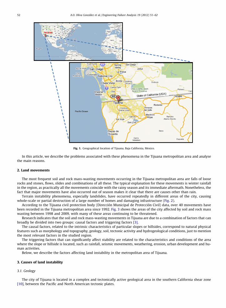
Fig. 1. Geographical location of Tijuana, Baja California, Mexico.
52 A.O. Oliva González et al. / Engineering Failure Analysis 19 (2012) 51–62
In this article, we describe the problems associated with these phenomena in the Tijuana metropolitan area and analysethe main reasons.
2. Land movements
The most frequent soil and rock mass-wasting movements occurring in the Tijuana metropolitan area are falls of looserocks and stones, flows, slides and combinations of all these. The typical explanation for these movements is winter rainfallin the region, as practically all the movements coincide with the rainy season and its immediate aftermath. Nonetheless, thefact that major movements have also occurred out of season makes it clear that there are causes other than rain.
Terrain instability phenomena, especially landslides, have occurred repeatedly in different areas of the city, causingwhole-scale or partial destruction of a large number of homes and damaging infrastructure (Fig. 2).
According to the Tijuana civil protection body (Dirección Municipal de Protección Civil) data, over 40 movements havebeen recorded in the Tijuana metropolitan area since 1992. Fig. 3 shows the areas of the city affected by soil and rock masswasting between 1998 and 2009, with many of these areas continuing to be threatened.
Research indicates that the soil and rock mass-wasting movements in Tijuana are due to a combination of factors that canbroadly be divided into two groups: causal factors and triggering factors [3].
The causal factors, related to the intrinsic characteristics of particular slopes or hillsides, correspond to natural physicalfeatures such as morphology and topography, geology, soil, tectonic activity and hydrogeological conditions, just to mentionthe most relevant factors in the studied region.
The triggering factors that can significantly affect stability are related to the characteristics and conditions of the areawhere the slope or hillside is located, such as rainfall, seismic movements, weathering, erosion, urban development and hu-man activities.
Below, we describe the factors affecting land instability in the metropolitan area of Tijuana.
3. Causes of land instability
3.1. Geology
The city of Tijuana is located in a complex and tectonically active geological area in the southern California shear zone[10], between the Pacific and North American tectonic plates.
Fig. 2. Major soil and rock movements in Tijuana. (A) Landslides in Anexa Ramírez (1998, 2000, 2002 and 2003). (B) Landslides in Defensores de BC (2002and 2003). (C) Landslide in Lomas del Río (2001). (D) Landslide in General Ballesteros (2007). (E) Landslide in Lomas Conjunto Residencial (2009). (F)Landslide in Laderas de Monterrey (2010).
A.O. Oliva González et al. / Engineering Failure Analysis 19 (2012) 51–62 53
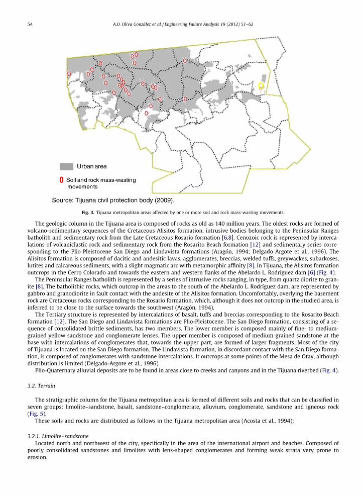
Fig. 3. Tijuana metropolitan areas affected by one or more soil and rock mass-wasting movements.
54 A.O. Oliva González et al. / Engineering Failure Analysis 19 (2012) 51–62
The geologic column in the Tijuana area is composed of rocks as old as 140 million years. The oldest rocks are formed ofvolcano-sedimentary sequences of the Cretaceous Alisitos formation, intrusive bodies belonging to the Peninsular Rangesbatholith and sedimentary rock from the Late Cretaceous Rosario formation [6,8]. Cenozoic rock is represented by interca-lations of volcaniclastic rock and sedimentary rock from the Rosarito Beach formation [12] and sedimentary series corre-sponding to the Plio-Pleistocene San Diego and Lindavista formations (Aragón, 1994; Delgado-Argote et al., 1996). TheAlisitos formation is composed of dacitic and andesitic lavas, agglomerates, breccias, welded tuffs, greywackes, subarkoses,lutites and calcareous sediments, with a slight magmatic arc with metamorphic affinity [8]. In Tijuana, the Alisitos formationoutcrops in the Cerro Colorado and towards the eastern and western flanks of the Abelardo L. Rodríguez dam [6] (Fig. 4).
The Peninsular Ranges batholith is represented by a series of intrusive rocks ranging, in type, from quartz diorite to gran-ite [8]. The batholithic rocks, which outcrop in the areas to the south of the Abelardo L. Rodríguez dam, are represented bygabbro and granodiorite in fault contact with the andesite of the Alisitos formation. Uncomfortably, overlying the basementrock are Cretaceous rocks corresponding to the Rosario formation, which, although it does not outcrop in the studied area, isinferred to be close to the surface towards the southwest (Aragón, 1994).
The Tertiary structure is represented by intercalations of basalt, tuffs and breccias corresponding to the Rosarito Beachformation [12]. The San Diego and Lindavista formations are Plio-Pleistocene. The San Diego formation, consisting of a se-quence of consolidated brittle sediments, has two members. The lower member is composed mainly of fine- to medium-grained yellow sandstone and conglomerate lenses. The upper member is composed of medium-grained sandstone at thebase with intercalations of conglomerates that, towards the upper part, are formed of larger fragments. Most of the cityof Tijuana is located on the San Diego formation. The Lindavista formation, in discordant contact with the San Diego forma-tion, is composed of conglomerates with sandstone intercalations. It outcrops at some points of the Mesa de Otay, althoughdistribution is limited (Delgado-Argote et al., 1996).
Plio-Quaternary alluvial deposits are to be found in areas close to creeks and canyons and in the Tijuana riverbed (Fig. 4).
3.2. Terrain
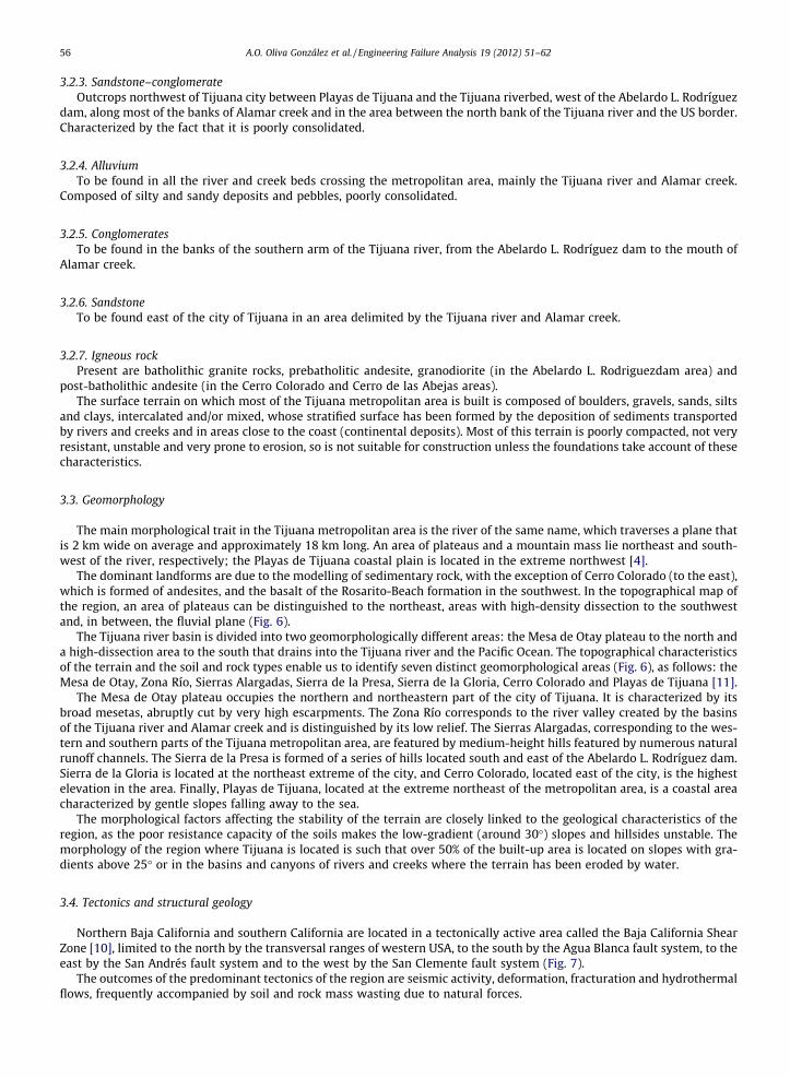
The stratigraphic column for the Tijuana metropolitan area is formed of different soils and rocks that can be classified inseven groups: limolite–sandstone, basalt, sandstone–conglomerate, alluvium, conglomerate, sandstone and igneous rock(Fig. 5).
These soils and rocks are distributed as follows in the Tijuana metropolitan area (Acosta et al., 1994):
3.2.1. Limolite–sandstoneLocated north and northwest of the city, specifically in the area of the international airport and beaches. Composed of
poorly consolidated sandstones and limolites with lens-shaped conglomerates and forming weak strata very prone toerosion.
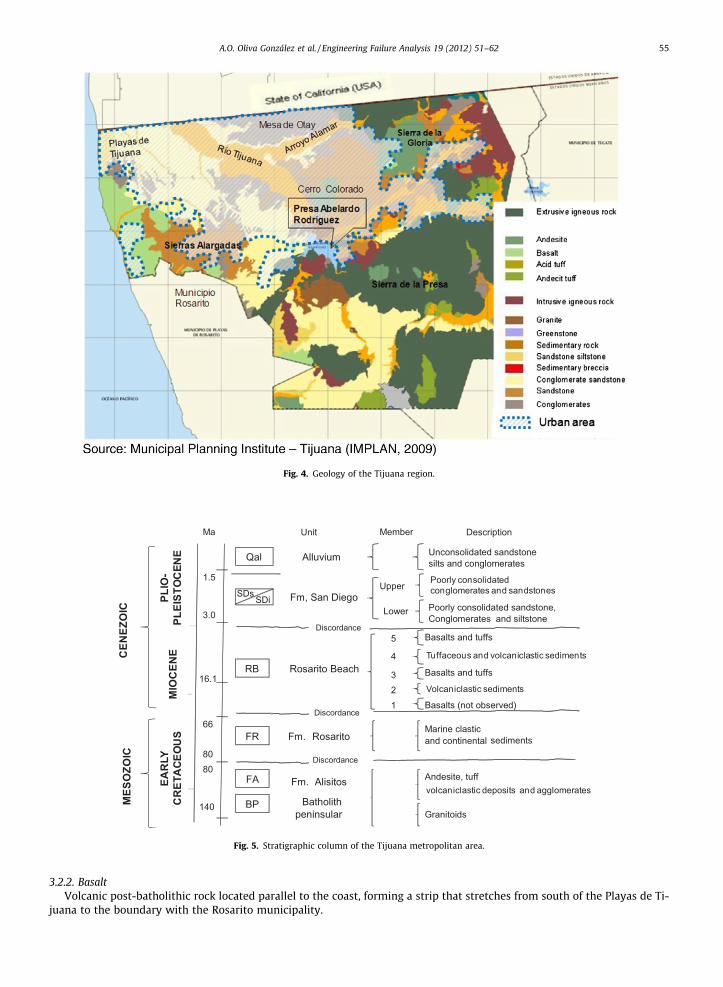
Fig. 4. Geology of the Tijuana region.
PLESTOCEN O
IOCENO
TEMPR ANO
1.5
3.0
16.1
66
8080
140
Ma
Qal
SDsSDi
RB
FR
FA
BP
Alluvium
Fm, San Diego
Rosarito Beach
Fm. Rosarito
Fm. Alisitos
Batholithpeninsular
Unit Member Description
Discordance
Unconsolidated sandstonesilts and conglomerates
Conglomerates poorlyconsolidated and sandstonePoorly consolidated sandstone, Conglomerates and siltstone
Upper
Lower
Basalts and tuffs
Tuffaceous sedimentsandvulcaniclastics
Basalts and tuffssedimentsVulcaniclastics
Basalts (not observed)
5
4
321
Marine clasticand continental
Andesite, tuffvulcaniclastics deposits and agglomerates
Granitoids
Discordance
Discordance
sediments
CEN
OZO
ICO
MES
OZO
ICO
PLIO
-PL
ESTO
CEN
OM
IOC
ENO
CR
ETÁC
ICO
TE
MPR
ANO
MES
OZO
ICC
ENEZ
OIC
EAR
LY
CR
ETA
CEO
US
volcaniclastic deposits and agglomerates
MIO
CEN
EPL
IO-
PLEI
STO
CEN
E
Poorly consolidated conglomerates and sandstones
Tuffaceous and volcaniclastic sediments
Volcaniclastic sediments
Fig. 5. Stratigraphic column of the Tijuana metropolitan area.
A.O. Oliva González et al. / Engineering Failure Analysis 19 (2012) 51–62 55
3.2.2. BasaltVolcanic post-batholithic rock located parallel to the coast, forming a strip that stretches from south of the Playas de Ti-
juana to the boundary with the Rosarito municipality.
56 A.O. Oliva González et al. / Engineering Failure Analysis 19 (2012) 51–62
3.2.3. Sandstone–conglomerateOutcrops northwest of Tijuana city between Playas de Tijuana and the Tijuana riverbed, west of the Abelardo L. Rodríguez
dam, along most of the banks of Alamar creek and in the area between the north bank of the Tijuana river and the US border.Characterized by the fact that it is poorly consolidated.
3.2.4. AlluviumTo be found in all the river and creek beds crossing the metropolitan area, mainly the Tijuana river and Alamar creek.
Composed of silty and sandy deposits and pebbles, poorly consolidated.
3.2.5. ConglomeratesTo be found in the banks of the southern arm of the Tijuana river, from the Abelardo L. Rodríguez dam to the mouth of
Alamar creek.
3.2.6. SandstoneTo be found east of the city of Tijuana in an area delimited by the Tijuana river and Alamar creek.
3.2.7. Igneous rockPresent are batholithic granite rocks, prebatholitic andesite, granodiorite (in the Abelardo L. Rodriguezdam area) and
post-batholithic andesite (in the Cerro Colorado and Cerro de las Abejas areas).The surface terrain on which most of the Tijuana metropolitan area is built is composed of boulders, gravels, sands, silts
and clays, intercalated and/or mixed, whose stratified surface has been formed by the deposition of sediments transportedby rivers and creeks and in areas close to the coast (continental deposits). Most of this terrain is poorly compacted, not veryresistant, unstable and very prone to erosion, so is not suitable for construction unless the foundations take account of thesecharacteristics.
3.3. Geomorphology
The main morphological trait in the Tijuana metropolitan area is the river of the same name, which traverses a plane thatis 2 km wide on average and approximately 18 km long. An area of plateaus and a mountain mass lie northeast and south-west of the river, respectively; the Playas de Tijuana coastal plain is located in the extreme northwest [4].
The dominant landforms are due to the modelling of sedimentary rock, with the exception of Cerro Colorado (to the east),which is formed of andesites, and the basalt of the Rosarito-Beach formation in the southwest. In the topographical map ofthe region, an area of plateaus can be distinguished to the northeast, areas with high-density dissection to the southwestand, in between, the fluvial plane (Fig. 6).
The Tijuana river basin is divided into two geomorphologically different areas: the Mesa de Otay plateau to the north anda high-dissection area to the south that drains into the Tijuana river and the Pacific Ocean. The topographical characteristicsof the terrain and the soil and rock types enable us to identify seven distinct geomorphological areas (Fig. 6), as follows: theMesa de Otay, Zona Río, Sierras Alargadas, Sierra de la Presa, Sierra de la Gloria, Cerro Colorado and Playas de Tijuana [11].
The Mesa de Otay plateau occupies the northern and northeastern part of the city of Tijuana. It is characterized by itsbroad mesetas, abruptly cut by very high escarpments. The Zona Río corresponds to the river valley created by the basinsof the Tijuana river and Alamar creek and is distinguished by its low relief. The Sierras Alargadas, corresponding to the wes-tern and southern parts of the Tijuana metropolitan area, are featured by medium-height hills featured by numerous naturalrunoff channels. The Sierra de la Presa is formed of a series of hills located south and east of the Abelardo L. Rodríguez dam.Sierra de la Gloria is located at the northeast extreme of the city, and Cerro Colorado, located east of the city, is the highestelevation in the area. Finally, Playas de Tijuana, located at the extreme northeast of the metropolitan area, is a coastal areacharacterized by gentle slopes falling away to the sea.
The morphological factors affecting the stability of the terrain are closely linked to the geological characteristics of theregion, as the poor resistance capacity of the soils makes the low-gradient (around 30�) slopes and hillsides unstable. Themorphology of the region where Tijuana is located is such that over 50% of the built-up area is located on slopes with gra-dients above 25� or in the basins and canyons of rivers and creeks where the terrain has been eroded by water.
3.4. Tectonics and structural geology
Northern Baja California and southern California are located in a tectonically active area called the Baja California ShearZone [10], limited to the north by the transversal ranges of western USA, to the south by the Agua Blanca fault system, to theeast by the San Andrés fault system and to the west by the San Clemente fault system (Fig. 7).
The outcomes of the predominant tectonics of the region are seismic activity, deformation, fracturation and hydrothermalflows, frequently accompanied by soil and rock mass wasting due to natural forces.
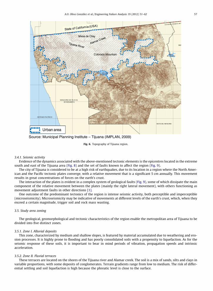
Fig. 6. Topography of Tijuana region.
A.O. Oliva González et al. / Engineering Failure Analysis 19 (2012) 51–62 57
3.4.1. Seismic activityEvidence of the dynamics associated with the above-mentioned tectonic elements is the epicentres located in the extreme
south and east of the Tijuana area (Fig. 8) and the set of faults known to affect the region (Fig. 9).The city of Tijuana is considered to be at a high risk of earthquakes, due to its location in a region where the North Amer-
ican and the Pacific tectonic plates converge, with a relative movement that is a significant 5 cm annually. This movementresults in great concentrations of forces on the earth’s crust.
The interaction of the plates is evident in a complex system of geological faults (Fig. 9), some of which dissipate the maincomponent of the relative movement between the plates (mainly the right lateral movement), with others functioning asmovement adjustment faults in other directions [1].
One outcome of the predominant tectonics of the region is intense seismic activity, both perceptible and imperceptible(microseismicity). Microseismicity may be indicative of movements at different levels of the earth’s crust, which, when theyexceed a certain magnitude, trigger soil and rock mass wasting.
3.5. Study area zoning
The geological, geomorphological and tectonic characteristics of the region enable the metropolitan area of Tijuana to bedivided into five distinct zones.
3.5.1. Zone I. Alluvial depositsThis zone, characterized by medium and shallow slopes, is featured by material accumulated due to weathering and ero-
sion processes. It is highly prone to flooding and has poorly consolidated soils with a propensity to liquefaction. As for theseismic response of these soils, it is important to bear in mind periods of vibration, propagation speeds and intrinsicacceleration.
3.5.2. Zone II. Fluvial terracesThese terraces are located on the shores of the Tijuana river and Alamar creek. The soil is a mix of sands, silts and clays in
variable proportions, with some deposits of conglomerates. Terrain gradients range from low to medium. The risk of differ-ential settling and soil liquefaction is high because the phreatic level is close to the surface.
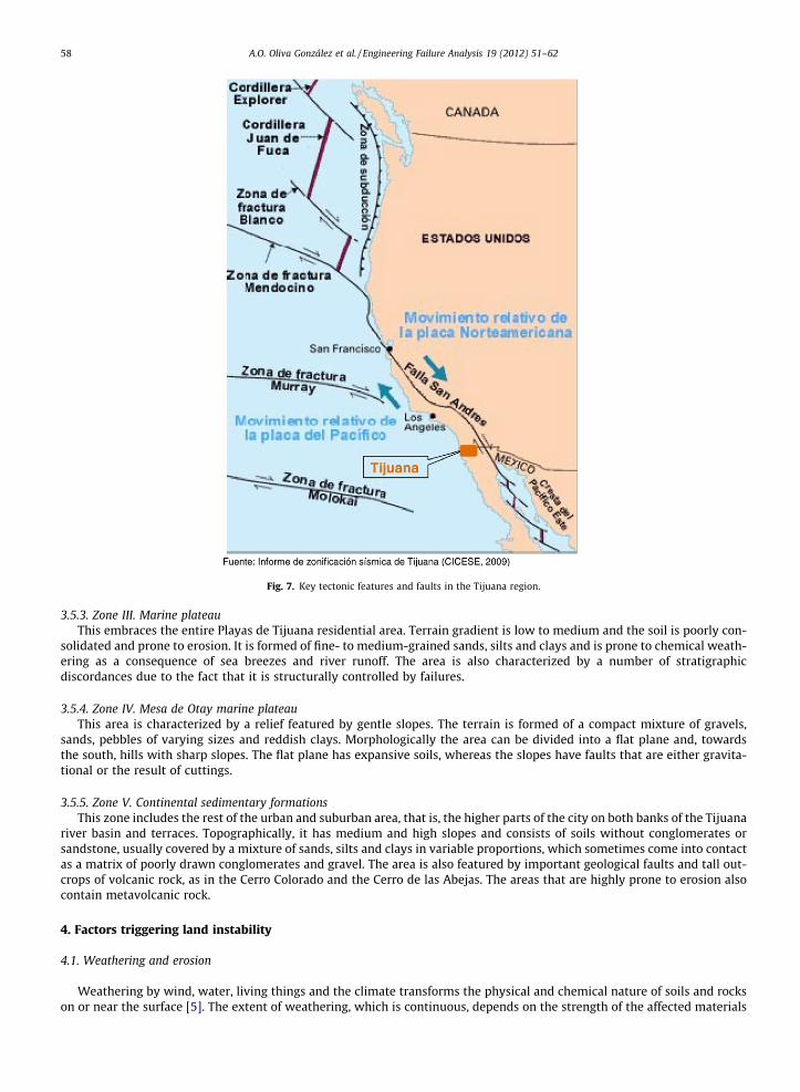
Fig. 7. Key tectonic features and faults in the Tijuana region.
58 A.O. Oliva González et al. / Engineering Failure Analysis 19 (2012) 51–62
3.5.3. Zone III. Marine plateauThis embraces the entire Playas de Tijuana residential area. Terrain gradient is low to medium and the soil is poorly con-
solidated and prone to erosion. It is formed of fine- to medium-grained sands, silts and clays and is prone to chemical weath-ering as a consequence of sea breezes and river runoff. The area is also characterized by a number of stratigraphicdiscordances due to the fact that it is structurally controlled by failures.
3.5.4. Zone IV. Mesa de Otay marine plateauThis area is characterized by a relief featured by gentle slopes. The terrain is formed of a compact mixture of gravels,
sands, pebbles of varying sizes and reddish clays. Morphologically the area can be divided into a flat plane and, towardsthe south, hills with sharp slopes. The flat plane has expansive soils, whereas the slopes have faults that are either gravita-tional or the result of cuttings.
3.5.5. Zone V. Continental sedimentary formationsThis zone includes the rest of the urban and suburban area, that is, the higher parts of the city on both banks of the Tijuana
river basin and terraces. Topographically, it has medium and high slopes and consists of soils without conglomerates orsandstone, usually covered by a mixture of sands, silts and clays in variable proportions, which sometimes come into contactas a matrix of poorly drawn conglomerates and gravel. The area is also featured by important geological faults and tall out-crops of volcanic rock, as in the Cerro Colorado and the Cerro de las Abejas. The areas that are highly prone to erosion alsocontain metavolcanic rock.
4. Factors triggering land instability
4.1. Weathering and erosion
Weathering by wind, water, living things and the climate transforms the physical and chemical nature of soils and rockson or near the surface [5]. The extent of weathering, which is continuous, depends on the strength of the affected materials
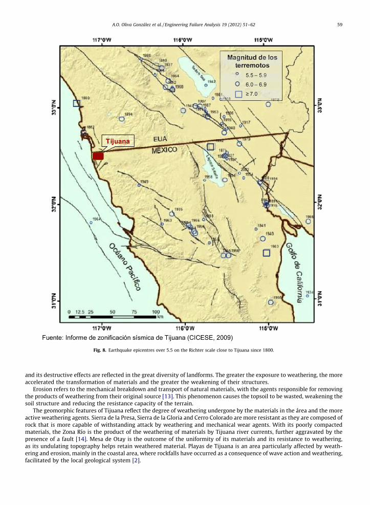
Fig. 8. Earthquake epicentres over 5.5 on the Richter scale close to Tijuana since 1800.
A.O. Oliva González et al. / Engineering Failure Analysis 19 (2012) 51–62 59
and its destructive effects are reflected in the great diversity of landforms. The greater the exposure to weathering, the moreaccelerated the transformation of materials and the greater the weakening of their structures.
Erosion refers to the mechanical breakdown and transport of natural materials, with the agents responsible for removingthe products of weathering from their original source [13]. This phenomenon causes the topsoil to be wasted, weakening thesoil structure and reducing the resistance capacity of the terrain.
The geomorphic features of Tijuana reflect the degree of weathering undergone by the materials in the área and the moreactive weathering agents. Sierra de la Presa, Sierra de la Gloria and Cerro Colorado are more resistant as they are composed ofrock that is more capable of withstanding attack by weathering and mechanical wear agents. With its poorly compactedmaterials, the Zona Río is the product of the weathering of materials by Tijuana river currents, further aggravated by thepresence of a fault [14]. Mesa de Otay is the outcome of the uniformity of its materials and its resistance to weathering,as its undulating topography helps retain weathered material. Playas de Tijuana is an area particularly affected by weath-ering and erosion, mainly in the coastal area, where rockfalls have occurred as a consequence of wave action and weathering,facilitated by the local geological system [2].
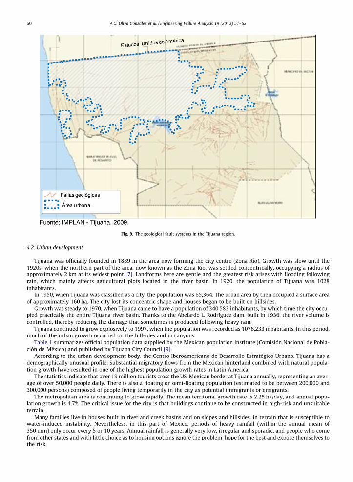
Fig. 9. The geological fault systems in the Tijuana region.
60 A.O. Oliva González et al. / Engineering Failure Analysis 19 (2012) 51–62
4.2. Urban development
Tijuana was officially founded in 1889 in the area now forming the city centre (Zona Río). Growth was slow until the1920s, when the northern part of the area, now known as the Zona Río, was settled concentrically, occupying a radius ofapproximately 2 km at its widest point [7]. Landforms here are gentle and the greatest risk arises with flooding followingrain, which mainly affects agricultural plots located in the river basin. In 1920, the population of Tijuana was 1028inhabitants.
In 1950, when Tijuana was classified as a city, the population was 65,364. The urban area by then occupied a surface areaof approximately 160 ha. The city lost its concentric shape and houses began to be built on hillsides.
Growth was steady to 1970, when Tijuana came to have a population of 340,583 inhabitants, by which time the city occu-pied practically the entire Tijuana river basin. Thanks to the Abelardo L. Rodríguez dam, built in 1936, the river volume iscontrolled, thereby reducing the damage that sometimes is produced following heavy rain.
Tijuana continued to grow explosively to 1997, when the population was recorded as 1076,233 inhabitants. In this period,much of the urban growth occurred on the hillsides and in canyons.
Table 1 summarizes official population data supplied by the Mexican population institute (Comisión Nacional de Pobla-ción de México) and published by Tijuana City Council [9].
According to the urban development body, the Centro Iberoamericano de Desarrollo Estratégico Urbano, Tijuana has ademographically unusual profile. Substantial migratory flows from the Mexican hinterland combined with natural popula-tion growth have resulted in one of the highest population growth rates in Latin America.
The statistics indicate that over 19 million tourists cross the US-Mexican border at Tijuana annually, representing an aver-age of over 50,000 people daily. There is also a floating or semi-floating population (estimated to be between 200,000 and300,000 persons) composed of people living temporarily in the city as potential immigrants or emigrants.
The metropolitan area is continuing to grow rapidly. The mean territorial growth rate is 2.25 ha/day, and annual popu-lation growth is 4.7%. The critical issue for the city is that buildings continue to be constructed in high-risk and unsuitableterrain.
Many families live in houses built in river and creek basins and on slopes and hillsides, in terrain that is susceptible towater-induced instability. Nevertheless, in this part of Mexico, periods of heavy rainfall (within the annual mean of350 mm) only occur every 5 or 10 years. Annual rainfall is generally very low, irregular and sporadic, and people who comefrom other states and with little choice as to housing options ignore the problem, hope for the best and expose themselves tothe risk.
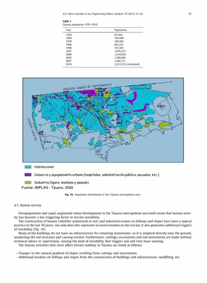
Table 1Tijuana population 1970–2010.
Year Population
1950 65,3641960 165,6901970 340,5831980 461,2571990 747,3811997 1,076,2332000 1,210,8202005 1,289,9822007 1,490,1112010 2,212,233 (estimated)
Fig. 10. Population distribution in the Tijuana metropolitan area.
A.O. Oliva González et al. / Engineering Failure Analysis 19 (2012) 51–62 61
4.3. Human activity
Overpopulation and rapid, unplanned urban development in the Tijuana metropolitan area both mean that human activ-ity has become a key triggering factor in terrain instability.
The construction of houses (whether authorized or not) and industrial estates on hilltops and slopes have been a typicalpractice in the last 30 years; not only does this represent an excess burden on the terrain, it also generates additional triggersof instability (Fig. 10).
Many of the buildings do not have an infrastructure for removing wastewater, so it is emptied directly onto the ground,weakening the soil structure and causing erosion. Furthermore, cuttings, excavations and soil movements are made withouttechnical advice or supervision, causing the kind of instability that triggers soil and rock mass wasting.
The human activities that most affect terrain stability in Tijuana are listed as follows:
– Changes in the natural gradient of slopes resulting from cuttings and excavations.– Additional burdens on hilltops and slopes from the construction of buildings and infrastructure, landfilling, etc.
62 A.O. Oliva González et al. / Engineering Failure Analysis 19 (2012) 51–62
– Increased pore pressure due to excessive or uncontrolled water spillage.– The removal of plant cover and changes to the natural vegetation of hillsides and slopes.
5. Conclusions
The instability of the terrain in the Tijuana metropolitan area causes economic and social damages and losses and also hasa negative impact on the environment. The impacts have increased considerably in the last 30 years, largely as a conse-quence of rapid, unplanned urban growth and poor-quality construction in areas prone to land movements. Vulnerabilitywill continue to increase until the risk is reduced or eliminated.
The main causes of terrain instability in the Tijuana metropolitan areas are geology, morphology, tectonics and humanactivity.
It is clear that there is an urgent need for structural and non-structural measures to reduce or eliminate the negative im-pact of soil and rock mass wasting in the region. Structural measures refer to physical intervention to minimize the riskresulting from the instability of terrain and to ameliorate its causes by implementing or reinforcing engineering projectsto protect people and property. Non-structural measures refer to regulating land use, strengthening institutional capacitiesand educating and preparing the community.
Since seismic movements, rainfall and geological, geomorphological and tectonic features cannot be intervened directly,it is necessary to reduce their impact by modifying some of physical and functional vulnerability of the exposed elements. Itis essential to study and confront the problem from a multidisciplinary, inter-institutional and multisectoral perspective. Theparticipation of society at large can play a decisive role, and actions to tackle the risk (prevention and mitigation) need to beformally included in planning and community education initiative.
Only by including preventive criteria in territorial, urban, sectoral and socioeconomic planning and by formulating pro-spective models of indicators and predictors of possible catastrophes, through early alert systems, will it be possible tolaunch a balanced process of sustainable development.
Acknowledgements
This article was the result of collaboration between the Universidad de Las Californias International (Tijuana, Mexico), theLand Engineering Group of the Universidad de Oviedo (Spain) and the Dirección Municipal de Protección Civil of the 19thCity Council of Tijuana (Mexico). The authors especially wish to thank these institutions for the support provided duringthe research and writing phases of this article.
Grateful thanks also to the RADIUS Tijuana Programme ‘Por una Ciudad Sísmicamente Segura’ and the Centro de Inves-tigación Científica y de Educación Superior de Ensenada (CICESE) for the valuable information provided to us.
References
[1] Acosta-Chang, et al. Microzonificación sísmica de Tijuana. Informe final. CICESE; Dirección Estatal de Protección Civil, Ayuntamiento de Tijuana;FOPREDEN. México; 2009.
[2] Aragón M. J. Evaluación de riesgo geológico debido a movimientos de laderas en la ciudad de Tijuana, BC., México. Tesis de Maestría, CICESE. Ensenada,México; 1994. p. 124.
[3] Cuanalo OA, Oliva González AO. Estabilidad de laderas. Análisis mediante factores de valuación. Revista IngeoPress no. 164. España; October 2007. p.38–44.
[4] Delgado-Argote et al. Estudio de riesgo geológico en Tijuana con base en análisis geomorfológicos estructurales y la respuesta del terreno en las áreas elPasteje, el Pato y Cañada Verde. Departamento de geología. CICESE, México: División Ciencias de la Tierra; 1993.
[5] Dolgoff A. Physical geology. New York: Houghton Mifflin Company; 1998.[6] Flynn Clinton J. Post-batholitic geology of the la Gloria-Presa Rodríguez area, Baja California, México. Geol Soc Am Bull 1970;81:1789–806.[7] García J. Los desastres por lluvia: un indicador de problemas en la relación suelo y desarrollo urbano en Tijuana. Master’s thesis. COLEF; 1998. p. 131.[8] Gastil Gordon R, Richard PP, Allison Edwin C. Reconnaissance geology of the state of Baja California. Boulder Colorado: The Geological Society of
America, Inc., Memoir 140; 1975. 170 p.[9] Ayuntamiento de Tijuana H. 2005–2007. <http://www.tijuana.gob.mx>.
[10] Legg MR, Wong VO, Suarez F. Geologic structure and tectonic of the inner continental borderland of northern, Baja California. In: Dauphin PJ, SimoneitBRT, editors. The Gulf and Peninsular Province of the Californias. AAPG memoir 47; 1991. p. 145–77 [chapter 9].
[11] López-Álvarez, et al. Diagnóstico de riesgos urbanos en el área metropolitana de Tijuana. Dirección Municipal de Protección Civil. Ayuntamiento deTijuana, Baja California, México; 2002.
[12] Minch John A. Stratigraphy and structure of the Tijuana-Rosarito Beach area, Northwestern Bala California, México. Geol soc Am Bull1967;78:1155–78.
[13] Mitchell JamesK. Fundamentals of soil behavior. 2nd ed. New York: John Wiley & Sons, Inc; 1993. 473 p.[14] Wiegand JW. Evidence of San Diego-Tijuana fault. Assoc Eng Geol Bull 1970;7:107–21.