A Binational Vision for the Tijuana River Watershed - Institute ...
359
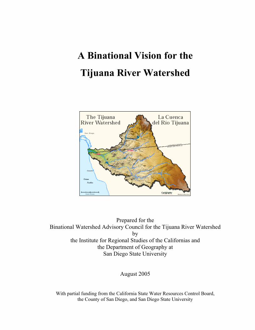
A Binational Vision for the Tijuana River Watershed Prepared for the Binational Watershed Advisory Council for the Tijuana River Watershed by the Institute for Regional Studies of the Californias and the Department of Geography at San Diego State University August 2005 With partial funding from the California State Water Resources Control Board, the County of San Diego, and San Diego State University
-
Upload
khangminh22 -
Category
Documents
-
view
2 -
download
0
Transcript of A Binational Vision for the Tijuana River Watershed - Institute ...
A Binational Vision for the
Tijuana River Watershed
Prepared for the Binational Watershed Advisory Council for the Tijuana River Watershed
by the Institute for Regional Studies of the Californias and
the Department of Geography at San Diego State University
August 2005
With partial funding from the California State Water Resources Control Board, the County of San Diego, and San Diego State University

Binational Vision for the TRW
ii

Children’s Vision of the TRW
The future TRW in a healthy state… and in an unhealthy state
By Gladys Aguilar, San Antonio Necua, Baja California
How people can help clean up the TRW waterways
by Shannon Johnson, Campo, California
iii
Binational Vision for the TRW
Acknowledgements
Special thanks to the following contributors:
Lawrence Beck, SDSU Stephanie Brodine, SDSU Fred Cagle, Southwest Interpretive Association Nico Calavita, SDSU Ted Case, UCSD Jane Clough-Riquelme, SANDAG Katherine Comer, SDSU Maria Curry, ICOMOS Martín De la Rosa, Comité de Planeación del Desarollo MunicipalJulie Desmond, SDSU Ileana Espejel, UABC Robert Fisher, SDSU Paul Ganster, SDSU Rick Gersberg, SDSU Carlos Graizbord, consultant Ned Greenwood, SDSU Louise Gresham, SDSU Larry Herzog, SDSU Alan Kilpatrick, SDSU Gene Lamke, SDSU Anne McAney, ICF John O’Leary, SDSU Victor Miguel Ponce, SDSU Elsa Saxod, City of San Diego Laura Silvan, PROFEA Alan Sweedler, SDSU Fernando Wakida Kusunoki, UABC Michael White, Conservation Biology Institute Michael Wilken, CUNA Richard Wright, SDSU
iv
Comments on the drafts provided by:
Bart Christensen, CASWRCB Mike Connolly, Campo EPA Elizabeth Giffen, County of San Diego Emilio De la Fuente, consultant Magda Gramada, County of San Diego Anne McAnaney, International Community Foundation Eugenia McNaughton, U.S. Environmental Protection Agency Jeffery Pasek, City of San Diego Mario Salzmann, Fundación La Puerta, A.C. Gabriel Sánchez, Binational Vision Project Team Elsa Saxod, City of San Diego Miguel Ángel Vargas, Pronatura, A.C. Armando Villarino, City of San Diego W alter Zúñiga, Secretaría de Fomento Agropecuario and UABC Cartography: David Dow, SDSU Harry Johnson, SDSU Andy Gordon, SDSU Kristen O’Grady, SDSU David Lindsey, SDSU Molly Schmelzle, SDSU Merrillee Willoughby, SDSU Additional comments are welcome. Please send them to: Katherine Comer, Research Coordinator Institute for Regional Studies of the Californias, SDSU [email protected] (619) 594-5423
v
Binational Vision for the TRW
Funding for this project has been provided in full or in part through a contract with the California State Water
Resources Control Board (CASWRCB) pursuant to the Costa-Machado Water Act of 2000 (Proposition 13) and any
amendments thereto for the implementation of California’s Non-point Source Pollution Control Program. The
contents of this document do not necessarily reflect the views and policies of the CASWRCB, nor does mention of
trade names or commercial products constitute endorsement or recommendation for use.
The data and products in this document were collected by the Institute for Regional Studies of the Californias
(IRSC), the Geography Department at San Diego State University, and El Sistema de Informacíon Geográfica of El
Colegio de la Frontera Norte (COLEF) in Tijuana. There are some restrictions on the distribution of these data and
projects. Please be aware that these products and much of the data and maps are generalized for display and regional
planning purposes.
vi

Table of Contents
Executive vision statement for the Tijuana River Watershed .......................................................................1 Executive summary .......................................................................................................................................3 Introduction to watersheds ............................................................................................................................9 Introduction to the Tijuana River Watershed ..............................................................................................11 The TRW Binational Vision Project ...........................................................................................................15
Description of the visioning process .......................................................................................................15 Project time line ......................................................................................................................................16 Description of stakeholder meetings.......................................................................................................17 Stakeholder input ....................................................................................................................................18
Topography .................................................................................................................................................21 Precipitation ................................................................................................................................................23 Population....................................................................................................................................................25
Population trends ....................................................................................................................................25 Population data gaps ...............................................................................................................................28
Land use ......................................................................................................................................................29 Land use trends .......................................................................................................................................32 Land use data ..........................................................................................................................................34 Land use data gap....................................................................................................................................34
Water quantity .............................................................................................................................................37 Hydrology ...............................................................................................................................................37 Water supply and demand.......................................................................................................................40 Precipitation ............................................................................................................................................43 Flooding and landslides ..........................................................................................................................43 Stream flow.............................................................................................................................................46 Groundwater quantity .............................................................................................................................46 Colorado River water quantity................................................................................................................50 Wastewater quantity and infrastructure ..................................................................................................50 Water quantity trends ..............................................................................................................................53
Surface water ......................................................................................................................................53 Groundwater .......................................................................................................................................55 Future sources.....................................................................................................................................55
Water quantity data .................................................................................................................................57 Water quantity data gaps.........................................................................................................................57 Water quantity recommendations ...........................................................................................................58
Water quality ...............................................................................................................................................63 Surface water quality ..............................................................................................................................63
Summary of water quality testing projects for the TRW ...................................................................66 Groundwater quality ...............................................................................................................................69 Colorado River and State Project water quality......................................................................................70 Wastewater quality..................................................................................................................................70 Water quality data ...................................................................................................................................71 Water quality data gaps...........................................................................................................................71 Water quality recommendations .............................................................................................................71
Ecosystems and natural resources ...............................................................................................................77 Biodiversity.............................................................................................................................................77 Fragmentation .........................................................................................................................................78 Soils ........................................................................................................................................................78 Flora ........................................................................................................................................................81 Fauna.......................................................................................................................................................88
The Multiple Species Conservation Program (MSCP).......................................................................94
vii Cuchumá easement .............................................................................................................................96

Binational Vision for the TRW
The Tijuana Estuary............................................................................................................................96 Cleveland National Forest ..................................................................................................................97
Ecosystems and natural resources trends ................................................................................................98 Ecosystems and natural resources data ................................................................................................101 Ecosystems and natural resources data gaps.........................................................................................101 Ecosystems and natural resources recommendations ...........................................................................101
Solid and hazardous waste ........................................................................................................................107 Trash .....................................................................................................................................................107 Recycling ..............................................................................................................................................108 Landfills ................................................................................................................................................109 Hazardous waste ...................................................................................................................................110 Waste trends..........................................................................................................................................111 Waste data.............................................................................................................................................111 Waste data gap ......................................................................................................................................112 Waste recommendations .......................................................................................................................112
Air quality .................................................................................................................................................117 Air quality trends ..................................................................................................................................121 Air quality data .....................................................................................................................................123 Air quality data gaps .............................................................................................................................123 Air quality recommendations................................................................................................................123
Socioeconomic issues................................................................................................................................127 Economy ...............................................................................................................................................127
International commuters ...................................................................................................................128 Transborder tourism and retail trade.................................................................................................129
Housing .................................................................................................................................................130 Infrastructure.........................................................................................................................................130 Human health ........................................................................................................................................131 Tourism and recreation .........................................................................................................................133 Historical and cultural resources...........................................................................................................134 Socioeconomic trends ...........................................................................................................................136
Economy...........................................................................................................................................136 Housing.............................................................................................................................................136 Infrastructure.....................................................................................................................................137
Socioeconomic data ..............................................................................................................................139 Socioeconomic data gaps ......................................................................................................................139
Economy...........................................................................................................................................139 Health................................................................................................................................................139 Tourism.............................................................................................................................................140
Socioeconomic recommendations.........................................................................................................140 Health................................................................................................................................................141 Tourism.............................................................................................................................................141 Infrastructure.....................................................................................................................................142
Implementation time line...........................................................................................................................147 Action plan: Identify areas for conservation restoration and rehabilitation based on ecosystem
function and threats ......................................................................................................................149 Action plan: Increase knowledge of the cultural characteristics of indigenous and other peoples of
the watershed................................................................................................................................152 Action plan: Protect sensitive habitat and cultural areas ..................................................................154 Action plan: Market sustainable tourism opportunities ....................................................................156 Action plan: Evaluate and protect groundwater supplies .................................................................160 Action plan: Develop and implement watershed education programs and products for children and
adults ............................................................................................................................................163 Action plan: Connect conservation areas across the border .............................................................165
viii
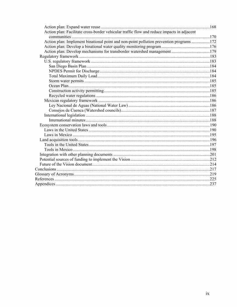
Action plan: Expand water reuse ......................................................................................................168 Action plan: Facilitate cross-border vehicular traffic flow and reduce impacts in adjacent
communities .................................................................................................................................170 Action plan: Implement binational point and non-point pollution prevention programs .................172 Action plan: Develop a binational water quality monitoring program .............................................176 Action plan: Develop mechanisms for transborder watershed management ....................................179
Regulatory framework ..........................................................................................................................183 U.S. regulatory framework ...............................................................................................................183
San Diego Basin Plan ...................................................................................................................184 NPDES Permit for Discharge.......................................................................................................184 Total Maximum Daily Load.........................................................................................................184 Storm water permits .....................................................................................................................185 Ocean Plan....................................................................................................................................185 Construction activity permitting...................................................................................................185 Recycled water regulations ..........................................................................................................186
Mexican regulatory framework ........................................................................................................186 Ley Nacional de Aguas (National Water Law) ............................................................................186 Consejos de Cuenca (Watershed councils)...................................................................................187
International legislation ....................................................................................................................188 International minutes....................................................................................................................188
Ecosystem conservation laws and tools ................................................................................................190 Laws in the United States .................................................................................................................190 Laws in Mexico ................................................................................................................................195
Land acquisition tools ...........................................................................................................................196 Tools in the United States.................................................................................................................197 Tools in Mexico................................................................................................................................198
Integration with other planning documents ..........................................................................................201 Potential sources of funding to implement the Vision ..........................................................................212 Future of the Vision document..............................................................................................................214
Conclusions ...............................................................................................................................................217 Glossary of Acronyms...............................................................................................................................219 References .................................................................................................................................................225 Appendices ................................................................................................................................................237
ix
Binational Vision for the TRW
List of Figures
1. Watershed diagram...........................................................................................................................9 2. Ecological and human interactions in a watershed.........................................................................10 3. County and municipality boundaries in the TRW. .........................................................................12 4. Temperature....................................................................................................................................14 5. General visioning process...............................................................................................................16 6. General time line for the Binational Vision Project. ......................................................................17 7. Shaded relief...................................................................................................................................22 8. Precipitation in the TRW................................................................................................................24 9. Historical Population Trends in the TRW region...........................................................................26 10. Population projections to 2030.......................................................................................................27 11. Population density projections for the year 2030 for San Diego County. ......................................27 12. Land use. ........................................................................................................................................30 13. Historical expansion of Tijuana 1956 to 1994................................................................................32 14. Projected urban expansion of Tijuana and Rosarito to 2023 and the Corredor Tijuana 2000........33 15. San Diego-Baja California planned land use, May 2003. ..............................................................34 16. Hydrography of the TRW...............................................................................................................38 17. Tijuana water use............................................................................................................................40 18. Tecate water use. ............................................................................................................................41 19. San Diego water use. ......................................................................................................................41 20. Slope, fault, and flood hazards in the Tijuana and San Diego border area, 2000...........................45 21. Estimated extent of Tecate aquifer. ................................................................................................48 22. San Diego Formation Aquifer. .......................................................................................................49 23. South Bay and International Wastewater treatment plants.............................................................52 24. Stream gauge at Tecate River 2001 to 2002...................................................................................53 25. Historical trends for surface water volumes of creeks in the U.S. portion. ....................................55 26. The California floristic province. ...................................................................................................77 27. Soils in the TRW. ...........................................................................................................................80 28. Vegetation in the TRW...................................................................................................................83 29. Vegetation patches of high conservation priority (1994). ..............................................................87 30. Proposed conservation areas for Mexican portion of TRW for 2020.............................................92 31. Recommended Mexican conservation areas and their connection with U.S. conservation areas. .93 32. Pacific Coast Flyway......................................................................................................................94 33. San Diego Multiple Species Conservation Program. .....................................................................95 34. Habitat fragmentation in the TRW 1953 to 1994. ........................................................................100 35. Wildlife corridors and needed underpass locations around Tecate. .............................................103 36. Comparison of waste generation among California areas. ...........................................................108 37. Ten-year trend for Tijuana trash generation. ................................................................................111 38. EPA-CICA air quality monitoring stations. .................................................................................118 39. Number days above the national Air Quality Index for San Diego from 1980 to 2003...............121 40. Trends for the Chula Vista air quality station...............................................................................122 41. Trends for the Otay Mesa-Paseo International air quality station. ...............................................122 42. Median income distribution..........................................................................................................128 43. Housing units with sewage connection, 2000. .............................................................................131 44. Historic distribution of indigenous groups in the TRW. ..............................................................135 45. Water and wastewater infrastructure for San Diego and Tijuana.................................................138 46. Hierarchy of U.S. regulators for water quality. ............................................................................184 47. Watershed councils in Mexico. ....................................................................................................188
x
List of Tables
1. Recommendations from the TRW stakeholders. ............................................................................. 7 2. General questions and steps in a watershed visioning process...................................................... 10 3. Population of Tijuana and Baja California from 1900 to 2000. .................................................... 26 4. Beneficial uses for the U.S. portion of the TRW........................................................................... 39 5. Leaks in the Tijuana water delivery system. ................................................................................. 40 6. Beneficial uses and threats for the Mexican aquifers systems. ..................................................... 47 7. Water quantity challenges, opportunities, goals, and objectives ................................................... 59 8. Priority water quantity actions from stakeholder meetings. .......................................................... 60 9. Constituents of concern in the Tijuana River 2003—2004. .......................................................... 65 10. Impairments to the U.S. portion of the lower TRW. ..................................................................... 65 11. Water quality challenges, opportunities, goals, and objectives ..................................................... 73 12. Priority water quality actions from stakeholder meetings. ............................................................ 75 13. Environmental Benefits of Trees in San Diego. ............................................................................ 88 14. Species identified as protected under multiple governments and a description of their habitats. . 90 15. Ecosystems and natural resources challenges, opportunities, goals, and objectives. .................. 104 16. Priority ecosystems and natural resources actions from stakeholder meetings. .......................... 105 17. Waste challenges, opportunities, goals, and objectives............................................................... 114 18. Priority waste actions from stakeholder meetings. ...................................................................... 115 19. Air quality data for the Tijuana, Tecate, San Diego County region, 2004.. ................................ 119 20. Main sources of PM 10, NOX and VOC emissions in Tijuana-Rosarito, 1998. .......................... 120 21. Air quality challenges, opportunities, goals, and objectives ....................................................... 124 22. Priority air quality actions from stakeholder meetings................................................................ 125 23. Environmental contaminants, sources, and the potential health problems. ................................. 133 24. Socioeconomic challenges, opportunities, goals, and objectives. ............................................... 143 25. Priority socioeconomic issues action from stakeholder meetings. .............................................. 144 26. Time line of Priority 14 actions................................................................................................... 148 27. Baja California wastewater regulators......................................................................................... 187 28. IBWC-CILA minutes affecting the TRW. .................................................................................. 189 29. Summary and comparison of land conservation tools in the United States and Mexico............. 201 30. Goals for the Tijuana-Playas de Rosarito Water Master Plan. .................................................... 210
xi

Binational Vision for the TRW
xii
Executive vision statement for the Tijuana River Watershed
The stakeholders of the Tijuana River Watershed desire to meet the needs of the present
while protecting resources for future generations; to create a balance between natural resource
protection, economic development, and quality of life; to proactively manage local surface and
groundwater for long-term sustainability; to protect, restore, and connect habitats; to create a
strong economic base for sustainable development; and to create human communities that allow
people to enjoy the unique cultural and natural landscapes and functions of the watershed.
1

Binational Vision for the TRW
2
Executive summary
Executive summary
The Tijuana River Watershed (TRW) lies across the U.S.-Mexican international
boundary and is approximately 1,750 mi2 (4,465 km2) in area, with one-third in California and
two-thirds in Baja California. The watershed is a place of natural and cultural beauty that is at
risk from uncontrolled urbanization and infrastructure deficits. Growing human populations and
land use changes have brought numerous environmental problems to the TRW region. These
include:
• Decline in local groundwater quantity and further dependence on imported water
• Decline in quality of surface and groundwater for human use
• Increased erosion and flood dangers
• Increased air pollution
• Reduction in the amount of safe, open, and green areas for urban residents
• Decline in ecosystem health
• Increasing number of threatened and endangered plants and animals
In 2002 a binational team of researchers and practitioners, the Binational Watershed
Advisory Council (BWAC), was convened to address these environmental challenges. The
council identified stakeholders in the watershed who, in turn, participated in the development of
this Binational Vision for the TRW, a snapshot of the current and desired conditions in the TRW.
The stakeholders also helped to devise strategies and options for achieving that Vision.
The Vision document contains baseline data and trends for the major areas of concern
identified by stakeholders: water, air, ecosystems and natural resources, waste, and
socioeconomic issues. The following are brief descriptions of the issues in the watershed that
will be discussed in detail in the body of this report.
Population growth
The watershed currently is home to about 1.4 million people; this figure is expected to
double in 15 to 20 years.
Land use
3
Binational Vision for the TRW
Experts estimate that 90% of the land within the Municipality of Tijuana will eventually
be developed. Tecate’s industrial, commercial, and residential sectors are predicted to extend
southward. The City of San Diego’s urban footprint is predicted to expand southeast. New
proposed border crossings at Tecate, Jacumba, and in East Otay Mesa (Otay II) would facilitate
that southeast expansion. There is a growing concern that these three cities will merge into one
megalopolis at the Otay corridor and choke off open space and wildlife corridors.
Water quantity and quality
Historically, the TRW’s rivers ran with clean water, the ocean and wetlands were healthy,
and groundwater was the main source of potable and irrigation water for the region. Today,
imported water from the California Water Project and the Colorado River serves much of the
area, and imported water use increases each year to meet a growing water demand. Surface and
groundwater are scarce in the TRW, with variable rainfall that averages only 250 mm (10 in.) per
year. Contamination of TRW aquifers and surface waters from sewage runoff, fertilizers, and
pesticides is a concern. Polluted surface waters partly explain the high rates of gastrointestinal
disease and hepatitis found in the TRW. Nitrogen and other contaminants found in the
groundwater can also cause human health problems.
The Tijuana River flows into the Tijuana River Estuary in the United States and then into
the Pacific Ocean. The water at the discharge point into the ocean contains some of the highest
concentrations of suspended solids, Cadmium (Cd), Copper (Cu), Nickel (Ni), Lead (Pb), Zinc
(Zn), and Polychlorinated Biphenyls (PCB) measured in Southern California. These heavy metals
can bioaccumulate in people and animals, causing health problems.
In conjunction with the hilly topography and unplanned squatter settlements on slopes,
the TRW precipitation pattern of dry weather much of the year and short, intense winter storms
produces erosion, flooding, and landslides, especially during El Niño years. Floods in the 1980s
and 1990s had devastating effects on natural habitat, structures, personal property, and
transportation facilities in the Tijuana River Valley and adjacent watercourses. It is anticipated
that flooding will continue to be problematic because of expanding impermeable areas that
increase the speed and volume of runoff, lack of vegetation on hillsides to slow the flows,
clogging of stream channels from sediment and trash, and inadequate municipal storm drainage
systems.
Ecosystems and natural resources 4
Executive summary
The flora and fauna of the TRW region are known internationally for their diversity and
high levels of endemism (species found only in this area). The region contains many endangered
and threatened species, such as bighorn sheep, the Arroyo toad, and several avian species. The
watershed also contains endangered/threatened vegetation communities including coastal sage
scrub and chaparral. Many of these plant and animal species are migratory and use habitats on
both sides of the international boundary. Connecting these habitats is important for a species’
survival.
Loss of biodiversity in the TRW regions is related to habitat fragmentation in vegetation.
The main human causes of habitat loss are cattle ranching and farming, introduced exotic species
that compete for resources, expanding urbanization, and extensive, dispersed rural development.
Fragmentation of habitat can inhibit gene flow between populations of a species, and cause
genetic problems that can contribute to extinction.
Healthy vegetated areas of the watershed should be protected. This can be achieved by
designating open space preserves or natural protected areas in places, such as the Otay Corridor
between Tijuana and Tecate, the upper watershed forests, the La Posta Corridor in the United
States, and Joe Bill Canyon in Tecate.
Solid and hazardous waste
Trash accumulates in rivers and creeks, harming wildlife and polluting surface and
groundwater. Landfills are inadequate in Mexico and recycling needs to be promoted on both
sides of the border. Hazardous materials in the TRW include industrial waste, commercial waste,
household waste, and biological waste that are sometimes illegally disposed of into the sewers or
in canyons and arroyos. Proper treatment and disposal facilities for hazardous materials are not
readily available in the Mexican portion of the TRW. Trash is sometimes burned, causing air
pollution problems and health risks.
Air quality
Pollutants in the atmosphere impact the human population as well as flora and fauna in
the TRW. The impacts can occur through direct inhalation of pollutants, deposition onto plants
and soils, and absorption into streams, rivers, aquifers, and the nearshore marine environment.
The major source of pollutants to the atmosphere within the TRW originates from human
5

Binational Vision for the TRW
sources, such as vehicular congestion in urban areas and border crossings, heavy commercial
trucking, dust from unpaved roads, burning trash, and industrial contamination.
Socioeconomic issues
The TRW is characterized by a rich cultural diversity and dynamic economic activity.
However, socioeconomic issues of concern include rapid population growth, expanding
industrialization, and uncontrolled urbanization over the past half century, especially in the
Mexican portion. These processes have overwhelmed the ability of governments in Mexico to
provide adequate urban infrastructure, affordable housing, parks and green areas, healthcare, and
education. Rapid urbanization has damaged the natural environment and has contributed to the
loss of historical and cultural resources. Although the regional economy has expanded
significantly, job quality has not improved sufficiently, with large percentages of workers living
in poverty.
In San Diego, the rapid population growth, economic expansion, urbanization and land
use changes have caused habitat loss, fragmentation, and decreases of open space. Urban runoff
and failure to maintain basic sewage infrastructure have impaired surface, groundwater, and
marine waters of the TRW. Infrastructure improvements, such as transportation investment, the
use of biotechnology, and smart growth which directs growth inward and upward is
recommended to improve quality of life.
Consequences of inaction
6
Current policy and land use practices (residential, commercial, and industrial) have
contributed to the social and environmental degradation of the TRW. Major policy changes are
needed for the watershed. It is difficult to accurately predict the future. However, based on past
trends and the opinion of experts, it is very likely that if no changes are made, the watershed will
continue to be negatively impacted by human practices. Probable consequences of business as
usual will be higher water costs, fewer natural resources, associated regional economic losses,
and deteriorating quality of life. In addition, one may expect more species extinctions and a more
degraded and unproductive environment, requiring importation of natural resources. For humans,
a likely scenario will be the continued loss of cultural and recreational resources, a decline in
quality of life, and social, political, and security problems on both sides of the border. As an
alternative to inaction, the Research Team, the BWAC, stakeholders, and others have suggested
some actions that can be taken in the watershed to help improve the future of the TRW.
Executive summary
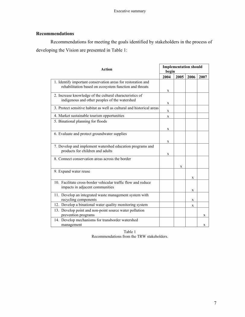
Recommendations
Recommendations for meeting the goals identified by stakeholders in the process of
developing the Vision are presented in Table 1:
Implementation should begin Action
2004 2005 2006 20071. Identify important conservation areas for restoration and
rehabilitation based on ecosystem function and threats x
2. Increase knowledge of the cultural characteristics of indigenous and other peoples of the watershed
x 3. Protect sensitive habitat as well as cultural and historical areas x 4. Market sustainable tourism opportunities x 5. Binational planning for floods
x 6. Evaluate and protect groundwater supplies
x 7. Develop and implement watershed education programs and
products for children and adults x
8. Connect conservation areas across the border
x 9. Expand water reuse
x 10. Facilitate cross-border vehicular traffic flow and reduce
impacts in adjacent communities x
11. Develop an integrated waste management system with recycling components x
12. Develop a binational water quality monitoring system x 13. Develop point and non-point source water pollution
prevention programs x 14. Develop mechanisms for transborder watershed
management x
Table 1 Recommendations from the TRW stakeholders.
7

Binational Vision for the TRW
8
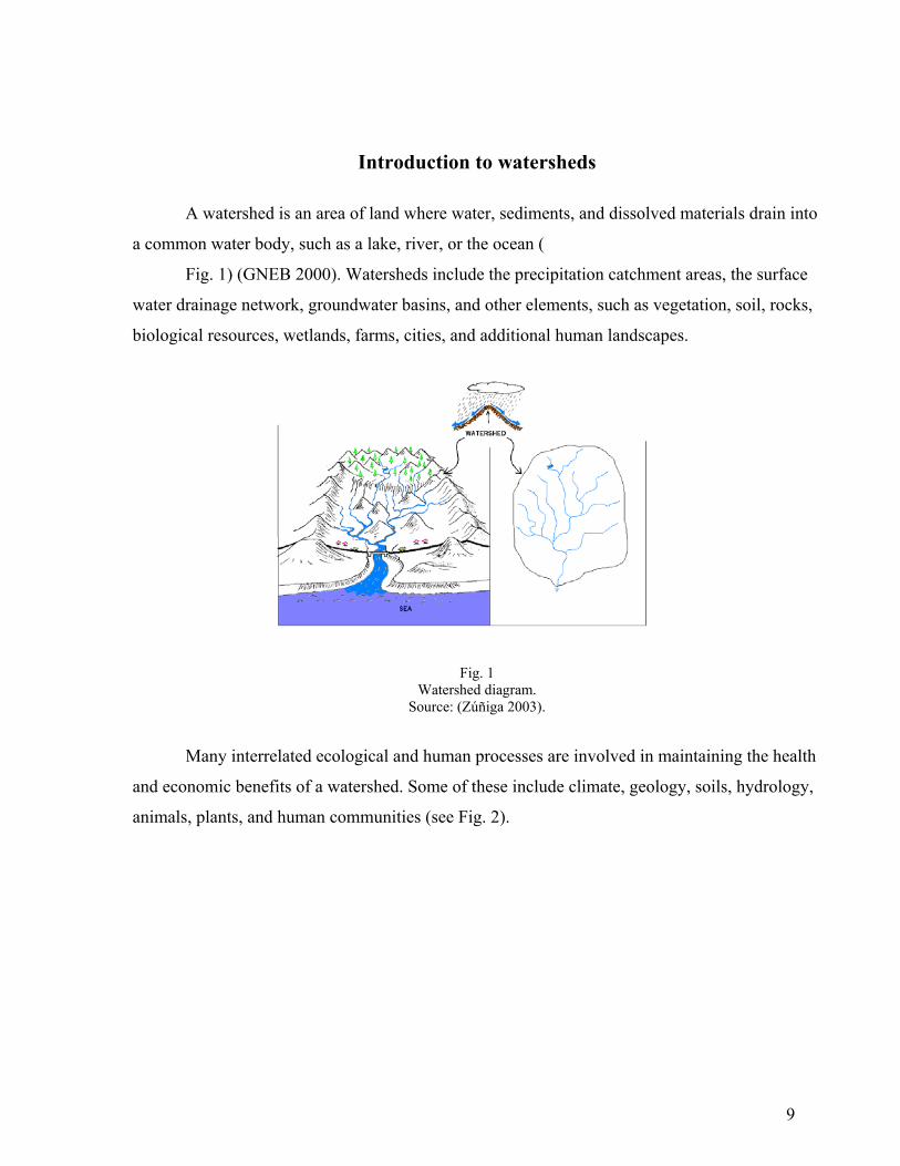
Introduction to watersheds
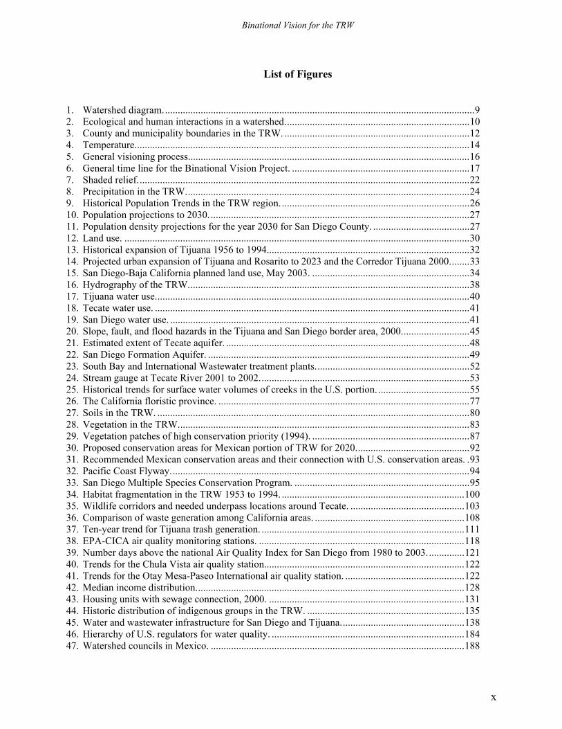
A watershed is an area of land where water, sediments, and dissolved materials drain into
a common water body, such as a lake, river, or the ocean (
Fig. 1) (GNEB 2000). Watersheds include the precipitation catchment areas, the surface
water drainage network, groundwater basins, and other elements, such as vegetation, soil, rocks,
biological resources, wetlands, farms, cities, and additional human landscapes.
Many interr
and economic bene
animals, plants, and
Fig. 1 Watershed diagram.
Source: (Zúñiga 2003).
elated ecological and human processes are involved in maintaining the health
fits of a watershed. Some of these include climate, geology, soils, hydrology,
human communities (see Fig. 2).
9
Binational Vision for the TRW
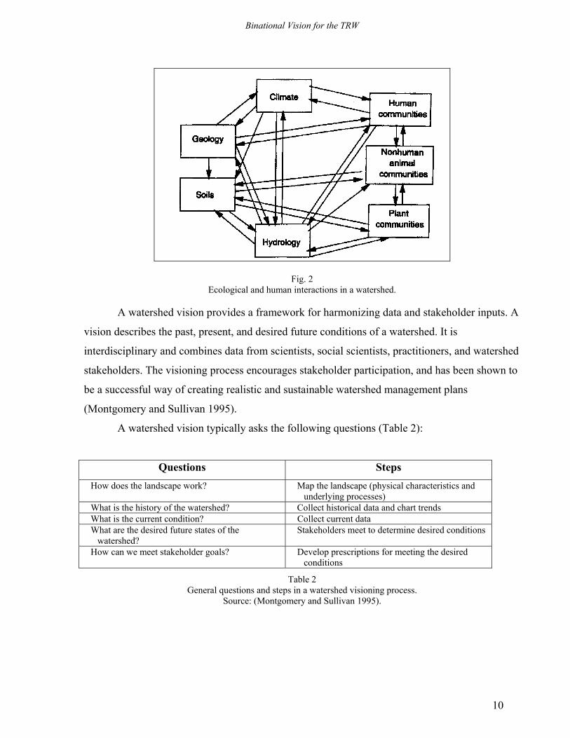
Fig. 2 Ecological and human interactions in a watershed.
A watershed vision provides a framework for harmonizing data and stakeholder inputs. A
vision describes the past, present, and desired future conditions of a watershed. It is
interdisciplinary and combines data from scientists, social scientists, practitioners, and watershed
stakeholders. The visioning process encourages stakeholder participation, and has been shown to
be a successful way of creating realistic and sustainable watershed management plans
(Montgomery and Sullivan 1995).
A watershed vision typically asks the following questions (Table 2):
Questions Steps How does the landscape work? Map the landscape (physical characteristics and
underlying processes) What is the history of the watershed? Collect historical data and chart trends What is the current condition? Collect current data What are the desired future states of the
watershed? Stakeholders meet to determine desired conditions
How can we meet stakeholder goals? Develop prescriptions for meeting the desired conditions
Table 2 General questions and steps in a watershed visioning process.
Source: (Montgomery and Sullivan 1995).
10
Introduction to the Tijuana River Watershed
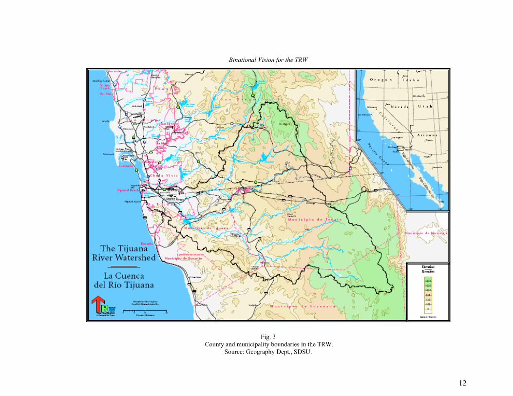
The Tijuana River Watershed (TRW) covers an area of 1,750 square miles (mi2) or 4,430
square kilometers (km2), with approximately one-third of the watershed in the United States, and
two-thirds in Mexico (Wright, Ries and Winckell 1995). The watershed extends from the Laguna
Mountains in the northeast, the Sierra Juárez Mountains in the south, to the Pacific Ocean in the
west. In the San Diego portion of the TRW, 93% of the land falls under the jurisdiction of
County of San Diego. In Mexico, almost all the TRW falls under the jurisdiction of the
municipalities of Tijuana and Tecate, but a small part lies within the Municipality of Ensenada
(Fig. 3).
Communities in the U.S. portion of the Tijuana River Basin include the incorporated
cities of Imperial Beach and San Diego (including the communities of San Ysidro and Otay
Mesa), Campo, Barrett Junction, Portreo, Pine Valley, Morena Village, Buckman Springs,
Boulder Oaks, Tierra del Sol, and Tecate (United States). Kumeyaay Indian reservations include
Campo, Manzanita, and portions of the La Posta and Cuyapaipe lands. Mexican cities include
Tijuana and Tecate, and the communities of Valle de Las Palmas, Nueva Colonia Hindú, Carmen
Serdán, Vallecitos, Santa Verónica, Nejí, El Hongo, San Luis, and Terrazas del Valle. Mexican
indigenous communities include San José de Tecate, Juntas de Nejí, Aguaje de la Tuna and Peña
Blanca. These are not officially recognized as communities by the Mexican government, with the
exception of Juntas de Nejí.
The eastern part of the watershed encompasses mountain ranges with altitudes reaching
1,900 m (6,233 ft), and an average precipitation of 250 mm (10 in.) (CNA 1995; Ojeda Revah
2000). The major tributaries in the TRW are the Cottonwood Creek-Río Alamar system and the
Río Las Palmas system. The TRW is characterized by steep, hilly terrain and a Mediterranean
climate. Vegetation cover is dominated by chaparral and coastal sage scrub, along with wetlands
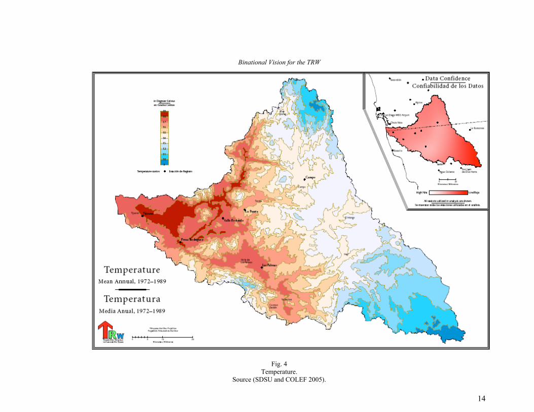
(vernal pools and riparian zones) and oaks and conifers in the mountains. Temperatures range
between 8 to 18 degrees Celsius (46.4 and 64.4 degrees Fahrenheit) (Fig. 4) and precipitation
amounts range from 150 to 650 mm (5.91 to 25.59 in.) per year (Aguado 2005).
11
Binational Vision for the TRW
12
Fig. 3 County and municipality boundaries in the TRW.
Source: Geography Dept., SDSU.
Introduction to the Tijuana River Watershed
13
In terms of human activity, the western section of the watershed demonstrates rapid
economic growth, urbanization, and population expansion in Tijuana, San Diego, and adjacent
cities. The eastern end of the basin remains lightly developed, although dispersed rural
development is increasing in the United States and Mexico. The TRW has numerous aquifers
that provide local drinking water. Water storage includes the Rodríguez and Carrizo Reservoirs
in Baja California, and the Morena and Barrett reservoirs in California. The Carrizo Reservoir is
the terminal for the Colorado River water brought over the mountains via the Colorado River
aqueduct. The other reservoirs store runoff from local precipitation.
The most pressing environmental and cultural issues identified in the watershed include
rapid population growth, uncontrolled urbanization, increasing demand for water, flood control,
poor water quality, and the loss of important animal and plant species and habitats. Cultural
issues include the preservation of important indigenous, historical, and archeological resources.
There is also a growing concern about decreasing quality of life in the TRW related to
environmental and cultural degradation, and other issues, such as traffic congestion, loss of
recreational areas, public safety, crime, and poverty.
Binational Vision for the TRW
14
Fig. 4 Temperature.
Source (SDSU and COLEF 2005).
15
The TRW Binational Vision Project
The TRW Binational Vision Project was headed by a core team of researchers at San
Diego State University (SDSU),11
along with colleagues from El COLEF and the Secretaría de
Fomento Agropecuario and the Universidad Autónoma de Baja California (UABC). The
Research Team provided basic research, Web page development, and stakeholder coordination,
along with day-to-day support for the project. The Research Team convened the Binational
Watershed Advisory Council (BWAC) early in the project to provide overall direction to the
Vision effort and to serve as the link to the diverse stakeholders of the TRW. A list of the
members of the Research Team, BWAC, and their responsibilities can be found in Appendix 1.
A description of stakeholder organizations and their responsibilities are outlined in Appendix 2.
The Binational Vision for the TRW presented here contains stakeholders’ views about the
desired state for the watershed in the near and distant future and recommends strategies and
alternatives for achieving that Vision. Much of the data and analysis on historical and projected
trends presented here had been collected previously and analyzed outside of the scope of this
visioning project. This document serves to inform stakeholders and provide guidelines for
decision makers, and provides a snapshot of the state of the TRW as it is viewed by stakeholders
today.
Description of the visioning process
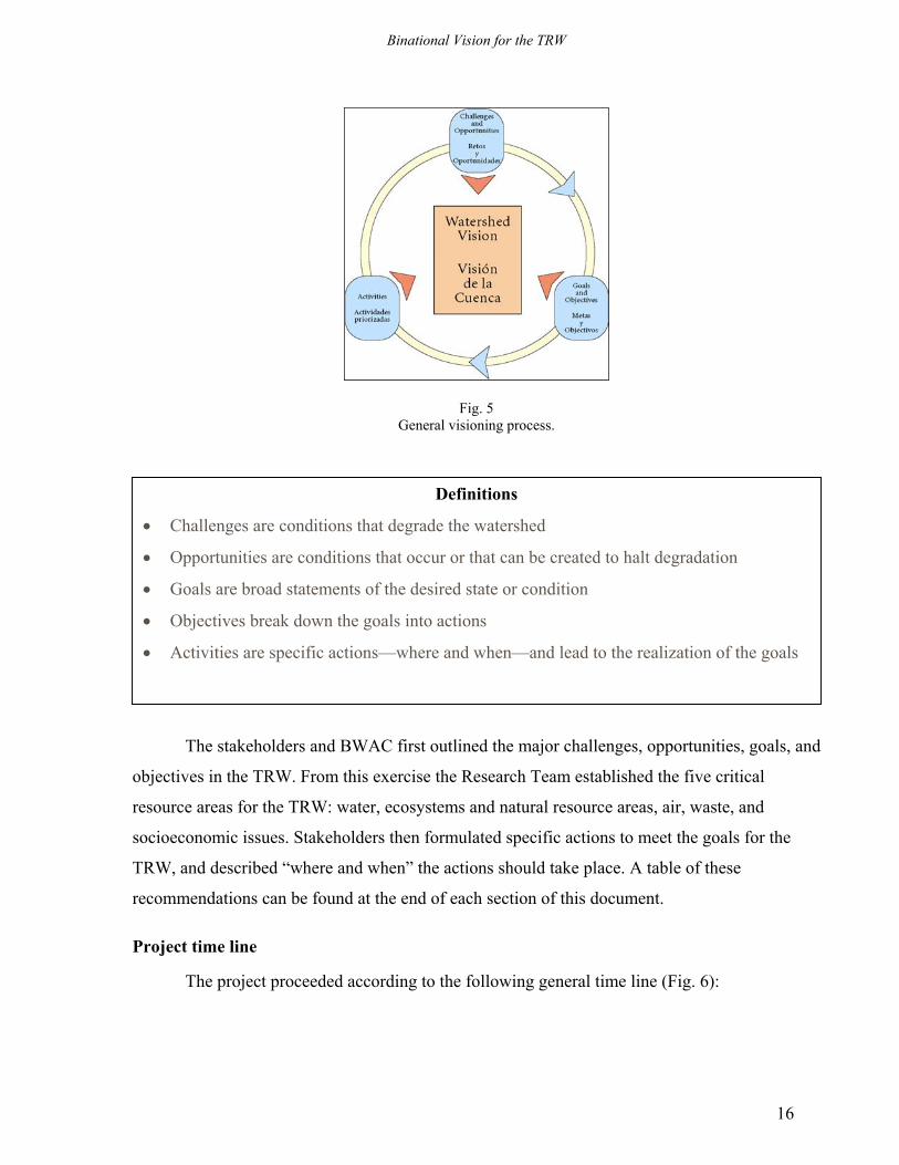
The general process for the Vision project followed these steps (Fig. 5):
11 The Institute for Regional Studies of the Californias and the Department of Geography at San Diego State University. Funding sources for the
project and associated research include the California State Water Resources Control Board, the County of San Diego, San Diego State
University, and the William and Flora Hewlett Foundation.
Binational Vision for the TRW
Project time line
The stakeholders and BWAC first
objectives in the TRW. From this exercise
resource areas for the TRW: water, ecosys
socioeconomic issues. Stakeholders then f
TRW, and described “where and when” th
recommendations can be found at the end
• Challenges are conditions that degra
• Opportunities are conditions that occ
• Goals are broad statements of the de
• Objectives break down the goals into
• Activities are specific actions—wher
The project proceeded according to
Fig. 5 General visioning process.
Definitions
de the watershed
ur or that can be created to halt degradation
sired state or condition
actions
e and when—and lead to the realization of the goals
16
outlined the major challenges, opportunities, goals, and
the Research Team established the five critical
tems and natural resource areas, air, waste, and
ormulated specific actions to meet the goals for the
e actions should take place. A table of these
of each section of this document.
the following general time line (Fig. 6):

The TRW Binational Vision Project
Fig. 6 General time line for the Binational Vision Project.
Description of stakeholder meetings
Approximately 60 BWAC members meet quarterly to discuss the components of the
Vision project. In 2003, the BWAC identified major challenges and opportunities for the
watershed. The Vision Research Team sketched out the goals and objectives for the watershed,
which were first reviewed and revised by BWAC, and then critiqued by a wider group of
stakeholders at public meetings.
One hundred and fifty-five (155) TRW stakeholders, or interested persons, were
convened in September and October of 2003 to help develop a Binational Vision for the TRW.
Three of the meetings were held in Imperial Beach, Campo, and Tecate, and two meetings took
place in Tijuana, for a total of five meetings. Each meeting included participants from both sides
of the border and from the entire TRW region including Ensenada. One-half of the participants
were contacted in person through outreach efforts in the field, while the remaining participants
were stakeholders suggested by BWAC members and contacted through mail, phone, email, and
fax (see Appendix 2 for participants and meeting dates). The meetings included diverse sectors,
such as landowners, water resource managers, natural resource managers, academics, indigenous
groups, cattle ranchers, agricultural interests, industry, the public sector, businesses, and so forth.
Efforts by outreach coordinators22
were critical in making sure that adequate numbers and types
of stakeholders participated at the public meetings.
22 Michael Wilken (CUNA), Juan Ramón Sánchez (CUNA), Victor Zambrano (IRSC-SDSU), and Katherine Comer (IRSC-SDSU)
17

Binational Vision for the TRW
The format of the 2003 stakeholder meetings was as follows:
1. Sign-in sheets. At the registration table, participants were presented with a list of issues
and asked to assign a value to each, ranging from one (lowest priority) to five (highest
priority). The issues were: water quality, air quality, ecosystem health, solid and
hazardous waste, and socioeconomic conditions.
2. Introduction to the TRW. A power point presentation then outlined the major TRW
challenges, opportunities, and goals that the BWAC had identified
3. Worksheets. Each participant next filled out a worksheet identifying actions that could
resolve some of the issues in the watershed.
4. Working groups. Participants were divided into small working groups for water,
ecosystem health, air, waste, and socioeconomic issues. They discussed their results and
decided on major actions for their resource area. Leaders presented the results of each
working group to the larger group.
5. Votes. At the end of the meeting, each participant voted with stickers for his or her five
priority actions from the list of major actions identified by all groups at their meeting.
This exercise enabled the Research Team to prioritize the actions according to the
number of votes.
Stakeholder input
Stakeholder input into this Vision document came from the five stakeholder meetings
held in September and October of 2003, as well as from BWAC members during the quarterly
meetings. The 266 proposed actions from the five stakeholder meetings are included in Appendix
4 of this report.
The Vision Research Team ranked the results of the five stakeholder meetings in several
ways. First, the votes for each of the actions proposed were tallied and then divided by the total
number of votes cast at the meeting. This gave a percentage vote for each action at each meeting.
The ten highest prioritized actions for each meeting were reported in a newsletter to stakeholders
in January 2004 to provide feedback to participants and to inform other interested parties.
Second, the actions, along with their percentage vote, were combined within the five
general resource areas: air, water, ecosystems and natural resources, socioeconomic conditions,
and waste. The actions for each resource area that received the highest percentage votes across
all meetings are reported in a table at the end of each section in this document. Combining the 18
The TRW Binational Vision Project
recommendations by resource area gives managers and decision makers an better idea about
what actions were important for the TRW as a whole.
Finally, the actions and percentage votes for the five resource areas and the five meetings
were combined (see Appendix 4). The reported percentages are a ratio of the number of votes
cast for an action divided by the total number of votes at each meeting. This provides decision
makers an idea of priority actions from stakeholders for the whole watershed, regardless of
resource area or meeting location. One assumption was that the more people who voted for an
action, the higher the priority, therefore the more urgent the need for immediate action. After
adding several actions identified from experts and the literature, the highest prioritized actions
for the TRW are presented in the “Time line” section of this document. Strategies for
implementing the time line are included.
19
Binational Vision for the TRW
The following chapters provide baseline data, historical trends, and projected trends for
the physical geography and the six resource areas of concern in the TRW—water quantity, water
quality, air quality, ecosystems and natural resources, solid and hazardous waste, and
socioeconomic issues. At the end of each section, the reader can find recommendations for
addressing some of the challenges in the TRW.
20

Topography
The watershed increases in elevation from sea level at the mouth of the Tijuana River in the
west, to more than 1,944 m (6,378 ft) and 1,800 m (5,900 ft) in the northeast and southeast
mountains, respectively (Fig. 7). Many parts of the TRW have been steeply eroded, particularly
near the major stream valleys which can have slopes in excess of 25%. Gently sloping land
(slopes of less than 10%) is found in the bottoms of the major stream valleys, such as the Tijuana
River and the Río de las Palmas, the tops of the marine terraces in the west, and the uplands of
the east-central and southeastern sections. Mountain peaks from west to east are (Wright 2005):
• Colorado Peak (500 m or 1,640 ft)
• Otay Mountain (1,087 m or 3,566 ft)
• San Isidro Peak (840 m or 2,638 ft)
• El Carmelo Peak (880 m or 2,887 ft)
• Gaskill Peak (1,169 m or 3,835 ft)
• Tecate Peak-Cerro Cuchumá (1,184 m or 3,885 ft)
• Grande Peak (900 m or 2,953 ft)
• Gordo Dos Peak (1,040 m or 3,412 ft)
• Corte Madera Mountain (1,419 m or 4,656 ft)
• Morena Butte (1,195 m or 3,920 ft)
• San Javier Peak (1,200 m or 3,937 ft)
• Los Monos Peak (1,100 m or 3,609 ft)
• Peña Blanca Peak (1,200 m or 3,937 ft)
• La Hiedra Peak (1,020 m or 3,346 ft)
• Gill Peak (1,125 m or 3,691 ft)
• Nejí Peak (1,360 m or 4,462 ft)
• Cuyapaipe Peak (1,944 m or 6,378 ft)
• La Sierrita Range (1,580 m or 5,184 ft)
• San Pedro Peak (1,800 m or 5,906 ft)
21
Binational Vision for the TRW
22
Fig. 7 Shaded relief.
Source (SDSU and COLEF 2005).

23
Precipitation
The TRW exhibits a Mediterranean seasonal precipitation pattern in which the majority
of precipitation occurs from October through March, with summers being particularly dry. Rain
gauge stations record precipitation from 200 mm (8 in.) to nearly 1,100 mm (43 in.) per year
(Fig. 8). Cold air masses move across the Pacific Ocean or southward along the coast from the
Gulf of Alaska, causing cooler seasons in the winter, with the possibility of snow at the higher
elevations. Precipitation in the late summer occasionally arrives in the form of late-stage tropical
storms off the coast of southern Baja California. Although these precipitation events normally
yield low rainfall amounts, they can occasionally produce flash floods, especially during El Niño
periodic storm seasons (Aguado 2005).
Binational Vision for the TRW
24
Fig. 8 Precipitation in the TRW.
Source: (SDSU and COLEF 2005).
25
Population
Of the approximate 1.4 million people who live in the TRW, around 97% reside within
the Mexican portion of the watershed (INEGI 2004; U.S. Census Bureau 2004).
TRW estimated population (2000)—1.4 million Mexico (municipalities of Tecate and Tijuana)—more than
1,277,795 United States (nine census tracts and the Campo Indian
Reservation)—more than 43,963
Population trends
Tijuana is the fastest growing city in the watershed. Historical data document a
population increase in the Municipality of Tijuana from 250 persons in 1900 to 1.2 million
persons in 2000. Tecate’s 1960 municipal population was 6,588 and the 2000 municipal
population was 77,796 (Table 3 and Fig. 9). Population growth in these border cities is driven
mainly by immigration from the interior of Mexico. The migrants are attracted by plentiful and
relatively well-paying jobs in the maquiladora (assembly) industry and by accessibility to the
United States for jobs and goods. The Vision Research Team selected census tracks that fell
within, or largely within, the watershed boundaries to calculate a population of 43,963 for the
U.S. portion of the TRW in 2000, an increase of 13,000 from 1990 (U.S. Census Bureau 2004).
The total population of the municipalities of Tijuana and Tecate from 2000 was derived from the
Mexican census. This total excludes the few TRW residents who live within the boundaries of
the Municipality of Ensenada and includes the Playas de Tijuana neighborhood which lies
partially outside of the TRW. There is likely undercounting of some rural populations and the
transient population.
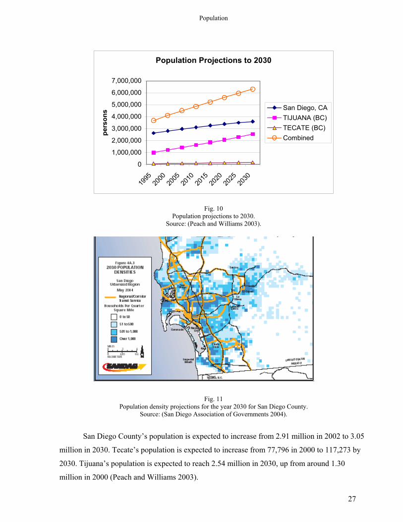
The population of the watershed is expected to double by 2030 (Fig. 10). Rapid
urbanization and industrial growth in the San Diego, Tijuana, and Tecate area will continue to
spread south and eastward (Fig. 11). Of particular concern is the possible physical merging of
Tijuana and Tecate over time. Uncontrolled population growth, urbanization, and lack of
infrastructure exacerbate other issues, such as water and sewage infrastructure deficits, poor
water quality, habitat fragmentation, and declining quality of life. If Tijuana and Tecate merge,
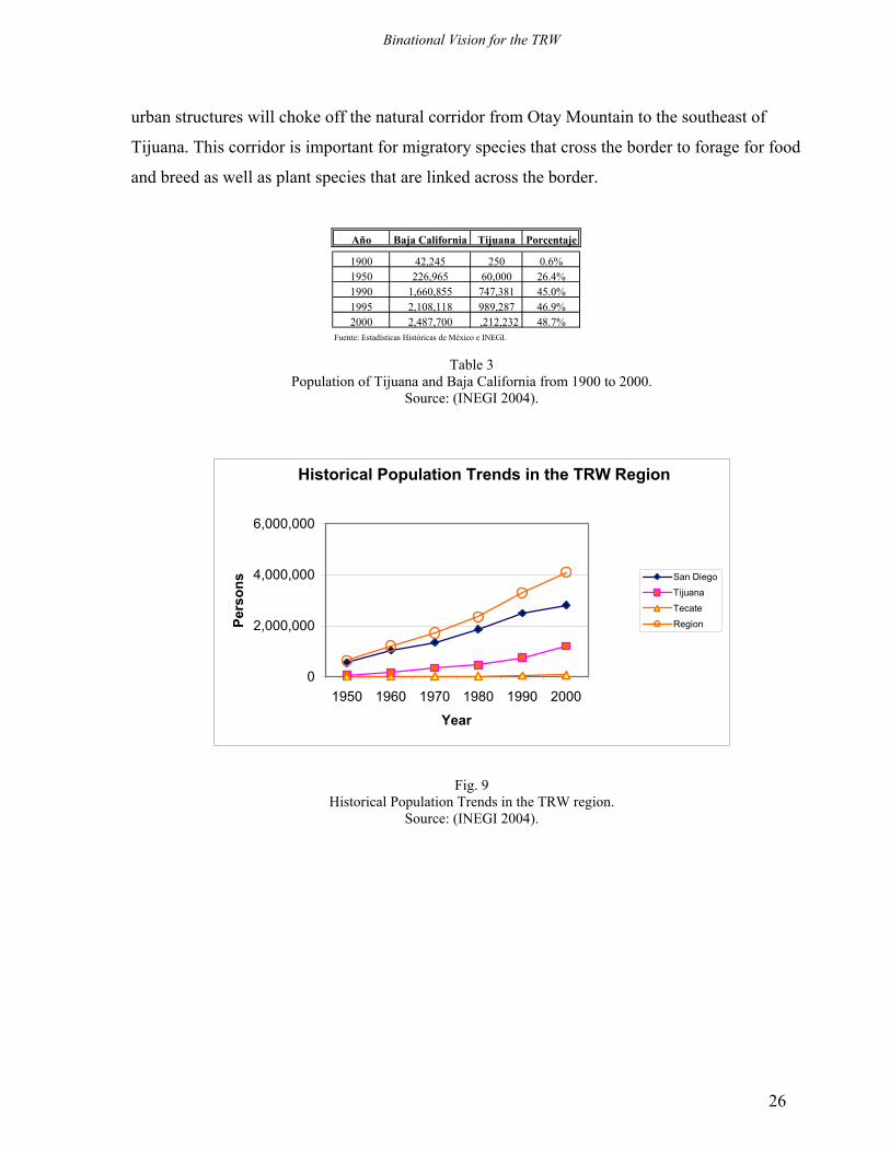
Binational Vision for the TRW
urban structures will choke off the natural corridor from Otay Mountain to the southeast of
Tijuana. This corridor is important for migratory species that cross the border to forage for food
and breed as well as plant species that are linked across the border.
1
Año Baja California Tijuana Porcentaje
1900 42,245 250 0.6%1950 226,965 60,000 26.4%1990 1,660,855 747,381 45.0%1995 2,108,118 989,287 46.9%2000 2,487,700 ,212,232 48.7%
Fuente: Estadísticas Históricas de México e INEGI.
Table 3 Population of Tijuana and Baja California from 1900 to 2000.
Source: (INEGI 2004).
2,
4,
6,
Pers
ons
Historical Population Trends in the TRW Region
0
000,000
000,000
000,000
1950 1960 1970 1980 1990 2000
Year
San Diego
Tijuana
Tecate
Region
Fig. 9 Historical Population Trends in the TRW region.
Source: (INEGI 2004).
26
Population
Population Projections to 2030
0
1,000,000
2,000,000
3,000,000
4,000,000
5,000,000
6,000,000
7,000,000
1995
2000
2005
2010
2015
2020
2025
2030
pers
ons San Diego, CA
TIJUANA (BC) TECATE (BC) Combined
Fig. 10 Population projections to 2030.
Source: (Peach and Williams 2003).
Fig. 11 Population density projections for the year 2030 for San Diego County.
Source: (San Diego Association of Governments 2004).
San Diego County’s population is expected to increase from 2.91 million in 2002 to 3.05
million in 2030. Tecate’s population is expected to increase from 77,796 in 2000 to 117,273 by
2030. Tijuana’s population is expected to reach 2.54 million in 2030, up from around 1.30
million in 2000 (Peach and Williams 2003).
27
Binational Vision for the TRW
Population data gaps
Both the United States and Mexico have problems with census undercounts. Typically, the
United States has problems counting urban populations while Mexico undercounts rural areas,
reporting households and estimating the number of residents. Also, Mexico does not census
federal zones along the international boundary, coast, or rivers. Mexico is taking steps to address
these issues with the next census in 2010.
In addition to undercounting problems, the census tracts in both countries do not coincide
with the natural boundaries of the TRW. In order to address the population data gaps, the
following are data and analysis are needed:
• A spatial population model that depicts historical, current, and projected population
densities within the boundaries of the TRW
• Census methods that are comparable across the border and do not exclude rural areas or
undercount
28
Land use
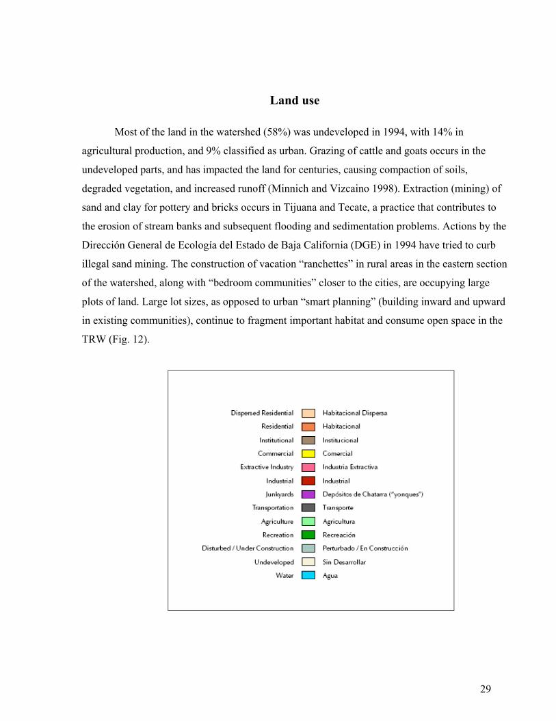
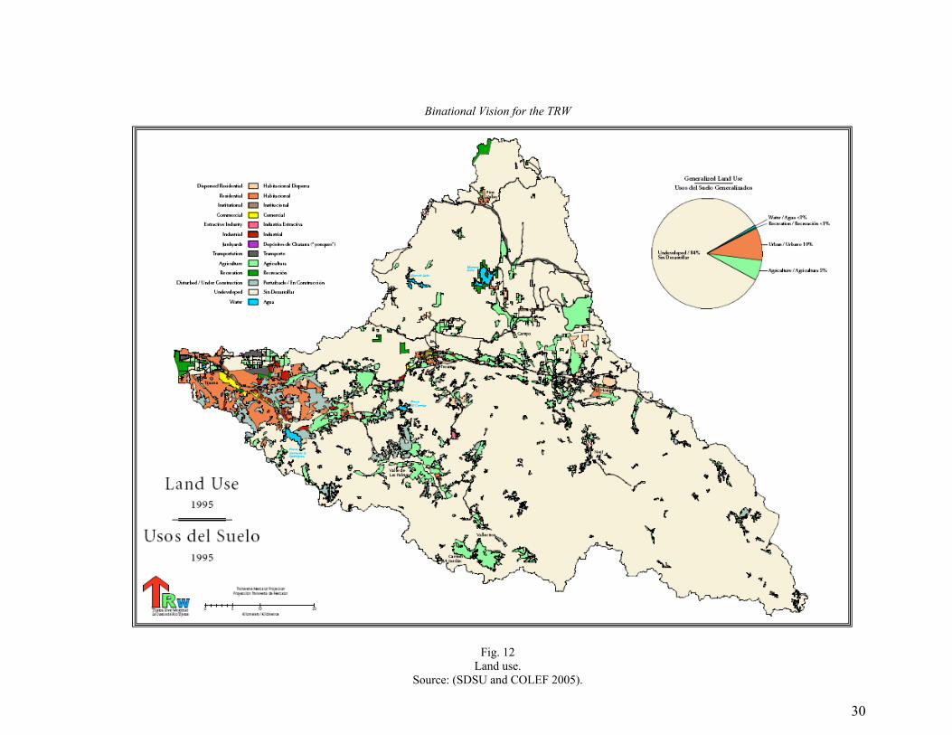
Most of the land in the watershed (58%) was undeveloped in 1994, with 14% in
agricultural production, and 9% classified as urban. Grazing of cattle and goats occurs in the
undeveloped parts, and has impacted the land for centuries, causing compaction of soils,
degraded vegetation, and increased runoff (Minnich and Vizcaino 1998). Extraction (mining) of
sand and clay for pottery and bricks occurs in Tijuana and Tecate, a practice that contributes to
the erosion of stream banks and subsequent flooding and sedimentation problems. Actions by the
Dirección General de Ecología del Estado de Baja California (DGE) in 1994 have tried to curb
illegal sand mining. The construction of vacation “ranchettes” in rural areas in the eastern section
of the watershed, along with “bedroom communities” closer to the cities, are occupying large
plots of land. Large lot sizes, as opposed to urban “smart planning” (building inward and upward
in existing communities), continue to fragment important habitat and consume open space in the
TRW (Fig. 12).
29
Binational Vision for the TRW
30
Fig. 12 Land use.
Source: (SDSU and COLEF 2005).

Binational Vision for the TRW
Land use trends
The developed area of Tijuana consumes approximately 25% of the Municipality of
Tijuana. About 90% of urban Tijuana is contained within the TRW boundaries. Fig. 13 shows
the expansion of Tijuana toward the southeast from 1956 to1994. In the late 1990s, new areas of
commercial and services activity, such as Villa Fontana and El Florido, developed toward the
east and southeast of the city.
co
Pl
bo
ac
(se
Fig. 13 Historical expansion of Tijuana 1956 to 1994.
Source: (SDSU and COLEF 2005).
An important transportation project, Corredor Tijuana-Rosarito 2000, is under
nstruction. The project is building a major highway and related infrastructure from south
ayas de Rosarito around the southeast part of Tijuana to connect with the new international
rder crossing at East Otay Mesa. One goal of the Corredor is consolidation of economic
tivity and infrastructure that will encourage development in more appropriate areas of Tijuana
e Fig. 14) (CESPT 2002).
32

Binational Vision for the TRW
gro
en
Sa
Pl
TR
mu
pa
pu
Ri
mo
Fig. 14 Projected urban expansion of Tijuana and Rosarito to 2023 and the Corredor Tijuana 2000.
Source (CESPT 2002).
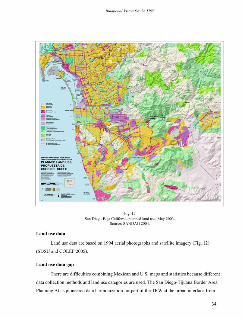
Future land use expansion for the entire TRW has not yet been modeled. However, urban
wth in San Diego County will likely affect the TRW in terms of cross-border traffic,
vironmental impacts, water consumption, habitat fragmentation, and so forth. In May 2003 the
n Diego Association of Governments (SANDAG) published the San Diego-Baja California
anned Land Use/Propuesta de Usos Del Suelo Map in May 2003 (Fig. 15) which covers the
W. Planned land use for the Municipalities of Tijuana and Tecate can be found in the planes
nicipales de desarrollo urbano, los programas de centro de población, and programas
rciales. Once the plans are approved by the governor’s office and the municipalities, they are
blished in the Periódico Oficial del Estado de Baja California. A land use plan for the Alamar
ver was developed in 1999 by Tijuana’s Municipal Planning Agency, IMPlan, and calls for
derate development while protecting the environment (IMPlan 1999).
33
Binational Vision for the TRW
L
(
L
d
P
Fig. 15 San Diego-Baja California planned land use, May 2003.
Source: SANDAG 2004.
and use data
Land use data are based on 1994 aerial photographs and satellite imagery (Fig. 12)
SDSU and COLEF 2005).
and use data gap
There are difficulties combining Mexican and U.S. maps and statistics because different
ata collection methods and land use categories are used. The San Diego-Tijuana Border Area
lanning Atlas pioneered data harmonization for part of the TRW at the urban interface from
34
Binational Vision for the TRW
Otay Mountain to the Pacific Ocean (IRSC 2000). In the 1994 TRW land use map, the use of the
term “undeveloped” also includes protected lands. There should be a separate class in the land
use legend of the TRW map titled “preserved” that would include national forests, parks, forest
preserves, open space preserves, and others. The addition of this land use class will significantly
alter the interpretation of land use patterns. In order to address the data gap for land use, the
following are suggested:
• An updated land use map with current (post-1994) data
• A new land use category called “protected areas”
• A spatial land use projection model within the boundaries of the TRW
35

Binational Vision for the TRW
36
Binational Vision for the TRW
Water quantity
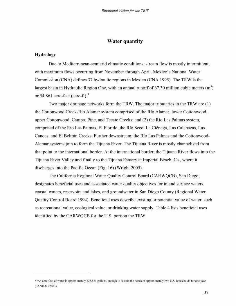
Hydrology
Due to Mediterranean-semiarid climatic conditions, stream flow is mostly intermittent,
with maximum flows occurring from November through April. Mexico’s National Water
Commission (CNA) defines 37 hydraulic regions in Mexico (CNA 1995). The TRW is the
largest basin in Hydraulic Region One, with an annual runoff of 67.30 million cubic meters (m3)
or 54,861 acre-feet (acre-ft).33
Two major drainage networks form the TRW. The major tributaries in the TRW are (1)
the Cottonwood Creek-Río Alamar system comprised of the Río Alamar, lower Cottonwood,
upper Cottonwood, Campo, Pine, and Tecate Creeks; and (2) the Río Las Palmas system,
comprised of the Río Las Palmas, El Florido, the Río Seco, La Ciénega, Las Calabazas, Las
Canoas, and El Beltrán Creeks. Further downstream, the Río Las Palmas and the Cottonwood-
Alamar systems join to form the Tijuana River. The Tijuana River is mostly channelized from
that point to the international border. At the international border, the Tijuana River flows into the
Tijuana River Valley and finally to the Tijuana Estuary at Imperial Beach, Ca., where it
discharges into the Pacific Ocean (Fig. 16) (Wright 2005).
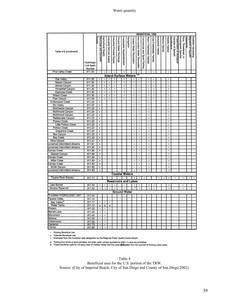
The California Regional Water Quality Control Board (CARWQCB), San Diego,
designates beneficial uses and associated water quality objectives for inland surface waters,
coastal waters, reservoirs and lakes, and groundwater in San Diego County (Regional Water
Quality Control Board 1994). Beneficial uses describe existing or potential value of water, such
as recreational value, ecological value, or drinking water supply. Table 4 lists beneficial uses
identified by the CARWQCB for the U.S. portion the TRW.
33 33An acre-foot of water is approximately 325,851 gallons, enough to sustain the needs of approximately two U.S. households for one year
(SANDAG 2003).
37

Binational Vision for the TRW
38
Fig. 16 Hydrography of the TRW.
Source: (SDSU and COLEF 2005).
Water quantity
39
Table 4 Beneficial uses for the U.S. portion of the TRW.
Source: (City of Imperial Beach, City of San Diego and County of San Diego 2002).
Binational Vision for the TRW
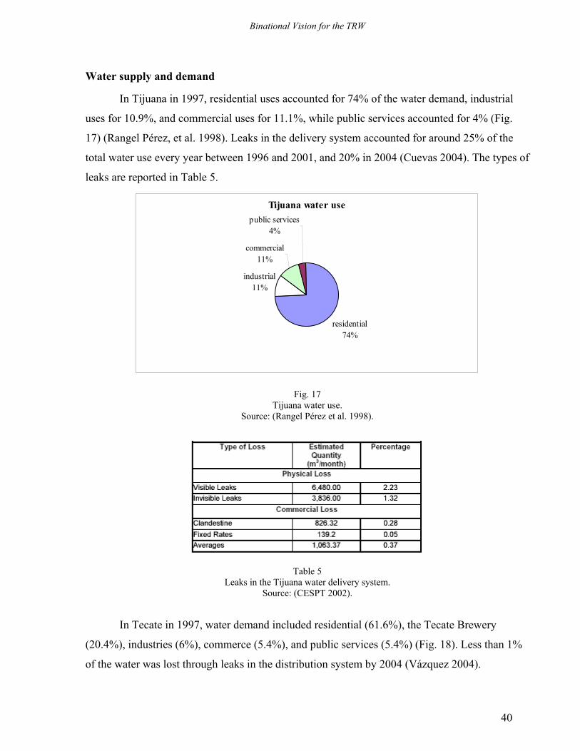
Water supply and demand
In Tijuana in 1997, residential uses accounted for 74% of the water demand, industrial
uses for 10.9%, and commercial uses for 11.1%, while public services accounted for 4% (Fig.
17) (Rangel Pérez, et al. 1998). Leaks in the delivery system accounted for around 25% of the
total water use every year between 1996 and 2001, and 20% in 2004 (Cuevas 2004). The types of
leaks are reported in Table 5.
Tijuana water use
residential74%
industrial11%
commercial11%
public services4%
Fig. 17 Tijuana water use.
Source: (Rangel Pérez et al. 1998).
Table 5 Leaks in the Tijuana water delivery system.
Source: (CESPT 2002).
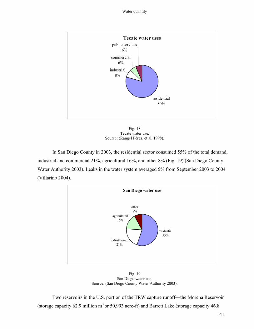
In Tecate in 1997, water demand included residential (61.6%), the Tecate Brewery
(20.4%), industries (6%), commerce (5.4%), and public services (5.4%) (Fig. 18). Less than 1%
of the water was lost through leaks in the distribution system by 2004 (Vázquez 2004).
40
Water quantity
Tecate water uses
residential80%
industrial8%
commercial6%
public services6%
Fig. 18 Tecate water use.
Source: (Rangel Pérez, et al. 1998).
In San Diego County in 2003, the residential sector consumed 55% of the total demand,
industrial and commercial 21%, agricultural 16%, and other 8% (Fig. 19) (San Diego County
Water Authority 2003). Leaks in the water system averaged 5% from September 2003 to 2004
(Villarino 2004).
San Diego water use
residential55%
indust/comm21%
agricultural16%
other8%
Fig. 19 San Diego water use.
Source: (San Diego County Water Authority 2003).
Two reservoirs in the U.S. portion of the TRW capture runoff—the Morena Reservoir
(storage capacity 62.9 million m3 or 50,993 acre-ft) and Barrett Lake (storage capacity 46.8
41
Binational Vision for the TRW
million m3 or 37,941 acre-ft). The water from Barrett Lake is transferred via a flume to Otay
Lakes in the Otay watershed for use and water storage in San Diego. Basin-to-basin transfers
such as this change the water balance and the naturally functioning hydrological systems of the
TRW. In Mexico, the El Carrizo Reservoir stores both surface water runoff and water from the
Colorado River Aqueduct (storage capacity of 40 million m3 or 32,428 acre-ft). The Abelardo L.
Rodríguez reservoir is the primary source of local surface water supply for Tijuana (storage
capacity of approximately 137 million m3 or 111,067 acre-ft).
Ninety-five percent of the water supplied by CESPT in 2001 came from the Colorado
River, while 4% was obtained from the Río Tijuana-Alamar, Rosarito, and La Misión aquifers,
while the remaining 1% came from surface runoff captured in the Rodríguez Dam (CESPT
2002). Tecate currently obtains 80% of its water from the Colorado River and 20% from public
wells (Ramírez 2004).
Demand for water in the San Diego region reached 846,821,064 m3 (686,529 acre-ft) in
2002. Water imported from the Colorado River and the California Water Project meets about
90% of the San Diego region’s water demands, depending on precipitation in the region. Barrett
Lake and the Morena Reservoir capture and store local surface water, which is exported out of
the TRW to contribute to the supply for the City of San Diego (San Diego County Water
Authority 2000; CESPT 2002).
In Tijuana in 1995, there were 100 public use wells and 310 domestic wells, extracted a
total of 18 million m3 (14,592 acre-ft). In 2001, municipal wells provided 4.5% of the water
supply for the Municipality of Tijuana bringing in 3.9 million m3 (CESPT 2002). In Tecate there
were 58 public wells and 12 domestic wells, together drawing 6 million m3 (4,864 acre-ft) of
water in 1995 (CESPT 2002). In 2003, private wells pumped around 58,000 m3 (47 acre-ft), and
the municipal wells pumped 2,027,940 m3, (1,664 acre-ft) although this rate is half the
production of 1993. In Valle de las Palmas, 48 public wells and 47 domestic wells, along with 4
water springs, provided 6.5 million m3 (5,270 acre-ft) in 1995 (CNA 1995). In the eastern San
Diego portion of the TRW, private wells are an important source of water. Data are unavailable
for volume of water extracted because private well owners are responsible for their own
extraction limits and water quality, with some testing done by the San Diego County Department
of Health (Rangel Pérez, et al. 1998).
42
Water quantity
Precipitation
There are 31 rain gauge stations in, or in close proximity, to the watershed. Precipitation
in the region is low and varies throughout the TRW depending on elevation and aspect (Fig. 8).
Annual mean values range from just over 200 mm (8 in.) to nearly 1,100 mm (43 in.). As a
result, streams are ephemeral and intermittent (seasonal). CNA recorded droughts during 1948–
1959, 1960–1974, 1980–1982, and 1984–1992. In each drought event, water supply demand
exceeded storage capacity of Tijuana’s main water reservoir, Presa Rodríguez (CNA 1995).
Flooding and landslides
The combination of hilly topography and unplanned squatter settlements on steep slopes
in Tijuana and Tecate and occasional heavy storm events have resulted in erosion, flooding, and
landslides. Fig. 20 shows potential hazards for the San Diego and Tijuana border area. Intense
precipitation resulted in severe floods in excess of 283 m3/s (10,000 ft3/s) in 1980, 1983, and
1993. These floods had devastating effects on natural habitat and human-built structures in the
Tijuana River Valley (Wright, et al. 2000). The events also coincided with the overflow of water
stored behind Rodríguez Dam. The 1993 flood was so powerful (283 m3/s or 32,000 ft3/s) that it
re-routed the Tijuana River channel, moving it several hundred feet to the north. It was
subsequently restored to its former channel (SDSU and COLEF 2005). Side canyons of the
Tijuana River Valley, such as Goat Canyon (Cañón de Los Laureles) and Smuggler’s Gulch
(Cañón Matadero) are especially subject to flash flooding during heavy rainfall events. It is
anticipated that flooding will continue to occur in the TRW due to increasing urbanization and
impermeable surfaces, loss of vegetation on the hillsides, accumulation of sediment and other
debris in drainage channels, and an inadequate storm drainage system (Wright, et al. 2000).
Because of the flood threat to the City of Tijuana, and to increased land area for
development, Mexico completed a large concrete flood channel for the Tijuana River through the
center of the city in 1979. In order to convey floodwaters that cross the border in this channel to
the ocean, a spreading basin, or “dissipater channel” was built on the U.S. side of the border in
the early 1980s. This dissipater channel terminates at Dairy Mart Road. From there, the natural
floodplain is used to convey runoff to the Pacific Ocean. Although the United States had agreed
with Mexico to extend the concrete channel from the border to the Pacific Ocean,
environmentalists and community activists put a stop to the plans. The outcome was the creation
of the Tijuana River National Estuarine Research Reserve (TRNERR) and a decision to protect
43
Binational Vision for the TRW
much of the U.S. portion of the river valley44. However, there are homes in the floodplain that
remain in danger of inundation in the event of a large flood (SDSU and COLEF 2005). The
Municipality of Tijuana has made concerted efforts to clean storm drains and provide movement
of floodwaters through urban Tijuana (Saxod 2004).
To combat flooding and disasters, a binational flood warning pilot project was initiated in
2000.55 A binational technical advisory committee designed and implemented a warning system
for regions of high risk in the lower portions of the watershed, including the Río Alamar corridor
and lower Cottonwood Creek, Campo Creek, and Tecate Creek subbasins. The system provides
real-time rain and river-level information and Geographic Information System (GIS) data to
emergency officials on both sides of the United States-Mexico border to enable effective
decision making during flood events in the lower TRW.
Seismic activities can result in landslides and liquefaction,66
which can lead to greater
earthquake damage. Earthquakes are especially devastating on steep or unstable slopes where
colonias are often built. Emergency preparedness plans could help save lives in the event of an
earthquake or other seismic event. Fig. 20 depicts slope, fault, and flood hazards identified in the
Tijuana and San Diego border area in 2000.
44 Land in the area is a matrix of federal, state, county, and city protected areas. 55 A collaboration of Dirección Estatal de Protección Civil, County of San Diego, the National Oceanic and Atmospheric Administration, and
Pacific REMS 66 Earthquakes dramatically decrease the stability of saturated cohesionless soil. The soil becomes a viscous fluid, creating problems with any
structure from bridges to buildings and to buried pipes and tanks (see http://cee.uiuc.edu/sstl/education/liquefaction/).
44
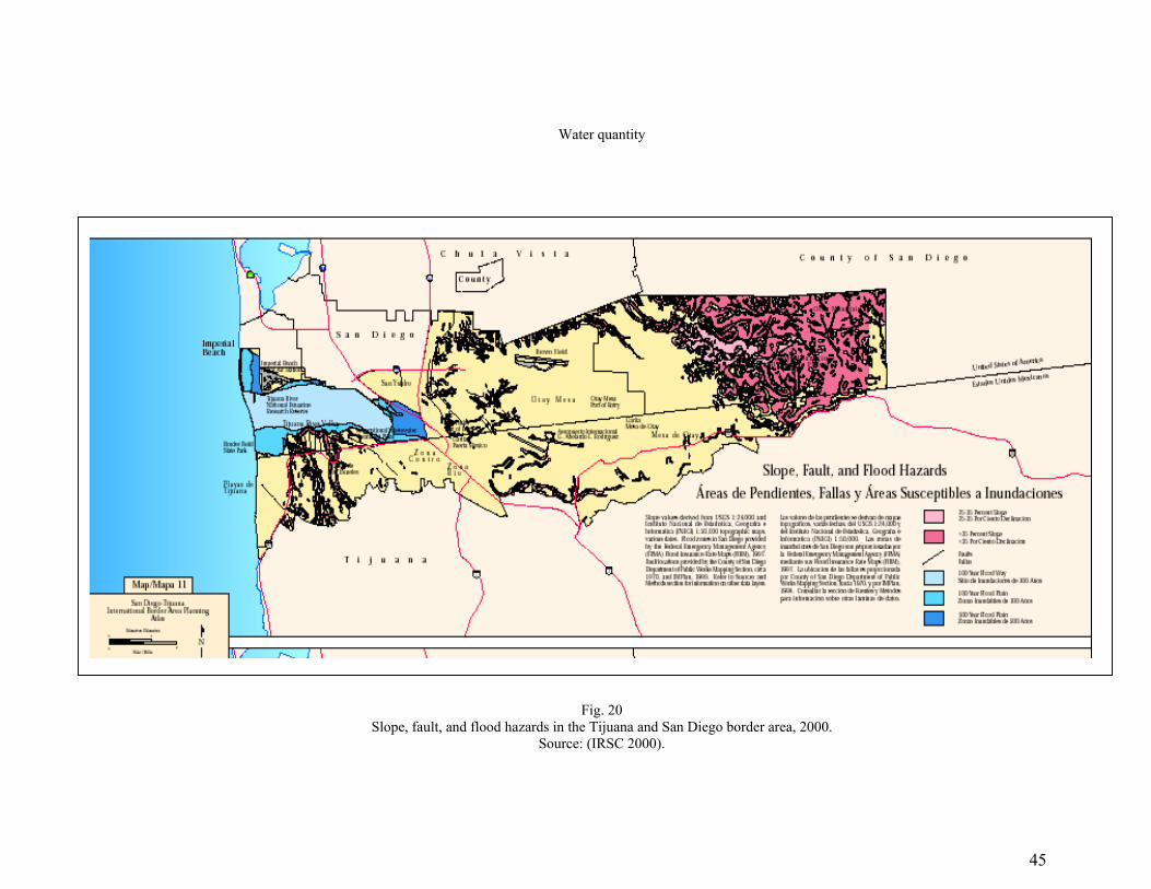
Water quantity
Fig. 20 Slope, fault, and flood hazards in the Tijuana and San
Source: (IRSC 2000).
45
Diego border area, 2000.
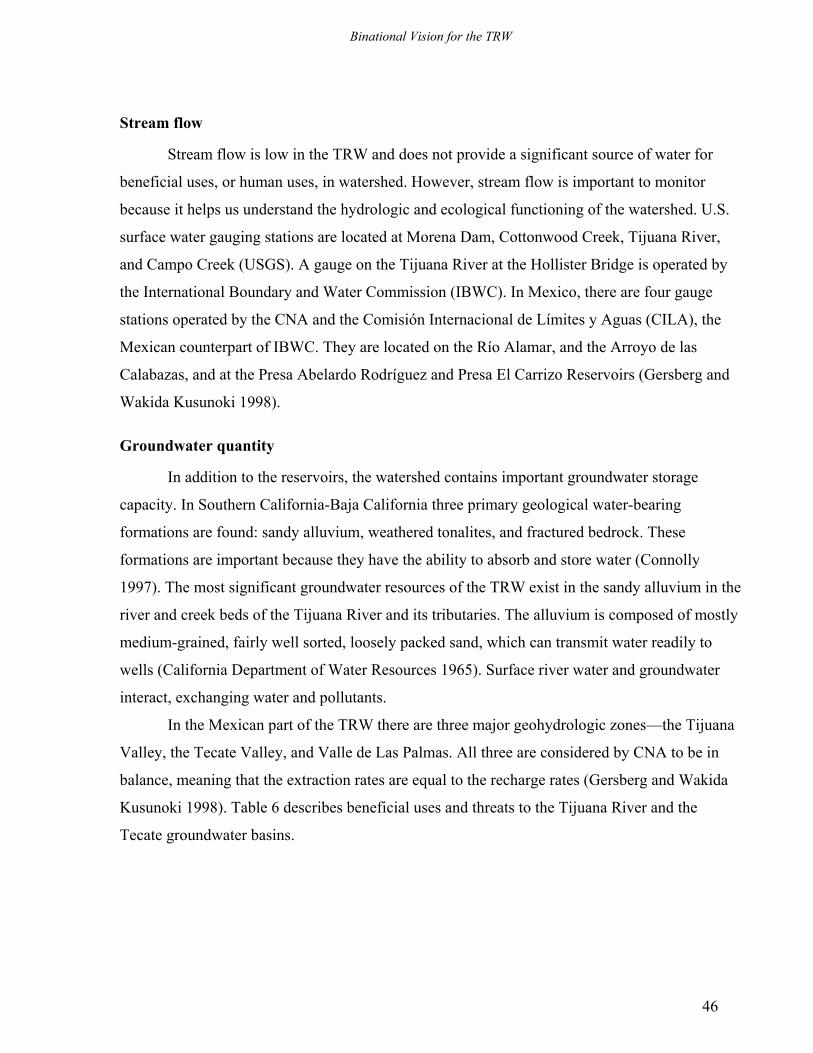
Binational Vision for the TRW
Stream flow
Stream flow is low in the TRW and does not provide a significant source of water for
beneficial uses, or human uses, in watershed. However, stream flow is important to monitor
because it helps us understand the hydrologic and ecological functioning of the watershed. U.S.
surface water gauging stations are located at Morena Dam, Cottonwood Creek, Tijuana River,
and Campo Creek (USGS). A gauge on the Tijuana River at the Hollister Bridge is operated by
the International Boundary and Water Commission (IBWC). In Mexico, there are four gauge
stations operated by the CNA and the Comisión Internacional de Límites y Aguas (CILA), the
Mexican counterpart of IBWC. They are located on the Río Alamar, and the Arroyo de las
Calabazas, and at the Presa Abelardo Rodríguez and Presa El Carrizo Reservoirs (Gersberg and
Wakida Kusunoki 1998).
Groundwater quantity
In addition to the reservoirs, the watershed contains important groundwater storage
capacity. In Southern California-Baja California three primary geological water-bearing
formations are found: sandy alluvium, weathered tonalites, and fractured bedrock. These
formations are important because they have the ability to absorb and store water (Connolly
1997). The most significant groundwater resources of the TRW exist in the sandy alluvium in the
river and creek beds of the Tijuana River and its tributaries. The alluvium is composed of mostly
medium-grained, fairly well sorted, loosely packed sand, which can transmit water readily to
wells (California Department of Water Resources 1965). Surface river water and groundwater
interact, exchanging water and pollutants.
In the Mexican part of the TRW there are three major geohydrologic zones—the Tijuana
Valley, the Tecate Valley, and Valle de Las Palmas. All three are considered by CNA to be in
balance, meaning that the extraction rates are equal to the recharge rates (Gersberg and Wakida
Kusunoki 1998). Table 6 describes beneficial uses and threats to the Tijuana River and the
Tecate groundwater basins.
46
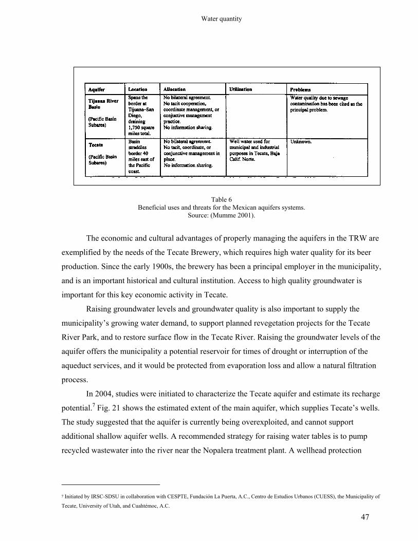
Water quantity
exem
prod
and
impo
mun
Rive
aqui
aque
proc
pote
The
addi
recy
77 Initia
Tecate
Table 6 Beneficial uses and threats for the Mexican aquifers systems.
Source: (Mumme 2001).
The economic and cultural advantages of properly managing the aquifers in the TRW are
plified by the needs of the Tecate Brewery, which requires high water quality for its beer
uction. Since the early 1900s, the brewery has been a principal employer in the municipality,
is an important historical and cultural institution. Access to high quality groundwater is
rtant for this key economic activity in Tecate.
Raising groundwater levels and groundwater quality is also important to supply the
icipality’s growing water demand, to support planned revegetation projects for the Tecate
r Park, and to restore surface flow in the Tecate River. Raising the groundwater levels of the
fer offers the municipality a potential reservoir for times of drought or interruption of the
duct services, and it would be protected from evaporation loss and allow a natural filtration
ess.
In 2004, studies were initiated to characterize the Tecate aquifer and estimate its recharge
ntial.77
Fig. 21 shows the estimated extent of the main aquifer, which supplies Tecate’s wells.
study suggested that the aquifer is currently being overexploited, and cannot support
tional shallow aquifer wells. A recommended strategy for raising water tables is to pump
cled wastewater into the river near the Nopalera treatment plant. A wellhead protection
ted by IRSC-SDSU in collaboration with CESPTE, Fundación La Puerta, A.C., Centro de Estudios Urbanos (CUESS), the Municipality of
, University of Utah, and Cuahtémoc, A.C.
47
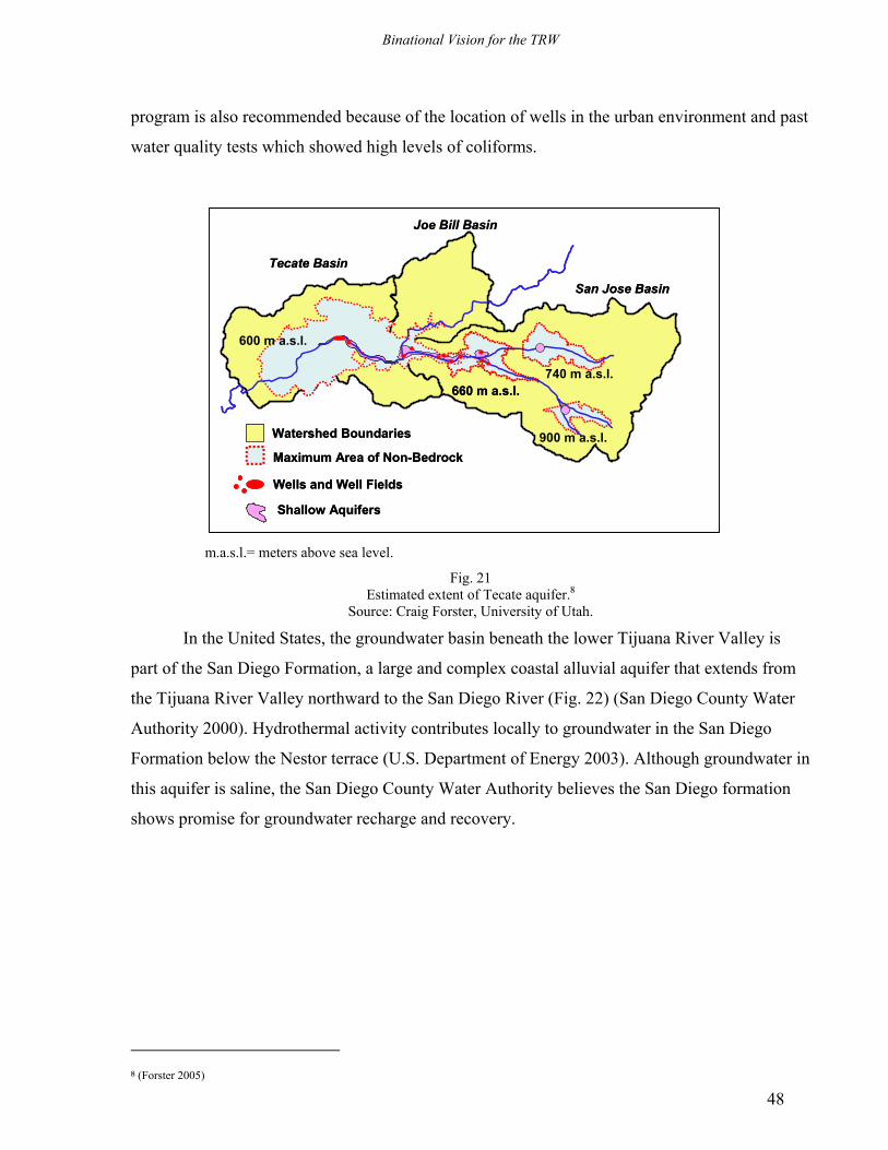
Binational Vision for the TRW
program is also recommended because of the location of wells in the urban environment and past
water quality tests which showed high levels of coliforms.
Joe Bill BasinJoe Bill Basin
m
In th
part of the S
the Tijuana
Authority 2
Formation b
this aquifer
shows prom
88 (Forster 2005)
740 m a.s.l.
900 m a.s.l.Watershed Boundaries
Maximum Area of Non-Bedrock
660 m a.s.l.
600 m a.s.l.
San Jose Basin
Tecate Basin
Wells and Well Fields
Shallow Aquifers
740 m a.s.l.
900 m a.s.l.Watershed Boundaries
Maximum Area of Non-Bedrock
660 m a.s.l.660 m a.s.l.
600 m a.s.l.
San Jose Basin
Tecate Basin
Wells and Well Fields
Shallow Aquifers
.a.s.l.= meters above sea level.
Fig. 21 Estimated extent of Tecate aquifer.88
Source: Craig Forster, University of Utah.
e United States, the groundwater basin beneath the lower Tijuana River Valley is
an Diego Formation, a large and complex coastal alluvial aquifer that extends from
River Valley northward to the San Diego River (Fig. 22) (San Diego County Water
000). Hydrothermal activity contributes locally to groundwater in the San Diego
elow the Nestor terrace (U.S. Department of Energy 2003). Although groundwater in
is saline, the San Diego County Water Authority believes the San Diego formation
ise for groundwater recharge and recovery.
48
Water quantity
and ca
bedroc
overly
produc
2003;
Valley
and a s
Depart
0.002c
Dresse
657 ft3
ft3/day
evapot
m3/day
Depart
Fig. 22 San Diego Formation Aquifer.
Source: (San Diego County Water Authority 1997).
The aquifer under the alluvial fill of the Tijuana River in the United States is unconfined
n potentially store up to 80,176,320 m3 (65,000 acre-ft) of water. The aquifer rests atop a
k surface and, on the average, consists of 15 to 27 m (50 to 90 ft) of sand and silt
ing 3 to 11 m (10 to 35 ft) of interbedded layers of gravel and sand, which are tapped by
tion wells (Municipal Wastewater District, 1996 as cited by Camp Dresser and McKee
San Diego County Water Authority 1997).
49
A bedrock aquifer lies beneath the alluvial aquifer in the hills bounding the Tijuana River
. The formation is made of an upper conglomerate unit approximately 250 ft (76 m) thick
andy facies approximately 1,200 ft (366 m) thick (Kennedy 2001 as cited by U.S.
ment of Energy 2003). Reported hydraulic conductivities of bedrock intervals range from
m/s (6 ft/day) to less than 0.0000185 cm/s (0.05 ft/day)(Dudek 1997 as cited by Camp
r and McKee 2003). Groundwater flow models for the Tijuana River aquifer show that 15,
/day of water leaves the system to the Pacific Ocean underground, 1,392 m3/day (49,144
) leaves to the ocean from the Tijuana River, and 191,878 ft3/day leaves through
ranspiration. Recharge of the system occurs from the Alamar and Tijuana Rivers 6,198
(218,913 ft3/day) and less so from precipitation 1,065 m3/day (37,626 ft3/day) (U.S.
ment of Energy 2003).

Binational Vision for the TRW
Colorado River water quantity
The Colorado River is currently the most important water source for users in the TRW.
The main water supply for the municipalities of Tijuana and Tecate is provided by the Colorado
River aqueduct that was constructed in 1975 with a capacity of 4,000 l/s (1,057 gal/s). Tijuana
has two filtration plants and provides potable water either through a piped supply or through
water trucks (pipas). Without water reuse or additional imported water, the Tijuana River Basin
cannot support additional urban growth with an adequate water supply (IRSC 1997).
The division of Colorado River water between the United States and Mexico is
determined by the 1944 water treaty, which established a volume of 1.9 billion liters/yr (or 1,540
acre-ft/yr) as Mexico’s allotment. This volume is destined mainly for agricultural uses and only
8% is used for municipal purposes in the cities of Tecate, Tijuana, and Playas de Rosarito
(CESPT 2002). The Colorado River Lower Basin states (California, Arizona, and Nevada) have
an annual apportionment of 9.3 million m3 (7.5 million acre-ft), of which California’s share is
5.4 million m3 (4.4 million acre-ft).
The current capacity of the Tijuana-Colorado River aqueduct is 3,900 l/s (1,030.3 gal/s),
of which 3,300 l/s (879.7 gal/s) are treated for drinking water use by CESPT at the El Florido
plant, and some is treated at the Abelardo L. Rodríguez Plant. The remaining 570 l/s (150.6
gal/s) are either used by the Municipality of Tecate, which has a capacity to receive 350 m3 /s
(12,360 ft3 /s) at its two treatment plants (Castro Ruíz 1998). Historically, wells supplied most of
the water for Tecate, however, this trend has reversed and now the aqueduct supplies 80% of the
water for Tecate (Ramirez March 2004).
Wastewater quantity and infrastructure
Tijuana currently has one wastewater plant providing secondary treatment (biological
treatment) at the San Antonio de los Buenos facility with a capacity of 1,100 l/s (291 gal/s). The
plant is located 10 km (6 mi) south of the border, outside the watershed boundary, at the coast
near Punta Bandera. The San Antonio de los Buenos Plant discharges into the ocean at Punta
Bandera through an arroyo. Some water is reclaimed and sold to the nearby Real del Mar golf
course. Ecoparque99
in Tijuana is a pilot reclamation project that treats wastewater to secondary
standards for irrigation uses. Located on a steep slope above the Tijuana River, water from the
plant is used for lagoons and irrigation projects. Ecoparque also serves as a field laboratory for
99 A program of COLEF and a collaboration between private, public, and academic sectors
50
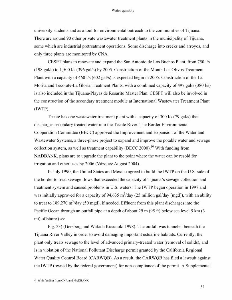
Water quantity
university students and as a tool for environmental outreach to the communities of Tijuana.
There are around 90 other private wastewater treatment plants in the municipality of Tijuana,
some which are industrial pretreatment operations. Some discharge into creeks and arroyos, and
only three plants are monitored by CNA.
CESPT plans to renovate and expand the San Antonio de Los Buenos Plant, from 750 l/s
(198 gal/s) to 1,500 l/s (396 gal/s) by 2005. Construction of the Monte Los Olivos Treatment
Plant with a capacity of 460 l/s (602 gal/s) is expected begin in 2005. Construction of the La
Morita and Tecolote-La Gloria Treatment Plants, with a combined capacity of 497 gal/s (380 l/s)
is also included in the Tijuana-Playas de Rosarito Master Plan. CESPT will also be involved in
the construction of the secondary treatment module at International Wastewater Treatment Plant
(IWTP).
Tecate has one wastewater treatment plant with a capacity of 300 l/s (79 gal/s) that
discharges secondary treated water into the Tecate River. The Border Environmental
Cooperation Committee (BECC) approved the Improvement and Expansion of the Water and
Wastewater Systems, a three-phase project to expand and improve the potable water and sewage
collection system, as well as treatment capability (BECC 2000).10 With funding from
NADBANK, plans are to upgrade the plant to the point where the water can be resold for
irrigation and other uses by 2006 (Vázquez August 2004).
10
In July 1990, the United States and Mexico agreed to build the IWTP on the U.S. side of
the border to treat sewage flows that exceeded the capacity of Tijuana’s sewage collection and
treatment system and caused problems in U.S. waters. The IWTP began operation in 1997 and
was initially approved for a capacity of 94,635 m3/day (25 million gal/day [mgd]), with an ability
to treat to 189,270 m3/day (50 mgd), if needed. Effluent from this plant discharges into the
Pacific Ocean through an outfall pipe at a depth of about 29 m (95 ft) below sea level 5 km (3
mi) offshore (see
Fig. 23) (Gersberg and Wakida Kusunoki 1998). The outfall was tunneled beneath the
Tijuana River Valley in order to avoid damaging important estuarine habitats. Currently, the
plant only treats sewage to the level of advanced primary-treated water (removal of solids), and
is in violation of the National Pollutant Discharge permit granted by the California Regional
Water Quality Control Board (CARWQB). As a result, the CARWQB has filed a lawsuit against
the IWTP (owned by the federal government) for non-compliance of the permit. A Supplemental
1100 With funding from CNA and NADBANK
51
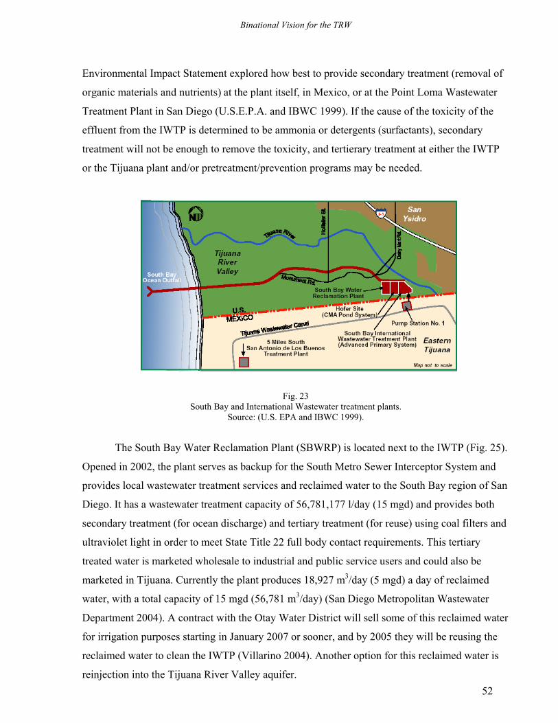
Binational Vision for the TRW
Environmental Impact Statement explored how best to provide secondary treatment (removal of
organic materials and nutrients) at the plant itself, in Mexico, or at the Point Loma Wastewater
Treatment Plant in San Diego (U.S.E.P.A. and IBWC 1999). If the cause of the toxicity of the
effluent from the IWTP is determined to be ammonia or detergents (surfactants), secondary
treatment will not be enough to remove the toxicity, and tertierary treatment at either the IWTP
or the Tijuana plant and/or pretreatment/prevention programs may be needed.
The
Opened in 2
provides loc
Diego. It ha
secondary t
ultraviolet l
treated wate
marketed in
water, with
Department
for irrigatio
reclaimed w
reinjection i
Fig. 23 South Bay and International Wastewater treatment plants.
Source: (U.S. EPA and IBWC 1999).
South Bay Water Reclamation Plant (SBWRP) is located next to the IWTP (Fig. 25).
002, the plant serves as backup for the South Metro Sewer Interceptor System and
al wastewater treatment services and reclaimed water to the South Bay region of San
s a wastewater treatment capacity of 56,781,177 l/day (15 mgd) and provides both
reatment (for ocean discharge) and tertiary treatment (for reuse) using coal filters and
ight in order to meet State Title 22 full body contact requirements. This tertiary
r is marketed wholesale to industrial and public service users and could also be
Tijuana. Currently the plant produces 18,927 m3/day (5 mgd) a day of reclaimed
a total capacity of 15 mgd (56,781 m3/day) (San Diego Metropolitan Wastewater
2004). A contract with the Otay Water District will sell some of this reclaimed water
n purposes starting in January 2007 or sooner, and by 2005 they will be reusing the
ater to clean the IWTP (Villarino 2004). Another option for this reclaimed water is
nto the Tijuana River Valley aquifer. 52
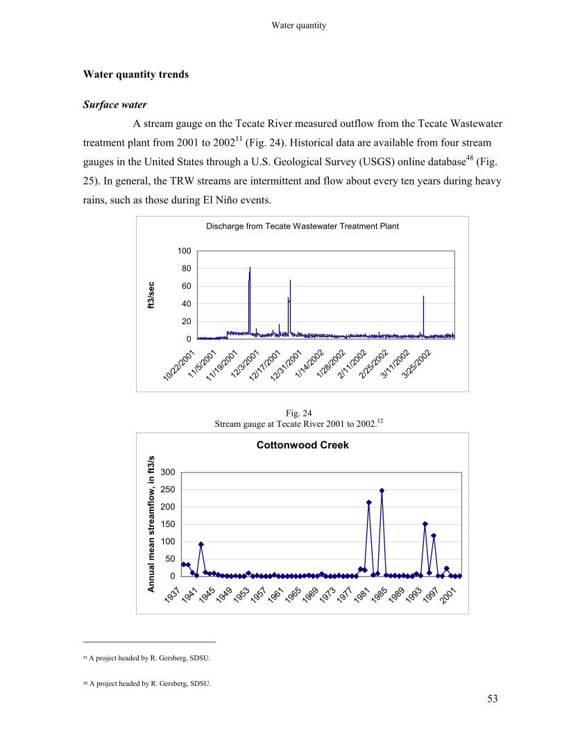
Water quantity
Water quantity trends
Surface water
A stream gauge on the Tecate River measured outflow from the Tecate Wastewater
treatment plant from 2001 to 200211 (Fig. 24). Historical data are available from four stream
gauges in the United States through a U.S. Geological Survey (USGS) online database48 (Fig.
25). In general, the TRW streams are intermittent and flow about every ten years during heavy
rains, such as those during El Niño events.
11
Discharge from Tecate Wastewater Treatment Plant
0
20
40
60
80
100
10/22
/2001
11/5/
2001
11/19
/2001
12/3/
2001
12/17
/2001
12/31
/2001
1/14/2
002
1/28/2
002
2/11/2
002
2/25/2
002
3/11/2
002
3/25/2
002
ft3/s
ec
Fig. 24 Stream gauge at Tecate River 2001 to 2002.12 12
Cottonwood Creek
0
50
100
150
200
250
300
1937
1941
1945
1949
1953
1957
1961
1965
1969
1973
1977
1981
1985
1989
1993
1997
2001A
nnua
l mea
n st
ream
flow
, in
ft3/s
1111 A project headed by R. Gersberg, SDSU.
1122 A project headed by R. Gersberg, SDSU.
53
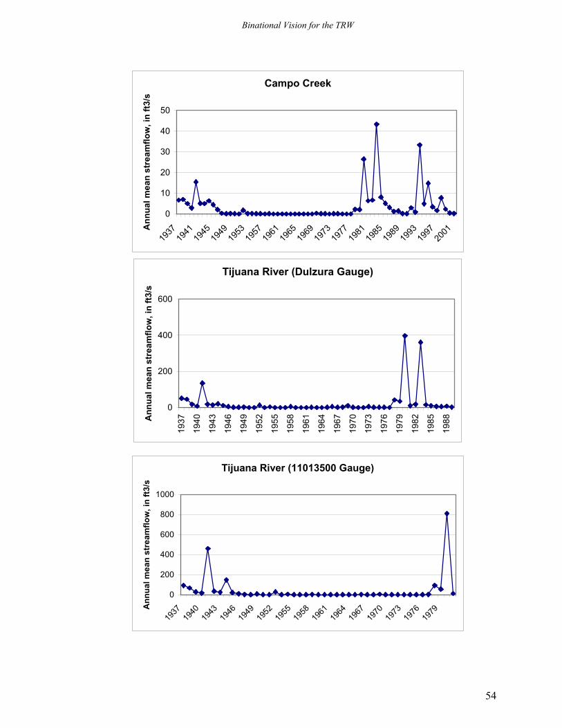
Binational Vision for the TRW
Campo Creek
0
10
20
30
40
50
1937
1941
1945
1949
1953
1957
1961
1965
1969
1973
1977
1981
1985
1989
1993
1997
2001A
nnua
l mea
n st
ream
flow
, in
ft3/s
Tijuana River (Dulzura Gauge)
0
200
400
600
1937
1940
1943
1946
1949
1952
1955
1958
1961
1964
1967
1970
1973
1976
1979
1982
1985
1988A
nnua
l mea
n st
ream
flow
, in
ft3/s
Tijuana River (11013500 Gauge)
0
200
400
600
800
1000
1937
1940
1943
1946
1949
1952
1955
1958
1961
1964
1967
1970
1973
1976
1979
Ann
ual m
ean
stre
amflo
w, i
n ft3
/s
54
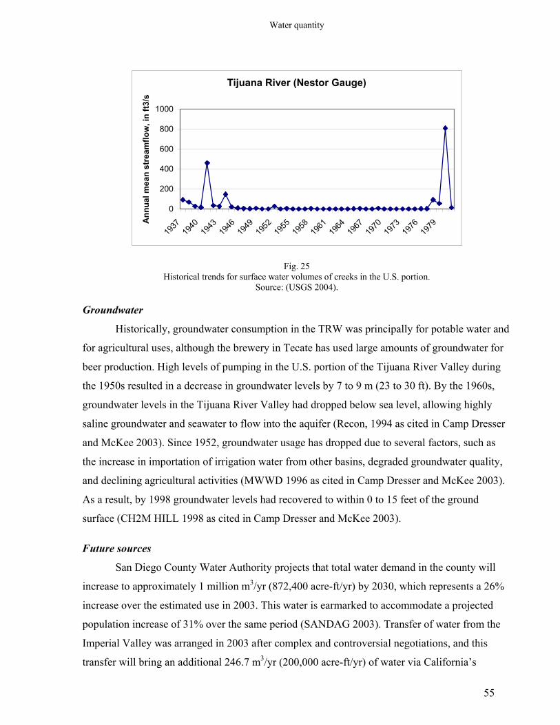
Water quantity
Tijuana River (Nestor Gauge)
0
200
400
600
800
1000
1937
1940
1943
1946
1949
1952
1955
1958
1961
1964
1967
1970
1973
1976
1979
Ann
ual m
ean
stre
amflo
w, i
n ft3
/s
Fig. 25 Historical trends for surface water volumes of creeks in the U.S. portion.
Source: (USGS 2004).
Groundwater
Historically, groundwater consumption in the TRW was principally for potable water and
for agricultural uses, although the brewery in Tecate has used large amounts of groundwater for
beer production. High levels of pumping in the U.S. portion of the Tijuana River Valley during
the 1950s resulted in a decrease in groundwater levels by 7 to 9 m (23 to 30 ft). By the 1960s,
groundwater levels in the Tijuana River Valley had dropped below sea level, allowing highly
saline groundwater and seawater to flow into the aquifer (Recon, 1994 as cited in Camp Dresser
and McKee 2003). Since 1952, groundwater usage has dropped due to several factors, such as
the increase in importation of irrigation water from other basins, degraded groundwater quality,
and declining agricultural activities (MWWD 1996 as cited in Camp Dresser and McKee 2003).
As a result, by 1998 groundwater levels had recovered to within 0 to 15 feet of the ground
surface (CH2M HILL 1998 as cited in Camp Dresser and McKee 2003).
Future sources
San Diego County Water Authority projects that total water demand in the county will
increase to approximately 1 million m3/yr (872,400 acre-ft/yr) by 2030, which represents a 26%
increase over the estimated use in 2003. This water is earmarked to accommodate a projected
population increase of 31% over the same period (SANDAG 2003). Transfer of water from the
Imperial Valley was arranged in 2003 after complex and controversial negotiations, and this
transfer will bring an additional 246.7 m3/yr (200,000 acre-ft/yr) of water via California’s
55
Binational Vision for the TRW
Colorado River Aqueduct. In addition to the purchase of the Imperial Valley water, a canal-
lining project for the All-American and Coachella Canals will free up an additional 94,978,653
m3/yr (77,000 acre-ft/yr) for San Diego County (San Diego County Water Authority 2003).
Lining the All-American Canal will significantly reduce recharge of the adjacent aquifer in
Mexicali, Mexico, and will likely have a significant impact on Mexicali’s agricultural
production. The continued availability of imported water may delay the development of local
water supply alternatives in the TRW, such as artificial aquifer recharge, water reclamation
projects, storm water recycling, and rain harvesting projects.
CESPTE projects a 2010 water demand of 7.8 million m3/yr (6,324 acre-ft/yr) of water
(Castro Ruíz 1998). For Tijuana and Playas de Rosarito combined, CESPT estimates the water
demand will increase from 106 million m3/yr (85,936 acre-ft/yr) in 2001 to 216 million m3/yr
(175,114 acre-ft/yr) in 2023, which represents an increase of 106% over the current demand. For
the year 2040, the projected demand is 316 million m3/yr (256,185 acre-ft/yr) (CESPT 2002).
It is expected that Colorado River water will continue to be an important water source for
Mexico in the future. The Mexican State Commission for Water Services (COSAE) proposes to
upgrade the aqueduct to conduct additional water in the amount of 1,300 l/s (343.4 gal/s)
(CESPT 2002). This is an expensive option with a relatively long implementation period, and
obtaining additional water rights, or developing a purchase agreement with the United States
would likely be necessary (CESPT 2002). There is also a plan to build a second aqueduct to the
coastal communities of Baja California called Acueducto Río Colorado II. The aqueduct would
be built from 2008—2011 and would have a capacity of 8,000 l/s (2,113 gal/s) and would require
an estimated $3.25 billion in investment (Gobierno del Estado de Baja California, et al. 2004a)
Groundwater in the Tijuana River Valley, although currently of low quality, is a potential
source of water for the San Diego County Water Authority. The goal of the City of San Diego
Water Department is to eventually extract 3 million m3/yr (2,500 acre-ft/yr) of groundwater from
the San Diego Formation in the lower Tijuana River Valley, through natural and artificial
recharge projects (San Diego County Water Authority 1997). Groundwater flow models13 for the
Tijuana River aquifer predict that between 7,570—9,463 m3/day (2.0—2.5 million gallons/day)
could be artificially injected through three wells on the U.S. side without reaching the surface
(U.S. Department of Energy 2003).
13
1133 (U.S. Department of Energy 2003)
56
Water quantity
Desalinization of seawater is an alternative being explored in both Tijuana and San
Diego. The main concern is that desalinization plants are very expensive to build and expensive
to operate because of the energy required. In San Diego, the County Water Authority (CWA) has
adopted the Seawater Desalination Action Plan with the goal of developing at least 25,000 acre-
ft of supply by 2020, provided it is determined to be cost-effective and feasible. The CWA is
interested in locations near the South Bay Power Plant in Chula Vista, and is and conducting a
study of other potential locations where seawater desalination facilities could be developed on a
regional scale. Although the potential sites are not located in the TRW, the availability of
desalinized water will likely have impacts on the supply and cost of water available to TRW
residents, including the emergency supply water provided to Tijuana by San Diego through
International Boundary and Water Commission (IBWC-CILA) (see “International legislation”
section) (SANDAG 2002).
Water quantity data
Sources of data on water quantity in the TRW are available in Appendix 7. The data
includes reports, electronic files, maps, and other information in English and Spanish from both
the United States and Mexico.
Water quantity data gaps
After reviewing the available data, the Research Team and others identified the following
data needs for the TRW:
• More surface water gauging stations at all the tributaries in the TRW
• All stream gauge data in a centralized database (see, for example, the Flood Warning
project)14 14
• Data on the extent of groundwater aquifers, quality, quantity, and flow (including
transboundary aquifers)
• Research on the potential for recharge of the aquifers through natural or artificial
means
• Data on runoff from precipitation and sediment loading in the rivers
• Stream flow rates for the Alamar and Tijuana Rivers on the Mexican side15 15
1144 A collaboration of Dirección Estatal de Protección Civil, County of San Diego, the National Oceanic and Atmospheric Administration, and
Pacific REMS 1155 Suggested by (U.S. Department of Energy 2003)
57
Binational Vision for the TRW
• Measured evapotranspiration zones and rates
The following applied research projects relating to groundwater quantity are
recommended by the Vision project:16 16
• Conduct regular periodic groundwater level monitoring along the Tijuana and Alamar
Rivers.
• Install an observation well near a supply well in Tijuana and conduct pumping tests to
determine hydraulic conductivity of the alluvial aquifer to better determine the flow,
extraction potential, and recharge rates of water.
• Test hydraulic conductivity in the San Diego Formation alluvial aquifer.
Water quantity recommendations
The Vision project recommends that water agencies focus on conjunctive water use, or
the coordinated management of surface, reclaimed, and groundwater supplies. Since
groundwater does not evaporate, groundwater storage, as opposed to open-air reservoirs, should
be considered. Many areas in the watershed could store water underground, replenishing their
wells. The Las Auras emergency storage tank in Tecate, for example, is open air, and subject to
evaporation losses, high pumping costs, and seepage. Recharging the Tecate aquifer and storing
water underground is an alternative worth investigating.
Reuse of water for landscaping should increase, and public education in both the United
States and Mexico is needed to dispel myths that reused water is unsafe for human consumption.
Stakeholder groups for groundwater are needed to make collaborative decisions on sustainable
groundwater use.
TRW stakeholders at community forums, the BWAC, and the Vision Research Team
jointly characterized the current situation and future desired scenarios for water quantity in the
TRW. Table 7 summarizes these conclusions.
1166 Suggested by (U.S. Department of Energy 2003)
58
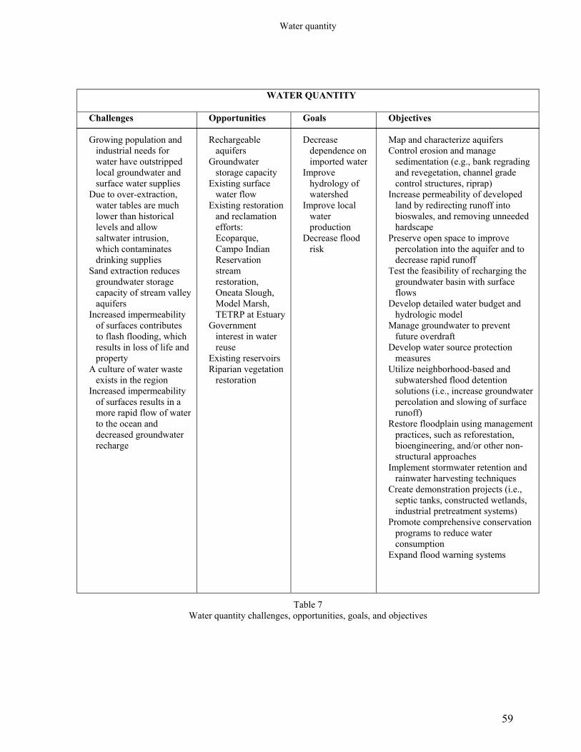
Water quantity
WATER QUANTITY
Challenges
Growing population and industrial needs for water have outstripped local groundwater and surface water supplies
Due to over-extraction, water tables are much lower than historical levels and allow saltwater intrusion, which contaminates drinking supplies
Sand extraction reduces groundwater storage capacity of stream valley aquifers
Increased impermeability of surfaces contributes to flash flooding, which results in loss of life and property
A culture of water waste exists in the region
Increased impermeability of surfaces results in a more rapid flow of water to the ocean and decreased groundwater recharge
Opportunities Rechargeable
aquifers Groundwater
storage capacity Existing surface
water flow Existing restoration
and reclamation efforts: Ecoparque, Campo Indian Reservation stream restoration, Oneata Slough, Model Marsh, TETRP at Estuary
Government interest in water reuse
Existing reservoirs Riparian vegetation
restoration
Goals Decrease
dependence on imported water
Improve hydrology of watershed
Improve local water production
Decrease flood risk
Objectives Map and characterize aquifers Control erosion and manage
sedimentation (e.g., bank regrading and revegetation, channel grade control structures, riprap)
Increase permeability of developed land by redirecting runoff into bioswales, and removing unneeded hardscape
Preserve open space to improve percolation into the aquifer and to decrease rapid runoff
Test the feasibility of recharging the groundwater basin with surface flows
Develop detailed water budget and hydrologic model
Manage groundwater to prevent future overdraft
Develop water source protection measures
Utilize neighborhood-based and subwatershed flood detention solutions (i.e., increase groundwater percolation and slowing of surface runoff)
Restore floodplain using management practices, such as reforestation, bioengineering, and/or other non-structural approaches
Implement stormwater retention and rainwater harvesting techniques
Create demonstration projects (i.e., septic tanks, constructed wetlands, industrial pretreatment systems)
Promote comprehensive conservation programs to reduce water consumption
Expand flood warning systems
Table 7 Water quantity challenges, opportunities, goals, and objectives
59
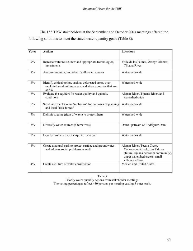
Binational Vision for the TRW
The 155 TRW stakeholders at the September and October 2003 meetings offered the
following solutions to meet the stated water quantity goals (Table 8):
Votes Actions Locations
9% Increase water reuse, new and appropriate technologies, investments
Valle de las Palmas, Arroyo Alamar, Tijuana River
7% Analyze, monitor, and identify all water sources Watershed-wide
6% Identify critical points, such as deforested areas, over-exploited sand mining areas, and stream courses that are at risk
Watershed-wide
6% Evaluate the aquifers for water quality and quantity conditions
Alamar River, Tijuana River, and watershed-wide
6% Subdivide the TRW in "subbasins" for purposes of planning and local "task forces"
Watershed-wide
5% Delimit streams (right of ways) to protect them Watershed-wide
5% Diversify water sources (alternatives) Dams upstream of Rodríguez Dam
5% Legally protect areas for aquifer recharge Watershed-wide
4% Create a natural park to protect surface and groundwater and address social problems as well
Alamar River, Tecate Creek, Cottonwood Creek, Las Palmas (future Tijuana bedroom community), upper watershed creeks, small villages, ejidos
4% Create a culture of water conservation Mexico and United States
Table 8 Priority water quantity actions from stakeholder meetings.
The voting percentages reflect ~50 persons per meeting casting 5 votes each.
60


Binational Vision for the TRW
62
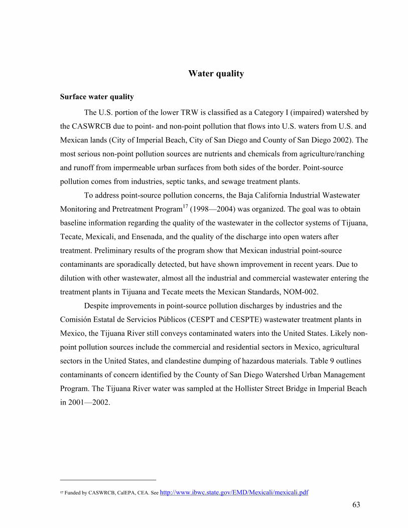
Water quality
Surface water quality
The U.S. portion of the lower TRW is classified as a Category I (impaired) watershed by
the CASWRCB due to point- and non-point pollution that flows into U.S. waters from U.S. and
Mexican lands (City of Imperial Beach, City of San Diego and County of San Diego 2002). The
most serious non-point pollution sources are nutrients and chemicals from agriculture/ranching
and runoff from impermeable urban surfaces from both sides of the border. Point-source
pollution comes from industries, septic tanks, and sewage treatment plants.
To address point-source pollution concerns, the Baja California Industrial Wastewater
Monitoring and Pretreatment Program17 (1998—2004) was organized. The goal was to obtain
baseline information regarding the quality of the wastewater in the collector systems of Tijuana,
Tecate, Mexicali, and Ensenada, and the quality of the discharge into open waters after
treatment. Preliminary results of the program show that Mexican industrial point-source
contaminants are sporadically detected, but have shown improvement in recent years. Due to
dilution with other wastewater, almost all the industrial and commercial wastewater entering the
treatment plants in Tijuana and Tecate meets the Mexican Standards, NOM-002.
17
Despite improvements in point-source pollution discharges by industries and the
Comisión Estatal de Servicios Públicos (CESPT and CESPTE) wastewater treatment plants in
Mexico, the Tijuana River still conveys contaminated waters into the United States. Likely non-
point pollution sources include the commercial and residential sectors in Mexico, agricultural
sectors in the United States, and clandestine dumping of hazardous materials. Table 9 outlines
contaminants of concern identified by the County of San Diego Watershed Urban Management
Program. The Tijuana River water was sampled at the Hollister Street Bridge in Imperial Beach
in 2001—2002.
1177 Funded by CASWRCB, CalEPA, CEA. See http://www.ibwc.state.gov/EMD/Mexicali/mexicali.pdf
63
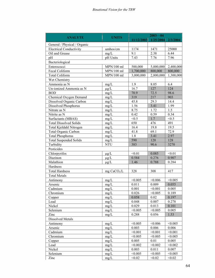
Binational Vision for the TRW
2003—04 ANALYTE UNITS 11/12/2003 1/25/2004 2/3/2004
General / Physical / Organic Electrical Conductivity umhos/cm 1174 1471 25000 Oil and Grease mg/L 9.1 2.38 6.44 pH pH Units 7.43 7.76 7.96 Bacteriological Enterococci MPN/100 ml 500,000 5,000,000 2,400,000Fecal Coliform MPN/100 ml 1,700,000 800,000 800,000 Total Coliform MPN/100 ml 3,000,000 2,800,000 1,300,000Wet Chemistry Ammonia as N mg/L 1.9 8.05 6.4 Un-ionized Ammonia as N µg/L 16.7 127 124 BOD mg/L 70.9 72.5 98.6 Chemical Oxygen Demand mg/L 319 217 903 Dissolved Organic Carbon mg/L 45.8 29.3 14.4 Dissolved Phosphorus mg/L 1.56 3.41 1.99 Nitrate as N mg/L 8.75 1.72 1.5 Nitrite as N mg/L 0.42 0.59 0.34 Surfactants (MBAS) mg/L <0.5 1.7 <0.5 Total Dissolved Solids mg/L 650 476 491 Total Kjeldahl Nitrogen mg/L 16.4 19.8 19.5 Total Organic Carbon mg/L 41.8 69.1 72.9 Total Phosphorus mg/L 1.8 3.41 2.97 Total Suspended Solids mg/L 590 120 128 Turbidity NTU 383 90.6 3270 Pesticides Chlorpyrifos µg/L <0.01 0.085 <0.01 Diazinon µg/L 0.584 0.276 0.907 Malathion µg/L 1.46 0.788 0.284 Hardness Total Hardness mg CaCO3/L 328 308 417 Total Metals Antimony mg/L <0.005 <0.006 <0.005 Arsenic mg/L 0.011 0.009 0.055 Cadmium mg/L 0.001 <0.001 0.005 Chromium mg/L 0.026 <0.005 0.189 Copper mg/L 0.058 0.02 0.197 Lead mg/L 0.048 0.007 0.278 Nickel mg/L 0.029 0.013 0.101 Selenium mg/L <0.005 <0.005 0.005 Zinc mg/L 0.288 0.056 1.53 Dissolved Metals Antimony mg/L <0.005 <0.006 <0.005 Arsenic mg/L 0.003 0.006 0.006 Cadmium mg/L <0.001 <0.001 <0.001 Chromium mg/L <0.005 <0.005 <0.005 Copper mg/L 0.005 0.01 0.005 Lead mg/L <0.002 <0.002 <0.002 Nickel mg/L 0.003 0.011 0.007 Selenium mg/L <0.005 <0.005 <0.005 Zinc mg/L <0.02 <0.02 <0.02
64
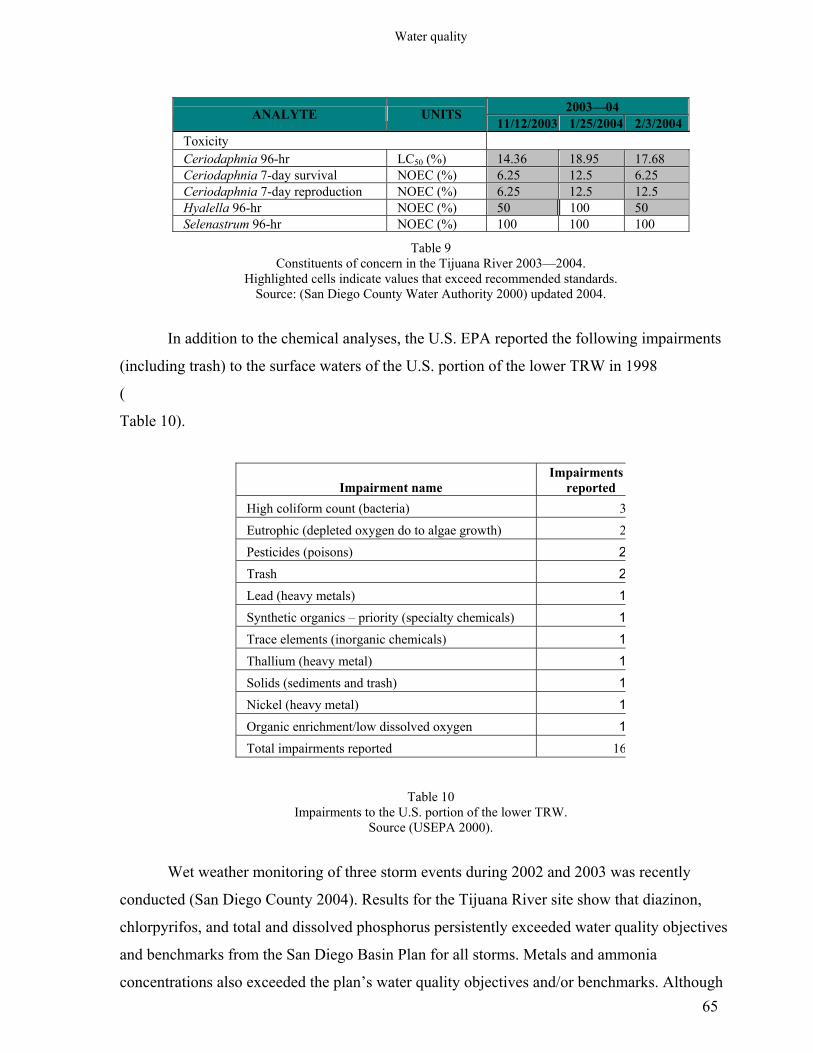
Water quality
2003—04 ANALYTE UNITS 11/12/2003 1/25/2004 2/3/2004
Toxicity Ceriodaphnia 96-hr LC50 (%) 14.36 18.95 17.68 Ceriodaphnia 7-day survival NOEC (%) 6.25 12.5 6.25 Ceriodaphnia 7-day reproduction NOEC (%) 6.25 12.5 12.5 Hyalella 96-hr NOEC (%) 50 100 50 Selenastrum 96-hr NOEC (%) 100 100 100
Table 9 Constituents of concern in the Tijuana River 2003—2004.
Highlighted cells indicate values that exceed recommended standards. Source: (San Diego County Water Authority 2000) updated 2004.
In addition to the chemical analyses, the U.S. EPA reported the following impairments
(including trash) to the surface waters of the U.S. portion of the lower TRW in 1998
(
Table 10).
High coliform c
Eutrophic (deplePesticides (poisoTrash
Lead (heavy meSynthetic organiTrace elements (
Thallium (heavySolids (sedimenNickel (heavy m
Organic enrichmTotal impairmen
Impairm
Wet weather monitoring o
conducted (San Diego County 20
chlorpyrifos, and total and dissolv
and benchmarks from the San Die
concentrations also exceeded the
Impairment name Impairments
reported ount (bacteria) 3
ted oxygen do to algae growth) 2ns)
tals) cs – priority (specialty chemicals) inorganic chemicals)
metal) ts and trash) etal)
ent/low dissolved oxygen ts reported 16
221111111
Table 10 ents to the U.S. portion of the lower TRW.
Source (USEPA 2000).
f three storm events during 2002 and 2003 was recently
04). Results for the Tijuana River site show that diazinon,
ed phosphorus persistently exceeded water quality objectives
go Basin Plan for all storms. Metals and ammonia
plan’s water quality objectives and/or benchmarks. Although 65
Binational Vision for the TRW
testing with Ceriodaphnia dubia, a water flea known to be sensitive to metals and pesticides and
other contaminants, showed toxic levels, no clear linkage has been identified to determine the
constituents of concern responsible for the toxicity. The County of San Diego recommends
continuing monitoring in the TRW, and performing a bioassessment and a toxicity identification
evaluation using C. dubia to identify constituents of concern.
Dry weather monitoring was conducted by the County of San Diego at Cottonwood
Creek and Pine Valley Creek in 2003. The sites had slow flowing water at all three sampling
rounds. No site exceeded the County standard, except for the bacteria indicators that exceeded
the voluntary County standards. However, follow-up investigations did not identify the likely
source of the bacteria and additional source identification was scheduled for 2004.18 18
Bioassessment was performed at two sites in 2003 in the U.S. portion of the TRW,
Campo Creek and Dairy Mart Road. The total number of macroinvertibrate taxa found at the
sites was 12 compared to the highest site in San Diego with 32 taxa. In general, higher numbers
of taxa indicate healthier streams. Richness of biodiversity was 8.3 taxa at Tijuana River-Dairy
Mart Road compared to 21.0 at De Luz Creek, a reference creek in Morro Hill, San Diego.
Campo Creek is reported to contain organisms highly intolerant to disturbances. Results indicate
that both of these sites had very slow currents with substrates dominated by fine particulate
organic matter (San Diego County 2004). The low taxa counts in the TRW likely relate to the
characteristics of the stream substrate and toxicity levels of the water.
Summary of water quality testing projects for the TRW 19 19
A number of water quality studies have been performed in the TRW in recent years.
Although the following studies were not all long-term sampling and monitoring efforts, the
results provide a useful characterization of water quality in the TRW:
a) Gersberg, Brown, Placchi, Bodensteiner, and Zambrano (1998) conducted a sampling
program to assess the quality of storm waters associated with a variety of land uses in the
TRW. Results showed that the heavy metals (chromium, copper, and zinc) were highest at
the industrial land use site, and lead levels were highest at the urban site. Generally, metal
concentrations in samples collected during the first 2 to 4 hours of runoff (early-storm) were
higher than those in samples collected 24–36 hours into the rain event. A notable exception
1188 Data provided by Jeffery Pasek, San Diego County Water Department 1199 Excerpt from (Gersberg and Wakida Kusunoki 1998)
66
Water quality
to this pattern was observed for the site on Tecate Creek, where levels of cadmium,
chromium, copper, and nickel were higher in the “late-storm” sample. This is probably due to
the point-source discharge of wastewater effluent from the Tecate Municipal Treatment Plant
just one mile upstream. At the industrial site, concentrations of copper, lead, and zinc in
samples of early-storm runoff fell in the 80th percentile range of a U.S. industrial runoff
dataset (Line, et al. 1997) but were generally lower than 90th percentile values for wet
weather runoff in an urban watershed of Los Angeles County. These data suggest that non-
point source pollution arising from a variety of land uses in the TRW will continue to enter
the Tijuana River Estuary and nearshore ocean during wet weather, arguing for basin-wide
wastewater and storm water management in this urban watershed.
b) Water quality data for Tecate Creek were obtained in the early 1990s (Lozano 1995). Levels
of fecal indicator bacteria at the Tecate Creek site were as high as those found in raw sewage,
with densities of 10 7 —10 8 MPN/100 ml for total coliforms (TC) and fecal coliforms (FC)
and 10 6 —10 7 MPN/100 ml for enterococci.
c) Data on sediment contamination of the Estuary were reported for metals (Meyer and
Gersberg 1997). Only at a site near a City of Imperial Beach storm drain were any of the
metal concentrations above the effects range-median values of 50 mg kg-1 Ni , 270 mg kg-1
Zn, and 9 mg kg-1 Cd, which are the concentrations approximately midway in the range of
reported values associated with biological effects (NOAA 1991 as cited by Meyer and
Gersberg 1997). Even at the most contaminated site in the Estuary, the SEM:AVS
(simultaneously extractable metal: acid volatile sulfide) ratio was several orders of
magnitude lower than the potential toxicity threshold of 1.0. Therefore, despite significant
metal loading to the Tijuana River and the Estuary in recent years, the sediment SEM:AVS
ratios indicate that the sulfides in the sediments should be more than sufficient to bind to the
metals and prevent toxicity.
67
d) The Bay Protection and Toxic Cleanup Program (BPTCP) (CASWRCB 1996) collected data
on the sediment chemistry and toxicity of sediments in the Tijuana River Estuary at six sites.
The chemical analyses for the chemicals of concern (including copper, mercury, zinc, total
chlordane, total PCBs, and total Polycyclic Aromatic Hydrocarbons [PAHs]) showed that
only the low molecular weight PAHs exceeded the probable effects level in the Tijuana
Estuary (at a single site in the northern arm). However, sediments at a number of stations in
both the southern and northern arms of the Tijuana Estuary showed toxicity (significant
difference in survival at less than 80% of lab controls) using amphipod and sea urchin
Binational Vision for the TRW
development pore water toxicity tests. Since sediment grain size (for bulk sediment toxicity
tests) and ammonia and/or sulfide may cause toxicity in addition to anthropogenic chemicals,
the BPTCP Report did not determine which particular chemical(s) caused the observed
toxicity.
e) The CASWRCB also oversaw the State Mussel Watch (SMW) Program (1996) and Toxic
Substances Monitoring (TSM) Program (1992). These programs involved the collection and
analysis of mussels and fish for a variety of contaminants. Unfortunately, the SMW Program
stopped sampling mussels in the Tijuana River in 1986, and the TSM Program ended
sampling of fish in the Tijuana Estuary in 1992. The last study showed that for several
contaminants (selenium and copper), there was indication of elevated levels in mullet from
the Estuary. Gersberg, Trindade, and Norby (1989) found that among the toxic metals tested
in fish from the Tijuana Estuary, only lead exceeded an international standard for edible
tissue (2 mg/kg). However when a human health risk assessment was conducted, and
considering that the Tijuana Estuary is not a significant commercial or sport fishery, it was
concluded that lead contamination does not pose a major threat to human health (Gersberg,
Trindade and Nordby 1989).
f) The San Diego County Department of Environmental Health collects data on coliform levels
at the Tijuana River mouth as well as the Imperial Beach Pier. Data indicate that the coliform
standards for recreational use (1,000 CFU/100 ml for total coliforms and 200 CFU/100 ml
for fecal coliforms) are generally attained at these sites during the summer, except during
rain events or spills or breaks in sewage pipes further up the watershed (Wakida and Riveles
1997). Gersberg, Dodge, Parsons, and Zedler (1994) studied the microbial quality of the
Tijuana Estuary under a range of tidal conditions during both wet and dry weather. This
study found that during wet weather, the whole Estuary was contaminated, but that the mean
levels of both total and fecal coliforms during dry weather were similar to indicator levels in
dry weather flows throughout Southern California (Gersberg, et al. 1994).
g) The San Diego Water Department conducts routine (almost monthly), ongoing water quality
monitoring at Barrett and Morena Reservoirs and several creeks tributary to these reservoirs.
The San Diego Water Department’s monitoring of the reservoirs began in earnest in 1989,
while there is some monitoring data from the reservoirs extending back to the 1940s.
Monitoring of the tributary streams began in 1999.
68
h) The Autonomous University of Baja California’s Department of Chemistry has conducted
several studies of the Tecate River water quality, including parameters such as heavy metals,
Water quality
hardness, biological oxygen demand (BOD), chemical oxygen demand (COD), greases, and
so forth (Lozano 1995). In 1987, the Department tested La Gloria, a neighborhood in
Tijuana, for lead in the soils, plants, and people.20 Between 1992 and 1993, the department
tested discharge points not connected to the sewer system in the Industrial Zone of Otay-
Mesa in Tijuana for iron, chromium, copper, manganese, lead, and zinc.21
20
21
i) The Baja California Industrial Wastewater Monitoring and Pretreatment Program22 sampled
all four Baja California treatment plants and key industrial plants from 1998—2004. In
addition, the project involved the training of personnel from the CESPs in wastewater
sampling techniques and the transfer and calibration of equipment. A liaison with Mexican
Agencies Team compiled wastewater testing data and made suggestions for policy changes in
Mexico. An Industrial Advisory Team, consisting of industrial wastewater plant operators
and pretreatment experts, made suggestions about how to economically sustain a
pretreatment program while maintaining an attractive business climate for industries.
22
The above studies provide snapshots for water quality at various locations in the TRW.
Data gaps and recommended future studies are provided at the end of this section.
Groundwater quality
Currently, the quality of groundwater in the U.S. portion of the Tijuana River Valley is
characterized by high levels of total dissolved solids and sodium chloride. It has been rated
inferior for domestic use due to high sulfate and fluoride concentrations. In addition, it was rated
inferior for irrigation purposes because of high electrical conductivity, high chloride levels, and a
high percentage of sodium. Several factors have been suggested to explain the poor quality of
groundwater, including seawater intrusion, leakage from the San Diego Formation, sewage from
the community of San Ysidro, irrigation return to groundwater, and groundwater movement from
the international boundary (Recon 1994 as cited by Camp Dresser and McKee 2003).
In Mexico in 1980, total dissolved solids levels of the wells ranged from 500 to 3,000
mg/L in the Tijuana River Valley, 200 to 2,500 mg/L in the Tecate Creek Valley and 1,000 to
4,000 mg/L in Valle de Las Palmas (INEGI 1995 as cited by Gersberg and Wakida Kusunoki
1998). Geochemical analysis of the groundwater in the Tijuana River alluvial aquifer showed
poor quality with high dissolved solids averaging 2,413 mg/L. Salt within the sediments of the
2200 See Benigno Perez Ruesga, UABC Chemistry Department 2211 See Ruben Guillermo Sepúlveda Marques, UABC Chemistry Department 2222 Funded by CASWRCB and Cal EPA
69
Binational Vision for the TRW
alluvium and bedrock, along with seawater intrusion from lowered water tables, contributes to
the saline character of the groundwater (U.S. Department of Energy 2003).
In 1996 a preliminary study was conducted of the water quality of five Indian
communities in Baja California, some of which occur in the TRW.23 Applying U.S. water
standards (total coliform = 0; nitrate = 10 mg/L; and dissolved solids = 500 mg/L), the
researchers found that all five communities had high levels of contamination in their drinking
water, which principally come from wells. The researchers suggested that the total coliform and
fecal coliform counts indicated contamination from human waste or animal feces, since cows,
goats, and horses graze upstream from these community water sources. The high nitrate levels
might be attributed to the effects of fertilizer runoffs (Kilpatrick 1998; Medina 2002).
23
Colorado River and State Project water quality
Water from the Colorado River is considered good quality water, although slightly saline.
In Mexico this water must be treated with chlorine or other disinfectant prior to distribution to
users (CESPT 2002). Bottling plants in the Mexican portion of the TRW buy municipal water
and treat it with reverse osmosis. In the United States, Colorado River and State Project water is
given full conventional treatment including flocculation, sedimentation, filtration, and
disinfection prior to distribution to through municipal water systems.
Wastewater quality
In April 1990, the IBWC initiated a water-sampling program to evaluate the wastewater
flows from Mexico that would be treated by the IWTP. Based on the measured concentration of
pollutants and an estimated flow rate of 37,854,118 l/day (10 mgd), the study showed that 401 kg
(884 lbs) of lead, 146 kg (322 lbs) of cyanide, 548 kg (1,208 lbs) of chromium, 1,606 kg (3,541
lbs) of copper, and 1,350 kg (2,976 lbs) of zinc were being introduced annually into the Tijuana
River from these wastewater flows (Recon 1994 as cited by Gersberg and Wakida Kusunoki
1998). Despite infrastructure improvements in Mexico and the opening of the IWTP in 1997,
during rain events, serious contamination of the Estuary and near shore marine waters continues
to occur. Prior to the completion of the IWTP, discharges from the Tijuana River contained the
highest concentrations of suspended solids among the eight largest creeks and rivers in Southern
California (SCCWRP 1992 as cited by Gersberg and Wakida Kusunoki 1998).
2233 A collaboration of the Campo Environmental Protection Agency, the Southwest Consortium for Environmental Research and Policy, CUNA,
SDSU, and others
70
Water quality
Water quality data
Sources of data on water quality in the TRW are available in Appendix 8. The data
includes reports, electronic files, maps, and other information in English and Spanish from both
the United States and Mexico.
Water quality data gaps
After reviewing the available data, the Research Team and others identified the following
data needs for the TRW:
• GIS data of residential areas with no piped potable water and/or sewage connection
• More data on groundwater quality in the Mexican portion of the watershed
• Temporal data on how pollutant loads vary in baseline and wet weather conditions24 24
Water quality recommendations
Improvements in the sewage infrastructure of Mexico are needed in order to keep pace
with the growing urban population and to assure better water quality in the TRW. Government
agencies in Mexico must enforce hazardous waste disposal laws. Government should require and
support industrial pretreatment of wastewater before it is discharged into the municipal sewer
system.
Suggested applied research projects relating to water quality are:25 25
• A monitoring program to determine toxic accumulation in sediments and biota of the
Estuary
• A mathematical model of the rate of transport of surface water pollution over the TRW
• Research on the impact of contaminated sites on surface and groundwater quality
• A binational surface and groundwater quality testing program with common methods and
quality control for Mexico and the United States
• Automatic sampling of pollutant loading and sediment loading in the Tijuana River
2244 From (Gersberg and Wakida Kusunoki 1998) 2255 From (Gersberg and Wakida Kusunoki 1998).
71
Binational Vision for the TRW
72
TRW stakeholders at community forums, the Binational Watershed Advisory Council,
and the Vision Research Team jointly characterized the current situation and future desired
scenarios for water quality in the TRW. This information is available in Table 11.
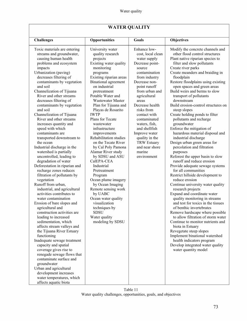
Water quality
WATER QUALITY Challenges Toxic materials are entering
streams and groundwater, causing human health problems and ecosystem impacts
Urbanization (paving) decreases filtering of contaminants by vegetation and soil
Channelization of Tijuana River and other streams decreases filtering of contaminants by vegetation and soil
Channelization of Tijuana River and other streams increases quantity and speed with which contaminants are transported downstream to the ocean
Industrial discharge in the watershed is partially uncontrolled, leading to degradation of water
Deforestation in riparian and recharge zones reduces filtration of pollutants by vegetation
Runoff from urban, industrial, and agricultural activities contributes to water contamination
Erosion of bare slopes and agricultural and construction activities are leading to increased sedimentation, which affects stream valleys and the Tijuana River Estuary functioning
Inadequate sewage treatment capacity and spatial coverage gives rise to renegade sewage flows that contaminate surface and groundwater
Urban and agricultural development increases water temperatures, which affects aquatic biota
Opportunities University water
quality research projects
Existing water quality monitoring programs
Existing riparian areas Binational agreement
on industrial pretreatment
Potable Water and Wastewater Master Plan for Tijuana and Playas de Rosarito
IWTP Plans for Tecate
wastewater infrastructure improvements
Rehabilitation studies on the Tecate River by Cal Poly Pamona
Alamar River study by SDSU and ASU
CalEPA-CEA Industrial Pretreatment Program
Ocean plume imagery by Ocean Imaging
Remote sensing work by UABC
Ocean water quality visualization techniques by SDSU
Water quality modeling by SDSU
Goals Enhance low-
cost, local clean water supply
Decrease point- source contamination from industry
Decrease non-point runoff from urban and agricultural areas
Decrease health risks from contact with contaminated waters, fish, and shellfish
Improve water quality in the TRW Estuary and near shore marine environment
Objectives Modify the concrete channels and
other flood control structures Plant native riparian species to
filter and slow pollutants Create river parks Create meanders and braiding in
floodplain Restore floodplains using existing
open spaces and green areas Build weirs and berms to slow
transport of pollutants downstream
Build erosion-control structures on steep slopes
Create holding ponds to filter pollutants and recharge groundwater
Enforce the mitigation of hazardous material disposal and industrial discharge
Design urban green areas for percolation and filtration purposes
Reforest the upper basin to slow runoff and reduce erosion
Provide adequate sewage systems for all communities
Restrict hillside development to reduce erosion
Continue university water quality research projects
Expand and coordinate water quality monitoring in streams and test for toxics in the tissues of benthic invertebrates
Remove hardscape where possible to allow filtration of storm water
Continue to monitor nutrients and biota in Estuary
Revegetate steep slopes Implement binational watershed
health indicators program Develop integrated water quality
water quantity model
Table 11 Water quality challenges, opportunities, goals, and objectives
73

Binational Vision for the TRW
74
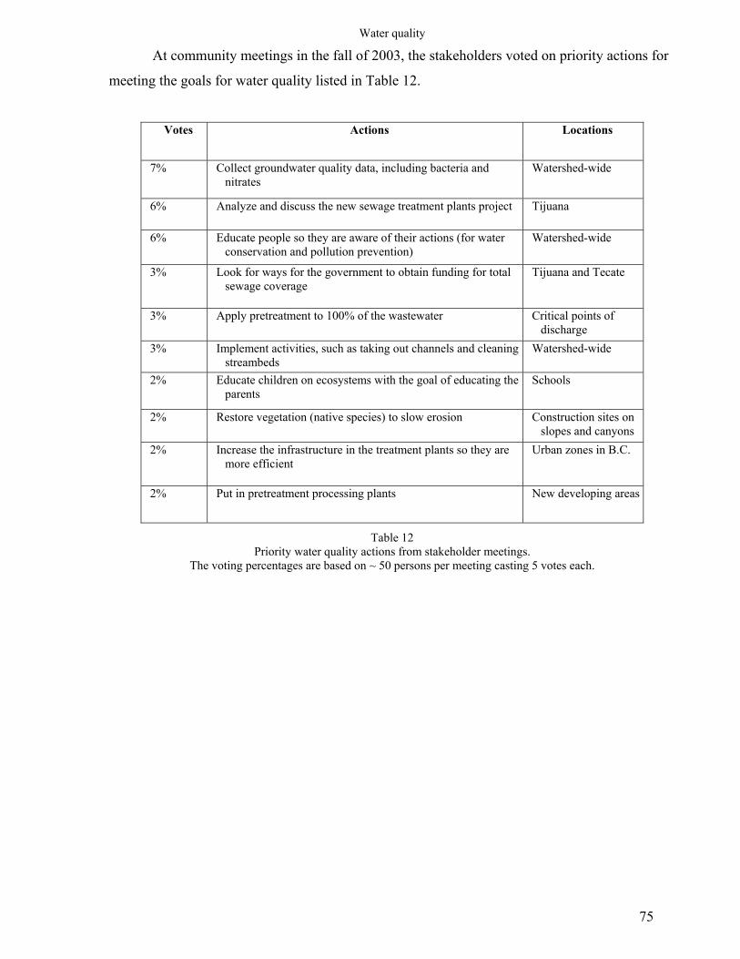
Water quality
At community meetings in the fall of 2003, the stakeholders voted on priority actions for
meeting the goals for water quality listed in Table 12.
Votes Actions Locations
7% Collect groundwater quality data, including bacteria and nitrates
Watershed-wide
6% Analyze and discuss the new sewage treatment plants project Tijuana
6% Educate people so they are aware of their actions (for water conservation and pollution prevention)
Watershed-wide
3% Look for ways for the government to obtain funding for total sewage coverage
Tijuana and Tecate
3% Apply pretreatment to 100% of the wastewater Critical points of discharge
3% Implement activities, such as taking out channels and cleaning streambeds
Watershed-wide
2% Educate children on ecosystems with the goal of educating the parents
Schools
2% Restore vegetation (native species) to slow erosion Construction sites on slopes and canyons
2% Increase the infrastructure in the treatment plants so they are more efficient
Urban zones in B.C.
2% Put in pretreatment processing plants New developing areas
Table 12 Priority water quality actions from stakeholder meetings.
The voting percentages are based on ~ 50 persons per meeting casting 5 votes each.
75

Binational Vision for the TRW
76
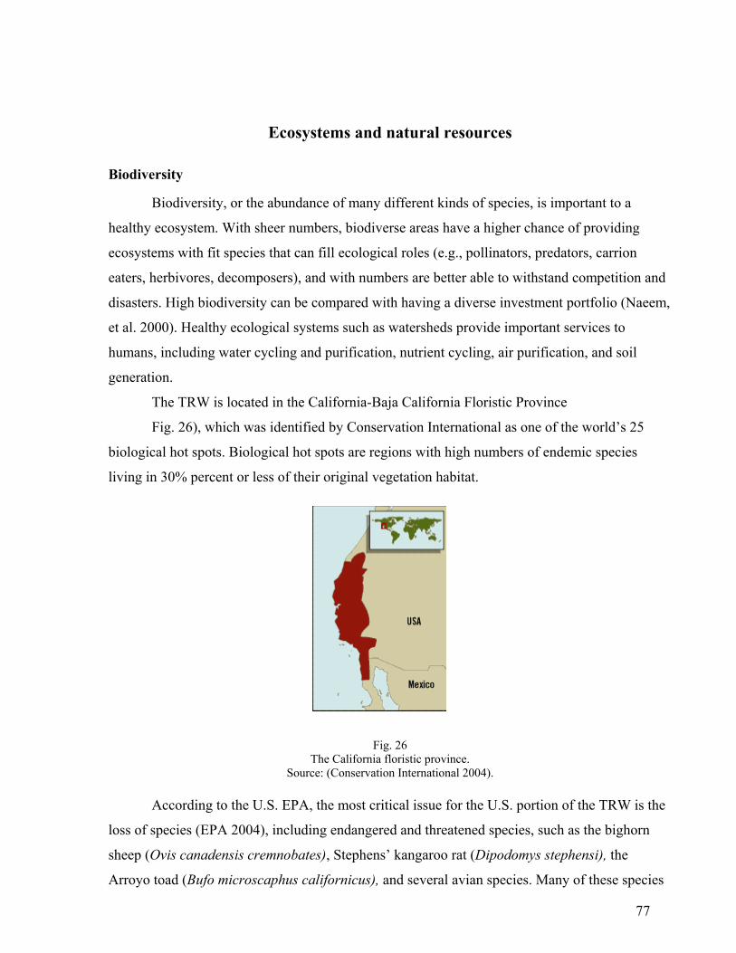
Ecosystems and natural resources
Biodiversity
Biodiversity, or the abundance of many different kinds of species, is important to a
healthy ecosystem. With sheer numbers, biodiverse areas have a higher chance of providing
ecosystems with fit species that can fill ecological roles (e.g., pollinators, predators, carrion
eaters, herbivores, decomposers), and with numbers are better able to withstand competition and
disasters. High biodiversity can be compared with having a diverse investment portfolio (Naeem,
et al. 2000). Healthy ecological systems such as watersheds provide important services to
humans, including water cycling and purification, nutrient cycling, air purification, and soil
generation.
The TRW is located in the California-Baja California Floristic Province
Fig. 26), which was identified by Conservation International as one of the world’s 25
biological hot spots. Biological hot spots are regions with high numbers of endemic species
living in 30% percent or less of their original vegetation habitat.
Fig. 26 The California floristic province.
Source: (Conservation International 2004).
According to the U.S. EPA, the most critical issue for the U.S. portion of the TRW is the
loss of species (EPA 2004), including endangered and threatened species, such as the bighorn
sheep (Ovis canadensis cremnobates), Stephens’ kangaroo rat (Dipodomys stephensi), the
Arroyo toad (Bufo microscaphus californicus), and several avian species. Many of these species
77
Binational Vision for the TRW
are migratory and use habitat on both sides of the border. The TRW and is also an important
region for valuable vegetation communities, such as coastal sage scrub and chaparral (Delgadillo
2000), which are diminishing due to human impacts.
Fragmentation
Loss of biodiversity in the TRW has been attributed to fragmentation, or the creation of
habitat islands and separation of habitats. Habitat fragmentation prohibits gene flows of
individual species because they cannot physically reproduce with neighboring populations,
resulting in population sinks that can lead to a decreased resistance to disease and disasters, or
even extinction (MacArthur 1967; Diamond 1975; Westman 1985; Ney-Nifle and Marc 1999).
Extinction of bird populations has been documented in island-like fragments of vegetation in San
Diego County (Bolger, Allison A. C. and Soule 1991). North-south and east-west habitat
connectivity is important in order to support the variety of plants and wildlife that are found in
the TRW (CBI, Pronatura, and TNC 2004).
Soils
Soil development within the Tijuana River Basin is controlled by three dominant factors:
a) the semiarid (xeric) climate, b) sparse vegetation dominated by brush and short grasses, and c)
geomorphic environments with little vegetation cover or sub-soils made up of shrink-swell clays.
On the U.S. side of the TRW, a detailed soil survey provides very specific descriptions
and taxonomy of the soil cover based upon the Natural Resource Conservation District’s Seventh
Approximation. The Mexican side of the watershed appears to have comparable soils, but
existing surveys are scant and based on different taxonomic criteria (U.N. Food and Agricultural
Organization [FAO]) that are difficult to correlate with the American system (Fig. 27)
(Greenwood 2005). However, the United States is moving toward using a State Soil Geographic
Database (STATSGO) that is more compatible with FAO.
78
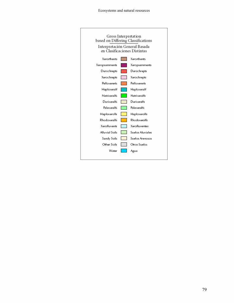
Ecosystems and natural resources
79
Binational Vision for the TRW
80
Fig. 27 Soils in the TRW.
Source: (SDSU and COLEF 2005).
Ecosystems and natural resources
The map of the U.S. side of the lower basin and foothills shows a dominance of Entisols
(soils with little or no morphological development) and Inceptisols (soils with weakly developed
subsurface horizons). Active floodplains and eroding slopes prevent the climate and vegetation
from creating mature profiles. Further inland and at slightly higher elevations with more stable
vegetative cover, zonal soils (mature horizon development) are dominated by Alfisols
(moderately leached soils with a subsurface zone of clay accumulation and >35% base
saturation) and Mollisols (grassland soils with high base status). Vertisols (clayey soils with high
shrink-swell capacity) are found scattered throughout the basin depending on the occurrence of
high shrink-swell clays in the parent materials (University of Idaho 2004; Greenwood 2005).
Flora
The flora of the Californias are known internationally for their diversity and endemism
(Oberbauer 1999). Vegetation species recorded during a 1994 biological survey in the U.S.
portion of the Tecate River26 found the highest quality riparian habitat remaining in Southern
California. Three hundred plant species were observed as well as a few non-native species.
Vernal pools are seasonal wetlands containing species, such as Orcutt’s brodiaea (Brodiaea
orcuttii), San Diego button celery (Eryngium aristulatum ssp. Parishii), California ocutt grass
(Orcuttia californica), and spreading navarretia (Navarretia fossalis) (USFWS 1996 November).
26
Examples of U.S.-listed endangered flora in the TRW are Otay tarplant (Hemizonia
conjugens), San Diego thornmint (Acanthomintha ilicifolia lamiaceae), Mexican flannelbush
(Fremontodendron mexicanum), Otay Mesa mint (Pogogyne nudiuscula), Tecate cypress
(Cupressus forbesii,) and the Tecate tarplant (Hemizonia floribunda) (Delgadillo 2000).
Distribution of 1994 vegetation is shown in Fig. 28.
2266 Performed by the U.S. EPA
81
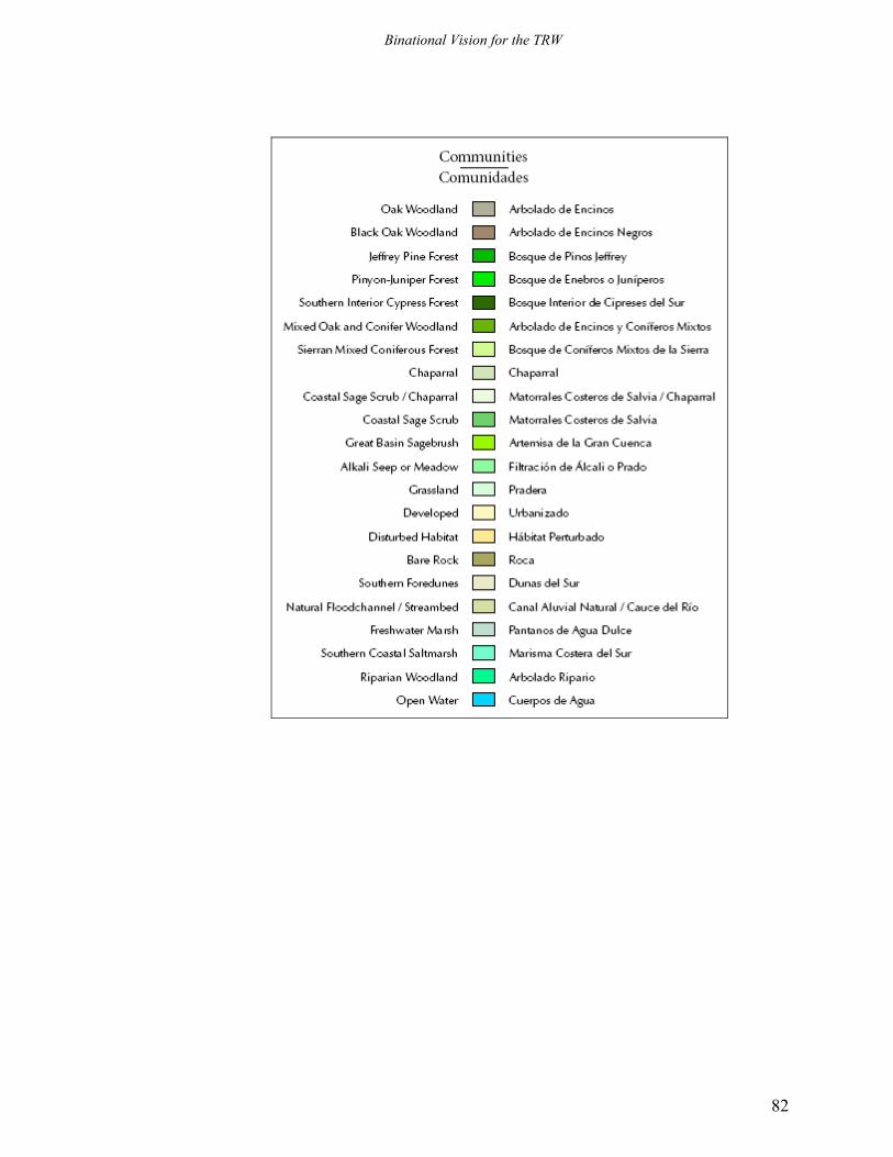
Binational Vision for the TRW
82

Ecosystems and natural resources
83
Fig. 28 Vegetation in the TRW.
Source: (SDSU and COLEF 2005).
Binational Vision for the TRW
Descriptions of major vegetation classes 27 27
Owing to its geological, topographical, and climatological diversity, the watershed supports a
wide variety of native plant communities. Vegetation types range in elevation from sea level
(e.g., coastal saltmarsh and southern foredunes) to Sierran mixed coniferous forest, found in the
highest northern portion of the watershed where precipitation is greatest. The following
vegetation classes are found in the TRW (O’Leary 2005).
Wetland types
Southern coastal marsh is located at the mouth of the Tijuana River. The Tijuana River
Estuary is one of the few salt marshes remaining in Southern California and northern Baja
California (O’Leary 2005). Sea-rocket (Cakile maritima), pickleweed (Salicornia virginica), and
Parish’s glasswort (S. subterminalis), along with alkali heath (Frankenia salina), saltgrass
(Distichlis spicata), alkali heath, (Jaumea carnosa), western marsh-rosemary (Limonium
californicum), wooly sea-blite (Suaeda taxifolia), Parish’s glasswort (Salicornia subterminalis),
red sand verbena (Abronia maritima), pink sand verbena (Abronia umbellata), and beach
evening primrose (Camissonia cheiranthifolia ssp. suffrutescens) are important plant species of
the salt marsh (Merkel and Associates 2004).
Shrubland types
Coastal sage scrub and chaparral are two shrubland types that cover approximately 74%
of the entire watershed. Coastal sage scrub28 is found almost entirely on drier, lower-elevation
slopes that occur in the western half of the watershed. Coastal sage scrub and chaparral formerly
covered most of the land in and around Tijuana, which is now developed. They are low-lying
scrubs of varying shrub densities with soft-woody, drought-resistant, deciduous species.
Characteristic species are California sagebrush (Artemisia californica), broom baccharis
(Baccharis sarothroides), California encelia (Encelia californica), interior flattop buckwheat
(Eriogonum fasciculatum var. foliolosum), coastal deerweed (Lotus scoparius var. scoparius),
laurel sumac (Malosma laurina), San Diego monkeyflower (Mimulus aurantiacus),
lemonadeberry (Rhus integrifolia), spiny redberry (Rhamnus crocea), black sage (Salvia
mellifera), and white sage (Salvia apiana). Succulents are common in western, coastal portions
of the watershed and include velvet cactus (Bergerocactus emoryi), Shaw’s agave (Agave
28
2277 Derived from (O’Leary 2005 ) and (Merkel and Associates 2004) 2288 Coastal sage scrub provides critical habitat to a large number of rare, threatened, and endangered species, most notably the California
gnatcatcher.
84
Ecosystems and natural resources
shawii), and coastal beavertail (Opuntia basilaris). Evergreen hard-leaved shrubs, such as laurel
sumac (Malosma laurina), lemonadeberry (Rhus integrifolia), and sugar bush (Rhus ovata), are
often distributed in patches throughout the TRW. Coastal sage scrub in the border region,
especially from Otay Mountain westward, serves as a vital dispersion link for the California
gnatcatcher and other species between the United States and Mexico.
Chaparral covers about 56% of the watershed and largely occurs above coastal sage scrub
in the eastern half of the watershed. Taller and denser than sage scrub, chaparral is dominated by
deep-rooted evergreen shrubs that possess relatively tough, leathery leaves. Several chaparral
types occur in the watershed, depending generally on elevation, slope, and aspect. Chamise
chaparral is the most common chaparral type in the more western portion of chaparral’s overall
distribution in the watershed. It is dominated by chamise (Adenostoma fasciculatum) and occurs
largely on flat or south-facing slopes in the lower, drier portion of chaparral’s overall
distribution. Mixed chaparral occurs most commonly on relatively mesic (flat-topped), north-
facing slopes and is a mixture of medium to tall shrub species. Red shank (Adenostoma
sparsifolium) chaparral commonly forms large unbroken stands in the eastern, upper-elevation
portions of chaparral’s distribution in the watershed (O’Leary 2005). Characteristic chaparral
species are big-berry manzanita (Arctostaphylos glauca), Ramona ceanothus (Ceanothus
tomentosus), San Diego mountain-mahogany (Cercocarpus minutiflorus), chamise (Adenostoma
fasciculatum), holly-leaf redberry (Rhamnus ilicifolia), sugar bush (Rhus ovata), and fuchsia-
flowered gooseberry (Ribes speciosum) (Merkel and Associates 2004).
Upland woodland and forest
Oak Woodland, Pinyon-Juniper Woodland, and Jeffrey Pine Forest account for but a
small fraction of the watershed, they serve as valuable habitat for a variety of wildlife types.
Culturally important species that are protected in Mexico include the Tecate cypress (Cupressus
forbesii). Oak woodland is dominated by the coastal live oak (Quercus agrifolia) and occurs
most commonly in lower-elevation portions of the watershed on mesic, north-facing slopes and
valley bottoms. Canyon live oak (Quercus chrysolepis) is a more common dominant species at
higher elevations in the eastern portion of the watershed. Pinyon-Juniper woodland is dominated
by the one-leaf pinyon (Pinus monophylla), the four-leaf pinyon (Pinus quadrifolia), and the
California juniper (Juniperus californica), and occurs at higher elevations in the watershed’s
85
Binational Vision for the TRW
southeastern extreme section. Jeffrey pine forest is dominated by the Jeffrey pine (Pinus jeffreyi).
Riparian vegetation types
The watershed also contains several riparian vegetation types that serve as valuable
habitat to a rich diversity of avian species, reptiles, mammals, freshwater fish, and amphibians.
Most riparian vegetation near Tijuana has been removed or seriously disturbed as a result of
spreading urbanization. However, notable examples still exist along the Tijuana River’s various
tributaries, such as Cottonwood Creek. Riparian woodland is usually dominated by low-density
stands of western sycamore (Platanus racemosa), although other trees, such as coastal live oak
(Quercus agrifolia) and cottonwood (Populus fremontii), may also be intermixed. Associated
subordinate species may include western poison oak (Toxicodendron diversilobum), fuchsia-
flowered gooseberry (Ribes speciosum), and blue elderberry (Sambucus mexicana). Oak riparian
forest is less common but can be found in the upper reaches of tributary streams in the
watershed. Oak riparian forest is characterized by dense stands of coastal live oak that occupy a
stream channel’s outer perimeter and winter-deciduous species of willow and cottonwood
situated closer to the stream channel. Riparian forest is the least common riparian type in the
watershed and is dominated by Gooding’s black willow (Salix gooddingii), arroyo willow (Salix
lasiolepis), Fremont cottonwood (Populus fremontii), white alder (Alnus rhombifolia), and coast
live oak. Characteristic understory plants are mugwort (Artemisia douglasiana), mule fat
(Baccharis salicifolia), and hoary nettle (Urtica dioica spp. holosericea). Riparian Scrub is the
most prevalent type of riparian vegetation in the watershed and includes communities, such as
willows (Salix spp.) and mulefat. Riparian scrub vegetation is especially common along the Río
de las Palmas, where a substantial amount of it is disturbed and has been invaded by non-native
shrubs, such as giant reed (Arundo donax), four-petal European tamarisk (Tamarix parviflora),
pampas grass (Cortaderia selloana), and castor bean (Ricinus communis).
86
Plant species listed at the international or national level in the Mexican portion of the
TRW are coastal prickly pear (Opuntia littoralis), coastal cholla (Opuntia prolifera), barrel
cactus (Ferocactus viridescens), scrub-oak (Quercus dumosa), Baja rose (Rosa minutifolia),
Tecate cypress (Cupresus forbesii), Southern California locoweed (Astragalus trichopodus),
scrub oak (Quercus cedrosensis), Weed’s mariposa lily (Calchortus weekii), Otay mountain
ceanothus (Ceanothus otayensis), brasil (Ceanthus tomentosus), and barberija (Chamebatia
australis) (Pronatura 2003). In 2004 the municipality of Tecate passed a municipal ordinance
that listed encinos (oaks) and the Tecate cypress (Cupressus forbesii) as protected species under
Article 176 of the Reglamento Municipal de Ecología del Ayuntamiento de Tecate. Fig. 29
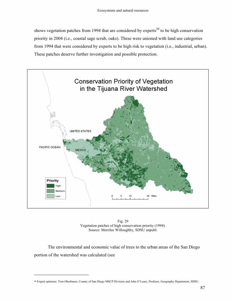
Ecosystems and natural resources
shows vegetation patches from 1994 that are considered by experts29 to be high conservation
priority in 2004 (i.e., coastal sage scrub, oaks). These were unioned with land use categories
from 1994 that were considered by experts to be high risk to vegetation (i.e., industrial, urban).
These patches deserve further investigation and possible protection.
29
Fig. 29 Vegetation patches of high conservation priority (1994).
Source: Merrilee Willoughby, SDSU unpubl.
The environmental and economic value of trees to the urban areas of the San Diego
portion of the watershed was calculated (see
2299 Expert opinions: Tom Oberbauer, County of San Diego MSCP Division and John O’Leary, Profesor, Geography Department, SDSU.
87

Binational Vision for the TRW
Table 13). In the Tijuana River Valley, San Ysidro, and Otay Mesa green areas
contributed 20,000 acres of vegetation, which was estimated to bring $18,528,500 worth of
storm water control to the cities. This area was estimated to remove 264,679 pounds of air
pollution through filtration and conversion of carbon dioxide to oxygen through the
photosynthesis process (American Forests and USFS 2003).
Table 13 Environmental Benefits of Trees in San Diego. Source: (American Forests and U.S.F.S. 2003).
Natural fire regimes have been altered in the TRW by deforestation for grazing,
urbanization, and fire management practices. Natural fires are critical for some plant
communities to regenerate. Changes in the fire regime have led to increased erosion rates when
fires burn too frequently at the urban edge (Ojeda Revah 2000).
Fauna
Flora and fauna are related because vegetation provides habitat for wildlife, and wildlife
help propagate seeds and pollen for plants. Habitats for animals in the TRW range from
Peninsular Range elements in the upper basin, to widespread coastal sage scrub and chaparral
elements in the lower elevations, to marsh and wetland species in the Tijuana Estuary. There are
also some sensitive upland elements on the fragmented mesa sides and tops, and species unique
to the sand dunes. There are many vernal pools, and the eastern upper slopes of the Laguna
88
Ecosystems and natural resources
Mountains and Sierra Juárez contain riparian and coniferous habitat (Case and Fisher 1998).
Riparian corridors at all elevations house migratory and resident species of fish, reptiles, birds,
and mammals.
The following list is not exhaustive but provides examples of species likely found in the
TRW that are either endangered or threatened at the California or U.S. federal level under the
Endangered Species Act (ESA) (MSCP 1996; CEC 2000) or protected at the federal level in
Mexico under NOM-059 (SEMARNAT 2002; Pronatura 2003). Some species are considered
threatened or endangered in Mexico but not the United States, and vice versa:
• Species listed only in the United States include the southwestern willow flycatcher
(Empidonax traillii extimus), southwestern pond turtle (Clemmys marmorata pallida),
California red-legged frog (Rana aurora draytoni), San Diego fairy shrimp (Branchinecta
sandiegoensis), and Quino checkerspot butterfly (Euphydryas editha quino)
• Species listed only in Mexico include the Pacific great blue heron (Ardea herodias
santilucae), Mexican long-tongued bat (Choeronycteris mexicana), and spiny pocket mouse
(Perognathus amplus rotundus)
• Species listed on both sides of the border include Belding’s Savannah sparrow (Passerculus
sandwichensis rostratus), burrowing owl (Speotyto cunicularia), Least bell’s vireo (Vireo
bellii pusillus), Mexican longnosed bat (Leptonycteris nivalis), bighorn sheep (Ovis
canadensis californiana), California condor (Gymnogyps californianus), California coastal
gnatcatcher (Polioptila californica californica), golden eagle (Aquila chrysaetos), and
orange-throated whiptail (Cnemidophorus hyperythrus beldingi)
A major challenge in binational watersheds is the management of migratory species, or
species with large ranges within a binational watershed. For example, the border fence and
unchecked habitat destruction along the border on the U.S. side, including the development of
new roads for border patrol vehicles, increased traffic on existing roads, and the clearing of
vegetation for new fences, threaten habitat and migratory routes in the TRW. Portions of the
westernmost 14 miles of the U.S.-Mexican border include secondary and tertiary fencing, roads,
and other improvements deemed necessary by the U.S. federal government for border security.
This is in addition to the primary fencing already in existence for the entire 14 miles. The
government has made plans to meet the additional congressional fencing mandate. There is great
concern that the proposed additional fencing will result in significant sedimentation impacts on
89
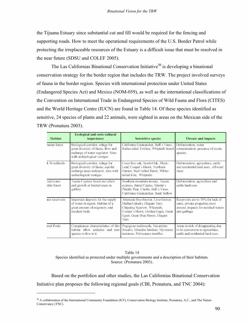
Binational Vision for the TRW
the Tijuana Estuary since substantial cut and fill would be required for the fencing and
supporting roads. How to meet the operational requirements of the U.S. Border Patrol while
protecting the irreplaceable resources of the Estuary is a difficult issue that must be resolved in
the near future (SDSU and COLEF 2005).
The Las Californias Binational Conservation Initiative30 is developing a binational
conservation strategy for the border region that includes the TRW. The project involved surveys
of fauna in the border region. Species with international protection under United States
(Endangered Species Act) and Mexico (NOM-059), as well as the international classifications of
the Convention on International Trade in Endangered Species of Wild Fauna and Flora (CITES)
and the World Heritage Centre (IUCN) are found in Table 14. Of these species identified as
sensitive, 24 species of plants and 22 animals, were sighted in areas on the Mexican side of the
TRW (Pronatura 2003).
30
I
33
C
Table 14 Species identified as protected under multiple governments and a description of their habitats.
Source: (Pronatura 2003).
Based on the portfolios and other studies, the Las Californias Binational Conservation
nitiative plan proposes the following regional goals (CBI, Pronatura, and TNC 2004):
00 A collaboration of the International Community Foundation (ICF), Conservation Biology Institute, Pronatura, A.C., and The Nature onservancy (TNC).
90

Ecosystems and natural resources
• Encompass biogeographically important and unique natural resources, distributed from
the coast, across the mountains, to the desert.
• Identify threats to maintaining an interconnected conservation network and sustaining
ecosystem processes.
• Identify large, intact wildlands that represent the region’s biodiversity.
• Link protected areas to facilitate wildlife movement and protect existing conservation
investments.
• Promote collaboration in implementing land-protection strategies that result in secure and
sustainable conservation.
• Lay the foundation for a binational park system that connects the Parque Constitución de
1857 in Mexico to wilderness areas, forests, and parklands in the United States.
• Heighten the visibility of this little-studied, multicultural area and the global importance
of implementing a strategy that conserves the integrity and functionality of its ecosystems
while enriching the health, economy, and standard of living of its residents.
Pronatura developed several maps of recommended areas for preservation of open space,
native vegetation, and green areas, along with habitat protection and enhancement.
Fig. 30 is a study within the TRW. Fig. 31 shows a regional view of connectedness with
U.S. protected areas.
91
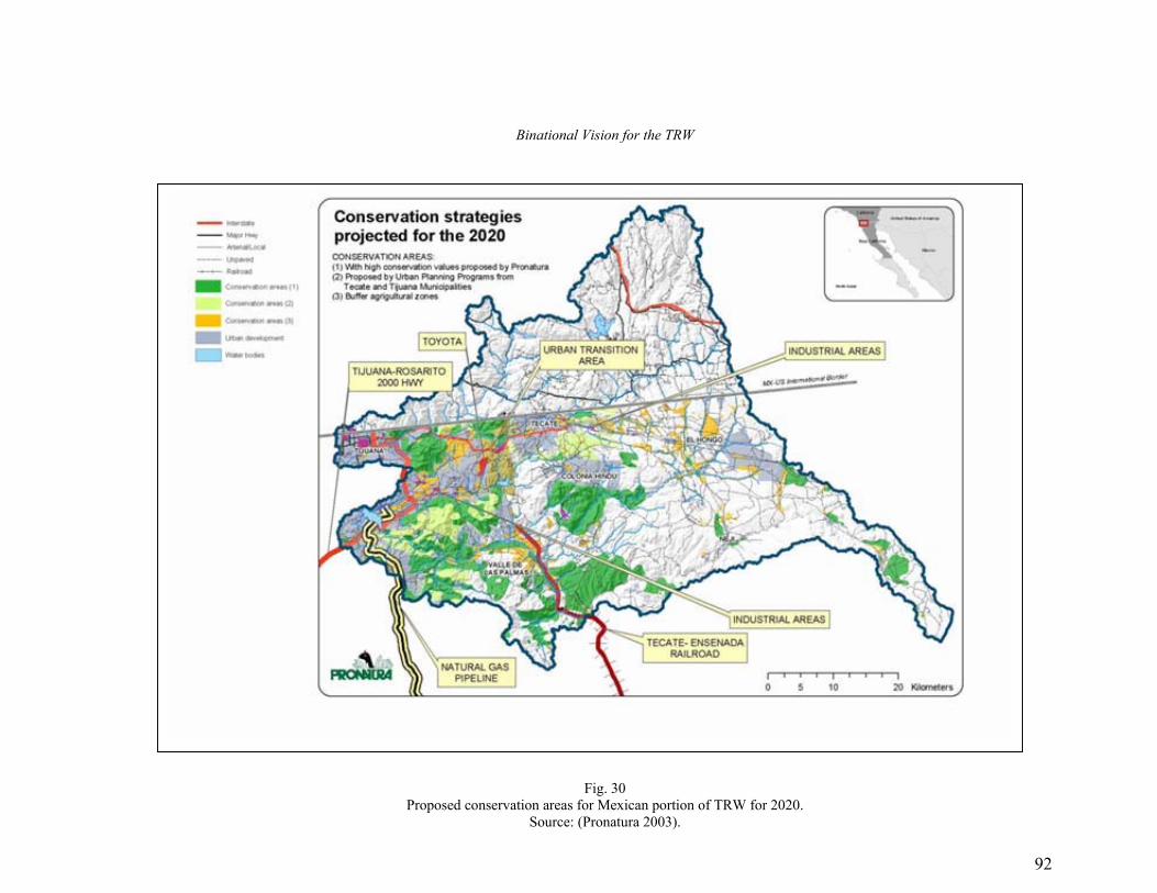
Binational Vision for the TRW
Fig. 30 Proposed conservation areas for Mexican portion of T
Source: (Pronatura 2003).
92
RW for 2020.
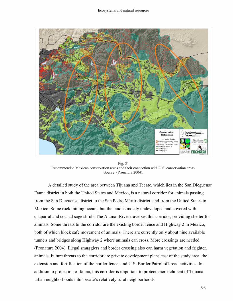
Ecosystems and natural resources
Fig. 31 Recommended Mexican conservation areas and their connection with U.S. conservation areas.
Source: (Pronatura 2004).
A detailed study of the area between Tijuana and Tecate, which lies in the San Dieguense
Fauna district in both the United States and Mexico, is a natural corridor for animals passing
from the San Dieguense district to the San Pedro Mártir district, and from the United States to
Mexico. Some rock mining occurs, but the land is mostly undeveloped and covered with
chaparral and coastal sage shrub. The Alamar River traverses this corridor, providing shelter for
animals. Some threats to the corridor are the existing border fence and Highway 2 in Mexico,
both of which block safe movement of animals. There are currently only about nine available
tunnels and bridges along Highway 2 where animals can cross. More crossings are needed
(Pronatura 2004). Illegal smugglers and border crossing also can harm vegetation and frighten
animals. Future threats to the corridor are private development plans east of the study area, the
extension and fortification of the border fence, and U.S. Border Patrol off-road activities. In
addition to protection of fauna, this corridor is important to protect encroachment of Tijuana
urban neighborhoods into Tecate’s relatively rural neighborhoods.
93
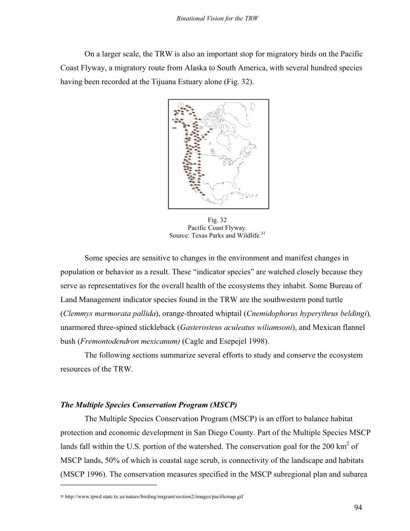
Binational Vision for the TRW
On a larger scale, the TRW is also an important stop for migratory birds on the Pacific
Coast Flyway, a migratory route from Alaska to South America, with several hundred species
having been recorded at the Tijuana Estuary alone (Fig. 32).
Some species are sensitiv
population or behavior as a resul
serve as representatives for the o
Land Management indicator spe
(Clemmys marmorata pallida), o
unarmored three-spined stickleb
bush (Fremontodendron mexican
The following sections su
resources of the TRW.
The Multiple Species Conservat
The Multiple Species Co
protection and economic develop
lands fall within the U.S. portion
MSCP lands, 50% of which is co
(MSCP 1996). The conservation
3311 http://www.tpwd.state.tx.us/nature/birding/mig
Fig. 32 Pacific Coast Flyway.
Source: Texas Parks and Wildlife.31 31
e to changes in the environment and manifest changes in
t. These “indicator species” are watched closely because they
verall health of the ecosystems they inhabit. Some Bureau of
cies found in the TRW are the southwestern pond turtle
range-throated whiptail (Cnemidophorus hyperythrus beldingi),
ack (Gasterosteus aculeatus wiliamsoni), and Mexican flannel
um) (Cagle and Esepejel 1998).
mmarize several efforts to study and conserve the ecosystem
ion Program (MSCP)
nservation Program (MSCP) is an effort to balance habitat
ment in San Diego County. Part of the Multiple Species MSCP
of the watershed. The conservation goal for the 200 km2 of
astal sage scrub, is connectivity of the landscape and habitats
measures specified in the MSCP subregional plan and subarea
rant/section2/images/pacificmap.gif
94

Ecosystems and natural resources
plans provide for “coverage” of 85 species of plants and animals under state and federal
endangered species laws. The MSCP also includes a preserve management program and a
subregional biological monitoring program to gauge the progress of the program toward meeting
its biological objectives (California Department of Fish and Game 2004). Mitigation for species
take (kill) or habitat destruction outside the MSCP can be met by purchasing land inside the
2,330 km2 (900mi2) planning area (see
Fig. 33).
regio
(MS
acro
Fig. 33 San Diego Multiple Species Conservation Program.
Source: (California Department of Fish and Game 2004).
The MSCP stops at the border. Many of the endangered and endemic species in the
n are migratory or their breeding, foraging, or wintering ranges extend across the border
CP 1996; CEC 2000). Thus, connecting areas of the MSCP to similarly protected areas
ss the border would greatly enhance species and habitat protection in the transborder region.
95
Binational Vision for the TRW
Cuchumá easement
Cerro Cuchumá, or Tecate Peak, is a sacred mountain for the Kumiai as well as being
biologically rich, containing endangered flora and fauna. In 2003, Pronatura helped negotiate an
ecological easement of Rancho La Puerta, A.C., Mexican lands that are contiguous with BLM
lands on the U.S. side of the border. In effect, this created a transborder ecological easement.
Pronatura acts as a third party for the easement contract, and monitors and protects the terms of
the easement, which include no development or activities harmful to the environment (Ochoa
2004; Vargas Téllez 2004). The easement is in perpetuity, so even if the lands are sold, they
remain protected.
The Tijuana Estuary
The Estuary is one of Southern California’s most pristine coastal wetlands and has high
potential for restoration. Its designation as a National Estuarine Research Reserve by the NOAA
in 1991 has allowed for increased protection and study of its resources (Desmond 1998). The
Tijuana Estuary is dominated by coastal saltmarsh, an increasingly rare and threatened habitat in
Southern California. It is one of the few estuaries in San Diego County whose tidal inlet has not
been obstructed by a highway or railroad; it has maintained its connection to the sea almost
continuously over the past century. The Tijuana Estuary and near shore marine habitats host at
least 29 species of fish, and 398 species of birds, including 24 sensitive species, such as the
California Least tern, the clapper rail, and Least bell’s vireo. The Estuary supports juveniles and
several commercial/recreational fishes, including the California halibut (Nordby and Zedler 1991
as cited by Desmond 1998), although shellfish are unfit for human consumption due to high
contamination levels.
Although sewage flows into the Estuary decreased with the installation of the sewage
diversion system in 1991 (Zedler and Nyden 1993 as cited by Desmond 1998) and the IWTP in
1997, sewage-contaminated waters still enter the Estuary during storm events, when there are
breaks in the collection system or whenever flow exceeds the system’s capacity. Development in
both Tijuana and San Diego and vehicular disturbances in the surrounding watershed have led to
greater amounts of freshwater runoff and sediment deposition in the Estuary. Due to
sedimentation, the tidal prism was closed to saltwater inputs during 1984, causing ecological
damage. Increased freshwater input through urban storm runoff can also promote the spread of
exotic plant species by decreasing soil salinity and increasing soil saturation (Kuhn and Zedler
1997; Callaway and Zedler n.d. as cited by Desmond 1998). Given the right conditions, these
96
Ecosystems and natural resources
exotic plants can out-compete native species and negatively affect habitat functioning in the
Estuary. Other estuarine problems include heavy human traffic through the Estuary, damages
caused by off-road vehicles, heavy noise from helicopters at nearby Ream Field (U.S. Navy), and
feral animals that hunt native species.
To combat some of these issues, the Tijuana Estuary Tidal Restoration Program began in
1992 with the goals of restoring the natural tidal prism (saltwater access), restoring intertidal
habitats, improving water quality, and restoring the barrier beach dunes. This requires the
removal of fill material and accumulated sediment already in the Estuary, the construction of
canyon-mouth sediment basins that will be routinely excavated, and implementation of erosion-
control projects throughout the watershed. Two completed restoration projects, the Oneonta
Tidal Linkage (1997) and the Model Marsh (2000), have restored critical saltmarsh habitat and
attracted endangered species. Sediment management basins in Goat Canyon (2004) plan to
control the large sediment load delivered through the Los Laureles Canyon upstream in Mexico.
Future studies will support a second and larger phase of the restoration program that will aim to
disperse flood energy and silt. The plan may also include pumping sandy material to the beach,
and combining saltmarsh restoration with beach replenishment (SDSU and COLEF 2005).
Future projects will focus on upstream impacts on the Estuary. This holistic approach
recognizes the connection between downstream problems, such as tidal blockage, trash, and
pollution with upstream solutions. One phase is a series of pilot projects to demonstrate
successful erosion-control techniques. Another educational phase will produce bilingual
materials, including a brief video and CD-ROM of the history, social concerns, objectives,
impacts on land and coastal ecosystems of Los Laureles Canyon and the TRNERR. Official
documents, sustainable guidelines, maps, and GIS databases will also be included.
Cleveland National Forest
This nationally protected forest includes three principal mountain ranges: the Santa Ana,
Palomar, and Laguna (Cuyamaca) Mountains. The latter falls within the TRW. The Cleveland
National Forest offers open space and recreational opportunities. Elevations range from 140 m
(460 ft) to 1,911 m (6,271 ft) on Monument Peak. More than 75% of the vegetation is chaparral,
predominantly coastal sage, chemise, manzanita, and ceonothus. A few riparian areas exist, but
they make up only about 1% of the forest. There are large oaks in meadows and along streams,
and Jeffrey and Coulter Pine forest at higher elevations. Some wet meadows are found between
the high-elevation pines (Wildernet 2004).
97
Binational Vision for the TRW
The U.S. Department of Agriculture (USDA) and the U.S. Forest Service (USFS) have
updated their Southern California Land Management Plan, and hope to expand the Pine Creek
Wilderness Area of 54 km2 (13,400 acres) with and additional 1.7 km2 (409 acres). They use a
holistic approach to land management and are proposing actions that could affect the TRW in
positive ways. Their goal is to move toward elimination of existing roads and power lines within
the wilderness areas, and minimize trespassing by motorized vehicles, while improving trail
networks. Their plans include (1) developing common management goals for open-space
protection and land acquisition plans for Lake Morena and Barrett Lake in cooperation with City
of San Diego water authorities; (2) working with San Diego water authorities to achieve water
discharge from Lake Morena that mimics natural conditions and supports unique wildlife and
plant values; (3) through the Border Fire Prevention Program, minimizing wildland fires related
to immigration routes, and maintaining existing fuel breaks and increasing community protection
and safety efforts; and (4) controlling and reducing resource damage caused by undocumented
immigration through the area (USDA and USFS 2004). This human foot traffic produces
significant quantities of trash, informal trails that are prone to erosion and can cause habitat
destruction/fragmentation, and campfires that sometimes cause wildfires.
Ecosystems and natural resources trends
Few data have been collected on TRW ecosystem functions, such as soil, water, and
nutrient cycling. Therefore, historical ecological analysis is limited to vegetation. Vegetative
processes are tied directly to processes in fauna, soils, water, and nutrients, and thus, are
important to study. Historic maps and accounts have pieced together a picture of vegetation
changes since 1766. Vegetation communities in Baja California were altered by agricultural
clearing by grazing of livestock and the introduction of herbaceous exotics. Exotic species, such
as Mediterranean grass (Schismus barbatus), foxtail chess (Bromus rubens), and Saharan
mustard (Brassica tournefortii), can increase fire fuel and burning rates (Minnich and Vizcaino
1998). Timber needs result in heavily exploited coast live oak (Querus agrifolia) forests, but
chaparral and forest densities seem to have maintained a stable composition since European
settlement.
In recent decades almost all the native vegetation in the TRW has suffered degradation,
fragmentation, and perforation. Between 1970 and 1994, coastal sage scrub lost the greatest area
(33 mi² or 86 km²), followed by chaparral (26 mi² or 68 km²) and Juniperus (12 mi² or 32 km²).
Nevertheless, within its own distribution area the most damaged community was Juniperus, 98
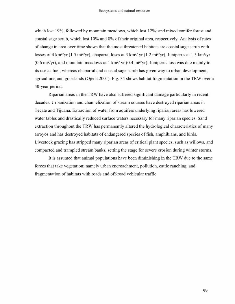
Ecosystems and natural resources
which lost 19%, followed by mountain meadows, which lost 12%, and mixed conifer forest and
coastal sage scrub, which lost 10% and 8% of their original area, respectively. Analysis of rates
of change in area over time shows that the most threatened habitats are coastal sage scrub with
losses of 4 km²/yr (1.5 mi²/yr), chaparral loses at 3 km²/ yr (1.2 mi²/yr), Juniperus at 1.5 km²/yr
(0.6 mi²/yr), and mountain meadows at 1 km²/ yr (0.4 mi²/yr). Juniperus loss was due mainly to
its use as fuel, whereas chaparral and coastal sage scrub has given way to urban development,
agriculture, and grasslands (Ojeda 2001). Fig. 34 shows habitat fragmentation in the TRW over a
40-year period.
Riparian areas in the TRW have also suffered significant damage particularly in recent
decades. Urbanization and channelization of stream courses have destroyed riparian areas in
Tecate and Tijuana. Extraction of water from aquifers underlying riparian areas has lowered
water tables and drastically reduced surface waters necessary for many riparian species. Sand
extraction throughout the TRW has permanently altered the hydrological characteristics of many
arroyos and has destroyed habitats of endangered species of fish, amphibians, and birds.
Livestock grazing has stripped many riparian areas of critical plant species, such as willows, and
compacted and trampled stream banks, setting the stage for severe erosion during winter storms.
It is assumed that animal populations have been diminishing in the TRW due to the same
forces that take vegetation; namely urban encroachment, pollution, cattle ranching, and
fragmentation of habitats with roads and off-road vehicular traffic.
99
Binational Vision for the TRW
Fragmentation process of riparian vegetation, mountain meadows and grassland
0
50
100
150
200
250
1953-1956 1970-1972 1994
area
0
100
200
300
400
500
600
700
no. f
ragm
ent
Riparian vegetationMountain meadowsGrassland
Fi
Fragmentation process of mixed conifer forest, Jeffrey Pine forest and Juniperus scrub
0
50
100
150
200
250
300
1953-1956 1970-1972 1994
area
0
10
20
30
40
50
60
70
80
90
no. f
ragm
ent
Mixed coniferJeffrey pine Juniperus scrub
Fragmentation process of chaparral and coastal sage scrubFragmentation process of irrigation and rainfed agriculture
0102030405060708090
100
1953-1956 1970-1972 1994
area
0
20
40
60
80
100
120
140
no. f
ragm
ent
Irrigation agricultureRainfed agriculture
Fragmentation process of urban development
0
50
100
150
200
250
300
350
1953-1956 1970-1972 1994
area
0
50
100
150
200
250
no. f
ragm
ent
Urban development
Habitat fragmentation Lines represent number of frag
Source: (
0
500
1000
1500
2000
2500
3000
1953-1956 1970-1972 1994
area
0
20
40
60
80
100
120
no. f
ragm
ent
ChaparralCoastal sage scrub
F r a g m e n ta t io n p r o c e s s o f r ip a r ia n v e g e ta t io n ,
g. 34
m o u n ta in m e a d o w s a n d g r a s s la n d
0
5 0
1 0 0
1 5 0
2 0 0
2 5 0
1 9 5 3 -1 9 5 6 1 9 7 0 -1 9 7 2 1 9 9 4
area
0
1 0 0
2 0 0
3 0 0
4 0 0
5 0 0
6 0 0
7 0 0
no. f
ragm
ent
R ip a r ia n v e g e ta t io nM o u n ta in m e a d o w sG ra s s la n d
in the TRW 1953 to 1994. ments and the bars represent area. Ojeda 2002).
100

Ecosystems and n
Ecosystems and natural resources data
Sources of data on ecosystems and natura
Appendix 9. The data includes reports, electronic
and Spanish from the United States and Mexico.
Ecosystems and natural resources data gaps
After reviewing the available data, the Re
data needs for the TRW:
• Pre-European data to evaluate the effect of li
• A localized list of sensitive flora and fauna th
Tijuana, and Tecate
• Maps of the distribution of fauna in general t
endangered riparian species, such as the Cali
steelhead, Western willow flycatcher, and Le
• The identification of binational movement co
lions and mule deer
• Current information on the Tijuana Estuary’s
• Improved methods for dune restoration to pre
Ecosystems and natural resources recommend
The Research Team, BWAC, and stakeho
and applied conservation projects in the TRW tha
resources. Suggested applied research projects in
• Mapping analysis of basin-wide rates of vege
and recruitment (new members of population
• Binational multi-species habitat modeling of
• Research on invertebrates, including insects
• Research on the impacts of Border Patrol act
fence with lighting, and on the movement pa
the border33 33
3322 (Minnich and Vizcaino 1998)
atural resources
101
l resources in the TRW are available in
files, maps, and other information in English
search Team and others identified the following
vestock grazing on coastal sage scrub
at is useful for authorities in San Diego,
hroughout the entire system, especially rare or
fornia red-legged frog, Arroyo toad, Southern
ast bell’s vireo
rridors for large mammals, especially mountain
bird populations
vent sand deposition into the Estuary
ations
lders produced suggestions for applied research
t would benefit ecosystems and natural
clude:
tation change, including succession (turn over)
s)32 32
critical areas to be conserved
and decomposing microorganisms
ivities, such as the building of a border triple
tterns of medium and large carnivores across
Binational Vision for the TRW
• Research on the impacts of human traffic through fragile riparian corridors on both sides of
the border
• The impacts of water quality on in-stream native invertebrates and vertebrates
(bioassessment)
• Research on methods of sediment control, especially near Goat Canyon (Cañon de los
Laureles) and Smuggler’s Gulch (Cañon de Matadero)
• More detailed information on wetland restoration methods34 34
• More research on contaminants in the Estuary
• Update the state and federal endangered species lists on both sides of the border.
• Investigate land tenure on the Mexican side of the border (CBI, Pronatura, and TNC 2004).
Policy initiative suggestions include (CBI, Pronatura, and TNC 2004):
• Explore possible unidades de manejo y aprovechamiento de la vida silvestre (UMAs) (areas
of management and use of wildlife) in Mexico to protect bighorn sheep populations from
overhunting.
• Develop a binational wildlife corridor from the Laguna Mountains in the Untied States to
the Sierra Juárez Mountains in Mexico through the TRW (a concept known as Parque to
Park).
• Explore the potential for mitigation impacts of California development projects with
conservation projects in Baja California.
• Develop and enforce mitigation laws in Baja California.
• Create a privately-funded and managed Las Californias Ventures Fund to implement the Las
Californias Initiative plan.
• Encourage BLM to swap privately held land that is high in biodiversity or cultural resources
with low conservation BLM lands.
• Create a Las Californias program within the California Resources Agency and include Baja
California representatives on the California Biodiversity Council.
• Work with the Natural Resources Conservation Service (NRCS) and non-governmental
orgnizations (NGOs) to secure easements and funds for farmers and ranchers who practice
conservation measures on their lands.
3333 (Case and Fisher 1998) 3344 (Desmond 1998)
102
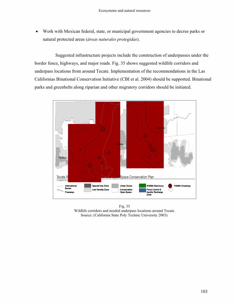
Ecosystems and natural resources
• Work with Mexican federal, state, or municipal government agencies to decree parks or
natural protected areas (áreas naturales protegidas).
Suggested infrastructure projects include the construction of underpasses under the
border fence, highways, and major roads. Fig. 35 shows suggested wildlife corridors and
underpass locations from around Tecate. Implementation of the recommendations in the Las
Californias Binational Conservation Initiative (CBI et al. 2004) should be supported. Binational
parks and greenbelts along riparian and other migratory corridors should be initiated.
International Border
Freeways
Special Use Zone
Low Density Zone
Urban Zones
Conservation Open Space
Wildlife Sanctuary
Flood Control & Aquifer Recharge Zone
Wildlife Crossings
Tecate
Campo
Tijuana
International Border
Freeways
Special Use Zone
Low Density Zone
Urban Zones
Conservation Open Space
Wildlife Sanctuary
Flood Control & Aquifer Recharge Zone
Wildlife CrossingsInternational Border
Freeways
Special Use Zone
Low Density Zone
Urban Zones
Conservation Open Space
Wildlife Sanctuary
Flood Control & Aquifer Recharge Zone
Wildlife CrossingsInternational Border
Freeways
Special Use Zone
Low Density Zone
Urban Zones
Conservation Open Space
Wildlife Sanctuary
Flood Control & Aquifer Recharge Zone
Wildlife Crossings
Tecate
Campo
Tijuana
Fig. 35 Wildlife corridors and needed underpass locations around Tecate.
Source: (California State Poly Technic University 2003).
103
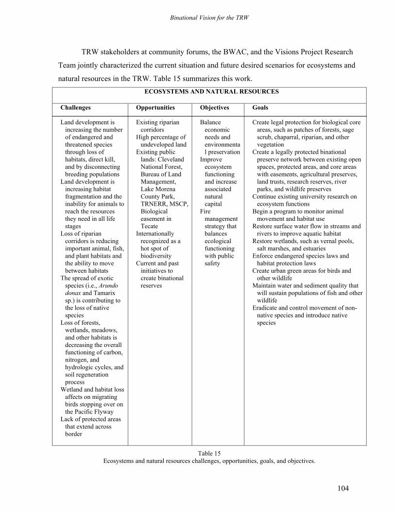
Binational Vision for the TRW
TRW stakeholders at community forums, the BWAC, and the Visions Project Research
Team jointly characterized the current situation and future desired scenarios for ecosystems and
natural resources in the TRW. Table 15 summarizes this work. ECOSYSTEMS AND NATURAL RESOURCES
Challenges Land development is
increasing the number of endangered and threatened species through loss of habitats, direct kill, and by disconnecting breeding populations
Land development is increasing habitat fragmentation and the inability for animals to reach the resources they need in all life stages
Loss of riparian corridors is reducing important animal, fish, and plant habitats and the ability to move between habitats
The spread of exotic species (i.e., Arundo donax and Tamarix sp.) is contributing to the loss of native species
Loss of forests, wetlands, meadows, and other habitats is decreasing the overall functioning of carbon, nitrogen, and hydrologic cycles, and soil regeneration process
Wetland and habitat loss affects on migrating birds stopping over on the Pacific Flyway
Lack of protected areas that extend across border
Opportunities Existing riparian
corridors High percentage of
undeveloped land Existing public
lands: Cleveland National Forest, Bureau of Land Management, Lake Morena County Park, TRNERR, MSCP, Biological easement in Tecate
Internationally recognized as a hot spot of biodiversity
Current and past initiatives to create binational reserves
Objectives Balance
economic needs and environmental preservation
Improve ecosystem functioning and increase associated natural capital
Fire management strategy that balances ecological functioning with public safety
Goals Create legal protection for biological core
areas, such as patches of forests, sage scrub, chaparral, riparian, and other vegetation
Create a legally protected binational preserve network between existing open spaces, protected areas, and core areas with easements, agricultural preserves, land trusts, research reserves, river parks, and wildlife preserves
Continue existing university research on ecosystem functions
Begin a program to monitor animal movement and habitat use
Restore surface water flow in streams and rivers to improve aquatic habitat
Restore wetlands, such as vernal pools, salt marshes, and estuaries
Enforce endangered species laws and habitat protection laws
Create urban green areas for birds and other wildlife
Maintain water and sediment quality that will sustain populations of fish and other wildlife
Eradicate and control movement of non-native species and introduce native species
Table 15 Ecosystems and natural resources challenges, opportunities, goals, and objectives.
104
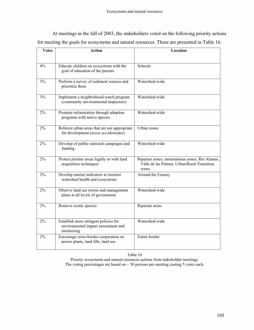
Ecosystems and natural resources
At meetings in the fall of 2003, the stakeholders voted on the following priority actions
for meeting the goals for ecosystems and natural resources. These are presented in Table 16. Votes Action Location
4% Educate children on ecosystems with the goal of education of the parents
Schools
3% Perform a survey of sediment sources and prioritize them
Watershed-wide
3% Implement a neighborhood watch program (community environmental inspectors)
Watershed-wide
2% Promote reforestation through adoption programs with native species
Watershed-wide
2% Reforest urban areas that are not appropriate for development (áreas accidentadas)
Urban zones
2% Develop of public outreach campaigns and funding
Watershed-wide
2% Protect pristine areas legally or with land acquisition techniques
Riparian zones, mountainous zones, Río Alamar, Valle de las Palmas, Urban/Rural Transition zones
2% Develop marine indicators to monitor watershed health and ecosystems
Around the Estuary
2% Observe land use norms and management plans at all levels of government
Watershed-wide
2% Remove exotic species Riparian areas
2% Establish more stringent policies for environmental impact assessment and monitoring
Watershed-wide
2% Encourage cross-border cooperation on power plants, land fills, land use
Entire border
Table 16 Priority ecosystems and natural resources actions from stakeholder meetings.
The voting percentages are based on ~ 50 persons per meeting casting 5 votes each.
105

Binational Vision for the TRW
106
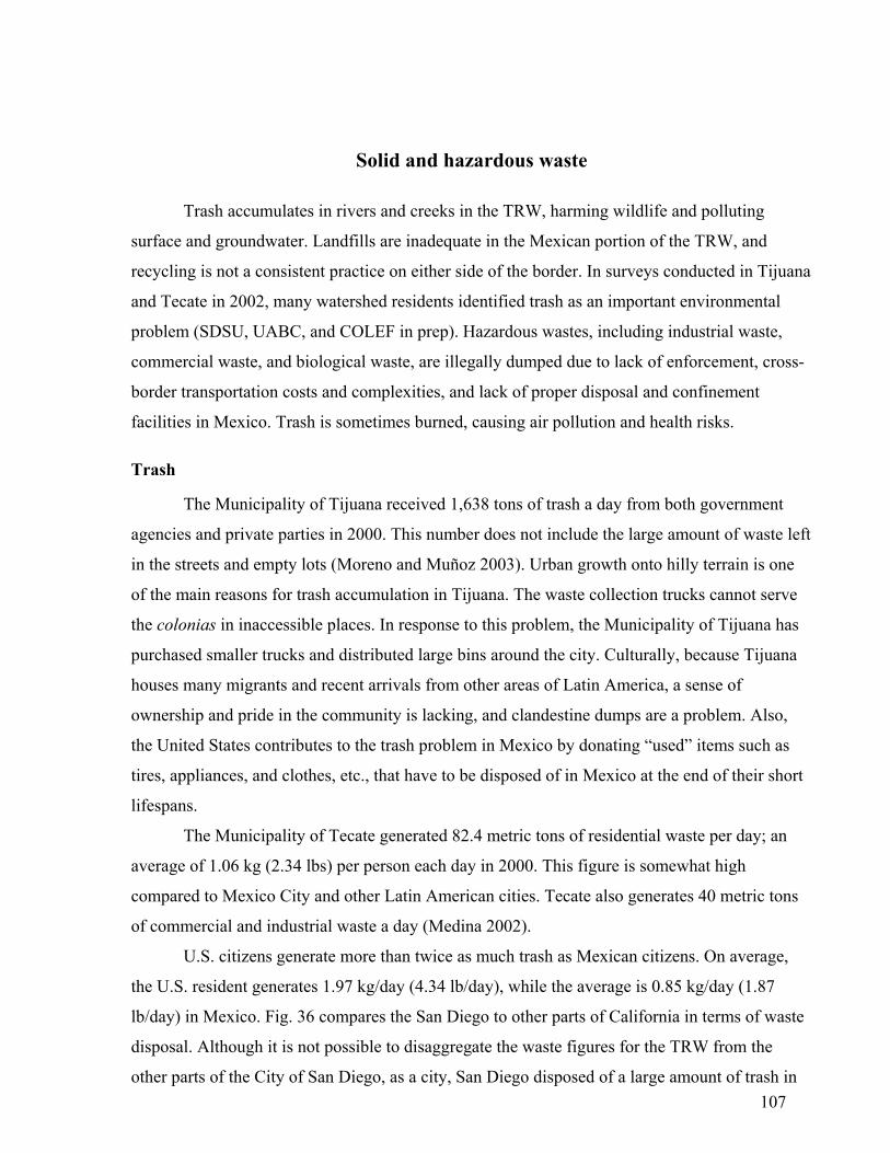
107
Solid and hazardous waste
Trash accumulates in rivers and creeks in the TRW, harming wildlife and polluting
surface and groundwater. Landfills are inadequate in the Mexican portion of the TRW, and
recycling is not a consistent practice on either side of the border. In surveys conducted in Tijuana
and Tecate in 2002, many watershed residents identified trash as an important environmental
problem (SDSU, UABC, and COLEF in prep). Hazardous wastes, including industrial waste,
commercial waste, and biological waste, are illegally dumped due to lack of enforcement, cross-
border transportation costs and complexities, and lack of proper disposal and confinement
facilities in Mexico. Trash is sometimes burned, causing air pollution and health risks.
Trash
The Municipality of Tijuana received 1,638 tons of trash a day from both government
agencies and private parties in 2000. This number does not include the large amount of waste left
in the streets and empty lots (Moreno and Muñoz 2003). Urban growth onto hilly terrain is one
of the main reasons for trash accumulation in Tijuana. The waste collection trucks cannot serve
the colonias in inaccessible places. In response to this problem, the Municipality of Tijuana has
purchased smaller trucks and distributed large bins around the city. Culturally, because Tijuana
houses many migrants and recent arrivals from other areas of Latin America, a sense of
ownership and pride in the community is lacking, and clandestine dumps are a problem. Also,
the United States contributes to the trash problem in Mexico by donating “used” items such as
tires, appliances, and clothes, etc., that have to be disposed of in Mexico at the end of their short
lifespans.
The Municipality of Tecate generated 82.4 metric tons of residential waste per day; an
average of 1.06 kg (2.34 lbs) per person each day in 2000. This figure is somewhat high
compared to Mexico City and other Latin American cities. Tecate also generates 40 metric tons
of commercial and industrial waste a day (Medina 2002).
U.S. citizens generate more than twice as much trash as Mexican citizens. On average,
the U.S. resident generates 1.97 kg/day (4.34 lb/day), while the average is 0.85 kg/day (1.87
lb/day) in Mexico. Fig. 36 compares the San Diego to other parts of California in terms of waste
disposal. Although it is not possible to disaggregate the waste figures for the TRW from the
other parts of the City of San Diego, as a city, San Diego disposed of a large amount of trash in
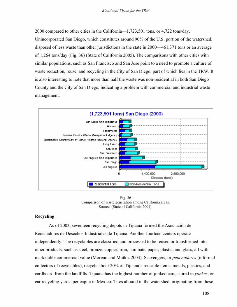
Binational Vision for the TRW
2000 compared to other cities in the California—1,723,501 tons, or 4,722 tons/day.
Unincorporated San Diego, which constitutes around 90% of the U.S. portion of the watershed,
disposed of less waste than other jurisdictions in the state in 2000—461,371 tons or an average
of 1,264 tons/day (Fig. 36) (State of California 2005). The comparisons with other cities with
similar populations, such as San Francisco and San Jose point to a need to promote a culture of
waste reduction, reuse, and recycling in the City of San Diego, part of which lies in the TRW. It
is also interesting to note that more than half the waste was non-residential in both San Diego
County and the City of San Diego, indicating a problem with commercial and industrial waste
management.
Fig. 36 Comparison of waste generation among California areas.
Source: (State of California 2001).
Recycling
As of 2003, seventeen recycling depots in Tijuana formed the Asociación de
Recicladores de Desechos Industriales de Tijuana. Another fourteen centers operate
independently. The recyclables are classified and processed to be reused or transformed into
other products, such as steel, bronze, copper, iron, laminate, paper, plastic, and glass, all with
marketable commercial value (Moreno and Muñoz 2003). Scavengers, or pepenadores (informal
collectors of recyclables), recycle about 20% of Tijuana’s reusable items, metals, plastics, and
cardboard from the landfills. Tijuana has the highest number of junked cars, stored in yonkes, or
car recycling yards, per capita in Mexico. Tires abound in the watershed, originating from these
108
Solid and hazardous waste
yonkes and from used tire sales from the United States. In 1996 approximately 184,000 tires
were imported into Tijuana; 113,000 tires were imported in 1997. Tires are used for fuel, to build
houses, for planters, soles of shoes, and for retaining walls. After use, tires are often dumped into
the rivers and canyons, causing flooding and environmental problems (Dirección de Ecología del
Estado de Baja California as cited in Moreno and Muñoz 2003). The new Tijuana landfill opened
in 2004 and has, among other recycling operations, a tire shredder that processed around 30,000
tires in August 2004 (Saxod 2004). Shredding tires helps them biodegrade, takes up less landfill
space, discourages burning, and prevents water from accumulating in the insides, attracting
mosquitoes and other insects.
Border WasteWise35 was a pilot project established in 1995 to help companies in Tijuana
reduce waste and improve economic competitiveness; a total of twenty-seven businesses
participated. The City of San Diego’s Department of Environmental Services Division of
Environmental Programs is responsible for the City of San Diego’s recycling programs. San
Diego County (including parts of the TRW) offers recycling throughout the South San Diego’s
Recycling Market Development Zone. Tecate’s government does not currently support recycling.
However, Tecate’s pepenadores recycle materials, such as cardboard, aluminum, and iron/steel
scrap (Medina 2002). Scrap collected in Tecate and Tijuana is often sold in San Diego and
constitutes a binational market.
35
Landfills
In Baja California, state law establishes that the Dirección General de Ecología del
Estado (DGE) is responsible for evaluating the environmental impacts of landfills. The
Departamentos de Limpia in the Municipalities of Tijuana and Tecate manage municipal waste.
The City of Tijuana has two waste transfer centers to streamline the daily movement of
trash to the landfill. One is located in Colonia Libertad near the border and is 7,179 m2 (1.8
acres) in area and in 1998 took in 15% of the waste generated in the municipality, mostly from
Mesa de Otay (70%) and Zona Centro (30%). The second is in Fraccionamento Mariano
Matamoros in the eastern part of the city which accepted 4% of the trash generated in the
Municipality, mainly from La Presa. This transfer center is 10,000 m2 (2.5 acres) in size and has
3355 A collaboration of Institute for Regional Studies of the Californias, San Diego State University; Environmental Services Department, City of
San Diego; Dirección de Obras y Servicios Públicos, Ayuntamiento de Tijuana; California Environmental Protection Agency, Integrated Waste
Management Board; U.S. Environmental Protection Agency, Region IX, Science Applications International Corporation (SAIC); Facultad
Internacional de Economía,Universidad Autónoma de Baja California
109
Binational Vision for the TRW
the capacity to handle 150 tons/day with a total storage capacity of 225 tons (Moreno and Muñoz
2003).
Until February 2003 there was only one landfill in Tijuana at Colonia Lomas del Jibarito,
in the Delegación San Antonio de los Buenos. In 1998 it received more than 100 loads per day
from city trucks and an unknown number of visits from private trucks. It is estimated that the
landfill reached its capacity in 1997. It was an open-air landfill and has experienced fires,
resulting in an investigation by environmental officials in 1990 (Moreno and Muñoz 2003). The
Municipality of Tijuana opened a state-of-the-art landfill in 2004 with a total area of 1,000,005
m2 (247 acres). Its expected capacity over the next 19 years will be 27,882,766 m3 (36,469,281
yd3) (DGE 2003).
Tecate’s landfill has also exceeded its lifespan and has caught on fire in the past. Local
authorities have proposed a new landfill that would occupy 0.47 km2 (0.18 mi2) south of town
with a lifespan of 50 years and a section for industrial waste (Medina 2002). Although funding
was approved by NADBANK, public debate about the location of the landfill and property title
issues have delayed construction.
The Otay Landfill lies north of the watershed boundary, is regulated in terms of water
quality by waste discharge requirements issued by the California Regional Water Quality Control
Board. Currently, the facility provides biosolids disposal services for the City of San Diego and
other municipalities in the San Diego metropolitan area. The remaining capacity in 2003 was
31,336,166 tons (San Diego County 2004).
Hazardous waste
The storage, transportation, treatment, recycling, and disposal of hazardous waste is
regulated by the Mexican federal Secretariat of Environment and Natural Resources
(SEMARNAT) and the National Environmental Institute (INE). In the United States, hazardous
waste is regulated by the EPA’s Region 9 Waste Management Division.
Mexican agencies define hazardous waste as corrosive, reactive, explosive, toxic,
flammable, or infectious materials (CRETIB). Hospitals, clinics, and laboratories generate
infectious waste and households generate hazardous waste, such as batteries and cleaning
products. Mexico and the United States have separate tracking systems for monitoring hazardous
wastes. Data on sources and quantities are unreliable and scarce. In Mexico, the maquiladora
industry is likely the largest generator of industrial hazardous waste (Medina 2002).
110
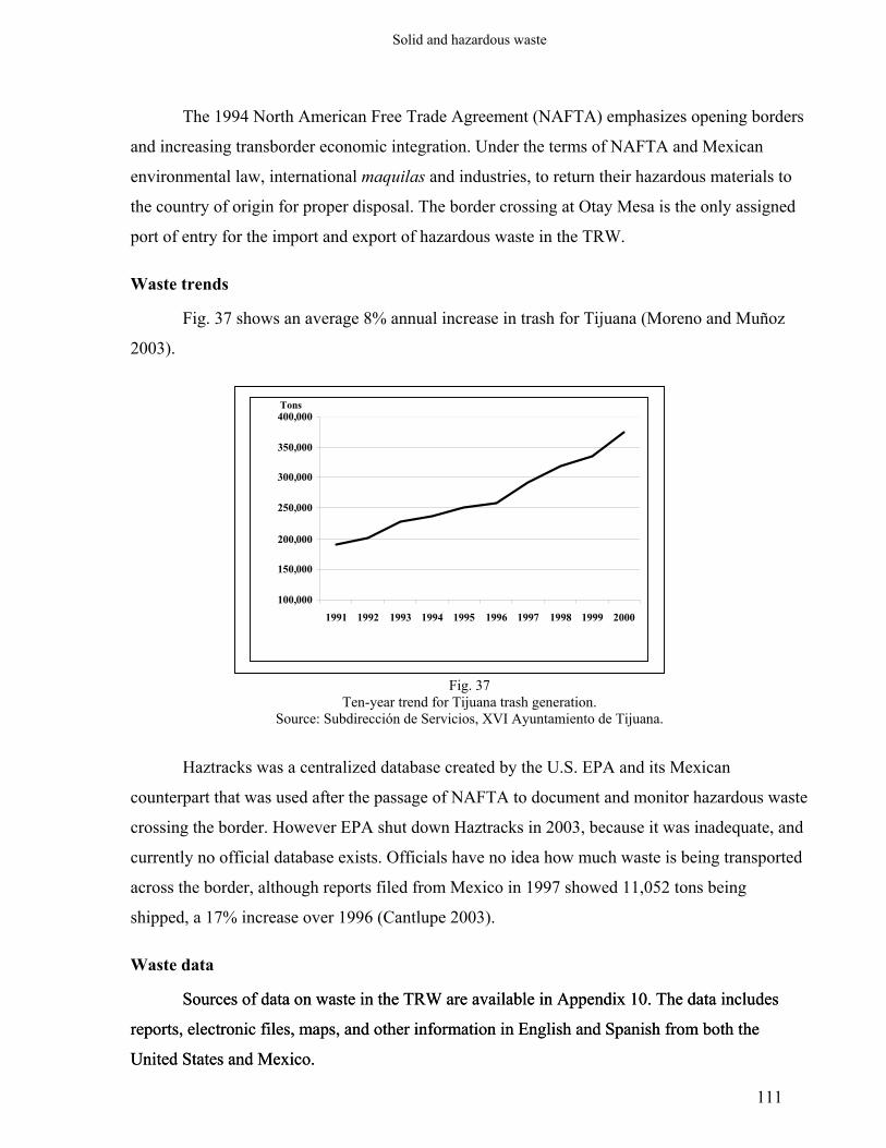
Solid and hazardous waste
The 1994 North American Free Trade Agreement (NAFTA) emphasizes opening borders
and increasing transborder economic integration. Under the terms of NAFTA and Mexican
environmental law, international maquilas and industries, to return their hazardous materials to
the country of origin for proper disposal. The border crossing at Otay Mesa is the only assigned
port of entry for the import and export of hazardous waste in the TRW.
Waste trends
Fig. 37 shows an average 8% annual increase in trash for Tijuana (Moreno and Muñoz
2003).
TonsTons
Haztrac
counterpart that
crossing the bor
currently no off
across the borde
shipped, a 17%
Waste data
Sources
reports, electron
United States an
Sources
reports, electron
United States an
Fig. 37
100,000
150,000
200,000
250,000
300,000
350,000
400,000
1991 1992 1993 1994 1995 1996 1997 1998 1999 2000
Años
Tone
lada
s de
bas
ura
100,000
150,000
200,000
250,000
300,000
350,000
400,000
1991 1992 1993 1994 1995 1996 1997 1998 1999 2000
Años
Tone
lada
s de
bas
ura
Ten-year trend for Tijuana trash generation. Source: Subdirección de Servicios, XVI Ayuntamiento de Tijuana.
ks was a centralized database created by the U.S. EPA and its Mexican
was used after the passage of NAFTA to document and monitor hazardous waste
der. However EPA shut down Haztracks in 2003, because it was inadequate, and
icial database exists. Officials have no idea how much waste is being transported
r, although reports filed from Mexico in 1997 showed 11,052 tons being
increase over 1996 (Cantlupe 2003).
of data on waste in the TRW are available in Appendix 10. The data includes
ic files, maps, and other information in English and Spanish from both the
d Mexico.
of data on waste in the TRW are available in Appendix 10. The data includes
ic files, maps, and other information in English and Spanish from both the
d Mexico.
111

Binational Vision for the TRW
Waste data gap
After reviewing the available data, the Research Team and others identified the following
data needs for the TRW:
• Quantified amount and type of waste crossing the border
• Information on tons of recycled materials collected per year in the TRW
Waste recommendations
Suggested research includes:
• Perform periodic characterizations of the source of the waste.
• Perform scientific studies to support public policy making.
• Study the role of landfill recyclers, or pepenadores.
• Study the successful experiences with recycling in other cities in Mexico and abroad.
• Research on classification of recyclables is needed.
The following recommendations were made by the civic group Tijuana Trabaja in 2003
(Moreno and Muñoz 2003). Although they focus on Tijuana, the suggestions apply broadly
throughout the TRW.
• Implement a strategy for organizing data and diffusing information on transboundary waste.
• Privatize Mexican waste collection through a contract that contains precise clauses and
follow-up by the municipal authority.
• Perform an immediate inventory of Tijuana waste collection and storage equipment, and
replace in stages.
• Inspect and maintain equipment.
• Redesign routes for trash collection in Tijuana.
• Supply the transfer station with urgently needed heavy equipment, efficient operational
control, expanded manpower, offices, and services for operators.
• Develop and diffuse programs to improve the efficiency of Mexican collection system
efficiency, such as posted schedules, hours, routes, general information, and ways to help
evaluation activities.
• Strengthen supervision and enforcement of law and punish lawbreakers.
• Create an information center and follow-up on complaints and reports of violations.
112
Solid and hazardous waste
• Develop a Tijuana master plan for the management of solid waste that includes a feasibility.
study and economic analysis for priority projects and promotes the well being of the citizens
and environmental protection.
• Transform the current Departamento de Limpia and start an integrated recycling program
with the private, education, and government sector involvement.
• Create an information system about the specific benefits of the recycling processes like
guides, collection programs, and all types of materials in the city parks and recreational
centers. Citizen training and presentations are needed.
• Implement a pilot recycling program in the schools that could become a model for city-wide
application in Tijuana.
• Create a management plan for car junk yards (yonkes) and tires.
• Promote family and institutional practices of composting.
• Explore government-sponsored composting options for organic matter.
• Explore incineration options for volume reduction and energy generation.
• Eliminate the fee at the Mexican landfills with the goal of reducing illegal dumping and
burning.
113
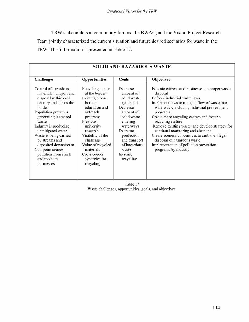
Binational Vision for the TRW
114
TRW stakeholders at community forums, the BWAC, and the Vision Project Research
Team jointly characterized the current situation and future desired scenarios for waste in the
TRW. This information is presented in Table 17.
SOLID AND HAZARDOUS WASTE
Challenges Control of hazardous
materials transport and disposal within each country and across the border
Population growth is generating increased waste
Industry is producing unmitigated waste
Waste is being carried by streams and deposited downstream
Non-point source pollution from small and medium businesses
Opportunities Recycling center
at the border Existing cross-
border education and outreach programs
Previous university research
Visibility of the challenge
Value of recycled materials
Cross-border synergies for recycling
Goals Decrease
amount of solid waste generated
Decrease amount of solid waste entering waterways
Decrease production and transport of hazardous waste
Increase recycling
Objectives Educate citizens and businesses on proper waste
disposal Enforce industrial waste laws Implement laws to mitigate flow of waste into
waterways, including industrial pretreatment programs
Create more recycling centers and foster a recycling culture
Remove existing waste, and develop strategy for continual monitoring and cleanups
Create economic incentives to curb the illegal disposal of hazardous waste
Implementation of pollution prevention programs by industry
Table 17 Waste challenges, opportunities, goals, and objectives.
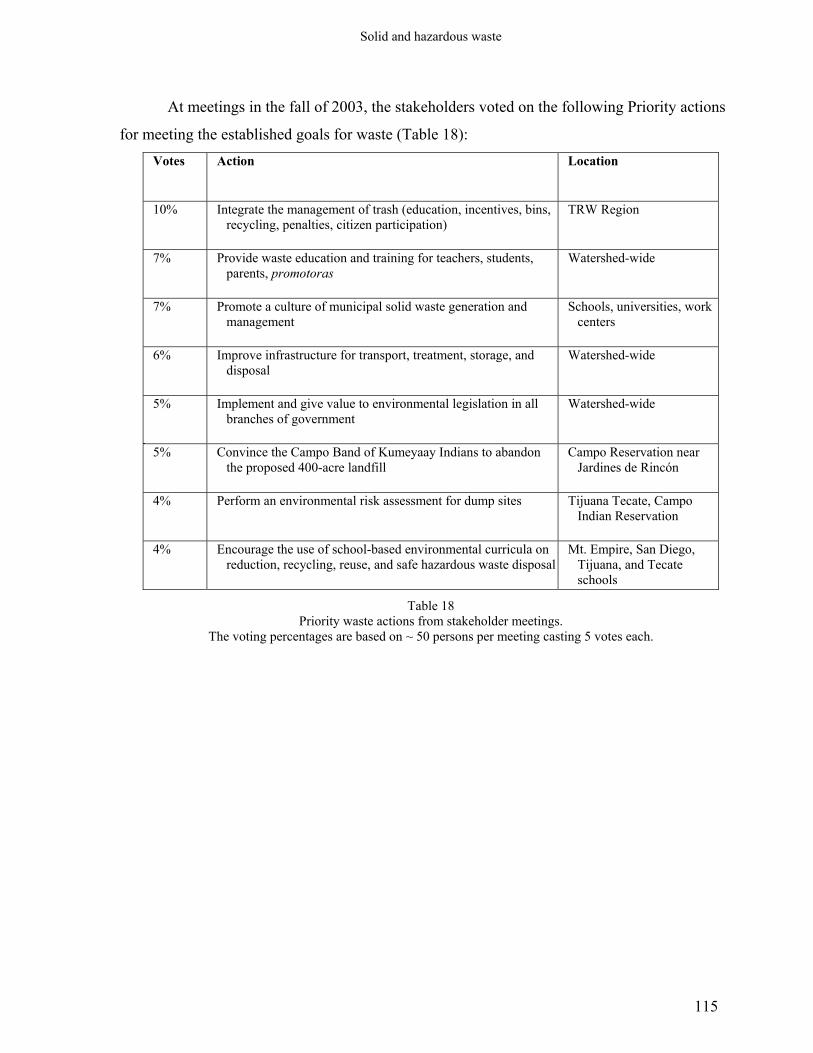
Solid and hazardous waste
115
At meetings in the fall of 2003, the stakeholders voted on the following Priority actions
for meeting the established goals for waste (Table 18): Votes Action Location
10% Integrate the management of trash (education, incentives, bins, recycling, penalties, citizen participation)
TRW Region
7% Provide waste education and training for teachers, students, parents, promotoras
Watershed-wide
7% Promote a culture of municipal solid waste generation and management
Schools, universities, work centers
6% Improve infrastructure for transport, treatment, storage, and disposal
Watershed-wide
5% Implement and give value to environmental legislation in all branches of government
Watershed-wide
5% Convince the Campo Band of Kumeyaay Indians to abandon the proposed 400-acre landfill
Campo Reservation near Jardines de Rincón
4% Perform an environmental risk assessment for dump sites Tijuana Tecate, Campo Indian Reservation
4% Encourage the use of school-based environmental curricula on reduction, recycling, reuse, and safe hazardous waste disposal
Mt. Empire, San Diego, Tijuana, and Tecate schools
Table 18 Priority waste actions from stakeholder meetings.
The voting percentages are based on ~ 50 persons per meeting casting 5 votes each.

Binational Vision for the TRW
116
Air quality
Pollutants in the atmosphere impact the health of humans, flora, and fauna in the TRW
through direct inhalation of pollutants, deposition onto plants and soils, and absorption into water
bodies. The major source of pollutants to the atmosphere in the TRW originates from human
activities that take place within the metropolitan region of San Diego-Tijuana-Tecate, although
some atmospheric pollutants may be transported from outside the basin through prevailing wind
patterns (Sweedler 1998).
Mexico and the United States have each established standards for the most important air
pollutants which include:
• Carbon monoxide (CO)
• Ozone (O3)
• Nitrogen dioxide (NO2)
• Sulfur dioxide (SO2)
• Particulate matter 2.5 micrometers or less in diameter (PM 2.5) United States only
• Particulate matter 10 micrometers or less in diameter (PM 10)
• Total suspended particulate matter (TSP) Mexico only
• Lead (Pb)
The standards established by Mexico are fairly close to the U.S. air quality standards.
There are also separate State of California standards for some criteria pollutants that are stricter
than both the U.S. and Mexican standards.
Only in the late 1990s were monitoring stations established in the Tijuana region to
provide information about ambient air quality (Sweedler 1998). These new stations complement
existing stations in San Diego to provide information about air quality in the binational region
and the TRW. Fig. 38 displays the location of air quality monitoring stations available in 2004.
117
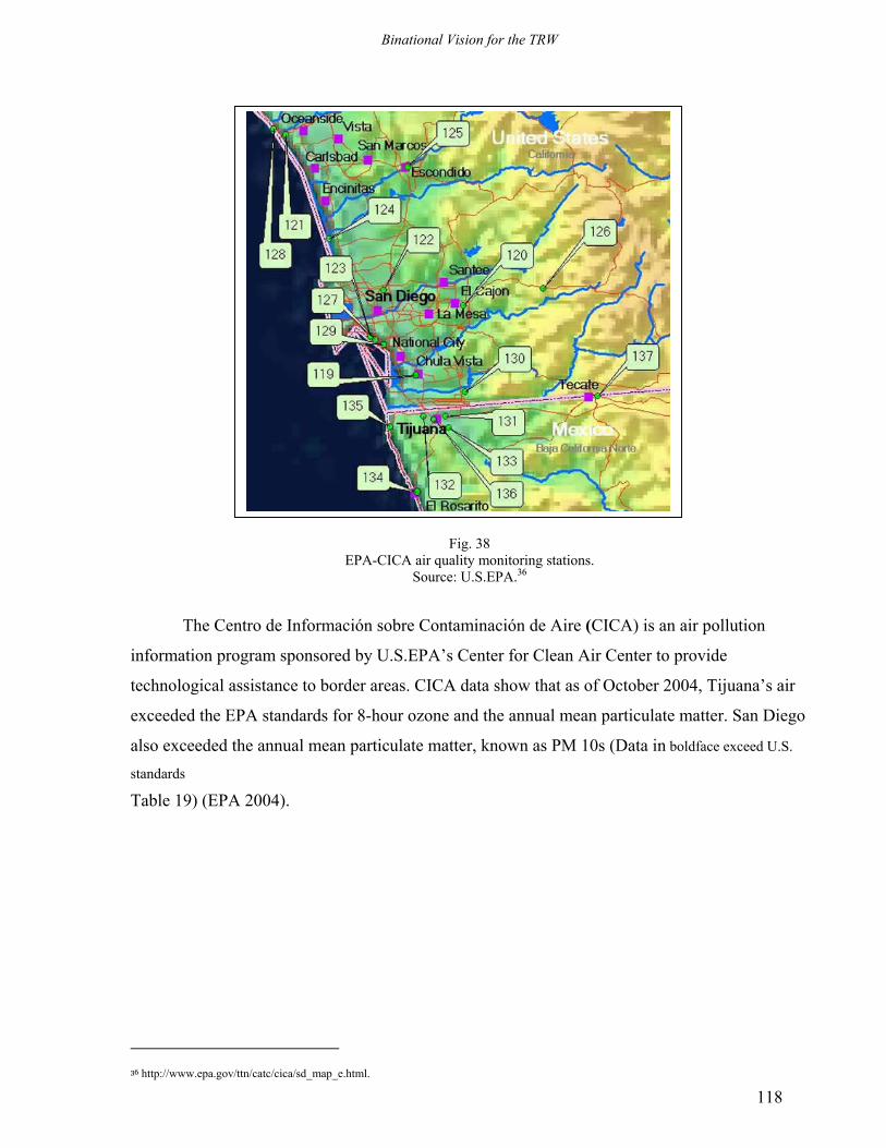
Binational Vision for the TRW
The Cen
information pro
technological a
exceeded the EP
also exceeded tstandards
Table 19) (EPA
3366 http://www.epa.gov/
118
Fig. 38 EPA-CICA air quality monitoring stations.
Source: U.S.EPA.36 36
tro de Información sobre Contaminación de Aire (CICA) is an air pollution
gram sponsored by U.S.EPA’s Center for Clean Air Center to provide
ssistance to border areas. CICA data show that as of October 2004, Tijuana’s air
A standards for 8-hour ozone and the annual mean particulate matter. San Diego
he annual mean particulate matter, known as PM 10s (Data in boldface exceed U.S.
2004).
ttn/catc/cica/sd_map_e.html.

Air quality
Carbon
monoxide Nitrogen dioxide Ozone Sulfur
dioxide Particulate
2.5 Particulate
10 Lead
2nd
Max
1-hr
2nd
Max 8-
hr
Annual
Mean
4th
Max 8-
hr
2nd
Max
24-hr
Annual
Mean
Annual
Mean
2nd
Max
24-hr
Annual
Mean
Quarterly
Mean
Tijuana-Tecate 13.8 7.2 0.025 0.109 0.092 0.004 0.002 143 64 0.08
San Diego Co. 6.1 3.8 0.022 0.104 0.082 0.015 0.004 42 14.9 104 53
2nd 98th
Max Percentile
1-hr
Data in boldface exceed U.S. standards
Table 19 Air quality data for the Tijuana, Tecate, San Diego County region, 2004.
Source: EPA-CICA.37 37
Description of data in Data in boldface exceed U.S. standards Table 19:
Carbon monoxide: 35 ppm (1-hour average), 9 ppm (8-hour average) Nitrogen dioxide: 0.053 ppm (annual mean) Ozone: 0.12 ppm (1-hour average), 0.08 ppm (8-hour average) Sulfur dioxide: 0.14 ppm (24-hour average), 0.030 ppm (annual mean) Particulate 2.5 (diameter < 2.5 micrometers): 65 µg/m3 (24-hour average), 15.0 µg/m3 (annual mean) Particulate 10 (diameter < 10 micrometers): 150 µg/m3 (24-hour average), 50 µg/m3 (annual mean) Lead: 1.5 µg/m3 (quarterly mean)
3377 See http://www.epa.gov/ttn/catc/cica/monvals_e.html?ba~sd~San%20Diego/Tijuana
119
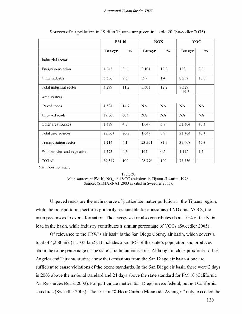
Binational Vision for the TRW
Sources of air pollution in 1998 in Tijuana are given in Table 20 (Sweedler 2005).
NA: Does not appl
Industrial sector
Energy generatio
Other industry
Total industrial s
Area sources
Paved roads
Unpaved roads
Other area sourc
Total area source
Transportation se
Wind erosion an
TOTAL
M
Unpaved
while the transpo
main precursors t
load in the basin,
Of releva
total of 4,260 mi2
about the same pe
Angeles and Tiju
sufficient to caus
in 2003 above the
Air Resources Bo
standards (Sweed
PM 10 NOX VOC
Tons/yr % Tons/yr % Tons/yr %
n 1,043 3.6 3,104 10.8 122 0.2
2,256 7.6 397 1.4 8,207 10.6
ector 3,299 11.2 3,501 12.2 8,329 10.7
4,324 14.7 NA NA NA NA
17,860 60.9 NA NA NA NA
es 1,379 4.7 1,649 5.7 31,304 40.3
s 23,563 80.3 1,649 5.7 31,304 40.3
ctor 1,214 4.1 23,501 81.6 36,908 47.5
d vegetation 1,273 4.3 145 0.5 1,195 1.5
29,349 100 28,796 100 77,736
y.
Table 20 ain sources of PM 10, NOX and VOC emissions in Tijuana-Rosarito, 1998.
Source: (SEMARNAT 2000 as cited in Sweedler 2005).
roads are the main source of particulate matter pollution in the Tijuana region,
rtation sector is primarily responsible for emissions of NOx and VOCs, the
o ozone formation. The energy sector also contributes about 10% of the NOx
while industry contributes a similar percentage of VOCs (Sweedler 2005).
nce to the TRW’s air basin is the San Diego County air basin, which covers a
(11,033 km2). It includes about 8% of the state’s population and produces
rcentage of the state’s pollutant emissions. Although in close proximity to Los
ana, studies show that emissions from the San Diego air basin alone are
e violations of the ozone standards. In the San Diego air basin there were 2 days
national standard and 24 days above the state standard for PM 10 (California
ard 2003). For particulate matter, San Diego meets federal, but not California,
ler 2005). The test for “8-Hour Carbon Monoxide Averages” only exceeded the
120
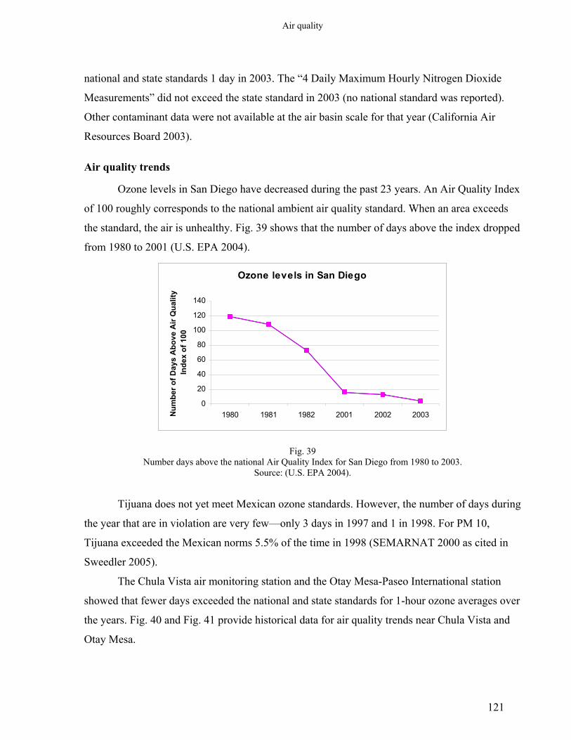
Air quality
national and state standards 1 day in 2003. The “4 Daily Maximum Hourly Nitrogen Dioxide
Measurements” did not exceed the state standard in 2003 (no national standard was reported).
Other contaminant data were not available at the air basin scale for that year (California Air
Resources Board 2003).
Air quality trends
Ozone levels in San Diego have decreased during the past 23 years. An Air Quality Index
of 100 roughly corresponds to the national ambient air quality standard. When an area exceeds
the standard, the air is unhealthy. Fig. 39 shows that the number of days above the index dropped
from 1980 to 2001 (U.S. EPA 2004).
Ozone levels in San Diego
0
20
40
60
80
100
120
140
1980 1981 1982 2001 2002 2003Num
ber o
f Day
s A
bove
Air
Qua
lity
Inde
x of
100
Fig. 39 Number days above the national Air Quality Index for San Diego from 1980 to 2003.
Source: (U.S. EPA 2004).
Tijuana does not yet meet Mexican ozone standards. However, the number of days during
the year that are in violation are very few—only 3 days in 1997 and 1 in 1998. For PM 10,
Tijuana exceeded the Mexican norms 5.5% of the time in 1998 (SEMARNAT 2000 as cited in
Sweedler 2005).
The Chula Vista air monitoring station and the Otay Mesa-Paseo International station
showed that fewer days exceeded the national and state standards for 1-hour ozone averages over
the years. Fig. 40 and Fig. 41 provide historical data for air quality trends near Chula Vista and
Otay Mesa.
121
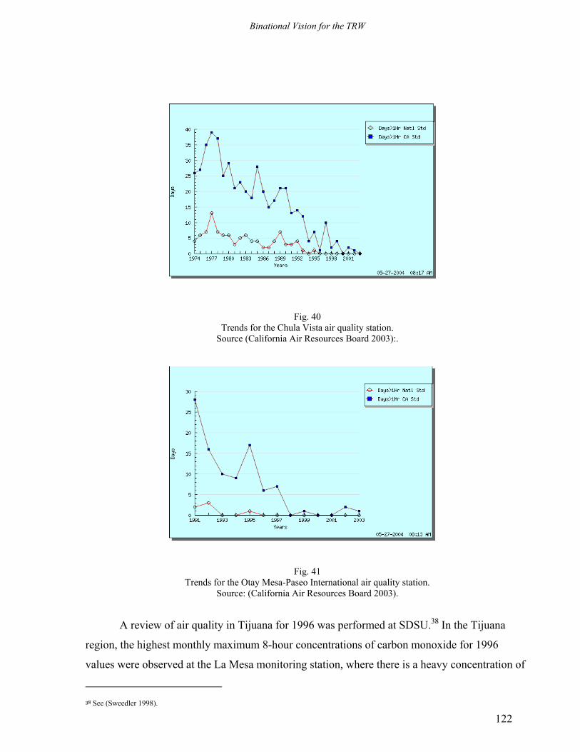
Binational Vision for the TRW
Fig. 40 Trends for the Chula Vista air quality station.
Source (California Air Resources Board 2003):.
Fig. 41 Trends for the Otay Mesa-Paseo International air quality station.
Source: (California Air Resources Board 2003).
A review of air quality in Tijuana for 1996 was performed at SDSU.38 In the Tijuana
region, the highest monthly maximum 8-hour concentrations of carbon monoxide for 1996
values were observed at the La Mesa monitoring station, where there is a heavy concentration of
38
3388 See (Sweedler 1998).
122
Air quality
commercial and urban traffic. Emissions from cars and trucks constitute a major source of
carbon monoxide. Even though the carbon monoxide levels were high, they were within the
Mexican federal standards. The highest 1-hour maximum concentrations for nitrogen dioxide
occurred at the heavily congested La Mesa monitoring site. NO2 is a precursor to ozone
formation and also results from combustion of petroleum-based fuel in cars and trucks. PM 10
were fairly high, although less than what is observed in the eastern portion of the TRW. The
nature of air over the TRW has not been characterized but it is clear that air movements transport
pollutants. up and down river valley
Air quality data
Sources of data on air quality in the TRW are available in Appendix 11. The data
includes reports, electronic files, maps, and other information in English and Spanish from both
the United States and Mexico.
Air quality data gaps
After reviewing the available data, the Research Team and others identified the following
data needs for the TRW:
• More air quality monitoring data for Mexico and at border crossings
Air quality recommendations
A very important element in reducing air pollution in the region is the development of an
adequate emissions inventory. Knowledge of the source and quantity of pollutants emitted into
the atmosphere is a precursor for developing a program updated to reduce air pollution in the
region. Suggested research topics include studies concerning the links between air pollutants and
water quality in the TRW (Sweedler 1998).
123
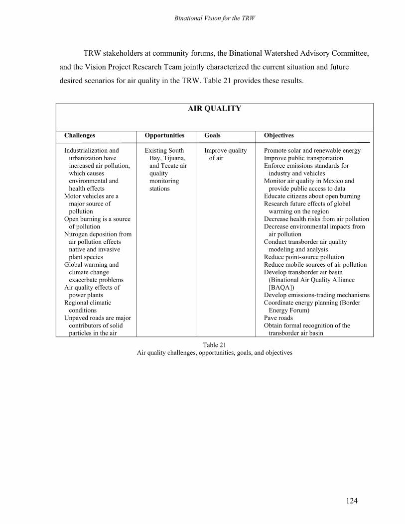
Binational Vision for the TRW
124
TRW stakeholders at community forums, the Binational Watershed Advisory Committee,
and the Vision Project Research Team jointly characterized the current situation and future
desired scenarios for air quality in the TRW. Table 21 provides these results.
AIR QUALITY
Challenges Industrialization and
urbanization have increased air pollution, which causes environmental and health effects
Motor vehicles are a major source of pollution
Open burning is a source of pollution
Nitrogen deposition from air pollution effects native and invasive plant species
Global warming and climate change exacerbate problems
Air quality effects of power plants
Regional climatic conditions
Unpaved roads are major contributors of solid particles in the air
Opportunities Existing South
Bay, Tijuana, and Tecate air quality monitoring stations
Goals Improve quality
of air
Objectives Promote solar and renewable energy Improve public transportation Enforce emissions standards for
industry and vehicles Monitor air quality in Mexico and
provide public access to data Educate citizens about open burning Research future effects of global
warming on the region Decrease health risks from air pollution Decrease environmental impacts from
air pollution Conduct transborder air quality
modeling and analysis Reduce point-source pollution Reduce mobile sources of air pollution Develop transborder air basin
(Binational Air Quality Alliance [BAQA])
Develop emissions-trading mechanisms Coordinate energy planning (Border
Energy Forum) Pave roads Obtain formal recognition of the
transborder air basin
Table 21 Air quality challenges, opportunities, goals, and objectives
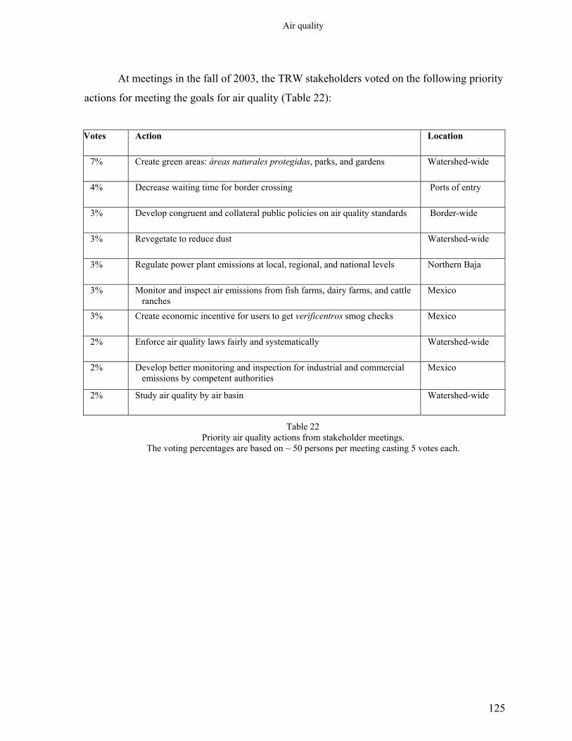
Air quality
At meetings in the fall of 2003, the TRW stakeholders voted on the following priority
actions for meeting the goals for air quality (Table 22):
Votes Action Location
7% Create green areas: áreas naturales protegidas, parks, and gardens Watershed-wide
4% Decrease waiting time for border crossing Ports of entry
3% Develop congruent and collateral public policies on air quality standards Border-wide
3% Revegetate to reduce dust Watershed-wide
3% Regulate power plant emissions at local, regional, and national levels Northern Baja
3% Monitor and inspect air emissions from fish farms, dairy farms, and cattle ranches
Mexico
3% Create economic incentive for users to get verificentros smog checks Mexico
2% Enforce air quality laws fairly and systematically Watershed-wide
2% Develop better monitoring and inspection for industrial and commercial emissions by competent authorities
Mexico
2% Study air quality by air basin Watershed-wide
Table 22 Priority air quality actions from stakeholder meetings.
The voting percentages are based on ~ 50 persons per meeting casting 5 votes each.
125

Binational Vision for the TRW
126
Socioeconomic issues
Economy
Disaggregating social and economic data to coincide with the physical boundaries of the
TRW is, in most cases, not possible. At the same time, harmonization of data across the
international boundary is not always possible or is too difficult or costly to be undertaken.
Consequently, much of the discussion of socioeconomic issues will focus on the larger region of
San Diego County, the Municipality of Tijuana, and the Municipality of Tecate.
Since World War II, the economy of Southern California, despite periods of recession,
has been very dynamic, demonstrating impressive growth over the long term. Military
expenditures and tourism have remained central to San Diego’s economy, and the region has
transitioned from the loss of aerospace jobs in the early 1990s to biotechnology, software, and
electronics quite successfully. Typically, unemployment in San Diego has remained lower than
the rest of the state or nation (Rey and Clement 1998).
The economic contrasts between San Diego and Tijuana-Tecate are striking. Depending
on the peso-dollar exchange rate, the regional product of San Diego is typically more than fifteen
times that of Tijuana and minimum wages are about ten times in the United States. Other
economic measures reveal similar asymmetries, including municipal budget expenditures per
capita. The regional asymmetries are characteristic of those between highly developed industrial
nations and developing countries (SANDAG 1998 as cited in (Rey and Clement 1998; Rey, et al.
1998) (Fig. 42).
At the same time, Tijuana is better off economically relative to the rest of Mexico, while
some aspects of San Diego’s economy, like affordable housing, lag behind the rest of the United
States. In areas such as per capita income, the entire U.S.-Mexican border, including San Diego,
have fallen behind the natural average. In both San Diego and Tijuana, income distribution has
become more unequal, with larger percentages of workers and the population at or near the
poverty level. This suggests that the benefits of economic expansion before and after NAFTA
have accrued mainly to groups at the top of the income scale. Inequality is growing within the
region (Rey and Clement 1998) (see Fig. 42).
127
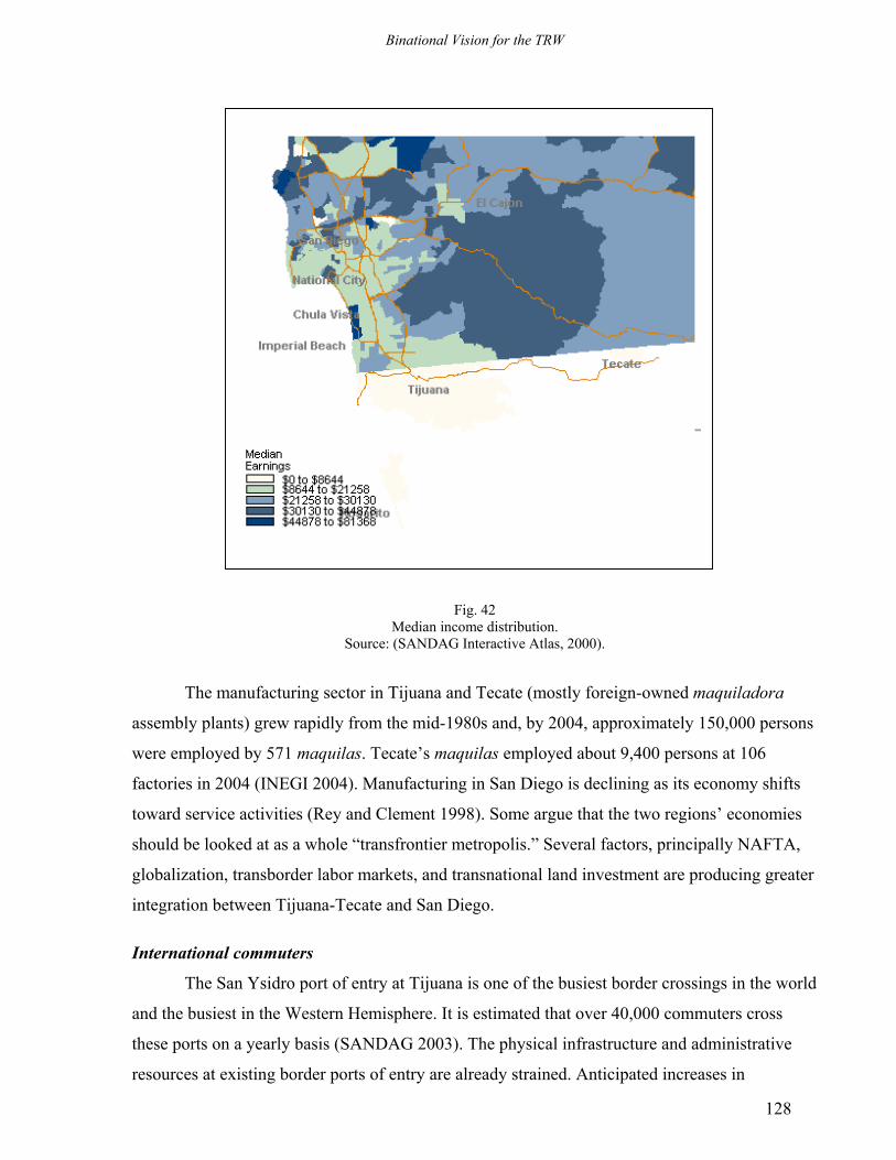
Binational Vision for the TRW
ass
we
fac
tow
sho
glo
int
In
an
the
res
Fig. 42 Median income distribution.
Source: (SANDAG Interactive Atlas, 2000).
The manufacturing sector in Tijuana and Tecate (mostly foreign-owned maquiladora
embly plants) grew rapidly from the mid-1980s and, by 2004, approximately 150,000 persons
re employed by 571 maquilas. Tecate’s maquilas employed about 9,400 persons at 106
tories in 2004 (INEGI 2004). Manufacturing in San Diego is declining as its economy shifts
ard service activities (Rey and Clement 1998). Some argue that the two regions’ economies
uld be looked at as a whole “transfrontier metropolis.” Several factors, principally NAFTA,
balization, transborder labor markets, and transnational land investment are producing greater
egration between Tijuana-Tecate and San Diego.
ternational commuters
The San Ysidro port of entry at Tijuana is one of the busiest border crossings in the world
d the busiest in the Western Hemisphere. It is estimated that over 40,000 commuters cross
se ports on a yearly basis (SANDAG 2003). The physical infrastructure and administrative
ources at existing border ports of entry are already strained. Anticipated increases in
128
Socioeconomic issues
population growth and international trade will place even greater pressures on the existing
infrastructure. Crossings of passengers and goods at the U.S.-Mexican international border are
projected to increase by nearly 90% by 2030 (SANDAG 2004).
According to the 2000 Mexican census, 50,000 Tijuana residents worked in the United
States (INEGI 2004). Many worked legally, but thousands of others cross illegally to work with
border crossing cards that were issued for non-work purposes. Whether working legally or
illegally in the San Diego region, these workers earn significantly higher wages than most
workers employed in Tijuana and Tecate. Thus, it is very likely that the total payroll of these
commuter workers exceeds the total payroll of the maquiladora line workers in Tijuana and
Tecate (Rey, et al. 1998). In 2002, total of 42.2 million persons legally crossed the border at San
Ysidro, 11.3 million crossed at Otay Mesa, and 2.7 million crossed at Tecate, totaling 56.5
million individuals.
The value of goods crossing the border in 2003 was and $20 billion and is expected to
increase by $34 billion by 2030, or 200%. The current port of entry and roadway network
serving the border are not adequate to handle the projected increase (SANDAG 2004). The
increased scrutiny of persons entering and leaving land ports of entry mandated by the U.S.
Department of Homeland Security will likely significantly increase border congestion when
implemented in 2005.
Transborder tourism and retail trade
In the 1920s, the prohibition of alcohol and gambling in the United States sparked
Mexican border tourism. Tourism continues to be a large generator of revenue in the border
region, particularly in Tijuana, but also in Tecate. Border tourism typically includes many
thousands of visits for short periods of shopping or dining and relatively low expenditures. For
many years, tourism authorities in Tijuana have tried to improve tourism through encouraging
overnight stays and expanding the number of venues. Tecate, in contrast, has begun to focus on
the possibilities of ecotourism and cultural-historical tourism to take advantage of the rich
environmental and human resources of the upper TRW. Cross-border shopping has been
important in the TRW region for more than a century. Merchants in San Ysidro and south San
Diego, as well as merchants in Tijuana, depend upon visitors for an important part of their sales.
Due to these factors and others, the economies of San Diego and Tijuana have been
expanding; however, there have been negative consequences for the region’s quality of life.
More jobs have attracted many more residents and contributed to urban sprawl and traffic.
129
Binational Vision for the TRW
Unfortunately, more jobs and more people do not necessarily translate to higher incomes or more
tax dollars for infrastructure. As a result of the population boom, there is an infrastructure deficit
for all cities in the TRW that threatens to undermine the potential for long-term prosperity and a
high quality of life (Rey and Clement 1998).
Housing
San Diego is usually among the top 20 least affordable housing markets in the nation due
to its relatively low wages and high housing costs. There has been a housing affordability crisis
in San Diego since 1978. The housing crisis is especially acute for low and very-low income
households (Calavita 1998). In the City of San Diego 155,910 households paid more than 30% of
their income on housing in 2000 (U.S. Census Bureau 2004). Just 11% of households in San
Diego County had income levels that were sufficient to purchase a home (California Association
of Realtors 2004).
A larger portion of residents in Mexican municipalities own their homes—Tijuana (68%)
and Tecate (67%). Nearly 45% of the low-income sector of Tijuana lacked any formal housing
options and could not get credit in 2000 (Gobierno Estatal de B.C. 2002).
Baja California already has the one of the largest communities of expatriate U.S.
homeowners in Mexico (second only to the Guadalajara region). Between 5,000–20,000 U.S.
citizens resided in homes along the Baja California coast in 1998. The extremely high housing
costs in the San Diego region have encouraged many to acquire more affordable housing south
of the border. Meanwhile, increasing numbers of Mexican immigrants are purchasing homes on
the U.S. side of the border as they formalize their work and immigration status. Also, many well-
to-do Mexicans purchase homes in San Diego due to public safety concerns in Tijuana (Herzog
and Graizbord 1998).
Infrastructure
In 2000, nearly 88% of houses in the municipality of Tijuana had potable water supplies.
Seventy-three percent of households had running water inside the houses, and 15% outside the
homes, the latter most likely in the form of water truck deliveries to barrels. Almost 85% of
houses were connected to the municipal sewage system—75% of those had direct connection,
8% had septic tanks, and 1% drained to soils, rivers, or lakes (INEGI 2004).
For residents of Tecate, 80% of houses had potable water supplies in 2000 (70% inside
the homes and 10% outside). Sixteen percent of households had to go to a public source or had
130
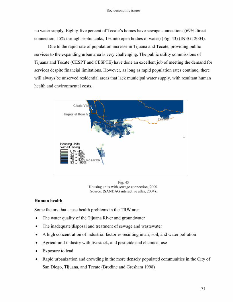
Socioeconomic issues
no water supply. Eighty-five percent of Tecate’s homes have sewage connections (69% direct
connection, 15% through septic tanks, 1% into open bodies of water) (Fig. 43) (INEGI 2004).
Due to the rapid rate of population increase in Tijuana and Tecate, providing public
services to the expanding urban area is very challenging. The public utility commissions of
Tijuana and Tecate (CESPT and CESPTE) have done an excellent job of meeting the demand for
services despite financial limitations. However, as long as rapid population rates continue, there
will always be unserved residential areas that lack municipal water supply, with resultant human
health and environmental costs.
Human hea
Some factor
• The wa
• The ina
• A high
• Agricul
• Exposu
• Rapid u
San Die
Fig. 43 Housing units with sewage connection, 2000. Source: (SANDAG interactive atlas, 2004).
lth
s that cause health problems in the TRW are:
ter quality of the Tijuana River and groundwater
dequate disposal and treatment of sewage and wastewater
concentration of industrial factories resulting in air, soil, and water pollution
tural industry with livestock, and pesticide and chemical use
re to lead
rbanization and crowding in the more densely populated communities in the City of
go, Tijuana, and Tecate (Brodine and Gresham 1998)
131
Binational Vision for the TRW
Food- and water-borne diseases are a major health problem in this region. These include
bacterial and viral diseases, from pathogens, such as brucella, salmonella, shigella, and hepatitis
A. The hepatitis A rate in San Diego in 1998 was almost three times higher than the national rate.
Other problems are the presence of toxins, such as pesticides and lead. Also, there is significant
local marine pollution, with bacterial contamination and demonstrated levels of heavy metals and
pesticides in the shallow waters off of San Diego and Tijuana, which makes shellfish and fish
consumption dangerous (Brodine and Gresham 1998). Intestinal infections by parasites affected
11.1 % of the population of Tecate between the ages of 15 and 64 (Gómez and Lozano 1998).
Respiratory disease, both infectious and non-infectious, is a significant problem in the
TRW. Infectious respiratory illnesses occur due to a variety of pathogens, such as tuberculosis,
coccidiomycoses, and viruses. The rates of tuberculosis are higher in San Diego County than
most parts of the United States, and forms of tuberculosis that are resistant to drugs are a
growing threat. Air pollution (e.g., carbon monoxide, ozone, particulate matter) is directly linked
to respiratory diseases, such as asthma and bronchitis, particularly in children. Air pollution is a
problem in the TRW and originates from vehicle fleet emissions, impaired roads, industry, and
pollution from other air basins imported by air currents. Tecate reported that in 2000, 64% of the
population between 15 and 64 years of age had acute respiratory infections, and 0.9% had
asthma (ISESALUD as cited in Gómez and Lozano 1998). Increases in water, soil, and air
pollution have led to a growing concern that these exposures could result in birth defects.
Widespread use and presence of hazardous materials, including solvents, PCBs, and pesticides,
also pose a risk for cancers (Brodine and Gresham 1998).
Sexually transmitted diseases and drug use occur at high rates in the TRW region. Some
diseases include chlamydia and gonorrhea (which are curable), human immunodeficiency virus
(HIV), hepatitis B, and hepatitis C (not curable). There is a high level of morbidity due to HIV in
San Diego County compared to other parts of the United States. Binge drinking by teens and
young adults in Tijuana contributes to health problems and motor vehicle accidents. The increase
in traffic with urbanization contributes to increased vehicle accidents and violence (Brodine and
Gresham 1998).
Table 23 summarizes some environmental contaminants and sources that can be found in
the TRW (Michel and Graizbord 2002) and the potential health problems (U.S. EPA Office of
Water 2004) associated with exposure to the contaminants.
132
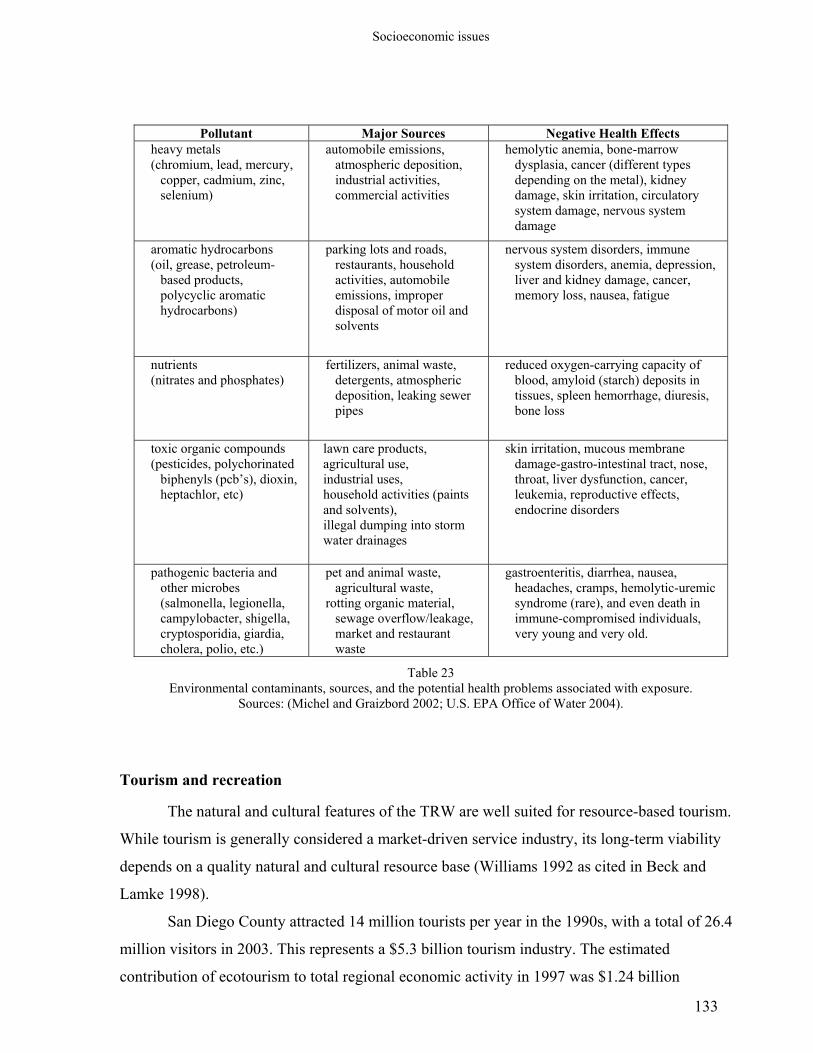
Socioeconomic issues
Pollutant Major Sources Negative Health Effects
heavy metals (chromium, lead, mercury,
copper, cadmium, zinc, selenium)
automobile emissions, atmospheric deposition, industrial activities, commercial activities
hemolytic anemia, bone-marrow dysplasia, cancer (different types depending on the metal), kidney damage, skin irritation, circulatory system damage, nervous system damage
aromatic hydrocarbons (oil, grease, petroleum-
based products, polycyclic aromatic hydrocarbons)
parking lots and roads, restaurants, household activities, automobile emissions, improper disposal of motor oil and solvents
nervous system disorders, immune system disorders, anemia, depression, liver and kidney damage, cancer, memory loss, nausea, fatigue
nutrients (nitrates and phosphates)
fertilizers, animal waste, detergents, atmospheric deposition, leaking sewer pipes
reduced oxygen-carrying capacity of blood, amyloid (starch) deposits in tissues, spleen hemorrhage, diuresis, bone loss
toxic organic compounds (pesticides, polychorinated
biphenyls (pcb’s), dioxin, heptachlor, etc)
lawn care products, agricultural use, industrial uses, household activities (paints and solvents), illegal dumping into storm water drainages
skin irritation, mucous membrane damage-gastro-intestinal tract, nose, throat, liver dysfunction, cancer, leukemia, reproductive effects, endocrine disorders
pathogenic bacteria and other microbes (salmonella, legionella, campylobacter, shigella, cryptosporidia, giardia, cholera, polio, etc.)
pet and animal waste, agricultural waste,
rotting organic material, sewage overflow/leakage, market and restaurant waste
gastroenteritis, diarrhea, nausea, headaches, cramps, hemolytic-uremic syndrome (rare), and even death in immune-compromised individuals, very young and very old.
Table 23 Environmental contaminants, sources, and the potential health problems associated with exposure.
Sources: (Michel and Graizbord 2002; U.S. EPA Office of Water 2004).
Tourism and recreation
The natural and cultural features of the TRW are well suited for resource-based tourism.
While tourism is generally considered a market-driven service industry, its long-term viability
depends on a quality natural and cultural resource base (Williams 1992 as cited in Beck and
Lamke 1998).
San Diego County attracted 14 million tourists per year in the 1990s, with a total of 26.4
million visitors in 2003. This represents a $5.3 billion tourism industry. The estimated
contribution of ecotourism to total regional economic activity in 1997 was $1.24 billion
133
Binational Vision for the TRW
annually, and in that year ecotourism employed approximately 9,340 people, twice the number
employed in 1990. It is estimated that an additional 7,500 jobs were created as a result of the
business transactions generated by ecotourism (Ecotourism Summit Fact Sheet 1997 as cited in
Beck and Lamke 1998). An Ecotourism Action Committee in San Diego works to promote
nature-based ecotourism in the region and is identifying several possibilities within the TRW
(Beck and Lamke 1998).
Some statistics are available for tourism in Baja California based on surveys in August
2000 of 300 tourists in Tecate and 600 tourists in Tijuana. The participants in the surveys rated
the public services of Tecate as 17% excellent, 68% good, and 16% poor. Tijuana’s services
received an excellent rating only from 2% of participants, 44% gave a good rating, and 52% a
poor rating, with a very poor rating from 3% of the participants. Public safety was also rated as
poor for Tecate (43%) and Tijuana (64%). Half the visitors reported that the purpose of their visit
to Tecate was for rest and relaxation (51%), while in Tijuana, participants were visiting family
and friends (51%). Tourists in Tecate rarely spent more than $300 per trip, while in Tijuana
tourists spent between $200 and $500. However, it is noteworthy that foreign tourists to Tecate
earn more $70,000 annually on average (INEGI 2004). It is suspected that these are visitors to
Rancho La Puerta spa. Rancho La Puerta is relatively low-impact tourism that employs many
local residents. It established a non-profit arm, Fundación La Puerta, that conducts outreach and
funds research. Rancho La Puerta and its foundation are a model for other parts of the TRW.
Historical and cultural resources
There are many significant historical and cultural monuments and sites in the TRW,
including the Campo-Tecate railroad, Parque Hidalgo in Tecate, the Railroad Museum in
Campo, the Centro Cultural in Tijuana, the bullring in Tijuana, many historic buildings in
Tijuana and Tecate, and numerous archeological and native peoples’ cultural sites. A more
complete list of resources and descriptions is provided in Appendix 5 of this document.
Besides the cultural resources of the Mexican, American, and Mexican-American
communities in the TRW, the tribal peoples in the rural areas are a cultural resource that is
threatened by modernization and encroachment of urban areas. Traditionally, the Kumiai39
Indians have occupied the territory situated approximately 70 miles north and south of the U.S.-
39
3399 This document uses Kumiai, although Kumeyaay is also used
134

Socioeconomic issues
Mexican border (Fig. 44). The traditional lands of the Kumeyaay include much of the TRW
(Kilpatrick and Wilken 1998).
Fig. 44 Historic distribution of indigenous groups in the TRW.
Source: Roberta Ladastida and Diana Caldeira.
On the U.S. side of the border, several Kimeyaay reservations are located in southeastern
San Diego County: Campo, Manzanita, La Posta, and Cuyapaipe. The Campo are wholly within
the watershed and the others have portions of their lands within the TRW. The Mexican bands
are the most environmentally affected of the Indian groups in this region. They include the rural
Kumiai communities of Tanamá, Aguaje de la Tuna, Juntas de Nejí, Peña Blanca, and San José
Tecate, whose members live without adequate infrastructure, such as running water and
electricity (Kilpatrick and Wilken 1998).
As of 2004, only one Mexican Indian community, Juntas de Nejí, has title to its land,
while several other traditional settlements struggle to regain or retain their land against the
encroachment of ejidos and other powerful interests. Many of the members of these communities
live only part-time in their communities, residing most of the time in Tecate, Valle de las
Palmas, El Testerazo, or other neighboring towns, where they can find easier access to
employment, schools, and services (Wilken-Robertson 2002).
Both U.S. and Mexican tribal entities are rural communities in the upper watershed above
sources of industrial and urban water pollution. Nevertheless, water quantity and quality remains
a major concern for all of the indigenous groups living in this region due to non-point source
135
Binational Vision for the TRW
pollution from grazing and farming and other human activities. Protecting their land from
overgrazing, soil erosion, and illegal dumping are just some of their concerns. Also, a challenge
is access to traditional wild foods and materials in the face of expansion of human settlements,
ranching and farming activities, and other economic endeavors in the watershed (Kilpatrick and
Wilken 1998).
San José Tecate, Tanamá, and Aguaje de la Tuna in Baja California are small traditional
Kumiai settlements that have been deeply impacted by the urban sprawl of Tecate (Wilken-
Robertson 2002). The remote El Alamo (Ja’a) canyon of Juntas de Nejí is one of the few areas
with a year-round flowing stream as well as important historic and prehistoric archaeological
sites. Acorns are one of the most important natural resources utilized in the area of Nejí, and
residents depend on other wild foods and medicinal plants as well as occasional hunting as part
of a diversified survival strategy. Although a tradition of juncus and willow basketry once
existed in the area, there are currently only a few women occasionally producing baskets
(Wilken-Robertson 2002).
Socioeconomic trends
Economy
The transborder economy of the San Diego-Tijuana region has grown relatively quickly
over the last decade and a half, except from 1990 to 1995 when San Diego suffered the general
national recession and the impacts of defense-related cutbacks in the federal budget. Since the
1982 Mexican debt crisis, Tijuana’s economy has been driven by the rapidly expanding
maquiladora industry and has grown at annual rates of 20–30% (Rey and Clement 1998). From
1988 to 2000, approximately 7% of Tijuana’s economically active population was employed in
the United States, although this percentage decreased approximately 0.5% from 2000 to 2003
(INEGI 2004). Based on previous trends and future population projections adding to the
workforce, maquiladoras are likely to continue to be an important part of the TRW economy.
Housing
Housing demand follows population trends. From 1990 to 2000 Tijuana’s population rose
5.33% per year and its housing growth was 6.2% per year. For Tecate, there was an annual 4.2%
growth in population and a 5.11% growth in housing for the same period. Tijuana added an
average of 13,235 houses per year from 1990-2000, while Tecate added 747 houses per year
during that decade (Gobierno Estatal de B.C. 2002). Discrepancies between the higher rates for 136
Socioeconomic issues
housing than population is likely due to census undercounting. The San Diego section of the
TRW had about 10,000 houses in 1990 and about 11,200 houses in 2000 (U.S. Census Bureau
2004).
The Municipality of Tijuana estimated that the 2007 demand for new lots with services
16,284 lots and 750 lots for Tecate. The need for more developable land was calculated at 2,300
more hectares for Tijuana, while Tecate will require 120 more hectares. Tijuana is projected to
build 59 houses per hectare and Tecate 47 houses per hectare (Gobierno Estatal de B.C. 2002).
San Diego experts project that between 1995 and 2020, the overall demand for housing in the
region will increase 41%. The number of units in the region in 1995 was 996,400 and 405,800
new units will be needed to accommodate the projected population growth (SANDAG 1999).
Developing land for housing often sacrifices open space and green areas to make way for single
family houses with yards. Building inward and upward, in existing urban areas, termed “smart
growth” is a recommended option for planners in the TRW.
Infrastructure
Fig. 45 shows the water and wastewater infrastructure for the border areas between San
Diego and Tijuana in 1994.Building permits for San Diego’s new housing developments will
require appropriate infrastructure services of potable water, sewage, electricity, roads, schools,
and hospitals. Mexican settlements are guaranteed water and sanitation services from the
government, although residents of colonias often wait years for service. Infrastructure
improvements in Mexico can lag years behind the demand.
137
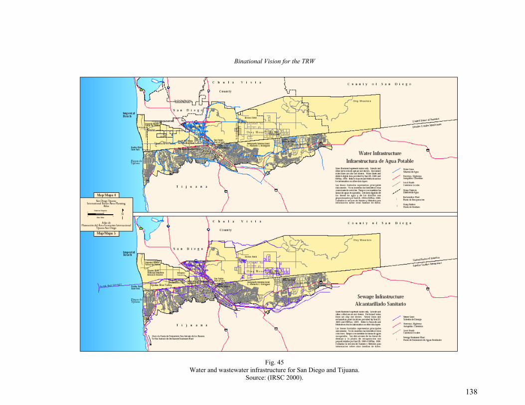
Binational Vision for the TRW
Fig. 45 Water and wastewater infrastructure for San Diego and
Source: (IRSC 2000).
138
Tijuana.
Socioeconomic issues
Socioeconomic data
Sources of data on socioeconomic issues in the TRW are available in Appendix 12. The
data includes reports, electronic files, maps, and other information in English and Spanish from
both the United States and Mexico.
Socioeconomic data gaps
After reviewing the available data, the Research Team and others identified the following
data needs for the TRW:
Economy
There are significant data gaps for understanding socioeconomic features of the TRW. Of
particular concern is the lack of data that are collected in the same way on both sides of the
border in order to better understand the linkages across the border. Important data gaps are
indicated in the following list:
• Number of cross-border commuters
• Cross-border expenditures by consumers (in San Diego and Tijuana)
• Tourism expenditures
• Linkages of assembly plants across borders
• Binational use of services (such as medical and recreational services)
• Cross-border housing markets40 40
• Percentage of population with recreational facilities and natural settings within a 10-minute
walk41 41
• Participation in organized youth programs at city centers
• Annual municipal expenditures on parks, open spaces, and streetscapes
Health
• Data on specific disease rates for comparison to national rates42 42
• The impact of disease in terms of morbidity, mortality, or quality years lost
4400 (Rey and Clement 1998) 4411 (Kjos and de la Rosa 1998) 4422 (Brodine and Gresham 1998)
139
Binational Vision for the TRW
• Prioritization for intervention strategies
• Number of people going to clinics for respiratory problems
• New cases of asthma43 43
Tourism
• Tourism statistics from urban areas, Indian tribes, and land-managing agencies on both sides
of the border44 44
Socioeconomic recommendations
The follow studies are recommended in the area of public health:
• Microbial studies are needed to assess disease patterns and trends of water quality, emerging
infections, enteric infections, and microbial-resistant organisms, such as tuberculosis and
gonorrhea.45 45
• Studies to carry out systematic surveys and land-use patterning analysis to help predict
where cultural heritage sites may be located and conserved.46 46
• Research existing or previous water treatment methods of border tribes may provide insights
into current management techniques.
• Research indigenous historical and current perspectives on animal habitat, vegetation
communities, and medicinal plants and document them.
The following issues were identified from the literature as critical to overcoming socioeconomic
issues in the TRW (Kjos and de la Rosa 1998):
• Dispel ignorance about the other side of the border. Although improvement has been made
in recent years, historic reasons, as well as stereotypes, continue to complicate efforts to
coordinate across the border.
• Facilitate access to information, particularly in Tijuana. This is also changing as more
information is now being generated. Mexico’s recently approved transparency law
4433 (Brodine and Gresham 1998) 4444 (Beck and Lamke 1998) 4477 (Brodine and Gresham 1998)
4466 (Kilpatrick and Wilken 1998)
140
Socioeconomic issues
guarantees citizens the right to governmental information has been a great help in providing
public access to data.
• Standardize methods for defining, categorizing, and producing information on both sides of
the border in order to facilitate collaborative efforts.
Health
• Improve surveillance, reporting, and outbreak investigations in order to better define the
spectrum of food- and water-borne illness.
• Provide improved access to care, including emergency and disaster services.
• Make health services responsive to the community’s diversity and local needs and reflect
increased cultural competency and respect.
• Provide binational case management. Due to the mobility of the border population,
binational case management is crucial, particularly for those with chronic diseases that
require long-term compliance with therapy, or have a potential for continued disease
transmission, such as tuberculosis. This cross-border cooperation is also critical for adequate
outbreak investigation and implementation of control measures.47 47
• Train tribal members to conduct water monitoring.48 48
• Apply low-tech strategies to solve chronic environmental problems such as rock drops, or
weirs, at appropriate places in rivers to recharge local water supplies.
• Fence off water sources from cattle.
• Cap wells.
Tourism
• Provide opportunities for ecotourism. Ecotourism can promote employment and provide
income to local communities, while allowing the continued existence of the natural resource
base.
• Monitor the impacts of tourism on wildlife and vegetation
• Provide access to sites for the disabled, public transportation to various destinations, and
bilingual tourism materials.49 49
• Organize binational workshops between U.S. and Mexican bands of Kumiai.
4477 (Brodine and Gresham 1998) 4488 (Kilpatrick and Wilken 1998) 4499 (Beck and Lamke 1998)
141
Binational Vision for the TRW
• Share geographic information system (GIS) capabilities.
• Tanamá could be the first stop on an ecotour including Peña Blanca and Juntas de Nejí.50 50
• Develop a relationship with the National Institute of Anthropology and History (INAH) in
order to identify common goals and possibilities for collaboration.
• Develop partnerships between indigenous communities and NGOs, such as Native Cultures
Institute of Baja California (CUNA), academic institutions, such as UABC and SDSU, and
Mexican federal agencies, such as the Instituto Nacional Indigenista (INI).51 51
• Implement strategies designed to involve local communities in appropriate site management
and ecotourism.
• Include formal tribal representation in the BECC, NADBank, the IBWC, and their
counterparts in Mexico.52 52
Infrastructure
• Provide public transportation, such as subways, buses, and vanpools, walkable-ridable urban
centers.
• Provide sewage and water connection to the colonias.
• Recharge the aquifers along the rivers using simple technologies, such as bulldozing lagoons
and collecting runoff, frequently cleaning the surfaces and/or moving the lagoons a few
meters from the original location.53 53
• Create emergency reservoirs in case of interruption of aqueduct service.
• Add another border crossing (East Otay Mesa and/or Jacumba-Jacumé).
• Add additional air pollution monitoring stations throughout the TRW.
• Invest in renewable energy sources, such as wind generators and solar panels.
• Designate pocket parks and greenways throughout urban centers.
• Promote the San Ysidro and Otay crossings as pilot projects for all the newest border-
crossing technology.
• Collaborate with Homeland Security, the Border Patrol, and Immigration and Naturalization
Services in order to maintain a flow of information and concerns, with the goal of creating
safe, seamless, transparent borders similar to some in Europe.
5500 (Valdez Flores 2002 as cited in Wilken-Robertson 2002). 5511 (Wilken-Robertson 2002) 5522 (Good Neighbor Environmental Board 2001) 5533 (Forster 2005)
142
Socioeconomic issues
TRW stakeholders at community forums, the Binational Watershed Advisory Committee,
and the Vision Project Research Team jointly characterized the current situation and future
desired scenarios for socioeconomic issues in the TRW; findings are presented in Table 24.
SOCIOECONOMIC ISSUES
Challenges Different perspectives
based on nationality and economic sector
Urban sprawl encroaches on green areas and decreases access to recreational opportunities
Loss of riparian zones decreases recreational opportunities
Beach closures decrease recreational opportunities
Deforestation decreases wildlife viewing and hiking areas
Inadequate transportation systems increase traffic congestion and smog
Lack of planning results in squatter settlements with a lack of infrastructure
Inadequate potable water delivery and sewage treatment systems contribute to residents’ health problems
Historical and culturally important landscapes are threatened by commercial development
Air and water pollution causes illnesses
Residents and property in flood zones and steep, unstable slopes are at risk
Opportunities
Development of baseline binational quality of life indicators for this area
Tijuana and Playas de Rosarito potable water and wastewater master plan
Binational flood warning system
National and binational NGOs concerned with environmental and human health
Goals
Improve binational quality of life through cultural, economic, historical, educational, and recreational enhancement of the basin
Decrease environmental health risks
Maintain a strong economic base for sustainable development
Objectives Monitor quality of life through indicators Relocate residents from flood zones to safe
areas Create flood control structures that also
provide recreational opportunities, such as river parks
Improve and expand sewage system services Provide public transportation alternatives, bike
paths, and improve traffic flow Create trail systems for hiking and horseback
riding Create open spaces and green areas within
cities and in the outskirts Create green buffers for noise and air
pollution, and to decrease urban heat islands Create historical zones, restore historical
buildings, and attract tourism Create wilderness preserves for education and
recreation Clean beaches and monitor pollution
violations upstream Create urban tree-planting programs Provide safe recreational opportunities, open
space, wildlife viewing, green areas, tourism opportunities, and clean beaches and rivers
Reduce erosion and landslide hazards
Table 24 Socioeconomic challenges, opportunities, goals, and objectives.
143

Binational Vision for the TRW
At TRW stakeholder meetings in the fall of 2003, the participants voted on the following
priority actions for meeting the goals for socioeconomic issues (Table 25):
Votes Action Location
11% Recognize and respect the Kumiai people Watershed-wide
9% Reimplement the Bracero (temporary guest worker) program to help control undocumented immigration and drug trafficking
United States
8% Market existing recreational opportunities and expand infrastructure for cross-border vacations, driving loops, ecotourism, camping. Lengthen the Pacific Crest Trail to the Sierra Juárez. Promote cross-border field visits, training, planning for agencies.
Laguna Mountain, Cleveland National Forest, Laguna Hanson, Sierra Juárez
8% Build/enhance GIS-based surveys of cultural and historic sites
Watershed-wide
6% Increase local green space using low-tech infrastructure, local skills, and community groups. Build/restore wetlands, hiking trails, river floodplains, recreation areas, habitat linkages, and earthen flood control berms
Alamar River, Tecate Creek, Cottonwood Creek, Las Palmas (future Tijuana bedroom community), upper watershed creeks, small villages, ejidos
5% Encourage greater use of Mexican roads to reduce truck traffic on California Highway 94
Mexico
5% Create planning and regional coordination mechanisms for the watershed
Watershed-wide
4% Use scientific studies for land use planning Campo and backcountry
4% Create incentives for conservation and development of natural areas and provide economic, training, assessment, and technical support
Watershed-wide
4% Give legal and official recognition to the Kumiai people of Baja California
San José Tecate, Juntas de Nejí, Tamaná
4% Distribute information about the natural capital benefits of the watershed and cultural responsibility
Urban zones
Table 25 Priority socioeconomic issues action from stakeholder meetings.
The voting percentages reflect ~ 50 persons per meeting casting votes 5 votes each.
144


Binational Vision for the TRW
146

147
Implementation time line
Table 26 lists the 14 priority actions suggested by participants in the 2003 stakeholder
meetings and indicates approximately when they should be implemented. Planning for these
actions should begin well ahead of the implementation year. To prioritize the actions,
stakeholder suggestions from all five public meetings and all critical resource areas were
combined, and the percentage vote per meeting was used to rank the top eight actions. Four
actions were added from the literature. Higher ranked actions were considered more urgent and
placed sooner on the time line. Logistical considerations, such as political momentum,
bureaucratic delays, and funding requirements were also considered during the creation of the
time line. More detailed plans for each action follow Table 26. Some simple things that residents
can do to help meet the goals of the Vision project can be found in Appendix 6.
Binational Vision for the TRW
Implementation should begin Action
2004 2005 2006 20071. Identify important conservation areas for restoration and
rehabilitation based on ecosystem function and threats x
2. Increase knowledge of the cultural characteristics of indigenous and other peoples of the watershed
x 3. Protect sensitive habitat as well as cultural and historical
areas x 4. Market sustainable tourism opportunities x 5. Binational planning for floods
x 6. Evaluate and protect groundwater supplies
x 7. Develop and implement watershed education programs
and products for children and adults x
8. Connect conservation areas across the border
x 9. Expand water reuse
x 10. Facilitate cross-border vehicular traffic flow and reduce
impacts in adjacent communities x
11. Develop an integrated waste management system with recycling components x
12. Develop a binational water quality monitoring system x 13. Develop point and non-point source water pollution
prevention programs x 14. Develop mechanisms for transborder watershed
management x
Table 26 Time line of Priority 14 actions.
The following section details the status of the actions, the recommendations for
implementation, the implementation time frame, and the recommended leaders for implementing
each of the above actions in the TRW.
148
Implementation time line
Action plan: Identify areas for conservation restoration and rehabilitation based on ecosystem
function and threats
Current status of the proposed action—What has happened in the past? What is going on now?
A conservation assessment for the California-Baja California binational region, the Las
Californias Binational Conservation Initiative,54 includes much of the TRW. The conservation
plan identified portions of the binational study area that support natural resources representing
the biodiversity of the region and are relatively intact. This effort is serving as a refinement of a
portion of TNC’s South Coast Ecoregion Assessment, which is still in draft form.
54
Recommended future steps to implement this action
• Link the Los Pinos and San Ysidro units, using Bureau of Management (BLM) lands
between McAlmond Canyon and Tecate Peak and City of San Diego Water Department land
adjacent to Cottonwood Creek as building blocks.
• Link the San Ysidro unit to the La Presa and Canada de Águila. Unite with adjacent areas,
such as the undeveloped land west of Tecate, and culturally important land on the flank of
White Mountain to the east of Cottonwood Creek.
• Create core conservation areas with connections at BLM lands around the La Posta
Microwave Station, and Hauser Mountain across Highway 94 to BLM lands at the border.
• Develop a binational wildlife corridor, “Parque to Park,” from the Laguna Mountains in the
Untied States to the Sierra Juárez Mountains in Mexico through the TRW.
• Provide north-south linkages from Otay Wilderness Area to Playas de Rosarito by creating
conservation areas between Tijuana and Tecate and on the eastern perimeter of Tijuana.
• Provide east-west habitat linkages or stepping stones for species whose distribution ranges
across coastal, trans-montane, and desert habitat by creating conservation areas in the
Campo Valley across the Tecate Divide to Jacumba.
• The above strategies could be implemented with the following tools: mitigation land
purchases from the Toyota plant in west Tecate, land trust purchases, conservation easement
contracts, County of San Diego 2020 General Plan rezoning, BLM-private land exchanges,
5544 A collaboration of Conservation Biology Institute, Pronatura, A.C., TNC, the San Diego Foundation, Resources Legacy Fund Foundation, and
the International Community Foundation
149
Binational Vision for the TRW
creation of USFS Wilderness Areas, Caltrans and Mexican federal rights-of-way
improvements, decree áreas naturales protegidas, conservation of City of San Diego Water
Department lands around Morena Reservoir and upstream from Cottonwood Creek.
• In addition to habitat connectivity studies, a basic biological survey is needed for the TRW
and research on the ecosystem functioning of the TRW including hydrology, nutrient and
soil cycling, geo-chemical processes, and so forth.
• The U.S. Homeland Security and Border programs have needs, such as open areas for
improved visibility of the border that are synergistic with open space preservation. These
opportunities should be explored (CBI, Pronatura, and TNC 2004).
When should implementation start? How long will it take?
Implementation should start in the fall of 2004. Implementation of land conservation actions will
be incremental and ongoing, probably for many years. Many actions will be taken as
opportunities arise or funding is available. Land management will be ongoing in perpetuity.
Where should this action be implemented?
Actions should be implemented within the conservation blueprint maps developed by the Las
Californias Binational Conservation Initiative and refined by future field studies and changing
land use patterns.
What agency, organization, or individual should be the lead in implementing this action?
TNC, Pronatura, CBI, Backcountry Land Trust, ICF, San Diego Foundation, USFS, U.S. Navy,
Toyota plant, County of San Diego planners, BLM, Caltrans, CNA, SEMARNAT, City of San
Diego Water Department
150
Implementation time line
References:
Conservation Biology Institute. 2003. La Posta Linkage Portfolio, p. 30. Tertiary La Posta
Linkage Portfolio. San Diego County, CA.
Conservation Biology Institute, Pronatura, and The Nature Conservancy
2004 Las Californias Binational Conservation Initiative: A Vision for Habitat
Conservation in the Border Region of California and Baja California. Prepared for the
San Diego Foundation, Resources Legacy Fund Foundation, and the International
Community Foundation. San Diego, CA, Sept.
Pronatura. 2003. Las Californias Binational Conservation Initiative Localities Portfolios. Tertiary
Las Californias Binational Conservation Initiative Localities Portfolios. Ensenada, B.C.
Pronatura. 2004. Iniciativa Binacional de Conservatión "Las Californias." Pronatura, Ensenada,
B.C., June.
151
Binational Vision for the TRW
Action plan: Increase knowledge of the cultural characteristics of indigenous and other
peoples of the watershed
Current status of the proposed action—What has happened in the past? What is going on now?
There has not previously been any concerted effort to organize and disseminate cultural
information at the watershed level. Currently, through the project “Cultural Ecology and the
Indigenous Landscape of the TRW,” a database of the prehistoric and ethnohistoric indigenous
cultural heritage of the Mexican side of the TRW is being created.55 The study involves
indigenous and university participants and should be finished by summer 2005. This Vision
document lists some historically and culturally important monuments and places in Appendix 5.
55
Recommended future steps to implement this action
• A similar prehistoric and ethnohistoric indigenous cultural heritage database needs to be
created for the U.S. portion of the TRW.
• Additional work is needed on historic and contemporary cultural resources within the entire
watershed.
• In all cases, it is important to make the information available to the public, on a Web site,
particularly educators and decision makers. The Instituto Nacional de Anthropología e
Historia (INAH) could take the lead on providing the information that it already has (except
information, such as rock art locations that is considered sensitive).
• A map of important cultural and historical sites is needed for restoration and protection
efforts. This map may be accessed only through government offices to registered persons to
protect sites from vandalism.
When should implementation start? How long will it take?
As soon as possible. General overviews of the existing literature on cultural resources should not
take more than a year. Sacred and historical monuments are being vandalized and need
immediate protection.
5555 With funding from SCERP
152
Implementation time line
Where should this action be implemented?
This action should take place watershed-wide.
What agency, organization, or individual should be the lead in implementing this action?
The suggested studies could be carried out in Mexico by INAH and The Instituto de
Investigaciones Históricas of UABC. In the United States, the local historical societies or
universities could carry out the projects.
153
Binational Vision for the TRW
Action plan: Protect sensitive habitat and cultural areas
Current status of the proposed action—What has happened in the past? What is going on now?
The Las Californias Binational Conservation Initiative has assessed binational conservation
priorities in the South Coast Ecoregion, with specific suggestions for land that has high
conservation value in the TRW (see Action Plan: Identify areas for conservation restoration and
rehabilitation based on ecosystem function and threats). A binational group identified target
species for binational protection at the South Coast Missing Linkages Workshop in 2002. In
2003 a conservation easement contract was signed protecting Tecate Peak-Cerro Cuchumá from
development. An ongoing study is identifying important cultural and indigenous areas using
mapping techniques and outreach.56 56
Recommended future steps to implement this action:
• Implement the recommendations from the Las Californias Initiative.
• Use public and private land acquisition tools to protect culturally and ecologically important
spaces.
• Create river parks at the Campo, Tecate, and Alamar Rivers.
• Connect the river parks across municipalities and the international border.
When should implementation start? How long will it take?
Immediately. Five to 10 years.
Where should this action be implemented?
Initial focus should be on the zone between Tijuana and Tecate, where a large migratory corridor
exists and urbanization is imminent. Rivers and other wetlands, such as those found in Campo,
Tecate, and along the Alamar River should also receive priority.
5566 A SCERP-funded project headed by Michael Wilken, CUNA and Hynn Garable, SDSU (see Action Plan: Increase knowledge of the cultural
characteristics in the watershed)
154

Implementation time line
What agency, organization, or individual should be the lead in implementing this action?
TNC, Back Country Land Trust, Terra Peninsular, Trust for Public Land, and Fundación La
Puerta, A.C. are pursuing individual parcels in their geographic interest areas. The Border 2012
Water Task Force for the TRW, or a similar binational planning entity, could coordinate the
fusion of these individual efforts so they serve the purposes of watershed health and ecological
integrity.
References:
Conservation Biology Institute. 2003. La Posta Linkage Portfolio: San Diego County, California,
grant report, July.
Pronatura Noroeste-Mar de Cortés. 2003. Las Californias Binational Conservation Initiative,
Phase I. grant report, January.
Pronatura Noroeste-Mar de Cortés. 2003. Las Californias Binational Conservation Initiative,
Localities Portfolios. grant report, January.
Pronatura Noroeste-Mar de Cortés. 2004. Las Californias Binational Conservation Initiative,
Phase II. grant report, July.
155
Binational Vision for the TRW
Action plan: Market sustainable tourism opportunities
Current status of the proposed action—What has happened in the past? What is going on now?
Tourism has not been promoted much outside of curio shopping in Tijuana, Rancho La Puerta in
Tecate, and some hunting in the upper watershed. A map-based online photo tour of the
watershed is being developed in order to guide interested persons through cultural and natural
resources.57 57
Recommended future steps to implement this action:
Start a pilot project in Tecate, which has a tradition of cultural interchange at the border with the
United States, with some existing tourist ranches offering spa services surrounded by native
vegetation.
• Invite the Association of Tourist Ranches to participate in activities concerning the TRW.
• Visit and tour the tourist ranches to better market their opportunities.
• Organize a meeting in the Municipality of Tecate at one of the ranches.
• Set up a tourist route and market the tour.
• Look for other areas of the watershed to perform similar routes, such as Campo, Valle de
las Palmas, the upper watershed.
When should the implementation begin? How long should it last?
Immediately. Spring and autumn are the best seasons.
Where should we implement the action?
Tecate, Campo, Tijuana, and Valle de las Palmas.
5577 Initiated by IRSC-SDSU
156
Implementation time line
Which agencies, organizations, or individuals should lead this action’s implementation?
For the Tecate pilot project:
Association of Tourist Ranches of Tecate, Department of Social Communication of the
Municipality of Tecate, Department of Urban Development and Ecology of the Municipality of
Tecate, CUNA, and INAH.
References:
Beck, L., Lamke, G. 1998. Tourism and Recreation. In The State of the Environment of the
Tijuana River Basin, Working Draft, eds. Institute for Regional Studies of the Californias,
pp. 34-35. San Diego: IRSC.
Valdez Flores, J.R. 2001. Levantamiento de datos Zona Kumiai. Available at CUNA. August.
157
Binational Vision for the TRW
Action Plan: Binational planning for floods
Current status of the proposed action—What has happened in the past? What is going on now?
Agencies from both side of the border have developed a real-time flood warning system for the
western portion of the watershed which includes Cottonwood Creek, Campo Creek, Tecate
Creek, and the Río Alamar. Additional precipitation and stream flow gauges have been installed
and locations for other stations are being considered. Equipment for receiving information from
the gauges exists in the County of San Diego Department of Public Works Office. Currently,
data from the gauges are transferred via file transfer protocol from the County of San Diego’s
flood warning base station to partnering agencies in the United States and Mexico. The County
of San Diego has a Web page where data is accessible to the public.
Recommended future steps to implement this action:
• Ensure the maintanence of the flood warning system.
• Expand the program—install more stations.
• Build a Spanish Web page for the public.
• Use radio repeaters to ensure that the system will remain intact during a storm emergency.
• Install a receiving station at the Tijuana River National Estuarine Research Reserve
(TRNERR).
• Create a public awareness campaign for emergencies.
When should implementation start? How long will it take?
Implementation should begin in 2005 and take approximately a year to complete.
Where should such this action be implemented?
Equipment should be installed at the emergency response agencies on both sides of the border,
TRNERR, and the International Boundary and Water Commission (IBWC).
What agency, organization, or individual should be the lead in implementing this action?
The working group of the flood warning program, the Comisión Nacional del Agua, County of San
Diego Department of Public Works, Dirección Estatal de Protección Civil, la Dirección Municipal
158
Implementation time line
de Protección Civil de Tijuana, IBWC, the City of San Diego, and TRNERR should take the lead
in working with other agencies to fully implement the system.
References:
Ponce, V. M. 2003. Flood hydrology of the binational Cottonwood Creek-Arroyo Alamar,
California and Baja California. SDSU.
Wright, R. D., Baron, K., Conway, K., Warner, R. 2000. Flood hazard and risk assessment
modeling with GIS in the transborder Tijuana River watershed, p. 15. Watershed 2000.
Vancouver, BC, Canada.
159

Binational Vision for the TRW
Action plan: Evaluate and protect groundwater supplies
Current status of the proposed action—What has happened in the past? What is going on now?
Monitoring of well levels is performed by the City of San Diego Water Department, and by
CNA. A characterization of the Tijuana River Valley aquifer was performed in 2003 (U.S.
Department of Energy 2003) and a Tecate aquifer characterization study was completed in
2004.58 A study of the Alamar-Cottonwood hydrology included groundwater interactions with
surface water has been published (Ponce 2003) as well as the same type of study in the nearby
Ojos Negros Valley (Ponce 2000). Research has been undertaken relating to the feasibility of
replenishing groundwater with treated wastewater (Ponce 2004). Applied projects include
ecohydrological plans versus concrete channelization plans for the Alamar and Tecate Rivers,
and Campo Indian Reservation community projects that installed rock drops, or weirs, and
revegetated Campo Creek to increase groundwater levels. Water quality testing on wells at
Indian reservations and communities has been performed (Kilpatrick 1998).
58
Recommended future steps to implement this action:
• In addition to the aquifers that have been studied, look for areas with sand or areas in valley
bottoms for potential groundwater sources.
• At these locations, perform an analysis of historical depletion from well pumping (if no wells
exist, find the mean depth of the water table).
• Form stakeholder groups in the United States, and comités técnicos de aguas subterráneas
(COTAS) for Tijuana, Valle de Las Palmas, and Tecate, and/or a binational groundwater
working group.
• Decide politically on the level of equilibrium for the groundwater and regulate the levels to
avoid over-exploitation. Decide on enforcement and fines.
• Reform water laws in the United States so that either the California State Water Resources.
Control Board (CASWRCB) or the International Boundary and Water Commission (IBWC)
monitors the rate and quality of water pumped from private U.S. lands.
• Studies should be performed to determine a more equitable rate for agricultural electricity
charges in order to discourage over-pumping.
5588 (Forster 2005)
160
Implementation time line
• Study the feasibility and energy costs (monetary and to the environment) of recharging the
Alamar River subsurface waters with IWTP treated waters and/or CESPT treated waters from
the San Antonio de los Buenos wastewater treatment plant.
• Study the connectivity of all the aquifers to see how recharge projects on the Alamar River
could recharge the Tijuana aquifer, the Tijuana wells, and the wells in the Tijuana River
Valley in the United States.
• Implement recommendations to build low-tech recharge ponds in the Tecate dry riverbed or
possibly the Alamar River. Recharge ponds are less costly than injection wells, are less
susceptible to plugging, and damage to the ponds during floods is less costly. Fill ponds with
raw water from aqueduct using existing pipelines, new pipelines, or raw water. Fill during
the winter when evaporation is at a minimum and most water is available. Regularly scrape
pond bottoms to stop plugging.59 59
• Implement plans for the Alamar and Tecate River Parks to facilitate recharge through green
areas, and slow water velocities with more naturally meandering rivers.
• Publish groundwater levels and quality data on the Internet in a central binational database.
• Implement a wellhead protection plan in urban areas that prohibits all activity within 30 m
(98 ft) of wellheads. Exclude most hazardous activities within 100 m (330 ft) or more of
wellheads. Prohibit new wells in the shallow aquifers, and monitor water levels in all shallow
aquifers during wet weather and floods.
• Build up stocks of stored groundwater water to prepare for drought conditions or breaks in
the aqueduct.61 61
• Conserve water by implementing public outreach campaigns.
• Protect areas identified as important aquifer recharge areas from development.
• Complement the binational aquifer study (U.S. Department of Energy 2003) with additional
data.
• Evaluate the environmental impacts of urban expansion on the Rodríguez Reservoir.
5599 (Forster 2005)
161
Binational Vision for the TRW
When should implementation start? How long will it take? Immediately.
Where should this action be implemented?
In Tecate, recharge ponds might be placed in El Descanso below El Nopalera. The Alamar River
study should explore exact locations for recharge potential.
In Valle de las Palmas new sources of water may be explored at Pino Suárez, El Escondido,
Valle las Palmas, and La Tuna where alluvium is found (Ponce pers. comm. 2004).
References:
Forster, C. “Characterization of the Tecate aquifer” Report to IRSC-SDSU. In prep.
Kilpatrick, A. 1998. An environmental assessment study of indian tribes living in the U.S.-
Mexican border region (planning phase). Final Report SCERP Project Number: IT98-1.
Ponce, V. M. 2003. Flood hydrology of the binational Cottonwood Creek-Arroyo Alamar,
California and Baja California. SDSU.
Ponce, V. M. 2000. Sustainable management of water in the Ojos Negros Valley, Baja
California. San Diego State University, Universidad Autónoma de Baja California,
Instituto Nacional de Investigaciones Agrícolas, Forestales y Pecuarias.
U.S. Department of Energy. 2003. Groundwater flow model for the Tijuana River Basin.
Southwest Border Project. Grand Junction, Colorado: Dept. of Energy. GJO-2003-408-
TAC.
162

Implementation time line
Action plan: Develop and implement watershed education programs and products for children
and adults
Current status of the proposed action—what has happened in the past? What is going on now?
For the last ten to twelve years, mainly citizens groups have been in charge of developing and
implementing an environmental education agenda in the TRW. This includes collaboration of
Mexican and U.S. organizations (see Appendix 3 for specific groups). Today there are several
environmental education initiatives in the watershed, some of which target the general public,
some target teachers, others target students of different educational levels, and some involve
environmental organizations. In the case of Tijuana, there is a recent initiative aimed at
incorporating environmental education themes into the curriculum for middle schools and junior
high schools. At present, there are several electronic educational tools about the watershed, such
as Web page,60 a video,61 and two CDs62. Many of the actors involved in these initiatives
participate in the Environmental Education Council of the Californias, which is currently
designing materials and a workshop focused on guidelines and best practices for organizing field
trips as a fundamental part of environmental education. CESPTE has an ongoing educational
program on water conservation in Tecate public schools.
60 61 62
Recommended future steps to implement this action:
• BWAC should develop an outreach strategy for educators and promotoras about the
importance of the watershed focus in environmental education.
• Develop a handout for educators about the TRW, stressing the importance of keeping a
watershed focus while teaching/learning about the environment and with information about
the Web page and other TRW information sources.
• Attend meetings where environment is being addressed and present the importance of
watershed focus.
• Develop materials for government officials, such as the Executive Summary of this
document, so that decision makers begin using a watershed focus.
6600 See http://trw.sdsu.edu 6611 Produced by SWIA and SDNHM 6622 One produced by SDNHM and another by SDSU Department of Geography
163
Binational Vision for the TRW
• Develop other materials through which information about the TRW can be communicated
(plastic models, murals, etc.).
• Contact more teachers and educators to become stakeholders in the TRW
• Encourage CESTPE to include watershed education in its water conservation outreach
programs.
When should implementation start? How long will it take?
Immediately and ongoing.
Where should this action be implemented?
Pilot projects in cities within the TRW, eventually throughout the region.
What agency, organization, or individual should be the lead in implementing this action?
BWAC, the Environmental Education Council of the Californias, PROBEA, SDNHM, Border
2012 Education Task Force, Border 2012 Water Task Force, and CESPTE.
164
Implementation time line
Action plan: Connect conservation areas across the border
Current status of the proposed action—What has happened in the past? What is going on now?
In 2003 Pronatura helped negotiate an ecological easement of Rancho La Puerta, A.C., Mexican
lands that are contiguous with BLM lands of Cerro Cuchumá, or Tecate Peak, on the U.S. side of
the border. In effect, this created a transborder ecological easement. Pronatura acts as a third
party for the easement contract, and monitors and protects the terms of the easement, which
include no development or activities harmful to the environment (Ochoa 2004; Vargas Téllez
2004). There are also current attempts to create a park in Tijuana called “Matadero” that would
be developed adjacent to the existing Tijuana River Estuary Research Reserve in San Diego,
with a fence separating them. There have been unsuccessful attempts to gain UNESCO Man and
the Biosphere (MAB) Reserve status for the TRW from UNESCO (Metzner and McCoy 1994).
There are detailed draft plans for a in the Las Californias Binational Conservation Initiative for a
binational protected area network to include much of the TRW (CBI, Pronatura, and TNC 2004).
Recommended future steps to implement this action:
• In general, create a network of nodes of biodiversity that are buffered and interconnected by
relatively intact land, in a matrix of lands with various degrees of human uses (CBI,
Pronatura, and TNC 2004).
• Use regional plans, such as the TRW Vision and the Las Californias Initiative and the South
Coast Ecoregion plan to identify critical corridors and conservation areas along the border
• First, seek small, simple, “do-able” strategies (The Nature Conservancy 2000) within country
• Create a binational or trinational (with indigenous involvement) NGO to promote and guide
the direction of transborder protected areas.
• After land is protected within country, weld conservation areas across the border using
MOUs, easements (such as Cuchumá), or land purchases/donations (Comer 2004)
• Create fidecomisos in Mexico to financially manage the land. A contract on rights of use can
be drawn and land/money can be donated and sold via a fidecomiso (financial responsibility).
The terms of the contract are monitored carefully (White, et al. 2004).
• Create a conservancy (or use an existing one) in the United States to financially manage the
land.
165
Binational Vision for the TRW
• Obtain international recognition and support from an institution, such as UNESCO.
When should implementation start? How long will it take?
Implementation should start immediately. The plans may take 5-10 years to implement.
Where should this action be implemented?
• The Otay Corridor between Tecate and Tijuana
• The riparian corridor from Campo to Tecate and westward
• Matadero-Goat Canyon in Tijuana
What agency, organization, or individual should be the lead in implementing this action?
• For the Otay Corridor, Pronatura and TNC have been involved in biological surveys and
studies. There are various land trusts that have the financial and land resources to dedicate
land for open space and green areas as recommended by the Las Californias Binational
Conservation Initiative.
• In Tecate, the municipality and Fundación La Puerta, A.C., have been working on a Tecate
River Park and could initiate the binational riparian corridor from Campo to Tecate, along
with participation from SEDUE, CNA, Mexican conservation NGOs, BLM, and the County
of San Diego.
• For Matadero Park, the Tijuana River National Estuarine Research Reserve, and the
Municipality of Tijuana, along with the landowner, should take the lead in implementation.
An NGO should be created to guide and monitor the park.
References:
Comer, K. 2004. A potential riparian protected area: the Kumiai Corridor. In SCERP Monograph
Series, Border Institute, Rio Rico AZ. Forthcoming.
Pronatura. 2003. "Las Californias Binational Conservation Initiative Localities Portfolios."
Prepared for the International Community Foundation, Ensenada, B.C.: Pronatura, A.C.,
prepared for the International Community Foundation.
(TNC) The Nature Conservancy. 2000. "The Five-S Framework for Site Conservation: A
Practitioner’s Handbook for Site Conservation Planning and Measuring Conservation
Success." Vol 1 (2).
166
Implementation time line
UNESCO. 2004a. "Man in the Biosphere Programm”.
http://www.unesco.org/mab/nutshell.htm#selected. Accessed 3/1/04.
White, M. D., Stallcup, J. A., Comer, K., Vargas, M. A., Beltran-Abaunza, J. M., et al. 2004.
Designing and establishing conservation areas in the Baja California-Southern California
border region. In SCERP Monograph Series, Border Institute, Rio Rico AZ, forthcoming.
167
Binational Vision for the TRW
Action plan: Expand water reuse
Current status of the proposed action—What has happened in the past? What is going on now?
The South Bay Water Reclamation Plant in the City of San Diego has the capacity to produce
15 mgd of tertiary effluent with the potential for reuse. The South Bay plant is negotiating
improvements to its delivery system in order to sell water to the Otay Water District for
irrigation purposes, and to the International Wastewater Treatment Plant (IWTP) for cleaning
purposes. There is a proposal to build the secondary treatment sludge ponds required of the
IWTP across the border, in the Alamar district. One benefit of this location is that reclaimed
water could be used to recharge the aquifer, and irrigate vegetation in the riparian zone.
Upgrades have been approved so that Tijuana will have its own secondary treatment plants that
will produce effluent suitable for use under NOM-003.
Recommended future steps to implement this action:
• Market reclaimed water from the South Bay Water Reclamation Plant.
• Create a public outreach campaign to dispel myths about reused water.
• Find uses for the secondary treated water that is currently going into the ocean.
• Designate uses of the reclaimed water for aquifer recharge; Rodríguez Dam replenishment;
landscape irrigation; agricultural uses; irrigation for golf courses, parks, airport yards,
industrial parks, and street cleaning; commercial uses, such as car washing; use in swamp or
evaporative coolers; fire protection; and use in bathrooms in commercial and industrial
facilities, and so forth.
• Create greenbelt areas that will allow the reuse of large volumes of treated effluent, in
addition to enhancing the environment and landscape.
• Perform a detailed assessment of the potential health risks of indirect potable uses that are
not for consumption but rather skin contact.
• Consideration must be made of the potential public health impacts from microbial and
chemical contaminants found or likely to be found in wastewater.
• Support the desalination plant proposed for Tijuana to supply coastal zones and indirect
potable uses.
• Support treatment plants that produce water for reuse, such as Ecoparque.
168
Implementation time line
When should implementation start? How long will it take?
The marketing and outreach campaigns should start immediately. The upgrades and reuse
infrastructure may start next year and take several years.
Where should this action be implemented?
Tijuana, San Diego, and Tecate
What agency, organization, or individual should be the lead in implementing this action?
The IBWC-CILA, CNA, CASWRCB, City of San Diego, Otay Water District, CESPT, and
CESPTE.
References:
(CESPT) Comisión Estatal de Servicios Públicos de Tijuana. 2002. Potable water and
wastewater master plan for Tijuana and Playas de Rosarito, draft.
169
Binational Vision for the TRW
Action plan: Facilitate cross-border vehicular traffic flow and reduce impacts in adjacent
communities
Current status of the proposed action—What has happened in the past? What is going on now?
Planning is underway with the federal General Services Administration (GSA) to improve the
San Ysidro port of entry through reorganization strategies, including the reuse of the Virginia
Avenue-El Chaparral gate. Similarly, plans are underway to modernize the Tecate port of entry
and its related transportation infrastructure. Commercial crossing improvements at Tecate have
recently improved flow. New technologies and long-term strategies are also being evaluated to
improve northbound and southbound truck access at the Otay Mesa-Mesa de Otay commercial
port. The development of a new port of entry at East Otay Mesa (Mesa de Otay II) is underway.
This port will be linked to State Routes 905 and 125 through the construction of State Route 11.
This port will also connect to the Tijuana–Rosarito corridor, a new highway under construction
in Baja California from the coastal area of Rosarito to the U.S.-Mexican border to the east of the
Otay Mesa port of entry. An additional port of entry is being planned in the long term in the area
of Jacumba-Jacumé east of Tecate (SANDAG 2004).
Local governments and authorities responsible for transportation infrastructure have also begun
to plan or construct new projects to link the ports of entry infrastructure with local transportation
systems and trade corridors. The completion of State Route 905 will connect Interstates 5 and
805 to the Otay Mesa port of entry. The completion of State Route 125 (South Tollway) will
improve regional mobility in the South Bay and access for residents and businesses to the
employment centers on both sides of the U.S.-Mexican border. SANDAG is pursuing funding for
needed transportation infrastructure in the region’s border areas and coordinating the
implementation of border-related capital and operating improvements with the GSA. The
completion of the Tijuana-Rosarito Corredor 2000 may help channel traffic to the perimeter of
Tijuana. All these transportation improvements run the risk of choking off wildlife corridors and
facilitating urban sprawl and associated pollution.
Recommended future steps to implement this action:
• Open the new ports of entry.
170
Implementation time line
• Enforce zoning restrictions associated with the new transportation plans, especially in
Mexico.
• Encourage the U.S. Department of Homeland Security (DHS) to improve its system for
entry/exit by attending the Ports Working Group monthly stakeholder meetings.
• Send TRW representatives to the San Diego Alliance for Border Efficiency (SDABE)
stakeholder working groups to advocate for reforms in the use of technology and needed
infrastructure improvements.
• Develop formal transportation planning committees with U.S. and Mexican participants
• Roads should have wildlife underpasses.
When should implementation start? How long will it take?
Immediately and ongoing.
Where should this action be implemented?
Mainly the San Diego-Tijuana interface.
What agency, organization, or individual should be the lead in implementing this action?
The U.S.-Mexico Binational Group on Bridges and Border Crossings addresses ports of entry
issues, California Department of Transportation (Caltrans), and local jurisdictions such as the
City of San Diego, can also initiate border projects. The GSA is responsible for the construction
of infrastructure, while the DHS is responsible for operations. SANDAG has regional
transportation plans and some resources.
References:
(SANDAG) San Diego Association of Governments. 2004. www.sandag.org (Borders Program
link). Accessed October 2004.
(SANDAG) San Diego Association of Governments 2004. Factibilidad de Instalar un Cruce de
la Frontera Internacional en Jacumba-Jacumé. San Diego, July. Pg.102.
(SANDAG) San Diego Association of Governments. 2004. Regional Comprehensive Plan (RCP)
Final Draft, July 23.Adopted in July of 2004.
171
Binational Vision for the TRW
Action plan: Implement binational point and non-point pollution prevention programs
Current status of the proposed action—What has happened in the past? What is going on now?
The principal sources of pollution in the watershed are industrial discharges, animal feedlot
operations, urban runoff during storm events, sewer system overflows, and poorly designed
septic systems. In the United States, the National Pollutant Discharge Elimination System
(NPDES) permit program has initiated programs, such as the Watershed Urban Runoff
Management Program in San Diego. Some binational initiatives have been undertaken to control
water pollution, including an industrial pretreatment program through Cal EPA, CEA, the City of
San Diego, and the International Wastewater Treatment Plant (IWTP) constructed under a
minute of IBWC-CILA.
Recommended steps to implement this action:
• There is a need to develop a comprehensive water pollution prevention program for the
Tecate-Tijuana section of the TRW. This program would aim to eliminate pollution at the
source locations. It would also involve expanding the aerial coverage of the Tecate and
Tijuana sewer systems and upgrade the sewage processing capability of the IWTP from
advanced primary to secondary.
• A comprehensive non-point source pollution program should be implemented for the entire
TRW. Elements of a program to control runoff pollution have already been implemented in
San Diego County, for example, requiring large construction sites to use runoff and erosion-
control technologies through a General Construction Permitting Process.
When should implementation start?
Immediately. It may take as long as ten years to fully implement the comprehensive water
pollution prevention program.
Where should this action be implemented?
The elimination of water pollution at the source should take place in the Tecate-Tijuana area. In
San Diego, the IWTP needs upgrading. Non-point source pollution needs to be controlled
throughout the watershed, in both urban and rural areas.
172
Implementation time line
What agency, organization, or individual should be the lead in implementing this action?
The municipalities of Tecate and Tijuana should take the lead in developing and implementing a
program of point-source pollution prevention, IBWC and the State of California Regional Water
Control Board should take the lead in upgrading the IWTP. Consejos de cuenca of the CNA and
the CARWQCB can work on the non-point source pollution control. The Border 2012 Water
Task Force can convene water quality experts and stakeholders from both sides of the border.
173
Binational Vision for the TRW
Action plan: Develop an integrated trash management system with recycling components
Current status of the proposed action—What has happened in the past? What is going on now?
Currently, waste in Tijuana is a problem, but a new landfill will help the deal with municipal
waste and offer recycling, including a tire shredder. A new landfill in Tecate is approved,
although the location remains to be determined. The proposed Campo landfill is also
controversial and is delayed. The Otay Landfill has not yet reached capacity. The transport of
recycled materials from Mexico to the United States occurs as part of a binational market.
Hazardous materials generated by U.S. companies in Mexico are transported across the border.
Used goods, such as tires, are transported from the United States to Mexico, generating
additional waste volume. The Haztrack database for tracking hazardous materials along the U.S-
Mexican border was inefficient and has been abandoned. Illegal dumping of solid, chemical, and
biological waste occurs on both sides of the border, but more so in Mexico. No binational
planning for waste disposal has been initiated to date, although the City of San Diego
Environmental Services Division has close ties with the Muncipality of Tijuana on waste issues.
Recommended future steps to implement this action:
• Form a binational waste planning committee.
• Form emergency plans for hazardous waste spills.
• Make hazardous waste receptacles more available throughout the watershed.
• Enforce the laws in Mexico against clandestine dumping.
• Train industries and commercial sectors on the proper disposal of waste.
• Clean up the dumps, or yonkes.
• Restructure the municipal trash pickup routes in Tijuana.
• Offer recycling in Mexico, including bins that the municipality can pick up and sell to U.S.
companies, generating revenue.
• Plan to build recycling plants on the Mexican side of the border.
• Conduct a binational educational campaign to reduce, reuse, and recycle.
When should implementation start? How long will it take?
Immediately.
174
Implementation time line
Where should this action be implemented?
Mainly Tijuana and Tecate.
What agency, organization, or individual should be the lead in implementing this action?
The Departamento de Limpia in the Municipalities of Tijuana and Tecate, Dirección de Ecología
of Baja California, Dirección Municipal de Ecología of Tijuana and Tecate, the City of San
Diego Environmental Services Division and General Services, and U.S. EPA.
References:
Moreno, D., Muñoz, V. 2003. El reto de la basura en Tijuana. Tijuana Trabaja. Tijuana, B.C.
156. Cuadernos para el diálogo.
175
Binational Vision for the TRW
Action plan: Develop a binational water quality monitoring program
Current status of the proposed action—What has happened in the past? What is going on now?
There has been no continual binational water quality testing of surface and groundwaters in the
TRW. However, there are, and have been, many unconnected programs and projects on either
side of the border. IBWC tests water quality for the Tijuana River on the U.S. side. The U.S.
EPA tracks surface and groundwater quality nationally. USGS and the CASWRCB also have
data on surface waters. CASWRCB had a long-term State Mussel Water program at the Tijuana
Estuary that ended in 1986. CNA and PROFEPA irregularly test the wells, rivers, and dams in
Mexico. The County of San Diego Department of Environmental Health monitors runoff to the
Tijuana River and the beach waters. The County of San Diego has two dry-weather monitoring
sites and one mass-loading station for storm events in the TRW. The Cities of Imperial Beach
and San Diego also have dry-weather monitoring sites. The City of San Diego Water Department
monitors the Barrett and Morena Reservoirs and their contributing tributaries. The City of
Imperial Beach monitors storm water quality. The County of San Diego regularly monitors beach
waters. The CESPs of Mexico monitor their wells and their effluent from the wastewater
treatment plants into open bodies of water. The TRNERR conducts water testing of the Estuary
on an ongoing basis. The former Tia Juana Valley County Water District also has performed
testing which has been assumed by the City of San Diego Water Department. Ja Jan reports that
it conducts a monthly beach water quality testing program implemented by a consortium of
NGOs and volunteers in the region and tests ocean waters almost monthly. The San Diego
Stream Team has tested the Campo Creek and the Tijuana River sporadically in recent years.
Quality controlled data can be found for certain locations and time periods from academic
studies at UABC, SDSU, and COLEF.
Recommended future steps to implement this action:
• Establish a California-Baja California regional water quality testing lab.
• Until funding is available for the regional lab, university and local government labs should be
convened to agree on methods for sampling and analysis for a binational program.
Equipment at the U.S. and Mexican institutions should be calibrated.
176
Implementation time line
• A preliminary recommended sampling scheme for surface water is to sample at least monthly
during the dry season and at least three to six storm events a year. In addition to quality, data
on streamflow are needed.
• More stream gauges are needed at the major tributaries.
• For groundwater, well sampling should occur monthly and depth reported. The program
should be low cost and continual. Aquifers should be mapped and characterized, because
some aquifers cross the border and their extent is not known. Wells should be sampled by an
independent agency and results reported to the users and the appropriate regulatory agencies
on both sides of the border.
• Coastal water quality should be monitored at more beaches in Mexico. Ja Jan should adopt
strict quality assurance/quality control methods, and a regular sampling scheme, and make its
data available to the public. The CNA and CESPT beach water sampling should be
regularized.
• All data—coastal quality, stream flow, stream quality, well depth, and well quality—should
be input to a centralized database. A bilingual Web site should allow citizens and
government agencies to view data and analysis. A water quality warning system, such as the
flood warning system (Wright, et al. 2000), should be established to alert officials to high
levels of contaminants. The definition of “high levels” differs between the two sovereign
nations’ laws. Therefore, both countries’ limitations should be reported in the warning
system since the waters traverse the two countries.
When should implementation start? How long will it take?
Immediately. Because the program will be costly, it will take from two to four years to find
funding to sample on a consistent basis.
Where should this action be implemented?
Tijuana River at Hollister Street in Imperial Beach, Río Tecate, Campo Creek, Cottonwood
Creek, Río Alamar, Río de las Palmas, and Arroyo El Florido.
177
Binational Vision for the TRW
What agency, organization, or individual should be the lead in implementing this action?
IBWC, the San Diego Regional Water Quality Control Board, CNA, Campo EPA, City of San
Diego Water Department, the San Diego County Water Authority, and local universities in San
Diego and Tijuana.
References:
Gersberg, Rick. 2004. Conversation with author. San Diego, CA.
Piñón Colín, Teresita de Jesús, Patricia Sirena López Gil, Libia J. Bernal Eng, Martínez Huato
Sebastián, and Jerome Pitt. 1998. "Analysis of Water Quality in the Tijuana Watershed." In
The Tijuana River Basin: Basic Environmental and Socioeconomic Data, edited by
Fernando Wakida and Karen Riveles, 59-105. San Diego, CA: IRSC.
178
Implementation time line
Action plan: Develop mechanisms for transborder watershed management
Current status of the proposed action—What has happened in the past? What is going on now?
Water management in Mexico is the responsibility of the federal government with some aspects
delegated to state agencies. In the United States, federal, state, and local governments are all
involved in water management. In California, there is a strong emphasis on development of
watershed management plans to control non-point source pollution and also to improve the
hydraulic functioning of watersheds. Mexico’s National Water Law, updated in 2004, establishes
watershed councils, or consejos de cuencas. Neither of these efforts has the ability to engage in
international planning and management of watersheds.
International management of water-related issues is undertaken by the International Boundary
and Water Commission (IBWC), whose actions to date have largely been confined to allocation
of surface waters according to treaty rights and addressing water quality issues, such as
transborder sewage flows. Recently, the IBWC has become involved in ecological studies in the
Colorado River Delta and watershed coordination projects, such as the TRW Vision project.
In addition to the Binational Vision Project for the TRW (2000—present), other local initiatives
in have also been important. In 1997 a Border Water Council (BWC) was established under the
Border Liaison Mechanism. Its major effort has been to launch a feasibility study for a joint
Mexican and U.S. aqueduct to bring water to the west from the Mexicali-Imperial Valleys. This
study was managed by IBWC with the cooperation of a number of Mexican and U.S. agencies.
The Border 2012 Water Task Force for the TRW under EPA and SEMARNAT was formed in
2003. For land use and transportation planning, SANDAG has a Mexican representative on its
Board of Directors and a special Borders Committee advised by the Committee on Binational
Regional Opportunities (COBRO). No organizations other than IBWC currently have the
capacity or legal authority to perform transborder planning, evaluate projects, develop joint
information data banks, or sign agreements. However, possibilities for binational watershed
management also exist under the Border Liaison Mechanism, under the 1983 La Paz Border
Environmental Agreement, through the Border 2012 process, through state-to-state efforts, or
through CNA and a U.S. counterpart agency.
179
Binational Vision for the TRW
Recommended future steps to implement this action:
Create the Tijuana River Watershed Council to ensure the binational, simultaneous
harmonization of actions on both sides of the border. This council would be formed under the
Border Liaison Mechanism or through a minute of the IBWC. IBWC could possibly provide
ongoing oversight. The council would have the following goals:
• The council should not follow the organizational and functional administrative-planning-
management fragmentation of existing agencies.
• The council should adopt a proactive approach that involves projecting scenarios, preventing
problems, and establishing goals.
• The council should relate water quality and allocation management to the watershed unit.
• The council should take into account the relationship between water quality, allocation
management, and land use management, including infrastructure.
• Coordination of water, land use, and environmental issues at a subbasin or regional level
will be necessary.
• Sustainability principles in relation to the use of natural resources, the environment,
economic development, and socioeconomics should be monitored.
• Non-monetary costs and benefits should be included in policies and evaluations.
• The private and public sectors should be included as stakeholders in council decision
making.
Responsibilities:
• The council should maintain the proper staff, as well as the necessary financial and legal
resources.
• The council should provide planning staff support for both the United States and Mexico.
• The council should provide regulatory enforcement capabilities for both countries.
• The general professional fields of expertise for the staff are engineering (hydrological
engineers, specifically), regional planners, physical planning (land use planning,
transportation, and design), environmental planning, economists and financial experts,
international law experts, and supporting administrative personnel.
• The council will need to conduct research to define water quality in the transborder context,
on appropriate planning approaches and methods, on the council’s management system, on
assessing new technological changes related to water management, and on physical
planning, particularly on sustainable environmental infrastructure.
180
Implementation time line
• The council will need to help develop regulatory standards that are homogeneous on both
sides of the watershed to ensure a consensual and clear definition of water quality and
pollution, as well as an effective system of enforcement of the regulations.
• The council should require and help review environmental impact reports for all projects in
the watershed.
• The council should be able to implement measures related to improving water quality.
• The council should be able to address flow regulation, groundwater recharge, regional
treatment plants, river rehabilitation, and so forth.
• The council will have to evaluate transborder projects that affect the watershed.
When should implementation start? How long will it take?
Implementation should begin immediately. The council’s work will be ongoing.
Where should this action be implemented?
Watershed-wide. The council’s office could be located at an existing agency, such as IBWC,
CESPs, or other.
What agency, organization, or individual should be the lead in implementing this action?
CNA, SEMARNAT, EPA, Secretaria de Desarrollo Urbano y Ecología (SEDUE), U.S. Housing
and Urban Development (HUD), IBWC-CILA, and the consuls general of both Mexico and the
United States. Funding to support council staff can come from IBWC-CILA or another existing
agency. The funds to enforce effluent and other standards could originate from taxes. The
charges imposed on dischargers of pollution could create revenue to fund the regional-binational
council.
181
Binational Vision for the TRW
References:
Brown, C., Castro Ruiz, J., Lowery, N., Wright, R. 2003. Comparative analysis of transborder
water management strategies: case studies on the U.S.-Mexican border. In The U.S.-
Mexican border environment: binational water management planning, ed. Suzanne
Michel, p. 279. San Diego: In SCERP Monograph Series, No. 8.
Graizbord, Carlos. 2004. “Potential mechanisms for transborder watershed management in the
Tijuana River Watershed.” Report to IRSC-SDSU.
182
Implementation time line
Regulatory framework
In order to implement the actions described in the Time line section of this report, general
understanding of the regulatory and policy framework in both the United States and Mexico is
necessary. This section is an overview of some of the laws and programs that could be used to
implement the actions desired by stakeholders. Historically, planning processes on both sides of
the border have not recognized the shared resources and complementary conservation
opportunities of the border region. By utilizing a mosaic of tools and programs in each country,
the common goal of watershed protection can be achieved in the short term. There is growing
recognition of the need for a binational legal mechanism to manage the binational watershed
resources for the longterm.
U.S. regulatory framework63 63
The EPA is the lead federal agency responsible for water quality management, under the
Clean Water Act. A regional office (EPA Region 9) is located in San Francisco and delegates
authority for waste discharge permitting to the CASWRCB. The CASWRCB, located in
Sacramento, is the agency with jurisdiction over-water quality issues in California. The
CASWRCB is governed by the Porter-Cologne Water Quality Act (Division 7 of the California
Water Code), which establishes the legal framework for water quality control activities by the
CASWRCB. Much of the implementation of the CASWRCB’s responsibilities is delegated to
nine regional water quality control boards (Fig. 46). Region 9 is the CARWQCB for the County
of San Diego, which covers the U.S. portion of the TRW.
6633 Adapted from (U.S.D.O.I. Bureau of Reclamation 2003)
183
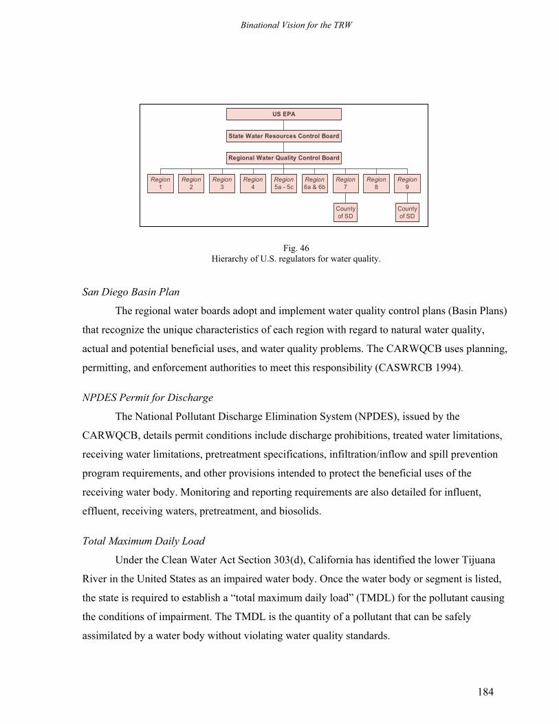
Binational Vision for the TRW
US EPA
San Diego Ba
The re
that recognize
actual and po
permitting, an
NPDES Perm
The N
CARWQCB,
receiving wat
program requ
receiving wat
effluent, recei
Total Maximu
Under
River in the U
the state is req
the conditions
assimilated by
Region1
Region2
Region3
Region4
Region5a - 5c
Region6a & 6b
Countyof SD
Region7
Region8
Countyof SD
Region9
Regional Water Quality Control Board
State Water Resources Control Board
Fig. 46 Hierarchy of U.S. regulators for water quality.
sin Plan
gional water boards adopt and implement water quality control plans (Basin Plans)
the unique characteristics of each region with regard to natural water quality,
tential beneficial uses, and water quality problems. The CARWQCB uses planning,
d enforcement authorities to meet this responsibility (CASWRCB 1994).
it for Discharge
ational Pollutant Discharge Elimination System (NPDES), issued by the
details permit conditions include discharge prohibitions, treated water limitations,
er limitations, pretreatment specifications, infiltration/inflow and spill prevention
irements, and other provisions intended to protect the beneficial uses of the
er body. Monitoring and reporting requirements are also detailed for influent,
ving waters, pretreatment, and biosolids.
m Daily Load
the Clean Water Act Section 303(d), California has identified the lower Tijuana
nited States as an impaired water body. Once the water body or segment is listed,
uired to establish a “total maximum daily load” (TMDL) for the pollutant causing
of impairment. The TMDL is the quantity of a pollutant that can be safely
a water body without violating water quality standards.
184
Implementation time line
Storm water permits
The San Diego Regional Water Quality Control Board issued the Municipal Storm Water
Permit Order (Municipal Permit) in 2001 to control waste discharges in urban runoff from the
Municipal Separate Storm Sewer Systems that drain into the watersheds of the County of San
Diego. In part, the Municipal Permit requires that the jurisdictions within a watershed collaborate
on the development of a Watershed Urban Runoff Management Program (WURMP) for each
watershed, which addresses high-priority storm water quality issues found within the various
watersheds. The WURMP for the U.S. portion of the Tijuana River Water has been submitted as
of 2004.
Ocean Plan
Water quality and discharges are also subject to regulation by the Water Quality Control
Plan, Ocean Waters of California (“Ocean Plan”) prepared by the CACASWRCB. The Ocean
Plan regulates point-source discharges to the ocean, with the goal of protecting beneficial uses.
The CARWQCB takes the provisions of the Ocean Plan (as well as the Basin Plan) into account
when establishing permit conditions.
Construction activity permitting
The CARWQCB also administers the NPDES General Permit for Discharges of Storm
Water Runoff Associated with Construction Activity (General Construction Permit).
Construction activities on 5 acres or more are subject to the permitting requirements. The permit
requires the preparation and implementation of a Storm Water Pollution Prevention Plan
(SWPPP). The plan would include specifications for best management practices (BMPs) that
would be implemented during project construction to control degradation of surface water
through measures to prevent the potential erosion of sediments or discharge of pollutants from
the construction area. Additionally, the plan would describe measures to prevent or control
runoff after construction is complete and identify a plan to inspect and maintain these facilities or
project elements.
185
Binational Vision for the TRW
Recycled water regulations
There are no federal standards governing wastewater reclamation and reuse in the United
States, although the EPA has sponsored the preparation of Guidelines for Water Reuse.
California has adopted Title 22, Division 4, Chapter 3, of the California Code of Regulations
(CCR) Water Recycling Criteria. The CARWQCB and the Department of Health Services
(CADHS) have the responsibility of reviewing proposed recycled water projects and for issuing
water recycling requirements through the waste discharge permit process. The existing Water
Recycling Criteria address treatment requirements for three main types of recycled water uses:
landscape irrigation, recreational impoundments, and industrial uses. The CADHS has also
produced Guidelines for Use of Reclaimed Water, which applies to recycled water. The
guidelines focus on application and management specifications for various recycled water uses,
including groundwater recharge/seawater intrusion barrier, cleaning, dual water system (toilet
flushing and landscape irrigation), firefighting, and wetlands creation/restoration. Some
examples of specifications in Title 22 are the requirement to use purple recycled water piping to
indicate recycled water and the prohibition of irrigation of disinfected tertiary recycled water
within 50 feet of any domestic water supply well (unless specific technical analyses are
conducted).
Mexican regulatory framework
The following are some of the regulations and regulators that affect water quality in Baja
California.
Ley Nacional de Aguas (National Water Law)
The 2002 Ley Nacional de Aguas (LAN), updated in 2004, stipulates the water quality
requirements for drinking water and wastewater, and for open national waters (lakes, rivers,
oceans). It requires the treatment of all waters prior to discharge into national water bodies.
Enforceable regulations under this law are called normas. The principle normas are NOM-001
that specifies limits for constituents of concern discharged into open bodies of water. NOM-002
stipulates maximum concentrations for discharge into sewers or other treatment facilities.
Mexico’s water recycling regulations are detailed in NOM-003. Agencies responsible for
monitoring potable and open water resources are SEMARNAT, CILA, COSAE, CNA, CESPs,
DGE, and the Dirección General de Planeación de Desarrollo Urbana y Ecología. Several
organizations are responsible for the enforcement of the LAN (Table 27).
186
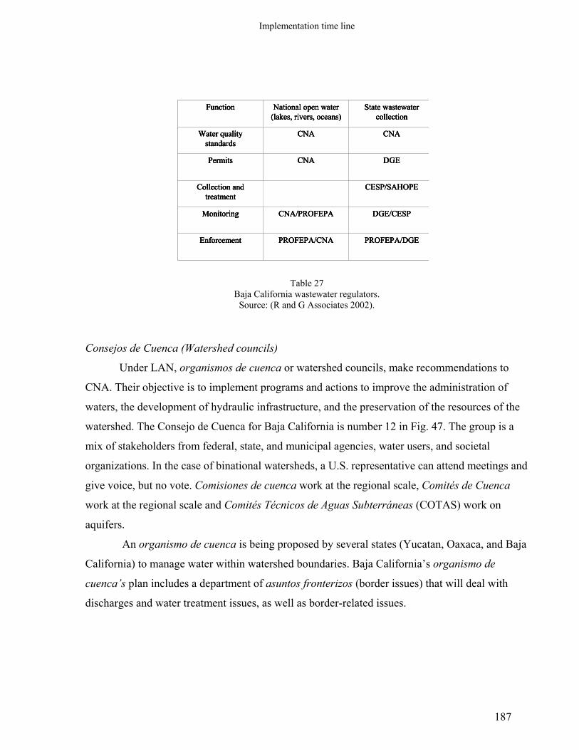
Implementation time line
Function National open water (lakes, rivers, oceans)
State wastewater collection
Water quality standards
CNA CNA
Permits CNA DGE
Collection and treatment
CESP/SAHOPE
Monitoring CNA/PROFEPA DGE/CESP
Enforcement PROFEPA/CNA PROFEPA/DGE
Function National open water (lakes, rivers, oceans)
State wastewater collection
Water quality standards
CNA CNA
Permits CNA DGE
Collection and treatment
CESP/SAHOPE
Monitoring CNA/PROFEPA DGE/CESP
Enforcement PROFEPA/CNA PROFEPA/DGE
FunctionFunction National open water (lakes, rivers, oceans)National open water
(lakes, rivers, oceans)State wastewater
collectionState wastewater
collection
Water quality standards
Water quality standards
CNACNA CNACNA
PermitsPermits CNACNA DGEDGE
Collection and treatment
Collection and treatment
CESP/SAHOPECESP/SAHOPE
MonitoringMonitoring CNA/PROFEPACNA/PROFEPA DGE/CESPDGE/CESP
EnforcementEnforcement PROFEPA/CNAPROFEPA/CNA PROFEPA/DGEPROFEPA/DGE
Table 27 Baja California wastewater regulators.
Source: (R and G Associates 2002).
Consejos de Cuenca (Watershed councils)
Under LAN, organismos de cuenca or watershed councils, make recommendations to
CNA. Their objective is to implement programs and actions to improve the administration of
waters, the development of hydraulic infrastructure, and the preservation of the resources of the
watershed. The Consejo de Cuenca for Baja California is number 12 in Fig. 47. The group is a
mix of stakeholders from federal, state, and municipal agencies, water users, and societal
organizations. In the case of binational watersheds, a U.S. representative can attend meetings and
give voice, but no vote. Comisiones de cuenca work at the regional scale, Comités de Cuenca
work at the regional scale and Comités Técnicos de Aguas Subterráneas (COTAS) work on
aquifers.
An organismo de cuenca is being proposed by several states (Yucatan, Oaxaca, and Baja
California) to manage water within watershed boundaries. Baja California’s organismo de
cuenca’s plan includes a department of asuntos fronterizos (border issues) that will deal with
discharges and water treatment issues, as well as border-related issues.
187

Binational Vision for the TRW
Internationa
Internationa
The C
Internationa
dealing with
subsequent m
so a minute
with bination
the TRW are
6644 Excerpt from (C
Fig. 47 Watershed councils in Mexico.
Source: CNA
l legislation64 64
l minutes
omisión Internacional de Límites y Agua (CILA) in Mexico and its counterpart
l Boundary and Water Commission (IBWC) in the United States, are in charge of
binational water resources and sanitation under the 1944 Treaty and a series of
inutes. There are currently no watershed management projects under IBWC-CILA,
would have to be created to expand the mandate of the IBWC-CILA in order to deal
al watersheds (see Time line section). The IBWC-CILA minutes that are relevant to
presented in Table 28.
ESPT 1999)
188
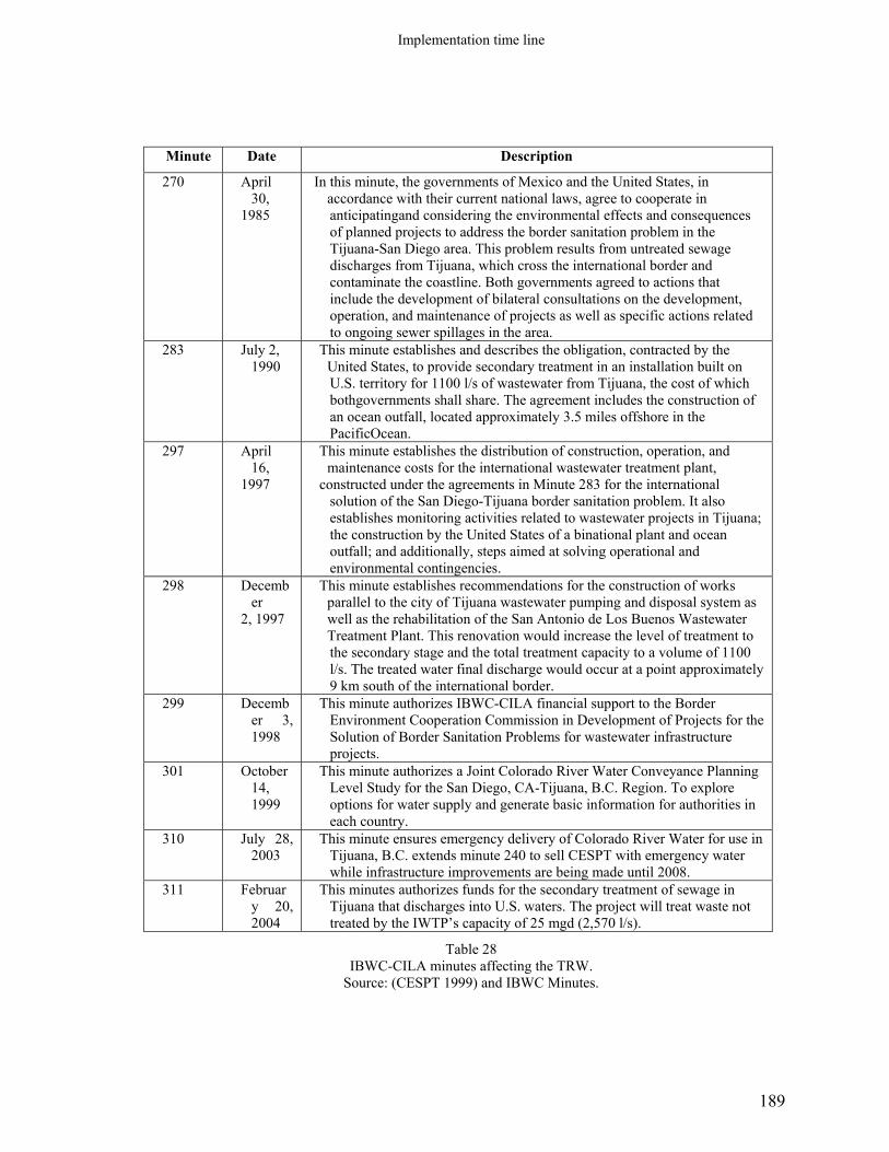
Implementation time line
Minute Date Description
270 April 30,
1985
In this minute, the governments of Mexico and the United States, in accordance with their current national laws, agree to cooperate in anticipatingand considering the environmental effects and consequences of planned projects to address the border sanitation problem in the Tijuana-San Diego area. This problem results from untreated sewage discharges from Tijuana, which cross the international border and contaminate the coastline. Both governments agreed to actions that include the development of bilateral consultations on the development, operation, and maintenance of projects as well as specific actions related to ongoing sewer spillages in the area.
283 July 2, 1990
This minute establishes and describes the obligation, contracted by the United States, to provide secondary treatment in an installation built on U.S. territory for 1100 l/s of wastewater from Tijuana, the cost of which bothgovernments shall share. The agreement includes the construction of an ocean outfall, located approximately 3.5 miles offshore in the PacificOcean.
297 April 16,
1997
This minute establishes the distribution of construction, operation, and maintenance costs for the international wastewater treatment plant,
constructed under the agreements in Minute 283 for the international solution of the San Diego-Tijuana border sanitation problem. It also establishes monitoring activities related to wastewater projects in Tijuana; the construction by the United States of a binational plant and ocean outfall; and additionally, steps aimed at solving operational and environmental contingencies.
298 December
2, 1997
This minute establishes recommendations for the construction of works parallel to the city of Tijuana wastewater pumping and disposal system as well as the rehabilitation of the San Antonio de Los Buenos Wastewater Treatment Plant. This renovation would increase the level of treatment to the secondary stage and the total treatment capacity to a volume of 1100 l/s. The treated water final discharge would occur at a point approximately 9 km south of the international border.
299 December 3, 1998
This minute authorizes IBWC-CILA financial support to the Border Environment Cooperation Commission in Development of Projects for the Solution of Border Sanitation Problems for wastewater infrastructure projects.
301 October 14, 1999
This minute authorizes a Joint Colorado River Water Conveyance Planning Level Study for the San Diego, CA-Tijuana, B.C. Region. To explore options for water supply and generate basic information for authorities in each country.
310 July 28, 2003
This minute ensures emergency delivery of Colorado River Water for use in Tijuana, B.C. extends minute 240 to sell CESPT with emergency water while infrastructure improvements are being made until 2008.
311 February 20, 2004
This minutes authorizes funds for the secondary treatment of sewage in Tijuana that discharges into U.S. waters. The project will treat waste not treated by the IWTP’s capacity of 25 mgd (2,570 l/s).
Table 28 IBWC-CILA minutes affecting the TRW.
Source: (CESPT 1999) and IBWC Minutes.
189
Binational Vision for the TRW
Ecosystem conservation laws and tools
Aside from water, many of the action items referred to in the Time line section of this
document deal with habitat and open space conservation, as well as protection of culturally
significant places. This section is an overview of 1) laws protecting habitat, species, and
culturally significant areas, and 2) tools for land acquisition that are available in the United
States and Mexico.
Laws in the United States65 65
There are many of federal, state, and local regulations that restrict adverse
impacts to the environment, including air, water, land, cultural resources, and socioeconomic
impacts. Some of these regulations provide mechanisms by which natural resources and open
spaces are protected. The following discussion summarizes a few of the laws that affect
conservation of natural resources on the U.S. side of the TRW.
National Environmental Policy Act (NEPA), Habitat Conservation Plan (HCP), National
Historic Preservation Act (NHPA), and Endangered Species Act (ESA)
Federal projects, projects on federal lands, and projects receiving federal funding are
subject to environmental review under these acts. One exception to the environmental review
requirements is for construction of the triple fence along the international boundary and related
road infrastructure. This exception was provided in congressional legislation. Non-federal
projects that may affect federally listed threatened or endangered species are subject to federal
ESA regulations. Projects that may cause significant adverse impacts to natural resources or
jeopardize the continued existence of federally listed species must mitigate these impacts, often
by establishing conservation areas as mitigation. Where there are incidental, adverse impacts to
listed species by nonfederal projects, an HCP must be prepared to demonstrate that habitat and
species conservation actions, including long-term biological management and monitoring, that
will mitigate impacts and contribute to the recovery of those species. The NHPA requires a
review of the projects expected impacts by the NHPA Council before excavation of land.
6655 Excerpt from (White et al. 2004)
190
Implementation time line
Clean Water Act
The U.S. Army Corps of Engineers administers this act, with
oversight from the U.S. EPA and the U.S. Fish and Wildlife Service. The Clean Water Act
regulates adverse impacts to “waters of the U.S.” and wetlands. It can require mitigation for
permitted impacts in the form of wetland and aquatic habitat conservation and restoration.
California Environmental Quality Act (CEQA), California Endangered Species
Act, and Natural Community Conservation Planning (NCCP) Act
Development projects are subject to environmental review under the CEQA and must
comply with a host of other environmental regulations and permitting requirements. Cultural and
historical resources must be evaluated for importance, and mitigation measures consisting of
preservation or recovery must be applied. Projects that may cause significant adverse impacts to
natural resources or jeopardize the continued existence of state-listed endangered or threatened
species must mitigate these impacts to a level that is less than significant. The project can do this
by modifying the project or by providing long-term conservation and management of natural
resources that would be affected by the project. For example, land developers and other project
proponents often purchase or establish conservation easements on land as “mitigation” for
project-related biological impacts. Historically, open space mitigation was accomplished on a
project-by-project basis; the result was a fragmented patchwork of conserved land that does little
to sustain biological resources over the long term. In 1991, California adopted the
NCCP Act, which provides for comprehensive land use planning to comply with
California ESA regulations. The NCCP Act allows local jurisdictions to plan for conservation of
ecosystems and ecosystem processes while allowing for reasonable economic growth.
Compliance with the NCCP Act and California ESA is often coordinated with federal ESA
compliance, resulting in the preparation of joint NCCP/HCP plans that specify reserve systems
of natural open space. This proactive approach attempts to protect currently listed species and
preclude the need for the listing of currently unlisted species in the future.
Local jurisdictions in Southern California, including the City and County of San
Diego, were among the first to undertake joint NCCP/HCP planning. NCCP/HCP
planning is conducted on a subregional basis, where a sub region consists of a group of
local jurisdictions within an ecoregion (e.g., South Coast ecoregion). In southern San
Diego County, conservation planning in the coastal jurisdictions has been completed,
191
Binational Vision for the TRW
and inland portions of the county will have planning initiated in the near future.
Both the City and the County of San Diego must annually appropriate funds for
acquisition, management, and monitoring of this open space. The Sweetwater
Authority and Otay Water District are in the process of completing NCCP/HCP
plans that will formally designate watershed lands they own as conserved open space.
NCCP/HCP plans have resulted in a significant amount of open space conservation in San Diego
County and are an important conservation tool for local governments.
National Fish and Wildlife Refuges
Within the border region, federal funding is being used to purchase private lands within
the Otay-Sweetwater Unit of the San Diego National Wildlife Refuge near Otay Mountain and to
develop a management and land use plan for the South Bay Unit of the San Diego National
Wildlife Refuge. These lands are considered federal contributions to the MSCP preserve system
in southwestern San Diego County.
Recovery Land Acquisition Grants Program
Funding from this program (subsidized through Section 6 of the Endangered Species Act)
is available to purchase land benefiting federally listed threatened and endangered species.
Forest Legacy Program
The USFS administers this voluntary program in cooperation with the California
Department of Forestry by purchasing qualified private properties and conservation easements to
maintain forest integrity.
Farm Bill 2002
The Natural Resources Conservation Service branch of the USDA works with private
landowners to manage land for natural resource values, under provisions of the Farm Bill 2002.
192
Implementation time line
State conservation programs
Multiple State of California departments and agencies have programs for habitat
conservation, including the Department of Parks and Recreation, Department of Fish and Game,
State Lands Commission, California Coastal Commission, and Wildlife Conservation Board,
which is a source of funding for acquisition of important natural resource areas. In addition,
several state propositions have been enacted by California voters in recent years that authorize
bonds for conservation of natural open space, water resources, and parklands. These bond
measures have provided substantial funding for natural resources conservation that is often used
to leverage additional funding from private foundations and non-governmental conservation
organizations.
General plans and zoning
In California, general plans describe policies that guide land uses within a city or county
jurisdiction, generally over a 20-year planning horizon. A conservation element is a mandatory
element of a general plan that provides guidance regarding the conservation, development, and
use of natural resources. Once a general plan is approved, the local jurisdiction then “zones” the
type and intensity (density) of land uses that are allowed. Certain land uses are compatible with
natural resources protection, while many are not. Thus, while general plans can provide
important conservation implementation mechanisms, they often reflect the political sentiments of
individual boards of supervisors or city councils and, in many instances, facilitate urban sprawl
rather than effective conservation. The County of San Diego is currently revising the General
Plan for the unincorporated part of San Diego County. If adopted, the County of San Diego
General Plan Update 2020 would encourage lower density development in the border region than
the current general plan.
County of San Diego Biological Mitigation Ordinance
The County of San Diego enacted the Biological Mitigation Ordinance to legally
implement the MSCP. The ordinance establishes criteria for avoiding impacts to important
resource areas and outlines mitigation requirements for all discretionary permit projects.
193

Binational Vision for the TRW
County of San Diego Resource Protection Ordinance (RPO)
The County of San Diego initiated the RPO program in 1991 to preserve wetlands,
floodplains, steep slopes, sensitive geological habitats, and prehistoric and historic sites that
contribute to society’s welfare. The RPO is the primary mechanism used in the unincorporated
County of San Diego lands to protect sensitive areas and minimize land development impacts.
The county’s Resource Protection Ordinance applies in unincorporated areas where the MSCP
has not yet been adopted. It establishes development controls on environmentally sensitive lands,
including wetlands, floodplains, steep slopes, and sensitive biological habitats (e.g., habitats that
support rare or endangered species or function as a wildlife corridor).
City of San Diego Environmentally Sensitive Lands Regulations, Resource
Protection Ordinance, and Associated Guidelines
As part of adopting the MSCP, the City of San Diego enacted these regulations to legally
implement the MSCP. The guidelines stipulate the biological standards that must be followed to
receive a development permit from the city and the amount and location of lands to be conserved
as mitigation.
Local conservation programs
Local municipalities have a variety of ways to raise money for conservation purposes.
These can include property taxes, sales and use taxes, transportation taxes, special assessment
districts, impact fees (one-time cost to developer), general obligation bonds, revenue bonds, and
so forth. Currently, SANDAG is discussing the parameters for a transportation tax that would not
only pay for transportation improvements, but would also support acquisition, management, and
monitoring of lands for open space as mitigation for transportation projects.
194
Implementation time line
Laws in Mexico66 66
Ley General de Equilibrio Ecológico y la Protección al Ambiente (General Law of Ecological
Balance and Environmental Protection)
In 1988, the General Law of Ecological Balance and Environmental Protection
(LEGEEPA) was passed which for the first time governed environmental protection. This
establishes the framework and authority for all environmental regulation in Mexico.
SEMARNAT is responsible for the enforcement of the LEGEEPA.
Decreto Federal o Estatal (Federal or State Decree)
Federal, state, or municipal government agencies can decree parks or natural protected
areas (áreas naturales protegidas). However, land within these areas may be privately owned,
and landowners within natural protected areas often are not compensated for economic losses
associated with the decreed land use limitations. Consequently, these private lands may not be
managed in a manner consistent with the protection of natural resource values. Incentives and
land management guidelines are needed to supplement this designation.
Plan de Desarrollo Urbano del Municipio (Municipal Master Plan)
This municipal plan for urban development, which is updated every two years,
establishes strategies, policies, and actions that will support sustainable growth (see, for example,
El Plan de Desarrollo Urbano del Centro de Población de Tijuana 2025 (IMPlan 2002 as cited by
White, et al. 2004). One drawback is that the plan can change when government changes.
Plan de Ordenamiento Ecológico Territorial (State Ecological Master Plan)
This is a governmental policy tool whose purpose is to regulate and control land
use and production activities, provide for environmental protection, and allow for
preservation and sustainable use of natural resources. They are similar to the Plan de Desarrollo
Urbano but were created for rural areas. Plans can be regional, state, municipal, or for specific
areas (Ojeda 2002). This tool lacks legal enforcement capability when land uses are changed
6666 Excerpt from (White et al. 2004)
195
Binational Vision for the TRW
from conservation to development (Gobierno de Baja California 1995 as cited by White, et al.
2004).
Scientists from the Universidad Autónoma de Baja California are assisting the City of
Tijuana with the identification of important natural resource areas (áreas verdes) as part of the
ordenamiento ecológico for Tijuana. Baja California is one of the few states where a regional
ordenamiento, based on ecological data, has been decreed (Ojeda 2002).
Other land use policies or zoning
A declaratoria is a special zoning tool that could be used by the state or municipality to
conserve woodlands. Declaratorias have proven to be ineffective in Baja California because of
the poor enforcement capability of the public sector (Graizbord and De la Fuente in prep.). A
municipal land bank allows municipalities to designate lands they own for special uses, such as
low-income housing or conservation. They can also sell land cheaply. Permutas allow cities to
exchange land in ecologically sensitive areas for areas of equal monetary value though less
sensitive. The policy of Manejo Sostenible del Uso de Vida Silvestre (UMA) under the Ley de
Vida Silvestre, or Management and Sustainable Use of Wildlife under the General Law of
Wildlife, is an incentive that allows for the development of productive alternatives compatible
with protection of natural resources and biodiversity. The objective is to provide for conservation
of managed species while improving quality of life for the community (M. Cariño pers. comm.
2004). This tool has been successfully used for gray whale protection in Laguna San Ignacio,
B.C., and could be used for the conservation, reproduction, and commercialization of bighorn
sheep within the TRW.
Land acquisition tools
Because government resources in both countries are limited and restricted by law, the
protection of private land in the United States and Mexico has become a major tool for land
conservationists. The tools can by used for total conservation (no use) to partial conservation
(mixed use). The tools may be useful when implementing the TRW Vision’s recommendations
to identify important conservation areas for restoration and rehabilitation, protect sensitive
habitat and cultural areas, evaluate and protect groundwater supplies, and connect conservation
areas across the border. Table 29 (at the end of this section) summarizes and compares tools in
the United States and Mexico.
196
Implementation time line
Tools in the United States67 67
Mitigation banks—If approved by federal and state wildlife agencies, a property owner can sell
“mitigation credits” on his land to other property owners or developers requiring mitigation land
for development impacts. The number and value of credits depend on the level and location of
impact and the type of resources affected.
Private land conservancies—In Southern California, many private nonprofit organizations
conserve land for natural and cultural resources protection, scenic beauty, recreation, community
open space, and agricultural resources. These organizations vary in size and scope, from very
large organizations with a global influence (e.g., TNC), to small, community-based land
conservancies focused on a particular area or watershed. In the border region, a few small land
trusts are conserving and/or managing natural open space areas.
Land transfers—The main use of this mechanism is to avoid the bureaucratic delays that
governments experience when buying land. A land trust typically holds the land until the
government is ready to pay for the land.
Land exchanges—Landowners can exchange property for other property without having to
incur a capital gain on the transaction. This allows a landowner to continue to own valuable real
estate, but transfer ecologically significant property to a land trust.
Land donations—There are federal income tax deductions that serve as incentives for land
donations for conservation.
Bargain sale—A landowner can sell his property for less than fair market value and claim a
charitable deduction for income tax purposes for the difference between the bargain sale price
and fair market value.
Conservation easements—A landowner can voluntarily place a conservation easement on his
property that legally restricts the uses within the easement to protect the natural resources. The
6677 Excerpt from (White et al. 2004)
197
Binational Vision for the TRW
easement is typically transferred to a conservation organization or government agency. The
easement is specific to each property and stays with the land in perpetuity, regardless of
ownership.
There are federal income tax benefits of donating a conservation easement. The value of an
easement is generally the difference between the value of the land with the easement (i.e., with
land use restrictions specified by the easement) and the value of the land without the easement
(i.e., without the easement restrictions).
Tools in Mexico68 68
Individuals, indigenous groups, and NGOs, such as Pronatura and Terra Penisular have
been working to develop mechanisms for the protection of natural resources on private lands
(Pronatura 2002). Legal conservation tools that allow landowners to voluntarily restrict the type
and amount of development to protect natural resources are relatively new in Mexico (Pronatura
2002). Some examples are described below.
Donation or purchase—This is the most complete and secure way of protecting land, but it is
rare in Mexico. There are legal restrictions on the amount of land a person can buy or own. Tax-
exempt NGOs are restricted from owning more land than “their immediate goals require”
(Corcuera, Steiner, and Guhathakurta 2000) and administering the land requires resources
beyond the capabilities of most NGOs. Foreigners are not allowed to own land in the 100
kilometer (km) strip along the border and 50 km strip along the coast, unless through a bank trust
(fideicomiso). Income tax deductions are allowed for donations, although one must petition the
Secretaría de Hacienda y Crédito Público. Many reassess land to decrease its value to
development, and thus protect it. However, current low land values in Mexico negate this as an
incentive. This practice works best on large, poor ejidos.
Bequest—This is the same as a land transfer or donation, but stipulated in a will and transferable
after death (Corcuera, Steiner, and Guhathakurta 2000).
6688 Excerpt from (White et al. 2004)
198
Implementation time line
Parques privados—The establishment of private parks in Mexico occurs mostly without legal
guarantees (Corcuera, Steiner, and Guhathakurta 2000). The first private conservation donation
was El Eden Research Station in Quintana Roo in 1990.
Usufructo (right of use)—An usufructo is a written agreement for a stipulated time that gives a
third party the right to use the resources on a property for certain purposes (in this case,
conservation). The contract is not tied to the land and expires with death of the landowner. The
owner also retains the right to use, sell, donate, or pass on the land to heirs (Pronatura 2002). In
this situation, an NGO could acquire lands from the owner and grant a restricted usufructo back
to the landowner, or landowners could rent the usufructo land to private companies for specified
purposes, such as camping or ecotourism.
Fideicomiso (property trust)—A person can grant property through a financial institution
(usually a bank) for conservation purposes, documented by a contract on rights of use.
Fideicomisos even allow foreigners to own property within the restricted areas, although the title
is held by the financial institution. Fideicomisos are easy to create under the Ley de Operaciones
de Crédito and allow many people to invest land, money, and services. There is a limit to the
contract period, depending on the kind of fideicomiso. Nationally, the tourism department of
Mexico, FONATUR, uses this system to develop land (Pronatura 2002). This tool was used
locally by PRODUTSA in Tijuana to develop the Río Tijuana 3a. Etapa, Corredor Tijuana-
Rosarito 2000, and San Antonio del Mar development (Lemus 2004 as cited by White, et al.
2004), but can be used for conservation as well.
Servidumbre (easement)—There are many types of servidumbres. The servidumbre ecológica
(conservation easement) is a voluntary legal agreement between two or more property owners in
which the rights of one are restricted in the type or intensity of land use allowed on the property,
with the objective of preserving natural resources, scenic beauty, or historical and cultural values
of the land for a designated period of time or in perpetuity. The servidumbre stays with the land
and not with the property owner. The property that receives the benefit is designated the predio
dominante, and the property that confers the benefit is the predio sirviente. There are also
servidumbres ecológicas recíprocas in which there are reciprocal restrictions on each property.
The properties can be contiguous or non-contiguous. Servidumbres ecológicas can be used to
199

Binational Vision for the TRW
conserve areas of biological richness, protect endangered species, and allow use as wildlife
movement corridors, or maintain sustainable land use practices. Restrictions that may be placed
on properties can vary by property and include hunting, cutting, or clearing trees and other
vegetation, impeding wildlife movement, burning, construction, subdividing the property, or
housing density. Many of these restrictions on public recreation can benefit ecotourism in
Mexico, which depends on the conservation of threatened or unique ecosystems. Rancho
Cuchumá is the only example of a servidumbre ecológica in the border region. Pronatura
recommends the servidumbre ecológica with monetary compensation to the landowner as one of
the best tools because it provides seed money to start sustainable practices on their land, thus
ensuring management and monitoring of ecosystems.
Transfer or Purchase of Development Rights—With the transfer or purchase of development
rights, a landowner has the right to sell the development rights to his land. The seller gives up the
development rights (emitting zone), and the buyer uses them to build on a more appropriate piece
of land (receiving zone). This tool is proposed for use as part of the County of San Diego
General Plan Update 2020.
Tool United States Mexico
Land donation Can be stipulated in wills, land gifts by corporations, and living proprietors. The government offers estate tax breaks and charitable tax deductions.
Not common due to lack of incentives; the donor pays for the transfer of title and development rights, and the receiver pays property taxes.
Land purchase Land trusts or governments buy or transfer lands.
Has recently been exercised by U.S. and Mexican NGO teams (see Coahuila, for example). Costs of property taxes and management of the donated land are high for land trusts. There are limits on how much land can be owned.
Easement donation
Landowners can donate conservation easements that for a stipulated time period (usually perpetuity), restrict some specific uses but maintain title to the land. Charitable deductions and estate tax breaks apply.
Must be signed between two plots of land (dominant and servient). The dominant party can be NGO which receives a gift of land (1 ha) as a gift from the landowner. For an "easement in gross," there is only one landowner. In general, there are insignificant tax incentives. An NGO can be a third-party overseer with legal power to defend the land, a more economic option.
200
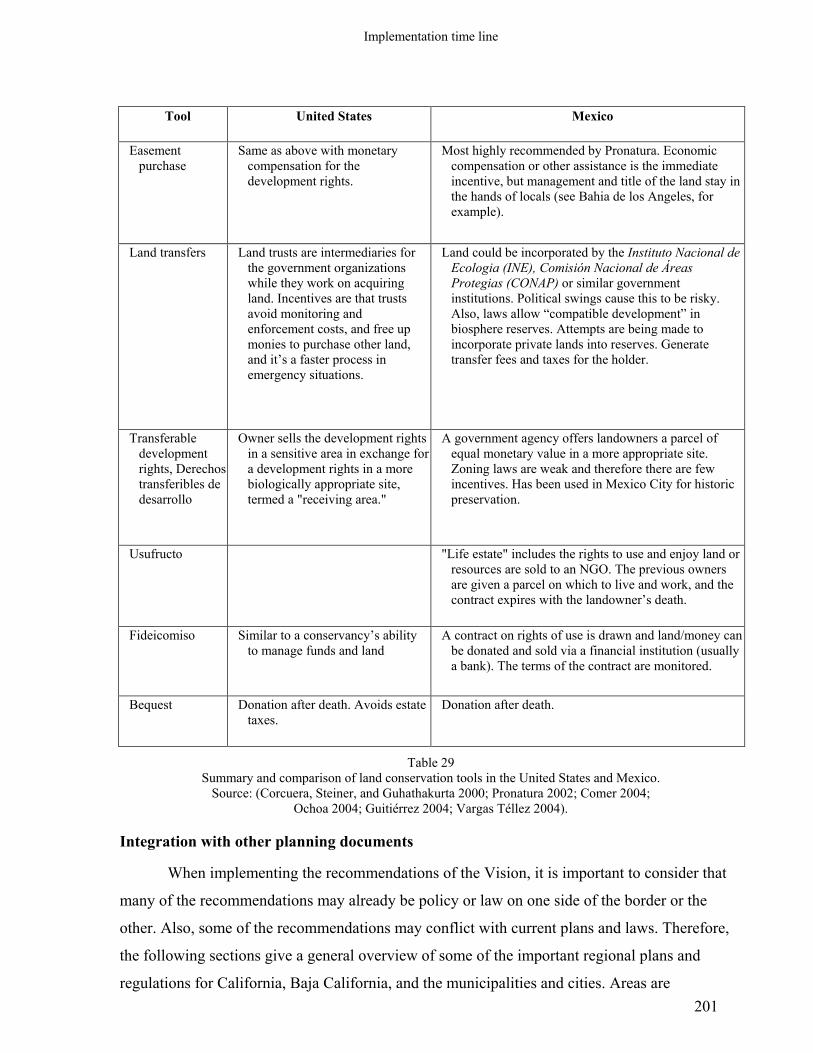
Implementation time line
Tool United States Mexico
Easement purchase
Same as above with monetary compensation for the development rights.
Most highly recommended by Pronatura. Economic compensation or other assistance is the immediate incentive, but management and title of the land stay in the hands of locals (see Bahia de los Angeles, for example).
Land transfers Land trusts are intermediaries for the government organizations while they work on acquiring land. Incentives are that trusts avoid monitoring and enforcement costs, and free up monies to purchase other land, and it’s a faster process in emergency situations.
Land could be incorporated by the Instituto Nacional de Ecologia (INE), Comisión Nacional de Áreas Protegias (CONAP) or similar government institutions. Political swings cause this to be risky. Also, laws allow “compatible development” in biosphere reserves. Attempts are being made to incorporate private lands into reserves. Generate transfer fees and taxes for the holder.
Transferable development rights, Derechos transferibles de desarrollo
Owner sells the development rights in a sensitive area in exchange for a development rights in a more biologically appropriate site, termed a "receiving area."
A government agency offers landowners a parcel of equal monetary value in a more appropriate site. Zoning laws are weak and therefore there are few incentives. Has been used in Mexico City for historic preservation.
Usufructo "Life estate" includes the rights to use and enjoy land or resources are sold to an NGO. The previous owners are given a parcel on which to live and work, and the contract expires with the landowner’s death.
Fideicomiso Similar to a conservancy’s ability to manage funds and land
A contract on rights of use is drawn and land/money can be donated and sold via a financial institution (usually a bank). The terms of the contract are monitored.
Bequest Donation after death. Avoids estate taxes.
Donation after death.
Table 29 Summary and comparison of land conservation tools in the United States and Mexico.
Source: (Corcuera, Steiner, and Guhathakurta 2000; Pronatura 2002; Comer 2004; Ochoa 2004; Guitiérrez 2004; Vargas Téllez 2004).
Integration with other planning documents
When implementing the recommendations of the Vision, it is important to consider that
many of the recommendations may already be policy or law on one side of the border or the
other. Also, some of the recommendations may conflict with current plans and laws. Therefore,
the following sections give a general overview of some of the important regional plans and
regulations for California, Baja California, and the municipalities and cities. Areas are 201
Binational Vision for the TRW
highlighted where the Vision coincides with or compliments existing or proposed plans to show
how the Vision supports and is supported by other regional efforts.
The TRW Vision follows the general strategic planning framework of the Regional
Comprehensive Plan for San Diego County (SANDAG 2004). It focuses on sustainability and
“smart growth,” or reinvestment into existing communities principles, taking into account the
economy, environment, and social equity. The plan calls for:
• Improving connections between land use and transportation plans using smart growth
principles
• Using the same plans to guide decisions regarding environmental and public facility
investments
• Focusing on collaboration and incentives to achieve regional goals and objectives. Specific
incentives for implementing smart growth plans are SANDAG transportation funds as a
permit streamlining, reduced parking standards, flexibility for mixed use development,
increased densities, and fee reductions for redevelopment.
The TRW Vision integrates well with the Mountain Empire Subarea Plan for the San
Diego General Plan (County of San Diego 1995) recommendations for conservation and
binational cooperation. The following policies and recommendations are in line with the Vision’s
recommendation to protect cultural and natural resources:
• All development shall demonstrate a diligent effort to retain as many native oak trees as
possible. Sewer districts should implement a wastewater reclamation program in areas where
groundwater is not abundant. Natural channels and streambeds should be used for drainage
and runoff should be for groundwater recharge where applicable.
• Development shall not adversely affect the habitat of sensitive plant and wildlife species or
those areas of significant scenic value.
• The exportation of more than 1 acre-foot of groundwater from the Potrero basin to areas
outside the Potrero watershed should be discouraged.
• Floodways shall be maintained in their natural state unless findings can be made that a threat
to public safety exists.
202
Implementation time line
• The Jacumba Hotel should be restored if at all possible.
Recommendations from SANDAG’s Water Quality Element of its Regional Growth Management
Strategy for 2020 to SANDAG and the San Diego County Water Authority (SANDAG 2002) coincide
with the Vision recommendations in the following areas:
• Plan for a safe and reliable supply.
• Pursue a legislative program that follows and takes positions on bills consistent with the
quality of life standards and objectives and recommended actions for water availability.
• Continue implementation of the existing and proposed BMPs to obtain water conservation
savings.
• Provide loans for studies of potential local supply projects.
• Local jurisdictions should require water conservation mechanisms, such as separate
irrigation meters for commercial and large residential common-use areas, to better manage
landscape water use, installation of high-efficiency dishwashers and coin-operated clothes
washers in commercial businesses, and encourage the use of recycled water when this
supply is available and meets all regulatory requirements.
• Complete by 2010 the regional Emergency Storage Project, a system of reservoirs, pipelines,
and other facilities that will provide water to the county during prolonged interruption of
imported water due to earthquake, drought, or other disaster.
• Review and adopt, as appropriate, drought allocation plans to cope with potential future
shortages within the region.
The General Plan for the City of Imperial Beach is supported by the Vision in terms of
water quality goals for point and non-point pollution (City of Imperial Beach, City of San
Diego, and County of San Diego 2002):
• To the extent feasible, preserve, and where possible, create or restore areas that provide water
quality benefits, such as riparian corridors and wetlands, and promote the design of new
developments to protect the natural integrity of drainage systems and water bodies.
203
Binational Vision for the TRW
• Avoid conversion of areas particularly susceptible to erosion and sediment loss, and/or
establish development guidelines that identify these areas and protect them from erosion and
sediment loss.
• To the extent feasible, minimize the amount of impermeable surfaces in areas of new
development and redevelopment, and maximize on-site infiltration of runoff. Where this is not
feasible, encourage runoff management practices that minimize the volume of urban runoff
discharged to receiving waters.
• In watershed planning, pollution prevention should be the first priority, to be followed by
source control (only when pollution prevention is not technologically feasible), and pollution
control.
• Reduce pollutants associated with vehicles and increasing traffic resulting from
development. Coordinate local traffic management reduction efforts with the San Diego
County Congestion Management Plan.
• Implement SANDAG’s recommendations as found in the Water Quality Element of its Regional
Growth Management Strategy for 2020.
• Post-development runoff from a site shall not contain pollutant loads, that cause or contribute to
an exceedance of receiving water quality objectives. Developments shall be designed to protect
water quality and provide for water protection.
• New development and redevelopment shall implement pollution prevention methods
supplemented by pollutant source controls and treatment through the use of small collection
strategies located at or as close as possible to the source to minimize the transport of urban
runoff and pollutants offsite and into the storm water sewer system.
• Prior to making land use decisions, utilize methods available to estimate increases in pollutant
loads and flows resulting from projected future development.
• New development and redevelopment shall incorporate structural and non-structu BMPs to
mitigate the projected increase in pollutant loads and flows.
The Vision is consistent with the character of the City of San Diego’s Progress Guide
and General Plan adopted on February 26, 1979. It states that new developments shall be
consistent with a community’s character and meet the needs for a diverse range of ages,
incomes, abilities, and lifestyles. New development shall also provide for the protection of the
County’s natural resources including ground-water resources, dark skies, cultural and historical
204
Implementation time line
resources, agriculture, natural floodplains, wetlands, environmentally sensitive lands, air quality,
and water quality through the creation of greenbelts and wildlife corridors and other open space
areas. The updated plan is scheduled for review in by City Council in 2005 (County of San
Diego 1995).
The Vision document meshes well with the San Diego County General Plan for land use
and the environment (County of San Diego 1998). The plan includes goals and policies that
provide mechanisms to preserve open spaces for conservation of natural resources, recreational,
and educational activities. The ultimate goal of the County of San Diego’s General Plan update
is to allow for efficient, economical, coordinated, and timely provision of public facilities and
services including water, sewer, roads, drainage and storm-water runoff, schools, parks,
libraries, police, fire protection, and emergency medical services. Adoption of the plan is
expected at the end of 2005.
Land use goals included in the plan are:
• Promote wise uses of the County’s land resources, preserving options for future use.
• Encourage future urban growth contiguous to existing urban areas and maximize the use of
underutilized lands within existing urban areas (infill).
• Retain the rural character of non-urban lands.
• In non-urban areas, limit high-density development to existing country towns.
• Encourage continuance and expansion of agricultural uses in appropriate portions of the
unincorporated County of San Diego.
• Ensure preservation of contiguous, regionally significant open space corridors.
• Protect lands needed for preservation of natural and cultural resources; managed production
of resources; and recreation, educational, and scientific activities.
The Vision shares some of the same general goals as the Otay Subregional Plan of the
San Diego General Plan (County of San Diego 1994). These are:
• Land use goal—Provide a land use pattern sensitive to the opportunities and the constraints
of the sub region.
205
Binational Vision for the TRW
• It is the goal of the County of San Diego to work with the private sector in capitalizing on
the unique development opportunities existing near the Mexican border while concurrently
encouraging interim agricultural production as much as economically feasible.
• Circulation goal—Provide a circulation network capable of handling subregional traffic. It is
the goal of the County of San Diego to plan for the orderly development of an ultimate
highway, street, and rail transportation network adequate to handle subregional traffic at
acceptable service levels and capable of accommodating automobile and truck as well as
public and non-motorized modes of travel with the sub region.
• Conservation goal—Protect environmental resources. It is the goal of the County of San
Diego to protect the environmental resources designated as "resource conservation areas" on
the conservation element.
• Coordination goal—Coordinate planning and development effort with Mexican agencies and
private interests involved in similar activities for the area immediately south of the border.
The Vision shares the three general goals as the Jamul-Dulzura Subregional Plan of the
San Diego General Plan (County of San Diego 1995):
• Encourage development of the land in such a manner as to retain the existing rural
atmosphere of the community.
• Provide for a land use pattern that accommodates the population projection with essential
services, such as water, fire protection, and schools.
• Direct urban density residential and commercial land uses to the region’s more level land in
the imported water service area. Outside the imported water services, areas should have low
density residential and agricultural land uses.
The Central Mountain Sub region Plan for the San Diego County General Plan specifies
some of the same objectives as the Vision for the TRW (County of San Diego 1995):
• Encourage the protection of existing vegetation, wildlife, and other natural resources.
• Discourage high-density public and private development.
• Residential development should be designed to conserve water.
206
Implementation time line
• Whenever and wherever possible, maintain the natural landforms and native vegetation
around residential structures in order to preserve the overall open character and scenic
quality of the sub region.
• Ensure that adequate public facilities exist to support proposed residential developments.
• Preserve the character of the existing landscape by retaining important natural features,
landforms, and scenic resources.
• Establish open space corridors to maintain biological diversity and viable access for wildlife
to and from water, food, and breeding areas.
• Harmoniously integrate transportation modes and ensure that access and circulation shall be
provided for vehicles, bicycles, pedestrians, and equestrians in a safe manner.
• Provide and encourage the use and expansion of public transportation.
• Scenic highways/routes and scenic preservation.
• Protect and enhance scenic views, wildlife habitats, native plant materials, and historical and
recreational resources within scenic highway corridors.
• Ensure the provision of adequate services and facilities to meet the educational needs of all
the residents in the area.
• Ensure that waste disposal does not adversely impact groundwater quality.
• Expand solid waste recycling programs.
• Conserve resources by reducing the volume of waste generated in the central mountain sub
region.
• Protect lives and property from uncontrolled flooding while protecting natural floodplain
values.
• Conserve hydrological and biological resources of all lakes, rivers, streams, and other
wetlands by controlling wastewater discharge and runoff.
• Preserve natural waterways for their value as recharge basins and wildlife habitat.
• Promote the establishment of emergency and preventative procedures to reduce damages
from geologic hazards, medical emergencies, and other disasters.
• Ensure the careful management of environmental resources in the plan area to prevent
wasteful exploitation or degradation of those resources, and to preserve them for future
generations.
207
Binational Vision for the TRW
• Establish resource conservation areas to ensure the protection and preservation of high
quality natural resources and significant cultural resources.
• Discourage the production of local air-polluting emissions in the planning area.
• Encourage a regional approach to the control and reduction of air-polluting emissions,
including the support of air pollution control district policies.
• Preserve known historical and archaeological resources and provide adequate protection for
new sites as they are discovered.
• Identify and preserve archaeological and historical resources through regulatory review of
development projects.
• Preserve natural landforms, water resources, aesthetic resources and soils by preventing
erosion due to the development process.
• Prevent the unnecessary alteration of the natural landscape and wildlife habitat within the
planning area.
• Whenever possible, protect all sensitive lands and habitat, such as coniferous forests, high
montane meadows, native grasslands, Diegan sage scrub, oak woodlands, montane
chaparral, riparian woodlands, vernal pools, and any other wetlands.
• Create open space corridors of sufficient size to maintain biological diversity and functional
access for wildlife to and from water, food, and breeding areas, and To prevent the creation
of biological islands.
• Identify and preserve endangered, threatened, or sensitive habitats, and species of plants and
wildlife.
The Vision supports the San Diego Basin Plan (CASWRCB 1994) submitted by Region
9 Water Quality Control Board. The Basin Plan designates beneficial uses for water bodies, and
establishes water quality objectives and implementation plans to protect those beneficial uses.
Both state and federal laws mandate the periodic review and update of Basin Plan water quality
standards. The last review was in 2004. These goals include:
• Maximum protection of beneficial uses.
• Municipal, agricultural, and industrial wastewaters are to be considered a part of the
available fresh water resource.
• Coordinate management of water and wastewater supplies on a regional basis.
208
Implementation time line
• Create a balanced prevention program of source control, reuse, treatment of wastewaters,
and proper disposal of effluents and residuals.
• Avoid environmental damage from disposal of residuals.
• Consolidated wastewater facilities and treatment operations to benefit the entire region.
• Institutional and financial resources must be shared throughout the region equitably
• Reclamation and reuse plans must be considered in long-range planning.
• Wastewater management systems must be designed to achieve maximum long-term benefit
from the funds expended.
• Water quality control must be based on the latest scientific findings.
• Monitoring programs must assess the effects of programs on beneficial uses including
aquatic life, its diversity, and seasonal fluctuations.
The Vision is compatible with the San Diego Water Department’s Source Water
Protection Guidelines for New Development (City of San Diego 2004). The guidelines help
protect seven drinking water reservoirs located throughout San Diego County that capture local
rain water runoff and supply up to 20% of the City of San Diego’s drinking water. The
guidelines are applicable throughout the sub-watershed areas of Barrett and Morena Reservoirs.
They are intended to influence the design and construction of new residential and commercial
developments in ways that will provide maximum protection of drinking source water quality.
The guidelines focus on the pollutants of greatest concern for drinking water quality including
nutrients, total organic carbon, and total dissolved solids. The guidelines establish three tiers of
projects and recommended BMPs, such as cluster housing, landscaping that provides infiltration,
vegetated swales, porous building materials, and limiting impermeable surfaces.
The TRW Vision integrates well with the objectives of the Potable Water and
Wastewater Master Plan for Tijuana and Playas de Rosarito. The purpose of the study was to
develop a plan to invest in projects to improve services of potable water, wastewater collection,
sanitation, and wastewater reuse in the short term (5 years), medium term (10 years) and long
term (20 years) (Table 30) (CESPT 2002).
209
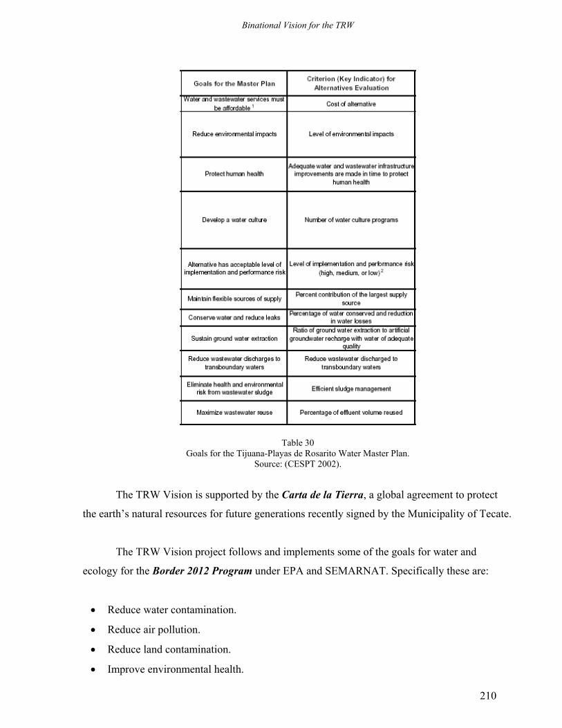
Binational Vision for the TRW
Table 30 Goals for the Tijuana-Playas de Rosarito Water Master Plan.
Source: (CESPT 2002).
The TRW Vision is supported by the Carta de la Tierra, a global agreement to protect
the earth’s natural resources for future generations recently signed by the Municipality of Tecate.
The TRW Vision project follows and implements some of the goals for water and
ecology for the Border 2012 Program under EPA and SEMARNAT. Specifically these are:
• Reduce water contamination.
• Reduce air pollution.
• Reduce land contamination.
• Improve environmental health.
210
Implementation time line
• Improve environmental performance through compliance, enforcement, pollution
prevention, and promotion of environmental stewardship.
The TRW is consistent with recommendations by the Good Neighbor Environmental
Board, a U.S. federal advisory panel that reports each year to the president and congress on
border issues (GNEB 2001). For example, the fifth annual report includes the following
recommendations:
Surface Water: 1) Support United States-Mexico discussions concerning compliance with
water treaty obligations and encourage greater binational cooperation directed at more
effective surface water supply management.
Groundwater: 2) Support efforts for increased collection and sharing of data about border
region groundwater resources and encourage greater binational cooperation in border
groundwater management.
Watersheds: 3) Support partnerships at all levels that promote strategic watershed
principles and watershed management.
The Vision coincides well with the Baja California State Plan de Ordenamiento Ecológico
Territorial (State’s Master Plan), which is a governmental policy tool whose purpose is to regulate and
control land use and natural resource production activities, provide for environmental protection, and
allow for preservation and sustainable use of natural resources. In addition, the municipalities of Tijuana
and Tecate each have an Ordenamiento Ecológico that will be used to guide land development. This tool
lacks legal enforcement (Gobierno de Baja California 1995).
The Vision integrates goals and objectives from the Plan de Desarrollo Urbano del
Municipio de Tijuana (Municipal Master Plan), updated every two years, that establishes
strategies, policies, and actions that will support sustainable growth. There is also the Plan de
Desarrollo Urbano del Municipio de Tijuana (Municipio de Tecate 2003) the latest version of
which covers 2001-2012. One drawback is that the plan can change when government changes.
The Vision has the advantage of longevity, a long-term vision, and stakeholder input.
211

Binational Vision for the TRW
The water goals from the Plan Estatal Hidráulico adopted by the State of Baja
California in 2004 (Gobierno del Estado de Baja California, et al. 2004a) coincide with the goals
of the Vision project developed in 2003. One member of the BWAC Research Team helped
develop this plan. These goals are:
• Promote the efficient use of water in the agricultural sector.
• Foster total coverage of quality potable water and sewage service.
• Strive for integrated sustainable management of water within watershed boundaries and
aquifers.
• Promote the technical, administrative, and financial development of the hydraulic sector.
• Consolidate the participation of water user and organized society in the management of water
and the promotion of a culture of proper water use.
• Minimize the risks and effects of floods and droughts.
The Plan Estatal de Rehabilitación de Microcuencas for Baja California (Gobierno del
Estado de Baja California, et al. 2004b) shares the following objectives with the Vision:
• Rehabilitate, conserve, and protect the natural resources within the subbasin to ensure the
ongoing autonomous integrated regional development
• Generate opportunities for the rural residents in the planning and implementation of projects
to ensure stakeholder involvement and sustainability.
• Strengthen actions and coordination of institutions of different levels of the government and
NGOs
• Promote an education campaign on watershed ecology
• Form multidisciplinary technical teams.
Potential sources of funding to implement the Vision
Throughout this Vision document, many sources of support for individual projects have
been mentioned. For water supply and quality issues, some sources include U.S. Bureau of
Reclamation Title XVI Grant Program, California Proposition 13, and MWD Local Resources
Program and Seawater Desalination Funds Program, the Financial Assistance Program, and the
Reclaimed Water Development Fund. For land conservation the following sources were
212
Implementation time line
mentioned: Recovery Land Acquisition Grants Program (subsidized through Section 6 of the
ESA), the Forest Legacy Program of the USFS and the California Department of Forestry
Natural Resources Conservation Service, an the USDA Farm Bill 2002. For habitat conservation,
the Department of Parks and Recreation, Department of Fish and Game, State Lands
Commission, California Coastal Commission, and Wildlife Conservation Board, state
propositions bonds, private Foundations, and non-governmental conservation organizations.
Transportation improvements have used GSA funds. Wastewater improvement projects have
used funds from NADBANK-BECC, CNA, and IBWC-CILA. There may be ways to implement
conservation that are synergistic with the goals of the U.S. Department of Homeland Security.
To implement a watershed council, two main sources of funding are feasible: California
Proposition 50 and/or resources from IBWC-CILA (see Action Plan: Create a mechanism for
transboundary watershed management).
Proposition 50, the Water Security, Clean Drinking Water, Coastal and Beach Protection
Act of 2002, was passed by California voters. The intent of the IRWM grant program is to
encourage integrated regional strategies for the management of water resources and to provide
funding, through competitive grants, for projects that protect communities from drought, protect
and improve water quality, and improve local water security by reducing dependence on
imported water. The Grant Program is administered jointly by the California Department of
Water Resources (DWR) and the CASWRCB and is intended to promote a new model for water
management. Approximately $380 million is anticipated to be available for IRWM grants during
Senate bills and Assembly bills (DWR and CASWRCB 2004). To be eligible, groups must have
an Integrated Regional Water Management Plan (IRWM) that is adopted or will be adopted by
January 1, 2007. An eligible group consists of at least three local public agencies, two of which
have statutory authority over water (such as the San Diego County Water Authority, City of San
Diego Water Department, or County of San Diego). At a meeting of the Technical Advisory
Committee (TAC) for Project Clean Water started by the County of San Diego County, the idea
of applying for funding was discussed. It is envisioned that the TAC would be a useful forum to
keep updated on all Proposition 50 and other funding processes. The following focuses were
recommended for submission:
• Programs for water supply reliability, water conservation, and water use efficiency
• Storm water capture, storage, treatment, and management.
213
Binational Vision for the TRW
• Removal of invasive non-native plants, the creation and enhancement of wetlands, and the
acquisition, protection, and restoration of open space and watershed lands.
• Non-point source pollution reduction, management, and monitoring
• Groundwater recharge and management projects
• Contaminant and salt removal through reclamation, desalting, and other treatment
technologies.
• Water banking, water exchange, water reclamation, and improvement of water quality
• Water quality, storm water capture and percolation
• Protection or improvement of wildlife habitat.
• Watershed management planning and implementation.
• Demonstration projects to develop new drinking water treatment and distribution methods.
Future of the Vision document
In order to ensure that the Binational Vision for the TRW remains a “living document”
and does not go out of date, the Research Team has created a web form on the Vision Web site
(http://trw.sdsu.edu) for users to add bibliographic references relating to the TRW, and to add
projects that are occurring in or around the TRW. Interested persons can register as stakeholders
on the Web page.
Important future steps are to circulate the Vision to the community and the decision
makers in the TRW. The stakeholders and BWAC should ensure that the Vision is integrated into
urban and ecological plans in California, Baja California, San Diego, Tijuana, Tecate, Ensenada,
and the basin plans and organismos de cuenca. The Border 2012 Water Task Force for the TRW
is an EPA-SEMARNAT sponsored group that meets quarterly. Eventually it will assume many
of the functions of the BWAC established as part of this TRW Vision Project. The objectives of
the group are to update the Vision document, and find ways to implement the Vision
recommendations on the ground. One of the primary tasks of the group will be to find formal
watershed-planning mechanisms that can be legally applied in both the United States and
Mexico. The group’s focus will be on water quality, although other issues will be discussed and
projects will be developed that deal with air, waste, socioeconomic conditions, and the
environment and natural resources. Representatives from other Border 2012 Task Forces may be
invited to participate in the Water Task Force in order to maintain the holistic approach to
watershed management that this Vision promotes.
214


Binational Vision for the TRW
216
217
Conclusions
The TRW is a complex mix of terrain, ecological systems, jurisdictions, and cultures. It is
a large, arid, and urbanizing watershed with many environmental problems. However, this
watershed should be treasured as a hot spot of biodiversity, a place of rich cultural heritage, and
a model for transborder cooperation. Collaborative efforts to achieve the goals and objectives of
the binational Vision detailed in this document will have long-lasting implications for
transborder cooperation along the U.S.-Mexican border and other watersheds around the world.
The Vision should be revisited and updated as the stakeholders and decision makers in the TRW
meet the Vision’s goals and create new ones.6969
6699 Information on recent accomplishments of the Binational Vision Project can be found at http://trw.sdsu.edu.

Binational Vision for the TRW
218

219
Glossary of Acronyms
Acronym/Acrónimo Full Name/Nombre Completo Translation/Traducción
ASU Arizona State University Universidad Estatal de Arizona
BECC Border Environmental Cooperation Committee Comisión de Cooperación Ecológica Fronteriza (COCEF)
BLM U.S. Bureau of Land Management Ofinina de Administración de Tierras de los EE. UU.
BMPs Best Management Practices Las mejores prácticas administrativas
BOD Biological Oxygen Demand Demanda de oxígeno biológico
BPTCP Bay Protection and Toxic Cleanup Program Programa de protección de la bahía y limpuieza total de
residuos tóxicos
BWAC Binational Watershed Advisory Council Consejo Consultivo de la Cuenca Binacional
BWC Border Water Council Consejo de aguas fronterizas
CADHS California Department of Health Services Secretaría de Salud de California
CARWQCB California Regional Water Quality Control Board Consejo Regional para el Control de la Calidad. del Agua de
California
CASWRCB California State Water Resources Control Board Consejo Estatal para el Control de la Calidad. del Agua de
California
CBI Conservation Biology Institute Instituto de Conservación Biológica
CCR California Code of Regulations Código de regulaciones de California
CEA Comisión Estatal del Agua de Baja California Baja California's Water State Commision
CEC Commission on Environmental Cooperation Comisión para la Cooperación Ambiental (CCA)
CEQA California Environmental Quality Act Ley de Calidad Ambiental de California
CESPs Comisiones Estatales de Servicios Públicos Public Service State Commission

Binational Vision for the TRW
220
Acronym/Acrónimo Full Name/Nombre Completo Translation/Traducción
CESPT Comisión Estatal de Servicios Públicos de Tijuana Tijuana Public Service State Commission
CESPTE Comisión Estatal de Servicios Públicos de Tecate Tecate Public Service State Commission
CFU Colony Forming Unit Unidades de formación de colonias
CH2M HILL private consulting firm una empresa privada de consultoría
CICA Centro de Información Sobre Contaminación de Aire Information Center on Air Pollution
CILA Comisión Internacional de Límites y Aguas International Boundary and Water Commission
CITES Convention on International Trade of Endangered Species Convención sobre el Comercio Internacional de Especies
Amenazadas de Fauna y Flora Silvestres
CNA Comisión Nacional del Agua National Water Commission
COBRO Committee on Binational Regional Opportunities Comité de oportunidades binacionales regionales
COD Chemical Oxygen Demand Demanda de oxígeno químico
COLEF El Colegio de la Frontera Norte The College of the Northern Frontier
CONAP Comisión Nacional de Áreas Protegidas National Commission of Protected Areas
COSAE Comisión de Servicios de Agua del Estado de Baja California Baja California State Water Utilities Commission
COTAS Comités Técnicos de Aguas Subterráneas Underground Water Technical Committees
CRETIB corrosive, reactive, explosive, toxic, flammable, infectious materials Características Corrosivas, Reactivas,
Explosivas, Tóxicas, Inflamables y Biológico-Infecciosas
CUNA Instituto de Culturas Nativas Native Cultures Institute
CWA County Water Authority (San Diego) Agencia de Agua del Condado de San Diego
DGE Dirección General de Ecología del Estado State Office of the General Director of Ecology
DHS U.S. Department of Homeland Security Departamento de Seguridad Nacional de EE.UU.
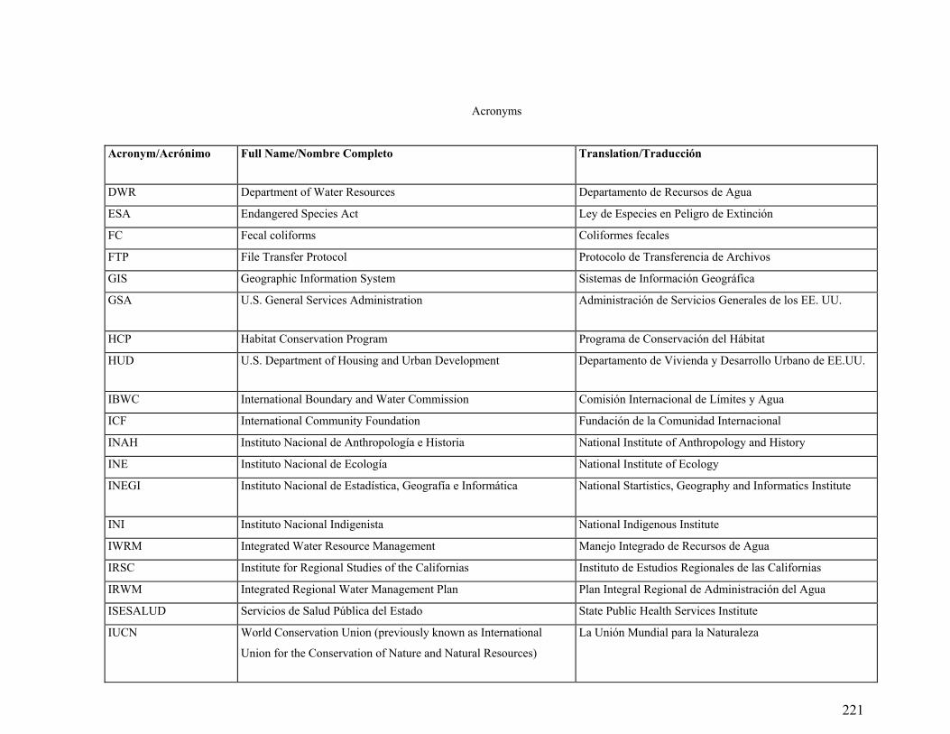
Acronyms
221
Acronym/Acrónimo Full Name/Nombre Completo Translation/Traducción
DWR Department of Water Resources Departamento de Recursos de Agua
ESA Endangered Species Act Ley de Especies en Peligro de Extinción
FC Fecal coliforms Coliformes fecales
FTP File Transfer Protocol Protocolo de Transferencia de Archivos
GIS Geographic Information System Sistemas de Información Geográfica
GSA U.S. General Services Administration Administración de Servicios Generales de los EE. UU.
HCP Habitat Conservation Program Programa de Conservación del Hábitat
HUD U.S. Department of Housing and Urban Development Departamento de Vivienda y Desarrollo Urbano de EE.UU.
IBWC International Boundary and Water Commission Comisión Internacional de Límites y Agua
ICF International Community Foundation Fundación de la Comunidad Internacional
INAH Instituto Nacional de Anthropología e Historia National Institute of Anthropology and History
INE Instituto Nacional de Ecología National Institute of Ecology
INEGI Instituto Nacional de Estadística, Geografía e Informática National Startistics, Geography and Informatics Institute
INI Instituto Nacional Indigenista National Indigenous Institute
IWRM Integrated Water Resource Management Manejo Integrado de Recursos de Agua
IRSC Institute for Regional Studies of the Californias Instituto de Estudios Regionales de las Californias
IRWM Integrated Regional Water Management Plan Plan Integral Regional de Administración del Agua
ISESALUD Servicios de Salud Pública del Estado State Public Health Services Institute
IUCN World Conservation Union (previously known as International
Union for the Conservation of Nature and Natural Resources)
La Unión Mundial para la Naturaleza
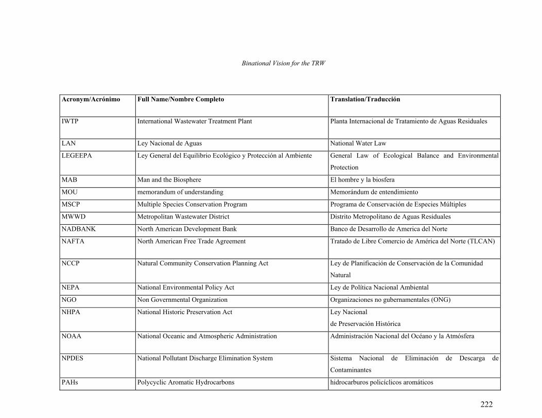
Binational Vision for the TRW
222
Acronym/Acrónimo Full Name/Nombre Completo Translation/Traducción
IWTP International Wastewater Treatment Plant Planta Internacional de Tratamiento de Aguas Residuales
LAN Ley Nacional de Aguas National Water Law
LEGEEPA Ley General del Equilibrio Ecológico y Protección al Ambiente General Law of Ecological Balance and Environmental
Protection
MAB Man and the Biosphere El hombre y la biosfera
MOU memorandum of understanding Memorándum de entendimiento
MSCP Multiple Species Conservation Program Programa de Conservación de Especies Múltiples
MWWD Metropolitan Wastewater District Distrito Metropolitano de Aguas Residuales
NADBANK North American Development Bank Banco de Desarrollo de America del Norte
NAFTA North American Free Trade Agreement Tratado de Libre Comercio de América del Norte (TLCAN)
NCCP Natural Community Conservation Planning Act Ley de Planificación de Conservación de la Comunidad
Natural
NEPA National Environmental Policy Act Ley de Política Nacional Ambiental
NGO Non Governmental Organization Organizaciones no gubernamentales (ONG)
NHPA National Historic Preservation Act Ley Nacional
de Preservación Histórica
NOAA National Oceanic and Atmospheric Administration Administración Nacional del Océano y la Atmósfera
NPDES National Pollutant Discharge Elimination System Sistema Nacional de Eliminación de Descarga de
Contaminantes
PAHs Polycyclic Aromatic Hydrocarbons hidrocarburos policíclicos aromáticos
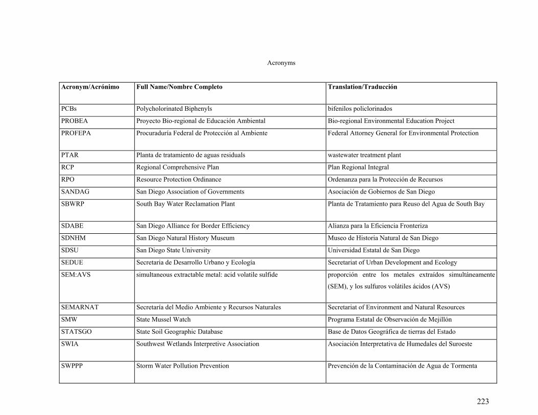
Acronyms
223
Acronym/Acrónimo Full Name/Nombre Completo Translation/Traducción
PCBs Polycholorinated Biphenyls bifenilos policlorinados
PROBEA Proyecto Bio-regional de Educación Ambiental Bio-regional Environmental Education Project
PROFEPA Procuraduría Federal de Protección al Ambiente Federal Attorney General for Environmental Protection
PTAR Planta de tratamiento de aguas residuals wastewater treatment plant
RCP Regional Comprehensive Plan Plan Regional Integral
RPO Resource Protection Ordinance Ordenanza para la Protección de Recursos
SANDAG San Diego Association of Governments Asociación de Gobiernos de San Diego
SBWRP South Bay Water Reclamation Plant Planta de Tratamiento para Reuso del Agua de South Bay
SDABE San Diego Alliance for Border Efficiency Alianza para la Eficiencia Fronteriza
SDNHM San Diego Natural History Museum Museo de Historia Natural de San Diego
SDSU San Diego State University Universidad Estatal de San Diego
SEDUE Secretaria de Desarrollo Urbano y Ecología Secretariat of Urban Development and Ecology
SEM:AVS simultaneous extractable metal: acid volatile sulfide proporción entre los metales extraídos simultáneamente
(SEM), y los sulfuros volátiles ácidos (AVS)
SEMARNAT Secretaría del Medio Ambiente y Recursos Naturales Secretariat of Environment and Natural Resources
SMW State Mussel Watch Programa Estatal de Observación de Mejillón
STATSGO State Soil Geographic Database Base de Datos Geográfica de tierras del Estado
SWIA Southwest Wetlands Interpretive Association Asociación Interpretativa de Humedales del Suroeste
SWPPP Storm Water Pollution Prevention Prevención de la Contaminación de Agua de Tormenta
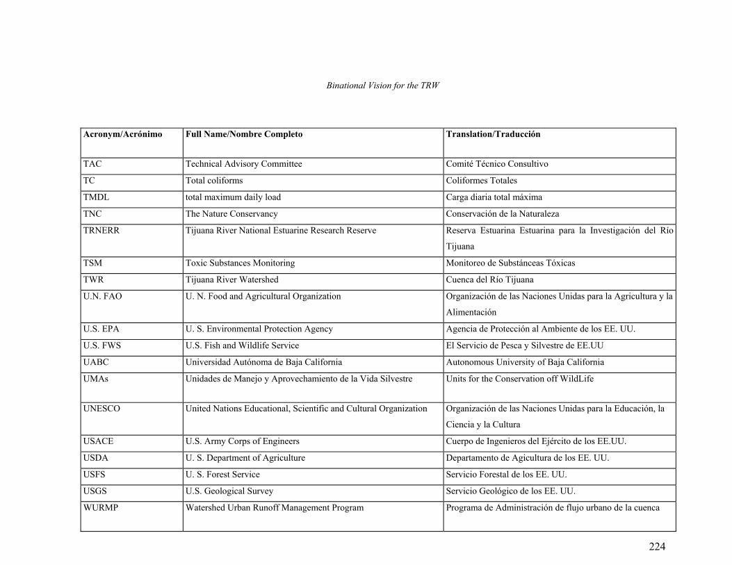
Binational Vision for the TRW
224
Acronym/Acrónimo Full Name/Nombre Completo Translation/Traducción
TAC Technical Advisory Committee Comité Técnico Consultivo
TC Total coliforms Coliformes Totales
TMDL total maximum daily load Carga diaria total máxima
TNC The Nature Conservancy Conservación de la Naturaleza
TRNERR Tijuana River National Estuarine Research Reserve Reserva Estuarina Estuarina para la Investigación del Río
Tijuana
TSM Toxic Substances Monitoring Monitoreo de Substánceas Tóxicas
TWR Tijuana River Watershed Cuenca del Río Tijuana
U.N. FAO U. N. Food and Agricultural Organization Organización de las Naciones Unidas para la Agricultura y la
Alimentación
U.S. EPA U. S. Environmental Protection Agency Agencia de Protección al Ambiente de los EE. UU.
U.S. FWS U.S. Fish and Wildlife Service El Servicio de Pesca y Silvestre de EE.UU
UABC Universidad Autónoma de Baja California Autonomous University of Baja California
UMAs Unidades de Manejo y Aprovechamiento de la Vida Silvestre Units for the Conservation off WildLife
UNESCO United Nations Educational, Scientific and Cultural Organization Organización de las Naciones Unidas para la Educación, la
Ciencia y la Cultura
USACE U.S. Army Corps of Engineers Cuerpo de Ingenieros del Ejército de los EE.UU.
USDA U. S. Department of Agriculture Departamento de Agicultura de los EE. UU.
USFS U. S. Forest Service Servicio Forestal de los EE. UU.
USGS U.S. Geological Survey Servicio Geológico de los EE. UU.
WURMP Watershed Urban Runoff Management Program Programa de Administración de flujo urbano de la cuenca

References
Aguado, E. 2005. “Precipitation”. In Tijuana River Watershed Atlas. Eds. SDSU, IRSC and Department of Geography and
Colegio de la Frontera Norte. Publ. Institute for Regional Studies of the Californias and San Diego State
University Press. San Diego, CA.
American Forests and U.S.F.S. 2003. Urban ecosystem analysis San Diego, CA: calculating the value of nature. 47. July.
(BECC) Border Environment Cooperation Commission. 2000. Improvement and Expansion of the Water and Wastewater
Systems for Tecate, Baja California. Border Environment Cooperation Commission.
Beck, L., Lamke, G. 1998. Tourism and Recreation. In The State of the Environment of the Tijuana River Basin, Working
Draft, eds. Institute for Regional Studies of the Californias, pp. 34-35. San Diego: IRSC.
Berstein, B., and Schiff, K.C. 2003. “The stormwater monitoring coalition: stormwater research needs in southern
California” in Southern California Coastal Water Research Project Biennial Report 2001-2002. Weisberg, S.B.,
Elmore, D. 2003 (eds). Relizon, Santa Ana, CA (May), pp 310-323.
Bleier, C. 2004. Principles for integrated planning in watersheds. Proceedings from the Integrated Planning Work Group of
the California Watershed Council, Oct. pp. 54.
Bolger, D., Allison A. C., Soule, M. E. 1991. Occurrence patterns of bird species in habitat fragments: Sampling,
extinction, and nested species subsets. The American Naturalist 137(2):155-66.
Brodine, S., Gresham, L. 1998. Human Health. In The State of the Environment of the Tijuana River Basin, Working Draft,
eds. Institute for Regional Studies of the Californias, pp. 29-33. San Diego: IRSC.
Brooks, H., Gersberg, R., Dhar, A. 2005. Detection and quantification of hepatitis A virus in seawater via real-time RT-
PCR. Journal of Virological Methods. Accepted 17 March. 9705: 1–10.
Brown, C. 2003. “New directions in binational water resource management in the U.S.-Mexico borderlands” the Social
Science Journal 40:555-572.
Cagle, F., Esepejel, I. 1998. Protected Areas of the Tijuana Watershed. In The State of the Environment of the Tijuana
River Basin, Working Draft, eds. Institute for Regional Studies of the Californias, pp. 43-48. San Diego: IRSC.
(CASWRCB) State Water Resources Control Board. 1994. San Diego Basin Plan for Region 9.
http://www.swrcb.ca.gov/rwqcb9/programs/basinplan.html. Accessed 10/14/04.
(CASWRCB) State Water Resources Control Board. 1996. Chemistry, Toxicity, and Benthic Community Conditions in
Sediments of the San Diego Bay Region: Final Report of the Bay Protection and Toxic Cleanup Program.
Division of Water Quality. Sacramento.
(CASWRCB) State Water Resources Control Board. 2000. Nonpoint source program strategy and implementation plan,
1998-2013. California Coastal Commission. January. pp. 166.
Calavita, N. 1998. Housing. In The State of the Environment of the Tijuana River Basin, Working Draft, eds. Institute for
Regional Studies of the Californias, p. 21. San Diego: IRSC.
California Air Resources Board. 2003. Air quality data. http://www.arb.ca.gov/aqd/aqdpage.htm. 5-24-04.
California Association of Realtors. 2004. www.car.org/index.php. 7-15-04.
225
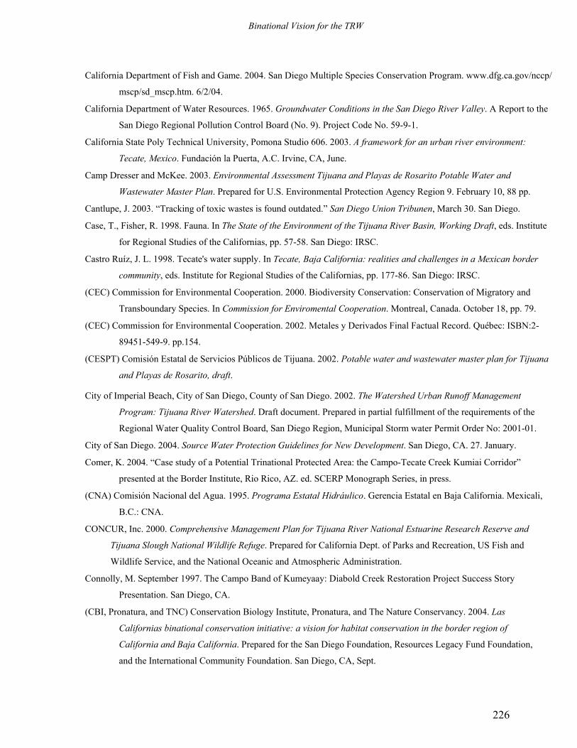
Binational Vision for the TRW
California Department of Fish and Game. 2004. San Diego Multiple Species Conservation Program. www.dfg.ca.gov/nccp/
mscp/sd_mscp.htm. 6/2/04.
California Department of Water Resources. 1965. Groundwater Conditions in the San Diego River Valley. A Report to the
San Diego Regional Pollution Control Board (No. 9). Project Code No. 59-9-1.
California State Poly Technical University, Pomona Studio 606. 2003. A framework for an urban river environment:
Tecate, Mexico. Fundación la Puerta, A.C. Irvine, CA, June.
Camp Dresser and McKee. 2003. Environmental Assessment Tijuana and Playas de Rosarito Potable Water and
Wastewater Master Plan. Prepared for U.S. Environmental Protection Agency Region 9. February 10, 88 pp.
Cantlupe, J. 2003. “Tracking of toxic wastes is found outdated.” San Diego Union Tribunen, March 30. San Diego.
Case, T., Fisher, R. 1998. Fauna. In The State of the Environment of the Tijuana River Basin, Working Draft, eds. Institute
for Regional Studies of the Californias, pp. 57-58. San Diego: IRSC.
Castro Ruíz, J. L. 1998. Tecate's water supply. In Tecate, Baja California: realities and challenges in a Mexican border
community, eds. Institute for Regional Studies of the Californias, pp. 177-86. San Diego: IRSC.
(CEC) Commission for Environmental Cooperation. 2000. Biodiversity Conservation: Conservation of Migratory and
Transboundary Species. In Commission for Enviromental Cooperation. Montreal, Canada. October 18, pp. 79.
(CEC) Commission for Environmental Cooperation. 2002. Metales y Derivados Final Factual Record. Québec: ISBN:2-
89451-549-9. pp.154.
(CESPT) Comisión Estatal de Servicios Públicos de Tijuana. 2002. Potable water and wastewater master plan for Tijuana
and Playas de Rosarito, draft.
City of Imperial Beach, City of San Diego, County of San Diego. 2002. The Watershed Urban Runoff Management
Program: Tijuana River Watershed. Draft document. Prepared in partial fulfillment of the requirements of the
Regional Water Quality Control Board, San Diego Region, Municipal Storm water Permit Order No: 2001-01.
City of San Diego. 2004. Source Water Protection Guidelines for New Development. San Diego, CA. 27. January.
Comer, K. 2004. “Case study of a Potential Trinational Protected Area: the Campo-Tecate Creek Kumiai Corridor”
presented at the Border Institute, Rio Rico, AZ. ed. SCERP Monograph Series, in press.
(CNA) Comisión Nacional del Agua. 1995. Programa Estatal Hidráulico. Gerencia Estatal en Baja California. Mexicali,
B.C.: CNA.
CONCUR, Inc. 2000. Comprehensive Management Plan for Tijuana River National Estuarine Research Reserve and
Tijuana Slough National Wildlife Refuge. Prepared for California Dept. of Parks and Recreation, US Fish and
Wildlife Service, and the National Oceanic and Atmospheric Administration.
Connolly, M. September 1997. The Campo Band of Kumeyaay: Diabold Creek Restoration Project Success Story
Presentation. San Diego, CA.
(CBI, Pronatura, and TNC) Conservation Biology Institute, Pronatura, and The Nature Conservancy. 2004. Las
Californias binational conservation initiative: a vision for habitat conservation in the border region of
California and Baja California. Prepared for the San Diego Foundation, Resources Legacy Fund Foundation,
and the International Community Foundation. San Diego, CA, Sept.
226
Conservation Biology Institute, Pronatura, The Nature Conservancy. 2004. Las Californias binational conservation
initiative: a vision for habitat conservation in the border region of California and Baja California. Prepared for
the San Diego Foundation, Resources Legacy Fund Foundation, and the International Community Foundation.
San Diego, CA, Sept.
Conservation International. 2004. http://www.biodiversityhotspots.org/xp/Hotspots/california_floristic/. Biological
hotspots. 7/6/04.
Corcuera, E., Steiner, F., Guhathakurta, S. 2000. Land Trust Mechanisms for Conservation. Journal of Borderlands
Studies XV(Fall):1-21.
County of San Diego. 1994. Otay subregional plan. County of San Diego Dept. of Planning and Land Use.
County of San Diego. 1995. Central Mountain Subregional plan. County of San Diego Dept. of Planning and Land use.
County of San Diego. 1998. General Plan 2020. County of San Diego Dept. of Planning and Land use.
County of San Diego. 2003. http://www.co.san-diego.ca.us/cnty/cntydepts/land use/planning/mscp/. County of San
Diego Multiple Species Conservation Program Web Site. 12-12-02.
County of San Diego. 2003b. 2003 Beach Closure and Advisory Report. Report by the Department of Environmental
Health. http://www.sdcounty.ca.gov/deh/lwq/beachbay/pdf/2003_beach_closure-advisory_report_0704.pdf.
Accessed 6/9/05.
County of San Diego. 2004. 2002-2003 Urban Runoff Report. San Diego, CA: MEC Analytical Systems, Inc.
Cuevas, T., CESPT. February 2004. Tijuana, B.C. Personal communication with the author.
Delgadillo, J. 2000. Floristica y ecologia del norte de Baja California. Divulgare 29 Y2 - enero-marzo:46-63.
Desmond, J. 1998. Estuarine Ecology. In The State of the Environment of the Tijuana River Basin, Working Draft, eds.
Institute for Regional Studies of the Californias, pp. 59-63. San Diego: IRSC.
(DGE) Dirección General de Ecología. 2003. Resolución de impacto ambiental para el relleno sanitario en Tijuana.
Tijuana, B.C., November. DGE-TIJ-2293/03 expediente 4.3.0129-MIA/03.
Diamond, J. 1975. The island dilemma; lessons of modern biogeographic studies for the design of natural reserves. Ecol.
Conservation 7:129.
Dudek and Associates, Inc. 1995. Groundwater management plan for the Tijuana River Basin summary report. Prepared
for the Tia Juana Valley County Water District (May) pp. 14.
(DWR and CASWRCB) Department of Water Resources and State Water Resources Control Board. 2004.
http://www.swrcb.ca.gov/funding/irwmgp/. Sacramento, CA. 12/4/04.
Environmental Law Institute. 2003. Legal tools and incentives for private lands conservation in Latin America: building
models for success. Environmental Law Institute. Washington, D.C. ISBN# 1-5876-059-5. pp. 206.
Ezcurra, E.M. 1998. “Conservation and sustainable use of natural resources in Baja California: an overview.” Prepared
for the San Diego Dialogue’s Forum Fronterizo policy luncheon series, (0ct.) pp. 15.
Forster, C. 2005 “Tecate Hydrogeology Assessment” Final Report to IRSC-SDSU. Salt Lake City, Utah. Mar 28. pp. 23
Ganster, P. 1996. Environmental Issues of the California-Baja California Border Region. Border Environment Reports
June (1):1-14227
Binational Vision for the TRW
June (1):1-14.
Ganster, P. 2004. NAFTA at 10 years: the California-Baja California border region. Working draft 4/14. pp. 9.
unpublished.
Gersberg, R. M., Wakida Kusunoki, F. T. 1998. Water Quality and Quantity. In The State of the Environment of the
Tijuana River Basin, Working Draft, eds. Institute for Regional Studies of the Californias, pp. 64-68. San
Diego: IRSC.
Gersberg, R., Dodge, D., Parsons, L., Zedler, J. 1994. Microbiological Water Quality of the Tijuana Estuary. Journal of
Border Health 10 (3):16-27.
Gersberg, R., Trindade, F., Nordby, C. 1989. Heavy Metals in Sediments and Fish of the Tijuana Estuary. Journal of
Border Health 5:5-15.
Gobierno Estatal de B.C. 2002. Programa sectoral de vivienda 2002
Gobierno del Estado de Baja California, SEDUE, SFA, CEA. 2004a. Plan Estatal Hidráulico. Mexicali, B.C. 174
Gobierno del Estado de Baja California, SAGARPA, FIRCO. 2004b. Plan estatal de rehabilitación de microcuencas.
Mexicali, B.C.
Gómez, R., Lozano, A. 1998. Health services in Tecate. In The State of the Environment of the Tijuana River Basin,
Working Draft, eds. Institute for Regional Studies of the Californias, pp. 29-33. San Diego: IRSC.
(GNEB) Good Neighbor Environmental Board. 2000. Fourth Report of the Good Neighbor Environmental Board to the
President and Congress of the United States. http://www.epa.gov/ocem/gneb/pdf/annrpt900eng.pdf. San Diego:
EPA, December. 10/14/04.
(GNEB) Good Neighbor Environmental Board. 2001. Fifth Report of the Good Neighbor Environmental Board to the
President and Congress of the United States. http://www.epa.gov/ocem/gneb/pdf/english2001gneb.pdf
(English) and http://www.epa.gov/ocem/gneb/pdf/spanish2001gneb.pdf (Spanish). Accessed 3/13/03.EPA.
December.
(GNEB) Good Neighbor Environmental Board. 2005. Eighth Report of the Good Neighbor Environmental Board to the
President and Congress of the United States. http://www.epa.gov/ocem/gneb. Accessed 6/29/05. San Diego:
EPA 130-R-05-001. February. pp.55.
Gosselin, P., Furgal, C., Ruiz, A. 2001. Environmental public health indicators for the U.S. – Mexico border region
concept document. Presentation to members of the Environmental Health Working Group, El Paso, Texas. July
26-27.
Graizbord, C., De la Fuente, E. in prep. Preservation of lands in the Border Region. In SCERP Monograph Series.
Border Institute, Rio Rico AZ: forthcoming.
Greenwood, N. 2005. “Soils”. In Tijuana River Watershed Atlas. Eds. SDSU, IRSC and Department of Geography and
Colegio de la Frontera Norte. Publ. Institute for Regional Studies of the Californias and San Diego State
University Press. San Diego, CA.
Guitiérrez, M. 2004. Presentation to stakeholders of the Tecate Urban River Park in Tecate, B.C., April.
Herzog, L., Graizbord, C. 1998. “Urban Structure”. In The State of the Environment of the Tijuana River Basin, Working
Draft, eds. Institute for Regional Studies of the Californias, pp. 14-18. San Diego: IRSC.
228

Holser, A. 2005. Exploring Water Supply Alternatives for Tecate, Mexico using a System Modeling Approach Master’s
thesis. University of Utah (March 23). Pp. 112.
IMPlan. 1999. Propuesta alternative de desarrollo para la cuenca del Arroyo Alamar. Tijuana, B.C.: IMPlan.
(INEGI) Instituto Nacional de Estadística e Geografía. 2004. “Baja California”
http://www.inegi.gob.mx/est/default.asp?c=697. Accessed 7-29-04.
(IRSC) Institute for Regional Studies of the Californias. 1997. “BorderLink”. In The Tijuana River Basin: Basic
Environmental and Socioeconomic Data, ed. F. Wakida, K. Riveles. San Diego: Institute for Regional Studies
of the Californias, SDSU.
(IRSC) Institute for Regional Studies of the Californias. 2000. International border area planning atlas. San Diego:
IRSC-SDSU.
Ja Jan. 2004. “Biweekly U.S.-Mexico border beach report monitoring of September 30th and October 1st , 2004” sent to
author.
Jerrett, M., Rey, S. Dufournaud, C., Jones, D. 2003. Accounting for the environmental “bottom line” along the U.S.-
Mexico border. Annals of the Assoc. of Amer. Geog. 93(1) pp. 67-88.
(JPL/SCERP-SDSU) Jet Propulsion Laboratory/Southwest Center for Environmental Research and Policy-San Diego
State University. 1994. “Transboundary environmental assessment and monitoring (TEAM) system for the
U.S.-Mexico border region”. Project proposal. Unpubl.
Kilpatrick, A. 1998. An Environmental Assessment Study of Indian Tribes Living in the U.S.-Mexico border Region
(Planning Phase). Final Report SCERP Project Number: IT98-1.
Kilpatrick, A., Wilken, M. 1998. Border Tribes. In The State of the Environment of the Tijuana River Basin, Working
Draft, eds. Institute for Regional Studies of the Californias, pp. 41-42. San Diego: IRSC.
Kjos, K., de la Rosa, M. 1998. Social Indicators. In The State of the Environment of the Tijuana River Basin, Working
Draft, eds. Institute for Regional Studies of the Californias, pp. 22-25. San Diego: IRSC.
Klein, J.M., Buckler, D.R. Osborn, K.J. 2002. Watershed approaches in the U.S.-Mexico border region—a focused effort
to ensure consistent and comparable information. Absract: UCOWR annual conference.
Leyva Aguilera, C., Aceves Calderón, P., Wilken-Robertson, M. Date unknown. Culrutal resources as a tool for
conservation and management. Unpublished report.
Line, D., Wu, J., Arnold, J., Jennings, G., Rubin, A. 1997. Water Quality of First Flush Runoff From 20 Industrial Sites.
Water Environmental Research 69::305-10.
Lozano, M. 1995. Physiochemical Characteristics of the Tecate River. Universidad Autónoma de Baja California.
Luderitz, V., Gerlach, F., Jupner, R., Calleros, J., Pitt, J., Gersberg, R. 2005. Biological Assessment of Tecate Creek
(U.S.-Mexico) with special regard to self-purification. Bull. Southern California Acad. Sci. 104 (1): 1-13.
MacArthur, R. H., and Wilson. 1967. The Theory of Island Biogeography. Princeton, NJ.: Princeton University Press.
Martínez, R., and Espejel, I. Date unknown. Conservation and management of ecosystems within and without protected
natural areas in Baja California. Environment 27(3). Pp. 10.
McPherson, M., Cliffton, C., Lupena, F. 2004. San Diego County 2004 Beach Closure & Advisory Report. County of
San Diego, San Diego, CA. pp. 31.
229
Binational Vision for the TRW
Medina, M. 2002. Municipal and hazardous waste management in Tecate. In Tecate, Baja California: Realities and
Challenges in Mexican Border Community, ed. P. Ganster, F. Cuamea, J. Castro Ruiz, A. Villegas, pp. 227-34.
IRSC-SDSU.
Merkel and Associates. 2004. Draft San Diego River Watershed Assessment. Prepared for San Diego River Watershed
Workgroup. San Diego. 97.
Metzner, C., McCoy, M. 1994. Man and the Biosphere Reserve System for the San Diego Border Region. Final report to
SCERP.
Meyer, S., Gersberg, R. 1997. Heavy Metals and Acid-volatile Sulfides in Sediments of the Tijuana Estuary. Bulletin of
Environmental Contamination and Toxicology 59:113-19.
Michel, S., Graizbord, C. 2002. Urban Rivers in Tecate and Tijuana: Strategies for Sustainable Cities. Tertiary Urban
Rivers in Tecate and Tijuana: Strategies for Sustainable Cities. San Diego.
Minnich, R., Vizcaino, E. 1998. Land of Chamise and Pines: Historical Accounts and Current Status of Northern Baja
Californias Vegetation. Berkeley, CA: University of California Press.
Montgomery, D. G., Sullivan, K. 1995. Watershed Analysis as a Framework for Implementing Ecosystem Management.
Water Resources Bulletin 31(3):369-86.
Moreno, D., Muñoz, V. 2003. El reto de la basura en Tijuana. Tijuana Trabaja. Tijuana, B.C. 156. Cuadernos para el
diálogo.
(MSCP) Multiple species conservation plan. 1996. MSCP Plan. San Diego.
Mumme, S. 2001. Minute 242 and beyond: challenges and opportunities for managing transboundary groundwater on
the U.S.-Mexico-Border. Natural Resources Journal 40.
Municipio de Tecate. 2003. Program de desarrollo urbano de centro de poblacion Tecate B.C. 2001-2022. Tecate, B.C.,
October. 122.
Naeem, S. C., Robert, Ehrilich, Golley, F., Hooper, D., et. al. 2000. Biodiversity and ecosystem functiong: maintaining
natural life support processes. Issues in Ecology, pp. 1-11.
(NAEPC) Native American Environmental Protection Coalition. 2005. “Accomplishments”. http://www.naepc.com.
Accessed 8/12/05.
Ney-Nifle, M., Marc, M. 1999. Habitat loss and changes in the species-area relationship. Conservation Biology 14(3):
893-98.
Oberbauer, T. 1999. La vegetacion del noreste de Baja California. Fremontia Edicion especial, Julio, pp. 16-22.
Ochoa, F. April 1, 2004. pers. comm. to author. Ensenada, B.C.
O’Connor. 1999. New strategies for America’s watersheds. National Academy Press, Washington, D.C. pp. 311.
Ojeda Revah, L. 2000. Land use and the conservation of natural resources in the Tijuana River Basin. In Shared Space:
Rethinking the U.S.-Mexico Border Environment, ed. L. A. Herzog, pp. 211-32. La Jolla, CA: Center for U.S.-
Mexican Studies, UCSD.
Ojeda, L. R. 2001. Changing land use patterns in the Tijuana River Watershed and the conservation of transborder
natural resources. In Is globalization overpowering democracy? The challenge for ecology, economy and
culture. June 12- 16, 2001, Prague, Villa Lanna.
230
Ojeda, L. 2002. Habitat fragmentation in the Tijuana River Watershed 1953-1994. In Tecate, Baja California: Realities
and Challenges in Mexican Border Community, ed. P. Ganster, F. Cuamea, J. Castro Ruiz, A. Villegas, pp. 163-
76. IRSC-SDSU.
O'Leary, J. 2005. “Vegetation”. In Tijuana River Watershed Atlas. Eds. SDSU, IRSC and Department of Geography and
Colegio de la Frontera Norte. Publ. Institute for Regional Studies of the Californias and San Diego State
University Press. San Diego, CA.
Peach, J., Williams, J. S. 2003. Population Dynamics of the U.S.-Mexican Border Region. San Diego: SCERP/SDSU
Press: SCERP Monograph series, forthcoming.
Parsons, California. 2004. Draft supplemental environmental impact statement for the Clean Water Act Compliance at
the South Bay International Wastewater Treatment Plant. Prepared for IBWC in cooperation with U.S.EPA.
Pasadena, CA. December.
Ponce, V. M. 2000. Sustainable management of water in the Ojos Negros Valley, Baja California. San Diego State
University, Universidad Autónoma de Baja California, Instituto Nacional de Investigaciones Agrícolas,
Forestales y Pecuarias.
Ponce, V. M. 2003. Flood hydrology of the binational Cottonwood Creek - Arroyo Alamar, California and Baja
California. SDSU.
Ponce, V. M. 2004. Hydrology and hydraulics for the Tecate Creek corridor restoration (2004-05). Report to IRSC-
SDSU. Accessed 7/15/05.
http://www.ponce.sdsu.edu/tecate_rio_parque_report_september2004.html#conclusions
Pronatura. 2002. Herramientas Legales para la Conservación de Tierras Privadas y Sociales, p. 145. Tertiary
Herramientas Legales para la Conservación de Tierras Privadas y Sociales. Mexico, D.F.
Pronatura. 2003. Las Californias Binational Conservation Initiative Localities Portfolios. Tertiary Las Californias
Binational Conservation Initiative Localities Portfolios. Ensenada, B.C.
Pronatura. 2004. Iniciativa binacional de conservatión "Las Californias". Phase 1 ( June).
R and G Associates. 2002. California/Baja California Industrial Wastewater Monitoring Pretreatment and Minimization
Program Needs Assessment. Prepared for CalEPA Border Affairs Unit. Sacramento, CA, Feb.
Ramírez, P., Director, CESPTE. March 2004. Tecate, Baja California. Pers. comm. to author.
Ramos, J.M. 2003. “Managing transborder cooperation on public security: the Tijuana-San Diego Region” Paper
presented at Research Seminar on Mexico and U.S. –Mexican Relations, The Center for U.S.-Mexican Studies,
UCSD, La Jolla, CA. (October 15), pp. 23.
Rangel Pérez, G. G., García Vega, B., Gene Jacobson, M., Ramos Jaramillo, W., Téllez Girón, T. 1998. Politics of Water
Management in the Tijuana River Watershed. In The Tijuana River Basin: Basic Environmental and
Socioeconomic Data, ed. F. Wakida, K. Riveles, pp. 29-55. San Diego: IRSC.
Regional Water Quality Control Board. 1994. Water quality control plan for the San Diego basin.
http://www.waterboards.ca.gov/sandiego/programs/basinplan.html. Accessed 5/11/05.
Rempel, R. 1992. Hydrogeoglical assessment of the Tijuana River Valley. Report to the CASWRCB. Feb 26. pp.18.
231
Binational Vision for the TRW
Rey, S., Clement, N. 1998. Economy. In The State of the Environment of the Tijuana River Basin, Working Draft, eds.
Institute for Regional Studies of the Californias, pp. 5-7. San Diego: IRSC.
Rey, S., Ganster, P., del Castillo, G., Alvarez, J., Schellhammer, K., et al. 1998. The San Diego-Tijuana region. In
Integrating cities and regions: north american faces globalization, ed. J. W. Wlikie, C. E. Smith, pp. 105-64.
Guadalajara: Universidad de Guadalajara.
Salinas, D. 2005. “Planean que Arroyo Alamar sea proyecto ambientalista” Frontera newspaper (6 July).
San Diego County Water Authority. 1997. Water Resources Plan: Groundwater Report (Executive Summary).
San Diego County Water Authority. 2000. Urban Water Management Plan. San Diego, CA.
San Diego County Water Authority. 2003. San Diego County Water Authority fact sheet. San Diego County Water
Authority. 2 pg.
San Diego Metropolitan Wastewater Department. 2004. Facilities: SBWRP.
http://www.sannet.gov/mwwd/facilities/southbay.shtml. 6/1/04.
(SANDAG) San Diego Association of Governments. 1999. 2020 Cities/County forecast for the San Diego region.
SANDAG Info. San Diego. Sept-Oct No. 5.
(SANDAG) San Diego Association of Governments. 2002. SANDAG's Water Quality Element of its Regional Growth
Management Strategy for 2020. SANDAG. January.
(SANDAG) San Diego Association of Governments. 2003. Regional comprehensive plan technical appendix: water
supply and delivery system. San Diego.
(SANDAG) San Diego Association of Governments. 2003. Conference Proceedings from the 2003 Binational Annual
Conference - Homeland Security, Challenges and Opportunities for the San Diego-Northern Baja California
Region. San Ysidro, CA. July 11.
(SANDAG) San Diego Association of Governments. 2004. Regional comprehensive plan for the San Diego region. San
Diego, July.
(SANDAG) San Diego Association of Governments. 2005. “About SANDAG”. http://www.sandag.org. Accessed
6/21/05.
(SANDAG) San Diego Association of Governments. 2005. “Borders Committee Agenda Item No 2: Overview of
lanning efforts in the Otay Mesa corridor”. http://www.sandag.org. Accessed 6/29/05.
(SDNHM) San Diego Natural History Museum. 2005. San Diego Natural History Museum website.
http://www.sdnhm.org. Accessed 7/15/05.
Saxod, E. 2004. San Diego, CA, October. Conversation with author.
(SDSU and COLEF) San Diego State University and Colegio de la Frontera Norte, eds. 2002. San Diego-Tijuana Border
Area Planning Atlas. San Diego: SDSU Press, IRSC.
(SDSU and COLEF) San Diego State University and Colegio de la Frontera Norte, eds. 2005. Tijuana River Watershed
Atlas. Eds. SDSU, IRSC and Department of Geography and Colegio de la Frontera Norte. Publ. Institute for
Regional Studies of the Californias and San Diego State University Press. San Diego, CA.
232
SDSU, UABC, COLEF. in prep. Quality of life in the greater San Diego-Tijuana-Tecate-Playas de Rosarito region. San
Diego, CA: IRSC.
Secretaria del Patrimonio Nacional. 1974. Canalización del río de Tijuana. In Calafia Revista de la Universdad. publ.
UABC. pp 23-25.
(SEMARNAT) Secretaria del Medio Ambiente y Recursos Naturales. 2002. Diario oficial, Miércoles 6 de marzo de
2002NOM-059-ECOL-2001. In (Segunda Sección) 1. Protección ambiental-Especies nativas de México de flora
y fauna silvestres-Categorías de riesgo y especificaciones para su inclusión, exclusión o cambio-Lista de
especies en riesgo. Mexico City.
Serrano González, J. 2002. Sitios con evidencias culturales en el municipio de Tecate, Baja California. Centro del INAH
en Baja California, November. pp. 46.
Southern California Coastal Water Research Project. 1998. Southern California Bight 1994 Pilot Project: Executive
Summary. Westminster, CA. http://www.sccwrp.org. pp. 21
State of California. 2005. “California waste stream profiles”. http://www.ciwmb.ca.gov/Profiles/County/. Accessed 5-5-
05.
Svejkosky, J. 2004. Satellite and aerial coastal water quality monitoring in the San Diego/Tijuana. Two year summary
report. Ocean Imaging, Inc. Solana Beach, CA. July 24.
Sweedler, A. 1998. Air Quality of the Tijuana Basin. In The State of the Environment of the Tijuana River Basin,
Working Draft, eds. Institute for Regional Studies of the Californias, pp. 69-71. San Diego: IRSC.
Sweedler, A. 2005. “Air Quality”. In Tijuana River Watershed Atlas. Eds. SDSU, IRSC and Department of Geography
and Colegio de la Frontera Norte. Publ. Institute for Regional Studies of the Californias and San Diego State
University Press. San Diego, CA.
(SWIA) Southwest Wetlands Interpretive Association. 1999. Draft Goat canyon/ Cañon de los Laureles enhancement
plan. Prepared for the State Coastal Conservancy, the Ca. Dept. of Parks and Recreation, The U.S. EPA with
consulting services of Philip Williams and Assoc., Land Restoration Assoc., and Tierra Environmental
Services. (June), pp 94.
The Nature Conservancy. 2000. The Five-S Framework for Site Conservation: A Practitioner’s Handbook for Site
Conservation Planning and Measuring Conservation Success. 2 Y2 - June.
Tolinson, R.V., Christensen, B., Hickman, JD. 1995. Preliminary border environment needs assessment report. Prepared
by CalEPA (April 20), pp. 267.
U.N. Department of Economic and Social Affairs. 2005. Changing unsustainable patterns of consumption and
production: human settlements and water. Background paper no.4. Division for Sustainable Development.
Thirteenth Session. New York, April 11-12. pp. 27.
U.N. Department of Economic and Social Affairs. 2005b. Catalyzing Change: A handbook for developing integrated
water resources management (IWRM) and water efficiency strategies. Background paper no.5. Commission on
Sustainable Development. Thirteenth Session. New York, April 11-12. pp. 51.
U.N. Department of Economic and Social Affairs. 2005c. Freshwater management: policy options and possible actions
to expedite implementation. Report of the Secretary-General. Commission on Sustainable Development.
233
Binational Vision for the TRW
Thirteenth Session. New York, April 11-12. pp. 19.
(UNESCO) United Nations Educational, Scientific, and Cultural Organization. 2004. "World heritage fund.” Accessed
3/1/04. http://whc.unesco.org/toc/mainf8.htm.
U.S. Army Corps of Engineers. 1999. Tijuana River Watershed management study, San Diego County, California: draft
project study plan. Los Angles District, Planning Division, Water Resources Branch (March), pp. 49.
U.S. Army Corps of Engineers. 2005. “Regulatory program Overview”
http://www.usace.army.mil/inet/functions/cw/cecwo/reg/oceover.htm. Accessed 7/11/05.
U.S. Census Bureau. 2004. http://factfinder.census.gov. Accessed 7/1/04.
U.S. Department of Energy. 2002. Conceptual model for the Tijuana River aquifer southwest border project. Grand
Junction, Colorado: DOE. GJO-2002-367-TAC OP 13.3-1 (Sept).
U.S. Department of Energy. 2003. Groundwater flow model for the Tijuana River Basin. Southwest border project.
Grand Junction, Colorado: DOE. GJO-2003-408-TAC.
U.S.D.O.I. Bureau of Reclamation. 2003. Pajaro Valley Water Management Agency Revised Basin Management Plan
Environmental Impact Study. Aug.
(U.S.EPA) U.S. Environmental Protection Agency, Office of Water. 1998. “Wastewater Primer”. Accessed 7/15/05.
http://www.epa.gov/npdes/pubs/primer.pdf. pp. 16.
(U.S. EPA and IBWC) U.S. Environmental Protection Agency and International Boundary and Water Commission.
1999. Fact sheet: about the International wastewater treatment plant.
http://www.epa.gov/region09/water/iwtp/ibw
(U.S.EPA) U.S. Environmental Protection Agency. 2000. “Cottonwood watershed profile”.
www.epa.gov/surf3/hucs/18070305/index.html. Accessed 11/2001.
(U.S. EPA) U.S. Environmental Protection Agency. 2004. “Ozone Trends”.
http://www.epa.gov/ozonedesignations/ozonetrends.htm. Accessed 5/25/04.
(U.S.EPA) U.S. Environmental Protection Agency, Office of Water. 2004. “Drinking Water Contaminants”.
http://www.epa.gov/safewater/hfacts.html. Accessed 5/25/04.
(U.S.EPA) U.S. Environmental Protection Agency. 2005. “First Border 2012 Binational Site Stabilization Action”
http://www.epa.gov/region09/waste/features/metales/. Last updated on Monday, June 20th, 2005 Accessed
8/12/05.
(U.S. EPA and SEDUE) U.S. Environmental Protection Agency and Secretaría de Desarrollo Urbano y Ecología. 1992.
Integrated Environmental Plan for the Mexican-U.S. Border Area, First Stage (1992-1994). A92-171.1 pp. (USFWS) U.S. Fish and Wildlife Service. 1996. Draft environmental assessment of proposed vernal pools stewardship
project. San Diego National Wildlife Refuge. San Diego, CA: USFWS, November.
(USDA and U.S.F.S) U.S. Department of Agriculture and U.S. Forest Service. 2004. Southern California Land
Management Plan Revisions Draft. San Diego, May. R5-MB-052-cd.
(USGS) U.S. Geological Survey. 2004. Calendar Year Streamflow Statistics for California.
http://nwis.waterdata.usgs.gov. Accessed 5/30/04.
234

University of Idaho. 2004. http://soils.ag.uidaho.edu/soilorders/orders.htm. Accessed 10-5-04.
Valdez Flores, J.R. 2001. Levantamiento de datos Zona Kumiai. Available at CUNA. August.
Vargas Téllez, M. April 1, 2004. Tertiary. Ensenada, B.C.
Vázquez, R. August 2004. Tecate, B.C. pers comm. to author.
Villarino, A. 2004. City of San Diego Metropolitan Wastewater Department. San Diego, CA, October. conversation with
author.
Vizcaino, E. R., Bredceda, A., Castellon, J. de J., de la Cueva, H., Hinojosa, A., Minnich, R. (eds.). 2005. “Workshops to
set conservation priorities for the terrestrial portion of the Baja California peninsula f the Baja California
peninsula” unpubl. Wakida, F., Riveles, K. 1997. Borderlink 1997. San Diego: Institute for Regional Studies of the Californias, San Diego
State University.
Water Environment Federation. 1998. “Watershed management: moving from theory to implementation” conference
proceedings. Denver, Colorado (May 3-6).
Westman, W. E. 1985. Ecology, Impact Assessment, and Environmental Planning. New York: John Wiley and Sons.
White, M. D., Stallcup, J. A., Comer, K., Vargas, M. A., Beltran-Abaunza, J. M., et al. 2004. SCERP Monograph Series,
Border Institute, Rio Rico, AZ, p. 23.
Winters, Mayda. February 2005. San Diego, CA. pers. comm. with the author.
Wilken-Robertson, M., Valdez Flores, J.F., Gonzalez, J.S. 2002. Indigenous Cultural Heritage Resource Study of the
Tecate-Nejí-Rumerosa Region: Part 1 Overview. Prepared for the International Community Foundation.
Ensenada, B.C. 18.
Wilken, M. 2005. Border 2012 fund update. Report to the Water Task Force (May 26).
Willoughby, M.R. 2005. GIS-based land use suitability modeling for open space preservation in the Tijuana River
Watershed. Masters thesis, Geography Dept. San Diego State University, San Diego, Ca. (Spring). Pp. 134.
Wright, R. 2005. “Hydrography”. In Tijuana River Watershed Atlas. Eds. SDSU, IRSC and Department of Geography
and Colegio de la Frontera Norte. Publ. Institute for Regional Studies of the Californias and San Diego State
University Press. San Diego, CA.
Wright, R., Ries, K., Winckell, A. 1995. Identifying Priorities for a Geographic Information System (GIS) for the
Tijuana River Watershed: Applications for Land Use, Planning, and Education, p. 93. San Diego, CA: Institute
for Regional Studies of the Californias, San Diego State University.
Wright, R. D., Baron, K., Conway, K., Warner, R. 2000. Flood hazard and risk assessment modeling with GIS in the
transborder Tijuana River watershed, p. 15. Watershed 2000. Vancouver, BC, Canada.
Zúñiga, W. 2003. “Holistic vision and ecosystemic approach on basins and water” presentation to BWAC (24 April).
Wildernet. 2004. “Destination locator: San Diego County”
http://areas.wildernet.com/pages/area.cfm?areaID=0502andCU_ID=1. 10-12-04. Accessed 5/18/05.
235

Binational Vision for the TRW
236

Appendices
237
Binational Vision for the TRW
238
Appendices 1. Appendix: BWAC responsibilities and members..................................................................................239 2. Appendix: Stakeholders.........................................................................................................................243 3. Appendix: Resources, Agencies, and NGOs in the Tijuana River Watershed ......................................247 4. Appendix: 266 Priorized Actions for the TRW from Stakeholder Meeting..........................................267 5. Appendix: Significant cultural and historical monuments in the TRW ................................................289 6. Appendix: Simple things residents can do ............................................................................................309 7. Appendix: Available data for water quantity ........................................................................................313 8. Appendix: Availble data for water quality ............................................................................................319 9. Appendix: Avaible data for ecosystems and natural resources .............................................................323 10. Appendix: Available data on solid and hazardous waste ....................................................................325 11. Appendix: Available data for air quality .............................................................................................329 12. Appendix: Available data for socioeconomic issues ...........................................................................333 13. Minutes from 2004 stakeholder meeting .............................................................................................341
239
1. Appendix: BWAC responsibilities and members
The Binational Watershed Advisory Committee (BWAC) provides guidance for the Binational
Vision for the Tijuana River Watershed. The duties of members BWAC are to:
• Attend quarterly meetings • Help develop the Vision Documents • Review and add to the website and its databases • Help identify stakeholders • Facilitate outreach to stakeholders • Network with decision makers • Represent the Binational Tijuana River Watershed Advisory Council
BWAC Co-Chairs: Saxod, Elsa Office of Binational Affairs, City of San Diego Silvan, Laura Proyecto Fronterizo de Educacion Ambiental A.C.
Name and Affiliation:
Ávila Niebla, Miguel Ángel
Comisión Estatal de Servicios Públicos de Tijuana (CESPT)
Borja Medina, Myrna Yolanda
Dirección Municipal de Ecología
Brightwood, Sarah Livia
Fundación La Puerta, A.C.
Connolly, Michael
Campo Environmental Protection Agency
Cueva Lopéz, Toribio
Comisión Estatal de Servicios Públicos de Tijuana (CESPT)
Binational Vision for the TRW
Diáz, F. Javier
Mexican Consulate of San Diego
Espinoza, Roberto
Comisión Internacional de Límites y Aguas
Fege, Anne S.
San Diego Natural History Museum
Fege, Dave
USEPA Border Liaison Office
González Aguirre, Eduardo Germán
Tecate
Guzmán, Saúl
Secretaria de Medio Ambiente y Recursos Naturales (SEMARNAT)
Holler, Ivan
County of San Diego
Ibarra, Enrique Villegas
Dirección General de Ecología
Kiy, Richard
International Community Foundation
Muñoz, Virgilio
Tijuana Trabaja
Nevarez, Ana L.
Loponti Holdings, Inc.
Oberbauer, Tom
County of San Diego
Peña, Carlos
International Boundary and Water Commission
Phillips, Clay
City of Imperial Beach, Tijuana River National Estuarine Research Reserve
(TRNERR)
Ramírez Pineda, Patricia
Comisión Estatal de Servicios Públicos de Tecate (CESPTe)
240
1. Appendix: BWAC responsibilities and members
Roman Calleros, Jesús
Universidad Autónoma de Baja California (UABC)
Rosquillas, Antonio
Dirección de Protección Civil
Saenz, Ron
San Diego Association of Governments (SANDAG)
Salzmann, Mario
Fundación la Puerta, A.C.
Schlachter, Joyce
Bureau of Land Management
Tañor Q., Onésimo
Dirrección Municipal de Ecología
Valdez, Victoria
Arch-Vic Construction
Vargas Rodríguez, Juan
Presidencia Municipal de Tecate
Wilken, Mike
El Instituto de Culturas Nativas (CUNA)
Winkelman, Doretta
Executive Director and Co-founder of PROBEA
Zavala, José Carmelo
Nacional de la Industria de Transformación (CANACINTRA)
Zepeda Berrelleza, Hugo
Secretaria de Medio Ambiente y Recursos Naturales (SEMARNAT)
241
Binational Vision for the TRW
RESEARCH TEAM
The Binational Vision for the Tijuana River Watershed working team consists of
researchers from San Diego State University, el Colegio de la Frontera Norte, and the
Secretaria de Fomento y Agropequaria. The team drafts documents, facilitates
stakeholder involvement, and coordinates meetings and events, among other duties.
Ultimately, the team will produce a Binational Vision document that reflects
stakeholders’ views of the desired state of the watershed for the near and distant future.
Dr. Paul Ganster, San Diego State University
Dr. Richard Wright, San Diego State University
Dr. José Luis Castro Ruiz, el Colegio de la Frontera Norte
M.C. Walter R. Zúñiga, Universidad Autónoma de Baja California
Katherine Comer, San Diego State University
242
2. Appendix: Stakeholder responsibilities, meeting dates, and member
organizations
Stakeholder responsibilities:
• Attend two annual meetings
• Comment on watershed goals and objectives
• Identify activities and actions needed in the watershed
• Prioritize the activities and actions
• Review final Vision document
Stakeholder organizations and meeting dates for fall 2003:
Estuary (Silver Strand Aquatic Center—Thursday, September 4th 1:00 pm-4:30 pm
19 Participants. Tijuana River National Estuarine Research Reserve (TRNERR); Conservation
Biology Institute (CBI); California Environmental Protection Agency (Cal/EPA); Dirección de
Protección Civil, Tijuana; Southwest Wetlands Interpretive Association (SWIA;, San Diego
State University (SDSU); California Sea Grant, Cleveland National Forest;El Colegio de la
Frontera Norte (COLEF); Instituto de Culturas Nativas de Baja California (CUNA); Regional
Water Quality Control Board (RWQCB); County of San Diego; San Diego Audubon Society;
San Diego Natural History Museum (SDNHM) y la Oficina del Senadora Denise Moreno
Ducheny.
Tijuana I (Hotel Camino Real)—Thurs., September 18th 10:30am-2:00 pm
37 Participants. Comisión Estatal de Servicios Públicos de Tijuana (CESPT); Cámara Nacional
de la Industria de la Trasformación (CANACINTRA); Dirección Municipal de Ecología;
Comisión Estatal del Agua (CEA); International Boundary and Water Commission (IBWC-
CILA); Dirección General de Ecología (DGE; County of San Diego; Fundación la Puerta, A.C.;
Surfrider Foundation, Instituto de Culturas Nativas de Baja California (CUNA), Tijuana Trabaja,
A.C.; Universidad Autónoma de Baja California (UABC); San Diego State University (SDSU);
243
Binational Vision for the TRW
El Colegio de la Frontera Norte (COLEF); Indiana University; Centro de Enseñanza Técnica y
Superior (CETYS); Ecológico, S.C.; Baja Environmental de México, S.C.; Centro de Estudios
Urbanos (CEUSS); ALAR, S.C.; Rancho Ontiveros/Loponti Holdings, Inc.
Tijuana II (Hotel Camino Real)—Saturday, September 20th 10:30am-2:00 pm
26 Participants. Universidad Tecnológica de Tijuana (UTT); la Universidad Autónoma de Baja
California (UABC); Dirección Municipal de Ecología; Instituto Municipal de Planeación
(IMPLAN); Comisión Estatal de Servicios Públicos (CESPT); Dirección General de Ecología
(DGE); Protección Civil de Ensenada; Administración Urbana Tijuana; Instituto de Culturas
Nativas de Baja California (CUNA); El Colegio de la Frontera Norte (COLEF); San Diego State
University (SDSU); Arc-Vic
Tecate (Hotel Dorado)—Thursday, September 25th 6:00 pm-9:30 pm
59 Participants. Fondo Regional de Mujeres Nativas, Baja California, San Antonio Necua;
Proyecto Fronterizo de Educación Ambiental (PFEA); Comunidad Kumiai de Peña Blanca;
Comunidad Kumiai de Juntas de Neji; Fundación La Puerta, A.C.; Lluvia del Sur de Colosio;
Proyecto Paz y Dignidad A.C.; Defensa Ciudadana Comité de Participación; INEH; Secretaría de
Fomento Agropecuario (SFOA); Riod-Mex; Durán y Asociados; Terra Peninsular; Proyecto
Autosustentable El Tecolote; CODAPEC; Municipio de Tecate (Presidencia Municipal,
Dirección de Administración Urbana, Obras Públicas, Regidores, Relaciones Públicas del
Ayuntamiento); SIDUE Delegación Tecate; Presidencia Municipal Valle de las Palmas; Colonia
Valle de las Palmas; Consejo de Administración del Valle de las Palmas; Cervecería
Cuauhtémoc Moctezuma; Rancho Ojai Tecate KOA; Asociación de Ganaderos Tecate; PACCSA
Ingeniería; Solarios, Arena Consultores Ambientales; Colegio de Ingenieros Civiles de Tecate;
Universidad Autónoma de Baja California (UABC); Centro de Enseñanza Técnica y Superior,
Tijuana (CETYS); Universidad Iberoamericana Noreste; Instituto de Culturas Nativas de Baja
California (CUNA); San Diego State University (SDSU).
244
2. Appendix: Stakeholder responsibilities, meeting dates, and member organizations
Campo (Mountain Health Community Services Center)—Monday, October 6th
6:00pm- 9:30pm
32 Participants. Mountain Empire Historical Society; Lake Morena Village Council; Mountain
Health and Community Services; Backcountry Against Dumps; Boulevard Sponsor Group;
Mountain Empire Resources Information Taskforce (MERIT); Campo/ Lake Morena Planning
District; Bureau of Land Management (BLM); the Guardian Newspaper; Campo EPA; City of
Imperial Beach, City of San Diego Water District, Instituto de Culturas Nativas de Baja
California (CUNA), Comisión Estatal de Servicios Públicos de Tecate (CESPTE);
residents/ciudadanos; ranchers/ganaderos; well drillers/perforistas; San Diego State University
(SDSU); Arc-Vic Construction.
245

Binational Vision for the TRW
246
247
3. Appendix: Resources, Agencies, and NGOs in the Tijuana River Watershed
The resources listed below are organized as follows: Background on Watersheds, Education and
Outreach Programs; Centers for Environmental Education; Programs for Community
Involvement; Environmental Networks; and Policy, Regulation and Research. These resources
are organized for the programming needs of formal and informal educators, citizen outreach
program designers and in some cases municipal outreach educators.
Background on Watersheds
Groundwater and Wetlands (U.S.) - a watershed science interactive website, includes an
introduction to the hydrologic cycle, rock properties, groundwater systems, high plains aquifers,
human modifications to groundwater systems, an introduction to wetlands, destruction of
wetlands and quizzes and exercises. Additional weblinks.
http://www.mhhe.com/earthsci/geology/mcconnell/demo/index.html
Communicating Ecosystem Services (U.S.) - The Union of Concerned Scientists (UCS) and the
Ecological Society of America (ESA) project Communicating Ecosystem Services focuses on
the valuable but under-appreciated services that nature provides. The purpose of the project is to
increase the public awareness of the importance of ecosystem services, and the promotion of the
extension of our country’s biological resources. It includes a series of tool kits and a website to
help achieve the goal. http://www.esa.org/ecoservices/
U.S. Environmental Protection Agency, EPA (U.S.) - About water by regions and state (linked
to water resources offices of each state), historical perspectives about water, summaries of water
conferences sponsored by the EPA. http://www.epa.gov/water/. http://www.epa.gov/surf
San Diego and Tijuana Education and Outreach Programs
Aquatic Adventures (U.S.) - provides educational programs that connect underserved youth to
science, inspire environmental action, and increase exposure to marine habitats. These programs
engage youth in unique experiences that reveal new opportunities and engender valuable skills,
Binational Vision for the TRW
248
empowering each individual to fulfill their potential. Aquatic Adventures facilitates five
programs as well as large community events. Programs integrate language arts, math, and social
studies and are aligned with California State Standards.http://www.aquaticadventures.org
Communities Alive In Nature (U.S.) - is an applied science, math, language arts and technology
program. It uses the natural and surrounding school environments as a framework for learning or
EIC (see the State Education & Environment Roundtable). It is dedicated to improving academic
achievement and developing environmental literacy in students and teachers. CAN process
focuses on the science concept, clarifies the concept with hands-on activities, followed by
concept application in field studies and restoration activities. Curriculum is augmented with the
adopted text and correlated to state content standards. The Adopt a Watershed curriculum is
incorporated in the program, with customized field assessment and restoration features of the San
Diego environment. CAN is a Best Practices Program recognized by The Chamber Foundation’s
Business Roundtable for Education. mailto:[email protected]
The Nature School (U.S.) - promotes environmental awareness and education by offering
programs on coastal creeks, fresh water habitat, stream ecology, fishery conservation and water
quality monitoring. The School is involved in coastal creek and fresh water habitat advocacy;
stream ecology and fishery conservation education; in class fish hatchery and field science, and
water quality monitoring. Contact: 619.224.2003.
Project Clean Water (U.S.) - represents a collective effort by the municipalities of San Diego
County. More than 100 stakeholders are involved and committed to make a collective effort to
assure Clean Water in the San Diego region. There is a strategic plan for the region, updates
from each of the Technical Advisory Committees (TAC) in science/technology,
legislative/funding and education/outreach. There is an inventory of education and outreach
programs in the Region and in California. http://www.projectcleanwater.org/index.html
Project SWELL - Stewardship: Watershed Education for Lifelong Leadership (U.S.) -The
beginnings of watershed curriculum written for San Diego Schools consisting of worksheets
addressing urban runoff originating from school grounds for grade 5. There is a set of worksheets
addressing runoff from different areas, effects to groundwater, rivers and ocean. Contact: San
Diego City Schools, Science Department
3. Appendix: Resources, Agencies, and NGOs in the Tijuana River Watershed
249
Proyecto Bio-regional de Educación Ambiental, PROBEA (MEX) - a program of the San
Diego Natural History Museum, PROBEA is a binational, inter-institutional, multidisciplinary
collaboration between partners who seek to inspire teachers and community workers through
environmental education. It focuses on strengthening communities through trainings and active
involvement in our bio-region, as well as builds relationships between neighbors through
collaborations and sharing ideas and resources. Founded in 1991, PROBEA has been facilitating
environmental education programs and events in San Diego and the Baja California peninsula
since 1993. PROBEA designs innovative curricula to facilitate environmental education
workshops and to spur enthusiasm for education among scientists, conservationists, volunteers
and teachers. The program uses innovative methodology to introduce environmental themes and
activities promoting an earth stewardship ethic. PROBEA unites communities in conservation
efforts through education and training and strengthens the relationships between Mexico and the
U.S. by collaborating on projects and sharing ideas and resources. PROBEA supports citizens in
caring for their environment to create a more sustainable future. mailto:probea@ hotmail.com.
http://www.sdnhm.org/education/binational
Proyecto Fronterizo de Educación Ambiental A.C., PFEA (MEX) - is a civil organization
dedicated to the development of change-generating processes in environmental practice and
policy, at the local and international levels. Their goal is to promote efficiency in social
participation based on partnership building and facilitating citizens' access to environmental
information. PFEA seeks to strengthen the institutional framework to achieve the development of
a sustainable society. PFEA is a non-profit, non-political organization with the following
principles: ecosystems determine the quality of life; the community is co-responsible for
environmental preservation; and each individual has the right to access information that
guarantees his right to a healthy environment. Only a democratic, informed and participatory
society is able to prevent and face present environmental challenges.
http://www.proyectofronterizo.org
San Diego County Office of Education Outdoor Education (U.S.) -
The Splash Van: A mobile science lab featuring five different stations where kids use computers,
Binational Vision for the TRW
250
microscopes, chemistry experiments and living creatures to learn about water quality and insect
life. The lab teaches students the connection between human activities and the health of the
environment.
The Green Machine: An interactive exploration program that teaches agricultural awareness at
three stations: a soils research station with live earthworms, the water cycle station with dramatic
role play scenarios and costumes, and an integrated pest management station with interactive role
play and insect puppets. Both the Green Machine and the Splash Van are operated by the San
Diego County Office of Education. Contact: 858.694.7000
The San Diego National Wildlife Refuge Complex (U.S.) - along with partners Chula Vista
Nature Center and Tijuana Estuary Visitor Center, offers three environmental education
experiences for grades K-6 that explore plants, animals, sea life and their habitats in the
classroom and in the field. They include: Sweetwater Safari, Tijuana Estuary Explorers and
Habitat Heroes. All materials meet state standards, and some transportation grants are available.
“The Pelican Van” depicts area ecosystems and wildlife and is available to visit Orange County
schools. Other environmental education opportunities are available at several of our San Diego
and Orange County Refuges. Contact: 619.691.1262. http://sandiegorefuges.fws.gov
San Diego County Water Authority Education for Teachers & Students (U.S.) - The San Diego
County Water Authority provides FREE educational programs and materials for grades K-12 to
San Diego County educators. Some materials require an in-service at your school. To schedule
an in-service or classroom presentation, or order materials, please call the School Education
Program. Mini grants are also available for school based water projects.
http://www.sdcwa.org/education/teachers.phtml
Solana Center for Environmental Innovation (U.S.) - formerly known as Solana Recyclers,
dedicated to environmental education, resource conservation, and sustainable agriculture. The
Solana Center provides information and opportunities for citizens and businesses to take
responsible action toward conserving natural resources and building a sustainable future. The
Center will provide interactive class presentations which focus on pollution prevention,
watershed education, composting, and natural resource conservation in English & Spanish.
http://www.beresourceful.org/. http://www.solanacenter.org
3. Appendix: Resources, Agencies, and NGOs in the Tijuana River Watershed
251
The TidePool Cruiser (U.S.) - The sixteen-foot TidePool Cruiser addresses the critical issue of
non-point source (NPS) pollution and its effect on the marine environment in an exciting,
innovative, and hands-on way. Participants are given the tools they need to decide for themselves
the type of impact they will have on the beaches and coastal waters of southern California. The
TidePool Cruiser travels to schools and parks around southern California from Santa Barbara
County to the Mexican border. http://www.windowsonourwaters.org/wow/tidepoolcruiser.shtml
State, National, Global Programs
Adopt-A-Watershed, (U.S.) - a K-12 watershed science curriculum and leadership institute for
educator teams to support the implementation of project based learning units. These curriculum
units are teacher created, attested and resource agency reviewed for accuracy and neutrality.
Many units have been adapted to the urban environment by San Diego County teachers. The
curriculum is easily augmented with adopted text and meets California content standards.
http://www.adopt-a-watershed.org/
Cal Alive! (U.S.) - The California Institute for Biodiversity (CIB), the creators of the Cal Alive!
Project, is a Bay Area-based non-profit organization. CIB is dedicated to improving science
literacy, environmental education, and the appropriate use of technology in classrooms
throughout the state. Since its inception by executive director Carol J. Baird, Ph.D. in 1995, CIB
has helped thousands of teachers introduce their students to the biological diversity of California.
As one of the world’s ten biodiversity “hotspots,” California offers its citizens and students a
remarkable opportunity to learn important scientific concepts and environmental values in the
context of the natural world around them. By providing high-quality software for students as
well as support materials and in-depth professional development opportunities for educators, CIB
has improved science education in California schools. http://www.calalive.org.
Environmental Education Exchange (U.S.) - is a nonprofit 501(c)(3) organization established
to enhance and expand the environmental literacy of inhabitants and visitors in the unique desert
regions of the southwestern United States and northwestern Mexico.
The Exchange offers expertise in environmental education to a wide range of public agencies,
Binational Vision for the TRW
252
private organizations, school districts and businesses. The Exchange works to provide
individuals with the knowledge, values, and skills necessary to actively contribute to a healthy
and sustainable environment in this culturally diverse area of rapid population growth and urban
development.
The Exchange is committed to developing programs and materials that present a fair, balanced
approach to environmental issues and strives to design programs which are ecologically sound,
culturally appropriate, and sensitive to regional considerations. http://www.eeexchange.org
GLOBE (U.S.) - is a worldwide hands-on, primary and secondary school-based science and
education program. Globe provides students the opportunity to learn by taking measurements in
the fields of atmosphere, hydrology, soils, and land cover. They then report this data on the
Internet. Students communicate with other students and scientists about the studies they are
undertaking. GLOBE is a cooperative effort of schools, led in the United States by a Federal
interagency program supported by NASA, NSF, EPA, and the State Department, in partnership
with over 140 colleges and universities, state and local school systems, and non-government
organizations. Internationally, GLOBE is a partnership between the United States and 97 other
countries. Available in Spanish. http://www.globe.gov/fsl/welcome.html
National 4-H (U.S.) - Curriculum in English and Spanish: Environmental Education and Earth
Sciences, Citizenship & Civic Education, Science & Technology, Plants & Animals, Wildlife
Habitat Evaluation program for urban and rural habitats.
http://www.national4-hheadquarters.gov/4h_curric.html
NSTA Journal Articles (U.S.) - Elementary & Intermediate School Resources, sorted by grade
level to provide ideas for classroom activities and lessons related to the earth’s environment and
ecosystems. http://science.nsta.org/enewsletter/2003-01/elementary.htm
http://science.nsta.org/enewsletter/2003-01/intermediate.htm
National Wildlife Federation, NWF (U.S. & MEX) - is the largest member-supported
conservation organization in the United States. It was founded in 1936 to help stem the loss of
wildlife habitat during the dust bowl era. NWF has nine regional offices, over 1.1 million
individual members, and state-wide affiliates in 45 states, as well as in the Virgin Islands and
Puerto Rico. NWF is known for its award winning publications for children and adults, its high
3. Appendix: Resources, Agencies, and NGOs in the Tijuana River Watershed
253
quality educational training courses for teachers, its popular web site and its "common sense"
approach to wildlife and habitat conservation.
NWF’s signature environmental education training courses, such as Schoolyard Habitats, have
been presented to thousands of teachers in almost every state in the U.S. Through the Alianza
para la Vida Silvestre project, NWF is working with partners in Mexico to make these training
courses available to Mexican teachers in a culturally appropriate manner. http:// www.nwf.org
Project Learning Tree, PLT (U.S.) - is an award winning, broad-based environmental education
program for educators and students in PreK - grade 12. PLT helps students learn HOW to think,
not WHAT to think, about the environment. PLT, a program of the American Forest Foundation,
is one of the most widely used environmental education programs in the United States and
abroad. PLT materials bring the environment into the classroom and students into the
environment. The program covers topics ranging from forests, wildlife, and water, to community
planning, waste management and energy. Some materials are available in Spanish.
http://www.plt.org/about/index.cfm
Project Wild (U.S.) - is a K-12 interactive, interdisciplinary wildlife conservation and
environmental education program supported by natural resource agencies. It provides
information about and sample materials from an interactive, interdisciplinary wildlife
conservation perspective. http://www.projectwild.org/
Schools Online (U.S.) - Website for K-12 educators that features brief text or animated
presentations on such subjects as planting, tending gardens, helping students to become more
aware of plants, animals & humans interact with the ecosystems. Some activities are available on
CD ROM & in Spanish. http://www.ultralab.anglia.ac.uk/pages/schools_online/Contents.html
TreePeople (U.S.) - The mission of TreePeople is to inspire the people of Los Angeles to take
personal responsibility for the urban forest, training and supporting them as they plant and care
for trees and improve the neighborhoods in which they live, learn, work and play. The mission
reaches beyond the simple act of planting a tree. The K-12 education programs raise
Binational Vision for the TRW
254
environmental awareness and they also enrich academic lessons and teach potent life skills.
While the forestry programs restore watersheds and fragile habitats, they also heal inner-city
communities, bring neighbors together, cool and green campuses, and address serious urban
issues such as water and energy conservation, flood prevention and storm-water pollution.
The Transagency Resources for Environmental and Economic Sustainability (T.R.E.E.S.) project
is changing the nation’s approach to urban watershed management, motivating other cities to
adopt “best management practices” and follow our lead. The project demonstrates the technical
and economic feasibility (and desirability) of retrofitting the city to function as an urban forest
watershed. It promotes strategic landscaping and other sustainable watershed management
practices for residential and commercial properties. These practices can conserve water, reduce
pollution, create open space and recreational opportunities, and provide jobs for youth in their
own communities. Contact: 818.623.4884. http://www.treepeople.org/trees
Union of Concerned Scientists, UCS (U.S.) - An interactive module that looks at the impacts of
global warming on the California habitats and ecosystems.
http://www.ucsU.S.a.org/climatechange/california.html
U.S. EPA Environmental Education (U.S.) - Activities by grade level and by region,
professional development, grant opportunities and events. Email requests for information can be
made in Spanish. http://www.epa.gov/enviroed/
U.S. Fish and Wildlife Service (U.S./Global) - Activities include distance learning programs for
students of all ages, materials, curricula, on-line programs and events.
http://www.fws.gov/kids/educators
United States Geological Survey USGS Learning Web (U.S.) - Dedicated to K-12 learning and
life long learning about people, places, plants and animals and how to find balance. Teacher
resource site provides lesson plans, project scenarios, hands on activities to understand mapping,
faults, land formations, etc. Project site offers interactive modules. One scenario is an
environmental study of Los Angeles. Students are given an opportunity to study real
environmental dilemmas concerning geologic and hydrologic hazards and provide solutions to
these dilemmas. http://www.U.S.gs.gov/education/
3. Appendix: Resources, Agencies, and NGOs in the Tijuana River Watershed
255
Water Education Foundation (U.S.) - is a non-profit organization whose mission is to create a
better understanding of water issues and help resolve water problems through educational
programs. Example: Where Does Your Water Come From? http://www.watereducation.org
Waves Wetlands and Watersheds (U.S.) - A science activity guide for students in formal and
informal settings to assist in learning about California coastal issues from upstream pollution to
sand and cliff erosion on the California coast. Free workshops available. California Coastal
Commission Science activity Guide, Julia Copple Davenport, Curriculum Developer 2003.
Contact: 415.904.5400. http://www.coastforyou.org
Centers for Environmental Education in the San Diego/Tijuana Region
The Birch Aquarium (U.S.) - has a range of different outreach and on-site programs and exhibits
dealing with the ocean and its inhabitants for grades K-12. All the programs require a fee and are
either classroom or on-site presentations. To find out more about the programs and to reserve a
presentation visit their website. http://www.aquarium.ucsd.edu/education/education.html
The Chula Vista Nature Center (U.S.) - Its mission involves educating the public on the
importance of coastal resource conservation at Sweetwater Marsh National Wildlife Refuge. This
is accomplished through collaboration with the Refuge on Sweetwater Safari, a science and
language arts based field experience as well as off-refuge field trips, guided walks, classes, tours,
and special projects. Its program includes a full-time Science Resource Teacher who works
closely with the Nature Center staff to provide environmental education programs which are
integrated in their science and social studies curricula. Contact: 619.476.7836 (Chula Vista
Elementary School District teachers) Contact: 619.409.5903 (Teachers and organizations outside
the district) http://www.chulavistanaturecenter.org
Ecoparque (MEX) - is a program of El Colegio de la Frontera Norte. Its mission is to raise
environmental awareness in visitors and the community at large. It was designed to contribute to
the goal of achieving urban sustainability. Ecoparque has in place an ambitious environmental
education program that serves thousands of students, educators and volunteers in the city of
Tijuana by using its water treatment plant and other resources as a demonstration of what can be
Binational Vision for the TRW
256
done to improve our environment. http://www.colef.mx
Las Piedras Environmental Education Center (MEX) - founded by Fundación La Puerta, a
magical and inspiring site at the foot of Mount Cuchama in Tecate, Baja California, Mexico. Its
mission is to encourage a love for nature through environmental education by teaching
knowledge of natural processes and understanding the relationship between man and nature. Its
main goals are to link the Tecate community to their natural environment and to support teachers
with training, materials and activities to integrate environmental education into their curriculum.
mailto:[email protected]. http://www.fundacionlapuerta.org
National Park Service – Cabrillo National Park (U.S.) - is responsible for the conservation of
scenery and natural and historic objects of its parks for the enjoyment of future generations.
Cabrillo National monument offers educational programs for 2rd through 5th grade students.
Programs include the history of Cabrillo’s 1542 expedition along the California coast; the
ecology and adaptation of plants and animals; Native American use of plants found in the coastal
sage scrub habitat. http://www.nps.gov/cabr/
Quail Botanical Gardens (U.S.) - Quail Botanical Gardens is dedicated to the conservation of
rare and endangered plants from across the globe. San Diego visitors and residents are invited to
experience this spectacular collection of flora. Tours, nature walks, lectures, landscape advice
and instructional programs are offered to advance public awareness of plant diversity.
http://www.qbgardens.com/
The San Diego Natural History Museum - (U.S./MEX) offers a variety of programs for grades
K-6. They offer grade appropriate workshops presented by the museum’s staff at the Museum, or
as an outreach program conducted at your school. There is a fee required for the programs.
Contact: 619.255.0210, Museum Education Department
Contact: 619.255.0228, Binational Education, PROBEA/Mexico project.
http://www.sdnhm.org. http://www.sdnhm.org/education/binational
The Tijuana Estuary Visitor Center (U.S.) - Managed by California State Parks and the U.S.
Fish and Wildlife Service, the Visitor Center offers a variety of hands-on, interactive activities
for visitors of all ages as well as a collection of videos (including videos in Spanish) that are
shown upon request. The educational videos are intended to educate the public about

3. Appendix: Resources, Agencies, and NGOs in the Tijuana River Watershed
257
estuaries and watersheds, including estuary flora and fauna, estuarine ecology and natural
processes. The Tijuana Estuary has exciting, hands-on education programs for students as well as
tours, informative lectures and other outreach opportunities for adult audiences. In addition to
ongoing programs, the Tijuana Estuary also puts on special events throughout the year, such as
Batmania in October and Earth Day activities in April. Contact: 619.575.3613
Ongoing activities and special events support the estuary’s mission to provide interactive, hands-
on, thematic, bilingual, environmental education to local and regional students and the
community, working in partnership with local schools, community groups and government
agencies. See programs diagramed below:
School Groups:
Estuary Explorers or M.A.R.S.H.
Adult Programs:
Speaker Series or Coastal Training Program
Other Programs for Kids:
Jr. Rangers or Scout Groups
http://www.tijuanaestuary.com/calendar
Programs for Community Involvement
Earth Force, Protecting Our Watersheds, POW (GLOBAL) - is a program for middle school
students to study their watersheds and work on projects to improve the health of their
watersheds. It can be used in a variety of settings. This site is a part of the GREEN site and
provides a free activity download. http://www.earthforce.org/pdf/uploaded/Sample.pdf
Fundación Esperanza de México, A.C., FEM (MEX) - is a non-profit, non-sectarian, social
service civil association. Formally incorporated in 1990, the foundation implements programs
focused on initiating community development and promoting communities´ self autonomy. It has
developed a program for self-construction of housing that does not require a skilled workforce,
but depends primarily on volunteer labor. FEM has successfully worked in collaboration with
other social organizations and community groups. Since 1994, it has promoted the creation of
Fondos de Ahorro para la Vivienda (FAV), Housing Savings Groups. To date, 110 families have
participated in the FAV with the aim to gain dignified housing, not only for themselves, but other

Binational Vision for the TRW
258
families. http://esperanzademexico.org
Give Water A Hand (U.S.) - is a highly acclaimed national watershed education program
designed to involve young people in local environmental service projects. It is applicable to
formal and informal applications and it engages and empowers students to understand and the
find solutions to water quality issues in different settings. http://www.uwex.edu/erc
Global Rivers Environmental Education Network, GREEN (GLOBAL) - was created to
improve the water lifelines of the world, thereby the lives of all people. Like a river, GREEN
crosses political, cultural and economic boundaries to help participants share information and
ideas for positive action in defense of their local rivers and watersheds. People from 133 nations
are linked through an international network of students, teachers and institutions.
The new GREEN website can help you make the lasting improvements to your watershed by
offering an online monitoring database and community action tool. Designed for monitoring
groups and interested browsers alike, the site contains a national database of locally generated
data for biological, chemical, physical and land use information; special project pages for
registered users to create customized records of their watershed monitoring and action projects.
Detailed Action Steps and Checklist systems to lead users through a step-by-step monitoring and
problem-solving process; extensive resources to support monitoring and action taking ability for
large watershed monitoring groups to review and coordinate monitoring data from affiliated
monitoring groups; it offers concise summaries and curricular resources for educators.
http://www.earthforce.org/green/
I Love A Clean San Diego (U.S.) - is dedicated to empower the community to act in ways that
are economically viable and ecologically sustainable. It offers a wide range of community
education programs and clean-up events. http://www.ilacsd.org/
Isaak Walton League of America (U.S.) - one of the oldest conservation organizations in America
was founded in 1922, in response to the noticeable degradation of the stream conditions in
America. It supports many conservation programs for citizen monitors, youth programs and more.
Save Our Streams is a well known program originated by the League. http://www.iwla.org/
3. Appendix: Resources, Agencies, and NGOs in the Tijuana River Watershed
259
Ja Jan (MEX/U.S.) - keeps the border communities of California and Baja California informed
about coastal water quality conditions, promotes water pollution prevention and encourages
constructive community participation in addressing the region’s water pollution. Ja Jan monitors
water quality at various high-use public beaches in the U.S.-Mexico border region and then
distributes the results of the tests to the public in English and Spanish. Ja Jan’s monitoring work
is geared towards the creation of a permanent, accessible and reliable source of water quality
data for the inland and coastal watersheds of the region. Current monitoring sites include:
Imperial Beach, Playas de Tijuana, Baja Malibu, Rosarito, San Miguel, El Sauzal and other
important locations. Ja Jan also trains and organizes citizens on both sides of the border so that
they can participate in beach water quality monitoring, and conducts bilingual environmental
education campaigns to inform students and the community about the impacts of water pollution
and pollution prevention. http://www.jajan.org
Los Niños (U.S./ MEX) - has as its mission to improve the quality of life by creating
opportunities for children and their families to realize their human potential through participation
in the development of their communities. Los Niños defines Community Development as a
participatory process through which community members identify community needs and
organize themselves to take the actions necessary to improve their quality of life. Los Niños
believes that sustainable communities with healthy children are the foundation of a strong civil
society. It provides opportunities to nurture human potential through self-reliant activities that
promote community development, food security, social justice, and human dignity.
http://www.losninosinternational.org
Project Wet International (GLOBAL) - The Discover a Watershed Series is comprised of
publications for children and adults, diverse community education events (e.g., expeditions,
festivals, and workshops), and networking services. Focused on major watersheds in North
America and Mexico. http://www.discoverawatershed.org/
San Diego Baykeeper (U.S.) - is dedicated to the principal that protecting California’s precious
coastal waters is the job of every citizen. As such, we have developed programs that involve the
community directly in stewardship of local waters. It offers many activities and training
opportunities including: citizen monitoring, kelp monitoring and restoration, beach clean-ups,
internships, pollution hotline and more. http://www.sdbaykeeper.org/programs/programs.htm
Binational Vision for the TRW
260
San Diego National Wildlife Refuge Complex (U.S.) - San Diego’s Refuges offer a variety of
environmental education programs in the field and in the classroom in collaboration with its
partners, the Chula Vista Nature Center, Tijuana Estuary and with the Friends of San Diego
Wildlife Refuges and other partners. http://sandiegorefuges.fws.gov
Surfrider Foundation (GLOBAL) - is dedicated to the preservation and conservation of
coastlines and beaches. The Foundation is international. Website allows access to current ocean
water quality by county and state. http://beach.com/beachwaterquality/
Environmental Networks and Collaboratives
Binational Watershed Advisory Council (U.S./MEX) - A binational team of researchers and
practitioners, the Binational Watershed Advisory Council (BWAC), has been organized by the
Institute for regional Studies of the Californias and the Department of Geography at San Diego
State University (SDSU). Funding sources include the State of California, the County of San
Diego, and SDSU. The Avisory Council has developed baseline information about the watershed
and identified stakeholders from various sectors. The stakeholders meet periodically to develop a
binational vision for the Tijuana River Watershed. The vision will contain stakeholders’ views
about the ideal state for their watershed in the near and distant future and will recommend
strategies and alternatives for achieving that vision. http://www.trw.sdsu.edu
Border Environmental Education Web (MEX/ U.S.) - A resource directory of organizations in
Mexico and U.S. involved in Environmental Education. This site has been made possible through
generous assistance from the USDA Forest Service- Region III, and the U.S. Environmental
Protection Agency's San Diego Border Liaison Office. This site offers comprehensive and up-to-
date information on environmental education programs and providers along the U.S.-Mexico
border. Search our easy-to-use database for resources, programs, or people. We invite you to
provide us with information on your organization, or update an existing organizational entry.
http://www.bordereeweb.net
The Border EcoWeb (U.S./MEX) - is designed to facilitate public access to environmental
information for the U.S.-Mexican border region. The Border EcoWeb INVENTORY provides
brief descriptions and links to various datasets available on the Internet. These links are
organized by media, organization, and region. Also developed is a DIRECTORY that contains
contact information and project descriptions for government agencies and other groups involved
3. Appendix: Resources, Agencies, and NGOs in the Tijuana River Watershed
261
in activities dealing with the border environment. http://www.borderecoweb.sdsu.edu/
California Regional Environmental Education Community Network, CREEC (U.S.) - The
State of California has organized itself into 11 regions throughout the state and established local
contacts for EE resources, events and opportunities pertinent to those regions. Each region can be
accessed through the following website as well as the regions website. http://www.creec.org
California Native Plant Society (U.S.) - is dedicated to increase the understanding and
appreciation of native plants of California and to preserve them in their natural habitats through
science activities, education and conservation. http://www.cnps.org/
Sierra Club (U.S.) - is dedicated to exploring, enjoying and protecting the planet. Its website
provides an update on local environmental issues, rare plant list for San Diego County,
photographs, environmental links and links to local decision makers.
http://www.sierraclub.org/ca/
Consejo de Educación Ambiental para las Californias, CEAC; Environmental Education
Council for the Californias, EECC (MEX/ U.S.) - A cross border organization of environmental
education and border environmental organizations whose purpose of advancing a culture of
sustainability in the region by addressing the environmental, economic, and social access issues
surrounding environmental education in the Californias. It focuses on increasing environmental
awareness and understanding and the subsequent behavior leading to responsible action for the
environment. http://www.ceac.net. http://www.eecc.net
EE Link (GLOBAL) - A project of the North American Association of Environmental
Education, NAAEE, the link is a primary source for environmental education resources, for
school based and outreach applications. http://www.eelink.net/
Environmental Education and Training Partnership, EETAP (U.S.) - The EETAP Project was
designed to assist educators, by helping them learn how to incorporate environmental education
into their curriculums through quality training and related support services. The goal of the
EETAP Resource Library is to provide access to quality resources and information through a
Binational Vision for the TRW
262
virtual library, various publications, and instruction on using EE databases to find
information. http://www.eetap.org/
Policy, Regulation and Research
Association for Borderland Studies (MEX/ U.S.) - The comparative study of international
boundaries and border regions has gained new urgency and vitality in the post-Cold War, 21st
century world. Contemporary issues include regional economic integration, the emergence of
new post-Communist nation states, the proliferation of ethnic conflicts, security versus openness
of borders, and the need to institutionalize management of trans-boundary problems ranging
from immigration to shared environmental problems to public health and economic development
concerns. http://www.absborderlands.org/
Project Clean Water (U.S.) - represents a collective effort by the municipalities of San Diego
County and more than 100 stakeholders dedicated, committed to make a collective effort to
assure Clean Water in the San Diego region. Includes a strategic plan for the region to attain the
vision of PCW, updates from each of the Technical Advisory Committees (TAC) in the
science/technology, legislative/funding and education/outreach. Includes and inventory of
education and outreach programs in the Region and in California.
http://www.projectcleanwater.org/index.html.
Proyecto Fronterizo de Educación Ambiental A.C., PFEA (MEX) - is a civil organization
dedicated to the development of change-generating processes in environmental practice and policy,
at the local and international levels. Their goal is to promote efficiency in social participation
based on partnership building and facilitating citizens' access to environmental information. PFEA
seeks to strengthen the institutional framework to achieve the development of a sustainable
society. PFEA is a non-profit, non-political organization with the following principles: ecosystems
determine the quality of life; the community is co-responsible for environmental preservation; and
each individual has the right to access information that guarantees his right to a healthy
environment. Only a democratic, informed and participatory society is able to prevent and face
present environmental challenges. http://www.proyectofronterizo.org
The Center for Sponsored Coastal Ocean Research - Coastal Ocean Program, CSCOR/COP
(U.S.) - is an important federal-academic partnership providing predictive capabilities for
3. Appendix: Resources, Agencies, and NGOs in the Tijuana River Watershed
263
managing coastal ecosystems. CSCOR/COP seeks to deliver the highest quality science in time
for important coastal policy decisions by supporting high-priority research and interagency
initiatives related to NOAA's mission in three goal areas: Coastal Fisheries Ecosystems,
Cumulative Coastal Impacts, Harmful Algal Blooms/Eutrophication.
http://www.cop.noaa.gov/Fact_Sheets/CSCOR_Gen.html
El Colegio de la Frontera Norte, COLEF (MEX) COLEF – ORSTROM joint Digital Mapping
Project (MEX/U.S.) - In this project, the partners propose to evaluate the uses and dynamics of
renewable resources in relation to economic and demographic activities. The evaluations will
allow the diagnosis of certain aspects of management of the Mexican Border environment
between the mouth of the Colorado River and the Pacific Coast and do a comparative analysis
with the system north of the border. http://govinfo.ucsd.edu/maps/colef/colef.html.
Institute for the Regional Studies of the Californias, IRSC (U.S./MEX) - The Institute for
Regional Studies of the Californias (IRSC) provides San Diego State University with a forum for
the investigation, discussion, and dissemination of information about the United States-Mexican
border region. The Institute focuses on the border region of California and Baja California and is
also concerned with important issues of the United States-Mexican interface and monitors border
regions elsewhere in the world. Created in 1983, the Institute has undertaken multidisciplinary
applied research projects on important regional concerns including trans-border environmental
issues, policy perspectives of the California-Mexico relationship, quality of life, and sustainable
development. IRSC also plays an active role in Mexico-related professional organizations and is
frequently consulted on trans-border issues by the media, nongovernmental organizations, the
public sector, and other border stakeholders. Other Institute activities include conducting
binational symposia; improving communication between public and private sector
representatives on both sides of the border; serving as a clearinghouse for information on trans-
border events, issues, and institutions; and encouraging the effective use of educational resources
among the region's universities. The Institute serves as a major link between SDSU and Mexican
institutions. IRSC has an ongoing publications program that includes books, monographs, and
shorter items. Many titles are co-published with SDSU Press. IRSC has under way major applied
research projects on border environmental issues and policy, regional economic issues, and trans-
border planning issues. IRSC serves as the SDSU link to the Southwest Center for
Binational Vision for the TRW
264
Environmental Research and Policy, a congressionally established consortium of Mexican and
U.S. universities for research and policy studies on environmental issues of the border.
http://irsc.sdsu.edu.
National Library for the Environment (U.S.) - Issues covered include global climate change,
population and environment, ocean and coastal resources and biodiversity. The site also accesses
environmental virtual libraries and congressional research reports. It is a project of the National
Council for Science and the Environment. http://www.ncseonline.org/NLE/
ProPenínsula (MEX) - is an organization dedicated to the preservation of natural resources of
Baja California through the strengthening of local organizations. http://www.propeninsula.org
The Southwest Center for Environmental Research and Policy, SCERP (U.S./MEX) - is a
consortium of five U.S. and five Mexican universities which serves U.S.-Mexican border
residents by applying research information, insights, and innovations to environmental
challenges in the region. http://www.scerp.org
Comisión Estatal de Servicios Públicos de Tijuana, CESPT (MEX) - Their mission is to
guarantee the efficient delivery of potable water and clean-up services to the municipalities of
Tijuana and Playas de Rosarito so that they can contribute to improve the residents’ quality of
life, the development of the region and environmental conservation. Their staff is committed
with their mission’s essence and their calling for service which exceeds user expectations.
http://www.cespt.gob.mx
Comisión Nacional del Agua, CNA (MEX) - Their mission is to manage and conserve national
waters with the community’s participation in order to achieve a sustainable use of the resource.
For CAN, managing and conserving national waters is to assess them for quantity and quality,
estimate their availability, grant concessions, assignments and reserves for a fairer and more
efficient use. It also encourages user participation in watershed boards to maintain a hydrological
balance and satisfactory water quality. Community participation will be achieved by establishing
a water culture which is the set of habits, behaviors and manners in which people use this
resource efficiently and rationally. http://www.cna.gob.mx
U.S. EPA Region IX (U.S.) - EPA’s commitment to environmental protection includes providing
educational services for educators, students, youth groups, the community and environmental
3. Appendix: Resources, Agencies, and NGOs in the Tijuana River Watershed
265
organizations. Competitive grants are offered to support environmental education, environmental
education publications for classroom use, and youth awards program. The U.S.-Mexico Border
XXI Program is an innovative binational effort that brings together U.S. and Mexican entities to
work toward sustainable development. http://www.epa.gov/region09/water/
USDA Forest Service – Cleveland National Forest (U.S.) - The mission of the Forest Service
(FS) is to achieve quality land management under the sustainable land use multiple use concept
in order to meet the diverse needs of people. The Cleveland National Forest, a unit of the U.S.
Forest Service, offers Project Learning Tree, Wilderness Education and Fire Ecology education
programs to students and teachers. A binational children’s educational camp was recently
sponsored in Baja California. http://www.fs.fed.U.S./r5/cleveland/
U.S. Fish & Wildlife Service (U.S.) - The Service is the principal federal agency responsible for
conserving, protecting, and enhancing fish and wildlife and their habitats for the continuing
benefit of the American people. The Service manages the 93-million-acre National Wildlife
Refuge System comprised of more than 500 national wildlife refuges, thousands of small
wetlands, and other special management areas. San Diego County is home to several wildlife
refuges: South San Diego Bay, Tijuana River Estuary, Sweetwater Marsh, and San Diego
National Wildlife Refuges (NWR). A variety of educational programs are offered from
interactive exhibits, nature hikes and youth programs depending on location.
http://sandiegorefuges.fws.gov. http://www.fws.gov/kids/educators
Also the U.S. Fish & Wildlife Service Division of Education Outreach provides training and
support for conservation professionals to develop and implement collaborative outreach,
education and heritage programs that achieve conservation goals. Library resources, training
courses, maps, pictures and videos can be accessed through this site.
http://training.fws.gov/deo/education.html.

Binational Vision for the TRW
266
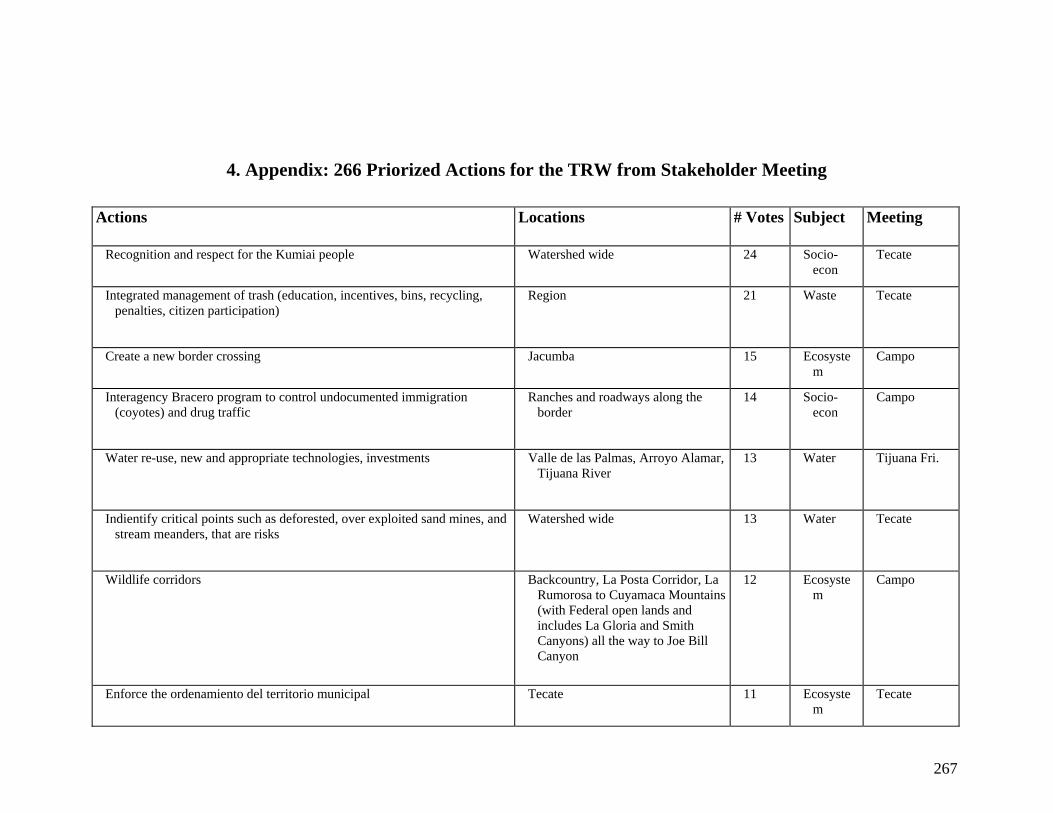
267
4. Appendix: 266 Priorized Actions for the TRW from Stakeholder Meeting
Actions Locations # Votes MeetingSubject
Recognition and respect for the Kumiai people Watershed wide 24 Socio-econ
Tecate
Integrated management of trash (education, incentives, bins, recycling, penalties, citizen participation)
Region 21 Waste Tecate
Create a new border crossing Jacumba 15 Ecosystem
Campo
Interagency Bracero program to control undocumented immigration (coyotes) and drug traffic
Ranches and roadways along the border
14 Socio-econ
Campo
Water re-use, new and appropriate technologies, investments Valle de las Palmas, Arroyo Alamar, Tijuana River
13 Water Tijuana Fri.
Indientify critical points such as deforested, over exploited sand mines, and stream meanders, that are risks
Watershed wide 13 Water Tecate
Wildlife corridors Backcountry, La Posta Corridor, La Rumorosa to Cuyamaca Mountains (with Federal open lands and includes La Gloria and Smith Canyons) all the way to Joe Bill Canyon
12 Ecosystem
Campo
Enforce the ordenamiento del territorio municipal Tecate 11 Ecosystem
Tecate
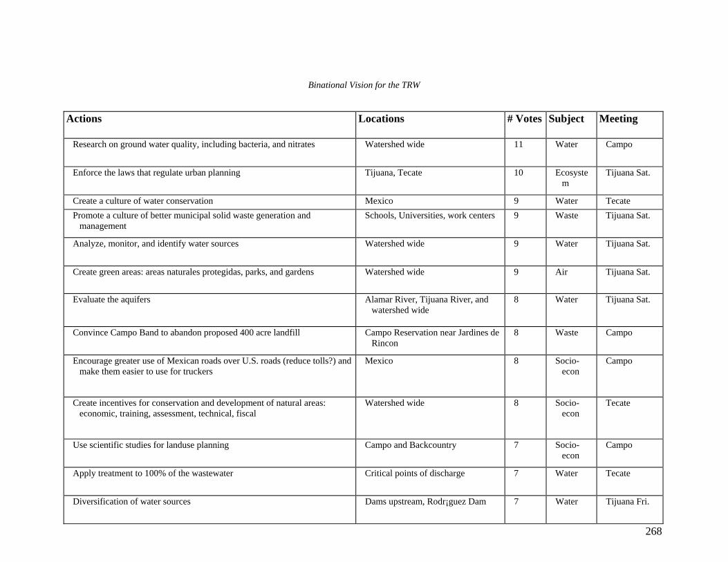
Binational Vision for the TRW
268
Actions Locations # Votes Subject Meeting
Research on ground water quality, including bacteria, and nitrates Watershed wide 11 Water Campo
Enforce the laws that regulate urban planning Tijuana, Tecate 10 Ecosystem
Tijuana Sat.
Create a culture of water conservation Mexico 9 Water Tecate Promote a culture of better municipal solid waste generation and
management Schools, Universities, work centers 9 Waste Tijuana Sat.
Analyze, monitor, and identify water sources Watershed wide 9 Water Tijuana Sat.
Create green areas: areas naturales protegidas, parks, and gardens Watershed wide 9 Air Tijuana Sat.
Evaluate the aquifers Alamar River, Tijuana River, and watershed wide
8 Water Tijuana Sat.
Convince Campo Band to abandon proposed 400 acre landfill Campo Reservation near Jardines de Rincon
8 Waste Campo
Encourage greater use of Mexican roads over U.S. roads (reduce tolls?) and make them easier to use for truckers
Mexico 8 Socio-econ
Campo
Create incentives for conservation and development of natural areas: economic, training, assessment, technical, fiscal
Watershed wide 8 Socio-econ
Tecate
Use scientific studies for landuse planning Campo and Backcountry 7 Socio-econ
Campo
Apply treatment to 100% of the wastewater Critical points of discharge 7 Water Tecate
Diversification of water sources Dams upstream, Rodr¡guez Dam 7 Water Tijuana Fri.
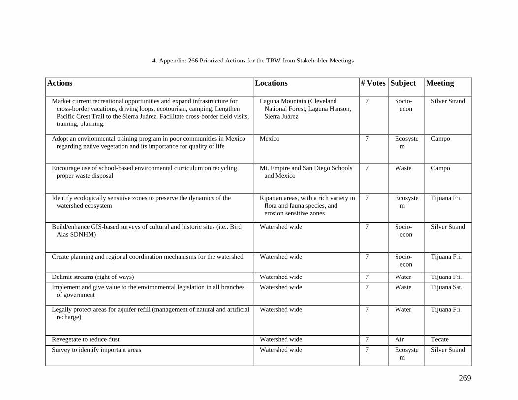
4. Appendix: 266 Priorized Actions for the TRW from Stakeholder Meetings
269
Actions Locations # Votes Subject Meeting
Market current recreational opportunities and expand infrastructure for cross-border vacations, driving loops, ecotourism, camping. Lengthen Pacific Crest Trail to the Sierra Juárez. Facilitate cross-border field visits, training, planning.
Laguna Mountain (Cleveland National Forest, Laguna Hanson, Sierra Juárez
7 Socio-econ
Silver Strand
Adopt an environmental training program in poor communities in Mexico regarding native vegetation and its importance for quality of life
Mexico 7 Ecosystem
Campo
Encourage use of school-based environmental curriculum on recycling, proper waste disposal
Mt. Empire and San Diego Schools and Mexico
7 Waste Campo
Identify ecologically sensitive zones to preserve the dynamics of the watershed ecosystem
Riparian areas, with a rich variety in flora and fauna species, and erosion sensitive zones
7 Ecosystem
Tijuana Fri.
Build/enhance GIS-based surveys of cultural and historic sites (i.e.. Bird Alas SDNHM)
Watershed wide 7 Socio-econ
Silver Strand
Create planning and regional coordination mechanisms for the watershed Watershed wide 7 Socio-econ
Tijuana Fri.
Delimit streams (right of ways) Watershed wide 7 Water Tijuana Fri. Implement and give value to the environmental legislation in all branches
of government Watershed wide 7 Waste Tijuana Sat.
Legally protect areas for aquifer refill (management of natural and artificial recharge)
Watershed wide 7 Water Tijuana Fri.
Revegetate to reduce dust Watershed wide 7 Air Tecate Survey to identify important areas Watershed wide 7 Ecosyste
m Silver Strand
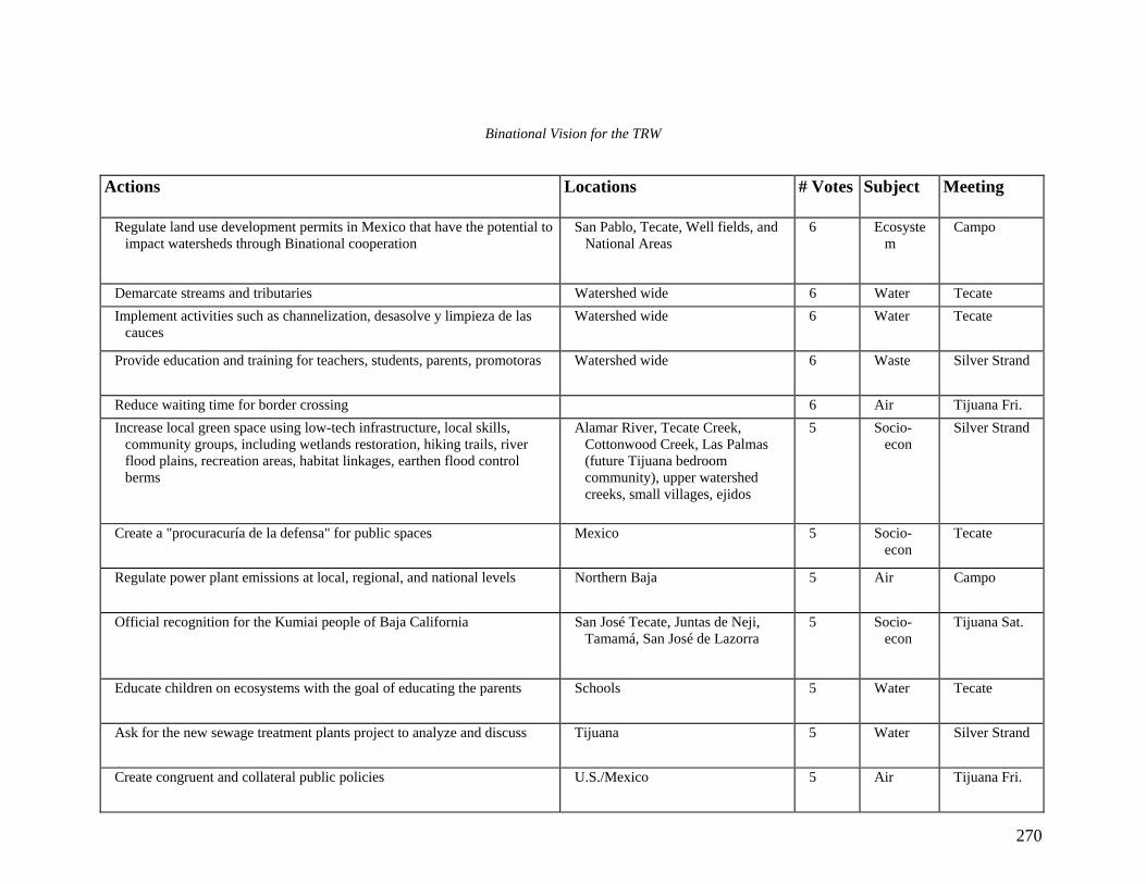
Binational Vision for the TRW
270
Actions Locations # Votes Subject Meeting
Regulate land use development permits in Mexico that have the potential to impact watersheds through Binational cooperation
San Pablo, Tecate, Well fields, and National Areas
6 Ecosystem
Campo
Demarcate streams and tributaries Watershed wide 6 Water Tecate Implement activities such as channelization, desasolve y limpieza de las
cauces Watershed wide 6 Water Tecate
Provide education and training for teachers, students, parents, promotoras Watershed wide 6 Waste Silver Strand
Reduce waiting time for border crossing 6 Air Tijuana Fri. Increase local green space using low-tech infrastructure, local skills,
community groups, including wetlands restoration, hiking trails, river flood plains, recreation areas, habitat linkages, earthen flood control berms
Alamar River, Tecate Creek, Cottonwood Creek, Las Palmas (future Tijuana bedroom community), upper watershed creeks, small villages, ejidos
5 Socio-econ
Silver Strand
Create a "procuracuría de la defensa" for public spaces Mexico 5 Socio-econ
Tecate
Regulate power plant emissions at local, regional, and national levels Northern Baja 5 Air Campo
Official recognition for the Kumiai people of Baja California San José Tecate, Juntas de Neji, Tamamá, San José de Lazorra
5 Socio-econ
Tijuana Sat.
Educate children on ecosystems with the goal of educating the parents Schools 5 Water Tecate
Ask for the new sewage treatment plants project to analyze and discuss Tijuana 5 Water Silver Strand
Create congruent and collateral public policies U.S./Mexico 5 Air Tijuana Fri.
4. Appendix: 266 Priorized Actions for the TRW from Stakeholder Meetings
271
Actions Locations # Votes Subject Meeting
Distribute information about the natural capital benefits of the watershed and cultural responsibilities
Urban zones 5 Socio-econ
Tijuana Sat.
Reforest urban areas not appropriate for development Urban zones 5 Ecosystem
Tecate
Educate people so they are aware of their actions with water Watershed wide 5 Water Silver Strand
Enforce air quality laws without impunity Watershed wide 5 Air TecateImprove infrastructure for waste transport treatment, storage, disposal Watershed wide 5 Waste Silver Strand
Promote effective reforestation Watershed wide 5 Socio-econ
Tecate
Promote reforestation through adoption programs with native species Watershed wide 5 Ecosystem
Tecate
Provide legal protection to land owners Watershed wide 5 Socio-econ
Tijuana Fri.
Subdivide the TRW in "sub-basins" for purposes of planning and local "task forces"
Watershed wide 5 Water Silver Strand
Create a natural parks to treat social problems as well Alamar River, Tecate Creek, Cottonwood Creek, Las Palmas (future Tijuana bedroom community), upper watershed creeks, small villages, ejidos
4 Water Silver Strand
Create green areas and recreation areas Arroyo Alamar, Tecate River, Corredor Campo, Tijuana River
4 Socio-econ
Tijuana Fri.
Promote old stone house and historic site preservation. Offer tours. Campo 4 Socio-econ
Campo
Binational Vision for the TRW
272
Actions Locations # Votes Subject Meeting
Control urban growth as water availability dictates Campo and backcountry 4 Socio-econ
Campo
Develop management plans for specific areas: set priorities, goals, adaptive management approaches for projects
Canyon de los Laureles, Canyon Mataderos
4 Ecosystem
Silver Strand
Control flooding by protecting habitat Cottonwood Creek upstream from Lake Morena
4 Water Campo
Create economic incentives for users to get smog checks Mexico 4 Air Tijuana Sat.
Monitor and inspect fish farms and cattle ranchers Mexico 4 Air Tijuana Sat.
Encourage more recycling opportunities: let them be predictable, have a tire amnesty day, large item pick ups, C & D, Appliances
rural U.S. and Mexico 4 Waste Campo
Perform an environmental risk assessment for dump sites Tijuana Tecate, Campo Indian Reservation
4 Waste Silver Strand
Campaign for continuing environmental education through formal education and media
Watershed wide 4 Socio-econ
Tecate
Form neighborhood watches (community environmental inspectors) Watershed wide 4 Ecosystem
Tijuana Fri.
Generate a watershed vision to secure socio-environmental and political stability
Watershed wide 4 Socio-econ
Tijuana Fri.
Generate employment through conservation and maintenance Watershed wide 4 Socio-econ
Tijuana Fri.
Identify opportunities for restoration and rehabilitation Watershed wide 4 Ecosystem
Silver Strand
4. Appendix: 266 Priorized Actions for the TRW from Stakeholder Meetings
273
Actions Locations # Votes Subject Meeting
Incorporate social groups in the replanting of the watershed Watershed wide 4 Socio-econ
Tijuana Fri.
Integrate public and private organizations into one binational project Watershed wide 4 Socio-econ
Tecate
Professionalize the Public Servants for the Environment Watershed wide 4 Socio-econ
Tecate
Promote a water culture, efficient use, re-use Watershed wide 4 Water Tijuana Fri.
Promote knowledge of cultural, historical and ecological resources in the region
Watershed wide 4 Socio-econ
Tecate
Study air quality by air basin Watershed wide 4 TecateAirReduce erosion that contributes to flooding 2355 Buckman Sp. Rd. and areas, all
landowners: Campo, Buckman Springs Rd., Lake Morena, Pine valley Bridge- upstream from Lake Morena
3 Water Campo
Create marine indicators to monitor watershed health and ecosystems Around the Estuary 3 Ecosystem
Tijuana Sat.
Enforce anti-burning laws Baja California 3 Air Tecate Carry out an inventory of all the historic cultural resources and make them
known Campo 3 Socio-
econ Tijuana Fri.
Identify areas of erosion to prevent their deterioration cauces de arroyos y laderas 3 Ecosystem
Tecate
Create a program to install desalinization plants Coast 3 Water Tecate
Encourage cross border cooperation on power plants, land fills, land use entire border, Boulevard, Tijuana, Tecate
3 Ecosystem
Campo
Binational Vision for the TRW
274
Actions Locations # Votes Subject Meeting
Create fiscal incentives for wastewater treatment Mexico 3 Water Tecate
Monitor and inspect industrial and commercial emissions with competent authorities who will enforce the law
Mexico 3 Air Tijuana Sat.
Create incentives to recycle in the community Municipal and state governments. Watershed wide
3 Waste Tijuana Sat.
Improve waste collection (to separate cases of heavy waste) Provide special equipment.
Neighborhoods near the river and streams
3 Waste Tijuana Fri.
Decentralize the waste processing plants New developing areas 3 Water Tijuana Fri. Integrate with other watersheds and establish means of communication and
cooperation Region 3 Ecosyste
m Tecate
Removal of exotic species with high impact to the ecosystems Riparian areas 3 Ecosystem
Tijuana Fri.
Protect pristine areas Riparian zones, Mountainous zones, Rio Alamar, Valle de las Palmas, urban/ruraltTransition zones
3 Ecosystem
Tijuana Sat.
Rehabilitate already existing natural areas Tecate River and Alamar 3 Socio-econ
Tijuana Fri.
Look for ways for the government to obtain funding for total sewage coverage
Tijuana/San Diego County 3 Water Silver Strand
Increase the infrastructure in the wastewater treatment plants so they are more efficient
Urban zones in Mexico 3 Water Tijuana Sat.
Support ecotourism projects that protect cultural resources watershed 3 Socio-econ
Tecate
4. Appendix: 266 Priorized Actions for the TRW from Stakeholder Meetings
275
Actions Locations # Votes Subject Meeting
Create a ground/surface water budget Watershed wide 3 Water Campo Create a joint development plan between the U.S. and Mexico Watershed wide 3 Socio-
econ Tijuana Sat.
Enforce strictly the law Watershed wide 3 Socio-econ
Tijuana Fri.
Establish more stringent policies for environmental impact assessments and monitoring
Watershed wide 3 Ecosystem
Tijuana Fri.
Greater observation of land use laws at all levels of government Watershed wide 3 Ecosystem
Tijuana Fri.
Increase cargo truck restrictions Watershed wide 3 Socio-econ
Campo
Promote training in sustainable management practices Watershed wide 3 Socio-econ
Tijuana Sat.
Restrict use of Hazmat in groundwater dependent areas by commercial and industrial facilities
Watershed wide 3 Waste Campo
Support local efforts for the conservation of the cultural heritage Watershed wide 3 Socio-econ
Tijuana Fri.
Survey and prioritize sediment sources Watershed wide 3 Ecosystem
Silver Strand
Educate and campaign on the value and natural need of green areas Watershed wide and all educational centers
3 Socio-econ
Tijuana Fri.
Aquifer research (quality and quantity) 3 Water Tijuana Fri. Implement rehabilitation projects such as: reforestion, control of sand
extraction, and anti-erosion barriers Areas identified as critical 2 Water Tecate
Binational Vision for the TRW
276
Actions Locations # Votes Subject Meeting
Equip air authorities in order to verify reported information Baja California 2 Air Tecate
Require smog checks Baja California and border crossing 2 Air Tecate
Create an education campaign to raise awareness for the relationship between trash, toxic waste, and children’s and ecosystem’s health
Campaign promotion in schools, churches, public charity centers, business, etc.
2 Waste Tijuana Fri.
Regulate activities that cause erosion Campo Hills development, 2 Ecosystem
Campo
Review "Community Character" document for Campo/Lake Morena Planning group
Campo/Lake Morena 2 Socio-econ
Campo
Restore vegetation (native species) Construction sites on slopes and canyons
2 Water Silver Strand
Use railroad to reduce traffic East County 2 Socio-econ
Campo
Train personnel on the receipt and treatment of water Industrial parks, hotels, department de industriales
2 Water Tijuana Sat.
Support and creation of community centers Marginalized or underserved zones 2 Socio-econ
Tijuana Fri.
Create legislation "marco juridico" and programs for emission controls Mexico 2 Air Tijuana Sat.
Reform and apply the Ecological Law of Mexico Mexico 2 Socio-econ
Tecate
Work visas for Mexican Nationals. Reduce need for immigration by increasing the standard of living in Mexico.
Mexico 2 Air Campo

4. Appendix: 266 Priorized Actions for the TRW from Stakeholder Meetings
277
Actions Locations # Votes Subject Meeting
Fencing around riparian habitat for cattle and horses Pine Valley Creek, CWD Creek, Hauser Canyon
2 Water Campo
Offer alternatives to invasive exotic species, pesticides, and herbicides Stores 2 Ecosystem
Tijuana Sat.
Control the effluent from running from treatment plants Tecate River, Alamar River 2 Water Tijuana Sat.
Recycle waste water Tecate, Tijuana, Major Border Cities 2 Ecosystem
Campo
Utilization of agricultural byproducts, wastewater treatment to produce energy
Tecate, Tijuana, Major Border Cities 2 Ecosystem
Campo
Apply urban development plans Tijuana and Tecate 2 Socio-econ
Tijuana Fri.
Localized grassroots riparian restoration efforts to address grazing, exotic vegetation, stream bank stabilization
Upper watershed areas and Sweetwater River, Bonita
2 Ecosystem
Campo
Establish percentages of required green areas related to housing development
Urban areas 2 Ecosystem
Tijuana Fri.
Protect sacred areas and paintings Watershed wide 2 Socio-econ
Tecate
Avoid overgrazing Watershed wide 2 Air Campo Control the use of pesticides Watershed wide 2 Air Tijuana Sat. Create fiscal incentives so that land-owners are encouraged to designate
green areas for recreational and conservation uses Watershed wide 2 Socio-
econ Tijuana Fri.
Development of public will and funding Watershed wide 2 Ecosystem
Silver Strand
Distribute air quality results from the communities Watershed wide 2 Air Tijuana Sat.
Binational Vision for the TRW
278
Actions Locations # Votes Subject Meeting
Distribute information on air quality to the community Watershed wide 2 Air Tecate
Ecological grading for erosion Watershed wide 2 Air Campo Encourage the use of cleaner fuels Watershed wide 2 Air Tijuana Fri. Harmonize laws binationally Watershed wide 2 Socio-
econ Tecate
Improve public transportation infrastructure and develop a collective transportation network
Watershed wide 2 Socio-econ
Tecate
Look for alternative water sources: geohydrology studies Watershed wide 2 Water Tecate
Pollution prevention programs Watershed wide 2 Waste Silver Strand
Rechare the aquifers with waste water from households and industries Watershed wide 2 Ecosystem
Tijuana Fri.
Restrict development to create green areas Watershed wide 2 Socio-econ
Tecate
Water reuse Watershed wide 2 Water Tijuana Sat. Characterize the type and quantity, and geography locations of toxic waste Watershed wide with focus on the
streams 2 Waste Tecate
Conduct an ongoing campaign for anti-burning education Baja California 1 Air Tecate
Create urban parks and corridors Between Canyon Matadero, and Laureles
1 Ecosystem
Tijuana Sat.
More support for local museums Campo and Backcountry 1 Socio-econ
Campo
Establish local waste transfer sites with supplemental funding Campo, Potrero/Tecate 1 Waste Campo
4. Appendix: 266 Priorized Actions for the TRW from Stakeholder Meetings
279
Actions Locations # Votes Subject Meeting
Develop rules and regulations to control cross border sale of sand, oaks, and Jeffery Pines to the U.S.
Enforcement checkpoints and border crossings
1 Ecosystem
Campo
Obtain economic resources for the equipment and operation of the wastewater treatment plants
Mexico 1 Water Tecate
Zone for gas stations, gas/power plants, and industries Mexico 1 Air Tijuana Sat.
Establish heritage sites and market them for recreation, Create a sense of place. Instill pride in Tijuana River Watershed through school programs
Neji tribe, Mexico 1 Socio-econ
Silver Strand
Create environmental emergency groups and drills Protección Civil (Mexico) and at the 3 levels of Mexican government
1 Waste Tijuana Sat.
Offer environmental/social programs in 3 languages in the region (Spanish, English, Kumiai dialects)
Region 1 Socio-econ
Tecate
Apply an unloading fee for acquiring used tires and the dollars should go to BC
Regional 1 Waste Tijuana Fri.
Apply the currently available regulations. Governmental organizations require funding for enforcement
Regional 1 Waste Tijuana Fri.
Revise, expand, and enforce the list of prohibited exotic and invasive species
Rios, wetlands, deserts 1 Ecosystem
Tijuana Sat.
Restrict transportation of hazardous materials on inadequate rural roads and railroads
Rural U.S. and Mexico 1 Waste Campo
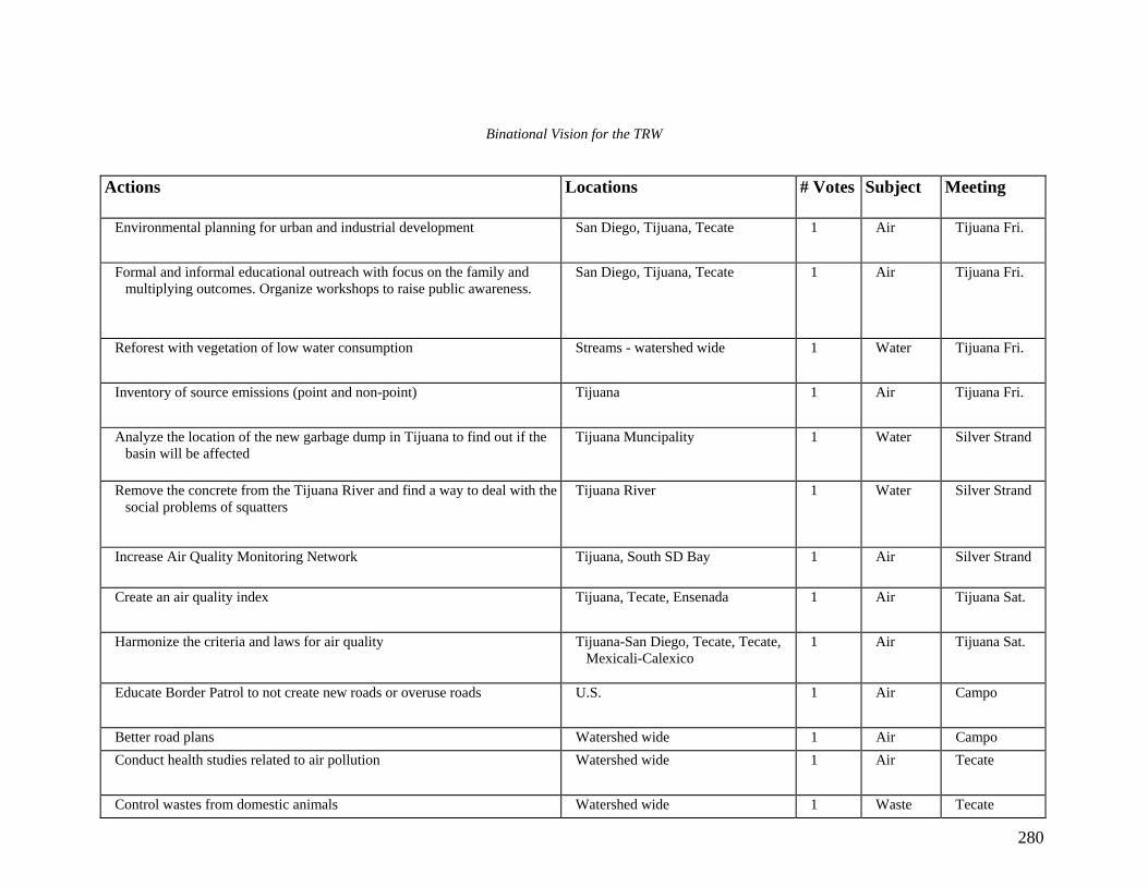
Binational Vision for the TRW
280
Actions Locations # Votes Subject Meeting
Environmental planning for urban and industrial development San Diego, Tijuana, Tecate 1 Air Tijuana Fri.
Formal and informal educational outreach with focus on the family and multiplying outcomes. Organize workshops to raise public awareness.
San Diego, Tijuana, Tecate 1 Air Tijuana Fri.
Reforest with vegetation of low water consumption Streams - watershed wide 1 Water Tijuana Fri.
Inventory of source emissions (point and non-point) Tijuana 1 Air Tijuana Fri.
Analyze the location of the new garbage dump in Tijuana to find out if the basin will be affected
Tijuana Muncipality 1 Water Silver Strand
Remove the concrete from the Tijuana River and find a way to deal with the social problems of squatters
Tijuana River 1 Water Silver Strand
Increase Air Quality Monitoring Network Tijuana, South SD Bay 1 Air Silver Strand
Create an air quality index Tijuana, Tecate, Ensenada 1 Air Tijuana Sat.
Harmonize the criteria and laws for air quality Tijuana-San Diego, Tecate, Tecate, Mexicali-Calexico
1 Air Tijuana Sat.
Educate Border Patrol to not create new roads or overuse roads U.S. 1 Air Campo
Better road plans Watershed wide 1 Air Campo Conduct health studies related to air pollution Watershed wide 1 Air Tecate
Control wastes from domestic animals Watershed wide 1 Waste Tecate
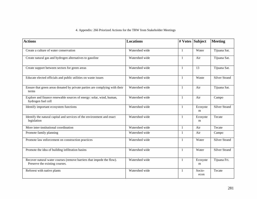
4. Appendix: 266 Priorized Actions for the TRW from Stakeholder Meetings
281
Actions Locations # Votes Subject Meeting
Create a culture of water conservation Watershed wide 1 Water Tijuana Sat.
Create natural gas and hydrogen alternatives to gasoline Watershed wide 1 Air Tijuana Sat.
Create support between sectors for green areas Watershed wide 1 13 Tijuana Sat.
Educate elected officials and public utilities on waste issues Watershed wide 1 Waste Silver Strand
Ensure that green areas donated by private parties are complying with their terms
Watershed wide 1 Air Tijuana Sat.
Explore and finance renewable sources of energy: solar, wind, human, hydrogen fuel cell
Watershed wide 1 Air Campo
Identify important ecosystem functions Watershed wide 1 Ecosystem
Silver Strand
Identify the natural capital and services of the environment and enact legislation
Watershed wide 1 Ecosystem
Tecate
More inter-institutional coordination Watershed wide 1 Air Tecate Promote family planning Watershed wide 1 Air Campo
Promote law enforcement on construction practices Watershed wide 1 Water Silver Strand
Promote the idea of building infiltration basins Watershed wide 1 Water Silver Strand
Recover natural water courses (remove barriers that impede the flow). Preserve the existing courses.
Watershed wide 1 Ecosystem
Tijuana Fri.
Reforest with native plants Watershed wide 1 Socio-econ
Tecate
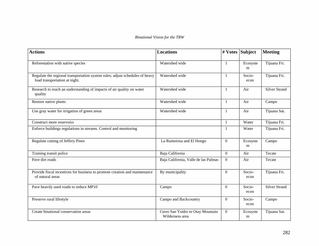
Binational Vision for the TRW
282
Actions Locations # Votes Subject Meeting
Reforestation with native species Watershed wide 1 Ecosystem
Tijuana Fri.
Regulate the regional transportation system rules; adjust schedules of heavy load transportation at night.
Watershed wide 1 Socio-econ
Tijuana Fri.
Research to reach an understanding of impacts of air quality on water quality
Watershed wide 1 Air Silver Strand
Restore native plants Watershed wide 1 Air Campo
Use gray water for irrigation of green areas Watershed wide 1 Air Tijuana Sat.
Construct more reservoirs 1 Water Tijuana Fri. Enforce buildings regulations in streams. Control and monitoring 1 Water Tijuana Fri.
Regulate cutting of Jeffery Pines La Rumorosa and El Hongo 0 Ecosystem
Campo
Training transit police Baja California 0 Air Tecate Pave dirt roads Baja California, Valle de las Palmas 0 Air Tecate
Provide fiscal incentives for business to promote creation and maintenance of natural areas
By municipality 0 Socio-econ
Tijuana Fri.
Pave heavily used roads to reduce MP10 Campo 0 Socio-econ
Silver Strand
Preserve rural lifestyle Campo and Backcountry 0 Socio-econ
Campo
Create binational conservation areas Cerro San Ysidro to Otay Mountain Wilderness area
0 Ecosystem
Tijuana Sat.

4. Appendix: 266 Priorized Actions for the TRW from Stakeholder Meetings
283
Actions Locations # Votes Subject Meeting
Proper design of waste water pretreatment systems at factories. Critical points of discharge 0 Water Tecate
Provide air quality diagnostics Current Tijuana 0 Air Tijuana Fri. Research related to source of waste, i.e.,US donations of clothing, TVs, etc. Customs 0 Waste Tijuana Fri.
Control the transport of invasive exotics Customs agencies 0 Ecosystem
Tijuana Sat.
Promote the involvement of egresados de cameras related to the environmental verification in the three levels of government
Dirección de Ecología Municipal, DGE, SEMARNAT
0 Waste Tijuana Sat.
Create a restricted confinement area for toxic wastes Far from urban areas with no development plans
0 Waste Tijuana Sat.
Campaign to retire useless autos Mexico 0 Air Tijuana Sat. Create economic aid for smog checks Mexico 0 Air Tijuana Sat. Create incentives such as loans to buy new or refurbished cars Mexico 0 Air Tijuana Sat.
Economic incentives for garages and used car dealers to retire old cars Mexico 0 Air Tijuana Sat.
Inspect for clandestine dumps Mexico 0 Air Tijuana Sat. Pressure PEMEX to improve the quality of their gas Mexico 0 Air Tijuana Sat.
Identify groundwater quantity/quality Mt. Empire source aquifer 0 Socio-econ
Campo
Better links between waste campaigns. Utilize neighborhood promotoras (community leaders), agents, funds from the private sector, equipment, equipment loans for oil, paint, cleaning
Regional 0 Waste Tijuana Fri.
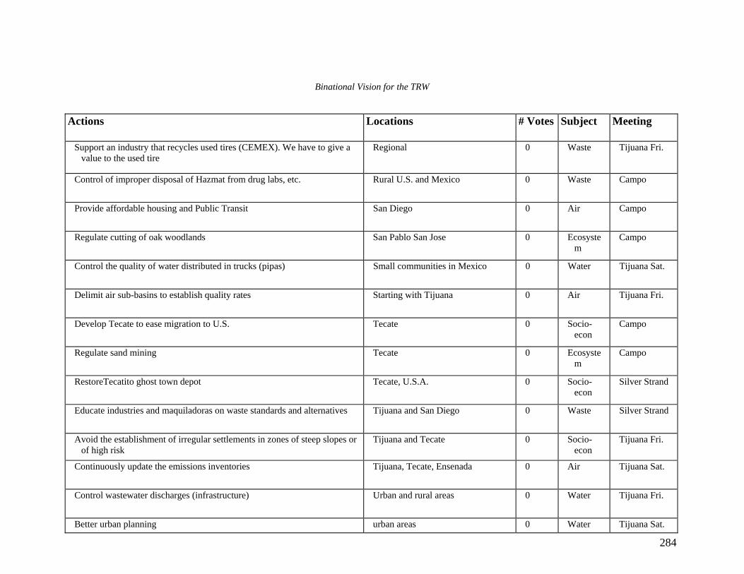
Binational Vision for the TRW
284
Actions Locations # Votes Subject Meeting
Support an industry that recycles used tires (CEMEX). We have to give a value to the used tire
Regional 0 Waste Tijuana Fri.
Control of improper disposal of Hazmat from drug labs, etc. Rural U.S. and Mexico 0 Waste Campo
Provide affordable housing and Public Transit San Diego 0 Air Campo
Regulate cutting of oak woodlands San Pablo San Jose 0 Ecosystem
Campo
Control the quality of water distributed in trucks (pipas) Small communities in Mexico 0 Water Tijuana Sat.
Delimit air sub-basins to establish quality rates Starting with Tijuana 0 Air Tijuana Fri.
Develop Tecate to ease migration to U.S. Tecate 0 Socio-econ
Campo
Regulate sand mining Tecate 0 Ecosystem
Campo
RestoreTecatito ghost town depot Tecate, U.S.A. 0 Socio-econ
Silver Strand
Educate industries and maquiladoras on waste standards and alternatives Tijuana and San Diego 0 Waste Silver Strand
Avoid the establishment of irregular settlements in zones of steep slopes or of high risk
Tijuana and Tecate 0 Socio-econ
Tijuana Fri.
Continuously update the emissions inventories Tijuana, Tecate, Ensenada 0 Air Tijuana Sat.
Control wastewater discharges (infrastructure) Urban and rural areas 0 Water Tijuana Fri.
Better urban planning urban areas 0 Water Tijuana Sat.
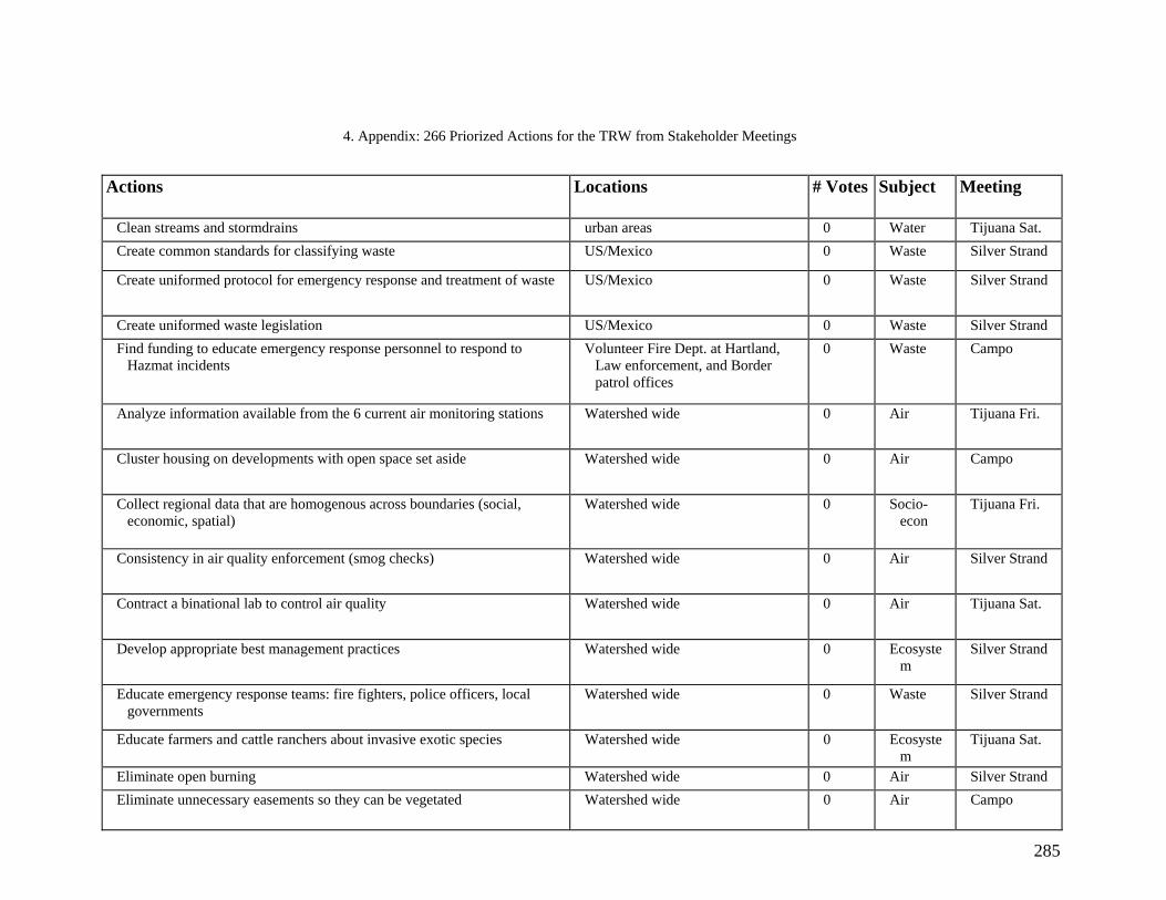
4. Appendix: 266 Priorized Actions for the TRW from Stakeholder Meetings
285
Actions Locations # Votes Subject Meeting
Clean streams and stormdrains urban areas 0 Water Tijuana Sat. Create common standards for classifying waste US/Mexico 0 Waste Silver Strand
Create uniformed protocol for emergency response and treatment of waste US/Mexico 0 Waste Silver Strand
Create uniformed waste legislation US/Mexico 0 Waste Silver StrandFind funding to educate emergency response personnel to respond to
Hazmat incidents Volunteer Fire Dept. at Hartland,
Law enforcement, and Border patrol offices
0 Waste Campo
Analyze information available from the 6 current air monitoring stations Watershed wide 0 Air Tijuana Fri.
Cluster housing on developments with open space set aside Watershed wide 0 Air Campo
Collect regional data that are homogenous across boundaries (social, economic, spatial)
Watershed wide 0 Socio-econ
Tijuana Fri.
Consistency in air quality enforcement (smog checks) Watershed wide 0 Air Silver Strand
Contract a binational lab to control air quality Watershed wide 0 Air Tijuana Sat.
Develop appropriate best management practices Watershed wide 0 Ecosystem
Silver Strand
Educate emergency response teams: fire fighters, police officers, local governments
Watershed wide 0 Waste Silver Strand
Educate farmers and cattle ranchers about invasive exotic species Watershed wide 0 Ecosystem
Tijuana Sat.
Eliminate open burning Watershed wide 0 Air Silver Strand Eliminate unnecessary easements so they can be vegetated Watershed wide 0 Air Campo
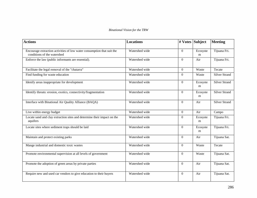
Binational Vision for the TRW
286
Actions Locations # Votes Subject Meeting
Encourage extraction activities of low water consumption that suit the conditions of the watershed
Watershed wide 0 Ecosystem
Tijuana Fri.
Enforce the law (public informants are essential). Watershed wide 0 Air Tijuana Fri.
Facilitate the legal removal of the "chatarra" Watershed wide 0 Waste Tecate Find funding for waste education Watershed wide 0 Waste Silver Strand
Idenify areas inappropriate for development Watershed wide 0 Ecosystem
Silver Strand
Identify threats: erosion, exotics, connectivity/fragmentation Watershed wide 0 Ecosystem
Silver Strand
Interface with Binational Air Quality Alliance (BAQA) Watershed wide 0 Air Silver Strand
Live within energy budget Watershed wide 0 Air Campo Locate sand and clay extraction sites and determine their impact on the
aquifers Watershed wide 0 Ecosyste
m Tijuana Fri.
Locate sites where sediment traps should be laid Watershed wide 0 Ecosystem
Tijuana Fri.
Maintain and protect existing parks Watershed wide 0 Air Tijuana Sat.
Mange industrial and domestic toxic wastes Watershed wide 0 Waste Tecate
Promote environmental supervision at all levels of government Watershed wide 0 Waste Tijuana Sat.
Promote the adoption of green areas by private parties Watershed wide 0 Air Tijuana Sat.
Require new and used car vendors to give education to their buyers Watershed wide 0 Air Tijuana Sat.
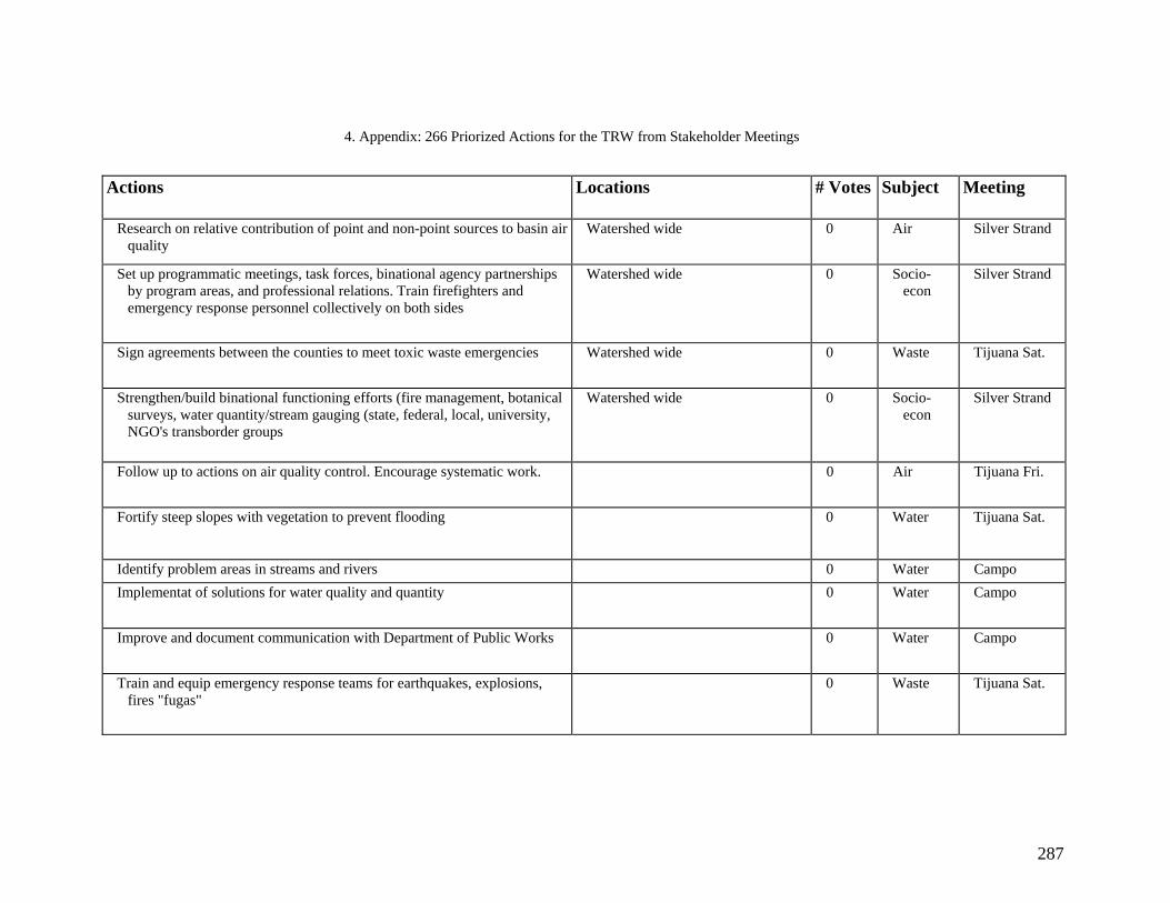
4. Appendix: 266 Priorized Actions for the TRW from Stakeholder Meetings
287
Actions Locations # Votes Subject Meeting
Research on relative contribution of point and non-point sources to basin air quality
Watershed wide 0 Air Silver Strand
Set up programmatic meetings, task forces, binational agency partnerships by program areas, and professional relations. Train firefighters and emergency response personnel collectively on both sides
Watershed wide 0 Socio-econ
Silver Strand
Sign agreements between the counties to meet toxic waste emergencies Watershed wide 0 Waste Tijuana Sat.
Strengthen/build binational functioning efforts (fire management, botanical surveys, water quantity/stream gauging (state, federal, local, university, NGO's transborder groups
Watershed wide 0 Socio-econ
Silver Strand
Follow up to actions on air quality control. Encourage systematic work. 0 Air Tijuana Fri.
Fortify steep slopes with vegetation to prevent flooding 0 Water Tijuana Sat.
Identify problem areas in streams and rivers 0 Water Campo Implementat of solutions for water quality and quantity 0 Water Campo
Improve and document communication with Department of Public Works 0 Water Campo
Train and equip emergency response teams for earthquakes, explosions, fires "fugas"
0 Waste Tijuana Sat.

Binational Vision for the TRW
288

289
5. Appendix: Significant cultural and historical monuments in the TRW
Name of monument or place
Historical or cultural importance Legal status Location or address
Bibliographic reference for further reading
Mojonera 258 International border marker built in 1884 by the International Commission of Limits. It marks the exact boundary between the United States and Mexico. The marker, made of stone and marble, is inserted in the border metal fence that separates Tijuana, B.C. from Imperial Beach, Ca.
Mexico and United Statesshared federal jurisdiction
Near the Pacific Ocean in Colonia Playas de Tijuana in front of the bullring
Instituto Nacional de Antropología e Historia. 1986. Catálogo Nacional de Monumentos Históricos Inmuebles, Municipio de Tijuana. Mexico, p. 651.
Avenida Revolución
A popular tourist street for adult entertainment and curio shopping. There are many historical landmarks such as the Jai Alai or Frontón, Hotel Caesar's, Villa Colonial Curious Store, Hotel Nelson, etc.
Tijuana City government
Avenida Revolución, in downtown Tijuana
Castillo Udiarte, Carlos; García Cortez, Alfonso; Morales Lira, Ricardo. 1996. La Revolución También es una Calle. 15vo Ayuntamiento de Tijuana, Universidad Iberoamericana. Tijuana, B.C..
Parque Los Encinos
A park cherished as a place for family gathering and remembrance for many Tecatenses. Parties, barbecues facilities, and a stage for music are available. There is a skateboard ramp and play areas for children. The Tecate Feria takes place in the park every year in the summer.
Tecate City government
One block south of Defensores de Tijuana Boulevard
Sierra, Olga A. 2002. "Culture, Recreation and Sports in Tecate." In Tecate, B.C.: Realities and Challenges in a Mexican Border Community. Paul Ganster, Felipe Cuamea Velázquez, José Luis Castro Ruiz, and Angélica Villegas, eds. San Diego: SDSU Press, pp. 100, 101.
Parque Hidalgo A downtown park created in the 1920s and known as the main plaza. It is a symbolic public area where people gather to socialize, eat, buy arts and crafts, listen to music, or to celebrate civic events. It has a gazebo in the center for musicians.
Tecate City government
Between Avenida Hidalgo and Avenida Juárez in downtown Tecate city
Santiago Guerrero, Leticia Vibiana. "Profile of the Origins of Tecate's Population." In Tecate, B.C.: Realities and Challenges in a Mexican Border Community. Paul Ganster, Felipe Cuamea Velázquez, José Luis Castro Ruiz, and Angélica Villegas, eds. San Diego: SDSU Press, pp.12, 13.
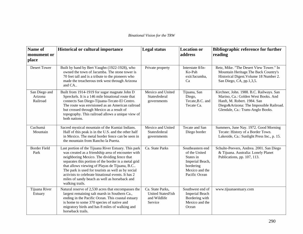
Binational Vision for the TRW
290
Name of monument or place
Historical or cultural importance Legal status Location or address
Bibliographic reference for further reading
Desert Tower Built by hand by Bert Vaughn (1922-1928), who owned the town of Jacumba. The stone tower is 70 feet tall and is a tribute to the pioneers who made the treacherous trek west through Arizona and CA..
Private property Interstate 8/In-Ko-Pah exit/Jacumba, Ca
Retz, Mike. "The Desert View Tower." In Mountain Heritage.The Back Country's Historical Digest.Volume 18 Number 2. San Diego, CA, pp.1,3,5.
San Diego and Arizona Railroad
Built from 1914-1919 for sugar magnate John D Spreckels. It is a 146 mile binational route that connects San Diego-Tijuana-Tecate-El Centro. The route was envisioned as an American railroad but crossed through Mexico as a result of topography. This railroad allows a unique view of both nations.
Mexico and United Statesfederal governments
Tijuana, San Diego, Tecate,B.C. and Tecate Ca.
Kirchner, John. 1988. B.C. Railways. San Marino, Ca.: Golden West Books. And Hanft, M. Robert. 1984. San Diego&Arizona: The Impossible Railroad. Glendale, Ca.: Trans-Anglo Books.
Cuchumá Mountain
Sacred mystical mountain of the Kumiai Indians. Half of this peak is in the U.S. and the other half in Mexico. The metal border fence can be seen in the mountain from Rancho la Puerta.
Mexico and United Statesfederal governments
Tecate and San Diego border
Summers, June Nay. 1972. Good Morning Tecate: History of a Border Town. Lakeside, Ca.: Sunlight Press Inc., p. 15.
Border Field Park
Last portion of the Tijuana River Estuary. This park was created as a friendship area of encounter with neighboring Mexico. The dividing fence that separates this portion of the border is a metal grid that allows viewing of Playas de Tijuana, B.C.. The park is used for tourists as well as by social activists to celebrate binational events. It has 2 miles of sandy beach as well as horseback and walking trails.
Ca. State Parks Southeastern end of the United States in Imperial Beach, bordering Mexico and the Pacific Ocean
Schulte-Peevers, Andrea. 2001. San Diego & Tijuana. Australia: Lonely Planet Publications, pp. 107, 113.
Tijuana River Estuary
Natural reserve of 2,530 acres that encompasses the largest remaining salt marsh in Southern Ca., ending in the Pacific Ocean. This coastal estuary is home to some 370 species of native and migratory birds and has 8 miles of walking and horseback trails.
Ca. State Parks, United StatesFish and Wildlife Service
Southwest end of Imperial Beach Bordering with Mexico and the Ocean
www.tijuanaestuary.com
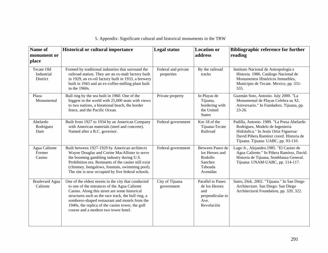
5. Appendix: Significant cultural and historical monuments in the TRW
291
Name of monument or place
Historical or cultural importance Legal status Location or address
Bibliographic reference for further reading
Tecate Old Industrial District
Formed by traditional industries that surround the railroad station. They are an ex-malt factory built in 1929, an ex-oil factory built in 1933, a brewery built in 1943 and an ex-coffee-milling plant built in the 1960s.
Federal and private properties
By the railroad tracks
Instituto Nacional de Antropología e Historia. 1986. Catálogo Nacional de Monumentos Históricos Inmuebles, Municipio de Tecate. Mexico, pp. 551-555.
Plaza Monumental
Bull ring by the sea built in 1960. One of the biggest in the world with 25,000 seats with views to two nations, a binational beach, the border fence, and the Pacific Ocean.
Private property In Playas de Tijuana, bordering with the United States
Guzmán Soto, Antonio. July 2000. "La Monumental de Playas Celebra su XL Aniversario." In Fundadors. Tijuana, pp. 23-26.
Abelardo Rodríguez Dam
Built from 1927 to 1934 by an American Company with American materials (steel and concrete). Named after a B.C. governor.
Federal government Km 18 of the Tijuana-Tecate Railroad
Padilla, Antonio. 1989. "La Presa Abelardo Rodríguez, Modelo de Ingenieria Hidráulica." In Jesús Ortiz Figueroa/ David Piñera Ramírez coord. Historia de Tijuana. Tijuana: UABC, pp. 93-110.
Agua Caliente Former Casino
Built between 1927-1929 by American architects Wayne Douglas and Corine MacAllister to serve the booming gambling industry during U.S. Prohibition era. Remnants of the casino still exist (chimney, bungalows, fountain, swimming pool). The site is now occupied by five federal schools.
Federal government Between Paseo de los Heroes and Rodolfo Sanchez Taboada Avenidas
Lugo Jr., Alejandro.1985. "El Casino de Agua Caliente." In Piñera Ramírez, David. Historia de Tijuana, Semblanza General. Tijuana: UNAM-UABC, pp. 114-117.
Boulevard Agua Caliente
One of the oldest streets in the city that conducted to one of the entrances of the Agua Caliente Casino. Along this street are some historical structures such as the race track, the bull ring, a sombrero-shaped restaurant and motels from the 1940s, the replica of the casino tower, the golf course and a modern two tower hotel.
City of Tijuana government
Parallel to Paseo de los Heroes and perpendicular to Ave. Revolución
Sutro, Dirk. 2002. "Tijuana." In San Diego Architecture. San Diego: San Diego Architectural Foundation, pp. 320, 322.
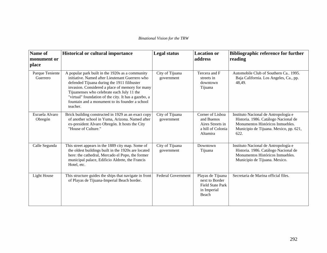
Binational Vision for the TRW
292
Name of monument or place
Historical or cultural importance Legal status Location or address
Bibliographic reference for further reading
Parque Teniente Guerrero
A popular park built in the 1920s as a community initiative. Named after Lieutenant Guerrero who defended Tijuana during the 1911 filibuster invasion. Considered a place of memory for many Tijuanenses who celebrate each July 11 the "virtual" foundation of the city. It has a gazebo, a fountain and a monument to its founder a school teacher.
City of Tijuana government
Tercera and F streets in downtown Tijuana
Automobile Club of Southern Ca.. 1995. Baja California. Los Angeles, Ca., pp. 48,49.
Escuela Alvaro Obregón
Brick building constructed in 1929 as an exact copy of another school in Yuma, Arizona. Named after ex-president Alvaro Obregón. It hosts the City "House of Culture."
City of Tijuana government
Corner of Lisboa and Buenos Aires Streets in a hill of Colonia Altamira
Instituto Nacional de Antropología e Historia. 1986. Catálogo Nacional de Monumentos Históricos Inmuebles. Municipio de Tijuana. Mexico, pp. 621, 622.
Calle Segunda This street appears in the 1889 city map. Some of the oldest buildings built in the 1920s are located here: the cathedral, Mercado el Popo, the former municipal palace, Edificio Aldrete, the Francis Hotel, etc.
City of Tijuana government
Downtown Tijuana
Instituto Nacional de Antropología e Historia. 1986. Catálogo Nacional de Monumentos Históricos Inmuebles. Municipio de Tijuana. Mexico.
Light House This structure guides the ships that navigate in front of Playas de Tijuana-Imperial Beach border.
Federal Government Playas de Tijuana next to Border Field State Park in Imperial Beach
Secretaria de Marina official files.
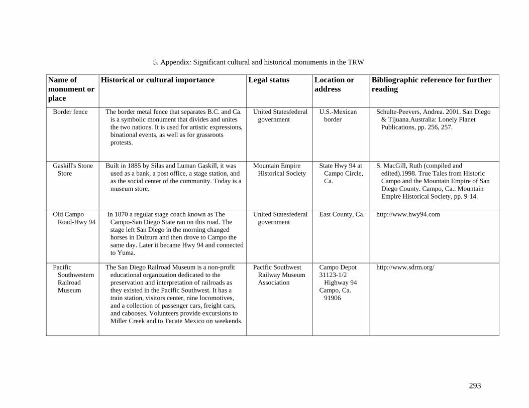
5. Appendix: Significant cultural and historical monuments in the TRW
293
Name of monument or place
Historical or cultural importance Legal status Location or address
Bibliographic reference for further reading
Border fence The border metal fence that separates B.C. and Ca. is a symbolic monument that divides and unites the two nations. It is used for artistic expressions, binational events, as well as for grassroots protests.
United Statesfederal government
U.S.-Mexican border
Schulte-Peevers, Andrea. 2001. San Diego & Tijuana.Australia: Lonely Planet Publications, pp. 256, 257.
Gaskill's Stone Store
Built in 1885 by Silas and Luman Gaskill, it was used as a bank, a post office, a stage station, and as the social center of the community. Today is a museum store.
Mountain Empire Historical Society
State Hwy 94 at Campo Circle, Ca.
S. MacGill, Ruth (compiled and edited).1998. True Tales from Historic Campo and the Mountain Empire of San Diego County. Campo, Ca.: Mountain Empire Historical Society, pp. 9-14.
Old Campo Road-Hwy 94
In 1870 a regular stage coach known as The Campo-San Diego State ran on this road. The stage left San Diego in the morning changed horses in Dulzura and then drove to Campo the same day. Later it became Hwy 94 and connected to Yuma.
United Statesfederal government
East County, Ca. http://www.hwy94.com
Pacific Southwestern Railroad Museum
The San Diego Railroad Museum is a non-profit educational organization dedicated to the preservation and interpretation of railroads as they existed in the Pacific Southwest. It has a train station, visitors center, nine locomotives, and a collection of passenger cars, freight cars, and cabooses. Volunteers provide excursions to Miller Creek and to Tecate Mexico on weekends.
Pacific Southwest Railway Museum Association
Campo Depot 31123-1/2
Highway 94 Campo, Ca.
91906
http://www.sdrm.org/
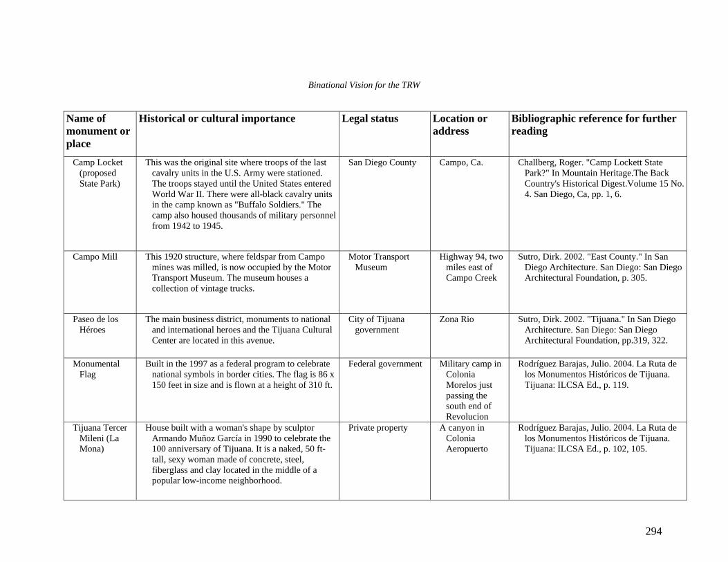
Binational Vision for the TRW
294
Name of monument or place
Historical or cultural importance Legal status Location or address
Bibliographic reference for further reading
Camp Locket (proposed State Park)
This was the original site where troops of the last cavalry units in the U.S. Army were stationed. The troops stayed until the United States entered World War II. There were all-black cavalry units in the camp known as "Buffalo Soldiers." The camp also housed thousands of military personnel from 1942 to 1945.
San Diego County Campo, Ca. Challberg, Roger. "Camp Lockett State Park?" In Mountain Heritage.The Back Country's Historical Digest.Volume 15 No. 4. San Diego, Ca, pp. 1, 6.
Campo Mill This 1920 structure, where feldspar from Campo mines was milled, is now occupied by the Motor Transport Museum. The museum houses a collection of vintage trucks.
Motor Transport Museum
Highway 94, two miles east of Campo Creek
Sutro, Dirk. 2002. "East County." In San Diego Architecture. San Diego: San Diego Architectural Foundation, p. 305.
Paseo de los Héroes
The main business district, monuments to national and international heroes and the Tijuana Cultural Center are located in this avenue.
City of Tijuana government
Zona Rio Sutro, Dirk. 2002. "Tijuana." In San Diego Architecture. San Diego: San Diego Architectural Foundation, pp.319, 322.
Monumental Flag
Built in the 1997 as a federal program to celebrate national symbols in border cities. The flag is 86 x 150 feet in size and is flown at a height of 310 ft.
Federal government Military camp in Colonia Morelos just passing the south end of Revolucion
Rodríguez Barajas, Julio. 2004. La Ruta de los Monumentos Históricos de Tijuana. Tijuana: ILCSA Ed., p. 119.
Tijuana Tercer Mileni (La Mona)
House built with a woman's shape by sculptor Armando Muñoz García in 1990 to celebrate the 100 anniversary of Tijuana. It is a naked, 50 ft-tall, sexy woman made of concrete, steel, fiberglass and clay located in the middle of a popular low-income neighborhood.
Private property A canyon in Colonia Aeropuerto
Rodríguez Barajas, Julio. 2004. La Ruta de los Monumentos Históricos de Tijuana. Tijuana: ILCSA Ed., p. 102, 105.

5. Appendix: Significant cultural and historical monuments in the TRW
295
Name of monument or place
Historical or cultural importance Legal status Location or address
Bibliographic reference for further reading
Cristo Rey This monumental Jesus Christ (72 feet tall) made of fiberglass and resin, aims to compete with another one in Brazil. It is surrounded by 28 angels.
Federal government in conjunction with a church
Colonia los Alamos next to San Martín de Porres church
Rodríguez Barajas, Julio. 2004. La Ruta de los Monumentos Históricos de Tijuana. Tijuana: ILCSA Ed., p. 119.
Plaza Santa Cecilia
This is the old Olvera Street that appears in the 1889 map of the city. Made a walking street in the 1980s and renamed as Plaza Santa Cecilia. There are restaurants, bars, street vendors, and a Mariachi stage. The 1950s Nelson Hotel is in the corner of the Plaza and Avenida Revolución.
City of Tijuana government
Between Revolución and Second Streets
Sutro, Dirk. 2002. "Tijuana." In San Diego Architecture. San Diego: San Diego Architectural Foundation, p. 318.
Parque del Profesor
A 28-acre park built in 1999 by Fundación la Puerta and designed by Hubbell and Hubbell. It hosts the Cuchumaá Ecological Center, an interactive educational center whose buildings resemble natural boulders that camouflage with the landscape.
Fundación la Puerta Left side of the entrance to Tecate (coming from Tijuana non-toll road)
La Cuenca del Río Tijuana. CD created by Digital Contact as a co-production of San Diego Natural History Museum, EPA, USFS.
Plaza de Toros de Tijuana
Built in 1938 entirely on wood construction. Rebuilt with steel after a fire in 1957.
Private property Boulevard Agua Caliente
Sutro, Dirk. 2002. "Tijuana." In San Diego Architecture. San Diego: San Diego Architectural Foundation, p. 314, 320.
Jacumba This city was a stopping place for travelers between Phoenix and San Diego. The hotel at Jacumba Hot Springs, built in the 1920s burned down in 1942. Visited by movie stars, now is a ghost town with a train station.
San Diego County Old highway 80 Sutro, Dirk. 2002. "East County." In San Diego Architecture. San Diego: San Diego Architectural Foundation, p. 306.
Rancho la Puerta
Old ranch adapted in the 1940s as a health resort and considered one of the world's most highly rated.
Private property In the Tecate Valley a the bottom of Cuchuma Mountain
http://www.rancholapuerta.com/
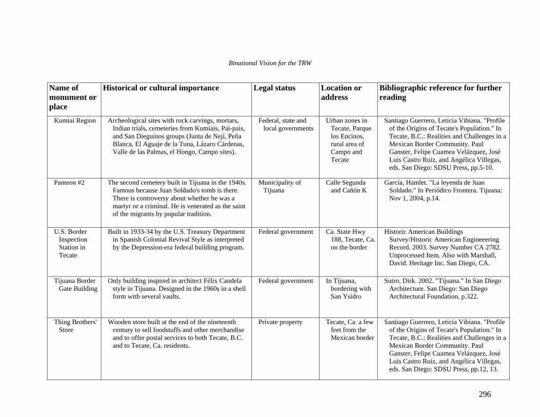
Binational Vision for the TRW
296
Name of monument or place
Historical or cultural importance Legal status Location or address
Bibliographic reference for further reading
Kumiai Region Archeological sites with rock carvings, mortars, Indian trials, cemeteries from Kumiais, Pai-pais, and San Dieguinos groups (Junta de Nejí, Peña Blanca, El Aguaje de la Tuna, Lázaro Cárdenas, Valle de las Palmas, el Hongo, Campo sites).
Federal, state and local governments
Urban zones in Tecate, Parque los Encinos, rural area of Campo and Tecate
Santiago Guerrero, Leticia Vibiana. "Profile of the Origins of Tecate's Population." In Tecate, B.C.: Realities and Challenges in a Mexican Border Community. Paul Ganster, Felipe Cuamea Velázquez, José Luis Castro Ruiz, and Angélica Villegas, eds. San Diego: SDSU Press, pp.5-10.
Panteon #2 The second cemetery built in Tijuana in the 1940s. Famous because Juan Soldado's tomb is there. There is controversy about whether he was a martyr or a criminal. He is venerated as the saint of the migrants by popular tradition.
Municipality of Tijuana
Calle Segunda and Cañón K
García, Hamlet. "La leyenda de Juan Soldado." In Periódico Frontera. Tijuana: Nov 1, 2004, p.14.
U.S. Border Inspection Station in Tecate
Built in 1933-34 by the U.S. Treasury Department in Spanish Colonial Revival Style as interpreted by the Depression-era federal building program.
Federal government Ca. State Hwy 188, Tecate, Ca. on the border
Historic American Buildings Survey/Historic American Engineeering Record. 2003. Survey Number CA 2782. Unprocessed Item. Also with Marshall, David. Heritage Inc. San Diego, CA.
Tijuana Border Gate Building
Only building inspired in architect Félix Candela style in Tijuana. Designed in the 1960s in a shell form with several vaults.
Federal government In Tijuana, bordering with San Ysidro
Sutro, Dirk. 2002. "Tijuana." In San Diego Architecture. San Diego: San Diego Architectural Foundation, p.322.
Thing Brothers' Store
Wooden store built at the end of the nineteenth century to sell foodstuffs and other merchandise and to offer postal services to both Tecate, B.C. and to Tecate, Ca. residents.
Private property Tecate, Ca. a few feet from the Mexican border
Santiago Guerrero, Leticia Vibiana. "Profile of the Origins of Tecate's Population." In Tecate, B.C.: Realities and Challenges in a Mexican Border Community. Paul Ganster, Felipe Cuamea Velázquez, José Luis Castro Ruiz, and Angélica Villegas, eds. San Diego: SDSU Press, pp.12, 13.
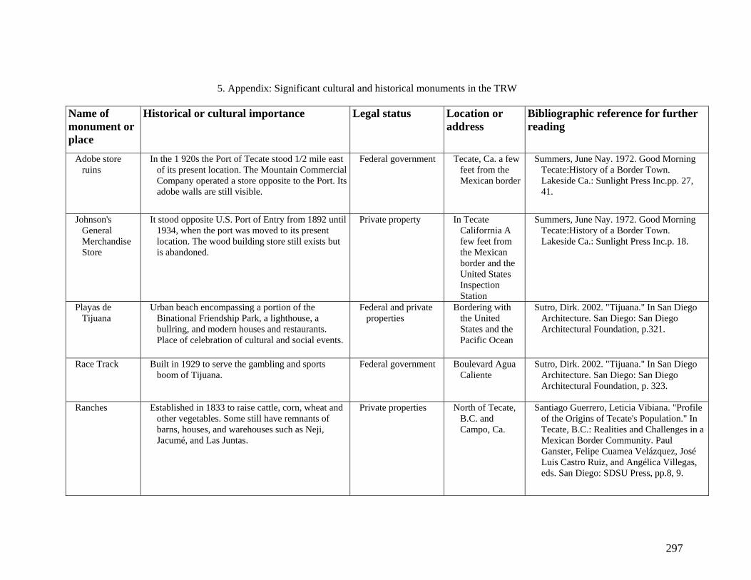
5. Appendix: Significant cultural and historical monuments in the TRW
297
Name of monument or place
Historical or cultural importance Legal status Location or address
Bibliographic reference for further reading
Adobe store ruins
In the 1 920s the Port of Tecate stood 1/2 mile east of its present location. The Mountain Commercial Company operated a store opposite to the Port. Its adobe walls are still visible.
Federal government Tecate, Ca. a few feet from the Mexican border
Summers, June Nay. 1972. Good Morning Tecate:History of a Border Town. Lakeside Ca.: Sunlight Press Inc.pp. 27, 41.
Johnson's General Merchandise Store
It stood opposite U.S. Port of Entry from 1892 until 1934, when the port was moved to its present location. The wood building store still exists but is abandoned.
Private property In Tecate Califorrnia A few feet from the Mexican border and the United States Inspection Station
Summers, June Nay. 1972. Good Morning Tecate:History of a Border Town. Lakeside Ca.: Sunlight Press Inc.p. 18.
Playas de Tijuana
Urban beach encompassing a portion of the Binational Friendship Park, a lighthouse, a bullring, and modern houses and restaurants. Place of celebration of cultural and social events.
Federal and private properties
Bordering with the United States and the Pacific Ocean
Sutro, Dirk. 2002. "Tijuana." In San Diego Architecture. San Diego: San Diego Architectural Foundation, p.321.
Race Track Built in 1929 to serve the gambling and sports boom of Tijuana.
Federal government Boulevard Agua Caliente
Sutro, Dirk. 2002. "Tijuana." In San Diego Architecture. San Diego: San Diego Architectural Foundation, p. 323.
Ranches Established in 1833 to raise cattle, corn, wheat and other vegetables. Some still have remnants of barns, houses, and warehouses such as Neji, Jacumé, and Las Juntas.
Private properties North of Tecate, B.C. and Campo, Ca.
Santiago Guerrero, Leticia Vibiana. "Profile of the Origins of Tecate's Population." In Tecate, B.C.: Realities and Challenges in a Mexican Border Community. Paul Ganster, Felipe Cuamea Velázquez, José Luis Castro Ruiz, and Angélica Villegas, eds. San Diego: SDSU Press, pp.8, 9.
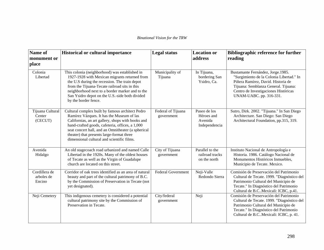
Binational Vision for the TRW
298
Name of monument or place
Historical or cultural importance Legal status Location or address
Bibliographic reference for further reading
Colonia Libertad
This colonia (neighborhood) was established in 1927-1928 with Mexican migrants returned from the U.S during the recession. The train depot from the Tijuana-Tecate railroad sits in this neighborhood next to a border marker and to the San Ysidro depot on the U.S.-side both divided by the border fence.
Municipality of Tijuana
In Tijuana, bordering San Ysidro, Ca.
Bustamante Fernández, Jorge.1985. "Surgimiento de la Colonia Libertad." In Piñera Ramírez, David. Historia de Tijuana: Semblanza General. Tijuana: Centro de Investigaciones Históricas UNAM-UABC. pp. 316-331.
Tijuana Cultural Center (CECUT)
Cultural complex built by famous architect Pedro Ramírez Vázques. It has the Museum of las Californias, an art gallery, shops with books and hand-crafted goods, cafeteria, offices, a 1,000 seat concert hall, and an Omnitheater (a spherical theater) that presents large-format three dimensional cultural and scientific films.
Federal of Tijuana government
Paseo de los Héroes and Avenida Independencia
Sutro, Dirk. 2002. "Tijuana." In San Diego Architecture. San Diego: San Diego Architectural Foundation, pp.315, 319.
Avenida Hidalgo
An old stagecoach road urbanized and named Calle Libertad in the 1920s. Many of the oldest houses of Tecate as well as the Virgin of Guadalupe church are located on this street.
City of Tijuana government
Parallel to the railroad tracks on the north
Instituto Nacional de Antropología e Historia. 1986. Catálogo Nacional de Monumentos Históricos Inmuebles, Municipio de Tecate. Mexico.
Cordillera de arboles de Encino
Corridor of oak trees identified as an area of natural beauty and part of the cultural patrimony of B.C. by the Commission of Preservation in Tecate (not yet designated).
Federal Government Neji-Valle Redondo Sierra
Comisión de Preservación del Patrimonio Cultural de Tecate. 1999. "Diagnóstico del Patrimonio Cultural del Municipio de Tecate." In Diagnóstico del Patrimonio Cultural de B.C..Mexicali: ICBC, p.41.
Neji Cemetery This indigenous cemetery is considered a potential cultural patrimony site by the Commission of Preservation in Tecate.
City/federal government
Neji Comisión de Preservación del Patrimonio Cultural de Tecate. 1999. "Diagnóstico del Patrimonio Cultural del Municipio de Tecate." In Diagnóstico del Patrimonio Cultural de B.C..Mexicali: ICBC, p. 41.
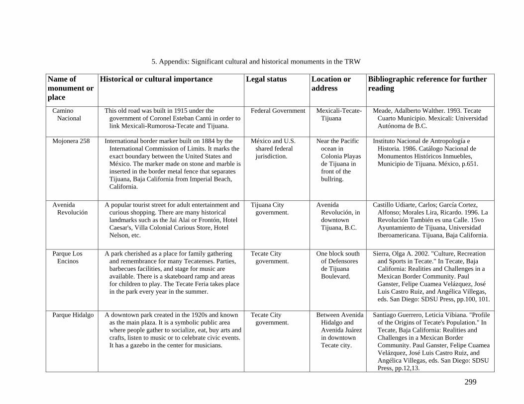
5. Appendix: Significant cultural and historical monuments in the TRW
299
Name of monument or place
Historical or cultural importance Legal status Location or address
Bibliographic reference for further reading
Camino Nacional
This old road was built in 1915 under the government of Coronel Esteban Cantú in order to link Mexicali-Rumorosa-Tecate and Tijuana.
Federal Government Mexicali-Tecate-Tijuana
Meade, Adalberto Walther. 1993. Tecate Cuarto Municipio. Mexicali: Universidad Autónoma de B.C.
Mojonera 258 International border marker built on 1884 by the International Commission of Limits. It marks the exact boundary between the United States and México. The marker made on stone and marble is inserted in the border metal fence that separates Tijuana, Baja California from Imperial Beach, California.
México and U.S. shared federal jurisdiction.
Near the Pacific ocean in Colonia Playas de Tijuana in front of the bullring.
Instituto Nacional de Antropología e Historia. 1986. Catálogo Nacional de Monumentos Históricos Inmuebles, Municipio de Tijuana. México, p.651.
Avenida Revolución
A popular tourist street for adult entertainment and curious shopping. There are many historical landmarks such as the Jai Alai or Frontón, Hotel Caesar's, Villa Colonial Curious Store, Hotel Nelson, etc.
Tijuana City government.
Avenida Revolución, in downtown Tijuana, B.C.
Castillo Udiarte, Carlos; García Cortez, Alfonso; Morales Lira, Ricardo. 1996. La Revolución También es una Calle. 15vo Ayuntamiento de Tijuana, Universidad Iberoamericana. Tijuana, Baja California.
Parque Los Encinos
A park cherished as a place for family gathering and remembrance for many Tecatenses. Parties, barbecues facilities, and stage for music are available. There is a skateboard ramp and areas for children to play. The Tecate Feria takes place in the park every year in the summer.
Tecate City government.
One block south of Defensores de Tijuana Boulevard.
Sierra, Olga A. 2002. "Culture, Recreation and Sports in Tecate." In Tecate, Baja California: Realities and Challenges in a Mexican Border Community. Paul Ganster, Felipe Cuamea Velázquez, José Luis Castro Ruiz, and Angélica Villegas, eds. San Diego: SDSU Press, pp.100, 101.
Parque Hidalgo A downtown park created in the 1920s and known as the main plaza. It is a symbolic public area where people gather to socialize, eat, buy arts and crafts, listen to music or to celebrate civic events. It has a gazebo in the center for musicians.
Tecate City government.
Between Avenida Hidalgo and Avenida Juárez in downtown Tecate city.
Santiago Guerrero, Leticia Vibiana. "Profile of the Origins of Tecate's Population." In Tecate, Baja California: Realities and Challenges in a Mexican Border Community. Paul Ganster, Felipe Cuamea Velázquez, José Luis Castro Ruiz, and Angélica Villegas, eds. San Diego: SDSU Press, pp.12,13.
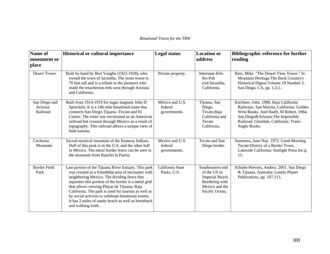
Binational Vision for the TRW
300
Name of monument or place
Historical or cultural importance Legal status Location or address
Bibliographic reference for further reading
Desert Tower Built by hand by Bert Vaughn (1922-1928), who owned the town of Jacumba. The stone tower is 70 feet tall and is a tribute to the pioneers who made the treacherous trek west through Arizona and California.
Private property. Interstate 8/In-Ko-Pah exit/Jacumba, California.
Retz, Mike. "The Desert View Tower." In Mountain Heritage.The Back Country's Historical Digest.Volume 18 Number 2. San Diego, CA, pp. 1,3,5..
San Diego and Arizona Railroad
Built from 1914-1919 for sugar magnate John D Spreckels. It is a 146 mile binational route that connects San Diego-Tijuana -Tecate-and El Centro. The route was envisioned as an American railroad but crossed through Mexico as a result of topography. This railroad allows a unique view of both nations.
México and U.S. federal governments.
Tijuana, San Diego, Tecate,Baja California and Tecate California.
Kirchner, John. 1988. Baja California Railways. San Marino, California: Golden West Books. And Hanft, M Robert. 1984. San Diego&Arizona:The Impossible Railroad. Glendale, California: Trans-Anglo Books.
Cuchuma Mountain
Sacred mystical mountain of the Kumeay Indians. Half of this peak is in the U.S. and the other half in México. The metal border fence can be seen in the mountain from Rancho la Puerta.
Mexico and U.S. federal governments.
Tecate and San Diego border.
Summers, June Nay. 1972. Good Morning Tecate:History of a Border Town. Lakeside California: Sunlight Press Inc.p. 15.
Border Field Park
Last portion of the Tijuana River Estuary. This park was created as a friendship area of encounter with neighboring Mexico. The dividing fence that separates this portion of the border is a metal grid that allows viewing Playas de Tijuana, Baja California. The park is used for tourists as well as by social activists to celebrate binational events. It has 2 miles of sandy beach as well as horseback and walking trails.
California State Parks. U.S.
Southeastern end of the US in Imperial Beach. Bordering with Mexico and the Pacific Ocean,
Schulte-Peevers, Andrea. 2001. San Diego & Tijuana. Australia: Lonely Planet Publications, pp. 107,113.
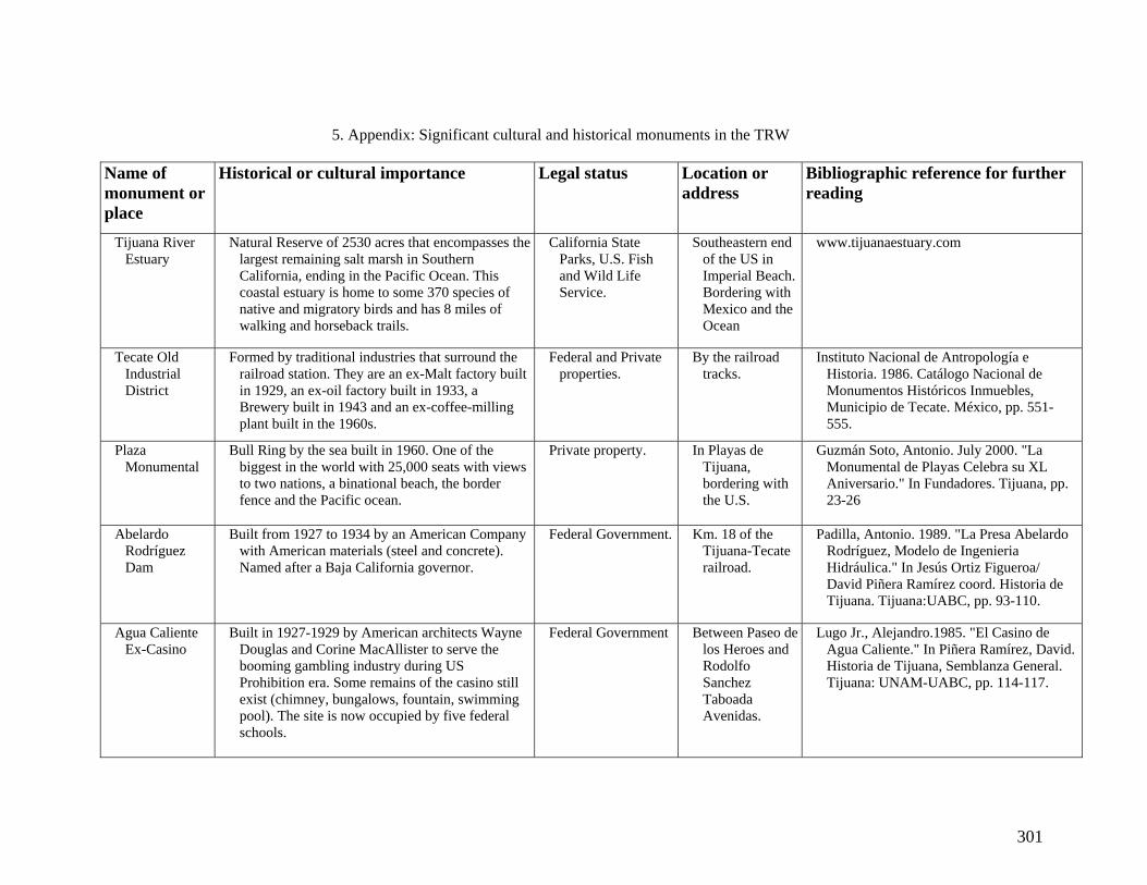
5. Appendix: Significant cultural and historical monuments in the TRW
301
Name of monument or place
Historical or cultural importance Legal status Location or address
Bibliographic reference for further reading
Tijuana River Estuary
Natural Reserve of 2530 acres that encompasses the largest remaining salt marsh in Southern California, ending in the Pacific Ocean. This coastal estuary is home to some 370 species of native and migratory birds and has 8 miles of walking and horseback trails.
California State Parks, U.S. Fish and Wild Life Service.
Southeastern end of the US in Imperial Beach. Bordering with Mexico and the Ocean
www.tijuanaestuary.com
Tecate Old Industrial District
Formed by traditional industries that surround the railroad station. They are an ex-Malt factory built in 1929, an ex-oil factory built in 1933, a Brewery built in 1943 and an ex-coffee-milling plant built in the 1960s.
Federal and Private properties.
By the railroad tracks.
Instituto Nacional de Antropología e Historia. 1986. Catálogo Nacional de Monumentos Históricos Inmuebles, Municipio de Tecate. México, pp. 551-555.
Plaza Monumental
Bull Ring by the sea built in 1960. One of the biggest in the world with 25,000 seats with views to two nations, a binational beach, the border fence and the Pacific ocean.
Private property. In Playas de Tijuana, bordering with the U.S.
Guzmán Soto, Antonio. July 2000. "La Monumental de Playas Celebra su XL Aniversario." In Fundadores. Tijuana, pp. 23-26
Abelardo Rodríguez Dam
Built from 1927 to 1934 by an American Company with American materials (steel and concrete). Named after a Baja California governor.
Federal Government. Km. 18 of the Tijuana-Tecate railroad.
Padilla, Antonio. 1989. "La Presa Abelardo Rodríguez, Modelo de Ingenieria Hidráulica." In Jesús Ortiz Figueroa/ David Piñera Ramírez coord. Historia de Tijuana. Tijuana:UABC, pp. 93-110.
Agua Caliente Ex-Casino
Built in 1927-1929 by American architects Wayne Douglas and Corine MacAllister to serve the booming gambling industry during US Prohibition era. Some remains of the casino still exist (chimney, bungalows, fountain, swimming pool). The site is now occupied by five federal schools.
Federal Government Between Paseo de los Heroes and Rodolfo Sanchez Taboada Avenidas.
Lugo Jr., Alejandro.1985. "El Casino de Agua Caliente." In Piñera Ramírez, David. Historia de Tijuana, Semblanza General. Tijuana: UNAM-UABC, pp. 114-117.
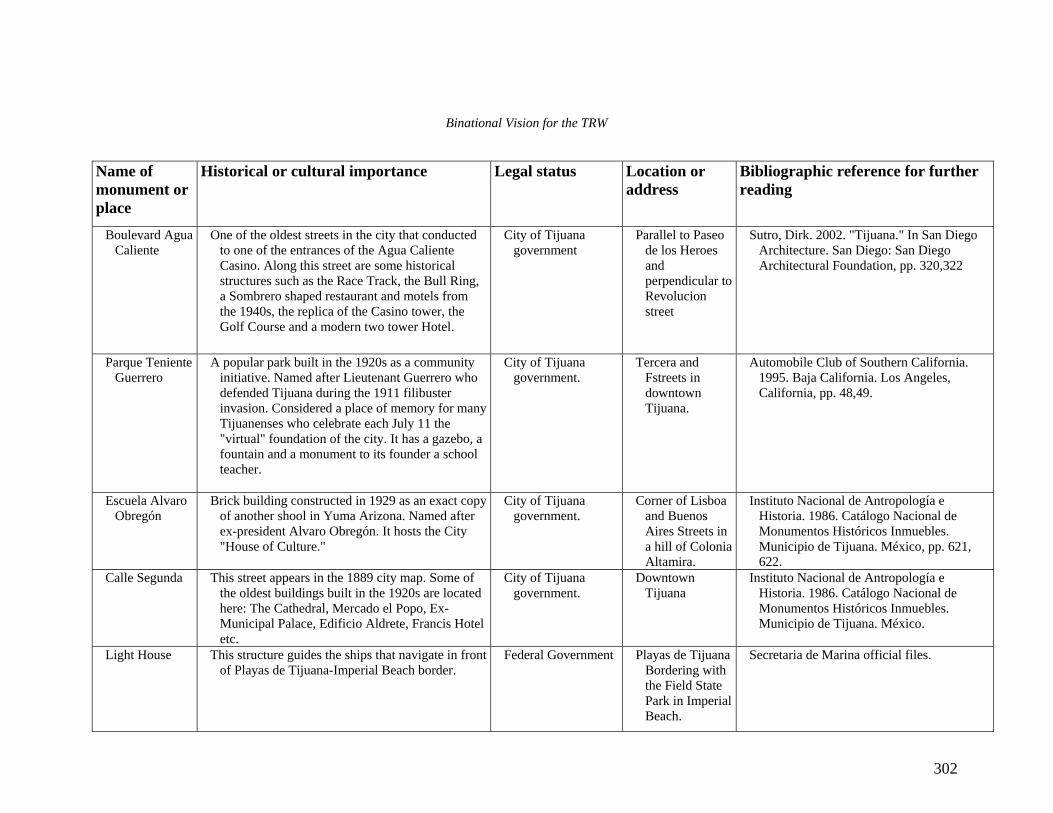
Binational Vision for the TRW
302
Name of monument or place
Historical or cultural importance Legal status Location or address
Bibliographic reference for further reading
Boulevard Agua Caliente
One of the oldest streets in the city that conducted to one of the entrances of the Agua Caliente Casino. Along this street are some historical structures such as the Race Track, the Bull Ring, a Sombrero shaped restaurant and motels from the 1940s, the replica of the Casino tower, the Golf Course and a modern two tower Hotel.
City of Tijuana government
Parallel to Paseo de los Heroes and perpendicular to Revolucion street
Sutro, Dirk. 2002. "Tijuana." In San Diego Architecture. San Diego: San Diego Architectural Foundation, pp. 320,322
Parque Teniente Guerrero
A popular park built in the 1920s as a community initiative. Named after Lieutenant Guerrero who defended Tijuana during the 1911 filibuster invasion. Considered a place of memory for many Tijuanenses who celebrate each July 11 the "virtual" foundation of the city. It has a gazebo, a fountain and a monument to its founder a school teacher.
City of Tijuana government.
Tercera and Fstreets in downtown Tijuana.
Automobile Club of Southern California. 1995. Baja California. Los Angeles, California, pp. 48,49.
Escuela Alvaro Obregón
Brick building constructed in 1929 as an exact copy of another shool in Yuma Arizona. Named after ex-president Alvaro Obregón. It hosts the City "House of Culture."
City of Tijuana government.
Corner of Lisboa and Buenos Aires Streets in a hill of Colonia Altamira.
Instituto Nacional de Antropología e Historia. 1986. Catálogo Nacional de Monumentos Históricos Inmuebles. Municipio de Tijuana. México, pp. 621, 622.
Calle Segunda This street appears in the 1889 city map. Some of the oldest buildings built in the 1920s are located here: The Cathedral, Mercado el Popo, Ex-Municipal Palace, Edificio Aldrete, Francis Hotel etc.
City of Tijuana government.
Downtown Tijuana
Instituto Nacional de Antropología e Historia. 1986. Catálogo Nacional de Monumentos Históricos Inmuebles. Municipio de Tijuana. México.
Light House This structure guides the ships that navigate in front of Playas de Tijuana-Imperial Beach border.
Federal Government Playas de Tijuana Bordering with the Field State Park in Imperial Beach.
Secretaria de Marina official files.

5. Appendix: Significant cultural and historical monuments in the TRW
303
Name of monument or place
Historical or cultural importance Legal status Location or address
Bibliographic reference for further reading
Border Fence The border metal fence that separates Baja California and California is a symbolic monument that divides and unites the tow nations. It is used for artistic expressions, binational events as well as for grassroots protests.
U.S. federal government
Mexico-US border.
Schulte-Peevers, Andrea. 2001. San Diego & Tijuana. Australia: Lonely Planet Publications, pp. 256,257.
Gaskill's Stone Store
This building was built in 1885 by Silas and Luman Gaskill. It was used as a bank, a post office, a stage station and as the social center of the community. Today is a museum store.
Mountain Empire Historical Society.
State Hiwy 94 at Campo Circle, California.
S. MacGill, Ruth (compiled and edited).1998. True Tales from Historic Campo and the Mountain Empire of San Diego County. Campo: Mountain Empire Historical Society, pp. 9-14.
Old Campo Road-Hwy 94
In 1870 a regular stage coach known as The Campo San Diego State, ran on this road. The stage left S.D. in the morning changed horses in Dulzura and then drove to Campo the same day. Later it became Hwy 94 and connected to Yuma.
U.S. federal government
East County http://www.hwy94.com
Pacific Southwestern Railroad Museum
The San Diego Railroad Museum is a non-profit educational organization dedicated to the preservation and interpretation of railroads as they existed in the Pacific Southwest. It has a train station, visitors center, nine locomotives and a collection of passenger cars, freight cars and cabooses. There are excursions to Miller Creek and to Tecate Mexico on weekends ran by volunteers.
Pacific Southwest Railway Museum Association.
Campo Depot 31123-1/2
Highway 94 Campo,
California 91906.
http://www.sdrm.org/
Camp Locket (proposed State Park)
This was the original site where troops of the last cavalry units in the U.S. army stationed. The troops stayed until the United States entered World War II. There were all-black cavalry units in the Camp known as "Buffalo Soldiers". The Camp also housed thousands of military personnel from 1942 to 1945.
San Diego County. Campo, California.
Challberg, Roger. "Camp Lockett State Park?" In Mountain Heritage.The Back Country's Historical Digest.Volume 15 Number 4. San Diego, CA, pp. 1,6.

Binational Vision for the TRW
304
Name of monument or place
Historical or cultural importance Legal status Location or address
Bibliographic reference for further reading
Campo Mill This 1920 structure, where feldspar from Campo mines was milled, is now occupied by the Motor Transport Museum. The museum houses a collection of vintage trucks.
Motor Transport Museum.
Highway 94, two miles east of Campo Creek.
Sutro, Dirk. 2002. "East County." In San Diego Architecture. San Diego: San Diego Architectural Foundation, p. 305.
Paseo de los Héroes.
The main business district, monuments to national and international heroes and the Tijuana Cultural Center are located in this avenue.
City of Tijuana government.
Zona Rio. Sutro, Dirk. 2002. "Tijuana." In San Diego Architecture. San Diego: San Diego Architectural Foundation, pp.319,322
Monumental Flag
Built in the 1997 as a federal program to celebrate national symbols in border cities. The flag is 86 x 150 feet in size and 310 feet tall.
Federal Government Military camp in Colonia Morelos just passing the south end of Revolucion.
Rodríguez Barajas, Julio. 2004. La Ruta de los Monumentos Históricos de Tijuana. Tijuana: ILCSA Ed., p. 119.
Tijuana Tercer Milenio (La Mona)
House built with a woman's shape by sculptor Armando Muñoz García in 1990 to celebrate the 100 anniversary of Tijuana. It is a naked 50 feet tall sexy woman made of concrete, steel, fiberglass and clay located in the middle of a popular low-income neighborhood.
Private property. A canyon in Colonia Aeropuerto.
Rodríguez Barajas, Julio. 2004. La Ruta de los Monumentos Históricos de Tijuana. Tijuana: ILCSA Ed., p. 102,105.
Cristo Rey This monumental Jesus Christ (72 feet tall) made of fiber glass and resin, aims to compete with another one in Brazil. It is surrounded by 28 angels.
Federal Government in conjunction with church.
Colonia los Alamos next to San Martin de Porres church.
Rodríguez Barajas, Julio. 2004. La Ruta de los Monumentos Históricos de Tijuana. Tijuana: ILCSA Ed., p. 119.
Plaza Santa Cecilia
This is the old Olvera Street that appears in the 1889 map of the city. Made a walking street in the 1980s and renamed as Plaza Santa Cecilia. There are restaurants, bars, street vendors and a Mariachi stage. The 1950s Nelson hotel is in the corner of the Plaza and Avenida Revolución.
City of Tijuana government.
Between Revolución and Second Streets.
Sutro, Dirk. 2002. "Tijuana." In San Diego Architecture. San Diego: San Diego Architectural Foundation, p. 318.
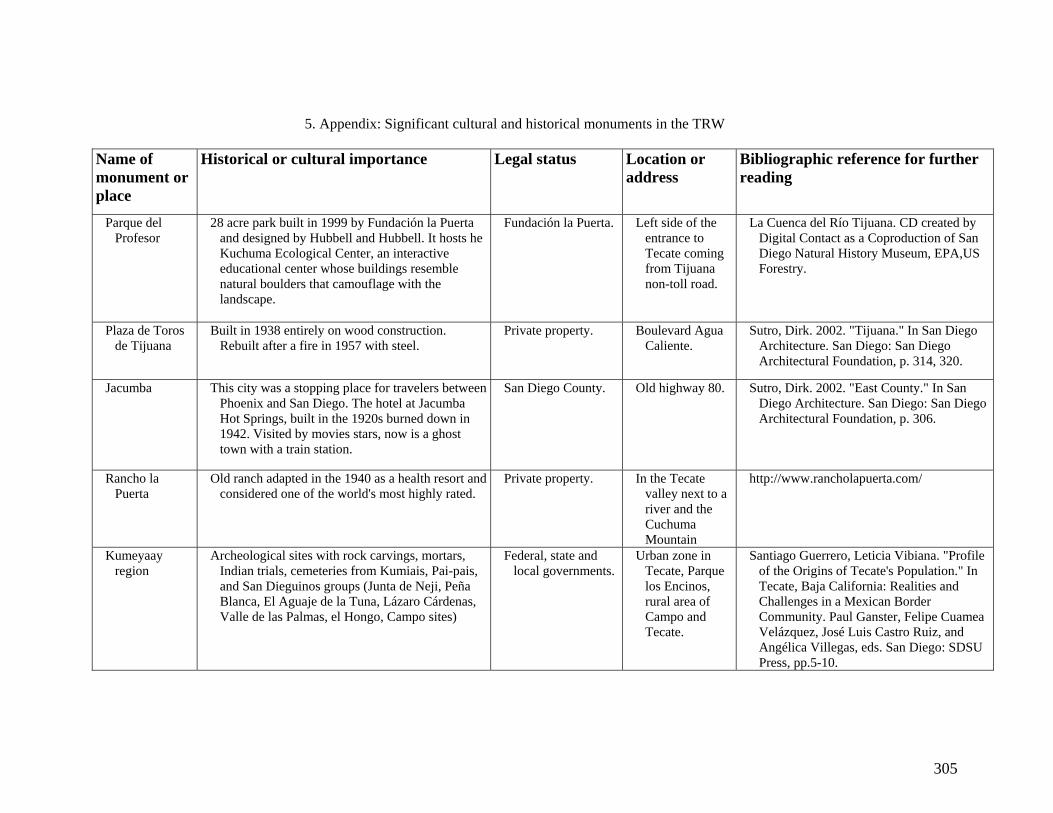
5. Appendix: Significant cultural and historical monuments in the TRW
305
Name of monument or place
Historical or cultural importance Legal status Location or address
Bibliographic reference for further reading
Parque del Profesor
28 acre park built in 1999 by Fundación la Puerta and designed by Hubbell and Hubbell. It hosts he Kuchuma Ecological Center, an interactive educational center whose buildings resemble natural boulders that camouflage with the landscape.
Fundación la Puerta. Left side of the entrance to Tecate coming from Tijuana non-toll road.
La Cuenca del Río Tijuana. CD created by Digital Contact as a Coproduction of San Diego Natural History Museum, EPA,US Forestry.
Plaza de Toros de Tijuana
Built in 1938 entirely on wood construction. Rebuilt after a fire in 1957 with steel.
Private property. Boulevard Agua Caliente.
Sutro, Dirk. 2002. "Tijuana." In San Diego Architecture. San Diego: San Diego Architectural Foundation, p. 314, 320.
Jacumba This city was a stopping place for travelers between Phoenix and San Diego. The hotel at Jacumba Hot Springs, built in the 1920s burned down in 1942. Visited by movies stars, now is a ghost town with a train station.
San Diego County. Old highway 80. Sutro, Dirk. 2002. "East County." In San Diego Architecture. San Diego: San Diego Architectural Foundation, p. 306.
Rancho la Puerta
Old ranch adapted in the 1940 as a health resort and considered one of the world's most highly rated.
Private property. In the Tecate valley next to a river and the Cuchuma Mountain
http://www.rancholapuerta.com/
Kumeyaay region
Archeological sites with rock carvings, mortars, Indian trials, cemeteries from Kumiais, Pai-pais, and San Dieguinos groups (Junta de Neji, Peña Blanca, El Aguaje de la Tuna, Lázaro Cárdenas, Valle de las Palmas, el Hongo, Campo sites)
Federal, state and local governments.
Urban zone in Tecate, Parque los Encinos, rural area of Campo and Tecate.
Santiago Guerrero, Leticia Vibiana. "Profile of the Origins of Tecate's Population." In Tecate, Baja California: Realities and Challenges in a Mexican Border Community. Paul Ganster, Felipe Cuamea Velázquez, José Luis Castro Ruiz, and Angélica Villegas, eds. San Diego: SDSU Press, pp.5-10.
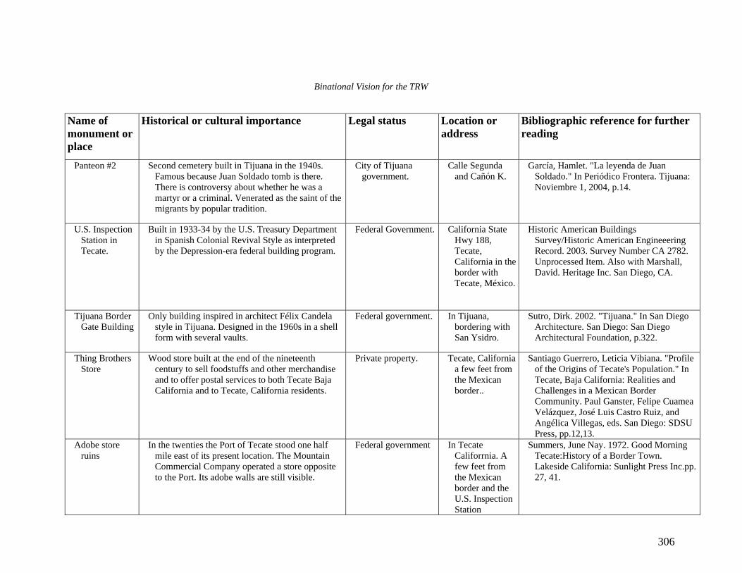
Binational Vision for the TRW
306
Name of monument or place
Historical or cultural importance Legal status Location or address
Bibliographic reference for further reading
Panteon #2 Second cemetery built in Tijuana in the 1940s. Famous because Juan Soldado tomb is there. There is controversy about whether he was a martyr or a criminal. Venerated as the saint of the migrants by popular tradition.
City of Tijuana government.
Calle Segunda and Cañón K.
García, Hamlet. "La leyenda de Juan Soldado." In Periódico Frontera. Tijuana: Noviembre 1, 2004, p.14.
U.S. Inspection Station in Tecate.
Built in 1933-34 by the U.S. Treasury Department in Spanish Colonial Revival Style as interpreted by the Depression-era federal building program.
Federal Government. California State Hwy 188, Tecate, California in the border with Tecate, México.
Historic American Buildings Survey/Historic American Engineeering Record. 2003. Survey Number CA 2782. Unprocessed Item. Also with Marshall, David. Heritage Inc. San Diego, CA.
Tijuana Border Gate Building
Only building inspired in architect Félix Candela style in Tijuana. Designed in the 1960s in a shell form with several vaults.
Federal government. In Tijuana, bordering with San Ysidro.
Sutro, Dirk. 2002. "Tijuana." In San Diego Architecture. San Diego: San Diego Architectural Foundation, p.322.
Thing Brothers Store
Wood store built at the end of the nineteenth century to sell foodstuffs and other merchandise and to offer postal services to both Tecate Baja California and to Tecate, California residents.
Private property. Tecate, California a few feet from the Mexican border..
Santiago Guerrero, Leticia Vibiana. "Profile of the Origins of Tecate's Population." In Tecate, Baja California: Realities and Challenges in a Mexican Border Community. Paul Ganster, Felipe Cuamea Velázquez, José Luis Castro Ruiz, and Angélica Villegas, eds. San Diego: SDSU Press, pp.12,13.
Adobe store ruins
In the twenties the Port of Tecate stood one half mile east of its present location. The Mountain Commercial Company operated a store opposite to the Port. Its adobe walls are still visible.
Federal government In Tecate Califorrnia. A few feet from the Mexican border and the U.S. Inspection Station
Summers, June Nay. 1972. Good Morning Tecate:History of a Border Town. Lakeside California: Sunlight Press Inc.pp. 27, 41.
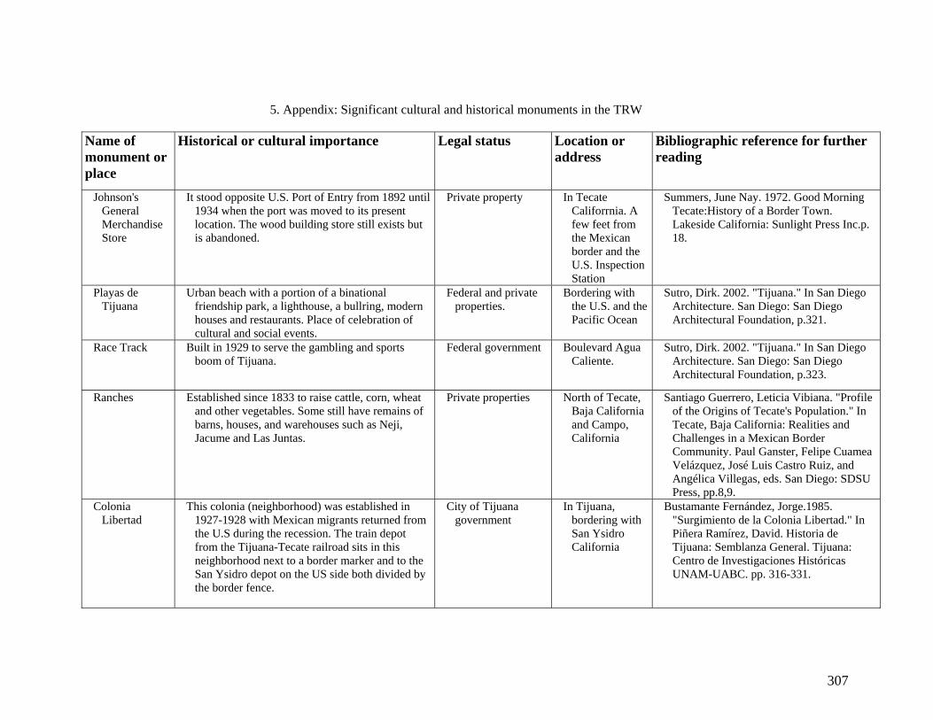
5. Appendix: Significant cultural and historical monuments in the TRW
307
Name of monument or place
Historical or cultural importance Legal status Location or address
Bibliographic reference for further reading
Johnson's General Merchandise Store
It stood opposite U.S. Port of Entry from 1892 until 1934 when the port was moved to its present location. The wood building store still exists but is abandoned.
Private property In Tecate Califorrnia. A few feet from the Mexican border and the U.S. Inspection Station
Summers, June Nay. 1972. Good Morning Tecate:History of a Border Town. Lakeside California: Sunlight Press Inc.p. 18.
Playas de Tijuana
Urban beach with a portion of a binational friendship park, a lighthouse, a bullring, modern houses and restaurants. Place of celebration of cultural and social events.
Federal and private properties.
Bordering with the U.S. and the Pacific Ocean
Sutro, Dirk. 2002. "Tijuana." In San Diego Architecture. San Diego: San Diego Architectural Foundation, p.321.
Race Track Built in 1929 to serve the gambling and sports boom of Tijuana.
Federal government Boulevard Agua Caliente.
Sutro, Dirk. 2002. "Tijuana." In San Diego Architecture. San Diego: San Diego Architectural Foundation, p.323.
Ranches Established since 1833 to raise cattle, corn, wheat and other vegetables. Some still have remains of barns, houses, and warehouses such as Neji, Jacume and Las Juntas.
Private properties North of Tecate, Baja California and Campo, California
Santiago Guerrero, Leticia Vibiana. "Profile of the Origins of Tecate's Population." In Tecate, Baja California: Realities and Challenges in a Mexican Border Community. Paul Ganster, Felipe Cuamea Velázquez, José Luis Castro Ruiz, and Angélica Villegas, eds. San Diego: SDSU Press, pp.8,9.
Colonia Libertad
This colonia (neighborhood) was established in 1927-1928 with Mexican migrants returned from the U.S during the recession. The train depot from the Tijuana-Tecate railroad sits in this neighborhood next to a border marker and to the San Ysidro depot on the US side both divided by the border fence.
City of Tijuana government
In Tijuana, bordering with San Ysidro California
Bustamante Fernández, Jorge.1985. "Surgimiento de la Colonia Libertad." In Piñera Ramírez, David. Historia de Tijuana: Semblanza General. Tijuana: Centro de Investigaciones Históricas UNAM-UABC. pp. 316-331.
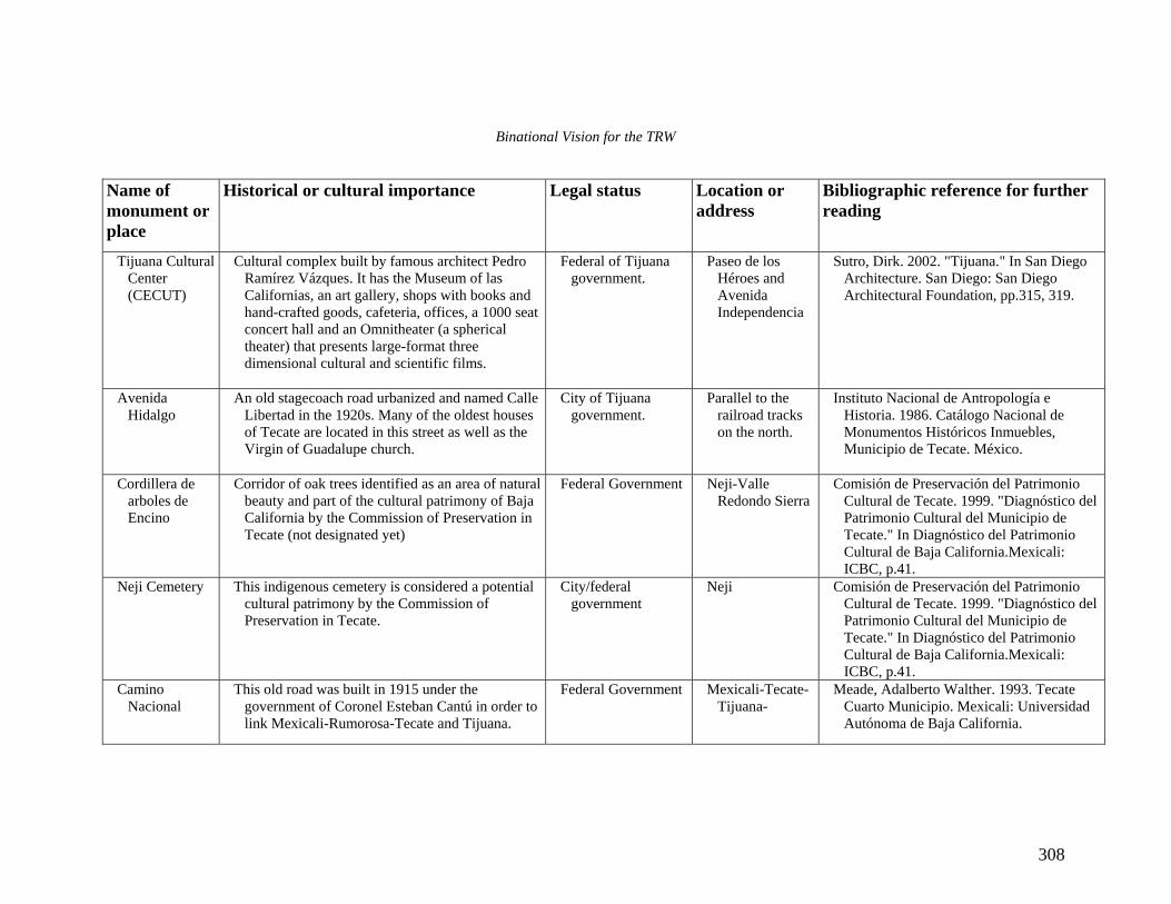
Binational Vision for the TRW
308
Name of monument or place
Historical or cultural importance Legal status Location or address
Bibliographic reference for further reading
Tijuana Cultural Center (CECUT)
Cultural complex built by famous architect Pedro Ramírez Vázques. It has the Museum of las Californias, an art gallery, shops with books and hand-crafted goods, cafeteria, offices, a 1000 seat concert hall and an Omnitheater (a spherical theater) that presents large-format three dimensional cultural and scientific films.
Federal of Tijuana government.
Paseo de los Héroes and Avenida Independencia
Sutro, Dirk. 2002. "Tijuana." In San Diego Architecture. San Diego: San Diego Architectural Foundation, pp.315, 319.
Avenida Hidalgo
An old stagecoach road urbanized and named Calle Libertad in the 1920s. Many of the oldest houses of Tecate are located in this street as well as the Virgin of Guadalupe church.
City of Tijuana government.
Parallel to the railroad tracks on the north.
Instituto Nacional de Antropología e Historia. 1986. Catálogo Nacional de Monumentos Históricos Inmuebles, Municipio de Tecate. México.
Cordillera de arboles de Encino
Corridor of oak trees identified as an area of natural beauty and part of the cultural patrimony of Baja California by the Commission of Preservation in Tecate (not designated yet)
Federal Government Neji-Valle Redondo Sierra
Comisión de Preservación del Patrimonio Cultural de Tecate. 1999. "Diagnóstico del Patrimonio Cultural del Municipio de Tecate." In Diagnóstico del Patrimonio Cultural de Baja California.Mexicali: ICBC, p.41.
Neji Cemetery This indigenous cemetery is considered a potential cultural patrimony by the Commission of Preservation in Tecate.
City/federal government
Neji Comisión de Preservación del Patrimonio Cultural de Tecate. 1999. "Diagnóstico del Patrimonio Cultural del Municipio de Tecate." In Diagnóstico del Patrimonio Cultural de Baja California.Mexicali: ICBC, p.41.
Camino Nacional
This old road was built in 1915 under the government of Coronel Esteban Cantú in order to link Mexicali-Rumorosa-Tecate and Tijuana.
Federal Government Mexicali-Tecate-Tijuana-
Meade, Adalberto Walther. 1993. Tecate Cuarto Municipio. Mexicali: Universidad Autónoma de Baja California.
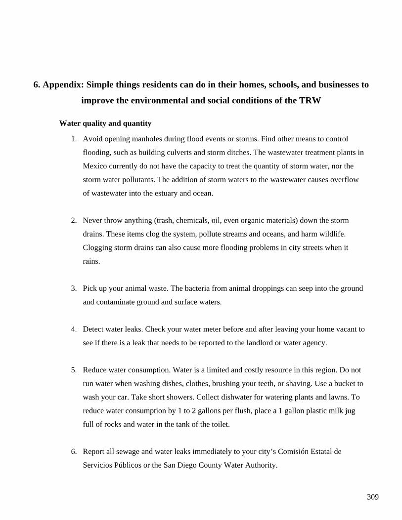
6. Appendix: Simple things residents can do in their homes, schools, and businesses to
improve the environmental and social conditions of the TRW
Water quality and quantity
1. Avoid opening manholes during flood events or storms. Find other means to control
flooding, such as building culverts and storm ditches. The wastewater treatment plants in
Mexico currently do not have the capacity to treat the quantity of storm water, nor the
storm water pollutants. The addition of storm waters to the wastewater causes overflow
of wastewater into the estuary and ocean.
2. Never throw anything (trash, chemicals, oil, even organic materials) down the storm
drains. These items clog the system, pollute streams and oceans, and harm wildlife.
Clogging storm drains can also cause more flooding problems in city streets when it
rains.
3. Pick up your animal waste. The bacteria from animal droppings can seep into the ground
and contaminate ground and surface waters.
4. Detect water leaks. Check your water meter before and after leaving your home vacant to
see if there is a leak that needs to be reported to the landlord or water agency.
5. Reduce water consumption. Water is a limited and costly resource in this region. Do not
run water when washing dishes, clothes, brushing your teeth, or shaving. Use a bucket to
wash your car. Take short showers. Collect dishwater for watering plants and lawns. To
reduce water consumption by 1 to 2 gallons per flush, place a 1 gallon plastic milk jug
full of rocks and water in the tank of the toilet.
6. Report all sewage and water leaks immediately to your city’s Comisión Estatal de
Servicios Públicos or the San Diego County Water Authority.
309
Binational Vision for the TRW
310
Environment and Natural Resources
7. Plant native shrubs and drought-resistant trees and shrubs in your yard. This will decrease
water use, increase habitat area, and attract local birds, insects, reptiles, and mammals.
The shade provided by native trees cools your house and yard. The roots of the trees help
retain soil in your yard.
8. Avoid exotic plants. Avoid using grass—you will help the environment and heavily-
watered lawns are attractions for skunks, opossums, and other unwanted guests. If you
have a grass lawn, place tin cans around the lawn and time how long the sprinklers take
to fill the can 1 inch. That is how long the sprinklers should run.
9. Place bird feeders and baths in your lawn. The TRW is a migratory stopover for birds in
the Americas. The wetlands they have used for centuries are diminishing, but households
can help in small ways until our local wetlands recover.
10. Cut up plastic beverage six-pack holders and never let helium balloons go—these can
strangle wildlife.
11. Bring your own bags to the store, or avoid using bags. Plastic bags are increasingly seen
as a major threat to the environment, wildlife, and our landfills.
Solid and Hazardous Waste
12. Avoid the use of household cleaning products and insecticides with chemicals. Never
throw unused chemical products into the sink or rivers. Remember, these chemicals can
end up in your well water, streams, and oceans.
13. Use water-based paint. Chemicals and heavy metals in lead-based paint can harm humans
and the environment.
14. Use rechargeable batteries; can save you money. Dead batteries should not be thrown
away or burned, because they leak hazardous materials into the soil and water, and can
6. Appendix: Simple things residents can do
311
explode. Deliver them to the San Diego Household Hazardous Waste Transfer Facility
(858-694-7000).
15. Reduce, Reuse, Recycle. Aluminum foil, glass jars, plastic containers and other items can
be rinsed and reused. If an item is unusable, rinse it and recycle it.
16. Chidren should educate their parents about litter. When hiking in the hills, at the beach,
or along the streams and rivers, carry a trash bag and pick up trash.
17. Start a recycling program. Children should ask their teachers to start a recycling center at
their schools. Recyclables can bring in money.
18. Take toxic household products to the appropriate hazardous waste centers. Examples of
toxic products are pesticide containers, used motor oil, gasoline, paint thinner, batteries,
paint containers, and so forth. Studies in the TRW show that residential pollutants in
wastewater are even more of a problem than industrial pollutants.
19. Compost your organic waste in a corner of your yard. In addition to helping reduce bulk
in the landfills, this compost is excellent fertilizer. Sprinkle the compost pile with ash or
lime (cal), and turn the compost pile so that the sun “cooks” the compost for about a
month before using it in plant beds. Lightly watering the compost pile helps speed up the
decomposition process.
20. Report illegal dumping to DGE, EPA, or similar authority.
21. Never dump unwanted items in public places like rivers or arroyos. Take them to
recycling centers, donation centers, or landfills that have liners proventing leakage into
the groundwater and soil.
22. Donate your old car to charity. This will keep cars out of the landfills and prevent
automobile fluids from leaking into the soil and groundwater. Car donations can be tax
deductible in the United States.
Binational Vision for the TRW
312
Air Quality
23. Bike, carpool, and take the bus or trolley as much as you can. Apply for a SENTRI
border crossing pass to help alleviate border area traffic and pollution.
24. Turn off your lights and appliances when not in use. This practice saves money and
reduces the power plants’ use of fossil fuels.
25. Use incandescent lightbulbs or higher wattage lightbulbs for the above reasons.
26. When building your house, calculate how much money could be saved by installing solar
panels.
27. Avoid using styrofoam products. The production process contributes to ozone depletion.
In addition, styrofoam is slow to biodegrade and takes up much landfill space.
Socioeconomic Issues
28. Vote in elections, and write or call your representatives. Demand that politicians be
responsible with your watershed resources. Put your local issues on their agenda.
29. Volunteer for a local charity, NGO, orphanage, senior center, etc. Community
involvement and pride can increase the quality of life for many.
30. Buy local. Try to buy local produce, nursery plants, and household products; avoid larger
chains. Transportation of goods from outside the watershed can have negative effects on
the TRW’s air quality, environment, traffic, and local economy.
31. Take a vacation in your own neighborhood. Enjoy the local beauty of the TRW by hiking
in the Otay Mountain Wilderness Area; bird watching at the Tijuana Estuary; visiting
Playas de Tijuana, tourist districts in Tijuana, tourist ranches in Tecate; and camp in the
upper watershed near El Compadre, La Hechicera, or Valle de Las Palmas.
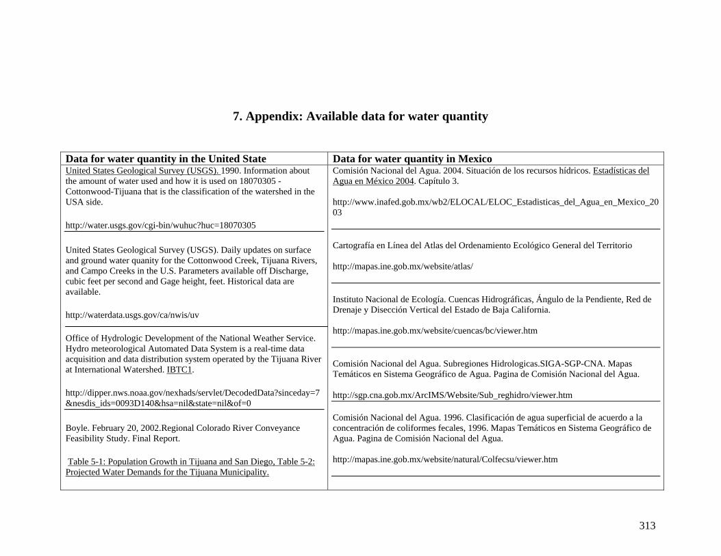
313
7. Appendix: Available data for water quantity
Data for water quantity in the United State Data for water quantity in Mexico United States Geological Survey (USGS). 1990. Information about the amount of water used and how it is used on 18070305 - Cottonwood-Tijuana that is the classification of the watershed in the USA side.
http://water.usgs.gov/cgi-bin/wuhuc?huc=18070305
United States Geological Survey (USGS). Daily updates on surface and ground water quanity for the Cottonwood Creek, Tijuana Rivers, and Campo Creeks in the U.S. Parameters available off Discharge, cubic feet per second and Gage height, feet. Historical data are available.
http://waterdata.usgs.gov/ca/nwis/uv
Office of Hydrologic Development of the National Weather Service. Hydro meteorological Automated Data System is a real-time data acquisition and data distribution system operated by the Tijuana River at International Watershed. IBTC1.
http://dipper.nws.noaa.gov/nexhads/servlet/DecodedData?sinceday=7&nesdis_ids=0093D140&hsa=nil&state=nil&of=0
Boyle. February 20, 2002.Regional Colorado River Conveyance Feasibility Study. Final Report.
Table 5-1: Population Growth in Tijuana and San Diego, Table 5-2: Projected Water Demands for the Tijuana Municipality.
Comisión Nacional del Agua. 2004. Situación de los recursos hídricos. Estadísticas del Agua en México 2004. Capítulo 3. http://www.inafed.gob.mx/wb2/ELOCAL/ELOC_Estadisticas_del_Agua_en_Mexico_2003 Cartografía en Línea del Atlas del Ordenamiento Ecológico General del Territorio http://mapas.ine.gob.mx/website/atlas/ Instituto Nacional de Ecología. Cuencas Hidrográficas, Ángulo de la Pendiente, Red de Drenaje y Disección Vertical del Estado de Baja California. http://mapas.ine.gob.mx/website/cuencas/bc/viewer.htm Comisión Nacional del Agua. Subregiones Hidrologicas.SIGA-SGP-CNA. Mapas Temáticos en Sistema Geográfico de Agua. Pagina de Comisión Nacional del Agua. http://sgp.cna.gob.mx/ArcIMS/Website/Sub_reghidro/viewer.htm Comisión Nacional del Agua. 1996. Clasificación de agua superficial de acuerdo a la concentración de coliformes fecales, 1996. Mapas Temáticos en Sistema Geográfico de Agua. Pagina de Comisión Nacional del Agua. http://mapas.ine.gob.mx/website/natural/Colfecsu/viewer.htm

Binational Vision for the TRW
314
http://www.sdcwa.org/news/pdf/Binational/Boyle2002/05near-termoptions.pdf
VICTOR MIGUEL PONCE . 1997. Flood Hydrology Of The Binational Cottonwood Creek/Arroyo Alamar, California And Baja California. SCERP Project Number: W-00-5. , San Diego State University.
- Topology of Cottonwood Creek-Arroyo Alamar Draingage Basin. Page 13.
- Average and Maximum Historic Monthly Levels in Lake Morena. Page 14
- Average and Maximum Historic Monthly Levels in Lake Barrett. Page 15.
- Flood Discharges (m3/s) calculated for the Basin of Arroyo Alamar with Statistical Methods. Page 16.
- Hydrologic Characteristics of the Subbasins. Page 17. - Design Storms (cm) for Return Periods of 2 years to 1000
Years. Page 21. - Historic Levels (in ft, relative) in Morena Reservoir at the
Beginning of the Month. Page 24. - Historic Levels (in ft, relative) in Barrett Reservoir at the
Beginning of the Month. Page 27. - Funtions of Elevation -stored Volume-spilled Discharge for
Morena Reservoir. Page 29. - Functions of Elevation-stored Volume-spilled Discharge for
Barrett Reservoir. Page 31. - Calculation of Runoff Curve Number for Pine Valley Creek
2 Lateral Subbasin (topological number 30602). Page 33. - RAINFLO Input File Corresponding to the 100-year Return
Period. Page 35. - Flood Discharges (m3 s-1) Calculated for Cottonwood Creek
- Arroyo Alamar by Rainfall Runoff Modeling. Page 45. - Flood Discharges (m3 s-1) Calculated for Arroyo Alamar
With and Without Infiltration in the Channelization Project
García Cueto, O. R. 1993. La variabilidad de la precipitación y el fenómeno ENSO. Divulgare, UABC, No. 2, Marzo-Mayo 1993 (Recursos Agua), May: 4. Álvarez Valdez, G. 1973. Cuencas de Captación en el Estado de Baja California. CALAFIA, UABC, Vol. II No. 3 (Cuenca), Diciembre: 5. Paredes Arellano, E. 1973. Disponibilidad de los recursos hidráulicos en el Estado de Baja California. CALAFIA, UABC, Vol. II No. 3 (Hidráulicos), Diciembre: 10. Segovia Zavala, J. A., Gutiérrez Galindo, E. A., & y Flores Muñoz, G. 1996. El agua en Baja California. Divulgare, UABC, No. 15, Año 4, Julio -Septiembre 1996 (Abastecimiento de Agua), Jul.: 5. CESPT. Información de Hidrometría de Agua Potable y Alcantarillado (Fólder). Plano con diagrama de flujo del sistema de agua potable, ubicación de tanques, rebombeos y los puntos donde se han realizado los aforos, lectura de macromedidores promedios mensuales del año 2001, aforos realizados en alcantarillado, indicadores de gestión del programa de control de pérdidas, plano de 32 circuitos hidrométricos. CESPT. Cobertura Total de Agua Potable y Alcantarillado. Contiene la población beneficiada de los sistemas de agua potable y alcantarillado. CESPT. Programa Hidráulico de Gran Visión Región I, Península de Baja California. Presentación, programa hidráulico, resumen ejecutivo, resumen sintético, síntesis básicas, documento de divulgación, libro del agua. CESPT. Información de Cuencas Hidrológicas del 2001. CD
7. Appendix: Available data for water quantity
315
Reach (40117). Page 47. http://www.scerp.org/projs/00rpts/W-00-5.pdf USGS California Hydrologic Data Report. 1996. Cottonwood Creek 11012000Above Tecate Creek, Near Dulzura, CA http://ca.water.usgs.gov/archive/waterdata/96/11012000.html USGS California Hydrologic Data Report. 1995. Cottonwood Creek 11012000Above Tecate Creek, Near Dulzura, Ca. http://ca.water.usgs.gov/archive/waterdata/96/11012000 http://ca.water.usgs.gov/archive/waterdata/95/sw/sw11012000.st USGS California Hydrologic Data Report. 1994. Cottonwood Creek 11012000Above Tecate Creek, Near Dulzura, Ca. http://ca.water.usgs.gov/archive/waterdata/96/11012000.html http://ca.water.usgs.gov/archive/waterdata/94/sw/sw11012000.html USGS. 1999. California Data Report: Discontinued Lakes & Reservoir Sites. Volume 1. Southern Great Basin from Mexican Border to Mono Lake Basin, and Pacific Slope Basins from Tijuana River to Data Maria River. http://ca.water.usgs.gov/archive/waterdata/99/disc_lakes.html USGS 1999 California Data Report: Discontinued Gaging Stations.
Información de cuencas hidrológicas, fraccionamientos, coberturas, límite municipal, división de distritos. Sistema Hidráulicos y Ambientales S.A. de C.V. ( Dos Tomos de 1999-2025). Estrategia de Gran Visión para Abastecimiento y Manejo de Agua en las Ciudades y Cuencas de la Frontera Norte CESPT. CD Base de Datos de los sobre los consumos por tipo de usuario. Gobierno del estado de Baja California. Plan Estatal Hidráulico 1994-2015. Documento oficial de diagnóstico de las necesidades futuras de agua en el medio urbano del estado y se establecen las acciones de gobierno que se requieren para satisfacer la demanda de agua. COLEF. Year? Plan Estatal de Desarrollo Urbano. Establece lineamientos y estrategias de ordenamiento urbano en el Estado. Gobierno del estado de Baja California y COLEF. Plan Estatal de Desarrollo 2002-2007. Documento oficial que contempla las acciones que se llevarán a cabo durante la presente administración para el estado de Baja California. CESPT. Plano con Límite de Distritos de Agua Potable y Colonias (Copia a Colores) esc: 1: 50,000. Límites de los distritos, presa, Río Tijuana, nombres de las colonias. CNA. 1997. Diagnóstico Actual y Propuesta de Explotación y Tratamiento de los Pozos
Binational Vision for the TRW
316
Volume 1. From the Southern Great Basin from Mexican Border to Mono Lake Basin, and Pacific Slope Basins from Tijuana River to Data Maria River. http://ca.water.usgs.gov/archive/waterdata/99/disc_sw.html Richard M. Gersberg, and, Fernando T. Wakida Kusunoki. 1998. “Water Quality and Quantity”. UABC and SDSU. Page 80. In State of the Enviroment of the Tijuana River Basin. Working Draft. Institute for Regional Studies of the California, San Diego Sate University An overview of the existing literature of the Water Quality and Quantity of the Tijuana River area.
de Agua Potable de la Ciudad de Tijuana (Tomo II). Planos de (localización de pozos, profundidad de niveles estáticos, evolución del nivel estático en el periodo 87-97) Proyectos, Estudios y Consultaría, S.A. de C.V. (2 tomos YEAR?). Definición de Nuevas Fuentes de Abastecimiento Diagnóstico de agua potable, elaboración de alternativas, para planeación de un horizonte al año 2015, propuesta de esquemas de solución viables desde el punto de vista técnico-económico que consideren la disponibilidad del recurso de agua. CESPT. YEAR? Situación Actual del Sistema de Abastecimiento de Agua Potable para la Ciudad de Tijuana B.C.3 Comportamiento del sistema de abastecimiento de agua potable a la ciudad de Tijuana. CESPT. CD con Información de Curvas de Nivel en Mosaico de Catastro. Información de curvas de nivel, inventario de redes, red primaria. CESPT. Histogramas de Consumo (2000-2001). Disquete Información de lo últimos dos años 2000-2001. CESPT. Resumen General del Consumo Promedio por Cuenta. Consumo promedio por cuenta en el año clasificado en residencial, comercial, industrial, y de gobierno, incluye también el promedio por mes del servicio.
7. Appendix: Available data for water quantity
317
CESPT. Diciembre 1999.Análisis Preliminar para el Abastecimiento de Agua a Tijuana Tecate, Rosalito, Mediante Ampliación del Acueducto Rió Colorado Tijuana. Es un estudio con el objeto de analizar la posibilidad de ampliar la capacidad de conducción del acueducto rió colorado-Tijuana, determinando las obras necesarias para este propósito y sus posibles costos, todo esto en el ámbito de factibilidad. CESPT. Definición de Políticas de Servicio de Agua Potable, a Corto, Mediano, y Largo Plazo (2004, 2009, 2038). Análisis de demanda de agua potable para zonas con infraestructura de distribución actual, para zonas con distribución y red primaria actual incluyendo baldíos intraurbanos, fraccionamientos en proceso, colonias incluidas en el crédito japonés, ampliación de la mancha urbana donde existe red primaria. La Conferencia COBRO Anual de 1997. Conferencia: Retos y oportunidades binacionales del Agua. Comité Regional de Oportunidades Fronterizas (COBRO) de la Asociación de Gobiernos de San Diego (SANDAG). Reporte que provee un acercamiento a las demandas de agua y fuentes en las regiones de San Diego y Tijuana. Resumen de las sesiones. CESPT.5 de marzo del 2002. Propuestas de DOE para Recarga de Acuífero
Binational Vision for the TRW
318
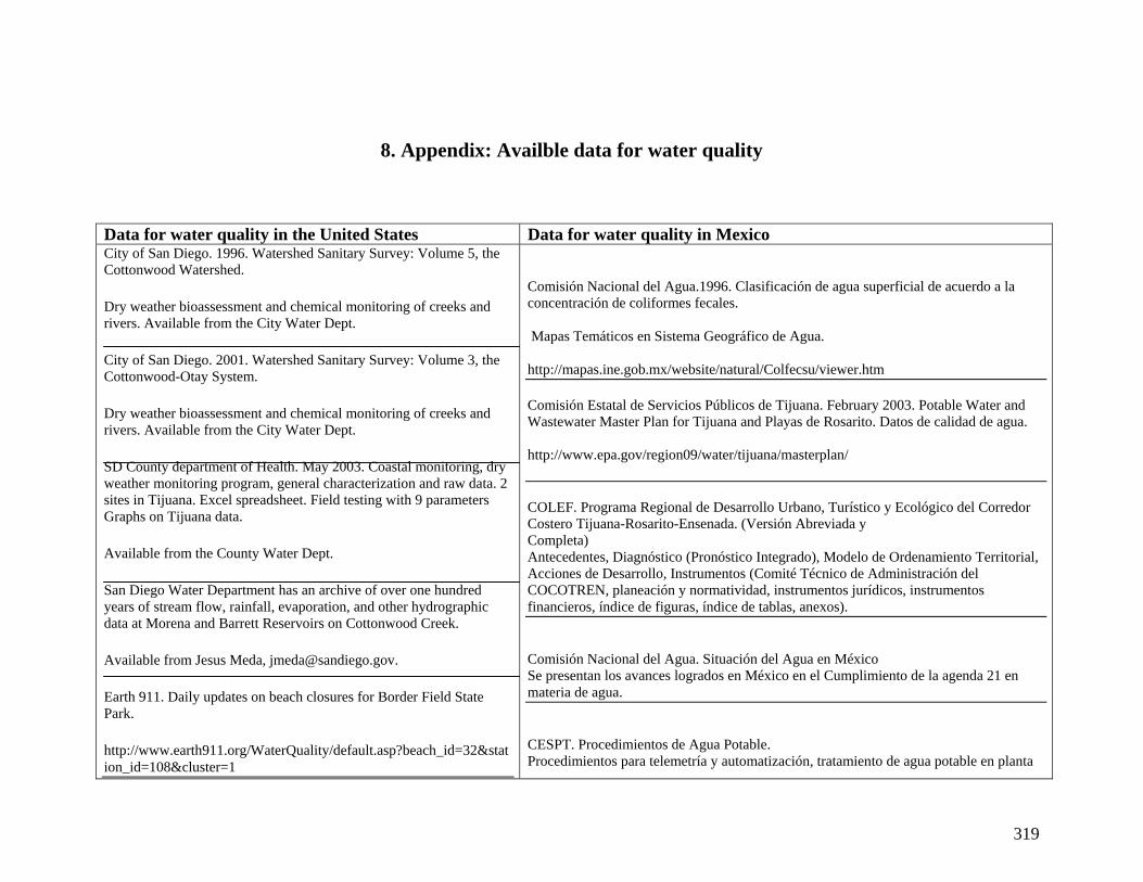
8. Appendix: Availble data for water quality
Data for water quality in the United States Data for water quality in Mexico City of San Diego. 1996. Watershed Sanitary Survey: Volume 5, the Cottonwood Watershed.
Dry weather bioassessment and chemical monitoring of creeks and rivers. Available from the City Water Dept.
City of San Diego. 2001. Watershed Sanitary Survey: Volume 3, the Cottonwood-Otay System.
Dry weather bioassessment and chemical monitoring of creeks and rivers. Available from the City Water Dept.
SD County department of Health. May 2003. Coastal monitoring, dry weather monitoring program, general characterization and raw data. 2 sites in Tijuana. Excel spreadsheet. Field testing with 9 parameters Graphs on Tijuana data.
Available from the County Water Dept.
San Diego Water Department has an archive of over one hundred years of stream flow, rainfall, evaporation, and other hydrographic data at Morena and Barrett Reservoirs on Cottonwood Creek.
Available from Jesus Meda, [email protected].
Earth 911. Daily updates on beach closures for Border Field State Park.
http://www.earth911.org/WaterQuality/default.asp?beach_id=32&station_id=108&cluster=1
Comisión Nacional del Agua.1996. Clasificación de agua superficial de acuerdo a la concentración de coliformes fecales. Mapas Temáticos en Sistema Geográfico de Agua. http://mapas.ine.gob.mx/website/natural/Colfecsu/viewer.htm Comisión Estatal de Servicios Públicos de Tijuana. February 2003. Potable Water and Wastewater Master Plan for Tijuana and Playas de Rosarito. Datos de calidad de agua. http://www.epa.gov/region09/water/tijuana/masterplan/ COLEF. Programa Regional de Desarrollo Urbano, Turístico y Ecológico del Corredor Costero Tijuana-Rosarito-Ensenada. (Versión Abreviada y Completa) Antecedentes, Diagnóstico (Pronóstico Integrado), Modelo de Ordenamiento Territorial, Acciones de Desarrollo, Instrumentos (Comité Técnico de Administración del COCOTREN, planeación y normatividad, instrumentos jurídicos, instrumentos financieros, índice de figuras, índice de tablas, anexos). Comisión Nacional del Agua. Situación del Agua en México Se presentan los avances logrados en México en el Cumplimiento de la agenda 21 en materia de agua. CESPT. Procedimientos de Agua Potable. Procedimientos para telemetría y automatización, tratamiento de agua potable en planta
319
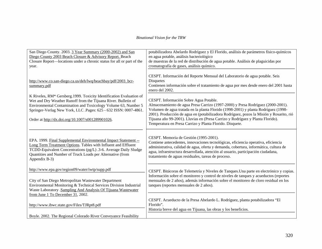
Binational Vision for the TRW
320
San Diego County. 2003. 3 Year Summary (2000-2002) and San Diego County 2003 Beach Closure & Advisory Report. Beach Closure Report—locations under a chronic status for all or part of the year.
http://www.co.san-diego.ca.us/deh/lwq/beachbay/pdf/2003_bcr-summary.pdf
K Riveles, RM* Gersberg.1999. Toxicity Identification Evaluation of Wet and Dry Weather Runoff from the Tijuana River. Bulletin of Environmental Contamination and Toxicology Volume 63, Number 5 Springer-Verlag New York, LLC .Pages: 625 - 632 ISSN: 0007-4861. Order at http://dx.doi.org/10.1007/s001289901026.
EPA. 1999. Final Supplemental Environmental Impact Statement -- Long Term Treatment Options. Tables with Influent and Effluent TCDD-Equivalent Concentrations (pg/L) .3-6. Average Daily Sludge Quantities and Number of Truck Loads per Alternative (from Appendix B-3)
http://www.epa.gov/region09/water/iwtp/supp.pdf
City of San Diego Metropolitan Wastewater Department Environmental Monitoring & Technical Services Division Industrial Waste Laboratory .Sampling And Analysis Of Tijuana Wastewater from June 1 To December 31, 2002.
http://www.ibwc.state.gov/Files/TJRpt8.pdf
Boyle. 2002. The Regional Colorado River Conveyance Feasibility
potabilizadora Abelardo Rodríguez y El Florido, análisis de parámetros físico-químicos en agua potable, análisis bacteriológico de muestras de la red de distribución de agua potable. Análisis de plaguicidas por cromatografía de gases, análisis químico. CESPT. Información del Reporte Mensual del Laboratorio de agua potable. Seis Disquetes Contienen información sobre el tratamiento de agua por mes desde enero del 2001 hasta enero del 2002. CESPT. Información Sobre Agua Potable. Almacenamiento de agua Presa Carrizo (1997-2000) y Presa Rodríguez (2000-2001). Volumen de agua tratada en la planta Florido (1998-2001) y planta Rodríguez (1998-2001). Producción de agua en (potabilizadora Rodríguez, pozos la Misión y Rosarito, rió Tijuana año 99-2001). Lluvias en (Presa Carrizo y Rodríguez y Planta Florido). Temperatura en Presa Carrizo y Planta Florido. Disquete. CESPT. Memoria de Gestión (1995-2001). Contiene antecedentes, innovaciones tecnológicas, eficiencia operativa, eficiencia administrativa, calidad de agua, oferta y demanda, cobertura, informática, cultura de agua, infraestructura desarrollada, atención al usuario, participación ciudadana, tratamiento de aguas residuales, tareas de proceso. CESPT. Bitácoras de Telemetría y Niveles de Tanques.Una parte en electrónico y copias. Información sobre el monitoreo y control de niveles de tanques y acueductos (reportes mensuales de 2 años), además información sobre el monitoreo de cloro residual en los tanques (reportes mensuales de 2 años). CESPT. Acueducto de la Presa Abelardo L. Rodríguez, planta potabilizadora “El Florido”. Historia breve del agua en Tijuana, las obras y los beneficios.
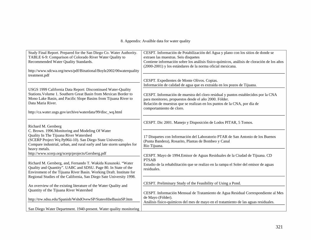
8. Appendix: Availble data for water quality
321
Study Final Report. Prepared for the San Diego Co. Water Authority. TABLE 6-9: Comparison of Colorado River Water Quality to Recommended Water Quality Standards. http://www.sdcwa.org/news/pdf/Binational/Boyle2002/06waterqualitytreatment.pdf USGS 1999 California Data Report: Discontinued Water-Quality Stations.Volume 1. Southern Great Basin from Mexican Border to Mono Lake Basin, and Pacific Slope Basins from Tijuana River to Data Maria River. http://ca.water.usgs.gov/archive/waterdata/99/disc_wq.html Richard M. Gersberg C. Brown. 1996.Monitoring and Modeling Of Water Quality In The Tijuana River Watershed (SCERP Project Wq Pp96ii-10). San Diego State University. Compare industrial, urban, and rural early and late storm samples for heavy metals. http://www.scerp.org/scerp/projects/Gersberg.pdf Richard M. Gersberg, and, Fernando T. Wakida Kusunoki. “Water Quality and Quantity”. UABC and SDSU. Page 80. In State of the Enviroment of the Tijuana River Basin. Working Draft. Institute for Regional Studies of the California, San Diego Sate University 1998. An overview of the existing literature of the Water Quality and Quantity of the Tijuana River Watershed http://trw.sdsu.edu/Spanish/WshdOvewSP/StateoftheBasinSP.htm San Diego Water Department. 1940-present. Water quality monitoring
CESPT. Información de Potabilización del Agua y plano con los sitios de donde se extraen las muestras. Seis disquetes Contiene información sobre los análisis físico-químicos, análisis de cloración de los años (2000-2001) y los estándares de la norma oficial mexicana. CESPT. Expedientes de Monte Olivos. Copias. Información de calidad de agua que es extraída en los pozos de Tijuana. CESPT. Información de muestra del cloro residual y puntos establecidos por la CNA para monitoreo, propuestos desde el año 2000. Fólder. Relación de muestras que se realizan en los puntos de la CNA, por día de comportamiento de cloro. CESPT. Dic 2001. Manejo y Disposición de Lodos PITAR, 5 Tomos. 17 Disquetes con Información del Laboratorio PTAR de San Antonio de los Buenos (Punta Bandera), Rosarito, Plantas de Bombeo y Canal Río Tijuana. CESPT. Mayo de 1994.Emisor de Aguas Residuales de la Ciudad de Tijuana. CD PTSAB Estudio de la rehabilitación que se realizo en la rampa el Soler del emisor de aguas residuales. CESPT. Preliminary Study of the Feasibility of Using a Pond. CESPT. Información Mensual de Tratamiento de Agua Residual Correspondiente al Mes de Mayo (Fólder). Análisis físico-químicos del mes de mayo en el tratamiento de las aguas residuales.
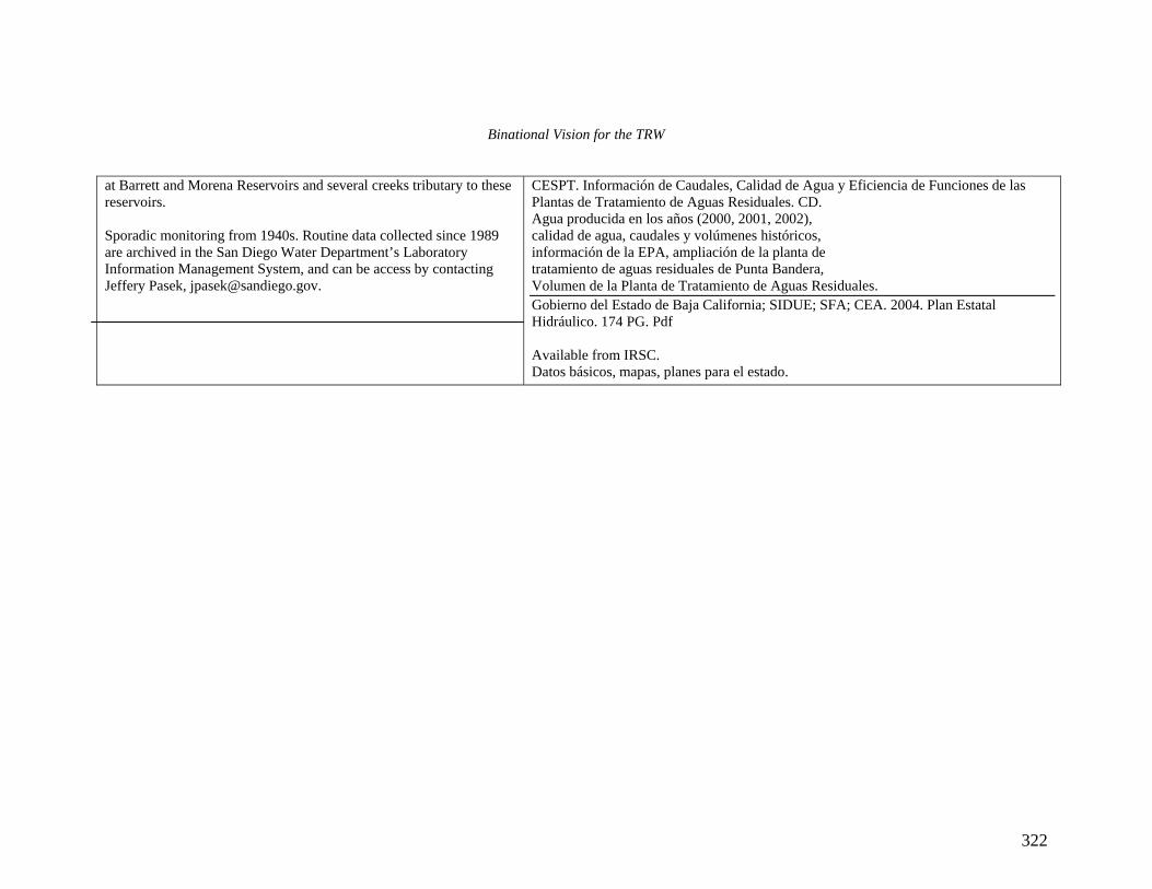
Binational Vision for the TRW
322
at Barrett and Morena Reservoirs and several creeks tributary to these reservoirs. Sporadic monitoring from 1940s. Routine data collected since 1989 are archived in the San Diego Water Department’s Laboratory Information Management System, and can be access by contacting Jeffery Pasek, [email protected].
CESPT. Información de Caudales, Calidad de Agua y Eficiencia de Funciones de las Plantas de Tratamiento de Aguas Residuales. CD. Agua producida en los años (2000, 2001, 2002), calidad de agua, caudales y volúmenes históricos, información de la EPA, ampliación de la planta de tratamiento de aguas residuales de Punta Bandera, Volumen de la Planta de Tratamiento de Aguas Residuales. Gobierno del Estado de Baja California; SIDUE; SFA; CEA. 2004. Plan Estatal Hidráulico. 174 PG. Pdf Available from IRSC. Datos básicos, mapas, planes para el estado.
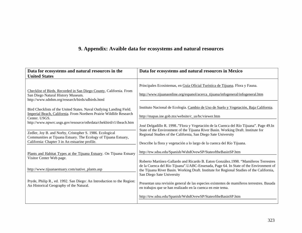
323
9. Appendix: Avaible data for ecosystems and natural resources
Data for ecosystems and natural resources in the United States
Data for ecosystems and natural resources in Mexico
Checklist of Birds. Recorded in San Diego County, California. From San Diego Natural History Museum. http://www.sdnhm.org/research/birds/sdbirds.html
Bird Checklists of the United States. Naval Outlying Landing Field. Imperial Beach, California. From Northern Prairie Wildlife Research Center. USGS. http://www.npwrc.usgs.gov/resource/othrdata/chekbird/r1/ibeach.htm
Zedler, Joy B. and Norby, Cristopher S. 1986. Ecological Communities at Tijuana Estuary. The Ecology of Tijuana Estuary, California: Chapter 3 in An estuarine profile.
Plants and Habitat Types at the Tijuana Estuary. On Tijuana Estuary Visitor Center Web page.
http://www.tijuanaestuary.com/native_plants.asp
Pryde, Philip R., ed. 1992. San Diego: An Introduction to the Region: An Historical Geography of the Natural.
Principales Ecosistemas, en Guía Oficial Turística de Tijuana. Flora y Fauna. http://www.tijuanaonline.org/espanol/acerca_tijuana/infogeneral/infogeneral.htm Instituto Nacional de Ecología. Cambio de Uso de Suelo y Vegetación, Baja California. http://mapas.ine.gob.mx/website/c_us/bc/viewer.htm José Delgadillo R. 1998..”Flora y Vegetación de la Cuenca del Río Tijuana”. Page 49.In State of the Environment of the Tijuana River Basin. Working Draft. Institute for Regional Studies of the California, San Diego Sate University Describe la flora y vegetación a lo largo de la cuenca del Río Tijuana. http://trw.sdsu.edu/Spanish/WshdOvewSP/StateoftheBasinSP.htm Roberto Martínez-Gallardo and Ricardo B. Eaton González.1998. “Mamíferos Terrestres de la Cuenca del Río Tijuana”.UABC-Ensenada, Page 64. In State of the Environment of the Tijuana River Basin. Working Draft. Institute for Regional Studies of the California, San Diego Sate University Presentan una revisión general de las especies existentes de mamíferos terrestres. Basada en trabajos que se han realizado en la cuenca en este tema. http://trw.sdsu.edu/Spanish/WshdOvewSP/StateoftheBasinSP.htm
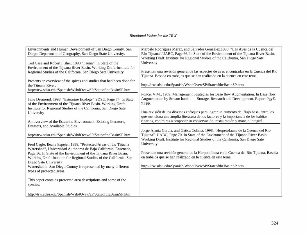
Binational Vision for the TRW
324
Environments and Human Development of San Diego County. San Diego: Department of Geography, San Diego State University. Ted Case and Robert Fisher. 1998.“Fauna”. In State of the Environment of the Tijuana River Basin. Working Draft. Institute for Regional Studies of the California, San Diego Sate University Presents an overview of the spices and studies that had been done for the Tijuana River. http://trw.sdsu.edu/Spanish/WshdOvewSP/StateoftheBasinSP.htm Julie Desmond. 1998. “Estuarine Ecology” SDSU, Page 74. In State of the Environment of the Tijuana River Basin. Working Draft. Institute for Regional Studies of the California, San Diego Sate University An overview of the Estuarine Environment, Existing literature, Datasets, and Available Studies. http://trw.sdsu.edu/Spanish/WshdOvewSP/StateoftheBasinSP.htm Fred Cagle. Ileana Espejel. 1998. “Protected Areas of the Tijuana Watershed”, Universidad Autónoma de Baja California, Ensenada, Page 56. In State of the Environment of the Tijuana River Basin. Working Draft. Institute for Regional Studies of the California, San Diego Sate University Watershed in San Diego County is represented by many different types of protected areas. This paper contains protected area descriptions and some of the species.
http://trw.sdsu.edu/Spanish/WshdOvewSP/StateoftheBasinSP.htm
Marcelo Rodríguez Méraz, and Salvador González.1998. “Las Aves de la Cuenca del Río Tijuana”.UABC, Page 66. In State of the Environment of the Tijuana River Basin. Working Draft. Institute for Regional Studies of the California, San Diego Sate University Presentan una revisión general de las especies de aves encontradas en la Cuenca del Río Tijuana. Basada en trabajos que se han realizado en la cuenca en este tema. http://trw.sdsu.edu/Spanish/WshdOvewSP/StateoftheBasinSP.htm Ponce, V,M., 1989. Management Strategies for Base flow Augmentation. In Base flow Augmentation by Stream bank Storage, Research and Development. Report PgyE. 91 pp. Una revisión de los diversos enfoques para lograr un aumento del flujo base, entre los que menciona una amplia literatura de los factores y la importancia de los habitas riparios, con miras a proponer su conservación, restauración y manejo integral. Jorge Alaniz García, and Gatica Colima. 1998. “Herpetofauna de la Cuenca del Río Tijuana”. UABC, Page 70. In State of the Enviroment of the Tijuana River Basin. Working Draft. Institute for Regional Studies of the California, San Diego Sate University Presentan una revisión general de la Herpetofauna en la Cuenca del Río Tijuana. Basada en trabajos que se han realizado en la cuenca en este tema. http://trw.sdsu.edu/Spanish/WshdOvewSP/StateoftheBasinSP.htm
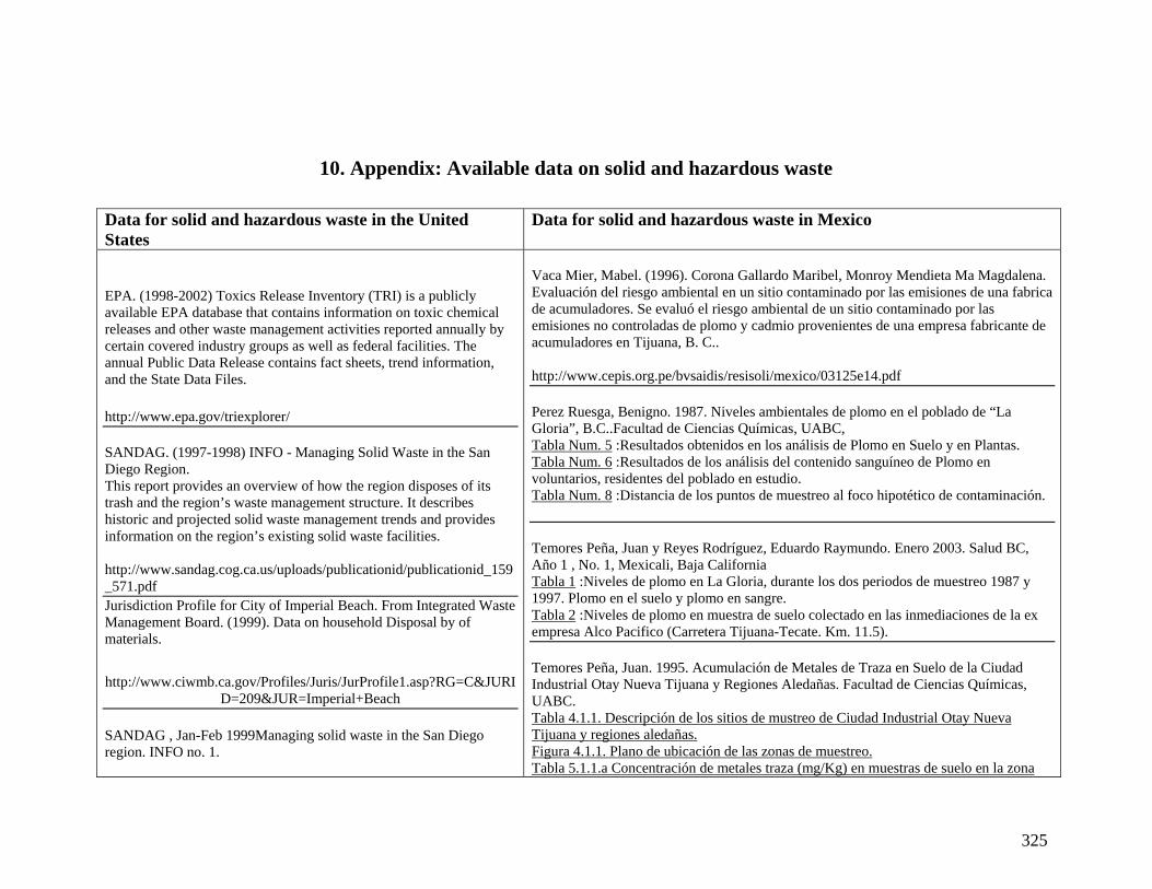
325
10. Appendix: Available data on solid and hazardous waste
Data for solid and hazardous waste in the United States
Data for solid and hazardous waste in Mexico
EPA. (1998-2002) Toxics Release Inventory (TRI) is a publicly available EPA database that contains information on toxic chemical releases and other waste management activities reported annually by certain covered industry groups as well as federal facilities. The annual Public Data Release contains fact sheets, trend information, and the State Data Files.
http://www.epa.gov/triexplorer/ SANDAG. (1997-1998) INFO - Managing Solid Waste in the San Diego Region. This report provides an overview of how the region disposes of its trash and the region’s waste management structure. It describes historic and projected solid waste management trends and provides information on the region’s existing solid waste facilities. http://www.sandag.cog.ca.us/uploads/publicationid/publicationid_159_571.pdf Jurisdiction Profile for City of Imperial Beach. From Integrated Waste Management Board. (1999). Data on household Disposal by of materials.
http://www.ciwmb.ca.gov/Profiles/Juris/JurProfile1.asp?RG=C&JURID=209&JUR=Imperial+Beach
SANDAG , Jan-Feb 1999Managing solid waste in the San Diego region. INFO no. 1.
Vaca Mier, Mabel. (1996). Corona Gallardo Maribel, Monroy Mendieta Ma Magdalena. Evaluación del riesgo ambiental en un sitio contaminado por las emisiones de una fabrica de acumuladores. Se evaluó el riesgo ambiental de un sitio contaminado por las emisiones no controladas de plomo y cadmio provenientes de una empresa fabricante de acumuladores en Tijuana, B. C.. http://www.cepis.org.pe/bvsaidis/resisoli/mexico/03125e14.pdf Perez Ruesga, Benigno. 1987. Niveles ambientales de plomo en el poblado de “La Gloria”, B.C..Facultad de Ciencias Químicas, UABC, Tabla Num. 5 :Resultados obtenidos en los análisis de Plomo en Suelo y en Plantas. Tabla Num. 6 :Resultados de los análisis del contenido sanguíneo de Plomo en voluntarios, residentes del poblado en estudio. Tabla Num. 8 :Distancia de los puntos de muestreo al foco hipotético de contaminación. Temores Peña, Juan y Reyes Rodríguez, Eduardo Raymundo. Enero 2003. Salud BC, Año 1 , No. 1, Mexicali, Baja California Tabla 1 :Niveles de plomo en La Gloria, durante los dos periodos de muestreo 1987 y 1997. Plomo en el suelo y plomo en sangre. Tabla 2 :Niveles de plomo en muestra de suelo colectado en las inmediaciones de la ex empresa Alco Pacifico (Carretera Tijuana-Tecate. Km. 11.5). Temores Peña, Juan. 1995. Acumulación de Metales de Traza en Suelo de la Ciudad Industrial Otay Nueva Tijuana y Regiones Aledañas. Facultad de Ciencias Químicas, UABC. Tabla 4.1.1. Descripción de los sitios de mustreo de Ciudad Industrial Otay Nueva Tijuana y regiones aledañas.Figura 4.1.1. Plano de ubicación de las zonas de muestreo.Tabla 5.1.1.a Concentración de metales traza (mg/Kg) en muestras de suelo en la zona
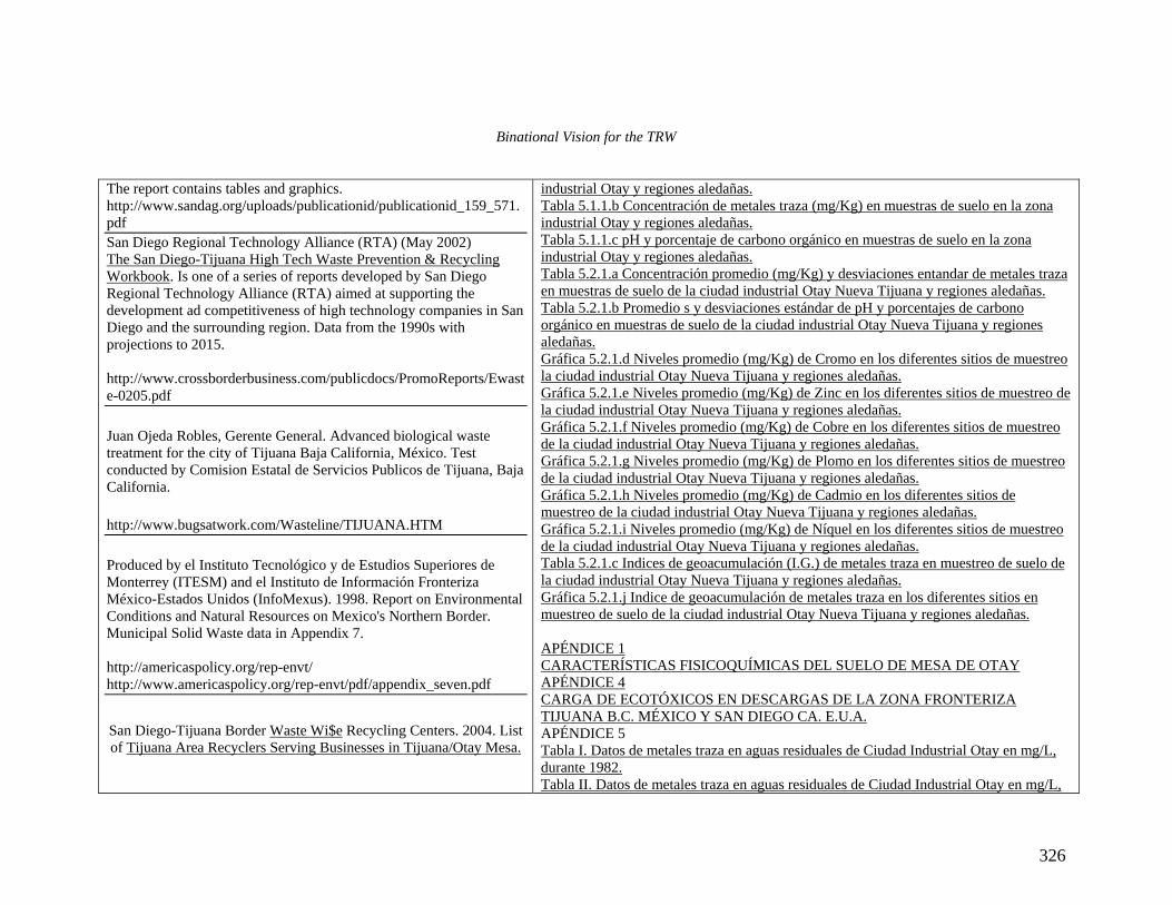
Binational Vision for the TRW
326
The report contains tables and graphics. http://www.sandag.org/uploads/publicationid/publicationid_159_571.pdf San Diego Regional Technology Alliance (RTA) (May 2002) The San Diego-Tijuana High Tech Waste Prevention & Recycling Workbook. Is one of a series of reports developed by San Diego Regional Technology Alliance (RTA) aimed at supporting the development ad competitiveness of high technology companies in San Diego and the surrounding region. Data from the 1990s with projections to 2015. http://www.crossborderbusiness.com/publicdocs/PromoReports/Ewaste-0205.pdf
Juan Ojeda Robles, Gerente General. Advanced biological waste treatment for the city of Tijuana Baja California, México. Test conducted by Comision Estatal de Servicios Publicos de Tijuana, Baja California.
http://www.bugsatwork.com/Wasteline/TIJUANA.HTM
Produced by el Instituto Tecnológico y de Estudios Superiores de Monterrey (ITESM) and el Instituto de Información Fronteriza México-Estados Unidos (InfoMexus). 1998. Report on Environmental Conditions and Natural Resources on Mexico's Northern Border. Municipal Solid Waste data in Appendix 7. http://americaspolicy.org/rep-envt/ http://www.americaspolicy.org/rep-envt/pdf/appendix_seven.pdf
San Diego-Tijuana Border Waste Wi$e Recycling Centers. 2004. List of Tijuana Area Recyclers Serving Businesses in Tijuana/Otay Mesa.
industrial Otay y regiones aledañas.Tabla 5.1.1.b Concentración de metales traza (mg/Kg) en muestras de suelo en la zona industrial Otay y regiones aledañas.Tabla 5.1.1.c pH y porcentaje de carbono orgánico en muestras de suelo en la zona industrial Otay y regiones aledañas.Tabla 5.2.1.a Concentración promedio (mg/Kg) y desviaciones entandar de metales traza en muestras de suelo de la ciudad industrial Otay Nueva Tijuana y regiones aledañas.Tabla 5.2.1.b Promedio s y desviaciones estándar de pH y porcentajes de carbono orgánico en muestras de suelo de la ciudad industrial Otay Nueva Tijuana y regiones aledañas.Gráfica 5.2.1.d Niveles promedio (mg/Kg) de Cromo en los diferentes sitios de muestreo la ciudad industrial Otay Nueva Tijuana y regiones aledañas.Gráfica 5.2.1.e Niveles promedio (mg/Kg) de Zinc en los diferentes sitios de muestreo de la ciudad industrial Otay Nueva Tijuana y regiones aledañas.Gráfica 5.2.1.f Niveles promedio (mg/Kg) de Cobre en los diferentes sitios de muestreo de la ciudad industrial Otay Nueva Tijuana y regiones aledañas.Gráfica 5.2.1.g Niveles promedio (mg/Kg) de Plomo en los diferentes sitios de muestreo de la ciudad industrial Otay Nueva Tijuana y regiones aledañas.Gráfica 5.2.1.h Niveles promedio (mg/Kg) de Cadmio en los diferentes sitios de muestreo de la ciudad industrial Otay Nueva Tijuana y regiones aledañas.Gráfica 5.2.1.i Niveles promedio (mg/Kg) de Níquel en los diferentes sitios de muestreo de la ciudad industrial Otay Nueva Tijuana y regiones aledañas.Tabla 5.2.1.c Indices de geoacumulación (I.G.) de metales traza en muestreo de suelo de la ciudad industrial Otay Nueva Tijuana y regiones aledañas.Gráfica 5.2.1.j Indice de geoacumulación de metales traza en los diferentes sitios en muestreo de suelo de la ciudad industrial Otay Nueva Tijuana y regiones aledañas. APÉNDICE 1 CARACTERÍSTICAS FISICOQUÍMICAS DEL SUELO DE MESA DE OTAYAPÉNDICE 4 CARGA DE ECOTÓXICOS EN DESCARGAS DE LA ZONA FRONTERIZA TIJUANA B.C. MÉXICO Y SAN DIEGO CA. E.U.A.APÉNDICE 5 Tabla I. Datos de metales traza en aguas residuales de Ciudad Industrial Otay en mg/L, durante 1982.Tabla II. Datos de metales traza en aguas residuales de Ciudad Industrial Otay en mg/L,
10. Appendix: Available data on solid and hazardous waste
327
http://www.borderwastewise.org/busassist/recy2.htm
durante 1983.Tabla III. Datos de metales traza en aguas residuales de Ciudad Industrial Otay en mg/L, durante 1984.Tabla IV. Datos de metales traza en aguas residuales de Ciudad Industrial Otay en mg/L, durante 1987.Tabla V. Datos de metales traza en aguas residuales de Ciudad Industrial Otay en mg/L, durante 1988.Tabla VI. Datos de metales traza en aguas residuales de Ciudad Industrial Otay en mg/L, durante 1989.Tabla VII. Datos de metales traza en aguas residuales de Ciudad Industrial Otay en mg/L, durante 1993. Bocco, G., Sámchez, R. A., & y Reimann, H. 1993. Evaluación del impacto de las inundaciones en Tijuana (Enero de 1993). Uso integrado de percepción remota y sistemas de información geográfica. Frontera Norte, COLEF, Vol. 5, No. 10, Jul-dic. 1993, Jul-Dic. 1993: 17. Ojeda Benítez, M. L., Rubén. 1998. Análisis estadístico del comportamiento de los residuos sólidos domiciliarios en una comunidad urbana. Frontera Norte, COLEF, Vol. 10, No. 19, 1998 (Residuos Sólidos), enero-junio 1998: 15. Raymundo Reyes R., and César García R..” Manejo de Materiales Peligrosos”.UABC, Page 92. In State of the Enviroment of the Tijuana River Basin. Workin Draft. Institute for Regional Studies of the California, San Diego Sate University 1998. An overview of the existing literature. Data Sets refer to the handling of toxic materials. http://trw.sdsu.edu/Spanish/WshdOvewSP/StateoftheBasinSP.htm Moreno, D., Muñoz, V. 2003. El reto de la basura en Tijuana. Tijuana Trabaja. Tijuana,
B.C. 156. Cuadernos para el diálogo.

Binational Vision for the TRW
328
329
11. Appendix: Available data for air quality
Data for air quality in the United States Data for air quality in Mexico An Expanded Emission Profile of Vehicles On-the-Road, and the Willingness–to-pay Characteristics for Pollution Reduction of the Population along US-Mexican Border between Tijuana, Baja California and San Diego, California. Project Number: A98-4. Dr. Soumen N. Ghosh, New Mexico State University. Dr. Lenora Bohren, Colorado State University Other Researcher: Dr. David Molina, University of North Texas. Final Report March 31, 2000. http://www.scerp.org/projects/Ghosh98.pdf
Quality Assurance Air Monitoring Site Information, updated November 11, 2002, Sites operated by SEMARNAT (Mexico):
Sites: 85016 Tijuana - COLEF 85002 Tijuana-Centro de Salud85001 Tijuana-ITT85003 Tijuana-La Mesa/La Presa http://www.arb.ca.gov/qaweb/site.php?s_arb_code=85016
Air Quality. Air Quality Statistics contains various air quality measures for more than 600 locations throughout California. RAND California. An Online Source for California U.S. Statistics.
http://ca.rand.org/stats/community/airqual.html Project Title: Sources of Air Pollution Along the Border: Analysis of
E1 Segundo Informe sobre la Calidad del Aire en Ciudades Mexicanas 1997: - Porcentaje y número de días en que se rebasan las normas de calidad del aire en general y por contaminante para 14 ciudades del país durante 1997. Tabla 2.1 - Comparación de la población, parque vehicular, número de industrias y estaciones de monitoreo entre la ZMVM, ZMG, ZMM, ZMVT, Cd. Juárez, Qro, S.L.P., Aguascalientes, Tijuana, Mexicali, Nacozari, Cananea, Manzanillo y Coatzacoalcos. Tabla 3.3. - Composición del parque vehicular en ZMVM, ZMG, ZMM, ZMVT, Cd. Juárez, Qro, S.L.P:, Aguascalientes, Tijuana, Mexicali, Coatzacoalcos y Manzanillo. Tabla 3.4. - Localización de la red de monitoreo de la calidad del aire de Tijuana. Figura 9.1. -. Estaciones de la Red de Monitoreo de Tijuana y parámetros que mide. Tabla 9.1 - Porcentaje de días con violaciones a las normas por contaminante y por mes en Tijuana durante 1997. Figura 9.2. - IMECA máximo diario en Tijuana durante 1997. Figura 9.3. - IMECA máximo mensual de ozono en Tijuana durante 1997. Figura 9.4. - IMECA máximo mensual de CO en Tijuana durante 1997. Figura 9.5. - IMECA máximo mensual de SO2 en Tijuana durante 1997. Figura 9.6. - IMECA máximo mensual de NO2 en Tijuana durante 1997. Figura 9.7. - IMECA máximo mensual de PM10 en Tijuana durante 1997. Figura 9.8. - Porcentaje y número de días en que se rebasan las normas de calidad del aire en general y por contaminante para 14 ciudades del país durante 1997. Tabla 12.1. - Porcentaje y número de días que se sobrepasan los 100, 150 y 200 puntos IMECA. Tabla D.16. - IMECA máximo por estación y por contaminante. Tabla D.17. - IMECA máximo mensual por contaminante. Tabla D.18. http://www.ine.gob.mx/descargas/descarga.html?cv_pub=113&tipo_file=pdf&url=http://www.ine.gob.mx/ueajei/publicaciones/consultaPublicacion.html?id_pub=113&id_tema=6&dir=Consultas&filename=113&id_tema=6
Binational Vision for the TRW
330
Data, Databases and Information SCERP Project Number: AQ94-7.7 Principal Investigator: Alan Sweedler and Paul Ganster San Diego State University. Database Coordination Initiative/Sources of Air Pollution Along the Border: Analysis of Data, Databases, and Information. Economic Incentives for Pollution Reduction SCERP Project Number: IS95-3 Principal Investigators: Dr. Alan Sweedler (PI), Professor of Physics, Director Center for Energy Studies San Diego State University. Dr. Paul Ganster (PI) Director Institute for Regional Studies of the Californias San Diego State University. Principal Mexican Collaborators: Dr. Margarito Quintero Nuñez Director Institute of Engineering,Universidad Autónoma de Baja California, Mexicali. Ing. Juan Alvarez Professor of Economics, Universidad Autónoma de Baja California, Tijuana.
Project Title: Transborder Trucking and Air Quality in the California Border Region SCERP Project Number: AQ PP96I-14 Principal Investigators: A. Sweedler, J. Alvarez, C. Kazimi, F. Cuamea, M.Q. Nunez, M. Fertig
The AirData Web site gives you access to air pollution data for the entire United States. AirData : Access to Air Pollution Data. EPA.
http://www.epa.gov/air/data/index.html
Alan Sweedler. “Air Quality of the Tijuana Basin”. SDSU Page 87. In
Análisis de Tendencias de la Calidad del Aire. Área Tijuana Rosarito. En Pagina Web del Instituto Nacional de Ecología. http://www.ine.gob.mx/dgicurg/calaire/lineas/tendencias/c_tijuana.html Calidad del aire en México. Segundo Informe de la calidad del aire 1997. SEMARNAT. http://www.cepis.ops-oms.org/bvsci/E/fulltext/1encuent/mexico.pdf PROGRAMA PARA MEJORAR LA CALIDAD DEL AIRE EN TIJUANA-ROSARITO. Air Quality Management Plans. EPA. 2002. Anexo A. Monitoreo e Índice Metropolitano de la Calidad del Aire. Pag. 147. Anexo B. Tablas resumen de la calidad del aire de Tijuana-Rosarito 1997-1998. Pag. 155. Anexo C. Efectos de los contaminantes en la salud. Pag. 158. Anexo D. Memoria de cálculo de estimaciones de reducciones de emisiones y de costos e inversiones. Pag. 166. Anexo F. Normatividad mexicana de calidad del aire. Pag. 187. Anexo G. Normatividad mexicana para la verificación vehicular. Pag. 189. http://www.epa.gov/region09/border/airplans/tijuanarosaritospa.pdf Laboratorio Analítico Ambiental tiene como objetivo: “ Ofrecer servicios analíticos acreditados en el área ambiental que ayuden a la toma de decisiones encaminadas al desarrollo sostenible del país, dentro de un marco de calidad total “. ITESM capus Monterrey. Dr. Porfirio Caballero Mata. http://uninet.mty.itesm.mx/cca/curric/pcaballero.html RESUMEN DE INDICADORES AMBIENTALES SELECCIONADOS, E P A 9 0 9 - R - 0 0 - 0 0 2 A, DEL PROGRAMA FRONTERA XXI MEXICO-ESTADOS UNIDOS:
11. Appendix: Available data for air quality
331
State of the Environment of the Tijuana River Basin. Working Draft. Institute for Regional Studies of the California, San Diego Sate University 1998. An overview of the existing literature, Data available Data Sets, and presents Graphics of the Air Quality of the Tijuana Basin.
REPORTE DE AVANCE 1996–2000. http://www.uacj.mx/Publicaciones/sf/vol2num6y7/comercios.htm
XI.3 Contaminación del aire. Baja California hacia la Competitividad. Perspectivas de Desarrollo para el Siglo XXI. Centro de Competitividad y Estudios Estratégicos Dirección de Extensión y Vinculación. CETYS Universidad. El estudio inicia en febrero de 1994 y concluye en mayo de 1995. http://www.mxl.cetys.mx/Deptos/Vinc/BC/s00vf.htm
Binational Vision for the TRW
332
333
12. Appendix: Available data for socioeconomic issues
Data for socioeconomic issues in the United States Data for socioeconomic issues in Mexico
Gerber, James. 1993. “Cycle and Trends in San Diego and California.” In San Diego-Tijuana in Transition: A Regional Analysis, N.C. Clement and E.Z. Miramontes, eds. San Diego: Institute for Regional Studies of the Californias, San Diego State University.
Higuera, Salvador Mendoza, Alejandro Valenzuela, and Eduardo Zepeda Miramontes. 1993. “Tijuana: Short-Term Growth or Long-Term Development.” In San Diego-Tijuana in Transition: A Regional Analysis, N.C. Clement and E.Z. Miramontes, eds. San Diego: Institute for Regional Studies of the Californias, San Diego State University.
Rey, Serge, Paul Ganster, Gustavo del Castillo, Juan Alvarez, Ken Shellhammer, Alan Sweedler, and Norris Clement. n.d. “The San Diego-Tijuana Region.” Forthcoming in Integrating Cities and Regions: NAFTA and the Caribbean Face Globalization, J.W. Wilkie and C.E. Smith, eds.
San Diego Association of Governments. 1998. Evaluating Economic Prosperity in the San Diego Region: 1998 Update. San Diego: San Diego Association of Governments.
INEGI, Instituto Nacional de Estadística Geográfica e Informática. Indicadores Disponibles para el Estado de Baja California.
http://www.inegi.gob.mx/est/default.asp?c=&e=02
SALUD PUBLICA EN MEXICO. NOVIEMBRE-DICIEMBRE DE 1994, VOL.36, No.6 . TITULO: EL TLC: UN RETO Y UNA OPORTUNIDAD PARA LA SALUD AMBIENTAL. EL CASO DE LAS MAQUILADORAS. AUTORES: FELIPE ESPINOSA-TORRES, M.C., M. EN S.A. MAURICIO HERNANDEZ-AVILA, M.C., D. SC. LIZBETH LOPEZ-CARRILLO, DR. EN S.P. - CUADRO I. Poblaciones de las Ciudades Hermanas de la Frontera México-EUA
1990. - Comparación de los salarios de los trabajadores estadounidenses con los
salarios de los trabajadores; de las maquiladoras en México (dólares estadounidenses).
- CUADRO VI. Calidad del aire en la frontera México-Estados Unidos.
http://dge1.insp.mx/salud/36/366-4s.html
Chávez, A. M. 1993. Encuestas demográficas de Baja California 1986. Frontera Norte, COLEF, Vol. 5, No. 9 (Demografía), ene-jun 1993: 17.
Binational Vision for the TRW
334
EPA Border XXI. 1998. Border XXI Program Framework Document. U.S./Mexico Border XXI/Frontera XXI. San Diego Association of Governments. 1998. Evaluating Economic Prosperity in the San Diego Region: 1998 Update. San Diego: San Diego Association of Governments. Sparrow, Glen, and Marco Walshok. 1993 “Local Government and Economic Development in San Diego: Past Trends and Present Dilemmas.” In San Diego-Tijuana in Transition: A Regional Analysis, N.C. Clement and E.Z. Miramontes, eds. San Diego: Institute for Regional Studies of the Californias, San Diego State University. Trade Point USA. 1995. Fact Sheet on the U.S./Mexican Agreement on the Border Environment Cooperation Commission (BECC) and the North American Development Bank (NADBANK). Sánchez, Roberto. 1993. “Urban Growth and Environment of Tijuana.” In San Diego-Tijuana in Transition: A Regional Analysis, N.C. Clement and E.Z. Miramontes, eds. San Diego: Institute for Regional Studies of the Californias, San Diego State University. Sparrow, Glen, and Marco Walshok. 1993. “Local Government and Economic Development in San Diego: Past Trends and Present Dilemmas.” In San Diego-Tijuana in Transition: A Regional Analysis, N.C. Clement and E.Z. Miramontes, eds. San Diego: Institute for Regional Studies of the Californias, San Diego State University. Stone, Katherine, and Dennis Martinek. 1991. “The Economic Consequences of Unmanaged Growth.” Western City (November). Griffin, Ernest, Richard Wright, Chris Brown, Steve McElroy, and Ann Obee. 1996.“GIS Applications in the San Diego-Tijuana Interface.” Pp. 807–17 in Proceedings GIS/LIS ‘96. (November).
Canales Céron, A. 1995. El poblamiento de Baja California. 1848-1950. Frontera Norte, COLEF, Vol. 7, No. 13 (Population), Enero-Junio 1995: 20. Estrella Valenzuela, G. 1995. Política de Desarrollo y Comportamiento Demográfico en la Frontera Norte de México. In Cambio socioeconómico y población en la región fronteriza norte de México. Política de Desarrollo y Comportamiento Demográfico en la Frontera Norte de México. UABC. Méndez Mungaray, E. Indice de calidad de vida en la frontera. . articulos publicados por investigadores de COLEF; en Hemeroteca COLEF. Alegría O., T. 1991. Crecimiento Urbano y Servicios Públicos en la Frontera Norte de México. In III Reunión Nacional sobre Estudios Fronterizos - ANUIES. Tampico, Tamaulipas: Departamento de Estudios Urbanos y Medio Ambiente. COLEF. Guillen López, Tonatiuh. nd. Gobernabilidad y gestión local en Mexico: El caso de Tijuana, B.C., 1989–1997. Tijuana: El Colegio de la Frontera Norte (borrador preliminar). Guillen López, Tonatiuh. 1993. “Municipal Government and Development in Tijuana.” In San Diego-Tijuana in Transition: A Regional Analysis, N.C. Clement and E.Z. Miramontes, eds. San Diego: Institute for Regional Studies of the Californias, San Diego State University. Guillen López, Tonatiuh. 1996. Gobiernos municipales en Mexico: Entre la modernización y la tradición politica. Tijuana: El Colegio de la Frontera Norte.
12. Appendix: Available data for socioeconomic issues
335
Katie Ries, Richard Wright, and Alain Winckell 1995. “Identifying Priorities for a GIS for the Tijuana River Watershed: Applications for Land Use” P. 93 in Planning and Education, Workshop Proceedings. San Diego: Institute for Regional Studies of the Californias, San Diego State University. Arreola, D., and J. Curtis. 1993. The Mexican Border Cities. Tucson: University of Arizona Press. Clement, N., and E. Zepeda. 1993. San Diego-Tijuana in Transition. San Diego: Institute for Regional Studies of the Californias, San Diego State University. Dillman, D. 1983. “Border Urbanization.” Pp. 237–44 in Borderlands Sourcebook, E. Stoddard, R. Nostrand, and J. West, eds. Norman: University of Oklahoma Press. Gilbert, A., ed. 1989. Housing and Land in Urban Mexico. La Jolla: Center for U.S.-Mexican Studies, University of California, San Diego. Herzog, L. A. 1999. From Aztec to High Tech: Architecture and Landscape Across the Mexico-United States Border. Johns Hopkins University Press. Herzog, L. 1998. “Urban Planning and Sustainable Development in the Transfrontier Metropolis: The Tijuana-San Diego Region” in Sustainable Development in San Diego-Tijuana, M. Spalding, ed. San Diego: Center for U.S.-Mexican Studies, University of California, San Diego. Herzog, L. 1997. “Border Urbanism.” Pp. 1505–11 in Encyclopedia of Mexico: History, Society and Culture, M. Werner, ed. Chicago: Fitzroy Dearborn.
Tamayo, J., and J.L. Fernández. 1983. Zonas fronterizas. México, D.F.: CIDE. Hiernaux, D. 1986. Urbanización y autoconstrucción de vivienda en Tijuana. México, D.F.: Centro de Ecodesarrollo. Aguila, S.O. 1996. Seroprevalencia A Toxoplasma gondii en poblacion trabajadora de establos. Universidad Autónoma de Baja California En el Area aledaña a la Ciudad de Tecate (zona de establos) se realizaron estudios que demostraron positividad al contacto con Toxoplasma gondii, parásito intracelular que se transmite por diferentes vias (oral, nasal, cutanea, trasplacentaria, etc..) y que causa la toxoplasmosis, enfermedad de difícil manejo y con repercusiones graves sobre la salud del individuo que la padece. Brito, P.M. 1997. Etiología y frecuencia de infecciones nosocomiales en hospitales públicos de Tijuana, B.C. Facultad de Medicina, Univeridad Autónoma de Baja California. Herrán, P.E. 1995. Evaluación del diagnóstico y tratamiento del paciente con Tuberculosis Pulmonar. Universidad Autónoma de Baja California, Instituto Mexicano del Seguro Social. Laniado, LT., Cárdenas, M.R. 1991. Tijuana: Zona endémica de infección por Coccidioides immitis. Revista de Salud Pública de México, p 235-239.

Binational Vision for the TRW
336
Herzog, L. 1997. “The Transfrontier Metropolis.” Harvard Design Magazine Winter/Spring: 16–19. Herzog, L. 1990. Where North Meets South: Cities, Space and Politics on the U.S.-Mexico Border. Austin: CMAS/ILAS/University of Texas Press. Herzog, L., ed. 1986. Planning the International Border Metropolis. La Jolla: Center for U.S.-Mexican Studies, University of California, San Diego House, J. 1982. Frontier on the Río Grande. Oxford: Oxford University Press. Martinez, O. 1996. U.S.-Mexico Borderlands. Wilmington: Scholarly Resources. Martinez, O. 1994. Border People. Tucson: University of Arizona Press. Price, J. 1973. Tijuana: Urbanization in a Border Culture. Notre Dame: University of Notre Dame Press. San Diego Dialogue. 1995. San Diego/Tijuana: Demographic Atlas. San Diego. Sklair, L. 1989. Assembling for Development. Boston: Unwin Hyman. Sweedler, Alan, Margarito Quintero Nuñez, and Patricia Bennett. n.d. “Energy Sector in the California-Baja California Border Region.” In Energy and Borders. Durham: University of Durham, forthcoming. The San Diego Economic Information and Modeling Project (SDEIMP) maintains an extensive set of socioeconomic data series on
12. Appendix: Available data for socioeconomic issues
337
the economies of Southern California and the United States. The SDEIMP data sets contain over 2,500 series; the majority are annual, beginning in the year 1969. San Diego State University’s Center for Energy Studies. A reasonable amount of data exist related to energy use and infrastructure in the San Diego-Tijuana region. Much of it can be found at web site at: http://www-rohan.sdsu.edu/dept/physics/CES.html The United Nations Centre for Human Settlements (Habitat) Indicators Programme. It provides a pertinent and realistic tool to measure the performance of the urban and shelter sector in cities, countries, and regions across the globe. The 46 indicators are divided into categories (Background; Socio-Economic Development; Infrastructure; Transportation; Environmental Management; Local Government; Housing Affordability and Adequacy; and Housing Provisions). http://www.unhabitat.org/ Regional Growth Management Strategy. The Regional Growth Management Strategy (RGMS) was adopted by the San Diego Association of Governments (SANDAG) in 1993 SANDAG creates and maintains a tremendous quantity of demographic, economic, land use, transportation and criminal justice information about the San Diego region. http://www.sandag.cog.ca.us/index.asp?classid=26&fuseaction=home.classhome
Binational Vision for the TRW
338
California/Mexico Public Health Strategic Planning Meeting. 1998. Outcomes and recommendations. Executive Summary. Ganster, Paul. 1996. “Environmental Issues of the California-Baja California Border Region.” Border Environment Research Reports. 1 (June). San Diego: Institute for Regional Studies of the Californias, San Diego State University. Guendelman, S. and M.J. Silberg. 1993. “The Health Consequences of Maquiladora Work: Women on the U.S.-Mexican Border.” American Journal of Public Health 83: 37–44. San Diego Dialogue. 1994. Who Crosses the Border: A View of the San Diego/Tijuana Metropolitan Region. (April). US-Mexico Border XXI Program. 1997. Comment and Response Summary Report. (June). Ecotourism Summit Fact Sheet. 1997. Presented at the San Diego Ecotourism Summit, 18 September, San Diego. Langdon, Margaret. 1970. A Grammar of Diegueno: The Mesa Grande Dialect, No. 66. Berkeley: Publications in Linguistics, University of California. A linguistic study Shipek, Florence. 1993. “Kumeyaay Plant Husbandry: Fire, Water, and Erosion Control Systems.” In Before the Wilderness: Environmental Management by Native Californians, Thomas C. Blackburn and Kat Anderson, eds. Menlo Park: Ballena Press. An ethnoarchaeological study Gifford, Edward W., and Lowie. 1928. Notes on the Akwa’ala Indians of Lower California, No.29. Tucson: University of Arizona.
12. Appendix: Available data for socioeconomic issues
339
Meigs, Peveril, III, 1939. “The Kiliwa Indians of Lower California.” Ibero-Americana 15: 1–114. Langdon, Margaret. 1970. A Grammer of Diegueno: The Mesa Grande Dialect, No. 66. Berkeley: Publications in Linguistics, University of California. Owen, Roger C. 1978. “Indians of Santa Catarina.” Ph.D. Diss., University of California, Berkeley. Information on the indigenous populations of northern Baja California. Land Resources and Management Plan Cleveland National Forest 1988 Sustaining Ecosystems: A Conceptual Framework, USDA 5R-EM-TP-001, April 1995 South Coast Resource Management Plan DOI-BLM 1994 BLM/CA/PL-94/013+1611 Protected areas which either border or cross into the watershed along the border are Bureau of Land Management (BLM) proposed wilderness areas (Hauser Mountain and Otay Mountain, the Guatay Mountain SIA, Kucchamaa Areas of Critical Environmental Concern [ACEC], Cedar Canyon ACEC, and Southern Otay Mountain). Border Field State Park, Unit History, Chronology 1976 A Management Framework for the Tijuana River Valley, June 1989. Prepared for the County of San Diego Department of Parks and
Binational Vision for the TRW
340
Recreation by the Graduate Program, Dept. of Landscape Architecture, California Polytechnic University, Pomona, California GIS data complied for Forest and Woodland Multi-Species Conservation Strategy (DRAFT) 1998 Williams, M. David. 1989. Coccidioidomicosis in Tijuana: A Spatial and Epidemiological Analysis. San Diego State University.
341
13. Minutes from 2004 stakeholder meeting
Stakeholder meeting for the
Binational Vision Project for the Tijuana River Watershed
Friday December 3, 2004
Hotel Pueblo Amigo
Conference Room Premier
9:00 a.m. – 1:30 p.m.
“Resources should be managed jointly (between the U.S. and México). The Vision offers
a very complete diagnostic,” Luis Cabrera, Dec., 3.
Elsa Saxod welcomed 60 participants
Katherine Comer distributed a handout of the executive summary and presented a summary
of the Draft Binational Vision document for the TRW.
Overview of the Draft Vision Document:
• Water quantity
• Water quality
Binational Vision for the TRW
342
• Ecosystems and Natural Resources
• Waste
• Air Quality
• Socio-economic issues
General Challenges:
• Merging of Tijuana and Tecate
• Reduction in the amount of safe, open and green areas for urban residents
• Decline in ecosystem health
• Increasing number of threatened and endangered plants and animals
The Binational Vision for the TRW is the stakeholder consensus of the current and
desired conditions in the TRW. Complete versions can be found at: http://trw.sdsu.edu.
Send comments to [email protected] by Jan 3, 2005
Discussion and feedback
More recommendations for watershed education and outreach are needed.
BREAK (5 min)
Invited Panel—How can we implement the Vision?
Ing. Jorge Corrales from the Comisión Nacional del Agua introduced the Consejos de
Cuenca
What are the different levels? The Ley de Aguas Nacional involves public participation
in the administration, planning, and management of water. The levels are: Consejos,
comisiones, comités, COTAS
What are the responsibilities of the different levels? The consejos have access to
information such as the titles to water rights, the public register, titles of concession,
assembly, and operating expenses. They can submit a complaint or “denuncio” if
someone is breaking the law.
13. Minutes from 2004 stakeholder meeting
343
What are the limitations? The consejos have no legal authority, they cannot grant permits,
concessions, water rights, sanctions, create normas (legal standard) or reglamentos
(enforcement specifications). The major limitation is lack of political will.
How can a future comisión de cuenca of the TRW involve U.S. participation or input?
The future comisión will consist of users with voting rights. The National Water Law
does not contemplate the possibility of U.S participation. However, the U.S. interested
parties can support and finance well-defined technical projects.
Mr. Pete Silva from the California State Water Resources Control Board introduced California
Basin Plans
What are Basin Plans? Under California’s old water pollution control act, watersheds
were the unit of management starting in the 1950s. The law that mandates basin plans is
the Porter-Cologne Act. The focus is on water rights and water quality.
What are the limitations? The basin plan is not an institutional tool, it is just a process
tool for complying with the regulations. They describe the numerical standards for
permits. Total Maximum Daily loads for water bodies or pollutant loads from point and
non-point sources are examples. Legally Mexico does not have TMDLs, therefore, there
are no monitoring programs similar to California’s.
How can the Basin Plan process for San Diego involve Mexican participation or input for
the TRW? By creating a binational TMDL, both countries would have similar point and
non-point sources pollution prevention programs, and common monitoring programs.
The next steps are to convince EPA and IBWC to implement and fund a binational
TMDL that would be voluntary in Mexico since there is no law mandating TMDLs yet.
Lic. Luis Cabrera C., Consul General of Mexico in San Diego discussed the Border Liaison
Mechanism
What is the BLM? The BLM was created by the Mexican Secretaría de Relaciones
Exteriores and the U.S. Department of State in October 1993 as a dialogue instrument at
the local level. Three levels of government participate: federal, state, and local. There are
four working groups: migration, ports of entry, public safety, and the border water
council.
Binational Vision for the TRW
344
What are the benefits?
The BLMs have contributed to better cooperation and conflict management as well as the
prevention of problems. The BLM has created an atmosphere of cooperation in the Rio
Bravo region, for example.
What are the limitations?
There are several agencies creating links outside the BLM. The Consul Generals need
know about those relationships and facilitate cooperation among them. An ordenamiento
is needed to create changes in the administration of the agencies.
Mr. David Stewart, Consul General of the United States in Tijuana discussed the use of the
Border Liaison Mechanism
The San Diego –Tijuana region is different from other BLMs because it very urbanized
with different competencies and complications that other parts of the border. The BLM
was created in 1993 because there was no way for local governments to talk to each
other, and Washington, D.C. and Mexico, D.F. added authority at the local level. The
concentration of the BLM is conflict resolution.
How has the Border Liaison Mechanism (BLM) helped San Diego and Tijuana in the
past?
In 1998, the BLMs Border Water Council brought together the Mexico’s National Water
Commission (CNA), Baja California’s CEA, Comisiones Estatales de Servicios Públicos,
and IBWC-CILA to conduct a joint feasibility study on water supply needs in the region.
In February 2002, a studies for the feasibility of a binational aqueduct and for supplying
Tijuana with water through the San Diego delivery system were completed.
What are the benefits?
The BLM is flexible. It can bring the three levels of government together, there are no
technical discussions, you must do your technical homework first, and it allows agencies
to get to know their counterpart. The BLM is a good mechanism to establish good
relationships.
13. Minutes from 2004 stakeholder meeting
345
How can the BLM help with the TRW planning and implementation in the future?
Mr. Stewart talked about the importance of the BLM and how it can assist the joint
Vision effort. BLM does not bring money to the table, but rather brings the actors
together. He looks forward to expanding the BLM to include issues in the Vision.
Ing. Roberto Espinoza from the Comisión Internacional de Límites y Aguas discussed the IBWC-
CILA mandates and minutes
What are the IBWC-CILA minutes? Mandates are the agreements by the IBWC-CILA
and supported by each nation’s laws. Minutes (a legal agreement) are created to legalize
specific projects. Several minutes have been signed over the years.
Ing. Carlos Peña from the International Boundary and Water Commission
How IBWC and CILA have cooperated in the past to address San Diego and Tijuana
water issues?
Mexico and the United States started a dialogue over an agreement to build the Southbay
International Wastewater Treatment Plant. It was $2 million investment and it was built
to solve a mutual problem. Minutes were created to allow that construction to happen.
Minute 310 was created to allow transfers of water through the San Diego system to
Tijuana. This was water that was already entitled to Tijuana. This cooperation is positive
benefit to the local community.
How can minutes help with TRW watershed planning and implementation of projects in
the future?
IBWC-CILA or BWAC could convene a stakeholders’ meting in which IBWC could
define its collaboration in the Vision project. Both commissioners could come to the
stakeholders’ meeting to see which action items from the Vision can be implemented by
the IBWC-CILA. These types of agreements take time and coordination, but there is
interest in moving this process forward.
M.C. Saúl Guzmán from the Secretaría de Medio Ambiente y Recursos Naturales discussed the
Programas de Manejo de Cuenca
What is the purpose of the program?
To determine a sustainable way to manage natural resources. One agency or actor can’t
decide on policy.
Binational Vision for the TRW
346
What are the limitations?
Human resources and qualified personnel are needed. There is a need to design the
institutional element to create a balance between social values of natural resources,
economic values, and ecological sustainability.
How can the program work with the U.S. participation on ecological issues in the TRW?
Create a ordenamianto territorial or an ordenimiento ecológico. The Mexican law allows
U.S. participation in these processes through the BLM. The Consejo de Cuenca del Delta
del Río Colorado has a binational aspect. The monitoring networks between EPA-
SEMARNAT are examples. We can create memorandums of understanding such as the
one by EPA and SEMARNAT to transfer air quality monitors in Mexico to local
governments so they continue with the air quality monitoring. The laws exists—there
needs to be consensus in order to make binational management operational.
Ing. Daniel Cervantes from the Comisión Estatal del Agua discussed cross-border cooperation
on water issues
CEA brings together the CESPs.
How has CEA worked with California in the past?
Industrial Pre-treatment Plan
Courses, workshops, and training programs funded by the State of California
Monitoring of domestic wastewater program
Groundwater study
Study of a desalination plant to be shared between San Diego and Tijuana
Reuse programs for discharge into the Tijuana River
Integrated management of aquifers is a major challenge
Ms. Elsa Saxod, City of San Diego Office of Binational Affairs discussed informal mechanisms
used by NGOs, the private sector, and local governments for cooperation across the border
Those of us living in the region need to call national attention to this region. Homeland
security concerns in Washington will affect air pollution and border wait times. We need
to push to implement the actions recommended in the Vision since we are far away from
Mexico City and Washington, D.C. We can use the help of our consul generals and other
colleagues and ask them to talk to influential persons.
13. Minutes from 2004 stakeholder meeting
347
V. General Discussion
Luis Cabrera: It is very important to work jointly with institutions from both countries.
Feedback is crucial and the creation of good ways to convene authorities from both side
of the border (such as the BLM) is necessary to maintain good communication.
Firefighters are collaborating in cases of emergency.
David Stewart: There is a binational fire council that has cooperated on many issues
including a cross training conference. The consuls general wish to move things forward.
However, they lack staff. They can commit to identifying officials on both sides of the
border and to support the effort.
VI. Working groups by sector
Participants broke into small working groups:
• Federal and State Governments
• Local Governments
• Private Sector, Businesses, and Industry
• Academia
• Non-governmental Organizations (NGOs)
The working groups listed organizations and agencies that should be included in a
binational planning and implementation group for the Tijuana River Watershed Vision.
There was a separate list for water quantity, water quality, air quality, ecosystems and
natural resources, solid and hazardous waste, socio-economic issues, and others.
VII. Group leaders presented recommendations to the larger group
These lists are very important for creating a diverse and comprehensive represenation in a
future binational watershed management council or a future consejo de cuenca.
VII. Paul Ganster thanked the panel and the participants for their valuable contributions to the
Vision project.