Capabilities of EMOA to Detect and Preserve Equivalent Pareto Subsets
Upload
khangminh22Category
view
0download
0
� � T h e V i l l a g e a t t h e G a l i s t e o B a s i n P r e s e r v e
IV • COMMUNITY dEVELOPMENT PLAN
Terrain Management Plan
A terrain management plan is a tool for ensuring the safety and welfare of resident populations in new or existing development areas, as well as for stabilizing, improving, and providing a regenerative platform for long-term health of biological and hydrological systems. The terrain management plan for the Village will be guided by the principles of Low Impact Development (LID) strategies. LID strategies seek to optimize the use of natural systems where engineered solutions and managed landscapes are an integral component of development.
Figure IV.H Phase I Plat + Aerial Photo of Village Basin
Overview

P h a s e 1 P r e l i m i n a r y P l a t � �
COMMUNITY dEVELOPMENT PLAN • IV
In the management of storm water, soil stabilization, sediment transfer, and the restoration of vegetation, the optimization of a natural system seeks to:
• Minimize the initial and long-term impact of development
• Improve the aesthetic quality, durability, and cost effectiveness of engineered solutions
• Provide for the adaptive management of resources over time
• Promote the natural improvement and regeneration of the hydrological and biological health of an ecosystem
The following figure is a diagrammatic representation of how a natural system interacts with engineered systems and managed landscapes. An optimized solution targets the intersection of the three, where the regenerative aspects of the natural system can help stabilization and restoration process.
NATURALSYSTEMS
ENGINEEREDSYSTEMS
MANAGEDLANDSCAPES
Regeneration & Restoration
Stabilization & Restoration
SystemsOptimization
Regeneration & Stabilization

� � T h e V i l l a g e a t t h e G a l i s t e o B a s i n P r e s e r v e
IV • COMMUNITY dEVELOPMENT PLAN
Terrain Analysis, Response + Management Methodology
The Village will incorporate a five-tiered terrain analysis, response, and management methodology for ensuring the ongoing safety and welfare of Village residents and improving the overall ecological health and hydrological functioning of the Village basin (the hydrological basin that contains the Village development area). The strategy assumes an iterative and ongoing process that informs, improves, and adapts to the constantly changing nature of the surrounding environs.
Analysis
A whole-systems approach will establish a baseline analysis for Village basin’s hydrological health, initial and ongoing impacts from development, and maintenance requirements for optimal stabilization and regeneration over time. This approach will require recurring physical assessments that extend beyond the development’s building areas and immediate impact zones. Based on preliminary assessments, the Village basin, system includes an immediate analysis area approximately twice the size of the Village development areas. While this report focuses on the analysis and requirements for the Phase I development area, data collection and assessments well beyond the Phase I boundaries have been performed and continue to be performed by a team of consultants and advisors.
Stabilize + Improve + Regenerate
With each iteration of analysis, information will be used to ensure that the Village basin’s natural, engineered, and landscape systems are stabilizing soils for safety, welfare, and hydrological health; improving hydrological functioning from historic degraded states; and providing a foundation upon which natural-systems processes can regenerate — and more importantly be self-regenerative over time.

P h a s e 1 P r e l i m i n a r y P l a t � �
COMMUNITY dEVELOPMENT PLAN • IV
Monitor
After baseline analyses are performed, monitoring will provide the information necessary to respond to any weaknesses in the natural, engineered, and landscape systems — and to help guarantee the success of ongoing terrain management planning. All monitoring will meet regulatory needs for erosion and drainage controls, as well as help ensure an improving hydrological and biological system with the Village basin. During the Village construction period, monitoring may have a different and more intense focus: to make sure that temporary soil, silt, and erosion mitigation efforts comply with regulatory requirements and that they are optimal for minimizing development impacts on hydrological and biological systems.
Adaptive Management + Planning
Over time, monitoring data will provide critical references for responses to any weakness in the natural, engineered, and landscape systems. Monitoring programs also may identify areas needing additional improvements. More importantly, impacts from climate change and/or other outside factors may require a different long-term response. An “adaptive management and planning” strategy will give the terrain management plan the flexibility to respond to evolving terrain conditions.
Operations + Management Program
The combination of analysis, monitoring, and adaptive management and planning will form the foundation for the Village operations and maintenance program. The program includes: the collection, recording, and archiving of all monitoring data; the review of, response to, and recording of analyses performed on monitoring data; and information on and guides to the functioning, operations, and management of all relative natural, engineered, and landscape solutions.

� � T h e V i l l a g e a t t h e G a l i s t e o B a s i n P r e s e r v e
IV • COMMUNITY dEVELOPMENT PLAN
Terrain Management Goals + Strategies
The following outlines terrain-specific goals and strategies for each segment of the Village basin landscape. These objectives will inform the tools and processes used in implementing the terrain management plan.
Upstream from Development
• Goal: Install upstream stabilization and enhancement structures to minimize downstream impacts and reduce risks to safety and welfare.
• Strategy: Reduce silt deposits and general soil erosion through mulching, reseeding, and replanting for increased canopy cover; Retain and detain silt and water flows through check dams, filter dams, and other soft infrastructure.
Neighborhood Bypass Flows
• Goal: Contain flows from development areas for safety and welfare purposes.
• Strategy: Ensure proper sediment transfer through development using open channels and soft infrastructure where possible.
Pre-construction + Construction
• Goal: Protect hydrological and biological functioning from immediate development impacts.
• Strategy: Implement a comprehensive stormwater-protection plan during construction that minimizes impacts to ecological and hydrological functioning, and that optimizes permanent erosion-control structures where typical temporary structures would otherwise be placed.

P h a s e 1 P r e l i m i n a r y P l a t � �
COMMUNITY dEVELOPMENT PLAN • IV
Neighborhood Drainage
• Goal: Protect property and promote safety and welfare through optimal infiltration, retention, detention, and drainage solutions.
• Strategy: Promote community use of permeable solutions instead of more typical impermeable surfaces; establish community, neighborhood,
and micro-watershed targets through landscaping, surface treatment, and naturally permeable features (soft- and hard-scape); provide homeowners with performance requirements for permeable surface cover.
Neighborhood Arroyos + Natural Space Connectivity
• Goal: Stabilize neighborhood arroyos for safety and optimize drainage connections to minimize natural systems impacts.
• Strategy: Spread flows of water and sediment on natural landscapes where possible; use transitional energy dissipators with bio-engineered solutions prior to key drainage and arroyo connections; provide for dispersed outfall versus concentrated outfall locations.
Arroyo Stabilization, Restoration + Regeneration
• Goal: Provide a foundation for natural-systems regeneration.
• Strategy: Slow flows to increase soil deposition, reduce bank and head-cut incision, increase water infiltration, and improve plant cover; use bioflexible structures that respond to evolving conditions; minimize the use of “hard” and less adaptable solutions that exacerbate erosion downstream and that do not encourage ecological and hydrological regeneration; conduct regular reviews of whole systems to assess ecological health, hydrological systems, and bank stabilization.

� 0 T h e V i l l a g e a t t h e G a l i s t e o B a s i n P r e s e r v e
IV • COMMUNITY dEVELOPMENT PLAN
Clearing + Grading
The Phase I development plan is designed to limit the extent and intensity of the site clearing and grading in order to conserve a large portion of the property’s native vegetation, drainage, and soil resources. Reducing the scope of its grading activity also allows Commonweal to leverage the property’s relatively gentle topography for solar access and view purposes. Additionally, a “lighter touch” in the community’s grading program minimizes the risks and expense associated with invasive stormwater-management infrastructure.
Erosion + Stormwater Management
Phase I development will rely on three primary techniques to control erosion, stabilize arroyos, and manage stormwater: upper-grasslands stabilization, natural channel design, and conventionally engineered solutions.
Upland + Grassland Stabilization
Upland and grassland stabilization is a critical component to preventing soil loss, controlling erosion, improving stability around arroyo edges and head-cuts, and enhancing the ability of soils to absorb moisture and stormwater. Due to the combination of overgrazing, prolonged periods of drought, and the invasion of less desirable native and non-native species, the Village area’s grasslands and hills have become somewhat degraded.
Plan Analysis + Implementation
P h a s e 1 P r e l i m i n a r y P l a t � 1
COMMUNITY dEVELOPMENT PLAN • IV
Stabilization and restoration will be targeted upland from development, within development areas, and outside of development areas. Primary treatment techniques include water-flow spreaders, the use of wood chip and rock mulching, and grass and shrub reseeding.
Natural Channel Design Techniques
Natural channel-design techniques are intended to offer a longer term, more adaptable, more stable, and lower maintenance solution to conventionally engineered “hard” solutions for drainage and stormwater management. They also can improve an area’s hydrological and ecological health. Often, standard hard solutions, such as gabion structures, rock plating, and cement-plated drainages, resolve problems locally but exacerbate erosional problems farther downstream and negatively impact hydrological and biological functions. Natural channel-design techniques are designed to stabilize and enhance the functioning of hydrological systems by adapting to local water, soil, vegetation, and slope conditions. Primary-treatment techniques include head-cut treatment, induced meandering, rock cross-vanes, and rock check dams.
Conventional Engineering Solutions
While natural stabilization techniques will be employed where possible, requirements for the safety and welfare of community residents will necessitate the application of more conventionally engineered solutions in certain places. Control techniques will include rooftop catchment systems for community rainwater reuse; stormwater discharge controls, such as retention and detention structures; transitional energy dissipaters where water is conveyed to existing drainage features; and conventional soil, vegetation, and arroyo stabilization measures. Usually these are required where steep road or lot cuts require bank stabilization or where stormwater flows are concentrated and collected to avoid development areas and the deleterious impacts of flooding.

� 2 T h e V i l l a g e a t t h e G a l i s t e o B a s i n P r e s e r v e
IV • COMMUNITY dEVELOPMENT PLAN
Temporary Erosion Control
Until recently, the Phase I development area was used exclusively for grazing. Despite the best efforts of the prior owner, the property’s 100-year grazing regime imposed a terrific burden on the grassland resources and soils of the fragile site. Drought conditions have contributed to additional soil and vegetation losses.
Following from Commonweal’s purchase of the Village site and surrounding properties, the practice of cattle grazing was terminated. After two years of above-average rainfall, the grasses and other native plants evidenced renewed strength and diversity. Although significant land restoration and reseeding will be required to regenerate the Preserve’s grassland ecology, a period of rest — combined with reasonable rainfall and snow melt — should measurably increase the water-storage and soil-building capabilities of the property’s grasses.
To bolster the water-retention and soil-stabiliza-tion needs of the property, Commonweal will oversee a variety of temporary erosion-control measures during development. As indicated in its Storm Water Pollution Prevention Plan (SWPPP) submittal to the Army Corps of Engineers, the organization will install erosion- control structures throughout the site in advance of construction and grading activities. The grad-ing perimeter will be established in the field to minimize the extent of the site disturbance, and check dams, silt fences, construction entrances, and sediment ponds will be installed during the grading operations to minimize the migration of sediments from the site.
Detailed plans for Phase I terrain management strategies are presented in MKA’s “Terrain Management Report: Soils, Drainage, and Grading,” found in the Technical Reports section of this submittal.

P h a s e 1 P r e l i m i n a r y P l a t � �
COMMUNITY dEVELOPMENT PLAN • IV
This page intentionally left blank

� � T h e V i l l a g e a t t h e G a l i s t e o B a s i n P r e s e r v e
IV • COMMUNITY dEVELOPMENT PLAN
Landscape + Restoration Plan
As an integral part of the Phase I development’s terrain management plan, the landscape and restoration plan is guided by the principles of environmental protection, regeneration, and stewardship. Central to the Village’s design and planning strategy is an understanding that the Galisteo Basin is a landscape of inherent abundance. Although the past 100 years of human use have wrought a radical transformation of the region’s soil and water resources, the land remains inherently vital and productive. Human beings therefore have a role to play in restoring the abundance that remains intact.
With this value-orientation as our guide, the landscape and restoration plan for the Phase I development is designed to enhance the vitality, viability, and evolutionary capability of the land and its inhabitants. By leveraging engineered solutions and existing natural systems, the landscape program will seek to:
• Protect and enhance the hydrological and ecological functioning of existing ecosystems through careful native reseeding, soil stabilization, habitat creation, and hydrological enhancements.
• Restore and stabilize soils and vegetation disturbed by development activities so as to heal and improve the rangeland habitat of the basin and blend the developed areas of the community into the fabric of the native landscape.
• Create an environment that is aesthetically attractive and educationally relevant for community residents and visitors, thereby fostering greater understanding of and care for the surrounding habitats.
• Establish an ecological platform for long-term stability and resiliency through the careful use of native species, the application of natural-systems restoration techniques, and the creation of community partnerships for long-term stewardship and educational purposes.
• Build the management, financial, and educational capacity for long- term stewardship within the emergent community.

P h a s e 1 P r e l i m i n a r y P l a t � �
COMMUNITY dEVELOPMENT PLAN • IV
Figure IV.I Phase I Landscape + Restoration Plan

� � T h e V i l l a g e a t t h e G a l i s t e o B a s i n P r e s e r v e
IV • COMMUNITY dEVELOPMENT PLAN
Transportation + Mobility
The Village is designed to minimize dependence on automobiles and encourage alternative means of transportation. Accordingly, commercial services, institutional facilities, and surrounding neighborhoods will be accessible from pedestrian, bicycle, and equestrian paths.
The transportation and mobility plan for the Village Phase I Plat has been informed by the following design principles:
• Promote simple and visible connections to civic and commercial amenities.
• Create a “transit-ready” community that will allow residents, students, visitors, and the Village workforce to capitalize on transit infrastructure and transportation service.
• Reduce reliance on automobile transportation by making alternativesattractive, enjoyable, and efficient.
Road Typologies
The road network in the Phase I Plat includes a limited number of street typologies. Mirroring the standards and design principles of the Institute of Traffic Engineers’ “Traditional Neighborhood Development: Street Design Guidelines,” as well as the roadway standards approved by Santa Fe County in the Land Use and Zoning Regulations for the Community College District (Ordinance No. 2000-12), the Village roads are classified by function and designed to accommodate a mix of traffic uses, speeds, and volumes.
Street + Access Plan
P h a s e 1 P r e l i m i n a r y P l a t � �
COMMUNITY dEVELOPMENT PLAN • IV
Consistent with the road standards and design typologies included within the Community College District Land Use and Zoning Regulations, portions of a given road may be developed differently — and reflect alternative typologies — in response to the surrounding development patterns, topography, and land-use context.
Traffic Priority Roads
Traffic Priority Roads are high-speed, long-distance through-roads that primarily serve the efficient movement of motorists. Traffic Priority Roads link the Village to surrounding communities (i.e., Lamy, Eldorado, Galisteo). US 285 is the single example of a Traffic Priority Road serving the Village.
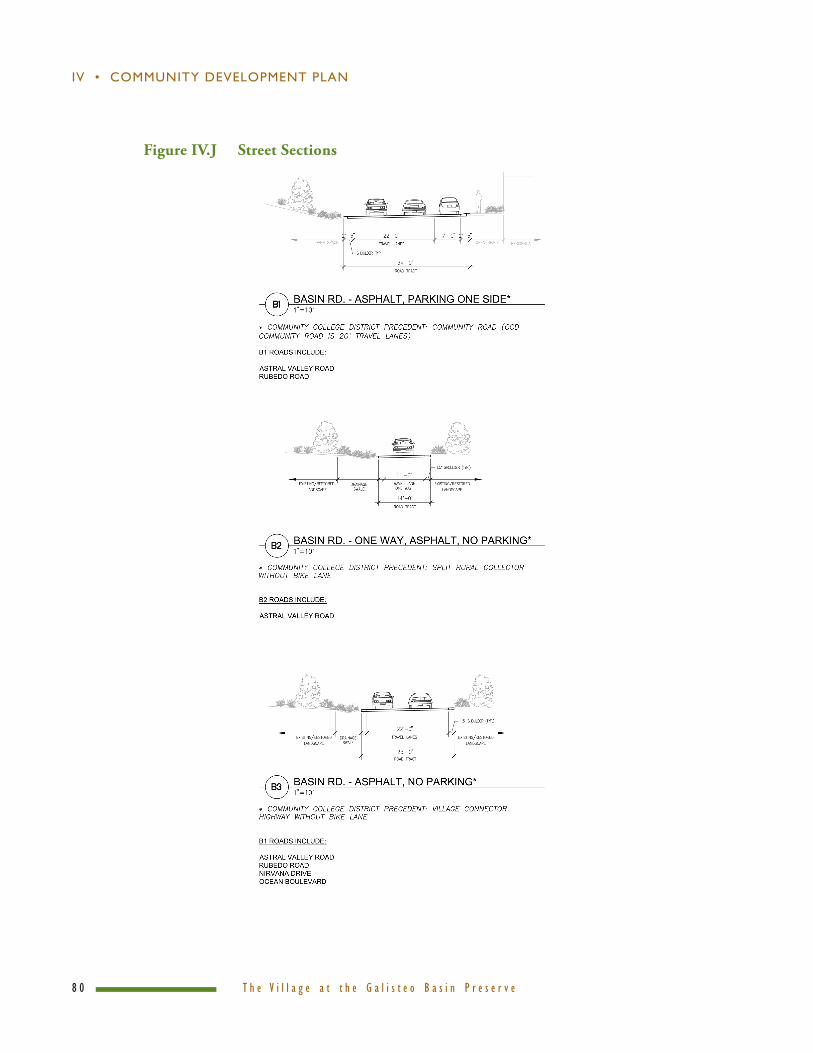
Basin Roads
Basin Roads are moderate-speed travelways that accommodate transitions between Village Streets, Neighborhood Roads, and Traffic Priority Roads. Basin Roads also link discrete neighborhoods and/or districts across the Village and distribute primary traffic onto smaller neighborhood roads. They are designed to maintain the site’s rural character, minimize impact to the Preserve’s existing environment, and balance the safety and efficiency of non-motorists and motorists equally.
The Basin Road typology allows for a path along one side for the shared use of bikes and pedestrians. In residential neighborhoods, on-street parallel parking is allowed on one side of the road for visitor and resident parking. A typical section of the Basin Road includes two travel lanes, compacted gravel shoulders, parking on one side in residential neighborhoods, drainage swales as required, and a shared-use path on one side for pedestrians, bicycles, and equestrians.
In the Phase I development, Basin Roads include Astral Valley and Rubedo roads. In future phases, Astral Valley road will serve as the “main street” for the Village center. It will be surfaced with asphalt, but will not be developed with a standing curb and gutters. A permeable-surface walking and cycling path (e.g., decomposed granite) will parallel designated lengths of Astral Valley road, facilitating pedestrian access to the Village center from US 285, as well as from internal Village neighborhoods.
� � T h e V i l l a g e a t t h e G a l i s t e o B a s i n P r e s e r v e
IV • COMMUNITY dEVELOPMENT PLAN
Basin Road Design Standards
Number of Lots: >200 Travel Lanes: Two Posted Speed (mph): 25 Surfacing: Asphalt or base course On-Street Parking: One side only in residential areas Curb Radii: 25 feet Paths: Shared use path for pedestrians, bicycles, and equestrians Drainage: Swales Landscape: Native vegetation and streets plantings in residential areas
Neighborhood Roads
Neighborhood Roads are the predominant roadway typology in the Village; they will serve a majority of the Village’s neighborhoods and accommodate varying densities of residential uses along their frontage. Neighborhood Roads are designed to establish a comfortable and safe pedestrian environment, maintain low vehicular speeds, and discourage through-traffic, allowing pedestrians to use the street for circulation. Their design priority is for the non-motorist.
Neighborhood Roads vary greatly in character but reflect the “traditional neighborhood” engineering designs as defined by the Institute of Traffic Engineers. Tight curb radii and narrow roads and narrow travel lanes will help slow traffic. Road surfacing and planted drainage swales are designed to enhance the rural character of the neighborhoods and Village. The typical Neighborhood Road section includes 20 feet for travel lanes, parallel parking, and planted drainage swales.
Phase I Neighborhood Roads include Cosmic Plain, Koan Court, Dharma Drive, Keyline Drive, Whimsical Way, Big Dipper, Quixotic Court, Pike Place, Attapa, Lorax Lane, Tranquility, and Pleiades Place.
Neighborhood Road Design Standards
Number of Lots: 0 to 60

P h a s e 1 P r e l i m i n a r y P l a t � �
COMMUNITY dEVELOPMENT PLAN • IV
Travel Lanes: Two Posted Speed (mph): 10 Surfacing: Base course, unit paving, or asphalt On-Street Parking: Two sides, one side or none Curb Radii: 20 feet Paths: None or in open space areas Drainage: Swales or valley gutters Landscape: Native vegetation and street plantings
Emergency Access Roads
Emergency Access Roads are designed for special-purpose vehicular use. This road typology is proposed for a single location in the Phase I Plat, which will allow county emergency vehicles access to the Village in the event the Basin Roads are congested or impassable. The Phase I Emergency Access Road, known as Rimrocker, is located northeast of the Happy Valley neighborhood.
Driveways
Driveways provide limited access to garages. For Driveways that serve more than two homes, the road width will accommodate two-way travel. Driveways serving multiple units will be posted “no parking.”
Street Design Standards
Commonweal Conservancy and individual parcel developers will build roadways that incorporate “low impact design” (LID) — planning and construction practices that minimize the adverse effects of automobiles on the community form, protect the environmental health of the land, and support the livability of the Village for residents, students, and workers.
LID standards will include, but not be limited to, the following:
• Roadways will be designed to minimize soil disturbance (i.e., cuts
� 0 T h e V i l l a g e a t t h e G a l i s t e o B a s i n P r e s e r v e
IV • COMMUNITY dEVELOPMENT PLAN
Figure IV.J Street Sections

P h a s e 1 P r e l i m i n a r y P l a t � 1
COMMUNITY dEVELOPMENT PLAN • IV
Figure IV.J Street Sections, continued
and fills), vegetation loss, and stormwater runoff. This design methodology will include undulating vertical and horizontal road profiles — a practice that allows roads to be directly overlaid on the land, rather than carved through it.
• Roadways will be designed to minimize the width of driving lanes and pavement. Road edges may employ a “ribbon curb” — or no curbs where appropriate — to limit water channelization through culverts, vertical curbs, and bar ditches. Paving materials (e.g., local site aggregate color, base course, chip seal, etc.) will reflect the color palette of the

� 2 T h e V i l l a g e a t t h e G a l i s t e o B a s i n P r e s e r v e
IV • COMMUNITY dEVELOPMENT PLAN
Galisteo Basin soils and rocks — affording a more rural quality to the roadways beyond the Village center.
• Roadway sections may not be crowned if a “sheet-drain” approach is: (i) more consistent with natural drainage patterns; (ii) helps minimize grading impacts; or (iii) bolsters the community’s stormwater retention capacity. Roadway shoulders will be revegetated to match the adjoining landscape characteristics and development form. Revegetation may be limited to seeding with native grasses and wildflowers, or include more intensive landscape plantings with permanent irrigation in high-visibility areas.
• Detention basins, silt drains/ fences, and temporary revegetation will be used in conjunction with earthwork operations for sediment and drainage control.
• Roadways and driveways will be strategically designed and constructed to minimize site disruption.
• Driveways will be made of permeable materials and limited in width.
• Grading will generally not occur on slopes exceeding 12 percent. Cuts of 8 feet or more in height shall have special slope treatments and/ or retaining walls to stabilize the slope and minimize scarring. Monotonous, uninterrupted retaining walls will be prohibited in favor of stepped retaining walls with planting wells. Natural materials (e.g., stone or wood) and natural colors will be used for retaining walls, wherever practical.
• Grading on slopes greater than 16 percent may only occur in isolated instances, such as arroyo crossings, or in designated residential development areas. Arroyo crossings will meet county and state standards, and no arroyo crossing shall be permitted on slopes exceeding 25 percent for more than 1,000 square feet, unless no alternative location is available. In these instances, site-specific solutions will be required to minimize visual and landscape impacts.

P h a s e 1 P r e l i m i n a r y P l a t � �
COMMUNITY dEVELOPMENT PLAN • IV
Egress + Ingress
Residents and visitors will access the Village from US 285 at two points of intersection. The main entry to the Village is the existing Astral Valley road — an “at-grade/full intersection” that links the Galisteo Basin Preserve to 285. Astral Valley road is planned as a split roadway with two 11-foot-wide travel lanes and 2 feet of roadway shoulders.
Secondary access to the Village and adjoining neighborhoods is available from Rimrocker road — an existing at-grade “right-in/right-out intersection” located approximately 1,300 feet north of Astral Valley road. Given its right-in/right-out intersection restrictions, the Rimrocker road entry will serve as emergency access for fire and safety vehicles, and secondary access for Village residents and visitors.
US Highway 285 Access
In July 2007, the TDA Colorado, Inc./Tilghman Group prepared a preliminary Traffic Impact Analysis (TIA) for the Phase I Plat submittal. This report included a survey of existing traffic volumes on US 285 between I-25 and County Road 41. It also estimated future traffic flows along US 285 and recommended infrastructure development and traffic-management system improvements to Commonweal and the New Mexico Department of Transportation.
To inform their analysis, TDA/Tilghman facilitated a traffic count along US 285 from December 6 to 7, 2006. TDA/Tilghman also secured population and development projections from Al Pitts, a Santa Fe demographer and economist, and consulted with the Santa Fe Metropolitan Planning Organization (MPO) to project traffic growth along the US 285 corridor during the next 23 years.
TDA/Tilghman forecast a range of traffic impacts on the US 285 corridor during the next 23 years and offered the following mitigation recommendations:
• By 2030, without any new development associated with the Galisteo Basin Preserve, approximately 757 new housing units and more than 535,000 square feet of commercial land uses will be developed within the corridor. These “background developments” will generate 23,500 vehicle weekday trips on US 285, with 945 morning peak-hour trips and 2,305 afternoon peak-hour trips.

� � T h e V i l l a g e a t t h e G a l i s t e o B a s i n P r e s e r v e
IV • COMMUNITY dEVELOPMENT PLAN
• With the exception of the westbound off-ramp at the I-25 intersection near Eldorado, area intersections will maintain acceptable “levels of service” (LOS) ratings (i.e., LOS of D or better) through 2020. By 2030, Avenida Amistad will require a dual eastbound left-hand turning lane to maintain an acceptable LOS.
• At full build-out in 2020, the Village is projected to generate 6,890 new external vehicle trips, with 680 in the morning peak hour and 815 in the afternoon peak hour.
• 2,000 trips would be generated within the Village, without impact on US 285.
• When added to existing traffic volumes along the US 285 corridor, TDA/Tilghman determined that the “Galisteo Basin Preserve’s traffic will cause little change to intersection levels of service.”
• The only intersection that will drop to an unacceptable level of service is anticipated to be the eastbound ramp at the I-25 interchange — an intersection that will require a traffic signal to reduce projected delays.
• Concurrently with the development of the Phase I Plat, TDA/Tilghman recommends that a deceleration lane be constructed along US 285 at Astral Valley road.
• At the main entrance of the Village, the existing “T intersection” is expected to function effectively through 2020 (i.e., LOS of D or better).
• By 2030, new traffic control measures will need to be developed to maintain acceptable LOS in the peak afternoon weekday hour. Toward that end, TDA/Tilghman recommends that the main entrance be improved with a “receiving and acceleration lane” in the US 285 north median to enable a two-stage entry for left-turning northbound vehicles during the peak-hour traffic.
As documented in the TDA/Tilghman Traffic Impact Analysis, the initial phase of development (i.e., 149 homes and 37,500 square feet of commercial and civic/educational land uses) will have no appreciable impact on the LOS classification for intersections along US 285 or at intersections on other area roads. For the full analysis, see “Traffic Impact Analysis” in the Technical Reports.

P h a s e 1 P r e l i m i n a r y P l a t � �
COMMUNITY dEVELOPMENT PLAN • IV
Parking Plan
The Village is designed and engineered to fairly accommodate the car storage needs of residents, employers, employees, students, and visitors. The community plan is not, however, wildly embracing of the car culture that characterizes most American suburbs. Instead, the Phase I Plat attempts to balance the car storage needs and expectations of property owners with more fundamental community-building priorities of public safety, community aesthetic, and environmental protection.
The place-making ambitions of traditional neighborhood development are often compromised by formulaic standards and practices of land-use development. In Santa Fe County, fortunately, a more thoughtful and pedestrian affirming practice of roadway design and parcel planning is encouraged. Toward that end, the Phase I Plat relegates car storage to the wings and backstage areas of the larger community stage.
As provided in the Phase I Plat Sheet Set, most of the Village’s residential lots are serviced by shared driveways — travel lanes that allow garages and carports to be accessible but out of view of adjoining streets and public areas. Hidden by walls
and other buildings, automobiles and car storage structures no longer dominate residential architecture, the streetscape, and the neighborhood pedestrian realm.
By limiting the number of parking spaces available to each residential and commercial parcel, moreover, homes and businesses absorb a larger share of the building envelope than traditional suburban development affords. In doing so, the space between homes is reduced, block lengths are shortened, and fewer sidewalk breaks and “curb cuts” are imposed on the community’s block structure. A more consistent street face and a more compact neighborhood form, in turn, create a safer and more engaging environment for pedestrians.
On Astral Valley road, a small number of on-street parking spaces are available for residents, visitors, and business clients and customers. Confined in their place and time on the street, these on-street parking spaces facilitate movement and activity — making visible the coming and going of residents and visitors. Selectively distributed within residential neighborhoods and along Rubedo road, on-street spaces also can accommodate visitors and students. The flow of cars into and out of on-street parking spaces also helps to slow traffic through the community — ensuring a higher degree of public safety for children and pedestrians.

� � T h e V i l l a g e a t t h e G a l i s t e o B a s i n P r e s e r v e
IV • COMMUNITY dEVELOPMENT PLAN
In addition to the Village street design, the parking plan for the Phase I Plat is informed by the standards and practices spearheaded in the Santa Fe Community College Ordinance. As outlined Figure IV.K, Phase I’s residential parking plan designates two off-street parking spaces for each detached dwelling unit and a combination of on- and off-street spaces for attached housing types. Phase I condominiums, town homes, and courtyard homes will average of 1.25 off-street parking spaces per unit; smaller condos will be assigned one off-street and one-half on-street space. Parking needs for the 14 smaller detached cottages will be met through a combination of 10 assigned off-street spaces and 18 on-street spaces.
Clients and customers of the 10 live-work units in the Phase I development will be able to park in 13 nearby on-street parking spaces (1.3 assigned on-street spaces for each dedicated 400 square feet of commercial use). In addition, 1.5 off-street parking spaces will be allocated to the residential area of these live-work units. This parking allotment slightly exceeds the required 1.25 off-street spaces per unit to accommodate one employee per commercial unit during daytime hours.
PHASE 1 PARKING PLAN SUMMARY
# Of Off-Street RESIDENTIAL PARKING SPACE PROVISIONSSpaces/Unit # of Required # of Provided # of Provided TOTAL
Per SF CCD Ordinance Units Off-Street Off-Street On-Street PROVIDED
RESIDENTIAL ATTACHED
A1 Studio Condo 1 assigned 1/4 unassigned 2 2.5 2 0.5 2.5
A2 Studio Condo 1 assigned 1/4 unassigned 2 2.5 2 0.5 2.5
A4 Hacienda Condo 1 assigned 1/4 unassigned 18 22.5 22.5 0 22.5
B1 Townhomes 1 assigned 1/4 unassigned 8 10 12 0 12
B2 Townhomes (with Live Work) 1 assigned 1/4 unassigned 10 12.5 20* 0 20
C1 Neighborhood Courtyard 1 assigned 1/4 unassigned 8 10 10 0 10
RESIDENTIAL DETACHED
A3 Cottage 2 14 28 20 8 28
C2 Neighborhood Courtyard 2 32 64 64 0 64
D1 Village 2 30 60 60 0 60
F2 Canyon 2 25 50 50 0 50
RESIDENTIAL SUBTOTAL 149 262 262.5 9 271.5
COMMERCIAL PARKING SPACE PROVISIONS
# Of Spaces/Unit # of Required # of Provided # of Provided TOTAL
Per SF CCD Ordinance Metric Spaces Off-Street On-Street PROVIDED
COMMERCIAL / LIVE WORK
B2 Work Component 1 space/300 sq ft 400 sq ft/unit 13 0 13 13
B2 Employee Component 1 space per employee 10 employees 10 0** 0** 0
COMMERCIAL SUBTOTAL 23 0 13 13
PHASE I PROJECT TOTALS 285 262.5 22 284.5
Notes:* See commercial summary for commercial work and employee components.** Assumes 1 parking spot is shared with employee during the day and 1.25 parking spots on-street assigned/restricted parking for visitors.
USE
USE
Figure IV.K Phase I Parking Plan Summary

P h a s e 1 P r e l i m i n a r y P l a t � �
COMMUNITY dEVELOPMENT PLAN • IV
Mobility Programs + Strategies
Transportation and mobility programs and strategies associated with the Village’s initial development phase include:
• A car-share program operated by the Neighborhood Association or another nonprofit entity will make high-efficiency vehicles available for single-purpose rental use (i.e., “smart car program”).
• A ride-share program will accommodate commuters to Santa Fe and Albuquerque, as well as residents traveling to Eldorado’s Agora Center.
• A network of paths and trails will facilitate inter-Village connections through and across neighborhoods, commercial and civic amenities, and surrounding parks and open spaces.
• A well-designed street network will facilitate safe and efficient vehicular movement and accommodate safe and attractive pedestrian, bicycle, and equestrian uses.
Longer-term strategies to address Village residents’ commuting needs include:
• Pedestrian and bicycle trails to a trolley platform. The proposed Santa Fe/ Lamy commuter trolley will include a train platform within 1/2-mile of the Village center. Ridership is expected to include students and teachers traveling to Charter School 37, workers commuting to downtown Santa Fe (and possibly Albuquerque), residents traveling to downtown Santa Fe for services and entertainment, and county residents riding to the Village to access Preserve facilities and trails.
• A tram/van system serving neighborhoods within the Village and limited outside locations. Users would include residents who have difficulty walking or who are unable to drive, residents desiring a quick connection to the Village center to and from the trolley station, and Village and Eldorado residents traveling between the two communities.
• A possible partnership with the new North Central Regional Transit District to provide stops at the Village. Village service could tie into NCRTD’s existing bus service between Eldorado and downtown Santa Fe, a service that is expanding to include Galisteo, Stanley, and Moriarty.

� � T h e V i l l a g e a t t h e G a l i s t e o B a s i n P r e s e r v e
IV • COMMUNITY dEVELOPMENT PLAN
Lighting Plan
The Village lighting plan is designed to facilitate visibility, accessibility, and public safety, while simultaneously protecting the fragile “dark skies” quality of the region. The plan is guided by the following values and principles: i) precise lighting placement; ii) sufficient, but not excessive, lighting coverage; iii) scalability, in terms of the number of fixtures and the magnitude of illumination; and iv) highly energy-efficient fixtures.
During the initial phase of construction, the Village lighting program will include a limited number of street fixtures. As the population grows and traffic volumes increase, the lighting system will be expanded to serve the needs of an increasingly active, urban population.
In this submittal, the Village lighting plan is informed by the quality and intensity of activity along and within the Phase I neighborhoods. By this standard, Astral Valley will be the primary beneficiary of community street lighting, given its stature as the emergent “Village main street.” As noted on the Phase I Plat Sheet Set (See Sheet SL1.01), Astral Valley road will be served by a small number of streetlights fronting the Tres Cortes and Narroyo neighborhoods.
Within the Village’s interior road network, streetlights are proposed for points of intersection and within courtyards. Instead of pole-mounted streetlights, however, most of the roadway and walking paths within the interior neighborhoods will be lit from bracket-mounted streetlights attached to privately developed walls. A “blanket easement” will overlay the Phase I Plat to allow Commonweal access to private parcels to place wall-mounted fixtures.
The street lighting and pathway fixtures will employ a Light Emitting Diode (LED) technology. LED lighting is acclaimed for its longevity (up to 50,000 hours), minimal power demand, and color quality — affording excellent nighttime visibility at relatively low light levels. Due to the relatively small size of the light
Lighting + Signage
P h a s e 1 P r e l i m i n a r y P l a t � �
COMMUNITY dEVELOPMENT PLAN • IV
source, moreover, the fixtures generate a uniform light level and minimize the effect of glare.
Among their many advantages, LED fixtures are “dimmable” to better match the cycle of daily traffic volumes (i.e., as vehicular and pedestrian traffic falls through the later hours of night, illuminance can be reduced). By managing the streetlights relative to motor vehicle and pedestrian traffic flow, the quality of the region’s dark skies can be better protected — ensuring greater visibility during priority sky-watching hours (i.e., midnight to 2 a.m.).
Finally, to ensure a high standard of performance and reliability, the Village’s street lighting fixtures will be assigned individual “addresses” to facilitate remote monitoring for outages or other malfunctions. The programmed network of fixtures will allow units to be individually managed for lighting timing and intensity.
Additional provisions of the Village lighting plan include:
• The height of streetlights shall not exceed 18 feet.
• The maintained illuminance (foot-candle) levels shall correspond to recommendations of the Illuminating Engineering Society of North America (IESNA) for the road/street/path type and traffic density.
• Cutoff and full-cutoff luminaires shall be used, and additional shields shall be added to avoid light trespass onto private properties.
• Use of high-pressure sodium and mercury vapor lights will be prohibited.
Signage
Village signage will be used to facilitate motor-vehicle movement, pedestrian flow, environmental interpretation, education, and “way-finding” along trails. Signage design standards will ensure that residents, visitors, and emergency-service providers can travel the Village roads and pathways efficiently and safely. Graphic design quality and material choices will reflect the community’s values of simplicity and modesty.
� 0 T h e V i l l a g e a t t h e G a l i s t e o B a s i n P r e s e r v e
IV • COMMUNITY dEVELOPMENT PLAN
Notwithstanding the imposition of graphic design standards for the larger community — especially with regard to street signage — the style and quality of home addressing and commercial signage will accommodate a wide range of aesthetic sensibilities. By this approach, the community will support a playful (and somewhat eclectic) signage program as it applies to commercial, educational, civic, and residential land uses.
The following signage standards will be incorporated in the Village Design Guidelines. The Village Design Review Committee (DRC) will be responsible for overseeing and enforcing the community standards:
• Lighting and landscaping are integral to signage design. Lighting will respect the community’s “dark sky” values and principles while providing proper illumination for directional and way-finding information.
• Freestanding signs shall be sized in proportion to their surroundings and for the audiences they serve. Sign faces should be large enough to accommodate the minimum typeface required to convey the intended message, but discreet enough not to overpower their surroundings or context. Sign colors should provide a contrasting background so type is legible, but should not create a visual nuisance.
Prohibited signs shall include:
• Signs which constitute a hazard to traffic or pedestrians
• Signs located within any drainage channel or critical habitat area
• Mobile, inflatable, or portable signs, and balloons, flags, or kite-style signs
• Signs which produce odor, sound, smoke, flame, or other emissions
• Signs which imitate or simulate official signs, or which use blinking or intermittent lights; signs using strobe lights or individual light bulbs exceeding 75 watts
• Signs on public property or right-of-way or signs attached to utility poles, streetlights, fences, barns, sheds, or similar structures

P h a s e 1 P r e l i m i n a r y P l a t � 1
COMMUNITY dEVELOPMENT PLAN • IV
• Roof-mounted signs and billboards
• Internally illuminated signs.
Residential Signage
• Monument signs, piers, walls, and/or freestanding monolith/pylons can be used to identify unique areas of the community, but shall be consistent with the overall community form and character. Identity signage will be designed to complement the graphic and material sign standards of the larger Village, rather than call attention to a neighborhood during a sales period.
• Lot signs may be provided in a given development phase, but all signs shall be designed with materials, colors, and typefaces that reflect the graphic standards of the Village.
• Individual homes may be signed with numbers visible from the street, but consistent in scale and material with the Village graphic standards.
Commercial Signage
• Commercial signage will be kept small and subordinate to the building. Commercial establishments shall have a maximum of one sign hung either directly on the front façade of the structure, from a portal column, or on a post at the entry wall. Three-dimensional signs, and those that add to the “place making” quality of the Village center, will be encouraged.

� 2 T h e V i l l a g e a t t h e G a l i s t e o B a s i n P r e s e r v e
IV • COMMUNITY dEVELOPMENT PLAN
Water Resources Plan
With deep respect and appreciation for the fragile water resources of Santa Fe County, the water-conservation and community-planning work associated with the Phase I Plat is designed to protect and enhance the hydrological health of the Galisteo Basin.
Toward this end, Commonweal Conservancy has engaged a number of geo-hydrologists, civil engineers, ecologists, state and county agency staff, and community representatives to advise its work. The project is designed to protect adjoining properties from deleterious stormwater impacts and/or aquifer-drawdown effects. The Preserve’s landscape-regeneration efforts also aspire to improve the water-recharge and alluvial-storage capacities of the property’s soils and drainages.
The Phase I Plat water plan incorporates “best practices” associated with infrastructure design, alluvial storage, water conservation, aquifer recharge, and water-rights management. The principles that guide the water plan include:
• Leverage the productive value of existing water sources during the initial phase of development (i.e., 2009 to 2011).
• Acquire water rights from sources that are located within the Galisteo sub-basin.
• Incorporate water-saving technologies and construction practices that will minimize residential, commercial, and civic/institutional water consumption.
• Use wastewater-reuse technologies and infrastructure to serve non- potable commercial and residential water needs and outdoor irrigation systems.
• Bolster the quality and quantity of groundwater recharge to the local aquifer with the use of advanced infiltration technologies.
Water Planning Principles
P h a s e 1 P r e l i m i n a r y P l a t � �
COMMUNITY dEVELOPMENT PLAN • IV
The water demand for the Village was derived from performance records of comparable communities, conservation and water-catchment projections, and computer modeling that forecast the water needs of a variety of housing types,
commercial activities, civic facilities, and special land uses (e.g., memorial landscape, orchard).
At full build-out in 2013, the Phase I Village population is expected to include approximately 315 people. This estimate anticipates development of 149 homes with an average household size of 2.1 residents per unit. It also anticipates construction of approximately 7,500 square feet of commercial facilities and 30,000 square feet of civic/educational facilities. A water budget for the community landscaping and agricultural program is also included in the estimate.
Following from the calculations of Santa Fe-based Natural Systems International (NSI), the domestic water demand for each Village household is projected to be less than 0.16 acre-feet per year. By contrast, in nearby Eldorado, the domestic water demand averages 0.2 acre-feet per year. By 2013, the total annual water demand for the community is expected to total 23.9 acre-feet for residential uses. Separately, commercial and civic water demand is expected to total 0.75 acre-feet per year, and annual educational uses are forecast
to require 0.75 acre-feet. Landscaping and irrigation uses will be supplied with treated-effluent and rainwater-catchment sources.
Using county formulas and data from nearby master-planned communities (i.e., the Community College District), NSI expects the consumptive use for the Phase I Plat to total 27.9 acre-feet per year at full build-out. Notwithstanding this estimate, NSI contends that the Village’s consumptive use will ultimately be less than 22 acre-feet per year, after accounting for recharge credits, wastewater reuse, and rainwater catchment.
Water Demand

� � T h e V i l l a g e a t t h e G a l i s t e o B a s i n P r e s e r v e
IV • COMMUNITY dEVELOPMENT PLAN
The water supply program for the Phase I Plat includes a mix of groundwater, rainwater, and treated-wastewater sources. The water plan for the project anticipates an aggressive water-conservation program (i.e., strict water budgets, fixture and appliance efficiencies), community-scale rainwater-catchment infrastructure, and a comprehensive wastewater recycling system to facilitate a return flow of treated effluent for irrigation and domestic uses.
John Shoemaker and Associates prepared an exhaustive analysis of the project’s water resources during a nine-month period in 2006 to 2007. A zone of Upper Galisteo Formation geology west of New Moon Overlook was identified by Shomaker as the preferred area for development of a Village well field.
The development and testing of numerous exploratory wells demonstrated the “Zone A” aquifer’s capacity to supply 191 acre-feet of domestic water for a 100-year period. In February 2007, Santa Fe County hydrologist Karen Torres corroborated Shomaker’s findings. In her letter of February 16, 2007, Ms. Torres affirmed that a 100-year domestic water supply was readily available to support the domestic needs of the Phase I Plat.
Two production wells will supply the domestic water needs of the Phase I Plat. Based on the pump test results from the Village production well No. 1 (drilled in March 2007), Village wells can reasonably be expected to produce 50 gallons per minute (gpm) on an alternating pumping schedule for a minimum of 100 years. Please see “Letter to Ted Harrison,” dated June 5, 2007, from Steve Finch of John Shomaker and Associates, in the Technical Reports.
To ensure adequate water storage for Phase I, Commonweal will construct a 250,000-gallon water tank to service the community’s domestic needs. This tank will also accommodate the fire-storage and system-pressure requirements of the Phase I development. The water-delivery infrastructure will include 8- to 10-inch
Water Supply Plan

P h a s e 1 P r e l i m i n a r y P l a t � �
COMMUNITY dEVELOPMENT PLAN • IV
gravity-fed water lines to service hydrants and water meters in conformance with Santa Fe County Code requirements.
Community Water System Design
Overview
In 2005, Commonweal engaged Seattle-based civil engineering firm Magnusson Klemencic Associates (MKA) and Natural Systems International (NSI) of Santa Fe, New Mexico, to craft an integrated community water-management strategy that would minimize the Village’s water consumption and maximize its water reuse and aquifer recharge capabilities.
A report entitled “Process Flows Description for the Village at the Galisteo Basin Preserve” (included in the Technical Reports) details the water sources and uses that will characterize the Village operations in the initial phase of development. Figure IV.L illustrates the anticipated water flows associated with the Phase I Plat.
Water System Design Features
The community water system for the initial phase of development is designed to meet or exceed federal, state, and county standards for a publicly managed water system. Accordingly, the water system will provide sufficient water supply and appropriate water quality to service:
• Homes for domestic needs (i.e., drinking, washing, toilets)
• Limited commercial and civic/educational uses
• Fire safety requirements
• Limited agricultural irrigation
The community water system for the Phase I Plat is designed to include:
• One to two community wells, with filtration systems as may be required to meet or exceed New Mexico Environment Department (NMED) standards

� � T h e V i l l a g e a t t h e G a l i s t e o B a s i n P r e s e r v e
IV • COMMUNITY dEVELOPMENT PLAN
• Standby power
• A distribution system capable of delivering water to homes and businesses at a minimum pressure of 40 psi at the meter
• A distribution system capable of sustaining fire flows of 500 gpm for a period of two hours to ensure residential fire protection
• A distribution system capable of sustaining fire flows of 1,000 gpm for two hours to ensure reasonable fire protection for schools and commercial areas
• Water storage tanks with a total capacity of 250,000 gallons
• A professional operating company will oversee the management and maintenance of the Village water-delivery system. As of this writing, Commonweal is in active discussions with the Eldorado Water and Sanitation District and a private utility known as Natural Systems Utilities to provide this service.
To supplement groundwater sources, homes and businesses will use water from roof catchment and treated effluent sources. Roof catchment can be reasonably expected to supply 1.2 acre-foot of stored water annually, depending on annual rainfall levels.
System Pressure — The community water wells will be designed to sense low-pressure conditions in the community and immediately activate pumps to supply deficit zones with appropriate water flows and line pressure. A series of booster stations will be sited and constructed to ensure consistent and reliable water delivery throughout the Village.
Metering — Water meters will be used to measure the consumption of Village customers. They will be developed with wireless transmitters to facilitate timely and efficient oversight of the community’s water use. In cases where water consumption is judged excessive or inconsistent with historical averages, the water-utility operator will be able to quickly undertake an investigation for leaks and/or inappropriate usage. Consistent with New Mexico’s Public Regulatory Committee (PRC) regulations, a defensible and competitive rate structure will be established that affords a “base rate” for water-delivery charges to residential and commercial customers. Mirroring the rate structure of other community and public systems

P h a s e 1 P r e l i m i n a r y P l a t � �
COMMUNITY dEVELOPMENT PLAN • IV
WATER BALANCE SUMMARY SCHEMATIC
LineLosses
10%2.54
27.90 AFY Pick Year: avgAFY
TotalPotable 25 AFY Potable to Indoor Uses: 0
Demand 0 23.87 0.75 0.75 0.00Total Residential AFY AFY AFY AFY Evaporative Cooling Demand
Demand: 0 evap cooled sf24 AFY 3 peak watts/sf.3
Charter School Commercial/CivicUnits
(Indoor Only)149 units
21.63 AFY Wastewater Produced 0 0AFY AFY
Evaporation Reuse to Reuse to4% W C' 1 C li
ResidentialUnits
(Indoor Only)(Indoor Only)
Potable Supply
Wastewater
Appendix B-1 Water Balance Summary 1 of 2
4% W.C's1 Cooling0.87 Target: Target:AFY 0% 0%
of available of available20.77 0 reuse reuse
AFY Reuse Available 0
Target:100%20.77
Evaporation AFY6% Reuse to
1.32 StorageAFY 1.20 AFY SW to Storage
Design Storage Vol: 1.55 AF
Storage Change2:Irrigation/Land Application 0.00 AFY
0 14.51 AFY 0 6.14AFY AFY Non-Potable to Irrigation Project: Galisteo Basin Preserve
Potable Phase: Phase I Build Outto File Date: 2/08/2008
Irrigation Total Irrigation0 Demand (AFY)
6.14 AFY
Landscape
Rainwater Harvesting: Rooftops
Treatment and Effluent
Reuse
Irrigation Storage: Covered
Pondsor Cisterns
WW & Rain
Appendix B-1 Water Balance Summary 1 of 2
Figure IV.L Phase I Water Balance Schematic
in the region, the per-gallon charge for water will increase on a stepped-function basis (i.e., thresholds of consumptive use will trigger geometrically higher per-gallon water rates).
Back up Power — Standby power in the form of a diesel- or natural-gas-powered generator will protect the community’s water supply against power outages.
Management — Commonweal is in active conversations with the Eldorado Water and Sanitation District (EWSD) and a private utility, Natural Systems Utility

� � T h e V i l l a g e a t t h e G a l i s t e o B a s i n P r e s e r v e
IV • COMMUNITY dEVELOPMENT PLAN
(NSU), to develop and manage the community’s portfolio of water, wastewater, reclaimed-water, and stormwater-catchment sources. The discussions with NSU involve an integrated water-management strategy that includes groundwater conservation, wastewater reclamation, stormwater catchment, and enhanced efficiencies for water-efficient appliances and faucets.
Fire Hydrants — Fire hydrants will be distributed throughout the Village residential zones at intervals of no less than 1,000 linear feet. The design of the hydrant system will ensure that hoses can be drawn from the outside edge of a residential block to the interior zones without complication. Hydrant placement in areas that include schools and commercial development will be placed at intervals of 500 feet or less, as specified by the Santa Fe Fire Department.
Service Zones — Commonweal’s civil-engineering consultants at MKA have established service zones for individual residential neighborhoods. By carefully accounting for line distances, elevation changes, and pressure requirements to accommodate peak domestic demand and fire flow, the community will be efficiently and responsibly served. At service zone boundaries, booster pumps will be developed to ensure that domestic water is available to higher-elevation neighborhoods and that storage-tank water levels are appropriately maintained. As tanks are filled to capacity, booster pumps will be cycled off and water will be delivered through pressure-reducing stations into lower zones.
Storage — In conformance with Santa Fe County Fire Department standards, the Village storage tanks and water lines will be sized to accommodate the demands of fire flow and peak domestic water use. To accommodate a fire-flow volume of 1,000 gpm for two hours — combined with peak-hour domestic water demands — a storage capacity of 250,000 gallons will be required for the Phase I Plat.
Distribution Mains — Water mains are required to connect supply, storage, and domestic service zones. The Santa Fe County Fire Department requires that hydrants be connected to water mains that are 8 inches in diameter or larger. Other

P h a s e 1 P r e l i m i n a r y P l a t � �
COMMUNITY dEVELOPMENT PLAN • IV
mains will be sized at 8 inches or larger, as required to accommodate commercial, civic, and/or educational land uses.
Water Quality
A Village well (production well No. 1) was drilled in March 2007 and pump tested at a rate of 80 gpm for a 96-hour period. Other test wells were drilled in 2006. The water chemistry of the proposed production well and the test wells was analyzed by Hall Environmental.
In a letter to Ted Harrison from John Shomaker and Associates, dated June 20, 2007, Steve Finch judged the water chemistry of the proposed production well to be of good quality and consistency. Of moderate concern was a fluoride reading of 5.0 mg/L — a level of concentration in excess of the 4.0 mg/L drinking-water standard.
Responding to an inquiry from county staff, Mr. Finch noted that “concentrations of fluoride may be significantly different at lower pumping rates, as indicated by the different values of specific conductance observed during the step-drawdown and constant-rate pumping tests.” Toward this end, a 50-gpm pump test is scheduled for May 2008 to assess the impact of a reduced pumping rate on the concentration of fluoride in the Village production well.
If the reduced pumping rate does not yield a fluoride concentration at or below EPA standards, treatment options may include blending with other water sources, reverse osmosis, or ion-adsorption filtration media. If treatment for fluoride is needed, Finch advised that there would be little to no water loss to the system due to the relatively low concentrations involved in the removal process.
Water Rights
In 2007, Commonweal acquired 2.1 acre-feet of consumptive water rights from John Holloman. The water right was associated with the “McKee well field” in an area northwest of the traditional village of Galisteo. Separately, Commonweal maintains a fully executed purchase-and-sale agreement with Kay Rivers for approximately 28.5 acre-feet of consumptive water rights in the Galisteo sub-basin

1 0 0 T h e V i l l a g e a t t h e G a l i s t e o B a s i n P r e s e r v e
IV • COMMUNITY dEVELOPMENT PLAN
of the Rio Grande Basin. Together, these water rights will allow Commonweal to use 30.6 acre-feet per year for the water needs of the initial development phase.
In September 2007, Commonweal filed a Water Rights Transfer application with the Office of the State Engineer (OSE). The application sought authorization from the OSE to move 2.1 acre-feet from the McKee well field and 28.5 acre-feet from Ms. Rivers’ Cerrillos, New Mexico, location to the Village production well field. The transfer application was initially “protested” by the EWSD and the Village of Galisteo Water Association (VGWA). Following negotiations with representatives of the EWSD and the VGWA, Commonweal expects the two entities will file a “release of protest” with the OSE in March 2008.
Given a timely review of the water-rights application, Commonweal believes that the transfer could be completed by December 2008. Concurrently with the transfer application’s approval, Commonweal will purchase Ms. Rivers’ allocation and hold title to 30.6 acre-feet of consumptive water rights for application to the Phase I Plat development program. Copies of the Sepcial Warranty Deed and water rights contract are included in the Technical Reports.
Conservation is the single most effective way for new communities to manage their water supplies; by helping minimize the magnitude of groundwater diversion, conservation can allow most of the aquifer’s water to remain at the source, untouched.
The Village incorporates responsible water stewardship in all phases of community development, from planning through long-term occupancy. Water-conservation practices will go beyond compliance with Santa Fe County codes and ordinances to include minimized groundwater withdrawals. Commonweal will do this by incorporating efficiencies throughout Village planning and design, by using high-quality reclaimed effluent and actively harvested rainwater, and through community education and outreach efforts.
The initial phase of Village development includes a number of water-management policies and practices that will help protect the groundwater resources of the
Water Conservation Approach + Strategies

P h a s e 1 P r e l i m i n a r y P l a t 1 0 1
COMMUNITY dEVELOPMENT PLAN • IV
region. By following these strategies, the water plan for Phase I should ensure that Village residents and visitors consume 35 to 50 percent less groundwater than other comparable communities in Santa Fe County.
Water Conservation Plan Summary:
• Use native and/or xeric plantings to create a low-water landscape
• Eliminate potable water for outdoor irrigation at residences
• Capture, treat, and store all on-site wastewater and a portion of the rooftop rainwater. Supply reclaimed wastewater and harvested rainwater for residential, commercial, and common-space irrigation
• Use low-water-use fixtures in all residences and commercial facilities
• Supply toilets with reclaimed wastewater and harvested rainwater, pending permit considerations
• Provide community outreach and education around water conservation on residential and commercial levels
At a minimum, the Village will meet the standards for water-conserving fixtures as set forth in the Santa Fe County Land Development Code and Water Conservation Ordinances. In addition, the following water-conservation restrictions will be applied to all residences and commercial development:
Indoor Fixtures and Appliances
Toilets: Maximum use of 1.6 gallons/flush Urinals: Maximum use of 1.0 gallons/flush Shower Heads: Maximum of 2.5 gallons per minute Faucets: Maximum of 2.5 gallons per minute Evaporative Coolers: Coolers will circulate bleed-off water; alternatively, refrigerated-air units will be used. Dishwashers: Maximum of 5 gallons/cycle, with cycle adjustment to reduce flows for smaller loads.
1 0 2 T h e V i l l a g e a t t h e G a l i s t e o B a s i n P r e s e r v e
IV • COMMUNITY dEVELOPMENT PLAN
Washing Machines: Maximum of 18 gallons/cycle, with cycle adjustment to reduce flows for smaller loads. Hot Water Recirc: Each unit will be supplied with a hot-water recirculation pump to minimize water loss while waiting for hot water. Alternatively, point-of- use water heaters can be installed.
Landscaping and Irrigation
• Restriction on Outdoor Hose Bibs: No outdoor hose bibs will be provided for residential units or clusters of residential units. Restricting outdoor watering with potable water supplies will reduce the development’s water demand relative to typical baseline studies of developments that permit outdoor irrigation.
• Reclaimed Effluent Irrigation: NMED Class 1B reclaimed effluent will be used as the sole source for residential landscaping, as well as augmenting common-area and commercial-area irrigation. All residential and commercial landscaping will be via subsurface drip. In the event that spray irrigation is used for open-space, park, or common-area irrigation, all applicable NMED and Santa Fe County regulations and setbacks from properties, wells, etc., will be observed. See the separate Process Flow Report in the Technical Reports for information on the reclaimed wastewater treatment, storage, and reuse description.
• Rainwater Harvesting: A centralized rainwater collection and harvesting system will convey and store rainwater from residential and commercial rooftops. Reclaimed rainwater will be filtered, disinfected, and pressurized into the community reuse piping for landscape irrigation and possibly toilet flushing.
• Landscape Plant Selection: Plantings will consist of low-water-use native and non-native xeric species. Establishment irrigation will be provided for 18 to 24 months, as outlined in the following excerpt from the landscape narrative. Small native-grass lawns (less than 800 square feet per lot for single-family residences and less than 500 square feet for town homes and condominiums) will be permitted.
Upon the recommendation of the planners and landscape architects of Seattle, Washington-based Site Workshop, “Drought-tolerant plant species and xeriscape

P h a s e 1 P r e l i m i n a r y P l a t 1 0 �
COMMUNITY dEVELOPMENT PLAN • IV
planting and mulching practices will be used to minimize water use in all plantings. Irrigation will consist of limited hand watering for native plants and permanent drip irrigation for perennial ornamental xeric plantings. Irrigation will be limited to an establishment period of 18 months to two years for most of the drought-tolerant
plantings; after this time, irrigation will be limited or eliminated. For private residences, covenants will be established that provide residents with a list of appropriate plants and planting practices. Minimal native-grass lawn areas will be allowed. These covenants will also ensure that, where irrigation is used, drip irrigation will be installed.” Site Workshop’s full landscape report can be found in the Terrain Management section of the Technical Reports.
Flow Metering
• All community water-system service connections and wells will be metered with a county-approved device. The system manager will record meter readings on a quarterly basis; meter readings will be provided to the code administrator at his request.
• Water-meter readings will be submitted quarterly to the Neighborhood Association and/or water utility. Records showing overall and average water use will be maintained by the Neighborhood Association and/or utility.
• The first time a property owner’s quarterly water consumption exceeds the amount allocated to the property, the owner will receive a fine a letter with educational/informational materials detailing how to reduce water use. All subsequent water usage violations will result in penalties, as outlined below.
• The following schedule of fines is based upon Santa Fe County’s Water Conservation Ordinance (2002 to 2013); it shall be used for violations of the Water Conservation Ordinance. All violations on a single date at a single address constitute a single offense for purposes of enforcement.
o First violation: $50.00 o Second violation: $100.00

1 0 � T h e V i l l a g e a t t h e G a l i s t e o B a s i n P r e s e r v e
IV • COMMUNITY dEVELOPMENT PLAN
o Third violation: $200.00 o Fourth and all subsequent violations: $400.00
Other Restrictions
• Car washing and wash-down of sidewalks, driveways, or other residential/ commercial hardscaping will be prohibited.
• Individual residential swimming pools are prohibited; covered spas will be allowed, however.
• Fugitive water and water waste are prohibited as outlined in the Santa Fe County Water Conservation Ordinance, 2002 to 2013. (Water waste means any non- beneficial use of water. Waste includes but is not limited to leaks from indoor and outdoor plumbing systems in excess of 0.25 gallons per minute.)
• Lodging facilities will only change towels and be linens upon request.
Signage and Notification
• Lodging facilities will provide water-conservation literature to guests.
• All restaurants will only provide drinking water upon request and will clearly indicate the policy to customers via notice on menus, table signage, etc.
P h a s e 1 P r e l i m i n a r y P l a t 1 0 �
COMMUNITY dEVELOPMENT PLAN • IV
• All public restrooms will post water-conservation notices (8.5 by 11 inches).
Education
An “operating manual” provided to homeowners and business owners will explain the need and opportunities for water conservation within the Galisteo Basin Preserve. The manual will provide property owners with information about the community’s groundwater supplies, catchment-water sources, and treated-effluent irrigation water. Financial incentives and/or public recognition will be given to households and businesses that demonstrate extraordinary levels of water efficiency and/or who champion water-conservation design innovations.
The water conservation and water budget report for the Village is included in Supplementary Water Supply Plan Information in the Technical Reports.
Copyright © 2022 FDOKUMEN