The kinematics of the Zagros Mountains (Iran
24
The kinematics of the Zagros Mountains (Iran) D. HATZFELD 1 *, C. AUTHEMAYOU 2–4 , P. VAN DER BEEK 5 , O. BELLIER 2 , J. LAVE ´ 6 , B. OVEISI 5,7 , M. TATAR 1,8 , F. TAVAKOLI 1,9 , A. WALPERSDORF 1 & F. YAMINI-FARD 1,8 1 Laboratoire de Ge ´ophysique Interne et Tectonophysique, CNRS, Universite ´ J. Fourier, Maison des Ge ´osciences, BP 53, 38041 Grenoble cedex 9, France 2 Cerege-UMR CNRS 6635-Aix – Marseille Universite ´, BP80, Europo ˆle, Me ´diterrane ´en de l’Arbois, 13545 Aix-en-Provence cedex 4, France 3 Universite ´ Europe ´enne de Bretagne, Brest, France 4 Universite ´ de Brest, CNRS, IUEM, Domaines oce ´aniques—UMR 6538, Place Copernic, F-29280, Plouzane ´, France 5 Laboratoire de Ge ´odynamique des Chaı ˆnes Alpines, CNRS, Universite ´ J. Fourier, Maison des Ge ´osciences, BP 53, 38041 Grenoble cedex 9, France 6 Centre de Recherches Pe ´trographiques et Ge ´ochimiques, 15 rue Notre Dame des Pauvres, 54501 Vandoeuvre le `s Nancy, France 7 Geological Survey of Iran, PO Box 13185-1494, Tehran, Iran 8 International Institute of Earthquake Engineering and Seismology, PO Box 19395/3913, Tehran, Iran 9 National Cartographic Center, PO Box 13185/1684, Tehran, Iran *Corresponding author (e-mail: [email protected]) Abstract: We present a synthesis of recently conducted tectonic, global positioning system (GPS), geomorphological and seismic studies to describe the kinematics of the Zagros mountain belt, with a special focus on the transverse right-lateral strike-slip Kazerun Fault System (KFS). Both the seismicity and present-day deformation (as observed from tectonics, geomorphology and GPS) appear to concentrate near the 1000 m elevation contour, suggesting that basement and shallow deformation are related. This observation supports a thick-skinned model of southwestward pro- pagation of deformation, starting from the Main Zagros Reverse Fault. The KFS distributes right-lateral strike-slip motion of the Main Recent Fault onto several segments located in an en echelon system to the east. We observe a marked difference in the kinematics of the Zagros across the Kazerun Fault System. To the NW, in the North Zagros, present-day deformation is partitioned between localized strike-slip motion on the Main Recent Fault and shortening located on the deformation front. To the SE, in the Central Zagros, strike-slip motion is distributed on several branches of the KFS. The decoupling of the Hormuz Salt layer, restricted to the east of the KFS and favouring the spreading of the sedimentary cover, cannot be the only cause of this distributed mechanism because seismicity (and therefore basement deformation) is associated with all active strike-slip faults, including those to the east of the Kazerun Fault System. Mountain building is the surface expression of crustal thickening caused by plate convergence. Mountains are located on continental lithosphere, which, because of its mechanical properties, gener- ally accommodates plate convergence in a more distributed and diffuse way than oceanic litho- sphere. Because thickening stores gravitational potential energy, it reaches a limit imposed by the mechanical strength of the crust and lithosphere, after which further storage of gravitational energy is possible only by increasing the lateral size of the mountain belt rather than its height (e.g. Molnar & Lyon-Caen 1988). Therefore, mountain building is a dynamic process, which, to be quanti- fied, requires a detailed description of both the surface kinematics and its relation with crustal From:LETURMY, P. & ROBIN, C. (eds) Tectonic and Stratigraphic Evolution of Zagros and Makran during the Mesozoic – Cenozoic. Geological Society, London, Special Publications, 330, 19–42. DOI: 10.1144/SP330.3 0305-8719/10/$15.00 # The Geological Society of London 2010. 1 2 3 4 5 6 7 8 9 10 11 12 13 14 15 16 17 18 19 20 21 22 23 24 25 26 27 28 29 30 31 32 33 34 35 36 37 38 39 40 41 42 43 44 45 46 47 48 49 50 51 52 53 54 55 56 57 58
Transcript of The kinematics of the Zagros Mountains (Iran
The kinematics of the Zagros Mountains (Iran)
D. HATZFELD1*, C. AUTHEMAYOU2– 4, P. VAN DER BEEK5, O. BELLIER2,
J. LAVE6, B. OVEISI5,7, M. TATAR1,8, F. TAVAKOLI1,9, A. WALPERSDORF1 &
F. YAMINI-FARD1,8
1Laboratoire de Geophysique Interne et Tectonophysique, CNRS, Universite J. Fourier,
Maison des Geosciences, BP 53, 38041 Grenoble cedex 9, France2Cerege-UMR CNRS 6635-Aix–Marseille Universite, BP80, Europole, Mediterraneen
de l’Arbois, 13545 Aix-en-Provence cedex 4, France3Universite Europeenne de Bretagne, Brest, France
4Universite de Brest, CNRS, IUEM, Domaines oceaniques—UMR 6538, Place Copernic,
F-29280, Plouzane, France5Laboratoire de Geodynamique des Chaınes Alpines, CNRS, Universite J. Fourier, Maison des
Geosciences, BP 53, 38041 Grenoble cedex 9, France6Centre de Recherches Petrographiques et Geochimiques, 15 rue Notre Dame des Pauvres,
54501 Vandoeuvre les Nancy, France7Geological Survey of Iran, PO Box 13185-1494, Tehran, Iran
8International Institute of Earthquake Engineering and Seismology, PO Box 19395/3913,
Tehran, Iran9National Cartographic Center, PO Box 13185/1684, Tehran, Iran
*Corresponding author (e-mail: [email protected])
Abstract: We present a synthesis of recently conducted tectonic, global positioning system (GPS),geomorphological and seismic studies to describe the kinematics of the Zagros mountain belt, witha special focus on the transverse right-lateral strike-slip Kazerun Fault System (KFS). Both theseismicity and present-day deformation (as observed from tectonics, geomorphology and GPS)appear to concentrate near the 1000 m elevation contour, suggesting that basement and shallowdeformation are related. This observation supports a thick-skinned model of southwestward pro-pagation of deformation, starting from the Main Zagros Reverse Fault. The KFS distributesright-lateral strike-slip motion of the Main Recent Fault onto several segments located in an enechelon system to the east. We observe a marked difference in the kinematics of the Zagrosacross the Kazerun Fault System. To the NW, in the North Zagros, present-day deformation ispartitioned between localized strike-slip motion on the Main Recent Fault and shorteninglocated on the deformation front. To the SE, in the Central Zagros, strike-slip motion is distributedon several branches of the KFS. The decoupling of the Hormuz Salt layer, restricted to the eastof the KFS and favouring the spreading of the sedimentary cover, cannot be the only cause ofthis distributed mechanism because seismicity (and therefore basement deformation) is associatedwith all active strike-slip faults, including those to the east of the Kazerun Fault System.
Mountain building is the surface expression ofcrustal thickening caused by plate convergence.Mountains are located on continental lithosphere,which, because of its mechanical properties, gener-ally accommodates plate convergence in a moredistributed and diffuse way than oceanic litho-sphere. Because thickening stores gravitationalpotential energy, it reaches a limit imposed by the
mechanical strength of the crust and lithosphere,after which further storage of gravitational energyis possible only by increasing the lateral size ofthe mountain belt rather than its height (e.g.Molnar & Lyon-Caen 1988). Therefore, mountainbuilding is a dynamic process, which, to be quanti-fied, requires a detailed description of both thesurface kinematics and its relation with crustal
From: LETURMY, P. & ROBIN, C. (eds) Tectonic and Stratigraphic Evolution of Zagros and Makran during theMesozoic–Cenozoic. Geological Society, London, Special Publications, 330, 19–42.DOI: 10.1144/SP330.3 0305-8719/10/$15.00 # The Geological Society of London 2010.
12345678910111213141516171819202122232425262728293031323334353637383940414243444546474849505152535455565758

deformation. In this paper, we show that shallowdeformation, as evidenced by global positioningsystem (GPS) measurements and geomorphology,correlates well, both spatially and temporally, withbasement deformation as evidenced by seismicityand topography, suggesting that they image thesame mountain-building process.
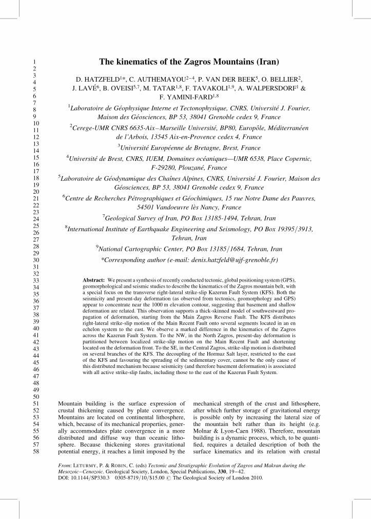
The Zagros fold-and-thrust belt is located withinIran at the edge of the Arabian plate (Fig. 1). Itis c. 1200 km long and trends NW–SE betweeneastern Turkey, where it connects to the Anatolianmountain belt, and the Strait of Hormuz, where itconnects to the Makran subduction zone. Its widthvaries from c. 200 km in the west to c. 350 km inthe east. The Zagros mountain belt results from con-vergence between Arabia and Eurasia, which hasbeen continuous since Late Cretaceous times, witha late episode of accentuated shortening duringthe Pliocene–Quaternary. The Zagros is classicallydescribed in terms of longitudinal units separatedby lateral discontinuities (Fig. 1). The High Zagroscomprises highly deformed metamorphic rocks ofMesozoic age; it is bounded to the NE by theMain Zagros Thrust (MZT), which is the boundarywith Central Iran, and to the SW by the HighZagros Fault (HZF). This is the highest part of theZagros, with maximum elevations reaching morethan 4500 m. The High Zagros overthrusts to thesouth the Zagros Fold Belt, which comprises a10 km thick Palaeozoic–Cenozoic sequence ofsediments. The Zagros Fold Belt is characterizedby large anticlines several tens of kilometreslong. Longitudinally, the Zagros is divided intotwo geological domains, the North Zagros (andthe Dezful embayment) to the west and theCentral Zagros (or Fars) to the east, separated bythe north–south-trending strike-slip Kazerun FaultSystem that cross-cuts the entire belt. Signifi-cant differences in mechanical stratigraphy existbetween the North and the Central Zagros; the sedi-mentary cover of the latter has been deposited on topof the infra-Cambrian Hormuz Salt layer, whereasthis layer is absent in the North Zagros.
The amount of shortening between Arabia andIran since Jurassic times, resulting from subductionof the Neotethys, is about 2000 km (McQuarrieet al. 2003). Ocean closure and cessation of sub-duction probably occurred during the Oligocene(Agard et al. 2005). This event is recorded by aslight decrease in the convergence velocity from30 to 20 mm a21 (McQuarrie et al. 2003). Thetotal amount of shortening since the onset of con-tinental collision is debated, depending on whichmarker is used to measure it. Estimates have beenbased on reconstructions of Late Cretaceous(Haynes & McQuillan 1974; Stocklin 1974)Q1 to lateMiocene (Stoneley 1981Q2 ) strata. Shortening is acco-mmodated differently in the North and Central
Zagros because of the differing boundary conditionsand pre-existing tectonics. In the North Zagros, theMain Recent Fault accommodates the lateral com-ponent of oblique convergence and may transfersome of the motion to the North Anatolian system,whereas deformation partitioning does not appearto exist in the Central Zagros.
Basement deformation
Morphotectonics and balanced cross-sections
Because the basement is decoupled from theshallow sediments by several ductile layers (e.g.the infra-Cambrian Hormuz and Miocene Gahsaraninterfaces), surface deformation may not berepresentative of the total crustal deformation.Furthermore, deformation mechanisms may differbetween the basement and the sedimentary coverbecause of their different mechanical properties.This view is partially supported by the fact thatless than 10% of the total deformation of theZagros (as measured at the surface) is released byseismic deformation (supposed to be related to thecrustal deformation) whereas most of the defor-mation is seismic in other areas of Iran (Jackson &McKenzie 1988; Masson et al. 2005). There is nodirect access to basement deformation in theZagros because there are no basement outcrops atthe surface, seismic reflection profiles do notclearly image the basement and earthquake ruptureson the reverse faults generally do not reachthe surface.
An approach that implies a model assumption isto indirectly infer basement deformation fromsurface observations. Berberian (1995) mappedfirst-order changes in the stratigraphy and identifiedfive morphotectonic units with different character-istics of folding, uplift, erosion and sedimentation.He suggested that these morphotectonic units areseparated by major reverse faults affecting the base-ment and striking parallel to the main structures(Fig. 1). These faults are partially associated withseismicity, consistent mostly with reverse mechan-isms, but the accuracy of earthquake locations(c. 20 km, Engdahl et al. 1998) does not permitmapping of active faults in detail. Moreover, somelarge earthquakes are not related to any of theinferred faults.
Another approach to indirectly infer crustaldeformation is to compute the amount of shorteningfrom balanced cross-sections (Blanc et al. 2003;McQuarrie 2004; Molinaro et al. 2004; Sherkati &Letouzey 2004). In this method, the differentlayers that constitute the sedimentary cover are sup-posed to only fold or fault, without internal defor-mation. However, the location at depth of thedecoupling layers, the amount of decoupling
D. HATZFELD ET AL.20
5960616263646566676869707172737475767778798081828384858687888990919293949596979899100101102103104105106107108109110111112113114115116
45°E
50°EE
55°E
30N
30°N
35°N
°
N
MZ
RF
MZ
RF
MZ
RF
MZ
RF
MR
FM
RF
HZ
FH
ZF
HZ
FH
ZF
MF
FM
FF
MF
FM
FF
ZF
FZ
FF
ZF
FZ
FF
KF
SK
FS
Hig
hZ
agro
sH
igh
Zag
ros
Hig
hZ
agro
sH
igh
Zag
ros
Sim
ple
Fol
ded
Bel
tS
impl
e F
olde
d B
elt
Sim
ple
Fol
ded
belt
Sim
ple
Fol
ded
belt
PERSIAN GULF
PERSIAN GULF
CENTRAL IRAN
CENTRAL IRAN
ARABIA
ARABIA
North Zagros
North Zagros
Central Zagros
Central Zagros
IRA
NIR
AN
25°N
50°E
Fig
.1.
Loca
tion
Colo
ur
on
lin
e=co
lou
r
hard
cop
y
map
show
ing
the
mai
ngeo
gra
phic
alan
dte
ctonic
feat
ure
sof
the
Zag
ros
(Ira
n)
modifi
edaf
ter
Ber
ber
ian
(1995),
Tal
ebia
n&
Jack
son
(2004)
and
Auth
emay
ou
etal.
(2006).
For
the
fault
s,w
euse
the
term
inolo
gy
of
Ber
ber
ian
(1995).
MZ
RF
,M
ain
Zag
ros
Rev
erse
Fau
lt;
MR
F,
Mai
nR
ecen
tF
ault
;H
ZF
,H
igh
Zag
ros
Fau
lt;
MF
F,
Mai
nF
ronta
lF
ault
;Z
FF
,Z
agro
sF
ronta
lF
ault
;K
FS
,K
azer
un
Fau
ltS
yst
em,w
hic
hse
par
ates
the
Nort
hZ
agro
sfr
om
the
Cen
tral
Zag
ros.
The
colo
urs
repre
sent
topogra
phy,w
ith
chan
ges
at1000,
2000
and
3000
mle
vel
s.
ZAGROS KINEMATICS 21
117118119120121122123124125126127128129130131132133134135136137138139140141142143144145146147148149150151152153154155156157158159160161162163164165166167168169170171172173174
related to these layers, and the relationship betweenfolding and faulting are all complex, and solutionsare generally non-unique. Usually, basement faultsare assumed where unfolding creates a space pro-blem in the core of folds. The link between surfaceand basement deformation is strongly debated.Some researches do not require faults in the base-ment (McQuarrie 2004), whereas others have pro-posed that deformation started in a thin-skinnedmode and continued as thick-skinned deformation(Blanc et al. 2003; Molinaro et al. 2004; Sherkatiet al. 2005). Some workers have suggested thatfaulting post-dates folding (Blanc et al. 2003;Molinaro et al. 2005), whereas others have proposedthat basement faulting predated folding (Mouther-eau et al. 2006). It is therefore problematic to inferbasement faulting, and moreover to estimate theamount of shortening, from balanced cross-sectionsalone, without complete control of the geometry ofthe different interfaces.
Seismicity
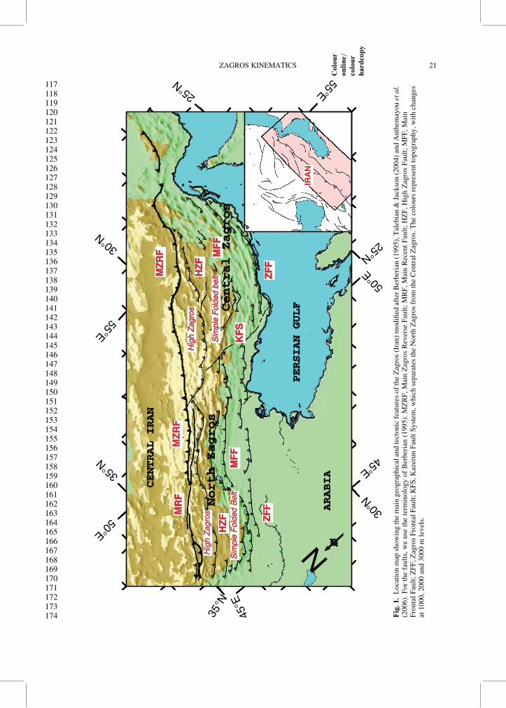
The other way to access basement deformation is tostudy seismicity (Fig. 2). Two sets of data providecomplementary information: earthquakes locatedteleseismically and earthquakes located by localnetworks. Teleseismically located earthquakeshave been recorded since the early 1960s; the dura-tion of the available time window is thus compar-able with the usual return period of continentalearthquakes. However, because of the lack ofregional stations, catalogues (ISC, USGS) of tele-seismically located earthquakes in Zagros aresubject to large mislocations (Ambraseys 1978;Berberian 1979; Jackson 1980; Engdahl et al.1998, 2006). Errors in epicentre location are up toc. 20 km and depths are generally unreliable.
Jackson & McKenzie (1984), Ni & Barazangi(1986) and Engdahl et al. (2006), amongst others,filtered catalogues or relocated seismicity toimprove the accuracy of epicentres and depths.The Zagros seismicity is totally confined betweenthe Persian Gulf coast and the Main Zagros Thrust(MZT), which both limit the active (or deforming)area and exclude seismic accommodation of short-ening by the MZT (Fig. 2). Moreover, althoughseismicity is spread over the entire width of theZagros, the larger magnitude (Mb . 5) earthquakesappear to concentrate in the Zagros Fold Belt, whichis an area of low (z , 1500–2000 m) topography(Jackson & McKenzie 1984; Ni & Barazangi 1986;Talebian & Jackson 2004). This larger seismicenergy release at low elevations has been explainedby differential stress owing to the gradient in topo-graphy (Jackson & McKenzie 1984; Talebian &Jackson 2004). Epicentres are not obviously corre-lated with geological structures or surface tectonics
(Fig. 2). Moreover, no instrumental earthquakehas a magnitude Mw greater than 6.7 and, as aconsequence, no co-seismic ruptures have beenobserved, except for one earthquake in 1990(Mw � 6.4) located at the eastern termination ofthe HZF (Walker et al. 2005). Q3
The only reliable depths for teleseismicallylocated earthquakes are those computed by body-wave modelling with uncertainties in depth of+4 km (Talebian & Jackson 2004). In the Zagrosthese depth of large earthquakes is 5–19 km witha mean c. 11 km, suggesting that earthquakesoccur in the basement below the sedimentary cover.
Most focal mechanisms computed from first-motion polarities (McKenzie 1978; Jackson &McKenzie 1984) or by body-wave modelling(Talebian & Jackson 2004) are reverse faultingwith NW–SE strikes, parallel to the folding(Fig. 3). Some of these mechanisms are associatedwith the major faults proposed by Berberian(1995) but others are not. Most of the mechanismsare high-angle reverse faulting probably occurringin the basement at depths between c. 5 and 15 km;they are thus unrelated to a low-angle detachmentat the base of the sedimentary layer (Fig. 3).
Q4Jackson (1980) proposed that they reactivatenormal faults inherited from a stretching episodeaffecting the Arabian platform during opening ofthe Tethys Ocean in the Early Mesozoic.
Strike-slip mechanisms are related to two faultsystems: the north–south-trending Kazerun FaultSystem (KFS; comprising the Kazerun, Kareh-Bas,Sabz-Pushan and Sarvestan faults), which crossesthe Zagros between 51.58E and 54.08E, and theMain Recent Fault (MRF), which runs parallel tothe MZT and connects at its SE termination to theKazerun Fault System. The MRF helps to accom-modate the oblique shortening experienced by theNorth Zagros by partitioning the slip motion intopure reverse faulting and strike-slip faulting.
Early studies based on unfiltered earthquakecatalogues Q5(Nowroozi 1971; Haynes & McQuillan1974; Q6Bird et al. 1975; Snyder & Barazangi 1986)postulated that some intermediate seismicity couldbe related to continental subduction located NE ofthe MZT. However, no reliably located earthquakeis located NE of the MZT (Engdahl et al. 1998)and no earthquakes have been located at a depthgreater than 20 km in this area (Jackson & Fitch1981; Jackson & McKenzie 1984; Maggi et al.2000; Engdahl et al. 2006), implying that continen-tal subduction is either aseismic or active.
Microearthquake studies complement the tele-seismic information because they locate epicentreswith an accuracy of a few kilometres; an orderof magnitude better than teleseismic locations.On the other hand, they span a relatively shorttime window, which may not record the tectonic
D. HATZFELD ET AL.22
175176177178179180181182183184185186187188189190191192193194195196197198199200201202203204205206207208209210211212213214215216217218219220221222223224225226227228229230231232
N
A
B
B1
B1
US
GS
mb
> 5
mb
> 6
45°E
50°E
55°E30
°N
30°N
35°N
25°N
50°E
Fig
.2.
Sei
smic
ity
map
of
the
Zag
ros
bas
edon
the
US
Colo
ur
on
lin
e=co
lou
r
hard
cop
y
Geo
logic
alS
urv
eyca
talo
gue,
confi
rmin
gth
eobse
rvat
ion
of
Tal
ebia
n&
Jack
son
(2004)
that
seis
mic
ity
(and
espec
iall
yla
rge
mag
nit
ude
eart
hquak
es)
isre
stri
cted
toth
eS
Wof
the
Zag
ros
topogra
phy.
Cro
ss-s
ecti
ons
for
lines
Aan
dB
are
show
nin
Fig
ure
11.
ZAGROS KINEMATICS 23
233234235236237238239240241242243244245246247248249250251252253254255256257258259260261262263264265266267268269270271272273274275276277278279280281282283284285286287288289290

Nmodeled
CMT
45°E
50°E
55°E
30°N
30°N
35°N
25°N
50°E
Fig
.3.
Fau
lt-p
lane
solu
tions
inth
eZ
agro
s.B
lue
foca
lsp
her
esar
e
Colo
ur
on
lin
e=co
lou
r
hard
cop
y
body-w
ave
solu
tions
model
led
by
Tal
ebia
n&
Jack
son
(2004)
and
red
foca
lsp
her
esar
eC
MT
solu
tions
(htt
p:/
/ww
w.s
eism
olo
gy.h
arvar
d.e
du/C
MT
sear
ch.h
ml)
.A
spoin
ted
out
by
Tal
ebia
n&
Jack
son
(2004),
most
of
the
Zag
ros
exper
ience
sre
ver
sefa
ult
ing,ex
cept
nea
rth
eM
ZR
Fan
dth
eK
FS
.
D. HATZFELD ET AL.24
291292293294295296297298299300301302303304305306307308309310311312313314315316317318319320321322323324325326327328329330331332333334335336337338339340341342343344345346347348
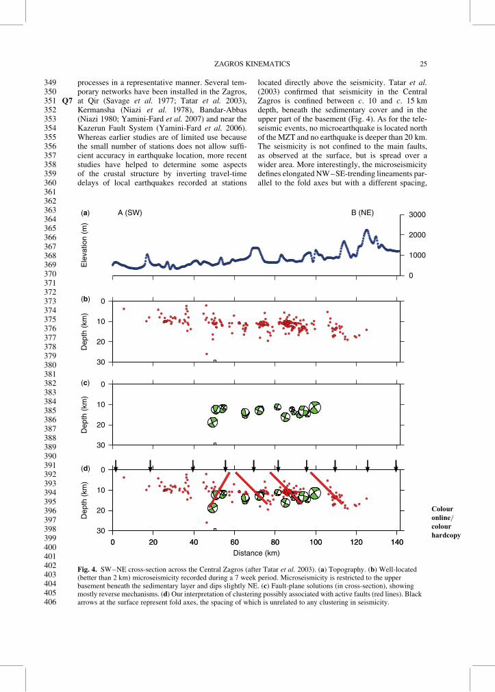
processes in a representative manner. Several tem-porary networks have been installed in the Zagros,at Qir (Q7 Savage et al. 1977; Tatar et al. 2003),Kermansha (Niazi et al. 1978), Bandar-Abbas(Niazi 1980; Yamini-Fard et al. 2007) and near theKazerun Fault System (Yamini-Fard et al. 2006).Whereas earlier studies are of limited use becausethe small number of stations does not allow suffi-cient accuracy in earthquake location, more recentstudies have helped to determine some aspectsof the crustal structure by inverting travel-timedelays of local earthquakes recorded at stations
located directly above the seismicity. Tatar et al.(2003) confirmed that seismicity in the CentralZagros is confined between c. 10 and c. 15 kmdepth, beneath the sedimentary cover and in theupper part of the basement (Fig. 4). As for the tele-seismic events, no microearthquake is located northof the MZT and no earthquake is deeper than 20 km.The seismicity is not confined to the main faults,as observed at the surface, but is spread over awider area. More interestingly, the microseismicitydefines elongated NW–SE-trending lineaments par-allel to the fold axes but with a different spacing,
0
1000
2000
3000A (SW)(a)
(b)
(c)
(d)
B (NE)
Ele
vatio
n (m
)
0
10
20
30
Dep
th (
km)
0
10
20
30
Dep
th (
km)
0
10
20
30
0 20 40 60 80 100 120 1400 20 40 60 80 100 120 140
Dep
th (
km)
Distance (km)
Fig. 4. SW–NE cross-section across the Central Zagros
Colour
online=colour
hardcopy
(after Tatar et al. 2003). (a) Topography. (b) Well-located(better than 2 km) microseismicity recorded during a 7 week period. Microseismicity is restricted to the upperbasement beneath the sedimentary layer and dips slightly NE. (c) Fault-plane solutions (in cross-section), showingmostly reverse mechanisms. (d) Our interpretation of clustering possibly associated with active faults (red lines). Blackarrows at the surface represent fold axes, the spacing of which is unrelated to any clustering in seismicity.
ZAGROS KINEMATICS 25
349350351352353354355356357358359360361362363364365366367368369370371372373374375376377378379380381382383384385386387388389390391392393394395396397398399400401402403404405406

suggesting that folds and faults are not directlyrelated. The seismicity clusters appear to dip NE(Fig. 4), supporting the model of normal-faultreactivation (Jackson 1980). Focal mechanisms areconsistent with NW–SE-striking reverse faultsconnected by NNW–SSE right-lateral strike-slipfaults. The main direction of the P-axes fits wellthe direction of GPS shortening, suggesting thatmicroearthquakes are the response of the crust tonorth–south shortening.
Two other surveys, at the intersection betweenthe Kazerun Fault and the MRF in Borujen (Yamini-Fard et al. 2006) and at the transition betweenthe Zagros collision zone and the Makran subduc-tion zone near Bandar-Abbas (Yamini-Fard et al.2007), show an interesting result. Reverse-slipfocal mechanisms are confined to depths greaterthan 12 km along NE-dipping decollements strikingperpendicular to the motion, whereas dextral strike-slip focal mechanisms are recorded at shallowerdepths under the trace of the MRF. This differencein mechanism with depth suggests that the upperbrittle crust deforms mostly by slip (either strike-slip or reverse, depending on the orientation) onweak pre-existing faults, but that the lower crust ismore pervasively weakened and accommodatesthe shortening by reverse faulting perpendicular toregional motion.
Surface deformation
GPS deformation
GPS measurements provide instantaneous velocitiesbetween benchmarks. Depending on the surveyingprocedure and on the duration of the measurementsfor each survey, the accuracy of the position canreach c. 2 mm. If the time span between two mea-surements is several years, and moreover if threeor more measurements are available allowingsome redundancy, we estimate the velocity uncer-tainties to be less than 2 mm a21.
Several campaigns have been conducted in theZagros. One was part of a regional-scale survey con-ducted throughout Iran, with a spacing betweenstations larger than c. 150 km (Nilforoushan et al.2003; Vernant et al. 2004; Masson et al. 2007),which does not provide sufficient resolution tostudy the deformation in great detail. However,a dozen benchmarks from this network record6–7.5 mm a21 of NNE–SSW shortening for theZagros, which corresponds to c. 30% of the totalconvergence between Arabia and Eurasia at thislongitude. The transition between the Makransubduction and the Zagros collision is clearly evi-denced by the contrast in the velocities relative toCentral Iran across the area.
Hessami et al. (2006) installed a network of35 benchmarks covering the entire Zagros. Thesestations were measured during three campaignsover 3 years in 1998, 1999 and 2001. Each stationwas measured several times and sessions lasted8 h. The observations of 4–6 IGS stations wereincluded for reference. Hessami et al. claimedtheir accuracy to be 3 mm a21. The main resultsare that west of the Kazerun Fault shortening isaccommodated by the Mountain Front Fault,whereas east of it, it seems to be accommodated100 km north of the Mountain Front Fault and bythe Main Zagros reverse Fault.
Since 1997, we installed several regional GPSnetworks in the Zagros (Fig. 5). These networkscovered the Central Zagros (15 benchmarks),the Kazerun Fault System (11 benchmarks) andthe Northern Zagros (18 benchmarks), and weremeasured simultaneously with several stationsof the Iran Global network as well as with Iranianpermanent stations. Each site was continuouslyobserved for at least 48 h per campaign. All net-works were measured a minimum of three timesover a time period lasting usually 2–5 years. Thedata have been analysed with the GAMIT/GLOBK 10.1 software (King & Bock 2002).As many as 32 IGS stations (depending on thesurvey) have been included to establish the terres-trial reference frame. Final IGS orbits and corre-sponding Earth orientation parameters have beenused. In the combination of daily solutions withthe Kalman filter GLOBK, the continuous timeseries of daily SOPAC global solution files (IGS3network) has been included, covering all of themeasurement epoch presented here. Mean repeat-ability is estimated to be less than 2 mm, whichyields a precision better than 2 mm a21. Details ofprocessing procedures can be found in previouspapers (Tatar et al. 2002; Walpersdorf et al. 2006;Tavakoli et al. 2008).
The main results (Fig. 5) show some differencesfrom those of Hessami et al. (2006). As observed bythose workers, the shortening component increasesfrom NW to SE, consistent with a Arabia–CentralIran pole of rotation located at 29.88N, 35.18E,inferred by Vernant et al. (2004). However, thedeformation on each side of the Kazerun FaultSystem is different from that proposed by Hessamiet al. (2006). West of the Kazerun Fault System,most of the deformation is located north of theMFF, far from the Zagros Frontal Fault (ZFF).It is clearly partitioned between 4–6 mm a21 ofdextral strike-slip motion concentrated in thenorth, with probably 2–4 mm a21 on the MRFalone, and 3–6 mm a21 of shortening probably onthe MFF. East of the Kazerun Fault, the deforma-tion is pure shortening of 8 mm a21 located alongthe Persian Gulf shore and associated with the
D. HATZFELD ET AL.26
407408409410411412413414415416417418419420421422423424425426427428429430431432433434435436437438439440441442443444445446447448449450451452453454455456457458459460461462463464
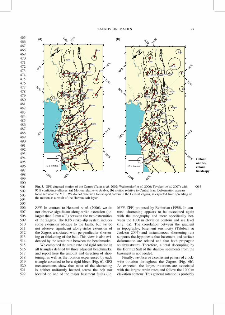
ZFF. In contrast to Hessami et al. (2006), we donot observe significant along-strike extension (i.e.larger than 2 mm a21) between the two extremitiesof the Zagros. The KFS strike-slip system inducessome extension oblique to the faults, but we donot observe significant along-strike extension ofthe Zagros associated with perpendicular shorten-ing or thickening of the belt. This view is also evi-denced by the strain rate between the benchmarks.
We computed the strain rate and rigid rotation inall triangles defined by three adjacent benchmarks,and report here the amount and direction of shor-tening, as well as the rotation experienced by eachtriangle assumed to be a rigid block (Fig. 6). GPSmeasurements show that most of the shorteningis neither uniformly located across the belt norlocated on one of the major basement faults (i.e.
MFF, ZFF) proposed by Berberian (1995). In con-trast, shortening appears to be associated againwith the topography and more specifically bet-ween the 1000 m elevation contour and sea level(Fig. 6a). The correlation between the gradientin topography, basement seismicity (Talebian &Jackson 2004) and instantaneous shortening ratesupports the hypothesis that basement and surfacedeformation are related and that both propagatesouthwestward. Therefore, a total decoupling bythe Hormuz Salt of the shallow sediments from thebasement is not needed.
Finally, we observe a consistent pattern of clock-wise rotation throughout the Zagros (Fig. 6b).As expected, the largest rotations are associatedwith the largest strain rates and follow the 1000 melevation contour. This general rotation is probably
50°E
50°E55°E
55°E
25°N
30°N
30°N
35°N
50°E
55°E
30°N
35°N
45°E55°E
NHAJ I
B E S 2
DE H2
HAR A
LAR 2
T MN2
K HO2
LAMB
B IG 2
G OT 2
B MG 2
AB AR
S V R 2
S AA2
IS L2QIR 2
MAR V
OS L2
AB AD
Y AG H
S E DE
F AR 2
K AN2DAY Y
DAS H
QOMS
S HAN
S E MI
S E P I
K S
ALIS
B AMO
S HAH
DE DA
K R D2
K HON
C HE L
S AR D
G HA
S HOL
HAF T
S OLE
J OZA
AWAZ
AHV A
DE ZF
HAMD
B OR U
K HOS
K OR A
B IJ A
G OR IDE LO
ILAM
10 ± 1 mm a–1
45°E
45°E
50°E
55°E
25°N
30°N
35°N45°E
35°N45°E
50°E
55°E
25°N
30°N
N
HAJ I
B E S 2
DE H2
HAR A
LAR 2
T MN2
K HO2
LAMB
B IG 2
G OT 2
B MG 2
AB AR
S V R 2
S AA2
IS L2QIR 2
MAR V
OS L2
AB AD
Y AG H
S E DE
F AR 2
K AN2DAY Y
DAS H
QOMS
S HAN
S E MI
S E P I
K S
ALIS
B AMO
S HAH
DE DA
K R D2
K HON
C HE L
S AR D
G HA
S HOL
HAF T
S OLE
J OZA
AWAZ
AHV A
DE ZF
HAMD
B OR U
K HOS
K OR A
B IJ A
G OR IDE LO
ILAM
10 ± 1 mm a–1
(a) (b)
Fig. 5. GPS-detected motion of the
Colour
online=colour
hardcopy
Zagros (Tatar et al. 2002; Walpersdorf et al. 2006; Tavakoli et al. 2007) Q19with95% confidence ellipses. (a) Motion relative to Arabia; (b) motion relative to Central Iran. Deformation appearslocalized near the MFF. We do not observe a fan-shaped pattern in the Central Zagros, as expected from spreading ofthe motion as a result of the Hormuz salt layer.
ZAGROS KINEMATICS 27
465466467468469470471472473474475476477478479480481482483484485486487488489490491492493494495496497498499500501502503504505506507508509510511512513514515516517518519520521522

induced by the general right-lateral transcurrentmotion between Central Iran and Arabia. We donot observe larger rotation associated with thestrike-slip Kazerun Fault System, nor any anti-clockwise rotation as proposed by Talebian &Jackson (2004).
Tectonics
The Zagros deformation is characterized byconstant-wavelength folding, thrusting and strike-slip faulting. Models suggest that detachment fold-ing is the main folding style (Mouthereau et al.
2006; Sherkati et al. 2006). Q8Fold geometries varysignificantly with the presence of intermediatedecollements (Sherkati et al. 2006). Some thrustsbranched on decollement levels are formed by pro-gressive fault propagation within the core of thefolds. Other thrusts, associated with topographicsteps, appear to be linked to basement faults.These reverse faults are generally blind. Thedifference in elevation of some stratigraphicmarker horizons on both sides of the thrusts indi-cates 5–6 km finite vertical offset on both theMFF and the HZF (Berberian 1995; Sherkati &Letouzey 2004). The southwestward migration of
N
deg ma–1
N
50 ppm
50°E
50°E
55°E
55°E
25°N
30°N
30°N
35°N
45°E
55°E
45°E
35°N
50°E
50°E
55°E
55°E
25°N
30°N
30°N
35°N
45°E
45°E
35°N(a) (b)
Fig. 6. (a) Strain rate deduced from GPS observations. Triangles are
Colour
online=colour
hardcopy
coloured as a function of the intensity of thedeformation. The arrows indicate the principal strain rates. The triangles with significant deformation (exceeding theuncertainties) are surrounded by a bold line. The direction of shortening consistently trends NNE–SSW with a slightnorth–south rotation near the Kazerun Fault System. East of the KFS, the deformation is localized at the MFF near thePersian Gulf. West of the KFS, the deformation is localized further north, also at the MFF. In both cases it can beassociated with the 1000 m topography elevation. (b) Rotations of triangles defined by three benchmarks. Althoughuncertainties are large, we observe a consistent clockwise rotation. Only two triangles located at the easternmostlocation show significant Q20, Q21anticlockwise rotation. Triangles with rotations larger than 18 Ma21 are associated with largestrain and located along the MFF as is the strain.
D. HATZFELD ET AL.28
523524525526527528529530531532533534535536537538539540541542543544545546547548549550551552553554555556557558559560561562563564565566567568569570571572573574575576577578579580

sedimentary depocentres from Late Cretaceous timeto Miocene collision, as well as the existence ofseveral stages of folding, suggests that the shorten-ing rates have varied through time (Sherkati &Letouzey 2004; Mouthereau et al. 2006).
In contrast to the blind reverse faults, the activetraces of strike-slip faults are observable. Finitedisplacements on strike-slip faults are constrainedby piercing points, major river offsets and fold off-sets. Talebian & Jackson (2002) suggested 50 kmof strike-slip offset on the MRF, which, assumingan onset 3–5 Ma ago (by analogy with the NorthAnatolian Fault), would require a slip rate of10–17 mm a21; much larger than the GPS velocityestimate. Lateral offsets of geomorphologicalmarkers and in situ cosmogenic dating yield anestimated slip rate of 4.9–7.6 mm a21 on theMRF (Authemayou et al. 2009). The other strike-slip fault is the Kazerun Fault System, which wewill discuss separately.
Geomorphological record of deformation
Numerous geomorphological markers such as fluvialand marine terraces occur throughout the CentralZagros and can be used to constrain fold kinematicsat time scales of 104–105 years, intermediate bet-ween the instantaneous deformation recorded byGPS and seismic studies and the long-term defor-mation inferred from section balancing. Suchmarkers record incremental deformation and maytherefore aid in discriminating between foldmodels. If they can be dated sufficiently preciselythey also constrain deformation rates, which canbe transformed into shortening rates using an appro-priate fold model.
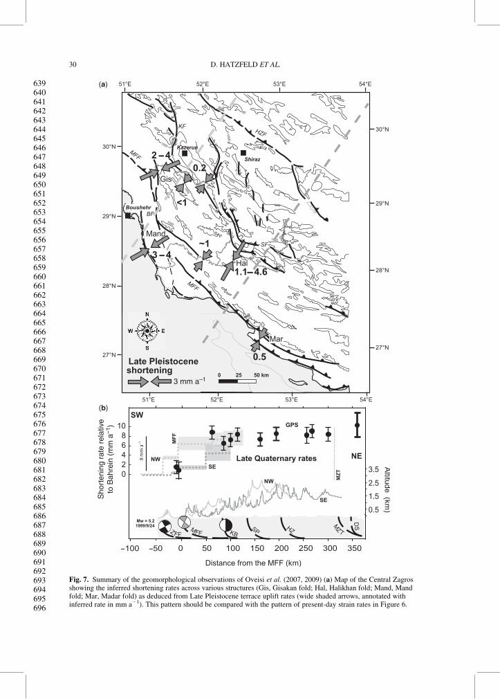
Q9 Oveisi et al. (2007, 2009) studied surface defor-mation as recorded by marine terraces along thecoastal Mand anticline, located south of the Boraz-jan Fault, as well as by fluvial terraces along theDalaki and Mand rivers, which cross the northwes-tern Fars east of the Kazerun Fault System. Theirresults indicate that shortening on Late Pleistocenetime scales is concentrated in the frontal part ofthe belt, consistent with the GPS results discus-sed above (Fig. 7). Three or four frontal structuresappear to absorb practically all of the shorten-ing across the Central Zagros on intermediate timescales. Immediately east of the Kazerun FaultSystem, the coastal Mand anticline accommodates3–4 mm a21 shortening in a NE–SW direction.The Gisakan fold, located at the intersection of theBorazjan Fault and the MFF, also accommodates2–4 mm a21 of shortening in the same direction.These two structures together thus account forat least 70% and possibly all of the shorteningbetween the stable Arabian and Iranian platforms.Further to the SE, the situation is slightly more
complex, with thin-skinned deformation concen-trated on the Halikan fold located inboard of theMFF and only c. 10% (�1 mm a21) of the shorten-ing taken up on the most frontal structures, such asthe coastal Madar anticline.
For the active coastal anticlines, structural dataas well as seismic sections preclude significant base-ment involvement. Instead, these anticlines evolveas open detachment or fault-propagation foldsabove basal (Hormuz Salt) or intermediate (Gach-saran evaporites) decollement levels. Crustal-scaleshortening is fed into these structures either fromthe MFF or from the most internal parts of theZagros. Active folds associated with the MFF,in contrast, do suggest basement involvement andoccasional fault rupture extending to the surface,as observed at the Gisakan fold. Inboard of theMFF, minor (,1 mm a21 along small-scale struc-tures east of the Kazerun Fault) to significant (upto 5 mm a21 for the Halikan anticline) amounts ofshortening are absorbed by thin-skinned structures,whereas the surface expressions of major basementfaults (e.g. the Surmeh Fault) provide no geomor-phological evidence for recent activity.
The total amount of shortening on 104–105 yearstime scales, as recorded by geomorphological mark-ers of deformation, is consistent, within error, withthe GPS-derived present-day deformation rates of8–10 mm a21 across the Zagros. The geomorpho-logical data also show that deformation has beenconcentrated in the outboard regions of the belt,associated with the MFF and other frontal struc-tures, during Late Quaternary times, and that boththick- and thin-skinned structures are activesimultaneously.
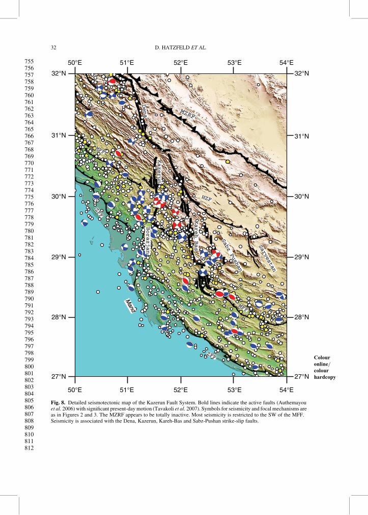
The Kazerun Fault System
The Kazerun Fault System (KFS) separates theNorth Zagros from the Central Zagros (Fig. 1). Itcomprises several roughly north–south-trendingright-lateral strike-slip faults. The Kazerun Faultitself is composed of three north–south-trendingsegments (Fig. 8): the Dena, Kazerun and Borazjansegments, which all terminate to the south with anorth-dipping reverse fault (Authemayou et al.2005, 2006). The Kazerun Fault is associated withexhumation of Hormuz Q10Salt (Talbot & Alavi 1996)and modifies the trend of folds adjacent to it. TheKFS, as well as the other north–south-trendingfaults, is probably inherited from a Cambrian tec-tonic event that affected the Arabian platformbecause it controls the distribution of HormuzSalt, which is present to the east of the faultsystem but not to the west (Talbot & Alavi 1996;Sepehr & Cosgrove 2005). Q11It was reactivated asearly as in the Middle Cretaceous (Koop & Stoneley
ZAGROS KINEMATICS 29
581582583584585586587588589590591592593594595596597598599600601602603604605606607608609610611612613614615616617618619620621622623624625626627628629630631632633634635636637638
(a)
(b)
Fig. 7. Summary of the geomorphological observations of Oveisi et al. (2007, 2009) (a) Map of the Central Zagrosshowing the inferred shortening rates across various structures (Gis, Gisakan fold; Hal, Halikhan fold; Mand, Mandfold; Mar, Madar fold) as deduced from Late Pleistocene terrace uplift rates (wide shaded arrows, annotated withinferred rate in mm a21). This pattern should be compared with the pattern of present-day strain rates in Figure 6.
D. HATZFELD ET AL.30
639640641642643644645646647648649650651652653654655656657658659660661662663664665666667668669670671672673674675676677678679680681682683684685686687688689690691692693694695696

1982). The total offset along the Kazerun Fault is amatter of debate, varying from 5 kmQ12 (Pattinson &Takin 1971) or 8.2 km (Authemayou et al. 2006)to 140 km (Berberian 1995), depending on themarkers used to quantify strike-slip motion. Thislarge difference in displacement results in inferredslip rates of 1–15 mm a21. Careful mapping ofthe active faults and of the lateral offsets alongthe various segments of the fault (Fig. 9) togetherwith precise dating of fans yields a slip rateof c. 3.1–4.7 mm a21 on the Dena Fault and 1.5–3.2 mm a21 on the Kazerun Fault (Authemayouet al. 2009). The southernmost segment, theBorazjan Fault, seems to have a dominant dip-slipmotion (e.g. Oveisi et al. 2009). East of theKazerun Fault, the Kareh-Bas Fault is very activeand accommodates c. 5.5 mm a21 of right-lateralstrike slip; the Sabz-Pushan Fault in contrast looksinactive, and the Sarvestan Fault accommodatesonly little motion.
The onset of strike-slip motion on the MainRecent Fault is probably of Late Miocene age andtherefore synchronous with the increase in shorten-ing rate within the Zagros and the general tectonicreadjustment observed throughout Iran (Allenet al. 2004). The onset of motion on both the Denaand Kazerun segments is more recent, probablyc. 3 Ma, and it is much younger (c. 0.8–2.8 Ma)for the Kareh-Bas Fault (Authemayou 2006;Authemayou et al. 2009).
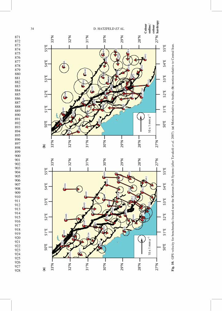
GPS measurements of 11 benchmarks across theKazerun Fault System (Fig. 10) allow us to inferslip rates on the various faults with uncertaintiesof c. 2 mm a21 (Tavakoli et al. 2008). The Denaand Kazerun faults accommodate c. 3.5 mm a21 ofright-lateral strike-slip motion. The Borazjan Faultis almost inactive, but the Kareh-bas Fault alsoaccommodates c. 3.5 mm a21 of right-lateral strike-slip motion. A cumulative motion of c. 1.5 mm a21
(within the uncertainties) affects the High ZagrosFault and the Sabz-Pushan Fault. It seems, therefore,that the motion distributes from the Main RecentFault to the Dena and Kazerun faults, jumps to theKareh–Bas Fault and distributes slightly on theHigh Zagros and Sabz–Pushan faults.
The Kazerun Fault System is seismically active(Berberian 1995; Baker et al. 1993; Talebian &Jackson 2004). Clearly, most of the seismicity andespecially the largest magnitude earthquakes arelocated on the central segment of the Kazerun Fault(Fig. 8). The three largest (Ms . 6) instrumental
earthquakes were located on the Kazerun segmentand the Kareh-Bas and Sabz-Pushan faults. Verylittle activity is observed on both the Dena andBorazjan faults, and no activity is associated witheither the High Zagros Fault or the Sarvestan Fault.The depth of the reliably located earthquakes associ-ated with the KFS is 9 + 4 km, which probablyassociates them with the basement. Most mechan-isms are strike-slip on the Kazerun, Kareh-Bas andSabz-Pushan faults. Reverse mechanisms are associ-ated with the Mountain Front Fault, on both sides ofthe Kazerun Fault System. A few reverse mechan-isms are also associated with the Borazjan seg-ment, which suggests that it is not an activestrike-slip fault but more probably a transpressivelateral ramp (e.g. Oveisi et al. 2009).
Discussion
The separation of the Zagros mountain belt intothree longitudinal structural domains (sedimentary,ophiolitic and metamorphic; Ricou et al. 1977)is valid only as a first-order approximation. In asecond approximation the Zagros can be dividedinto two main units along strike, the North Zagrosand the Central Zagros (the Fars), separated by theKazerun Fault System (Berberian 1995; Talebian& Jackson 2004). These two domains show differ-ences in width, in the activity of bounding faults,and in the direction of folding. To further investi-gate the present-day kinematics of the Zagros, weneed to know the relative roles of the basement(and ultimately of the lithosphere) and the surfacecover. The present-day kinematics is certainly influ-enced by both the structure and the tectonic evol-ution of the fold belt, and therefore should bestudied in this perspective. We thus concentratein this discussion on the comparison of shallowand crustal deformation patterns, both spatiallyand in time.
Surface deformation
The coupling between surface and basement variesacross the Kazerun Fault System. This variationin coupling may induce variations in the responseof the surface layer to the deformation. To estimatethe shortening of the North Zagros, we use thebalanced cross-sections of Blanc et al. (2003) andMcQuarrie (2004), because those of Sherkati &
Fig. 7. (Continued) BF, Borazjan Fault; HZF, High Zagros Fault; KF, Kazerun Fault; MFF, Main Frontal Fault; SF,Surmeh Fault. Light and dark grey dashed lines indicate locations of transects shown in (b). (b) Synthetic profiles ofconvergence rates (relative to stable Arabia) across the Central Zagros according to GPS and geomorphological data,compared with topographic profiles along a northwestern (light shading) and southeastern (dark shading) transect.Modified from Oveisi et al. (2009). KB, Karesh Bas; SP, Sabz Pushan; HZ, High Zagros Fault; DS, . . . Q22
ZAGROS KINEMATICS 31
697698699700701702703704705706707708709710711712713714715716717718719720721722723724725726727728729730731732733734735736737738739740741742743744745746747748749750751752753754
51°E 52°E 53°E 54°E
27°N
28°N
29°N
30°N
31°N
32°N
27°N
28°N
29°N
30°N
31°N
32°N
50°E
51°E 52°E 53°E 54°E50°E
MZRFMZRF
Dena
Dena
HZFHZF
Kazerun
Kazerun
Borazjan
Borazjan
Kareh Bas
Kareh Bas
Sabz Pushan
Sabz Pushan
Sarvestan
Sarvestan
MFFMFF
MFFMFF
ZFFZFF
ZFFZFF
Mand
Mand
Fig. 8. Detailed seismotectonic map of the Kazerun Fault System. Bold lines
Colour
online=colour
hardcopy
indicate the active faults (Authemayouet al. 2006) with significant present-day motion (Tavakoli et al. 2007). Symbols for seismicity and focal mechanisms areas in Figures 2 and 3. The MZRF appears to be totally inactive. Most seismicity is restricted to the SW of the MFF.Seismicity is associated with the Dena, Kazerun, Kareh-Bas and Sabz-Pushan strike-slip faults.
D. HATZFELD ET AL.32
755756757758759760761762763764765766767768769770771772773774775776777778779780781782783784785786787788789790791792793794795796797798799800801802803804805806807808809810811812

Fig. 9. Quaternary slip rate and finite horizontal displacement, showing the motion distribution from the Main RecentFault to the Kazerun Fault System (after Authemayou et al. 2006).
ZAGROS KINEMATICS 33
813814815816817818819820821822823824825826827828829830831832833834835836837838839840841842843844845846847848849850851852853854855856857858859860861862863864865866867868869870
51
°E5
2°E
53
°E5
4°E
55
°E
BE
DE
H
HA
RA
LA
R2
TM
N2
KH
O2
AR
DA
BIG
2
GO
T2
AB
AR
SV
R2
SA
A2
ISL
2Q
IR2
MA
RV
OS
L2
AB
AD
YA
GH
SE
DE
FA
R2
KA
N2
DA
YY
DA
SH
QO
MS
SH
AN
SE
MI
SE
PI
AL
IS
BA
MO
SH
AH
DE
DA
KR
D2
CH
EL
SA
RD
HA
FT
SO
LE
BE
DE
H
HA
RA
LA
R2
TM
N2
KH
O2
AR
DA
BIG
2
GO
T2
AB
AR
SV
R2
SA
A2
ISL
2Q
IR2
MA
RV
OS
L2
AB
AD
YA
GH
SE
DE
FA
R2
KA
N2
DA
YY
DA
SH
QO
MS
SH
AN
SE
MI
SE
PI
AL
IS
BA
MO
SH
AH
DE
DA
KR
D2
CH
EL
SA
RD
HA
FT
SO
LE
27°N
28°N
29°N
30°N
31°N
32°N
33°N
27°N
28°N
29°N
30°N
31°N
32°N
33°N
50°E
51
°E5
2°E
53
°E5
4°E
55
°E50
°E(a
)(b
)
51
°E5
2°E
53
°E5
4°E
55
°E
27°N
28°N
29°N
30°N
31°N
32°N
33°N
27°N
28°N
29°N
30°N
31°N
32°N
33°N
50°E
51
°E5
2°E
53
°E5
4°E
55
°E50
°E
10 ±
1 m
m a
–110
± 1
mm
a–1
Fig
.10.
GP
Svel
oci
tyfo
rben
chm
arks
loca
ted
nea
rth
eK
azer
un
Fau
ltS
yst
em
Colo
ur
on
lin
e=co
lou
r
hard
cop
y
(aft
erT
avak
oli
etal.
2007).
(a)
Moti
on
rela
tive
toA
rabia
;(b
)m
oti
on
rela
tive
toC
entr
alIr
an.
D. HATZFELD ET AL.34
871872873874875876877878879880881882883884885886887888889890891892893894895896897898899900901902903904905906907908909910911912913914915916917918919920921922923924925926927928

Letouzey (2004) cross the Kazerun Fault and maynot be representative of the shortening of thewhole Zagros. For the Fars region, we use the cross-section of McQuarrie (2004), which is the onlysection that really crosses Fars, the sectionof Molinaro et al. (2004) being located at theZagros–Makran transition. Paradoxically, the totalamount of shortening is larger in the North Zagrosthan in Fars, both for the whole Zagros (from 57to 85 km) and for the Zagros Fold Belt (from 35 to50 km), even though the Fars is located furtherfrom the long-term Arabia–Central Iran pole ofrotation located at 29.88N, 35.18E. This variationin finite shortening could be explained by an under-estimate of the displacement along the suturezone in the Central Zagros by McQuarrie (2004),or by an earlier onset of deformation in the NorthZagros compared with the Central Zagros as aresult of the progressive southeastward closure ofthe Neotethys associated with the anti-clockwiserotation of the Arabian plate.
The GPS measurements also show a differencein present-day deformation across the KazerunFault System (Walpersdorf et al. 2006). In contrastto the total shortening, the present-day shorteningrates increase slightly from the North Zagros (4–6mm a21) to the Fars (8 mm a21), consistent withthe increasing distance to the pole of rotation. Thestrike-slip component is mostly localized on theMain Recent Fault in the North Zagros but seemsto be smaller and distributed in Fars. Both in theNorth Zagros and in the Fars, shortening seemsto be concentrated between the 1000 m elevationtopography and sea level.
Geomorphological observations suggest thatthe folds located at the shore of the Persian Gulfare the most active structures of the Zagros. Thisis consistent with the GPS measurements showingthat most of the present-day shortening in Fars isalso accommodated at the shore. This present-dayactivity located at the edge of the Zagros fold belt,along the Persian Gulf shore, is consistent withthe southwestward propagation of the front of theSimply Folded Belt from the Eocene (and thereforeearlier than the onset of collision) to the present time(Shearman 1977; Hessami et al. 2001).
Basement deformation
The debate concerning thick-skinned and thin-skinned models for Zagros fold belt deformationmay never find a satisfactory answer because ofthe lack of seismic profiles reaching the basement.The only reliably (on the base of balanced cross-sections) inferred basement reverse faults are theHZF and the MFF (Blanc et al. 2003; Sherkati &Letouzey 2004; Bosold et al. 2005) because theyclearly offset the sedimentary sequence and are
controlled by seismic reflection profiles. TheZagros Frontal Fault itself generally does not propa-gate to the surface through the sedimentary cover,although a few surface breaks have been described(Bachmanov et al. 2004; Oveisi et al. 2009).
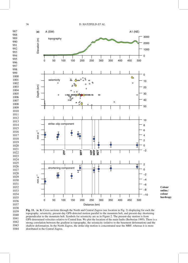
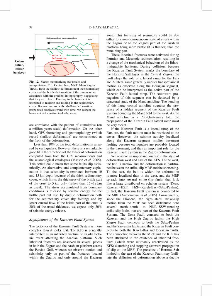
The seismicity associated with shortening andreverse mechanisms is mostly located in theZagros Fold Belt (Fig. 11). Therefore neither theMZT nor the HZF is active or both are lubricatedand slip aseismically. This seems true both forthe North Zagros, where the only large earthquakeslocated north of the HZF belong to the strike-slipMRF, and for the Fars, where the seismic inactivityof these two faults is consistent with the absenceof surface motion from GPS measurements acrossthem. More precisely, the seismicity associatedwith reverse mechanisms is restricted to topographyless than 1000 m, as pointed out by Talebian &Jackson (2004). This could be due to the gradientin topography (Talebian & Jackson 2004) but wesuspect it is related to the propagation of the defor-mation front to the SW, as evidenced from structuralstudies (Sherkati & Letouzey 2004), geomorphol-ogy and GPS. The two could be linked, however,if we consider a critical-wedge model for the evol-ution of the Zagros Fold Belt (e.g. Mouthereauet al. 2006). This propagation of deformation,and therefore of the construction of topography,explains why seismicity is bounded by the PersianGulf shore (Fig. 12), even though this shorelinehas no tectonic significance and the water depth inthe Persian Gulf is less than 70 m.
The relation between seismicity and surfacefaults differs between the North Zagros and theFars arc (Fig. 11). In the North Zagros, seismicityis restricted to a narrow band limited by the 1000 melevation contour, which is also the trace of theMFF. Because the topography is relatively steep,the relation between the 1000 m contour and theMFF is clear. The seismicity does not fit totallywith the distribution of GPS shortening, which alsoaffects the low topography north of the PersianGulf. However, because GPS deformation there iscontrolled only by the station KHOS (Fig. 5a) andno folding or topography generation is observedin the lowland, this frontal shortening remains tobe confirmed.
In Fars, seismicity is spread throughout the areabetween 1000 m elevation and the shore (whichmight be related to the MFF and the ZFF, respect-ively); the zone of seismicity is wider than in theNorth Zagros but does not encompass the entirewidth of the fold belt. The gradient in topographyis also smoother in Fars than in the North Zagros.GPS shortening is restricted to the shore and unre-lated to the high elevation.
Thus, both the seismicity and the gradient intopography (which record basement deformation)
ZAGROS KINEMATICS 35
929930931932933934935936937938939940941942943944945946947948949950951952953954955956957958959960961962963964965966967968969970971972973974975976977978979980981982983984985986
0
1000
2000
3000
0
10
20
30
40
50
Dep
th (
km)
seismicity
−2
0
2
4
6
8
10
mm
a–1
strike−slip component
MZ
TM
RF
HZ
F
MF
F
ZF
F
−10
−8
−6
−4
−2
0
2
0 50 100 150 200 250 300 350 400 450 500
0 50 100 150 200 250 300 350 400 450 500
mm
a–1
shortening component
Distance (km)
A (SW) A1 (NE)
Ele
vatio
n (m
) topography
(a)
Fig. 11. (a, b) Cross-sections through the
Colour
online=colour
hardcopy
North and Central Zagros (see location in Fig. 2) displaying for each thetopography, seismicity, present-day GPS-detected motion parallel to the mountain belt, and present-day shorteningperpendicular to the mountain belt. Symbols for seismicity are as in Figure 2. The present-day motion is fromGPS-determined velocities relative to Central Iran. We plot the location of the main faults (Berberian 1995). There is astrong correlation between the gradient in topography, the seismicity (relative to the basement deformation) and theshallow deformation. In the North Zagros, the strike-slip motion is concentrated near the MRF, whereas it is moredistributed in the Central Zagros.
D. HATZFELD ET AL.36
987988989990991992993994995996997998999100010011002100310041005100610071008100910101011101210131014101510161017101810191020102110221023102410251026102710281029103010311032103310341035103610371038103910401041104210431044

0 50 100 150 200 250 300 350 400 450 500
0
1000
2000
3000
0
10
20
30
40
50
Dep
th (
km)
seismicity
30
−2
0
2
4
6
8
10
mm
a–1
strike−slip component
MZ
T
HZ
F
MF
F
ZF
F
−10
−8
−6
−4
−2
0
2
0 50 100 150 200 250 300 350
B (SW)(b) B1 (NE)
Ele
vatio
n (m
) topography
400 450 500
mm
a–1
shortening component
Distance (km)
Fig. 11. Continued.
Colour
online=colour
hardcopy
ZAGROS KINEMATICS 37
1045104610471048104910501051105210531054105510561057105810591060106110621063106410651066106710681069107010711072107310741075107610771078107910801081108210831084108510861087108810891090109110921093109410951096109710981099110011011102
are correlated with the pattern of cumulative (ona million years scale) deformation. On the otherhand, GPS shortening and geomorphology (whichrecord shallow deformation) are concentrated atthe front of the deformation.
Less than 10% of the total deformation is relea-sed by earthquakes. However, there is a remarkablegood fit in the directions of the tensor of deformationcomputed from both the GPS measurements andthe seismological catalogues (Masson et al. 2005).This deficit could mean that some faults slip aseis-mically. An alternative and complementary expla-nation is that seismicity is restricted between 10and 15 km depth because of the thick sedimentarycover, which limits the thickness of the brittle partof the crust to 5 km only (rather than 15–18 kmas usual). The stress accumulated from boundaryconditions is released by seismic energy for thebrittle part but also by ductile deformation bothfor the sedimentary cover (by folding) and bylower crustal flow. If the brittle part of the crust is30% of the usual thickness, we expect only 30%of seismic energy release.
Significance of the Kazerun Fault System
The tectonics of the Kazerun Fault System is morecomplex than it looks first. The KFS is generallyinterpreted as an inherited fracture of an old tecto-nic event affecting the Arabian platform. Suchinherited fractures are observed in several placesin both the Zagros and the Arabian platform acrossthe Persian Gulf, whereas we observe motion andseismicity only on part of the fractures locatedwithin the Zagros and only around the Kazerun
zone. This focusing of seismicity could be dueeither to a non-homogeneous state of stress withinthe Zagros or to the Zagros part of the Arabianplatform being more brittle (it is thinner) than theremaining part.
These inherited fractures were activated duringPermian and Mesozoic sedimentation, resulting ina change of the mechanical behaviour of the lithos-tratigraphic horizons. During collision, becausethe Kazerun Fault System marks the boundary ofthe Hormuz Salt layer in the Central Zagros, thefault plays the role of a lateral ramp for the Farsarc. A lateral ramp generally implies transpressionalmotion as observed along the Borazjan segment,which can be interpreted as the active part of theKazerun Fault lateral ramp. The southward pro-pagation of this segment can be detected by astructural study of the Mand anticline. The bendingof this large coastal anticline suggests the pre-sence of a hidden segment of the Kazerun FaultSystem bounding the Mand fold to the west. As theMand anticline is a Plio-Quaternary fold, thepropagation of the Kazerun Fault lateral ramp mustbe very recent.
If the Kazerun Fault is a lateral ramp of theFars arc, the fault motion must be restricted to thecover. However, the seismic activity localizedalong the Kazerun segment implies basementfaulting because earthquakes are probably locatedin the basement, and thus an important role for theKazerun Fault System in the Zagros deformation.
We observe an important contrast in the style ofdeformation west and east of the KFS. To the west,the belt is narrow and the deformation is partitio-ned between the strike-slip MRF and the shortening.To the east, the belt is wider, the deformationis more localized than in the west, and the MRFspreads into several strike-slip faults that looklike a large distributed en echelon system (Dena,Kazerun–HZF, HZF–Kareh-Bas–Sabz-Pushan).In fact, the Kazerun Fault System is connected tothe MRF (Authemayou et al. 2005). Consequently,since the Pliocene, the right-lateral strike-slipmotion from the MRF has been distributed ontoseveral north–south- to NNE–SSW-trendingstrike-slip faults that are part of the Kazerun FaultSystem. The Dena Fault connects to both theKazerun and the High Zagros faults, the HighZagros Fault connects to both the Sabz-Pushanand the Sarvestan faults, and the Kazerun Fault con-nects to both the Kareh-Bas and Borazjan faults.The connection between the MRF and the KFS hasbeen attributed to the existence of inherited frac-tures (which were ultimately reactivated as theKFS) disturbing and stopping eastward propagationof slip on the MRF. The presence of Hormuz Saltlimited to the east of the Kazerun Fault may facili-tate the diffusion of deformation above a ductile
Sedimentary cover
Deformation propagation
Basement
Brittledeformation
CC.. II..
MZT
Fig. 12. Sketch summarizing our results andinterpretation. C.I.,
Colour
online=colour
hardcopy
Central Iran; MZT, Main ZagrosThrust. Both the shallow deformation of the sedimentarycover and the brittle deformation of the basement areassociated with the gradient in topography, suggestingthat they are related. Faulting in the basement isunrelated to faulting and folding in the sedimentarycover. Because we know the shallow deformationpropagated southwestward with time, we suspect thebasement deformation to do the same.
D. HATZFELD ET AL.38

layer and thus the slip motion. However, the exist-ence of the Hormuz Salt cannot explain on its ownthe distribution of motion, because some of thesefaults (Kareh-Bas, Sabz-Pushan) are also seismi-cally very active. Furthermore, our GPS results donot support a ‘spreading’ pattern of deformationfor the Kazerun Fault System similar to gravityspreading as claimed by Nilforoushan & Koyi(2007) on the basis of analogue experiments. Theypredicted a divergent motion of the GPS vectorsrelative to Arabia, as reported by Hessami et al.(2006), but that does not correspond to our obser-vations. We think that the distribution of deforma-tion from the MRF to the Kazerun Fault Systemaffects both the shallow sediments and the basementbeneath the ductile layer.
Partitioning
Partitioning is one of the mechanisms that accom-modate oblique motionQ13 (e.g. Fitch 1972). Usually,strike-slip and reverse motion occur on two parallelfaults that are a few tens of kilometres apart. Incontinental areas, it is likely that pre-existingfaults localize the deformation because they areweakQ14 (e.g. Zoback et al. 1987). It has also beenproposed that a ductile layer decouples the obliquemotion (Richard & Cobbold 1989) and helpspartitioning. However, we observe partitioning ofoblique convergence between shortening perpen-dicular to the belt and strike-slip motion on theMRF to the west of the Kazerun Fault Systemonly, where the coupling between sediments andbasement is strongest. Therefore, a ductile layer isprobably not responsible for deformation parti-tioning in the North Zagros. We suspect insteadthat the MRF introduces a weak discontinuity thatlocalizes strike-slip motion and, as a consequence,favours partitioning.
Vernant & Chery (2006) designed a numericalmechanical model to explain the oblique conver-gence in the Zagros. They suggested low partition-ing along the MRF (1–2 mm a21) associated withtranspressionnal deformation throughout the belt.In contrast to their model predictions, GPS strike-slip motion is slightly higher (2–4 mm a21) andgeomorphological slip rate estimates on the MRFappear to match nearly completely the strike-slipcomponent of convergence between Arabia andCentral Iran. Fault kinematic measurements alongthe HZF, south of the MRF, indicate a transpres-sional regime on this fault (Malekzadeh 2007). Ifpartitioning exists, the shortening that complementsthe minimum Quaternary slip rate on the MRF of4.9–7.6 mm a21 (Authemayou et al. 2009) mustbe accommodated somewhere else. However, thefast slip rate along the MRF probably suggestsa very weak MRF with a lower friction
coefficient than adopted by Vernant & Chery(2006), or possibly strong decoupling of thesurface from the basement, rendering a modelwithout mechanical layering somewhat irrelevant.
Conclusion
Our first conclusion is that we find, on both sidesof the KFS, a good correlation between present-day surface deformation, as measured by GPS andgeomorphology on one hand, and seismicity (affect-ing only the upper basement) and topography on theother hand (Fig. 11), suggesting that both the sedi-mentary cover and the basement deform together(i.e. a thick-skinned system). Because we know thatdeformation of the sedimentary cover propagatessouthwestward, we suspect basement deformation,which is required to explain the average topography,to do the same (Fig. 12). In contrast to Hessamiet al. (2006), we do not observe any active shorten-ing across the southern segment of the MZT. Thus,the reason for such propagation is probably therecent locking of the continental collision, propagat-ing the stress away from the MZT onto inheritednormal faults of the Arabian platform (Jackson1980). Because the strike of the belt is perpendicularto the motion of Arabia relative to Central Iran,no partitioning is required in the Central Zagros(Talebian & Jackson 2004).
The second conclusion is that the Kazerun FaultSystem separates the North Zagros (experienc-ing slip partitioning), from the Central Zagros(experiencing distributed deformation), as proposedpreviously. There is a good agreement betweenpresent-day deformation observed by GPS and tec-tonic observations, suggesting that this deformationhas been stable for some time. The Kazerun FaultSystem distributes the strike-slip motion fromthe MRF onto different branches in an en echelonarrangement, from the Dena segment to the Sabz-Pushan and High Zagros faults. The presence of thedecoupling Hormuz Salt layer cannot be the onlyreason for such distribution, because seismicityis associated with the active faults, indicatingthat the basement deforms in the same way. Conse-quently, the Kazerun Fault System affects both thesedimentary cover and the basement, playing therole of a lateral ramp of the deformation frontfor its southern Borazjan segment and of a ‘horse-tail’ termination of the MRF for its northern andcentral segments.
This work is part of a Franco-Iranian collaborative pro-gramme between French and Iranian scientific institu-tions conducted between 1997 and 2007. It has beenfunded by CNRS–INSU, the French Embassy in Tehran,the International Institute of Earthquake Engineeringand Seismology of Iran, the Geological Survey of Iran
ZAGROS KINEMATICS 39
1103110411051106110711081109111011111112111311141115111611171118111911201121112211231124112511261127112811291130113111321133113411351136113711381139114011411142114311441145114611471148114911501151115211531154115511561157115811591160

and the National Cartographic Center of Iran. We warmlythank all the people who enthusiastically participated in thefieldwork. We are considerably indebted to all drivers ofIranian institutions who spent countless time to help inall aspects of the fieldwork. We thank M. Goraishi,M. Ghafory-Ashtiany, M. Madad and P. Vidal for encour-agement and support. We benefited from numerous scien-tific discussions with several colleagues and especiallyP. Agard, J. Jackson, L. Jolivet, J. Letouzey, L.-E. Ricouand M. Talebian. The paper greatly benefited fromcareful reviews by R. Bendick and J. Jackson.
References
AGARD, P., OMRANI, J., JOLIVET, L. & MOUTHEREAU,F. 2005. Convergence history across Zagros (Iran):constraints from collisional and earlier deformation.International Journal of Earth Sciences, doi:10.1007/s00531-005-0481-4.
ALLEN, M., JACKSON, J. & WALKER, R. 2004. LateCenozoic re-organisation of the Arabia–Eurasia col-lision and the comparison of short-term and long-termdeformation rates. Tectonics, 23, doi: 10.1029/2003TC001530.
AMBRASEYS, N. N. 1978. The relocation of epicenters inIran. Geophysical Journal of the Royal AstronomicalSociety, 53, 117–121.
AUTHEMAYOU, C. 2006. Partitionnement de la conver-gence oblique en zone de collision: exemple de lachaıne du Zagros (Iran). PhD thesis, Universite PaulCezanne, Aix–Marseille.
AUTHEMAYOU, C., BELLIER, O., CHARDON, D., MAL-
EKZADEH, Z. & ABBASSI, M. 2005. Active partition-ing between strike-slip and thrust faulting in the Zagrosfold-and-thrust belt (Southern Iran). Comptes RendusGeosciences, 337, 539–545.
AUTHEMAYOU, C., CHARDON, D., BELLIER, O., MAL-
EKZADEH, Z., SHABANIAN, E. & ABBASSI, M. R.2006. Late Cenozoic partitioning of oblique plateconvergence in the Zagros fold-and-thrust belt (Iran).Tectonics, 25, article number TC3002.
AUTHEMAYOU, C., BELLIER, O. ET AL. 2009. Quaternaryslip-rates of the Kazerun and the Main Recent Faults:active strike-slip partitioning in the Zagros fold-and-thrust belt. Geophysical Journal International(in press).Q15
BACHMANOV, D. M., TRIFONOV, V. G. ET AL. 2004.Active faults in the Zagros and central Iran. Tectono-physics, 380, 221–241.
BAKER, C., JACKSON, J. & PRIESTLEY, K. 1993. Earth-quakes on the Kazerun Line in the Zagros Mountainsof Iran: strike-slip faulting within a fold-and-thrustbelt. Geophysical Journal International, 115, 41–61.
BERBERIAN, M. 1979. Evaluation of the instrumental andrelocated epicenters of Iranian earthquakes. Geophysi-cal Journal of the Royal Astronomical Society, 58,625–630.
BERBERIAN, M. 1995. Master blind thrust faults hiddenunder the Zagros folds: active basement tectonicsand surface morphotectonics. Tectonophysics, 241,193–224.
BLANC, E. J.-P., ALLEN, M. B., INGER, S. & HASSANI, H.2003. Structural styles in the Zagros Simple Folded
Zone, Iran. Journal of the Geological Society,London, 160, 401–412.
BOSOLD, A., SCHWARZHANS, W., JULAPOUR, A.,ASHRAZADEH, A. R. & EHSANI, S. M. 2005. Thestructural geology of the High Central Zagros revi-sisted (Iran). Petroleum Geosciences, 11, 225–238.
ENGDAHL, E. R., VAN DER HILST, R. D. & BULAND,R. P. 1998. Global teleseismic earthquake relocationwith improved travel times and procedures for depthdetermination. Bulletin of the Seismological Societyof America, 88, 722–743.
ENGDAHL, E. R., JACKSON, J. A., MYERS, S. C.,BERGMAN, E. A. & PRIESTLEY, K. 2006. Relocationand assessment of seismicity in the Iran region.Geophysical Journal International, 167, 761–778.
HAYNES, S. J. & MCQUILLAN, H. 1974. Evolution of theZagros suture zone, southern Iran. Geological Societyof America Bulletin, 85, 739–744.
HESSAMI, K., KOYI, H., TALBOT, C. J., TABASI, H. &SHABANIAN, E. 2001. Progressive unconformitieswithin and evolving foreland fold–thrust belt, ZagrosMountains. Journal of the Geological Society,London, 158, 969–981.
HESSAMI, K., NILFOROUSHAN, F. & TALBOT, C. 2006.Active deformation within the Zagros Mountainsdeduced from GPS measurements. Journal of theGeological Society, London, 163, 143–148.
JACKSON, J. A. 1980a. Reactivation of basement faultsand crustal shortening in orogenic belts. Nature, 283,343–346. Q16
JACKSON, J. 1980b. Errors in focal depth determinationand depth of seismicity in Iran and Turkey. Geophysi-cal Journal of the Royal Astronomical Society, 61,285–301.
JACKSON, J. & FITCH, T. 1981. Basement faulting and thefocal depths of the larger earthquakes in the Zagrosmountains (Iran). Geophysical Journal of the RoyalAstronomical Society, 64, 561–586.
JACKSON, J. A. & MCKENZIE, D. 1984. Active tectonicsof the Alpine–Himalayan Belt between westernTurkey and Pakistan. Geophysical Journal of theRoyal Astronomical Society, 77, 185–264.
JACKSON, J. & MCKENZIE, D. 1988. The relationshipbetween plate motions and seismic moment tensorsand the rates of active deformation in the Mediterra-nean and Middle East. Geophysical Journal of theRoyal Astronomical Society, 83, 45–73.
KING, R. W. & BOCK, Y. 2002. Documentation for theGAMIT analysis software, release 10.1. MassachusettsInstitute of Technology, Cambridge, MA.
KOOP, W. J. & STONELEY, R. 1982. Subsidence history ofthe Middle East Zagros Basin, Permian to Recent.Philosophical Transactions of the Royal Society ofLondon, 305, 149–168.
MAGGI, A., JACKSON, J. A., PRIESTLEY, K. & BAKER, C.2000. A re-assessement of focal depth distributionsin Southern Iran, the Tien Shan and NorthernIndia; Do earthquakes really occur in the continentalmantle? Geophysical Journal International, 143,629–661.
MALEKZADEH, Z. 2007. The accommodation of thedeformation from Main Recent Fault to Kazerun.PhD thesis, Institute of Earthquake Engineering andSeismology, Tehran.
D. HATZFELD ET AL.40
1161116211631164116511661167116811691170117111721173117411751176117711781179118011811182118311841185118611871188118911901191119211931194119511961197119811991200120112021203120412051206120712081209121012111212121312141215121612171218
MASSON, F., CHERY, J., HATZFELD, D., MARTINOD, J.,VERNANT, P., TAVAKOLI, F. & GHAFORY-ASTHIANI, M. 2005. Seismic versus aseismic defor-mation in Iran inferred from earthquakes and geodeticdata. Geophysical Journal International, 160,217–226.
MASSON, F., ANVARI, M. ET AL. 2007. Large-scale vel-ocity field and strain tensor in Iran inferred form GPSmeasurements: new insight for the present-day defor-mation pattern within NE Iran. Geophysical JournalInternational, 170, 436–440.
MCKENZIE, D. P. 1978. Active tectonics of the Alpine–Himalayan belt: the Aegean Sea and surroundingregions. Geophysical Journal of the Royal Astronomi-cal Society, 55, 217–254.
MCQUARRIE, N. 2004. Crustal scale geometry of theZagros fold–thrust belt, Iran. Journal of StructuralGeology, 26, 519–535.
MCQUARRIE, N., STOCK, J. M., VERDEL, C. & WER-
NICKE, B. P. 2003. Cenozoic evolution of Neotethysand implications for the causes of plate motion.Geophysical Research Letters, 30, doi: 10.1029/2003GL017992.
MOLINARO, M., GUEZOU, J. C., LETURMY, P., ESHRA-
GHI, S. A. & FRIZON DE LAMOTTE, D. 2004. Theorigin of changes in structural style across the BandarAbbas syntaxis, SE Zagros (Iran). Marine and Pet-roleum Geology, 21, 735–752.
MOLINARO, M., LETURMY, P., GUEZOU, J.-C. & FRIZON
DE LAMOTTE, D. 2005. The structure and kinematicsof the south-eastern Zagros fold–thrust belt, Iran:from thin-skinned to thick-skinned tectonics. Tec-tonics, 24, NIL42–NIL60.
MOLNAR, P. & LYON-CAEN, H. 1988. Some simple phys-ical aspects of the support, structure, and evolution ofmountain belts. In: Processes in Continental Litho-spheric Deformation. Geological Society of America,Special Papers,Q17 218, 179–207.
MOUTHEREAU, F., LACOMBE, O. & MEYER, B. 2006.The Zagros folded belt (Fars, Iran): constraints fromtopography and critical wedge modeling. GeophysicalJournal International, 165, 336–356.
NI, J. & BARAZANGI, M. 1986. Seismotectonics of theZagros Continental Collision Zone and a Comparisonwith the Himalayas. Journal of Geophysical Research,91, 8205–8218.
NIAZI, M. 1980. Microearthquakes and crustal structureoff the Makran coast of Iran. Geophysical ResearchLetters, 7, 297–300.
NIAZI, M., ASUDEH, G., BALLARD, G., JACKSON, J. A.,KING, G. & MCKENZIE, D. P. 1978. The depth ofseismicity in the Kermansha region of the Zagrosmountains (Iran). Earth and Planetary ScienceLetters, 40, 270–274.
NILFOROUSHAN, F. & KOYI, H. A. 2007. Displacementfields and finite strains in a sandbox model simulatinga fold–thrust belt. Geophysical Journal International,169, 1341–1355.
NILFOROUSHAN, F., VERNANT, P. ET AL. 2003.GPS network monitors the Arabia–Eurasia collisiondeformation in Iran. Journal of Geodesy, 77,411–422.
OVEISI, B., LAVE, J. & VAN DE BEEK, P. 2007. Ratesand processes of active folding evidenced by
Pleistocene terraces at the central Zagros front (Iran).In: LACOMBE, O. ET AL. (eds) Thrust Belt and Fore-land Basin. Frontiers in Earth Sciences. Springer,Berlin, 267–287. Q18
OVEISI, B., LAVE, J., VAN DER BEEK, P., CARCAILLET,J., BENEDETTI, L., BRAUCHER, R. & AUBOURG, C.2009. Thick- and thin-skinned deformation rates inthe Zagros Simple Folded Zone (Iran) indicated bydisplacement of geomorphic surfaces. GeophysicalJournal International, 176, 627–654.
RICHARD, P. & COBBOLD, P. 1989. Structures enfleur positives et decrochements crustaux: mode-lisation analogique et interpretation mecanique.Comptes Rendus de l0Academie des Sciences, 308,553–560.
RICOU, L. E., BRAUD, J. & BRUNN, J. H. 1977. Le Zagros.Memoires Hors Serie, Societe Geologique de France,8, 33–52.
SHEARMAN, D. J. 1977. The geological evolutionof Southern Iran. Geographical Journal, 142,393–410.
SHERKATI, S. & LETOUZEY, J. 2004. Variation of struc-tural and basin evolution in the central Zagros (Izehzone and Dezful Embayment), Iran. Marine andPetroleum Geology, 21, 535–554.
SHERKATI, S., MOLINARO, M., FRIZON DE LAMOTTE,D. & LETOUZEY, J. 2005. Detachment folding inthe Central and Eastern Zagros fold-belt (Iran):salt mobility, multiple detachments and late base-ment control. Journal of Structural Geology, 27,1680–1696.
SNYDER, D. B. & BARAZANGI, M. 1986. Deep crustalstructure and flexure of the Arabian plate beneath theZagros collisional mountain belt as inferred fromgravity observations. Tectonics, 5, 361–373.
TALEBIAN, M. & JACKSON, J. 2002. Offset on the MainRecent Fault of NW Iran and implications for the lateCenozoic tectonics of the Arabia–Eurasia collisionzone. Geophysical Journal International, 150,422–439.
TALEBIAN, M. & JACKSON, J. 2004. A reappraisal ofearthquake focal mechanisms and active shorteningin the Zagros mountains of Iran. Geophysical JournalInternational, 156, 506–526.
TATAR, M., HATZFELD, D., MARTINOD, J., WALPERS-
DORF, A., GHAFORI-ASHTIANY, M. & CHERY, J.2002. The present-day deformation of the centralZagros (Iran) from GPS measurements. GeophysicalResearch Letters, 29, 1927–1930.
TATAR, M., HATZFELD, D. & GHAFORY-ASHTIANY, M.2003. Tectonics of the Central Zagros (Iran) de-duced from microearthquake seismicity. GeophysicalJournal International, 156, 255–266.
TAVAKOLI, F., WALPERSDORF, A. ET AL. 2008. Dis-tribution of the right-lateral strike-slip motion fromthe Main Recent Fault to the Kazerun Fault System(Zagros, Iran): evidence from present-day GPSvelocities. Earth and Planetary Science Letters,doi: 10.1016/j.espl.2008.08.030.
VERNANT, P. & CHERY, J. 2006. Mechanical modellingof oblique convergence in the Zagros, Iran. Geophysi-cal Journal International, 165, 991–1002.
VERNANT, P., NILFOROUSHAN, F. ET AL. 2004. Contem-porary crustal deformation and plate kinematics in
ZAGROS KINEMATICS 41
1219122012211222122312241225122612271228122912301231123212331234123512361237123812391240124112421243124412451246124712481249125012511252125312541255125612571258125912601261126212631264126512661267126812691270127112721273127412751276

the Middle East Constrained by GPS measurements inIran and Northern Oman. Geophysical Journal Inter-national, 157, 381–398.
WALPERSDORF, A., HATZFELD, D. ET AL. 2006. Differ-ence in the GPS deformation pattern of North andCentral Zagros (Iran). Geophysical Journal Inter-national, 167, 1077–1088.
YAMINI-FARD, F., HATZFELD, D., TATAR, M. & MOKH-
TARI, M. 2006. Microseismicity at the intersection
between the Kazerun fault and the Main Recent Fault(Zagros-Iran). Geophysical Journal International,166, 186–196.
YAMINI-FARD, F., HATZFELD, D., FARAHBOD, A.,PAUL, A. & MOKHTARI, M. 2007. The diffuse tran-sition between the Zagros continental collision andthe Makran oceanic subduction (Iran): microearth-quake seismicity and crustal structure. GeophysicalJournal International, 170, 182–194.
D. HATZFELD ET AL.42
1277127812791280128112821283128412851286128712881289129012911292129312941295129612971298129913001301130213031304130513061307130813091310131113121313131413151316131713181319132013211322132313241325132613271328132913301331133213331334