White Mountains airborne magnetic and radiometric ...
17
WHITE MOUNTAINS AIRBORNE MAGNETIC AND RADIOMETRIC GEOPHYSICAL SURVEY Emond, A.M., and MPX Geophysics LTD Geophysical Report 2021-3 2021 STATE OF ALASKA DEPARTMENT OF NATURAL RESOURCES DIVISION OF GEOLOGICAL & GEOPHYSICAL SURVEYS
-
Upload
khangminh22 -
Category
Documents
-
view
0 -
download
0
Transcript of White Mountains airborne magnetic and radiometric ...
WHITE MOUNTAINS AIRBORNE MAGNETIC AND RADIOMETRIC GEOPHYSICAL SURVEY Emond, A.M., and MPX Geophysics LTD
Geophysical Report 2021-3
2021 STATE OF ALASKA DEPARTMENT OF NATURAL RESOURCES DIVISION OF GEOLOGICAL & GEOPHYSICAL SURVEYS
STATE OF ALASKA Mike Dunleavy, Governor DEPARTMENT OF NATURAL RESOURCES Corri A. Feige, Commissioner DIVISION OF GEOLOGICAL & GEOPHYSICAL SURVEYS Steve Masterman, State Geologist & Director Publications produced by the Division of Geological & Geophysical Surveys are available to download from the DGGS website (dggs.alaska.gov). Publications on hard-copy or digital media can be examined or purchased in the Fairbanks office: Alaska Division of Geological & Geophysical Surveys (DGGS) 3354 College Road | Fairbanks, Alaska 99709-3707 Phone: 907.451.5010 | Fax 907.451.5050 [email protected] | dggs.alaska.gov DGGS publications are also available at: Alaska State Library, Historical Collections & Talking Book Center 395 Whittier Street Juneau, Alaska 99801 Alaska Resource Library and Information Services (ARLIS) 3150 C Street, Suite 100 Anchorage, Alaska 99503 Suggested citation: Emond, A.M., and MPX Geophysics LTD, 2021, White Mountains airborne magnetic and radiometric geophysical survey: Alaska Division of Geological & Geophysical Surveys Geophysical Report 2021-3. https://doi.org/10.14509/30756
WHITE MOUNTAINS AIRBORNE MAGNETIC AND RADIOMETRIC GEOPHYSICAL SURVEY Emond, A.M.,1 and MPX Geophysics LTD
ABSTRACT
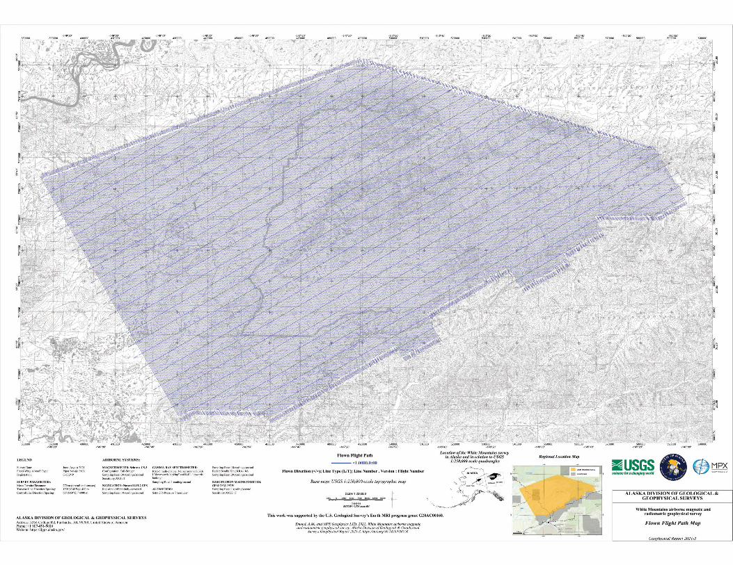
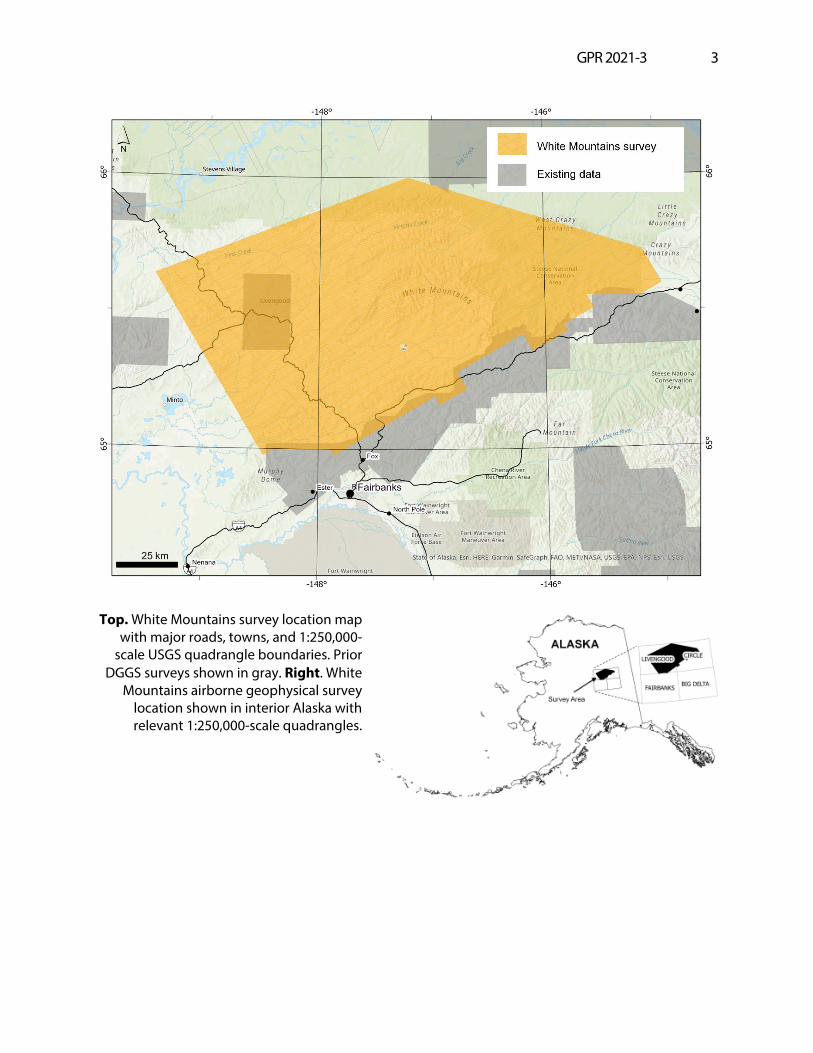
The White Mountains airborne magnetic and radiometric geophysical survey covers parts of the Livengood, Circle, and Fairbanks quadrangles 25 kilometers north of Fairbanks, Alaska (fig. 1). Magnetic and radiometric data were collected with a fixed-wing aircraft June 30 to August 22, 2021 by MPX Geophysics LTD. A total of 36,933 line kilometers were collected covering 13,423 square kilometers. The magnetometer was mounted to a rear-facing fixed boom (“tail stinger”). The radiometric crystals were located in the cabin of the aircraft. The White Mountains survey was flown with a line spacing of 400 meters (m) and a mean ground clearance of 270 m.
PURPOSE
The data from the White Mountains airborne magnetic and radiometric geophysical survey will be used for improving the understanding of the geology and mineral potential, promoting resource exploration, and be a part of the continuous regional magnetic data coverage of the Yukon Tanana Uplands.
SURVEY OVERVIEW DESCRIPTION
This document provides an overview of the survey and includes text and figures of select primary and derivative products of this survey. A table of digital data packages available for download is provided to assist users in data selection. For reference, a catalog of the available maps is presented in reduced resolution. Please consult the metadata, project report, and digital data packages for more information and data.
ACKNOWLEDGMENTS
This work was supported by the U.S. Geological Survey’s Earth MRI program grant G20AC00160. The views and conclusions contained in this document are those of the authors and should not be interpreted as necessarily representing the official policies, either expressed or implied, of the U.S. Government.
1 Alaska Division of Geological & Geophysical Surveys, 3354 College Road, Fairbanks, Alaska 99709-3707
GPR 2021-3 2
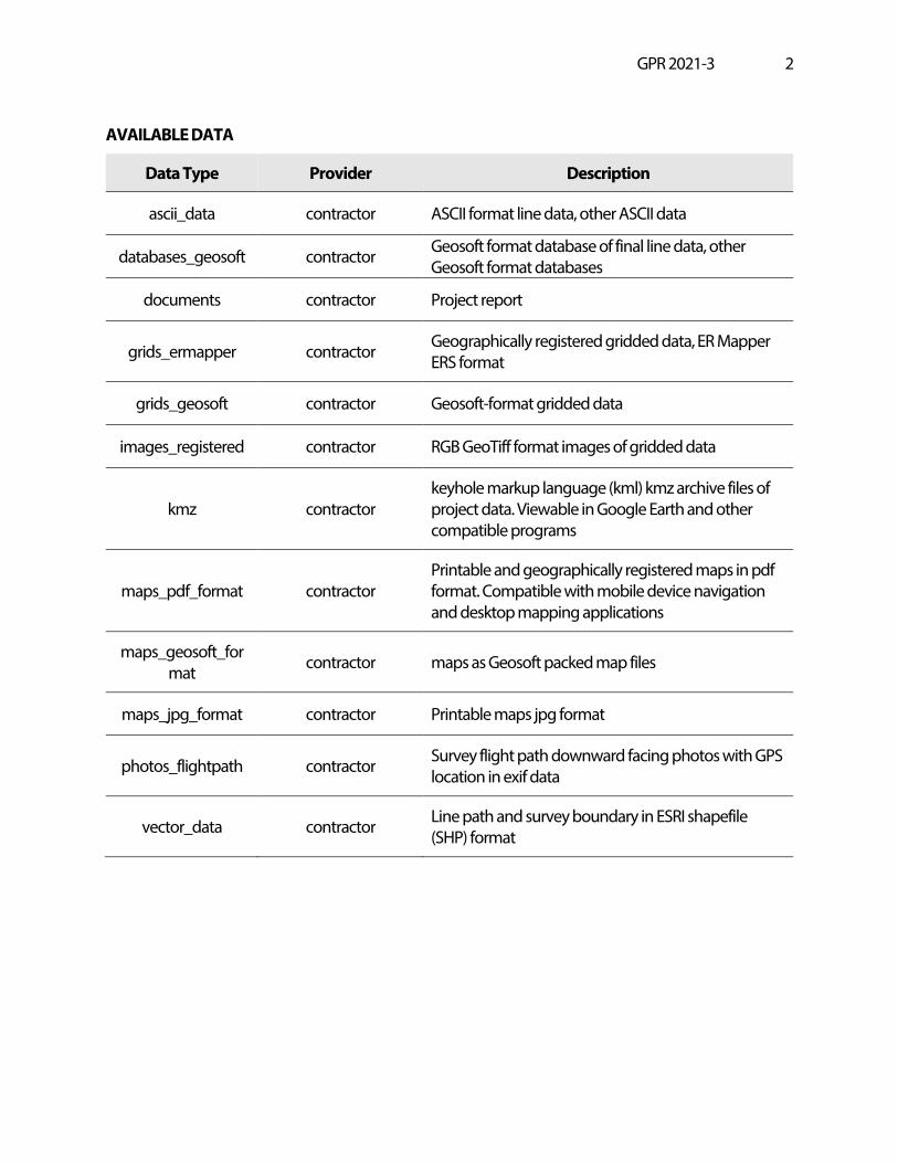
AVAILABLE DATA
Data Type Provider Description
ascii_data contractor ASCII format line data, other ASCII data
databases_geosoft contractor Geosoft format database of final line data, other Geosoft format databases
documents contractor Project report
grids_ermapper contractor Geographically registered gridded data, ER Mapper ERS format
grids_geosoft contractor Geosoft-format gridded data
images_registered contractor RGB GeoTiff format images of gridded data
kmz contractor keyhole markup language (kml) kmz archive files of project data. Viewable in Google Earth and other compatible programs
maps_pdf_format contractor Printable and geographically registered maps in pdf format. Compatible with mobile device navigation and desktop mapping applications
maps_geosoft_format contractor maps as Geosoft packed map files
maps_jpg_format contractor Printable maps jpg format
photos_flightpath contractor Survey flight path downward facing photos with GPS location in exif data
vector_data contractor Line path and survey boundary in ESRI shapefile (SHP) format
GPR 2021-3 3
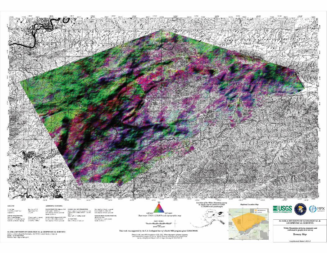
Top. White Mountains survey location map
with major roads, towns, and 1:250,000-scale USGS quadrangle boundaries. Prior
DGGS surveys shown in gray. Right. White Mountains airborne geophysical survey
location shown in interior Alaska with relevant 1:250,000-scale quadrangles.
GPR 2021-3 4
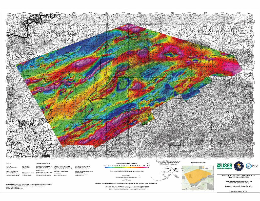
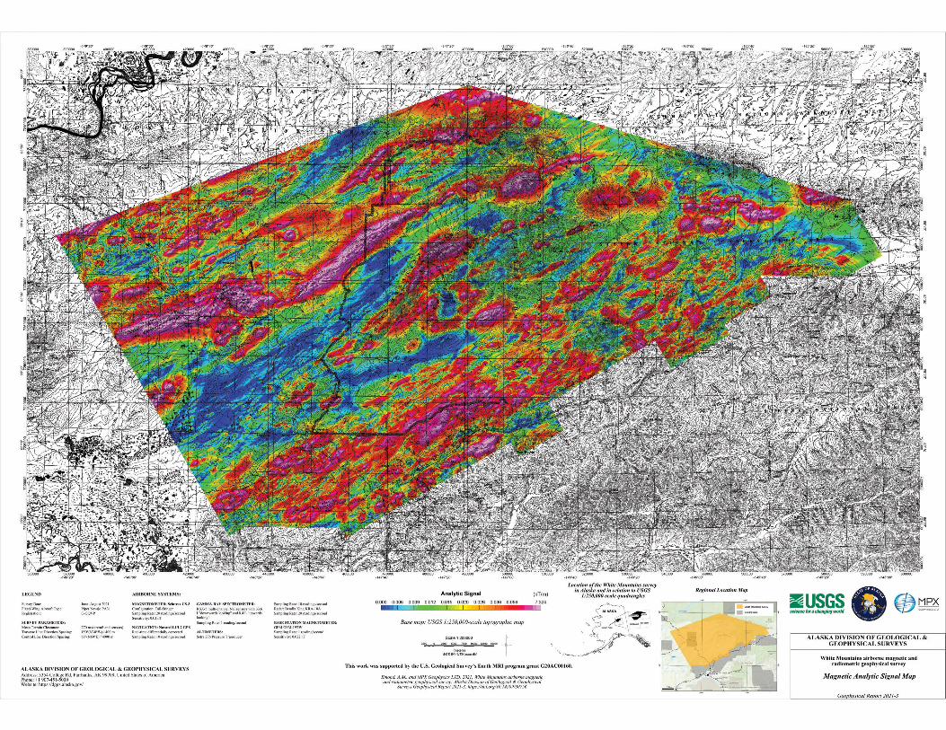
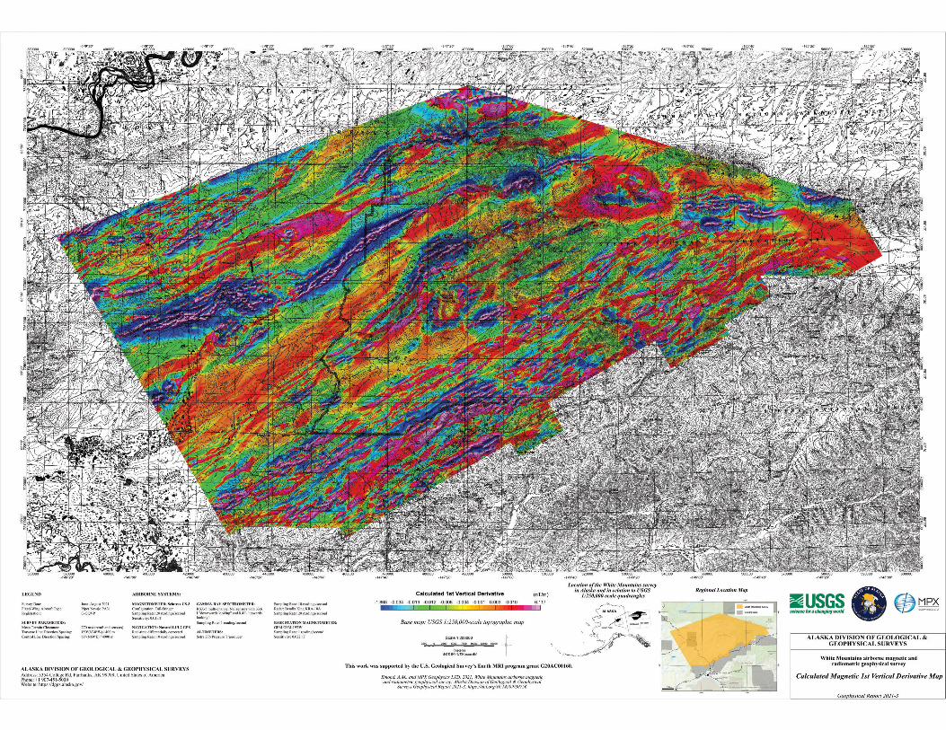
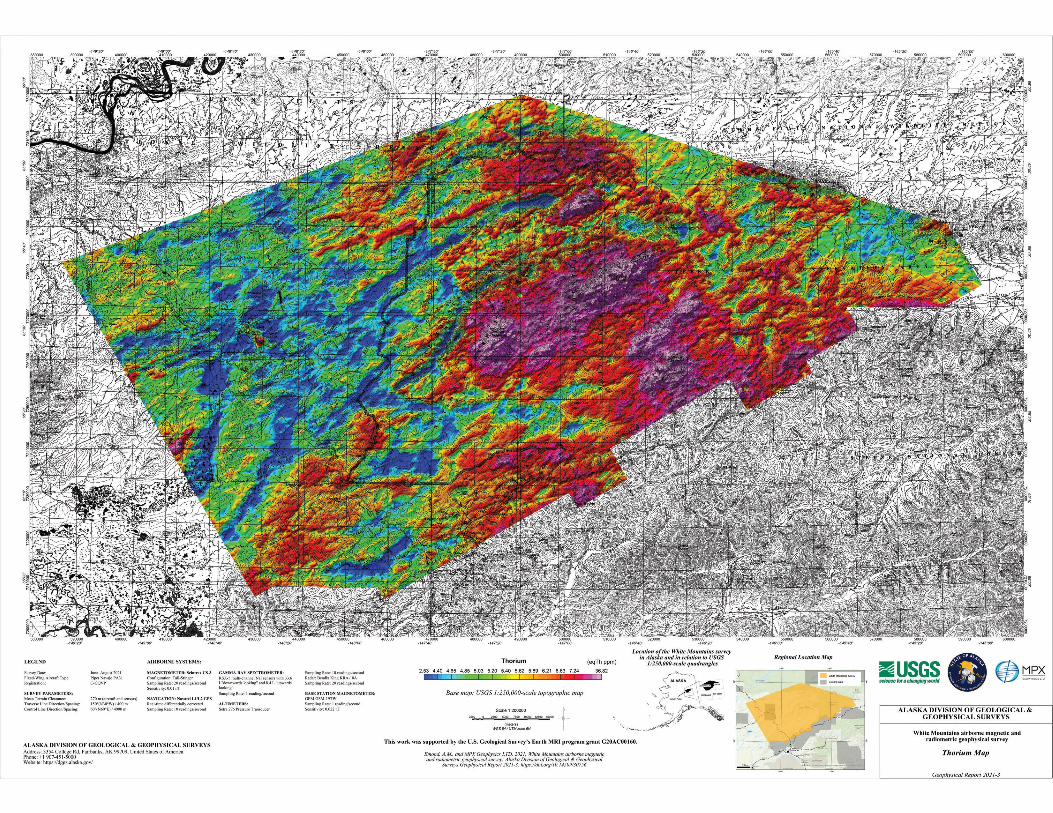
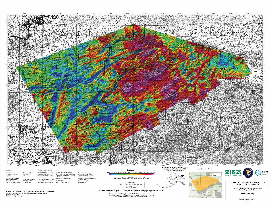
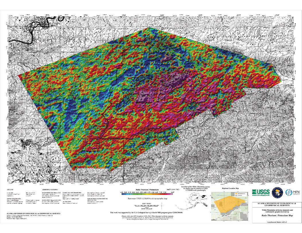
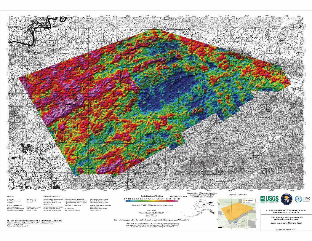
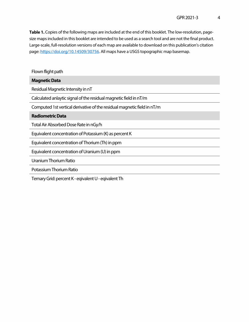
Table 1. Copies of the following maps are included at the end of this booklet. The low-resolution, page-size maps included in this booklet are intended to be used as a search tool and are not the final product. Large-scale, full-resolution versions of each map are available to download on this publication’s citation page: https://doi.org/10.14509/30756. All maps have a USGS topographic map basemap.
Flown flight path
Magnetic Data
Residual Magnetic Intensity in nT
Calculated anlaytic signal of the residual magnetic field in nT/m
Computed 1st vertical derivative of the residual magnetic field in nT/m
Radiometric Data
Total Air Absorbed Dose Rate in nGy/h
Equivalent concentration of Potassium (K) as percent K
Equivalent concentration of Thorium (Th) in ppm
Equivalent concentration of Uranium (U) in ppm
Uranium Thorium Ratio
Potassium Thorium Ratio
Ternary Grid: percent K - eqivalent U - eqivalent Th