
2014 - Blue Mountains City Council
403
DCP DRAFT 2014 VOLUME 2: Specific Development Types, Precinct Areas and Guidelines October 2014
-
Upload
khangminh22 -
Category
Documents
-
view
0 -
download
0
Transcript of 2014 - Blue Mountains City Council

DCP DRAFT2014
VOLUME 2: Specif ic Development Types, Precinct Areas and Guidelines
October 2014
CONTENTS | PAGE 417BLUE MOUNTAINS DRAFT DCP 2014
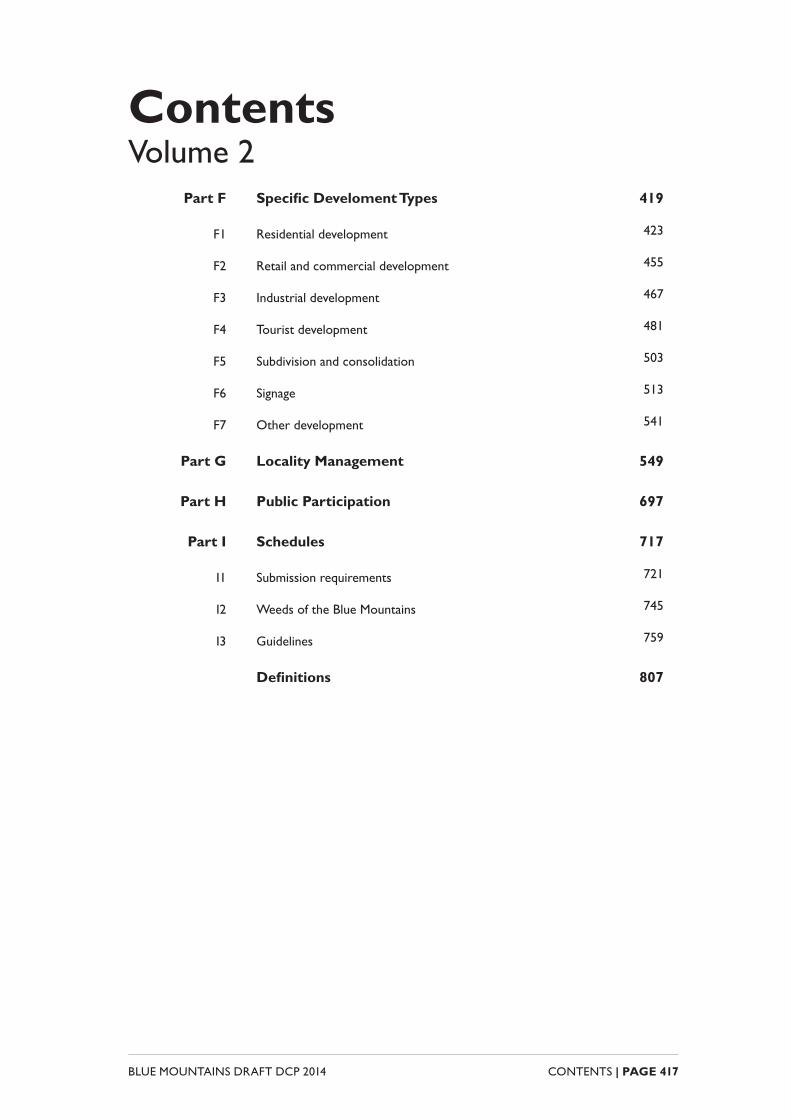
ContentsVolume 2
Part F Specifi c Develoment Types 419
F1 Residential development 423
F2 Retail and commercial development 455
F3 Industrial development 467
F4 Tourist development 481
F5 Subdivision and consolidation 503
F6 Signage 513
F7 Other development 541
Part G Locality Management 549
Part H Public Participation 697
Part I Schedules 717
I1 Submission requirements 721
I2 Weeds of the Blue Mountains 745
I3 Guidelines 759
Defi nitions 807

BLUE MOUNTAINS DRAFT DCP 2014 CONTENTS | PAGE 418

SPECIFIC DEVELOPMENT TYPES
Additional provisions for certain types of development
PART F

BLUE MOUNTAINS DRAFT DCP 2014 PART F | PAGE 420

PART F | PAGE 421BLUE MOUNTAINS DRAFT DCP 2014
ContentsPart F1 Residential development 423
F1.1 Low density residential 426
F1.2 Medium density residential 437
F1.3 Ancillary development 448
Part F2 Retail and commercial development 455
F2.1 Building design and site planning 458
F2.2 Parking and access 458
F2.3 Landscaping for parking areas 462
F2.4 Amenity 463
Part F3 Industrial development 467
F3.1 Building design and site planning 470
F3.2 Driveways and parking 471
F3.3 Landscaping for parking areas 473
F3.4 Amenity and privacy 475
F3.5 Industrial ancillary development 478
Part F4 Tourist development 481
F4.1 General objectives for all visitor and tourist accommodation 484
F4.2 Bed and breakfast accommodation and holiday lets 485
F4.3 Hotel or motel accommodation 490
F4.4 Eco-tourist facility 500
BLUE MOUNTAINS DRAFT DCP 2014 PART F | PAGE 422
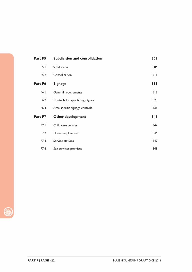
Part F5 Subdivision and consolidation 503
F5.1 Subdivision 506
F5.2 Consolidation 511
Part F6 Signage 513
F6.1 General requirements 516
F6.2 Controls for specifi c sign types 523
F6.3 Area specifi c signage controls 536
Part F7 Other development 541
F7.1 Child care centres 544
F7.2 Home employment 546
F7.3 Service stations 547
F7.4 Sex services premises 548

PART F1RESIDENTIAL
DEVELOPMENT

Part
F1:
Res
iden
tial
Dev
elop
men
t
BLUE MOUNTAINS DRAFT DCP 2014 PART F1 | PAGE 424
IntroductionPart F1 establishes additional provisions for residential development in the Blue Mountains and is divided into low density residential, medium density residential and ancillary development.
In practice most of the controls relevant to residential development will be contained in earlier parts of the Blue Mountains Development Control Plan. This part contains supplementary controls relating to open space, residential amenity and the like.
To the extent of any inconsistency between this section and any other DCP sections, this section will prevail.
Part
F1:
Res
iden
tial
Dev
elop
men
t
PART F1 | PAGE 425BLUE MOUNTAINS DRAFT DCP 2014
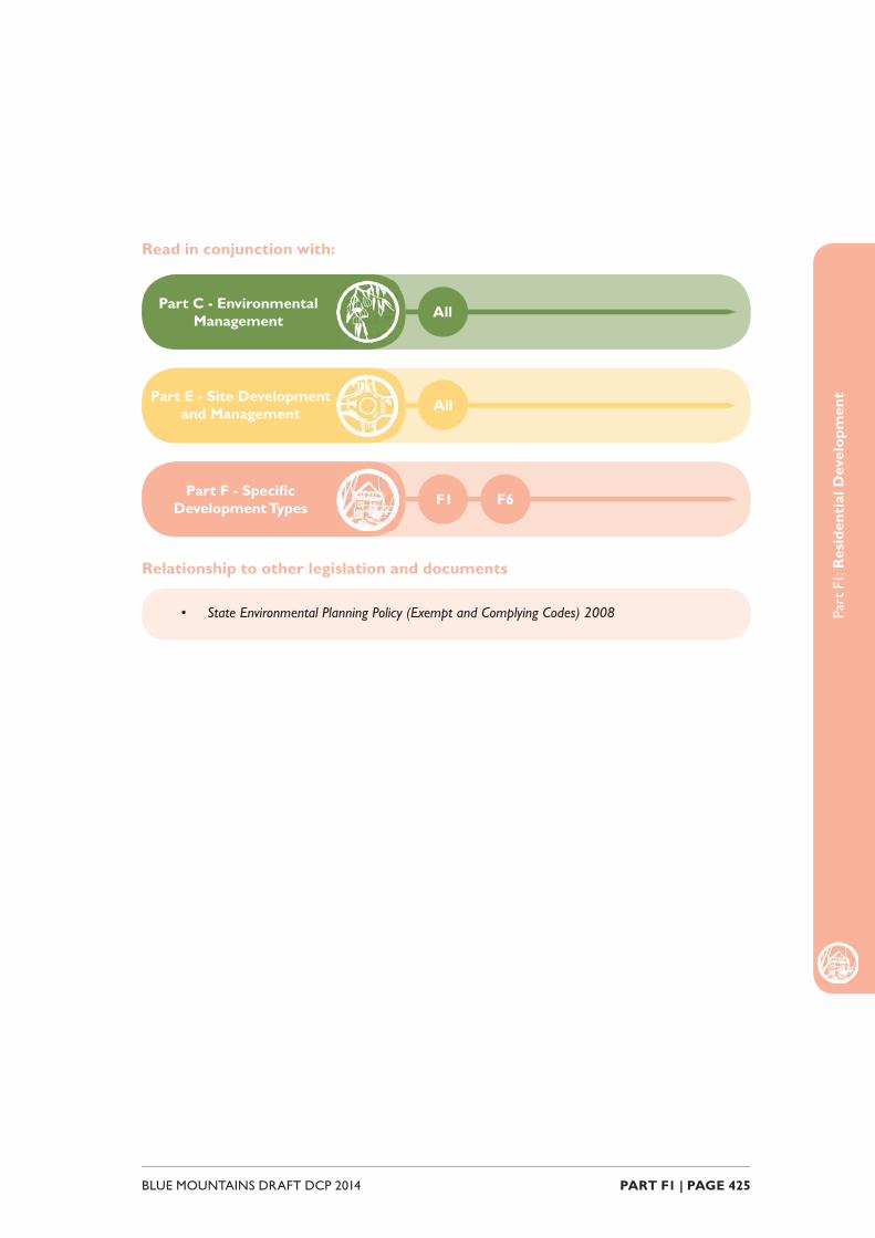
Part F - Specifi c Development Types F1
Part C - Environmental Management All
Part E - Site Development and Management All
F6
• State Environmental Planning Policy (Exempt and Complying Codes) 2008
Read in conjunction with:
Relationship to other legislation and documents

Part
F1:
Res
iden
tial
Dev
elop
men
t
BLUE MOUNTAINS DRAFT DCP 2014 PART F1 | PAGE 426
F1.1. Low Density ResidentialThis part contains objectives and controls which apply to development for the purposes of low density residential development, including the following types of development defi ned in the Blue Mountains LEP 2014:
• Dwelling houses
• Dual occupancy
• Secondary dwellings
• Semi-detached dwellings
• Group homes
F1.1.1. Private open space
Explanation
Private open space areas allow for passive recreation and contribute to the health and amenity performance of low density residential development.
Objectives
O1. Private open space functions as an accessible extension to the living area of a dwelling and is designed to protect privacy and optimise solar access and allows for passive recreation.
Controls
C1. Private open space is not to be situated in the front building setback.
C2. Development for the purposes of a secondary dwelling is to have at least 25m2 of private open space that is accessible from the secondary dwelling (whether or not associated with the principal dwelling).
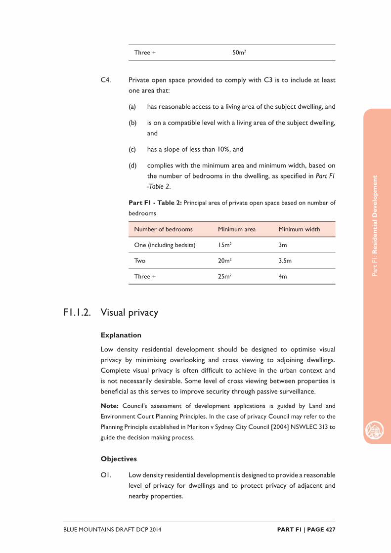
C3. For each dwelling of a dual occupancy development, provision is to be made for a minimum area of private open space, based on the number of bedrooms in the dwelling, as specifi ed in Part F1 - Table 1.
Part F1 - Table 1: Minimum area of private open space based on number
of bedrooms
Number of bedrooms Minimum area of POS
One (including bedsits) 25m2
Two 40m2
Part
F1:
Res
iden
tial
Dev
elop
men
t
PART F1 | PAGE 427BLUE MOUNTAINS DRAFT DCP 2014
Three + 50m2
C4. Private open space provided to comply with C3 is to include at least one area that:
(a) has reasonable access to a living area of the subject dwelling, and
(b) is on a compatible level with a living area of the subject dwelling, and
(c) has a slope of less than 10%, and
(d) complies with the minimum area and minimum width, based on the number of bedrooms in the dwelling, as specifi ed in Part F1 -Table 2.
Part F1 - Table 2: Principal area of private open space based on number of
bedrooms
Number of bedrooms Minimum area Minimum width
One (including bedsits) 15m2 3m
Two 20m2 3.5m
Three + 25m2 4m
F1.1.2. Visual privacy
Explanation
Low density residential development should be designed to optimise visual privacy by minimising overlooking and cross viewing to adjoining dwellings. Complete visual privacy is often diffi cult to achieve in the urban context and is not necessarily desirable. Some level of cross viewing between properties is benefi cial as this serves to improve security through passive surveillance.
Note: Council’s assessment of development applications is guided by Land and
Environment Court Planning Principles. In the case of privacy Council may refer to the
Planning Principle established in Meriton v Sydney City Council [2004] NSWLEC 313 to
guide the decision making process.
Objectives
O1. Low density residential development is designed to provide a reasonable level of privacy for dwellings and to protect privacy of adjacent and nearby properties.
Part
F1:
Res
iden
tial
Dev
elop
men
t
BLUE MOUNTAINS DRAFT DCP 2014 PART F1 | PAGE 428
Controls
C1. The location, scale and design of a dwelling house or secondary dwelling shall ensure that the visual privacy of residents of buildings on adjoining allotments is not signifi cantly impacted upon.
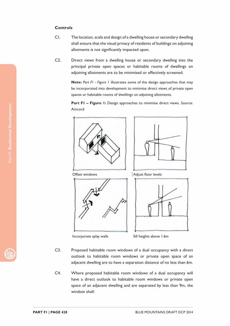
C2. Direct views from a dwelling house or secondary dwelling into the principal private open spaces or habitable rooms of dwellings on adjoining allotments are to be minimised or effectively screened.
Note: Part F1 - Figure 1 illustrates some of the design approaches that may
be incorporated into development to minimise direct views of private open
spaces or habitable rooms of dwellings on adjoining allotments.
Part F1 – Figure 1: Design approaches to minimise direct views. Source:
Amcord
Offset windows Adjust fl oor levels
Incorporate splay walls Sill heights above 1.6m
C3. Proposed habitable room windows of a dual occupancy with a direct outlook to habitable room windows or private open space of an adjacent dwelling are to have a separation distance of no less than 6m.
C4. Where proposed habitable room windows of a dual occupancy will have a direct outlook to habitable room windows or private open space of an adjacent dwelling and are separated by less than 9m, the window shall:
Part
F1:
Res
iden
tial
Dev
elop
men
t
PART F1 | PAGE 429BLUE MOUNTAINS DRAFT DCP 2014
(a) be offset a minimum of 1m from the edge of the proposed window to the edge of the existing window, or
(b) have sill heights of at least 1.6m above fl oor level, or
(c) have fi xed obscure glazing applied to any part of the window below 1.6m above fl oor level.
C5. Overlooking from or to private open space areas is to be reduced by ensuring that any upper level balconies of a dual occupancy are designed and screened to minimise the potential for overlooking of the private open space of any lower level of adjoining dwellings.
C6. Where potential overlooking from a dual occupancy cannot be avoided, views of private open space areas may be obscured in the following ways:
(a) by solid translucent screens or perforated panels or trellises, which have a maximum of 25% openings and that are designed to blend in with the proposed redevelopment, and are to be permanent components of the structure and diffi cult to alter,
(b) by retention or planting of dense mature vegetation on the development site, if used in conjunction with (a).
C7. The setback between shared driveways or access ways (including a right of carriageway) and the habitable room windows of a dwelling is to be no less than 1.5m.
F1.1.3. Acoustic Privacy
Explanation
Low density residential development should be designed to minimise noise intrusion for dwellings. Clever layout and design can serve to improve acoustic amenity, particularly in regard to positioning of noise generating rooms such as living areas and private open space.
Objectives
O1. Low density residential development is located and designed to minimise the impact of noise transmission between dwellings and from signifi cant external noise sources such as rail corridors and busy roads.
Controls
C1. Private open space areas and associated outdoor facilities including swimming pools, tennis courts and BBQ areas are to be located away
Part
F1:
Res
iden
tial
Dev
elop
men
t
BLUE MOUNTAINS DRAFT DCP 2014 PART F1 | PAGE 430
from noise sensitive rooms of adjoining dwellings.
C2. Operating plant including air conditioning systems and pool pumps are to be located away from noise sensitive rooms of adjoining dwellings.
C3. Residential development adjacent to a rail corridor or a classifi ed road is to be located and designed to ameliorate potential noise impacts arising from the adjacent rail corridor or classifi ed road. Refer to requirements in State Environmental Planning Policy (Infrastructure) 2007 and the NSW Department of Planning document Development near Rail Corridors and Busy Roads – Interim Guideline.
F1.1.4. Sunlight access
Explanation
Adequate solar access contributes to the health and amenity of low density residential development and its inhabitants. Good solar access also reduces reliance on artifi cial lighting and heating which has subsequent fi nancial and environmental benefi ts.
Note: Council’s assessment of development applications is guided by Land and
Environment Court Planning Principles. In the case of sunlight access Council may refer
to the Planning Principle established in The Benevolent Society v Waverley Council
[2010] NSWLEC 1082 to guide the decision making process.
Objectives
O1. Low density residential development should be located and designed to optimise solar access to living areas and private opens space, and to maintain reasonable solar access to adjacent properties.
Controls
C1. Locate and design development so that between the hours of 9am and 3pm on 21 June:
(a) a total area of at least 1m2 of living room windows associated with the development receive a minimum of 3 hours of unobstructed sunlight, and
(b) at least 50% of private open space areas associated with the development receive a minimum of 3 hours of unobstructed sunlight.
C2. Locate and design development so that between the hours of 9am and 3pm on 21 June:

Part
F1:
Res
iden
tial
Dev
elop
men
t
PART F1 | PAGE 431BLUE MOUNTAINS DRAFT DCP 2014
(a) a total area of at least 1m2 of living room windows associated with neighbouring development receive a minimum of 3 hours of unobstructed sunlight, and
(b) at least 50% of private open space areas associated with development on adjoining allotments receive a minimum of 3 hours of unobstructed sunlight.
C3. Where pre-development sunlight access enjoyed by development on adjoining allotments is less than the outcomes prescribed in C2, new development is not to create any additional overshadowing for that development.
C4. Shadow diagrams for 9.00 am, 12.00 pm and 3.00 pm on the winter solstice (21 June) are to be submitted with a development application where building comprising two storeys or more (or a building that is of a similar scale and massing to a two storey building) is proposed.
Note: Council may request that shadow diagrams be submitted for single
storey buildings where solar access is deemed to be an area of concern.
F1.1.5. Views
Explanation
Many dwellings and public places in the Blue Mountains enjoy bushland and escarpment views which contribute to the amenity of the property. New development should be sited and designed to minimise the impact on views, where practicable.
Notes: Council’s assessment of development applications is guided by Land and
Environment Court Planning Principles. In the case of view sharing Council may refer
to the Planning Principle established in Tenacity Consulting v Warringah Council [2004]
NSWLEC 140 to guide the decision making process.
Objectives
O1. Minimise view loss from adjoining or nearby properties without unreasonably limiting the development potential of a site.
Controls
C1. Locate and design development to allow for view sharing ensuring that existing views enjoyed by surrounding properties and from public open spaces are not substantially affected.

Part
F1:
Res
iden
tial
Dev
elop
men
t
BLUE MOUNTAINS DRAFT DCP 2014 PART F1 | PAGE 432
F1.1.6. Driveways and parking
Explanation
The location and design of driveways are key considerations when planning for development. Driveways that are appropriately located serve to maintain the safety and functionality of the public road network and allow for the retention of on-street parking.
The location and design of parking facilities such as garages, carports and landings are an important determinant of streetscape appearance. Parking facilities that are well designed and thoughtfully positioned do not form a visually prominent built element in the streetscape.
Objectives
O1. Low density residential development that provides suffi cient and convenient parking for residents without compromising streetscape appearance or traffi c safety and function.
Controls
Driveway
C1. One driveway is permitted on each road frontage of an allotment.
C2. Notwithstanding C1, Council may consider a second driveway where it can be demonstrated that:
(a) an allotment has a frontage of substantial width, and
(b) ample on-street parking is available in the locality, and
(c) traffi c and pedestrian safety will not be compromised.
C3. Provide driveways from a secondary street or rear lane in preference to the primary street frontage where practicable.
C4. Driveways are to be positioned so that on-street parking and landscaping on the site is maximised, and removal or damage to existing street trees is avoided.
C5. Driveway widths are to comply with Australian Standard 2890.1 Parking facilities – Off-street car parking and be a minimum of 3m wide and no wider than the garage opening other than as necessary to enable vehicles to access car parking spaces.
C6. Within the road reserve, driveways are to be constructed of reinforced concrete, at least 150mm thick, on an approved subgrade.
Part
F1:
Res
iden
tial
Dev
elop
men
t
PART F1 | PAGE 433BLUE MOUNTAINS DRAFT DCP 2014
C7. Within the property, driveways may be constructed of porous materials such as compacted crushed stone, pebble, gravel and semiporous pavers, where slopes are negligible.
C8. Within the property, driveways on slopes shall be constructed in accordance with Part F - Table 4:
Part F1 - Table 4: Driveway construction
Slope Minimum construction requirement
Less than 10% All weather gravel
10% – 16% Sealed (i.e. pavers, two coat seal, asphaltic concrete or concrete)
Greater than 16% Asphaltic concrete or concrete.
C9. Where possible, driveways are to be drained to adjoining landscaped areas.
C10. A driveway should be setback a minimum 1m from side boundaries to provide for landscaping or pervious area between the driveway and the side boundary.
C11. On busy roads, roads with poor site distance or on steep driveways, a turning facility may be required to ensure safe forward entry and exit.
Parking
C12. On-site parking is to be provided in accordance with that parking rates table provided at E2 Traffi c, Parking and Access.
C13. Garages and car parking areas are to be located behind the front alignment of buildings and are not to form a visually prominent element of the streetscape.
C14. The amount of street frontage (including the front elevation) of a dwelling house that may be taken up by openings for garages or carports is limited to:
(a) a maximum of 4m where the width of the allotment is less than 15m, or
(b) a maximum of 6m where the width of the allotment is equal to or greater than 15m.
C15. Notwithstanding C14, Council may consider openings for garages and carports that are greater than the limits prescribed where:

Part
F1:
Res
iden
tial
Dev
elop
men
t
BLUE MOUNTAINS DRAFT DCP 2014 PART F1 | PAGE 434
(a) the design is visually appropriate and does not detract from the streetscape, and
(b) the part of the garage or carport opening that exceeds the prescribed limit is setback behind other garages no less than 1m.
F1.1.7. Dual occupancy
Explanation
Dual occupancy means two dwellings on one lot of land and can be attached or detached. The controls in this part supplement the controls prescribed in earlier parts of the DCP and prevail over these controls in the case of any inconsistency.
Objectives
O1. Development for the purpose of a dual occupancy achieves a built form and streetscape appearance that is consistent with the desired character of an area, protects residential amenity and provides adequate landscaping opportunities.
Controls
Building separation
C1. The dwellings of a detached dual occupancy are to be separated by a minimum distance of 6m or alternative distance as required such that:
(a) visual separation between the two dwellings is achieved, and
(b) adequate visual privacy, acoustic privacy and solar access can be achieved for each of the dwellings, and
(c) the area between the dwellings provides for the retention of existing vegetation and/or ample space for landscaping.
Orientation and appearance
C2. The form, design and appearance of a dual occupancy, including the roof pitch, colours and materials, shall be complementary to the adjoining and adjacent buildings and any existing dwelling house on the land.
C3. The appearance and location from the primary street frontage of a dual occupancy should retain or enhance the existing character and appearance of a low-density residential area and shall avoid, in all but exceptional circumstances, a mirror-reversed design.
Part
F1:
Res
iden
tial
Dev
elop
men
t
PART F1 | PAGE 435BLUE MOUNTAINS DRAFT DCP 2014
C4. Dual occupancies located on a corner allotment shall be designed to separately address the primary and secondary street frontages, where practicable.
Landscaping
C5. To facilitate absorption of run-off and provide for adequate landscaping opportunities, a deep soil zone comprising at least 10% of the site area is to be provided as a single area at the rear of the site.
Note: Where the pattern of neighbourhood development has deep soil
planting at the front of the site, it may be desirable to replicate this pattern.
F1.1.8. Secondary dwellings
Explanation
Secondary dwellings may also be referred to as a granny fl at or in-law accommodation. The controls contained in this part supplement the controls prescribed in earlier parts of the DCP and prevail over these controls in the case of any inconsistency.
Note: Secondary dwellings may be constructed as complying development on land
within Zones R1 General Residential, R2 Low Density Resdiential and R3
Medium Density Resdiential provided the land upon which they are proposed and
the development itself satisfi es the provisions and relevant development standards of
State Environmental Planning Policy (Affordable Rental Housing) 2009.
Objectives
O1. To ensure that development for the purpose of a secondary dwelling is of an appropriate scale, thoughtfully positioned and is compatible with the desired residential character of the locality.
Controls
Lot requirements
C1. Development for the purposes of a secondary dwelling may only be carried out on a lot that at the completion of the development will have only one principal dwelling and one secondary dwelling.
C2. Subdivision of an approved secondary dwelling for the purposes of making the secondary dwelling and the principal dwelling available for separate sale is not permitted.
Part
F1:
Res
iden
tial
Dev
elop
men
t
BLUE MOUNTAINS DRAFT DCP 2014 PART F1 | PAGE 436
Height & setbacks
C3. Where a secondary dwelling is being incorporated into a new development, or where part of an existing dwelling is being converted into a secondary dwelling, the secondary dwelling must comply with the height and setback requirements for single dwellings.
C4. Despite C3, a dwelling on a lot that has a rear boundary with a laneway may have a building line that abuts that boundary for up to 50% of the length of that boundary.
Building design & articulation
C5. The design and location a secondary dwelling must complement the style, scale and appearance of the primary dwelling on the allotment.
C6. Development for the purposes of a secondary dwelling on a lot with a frontage to a secondary road (i.e. corner lot or parallel roads) is to result in either the principal dwelling or the secondary dwelling having a window to a habitable room in the building wall that faces a secondary road.

Part
F1:
Res
iden
tial
Dev
elop
men
t
PART F1 | PAGE 437BLUE MOUNTAINS DRAFT DCP 2014
F1.2. Medium Density ResidentialThis part contains objectives and controls which apply to development for the purposes of medium density housing, including the following types of development defi ned in the Blue Mountains LEP 2014:
• Multi dwelling housing
• Residential fl at buildings
• Attached dwellings
• Boarding Houses
Note: State Environmental Planning Policy No. 65 Design Quality of Residential Flat
Development applies to the erection of a new residential fl at building (RFB), the
substantial redevelopment or refurbishment of an existing RFB or the conversion of an
existing building to an RFB.
F1.2.1. Building articulation and separation
Explanation
The spatial separation of buildings and articulation of built form is an important determinant of massing and streetscape appearance. Adequate building separation and thoughtful articulation ‘softens’ the visual mass of medium density residential development, improves amenity and allows for landscaping opportunities.
Objectives
O1. Building separation achieves a built form and streetscape appearance that is consistent with the desired character of an area, protects residential amenity and provides adequate landscaping opportunities.
Controls
C1. Building separation between detached dwellings within a multi dwelling housing development or residential fl at building development is to comply with minimum distances prescribed in Part F - Table 5.
Part F1 - Table 5: Separation distances based on number of storeys
Number of storeys Room type Minimum separation distance
Up to 2 storeys All room types 6m
Part
F1:
Res
iden
tial
Dev
elop
men
t
BLUE MOUNTAINS DRAFT DCP 2014 PART F1 | PAGE 438
Greater than 3 storeys
Between non-habita-ble rooms
6m
Between habitable rooms or balconies and non-habitable rooms
9m
Between habitable rooms or balconies
12m
C2. Notwithstanding C1, consideration will be given to an alternative separation distance where it can be demonstrated that:
(a) the scale and massing of the development is visually appropriate and consistent with streetscape appearance, and
(b) adequate visual privacy, acoustic privacy and solar access can be achieved for each of the dwellings, and
(c) the area between the dwellings provides for the retention of existing vegetation and/or ample space for landscaping.
(d) Reduce the visual bulk of roof forms by breaking down the roof into smaller elements, rather than having a single uninterrupted roof structure.
C3. Reduce the visual impact of unrelieved walls by limiting length of walls and / or articulating built form, particularly on narrow side and rear setbacks.
F1.2.2. Private open space
Explanation
Private open space areas allow for passive recreation and contribute to the health and amenity performance of medium density residential development.
Objectives
O1. Private open space functions as an accessible extension to the living area of a dwelling and is designed to protect privacy and optimise solar access and allows for passive recreation.
Controls
C1. For each dwelling of a multi dwelling housing development, provision is to be made for a minimum area of private open space, based on the
Part
F1:
Res
iden
tial
Dev
elop
men
t
PART F1 | PAGE 439BLUE MOUNTAINS DRAFT DCP 2014
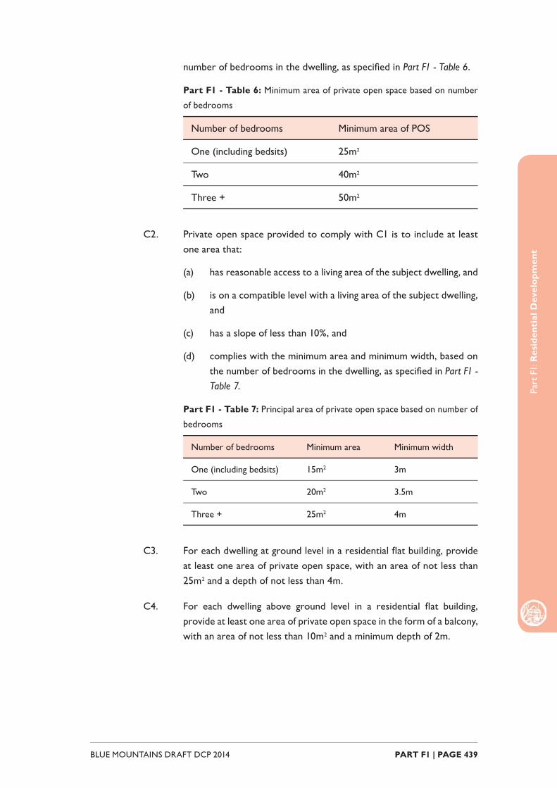
number of bedrooms in the dwelling, as specifi ed in Part F1 - Table 6.
Part F1 - Table 6: Minimum area of private open space based on number
of bedrooms
Number of bedrooms Minimum area of POS
One (including bedsits) 25m2
Two 40m2
Three + 50m2
C2. Private open space provided to comply with C1 is to include at least one area that:
(a) has reasonable access to a living area of the subject dwelling, and
(b) is on a compatible level with a living area of the subject dwelling, and
(c) has a slope of less than 10%, and
(d) complies with the minimum area and minimum width, based on the number of bedrooms in the dwelling, as specifi ed in Part F1 - Table 7.
Part F1 - Table 7: Principal area of private open space based on number of
bedrooms
Number of bedrooms Minimum area Minimum width
One (including bedsits) 15m2 3m
Two 20m2 3.5m
Three + 25m2 4m
C3. For each dwelling at ground level in a residential fl at building, provide at least one area of private open space, with an area of not less than 25m2 and a depth of not less than 4m.
C4. For each dwelling above ground level in a residential fl at building, provide at least one area of private open space in the form of a balcony, with an area of not less than 10m2 and a minimum depth of 2m.

Part
F1:
Res
iden
tial
Dev
elop
men
t
BLUE MOUNTAINS DRAFT DCP 2014 PART F1 | PAGE 440
F1.2.3. Communal open space
Explanation
Communal open space supplements the provision of private open space in residential fl at building development. Communal open space facilitates recreation and social opportunities and enhances the amenity and appearance of the development.
Note: Communal open space areas exclude driveways, parking areas, essential access
paths such as fi re escape routes, indoor gyms and clothes drying areas.
Objectives
O1. To ensure the provision of a functional and accessible area of communal open space for passive recreation that is designed to protect privacy and optimise solar access.
Controls
C1. Where a residential fl at building is proposed, provide an area of communal open space that is at least 25% of the site area and has a minimum dimension of 6m.
C2. Notwithstanding C1, Council may consider an area of communal open space that does not satisfy the minimum area requirements where it can be demonstrated that:
(a) Residential amenity is provided in the form of increased private open space for dwellings within the development; or
(b) Residential amenity is provided by way of a contribution to public open space that is reasonably accessible to residents of the development.
C3. Communal open space provided to comply with C1 is to include at least one area that:
(a) is located at ground level, and
(b) comprises a principal area of not less than 50m2, with a slope of less than 10%, and
(c) is highly visible and directly accessible to as many dwellings as can practically be achieved, and
(d) is designed and located to minimise potential overshadowing from adjoining buildings and to promote natural airfl ow, and
(e) incorporates acoustic treatments, where necessary and practical,
Part
F1:
Res
iden
tial
Dev
elop
men
t
PART F1 | PAGE 441BLUE MOUNTAINS DRAFT DCP 2014
to minimise disturbance to residents of adjoining dwellings.
F1.2.4. LandscapingMedium density residential development generally results in higher urban densities and there are subsequently fewer opportunities to achieve good landscaping outcomes. For this reason, it is important that existing vegetation and desired landscape outcomes are considered in more detail at the development design stage.
Note: The landscaping controls prescribed below supplement the objectives and
controls prescribed in Part C3 Landscaping.
Objectives
O1. Medium density residential development is designed to ensure adequate and appropriate areas are set aside for landscape purposes.
Controls
C1. To facilitate absorption of run-off and provide for adequate landscaping opportunities, a deep soil zone comprising at least 10% of the site area is to be provided as a single area at the rear of the site.
Note: Where the pattern of neighbourhood development has deep soil
planting at the front of the site, it may be desirable to replicate this pattern.
F1.2.5. Visual privacy
Explanation
Medium density residential development should be designed to optimise visual privacy by minimising overlooking and cross viewing to adjoining dwellings. Complete visual privacy is often diffi cult to achieve in the urban context and is not necessarily desirable. Some level of cross viewing between properties is benefi cial as this serves to improve security through passive surveillance.
Note: Council’s assessment of development applications is guided by Land and
Environment Court Planning Principles. In the case of privacy Council may refer to the
Planning Principle established in Meriton v Sydney City Council [2004] NSWLEC 313 to
guide the decision making process.
Objectives
O1. Medium density residential development is designed to provide a reasonable level of privacy for dwellings and to protect privacy of
Part
F1:
Res
iden
tial
Dev
elop
men
t
BLUE MOUNTAINS DRAFT DCP 2014 PART F1 | PAGE 442
adjacent and nearby properties.
Controls
C1. Proposed habitable room windows with a direct outlook to habitable room windows or private open space of an adjacent dwelling are to have a separation distance of no less than 6m.
C2. Where proposed habitable room windows will have a direct outlook to habitable room windows or private open space of an adjacent dwelling and are separated by less than 9m, the window shall:
(a) be offset a minimum of 1m from the edge of the proposed window to the edge of the existing window, or
(b) have sill heights of at least 1.6m above fl oor level, or
(c) have fi xed obscure glazing applied to any part of the window below 1.6m above fl oor level.
C3. Overlooking from or to private open space areas is to be reduced by ensuring that any upper level balconies are designed and screened to minimise the potential for overlooking of the private open space of any lower level of adjoining dwellings.
C4. Where potential overlooking cannot be avoided, views of private open space areas may be obscured in the following ways:
(a) by solid translucent screens or perforated panels or trellises, which have a maximum of 25% openings and that are designed to blend in with the proposed redevelopment, and are to be permanent components of the structure and diffi cult to alter,
(b) by retention or planting of dense mature vegetation on the development site, if used in conjunction with (a).
C5. The setback between shared driveways or access ways (including a right of carriageway) and the habitable room windows of a dwelling is to be no less than 1.5m.
F1.2.6. Acoustic privacy
Explanation
Medium density residential development should be designed to minimise noise intrusion for dwellings. Clever layout and design can serve to improve acoustic amenity, particularly in regard to positioning of noise generating rooms such as living areas and private open space.
Part
F1:
Res
iden
tial
Dev
elop
men
t
PART F1 | PAGE 443BLUE MOUNTAINS DRAFT DCP 2014
Objectives
O1. Medium density residential development is located and designed to minimise the impact of noise transmission between dwellings and from signifi cant external noise sources such as rail corridors and busy roads.
Controls
C1. Private open space, communal open space and associated outdoor facilities including swimming pools, tennis courts and BBQ areas are to be located away from noise sensitive rooms of adjoining dwellings.
C2. Operating plant including air conditioning systems and pool pumps are to be located away from noise sensitive rooms of adjoining dwellings.
C3. Residential development adjacent to a rail corridor or a classifi ed road is to be located and designed to ameliorate potential noise impacts arising from the adjacent rail corridor or classifi ed road. Refer to requirements in State Environmental Planning Policy (Infrastructure) 2007 and the NSW Department of Planning document Development near Rail Corridors and Busy Roads – Interim Guideline.
F1.2.7. Sunlight access
Explanation
Adequate solar access contributes to the health and amenity of medium density residential development and its inhabitants. Good solar access also reduces reliance on artifi cial lighting and heating which has subsequent fi nancial and environmental benefi ts.
Note: Council’s assessment of development applications is guided by Land and
Environment Court Planning Principles. In the case of sunlight access Council may refer
to the Planning Principle established in The Benevolent Society v Waverley Council
[2010] NSWLEC 1082 to guide the decision making process.
Objectives
O1. Medium density development is located and designed to optimise solar access to living rooms and private opens space areas, and to maintain reasonable solar access to adjacent properties.
Controls
C1. Locate and design development so that between the hours of 9am and 3pm on 21 June:
(a) at least 1m2 of living room windows receive a minimum of 3
Part
F1:
Res
iden
tial
Dev
elop
men
t
BLUE MOUNTAINS DRAFT DCP 2014 PART F1 | PAGE 444
hours of unobstructed sunlight, and
(b) at least 50% of private open space areas receive a minimum of 3 hours of unobstructed sunlight, and
(c) at least 30% of the required communal open space area receives a minimum of 3 hours of unobstructed sunlight.
Note: This control applies to at least of 70% of dwellings within a residential
fl at building.
C2. Locate and design development so that between the hours of 9am and 3pm on 21 June:
(a) at least 1m2 of living room windows associated with neighbouring development receive a minimum of 3 hours of unobstructed sunlight, and
(b) at least 50% of private open space areas associated with development on adjoining allotments receive a minimum of 3 hours of unobstructed sunlight.
C3. Where pre-development sunlight access enjoyed by development on adjoining allotments is less than the outcomes prescribed in C2, new development is not to create any additional overshadowing for that development.
C4. Limit number of single-aspect dwellings with a southerly aspect (SW-SE) to a maximum of 10% of the total dwellings proposed in a residential fl at building.
C5. Shadow diagrams for 10.00 am, 12.00 pm and 2.00 pm on the winter solstice (21 June) are to be submitted with a development application where a building of two storeys or more is proposed.
Note: Council may request that shadow diagrams be submitted for single
storey buildings where solar access is deemed to be an area of concern.
F1.2.8. Ventilation
Explanation
Natural ventilation refers to the circulation of fresh air through a dwelling which helps to create a comfortable indoor environment. Building orientation and dwelling confi guration are key to optimising natural ventilation.
Objectives
O1. Development is designed to maximise residential amenity by facilitating
Part
F1:
Res
iden
tial
Dev
elop
men
t
PART F1 | PAGE 445BLUE MOUNTAINS DRAFT DCP 2014
natural cross ventilation.
Controls
C1. At least 60% of dwellings within residential fl at buildings are to have dual aspect and openings on those elevations to facilitate cross ventilation.
C2. For single aspect dwellings within residential fl at buildings, the depth of the apartment is to be less than the width of its external face to encourage good ventilation.
C3. 25% of kitchens within a residential fl at building should have access to natural ventilation.
F1.2.9. Views
Explanation
Many dwellings and public places in the Blue Mountains enjoy bushland and escarpment views which contribute to the amenity of the property. New development should be sited and designed to minimise the impact on views, where practicable.
Notes: Council’s assessment of development applications is guided by Land and
Environment Court Planning Principles. In the case of view sharing Council may refer
to the Planning Principle established in Tenacity Consulting v Warringah Council [2004]
NSWLEC 140 to guide the decision making process.
Objectives
O1. Minimise view loss from adjoining or nearby properties without unreasonably limiting the development potential of a site.
Controls
C1. Locate and design development to allow for view sharing ensuring that existing views enjoyed by surrounding properties and from public open spaces are not substantially affected.
F1.2.10. Driveways and parking
Explanation
The location and design of driveways are key considerations when planning site layout. Driveways that are appropriately located serve to maintain the safety and functionality of the public road network and allow for the retention of on-street parking.
Part
F1:
Res
iden
tial
Dev
elop
men
t
BLUE MOUNTAINS DRAFT DCP 2014 PART F1 | PAGE 446
The location and design of parking facilities such as basement parking, garages and landings are an important determinant of streetscape appearance. Parking facilities that are well designed and thoughtfully positioned do not form a visually prominent built element in the streetscape.
Objectives
O1. Medium density residential development that provides suffi cient and convenient parking for residents without compromising streetscape appearance or traffi c safety and function.
Controls
Driveways
C1. One driveway is permitted on each road frontage of an allotment.
C2. Notwithstanding C1, Council may consider a second driveway where it can be demonstrated that:
(a) an allotment has a frontage of substantial width, and
(b) ample on-street parking is available in the locality, and
(c) traffi c and pedestrian safety will not be compromised.
C3. Provide driveways from a secondary street or rear lane in preference to the primary street frontage where practicable.
C4. Driveways are to be positioned so that on-street parking and landscaping on the site is maximised, and removal or damage to existing street trees is avoided.
C5. Driveway widths are to comply with Australian Standard 2890.1 Parking facilities – Off-street car parking and be a minimum of 3m wide and no wider than the opening associated with the parking facility other than as necessary to enable vehicles to access car parking spaces.
C6. Within the road reserve, driveways are to be constructed of reinforced concrete, at least 150mm thick, on an approved subgrade.
C7. Within the property, driveways shall be constructed in accordance with Part F - Table 9:
Part F1 - Table 9: Driveway construction
Slope Minimum construction requirement
Less than 16% Sealed (i.e. pavers, two coat seal, asphaltic concrete or concrete)
Part
F1:
Res
iden
tial
Dev
elop
men
t
PART F1 | PAGE 447BLUE MOUNTAINS DRAFT DCP 2014
Greater than 16% Asphaltic concrete or concrete.
C8. Driveways associated with medium density residential development shall be designed to:
(a) enable vehicles to enter and leave the site in a forward direction, and
(b) incorporate passing bays at least every 30m.
C9. The alignment of driveways shall:
(a) be located at least 1m from any side boundary to provide for landscaping or pervious area between the driveway and the side boundary, and
(b) be varied to avoid a ‘gun barrel’ appearance.
C10. Shared driveways are to be set back a minimum of 1.5m from windows of habitable rooms or a minimum of 1m where the fl oor level of the habitable room is at least 1m above the driveway at the window opening.
Parking
C11. On-site parking is to be provided in accordance with that parking rates table provided at E2 Traffi c, Parking and Access.
C12. Garages and car parking areas are to be located behind the front alignment of buildings and are not to form a visually prominent element of the streetscape.
C13. Stacked parking may be proposed where two spaces are provided for a specifi c dwelling.
C14. Visitor parking is to be clearly identifi ed by way of pavement marking or discreet signage, and shall be conveniently located.
Basement parking
C15. Basement car parking shall:
(a) be located within the limits of the building footprint and project no more than 1m above natural ground level, and
(b) facilitate natural ventilation, and
(c) incorporate lighting in accordance with the Australian Standard 1680.2.1 Interior and workplace lighting – Specifi c applications – Circulation spaces and other general areas.

Part
F1:
Res
iden
tial
Dev
elop
men
t
BLUE MOUNTAINS DRAFT DCP 2014 PART F1 | PAGE 448
F1.3. Ancillary Development
Explanation
Development ancillary to a dwelling house commonly includes fences, studios, sheds and swimming pools / spas. Ancillary development should be visually compatible with the design of the subject building and sympathetic to the character of the locality.
Note: Some forms of ancillary development may be categorised as exempt or complying
development pursuant to State Environmental Planning Policy (Exempt and Complying
Development Codes) 2008 (Codes SEPP).
F1.3.1. FencesNote: When proposing a side or rear fence the proponent must also refer to the
requirements of, and understand their obligations under, the Dividing Fences Act 1991.
Objectives
O1. Fences for residential development are appropriately scaled and allow for passive surveillance between public and private realms.
Controls
Residential & Environmental Zones
C1. The maximum height of a fence is to comply with the height limits prescribed in Part F1 - Table 5.
Part F1 – Table 5: Maximum height of fence
Location Maximum height above ground level
Primary frontage 1.2m
Secondary road frontage
1.2m between the front boundary and the front building line
1.8m between the front building line and the rear boundary
Common boundary 1.8m
1.2m between the front boundary and the front building line
1.2m if masonry construction
C2. Fences installed on a primary road frontage shall be open for at least

Part
F1:
Res
iden
tial
Dev
elop
men
t
PART F1 | PAGE 449BLUE MOUNTAINS DRAFT DCP 2014
20% of the area of the fence that is more than 400mm above ground level, with any individual solid element of the fence above this height being no more than 350mm in width with a minimum aperture of 25mm.
C3. If a lot has a frontage to a secondary road(s), C2 applies to 50% of contiguous secondary road boundaries, measured from the corner with the primary road boundary.
C4. Despite C1, if the fence is erected on a sloping site and stepped to accommodate the fall in the land:
(a) a fence that is required to be not more than 1.2m above ground level, must not be more than 1.5m above ground level at each step, and
(b) a fence that is required to be not more than 1.8m above ground level, must not be more than 2.2m above ground level at each step.
C5. Long sections of fencing on a secondary road frontage are to include recessed portions located at regular intervals along the length of the fence for the purpose of additional landscaping.
Rural Zones
C6. The maximum height of a fence is to be no higher than 1.8m above ground level unless the fence is erected on a sloping site and is stepped to accommodate the fall in the land in which case it may not be more than 2.2m above ground level at each step.
C7. A fence shall not include any masonry construction that extends more than 3m from either side of the entrance to the property from the primary road.
C8. Fences are to be constructed using post and wire or post and rail.
C9. If the fence includes an entrance gate, the gate shall not open outwards.
F1.3.2. Detached studios
Explanation
A detached studio is established in conjunction with and on the same lot as a dwelling house and is not capable of being occupied as a separate dwelling. Detached studios may be used for purposes such as a bedroom, an artist’s workspace, a home offi ce, a hobby room, a rumpus room, a teenagers ‘retreat’
Part
F1:
Res
iden
tial
Dev
elop
men
t
BLUE MOUNTAINS DRAFT DCP 2014 PART F1 | PAGE 450
or similar habitable room.
Note: Detached studios may be constructed as complying development in R1, R2
and R3 zones provided the land upon which they are proposed and the development
itself satisfi es the provisions and relevant development standards of State Environmental
Planning Policy (Exempt and Complying Development Codes) 2008.
Objectives
O1. To ensure that development for the purpose of a detached dual occupancy is of an appropriate scale, thoughtfully positioned and is compatible with the desired residential character of the locality.
Controls
C1. A detached studio is to be located behind the building line of the primary street frontage.
C2. Not more than one detached studio may be located on a lot.
C3. The maximum gross fl oor area of a detached studio is 35m2.
C4. Kitchen and laundry facilities are not permitted in detached studios.
C5. An application for or incorporating a detached studio is to be supported by a fl oor plan showing all proposed facilities as well as a statement of use.
Note: The statement of use assists in determining which facilities, if any,
would be permitted given the stated use of the detached studio. The
following facilities may be permitted within the detached studio depending
on the proposed use:
• A shower / toilet facility,
• A sink (free standing or in a bench top) with a hot and cold water supply
for washing hands and / or cleaning art / hobby equipment only,
• Other facilities which are appropriate for the proposed use and do not
provide for separate occupancy.
F1.3.3. Sheds
Objectives
O1. To ensure that sheds are of an appropriate scale and have regard to residential amenity.
Controls

Part
F1:
Res
iden
tial
Dev
elop
men
t
PART F1 | PAGE 451BLUE MOUNTAINS DRAFT DCP 2014
C1. Sheds are to be located behind the building line of any road frontage.
C2. Notwithstanding C1, a shed may be located forward of the building line on land within Zone RU2 Rural Landscape, RU4 Primary Production Small Lots or E3 Environmental Management, where it can be demonstrated that:
(a) the form, scale and design of the shed is visually appropriate and is consistent with streetscape appearance in the locality, and
(b) the shed is suitably screened by vegetation and will not present as a prominent element in the streetscape.
C3. The height of a shed shall not exceed the building height of the dwelling located on the subject land.
C4. The fl oor area of a shed is to comply with the areas prescribed in Part F1 - Table 6.
Part F1 – Table 6: Maximum fl oor area for sheds based on lot size
Lot size Maximum fl oor area
Less than 720m2 22m2
Between 720m2 – 1,200m2 44m2
Between 1,200m2 - 2,000m2 68m2
Greater than 2,000m2 Merit based assessment
C5. The form and scale of the shed, including roof forms, shall be consistent with, or complementary to, the form and massing of buildings in the locality.
C6. Building materials shall complement the materials commonly used in buildings in the locality and, to the extent that the structure is comprised of metal components, be low refl ective.
C7. Council may require that the shed incorporate appropriate acoustic attenuation measures to ensure that residential amenity is not unduly impacted.
C8. A shed is not to be habitable.
F1.3.4. Swimming pools and spas
Objectives
Part
F1:
Res
iden
tial
Dev
elop
men
t
BLUE MOUNTAINS DRAFT DCP 2014 PART F1 | PAGE 452
O1. To minimise the visual impact of swimming pools and spas and maintain a reasonable level of visual and acoustic privacy for neighbouring properties.
Controls
C1. Swimming pools and spas should be located at the rear of properties.
C2. Swimming pools and spas are to be set back a minimum of 1.2m from any property boundary.
C3. Position swimming pools or spas away from noise sensitive rooms (i.e. bedrooms) of both the subject dwelling and neighbouring dwellings.
C4. Mechanical equipment associated with swimming pools and spas are to be housed in an enclosure that is soundproofed.
C5. Position any pool related decking away from the side and rear boundaries of the property to minimise adverse privacy impacts on the neighbours.
C6. Where illumination is proposed, use low level lighting and direct away from adjoining properties.
F1.3.5. Tennis Courts
Objectives
O1. To ensure that tennis courts are appropriately located and do not adversely affect the amenity of the locality.
Controls
C1. Tennis courts are to be located behind the building line of any road frontage.
C2. Tennis courts shall not involve cut or fi ll of more than 1m below or above existing ground level.
C3. Tennis courts are to be set back a minimum of 5m from a side or rear boundary.
C4. Position tennis courts away from noise sensitive rooms (i.e. bedrooms) of both the subject dwelling and neighbouring dwellings.
C5. Screen planting should be provided between a tennis court and adjoining properties.
Part
F1:
Res
iden
tial
Dev
elop
men
t
PART F1 | PAGE 453BLUE MOUNTAINS DRAFT DCP 2014
C6. The colour of any associated fencing is to be recessive (e.g. black) to minimise visual impact.
C7. Flood lighting is generally not permitted unless it can be demonstrated that the lighting and use of the court at night will not interfere with neighbour amenity.

Part
F1:
Res
iden
tial
Dev
elop
men
t
BLUE MOUNTAINS DRAFT DCP 2014 PART F1 | PAGE 454
PART F2RETAIL AND COMMERCIAL
DEVELOPMENT
Part
F2:
Ret
ail a
nd C
omm
erci
al D
evel
opm
ent
BLUE MOUNTAINS DRAFT DCP 2014 PART F2 | PAGE 456
IntroductionRetail and commercial enterprises provide an essential for the community. In the Blue Mountains, these businesses serve both the permanent residential population as well as an itinerant tourist population.
Additionally, villages and towns are separated by bushland and areas of World Heritage National Park, due to the linear layout of the local government area, which stretches along the Great Western Highway. This separation contributes to the creation of distinct village character for which the Blue Mountains is known, but it also highlights the need for establishment of core businesses and services within the each town centre. The provision of retail shops, restaurants and business services as well as health, recreation and education facilities are all important elements for the establishment of a community.
To the extent of any inconsistency between this section and any other DCP sections, this section will prevail.

Part
F2:
Ret
ail a
nd C
omm
erci
al D
evop
men
t
PART F2 | PAGE 457BLUE MOUNTAINS DRAFT DCP 2014
Read in conjunction with:
Relationship to other legislation and documents:
Submission requirements:
Part F - Specifi c Development Types F1
Part C - Environmental Management All
Part E - Site Development and Management All
F6
• State Environmental Planning Policy (Exempt and Complying Codes) 2008
One or more of the following types of reports may need to accompany a development application:
• Acoustic Impact Assessment
• Odour Assessment

Part
F2:
Ret
ail a
nd C
omm
erci
al D
evel
opm
ent
BLUE MOUNTAINS DRAFT DCP 2014 PART F2 | PAGE 458
F2.1. Building Design and Site Planning
Explanation
Through high quality building design and appropriate site planning, development for commercial and retail purposes can make positive a contribution to the streetscape and provide for functional and inviting access for the general public.
The majority of commercial and retail businesses are located within town centres and immediately surrounding areas. These localities are in the main, identifi ed as precinct areas on the Built Character Map in Blue Mountains Local Environmental Plan 2014 (BMLEP2014), and are to meet the particular objectives and controls identifi ed in Part G Locality Management, of this DCP. The following controls are supplementary to Part G, and where there is any inconsistency in the provisions, Part G prevails.
Objectives
O1. To identify key components of urban design to be considered and addressed in development proposals.
O2. To retain and enhance the unique qualities of neighbourhood character and context, by responding to existing elements and elements of desired future character.
O3. To ensure that the operation of commercial and retail enterprises minimises impact on the amenity of adjoining and nearby residential land uses.
Controls
C1. New commercial and retail development, including additions and alterations, in precinct areas as identifi ed on the Built Character Map in BMLEP2014, is to be undertaken in accordance with the relevant provisions in Part B3 Design of this DCP.
C2. New commercial and retail development, including additions and alterations, is to minimise bulk and scale and utilise design elements such as articulation to limit visual intrusion.
F2.2. Parking and Access
Explanation
Development for commercial and retail purposes is often by nature located within main streets and more densely developed areas in the centre of town. In the Blue Mountains, these centres often have heritage value and a development

Part
F2:
Ret
ail a
nd C
omm
erci
al D
evop
men
t
PART F2 | PAGE 459BLUE MOUNTAINS DRAFT DCP 2014
pattern that has been in place since the early commercial development of these areas. The provision of onsite parking within these locations is often diffi cult, as existing buildings are generally built to the property boundary, particularly within Heritage Conservation Areas and other established areas.
While onsite parking is important to ensure that development does not impact on adjoining neighbours and the local street network, this part of the DCP provides some fl exibility for the provision of onsite parking in locations (particularly within town centres) where physical site constraints mean it is not possible or aesthetically desirable to provide onsite parking (eg the site is fully developed, or provision of off street parking in the frontage of a heritage item or in areas of signifi cant streetscape value).
This section also provides controls for the location and design of parking areas for larger commercial and retail development.
Objectives
O1. To ensure that commercial and retail development provide onsite parking that is adequate for the land use, without compromising streetscape appearance or traffi c safety and function.
O2. To provide fl exibility where compliance with parking rates may not be possible due to physical site constraints, or may result in an adverse impact on streetscape, amenity or character.
Controls
Driveways
C1. Only one driveway is to be provided at each road frontage of an allotment.
C2. Notwithstanding C1, Council may consider a second driveway where it can be demonstrated that:
(a) an allotment has a frontage of substantial width, and
(b) it is required for manoeuvrability within the site (due to the operation of the commercial use or the size of vehicle required to access the site), and
(c) suffi cient on-street parking is available in the locality, and
(d) traffi c and pedestrian safety will not be compromised.
C3. The alignment of driveways shall be located at least 2m from any side boundary to provide space for landscaping and pervious area, except in town centres where building site cover precludes that outcome.

Part
F2:
Ret
ail a
nd C
omm
erci
al D
evel
opm
ent
BLUE MOUNTAINS DRAFT DCP 2014 PART F2 | PAGE 460
C4. Driveways are to be positioned so that on-street parking and landscaping on the site is maximised, and removal or damage to existing street trees is avoided.
C5. Driveway widths are to comply with Australian Standard 2890.2 Parking facilities – Off-street commercial parking facilities and be a minimum of 3m wide and no wider than the opening associated with the parking facility other than as necessary to enable vehicles to access car parking spaces.
C6. Driveways associated with large scale commercial development shall be designed to:
(a) enable vehicles to enter and leave the site in a forward direction, and
(b) be capable of accommodating the entry and exit manoeuvers of the largest vehicle expected to enter the site.
Parking
C7. On-site parking is to be provided in accordance with the parking rates table provided at Part E2 Traffi c, Parking and Access of this DCP, Part E2: Table 2.
C8. Car parking areas should preferably be located behind the front alignment of buildings and are not to form a visually prominent element of the streetscape.
C9. Where parking cannot be located behind the front building alignment, parking areas are to be designed to provide appropriate space for landscaping; both on the boundaries and along street frontages, as well as at regular intervals between parking spaces.
Basement parking
C10. Basement car parking shall:
(a) be located within the limits of the building footprint and project no more than 1m above natural ground level, and
(b) facilitate natural ventilation, and
(c) incorporate lighting in accordance with the Australian Standard 1680.2.1 Interior and workplace lighting – Specifi c applications – Circulation spaces and other general areas.
C11. Separate pedestrian access to buildings is to be provided.
Part
F2:
Ret
ail a
nd C
omm
erci
al D
evop
men
t
PART F2 | PAGE 461BLUE MOUNTAINS DRAFT DCP 2014
F2.2.1. Exceptions to Parking rates
C1. Compliance with the parking rates in Part E2: Table 2 is not generally required where:
(a) the proposed commercial or retail development is located within Zone B2 Local Centre, and
(b) the site is developed to the front and side property boundaries such that access to the site for parking would not be possible, and
(c) the site does not have rear access or the provision of parking in this part of the site would not be practical or would result in an adverse impact on streetscape character.
C2. With the exception of C1, a variation sought to the parking rates is to address the following issues (as relevant to the particular development):
(a) Site constraints that inhibit the provision of the required parking onsite,
(b) Justifi cation as to how the parking that cannot be accommodated onsite can be managed without adverse impacts on the locality.
(c) A survey of available on-street parking within walking distance from the site at peak parking generation times relevant to the proposed development.
(d) Existing parking facilities already provided prior to the proposed development.
(e) Any complementary uses of the available parking spaces.
(f) The proximity and access to public transport.
(g) Location of local services, employment, retail and recreational facilities.
(h) Safety of vehicles, pedestrians and cyclists.
Note: It is the responsibility of the applicant through the development
application and assessment process to demonstrate that the proposed level
of parking provision is adequate, or that the overall planning benefi ts of the
proposed development outweigh any parking defi ciencies.

Part
F2:
Ret
ail a
nd C
omm
erci
al D
evel
opm
ent
BLUE MOUNTAINS DRAFT DCP 2014 PART F2 | PAGE 462
F2.3. Landscaping for parking areas
Explanation
Commercial and Retail development, particularly larger scale proposals, generate the need for onsite parking. With reference to Part F2.2 of this DCP, in town centres, this parking requirement may not be able to be provided onsite. However where parking is required onsite it is important that these hard stand areas are designed to accommodate appropriate landscaping, so as to soften the development and contribute to streetscape amenity.
Note: The landscaping controls prescribed below supplement the objectives and
controls prescribed in Part C3 Landscaping.
Objectives
O1. To ensure that commercial and retail development is appropriately planned and sited to accommodate landscaped areas within car parks and associated hard stand areas of the site.
Controls
C1. Landscaping is to be used to minimise the physical and visual dominance of car parking and vehicular circulation areas.
C2. Where it is not possible or practical to retain existing trees, new advanced trees are to be provided within the landscaped areas to rapidly reinstate a canopy presence of equivalent stature.
C3. The soil volume provided within planter beds is to be suffi cient to ensure successful establishment and growth of selected tree and shrub species. As a guide the following soil volumes (unobstructed root area) are required for tree establishment:
(a) Between 5 and 15m3 for a small tree (6-8m height with a 5m crown spread); and
(b) Between 20 and 40m3 for a medium sized tree (10-12m height with a 8m crown spread); and
(c) Between 50 and 80m3 for a large tree (16-20m height with a 16m crown spread).
C4. Planter beds are to use Gap Graded or “structural” soils in the subsoil layer to assist in the provision of a sustainable growing medium for selected species. Structural subsoil is to also be provided beneath parking bays adjacent to planted trees so as to increase available soil volume.

Part
F2:
Ret
ail a
nd C
omm
erci
al D
evop
men
t
PART F2 | PAGE 463BLUE MOUNTAINS DRAFT DCP 2014
C5. In order to reduce the potential for damage to tree trunks and to reduce subsequent pruning maintenance, trees are to be located to the centre of planting beds.
C6. Plant materials selected are to be compatible with pedestrian access, safety and amenity. Trees which produce high levels of leaf, fl ower or fruit debris or large quantities of resin are to be avoided.
C7. Plant spacing, layout and characteristics are to provide adequate opportunities for natural surveillance and the maintenance of required sight lines at egress and entrance points.
C8. Artifi cial lighting and associated infrastructure is to be located so as to avoid confl ict with existing and proposed canopy elements. Ensure adequate space is provided to accommodate mature tree canopy without compromising illumination.
F2.4. Amenity
Explanation
Commercial and Retail development, depending on the nature of the business, can have the potential to impact on the amenity of adjoining and nearby properties. This may be due to the scale or nature of a business or other factors such as noise, odour or potential impacts to adjoining properties in relation to sunlight access or loss of views.
Objectives
O1. To ensure adverse impacts to the amenity of adjoining and nearby properties are minimised.
O2. To provide effective measures, both operational and constructed, to minimise the impacts of operational noise and odour.
O3. To design and locate commercial development to maintain reasonable solar access to adjacent properties.
O4. Minimise view loss from adjoining or nearby properties without unreasonably limiting the development potential of a site.
F2.4.1. Operational Noise and Odour
Explanation
Commercial and retail development includes a number of different land uses, which as a result of differing scale, operational requirements or other factors,

Part
F2:
Ret
ail a
nd C
omm
erci
al D
evel
opm
ent
BLUE MOUNTAINS DRAFT DCP 2014 PART F2 | PAGE 464
have the potential to generate noise or odour which could impact adjoining neighbours. This may be due to loading and unloading, deliveries or fumes from the operation of a kitchen for example. With careful site planning and mangement these potential impacts can be effectively minimised.
Controls
C1. Operating plant, including air conditioning systems, generators or other equipment, is to be located:
(a) suffi ciently distant from any adjoining residential development, and
(b) within an enclosed space to provide for noise attenuation and management of fumes, and
(c) to minimise the visual impact on the streetscape and adjoining development, and may need to be screened to achieve this outcome.
Depending on the scale and type of the development, impact assessments for Noise and Odour may need to be submitted as part of a development application.
C2. Proposed development is to consider the following with regard to hours of operation:
(a) Proximity to residential development should night trading be proposed, and
(b) Deliveries and loading outside of core operating hours with regard to noise and light spill, and
(c) Levels of traffi c generation of the proposed development.
F2.4.2. Sunlight access
Explanation
Adequate solar access contributes to the health and amenity, and good solar access also reduces reliance on artifi cial lighting and heating which has subsequent fi nancial and environmental benefi ts.
Note: Council’s assessment of development applications is guided by Land and
Environment Court Planning Principles. In the case of sunlight access Council may refer
to the Planning Principle established in The Benevolent Society v Waverley Council
[2010] NSWLEC 1082 to guide the decision making process.
Part
F2:
Ret
ail a
nd C
omm
erci
al D
evop
men
t
PART F2 | PAGE 465BLUE MOUNTAINS DRAFT DCP 2014
Controls
C1. Locate and design development so that between the hours of 9am and 3pm on 21 June:
(a) at least 1m2 of living room windows associated with neighbouring development receive a minimum of 3 hours of unobstructed sunlight, and
(b) at least 50% of private open space areas associated with development on adjoining allotments receive a minimum of 3 hours of unobstructed sunlight.
C2. Where pre-development sunlight access enjoyed by development on adjoining allotments is less than the outcomes prescribed in C2, new development is not to create any additional overshadowing for that development.
C3. Shadow diagrams for 9.00 am, 12.00 pm and 3.00 pm on the winter solstice (21 June) are to be submitted with a development application where a building of two storeys or more is proposed.
Note: Council may request that shadow diagrams be submitted for single
storey buildings where solar access is deemed to be an area of concern.
F2.4.3. Views
Explanation
Many areas of the Blue Mountains enjoy bushland and escarpment views which contribute to the amenity of a property. New commercial or retail development, particularly where located adjoining or within close proximity to residential areas, should be sited and designed to minimise the impact on views, where practicable.
Notes: Council’s assessment of development applications is guided by Land and
Environment Court Planning Principles. In the case of view sharing Council may refer
to the Planning Principle established in Tenacity Consulting v Warringah Council [2004]
NSWLEC 140 to guide the decision making process.
Controls
C1. Locate and design development to allow for view sharing ensuring that existing views enjoyed by surrounding properties and from public open spaces are not substantially affected.

Part
F2:
Ret
ail a
nd C
omm
erci
al D
evel
opm
ent
BLUE MOUNTAINS DRAFT DCP 2014 PART F2 | PAGE 466

PART F3INDUSTRIAL
DEVELOPMENT

Part
F3:
Indu
stri
al D
evel
opm
ent
BLUE MOUNTAINS DRAFT DCP 2014 PART F3 | PAGE 468
IntroductionIndustrial zones permit a wide range of land uses including storage premises, some commercial and residential land uses, and general industrial development. In general, industrial land uses have a greater potential to result in adverse impacts than some other land uses and these need to be managed as part of site planning and design. Such development may also be adjoining or adjacent to residential zones. These types of developments need to be carefully planned and managed, to limit the potential for land use confl ict in these areas.
To the extent of any inconsistency between this section and any other DCP sections, this section will prevail.

Part
F3:
Indu
stri
al D
evop
men
t
PART F3 | PAGE 469BLUE MOUNTAINS DRAFT DCP 2014
Read in conjunction with:
Relationship to other legislation and documents
Part F - Specifi c Development Types F1
Part C - Environmental Management All
Part E - Site Development and Management All
F6
• State Environmental Planning Policy (Exempt and Complying Codes) 2008
Part
F3:
Indu
stri
al D
evel
opm
ent
BLUE MOUNTAINS DRAFT DCP 2014 PART F3 | PAGE 470
F3.1. Building Design and Site Planning
Explanation
Through high quality building design and appropriate site planning, industrial developments despite often having a larger bulk and scale, can provide and maintain a suitable level of visual, acoustic and environmental quality. Such design planning is required to maintain the amenity of adjoining neighbours and enhance the streetscape of the locality. This is particularly important where industrial development adjoins or is in close proximity to residential development.
Objectives
O1. To ensure that industrial development is designed and sited to minimise impacts on the environment and on the visual and acoustic privacy of adjoining and nearby development.
O2. To ensure that industrial development is compatible with the amenity of existing and likely future residential use within the adjoining residential zone.
Controls
C1. New industrial development is to minimise bulk and scale and utilise design elements such as articulation to limit visual intrusion.
Note: Refer to Part B2 Building Envelope of this DCP, with particular
reference to B2.3.3.
C2. Where new industrial development adjoins a residential zone, new buildings are to be sited so as to retain the visual and acoustic privacy of residents of properties in these adjoining residential zones.
C3. Warehouses and industrial buildings are to be equipped with permanent ridge venting .
Part
F3:
Indu
stri
al D
evop
men
t
PART F3 | PAGE 471BLUE MOUNTAINS DRAFT DCP 2014
F3.2. Driveways and Parking
Explanation
The location and design of driveways are key considerations when planning for development. Driveways that are appropriately located serve to maintain the safety and functionality of the public road network and allow for the retention of on-street parking.
The location and design of parking facilities such as basement parking, garages and landings are an important determinant of streetscape appearance. Parking facilities that are well designed and thoughtfully positioned do not form a visually prominent built element in the streetscape.
Objectives
O1. To ensure that industrial development provides suffi cient and convenient onsite parking without compromising streetscape appearance or traffi c safety and function.
Controls
Driveways
C1. Only one driveway is to be provided at each road frontage of an allotment.
C2. Notwithstanding C1, Council may consider a second driveway where it can be demonstrated that:
(a) an allotment has a frontage of substantial width, and
(b) it is required for manoeuvrability within the site (due to the operation of the industrial use or the size of vehicle required to access the site) within the second driveway, and
(c) suffi cient on-street parking is available in the locality, and
(d) traffi c and pedestrian safety will not be compromised.
C3. The alignment of driveways shall be located at least 2m from any side boundary to provide space for landscaping and pervious area.
C4. Driveways are to be positioned so that on-street parking and landscaping on the site is maximised, and removal or damage to existing street trees is avoided.
C5. Driveway widths are to comply with Australian Standard 2890.2 Parking facilities – Off-street commercial parking facilities and be a

Part
F3:
Indu
stri
al D
evel
opm
ent
BLUE MOUNTAINS DRAFT DCP 2014 PART F3 | PAGE 472
minimum of 3m wide and no wider than the opening associated with the parking facility other than as necessary to enable vehicles to access car parking spaces.
C6. Driveways associated with industrial development shall be designed to:
(a) enable vehicles to enter and leave the site in a forward direction, and
(b) be capable of accommodating the entry and exit manoeuvers of the largest vehicle expected to enter the site.
Parking
C7. On-site parking is to be provided in accordance with that parking rates table provided at Part E2 Traffi c, Parking and Access of this DCP: Part E2: Table 2.
C8. Car parking areas should preferably be located behind the front alignment of buildings and are not to form a visually prominent element of the streetscape.
C9. Where parking cannot be located behind the front building alignment, parking areas are to be designed to provide appropriate space for landscaping; both on the boundaries and along street frontages, as well as at regular intervals between parking spaces.
Basement parking
C10. Basement car parking shall:
(a) be located within the limits of the building footprint and project no more than 1m above natural ground level, and
(b) facilitate natural ventilation, and
(c) incorporate lighting in accordance with the Australian Standard 1680.2.1 Interior and workplace lighting – Specifi c applications – Circulation spaces and other general areas.
C11. Separate pedestrian access to buildings is to be provided.
Part
F3:
Indu
stri
al D
evop
men
t
PART F3 | PAGE 473BLUE MOUNTAINS DRAFT DCP 2014
F3.3. Landscaping for parking areas
Explanation
Industrial development has the potential to result in larger scale development comprising sizable hard stand areas for parking and site manoeuvrability. With consideration for these design elements, there are often more limited landscaping opportunities. However, because of the bulk and scale of industrial development, landscaping has an important role to play in both the provision of spaces on the site to absorb run off, and also to visually soften development and contribute to streetscape amenity.
Note: The landscaping controls prescribed below supplement the objectives and
controls prescribed in Part C3 Landscape.
Objectives
O1. To ensure that Industrial development is appropriately planned and sited to accommodate landscaped areas within car parks and associated hard stand areas of the site.
Controls
C1. Landscaping is to be used to minimise the physical and visual dominance of car parking and vehicular circulation areas.
C2. Where it is not possible or practical to retain existing trees, new advanced trees are to be provided within the landscaped areas to rapidly reinstate a canopy presence of equivalent stature.
C3. The soil volume provided within planter beds is to be suffi cient to ensure successful establishment and growth of selected tree and shrub species. As a guide the following soil volumes (unobstructed root area) are required for tree establishment:
(a) Between 5 and 15 cubic m for a small tree (6-8m height with a 5m crown spread); and
(b) Between 20 and 40 cubic m for a medium sized tree (10-12m height with a 8m crown spread); and
(c) Between 50 and 80 cubic m for a large tree (16-20m height with a 16m crown spread).
C4. Planter beds are to use Gap Graded or “structural” soils in the subsoil layer to assist in the provision of a sustainable growing medium for selected species. Structural subsoil is to also be provided beneath
Part
F3:
Indu
stri
al D
evel
opm
ent
BLUE MOUNTAINS DRAFT DCP 2014 PART F3 | PAGE 474
parking bays adjacent to planted trees so as to increase available soil volume.
C5. In order to reduce the potential for damage to tree trunks and to reduce subsequent pruning maintenance, trees are to be located to the centre of planting beds.
C6. Plant materials selected are to be compatible with pedestrian access, safety and amenity. Trees which produce high levels of leaf, fl ower or fruit debris or large quantities of resin are to be avoided.
C7. Plant spacing, layout and characteristics are to provide adequate opportunities for natural surveillance and the maintenance of required sight lines at egress and entrance points.
C8. Artifi cial lighting and associated infrastructure is to be located so as to avoid confl ict with existing and proposed canopy elements. Ensure adequate space is provided to accommodate mature tree canopy without compromising illumination.
Part
F3:
Indu
stri
al D
evop
men
t
PART F3 | PAGE 475BLUE MOUNTAINS DRAFT DCP 2014
F3.4. Amenity and Privacy
Explanation
Development in Industrial zones can take a number of forms. Some land uses permitted within these zones are commercial or recreational in nature, and others are light industrial uses of a limited scale. There is however some uses which due to the scale of a business or to particular operations which result in noise, odour, sunlight access or other potential impacts on the amenity of adjoining neighbours.
In a number of areas of the Blue Mountains, Industrial zones are located adjoining, or within close proximity of residential zones. The use of appropriate building materials, landscaping and adequate setbacks, can reduce confl ict between these land uses and allow the amenity and privacy of residential neighbours to be maintained.
Objectives
O1. To ensure adverse impacts to the amenity of adjoining and nearby properties are minimised.
O2. To provide effective measures, both operational and constructed, to minimise the impacts of operational noise and odour.
O3. To design and locate commercial development to maintain reasonable solar access to adjacent properties, with particular consideration for adjoining residential zones.
Controls
C1. Development within Zones B7 Business Park, IN1 General Industry and IN Light Industry and on land which adjoins or is adjacent to land that permits residential accommodation is to be compatible with the amenity of any existing and likely future residential use, having regard to:
(a) the relatively building scale, bulk, design and height and the siting of the proposed development, and
(b) the retention of acoustic and visual privacy of residents of properties in the residential zone, and
(c) the hours of operation of the proposed development, and
(d) levels of traffi c generation of the proposed development, and
(e) any noise, light dust and odour impacts likely to be generated by the proposed development, and

Part
F3:
Indu
stri
al D
evel
opm
ent
BLUE MOUNTAINS DRAFT DCP 2014 PART F3 | PAGE 476
(f) overshadowing of, and retention of solar access to, properties in the residential zone.
Site Planning
C2. Site landscaping is to include suffi cient planting within side and rear setbacks so as to provide privacy and enhance visual amenity within the site and for adjacent dwellings.
C3. Operating plant, including air conditioning systems, generators or other equipment, is to be located:
(a) suffi ciently distant from any adjoining residential development, and
(b) within an enclosed space to provide for noise attenuation and management of fumes, and
(c) (to minimise the visual impact on the streetscape and adjoining development.
Depending on the scale and type of the development, impact assessments for Noise and Odour may need to be submitted as part of a development application.
Sunlight Access
C4. Locate and design development so that between the hours of 9am and 3pm on 21 June:
(a) at least 1m2 of living room windows associated with neighbouring development receive a minimum of 3 hours of unobstructed sunlight, and
(b) at least 50% of private open space areas associated with development on adjoining allotments receive a minimum of 3 hours of unobstructed sunlight.
C5. Where pre-development sunlight access enjoyed by development on adjoining allotments is less than the outcomes prescribed in C2, new development is not to create any additional overshadowing for that development.
C6. Shadow diagrams for 10.00 am, 12.00 pm and 2.00 pm on the winter solstice (21 June) are to be submitted with a development application where a building of two storeys or more is proposed.
Note 1: Council may request that shadow diagrams be submitted for single
storey buildings where solar access is deemed to be an area of concern.
Part
F3:
Indu
stri
al D
evop
men
t
PART F3 | PAGE 477BLUE MOUNTAINS DRAFT DCP 2014
Note 2: Council’s assessment of development applications is guided by Land
and Environment Court Planning Principles. In the case of sunlight access
Council may refer to the Planning Principle established in The Benevolent
Society v Waverley Council [2010] NSWLEC 1082 to guide the decision
making process.
Hours of Operation
C7. Having regard for the hours of operation of the development, particular consideration is to be given to noise and light spill resulting from deliveries and loading outside of core operating hours.
Views
C8. Locate and design development to allow for view sharing ensuring that existing views enjoyed by surrounding properties and from public open spaces are not substantially affected.
Notes: Council’s assessment of development applications is guided by Land
and Environment Court Planning Principles. In the case of view sharing
Council may refer to the Planning Principle established in Tenacity Consulting
v Warringah Council [2004] NSWLEC 140 to guide the decision making
process.

Part
F3:
Indu
stri
al D
evel
opm
ent
BLUE MOUNTAINS DRAFT DCP 2014 PART F3 | PAGE 478
F3.5. Industrial Ancillary Development
F3.5.1. Industrial Retail Outlets
Explanation
Development within Zones B7 Business Park, IN1 General Industry and IN2 Light Industry, can include a retail component for the display or sale of those goods manufactured on the site, in conjunction with the associated industry. This enables manufacturers to sell products from their production site on a limited basis, without needing to take up another retail premise for this purpose.
Controls
C1. The retail fl oor area of any Industrial Retail Outlet is to be in accordance with the provisions of clause 5.4(4) of Blue Mountains Local Environmental Plan 2014.
C2. Industrial retail outlets are to be accessed via a separate entrance, located away from the manufacturing area of the development. This entrance is to the clearly identifi ed and easily accessible from any parking areas.
F3.5.2. Dwellings (Caretaker’s residence)
Explanation
Industrial development may include the provision of a caretaker’s residence. This is not a defi ned used in BMLEP 2014, and a dwelling of this type will be assessed under the general provisions of this DCP, and those for Low Density Residential development. However, there are some particular considerations in relation to this type of dwelling, due to their location within an industrial site.
Objectives
O1. Private open space functions as an accessible extension to the living area of a dwelling and is designed to protect privacy and optimise solar access and allows for passive recreation.
Controls
C1. Private open space is not to be situated in the front building setback.
C2. Development for the purposes of a dwelling ancillary to industrial development is to have at least 25m2 of private open space, and this

Part
F3:
Indu
stri
al D
evop
men
t
PART F3 | PAGE 479BLUE MOUNTAINS DRAFT DCP 2014
open space area is to:
(a) have a minimum width of 4m;
(b) be appropriately screened and appropriately separated from the industrial development on the site, and
(c) have reasonable access to a living area of the subject dwelling, and
(d) have a slope of less than 10%.

Part
F3:
Indu
stri
al D
evel
opm
ent
BLUE MOUNTAINS DRAFT DCP 2014 PART F3 | PAGE 480

PART F4TOURIST
DEVELOPMENT
Part
F4:
Tou
rist
Dev
elop
men
t
BLUE MOUNTAINS DRAFT DCP 2014 PART F4 | PAGE 482
IntroductionTourism is core business in the Blue Mountains, with the Local Government Area being one of the most highly visited tourist destinations in New South Wales. Tourism provides support for the local economy, as well educating and exposing visitors to the village and towns within the World Heritage National Park.
This environmentally sensitive location and the regular infl ux of people beyond the resident population, also presents challenges in relation to the management of services, traffi c and parking, as well as the privacy and amenity of residents who adjoin properties used for tourist and visitor facilities.
This part of the DCP provides objectives and controls for visitor and tourist accommodation, to ensure that the City can provide inviting and well serviced places for people to stay, without adversely impacting on the amenity and well-being of permanent residents.

Part
F4:
Tou
rist
Dev
opm
ent
PART F4 | PAGE 483BLUE MOUNTAINS DRAFT DCP 2014
Read in conjunction with:
Relationship to other legislation and documents
Part F - Specifi c Development Types F6
Part C - Environmental Management All
Part E - Site Development and Management All
Part D - Heritage Management All
Part G - Precincts All
• State Environmental Planning Policy (Exempt and Complying Codes) 2008
Part
F4:
Tou
rist
Dev
elop
men
t
BLUE MOUNTAINS DRAFT DCP 2014 PART F4 | PAGE 484
F4.1. General objectives for all Visitor and Tourist AccommodationO1. To encourage environmentally sustainable tourist development that
provide quality built outcomes, which respond to the unique qualities of neighbourhood character, for the economic and social benefi t of the City.
O2. To ensure that tourist-based development results in a net benefi t to the condition of the land upon which is located.
O3. To ensure that the amenity and privacy of adjoining properties is preserved, including visual and acoustic privacy, and solar access.
O4. To provide an appropriate proportion of accessible accommodation suites for the elderly, people with a disability and people with limited mobility.
O5. To ensure that adequate onsite parking is provided for guests and staff, and that these parking areas do not detract from streetscape amenity and character of the locality.
O6. To ensure that the provision of services and plant does not result in visual clutter.

Part
F4:
Tou
rist
Dev
opm
ent
PART F4 | PAGE 485BLUE MOUNTAINS DRAFT DCP 2014
F4.2. Bed & Breakfast Accommodation, Holiday Lets and Farm Stay Accommodation
Explanation
Bed and Breakfast Accommodation is common throughout the Blue Mountains, and provides for a relatively low scale, low impact form of tourist accommodation operated from a dwelling by the permanent residents of that dwelling. It is important that this type of development is appropriately designed to minimise impacts to adjoining neighbours and provide appropriate services for guests, such as onsite parking and accessible access.
Note 1: Bed and Breakfast Accommodation is considered complying development in
certain circumstances, under the provisions of State Environmental Planning Policy (Exempt
and Complying Development Codes) 2008, and a complying development certifi cate is
required rather than a development application.
Holiday Let is the use of dwelling house for short-term paid accommodation where visitors or tourists stay for a period of less than three months and have a principal place of residence elsewhere. Holiday Lets are a common form of tourist accommodation in the Blue Mountains, and located throughout the local government area, but predominantly in tourist areas.
Note: Development consent may not be required for the purposes of a holiday let,
should the development meet certain criteria. Refer to clause 6.31 and Schedule 2 of
Blue Mountains Local Environmental Plan 2014.
Farm Stay Accommodation is short term accommodation for paying guests on a working farm as a secondary business to primary production.
F4.2.1. Site Planning and Bush fi re requirements
Explanation
The location and size of an allotment are important factors with regard to the siting of a development. This is more pertinent when the allotment is identifi ed as bush fi re prone land on the Bush fi re prone land Map. The following controls should be referred to early in the design stage of the proposal.
Controls
C1. In accordance with clause 5.4(1) of Blue Mountains Local Environmental Plan 2014, bed and breakfast accommodation is limited to four (4) bedrooms.
C2. Bed and Breakfast accommodation can only be operated from a dwelling located on a site that has a total area of 1200m2 or greater.

Part
F4:
Tou
rist
Dev
elop
men
t
BLUE MOUNTAINS DRAFT DCP 2014 PART F4 | PAGE 486
C3. Where bed and breakfast accommodation or development for the purposes of a holiday let is proposed to be located on bush fi re prone land as identifi ed on the Bush Fire Prone Land Map, a Bush fi re Threat Assessment is to be submitted as part of any application. The development is to comply with the requirements of the Rural Fires Act 1997 and Planning for Bush fi re Protection. Refer to Part E4 of this DCP.
Note 1: Bed and breakfast accommodation and holiday lets are considered
Special Fire Protection Purposes under the provisions of the Rural Fires Act
1997. Development applications for these land uses will therefore be referred
to the Rural Fire Service for the issue of a Bush fi re Safety Authority.
Note 2: Bed and breakfast accommodation may be exempt from the
requirement for a Bush fi re Safety Authority if it is proposed to be located
more than 30m from native vegetation. Refer to clause 45 of the Rural Fires
Regulation 2014.
F4.2.2. Parking and Access
Explanation
While bed and breakfast accommodation and holiday lets are a low scale form of tourist accommodation, it does result in some traffi c generation which can affect adjoining and neighbouring residents. To ensure that the development does not result in overfl ow parking to the street, but does provide appropriately located, accessible parking for guests the following controls detail how parking is to be provided within the property.
Controls
Driveways
C1. Only one driveway is to be provided at each road frontage of an allotment.
C2. Notwithstanding C1, Council may consider a second driveway where it can be demonstrated that:
(a) an allotment has a frontage of substantial width, and
(b) it is required for manoeuvrability within the site (due to the operation of the commercial use or the size of vehicle required to access the site), and
(c) suffi cient on-street parking is available in the locality, and
(d) traffi c and pedestrian safety will not be compromised.
Part
F4:
Tou
rist
Dev
opm
ent
PART F4 | PAGE 487BLUE MOUNTAINS DRAFT DCP 2014
Parking
C3. On-site parking is to be provided in accordance with the parking rates table provided at Part E2 Traffi c, Parking and Access of this DCP, Part E2: Table 2.
C4. Car parking areas should preferably be located behind the front alignment of buildings and are not to form a visually prominent element of the streetscape.
C5. Car parking spaces and vehicle turning areas are generally not permitted within the front setback area. Consideration will be given to varying the location where it is desirable for environmental reasons, or where there is a substantial setback and dense landscape screening.
C6. For new construction for the purposes of bed and breakfast accomodation, holiday lets and farm stay accommodation, all parking is to be provided onsite, and guest parking is to be clearly identifi able and easily accessed.
F4.2.3. Amenity
Explanation
The location of tourist accommodation within residential areas has the potential to result in adverse impacts on adjoining properties and nearby neighbours, particularly in relation to privacy and noise. With well-considered design of both the site and the dwelling, these potential impacts can be minimised.
Controls
Acoustic Amenity and Privacy
C1. For new construction, any balcony, deck or outdoor entertaining / recreation area (such as BBQ areas, swimming pools or spas) is to be located and designed in a manner that does not adversely impact on the privacy or amenity of adjoining neighbours, and located away from the bedroom areas of adjoining dwellings.
C2. Where the development is a change of use from a dwelling to bed and breakfast accommodation or a holiday let, privacy screening and any other measures to limit privacy and amenity impacts are to be included for existing balcony, deck or outdoor entertaining / recreation areas.
C3. Operating plant, including air conditioning systems, generators, pool pumps or other equipment, is to be located:
Part
F4:
Tou
rist
Dev
elop
men
t
BLUE MOUNTAINS DRAFT DCP 2014 PART F4 | PAGE 488
(a) suffi ciently distant from any adjoining residential development, and
(b) where appropriate, within an enclosed space to provide for noise attenuation.
F4.2.4. Sunlight Access
C1. For new construction for the purposes of bed and breakfast accommodation, holiday lets and farm stay accommodation, the development is to be designed and located so that between the hours of 9am and 3pm on 21 June:
(a) at least 1m2 of living room windows associated with neighbouring development receive a minimum of 3 hours of unobstructed sunlight, and
(b) at least 50% of private open space areas associated with development on adjoining allotments receive a minimum of 3 hours of unobstructed sunlight.
C2. Where pre-development sunlight access enjoyed by development on adjoining allotments is less than the outcomes prescribed in C2, new development is not to create any additional overshadowing for that development.
F4.2.5. Services
Controls
C1. For new dwellings to be used for bed and breakfast accommodation or a holiday let, the provision of electricity and gas services is to be provided underground.
C2. Provision is to be made for only one external television aerial to service the bed and breakfast accommodation or holiday let.
C3. For all dwellings to be used for bed and breakfast or a holiday let, the following dedicated areas are to be provided on site:
(a) A common clothes drying area, and
(b) An area for storing garbage, recycling and composting bins, which is suitably located and screened.
Part
F4:
Tou
rist
Dev
opm
ent
PART F4 | PAGE 489BLUE MOUNTAINS DRAFT DCP 2014
F4.2.6. Accessibility
Explanation
The intent of development controls around accessibility is to ensure that people with disabilities are able to access public places in the same way as other members of the community. These controls are primarily found in commonwealth legislation, and are addressed in Part E3 of this DCP. Before preparing your development, reference should be made to the provisions of that part.
Control
C1. A minimum of one (1) guest room shall be fi tted out as a fully accessible suite, having internal and external access complying with AS1428. A continuous path of travel from the parking area to this suite, and to all areas and facilities within the development where there is a reasonable expectation for access, is to be provided.
Part
F4:
Tou
rist
Dev
elop
men
t
BLUE MOUNTAINS DRAFT DCP 2014 PART F4 | PAGE 490
F4.3. Hotel or Motel Accommodation, Serviced Apartments and Backpackers’ Accommodation
Explanation
By defi nition, hotel or motel accommodation, serviced apartments and backpackers’ accommodation are relatively high density land use compared with forms of tourist accommodation in the Blue Mountains, and includes not only accommodation and parking facilities for visitors, but also commonly incorporates separate land uses such as a restaurant facility for both guests and the general public for example. It is therefore important this type of development is planned and managed to limit potential impacts on adjoining neighbours and the surrounding area.
F4.3.1. Site Planning and Building Design
Explanation
Through high quality building design and appropriate site planning, development for hotel or motel accommodation and serviced apartments can make a positive contribution to the locality and provide for functional and inviting access for the general public. This development type is primarily located within town centres and immediately surrounding areas. These areas are in the main, identifi ed as precinct areas on the Built Character Map in Blue Mountains Local Environmental Plan 2014, and are to meet the particular objectives and controls identifi ed in Part G Locality Management, of this DCP. The following controls are supplementary to Part G, and where there is any inconsistency in the provisions, Part G prevails.
Controls
Design
C1. New development for the purposes of hotel or motel accommodation, serviced apartments or backpackers’ accommodation, including additions and alterations, in precinct areas as identifi ed on the Built Character Map in Blue Mountains Local Environmental Plan 2014, is to be undertaken in accordance with the relevant provisions in Part B3 Design of this DCP.
C2. New commercial and retail development, including additions and alterations, is to minimise bulk and scale and utilise design elements such as articulation to limit visual intrusion.
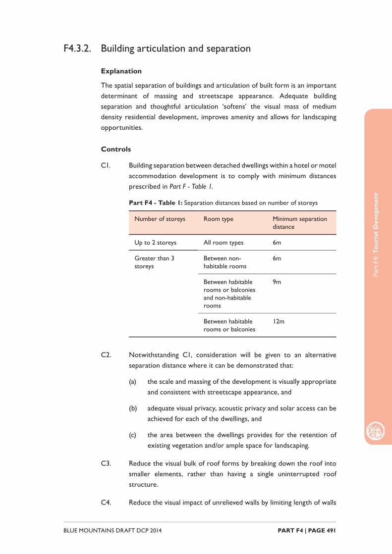
Part
F4:
Tou
rist
Dev
opm
ent
PART F4 | PAGE 491BLUE MOUNTAINS DRAFT DCP 2014
F4.3.2. Building articulation and separation
Explanation
The spatial separation of buildings and articulation of built form is an important determinant of massing and streetscape appearance. Adequate building separation and thoughtful articulation ‘softens’ the visual mass of medium density residential development, improves amenity and allows for landscaping opportunities.
Controls
C1. Building separation between detached dwellings within a hotel or motel accommodation development is to comply with minimum distances prescribed in Part F - Table 1.
Part F4 - Table 1: Separation distances based on number of storeys
Number of storeys Room type Minimum separation distance
Up to 2 storeys All room types 6m
Greater than 3 storeys
Between non-habitable rooms
6m
Between habitable rooms or balconies and non-habitable rooms
9m
Between habitable rooms or balconies
12m
C2. Notwithstanding C1, consideration will be given to an alternative separation distance where it can be demonstrated that:
(a) the scale and massing of the development is visually appropriate and consistent with streetscape appearance, and
(b) adequate visual privacy, acoustic privacy and solar access can be achieved for each of the dwellings, and
(c) the area between the dwellings provides for the retention of existing vegetation and/or ample space for landscaping.
C3. Reduce the visual bulk of roof forms by breaking down the roof into smaller elements, rather than having a single uninterrupted roof structure.
C4. Reduce the visual impact of unrelieved walls by limiting length of walls
Part
F4:
Tou
rist
Dev
elop
men
t
BLUE MOUNTAINS DRAFT DCP 2014 PART F4 | PAGE 492
and / or articulating built form, particularly on narrow side and rear setbacks.
F4.3.3. Site Requirements and Services
C1. Development for hotel or motel accommodation is not to be located on land without a reticulated sewerage system in place that has the existing capacity to service the development, or can be upgraded to accommodate the additional capacity as part of the development.
C2. For new construction the provision of electricity and gas services is to be provided underground.
F4.3.4. Parking and Access
Explanation
Development for hotel or motel accommodation, serviced apartments or backparckers’ accommodation has the potential, particularly larger scale proposals, to generate a substantial parking need. Onsite parking is important to ensure that development does not impact on adjoining neighbours and the local street network. It is important that these parking areas are appropriately designed and located to allow for safe and effi cient vehicle movement to and from the site, as well minimise the impact of these hard stand areas on local amenity of the streetscape.
Objectives
O1. To ensure that development for the purposes of hotel or motel accommodation provides onsite parking that is adequate for the land use, without compromising streetscape appearance or traffi c safety and function.
Controls
Driveways
C1. Only one driveway is to be provided at each road frontage of an allotment.
C2. Notwithstanding C1, Council may consider a second driveway where it can be demonstrated that:
(a) an allotment has a frontage of substantial width, and
(b) it is required for manoeuvrability within the site (due to the
Part
F4:
Tou
rist
Dev
opm
ent
PART F4 | PAGE 493BLUE MOUNTAINS DRAFT DCP 2014
operation of the commercial use or the size of vehicle required to access the site), and
(c) suffi cient on-street parking is available in the locality, and
(d) traffi c and pedestrian safety will not be compromised.
C3. The alignment of driveways shall be located at least 2m from any side boundary to provide space for landscaping and pervious area.
C4. Driveways are to be positioned so that on-street parking and landscaping on the site is maximised, and removal or damage to existing street trees is avoided.
C5. Driveway widths are to comply with Australian Standard 2890.2 Parking facilities – Off-street commercial parking facilities and be a minimum of 3m wide and no wider than the opening associated with the parking facility other than as necessary to enable vehicles to access car parking spaces.
C6. Driveways associated with large scale hotel or motel accommodation shall be designed to:
(a) enable vehicles to enter and leave the site in a forward direction, and
(b) be capable of accommodating the entry and exit manoeuvers of the largest vehicle expected to enter the site.
Parking
C7. On-site parking is to be provided in accordance with the parking rates table provided at Part E2 Traffi c, Parking and Access of this DCP, Part E2: Table 2.
C8. Car parking areas are to be located behind the front alignment of buildings and are not to form a visually prominent element of the streetscape.
C9. Where parking cannot be located behind the front building alignment, parking areas are to be designed to provide appropriate space for landscaping; both on the boundaries and along street frontages, as well as at regular intervals between parking spaces.
Basement parking
C10. Basement car parking shall:
(a) be located within the limits of the building footprint and project
Part
F4:
Tou
rist
Dev
elop
men
t
BLUE MOUNTAINS DRAFT DCP 2014 PART F4 | PAGE 494
no more than 1m above natural ground level, and
(b) facilitate natural ventilation, and
(c) incorporate lighting in accordance with the Australian Standard 1680.2.1 Interior and workplace lighting – Specifi c applications – Circulation spaces and other general areas.
C11. Separate pedestrian access to buildings is to be provided.
F4.3.5. Landscaping Development for the purposes of hotel or motel accommodation, serviced apartments or backpackers’ accommodation generally results in higher urban densities and there are subsequently fewer opportunities to achieve good landscaping outcomes. For this reason, it is important that existing vegetation and desired landscape outcomes are considered in more detail at the development design stage. This includes consideration of landscaping within the main part of the site, and specifi cally within parking areas for the proposed development.
Note: The landscaping controls prescribed below supplement the objectives and
controls prescribed in Part C3 Landscaping.
Objectives
O1. To ensure hotel or motel accommodation is appropriately planned and designed to:
(a) provide for adequate and appropriate areas are set aside for landscape purposes, and
(b) accommodate landscaped areas within car parks and associated hard stand areas.
Controls
C1. To facilitate absorption of run-off and provide for adequate landscaping opportunities, a deep soil zone comprising at least 10% of the site area is to be provided as a single area at the rear of the site. Where the pattern of neighbourhood development has deep soil planting at the front of the site, it may be desirable to replicate this pattern.
Landscaping for Car park Areas
C2. Landscaping is to be used to minimise the physical and visual dominance of car parking and vehicular circulation areas.
C3. Where it is not possible or practical to retain existing trees, new

Part
F4:
Tou
rist
Dev
opm
ent
PART F4 | PAGE 495BLUE MOUNTAINS DRAFT DCP 2014
advanced trees are to be provided within the landscaped areas to rapidly reinstate a canopy presence of equivalent stature.
C4. The soil volume provided within planter beds is to be suffi cient to ensure successful establishment and growth of selected tree and shrub species. As a guide the following soil volumes (unobstructed root area) are required for tree establishment:
(a) Between 5 and 15m3 for a small tree (6-8m height with a 5m crown spread), and
(b) Between 20 and 40m3 for a medium sized tree (10-12m height with a 8m crown spread), and
(c) Between 50 and 80m3 for a large tree (16-20m height with a 16m crown spread).
C5. Planter beds are to use Gap Graded or “structural” soils in the subsoil layer to assist in the provision of a sustainable growing medium for selected species. Structural subsoil is to also be provided beneath parking bays adjacent to planted trees so as to increase available soil volume.
C6. In order to reduce the potential for damage to tree trunks and to reduce subsequent pruning maintenance, trees are to be located to the centre of planting beds.
C7. Plant materials selected are to be compatible with pedestrian access, safety and amenity. Trees which produce high levels of leaf, fl ower or fruit debris or large quantities of resin are to be avoided.
C8. Plant spacing, layout and characteristics are to provide adequate opportunities for natural surveillance and the maintenance of required sight lines at egress and entrance points.
C9. Artifi cial lighting and associated infrastructure is to be located so as to avoid confl ict with existing and proposed canopy elements. Ensure adequate space is provided to accommodate mature tree canopy without compromising illumination.
F4.3.6. Visual privacy
Explanation
Complete visual privacy is often diffi cult to achieve in the urban context and is not necessarily desirable. Some level of cross viewing between properties is benefi cial as this serves to improve security through passive surveillance.
Part
F4:
Tou
rist
Dev
elop
men
t
BLUE MOUNTAINS DRAFT DCP 2014 PART F4 | PAGE 496
Note: Council’s assessment of development applications is guided by Land and
Environment Court Planning Principles. In the case of privacy Council may refer to the
Planning Principle established in Meriton v Sydney City Council [2004] NSWLEC 313 to
guide the decision making process.
Controls
C1. Proposed habitable room windows with a direct outlook to habitable room windows or private open space of an adjacent dwelling are to have a separation distance of no less than 6m.
C2. Where proposed habitable room windows will have a direct outlook to habitable room windows or private open space of an adjacent dwelling and are separated by less than 9m, the window shall:
(a) be offset a minimum of 1m from the edge of the proposed window to the edge of the existing window, or
(b) have sill heights of at least 1.6m above fl oor level, or
(c) have fi xed obscure glazing applied to any part of the window below 1.6m above fl oor level.
C3. Overlooking to private open space areas on adjoining properties is to be reduced by ensuring that any upper level balconies are designed and screened to minimise the potential for overlooking of the private open space of any lower level of adjoining dwellings.
C4. Where potential overlooking cannot be avoided, views of private open space areas may be obscured in the following ways:
(a) by solid translucent screens or perforated panels or trellises, which have a maximum of 25% openings and that are designed to blend in with the proposed redevelopment, and are to be permanent components of the structure and diffi cult to alter,
(b) by retention or planting of dense mature vegetation on the development site, if used in conjunction with (a).
C5. The setback between shared driveways or access ways (including a right of carriageway) and the habitable room windows of a dwelling is to be no less than 1.5m.
F4.3.7. Acoustic privacy
Explanation
Clever layout and design can serve to improve acoustic amenity, particularly
Part
F4:
Tou
rist
Dev
opm
ent
PART F4 | PAGE 497BLUE MOUNTAINS DRAFT DCP 2014
in regard to the positioning of noise generating rooms such as living areas, and designing to minimise impacts from external noise sources such as rail corridors and busy roads.
Controls
C1. Outdoor facilities including swimming pools, tennis courts and BBQ areas are to be located away from noise sensitive rooms of adjoining dwellings.
C2. Operating plant, including air conditioning systems, generators or other equipment, is to be located:
(a) suffi ciently distant from any adjoining residential development, and
(b) within an enclosed space to provide for noise attenuation and management of fumes, and
(c) to minimise the visual impact on the streetscape and adjoining development.
Depending on the scale and type of the development, impact assessments for Noise and Odour may need to be submitted as part of a development application.
C3. Residential development adjacent to a rail corridor or a classifi ed road is to be located and designed to ameliorate potential noise impacts arising from the adjacent rail corridor or classifi ed road. Refer to requirements in State Environmental Planning Policy (Infrastructure) 2007 and the NSW Department of Planning document Development near Rail Corridors and Busy Roads – Interim Guideline.
F4.3.8. Sunlight access
Explanation
Adequate solar access contributes to the health and amenity of medium density residential development and its inhabitants. Good solar access also reduces reliance on artifi cial lighting and heating which has subsequent fi nancial and environmental benefi ts.
Note: Council’s assessment of development applications is guided by Land and
Environment Court Planning Principles. In the case of sunlight access Council may refer
to the Planning Principle established in The Benevolent Society v Waverley Council
[2010] NSWLEC 1082 to guide the decision making process.

Part
F4:
Tou
rist
Dev
elop
men
t
BLUE MOUNTAINS DRAFT DCP 2014 PART F4 | PAGE 498
Objectives
O1. Medium density development is located and designed to optimise solar access to living rooms and private opens space areas, and to maintain reasonable solar access to adjacent properties.
Controls
C1. Locate and design development so that between the hours of 9am and 3pm on 21 June:
(a) at least 1m2 of living room windows associated with neighbouring development receive a minimum of 3 hours of unobstructed sunlight, and
(b) at least 50% of private open space areas associated with development on adjoining allotments receive a minimum of 3 hours of unobstructed sunlight.
C2. Where pre-development sunlight access enjoyed by development on adjoining allotments is less than the outcomes prescribed in C1, new development is not to create any additional overshadowing for that development.
C3. Limit number of single-aspect dwellings with a southerly aspect (SW-SE) to a maximum of 10% of the total dwellings proposed in development for hotel or motel accommodation.
C4. Shadow diagrams for 9:00 am, 12:00 pm and 3:00 pm on the winter solstice (21 June) are to be submitted with a development application where a building of two storeys or more is proposed.
Note: Council may request that shadow diagrams be submitted for single
storey buildings where solar access is deemed to be an area of concern.
F4.3.9. Views
Explanation
Many dwellings and public places in the Blue Mountains enjoy bushland and escarpment views which contribute to the amenity of the property. New development should be sited and designed to minimise the impact on views, where practicable.
Note: Council’s assessment of development applications is guided by Land and
Environment Court Planning Principles. In the case of view sharing Council may refer
to the Planning Principle established in Tenacity Consulting v Warringah Council [2004]
NSWLEC 140 to guide the decision making process.

Part
F4:
Tou
rist
Dev
opm
ent
PART F4 | PAGE 499BLUE MOUNTAINS DRAFT DCP 2014
Controls
C1. Locate and design development to allow for view sharing ensuring that existing views enjoyed by surrounding properties and from public open spaces are not substantially affected.

Part
F4:
Tou
rist
Dev
elop
men
t
BLUE MOUNTAINS DRAFT DCP 2014 PART F4 | PAGE 500
F4.4. Eco-tourist Facility
Explanation
An eco-tourist facility is a low scale form of tourist accommodation, intended to provide guests with a direct experience of special ecological or cultural features, while being sensitively located within the environment. To ensure this type of development respects the environmental values of the land, factors including the scale of the development, the management of waste, and impacts on visual and landscape values must be appropriately considered.
Objectives
Eco-tourist facilities are to comply with the general objectives at Part F4.1 related to all Tourist and Visitor Accommodation, as well as those listed below:
O1. To comply with the provisions of Clause 5.13 Eco-tourist facilities of Blue Mountains LEP 2014.
O2. To facilitate and support the establishment of low scale nature based tourism in accordance with clause 6.30 of DLEP 2013.
O3. To ensure the size and scale of eco-tourist facilities is consistent with the aim of protecting and enhancing the natural environment or scenic amenity of the locality.
O4. To ensure that eco-tourist facilities are sympathetically designed and sited such that development does not impinge on the amenity of adjoining properties.
F4.4.1. Design and Operation
Controls
C1. The development is to be designed to utilise building materials that blend with the surrounding landscape, promoting the use of recycled materials and materials sourced from the region.
C2. A plan for the environmental repair and enhancement of the property (vegetation management plan or biodiversity conservation management plan) is to be submitted with any development application for an eco-tourist facility.
C3. A verifi cation statement prepared by a suitably qualifi ed consultant ecologist or bushland restoration practitioner is to be provided to the Council on an annual basis. The statement is the verify the ongoing implementation of the measures detailed in the environmental, waste and water management plans.
Part
F4:
Tou
rist
Dev
opm
ent
PART F4 | PAGE 501BLUE MOUNTAINS DRAFT DCP 2014
F4.4.2. Services
Controls
C1. A water management plan is to be submitted with any development application for an eco-tourist facility. The plan is to demonstrate how rain water is to be stored and reused within the facility.
C2. A waste management plan is to be submitted with any development application for an eco-tourist facility. The plan is to set out at a minimum, measures to separate and dispose of green waste, paper products, and other recyclable materials.

Part
F4:
Tou
rist
Dev
elop
men
t
BLUE MOUNTAINS DRAFT DCP 2014 PART F4 | PAGE 502

PART F5SUBDIVISION AND
CONSOLIDATION
Part
F5:
Sub
divi
sion
and
Con
solid
atio
n
BLUE MOUNTAINS DRAFT DCP 2014 PART F5 | PAGE 504
IntroductionIn the Blue Mountains, subdivision of land often has to take into account constraints including bushfi re, environmental issues, water quality, slope, heritage and infrastructure capacity. Accordingly, the nature of subdivision in the Mountains is very different to the large release areas or green fi eld subdivisions in western Sydney.
As there is little remaining land stock available for Torrens title subdivisions, it is anticipated that future higher density development in closer proximity to town centres will result in an increase in strata and community title subdivisions.
Consolidation of allotments does not require consent. It will generally be included as a condition of consent where a development extends over two or more allotments, to avoid any potential separate sale of an essential component of the development.
The minimum area requirements for new allotments and the circumstances where developments may be strata subdivided are prescribed in LEP 2014.
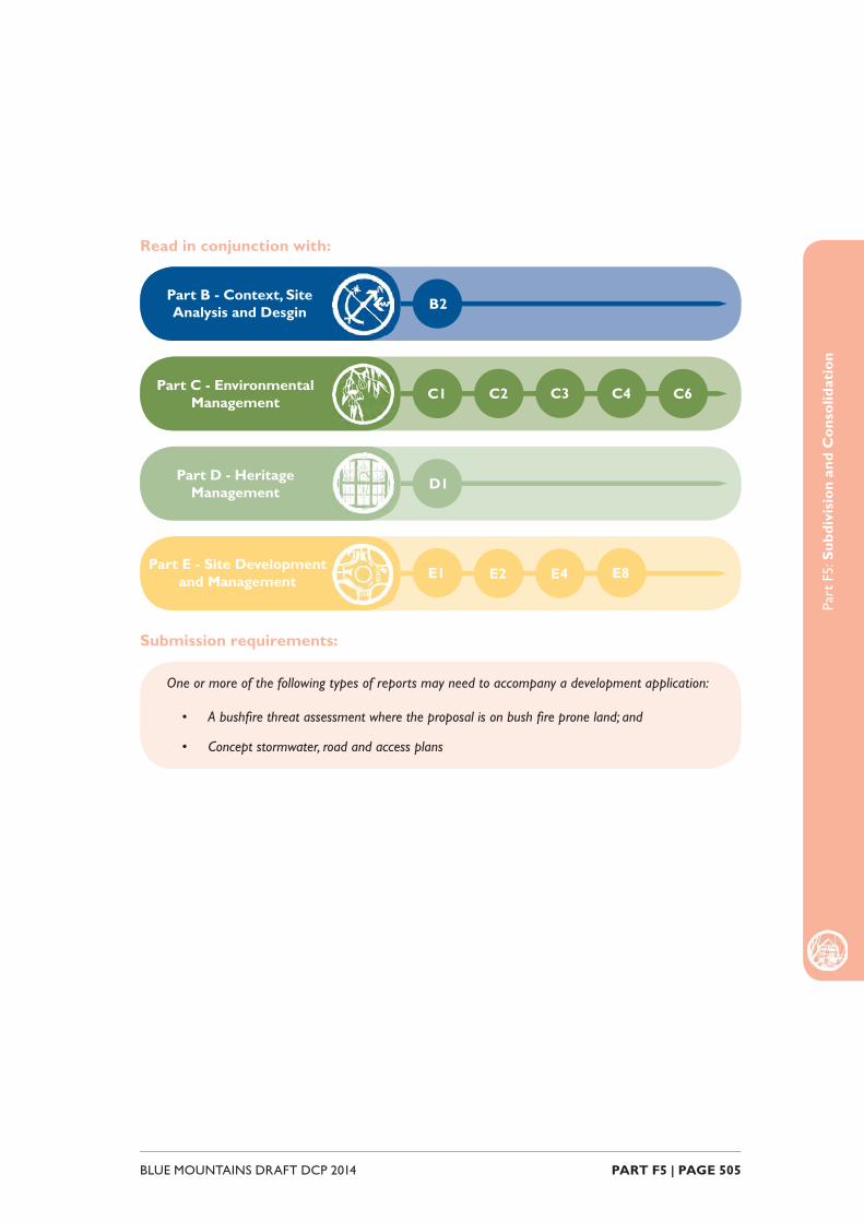
Part
F5:
Sub
divi
sion
and
Con
solid
atio
n
PART F5 | PAGE 505BLUE MOUNTAINS DRAFT DCP 2014
Read in conjunction with:
Submission requirements:
Part C - Environmental Management C1
Part E - Site Development and Management E1
Part D - Heritage Management D1
Part B - Context, Site Analysis and Desgin B2
C2 C3 C4 C6
E2 E4 E8
One or more of the following types of reports may need to accompany a development application:
• A bushfi re threat assessment where the proposal is on bush fi re prone land; and
• Concept stormwater, road and access plans

Part
F5:
Sub
divi
sion
and
Con
solid
atio
n
BLUE MOUNTAINS DRAFT DCP 2014 PART F5 | PAGE 506
F5.1. Subdivision
Objectives
O1. To create lots that can be developed, serviced, accessed and protected from bushfi re while minimising adverse environmental, character, privacy and amenity impacts.
O2. To ensure that the subdivision complements the predominant subdivision pattern of the area.
O3. To ensure that lot sizes and street frontages can support the future development type and function.
O4. To create a subdivision layout that addresses any access and traffi c constraints and maximises vehicle and pedestrian safety.
O5. To ensure the long-term provision of rent controlled affordable housing.
Controls
C1. Subdivision is to be designed to:
(a) ensure that the subdivision works, any necessary bush fi re protection measures and future development of the lots have minimal environmental impact; and
(b) have a lot and road layout that takes the site topography and slope into account to minimise the need for cut and fi ll associated with road, access and future building construction; and
(c) protect natural, cultural and heritage features; and
(d) ensure that a heritage item and its curtilage are wholly contained within a single allotment; and
(e) have regard to the views to and from the site, and
(f) retain signifi cant trees and vegetation communities through:
i. appropriate lot and road confi guration; and
ii. not locating the proposed boundaries through and adjacent to signifi cant vegetation; and
iii. the provision of suitable building envelopes outside the signifi cant vegetation that can be protected from bushfi re without the need to hazard reduce the signifi cant vegetation; and
iv. the alignment of access points and location of services a

Part
F5:
Sub
divi
sion
and
Con
solid
atio
n
PART F5 | PAGE 507BLUE MOUNTAINS DRAFT DCP 2014
suffi cient distance from signifi cant vegetation.
C2. Subdivisions on bushfi re prone land are to comply with the requirements of the NSW Rural Fire Service document Planning for Bush Fire Protection, and ensure that any necessary bush fi re asset protection zones are wholly contained within the site.
C3. New allotments are to be regular in shape, with an orientation and alignment that enables:
(a) future buildings to have adequate street frontage and optimise solar access; and
(b) adequate private open space to be located behind future dwellings; and
(c) parking and stormwater measures for future development to be accommodated wholly within the allotment.
C4. Applications are to demonstrate that new allotments within Zones R2 Low Density Residential, Zone R6 Residential Character Conservation, Zone E3 Environmental Management and Zone E4 Environmental Living are to be able to accommodate a minimum 300m2 building envelope that:
(a) is 15m by 20m or 12m by 25m, and
(b) is not Environmentally Constrained Land, and
(c) is wholly outside the Flood Planning Area as shown on the Flood Planning map, and
(d) is not within the boundary setbacks prescribed by BMLEP 2014 or the DCP; and
(e) can be readily and safely accessed by a vehicle from a public road.
C5. Applications are to demonstrate that new allotments within Zones R2 Low Density Residential, R6 Residential Character Conservation, E3 Environmental Management and E4 Environmental Living are able to accommodate a minimum 150m2 area for private open space that:
(a) is at least 10m wide or deep, and
(b) is not Environmentally Constrained Land, and
(c) is does not contain land steeper than 10% slope, and
(d) is located behind the building envelope specifi ed in control C4, and
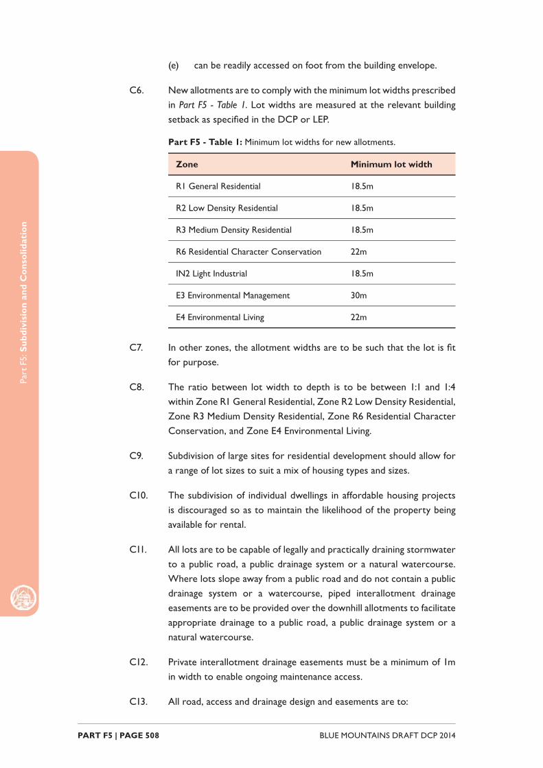
Part
F5:
Sub
divi
sion
and
Con
solid
atio
n
BLUE MOUNTAINS DRAFT DCP 2014 PART F5 | PAGE 508
(e) can be readily accessed on foot from the building envelope.
C6. New allotments are to comply with the minimum lot widths prescribed in Part F5 - Table 1. Lot widths are measured at the relevant building setback as specifi ed in the DCP or LEP.
Part F5 - Table 1: Minimum lot widths for new allotments.
Zone Minimum lot width
R1 General Residential 18.5m
R2 Low Density Residential 18.5m
R3 Medium Density Residential 18.5m
R6 Residential Character Conservation 22m
IN2 Light Industrial 18.5m
E3 Environmental Management 30m
E4 Environmental Living 22m
C7. In other zones, the allotment widths are to be such that the lot is fi t for purpose.
C8. The ratio between lot width to depth is to be between 1:1 and 1:4 within Zone R1 General Residential, Zone R2 Low Density Residential, Zone R3 Medium Density Residential, Zone R6 Residential Character Conservation, and Zone E4 Environmental Living.
C9. Subdivision of large sites for residential development should allow for a range of lot sizes to suit a mix of housing types and sizes.
C10. The subdivision of individual dwellings in affordable housing projects is discouraged so as to maintain the likelihood of the property being available for rental.
C11. All lots are to be capable of legally and practically draining stormwater to a public road, a public drainage system or a natural watercourse. Where lots slope away from a public road and do not contain a public drainage system or a watercourse, piped interallotment drainage easements are to be provided over the downhill allotments to facilitate appropriate drainage to a public road, a public drainage system or a natural watercourse.
C12. Private interallotment drainage easements must be a minimum of 1m in width to enable ongoing maintenance access.
C13. All road, access and drainage design and easements are to:
Part
F5:
Sub
divi
sion
and
Con
solid
atio
n
PART F5 | PAGE 509BLUE MOUNTAINS DRAFT DCP 2014
(a) be in accordance with the Council’s Design and Construction Specifi cation; and
(b) comply with the Council’s Public Domain Technical Manual Specifi cation within town centres; and
(c) comply with the NSW Rural Fire Service document Planning for Bush Fire Protection in bush fi re prone areas.
C14. All services are to be installed underground where new roads are created or existing roads are extended as part of the subdivision.
Battleaxe allotments
C15. For the purpose of Controls C16 to C19, a ‘battleaxe allotment’ is a lot proposed in a subdivision that relies on an access handle or a right of carriageway for the provision of access to a public road.
C16. The area of the battleaxe handle is excluded from the minimum lot area calculation for a battleaxe allotment as per Part F5 - Figure 1.
C17. Where a battleaxe allotment is accessed via a right of carriageway, the area and width of the right of carriageway is excluded from the minimum area and width calculations on the burdened lot as per Part F5 - Figure 2.
C18. Notwithstanding C17, the area and width of the right of carriageway is included in the minimum area and width calculations on the burdened lot only if that right-of-carriageway will provide the sole vehicular access for a dwelling on the burdened lot.
Part F5 - Figure 2: Calculating the minimum area of a battleaxe
allotment (Lot 2); the battleaxe handle area (A x B) is to be excluded
from Lot 2.

Part
F5:
Sub
divi
sion
and
Con
solid
atio
n
BLUE MOUNTAINS DRAFT DCP 2014 PART F5 | PAGE 510
Part F5 - Figure 2: Calculating the minimum area and width of a
lot burdened by a right of carriageway to a battleaxe allotment; the
right of carriageway area (A x B) and width (B) is to be excluded from
Lot 1 where vehicle access to Lot 1 is located outside the right of
carriageway.
C19. A handle to a battleaxe allotment is to:
(a) have a passing bay approximately at mid length where the handle is longer than 50m, and
(b) serve a maximum of 3 allotments, and
(c) be a minimum of 4.5m wide where accessing a single allotment, and
(d) be a minimum of 6m wide where serving more than 1 allotment.
Strata subdivisions
C20. The strata titling of commercial and industrial development and affordable housing is discouraged as it may restrict the future redevelopment potential of the site by having multiple different owners.
C21. Within a strata or community title subdivision, parking spaces and spaces used for other purposes (eg: storage) that are associated with an individual unit are to be included in the same allotment as the unit.
C22. Landscaping, communal open space, access areas, services areas and directory board signage, where not part of an individual unit in a strata subdivision, are to be designated as common property.
Part
F5:
Sub
divi
sion
and
Con
solid
atio
n
PART F5 | PAGE 511BLUE MOUNTAINS DRAFT DCP 2014
F5.2. Consolidation
Objectives
O1. To minimise the potential of integral parts of a development being sold separately.
O2. To promote the effi cient use of land and to avoid the creation of sites that are isolated from established urban settlements.
Controls
C1. Where development extends over 2 or more allotments, the allotments are to be consolidated prior to the issue of any Occupation Certifi cate.
C2. Consolidation of allotments for multi-unit development is encouraged so as to avoid isolated single dwellings on small lots surrounded by high density development.

Part
F5:
Sub
divi
sion
and
Con
solid
atio
n
BLUE MOUNTAINS DRAFT DCP 2014 PART F5 | PAGE 512

PART F6SIGNAGE

Part
F6:
Sig
nage
BLUE MOUNTAINS DRAFT DCP 2014 PART F6 | PAGE 514
IntroductionRational, well located and appropriately designed signage serves to effectively identify and promote buildings and businesses in the Blue Mountains and can positively contribute to streetscape character. Conversely, signs that are inappropriately located, poorly designed and excessive in number create visual and physical clutter and can signifi cantly detract from streetscape character. The objectives and controls contained in this part of the DCP apply to proposals for or incorporating signage.
Part
F6:
Sig
nage
PART F6 | PAGE 515BLUE MOUNTAINS DRAFT DCP 2014
Read in conjunction with:
Relationship to other legislation and documents:
Part F - Specifi c Development Types F2
Part G - Precincts All
F3
• State Environmental Planning Policy (Exempt and Complying Codes) 2008
• State Environmental Planning Policy No. 64 - Advertising and Signage
Part
F6:
Sig
nage
BLUE MOUNTAINS DRAFT DCP 2014 PART F6 | PAGE 516
F6.1. General requirements
F6.1.1. General objectives
O1. To provide a consistent approach to the control, location and design of signage.
O2. To encourage signage that is compatible with the desired amenity and visual character of an area.
O3. To ensure that signage is of a high quality design and fi nish.
O4. To ensure signage is adequate and effective and recognises the need for signs to provide direction, business identifi cation and promotion.
O5. To prevent the proliferation of signage and to encourage the rationalisation of existing and proposed signs.
O6. To ensure signs are not located where they may be hazardous and/or distracting to pedestrians or motorists.
F6.1.2. Unacceptable signageCertain sign types and displays have the potential to signifi cantly detract from the unique character of Blue Mountains townships. Sign types and displays which may be common in areas of metropolitan Sydney are often not appropriate in the historic village and bushland contexts of the Blue Mountains. The following signs are discouraged and will generally not be supported by Council:
(a) Advertising displays, including commercial advertising and advertising for promotional purposes,
(b) Bunting, other than of a temporary nature (fetes, festivals and the like),
(c) Flashing and animated (moving) signs,
(d) Above awning signs being a sign constructed or installed above the awning of a building,
(e) Roof or sky signs being a sign constructed or installed above the roof, parapet or eaves of a building,
(f) Large infl atable signs such as those used for commercial promotions,
(g) Signs displayed on parked vehicles.
F6.1.3. Exempt DevelopmentSome forms of advertising and signage fall into the category of exempt development, that is, development for which consent is not required. State Environmental Planning Policy (Exempt and Complying Development Codes) 2008 (Codes SEPP) prescribes a range of exempt signage types and their associated
Part
F6:
Sig
nage
PART F6 | PAGE 517BLUE MOUNTAINS DRAFT DCP 2014
development standards. Where signage does not satisfy the development standards of the Codes SEPP, the proposal is likely to require consent and will be assessed against the objectives and controls contained within this part of the DCP.
F6.1.4. Replacement of existing signsPart 2, Division 2 of the Codes SEPP allows the replacement of existing building identifi cation and business identifi cation signs and the content of such signs without the need for consent, subject to a series of development standards. The development standards specify that the development (or replacement sign) must:
(a) replace a lawful sign, and
(b) not be greater in size than the sign that it replaces, and
(c) not be animated, fl ashing or illuminated unless the sign it replaces has development consent to be animated, fl ashing or illuminated, and
(d) not involve any alteration to the structure on which the sign is displayed, and
(e) not obstruct or interfere with traffi c signs.
Alterations to existing approved signs beyond what is permitted by the Codes SEPP will require modifi cation of the corresponding development consent pursuant to Section 96 of the Environmental Planning and Assessment Act 1979 (EP&A Act). An application to modify an existing consent for signage will be assessed against the objectives and controls contained within this part of the DCP.
F6.1.5. Signage in the public domainCouncil’s Local Approval Policy permits the placement of a-frame, sandwich board signs and information display stands on public roads (i.e. footpaths) without the need for approval, provided that they comply with the prescribed criteria. Such signs must be positioned so as not to present a public hazard to pedestrians or vehicles. The Local Approvals Policy can be downloaded from Council’s website.
Where a sign or part of a sign projects over a public road, including a footpath, the sign is to be approved under section 138 of the Roads Act 1993. An application for such an approval is to be made to Council and is commonly termed a Roads Act Approval. Where the signage proposal is the subject of a development application, any subsequent consent will include a condition requiring the Roads Act Approval, if such an approval is required.
Part
F6:
Sig
nage
BLUE MOUNTAINS DRAFT DCP 2014 PART F6 | PAGE 518
F6.1.6. Number, location and design of signs
Controls
Number of signs permitted
C1. No more than 1 building identifi cation sign per street frontage.
C2. No more than 3 business identifi cation signs are permitted to be constructed or installed in relation to a building if the building houses only one commercial tenant.
C3. No more than 6 business identifi cation signs are permitted to be constructed or installed in relation to any building.
C4. No more than one business identifi cation sign is permitted to be constructed or installed in relation to a home business, home industry or home occupation.
Location of signs
C5. Signage must pertain to the business or use carried out on the land upon which the sign is installed or constructed.
C6. Location of signs should generally be confi ned to the ground level of buildings, the awning fascia or suspended under the awning.
C7. Multi-unit buildings within industrial zones are to be identifi ed at the entrance by a directory board sign, identifying the name of the units, and the occupants.
Note: Maintenance of directory board signs should be the responsibility of
the body corporate or the owner.
Design of signs
C8. Signs are to be integrated into the design of the building to which the sign relates.
C9. The scale and confi guration of a sign should be compatible with the scale of the building or site to which the sign relates.
C10. Signage proposals are to give consideration to existing signs on a building or within a site as well as the streetscape to ensure that any new sign does not result in visual and physical clutter.
C11. Corporate colours, logos and other graphics are to achieve a high degree of compatibility with the architecture, materials, fi nishes and
Part
F6:
Sig
nage
PART F6 | PAGE 519BLUE MOUNTAINS DRAFT DCP 2014
colours of the building or site to which the sign relates and is to complement the streetscape.
C12. Signs are to add visual interest and exhibit a high level of design quality.
C13. Signs in residential zones are to be discreet and consistent with residential character. In this regard, colour schemes of signs should complement the colour schemes of the subject and surrounding properties.
C14. Where a signage proposal relates to a site or building that is in the vicinity of a heritage item, the proposal must not detract from the heritage signifi cance of the item by impacting visual curtilage or streetscape character.
F6.1.7. Illumination
Objectives
O1. To ensure that illumination of signs, whether internal or external, does not impact on the amenity or character of Blue Mountains villages.
Controls
C1. Illumination should be minimal and simple. In this regard, fl ashing and animated (moving) signs will generally not be supported by Council.
C2. Illuminated signs are to comply with AS 4282, Control of the obtrusive effects of outdoor lighting.
C3. Lighting is to be located and directed to avoid light spill that is likely to:
(a) impact the safety of pedestrians or vehicles, and/or
(b) detract from the amenity of any residence or other form of accommodation.
C4. In some cases Council may require that illuminated signs:
(a) have the functionality to allow the intensity of illumination to be adjusted, and/or
(b) be subject to a curfew, or limited to hours of operation.
C5. Cables, fi xtures and fi ttings associated with an illumination scheme are not to detract from the appearance of the building or site to which the illumination scheme relates and should be concealed where possible.
Part
F6:
Sig
nage
BLUE MOUNTAINS DRAFT DCP 2014 PART F6 | PAGE 520
F6.1.8. Heritage items and heritage conservation areasThe following objectives and controls apply to items and areas of environmental heritage listed in Schedule 5 of Blue Mountains Local Environmental Plan 2014 (LEP 2014).
Where signage is proposed to be constructed or installed on a heritage item or within a heritage conservation area (HCA), a development application is generally required. Where a site is listed as an item of State Signifi cance under the Heritage Act 1977, separate approval may be required from the NSW Heritage Council.
It is important that the location, design and confi guration of signs constructed or installed on or in the vicinity of a heritage item or within a HCA is carefully considered to achieve a high degree of compatibility with the heritage signifi cance of the building or streetscape so as not to detract from that signifi cance.
Objectives
O1. To ensure that existing signs on heritage items and within heritage conservation areas that have heritage signifi cance are retained and conserved, and not compromised by the construction or installation of any new sign.
O2. To ensure that the installation of signage does not result in irreversible damage to signifi cant heritage fabric.
O3. To ensure that signage is compatible with the signifi cance of a heritage item or heritage conservation area in terms of location, confi guration, materials, fi nishes and colours, and that adverse impact is minimised.
O4. To ensure that the signifi cance of a heritage item or heritage conservation area is not compromised by excessive signage.
Controls
Signage location
C1. Where a sign is proposed to be constructed or installed on a heritage item or within a heritage conservation area, the location and confi guration of the sign is to accord with the following:
(a) Signs above the ground fl oor or awning level are not permitted unless it can be demonstrated that the area was historically used for signage, and
(b) A sign is not to dominate the architectural form or features of a heritage listed building and is to be proportionate to any architectural feature to which the sign may relate, and
Part
F6:
Sig
nage
PART F6 | PAGE 521BLUE MOUNTAINS DRAFT DCP 2014
(c) Historic signs may have their own signifi cance and are not to be obscured or damaged by new signage, and
(d) New signage is to be located at a reasonable and respectful distance from the borders of existing signifi cant signage.
Signage Design
C2. Where a sign is proposed to be constructed or installed on a heritage item or within a heritage conservation area, the design of the sign is to demonstrate the following:
(a) Materials are to be compatible with the heritage signifi cance of the heritage item or heritage conservation area, and be typical of the era or style of building to which the sign relates, and
E.g. matte fi nish rather than glossy; painted signs rather than printed.
(b) Colours are to be sympathetic to the heritage signifi cance of the heritage item or heritage conservation area. This includes corporate signage which will require special consideration and design to avoid visually dominating the character of the heritage building or place.
E.g. muted tones rather than bright colours.
C3. The installation or construction of internally illuminated signs on a heritage item or within a heritage conservation area is discouraged unless it can be demonstrated that internal illumination is an important aspect of the heritage signifi cance of that item or area.
C4. Externally illuminated signs are permitted only where:
(a) The design of the sign achieves a high degree of compatibility with the heritage item or heritage conservation area; and
(b) The cabling and conduit supplying power to the sign is concealed and does not involve or damage of signifi cant fabric.
C5. The number of signs installed or constructed on a heritage item is not to be excessive and generally be limited to two signs e.g. an awning fascia and under awning sign.
Note: Where a heritage building has multiple street front tenancies,
additional signs will be considered on a merits basis.
C6. The construction or installation of any sign on a heritage item is to be undertaken in such a manner that damage to signifi cant fabric is avoided or reversible.
Part
F6:
Sig
nage
BLUE MOUNTAINS DRAFT DCP 2014 PART F6 | PAGE 522
Further Information
The following reference material offers helpful guidance on appropriate sign design in heritage conservation areas and on heritage buildings.
• Conserving Historic Signs: Conservation Guidelines for Historic Signs and New Signs on Heritage Buildings, NSW Heritage Offi ce, 2006.
• Street Smart: Corporate Development in Historic Town Centres, NSW Heritage Offi ce, 1998.
• Streetwise: A Practical Guide for the Revitalisation of Commercial Heritage Precincts and Traditional Main Streets in Australian Cities and Towns, Elizabeth Vines, the National Trust of Australia, 1996.

Part
F6:
Sig
nage
PART F6 | PAGE 523BLUE MOUNTAINS DRAFT DCP 2014
F6.2. Controls for specifi c sign types
F6.2.1. Building identifi cation signsA building identifi cation sign is defi ned as a sign that identifi es or names a building and that may include the name of a building, the street name and number of a building, and a logo or other symbol but does not include general advertising of products, goods or services.
Note: Building identifi cation signs may be exempt development pursuant to State
Environmental Planning Policy (Exempt and Complying Development Codes) 2008 (Codes
SEPP).
Controls
C1. Subject to C2, building identifi cation signs are to accord with each of the design requirements prescribed in Part F6 - Table 1:
Part F6 - Table1: Design requirements for building identifi cation signs
Element Standard
Maximum No. of signs Limited to one per elevation
Maximum area (per sign) 2.5m2
Installation Flat mounted against exterior wall or parapet
Maximum projection 300mm from face of wall or parapet
Illumination Permitted if not animated, fl ashing or moving
C2. Building identifi cation signs that do not accord with the design requirements prescribed in C1 are unlikely to be supported however will be assessed on the merits of the proposal and are to demonstrate:
(a) compatibility with the existing or desired future character of an area, and
(b) compatibility with scale, proportion and other characteristics of the building or site on which the signage is proposed to be located.
F6.2.2. Wall signs A wall sign is defi ned as a business identifi cation sign (including a business identifi cation sign for a home business) that is fl at mounted or painted on the exterior wall of an existing building, or on an existing boundary fence or wall.
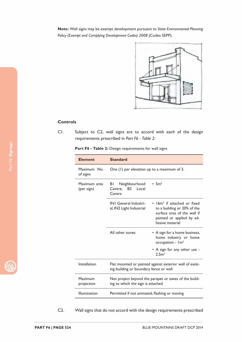
Part
F6:
Sig
nage
BLUE MOUNTAINS DRAFT DCP 2014 PART F6 | PAGE 524
Note: Wall signs may be exempt development pursuant to State Environmental Planning
Policy (Exempt and Complying Development Codes) 2008 (Codes SEPP).
Controls
C1. Subject to C2, wall signs are to accord with each of the design requirements prescribed in Part F6 - Table 2:
Part F6 - Table 2: Design requirements for wall signs
Element Standard
Maximum No. of signs
One (1) per elevation up to a maximum of 3.
Maximum area (per sign)
B1 Neighbourhood Centre, B2 Local Centre
• 5m2
IN1 General Industri-al, IN2 Light Industrial
• 16m2 if attached or fi xed to a building or 20% of the surface area of the wall if painted or applied by ad-hesive material
All other zones • A sign for a home business, home industry or home occupation - 1m2
• A sign for any other use - 2.5m2
Installation Flat mounted or painted against exterior wall of exist-ing building or boundary fence or wall
Maximum projection
Not project beyond the parapet or eaves of the build-ing to which the sign is attached
Illumination Permitted if not animated, fl ashing or moving
C2. Wall signs that do not accord with the design requirements prescribed

Part
F6:
Sig
nage
PART F6 | PAGE 525BLUE MOUNTAINS DRAFT DCP 2014
in C1 will be assessed on the merits of the proposal and are to demonstrate:
(a) compatibility with the existing or desired future character of an area, and
(b) contribution to visual interest of the streetscape or setting, and
(c) compatibility with scale, proportion and other characteristics of the building or site on which the signage is proposed to be located, and
(d) rationalisation of existing signage and the minimisation of visual and physical clutter.
F6.2.3. Fascia signsA fascia sign is defi ned as a business identifi cation sign on the existing fascia of the awning of a building.
Note: Fascia signs may be exempt development pursuant to State Environmental Planning
Policy (Exempt and Complying Development Codes) 2008 (Codes SEPP).
Controls
C1. Subject to C2, fascia signs are to accord with each of the design requirements prescribed in Part F6 - Table 3:
Part F6 - Table 3: Design requirements for fascia signs
Element Standard
Installation Flat mounted or painted and securely fi xed to the fascia
Maximum projection Not project below, above or beyond the sides of the fascia

Part
F6:
Sig
nage
BLUE MOUNTAINS DRAFT DCP 2014 PART F6 | PAGE 526
Location 600mm behind the alignment of any kerb in the adjacent road
Illumination Must not be illuminated
C2. Fascia signs that do not accord with the design requirements prescribed in C1 are unlikely to be supported however will be assessed on the merits of the proposal, and are to demonstrate:
(a) compatibility with the existing or desired future character of an area, and
(b) compatibility with scale, proportion and other characteristics of the building or site on which the signage is proposed to be located.
F6.2.4. Under awning signsAn under awning sign is defi ned as a business identifi cation sign suspended below the existing awning of a building.
Note: Under awning signs may be exempt development pursuant to State Environmental
Planning Policy (Exempt and Complying Development Codes) 2008 (Codes SEPP).
Controls
C1. Subject to C2, under awning signs are to accord with each of the design requirements prescribed in Part F6 - Table 4:
Part F6 - Table F7.4: Design requirements for under awning signs
Element Standard
Maximum No. of signs One (1) per ground fl oor tenancy. 2 under awning signs permitted where a tenancy is situated on a corner allotment and has a front-age to both streets.
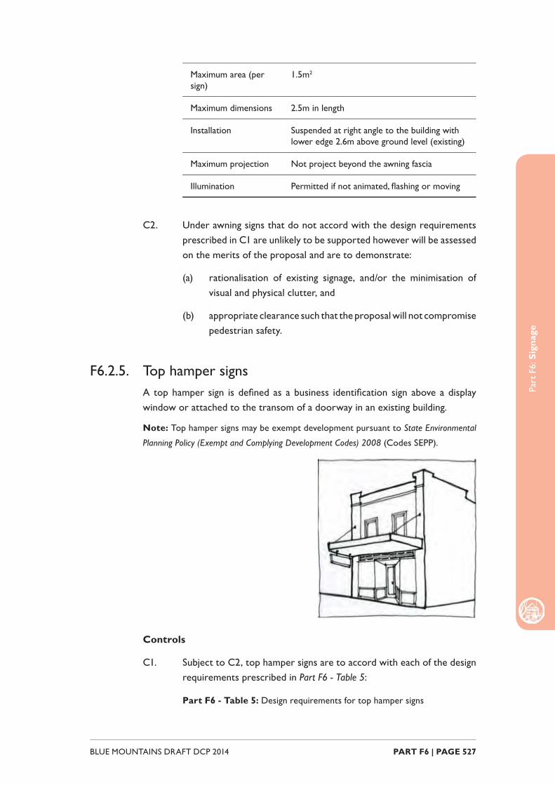
Part
F6:
Sig
nage
PART F6 | PAGE 527BLUE MOUNTAINS DRAFT DCP 2014
Maximum area (per sign)
1.5m2
Maximum dimensions 2.5m in length
Installation Suspended at right angle to the building with lower edge 2.6m above ground level (existing)
Maximum projection Not project beyond the awning fascia
Illumination Permitted if not animated, fl ashing or moving
C2. Under awning signs that do not accord with the design requirements prescribed in C1 are unlikely to be supported however will be assessed on the merits of the proposal and are to demonstrate:
(a) rationalisation of existing signage, and/or the minimisation of visual and physical clutter, and
(b) appropriate clearance such that the proposal will not compromise pedestrian safety.
F6.2.5. Top hamper signsA top hamper sign is defi ned as a business identifi cation sign above a display window or attached to the transom of a doorway in an existing building.
Note: Top hamper signs may be exempt development pursuant to State Environmental
Planning Policy (Exempt and Complying Development Codes) 2008 (Codes SEPP).
Controls
C1. Subject to C2, top hamper signs are to accord with each of the design requirements prescribed in Part F6 - Table 5:
Part F6 - Table 5: Design requirements for top hamper signs
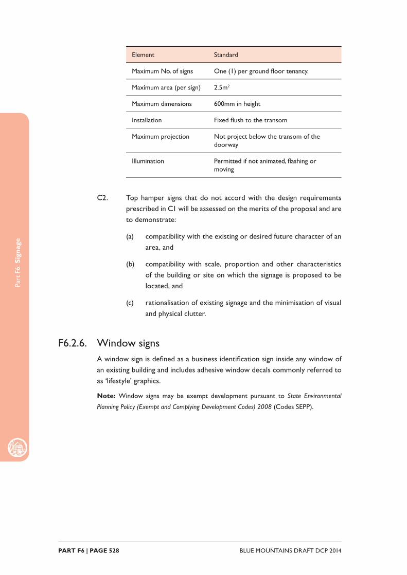
Part
F6:
Sig
nage
BLUE MOUNTAINS DRAFT DCP 2014 PART F6 | PAGE 528
Element Standard
Maximum No. of signs One (1) per ground fl oor tenancy.
Maximum area (per sign) 2.5m2
Maximum dimensions 600mm in height
Installation Fixed fl ush to the transom
Maximum projection Not project below the transom of the doorway
Illumination Permitted if not animated, fl ashing or moving
C2. Top hamper signs that do not accord with the design requirements prescribed in C1 will be assessed on the merits of the proposal and are to demonstrate:
(a) compatibility with the existing or desired future character of an area, and
(b) compatibility with scale, proportion and other characteristics of the building or site on which the signage is proposed to be located, and
(c) rationalisation of existing signage and the minimisation of visual and physical clutter.
F6.2.6. Window signsA window sign is defi ned as a business identifi cation sign inside any window of an existing building and includes adhesive window decals commonly referred to as ‘lifestyle’ graphics.
Note: Window signs may be exempt development pursuant to State Environmental
Planning Policy (Exempt and Complying Development Codes) 2008 (Codes SEPP).

Part
F6:
Sig
nage
PART F6 | PAGE 529BLUE MOUNTAINS DRAFT DCP 2014
Controls
C1. Subject to C2, window signs and decals are to accord with each of the design requirements prescribed in Part F6 - Table 6:
Part F6 - Table 6: Design requirements for window signs
Element Standard
Maximum area Not cover more than 20% of the surface of the win-dow in which it is displayed or 6m2, whichever is the lesser
Location Must not unreasonably obstruct existing or potential sight lines between the interior of a premise and the public domain, or compromise active street frontages. Consideration will be given to privacy requirements.
Illumination Must not be illuminated
C2. Window signs that do not accord with the design requirements prescribed in C1 will be assessed on the merits of the proposal and are to demonstrate:
(a) compatibility with the existing or desired future character of an area, and
(b) compatibility with scale, proportion and other characteristics of the building or site on which the signage is proposed to be located.
F6.2.7. Community notice and public information signsCommunity notice and public information signs are signs that provide information on, or advertise services or activities on a site for a public or community institution or organisation.
Note: Community notice and public information signs may be exempt pursuant to State
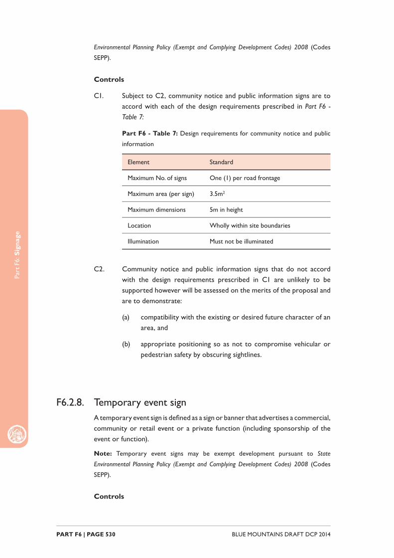
Part
F6:
Sig
nage
BLUE MOUNTAINS DRAFT DCP 2014 PART F6 | PAGE 530
Environmental Planning Policy (Exempt and Complying Development Codes) 2008 (Codes
SEPP).
Controls
C1. Subject to C2, community notice and public information signs are to accord with each of the design requirements prescribed in Part F6 - Table 7:
Part F6 - Table 7: Design requirements for community notice and public
information
Element Standard
Maximum No. of signs One (1) per road frontage
Maximum area (per sign) 3.5m2
Maximum dimensions 5m in height
Location Wholly within site boundaries
Illumination Must not be illuminated
C2. Community notice and public information signs that do not accord with the design requirements prescribed in C1 are unlikely to be supported however will be assessed on the merits of the proposal and are to demonstrate:
(a) compatibility with the existing or desired future character of an area, and
(b) appropriate positioning so as not to compromise vehicular or pedestrian safety by obscuring sightlines.
F6.2.8. Temporary event signA temporary event sign is defi ned as a sign or banner that advertises a commercial, community or retail event or a private function (including sponsorship of the event or function).
Note: Temporary event signs may be exempt development pursuant to State
Environmental Planning Policy (Exempt and Complying Development Codes) 2008 (Codes
SEPP).
Controls
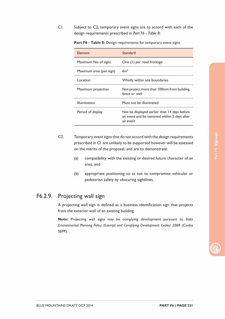
Part
F6:
Sig
nage
PART F6 | PAGE 531BLUE MOUNTAINS DRAFT DCP 2014
C1. Subject to C2, temporary event signs are to accord with each of the design requirements prescribed in Part F6 - Table 8:
Part F6 - Table 8: Design requirements for temporary event signs
Element Standard
Maximum No. of signs One (1) per road frontage
Maximum area (per sign) 6m2
Location Wholly within site boundaries
Maximum projection Not project more than 100mm from building, fence or wall
Illumination Must not be illuminated
Period of display Not be displayed earlier than 14 days before an event and be removed within 2 days after an event
C2. Temporary event signs that do not accord with the design requirements prescribed in C1 are unlikely to be supported however will be assessed on the merits of the proposal, and are to demonstrate:
(a) compatibility with the existing or desired future character of an area, and
(b) appropriate positioning so as not to compromise vehicular or pedestrian safety by obscuring sightlines.
F6.2.9. Projecting wall signA projecting wall sign is defi ned as a business identifi cation sign that projects from the exterior wall of an existing building.
Note: Projecting wall signs may be complying development pursuant to State
Environmental Planning Policy (Exempt and Complying Development Codes) 2008 (Codes
SEPP).

Part
F6:
Sig
nage
BLUE MOUNTAINS DRAFT DCP 2014 PART F6 | PAGE 532
Controls
C1. Subject to C2, projecting wall signs are to accord with each of the design requirements prescribed in Part F6 - Table 9:
Part F6 - Table 9: Design requirements for projecting wall signs
Element Standard
Generally not acceptable within the following zones
RU2 Rural Landscape, RU4 Primary Production Small Lots, R2 Low Density Residential, R3 Medium Density Residential, R6 Residential Character Conservation, E2 Environmental Conservation, E3 Environmental Management, E4 Environmental Living
Location 600mm behind the alignment of any kerb in the adja-cent road
Maximum No. of signs
One (1) per elevation to a maximum of 3. Multiple projecting wall signs on the same elevation will be considered for premises with multiple commercial tenants within Zone IN1 General Industrial and Zone IN2 Light Industrial
Maximum area (per sign)
IN1 General Industrial, IN2 Light Industrial
2.5m2
B1 Neighbourhood Centre, B2 Local Centre, RE1 Public Recreation, RE2 Private Recreation, R1 General Residential
1.5m2
Maximum projection
IN1 General Industrial, IN2 Light Industrial
• Not project more than 1.5m horizontally from wall of building
• Not project beyond the parapet or eaves
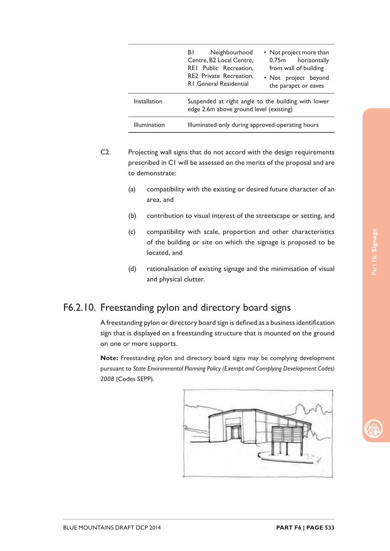
Part
F6:
Sig
nage
PART F6 | PAGE 533BLUE MOUNTAINS DRAFT DCP 2014
B1 Neighbourhood Centre, B2 Local Centre, RE1 Public Recreation, RE2 Private Recreation, R1 General Residential
• Not project more than 0.75m horizontally from wall of building
• Not project beyond the parapet or eaves
Installation Suspended at right angle to the building with lower edge 2.6m above ground level (existing)
Illumination Illuminated only during approved operating hours
C2. Projecting wall signs that do not accord with the design requirements prescribed in C1 will be assessed on the merits of the proposal and are to demonstrate:
(a) compatibility with the existing or desired future character of an area, and
(b) contribution to visual interest of the streetscape or setting, and
(c) compatibility with scale, proportion and other characteristics of the building or site on which the signage is proposed to be located, and
(d) rationalisation of existing signage and the minimisation of visual and physical clutter.
F6.2.10. Freestanding pylon and directory board signs A freestanding pylon or directory board sign is defi ned as a business identifi cation sign that is displayed on a freestanding structure that is mounted on the ground on one or more supports.
Note: Freestanding pylon and directory board signs may be complying development
pursuant to State Environmental Planning Policy (Exempt and Complying Development Codes)
2008 (Codes SEPP).
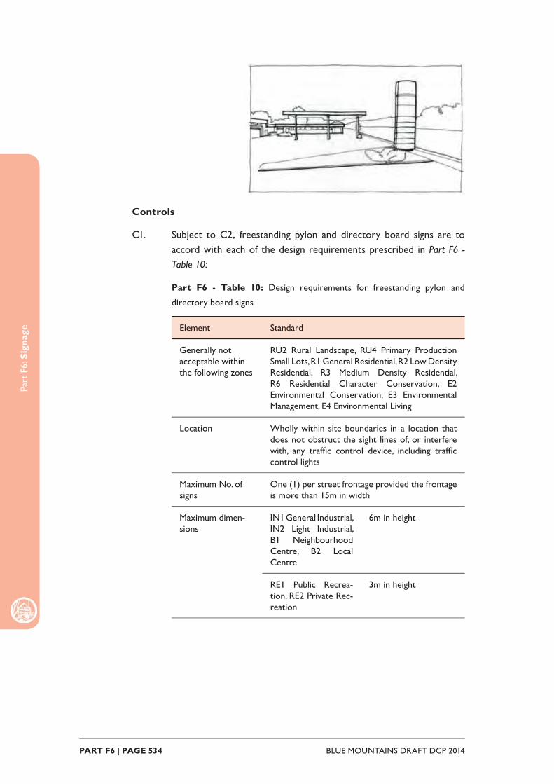
Part
F6:
Sig
nage
BLUE MOUNTAINS DRAFT DCP 2014 PART F6 | PAGE 534
Controls
C1. Subject to C2, freestanding pylon and directory board signs are to accord with each of the design requirements prescribed in Part F6 - Table 10:
Part F6 - Table 10: Design requirements for freestanding pylon and
directory board signs
Element Standard
Generally not acceptable within the following zones
RU2 Rural Landscape, RU4 Primary Production Small Lots, R1 General Residential, R2 Low Density Residential, R3 Medium Density Residential, R6 Residential Character Conservation, E2 Environmental Conservation, E3 Environmental Management, E4 Environmental Living
Location Wholly within site boundaries in a location that does not obstruct the sight lines of, or interfere with, any traffi c control device, including traffi c control lights
Maximum No. of signs
One (1) per street frontage provided the frontage is more than 15m in width
Maximum dimen-sions
IN1 General Industrial, IN2 Light Industrial, B1 Neighbourhood Centre, B2 Local Centre
6m in height
RE1 Public Recrea-tion, RE2 Private Rec-reation
3m in height

Part
F6:
Sig
nage
PART F6 | PAGE 535BLUE MOUNTAINS DRAFT DCP 2014
Maximum area (per sign)
IN1 General Industrial, IN2 Light Industrial, B1 Neighbourhood Centre, B2 Local Centre
• 8m2 if the sign relates to a premises with a single commercial tennant
• 16m2 if the sign relates to a premise with multiple commercial tenants
RE1 Public Recrea-tion, RE2 Private Rec-reation
4.5m2
Illumination Illuminated only during approved operating hours
C2. Freestanding pylon and directory board signs that do not accord with the design requirements prescribed in C1 are unlikely to be supported however will be assessed on the merits of the proposal and are to demonstrate:
(a) compatibility with the existing or desired future character of an area, and
(b) contribution to visual interest of the streetscape or setting, and
(c) appropriate positioning so as not to compromise vehicular or pedestrian safety by obscuring sightlines.
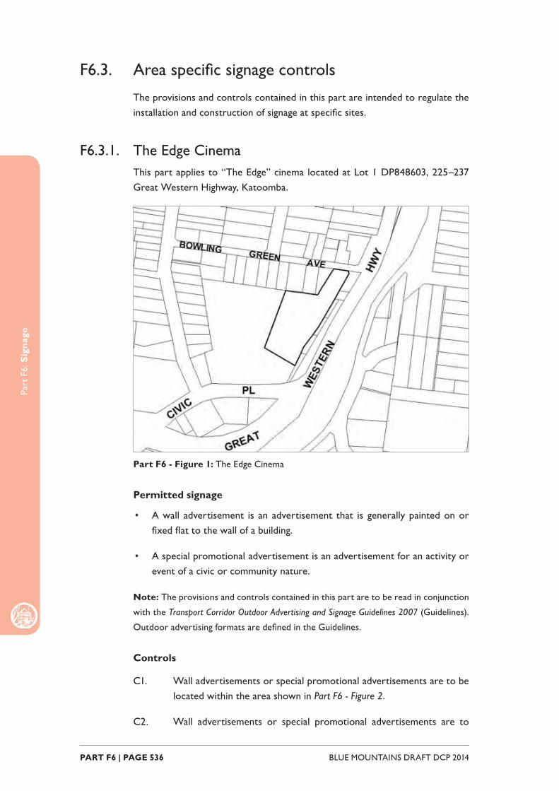
Part
F6:
Sig
nage
BLUE MOUNTAINS DRAFT DCP 2014 PART F6 | PAGE 536
F6.3. Area specifi c signage controls
The provisions and controls contained in this part are intended to regulate the installation and construction of signage at specifi c sites.
F6.3.1. The Edge CinemaThis part applies to “The Edge” cinema located at Lot 1 DP848603, 225–237 Great Western Highway, Katoomba.
Part F6 - Figure 1: The Edge Cinema
Permitted signage
• A wall advertisement is an advertisement that is generally painted on or fi xed fl at to the wall of a building.
• A special promotional advertisement is an advertisement for an activity or event of a civic or community nature.
Note: The provisions and controls contained in this part are to be read in conjunction
with the Transport Corridor Outdoor Advertising and Signage Guidelines 2007 (Guidelines).
Outdoor advertising formats are defi ned in the Guidelines.
Controls
C1. Wall advertisements or special promotional advertisements are to be located within the area shown in Part F6 - Figure 2.
C2. Wall advertisements or special promotional advertisements are to
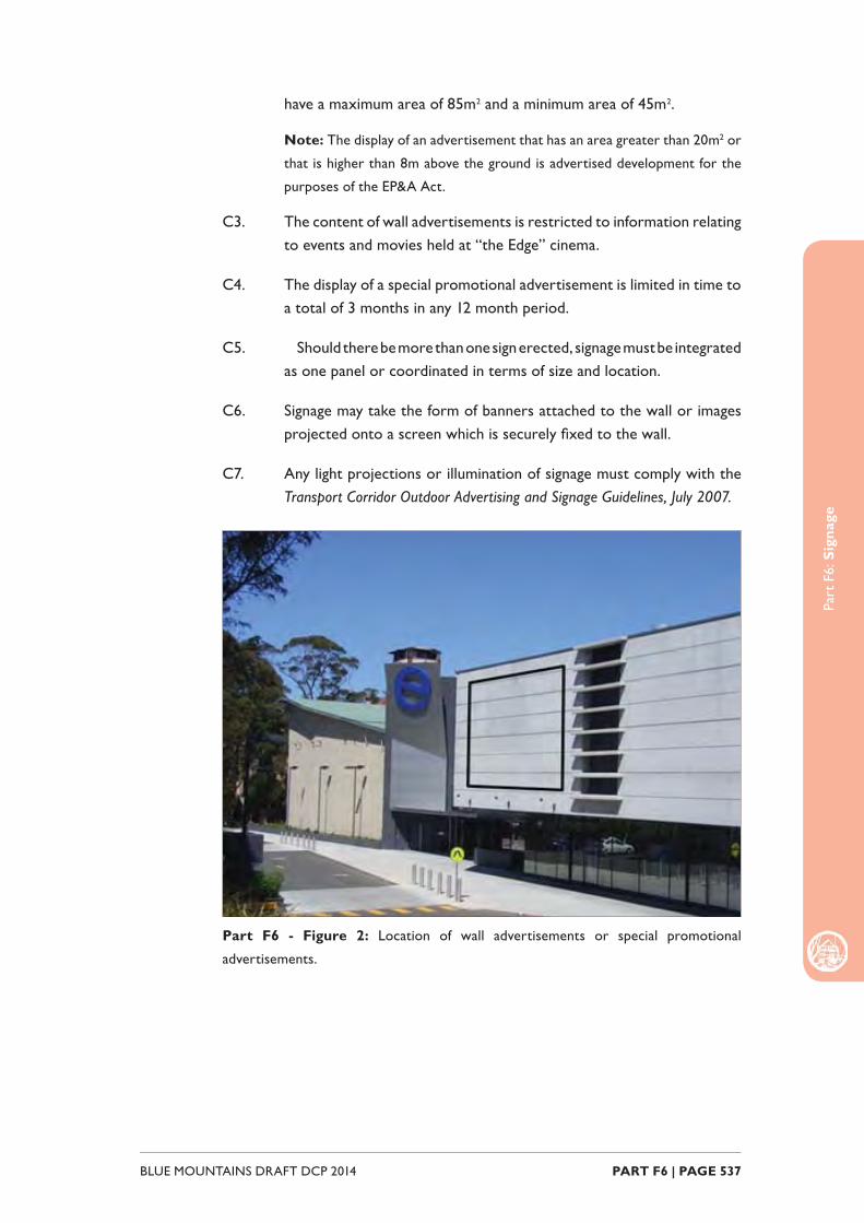
Part
F6:
Sig
nage
PART F6 | PAGE 537BLUE MOUNTAINS DRAFT DCP 2014
have a maximum area of 85m2 and a minimum area of 45m2.
Note: The display of an advertisement that has an area greater than 20m2 or
that is higher than 8m above the ground is advertised development for the
purposes of the EP&A Act.
C3. The content of wall advertisements is restricted to information relating to events and movies held at “the Edge” cinema.
C4. The display of a special promotional advertisement is limited in time to a total of 3 months in any 12 month period.
C5. Should there be more than one sign erected, signage must be integrated as one panel or coordinated in terms of size and location.
C6. Signage may take the form of banners attached to the wall or images projected onto a screen which is securely fi xed to the wall.
C7. Any light projections or illumination of signage must comply with the Transport Corridor Outdoor Advertising and Signage Guidelines, July 2007.
Part F6 - Figure 2: Location of wall advertisements or special promotional
advertisements.

Part
F6:
Sig
nage
BLUE MOUNTAINS DRAFT DCP 2014 PART F6 | PAGE 538
F6.3.2. BMCC HeadquartersThis part applies to the Blue Mountains City Council Headquarters building, located at Lot 1 DP705910 – 2 – 6 Civic Place, Katoomba.
Part F6 - Figure 3: BMCC Headquarters
Permitted signage
• A special promotional advertisement is an advertisement for an activity or event of a civic or community nature.
Note: The provisions and controls contained in this part are to be read in conjunction
with the Transport Corridor Outdoor Advertising and Signage Guidelines 2007 (Guidelines).
Outdoor advertising formats are defi ned in the Guidelines.
Controls
C1. Special promotional advertisements are to be located within the areas shown in Figures Part F6 - Figure3.
C2. Maximum area of special promotional advertisement signs is 25m2.
Note: The display of an advertisement that has an area greater than 20m2 or
that is higher than 8m above the ground is advertised development for the
purposes of the EP&A Act.
C3. Special promotional advertisements are to be consistent with Council’s Public Art Policy.
C4. Should there be more than one sign erected, signage must be integrated as one panel or coordinated in terms of size and location.

Part
F6:
Sig
nage
PART F6 | PAGE 539BLUE MOUNTAINS DRAFT DCP 2014
C5. Signage may take the form of banners attached to the wall or images projected onto a screen which is securely fi xed to the wall.
C6. Any light projections or illumination of signage must comply with the Transport Corridor Outdoor Advertising and Signage Guidelines, July 2007.
Part F6 - Figure 4: Location of special promotional advertisements.

Part
F6:
Sig
nage
BLUE MOUNTAINS DRAFT DCP 2014 PART F6 | PAGE 540

PART F7OTHER
DEVELOPMENT
Part
F7:
Oth
er D
evel
opm
ent
BLUE MOUNTAINS DRAFT DCP 2014 PART F7 | PAGE 542
IntroductionThis part provides objectives and controls for particular types of development. These development types may have site specifi c requirements, or simply due to the nature of the development, require separate consideration.
To the extent of any inconsistency between this section and any other DCP sections, this section will prevail.

Part
F7:
Oth
er D
evop
men
t
PART F7 | PAGE 543BLUE MOUNTAINS DRAFT DCP 2014
Read in conjunction with:
Relationship to other legislation:
• State Environmental Planning Policy (Exempt and Complying Codes) 2008
Part F - Specifi c Development Types F1
Part C - Environmental Management All
Part E - Site Development and Management All
F6
Part
F7:
Oth
er D
evel
opm
ent
BLUE MOUNTAINS DRAFT DCP 2014 PART F7 | PAGE 544
F7.1. Child Care Centres
Explanation
Child care centres provide an important service to the community and it is important that these facilities are appropriately planned and located, to provide for safety for the children in care, and to minimise the impact from this form of development on adjoining land, particularly where this is used for residential purposes.
Objective
O1. To provide child care centre which are appropriately located and planned so as to provide for a safe and identify key components of urban design to be considered and addressed in development proposals.
O2. To retain and enhance the unique qualities of neighbourhood character and context, by responding to existing elements and elements of desired future character.
O3. To ensure that the operation of commercial and retail enterprises minimises impact on the amenity of adjoining and nearby residential land uses.
Controls
Access and Parking
C1. Child care centres are not permitted on battle-axe allotments or where the access is to be provided via a right-of-carriageway due to the potential for amenity, traffi c and noise impacts on adjoining properties.
C2. To provide for pedestrian safety, pick-up, set-down and pedestrian areas are to be separated from the general parking areas and driveways.
Amenity and Noise
C3. Noise levels (measured at any point on the boundary of the site, between the proposed child care centre and adjoining property) is not to exceed 5 decibels (dBA) above the background level.
C4. Public address systems or amplifi ed music are not to be installed or used with the child care centre.
C5. Outdoor play areas are not to be located within the front building setback.
C6. Play equipment is not to be located within 2m of the fence line, and is

Part
F7:
Oth
er D
evop
men
t
PART F7 | PAGE 545BLUE MOUNTAINS DRAFT DCP 2014
not be higher than the fencing.
C7. 50% of all outdoor play areas are to be shaded during the hours of 10:00am to 3:00pm, eastern summer time.
Part
F7:
Oth
er D
evel
opm
ent
BLUE MOUNTAINS DRAFT DCP 2014 PART F7 | PAGE 546
F7.2. Home Employment
Explanation
Home employment provides an opportunity for people to develop and operate local scale businesses from their home (or in association with a dwelling). By their nature therefore, they operate within a residential setting, and consideration of the potential impacts on adjoining neighbours is necessary, particularly in relation to noise and amenity.
Objective
O1. To ensure that home employment is appropriately scaled and operated within consideration for the residential setting in which it is located.
Controls
C1. The total site coverage resulting from the home employment land use is not to exceed that specifi ed for the land elsewhere in this DCP, and
C2. Any external lighting associated with the home employment land use is to be located and directed to minimise impact on adjoining residential properties, and
C3. A separate or defi ned access is to be provided from the street to the home employment area.
C4. A clearly identifi able separate area for the operation of the home employment land use is to be provided, that can be separated from the balance of the dwelling for privacy and security.
C5. It can be demonstrated that it is reasonably practical for the home employment area to be converted to become part of the residence or a separate granny fl at or self-contained unit.
C6. The character of the proposed home employment land use is to be consistent with the scale and massing of the surrounding area, where it is located in an existing residential setting.
Part
F7:
Oth
er D
evop
men
t
PART F7 | PAGE 547BLUE MOUNTAINS DRAFT DCP 2014
F7.3. Service Stations
Explanation
Service stations often require direct access to the Great Western Highway or other major arterial road, generating the need for particular access requirements. Other elements of consideration for this development type include traffi c manoeuvrability (both within the site and upon entry and exit), as well as safety considerations for fuel loading etc.
Objectives
O1. To ensure that access arrangements are functional and safe, and do not result in traffi c hazards, particularly on main arterial roads.
Controls
C1. Development for the purpose of a service station is to be located on an allotment that:
(a) is at least 90m from the junction or intersection of a classifi ed road, with another main or arterial road, and
(b) has a frontage of not less than 50m.
C2. Provision is to be made for separate entrances to and exits from the site. Those entrances and exits are to be separated by physical barriers constructed on the road alignment and so identifi ed by suitable signs which are readily visible to persons using the adjoining road or entering the site.
C3. Inlets to bulk fuel storage tanks are to be situated on the site so as to ensure that tankers, whilst discharging fuel into the storage tanks, stand wholly within the site.

Part
F7:
Oth
er D
evel
opm
ent
BLUE MOUNTAINS DRAFT DCP 2014 PART F7 | PAGE 548
F7.4. Sex Services Premises
Explanation
Sex services premises is a permitted use within limited areas of the Blue Mountains, being only on land within zone IN1 – General Industrial. Within this zone, there are other restrictions with regard to the location of this land use, relative to other forms of development.
Objectives
O1. To ensure sites proposed for use as sex services premises are appropriately located and suffi ciently distant from other incompatible land uses.
Controls
C1. Sex services premises are not to be located:
(a) Adjacent to, adjoining or within 100m of an educational establishment, a childcare centre, a recreational area, a place of worship, a hospital, or any other place regularly frequented by children for recreational or cultural activities, and
(b) Within 50m of the boundary of any zone in which a dwelling house is a permissible use, and
(c) On land fronting or which direct vehicular access from, the Regional Transport Corridor.

LOCALITY MANAGEMENT
PART G

BLUE MOUNTAINS DRAFT DCP 2014 PART G12 | PAGE 550
PART G12 | PAGE 551BLUE MOUNTAINS DRAFT DCP 2014
ContentsPart G1 Mount Victoria 553
Part G2 Blackheath 561
Part G3 Medlow Bath 573
Part G4 Katoomba 577
Part G5 Leura 617
Part G6 Wentworth Falls 633
Part G7 Lawson 641
Part G8 Hazelbrook 651
Part G9 Springwood 661
Part G10 Winmalee 677
Part G11 Blaxland 683
Part G12 Glenbrook 693

BLUE MOUNTAINS DRAFT DCP 2014 PART G12 | PAGE 552

MOUNT VICTORIA
B1-MV01 - Town Centre Precinct
R1-MV02 - Station Street Precinct
R1-MV03 - Harley Avenue Precinct

Part
G1:
Mou
nt V
icto
ria
BLUE MOUNTAINS DRAFT DCP 2014 PART G1 | PAGE 554
G1.1. Mount Victoria Precinct B1-MV01—Town Centre PrecinctThis is a compact town centre, accommodating a diverse range of small-scale retail and other businesses that serve the resident community as well as visitors, plus a scattering of existing residences.
A variety of modestly-scaled cottages, shops and former civic buildings are arranged in a traditional country town pattern that comprises a continuous row of single storey buildings with shop-fronts and garden forecourts. This pattern of buildings provides a scenic and distinctive Highway backdrop, and structures range from the late-Victorian period to the Inter-War period.
Buildings provide an active street frontage along the Highway, encouraging pedestrian movement along a safe footpath that is protected from through traffi c.
Reference should be made to the precinct objectives in Clause 7.4(1) of Blue Mountains Local Environmental Plan 2014 (BMLEP 2014).
Controls
C1. Development is to comply with the precinct objectives of clause 7.4(1) of BMLEP 2014.
C2. The maximum height of a building is to comply with clause 4.3 of BMLEP 2014 and the accompanying Height of Buildings Map.
C3. The maximum fl oor space ratio of development is to comply with clause 4.4 of BMLEP 2014 and the accompanying Floor Space Ratio Map.
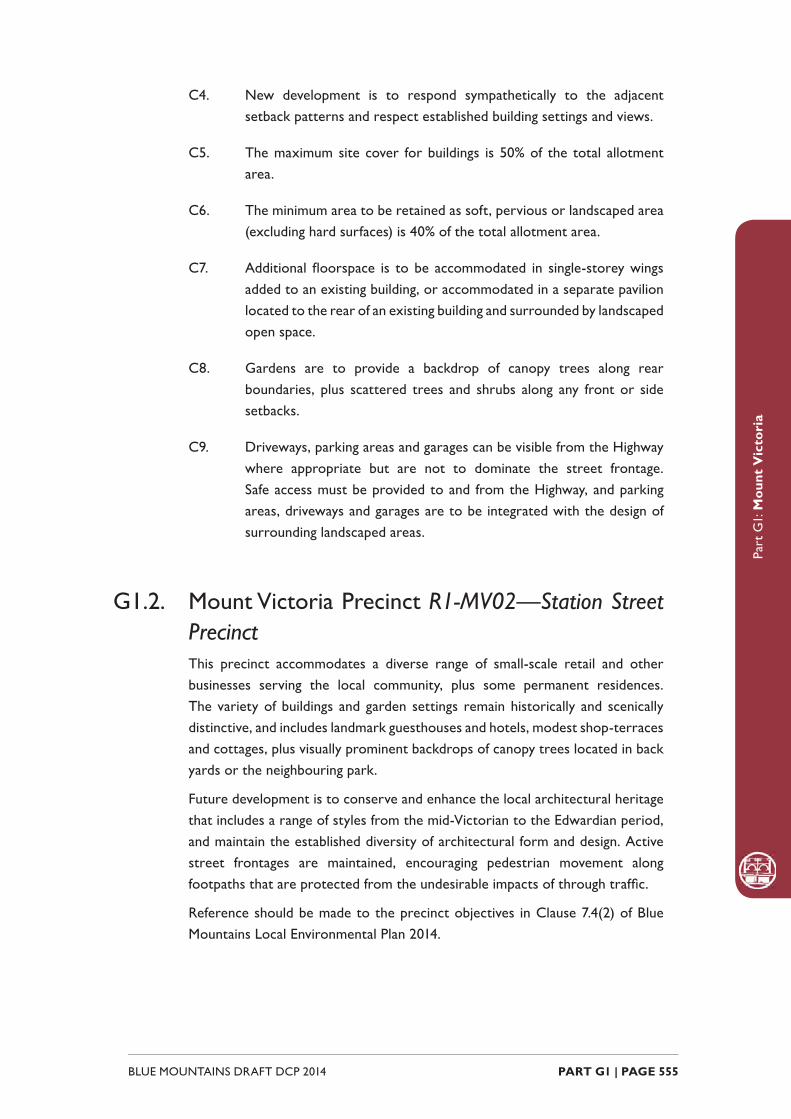
Part
G1:
Mou
nt V
icto
ria
PART G1 | PAGE 555BLUE MOUNTAINS DRAFT DCP 2014
C4. New development is to respond sympathetically to the adjacent setback patterns and respect established building settings and views.
C5. The maximum site cover for buildings is 50% of the total allotment area.
C6. The minimum area to be retained as soft, pervious or landscaped area (excluding hard surfaces) is 40% of the total allotment area.
C7. Additional fl oorspace is to be accommodated in single-storey wings added to an existing building, or accommodated in a separate pavilion located to the rear of an existing building and surrounded by landscaped open space.
C8. Gardens are to provide a backdrop of canopy trees along rear boundaries, plus scattered trees and shrubs along any front or side setbacks.
C9. Driveways, parking areas and garages can be visible from the Highway where appropriate but are not to dominate the street frontage. Safe access must be provided to and from the Highway, and parking areas, driveways and garages are to be integrated with the design of surrounding landscaped areas.
G1.2. Mount Victoria Precinct R1-MV02—Station Street PrecinctThis precinct accommodates a diverse range of small-scale retail and other businesses serving the local community, plus some permanent residences. The variety of buildings and garden settings remain historically and scenically distinctive, and includes landmark guesthouses and hotels, modest shop-terraces and cottages, plus visually prominent backdrops of canopy trees located in back yards or the neighbouring park.
Future development is to conserve and enhance the local architectural heritage that includes a range of styles from the mid-Victorian to the Edwardian period, and maintain the established diversity of architectural form and design. Active street frontages are maintained, encouraging pedestrian movement along footpaths that are protected from the undesirable impacts of through traffi c.
Reference should be made to the precinct objectives in Clause 7.4(2) of Blue Mountains Local Environmental Plan 2014.
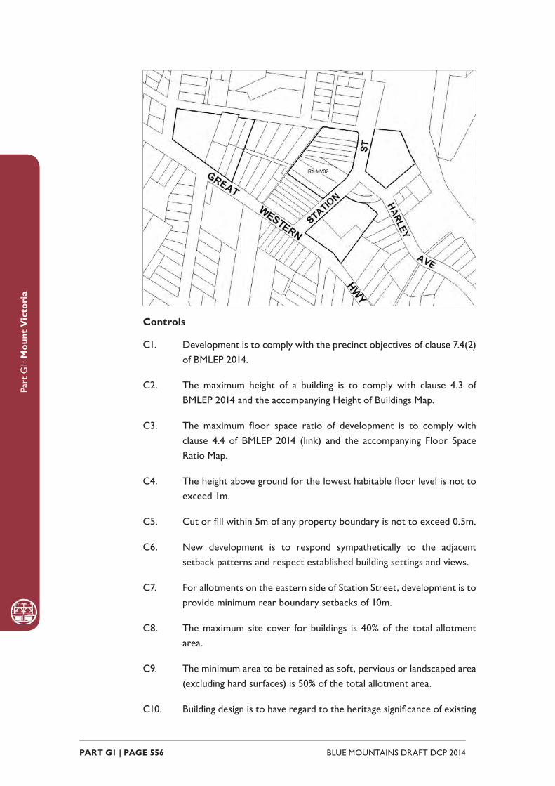
Part
G1:
Mou
nt V
icto
ria
BLUE MOUNTAINS DRAFT DCP 2014 PART G1 | PAGE 556
Controls
C1. Development is to comply with the precinct objectives of clause 7.4(2) of BMLEP 2014.
C2. The maximum height of a building is to comply with clause 4.3 of BMLEP 2014 and the accompanying Height of Buildings Map.
C3. The maximum fl oor space ratio of development is to comply with clause 4.4 of BMLEP 2014 (link) and the accompanying Floor Space Ratio Map.
C4. The height above ground for the lowest habitable fl oor level is not to exceed 1m.
C5. Cut or fi ll within 5m of any property boundary is not to exceed 0.5m.
C6. New development is to respond sympathetically to the adjacent setback patterns and respect established building settings and views.
C7. For allotments on the eastern side of Station Street, development is to provide minimum rear boundary setbacks of 10m.
C8. The maximum site cover for buildings is 40% of the total allotment area.
C9. The minimum area to be retained as soft, pervious or landscaped area (excluding hard surfaces) is 50% of the total allotment area.
C10. Building design is to have regard to the heritage signifi cance of existing
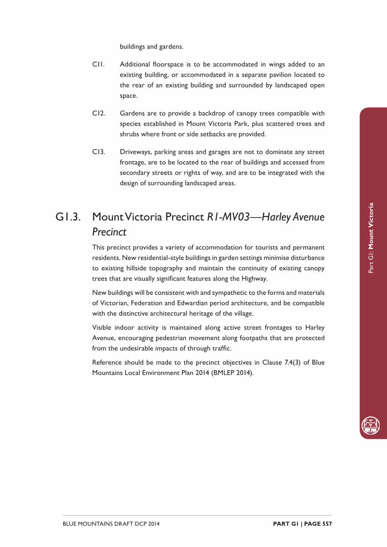
Part
G1:
Mou
nt V
icto
ria
PART G1 | PAGE 557BLUE MOUNTAINS DRAFT DCP 2014
buildings and gardens.
C11. Additional fl oorspace is to be accommodated in wings added to an existing building, or accommodated in a separate pavilion located to the rear of an existing building and surrounded by landscaped open space.
C12. Gardens are to provide a backdrop of canopy trees compatible with species established in Mount Victoria Park, plus scattered trees and shrubs where front or side setbacks are provided.
C13. Driveways, parking areas and garages are not to dominate any street frontage, are to be located to the rear of buildings and accessed from secondary streets or rights of way, and are to be integrated with the design of surrounding landscaped areas.
G1.3. Mount Victoria Precinct R1-MV03—Harley Avenue PrecinctThis precinct provides a variety of accommodation for tourists and permanent residents. New residential-style buildings in garden settings minimise disturbance to existing hillside topography and maintain the continuity of existing canopy trees that are visually signifi cant features along the Highway.
New buildings will be consistent with and sympathetic to the forms and materials of Victorian, Federation and Edwardian period architecture, and be compatible with the distinctive architectural heritage of the village.
Visible indoor activity is maintained along active street frontages to Harley Avenue, encouraging pedestrian movement along footpaths that are protected from the undesirable impacts of through traffi c.
Reference should be made to the precinct objectives in Clause 7.4(3) of Blue Mountains Local Environment Plan 2014 (BMLEP 2014).
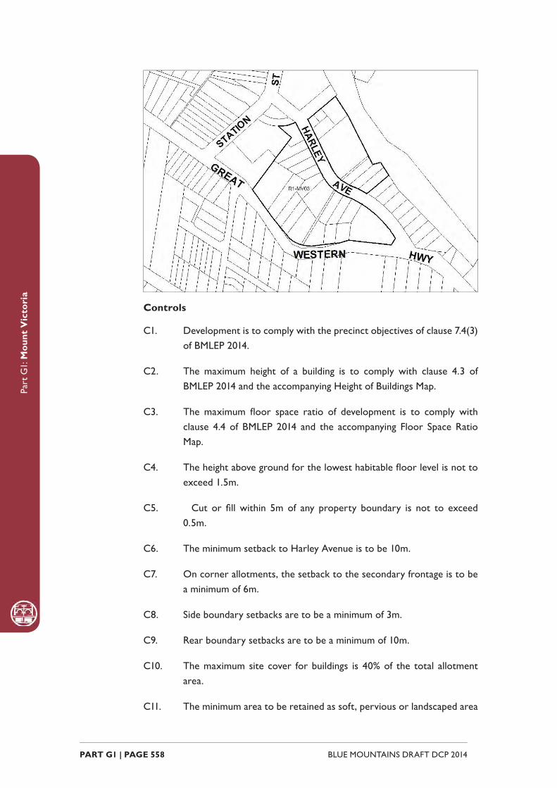
Part
G1:
Mou
nt V
icto
ria
BLUE MOUNTAINS DRAFT DCP 2014 PART G1 | PAGE 558
Controls
C1. Development is to comply with the precinct objectives of clause 7.4(3) of BMLEP 2014.
C2. The maximum height of a building is to comply with clause 4.3 of BMLEP 2014 and the accompanying Height of Buildings Map.
C3. The maximum fl oor space ratio of development is to comply with clause 4.4 of BMLEP 2014 and the accompanying Floor Space Ratio Map.
C4. The height above ground for the lowest habitable fl oor level is not to exceed 1.5m.
C5. Cut or fi ll within 5m of any property boundary is not to exceed 0.5m.
C6. The minimum setback to Harley Avenue is to be 10m.
C7. On corner allotments, the setback to the secondary frontage is to be a minimum of 6m.
C8. Side boundary setbacks are to be a minimum of 3m.
C9. Rear boundary setbacks are to be a minimum of 10m.
C10. The maximum site cover for buildings is 40% of the total allotment area.
C11. The minimum area to be retained as soft, pervious or landscaped area

Part
G1:
Mou
nt V
icto
ria
PART G1 | PAGE 559BLUE MOUNTAINS DRAFT DCP 2014
(excluding hard surfaces) is 50% of the total allotment area.
C12. New development is to be sympathetic to the traditional building forms, materials and details of the precinct, including the use of traditionally-pitched roofs, articulated layouts and forms, verandahs, timber joinery, vertically–proportioned openings and some painted external fi nishes, with a curtilage of landscaped areas and an address to the street provided. New development is to be similar in form and materials to quality older buildings but subservient in detail to distinguish it as new work.
C13. Development is to respond to the topography through appropriate siting and stepped building forms.
C14. Landscaping is to conserve existing visually prominent trees and be based on appropriate design, layout and species selection.
C15. Garden areas are to maintain the existing backdrop of canopy trees along the Highway boundary, as well as provide space for new trees and shrubs in front and side yards to frame buildings, driveways and parking areas.
C16. Driveways, parking areas and garages are not to dominate any street frontage, and are to be integrated with the design of surrounding landscaped areas.

Part
G1:
Mou
nt V
icto
ria
BLUE MOUNTAINS DRAFT DCP 2014 PART G1 | PAGE 560
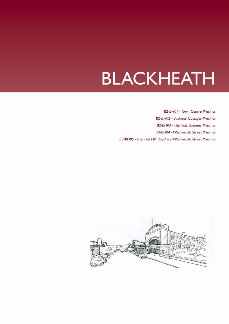
BLACKHEATH
B2-BH01 - Town Centre Precinct
B2-BH02 - Business Cottages Precinct
B2-BH03 - Highway Business Precinct
R3-BH04 - Wentworth Street Precinct
R3-BH05 - Cnr Hat Hill Road and Wentworth Street Precinct

Part
G2:
Bla
ckhe
ath
BLUE MOUNTAINS DRAFT DCP 2014 PART G2 | PAGE 562
G2.1. Blackheath Precinct B2-BH01—Town Centre PrecinctThis precinct remains a compact town centre, accommodating a diverse range of small retailers, local businesses, tourist-related activities and permanent residents.
Modestly-scaled buildings are arranged in a traditional main street pattern, creating continuous facades of one and two-storey buildings that refl ect the traditional shopfront architecture of the Victorian, Federation and Inter-War periods. As a whole, the group display an interesting variety of form and design. The form and architectural detail of landmark corner buildings, hotels and the former Victory Theatre are preserved.
Future development is to be sympathetic and subservient to the distinctive character of these landmarks and this urban pattern, and promote new retail frontages facing existing carparks and laneways. Active street frontages are encouraged, with pedestrian activity concentrated along the streets, laneways and around the carparks, encouraging informal community gatherings in areas that are protected from undesirable impacts of through traffi c.
Reference should be made to the precinct objectives in Clause 7.5(1) of Blue Mountains Local Environment Plan 2014 (BMLEP 2014).
Controls
C1. Development is to comply with the precinct objectives of clause 7.5(1) of BMLEP 2014.
C2. The maximum height of a building is to comply with clause 4.3 of BMLEP 2014 and the accompanying Height of Buildings Map.
C3. The maximum fl oor space ratio of development is to comply with clause 4.4 of BMLEP 2014 and the accompanying Floor Space Ratio Map.
C4. Front and side setbacks are to be zero, except in the case of side setbacks if it can be satisfactorily demonstrated that a side boundary adjoins the public domain and that an active street frontage will be provided.
C5. The maximum site cover for buildings is 80% of the total allotment area.
C6. The existing continuity of retail and other businesses facing the Highway, Govetts Leap Road and Wentworth Street is to be retained.
Part
G2:
Bla
ckhe
ath
PART G2 | PAGE 563BLUE MOUNTAINS DRAFT DCP 2014
C7. On properties with secondary frontages to the public domain, the secondary frontage is to provide new retail or other commercial activity to at least 50% of ground level frontages to the public domain, and for all storeys above ground, balconies or extensive windows, or both, facing the public domain is to be provided.
C8. On properties facing Hydora Lane, the laneway can be activated by commercial use. Development is to subservient to the traditional rear wing forms and layouts of the shopfront buildings, and is to maintain the use of traditional rear elevation materials such as commons bricks, timber joinery and corrugated metal sheeting. Views of the upper level rear elevations of properties fronting Govetts Leap Road and the Highway are to be maintained.
C9. The pattern of traditional main street Victorian, Federation and Inter-War shop-terraces facing principal street frontages is to be retained and enhanced.
C10. Existing or original shopfront buildings are to be retained and conserved, including the street façade, principal rooms and all associated original elements and details.
Note: Refer to 9.7 Traditional shopfront buildings in Part D1 Heritage
Conservation where heritage considerations apply.
C11. Alterations and additions to shop buildings and infi ll development are to be in accordance with traditional shopfront building design, and to ensure that where appropriate, continuous awnings and/or balconies are provided.
Note: Guidelines on traditional shopfront design are found in B3.2.1 Infi ll
shopfront buildings in B3 Design development , and in 9.7 Traditional shopfront
buildings in Part D1 Heritage Conservation where heritage considerations
apply.
C12. Development on large allotments is to distribute fl oorspace into carefully-articulated structures that are composed of separate wings, pavilions or interconnected buildings, with traditionally-pitched roofs and appropriately landscaped garden courtyards with canopy trees.
C13. On-site parking areas are to be accessed only from the rear or side of buildings via existing public carparks, laneways or secondary streets, and are to be concealed behind retail or business fl oorspace wherever possible.
C14. The existing pedestrian network is to be expanded by promoting new retail frontages surrounding the public domain.
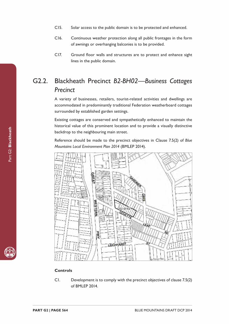
Part
G2:
Bla
ckhe
ath
BLUE MOUNTAINS DRAFT DCP 2014 PART G2 | PAGE 564
C15. Solar access to the public domain is to be protected and enhanced.
C16. Continuous weather protection along all public frontages in the form of awnings or overhanging balconies is to be provided.
C17. Ground fl oor walls and structures are to protect and enhance sight lines in the public domain.
G2.2. Blackheath Precinct B2-BH02—Business Cottages PrecinctA variety of businesses, retailers, tourist-related activities and dwellings are accommodated in predominantly traditional Federation weatherboard cottages surrounded by established garden settings.
Existing cottages are conserved and sympathetically enhanced to maintain the historical value of this prominent location and to provide a visually distinctive backdrop to the neighbouring main street.
Reference should be made to the precinct objectives in Clause 7.5(2) of Blue Mountains Local Environment Plan 2014 (BMLEP 2014).
Controls
C1. Development is to comply with the precinct objectives of clause 7.5(2) of BMLEP 2014.

Part
G2:
Bla
ckhe
ath
PART G2 | PAGE 565BLUE MOUNTAINS DRAFT DCP 2014
C2. The maximum height of a building is to comply with clause 4.3 of BMLEP 2014 and the accompanying Height of Buildings Map.
C3. The maximum fl oor space ratio of development is to comply with clause 4.4 of BMLEP 2014 and the accompanying Floor Space Ratio Map.
C4. The height above ground for the lowest habitable fl oor level is not to exceed 1m.
C5. Cut or fi ll within 5m of any property boundary is not to exceed 0.5m.
C6. Development is to provide front setbacks consistent with that of adjacent buildings.
C7. Development is to provide a minimum side boundary setback of 2m.
C8. Development is to provide a minimum rear boundary setback of 6m.
C9. All setback areas are to be landscaped.
C10. The maximum site cover for buildings is 50% of the total allotment area.
C11. The minimum area to be retained as soft, pervious or landscaped area (excluding hard surfaces) is 40% of the total allotment area.
C12. New development is to be sympathetic to the traditional building forms, materials and details of the precinct, including the use of traditionally-pitched roofs, articulated layouts and forms, verandahs, timber joinery, vertically–proportioned openings and some painted external fi nishes, with a curtilage of landscaped areas and an address to the street provided. New development is to be similar in form and materials to quality older buildings but subservient in detail to distinguish it as new work.
C13. Any non-residential activities are to be accommodated in buildings with a residential scale and character.
C14. Buildings are not to exceed 18m in any direction.
C15. Gardens are to provide and maintain a backdrop of canopy trees along rear boundaries, plus trees and shrubs scattered through front and side yards.
C16. Driveways, parking areas and garages are to be integrated with the design of surrounding landscaped areas, with garages and parking to be behind the front building setback.
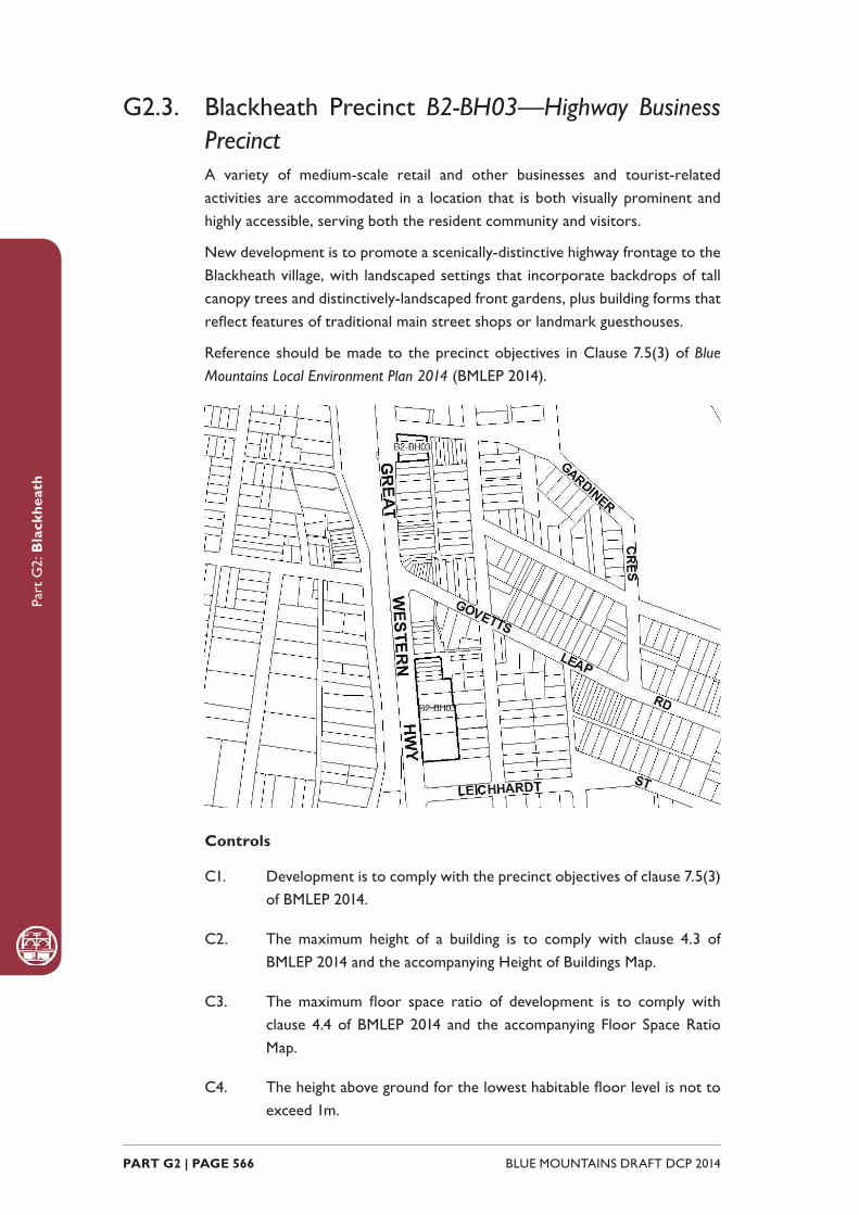
Part
G2:
Bla
ckhe
ath
BLUE MOUNTAINS DRAFT DCP 2014 PART G2 | PAGE 566
G2.3. Blackheath Precinct B2-BH03—Highway Business PrecinctA variety of medium-scale retail and other businesses and tourist-related activities are accommodated in a location that is both visually prominent and highly accessible, serving both the resident community and visitors.
New development is to promote a scenically-distinctive highway frontage to the Blackheath village, with landscaped settings that incorporate backdrops of tall canopy trees and distinctively-landscaped front gardens, plus building forms that refl ect features of traditional main street shops or landmark guesthouses.
Reference should be made to the precinct objectives in Clause 7.5(3) of Blue Mountains Local Environment Plan 2014 (BMLEP 2014).
Controls
C1. Development is to comply with the precinct objectives of clause 7.5(3) of BMLEP 2014.
C2. The maximum height of a building is to comply with clause 4.3 of BMLEP 2014 and the accompanying Height of Buildings Map.
C3. The maximum fl oor space ratio of development is to comply with clause 4.4 of BMLEP 2014 and the accompanying Floor Space Ratio Map.
C4. The height above ground for the lowest habitable fl oor level is not to exceed 1m.
Part
G2:
Bla
ckhe
ath
PART G2 | PAGE 567BLUE MOUNTAINS DRAFT DCP 2014
C5. Cut or fi ll within 5m of any property boundary is not to exceed 0.5m.
C6. Development is to provide a minimum setback to the Great Western Highway of 6m.
C7. Development is to provide a minimum side boundary setback of 2m.
C8. For development that shares a rear boundary with existing residential development, the development is to provide a minimum rear boundary setback of 6m.
C9. All setback areas are to be landscaped.
C10. The maximum site cover for buildings is 55% of the total allotment area.
C11. The minimum area to be retained as soft, pervious or landscaped area (excluding hard surfaces) is 35% of the total allotment area.
C12. Development facing the Highway is to promote new retail or other commercial activity along at least 50% of ground level frontages, and for all storeys above ground, incorporate balconies and/or extensive windows.
C13. New development is to be sympathetic to the traditional building forms, materials and details of the precinct, and incorporate traditionally-pitched roofs and/or parapets, traditional shopfront design, articulated building forms and layouts, vertically-proportioned openings, and sympathetic materials and detailing as appropriate to the context. New development is to be similar in form and materials to quality older buildings but subservient in detail to distinguish it as new work.
Note: Guidelines on traditional shopfront design are found in B3.2.1 Infi ll
shopfront buildings in B3 Design development, and in 9.7 Traditional shopfront
buildings in Part D1 Heritage Conservation where heritage considerations
apply.
C14. Gardens are to provide a backdrop of canopy trees along rear boundaries, plus scattered trees and shrubs through front and side yards to frame buildings, driveways and parking areas.
C15. On-site parking areas are to be located behind buildings and concealed from the Highway where possible, and are to be integrated with landscape design of garden areas.
C16. New retail frontages are to be provided along the Highway to expand the existing town centre pedestrian network.
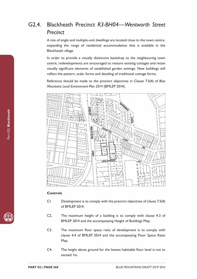
Part
G2:
Bla
ckhe
ath
BLUE MOUNTAINS DRAFT DCP 2014 PART G2 | PAGE 568
G2.4. Blackheath Precinct R3-BH04—Wentworth Street PrecinctA mix of single and multiple-unit dwellings are located close to the town centre, expanding the range of residential accommodation that is available in the Blackheath village.
In order to provide a visually distinctive backdrop to the neighbouring town centre, redevelopments are encouraged to restore existing cottages and retain visually signifi cant elements of established garden settings. New buildings will refl ect the pattern, scale, forms and detailing of traditional cottage forms.
Reference should be made to the precinct objectives in Clause 7.5(4) of Blue Mountains Local Environment Plan 2014 (BMLEP 2014).
Controls
C1. Development is to comply with the precinct objectives of clause 7.5(4) of BMLEP 2014.
C2. The maximum height of a building is to comply with clause 4.3 of BMLEP 2014 and the accompanying Height of Buildings Map.
C3. The maximum fl oor space ratio of development is to comply with clause 4.4 of BMLEP 2014 and the accompanying Floor Space Ratio Map.
C4. The height above ground for the lowest habitable fl oor level is not to exceed 1m.
Part
G2:
Bla
ckhe
ath
PART G2 | PAGE 569BLUE MOUNTAINS DRAFT DCP 2014
C5. Cut or fi ll within 5m of any property boundary is not to exceed 0.5m.
C6. The setback to Wentworth Street is to be a minimum of 8m.
C7. On corner allotments, the setback to the secondary frontage is to be a minimum of 4m.
C8. Side boundary setbacks are to be a minimum of 2m.
C9. Development located on the western side of Wentworth Street is to provide a minimum rear setback of 2m.
C10. Development located on the eastern side of Wentworth Street is to provide a minimum rear setback of 6m.
C11. All setback areas are to be landscaped.
C12. The maximum site cover for buildings is 50% of the total allotment area.
C13. The minimum area to be retained as soft, pervious or landscaped area (excluding hard surfaces) is 40% of the total allotment area.
C14. New development is to be sympathetic to the traditional building forms, materials and details of the precinct, including the use of traditionally-pitched roofs, articulated layouts and forms, verandahs, timber joinery, vertically–proportioned openings and some painted external fi nishes, with a curtilage of landscaped areas and an address to the street provided. New development is to be similar in form and materials to quality older buildings but subservient in detail to distinguish it as new work.
C15. Buildings are not to exceed 15m in any direction.
C16. Any non-residential activities are to be accommodated in buildings with a residential scale and character.
C17. Gardens are to incorporate a backdrop of canopy trees along rear boundaries, plus trees and shrubs scattered through front and side yards.
C18. Driveways, parking areas and garages are to be integrated with the design of surrounding landscaped areas, with garages and parking to be behind the front building setback.

Part
G2:
Bla
ckhe
ath
BLUE MOUNTAINS DRAFT DCP 2014 PART G2 | PAGE 570
G2.5. Blackheath Precinct R3-BH05—Cnr Hat Hill Road and Wentworth Street PrecinctAlternative forms of housing are provided within a landscaped setting that is in sympathy with the park opposite. The housing contributes to meeting housing demand in accordance with changing demographics within the Blue Mountains.
Reference should be made to the precinct objectives in Clause 7.5(5) of Blue Mountains Local Environment Plan 2014 (BMLEP 2014).
Controls
C1. Development is to comply with the precinct objectives of clause 7.5(5) of BMLEP 2014.
C2. The maximum height of a building is to comply with clause 4.3 of BMLEP 2014 and the accompanying Height of Buildings Map.
C3. The maximum fl oor space ratio of development is to comply with clause 4.4 of BMLEP 2014 and the accompanying Floor Space Ratio Map.
C4. The minimum setback from the street frontage is 4.5m.
C5. The maximum site coverage for each allotment is 50%.
C6. The minimum pervious area required for each allotment is 40%.
C7. Development is to provide articulation and building modulation in order to minimise the bulk of buildings.
Part
G2:
Bla
ckhe
ath
PART G2 | PAGE 571BLUE MOUNTAINS DRAFT DCP 2014
C8. Development is to provide an activated street frontage to the primary street.
C9. Development is to provide landscaping along the street frontages that is refl ective of plantings along Wentworth Street.
C10. Garages, access and car parking are to be screened from the public domain with garages and parking areas located internally so as not to adversely impact upon streetscape, pedestrian circulation, and building character.

Part
G2:
Bla
ckhe
ath
BLUE MOUNTAINS DRAFT DCP 2014 PART G2 | PAGE 572

MEDLOW BATHR1-MB01 - Great Western Highway Precinct
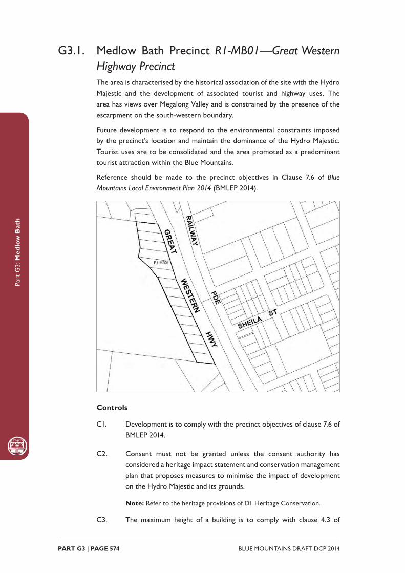
Part
G3:
Med
low
Bat
h
BLUE MOUNTAINS DRAFT DCP 2014 PART G3 | PAGE 574
G3.1. Medlow Bath Precinct R1-MB01—Great Western Highway PrecinctThe area is characterised by the historical association of the site with the Hydro Majestic and the development of associated tourist and highway uses. The area has views over Megalong Valley and is constrained by the presence of the escarpment on the south-western boundary.
Future development is to respond to the environmental constraints imposed by the precinct’s location and maintain the dominance of the Hydro Majestic. Tourist uses are to be consolidated and the area promoted as a predominant tourist attraction within the Blue Mountains.
Reference should be made to the precinct objectives in Clause 7.6 of Blue Mountains Local Environment Plan 2014 (BMLEP 2014).
Controls
C1. Development is to comply with the precinct objectives of clause 7.6 of BMLEP 2014.
C2. Consent must not be granted unless the consent authority has considered a heritage impact statement and conservation management plan that proposes measures to minimise the impact of development on the Hydro Majestic and its grounds.
Note: Refer to the heritage provisions of D1 Heritage Conservation.
C3. The maximum height of a building is to comply with clause 4.3 of

Part
G3:
Med
low
Bat
h
PART G3 | PAGE 575BLUE MOUNTAINS DRAFT DCP 2014
BMLEP 2014 and the accompanying Height of Buildings Map in BMLEP 2014.
C4. The maximum fl oor space ratio of development is to comply with clause 4.4 of BMLEP 2014 and the accompanying Floor Space Ratio Map.
C5. The minimum front setback is 10m.
C6. The maximum site coverage for any development is not to exceed 35%.
C7. Appropriate landscaping shall be provided within the front setback.
C8. The existing mature vegetation on the site (particularly Pinus radiata) is to be retained.
C9. Front facades are to address the street and be well-articulated through the provision of architectural features including doors, windows and verandahs.
C10. Building height and roof pitch are to be varied in order to minimise the bulk of buildings.
C11. Tree planting should be consistent with existing exotic landscaped gardens within the area.
C12. New development is to be constructed of non-refl ective, muted colours that do not undermine the visual dominance of the Hydro Majestic Hotel when viewed from Megalong Valley.

Part
G3:
Med
low
Bat
h
BLUE MOUNTAINS DRAFT DCP 2014 PART G3 | PAGE 576

KATOOMBAB2-KA01 - Katoomba Street and Bathurst Road Shopping Strip Precinct
B2-KA02 - District Retail Precinct
B2-KA03 - Waratah Commercial Precinct
B2-KA04 - Katoomba Town Approach Precinct
sB2-KA05 - Katoomba Town Entry Precinct
B2-KA06 - Cultural Centre Precinct
R1-KA07 - Lurline Street South Precinct
R1-KA08 - Lurline Street North Precinct
R1-KA09 - Gang Gang Street East Precinct
R3-KA10 - Great Western Highway Precinct
R3-KA11 - Dora Street Precinct
R3-KA12 - GWH Between Bowling Green Ave and Station Street Precinct
R3-KA13 - Lurline and Vale Streets Precinct
R3-KA14 - Lurline Street Housing Precinct
R3-KA15 - Cascade and Parke Street Edge Precinct
R3-KA16 - Cnr GWH and Camp Street Precinct
R3-KA17 - Katoomba Golf Course Housing Precinct
R1-KA18 - Lilianfels
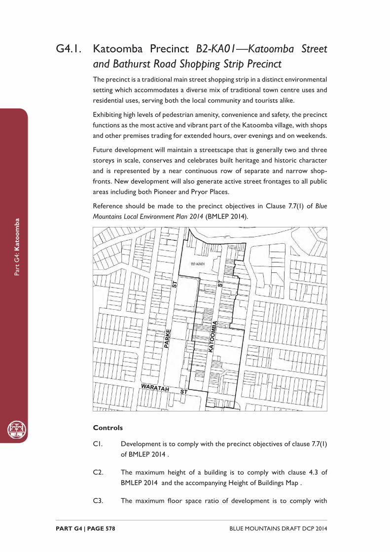
Part
G4:
Kat
oom
ba
BLUE MOUNTAINS DRAFT DCP 2014 PART G4 | PAGE 578
G4.1. Katoomba Precinct B2-KA01—Katoomba Street and Bathurst Road Shopping Strip PrecinctThe precinct is a traditional main street shopping strip in a distinct environmental setting which accommodates a diverse mix of traditional town centre uses and residential uses, serving both the local community and tourists alike.
Exhibiting high levels of pedestrian amenity, convenience and safety, the precinct functions as the most active and vibrant part of the Katoomba village, with shops and other premises trading for extended hours, over evenings and on weekends.
Future development will maintain a streetscape that is generally two and three storeys in scale, conserves and celebrates built heritage and historic character and is represented by a near continuous row of separate and narrow shop-fronts. New development will also generate active street frontages to all public areas including both Pioneer and Pryor Places.
Reference should be made to the precinct objectives in Clause 7.7(1) of Blue Mountains Local Environment Plan 2014 (BMLEP 2014).
Controls
C1. Development is to comply with the precinct objectives of clause 7.7(1) of BMLEP 2014 .
C2. The maximum height of a building is to comply with clause 4.3 of BMLEP 2014 and the accompanying Height of Buildings Map .
C3. The maximum fl oor space ratio of development is to comply with

Part
G4:
Kat
oom
ba
PART G4 | PAGE 579BLUE MOUNTAINS DRAFT DCP 2014
clause 4.4 of BMLEP 2014 and the accompanying Floor Space Ratio Map .
C4. Buildings are generally to have zero front and side setbacks; however, when there is a front building line established by adjacent buildings, new development may provide a setback consistent with the adjacent setback; and where the side boundary adjoins the public domain, setbacks greater than zero may be considered, but only where it can be demonstrated that an active street frontage will be provided.
C5. Visible retail or commercial activity is to be provided along the entire length of primary street frontages to Katoomba Street, Bathurst Road and Waratah Street.
C6. New development with secondary frontages to a public road, laneway or public place is to provide a visible and active street frontage distributed along a minimum of 65% of that frontage.
C7. Development fronting Katoomba Street, Waratah Street and Bathurst Road is to generally provide the following:
(a) narrow terraced building forms of masonry construction, and
(b) parapets that step with the topography, with pitched or skillion roofs behind, and
(c) symmetry and vertical proportion of window and door openings, and
(d) articulation of shopfront elements, and
(e) cantilevered metal awnings.
Note: Guidelines on traditional shopfront design are found in B3.2.1 Infi ll
shopfront buildings in B3 Design development, and in 9.7 Traditional shopfront
buildings in Part D1 Heritage Conservation where heritage considerations
apply.
C8. Signage is to be sympathetic to the style and detailing of the shop front, and be of appropriate size, scale and location.
C9. Buildings fronting Lurline Street are to present a frontage compatible with the diversity of the predominantly residential streetscape.
C10. Continuous overhead awnings, where appropriate, are to be provided along the length of a frontage to a street, laneway or public place.
C11. Appropriate levels of lighting are to be incorporated into all on-site pedestrian areas. All light fi ttings are to be of a form and character

Part
G4:
Kat
oom
ba
BLUE MOUNTAINS DRAFT DCP 2014 PART G4 | PAGE 580
consistent with that of the building.
C12. On-site car parking is not to be accessed from Katoomba Street or Waratah Street.
G4.2. Katoomba Precinct B2-KA02—District Retail PrecinctServing as the core area for district-scale retailing facilities, this precinct will see increases in commercial fl oor space in response to increasing retailing demands for upper mountains residents.
Future development is to be represented in well-designed, multi-level buildings of a more contemporary form. Building designs will incorporate stronger interfaces with Parke and Waratah Streets, represented by active street frontages and prominent building entries.
The precinct provides an enhanced public domain that offers high levels of accessibility to both pedestrians and vehicles, but minimises confl icts between the two. The precinct will be well served by vehicle parking and heavy vehicle access, however neither will be visually prominent elements. The precinct will also provide clear and tangible links between existing retailing on Katoomba Street, and Katoomba Precinct B2-KA06 to the north.
Reference should be made to the precinct objectives in Clause 7.7(2) of Blue Mountains Local Environment Plan 2014 (BMLEP 2014).
Controls
C1. Development is to comply with the precinct objectives of clause 7.7(2) of BMLEP 2014 .
C2. The maximum height of a building is to comply with clause 4.3 of BMLEP 2014 and the accompanying Height of Buildings Map .
C3. The maximum fl oor space ratio of development is to comply with clause 4.4 of BMLEP 2014 and the accompanying Floor Space Ratio Map .
C4. All viewing opportunities from the podium level of the Blue Mountains Cultural Centre to the town, Jamison Valley and Frank Walford Park are to be maintained. A view analysis may be required.
Note: Podium level is defi ned as: at or below an Australian Height Datum
of 1024.5m, at or below the fi nished level of College Lane at the northern
Part
G4:
Kat
oom
ba
PART G4 | PAGE 581BLUE MOUNTAINS DRAFT DCP 2014
boundary of the precinct, and at or below 12m above the fi nished level of
College Lane at the south eastern boundary of the precinct.
C5. Buildings with a frontage to Parke and Waratah Streets are generally to have a zero setback to that frontage, except where it can be demonstrated that the increased setback forms part of a building entry and incorporates an active street frontage.
C6. Visible retail or other commercial activity is to be provided along a minimum of 50% of a frontage to a public road or pathway, except in the case of Pioneer Place, where a minimum of 65% is to be provided.
C7. Where development involves long elevations, they are to present varied heights and forms.
C8. Walls in new development visible from the public domain are not to be left blank, unadorned or unarticulated.
C9. Roof forms to new development are to conceal mechanical plant and equipment from adjacent buildings, private open space and public areas.
C10. Awnings or colonnades are to be provided over the entire length of public footpaths and pedestrian areas.
C11. Paths and plaza areas are to minimise confl icts between vehicles and pedestrians.
C12. Clear sight lines are to be provided along the entire length of a pedestrian area.
C13. New development is to incorporate appropriate levels of lighting to all pedestrian areas. All light fi ttings are to have a form and character that is consistent with that of the building.
C14. The design and provision of any pedestrian accessways to Waratah Street, Parke Street, or adjoining precincts is to ensure equitable access for all pedestrians.
C15. No additional vehicular access points are permitted off Parke or Waratah Streets.
C16. Primary access to parking is to be off Parke Street.
C17. Any parking and heavy vehicle loading and manoeuvring areas are to be designed to minimise visual impact when viewed from the public domain, and to be safely and effi ciently designed.
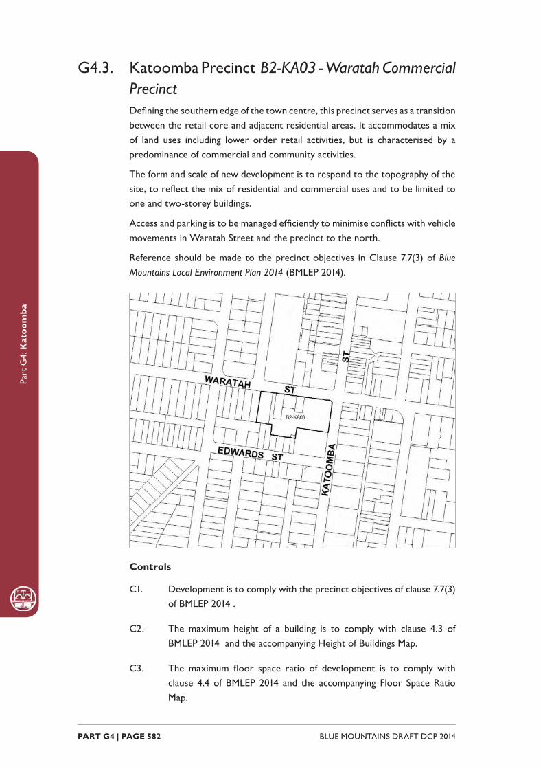
Part
G4:
Kat
oom
ba
BLUE MOUNTAINS DRAFT DCP 2014 PART G4 | PAGE 582
G4.3. Katoomba Precinct B2-KA03 - Waratah Commercial PrecinctDefi ning the southern edge of the town centre, this precinct serves as a transition between the retail core and adjacent residential areas. It accommodates a mix of land uses including lower order retail activities, but is characterised by a predominance of commercial and community activities.
The form and scale of new development is to respond to the topography of the site, to refl ect the mix of residential and commercial uses and to be limited to one and two-storey buildings.
Access and parking is to be managed effi ciently to minimise confl icts with vehicle movements in Waratah Street and the precinct to the north.
Reference should be made to the precinct objectives in Clause 7.7(3) of Blue Mountains Local Environment Plan 2014 (BMLEP 2014).
Controls
C1. Development is to comply with the precinct objectives of clause 7.7(3) of BMLEP 2014 .
C2. The maximum height of a building is to comply with clause 4.3 of BMLEP 2014 and the accompanying Height of Buildings Map.
C3. The maximum fl oor space ratio of development is to comply with clause 4.4 of BMLEP 2014 and the accompanying Floor Space Ratio Map.
Part
G4:
Kat
oom
ba
PART G4 | PAGE 583BLUE MOUNTAINS DRAFT DCP 2014
C4. New development with a frontage to Waratah or Katoomba Street is generally to have a zero setback; however greater setbacks may be considered where it can be demonstrated that the setback incorporates active street frontages.
C5. Development is to respond to the topography of the site and step down the slope.
C6. Walls visible from the public domain shall not be left blank, unadorned or unarticulated.
C7. Development shall present visible retail or other commercial activity along a minimum of 65% of a frontage to Waratah and Katoomba Streets.
C8. Development fronting the public domain shall provide continuous overhead awnings along the length of that frontage.
C9. Any parking and heavy vehicle loading and manoeuvring areas are to be designed to minimise visual impact when viewed from the public domain, and to be safely and effi ciently designed.
G4.4. Katoomba Precinct B2-KA04—Town Approach PrecinctLocated adjacent to the primary road and rail corridors, this precinct will experience substantial redevelopment of sites and will operate as both a “gateway” and transport interchange for the Katoomba Village. New development will support this gateway role by presenting urban design of the highest quality that contributes to a positive fi rst experience of Katoomba. This, together with a mix of land uses that support the role of the town centre, will entice passing traffi c to enter the town.
Trading over extended hours, development will provide passive surveillance and improved public safety and amenity. The precinct’s interchange role will be supported by ample provision of commuter car parking, coach parking and convenient pedestrian access to the town centre. Whilst offering high levels of accessibility to both pedestrian and vehicles, potential confl icts between the two will be minimised.
Reference should be made to the precinct objectives in Clause 7.7(4) of Blue Mountains Local Environment Plan 2014 (BMLEP 2014).

Part
G4:
Kat
oom
ba
BLUE MOUNTAINS DRAFT DCP 2014 PART G4 | PAGE 584
Controls
C1. Development is to comply with the precinct objectives of clause 7.7(4) of BMLEP 2014.
C2. The maximum height of a building is to comply with clause 4.3 of BMLEP 2014 and the accomanying Height of Buildings Map.
C3. The maximum fl oor space ratio of development is to comply with clause 4.4 of BMLEP 2014 and the accompanying Floor Space Ratio Map.
C4. Buildings fronting Goldsmith Place are to have zero setback to that frontage; however, greater setbacks may be considered, but only where it can be demonstrated that the setback incorporates active street frontages.
C5. New development is to have visible and interactive uses distributed regularly along 65% of its frontage to Goldsmith Place.
C6. Where development involves long elevations, they are to present varied heights and forms.
C7. Walls in new development visible from the public domain are not to be left blank, unadorned or unarticulated.
C8. Roof forms to new development are to conceal mechanical plant and equipment from adjacent development, private open space and the
Part
G4:
Kat
oom
ba
PART G4 | PAGE 585BLUE MOUNTAINS DRAFT DCP 2014
public domain.
C9. New development is to provide gateway or entry elements at the corner and frontage of the Great Western Highway and Yeaman’s Bridge.
C10. All parking areas and delivery docks are to be concealed from public view.
C11. New development is to provide awnings or colonnades over the entire length of public footpaths and pedestrian areas.
C12. New development is to provide pathways that minimise confl icts between vehicles and pedestrians.
C13. Clear sight lines are to be provided along the entire length of a pedestrian area.
C14. New development is to incorporate appropriate levels of lighting to all pedestrian areas. All light fi ttings are to have a form and character that is consistent with that of the building.
C15. New development is to provide public pedestrian access between Yeaman’s Bridge and Goldsmith Place, where development provides a frontage to both places.
G4.5. Katoomba Precinct B2-KA05—Town Entry PrecinctThis precinct derives its prominence from its town entry position and associated visibility from Yeaman’s Bridge, Bathurst Road and Parke Street.
New development provides high quality entry statements and contributes to the defi nition of Katoomba as a town with a unique character defi ned by its historic built form and environmental setting. This precinct will support the viability of the town’s core retail areas by providing a mix of land uses including commercial, residential and retailing opportunities.
Future development will provide a streetscape that is generally two storeys in scale, conserves and celebrates built heritage and period items, and is represented by a near continuous row of separate shop buildings on narrow-fronted allotments. Traffi c management measures are provided to facilitate ready vehicular access to the town centre.
Reference should be made to the precinct objectives in Clause 7.7(5) of Blue Mountains Local Environment Plan 2014 (BMLEP 2014).
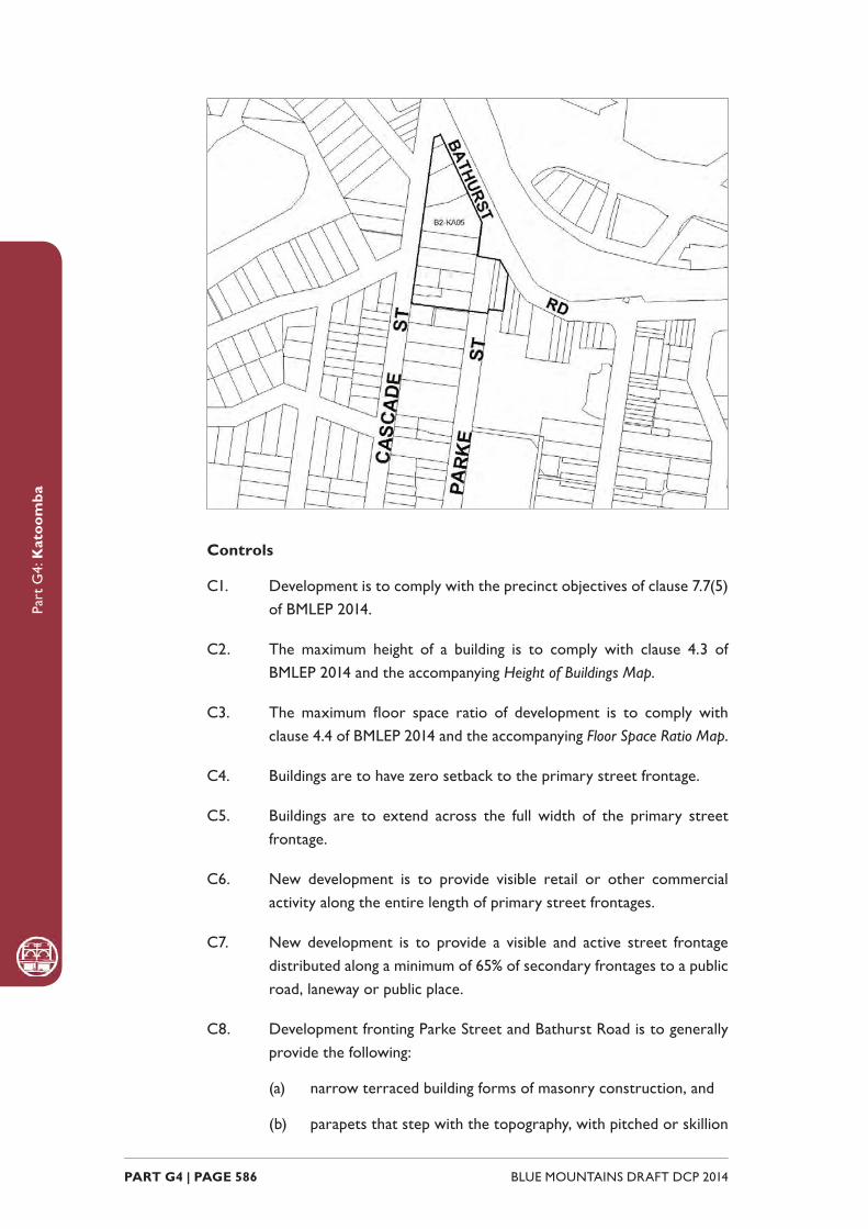
Part
G4:
Kat
oom
ba
BLUE MOUNTAINS DRAFT DCP 2014 PART G4 | PAGE 586
Controls
C1. Development is to comply with the precinct objectives of clause 7.7(5) of BMLEP 2014.
C2. The maximum height of a building is to comply with clause 4.3 of BMLEP 2014 and the accompanying Height of Buildings Map.
C3. The maximum fl oor space ratio of development is to comply with clause 4.4 of BMLEP 2014 and the accompanying Floor Space Ratio Map.
C4. Buildings are to have zero setback to the primary street frontage.
C5. Buildings are to extend across the full width of the primary street frontage.
C6. New development is to provide visible retail or other commercial activity along the entire length of primary street frontages.
C7. New development is to provide a visible and active street frontage distributed along a minimum of 65% of secondary frontages to a public road, laneway or public place.
C8. Development fronting Parke Street and Bathurst Road is to generally provide the following:
(a) narrow terraced building forms of masonry construction, and
(b) parapets that step with the topography, with pitched or skillion
Part
G4:
Kat
oom
ba
PART G4 | PAGE 587BLUE MOUNTAINS DRAFT DCP 2014
roofs behind, and
(c) symmetry and vertical proportion of window and door openings, and
(d) articulation of shopfront elements, and
(e) cantilevered metal awnings.
Note: Guidelines on traditional shopfront design are found in B3.2.1 Infi ll
shopfront buildings in B3 Design development , and in 9.7 Traditional shopfront
buildings in Part D1 Heritage Conservation where heritage considerations
apply.
C9. Signage is to be sympathetic to the style and detailing of the shop front, and be of appropriate size, scale and location.
C10. New development is to provide continuous overhead awnings along the length of a frontage to a street, laneway or public place.
C11. New development is to incorporate appropriate levels of lighting to all pedestrian areas. All light fi ttings are to have a form and character that is consistent with that of the building.
C12. On-site car parking is not to be accessed directly from Bathurst Road.
G4.6. Katoomba Precinct B2-KA06—Cultural Centre Precinct The precinct is defi ned by the success of the urban renewal strategy that has seen it transformed from a predominantly vacant site into a place that provides a focus for cultural and social activities and learning. The precinct includes shopping experiences, contributing to Katoomba’s revitalisation. The development enhances the urban environment in this part of Katoomba and defi nes the western edge of the town centre as a principal vehicular entry into the town, which is also a gateway to the Echo Point precinct.
The highly successful new landmark buildings contribute a contemporary layer to Katoomba’s townscape qualities and to the surrounding urban pattern. The podium provides views of the town’s historic streetscapes and the magnifi cent natural setting. The development is immediately recognisable to visitors of Katoomba as an identifi able cultural and tourism destination. The community and visitors value this place as it celebrates the unique character of Katoomba, while telling its own ongoing story.
Reference should be made to the precinct objectives in Clause 7.7(6) of Blue Mountains Local Environment Plan 2014 (BMLEP 2014).

Part
G4:
Kat
oom
ba
BLUE MOUNTAINS DRAFT DCP 2014 PART G4 | PAGE 588
Controls
C1. Development is to comply with the precinct objectives of clause 7.7(6) of BMLEP 2014.
C2. The maximum height of a building is to comply with clause 4.3 of BMLEP 2014 and the accompanying Height of Buildings Map .
C3. The maximum fl oor space ratio of development is to comply with clause 4.4 of BMLEP 2014 and the accompanying Floor Space Ratio Map .
C4. The maximum site cover for buildings with enclosed walls that are to be erected on the podium level is not to exceed 75% of the total podium area.
Design considerations
C5. Development of the cultural centre is to be the product of an integrated design approach.
C6. Development is to create signifi cant, interlinked public spaces that can be used independently or in conjunction with the cultural centre.
C7. Retail development is to include a district supermarket or a major store and may include associated specialty outlets.

Part
G4:
Kat
oom
ba
PART G4 | PAGE 589BLUE MOUNTAINS DRAFT DCP 2014
C8. A direct, dedicated and vertically integrated pedestrian route is to link all levels of the cultural facility, retail area and car park.
C9. Facades are to generally be highly articulated and differentiated to incorporate appropriate rhythm, with proportions and depth in the facade to reduce bulk and mass.
C10. Long, continuous elevations are to be avoided, with principal facades broken into discrete bays or modules; verticality is encouraged.
C11. Windows, openings and cultural displays are to be a predominant element on the eastern facade to College Lane.
C12. Windows are to be provided in the southern facade of the library building.
C13. The design of parking and heavy vehicle loading and manoeuvring areas on the Parke Street facade is to minimise visual impact when viewed from public streets and places.
C14. Parke Street elevations are to provide a variety of architectural and urban design elements such as landscaping, viewing places, and windows or openings, with art works or display cases provided along the windowless facades.
C15. The north-western entry of the site is to achieve a sense of visual connectivity between Parke Street and the public court by measures such as the provision of an open visual entry statement and vistas of the public court for passing vehicles and pedestrians.
C16. Doors, which are to be provided to any loading bay, are to be fully integrated with architectural elements of the street facade.
C17. Building design elements such as the use of fi nishes, materials and colours are to be sympathetic to the historic town centre and adjacent heritage items and avoid large expanses of refl ective materials.
C18. The building design is to indicate locations for public art and commercial signs which will be presented in a manner that does not compromise the building’s contribution to the streetscape.
C19. The development and adjacent public places are to adopt an integrated approach to urban design, landscaping, the display of public art and built form, which serves to identify, and act as a visual attractor for, the cultural facility.
Energy conservation
Part
G4:
Kat
oom
ba
BLUE MOUNTAINS DRAFT DCP 2014 PART G4 | PAGE 590
C20. The design and siting of buildings is to maximise energy conservation techniques in construction, and is to use materials with low embodied energy.
C21. Water conservation and water management systems are to be implemented.
Public spaces
C22. A major court is to be proved in the northern part of the Precinct at the podium level, providing:
(a) a link to the Carrington Hotel to the north, and
(b) access between College Lane and Parke Street, which is suitable for use by all members of the community including those with limited mobility.
C23. The court is to include some shelter and soft landscaping elements to assist with the creation of pleasant liveable space.
C24. Development is to provide public spaces that are integrated by a suite of directional signage, street furniture and light fi ttings, which complement and reinforce links to prominent adjoining public places.
C25. A development application is to show how crime minimisation is to be achieved, particularly for public spaces that could lead to anti-social behaviour.
C26. The public spaces are to be capable of housing public art initiatives and other events.
C27. Development is to include public spaces and buildings which provide places from which to view the town and the Jamison Valley and Frank Walford Park.
Traffi c management
C28. A Traffi c Impact Assessment shall be prepared which identifi es the traffi c impacts of proposed development and provides mitigation measures, if required, for the local road network.
C29. College Lane is to be designed for shared pedestrian and vehicular access.
Heritage
C30. Architectural design of any building must respect the heritage
Part
G4:
Kat
oom
ba
PART G4 | PAGE 591BLUE MOUNTAINS DRAFT DCP 2014
signifi cance of the site and its heritage setting.
C31. Roof forms are to be designed to be viewed from above, with mechanical plant and equipment being concealed or treated to minimise any visual impact.
C32. Any heritage impact statement required for new development is to demonstrate that the proposed development does not signifi cantly impede views from the upper terrace level of the Carrington Hotel to the Jamison Valley.
C33. The heritage signifi cance of the Precinct as the location of the fi rst permanent private residence in Katoomba (Froma House, c1867) and as a school site since 1912 shall be interpreted as part of any development proposed for the site.
Advertising signage
C34. The design and size of advertising signage is to:
(a) Be compatible with the cultural facility;
(b) respect the cultural signifi cance of the building;
(c) reduce visual clutter by rationalising and simplifying signage; and
(d) be the product of an integrated signage package for the entire building or the precinct as a whole.
C35. Advertising signage is to be fully integrated with the architectural elements of that part of the building on which it is located.
C36. Advertising signage that identifi es, or relates to the use of, the entire building or the precinct as a whole shall:
(a) be designed to complement the display of any public art work on the building on which it is located, and
(b) be located below the podium level.
Note: Podium level is defi ned as: at or below an Australian Height Datum
of 1024.5m, at or below the fi nished level of College Lane at the northern
boundary of the precinct, and at or below 12m above the fi nished level of
College Lane at the south eastern boundary of the precinct.
C37. Advertising signage related exclusively to development for the purpose of the district supermarket or other commercial premises located below the podium level, and any associated facilities, is to:
(a) be compatible with the scale and proportion of the building on

Part
G4:
Kat
oom
ba
BLUE MOUNTAINS DRAFT DCP 2014 PART G4 | PAGE 592
which the signage is to be located, and
(b) be limited to business identifi cation purposes for the major tenant for any signage within the precinct visible from Parke Street, and shall be contained within an envelope or envelopes with a total maximum area of 15m2, and
(c) be limited to business identifi cation purposes for the major tenant and associated retail tenants for any signage within the precinct that is visible from College Lane, and shall be contained within an envelope or envelopes with a total maximum area of 20m2, and
(d) not be used for product promotion or other temporary advertising purposes.
Note: Podium level is defi ned as: at or below an Australian Height
Datum of 1024.5m, at or below the fi nished level of College Lane at
the northern boundary of the precinct, and at or below 12m above
the fi nished level of College Lane at the south eastern boundary of
the precinct.
C38. Advertising signage must be attached to a building and shall:
(a) be fl ush to the wall and not protrude beyond 300mm from the wall to which the structure is attached, or
(b) be suspended under an awning, entrance or the like, but only where a clearance of 2500mm is provided between the structure and the fl oor or road pavement below.
C39. Advertising signage may be considered that does not comply with Control 38 above only if:
(a) it is demonstrated that the signage assists in reducing the area of advertising signage and is of a high design quality and fi nish, or
(b) the signage relates to development for the purpose of a cultural facility.
C40. Any illumination of advertising signage must not:
(a) result in unacceptable glare, or
(b) affect the safety of pedestrians or vehicles, or
(c) detract from the amenity of any residence within the locality.
C41. To ensure that advertising signage does not compromise safety, signage shall be designed so that:

Part
G4:
Kat
oom
ba
PART G4 | PAGE 593BLUE MOUNTAINS DRAFT DCP 2014
(a) users of the public road are not hindered or distracted by signage, and
(b) the sightlines for pedestrians and/or cyclists from public places are not obstructed.
G4.7. Katoomba Precinct R1-KA07—Lurline Street South PrecinctThis location presents a range of tourist-related uses that contribute to the visitor experience by providing an interesting and interactive streetscape. Development retains a generally single-storey scale and refl ects traditional architectural features of the historic built form within this precinct.
Some typical 19th/early 20th century details present in the locality and are:-
• fence and balustrade railings of vertical or diagonal forms (not horizontal), and
• timber verandahs roofed independently from the main roof, and
• timber windows, usually double hung or casement, and
• doors of panelled construction, and
• weatherboarding and timberwork dressed and painted, and
• circular downpipes, and
• chimneys and chimney pots, and
• fret-worked timber barge boards, and
• timber supported window canopies.
It is essential for new development in this area to be compatible with the predominant heritage and domestic character of the precinct, particularly that typifi ed by the numerous, high-quality Federation period houses present.
Reference should be made to the precinct objectives in Clause 7.7(7) of Blue Mountains Local Environment Plan 2014 (BMLEP 2014) .
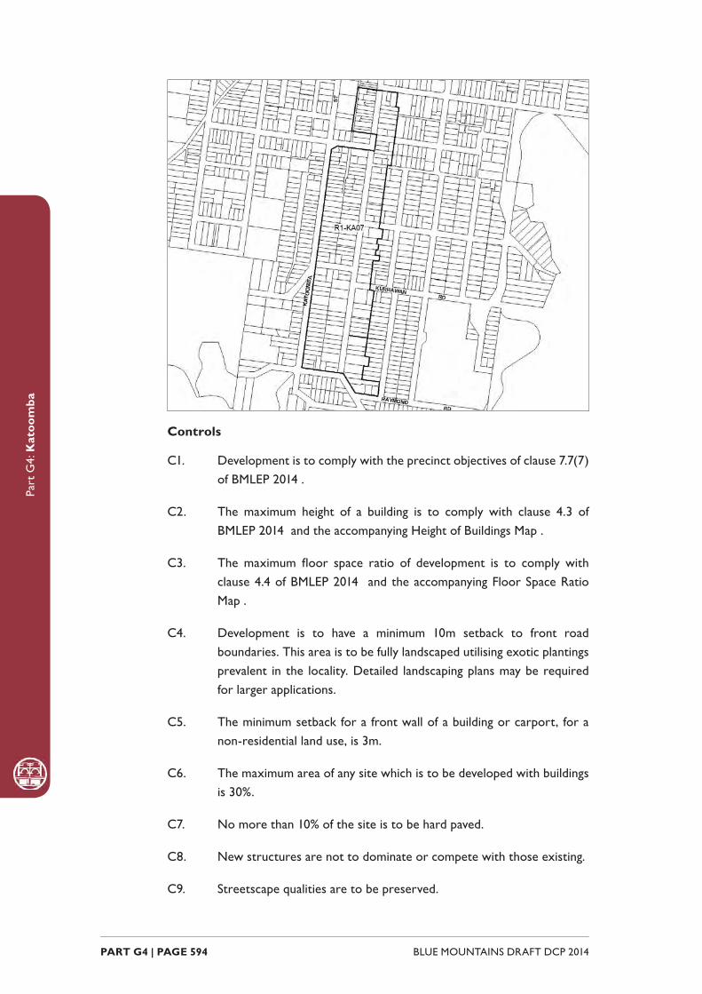
Part
G4:
Kat
oom
ba
BLUE MOUNTAINS DRAFT DCP 2014 PART G4 | PAGE 594
Controls
C1. Development is to comply with the precinct objectives of clause 7.7(7) of BMLEP 2014 .
C2. The maximum height of a building is to comply with clause 4.3 of BMLEP 2014 and the accompanying Height of Buildings Map .
C3. The maximum fl oor space ratio of development is to comply with clause 4.4 of BMLEP 2014 and the accompanying Floor Space Ratio Map .
C4. Development is to have a minimum 10m setback to front road boundaries. This area is to be fully landscaped utilising exotic plantings prevalent in the locality. Detailed landscaping plans may be required for larger applications.
C5. The minimum setback for a front wall of a building or carport, for a non-residential land use, is 3m.
C6. The maximum area of any site which is to be developed with buildings is 30%.
C7. No more than 10% of the site is to be hard paved.
C8. New structures are not to dominate or compete with those existing.
C9. Streetscape qualities are to be preserved.
Part
G4:
Kat
oom
ba
PART G4 | PAGE 595BLUE MOUNTAINS DRAFT DCP 2014
C10. New development is to provide activated street frontages.
Forms and fi nishes
C11. The building mass of new developments is to be broken into elements of no more than 10m in any dimension to ensure an appropriate scale results.
C12. Roof form is to relate to neighbouring examples, and have a traditional pitch (approximately 35 degrees) in hipped and/or gabled forms. Flat or simple skillion roofs for a main roof form are inappropriate unless concealed by a parapet.
C13. Roof cladding is to be generally corrugated metal sheeting or unglazed terracotta (Marseille) tiles.
C14. Buildings are to incorporate forms and materials that are consistent with, or complementary to, the periods and architectural character of adjoining buildings. This is to include gables, verandahs, hipped roofs, timber cladding or other architectural elements. The treatment of facade elements such as windows, walling and verandahs are to be in keeping with the predominant proportions of existing buildings.
C15. New work is to be sympathetic to older details without direct imitation. New development is to be remain subordinate to the established character through simplifi ed detailing.
C16. New development is not to confl ict in character or scale, but maintain consistency of streetscape.
C17. Walls in new development visible from the public domain are not to be left blank, unadorned or unarticulated.
C18. Timber column-supported verandahs should be incorporated in the front elevation where possible and appropriate, to produce a shadow-effect and be a defi ning element of a building facade. Verandah widths can be varied to suit the measure of climatic control required. Verandahs need not return around all sides of a building to provide a desirable appearance.
C19. The verticality of windows is to be preserved where visible. Both doors and windows can be grouped together in bays to provide large glass areas if required and where appropriate.
C20. Timber windows are generally to be used in preference to aluminium particularly where visible. Timber windows are generally to be painted externally.
Part
G4:
Kat
oom
ba
BLUE MOUNTAINS DRAFT DCP 2014 PART G4 | PAGE 596
C21. Front fences are to match the primary material of the house, and be either of low brick construction with piers and panels, timber pickets or hedges.
C22. Appropriate wall surfaces are to be used. These include simple face brickwork, plain dry-pressed ‘commons’ bricks, rendered and painted brick walls, timber weatherboards, and fi bre cement sheeting.
C23. Traditional heritage colour schemes are generally to be followed; a light stone colour should be chosen for walling, with a dark colour for architectural trim. Corrugated metal roofs are preferably dark green, dark red or plain galvanised steel. Many standard ‘Colorbond’ colours are not appropriate for historic precincts.
C24. Buildings are to be constructed on solid brick or stone bases surrounding sub-fl oor areas.
C25. Commercial signage is to be co-ordinated to refl ect a village character, with local design themes predominating over corporate signage.
Landscaping
C26. Existing plantings, mature trees and dominant garden elements are to be generally maintained. This is of particular importance in front setback areas. Landscaping of new developments is to repeat elements of existing plantings in the locality. A strong preference is to be given to exotic species.
On-site parking
C27. Garages, access and car parking are to be screened from the public domain and located behind the front building line so as not to adversely impact upon streetscape, pedestrian circulation, and building character.
C28. All parking demands generated by developments are to be met fully on-site.
Existing Buildings (Dwellings)
C29. Where non-residential uses on developed sites are proposed, priority is to be given to the conservation, adaptive re-use and restoration of existing dwellings. The demolition of existing buildings will generally not be supported unless, in the opinion of the Council, the subject building is not contributory to the character and value of the streetscape.
Part
G4:
Kat
oom
ba
PART G4 | PAGE 597BLUE MOUNTAINS DRAFT DCP 2014
Existing Motels
C30. The existing motels in this precinct are discordant elements and their sympathetic redevelopment is encouraged, to provide a more domestic scale. This generally means:
(a) articulated forms of no greater than 10m by 15m, and
(b) one or two-storey height, and
(c) traditional building and roof forms, and
(d) parking underground or out of sight of the road, and
(e) driveway entrances with a domestic scale of approximately 3m wide, and
(f) substantial tree planting, and
(g) limited signage, and
(h) vehicular access limited to Katoomba Street and Lurline Street.
G4.8. Katoomba Precinct R1-KA08—Lurline Street North PrecinctThe precinct is characterised by a diversity of residential and commercial uses catering to both local residents and tourists. It contains a mixture of single dwellings, larger character properties such as guesthouses and hotels, as well as modern buildings which interrupt the historic character of the town centre fringes. Built form is of a comparatively denser scale and takes advantage of the unique views available to the east over the Jamison Valley. Architectural detailing refl ects forms and fi nishes present in the historic guesthouses and other residential buildings typical in and around Lurline Street.
Future development is to consolidate the higher density built form and tourist land uses within this area. The consolidation of land uses assists in providing a connection between the Katoomba town centre and Echo Point.
Reference should be made to the precinct objectives in Clause 7.7(8) of Blue Mountains Local Environment Plan 2014 (BMLEP 2014) .

Part
G4:
Kat
oom
ba
BLUE MOUNTAINS DRAFT DCP 2014 PART G4 | PAGE 598
Controls
C1. Development is to comply with the precinct objectives of clause 7.7(8) of BMLEP 2014 .
C2. The maximum height of a building is to comply with clause 4.3 of BMLEP 2014 and the accompanying Height of Buildings Map .
C3. The maximum fl oor space ratio of development is to comply with clause 4.4 of BMLEP 2014 and the accompanying Floor Space Ratio Map .
C4. Front setbacks are to be consistent with setbacks of adjoining properties.
C5. The maximum site coverage of any building is not to exceed 50% of the total site area.
C6. New development must enable view sharing with surrounding development, particularly from main habitable rooms of that development.
C7. New development must be able to provide for basement car parking if required.
C8. New development is to incorporate through-site pedestrian links to improve the permeability of the area if appropriate and desirable.
Part
G4:
Kat
oom
ba
PART G4 | PAGE 599BLUE MOUNTAINS DRAFT DCP 2014
C9. New development is to provide activated street frontages.
C10. New development is to be sympathetic to the traditional building forms, materials and details of the precinct, including the use of traditionally-pitched roofs, articulated layouts and forms, verandahs, timber joinery, vertically–proportioned openings and some painted external fi nishes, with a curtilage of landscaped areas and an address to the street provided. New development is to be similar in form and materials to quality older buildings but subservient in detail to distinguish it as new work.
C11. Walls in new development visible from the public domain are not to be left blank, unadorned or unarticulated.
C12. Commercial signage is to be co-ordinated to refl ect a village character, where local design themes predominate over corporate signage.
C13. Garages, access and car parking are to be screened from the public domain and located behind the front building line so as not to adversely impact upon streetscape, pedestrian circulation, and building character.
G4.9. Katoomba Precinct R1-KA09—Gang Gang Street East PrecinctSituated on one of the highest points in Katoomba and with expansive views to the Jamison Valley, development on this site reinforces the historically signifi cant tradition of guesthouse accommodation within the precinct. Development is responsive to the historic signifi cance of buildings within the precinct and provides for a transition of building scale, with reduced scale toward the land within the zone E4 Environmental Living to the north. The commanding presence of the built form within a landscape setting is maintained and there are strong pedestrian linkages between the precinct and the town centre. Period features are retained. Any additions to the existing buildings are consistent with the historic architectural themes.
Reference should be made to the precinct objectives in Clause 7.7(9) of Blue Mountains Local Environment Plan 2014 (BMLEP 2014) .
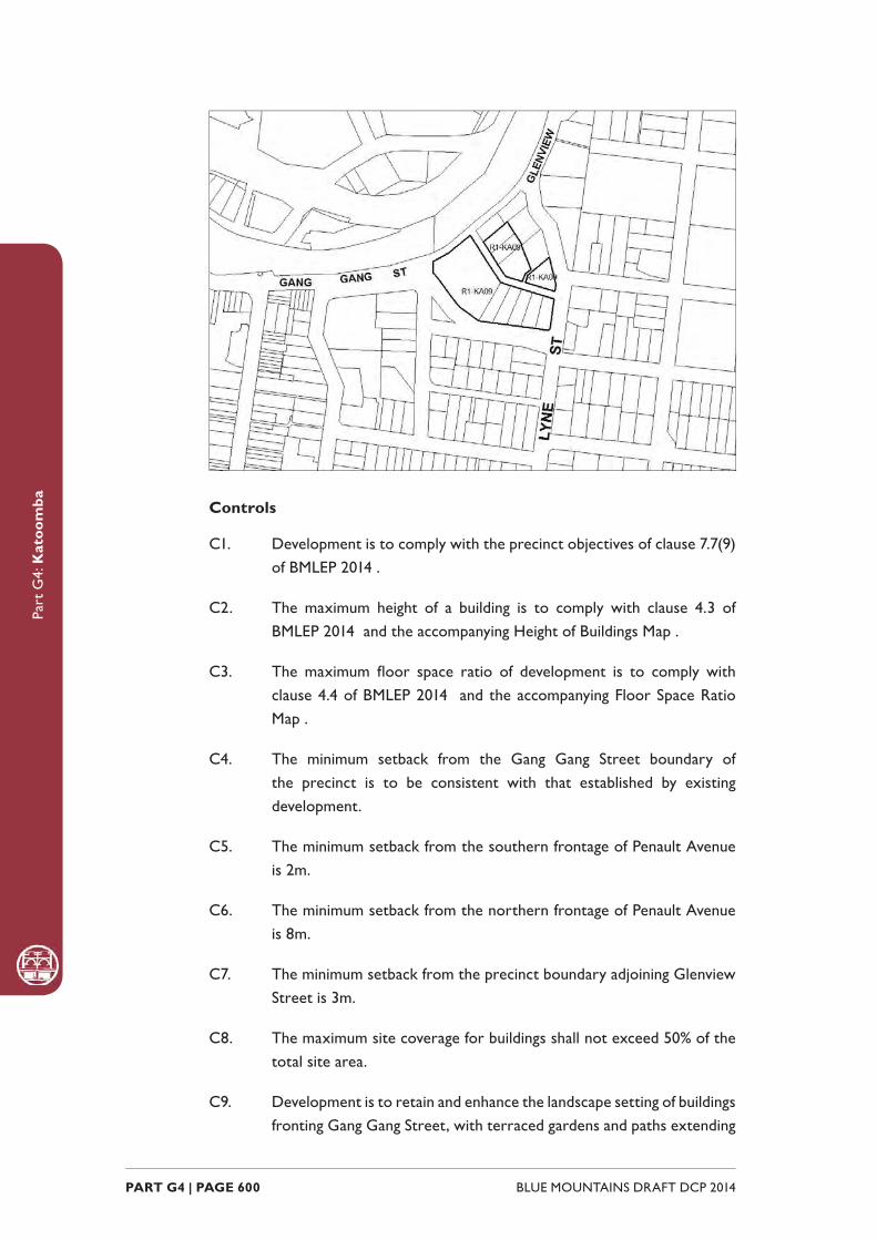
Part
G4:
Kat
oom
ba
BLUE MOUNTAINS DRAFT DCP 2014 PART G4 | PAGE 600
Controls
C1. Development is to comply with the precinct objectives of clause 7.7(9) of BMLEP 2014 .
C2. The maximum height of a building is to comply with clause 4.3 of BMLEP 2014 and the accompanying Height of Buildings Map .
C3. The maximum fl oor space ratio of development is to comply with clause 4.4 of BMLEP 2014 and the accompanying Floor Space Ratio Map .
C4. The minimum setback from the Gang Gang Street boundary of the precinct is to be consistent with that established by existing development.
C5. The minimum setback from the southern frontage of Penault Avenue is 2m.
C6. The minimum setback from the northern frontage of Penault Avenue is 8m.
C7. The minimum setback from the precinct boundary adjoining Glenview Street is 3m.
C8. The maximum site coverage for buildings shall not exceed 50% of the total site area.
C9. Development is to retain and enhance the landscape setting of buildings fronting Gang Gang Street, with terraced gardens and paths extending

Part
G4:
Kat
oom
ba
PART G4 | PAGE 601BLUE MOUNTAINS DRAFT DCP 2014
down to street level.
C10. New development is to incorporate forms and fi nishes that are consistent with, or complement the periods and architectural character of adjoining buildings.
C11. Walls that are visible from any public road or the transport corridor are not to be left blank, unadorned or unarticulated.
C12. Commercial signage is to be non-obtrusive and complement the historical character of the precinct.
C13. Parking is to be located off Penault Avenue.
C14. Existing landscaping within the building setback to the north of Penault Avenue is to be retained or enhanced as part of any development proposal.
G4.10. Katoomba Precinct R3-KA10—Great Western Highway PrecinctThis location provides opportunities for the provision of urban housing in a form that positively contributes to the eastern approach to Katoomba and incorporates distinctive tree planting.
Reference should be made to the precinct objectives in Clause 7.7(10) of Blue Mountains Local Environment Plan 2014 (BMLEP 2014) .
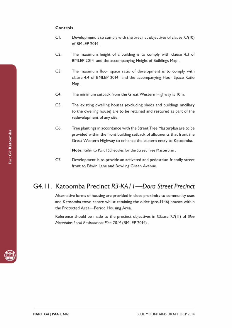
Part
G4:
Kat
oom
ba
BLUE MOUNTAINS DRAFT DCP 2014 PART G4 | PAGE 602
Controls
C1. Development is to comply with the precinct objectives of clause 7.7(10) of BMLEP 2014 .
C2. The maximum height of a building is to comply with clause 4.3 of BMLEP 2014 and the accompanying Height of Buildings Map .
C3. The maximum fl oor space ratio of development is to comply with clause 4.4 of BMLEP 2014 and the accompanying Floor Space Ratio Map .
C4. The minimum setback from the Great Western Highway is 10m.
C5. The existing dwelling houses (excluding sheds and buildings ancillary to the dwelling house) are to be retained and restored as part of the redevelopment of any site.
C6. Tree plantings in accordance with the Street Tree Masterplan are to be provided within the front building setback of allotments that front the Great Western Highway to enhance the eastern entry to Katoomba.
Note: Refer to Part I Schedules for the Street Tree Masterplan .
C7. Development is to provide an activated and pedestrian-friendly street front to Edwin Lane and Bowling Green Avenue.
G4.11. Katoomba Precinct R3-KA11—Dora Street PrecinctAlternative forms of housing are provided in close proximity to community uses and Katoomba town centre whilst retaining the older (pre-1946) houses within the Protected Area—Period Housing Area.
Reference should be made to the precinct objectives in Clause 7.7(11) of Blue Mountains Local Environment Plan 2014 (BMLEP 2014) .
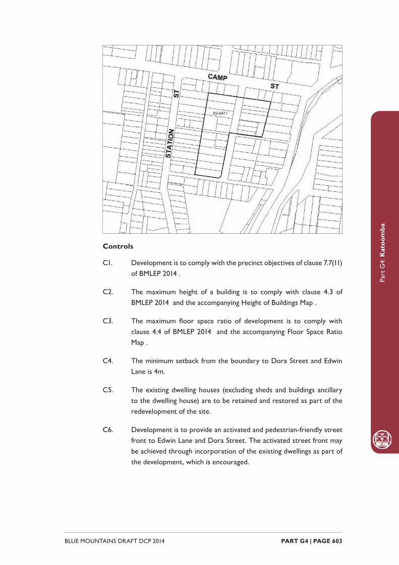
Part
G4:
Kat
oom
ba
PART G4 | PAGE 603BLUE MOUNTAINS DRAFT DCP 2014
Controls
C1. Development is to comply with the precinct objectives of clause 7.7(11) of BMLEP 2014 .
C2. The maximum height of a building is to comply with clause 4.3 of BMLEP 2014 and the accompanying Height of Buildings Map .
C3. The maximum fl oor space ratio of development is to comply with clause 4.4 of BMLEP 2014 and the accompanying Floor Space Ratio Map .
C4. The minimum setback from the boundary to Dora Street and Edwin Lane is 4m.
C5. The existing dwelling houses (excluding sheds and buildings ancillary to the dwelling house) are to be retained and restored as part of the redevelopment of the site.
C6. Development is to provide an activated and pedestrian-friendly street front to Edwin Lane and Dora Street. The activated street front may be achieved through incorporation of the existing dwellings as part of the development, which is encouraged.
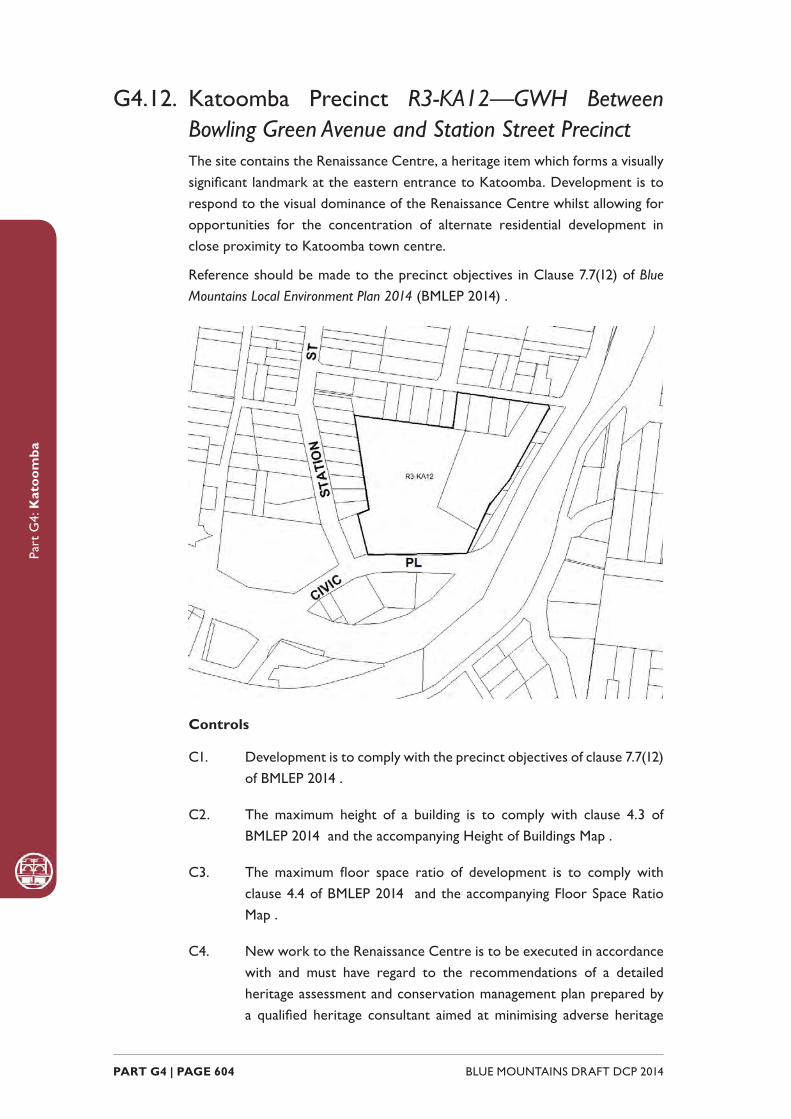
Part
G4:
Kat
oom
ba
BLUE MOUNTAINS DRAFT DCP 2014 PART G4 | PAGE 604
G4.12. Katoomba Precinct R3-KA12—GWH Between Bowling Green Avenue and Station Street PrecinctThe site contains the Renaissance Centre, a heritage item which forms a visually signifi cant landmark at the eastern entrance to Katoomba. Development is to respond to the visual dominance of the Renaissance Centre whilst allowing for opportunities for the concentration of alternate residential development in close proximity to Katoomba town centre.
Reference should be made to the precinct objectives in Clause 7.7(12) of Blue Mountains Local Environment Plan 2014 (BMLEP 2014) .
Controls
C1. Development is to comply with the precinct objectives of clause 7.7(12) of BMLEP 2014 .
C2. The maximum height of a building is to comply with clause 4.3 of BMLEP 2014 and the accompanying Height of Buildings Map .
C3. The maximum fl oor space ratio of development is to comply with clause 4.4 of BMLEP 2014 and the accompanying Floor Space Ratio Map .
C4. New work to the Renaissance Centre is to be executed in accordance with and must have regard to the recommendations of a detailed heritage assessment and conservation management plan prepared by a qualifi ed heritage consultant aimed at minimising adverse heritage

Part
G4:
Kat
oom
ba
PART G4 | PAGE 605BLUE MOUNTAINS DRAFT DCP 2014
impacts related to development of the site. New development will require approval from the NSW Heritage Council.
C5. Any new buildings for the site are to be located to preserve the curtilage of the Renaissance Centre that is established, to the satisfaction of the consent authority, by the heritage impact assessment and conservation management plan for the site.
C6. The existing buildings on site are to be retained.
C7. Access to the site is to be provided via Station Street.
C8. The existing mature eucalypts are to be retained where possible and substantial plantings undertaken in order to screen hard surfaces and car parking areas from the Great Western Highway.
G4.13. Katoomba Precinct R3-KA13—Lurline and Vale Streets PrecinctAlternative forms of housing incorporate views to the southeast and provide passive surveillance of Kingsford Smith Park. The topography of the site promotes development that steps down the slope, thus permitting the retention of views to the south-east from Lurline Street. Design of buildings is to be responsive to the heritage signifi cance of Kingsford Smith Park and the character of the historic buildings within the vicinity and also respond to the prominence of the location and the topography of the site.
Reference should be made to the precinct objectives in Clause 7.7(13) of Blue Mountains Local Environment Plan 2014 (BMLEP 2014) .

Part
G4:
Kat
oom
ba
BLUE MOUNTAINS DRAFT DCP 2014 PART G4 | PAGE 606
Controls
C1. Development is to comply with the precinct objectives of clause 7.7(13) of BMLEP 2014 .
C2. The maximum height of a building is to comply with clause 4.3 of BMLEP 2014 and the accompanying Height of Buildings Map .
C3. The maximum fl oor space ratio of development is to comply with clause 4.4 of BMLEP 2014 and the accompanying Floor Space Ratio Map .
C4. The minimum setback from Lurline Street is 8m.
C5. The minimum setback from Vale Street is to be within 20% of the average setback of dwellings on adjoining allotments.
C6. Buildings are to step down the slope.
C7. Development is to take into consideration the retention of existing views from buildings on Lurline Street and is to retain view corridors from Lurline Street to the south east to the satisfaction of the consent authority.
C8. Filtered views are to be provided from the living areas of dwellings into Kingsford Smith Park where possible.
C9. Development adjacent to Vale Street is to address the street and provide an active frontage such as windows, doors and verandahs.
C10. Landscaping is not to signifi cantly obstruct views from buildings into Kingsford Smith Park.
G4.14. Katoomba Precinct R3-KA14—Lurline Street Housing PrecinctForming the eastern edge of the town centre, this precinct provides multi-dwelling accommodation for both tourists and residents in a setting that is representative of a diversity of early twentieth century period apartment buildings and guesthouses.
New development is to contribute to the availability of diverse housing opportunities; however, traditional housing forms and their gardens are to be conserved and new development is to be of a built form consistent with and sympathetic to the relevant style of traditional housing.
The precinct will maintain strong connections to Katoomba Street through safe and convenient stairways and laneways.

Part
G4:
Kat
oom
ba
PART G4 | PAGE 607BLUE MOUNTAINS DRAFT DCP 2014
Reference should be made to the precinct objectives in Clause 7.7(14) of Blue Mountains Local Environment Plan 2014 (BMLEP 2014) .
Controls
C1. Development is to comply with the precinct objectives of clause 7.7(14) of BMLEP 2014 .
C2. The maximum height of a building is to comply with clause 4.3 of BMLEP 2014 and the accompanying Height of Buildings Map .
C3. The maximum fl oor space ratio of development is to comply with clause 4.4 of BMLEP 2014 and the accompanying Floor Space Ratio Map .
C4. Development is to provide a front building line consistent with that established by existing and adjacent development.
C5. Buildings are to conform to established building height patterns and be set behind landscaped front gardens.
C6. Building design is to be sympathetic to existing Federation and Inter-War apartment and guesthouse forms, and utilise open and/or glazed verandahs, traditionally-pitched roofs with appropriate roof detailing, articulated and painted brickwork walls, projecting bay windows, vertically-proportioned openings, and timber-framed balconies as relevant.
C7. Garages may front Lurline Street where the site grade and traffi c safety permits.

Part
G4:
Kat
oom
ba
BLUE MOUNTAINS DRAFT DCP 2014 PART G4 | PAGE 608
G4.15. Katoomba Precinct R3-KA15—Cascade and Parke Street Edge PrecinctDefi ning the western and southern edges of the town centre, this precinct serves as a transition between the retail core and adjacent residential areas. It accommodates a mix of land uses including lower order commercial and smaller home based employment activities.
New development refl ects the mix of residential and commercial uses, however new development will be consistent with a predominantly residential streetscape, which is characterised by one and two-storey scale development with curtilages made up of gardens and landscaping.
Reference should be made to the precinct objectives in Clause 7.7(15) of Blue Mountains Local Environment Plan 2014 (BMLEP 2014) .
Controls
C1. Development is to comply with the precinct objectives of clause 7.7(15) of BMLEP 2014 .
C2. The maximum height of a building is to comply with clause 4.3 of BMLEP 2014 and the accompanying Height of Buildings Map .
C3. The maximum fl oor space ratio of development is to comply with clause 4.4 of BMLEP 2014 and the accompanying Floor Space Ratio Map .
Part
G4:
Kat
oom
ba
PART G4 | PAGE 609BLUE MOUNTAINS DRAFT DCP 2014
C4. Buildings fronting Parke Street are to have a minimum setback of 3m.
C5. Buildings fronting Cascade Street are to have a minimum setback of 5m.
C6. Development on Cascade Street are to incorporate landscaped front gardens.
C7. New development is to be sympathetic to the traditional building forms, materials and details of the precinct, including the use of traditionally-pitched roofs, articulated layouts and forms, verandahs, timber joinery, vertically–proportioned openings and some painted external fi nishes, with a curtilage of landscaped areas and an address to the street provided. New development is to be similar in form and materials to quality older buildings but subservient in detail to distinguish it as new work.
C8. Parking areas are to be designed in a manner that minimises their visual impact when viewed from the public domain.
C9. Pedestrian access is to be provided to public walkways adjacent the precinct.
C10. Separate entrances are to be provided for residential and commercial uses in mixed use developments.
G4.16. Katoomba Precinct R3-KA16—Cnr Great Western Highway and Camp Street PrecinctDevelopment recognises and retains the important role and prominence of the site as part of the eastern approach to Katoomba. Infi ll development on the site presents a high quality urban design that complements the low density scale of development on the adjoining lands within the R6 Residential Character Conservation zone and retains existing period buildings within the precinct. Existing mature plantings are retained and further planting incorporated into the future development of the site. Reference should be made to the precinct objectives in Clause 7.7(16) of Blue Mountains Local Environment Plan 2014 (BMLEP 2014) .

Part
G4:
Kat
oom
ba
BLUE MOUNTAINS DRAFT DCP 2014 PART G4 | PAGE 610
Controls
C1. Development is to comply with the precinct objectives of clause 7.7(16) of BMLEP 2014 .
C2. The maximum height of a building is to comply with clause 4.3 of BMLEP 2014 and the accompanying Height of Buildings Map .
C3. The maximum fl oor space ratio of development must comply with clause 4.4 of BMLEP 2014 and the accompanying Floor Space Ratio Map .
C4. The setback from the Great Western Highway, Orient Street and Showground Lane boundaries of the precinct is to be consistent with that established by existing development.
C5. The setback from the Camp Street frontage is to allow for established vegetation gardens to be retained and is to be within 20% of the average setback of adjacent dwellings along Camp Street.
C6. The maximum site coverage for buildings is 50% of the total site area.
C7. Buildings facing Camp Street and Orient Street are to incorporate windows, doors, gables, awnings, verandahs and similar along these frontages.
C8. Tree plantings in accordance with the Street Tree Masterplan, are to be provided within the front building setback to Camp Street.
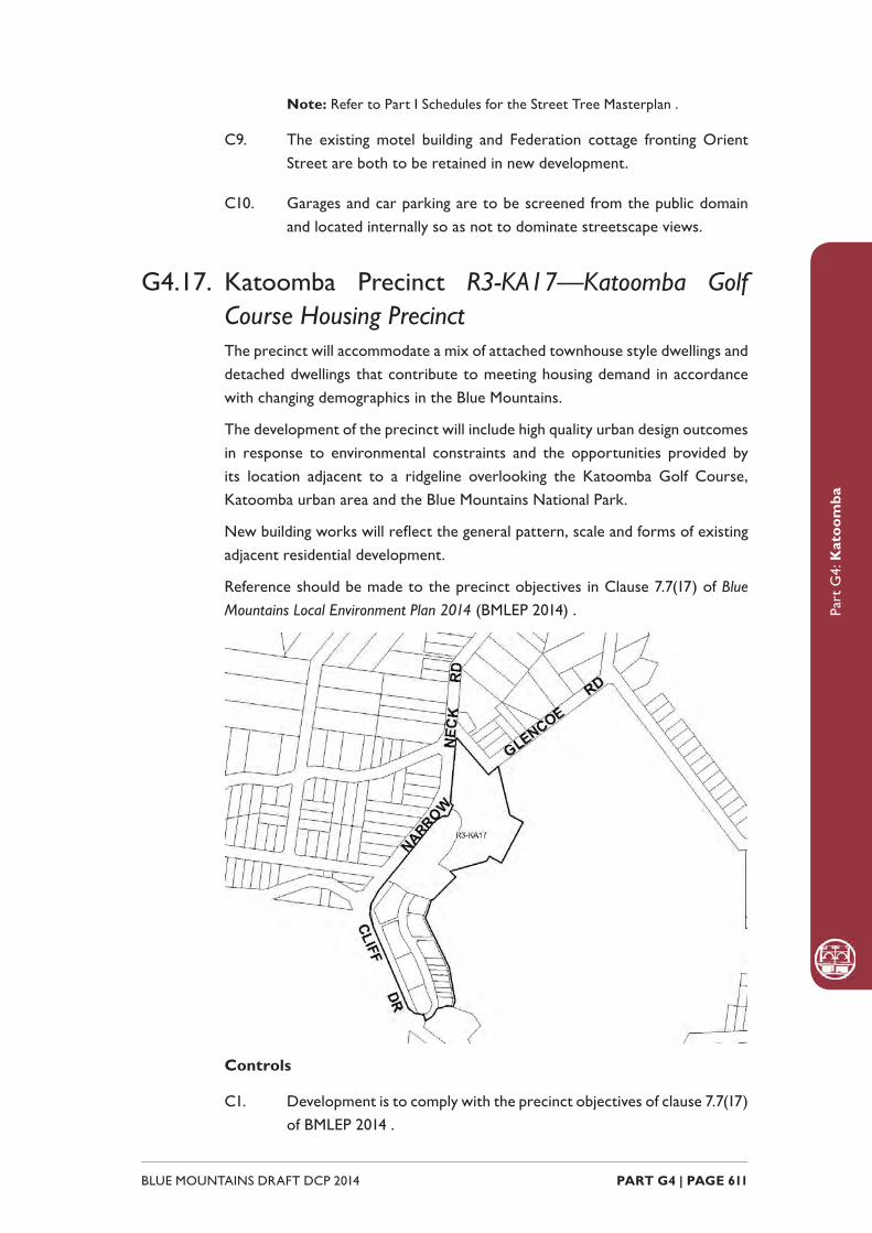
Part
G4:
Kat
oom
ba
PART G4 | PAGE 611BLUE MOUNTAINS DRAFT DCP 2014
Note: Refer to Part I Schedules for the Street Tree Masterplan .
C9. The existing motel building and Federation cottage fronting Orient Street are both to be retained in new development.
C10. Garages and car parking are to be screened from the public domain and located internally so as not to dominate streetscape views.
G4.17. Katoomba Precinct R3-KA17—Katoomba Golf Course Housing PrecinctThe precinct will accommodate a mix of attached townhouse style dwellings and detached dwellings that contribute to meeting housing demand in accordance with changing demographics in the Blue Mountains.
The development of the precinct will include high quality urban design outcomes in response to environmental constraints and the opportunities provided by its location adjacent to a ridgeline overlooking the Katoomba Golf Course, Katoomba urban area and the Blue Mountains National Park.
New building works will refl ect the general pattern, scale and forms of existing adjacent residential development.
Reference should be made to the precinct objectives in Clause 7.7(17) of Blue Mountains Local Environment Plan 2014 (BMLEP 2014) .
Controls
C1. Development is to comply with the precinct objectives of clause 7.7(17) of BMLEP 2014 .
Part
G4:
Kat
oom
ba
BLUE MOUNTAINS DRAFT DCP 2014 PART G4 | PAGE 612
C2. The maximum height of a building is to comply with clause 4.3 of BMLEP 2014 and the accompanying Height of Buildings Map .
C3. The maximum fl oor space ratio of development is to comply with clause 4.4 of BMLEP 2014 and the accompanying Floor Space Ratio Map .
C4. The height above the existing ground level for the lowest habitable fl oor level is not to exceed 3m.
C5. The maximum cut is 2m for townhouses and 1m for detached dwellings.
C6. The maximum fi ll is 2m for townhouses and 2.5m for detached dwellings.
C7. The minimum setback from The Escarpments street frontage and the internal road street frontage (that intersects with Narrow Neck Road) is 5m for townhouses and 6m for dwelling houses.
C8. The minimum side boundary setback is 1m for townhouses and 1.5m for dwelling houses.
C9. The minimum building setback from the Narrow Neck Road boundary and the Glencoe Road boundary is 12m. A minor departure from this provision may be supported if the Council is satisfi ed that the objectives and provisions for the precinct will be achieved.
C10. Apart from the provision of an access road, pedestrian pathways, fences, mailboxes and the like, existing vegetation within 12m of the boundaries of the reserves of Narrow Neck Road or Glencoe Road is not to be disturbed.
C11. All setback areas are to be landscaped.
C12. The maximum site cover for buildings is 40% of the total allotment area.
C13. The minimum area to be retained as soft, pervious or landscaped area (excluding hard surfaces) is 40% of the total allotment area.
C14. Development is to be sited, designed and constructed to minimise impacts on surrounding areas.
C15. Landscaping is to be compatible with the native bushland and exotic plant communities on adjacent properties while minimising bush fi re hazard.
C16. A landscaped area not less than 5m wide is to be provided between

Part
G4:
Kat
oom
ba
PART G4 | PAGE 613BLUE MOUNTAINS DRAFT DCP 2014
any building and the golf course. That area is to be planted with species that will, at maturity, provide a soft fi ltered view of the building from the golf course. The species used to achieve this screening are to be either endemic to the area or exotics compatible to those presently used on the golf course.
C17. Provision is to be made around and between any building for the planting of trees that grow to suffi cient heights to provide a canopy that will reduce the prominence of such buildings in the landscape when viewed from distant viewpoints. Plant species that minimise bush fi re hazard are preferred.
C18. Building design is to integrate with the surrounding residential scale and to enhance amenity through the creation of view corridors, view sharing, passive solar design, quality architectural treatment and recessive colour schemes (neutral or earthy tones with low refl ectivity).
C19. Driveways, parking areas and garages are not to dominate any street frontage, and are to be integrated with the design of surrounding landscaped areas.
C20. A maximum of two vehicular access points are to be provided to access the combined development. Each access point is to incorporate a roundabout in the existing public road to be located and designed to the Council’s satisfaction.
C21. A combined cycleway and footpath is to be provided from the junction of Glencoe and Narrow Neck Roads to the existing golf clubhouse.
G4.18. Katoomba Precinct R1-KA18 - LilianfelsThis precinct operates as a substantial tourist accommodation complex that has been incorporated into a highly signifi cant heritage site. Lilianfels Park to the south and the surrounding streets are of high streetscape and cultural value adjacent the Echo Point area. The precinct is adjacent multiple signifi cant and spectacular views and viewing points.
Future development must take into consideration the sensitivity of the location in relation to exceptionally important areas of natural and cultural value. Consideration of bulk and scale, settings, views, architectural treatments and commercial signage are paramount.
Reference should be made to the precinct objectives in Clause 7.7(18) of Blue Mountains Local Environment Plan 2014 (BMLEP 2014) .

Part
G4:
Kat
oom
ba
BLUE MOUNTAINS DRAFT DCP 2014 PART G4 | PAGE 614
Controls
C1. Development is to comply with the precinct objectives of clause 7.7(18) of BMLEP 2014 .
C2. The maximum height of a building is to comply with clause 4.3 of BMLEP 2014 and the accompanying Height of Buildings Map .
C3. The maximum fl oor space ratio of development is to comply with clause 4.4 of BMLEP 2014 and the accompanying Floor Space Ratio Map .
C4. A minimum curtilage of 30m is to be retained around Lilianfels in which no new above-ground development is to occur.
C5. Stands of mature trees, including street plantings, are to be preserved.
C6. Lilianfels garden, and its principal elements (paths, hedges, gazebos) is to be retained, restored and enhanced according to management principles of a relevant conservation management plan.
C7. The minimum setback to any road frontage for all new buildings is 10m.
C8. Vehicular access to any new development is to be restricted to Echo Point Road and/or Panorama Drive.
C9. Vehicular access-ways are not to be created on or within 15m of a corner.
Part
G4:
Kat
oom
ba
PART G4 | PAGE 615BLUE MOUNTAINS DRAFT DCP 2014
C10. Landscaping of the site is to be in accordance with professionally prepared and approved plans, utilising predominantly exotic plantings and elements characteristic to the locality.
C11. No more than 30% of the surface area of the land is to be developed with buildings.
C12. No more than 10% of the surface area is to be hard paved.
C13. No uses or activities deemed to be noisy or disruptive to the residential amenity of the area will be supported.
C14. The use of the land is limited to low-key, guesthouse-style tourist accommodation and associated facilities such as a restaurant or tea room.
C15. No new building development north of Lilianfels is to occur.
C16. No new building is to exceed the maximum height above ground level of Lilianfels, or visually dominate it or surrounding roadways.
C17. Existing views from adjacent residences to the south are to be maintained.
C18. New development which is to be located to the east of Lilianfels is not to exceed two storeys in height, where the second storey is contained within a pitched roof space.
C19. The architectural treatment and design of new development is to be sympathetic and subservient to Lilianfels in form, materials and detailing.
C20. All parking demands generated by any new development is to be met and fully provided on-site.
C21. New work to Lilianfels is to be executed in accordance with a detailed conservation management plan prepared by a qualifi ed heritage consultant and will require approval from the NSW Heritage Council.

Part
G4:
Kat
oom
ba
BLUE MOUNTAINS DRAFT DCP 2014 PART G4 | PAGE 616
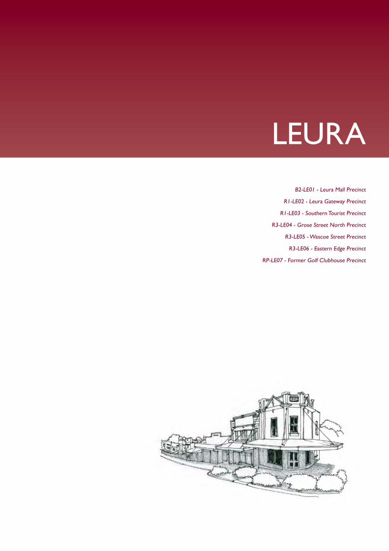
LEURA
B2-LE01 - Leura Mall Precinct
R1-LE02 - Leura Gateway Precinct
R1-LE03 - Southern Tourist Precinct
R3-LE04 - Grose Street North Precinct
R3-LE05 - Wascoe Street Precinct
R3-LE06 - Eastern Edge Precinct
RP-LE07 - Former Golf Clubhouse Precinct
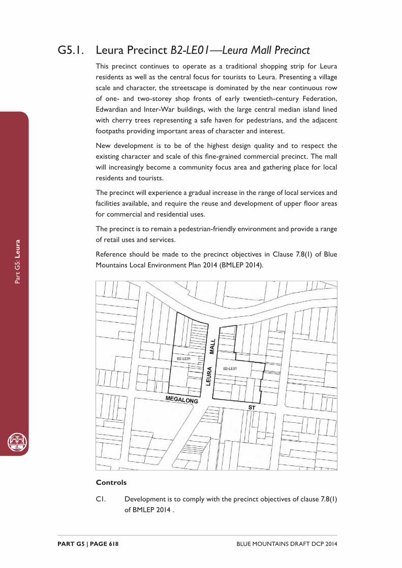
Part
G5:
Leu
ra
BLUE MOUNTAINS DRAFT DCP 2014 PART G5 | PAGE 618
G5.1. Leura Precinct B2-LE01—Leura Mall PrecinctThis precinct continues to operate as a traditional shopping strip for Leura residents as well as the central focus for tourists to Leura. Presenting a village scale and character, the streetscape is dominated by the near continuous row of one- and two-storey shop fronts of early twentieth-century Federation, Edwardian and Inter-War buildings, with the large central median island lined with cherry trees representing a safe haven for pedestrians, and the adjacent footpaths providing important areas of character and interest.
New development is to be of the highest design quality and to respect the existing character and scale of this fi ne-grained commercial precinct. The mall will increasingly become a community focus area and gathering place for local residents and tourists.
The precinct will experience a gradual increase in the range of local services and facilities available, and require the reuse and development of upper fl oor areas for commercial and residential uses.
The precinct is to remain a pedestrian-friendly environment and provide a range of retail uses and services.
Reference should be made to the precinct objectives in Clause 7.8(1) of Blue Mountains Local Environment Plan 2014 (BMLEP 2014).
Controls
C1. Development is to comply with the precinct objectives of clause 7.8(1) of BMLEP 2014 .

Part
G5:
Leu
ra
PART G5 | PAGE 619BLUE MOUNTAINS DRAFT DCP 2014
C2. The maximum height of a building is to comply with clause 4.3 of BMLEP 2014 and the accompanying Height of Buildings Map .
C3. The maximum fl oor space ratio of development is to comply with clause 4.4 of BMLEP 2014 and the accompanying Floor Space Ratio Map .
C4. Development is to generally have zero front and side setbacks, unless a side boundary adjoins the public domain and an active street frontage is proposed that positively contributes to the public domain.
C5. Development may provide a maximum site cover of 100% of the total allotment area, except where adjoining an allotment within the R6 Residential Character Conservation or E4 Environmental Living zones, where the maximum site cover is to be 70% of the total allotment area.
C6. The existing continuity of retail and other businesses facing Leura Mall, Megalong Street or Railway Parade is to be maintained.
C7. On properties with secondary frontages to the public domain, new commercial businesses are to be promoted along at least 50% of those ground level frontages to public carparks, side streets and laneways, and for all storeys above ground, balconies and/or extensive windows overlooking the street are to be provided.
C8. New development is to have regard to the scale, forms and detailing of traditional shopfront buildings, and to ensure that where appropriate, continuous awnings and/or balconies are provided.
Note: Guidelines on traditional shopfront design are found in B3.2.1 Infi ll
shopfront buildings in B3 Design development , and in 9.7 Traditional shopfront
buildings in Part D1 Heritage Conservation where heritage considerations
apply.
C9. For properties with existing two-storey traditional shop terraces, future development is to retain and restore the principal shop front structure plus the adjoining rooms.
Note: Guidelines on traditional shopfront design are found in B3.2.1 Infi ll
shopfront buildings in B3 Design development , and in 9.7 Traditional shopfront
buildings in Part D1 Heritage Conservation where heritage considerations
apply.
C10. Development on large allotments is to distribute fl oorspace into well-articulated structures that are composed of separate wings or interconnected buildings, with traditionally pitched roofs and appropriately landscaped garden courtyards with canopy trees.
Part
G5:
Leu
ra
BLUE MOUNTAINS DRAFT DCP 2014 PART G5 | PAGE 620
C11. On-site parking areas are to be accessed only from the rear or side of buildings via existing public carparks, laneways or secondary streets, and are to be concealed behind retail or business fl oorspace wherever possible.
C12. The existing pedestrian network should be expanded by promoting new retail frontages surrounding the public carparks or facing side streets and laneways.
C13. Solar access to the public domain is to be protected and enhanced.
C14. Continuous weather protection along all public frontages in the form of awnings or overhanging balconies is to be provided.
C15. Ground fl oor walls and structures are to protect and enhance sight lines in public places.
G5.2. Leura Precinct R1-LE02—Leura Gateway PrecinctLocated adjacent to the primary road and rail corridors, this precinct experiences substantial redevelopment of sites and operates as the “gateway” to the Leura Village. New development supports this gateway role by presenting urban design of the highest quality that contributes to a positive fi rst experience of the Leura Village. This, together with a mix of land uses that support the tourist role of the village serves as an enticement to passing traffi c.
Development of this precinct, including the changes to the Highway interchange, assist in enhancing both pedestrian and vehicle access to the Village and enhance connectivity between north and south Leura. Whilst offering high levels of accessibility to both pedestrians and vehicles, potential confl icts between the two are minimised.
The form and scale of new development responds to that of existing buildings in the village and new buildings shall address both the highway and the Leura Mall. Signage associated with development is provided at a modest scale and does not seek to be legible from the distant approaches.
New buildings on the old Chateau Napier site respect the heritage of the previous use, but recapture the landmark status of that site.
Reference should be made to the precinct objectives in Clause 7.8(2) of Blue Mountains Local Environment Plan 2014 (BMLEP 2014) .
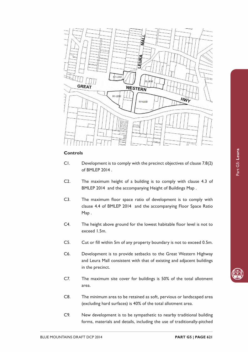
Part
G5:
Leu
ra
PART G5 | PAGE 621BLUE MOUNTAINS DRAFT DCP 2014
Controls
C1. Development is to comply with the precinct objectives of clause 7.8(2) of BMLEP 2014 .
C2. The maximum height of a building is to comply with clause 4.3 of BMLEP 2014 and the accompanying Height of Buildings Map .
C3. The maximum fl oor space ratio of development is to comply with clause 4.4 of BMLEP 2014 and the accompanying Floor Space Ratio Map .
C4. The height above ground for the lowest habitable fl oor level is not to exceed 1.5m.
C5. Cut or fi ll within 5m of any property boundary is not to exceed 0.5m.
C6. Development is to provide setbacks to the Great Western Highway and Leura Mall consistent with that of existing and adjacent buildings in the precinct.
C7. The maximum site cover for buildings is 50% of the total allotment area.
C8. The minimum area to be retained as soft, pervious or landscaped area (excluding hard surfaces) is 40% of the total allotment area.
C9. New development is to be sympathetic to nearby traditional building forms, materials and details, including the use of traditionally-pitched

Part
G5:
Leu
ra
BLUE MOUNTAINS DRAFT DCP 2014 PART G5 | PAGE 622
roofs, articulated layouts and forms, verandahs, timber joinery, vertically–proportioned openings and some painted external fi nishes, with a curtilage of landscaped areas and an address to the street provided. New development is to be similar in form and materials to quality older buildings but subservient in detail to distinguish it as new work.
C10. Buildings are not to exceed 18m in any direction.
C11. New development may incorporate prominent or landmark features at the corner of Leura Mall and The Great Western Highway.
C12. Driveways, parking areas and garages are not to dominate any street frontage, and are to be integrated with the design of surrounding landscaped areas.
C13. Gardens and landscaped areas are to protect and enhance exotic and indigenous canopy trees, which provide a visual backdrop that contributes to the character of the precinct.
G5.3. Leura Precinct R1-LE03—Southern Tourist PrecinctLocated to the south of the core village area, this precinct serves as a transition between the retail core and adjacent residential areas.
Accommodating the continued growth in tourism activity in Leura, the precinct provides a mix of new land uses including arts and craft galleries, refreshment rooms and tourist accommodation.
Existing buildings are generally used to accommodate these new land uses. Where new development is provided, it maintains the residential scale and character of the precinct, including the established gardens and mature vegetation that make a signifi cant contribution to the character of the precinct.
Reference should be made to the precinct objectives in Clause 7.8(3) of Blue Mountains Local Environment Plan 2014 (BMLEP 2014) .

Part
G5:
Leu
ra
PART G5 | PAGE 623BLUE MOUNTAINS DRAFT DCP 2014
Controls
C1. Development is to comply with the precinct objectives of clause 7.8(3) of BMLEP 2014 .
C2. The maximum height of a building is to comply with clause 4.3 of BMLEP 2014 and the accompanying Height of Buildings Map .
C3. The maximum fl oor space ratio of development is to comply with clause 4.4 of BMLEP 2014 and the accompanying Floor Space Ratio Map .
C4. The height above ground for the lowest habitable fl oor level is not to exceed 1m.
C5. Cut or fi ll within 5m of any property boundary is not to exceed 0.5m.
C6. Development is to provide front setbacks consistent with that of adjacent buildings.
C7. Development is to provide a minimum side boundary setback of 2m.
C8. Development is to provide a minimum rear boundary setback of 4m.
C9. All setback areas are to be landscaped.
C10. The maximum site cover for buildings is 40% of the total allotment area.
Part
G5:
Leu
ra
BLUE MOUNTAINS DRAFT DCP 2014 PART G5 | PAGE 624
C11. The minimum area to be retained as soft, pervious or landscaped area (excluding hard surfaces) is 50% of the total allotment area.
C12. New development is to be sympathetic to nearby traditional building forms, materials and details, including the use of traditionally-pitched roofs, articulated layouts and forms, verandahs, timber joinery, vertically–proportioned openings and some painted external fi nishes, with a curtilage of landscaped areas and an address to the street provided. New development is to be similar in form and materials to quality older buildings but subservient in detail to distinguish it as new work.
C13. Buildings are not to exceed 18m in any direction.
C14. Any non-residential activities should be accommodated in buildings with a residential scale and character.
C15. Gardens should incorporate a backdrop of canopy trees along rear boundaries plus trees and shrubs scattered through front and side yards.
C16. Driveways, parking areas and garages should not dominate any street frontage, and are to be integrated with the design of surrounding landscaped areas.
G5.4. Leura Precinct R3-LE04—Grose Street North PrecinctAn area that has a signifi cant streetscape character. Older cottages are retained whilst sensitively designed residential infi ll development is located at the rear of lots. Development on vacant lots is to maintain the existing residential character through the presentation of single storey dwellings with landscaped front setbacks.
Reference should be made to the precinct objectives in Clause 7.8(4) of Blue Mountains Local Environment Plan 2014 (BMLEP 2014) .
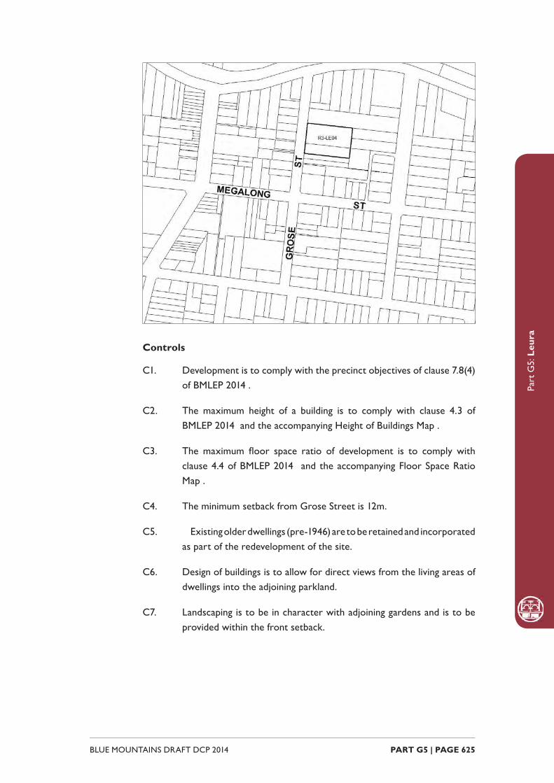
Part
G5:
Leu
ra
PART G5 | PAGE 625BLUE MOUNTAINS DRAFT DCP 2014
Controls
C1. Development is to comply with the precinct objectives of clause 7.8(4) of BMLEP 2014 .
C2. The maximum height of a building is to comply with clause 4.3 of BMLEP 2014 and the accompanying Height of Buildings Map .
C3. The maximum fl oor space ratio of development is to comply with clause 4.4 of BMLEP 2014 and the accompanying Floor Space Ratio Map .
C4. The minimum setback from Grose Street is 12m.
C5. Existing older dwellings (pre-1946) are to be retained and incorporated as part of the redevelopment of the site.
C6. Design of buildings is to allow for direct views from the living areas of dwellings into the adjoining parkland.
C7. Landscaping is to be in character with adjoining gardens and is to be provided within the front setback.

Part
G5:
Leu
ra
BLUE MOUNTAINS DRAFT DCP 2014 PART G5 | PAGE 626
G5.5. Leura Precinct R3-LE05—Wascoe Street PrecinctAlternative forms of housing are consolidated in close proximity to Leura village. Mitigation measures are undertaken that minimise the impact of development and contribute to the regeneration of the adjacent watercourse buffer areas.
Reference should be made to the precinct objectives in Clause 7.8(5) of Blue Mountains Local Environment Plan 2014 (BMLEP 2014) .
Controls
C1. Development is to comply with the precinct objectives of clause 7.8(5) of BMLEP 2014 .
C2. The maximum height of a building is to comply with clause 4.3 of BMLEP 2014 and the accompanying Height of Buildings Map .
C3. The maximum fl oor space ratio of development is to comply with clause 4.4 of BMLEP 2014 and the accompanying Floor Space Ratio Map .
C4. The minimum setback from Wascoe Street is 8m.
C5. Existing older dwellings (pre-1946) are to be retained and incorporated as part of the redevelopment of any site.
C6. Development is to promote a landscape setting and provide screening of future development through planting of appropriate trees and shrubs that minimise the visibility of development from Megalong Street.
C7. Development is to provide active street frontages to Wascoe Street and Quinns Avenue.

Part
G5:
Leu
ra
PART G5 | PAGE 627BLUE MOUNTAINS DRAFT DCP 2014
G5.6. Leura Precinct R3-LE06—Eastern Edge PrecinctDefi ning the eastern edge of the Leura Village centre, this precinct serves as a transition between the retail core and adjacent residential areas. It accommodates a mix of land uses including lower order commercial and smaller home-based employment activities.
New development refl ects the mix of residential and commercial uses, however new development is consistent with a predominantly residential streetscape, which is characterised by one and two-storey scale development with curtilages of landscaped gardens.
Reference should be made to the precinct objectives in Clause 7.8(6) of Blue Mountains Local Environment Plan 2014 (BMLEP 2014) .
Controls
C1. Development is to comply with the precinct objectives of clause 7.8(6) of BMLEP 2014 .
C2. The maximum height of a building is to comply with clause 4.3 of BMLEP 2014 and the accompanying Height of Buildings Map.
C3. The maximum fl oor space ratio of development is to comply with clause 4.4 of BMLEP 2014 and the accompanying Floor Space Ratio Map.
C4. Development is to provide front setbacks consistent with that of adjacent buildings.
Part
G5:
Leu
ra
BLUE MOUNTAINS DRAFT DCP 2014 PART G5 | PAGE 628
C5. Development is to provide a minimum side boundary setback of 2m.
C6. Development is to provide a minimum rear boundary setback of 4m.
C7. All setback areas are to be landscaped.
C8. The maximum site cover for buildings is 50% of the total allotment area.
C9. The minimum area to be retained as soft, pervious or landscaped area (excluding hard surfaces) is 40% of the total allotment area.
C10. New development is to be sympathetic to nearby traditional building forms, materials and details, including the use of traditionally-pitched roofs, articulated layouts and forms, verandahs, timber joinery, vertically–proportioned openings and some painted external fi nishes, with a curtilage of landscaped areas and an address to the street provided. New development is to be similar in form and materials to quality older buildings but subservient in detail to distinguish it as new work.
C11. Buildings are not to exceed 18m in any direction.
C12. Any non-residential activities are to be accommodated in buildings with a residential scale and character.
C13. Gardens are to incorporate a backdrop of canopy trees along rear boundaries plus trees and shrubs scattered through front and side yards.
C14. Driveways, parking areas and garages are not to dominate any street frontage, and are to be integrated with the design of surrounding landscaped areas.
G5.7. Leura Precinct RP-LE07 – Former Golf Clubhouse Precinct Formerly the site of the Leura Golf Clubhouse and Bowling Club, which has its origins in the early twentieth century, the Former Leura Golf Clubhouse Precinct is in an area of Leura recognised for its streetscape character, landscaped garden setting and areas of older housing. The site has a prominent position on the tourist route between the Leura town centre and Sublime Point.
Development in the precinct accommodates accessible housing and a range of services and facilities to meet the needs of residents. Future housing development should contribute to providing a quality living environment for older people,

Part
G5:
Leu
ra
PART G5 | PAGE 629BLUE MOUNTAINS DRAFT DCP 2014
with access to necessary services and facilities. As the focal element of the precinct, the former Leura Golf Clubhouse should be retained as a facility for residents and in recognition of its contribution to the streetscape.
The precinct contributes to the character of the locality by establishing a landscape setting and gardens within building setbacks and common open space. Buildings respect the scale and architectural form of surrounding development through articulated roof forms and fl oor plans and by presenting a generally single-storey appearance.
Objectives
O1. To enable the provision of accessible housing with a building form and scale consistent with residential character in the locality and utilising the facilities provided by the former Leura Golf Clubhouse.
O2. To ensure the retention and enhancement of the former Leura Golf Clubhouse for use as a community facility and in recognition of its contribution to the streetscape character of the locality.
O3. To minimise the impact of development on the environment and on residential amenity through appropriate siting and design of buildings.
O4. To maintain and improve streetscape character by establishing a landscaped garden setting, consistent with the settings of residential and other land uses in the locality.
Controls
C1. The maximum height of a building is to comply with clause 4.3 of
Part
G5:
Leu
ra
BLUE MOUNTAINS DRAFT DCP 2014 PART G5 | PAGE 630
BMLEP 2014 and the accompanying Height of Buildings Map.
Note: The height of a building fronting Fitzroy Street may be measured from
the fi nished ground level of the bowling green (rather than from street level):
(a) if measuring from that level is necessary to preserve the landscape setting of the building or to enhance the relationship of the building to Fitzroy Street by limiting the visual prominence of its roof structure, and
(b) provided that the building will have a single-storey appearance from Fitzroy Street.
C2. The maximum fl oor space ratio of development is to comply with clause 4.4 of BMLEP 2014 and the accompanying Floor Space Ratio Map.
C3. The retention of the Clubhouse as a common facility for residents and an integral component of the streetscape is encouraged.
C4. Buildings fronting Fitzroy Street are to have a setback of not less than 12m and not more than 15m.
C5. Buildings fronting Gladstone Road are to have a setback of not less than 8m.
C6. No buildings are to be located between the former Leura Golf Clubhouse and Fitzroy Street, in an area extending 10m from the outermost walls of the Clubhouse.
C7. A building on land that adjoins the R6 Residential Character Conservation zone or the golf course is to have:
(a) if the building has a building height of 6m or less—an average setback of not less than 4.5m, or
(b) if the building has a building height greater than 6m—an average setback of not less than 6m.
C8. A building located within 50m of the southernmost boundary of the Former Leura Golf Clubhouse Precinct is only likely to be supported if the building:
(a) has a setback of at least 10m from that boundary, and
(b) maintains adequate view lines from each adjoining property on land in the R6 Residential Character Conservation zone to the golf course, and
(c) contains no more than two dwellings, and
(d) provides a transition in terms of bulk, scale and form between

Part
G5:
Leu
ra
PART G5 | PAGE 631BLUE MOUNTAINS DRAFT DCP 2014
development within the precinct and the housing forms on land in the adjoining R6 Residential Character Conservation zone.
C9. The maximum site coverage for buildings (including ancillary buildings, swimming pools and tennis courts) is 30% of the total precinct area, except for buildings within 50m of Fitzroy Street, where the maximum site coverage is 1,000m2 (excluding the site coverage of any existing buildings).
C10. The minimum area to be retained as soft, pervious or landscaped areas (excluding hard surfaces) is 55% of the total precinct area.
C11. New development fronting Fitzroy Street is to be sympathetic to nearby traditional building forms, materials and details, including the use of traditionally-pitched roofs, articulated layouts and forms, verandahs, timber joinery, vertically–proportioned openings and some painted external fi nishes, with a curtilage of landscaped areas and an address to the street provided. New development is to be similar in form and materials to quality older buildings but subservient in detail to distinguish it as new work.
C12. Development on land in the Former Leura Golf Clubhouse Precinct is not to have a detrimental effect on the contribution of the former Leura Golf Clubhouse to the streetscape and character of the locality.
C13. Consent for development on land in the Former Leura Golf Clubhouse Precinct may be granted subject to a condition that requires the creation of a restrictive or positive covenant that provides for the retention and continued maintenance of the former Leura Golf Clubhouse, but this subclause does not:
(a) limit the kinds of conditions that may be imposed on a development consent, or
(b) allow conditions to be imposed on a development consent otherwise than in accordance with the Environmental Planning and Assessment Act 1979.
C14. Consent will not be granted for development involving the demolition of the exterior, or part of the exterior, of the former Leura Golf Clubhouse unless Council is satisfi ed that the building, or part of the building, proposed for demolition, is either structurally unsound (on the basis of documentary evidence), and not economically repairable (on the basis of documentary evidence prepared by a suitably qualifi ed person that demonstrates that the cost of the repair would exceed the value of the repaired building).

Part
G5:
Leu
ra
BLUE MOUNTAINS DRAFT DCP 2014 PART G5 | PAGE 632
C15. Built forms are to provide a transition from larger buildings in the centre of the Former Leura Golf Clubhouse Precinct to domestic scale cottages, as viewed from the golf course and any public place.
C16. Generally buildings are to have pitched tiled roofs, with materials and form that complement the former Leura Golf Clubhouse. However, low-pitched and/or decked roofs are permissible to internal roof areas of buildings if they are not visible from a public place or from adjacent properties.
C17. Soil within the Fitzroy Street front building setback is to be remediated to provide a deep planting zone, which is to be planted to provide a garden setting that will make a signifi cant contribution to the streetscape within 10 to 15 years.
C18. Buildings are to refl ect the principles of water sensitive urban design.
C19. A landscaped screen suffi cient to separate the site from existing residential properties on land in the R6 Residential Character Conservation zone and the golf course is to be provided along the perimeter of the shared boundaries.
C20. Buildings are to retain existing solar access for a minimum of 3 hours between the hours of 9am to 3pm on 21 June for the living rooms and private open space of existing dwellings.
C21. A variety of heights and forms are to be incorporated, and varied setbacks are encouraged.
C22. Vehicular access to the precinct is to be limited to a single point of access to Fitzroy Street.
C23. Vehicular access, parking and garages for dwellings fronting Fitzroy Street are to be located to the rear of the former bowling green to minimise visibility from the street.
WENTWORTH FALLS
B2-WF01 - Town Centre Precinct
R3-WF02 - Adele Street Precinct
R3-WF03 - Great Western Highway Precinct

Part
G6:
Wen
twor
th F
alls
BLUE MOUNTAINS DRAFT DCP 2014 PART G6 | PAGE 634
G6.1. Wentworth Falls Precinct B2-WF01—Town Centre PrecinctThis remains a compact town centre, accommodating a diverse range of small retail and other local businesses, tourist-related activities and permanent residents.
Modestly-scaled buildings are arranged in a traditional main street pattern, with a continuous row of one and two-storey buildings that refl ect local architectural traditions yet display some variety of form and design. The form and architectural detail of landmark retail terrace buildings are preserved. Future development emphasises the distinctive character of these landmarks, and promotes new retail frontages along Plantation Street, as well as existing laneways and the Highway.
Buildings provide visible indoor activity along all public frontages, and pedestrian activity is concentrated along the streets and laneways, encouraging informal community gatherings in areas that are protected from undesirable impacts of through traffi c.
Reference should be made to the precinct objectives in Clause 7.9(1) of Blue Mountains Local Environment Plan 2014 (BMLEP 2014) .
Controls
C1. Development is to comply with the precinct objectives of clause 7.9(1) of BMLEP 2014 .
C2. The maximum height of a building is to comply with clause 4.3 of
Part
G6:
Wen
twor
th F
alls
PART G6 | PAGE 635BLUE MOUNTAINS DRAFT DCP 2014
BMLEP 2014 and the accompanying Height of Buildings Map.
C3. The maximum fl oor space ratio of development is to comply with clause 4.4 of BMLEP 2014 and the accompanying Floor Space Ratio Map.
C4. Development is to have a zero front setback, except in Plantation Street, where the setbacks are to be a minimum of 2.5m.
C5. Development is to have a zero side setback, except where the side boundary adjoins the public domain, where setbacks greater than zero may be allowed, but only when it can be demonstrated that an active frontage will be provided.
C6. Development may provide a maximum site cover of 100% of the total allotment area.
C7. The existing continuity of retail and other business premises and shop fronts facing Station Street and the Highway is to be maintained.
C8. On properties facing Plantation Street or a public laneway, new retail or other business with shop fronts or accessible courtyards are to be promoted along at least 50% of ground level frontages to any public street or laneway, and for all storeys above ground, balconies and/or extensive windows overlooking the street are to be provided.
C9. New development, including alteration and additions to existing shopfronts, is to have regard to the scale, forms and detailing of traditional shopfront buildings, and to ensure that where appropriate, continuous awnings and/or balconies are provided.
Note: Guidelines on traditional shopfront design are found in B3.2.1 Infi ll
shopfront buildings in B3 Design development , and in 9.7 Traditional shopfront
buildings in Part D1 Heritage Conservation where heritage considerations
apply.
C10. On properties with existing two-storey traditional shop terraces, future development is to retain and restore the principal shop front structure plus the adjoining rooms.
Note: Guidelines on traditional shopfront design are found in B3.2.1 Infi ll
shopfront buildings in B3 Design development , and in 9.7 Traditional shopfront
buildings in Part D1 Heritage Conservation where heritage considerations
apply.
C11. Development on large allotments is to distribute fl oorspace into well-articulated structures that are composed of separate wings or interconnected buildings, with traditionally pitched roofs and appropriately landscaped garden courtyards.
Part
G6:
Wen
twor
th F
alls
BLUE MOUNTAINS DRAFT DCP 2014 PART G6 | PAGE 636
C12. Existing canopy trees are to be retained to frame building presentation. New landscaping is to be appropriately-sized and characteristic of the locality.
C13. On-site parking areas are to be accessed only from the rear or side of buildings via existing public carparks, laneways or secondary streets, and are to be concealed from Station and Plantation Streets behind retail or business fl oorspace.
C14. Buildings fronting Plantation Street with a zero setback may be allowed as part of a development proposal that provides for variable setbacks and articulated building frontages to enhance building presentation and facilitate associated activities such as outdoor dining.
C15. The existing pedestrian network is to be expanded by promoting new retail frontages facing Plantation Street and other public places.
C16. Solar access to the public domain is to be protected and enhanced.
C17. Continuous weather protection along all public frontages in the form of awnings or overhanging balconies is to be provided.
C18. Ground fl oor walls and structures are to protect and enhance sight lines in public places.
G6.2. Wentworth Falls Precinct R3-WF02—Adele Street PrecinctContaining a screen of dense vegetation, this site provides alternative housing forms in close proximity to Wentworth Falls shops. The design of buildings is sympathetic to the heritage items located adjacent to the precinct and shall include forms and fi nishes that minimise the visual impact of buildings from the Great Western Highway.
Reference should be made to the precinct objectives in Clause 7.9(2) of Blue Mountains Local Environment Plan 2014 (BMLEP 2014) .

Part
G6:
Wen
twor
th F
alls
PART G6 | PAGE 637BLUE MOUNTAINS DRAFT DCP 2014
Controls
C1. Development is to comply with the precinct objectives of clause 7.9(2) of BMLEP 2014 .
C2. The maximum height of a building is to comply with clause 4.3 of BMLEP 2014 and the accompanying Height of Buildings Map.
C3. The maximum fl oor space ratio of development is to comply with clause 4.4 of BMLEP 2014 and the accompanying Floor Space Ratio Map.
C4. The minimum setback from the Great Western Highway is 25m.
C5. No direct vehicular access is to be provided from the Great Western Highway. Vehicular access to development on the site is to be provided via Adele Street or Matcham Street and is to demonstrate appropriate sight distances for driveways.
C6. Building form and location is to provide for active frontages of dwellings to Adele and Matcham Streets.
C7. Planting of screening vegetation is to be provided between any building and the boundary with Blue Mountains Grammar School. This screen planting is to incorporate a fence that restricts access between the building and the school.
C8. The existing bushland within the Great Western Highway setback is to be retained and, where necessary, revegetated to screen buildings from the Great Western Highway.
C9. Development for the purpose of multi-dwelling housing in this precinct will respect and complement the existing historical and heritage values of adjoining sites.
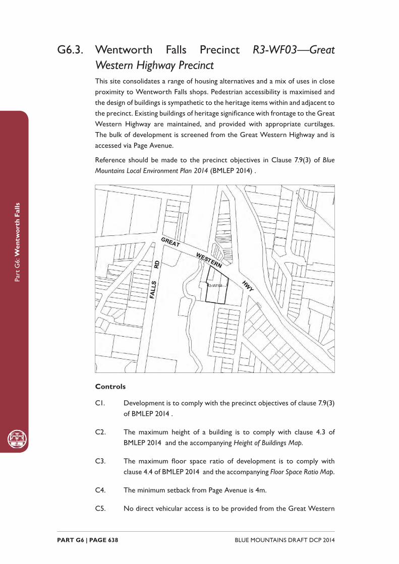
Part
G6:
Wen
twor
th F
alls
BLUE MOUNTAINS DRAFT DCP 2014 PART G6 | PAGE 638
G6.3. Wentworth Falls Precinct R3-WF03—Great Western Highway PrecinctThis site consolidates a range of housing alternatives and a mix of uses in close proximity to Wentworth Falls shops. Pedestrian accessibility is maximised and the design of buildings is sympathetic to the heritage items within and adjacent to the precinct. Existing buildings of heritage signifi cance with frontage to the Great Western Highway are maintained, and provided with appropriate curtilages. The bulk of development is screened from the Great Western Highway and is accessed via Page Avenue.
Reference should be made to the precinct objectives in Clause 7.9(3) of Blue Mountains Local Environment Plan 2014 (BMLEP 2014) .
Controls
C1. Development is to comply with the precinct objectives of clause 7.9(3) of BMLEP 2014 .
C2. The maximum height of a building is to comply with clause 4.3 of BMLEP 2014 and the accompanying Height of Buildings Map.
C3. The maximum fl oor space ratio of development is to comply with clause 4.4 of BMLEP 2014 and the accompanying Floor Space Ratio Map.
C4. The minimum setback from Page Avenue is 4m.
C5. No direct vehicular access is to be provided from the Great Western
Part
G6:
Wen
twor
th F
alls
PART G6 | PAGE 639BLUE MOUNTAINS DRAFT DCP 2014
Highway. Vehicular access to development is to be provided via Page Avenue and is to demonstrate appropriate sight distances for driveways.
C6. Building form and location is to provide activated safe and pedestrian-friendly street frontages to dwellings at Page Avenue.
C7. Development is to respect and complement the existing heritage values of adjoining sites.

Part
G6:
Wen
twor
th F
alls
BLUE MOUNTAINS DRAFT DCP 2014 PART G6 | PAGE 640

LAWSON
B2-LA01 - Town Centre Precinct
R3-LA02 - San Jose Avenue Precinct
R3-LA03 - Loftus Street Precinct
R3-LA04 - Housing Precinct

Part
G7:
Law
son
BLUE MOUNTAINS DRAFT DCP 2014 PART G7 | PAGE 642
G7.1. Lawson Precinct B2-LA01—Town Centre PrecinctThe Lawson Town Centre precinct has experienced signifi cant changes associated with the widening of the Great Western Highway. The Lawson Village Centre Masterplan was prepared to guide future development of the Town Centre Precinct, which is undergoing revitalisation. A site-specifi c DCP was also prepared to promote and guide the progression of the Masterplan.
The predominant objectives of the Masterplan have been achieved with the creation of the public domain within the new town centre. The restored Heatherbrae has become the focus for a new village centre and park.
The Lawson DCP has been consolidated into the existing Town Centre Precinct controls following the completion of the public domain elements, to ensure that future development within the precinct remains consistent with the aims of the Masterplan and the DCP.
Desired future character
The Town Centre precinct presents opportunities to enhance community well-being through the expansion and improvement of commercial and community facilities, whilst retaining the village scale and the cultural elements important to the local community and history of Lawson. The retail / commercial activities within the town centre cater for the needs of the community and passing highway trade including tourism opportunities. Sustainability and accessibility are further components of the continuing redevelopment of the town centre.
The relationship with the Highway and railway is enhanced and protected, as is the clear urban structure of the roads, streets and public spaces. Vehicular

Part
G7:
Law
son
PART G7 | PAGE 643BLUE MOUNTAINS DRAFT DCP 2014
parking areas fronting shops along the Highway provide good access for Highway traffi c; however, a new focus for local retail and community activity is protected and enhanced to the rear of shops that face the Highway. Good parking availability and safe pedestrian routes interact to provide a compact urban structure with high levels of amenity and accessibility.
A sense of place and positive links to the past are enhanced through landscape elements and built form, with adequate open space and safe pedestrian-friendly places. New built form seeks to complement the traditional character of surrounding buildings and the character of other villages. Welcoming open spaces are defi ned by built form. Four public spaces predominate:
(a) Douglass Square: Heritage character around Douglass Square is retained and interpreted, enhancing this place as the main civic and historical place in Lawson, and a heritage gateway to the town centre.
(b) Heatherbrae: The setting and landscape of Heatherbrae is a ‘Village Park’ fronting New Street as a second public domain space. Important views of and from Heatherbrae and distant views of the natural environment to the south are retained and enhanced.
(c) A Village Square is a focal point behind the shops that front the Highway, with outdoor seating and retail frontages,
(d) The Community Centre is capable of extension, with a community garden area at the rear.
These public spaces are interconnected though walkways and pathways. The primary entrance to the town centre is marked at the intersection of New Street and the Great Western Highway. Two public spaces act as pedestrian gateways to the precinct; at Douglass Square and at the Mid Mountains Community Centre. New Street is consolidated as the main street in the Lawson town centre.
Diverse commercial activity caters for both locals and visitors, with an emphasis on a strong local economy. Additional shop buildings give an expanded active street frontage layout that adds vitality and viability to the precinct. Commercial uses are maintained along the Highway to attract passing trade. Additional residential accommodation or additional commercial uses are housed in two-storey buildings facing the Highway, where shop-top housing can enable passive surveillance and after-hours activity. Community spaces in the vicinity of the Mid Mountains Community Centre and Heatherbrae support a sense of place.
Reference should be made to the precinct objectives in Clause 7.10(1) of Blue Mountains Local Environment Plan 2014 (BMLEP 2014).
Note: The Community Infrastructure Contributions Plan for Lawson Town Centre (Lawson
Contributions PLan) applies to this precinct. Parking credits are identifi ed within the
Lawson Contributions Plan for certain lots fronting the Great Western Highway. The
plan can be accessed via Council’s webiste.
Part
G7:
Law
son
BLUE MOUNTAINS DRAFT DCP 2014 PART G7 | PAGE 644
Controls
C1. Development is to comply with the precinct objectives of clause 7.10(1) of BMLEP 2014 .
C2. The maximum height of a building is to comply with clause 4.3 of BMLEP 2014 and the accompanying Height of Buildings Map.
C3. The maximum fl oor space ratio of development is to comply with clause 4.4 of BMLEP 2014 and the accompanying Floor Space Ratio Map.
C4. Development is to have a zero front setback.
C5. Development is to have a zero side setback, except where the side boundary adjoins a public place, where side setbacks greater than zero may be considered, but only when it can be demonstrated that an active frontage is provided.
C6. Development may provide a maximum site cover of 100% of the total allotment area.
C7. Visible retail or other commercial activity is to be promoted along the entire length of primary street frontages.
C8. Each secondary frontage to a public road, lane way or public place is to provide a visible and active street frontage distributed along a minimum of 65% of that frontage.
C9. Street corners are to be reinforced through design elements such as splay walls and orientation of entry and window elements.
C10. New development, including alteration and additions to existing shopfronts, is to have regard to the scale, forms and detailing of traditional shopfront buildings, and to ensure that where appropriate, continuous awnings and/or balconies for weather protection are provided.
Note: Guidelines on traditional shopfront design are found in B3.2.1 Infi ll
shopfront buildings in B3 Design development , and in 9.7 Traditional shopfront
buildings in Part D1 Heritage Conservation where heritage considerations
apply.
C11. Servicing areas are to be located to the rear of buildings fronting the Highway to maintain a continuous retail streetscape.
C12. Appropriate site servicing facilities for retail, commercial and residential uses are to be located and designed to minimise their impact on the amenity of adjoining properties and the streetscape.
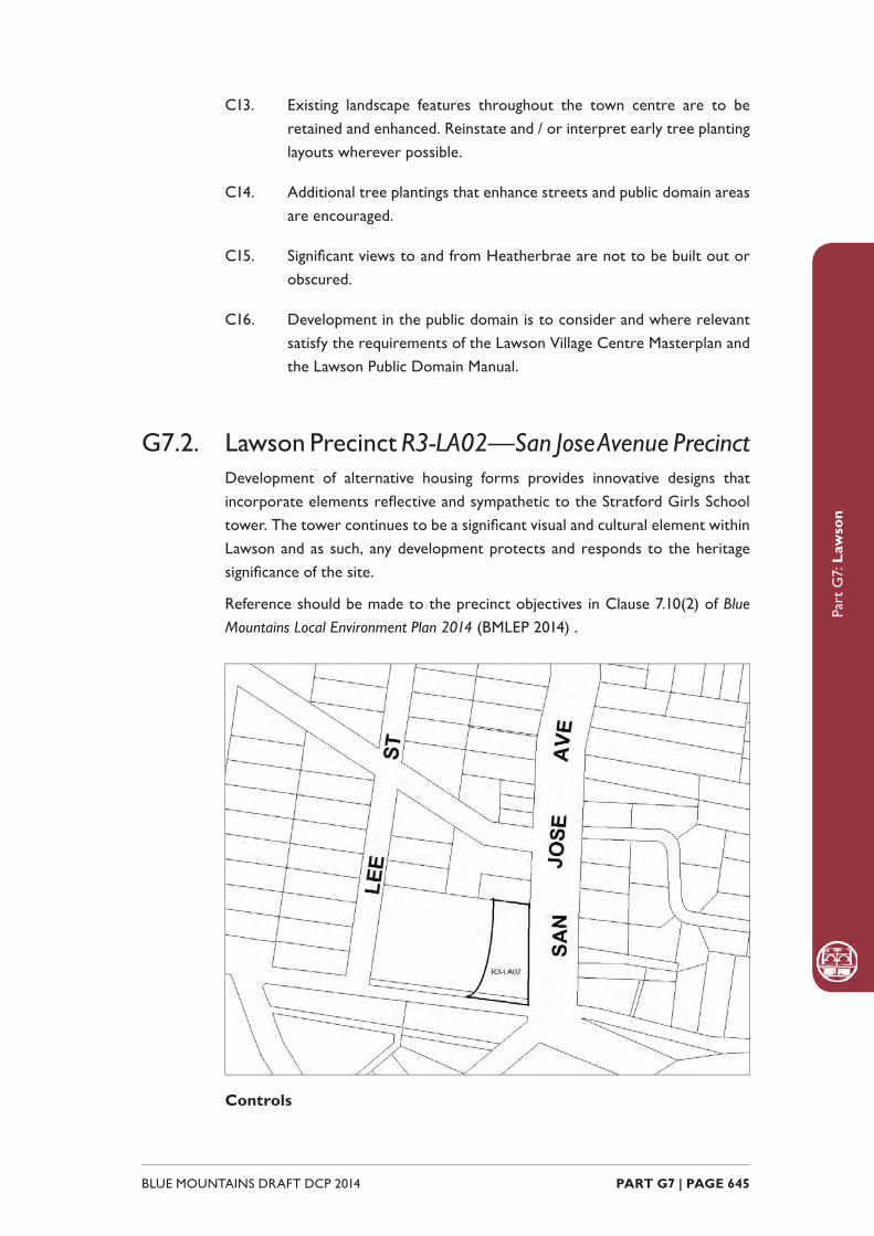
Part
G7:
Law
son
PART G7 | PAGE 645BLUE MOUNTAINS DRAFT DCP 2014
C13. Existing landscape features throughout the town centre are to be retained and enhanced. Reinstate and / or interpret early tree planting layouts wherever possible.
C14. Additional tree plantings that enhance streets and public domain areas are encouraged.
C15. Signifi cant views to and from Heatherbrae are not to be built out or obscured.
C16. Development in the public domain is to consider and where relevant satisfy the requirements of the Lawson Village Centre Masterplan and the Lawson Public Domain Manual.
G7.2. Lawson Precinct R3-LA02—San Jose Avenue PrecinctDevelopment of alternative housing forms provides innovative designs that incorporate elements refl ective and sympathetic to the Stratford Girls School tower. The tower continues to be a signifi cant visual and cultural element within Lawson and as such, any development protects and responds to the heritage signifi cance of the site.
Reference should be made to the precinct objectives in Clause 7.10(2) of Blue Mountains Local Environment Plan 2014 (BMLEP 2014) .
Controls

Part
G7:
Law
son
BLUE MOUNTAINS DRAFT DCP 2014 PART G7 | PAGE 646
C1. Development is to comply with the precinct objectives of clause 7.10(2) of BMLEP 2014 .
C2. The maximum height of a building is to comply with clause 4.3 of BMLEP 2014 and the accompanying Height of Buildings Map.
C3. The maximum fl oor space ratio of development is to comply with clause 4.4 of BMLEP 2014 and the accompanying Floor Space Ratio Map.
C4. The scale of development is to not exceed the scale of the previous sanatorium and Stratford Girls School building, being a 2-storey brick structure with hipped iron roofs and a maximum height of 8m.
C5. The minimum setback from the San Jose Avenue boundary of the site is 12m.
C6. The minimum setback from the side boundary adjoining Avon House (10 San Jose Avenue) is 8m.
C7. Land zoned E2 Environmental Conservation is not to be taken into consideration when calculating the fl oor space ratio.
C8. The three-storey tower located in the south-east corner of the site, and its immediate curtilage, are to be retained. The height, massing and location of any development is to ensure that the tower is maintained as the visually dominant feature of the site, particularly when viewed from the surrounding public roads.
C9. Development is to have regard to the recommendations of a detailed heritage impact statement and conservation management plan, and to minimise the impact of development on the site.
C10. The two course, rock-faced masonry wall along the boundary of the site to San Jose Avenue is to be retained as a feature of the site.
C11. The mature boundary trees, including pines and cypresses, located along the San Jose Avenue boundary of the site are to be retained as part of any redevelopment.
C12. Land zoned E2 Environmental Conservation is to be revegetated with indigenous native plants.
C13. Design elements of the sanatorium and Stratford Girls School building such as brick construction, hipped corrugated metal roofi ng, arched windows and verandahs are to be incorporated in any building design.
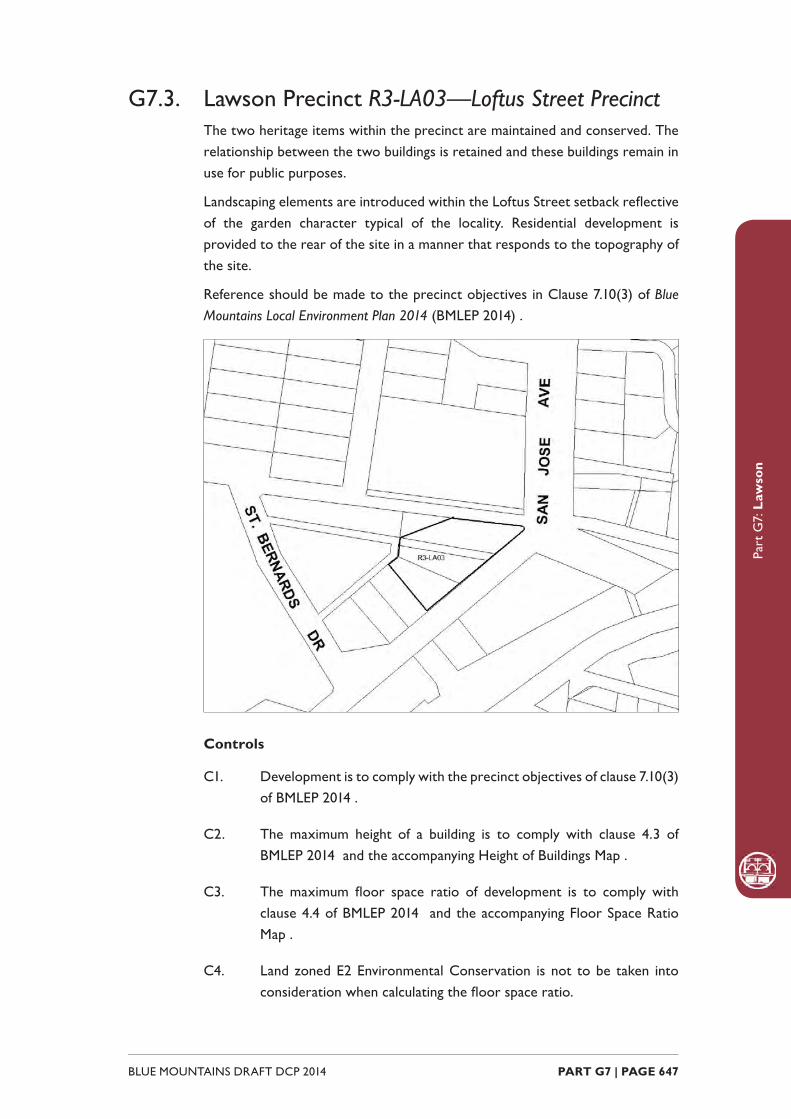
Part
G7:
Law
son
PART G7 | PAGE 647BLUE MOUNTAINS DRAFT DCP 2014
G7.3. Lawson Precinct R3-LA03—Loftus Street PrecinctThe two heritage items within the precinct are maintained and conserved. The relationship between the two buildings is retained and these buildings remain in use for public purposes.
Landscaping elements are introduced within the Loftus Street setback refl ective of the garden character typical of the locality. Residential development is provided to the rear of the site in a manner that responds to the topography of the site.
Reference should be made to the precinct objectives in Clause 7.10(3) of Blue Mountains Local Environment Plan 2014 (BMLEP 2014) .
Controls
C1. Development is to comply with the precinct objectives of clause 7.10(3) of BMLEP 2014 .
C2. The maximum height of a building is to comply with clause 4.3 of BMLEP 2014 and the accompanying Height of Buildings Map .
C3. The maximum fl oor space ratio of development is to comply with clause 4.4 of BMLEP 2014 and the accompanying Floor Space Ratio Map .
C4. Land zoned E2 Environmental Conservation is not to be taken into consideration when calculating the fl oor space ratio.

Part
G7:
Law
son
BLUE MOUNTAINS DRAFT DCP 2014 PART G7 | PAGE 648
Note: Refer to the BMLEP 2014 Floor Space Ratio Map .
C5. Landscape screening is to be provided for the development when viewed from Loftus Street.
C6. A curtilage is to be provided to the heritage items in the following manner: 15m to the west of the former Shire offi ces, 6m to the north-west of the Shire offi ces and the former Electricity Substation, and 4m to the south-west of the former Electricity Substation.
C7. Development is to have regard to the recommendations of a detailed heritage impact statement and conservation management plan, and to minimise the impact of development on the site.
C8. The heritage items on the site are to be retained and incorporated into the design of the development.
C9. Public access to the heritage items is to be maintained.
C10. Land between the two heritage items is to be maintained and landscaped.
C11. The land between the heritage buildings may be considered suitable for the purpose of driveways used to access a future housing development on the site if the treatment of the entry and driveways, including landscaping, complements the heritage buildings.
C12. Land zoned E2 Environmental Conservation is to be revegetated with indigenous native vegetation.
G7.4. Lawson Precinct R3-LA04—Housing PrecinctA mix of single and multiple-unit dwellings are located close to the town centre and expand the range of residential accommodation available in the Lawson Village.
All heritage items in the precinct are conserved. Redevelopment is encouraged to restore existing traditional cottages, and retain visually signifi cant elements of established garden settings.
New buildings refl ect the pattern, scale and architectural style of traditional modest cottages surrounded by established gardens.
Reference should be made to the precinct objectives in Clause 7.10(4) of Blue Mountains Local Environment Plan 2014 (BMLEP 2014).

Part
G7:
Law
son
PART G7 | PAGE 649BLUE MOUNTAINS DRAFT DCP 2014
Controls
C1. Development is to comply with the precinct objectives of clause 7.10(4) of BMLEP 2014 .
C2. The maximum height of a building is to comply with clause 4.3 of BMLEP 2014 and the accompanying Height of Buildings Map .
C3. The maximum fl oor space ratio of development is to comply with clause 4.4 of BMLEP 2014 and the accompanying Floor Space Ratio Map .
C4. The height above ground for the lowest habitable fl oor level is not to exceed 1.5m.
C5. Cut or fi ll within 5m of any property boundary is not to exceed 0.5m.
C6. Development is to provide setbacks to the primary street frontage consistent with that of adjacent buildings.
C7. Side boundary setbacks are to be a minimum of 2m.
C8. All setback areas are to be landscaped.
C9. The maximum site cover for buildings is 50% of the total allotment area.
C10. The minimum area to be retained as soft, pervious or landscaped area
Part
G7:
Law
son
BLUE MOUNTAINS DRAFT DCP 2014 PART G7 | PAGE 650
(excluding hard surfaces) is 40% of the total allotment area.
C11. Development is to be sited, designed and constructed to minimise impacts upon surrounding bushland.
C12. Landscaping is to be compatible with the ecology of bushland plant communities on any neighbouring property as well as minimise bush fi re hazard.
C13. New development is to be sympathetic to traditional building forms, materials and details, including the use of traditionally-pitched roofs, articulated layouts and forms, verandahs, timber joinery, vertically–proportioned openings and some painted external fi nishes, with a curtilage of landscaped areas and an address to the street provided. New development is to be similar in form and materials to quality older buildings but subservient in detail to distinguish it as new work.
C14. Buildings are not to exceed 15m in any direction.
C15. Driveways, parking areas and garages are not to dominate any street frontage, and are to be integrated with the design of surrounding landscaped areas.
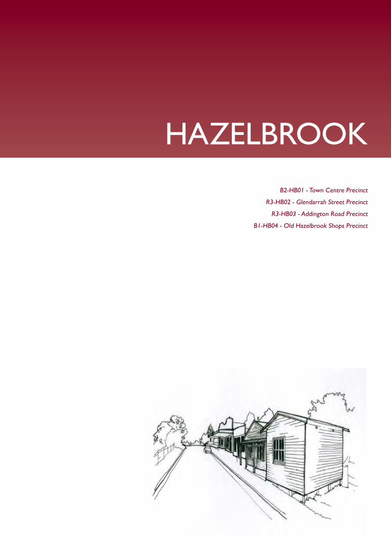
HAZELBROOK
B2-HB01 - Town Centre Precinct
R3-HB02 - Glendarrah Street Precinct
R3-HB03 - Addington Road Precinct
B1-HB04 - Old Hazelbrook Shops Precinct
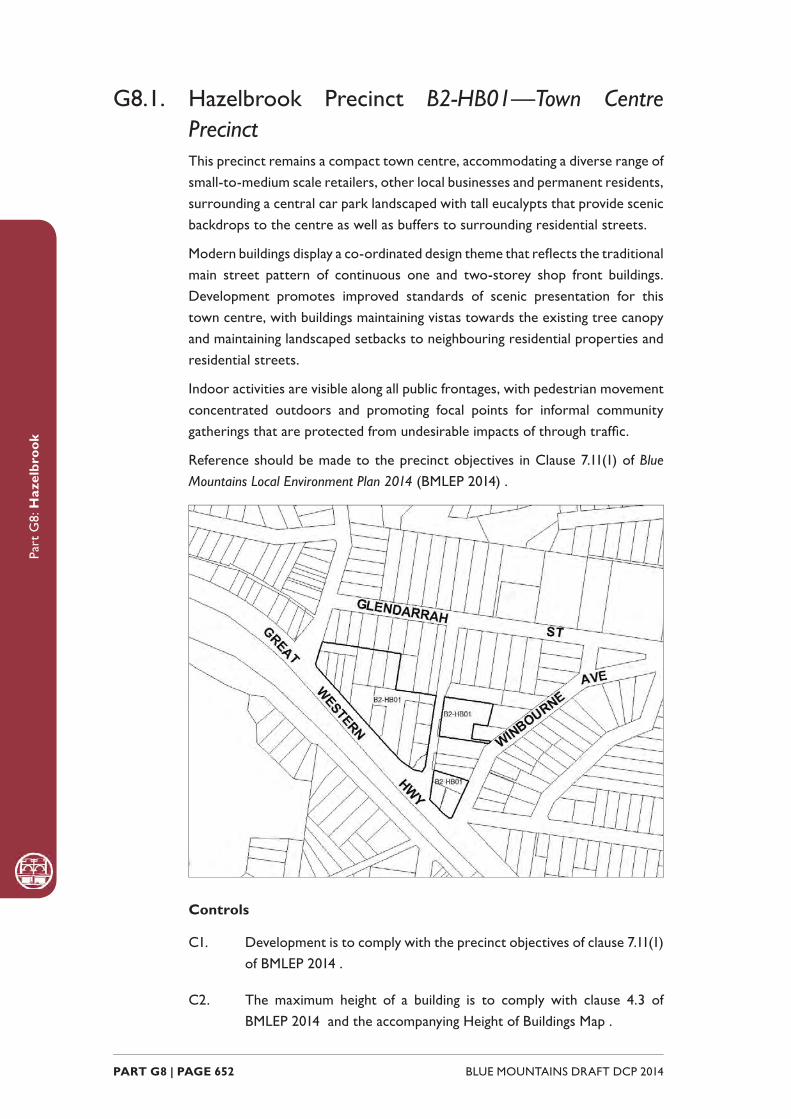
Part
G8:
Haz
elbr
ook
BLUE MOUNTAINS DRAFT DCP 2014 PART G8 | PAGE 652
G8.1. Hazelbrook Precinct B2-HB01—Town Centre PrecinctThis precinct remains a compact town centre, accommodating a diverse range of small-to-medium scale retailers, other local businesses and permanent residents, surrounding a central car park landscaped with tall eucalypts that provide scenic backdrops to the centre as well as buffers to surrounding residential streets.
Modern buildings display a co-ordinated design theme that refl ects the traditional main street pattern of continuous one and two-storey shop front buildings. Development promotes improved standards of scenic presentation for this town centre, with buildings maintaining vistas towards the existing tree canopy and maintaining landscaped setbacks to neighbouring residential properties and residential streets.
Indoor activities are visible along all public frontages, with pedestrian movement concentrated outdoors and promoting focal points for informal community gatherings that are protected from undesirable impacts of through traffi c.
Reference should be made to the precinct objectives in Clause 7.11(1) of Blue Mountains Local Environment Plan 2014 (BMLEP 2014) .
Controls
C1. Development is to comply with the precinct objectives of clause 7.11(1) of BMLEP 2014 .
C2. The maximum height of a building is to comply with clause 4.3 of BMLEP 2014 and the accompanying Height of Buildings Map .

Part
G8:
Haz
elbr
ook
PART G8 | PAGE 653BLUE MOUNTAINS DRAFT DCP 2014
C3. The maximum fl oor space ratio of development is to comply with clause 4.4 of BMLEP 2014 the accompanying Floor Space Ratio Map .
C4. Development adjoining the public domain is generally to provide a zero setback, except where it can be demonstrated that an active frontage will be provided. The exception is at the Great Western Highway and Glendarrah Street where development is to provide a minimum setback of 6m.
C5. All setback areas are to be landscaped.
C6. The maximum site cover for buildings is 100% of the total allotment area, except for buildings on land adjoining an existing residential allotment where the site to is limited to 70% of the total allotment area.
C7. The existing continuity of retail and other business premises on properties that face the public car park is to be maintained.
C8. For allotments adjoining the public car park and facing the Great Western Highway, new buildings are to provide new retail or other business premises with shop fronts along at least 50% of ground level frontages, and balconies or extensive windows, or both, for aboveground storeys.
C9. On any allotment adjoining an existing residential property, facades are to locate balconies or windows, or both, in a way that is designed to protect residential amenity.
C10. New retail development facing principal streets is to be in accordance with the design of traditional shopfront buildings, and to generally provide the following:
(a) narrow shopfronts, and
(b) continuous awnings and/or balconies, and
(c) references to traditional shopfront detailing in sympathetic contemporary materials and details.
Note: Guidelines on traditional shopfront design are found in B3.2.1 Infi ll
shopfront buildings in B3 Design development .
C11. Landscaped setbacks adjacent to residential properties or facing residential streets are to incorporate eucalypt species that are consistent with the established canopy.
C12. On-site parking areas are to be accessed only from the rear or side of buildings via existing public carparks, laneways or secondary streets,

Part
G8:
Haz
elbr
ook
BLUE MOUNTAINS DRAFT DCP 2014 PART G8 | PAGE 654
and are to be concealed from principal frontages behind retail or other business premises.
C13. The existing pedestrian network is to be expanded by promoting new retail frontages surrounding public places and fronting the Highway.
C14. Solar access to the public domain is to be protected and enhanced.
C15. Continuous weather protection along all public frontages in the form of awnings or overhanging balconies is to be provided.
C16. Ground fl oor walls and structures are to protect and enhance sight lines in public places.
G8.2. Hazelbrook Precinct R3-HB02—Glendarrah Street PrecinctThis precinct provides alternative housing types within a landscape setting of substantial radiata pines.
Reference should be made to the precinct objectives in Clause 7.11(2) of Blue Mountains Local Environment Plan 2014 (BMLEP 2014) .
Controls
C1. Development is to comply with the precinct objectives of clause 7.11(2) of BMLEP 2014 .
Part
G8:
Haz
elbr
ook
PART G8 | PAGE 655BLUE MOUNTAINS DRAFT DCP 2014
C2. The maximum height of a building is to comply with clause 4.3 of BMLEP 2014 and the accompanying Height of Buildings Map .
C3. The maximum fl oor space ratio of development is to comply with clause 4.4 of BMLEP 2014 and the accompanying Floor Space Ratio Map .
C4. Building height and roof pitch are to be varied in order to minimise the bulk of buildings.
C5. The minimum setback of buildings from Glendarrah Street is 15m.
C6. Building form is to provide an activated and safe, pedestrian-friendly street frontage through the provision of windows, verandahs and doorways to Glendarrah Street.
C7. Car parking areas and hard surfaces are to be screened through the provision of dense planting.
C8. The existing mature pine trees are to be retained and enhanced with further planting in the building setback in order to substantially screen any development from Glendarrah Street.
G8.3. Hazelbrook Precinct R3-HB03—Addington Road PrecinctThis precinct provides a mix of single and multiple-unit dwellings located close to the town centre and expands the range of residential accommodation available in the Hazelbrook village.
Redevelopment is to restore existing traditional cottages, and retain visually signifi cant elements of established garden settings. New buildings will refl ect the pattern, scale and architectural style of traditional Federation and Inter-War cottages surrounded by gardens.
Reference should be made to the precinct objectives in Clause 7.11(3) of Blue Mountains Local Environment Plan 2014 (BMLEP 2014) .

Part
G8:
Haz
elbr
ook
BLUE MOUNTAINS DRAFT DCP 2014 PART G8 | PAGE 656
Controls
C1. Development is to comply with the precinct objectives of clause 7.11(3) of BMLEP 2014 .
C2. The maximum height of a building is to comply with clause 4.3 of BMLEP 2014 and the accompanying Height of Buildings Map.
C3. The maximum fl oor space ratio of development is to comply with clause 4.4 of BMLEP 2014 and the accompanying Floor Space Ratio Map.
C4. The height above ground for the lowest habitable fl oor level is not to exceed 1m.
C5. Cut or fi ll within 5m of any property boundary is not to exceed 0.5m.
C6. The minimum setback from the primary street frontage is 8m.
C7. On corner allotments, the setback to the secondary frontage is to be a minimum of 4m.
C8. Side boundary setbacks are to be a minimum of 2m.
C9. All setback areas are to be landscaped.
C10. The maximum site cover for buildings is 50% of the total allotment area.
Part
G8:
Haz
elbr
ook
PART G8 | PAGE 657BLUE MOUNTAINS DRAFT DCP 2014
C11. The minimum area to be retained as soft, pervious or landscaped area (excluding hard surfaces) is 40% of the total allotment area.
C12. New development is to be sympathetic to traditional building forms, materials and details, including the use of traditionally-pitched roofs, articulated layouts and forms, verandahs, timber joinery, vertically–proportioned openings and some painted external fi nishes, with a curtilage of landscaped areas and an address to the street provided. New development is to be similar in form and materials to quality older buildings but subservient in detail to distinguish it as new work.
C13. Buildings are not to exceed 18m in any direction.
C14. Gardens are to incorporate a backdrop of indigenous canopy trees along rear boundaries, and a mix of native and exotic trees and shrubs through front and side yards.
C15. Any non-residential activities are to be accommodated in buildings with a residential scale and character.
C16. Driveways, parking areas and garages are not to dominate any street frontage, and are to be integrated with the design of surrounding landscaped areas.
G8.4. Hazelbrook Precinct B1-HB04 – Old Hazelbrook Shops Precinct This precinct comprises a small strip of traditional shop buildings and a number of older residences used for commercial purposes set in a main street arrangement adjacent the railway station. The buildings present a diversity of periods, styles and forms, many of which have historic signifi cance. The group retains a small-scale and local presence as a commercial precinct within a residential neighbourhood, with an emphasis on pedestrian activity and relationship to the railway station.
New development should consolidate and enhance the shopping precinct as an historic local retail area with a mixture of tourist-related and local businesses. Active street frontages to shopfront buildings are to be provided to create a pedestrian-friendly and safe environment.
Reference should be made to the precinct objectives in Clause 7.11(4) of Blue Mountains Local Environment Plan 2014 (BMLEP 2014) .

Part
G8:
Haz
elbr
ook
BLUE MOUNTAINS DRAFT DCP 2014 PART G8 | PAGE 658
Controls
C1. Development is to comply with the precinct objectives of clause 7.11(4) of BMLEP 2014 .
C2. The maximum height of a building is to comply with clause 4.3 of BMLEP 2014 and the accompanying Height of Buildings Map.
C3. The maximum fl oor space ratio of development is to comply with clause 4.4 of BMLEP 2014 and the accompanying Floor Space Ratio Map.
C4. Development is to preserve and enhance the heritage items and their settings.
C5. Development is to provide front boundary setbacks consistent with adjacent traditional shopfronts or traditional freestanding cottages as relevant, including location of forms such as verandahs, shop frontages and landscaped setbacks. The settings of existing cottages are to be respected and enhanced by new development.
C6. The maximum site coverage for buildings is 40% of the total allotment area.
C7. The minimum area to be retained as soft, pervious or landscaped area (excluding hard surfaces) is 50% of the total allotment area.
C8. Rear gardens are to be landscaped to screen parking areas and other service-related spaces.

Part
G8:
Haz
elbr
ook
PART G8 | PAGE 659BLUE MOUNTAINS DRAFT DCP 2014
C9. Additional fl oorspace should be incorporated into new rear wings or separate pavilions located to the rear of existing buildings and surrounded by landscaped open space.
C10. New development is to have regard to the scale, forms and detailing of traditional shopfront buildings, and to ensure that where appropriate, continuous awnings and/or balconies are provided.
Note: Guidelines on traditional shopfront design are found in B3.2.1 Infi ll
shopfront buildings in B3 Design development , and in 9.7 Traditional shopfront
buildings in Part D1 Heritage Conservation where heritage considerations
apply.
C11. On-site parking areas are to be accessed only from the rear of buildings, and are to be concealed from principal frontages behind retail or other business premises.

Part
G8:
Haz
elbr
ook
BLUE MOUNTAINS DRAFT DCP 2014 PART G8 | PAGE 660

SPRINGWOOD
B2-SP01 - Town Centre Precinct
R3-SP02 - Ferguson Road Precinct
R3-SP03 - Western Precinct
R3-SP04 - Southern Precinct
R3-SP05 - Eastern Precinct
RP-SP06 - St Columba’s Elmhurst Precinct
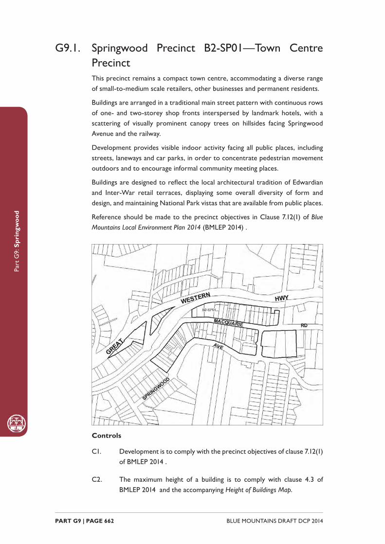
Part
G9:
Spr
ingw
ood
BLUE MOUNTAINS DRAFT DCP 2014 PART G9 | PAGE 662
G9.1. Springwood Precinct B2-SP01—Town Centre PrecinctThis precinct remains a compact town centre, accommodating a diverse range of small-to-medium scale retailers, other businesses and permanent residents.
Buildings are arranged in a traditional main street pattern with continuous rows of one- and two-storey shop fronts interspersed by landmark hotels, with a scattering of visually prominent canopy trees on hillsides facing Springwood Avenue and the railway.
Development provides visible indoor activity facing all public places, including streets, laneways and car parks, in order to concentrate pedestrian movement outdoors and to encourage informal community meeting places.
Buildings are designed to refl ect the local architectural tradition of Edwardian and Inter-War retail terraces, displaying some overall diversity of form and design, and maintaining National Park vistas that are available from public places.
Reference should be made to the precinct objectives in Clause 7.12(1) of Blue Mountains Local Environment Plan 2014 (BMLEP 2014) .
Controls
C1. Development is to comply with the precinct objectives of clause 7.12(1) of BMLEP 2014 .
C2. The maximum height of a building is to comply with clause 4.3 of BMLEP 2014 and the accompanying Height of Buildings Map.

Part
G9:
Spr
ingw
ood
PART G9 | PAGE 663BLUE MOUNTAINS DRAFT DCP 2014
C3. The maximum fl oor space ratio of development is to comply with clause 4.4 of BMLEP 2014 and the accompanying Floor Space Ratio Map.
C4. Development is to have a zero front setback, except to Springwood Avenue, where the setbacks are to be 6m with landscaping provided.
C5. Development is to have a zero side setback, except where the side boundary adjoins the public domain, in which case setbacks greater than zero may be considered if an active frontage is provided.
C6. The maximum site cover for buildings is 100% of the total allotment area, except on properties with frontages to Springwood Avenue where the maximum site cover is 70%.
C7. The existing continuity of retail and other business premises on properties that face Macquarie or Raymond Roads is to be retained.
C8. On properties with secondary frontages to the public domain, new retail or other business premises to those secondary frontages are to be promoted along at least 50% of ground level frontages to public carparks, side streets and laneways, and for all storeys above ground, balconies and/or extensive windows facing the public domain are to be provided.
C9. On properties facing Springwood Avenue, extensive balconies and/or windows are to be provided in all facades facing that street.
C10. New development is to have regard to the scale, forms and detailing of traditional shopfront buildings, and to ensure that where appropriate, continuous awnings and/or balconies are provided.
Note: Guidelines on traditional shopfront design are found in B3.2.1 Infi ll
shopfront buildings in B3 Design development , and in 9.7 Traditional shopfront
buildings in Part D1 Heritage Conservation where heritage considerations
apply.
C11. On properties that contain two-storey traditional shop buildings, new development is to retain the principal shopfront structure and elements, and also the adjoining rooms.
Note: Guidelines on traditional shopfront design are found in B3.2.1 Infi ll
shopfront buildings in B3 Design development , and in 9.7 Traditional shopfront
buildings in Part D1 Heritage Conservation where heritage considerations
apply.
C12. Development on large allotments is to distribute fl oorspace into well-articulated structures that are composed of separate wings or interconnected buildings, with traditionally pitched roofs and
Part
G9:
Spr
ingw
ood
BLUE MOUNTAINS DRAFT DCP 2014 PART G9 | PAGE 664
appropriately landscaped garden courtyards.
C13. Existing canopy trees are to be retained to frame building presentation. New landscaping is to be appropriately-sized and characteristic of the locality.
C14. On-site parking areas are to be accessed only from the rear or side of buildings via existing public car parks, laneways or secondary streets, and are to be concealed behind retail or business fl oorspace wherever possible.
C15. The existing pedestrian network is to be expanded by promoting new retail frontages surrounding the public domain.
C16. Solar access to the public domain is to be protected and enhanced.
C17. Continuous weather protection along all public frontages in the form of awnings or overhanging balconies is to be provided.
C18. Ground fl oor walls and structures are to protect and enhance sight lines in public places.
G9.2. Springwood Precinct R3-SP02—Ferguson Road PrecinctThis precinct provides a mix of single and multiple-unit dwellings located close to the town centre and expanding the range of residential accommodation that is available in the Springwood village.
New development will refl ect the scale, forms, materials and details of existing traditional cottages.
In order to provide a distinctive backdrop to both the town centre and the highway, redevelopment is to retain visually signifi cant elements of established garden settings, such as canopy trees in front and rear yards, and restoration of existing cottages is encouraged.
Reference should be made to the precinct objectives in Clause 7.12(2) of Blue Mountains Local Environment Plan 2014 (BMLEP 2014) .

Part
G9:
Spr
ingw
ood
PART G9 | PAGE 665BLUE MOUNTAINS DRAFT DCP 2014
Controls
C1. Development is to comply with the precinct objectives of clause 7.12(2) of BMLEP 2014 .
C2. The maximum height of buildings is to comply with clause 4.3 of BMLEP 2014 and the accompanying Height of Buildings Map.
C3. The maximum fl oor space ratio of development is to comply with clause 4.4 of BMLEP 2014 and the accompanying Floor Space Ratio Map.
C4. The height above ground for the lowest habitable fl oor level is not to exceed 1.5m.
C5. Cut or fi ll within 5m of any property boundary is not to exceed 0.5m.
C6. The minimum setback from the street frontage is 8m.
C7. Side boundary setbacks, including any secondary frontage to Yerrawar Place is to be a minimum of 2m.
C8. All setback areas are to be landscaped.
C9. The maximum site cover for buildings is 50% of the total allotment area.
C10. The minimum area to be retained as soft, pervious or landscaped area (excluding hard surfaces) is 40% of the total allotment area.
Part
G9:
Spr
ingw
ood
BLUE MOUNTAINS DRAFT DCP 2014 PART G9 | PAGE 666
C11. New development is to be sympathetic to traditional building forms, materials and details, including the use of traditionally-pitched roofs, articulated layouts and forms, verandahs, timber joinery, vertically–proportioned openings and some painted external fi nishes, with a curtilage of landscaped areas and an address to the street provided. New development is to be similar in form and materials to quality older buildings but subservient in detail to distinguish it as new work.
C12. Buildings are not to exceed 18m in any direction.
C13. Any non-residential activities are to be accommodated in buildings with a residential scale and character.
C14. Driveways, parking areas and garages are not to dominate any street frontage, and are to be integrated with the design of surrounding landscaped areas.
G9.3. Springwood Precinct R3-SP03—Western PrecinctThis precinct provides a mix of single and multiple-unit dwellings, located close to the town centre and expanding the range of residential accommodation that is available in the Springwood village.
New development will refl ect the scale, forms, materials and details of existing traditional cottages, and conserve and enhance established garden settings.
In order to provide a visually distinctive backdrop to the town centre, redevelopment is to retain visually signifi cant elements of established garden settings, particularly tall eucalypts and other canopy trees on hillside sites.
Reference should be made to the precinct objectives in Clause 7.12(3) of Blue Mountains Local Environment Plan 2014 (BMLEP 2014) .

Part
G9:
Spr
ingw
ood
PART G9 | PAGE 667BLUE MOUNTAINS DRAFT DCP 2014
Controls
C1. Development is to comply with the precinct objectives of clause 7.12(3) of BMLEP 2014 .
C2. The maximum height of a building is to comply with clause 4.3 of BMLEP 2014 and the accompanying Height of Buildings Map.
C3. The maximum fl oor space ratio of development is to comply with clause 4.4 of BMLEP 2014 and the accompanying Floor Space Ratio Map.
C4. The height above ground for the lowest habitable fl oor level is not to exceed 1.5m.
C5. Cut or fi ll within 5m of any property boundary is not to exceed 0.5m.
C6. The minimum setback from the primary street frontage is 8m.
C7. On corner allotments, the setback to the secondary frontage is to be a minimum of 4m.
C8. Side boundary setbacks are to be a minimum of 2m.
C9. All setback areas are to be landscaped.
C10. The maximum site cover for buildings is 50% of the total allotment area.

Part
G9:
Spr
ingw
ood
BLUE MOUNTAINS DRAFT DCP 2014 PART G9 | PAGE 668
C11. The minimum area to be retained as soft, pervious or landscaped area (excluding hard surfaces) is 40% of the total allotment area.
C12. New development is to be sympathetic to traditional building forms, materials and details, including the use of traditionally-pitched roofs, articulated layouts and forms, verandahs, timber joinery, vertically–proportioned openings and some painted external fi nishes, with a curtilage of landscaped areas and an address to the street provided. New development is to be similar in form and materials to quality older buildings but subservient in detail to distinguish it as new work.
C13. Buildings are not to exceed 15m in any direction.
C14. Any non-residential activities are to be accommodated in buildings with a residential scale and character.
C15. Driveways, parking areas and garages are not to dominate any street frontage, and are to be integrated with the design of surrounding landscaped areas.
G9.4. Springwood Precinct R3-SP04—Southern PrecinctMultiple-unit dwellings in this precinct are planned and constructed to protect the neighbouring bushland reserve of Fairy Dell from adverse visual or environmental impacts, as well as to provide an attractive backdrop to the Springwood Village centre and to expand the range of residential accommodation that is available in the Springwood Village.
Buildings and site works are confi ned to street frontages along Springwood Avenue, avoiding disturbance to steeper wooded slopes surrounding Fairy Dell. Substantial landscape buffers of canopy trees and understorey are maintained along all street and park boundaries, screening buildings and maintaining a quiet bushland atmosphere in the neighbouring reserve.
Reference should be made to the precinct objectives in Clause 7.12(4) of Blue Mountains Local Environment Plan 2014 (BMLEP 2014) .
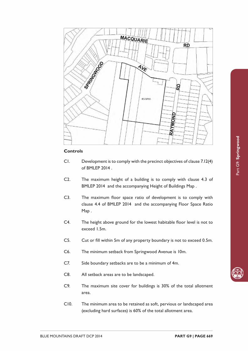
Part
G9:
Spr
ingw
ood
PART G9 | PAGE 669BLUE MOUNTAINS DRAFT DCP 2014
Controls
C1. Development is to comply with the precinct objectives of clause 7.12(4) of BMLEP 2014 .
C2. The maximum height of a building is to comply with clause 4.3 of BMLEP 2014 and the accompanying Height of Buildings Map .
C3. The maximum fl oor space ratio of development is to comply with clause 4.4 of BMLEP 2014 and the accompanying Floor Space Ratio Map .
C4. The height above ground for the lowest habitable fl oor level is not to exceed 1.5m.
C5. Cut or fi ll within 5m of any property boundary is not to exceed 0.5m.
C6. The minimum setback from Springwood Avenue is 10m.
C7. Side boundary setbacks are to be a minimum of 4m.
C8. All setback areas are to be landscaped.
C9. The maximum site cover for buildings is 30% of the total allotment area.
C10. The minimum area to be retained as soft, pervious or landscaped area (excluding hard surfaces) is 60% of the total allotment area.
Part
G9:
Spr
ingw
ood
BLUE MOUNTAINS DRAFT DCP 2014 PART G9 | PAGE 670
C11. Gardens and buildings are to minimise impacts on the surrounding bushland and provide for additional plantings that are compatible with the ecology of adjoining bushland plant communities as well as minimising bush fi re hazard.
C12. Buildings are to incorporate design elements that integrate new development sensitively with the bushland setting. This includes well-articulated and site-responsive forms, pitched roofs that align with the topography, and earthy materials and colours.
C13. Buildings are not to exceed 25m in any direction.
C14. Any non-residential activities are to be accommodated in buildings with a residential character.
C15. Driveways, parking areas and garages are not to dominate any street frontage, and are to be integrated with the design of surrounding landscaped areas.
G9.5. Springwood Precinct R3-SP05—Eastern PrecinctMultiple-unit dwellings in this precinct are designed to establish an attractive and distinctive eastern gateway to the neighbouring town centre, as well as expanding the range of residential accommodation that is available in the Springwood Village.
In order to provide a visually distinctive backdrop to the neighbouring town centre, buildings are surrounded by landscaped settings that include copses of tall eucalypts. Building forms are well-articulated and incorporate traditional building elements such as traditionally-pitched hipped and/or gabled roofs, dry-pressed brickwork walls and timber joinery for traditionally-designed verandahs and balconies.
Reference should be made to the precinct objectives in Clause 7.12(5) of Blue Mountains Local Environment Plan 2014 (BMLEP 2014) .
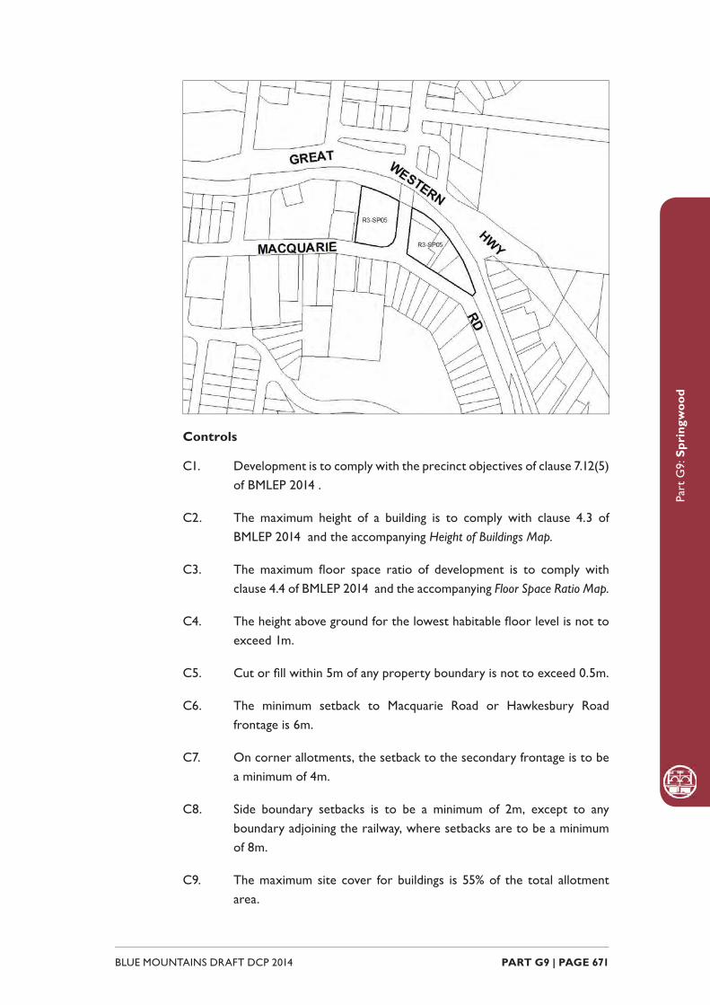
Part
G9:
Spr
ingw
ood
PART G9 | PAGE 671BLUE MOUNTAINS DRAFT DCP 2014
Controls
C1. Development is to comply with the precinct objectives of clause 7.12(5) of BMLEP 2014 .
C2. The maximum height of a building is to comply with clause 4.3 of BMLEP 2014 and the accompanying Height of Buildings Map.
C3. The maximum fl oor space ratio of development is to comply with clause 4.4 of BMLEP 2014 and the accompanying Floor Space Ratio Map.
C4. The height above ground for the lowest habitable fl oor level is not to exceed 1m.
C5. Cut or fi ll within 5m of any property boundary is not to exceed 0.5m.
C6. The minimum setback to Macquarie Road or Hawkesbury Road frontage is 6m.
C7. On corner allotments, the setback to the secondary frontage is to be a minimum of 4m.
C8. Side boundary setbacks is to be a minimum of 2m, except to any boundary adjoining the railway, where setbacks are to be a minimum of 8m.
C9. The maximum site cover for buildings is 55% of the total allotment area.
Part
G9:
Spr
ingw
ood
BLUE MOUNTAINS DRAFT DCP 2014 PART G9 | PAGE 672
C10. The minimum area to be retained as soft, pervious or landscaped area (excluding hard surfaces) is 35% of the total allotment area.
C11. Buildings are to present a high standard of architectural form and detailing and formally address signifi cant public domain areas within the immediate setting; service function areas are to be compact and discreetly located.
C12. New development is to be sympathetic to traditional building forms, materials and details, including the use of traditionally-pitched roofs, articulated layouts and forms, verandahs, timber joinery, vertically–proportioned openings and some painted external fi nishes, with a curtilage of landscaped areas and an address to the street provided. New development is to be similar in form and materials to quality older buildings but subservient in detail to distinguish it as new work.
C13. Buildings are not to exceed 15m in any direction.
C14. Any non-residential activities are to be accommodated in buildings with a residential scale and character.
C15. Driveways, parking areas and garages are not to dominate any street frontage, and are to be integrated with the design of surrounding landscaped areas.
G9.6. Springwood Precinct RP-SP06—St Columba’s Elmhurst Precinct Located on the periphery of the urban areas of Springwood and Winmalee, this site is signifi cant for its natural and cultural values. The precinct forms part of a site comprised of land with high environmental value, including escarpment areas, areas of steep slope, riparian corridors and signifi cant vegetation. In addition, the site contains valuable evidence of pre-1890 Aboriginal habitation. These areas are protected through a conservation management plan. Watercourses on the site feed into the Hawkesbury-Nepean catchments. All of these factors impact on development within the precinct.
The precinct contains important heritage items that relate to European settlement at the turn of the 20th Century.
Development within the precinct retains a predominantly rural setting around the remains of Elmhurst and is of a scale and form that is complementary to the historic form and setting of Elmhurst.
The environmental values of the site are protected through appropriate development and design and mitigate the impact on adjoining land zoned E2 Environmental Conservation and sub-catchments of the Hawkesbury-Nepean
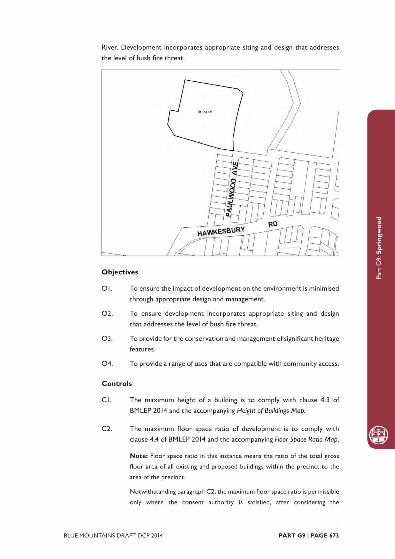
Part
G9:
Spr
ingw
ood
PART G9 | PAGE 673BLUE MOUNTAINS DRAFT DCP 2014
River. Development incorporates appropriate siting and design that addresses the level of bush fi re threat.
Objectives
O1. To ensure the impact of development on the environment is minimised through appropriate design and management.
O2. To ensure development incorporates appropriate siting and design that addresses the level of bush fi re threat.
O3. To provide for the conservation and management of signifi cant heritage features.
O4. To provide a range of uses that are compatible with community access.
Controls
C1. The maximum height of a building is to comply with clause 4.3 of BMLEP 2014 and the accompanying Height of Buildings Map.
C2. The maximum fl oor space ratio of development is to comply with clause 4.4 of BMLEP 2014 and the accompanying Floor Space Ratio Map.
Note: Floor space ratio in this instance means the ratio of the total gross
fl oor area of all existing and proposed buildings within the precinct to the
area of the precinct.
Notwithstanding paragraph C2, the maximum fl oor space ratio is permissible
only where the consent authority is satisfi ed, after considering the

Part
G9:
Spr
ingw
ood
BLUE MOUNTAINS DRAFT DCP 2014 PART G9 | PAGE 674
conservation management plan, that the integrity of the heritage items on
the site will be maintained.
Notwithstanding paragraph C2, the maximum fl oor space ratio is permissible
only where the consent authority is satisfi ed that appropriate bush fi re
management measures are in place in accordance with this plan.
Notwithstanding paragraph C2, the consent authority, in assessing building
heights, is to have regard to the recommendations of a conservation
management plan.
C3. The minimum setback from the primary access road to the west of the precinct, as existing on the appointed day, is 40m.
C4. The consent authority, in assessing setbacks from heritage buildings, is to have regard to the recommendations of a conservation management plan.
C5. The maximum site cover for buildings (including any buildings ancillary to the main building, swimming pools or tennis courts) is 30% of the total area of the precinct.
C6. The minimum area to be retained as soft, pervious or landscaped areas (excluding hard surfaces) is 40% of the total area of the precinct.
C7. Any development application is to include the following:
(a) a bush fi re threat analysis that, to the satisfaction of the consent authority, assesses the threat of bush fi re and incorporates appropriate recommendations for the design of the proposed development siting and addresses the level of bush fi re threat, and
(b) an archaeological survey undertaken to determine the location and signifi cance of any archaeological sites and any Aboriginal places on the land, and a report on how development should be managed with regard to the result of the survey, and
(c) a detailed heritage impact assessment and conservation management plan by a suitably qualifi ed consultant, and
(d) how development in this precinct will have regard to and complement the existing historical and heritage values of the site, and
(e) a traffi c statement, prepared by a suitably qualifi ed traffi c engineer, which addresses but is not limited to an assessment of increases in traffi c volumes, the impact of proposed development on Hawkesbury Road, and the number and location of car
Part
G9:
Spr
ingw
ood
PART G9 | PAGE 675BLUE MOUNTAINS DRAFT DCP 2014
parking spaces, and
(f) how signifi cant street trees along the primary access road are to be retained and appropriate measures for their protection, and
(g) a statement of community benefi t, indicating recommendations for the provision of and access to public facilities on the site.
C8. A minimum of two separate vehicular access routes are to be provided from the precinct to Hawkesbury Road.
C9. New buildings are to be separate and independent from the primary school grouping.
C10. Development adjacent to Elmhurst is to provide frontages in a westerly direction.
C11. A variety of heights and forms are to be incorporated in the design of development in order to minimise the bulk and scale of development and is to be of a form that is complementary to the setting of the historic building remnants within the precinct.

Part
G9:
Spr
ingw
ood
BLUE MOUNTAINS DRAFT DCP 2014 PART G9 | PAGE 676
WINMALEE
B2-WL01 - Town Centre Precinct
R3-WL02 - Village Housing Precinct

Part
G10
: Win
mal
ee
BLUE MOUNTAINS DRAFT DCP 2014 PART G10 | PAGE 678
G10.1. Winmalee Precinct B2-WL01 –Town Centre PrecinctThe precinct remains a compact town centre, accommodating a diverse range of retail and other businesses that complement the district level retail facilities that form the main focus of commercial activity for the precinct.
Development in the northern section of the precinct is in keeping with the residential scale form and character of the surrounding residential areas. Heritage items are preserved and form a signifi cant visual element to be taken into account in the design of new development.
The development of the precinct is to incorporate the low densities and bushland character elements that have characterised the traditional development of Winmalee village. The visual impact of built components is minimised through design elements and native vegetation screening from surrounding roadways. Signifi cant trees, including the heritage listed Bunya Pines, are retained and enhanced with new plantings, particularly within and surrounding car parking areas.
Reference should be made to the precinct objectives in Clause 7.13(1) of Blue Mountains Local Environment Plan 2014 (BMLEP 2014) .
Controls
C1. Development is to comply with the precinct objectives of clause 7.13(1) of BMLEP 2014.
C2. The maximum height of a building is to comply with clause 4.3 of BMLEP 2014 and the accompanying Height of Buildings Map.
C3. The maximum fl oor space ratio of development is to comply with clause 4.4 of BMLEP 2014 and the accompanying Floor Space Ratio Map.

Part
G10
: Win
mal
ee
PART G10 | PAGE 679BLUE MOUNTAINS DRAFT DCP 2014
C4. The minimum setback is to be within 20% of the average setback of adjoining allotments.
C5. The maximum site cover for buildings is 40% of the total allotment area.
C6. All visible walls are to be articulated with appropriate design elements and heavily screened with appropriate native vegetation plantings.
C7. New development is to provide circulation that minimises confl icts between vehicles and pedestrians.
C8. Commercial signage is to be co-ordinated with building and shop front design to refl ect a village character.
C9. The heritage items within the precinct are to be retained and incorporated into any future development proposals.
G10.2. Winmalee Precinct R3-WL02 – Village Housing PrecinctThe precinct reinforces a compact town centre, accommodating a diverse range of residential, medical and other professional services that complement the adjacent district level retail and community facilities.
Buildings in the precinct are designed to establish an attractive and distinctive gateway to the neighbouring town centre, as well as expanding the range of residential, medical and other professional services that are available in the Winmalee village.
New building works are well-articulated and refl ect the pattern and scale of the surrounding residential areas, together with surrounding gardens. In order to provide a visually distinctive backdrop to the neighbouring town centre, redevelopment is to incorporate visually signifi cant elements of established garden settings, particularly tall eucalypts and other canopy trees.
Buildings and associated infrastructure in the precinct are planned and constructed to protect neighbouring land zoned E2 Environmental Conservation from environmental effects.
The development of the precinct is to incorporate the low densities and bushland character elements that have characterized the traditional development of Winmalee village. The visual impact of built components is minimised through design elements and native vegetation screening from surrounding roadways. Signifi cant trees are retained and enhanced with new plantings, particularly within and surrounding car parking areas.
Reference should be made to the precinct objectives in Clause 7.13(2) of Blue Mountains Local Environment Plan 2014 (BMLEP 2014) .
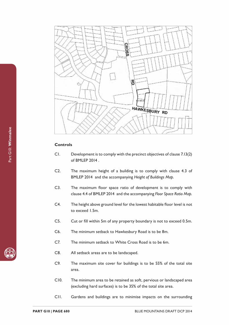
Part
G10
: Win
mal
ee
BLUE MOUNTAINS DRAFT DCP 2014 PART G10 | PAGE 680
Controls
C1. Development is to comply with the precinct objectives of clause 7.13(2) of BMLEP 2014 .
C2. The maximum height of a building is to comply with clause 4.3 of BMLEP 2014 and the accompanying Height of Buildings Map.
C3. The maximum fl oor space ratio of development is to comply with clause 4.4 of BMLEP 2014 and the accompanying Floor Space Ratio Map.
C4. The height above ground level for the lowest habitable fl oor level is not to exceed 1.5m.
C5. Cut or fi ll within 5m of any property boundary is not to exceed 0.5m.
C6. The minimum setback to Hawkesbury Road is to be 8m.
C7. The minimum setback to White Cross Road is to be 6m.
C8. All setback areas are to be landscaped.
C9. The maximum site cover for buildings is to be 55% of the total site area.
C10. The minimum area to be retained as soft, pervious or landscaped area (excluding hard surfaces) is to be 35% of the total site area.
C11. Gardens and buildings are to minimise impacts on the surrounding
Part
G10
: Win
mal
ee
PART G10 | PAGE 681BLUE MOUNTAINS DRAFT DCP 2014
bushland, to provide for additional plantings that are compatible with the ecology of adjoining bushland plant communities, and to minimise bush fi re hazard.
C12. Buildings are to incorporate design elements that integrate new development sensitively with the bushland setting. This includes well-articulated and site-responsive forms, pitched roofs that align with the topography, and earthy materials and colours.
C13. Residential buildings are not to exceed 15m in width or depth.
C14. Any non-residential activities are to be accommodated in buildings with a residential character.
C15. Driveways, parking areas and garages are not to dominate any street frontage, and are to be integrated with the design of surrounding landscaped areas.
C16. All vehicular access and egress to the site is to be via White Cross Road and located in a position that does not unreasonably interfere with the fl ow of vehicular and pedestrian movements on White Cross Road, and also into and out of the Winmalee Shopping Centre, adjoining properties and the Winmalee Public School.

Part
G10
: Win
mal
ee
BLUE MOUNTAINS DRAFT DCP 2014 PART G10 | PAGE 682
BLAXLAND
B2-BX01 - Town Centre Precinct
R3-BX02 - Layton Avenue Precinct
R3-BX03 - Hope Street Precinct
R3-BX04 - Housing Precinct
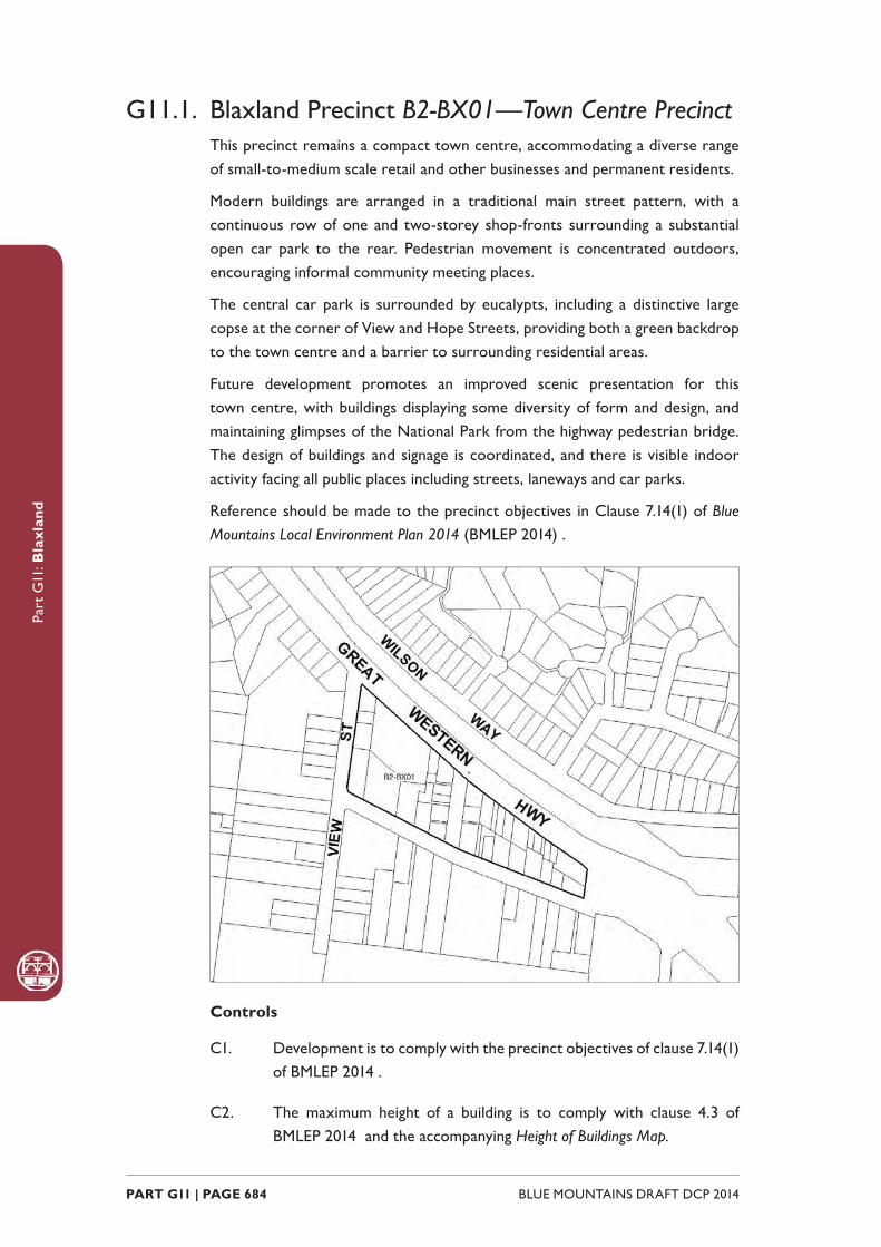
Part
G11
: Bla
xlan
d
BLUE MOUNTAINS DRAFT DCP 2014 PART G11 | PAGE 684
G11.1. Blaxland Precinct B2-BX01—Town Centre PrecinctThis precinct remains a compact town centre, accommodating a diverse range of small-to-medium scale retail and other businesses and permanent residents.
Modern buildings are arranged in a traditional main street pattern, with a continuous row of one and two-storey shop-fronts surrounding a substantial open car park to the rear. Pedestrian movement is concentrated outdoors, encouraging informal community meeting places.
The central car park is surrounded by eucalypts, including a distinctive large copse at the corner of View and Hope Streets, providing both a green backdrop to the town centre and a barrier to surrounding residential areas.
Future development promotes an improved scenic presentation for this town centre, with buildings displaying some diversity of form and design, and maintaining glimpses of the National Park from the highway pedestrian bridge. The design of buildings and signage is coordinated, and there is visible indoor activity facing all public places including streets, laneways and car parks.
Reference should be made to the precinct objectives in Clause 7.14(1) of Blue Mountains Local Environment Plan 2014 (BMLEP 2014) .
Controls
C1. Development is to comply with the precinct objectives of clause 7.14(1) of BMLEP 2014 .
C2. The maximum height of a building is to comply with clause 4.3 of BMLEP 2014 and the accompanying Height of Buildings Map.

Part
G11
: Bla
xlan
d
PART G11 | PAGE 685BLUE MOUNTAINS DRAFT DCP 2014
C3. The maximum fl oor space ratio of development is to comply with clause 4.4 of BMLEP 2014 and the accompanying Floor Space Ratio Map.
C4. Development is to have a zero front setback, except in Hope Street where the setback is to be a minimum of 6m and is to be landscaped.
C5. Development is to have a zero side setback, except where the side boundary adjoins the public domain, where setbacks greater than zero may be considered where an active frontage will be provided.
C6. Notwithstanding C4 and C5, front and side setbacks at the intersection of Hope and View Streets are to be increased to protect the visually signifi cant eucalypt canopy.
C7. The maximum site cover for buildings is 100% of the total allotment area, except for buildings on an allotment fronting Hope Street, where the maximum site cover is 80% of the total allotment area.
C8. Notwithstanding C7 at the corner of Hope and View Streets the footprint shall be reduced as necessary to conserve the visually signifi cant eucalypt canopy.
C9. The existing continuity of retail and other business premises on properties that face the Highway is to be maintained.
C10. On properties with a secondary frontage to a public place, new retail or other business premises are to be promoted along at least 50% of ground level frontages to public carparks, side streets and laneways, and for all storeys above ground, balconies and/or extensive windows facing those public places are to be included.
C11. On properties fronting Hope Street, extensive balconies and/or windows are to be promoted in all facades facing that street.
C12. New development is to have regard to the scale, forms and detailing of traditional shopfront buildings and to ensure that where appropriate, continuous awnings and/or balconies are provided.
Note: Guidelines on traditional shopfront design are found in B3.2.1 Infi ll
shopfront buildings in B3 Design development .
C13. Buildings are to present a high standard of architectural form and detailing, and formally address signifi cant public domain areas within the immediate setting; service function areas are to be compact and discreetly located.
C14. Development on large allotments is to distribute fl oorspace into well-articulated structures that are composed of separate wings

Part
G11
: Bla
xlan
d
BLUE MOUNTAINS DRAFT DCP 2014 PART G11 | PAGE 686
or interconnected buildings, with traditionally pitched roofs and appropriately-landscaped garden courtyards.
C15. Existing canopy trees are to be retained to frame building presentation. New landscaping is to be appropriately-sized and characteristic of the locality.
C16. On-site parking areas are to be accessed only from the rear or side of buildings via existing public car parks, laneways or secondary streets, and are to be concealed from principal frontages behind retail or other business premises.
C17. The existing pedestrian network is to be expanded by promoting new retail frontages surrounding the public places.
C18. Solar access to the public domain is to be protected and enhanced.
C19. Continuous weather protection is to be provided along all public frontages in the form of awnings or overhanging balconies.
C20. Ground fl oor walls and structures are to protect and enhance sight lines in public places.
G11.2. Blaxland Precinct R3-BX02—Layton Avenue PrecinctThis precinct provides sensitive redevelopment for the purpose of alternate housing forms, designed so as to present a positive residential amenity in close proximity to services and public transport. Redevelopment contributes to the streetscape by providing active street frontages to Layton Avenue.
Reference should be made to the precinct objectives in Clause 7.14(2) of Blue Mountains Local Environment Plan 2014 (BMLEP 2014) .

Part
G11
: Bla
xlan
d
PART G11 | PAGE 687BLUE MOUNTAINS DRAFT DCP 2014
Controls
C1. Development is to comply with the precinct objectives of clause 7.14(2) of BMLEP 2014 .
C2. The maximum height of a building is to comply with clause 4.3 of BMLEP 2014 and the accompanying Height of Buildings Map.
C3. The maximum fl oor space ratio of development is to comply with clause 4.4 of BMLEP 2014 and the accompanying Floor Space Ratio Map.
C4. The minimum setback from Layton Avenue is 5m.
C5. Building form is to provide an active street frontage to Layton Avenue and facades fronting Layton Avenue are to be articulated through, for example, the provision of verandahs, windows and front doors.
C6. Development is to provide private open space in the form of landscaping with screening at the rear of the site.
G11.3. Blaxland Precinct R3-BX03—Hope Street Precinct (106 Great Western Highway, Blaxland) This precinct promotes sensitive development for the purpose of promoting alternate housing forms, designed so as to present a positive residential amenity in close proximity to services and public transport. Development of this site maintains the bushland character of the locality and limits access onto the Great
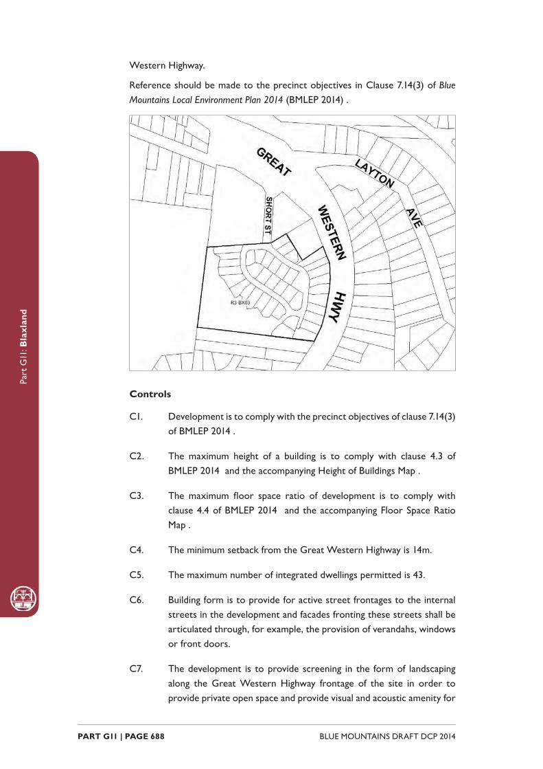
Part
G11
: Bla
xlan
d
BLUE MOUNTAINS DRAFT DCP 2014 PART G11 | PAGE 688
Western Highway.
Reference should be made to the precinct objectives in Clause 7.14(3) of Blue Mountains Local Environment Plan 2014 (BMLEP 2014) .
Controls
C1. Development is to comply with the precinct objectives of clause 7.14(3) of BMLEP 2014 .
C2. The maximum height of a building is to comply with clause 4.3 of BMLEP 2014 and the accompanying Height of Buildings Map .
C3. The maximum fl oor space ratio of development is to comply with clause 4.4 of BMLEP 2014 and the accompanying Floor Space Ratio Map .
C4. The minimum setback from the Great Western Highway is 14m.
C5. The maximum number of integrated dwellings permitted is 43.
C6. Building form is to provide for active street frontages to the internal streets in the development and facades fronting these streets shall be articulated through, for example, the provision of verandahs, windows or front doors.
C7. The development is to provide screening in the form of landscaping along the Great Western Highway frontage of the site in order to provide private open space and provide visual and acoustic amenity for
Part
G11
: Bla
xlan
d
PART G11 | PAGE 689BLUE MOUNTAINS DRAFT DCP 2014
residents.
C8. The development is to incorporate appropriate mitigation measures such as stormwater treatment and bushland regeneration to ensure the protection of habitat for threatened species such as the Red-crowned Toadlet.
C9. Communal open space is to be provided so as to provide recreational opportunities for the residents of the development, allow for stormwater management on site, and promote bushland regeneration to ensure the protection of habitat for threatened species, such as the Red-crowned Toadlet.
C10. Vehicular access to land within the precinct is to be provided from the public road linking the northern boundary of the precinct to the Great Western Highway.
G11.4. Blaxland Precinct R3-BX04—Village Housing PrecinctThis precinct provides a mix of single and multiple-unit dwellings, plus a variety of low-key businesses facing Hope Street.
Future development is planned and constructed to protect neighbouring bushland from adverse visual or environmental impacts, as well as to provide an attractive backdrop to the town centre, and to expand the range of residential accommodation and community services available in the Blaxland Village.
New development will refl ect the scale, forms, materials and details of existing traditional cottages, and provide garden settings that support a dense bushland backdrop.
Buildings and site works are set close to Hope Street, protecting steeper wooded slopes from disturbance and maintaining substantial landscape buffers of canopy trees and understorey along the rear boundary. Street frontages are landscaped to provide a visually distinctive backdrop to the town centre.
Reference should be made to the precinct objectives in clause 7.14(4) of Blue Mountains Local Environment Plan 2014 (BMLEP 2014) .
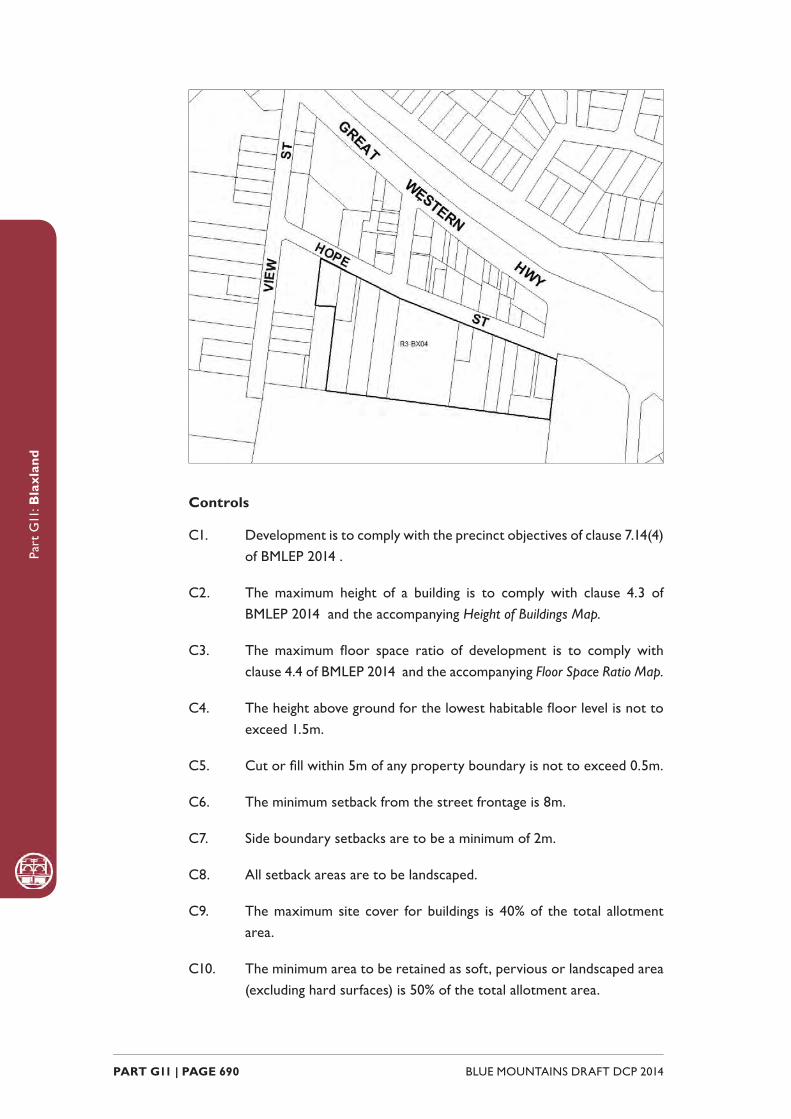
Part
G11
: Bla
xlan
d
BLUE MOUNTAINS DRAFT DCP 2014 PART G11 | PAGE 690
Controls
C1. Development is to comply with the precinct objectives of clause 7.14(4) of BMLEP 2014 .
C2. The maximum height of a building is to comply with clause 4.3 of BMLEP 2014 and the accompanying Height of Buildings Map.
C3. The maximum fl oor space ratio of development is to comply with clause 4.4 of BMLEP 2014 and the accompanying Floor Space Ratio Map.
C4. The height above ground for the lowest habitable fl oor level is not to exceed 1.5m.
C5. Cut or fi ll within 5m of any property boundary is not to exceed 0.5m.
C6. The minimum setback from the street frontage is 8m.
C7. Side boundary setbacks are to be a minimum of 2m.
C8. All setback areas are to be landscaped.
C9. The maximum site cover for buildings is 40% of the total allotment area.
C10. The minimum area to be retained as soft, pervious or landscaped area (excluding hard surfaces) is 50% of the total allotment area.
Part
G11
: Bla
xlan
d
PART G11 | PAGE 691BLUE MOUNTAINS DRAFT DCP 2014
C11. Development is to be sited, designed and constructed to minimise impacts upon surrounding bushland.
C12. Landscaping is to be compatible with the ecology of bushland plant communities on any neighbouring property as well as minimising bush fi re hazard.
C13. New development is to be sympathetic to traditional building forms, materials and details, including the use of traditionally-pitched roofs, articulated layouts and forms, verandahs, timber joinery, vertically–proportioned openings and some painted external fi nishes, with a curtilage of landscaped areas and an address to the street provided. New development is to be similar in form and materials to quality older buildings but subservient in detail to distinguish it as new work.
C14. Buildings are not to exceed 15m in any direction.
C15. Any non-residential activities along Hope Street are to be accommodated in buildings with a residential scale and character.
C16. Driveways, parking areas and garages are not to dominate any street frontage, and are to be integrated with the design of surrounding landscaped areas.

Part
G11
: Bla
xlan
d
BLUE MOUNTAINS DRAFT DCP 2014 PART G11 | PAGE 692
GLENBROOK
B1-GB01 - Glenbrook Shops Precinct
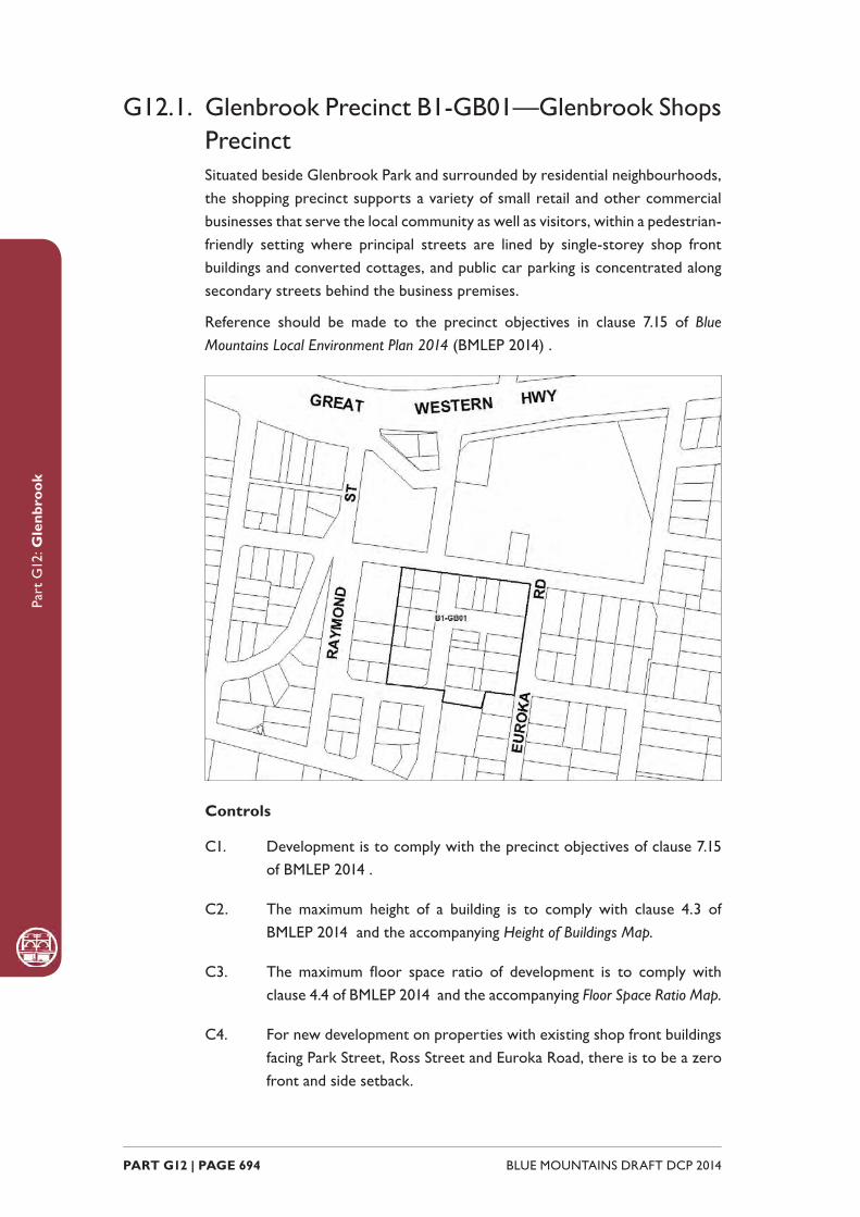
Part
G12
: Gle
nbro
ok
BLUE MOUNTAINS DRAFT DCP 2014 PART G12 | PAGE 694
G12.1. Glenbrook Precinct B1-GB01—Glenbrook Shops PrecinctSituated beside Glenbrook Park and surrounded by residential neighbourhoods, the shopping precinct supports a variety of small retail and other commercial businesses that serve the local community as well as visitors, within a pedestrian-friendly setting where principal streets are lined by single-storey shop front buildings and converted cottages, and public car parking is concentrated along secondary streets behind the business premises.
Reference should be made to the precinct objectives in clause 7.15 of Blue Mountains Local Environment Plan 2014 (BMLEP 2014) .
Controls
C1. Development is to comply with the precinct objectives of clause 7.15 of BMLEP 2014 .
C2. The maximum height of a building is to comply with clause 4.3 of BMLEP 2014 and the accompanying Height of Buildings Map.
C3. The maximum fl oor space ratio of development is to comply with clause 4.4 of BMLEP 2014 and the accompanying Floor Space Ratio Map.
C4. For new development on properties with existing shop front buildings facing Park Street, Ross Street and Euroka Road, there is to be a zero front and side setback.
Part
G12
: Gle
nbro
ok
PART G12 | PAGE 695BLUE MOUNTAINS DRAFT DCP 2014
C5. For new development on properties that contain existing cottages, the existing front setback is to be maintained and side setbacks of 1m minimum are to be provided. The built frontage is not to exceed 75% of the lot width.
C6. Rear boundary setbacks adjoining a residential neighbourhood are to be a minimum of 6m and to retain any existing vegetation that forms a visually signifi cant streetscape element.
C7. All existing vegetation forming visually signifi cant streetscape elements is to be retained.
C8. Development fronting Park Street, Ross Street and Euroka Road is to incorporate visible retail or commercial activity along the entire length of that street frontage, and continuous overhead awnings over the entire length of that frontage.
C9. Development with a frontage to a lane is to incorporate visible retail or commercial activity along a minimum of 50% of any allotment frontage, and continuous overhead awnings over the entire length of that frontage.
C10. New development is to be sympathetic to the periods and architectural character of existing buildings in its forms and fi nishes.
C11. Walls are not to be left blank or unarticulated.
C12. For allotments with shop front buildings, development is to be of masonry walls, with simple skillion roofs behind parapets, and detailing sympathetic and subservient to the existing character of the precinct.
Note: Guidelines on traditional shopfront design are found in B3.2.1 Infi ll
shopfront buildings in B3 Design development , and in 9.7 Traditional shopfront
buildings in Part D1 Heritage Conservation where heritage considerations
apply.
C13. For allotments with existing cottages, development is to continue traditional residential building forms that refl ect the existing cottage, use light-weight cladding materials and articulate any facades visible from the public domain.
C14. Local design themes are to predominate over corporate signage and refl ect the village character.
C15. Signage is to be coordinated with shop front design.
C16. On-site vehicular access is to be, where possible, from a lane and not via Park, Euroka or Ross Streets for a property with frontage to these
Part
G12
: Gle
nbro
ok
BLUE MOUNTAINS DRAFT DCP 2014 PART G12 | PAGE 696
streets.
C17. On-site car parking is to be concealed behind commercial premises, or screened by landscaping or an architectural treatment that is consistent with the building adjoining the point of access.

PART H | PAGE 697BLUE MOUNTAINS DRAFT DCP 2014
Part
H: P
ublic
Par
tici
pati
on
PUBLIC PARTICIPATIONPART H
PART H | PAGE 698 BLUE MOUNTAINS DRAFT DCP 2014
Part
H: P
ublic
Par
tici
pati
on
IntroductionThe most common matters that are referred to the community for comment are development applications. This section of the DCP outlines the criteria and procedures used to inform the community of development applications. It seeks to achieve a consistent approach to the notifi cation of development applications and to balance the public participation process with the timely assessment of an application.
The requirements of this part of the DCP apply to all land in the Blue Mountains Local Government Area.
Not all notifi cation is undertaken by the Council, for example ‘State signifi cant’ development is managed by the State Government. There are also other development categories that have either no approval or pre determination notifi cation requirements, such as ‘Exempt’ and ‘Complying’ development. This part of the DCP focuses on the notifi cation requirements managed by the Council for ‘Designated’, ‘Advertised’ and ‘other notifi able’ development’.

PART H | PAGE 699BLUE MOUNTAINS DRAFT DCP 2014
Part
H: P
ublic
Par
tici
pati
on
Advisory notes
‘Affected’ defi ned
Affected: is any property, as determined by the Council, the enjoyment of which may be detrimentally infl uenced by the proposed development. This will generally be adjoining properties. However, the need for notifi cation will be determined by the potential for detrimental impact. This may include properties not directly abutting the proposed development but which may be visually affected or properties along a road where traffi c impact is likely to be signifi cant.
Whether land may be detrimentally affected is to be determined by taking into consideration the effect that a proposal would have on:
• views to and views from the land
• overshadowing
• privacy
• noise
• the quality and character of the adjoining streetscape
• light spillage
‘Adjoining’ defi ned
Adjoining: means land which abuts or has a common boundary with or is directly opposite an application site or is separated from it only by a pathway, driveway or similar thoroughfare. See examples.
PART H | PAGE 700 BLUE MOUNTAINS DRAFT DCP 2014
Part
H: P
ublic
Par
tici
pati
on
H.1.1. Designated developmentDesignated development is defi ned under the Environmental Planning and Assessment Act 1979 (EP&A Act) as a class of development declared as such by an environmental planning instrument or the Environmental Planning and Assessment Regulation 2000 (Regulation). Schedule 3 of the Regulation lists the various activities and types of development that are considered ‘Designated’. Very few applications received in the Blue Mountains are associated with this type of development. The public participation process for ‘Designated’ development is specifi ed under s.79 of the Act and the Regulation. The procedures outlined below follow the Act and Regulation with additional provisions to clarify administrative processes.
Criteria for notifi cation
All ‘Designated’ development applications are notifi ed.
Time period for notifi cation
The notifi cation period for ‘Designated’ development is 30 calendar days. Notifi cation shall not commence or end between the Christmas and New Year period (i.e. 20 December until 5 January). Notifi cation spanning this time shall also make allowance for the holiday period.
The notifi cation period will apply from the date on which the notice was fi rst published in the newspaper.
Online notifi cation The Council’s website publishes an updated list of applications in notifi cation. Documents submitted by the applicant will generally be available for viewing online during the notifi cation period.
Written notice
A written notice will be given to:
• Persons who appear to own or occupy adjoining land, and
• Those public authorities that Council considers may have an interest in the determination of the application (other than concurrence authorities or other approval authorities), and
• To such other persons as appear to own or occupy the land, the use or enjoyment of which, in Council’s opinion, may be detrimentally affected if the ‘Designated’ development is carried out. Where the area of affectation is large then advertising in the local press shall occur instead of notifi cation for other than the properties in the immediate vicinity, and
• If a notifi cation letter is sent and that notice is returned, Council is considered to have fulfi lled its obligations.

PART H | PAGE 701BLUE MOUNTAINS DRAFT DCP 2014
Part
H: P
ublic
Par
tici
pati
on
For the purpose of written notifi cation:
Where the land is a lot within the Strata Titles Act, Strata Titles Leasehold Act or Community Development Act, a written notice to the Body Corporate is taken to be a written notice to the owner of each lot.
If the land is owned or occupied by more than one person, a written notice to one owner or one occupier is taken to be a written notice to all the owners and occupiers of that land.
The notice sent to the land owner will be at the address shown on Council’s ownership records at the date the notice was generated.
The written notice is to occur at the same time as the published notice.
Published notice
A published notice will be included in the local paper as soon as practical after the development application is lodged. The notice for ‘Designated’ development must:
• Be published on at least 2 separate occasions;
• Appear across 2 or 3 columns in the display section of the newspaper;
• Be headed in capital letters and bold type “DEVELOPMENT PROPOSAL”.
• Notice on the land A signpost or board must be exhibited on the land to which the development relates and, if practical, in a location capable of being read from a public place.
• The sign will be installed at the same time as the published notice.
Content of a written / published notice
The written and published notice will contain:
• A description of the land (including the address) on which the development is proposed to be carried out, and
• The name of the applicant and the name of the consent authority, and
• A description of the proposed development, and
• A statement that the proposed development is ‘Designated’ development, and
• A statement that the application and the documents accompanying that application (including the environmental impact statement) may be inspected on Council’s website during the notifi cation period, and
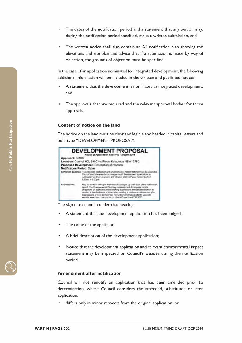
PART H | PAGE 702 BLUE MOUNTAINS DRAFT DCP 2014
Part
H: P
ublic
Par
tici
pati
on
• The dates of the notifi cation period and a statement that any person may, during the notifi cation period specifi ed, make a written submission, and
• The written notice shall also contain an A4 notifi cation plan showing the elevations and site plan and advice that if a submission is made by way of objection, the grounds of objection must be specifi ed.
In the case of an application nominated for integrated development, the following additional information will be included in the written and published notice:
• A statement that the development is nominated as integrated development, and
• The approvals that are required and the relevant approval bodies for those approvals.
Content of notice on the land
The notice on the land must be clear and legible and headed in capital letters and bold type “DEVELOPMENT PROPOSAL”.
The sign must contain under that heading:
• A statement that the development application has been lodged;
• The name of the applicant;
• A brief description of the development application;
• Notice that the development application and relevant environmental impact statement may be inspected on Council’s website during the notifi cation period.
Amendment after notifi cation
Council will not renotify an application that has been amended prior to determination, where Council considers the amended, substituted or later application:
• differs only in minor respects from the original application; or

PART H | PAGE 703BLUE MOUNTAINS DRAFT DCP 2014
Part
H: P
ublic
Par
tici
pati
on
• is of a lesser impact; or
• addresses impact issues.
Such an application will be referred to as a ‘replacement’ application. Where re-notifi cation occurs, the application will be notifi ed to any person who made a submission to the original application, and to owners of land who Council considers could suffer increased adverse impacts due to the proposed amendment.
H.1.2. Advertised development‘Advertised’ development is defi ned in the Environmental Planning and Assessment Act 1979 (EP&A Act) and includes the following:
• Any development listed as a scheduled activity at any premises under the Protection of the Environmental Operations Act 1997 (other than those identifi ed as ‘Designated’ development).
• Nominated Integrated Development under s91(1) of the EP&A Act being relevant applications under Heritage Act 1977, Water Management Act 2000 and Protection of the Environment Operations Act 1997.
• Threatened Species development that requires a species impact statement under Division 2 of Part 6 of the Threatened Species Conservation Act 1995.
• Class 1 aquaculture development under State Environmental Planning Policy No. 62 – Sustainable Aquaculture.
• Any development identifi ed as ‘Advertised’ by a Local Environmental Plan (LEP).
Specifi c provisions apply under s.79A of the EP&A Act and the Regulations.
The procedures outlined below follow the Act and Regulations with additional provisions to clarify administrative processes.
Criteria for notifi cation
All ‘Advertised’ development applications are notifi ed.
Time period for notifi cation
The notifi cation period for ‘Advertised’ development is:
• 30 calendar days for nominated integrated or threatened species development;

PART H | PAGE 704 BLUE MOUNTAINS DRAFT DCP 2014
Part
H: P
ublic
Par
tici
pati
on
• 14 calendar days for all other types of ‘Advertised’ development.
• Notifi cation shall not commence or end between the Christmas and New Year period (i.e. 20 December until 5 January). Notifi cation spanning this time shall also make allowance for the holiday period.
The notifi cation period will apply from the date on which the notice was fi rst published in the newspaper.
Online notifi cation The Council’s website publishes an updated list of applications in notifi cation. Documents submitted by the applicant will generally be available for viewing online during the notifi cation period.
Written notice
A written notice will be given to:
• Persons who appear to own or occupy adjoining land; and
• Those public authorities that Council considers may have an interest in the determination of the application (other than concurrence authorities or other approval authorities).
• If a notifi cation letter is sent and that notice is returned, Council is considered to have fulfi lled its obligations.
For the purpose of written notifi cation:
Where the land is a lot within the Strata Titles Act, Strata Titles Leasehold Act or Community Development Act, a written notice to the Body Corporate is taken to be a written notice to the owner of each lot.
If the land is owned or occupied by more than one person, a written notice to one owner or one occupier is taken to be a written notice to all the owners and occupiers of that land.
The notice sent to the land owner will be at the address shown on Council’s ownership records at the date the notice was generated.
Published notice
A published notice will be included in the local paper as soon as practical after the development application is lodged.
Content of a written / published notice
The written and published notice will contain:
• A description of the land (including the address) on which the development is proposed to be carried out;
• The name of the applicant and the name of the consent authority;
PART H | PAGE 705BLUE MOUNTAINS DRAFT DCP 2014
Part
H: P
ublic
Par
tici
pati
on
• A description of the proposed development;
• A statement that the application and the documents accompanying that application may be inspected on Council’s website during the notifi cation period;
• The dates of the notifi cation period and a statement that any person may, during the notifi cation period specifi ed, make a written submission.
• The written notice shall also contain an A4 notifi cation plan showing the elevations and site plan and advice that if a submission is made by way of objection, the grounds of objection must be specifi ed.
In the case of Nominated Integrated development, the following additional information will be included in the written and published notice:
• A statement that the development is nominated as integrated development;
• The approvals that are required and the relevant approval bodies for those approvals; and
• In the case of development that is threatened species development, a statement that the development is threatened species development.
Amendment after notifi cation
Council will not renotify an application that has been amended prior to determination, where in the opinion of Council, the amended, substituted or later application:
• differs only in minor respects from the original application; or
• is of a lesser impact; or
• addresses impact issues.
Such an application will be referred to as a replacement application. Where re-notifi cation occurs, the application will be notifi ed to any person who made a submission in respect of the original application, and to the owners of land who Council considers could suffer increased adverse impacts as a result of the proposed amendment.
PART H | PAGE 706 BLUE MOUNTAINS DRAFT DCP 2014
Part
H: P
ublic
Par
tici
pati
on
H.1.3. Other notifi able development (also referred to as specifi ed development)This category includes any development proposal other than ‘Designated’ or ‘Advertised’ development. The majority of development applications received fall into this category. There are no statutory requirements to formally notify this type of development, the Council however chooses to do so in some circumstances. In accordance with s79A(2) of the EP&A Act, these circumstances are stated below.
Criteria for notifi cation
A written notice will be sent to the owners of adjoining land (refer to defi nition of ‘adjoining’) to obtain their view in relation to the proposal, unless:
• The application is for internal works in an existing building and there will be no change or external impact as a result of that application;
• The application involves the demolition of a structure (other than a heritage item);
• It is a strata application involving the adjustment of boundaries;
• In the opinion of Council, it is considered that the enjoyment of the adjoining land will not be detrimentally affected (refer to defi nition of ‘affected’).
A published notice in the local newspaper will only occur where:
• The application is for a signifi cant development that is not expected to occur with any frequency in that land use zone;
• The application is for a non-residential use, other than where the application comprises: ancillary works, change of use; fi rst use or similarly minor works;
• The application is for a multi residential development (including villas, townhouses) other than where the application comprises ancillary or similarly minor works;
• More than 5 additional lots are proposed.
Time period for notifi cation
The notifi cation period for ‘other notifi able’ development is 14 calendar days.
For exceptionally complex development proposals the notifi cation period may be increased to 30 calendar days. Notifi cation shall not commence or end between the Christmas and New Year period (i.e. 20 December until 5 January). Notifi cation spanning this time shall also make allowance for the holiday period.
PART H | PAGE 707BLUE MOUNTAINS DRAFT DCP 2014
Part
H: P
ublic
Par
tici
pati
on
Where published the time frame will apply from the date on which the notice was fi rst in the newspaper.
Online notifi cation
The Council’s website publishes an updated list of applications in notifi cation. Documents submitted by the applicant will generally be available for viewing online during the notifi cation period.
Written notice
A written notice will be forwarded to the land owner at the address shown on the Council’s ownership records at the date the notifi cation letter was generated.
If a notifi cation letter is returned, Council is considered to have fulfi lled its obligations.
For the purpose of written notifi cation:
• Where the land is a lot within the Strata Titles Act, Strata Titles Leasehold Act or Community Development Act, a written notice to the Body Corporate is taken to be a written notice to the owner of each lot.
• If the land is owned by more than one person, a written notice to one owner is taken to be a written notice to all the owners of that land.
• The notice sent to the land owner will be at the address shown on Council’s ownership records at the date the notice was generated.
Published notice
A published notice (where required) will be included in the local paper as soon as practical after the development application is lodged.
Content of a written / published notice
The written and published notice will contain:
• A description of the land (including the address) on which the development is proposed to be carried out;
• The name of the applicant and the name of the consent authority;
• A description of the proposed development;
• A statement that the application and the documents accompanying that application may be inspected on Council’s website during the notifi cation period;
PART H | PAGE 708 BLUE MOUNTAINS DRAFT DCP 2014
Part
H: P
ublic
Par
tici
pati
on
• The dates of the notifi cation period and a statement that any person may, during the notifi cation period specifi ed, make a written submission.
The written notice shall also contain an A4 notifi cation plan showing the elevations and site plan.
In the case of an application nominated for integrated development, the following additional information will be included in the written and published notice:
• A statement that the development is nominated as integrated development;
• The approvals that are required and the relevant approval bodies for those approvals.
Amendment after notifi cation
Council will not renotify an application that has been amended prior to determination, where in the opinion of Council, the amended, substituted or later application:
• differs only in minor respects from the original application; or
• is of a lesser impact; or
• addresses impact issues.
Such an application will be referred to as a replacement application.
Where re-notifi cation occurs, the application will be notifi ed to any person who made a submission in respect of the original application, and to the owners of land that in the opinion of Council, could suffer increased adverse impacts as a result of the proposed amendment.
PART H | PAGE 709BLUE MOUNTAINS DRAFT DCP 2014
Part
H: P
ublic
Par
tici
pati
on
H.1.4. Modifi cationsChanges may occur to a development application after determination. The following sets out Council’s criteria and procedures for notifi cation associated with a modifi cation to a development application.
H4.1.1. Criteria for notifi cationThe Environmental Planning and Assessment Act provides for three levels of modifi cations:
• Modifi cation involving a ‘Minor Error, Misdescription or Miscalculation’ – Section 96(1). No notifi cation required.
• Modifi cation involving ‘Minimal Environmental Impact’ – Section 96(1A). Generally, no notifi cation required unless the original consent was issued by the Court.
• All ‘Other Modifi cations’ – Section 96(2). These modifi cations are notifi ed in accordance with the type of development as detailed below.
Designated development
Notice of the proposed modifi cation must be:
• Published in a local paper;
• Forwarded to any persons who made a submission in respect of the original application; and
• Forwarded to the owners or occupiers of land, who in the opinion of Council, could suffer increased adverse impacts as a result of the proposed amendment.
The information contained in any written or published notice shall include:
• A brief description of the development consent, the land to which it relates and the modifi cation sought; and
• A statement that written submissions concerning the proposed modifi cation may be made to the Council within the time period specifi ed.
• The notifi cation period for a modifi ed ‘Designated’ development is 30 calendar days.
Other notifi able development
Written notice of the proposed modifi cation will be forwarded to:
• Any persons who made a submission in respect of the original application.
PART H | PAGE 710 BLUE MOUNTAINS DRAFT DCP 2014
Part
H: P
ublic
Par
tici
pati
on
• To the owners of land, in the opinion of Council, could suffer increased adverse impacts as a result of the proposed amendment.
The information contained in any written notice shall include:
• A brief description of the development consent, the land to which it relates and the modifi cation sought; and
• A statement that written submissions concerning the proposed modifi cation may be made to the Council within the time period specifi ed.
The notifi cation period for a modifi cation associated with other notifi able development is 14 calendar days.

PART H | PAGE 711BLUE MOUNTAINS DRAFT DCP 2014
Part
H: P
ublic
Par
tici
pati
on
H.1.5. Review of determination & revocation of consent
Revocation of consent
Under s.96A of the Environmental Planning and Assessment Act, a development consent can in certain circumstances be revoked or modifi ed by the Director General.
In such cases, Council is required to notify any person who it considers would be adversely affected by the revocation, prior to the making of any such decision. The time period for notifi cation will be determined on the basis of the revocation being considered.
Review of determination
The Council will not notify an application seeking a review of determination under s.82A of the Environmental Planning and Assessment Act, except where an applicant proposes to make amendments to the development and such amendments are, in the opinion of the Council, likely to increase the environmental impacts of the development.
In these cases the application will be notifi ed to any person who made a submission in respect of the original application, and to the owners of land, who in the opinion of Council could suffer increased adverse impacts as a result of the proposed amendment.
A notifi cation period of 14 calendar days will apply.
PART H | PAGE 712 BLUE MOUNTAINS DRAFT DCP 2014
Part
H: P
ublic
Par
tici
pati
on
H.1.6. Advisory notes
Models / artist impressions
Where a model / artist impression is supplied by the applicant this will be displayed at our Katoomba offi ce (for development on land from Lawson to ‘the Mounts’) or Springwood offi ce (for development between Lapstone to Hazelbrook).
Copying of documents
All plans and reports associated with a development application are subject to copyright. Whilst documents may be viewed online, print access will be restricted to only those parts exempt for the purposes of s.105 of the Environmental Planning and Assessment Act 1979. Copies of Environmental Impact Statements which accompany a ‘Designated’ development are made available for purchase.
Content of a submission
In determining an application the Council forms a decision based on the overall merits of the proposal. An extensive range of planning matters is considered and these are outlined in planning instruments such as Local Environmental Plan 2015 and relevant State and / or Regional Environmental Plans.
Submissions, referral comments from agencies and compliance with planning instruments form part of the assessment.
In making a submission, view the development proposal in the context of the character of the streetscape. Consider amenity impacts such as accessibility, privacy and overshadowing, potential loss of views, landscaping, stormwater management, traffi c and parking as well as other environmental, social and economic impacts in the locality. Also consider ways in which adverse impacts (if any) could be mitigated.
Political donations
A person or an associate of that person who makes a submission on a development application is required to disclose political donations and gifts (if any) to a local Councillor or employee. This includes any donation or gift within 2 years before the submission is made up until the application is determined. Further details refer to Councils website .
Lodgement of a submission
A submission to an application can be made by mail, email or via the online form. Refer to ‘Development applications on notifi cation’ section of Council’s website. To allow for proper consideration of submissions (and where the application is ‘Designated’ development, to retain any third party appeal rights), submissions
PART H | PAGE 713BLUE MOUNTAINS DRAFT DCP 2014
Part
H: P
ublic
Par
tici
pati
on
should be received in the Council offi ces before the close of business on the last nominated date.
Submissions are acknowledged. In the case of:
• Form letters, letters and emails - the acknowledgement will be sent to the name and address where that name and address is legible and complete.
• Petitions - (i.e. submissions received referencing more than one address) the acknowledgement will be sent to the representative nominated on the petition where that name and address is legible and complete.
Where a submission is acknowledged all other communications e.g. advice of a Council meeting or the determination outcome of the development application will follow to that submitter’s name and address.
Confi dentiality of submissions
Submissions are not confi dential.
A submitter who has concerns about the release of their name and address, or any other identifying material, must provide and highlight in their submission valid written reasons for seeking confi dentiality. In such circumstances, the Council may attempt to withhold the release of the submission. If an application is called up before the Courts all details are available.
A copy of all submissions received in response to the public exhibition of a development application for ‘Designated’ development is sent to the Director-General immediately after the relevant submission period. Note: This does not apply if the Director-General has waived the requirement under s.80(10)(b).
Copies of submissions are also given to the determining authority – Joint Regional Planning Panel.
Calling of a public meeting
Where Council determines that a proposal for which consent may be given is of suffi cient interest and signifi cance to the community, a public meeting may be called to discuss the proposal before the assessment is fi nalised. This is however followed only in unusual circumstances where such a meeting can add information not easily obtained through submissions.
In such circumstances meetings will generally be arranged by written invitation to those persons who made submissions. Where there is likely to be a wider community interest, a notice will be placed in the local newspaper or displayed in a prominent position in the respective village/town.
Council has in place a Mediation Policy which in some circumstances may be an appropriate means of facilitating the resolution of confl icting points of view.
PART H | PAGE 714 BLUE MOUNTAINS DRAFT DCP 2014
Part
H: P
ublic
Par
tici
pati
on
Notice of Council meeting
Where a development application is referred to the Council for determination, people who have made a written submission to that application, together with applicants will be advised of the scheduling of the item for the Council meeting.
While Council will endeavour to give reasonable notice of the meeting, the period may be limited due to the scheduling of meetings. Copies of business papers are available online at Council’s website .
Notice of Joint Regional Planning Panel meeting
Where an application is to be determined by a Joint Regional Planning Panel, people who have made a written submission to that application, together with applicants, will be advised of the date and time of the meeting by the Panel Secretariat.
Advice of determination
A list of development consents and refusals will be regularly published in the local newspaper. The notice will describe the land and the development, and advise that the determination is available for inspection free of charge at the offi ce of the Council during ordinary offi ce hours. This information will be made available on Council’s website for applications lodged after 1 January 2011.
Any person who makes a written submission to a development application will be notifi ed of the determination of that application. In the case of a modifi cation to a consent, advice will only be sent to those who made a submission on the modifi cation.
In the case of ‘Designated’ developments, advice to an objector will be made at the same time as the notice of determination is given to the applicant and will advise the objector of the rights of appeal. A consent for a ‘Designated’ development will not commence operation until 30 days after the issue of the notice, being the time in which objectors may lodge an appeal in the Land and Environment Court.
Complying Development Certifi cates
In accordance with s.101 of the Environmental Planning and Assessment Act 1979, a determination notice of a complying development certifi cate is notifi ed in the local newspaper by the issuing authority. If the public notice is given by an accredited certifi er then they must send a copy of the page of the newspaper to Council within 7 days after the notice is published.
Register of applications
Council is required to keep a register of applications under cls.264-265 of the Environmental Planning and Assessment Regulation 2000. This register is

PART H | PAGE 715BLUE MOUNTAINS DRAFT DCP 2014
Part
H: P
ublic
Par
tici
pati
on
available in an electronic format and may be viewed at Katoomba and Springwood Offi ces. Web access will be available for applications lodged after 1 January 2011.

PART H | PAGE 716 BLUE MOUNTAINS DRAFT DCP 2014
Part
H: P
ublic
Par
tici
pati
on

SCHEDULESPART I

BLUE MOUNTAINS DRAFT DCP 2014 PART I | PAGE 718

PART I | PAGE 719BLUE MOUNTAINS DRAFT DCP 2014
ContentsPart I Schedules 717
I1.1 Submission requirements 721
I1.2 Weeds of the Blue Mountains 745
I1.3 Guidelines 759
BLUE MOUNTAINS DRAFT DCP 2014 PART I | PAGE 720
IntroductionThis part contains submission requirements, guidelines and other reference documents identifi ed throughout the DCP.
The intention of this part is to provide more detailed information on how to prepare documents or reports referred to in particular parts of the DCP. It is also to provide complete lists (Weeds of the Blue Mountains), strategies and guidelines (Vegetation Management Plan guideline for example) to inform and help applicants through the development process.
PART I1SUBMISSION
REQUIREMENTS
BLUE MOUNTAINS DRAFT DCP 2014 PART I1 | PAGE 722
Part
I1: S
ubm
issi
on R
equi
rem
ents
IntroductionEach part of the DCP references reports and other documentation that may be required to be submitted as part of a development application.
This part provides additional detail one the elements to be included in these reports, how they should be prepared, and resources to aid this preparation.
The submission requirements have been organised in accordance with the part of the DCP within which they are referenced.
PART I1 | PAGE 723BLUE MOUNTAINS DRAFT DCP 2014
Part
I1: S
ubm
issi
on R
equi
rem
ents
I1.1. Part A – Introduction There are no submission requirements for Part A. This part of the DCP provides the general historical and planning context for the Blue Mountains, and provides a guide to the use of the DCP. It is a useful starting point for all development applications.
I1.2. Part B - ContextPart B – Context covers Site Analysis, Building Envelopment controls and design considerations. The primary submission requirement within this part is a Site Analysis Plan.
Part B1 Site Analysis
Site Analysis Plan
A site analysis plan is
Part B2 Building Envelope
There are no specifi c submission requirements for this section, however the core building envelope controls would need to be addressed as part of any Statement of Environmental Effects submitted with the development application.
B3 – Design
Site and Context Analysis
Proposals for signifi cant infi ll development are to provide a detailed site and context analysis. This is to include a statement outlining the proposed measures to minimise the adverse impacts of the infi ll development on neighbouring lands including the public domain; and the philosophy of how the design elements relate to the proposal’s context in terms of built form, materials and character. Applicants are to identify elements that contribute to the quality of the place, and demonstrate how these elements are reinterpreted in the new development
BLUE MOUNTAINS DRAFT DCP 2014 PART I1 | PAGE 724
Part
I1: S
ubm
issi
on R
equi
rem
ents
I1.3. Part C - Environmental ManagementPart C – Environmental Management covers areas such as biodiversity, landscaping and bush fi re. These considerations are interconnected and the submission requirements may be the same or have some content which overlaps.
As such, the following list of submission covers all sections within Part C of the DCP, with the exception of C6 Water Management.
The level of environmental and landscape information to be submitted with a development application will depend on a number of factors, such as the type and scale of the development; the location, extent and nature of the proposed site works, and whether environmental features will be impacted.
Part C1 Biodiversity and Natural Resources – C5 Tree Vegetation and Preservation
One or more of the following types of surveys, reports and strategy documents may need to accompany a development application:
Site Analysis Plan
Details on how to prepare a site analysis plan are contained at B1.
Flora and Fauna Assessment
It is important that a Flora and Fauna Assessment submitted to Council considers the environmental impact of the proposed development (including ancillary works such as asset protection zones, effl uent disposal, stormwater management and landscaping works etc) by addressing the relevant clauses from the Local Environmental Plan with respect to fl ora and fauna protection and management. In addition the assessment must address the requirements of the relevant state and federal legislation.
Council’s guide on how to prepare a Flora and Fauna Assessment can be found at: http://www.bmcc.nsw.gov.au/sustainableliving/environmentalinformation/environmentalguides
The zoning referred to is under Local Environmental Plan 2005. The guide is currently being updated to refl ect the land use zones under Draft Local Environmental Plan 2014; however the principles of preparing a Flora and Fauna Assessment remain the same.
Vegetation Survey and Species Inventory
In some circumstances for small scale development applications, a Vegetation Survey and Species Inventory, comprising a list and an accompanying plan, may be required to be prepared instead of a Flora and Fauna Assessment.
A vegetation survey of the site is to be conducted by an environmental consultant,

PART I1 | PAGE 725BLUE MOUNTAINS DRAFT DCP 2014
Part
I1: S
ubm
issi
on R
equi
rem
ents
or other practitioner, with relevant qualifi cations and experience in botanical identifi cation.
A fl ora inventory or list of all fl ora species occurring within the footprint of the proposed development including any asset protection zone is to be prepared. The inventory is to include the following information: scientifi c/common name, age class/size, habitat value, rare/threatened status, exotic/native).
An accompanying plan (such as a Site Analysis Plan) is to be provided to show proposed development including any asset protection zones and the location of any rare or threatened fl ora species observed; and the location, extent and description of observed native vegetation communities present within the site. The plan is to identify the presence of any signifi cant vegetation communities (listed under BMLEP 2014 Schedule 6) or any Endangered Ecological Communities (listed under the NSW Threatened Species Conservation Act, 1995 or Commonwealth Environment Protection and Biodiversity Conservation Act, 1999).
Depending on the outcomes of the Vegetation Survey and Inventory, further information to complete a full Flora and Fauna Assessment may be required.
Vegetation Management Plan (VMP)
A Vegetation Management Plan (VMP) is a map based report intended to assist the property owner or occupier in managing their development site (planned or existing) in order to ensure that existing bushland elements on their land are protected from excessive human induced disturbance. A VMP is generally a requirement on sites where there are number of environmental constraints or high level ecological values. It should contain a concise written report (Part 1) and a map or plan drawing (Part 2) of the study area.
Council’s The Vegetation Management Plan Guide (VMP Guide) will assist in the preparation of a detailed vegetation management plan, and can be accessed at:
http://www.bmcc.nsw.gov.au/sustainableliving/environmentalinformation/environmentalguides
The VMP Guide currently refers to provisions within Blue Mountains LEP 2005 and the Better Living Development Control Plan. The guide is being updated to refl ect Draft Local Environmental Plan 2013 and this DCP. However the principles of preparing a VMP remain the same, and therefore the content of the guide can still provide assistance to applicants.
Weed Management Strategy (WMS)
A weed management strategy is to be comprised of two parts; an annotated aerial photograph or site plan and an accompanying document, predominantly in tabular format, specifying the weed control strategy and timing. Complex weed management strategies will need to be prepared by a suitably qualifi ed and

BLUE MOUNTAINS DRAFT DCP 2014 PART I1 | PAGE 726
Part
I1: S
ubm
issi
on R
equi
rem
ents
experienced weed control or bushland restoration practitioner.
A weed management strategy is to contain the following information:
(a) A site plan/annotated aerial photograph, with vegetation management zones identifi ed, and the location of existing weeds clearly identifi ed (See Vegetation Management Plan (VMP) guidelines for further explanation)
(b) A statement which identifi es the factors or processes promoting the weeds on the site, and
(c) The actions which will be taken to remediate or mitigate these factors and processes so as to reduce opportunities for further weed growth
(d) Methods to be used to stabilise all areas where weeds are to be removed so as to maintain soil stability until such time as the site is fully regenerated or revegetated with desirable species (if relevant), or otherwise permanently stabilised.
(e) A table which identifi es the following:
i. Scientifi c and common names of all noxious and dominant environ-mental weeds present on the site, and their weed class (noxious weeds only)
ii. The most appropriate and applicable control technique(s) for each weed or class of weed
iii. Appropriately staged timing for implementation of the weed con-trol strategy
iv. An indication of the level of weed control to be achieved on all parts of the site, within the following time frames:
• within three months of the date of development approval
• within six months from the date of development approval
• prior to the issue of the occupation certifi cate
• within three years of occupation
Arboricultural Survey Report and Arboricultural Impact Assessment
In circumstances where large and/or signifi cant trees occur on a proposed development site, an Arboricultural Survey Report, providing detailed information on the trees present, is to be prepared by a qualifi ed Consulting Arborist and submitted in support of the development application. Full detail of trees to be removed as well as trees proposed for retention should be given.
Where signifi cant trees are identifi ed during the Arboricultural Survey as suitable for retention, an Arboricultural Impact Assessment Report is to explain

PART I1 | PAGE 727BLUE MOUNTAINS DRAFT DCP 2014
Part
I1: S
ubm
issi
on R
equi
rem
ents
design and construction methods proposed to minimize impacts on retained trees where there is encroachment into the calculated Tree Protection Zone (TPZ). It will recommend measures necessary to protect the trees throughout all demolition and construction stages.
The Arborist’s Reports on existing trees taller than 4m are to include the following information where appropriate:
(a) Allocated survey number (to correlate with survey plan and identify location within site).
(b) Species name & common name.
(c) Trees to be retained.
(d) Trees to be removed due to the proposed development.
(e) Trees to be removed due to death or disease.
(f) Estimated Height (to aid on-site identifi cation and assessment of signifi cance)
(g) DBH (Diameter at Breast Height – to indicate tree maturity and allow estimation of lateral root spread).
(h) Canopy spread (to allow assessment of any requirement to prune or likely impact of overshadowing).
(i) Health and/or Condition status (which may include SULE rating or comparative suitability for retention).
(j) Recommended TPZ (Tree Protection Zone) for trees, which are to be retained, if applicable. This is the minimum distance from the centre of any tree at which development should commence.
All trees on adjoining properties that are within 3 metres of the boundary of the proposed development shall be incorporated into the Arboricultural Survey report. When the proposed development will have a signifi cant impact upon the future health and suitability for retention of other large or signifi cant trees located on adjacent properties, but which are further away than three metres, the arborist is to note their existence, and provide appropriate recommendations for their management.
All assessment and recommendations should be consistent with the Australian Standard AS 4970—2009, The Protection of Trees on Development Sites.
Tree Removal and Retention Plan (Basic plan)
In some circumstances for small scale development applications, a Tree Removal and Retention Plan may be required as an alternative to an Arboricultural Survey Report
The Tree Removal and Retention Plan is to be prepared by an appropriate person, and is to show the approximate location of all existing trees within the proposed

BLUE MOUNTAINS DRAFT DCP 2014 PART I1 | PAGE 728
Part
I1: S
ubm
issi
on R
equi
rem
ents
development footprint, including any asset protection zone or landscaped area, and indicate whether they are proposed for removal or retention.
The trees are to be identifi ed by scientifi c and/or common name, and each tree provided with a unique identifying number on both the plan drawing and on site (using suitable markers).
Landscape Plan
Almost all development proposals within the Blue Mountains are required to provide details of landscaping works. Generally, only minor additions and alterations (where development involves an area <50m2) and proposals which do not include site works are exempt from this requirement. It is important to recognise landscaping as an integral part of the development planning and design, regardless of the level of development proposed. Landscape Plans assist Council in determining the likely or potential environmental and visual impact of your proposal.
‘Landscaping’ may include approaches which seek to retain and manage existing indigenous vegetation as far as is practicable, through to the fabrication of a new landscaped area, depending upon the existing characteristics and condition of the site, the land use zone and any environmentally constrained area controls that may apply to the property.
The aim of the landscape plan is to demonstrate that the development incorporates planting that will promote a garden setting and enhance the streetscape of the surrounding area. The extent and type of landscape information required as part of the development application will to some extent depend on the type of development proposed, and under certain circumstances, detailed landscape plans may need to be submitted prior to operational consent.
Landscape plans, drawn at an appropriate scale to demonstrate the necessary information (usually 1:100 up to 1:25 for larger properties) are to include the following information and features:
(a) the entire area to be landscaped, with scale bar, scale ratio and north arrow; and
(b) Existing and proposed buildings and other structures such as walls, fences, retaining walls, roadways, driveways, carparks and footpaths and other impervious areas, and
(c) overland fl ow paths and drainage lines;
(d) signifi cant natural features which have been identifi ed during the site analysis, and
(e) the location, size and species of existing vegetation to be affected by the development, including trees, hedges, large shrubs, shrub beds and any areas of natural vegetation on the subject site and any trees > 4 metres in height within three metres of the property boundary, and

PART I1 | PAGE 729BLUE MOUNTAINS DRAFT DCP 2014
Part
I1: S
ubm
issi
on R
equi
rem
ents
(f) the location and extent of existing vegetation to be retained including trees, hedges, large shrubs, shrub beds and any areas of natural vegetation. Include botanical name, common name and spread of foliage, and
(g) proposed protection measures for retained trees, areas of indigenous or other existing vegetation or signifi cant site features to ensure their conservation, and
(h) a planting plan showing the location and size within 10 years of each tree and large shrub and the areas to be planted with low shrubs and ground covers, and.
(i) a table indicating common name, botanic name, ultimate height and width and planting size (pot size and height at 10 years) of each tree and large shrub proposed, if relying on planting of trees or large shrubs for privacy, or as compensatory planting if large scale vegetation removal is proposed as a component of the development. The planting is to achieve any of the specifi c landscape functions that are relevant to the application, and the plant selection is to be consistent with the zone objectives and character of the locality, and
(j) broad descriptions of any proposed land modifi cation, including cut and fi ll, retaining walls, stormwater detention areas and mounded embankments. You need to show that any of these changes proposed will not have a negative impact upon existing site vegetation and drainage.
(k) any Water Sensitive Urban Design features where these occur in areas set aside for landscape treatments or where they require a vegetative component.
In most single dwelling residential developments, landscape plans do not need to be prepared by a professional consultant. However, the landscape design and works is to be in accordance with the landscape principles and requirements of this DCP.
For complex or large developments a consultant will generally need to be engaged to prepare the landscape plans. Council may also require the submission of a detailed landscape plan to the certifi er prior to release of the construction certifi cate.
Those with suitable qualifi cations include accredited landscape architects, landscape designers or horticulturalists with relevant design experience. The designer’s name and contact details should be clearly marked on the landscape plan.
Bushfi re Threat Assessment
(a) For any development other than subdivision or a special fi re protection purpose, in accordance with section 79bA of the Environmental Planning and Assessment Act 1979;
BLUE MOUNTAINS DRAFT DCP 2014 PART I1 | PAGE 730
Part
I1: S
ubm
issi
on R
equi
rem
ents
(b) For subdivision and Special Fire Protection Purposes in accordance with section 100b of the Rural Fires Act 1997
A Bush Fire Threat Assessment, prepared by a suitably qualifi ed consultant, is required to be submitted as part of a development application.
Note 1: The RFS recognises consultants within certain accreditation schemes. These
can be found at: http://www.rfs.nsw.gov.au/plan-and-prepare/building-in-a-bush-fi re-
area/legal-obligations/qualifi ed-consultants
Part C6 Water Management
Small Scale Development: Concept Stormwater Management Plan
The Concept Stormwater Management Plan (SMP) is a drawing that depicts the process of capture, conveyance, treatment and disposal of stormwater runoff from the site. The plan must provide enough detail for Council to determine that the proposal will function in accordance with the development controls of this Section of the DCP and in accordance with accepted engineering practices.
The Concept SMP is to show:
(a) the entire site, with scale bar, scale ratio and north arrow; and
(b) proposed development, extent of works, existing and proposed impervious areas and areas of disturbance; and
(c) existing land use and vegetation cover / condition; and
(d) overland fl ow paths, drainage lines, sub-catchment areas; and
(e) constraint areas including planning, ecological, archaeological, geotechnical, fl ood prone land etc; and
(f) water conservation, re-use and detention measures; and
(g) location and design of stormwater quality and quantity control measures; and
(h) drainage layouts, pit and pipe design/sizing, discharge points; and
(i) any required sub-soil drainage; and
(j) any legal easements.
Small Scale Development: Small Scale Stormwater Quality Model
This submission requirement only applies to development required to provide stormwater quality treatment and proposing to achieve this using a stormwater treatment train determined by the Sydney Catchment Authority’s Small Scale Stormwater Quality Model (s3qm).
A certifi cate from an assessment completed using s3qm must be submitted with these proposals.
PART I1 | PAGE 731BLUE MOUNTAINS DRAFT DCP 2014
Part
I1: S
ubm
issi
on R
equi
rem
ents
The s3qm model is available on the SCA’s website at www.sca.nsw.gov.au.
The following parameters are to be used in the s3qm model:
• climate region = Refer to the climate zones identifi ed by the SCA at https://www.s3qm.com.au/documentation. For sites located outside of the identifi ed climate zones, utilise zone 25; and
• soil type = Select sandy loam, sandy clay, sand or clay, as occurs on the site; and
• assessment type = NorBE; and
• assessment method = Design.
Large Scale Development: Concept Stormwater Management Plan
The Concept Stormwater Management Plan (SMP) is a drawing that depicts the process of capture, conveyance, treatment and disposal of stormwater runoff from the site. The plan must provide enough detail for Council to determine that the proposal will function in accordance with the development controls of this Section of the DCP, and in accordance with accepted engineering practices.
The Concept SMP is to show:
(a) the entire site, with scale bar, scale ratio and north arrow; and
(b) the proposed development, extent of works, existing and proposed impervious areas and areas of disturbance; and
(c) the existing land use and vegetation cover / condition; and
(d) any overland fl ow paths, drainage lines, sub-catchment areas; and
(e) any constraint areas – planning, ecological, archaeological, geotechnical, fl ood prone land etc; and
(f) the water conservation, re-use and detention measures; and
(g) the location and design of stormwater quality and quantity control measures; and
(h) the rainage layouts, pit and pipe design/sizing, discharge points; and
(i) any required sub-soil drainage; and
(j) any legal easements.
Large Scale Development: WSUD strategy
For all large developments, a WSUD strategy comprising a written report must accompany the Concept Stormwater Management Plan drawing.
The WSUD strategy is to address the whole water cycle (potable, stormwater, waste water) in a sustainable and integrated way to provide for water

BLUE MOUNTAINS DRAFT DCP 2014 PART I1 | PAGE 732
Part
I1: S
ubm
issi
on R
equi
rem
ents
conservation and re-use, on-site detention, retention, water quality treatment, infi ltration and safe disposal to the receiving natural environment. The WSUD strategy is to demonstrate the proposed development will meet the objectives and controls of this Part of the DCP.
A detailed WSUD strategy is to cover the following items:
(a) Background information – summarise relevant background information, relevant studies (fl ood, geo-technical, contamination, environmental) and Council mapping data; and
(b) Site context – identify all sub-catchment areas, drainage lines, fl ow paths and receiving environments, the ecological values of the site and its receiving waters; and
(c) Proposed development – provide an accurate description of the proposed development. Illustrate the proposed development on a detailed site plan showing site boundaries, contours, proposed infrastructure, staging, access, location and extent of existing and proposed land uses/existing and proposed impervious areas/vegetation cover and asset protection zones; and
(d) WSUD objectives and targets – describe the WSUD objectives and identify stormwater treatment performance targets that apply to the proposal, consider Council requirements and Sydney Catchment Authority requirements in Sydney’s Drinking Water Catchments; and
(e) Integrated Water Cycle Management – address the whole water cycle (potable, stormwater, wastewater) in a sustainable and integrated way; and
(f) Water conservation maximised – identify all opportunities to reduce consumption and re-use water, demonstrate how potable water will be conserved through the use of roof water, harvested stormwater or grey water; and
(g) Constraints and opportunities – identify the key environmental and site constraints and opportunities for water management on the site including fl ooding, soil/geological and surface/groundwater conditions, environmentally sensitive features that require protection. The strategy is to be consistent with the fi ndings of any related geotechnical investigation, fl ood studies and/or environmental assessments; and
(h) Hydrologic and ecological impacts minimised - Outline all necessary ameliorative measures taken to avoid, minimise and mitigate the impacts; and
(i) Stormwater management – demonstrate how the quality and quantity targets will be met with a best practice stormwater treatment train that provides appropriate devices in the correct sequence. Identify the location, size and confi guration of stormwater treatment measures and
PART I1 | PAGE 733BLUE MOUNTAINS DRAFT DCP 2014
Part
I1: S
ubm
issi
on R
equi
rem
ents
drainage layout proposed for the development; and
(j) Water quality modelling - WSUD performance analysed and measured against targets, include water quality and fl ow modelling results, sub-catchment plan, inputs and assumptions of the model. Provide a statement as to whether the development has a neutral or benefi cial effect (NorBE) on water quality in accordance with the Sydney Catchment Authority and Council’s water quality requirements; and
(k) Integration with urban and landscape design – Outline how the WSUD elements will integrate with the built and landscaped urban design. Show how landscape, visual and social amenity will be enhanced; and
(l) Operation and maintenance details – Identify basic monitoring, maintenance and access requirements to ensure the effective ongoing structural integrity, operation, maintenance and required performance of the stormwater management system for the life of the development.
Large Scale Development: Pre and Post development water quality analysis
All large scale development is required to provide a MUSIC Model or equivalent detailed water quality analysis with an industry standard water quality model is required to demonstrate that the stormwater treatment performance outcomes will be achieved. The applicant must ensure:
(a) the MUSIC model analyses the WSUD strategy being proposed and be consistent with the accompanying Concept Stormwater Management Plan; and
(b) a digital fi le containing the water quality model is to submitted with the development application; and
(c) the application includes a catchment plan for the pre and post development scenarios; and
(d) all pre and post development modelling parameters, inputs, assumptions, calculations and output fi les are to be included in the accompanying Stormwater Management Plan; and
(e) the water quality model is to comply with the Sydney Catchment Authority document “Using MUSIC in Sydney’s Drinking Water Catchment A Sydney Catchment Authority Standard”.
Geo-technical Investigation
A geotechnical investigation and report may be required to be undertaken by a qualifi ed geotechnical professional with demonstrated experience that specifi cally addresses the current site conditions and suitability of the site to accommodate water sensitive urban design (WSUD) devices to provide stormwater water quality control, infi ltration and treatment systems.
BLUE MOUNTAINS DRAFT DCP 2014 PART I1 | PAGE 734
Part
I1: S
ubm
issi
on R
equi
rem
ents
The investigation is to confi rm the following:
(a) the geology and soil character/depth; and
(b) the soil permeability/hydraulic conductivities/infi ltration rates; and
(c) the presence and depth of any groundwater in the vicinity of required WSUD devices; and
(d) the presence and depth of any bedrock in the vicinity of required WSUD devices; and
(e) any apparent soil and groundwater contamination issues
The results of the investigation are to inform the detailed stormwater management design and confi rm the nature of WSUD devices considered suitable and effective for the site.
Onsite stormwater detention
A concept stormwater management plan showing the location of the proposed onsite stormwater detention system. The plan is to include levels to demonstrate that the detention system is able to drain stormwater to the proposed discharge point.
Pre-development and post-development calculations to size the onsite stormwater detention tank.
Groundwater Assessment (or Geotechnical Investigation)
A Groundwater Assessment (or Geotechnical Investigation) that meets Councils requirements is to be conducted, prepared and submitted as part of any Development Application for all development proposals, other than single dwellings, incorporating an excavation greater than 1m, and for all development where ground water is evident, to establish whether the development may impact upon groundwater.
This investigation is to be undertaken by a suitably qualifi ed geotechnical or hydrogeological engineer and submitted with the development application.
The Groundwater Assessment (or Geotechnical Investigation) must provide information on:
(a) the local hydrology including depth to water table and an assessment of the recharge characteristics; and
(b) the presence of contaminated soil, surface water or groundwater including details of the contamination; and
(c) the presence of any conditions that require specifi c management measures; and
(d) an assessment of the potential for interaction with, or potential for impacts on groundwater; and

PART I1 | PAGE 735BLUE MOUNTAINS DRAFT DCP 2014
Part
I1: S
ubm
issi
on R
equi
rem
ents
(e) the likelihood of groundwater contamination resulting from the development; and
(f) any adverse impacts the development may have on groundwater dependant ecosystems; and
(g) the cumulative impact the development may have on groundwater resources and its usage.
Groundwater Management Plan
A Groundwater Management Plan is required to be prepared if the Groundwater Assessment (or Geotechnical Investigation) determines that there is potential for interaction with, or potential for impacts on groundwater.
The Groundwater Management Plan is to comprise a written document that must be prepared by a practitioner with relevant tertiary qualifi cations, technical knowledge and a minimum of fi ve (5) years demonstrated experience in the geotechnical or hydrogeological fi eld and be prepared in accordance with the Sydney Coast Councils Group Groundwater Management Handbook 2006, subsequent updates or superseding documents.
The Groundwater Management Plan is to include and identify:
(a) a summary of the fi ndings of the Groundwater Assessment (or Geotechnical Investigation); and
(b) more detailed information on the local hydrogeology where relevant, such as groundwater fl ow rates; and
(c) the ambient chemical characteristics of the groundwater and measures to protect against corrosive attack of any affected infrastructure; and
(d) the proximity of surrounding structures or buildings their footing systems and soil conditions; and
(e) the potential for settlement and water seepage; and
(f) any appropriate measures proposed to avoid, minimise or mitigate the impacts of the development on groundwater systems; and
(g) the concept design of any temporary or permanent measures to be employed to manage groundwater interference, with suffi cient detail and explanation to demonstrate that the measures will provide an acceptable level of performance; and
(h) the location and assessment of risk to adjoining properties; and
(i) options for the disposal of groundwater and stormwater; and
(j) how the existing groundwater regime will be maintained.; and
(k) a monitoring program in accordance with any licensing requirements, or in the absence of licensing requirements as determined by Council

BLUE MOUNTAINS DRAFT DCP 2014 PART I1 | PAGE 736
Part
I1: S
ubm
issi
on R
equi
rem
ents
(Fluctuations in water level should also be monitored pre, during and post construction to inform any necessary remedial action); and
(l) an assessment of possible reasons for performance falling short of the required level and a contingency plan to deal with sub-standard performance and any unforeseen circumstances; and
(m) documentation to satisfy requirements for any permits or licensing to be obtained from the NSW State Government; and
(n) any other features that will have an infl uence on the site or surrounding area.
Flooding
(a) A site plan that plots the mapped Flood Planning Area.
(b) A fl ood study that estimates the 1 in 100 year fl ood level and fl ow path through the existing and proposed developed site.
PART I1 | PAGE 737BLUE MOUNTAINS DRAFT DCP 2014
Part
I1: S
ubm
issi
on R
equi
rem
ents
I1.4. Part D - Cultural Management
Part D1 – Heritage
Heritage impact statements
Development of heritage properties is to consider potential heritage impacts and mitigate adverse impacts. Owners of heritage items and buildings within conservation areas who wish to develop their properties are required to demonstrate adequate assessment of impact of their proposal on existing heritage values of the property and locality.
Clause 5.10(5) of BMLEP 2014 identifi es that Council may require a Heritage Impact Statement for development or works to heritage properties. This section provides further guidance on those requirements under Clause 5.10(5).
A Heritage Impact Statement (or HIS) is to be submitted for development applications affecting:
• Heritage items identifi ed in BMLEP 2014; or
• Properties within a heritage conservation area identifi ed in BMLEP 2014; or
• Properties within the vicinity of a heritage item or heritage conservation area.
A Heritage Impact Statement is to be prepared by a suitably qualifi ed person, such as a heritage consultant or architect with heritage experience. A list of heritage practitioners can be found on the website of the Offi ce of Environment and Heritage (OEH) at http://www.environment.nsw.gov.au/heritageapp/HeritageConsultantsDirectory.aspx
Guidelines for the preparation of Statements of Heritage Impact are available on the website of the Offi ce of Environment and Heritage at http://www.environment.nsw.gov.au/Heritage/publications/index.htm#S-U
The scope and size of the Heritage Impact Statement will vary according to the scope and size of the changes proposed. The size of the Heritage Impact Statement should be in concise form or full form, depending on the proposal.
Concise Heritage Impact Statement: For small alterations and additions, and works to modest properties, and where a heritage inventory sheet has been adequately prepared for minor works and modest properties, only a concise Heritage Impact Statement is required. For properties in the vicinity of a heritage item or heritage conservation area, it is also likely that only a concise form of Heritage Impact Statement would be required, as only the curtilage or setting and views of the item or area are likely to be affected by development.
Full Heritage Impact Statement: For larger applications where substantial
BLUE MOUNTAINS DRAFT DCP 2014 PART I1 | PAGE 738
Part
I1: S
ubm
issi
on R
equi
rem
ents
works are proposed, and more complex heritage items, a full Heritage Impact Statement will be required. Primary and secondary research may be required to confi rm information in the inventory sheet and guide the appropriateness of various works. More detailed fabric analysis is likely to be required.
Either form of the Heritage Impact Statement is to generally include research, descriptions, illustrations (photographs and drawings) and analysis, and to clearly and succinctly provide the following:
(a) An assessment of the heritage signifi cance of the heritage item and/or the contribution which the building makes to the heritage signifi cance of the heritage conservation area. This can be taken from the heritage inventory sheet if available for smaller applications, and no further primary or secondary research may be required;
(b) A thorough description of the current proposal with supporting plans;
(c) Compliance with the relevant controls of Part D1 – Heritage conservation of the BMDCP, preferably in a tabulated form for ease of reference.
(d) The options that were considered when arriving at a preferred development and the reasons for choosing the preferred option;
(e) The resultant impact of the proposed development on the heritage signifi cance of the heritage item, heritage items or conservation areas within the vicinity, or the heritage conservation area;
(f) The compatibility of the development with either conservation policies of a Conservation Management Plan or Conservation Management Strategy, or the recommended management from the Heritage Inventory Sheet for the item or conservation area.
For properties with signifi cant gardens, curtilages and or landscape settings, the report is to include:
(a) an assessment of signifi cance of the landscape elements, trees, gardens and landscape design;
(b) a discussion of the impacts of the proposal upon the landscape elements, trees, gardens and landscape design, including visual impacts and views, tree removal and streetscape impacts.
If a proposed development will not comply with one or more of the objectives and controls in D1 – Heritage conservation, the documentation accompanying the development application is to demonstrate how the proposal will still satisfy the heritage conservation objectives by providing a detailed analysis.
Conservation management plans
A conservation management plan (CMP) is a more comprehensive document than a heritage impact statement. It identifi es the heritage signifi cance of a place, and provides an assessment of that signifi cance, which then informs the
PART I1 | PAGE 739BLUE MOUNTAINS DRAFT DCP 2014
Part
I1: S
ubm
issi
on R
equi
rem
ents
preparation of guiding policy for future works or potential changes of use. A Heritage Impact Statement is sometimes appended to or incorporated into a CMP to assess currently proposed works.
Clause 5.10(6) of BMLEP 2014 identifi es that Council may require a Conservation Management Plan for development or works to heritage properties. This section provides further guidance on those requirements under Clause 5.10(6).
A conservation management plan (or CMP) prepared by a suitably qualifi ed heritage consultant to accompany a development applications is required for the following:
• Any alterations to the fabric or setting of a heritage item listed on the State Heritage Register which requires consent;
• An application under the heritage conservation incentives provisions of 5.10(10) of BMLEP 2014;
• Substantial alterations and/or additions to a heritage item considered by Council to be of high local signifi cance, unless the consent authority determines that it is not required.
• A change of use of a heritage item listed on the State Heritage Register;
A conservation management plan is to be prepared by a suitably qualifi ed person, such as a heritage consultant or architect with heritage experience. A list of heritage practitioners can be found on the website of the Offi ce of Environment and Heritage (OEH) at http://www.environment.nsw.gov.au/heritageapp/HeritageConsultantsDirectory.aspx
The conservation management plan is to include:
(a) Detailed documentary evidence of the historic development and physical fabric of the heritage item;
(b) A comparative analysis of properties of similar size and use, similar style and period, an architect’s body of work, as relevant;
(c) A curtilage assessment;
(d) Assessment of signifi cance according to the accepted heritage criteria and using the endorsed heritage inventory sheet;
(e) Investigation of the constraints and opportunities for the item;
(f) Conservation policies which address the following as a minimum:
i. Conservation of the fabric and setting of the item;
ii. Appropriate uses of the item;
iii. Appropriate options for interpretation of the item and interpre-tive devices;
BLUE MOUNTAINS DRAFT DCP 2014 PART I1 | PAGE 740
Part
I1: S
ubm
issi
on R
equi
rem
ents
iv. Management of the item;
v. Guidelines for future development;
(g) Priorities for instigation of conservation policies.
In certain cases, Council may consider a conservation management strategy (or CMS) as an appropriate alternative to a conservation management plan for heritage items of local signifi cance depending on the scope of the works and the signifi cance of the item.
A CMP or a CMS is to be prepared in accordance with the format prepared by the NSW Offi ce of Environment and Heritage and ‘The Conservation Plan’ By James Semple Kerr (National Trust, 1982).
A CMP needs to be regularly updated, particularly where major new works are proposed. The timeframe for updating a CMP is generally after fi ve years.
Cultural Heritage Assessments
Aboriginal Cultural Heritage Assessments
Cultural Heritage Assessments are to be prepared by a suitably qualifi ed archaeologist in accordance with the guidelines prepared by the Offi ce of Environment and Heritage.
Further information can be sourced from the Offi ce of Environment and Heritage website.
The core guideline documents include:
• Guide to investigating, assessing and reporting on Aboriginal cultural heritage in NSW;
• Aboriginal Cultural Heritage Consultation requirements for proponents;
• Due Diligence Code of Practice for the Protection of Aboriginal Objects in New South Wales.
Historical Archaeological Assessments
A Historical Archaeological Assessment may be required for sites where there is known or potential presence of Archaeological heritage. The NSW Heritage Act 1977 was amended in 2009 such that the defi nition of archaeological ‘relic’ includes an archaeological deposit, resources or feature that has heritage signifi cance at a local or State level. The defi nition is no longer based on age.
The NSW Heritage Council has adopted specifi c criteria for heritage assessment, related to the NSW Heritage Act 1977.
These criteria and further guidelines on the requirements for Archaeological Assessments can be sourced from the Offi ce of Environment and Heritage
PART I1 | PAGE 741BLUE MOUNTAINS DRAFT DCP 2014
Part
I1: S
ubm
issi
on R
equi
rem
ents
website at:
http://www.environment.nsw.gov.au/resources/heritagebranch/heritage/ArchSignifi cance.pdf
Archival recording
The requirement for an archival record is generally a condition attached to a development consent. It is usually required for demolition of or signifi cant change to a heritage item or a building within a heritage conservation area. An archival record provides accurate documentation of the current condition of a property prior to that substantial change or loss. The archival record is held at the Local Studies Library and may be used by the public for research purposes.
An archival record may be required as a condition of consent to a development, where demolition or substantial changes are proposed to an item or conservation area.
The archival record is to be completed by a suitably qualifi ed consultant who must demonstrate a working knowledge of archival principles. A list of heritage practitioners can be found on the website of the Offi ce of Environment and Heritage (OEH) at http://www.environment.nsw.gov.au/heritageapp/HeritageConsultantsDirectory.aspx
As a minimum, the archival record is to include the following:
(a) Title, author, date and property details;
(b) Site description, history and signifi cance (can be extracted from Heritage Impact Statement);
(c) Copies of approved plans appended at A4 for reference; and
(d) Extensive photographic record using digital capture.
(e) Photographic material is to be individually captioned and cross-referenced to site plans and/or plans of each building level.
Two sets of the documents are to be submitted. Each set is to be contained within an archival-quality binder (Albox or similar) and include printed photographic records and all other documentation as above, and an electronic version on CD.
Note: One copy will be retained on fi le at Council and a second copy will be sent to
the Local Studies Library.
Photographic archival records must be taken of the building, landscape or item and may use the following references as guidelines:
• Archives Advice 7: Protecting and Handling Photographs (2007), National Archives of Australia;
• Archives Advice 30: Which Paper? (2007), National Archives of Australia;
• Assessing Heritage Signifi cance (2001), Heritage Branch;
BLUE MOUNTAINS DRAFT DCP 2014 PART I1 | PAGE 742
Part
I1: S
ubm
issi
on R
equi
rem
ents
• How to Prepare Archival Records of Heritage Items (1998), Heritage Branch;
• Photographic Recording of Heritage Items Using Film or Digital Capture (2006), Heritage Branch.
Additional requirements and variations
Where development is in relation to a highly signifi cant or sensitive property, or development is contentious in nature, applicants are advised to consult Council’s Heritage Advisor as early as possible in the process to determine Council’s potential support, and what additional information will be required. This would generally be in the form of a pre-lodgement application, where specialist heritage advice can be made available.
(a) Council may require photomontages or perspectives that demonstrate the impact of the proposed development on existing views of the property from the public domain or other place identifi ed by Council depending on the nature of the proposed development. A model may be required for major development, particularly if infi ll development is proposed.
(b) If a larger scaled development is proposed (for example, where several lots are to be amalgamated and the site redeveloped), additional site-specifi c controls may be required to address the specifi c issues relevant to the site and its setting.
(c) Where an applicant proposes a good quality design solution that will protect the heritage signifi cance of the property or heritage conservation area, Council may support variation from the standards identifi ed in this part.
D2 – Period Housing
Character assessment (refer to Site and context analysis required under Part B)
PART I1 | PAGE 743BLUE MOUNTAINS DRAFT DCP 2014
Part
I1: S
ubm
issi
on R
equi
rem
ents
I1.5. Part E Site Management
E2 – Traffi c, Parking and Access
Traffi c and Parking Report
This report is to include:
(a) A parking generation calculation as required in C1; and
(b) if all parking cannot be accommodated onsite, a survey of available on-street parking within walking distance from the site at peak generation times relevant to the proposed development; and
(c) estimates of the peak hour traffi c generation for the development; and
(d) on classifi ed or collector roads, or areas of high pedestrian and vehicle traffi c, the report is to include a queue length analysis for vehicles entering and leaving the site.
Traffi c Impact Study
A Traffi c Impact Study is to be prepared by a suitably qualifi ed traffi c engineer and is to include:
(a) The requirements within the Parking and Traffi c Report; and
(b) the requirements of Section 2.2 of the Roads and Maritime Services (RMS) Guide to Traffi c Generating Developments.
A Preliminary Construction Traffi c Management Plan
This plan is to include details of how the proposed development will be able to undertake loading and unloading, demolition and construction including the manoeuvring of trucks in and out of a site, parking of construction and staff vehicles with minimum disruption to vehicular and pedestrian traffi c or transportation networks.
Services Plan (for all development)
A plan showing the location of existing and proposed services, connection points, easements, clearances and access ways.
Water Cycle Management Study
This study is to be provided for all development which includes Onsite wastewater disposal
Site and Soil Assessment Report
This study is to be provided for development including which includes a pumpout system.

BLUE MOUNTAINS DRAFT DCP 2014 PART I1 | PAGE 744
Part
I1: S
ubm
issi
on R
equi
rem
ents

PART I2WEEDS OF THE BLUE
MOUNTAINS

BLUE MOUNTAINS DRAFT DCP 2014 PART I2 | PAGE 746
Part
I2: W
eeds
of t
he B
lue
Mou
ntai
ns
IntroductionThe following is a list of noxious and environmental weeds which have been evaluated as posing a potential weed risk in natural environments in the Blue Mountains Local Government Area (LGA). This assessment has been made using the NSW Weed Risk Management System (Johnson 2009*).
These weed risk assessments have been based on current knowledge and research, and are not based solely on current distribution in the local government area: the evaluation also takes into account the weed’s potential distribution and impacts in the specifi c climatic, geological and biological conditions occurring in the region.
The list is not exhaustive. The selection of species to be assessed was based on plants or groups of plants known to have weed potential, which are commonly used in landscaping, gardening or agricultural situations and are generally commercially available.
This list will be periodically reviewed and updated. As new species become commercially available, or new information on the weed risk of some plants emerges, species may be reassessed and added or removed from the list.
Disclaimer: Council recognises that some weed species pose a lesser or higher risk in specifi c climatic and
geological regions within the LGA. The current weed risk assessments have been conducted based on current
knowledge and broad vegetation and risk categories. It should be noted, however that there are limitations with
the assessment process for weeds which are only invasive in a small percentage of habitats, but these habitats
have high conservation signifi cance (e.g. swamps / shale based communities). In these instances, the weed risk
may be assessed as lower than might truly be the case for that specifi c weed where it occurs in these specifi c
habitats. These plants have been identifi ed by an asterisk against their Weed Risk Category.

PART I2 | PAGE 747BLUE MOUNTAINS DRAFT DCP 2014
Part
I2: W
eeds
of t
he B
lue
Mou
ntai
ns
Use of this list
This list is to be read in conjunction with Part C5: Tree and Vegetation Removal and Part C2: Bushland and Weed Management, of this DCP, where general and specifi c controls on the removal and control of these plant species is provided.
This list is also a useful reference for land management agencies, consultants, landowners and residents operating in the Blue Mountains LGA as a tool for identifying weeds in their area and species to be avoided when selecting plants for landscape purposes.
* Dr Stephen Johnson, Industry and Investment New South Wales, ORANGE NSW 2800, September 2009/ © State of New South Wales through Industry and Investment NSW 2009.

BLUE MOUNTAINS DRAFT DCP 2014 PART I2 | PAGE 748
Part
I2: W
eeds
of t
he B
lue
Mou
ntai
ns
I2.1. Categories of weeds listedNoxious weeds are those that have been identifi ed as posing a signifi cant threat to human health, agriculture or natural resources and which legally require some measure of control. They are ‘declared’ weeds under the Noxious Weeds Act 1993.
Further information on noxious weeds can be sourced from Council’s website at:
www.bmcc.nsw.gov.au/sustainableliving/weedmanagement/weedcontrolnotifi cation
Noxious weeds are classifi ed as follows:
• Class 1: State Prohibited Weeds
• Class 2: Regionally Prohibited Weeds
• Class 3: Regionally Controlled Weeds
• Class 4: Locally Controlled Weeds
• Class 5: Restricted Plants
A noxious weed that is classifi ed as a Class 1, 2 or 5 noxious weed is referred to in this Act as a notifi able weed, which needs to be reported.
Environmental Weeds include, but are not restricted to species listed under the Noxious Weeds Act 1993. The nomination of species eligible for listing as environmental weeds is generally a matter for local agencies and organisations including Local Councils, Local Land Services, Community groups such as Landcare, Conservation societies and organisations, Research Centres and other members of the scientifi c community.
Further information can be sourced from the Department of Primary Industries and the Council’s website through the following links:
www.dpi.nsw.gov.au/agriculture/pests-weeds/weeds/wrm-system
http://www.bmcc.nsw.gov.au/sustainableliving/weedmanagement
Common Name Scientifi c Name Risk Category Note
Trees
African Olive Olea europaea spp.africana
DECLARED
Albizia/Cape Leeu-win Wattle
Paraserianthes lophantha
Very High
Bird Cherry Prunus serotina High
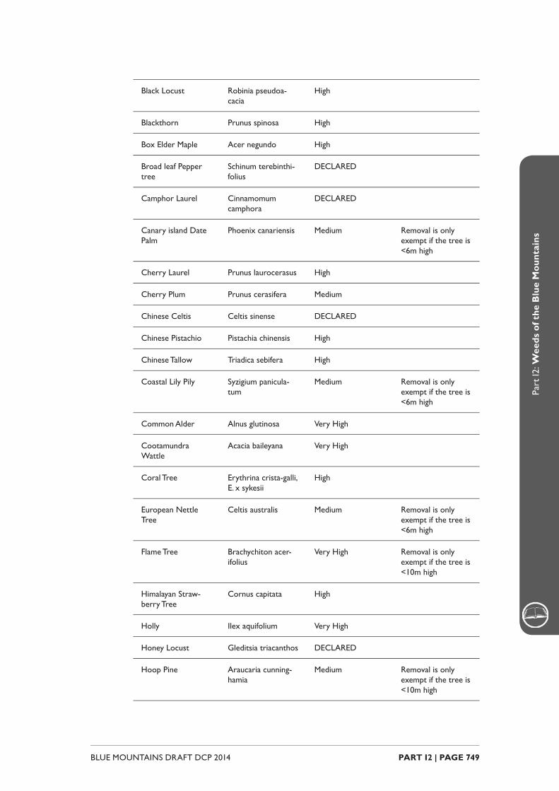
PART I2 | PAGE 749BLUE MOUNTAINS DRAFT DCP 2014
Part
I2: W
eeds
of t
he B
lue
Mou
ntai
ns
Black Locust Robinia pseudoa-cacia
High
Blackthorn Prunus spinosa High
Box Elder Maple Acer negundo High
Broad leaf Pepper tree
Schinum terebinthi-folius
DECLARED
Camphor Laurel Cinnamomum camphora
DECLARED
Canary island Date Palm
Phoenix canariensis Medium Removal is only exempt if the tree is <6m high
Cherry Laurel Prunus laurocerasus High
Cherry Plum Prunus cerasifera Medium
Chinese Celtis Celtis sinense DECLARED
Chinese Pistachio Pistachia chinensis High
Chinese Tallow Triadica sebifera High
Coastal Lily Pily Syzigium panicula-tum
Medium Removal is only exempt if the tree is <6m high
Common Alder Alnus glutinosa Very High
Cootamundra Wattle
Acacia baileyana Very High
Coral Tree Erythrina crista-galli, E. x sykesii
High
European Nettle Tree
Celtis australis Medium Removal is only exempt if the tree is <6m high
Flame Tree Brachychiton acer-ifolius
Very High Removal is only exempt if the tree is <10m high
Himalayan Straw-berry Tree
Cornus capitata High
Holly Ilex aquifolium Very High
Honey Locust Gleditsia triacanthos DECLARED
Hoop Pine Araucaria cunning-hamia
Medium Removal is only exempt if the tree is <10m high
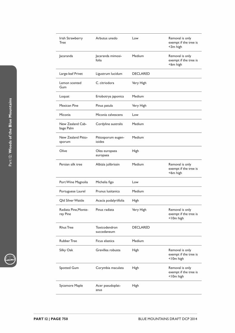
BLUE MOUNTAINS DRAFT DCP 2014 PART I2 | PAGE 750
Part
I2: W
eeds
of t
he B
lue
Mou
ntai
ns
Irish Strawberry Tree
Arbutus unedo Low Removal is only exempt if the tree is <3m high
Jacaranda Jacaranda mimosi-folia
Medium Removal is only exempt if the tree is <6m high
Large-leaf Privet Ligustrum lucidum DECLARED
Lemon scented Gum
C. citriodora Very High
Loquat Eriobotrya japonica Medium
Mexican Pine Pinus patula Very High
Miconia Miconia calvescens Low
New Zealand Cab-bage Palm
Cordyline australis Medium
New Zealand Pitto-sporum
Pittosporum eugen-ioides
Medium
Olive Olea europaea europaea
High
Persian silk tree Albizia julibrissin Medium Removal is only exempt if the tree is <6m high
Port Wine Magnolia Michelia fi go Low
Portuguese Laurel Prunus lusitanica Medium
Qld Silver Wattle Acacia podalyriifolia High
Radiata Pine,Monte-rey Pine
Pinus radiata Very High Removal is only exempt if the tree is <10m high
Rhus Tree Toxicodendron succedaneum
DECLARED
Rubber Tree Ficus elastica Medium
Silky Oak Grevillea robusta High Removal is only exempt if the tree is <10m high
Spotted Gum Corymbia maculata High Removal is only exempt if the tree is <10m high
Sycamore Maple Acer pseudoplat-anus
High

PART I2 | PAGE 751BLUE MOUNTAINS DRAFT DCP 2014
Part
I2: W
eeds
of t
he B
lue
Mou
ntai
ns
Tree Lucerne/Taga-saste
Chamaecytisus palmensis
Very High
Tree-of-Heaven Ailanthus altissima Very High
Umbrella Tree Scheffl era actino-phylla
High
White Cedar Melia azedarach Very High
White Poplar Populus alba Medium Removal is only exempt if the tree is <10m high
Noxious Willows All Salix spp. DECLARED
Other willows S. babylonica, S. x reichardii, S. calo-dendron
TBA Removal is only exempt if the tree is <10m high
Shrubs
African Boxthorn Lycium ferocissimum DECLARED
Barberry /Berberis Berberis thunbergia, B. vulgaris,
B. aristata, B. darwinii. Very High
Blackberry Rubus fruticosus L.. agg DECLARED
Boneseed, Bitou Bush Chrysanthemoides monil-ifera
DECLARED
Broom Genista linifolia DECLARED
Butterfl y Bush Buddleja davidii High
Cape Broom/Montpellier Broom
Genista monspessulana DECLARED
Cassia Senna pendula var glabrata Very High
Cassia Senna x fl oribunda High
Castor Oil Plant Ricinus communis Medium
Cestrum-Red Flowering Cestrum elegans Very High
Chinese Holly Mahonia aquifolium= Berb-eris aquifolium
High
Chinese Lantern Abutilon pictum High
Common Privet Ligustrum vulgare Very High
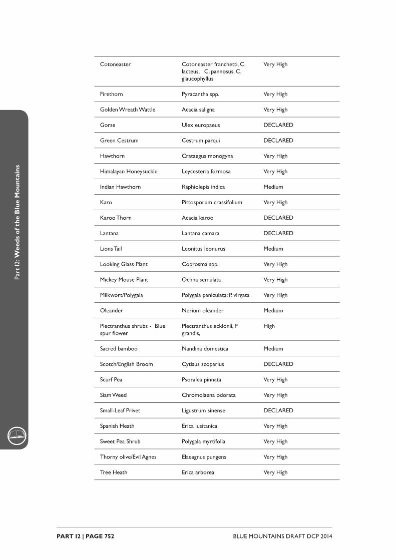
BLUE MOUNTAINS DRAFT DCP 2014 PART I2 | PAGE 752
Part
I2: W
eeds
of t
he B
lue
Mou
ntai
ns
Cotoneaster Cotoneaster franchetti, C. lacteus, C. pannosus, C. glaucophyllus
Very High
Firethorn Pyracantha spp. Very High
Golden Wreath Wattle Acacia saligna Very High
Gorse Ulex europaeus DECLARED
Green Cestrum Cestrum parqui DECLARED
Hawthorn Crataegus monogyna Very High
Himalayan Honeysuckle Leycesteria formosa Very High
Indian Hawthorn Raphiolepis indica Medium
Karo Pittosporum crassifolium Very High
Karoo Thorn Acacia karoo DECLARED
Lantana Lantana camara DECLARED
Lions Tail Leonitus leonurus Medium
Looking Glass Plant Coprosma spp. Very High
Mickey Mouse Plant Ochna serrulata Very High
Milkwort/Polygala Polygala paniculata; P. virgata Very High
Oleander Nerium oleander Medium
Plectranthus shrubs - Blue spur fl ower
Plectranthus ecklonii, P grandis,
High
Sacred bamboo Nandina domestica Medium
Scotch/English Broom Cytisus scoparius DECLARED
Scurf Pea Psoralea pinnata Very High
Siam Weed Chromolaena odorata Very High
Small-Leaf Privet Ligustrum sinense DECLARED
Spanish Heath Erica lusitanica Very High
Sweet Pea Shrub Polygala myrtifolia Very High
Thorny olive/Evil Agnes Elaeagnus pungens Very High
Tree Heath Erica arborea Very High

PART I2 | PAGE 753BLUE MOUNTAINS DRAFT DCP 2014
Part
I2: W
eeds
of t
he B
lue
Mou
ntai
ns
Tutsan Hypericum androsaemum, H. kouytchense (H. x mose-rianum)
DECLARED
Wild Tobacco Solanum mauritianum High
Yellow Bells Tecoma stans DECLARED
Perennials and Ground Covers
Agapanthus Agapanthus praecox ssp. orientalis
Very High
Alligator Weed Alternanthera philoxeroides DECLARED
Arum or Calla Lily Zantedeschia aethiopica High
Asparagus Fern Asparagus aethiopicus, A. africanus
DECLARED
Asthma Weed Parietaria judaica Low
Bathurst/Noogoora/Califor-nian Burr
Xanthium spp. DECLARED
Blue Periwinkle Vinca major; V. minor Very High
Broomrapes Orobanche spp. DECLARED
Canna Lily Canna indica Low
Coreopsis Coreopsis lanceolata Very High
Creeping Buttercup Ranunculus repens *Low
Creeping Lantana Lantana montevidensis Very High
Crofton Weed Ageratina adenophora DECLARED
Day Lily Hemerocallis spp. *Low
Fennel Foeniculum vulgare *Low
Fireweed Senecio madagascariensis High
Forget-Me-Not Myosotis sylvatica Very High
Formosan Lily Lilium formosanum Very High
Gaura, Clock weed; Butterfl y plant
Oenothera curtifl ora (syn Gaura parvifl ora),
DECLARED
Ginger Lily Hedychium gardnerianum Very High
Hawkweed Hieracium spp. DECLARED
Horsetail Equisetum arvense DECLARED

BLUE MOUNTAINS DRAFT DCP 2014 PART I2 | PAGE 754
Part
I2: W
eeds
of t
he B
lue
Mou
ntai
ns
Impatiens/Busy Lizzy Impatiens balsamina/walle-riana
Medium
Japanese Knotweed Persicaria capitata Medium
Japanese Windfl ower Anemone x hybrida Medium
Kochia Kochia scoparia DECLARED
Mistfl ower Ageratina riparia High
Montbretia Crocosmia x crocosmiifl ora DECLARED
Nasturtium Tropoleum majus High
New Zealand Flax Phormium sp. *Low
Ox-eyed Daisy Leucanthemum vulgare Medium
Oyster Plant Acanthus mollis Very high
Parthenium Weed Parthenium hysterophorus Very High
Patersons Curse/Viper Bugloss
Echium spp. DECLARED
Peruvian Lily Alstromeria aurea High
Plectranthus ground covers Plectrantus ciliatus, P. ver-ticillatus, P. amboinicus, P. ornatus, P.oertendahlii
High
Prostrate Cotoneaster Cotoneaster microphyllus / horizontalis
Very high
Red Hot Poker Kniphofi a sp. High
Seaside Daisy Erigeron karvinskianus Very High
Self Heal Prunella vulgaris Medium
Shasta Daisy Leucantheum sp. Low
Spotted Knapweed Centaurea maculosa Medium
St Johns Wort Hypericum perforatum DECLARED
Topped lavender Lavandula stoechas Medium
Veldt Daisy Osteospermum ecklonis Very High
Wandering Jew Tradescantia fl uminensis Very High
Watsonia Watsonia meriana “bulbil-lifera”
High
Watsonia Watsonia borbonica High
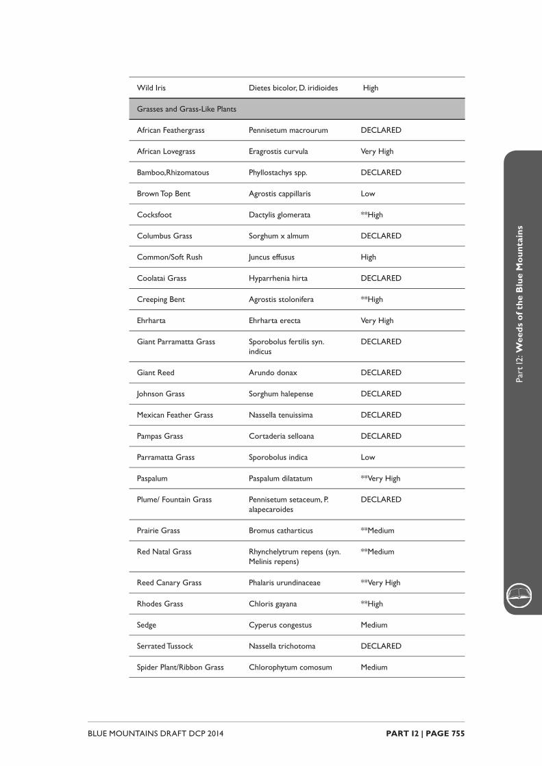
PART I2 | PAGE 755BLUE MOUNTAINS DRAFT DCP 2014
Part
I2: W
eeds
of t
he B
lue
Mou
ntai
ns
Wild Iris Dietes bicolor, D. iridioides High
Grasses and Grass-Like Plants
African Feathergrass Pennisetum macrourum DECLARED
African Lovegrass Eragrostis curvula Very High
Bamboo,Rhizomatous Phyllostachys spp. DECLARED
Brown Top Bent Agrostis cappillaris Low
Cocksfoot Dactylis glomerata **High
Columbus Grass Sorghum x almum DECLARED
Common/Soft Rush Juncus effusus High
Coolatai Grass Hyparrhenia hirta DECLARED
Creeping Bent Agrostis stolonifera **High
Ehrharta Ehrharta erecta Very High
Giant Parramatta Grass Sporobolus fertilis syn.indicus
DECLARED
Giant Reed Arundo donax DECLARED
Johnson Grass Sorghum halepense DECLARED
Mexican Feather Grass Nassella tenuissima DECLARED
Pampas Grass Cortaderia selloana DECLARED
Parramatta Grass Sporobolus indica Low
Paspalum Paspalum dilatatum **Very High
Plume/ Fountain Grass Pennisetum setaceum, P. alapecaroides
DECLARED
Prairie Grass Bromus catharticus **Medium
Red Natal Grass Rhynchelytrum repens (syn.Melinis repens)
**Medium
Reed Canary Grass Phalaris urundinaceae **Very High
Rhodes Grass Chloris gayana **High
Sedge Cyperus congestus Medium
Serrated Tussock Nassella trichotoma DECLARED
Spider Plant/Ribbon Grass Chlorophytum comosum Medium
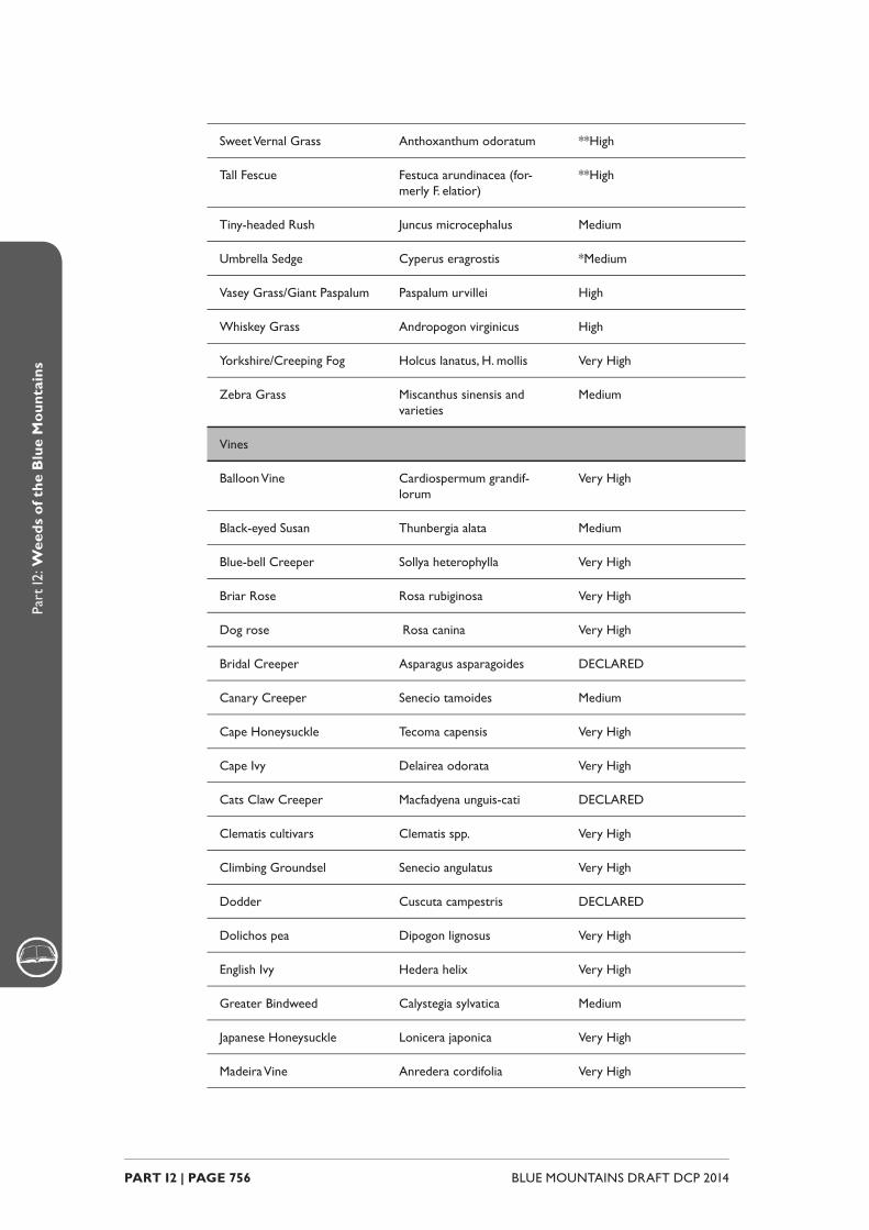
BLUE MOUNTAINS DRAFT DCP 2014 PART I2 | PAGE 756
Part
I2: W
eeds
of t
he B
lue
Mou
ntai
ns
Sweet Vernal Grass Anthoxanthum odoratum **High
Tall Fescue Festuca arundinacea (for-merly F. elatior)
**High
Tiny-headed Rush Juncus microcephalus Medium
Umbrella Sedge Cyperus eragrostis *Medium
Vasey Grass/Giant Paspalum Paspalum urvillei High
Whiskey Grass Andropogon virginicus High
Yorkshire/Creeping Fog Holcus lanatus, H. mollis Very High
Zebra Grass Miscanthus sinensis and varieties
Medium
Vines
Balloon Vine Cardiospermum grandif-lorum
Very High
Black-eyed Susan Thunbergia alata Medium
Blue-bell Creeper Sollya heterophylla Very High
Briar Rose Rosa rubiginosa Very High
Dog rose Rosa canina Very High
Bridal Creeper Asparagus asparagoides DECLARED
Canary Creeper Senecio tamoides Medium
Cape Honeysuckle Tecoma capensis Very High
Cape Ivy Delairea odorata Very High
Cats Claw Creeper Macfadyena unguis-cati DECLARED
Clematis cultivars Clematis spp. Very High
Climbing Groundsel Senecio angulatus Very High
Dodder Cuscuta campestris DECLARED
Dolichos pea Dipogon lignosus Very High
English Ivy Hedera helix Very High
Greater Bindweed Calystegia sylvatica Medium
Japanese Honeysuckle Lonicera japonica Very High
Madeira Vine Anredera cordifolia Very High

PART I2 | PAGE 757BLUE MOUNTAINS DRAFT DCP 2014
Part
I2: W
eeds
of t
he B
lue
Mou
ntai
ns
Maidenhair Vine Muehlenbeckia complexa Low
Morning Glory Ipomoea indica, I. cairica High
Moth Vine Araujia sericifera Very High
Passionfruit (Common Banana, White)
Passifl ora edulis, P. mollisina P. subpeltata, P. cinnabarina
High
Turkey Rhubarb Acetosa sagittata Very High
White Jasmine Jasminum polyanthum Very High
Ferns
Sword Fern/Fishbone Fern Nephrolepis cordifolia Low
Coin spot/Scaly tree fern Cyathea cooperi Medium
Cacti and Succulents
Agave Agave americana Medium
Aloe Aloe arborescens Medium
Fairy Crassula Crassula multicava Medium
Harrissia Cactus Harrissia spp DECLARED
London’s Pride Saxifraga umbrosa Low
Mother of Millions, Mother of Thousands, Resurrection plant
Bryophyllum delagoense; B. proliferum, B. daigremon-tianum; B x houghtonii, B. pinnatum
DECLARED
Prickly Pear Opuntia spp. DECLARED
Swedish Ivy / Creeping Charlie
Plectranthus verticelatus High
Yucca Yucca aloifolia High
Aquatic Plants
Alligator Weed Alternanthera philoxeroides DECLARED
Cabomba/Fanwort Cabomba caroliana DECLARED
Dwarf Rotala Rotala rotundifolia High
Egeria Egeria densa DECLARED
Lagarosiphon Lagarosiphon major DECLARED
Mexican Water Lily Nymphaea mexicana High

BLUE MOUNTAINS DRAFT DCP 2014 PART I2 | PAGE 758
Part
I2: W
eeds
of t
he B
lue
Mou
ntai
ns
Salvinia Salvinia molesta DECLARED
Senegal Tea Plant Gymnocoronis spilanthoides DECLARED
Water Hyacinth Eichhornia crassipes DECLARED
Water Lettuce Pistia stratiotes DECLARED
Water Primrose Ludwigia peruviana DECLARED
* These species are identifi ed as high risk in swamps and riparian (creekline) habitats
** These species are identifi ed as low risk in pasture situations in rural land use areas

PART I3GUIDELINES
BLUE MOUNTAINS DRAFT DCP 2014 PART I3 | PAGE 760
Part
I3: G
uide
lines
IntroductionThis part contains guideline documents to provide detailed advice on how to prepare certain reports or plans.
These documents are to provide guidance and do not form part of the DCP.
Some of these documents reference current planning instruments (Blue Mountains Local Environmental Plan 2005) and other planning legislation including the Blue Mountains Better Living Development Control Plan.
These guidelines will be updated and amended as required, upon gazettal of Draft Local Environmental Plan 2014.
Nevertheless, the principles within these guidelines remain the same, and the content can therefore reference and used to provide understanding and explanation of the provisions within this DCP.
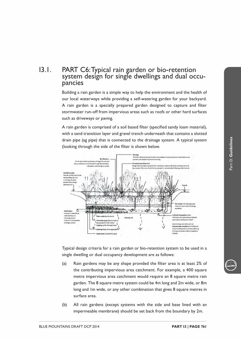
PART I3 | PAGE 761BLUE MOUNTAINS DRAFT DCP 2014
Part
I3: G
uide
lines
I3.1. PART C6: Typical rain garden or bio-retention system design for single dwellings and dual occu-panciesBuilding a rain garden is a simple way to help the environment and the health of our local waterways while providing a self-watering garden for your backyard. A rain garden is a specially prepared garden designed to capture and fi lter stormwater run-off from impervious areas such as roofs or other hard surfaces such as driveways or paving.
A rain garden is comprised of a soil based fi lter (specifi ed sandy loam material), with a sand transition layer and gravel trench underneath that contains a slotted drain pipe (ag pipe) that is connected to the drainage system. A typical system (looking through the side of the fi lter is shown below.
Typical design criteria for a rain garden or bio-retention system to be used in a single dwelling or dual occupancy development are as follows:
(a) Rain gardens may be any shape provided the fi lter area is at least 2% of the contributing impervious area catchment. For example, a 400 square metre impervious area catchment would require an 8 square metre rain garden. The 8 square metre system could be 4m long and 2m wide, or 8m long and 1m wide, or any other combination that gives 8 square metres in surface area.
(b) All rain gardens (except systems with the side and base lined with an impermeable membrane) should be set back from the boundary by 2m.

BLUE MOUNTAINS DRAFT DCP 2014 PART I3 | PAGE 762
Part
I3: G
uide
lines
(c) Provide adequate setbacks to any underground services (gas, electricity, water, on-site effl uent disposal systems) and to the foundations of existing buildings and structures.
(d) Rain gardens should be positioned to treat as much of the site’s impervious area runoff (from roof downpipes, rain tank overfl ows, driveway, paved areas) as possible.
(e) Minimum Design Criteria are as follows:
• The temporary ponding area should be at least 200mm deep.
• Filter media should be sandy loam and be between 200-400mm depth.
• Transition layer should be coarse sand and be approximately100mm depth.
• Drainage layer should be gravel and be at least 200mm depth.
• The perforated collection pipe or underdrain should be at least 90mm in diameter and be connected to the stormwater drainage system.
(f) Infi ltration from the base of the drainage layer of a rain garden is recommended to be provided where ever this can be safely accommodated by the site and environmental conditions (soil depth and permeability, depth to groundwater table or bedrock).
(g) Where rain gardens are located near shallow groundwater or bedrock, or where soils of low permeability occur, the base and sides must be lined with an impervious membrane to prevent infi ltration.
(h) Provide suitable collection and disposal of design overfl ows to a stormwater drainage system (street gutter, inter-allotment drainage system or drainage easement), unless these overfl ows can be otherwise safely infi ltrated within the site.
(i) Rain gardens should be densely planted with native macrophyte or groundcover species that:
• are adapted to the local climatic conditions and high and variable nutrient and moisture conditions; and
• contain extensive fi brous root systems, spreading rhizomatous or suckering habitat are preferred over a clumped habit; and
• are established at a minimum density of at least 8 plants per square metre across the fi lter area base and any side batters; and
• provide complexity and year round coverage by including at least 4

PART I3 | PAGE 763BLUE MOUNTAINS DRAFT DCP 2014
Part
I3: G
uide
lines
different species within the fi lter area, use mainly moisture tolerant species such as Juncus planifolius, Juncus usitatus, Carex appressa, Gahnia, Lepidosperma, Schoenus and Restio species. Other species that may be incorporated are Poa sieberiana, Lomandra, Patersonia, Dianella and Blechnum species or other similar local native species.
Note: For further information consult http://www.melbournewater.com.
au/raingardens. The plant species suggested in this information need to be
modifi ed to be compatible with local Blue Mountains conditions.
I3.2. PART C6: WSUD guidelines for large scale developmentThe WSUD strategy and stormwater management system is to be appropriately designed and sized in a manner consistent with the latest guidelines and current best management practices for WSUD
The latest WSUD guidelines include but are not limited to:
(a) Using MUSIC in Sydney’s Drinking Water Catchment A Sydney Catchment Authority Standard dated March 2012 by the Sydney Catchment Authority (for use in Sydney’s Drinking Water Catchments) (http://www.sca.nsw.gov.au/__data/assets/pdf_file/0019/39313/Using-MUSIC-in-Sydneys-Drinking-Water-Catchments.pdf)
(b) Draft NSW MUSIC Modelling Guidelines, by BMT WBM NSW Government and Sydney Metro Catchment Management Authority dated August 2010 (http://wsud.org/wp-content/uploads/2012/07/Draft-MUSIC-Modelling-Guidelines-31-08-201011.pdf)
(c) Concept Design Guidelines for WSUD by Water by Design SEQ Version 1.1 April 2010 (http://waterbydesign.com.au/conceptguide/)
(d) Construction and Establishment Guidelines by Water by Design SEQ Version 1.1 April 2010 (http://waterbydesign.com.au/CEguide/)
(e) Water Sensitive Urban Design – Technical Design Guidelines for South East Queensland, by Water by Design SEQ 2006 (http://waterbydesign.com.au/TechGuide/)
(f) Maintaining Vegetated Stormwater Assets by Water by Design SEQ 2012 (http://waterbydesign.com.au/maintenanceguide/)
(g) Stormwater Bio-fi ltration Systems Adoption Guidelines, Planning Design and Practical information, by Facility for Advancing Water Bio-fi ltration, Version 1, June 2009 (http://www.monash.edu.au/fawb/products/)
(h) Australian Runoff Quality - A Guide to Water Sensitive Urban Design by Engineers Australia, 2006 (http://www.wsud.org/resources-examples/case-studies/australian-runoff-quality/)

BLUE MOUNTAINS DRAFT DCP 2014 PART I3 | PAGE 764
Part
I3: G
uide
lines
(i) WSUD Engineering Procedures Stormwater by Melbourne Water dated 2005 (http://www.publish.csiro.au/au/pid/4974.htm)
(j) WSUD Technical Guidelines for Western Sydney by Stormwater trust and the Upper Parramatta River Catchment Trust dated May 2004 (http://www.wsud.org/wp-content/uploads/2012/08/part1.pdf)
(k) Managing Urban Stormwater: Harvesting and Reuse by the NSW Department of Environment and Conservation, 2006 (http://www.environment.nsw.gov.au/stormwater/publications.htm)
(l) Developments in Sydney’s Drinking Water Catchment – Water Quality Information Requirements by the Sydney Catchment Authority (as relevant to the Sydney Drinking Water Catchment). (http://www.sca.nsw.gov.au/__data/assets/pdf_fi le/0015/36402/Developments-in-Sydney-water-quality-information-requirements.pdf)
(m) Water Sensitive Design Guide for Rural Residential Subdivisions, Water Sensitive Urban Design;
(n) Draft Water Sensitive Urban Design Book 1 Policy by Landcom (2006) (http://landcom.com.au/downloads/uploaded/WSUD_Book1_Policy_Draft_0409_6d9c.pdf)
(o) Other Council’s guidelines - Blacktown City Council Developer Handbook for Water Sensitive Urban Design (Version 1.1 November 2013) (http://www.blacktown.nsw.gov.au/Planning_and_Development/Plans_and_Guidelines/Engineering_Guidelines_for_Development/Water_Sensitive_Urban_Design)
Note: These documents provides relevant general technical guidance however
may include stormwater treatment targets or other criteria that are different to
targets required by Blue Mountains City Council).
PART I3 | PAGE 765BLUE MOUNTAINS DRAFT DCP 2014
Part
I3: G
uide
lines
I3.3. PART C6: Typical WSUD devices The WSUD strategy is include a treatment train that is to comprise all necessary stormwater treatment devices, to provide the retention, fi ltering, infi ltration and safe disposal necessary to meet the required stormwater treatment performance outcomes.
The WSUD strategy is to include appropriate water quality and quantity treatment devices, such as:
(a) Rainwater tanks and reuse
(b) Grey water treatment and tanks for re-use
(c) Detention basins
(d) Sediment basins
(e) Gross pollutant capture devices
(f) Oil/grit/grease/water separators
(g) Vegetated fi lter strips
(h) Grass or vegetated swales
(i) Bio-retention swales or basins
(j) Sand fi lter beds
(k) Porous pavements
(l) Infi ltration measures
(m) Constructed wetlands
Note - Adaptability to climate change should be considered in the planning, design
and management of WSUD strategies and infrastructure, particularly with regard to
long term stormwater harvesting schemes and landscaping species selection. Consider
potential changes in the volume and frequency of rainfall, temperatures and other climatic
conditions, bushfi re and storm recurrence and intensity and ecological succession.

BLUE MOUNTAINS DRAFT DCP 2014 PART I3 | PAGE 766
Part
I3: G
uide
lines
I3.4. PART D1: Heritage Listings BMLEP2014 provides clauses for the protection of the heritage of the Blue Mountains under Clause 5.10. Heritage items and heritage conservation areas are identifi ed by property address and real property description in Schedule 5 of BMLEP2014 and also on the accompanying Heritage Conservation maps to the LEP. Heritage listings are based on studies carried out by qualifi ed heritage consultants engaged by Council, and heritage listing has been the result of a rigorous approval process.
All items on Schedule 5 of BMLEP 2014 are listed as being of local heritage signifi cance; however, a number of items are also assessed as being of state signifi cance, meaning they have signifi cance and value to the broader community of NSW. Some of these items with state-signifi cant assessments have been formally listed on the State Heritage Register. The listing status (whether local or state) is identifi ed in Schedule 5 of the LEP.
Individual heritage inventory sheets have been prepared for each heritage item and heritage conservation area. These provide background information about the history of the property or area, a description of the item or area and an assessment of the various heritage values. These heritage inventory sheets should be referred to early in the development process. They are also required to be considered when preparing a heritage management document for submission to Council with a development application. These inventory sheets are available from Council and on the NSW Heritage Branch’s website at http://www.environment.nsw.gov.au/heritageapp/heritagesearch.aspx. The information in the heritage inventory sheets will be considered by Council as part of its assessment of development applications.
Understanding a property’s signifi cance
Individual heritage inventory sheets have been prepared for each heritage item and heritage conservation area. These provide background information about the history of the property or area, a description of the item or area and an assessment of the various heritage values. These heritage inventory sheets should be referred to early in the development process. They are also required to be considered when preparing a heritage management document for submission to Council with a development application. These inventory sheets are available from Council and on the NSW Heritage Branch’s website at http://www.environment.nsw.gov.au/heritageapp/heritagesearch.aspx. The information in the heritage inventory sheets will be considered by Council as part of its assessment of development applications.
There are a number of ways to determine the heritage signifi cance of heritage items and conservation areas.
Heritage inventory sheets

PART I3 | PAGE 767BLUE MOUNTAINS DRAFT DCP 2014
Part
I3: G
uide
lines
Search for the property’s heritage inventory sheet on the Heritage Council webiste. Properties within heritage conservation areas will not be separately listed, so the search should be for the name of the heritage conservation area.
Research and investigation is an ongoing process, and some inventory sheets may appear incomplete; however, this does not mean that the property is not signifi cant.
Researching property history
Without clear information from a heritage inventory sheet, additional research may be required. The purpose of undertaking research into a property’s history is to assist Council in considering how the proposed development has taken into account the history and signifi cant features of the item. Important or relevant information could include:
Historical details: dates, architects/builders, period of subdivision, names of any signifi cant original or early owners, signifi cant previous uses or associations
Heritage signifi cance: any previous assessments of signifi cance
Intactness and condition: an analysis of materials and elements to establish original, early and later fabric and details; to identify later or new elements; to identify the condition of important elements
Braemar, Springwood: Local Studies Library
The Blue Mountains municipality has a Local Studies Library that contains records, photographs and other archival and historic material that may be of relevance in preparing information in support of proposed changes to heritage properties. The librarian at the Library should be contacted for assistance.
Conservation and heritage community groups
There are a number of local community-based conservation and heritage groups who can provide information and guidance.
Records search
Council’s records may contain useful information on fi le which can be accessed by a GIPA search. This is a free service provided by Council, following the submission of the application form, which can be found here insert link xxxx. File material may contain previous heritage assessments, approvals and consent conditions, old photos and other material useful in understanding the history of the site.
Council
Council has a Heritage Advisory Committee and a Heritage Advisor who can provide information and guidance.
BLUE MOUNTAINS DRAFT DCP 2014 PART I3 | PAGE 768
Part
I3: G
uide
lines
Heritage assessment guidelines
The Offi ce of Environment and Heritage (OEH) provides free publications to assist owners, local Councils, consultants and others in understanding heritage signifi cance. A primary document is ‘Assessing Heritage Signifi cance’ which is available to download at http://www.environment.nsw.gov.au/Heritage/publications/index.htm
A list of heritage practitioners can be found on the website of the Offi ce of Environment and Heritage (OEH) at http://www.environment.nsw.gov.au/heritageapp/HeritageConsultantsDirectory.aspx
Guidelines
• The Burra Charter: The Australia ICOMOS Charter for Places of Cultural Signifi cance, 1999
This part of the DCP is consistent with the Australian International Council on Monuments and Sites (ICOMOS) Charter for the Conservation of Places of Cultural Signifi cance (The Burra Charter). The Burra Charter is available on Council’s website.
• The Conservation Plan, by James Semple Kerr, National Trust, 2000
This seminal text sets out the format for and is a guide to the preparation of Conservation Plans. Available as a free download on the NSW Heritage Branch website at http://www.environment.nsw.gov.au/Heritage/publications/index.htm
• Heritage Branch publications
The Heritage Branch provides a diverse range of publications covering many heritage and conservation topics: technical advice, conservation by of particular building types, heritage nominations, assessing signifi cance, thematic histories, and more. Many are available free to download.
Also available is Design in Context, guidelines for infi ll development, and New Uses for Heritage Places, publications prepared in association with the Australian Institute of Architects, and available as free downloads. The Heritage Branch of NSW publications are available at http://www.environment.nsw.gov.au/Heritage/publications/index.htm
• State Environmental Planning Policy (Exempt and Complying Development) 2008
The ‘Codes SEPP’ details exemptions for a range of minor works for heritage items and within heritage conservation areas. It also allows complying development within conservation areas but does not allow complying development to heritage items.
PART I3 | PAGE 769BLUE MOUNTAINS DRAFT DCP 2014
Part
I3: G
uide
lines
I3.5. PART E5: CPTED Guidelines
Site building layout
Orientate the main entrance towards the street or both streets if located on a corner.
Offset windows, doorways and balconies to allow for natural observation while protecting privacy.
Avoid large trees, carports, skillion extensions, fences or downpipes next to second storey windows or balconies that could provide a means of access.
Design balconies and windows to maximise natural observation of vehicle and pedestrian movement.
Set buildings back from the verge to create a perception of semi-private space.
Entrances and building identifi cation
Locate entrances in prominent positions.
Use design features such as numbering and directional signage so that entrances are easily recognisable.
Providing common access points to no more than 6 to 8 dwellings.
Where buildings accommodate a number of dwellings or uses, the building entry should clearly state the dwelling numbers accessed from that entry.
Include a viewing window / vision panel in fi re exit doors to allow visibility before opening. (The materials must comply with the fi re rating requirements of the Building Code of Australia.)
Staff entrances that are separate from the main entrance must be located to maximise opportunities for natural surveillance from the street or other public areas.
Locate offi ces, desks, work-stations so as to overlook public areas, carparking areas, entrances to buildings, adjoining arcades, malls and the like.
Place street numbers so they are clearly visible and not obscured by foliage.
Blind corners
Design direct pathways.
Make sure that any barriers along pathways are visually permeable (‘see through’), including landscaping and fencing.
Install glass panels in stairwells to maximise visibility.
Use mirrors so that users can see around corners or ahead of them.
Lighting

BLUE MOUNTAINS DRAFT DCP 2014 PART I3 | PAGE 770
Part
I3: G
uide
lines
Use diffused lights and / or movement sensitive lights.
Direct these lights towards access / egress routes to illuminate potential offenders, rather than towards buildings or resident observation points.
Lighting should have a wide beam of illumination, which reaches to the beam of the next light, or the perimeter of the site or area being traversed.
Avoid light spillage onto neighbouring properties as this can cause nuisance and reduce opportunities for casual surveillance.
Light areas to enable users to identify a persons face 15 metres away.
Lighting of all pathways, areas adjoining public spaces and outdoor / open carparking areas is to be in accordance with Australian / New Zealand Standard 1158.3.1:1999 – Pedestrian Area Lighting.
Illuminate possible places for intruders to hide, including letterboxes and communal areas.
Use energy effi cient lamps, fi ttings and switches to save energy.
Ensure that external areas such as letterboxes and communal areas are well lit and observable from inside.
Ensure that entrances to buildings are well illuminated.
Communal/public areas
Position active uses or habitable rooms with windows adjacent to main communal / public areas, such as playgrounds, swimming pools, gardens, car parks, etc. Whilst natural surveillance is encouraged in this instance, consideration also needs to be given to acoustic impacts on habitable areas. A balance needs to be sought.
Make sure utility/service areas are easily secured, well lit and free of possible entrapment spots such as alcoves. For aesthetic reasons, garbage storage areas should be screened from public places using fencing or vegetation. Careful and innovative design is required to balance both of these design criteria.
Open style or transparent materials are encouraged on doors and /or walls where stairwell or elevators are provided.
Waiting areas and entries to elevators / stairwells should be close to areas of active uses and should be visible from the building entry.
Seating should be located in areas of active uses.
Ownership
Distinguish dwellings or groups of dwellings by using design features such as colour, vegetation, paving, fencing, furniture etc.
Physical and / or psychological barriers, such as fences, gardens, lawn strips, varying textured surfaces can be used to defi ne different spaces and to clearly distinguish between public, semi public-private and private spaces.

PART I3 | PAGE 771BLUE MOUNTAINS DRAFT DCP 2014
Part
I3: G
uide
lines
Landscaping
Avoid medium-height vegetation with concentrated top to bottom foliage. Plants such as low hedges and shrubs, creepers, ground covers and high canopied vegetation are good for natural surveillance.
Trees with dense low growth foliage should be spaced or ‘crown raised’ to avoid a continuous barrier.
When landscaping around children’s play areas, car parks and along pedestrian pathways, use low ground covers or high canopied trees which have clean (ie., free of foliage) trunks to a minimum height of 2 metres.
Where planting is provided within 5 metres of a pedestrian pathway, it should be lower than 1 metre or be thin trunked with a high canopy.
Keep a cleared space of 3 to 5 metres on either side of pathways and bicycle routes. Step back vegetation in height beyond this point.
Planting should not prevent informal surveillance by adjacent residents.
Avoid vegetation which conceals the building entrance from the street.
Prickly plants may be used as effective barriers, where appropriate.
Landscaping techniques can be used to prevent access to windows and walls for better security and graffi ti management.
Fences
Fences should not inhibit surveillance of communal areas, pathways and footpath by occupants of the building. Both the height of the fence in relation to the building, as well as the nature of the construction materials needs to be considered.
Keep fences and walls low and / or open to improve observation and maximise sunlight. Vegetation should not obscure building entrances, windows and other vulnerable areas.
Install double glazing where noise is a problem at the front of the building rather than using a high solid fence.
Use light coloured open fencing, if privacy is an issue, as this will provide more privacy than dark coloured open fencing, but will still allow a level of surveillance from the street.
Colourbond fences should not be used as a fencing material adjoining public open space or thoroughfare unless vegetation is planted in front to reduce graffi ti access.
Security
Door and window locks should be installed in accordance with the relevant Australian Standard in all residential developments comprising three or more dwellings and in commercial and industrial developments.

BLUE MOUNTAINS DRAFT DCP 2014 PART I3 | PAGE 772
Part
I3: G
uide
lines
Display security system notices prominently.
Ensure that perimeter doors and windows are of solid construction and fi tted with quality deadlocking devices.
Fit the main entry doors with viewing ports to allow identifi cation of visitors.
Install sensor lighting or timed lighting that can be controlled from within the building.
Encourage casual use of public and semi-private open spaces during evening hours so they can be ‘animated’ with legitimate activities.
Building materials
Use toughened or laminated glass at ground fl oor level.
Modulate large walls and use dark colours to discourage graffi ti.
Consider the use of vegetation such as ‘creepers’ on walls or the use of murals which can be effective in deterring graffi ti.
Use strong, wear-resistant laminate, impervious glazed ceramics, treated masonry products, stainless steel materials or use anti-graffi ti paint or clear over sprays.
Avoid fl at or porous fi nishes where graffi ti is likely to be a problem.
Ensure that skylights and roofi ng tiles cannot be easily removed from the outside.
Glass should be reinforced with shatter resistant material to prevent entry.
Public facilities
Employ traffi c calming measure to slow cars and encourage pedestrian activity where possible.
Locate public facilities in highly visible locations that are well lit and near activities with extended trading hours such as restaurants, convenience stores, taxi ranks, etc.
Locate public facilities away from possible entrapment spots such as fi re exits, alleys, etc.
Design ATM’s to incorporate mirrors or refl ective materials so that users can observe people behind. Do not locate ATM’s in alcoves which limit visibility.
Provide directional signs to key services and landmarks such as railway stations, police stations, taxi ranks, etc.
Design pedestrian pathways to be of generous width in busy areas.
Construction of pathways through existing vegetation should consider the appropriateness of the route, the need to thin vegetation at the base of trees and to the location and orientation of lighting.
Design open spaces so that they are clearly designated and easily observed by people. Parks and playgrounds should face the street rather than lanes and be

PART I3 | PAGE 773BLUE MOUNTAINS DRAFT DCP 2014
Part
I3: G
uide
lines
placed in close proximity to public activity (such as in front of a building, shopping centre).
Play equipment, seating, BBQ areas and the like, should be provided to encourage active use of these areas.
Seating should be conveniently located and easily seen.
Facilities such as toilets and telephones should be located close to areas of active uses.
Bus and taxi shelters are to be located within close proximity to active areas (street, pathways, adjoining businesses, etc). Vegetation surrounding such shelters should be minimised or maintained to maximise visibility. Shelters should be well lit.
Pathways should be direct, follow pedestrian sight lines and avoid blind corners. Avoid sudden changes of grade on pathways, where possible, if it reduces sight lines.
Directional and behavioural signage should be provided at entrances to parks / open space areas.
Car parking facilities
Avoid large expanses of car parks. If this is not possible provide surveillance such as security cameras (in accordance with the NSW Government policy, statement and guidelines for the ‘Establishment and Implementation of CCTV in Public Places’).
Access to lifts, stairwells and pedestrian pathways should be clearly visible.
Pedestrian sight lines should be clearly identifi ed to direct users to exits or key points within the car park facility such as the use of lighting, pavement markings, etc.
Locate disabled parking spaces in highly visible and convenient locations.
Locate car parks in areas that can be observed by adjoining uses.
Minimise the number of entry and exit points. Where possible, locate entry/exit points in proximity to active uses such as shops.
Staff parking facilities should be separated, secured (where appropriate), well lit and easily accessible.
Internal car park structure (such as concrete columns, solid internal walls, service rooms and enclosed fi re exits) can create signifi cant visual obstructions in car parks. Adequate sight lines are to be provided and design alternatives such as minimising vertical columns through engineering design or placing ‘portholes’ in car park walls increases visibility.
Avoid the use of the ‘herring-bone’ confi guration in open car parking areas where possible, as this restricts natural supervision and limits sight lines.

BLUE MOUNTAINS DRAFT DCP 2014 PART I3 | PAGE 774
Part
I3: G
uide
lines
I3.6. PART E5: Food Safety GuidelinesAll food businesses are required to satisfy the following key food safety requirements:
1. Approval requirements
The relevant approvals must be obtained from Council prior to commencing the operation and use of any food business.
2. Food premises fi t-out
Food premises must be designed and constructed in accordance with specifi c standards and requirements to facilitate cleaning, good food-handling practices, health and hygiene and to minimise potential contamination and food-borne illnesses as set out in the Food Safety Code and Australian Standard 4674 – 2004 Design, construction and fi t-out of food premises.
3. Food handlers: skills and knowledge
All food handlers must have the necessary skills and knowledge in food safety and food hygiene.
The operator or manager of the business must have high-level skills and knowledge in food safety and food hygiene and they must ensure that all staff have suffi cient knowledge and skills in food safety.
Council recommends that all food handlers undertake formal training in food safety and food hygiene, such as relevant TAFE or food/catering college training course. At least one food safety supervisor must be appointed for each venue within a business.
4. Food handling practices and controls
The operator or manager of the business and all food handlers must ensure that food products are handled in a safe and controlled manner, from transportation, receipt, storage, processing, display, service and disposal.
Incorrect or sloppy food-handling practices signifi cantly increase the risk of food becoming contaminated and causing potentially serious food poisoning incidents.
Food must be stored, prepared, displayed and handled in a way that does not increase the risk of contamination or the growth of bacteria and toxins.
Standard 3.2.2 of the Food Standards Code contains detailed requirements and procedures for food handling.
5. Temperature control
To minimise the risk of food spoilage, food poisoning and the growth of bacteria or toxins, it is essential that potentially hazardous food is kept under appropriate
PART I3 | PAGE 775BLUE MOUNTAINS DRAFT DCP 2014
Part
I3: G
uide
lines
temperature control.
Potentially hazardous food includes:
• raw and cooked meat or poultry, or foods containing meat or poultry, eg casseroles, curries, meat pies, sausage rolls, kebabs, lasagne, spaghetti bolognese
• dairy products, eg milk, custard, cream, dairy based desserts
• seafood, eg fi sh, prawns, lobsters, oysters, calamari, shellfi sh
• processed fruits and vegetables, eg salads
• cooked rice, pasta and pasta salads
• foods containing eggs, beans, nuts or other protein rich foods, eg quiche, soy products
• foods that contain these foods, eg sandwiches and rolls.
Potentially hazardous food must be maintained:
• at or below 5°C (ie in a refrigerator or freezer), or
• at or above 60°C (ie in a heated display cabinet).
Potentially hazardous food should be cooled from 60°C to 21°C within 2 hours and 21°C to 5°C within a further 4 hours. and be refrigerated as soon as practicable (generally within 2 to 4 hours).
All refrigerators, freezers and heated food display cabinets must be monitored with an accurate thermometer (can be located within the appliance where readily visible), to ensure that food is maintained within the appropriate temperature range (eg digital-probe type thermometer).
Standard 3.2.2 of the Food Standards Code details the specifi c requirements for keeping potentially hazardous food at appropriate temperatures.
6. Prevention of contamination
Food business operators must ensure that all practicable measures are taken to protect food from the likelihood of contamination.
Food contamination can be caused by a number of inappropriate practices and controls, including:
• inappropriate temperature control
• inappropriate thawing and re-heating practices
• vermin and pests (eg mice, rats, fl ies, cockroaches, birds, insects)
BLUE MOUNTAINS DRAFT DCP 2014 PART I3 | PAGE 776
Part
I3: G
uide
lines
• unclean equipment, appliances, utensils and surfaces
• unclean hands and clothing
• cross contamination of food, between raw food and cooked/ready to eat food
• incorrect or poor food-handling practices (eg from touching cooked/ready-to-eat food without gloves)
• contamination from customers (eg handling or sneezing upon the food)
• poor transportation and storage practices
• poor cleaning and person hygiene practices
• inappropriate or insuffi cient waste disposal facilities
• other physical and chemical contamination
Raw foods (eg meat, chicken, seafood) must be stored, prepared and processed separately or away from ready-to-eat cooked food to prevent possible cross contamination of food.
Standard 3.2.2 of the Food Standards Code contains further details and requirements to prevent contamination of food.
7. Cleaning and sanitising
It is essential that food premises are kept in a clean condition at all times including all walls, fl oors, ceilings, shelving, windows, cooking equipment, ventilation equipment, fridges, appliances, cupboards, utensils, crockery, cutlery, furniture and fi ttings.
The most effective and effi cient way of keeping the premises clean and hygienic is to develop and implement an ongoing cleaning program.
The cleaning program should identify who, what, when and how the particular area or items will be cleaned.
To ensure that surfaces, equipment and utensils etc are thoroughly cleaned and sanitised, it is recommended that specifi c commercial ‘cleaning and sanitising’ products be used from a commercial kitchen, catering or cleaning supplier, in accordance with the manufacturers directions.
8. Health and hygiene
Everyone is a potential carrier of bacteria and bacteria can easily be transferred from someone’s hands, clothing and utensils or other articles to the food, or to the surfaces of food preparation areas or utensils.
PART I3 | PAGE 777BLUE MOUNTAINS DRAFT DCP 2014
Part
I3: G
uide
lines
All staff must wash their hands regularly (with warm water and hand cleanser), especially:
• before starting work
• before starting work after a break
• after handling money and before handling food
• after handling dirty dishes, glasses or utensils
• after doing any cleaning
• after using the toilet
• after smoking
• before handling cooked food - after handling raw food
• after handling rubbish or other waste
• after touching their hair, mouth, nose or any other body part.
It is also important that food handlers minimise potential contamination of food. For example, by wearing gloves or using tongs to avoid touching ready-to-eat or cooked food, and by wearing clean clothing and footwear.
9. Food storage and waste disposal
Food products must be stored in an appropriate location, in a suitable container and at a controlled temperature, to prevent potential contamination and growth of bacteria.
Potentially hazardous food should be stored in appropriate plastic containers with lids, to reduce the risk of contamination from other food (eg to separate raw food and cooked or ready-to-eat food), and from food handling, dirt, dust and other physical and chemical contaminants.
To minimise the growth of bacteria:
• keep the food cold (below 5°C)
• keep the food hot (above 60°C)
• always re-heat and cool food quickly.
To reduce the risk of contamination, all food premises must also have suffi cient and appropriate waste disposal facilities and receptacles.
Waste bins must be provided with lids and be located in a suitable area, so as not to potentially contaminate any food, other surfaces or equipment.

BLUE MOUNTAINS DRAFT DCP 2014 PART I3 | PAGE 778
Part
I3: G
uide
lines
Food storage and waste storage areas must be kept in a clean and sanitary condition, free from vermin, fl ies, cockroaches and other pests.
Food businesses must arrange for their waste materials and recycling to be collected and disposed of by an approved trade/commercial waste contractor (Council’s Trade Waste Service or a private licensed contractor).
I3.7. Current environmental guides and strategiesThe Council has produced a number of environmental guides and strategies to provide detailed advice on how to prepare submissions as part of a development application and to further explain provisions within development control plans.
Included here are the following guidelines:
• Flora and Fauna Assessment;
• Vegetation Management Plant;
• Waste Management Strategy
As stated above, these guidelines will be updated upon gazettal of Draft Local Environmental Plan 2014, and are provided here for reference.

BMCC - Flora and Fauna Guidelines p.1
It is important that a Flora and Fauna Assessment submitted to Blue Mountains CityCouncil considers the environmental impact of the proposed development (includingancillary works such as asset protection zones, effluent disposal, stormwatermanagement and landscaping works etc.) by addressing the relevant clauses fromthe applicable Local Environment Plan with respect to flora and fauna protectionand management. In addition, the assessment must address the requirements ofrelevant state and federal legislation.
The content and methods of the flora and fauna assessment should include allitems outlined in the check list provided below.
Determine which Local Environment Plan applies and which zoning applies to thesite by visiting Council’s website at www.bmcc.nsw.gov.au.
If LEP 2005 applies then address the following relevant clauses to demonstratethat the proposed development complies with respect to flora and fauna.Part 1 PreliminaryDivision 1 Administration
Clause 9Consider whether the development complies with the listed “considerationsbefore development consent” with respect to flora and fauna protection andmanagement.
Division 2 Planning Principles
Clause 10, 11 and 12Consider whether the development complies with the aims of LEP 2005, theprinciples of ecologically sustainable development and principle objectives ofLEP 2005 with respect to flora and fauna protection and management.
Part 2 Environmental AssessmentDivision 2 Zone Objectives
Confirm the relevant zoning(s) for the site and consider whether thedevelopment complies with the relevant zone objectives with respect to floraand fauna protection and management.
Part 3 Assessing the site and environmental contextDivision 1 Site analysis
clauses 41, 42 and 43Site analysis – ensure the flora and faunaassessment provides sufficient information toaddress the relevant aspects of site analysis.
Flora and FaunaAssessment Guidelines
Address the relevant requirements of the Local Environment Plan
Local EnvironmentPlan 2005 (LEP2005)
Introduction
BLUE MOUNTAINS CITY COUNCIL
(OCTOBER 2009)
The assessment must beundertaken by persons
with experience andappropriate
qualifications in thesurvey and assessment
of flora and fauna.
Endangered EcologicalCommunity
Blue Gum River-Flat Forest
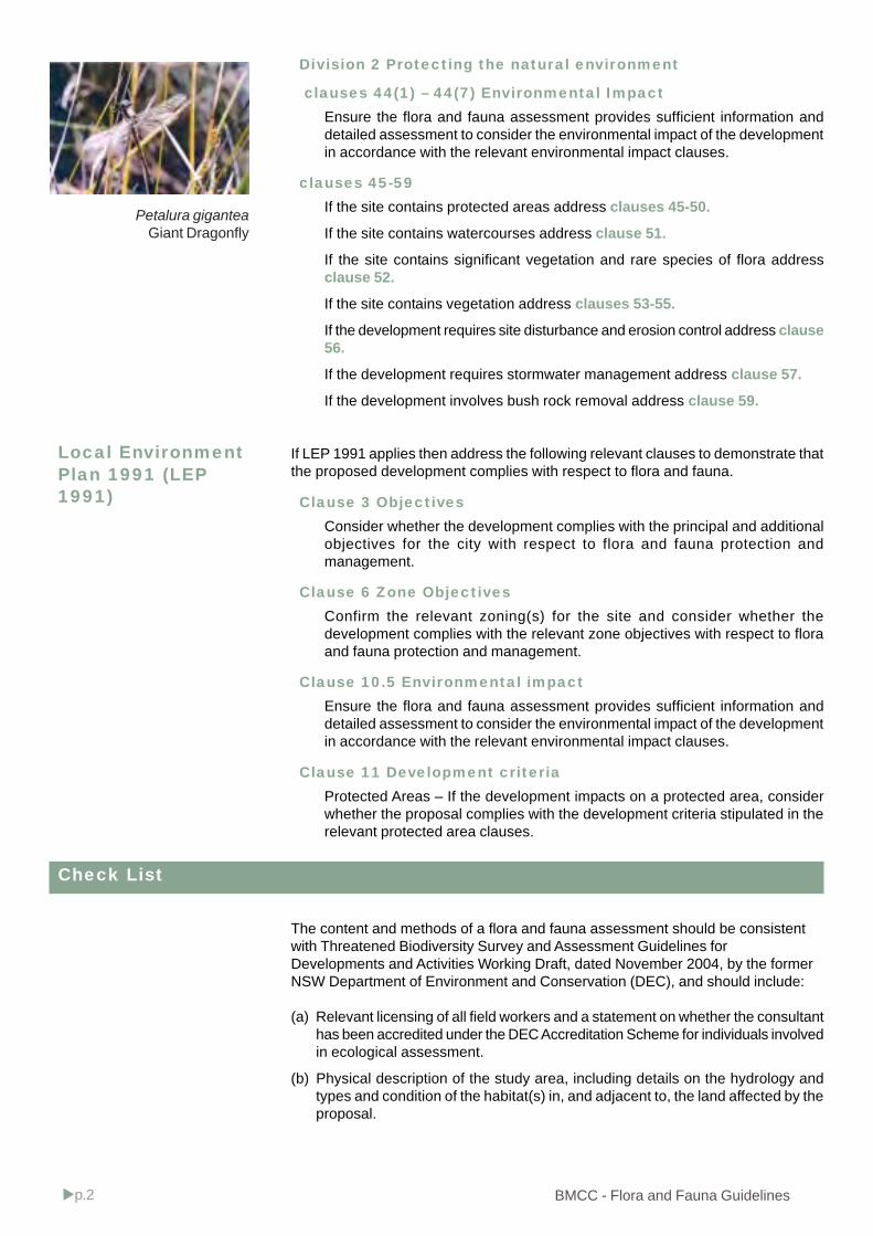
BMCC - Flora and Fauna Guidelinesp.2
Division 2 Protecting the natural environment
clauses 44(1) – 44(7) Environmental ImpactEnsure the flora and fauna assessment provides sufficient information anddetailed assessment to consider the environmental impact of the developmentin accordance with the relevant environmental impact clauses.
clauses 45-59If the site contains protected areas address clauses 45-50.
If the site contains watercourses address clause 51.
If the site contains significant vegetation and rare species of flora addressclause 52.
If the site contains vegetation address clauses 53-55.
If the development requires site disturbance and erosion control address clause56.
If the development requires stormwater management address clause 57.
If the development involves bush rock removal address clause 59.
If LEP 1991 applies then address the following relevant clauses to demonstrate thatthe proposed development complies with respect to flora and fauna.
Clause 3 ObjectivesConsider whether the development complies with the principal and additionalobjectives for the city with respect to flora and fauna protection andmanagement.
Clause 6 Zone ObjectivesConfirm the relevant zoning(s) for the site and consider whether thedevelopment complies with the relevant zone objectives with respect to floraand fauna protection and management.
Clause 10.5 Environmental impactEnsure the flora and fauna assessment provides sufficient information anddetailed assessment to consider the environmental impact of the developmentin accordance with the relevant environmental impact clauses.
Clause 11 Development criteriaProtected Areas – If the development impacts on a protected area, considerwhether the proposal complies with the development criteria stipulated in therelevant protected area clauses.
The content and methods of a flora and fauna assessment should be consistentwith Threatened Biodiversity Survey and Assessment Guidelines forDevelopments and Activities Working Draft, dated November 2004, by the formerNSW Department of Environment and Conservation (DEC), and should include:
(a) Relevant licensing of all field workers and a statement on whether the consultanthas been accredited under the DEC Accreditation Scheme for individuals involvedin ecological assessment.
(b) Physical description of the study area, including details on the hydrology andtypes and condition of the habitat(s) in, and adjacent to, the land affected by theproposal.
Local EnvironmentPlan 1991 (LEP1991)
Check List
Petalura giganteaGiant Dragonfly
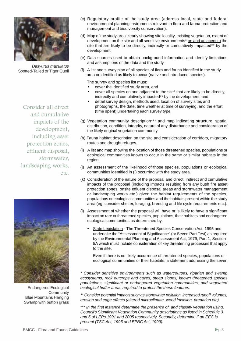
BMCC - Flora and Fauna Guidelines p.3
(c) Regulatory profile of the study area (address local, state and federalenvironmental planning instruments relevant to flora and fauna protection andmanagement and biodiversity conservation).
(d) Map of the study area clearly showing site locality, existing vegetation, extent ofdevelopment on the site and all sensitive environments* on and adjacent to thesite that are likely to be directly, indirectly or cumulatively impacted** by thedevelopment.
(e) Data sources used to obtain background information and identify limitationsand assumptions of the data and the study.
(f) A list and survey plan of all species of flora and fauna identified in the study area or identified as likely to occur (native and introduced species).
The survey and species list must:cover the identified study area, andcover all species on and adjacent to the site* that are likely to be directly,indirectly and cumulatively impacted** by the development, anddetail survey design, methods used, location of survey sites andphotographs, the date, time weather at time of surveying, and the effort(time spent) undertaking each survey type.
(g) Vegetation community description*** and map indicating structure, spatialdistribution, condition, integrity, nature of any disturbance and consideration ofthe likely original vegetation community.
(h) Fauna habitat description on the site and consideration of corridors, migratoryroutes and drought refuges.
(i) A list and map showing the location of those threatened species, populations orecological communities known to occur in the same or similar habitats in theregion.
(j) An assessment of the likelihood of those species, populations or ecologicalcommunities identified in (i) occurring with the study area.
(k) Consideration of the nature of the proposal and direct, indirect and cumulativeimpacts of the proposal (including impacts resulting from any bush fire assetprotection zones, onsite effluent disposal areas and stormwater managementor landscaping works etc.) given the habitat requirements of the species,populations or ecological communities and the habitats present within the studyarea (eg. consider shelter, foraging, breeding and life cycle requirements etc.).
(l) Assessment of whether the proposal will have or is likely to have a significantimpact on rare or threatened species, populations, their habitats and endangeredecological communities as determined by:
• State Legislation - The Threatened Species Conservation Act, 1995 andundertake the “Assessment of Significance” (or Seven Part Test) as requiredby the Environmental Planning and Assessment Act, 1979, Part 1, Section5A which must include consideration of key threatening processes that applyto the site.
Even if there is no likely occurrence of threatened species, populations orecological communities or their habitats, a statement addressing the seven
Endangered EcologicalCommunity
Blue Mountains HangingSwamp with button grass
Dasyurus maculatusSpotted-Tailed or Tiger Quoll
* Consider sensitive environments such as watercourses, riparian and swampecosystems, rock outcrops and caves, steep slopes, known threatened speciespopulations, significant or endangered vegetation communities, and vegetatedecological buffer areas required to protect the these features.
** Consider potential impacts such as stormwater pollution, increased runoff volumes,erosion and edge effects (altered microclimate, weed invasion, predation etc).
*** In the first instance determine the presence of, and classify vegetation using,Council’s Significant Vegetation Community descriptions as listed in Schedule 3and 5 of LEPs 1991 and 2005 respectively. Secondly, determine if an EEC ispresent (TSC Act, 1995 and EPBC Act, 1999).
.
Consider all directand cumulativeimpacts of thedevelopment,
including assetprotection zones,effluent disposal,
stormwater,landscaping works,
etc.
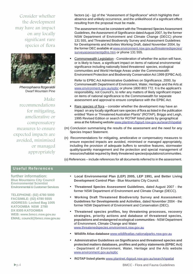
BMCC - Flora and Fauna Guidelinesp.4
factors (a) - (g) of the “Assessment of Significance” which highlights theirabsence and unlikely occurrence, and the unlikelihood of a significant effectresulting from the proposal must be made.
The assessment must be consistent with the Threatened Species AssessmentGuidelines, the Assessment of Significance dated August 2007, by the formerNSW Department of Environment and Climate Change (DECC) phone131 555, and Threatened Biodiversity Survey and Assessment Guidelinesfor Developments and Activities Working Draft, dated November 2004, bythe former DEC available at www.environment.nsw.gov.au/threatenedspecies/surveyassessmentgdlns.htm or phone 131 555.
• Commonwealth Legislation - Consideration of whether the action will have,or is likely to have, a significant impact on items of national environmentalsignificance including nationally listed threatened species, ecologicalcommunities and World Heritage Areas under the CommonwealthEnvironment Protection and Biodiversity Conservation Act 1999 (EPBC Act).
Refer to EPBC Act Administrative Guidelines on Significance, 2000, byCommonwealth Department of Environment, Water, Heritage and the Arts atwww.environment.gov.au/epbc or phone 1800 803 772. It is the applicant’sresponsibility, not Council’s, to refer any matters of likely significant impacton items of national significance to the Commonwealth for separateassessment and approval to ensure compliance with the EPBC Act.
• Rare species of flora – consider whether the development may have animpact on any locally significant rare species of flora as listed in the publicationentitled “Rare or Threatened Australian Plants” (ROTAP), Briggs and Leigh,1995 Revised Edition or search for ROTAP listed plants by geographicalarea at the following website www.plantnet.rbgsyd.nsw.gov.au/search/spatial.
(m) Conclusion summarising the results of the assessment and the need for anySpecies Impact Statement.
(n) Recommendations for mitigating, ameliorative or compensatory measures toensure expected impacts are avoided, minimised or managed appropriately,including the provision of adequate buffers to sensitive features, stormwaterquality/quantity management and the protection and special management ofresources/habitat required by likely threatened species/populations/communities.
(o) References – include references for all documents referred to in the assessment.
Useful References
Consider whetherthe development
may have an impacton any locally
significant rarespecies of flora
Makerecommendations
for mitigating,ameliorative orcompensatory
measures to ensureexpected impacts are
avoided, minimisedor managed
appropriately
further information:Blue Mountains City CouncilEnvironmental ScientistEnvironmental & Customer Services
TELEPHONE: (02) 4780 5000FACSIMILE: (02) 4780 5555ADDRESS: Locked Bag 1005KATOOMBA NSW 2780DX 8305 KATOOMBAWEB: www.bmcc.nsw.gov.auEMAIL: [email protected]
Pherosphaera fitzgeraldiiDwarf Mountain Pine
• Local Environmental Plan (LEP) 2005, LEP 1991, and Better LivingDevelopment Control Plan - Blue Mountains City Council.
• Threatened Species Assessment Guidelines, dated August 2007 - theformer NSW Department of Environment and Climate Change (DECC).
• Working Draft Threatened Biodiversity Survey and Assessment:Guidelines for Developments and Activities, dated November 2004 - theformer NSW Department of Environment and Conservation (DEC).
• Threatened species profiles, key threatening processes, recoverystrategies, priority actions and database of threatened species,populations and endangered ecological communities - NSW Departmentof Environment, Climate Change and Waterwww.threatenedspecies.environment.nsw.gov.au
• Wildlife Atlas database www.wildlifeatlas.nationalparks.nsw.gov.au
• Administrative Guidelines on Significance and threatened species andprotected matters databases, profiles and policy statements (EPBC Act)- Department of Environment, Water, Heritage and the Arts websitewww.environment.gov.au/epbc
• ROTAP listed plants www.plantnet.rbgsyd.nsw.gov.au/search/spatial
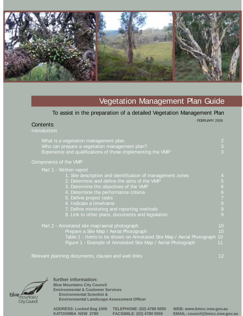
further information:Blue Mountains City CouncilEnvironmental & Customer Services
Environmental Scientist &Environmental Landscape Assessment Officer
ADDRESS: Locked Bag 1005KATOOMBA NSW 2780
TELEPHONE: (02) 4780 5000FACSIMILE: (02) 4780 5555
Vegetation Management Plan GuideTo assist in the preparation of a detailed Vegetation Management Plan
WEB: www.bmcc.nsw.gov.auEMAIL: [email protected]
Introduction
What is a vegetation management plan. 2Who can prepare a vegetation management plan? 3Experience and qualifications of those implementing the VMP 3
Components of the VMP
Part 1 - Written report1. Site description and identification of management zones 42. Determine and define the aims of the VMP 53. Determine the objectives of the VMP 64. Determine the performance criteria 65. Define project tasks 76. Indicate a timeframe 97. Define monitoring and reporting methods 98. Link to other plans, documents and legislation 9
Part 2 - Annotated site map/aerial photograph 10Prepare a Site Map / Aerial Photograph 10Table 1 - Items to be shown on Annotated Site Map / Aerial Photograph 10Figure 1 - Example of Annotated Site Map / Aerial Photograph 11
Relevant planning documents, clauses and web links 12
ContentsFEBRUARY 2009
p.2 Adopted date
Vegetation Management Plan Guide
Introduction
What is a Vegetation Management Plan and why is it required?
A Vegetation Management Plan (VMP) is a map based report intended to assist the property owner or occupier inmanaging their development site (planned or existing) in order to ensure that existing bushland elements on theirland are protected from excessive human induced disturbance. A VMP is generally a requirement on sites wherethere are number of environmental constraints or high level ecological values. It should contain a concise writtenreport (Part 1) and a map or plan drawing (Part 2) of the study area.
A VMP is generally required to ensure that development and ongoing site management;achieves the relevant objectives identified within Council’s Local Environmental Plan (LEP) 2005, LEP 1991 andBetter Living Development Control Plan (DCP) andis consistent with other related environmental legislation and policies, for example Threatened SpeciesConservation Act 1995, the Noxious Weeds Act 1993 the Water Management Act 2002, and guidelines such asthe Rural Fire Services Planning for Bushfire Protection 2006, andmitigate impacts of urban development upon remnant bushland areas.
A VMP must provide quantifiable goals and strategies that help to conserve specific site elements including theecological processes operating on the site, where these processes have been or are likely to be, affected byconstruction or land modification activities.
Doing so will also help to conserve the natural heritage of the Blue Mountains by managing and reducing the directand cumulative impacts of development upon natural areas, including the World Heritage listed Blue MountainsNational Park and upon the numerous Endangered Ecological Communities (EEC’s)*, locally significant ecologicalcommunities** and the rare and threatened flora and fauna species that occur in the Blue Mountains localgovernment area.
A Vegetation Management Plan may be required:prior to or as a condition of development consent, written as Part Two of the Flora and Fauna report (where suchis required) or as a separate report, orfollowing unauthorised activities, such as land clearing, including hazard reduction without a relevant approval,orwhere harm has occurred on a development site as a result of poor site management, oras a supplement or to replace a landscape plan, orin order to comply with the Noxious Weeds Act 1993.
A vegetation management plan is not required for works approved under a Bushfire Hazard reduction certificate, or ahazard reduction Notice under s 66 of the Rural Fires Act.
To ensure adequate vegetation management prior to works, during construction and following completion of worksthe recommendations within the VMP may be incorporated by Council into the conditions of consent (if relevant) andmay be subject to a restriction of the land use or positive covenant under Section 88B or 88E respectively of theConveyancing Act, 1919.
The VMP is linked to the site, rather than the owner or the consultant, and applies to the site for the life of the development.
* Current applicable EEC’s as listed under Schedule 1, 1A and 2 of the Threatened Species Conservation Act, 1995and as listed under the Environment Protection and Biodiversity Conservation Act, 1999.
** Environmentally sensitive or significant vegetation communities listed under Schedule 3 and 5 of LEP 1991 and2005 respectively.

p.3Adopted Date
Vegetation Management Plan Guide
Who can prepare a Vegetation Management Plan?
The VMP must be prepared by an Environmental Consultant or Bush Regenerator with theoretical and practicalexperience in bushland restoration and management, including weed control, preferably with experience relevant tothe local government area. This is a requirement under the following circumstances:
for the rehabilitation of unauthorised clearing,where Environmental Constraint Areas or Ecological Buffer Areas are affected,where significant rare or threatened species/habitat matters are present,where the Asset Protection Zone is to be permitted within an Environment Protection zone,where vegetation management is required over a large area, greater than 1,000m2, andwhere any other special circumstances occur, or as otherwise required by Council.
However, under certain circumstances individual landowners may prepare the VMP with the assistance of Council’sEnvironmental Officers.
Experience and qualifications of those implementing the VMP
Council may specify that, owing to the sensitivity of the site, the complexity of the restoration tasks or the necessityfor the works to be completed within a restricted time frame, that suitably qualified personnel with specialist skillsrelevant to the situation be engaged to implement the Plan.
Details of those involved in project would need to be supplied if the area requiring regeneration is significant or lieswithin an EEC.
As a guide, the Australian Association of Bush Regenerators (AABR) considers a minimum of the BushlandRegeneration Certificate II/Natural Area Restoration Certificate III, plus 500 hours of practical bushland regenerationunder an experienced supervisor is expected of those being employed as trained regenerators. Supervisors wouldbe required to have at least some supervisory experience,preferably a higher qualification and a minimum of 700 hoursbush regeneration. All personnel engaged in chemical weedcontrol would be expected to have attained a minimum AQF IIIlevel in Chemical Application.
However, it is not always a requirement for persons involved inthe implementation of the VMP tasks, to hold ecologicalrestoration qualifications and experience. Thus determinationcan be made on a case by case basis.
It is often quite appropriate for the individual landowner toundertake the works themselves, particularly when a planestablishes a strategy that runs over a number of years. If indoubt, ask relevant Council staff to clarify this aspect.
Introduction
Moist Basalt Cap Forest

p.4 Adopted date
Vegetation Management Plan Guide
Components of the VMP - Part 1 - Written Report
Specify the current nature, extent and condition of site vegetation and describe the broader contextof the site within its catchment. Detail site constraints, and any significant or sensitiveenvironmental features.
Identify the location and extent of THE SITE to be covered by the plan and any adjoining areasconsidered relevant to the plan (the study area).
Determine which Local Environment Plan (LEP), zoning and any protected areas that apply to thesite using the interactive maps on Councils website www.bmcc.nsw.gov.au (Mapped environmentalfeatures should be verified on site.)
For the sake of clarity, it is important to identify and name management zones within the site.There is no limit to the number of zones identified, but ensure that the zones reflect either sitefeatures or proposed aspects of the development.
1. Site description and identification of management zones
Management zones that may be applicable include:construction zone,inner and outer asset protection zones (APZ’s),on-site effluent and stormwater disposal areas,landscaped areas including streetscape/front setback,bushland and/or areas requiring conservation and/or restoration,threatened species, environmentally sensitive or significant vegetation communities and their buffers,groundwater recharge zones and/or overland flow paths, andriparian or wildlife corridors.
The location, numbers and extent of the management zones applicable to the subject site need to be demonstratedon the VMP plan/map drawing.
Completed
1.1
1.2
1.3
1.4

p.5Adopted Date
Vegetation Management Plan Guide
2. Determine and define the aims of the VMP
Both LEP 2005 and LEP 1991 require development in areas containing bushland elements toincorporate the conservation and enhancement of the ecological integrity, environmental heritage,ecological significance and bushland amenity values of the Blue Mountains.
Therefore as far as is practicable, and notwithstanding a general requirement to provide andmaintain an asset protection zone around current and proposed dwellings, areas of existing nativevegetation and key habitat features are to be protected at all stages during construction and forthe life of the development. This must be considered when developing the aims of the VegetationManagement Plan.
Components of the VMP - Part 1 - Written Report
Completed
2.1
2.2
Identify the relevant LEP clauses (refer to Table 2) and requirements for vegetationmanagement (e.g. conditions of consent or directives of the compliance notice) relating to thesite. These clauses and requirements will establish the main aims (target condition) andobjectives (goals to achieve the target condition) for the VMP.
Determine and state the current and target condition of the site following the proposed works.The target condition becomes the aim of the project.
The ‘current condition’ of the site should be detailed within a statement describing the currentform, diversity, complexity, health and resilience of the bushland covered by the VMP. Thisstatement should be accompanied by a series of photographs taken from establishedreference points.
Habitat features on site should be identified and protected by the VMP
p.6 Adopted date
Vegetation Management Plan Guide
Objectives for a VMP may include but are not limited to, the following:establishment of environmentally sensitive APZ’s by the selective removal of vegetation components in amanner that is acceptable to the consent authority (consistent with the relevant LEP objectives and the principlesof Planning for Bushfire Protection 2006);conservation or selection of appropriate landscape species and on site tree management;limiting impacts on threatened, endangered, vulnerable or a locally significant flora and fauna species orecological communities by their conservation, provision of an adequate native vegetation buffers andameliorative measures;retaining and restoring vegetation and trees within mapped or otherwise identified protected areas;management of vegetation to achieve optimum and effective nutrient uptake and removal function of an on-siteeffluent disposal system;selecting and maintaining vegetation that stabilises soils or that absorbs run-off from accumulation points on thesite, or that contributes to the optimum and effective functioning of Water Sensitive Urban Design (WSUD)stormwater management devices;retaining or reinstatement of vegetation and trees that contribute to wildlife corridors or provide habitat for nativefauna;restoration of degraded areas resulting from unauthorised clearing, stormwater erosion, sediment deposition orother degrading factors;removal of noxious and environmental weeds in a manner that is environmentally sustainable.
Performance criteria may include, but not be limited to:a site with rare plant species may include the specific number, location and condition of the rare plant speciesthat are to remain following the completion of site works;the percentage area of groundcovers or shrubs to remain following implementation of an asset protection zone;the percentage survival rate for plantings in a riparian zone 12 months after establishment;the species diversity and density of a bushland regeneration zone following 12 months of management;the percentage weed coverage 12 months following primary weed control.
Components of the VMP - Part 1 - Written Report
Commonly the main objectives for a VMP relate to the need to protect sensitive site features andto mitigate the impacts of proposed works. This may require specific vegetation management toachieve a stated goal within identified management zones.
3. Determine the objectives of the VMP Completed
3.1
4. Determine performance criteria
State how the success of the strategies will be assessed (specific performance criteria).
Performance criteria should be identified for each objective and must be specific andmeasurable. They are expressed as either qualitative or quantitative statements that define howthe success of the VMP in achieving the stated objectives will be determined.
Completed
4.1
4.2

p.7Adopted Date
Vegetation Management Plan Guide
PROJECT TASKS FOR A VMP MAY INCLUDE BUT ARE NOT LIMITED TO, THE FOLLOWING:Site management - general
Provision of temporary or permanent fencing of features to be protected, including specifications of fence type;Soil remediation techniques and/or surface preparation and / or stabilisation of disturbed areas (scarifying, deepripping, mulching, erosion matting, sterile cover crops, binding sprays etc.);decommissioning, soil stabilisation and vegetative rehabilitation areas affected by temporary erosion andsedimentation controls.
Stormwater, wastewater and hydrological functionErosion and sediment controls, type, location and maintenance, where relevant;Undertaking revegetation of WSUD stormwater quantity and quality treatments or on-site effluent disposal areas,including selection of nutrient tolerant native species and plant establishment densities for optimumperformance;Restoration of appropriately sized riparian zones, detailing stabilisation measures and locally indigenous speciesto be provided, with planting densities included.
Asset Protection Zone management - specific and detailed vegetation and soil management strategies need to beoutlined, including:
Extent of modification (slashing, pruning, thinning, tree removal, resultingcanopy separation, retained shrub cluster dimensions) of existingvegetation proposed, being the minimum required to comply withPlanning for Bushfire Protection 2006;Specifications required to protect natural bushland values byretaining elements of all stratum, representing all age classes andmaintaining species diversity;Nature of habitat features to be retained or provided (forage trees,habitat hollows and ground or shrub layer shelter), and how theywill be identified and protected during site works;Where appropriate, species targeted for priority removal andretention;Fuel reduction frequency, access management and methodincluding machinery and equipment to be employed, and limits totheir use in relation to any slope or other constraints;Vegetative waste management, reuse and/or disposal etc,including tree stumps and logs.
Components of the VMP - Part 1 - Written Report
5. Define project tasks
Describe with sufficient detail each task necessary for the implementation of the plan, describewhere each task is to be carried out (identify all tasks required for each management zone),how each will be done, the duration and completion dates, the priority order and who will beresponsible for undertaking each task.
Completed
5.1

p.8 Adopted date
Vegetation Management Plan Guide
Components of the VMP - Part 1 - Written Report
Regeneration, revegetation, weed controlSpecific activities designed to enhance a sites recovery potential, for example brush matting, direct seeding,bushland regeneration techniques to stimulate spontaneous recovery;Using locally sourced (provenance) indigenous plant material, comprised of nutrient and/or disturbance tolerantspecies to provide a buffer around ecologically sensitive areas or features;Vegetation salvage and transplant from donor (development) to recipient (area requiring restoration) areas,including indicative species and timing of activity;Restoration and/or enhancement of, fauna habitat and/or corridor connectivity by reinstatement of absent stratumelements (canopy, mid-storey or groundcover);Restoration of a vegetation community through selective planting, including proposed species schedule andplanting density for areas requiring reinstatement of local provenance plant species;Methods of Weed control (proposed techniques and priorities) in accordance with current guidelines andstandards - refer Table 2. Include removal strategies, timing, constraints, herbicides to be used, and wastedisposal and where relevant, the recommended qualifications of those to undertake the work;Any other ameliorative measures to limit impacts on threatened, endangered, vulnerable or a locally significantflora or fauna species or ecological communities.
Restoration of a riparian corridor through selective planting
Blue Gum RiverflatForest
Riverbank stabilisation and rehabiiliation works

p.9Adopted Date
Vegetation Management Plan Guide
Components of the VMP - Part 1 - Written Report
6. Indicate a timeframe
If the site is large and the proposed works complex you may need to prepare a Gantt chart toreflect the staging of works.
Address all tasks in the project, frequency of visits and number of hours required to completethe project.
Completed
Completed
6.1
6.2
Completed
7.2
7.1
7. Define monitoring and reporting methods
Monitoring and reporting the progress and success should be provided on a 6-12 monthly basis for aminimum 2 year period (or as otherwise specified). Council will monitor the satisfactory completionof specified targets in the VMP at mandatory critical stage inspections and/or at other nominatedtimes, including prior to the issue of the Occupation or Subdivision Certificate.
Specify the methods and responsibility for evaluating the achievement of the performancecriteria and the target condition specified within the VMP.
Nominate a report style, either the provision of a brief written report addressing the progress,performance criteria and any problems encountered in the plans implementation AND/OR aseries of photographs, taken from established reference points.
Where any proposed strategies have been amended of necessity, this should be discussed.
8. Link to other plans, documents and legislation
Show how the VMP links with any other plans, documents or legislation that relate to thedevelopment. For example the Erosion and Sediment Control Plan, Landscape Plan, ThreatenedSpecies Recovery Plans, Noxious Weed Management Plans etc.
Recommendations within the VMP must be consistent with other legislation such as the Rural FiresAct, 1997, The Water Management Act, 2000, Threatened Species Conservation Act, 1995,Environment Protection and Biodiversity Conservation Act, 1999, Noxious Weeds Act, 1993,Drinking Water Catchment Regional Environmental Plan (REP) No 1.
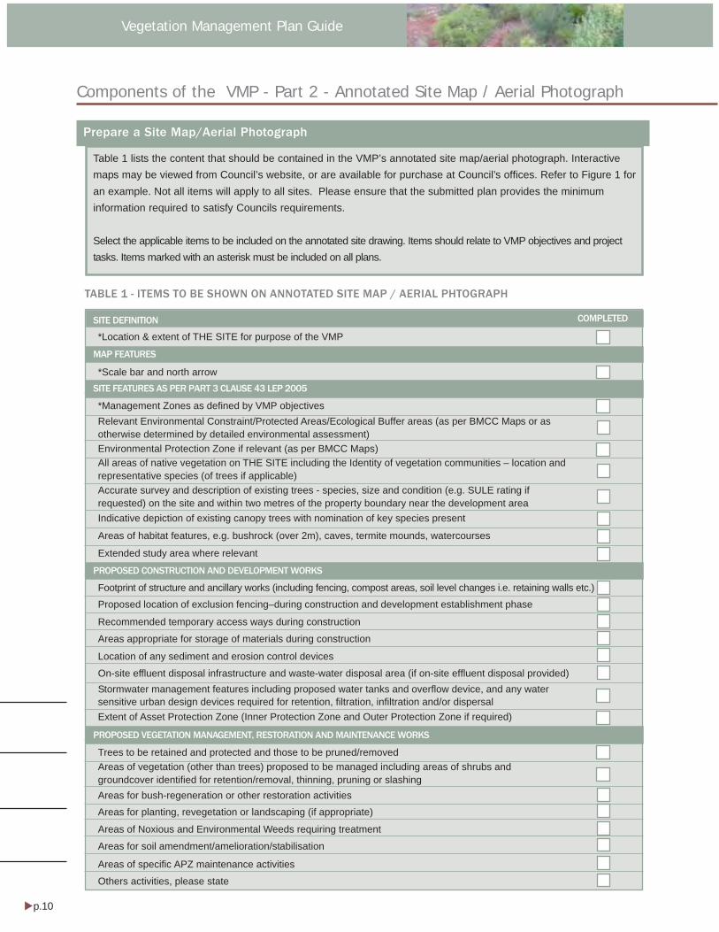
p.10 Adopted date
Vegetation Management Plan Guide
Components of the VMP - Part 2 - Annotated Site Map / Aerial Photograph
Prepare a Site Map/Aerial Photograph
Table 1 lists the content that should be contained in the VMP’s annotated site map/aerial photograph. Interactivemaps may be viewed from Council’s website, or are available for purchase at Council’s offices. Refer to Figure 1 foran example. Not all items will apply to all sites. Please ensure that the submitted plan provides the minimuminformation required to satisfy Councils requirements.
Select the applicable items to be included on the annotated site drawing. Items should relate to VMP objectives and projecttasks. Items marked with an asterisk must be included on all plans.
TABLE 1 - ITEMS TO BE SHOWN ON ANNOTATED SITE MAP / AERIAL PHTOGRAPH
*Location & extent of THE SITE for purpose of the VMP
*Scale bar and north arrow
*Management Zones as defined by VMP objectivesRelevant Environmental Constraint/Protected Areas/Ecological Buffer areas (as per BMCC Maps or asotherwise determined by detailed environmental assessment)Environmental Protection Zone if relevant (as per BMCC Maps)All areas of native vegetation on THE SITE including the Identity of vegetation communities – location andrepresentative species (of trees if applicable)Accurate survey and description of existing trees - species, size and condition (e.g. SULE rating ifrequested) on the site and within two metres of the property boundary near the development area
Areas of habitat features, e.g. bushrock (over 2m), caves, termite mounds, watercourses
Extended study area where relevant
Indicative depiction of existing canopy trees with nomination of key species present
Footprint of structure and ancillary works (including fencing, compost areas, soil level changes i.e. retaining walls etc.)
Proposed location of exclusion fencing–during construction and development establishment phase
Recommended temporary access ways during construction
Areas appropriate for storage of materials during construction
Location of any sediment and erosion control devices
On-site effluent disposal infrastructure and waste-water disposal area (if on-site effluent disposal provided)Stormwater management features including proposed water tanks and overflow device, and any watersensitive urban design devices required for retention, filtration, infiltration and/or dispersalExtent of Asset Protection Zone (Inner Protection Zone and Outer Protection Zone if required)
Trees to be retained and protected and those to be pruned/removedAreas of vegetation (other than trees) proposed to be managed including areas of shrubs andgroundcover identified for retention/removal, thinning, pruning or slashingAreas for bush-regeneration or other restoration activities
Areas for planting, revegetation or landscaping (if appropriate)
Areas of Noxious and Environmental Weeds requiring treatment
Areas for soil amendment/amelioration/stabilisation
Areas of specific APZ maintenance activities
Others activities, please state
SITE DEFINITION
MAP FEATURES
SITE FEATURES AS PER PART 3 CLAUSE 43 LEP 2005
PROPOSED CONSTRUCTION AND DEVELOPMENT WORKS
PROPOSED VEGETATION MANAGEMENT, RESTORATION AND MAINTENANCE WORKS
COMPLETED
p.11Adopted Date
Vegetation Management Plan Guide
Components of the VMP - Part 2 - Annotated Site Map / Aerial Photograph
FIGURE 1 - EXAMPLE OF ANNOTATED SITE MAP/AERIAL PHOTOGRAPH
The example below of a site map/ aerial photograph plan indicates the site, its environmental features, managementzones and proposed works.
LEGEND
The site
Eucalyptus sieberi - Eucalyptus piperitaforest (conservation)
Blue Mountains Swamp EndangeredEcological Community (conservation)
Threatened species recorded (Eulamprusleuraensis, Petalura gigantea, Persooniaacerosa)
Ecological buffer to Blue Mountains Swamp(conservation)
Retained bushland (conservation, no fuelreduction, bush regeneration)
Outer protection zone boundary (limited fuelreduction as per PBP 2006 by RFS and bushregeneration within the limits of an APZ)
Inner protection zone boundary (fuelreduction as per PBP 2006 by RFS and bushregeneration within the limits of an APZ)
Threatened flora protection zone(conservation and bush regeneration)
Stormwater Management zone
Nutrient absorption filter strip
Development area (road, driveway, buildings)
Construction zone
Retained bushland (streetscape/privacy)
Lilly Pilly creek

p.12 Adopted date
Vegetation Management Plan Guide
RELEVANT PARTS/ CLAUSESLEP 2005
PART 2 DIVISION 218-31 Zone Objectives
PART 3 DIVISION 1 SITE ANALYSIS42 Site analysis plan 3.143 Contents of site analysis plan
PART 3 DIVISION 2 PROTECTING THE NATURALENVIRONMENT44 Environmental impact45 Protected Area—Slope Constraint46 Protected Area—Vegetation
Constraint47 Protected Area—Ecological Buffer48 Protected Area—Water Supply
Catchment49 Protected Area—Escarpment50 Protected Area—Riverine Scenic
Quality Corridor51 Watercourses52 Significant vegetation communities
and rare species of flora53 Retention and management of
vegetation54 Preservation of trees54A Bushland protection55 Weed management56 Site disturbance and erosion control57 Stormwater management58 Modification of land form59 Bush rock removal65 Landscaping for residential
development66 Detailed landscape plan for certain
residential development67 Private open space and gardens for
certain residential development
PART 3 DIVISION 5 BUSH FIRE PROTECTION78 Consideration of bush fire protection79 Bush fire protection objectives80 Asset protection zones81 Bush fire protection for residential
subdivision and development82 Special fire protection purposes83 Bush fire protection for infill
development84 Access to bush fire prone land
PART 4 DIVISION 190(8) Subdivision lot layout to retain
existing vegetation where possible
SCHEDULE 5: SIGNIFICANT VEGETATIONCOMMUNITIES
website: www.bmcc.nsw.gov.au/citydevelopment/localenvironmentalplans/lep2005writteninstrument
3. OBJECTIVES6. ZONE OBJECTIVES6.1 Zone: Rural Conservation (RC)6.2 Zone: Bushland Conservation (BC)6.3 Zone: Residential Bushland
Conservation (RES-BC)6.8 Zone: Environmental Protection
(EP)
7. PROTECTED AREAS OBJECTIVES7.1 Canopy Conservation7.2 Environmental Constraint Area7.3 Escarpment Area7.4 Land Between Towns7.5 Water Supply Catchment Area
10. DEVELOPMENT CRITERIA - GENERAL10.1 Any Development10.5 Environmental Impact10.11 Tree Preservation
11. DEVELOPMENT CRITERIA PROTECTEDAREAS
SCHEDULE 3: ENVIRONMENTALLY SENSITIVEVEGETATION UNITS
website: www.bmcc.nsw.gov.au/citydevelopment/localenvironmentalplans
PART B: SITE PLANNINGSite Analysis and DesignBetter Living DCP Part
C GENERAL PRINCIPLESC1. PROTECTING THE NATURALENVIRONMENTC1.1 BiodiversityC1.2 WeedsC1.3 StormwaterC1.4 Site managementC2. Character and Landscape
AssessmentC2.1 Streetscape and characterC2.2 Landscaping
PART F2. WEEDS OF THE BLUE MOUNTAINSA list of noxious and environmentalweeds.
website: www.bmcc.nsw.gov.au/citydevelopment/developmentplanspoliciesandguides/betterlivingdcp
NSW RFS PLANNING FOR BUSHFIREPROTECTION 2006
APPENDIX 2Determining Asset Protection Zones
APPENDIX 5Bushfire Provisions – Landscaping andproperty maintenance
STANDARDS FOR ASSET PROTECTIONZONESwebsite: http://www.rfs.nsw.gov.au
RELEVANT PARTS/ CLAUSESLEP 1991
RELEVANT PARTS/CLAUSESBETTER LIVING DCP
TABLE 2 - RELEVANT PLANNING DOCUMENTS AND CLAUSES
Relevant Planning Documents, Clauses and Web links
USEFUL LINKS
AABR (Australian association of bush regenerators) http://www.aabr.org.au/index.phpNoxious weeds information kit http://www.bmcc.nsw.gov.au/councilservices/noxiousweedsAustralian Network for plant conservation http://www.anbg.gov.au/anpc/web.htmlNSW DECC Threatened species http://www.environment.nsw.gov.au/threatenedspecies/index.htmDECC Threatened species assessment guides http://www.environment.nsw.gov.au/threatenedspecies/tsaguide.htmAtlas of NSW wildlife http://wildlifeatlas.nationalparks.nsw.gov.au/wildlifeatlas/watlas.jspThe introduced flora of Australia and its weed status http://www.weedscrc.org.au/documents/intro_flora_australia.pdfPlantNET http://plantnet.rbgsyd.nsw.gov.auAustralian Plant name Index http://www.anbg.gov.au/cpbr/databases/apni.htmlAustralian Pesticides and Veterinary Medicine Authority (APVMA) Registered ProductsDatabase http://services.apvma.gov.au/PubcrisWebClient/welcome.do;jsessionid=GLxdxXd0tR0PM3JDSpGLgq1FNQCdc0vnGreening Australia Resources http://www.greeningaustralia.org.au/resources/resources

Waste Management Strategies for
Development Guide
www.bmcc.nsw.gov.au/building&development
Helping You Achieve Better Resource Recovery
Contact usBlue Mountains City CouncilKATOOMBA: 2-6 Civic PlaceSPRINGWOOD:104 Macquarie Rd
POSTAL ADDRESS: Locked Bag 1005 Katoomba 2780
TELEPHONE: (02) 4780 5000 FACSIMILE: (02) 4780 5555EMAIL: [email protected]: www.bmcc.nsw.gov.au

p.2
Waste in the Blue MountainsThe building and construction industry generates a massive amount of waste in Australia. This is particularly challenging to the Blue Mountains Area due to:
• lack of space suitable for waste disposal,
• our distance from alternative disposal options and
• the unique World Heritage environmental assets that surround the area.
This guide will help you:
• avoid waste from your development
• save money on waste disposal and purchasing materials
• recover potential ‘resources’ from your waste
• Understand whether you need to submit a formal Waste Management Strategy (WMS) for your development application.
• Write a WMS for your development if required. For a sample WMS, see the Blue Mountains Document “Example of a Completed Waste management plan” available on the Blue Mountains Website.
While not all developments require submission of a formal Waste Management Strategy (WMS), Blue Mountains City Council recommends that you consider this guide in all developments as it presents a signifi cant opportunity for improved environmental outcomes and the opportunity to reduce the costs associated with your development.
When should I consider waste management for my development?Many of the best benefi ts for both you and the environment are achieved by including waste minimisation and management from the design phase of your development.
If you are contracting a builder, make sure you discuss and include waste minimisation from the outset in their contract.
Looking at waste across the lifetime of your developmentYou also need to consider how waste will be managed across the ongoing life of your development from the design stage.
This includes not only the built space and requirements for waste and recycling facilities, such as various bin storage areas and onsite compost facilities/areas, but also planning for the provision of collection services such as garbage trucks or liquid waste pump outs. These services should be able to be delivered in a way that does not unnecessarily impact on the property itself or on the amenity of neighbours or the area.
For more detailed information on waste facility design specifi cations please refer to the Better Living DCP C5.1. Information developed by the state government titled “Better Practice Guide for Waste Management in Multi Unit Dwellings” may also be of use for multi unit dwellings.
Objectives of Waste Management The ultimate goal of waste management is waste reduction through:
• Avoiding unnecessary consumption of materials
• Reducing the total additional material inputs through effi cient design,
• Reuse of the greatest portion of recycled materials from onsite
• Recycling the greatest portion of remaining material off site.
• Responsibly disposing of the smallest possible amount of waste to a licensed waste management facility.
How effective waste management benefi ts youEff ecti ve waste planning and management will benefi t you in the following ways.
• Reduce your costs through reduced material costs.
• Improve your workplace safety by keeping materials and waste stored appropriately.
• Enhance your public image through environmentally responsible management of your building site.
• Reduce your operational risk through compliance with legislation.

p.3
5 Rules of Thumb for Waste ManagementWaste management sounds complex, but really it’s about keeping in mind these fi ve simple rules of thumb:
1. AVOID
Avoiding unnecessary material use during design and construction is the simplest and most effective way to minimise waste and the best way to eliminate additional building costs. If you’re not using it, you’re not paying for it, and none of its going to waste.
Here are some Waste Avoidance Opportunities you can consider from the design phase:
• Repurpose a whole or part of an existing building. Is a renovation an alternative to demolition?
• Favour effi cient design fi t for purpose. Avoid over engineering. More materials mean greater costs, increased wastage and often higher operating/maintenance costs during the life of the development.
• Factor in the design specifi cations of the project to material sizes. If the building is designed with the material in mind additional handling and material wastage can be avoided.
• Design to landform to minimise clearing and earth work requirements.
• Select appropriately durable materials with long service life to reduce the need for replacement during the project’s service life.
2. REDUCE
Reducing your project waste will also reduce the costs of waste disposal and volumes of waste going to landfi ll.
You can achieve this if you:
• Accurately estimate material requirements to prevent over purchasing and wastage.
• Effective communication during both design and build stage is essential. A huge amount of material is wasted on Australian building sites each year due to mistakes and duplications caused by poor communication from design right through to completion.
• Consider the use of prefabricated design elements and materials.
• Take back agreements for wastage or packaging with material suppliers to reduce wastage and rubbish.
• Reduce wastage by ensuring materials are well protected prior to delivery and onsite to minimise damage.
3. REUSE
By Reusing “waste” materials generated on site you can avoid the costs of both disposal and purchasing new materials. When you demolish a building, there is a massive opportunity to salvage a range of materials cost effectively and reuse them in your new construction.
• You can maximise your reuse of materials if you stage your demolition to minimise damage to usable materials and increase opportunities for reuse.
• Design your new development to incorporate reusable materials such windows, doors and joinery from demolition.
• Prepare non load bearing formwork such as paths to reuse waste cement or concrete before it sets.
• Reuse broken brick, tile or aggregate as fi ll.
• Store onsite and then reuse earth works soil for landscaping.
• Mulch or compost organic waste from on-site for use in landscaping.
• Use carpet for sediment barriers, erosion control or weed matting onsite.
• Consider the storage requirements of reused materials. Consider moisture/rain, slope, drainage, location of water ways, vegetation and wind effects.
NOTE –Materials contaminated with hazardous substances such as asbestos must not be reused or reworked.
4. RECYCLE
Many of the waste materials generated onsite can be recycled off site in other developments or recycled to make new materials. By conserving useful materials through recycling, you can benefi t the environment, cut your disposal costs and, in some cases, offset your costs by generating income from waste.
Tips to maximise your recycling:
• Plan how you will separate and store your waste. Timbers, bricks, packaging cardboard, topsoil, clean fi ll, roof tiles and other materials can often be recycled for free if they are separated out. Other materials such as metal may generate signifi cant income to recyclers.
• Arrange separate storage areas/vessels for recyclable materials.
• Clearly sign-post waste and recycling areas to reduce accidental discarding of recyclables or contamination of recycling bins/areas with other waste.
• Discuss with suppliers possible take back schemes for wastage such as plaster board or unused cement.
• Buy/source recycled material. Using recycled materials reinforces the market, increasing the opportunities for recycling across the industry. It may also be cheaper.
• Consider using recycling exchange networks such as ”Free Cycle” (www.freecycle.org, the Waste Not Resource Exchange (wastenot.streamline.org.au) or trading posts to give or sell your non hazardous waste to someone else that can use it.

p.4
How ‘waste’ can become a valuable ‘resource’ through recycling.
Waste Stream Recycled Product
Topsoil Use by landscape supplier
Cardboard packaging New Cardboard
Crushed Concrete New Concrete
Crushed Masonry/Bricks Road Base/ Clean Fill
Offi ce Paper, Plans Recycled Paper
Scrap Plaster Board Plaster Board, Soil Amendment
Hard Plastic Waste Rubbish Bins, Pipes
Green Waste Compost
Ferrous metal Scrap Roofi ng Sheet
Non ferrous Metal New Fittings
Pallet Wrap Film New Plastic Products
Soft Wood Chipboard
Hard Wood Landscaping Projects
5. RESPONSIBLE DISPOSAL
Regardless of how well you avoid, reduce, reuse and recycle your waste some of it will inevitably require disposal. If you fail to responsibly dispose of wastes you may expose the community to hazardous materials such as solvents, lead or asbestos and face signifi cant fi nes enforced by the NSW State Government. It is important to remember that failure to dispose of materials correctly is an illegal offense. Both the dumper and the company or individual responsible for the generation of the waste may be held liable. It is your responsibility as a developer to ensure that your waste is being disposed of appropriately.
To dispose of your waste responsibly, you need to:
• Dispose of waste through an authorised waste disposal company or facility.
• Handle and dispose of hazardous wastes such as asbestos, paints and solvents appropriately. These should not be disposed of with mixed waste loads.
• For developments requiring a formal Waste Management Strategy, you must keep copies of all disposal dockets and the plan onsite. These may be inspected by council offi cers or certifi ers. This is also true for the disposal of asbestos.

p.5
1. Do I Need to Submit A Waste Management Strategy?Some developments in the Blue Mountains City Council require the submission of a formal Waste Management Strategy (WMS). The chart below outlines the developments that require submission of a WMS before a DA may be approved. However this list is not exhaustive and in some cases other forms of development may be required to issue a WMS as a condition of consent.
Type of Development Requires WMS at Applicati on Stage
Exempt & Complying Development No
Ancillary Structures No but may be required as condition of consent.
Demolition Yes as a condition of consent.
Single Dwelling Yes as a condition of consent.
Subdivision Yes
Multi Dwelling Housing Yes
Accessible Housing Yes
Commercial Buildings Yes
Industrial Buildings Yes
Road Construction Yes
2. What is a Waste Management Strategy?
A WMS outlines measures to minimise and manage waste generated during;
• Demolition
• Construction
• The ongoing use of the premises
The WMS highlights the method of recycling or disposal and the waste management service provider. It should also link to development plans with storage areas and access paths outlined.
3. How to prepare and submit your WMS Steps in the Preparation and Submission of a Waste Management Strategy
Step 1- Understand the objectives and strategies of effective waste management included in this guide.
Step 2- Familiarise yourself with the WMS pro forma.
Step 3 - Consider avoidance, reduction, reuse and disposal options from the design stage.
Step 4- Prepare a WMS .
Step 5 - Submit your Stage 1 WMS along with other DA specifi ed documents.
Step 6- Submit your Stage 2 WMS for Construction/Demolition prior to Commencement of Works.
Step 7- Submit your Stage 3 WMS for Ongoing Management prior to issue of Occupation Certifi cate.
4. Writing your WMS – what you need to include:A waste management strategy is a brief overview of waste management on the site and is split into several parts as follows;
• Cover sheet - Developments details and contacts - this can be reused for each WMS Stage.
• Stage 1 Design - Outline of waste considerations in design of the development.
• Stage 2 Demolition & Construction - Outline waste estimates and management of site wastes including site plan indicating waste storage and access paths
• Stage 3 Ongoing Management - Outline operational waste management of the development.
An example pro-forma is available on the Blue Mountains Website to help you develop and format your WMS.
EnforcementWhether your WMS is required by a condition of development consent or under a building type specifi ed by Better Living DCP you are required to retain a copy of the plan and copies of disposal receipts. This is enforceable through the development assessment and approval process of the Environmental Planning and Assessment Act, 1979.
This plan and waste disposal receipts may be required for inspection by Council Offi cers, Work Cover or the NSW EPA.
p.6
Waste Management Strategy Cover SheetPlease include cover sheet on all WMS submissions to Blue Mountains City Council
Applicant Details
Application No.
Name
Address
Phone Number(s)
Address of Development
Existing Building/ Structures.
Description of proposed development
This development achieves the waste objecti ves set out in the Blue Mountains City Council “ Bett er Living DCP and “A Guide to Waste Management Strategies for Development”.
The details on this form are the plans and provisions for minimising and managing this waste relevant to this project. A copy of this plan and all records demonstrati ng lawful disposal of waste will be retained and kept accessible for inspecti on by regulatory authoriti es such as Council, NSW EPA & Work Cover.
Name
Signature
Date

p.7
WMS Stage 1- Design Phase
Constructi on Design
Outline how measures for waste minimisation and avoidance have been incorporated into the design, material selection and of the development:
Outline how measures for waste minimisation and avoidance have been incorporated into the material selection of the development:
Outline how measures for waste minimisation and avoidance have been incorporated into the construction techniques of the design:
APPLICATION NUMBER:

p.8
WMS Stage 2- Demolition Phase
Refer to the BMCC Guide to developing a Waste Management Strategy for objectives regarding demolition waste.
Most Favourable Least Favourable
Reuse Recycle Disposal
Type of Waste Generated
Estimated Volume (m3)
Estimated Volume (m3)
Estimated Volume (m3)
Specify on site reuse, contractor or recycling outlet and/or waste disposal depot to use.
Excavation Material
Timber
Concrete
Bricks/Pavers
Tiles
Metal
Glass
Fixtures &
Fittings
Floor Coverings (Carpet, etc.)
Garden Organics
Plastics
(pallet wrap etc)
Paper/Cardboard
Residual Waste
Hazardous Wastes e.g asbestos, lead paints. (Specify)
Other (Specify)
How will materials and waste be separated and/or stored on site for reuse, recycling and disposal.
How will the site be managed to ensure minimum waste creation and maximum reuse and recycling?
APPLICATION NUMBER:

p.9
WMS Stage 2- Construction Phase
Refer to the BMCC Guide to developing a Waste Management Strategy for objectives regarding waste management.
Most Favourable Least Favourable
Reuse Recycle Disposal
Type of Waste Generated
Estimated Volume (m3)
Estimated Volume (m3)
Estimated Volume (m3)
Specify on site reuse, contractor or recycling outlet and/or waste disposal depot to use.
Excavation Material
Timber
Concrete
Bricks/Pavers
Tiles
Metal
Glass
Fixtures &
Fittings
Floor Coverings (Carpet, etc.)
Packaging (Pallets etc )
Garden Organics
Plastic
(pallet wrap etc)
Paper/Cardboard
Residual Waste
Hazardous Wastes e.g asbestos, lead paints. (Specify)
Other (Specify)
How will materials and waste be separated and/or stored on site for reuse, recycling and disposal.
How will the site be managed to ensure minimum waste creation and maximum reuse and recycling?
APPLICATION NUMBER:
p.10
WMS Stage 3- Ongoing Management
Ongoing Management
Outline how measures for waste minimisation and avoidance will be managed and maximised during the operational life of the building.
Detail the arrangements that would be appropriate for the ongoing use of waste facilities as provided in the development. Identify each stage of waste transfer between resident’s units/commercial tenancies to storage areas and loading into the collection vehicle. Consider responsibility for and location and frequency of, transfer and collection.
APPLICATION NUMBER:
p.11
WMS Checklist Plans & DrawingsThis checklist will help ensure all necessary documentation have been submitted for approval of your application.
Please note that drawings are to be submitted to scale, clearly indicating the location and provisions for the storage and collection of waste and recyclables during;
• Design
• Demolition
• Construction
Do your plans clearly show:
Design Stage 1 Tick yes
Size and Location of waste storage areas?
Recycling bins placed next to residual waste bins?
Space provided for access and the manoeuvring of bins/equipment?
Any additional facilities i.e compactors, waste chutes etc?
Access route(s) to deposit waste/recycling in storage areas?
Access route(s) to collect waste/recycling from storage areas?
Bin carting grade?
Location of fi nal collection point?
Clearance, geometric design and strength of internal access driveways and roads?
Direction of traffi c fl ow for internal access driveways and roads?
Aesthetic design of external waste storage areas?
Signage, type and location
Construction details of storage rooms/areas including fl oors, wash down provisions, ventilation, sewer connection etc
Demoliti on/Constructi on Stage 2 Tick yes
Size and location of waste storage areas?
Access for waste collection vehicles?
Areas to be excavated?
Types and number of storage bins/vessels likely to be required?
Signage required to facilitate correct use of waste/recycling facilities?


DEFINITIONS

Defi
nit
ions
BLUE MOUNTAINS DRAFT DCP 2014 DEFINITIONS | PAGE 808
Defi nitions Note: Defi nitions from the Blue Mountains Local Environmental Plan are identifi ed by BMLEP 2013
at the end of each defi nition.
1% Annual Exceedance Probability (AEP) fl ood means a fl ood with a 1% (1:100) probability of occurring in any given year, also known as the 100 year Average Recurrence Interval (ARI).
5% AEP fl ood means a fl ood with a 5% (1:20) probability of occurring in any given year, also known as the 20 year ARI.
Aboriginal object means physical evidence of the use of an area by Aboriginal people. They can also be referred to as 'Aboriginal sites', 'relics' or 'cultural material'.
Aboriginal place means a place that was or is of special signifi cance with respect to Aboriginal culture, as defi ned in the NSW National Parks and Wildlife Act 1974 (NPW Act).
Adaptation means modifi cation of a heritage item to suit the proposed, compatible use.
Aesthetic signifi cance means an item having this value is signifi cant because it has visual or sensory appeal, landmark qualities and/or creative or technical excellence
Alter (as it applies to a heritage item or to a building or work within a heritage conservation area) means to make structural changes to the outside of the heritage item, building or work, or to make non-structural changes to the detail, fabric, fi nish or appearance of the outside of the heritage item, building or work, but not changes that involve the maintenance of the existing detail, fabric, fi nish and appearance of the outside of the heritage item, building or work.
Archaeological site means place that contained evidence of past human activity. Below-ground archaeological sites include building foundations, occupation deposits, features and artefacts. Above-ground archaeological sites include buildings, works, industrial structures and relics that are intact or ruined.
Assisted natural regeneration (the main practical approach to ecological restoration) is a staged process which aims to stimulate or “trigger” the growth of native plant propagules (such as seed, tubers or rhizomes etc.) already present on site or having the ability to migrate onto the site. This is used in preference to the use of revegetation .It generally employs low impact techniques to treat existing weed incursions and repair damaged land surfaces (including creek banks and swamps).
Building identifi cation sign means a sign that identifi es or names a building and that may include the name of a building, the street name and number of a building, and a logo or other symbol but does not include general advertising of products, goods or services.
Bunding/bunded means an impervious embankment of earth, or a wall of brick, stone, concrete or other suitable material, which may form part or all of the perimeter of an area that provides a barrier to retain liquid.

Defi
nit
ions
DEFINITIONS | PAGE 809BLUE MOUNTAINS DRAFT DCP 2014
Bush regeneration is defi ned by the Australian Association of Bush Regenerators (AABR) as meaning: “the practice of restoring bushland by focusing on reinstating and reinforcing the systems’ ongoing natural regeneration processes”.
Compatible use means use for a heritage item which involves no change to its culturally signifi cant fabric, changes which are substantially reversible or changes which make a minimal impact.
Conservation (as it applies to vegetation management) means all the processes and actions of looking after a place so as to retain its natural signifi cance and always includes protection, maintenance and monitoring. Conservation may, according to circumstance, also include regeneration, restoration, enhancement, reinstatement, preservation or modifi cation, or a combination of more than one of these. Conservation includes conserving natural processes of change (as opposed to artifi cially accelerated changes).
Conservation (as it applies to heritage) means all the processes of looking after an item so as to retain its cultural signifi cance. It includes maintenance and may, according to circumstances, include preservation, restoration, reconstruction and adaptation and will be commonly a combination of most on one of these.
Conservation management plan means a document prepared in accordance with the requirements of the NSW Heritage Branch that establishes the signifi cance of a heritage item, place or heritage conservation area, and proposes policies and management mechanisms to retain that signifi cance. It can include guidelines for additional development or maintenance of the place.
Contributory building means a building and its setting, which contributes to the heritage signifi cance of a heritage conservation area but which is not listed as a heritage item.
Contributory item means a building, work, archaeological site, tree or place and its setting, which contributes to the heritage signifi cance of the heritage conservation area. The contributory properties may have historic, aesthetic, social or scientifi c values but will most typically have historic and/or aesthetic signifi cance including streetscape value.
Critical facilities means hospitals, police, fi re, ambulance, SES stations, major transport facilities, major sewage or water supply or electricity or telecommunication plants, schools, nursing homes and retirement villages
Cultural landscape means those areas of the landscape which have been signifi cantly modifi ed by human activity and may contain various heritage items, contributory items or heritage conservation areas and act as the heritage curtilage to those items or areas. They include rural lands such as farms, villages and mining sites, as well as country towns.
Cultural signifi cance means a term frequently used to encompass all aspects of signifi cance, particularly in guideline documents such as the Burra charter. Also one of the categories of signifi cance listed in the Heritage Act 1977.

Defi
nit
ions
BLUE MOUNTAINS DRAFT DCP 2014 DEFINITIONS | PAGE 810
Curtilage means the geographical area that provides the physical context for an item, and which contributes to its heritage signifi cance. Land title boundaries and heritage curtilages do not necessarily coincide.
Damage refers to acute and obvious changes within an ecosystem.
Dead means a tree with no living vascular tissue. This includes the following symptoms such as permanent leaf loss in both deciduous and evergreen plants; permanent wilting (the loss of turgidity which is marked by the drying out of stems, leaves and roots); shedding of the epidermis (bark dries out and peels off to the beginning of the sapwood.
Degradation means any subtle or gradual decline in the quality of natural resources or natural integrity of a place or the viability of an ecosystem, caused directly or indirectly by human activities.
Degraded bushland means bushland which is either overcleared, or contains disturbed or contaminated soils, or which has lost all or some of its component stratum or species, or which is signifi cantly burdened by introduced ‘weed’ species. Degraded bushland does not represent optimal habitat for native fauna species, and it may represent a point source of weed propagules for other areas of the catchment.
Demolition means the damaging, defacing, destroying or dismantling of a heritage item or a component of a heritage conservation area, in whole or in part.
Ecological connectivity means physical or ecological events that permit the fl ow of material, organisms and ecological processes between habitat areas that are intermittently or permanently isolated in space or time.
Ecological processes means all those processes that occur between organisms, and within and between communities, including interactions with the non-living environment, that result in existing ecosystems and bring about changes in ecosystems over time.
Ecological Restoration is the process of assisting the recovery of an ecosystem that has been degraded, damaged or destroyed, The aim is to return existing habitats to a known past state or to an approximation of the natural condition.
Endangered Ecological Communities (EEC) are groups of plants and animals that occur together in a particular area, and which are listed under the Threatened Species Conservation Act 1995 (TSC Act) or the Environmental Protection and Biodiversity Conservation Act 1999 (EPBC Act) as critically endangered, endangered or vulnerable, depending on their risk of extinction.
Endemic means local and restricted to a particular area, although the level of endemism can be very broad (e.g. endemic to Australia) or very narrow (e.g. endemic to Katoomba and Leura). It may also be used to indicate locally indigenous vegetation that is ‘remnant’ on a site.
Enhancement means the introduction of additional organisms, genotypes, species or

Defi
nit
ions
DEFINITIONS | PAGE 811BLUE MOUNTAINS DRAFT DCP 2014
elements of habitat or geodiversity to those that naturally exist in a place Enhancement planting must be restricted to endemic species, and where possible, to those of ‘local’ genetic provenance.
Environmentally sensitive areas means environmentally constrained land, protected areas, springs or areas with a shallow groundwater table, environmentally sensitive or signifi cant natural areas as identifi ed in Part C1 Biodiversity and Natural Resources Section of this DCP.
Exotic plants means any plant not originating in Australia.
Fabric means all the physical material of an item, including surroundings and contents which contribute to its heritage signifi cance. In the case of a building, fabric would include materials such as brick, stone, timber, mortar, glazing, iron, steel, terracotta, plaster.
Façade means the elevation of a building facing the street. In the past the practice of retaining only the facade of buildings was regarded as a gesture in recognition of its heritage value. The Heritage Council (and Blue Mountains City Council) no longer condones this practice.
Flood planning area means land mapped on the Flood Planning map.
Form means the way that the parts of the building enclose the spaces – for example, the shape of the building and roof. The form is also infl uenced by semi-enclosed spaces around the building, such as verandahs, courtyards and carports. Elements such as chimneys, parapets and towers are part of the building’s form.
Fragmentation or habitat subdivision describes the emergence of discontinuities in an organism's preferred environment, and isolation of preferred habitat areas within a hostile environmental matrix or dissimilar and unsuitable vegetated matrix .
Freeboard means a factor of safety typically used in relation to fl oor levels, to ensure that the required standard of protection is achieved.
Height (as it applies to trees) means the distance measured vertically between the horizontal plane of the lowest point of the base of the tree/s which is immediately above ground level and the horizontal plane of the uppermost point of the tree/s.
Heritage assessment criteria mean the principles by which the values for heritage signifi cance are described and tested. The New South Wales Heritage Council has adopted criteria for the assessment of heritage signifi cance based on six core values: historic value, historic association value, aesthetic value, research value, social value, representative value and rarity value. See the publication Assessing Heritage Signifi cance published by the New South Wales Heritage Council for a detailed description of these values and how they are interpreted.
Heritage conservation area means an area which has a distinctive character of heritage signifi cance and has been provided legislative protection as a place of heritage value worthy
Defi
nit
ions
BLUE MOUNTAINS DRAFT DCP 2014 DEFINITIONS | PAGE 812
of preservation. Identifi ed on BMLEP2014 as land shown edged in blue and marked ‘heritage conservation area’ on the Heritage Conservation map.
Heritage item means a landscape, tree, place, building, structure, relic or other work of heritage signifi cance as described in Schedule 5 of BMLEP2014 and identifi ed on the Heritage Conservation map.
Heritage signifi cance means historical, scientifi c, cultural, social, archaeological, architectural, natural or aesthetic value. (BMLEP 2013)
Heritage value means the same as heritage signifi cance.
Horticulture means the cultivation of fruits, vegetables, mushrooms, nuts, cut fl owers and foliage and nursery products for commercial purposes, but does not include a plant nursery, turf farming of viticulture. (BMLEP 2013)
Imminent danger means where the structural condition of the tree in part or full is so unstable that it would be unreasonable and dangerous to delay so as to go through an approval process. An example may be obvious instability of the root system, evidence of soil uplifting, cracking, loss of structural roots, storm damage and structural defects that are imminently hazardous such as cracking/splitting of the trunk and/or main branches.
Impervious area means a hard surface area such as roof areas, roads, driveways, car parking areas or pathways that prevent the entry of water into the soil causing runoff the surface in greater quantities and at an increased rate of fl ow.
Infi ll development means new buildings sited and designed to ‘fi t in’ and respect the context within which it is located. Infi ll development occurs where there is an existing building which is to be demolished or where there is a vacant allotment.
Injury (as it applies to trees or vegetation for the purpose of the DCP) means removing a tree or vegetation; pruning, damaging, breaking or tearing of live branches and/or roots that is not carried out in accordance with AS 4373 – 2007 – Pruning of Amenity Trees); lopping (height reduction) or topping a tree; poisoning a tree or vegetation, or spilling and or damaging the root zone through directed contaminants or compaction or stripping of top soil; ringbarking, scarring or otherwise causing physical damage to the tree; underscrubbing of native vegetation, particularly carried out by mechanical tools such as brushcutters, skid steers, backhoes and the like.
Integrity (as it applies to a building or place) means the soundness, quality and condition of the fabric. A heritage item is said to have integrity if its assessment and statement of signifi cance is supported by sound research and analysis, and its fabric and curtilage are still largely intact.
Intrusive development means development which is inappropriate to the signifi cant heritage character of the heritage item or heritage conservation area due to its form, scale, bulk, materials and proportions and which adversely affects adjoining buildings, the streetscape and general character of the area.

Defi
nit
ions
DEFINITIONS | PAGE 813BLUE MOUNTAINS DRAFT DCP 2014
Landscape fabrication means the creation, through any or all of the processes of construction, land reshaping, soil amendment and replanting, of a landscaped area which is distinctly different in species diversity, composition, structure and appearance to the pre-existing bushland community on a site.
Likely habitat tree means any living or dead naturally-occurring tree (being native vegetation or remnant native vegetation) which contains one or more visible hollows (cavities within the trunk or branches) and which is suitable for the occupation of hollow-dependent fauna such as nesting birds, arboreal marsupials such as possums, or native placental mammals such as bats for the purposes of nesting, roosting and/or denning sites, or which is supporting the growth of locally indigenous or endemic epiphytic plants such as orchids.
Listed Weed Species means those declared and environmental weed species contained within Part I of this DCP, under Weeds of the Blue Mountains.
Local provenance means the specifi c plant is genetically similar to other plants naturally occurring (either currently or historically) on a site.
Local provenance plants are grown from seed that is collected from healthy plants growing near the planting site in similar environmental situations. Using plants of local provenance is important because local plants are genetically adapted to local conditions. Planting local plants increases the success of revegetation projects and decreases the risk of disrupting the local fl ora gene pool.
Local signifi cance means items that are of heritage signifi cance to the local community.
Locally indigenous species means a species that occurs at a place within its historically known natural range and that forms part of the natural biodiversity of a place.
Locally indigenous means a plant which grows ‘naturally’ (either currently or historically) in the bushland of the local area
Maintenance (as it applies to biodiversity) means the continuous protective care of the biodiversity and geodiversity of a place or ongoing care (including remedial action) of an item, comprising a single tree, area of remnant bushland or of the fabricated (created) landscape, and may include weed control or supplementary watering.
Maintenance (as it applies to heritage) means the continuous protective care of the fabric of an item and its setting or of the building within the heritage conservation area.
Modifi cation means altering a place to suit proposed uses that are compatible with the natural signifi cance of the place. Modifi cation may involve changes to safeguard the natural signifi cance of a place
Monitoring means ongoing review, evaluation and assessment to detect changes in the natural integrity or improved condition of a site, with reference to a baseline condition. Monitoring is used to assist review of decisions by providing knowledge of the effects of

Defi
nit
ions
BLUE MOUNTAINS DRAFT DCP 2014 DEFINITIONS | PAGE 814
conservation processes, and allows the consent authority to determine if objectives of the environmental protection works are being achieved.
Moveable heritage means Heritage items or parts of an item not fi xed to a site or place (for example, furniture, locomotives, archives).
Native (as it applies to trees or vegetation) means originating anywhere in Australia, and may be a cultivated variety of a native plant (cultivar).
Natural Areas (for the purpose of this DCP) means those areas comprised of indigenous vegetation and habitat features, and which are conserved and protected from incompatible recreational or other uses.
Natural heritage signifi cance means natural areas and items (as opposed to cultural items) may have natural heritage signifi cance for their evolutionary, aesthetic, technical/research and social values.
Operation of an onsite wastewater disposal system has the same meaning as to ‘operate a system of sewage management’ in accordance with Sections 68 and 68A of the Local Government Act 1993.
Overland Flow Path means the path of rain-induced surface run-off that is not part of a defi ned watercourse or natural fl ow path, including run-off in excess of the capacity of the road and property drainage system.
Pedestrian means all forms of mobility excluding cycling and vehicles.
Place means a site, area or landscape or group of works, together with associated structures, contents and surrounds.
Preservation means maintaining biodiversity of a place at the existing stage of succession, or maintaining existing geodiversity.
Preservation means maintaining the fabric of an item in its existing state and retarding deterioration. It does not include new work.
Principal building form means the original front section of a building and its main roof, which contains the main rooms.
Probable Maximum Flood (PMF) means the largest fl ood that could reasonably occur.
Proportion means the relationships between the different elements of the structure and how well they ‘sit’ together. Different building styles are characterised by different proportions, and it is important that changes respect the proportions of the original building.
Protecting means including a heritage item on a statutory list and/or making decisions about its future that ensure its heritage signifi cance is maintained.
Protection means taking care of a place or feature by managing impacts to ensure that its

Defi
nit
ions
DEFINITIONS | PAGE 815BLUE MOUNTAINS DRAFT DCP 2014
natural signifi cance and / or function is retained. It may involve the placement of fencing or barriers to introduce a physical separation between the area or item to be protected and a disturbance (e.g. construction works).
Prune or pruning means cutting branches from a tree/s in a planned and systematic manner that is carried out in accordance with the provisions of Australian Standard AS 4373 - 2007 - Pruning of Amenity Trees.
Reconstruction means returning a place as nearly as possible to a known earlier state by the introduction of new or old materials into the fabric (not to be confused with conjectural reconstruction which is not based on a known earlier state.
Reconstruction through revegetation means the introduction of locally indigenous plant species, modelled on the diversity and structural characteristics of the original vegetation community. It is carried out by planting or by re-introducing propagules.
Recruitment (as it applies to trees or vegetation) means to spontaneous or facilitated germination of seedlings of extant plant species within a community, which may ultimately represent a younger age class cohort.
Reference ecosystem or landscape means a model for planning an ecological restoration project, and may represent the ‘target condition’ for environmental protection works.
Regeneration means the recovery of natural integrity following disturbance or degradation. Regeneration applies to both the geodiversity (soils, rocks, landforms) and biodiversity of a place, and includes the process of natural succession.
Relic means any deposit, object or material evidence relating to the use or settlement of the area of the Blue Mountains, not being Aboriginal habitation, which is more than 50 years old or Aboriginal habitation of the area of the Blue Mountains commencing before or continuing after its occupation by persons of European extraction, including human remains.
Remediation means: (a) removing, dispersing, destroying, reducing, mitigating or containing the contamination of any land, or (b) eliminating or reducing any hazard arising from the contamination of any land (including by preventing the entry of persons or animals on the land).
Remnant vegetation means locally indigenous trees, shrubs and groundcovers which remain on a site following clearing of land for agriculture, development or other use.
Remove or removal means to cut down, fell, destroy, kill, take away, uproot or transplant a tree from its place of origin.
Representativeness means a value of signifi cance; an item may have this type of signifi cance because it is a fi ne representative example of an important class of signifi cant items or environments.
Resilience means the recovery of a plant community, species or ecosystem following
Defi
nit
ions
BLUE MOUNTAINS DRAFT DCP 2014 DEFINITIONS | PAGE 816
disturbance, as well as the potential of the plant community, species or ecosystem to recover after disturbance (McDonald 1996). A resilient community is one which is expected to persist and recover generally to its pre-disturbance identity and function or to an equivalent stable state, following disturbance. (Holling, 1973; Gunderson, 2000; Scheffer & Carpenter, 2003)
Restoration means returning the existing fabric of a place to a known earlier state by removing accretions or by reassembling existing components without introducing new material.
Rhythm means the repetition of elements such as windows, doors, gables and roof planes in the arrangement of the façade (elevation) of the building. It is also a term used to describe the patterns of spacing of buildings on the site or in the streetscape, where the repeated elements include the houses, fences and driveways.
Roofscape means a view or expanse of roofs including their pitch and form, and elements such as chimneys, parapets, party walls, guttering and roof materials.
Scale means the overall size of the building or element in comparison to the original, or of other buildings in the locality. It is based on the size of the footprint, height of the walls and the pitch of the roof relative to the size of the lot. New development is generally more sympathetic if it is of a smaller, or more modest, scale than the original.
Signifi cance means the same as ‘heritage signifi cance’.
Signifi cant building means a building that has historic, scientifi c, cultural, social, archaeological, natural or aesthetic value for past, present or future generations, and which is not listed as a heritage item; or a building that makes a positive contribution to the streetscape in terms of aesthetic or architectural qualities, has local or state signifi cance, or both and/or has a rarity value.
Signifi cant cultural plantings mean those plants including native plants that were planted for a deliberate purpose and which refl ect the taste or fashion of a particular period or were associated with a person or event of historical signifi cance.
Siting means the placement of the structure, both on its lot and within the wider landscape. It includes setbacks and the direction that the building faces, for example, whether it is sited parallel to the street (in the usual manner), sideways (to face the side boundary) or set on an angle relative to the street.
Soft Engineering is the use of ecological principles and practices to reduce erosion and achieve the stabilization and safety of disturbed land, stormwater channels and riparian areas. Soft engineering is achieved by using vegetation and other (generally) biodegradable materials to manage and stabilise the land-water interface and bare soil surfaces, particularly on steep land.
State signifi cant means items that have been assessed and determined by the New South Wales Heritage Council to be of heritage signifi cance to the State of New South Wales,
Defi
nit
ions
DEFINITIONS | PAGE 817BLUE MOUNTAINS DRAFT DCP 2014
and are fi ne examples, or rare, at the State community level. Listed on the State Heritage Register.
Succession means the natural process by which species composition changes over time in response to the natural development of the plant community.
Triggers means actions which may stimulate regeneration of soil stored seed or other propagules, and includes fi re or other application of heat to the soil , application of ‘smoked water’, scarifi cation of the soil surface, application of water during dry periods, weed control using mechanical means which creates soil disturbance.
Trunk means the main stem of the tree, as distinguished from the branches and roots.

Defi
nit
ions
BLUE MOUNTAINS DRAFT DCP 2014 DEFINITIONS | PAGE 818