Abstracts Blue Planet low
79
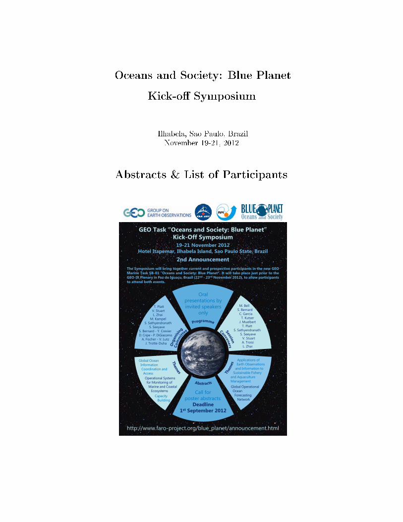
GEO Task “Oceans and Society: Blue Planet” Kick-Off Symposium 19-21 November 2012 Hotel Itapemar, Ilhabela Island, Sao Paulo State, Brazil 2nd Announcement The Symposium will bring together current and prospective participants in the new GEO Marine Task SB-01 “Oceans and Society: Blue Planet”. It will take place just prior to the GEO-IX Plenary in Foz do Iguaçu, Brazil (22 nd - 23 rd November 2012), to allow participants to attend both events. BLUE PLANET Oceans and Society http://www.faro-project.org/blue_planet/announcement.html Call for poster abstracts: Deadline 1 st September 2012 T h e m e s A b s t r a c t s T h e m e s Oral presentations by invited speakers only T. Platt V. Stuart L. Zhai M. Kampel S. Sathyendranath S. Seeyave S. Bernard - Y. Crevier D. Cripe - P. DiGiacomo A. Fischer - V. Lutz J. Trotte-Duha Global Ocean Information Coordination and Access Operational Systems for Monitoring of Marine and Coastal Ecosystems Capacity Building Applications of Earth Observations and Information to Sustainable Fishery and Aquaculture Management Global Operational Ocean Forecasting Network M. Bell S. Bernard C. Garcia T. Kutser J. Muelbert T. Platt S. Sathyendranath S. Seeyave V. Stuart A. Troisi L. Zhai O r g a n i s i ng P r o g r a m m e S e s s i o n C o m m i t t e e C o n v e n e r s
Transcript of Abstracts Blue Planet low
Oceans and Society: Blue Planet
Kick-o� Symposium
Ilhabela, Sao Paulo, Brazil
November 19-21, 2012
Abstracts & List of Participants
GEO Task “Oceans and Society: Blue Planet”Kick-Off Symposium
19-21 November 2012Hotel Itapemar, Ilhabela Island, Sao Paulo State, Brazil
2nd AnnouncementThe Symposium will bring together current and prospective participants in the new GEO Marine Task SB-01 “Oceans and Society: Blue Planet”. It will take place just prior to the GEO-IX Plenary in Foz do Iguaçu, Brazil (22nd - 23rd November 2012), to allow participants to attend both events.
BLUE PLANETOceans and Society
http://www.faro-project.org/blue_planet/announcement.html
Call for poster abstracts:
Deadline 1st September 2012
Themes Abstracts
Them
es
Oral presentations by invited speakers
only T. Platt V. Stuart L. Zhai M. Kampel S. Sathyendranath S. Seeyave S. Bernard - Y. CrevierD. Cripe - P. DiGiacomo A. Fischer - V. Lutz J. Trotte-Duha
Global Ocean Information Coordination and Access
Operational Systems for Monitoring of Marine and Coastal Ecosystems
Capacity Building
Applications of Earth Observations
and Information to Sustainable Fishery
and Aquaculture ManagementGlobal Operational Ocean Forecasting Network
M. Bell S. Bernard C. Garcia T. Kutser J. Muelbert T. Platt S. Sathyendranath S. Seeyave
V. Stuart A. Troisi L. Zhai O
rgan
ising
P
rogramme SessionCo
mm
itt
ee Conveners
Acknowledgements
The organisers gratefully acknowledge the sponsorship from the following organisations for theSymposium.
1. The Canadian Space Agency (CSA)
2. The Partnership for Observation of the Global Oceans (POGO)
3. The Group on Earth Observations (GEO)
4. The National Institute for Space Research (INPE)
Contents
1 Advances of inland water remote sensing in Brazil
Barbosa C. . . . . . . . . . . . . . . . . . . . . . . . . . . . . . . . . . . . . . . . . . . 1
2 A proposal for fisheries management and conservation Dory-teuthis plei (Teuthida: Loliginidae) in the North Coast of SãoPaulo State, Brazil
Barcellos D. D. . . . . . . . . . . . . . . . . . . . . . . . . . . . . . . . . . . . . . . . . 2
3 Study of the CH4 Concentrations on the Brazilian Coast
Basso L. S. et al. . . . . . . . . . . . . . . . . . . . . . . . . . . . . . . . . . . . . . . . 3
4 SF6 Brazilian Background Concentration
Basso L. S. et al. . . . . . . . . . . . . . . . . . . . . . . . . . . . . . . . . . . . . . . . 5
5 Developing global observation systems for Harmful Algal Blooms:Earth observation and autonomous systems
Bernard B. . . . . . . . . . . . . . . . . . . . . . . . . . . . . . . . . . . . . . . . . . . 7
6 Background of CO2 on the Brazilian Northeast coast
Borges V. F. et al. . . . . . . . . . . . . . . . . . . . . . . . . . . . . . . . . . . . . . . 8
7 Study of N2O Background on the Brazilian Northeast coast
Borges V. F. et al. . . . . . . . . . . . . . . . . . . . . . . . . . . . . . . . . . . . . . . 10
8 Brazilian coast CO Background
Borges V. F. et al. . . . . . . . . . . . . . . . . . . . . . . . . . . . . . . . . . . . . . . 12
9 Contribution to the setup of a ChloroGIN timeseries node inIberia and African Portuguese speaking countries
Brotas V. . . . . . . . . . . . . . . . . . . . . . . . . . . . . . . . . . . . . . . . . . . . 14
10 Operational Oceanography in the South Atlantic
Campos E. . . . . . . . . . . . . . . . . . . . . . . . . . . . . . . . . . . . . . . . . . . 15
11 The Oceans Component of The Merton Initiative: Towards aGlobal Observing System for the Human Environment
Chavez F. . . . . . . . . . . . . . . . . . . . . . . . . . . . . . . . . . . . . . . . . . . . 16

CONTENTS
12 Toward Multiscale Methods For Mapping and Management Ma-rine Data in Brazil
Conti L. . . . . . . . . . . . . . . . . . . . . . . . . . . . . . . . . . . . . . . . . . . . . 17
13 GEOWOW: a European contribution to interoperable waterinformation systems
Craglia M. . . . . . . . . . . . . . . . . . . . . . . . . . . . . . . . . . . . . . . . . . . . 18
14 Establishing long-term coastal ocean observations in SE Brazil
da Cunha L. C. et al. . . . . . . . . . . . . . . . . . . . . . . . . . . . . . . . . . . . . 19
15 Endeavoring for Wise Mariculture: Science Input to PolicyImplementation
David L. T. et al. . . . . . . . . . . . . . . . . . . . . . . . . . . . . . . . . . . . . . . . 20
16 Use Of The Satellite Data To Study The Temporal EvolutionOf Marine Dynamics And Ecological Response To Changes InThe South Atlantic Ocean
Delcourt F. T. et al. . . . . . . . . . . . . . . . . . . . . . . . . . . . . . . . . . . . . . 21
17 The ANTARES-Ubatuba coastal time-series station (SP/Brazil):nine years of in situ and satellite monitoring
de Moraes Rudor� N. et al. . . . . . . . . . . . . . . . . . . . . . . . . . . . . . . . . . 22
18 Discovery of Global Earth Observation Ocean Data throughCWIC
Di et al. . . . . . . . . . . . . . . . . . . . . . . . . . . . . . . . . . . . . . . . . . . . . 23
19 Variability Of Upwelling Intensity And The Dynamics Of ThePopulation Of Octopus Vulgaris, Near Mbour
Diankha O. et al. . . . . . . . . . . . . . . . . . . . . . . . . . . . . . . . . . . . . . . . 24
20 The GEO Coastal Zone Community of Practice (CZCP)
DiGiacomo P. et al. . . . . . . . . . . . . . . . . . . . . . . . . . . . . . . . . . . . . . 25
21 Information for a Blue Society: proposal for an interoperableMarine Spatial Data Infrastructure � the ChloroGIN example
Djavidnia S. . . . . . . . . . . . . . . . . . . . . . . . . . . . . . . . . . . . . . . . . . . 26
ii

CONTENTS
22 Study of Sea Level Fluctuation effects on Environment ofCaspian Sea
Eghtesadi Sh. and R. Zahedi . . . . . . . . . . . . . . . . . . . . . . . . . . . . . . . . 27
23 Study of Sea Level Fluctuation effects on Environment ofCaspian Sea
Escudero L. . . . . . . . . . . . . . . . . . . . . . . . . . . . . . . . . . . . . . . . . . . 28
24 The Global Ocean Observing System and GEO
Fischer A. . . . . . . . . . . . . . . . . . . . . . . . . . . . . . . . . . . . . . . . . . . 29
25 The Brazilian Coastal Monitoring System (SiMCosta)
Garcia C. A. E. . . . . . . . . . . . . . . . . . . . . . . . . . . . . . . . . . . . . . . . 30
26 Phytoplankton groups assessment from remote sensing data inthe Sargasso Sea
Giannini M. F. C. and M. W. Lomas . . . . . . . . . . . . . . . . . . . . . . . . . . . . 31
27 A global network of temperature sections in support of cli-mate studies
Goni G. . . . . . . . . . . . . . . . . . . . . . . . . . . . . . . . . . . . . . . . . . . . . 32
28 The Global Alliance of Continuous Plankton Recorder Sur-veys (GACS)
Graham H. et al., . . . . . . . . . . . . . . . . . . . . . . . . . . . . . . . . . . . . . . . 33
29 Recent developments in the ChloroGIN website and links toEU initiatives
Groom S. . . . . . . . . . . . . . . . . . . . . . . . . . . . . . . . . . . . . . . . . . . . 34
30 Earth observation data for marine conservation
Gurney, L.J., et al. . . . . . . . . . . . . . . . . . . . . . . . . . . . . . . . . . . . . . 35
31 The GODAE OceanView Task Teams for Coastal Ocean Shelf-Seas (COSS) and Marine Ecosystem Prediction (MEP)
Hernandez F. . . . . . . . . . . . . . . . . . . . . . . . . . . . . . . . . . . . . . . . . . 36
32 Global observatory of lake responses to environmental change(GloboLakes) project
Hunter P. . . . . . . . . . . . . . . . . . . . . . . . . . . . . . . . . . . . . . . . . . . . 37
iii
CONTENTS
33 GOOS-related ocean observation for understanding the presentand future status of climate
Kawano T. . . . . . . . . . . . . . . . . . . . . . . . . . . . . . . . . . . . . . . . . . . 38
34 Long-term oceanographic measurements: an overview
Kraberg A. et al. . . . . . . . . . . . . . . . . . . . . . . . . . . . . . . . . . . . . . . . 39
35 The NF-POGO Alumni Network - Integrated Observations of aChanging Ocean
Krug L. et al. . . . . . . . . . . . . . . . . . . . . . . . . . . . . . . . . . . . . . . . . . 40
36 Global monitoring of inland water quality with remote sens-ing methods
Kutser T. et al. . . . . . . . . . . . . . . . . . . . . . . . . . . . . . . . . . . . . . . . . 41
37 Capacity Building for Oceanographic Research in Sri Lanka �A partnership between NARA and University of Notre Dame
Lozovatsky I. et al. . . . . . . . . . . . . . . . . . . . . . . . . . . . . . . . . . . . . . . 42
38 The rising of the sea level in the zone coastal of Madagascarthrough data satellite
Lucie N. A. . . . . . . . . . . . . . . . . . . . . . . . . . . . . . . . . . . . . . . . . . . 43
39 Importance of Time Series studies in Oceanography: Exampleof the Latin-American Antares network
Lutz V. et al. . . . . . . . . . . . . . . . . . . . . . . . . . . . . . . . . . . . . . . . . . 44
40 Abundance of Skipjak and Yellowfin tuna species in relationto remotely sensed ocean colour and SST in Sri Lankan waters
Madhubhashini E.T. et al. . . . . . . . . . . . . . . . . . . . . . . . . . . . . . . . . . . 45
41 Remote sensing applications for fisheries management � an In-dian Perspective
Meenakumari.B and Madhu.V.R. . . . . . . . . . . . . . . . . . . . . . . . . . . . . . . 46
42 The PIRATA research array of moored buoys over the Tropi-cal Atlantic
Nobre P. . . . . . . . . . . . . . . . . . . . . . . . . . . . . . . . . . . . . . . . . . . . . 47
iv

CONTENTS
43 Beyond chlorophyll for phytoplankton phenology at EPEAtime-series station (38º28'S - 57º41'W Argentine Sea �SWAO). Abaseline study from 2000 to 2010
Negri R. et al. . . . . . . . . . . . . . . . . . . . . . . . . . . . . . . . . . . . . . . . . . 48
44 Operational Oceanography and Ecosystems-Based Managementat Fisheries and Oceans Canada
Ott M. . . . . . . . . . . . . . . . . . . . . . . . . . . . . . . . . . . . . . . . . . . . . . 49
45 The Ocean Research Coordination Network � interdisciplinarycollaboration
Pearlman J. . . . . . . . . . . . . . . . . . . . . . . . . . . . . . . . . . . . . . . . . . . 50
46 Scope and purpose of the �Oceans and Society: Blue Planet�Task
Platt T. . . . . . . . . . . . . . . . . . . . . . . . . . . . . . . . . . . . . . . . . . . . . 51
47 International coordination of satellite observations of theocean
Sathyendranath S. et al. . . . . . . . . . . . . . . . . . . . . . . . . . . . . . . . . . . . 52
48 POGO Capacity Building
Seeyave S. et al. . . . . . . . . . . . . . . . . . . . . . . . . . . . . . . . . . . . . . . . 53
49 Contribution of zooplankton fecal pellets to the deep oceanparticle flux in the Sargasso Sea assessed using quantitativeimage analysis
Shatova O. et al. . . . . . . . . . . . . . . . . . . . . . . . . . . . . . . . . . . . . . . . 54
50 Operational Coastal Ocean Color for Australian Waters: Progressand Outlook
Steven A. et al. . . . . . . . . . . . . . . . . . . . . . . . . . . . . . . . . . . . . . . . . 55
51 Fisheries Applications of Remote Sensing Data: A FARO Per-spective
Stuart V. . . . . . . . . . . . . . . . . . . . . . . . . . . . . . . . . . . . . . . . . . . . 56
52 The Global Ocean Forecasting Initiative (GODAE OceanView)
Tanajura C. A. . . . . . . . . . . . . . . . . . . . . . . . . . . . . . . . . . . . . . . . . 57
v

CONTENTS
53 Application the Earth Observation for Monitoring of CoastalMarine Ecosystems in Vietnam
Tin H. C. and T.P.H. Son . . . . . . . . . . . . . . . . . . . . . . . . . . . . . . . . . . 58
54 Integration of in-situ time-series data and ocean color remotesensing to estimate primary production and photosynthetic pa-rameters in the Sargasso Sea
Tin H. C. et al. . . . . . . . . . . . . . . . . . . . . . . . . . . . . . . . . . . . . . . . . 59
55 International Ocean Data and Information Exchange. Policyand practice
Troisi A. H. . . . . . . . . . . . . . . . . . . . . . . . . . . . . . . . . . . . . . . . . . . 60
56 Challenges of training and capacity development in data andmarine information management in the XXIst century
Troisi A. H. . . . . . . . . . . . . . . . . . . . . . . . . . . . . . . . . . . . . . . . . . . 61
57 Antares Ubatuba Time Series: Analysis of Radiometric Mea-surements
Valério L. et al. . . . . . . . . . . . . . . . . . . . . . . . . . . . . . . . . . . . . . . . . 62
58 Developing a global capability for predictive Harmful AlgalBloom modelling: dreams realities
Velo-Suarez L. et al. . . . . . . . . . . . . . . . . . . . . . . . . . . . . . . . . . . . . . 63
59 US Office of Naval Research Work on Coastal Geosciences inthe Gulf of Guinea
Vogel A. . . . . . . . . . . . . . . . . . . . . . . . . . . . . . . . . . . . . . . . . . . . . 64
60 Requirements for Global Implementation of the Strategic Planfor Coastal GOOS, and the GEO Global HF radar task
Willis Z. et al. . . . . . . . . . . . . . . . . . . . . . . . . . . . . . . . . . . . . . . . . 65
61 JAMSTEC Contribution to Data Collection
Yamada A. . . . . . . . . . . . . . . . . . . . . . . . . . . . . . . . . . . . . . . . . . . 66
62 Phytoplankton phenology as an ecological indicator for thepelagic system in the ocean
Zhai et al. . . . . . . . . . . . . . . . . . . . . . . . . . . . . . . . . . . . . . . . . . . . 67
vi
CONTENTS
List of Participants
. . . . . . . . . . . . . . . . . . . . . . . . . . . . . . . . . . . . . . . . . . . . . . . . . 68
vii
Talk
1 Advances of inland water remote sensing in Brazil
Claudio Barbosa
National Institute for Space Research (INPE), Brazil
The challenges for monitoring water quality in a country with continental dimensions such asBrazil are enormous. Here we face a variety of water types distributed in several aquatic ecosys-tems spanning from arid to tropical environments and from pristine to man-made reservoirs.These aquatic environments require satellite sensors with suitable spatial, spectral and tem-poral resolution. In Brazil, there is a large number of inland aquatic ecosystems, formed byhydroelectric reservoirs and by the extensive �oodplain of the Amazon basin with more than10,000 lakes and through which circulates approximately 12% of the earth's fresh water. In thesecases, an approach based on satellites, complemented by in situ collections, o�ers considerablepotential.
In this context, we will outline the research e�orts undertaken in the last 8 years, by re-searchers from the Earth Observation Directorate of INPE, in monitoring and mapping theoptically active components in optically complex inland waters. Examples of empirical andsemi-empirical approaches integrating Landsat TM/ETM+, MERIS, Hyperion and airbornehyperspectral (Spectir) data, as well as, our early e�orts to measure the inherent optical prop-erties and analytical models will be presented.
1

Poster
2 A proposal for fisheries management andconservation Doryteuthis plei (Teuthida:
Loliginidae) in the North Coast of São Paulo State,Brazil
Diogo D. Barcellos
Fisheries Ecosystems Laboratory, Department of Biological Oceanography, Institute Oceanographic, University of SãoPaulo
During all months of the year are caught immature individuals of the species Doryteuthis plei asby-catch by shrimp trawlers, but also the kind of study has been su�ering human impacts such asdegradation and mischaracterization of habitat caused by increasing urbanization, introductionof exotic species through ballast water of ships port, tourism and pollution. There are recentstudies on the biology, �sheries and ecological importance of D. plei in the region of São SebastiãoIsland, which can serve as a basis to support the management of its local exploitation. Since in aglobal context, due to over�shing and other anthropogenic e�ects, a large number of species havebeen included in the red list of threatened species of the International Union for Conservationof Nature - IUCN, the objective of this study is to promote the management of �shing andconservation of the squid D. plei on the northern coast of São Paulo. Some measures for �sheriesmanagement and conservation are proposed, including: restriction of �shing licenses, allowingonly residents or native �shermen involved in squid �shing for a period equal to or greaterthan 10 years; delimitation capture squid with mantle length greater than 140 mm; to open thebag of trawl in a tank with water collected from the environment, select the target species ofshrimp and discard the environment squid with mantle length lower than the allowed minimumstandard; creation of a research group to monitor �sheries management, study the abundanceof the population focus, promote expeditions to identify spawning sites and prohibit �shing inthese locations, promote environmental education events and other conservation actions. It isexpected that with the handling measures proposed here are implemented to conserve D. plei inthe study region and other regions where the population is su�ering impacts.
2

Poster
3 Study of the CH4 Concentrations on the BrazilianCoast
Luana S. Basso1; Viviane F. Borges1; Luciana V. Gatti1; Alexandre
Martinewski1; Lucas G. Domingues1; Caio S.C. Correia1; John B.
Miller2; Humberto R. da Rocha3; Emanuel U.Gloor4
1Instituto de Pesquisas Energéticas e Nucleares, Brazil; 2NOAA/ESRL, Boulder, USA; 3IAG/USP, São Paulo, Brasil;4University of Leeds, Leeds, United Kingdom
Since 2000 atmospheric measurements of CH4 were started with aircraft vertical pro�les infour sites in Brazilian Amazon Basin, Santarém (SAN: 02◦S; 54◦W), 2010 in Rio Branco (RBA:10◦S, 68◦W), Alta Floresta (ALF: 8◦S, 56◦W) and Tabatinga (TAB: 4◦S, 64◦W), to calculate theCH4 �ux in this region. In this method was needed to calculate the background concentration,using SF6, as a tracer of air masses (Draxler et al., 2012), due it is an anthropogenic gas, asthe concentration obtained in the Amazon is the same found in the coast. We also started�asks measurements in three sites located in the Brazilian coast, Arembepe (ABP: 12◦S, 38◦W)between 2006-2010 and since 2010 in Salinópolis (SAL: 1◦S, 47◦W) and Natal (NAT: 5◦S, 35◦W),these results represent the CH4 concentrations over the oceans, because the sampling was madein locations in front of the sea, so didn't have in�uence of the continental area. Figure 1 showthe temporal series for all sites, and the concentrations of two global stations of NOAA/ESRLnetwork, Ascension Island (ASC: 8◦S, 14◦W) and Barbados (RPB: 13◦N, 59◦W), representingthe South and North Hemisphere. It is also observed that CH4 concentrations of ALF, RBA,SAN, TAB and SAL, are between the RPB and ASC and the ABP and NAT concentrations arecloser to the ASC. Analyzing the back trajectories of air masses, simulated by HYSPLIT model(Miller et al., 2007) for each day and sampling site, arriving in ALF, RBA, SAN, TAB and SAL,we found that the air masses received in�uence of both the North and the South Hemisphere,in agreement with the concentrations obtained in the study sites. The back trajectories thatarrived in ABP and NAT have a homogeneous pattern, from the South Atlantic Ocean withlatitude below of the ASC, which is consistent with the concentrations obtained in these sitesthat are near than ASC.
References
Draxler, R.R. and Rolph, G.D., 2012. HYSPLIT (HYbrid Single-Particle Lagrangian IntegratedTrajectory) Model access via NOAAARL READYWebsite: (http://ready.arl.noaa.gov/HYSPLIT.php).NOAA Air Resources Laboratory, Silver Spring, MD.
Miller, J.B.; Gatti, L.V.; D'amelio, M.T.S.; Crotwell, A.M.; Dlugockencky, E.J.; Bakwin, P.;Tans, P.P. 2007. Airborne measurements indicate large methane emissions from the easternamazon basin, J. Geophys. Res., 34 (10).
3

Poster
Figure 1: CH4 temporal series between 2000 and 2011 for all sample sites and ASC and RPB.
4

Poster
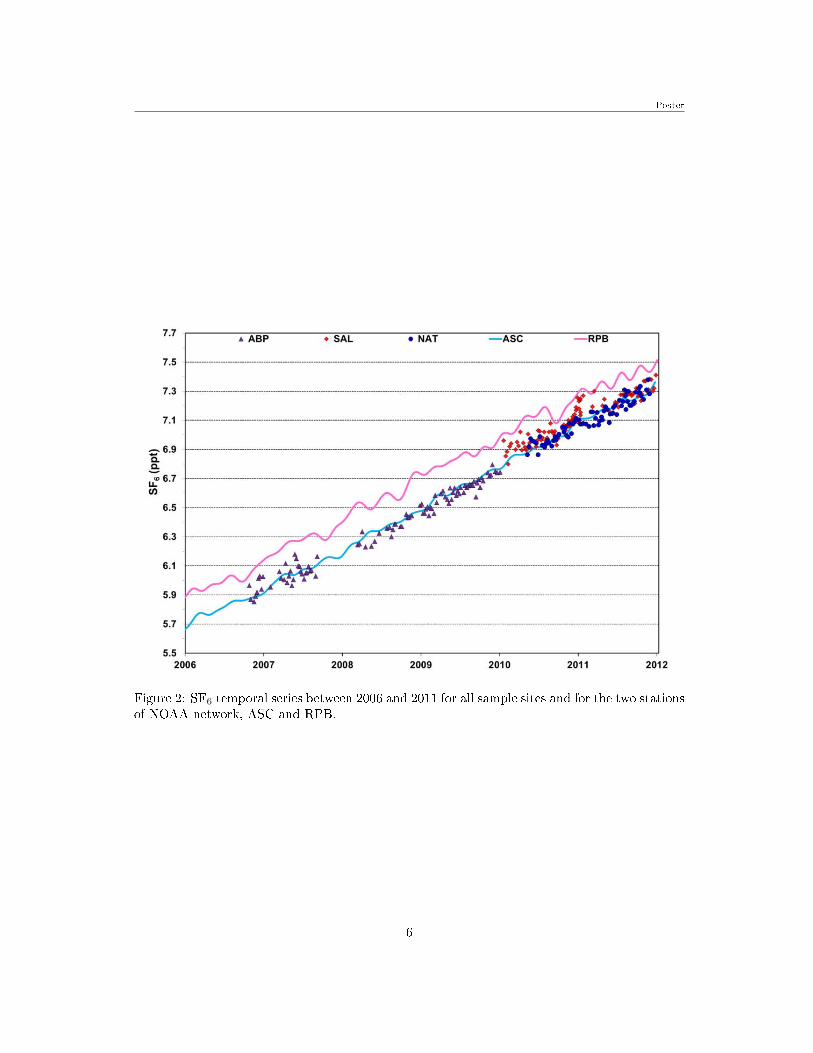
4 SF6 Brazilian Background Concentration
Luana S. Basso1; Viviane F. Borges1; Luciana V. Gatti1; Alexandre
Martinewski1; Lucas G. Domingues1; Caio S.C. Correia1; John B.
Miller2; Emanuel U.Gloor3
1Instituto de Pesquisas Energéticas e Nucleares, Brazil; 2NOAA/ESRL, Boulder, USA; 3University of Leeds, Leeds,United Kingdom
Between 2006 and 2010, atmospheric measurements of SF6 was started in the Brazilian coast,in Arembepe (ABP: 12◦S, 38◦W) and since January 2010 in Salinópolis (SAL: 1◦S, 47◦W) andMay of the same year in Natal (NAT: 5◦S, 35◦W). All these sites are located in the Braziliancoast and these results represent the SF6 concentrations over the oceans, because the samplingwas made in locations in front the sea, so that there have not in�uence of the continental areain the results.
The temporal series for all these sites could be observed in Figure 2, as well the concentra-tions of two stations of NOAA/ESRL global air sampling network, Ascension Island (ASC: 8◦S,14◦W) and Barbados (RPB: 13◦N, 59◦W). It is possible to be observed that SF6 concentrationsin ABP, NAT and SAL are closer of the measured values in the global stations, ASC and RPB,in most of the studied period, additionally the concentrations of this gas showed a continuousincreasing, between 2006 and 2011.
The concentrations in ABP and NAT are closer to ASC concentrations, and the SAL concen-trations are between the RPB and ASC. Analysing the back trajectories of air masses, simulatedby the HYSPLIT model (Draxler et al., 2012) for each day and sampling site, were observedthat the trajectories of the air masses arrived in ABP and NAT have a homogeneous pattern,from the South Atlantic Ocean with latitude below of the ASC, this pattern is consistent withthe concentrations obtained in these sites, that are near than those obtained in ASC, indicatingthat in the South Atlantic Ocean the SF6 concentrations are homogeneous. The air massesarrived in SAL received in�uence of both the North and the South Hemisphere, in agreementwith the concentrations obtained in this site.
References
Draxler, R.R. and Rolph, G.D., 2012. HYSPLIT (HYbrid Single-Particle Lagrangian IntegratedTrajectory) Model access via NOAAARL READYWebsite: (http://ready.arl.noaa.gov/HYSPLIT.php).NOAA Air Resources Laboratory, Silver Spring, MD.
5
Poster
Figure 2: SF6 temporal series between 2006 and 2011 for all sample sites and for the two stationsof NOAA network, ASC and RPB.
6

Talk
5 Developing global observation systems for HarmfulAlgal Blooms: Earth observation and autonomous
systems
Stewart Bernard
Council for Scienti�c and Industrial Research, South Africa
Harmful algal blooms (HABs) are responsible for ecosystem disruption and socio-economic dam-age in marine and freshwaters systems across the globe. There is considerable scope and potentialimpact from the implementation of GEOSS type systems for bloom observation across a multi-tude of scales, using both space-based and in situ sensors, and bringing together the interestsof GEO, GEOHAB, the IOCCG, and agency/regional/national interests. Brie�y, various majortypes of HABs are reviewed from an earth observation perspective, highlighting the need forecological context of bloom development and domain-speci�c demands on ocean colour-basedobservation. Examples of characteristic HAB events and optimal ocean colour products areshown in illustration of both bloom and ocean colour algorithm types. In addition, the need forcomplementary autonomous in situ systems is highlighted, focusing on the need for higher fre-quency and more complex or precisely observed parameters. A GEOSS perspective necessarilyrequires a focus on low cost, distributable and preferably standardised autonomous hardware,and some of the relevant options, challenges and opportunities are presented. Finally, somesuggested mechanisms for implementation are discussed, including related GEO initiatives.
7
Poster
6 Background of CO2 on the Brazilian Northeastcoast
Viviane F. Borges1; Luciana V. Gatti1; Alexandre Martinewski1;
Luana S. Basso1; Lucas G. Domingues1; Caio S.C. Correia1; John B.
Miller2; Humberto R. da Rocha3; Emanuel U.Gloor4
1Instituto de Pesquisas Energéticas e Nucleares, Brazil; 2NOAA Climate Monitoring and Diagnostics Laboratory,Boulder, Colorado, USA; 3IAG/USP, São Paulo, Brasil; 4University of Leeds, Leeds, United Kingdom
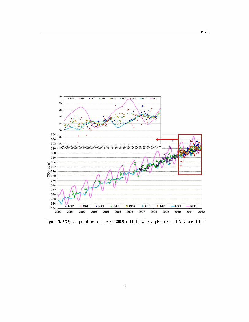
Between 2006-2010 in Arembepe (ABP: 12◦S, 38◦W), and since 2010 in Salinópolis (SAL: 1◦S,47◦W) and Natal (NAT: 5◦S, 35◦W), sites on the Brazilian coast, were started atmosphericCO2) concentrations measurements. Measurements were also performed with vertical pro�les inthe Amazon Basin - Santarém (SAN: 2◦S, 54◦W), Rio Branco (RBA: 10◦S, 68◦W), Alta Floresta(ALF: 8◦S, 56◦W) and Tabatinga (TAB: 4◦S, 64◦W). For the calculation of the CO �ux (Miller etal., 2007) in the Amazon Basin, was necessary to calculate the Continent background using SF6
- anthropic gas, as air masses tracer. The results of these sites represent the CO2 concentrationsover the oceans, since the coast sampling was made on the beach, in front the Atlantic Ocean,without continental in�uence, and in the Amazon Basin the SF6 concentrations were the samefound on the coast. The results obtained were compared with two global stations NOAA/ESRLnetwork results - Ascension Island (ASC: 8◦S, 14◦W) and Barbados (RPB: 13◦N, 59◦W) �localized in the Atlantic Ocean, as show Figure 3. It was observed that the CO2 concentrations inABP and NAT presented a homogeneous pattern with the ASC concentrations. SAL presentedseasonality between the ASC and RPB concentrations, as well SAN, RBA, ALF and TAB.Studies of the air masses back trajectories, simulated by HYSPLIT (Draxler et al., 2012) model,for each day and sample sites, showed that SAL, SAN, RBA, ALF and TAB received in�uencesfrom North and South Hemispheres. Analyzing the air masses back trajectories in ABP andNAT was observed a homogeneous pattern from the South Atlantic Ocean (SAO), with latitudebelow of the ASC, indicating that the CO2 concentrations along the SAO are homogeneous.
References
Miller, J.B.; Gatti, L.V.; D'amelio, M.T.S.; Crotwell, A.M.; Dlugockencky, E.J.; Bakwin, P.;Tans, P.P. 2007. Airborne measurements indicate large methane emissions from the easternAmazon basin, J. Geophys. Res., 34 (10).
Draxler, R.R. and Rolph, G.D., 2012. HYSPLIT (HYbrid Single-Particle Lagrangian IntegratedTrajectory) Model access via NOAAARL READYWebsite: (http://ready.arl.noaa.gov/HYSPLIT.php).NOAA Air Resources Laboratory, Silver Spring, MD.
8
Poster
Figure 3: CO2 temporal series between 2000-2011, for all sample sites and ASC and RPB.
9
Poster
7 Study of N2O Background on the BrazilianNortheast coast
Viviane F. Borges1; Luciana V. Gatti1; Alexandre Martinewski1;
Luana S. Basso1; Lucas G. Domingues1; Caio S.C. Correia1; John B.
Miller2; Humberto R. da Rocha3; Emanuel U.Gloor4
1Instituto de Pesquisas Energéticas e Nucleares, Brazil; 2NOAA Climate Monitoring and Diagnostics Laboratory,Boulder, Colorado, USA; 3IAG/USP, São Paulo, Brasil; 4University of Leeds, Leeds, United Kingdom
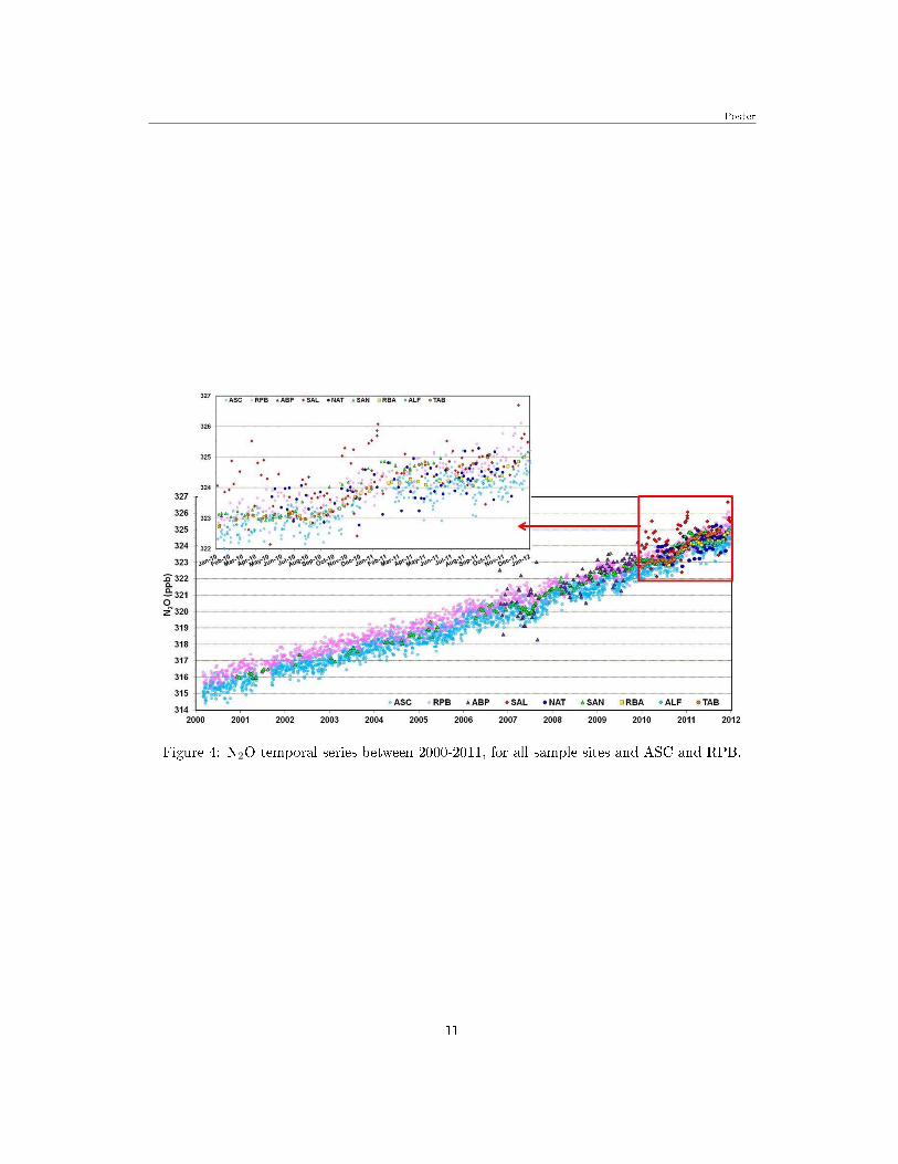
N2O concentrations by �asks sampling on the Brazilian coast were started in 2010 in Salinópolis(SAL: 1°S, 47°W) and Natal (NAT: 5°S, 35°W). In Arembepe (ABP: 12ºS, 38ºW) measureswere performed between 2006-2010. All sampling in these sites were made on the beach and theresults represent the N2O concentrations over the ocean. In the Amazon Basin were performed,since 2010, measures with aircraft vertical pro�les in Rio Branco (RBA: 10ºS, 68ºW), AltaFloresta (ALF: 8°S, 56°W), Tabatinga (TAB: 4°S, 64°W) and, since 2000, in Santarém (SAN:2ºS, 54ºW), for this method was necessary to calculate the background on the Continent to knowthe N2O �ux (Miller et al., 2007), using SF6 as air masses tracer, since in the Amazon Basin, theSF6 concentrations found were the same that in the coast. The results obtained were comparedwith two global stations NOAA/ESRL network results - Ascension Island (ASC: 8°S, 14°W) andBarbados (RPB: 13ºN, 59ºW) � localized in the Atlantic Ocean, as show Figure 4. In SAN,RBA, ALF and TAB were observed that the N2O concentrations presented values between ASCand RPB. In ABP and NAT the N2O concentrations presented values between ASC and RPB.In SAL was observed that the N2O concentrations were higher than ASC and RPB, mainly in2010, indicating a possible source of the N2O. To know the origin of the air masses that arrivedin the study sites, were simulated the air masses back trajectories for each day and sample sitesby HYSPLIT (Draxler et al., 2012) model. This study showed that SAL, SAN, RBA, ALF andTAB received in�uences from both: North and South Hemispheres. ABP and NAT had onlyin�uence by air masses of the South Atlantic Ocean, being observed a homogeneous air massespattern with origin below of the ASC latitude.
References
Miller, J.B.; Gatti, L.V.; D'amelio, M.T.S.; Crotwell, A.M.; Dlugockencky, E.J.; Bakwin, P.;Tans, P.P. 2007. Airborne measurements indicate large methane emissions from the easternAmazon basin, J. Geophys. Res., 34 (10).
Draxler, R.R. and Rolph, G.D., 2012. HYSPLIT (HYbrid Single-Particle Lagrangian IntegratedTrajectory) Model access via NOAAARL READYWebsite: (http://ready.arl.noaa.gov/HYSPLIT.php).NOAA Air Resources Laboratory, Silver Spring, MD.
10
Poster
Figure 4: N2O temporal series between 2000-2011, for all sample sites and ASC and RPB.
11
Poster
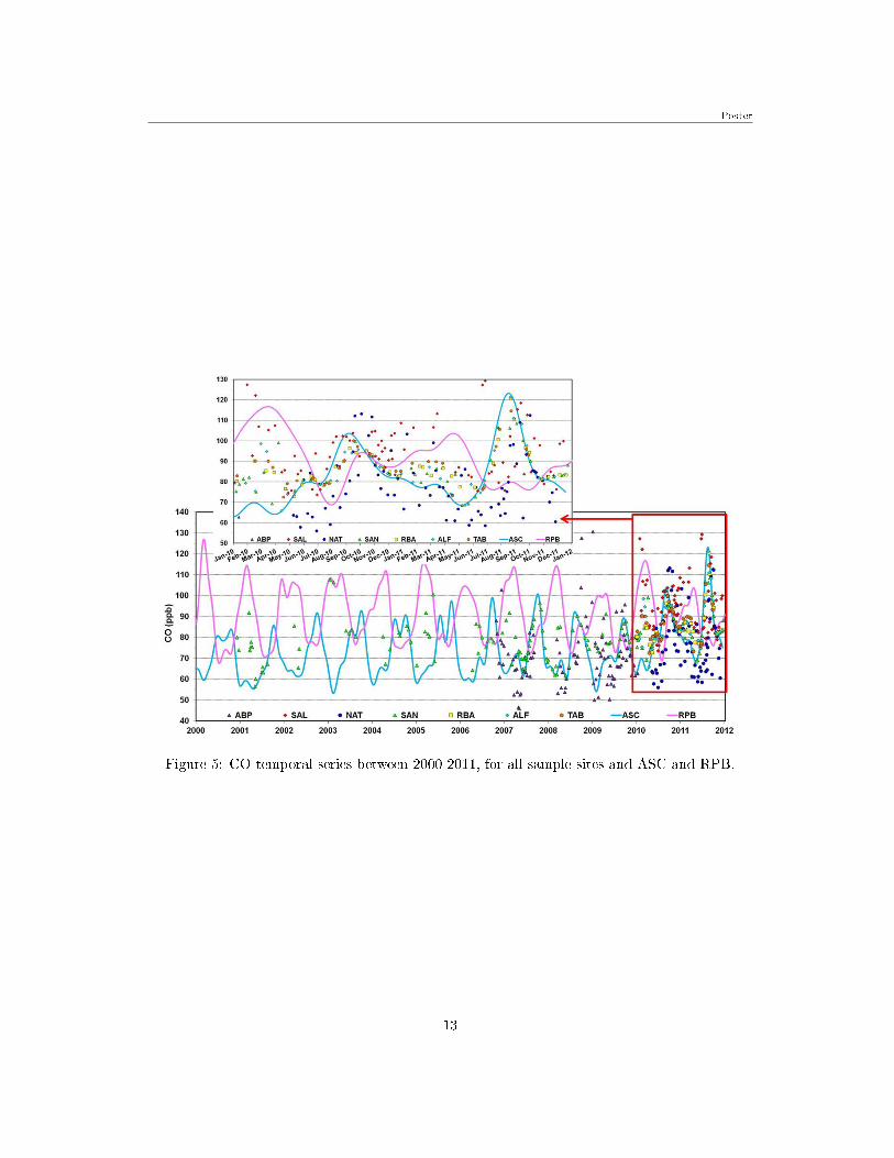
8 Brazilian coast CO Background
Viviane F. Borges1; Luciana V. Gatti1; Alexandre Martinewski1;
Luana S. Basso1; Lucas G. Domingues1; Caio S.C. Correia1; John B.
Miller2; Humberto R. da Rocha3; Emanuel U.Gloor4
1Instituto de Pesquisas Energéticas e Nucleares, Brazil; 2NOAA Climate Monitoring and Diagnostics Laboratory,Boulder, Colorado, USA; 3IAG/USP, São Paulo, Brasil; 4University of Leeds, Leeds, United Kingdom
Since 2010 were started atmospheric measurements of the CO concentrations on the Braziliancoast, in Salinópolis (SAL: 1°S, 47°W), Natal (NAT: 5°S, 35°W) and between 2006-2010 inArembepe (ABP: 12ºS, 38ºW). The coast samplings were performed on the beach, withoutcontinental in�uence. Measurements were also performed in aircraft vertical pro�les on theAmazon Basin - Santarém (SAN: 2ºS, 54ºW), Rio Branco (RBA: 10ºS, 68ºW), Alta Floresta(ALF: 8°S, 56°W) and Tabatinga (TAB: 4°S, 64°W), for the calculation of the CO �ux (Milleret al., 2007), was necessary to calculate the background on the Continent, using SF6 - anthropicgas, as air masses tracer, once the SF6 concentrations on the Amazon Basin were the samefound on the coast. The results of these sites represent the CO concentrations over the oceans.The results obtained were compared with two global stations NOAA/ESRL network results- Ascension Island (ASC: 8°S, 14°W) and Barbados (RPB: 13ºN, 59ºW) � localized in theAtlantic Ocean, as show Figure 5. It was observed that the CO concentrations in ABP andNAT presented a homogeneous pattern with concentrations nearly of ASC. SAL presented theCO concentrations a little above of the ASC and RPB. SAN, RBA, ALF and TAB presentedconcentrations between of ASC and RPB. Studies of the air masses back trajectories, simulatedby HYSPLIT (Draxler and Rolph, 2012) model, for each day and sample sites, showed that SAL,SAN, RBA, ALF and TAB received in�uences from North and South Hemispheres. ABP andNAT received in�uences from South Hemisphere and it was observed a homogeneous pattern ofthe air masses back trajectories from latitude below ASC of the South Atlantic Ocean (SAO).The air masses back trajectories in ABP and NAT analyses shown a homogeneous pattern fromthe South Atlantic Ocean (SAO) and indicate a homogeneous CO concentration along the SAO.
References
Miller, J.B.; Gatti, L.V.; D'amelio, M.T.S.; Crotwell, A.M.; Dlugockencky, E.J.; Bakwin, P.;Tans, P.P. 2007. Airborne measurements indicate large methane emissions from the easternAmazon basin, J. Geophys. Res., 34 (10).
Draxler, R.R. and Rolph, G.D., 2012. HYSPLIT (HYbrid Single-Particle Lagrangian IntegratedTrajectory) Model access via NOAAARL READYWebsite: (http://ready.arl.noaa.gov/HYSPLIT.php).NOAA Air Resources Laboratory, Silver Spring, MD.
12
Poster
Figure 5: CO temporal series between 2000-2011, for all sample sites and ASC and RPB.
13

Poster
9 Contribution to the setup of a ChloroGINtimeseries node in Iberia and African Portuguese
speaking countries
Vanda Brotas
University of Lisbon, Centre of Oceanography, Portugal
The importance of oceanic observational networks is unquestionable. The organization andmaintenance of a successful network is not straightforward, size and common interests are keyparameters in this equation. This work presents a proposal for the setup of a ChloroGIN time-series node in Iberia, Azores, Madeira and African Portuguese speaking countries. The mainobjectives of this network would be:
1. Support ChloroGIN aims, i.e, to promote in situ measurement of chlorophyll in com-bination with satellite derived estimates
2. Establish a network program of in situ observations on Portuguese coast, Azores,Madeira, Angola, Cape Verde and Mozambique
3. Develop Capacity building and training programs amongst partners and other scien-ti�c organizations.
The following institutions were contacted and declared their interest: Universidade de Lis-boa (Portugal), Universidade dos Açores (Portugal), Universidade da Madeira (Portugal) Uni-versidade Agostinho Neto (Angola), Instituto Nacional de Desenvolvimento das Pescas nas ilhasde Cabo verde (INDP, Cape Vert), Instituto Nacional de Investigação Pesqueira (Mozambique),Universidade Eduardo Mondlane (Mozambique). During Blue Planet meeting, the involvementof Brazilian institutions will be promoted. There is already a history of common publicationswith Portugal-Mozambique and Portugal-Brazil, and there is a submitted proposal to FAOinvolving Portugal and Cape Vert.
University of Lisbon (UL) has a long expertise in marine and estuarine phytoplanktonresearch, being involved in water framework directive, toxic algae studies, biodiversity and val-idation of ocean colour with in situ pigments data along the Iberian west coast. Presently, ULparticipates in CoastColour project and Mermaid (Meris Matchup in situ database). UL hoststhe recently created OCPortugal group (ocportugal.org), which brings together expertise in dif-ferent research areas: applied optics, pattern recognition, remote sensing and high-performancecomputing.
14
Talk
10 Operational Oceanography in the South Atlantic
Edmo Campos
Oceanographic Institute of the University of São Paulo, Brazil
Changes in the large scale ocean circulation resulting from changes in Earth's climate is likelyto have signi�cant impacts on the oceanic region adjacent to the Brazilian shores, a�ecting thetemperature, salinity and heat content in the upper-layer of the ocean. One can expect thatchanges in these physical properties will result in alterations of the local climate, with impactson the hydrological cycle, on the �uvial discharge regimes and on the biological pump andthe biogeochemical cycles on the continental shelf. To understand and monitor these impactsand to provide valuable information for forecasting services and for di�erent stakeholders anddecision-makers, an operational system for marine and coastal zones is being implemented inthe South Atlantic. This operational system is based on the deployment and maintenanceof moored systems, long-term repeat hydrography, satellite-based observations and numericalmodeling. In this context, some of the most relevant contributions are the Brazilian GOOSmoored buoy program, which includes the deployment of an Atlas buoy on 28S, 44W, and theSAMOC Project, a contribution to an international e�ort to monitor meridional �uxes across atransatlantic section along 34S. The operational modeling e�ort is based on the implementationand use of a hierarchy of models with downscaling and data assimilation approaches, for oceanforecasting from synoptic to seasonal scales.
15
Talk
11 The Oceans Component of The Merton Initiative:Towards a Global Observing System for the Human
Environment
Francisco Chavez and Merton Initiative
Monterey Bay Aquarium Research Institute
The presentation builds on a report generated by an IGPB-sponsored group that met at MertonCollege, Oxford University in September 2011. The group recognized that as Earth Systemscience advances and matures, it must be supported by robust and integrated (environment,discipline) observation systems that meet the scienti�c and practical challenges of the 21stCentury. In particular the focus was on human components of the observing system. Observingsystems are used to quantify biological and environmental condition and change, and includerepeated measurements of biological, biogeochemical, physical, hydrological and meteorologicalparameters of interest. Long-term observations, e.g. over decades, are used to elucidate trendsin biological and environmental condition. Observations of the human dimension need to be partof the analysis of change in condition. This includes human appropriation of primary productionand its drivers (population density and distribution, associated land-use/land cover change. e.g.,patterns of forest clearing for agriculture), human wellbeing, and proposed or implemented policyactions. Integration of the observing systems can predict future biological outcomes of policyactions and land-use patterns. These ideas are clearly relevant for the terrestrial environment butwhat about the oceans? The oceans have their own internal challenges (�shing, pollution, oceanacidi�cation, climate change) but also in�uence the atmosphere and terrestrial environments bychanges in ocean circulation, chemistry and biology. The presentation will generally introducethe Merton Initiative report and then focus on di�erent aspects of the Oceans Component insupport of bio-diversity, ocean health and climate.
16
Talk
12 Toward Multiscale Methods For Mapping andManagement Marine Data in Brazil
Luis Conti
Escola de Artes Ciencias e Humanidades, Universidade de São Paulo, Brazil
Marine and Coastal environments tend to have a highly complex dynamics due to the interactionof multiscale processes. The use of Geographic Information Systems can facilitate understandingsuch dynamics, since it can provide multiple dataset analyses to gather, display and process largequantities of spatially and temporally related data. However most of current application of GISand Geoprocessing in Marine sciences has been limited to simple mapping and navigation issues.While terrestrial oriented geoprocessing have been settled on theoretical grounds such as thewell-established ideas of landscape ecology or Conservation Biology which deals with behaviorof spatial patterns in the environment, the marine and coastal sciences have been struggling withhow to deal with rapidly growing bodies of information without such base theories to supportit completely. In the last decades, most of the e�orts of create multi-scale framework to dealwith coastal marine environments have resulted in important achievements and the developmentof a multispatial geodatabases models providing important step for developing an appropriateassessment and prediction methods for marine and coastal management and it is imperativethat such framework should support data management and data accessibility tools.
In case of brazil and speci�cally in Sao Paulo state, several studies involving oceanographicprocesses and its relation to antropic occupation has been produced extendedly in the last years.Only in University of São Paulo, more than 75 projects have been carry on with management andof coastal zone of São Paulo State. Although Technical and Scienti�c works have been publishedsince the 50's but part of all data and information collected have been lost or kept in privateissues. During the last decade, however, the academic, military and civil society started to makesome e�orts in order to normalize and systemize marine data and information in OceanographicDatabases. Some examples such as BNDO (Brazilian Oceanographic Database) coordinated bythe Brazilian Navy and BANPETRO (Environmental Marine Database), supported by Petro-brás are two good examples projects aiming the systematization of coastal and marine data intogeodetic platforms. A signi�cant bene�t of available and proposed geographic information sys-tem (GIS) techniques is their ability to collect, structure, and analyze such coastal managementrelevant spatial information, but development of these programs should not be limited to themanagement of 'inventories', but also relates to the methodological development, technical so-lutions and applications that also aims at analyzing such information and the question of multiscale mapping should be on the center of the discussion.
17

Poster
13 GEOWOW: a European contribution tointeroperable water information systems
Massimo Craglia, Joost van Bemmelen, Roberto Cossu, Stefano
Nativi, Michael Nyenhuis, Albert Fischer, David Richardson
Joint Research Centre, European Commission, Italy
GEOWOW is a project, co-funded under the European Community's Seventh Framework Pro-gramme FP7/2007-2013 under grant agreement no. 282915 in response to call ENV.2011.4.1.3-1�Interoperable integration of Shared Earth Observations in the Global Context�. The projectaddresses the following objectives:
1. Contributing to the GEOSS Common Infrastructure improving global data discovery andenabling global access to, and use of, Earth Observation data and resources (computing,data handling tools, models. . . ) in the �elds of weather, water, and Ocen ecosystems..
2. Developing tools and protocols promoting the implementation of the GEOSS Data SharingPrinciples, and the re-use and dissemination of Earth Observation data, whilst addressingidenti�ed concerns expressed by data producers.
3. Developing the operational capabilities of the GCI through applications in three areas:a. Weather, with a focus on uni�ed access to EO and forecasting systems for hazard andextreme meteorological events.b. Water, with a focus on hydrological applications and run-o� process using in-situ andsatellite data.c. Ecosystem, with a focus on the implementation of GOOS by engineering and testingaccess to Ocean data via the GCI.
4. Enhancing multidisciplinary interoperability.
5. Analysing the bene�ts of GEOSS for Europe using models linking economy, environment,and society.
The project has identi�ed a number of key requirements coming from the scienti�c commu-nity in the three thematic areas covered by GEOWOW, as well as more generic requirements ofusers of the GEOSS Common Infrastructure. The poster shows how the project is developinginitiatives and technological components to address these requirements and how it contributesto the achievements of the GEOSS targets.
Additional details on the project are provided in the project website: http://www.geowow.eu
18
Poster
14 Establishing long-term coastal ocean observationsin SE Brazil
L.C. da Cunha; Farias, C.O.; Hamacher, C.; Moser, G.; Bastos, M.
Faculty of Oceanography- Rio de Janeiro State University, Brazil
Coastal ecosystems are among the most vulnerable areas to climate-related impacts such assea-level rise, increase in sea-surface temperatures, and ocean acidi�cation. Despite their rolein the global ocean primary production, coastal ecosystems still lack of long-term observations,especially in tropical areas, including SE Brazil. Another gap identi�ed in coastal areas isconstraining their role in the sea-air CO2 �uxes, i.e. do these areas act as sinks or sources ofCO2 to the atmosphere?
Research groups at the Faculty of Oceanography at UERJ (FAOC-UERJ) are at presentinterested in establishing long-term biogeochemical observations in a pristine coastal area in SEBrazil (Barra Grande Estuary, Rio de Janeiro State). The Barra Grande Estuary is locatedat Vila Dois Rios, on the ocean-side of Ilha Grande, and characterized by the presence ofdense mangrove forests on its margins. The whole island belongs to the Ilha Grande RegionalPark, one of the best preserved Atlantic rain forest areas in SE Brazil. The UERJ runs alaboratory and �eld sampling facilities at Ilha Grande, the CEADS (Centre for Studies onSustainable Environmental Development), close to the estuary site. The sta� at FAOC-UERJcurrently develops di�erent research and education projects (graduate and undergraduate levels)at CEADS. Two current projects aim at studying the processes controlling nutrients and carbon(organic and inorganic) �uxes from land to the coastal ocean through the Barra Grande estuary.Establishing long-term observations in the estuary and at a �xed point in the adjacent coastalocean will allow us to constrain the seasonal and annual variability of lateral nutrient �uxes,processes controlling primary production, and the sea-air CO2 transfer. Additionally, marinebiogeochemical background data collection and logistic support at CEADS will enable studiesfocusing on global change e�ects in the tropical Atlantic coast. Finally, such a scienti�c programwould enhance the capacity building at both Bachelor and Master levels within UERJ students.
19

Talk
15 Endeavoring for Wise Mariculture: Science Inputto Policy Implementation
Laura T. David, Roselle Borja, Bayosa Aya Carino, Kristina Cordero,
Aldwin Almo, Eileen Pena�or
University of the Philippines Marine Science Institute, Philippines
Mariculture o�ers a pragmatic solution to the food security of the Philippines. Since it gainedpopularity in the 70's, however episodic �sh kills have plagued this industry. Contributing factorsinclude eutrophication, reduced �ushing rates, hypoxia, harmful algal blooms, and warmingwaters. If the country is to make a concerted e�ort to secure our source of food, its planning andmanagement of its mariculture needs to be science-based. Currently, there is still no establishedprotocol on how and where these parks will be established. Without science-based guidance, thevery industry we are relying on to continue to provide food for the Filipinos will inadvertentlycontribute to the further demise of our coastal resources. Each �sh kill not only a�ects themariculture industry but also compromises the ability of the surrounding benthic and pelagichabitat to be resilient to any additional pressures. This research presented here studied thedi�erent regions in the Philippines vis-à-vis their physical characteristics to evaluate the levelof intensity of mariculture activities that can be maintained per region in the Philippines. Thestudy entailed using historical remotely sensed derived atmospheric and oceanic data whichshowed that the Philippine waters naturally divided into 11 climate exposure types National-scale hydrographic models were also be analyzed for coarse scale entrainment features. Finally,for speci�c embayments, �ushing rates were also be calculated.
20
Poster
16 Use Of The Satellite Data To Study The TemporalEvolution Of Marine Dynamics And Ecological
Response To Changes In The South Atlantic Ocean
Flavia Tavares Delcourt, Milton Kampel, Bertrand Chapron, Antonio
Juan Gámez
Instituo Nacional de Pesquisas Espaciais, Brazil
The oceanic circulation in the western South Atlantic Ocean is dominated by the presence ofboundary currents from the Anticyclonic Subtropical Gyre. By the joint action of trade windsand the Earth's rotation, a displacement and accumulation of water in the west side of theAtlantic occur. For the same reasons that contribute to the occurrence of certain oceanographicphenomena, such as upwelling, ocean strati�cation and generation of eddies and meanders, whichin�uence the ecosystems bystanders. The use of the altimeters and sea surface temperature,surface wind, and the chlorophyll sensors on-board of satellites is essential for the development ofa spatiotemporal analysis of the variability of those parameters in the SouthWest Atlantic region.The goal of this PhD investigation is to study the variations of the di�erent spatiotemporal scalesbetween the continental shelf and the open ocean, developing a methodology that combines dataprocessing, remote sensing of the marine dynamics and the known biological systems in theBrazilian coast to �nd the relationships between them and their evolution. The results have ledto a classi�cation of the South Atlantic in ecological provinces, based on dynamic characteristicsof the time series involved. These provinces are in�uenced by exogenous events that contributeto the exceptional pattern of the variables, suggesting inter-relationships with physical processesand the El Niño phenomenon.
21
Poster
17 The ANTARES-Ubatuba coastal time-series station(SP/Brazil): nine years of in situ and satellite
monitoring
Natalia de Moraes Rudor�, Maria Laura Zo�oli, Larissa Valerio, Aline
de Matos Valério, João Felipe Cardoso dos Santos, Gustavo Prouvot
Ortiz, Gabriel Moiano, Milton Kampel, Mayza Pompeu, Salvador
Gaeta
Instituo Nacional de Pesquisas Espaciais (INPE), Brazil
Coastal zones are highly dynamic systems in the interface of ocean-climate and continental pro-cesses, and thus highly vulnerable to natural and anthropogenic changes. This complex systemembraces important coastal and marine ecosystems and is usually combined with highly popu-lated areas, sharing di�erent activities. It is thus very important to understand the processesregarding these interfaces and monitor the changes and their e�ects. Ocean colour remotesensing is a powerful tool for environmental monitoring, and the only means to obtain thespatio-temporal distribution of biogeochemical properties in large geographical scales with ahigh frequency of acquisition. However, the determination of these properties in coastal opti-cally complex waters is a challenge for bio-optical modeling. The ANTARES regional networkaims the validation and adjustment of bio-optical models, and the monitoring of climate andanthropogenic changes in coastal zones around Latin America. The present work shows how theANTARES-Ubatuba station (SP/Brazil) located in the Brazilian southeast continental shelf isbeing implemented since 2004, with in situ and satellite monthly data collections of radiometricand bio-optical data. We show some of the works that are being developed regarding bio-opticalcharacterization, validation of satellite products, testes of the performance of empirical and semi-analytical models, and time-series analysis of annual and inter-annual variability. The Braziliansoutheastern continental is an important environmental and social-economic region with biolog-ical protected areas, high tourism activities, local �sheries, aquaculture activities and has oneof the greatest natural gas reserves of the Brazilian coast. The ANTARES-Ubatuba monitoringprogram aims to provide reliable and accurate ocean colour products for the region, as well, asmonitor the processes that regulate the distribution of biogeochemical properties, such as thephytoplankton distribution and coloured dissolved organic matter, and detect possible changesthat may a�ect (or be a�ected by) human activities and the natural environment.
22
Poster
18 Discovery of Global Earth Observation OceanData through CWIC
Liping Di1, Yuanzheng Shao1, Lingjun Kang1, Meixia Deng1, Yonsook
Enloe2, Martin Yapur3
1Center for Spatial Information Science and Systems, George Mason University, Fairfax, Virginia, USA; 2NASAGoddard Space Flight Center/Columbus Technologies and Services, Inc., Greenbelt, Maryland, USA; 3 NOAA
Satellites and Information Service, Silver Spring, Maryland, USA
In recent years, Earth Observation (EO) technologies have being developed rapidly. Hugeamount of EO data have been collected, mainly through remote sensing, and archived at datacenters around the world. A signi�cant portion of the data is related to the global oceans. Thedistributed nature, complex features, and massive amounts of EO ocean data lead to challengeson how to make them easily discoverable, accessible, and useable for the user community. To con-duct ocean and marine-related scienti�c research, scientists need multi-source data, which maybe archived in di�erent data centers. Most of data centers distribute the data through individualnon-interoperable legacy catalogues, and use heterogeneous query interfaces and metadata mod-els. To �nd the data of interest from multiple data centers for their research and applications,the scientists and data users need to query multiple data catalogs and handle di�erent querylanguages and metadata models. In order to overcome the problem and facilitate one-stop datadiscovery of data in its member space agencies, the Working Group on Information Systems andServices (WGISS) of the Committee on Earth Observation Satellites (CEOS) has initiated aproject to develop and operate the CEOS WGISS Integrated Catalog (CWIC) as a contributionto the Global Earth Observation System of Systems (GEOSS). CWIC project is a multi-phaseproject with the �rst phase, which is near �nished, concentrates on the data discovery. CWICintegrates multiple data centers of the CEOS member agencies, such as NASA, NOAA, USGS,INPE, CAS, and JAXA, through the interoperable catalog federation technology. OGC CSWspeci�cation has been used as the query interface, and both CSW Core pro�le and ISO 19115pro�le have been selected as its metadata models. Through CWIC clients, user-needed oceano-graphic data archived at the data centers, such as sea surface temperature, ocean wind speedand direction, and salinity, can be easily found. The next phase of CWIC development will beon data access. The initial operation has proved that CWIC is an e�ective tool to discoveryEarth observation ocean data from multiple data centers.
23

Poster
19 Variability Of Upwelling Intensity And TheDynamics Of The Population Of Octopus Vulgaris,
Near Mbour
Ousmane Diankha1 and Modou Thiaw2
1Laboratoire de Physique de l'Atmosphère et de l'Océan Siméon Fongang (LPAO-SF/ESP-UCAD, Sénégal) 2Centre deRecherche Océanographique de Dakar-Thiaroye (CRODT, ISRA Sénégal)
The �uctuations of the upwelling intensity and their e�ects on seasonal, and interannual octopusrecruitment near Mbour (13.5-14.5 N and 17-17.5 W, area of octopus catch) are analysed andquanti�ed using data from 1996 to 2005. Octopus recruitment estimated from the VirtualPopulation Analysis model (VPA) using monthly octopus catch and environmental data, seasurface temperature (SST) derived from satellite, and North Atlantic Oscillation (NAO) indexobtained from the National Oceanic Atmosphere Administration (NOAA) website were used.
The results show that upwelling intensity and octopus recruitment are characterized bygreat seasonal and interannual variability. The highest upwelling intensity is observed in Marchcoinciding with the maximum of octopus recruitment. Inverse and signi�cant correlations be-tween octopus recruitment and SST and between SST and NAO index were calculated. Octopusrecruitment and NAO index are positively correlated. Regarding the relationship between thesevariables, a linear model (lm) with stepwise procedure was used. The seasonal and interannualvariability of octopus recruitment is explained by the combined SST and NAO index (87.3
This study suggest that the variable environment should be taken in account in the man-agement and planning of octopus �sheries in order to manage and assess better the octopusresource.
24

Talk
20 The GEO Coastal Zone Community of Practice(CZCP)
Paul M. DiGiacomo1, Hans-Peter Plag, Jose Muelbert
1NOAA, USA)
Global, regional and local trends in natural processes and human demands on coastal ecosystemsjeopardize the ability of these ecosystems to support commerce, living resources, recreation andhabitation. In this context, improved, integrated and sustained coastal observing capabilities arerequired to better support user information needs. The Group on Earth Observations (GEO)provides a valuable framework and mechanism to help implement these capabilities, and underthe auspices of GEO, a Coastal Zone Community of Practice (CZCP) was initiated in 2006. TheCZCP builds on the heritage of the former IGOS Coastal Theme, which provided a strategy forintegrated observations across the land-sea interface, and aims to enable broader participation,improved linkage to users, coordinated implementation, and enhanced societal bene�ts.
The CZCP is a user-driven community of stakeholders, the purpose of which is to developand execute a strategy, in the framework of GEO, for engaging user groups across the land-sea interface in the development of those elements of GOOS and other observing systems thatare required to provide and integrate data on terrestrial, freshwater, marine and atmosphericsystems that converge in the coastal zone.
CZCP activities in recent years have included undertaking several regional workshops aspart of the series entitled �GEOSS Support for Decision-Making in the Coastal Zone: Manag-ing and Mitigating the Impacts of Human Activities and Natural Hazards in the Coastal Zone�.Other ongoing activities include e�orts to facilitate the implementation of coastal GOOS, as wellas more broadly support the Blue Planet Task for GEO. Emerging activities being consideredinclude development of a prototype, science-based coastal information system for routine assess-ments and monitoring of coastal zones in developed and developing nations. This presentationwill highlight these and other recent and upcoming activities for the CZCP.
25
Talk
21 Information for a Blue Society: proposal for aninteroperable Marine Spatial Data Infrastructure
� the ChloroGIN example
Samy Djavidnia
FARO/POGO collaborator
Our society is currently facing a number of crucial challenges, one of them being the sustainabledevelopment of a �green� and �blue� economy for mitigating and adapting to climate change.Within this context, the �Ocean� has been identi�ed as one of the 7 �Critical Issues� at theRio+20 United Nations Conference on Sustainable Development and is now an integral part ofthe United Nations Climate Change Conference discussions and negotiations.
Based on the principle that �in order to manage it [a problem], we must be able to measureit�, the availability of observational data and information of our complex ecosystems is essential.Earth Observation, via in-situ and satellite remote sensing, is a powerful tool for collectingenvironmental data and information, both at local and global scales. While the aspects relativeto the science, sensor spatial coverage, type and sustainability of these observations are offundamental importance, the access and exchange of this data and information is a facet whichalso deserves special attention. The further development and implementation of an ocean/marineinformation environment which facilitates the sharing, use and dissemination of data amongvarious stakeholders is a key to addressing sustainable management and protection of oceansand marine resources at a global scale.
The Chlorophyll Global Integrated Network - ChloroGIN - is an international network toassess the state of marine, coastal and inland-water ecosystems. For this purpose it promotesin-water observations in synergy with ocean-colour and other related satellite observations. Thenetwork consists of a number of di�erent data providers, each of them collecting, storing, process-ing, and distributing data independently. This paper will strive to demonstrate that in orderto ful�l its objectives, in addition to the science based research development work it alreadysuccessfully conducts, ChloroGIN should provide an interoperable Spatial Data Infrastructureplatform able to integrate and disseminate the di�erent spatial and temporal referenced datasetsand services o�ered by its network in a standardised way. The development of this platformshould follow the relevant directives and guidelines as set by the GEOSS 10-Year Implementa-tion Plan and thereby enable ChloroGIN's network of partners to reach a level of harmonisationand interoperability which is bene�cial to all its users and stakeholders.
26

Poster
22 Study of Sea Level Fluctuation effects onEnvironment of Caspian Sea
Sh. Eghtesadi, R. Zahedi
Oceanic and Atmospheric Science Center, Iran
Blue Planet has always amazing ideas for many researchers of di�erent scienti�c �elds whichlead to thinking and speculation about it. However, changes in blue planet environment havemajor impact on mankind's life. Various phenomena such as global increasing of air and seatemperature, melting polar glaciers, increased occurrence of extreme weather phenomena andso on that are signs of human impact on environment of blue planet. Although the changes inwater �ow and temperature pattern, acidity, Arctic ice melting and sea level �uctuations areother signs to show long term e�ects of human life on blue planet's conditions.
For example, water level �uctuations of Caspian Sea, which is the largest lake in the world,play an important role as a natural indicator of climate change on central part of Asia. In thisbackground, there are many methods based on time series which shows impacts of climate ondi�erent quantities and detection of climate change.
One of the most frequent procedures is numeric models. This research tries to predict waterlevel �uctuations by using numeric models and also prepare the latest products and achievementsto develop research areas and its impacts on blue Planet.
27

Poster
23 Study of Sea Level Fluctuation effects onEnvironment of Caspian Sea
Luis Escudero
Instituto Del Mar Del Peru, Peru
The spatial distribution of monthly chlorophyll-a concentration o� the coast of Peru from satel-lite images derived from Sea-viewing Wide Sensor Field-of-view Sensor (SeaWiFS) for the periodSeptember 1997 to December 2010 when the sensor stopped working. The time series of monthlyimages corresponds to 152 level L3 with spatial resolution of 9 km. The aim of this study is toknow the monthly variations in the concentration of chlorophyll-a o� the coast of Peru. Thehighest concentrations of chlorophyll-a (> 10 mg / m3) occur from November to April, espe-cially in the area between 3 °S to 14 °S distributed throughout the shelf, from May to October,the lowest observed chlorophyll-a concentrations (<3 mg / m3). During the occurrence of warmevents like El Niño, the concentration of chlorophyll-a decrease substantially the entire Peruviancoast. High concentrations of chlorophyll-a are strongly associated with the cold coastal waters(ACF) of the Humboldt Current.
28
Talk
24 The Global Ocean Observing System and GEO
Albert Fischer
UNESCO/IOC, France
The Global Ocean Observing System (GOOS) has adopted a Framework for Ocean Observing(doi:10.5270/OceanObs09-FOO) developed out of the OceanObs'09 conference (September 2009,Venice, Italy) as guidelines for a restructuring. The goals of GOOS are to engage the wide oceanobservations community in: 1. sustaining present observations, 2. expanding to new variablesand serving new requirements, and 3. identifying regional priorities, capacity, and addressinggaps. GOOS is harnessing the principles of GEO in improving data infrastructure and inter-operability through the European Commission GEOWOW project, and developing informationfor the science-policy interface through a GEF-funded Transboundary Waters Assessment Pro-gramme aimed at bringing information on how the ocean environment and human well-beingare linked.
29
Talk
25 The Brazilian Coastal Monitoring System(SiMCosta)
Carlos A. E. Garcia
Institute of Oceanography Federal University of Rio Grande, Brazil
The Brazilian Coastal Monitoring System (SiMCosta) has been conceived within the Sub-network for Coastal Zones of the Climate Network (REDE CLIMA) and the National Institute ofScience and Technology (INCT) for Climate Change. These research networks integrate di�erentresearch institutions with complementary expertise and capabilities on the use of state-of-the-arttechnologies in terms of infrastructure and hardware for costal observing systems.
SiMCosta has been conceived to be part of a wider, robust and integrated observing systemof the Brazilian coastal zone, for the continuous and distributed acquisition of long-term timeseries of atmospheric, hydrological and oceanic data. The environmental data will be primarilyused as indicators of local changes in the marine and coastal environment. The system will beintegrated with other research programs such as the National Buoy Program (PNBOIA) andthe INCT in Marine Sciences.
SiMCosta is expected to detect long-term trends, and improve the capability of predictingclimatic variability and the e�ects of climate changes. The system will also contribute with othernational e�orts of early warning systems for extreme events. SiMCosta is funded by BrazilianMinistry of Environment and Ministry of Science, Technology and Innovation.
30
Poster
26 Phytoplankton groups assessment from remotesensing data in the Sargasso Sea
Maria Fernanda C. Giannini; Michael W. Lomas
USP-Centro de Biologia Marinha, Brasil
Remote sensing is a powerful tool to understand ocean processes in a large temporal and spatialscale, especially those related to biogeochemical cycles, as the global carbon �ux. For this reason,it is important to assess the phytoplankton community structure and their roles in this processes.A model called PHYSAT was developed in order to identify the variability of phytoplanktoncommunity in the global oceans from remote sensing data of radiance. In the present work, themethodology used for PHYSAT was reproduced in a local scale, using the Bermuda AtlanticTime-series Study dataset, and also an analysis was made for the performance of the originalPHYSAT in the Sargasso Sea. The time-series data could not reproduce the results of PHYSATfor a local application, once that in a very small spatial scale, the changes in community werenot large enough to de�ne speci�c spectra for di�erent groups, as well as due to the temporalscale of the dataset, which may mask some patterns up. The response of the PHYSAT for theSargasso Sea showed a general agreement for latitudinal patterns of distribution, however formany local features the model did not perform very well, especially for the small prokaryoticcells, such as Prochlorococcus. Further analysis need to be done, in order to better validate themodel with in situ data of higher spatial resolution and to be able to develop a regional modelof phytoplankton groups dominance for the Sargasso Sea or even for other regions.
31

Talk
27 A global network of temperature sections insupport of climate studies
Gustavo Goni
National Oceanic and Atmospheric Administration, US
The global eXpendable BathyThermograph (XBT) network addresses both scienti�c and oper-ational goals that contribute to the building of a sustained ocean observing system. The mainmission is the collection of upper ocean temperature pro�les mostly from volunteer vessels. TheXBT deployments are designated by their spatial and temporal sampling goals or modes of de-ployment (Low Density, Frequently Repeated, and High Density or High Resolution) and samplealong repeated, scienti�cally important transects, on either large or small spatial scales, or atspecial locations such as boundary currents and chokepoints. These observations are comple-mented by or complementary to other observational programs, such as Argo, the surface drifterarray, pCO2 system network, satellite altimetry, etc. Multi-national reviews of the XBT networkwere carried out at the 1999 and 2009 OceanObs Conferences. Given the advances in the Argoprogram, the global XBT network is now focused on high resolution monitoring of fronts, ed-dies, boundary currents and heat transport and not exclusively on the broad-scale upper oceanthermal �eld. We present here the current state of the XBT network and key results of XBTdata for climate studies.
32
Poster
28 The Global Alliance of Continuous PlanktonRecorder Surveys (GACS)
Hosie, Graham∗1, Sonia Batten2, Sanae Chiba3, Martin Edwards2,
Mitsuo Fukuchi4, Julie Hall5, Chris Melrose6, Erik Muxagata7, Nick
Owens2, Anthony Richardson8, Sun Song9, Hans Verheye10, Peter
Burkill11
∗1 Australian Antarctic Division, 203 Channel Highway, Kingston, Tasmania 7050; 2Sir Alister Hardy Foundation forOcean Science, Plymouth UK; 3Japan Agency for Marine-Earth Science and Technology, Yokosuka Japan; 4NationalInstitute of Polar Research, Tokyo Japan; 5National Institute for Water and Atmospheric Research, Wellington NewZealand; 6National Oceanic and Atmospheric Administration, Narragansett USA; 7Universidade Federal do Rio
Grande, Brasil; 8CSIRO, Brisbane; 9Institute of Oceanology, Chinese Academy of Sciences, China; 10Department ofEnvironmental A�airs, Cape Town South Africa; 11University of Plymouth, UK
Continuous Plankton Recorders have been deployed as a lower trophic level sampling tool formany decades in the North Atlantic, and have provided a wealth of data used to describeplankton diversity, biogeography, response to climate forcing and in�uence on upper trophiclevels. Other regions of the ocean have since been monitored with CPRs; the Southern Oceanfor over 20 years, the north Paci�c for over 10 and new surveys have recently been initiatedaround Australia, New Zealand, Brazil and in the Benguela Current. The CPR has remainedthe instrument of choice because it o�ers a cost e�ective way to routinely sample deep oceanbasins and coastal ecosystems seamlessly, and is the only current instrument that does so whilemeasuring biodiversity of both zooplankton and larger phytoplankton. Recognising the need tocombine expertise and data to address global issues a�ecting lower trophic levels (ocean warming,acidi�cation etc.) a Global Alliance of CPR Surveys (GACS) was formed in September 2011.GACS will provide that global perspective using CPR data. It will also allow us to assesschanges and events at a local or regional level in a world-wide context. The group has a boardof governance comprising members from 9 regional CPR surveys and active working groups todevelop a joint database and maintain working standards and methodologies. Other speci�caims are to produce a regular ecological status report for global plankton biodiversity, and toprovide an interface for plankton biodiversity with other global ocean observation programmes.www.globalcpr.org.
33
Talk
29 Recent developments in the ChloroGIN websiteand links to EU initiatives
Steve Groom
Plymouth Marine Laboratory, UK
The ChloroGIN web site is maintained and developed by PML on behalf of the ChloroGINproject in support of GEO SB-01 Oceans and Society: Blue Planet, C2 Operational Systems forMonitoring of Marine and Coastal Ecosystems.
The website has recently undergone some changes in terms of look and feel and content. Ofparticular note has been the establishment of a ChloroGIN-Lakes portal that provided accessto full resolution (300m) products from the ESA Medium Resolution Imaging Spectrometer(MERIS) instrument on the Envisat spacecraft. This was done as an �end to end demonstrator�in support of the GEO WA-01 Integrated Water Information (incl. Floods and Droughts), C4Global Water Quality Products and Services that explicitly mentions expansion of ChloroGINto lakes. The demonstrator included example lakes in all continents with a focus on lakes wherein situ observations are available. Unfortunately contact was lost with Envisat on 8 April sincewhen there have been no images. NASA MODIS 500m products have been produced for someregions and provide limited lake water colour capability.
ChloroGIN has also been supported through a number of European projects. The Africancomponent of ChloroGIN has been maintained and expanded through the Europe Africa MarineEO Network (EAMNet) project, part �nanced by the EC. ChloroGIN is also being used as a testcase in a number of projects investigating web based visualisation and data integration usingopen standards approaches.
This presentation will show the ChloroGIN website, the ChloroGIN-Lakes portal and someof the web-based visualisation demonstrations.
34
Poster
30 Earth observation data for marine conservation
Gurney, L.J., Derycke, P., Skoien J., Hoep�ner, N., Dubois,G.
Joint Research Centre, European Commission, Italy
While the application of earth observation data for marine resource and �sheries managementhas been growing over the past decade, its application to marine conservation issues has beenlimited. As part of the Biodiversity and Protected Areas Management Program (BIOPAMA)project the Joint Research Centre of the European Commission is extending the developmentof the Digital Observatory for Protected Areas (DOPA) platform to provide scienti�c data toserve the conservation community. The project is focused on ACP regions (Africa, Caribbeanand the Paci�c) with an important capacity building element provided by the InternationalUnion for the Conservation of Nature (IUCN). Following the assessment of the needs of endusers (at national, regional and local scales), products are being generated to address speci�cneeds with a focus on EO derivatives. With the push to expand the areas under protectionglobally for the marine habitat from what is currently conserved (less than 3% to 10%) asoutlined in Target 11 of the Convention of Biological Diversity, tools which can be used toidentify relevant habitats for conservation are in need. With their extensive spatial and temporalcoverage satellite remote sensing products provide such data and with appropriate processingcan provide useful products by identifying habitats through characterising the environmentand providing an assessment of what is conserved as well as the connectivity between suchhabitats. In addition, identifying ecologically and biologically signi�cant areas (EBSAs), forexample high productivity zones/frontal features and linking such features to distribution ofprotected species. Both applications can be used to highlight areas to be considered to achievemarine resource management objectives. The application of such products are already widelyused for exploitation of �sheries resources and such tools can (and should) be applied to achieveconservation goals. As part of the BIOPAMA project, we would like to provide a demonstrationof the tools under construction for this initiative.
35
Talk
31 The GODAE OceanView Task Teams for CoastalOcean Shelf-Seas (COSS) and Marine Ecosystem
Prediction (MEP)
Fabrice Hernandez
IRD / Mercator Océan, France
The GODAE Ocean View (GOV) panel gathers both academic and operational groups focusingon ocean forecasting capabilities, and the ways to build and improve it. The enhancementof the observing, modelling, and end-to-end service capacity are key issues, together with thesustainability concerns, with strong similarities with GEO work plan and targets. The GOVscience team is driven by task teams, in particular for the Coastal Ocean Shelf Seas (COSS)and the Marine Ecosystem Prediction (MEP) issues.
The COSS-TT deals with support of multidisciplinary analysis and forecasting of thecoastal transition zone, as well as shelf/open ocean exchanges in relation with the larger-scalee�orts. Promoting the use of coastal ocean forecasting systems and for coastal applications ina wider community; discuss and foster integration of the varied routine sources of informationin coastal ocean forecasting system, like satellite observations, coastal observing systems interms of science and technology; discuss the key physical and biogeochemical processes whichhave the greatest impact on modeling and forecasting quality and their utility for applications;discuss and promote state-of-the-art methodology such as two-way coupling, unstructured-gridmodeling, downscaling, data assimilation, or array design.
The MEP-TT focuses on the integration of new models and assimilation components intooperational systems for ocean biogeochemistry and marine ecosystem monitoring. In order tobridge the gap between the current status of the GODAE OceanView capabilities and new ap-plications in areas such as �sheries management, marine pollution, water quality and carboncycle monitoring. It has been set up with the goal to de�ne, promote and coordinate actionsbetween developers of operational systems and ecosystem modelling experts, in close connectionwith IMBER. A work plan from 2010 to 2013 with an assessment/inventory phase, an improve-ment of tools phase, and a development phase is carried on. Outcomes such as the downscalingfrom global to regional systems, by provision of biogeochemical boundary conditions and thefurther development of 2-way biogeochemical coupling in models in order to include and assesbio-physical feedbacks ; and the identi�cation of the essential sets of physical and biogeochemicalobservations required to constrain the coupled models, with key application like CO2 monitoring,HABS and �sh management are expected.
36
Talk
32 Global observatory of lake responses toenvironmental change (GloboLakes) project
Hunter P.D.1, Tyler, A.N.1, Groom, S.2, Dall'Olmo, G.2, Tilstone, S.2,
Martinez-Vicente, V.2, Merchant, C.M.3, MacCallum, S.3, Cutler,
M.4, Rowan, J.4, Dawson, T.4, Maberley, S.C.5, Carvalho, L.6, Elliot,
J.A.6, Thackery, S.6, Miller, C.A.7 and Scott. E.M.7
1University of Stirling, UK; 2Plymouth Marine Laboratory, UK; 3University of Edinburgh, UK; 4University ofDundee, UK; 5Centre for Ecology and Hydrology, UK; 6University of Glasgow, UK.
The world's freshwater ecosystems are vital components of the global biosphere, yet are vul-nerable to climate and other human-induced change. There is increasing recognition that lakesplay an important role in global biogeochemical cycling and provide key ecosystem services.However, our understanding of how lakes respond to environmental change at a global scale,and how this impacts on their status and function, is hampered by limited information on theirchemical, physical and ecological condition. There are estimated to be some 304 million lakesglobally, of which over 17,000 are greater than 10 km2 in surface area. These sheer numbershave militated against the systematic study of lake ecosystems.
GloboLakes is a �ve-year research programme investigating the state of lakes and theirresponse to climatic and other environmental drivers of change through the realisation of a near-real time satellite based observatory with archive data processing to produce a 20-year timeseries of observed ecological parameters and lake temperature for over 1000 lakes globally. Thiswill be supported by linked auxiliary data on catchment land-use and meteorological forcing.The ability to monitor a large number of lakes consistently at high frequency and globally willfacilitate a paradigm shift in our understanding of how lakes respond to environmental changeat di�erent spatial and temporal scales. This talk will introduce the GloboLakes project andoutline its scienti�c ambitions for the next 5 years.
37
Talk Poster
33 GOOS-related ocean observation forunderstanding the present and future status of
climate
Takeshi Kawano
Japan Agency for Marine-Earth Science and Technology (JAMSTEC), Japan
Climate change is a serious threat to humans/the Earth's environment, which an urgent measureshould be taken against. Global observation of the Earth plays a key role to plan adaptationand mitigation strategies for climate change since it provides fundamental information on thestatus of the Earth.
JAMSTEC has conducted ship-based repeat hydrographic observation since 1999, reoc-cupying World Ocean Circulation Experiment (WOCE) Hydrographic Program (WHP) linesmainly in the Paci�c Ocean. JAMSTEC is one of major contributors to the International ArgoProject deploying approximately 1000 �oats for 10 years and running Paci�c Argo RegionalCenter (PARC), which is responsible for quality control and distribution of data in the Paci�cregion. Also, JAMSTEC has conducted moored buoy observation and been involved in devel-opment of tropical moored buoy arrays for monitoring air-sea interaction in the tropical Paci�cand Indian Oceans.
The collected observation data are quality-controlled, disseminated to the public and usednot only for scienti�c researches but also for societal purposes such as weather forecast. Whilecontinuing in-situ ocean observations, JAMSTEC encourages enhancement of international net-works and frameworks for global ocean monitoring and data dissemination.
Through its GCOS/GOOS-related observation and research activities, JAMSTEC has con-tributed to further understandings of the status of the ocean and the mechanism of climatechange and to achievement of GEOSS tasks.
38

Talk
34 Long-term oceanographic measurements: anoverview
Alexandra Kraberg, Karen Helen Wiltshire, Angela Schäfer
Alfred Wegener Institute for Polar and Marine Research, Biological Station Helgoland, Germany
Time series measurements are a key tool in the detection of long-term changes in the physic-chemical environment and concomitant changes in marine communities. As such they, indirectly,also make a major contribution, towards the management of marine/coastal ecosystem services.In the context of this talk we de�ne time series as any regular, sustained observations, whichfacilitate the observation of long-term trends. These include not only station-based, long-termpoint measurements, but also observations from devices onboard ships, �oats, satellite data etc.
While all these sources, in their totality, provide enormous potential for the identi�cationand understanding of processes in the marine environment, their management is extremelycomplex. Di�erent data sources have di�erent formats and often very complex metadata andsometimes di�erent quality control mechanisms. In this presentation we will, using the rangeof time series resources at the Alfred Wegener Institute, review the types of data availableand describe the tools at hand to facilitate their management and analysis. Particularly we willintroduce the newly emerging project MaNIDA which aims to create a portal to access and mineinformation from diverse federated e-infrastructures with an emphasis on national monitoringactivities from onboard vessels and stationary observatories. Quality controlled data and dataproducts will be integrated and aggregated together with all other contextual information suchas publications to facilitate meaningful, novel analyses of the aggregated data. With a furtherfocus on quality control issues and the development on user support mechanisms the long-termavailability of the resource is to be assured.
39
Poster
35 The NF-POGO Alumni Network - IntegratedObservations of a Changing Ocean
Lilian Krug1, Sophie Seeyave2, Olga Shatova3
1University of Algarve, Centre for Marine and Environmental Research, Portugal;2Plymouth Marine Laboratory;3Department of Marine Science, University of Otago, New Zealand
The Nippon Foundation-Partnership for Observation of the Global Oceans Alumni Network forOceans (NANO) is a global network of NF-POGO scholars, associated professors and researchersthat was established in October 2010. NANO aims to maximize the bene�ts to the alumni fromthe training they have received, to facilitate active contacts among the alumni and with thetraining faculty and to promote joint research activities that will build on the training. TheNF-POGO training courses and main capacity building initiatives are: i) the Visiting Professor-ship, a programme where distinguished professors of renowned oceanographic institutes teachyoung scientists in developing countries; ii) the Centre of Excellence (CofE) in ObservationalOceanography which allows scholars from developing countries to receive training from world-class scientists for ten months at the Bermuda Institute of Ocean Sciences and iii) the RegionalCofE, where intensive short term training courses are conducted every year in conjunction withthe Bermuda Centre of Excellence, at oceanographic institutes in developing countries.
Since 2004, more than 230 early career scientists have participated in one (or more) of the13 courses held as part of the NF-POGO initiative. NANO network members currently include150 alumni from 38 countries on 5 continents, as well as 40 top-ranked scientists that are knownas NANO �Friends�.
In 2012, NANO launched four joint regional research projects funded by NF and supportedby POGO. These regional projects are being undertaken in the Indian sub-Continent, South-East Asia, Latin America, and North-West Africa by alumni from di�erent countries withinthese particular regions, and with support and advice from NANO Friends. The projects focuson regional monitoring of Harmful Algal Blooms, standardization of photosynthetic pigmentanalyses, and coastal chemical pollution and erosion issues, respectively.
NANO is held together by a common interest in, and commitment to, ocean science and bythe common will to communicate scienti�c results to the general public. The network now hasits own biannual newsletter, which can be downloaded from the NANO website. To learn moreabout NANO, please visit <www.nf-pogo-alumni.org>.
40
Talk
36 Global monitoring of inland water quality withremote sensing methods
Tiit Kutser
Estonian Marine Institute, University of Tartu, Estonia
Lakes are important drinking water as well as �sheries and recreation industry resource in manycountries. Increased anthropogenic pressures and changing climate are causing deterioration ofthis resource. Recent studies show that lakes play very important role in the global carboncycle yet they are completely ignored in carbon-climate models like those used by the IPCC.Monitoring lake water quality even in regional scale is immense task if only conventional in situmethods are used. De�ning the true role of lakes in the global carbon cycle is unrealistic basedon in situ sampling results. The presentation gives an overview what has been done in the �eldof lake remote sensing in order to monitor changes in water quality, what parameters can bemapped from space, what type of sensors are needed for lake remote sensing and what type ofsensors will be available in near future. Aspects of global cooperation needed to solve the abovementioned problems will also be discussed.
41
Poster
37 Capacity Building for Oceanographic Research inSri Lanka � A partnership between NARA and
University of Notre Dame
I. Lozovatsky and H.J.S Fernando1, S.U.P. Jinadasa and Arulanansan
Kanapathipilla2, Hemantha Wijisekera3
11University of Notre Dame, USA 2 NARA, Sri Lanka 3 NRL, USA
The National Aquatic Resources Research and Development Agency (NARA) is conductingand coordinating marine research in Sri Lanka. It has established an around-the-clock OceanObservation and Early Response Centre. However, lack experience on ocean studies and highly-trained personal has limited NARA's capacity to cater the needs Sri Lanka with regard toutilization of various marine resources. Understanding of coastal processes is imperative tominimize risks and impacts of ocean based natural hazards. Some of these disasters as well as�shery and hydrologic resources are predicted to be in�uenced by perceived climate change. Thecatastrophe of the December 2004 Tsunami could have been mitigated, if an adequate knowledgeof tsunamis and an early warning system existed. Another issue is boundary currents around SriLanka, which are related to monsoon dynamic. Their characteristics and dynamics are poorlyunderstood. The fresh/salt water exchanges between the Bay of Bengal and Arabian Sea andthe resulting distribution of sea surface temperature and air-sea interaction play an importantrole on the prediction of monsoon onset and distribution of rainfall. Given the plethora ofcritical problems pivotal for southern Asia, NARA is poised to be a regional Centre for IndianOcean studies, and hence capacity building of NARA will have pervasive impacts on regional andinternational science. University of Notre Dame (UND, USA) has partnered with NARA to helpits capacity build through a collaborative program. Funding from internal and external sourcesare sought to steer the program into a true partnership between US and Sri Lanka institutions.UND has experience in oceanographic and atmospheric research, and is currently conductingstudies in China Seas and Atlantic Ocean, with special focus on mesoscale and small-scale oceanprocesses. Several critical issues related to the Indian Ocean oceanography and climatologyhas been identi�ed for initial work, focusing on canyon �ows, boundary currents and air seainteractions. Exchange visits between UND and NARA has begun, and these visits will soonencompass other US institutions.
42

Poster
38 The rising of the sea level in the zone coastal ofMadagascar through data satellite
Noasilalaonomenjanahary Ambinintsoa Lucie
Ministry of Environment and Forest, Madagascar
Background
Madagascar is a big Island between the Indian Ocean and Mozambic Channel. Geographicallyand biologically isolated for millions of years, Madagascar is home to a vastarray of plantsand animals found nowhere else in the world, including an estimated 101 endemic mammals,202 endemic amphibians, 130 endemic birds, 370 endemic reptiles, and approximately endemicvascular plants:
� Trees and bushes: 95% endemic
� Pteridophytes: 50%endemic
� Palm: 100% endemic
� Orchids: 95%
During 2008-2010, the number of the vascular endemic plants submitted in UICN is 1676.
State of the zone coastal of Madagascar
Madagascar as a big Island in Indian Ocean is victim of the rising of the sea. The part west ofMadagascar is touched. Many kilometers of the west parts of the zone coastal are already inthe sea now. This region named �Menabe�. It's a region in the west of Madagascar.
The content of the Poster
We want to show in the Poster the impact of the rising of the sea in this west region of Mada-gascar, such as:
� The coastal zone of Madagascar through data satellite (map Madagascar)
� 2 coastal zones touched, in the part west through data satellite (map region)
� Some photos in these zones (biodiversity, populations, urban)
� Story of Madagascar in GEO and GEO in Madagascar
� Big points of the Project MADEOS � MADagascar Earth Observation System.
43
Talk
39 Importance of Time Series studies in Oceanography:Example of the Latin-American Antares network
V. Lutz and R. Negri
Instituto Nacional de Investigación y Desarrollo Pesquero, Argentina
Physical-chemical and biological processes in the ocean occur at a wide range of spatial (mil-limeters to hundreds of kilometers) and temporal (seconds to decades and beyond) scales. Apartfrom the natural cycles anthropogenic e�ects are undeniable, and are a�ecting the marine biotaincluding �sheries. Phytoplankton, because of their short generation time, are the most vulner-able to variations in the environment acting as sentinels. To follow variations in biomass andstructure of the phytoplankton communities long term observations are required. Even more, tomonitor these changes at regional or global scale, the concerted e�ort from di�erent countries isnecessary. Hence, the importance of networks of time series studies in the ocean.
Satellite estimations are invaluable in the collection of data at high spatial and temporalscales. Nevertheless, these data need to be validated with high quality �eld measurements.Besides, satellites only see the surface of the ocean; and furthermore, some relevant properties,such as bio-diversity and physiological rates, cannot be acquired through remote sensing. Thebest choice consists in a synergy between satellite and in situ observations.
The Antares Latin-American network (www.antares.ws) of coastal time series, now part ofthe `Chlorophyll Globally Integrated Network' (www.chlorogin.org), was created following thatconcept. It involves the development of in situ and satellite observations, as well as capacitybuilding. In situ observations of several physical, chemical and biological variables are carriedout in 8 countries (Argentina, Brazil, Chile, Colombia, Ecuador, Mexico, Peru and Venezuela).Each station runs its own self-�nanced project, but a core set of sea surface temperature (SST)and chlorophyll-a data are shared. The network includes among its members advisors fromCanada and USA. A system to process and distribute high resolution (MODIS, NASA) satelliteinformation for the areas of the in situ stations was developed by IMARS (USF, USA). Integratedoutcomes from the network involve several specialized training courses, and a work in progressjoining information of SST and chlorophyll-a from all the centers to evaluate possible trendsin these properties at the di�erent biogeochemical provinces represented. Advancements andchallenges of carrying out time series observations in Latin-America will be discussed.
44
Poster
40 Abundance of Skipjak and Yellowfin tuna speciesin relation to remotely sensed ocean colour and
SST in Sri Lankan waters
E.T.S. Madhubhashini1, K.K.A.S. Yapa2, N. Alahakoon1
1Department of Oceanography and Marine Geology, University of Ruhuna, Matara, Sri lanka. 2Department of Physics,University of Ruhuna, Matara, Sri Lanka.
The two most dominant tuna species in Sri Lankan waters are Skipjak and Yellow�n tuna.MODIS aqua data and �sh catch data for 2006 are studied to �nd possible relationships be-tween the oceanographic parameters and �sh abundance of the two species. The waters aroundthe island are divided into four regions for convenience and remotely sensed oceanographic pa-rameters, chlorophyll a and SST are studied against available gill net and long line �shing dataof the two species within Sri Lanka EEZ in the south west monsoon period.
CPUE (catch per unit e�ort) for Skipjak tuna is found to be signi�cantly high in the monthsof July and August in the northwestern and southern ocean regions and that for Yellow�n islesser in magnitude and does not show a signi�cant monthly variability. Mean chlorophyll avalues in the areas with high abundance of Skipjak tuna are found to be in the range 0.2 � 0.8mg m−3 with mean SST in the range 25◦C � 28◦C. Yellow�n tuna is found to be abundant inregions with much lower mean chlorophyll a values (0.1 � 0.3 mg m−3) with mean SST in therange 27◦C � 30◦C.
45
Poster
41 Remote sensing applications for fisheriesmanagement � an Indian Perspective
Meenakumari.B.1 and Madhu.V.R.2
1Indian Council of Agricultural Research, New Delhi; 2Central Institute of Fisheries Technology, Cochin
Fisheries world over is under increasing pressure with factors related to unsustainable �shingmethods, over capacity, pollution, habitat degradation and issues related to climate change.FAO (2010) has reported that nearly 80
In the Indian scenario, the application of remote sensing in �sheries was given much boostafter the launch of IRS P4 (Oceansat 1) and wide range of applications related to �sherieswere carried out during this period. The development of Potential Fishing Zones (PFZ) usingremotely sensed ocean colour and sea surface temperature and identifying using features likethermal boundaries, eddies, rings, gyres and upwelling zones, was the major outcome related to�sheries. This information is now regularly disseminated to �shermen by Indian National Centrefor Ocean Information Services (INCOIS). The role of remote sensing for monitoring the extentof mangroves and coral reefs is reported along the Indian coast (Nayak and Bhauguna, 2001).Harmful algal blooms were detected along the Indian coast using sensor speci�c algorithms(Sarangi et al., 2004) and factors like the rolling chlorophyll anomaly, bloom index and seasurface temperature is used to derive information on harmful algae and advisories are providedin near real time along the Indian coast under the ChloroGIN-IO project.
Signi�cant advances have been made by India to utilize remote sensing data for manage-ment of �sheries. Research is now oriented towards species speci�c forecasts by studying thehabitat preference of the species and utilization of remotely sensed data for estimation of stocksis expected to signi�cantly improve the accuracy of the forecasts. Delineation of the coast intozones depending on the environmental factors using remote sensing and GIS will help in pre-dicting areas for conservation and sustainable �shing. Some work has been already carried outto identify areas suitable for shrimp farming. With increasing e�orts given to the developmentof mariculture, maps derived using remotely sensed data and concurrent use of GeographicalInformation system, which can predict potential areas for cage culture, will be important forfurther adoption and development of mariculture along the Indian coast. The development ofChloroGIN-IO with facilities for automatic data processing and dissemination in near real time,will greatly help in utilization of remote sensing data in the Indian context. Location speci�calgorithms for the coastal waters are now being attempted which will signi�cantly enhance thepredictive power, accuracy and the utility of remote sensing.
46
Talk
42 The PIRATA research array of moored buoys overthe Tropical Atlantic
Paulo Nobre
National Institute for Space Research-INPE, Brazil
The PIRATA research array of moored buoys over the Tropical Atlantic coordination and resultswill be presented. The PIRATA array represents an example of international and nationalcoordination to establish and maintain a basin wide ocean monitoring system in support of oceanand climate sciences and products. The talk covers the mechanisms in place for sustaining thePIRATA array and impacts of the PIRATA real time data sets freely available on the internet onsupporting the development of both operational products and research articles about the AtlanticOcean functioning and its impacts on climate variability over South America and Africa.
47

Poster
43 Beyond chlorophyll for phytoplankton phenologyat EPEA time-series station (38º28'S - 57º41'W
Argentine Sea �SWAO). A baseline study from 2000to 2010
Rubén Negri, Ricardo Silva and Vivian Lutz
Instituto Nacional de Investigación y Desarrollo Pesquero, Argentina
Variations in the structure of the phytoplankton community were studied together with changesin the chlorophyll-a concentration, in situ and satellite, at the coastal station EPEA, part ofthe Antares network. Chlorophyll-a (chla) was determined using the �uorometric method, andsatellite data from the Antares site (www.antares.ws). Micro-, nano- and ultra-phytoplanktonwere studied by sedimentation and epi�uorescence. Chla did not show a clear seasonality,with values rarely above 2 mg m−3 (with averages of 1.09 and 1.10 for in situ and satelliterespectively), but with some maxima in winter and spring, and a secondary maximum at end ofsummer.
During winters of 2003, 2004, 2010 microplanktonic diatoms dominated, and the most com-mon species were of the genera: Guinardia, Pseudo-nitzschia and Rhizosolenia; while in 2001,2002, 2005, 2007 and 2009 nanoplanktonic diatoms of the genera Leptocylindrus, Chaetoceros,Asteromphallus and centric (10 m) were predominant. Within the ultraplankton, althoughwithout reaching high concentrations, the most abundant components were cryptophyta, Skele-tonema menzelii and Gephyrocapsa oceanica. Among the winters the year 2000 showed thehighest Chla (also the highest for that year) and most of the biomass was composed of the giantdiatom Coscinodiscus wailesii.
The spring period was more variable, though in general, dino�agellates and microplank-tonic diatoms, mainly of the genera Ceratium, Prorocentrum, Guinardia, Pseudo-nitzschia andThalassiosira (musilageneous colonies) were in high concentrations. In 2000 and 2004 nanoplank-tonic forms were abundant such as Eutreptiella and Dactyliosolen. 2005 and 2008 showed thehighest Chla with particular communities dominated by Prymnesium sp. in 2005 and by adiversity of species- where a nanoplanktonic chain-forming Thalassiosira, Emiliania huxleyi andpicoplanktonic coccal forms were abundant- in 2008.
These results show that, although satellite Chla is an important indicator of spatio-temporalvariations of biomass, it misses relevant information regarding the variability and richness in phy-toplankton sizes and phylogenetic groups, each one having di�erent implications in the pelagicecosystem.
48
Poster
44 Operational Oceanography and Ecosystems-BasedManagement at Fisheries and Oceans Canada
Michael Ott
Fisheries and Oceans Canada, Canada
In recent years, Fisheries and Oceans Canada (DFO) has been moving toward an ecosystem-based approach to �sheries and habitat management, and to the science underpinning it. Theimportance of observations, data management, science, modeling, and dissemination in providingtimely, accurate, and value-added oceanographic products and services to inform decision-makershas highlighted the need to de�ne the role of operational oceanography at DFO. Scientists atDFO have developed many of the tools and products required, and a national framework foroperational oceanography is being developed to coordinate and formalize the delivery of theseproducts and the resulting advice across Canada. This framework will build on our collab-orations with other government departments and outside agencies, particularly EnvironmentCanada, National Defence, and the Canadian Space Agency. In addition, client input at allstages of the operational oceanography development cycle will be critical to ensure an e�cientand e�ective ecosystem-based management system responsive to the needs of all Canadians.While challenges remain, particularly in the increasingly accessible Arctic, several advances inoperational oceanography are poised to move ecosystem-based ocean management into a newand more established position.
49
Poster
45 The Ocean Research Coordination Network �interdisciplinary collaboration
Jay Pearlman
IEEE, US
The oceans provide many important functions within the Earth system including strong couplingwith weather and climate dynamics, providing food and energy resources, supporting trade andcommerce, o�ering extensive stabilization for variations in our environment and being a resourcefor biodiversity. The need for improved coordination in ocean observations is more urgent nowand ocean researchers must work across disciplines to provide policy makers with clear andunderstandable assessments of the state of the ocean.
A National Science Foundation-funded Research Coordination Network is addressing ap-proaches for improving interdisciplinary research capabilities in the ocean sciences. This includesa range of topics:
� Motivate commitments to sustaining ocean and marine observing systems
� Facilitate open exchange of ocean data
� Promote interoperability
� Improve the �ow of critical ocean observation information to key stakeholders
� Stimulate capacity building and retention in ocean and marine observations community.
The initial focus areas for the RCN are open data access and outreach/capacity building.There has been a signi�cant trend toward free and open access to data in the last few years. Atthe GEO Summit in Cape Town, South Africa 2007, the US announced that Landsat data wouldbe available at no charge. The Chinese and Brazilian o�ered CBERS (satellite) data to Africaat no cost. GMES Sentinel system subsequently o�ered similar opportunities. Float data fromthe US (NDBC), JCOMM and OceanSites o�er web-based access. The RCN considerations andreporting address these and other issues within the context of globalizing ocean observationsand input to discussions that take place through GEO and other international organizations.
50

Talk
46 Scope and purpose of the �Oceans and Society:Blue Planet� Task
Trevor Platt
Plymouth Marine Laboratory, United Kingdom
GEO is structured around a series of Societal Bene�t Areas (SBA). There is no SBA that isdevoted explicitly or exclusively to oceans. Although there was a considerable marine e�ort inGEO, it was distributed amongst various SBA, and there was a view that this body of workdid not have the collective impact that it might have had. A new marine Task, "Oceans andSociety: the Blue Planet" was initiated in 2012 to coordinate the marine elements of GEO andto develop synergies between them, where possible. The Blue Planet Symposium is the kick-o�activity for this new Task.
51

Talk
47 International coordination of satelliteobservations of the ocean
Shubha Sathyendranath1, Mark Dowell2, Diane Wickland3, Trevor
Platt1, and Kerry Sawyer4
1Plymouth Marine Laboratory, United Kingdom; 2Joint Research Centre, European Commission, Italy; 3NASA, USA;4NOAA, USA
The Global Climate Observing System has identi�ed a suite of Essential Climate Variables(ECV) that have to be monitored on a routine basis, to meet requirements under the UnitedNations Framework Convention on Climate Change and to contribute to the reports of the In-tergovernmental Panel on Climate Change. Many of the ECV are accessible to remote sensingvia satellites, and various international initiatives are underway related to the use of satellitedata for climate monitoring and related activities. The Climate Change Initiative (CCI) of theEuropean Space Agency targets a number of ECV, of which four are related to the oceans:sea-surface temperature, ocean colour, sea level and sea ice. The concept of virtual constella-tions embraced by the Committee on Earth Observation Satellites (CEOS), and included as aGEO Task, includes four marine elements: ocean surface topography, sea surface temperature,ocean surface vector wind and ocean colour radiometry. Each virtual constellation, comprisingof space and land-based observing elements, operating in a coordinated fashion, strives to servethe observational requirements of the Group on Earth Observations to meet societal needs. TheCarbon Task Force of CEOS has been commissioned to prepare a report on Carbon Observa-tions from Space as a CEOS response to the GEO Carbon Strategy Report. It will deal withthe potential of space observations to monitor pools and �uxes of carbon in the ocean, landand atmospheric domains, in the context of climate change, and describe the actions CEOS andits member agencies will take to meet the needs for carbon observations from space. Recently,CEOS has also established a Working Group on Climate, with the mandate to facilitate the im-plementation and exploitation of time series of ECV through coordination of existing activities.The presentation will provide an overview of these e�orts, highlight links to other initiatives,and identify additional work where needed.
52

Talk
48 POGO Capacity Building
Sophie Seeyave, Trevor Platt, and Shubha Sathyendranath
Plymouth Marine Laboratory, United Kingdom
Since its early days, the Partnership for Observation of the Global Oceans (POGO) has stronglyemphasized training and education as a central part of its agenda. As a result of its SãoPaulo declaration of 2001, which drew attention to the world imbalance between Northern andSouthern Hemispheres in the capacity to observe the oceans, POGO set up training initiativesfor scientists from developing countries. These have, over the years, grown into a comprehensiveand renowned capacity building programme, intended primarily for scholars from developingcountries. This includes:
The Nippon Foundation-POGO Centre of Excellence in Observational Oceanography, underwhich ten scientists from developing countries, annually, are supported to study for ten monthsin an intensive programme related to ocean observations.
The POGO-SCOR Fellowship Programme, annually, under which scientists from developingcountries can spend up to three months training in a major oceanographic institution.
The POGO-AMT Fellowship Programme, under which one scientist annually can partici-pate in a major oceanographic cruise, and experience cruise preparation and data analysis.
The POGO Visiting Professor Programme, under which one senior scientist, annually, visitsa developing country to conduct training.
The POGO-UCT Bursary Programme under which one African graduate student, annually,is supported to study at the University of Cape Town.
Travel support for participants from developing countries attending Austral Summer Insti-tute courses at the University of Concepcion, Chile.
Some 450 young scientists from 63 countries have received advanced training through POGOcapacity-building initiatives, while the massive over-subscription for POGO training schemesprovides ample proof that the e�ort is responding to a genuine need. Since 2010, POGO has beendeveloping a Network of Alumni trained under the joint Nippon Foundation-POGO programmes.The aims of the Network are to maximise the bene�ts to the alumni from the training they havereceived; to facilitate active contacts among the alumni and with the training faculty; and topromote joint research activities that will build on the training. The Network comprises over150 members, has a website and biannual newsletter, and launched, in 2012, four collaborative,regional research projects conducted by the alumni.
53
Poster
49 Contribution of zooplankton fecal pellets to thedeep ocean particle flux in the Sargasso Seaassessed using quantitative image analysis
Shatova O., Koweek D., Conte M., Weber JC.
Department of Marine Science, University of Otago, New Zealand
Zooplankton fecal pellets are an important part of the particle �ux because they export carbonfrom the surface ocean and serve as a nutrient source to deep ocean ecosystems. We analyzedsamples from the Oceanic Flux Program (OFP) sediment traps to assess the variability of fecalpellet �ux in the Sargasso Sea. The OFP, located 75 kilometers southeast of Bermuda, hascontinually collected deep ocean particle �ux since 1978 and is the longest running deep oceansediment-trap time series in the world. We used quantitative digital microphotographs of theOFP samples (125-500um fraction) to assess the contribution of fecal pellets to the mesopelagicparticle �ux. OFP data was analyzed in conjunction with physical oceanographic data from theBermuda Testbed Mooring (BTM), and the Bermuda Atlantic Time Series (BATS) programs,that expounds the response of fecal pellet �ux to mesoscale physical forcing of the upper ocean.Three mesoscale eddies passed the OFP area in 2007: a cyclonic eddy, a mode water eddy andan anticyclonic eddy. Fecal pellet �ux was enhanced during the cyclonic and mode water eddies,but was not enhanced during the anticyclonic eddy despite indications of increased zooplanktonbiomass from ADCP backscatter intensity data. Fecal pellets size frequency distributions iswell modeled by gamma-function, as well as the OFP total mass �ux distributions. The fecalpellet size distribution at 1500m depth shows surprisingly little seasonal progression and littlechange during passage of any of the eddies. Fecal pellet size distribution data at 500m indicatesgreater sensitivity to mesoscale eddies than fecal pellet size distributional data from 1500m and3200m. The size distributions are di�erent at di�erent depths which suggest reprocessing ofsinking material in the water column by di�erent zooplankton communities from those found inthe upper ocean. Fecal pellets contributed 3-9% of total carbon �ux, a minimum estimate sincefragile fecal pellets disintegrate post-collection. Our work highlights the potential of quantitativedigital image analysis for quantitative studies of marine particle �ux.
54

Poster
50 Operational Coastal Ocean Color for AustralianWaters: Progress and Outlook
Andrew Steven1, Vitorrio Brando, Arnold Dekker, Nick
Hardman-Mountford, Edward King, Thomas Schroeder
1CSIRO, Australia
With a continental coastline of 36000 km and spanning 35◦ of latitude, Australia's coastal wa-ters vary greatly from clear oceanic waters to very turbid, optically-complex waters. Thus, theapproach in Australia to developing national ocean color (OC) services for a range of end users isone of regional validation, and as required, algorithm development, to produce user-de�ned prod-ucts supported and delivered by a national operational infrastructure. Progress over the last 3-4years has been signi�cantly advanced through major initiatives including national infrastructureinvestment such as the Integrated Marine Observing System (IMOS) and Terrestrial EcosystemResearch Network (TERN) initiatives, and ongoing support and major projects under the CSIROWealth from Oceans Flagship. These initiatives have supported investments in infrastructurefor in situ validation and atmospheric correction, computer infrastructure and provided supportfor Earth observation and OC communities-of-practice. Algorithms have been developed formacroalgal blooms, reef systems and shallow water bathymetry. Regional validation has beenmost signi�cantly advanced in the waters of the Great Barrier Reef, and operational productsare now delivered to the responsible management agency, the Great Barrier Reef Marine ParkAuthority. The Bureau of Meteorology is now undertaking operational delivery of some oceancolor products for the region. Under a signi�cant 5-year initiative called eReefs further regionalvalidation of GBR waters, operational delivery and assimilation with hydrodynamic and bio-geochemical models that are also being developed will be pursued. Nationally, while there isgeneral interest in the potential of OC to provide environmental services, adoption elsewhere hasbeen relatively slow. Engagement has mostly been with environmental management agencies,with very limited interest to-date by �sheries. However, there is of late a renewed interest inthe application of Earth observation to Australia's environmental needs, and the role Australiacan play regionally in international initiatives such as IOCCG, CHLOROGIN and SAFARI.
55
Talk
51 Fisheries Applications of Remote Sensing Data: AFARO Perspective
Venetia Stuart
Bedford Institute of Oceanpgraphy, Canada
The SAFARI project was established in 2007, following a request from GEO to facilitate theapplication of rapidly-evolving satellite technology to �sheries research and management ques-tions. The program was initially funded by the Canadian Space Agency (CSA) for 3 years, afterwhich the SAFARI and ChloroGIN programs were both supported by CSA under the umbrellaFARO (Fisheries Applications of Remotely-Sensed Ocean Colour). Satellite ocean colour ra-diometry is ideal for �sheries applications, because it is the only means of obtaining biologicalmeasurements from space. Aspects of �sheries that may bene�t from the use of such satellitedata include harvesting, stock assessment and management: an overview will be given of variousapplications that use remote sensing data in these three areas, and a number of case studiesfor commercial as well as protected marine species will be reviewed. For �sheries (and other)applications it is essential to maintain an uninterrupted stream of well-calibrated, climate qual-ity, ocean-colour data (i.e. Climate Data Records), in order to assess the impact of climatechange and variability on marine ecosystems. Ocean colour products, calibration methods andalgorithms thus need to be evaluated and inter-compared to maintain quality; this will be thefocus of an International Ocean Colour Science meeting to be held in Germany in 2013. Thelong-term continuity of the ocean colour data stream is being addressed through the CEOSOcean Colour Radiometry-Virtual Constellation to ensure no future gaps in data continuity.
56

Talk
52 The Global Ocean Forecasting Initiative (GODAEOceanView)
Clemente A. S. Tanajura and the GODAE OceanView Science Team
Federal University of Bahia, Brazil
The goals and structure of the GODAE OceanView Project will be presented along with ageneral view of their operational ocean forecasting systems. Today GODAE OceanView systemsalso include regional domains resolved with very high resolution. E�orts in the development ofocean data assimilation methods as well as applications will be shown, such as sensitivity studiesof the ocean analysis to investigate the relative importance of in situ data and remote sensingdata.
57
Poster
53 Application the Earth Observation for Monitoringof Coastal Marine Ecosystems in Vietnam
Hoang Cong Tin, Tong Phuoc Hoang Son
Curtin University of Technology, Australia
Applications the earth observation in coastal habitat mapping have been becoming essentialtechniques for evaluating and monitoring of coastal marine ecosystems. The Advanced LandObserving Satellite (ALOS-AVNIR2) data has been applied in monitoring the exist distributionof seagrass meadows, mangroves and agriculture ecosystems. Huong Phong commune belongingto Huong Tra district, Thua Thien Hue province, Vietnam was selected as a pilot site for thisstudy. Through analysis of survey and earth observation data, seagrass meadows, mangrovesand agriculture ecosystems were mapped. In particular, these coastal ecosystems were mappedfor the �rst time in Huong Phong commune. The results showed that the total area of seagrassdistribution was estimated to be 76.79 hectares, 11.55 hectares mangrove �ora and agricultureecosystems were also evaluated. Regarding spatial distribution, there are three main areas alongthe coast: Te Island, Sao Island, and Van Quoc Dong.
The data on spatial distribution, qualitative and quantitative characteristics of coastalecosystems can be considered as fundamental and essential information for the planning, policymaking on sustainable developing and utilizing these coastal marine ecosystems under impactsof economic developing and natural disaster pressures.
58
Poster
54 Integration of in-situ time-series data and oceancolor remote sensing to estimate primary
production and photosynthetic parameters in theSargasso Sea
Hoang C. Tin, Michael W. Lomas, Tong P. H. Son, Joji Ishizaka
Curtin University of Technology, Australia
Estimation of primary production from satellites on both region and global scales is one ofthe most important goals of international ocean color remote sensing programs. This paperpresents data on both surface and vertical distribution phytoplankton biomass, and measuredparameters of photosynthetic-irradiance (P-E) curve, which were used to estimate integratedspring season primary production in the Sargasso Sea from 2004-2009. Surface chlorophyll (Chl-a) concentrations in the Sargasso Sea are low but display strong seasonal variations. Satelliteand in-situ measurements of Chl-a were well correlated. Underwater light transmission wasmodeled using a shifted Gaussian model from 69 vertical Chl-a pro�les which were collectedin the Sargasso Sea. P-E curve parameters were experimentally determined; the maximumphotosynthetic rate, PB
m ranged from 1.51 to 3.05 (mgC mgChl-a−1 h−1) and the maximum lightutilization coe�cient, B , ranged from 0.017 to 0.806 (mgC mgChl-a-1Wm-2-1 h-1). Using theseand previously published P-E curve parameters, water-column integrated primary productionduring the spring bloom season in the Sargasso Sea was estimated using a spectral non-uniformmodel. Most of the estimated primary production values from model agree well with in-situobservation data (± 20%) and there was strong variation over the year. The factors controllingP-E curve parameters, the impact of P-E curve parameters choice on modeling results and therelationship between chlorophyll biomass vertical structure and measured primary productionare also discussed.
Thus, determined phytoplankton photosynthesis parameters and remotely-sensing estimatedprimary production in the low nutrient ocean gyres system such as Sargasso Sea is most essentialwhich aim to understand how the ocean ecosystem responds to the variations of di�erent climatechange consequences.
59
Talk
55 International Ocean Data and InformationExchange. Policy and practice
Ariel Hernán Troisi
Servicio de Hidrografía Naval � Ministerio de Defensa, Argentina
Oceanographic observations are unique: they measure a particular parameter at a given locationat a given time and thus can never be reproduced. Ocean data and information exchange isusually presented as a cross-cutting issue involving observations, operational activities as wellas research, which reach beyond the tasks of a �nal data repository. It stands to reason thenthat almost immediately after the Intergovernmental Oceanographic Commission (IOC) wasestablished within UNESCO in 1961, the International Oceanographic Data and InformationExchange (IODE) program was set up. In the following decades the challenge extended beyondmanaging large volumes of data, covering not only standards, formats and best practices but alsothe generation of data products and provision of services to a wider community. Technologicaldevelopments changed the pace and methodologies, introducing new variables and concepts suchas �interoperability�, as well as demanding clear and updated procedures and policies leading toa timely and appropriate access to data and information. The scenario is dynamic; today thereare multiple data and information sources available, often requiring the services of data-miners.
60

Talk
56 Challenges of training and capacity developmentin data and marine information management in the
XXIst century
Ariel Hernán Troisi
Servicio de Hidrografía Naval � Ministerio de Defensa, Argentina
Training and capacity development are key to ensure that all interested parties are enabledto participate equitably in observation and research activities, process and analyze data andrespond to the needs and requirements of stakeholders. Increasing volumes of data, new datatypes and formats, data citation/publication, faster communications and requirements in real-time and near-real-time are just examples of the challenges data and information managers haveto face on a daily base.
These same issues have become also part of the daily life of forecasters, climatologists andresearchers, thus raising the need for data and information management training in academicand operational institutions.
A simple look-around of existing opportunities leads to knowledge-based systems of trainingcourses developed to synthesize the data resources available from operational programs (includ-ing for example wind, wave, current, surface temperature, salinity and sea-ice datasets) allowingthe assembly, synthesis and display in single software platforms. Furthermore, these courseshelp demonstrate the enhanced value of multiple observing systems.
Due attention is also given to marine information, ensuring availability and access to scien-ti�c e-literature.
Current information and communication technologies are providing new ways to implementthese activities, although e�orts are still needed to bridge the digital divide.
61

Poster
57 Antares Ubatuba Time Series: Analysis ofRadiometric Measurements
Larissa Valério, Milton Kampel, Salvador Gaeta
Brazilian National Institute for Space Research (INPE), Brazil
The present work takes part of an oceanographic time-series station (Antares-Ubatuba) locatednear the coast of Ubatuba (SP/Brazil), with data collected since July of 2006. The Antaresproject whose initial �nancial support was provided by IAI, is a regional network, inserted inthe global ChloroGIN network and supported by the IOCCG and POGO, involving severalcountries of Latin America. The monthly time series aims the research of bio-optical and phys-ical parameters with the objective to study long term changes in the coastal ecosystems aroundSouth America. Radiometric measurements are made, using two di�erent hyperspectral instru-ments: the Fieldspec Hand Held (ASD Inc.), and the HyperPro II Pro�ler (Satlantic Inc.). The�rst one measures the radiance above water, and the second makes a depth pro�le of the radi-ance and irradiance underwater. Employing these two equipments to gather radiometric data,some di�erences may arise between the resulting surface remote sensing re�ectance calculated.This work is a brief description of the procedures used to calculate the surface re�ectance and acomparison between the data obtained from these di�erent devices. The procedures follow theOcean Optics NASA protocol volume III 2003 for radiometric measurements and data analysis.The comparisons are will be made via statistical analysis of the samples including the monthlystations from july July 2006 to July 2011 (5 years, 58 stations). Knowing the possible di�er-ences regarding the measurements of radiometric devices may help improve the data acquisitionprocedures and the quality of �eld information acquired.
62
Talk
58 Developing a global capability for predictiveHarmful Algal Bloom modelling: dreams realities
Lourdes Velo-Suarez
Woods Hole Oceanographic Institution, United States of America
Harmful Algal Blooms (HABs) cause severe economic and ecological damage in both marine andfreshwater environments worldwide. Technological advances have expanded our capabilities notonly to detect HABs but also to record how their physical-chemical-biological environment canmodule their population dynamics. However, despite our new observational instrumentation, westill do not completely understand HABs dynamics and we must rely on models to comprehendour data and predict HAB development. Many model approaches have been developed todescribe or forecast HABs in the last decades. Such models can range in complexity from singleconceptual models or simple analytic equations to very complex 3D numerical simulations. Iwill present an overview on the wide variety of models that have been used to understandHABs until now. Some examples will be evaluated to illustrate their applicability for speci�csituations. Advantages and disadvantages of the di�erent approaches will be explored. Althoughsome models have been proved to be very useful, many open questions need still to be resolvedwhile health managers and monitoring organizations are pressing to know more than ever. Futureprogress in this �eld includes the integration of a multidisciplinary research community. I will tryto highlight and discuss HAB modelling needs and challenges, pragmatic solutions and scienti�cunderstanding concerns.
63
Talk
59 US Office of Naval Research Work on CoastalGeosciences in the Gulf of Guinea
Augustus Vogel
Latin America and Sub-Saharan Africa O�ce of Naval Research Global, USA
In 2007, the O�ce of Naval Research began investing in the University of Ghana to developresearch capability in coastal geosciences. This program was also supported by US Naval ForcesAfrica, and involved the development of coastal research team, deployment of a directional wavebuoy, and establishment of remote sensing expertise in the Department of Marine and FisheriesScience. Since that time, the department has increasingly asserted itself as a national resourcefor decision makers in Ghana, as well as for regional programs. This presentation will discussthe history of the program, as well as next steps that are being undertaken by the Ghanaiansto continue their work.
64
Talk
60 Requirements for Global Implementation of theStrategic Plan for Coastal GOOS, and the GEO
Global HF radar task
Zdenka Willis
US IOOS Program O�ce, USA
The goal of the Strategic Plan for Coastal GOOS is to develop a plan for sustained provision ofdata and information to inform Ecosystem Based Approaches (EBAs) for managing human usesof coastal ecosystem goods and services and adapting to climate change. The Coastal GOOSplan will identify priority indicators of ecosystem states (health) to guide the requirements forcoastal observing system. Addressing the Coastal GOOS plan priorities will require investmentsby developed nations in a coordinated global network of national and regional observing systemsthat are locally relevant and based on interoperable data and information exchange. The UnitedStates Integrated Ocean Observing System (IOOS®) is one program that is working to imple-ment the Coastal GOOS by being a user-driven, coordinated network of people, organizations,and technology that generate and disseminate continuous data about our coastal waters, GreatLakes, and oceans supported by strong research and development activities. The United Stateshas been working many years to transition its HF radar network to an operational system andhas succeeded in moving from individual radars to a comprehensive national networked tiedtogether through a common data architecture, set of practices and a national plan. Many othernations have begun to deploy HF radars and there is a tremendous amount of informal coordi-nation and collaboration taking place. We believe that we can capitalize on this coordinationby coming together more formally under GEO and accelerate the transition of operations of allHF radars through this e�ort.
65
Poster
61 JAMSTEC Contribution to Data Collection
Akiko Yamada
Japan Agency for Marine-Earth Science and Technology (JAMSTEC)
JAMSTEC plays a leading role not only in scienti�c observation and research but also in datadissemination.
JAMSTEC opens �Data Search Portal� site where all data collected by ship-based observa-tions and various data products are made available. In collaboration with International Paci�cResearch Center of University of Hawaii in U.S. (IPRC) and The Commonwealth Scienti�c andIndustrial Research Organisation in Australia (CSIRO), JAMSTEC established Paci�c ArgoRegional Center (PARC), which is responsible for validating all �oat data in the Paci�c Oceanand deriving regional products based on the �oats. All Argo �oats data are collected to GlobalData Archive Center (GDACs) and distributed within 24 hours of collection. The global tropi-cal moored buoy array is a monitoring tool of ocean/atmosphere status developed and operatedunder multilateral cooperation. The data obtained by each buoy in the array are transmittedvia satellite, processed in each organizations in accordance with the standard determined by thescienti�c panel of the array, and disseminated within a few days of quality control for real-timedata and within one to two years of recovery of buoy for delayed mode data.
66
Talk
62 Phytoplankton phenology as an ecologicalindicator for the pelagic system in the ocean
Li Zhai1, Trevor Platt2, Shubha Sathyendranath2 and Venetia Stuart1
1Bedford Institute of Oceanography, Canada; 2Plymouth Marine Laboratory, United Kingdom
Phytoplankton phenology is de�ned as the seasonal phytoplankton cycle, in which the dominantevent is the Spring bloom. The inter-annual �uctuations in the phase of the cycle are importantfor the marine ecosystem. Phytoplankton phenology, as determined by ocean-colour radiometry,has proved to have a wide variety of applications, including �sheries management, the study ofcarbon cycles mediated by phytoplankton, and understanding the e�ect of phytoplankton onthe heat budget of the upper ocean. However the time series record that can be recoveredfrom remote sensing is still short (about 15 years). Because the phenology has a physical basis(onset of strati�cation), we can reconstruct through retrospective physical analyses, the onset ofstrati�cation and its relation to phytoplankton phenology, with a view to making both a longerrecord of phenology.
We show that inter-annual variability of spring blooms and phytoplankton community struc-ture in the central North Atlantic Ocean can be reconstructed from satellite SST data and NAOindex using a statistical model. The onset of the spring bloom occurred earlier in high NAOindex years when fresh Arctic water was advected south by the strong Ekman transport, leadingto enhanced strati�cation in the study area. The diatoms were more abundant when there wasstrong vertical mixing and enhanced nutrient supply to the surface, resulting from the posi-tive NAO forcing. The extrapolated spring bloom timing showed later blooms in mid-1980sand earlier blooms in 1990s. The extended time series of phytoplankton community structurebetween 1985 and 2009 showed a decadal decreasing trend in diatoms and increasing trend indino�agellates.
The results of the retrospective phenology could be used for the development of knowledge-based marine ecosystem management, and could be used to develop an ecological partition ofthe waters o� Eastern Canada for use in �sheries applications. For example, the timing of springbloom has been shown to be an extremely important indicator for the survival of Haddock �shlarvae, it in�uences the hatching times of Northern Shrimp, and is related to the breeding successof marine seabirds.
67
Symposium Participants
List of Participants
Name Institute Country
Alessandro Annoni Joint Research Centre � European Commis-sion
Italy
Claudio Barbosa INPE � National Institute for Space Research BrazilDiogo Barcellos University of São Paulo BrazilLuana Basso Instituto de Pesquisas Energéticas e Nucle-
ares/ IPENBrazil
Chris Beaverson National Oceanic and Atmospheric Adminis-tration (NOAA)
USA
Stewart Bernard Centre for High Performance Computing South AfricaB.Meenakumari Indian Council of Agricultural Research IndiaViviane Borges Instituto de Pesquisas Energéticas e Nucle-
ares/ IPENBrazil
Vanda Brotas Centre of Oceanography, FCUL CampoGrande
Portugal
Edmo Campos University of Sao Paulo BrazilFrancisco Chavez Monterey Bay Aquarium Research Institute USAMaria Fernanda Coló Giannini Universidade de São Paulo BrazilLuis Conti Escola de Artes Ciencias e Humanidades BrazilLeticia Cotrim da Cunha State University of Rio de Janeiro BrazilMassimo Craglia Joint Research Centre ItalyDouglas Cripe GEO Secretariat SwitzerlandLaura David University of the Philippines PhilippinesNatalia de Moraes Rudor� INPE � National Institute for Space Research BrazilFlavia Delcourt INPE � National Institute for Space Research BrazilMeixia Deng CSISS/GMU USALiping Di CSISS/GMU USAOusmane Diankha Laboratoire de Physique de l'Atmosphere et
de l'OceanSenegal
Samuel Djavidnia FARO/POGO collaborator PortugalShahmir Eghtesadi Oceanic and Atmospheric Science Center
(OASC)Iran
Luis Escudero Instituto del Mar dels Peru PeruAlbert Fischer Intergovernmental Oceanographic Commis-
sion of UNESCOFrance
Masao Fukasawa Japan Agency for Marine-Earth Science andTechnology (JAMSTEC)
Japan
Carlos Garcia Universidade Federal do Rio Grande BrazilLuciana Gatti IPEN Brazil
68
Symposium Participants
Name Institute Country
Gustavo Goni National Oceanic and Atmospheric Adminis-tration
USA
Edward Gorecki International Activities O�ce NOAA Re-search
USA
Sarah Grimes Intergovernmental Oceanographic Commis-sion of UNESCO
France
Steve Groom Plymouth Marine Laboratory UKAriel Hernán Troisi Servicio de Hidrografía Naval Ministerio de
DefensaArgentina
Fabrice Hernandez IRD / Mercator Océan FranceHoang Cong Tin Curtin University of Technology AustraliaPeter Hunter University of Stirling UKTetsuro Isono Japan Agency for Marine-Earth Science and
Technology (JAMSTEC)Japan
Milton Kampel Instituto Nacional de Pesquisas Espaciais BrazilTakeshi Kawano Japan Agency for Marine-Earth Science and
Technology (JAMSTEC)Japan
Alexandra Kraberg Alfred Wegener Institute for Polar and MarineResearch
Germany
Lilian Krug University of Algarve PortugalTiit Kutser University of Tartu EstoniaIossif Lozovatsky University of Notre Dame USAVivian Lutz Instituto Nacional de Investigación y Desar-
rollo Pesquero (INIDEP)Argentina
Gabriel Moiano INPE � National Institute for Space Research BrazilJonas Mphepya Department of Environmental A�airs South AfricaNoasilalao Ministry of Environment and Forest MadagascarPaulo Nobre National Institute for Space Research - INPE BrazilMichael Ott Fisheries and Oceans Canada CanadaFrancoise Pearlman Institute of Electrical and Electronics Engi-
neersUSA
Jay Pearlman Institute of Electrical and Electronics Engi-neers
USA
Trevor Platt Plymouth Marine Laboratory UKShubha Platt Plymouth Marine Laboratory UKCatherine Ribeiro Universidade de São Paulo BrazilBarbara Ryan GEO Secretariat SwitzerlandKerry Sawyer National Oceanic and Atmospheric Adminis-
tration (NOAA)USA
Sophie Seeyave Plymouth Marine Laboratory UKSergey Shapovalov P.P.Shirshov Institute of Oceanology Russia
69

Symposium Participants
Name Institute Country
Olga Shatova University of Otago New ZealandAndrew Steven Commonwealth Scienti�c and Industrial Re-
search OrganisationAustralia
Venetia Stuart Bedford Institute of Oceanography CanadaClemente Tanajura Federal University of Bahia (UFBA) BrazilJanice Trotte-Duha Ministry of Science, Technology and Innova-
tionBrazil
Aline Valerio INPE � National Institute for Space Research BrazilLarissa Valerio INPE � National Institute for Space Research BrazilLourdes Velo Suarez Woods Hole Oceanographic Institution USAAugustus Vogel O�ce of Naval Research Global ChileZdenka.S Willis US IOOS Program O�ce USAAkiko Yamada Japan Agency for Marine-Earth Science and
Technology (JAMSTEC)Japan
Kanthi Yapa University of Ruhuna Sri LankaLi Zhai Bedford Institute of Oceanography CanadaMaria Laura Zo�oli Instituto Nacional de Pesquisas Espaciais
(INPE)Brazil
70