The International Soil Moisture Network - A data hosting facility for in situ soil moisture...
55
HESSD 8, 1609–1663, 2011 The International Soil Moisture Network W. A. Dorigo et al. Title Page Abstract Introduction Conclusions References Tables Figures Back Close Full Screen / Esc Printer-friendly Version Interactive Discussion Discussion Paper | Discussion Paper | Discussion Paper | Discussion Paper | Hydrol. Earth Syst. Sci. Discuss., 8, 1609–1663, 2011 www.hydrol-earth-syst-sci-discuss.net/8/1609/2011/ doi:10.5194/hessd-8-1609-2011 © Author(s) 2011. CC Attribution 3.0 License. Hydrology and Earth System Sciences Discussions This discussion paper is/has been under review for the journal Hydrology and Earth System Sciences (HESS). Please refer to the corresponding final paper in HESS if available. The International Soil Moisture Network: a data hosting facility for global in situ soil moisture measurements W. A. Dorigo 1 , W. Wagner 1 , R. Hohensinn 1 , S. Hahn 1 , C. Paulik 1 , M. Drusch 2 , S. Mecklenburg 3 , P. van Oevelen 4 , A. Robock 5 , and T. Jackson 6 1 Institute of Photogrammetry and Remote Sensing (IPF), Vienna University of Technology, Vienna, Austria 2 European Space Agency, ESTEC, Noordwijk, The Netherlands 3 European Space Agency, ESRIN, Frascati, Italy 4 International GEWEX Project Office (IGPO), Silver Spring, Maryland, USA 5 Department of Environmental Sciences, Rutgers University, New Brunswick, New Jersey, USA 6 Hydrology and Remote Sensing Laboratory, Agricultural Research Service, US Department of Agriculture, Beltsville, USA 1609
-
Upload
independent -
Category
Documents
-
view
2 -
download
0
Transcript of The International Soil Moisture Network - A data hosting facility for in situ soil moisture...
HESSD8, 1609–1663, 2011
The International SoilMoisture Network
W. A. Dorigo et al.
Title Page
Abstract Introduction
Conclusions References
Tables Figures
J I
J I
Back Close
Full Screen / Esc
Printer-friendly Version
Interactive Discussion
Discussion
Paper
|D
iscussionP
aper|
Discussion
Paper
|D
iscussionP
aper|
Hydrol. Earth Syst. Sci. Discuss., 8, 1609–1663, 2011www.hydrol-earth-syst-sci-discuss.net/8/1609/2011/doi:10.5194/hessd-8-1609-2011© Author(s) 2011. CC Attribution 3.0 License.
Hydrology andEarth System
SciencesDiscussions
This discussion paper is/has been under review for the journal Hydrology and EarthSystem Sciences (HESS). Please refer to the corresponding final paper in HESSif available.
The International Soil Moisture Network: adata hosting facility for global in situ soilmoisture measurementsW. A. Dorigo1, W. Wagner1, R. Hohensinn1, S. Hahn1, C. Paulik1, M. Drusch2,S. Mecklenburg3, P. van Oevelen4, A. Robock5, and T. Jackson6
1Institute of Photogrammetry and Remote Sensing (IPF), Vienna University of Technology,Vienna, Austria2European Space Agency, ESTEC, Noordwijk, The Netherlands3European Space Agency, ESRIN, Frascati, Italy4International GEWEX Project Office (IGPO), Silver Spring, Maryland, USA5Department of Environmental Sciences, Rutgers University, New Brunswick, New Jersey,USA6Hydrology and Remote Sensing Laboratory, Agricultural Research Service, US Departmentof Agriculture, Beltsville, USA
1609

HESSD8, 1609–1663, 2011
The International SoilMoisture Network
W. A. Dorigo et al.
Title Page
Abstract Introduction
Conclusions References
Tables Figures
J I
J I
Back Close
Full Screen / Esc
Printer-friendly Version
Interactive Discussion
Discussion
Paper
|D
iscussionP
aper|
Discussion
Paper
|D
iscussionP
aper|
Received: 20 January 2011 – Accepted: 21 January 2011 – Published: 3 February 2011
Correspondence to: W. A. Dorigo ([email protected])
Published by Copernicus Publications on behalf of the European Geosciences Union.
1610

HESSD8, 1609–1663, 2011
The International SoilMoisture Network
W. A. Dorigo et al.
Title Page
Abstract Introduction
Conclusions References
Tables Figures
J I
J I
Back Close
Full Screen / Esc
Printer-friendly Version
Interactive Discussion
Discussion
Paper
|D
iscussionP
aper|
Discussion
Paper
|D
iscussionP
aper|
Abstract
In situ measurements of soil moisture are invaluable for calibrating and validating landsurface models and satellite-based soil moisture retrievals. In addition, long-term timeseries of in situ soil moisture measurements themselves can reveal trends in the watercycle related to climate or land cover change. Nevertheless, on a worldwide basis the5
number of meteorological networks and stations measuring soil moisture, in particularon a continuous basis, is still limited and the data they provide lack standardizationof technique and protocol. To overcome many of these limitations, the InternationalSoil Moisture Network (ISMN; http://www.ipf.tuwien.ac.at/insitu) was initiated to serveas a centralized data hosting facility where globally available in situ soil moisture mea-10
surements from operational networks and validation campaigns are collected, harmo-nized, and made available to users. Data collecting networks share their soil moisturedatasets with the ISMN on a voluntary and no-cost basis. Incoming soil moisture dataare automatically transformed into common volumetric soil moisture units and checkedfor outliers and implausible values. Apart from soil water measurements from differ-15
ent depths, important metadata and meteorological variables (e.g., precipitation andsoil temperature) are stored in the database. These will assist the user in correctlyinterpreting the soil moisture data. The database is queried through a graphical userinterface while output of data selected for download is provided according to commonstandards for data and metadata. Currently (status January 2011), the ISMN contains20
data of 16 networks and more than 500 stations located in the North America, Europe,Asia, and Australia. The time period spanned by the entire database runs from 1952until the present, although most datasets have originated during the last decade. Thedatabase is rapidly expanding, which means that both the number of stations and thetime period covered by the existing stations are still growing. Hence, it will become25
an increasingly important resource for validating and improving satellite-derived soilmoisture products and studying climate related trends. As the ISMN is animated bythe scientific community itself, we invite potential networks to enrich the collection bysharing their in situ soil moisture data.
1611

HESSD8, 1609–1663, 2011
The International SoilMoisture Network
W. A. Dorigo et al.
Title Page
Abstract Introduction
Conclusions References
Tables Figures
J I
J I
Back Close
Full Screen / Esc
Printer-friendly Version
Interactive Discussion
Discussion
Paper
|D
iscussionP
aper|
Discussion
Paper
|D
iscussionP
aper|
1 Introduction
Across many landscapes, soil moisture and its freeze/thaw state control evapotranspi-ration, thus providing the link between terrestrial and atmospheric water, energy, andcarbon cycles (Robock et al., 2000). In addition, surface soil moisture is a determinantof the partitioning of surface precipitation into infiltration and runoff. The availability of5
better spatial estimates of surface soil moisture conditions can therefore help to im-prove forecasting of precipitation, droughts and floods as well as climate projectionsand predictions (Dirmeyer et al., 2006). It will also contribute to further the develop-ment of other hydrological applications that can support water managers and waterresource decision-makers. The importance of soil moisture in the global climate sys-10
tem has recently been underlined by the Global Climate Observing System (GCOS) byendorsing soil moisture as an Essential Climate Variable1.
The value of soil moisture for various applications is reflected by the large number ofsatellite-based soil moisture products that have emerged during the last decade. Onlyin 2000, Robock et al. (2000, p. 1298) concluded their paper stating: “There are no15
existing global soil moisture datasets measured from remote sensing”. Today, a widevariety of operational global soil moisture products are available for existing microwavesensors such as AMSR-E (Jackson, 1993; Njoku et al., 2003; Koike et al., 2004; Oweet al., 2008), TRMM-TMI (Owe et al., 2008), SSM/I (Owe et al., 2008), WindSat (Liet al., 2010), ERS 1 and 2 (Wagner et al., 1999; Scipal et al., 2002), and ASCAT20
(Naeimi et al., 2009). In addition, special missions dedicated to soil moisture eitherhave been recently launched, i.e. the Soil Moisture and Ocean Salinity Mission (SMOS)of the European Space Agency (ESA; Kerr et al., 2001; Wigneron et al., 2007), or arescheduled for the near future, such as the Soil Moisture Active and Passive (SMAP)mission of the United States National Aerospace Space Administration (NASA; En-25
tekhabi et al., 2010a). In addition, global soil moisture products based on land surfacemodels are being made available routinely through operational forecast systems, e.g.
1http://gosic.org/ios/MATRICES/ECV/ECV-Introduction.htm
1612

HESSD8, 1609–1663, 2011
The International SoilMoisture Network
W. A. Dorigo et al.
Title Page
Abstract Introduction
Conclusions References
Tables Figures
J I
J I
Back Close
Full Screen / Esc
Printer-friendly Version
Interactive Discussion
Discussion
Paper
|D
iscussionP
aper|
Discussion
Paper
|D
iscussionP
aper|
from the European Centre for Medium-Range Weather Forecasts (Drusch and Viterbo,2007), re-analyses (Uppala et al., 2005; Simmons et al., 2007) or the soil moisturefields provided by the Global Land Surface Data Assimilation System (Rodell et al.,2004) and the Global Soil Wetness Project (Dirmeyer et al., 1999).
To calibrate and validate such satellite- and model-based soil moisture estimates, in5
situ measurements are an indispensable source of information (e.g., Ceballos et al.,2005; Wagner et al., 2007; Balsamo et al., 2009; Gruhier et al., 2010; Jackson et al.,2010; Liu et al., 2011). Moreover, in situ soil moisture measurements provide infor-mation that facilitates the study of the spatial and temporal variability of soil moistureat different scales (Famiglietti et al., 1999; Entin et al., 2000; Brocca et al., 2007), the10
exchange of water between different layers within the soil column or between the landsurface and the atmosphere (Mahfouf and Noilhan, 1991; Chen and Hu, 2004; Albergelet al., 2008), and climate related trends in soil moisture (Robock et al., 2005).
Since the early 1990s, several dedicated soil moisture field campaigns in the US,Europe, and Australia have resulted in both short term and long term soil moisture15
datasets. Most of these campaigns were designed for satellite validation purposes(e.g., Jackson et al., 2002, 2010). The importance of soil moisture has been growingin importance also in the meteorological and hydrological communities and as a resultseveral networks now measure soil moisture as a routine observation (e.g., Beyrichand Adam, 2007; Calvet et al., 2008). Nevertheless, on a global basis the number of20
long-term in situ monitoring networks is still small and mostly restricted to mid-latituderegions. Only few measurements are being made in Africa and South America. Com-plicating the easy utilization of network data is the lack of a standard measurementtechnique and a standard measurement protocol (Robock et al., 2000). Also, the factthat the various datasets are managed by a large number of different organizations25
makes clear that global studies incorporating in situ soil moisture measurements aretedious to perform.
Actions to collect data from several networks and to offer a centralized portal fordissemination are basically confined to the historical Global Soil Moisture Data Bank
1613

HESSD8, 1609–1663, 2011
The International SoilMoisture Network
W. A. Dorigo et al.
Title Page
Abstract Introduction
Conclusions References
Tables Figures
J I
J I
Back Close
Full Screen / Esc
Printer-friendly Version
Interactive Discussion
Discussion
Paper
|D
iscussionP
aper|
Discussion
Paper
|D
iscussionP
aper|
existing at Rutgers University, NJ (Robock et al., 2000, 2005). This data archiveprovided data and metadata for various historical and operative networks around theglobe. The dozens of scientific publications relying on its datasets have affirmed the im-portance of this dissemination platform. Although the Global Soil Moisture Data Bankis a good starting point for global validation efforts, the last update of the data base5
occurred in 2005 which makes it unusable for the most recent and upcoming satellite-based soil moisture products listed above. In addition, the observations of the variousnetworks in the Global Soil Moisture Data Bank have not been harmonized in terms ofmeasurement units. They are presented either as plant-available volumetric or as totalvolumetric soil moisture in cm or percent for a given soil layer depth. Hence, the soil10
water units need to be carefully checked before a comparison is performed.The need for intensified international cooperation in establishing new monitoring
networks and constructing centralized and harmonized global soil moisture datasetshas been broadly recognized by the international community (Grabs and Thomas,2002; Jackson et al., 2005). Hence, in 2006 the International Soil Moisture Working15
Group (ISMWG) was established to facilitate the creation of multi-source soil moisturedatasets, including in situ observations. The development of these data sets and insitu soil moisture network was consequently included in the Group on Earth Obser-vation (GEO) 2009–2011 Work Plan under sub-task WA-08-01a lead by the GlobalEnergy and Water Cycle Experiment (GEWEX) and ESA. Its implementation is co-20
ordinated through the ISMWG under auspices of GEWEX. The launch of SMOS inNovember 2009 has given a strong impulse to the establishment of a centralized datahosting facility for in situ soil moisture measurements in support of a reliable calibra-tion and validation of the mission soil moisture products. It was recognized that anintegrated system was needed to host quality-controlled and harmonized soil moisture25
measurements from the various worldwide ground validation campaigns and networks.For this reason, ESA has supported the development and first phase of operation ofa data hosting facility called the International Soil Moisture Network. The Interna-tional Soil Moisture Network (ISMN) has been implemented by the Vienna University
1614
HESSD8, 1609–1663, 2011
The International SoilMoisture Network
W. A. Dorigo et al.
Title Page
Abstract Introduction
Conclusions References
Tables Figures
J I
J I
Back Close
Full Screen / Esc
Printer-friendly Version
Interactive Discussion
Discussion
Paper
|D
iscussionP
aper|
Discussion
Paper
|D
iscussionP
aper|
of Technology and provides no-cost access to its datasets for all users.This article gives an overview of the ISMN, which can be accessed through http:
//www.ipf.tuwien.ac.at/insitu. To put the structure of the system and the data manip-ulations performed within the system into a clearer context, the article starts with anoverview of soil moisture definitions and the measurement techniques and instruments5
commonly used to measure soil moisture in situ (Sect. 2). Section 3 provides anoverview of the technical design and implementation of the ISMN, and the methodsused for harmonizing the soil moisture datasets. Section 4 summarizes the datasetscurrently contained in the database. Even though the number of networks and stationsare still rapidly increasing (visit http://www.ipf.tuwien.ac.at/insitu/index.php/news.html10
for news on recent updates), this section intends to provide insight in the diversity ofthe datasets that are considered for integration in the ISMN. Section 5 discusses thepossible outreach of the ISMN and some issues that should be taken into considera-tion if in situ soil moisture data are used for calibration and validation of remote sensingproducts and land surface models. Section 6 concludes this paper by looking into the15
future and outlining some prerequisites for a successful continuation of the ISMN.
2 Measuring in situ soil moisture
2.1 Soil moisture definitions and units
Soil moisture (Θ) is usually defined as the water present in the unsaturated part ofthe soil profile, i.e., between the soil surface and the ground water level and can be20
expressed in different units (e.g., Fredlund and Rahardjo, 1993; Hillel, 1998; Robocket al., 2000; Seneviratne et al., 2010). An understanding of the different definitionsis crucial for homogenization of the soil moisture measurements. The most commondefinition of soil moisture is volumetric soil moisture. It is either expressed as thevolumetric fraction of water in a given soil depth (m3 water per m3 soil) or as the depth25
of a column of water contained in a given depth of soil (mm water per mm soil). The
1615

HESSD8, 1609–1663, 2011
The International SoilMoisture Network
W. A. Dorigo et al.
Title Page
Abstract Introduction
Conclusions References
Tables Figures
J I
J I
Back Close
Full Screen / Esc
Printer-friendly Version
Interactive Discussion
Discussion
Paper
|D
iscussionP
aper|
Discussion
Paper
|D
iscussionP
aper|
volumetric fraction (m3 m−3) is most widespread in earth observation. Therefore, thisis also the unit adopted in the ISMN. Datasets that are provided in other units will beconverted to this unit (Sect. 3.3.2). Some other relevant descriptors are presentedbelow.
Soil moisture can also be expressed as fraction of saturation. A fraction of the soil,5
typically less than 0.5, consists of pores that can be filled with air or water. This fractionis called the porosity (P ). If this fraction were completely filled with water, the soil wouldreach its maximum soil moisture content or saturation. The saturation ratio variesbetween 0 (no soil moisture) and 1 (full saturation). The porosity, or water storagecapacity, is needed to convert the saturation ratio into volumetric fraction.10
Another commonly used term is plant available water (PAW), which is the volume ofwater available to plants. PAW is computed by subtracting the volume of water cor-responding to the permanent wilting point from the total volumetric soil water content.Below the wilting point water is held too strongly by the soil matrix and is not acces-sible to plants (Hillel, 1998). The wilting point depends on soil properties such as soil15
texture, and thus varies geographically.Essential for the definition of soil moisture is the characterization of the soil volume,
as soil moisture content is not homogeneously distributed vertically and horizontallyand thus depends on the soil volume considered. This is of high relevance for inter-comparing in situ measurements originating from different stations and for the com-20
parison of in situ measurements with Earth observation and land surface model data.For example, some methods measure only soil moisture in the top few millimeters tocentimeters of the soil (e.g., microwave remote sensing), a small volume at a givendepth (e.g., time domain reflectometry (TDR) measurements Sect. 2.2), or provide anintegral measure down to the water table depth. Moreover, for certain soil moisture25
definitions (e.g., root zone soil moisture, total soil moisture), Θ may be a function ofspace and time (i.e., as a function of the plants’ rooting depth or the water table depth).
For a more extensive description of soil moisture definitions we refer the reader toexisting literature (e.g., Hillel, 1998; Seneviratne et al., 2010).
1616

HESSD8, 1609–1663, 2011
The International SoilMoisture Network
W. A. Dorigo et al.
Title Page
Abstract Introduction
Conclusions References
Tables Figures
J I
J I
Back Close
Full Screen / Esc
Printer-friendly Version
Interactive Discussion
Discussion
Paper
|D
iscussionP
aper|
Discussion
Paper
|D
iscussionP
aper|
2.2 Measurement techniques
Several techniques are available for measuring soil moisture content in situ (e.g., Wardand Robinson, 1990; Robock et al., 2000; Walker et al., 2004; Robinson et al., 2008;Seneviratne et al., 2010). They can be categorized either as direct or indirect meth-ods. The most frequently used methods are summarized below. For a more detailed5
discussion we refer to the references cited above.
2.2.1 Gravimetric method
The gravimetric method is the only method that measures soil moisture directly. Typ-ically, soil samples are taken using coring devices or augers at specific depths andlocations. The samples are weighted before and after drying, and from the changes10
in mass, the soil moisture content can be derived. The method is labor-intensive anddestructive (i.e., a sample cannot be taken at exactly the same location more thanonce). When implemented as a monitoring technique, the temporal resolution of long-term measurement networks using this technique is usually coarse, typically of theorder of 1–2 weeks at best (Seneviratne et al., 2010). Nevertheless, as the gravimetric15
method is low-tech and simple, it makes an excellent technique for long homogeneousclimatological records (Robock et al., 2000). Today, most systematic observations arebased on indirect methods; however, calibration typically requires using the gravimetricmethod.
2.2.2 Neutron probes20
Neutron probes are relatively easy to use, accurate, and capable of measurements inreal time. This indirect method uses a radioactive source of fast (high-energy) neutrons,which is lowered into a borehole, and the backscattered slow neutrons are measured.A detector counts the number of neutrons slowed down or thermalized by collisionswith hydrogen nuclei, mainly representing soil water. A relationship with volumetric25
1617

HESSD8, 1609–1663, 2011
The International SoilMoisture Network
W. A. Dorigo et al.
Title Page
Abstract Introduction
Conclusions References
Tables Figures
J I
J I
Back Close
Full Screen / Esc
Printer-friendly Version
Interactive Discussion
Discussion
Paper
|D
iscussionP
aper|
Discussion
Paper
|D
iscussionP
aper|
soil moisture content is obtained by calibrating the slow neutron counts with gravimet-ric samples of soil moisture content and bulk densities (Vachaud et al., 1977). Sinceradioactive scattering occurs over a spherical domain, a neutron probe samples a vol-ume of soil rather than a point. The probe’s relatively large volume of influence makesobservations at shallow depths prone to errors, as adjoining air is also sampled. Dis-5
advantages of neutron probes include their requirement to be calibrated to soil typesand zones over a period of time with different soil moisture fractions, that they are alsolabor-intensive, the need for precautions associated with handling radioactive material,and the relatively high costs. It is also not adaptable to frequent and automated obser-vations. The neutron probe is mostly used to measure soil moisture differences rather10
than absolute soil moisture content.
2.2.3 Electromagnetic techniques
Soil capacitance measurements, TDR and frequency domain reflectometry (FDR) areelectromagnetic techniques that make use of the dependency of the dielectric per-mittivity of the soil on soil moisture content, caused by the difference between the15
dielectric constant of soil components and water, respectively. These techniques arenon-destructive and non-radioactive and can be easily set up for automated operationwith a data logger. This facilitates frequent measurements up to several measurementsper hour. TDR and FDR sensors, operating at higher frequencies, are more accuratethan capacitance sensors (e.g. Robinson et al., 2008). However, the latter are of much20
lower cost, which can allow for a higher number of instruments and thus much densernetworks (e.g., Bogena et al., 2007). All techniques require calibration with gravimetricsamples.
2.2.4 Cosmic-ray neutrons
Recently, a non-invasive method has been proposed that measures low-energy25
cosmic-ray neutrons that are generated within soil, moderated mainly by hydrogen
1618

HESSD8, 1609–1663, 2011
The International SoilMoisture Network
W. A. Dorigo et al.
Title Page
Abstract Introduction
Conclusions References
Tables Figures
J I
J I
Back Close
Full Screen / Esc
Printer-friendly Version
Interactive Discussion
Discussion
Paper
|D
iscussionP
aper|
Discussion
Paper
|D
iscussionP
aper|
atoms, and diffused back to the atmosphere (Zreda et al., 2008). These neutrons aresensitive to water content changes, but largely insensitive to variations in soil chemistry.Their intensity above the surface is inversely correlated with hydrogen content of thesoil. Portable neutron detectors are placed a few meters above the ground and allowfor a sampling interval of several minutes to hours. Soil moisture information is inferred5
over a depth of 15 to 70 cm. In contrast to the methods presented above, cosmic-ray measurements integrate soil moisture measurements over much larger horizontalscales (diameter ∼670 m) and hence have the potential to bridge the spatial mismatchbetween point measurements using contact methods and remote sensing estimatesover large areas. Several operational and experimental networks based on this method10
are currently set-up worldwide2.
2.2.5 Further considerations
The appropriateness of a measurement technique for a specific application stronglydepends on the spatial and temporal scales of the in-situ measurements and of theprocess that one wishes to describe. For example, if the aim is to validate satellite-15
derived surface soil moisture, the user should be aware that these products containinformation only about the upper few millimeters to centimeters of the soil column,whereas a technique based on cosmic-ray neutrons provides information up to a depthof ∼70 cm. On the other hand, the latter provides estimates that are spatially moreconsistent than single electromagnetic devices or gravimetric measurements.20
Apart from the technique adopted, measured soil moisture content is strongly influ-enced by several other factors including:
– Calibration of the sensor.
– Installation depth of the sensor.
– Placement of the sensor, e.g., is sensor positioned horizontally or vertically?25
2COSMOS: http://cosmos.hwr.arizona.edu/1619

HESSD8, 1609–1663, 2011
The International SoilMoisture Network
W. A. Dorigo et al.
Title Page
Abstract Introduction
Conclusions References
Tables Figures
J I
J I
Back Close
Full Screen / Esc
Printer-friendly Version
Interactive Discussion
Discussion
Paper
|D
iscussionP
aper|
Discussion
Paper
|D
iscussionP
aper|
– Is soil moisture measured at a specific depth or integrated over a certain soildepth interval? This is often closely related to the positioning of the instrument.
– Characterization of the soil, including texture, porosity, and organic matter con-tent.
– Density and geographical distribution of measurements,5
Ideally, all these factors should be accounted for when in situ soil measurements fromdifferent sites are harmonized, so that observed variations are related only to real dif-ferences in soil moisture.
3 Implementation of the ISMN data hosting facility
3.1 Data and metadata included10
The ultimate goal of the ISMN is to provide a system for the dissemination of quality-controlled and harmonized soil moisture measurements from various ground valida-tion campaigns and operational networks. Harmonization and quality control of soilmoisture datasets can only performed if sufficient data and metadata are available(Sects. 3.3 and 3.4). The information that is useful in interpreting the soil moisture15
measurements can be subdivided into information that is considered either static (sitecharacteristics) or that is highly variable over time (e.g. most meteorological and hydro-logical variables).
The static variables that are included in the ISMN are summarized in Table 1. Thecoordinates of the measurement stations are obligatory. Conditional variables like bulk20
density and soil porosity are needed if soil moisture data are provided in units otherthan volumetric soil moisture and, as a consequence, the data need to be converted(Sect. 3.3.2). All other variables are not obligatory, but are very useful for a qualitativeinterpretation of observed soil moisture dynamics or encountered anomalies, e.g., be-tween satellite-derived soil moisture and soil moisture contents measured in situ. Even25
1620
HESSD8, 1609–1663, 2011
The International SoilMoisture Network
W. A. Dorigo et al.
Title Page
Abstract Introduction
Conclusions References
Tables Figures
J I
J I
Back Close
Full Screen / Esc
Printer-friendly Version
Interactive Discussion
Discussion
Paper
|D
iscussionP
aper|
Discussion
Paper
|D
iscussionP
aper|
though the variables listed in Table 1 may be considered static over time, they usuallyvary with depth.
Table 2 summarizes the meteorological and soil variables that vary over time thatcan be optionally included in the ISMN. Not all variables are measured at all stations.Some of the variables (e.g., soil suction) are directly related to the soil moisture content,5
whereas others (e.g., soil temperature and precipitation) can be helpful indicators ofsoil moisture data quality (Sect. 3.4). Temporal sampling resolutions of these variables(including soil moisture measurements) vary from 10 min to infrequent measurementsevery couple of days or even weeks, although an hourly sampling interval is most com-mon. The sampling rate of the original soil moisture measurements for each network10
will be summarized in Sect. 4.
3.2 System overview
3.2.1 General layout
The data hosting facility has been designed fulfilling the following requirements: Firstly,the data hosting facility had to be able to store all relevant information for the networks,15
the stations, the datasets, and the measurements techniques. Secondly, this informa-tion should also be easily accessible, e.g., by users who are looking for datasets withina specific region of interest, or by users that for satellite product validation that areinterested only in soil moisture measurements of the top soil layer. Finally, any modifi-cations made to the original data, like harmonization, should be traceable and the user20
should be able to invert this procedure to obtain the original measurement values (e.g.,plant available water).
Based on these considerations the following system was implemented (Fig. 1):
1. Software for automated reading, conversion, harmonization, and quality checkingof input data,25
2. A database containing the harmonized data and metadata, and
1621

HESSD8, 1609–1663, 2011
The International SoilMoisture Network
W. A. Dorigo et al.
Title Page
Abstract Introduction
Conclusions References
Tables Figures
J I
J I
Back Close
Full Screen / Esc
Printer-friendly Version
Interactive Discussion
Discussion
Paper
|D
iscussionP
aper|
Discussion
Paper
|D
iscussionP
aper|
3. A web portal to provide the interface between the database and user queries andoutput.
The last two items are presented in this section, whereas data harmonization andquality control are discussed in Sects. 3.3 and 3.4, respectively.
The system is automated to the highest degree possible to facilitate the processing of5
large datasets and frequent updates. In practice, this means that data harmonization,quality control, and archiving are performed in a fully automated way. Only the inges-tion into the system of the original datasets needs to be tailored to the specific network,as the data made available to the ISMN (e.g., by email or by download) are very het-erogeneous with respect to file naming, file type, file format, the variables measured,10
and the metadata available. All data manipulations are performed in the InteractiveData Language (IDL) of ITT-VIS3.
3.2.2 Database
The database (or archive) is the core of the ISMN data hosting facility. Its designwas very critical, since inadequate design considerations can significantly slow down15
operation when the database gets filled or leads to a database structure that is in-capable of assimilating new networks with a different design or measurement setup.The design of the database was guided by its potential content, and the entries havebeen established after consultation with data providers, possible users, and standardsfor hydrometeorological, and spatial data and metadata. The database distinguishes20
between mandatory, conditional, and optional database entries (see also Tables 1–2) and uses the following hierarchy: network> station>dataset. Apart from data andmetadata of soil moisture and other variables, additional relevant information on thenetworks and the stations is included, e.g., the responsible organization or referencesto more detailed information on the networks and sites. Among others, an important25
design consideration has been the use of a measurement depth interval (“from – to”)
3http://www.ittvis.com1622
HESSD8, 1609–1663, 2011
The International SoilMoisture Network
W. A. Dorigo et al.
Title Page
Abstract Introduction
Conclusions References
Tables Figures
J I
J I
Back Close
Full Screen / Esc
Printer-friendly Version
Interactive Discussion
Discussion
Paper
|D
iscussionP
aper|
Discussion
Paper
|D
iscussionP
aper|
to comply with the different measurement techniques and installation positions of thesensors. In the case of a variable measured at a specific depth, the “from” and “to”depths are identical.
The database was implemented in the open-source object-relational database man-agement system PostgreSQL4 (version 8.4) including the spatial database extension5
PostGIS5 1.3.6.
3.2.3 Web portal
The ISMN can be accessed at http://www.ipf.tuwien.ac.at/insitu. It consists of two majorparts: (i) a project website providing details about networks, partners, and the projectitself, and (ii) the data hosting centre itself where users can query, view, and download10
the data contained in the database.Figure 2 shows a screenshot of the initial view of the data hosting centre. It embeds
a Google Maps application programming interface (API), which offers the user a map-based selection tool to view and download the available data. In addition, through thesatellite data and orthophotos in Google Maps the user is able to obtain additional infor-15
mation about the land use/land cover and topography in the vicinity of the measurementstations. By clicking on the markers, the user obtains a summary of important meta-data about the networks or stations, respectively, depending on the zoom level withinGoogle Maps. For a selected station the available data can be viewed in a data viewerto get a first impression of the availability and quality of the data (Fig. 3). Apart from20
the map-based selection, the graphical data selection can also be refined by selectingcontinent, network, latitude/longitude, and time period. Finally, an advanced downloadwindow offers the possibility to make any query in the database based on SQL syntax.
4http://www.postgresql.org/5http://postgis.refractions.net/
1623
HESSD8, 1609–1663, 2011
The International SoilMoisture Network
W. A. Dorigo et al.
Title Page
Abstract Introduction
Conclusions References
Tables Figures
J I
J I
Back Close
Full Screen / Esc
Printer-friendly Version
Interactive Discussion
Discussion
Paper
|D
iscussionP
aper|
Discussion
Paper
|D
iscussionP
aper|
3.2.4 Output
After selecting the required datasets for download, the output is prepared according tothe data and metadata standards of the Coordinated Energy and water cycle Observa-tions Project (CEOP)6,7. CEOP’s main goal is to understand and predict continental tolocal-scale hydroclimates for hydrologic applications and coordination of the regional5
hydroclimate projects. CEOP has accelerated the adoption of standards for varioustypes of observations, including those of soil moisture. These standards do not onlyspecify the formats of the data (Table 3) but also provide prescriptions on metadataformats and file naming conventions. Metadata descriptions compliant with ISO 19115and INSPIRE (Infrastructure for Spatial Information in the European Community)8 are10
directly retrieved from the database and saved in an XML file that is appended to thedata download.
3.3 Data harmonization
Datasets provided by participating networks (Sect. 4) are harmonized in time and withrespect to the measurement units.15
3.3.1 Temporal resampling
The various networks and stations measure at different temporal sampling intervals.Whereas the datasets contained in the Global Soil Moisture Data Bank (Robock et al.,2000) supply only several observations per month, most modern automated stationsprovide several measurements per hour (Sect. 4). Following recommendations from20
the World Meteorological Organization, co-sponsored programs and applications for
6 CEOP is renamed GEWEX Hydroclimatology Project since September, 2010.7http://www.eol.ucar.edu/projects/ceop/dm/documents/refdata report/8http://inspire.jrc.ec.europa.eu/
1624

HESSD8, 1609–1663, 2011
The International SoilMoisture Network
W. A. Dorigo et al.
Title Page
Abstract Introduction
Conclusions References
Tables Figures
J I
J I
Back Close
Full Screen / Esc
Printer-friendly Version
Interactive Discussion
Discussion
Paper
|D
iscussionP
aper|
Discussion
Paper
|D
iscussionP
aper|
satellite soil moisture products9, we decided that for the ISMN a temporal resolution of1 h is sufficient for all applications, including regional numerical weather prediction.
Observation data sets, which are available at sub-hourly sampling rates, have beenthinned selecting the individual measurements at the hourly UTC reference time step(Table 4). If at this hourly sampling interval no measurement is available (e.g., indi-5
cated by a dummy value like “−99.90”), the database entry will receive the value “NaN”(not a Number). This is illustrated in Table 4 for the time step 19:00 UTC. If no validmeasurement is available, which means that the measurement value is outside a plau-sible range, the database entry for this measurement is labeled with a quality flag (seeSect. 3.4 for details). The thinning also has the advantage that the data amount is10
significantly reduced, thus leading to a better performance of the database.The proposed temporal resampling scheme is applied to all included meteorological
variables, except for precipitation. For precipitation, which is a flux and not a statevariable, all valid measurements taken since the penultimate database entry are addedup for the respective time interval.15
3.3.2 Harmonizing soil moisture
All soil moisture measurements provided to the ISMN are stored in the database asfractional volumetric soil moisture (m3 m−3) which is the most commonly used unit(Sect. 2.1). Most current networks provide their data in volumetric soil moisture (eitherin m3 m−3 or %) so often no conversion is needed. However, most historical networks20
provide soil moisture in a different unit or definition and hence these observations needto be converted. This is done according to the equations in Table 5. For the conversionadditional metadata are required.
We decided not to harmonize soil moisture measurements in the vertical direction(depth). A harmonization in terms of depths is considered infeasible, as all networks25
operate their sensors in different ways (horizontal and vertical measurements, point vs.
9http://www.wmo.int/pages/prog/sat/Requirements/Observational-requirements web.xls
1625
HESSD8, 1609–1663, 2011
The International SoilMoisture Network
W. A. Dorigo et al.
Title Page
Abstract Introduction
Conclusions References
Tables Figures
J I
J I
Back Close
Full Screen / Esc
Printer-friendly Version
Interactive Discussion
Discussion
Paper
|D
iscussionP
aper|
Discussion
Paper
|D
iscussionP
aper|
interval measurements, etc.) and depths. Harmonizing the data to one or several fixeddepths would require either assumptions or supplemental modeling that would requireinformation about the profile that is not available. In addition, since there are manypotential uses for the data, there is no general agreement on the optimum depths ofsoil moisture measurements to provide. Regardless, there is a general consensus that5
a 0–5 cm layer is most valuable for satellite retrievals and a 100-cm average (nominalroot-zone) is needed for modeling.
3.4 Quality flagging
Quality flagging of the data is based on the CEOP-Data Flag Definitions10. At present, itis not a common practice that soil moisture networks provide quality indicators with their10
data. Therefore, we decided to integrate the allocation of quality indicators in the datahosting facility itself. A rather conservative quality checking scheme was implemented,so that suspect observations can be detected more easily. We decided to provide onlyquality indicators that can be checked in an objective way. Hence, indicators like “bad”and “good” are not included. This leads to the subset of CEOP quality flags presented15
in Table 6.Table 7 shows the possible ranges for the most important meteorological variables.
If a measured data value exceeds this range (on either side of the range) the measure-ment receives the flag value “C”. If a measurement is missing, its quality flag is set to“M”. All other dataset values have been set to “U” for unchecked.20
In contrast to the other meteorological measurements, for soil moisture the qualityflag “questionable/dubious (D)” is adopted. This quality flag is adopted when a soilmoisture measurement in combination with another variable leads to a suspicious re-sult (Table 8).
10http://www.eol.ucar.edu/projects/ceop/dm/documents/refdata report/data flag definitions.html
1626

HESSD8, 1609–1663, 2011
The International SoilMoisture Network
W. A. Dorigo et al.
Title Page
Abstract Introduction
Conclusions References
Tables Figures
J I
J I
Back Close
Full Screen / Esc
Printer-friendly Version
Interactive Discussion
Discussion
Paper
|D
iscussionP
aper|
Discussion
Paper
|D
iscussionP
aper|
If networks themselves provide CEOP-based quality flags with their data, these arepropagated to the data hosting facility. Thus, the list of quality flags might be extendedwith the other CEOP flags in a future version of the database. In case a quality flagprovided by a network conflicts with the one attributed by the ISMN, the most restrictiveone is always adopted (e.g., if a contributing network sets the flag “good” and the quality5
control of the ISMN typifies a measurement as “dubious”, the latter will be taken overby the database).
4 Soil moisture datasets currently contained in the ISMN
The soil moisture and meteorological datasets contained in the ISMN are shared by thenetwork operating organizations on a voluntary basis and free of cost. At present (sta-10
tus January 2011), the ISMN contains the data of 16 networks which together containmore than 500 stations. The spatial distribution of the stations is presented in Fig. 4.Apart from several recently established operational networks that share their data withthe ISMN, the Global Soil Moisture Data Bank (Robock et al., 2000) merged its datacollection with the ISMN and has now been closed.15
The following paragraphs describe the individual networks, which are listed in al-phabetical order. The overview of the datasets presented here is just a snapshotof the current situation while the ISMN is continuously evolving. Several other net-works have already announced their participation and will be included in the nearfuture. To keep up to date with the most recent developments, we advise regu-20
lar visits to the news section of the ISMN or a subscription to the newsletter (seehttp://www.ipf.tuwien.ac.at/insitu/index.php/news.html for more details).
4.1 CAMPANIA
The CAMPANIA network contains two stations located near the city of Naples in theCampania region in Southern Italy. The data are measured and prepared by the Centro25
1627

HESSD8, 1609–1663, 2011
The International SoilMoisture Network
W. A. Dorigo et al.
Title Page
Abstract Introduction
Conclusions References
Tables Figures
J I
J I
Back Close
Full Screen / Esc
Printer-friendly Version
Interactive Discussion
Discussion
Paper
|D
iscussionP
aper|
Discussion
Paper
|D
iscussionP
aper|
Funzionale per la Previsione Meteorologica e il Monitoraggio Meteo-Pluvio-Idrometricoe delle Frane, Settore Programmazione Interventi di Protezione Civile sul Territorio,Regione Campania11. Details on the measurements performed in this network arefound in Table 9.
4.2 CHINA5
This dataset was included in the Global Soil Moisture Data Bank (Robock et al., 2000).It consists of gravimetric observations taken at the 8th, 18th and 28th of each monthduring the period 1981–1999. For some stations, no measurements were taking in thecold season due to the frozen surface. Despite the low sampling rate, the soil moisturemeasurements provide detailed information on the vertical distribution of soil water as10
measurements were taken at 11 depth intervals over the upper 1 m soil layer. Moredetails are found in Table 9 and Robock et al. (2000).
4.3 CNR-IRPI
This small network of 4 stations is located near the city of Perugia in Central Italy. Thenetwork is maintained by the Research Institute for Geo-Hydrological Protection (IRPI)15
of the Italian National Research Council (CNR)12. Additional information on the sitescan be found in Table 9 and in Brocca et al. (2008, 2009).
4.4 ICN
The Illinois Climate Network (ICN)13 is coordinated by the Water and Atmospheric Re-sources Program of the Illinois State Water Survey and contains soil moisture measure-20
ments from 19 stations. This network was also contained in the Global Soil Moisture11http://www.regione.campania.it/12http://www.irpi.cnr.it/13http://www.isws.illinois.edu/warm
1628

HESSD8, 1609–1663, 2011
The International SoilMoisture Network
W. A. Dorigo et al.
Title Page
Abstract Introduction
Conclusions References
Tables Figures
J I
J I
Back Close
Full Screen / Esc
Printer-friendly Version
Interactive Discussion
Discussion
Paper
|D
iscussionP
aper|
Discussion
Paper
|D
iscussionP
aper|
Data Bank. Measurements began in 1981 and the network continues to operate untilpresent. As a result it is a very valuable network for studying climate related variationsin soil moisture. The dataset contained in the ISMN covers the period 1983 throughJuly 2008 although an update with the most recent datasets is foreseen for the nearfuture. The first two years were removed because of spin-up issues as the sensors5
were installed. Despite the low temporal sampling frequency (1–2 times per month,depending on the time of the year), the large number of depth intervals (11) facilitatesstudying the vertical behavior of soil moisture over time. Further details on the networkcan be found in Table 9 and Hollinger and Isard (1994).
4.5 IOWA10
The IOWA dataset was transferred from the Global Soil Moisture Data Bank and con-sists of soil moisture observations from two different catchments located in the south-west of Iowa. Soil moisture observations are available for the period 1972–1994 for12 soil layers. The gravimetric method was used to measure soil moisture for the top5 layers, neutron probes for the deeper layers. On average, observations were made15
twice a month between April and October. More information about this network can befound in Table 9, Entin et al. (2000), and Robock et al. (2000).
4.6 Lindenberg Meteorological Observatory
The Lindenberg Meteorological Observatory-Richard Assmann Observatory (MOL-RAO)14 is situated close to Berlin, Germany. It is operated by the German Meteo-20
rological Service DWD and perfoms systematic observations of the atmosphere andthe land surface. Soil moisture is operationally measured at a grassland site (Falken-berg) and a forest site (Kerigh) since 1998 and 2002, respectively. Being part of anoperational meteorological observatory, also several other relevant hydrometeorolog-ical variables are provided and soil properties are well documented. Information on25
14http://www.dwd.de/mol1629

HESSD8, 1609–1663, 2011
The International SoilMoisture Network
W. A. Dorigo et al.
Title Page
Abstract Introduction
Conclusions References
Tables Figures
J I
J I
Back Close
Full Screen / Esc
Printer-friendly Version
Interactive Discussion
Discussion
Paper
|D
iscussionP
aper|
Discussion
Paper
|D
iscussionP
aper|
the network can be found in Table 9, in Beyrich and Adam (2005) and in various websources15,16.
4.7 MONGOLIA
Also this dataset was previously contained in the Global Soil Moisture Data Bank. Soilmoisture datasets for 44 stations were collected by the National Agency of Meteorology,5
Hydrology and Environment Monitoring in Ulaanbaatar. All observations were taken us-ing the gravimetric technique and initially provided as volumetric plant-available water(vol. %). As the original measured wilting levels, required to convert PAW into frac-tional volumetric soil moisture content (m3 m−3), could not be retrieved, these werecalculated from soil texture and organic carbon content at each station using the pre-10
dictive equations of Saxton and Rawls (2006). Input to the equations was providedby the Harmonized World Soil Database (FAO/IIASA/ISRIC/ISS-CAS/JRC, 2009). Soilmoisture measurements are provided three times a month from 1964 to 2002 duringthe warm period of the year, which runs from April until the end of October. Moreinformation about this network is found in Table 9 and Robock et al. (2000).15
4.8 OzNet
The OzNet hydrological monitoring network (Table 9) consists of several smaller projectnetworks in New South Wales in Southeast Australia17. The various networks aretypically associated with hydrological catchments, of which the most significant are theMurrumbidgee (Young et al., 2008) and the Goulburn River catchments (Rudiger et al.,20
2007). The OzNet network is managed by the University of Melbourne.
15http://www.eol.ucar.edu/projects/ceop/dm/insitu/sites/baltex/lindenberg/falkenberg/16http://www.eol.ucar.edu/projects/ceop/dm/insitu/sites/baltex/lindenberg/forest17http://www.oznet.org.au
1630

HESSD8, 1609–1663, 2011
The International SoilMoisture Network
W. A. Dorigo et al.
Title Page
Abstract Introduction
Conclusions References
Tables Figures
J I
J I
Back Close
Full Screen / Esc
Printer-friendly Version
Interactive Discussion
Discussion
Paper
|D
iscussionP
aper|
Discussion
Paper
|D
iscussionP
aper|
4.9 REMEDHUS
The REMEDHUS network is situated in the center of the Iberian Peninsula and isoperated by the Centro Hispano Luso de Investigaciones Agrarias (CIALE) group ofthe University of Salamanca18. The stations lie in an agricultural area where irrigationis common. As a result, large jumps in measured soil moisture that cannot be coupled5
to meteorological events and very high soil moisture fractions (up to 0.95 m3 m−3) arepossible. As irrigation usually is a very local phenomenon, the stations that are affectedshould be treated with caution when interpreted in a spatial context. Details of thenetwork can be found in Table 9 and in Martınez-Fernandez and Ceballos (2005).
4.10 RUSWET-AGRO10
Soil moisture datasets for 78 districts in the Former Soviet Union were prepared by theRussian Hydrometeorological Center, Moscow, Russia and initially distributed throughthe Global Soil Moisture Databank. The soil moisture observations were taken us-ing the gravimetric technique and were provided as volumetric plant-available water(vol. %) for the upper 20 cm and 1 m soil layers at agricultural fields. Thus volumetric15
soil moisture (m3 m−3) was calculated by first extracting texture properties of all sitesfrom the Harmonized World Soil Database (FAO/IIASA/ISRIC/ISS-CAS/JRC, 2009)and subsequently calculating the wilting levels for all stations using the equations ofSaxton and Rawls (2006). As the RIUSWET-GRASS dataset was designed for moni-toring soil moisture at agricultural fields, datasets were separately available for spring20
cereal crops and winter cereal crops for all locations. In the ISMN stations with the suf-fix “a” represent spring cereal crops while stations with “b” illustrate winter cereal crops.Measurements are available three times a month during the growing period from 1987to 1988. More information about this network is available in Table 9, Vinnikov andYeserkepova (1991), and Robock et al. (2000).25
18http://campus.usal.es/∼hidrus/
1631

HESSD8, 1609–1663, 2011
The International SoilMoisture Network
W. A. Dorigo et al.
Title Page
Abstract Introduction
Conclusions References
Tables Figures
J I
J I
Back Close
Full Screen / Esc
Printer-friendly Version
Interactive Discussion
Discussion
Paper
|D
iscussionP
aper|
Discussion
Paper
|D
iscussionP
aper|
4.11 RUSWET-GRASS
The RUSWET-GRASS dataset is a merger of the RUSWET-130STA and RUSWET-50STA networks previously contained in the Global Soil Moisture Data Bank, and isbased on gravimetric measurements of plant available water from the former SovietUnion. The dataset covers the years 1952–1985, but the spatial extent of these data5
is poor until about 1975. Observations were made on plots with natural grasslandvegetation with a temporal resolution of about 10 days during the warm season, andonce a month during winter. The provided measurements are the average of foursamples taken within an area of about 1000 m2.
Due to the lag between observations and the publication of the data in reference10
books, and geo-political changes during the era, information on the wilting points (re-quired to convert plant available water into volumetric soil moisture) has gone lost. Toresolve this problem and make the data compatible, the predictive equations of Saxtonand Rawls (2006) were used to estimate the wilting points from soil texture and organiccarbon content. Input to the equations was provided by the Harmonized World Soil15
Database (FAO/IIASA/ISRIC/ISS-CAS/JRC, 2009). More information on this datasetcan be found in Table 9, Vinnikov and Yeserkepova (1991), and Robock et al. (2000).
4.12 RUSWET-VALDAI
Soil moisture datasets for 3 catchments located in the Valdai Basin were collected bythe State Hydrological Institute in St. Petersburg from 1960 to 1990. The catchments20
are characterized by different types of vegetation: the Usadievskiy catchment is mainlycovered by grassland vegetation, Tayozhniy by a mature deciduous forest, and SinayaGnilka was afforested in 1961. Soil moisture (volumetric %) was computed using datafrom 9–11 observational points distributed over the basin area. The resulting filescontain monthly means of soil moisture for the layers of 0–20, 0–50 and 0–100 cm.25
Thus, soil moisture values are available as monthly means, precipitation as monthlytotals (mm) and temperature (◦C) as daily values. Other variables measured but not
1632

HESSD8, 1609–1663, 2011
The International SoilMoisture Network
W. A. Dorigo et al.
Title Page
Abstract Introduction
Conclusions References
Tables Figures
J I
J I
Back Close
Full Screen / Esc
Printer-friendly Version
Interactive Discussion
Discussion
Paper
|D
iscussionP
aper|
Discussion
Paper
|D
iscussionP
aper|
included into the ISMN are runoff, monthly averaged water table depth, snow waterequivalent, and evaporation. More information can be found in Table 9, Vinnikov andYeserkepova (1991), and Robock et al. (2000).
4.13 SMOSMANIA
The SMOSMANIA network in Southern France was set up in support of calibration5
and validation activities for SMOS. The network is operated by the Centre Nationalde Recherches Meteorologiques, Group d’Etudes de l’Atmosphere Meteorologique(CNRM/GRAM) of MeteoFrance. In addition to the 12 stations currently containedin the database, another 9 stations were recently installed and will be included in theISMN in the near future. Details of SMOSMANIA can be found in Table 9 and in Al-10
bergel et al. (2008) and Calvet et al. (2008).
4.14 SWEX POLAND
The two soil moisture stations within the Soil Water and Energy eXchange Poland(SWEX Poland) network are operated by the Institute of Agrophysics of the PolishAcademy of Sciences. The network has been set up in particular to support calibration15
and validation of SMOS products over wetlands. Soil moisture and soil temperatureare measured over eight different depths. More info is found in Table 9 and Marczewskiet al. (2010).
4.15 UDC SMOS
The Upper Danube Catchment SMOS network (UDC SMOS) in Southern Germany is20
one of the two official European SMOS cal/val test sites. The soil moisture networkis run as a cooperation between the University of Munich and the Bavarian State Re-search Center for Agriculture. It is funded by the German Aerospace Centre (DLR)
1633

HESSD8, 1609–1663, 2011
The International SoilMoisture Network
W. A. Dorigo et al.
Title Page
Abstract Introduction
Conclusions References
Tables Figures
J I
J I
Back Close
Full Screen / Esc
Printer-friendly Version
Interactive Discussion
Discussion
Paper
|D
iscussionP
aper|
Discussion
Paper
|D
iscussionP
aper|
through the project SMOSHYD19. Soil moisture measurements are taken at five differ-ent layers up to a depth of 40 cm. At some stations soil moisture of a specific layer ismeasured by multiple sensors. All stations of this network are located on grassland.Details on the UDC SMOS network can be found in Table 9 and (Loew et al., 2009).
4.16 UMSUOL5
The UMSUOL is a one station network in the Po River plain in Northern Italy. Itis part of an operational meteorological network operated by the Service of Hydrol-ogy, Meteorology and Climate of the Regional Agency for Environmental Protection inEmilia-Romagna (ARPA-SIMC). Soil moisture is provided at seven different depths upto 1.80 m depth. More information is given in Table 9.10
5 Discussion
5.1 Impact of the ISMN for satellite products and land surface models
Even though the initial funding for the establishment of the ISMN, as provided by ESA,mainly focused on the SMOS mission, other satellite-based soil moisture products fromthe existing and future missions such as AMSR-E, ASCAT and SMAP can profit from15
the established network. However, the intention of the ISMN is to go beyond the role ofsatellite validation resource and to serve other scientific and application-oriented com-munities as well, such as hydrological modeling, numerical weather forecasting, andwater management. To fulfill this task, the ISMN stores not only surface soil moisturebut also soil water content of the deeper layers and relevant hydrometeorological vari-20
ables such as precipitation and temperature of the air and soil. In addition, to betterserve time critical applications (ranging from several hours to a few days), the ISMN will
19http://www.geographie.uni-muenchen.de/department/fiona/forschung/projekte/index.php?projekt id=103
1634

HESSD8, 1609–1663, 2011
The International SoilMoisture Network
W. A. Dorigo et al.
Title Page
Abstract Introduction
Conclusions References
Tables Figures
J I
J I
Back Close
Full Screen / Esc
Printer-friendly Version
Interactive Discussion
Discussion
Paper
|D
iscussionP
aper|
Discussion
Paper
|D
iscussionP
aper|
be structured in a way that enables processing incoming soil moisture measurementson a fully automated basis. To do so, the data providers will need to have operationalmeasurement and processing chains that guarantee timely data delivery to the ISMN.
Evaluating satellite- and model-derived soil moisture retrievals with in situ soil mois-ture measurements is commonly based on the root-mean-square metric (Jackson5
et al., 2010). However, to use in situ soil moisture measurements from the ISMN insatellite and land surface model validation and calibration, the user should be awareof the systematic differences that may exist between in situ measurements and soilmoisture estimates from models and satellite observations (Entekhabi et al., 2010b).Even though the ISMN provides soil moisture measurements in the same volumetric10
unit that is returned by most satellite products and models, biases and differences inthe dynamic range may exist between the datasets, e.g., by assumptions and gener-alizations made within the retrieval concept, scaling issues, or due to the different soillayers or soil depths considered. Thus, other metrics, such as the Pearson or Spear-man correlation coefficient, often provide valuable and complementary information on15
the performance (Entekhabi et al., 2010b).To combine in situ soil moisture measurements with satellite retrievals and a first
guess predicted by a land surface model, e.g., in the framework of data assimilation, itis often necessary to minimize systematic differences between the individual data sets(e.g. Drusch, 2007). These correction methods include standard rescaling techniques,20
e.g. based on simple statistic descriptors of both datasets such as minimum, maximum,mean, and variance (Dorigo et al., 2010; Miralles et al., 2010), linear regression (Scipalet al., 2008), or CDF-matching (Drusch et al., 2005; Liu et al., 2010). Other studies pro-pose the use of exponential filters or land surface models to find a robust relationshipbetween the soil moisture dynamics observed at different observation depths and in25
different observation spaces (Wagner et al., 1999; Sabater et al., 2007; Albergel et al.,2008).
1635

HESSD8, 1609–1663, 2011
The International SoilMoisture Network
W. A. Dorigo et al.
Title Page
Abstract Introduction
Conclusions References
Tables Figures
J I
J I
Back Close
Full Screen / Esc
Printer-friendly Version
Interactive Discussion
Discussion
Paper
|D
iscussionP
aper|
Discussion
Paper
|D
iscussionP
aper|
5.2 Additional science benefits of the ISMN
Since for the first time a globally harmonized soil moisture dataset is available, theISMN may help to find comprehensive answers to fundamental science questions re-garding soil moisture and its role in the integrated water cycle, such as:
– Can we refine our understanding of the memory of soil moisture (e.g., Entin et al.,5
2000)? How does it depend on climate variability, climate persistence and soilhydraulic properties? How do vegetation characteristics affect this memory?
– How is surface soil moisture dynamics linked with that in the subsurface profile?How does soil moisture at the surface and below the surface respond to precipi-tation events and drydowns?10
– What are the functional relationships between soil moisture and evaporation (e.g.,Jung et al., 2010)? How does it depend on vegetation, soil type and structure?
– Are land surface models accurate and unbiased enough to be used in data as-similation?
– Can long-term trends and changes in the frequencies of extremes that have been15
regionally observed in regional in situ observations (e.g., Robock et al., 2005) beextrapolated to the global scale?
In addition, existing knowledge on the temporal stability and spatial correlation of soilmoisture (e.g., Vachaud et al., 1985; Martınez-Fernandez and Ceballos, 2005; Coshet al., 2008), can now be strengthened with global evidence.20
6 Conclusions and outlook
With the establishment of the ISMN data hosting center presented in this paper, a firstimportant step has been taken toward a global soil moisture observing system. Al-though soil moisture is now recognized as an essential climate variable by GCOS, the
1636

HESSD8, 1609–1663, 2011
The International SoilMoisture Network
W. A. Dorigo et al.
Title Page
Abstract Introduction
Conclusions References
Tables Figures
J I
J I
Back Close
Full Screen / Esc
Printer-friendly Version
Interactive Discussion
Discussion
Paper
|D
iscussionP
aper|
Discussion
Paper
|D
iscussionP
aper|
growth and continuity of this effort will depend upon the commitment of financial sup-port and the cooperation of data providers on a long-term basis. To reach the goal ofa fully integrated global soil moisture observing system it will be necessary to estab-lish, expand and improve current soil moisture observations, both in situ and remotelysensed. The in situ efforts should focus on:5
– Developing a coordinated plan for soil moisture networks at both the national andinternational levels.
– Designing a supersite program, approximately satellite footprint size regions withhigh density measurements, needed to provide the comprehensive datasets re-quired for satellite sensor evaluation and calibration, and to provide a basis for10
developing soil wetness algorithms for satellite measurements and the evaluationof climate model outputs. For example, we expect the newly established NationalEcological Observatory Network (NEON) in the US and the densely sampled wa-tershed validation networks operated by USDA, to help serve as a model for suchefforts.15
– Enhancing consistency and standardization of measurements, data, and meta-data.
– Striving for data continuity and automation.
– Advancing data exchange.
The positive and vital contributions of international organizations such as WCRP,20
GEWEX and GEO, the support of Space Agencies, and the voluntary efforts of nu-merous individual scientists contributing to the ISMN have raised the confidence thatthe consciousness and willingness to realize such an integrated soil moisture observ-ing system are ubiquitous.
Finally, we would like to emphasize that the ISMN is a growing entity animated by the25
scientific community itself. We therefore solicit users to download, use, and give feed-back on the datasets currently contained in the database, and invite potential networks
1637

HESSD8, 1609–1663, 2011
The International SoilMoisture Network
W. A. Dorigo et al.
Title Page
Abstract Introduction
Conclusions References
Tables Figures
J I
J I
Back Close
Full Screen / Esc
Printer-friendly Version
Interactive Discussion
Discussion
Paper
|D
iscussionP
aper|
Discussion
Paper
|D
iscussionP
aper|
to enrich the collection by sharing their data with the ISMN. As was demonstrated bythe success the Global Soil Moisture Data Bank (Robock et al., 2000), the benefit ofsharing soil moisture data free of cost with the scientific community is valuable not onlyfor data users but also for the networks. Networks may become embedded as keynetworks in international calibration and validation activities or climate monitoring pro-5
grams, e.g. like happened to the flux tower sites participating to FLUXNET (Baldocchiet al., 2001) or the stations participating to the Baseline Surface Radiation Network(Ohmura et al., 1998). This in turn may lead to vast international scientific recognitionand pave the way for access to extended funding resources.
Acknowledgement. We greatly thank all data providers that kindly shared their data with10
the ISMN: Matteo Gentilella and Giovanni Battista Chirico (CAMPANIA), Konstantin Vinnikovand Thomas Collow (CHINA, IOWA, MONGOLIA, RUSWET-AGRO, RUSWET-GRASS, andRUSWET-VALDAI), Luca Brocca (CNR-IRPI), Bob Scott (ICN), Udo Rummel (MOL-RAO), Jef-frey Walker and Christoph Rudiger (OZNET), Jose Martınez Fernandez (REMEDHUS), Jean-Christophe Calvet (SMOSMANIA), Bogusaw Usowicz, Jerzy Usowicz, and Wojciech Mar-15
czewski (SWEX Poland), Florian Schlenz, Alexander Loew, Wolfram Mauser (UDC SMOS),Vittorio Marletto and Marco Bittelli (UMSUOL). Without their valuable contributions this initia-tive would not have been possible in the first place. We thank Angelika Xaver and AlexanderGruber for processing the datasets. The ISMN has been funded through the SMOS Soil Mois-ture Network Study (ESA ESTEC Contract No.22954/09) and the SMOS Soil Moisture Network20
Study – Operational Phase (ESA ESTEC Contract No.4000102722/10). Alan Robock is sup-ported by NASA grant NNX09AJ99G.
References
Albergel, C., Rudiger, C., Pellarin, T., Calvet, J.-C., Fritz, N., Froissard, F., Suquia, D., Petitpa, A.,Piguet, B., and Martin, E.: From near-surface to root-zone soil moisture using an exponential25
filter: an assessment of the method based on in-situ observations and model simulations,Hydrol. Earth Syst. Sci., 12, 1323–1337, doi:10.5194/hess-12-1323-2008, 2008.
Baldocchi, D., Falge, E., Gu, L., Olson, R., Hollinger, D., Running, S., Anthoni, P., Bernhofer, C.,Davis, K., Evans, R., Fuentes, J., Goldstein, A., Katul, G., Law, B., Lee, X., Malhi, Y., Mey-
1638

HESSD8, 1609–1663, 2011
The International SoilMoisture Network
W. A. Dorigo et al.
Title Page
Abstract Introduction
Conclusions References
Tables Figures
J I
J I
Back Close
Full Screen / Esc
Printer-friendly Version
Interactive Discussion
Discussion
Paper
|D
iscussionP
aper|
Discussion
Paper
|D
iscussionP
aper|
ers, T., Munger, W., Oechel, W., Paw, K. T., Pilegaard, K., Schmid, H. P., Valentini, R.,Verma, S., Vesala, T., Wilson, K., and Wofsy, S.: FLUXNET: a new tool to study the tem-poral and spatial variability of ecosystem-scale carbon dioxide, water vapor, and energy fluxdensities, Bull. Am. Meteorol. Soc., 82, 2415–2434, doi:10.1175/1520-0477(2001), 2001.
Balsamo, G., Viterbo, P., Beljaars, A., van den Hurk, B., Hirschi, M., Betts, A. K., and Sci-5
pal, K.: A revised hydrology for the ECMWF model: verification from field site to terrestrialwater storage and impact in the integrated forecast system, J. Hydrometeorol., 10, 623–643,doi:10.1175/2008jhm1068.1, 2009.
Beyrich, F. and Adam, W. K.: Site and Data Report for the Lindenberg Reference Site in CEOP– Phase I, Berichte des Deutschen Wetterdienstes, Offenbach am Main – Selbstverlag des10
Deutschen Wetterdienstes: Berichte des Deutschen Wetterdienstes, Nr. 230, 55 pp., (ISSN0072-4130; ISBN: 978-3-88148-422-0), 2005.
Bogena, H. R., Huisman, J. A., Oberdorster, C., and Vereecken, H.: Evaluation of a low-cost soil water content sensor for wireless network applications, J. Hydrol., 344, 32–42,doi:10.1016/j.jhydrol.2007.06.032, 2007.15
Brocca, L., Morbidelli, R., Melone, F., and Moramarco, T.: Soil moisture spatial variability inexperimental areas of Central Italy, J. Hydrol., 333, 356–373, 2007.
Brocca, L., Melone, F., and Moramarco, T.: On the estimation of antecedent wetness conditionsin rainfall-runoff modelling, Hydrol. Process., 22, 629–642, 2008.
Brocca, L., Melone, F., Moramarco, T., and Morbidelli, R.: Antecedent wetness conditions based20
on ERS scatterometer data, J. Hydrol., 364, 73–87, 2009.Calvet, J. C., Fritz, N., Froissard, F., Suquia, D., Petitpa, A., and Piguet, B.: In situ soil mois-
ture observations for the CAL/VAL of SMOS: The SMOSMANIA Network, International Geo-science and Remote Sensing Symposium, IGARSS, Barcelona, Spain, 23–28 July 2007,,1196–1199, 2008.25
Ceballos, A., Scipal, K., Wagner, W., and Martinez-Fernandez, J.: Validation of ERSscatterometer-derived soil moisture data in the central part of the Duero Basin, Spain, Hy-drol. Process., 19, 1549–1566, doi:10.1002/Hyp.5585, 2005.
Chen, X. and Hu, Q.: Groundwater influences on soil moisture and surface evaporation, J. Hy-drol., 297, 285–300, 2004.30
Cosh, M. H., Jackson, T. J., Moran, S., and Bindlish, R.: Temporal persistence and stabilityof surface soil moisture in a semi-arid watershed, Remote Sensing Environ., 112, 304–313,2008.
1639

HESSD8, 1609–1663, 2011
The International SoilMoisture Network
W. A. Dorigo et al.
Title Page
Abstract Introduction
Conclusions References
Tables Figures
J I
J I
Back Close
Full Screen / Esc
Printer-friendly Version
Interactive Discussion
Discussion
Paper
|D
iscussionP
aper|
Discussion
Paper
|D
iscussionP
aper|
Dirmeyer, P. A., Dolman, A. J., and Sato, N.: The pilot phase of the global soil wetness project,Bull. Am. Meteorol. Soc., 80, 851–878, 1999.
Dirmeyer, P. A., Gao, X., Zhao, M., Guo, Z., Oki, T., and Hanasaki, N.: GSWP-2: multimodelanalysis and implications for our perception of the land surface, Bull. Am. Meteorol. Soc., 87,1381–1397, 2006.5
Dorigo, W. A., Scipal, K., Parinussa, R. M., Liu, Y. Y., Wagner, W., de Jeu, R. A. M., andNaeimi, V.: Error characterisation of global active and passive microwave soil moisturedatasets, Hydrol. Earth Syst. Sci., 14, 2605–2616, doi:10.5194/hess-14-2605-2010, 2010.
Drusch, M.: Initializing numerical weather prediction models with satellite-derived sur-face soil moisture: data assimilation experiments with ECMWF’s integrated forecast10
system and the TMI soil moisture data set, J. Geophys. Res.-Atmos., 112, D03102,doi:10.1029/2006JD007478, 2007.
Drusch, M. and Viterbo, P.: Assimilation of screen-level variables in ECMWF’s integrated fore-cast system: a study on the impact on the forecast quality and analyzed soil moisture, Mon.Weather Rev., 135, 300–314, 2007.15
Drusch, M., Wood, E. F., and Gao, H.: Observation operators for the direct assimilationof TRMM microwave imager retrieved soil moisture, Geophys. Res. Lett., 32, L15403,doi:10.1029/2005GL023623, 2005.
Entekhabi, D., Njoku, E. G., O’Neill, P. E., Kellogg, K. H., Crow, W. T., Edelstein, W. N.,Entin, J. K., Goodman, S. D., Jackson, T. J., Johnson, J., Kimball, J., Piepmeier, J. R.,20
Koster, R. D., Martin, N., McDonald, K. C., Moghaddam, M., Moran, S., Reichle, R., Shi, J. C.,Spencer, M. W., Thurman, S. W., Tsang, L., and Van Zyl, J.: The soil moisture active passive(SMAP) mission, Proc. IEEE, 98, 704–716, 2010a.
Entekhabi, D., Reichle, R. H., Koster, R. D., and Crow, W. T.: Performance metrics forsoil moisture retrievals and application requirements, J. Hydrometeorol., 11, 832–840,25
doi:10.1175/2010JHM1223.1, 2010b.Entin, J. K., Robock, A., Vinnikov, K. Y., Hollinger, S. E., Liu, S., and Namkhai, A.: Temporal
and spatial scales of observed soil moisture variations in the extratropics, J. Geophys. Res.,105, 11865–11877, 2000.
Famiglietti, J. S., Devereaux, J. A., Laymon, C. A., Tsegaye, T., Houser, P. R., Jackson, T. J.,30
Graham, S. T., Rodell, M., and Van Oevelen, P. J.: Ground-based investigation of soilmoisture variability within remote sensing footprints during the Southern Great Plains 1997(SGP97) Hydrology Experiment, Water Resour. Res., 35, 1839–1851, 1999.
1640

HESSD8, 1609–1663, 2011
The International SoilMoisture Network
W. A. Dorigo et al.
Title Page
Abstract Introduction
Conclusions References
Tables Figures
J I
J I
Back Close
Full Screen / Esc
Printer-friendly Version
Interactive Discussion
Discussion
Paper
|D
iscussionP
aper|
Discussion
Paper
|D
iscussionP
aper|
FAO/IIASA/ISRIC/ISS-CAS/JRC: Harmonized World Soil Database (version 1.1). FAO, Rome,Italy and IIASA, Laxenburg, Austria, 2009.
Fredlund, D. G. and Rahardjo, H.: Soil Mechanics for Unsaturated Soil, John Wiley and Sons,New York, 1993.
Grabs, W., and Thomas, A. R.: Report of the GCOS/GTOS/HWRP Expert Meeting on the Im-5
plementation of a Global Terrestrial Network-Hydrology (GTN-H), WMO/TD No. 1099, 2002.Gruhier, C., de Rosnay, P., Hasenauer, S., Holmes, T., de Jeu, R., Kerr, Y., Mougin, E., Njoku, E.,
Timouk, F., Wagner, W., and Zribi, M.: Soil moisture active and passive microwave products:intercomparison and evaluation over a Sahelian site, Hydrol. Earth Syst. Sci., 14, 141–156,doi:10.5194/hess-14-141-2010, 2010.10
Hillel, D.: Environmental Soil Physics, Academic Press, San Diego, 771 pp., 1998.Hollinger, S. E. and Isard, S. A.: A soil moisture climatology of Illinois, J. Climate, 7, 822–833,
1994.Jackson, T. J.: III. Measuring surface soil moisture using passive microwave remote sensing,
Hydrol. Process., 7, 139–152, 1993.15
Jackson, T. J., Gasiewski, A. J., Oldak, A., Klein, M., Njoku, E. G., Yevgrafov, A., Christiani, S.,and Bindlish, R.: Soil moisture retrieval using the C-band polarimetric scanning radiometerduring the Southern Great Plains 1999 Experiment, IEEE T. Geosci. Remote, 40, 2151–2161, 2002.
Jackson, T., Entekhabi, D., Van Oevelen, P. J., and Kerr, Y.: Towards integrated global soil20
moisture observations, GEWEX News, 15, 8–9, 2005.Jackson, T. J., Cosh, M. H., Bindlish, R., Starks, P. J., Bosch, D. D., Seyfried, M.,
Goodrich, D. C., Moran, M. S., and Du, J.: Validation of advanced microwave scan-ning radiometer soil moisture products, IEEE T. Geosci. Remote, 48, 4256–4272,doi:10.1109/TGRS.2010.2051035, 2010.25
Jung, M., Reichstein, M., Ciais, P., Seneviratne, S. I., Sheffield, J., Goulden, M. L., Bonan, G.,Cescatti, A., Chen, J. Q., de Jeu, R., Dolman, A. J., Eugster, W., Gerten, D., Gianelle, D.,Gobron, N., Heinke, J., Kimball, J., Law, B. E., Montagnani, L., Mu, Q. Z., Mueller, B., Ole-son, K., Papale, D., Richardson, A. D., Roupsard, O., Running, S., Tomelleri, E., Viovy, N.,Weber, U., Williams, C., Wood, E., Zaehle, S., and Zhang, K.: Recent decline in the30
global land evapotranspiration trend due to limited moisture supply, Nature, 467, 951–954,doi:10.1038/nature09396, 2010.
Kerr, Y. H., Waldteufel, P., Wigneron, J. P., Martinuzzi, J. M., Font, J., and Berger, M.: Soil
1641

HESSD8, 1609–1663, 2011
The International SoilMoisture Network
W. A. Dorigo et al.
Title Page
Abstract Introduction
Conclusions References
Tables Figures
J I
J I
Back Close
Full Screen / Esc
Printer-friendly Version
Interactive Discussion
Discussion
Paper
|D
iscussionP
aper|
Discussion
Paper
|D
iscussionP
aper|
moisture retrieval from space: the soil moisture and ocean salinity (SMOS) mission, IEEE T.Geosci. Remote, 39, 1729–1735, 2001.
Koike, T., Nakamura, Y., Kaihotsu, I., Davva, N., Matsuura, N., Tamagawa, K., and Fujii, H.:Development of an advanced microwave scanning radiometer (AMSR-E) algorithm of soilmoisture and vegetation water content, Ann. J. Hydraul. Eng. JSCE, 48, 217–222, 2004.5
Li, L., Gaiser, P. W., Gao, B. C., Bevilacqua, R. M., Jackson, T. J., Njoku, E. G., Rudiger, C.,Calvet, J. C., and Bindlish, R.: WindSat global soil moisture retrieval and validation, IEEE T.Geosci. Remote, 48, 2224–2241, 2010.
Liu, Y. Y., Parinussa, R. M., Dorigo, W. A., de Jeu, R. A. M., Wagner, W., van Dijk, A. I. J. M.,McCabe, M. F., and Evans, J. P.: Developing an improved soil moisture dataset by blending10
passive and active microwave satellite-based retrievals, Hydrol. Earth Syst. Sci. Discuss., 7,6699–6724, doi:10.5194/hessd-7-6699-2010, 2010.
Liu, Y. Y., Parinussa, R. M., Dorigo, W. A., De Jeu, R. A. M., Wagner, W., Van Dijk, A. I. J. M.,McCabe, M. F., and Evans, J. P.: Developing an improved soil moisture dataset by blendingpassive and active microwave satellite-based retrievals, Hydrol. Earth Syst. Sci., accepted,15
2011.Loew, A., Dall’Amico, J. T., Schlenz, F., and Mauser, W.: The Upper Danube soil moisture val-
idation site: measurements and activities, Earth Observation and Water Cycle Conference,Frascati (Rome), ESA Special Publications, SP-674. CD-ROM, 18–20 November 2009.
Mahfouf, J. F. and Noilhan, J.: Comparative study of various formulations of evaporation from20
bare soil using in situ data, J. Appl. Meteorol., 30, 1354–1365, 1991.Marczewski, W., Slominski, J., Slominska, E., Usowicz, B., Usowicz, J., Romanov, S.,
Maryskevych, O., Nastula, J., and Zawadzki, J.: Strategies for validating and directions foremploying SMOS data, in the Cal-Val project SWEX (3275) for wetlands, Hydrol. Earth Syst.Sci. Discuss., 7, 7007–7057, doi:10.5194/hessd-7-7007-2010, 2010.25
Martınez-Fernandez, J. and Ceballos, A.: Mean soil moisture estimation using temporal stabilityanalysis, J. Hydrol., 312, 28–38, 2005.
Miralles, D. G., Crow, W. T., and Cosh, M. H.: Estimating spatial sampling errors in coarse-scale soil moisture estimates derived from point-scale observations, J. Hydrometeorol., 11,1423–1429, doi:10.1175/2010JHM1285.1, 2010.30
Naeimi, V., Scipal, K., Bartalis, Z., Hasenauer, S., and Wagner, W.: An improved soil mois-ture retrieval algorithm for ERS and METOP scatterometer observations, IEEE T. Geosci.Remote, 47, 1999–2013, doi:10.1109/Tgrs.2009.2011617, 2009.
1642

HESSD8, 1609–1663, 2011
The International SoilMoisture Network
W. A. Dorigo et al.
Title Page
Abstract Introduction
Conclusions References
Tables Figures
J I
J I
Back Close
Full Screen / Esc
Printer-friendly Version
Interactive Discussion
Discussion
Paper
|D
iscussionP
aper|
Discussion
Paper
|D
iscussionP
aper|
Njoku, E. G., Jackson, T. J., Lakshmi, V., Chan, T. K., and Nghiem, S. V.: Soil moisture retrievalfrom AMSR-E, IEEE T. Geosci. Remote, 41, 215–229, doi:10.1109/tgrs.2002.808243, 2003.
Ohmura, A., Dutton, E. G., Forgan, B., Frohlich, C., Gilgen, H., Hegner, H., Heimo, A., Konig-Langlo, G., McArthur, B., Muller, G., Philipona, R., Pinker, R., Whitlock, C. H., Dehne, K.,and Wild, M.: Baseline surface radiation network (BSRN/WCRP): new precision radiometry5
for climate research, Bull. Am. Meteorol. Soc., 79, 2115–2136, 1998.Owe, M., de Jeu, R., and Holmes, T.: Multisensor historical climatology of satellite-
derived global land surface moisture, J. Geophys. Res.-Earth Surf., 113, F01002,doi:10.1029/2007jf000769, 2008.
Robinson, D. A., Campbell, C. S., Hopmans, J. W., Hornbuckle, B. K., Jones, S. B., Knight, R.,10
Ogden, F., Selker, J., and Wendroth, O.: Soil moisture measurement for ecological and hy-drological watershed-scale observatories: A review, Vadose Zone J., 7, 358–389, 2008.
Robock, A., Vinnikov, K. Y., Srinivasan, G., Entin, J. K., Hollinger, S. E., Speranskaya, N. A.,Liu, S., and Namkhai, A.: The global soil moisture data bank, Bull. Am. Meteorol. Soc., 81,1281–1299, 2000.15
Robock, A., Mu, M., Vinnikov, K., Trofimova, I. V., and Adamenko, T. I.: Forty-five years ofobserved soil moisture in the Ukraine: no summer desiccation (yet), Geophys. Res. Lett.,32, 1, 2005.
Rodell, M., Houser, P. R., Jambor, U., Gottschalck, J., Mitchell, K., Meng, C. J., Arsenault, K.,Cosgrove, B., Radakovich, J., Bosilovich, M., Entin, J. K., Walker, J. P., Lohmann, D., and20
Toll, D.: The global land data assimilation system, Bull. Am. Meteorol. Soc., 85, 381–394,2004.
Rudiger, C., Hancock, G., Hemakumara, H. M., Jacobs, B., Kalma, J. D., Martinez, C.,Thyer, M., Walker, J. P., Wells, T., and Willgoose, G. R.: Goulburn River experimental catch-ment data set, Water Resour. Res., 43, W10403, doi:10.1029/2006WR005837, 2007.25
Sabater, J. M., Jarlan, L., Calvet, J. C., Bouyssel, F., and De Rosnay, P.: From near-surface toroot-zone soil moisture using different assimilation techniques, J. Hydrometeorol., 8, 194–206, 2007.
Saxton, K. E. and Rawls, W. J.: Soil water characteristic estimates by texture and organic matterfor hydrologic solutions, Soil Sci. Soc. Am. J., 70, 1569–1578, doi:10.2136/sssaj2005.0117,30
2006.Scipal, K., Wagner, W., Trommler, M., and Naumann, K.: The global soil moisture archive 1992–
2000 from ERS scatterometer data: first results, Igarss 2002: IEEE International Geoscience
1643

HESSD8, 1609–1663, 2011
The International SoilMoisture Network
W. A. Dorigo et al.
Title Page
Abstract Introduction
Conclusions References
Tables Figures
J I
J I
Back Close
Full Screen / Esc
Printer-friendly Version
Interactive Discussion
Discussion
Paper
|D
iscussionP
aper|
Discussion
Paper
|D
iscussionP
aper|
and Remote Sensing Symposium and 24th Canadian Symposium on Remote Sensing, Vols.I–VI, Proceedings Toronto, Canada, 24–28 June 2002, 1399–1401, 2002.
Scipal, K., Holmes, T., de Jeu, R., Naeimi, V., and Wagner, W.: A possible solution for theproblem of estimating the error structure of global soil moisture data sets, Geophys. Res.Lett., 35, L24403, doi:10.1029/2008gl035599, 2008.5
Seneviratne, S. I., Corti, T., Davin, E. L., Hirschi, M., Jaeger, E. B., Lehner, I., Orlowsky, B., andTeuling, A. J.: Investigating soil moisture-climate interactions in a changing climate: a review,Earth-Sci. Rev., 99, 125–161, 2010.
Simmons, A., Uppala, S., Dee, D., and Kobayashi, S.: ERA-Interim: New ECMWF reanalysisproducts from 1989 onwards, ECMWF Newslett., 110, 25–35, 2007.10
Uppala, S. M., Kallberg, P. W., Simmons, A. J., Andrae, U., Bechtold, V. D., Fiorino, M., Gib-son, J. K., Haseler, J., Hernandez, A., Kelly, G. A., Li, X., Onogi, K., Saarinen, S., Sokka, N.,Allan, R. P., Andersson, E., Arpe, K., Balmaseda, M. A., Beljaars, A. C. M., Van De Berg, L.,Bidlot, J., Bormann, N., Caires, S., Chevallier, F., Dethof, A., Dragosavac, M., Fisher, M.,Fuentes, M., Hagemann, S., Holm, E., Hoskins, B. J., Isaksen, L., Janssen, P., Jenne, R.,15
McNally, A. P., Mahfouf, J. F., Morcrette, J. J., Rayner, N. A., Saunders, R. W., Simon, P.,Sterl, A., Trenberth, K. E., Untch, A., Vasiljevic, D., Viterbo, P., and Woollen, J.: The ERA-40re-analysis, Q. J. Roy. Meteorol. Soc., 131, 2961–3012, doi:10.1256/qj.04.176, 2005.
Vachaud, G., Royer, J. M., and Cooper, J. D.: Comparison of methods of calibration of a neutronprobe by gravimetry or neutron-capture model, J. Hydrol., 34, 343–356, 1977.20
Vachaud, G., Passerat De Silans, A., Balabanis, P., and Vauclin, M.: Temporal stability of spa-tially measured soil water probability density function, Soil Sci. Soc. Am. J., 49, 822–828,1985.
Vinnikov, K. Y. and Yeserkepova, I. B.: Soil moisture: empirical data and model results, J. Cli-mate, 4, 66–79, 1991.25
Wagner, W., Lemoine, G., and Rott, H.: A method for estimating soil moisture from ERS scat-terometer and soil data, Remote Sensing Environ., 70, 191–207, 1999.
Wagner, W., Naeimi, V., Scipal, K., de Jeu, R., and Martinez-Fernandez, J.: Soil moisture fromoperational meteorological satellites, Hydrogeol. J., 15, 121–131, doi:10.1007/s10040-006-0104-6, 2007.30
Walker, J. P., Willgoose, G. R., and Kalma, J. D.: In situ measurement of soil moisture: a com-parison of techniques, J. Hydrol., 293, 85–99, 2004.
Ward, R. C. and Robinson, M.: Principles of Hydrology, McGraw-Hill, Maidenhead, 1990.
1644

HESSD8, 1609–1663, 2011
The International SoilMoisture Network
W. A. Dorigo et al.
Title Page
Abstract Introduction
Conclusions References
Tables Figures
J I
J I
Back Close
Full Screen / Esc
Printer-friendly Version
Interactive Discussion
Discussion
Paper
|D
iscussionP
aper|
Discussion
Paper
|D
iscussionP
aper|
Wigneron, J. P., Kerr, Y., Waldteufel, P., Saleh, K., Escorihuela, M. J., Richaume, P., Ferraz-zoli, P., de Rosnay, P., Gurney, R., Calvet, J. C., Grant, J. P., Guglielmetti, M., Hornbuckle, B.,Matzler, C., Pellarin, T., and Schwank, M.: L-band Microwave Emission of the Biosphere(L-MEB) Model: description and calibration against experimental data sets over crop fields,Remote Sensing Environ., 107, 639–655, 2007.5
Young, R., Walker, J., Yeoh, N., Smith, A., Ellett, K., Merlin, O., and Western, A.: Soil moistureand meteorological observations from the Murrumbidgee catchment, Department of Civil andEnvironmental Engineering, The University of Melbourne, Melbourne, 2008.
Zreda, M., Desilets, D., Ferre, T. P. A., and Scott, R. L.: Measuring soil moisture content non-invasively at intermediate spatial scale using cosmic-ray neutrons, Geophys. Res. Lett., 35,10
L21402, doi:10.1029/2008gl035655, 2008.
1645

HESSD8, 1609–1663, 2011
The International SoilMoisture Network
W. A. Dorigo et al.
Title Page
Abstract Introduction
Conclusions References
Tables Figures
J I
J I
Back Close
Full Screen / Esc
Printer-friendly Version
Interactive Discussion
Discussion
Paper
|D
iscussionP
aper|
Discussion
Paper
|D
iscussionP
aper|
Table 1. Static station parameters contained in the ISMN that are either mandatory (M), con-ditional (C) or optional (O) for a correct interpretation of in situ soil moisture measurements.A conditional inputs is only required when soil moisture is provided in units or definitions otherthan fractional volumetric soil moisture in m3 m−3 and the respective information is needed toconvert it to the latter.
Variable name Unit
Location Degree lat/lon (Range: [−90,90], [−180,180]) MElevation m MSlope Degree OAspect Degree OLand cover Descriptive OLand use Descriptive OPhoto − OSoil salinity d S m−1 OSoil bulk density kg m−3 CSoil porosity % (m3 m−3 ·100) CSoil texture % clay, silt, sand CSoil textural class Descriptive, different systems CSoil depth cm OResidual water content m3 m−3 CSaturation water content m3 m−3 CWilting point % (m3 m−3 ·100) CField capacity % (m3 m−3 ·100) C
1646

HESSD8, 1609–1663, 2011
The International SoilMoisture Network
W. A. Dorigo et al.
Title Page
Abstract Introduction
Conclusions References
Tables Figures
J I
J I
Back Close
Full Screen / Esc
Printer-friendly Version
Interactive Discussion
Discussion
Paper
|D
iscussionP
aper|
Discussion
Paper
|D
iscussionP
aper|
Table 2. Meteorological and hydrological variables useful for the interpretation of soil moisturedata.
Quantity name Units Measuring device typically used
Precipitation mm h−1 Storage-type gage or tipping bucketAir temperature at 2 m ◦C Thermistor, thermometerSoil temperature ◦C Thermistor, thermometerSoil suction kPa PsychrometerSnow water content % Snow pillow device and a pressure transducerSnow depth cm Sonic sensorGround water level cm Pressure sensor
1647
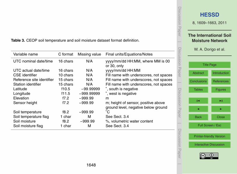
HESSD8, 1609–1663, 2011
The International SoilMoisture Network
W. A. Dorigo et al.
Title Page
Abstract Introduction
Conclusions References
Tables Figures
J I
J I
Back Close
Full Screen / Esc
Printer-friendly Version
Interactive Discussion
Discussion
Paper
|D
iscussionP
aper|
Discussion
Paper
|D
iscussionP
aper|
Table 3. CEOP soil temperature and soil moisture dataset format definition.
Variable name C format Missing value Final units/Equations/Notes
UTC nominal date/time 16 chars N/A yyyy/mm/dd HH:MM, where MM is 00or 30, only
UTC actual date/time 16 chars N/A yyyy/mm/dd HH:MMCSE identifier 10 chars N/A Fill name with underscores, not spacesReference site identifier 15 chars N/A Fill name with underscores, not spacesStation identifier 15 chars N/A Fill name with underscores, not spacesLatitude f10.5 −99.99999 ◦, south is negativeLongitude f11.5 −999.99999 ◦, west is negativeElevation f7.2 −999.99 mSensor height f7.2 −999.99 m; height of sensor, positive above
ground level, negative below groundSoil temperature f8.2 −999.99 ◦CSoil temperature flag 1 char M See Sect. 3.4Soil moisture f8.2 −999.99 %, volumetric water contentSoil moisture flag 1 char M See Sect. 3.4
1648
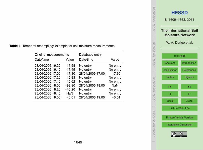
HESSD8, 1609–1663, 2011
The International SoilMoisture Network
W. A. Dorigo et al.
Title Page
Abstract Introduction
Conclusions References
Tables Figures
J I
J I
Back Close
Full Screen / Esc
Printer-friendly Version
Interactive Discussion
Discussion
Paper
|D
iscussionP
aper|
Discussion
Paper
|D
iscussionP
aper|
Table 4. Temporal resampling: example for soil moisture measurements.
Original measurements Database entry
Date/time Value Date/time Value
28/04/2006 16:20 17.58 No entry No entry28/04/2006 16:40 17.49 No entry No entry28/04/2006 17:00 17.30 28/04/2006 17:00 17.3028/04/2006 17:20 16.83 No entry No entry28/04/2006 17:40 16.62 No entry No entry28/04/2006 18:00 −99.90 28/04/2006 18:00 NaN28/04/2006 18:20 −16.20 No entry No entry28/04/2006 18:40 NaN No entry No entry28/04/2006 19:00 −0.01 28/04/2006 19:00 −0.01
1649

HESSD8, 1609–1663, 2011
The International SoilMoisture Network
W. A. Dorigo et al.
Title Page
Abstract Introduction
Conclusions References
Tables Figures
J I
J I
Back Close
Full Screen / Esc
Printer-friendly Version
Interactive Discussion
Discussion
Paper
|D
iscussionP
aper|
Discussion
Paper
|D
iscussionP
aper|
Table 5. Equations used to convert original soil moisture unit into volumetric water content Θ(% volume).
Measurement unit Conversion equation
Gravimetric water content (w), defined Θ=w ·ρb/ρwas the ratio between the mass of water ρb: dry bulk density (variable)and the mass of solids ρw: water density (assumed 1000 kg m−3)
Degree of saturation (s), defined as the Θ= P ·svolume of water relative to the volume P : total porosityof voids
Equivalent depth of water per depth of Θ=∆z/Deqsoil (Deq), calculated by multiplying thevolumetric water content Θ with a depthinterval ∆z
Plant available water, PAW Θ=PAW+ΘwpΘwp: permanent wilting point
Water volume ratio (sometimes called Θ= νw/(1+e)liquid ratio), νw, expressed by the volume e: void ratioof water divided by the volume of soil
1650
HESSD8, 1609–1663, 2011
The International SoilMoisture Network
W. A. Dorigo et al.
Title Page
Abstract Introduction
Conclusions References
Tables Figures
J I
J I
Back Close
Full Screen / Esc
Printer-friendly Version
Interactive Discussion
Discussion
Paper
|D
iscussionP
aper|
Discussion
Paper
|D
iscussionP
aper|
Table 6. CEOP quality flags adopted by the ISMN.
Flag value Definition
C Reported value exceeds output format field size OR was negative precipitationM Parameter value missing OR derived parameter can not be computedD Questionable/dubiousU Unchecked
1651
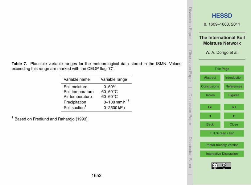
HESSD8, 1609–1663, 2011
The International SoilMoisture Network
W. A. Dorigo et al.
Title Page
Abstract Introduction
Conclusions References
Tables Figures
J I
J I
Back Close
Full Screen / Esc
Printer-friendly Version
Interactive Discussion
Discussion
Paper
|D
iscussionP
aper|
Discussion
Paper
|D
iscussionP
aper|
Table 7. Plausible variable ranges for the meteorological data stored in the ISMN. Valuesexceeding this range are marked with the CEOP flag “C”.
Variable name Variable range
Soil moisture 0–60%Soil temperature −60–60 ◦CAir temperature −60–60 ◦CPrecipitation 0–100 mm h−1
Soil suction1 0–2500 kPa
1 Based on Fredlund and Rahardjo (1993).
1652

HESSD8, 1609–1663, 2011
The International SoilMoisture Network
W. A. Dorigo et al.
Title Page
Abstract Introduction
Conclusions References
Tables Figures
J I
J I
Back Close
Full Screen / Esc
Printer-friendly Version
Interactive Discussion
Discussion
Paper
|D
iscussionP
aper|
Discussion
Paper
|D
iscussionP
aper|
Table 8. Parameter combinations leading to CEOP quality flag “D” for soil moisture.
1 Valid soil moisture measurement in combination with a negative soiltemperature (measured at same depth)
2 Valid surface soil moisture measurement in combination with a negativeair temperature
3 A decreasing or stable surface soil moisture content (with respect tothe previous time step) while precipitation is measured
1653

HESSD8, 1609–1663, 2011
The International SoilMoisture Network
W. A. Dorigo et al.
Title Page
Abstract Introduction
Conclusions References
Tables Figures
J I
J I
Back Close
Full Screen / Esc
Printer-friendly Version
Interactive Discussion
Discussion
Paper
|D
iscussionP
aper|
Discussion
Paper
|D
iscussionP
aper|
Table 9. Overview of networks contained in ISMN (status January 2011).
Network name CAMPANIA CHINA CNR-IRPI
Country Italy China Italy
Number of 2 40 4stations
Variables Soil moisture (m3 m−3), Soil moisture (cm) Soil moisture (m3 m−3),measured air temperature at 2 m air temperature at 2 m
(◦C), precipitation (mm) (◦C), precipitation (mm)
Depths of soil 0.30 m 0.00–0.05 m, 0.05–0.10 m, 0.10–0.20 m, 0.05–0.15 m, 0.15–0.25 m,moisture 0.20–0.30 m, 0.30–0.40 m, 0.40–0.50 m, 0.35–0.45 mmeasurements 0.50–0.60 m, 0.60–0.70 m, 0.70–0.80 m,
0.80–0.90 m, 0.90–1.00 m
Soil moisture ThetaProbe ML2 Coring device/auger EnviroSCAN (Sentekinstrument (Delta-T Devices) Technologies)
Data availability 26 Nov 2000–31 Dec 8 Jan 1981–28 Dec 1999 9 Oct 2002–31 May 20082008
Original sampling 60 min 10–11 days 30 mininterval
Land cover/ Agriculture (grassland), Agricultural (e.g. winter wheat, maize, Agricultural, pastureland use forest sorghum, beans)
Available soil Soil texture Permanent wilting points −metadata
1654

HESSD8, 1609–1663, 2011
The International SoilMoisture Network
W. A. Dorigo et al.
Title Page
Abstract Introduction
Conclusions References
Tables Figures
J I
J I
Back Close
Full Screen / Esc
Printer-friendly Version
Interactive Discussion
Discussion
Paper
|D
iscussionP
aper|
Discussion
Paper
|D
iscussionP
aper|
Table 9. Continued.
Network name ICN IOWA MOL-RAO
Country United States United States Germany
Number of 19 6 2stations
Variables Soil moisture (mm) Soil moisture (% vol) Soil moisture (% vol),measured soil temperature (◦C),
air temperature at 2 m(◦C), precipitation (mm)
Depths of soil 0.00–0.10 m, 0.10–0.30 m, 0.30–0.50 m, 0.00–0.07 m, 0.07–0.15 m, 0.15–0.30 m, 0.08 m, 0.10 m, 0.15 m,moisture 0.50–0.70 m, 0.70–0.90 m, 0.90–1.10 m, 0.30–0.45 m, 0.45–0.68 m, 0.68–0.83 m, 0.20 m, 0.30 m, 0.45 m,measurements 1.10–1.30 m, 1.30–1.50 m, 1.50–1.70 m, 0.83–1.06 m, 1.06–1.37 m, 1.37–1.67 m, 0.60 m, 0.90 m, 1.50 m
1.70–1.90 m, 1.90–2.00 m 1.67–1.98 m, 1.98–2.28 m, 2.28–2.59 m
Soil moisture Neutron depth probe (Troxler), Coring device/auger, TRIME-EZ TDR Sensorinstrument neutron surface probe (Troxler) neutron probe (IMKO GmbH)
Data 1 Jan 1981–15 Jul 2008 4 Apr 1972–15 Nov 1994 1 Jan 2003–31 Dec 2008availability
Original 14–16 days (growing season); 15 days (growing season) 30 minsampling 28–31 days (rest of the year)interval
Land cover/ Grassland, bare soil Agricultural crops Grassland, forest (pine)land use
Available soil Field capacity, permanent wilting None Texture, bulk density,metadata point, potential plant available water porosity, wilting points,
hydraulic conductivity,heat capacity
1655

HESSD8, 1609–1663, 2011
The International SoilMoisture Network
W. A. Dorigo et al.
Title Page
Abstract Introduction
Conclusions References
Tables Figures
J I
J I
Back Close
Full Screen / Esc
Printer-friendly Version
Interactive Discussion
Discussion
Paper
|D
iscussionP
aper|
Discussion
Paper
|D
iscussionP
aper|
Table 9. Continued.
Network name MONGOLIA OzNet REMEDHUS
Country Mongolia Australia Spain
Number of 44 64 18stations
Variables Plant available water (% vol) Soil moisture (m3 m−3), Soil moisture (m3 m−3),measured soil temperature (◦C), soil soil temperature (◦C)
suction (kPa), precipitation (mm)
Depths of soil 0.00–0.10 m, 0.10–0.20 m, 0.20–0.30 m, 0.00–0.05 m, 0.00–0.08 m, 0.00–0.30 m, 0.00–0.05 mmoisture 0.30–0.40 m, 0.40–0.50 m, 0.50–0.60 m, 0.30–0.60 m, 0.43–0.73 m, 0.51–0.81 m,measurements 0.60–0.70 m, 0.70–0.80 m, 0.80–0.90 m, 0.60–0.90 m
0.90–1.00 m
Soil moisture Gravimetric, neutron probe CS615 and CS616 (Campbell Hydra Probeinstrument Scientific), Hydra Probe (Stevens) (Stevens)
Data 8 Apr 1964–28 October 2002 1 Jan 2001–2 Feb 2010 1 Jan 2005–31 Decavailability 2009
Original 15 days (growing season) 20–30 min 60 minsamplinginterval
Land cover/ Agricultural crops, extensive pasture Agriculture, grass land (pasture) Agriculture, partlyland use irrigated
Available Wilting points Soil type, soil depth, soil porosity, Nonesoil salinitymetadata
1656

HESSD8, 1609–1663, 2011
The International SoilMoisture Network
W. A. Dorigo et al.
Title Page
Abstract Introduction
Conclusions References
Tables Figures
J I
J I
Back Close
Full Screen / Esc
Printer-friendly Version
Interactive Discussion
Discussion
Paper
|D
iscussionP
aper|
Discussion
Paper
|D
iscussionP
aper|
Table 9. Continued.
Network name RUSWET-AGRO RUSWET-GRASS RUSWET-VALDAI
Country Russia, Belarus, Moldova, Lithuania, Russia, Belarus, Kazakhstan, RussiaLatvia, Estonia, Kazakhstan Uzbekistan, Turkmenistan, Tajikistan
Number of 78 122 3stations
Variables Plant available water (vol. %) Plant available water (vol. %) Soil moisture (vol. %),measured precipitation (mm),
soil temperature (◦C),air temperature (◦C),water table depth (cm),snow water equivalent (mm)
Depths of soil 0.00–0.20 m, 0.00–1.00 m 0.00–0.10 m, 0.00–1.00 m 0.00–0.20 m, 0.00–0.50 m,moisture 0.00–1.00 mmeasurements
Soil moisture Gravimetric Gravimetric Gravimetricinstrument
Data availability 28 Dec 1986–28 Dec 1988 Jan 1952–Dec 1985 Jan 1952–Dec 1985
Original sampling 10–11 days (growing season) 10–11 days (growing season); 1 monthinterval 28–31 days (rest of year)
Land cover/ Spring cereal crops and winter Natural grassland Grassland, Forestland use cereal crops
Available soil Wilting points Wilting points Wilting pointsmetadata
1657

HESSD8, 1609–1663, 2011
The International SoilMoisture Network
W. A. Dorigo et al.
Title Page
Abstract Introduction
Conclusions References
Tables Figures
J I
J I
Back Close
Full Screen / Esc
Printer-friendly Version
Interactive Discussion
Discussion
Paper
|D
iscussionP
aper|
Discussion
Paper
|D
iscussionP
aper|
Table 9. Continued.
Network name SMOSMANIA SWEX POLAND UDC SMOS
Country France Poland Germany
Number of 12 (to be extended with 2 11stations 9 additional ones soon)
Variables Soil moisture (m3 m−3) Soil moisture (m3 m−3), Soil moisture (m3 m−3)measured soil temperature (◦C)
Depths of soil 0.05 m, 0.10 m, 0.20 m, 0.00–0.02 m, 0.05 m, 0.10 m, 0.00–0.10 m, 0.05 m, 0.10 m,moisture 0.30 m 0.20 m, 0.30 m, 0.40 m, 0.50 m, 0.20 m, 0.40 mmeasurements 0.60–1.00 m
Soil moisture ThetaProbe ML2X D-LOG/mpts (EasyTest) IMKO TDR, ECHO EC5,instrument (Delta-T Devices) EC-TE probes
Data availability 1 Jan 2007–31 Dec 2009 3 Mar 2006–3 Jan 2010 8 Nov 2007–25 Jul 2010
Original sampling 12 min 30 min, 60 min 60 mininterval
Land cover/ Agriculture, partly Agriculture (crops), forest, bog Agriculture (intensively usedland use irrigated grassland)
Available soil None None Nonemetadata
1658

HESSD8, 1609–1663, 2011
The International SoilMoisture Network
W. A. Dorigo et al.
Title Page
Abstract Introduction
Conclusions References
Tables Figures
J I
J I
Back Close
Full Screen / Esc
Printer-friendly Version
Interactive Discussion
Discussion
Paper
|D
iscussionP
aper|
Discussion
Paper
|D
iscussionP
aper|
Table 9. Continued.
Network name UMSUOL
Country Italy
Number of stations 1
Variables measured Soil moisture (m3 m−3)
Depths of soil moisture 0.10 m, 0.25 m, 0.45 m, 0.70 m,measurements 1.00 m, 1.35 m, 1.80 m
Soil moisture instrument TDR 100 (Campbell)
Data availability 1 Jun 2009–1 Oct 2010
Original sampling interval 60 min
Land cover/land use Grassland
Available soil metadata Organic matter content, texture, bulk density
1659
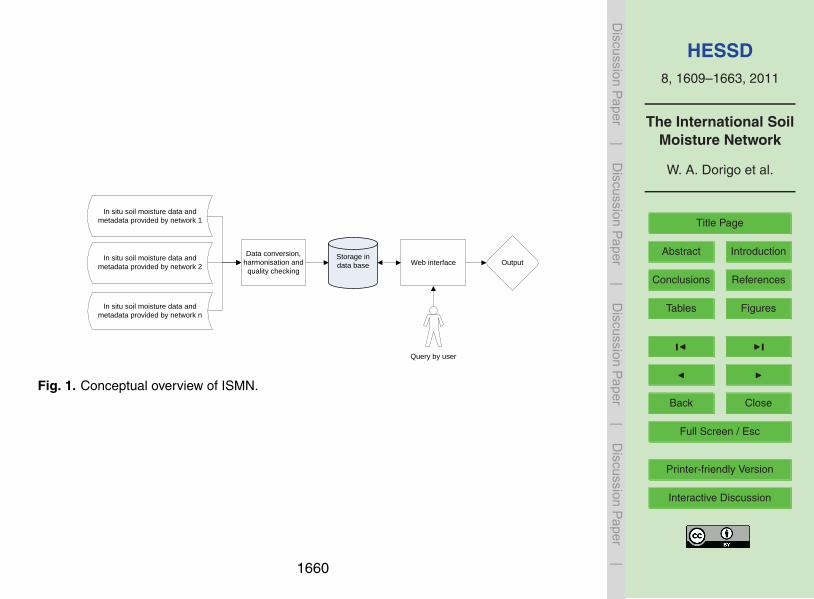
HESSD8, 1609–1663, 2011
The International SoilMoisture Network
W. A. Dorigo et al.
Title Page
Abstract Introduction
Conclusions References
Tables Figures
J I
J I
Back Close
Full Screen / Esc
Printer-friendly Version
Interactive Discussion
Discussion
Paper
|D
iscussionP
aper|
Discussion
Paper
|D
iscussionP
aper|
In situ soil moisture data and
metadata provided by network 1
In situ soil moisture data and
metadata provided by network 2
Data conversion,
harmonisation and
quality checking
In situ soil moisture data and
metadata provided by network n
Web interfaceStorage in
data base Output
Query by user
Fig. 1. Conceptual overview of ISMN.
1660

HESSD8, 1609–1663, 2011
The International SoilMoisture Network
W. A. Dorigo et al.
Title Page
Abstract Introduction
Conclusions References
Tables Figures
J I
J I
Back Close
Full Screen / Esc
Printer-friendly Version
Interactive Discussion
Discussion
Paper
|D
iscussionP
aper|
Discussion
Paper
|D
iscussionP
aper|
Fig. 2. Web interface of ISMN. Red droplets indicate the center coordinates of the differentnetworks contained in the database.
1661

HESSD8, 1609–1663, 2011
The International SoilMoisture Network
W. A. Dorigo et al.
Title Page
Abstract Introduction
Conclusions References
Tables Figures
J I
J I
Back Close
Full Screen / Esc
Printer-friendly Version
Interactive Discussion
Discussion
Paper
|D
iscussionP
aper|
Discussion
Paper
|D
iscussionP
aper|
Fig. 3. Data viewer window with an example of soil moisture data from the SMOSMANIAnetwork, Sabres station.
1662

HESSD8, 1609–1663, 2011
The International SoilMoisture Network
W. A. Dorigo et al.
Title Page
Abstract Introduction
Conclusions References
Tables Figures
J I
J I
Back Close
Full Screen / Esc
Printer-friendly Version
Interactive Discussion
Discussion
Paper
|D
iscussionP
aper|
Discussion
Paper
|D
iscussionP
aper|
Fig. 4. Map of the distribution of networks and stations contained in the ISMN (situation ofJanuary 2011).
1663