Quasi-Gaussian DCT Filter for Speckle Reduction of Ultrasound Images
1
Speckle noise and soil heterogeneities as errorsources in a Bayesian soil moisture retrieval scheme
for SAR dataMatias Barber, Student Member, IEEE, Francisco Grings, Pablo Perna, Marcela Piscitelli, Martin Maas,
Cintia Bruscantini, Student Member, IEEE, Julio Jacobo-Berlles and Haydee Karszenbaum.
Abstract—Soil moisture retrieval from SAR images is alwaysaffected by speckle noise and uncertainties associated to soilparameters, which impact negatively on the accuracy of soilmoisture estimates. In this paper a soil moisture Bayesian estima-tor from polarimetric SAR images is proposed to address theseissues. This estimator is based on a set of statistical distributionsderived for the polarimetric soil backscattering coefficients, whichnaturally includes models for the soil scattering, the speckle andthe soil spatial heterogeneity. As a natural advantage of theBayesian approach, prior information about soil condition can beeasily included, enhancing the performance of the retrieval. TheOh’s model is used as scattering model, although it presents alimiting range of validity for the retrieval of soil moisture. Afterfully stating the mathematical modeling, numerical simulationsare presented. First, traditional minimization-based retrieval isinvestigated. Then, it is compared with the Bayesian retrievalscheme. The results indicate that the Bayesian model enlarges thevalidity region of the minimization-based procedure. Moreover,as speckle effects are reduced by multilooking, Bayesian retrievalapproaches the minimization-based retrieval. On the other hand,when speckle effects are large, an improvement in the accuracyof the retrieval is achieved by using a precise prior. The proposedalgorithm can be applied to investigate which are the optimumparameters regarding multilooking process and prior informationrequired to perform a precise retrieval in a given soil condition.
Index Terms—Soil moisture, radar applications, Bayesianmethods, synthetic aperture radar, inverse problems.
I. INTRODUCTION
SURFACE soil moisture content plays a key role in theinteraction between the land surface and the atmosphere,
and accurate knowledge about this variable is of interest fora variety of reasons. First, it is strongly related to vegetationdevelopment. Second, it determines the partitioning betweenrainfall into infiltration and runoff, which is strongly related toerosion of top soil through leaching. Third, when soil moistureis high, infiltration decreases and the risk of floods due to rain-fall increases. And finally, soil evaporation and transpirationdepends on soil moisture and therefore it influences the heatand mass transfers between the Earth and the atmosphere [1].
M. Barber, F. Grings, P. Perna, M. Maas, C. Bruscantini and H. Karszen-baum are with the Instituto de Astronomıa y Fısica del Espacio (IAFE),Argentina (e-mail: [email protected]).
M. Piscitelli is with the Catedra de Conservacion y Manejo de Suelos,Facultad de Agronomıa, Universidad Nacional del Centro de la Pcia. deBuenos Aires (UNICEN), Argentina.
J. Jacobo-Berlles is with the Departamento de Computacion, Facultad deCiencias Exactas y Naturales (FCEN), Universidad de Buenos Aires (UBA),Argentina.
Following this demand of information, there is a systematiceffort to develop maps of soil moisture of the Earth’s surface.Orbiting microwave synthetic aperture radar (SAR) systemsoffer the opportunity of monitoring soil moisture contentat different scales and under almost any weather condition,through the known sensitivity that the backscattered signalexhibits to soil parameters, including, among others, soilmoisture and soil roughness [2]. Polarimetric SAR systems areable to transmit and receive radiation that is linearly polarizedin the horizontal (h) and vertical (v) planes (relative to theplane defined by the wave vector and the normal to the surfacebeing illuminated), giving rise to four intensity images σ0
hh,σ0hv , σ0
vh, and σ0vv of the target of interest [3].
However, the relation between backscattered signal and soilparameters is not straightforward, and consequently there arestill no operational SAR-derived soil moisture products. Thereare two main reasons for this: (1) the scattering processes thatrelate backscattering to soil properties (moisture, roughness,and others) are difficult to model [4], and (2) the necessaryinput parameters are difficult to measure in the field [5], [6].The former is mainly related to the SAR imaging systemwhereas the latter to soil parameters heterogeneity.
Moreover, usually there are several combinations of surfaceparameters producing the same SAR observations. As a conse-quence, any retrieving scheme is an ill-posed inverse problem.Accordingly, soil parameters retrieval remains challenging,and soil moisture products derived from remotely-sensed SARdata are still poorly accurate [7].
Restricting this study to bare soils, surface soil moisturepresents a high degree of spatial variability at different scales,even for relatively small areas. This is associated to water-routing processes, radiative effects and heterogeneity in soilcharacteristics [5]. On the other hand, heterogeneity of surfaceroughness arises from both man-made and natural factors:tillage system, soil texture and soil type among others [6].
When using SAR images for retrieving soil properties, thespeckle phenomenon, characteristic of SAR images, furtherhinders soil moisture retrieval. Speckle leads to a grain-likeappearance of SAR images decreasing their contrast and ra-diometric quality [3]. It is characteristic of the coherent natureof the SAR imaging system, can be modeled as a multiplicativenoise and it is usually reduced in a post-processing stageby: (1) averaging neighboring pixels (multilooking process)at the expense of spatial resolution [8] or (2) using adaptivefilters [9], to reduce radiometric uncertainties without losing
2
spatial resolution, but at the expense of introducing artifacts.It is important to note that the process of averaging toreduce radiometric uncertainties implicitly assumes that soilproperties within the average window are constant, which isusually not the case in most of the bare soils. Therefore, atrade-off between averaging and soil properties heterogeneityis usually accepted. However, heterogeneity of soil propertiesand speckle are usually considered as independent problems,whereas they are indeed a part of the same inference problem.
In this general framework, soil moisture retrieval overbare soils from SAR images can be considered an inferenceproblem, where one essentially wants to infer soil conditiongiven a set of measured backscatter coefficients and ancillaryinformation. Polarimetric methods [10], [11], change detectionprocedures [12], [13], [14], possibilistic approaches [15], [16],radar backscatter modeling (theoretical and semi-empirical)[17], [18], [19], [4] and Bayesian approaches [20], [21], [22]are among the retrieval methodologies offered in the literature.
Polarimetric methods are based on modeling the backscatterresponse in terms of a certain polarimetric matrix decom-position (see [23] for a review) and taking into accountthe amplitude as well as the phase difference of the mea-sured backscattering coefficients. Although polarimetry lookspromising, a major effort is still needed to achieve an opera-tional soil moisture retrieval algorithm using these techniques.Such algorithm was only developed in closed form for theSmall Pertubation Model [11], which has a highly restrictiverange of validity for the normalized RMS height (ks � 0.3,where k = 2π
λ is the wavenumber, λ the wavelength and s theRMS height), limiting operational soil parameter retrieval tovery smooth surfaces. Therefore, this method is not suitable forreal applications, where it is usually found values of ks ∼ 0.3for L-band (i.e. s = 1 cm). In addition, speckle noise is nottaken into account, although a polarimetric SAR speckle noisemodel was developed in [10].
Change detection methods exploit the availability of tem-poral series of SAR acquisitions from space platforms tomonitor near-surface soil moisture content globally. The ra-tionale behind this method is that temporal changes of surfaceroughness, canopy structure, and vegetation biomass occurover longer temporal scales than soil moisture changes, ex-cluding periods of cultivation. Therefore, variations in surfacebackscatter observed with a short repeat cycle are expected tomainly reflect changes in soil moisture, since other parametersaffecting radar backscatter can be considered fairly constant.Clearly, this sort of technique is constrained to spacebornesensors with short-repeating cycles [12].
The possibilistic methods make use of an alternative set ofaxioms called fuzzy logic. As an advantage, they enable andrequire the use of prior information, which is used to improvethe retrieving of soil parameters. On the other hand, they donot take into account speckle and they are computationallyintensive [15].
Regarding radar backscatter modeling approaches, a widerange of forward models, ranging from semi-empirical to the-oretical, physically-based models have been developed in orderto assess the dependency of soil parameters to backscatteredsignal. These models are important to understand the physics
related to soil backscattering. They can also play a key role inthe retrieval of soil condition from SAR measurements if aninverse problem approach is used [24], [25].
Physical Optics model (PO), Geometrical Optics model(GO), the first-order Small Pertubation Model (SPM) and theIntegral Equation Model (IEM) [4] with its further improve-ments and updates [26], [27], [28] are the analytical electro-magnetic backscattering models available. Their strength liesin the fact that they are derived from the well-established elec-tromagnetic theory. However, the first three of them have beenderived considering some specific assumptions and thereforehave a limited applicability in terms of surface roughness.Although IEM is valid for a wider range of surface roughnessconditions, the complexity of the model and the inherentrelationship between soil parameters and soil backscatteringmake difficult to perform a direct retrieval.
Semi-empirical models are among the most popular for soilmoisture retrieval applications. This is related to their simplealgebraic formalism, that allows a straightforward retrievalscheme being the usual ones the direct inversion [18] and min-imization (look-up table) procedures [19], [29]. The standardapproach for the development of these models is to measuresoil backscattering at different polarizations, incidence anglesand soil conditions using scatterometers, for deriving a modelby means of these measurements. In all the semi-empiricalmodels available [17], [18], [19], only the mean value of thebackscattering coefficient as a function of soil parameters ismodeled, disregarding the spread around the average valueand its causes. This gives rise to characteristic artifacts whereseveral values of soil moisture estimated from scatterometerdata correspond to the same soil moisture measured on thefield [20]. Reasons for mismatches between model estimationsand measured data include system measurement errors, theinhomogeneity of soil parameters within a given system reso-lution cell (or from one cell to the next) and the difficulty tomeasure soil parameters on the field [6], [30], [20]. Regardingthis, the most difficult parameter to measure and to interpret isthe surface correlation length [6]. Concerning the Oh’s model[19], a simplified alternative version was modeled ignoringthe correlation length, motivated by the insensitivity of theσ0vh − σ0
vv ratio on this roughness parameter.To the authors’ knowledge, it was not until Haddad et
al. [20] that a systematic way to include uncertainties in aforward model based on Bayes’ theorem was presented forthe retrieval of soil parameters. The Bayesian framework hasthe relevant feature of naturally including many sources ofuncertainty as well as many sources of information aboutthe variables involved in the retrieval. Whereas the radarbackscatter models give rise to several combinations of sur-face parameters that map the same SAR observations, theBayesian algorithm appropriately assimilates prior informationon geophysical parameters in order to constrain the inversionof forward models. Despite these outstanding features, intheir original paper Haddad et al. [20] only included as errorsource a term related to model uncertainties, and used onlyuniform distributions as prior. In addition, the potential of suchBayesian methodology is pointed out in [21] where data fromactive and passive sensors were merged in order to retrieve
3
soil moisture. Nevertheless, up to date there is no model thatincorporates multilooking speckle noise as an error source.
In this paper, we propose a Bayesian retrieval methodologywhich incorporates in a natural way soil parameters hetero-geneity and speckle as sources of uncertainty that degradethe estimated soil moisture. Such a Bayesian approach (1)needs only a forward model, (2) gives the optimal estimator forthe soil moisture and its error, (3) can include as many errorsources as required and (4) can include prior information ina systematic way. The methodology will be presented usinga simplified version of the Oh’s model [19] as the forwardmodel.
The present paper has been divided as follows. In Section IIa brief description of the general properties of scatterometer-based semi-empirical forward models is presented, focused onOh’s model and the multiplicative model. Section III is devotedto present the statistical model, and Bayesian estimators arederived. Numerical results are reported in Section IV. Finally,Section V presents the main conclusions derived from thisstudy.
II. SCATTEROMETER-BASED SEMI-EMPIRICAL FORWARDMODELS
A. Oh’s Model
One of the most widely used semi-empirical soil scatteringmodels is the one developed by Oh [19], where model ex-pressions are physically-based, but model parameters are fittedusing data from an extensive database of polarimetric radarscatterometer measurements over bare soils. In its simplifiedversion, where the correlation length is disregarded, the Oh’smodel relates backscattering coefficients and certain bare soilproperties through a set of three analytical functions σ0
i , thatcan be symbolically expressed as [19, eqs. (1),(2) and (4)],
xi = σ0i (m, ks) (i = 1, 2, 3), (1)
where xi is the backscattering (measured) coefficients andthe subscript i = 1, 2, 3 stands respectively for the hh-, vv-and vh-polarizations. The backscattering coefficients xi arefunctionally related to the volumetric soil moisture content m(cm3/cm3) and the normalized surface soil RMS height ks(where k = 2π
λ is the wavenumber and s the RMS height)throughout the functions σ0
i . This model also depends onthe system incidence angle θ, which is a known parameter.Throughout this paper, it will be assumed that θ = 35◦. TheOh’s model is constrained to the range 0.04 ≤ m ≤ 0.291 and0.13 ≤ ks ≤ 6.98, although a better agreement between themodel and the experimental results is obtained for ks ≤ 3.5[19]. Explicitly from [19, eqs. (1),(2) and (4)],
σ0vh = 0.11m0.7(cosθ)2.2[1− exp(−0.32(ks)1.8)], (2)
σ0vv =
σ0vh(m, ks)
0.095(0.13 + sin(1.5θ)1.4[1− exp(−1.3(ks)0.9)],
(3)
σ0hh = σ0
vv(m, ks)[1− (θ
90◦)0.35m
−0.65
exp(−0.4(ks)1.4)].
(4)
Concerning the σ0i functions, it is worth mentioning that
they are not independent of each other, since by (1) there arethree equations and only two variables. Then, providing thatm and ks are given, it always holds
σ0hh = f1(m, ks)σ0
vv (5)
σ0vh = f3(m, ks)σ0
vv, (6)
thus indicating that both hh and vh backscattering coefficientsare a rescaled version of vv, where the derivation of functionsf1 and f3 is straightforward from (4) and (3), respectively. Thisis a consequence of the deterministic nature of the Oh’s model.From (2), (3) and (4), it is easy to show that the backscatteringcoefficients for σ0
hh, σ0vv and σ0
vh increase monotonically withm and ks, but with different slopes in each variable; for abare soil, σ0
vv is always greater than σ0hh and the latter greater
than σ0vh. Any retrieval scheme using Oh’s model is based
on the differential sensitivity exhibited by the backscatteringcoefficients to m and ks. The dynamic range in dB of thebackscattering coefficients (eqs. (2-4)) is given in a nested wayfrom the simplified formulation of the Oh’s model, constrainedto ks ≤ 3.5 and for θ = 35◦:
−42.2dB < σ0vh < −15.6dB, (7)
σ0vh + 10.8dB < σ0
vv < σ0vh + 18.0dB (8)
andσ0vv − 2.7dB < σ0
hh < σ0vv. (9)
The inequations (7), (8) and (9) define a region where Oh’smodel is valid (Oh’s model validity region). Only points(σ0hh, σ
0vv, σ
0vh) within this region may be used to retrieve
(m, ks) using Oh’s model.Considering the aim of this work, differences between the
backscattering coefficients measured from SAR systems andthe ones measured from ground-based scatterometers have tobe analyzed. First, the ground-based scatterometer footprintis small; the actual size varies for different experiments andsensors, but it is always of the order of a few squaredmeters. This is justified assuming that the soil propertieson which measured microwave backscattering depends (soilmoisture and roughness) are constant inside the sampled area.Therefore, it is reasonable to assume that the backscatteringcoefficient of the study area is a function of a single soil mois-ture value and roughness profile. In other words, the terrainscattering properties within the footprint can be consideredconstant. Second, it is easy to average several measurementsupon the same surface’s target and thus reduce the specklenoise.
On the other hand, SAR system resolution is larger (ofthe order of hundreds of m2) and even larger if we want toaverage and increase the number of looks to reduce speckle.Therefore, any retrieval scheme based on SAR data that usesscaterometer-based models should deal with the heterogeneityof soil properties and speckle. This will lead to non-constantsoil scattering properties in the averaging window and/or non-negligible speckle noise, which in any case will degrade soilmoisture retrieval.
4
B. Multiplicative Model
The multiplicative model is generally used to model theSAR response of a target as a function of the combined effectof terrain backscattering and speckle noise. Specifically, themodel states that the observed intensity value in every pixelof a SAR image is the outcome of a random variable Z, calledreturn, defined as the product between the random variables Xand Y , where X represents the random variable modeling thevariations of terrain backscattering properties and Y representsthe random variable modeling the speckle noise; i.e. Z = XY[3].
Different probability density distributions (PDF) for X andfor Y yield different models for the observed data Z. Forhomogeneous regions, the terrain scattering properties areassumed constant. Therefore, the distribution of Z is a rescaledversion of the distribution of Y , which is usually assumed asGamma-distributed with parameters (n, n) and mean valueE[Y ] = 1 [3],
PY (y) =nn
Γ(n)yn−1e−ny (10)
where n is the equivalent number of looks and Γ(n) is theGamma function. Since V ar[Y ] = 1
n , as n approaches toinfinity, the radiometric uncertainty becomes negligible.
The basic hypothesis that governs the modeling of inho-mogeneous regions (X 6= constant) is that they can bemodeled by a convenient distribution. In our case, we willpropose a PDF for X that arises as the result of inter-pixel soil parameters heterogeneity. Indeed, if soil parameterschanges from pixel to pixel, soil backscattering (which is afunction of soil parameters) will also change accordingly. Inorder to account for backscattering variability arising from soilparameters heterogeneity, we will derive the correspondingPDF using Oh’s model, for all the polarizations.
By means of the multiplicative model, we can include twoindependent sources of SAR image inhomogeneity: soil spatialvariability and speckle. This idea can be formalized as follows.First, we will assume that X and Y are independent. Second,that the average properties of the return Z will be determinedby the average properties of both X and Y , since by virtue ofthe multiplicative model,
E[Z] = E[X]E[Y ]. (11)
Suitable distributions for X and Y will be introduced insections III-C and III-D.
III. STATISTICAL MODEL
A. Bayesian Approach
The deterministic forward model developed by Oh can beextended to a stochastic model following [20]. In doing so, wecan include in the forward model both the terrain heterogeneityand speckle through the multiplicative model,
Zi = XiYi (i = 1, 2, 3), (12)
where Zi is the random variable which represents the returnzi and the subscript i stands for the different polarizations,as stated before. Xi and Yi are independent random variables
that model the heterogeneity of the target backscattering andthe speckle noise, respectively.
We assumed that the target response to the backscatteris modeled through the Oh’s model by Xi = σ0
i (M,KS)(i = 1, 2, 3), where the σ0
i are the same as in (1) andrepresent here the deterministic way in which the randomvariable X depends on the random variables M and KS(which represent the m’s and ks’s of the target). In otherwords, an heterogeneous soil will produce a wide range ofpossible outcomes x of X , provided a wide range of soilmoisture and roughness values were presented in the soil.On the other hand, an extremely homogeneous soil (i.e.a certain mean value (m, ks) with a very low variance)will produce a very narrow probability density function forX . This statement is mathematically grounded by means ofa Taylor expansion, namely E[Xi] = E[σ0
i (M,KS)] =σ0i (m, ks) + O(V ar(M), V ar(KS)), where m and ks are
the expected or mean values of M and KS within theresolution cell and higher order terms are neglected. Therefore,E[Xi] ≈ σ0
i (m, ks) as long as the variance remains low, forall i = 1, 2, 3. In addition, following [3] the speckle adds onlya multiplicative noise so that E[Yi] = 1 (i = 1, 2, 3). This ap-proach leads into a proper average behavior for the returns Ziin terms of the forward Oh’s model since E[Zi] = σ0
i (m, ks)under the assumption of independence of X and Y .
From the set of equations (12) and using Bayes’ theorem,an expression for the conditional (“posterior ”) probability ofmeasuring m and ks given measurements of returns z1, z2 andz3 can be obtained,
P (m, ks|z1, z2, z3) =PZ1Z2Z3
(z1, z2, z3|m, ks)PMKS(m, ks)
PZ1Z2Z3(z1, z2, z3),
(13)where PZ1Z2Z3
(z1, z2, z3|m, ks) is the probability of measur-ing a certain set (z1,z2,z3) of returns given measurementsof m and ks (the “likelihood ”), PMKS is the prior jointdensity function of m and ks (where it is included all theprior information about m and ks) and P (z1, z2, z3) worksas a normalizing factor and it is the probability of a certainset (z1,z2,z3) to be measured. Then, providing the conditionaldensity function (13) is exact, the optimal unbiased estimatorof m that has the minimum variance is the mean of (13) [31],
mBayesest =
∫∫D
mP (m, ks|z1, z2, z3)dmdks (14)
and similarly the squared standard deviation of this estimatorwill be:
m2std =
∫∫D
(m−mBayesest )2P (m, ks|z1, z2, z3)dmdks (15)
where an explicit expression for (13) must be found in order tocalculate mBayes
est and mstd. The integration domain D in (14)and (15) spans the same range of (m, ks) where the forwardOh’s model was originally constrained, except for ks which istaken to be ≤ 3.5 as discussed in Section II-A. The standarddeviation mstd can be used as a measure of the error of theestimate mBayes
est .
5
B. Derivation of the Likelihood
The posterior distribution P (m, ks|z1, z2, z3) in (13) can becomputed as follows. First, using recursively the definition ofconditional probability yields
PZ1Z2Z3(z1, z2, z3|m, ks) = PZ1
(z1)PZ2|Z1=z1(z2)×× PZ3|Z1=z1,Z2=z2(z3) (16)
where in the right term the given m and ks were suppressedfor simplicity. In (16), PZ1
(z1) is calculated using the changeof variables theorem upon (12) (i = 1) and the assumption ofindependence between X and Y ,
PZ1(z1) =
∫ ∞0
PX1(w)PY1
(z1w
)1
wdw. (17)
In order to calculate the remaining two terms in (16), it mightbe noted that replacing m by M and ks for KS in (5) and(6) the following relationships concerning Xi hold
X1 = f1(M,KS)X2 (18)
X3 = f3(M,KS)X2 (19)
Replacing this set of equation in (12) and then equating forZ2 and Z3 one obtains
Z2 =1
f1(M,KS)
Y2Y1Z1 (20)
Z3 = f3(M,KS)Y3Y2Z2 (21)
Finally, given m and ks and using again the change ofvariables theorem upon (20) and (21) separately, the remainingconditional probabilities are
PZ2|Z1=z1(z2|m, ks) =f1(m, ks)
z1PY2
Y1
(f1(m, ks)z2
z1), (22)
PZ3|Z1=z1,Z2=z2(z3|m, ks) =1
f3(m, ks)z2PY3
Y2
(z3
f3(m, ks)z2),
(23)where P Yi
Yj
(i 6= j) is the joint distribution of the ratio of two
multilooked random variables that are affected by speckle. Thelikelihood in (16) is constructed then by multiplying (17), (22)and (23).
C. Modeling the Terrain Backscatter X
Natural variability of soil moisture are always present atdifferent scales, and thus also at the scale of SAR systems [32].In general, this implies that soil moisture inside a field cannotbe considered constant; i.e. the field is heterogeneous in termsof soil moisture. Soil roughness can also be framed withinthis description. In agricultural fields, roughness is generatedartificially by tilling and naturally by wind and water erosion.Moreover, soil surface roughness is very dependent on soiltype [33].
In order to define the PDF of X arising from randomnessin M and KS, a forward model is needed. It is importantto remark that errors introduced by the forward model set alower bound of uncertainty in any retrieval scheme. In theapproach developed in this paper, forward model uncertainties
were not considered, because the focus is placed on addressingthe relative contribution of prior information and multilookingprocess on the retrieval errors.
This mapping will be completely defined by the functionsσ0i from (1) that associate soil backscattering with soil pa-
rameters (i.e. the forward model). To compute this mapping,we will use a three-step procedure given in [34, §2.12]. Sucha procedure allows to find the distribution PR of a generalfunction r(u, v) which depends on two random variables Uand V of known distribution. In our case, we are interestedon the computation of the distribution of x1 = σ0
hh(m, ks)used in (17) as PX1
when the soil moisture m and roughnessks are considered random variables M and KS, respectively.Ignoring the subscript 1, such computation states that
FX(x) =
∫∫Ax
PMKS(m, ks)dmdks, (24)
where FX(x) is the cumulative distribution function of therandom variable X and the integration domain is Ax ={(m, ks) : σ0
hh(m, ks) ≤ x}. Then PX(x) is readily ob-tained by deriving (24) with respect to x. In what follows,it would be assumed that M and KS are uncorrelated andGaussian random variables, so that PMKS = PMPKS wherePM ∼ N(m, σm) and PKS ∼ N(ks, σks). Therefore, theheterogeneity of the soil parameters within a SAR pixel iscontrolled throughout the variance σ2
m and σ2ks. The Gaussian
assumption is not restricting or fundamental in any way, andthe procedure can be also applied to different distributions form and ks, even empirical ones. On the other hand, under thisassumption the computation of (24) can be only performednumerically.
D. Modeling the Speckle Noise Y
Statistical properties of multilook polarimetric data are quitedifferent from those of single-look data [8]. Therefore, inorder to model the expected speckle phenomena, we need toknow the probability density function of polarimetric data asa function of the number of looks n. In the case of multilookintensity values, the corresponding distribution PY is that of(10) and is used in (17). On the other hand, the probabilitydensity function of the ratio of two multilook polarimetric datasets PYi/Yj
which are not independent is required in (22) and(23). Such a distribution was derived by Lee et al. [8]:
PU (u) =Γ(2n)
Γ(n)Γ(n)
τn(1− |ρu|2)n(τ + u)un−1
[(τ + u)2 − 4τ |ρu|2u]n+1/2(25)
where U = Yi
Yj(i 6= j), n is the number of looks, ρc is the
correlation between the numerator and the denominator andτ = E[Yi]
E[Yj ]is the ratio of the expected value of Yi and Yj .
In order to determine the expected value of the returns onlyby the expected value of the forward model, we stated thatE[Yi] = 1 (i = 1, 2, 3) and then τ = 1. Thus the expectedvalue of Z is determined only by X as follows from (11).The ratio distribution also depends on the correlation betweenthe numerator and the denominator ρu. This is very important,since when numerator/denominator correlation increases, thevariance of the distribution decreases [8]. As expected, when
6
n increases the distribution becomes narrower and thus thevariance of the estimates decreases, leading to a more preciseretrieval. Up to this point, we presented all the mathematicsneeded in a Bayesian retrieval scheme. In the next sections wepresent the results of numerical simulations.
IV. NUMERICAL RESULTS
A. Minimization Estimate
Since Oh’s model is not directly invertible, in [19] itis presented an algorithm for retrieving soil moisture androughness from a set of measured backscattering coefficientsσ0hh, σ0
vv and σ0vh through a minimization procedure. Such
a procedure is based on the simultaneous solution of modelequations (2), (3) and (4), leading to the following non-linearexpression [19, eq. (6)],
1− (θ
90◦)0.35m
−0.65
exp(−0.4(ks(θ,m, σ0vh))1.4)− σ0
hh
σ0vv
= 0
(26)where ks(θ,m, σ0
vh) is directly obtained after solving (2).For a given (σ0
hh, σ0vv, σ
0vh), the estimated value of m is
the one that minimizes this expression, namely mOhest . It is
important to note that (26) can be solved only for the valuesof (σ0
hh, σ0vv, σ
0vh) that are allowed by the forward model,
specifically those values that lie within the region bounded byinequations (7), (8) and (9). This means that this approach isnot robust to high statistical fluctuations in the backscatteringcoefficients, that are commonly found in real applications.
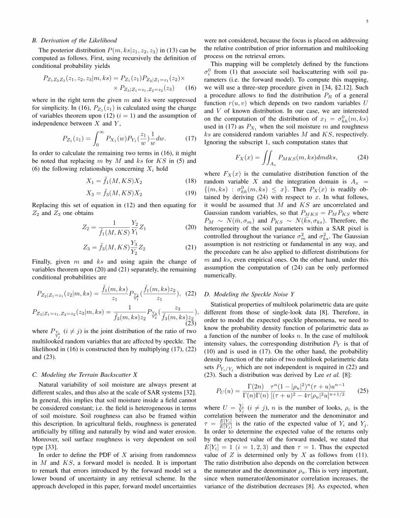
Assuming a certain value for σ0vh (σ0
vh = −25dB) andθ = 35◦, when applying to the entire (σ0
hh, σ0vv)-space
a root-finding procedure applied on (26) gives rise to thecontour lines depicted on Fig. 1. Although the levels of thecontour lines span the entire range of Oh’s model (0.04 −0.291 cm3/cm3), only the levels corresponding to 0.05, 0.10,0.15, 0.20 and 0.25 (in units of cm3/cm3) are drawn. Thelinear trend of the contour lines is consistent with the factthat at fixed vh, the dynamical range of the minimizationestimates from (26) is governed by the ratio σ0
hh/σ0vv , which
takes constant values over lines in the entire (σ0hh, σ
0vv)-space.
To corroborate the inversion, the exact values of m werecomputed using the deterministic forward Oh’s model (1),constrained to the assumption that σ0
vh = −25dB (’+’ marksin Fig. 1). The levels of the exact values agree with those ofthe minimization estimates.
Every value of (σ0hh, σ
0vv, σ
0vh) yields in a value of mOh
est
inside Oh’s model validity region, as expected, whereas forthe values of (σ0
hh, σ0vv, σ
0vh) lying outside that region the
inversion technique cannot produce a retrieval. The lattersituation could be related to shortcomings of the forwardmodel, landcover uncertainties (i.e. the target is not completelybare soil), speckle noise and/or system fluctuations. In anoperational implementation, the spurious estimations related tothe landcover can be reduced using ancillary information aboutlandcover status. Nevertheless, it is important to remark thateven bare soil can produce values of (σ0
hh, σ0vv, σ
0vh) outside
the Oh’s model validity region, due to speckle and systemfluctuations.
Fig. 1. Soil moisture mOhest estimated on the (σ0hh,σ0
vv)-plane (at fixedσ0vh = −25dB) from Oh’s model, in units of cm3/cm3. The light gray
area encloses the pairs (σ0hh,σ0
vv) where the model is valid.
The estimation procedure from (26) produces a single valueof mOh
est given a set of measured values (σ0hh, σ
0vv, σ
0vh). No
ancillary information about soil status (previous or estimatedby other means) is allowed. Moreover, it is implicitly assumedthat image radiometric uncertainties are very low, since smallfluctuation of measured values can produce strong variationsin soil moisture estimation. Therefore, in order to successfullyuse this type of retrieval, a speckle reduction technique ismandatory.
B. Bayesian Estimate
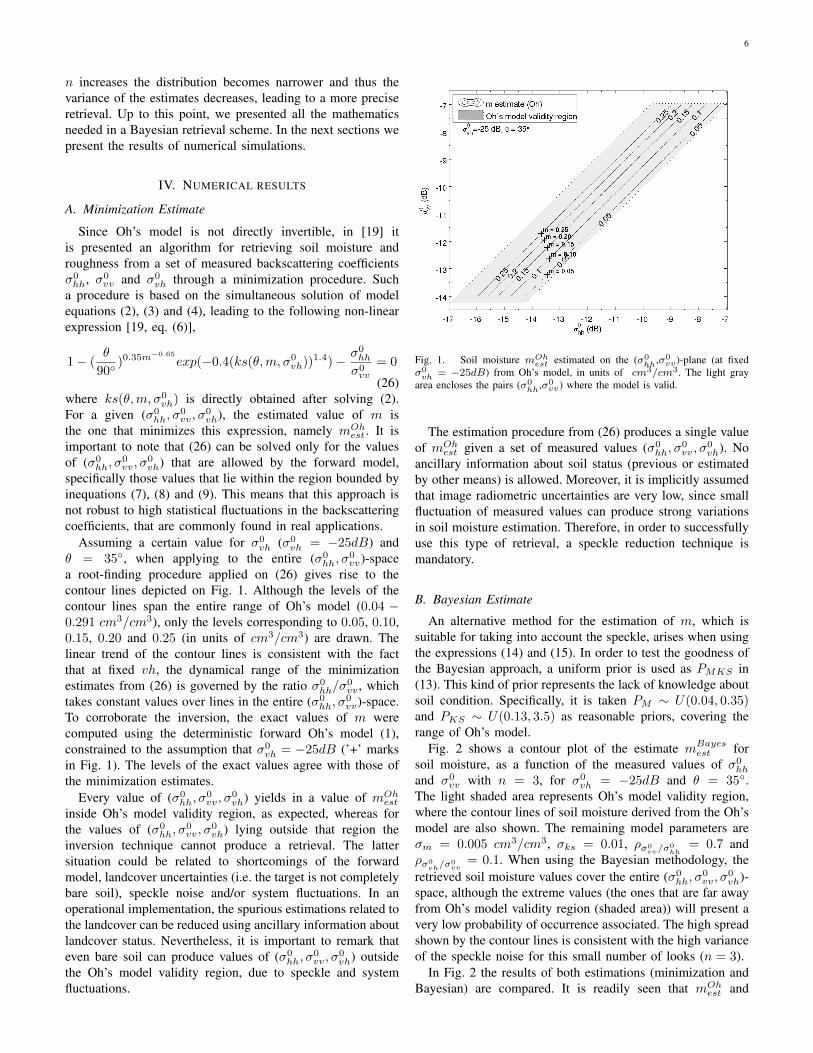
An alternative method for the estimation of m, which issuitable for taking into account the speckle, arises when usingthe expressions (14) and (15). In order to test the goodness ofthe Bayesian approach, a uniform prior is used as PMKS in(13). This kind of prior represents the lack of knowledge aboutsoil condition. Specifically, it is taken PM ∼ U(0.04, 0.35)and PKS ∼ U(0.13, 3.5) as reasonable priors, covering therange of Oh’s model.
Fig. 2 shows a contour plot of the estimate mBayesest for
soil moisture, as a function of the measured values of σ0hh
and σ0vv with n = 3, for σ0
vh = −25dB and θ = 35◦.The light shaded area represents Oh’s model validity region,where the contour lines of soil moisture derived from the Oh’smodel are also shown. The remaining model parameters areσm = 0.005 cm3/cm3, σks = 0.01, ρσ0
vv/σ0hh
= 0.7 andρσ0
vh/σ0vv
= 0.1. When using the Bayesian methodology, theretrieved soil moisture values cover the entire (σ0
hh, σ0vv, σ
0vh)-
space, although the extreme values (the ones that are far awayfrom Oh’s model validity region (shaded area)) will present avery low probability of occurrence associated. The high spreadshown by the contour lines is consistent with the high varianceof the speckle noise for this small number of looks (n = 3).
In Fig. 2 the results of both estimations (minimization andBayesian) are compared. It is readily seen that mOh
est and
7
Fig. 2. Comparison between the soil moisture estimated using Oh’s modeland the Bayesian retrieval approach, in units of cm3/cm3. The parametersadopted by the simulation are: n = 3, σm = 0.005 cm3/cm3, σks = 0.01,ρσ0
vv/σ0hh
= 0.7 and ρσ0vh/σ0
vv= 0.1.
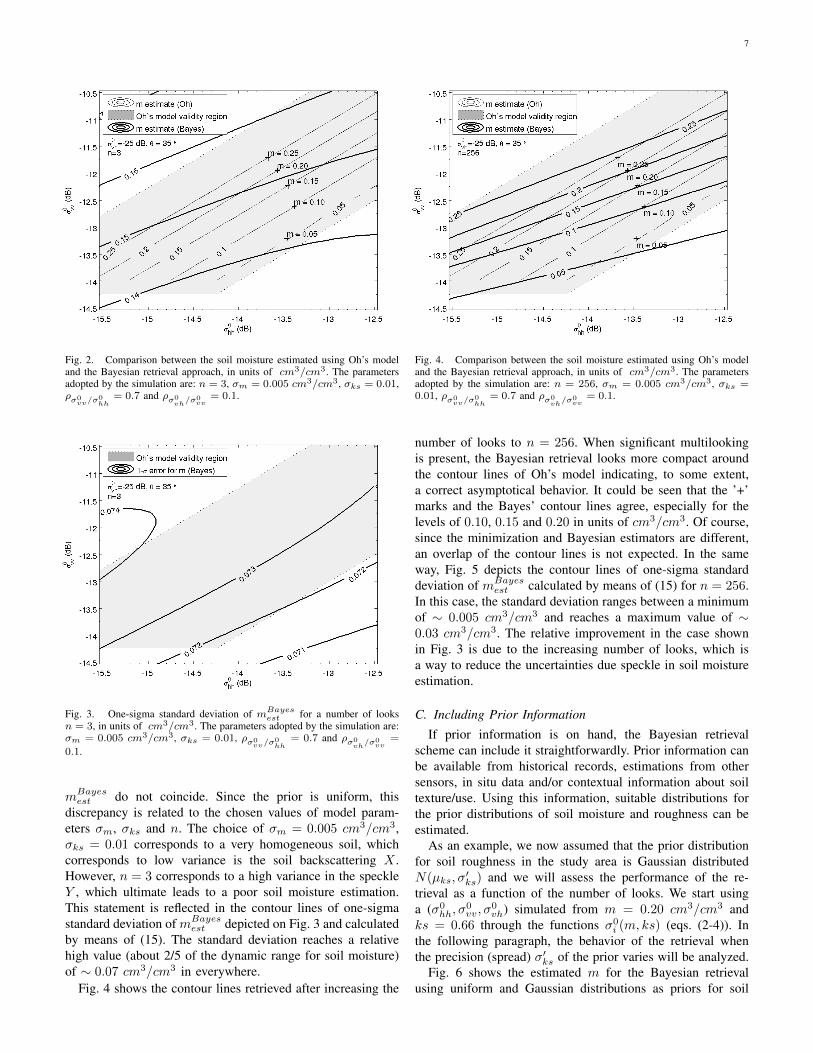
Fig. 3. One-sigma standard deviation of mBayesest for a number of looksn = 3, in units of cm3/cm3. The parameters adopted by the simulation are:σm = 0.005 cm3/cm3, σks = 0.01, ρσ0
vv/σ0hh
= 0.7 and ρσ0vh/σ0
vv=
0.1.
mBayesest do not coincide. Since the prior is uniform, this
discrepancy is related to the chosen values of model param-eters σm, σks and n. The choice of σm = 0.005 cm3/cm3,σks = 0.01 corresponds to a very homogeneous soil, whichcorresponds to low variance is the soil backscattering X .However, n = 3 corresponds to a high variance in the speckleY , which ultimate leads to a poor soil moisture estimation.This statement is reflected in the contour lines of one-sigmastandard deviation of mBayes
est depicted on Fig. 3 and calculatedby means of (15). The standard deviation reaches a relativehigh value (about 2/5 of the dynamic range for soil moisture)of ∼ 0.07 cm3/cm3 in everywhere.
Fig. 4 shows the contour lines retrieved after increasing the
Fig. 4. Comparison between the soil moisture estimated using Oh’s modeland the Bayesian retrieval approach, in units of cm3/cm3. The parametersadopted by the simulation are: n = 256, σm = 0.005 cm3/cm3, σks =0.01, ρσ0
vv/σ0hh
= 0.7 and ρσ0vh/σ0
vv= 0.1.
number of looks to n = 256. When significant multilookingis present, the Bayesian retrieval looks more compact aroundthe contour lines of Oh’s model indicating, to some extent,a correct asymptotical behavior. It could be seen that the ’+’marks and the Bayes’ contour lines agree, especially for thelevels of 0.10, 0.15 and 0.20 in units of cm3/cm3. Of course,since the minimization and Bayesian estimators are different,an overlap of the contour lines is not expected. In the sameway, Fig. 5 depicts the contour lines of one-sigma standarddeviation of mBayes
est calculated by means of (15) for n = 256.In this case, the standard deviation ranges between a minimumof ∼ 0.005 cm3/cm3 and reaches a maximum value of ∼0.03 cm3/cm3. The relative improvement in the case shownin Fig. 3 is due to the increasing number of looks, which isa way to reduce the uncertainties due speckle in soil moistureestimation.
C. Including Prior Information
If prior information is on hand, the Bayesian retrievalscheme can include it straightforwardly. Prior information canbe available from historical records, estimations from othersensors, in situ data and/or contextual information about soiltexture/use. Using this information, suitable distributions forthe prior distributions of soil moisture and roughness can beestimated.
As an example, we now assumed that the prior distributionfor soil roughness in the study area is Gaussian distributedN(µks, σ
′ks) and we will assess the performance of the re-
trieval as a function of the number of looks. We start usinga (σ0
hh, σ0vv, σ
0vh) simulated from m = 0.20 cm3/cm3 and
ks = 0.66 through the functions σ0i (m, ks) (eqs. (2-4)). In
the following paragraph, the behavior of the retrieval whenthe precision (spread) σ′ks of the prior varies will be analyzed.
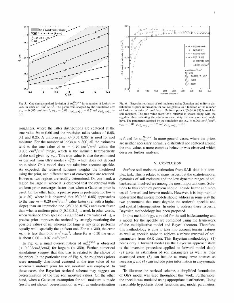
Fig. 6 shows the estimated m for the Bayesian retrievalusing uniform and Gaussian distributions as priors for soil
8
Fig. 5. One-sigma standard deviation of mBayesest for a number of looks n =256, in units of cm3/cm3. The parameters adopted by the simulation are:σm = 0.005 cm3/cm3, σks = 0.01, ρσ0
vv/σ0hh
= 0.7 and ρσ0vh/σ0
vv=
0.1.
roughness, where the latter distributions are centered at thetrue value ks = 0.66 and the precision takes values of 0.05,0.1 and 0.25. A uniform prior U(0.04, 0.35) is used for soilmoisture. For the number of looks n > 300, all the estimatestend to the true value of m = 0.20 cm3/cm3 within the0.005 cm3/cm3 range, which is the intrinsic heterogeneityof the soil given by σm. This true value is also the estimatedm derived from Oh’s model (mOh
est), which does not dependon n since Oh’s model does not take into account speckle.As expected, the retrieval schemes weights the likelihoodusing the prior, and different rates of convergence are reached.However, two regions are readily determined. On one hand, aregion for large n, where it is observed that the retrieval withuniform prior converges faster than when a Gaussian prior isused. On the other hand, a precise prior is preferable for low n(n < 50), where it is observed that N(0.66, 0.05) approachesto the true m = 0.20 cm3/cm3 value faster (i.e. with a higherslope) than an imprecise one (N(0.66, 0.25)) and even fasterthan when a uniform prior U(0.13, 3.5) is used. In other words,when variance from speckle is significant (low values of n), aprecise prior improves the retrieval by strongly restricting thepossible values of m, whereas for large n any prior performsequally well, specially the uniform one. For n > 300, the errormstd is less than 0.03 cm3/cm3, where for n < 50 the erroris about 0.06− 0.07 cm3/cm3.
In Fig. 6, a small overestimation of mBayesest is observed
(< 0.005cm3/cm3) for large n (> 350). Further numericalsimulations suggest that this bias is related to the choice ofthe priors. In the particular case of Fig. 6, the roughness priorswere normally distributed centered at the true value of kswhereas a uniform prior for soil moisture was employed. Inthese cases, the Bayesian retrieval scheme may suggest anoverestimation of the true soil moisture values. On the otherhand, when a Gaussian assumption for soil moisture is made(results not shown) overestimation as well as underestimation
0 50 100 150 200 250 300 350 400 4500.15
0.16
0.17
0.18
0.19
0.2
0.21
Number of looks n
Soil
mois
ture
estim
ate
m (
cm
3/c
m3)
m=0.20 cm3/cm
3
ks=0.66
σ0
hh=−13.5dB, θ = 35 °
σ0
vv=−12dB
σ0
vh=−25dB
N(0.66,0.05)
N(0.66,0.1)
N(0.66,0.25)
U(0.13,3.5)
m estimate (Oh)
+0.005 cm3/cm
3
Fig. 6. Bayesian retrievals of soil moisture using Gaussian and uniform dis-tributions as prior information for soil roughness, as a function of the numberof looks n, in units of cm3/cm3. Uniform prior U(0.04, 0.35) is used forsoil moisture. The true value from Oh’s retrieval is shown along with theσm-line, thus indicating the minimum uncertainty that every retrieval mighthave. The parameters adopted by the simulation are: σm = 0.005 cm3/cm3,σks = 0.01, ρσ0
vv/σ0hh
= 0.7 and ρσ0vh/σ0
vv= 0.1.
is found for mBayesest . In more general cases, where the priors
are neither necessary normally distributed nor centered aroundthe true value, a more complex behavior was observed whichdeserves further analysis.
V. CONCLUSION
Surface soil moisture estimation from SAR data is a com-plex task. This is related to many issues, but the spatiotemporaldynamics of soil moisture and the low dynamic ranges of soilbackscatter involved are among the most important ones. Solu-tions to this complex problem should include better and moretested forward and inverse models. However, it is important tounderstand that inverse models should address in some way thetwo phenomena that most degrade the retrieval: speckle andsoil spatial heterogeneities. In order to address these issues, aBayesian methodology has been proposed.
In this methodology, a model for the soil backscattering anda model for the speckle are combined using the frameworkof the multiplicative model and Bayes’ theorem. Therefore,this methodology is able to take into account terrain featuresas well as speckle noise to achieve a robust retrieval of soilparameters from SAR data. This Bayesian methodology: (1)needs only a forward model (as the Bayesian approach itselfis the inversion procedure applied to forward model data),(2) gives an estimation of soil parameters as well as theirassociated error, (3) can include as many error sources asnecessary, and (4) can include prior information in a systematicway.
To illustrate the retrieval scheme, a simplified formulationof Oh’s model was used throughout this work. Furthermore,the speckle was modeled using appropriate distributions. Usingreasonable hypothesis about functions and model parameters,
9
the retrieval scheme was tested in different scenarios by meansof numerical simulations.
For any soil condition, when the number of looks n islow and uniform priors for soil parameters are used, theretrieval errors are large. However, when significant multilook-ing (n = 256) is present, the retrieval error decreases. Therelative improvement due to the increasing of n is displayedby the one-sigma contour lines, where error decreases from∼ 0.07 cm3/cm3 to ∼ 0.03 cm3/cm3.
The effect on the retrieval of different prior distributionswas also studied. Comparing Gaussian and uniform priorsgives rise to two well-defined behavior for the soil moistureestimates in terms of the number of looks n. For large n(n > 300), both uniform and Gaussian priors work well (i.e.convergence is assured within the intrinsic variance of the soilmoisture). For low values of n (n < 50), a precise prior (i.e.σ′ks = 0.05) determines a rate of convergence higher than animprecise one (i.e. σ′ks = 0.25). A small overestimation isobserved (< 0.005cm3/cm3) for large n (> 350). This biascould be related to the the choice of the priors.
In summary, the proposed soil moisture retrieval schemetakes as inputs the measured soil backscattering coefficients,soil ancillary parameters and the number of looks, amongothers. Soil ancillary parameters are related to the expecteddistribution of soil parameters within the SAR pixel. Sodefined, soil moisture estimation converges to the expectedbehavior when σm → 0, σks → 0 and n → ∞, confirmingthat the standard Oh’s model regime is reached.
Due to its conception, the presented model is able tostudy the performance of different retrieval schemes for dif-ferent types of soils and/or different soil moisture spatialdistributions. Furthermore, since soil variance increases withscale, multilooking will reduce speckle variance but also willincrease observed soil parameters variance (σ2
m, σ2ks), thus
ultimately degrading the retrieval. Therefore, the proposedscheme is a useful tool to investigate, given an error require-ment, which is the optimum number of looks for soil moistureretrieval in a given soil condition (degree of heterogeneity).
ACKNOWLEDGMENT
The authors would like to thank C. Notarnicola and D.Dadamia for their helpful review comments. This work wasfunded by the Agencia Nacional de Promocion Cientıfica yTecnologica (ANPCyT) (PICT 1203) and MinCyT-CONAE-CONICET project 12. The author thanks the anonymousreviewers for their thoughtful comments for improving themanuscript.
REFERENCES
[1] Y. Kerr, “Soil moisture from space: Where are we?,” HydrogeologyJournal, vol. 15, pp. 117–120, 2007, 10.1007/s10040-006-0095-3.
[2] F. T. Ulaby, R. K. Moore, and A. K. Fung, Microwave remote sensing:Active and passive. Radar Remote Sensing and Surface Scattering andEmission Theory, vol. 2, Addison-Wesley, 1982.
[3] C. Oliver and S. Quegan, Understanding Synthetic Aperture RadarImages, SciTech Publishing, 2004.
[4] A. K. Fung, Microwave scattering and emission models and theirapplications, The Artech House remote sensing library. Artech House,1994.
[5] A. W. Western, R. B. Grayson, G. Bloschl, G. R. Willgoose, and T. A.McMahon, “Observed spatial organization of soil moisture and itsrelation to terrain indices,” Water Resources Research, vol. 35, no. 3,pp. 797–810, 1999.
[6] N. E. C. Verhoest, H. Lievens, W. Wagner, J. Alvarez-Mozos, M. S.Moran, and F. Mattia, “On the soil roughness parameterization problemin soil moisture retrieval of bare surfaces from synthetic aperture radar,”Sensors, vol. 8, pp. 4213–4248, Jul. 2008.
[7] G. Satalino, F. Mattia, M.W.J. Davidson, Thuy Le Toan, G. Pasquariello,and M. Borgeaud, “On current limits of soil moisture retrieval fromERS-SAR data,” Geoscience and Remote Sensing, IEEE Transactionson, vol. 40, no. 11, pp. 2438–2447, Nov. 2002.
[8] J. S. Lee, K. W. Hoppel, S. A. Mango, and A. R. Miller, “Intensityand phase statistics of multilook polarimetric and interferometric SARimagery,” IEEE Transactions on Geoscience and Remote Sensing, vol.32, no. 5, pp. 1017–1028, Sep. 1994.
[9] J. S. Lee, Jen-Hung Wen, T.L. Ainsworth, Kun-Shan Chen, and A.J.Chen, “Improved sigma filter for speckle filtering of SAR imagery,”Geoscience and Remote Sensing, IEEE Transactions on, vol. 47, no. 1,pp. 202–213, Jan. 2009.
[10] C. Lopez-Martinez, I. Hajnsek, J.S. Lee, E. Pottier, and X. Fabregas,“Polarimetric speckle noise effects in quantitative physical parametersretrieval,” Radar, Sonar and Navigation, IEE Proceedings -, vol. 153,no. 3, pp. 250–259, Jun. 2006.
[11] I. Hajnsek, E. Pottier, and S.R. Cloude, “Inversion of surface parametersfrom polarimetric SAR,” Geoscience and Remote Sensing, IEEETransactions on, vol. 41, no. 4, pp. 727–744, Apr. 2003.
[12] A. Balenzano, F. Mattia, G. Satalino, and M.W.J. Davidson, “Densetemporal series of C- and L-band SAR data for soil moisture retrievalover agricultural crops,” Selected Topics in Applied Earth Observationsand Remote Sensing, IEEE Journal of, vol. 4, no. 2, pp. 439–450, june2011.
[13] F. Mattia, G. Satalino, V. R. N. Pauwels, and A. Loew, “Soil moistureretrieval through a merging of multi-temporal l-band sar data andhydrologic modelling,” Hydrology and Earth System Sciences, vol. 13,no. 3, pp. 343–356, 2009.
[14] Yunjin Kim and J.J. van Zyl, “A time-series approach to estimatesoil moisture using polarimetric radar data,” Geoscience and RemoteSensing, IEEE Transactions on, vol. 47, no. 8, pp. 2519–2527, aug.2009.
[15] N. E. C. Verhoest, B. De Baets, F. Mattia, G. Satalino, C. Lucau, and P.A.Defourny, “A possibilistic approach to soil moisture retrieval from ERSsynthetic aperture radar backscattering under soil roughness uncertainty,”Water Resources Research, vol. 43, no. 7, pp. W07435, 2007.
[16] H. Vernieuwe, N.E.C. Verhoest, H. Lievens, and B. De Baets, “Possi-bilistic soil roughness identification for uncertainty reduction on SAR-retrieved soil moisture,” Geoscience and Remote Sensing, IEEE Trans-actions on, vol. 49, no. 2, pp. 628–638, feb. 2011.
[17] Y. Oh, K. Sarabandi, and F.T. Ulaby, “An empirical model andan inversion technique for radar scattering from bare soil surfaces,”Geoscience and Remote Sensing, IEEE Transactions on, vol. 30, no.2, pp. 370–381, Mar. 1992.
[18] P.C. Dubois, J. van Zyl, and T. Engman, “Measuring soil moisture withimaging radars,” Geoscience and Remote Sensing, IEEE Transactionson, vol. 33, no. 4, pp. 915–926, Jul. 1995.
[19] Y. Oh, “Quantitative retrieval of soil moisture content and surfaceroughness from multipolarized radar observations of bare soil surfaces,”IEEE Transactions on Geoscience and Remote Sensing, vol. 42, no. 3,pp. 596 – 601, Mar. 2004.
[20] Z. S. Haddad, P. D. Dubois, and J. J. van Zyl, “Bayesian estimationof soil parameters from radar backscatter data,” IEEE Transactions onGeoscience and Remote Sensing, vol. 34, no. 1, pp. 76–82, Jan. 1996.
[21] C. Notarnicola and F. Posa, “Bayesian algorithm for the estimation ofthe dielectric constant from active and passive remotely sensed data,”Geoscience and Remote Sensing Letters, IEEE, vol. 1, no. 3, pp. 179–183, Jul. 2004.
[22] F. Mattia, G. Satalino, L. Dente, and G. Pasquariello, “Using a prioriinformation to improve soil moisture retrieval from ENVISAT ASARAP data in semiarid regions,” Geoscience and Remote Sensing, IEEETransactions on, vol. 44, no. 4, pp. 900–912, Apr. 2006.
[23] S.R. Cloude and E. Pottier, “A review of target decomposition theoremsin radar polarimetry,” Geoscience and Remote Sensing, IEEE Transac-tions on, vol. 34, no. 2, pp. 498–518, Mar. 1996.
[24] A. Tarantola, Inverse Problem Theory and Methods for Model ParameterEstimation, Society for Industrial and Applied Mathematics, Philadel-phia, PA, USA., 2005.
10
[25] C. R. Vogel, Computational Methods for Inverse Problems, Society forIndustrial and Applied Mathematics, Philadelphia, PA, USA, 2002.
[26] K.S. Chen, Tzong-Dar Wu, Leung Tsang, Qin Li, Jiancheng Shi, andA.K. Fung, “Emission of rough surfaces calculated by the integralequation method with comparison to three-dimensional moment methodsimulations,” Geoscience and Remote Sensing, IEEE Transactions on,vol. 41, no. 1, pp. 90–101, Jan. 2003.
[27] A.K. Fung and K.S. Chen, “An update on the IEM surface backscatteringmodel,” Geoscience and Remote Sensing Letters, IEEE, vol. 1, no. 2,pp. 75–77, Apr. 2004.
[28] Kaijun Song, Xiaobing Zhou, and Yong Fan, “Empirically adopted IEMfor retrieval of soil moisture from radar backscattering coefficients,”Geoscience and Remote Sensing, IEEE Transactions on, vol. 47, no.6, pp. 1662–1672, Jun. 2009.
[29] A. Merzouki, H. McNairn, and A. Pacheco, “Mapping soil moistureusing RADARSAT-2 data and local autocorrelation statistics,” SelectedTopics in Applied Earth Observations and Remote Sensing, IEEEJournal of, vol. 4, no. 1, pp. 128–137, Mar. 2011.
[30] M. Callens, N. E. C. Verhoest, and M. W. J. Davidson, “Parameterizationof tillage-induced single-scale soil roughness from 4-m profiles,” IEEETransactions on Geoscience and Remote Sensing, vol. 44, no. 4, pp.878–888, Mar. 2006.
[31] D. J. C. MacKay, Information Theory, Inference, and Learning Algo-rithms, Cambridge University Press, 2003.
[32] A. W. Western and G. Bloschl, “On the spatial scaling of soil moisture,”Journal of Hydrology, vol. 217, no. 3-4, pp. 203–224, 1999.
[33] T.J. Jackson, H. McNairn, M.A. Weltz, B. Brisco, and R. Brown, “Firstorder surface roughness correction of active microwave observationsfor estimating soil moisture,” Geoscience and Remote Sensing, IEEETransactions on, vol. 35, no. 4, pp. 1065–1069, Jul. 1997.
[34] L. Wasserman, All of Statistics: A Concise Course in StatisticalInference, Springer Texts in Statistics. Springer, 2004.
Matias Barber received the degree in physics fromthe University of Buenos Aires, Argentina, in 2009.He is currently pursuing the Ph.D. degree workingon surface scattering models at the Instituto deAstronomıa y Fısica del Espacio (IAFE), BuenosAires, Argentina. Since 2007 he is also responsiblefor development of laser profilers and field work.
Fransisco Grings received the Ph.D. degree in 2008.He is a physicist and a junior research member ofConsejo Nacional de Investigaciones Cientıficas yTecnicas (CONICET) working at Instituto de As-tronomıa y Fısica del Espacio (IAFE), Buenos Aires,Argentina. He is responsible for remote sensingmodeling within IAFE’s remote sensing group. Heis leading the Observing System Simulation Exper-iment (OSSE) project at IAFE.
Pablo Perna is a student in computer science fin-ishing his career at the University of Buenos Aires.He is a consultant for Instituto de Astronomıa yFısica del Espacio (IAFE), Buenos Aires, Argentina,and responsible for computer simulations and dataacquisition algorithms.
Marcela Piscitelli is an agronomist graduated fromthe University of Buenos Aires, Argentina, in 1980,and received her Magister degree in Remote Sensingand Geographic Information Systems from the Uni-versidad del Centro (UNCPBA) in 2009. Since 1989she is Professor of Soil Management and Conserva-tion at UNCPBA. Her research here is focused onsoil cartography, soil physical degradation and soilwater erosion. She has field experience in soil con-servation tillage using experimental plots. Latterly,she focused her research on soil remote sensing with
particular emphasis on satellite data applications in soil properties.
Martin Maas is currently pursuing the Licenciaturadegree in Applied Mathematics, at the University ofBuenos Aires. He works in numerical electromag-netics and statistical modeling in microwave remotesensing, at the Instituto de Astronomıa y Fısica delEspacio (IAFE), Buenos Aires, Argentina.
Cintia Bruscantini is an electronic engineer cur-rently pursuing the engineering Ph.D. degree inobserving systems simulations at the Instituto deAstronomıa y Fısica del Espacio (IAFE), BuenosAires, Argentina. She has been working on devel-oping an Observing System Simulation Experiment(OSSE) for the Aquarius soil moisture product. Sheis also collaborating with the National Commissionon Space Activities (CONAE) of Argentina for thecalibration of the microwave radiometer (MWR) onboard the Aquarius/SAC-D.
Julio Jacobo-Berlles received the Eng. degree inelectronics and the Ph.D. degree in computer sci-ence from the University of Buenos Aires, BuenosAires, Argentina, in 1983 and 2005, respectively.His current research interests include microwaveremote sensing, image processing, and computervision. He is currently an Adjoint Professor at theComputer Science Department, Faculty of Exact andNatural Sciences, University of Buenos Aires and iscurrently involved in a collaboration project relatedto the Argentine SAOCOM SAR mission.
Haydee Karszenbaum is a physicist and researchmember of Consejo Nacional de InvestigacionesCientıficas y Tecnicas (CONICET), a remote sens-ing specialist, and Director of the Remote SensingGroup at the Instituto de Astronomıa y Fısica delEspacio (IAFE), Buenos Aires, Argentina. Since1983, she has worked in remote sensing, and since1997, she has been dedicated to microwave remotesensing. She is currently the PI of national projectsand of Space Agencies AO projects. She is alsocoordinating a technology transfer project related to
applications and quality analysis of the future Argentine SAOCOM SARmission products.
Copyright © 2022 FDOKUMEN