The effectiveness of morphology and street networks in determining models of urban growth at...
25
The Effectiveness Of Morphology And Street Networks In Determining Models Of Urban Growth At Different Spatial Scales Analysis Universitat Polítècnica de Catalunya (UPC) Centre de Política de Sòl i Valoracions (CPSV) Av. Diagonal, 649 4a planta 08028 Barcelona, Spain http://www.upc.edu/cpsv/ NICOLA COLANINNO BAHAAEDDIN ALHADDAD JOSEP ROCA CLADERA Authors Center of Land Policy and Evaluations Keywords Remote sensing, G.I.S., Street network, urban morphology, spatial analysis SPIE Europe Remote Sensing Urban Remote Sensing
Transcript of The effectiveness of morphology and street networks in determining models of urban growth at...
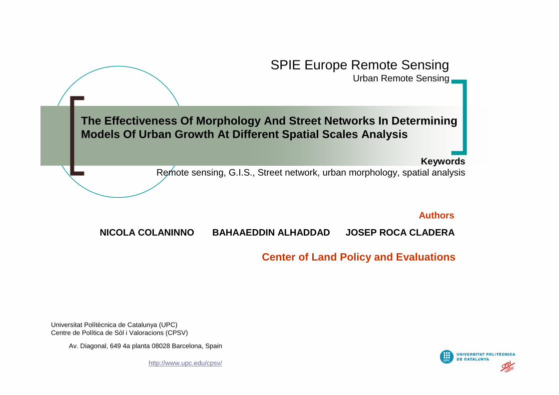
The Effectiveness Of Morphology And Street Networks In Determining Models Of Urban Growth At Different Spatial Scales Analysis
Universitat Polítècnica de Catalunya (UPC)Centre de Política de Sòl i Valoracions (CPSV)
Av. Diagonal, 649 4a planta 08028 Barcelona, Spain
http://www.upc.edu/cpsv/
NICOLA COLANINNO BAHAAEDDIN ALHADDAD JOSEP ROCA CLADERA
Authors
Center of Land Policy and Evaluations
KeywordsRemote sensing, G.I.S., Street network, urban morphology, spatial analysis
SPIE Europe Remote SensingUrban Remote Sensing

I N D E X
1. Objectives
2. Data and study area
3. Methodology3.1. Pattern Scale Analysis
3.2. Morphological Model3.2.1. Morphology of Settlement Form and Structure
3.3. Grid Form Morphology
The effectiveness of morphology and street networks in determining models of urban growth at different spatial scales analysis
4. Describe Cluster Analysis by Interaction of Settlement Form and Structure with Urban Grid
5. Correlation Between Cluster Analysis, Slope and Land Occupation in Describe Urban Model
6. Conclusions
7. Acknowledgement
8. Bibliography
NICOLA COLANINNO BAHAAEDDIN ALHADDAD JOSEP ROCA CLADERA

The effectiveness of morphology and street networks in determining models of urban growth at different spatial scales analysis
NICOLA COLANINNO BAHAAEDDIN ALHADDAD JOSEP ROCA CLADERA
1. Objectives
An approach to analyze urban morphology through understand the relation between urban settlement and grid with land topology:• Better understanding on what is possible to observe using urban remote sensing and how such information can be integrated to improve our theoretical knowledge about urban areas and their dynamics; • Assess and verify the measurement of metropolitan urban growth from a strictly morphological perspective and classifying typologies using the cluster analysis.
•Understanding the dynamics and patterns of urban extend related with their interactions in heterogeneous landscapes.
•Determining the analogies between patterns of cities and their “physical” characters providing indicators of the aspect of settlement form and structure.
•Focusing on the development of a methodology to classify the geometric properties and intrinsic space of urban settlements based on their characteristics and fundamental forms.
Classify, evaluate and compare different urban forms related to street networks and land characters, also considering the morphological typologies of urban settlements by moving from the spatial scale of a municipality to a wider territorial. The intent is to discover secure principals to find the most likely urban models of cities, taking topographical parameters into account.

The effectiveness of morphology and street networks in determining models of urban growth at different spatial scales analysis
NICOLA COLANINNO BAHAAEDDIN ALHADDAD JOSEP ROCA CLADERA
1. Objectives
Digital Elevation ModelTeleAtlas street networks Land occupation and morphology
•Define the interaction between morphology measures and grid integration revealing that the effect of morphologies on grid is strongest according to urban types.
•Find the effect of geographical characters on the urban settlement defined by Form of urban shapes and the infrastructure system.

The effectiveness of morphology and street networks in determining models of urban growth at different spatial scales analysis
NICOLA COLANINNO BAHAAEDDIN ALHADDAD JOSEP ROCA CLADERA
2. Data and study area
This research carried out focusing upon the metropolitan region of Barcelona, with urban sites defined according to the contiguity of artificial and administrative boundaries. The TeleAtlas and land activity classification deriving from Spot Imagery form the basis of this study.
Today the increasing availability of satellite images is becoming instrumental in geographical applications and offering a reliable tool for decision making in territorial management. For
example the SPOT 5 satellite offers the possibility of producing images of large scale territorial areas (60 km by 60 km) with a resolution from 2.5m to 10m
The chosen area is Metropolitan Region of Barcelona (RMB), which is the regional capital of Catalonia, lying in the north-east of Spain (see Figure 1). The
Metropolitan Region of Barcelona consists of 164 municipalities and the physical limit of the region extends to almost 3,239 km2 and has a current population of
some 4.7 million inhabitants (Campaign, 1991)
Remote sensing data sets used for the study with a supervised classification for the urban agglomeration, drawing upon 2004 images in order to maximize the number of distinguishable land cover classes for the study area. This methodology employed maximum and minimum likelihood, binary encoding and parallel piped methods, prior to scattergram processes and the merging of all the data, drawing upon a subtraction process to arrive at the final classified image.
A base-map from TeleAtlas was used, acquired on 2000
In order to obtain the territory slop, it was necessary to use DEM (Digital Elevation Model)

The effectiveness of morphology and street networks in determining models of urban growth at different spatial scales analysis
NICOLA COLANINNO BAHAAEDDIN ALHADDAD JOSEP ROCA CLADERA
2. Data and study area
The metropolitan region of Barcelona in the final result with 21 improved categories Artificial areas
The classification process led to the identification of some twenty (21) land cover categories for Barcelona.
These land activity categories were then grouped together in one major group, to ascertain the ‘artificial’activities, or activities representing some form of development.

The effectiveness of morphology and street networks in determining models of urban growth at different spatial scales analysis
NICOLA COLANINNO BAHAAEDDIN ALHADDAD JOSEP ROCA CLADERA
Land use/cover Classification(Spot 2004)
Street networks(TeleAtlas 2000)
DEM
Data sources Pattern scale
Municipalities ProtoSistema
Morphological Model
Settlement Form
Morphology
Slope
Grid Form Morphology
Shape Index
Complexity Index
Fractal Dimension
Settlement Structure
Morphology
Fragmentation
Dispersion
Axis X
Axis Y
Axis Z
Land Occupation
Local System
3. Methodology
Three steps: the first step deals with the quantification of characters (Pattern scale model), the second will identify the settlement behaviours with its location (Morphological model), and the third one will study the relation between models (Urban Model)

The effectiveness of morphology and street networks in determining models of urban growth at different spatial scales analysis
NICOLA COLANINNO BAHAAEDDIN ALHADDAD JOSEP ROCA CLADERA
jj
ji
Ji
ij
LTLPOR
F
LTLPOR
F
..VI
22
ij +=
3.1. Pattern Scale Analysis
Changing the scale changes the spatial patterns, which has implication for the understanding the complex urban system. Thus, urban analysis performed at a single scale is incomplete and insufficient for understanding spatial patterns (Barros Filho and Sobreira, 2007).
Three scales are presented, one using the municipalities as units of analysis, the second will focus over the Protosistemas unit, finally local System unites will define the largest scale in our research
The Protosistemas unit allows delimiting supra-municipal Areas, joining municipalities in greater unites, “drawing” a territorial level organization based on strong interactions between nearby towns; the grouping of municipalities is made according their highest
value for interaction (V.I.) as it shown in the equation:
Where:Fij: number of workers living in the town “i” and who go to work to the municipality “j”, if i = j than Fij=RWi (Resident Workings), Workers who live and work in the same town.PORi: resident working population of the municipality “i”LTLi: jobs located in the municipality “i”

The effectiveness of morphology and street networks in determining models of urban growth at different spatial scales analysis
NICOLA COLANINNO BAHAAEDDIN ALHADDAD JOSEP ROCA CLADERA
Local System map. Matrix bound by Labour Mobility and Functional systems for Metropolitan Region of Barcelona RMB
Protosistemas map
3.1. Pattern Scale Analysis
Looking for larger scale level, Local Systems are defined and made by add more restrictions on the Protosistemas, such as contiguity or size, demographic issues and even the evaluating of resident workers. These parameters allow to “Consolidating” the Protosistemas limits to define this new scale level. Since the classification systems affect the result of urban land use pattern analysis, result also shows the effect of spatial scale on urban land use pattern analysis if different classification system takes different characteristics in certain range of scale

The effectiveness of morphology and street networks in determining models of urban growth at different spatial scales analysis
NICOLA COLANINNO BAHAAEDDIN ALHADDAD JOSEP ROCA CLADERA
3.2. Morphological Model
Urban morphology “implies ‘form,’ ‘land use,’ and ‘density,’ and has connotations with the shape, structure, pattern and organization of land use, and the system of relation between them” (Donnay, Barnsley, and Longley, 2001)
Morphological analysis, which refers to the geometric characteristics of urban sites, illustrates its usefulness in determining the analogies between patterns of cities and their “physical” characters providing indicators of the aspect of settlement form and structure
Three levels of conceptualization, these levels will help to obtain the morphological model whichpresents a relation between two pure morphology settlement calculations, made on urban area patches, and the morphology of street networks model, presenting them by three axis (X,Y,Z).
The first is the physical record or representation of settlement urban form itself by studying the following parameters: shape and fractal dimension indexes. The second is the settlement structure by observing
the settlements behaviour through fragmentation and dispersion indexes and the third is to analysis Street network form which can be achieved with the data available by analyzing streets Complexity
To understand settlement form and structure a process was realized in four phases. In the first phase, will be related to settlement form morphology which look to calculate the shape index and fractal
dimension refer to specific calculations. In the second phase will focus on settlement structure morphology which takes place to understand urban settlements from fragmentation and dispersion.All calculation results applied will applied over settlement dataset in municipal level and repeated over
Protosistemas and Local Systems

The effectiveness of morphology and street networks in determining models of urban growth at different spatial scales analysis
NICOLA COLANINNO BAHAAEDDIN ALHADDAD JOSEP ROCA CLADERA
3.2.1. Morphology of Settlement Form and Structure
∑
∑
=
=
⋅
=n
i
n
i
1
1 2
A
aa
p
AWMSI
i
i
i
π( )
∑
∑
=
=
⋅
⋅
=n
i
n
i
1
1
A
aaln
p 0.252ln
AWMPFDi
i
i
Shape Index Fractal Dimension
Shape Index, as quantitative indices to describe patterns of the settlements form (Gravelius)
Where:pi = Perimeter of patchai = Area of patchn = number of pathces
Fractal Dimension, to “measure” urban patterns, aiming at finding “new” descriptions of the variety of urban morphologies, analysed following principles from fractal geometry
Where:A = total Area of urban patches in the landscape

The effectiveness of morphology and street networks in determining models of urban growth at different spatial scales analysis
NICOLA COLANINNO BAHAAEDDIN ALHADDAD JOSEP ROCA CLADERA
3.2.1. Morphology of Settlement Form and Structure
( )[ ]
nLn
FLn F1 - H
n
1iii∑
==
−⋅
+
−⋅
=
∑
∑
∑
∑
=
=
=
= 2wn
1i
i2i
2wn
1i
n
1ii
2i
yA
ayx
A
ax SD
n
i 1
Fragmentation Dispersion
Where:Fi = Ai / Atot = Area of patch i, divided by the total area made sumarizing all the pathces in the landscape
Where:Xw, Yw = the coordinate position of polygons centroidesystem.Xi , Yi = the coordinate position of each polygon centroid.
Fragmentation, measures spatial atomization and holes in the city area (Shannon)
Dispersion, used to describe a representative measure of distance between the parts which compose the urban area (Standard Distance)
The effectiveness of morphology and street networks in determining models of urban growth at different spatial scales analysis
NICOLA COLANINNO BAHAAEDDIN ALHADDAD JOSEP ROCA CLADERA
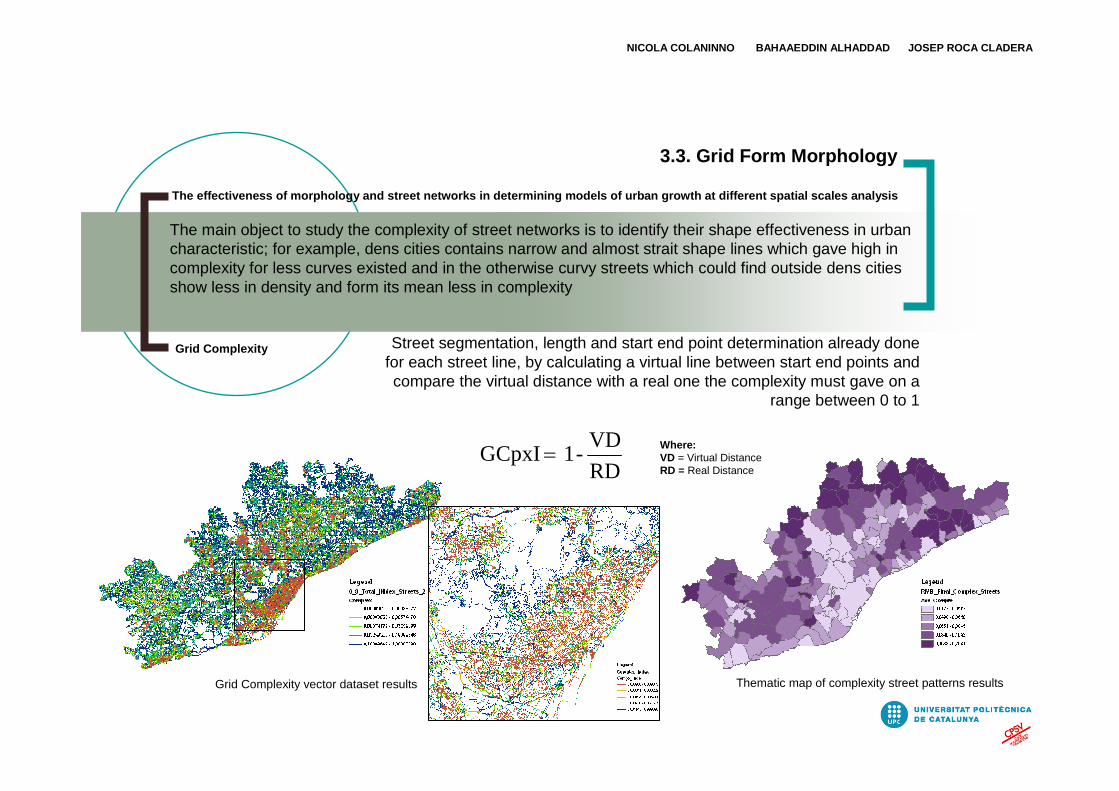
Grid Complexity vector dataset results Thematic map of complexity street patterns results
3.3. Grid Form Morphology
RD
VD -1 GCpxI=
Grid Complexity
Where:VD = Virtual DistanceRD = Real Distance
The main object to study the complexity of street networks is to identify their shape effectiveness in urban characteristic; for example, dens cities contains narrow and almost strait shape lines which gave high in complexity for less curves existed and in the otherwise curvy streets which could find outside dens cities show less in density and form its mean less in complexity
Street segmentation, length and start end point determination already done for each street line, by calculating a virtual line between start end points and compare the virtual distance with a real one the complexity must gave on a
range between 0 to 1

The effectiveness of morphology and street networks in determining models of urban growth at different spatial scales analysis
NICOLA COLANINNO BAHAAEDDIN ALHADDAD JOSEP ROCA CLADERA
4. Describe Cluster Analysis by Interaction of Settlement Form and Structure with Urban Grid
From a methodological point of view, form and structure study captures significant properties of the urban settlements and discriminates the relation between both and street networks, but measures of form and structure morphologies, which are based on geometrical characteristics, show correlation with measures of street networks.
X axis illustrates joined relation between shape index and fractal dimension as away to understand the settlements form morphology, in the otherwise Y axis try to fin a relative relation between fragmentation and dispersion to describe settlements structure morphology and Z axis
presents the grid complexity

The effectiveness of morphology and street networks in determining models of urban growth at different spatial scales analysis
NICOLA COLANINNO BAHAAEDDIN ALHADDAD JOSEP ROCA CLADERA
4. Describe Cluster Analysis by Interaction of Settlement Form and Structure with Urban Grid
The 3D model illustrates the relation between morphological form, structure and Grid Complexity
The concept of the model is to present the relations in a unique model able to show previous morphological parameters and illustrated in three dimensional axes to indicate urban behaviours of growth.
The objective of the cluster analysis is to explore the relation between our three axes in different data source levels.
The district map coded for the results of the final cluster analysis with 5 scenarios shows which municipalities have similar morphological characters

The effectiveness of morphology and street networks in determining models of urban growth at different spatial scales analysis
NICOLA COLANINNO BAHAAEDDIN ALHADDAD JOSEP ROCA CLADERA
4. Describe Cluster Analysis by Interaction of Settlement Form and Structure with Urban Grid
Random examples illustrate cluster result taken from the metropolitan region of Barcelona (see thematic map above).
These areas define clearly the topological behaviour of each cluster unit:
1 (Barcelona city) High compactness and complexity forms with low dispersion of varied street network types
2 High compactness and low complexity forms with zero fragmentation, road network structure contains two types: Orthogonal and Seprentine
3 High fragmentation without dispersion, street structure shows a predominantly serpentine type with high density
4 Middle compactness mixed with dispersion including high complexity shape, street structure shows a predominantly orthogonal merged with few seprentine types in the peripheral city part
5 Low compactness and complexity shape, high fragmentation and dispersion with serpentine street network structure but with low density
Cluster analysis is a family of methods that seeks to explore the structure of a data set by defining the relationships between individual observations in the set and group each neighbourhood with other
neighbourhoods that are most similar to it.

The effectiveness of morphology and street networks in determining models of urban growth at different spatial scales analysis
NICOLA COLANINNO BAHAAEDDIN ALHADDAD JOSEP ROCA CLADERA
4. Describe Cluster Analysis by Interaction of Settlement Form and Structure with Urban Grid
1 2 3 4 5
Strong and significant correlations between the measures indicate that the effect of settlement shape on street network is exerted according to the shape fragmentation or dispersion, where more convex and
less fragmented urban shapes coincide with more integrated networks, etc.

The effectiveness of morphology and street networks in determining models of urban growth at different spatial scales analysis
NICOLA COLANINNO BAHAAEDDIN ALHADDAD JOSEP ROCA CLADERA
4. Describe Cluster Analysis by Interaction of Settlement Form and Structure with Urban Grid
Cluster analysis results shown different characteristics of urban model over different scales. (1) Protosistemas thematic cluster map. (2) (2) Local Systems shown different scale of cluster analysis.
Cluster analysis applied over Protosistemas and Local Systems levels.
This finding is potentially significant to cluster behaviour in changing scale level. Cluster results here had the ability to explore the settlement behaviours but from pure morphological said. Observe last cluster results with reality such as land occupation and land slop gave by DEM we found it important to understand deeply our urban model behaviour relating to the territory.

The effectiveness of morphology and street networks in determining models of urban growth at different spatial scales analysis
NICOLA COLANINNO BAHAAEDDIN ALHADDAD JOSEP ROCA CLADERA
5. Correlation Between Cluster Analysis, Slope and Land Occupation in Describe Urban Model
The thematic slope layer needed for this analysis can be easily created using a series of processes and produce from a Digital Elevation Model (DEM) associate to the altimetry, elaborated in ArcGIS.
Land occupation is a fundamental factor to define settlement units. The analysis shows that the majority of the land occupations occur in the lower slope levels and it’s almost concentrate in the costal zones and in the northern west of Barcelona city.
The following parameters Slope and land occupation were analysed. The figure illustrate municipal thematic maps. The maps represent the slope values (% of slope) and land occupation values (% of urbanized area on municipal area).

The effectiveness of morphology and street networks in determining models of urban growth at different spatial scales analysis
NICOLA COLANINNO BAHAAEDDIN ALHADDAD JOSEP ROCA CLADERA
5. Correlation Between Cluster Analysis, Slope and Land Occupation in Describe Urban Model
The Digital Elevation Models framing of data on urban areas and the amount of land occupation allow to see the way in which it can be cross-referred to the data on urban model
Various parameters could add to the final description of urban model behaviour to be part of them in order to improve the capability to adopt different scales, occupation and territories.Urban growth has quite good relation with above parameters as we know the continuity in land occupation produce high possibility of urban extend and the same for slop analysis which show like urban behaviour go for less extend in high slop areas and almost full occupation in the flat one.
This behaviour of previous indicators forces us to explore the relation with cluster analysis results, that is the morphological characters. Table 1 and 2 present that relation in municipal scale looking to
repeat similar process over Protosistemas and Local Systems scales

The effectiveness of morphology and street networks in determining models of urban growth at different spatial scales analysis
NICOLA COLANINNO BAHAAEDDIN ALHADDAD JOSEP ROCA CLADERA
5. Correlation Between Cluster Analysis, Slope and Land Occupation in Describe Urban Model
Immediate relation waiting cluster analysis compared with slope indicator (Right) And correlation between cluster analysis and land occupation in municipal scale (Left)
Clear correlation between terrain slope and land occupation parameters suggests other point of interest to understand their effectiveness on cluster analysis behaviour. Slope analysis is an important component of site selection analysis and allows an in-deep and more direct morphological analysis.

The effectiveness of morphology and street networks in determining models of urban growth at different spatial scales analysis
NICOLA COLANINNO BAHAAEDDIN ALHADDAD JOSEP ROCA CLADERA
6. Conclusions
Remotely sensed data products have got unique advantage over conventional data gathering techniques in the study of urban morphology. The physical parameters like urban form, street pattern and urban structure as well as functional characteristic which can be derived from land use classification, area clearly visible on satellite data products. Remote sensing data is capable of detecting and measuring a variety of elements relating to the morphology of cities, such as the amount, shape, density, textural form and spread of urban areas.
The model already tested over the metropolitan region of Barcelona will be improved in its part concerning the scale analysis and tested over others geographical areas in Spain.
When thinking about Urban Morphology it is important to remind that we use urban models to identify and compare patterns of settlements and to understand the relation between form and structure in them, and between morphology and topology.
The present study has demonstrated a new method for Urban Model to identify measure and monitor various patterns of urban behavior in different scale levels in the metropolitan region and its environs, by integrating with remote sensing and GIS techniques.
The current method can be easily implemented within GIS to facilitate the measurement of urban growth.

The effectiveness of morphology and street networks in determining models of urban growth at different spatial scales analysis
NICOLA COLANINNO BAHAAEDDIN ALHADDAD JOSEP ROCA CLADERA
7. Acknowledgement
The authors of this paper gratefully acknowledge the research funding provided by the Spanish Ministry of Education and Science (SEJ2006-09630-GEO), the Spanish Ministry of Housing and the European Union by way of the INTERREG IIIB Programme (South Western Europe)
Similarly the authors acknowledge the technical expertise and assistance provided by Jorge Cerda in particular and Carlos
Marmolejo, Montse Moix, Carlos Aguirre, Edison Salinas and Malcolm Burns in the development of this research project

8. Bibliography
The effectiveness of morphology and street networks in determining models of urban growth at different spatial scales analysis
•Jean-Paul Donnay, Michael J.Barnsley and Paul A. Longley, Remote Sensing and Urban Analysis, Chapter 2, Taylor & Francis, Landon and New York, 2001.•Batty M., Longley P.A., Urban Shape as Fractal, Area 19.3, 215-221 (1987).•Sohn, G., Dowman, I., Extraction of buildings from high resolution satellite data.In: Baltsavias, E., Gruen, A., Van Gool, L. (Eds.) Automated Extraction of Man-Made Object from Aerial and Space Images (III). Balkema Publishers, Lisse, pp.345– 355 (2001).•Puissant A., Weber C, Potentialities of very high spatial resolution image to identify urban fabrics, Geocarto International, 12 p (2000).•Campaign against the Quart Cinturo of Barcelona, Land Use Planning and Transformation of Space, the Barcelona fourth ring road project, Sabadell, Barcelona, Spain, (1991), http://ccqc.pangea.org/eng/ocuterri/tereng.htm•Jantz Claire and Goetz Scott, Analysis of scale dependencies in an urban land-use-change model, International Journal of Geographical Information Science, Volume 19, Number 2, pp. 217-241(2005).•Mauro Barros Filho and Fabiano Sobreira, Urban texture: a multiscale analysis of socio-spatial patterns, 10th International Conference on Computers in Urban Planning and Urban Management, Iguassu Falls, Brazil, (2007).•P. T. Kivell, A. J. Parsons, B. R. P. Dawson, Monitoring derelict urban land: A review of problems and potentials of remote sensing techniques, Volume 1 Issue 1, Pages 5 – 21 (2006).•Ronald R. Boyce and W. A. V. Clark, The Concept of Shape in Geography, Geographical Review, Vol. 54, No. 4, pp. 561-572 (1964).•Mandelbrot, B., Fractals: Form, Chance, and Dimension, Freeman and Co., San Francisco, (1977).•Batty, M. and Xie, Y., Preliminary Evidence for a Theory of the Fractal City, Environment and Planning A, 28: 1745-1762 (1996).•Frankhauser P., The Fractal Approach: A new tool for the spatial analysis of urban agglomerations, Population: An English selection, special issue New Methodological Approaches in the Social Sciences, p. 205-240 (1998).•Frankhauser P., Pumain D., Modèles en analyse spatiale, Fractales et géographie, in Sanders L. (ed.) Paris, Hermès, 301-329 (2002).•Elio Piroddi and Paolo Colarossi, The Urban Project: from Fragmentation to Recomposition, Arch. & Compott. I Arch. Behav., Vol. 7, no. 4, p. 367-374 (1991).•Cauvin C. and Rimbert S., La lecture numérique des cartes thématiques : les méthodes de la cartographie thématique : fascicule 1. Fribourg, Editions Universitaires de Fribourg, 1976. 172 p., ISBN: 2-8271-0109-2 (1976).•Elena G. Irwin and Nancy E. Bockstael, The evolution of urban sprawl: Evidence of spatial heterogeneity and increasing land fragmentation, Natl Acad Sci U S A., 104(52): 20672–20677 (2007).•John Peponis, Douglas Allen, Dawn Haynie, Martin Scoppa and Zongyu Zhang, MEASURING THE CONFIGURATION OF STREET NETWORKS: the Spatial profiles of 118 urban areas in the 12 most populated metropolitan regions in the US, Proceedings, 6th International Space Syntax Symposium, Istanbul, (2007).•Marc Barthélemy and Alessandro Flammini, Modeling Urban Street Patterns, PRL 100, 138702 (2008).•Ermal Shpuza, URBAN SHAPES AND URBAN GRIDS: a comparative study of Adriatic and Ionian coastal cities, Proceedings, 6th International Space Syntax Symposium, Istanbul, (2007).•Smith, J., Cluster Analysis as Part of a Land-Use Classification Scheme for Optimized Land Use and Transportation Planning. Masters Thesis, Department of Civil Engineering, Brigham Young University, Provo, UT, (2000).•McGarigal, K., S. A. Cushman, M. C. Neel, and E. Ene. 2002. FRAGSTATS: Spatial Pattern Analysis Program for Categorical Maps. Computer software program produced by the authors at the University of Massachusetts, Amherst. Available at the following web site: www.umass.edu/landeco/research/fragstats/fragstats.html
NICOLA COLANINNO BAHAAEDDIN ALHADDAD JOSEP ROCA CLADERA

Universitat Polítècnica de Catalunya (UPC)Centre de Política de Sòl i Valoracions (CPSV)
Av. Diagonal, 649 4a planta 08028 Barcelona, Spain
http://www.upc.edu/cpsv/
SPIE Europe Remote SensingUrban Remote Sensing
The effectiveness of morphology and street networks in determining models of urban growth at different spatial scales analysis
Thank You
For Your Attention
NICOLA COLANINNO BAHAAEDDIN ALHADDAD JOSEP ROCA CLADERA