STREET LIFE - TSPA
230
STREET LIFE Re-Inventing Roads as Hybrid, Socioeconomic Infrastructures in the Netherlands Final Report, 15.08.2011 A Research and Design Project by Uberbau | Architecture & Urbanism Funded by the Netherlands Architecture Fund
-
Upload
khangminh22 -
Category
Documents
-
view
1 -
download
0
Transcript of STREET LIFE - TSPA

STREET LIFERe-Inventing Roads as Hybrid, Socioeconomic
Infrastructures in the Netherlands
Final Report, 15.08.2011
A Research and Design Project by
Uberbau | Architecture & Urbanism
Funded by the
Netherlands Architecture Fund


Contents
1 Introduction ................................................................................................................................5
2 A Short Story of the Disintegration of Road and Urban Context ............................................15
3 Contemporary Challenges and the Future of Roads in the Netherlands ................................45
3.1 The Current Situation of Roads and their Urban Context ..............................................................46
3.2 The Future of Roads in the Randstad: Trends, Visions and a Scenario ..........................................64
4 Road Matrix NL: Eight Proposals for the Transformation of Dutch Road Situations .............75
4.1 Approach ....................................................................................................................................78
4.2 Hoogvliet: Activating a Public Non-Space ....................................................................................83
4.3 Groene Hart: Accessing an Artificial Landscape ...........................................................................99
4.4 Afrikaanderwijk: Empowering an ‘Internationaale Wijk’ .............................................................111
4.5 Ypenburg: Linking an Urban Fragment ......................................................................................127
4.6 Coolsingel: Integrating a Central Boulevard ...............................................................................139
4.7 Almere: Diversifying a Homogeneous Scenery ..........................................................................161
4.8 Einsteinweg: Reinventing an Urban Boulevard ...........................................................................173
4.9 Westland: Upgrading an Industrialized Landscape .....................................................................196
4.10 Road Matrix NL Conclusions .....................................................................................................208
5 Overall Conclusion and Main Findings ..................................................................................213
6 Appendix .................................................................................................................................219
6.1 Bibliography .............................................................................................................................221
6.2 Team ........................................................................................................................................226
6.3 Contact .....................................................................................................................................229


Introduction1
5


Approximately 132’500 ha of the Netherlands’ surface is used for roads, with a total length of 125’000 km. These numbers continue to grow. Today NL has the densest road network in the world after Belgium and Japan1 as well as “a motorway density of 57.5 kilometres per 1’000 km², the most dense motorway network in the European Union.”2
The annual investment to maintain and extend this system exceeds 10 Billion € annually.3 This is a substantial part (5%) of Netherlands’ GDP.4 Although the Netherlands is famous for its strong bicycle culture, the car is used twice as much as the bike.5
The Dutch road system is one of the most advanced motorway networks in
the world, despite frequent congestion problems. It features variable message
signs and electronic signalization across most of the network, and has a model
status in the international context. Considering this massive amount of road
infrastructure within populated areas and urban settings it surprises that little of
it relates to its immediate context. Homogeneous streets, isolated highways and
wide thoroughfares cut through the city with little relation to the urban tissue of
its neighbourhoods, city centres and suburbs.
The research derives five general working hypotheses from this situation:
1. Dutch roads are mostly monofunctional mainly accommodating
car-oriented mobility.
1 Selected year 2006 road traffic data. See OECD International Traffic Safety Data and Analysis Group (IRTAD)2 See http://en.wikipedia.org/wiki/Transport_in_the_Netherlands as of 0910133 11’990 Million Euro Budget in 2008 for ‘EuroMIRT multi-year infrastructure, spatial planning and transport projects’, see Rijkswaterstaat Jaarverslaag 20084 500 Billion in 2008 , see The World Fact Book (www.cia.gov) 5 In 2006 the bike accounted for 27% of all journeys, while the car for 48%. See: Roes, Theo (Ed.) “Facts and Figures of the Netherlands: Social and Cultural Trends 1995-2006”, The Hague: Netherlands Institute for Social Research, March 2008. p. 84
7

1. Monofunctionality
3. Waste of Surface
5. Separation
4. Zoning
2. Barriers
8

2. Dutch roads are full of physical barriers to ensure traffic
orientation and security.
3. Dutch roads are strictly zoned to ensure efficiency for various
transport modes.
4. Dutch roads are wasting enormous amounts of surface because of traffic
security demands.
5. Dutch roads are often physically and socially disrupting the
urban environment.
HYPOTHESIS
In a current political context of deregulation, increasing social polarization and
the adaptation of the concept of the welfare state in Europe, there is a neglected
potential in roads towards a hybrid development. Their transformation could
enable an active civil society to participate in, and profit from the development
of their immediate urban environments. Roads need to be designed in a hybrid
way, meaning that their car-oriented monofunctionality and homogeneity must
be reduced, to favour the integration with their immediate urban contexts and to
allow for socioeconomic functions.
AIMS
Taking the Netherlands as an example, it is the aim of this research to develop
a vision of this social re-engagement with the city. Based on a careful future
scenario for roads in the Netherlands we want to illustrate this possibility and its
potentials using eight prototypical road types and situations in the Randstad. By
doing this we aim at re-thinking the prevailing conception of road infrastructure
and developing new design concepts that see roads as hybrid, socioeconomic
infrastructures.
As a statement, the project puts emphasis on the necessity of using the city’s
complexity to achieve a socially integrated urban development. As a theoretical
model, it should serve as a source of inspiration for architects and planners
to re-imagine roads as hybrid public infrastructures, offering a pragmatic
vision, a conceptual framework and design instruments that can be adapted to
respective local strategies and aims. As a precise vision completed by specific
proposals, design is regarded not as an end product, but as the starting point of
a process that could raise the awareness for the importance and potentials of
the transformation of roads among the public.
9

RESEARCH CONTEXT
Our research must be read in the context of various recent studies and projects
on roads in the Netherlands and abroad.
In recent years there is a general international trend in research and practise
that re-articulates principles of density, hybridity and proximity in the field of
architecture and urbanism under the umbrella of sustainability. Nonetheless the
solutions mostly define the term sustainability as a technical solution to answer
ecological problems and often fail as they lack a holistic point of view that also
includes the idea of socioeconomic sustainability.6
In the field of urbanism there is a trend in design that re-invents transport
infrastructures as new public spaces, initiated by people like James Corner or
Stan Allen, and exemplified in projects as the High Line park in New York.7 There
are a series of attempts, like the conference “Infrastrukturbanismus”8 that took
place in 2010 at the Technische Universität Munich in Germany, to formulate
an own theory on infrastructural urbanism. The International Architecture
Biennale Rotterdam 2009 “Open City” exhibited a variety of projects stressing
the need of architecture and urbanism today to be conceived in an “open” way
enabling a variety of urban actors to participate in urban development. Some
6 As can be seen for example in the case of the Masdar project , a zero carbon city by Foster & Partners in the UAE, that excludes parts of the working population from the plan creating a large amount of daily travels that are not included in the city’s carbon emission balance. See: Zareh, Vesta Nele “Rückstand durch Technik”, in: Der Freitag, 20.01.2010, http://www.freitag.de/kultur/1003-masdar-city-klimaschutz-oekologie-zukunft-stadtplanung. Last accessed: 14.07.20117 See: http://www.thehighline.org/design/design-team-selection/field-operations-diller-scofidio-renfro. Last accessed: 14.07.20118 See: http://www.infrastruktururbanismus.de/. Last accessed: 14.07.2011
James Corner Field Operations, Diller Scofidio + Renfro “Highline Park”, 2009
10

of these studies focus on transport infrastructure like the projects “Hofbogen”
by Crimson and “Kleinpolder” by Maxwan, studies exhibited under the title of
“Maakbaarheid”.9 Equally we are inspired by the deregulation efforts of Hans
Monderman as for example realised in the road intersection in Drachten.10
There are various studies focussing on the conception of regional roads in the
Netherlands, such as the initiative “Langzame Stad”11 and various studies by the
Dutch architects Aglaée Degros and Stefan Bendiks, for example “N4 - Towards
a Living Infrastructure”12 or their ongoing PhD dissertation titled “Roads and
City - Dissociation an Proximity”13. And there are a number of studies focusing
on the spatial appearance of Dutch highways such as “De Diabolische Snelweg”
by Wim Nijenhuis and Wilfried van Winden14, “A Room with a View” by Francine
Houben15 or “Machinekamer Snelweg” by OMA16. These studies have in
common that they analyse the situation of highways or regional roads in order
to develop new strategies to deal with them.
We see our research proposal in line with all these efforts, and want to expand
on them by developing a systematic approach towards contemporary hybrid
9 Projects coordinated by Crimson Architectural Historians, ‘Kleinpolder’ project designed by Maxwan architects & urbanists. Rients Dijkstra of Maxwan and Wouter Vanstiphout of Crimson participate in this research as expert consultants. See also: Rieniets,Tim; Sigler, Jennifer; Christiaanse, Kees (Eds.) “Open City: Designing Coexistence”, Exhibition catalogue IAB Rotterdam 2009, Amsterdam: Uitgeverrij SUN, 200910 See: The New York Times, 22.01.2005. http://www.nytimes.com/2005/01/22/international/europe/22monderman.html/. Last accessed: 14.07.201111 See: http://www.langzamestad.nl/. Last accessed: 14.07.2011.12 Artgeneering “N4 - Towards a Living Infrastructure!”, A16, Brussels 2007.13 Bendiks, Stefan; Degros, Aglaée “Roads and City - Dissociation and Proximity”, in: Bruyns, G.; Fuchs, A.; Hoekstra, MJ.; Meyer, H.; van Nes, A. (Eds.) “4th International Seminar on Urbanism and Urbanization”, International Forum on Urbanism, TU Delft 2007, pp.126-13414 Nijenhuis, Wim; van Winden, Wilfried “De Diabolische Snelweg”, 010 Publishers, Rotterdam, 2007.15 Houben, Francine; Calabrese, L. M. (Eds.) “Mobility, A Room with a View”, Nai Publishers, Rotterdam 200316 Office for Metropolitain Architecture ”Machinekamer Snelweg”, Rijksadviseur Infrastructuur, Atelier Rijksbouwmeester, The Hague 2006.
A fine steel mesh curtain and a light cloudlike ceiling: Overschie community hall
maxwan, “Kleinpolderplein”, 2009 (left) / Crimson “Hoofbogen”, 2011 (right)
11
infrastructure based on the comparison of a set of different road types and
by focussing on the question how specific designs for hybrid roads could be
conceived for them.
STRUCTURE & METHODOLOGY
The Street Life report departs with an analysis of the evolution of roads in Europe.
This Short Story of the Disintegration of Roads and Urban Context is an essay
illustrated by a timeline, images and sections. It gives an overview of events,
projects, phenomena, mechanisms, conditions, concepts and technologies
that generated roads from the past until today through a selection of European
case studies. The examples serve to illustrate the transformation from hybrid
to monofunctional roads in history. This collection directs a first assessment of
hybrid roads in urban theory and practice, illustrates the development of roads
in general, and serves as a toolbox for the speculation on contemporary hybrid
road systems.
The following chapter Contemporary Challenges and the Future of Roads in
The Netherlands consists of two texts, that are illustrated by diagrams, maps
and images. It puts the focus on the latest developments in Dutch society and
their effects on Dutch roads. The first part of this chapter takes the Randstad
as an example to analyse the current situation of the Dutch road network. In
the second part several current national and international trends with strong
impact on the design of roads are presented. Based on their evaluation several
assumptions are formulated, that altogether formulate a scenario for the future
of roads in the Randstad. The scenario defines the larger context for specific
road designs.
The main chapter of the report Road Matrix NL: Eight Proposals for the
Transformation of Dutch Road Situations compares eight prototypical road
situations in the Randstad and proposes designs for turning each of them into
a hybrid road. It is illustrated by comparative drawings like maps and sections,
images, references and texts. It forms a catalogue that analyses the sites in
terms of their socioeconomic, political and territorial context and compares
them according to the initially mentioned working hypotheses. Based on
this analysis it develops specific designs for each situation structured along
comparative design instruments – such as creating accessibility, transforming
redundant surfaces, densifiying through new buildings etc. While each design
is structured along these instruments – their precise nature is reacting to the
local specificity of each site.
12
The report concludes with a summary of the main findings of the research.
PROGRESS AND FOLLOW UP
In principle the Street Life project was carried out according to the initial project
proposal submitted to the Netherlands Architecture Fund on 15.10.2009 and
corresponds to the four points of the structure and methodology described on
p. 7 of the initial proposal.
There is one difference: While the initial application proposed to analyse a number
of prototypical situations, to develop a larger model or scenario and apply it
through the design of one test site, more emphasis was put on the development
of designs for a larger number of sites. This was done to address the comment
of the advisory committee from November 5th 2009, that suggested to focus
more on the design of Dutch roads in relation to their surroundings from an
international perspective, but also to show that our thesis works for various
contexts. This change justifies the high amount of extra working hours indicated
in the financial statement.
The first public presentation of the project took place on June 23rd 2011 at
the Institute for Architecture of the Technische Universität Berlin hosted by the
chair of Prof. Klaus Zillich. It was attended by ca. 50 persons, followed by a vivid
discussion and resulted in a positive feedback. The second project presentation
took place on August 5th 2011 at the Strelka Institute in Moscow, with an
attendance of ca. 300 persons. Two more project presentations are planned at
the Berlage Institute in Rotterdam and the TU Delft for the end of 2011.
Right after submission, the report will be published in form of a book that
includes essay’s of Dutch and international experts in post-war urbanism and
road infrastructure. Besides this, parts of it should be published in magazines,
and exhibitions. In parallel the project should be presented to international
academic institutions as well as to a larger public in the Netherlands (i. e. city
administrations, neighbourhood associations, developers). Finally a project
website will be launched to present the findings of the report and to create
awareness of the issue in a larger public. These steps should form the foundation
for initiating a public discussion and ideally lead to pilot projects.
13


A Short Story of the Disintegration of Road and Urban Context
2
15


Timeline of the evolution of roads in relation to political, socioeconomic, urbanistic and technological factors. Sources: Benevolo, CBS, Wikipedia, archplus, OMA, Mumford, Lampugnani, Overy, Worldbank, Eurostat.

A Short Story of the Disintegration of Road and Urban Context
The history of urban systems reveals that infrastructures of mobility, specifically roads, have always had massive impact on the social, economic and cultural development of a city. Until the beginning of industrialization roads were an instrument that triggered social, cultural, political and economic exchange. The road enabled this socioeconomic interaction in two directions: on the one hand its was directly connecting important cities and European trade centres, on the other hand it was facilitating the transversal interaction of both sides of road integrating the territories it crossed. With the emergence of post-war planning the latter aspect was lost.
ANTIQUITY TO INDUSTRIALIZATION: ROADS AS HYBRID SPACES
European cities usually developed along trade routes and strategic cross-roads
which triggered social and economic development. The Amber roads were
various historic trade routes that emerged in the 10th century BC in Europe
[i1]1. The biggest of them was connecting the Baltic Sea with the Adria from
were amber was shipped to North Africa and Egypt. At such points first markets
and later cities such as St. Petersburg or Venice emerged. In an era of beginning
European trade, roads were the main instrument for cultural exchange.
1 [i XX] refers to the images on the following pages.
2
ca. 800 BC, Amber Road
21

Along these routes amenities arose that served the various needs of the
passengers. The Roman Via Appia [i2] for example, featured first message
signs in form of milestones, temples, shops for refreshments etc. aligned to
the route. While the Amber road was still an unpaved path embedded into the
landscape, the Romans invented Opus caementicum – a first form of concrete –
that made it possible to pave the Via Appia. This improvement was of advantage
for the distribution of military inside the Roman Empire and contributed to its
successful expansion. The Via Appia’s construction technique should remain the
most advanced until the until the beginning of industrialization, when the orad
type of the Chaussee was invented.
Looking back to the town of Pompeii [i3] or Miletus [i4] in antiquity, we find
the same integration between road and urban environment that the Via Appia
featured. In Pompeii a grid-like road layout defined by the main roads cadro and
decumanus gave an non-hierarchic structure to the city. Deep roads ditches
acted as sewage and waste water drainage, large stone foot pads acted as
“bridges”, but allowed the carts to pass through. Despite these first signs of
functional zoning, the street was one dense, ca. 8m wide space that hosted
pedestrian and cart traffic, but also allowed for social functions connected to
the adjoining buildings. Shops and roadside restaurants were open to the street
and roofs were giving shade to their visitors. The same integration can be found
in Miletus, a Greek city state that was most probably designed by Hippodamus
Via Appia, IT, ca. 100 AD
Miletus, GR, ca. 500 BC Via Dell’Abondanza, Pompeii, IT, ca. 50 AD
5 m 8 m
5 m
22

in a grid-like manner [i4].2 Also here small arcades in front of the buildings gave
shadow to the inhabitants and created transition zones from public to private.
In the Middle Ages much of what the Romans invented in terms of construction
and zoning was forgotten. Main streets were one, mostly unpaved, hybrid space,
that hardly distinguished various functions. Streets developed organically
according to a set of rules and were linked to the functions of the adjoining
buildings. In Brugge in Belgium [i5] for example the size and proportions of
irregularly curved roads adapted to public buildings, churches, market squares
etc. Their narrowness and the openness of the buildings’ ground floor’s
facilitated the interaction of both sides of the street.3
While roads in the Middle Ages mostly grew organically, in Renaissance linear
layouts of roads in form of grids and axes were reintroduced. This went hand
in hand with the emergence of modern sciences, humanism, and a return of
antique values in science and art. For example the invention of the central
perspective gave the view point of the human being a new importance in
painting. Similar to it, linear road axes articulating important places of the city
2 Mumford, Lewis “Die Stadt”, Vol. 1, DTV, Munich 1980. Originally published as: Mumford, Lewis “The City in History”, Harcourt, Brace & World, New York 1961. 3 Benevolo, Leonardo “Die Geschichte der Stadt”, Campus, Frankfurt and New York 2000. Originally published as: Benevolo, Leonardo “Storia della città”, Editori Laterza, Rome and Bari 1975.
Brugge, BE, 1200
Via del Corso, Rome, IT, 1467 Via Po, Torino, IT, 1714
9 m
10 m 17 m
23

and contributed to the perception of its identity like for example the Via del
Corso in Rome [i6], that opens up the view towards the Piazza del Popolo. In
Renaissance street widths and buildings did not change much compared to the
Middle Ages and streets were still featuring public services in the ground floors.
In Baroque street widths and buildings became much bigger. This is due to
new representative functions that streets obtained. Axes were now used by the
ruling classes to articulate their power and impose social order by directing
views towards monuments or other symbols of power [i8]. Through the new
representative functions Baroque roads, like the Via Po in Torino [i7], became
considerably wider and buildings higher. Elements that modified the classical
formal language of the Renaissance such as balconies or arcades raised the
orientation of the buildings towards the road and integrated it with the urban
context.
In the wake of industrialization roads mainly remained a mixed-use space, even
though the automobile as well as road construction technologies continued
to progress. With Haussmann’s transformation of Paris, new street profiles
[i10] were introduced that should bring more air and light into urban fabric of
medieval Paris, but at the same time served military purposes and offered better
control of uprisings.
Haussmann’s roads introduced a set of new public amenities into the city. Street
lamps were introduced, space for trees was allocated, wide sidewalks served
for walks and gave space for cafés, shops and restaurants. Although serving
traffic functions and despite soft functional zoning, the Haussmannian street
became the symbol of the public life of the Belle Epoque and is still widely
regarded as a symbol for the integration of social, economic and transport
functions in one public space [i9].
Boulevard de Sébastopol, Paris, F, ca. 1870
30 m
24

So far the conception of roads was of an intrinsically multifunctional nature,
and the integration with their urban context bore substantial socioeconomic
potentials. As transition zones - from inside to the outside, from the house to the
street, from private to public – they were not only connecting one endpoint to
the other, but mediated between the manifold needs, interests, functions, goods
and people of the city. It is this specific mix of people, functions and permeability
of road and urban tissue, that we refer to with the terms of “European City”,
“Street Life”, or “street culture”. In that sense they were not solely technical, but
also social and economic infrastructures that contributed to the cities’ cultural
renewal.
INDUSTRIALIZATION, OIL, MODERNISM: BEGINNING DISINTEGRATION
OF ROAD AND URBAN CONTEXT
This integration started to be questioned with the beginning industrialization in
Europe. From the beginning of the 1800s onwards the increasing migration to
the industrial centres of Europe, lead to a massive expansion and diversification
of transport infrastructure in the cities.
A series of technological innovations made this possible. In 1863 the first
underground metro was opened in London. In 1868 the first traffic light was
installed in London [i11], operated by a policeman who later died when the light
exploded in 1869. In 1870 Edward Joseph de Smedt, a Belgian living in New York
City, invented asphalt. In 1835 Professor Sibrandus Stratingh and Christopher
Becker created a small-scale electric car in Groningen, Netherlands. In 1907
the American firm Detroit Electric adopted this technology using a nickel-iron
battery by Thomas Edison and sold electric cars until its bankruptcy in 1939
[i12]. Following them, Walter Hancock built a four-seat steam automobile called
the Phaeton in 1838 in the UK. There was a long break in technological evolution
from this point until the 1880s when in Germany a series of inventions were
developed which effectively led the car as we know it today. In 1885 Karl Benz
builds and patents the internal combustion engine using petrol in Mannheim.
And shortly thereafter in 1889 Gottlieb Daimler and Wilhelm Maybach design a
vehicle in Stuttgart that also uses an internal combustion engine.
The technological innovations inspired architects for visionary proposals for
future cities. Proposals like Eugène Hénard’s “La Ville de l’Avenir” in 1880 [i13]
or William Robinson Leigh’s “Visionary City” in 1908 [i14], proposed to layer
the city vertically through a set of platforms each allocating a different mode
of traffic.
25

i1 i2
i5
i7
i9
i4i3
i6
i8
i10
26

i12
i15
i17
i19
i14i13
i16
i18
i20
i11
27

All these innovations and visions combined with a huge population growth
had a beginning impact on the monofunctionality of roads. Roads needed
to accommodate the new forms of transport [i15]. In Berlin for example the
accommodation of the elevated U-Bahn, horse driven tramways, side walks
and car lanes resulted in street widths of up to 50 m. In New York the Highline
was implanted into the Urban Fabric: An elevated platform that separated the
transport of goods from the other traffic [i16].
At the same time increasingly unprovisioned living conditions in cities lead to
proposals such as Ebenezer Howard’s ‘Garden City’ [i17] in 1898, that proposed
an escape from the polluted city to green Garden Cities in the countryside –
visions that later became very influential for the modernists. Also during this
period Frederick Law Olmsted, the designer of the Central Park in New York,
developed the typology of the parkway – a road that articulates the pleasure of
driving through the countryside through soft curves that meander through the
landscape. He first implements his idea with the Fenway in Boston in 1893 [i18].
Skalitzer Strasse, Berlin, D, 1902
Fenway, Boston, US, 1893
50 m
10 m
28

In 1900 40% of American cars were using steam, 38% electricity and 22%
petrol.4 This dramatically changed as petrol became cheaper after discoveries of
oil reserves at first in the USA, such as in Spindletop, Texas [i19]. The rapid rise
in global oil production, low oil prices and increased mining efficiency separated
petrol as the transport fuel to be perused for the development of cars. As a
consequence the road infrastructure was improved in anticipation for the rise
of the car. Efficient roads and highways spread through cities and countryside
and the first highway - the “Autostrada” [i20] – was built in Italy between Milan
and Varese during 1921 and 1924. In contrast to the Macadamian Chaussee5 it
featured one dedicated, asphalt lane for each direction.
The introduction of high-speed roads, the continuous concerns for living
conditions in the polluted, industrialized cities and beginning street congestion,
lead architects to question the mixing of automobiles and urban life as well as
the concept of a dense and mixed city in general. The starting decentralization,
that the car and the expansion of the road network made possible, represented
the possibility to escape from the bad conditions of the industrial city to the
countryside.
Inspired by the ideas of Ebenezer Howard, architects such as Le Corbusier,
Ludwig Hilbersheimer and Cornelis van Eesteren began to imagine the city as
a reorganized, 3-dimensional system during this period of early Modernism. In
their proposals, road traffic was separated from pedestrian traffic, sometimes
at different heights. In 1922 Le Corbusier proposed his theoretical project “La
Ville contemporaine de trois million inhabitants” [i21] at the Salon d’automne
in Paris6. Besides the separation of functions, his proposal was located in
the countryside and oriented towards the new possibilities that cars offered,
4 archplus “Zeitleiste: Stadtverkehr”, in: archplus , No. 196/197, p. 108ff .5 The macadamian construction, is a technique that layered gravel of different grains to improve stability and better drain rain water. It was invented by the Scottish engineer John Loudon MacAdam.6 Farjas, Jean-Claude. “Chronique du Salon d’Automne.” Société du salon d’automne, Paris. http://www.salon-automne-paris.com/histo/histofr.htm/. Last Accessed: 01.06.2010
Autostrada, IT, 1924Kiel-Altonaer Chaussee, D, ca. 1826
10 m 10 m
29

featuring wide roads and ample spaces between high-rise buildings. In 1927
Ludwig Hilberseimer proposed a separated street hierarchy network in his book
“Grossstadtarchitektur” [i22]7. And in 1928 Cornelius van Eesteren gave a lecture
in Berlin about his proposal for a “Functional City.”8 These were precursors to
the thinking later adopted by the Congrès internationaux d’architecture modern
(CIAM) that began to take shape at two meetings: the first in 1930 in Brussels,
CIAM #3 entitled “Rational Site Planning”, and the second in 1933, CIAM #4,
on the ship SS Patris to Athens entitled “The Functional City”, that later lead
to the formulation of the “Charter of Athens” in 1943.”9 It was at this moment
in time that the city was theorized as discreet components, to be separated
in functional units, which included the separation of the automobile from the
pedestrian.
At the same time the expansion of the road system of European cities continued
and roads became wider and wider. Germany’s first major highway was built in
1931, between Cologne and Bonn, called the “Kraftfahrstrasse”. In contrast to
the Autostrada or the American highways of that time, it featured two entirely
separated lanes per direction, addressing the higher speeds of cars and raising
security demands. The Kraftfahrstrasse was later adopted by the Nazis into a
new road network plan called the “Reichsautobahn”. In June 1933 Hitler passed
the “Law on the Establishment of a Reichsautobahn Enterprise”, which liberated
funds and workers to extensively expand the German highway system. Beyond
traffic functions the “Reichsautobahn” played an important propagandistic role
for the Nazis. Besides raising Hitler’s popularity by creating jobs, it was used to
strengthen a feeling of local belonging among the population. As a consequence
7 Hilberseimer, Ludwig. Grossstadtarchitektur. Stuttgart: Julius Hoffmann Verlag, 1927.8 Van Eesteren, Cornelius. Cornelius Van Eesteren: The Idea of the Functional City. Rotterdam: Nai Publishers, 1998. 9 Mumford, Eric. The CIAM Discourse on Urbanism, 1928-1960. Cambridge, MA: The MIT Press, 2000.
Reichsautobahn, D, 1936
24 m
30
the layout and design of the “Reichsautobahn” was carefully planned in order
to give prominence to characteristic places of the German landscape [i23]. 10
During the Second World War there was a continued effort in the USA to imagine
the modern city along the lines of the “Functional City” proposed by CIAM. In
1939 Norman Bel Geddes designed the popular “Futurama Ride” [i24]. exhibition
for General Motors on display at the New York World Fair11. Geddes, an industrial
designer with experience in transportation design, imagined the city as a high-
tech creation with advanced transport networks. After the exhibition he wrote
the book “Magic Motorways” that gave an overview of roads and their possible
developments within the American context.12 This urban vision stems not from
a comprehensive urban theory, but rather from pushing the technological limits
of vehicles to an extreme.
Following Geddes’ Futurama, the Austrian immigrant Viktor Gruen, had perhaps
the most influence on the loss of street life with the invention of the shopping
mall. Gruen’s first design was in 1954 for the Northland Centre in Detroit and
was followed by his first enclosed mall, the Southdale Centre [i25]. built in
1956 in Edina, Minnesota. Inspired by the “Lijnbaan” in Rotterdam the two
designs proved to be the beginning of an enormous transformation in retail
design, moving shopping space from the externalized street to the internalized
pedestrian zone of open-air and closed-air malls.13 Unlike the earlier arcades
of European baroque streets that were integrated into a dense, urban fabric,
malls were essentially disconnected from the city in the middle of emerging
Suburbia [i26] and required the visitor to pass through an expansive parking lot
to reach the building, a shopping oasis in the suburban desert.
Population pressure on cities, the rise of the petrol-driven car, the speed
of its movement and growing suburban decentralization, lead between
industrialization and WWII to the increasing separation of public space from
transport space, diminishing social functions. To allow free flow and an ‘ideal’
environment for each specific function - be it living, working, walking or driving -
10 Stommer, Rainer (Ed.) “Reichsautobahn - Pyramiden des Dritten Reichs”, Jonas Verlag, Marburg 1982.11 “The Original Futurama.” Wired.com, 27.11.2007. http://www.wired.com/entertainment/hollywood/magazine/15-12/ff_futurama_original/. Last Accessed: 01.06.2010.12 Geddes, Norman Bel. Magic Motorways. New York: Random House, 1940.13 Wall, Alex “Victor Gruen: From Urban Shop to New City”, Actar, Barcelona 2005.
31

early modernism and the urban principles manifested in the “Charter of Athens”
initiated a process that put an end to the integration of road and urban tissue.
EMERGING WELFARE STATES AND THE “DEATH” OF “STREET LIFE”
Following the Second World War in Europe, national governments entered into
a period of high economic growth. This was initially driven by the Marshall
Plan agreement between the United States and some Western European
governments. At the same time, the Benelux countries began to interlink their
economies with the goal of political and economic integration motivated by
prosperity and regional security, which formalized Benelux Economic Union
in 1958. Initial trade and political agreements allowed for increasing flow of
goods and services with less financial friction and an increase in profits. At the
same time the post-war population was heavily growing and immigrants from
decolonising countries were recruited to help building up Europe.
The governments themselves adopted the concept of a centralized Welfare
State, a state that guarantees the provision of basic human needs for all
strata of society, an idea that was first introduced by German chancellor Otto
von Bismarck [i27] in 1884 to ensure the social security and productivity of
the working population.14 While prior to the emergence of Welfare states
these services were provided by the civil society, such as families, religious
organizations or other charities, it was now the state that took over the
responsibility for the welfare of its citizens. In exchange to this comfort political
power was shifted from the civil society to the centralized nation state.
For urbanism it meant that city development was not regarded as a participative
process of interaction, innovation and adaptation with the road as its main actor
anymore, but as an engineerable end product, that could be planned top-down,
from scratch, and would work exactly as it was designed. For the sake of welfare
and comfort an ideology of social engineering was implemented, giving all
responsibility for the urban environment to the state and degrading the citizen
from an actively participating urban actor to an incapacitated consumer.15 Or as
the voice-over of Disney’s euphoric 1958 transport utopia [i28] from 1958 puts
14 A protocol from his original speech in front of the Reichstag on March 20th 1884 can be obtained at: http://www.reichstagsprotokolle.de/en_Blatt3_k5_bsb00018445_00161.html . Last Accessed: 14.07.2011.15 See also: Wouter Vanstiphout “Social Engineering of the City an Urban Design: Ideology as an Achilles Heel” in: Open: Cahier on Art and the Public Domain, No.15, p. 60 ff., NAI Publishers, Rotterdam 2008
32

it: ”Safely above vehicular traffic, moving sidewalks make window-shopping
effortless.”16
The devastation after the war, the economic strength and political power
of centralized welfare states, the massive need for housing as a result of
population growth, and the new technological possibilities of mass production
and standardization formed the ideal conditions for planners not only to
comprehensively re-imagine the city on the basis of modernist ideas, but
also to immediately implement it on a large scale. The stage was set for an
unseen realisation of modernist ideas and the preliminary “death” of “street
life” throughout Europe. Modernist principles were equally implemented in
western welfare states, socialist countries and the newly emerging nations
of the decolonising countries. Entirely car-dependent New Towns and city
extensions spread all over the world, helping politicians and policy makers to
literally “design” their respective “ideal” societies.17
In an essay Richard Sennett explains the major transformation in urbanism that
occurred in the twentieth century, especially following Le Corbusier’s visionary
project “Plan Voisin” for Paris in 1925:
“Le Corbusier’s intended destruction of vibrant street life was realized in suburban growth for the middle classes, with the replacement of high streets by mono-function shopping malls, by gated communities, by schools and hospitals built as isolated campuses. The proliferation of zoning regulations in the twentieth century is unprecedented in the history of urban design, and the dissemination of rules and bureaucratic regulations has disabled local innovation and growth. It has frozen the city in time.”18
Once “liberated” from their hybrid functions roads could now be conceived
solely to canalize the ever increasing car traffic. For the better organisation
of this traffic in 1950 Le Corbusier develops a road hierarchy system called
“The 7 V Rule” [i29] commissioned by the UNESCO and that he first used in
his masterplan for Chandigarh in India in 1951. While it attempts to classify
16 Disney “Magic Highway”, 1958. See: http://www.youtube.com/watch?v=H8jZtwRJnRs/. Last accessed: 12.07.2011.17 See Michelle Provoost “New towns on the Cold War frontier: How modern urban planning was exported as an instrument in the battle for the developing world”, http://www.eurozine.com/articles/2006-06-28-provoost-en.html18 Sennett,Richard “The Open City” in Burdett, Ricky and Dejan Sudjic. The Endless City. London: Phaidon Press, 2007, p. 292.
33

an entire street hierarchy, Le Corbusier still approached the issue from a
technocratic position. Today this simplistic strategy for Chandigarh’s roads was
turned upside down by the complex reality of Indian traffic.19
In Europe roads became wider and wider in the following decades allowing for
more traffic inside the cities while socioeconomic functions were disconnected.
The Stalinallee in Berlin [i30] from 1948 featured three lanes per direction
flanked by huge public spaces and gigantic social realist buildings with
dimensions of up to 100 m street width making it the widest road in the world.
And the Leipziger Strasse [i31] also in Berlin featured 8 lanes with a street width
of 65 m flanked by modernist high rise buildings. To cross this road tunnels and
bridges for pedestrians were built. And in Rotterdam the previously mentioned
Lijnbaan, by Bakema & van den Broek, and the Coolsingel were built. While the
Lijnbaan represented the first car-free pedestrian precinct in the world allocating
shops and restaurants, the 70 m wide Coolsingel with its four lanes formed a
part of the traffic ring around the city centre. Modernist principles pushed the
socioeconomic functions of the city to the inside of the neighbourhoods, while
congested roads became their borders.
During the 1960s a growing backlash against technocratic urban planners – as
represented by New York City’s urban planner Robert Moses - was brewing
in the United States [i32]. At the forefront of this movement was Jane Jacobs
[i33], who had published her influential book “The Death and Life of Great
American Cities”. The book was a critic against simplistic urban planning
which developed a method for dividing and conquering urban space through
19 The “7 Rule” actually became the “8 Rule” as it originally failed to account for bicycle traffic, one of the key transportation methods in India. See: Le Corbusier, “The Master Plan” in Marg, Vol. XV No.1, 1961. Reprinted December 1998.
Stalinallee, Berlin, D, 1948
100 m
34

programme, demographics, economics, transport and space. Technocratic
modernist planning was the antithesis of Jacobs understanding of cities as
a complex system of diverse community structures.20 But also other people,
like for example Christopher Alexander address heavy criticism by describing
the hierarchic structure of modernist planning in his article “A City is not a
Tree” form 1967.21 An ever greater number of urbanists and transport engineers
began to question the role of automobile and road mobility within the society,
and its affect upon safety and social urban space. Many people were highly
critical, and a series of activists emerged against technocratic automobile and
highway culture that controlled city planning around Western Europe and North
America. And in 1963 the famous “Buchanan Report” by Sir Colin Buchanan
was published, that attempted to comprehend and mitigate the growing amount
of cars and their traffic in the country. Buchanan writes:
“The problems of traffic are crowding in upon us with desperate urgency. Unless steps are taken, the motor vehicle will defeat its own utility and bring about a disastrous degradation of the surroundings for living […]. Either the utility of vehicles in town will decline rapidly, or the pleasantness and safety of surroundings will deteriorate catastrophically –in all probability both will happen.”22
20 Jacobs, Jane. The Death and Life of Great American Cities. New York: Random House, 1961.21 Alexander, Christopher “A City is not a Tree”, in: Architectural Forum, vol.122, No. 1, (April 1965) p.58-62; vol. 122, no. 2, (May 1965) p.58-61. Reprinted in: Design, no. 206, February 1966, pp 46-55. 22 Buchanan, Sir Colin. Traffic in Towns. London: Penguin Books in association with HMSO. 1964.
Leipziger Strasse, Berlin, D, 1970
65 m
35

i21
i25
i27
i29
i23
i26
i28
i30
i22
i24
36

i32
i35
i37
i39
i34i33
i36
i38
i40
i31
37

In his book “Traffic in Towns” he proposed that road networks should be built
above a continuous building roof network an idea based on Geoffery Jellicoe
“Motopia” [i34] project from 1961.
THE LIMITS OF GROWTH
The raising criticism towards modernist principles and car-dependent planning
culminated in a series of events at the end of the 1960s and the beginning of
the 1970s. In New York the explosion of the Pruitt Igoe housing complex in 1972
[i35], a decaying social housing complex from 1951 that was built according
to CIAMs “Functional City”23, changed the public opinion towards large-scale
housing. The oil crisis in 1973 [i36] for the first time created public awareness of
the negative side of the oil dependency of Western societies. Traffic pollution and
the number of traffic deaths reached a climax. The Vietnam War and a general
mistrust in unpolitical experts, lead to the foundation of the environmentalist
movement and to first uprisings and law suits against the construction of
Interstate roads in the US. And in 1968 a study of the US Department of Housing
and Urban Development recommended the offer of various modes of traffic
depending on the population densities of neighbourhoods.24
Again influenced by these events this was also the time when architects started
to imagine alternatives or critiques to the modernist ideas, sometimes even
incorporating the complete dissolution of the road. Late modernists around
Team X, were trying to adapt the principles of the “Charter of Athens” to the
social realities. For example the Golden Lane Housing [i37] project of Peter and
23 According to the Post-modernist Charles Jencks this event marked “the day when Modern Architecture died”.24 archplus, op. cit.
18 m
Lijnbaan, Rotterdam,NL, 1953
38

Alison Smithson from 1952 was an early attempt to re-invent internal streets
of a housing block into central places for social interaction and organisation.25
Archizoom in their project No-Stop City from 1969 imagined an endless city that
ironically radicalises the Pop Art culture, mass consumption, shopping malls
and suburbia to an extreme.26 In the Netherlands, Constant Nieuwenhuys from
1959 to 1974 developed his project New Babylon, a megastructure that would
rhizomatically develop completely elevated from the ground above the overcome
cities. In the inside the nomadic New Babylonians would stroll around, liberated
from work through automatic production in pursuit of self-fulfillment through
collective creativity.27 In 1964 Ron Heron from Archigram developed his vision of
the “Walking City”, imagining cities that would move around the landscape with
minimal impact making roads obsolete.28 And in 1972 Robert Venturi, Denise
Scott Brown and Steven Izenour published their seminal book “Learning from
Las Vegas” [i38], that describes the playful architecture that the Las Vegas strip
had generated and that dogmatic modernism did not allow.29
TOWARDS HYBRID ROADS
As a result of these events, movements and visions politicians and engineers
began to push the extension of public transport infrastructure and the
investigation into alternatives to the car and the many forgotten inventions
25 See: Smithson, Alison (Ed.) “Team 10 Primer”, MIT Press, Boston 196826 Branzi, Andrea “No Stop City - Archizoom Associati”, Editions HYX, Orléans 200627 See: Lootsma, Bart “Koolhaas, Constant and Dutch culture in the 1960’s“, in: Hunch, No. 1, Berlage Institute, Rotterdam 1999, p. 152-173.28 See: van Schaik, Martin; Macel, Otakar “Exit Utopia - Architectural Provocations 1956-76”, Prestel, Frankfurt am Main 2005.29 Venturi, Robert; Scott Brown, Denise; Izenour, Steven “Learning from Las Vegas”, MIT Press, Cambridge 2001. First published in 1972.
70 m
Coolsingel, Rotterdam, NL, 1967
39

of industrialization got a new meaning. In 1968 the Amsterdam Metro was
approved and opened in 1977. In Amsterdam the first electric car sharing project
called “Witkar” [i39] was tested between 1974 and 1986. In Germany, the US
and France Personal Rapid Transit Systems were developed and implemented
in 1983 with the VAL in the French town Lille. And in 1981 the first high-speed
train TGV was running between Lyon and Paris.30
Besides these developments some cities could successfully re-integrate their
over-dimensioned road infrastructures into the city fabric. In Barcelona a series
of urban renewal projects transformed the city for the Olympic Games in 1992.
One of them was the Moll de la Fusta project in 1987 [i40], the integration of
the ring road – a highway counting 12 lanes in total – that was running between
old harbour and old city, entirely disconnecting the city from the water. A major
transformation project covered the highway with local streets and public spaces
and reconnected the city and sea.31
But despite the development and implementation of new transport systems and
successful examples of road re-integration, car traffic did not slow down and
the consequent monofunctionality of roads did not change. On the contrary in
30 archplus, op. cit.31 Busquets, Joan “The Urban Evolution of a Compact City”, Nicolodi Editore, Rovereto 2005.
90 m
152 m
Moll de la Fusta, Barcelona, ES, 1987
Raststätte Fläming, D, 2011
40

Germany for example the amount of cars more than doubled between 1975
and 2005 from 23 Million cars to 54 Million.32 This rise is also the case in
other European countries including the Netherlands.33 The growing traffic and
the expansion of the European Union made a standardization of road types
necessary. This European Agreement on Main International Traffic Arteries
(AGR) form 1975 is the document that still governs the road types of the EU.34 It
distinguishes three main types: Motorways, Express roads and Ordinary Roads.
Speeds, dimensions and signage are just some of the many regulated elements
of the road network. This regulation and standardization is one of the reasons
that streets are no longer hybrid – because it is forbidden. The regulations
purely approach the issue of roads from the point of view of car traffic and
security, not only that social, economic or cultural functions are not mentioned
at all, they are often clearly forbidden. One such example the “limited-access”
street were no together no other “uses” are allowed.
In the 1990s a new thinking on post-war urbanism emerged in the architectural
domain. Three influential texts contributed to this. In 1992 Marc Augé published
“Non-Places” in which he describes transitory spaces such as motorways,
32 archplus, op. cit.33 Roes, op. cit., p. 83.34 From the abridged version of the AGR (32-33), online: http://www.unece.org/trans/conventn/ECE-TRANS-SC1-384e.pdf. Last Accessed: 11.06.2010
41

airports, hotel rooms or shopping malls and their lack of identity.35 In 1995 Rem
Koolhaas published “Generic City”, a text provocatively states that the city as
a dense and hybrid urban space was is dead and concludes: “[...] Relief...it’s over. That is the story of the city. The city is no longer. We can leave the theatre now. .”36 And in 1996 Albert Pope publishes his book “Ladders”, where
he describes the disconnected enclaves that the American City generated.37
These texts were influential, because they came at a time were concerns of
climate change and the limits of fossil energy sources – in 1995 Al Gore publicly
started to address the issue of climate change, in 1997 the Kyoto Conference
took place - began to question the conception of post-war urbanism. The idea
of low density, car dependance, separation of functions and inefficient use of
surfaces initiated a new awareness among architects and policy makers and
lead to the renaissance of ideas of density, compactness and mixed-use in
urbanism.
Besides this questioning of modernist principles economic depression, ecologic
crisis, stagnation of population growth, and the consequent crisis of the welfare
states entirely changed the urban conditions that triggered modernist planning.
Despite these new conditions, after more than 60 years the phantoms of the past
still govern the conception of roads in form of huge administrative apparatuses
and encyclopedias of regulations. The contemporary situation of an enormous
amount of sad and homogeneous “modernist” roads cutting through urban
contexts with “best intentions” is the result of this situation. While the same
types of roads generated hybrid developments in countries of the developing
world38, in Europe the regulations of a past era still block their activation or
development, and the citizens forgot about the potentials they could bear. In
the following we want to speculate how this re-integration of road and urban
context could be re-introduced into the European context by focussing on the
Netherlands.
35 Augé, Marc “Non-Places: An Introduction to an Anthropology of Supermodernity”, Verso, London 1995. First published: Augé, Marc “Non-Lieux, Introduction à une anthropologie de la surmodernité”, Editions du Seuil, Paris 1992.36 Koolhaas, Rem “Generic City”, in: OMA, rem Koolhaas, Bruce Mau “S, M, L, XL”, Taschen, Cologne 1997.37 Pope, Albert “Ladders”, New York: Princeton Architectural Press, 1996. 38 See: Saad, Ali “Rourkela: Das Doppelleben einer indischen New Town” in: archplus, No. 185, November 2007
42

Urban Main Roads Transit Roads
43

44

3 Contemporary Challenges and the Future of Roads in the Netherlands
45

Comparison Dutch population by age 1950 and 2010 (top) and immigration to the Netherlands since 1900 (bottom). Source: Centraal Bureau voor de Statistiek.
46
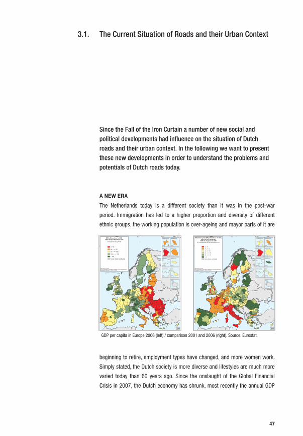
The Current Situation of Roads and their Urban Context
Since the Fall of the Iron Curtain a number of new social and political developments had influence on the situation of Dutch roads and their urban context. In the following we want to present these new developments in order to understand the problems and potentials of Dutch roads today.
A NEW ERA
The Netherlands today is a different society than it was in the post-war
period. Immigration has led to a higher proportion and diversity of different
ethnic groups, the working population is over-ageing and mayor parts of it are
beginning to retire, employment types have changed, and more women work.
Simply stated, the Dutch society is more diverse and lifestyles are much more
varied today than 60 years ago. Since the onslaught of the Global Financial
Crisis in 2007, the Dutch economy has shrunk, most recently the annual GDP
3.1.
0 600 km
BIP je Einwohner, in KKS,nach NUTS-2-Regionen, 2006
Kartographie: Eurostat — GISCO, 07/2009© EuroGeographics Association, bezüglich der VerwaltungsgrenzenDatenquelle: Eurostat
<= 5050 – <= 7575 – <= 100100 – <= 125> 125Keine Daten verfügbar
In Prozent von EU-27=100
Guadeloupe (FR)
0 25
Martinique (FR)
0 20
Guyane (FR)
0 100
Réunion (FR)
0 20
Açores (PT)
0 100
Madeira (PT)
0 20
Canarias (ES)
0 100
Malta
0 10
0 100
Ísland
0 600 km
Entwicklung des BIP je Einwohner, in KKS,nach NUTS-2-Regionen,
2006 im Vergleich zu 2001
Kartographie: Eurostat — GISCO, 07/2009© EuroGeographics Association, bezüglich der VerwaltungsgrenzenDatenquelle: Eurostat
<= -7-7 – <= -2-2 – <= +2+2 – <= +5+5 – <= +7> +7Keine Daten verfügbar
In Prozentpunkten des Durchschnitts EU-27
Guadeloupe (FR)
0 25
Martinique (FR)
0 20
Guyane (FR)
0 100
Réunion (FR)
0 20
Açores (PT)
0 100
Madeira (PT)
0 20
Canarias (ES)
0 100
Malta
0 10
0 100
Ísland
GDP per capita in Europe 2006 (left) / comparison 2001 and 2006 (right). Source: Eurostat.
47

has fallen -3.9% in 20091. While this drop is an anomaly in the history of post-
war Netherlands, the country is currently in a period of slow growth.
ADAPTATION OF THE WELFARE STATE IDEA
This slow recovery hints to the success of reforms that the government has
been introducing since the mid-2000s – such as the “Levensloopregeling”2 or
the re-adjustment of the health care system – to adjust its model of the welfare
state in order to create a sustainable financial system of care for the Dutch
citizenry. In a recent paper, Ruud de Mooij explains the challenges facing the
Dutch welfare state:
“European welfare states tend to become unsustainable in the future, both in financial terms and in terms of social legitimacy. Indeed, public expenditures will rise in light of ageing while globalization makes it more difficult to finance them due to increasing mobility of tax bases. At the same time, welfare state institutions have poorly adapted to recent change in socioeconomic conditions, such as heterogeneous preferences, a better educated work force, and rising female participation rates. Moreover, welfare states create sustained inactivity among benefit recipients, elderly workers, low-skilled people and women. Therefore, countries can no longer afford these high rates of inactivity in combination with generous public welfare state provisions. European Union governments are therefore thinking about re-inventing their welfare states.”3
To ensure economic prosperity and social cohesion De Mooij clearly calls for the
activation and participation of the weaker parts of the civil society, a concern
that has big importance in the Dutch public debate and that is reflected in
initiatives like the Social Support Act (WMO) and the Coalition Agreement of the
fourth government led by Prime Minister Jan Peter Balkenende4. The welfare
1 See: CIA “Netherlands: Economy”, in: The World Fact Book. https://www.cia.gov/library/publications/the-world-factbook/geos/nl.html. Last Accessed: 2 The Levensloopregeling (or “life-cycle savings scheme”) was introduced in 2006 to pragmatically respond to the changing needs of demographics, lifestyles and a large labour force working in service industries by enabling them to save part of their gross salary to finance a period of unpaid leave in the future e.g. for child care, early retirement, a sabbatical etc. See: Geus, Aart Jan de “Welfare to strengthen the economy“, in: OECD Observer No. 248, March 2005. http://www.oecdobserver.org/news/fullstory.php/aid/1549/Netherlands.html. Last Accessed: 09.07.20113 Mooij, Ruud A. “Challenges for the Dutch Welfare State”, in: Euroframe EFN Autumn 2007 Report “Economic Assessment of the Euro Area: Forecasts and Policy Analysis”, Annex 7, ESRI, Dublin September 2007. 4 Roes, op. cit., p. 76
48
state was financed by the high economic growth rates of the post-war period
and has to adapt its policies to the new realities in order to cope with the new
diversity of society and lifestyles. A solution could be the social and economic
empowerment of the citizens and a partial shift of responsibilities from the state
to a heterogeneous civil society.
With regards to urbanism it would mean that urban development would not
be decided by a centralized state that decides on the citizens needs anymore,
but that the citizens themselves – organized in different interest groups and
especially the weaker ones – can actively shape their urban environment
according to their social as well as economic needs. Roads could play an
important role in this process of re-engagement with the city.
INCREASED MOBILITY
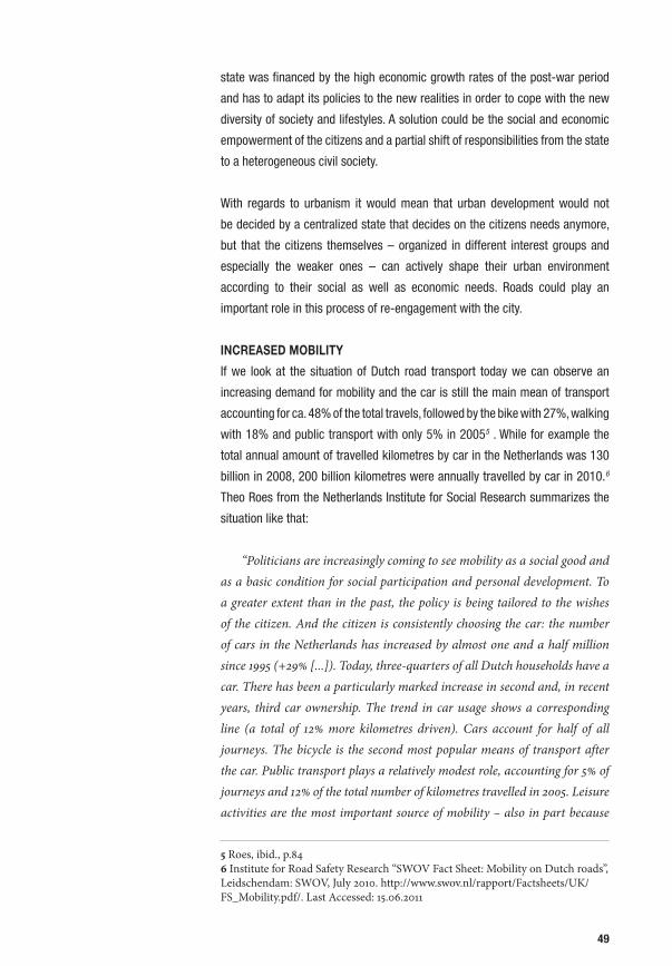
If we look at the situation of Dutch road transport today we can observe an
increasing demand for mobility and the car is still the main mean of transport
accounting for ca. 48% of the total travels, followed by the bike with 27%, walking
with 18% and public transport with only 5% in 20055 . While for example the
total annual amount of travelled kilometres by car in the Netherlands was 130
billion in 2008, 200 billion kilometres were annually travelled by car in 2010.6
Theo Roes from the Netherlands Institute for Social Research summarizes the
situation like that:
“Politicians are increasingly coming to see mobility as a social good and as a basic condition for social participation and personal development. To a greater extent than in the past, the policy is being tailored to the wishes of the citizen. And the citizen is consistently choosing the car: the number of cars in the Netherlands has increased by almost one and a half million since 1995 (+29% [...]). Today, three-quarters of all Dutch households have a car. There has been a particularly marked increase in second and, in recent years, third car ownership. The trend in car usage shows a corresponding line (a total of 12% more kilometres driven). Cars account for half of all journeys. The bicycle is the second most popular means of transport after the car. Public transport plays a relatively modest role, accounting for 5% of journeys and 12% of the total number of kilometres travelled in 2005. Leisure activities are the most important source of mobility – also in part because
5 Roes, ibid., p.84 6 Institute for Road Safety Research “SWOV Fact Sheet: Mobility on Dutch roads”, Leidschendam: SWOV, July 2010. http://www.swov.nl/rapport/Factsheets/UK/FS_Mobility.pdf/. Last Accessed: 15.06.2011
49

the Dutch average annual hours worked is far less than other countries, at 1,392 hours per person. One of the downsides of a mobile society is the incidence of road traffic accidents. There were 750 road deaths in 2005 and 9,400 hospital admissions in connection with traffic accidents. These figures are substantially lower than around ten years earlier.” 7
As Roes mentions Dutch transportation policy so far, as in most other European
countries, was mainly concerned with comforting and facilitating the increase
in car-related mobility. The increasing traffic led to concerns in terms of traffic
security which was tried to get compensated by the constant expansion of the
road system and its security systems. But these measures hardly had a positive
effect. The Dutch road system is still one of the most congested traffic systems
in Europe were a driver spends an average time of more than 65 hours per year
in traffic jams.8
Lucas Harms from the Netherlands Institute for Transport Policy Analysis and
the Netherlands Institute for Social Research writes in a paper, that the reasons
for the growth of mobility are also linked to a complex set of the social changes
inside the Dutch society and a consequent change of mobility patterns that are
7 Roes, op. cit., p. 89.8 INRIX “Benelux Verkeer Scorecard”, Kirkland, November 2010. http://euscorecard.inrix.com/scorecard%5Feu/BNL/summary.asp/. Last Accessed: 07.07.2011
Usage of various modes of transport in the Netherlands (in billion traveller km per year). Source: Rijkswaterstaat, 2007.
50

representative for our time. Basically the amount and type of mobility in the
Netherlands is changing and diversifying affected by several trends9:
1. Growth of Dutch population
2. Increase in prosperity and car ownership
3. Expansion of the road network
4. Separation and dispersion of housing and places of employment
5. Individualization, decline in the number of members of households
and emancipation of women
6. Intensification of diverse activities (e.g. work, household and
education) within a limited time budget
7. More diverse leisure activities
6. ‘Informatisation’ of society, the use of Information and Communication
Technologies (ICT) generates more rather than less mobility
7. Internationalisation and cross-border mobility in e. g. connection
with holidays and recreation
It is interesting that road expansion and the separation of urban functions also
contributes to the growth of mobility. It makes clear that the current Dutch
transportation policy, is not the solution of the mobility problem, but is even
increasing it. The approach can not be “More mobility = more cars = more
roads” anymore, but needs to be a strategy that reacts to these demographic,
social, socioeconomic and cultural trends and fundamentally rethinks the issue
of mobility in a more nuanced and complex way.
URBANISM OF NEGLECT
The new social and economic situation after the Fall of the Iron Curtain and
the decline of a centrally acting Welfare State led to a failure of its modernist
planning principles not only in the Netherlands, but in Europe and in most of
9 Harms, Lucas “Mostly Mobile: Social Trends, Time Use and Mobility; Insights from the Netherlands”, 12th International conference Travel Behaviour Research, Jaipur 2009.
Christopher Alexander “A City is not a Tree, 1967.
51

the Western countries in general. Be it in the periphery of Paris, in the Randstad
or the Rhein-Main Area – the same urban phenomena prevail: What was once
known as the European City, an archetype of a dense, diverse and complex
social space, beyond its old city cores became an unrelated and neglected
amalgamation of urban sprawl, dispersed fragments of landscape and traffic
infrastructures more separating than connecting. The result are the same urban
spaces that were described for example in previously mentioned works of Albert
Pope “Ladders” in 1996 and Christopher Alexander “A City is not a Tree” in
1967.10
Today the texture of European cities is disrupted, neighbourhoods disconnected
from their flows of energy and exchange, enforcing urban fragmentation, social
polarization and an unequal urban development – the result of an urbanism
of neglect, with the state more and more incapable of fulfilling its promise of
“total care” anymore. The Dutch architect and urban planner Kees Christiaanse
describes the situation like this:
“Urban development today displays almost everywhere a dramatic increase in separation. Residential areas, industrial and commercial estates, university campuses, airports, and shopping centres form monofunctional clusters with single access routes, separated by clusters of infrastructure that compartmentalize the landscape.”11
The spatial explanation for this situation lies in the nature of modernist planning
principles. As described in the second chapter, historically roads were connecting
points of importance inside a continuous and permeable urban tissue. Streets
11 Christiaanse, Kees “The Open City and Its Enemies”, in: Rieniets,Tim; Sigler, Jennifer; Christiaanse, Kees (Eds.) “Open City: Designing Coexistence”, Exhibition catalogue IAB Rotterdam 2009, Uitgeverrij SUN, Amsterdam 2009, p.34.
Albert Pope “Ladders”, 1996.
52
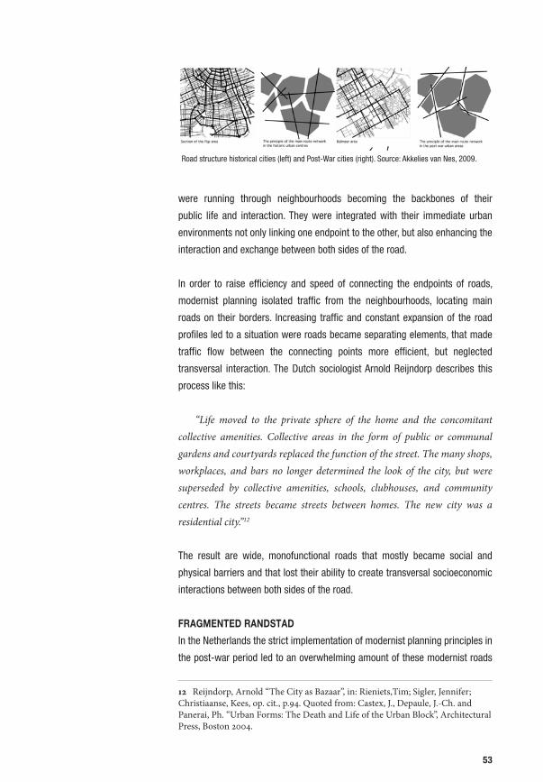
were running through neighbourhoods becoming the backbones of their
public life and interaction. They were integrated with their immediate urban
environments not only linking one endpoint to the other, but also enhancing the
interaction and exchange between both sides of the road.
In order to raise efficiency and speed of connecting the endpoints of roads,
modernist planning isolated traffic from the neighbourhoods, locating main
roads on their borders. Increasing traffic and constant expansion of the road
profiles led to a situation were roads became separating elements, that made
traffic flow between the connecting points more efficient, but neglected
transversal interaction. The Dutch sociologist Arnold Reijndorp describes this
process like this:
“Life moved to the private sphere of the home and the concomitant collective amenities. Collective areas in the form of public or communal gardens and courtyards replaced the function of the street. The many shops, workplaces, and bars no longer determined the look of the city, but were superseded by collective amenities, schools, clubhouses, and community centres. The streets became streets between homes. The new city was a residential city.”12
The result are wide, monofunctional roads that mostly became social and
physical barriers and that lost their ability to create transversal socioeconomic
interactions between both sides of the road.
FRAGMENTED RANDSTAD
In the Netherlands the strict implementation of modernist planning principles in
the post-war period led to an overwhelming amount of these modernist roads
12 Reijndorp, Arnold “The City as Bazaar”, in: Rieniets,Tim; Sigler, Jennifer; Christiaanse, Kees, op. cit., p.94. Quoted from: Castex, J., Depaule, J.-Ch. and Panerai, Ph. “Urban Forms: The Death and Life of the Urban Block”, Architectural Press, Boston 2004.
Proceedings of the 7th International Space Syntax Symposium Edited by Daniel Koch, Lars Marcus and Jesper Steen, Stockholm: KTH, 2009. 121:5
Figure 1 A hypothesis on how the main routes are connected to local streets in traditional and post-War urban areas It is easily to identify the highway net and the local street net manually from most maps. However, identifying the middle scale network has so far been a rather subjective matter. It is easy to spot out the main routes in Post War urban areas from tourist maps due to their clearly hierarchic road sys-tem. It is an effect of how the Buchanan report has influenced various ways of planning streets and roads in urban areas as a consequence of the increase in private car ownership since the 1960’s. As regards the main routes in Pre War built environments it could be difficult, due to the way main routes tend to be well connected and intertwined with the local street net. Therefore, as it has turned out in several student assignments analysing the same area, the results differ from individual to individual. Tracing the main routes manually results in two problems. One is the identification criterion for defining a street or road belonging to a main route network. Apparently, this criterion has never been singled out appropriately. Different researchers have come up with different results when tracing the main routes in the same area. Moreover, one has to know the city very well in order to identify the main routes in traditional urban areas. The other problem touches upon the difficulty to predict economical consequences of proposed urban interventions. It is difficult to know exactly where main routes were located in the past, and it is even more difficult to know whether a new road link will function as a main route or not in the future. Moreover, this “layered spatial model” approach is rather ideological in the way one start to think in the hierarchical way such as proposed in the Buchanan report on how infrastructures in urban areas are built up (or rather
Road structure historical cities (left) and Post-War cities (right). Source: Akkelies van Nes, 2009.
53

and to similar urban conditions as described above. We can see this for example
in the Randstad, an area that covers ca. 8287 km2 or 20% of the Netherlands. It
is the area were the largest Dutch cities are located, the majority of the Dutch
population lives and were the main political, social, economic institutions are
located. At the same time it incorporates a broad range of typical road situations
representative for the rest of the Netherlands from roads in urban or semi-urban
to rural, costal or industrial areas.
The Randstad can be characterized as an agglomeration of quite compact
cities and villages embedded in a more or less engineered, agricultural Polder
landscape. The relative compactness and the clear contrast between city and
landscape is the result of the Dutch spatial planning policy until 2006 the so-
called “Nota Ruimte”. Until 2006 the state centrally planned were urbanization
should take place and were not. In the wake of the above mentioned reforms
the latest Nota Ruimte from 2006 enhanced decentralization and turned its
policy from spatial planning to urban development giving more responsibility
The Randstad in the Netherlands. Source: VROM, LNV, VenW en EZ, 2010 (modified).
The Hague
Amsterdam
Rotterdam
Utrecht
54
to the local authorities, a fact that is widely regarded to promote sprawl in the
periphery of the larger cities and along the highways.13
The cities and villages of the Randstad form a ring around the mostly
unurbanized, rural landscape called “Groene Hart”. The Randstad’s principal
road network is technologically one of the most advanced highway systems in
the world. It interconnects its main cities Rotterdam, Amsterdam, The Hague
and Utrecht and links them to larger cities outside the Randstad.
While the highway connects these “endpoints” very well, its integration with the
local roads is quite weak. A study carried out by Akkelies van Nes from the TU
Delft employs Space Syntax on the Randstad – a visual tool developed by Bill
Hillier14 to analyse the permeability and connectivity of road systems – illustrates
this: Although the major cities Amsterdam, The Hague, Rotterdam and Utrecht
are connected quite well to each other through the highway system, their local
integration is quite weak. The current government policy for mobility “Nota
Mobiliteit” from 2004 enforces this situation by putting weight on developing
effective highways to support economic development and growth for the big
economic centres, neglecting the integration local areas.15
If we look on how the highway is embedded in the urban environment this
observation is confirmed in two ways:
1. Although the highway connects several conurbations, their secondary
and tertiary connections among each other are mostly disrupted. As a result
inhabitants of neighbouring communities, often need to use the highway to
reach each other, instead of having direct connections. This is one reason for
the congestion pressure on Dutch highways.
2. The highway is a huge barrier, that fragments and separates its adjoining
neighbourhoods. In fact the communities form a sort of islands that are often
only linked to the highway.
13 Ministries van VROM “Nota Ruimte. Ruimte voor ontwikkeling”, Ministerie van Volkshuisvesting, Ruimtelijke Ordening en Milieubeheer VROM; Ministerie van Landbouw, Natuur en Voedselkwaliteit LNV, Ministerie van Verkeer en Waterstaat V en W en Ministerie van Economische EZ, The Hague 2006. See also: Bendiks, Degros, op. cit.14 Hillier, Bill “Spatial Sustainability in Cities: Organic Patterns and Sustainable Forms“, in: Koch, D.; Marcus, L.; Steen, J. (Eds.) “Proceedings of the 7th International Space Syntax Symposium”, KTH, Stockholm 2009. 15 van Nes, Akkelies “Analysing Larger Metropolitain Areas: On Identification Criteria for Middle Scale Networks”, in: Koch, Marcus, Steen, op. cit., ref. 121. See also: Ministeries van VROM “Nota Mobiliteit. Naar en berouwbare en voorspelbare bereikbaarheid”, Ministeries van V en W en VROM, The Hague 2004.
55

Proceedings of the 7th International Space Syntax Symposium Edited by Daniel Koch, Lars Marcus and Jesper Steen, Stockholm: KTH, 2009. 121:7
However, when looking at the location pattern of shop in Amsterdam in figure 2, it is easy to identify that they follow a certain location pattern of main routes through urban areas (top). The strength of the axial analyses in the space syntax method is that it is able to compare spatial properties independently from socio-economic data. Therefore, the challenge has been the last four years to find mathematical means to calculate it only by using various spatial properties. During the last year it has become possible to identify the main routes through urban areas through the most recent development in the space syntax analyses. In the first instance, all streets and roads are represented as a set of the fewest and longest axial sight lines. No difference is made between pedestrian routes and highways. Then it is up to the mathematical calculations to identify the main routes and the lively shopping streets at various scale levels. The latest version of the Depthmap software has the capacity to analyse the whole Randstad area. In addition to analysing topological distance, the software is also able to analyse metric and geometrical distance. The metric distance measures the city's street and road net as a system of shortest paths, while the topological distance, calculates the city's street and road net as a system of fewest turns paths. Finally, the geometrical distance gives a picture of the city's street and road net as a system of least angle change paths. Each type of relation can be calculated at different radii from each street segment, defining radius again either in terms of shortest, fewest turns or least angle paths (Hillier and Iida 2005, 557–558). The consistency of the space syntax method is to represent all Randstad’s streets and roads as a set of axial lines. No differences are made between highways and footpaths in the representing of the movement network at a set of axial sightlines. After a time consuming job drawing the entirely street and road net of the whole Randstad on an axial map, the mathematical calculations do the job for highlighting the main routes from the remaining street net.
Figure 3 Global integration of the Randstad (topological distance)
Amsterdam
The Hague
Rotterdam
Utrecht
Territorial Scale: Highway system connects larger cities
Proceedings of the 7th International Space Syntax Symposium Edited by Daniel Koch, Lars Marcus and Jesper Steen, Stockholm: KTH, 2009. 121:8
Figure 3 shows how topologically integrated a street or road in the Randstad is in relation to all others. The black colour shows the highest integrated streets while the light grey colour shows the lowest integrated ones. The highest integration values can be found on the highways, where the highest values are at the ZuidAs. During rush hours, Randstad's highways are suffering from con-gestion. Even though Amsterdam is metrically located on Randstad's edge, it has the topologically most central location. Leiden has the metrical most central location in the Randstad. However, topologically it has low integration values. The connection to Leiden centre is weak from the highly integrated highway A4. One has to change directions many times before the city centre is reached. The Prins Claus Plein highway junction in The Hague has high global integration values. In order to understand its vitality on a local scale, it must be seen together with a local integration analysis.
Figure 4 Local integration of the Randstad (topological distance)
Randstad's local integration analysis (figure 4) highlights the most integrated streets in the various towns and city centres. When comparing the ZuidAs with the Prins Claus Plein highway junction, the ZuidAs has both high local as well as global integration values. This explains as to why 90% of the FDI's and APS's are located in the ZuidAs. When looking at the various city centres, The Hague and Amsterdam centre have high local integration values, whereas it is low in Rotterdam. The most segregated areas in Amsterdam are in the northern suburbs and the Red Light District. In general, most post war through planned urban areas have low local integration values. When applying the angular weighting values to the analyses, Randstad's highways are even highlighted more than in the global integration analyses. As figure 5 shows, the congested highway A13 between The Hague and Rotterdam implies high spatial integration values with angular weighting. Still the ZuidAs has the highest values. The main routes through urban areas with their degree of vitality can be found in the local angular analyses (figure 5). The highest values can be found in Amsterdam centre, the ZuidAs and The Hague centre. Otherwise, the main route system is highlighted in the remaining towns and city centres.
Space Syntax Randstad - Global (left) and local (right) integration: Highway connects major economic poles, but has weak regional and local road integration. Dark: well connected. Light: Weakly connected. Source: van Nes, 2009.
56

Local scale: Disrupted secondary and tertiary network and fragmenting highway (The Hague – Rotterdam Area)
Space Syntax: Disrupted regional and local road network.Yellow: Permeable, Blue: Impermeable.Source: van Nes, 2009.
57

Disrupted road network and fragmenting infrastructures in the East of the Parisian Banlieue. Source: Project “Paris Peripherie Nord-Est”, LIN/Uberbau, 2010.
Aerial view of Aulnay-sous-Bois / Sevran
Space syntax showing permeability of the road system. Yellow: Permeable, Blue: Impermeable.
Types of networks
58
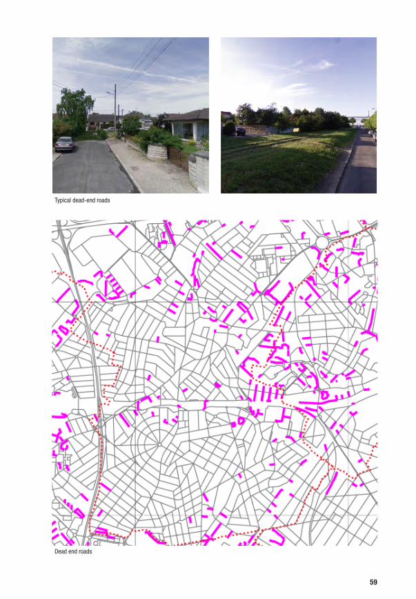
Dead end roads
Typical dead-end roads
59

The resulting spatial model is a hierarchic, tree-like system as described
Christopher Alexander’s “A City is not a Tree”16. Local streets lead to regional
roads that lead to highways in a hierarchic manner. The highways connect the
main points of economic interest and areas directly connected to the highway
(e. g. the Zuid As next to Amsterdam), while fragmenting the rest of the territory.
The result is an unequal urban development that exacerbates the difference
between well accessible and badly accessible areas, enforces socioeconomic
polarization and ultimately leads to the degradation of the badly accessible
areas. This is a phenomena that can be seen in various European contexts such
as for example in the East of the Parisian Banlieue.
APPROACH: THE ROAD AS A HYBRID OPEN SPACE
We see two interrelated approaches to change this situation:
1. On the territorial scale we see a possibility to turn the tree like mobility
structure into a multidirectional network, an approach that can be connected to
the idea that a permeable and grid-like road structure facilitates the exchange
among people, ideas and goods an ultimately leads to a more equal urban
development.17
In the context of the Randstad such a transport network (be it by roads or by
other means transport) that is independent from the highway system, could
raise the connectivity between the various conurbations, create more exchange
between them and relieve them from their dependence on the highway.
Combined with intelligent transport technologies this could lead to a more
equal and efficient distribution of traffic in the Randstad, reduce the highway’s
traffic congestion and the profiles of overdimensioned main roads and generate
spatial potentials. There are already various trends and initiatives inside and
outside the Netherlands that are emphasizing this approach.
2. On the local scale we see the possibility to change the design of roads
themselves in order to facilitate transversal interaction and exchange between
the immediate environments that roads currently separate. By designing roads
in a hybrid way, meaning to find ways of re-contextualizing them and integrating
the social, spatial and functional diversity of different urban environments, roads
16 See also: van Nes, op. cit., p. 1117 This idea was already formulated in the 1960s by Jane Jacobs in “The Death and Life of the Great American Cities” and recently readdressed by Kees Christiaanse on the occasion of the International Architecture Biennale Rotterdam “Open City”. See: Jacobs, op. cit. See also: Christiaanse, op. cit.
60

could again become hybrid open spaces that form the social and economic
backbone of cities.
With our research we want to focus on the latter approach as the development
of convincing and precise design solutions for the integration of roads and urban
context in the Netherlands was mostly neglected so far. At the same time a new
design of roads in the local scale can not be proposed without considering
the influences of currently probable future developments on a territorial scale.
These should be presented in the following.
61

Current spatial model: The Randstad is a Tree
62

2. Transformation local scale: From the connection of “endpoints” to the transversal interaction of various urban contexts
1. Transformation territorial scale: from a tree structure to a network
63

Bronnen:Randstad: AVV, CBS, Witsen kaart. Ruhr: Ministerium für Vekehr, Energie und Landesplannung des Landes Nordrhein-WestfalenLonden: Department for TransportLA: California Department of Transportation
Gebied
Randstad* Ruhr Londen LA oppervlakte (km2) 6400 4400 2200 3660
populatie (miljoenen) 7.3 5.4 7.4 12.5
populatie dichtheid (inwoners / km2) 1133 1227 3364 3415
aantal auto’s (miljoenen) 2.3 2.6 2.7 5.3
auto dichtheid (auto’s / km2) 359 591 1227 1448
auto dichtheid (auto’s / 1000 inw.) 317 481 365 424
mobiliteit (auto km1 / persoon, dag) 15 12 22 55
Wegenstructuur
HWN Randstad Ruhr Londen LA lengte HWN (km1) 950 610 235 1133
rijstrooklengte (km1 - 2 richtingen) 4275 2684 1410 9404
rijstrook dichtheid (km1/ km2) 0.67 0.61 0.64 2.57
rijstrook dichtheid (km1/ 1000 inw.) 0.59 0.50 0.19 0.75
aantal afslagen / km1 0.4 2.7 6.3 7.0
gem. aantal rijstroken (2 richtingen) 4.50 4.40 6.00 8.30
OWNlengte OWN (km1) 1150 2270 1780 9486
rijstrooklengte (km1 - 2 richtingen) 2875 5675 5340 33106
rijstrook dichtheid (km1/ km2) 397 1051 722 2648
rijstrook dichtheid (km1/ 1000 inw.) 0.40 1.05 0.72 2.65
gem. aantal rijstroken (2 richtingen) 2.5 2.5 3.0 3.5
*Randstad: provincies Zuid Holland en Utrecht en de stadsgewesten Amsterdam en Haarlem
Lack of regional roads in the Randstad region in comparison to the Ruhr region (DE), London (UK) and Los Angeles (US). Source: maxwan a&u “The Missing Link”.
Lack of interconnected regional roads in the Randstad region in comparison to the Ruhr region (DE). Source: Zandbelt & van den Berg “Nieuwe Nederlandse Stad”, 2007.
Reparatiewerven
JachthavenCruisevaartterminal
Business Resort Amstelwijck
Congrescentrum Dordtse Kil
ZeehavenpleinWilhelmina-haven
Admiraalsplein
Kop Wieldrecht
Kop Tunnel-Krispijn
Wielwijkpark
Weizichtpark
Duivelseiland
Cinecenter Dordrecht
Theater- plein
Randstad Theater Grand Hotel
Aquarium
Programma ruimteschaal 1 : 25.000
Bebouwing transformatiegebied Langzame Stad
Overige bebouwing
Openbaar gebouw Langzame Stad
Openbaar gebouw
Park Langzame Stad
Park
Water
Plein
Langzame Stad boulevard
Stadstraat
Proefvak Dordrecht A16: Deltaboulevard
16 STUDIES
+/- 25 min
File
3
A 16
N 217
4 min
100
max. 5000 auto’s/uur
Binnenstad Dordrecht
4
Deltaweg
Diepenbockweg
Zeehavenlaan
N 217
Dokweg
12 min
50
LS
ca. 3000 auto’s/uur
Kop Wieldrecht
‘s-Gravendeelsedijk
Reeweg Zuid
Vergelijking ruimtewinst Afwikkeling autoverkeer
Bestaand profiel A16
Dordrecht Deltaboulevard
A16 Dordrecht 59,5 ha
Kop van Zuid79,1 ha = circa 300.000m² kantoren, en circa 4.000 woningen
Nu: A16 Dordrechtmaximaal 5.000 auto’s per uur
Straks: A16 Dordrechtcirca 3.000 auto’s per uur
Ontwerponderzoek Langzame Stad november 2009
Langzame Stadsboulevard
Een verlaagde snelheid op de A16 kan Dordrecht verbinden met het water. Het havengebied kan een nieuwe aanwinst worden voor Dordrecht als een nieuw te ont-wikkelen gebied met bedrijven en voorzieningen gecombineerd met woningbouw. De bestaande be-drijventerreinen Dordtse Kil 1 en 2 krijgen nieuwe impulsen door een betere aansluiting op de stad. De schiereilanden Duivelseiland en de kop van de Drechttunnel kun-nen weer ontsloten worden en transformeren tot nieuwe openba-re ruimten. Zij verbinden de stad met het water van de Oude Maas en Dordtse Kil en zorgen zo voor een zeer aantrekkelijke nieuwe stadsruimte.
DeltaboulevardProefvak A16 bij Dordrecht is van de drie proefvakken het meest extreme voorbeeld van de radicale ontmoeting tussen stad en snelweg. De huidige A16 is te typeren als ‘een weg van het water’ of een ‘Deltaweg’. De A16 maakt een golvende beweging vanuit de Drechttunnel omhoog naar het onderzoeksgebied van de Langzame Stad waar het onder NAP, vanaf het havengebied haast onzichtbaar, het gebied doorsnijdt. De beide kanten van de snelweg verschillen erg van elkaar. Aan de westkant bevindt zich een havengebied langs de Dordtse Kil, met kleine bedrijvigheid op een dijklichaam langs de A16. Aan de oostzijde staan naoorlogse woonwijken en is er een ontwikkelingslocatie ter hoogte van de N3.
Huidig en nieuw netwerkDe A16 is een zeer belangrijke transportroute voor vrachtverkeer tussen Antwerpen en Rotterdam. Op termijn zal aan de westzijde van de A16 een nieuwe route worden aangelegd A4N3 die een groot deel van de noordzuid capaciteit zal gaan accommoderen. Niettemin zal ook de A16 een belangrijke doorvoerroute
blijven na het realiseren van de A4N3. Langzame Stad stelt voor om de verschillende vormen van verkeer op de A16 na de Drechttunnel te ontvlechten. Er blijft een onbelemmerde doorgaande route voor vrachtverkeer in een getransformeerde, versmalde corridor. Het overige verkeer zal op de al aanwezige parallelle wegenstructuur langs het havengebied en over de ‘s Gravendeelsedijk worden geleid. Zij rijden niet harder dan 50 kilometer per uur over een stedelijke boulevard langs het water. Aan deze noordzuid ontsluitingen worden de koppelingen gemaakt met de stedelijke ontsluitingswegen.
Thema 1: RuimtewinstDe huidige A16 beslaat 59,5 hectare. Ter vergelijking, de Kop van Zuid in Rotterdam beslaat 79 hectare en huisvest 300.000 M² kantoren, ruim 4.000 woningen en verschillende openbare stedelijke voorzieningen.
De ruimtewinst ontstaat door versmalling van het wegprofiel en het gebruiken van bestaande noordzuidverbindingen. Deze ingrepen hebben directe gevolgen voor de aangrenzende bebouwing. Die krijgt een geheel nieuwe oriëntatie en ontwikkelingspotentie. Het ruimtebeslag van snelweg en onderliggende wegen met op en afritten is rond bedrijventerrein ‘de Put’ groot. Verlaging van de snelheid zal enorme kansen bieden voor de stad. De herstructureringsgebieden Wielwijk, Oud Krispijn, Louter Bloemen en Amstelwijck krijgen voorkanten aan een Randstedelijke boulevard.
Thema 2: VerbindingenLangzame Stad zal de A16 transformeren van een onoverbrugbare barrière in een stadsboulevard. Een langzame A16 verbindt de verschillende delen van Dordrecht, herstelt doorsnijdingen en brengt in alle richtingen de delen van de stad dichter bij elkaar. Door versmalling van de A16 en ontvlechting van de verkeersstro
men kunnen loodrecht op de snelweg dwarsverbindingen gemaakt worden, die de stad koppelen aan het water. De Zeehavenlaan en de Reeweg lopen tot aan de Wilhelminahaven en de ’s Gravendeelsedijk, waardoor een nieuw netwerk van straten ontstaat als alternatief voor de A16. Het aanwezige netwerk aan de oostkant wordt opgewaardeerd tot een hoogwaardig stedelijk netwerk, dat de naoorlogse wijken beter zal ontsluiten.
Nieuwe verbindingen - Binnenstad HavenOp dit moment is behalve de A16 ook het stelsel van op en afritten ten zuiden van de Drechttunnel een enorme barrière tussen de oude binnenstad en de haven. Met de nieuwe A16 kan dit stelsel verdwijnen en plaats bieden aan een nieuw programma en nieuwe openbare ruimte. Dat levert een onbelemmerde dwarsroute tussen de binnenstad en het nieuwe havenfront (Mauritsweg), die nieuwe en bestaande openbare ruimtes met elkaar zal verbinden en de stad tot aan het water zal brengen.
Nieuwe verbindingen - ZeehavenlaanTen zuiden van de Mauritsweg zal de lijn PaterwegZeehavenweg toegang geven aan het nieuwe hart van het havenfront van Dordrecht, de Wilhelminahaven. Deze nieuwe verbinding is de ontbrekende schakel in het netwerk van stadstraten. De weg wordt het langzame alternatief voor de A16 die de haven met de N3 verbindt.
Thema 3: Nieuw programma ImplosieDe ruimtewinst van de Delta boulevard, kan voor zowel woningen, voorzieningen als openbare ruimte worden gebruikt. De nieuwe geplande woonwijken aan de oostzijde van Dordrecht kunnen er een plaats krijgen, maar ook grootschalige voorzieningen, die niet in de binnenstad
passen. De Wilhelminahaven wordt de spil van de Deltaboulevard met openbare voorzieningen zoals een Havengebouw, een Aquarium en aan de haven gerelateerde bedrijvigheid zoals werven, jachthaven en cruiseterminal. Tussen het nieuwe woongebied op het Duivelseiland en de oude binnenstad, zal een lint van nieuwe Randstedelijke voorzieningen komen, zoals een Grand hotel, een theater/bioscoop met 50 zalen en een Cinecenter. Kantoorfuncties en een congrescentrum langs de A16 zullen een impuls geven aan de bedrijventerreinen aan de Dordtse Kil.
Thema 4: Nieuwe openbare ruimte DeltaboulevardDe woonwijken Wielwijk, Oud Krispijn, Louter Bloemen en Amstelwijck liggen straks aan de nieuwe Randstadboulevard: Blocatie wordt toplocatie. Met deze nieuwe positionering van infrastructuur kan de herstructurering een nieuwe fase ingaan. De corridor voor het vrachtverkeer wordt gedeeltelijk overbouwd, met oplopende brugelementen en pleinen. De nieuw ontstane ruimte die gedeeltelijk boven de A16 ligt, is bestemd voor openbare ruimte aan de Deltaboulevard. Er komen schitterende flaneermogelijkheden aan de Dordtse Kil door een Randstedelijke maatvoering van de balkons aan het water. De ervaring van een gesloten corridor temidden van onzichtbaar water maakt plaats voor een stedelijke boulevard langs een vijf kilometer lang nieuw havenfront.
Proefvak A16 Dordrecht: DeltaboulevardStad aan het water
EXTREME RADICALE ONTMOETING TUSSEN STAD EN SNELWEG RUIMTE- EN MILIEUWINST VOOR DE STAD Rianne Zandee en Douwe Tiemersma Stichting Natuur en Milieu
Het idee van Langzame Stad sluit naadloos aan bij wat Stichting Natuur en Milieu wil: het beter benutten van de ruimte in de stad. Immers: bouwen in de stad levert zo veel meer op dan bouwen in de groene wei. Wij onderkennen dan ook de potenties van de Langzame Stad als het gaat om ruimtewinst en verbetering van de ruimtelijke kwaliteit in de stad. Het is positief om autover-keer langzamer te maken en daarmee fiets en openbaarvervoer een betere concurrentiepositie te geven. Dat is goed voor de luchtkwaliteit, de geluids-hinder en CO2-uitstoot.
Je moet wel goed kijken welke wegen daarvoor het meest geschikt zijn. Dat zullen niet altijd de rijkssnelwegen zijn waar de Langzame Stad zich op richt, maar juist ook vierbaans stadswegen met ongelijkvloerse kruisingen, zoals de Gooiseweg en Cornelis Lelylaan in Amsterdam. Wij zijn geen voorstander van het ‘downgraden’ van autowegen als de A13, als dit betekent dat er een nieuwe snelweg moet worden aangelegd door kostbare landschappen, in dit geval de A4 door Midden-Delfland. In het algemeen is benutting van bestaan-de snelwegen en deze ondergronds brengen een betere optie, zoals de keuze voor de A9 in tunnels in Amstelveen en Amsterdam Zuid-Oost, in plaats van een nieuwe weg langs het Naardermeer. Ook op die manier kan ruimte voor bebouwing in de stad worden gewonnen.
Een ander aandachtspunt is dat voorkomen moet worden dat bij het ‘down-graden’ van een snelweg naar een stadsboulevard negatieve effecten optre-den op het omliggende wegennet. Immers: door de transformatie van snel-weg naar stadsboulevard zal het verkeer zich gaan verdelen over alternatieve routes op het omliggende wegennet, die nu even snel of mogelijk sneller zijn dan de stadsboulevard. In dat geval worden de problemen van congestie, geluid en luchtkwaliteit dus verplaatst. Nodig is een totaalpakket van maatre-gelen die autoverkeer ontmoedigen en fiets en openbaarvervoer bevorderen. De Langzame Stad inrichting van de stadsboulevard creëert een fijnmaziger fietsnetwerk dat het fietsgebruik sterk bevordert. Als extra zijn goed bereik-bare en gratis fietsenstallingen nodig en minder autoparkeerplaatsen. Die autoparkeerplaatsen moeten bovendien een behoorlijke prijs kennen; de kosten van de schaarse ruimte moeten volledig doorberekend worden in het parkeertarief.
Met deze ‘kanttekeningen’ bij de Langzame Stad denken wij dat het concept veel waarde kan hebben voor een leefbare en aantrekkelijke stad, waar men-sen graag willen leven. Het wachten is nu op de eerste bestuurder die rea-lisatie aandurft. Het programma ‘Transformatie van de stad’ van Natuur en Milieu, wil dit soort ‘doorbraaktrajecten’ bewerkstelligen door het vormen van een brede coalitie van koplopers van overheden en marktpartijen. Want niet alleen is de stad het waard, maar ook blijft op deze manier de open ruimte om de stad gespaard.
e-mail: [email protected] en [email protected]
STUDIES 17
StedebouwMUST maakt de stad
Ontwerponderzoek Langzame Stad november 2009
New Regional Roads with speed limit of 50 km/h.
Source: Langzame Stad, 2009.
64

The Future of Roads in the Randstad: Trends, Visions and a Scenario
In the following we want to present and evaluate some trends and visions for the future of roads and transport in order to propose a territorial scenario for the Randstad, that sets the larger context for the design of hybrid roads.
NETWORK OF REGIONAL ROADS
Besides the implementation of modern traffic management systems for
highways, there is an ongoing debate in the Netherlands to relieve the highway
system from its congestion through the expansion and connection of existing
regional roads, in order to achieve an independent regional transport network.
This would distribute car traffic more equally over the territory and create less
traffic at current bottlenecks and more traffic at currently underused places.
There are various studies and initiatives that promote this vision. A study by
Zandbelt & van den Berg presented at the Rotterdam Biennale 2007 compares
the Randstad with the Ruhrgebiet in Germany and observes that the Ruhrgebiet
has an independent network of regional roads.1 This enables neighbouring
communities to be linked directly to each other and results in less traffic on
the highway. The study “Missing Link” carried out by maxwan for the Dutch
Ministry of Transport observes that the amount of regional roads is much higher
than in the Netherlands and hints to the necessity of expanding the regional
1 Zandbelt & van den Berg “Randstad”, source unknown.
3.2.
Van een discontinu systeem met ‘missing links’ naar een fijnmazig continu systeem waarin snelweg en regionaal netwerk aan elkaar zijn verknoopt.
Van A22 naar N22?Tendensen in de verkeerskundige werelding. W.E. Scheper adviseur verkeer & ruimte Goudappel Coffeng BV
Stedelijk Verkeer & Vervoerplan BeverwijkVoor de regio IJmond, waar de gemeente Beverwijk deel van uitmaakt, is de A22 de belangrijkste ontsluitingsweg. Door de aanleg van de Wijkertunnel heeft de A9 sinds 1996 de functie voor het doorgaande verkeer tussen Amsterdam en Alkmaar overgenomen. Uit onderzoek blijkt dat de A22 vrijwel alleen nog door regionaal en lokaal verkeer wordt gebruikt. De bereikbaarheid van Velsen-Noord en Beverwijk (inclusief Corus) is in de spitsuren slecht, omdat er slechts één aansluiting op de A22 beschikbaar is. Ook in het weekend zijn er rondom de Bazaar veel bereikbaarheidsproblemen binnen Beverwijk. De mogelijk-heid om de A22 om te vormen tot een regionale stadsweg is door het bestuur (college en raadscommissie) van Beverwijk enthousiast ontvangen. Tijdens een discussieavond met de raadscommissie werd deze oplossing unaniem als kansrijk bestempeld. De A22 als regionale stadsweg biedt verkeerskundig kansen (meer aansluitingen van het stedelijke op het regionale wegennet) en kent mogelijk ook kansen voor nieuwe ruimtelijke ontwikkelingen. Sterker nog, het compleet anders vormgeven van de A22 lijkt noodzakelijk om de geplande ruimtelijke ontwikkelingen goed bereikbaar te houden. De gemeente Beverwijk wil samen met de buurgemeenten Velsen en Heemskerk, de provincie Noord-Holland en Rijkswaterstaat de mogelijkheden om te komen tot een N22 nader verkennen. Rijkswaterstaat heeft in een eerste reactie aangegeven dat de weg voor haar een belangrijke functie heeft als alternatief voor de A9 bij calamitei-ten. Een ‘afwaardering’ tot regionale stadsweg past volgens hen daar niet in. Verkeerskundig zijn er echter volop mogelijkheden om de weg zodanig vorm te geven dat de N22 een alternatief blijft in geval van calamiteiten. De uitdaging ligt er om de vele betrokken partijen te overtuigen van de mogelijkheden van de Langzame Stad. De gemeenten in de regio IJmond willen zich daar hard voor maken. e-mail: [email protected]
wat een grote Nederlandse stad ook heeft, behalve woningen. De winkels op Schiphol genereren meer omzet dan de oorspronkelijke functies van de luchthaven. Ook voor snelwegen en de functies op en rond snelwegen is een vergelijkbaar proces denkbaar. De groei van de perifere detailhandel is ingezet, met de IKEA’s en driveins van McDonald’s voorop en met de woonboulevards, autohandel, kantoren parken en stadions met transferia. De wereld van de snelweg ontwikkelt zich steeds meer tot een nieuw stedelijk weefsel met een eigen maat, schaal en gebruik.
Intensief ruimtegebruik De meeste snelwegen zijn vijftig jaar geleden geprojecteerd buiten, of aan de rand van de stad. Inmiddels zijn vrijwel alle steden naar de snelweg gegroeid en vaak ook er overheen. De vrij gebleven zones langs snelwegen, vaak met sportvelden en volkstuinen, zijn de laatste tien jaar in rap tempo getransformeerd tot nieuwe stedelijke centra. Snelweglocaties zijn samen met oude (haven)industriegebieden de belangrijkste verdichtingsruimten in de steden. Zelfs de ruimte onder en boven de snelweg wordt steeds vaker benut, zoals in Den Haag en Amsterdam. De stad drukt de snelweg weg. De Utrechtse Baan in Den
Haag is inmiddels bijna een tunnel geworden door het grote aantal bruggebouwen dat over de snelweg is gebouwd. Op de Zuidas in Amsterdam wordt de snelweg letterlijk onder de grond gedrukt door het enorme ontwikkelpotentieel dat het toekomstige dakvlak van de tunnel heeft. Goede bereikbaarheid is een belangrijke voorwaarde voor de explosieve stedelijke groei rondom snelwegen, maar ook de zichtbaarheid vanaf de snelweg; de openbare ruimte met het grootste bezoekersaantal in Nederland, is een aantrekkelijke vestigingsfactor. Steeds meer projecten en initiatieven omarmen de snelweg en betrekken die bij de stad. In de huidige gebiedsontwikkeling worden manieren gezocht om snelweg en stad te vervlechten. In die nieuwe gebieden zijn de mobiliteit en acceptatie van de snelweg bijna vanzelfsprekend. Waar geluidsschermen kantoren worden met zichtlocaties met daarachter woningen, wordt de verbinding met de snelweg positief benaderd. Daar ontstaan de nieuwe, bereikbare centra aan de randen van de stad.
Stedelijke transformatieDe herstructurering van de naoorlogse woonwijken is in volle gang; de grootste stedelijke transformatie die ooit in Nederland heeft plaatsgevonden. Naast het vervangen van de
verouderde woningvoorraad speelt het herpositioneren van een groot aantal naoorlogse woonwijken een belangrijke rol. Wijken die aanvankelijk gebouwd zijn als uitbreiding van bestaande steden zijn nu, door de toegenomen mobiliteit, strategisch gelegen stadswijken in de Randstad. Ze zijn goed bereikbaar, hebben goed openbaarvervoer, kennen vaak een hoog voorzieningenniveau en een bijzonder aantrekkelijk en ruim opgezette woonomgeving. Dit is een kwaliteit die bij de bouw van de hedendaagse uitbreidingswijken niet meer haalbaar is. De centrale ligging in de stedelijke regio en goede mogelijkheden voor aansluiting op de netwerken van de Randstad zijn belangrijke pluspunten voor deze locaties. Het laatste punt vraagt echter nog wel aandacht.
Rijkswegennet van parkwaysIn de wijken die tussen 1945 en 1970 zijn gebouwd, heeft mobiliteit nadrukkelijk deel uitgemaakt van het ontwerp. De verbindingen met het omliggende stedelijke veld zijn nu echter vaak gebrekkig, omdat het ontworpen fijnmazige rijkswegennet van parkways nooit is gerealiseerd. De rijkswegen die wel gerealiseerd zijn, hebben weinig met de wijken te maken. De ruimte die voor de rijkswegen was gereserveerd, is veel te klein voor de hedendaagse snelweg
machine. Op veel plekken is daarom het samenhangende stedelijke weefsel opgeofferd om meer ruimte aan de snelwegen te geven. Zo zijn veel naoorlogse wijken ruimtelijk en functioneel geïsoleerd geraakt. Er is bovendien veel geluidshinder en voor de snelweg zelf is vaak toch nog te weinig ruimte.
Langzame Stad: handvat toekomstOndanks de grootschalige aanpak van de naoorlogse woonwijken stagneert de herstructurering op veel plekken. Herplaatsing van bewoners is een groot probleem, omdat men er niet in slaagt het aantal woningen dat gesloopt wordt ook weer terug te bouwen. Op dit moment worden voor elke 100 gesloopte woningen slechts 69 woningen teruggebouwd in de wijken. Wachtlijsten voor herplaatsing van bewoners lopen op en vertragen de sloop. Langzame Stad zou heel goed als handvat kunnen dienen om deze situatie vlot te trekken. Het zorgt immers voor betere bereikbaarheid én meer ontwikkelruimte, vaak in de aangrenzende zone van naoorlogse wijken.
( RISICO )
120100 VERKEERSDODEN
5025 VERKEERSDODEN
8 INZICHT
vervolg van pagina 6
Ontwerponderzoek Langzame Stad november 2009
Distribution of traffic through gradual expansion of regional road system. Source: Langzame Stad, 2009.
65

road system in the Netherlands.2 The “Langzame Stad” initiative argues for
the higher efficiency and security of driving slower in general and proposes
the expansion of regional “boulevards” that should have a speed limit of 50
km/h.3 The architects and researchers Stefan Bendiks and Aglaée Degros point
out the potential for regional roads to become a structuring element that could
control urbanization locally and avoid sprawl as a consequence of the latest
Nota Ruimte.4
GRADUATED AND INTERMODAL PUBLIC MOBILITY SYSTEMS
In the wake of the ecologic crisis there is a large international debate on the use
of new so-called “e-mobility” systems, that reduce the carbon footprint, offer
an alternative to the privately owned, fuel-driven car and react to the previously
mentioned diversification of mobility. Various Dutch institutions are currently
investigating the potentials of e-mobility systems for the Netherlands, such as
the Formula E team of the Dutch government or the Dutch Innovation Centre for
Electric Road Transport (D INCERT) at the TU Delft.5
The idea is to change the so-called “modal split”, a term that describes the
distribution of mobility on various modes of traffic. Mobility demands should
be distributed from the car to various ecologically more sustainable means of
transport according to the need of the consumer. For example a train would
be employed for larger distances, Metro or Bus Rapid Transit systems would
bring the citizen from the train station to its neighbourhood and micromobility
systems, like bikes or buses on-demand would bring him from the metro station
to his house. These systems would be complemented by shared electric car
systems to answer more individual demands.
2 maxwan “Missing Link”, Dutch Ministry of Transport, year unknown3 Stichting Langzame Stad “Ontwerponderzoek Langzame Stad”, Uitgave no.1, November 2009, http://www.langzamestad.nl. Accessed: 09.07.20114 Bendiks; Degros, op. cit. 5 See: Formula E Team, http://www.agentschapnl.nl/en/onderwerp/formula-e-team/. Last Accessed: 14.07.2011. See also: D INCERT http://www.d-incert.nl/. Last Accessed: 14.07.2011.
Micromobility systems. Source: DB Rent, 2011.
66

The key to the efficiency of these systems is the integration and coordination
between the various modes of transport. This should be ensured on the one
hand, through efficient multimodal stations, that facilitate the transition from
one mode of traffic to the other including Park-and-Ride facilities for privately
owned cars. On the other hand the use of Information and Communication
Technologies (ICT) can support a smooth coordination of the different traffic
modes.6 These are for example applications for cell phones that use GPS
technologies to calculate the most fluent combination of different modes for
each individual trip.
INTELLIGENT INDIVIDUAL TRANSPORT SYSTEMS
Intelligent individual transport systems address the possibility of improving the
efficiency of the individual car through the use of new information and GPS
technologies. They basically assume that in the future all informations needed
for driving will be incorporated in each individual car and this will completely
change the conception of roads.
For example the futuristic vision “Pokeville” formulated by the German architect
Jürgen Mayer H. that won the Audi Urban Future Award in 2010, assumes that
GPS will lead to slower, calmer, non-polluting and more efficient driving. Once
the informations for driving are incorporated in the car street signs and physical
security measures like bollards etc. will not be necessary anymore. The better
coordination of traffic will lead to the reduction of driving lanes and newly
available surfaces could become new contemporary, public spaces.7
6 Cranzler, Weert “Vernetzt unterwegs: wie sonst?”, in: Heinrich-Böll-Stiftung (Ed.) “Urban Futures 2050 - Szenarien und Lösungen für das Jahrhundert der Städte”, Schriftenreihe Ökologie, Vol. 18, Heinrich-Böll-Stiftung, Berlin 2011.7 Mayer H., Jürgen “Pokeville”, http://www.poke-ville.com/. Last accessed: 20.06.2011.
Jürgen Mayer H. „Pokeville“, 2010
67

SHARED SPACE & RESPONSIBILITY OF THE CIVIL SOCIETY
These spatial implications are similar to the concept of shared space developed
by the Dutch planner Hans Monderman, a concept that is being successfully
implemented in various smaller cities in the Netherlands, e.g. in Drachten.8 It
is based on a reorganisation of roads in favour of public space, in a reduction
of traffic signs and in a mix of various modes of traffic (car, bike, pedestrian) on
one surface.
Monderman’s approach sees traffic as a means of social interaction. He wants
the traffic participant not to rely on traffic rules or rights-of-way, but instead
to communicate and interact with the other traffic participants in order to
“negotiate” rules and rights with each other. He criticizes that for the sake of
technology and comfort all responsibility for the urban environment was taken
from the citizen in the Post-War Era.9 By arguing that each traffic participant has
to take care of the other he gives the responsibility for a safe and fluent traffic to
each individual. While Intelligent Transport Systems imply a shift of responsibility
to technology, an idea the governed that also Post-War Era, Monderman much
more sees traffic as a social responsibility and as a way to empower the citizens
to actively interact with their urban environment.
8 See: Shared Space http://www.shared-space.org/files/18445/SharedSpace_Eng.pdf/. Last Accessed: 28.06.2011. See also: A video of the traffic flow on main junction of Drachten: http://www.youtube.com/watch?v=3Wte5-_gCDQ&feature=player_embedded. Last Accessed: 14.07.2011.9 Also compare Hans Monderman: “If you treat drivers like idiots, they act as idiots. Never treat anyone in the public realm as an idiot, always assume they have intelligence.” in: Times Online (http://www.timesonline.co.uk/tol/comment/obituaries/article3167372.ece)
Shared Space in Drachten. Source: www.flickr.com/fietsberaad. 2010.
68

This is connected to an ongoing international debate on the question of
how European cities should be governed today in a post-welfare state era.10
European society has enormously changed after WWII, that it has become
much more heterogeneous and is organising itself more an more in different
religious groups, ethnic communities, political parties, clubs and associations.
By activating these urban agents of the civil society and stimulating them to
interact inside their urban environments, the state could again fulfil its promise
of care, this time not through centralistic dirigism, but by empowering them
to act on their urban environments through a decentralized and contextual
stimulation of their activities. Like this the state could become a mediator
between market and civil society to achieve a balanced field of micro- and
macro-economic forces inside the urban territory.
SCENARIO & VISION
The aim of this research is not to develop a vision for the future of Dutch roads
that extrapolates one or all of these trends to an extreme. For example we do
not believe in the complete replacement of the private car through an integrated
public transport system, neither in the construction of a complete regional road
network, nor in a complete trust on intelligent transport technologies. Our aim is
rather to develop a pragmatic vision that could be realized today and carefully
anticipates the mentioned trends.
Our scenario is based on the following assumptions:
1. The regional road system will be extended and will connect various
conurbations directly, but mostly between the urbanized places of the Randstad
along the ring around the Groene Hart.
2. Integrated public mobility systems will offer an alternative to cars and will
cover the complete territory of the Randstad. Their flexibility will be used to
adapt them to the diversity of local situations. Fast systems, like train, metro
or BRT systems will serve the dense areas, while micromobility systems like
bikes, electric car and busses on demand will serve the least dense areas. The
“holes” of the regional road system at places with environmental importance
like the Groene Hart or the Ijsselmeer will be served by modes of traffic with
10 See Philipp Oswalt (Ed.) “Shrinking Cities - Vol. 2: Handlungskonzepte”, p. 12 ff., Hatje Cantz, Ostfildern 2005; see also: Nikolaus Kuhnert/Anh-Linh Ngo “Editorial: Governance”, in: archplus, No. 173, Aachen and Berlin, May 2005; see also: Michael Haus/ Hubert Heinelt “Politikwissenschaftliche Perspektiven auf den Stand der Planungstheorie”, in: Uwe Altrock et al. (Ed.) “Perspektiven der Planungstheorie”, Edition Stadt und Region, Vol. 9, Leue, Berlin 2004.
69
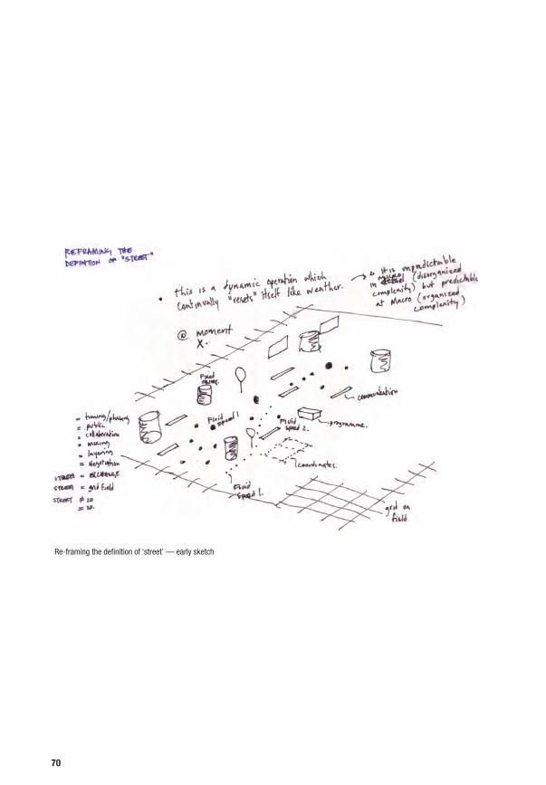
Re-framing the definition of ‘street’ — early sketch
70

a low impact, like bike tracks, boat shuttles or simple pedestrian paths, that
ensure their accessibility, but respect their recreational qualities. Spots of high
environmental quality, like for example some places in the Groene Hart, will be
deliberately disconnected to guard their qualities.
3. Intelligent individual transport systems will make traffic safer and help
distributing it more efficiently in the Randstad. The reduction of street signage,
bollards etc. will lead to less visual and physical pollution of the streets.
4. All these developments will lead to more equally distributed traffic and reduce
the focus on the car. This will make it possible to apply shared space concepts
also on central roads in larger cities, such as Amsterdam or Rotterdam.
Road lanes can be reduced and new spaces with a potential to be designed
differently will appear. It is there were the civil society will be able to act, as
the state will create the circumstances (be it through change of policies or
regulations, through the investment in public spaces etc.) for its stimulation.
These assumptions form the context for our proposal for the re-design of roads
into hybrid infrastructures. They lead to a vision of the road as a non-directional
public surface, that enhances linear as well as transversal interaction, and that
is turned from a border inside the urban environment to its public backbone.
This opens up new spatial potentials and can help to activate the civil society
for new socioeconomic interactions.
Vision: From the road as a barrier to the road as a hybrid, multidirectional surface
71

25 km
Highways
Regional Roads
Fast Integrated Mobility Systems
Regional Integrated Mobility Systems
Soft Integrated Public Transport
Local Micromobility Systems
Intelligent Transport Systems
Hybrid Roads
Randstad territorial scenario


Road Matrix NL: Eight Proposals for the Transformation of Dutch Road Situations
75
4


Groene Hart
Highway
Regional road
Main road
Local street
in city
in rural landscape
in city centre
in traditional neighbourhood
in industrialized landscape
in post-war neighbourhood
in post-war neighbourhood
in periphery
Hoogvliet
AlmereCoolsingel
Einsteinweg Ypenbug
Afrikaanderwijk
Westland
78

Approach
The following presents eight situations of roads in the Randstad on which we applied our vision of hybrid roads. They tell the story of the disintegration of road and urban context and illustrate the nature and variety of its road situations, urban issues, problems and potentials.
TYPOLOGIES
Our hypothesis is that roads in the Netherlands, regardless of their type and
urban context, can be turned into hybrid infrastructures.
The integration of roads with their immediate contexts is the basis of our
hypothesis. We categorised roads according to their intrinsic character as well
as their urban environment. The selection is based on typical combinations of
post-war roads and urban contexts found in the Randstad. This results in the
following representative selection of road types, that have not the ambition to
be comprehensive:
1. Highway in city – Einsteinweg
2. Highway in periphery – Ypenburg
3. Regional road in rural landscape – Groene Hart
4. Regional road in industrialized landscape – Westland
5. Main road in city centre – Coolsingel
6. Main road in post-war neighbourhood – Almere
7. Local street in traditional neighbourhood – Afrikaanderwijk
8. Local street in post-war neighbourhood – Hoogvliet
SPECIFIC AND GENERIC
Based on these categories we selected eight corresponding sites in the territory
of the Randstad. We analysed each spatial, social, economic and political
situation and developed a corresponding design.
79
4.1.

Alternatively we could have created a catalogue of generic situations and
analogous design proposals. We decided to choose specific ‘real’ sites, because
only this allowed us to avoid superficial and generic design solutions for an
idealised world. The specific sites in contrast challenged us with their respective
complex and often bad condition. The selection of the sites was thus a balancing
act. On the one hand we tried to be as generic as possible in the selection
of them, trying to find typical ‘Dutch’ conditions, while on the other hand we
naturally discovered the uniqueness of each site the closer we looked. We
will step back to compare and evaluate our findings and see where we can
generalise at the end of this chapter.
PRAGMATIC DESIGNS
The proposals show the broadness of potentials, approaches and possibilities
of re-designing roads into hybrid, socioeconomic infrastructures in the
Netherlands today. They try to imagine specific designs that integrate the
diversity of interests and needs of various groups of the actual civil society. They
see the collaboration of all parts of the civil society with the state as an enabler
as a fundamental basis for urbanism today. They are pragmatic in the sense
that they deliberately put weight on the ability of hybrid roads to help solving
their specific problems today integrating the assumptions of the scenario, but
avoiding to extrapolate them to an extreme.
80
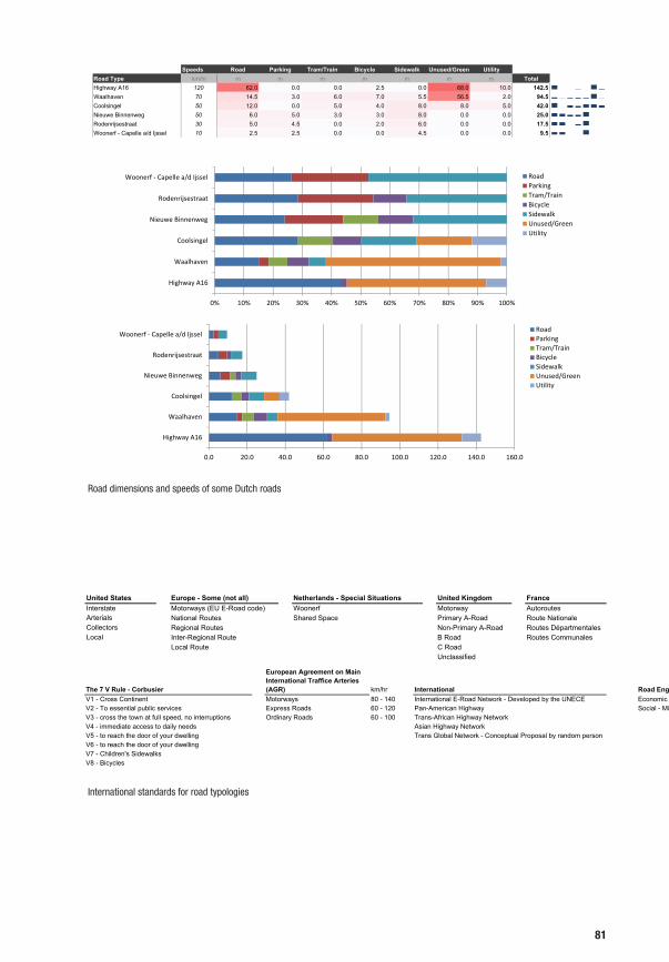
Road Speed & DimensionsDutch Road Sections
Speeds Road Parking Tram/Train Bicycle Sidewalk Unused/Green UtilityRoad Type km/hr m m m m m m m TotalHighway A16 120 62.0 0.0 0.0 2.5 0.0 68.0 10.0 142.5Waalhaven 70 14.5 3.0 6.0 7.0 5.5 56.5 2.0 94.5Coolsingel 50 12.0 0.0 5.0 4.0 8.0 8.0 5.0 42.0Nieuwe Binnenweg 50 6.0 5.0 3.0 3.0 8.0 0.0 0.0 25.0Rodenrijsestraat 30 5.0 4.5 0.0 2.0 6.0 0.0 0.0 17.5Woonerf - Capelle a/d Ijssel 10 2.5 2.5 0.0 0.0 4.5 0.0 0.0 9.5
0% 10% 20% 30% 40% 50% 60% 70% 80% 90% 100%
Highway A16
Waalhaven
Coolsingel
Nieuwe Binnenweg
Rodenrijsestraat
Woonerf ‐ Capelle a/d Ijssel RoadParkingTram/TrainBicycleSidewalkUnused/GreenUtility
0.0 20.0 40.0 60.0 80.0 100.0 120.0 140.0 160.0
Highway A16
Waalhaven
Coolsingel
Nieuwe Binnenweg
Rodenrijsestraat
Woonerf ‐ Capelle a/d IjsselRoadParkingTram/TrainBicycleSidewalkUnused/GreenUtility
Hierarchy of Roads
United States Europe - Some (not all) Netherlands - Special Situations United Kingdom FranceInterstate Motorways (EU E-Road code) Woonerf Motorway AutoroutesArterials National Routes Shared Space Primary A-Road Route NationaleCollectors Regional Routes Non-Primary A-Road Routes DépartmentalesLocal Inter-Regional Route B Road Routes Communales
Local Route C RoadUnclassifiedHierarchy of Roads
The 7 V Rule - Corbusier
European Agreement on Main International Traffice Arteries (AGR) km/hr International Road Engineering for Developmen
V1 - Cross Continent Motorways 80 - 140 International E-Road Network - Developed by the UNECE Economic - MajorV2 - To essential public services Express Roads 60 - 120 Pan-American Highway Social - MinorV3 - cross the town at full speed, no interruptions Ordinary Roads 60 - 100 Trans-African Highway NetworkV4 - immediate access to daily needs Asian Highway NetworkV5 - to reach the door of your dwelling Trans Global Network - Conceptual Proposal by random personV6 - to reach the door of your dwellingV7 - Children's SidewalksV8 - Bicycles
Road dimensions and speeds of some Dutch roads
International standards for road typologies
81

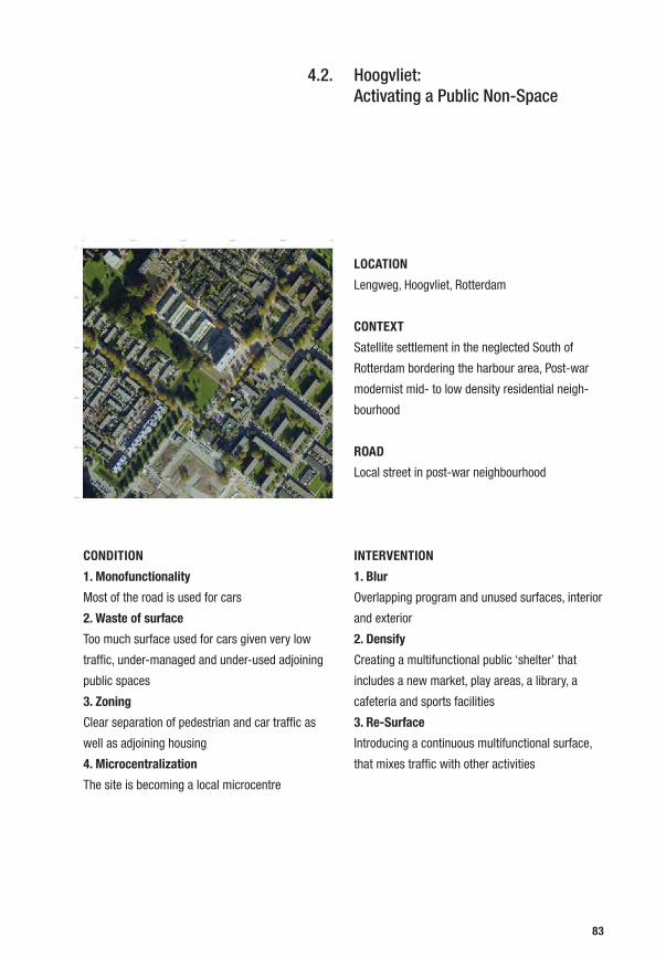
Hoogvliet: Activating a Public Non-Space
LOCATION
Lengweg, Hoogvliet, Rotterdam
CONTEXT
Satellite settlement in the neglected South of
Rotterdam bordering the harbour area, Post-war
modernist mid- to low density residential neigh-
bourhood
ROAD
Local street in post-war neighbourhood
INTERVENTION
1. Blur
Overlapping program and unused surfaces, interior
and exterior
2. Densify
Creating a multifunctional public ‘shelter’ that
includes a new market, play areas, a library, a
cafeteria and sports facilities
3. Re-Surface
Introducing a continuous multifunctional surface,
that mixes traffic with other activities
CONDITION
1. Monofunctionality
Most of the road is used for cars
2. Waste of surface
Too much surface used for cars given very low
traffic, under-managed and under-used adjoining
public spaces
3. Zoning
Clear separation of pedestrian and car traffic as
well as adjoining housing
4. Microcentralization
The site is becoming a local microcentre
83
4.2.
Vlaardingen

Rotterdam
Rotterdam Harbour
Spijkenisse
Vlaardingen

Lengweg in Hoogvliet, Lengweg TodayDead End Hoogvliet
Wimby! Hoogvliet renewal project (Crimson Architectural Historians, „Wimby!“, 2000 - 2010)
Lengweg in Hoogvliet, Lengweg 1930 & 1950 Hoogvliet: Organisation principle
86

SITE
Hoogvliet is a settlement just bordering on
Rotterdam’s harbour area, south of the Maas on the
island Ijsselmonde, close to the intersection of the
A4 and A15 and crossed by the N492. It is populated
by ca. 35.000 inhabitants1. While Hoogvliet’s history
reaches back to the 14th century, it is today mostly
characterised by post-war slabs and more recent
low density housing next to the harbour industries.
The neighbourhood underwent some decline with
the arrival of de-industrialisation. It was recently
subject of an urban renewal project by Crimson
Architectural Historians2.
The immediate context of the site is a residential
area in the Southwest of Hoogvliet, the intersection
of Barbeelsingel, Steurweg and Lengweg, in
proximity of the waterfront and the ‘Zalmplaat’
Metro station. The neighbourhood is predominantly
residential with 2 to 4 floor post-war buildings and
the exceptional 11 floor slab, some of them recently
built or modernised. At the intersection there are
already some services available, such as a school,
a supermarket, a pizzeria and a flower shop.
Average rental prices are comparably low. Traffic
flow is very low. The roads, and in particular the
distance green, is over-dimensioned and under-
used (facade to facade distance on Barbeelsingel is
1 http://nl.wikipedia.org/wiki/Hoogvliet_(deelgemeente). Last accessed: 14.07.20112 Crimson Architectural Historians “Wimby! Hoogvliet - Future, Past and Present of a New Town”, Nai Publishers, Rotterdam 2007.
Hoogvliet Map
Hoogvliet from the air — city & port
87

90m, with 4 level buildings on the west side and 2
level buildings on the east).
The over-provision of open, albeit undefined areas,
neither a park nor a boulevard, neither a square nor
a road, neither a sport-field nor a garden effect an
alienating atmosphere.
Existing building foot prints
Residential
Barbeelsingel
Steurweg
88

Existing situation Hoogvliet, Rotterdam (1:3000)
Supermarket
Shops
Residential
Residential
SchoolBus Stop
New low-rise housing development
Lengweg
Steurweg
89

PROPOSAL
Our proposal gives the under-used green and public
areas a purpose and a definition. The void is filled
and the emerging local centrality is enforced by the
introduction of a light, multifunctional structure at
its core, a roof sheltering a mix of public functions, a
mini fun-palace for Hoogvliet. The volume gives the
outside spaces a clear edge and creates a physical
and programmatic link between supermarket and
existing bus stop. It generates through its clear
edges it generates recognizable outside spaces.
The building consists of a roof in a height of 10m
with an unclimatised space underneath. It spans
over a new multiuse surface, the singel and partially
the road. Under its roof it houses a market for the
inhabitants, a series of kiosks and functions such
as an all-weather playground, a mini-library, sport
facilities and a bicycle rental station next to the
“beach” cafeteria at the singel.
Introduction of new volume
Barbeelsingel
Steurweg
Residential
90

Proposal: A fun palace in Hoogvliet (1:3000)
Lengweg
Steurweg
Multifunctional Shelter
Flexible Street Furniture
Climbing WallShared Bike Station
Sports Fields
Multiuse Surface
Supermarket
Residential
Residential
SchoolBus Stop
New low-rise housing development
Shops
91

Proposal: A fun palace in Hoogvliet (1:500)
Existing situation Hoogvliet, Rotterdam (1:500)
92

93

Artificial Topography
Beach Cafeteria
Football around the Lampposts (Algiers, 2010) Fun Palace (Cedric Price, 1961)
94

The multitude of functions under one roof are more
than the sum of its parts, they create the critical
mass necessary to keep the single existing services
alive (compare ‘Idea Stores‘, David Adjaye, London)
and create a real micro-centrality.
Beyond the sheltered surface, ‘distance green’
is converted into public space, slowed traffic,
surface material (tarmac, wood) and sport facilities
encourage use and give priority to social and public
functions.
Neighbourhood market
Artificial Topography
Beach Cafeteria
Mini-Library
95
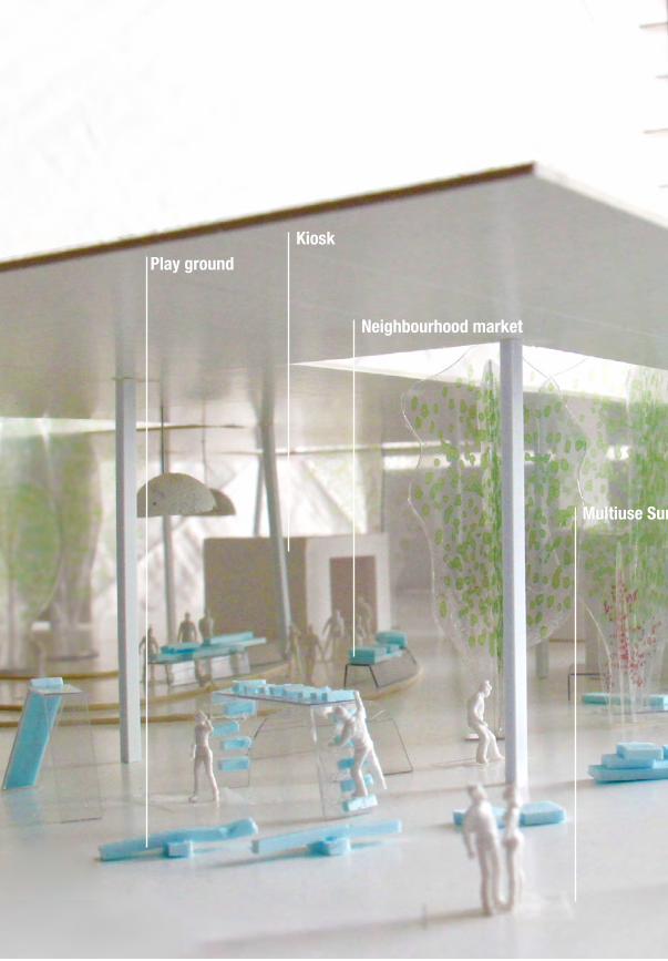
Play ground
Neighbourhood market
Kiosk
Multiuse Surface

Multifunctional Shelter
Multiuse Surface
Flexible Street Furniture
Shared Bike Station


The Groene Hart: Accessing an Artificial Landscape
LOCATION
Hoogeind, Langeweide, Groene Hart
CONTEXT
Agricultural polder landscape, low built density,
single farms along the access road
ROAD
Regional road in rural landscape
INTERVENTIONS
1. Access
Easy public access to the cultural landscape
through the implementation of a secondary leisure
and bicycle network
2. Blur
A blurred public zone around the road, with clear
development limits
3. Densify
Adding services, from micro-markets to sport
facilities to observation posts
CONDITION
1. Monofunctionality
Road is solely dedicated to cars
2. Barriers
Limited accessibility to the landscape, a thin strip
of public ground within private land
3. Development pressure
Tourism, sprawl, industrialised agriculture
99
4.3.

Gouda
Capelle aan den Ijssel

Woerden

A Watercourse at Abcoude (Paul Joseph Constantin Gabriel, 1878)
102

SITE
The site lies along Hoogeind road in the middle
of the Groene Hart, not far from the A12 cutting
through the polder landscape between Gouda and
Utrecht. The Groene Hart is a relatively unpopulated
area enveloped by the Randstad. While certainly
not natural but man-made, the polder landscape
is of cultural significance as well as being the last
large continuous green area in Zuid-Holland. The
landscape is characterised by agricultural use
and water management, it is a flat green land,
drainage channels alternate with dikes, the fields
are sprinkled with cows and sheep. The farms
concentrate in a linear way along the thoroughfares,
with the fields in their back. The farms are directly
accessed from the 6m wide road, with a harsh
transition from public to private land.
The Green Heart of South Holland
103

The growing pressure on the Groene Hart on the one
hand through the industrialisation of agriculture,
and on the other hand through sprawl — the desire
of Randstad citizens to have a house out of town
— jeopardises the landscape. While a certain
degree of tourism is welcome, uncontrolled sprawl
and fragmentation leading to the destruction of the
landscape must be avoided.
Fields
Fields
Water Channels
104

Existing situation Hoogeind, Langeweide (1:3000)
Cultural LandscapeFarms
Gardens
Fields
Hoogeind Road
Fields
Water Channels
105

PROPOSAL
Our proposal creates a public, multifunctional band
along the already urbanized area of the Hoogeind.
This band of a width of ca. 150m clearly delimits
the area of development, with a different set of
building laws, that are derived in terms of density
and building height from the actual character of
the urbanization. The band allows for the cautious
development of new functions besides farming,
such as hotels, restaurants, markets, sport facilities
or housing extensions for the existing farms. It
allows on the one hand for the diversification of
the sites along the roadside, while it protects the
green ‘hinterland’ on the other hand. The loss of
productive land can be offset through additional
income for the local population via tourism.
The transition from road to farmland, from public
to private is clearly limited through an additional
system of pedestrian and bicycle paths for locals
and visitors. These paths have as much leisure as
educative functions. They offer alternative, “soft”
means of transport adequate for the mobility inside
the Groene Hart. At the same time they deliberately
disconnect to fields in order to keep the quality of
the landscape.
Like this the Groene Hart has become more
accessible, the provision of additional services
and decentralisation decrease the amount of
travels. Visitors can watch the fauna from within
the hospitality facilities in the strip as well as from
exceptional observation outposts in the polder
landscape.
Fields
Fields
Water Channels
106

Proposal Hoogeind, Langeweide: A multifunctional strip in the cultural polder landscape (1:3000)
Multifunctional bandCultural LandscapeFarms
Gardens
Fields
Hoogeind Road
Fields
Water Channels
Observation Post
Pedestrian Walkway
Bicycle Path
New Services
Housing extensions
107

Existing situation Hoogeind, Langeweide (1:500)
Proposal Hoogeind, Langeweide: A multifunctional strip in the cultural polder landscape (1:500)
108

109


Afrikaanderwijk: Empowering an ‘Internationaale Wijk’ LOCATION
Cronjestraat, Afrikaanderwijk, Rotterdam
CONTEXT
Medium density, multitethinc residential
neighbourhood street in Rotterdam Zuid
ROAD
Local street in traditional neighbourhood
INTERVENTION
1. Access
Opening up backyards, creating pedestrian
shortcuts
2. Blur
Deregulating street surface limits
3. Re-Program & Adapt
Introducing a manual that explains to inhabitants
or house owners how the existing “be-bo”
typologies can be transformed to make facade
openings and reorganised ground floors possible,
in order to introduce flexibility of use and new
socioeconomic activities
4. Re-Surface
Reducing parking and introducing a mixed surface
CONDITION
1. Monofunctionality
Cars occupy most of the space, surroundings are
mostly residential without services
2. Barriers
Parallel parked cars and parking curbstones create
physical barriers
3. Waste of surface
Principal street function is parking
4. Zoning
Street surface clearly zoned in sidewalk, parking,
driving
5. Social tension
Socially segregated, working class neighbourhood
111
4.4.

Rotterdam South
Rotterdam North
Rotterdam Harbour
Delft
Spijkenisse

Rotterdam South
Dordrecht
Rotterdam North

Local Street Life
Global Connections
Flags
shops
Afrikaanderwijk — Activities
Afrikaanderwijk — Activities
114

SITE
The site, Joubertstraat and Cronjéstraat in
Rotterdam Zuid, lies in the Afrikaanderwijk in
proximity to the old Rotterdam harbour in the South
of the city. The Afrikaanderwijk is an old worker’s
neighbourhood in Rotterdam’s Feijenoord district.
Initially built to house harbour workers during the
boom at the end of the 19th century, it was one
of the first neighbourhoods in the Netherlands with
a population majority of immigrants. A so-called
“Internationaale Wijk’, the Afrikaanderwijk has
become a symbol for tension between the local
populace and migrants, when in the early seventies
tensions about the distribution of social housing
apartments led to clashes in the neighbourhood. To
improve the quality of the neighbourhood various
public space projects, such as the redesign of
the Afrikaanderplein, were executed by the city
administration.
The mainly residential neighbourhood features
14m wide one-way streets with parallel parking on
both sides and sparse planting. The buildings are
late century 3-level be-bo (beneden-boven) brick
houses. The road itself is a local neighbourhood
road with no through-traffic.
Project Parkstad
Afrikaanderplein (Okra, 1995–2005)
115

The monotonous street aspect, the sparse green,
the bad materials, and the lack of protected or
semi-private spaces as well as the lack of any
commercial, public or hospitality program put a very
high barrier to self-empowerment and interaction
between the neighbours.
Docks
Harbour
116

Existing situation Afrikaanderwijk, Rotterdam (1:3000)
Afrikaanderplein
“be-bo” houses
Shops
Joubertstraat
Cronjéstraat
117
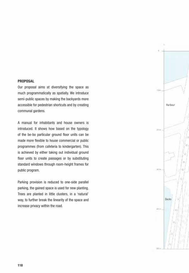
PROPOSAL
Our proposal aims at diversifying the space as
much programmatically as spatially. We introduce
semi-public spaces by making the backyards more
accessible for pedestrian shortcuts and by creating
communal gardens.
A manual for inhabitants and house owners is
introduced. It shows how based on the typology
of the be-bo particular ground floor units can be
made more flexible to house commercial or public
programmes (from cafeteria to kindergarten). This
is achieved by either taking out individual ground
floor units to create passages or by substituting
standard windows through room-height frames for
public program.
Parking provision is reduced to one-side parallel
parking, the gained space is used for new planting.
Trees are planted in little clusters, in a ‘natural’
way, to further break the linearity of the space and
increase privacy within the road.
Harbour
Docks
118

Proposal Afrikaanderwijk, Rotterdam: A permeable neighbourhood (1:3000)
Shops
Afrikaanderplein
Joubertstraat
Cronjéstraat
Communal Courtyards
Shortcuts
Shared Street Surface
Transformed Ground floors
“be-bo” houses
119

120

Existing situation Afrikaanderwijk, Rotterdam (1:500)
Proposal Afrikaanderwijk, Rotterdam: A permeable neighbourhood (1:500)
121

The new shortcuts and services encourage
social and commercial interaction within the
neighbourhood, the newly available commercial
spaces on the ground floor provide a space
for micro-business initiatives. The deregulated
transport structure and playful planting encourage
bicycle use. The road becomes more than a parking
space plus minimal sidewalk, it becomes the social
point of encounter of the neighbourhood.
122

New openings and furniture attached to facade
Loosely arranged trees delimit car space
123
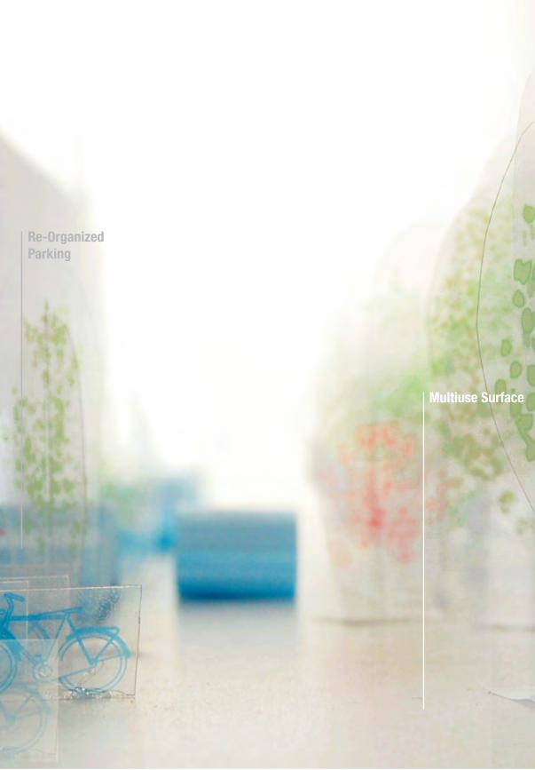
Multiuse Surface
Re-OrganizedParking
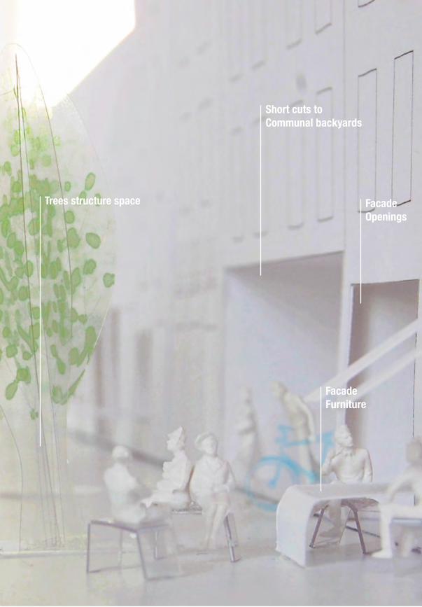
Multiuse Surface
Trees structure space FacadeOpenings
FacadeFurniture
Short cuts to Communal backyards


Ypenburg: Linking an Urban Fragment
LOCATION
A4, Ypenburg, The Hague
CONTEXT
Vinex settlement founded 1992 enveloped by
highways A13, A4, and A12 close to Den Haag on
a former airport, the Site is a noise-dike between a
mixed use and office area, a residential neighbour-
hood and the highway
ROAD
Highway in periphery
INTERVENTION
1. Access
Creating small links between highway and neigh-
bourhood
2. Blur
Transforming the boundary into a centre and meet-
ing point for travellers and locals
3. Densify
Introducing a multifunctional, large-scale building
that pierces the dike and mediates the scales of
highway and neighbourhood
4. Re-Surface
Introducing new programmes on the dike and
around the building, such as tribunes, terraces,
squares, paths, that complement the existing
programmes
CONDITION
1. Monofunctionality
Highway lanes and security offsets characterize
the site, the area’s functions are clearly separated
into road, office, housing
2. Barriers
Security barriers, dike protects and hides Ypenburg
from the highway
3. Waste of surface
The fringe of Ypenburg serves merely as a buffer
4. Separation
The huge highway strongly separates its adjoining
environments
127
4.5.

The Hague
Delft

Zoetermeer
Leiden

Business park, Ypenburg, 2010
Boswijk, Ypenburg, 2009
On the dike, Ypenburg, 2009
130

SITE
The site in Ypenburg is the area of the dike between
the A4 highway, close to the trumpet intersection
with the A13 (‘Knooppunt Ypenburg’), and the
mostly residential Ypenburg settlement. Ypenburg
is a Vinex (Vierde Nota Ruimtelijke Ordening
Extra, housing development program of the Dutch
Ministry of Housing, Spatial Planning and the
Environment VROM) neighbourhood. Construction
started in 1997, with a planned capacity of 30.000
inhabitants. It is a part of The Hague, built on the
site of a former airport, which was in use between
1936 until 1992. Apart from the A4, which connects
Ypenburg to Amsterdam towards and Rotterdam,
Ypenburg is enveloped by the highways A13 and
the A12. Our site straddles the noise protection dike
sandwiched between the highway in the Northwest,
the low residential housing neighbourhood Boswijk
in the East and Ypenburg’s business park in the
South. The tram from The Hague central station
accesses the site from the Northwest.
Ypenburg Airport, 1990
Ypenburg Vinex, 2010
131

Ypenburg is schizophrenically dependent on
the highway while it always turns its back to the
infrastructure to protect the residents from noise
and pollution. Ypenburg is thus well-connected and
isolated at the same time, with an abrupt change
in scale, speed and environment which becomes
eminent for one who climbs the dike and watches
the panorama on both sides.
Rotterdam
The Hague
132

Existing situation Ypenburg, Den Haag (1:3000)
Offices
Tram Stop
Sports Fields
Ypenburg
A4
Amsterdam
Rotterdam
The Hague
133

PROPOSAL
Our proposal aims at piercing the dike and mediate
between the different environments, offering
services both for the residents and highway
travellers. The new multifunctional building
houses, shopping, offices and services and is
directly accessible from the highway with its
anchor stores, and provides smaller shop areas
at the neighbourhood side. The large horizontal
facade makes the building clearly visible from the
highway, while the Ypenburg side merges within
the landscape and the neighbourhood structure,
providing several entrances into the building and
also allowing access to the roof terraces through
boardwalks climbing up the green dike. Occasionally,
the slope of the dike turns into a tribune for sports
or cultural events on the neighbouring sport field,
that also travellers can attend. Direct pedestrian
access to the tram, business park and Boswijk
neighbourhood turn the former border situation into
a destination and meeting point.
Tourism Residency, BLOCK architects, Sainte-Féréole, F, 2008
Rotterdam
The Hague
134

Proposal Ypenburg, Den Haag: Neighbourhood centre plus highway shopping piercing the dike (1:3000)
Viewing Terrace
Multifunctional building
Highway Access
Shared Surface
Tram Stop
Sports Fields
Offices
Ypenburg
A4Neighbourhood Access
A4
Amsterdam
Rotterdam
The Hague
135

Existing situation Ypenburg, Den Haag (1:500)
Proposal Ypenburg, Den Haag: Neighbourhood centre plus highway shopping piercing the dike (1:500)
136

137


Coolsingel: Integrating a Central Boulevard
LOCATION
Coolsingel, Rotterdam
CONTEXT
Office, commercial and public mixed use post-war
buildings within Rotterdam’s central shopping area
ROAD
Main Road in City Centre
INTERVENTION
1. Access
Creating pedestrian short cuts to Lijnbaan through
opening up and activating semi-public backyards
2. Blur
Introducing one open and continuous ground floor
that blurs buildings and public space
3. Densify
Introducing new pavilions for restaurants and cafés
as well as street furniture with coherent design
4. Re-Surface
Flattening and re-organising road surface to
encourage new uses, reduction of road lanes,
introduction of characteristic sequences
5. Remove
Remove existing pavilions for restaurants and
cafés as well as street furniture
CONDITION
1. Monofunctionality
An overwhelming amount of surface is used for
cars, parking or traffic security demands
2. Barriers
Coolsingel is hard to cross, cluttered haphazard
public furniture and kiosks an undefined space full
of obstacles
3. Waste of surface
Too many lanes for cars, distance strips and
left-over spaces result in unusable surfaces, high
amount of traffic lanes
4. Zoning
Coolsingel is highly banded for accommodating
cars, tram, pedestrian and bicycle traffic
5. Vacancy
Many buildings along Coolsingel are vacant
139
4.6.

Rotterdam Harbour
A4
Delft

Rotterdam SouthRotterdam Harbour
A16

Rotterdam before WWII
Rotterdam after WWII
Rotterdam 1952
Coolsingel 1945 (nemonisi.nl)
Coolsingel 1952 (engelfriet.net)
Coolsingel 1960s (engelfriet.net)
Plan Lijnbaan (Bakema & van den Broek, 1955)
142

SITE
The Coolsingel is Rotterdam’s main boulevard and
its main back street at once. In the heart of the city,
it links the Schiekade axis with the Erasmus bridge
and the South of Rotterdam. As such it fulfils an
important function on the scale of the city, being
the main inner-city connection between south
and north sandwiched between the regional level
crossings of the A4 and A16. Hofplein at its northern
end is a main transport hub linking the West-Est
thoroughfare Weena to the North-South link and
is well connected to the tram system, which has
its central hub not far at the central station. A bit
further south we find the city hall, the central police
station and important commercial program, such as
the stock building and the Bijenkorf, the principal
Dutch department store, and an important metro
hub opened in 1968, where the east-west and
north-south lines intersect at Beurs.
143

Coolsingel & Lijnbaan —Parents and Children (Bakema, 1955)
Relationship Lijnbaan — Coolsingel
Lijnbaan in the 1950s Coolsingel Today
Crowd celebrating Feyenoord on Coolsingel Stadhuisplein, Coolsingel Today
144

Nonetheless are its immediate surroundings
characterised by urban degeneration. Many of the
60s office buildings are empty, with blind or broken
windows in the upper floors, while second-rate
shops occupy the ground floor. To avoid squatting,
spaces are partially rented out with ‘anti-kraak’
(anti-squat) contracts.
The Coolsingel has a diverse building structure.
Large solitaires alternate with slabs and towers.
The building substance is predominantly post-war,
with the exception of the Stadhuis, the city hall
(1914-1920, Dr. Henri Evers). The neighbouring
Lijnbaan was designed in 1955 by Bakema & van
den Broek to become the principal shopping street
of Rotterdam, a set of low-rise streets with larger
structures bordering at its edge — for example at
the Coolsingel. So while the Coolsingel can be read
as one of the principal streets of Rotterdam, we can
equally make an argument for it to be a backstreet
of the Lijnbaan.
If we take a closer look at the Coolsingel, we see
that shopping arcades, wide sidewalks with various
kiosks and street restaurants along the 2x2 lane
road with a wide reserved strip for the tram in the
middle span a distance of 60m from facade to face,
filled with urban junk and traffic paraphernalia,
signposts, railings, garbage cans, bollards, traffic
lights, street lamps.
145

While the different modes of traffic are clearly
zoned (sidewalk, bicycle path, road, tram, and
back again) and separated by high sidewalks and
distance strips, the spaces are rather undefined.
The diverse ground floor areas plus the urban
clutter make it impossible to read the street as a
whole (for example the view from the Stadhuisplein
opening up to the facade of the city hall is blocked
on eye level by restaurant pavilions and trashy
windshields on the ground). The banded traffic
organisation allows crossings only at specific traffic
light crosswalks, to the loss of the flaneur.
Lijnbaan
Weena
146

Existing situation Coolsingel, Rotterdam (1:3000)
Rotterdam Zuid
Lijnbaan
Coolsingel
Weena
Hofplein
Tram Station
Stadhuis
Stadhuisplein
Pavilions
Bijenkorf
147

PROPOSAL
Our proposal has a unified shared surface at
its heart, to make crossing as easy as possible,
allow permeability and emphasise a continuous
inside and outside, doing away with barriers and
level differences. A continuous public ground
floor permeates all buildings, be it the Stadhuis,
Bijenkorf or a Restaurant. Facades on the ground
floor are transparent. The buildings hover above this
continuous public surface.
The backyards of the buildings along the Coolsingel
are opened up and new shortcuts and direct
links to the Lijnbaan are created. This raises the
permeability of the Coolsingel and activates the
now semi-public backyards for new uses. Here for
example the cultural entrepreneurs, that currently
use some of the vacant buildings, could display
their activities to the public or organise events
linked to their activities. The renting out of vacant
buildings, that do not have the building standards
to attract high investments, could be rented out to
micro businesses, that would ensure the social mix
of the city centre.
Lijnbaan
Weena
148
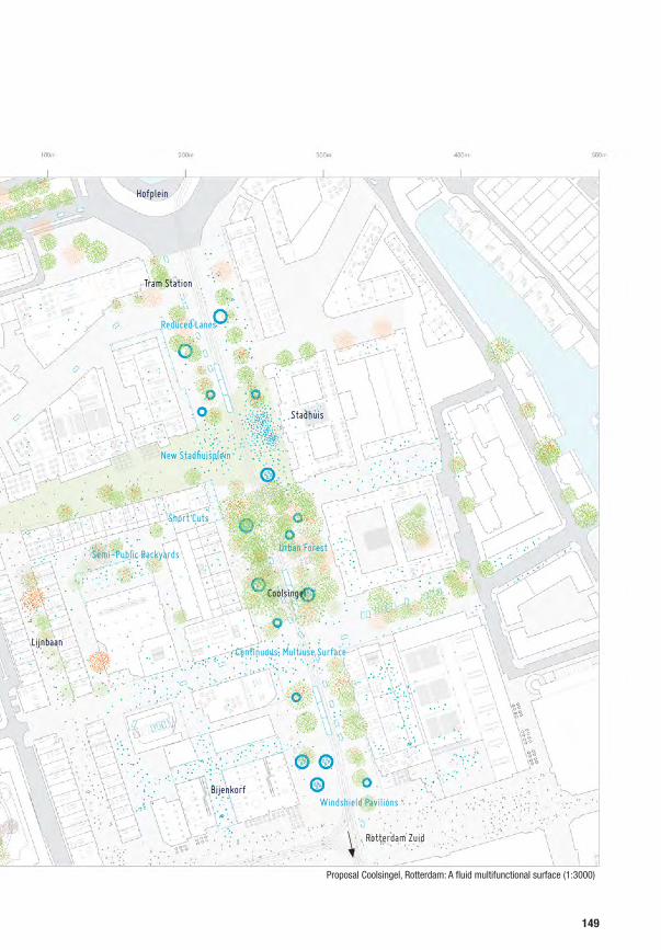
Proposal Coolsingel, Rotterdam: A fluid multifunctional surface (1:3000)
New Stadhuisplein
Short Cuts
Reduced Lanes
Windshield Pavilions
Continuous, Multiuse Surface
Semi-Public BackyardsUrban Forest
Lijnbaan
Coolsingel
Weena
Hofplein
Tram Station
Stadhuis
Bijenkorf
Rotterdam Zuid
149

Existing situation Coolsingel, Rotterdam (1:500)
150

151

Proposal Coolsingel, Rotterdam: A fluid multifunctional surface (1:500)
152

153

Continuous ground surface from inside to outside
154

The overall flattening of the surface, eliminating
steps, borders, bollards, sidewalks and the
reduction of road lanes make movements fluid and
continuous, in particular with regards to the road
surface itself. Pedestrian, tram, bicycle and car
traffic happen on the same surface. The previous
clutter of objects is substituted by a flowing, active,
communicating swarm. Smart traffic guidance,
slower speeds, better view connections and
increased awareness (ref. Monderman) ensure
safety. The better view relationships through the
reduced urban clutter encourages spontaneous
interaction, shorter walking distances and activate
the businesses. The easier change between modes
of transport and effortless crossing reduce the
reliance on the car.
155
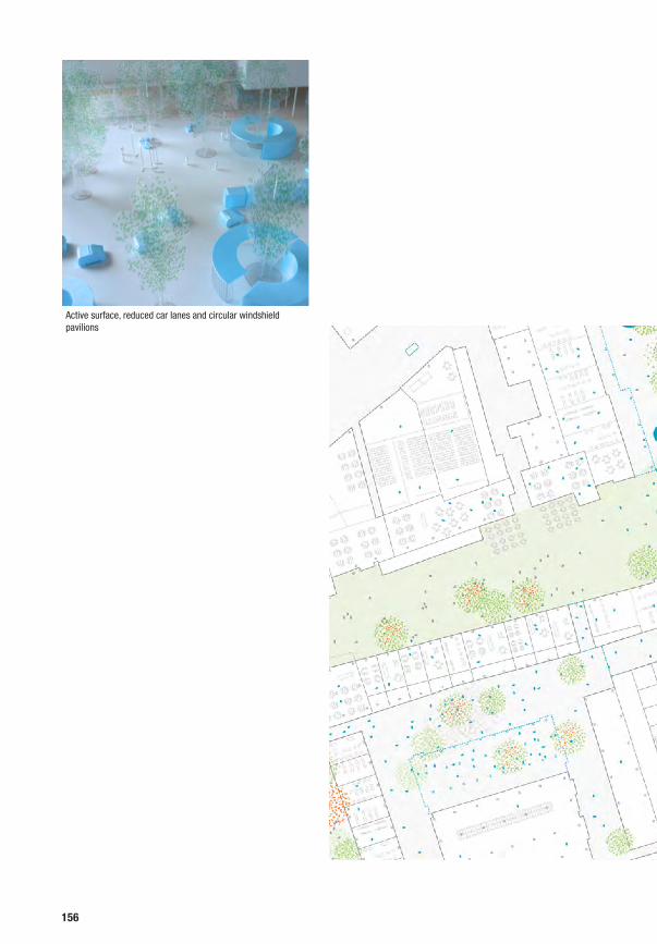
Active surface, reduced car lanes and circular windshield pavilions
156

To make the space further readable, public
furniture is redesigned and gives the Coolsingel a
newfound identity. The new circular pavilions that
house kiosks and restaurants and integrate the
typical wind shields, are not distributed evenly but
clustered, creating a rhythm of different characters
in the perception of the road: open in front of the
city hall, densely green in front of the former post
building, cafeterias and kiosks at the Bijenkorf.
Stadhuisplein and urban forest
157

New Microbusinesses in Vacant Buildings
Open Ground Floors

Multiuse Surface
WindshieldPavilions
Reduced Road Lanes
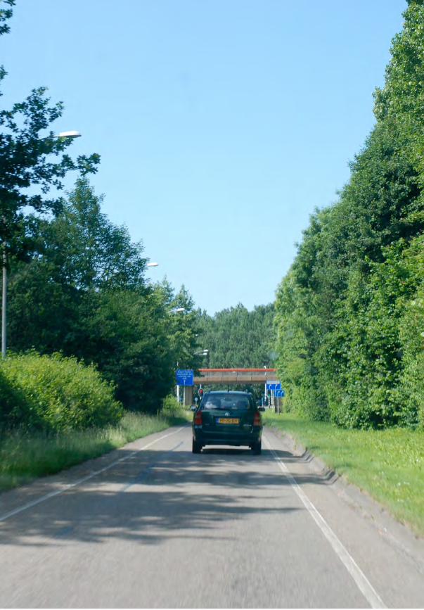

Almere: Diversifying a Homogeneous Scenery
LOCATION
Stedendreef, Muziekwijk Zuid, Almere
CONTEXT
Almere was founded in 1975 and is the largest
New Town in NL with clear distinction between
road system and neighbourhoods. Stedendreef in
Almere is a secondary feeder road in the hierarchi-
cal road system, embedded in a green buffer zone
ROAD
Main Road in post-war neighbourhood
INTERVENTION
1. Access
Introducing new pedestrian crossings to bridge the
disconnected neighbourhoods, introduction of new
entrances on the backside of adjoining houses to
green areas, introduction of jogging paths
2. Blur
Transforming the unused green buffer zone into a
linear park with some leisure services to mediate
between road and houses
3. Densify
New landmark buildings turn backsides to front
sides and provide space for public facilities and
commercial services at intersections
CONDITION
1. Monofunctionality
Road purely used for car traffic, adjoining green
spaces only serve as “decoration”
2. Waste of surface
Green buffer along road is unused
3. Separation
Distance green and only very few crossings make
it nearly impossible to cross the road for neigh-
bouring residents
4. Orientation
Uniform appearance from the driver’s perspective
makes orientation difficult
161
4.7.

Amsterdam

Almere

Almere Haven. The cellular structure of the neighbourhoods straddles the infrastructure network (Ekim Tan, 2009)
Garden Cities of Tomorrow (Ebenezer Howard, 1902)
164

SITE
The site, the Stedendreef, is in Almere, the largest
New Town in the Netherlands with a count of
190.000 inhabitants in 2011. It is the largest city
in Flevoland, a reclaimed area in the Ijsselmeer, and
has only come into existence in 1975. This rapid
growth is largely due to its proximity to Amsterdam
with its high real estate prices, offering homes to
commuters and despite that is has been dubbed the
‘ugliest place in the Netherlands’1. Nonetheless it is
not a ‘sleeper city’ but sports its own centre (OMA
Masterplan, 1998-2007).
The Stedendreef is a secondary feeder road in
the strictly hierarchical road system. Together
with the Hollandsedreef and the Muziekdreef
it provides access to the mostly homogeneous
residential neighbourhoods from the N702
(Hogering, Buitenring), which itself feeds into the A6
Amsterdam-Lelystad.
1 See “De Winnaars: Almere en Charleroi”, in: De Volkskrant, 29 februari 2008. See also: Provoost, Michelle “Almere New Town -De buitenlandse wortels van een oer-Hollandse polderstad” in : Franke, S. (Ed.) “Adolescent Almere”, 2007
The Emerald Necklace and Fenway (F.L. Olmsted, Boston, 1880)
Stedendreef, Almere. Scenic parkway (2010)
165

The strict separation of the neighbourhoods and
through traffic including the separation of the
different traffic modes in itself has made it very hard
to navigate Almere, consumes vast areas for buffer
zones and makes it very difficult to cross roads for
pedestrians. The Stedendreef itself is embedded in
a green, partly forested strip and undulates up and
down at crossings to neighbourhood roads. This has
a cinematographic effect for the passenger to drive
in a green valley, only to emerge at intersections
and perceive the city there.
166

Existing situation Stedendreef, Almere (1:3000)
Stedendreef
Tennis
Low-Rise Residential
Low-Rise ResidentialStedenwijk
Light industries
Muziekwijk Zuid
Low-Rise Residential
167

PROPOSAL
Our proposal turns the linear buffer strip along
the Stedendreef into a public park complete with
furniture, terraces and sport facilities. Additional
pedestrian paths, in particular crossings, make
the area accessible, connect the bordering
neighbourhoods and enable for new activities such
as jogging or walking. The crossings offer shortcuts
in a perpendicular direction to the existing hierarchy
and directly link the currently disconnected,
adjoining neighbourhoods. They are widened form
time to time for the allocation of several leisure
activities connected to the park, such as kiosk or
bike rent spots.
Unique public and commercial buildings are erected
the intersections with the neighbourhood roads,
marking the exit in a distinct way and servicing
the neighbourhood, creating thus a new focal
point for the community. They feature bakeries,
kindergartens etc., creating microcentralities and
acknowledge the fact that Almere has changed
from a sleeper town to a real city with its respective
needs. The experience of driving is enhanced
through the new landmark buildings, orientation
has become easier.
The neglected backside of the houses along the road
can be opened to the new paths creating alternative
accesses to the houses or become a pleasurable
places for local initiatives and businesses.
Cross Connections
168

Proposal Stedendreef, Almere: Landmarks in a linear park (1:3000)
Linear park
New Public and commercial services
Leisure Services
Leisure Services
Cross Connections
Pedestrian paths
Cross Connections
Stedendreef
Tennis
Low-Rise Residential
Low-Rise ResidentialStedenwijk
Light industries
Muziekwijk Zuid
Low-Rise Residential
169

Existing situation Stedendreef, Almere (1:3000)
Proposal Stedendreef, Almere: Landmarks in a linear park (1:500)
170

171


0 100m
0
200m 300m 400m 500m
100m
200m
300m
400m
500m
Einsteinweg: Reinventing an Urban Boulevard
LOCATION
Einsteinweg, A10, Bos en Lommer, Amsterdam
CONTEXT
The Einsteinweg passes through a residential,
multiethnic neighbourhood in West-Amsterdam
ROAD
Highway in city
INTERVENTION
1. Access
Improving pedestrian access and cross connec-
tions as well as introducing new vertical connec-
tions between the two highways levels.
2. Densify
Introducing a new landmark building on bigger
intersections, were high investments are probable
3. Re-Program & Adapt
Changing of ground and upper floor plans of
adjoining buildings to introduce flexibility, accom-
modate workshops, studios or simple garages and
inject activity to the local streets. Introduction of
similar spaces along and under the embankments
of the highway. Introduction of a new hamam/spa
and supermarket under the highway.
4. Re-Surface
Activating of open spaces under and around the
highway, reducing road lanes.
CONDITION
1. Monofunctionality
Highway lanes and security offsets characterize
the site
2. Barriers
Large amount of traffic security barriers
3. Waste of surface
Too many lanes for traffic, large amount of security
offsets, adjoining environment mostly features
unmaintained green surfaces, spaces along and
under the highway are undefined and serve no
purpose
4. Separation
Huge highway strongly separates adjoining neigh-
bourhoods, dead frontage along its embankments
5. Social tension
The neighbourhood was listed as one of the so-
cially most deprived areas in the Netherlands
6. Vacancy
Most of the flats along highway are not rented out
173
4.8.

Haarlem

Zuid As
Amsterdam

Einsteinweg during construction of A10, 1964
Einsteinweg in 1961 Original Plan
Built Plan
176

SITE
The site is located in the west of Amsterdam, in the
densely inhabited area of Bos en Lommer along
the Einsteinweg, which is a part of the A10 forming
the western part of the highway ring around
Amsterdam, with our stretch just south of the N200
(Harleemerweg). The Einsteinweg is to Amsterdam
what the ‘Péripherique’ is to Paris: It forms the
delimiting line between what is ‘inside’ and part
of Amsterdam and what is ‘outside’. While the
neighbourhood east of the highway that are closer
to Amsterdam are attracting young people, artists
and students because of their relative proximity
to the centre and their still affordable prices, their
western counterparts of similar structure are in dire
straits, with the barrier of the highway causing this
imbalance.
Original Plan
Built Plan
Extension plan of Amsterdam (Cornelis Van Eesteren, 1935)
Einsteinweg Today
Einsteinweg 1969
177

In the Amsterdam City Extension Plan (Cornelis Van
Eesteren, 1935) the Bos en Lommer neighbourhood
featured a Boulevard at its centre, the Bos en
Lommerplein. Increased transport needs and
the then fashionable urban highway lead to the
implementation of a highway forming part of
Amsterdam’s ring in 1961. As the neighbourhood
had already been partly built, the highway crosses
the neighbourhood at sometimes minimal distance
to the buildings, dividing a neighbourhood of the
same structure in two parts.
Today Bos en Lommer is a multiethnic
neighbourhood housing Turkish and Moroccan
communities. In 2007 it was listed as one of the
40 “probleemwijks” in the Netherlands, deprived
neighbourhoods with social tensions that needed
extra attention. As a consequence Bos en Lommer
is scheduled for urban renewal with the hope to
attract higher-income residents.
The space under the highway
Residential
Residential
178

Existing situation Einsteinweg, Amsterdam – Ground Level (1:3000)
Residential
Residential
Residential
Offices and Light industries
Offices and Light industries
Unused SpaceEmpty Housing Slab Empty Housing Slab
Schools
Wiltzanghlaan
179

Most of the buildings are four level residential slabs
with North-South orientation, with some higher
slabs along the highway (7 levels), with relatively
low rents. In particular the buildings along the
highway are not fully rented out. At the overpasses
of local roads we can find some recent office and
light industry facilities.
The highway itself is elevated for grade separate
intersections and features pedestrian and local
traffic under- and overpasses.
The highway forms a barrier in the neighbourhood
and causes long stretches with dead frontages
(embankments, retainment walls). The sound and
air pollution exacerbate the situation.
At the intersections of the highway the regional
roads, higher investments and bigger buildings
with commercial and public services on the bridges
develop, creating local centres, like for example at
Bos en Lommerplein.
Aerial view of Bos en Lommerplein
Residential
Residential
180

Existing situation Einsteinweg, Amsterdam – Highway Level (1:3000)
Residential
Residential
Residential
Offices and Light industries
Offices and Light industries
A10 Einsteinweg
Empty Housing Slab Empty Housing Slab
Schools
Bos en Lommerplein
Wiltzanghlaan
181

PROPOSAL
Our proposal reduces and activates the stretches of
dead frontage, integrates the highway vertically with
the neighbourhood, turning it into an advantage.
At the same time it adjusts the adjacent typology
for a wider range of uses which can coexist with
the traffic and makes use of the space under the
highway (now a barren labyrinth of columns). The
displeasing pedestrian underpass come to life
because of the entrances to the new hamam and
supermarket. These two facilities (with little need
for daylight) use the space under the highway, and
turn the former dead end into an attraction. The
border becomes the centre.
Conference centre in Agadir (OMA, 1990)
Residential
Residential
182

Proposal Einsteinweg, Amsterdam: Spa and market, active frontage – Ground level (1:3000)
Supermarket
Bakery, Cafés and Shops
Active Frontage with garage typologies
Landmark building
Hamam
Re-used Housing Slabs
Residential
Residential
Residential
Offices and Light industries
Offices and Light industries
Schools
Wiltzanghlaan
183

A new commercial landmark building further north
spanning the two sides of the highway symbolises
the reconnected neighbourhoods and gives a visual
hint to the drivers on the A10 about the transformed
highway.
The Garage in which Steve Jobs invented the first Mac
Residential
Residential
184

Proposal Einsteinweg, Amsterdam: Landmark and highway access – Highway level (1:3000)
Bos en Lommerplein
Residential
Residential
Residential
Offices and Light industries
Offices and Light industries
A10 Einsteinweg
Wiltzanghlaan
Schools
Landmark building
Drive-in parking and access to Supermarket
Drive-in parking and access to Supermarket
Reduced Traffic Lanes
185

Existing situation Einsteinweg, Amsterdam (1:500)
Proposal Einsteinweg, Amsterdam: Spa and market, active frontage, repurposed buildings (1:500)
186

187

Along the edges we propose smaller units - garages
- which can house small scale businesses, from
car repair to bakery to IT startup or simple storage
room, that compensates for the lack of space
in the surrounding flats. A car park accessible
directly from the highway allow the driver to stop
and shop in the supermarket on the way home as
Model section
Garages
Re-Used Housing Slab
Modified Building Structure
Re-Organised Surface
188

easily as the neighbour can access the market from
the ground level. The unrentable residential units
along the highway are stripped and converted into
studios, which will attract creative pioneers with
their low rent and freedom. A place to be loud. The
new spaces for business on the ground and upper
floor can be a catalyst for further change in the area.
HamamA10 Einsteinweg
Transversal access
Re-Used Housing Slab
Modified Building Structure
189


Westland: Upgrading an Industrialized Landscape
LOCATION
Koningin Julianaweg, ’sGravenzande, Westland
CONTEXT
Westland is Europe’s food chamber, growing
produce in highly efficient greenhouses
ROAD
Regional road in industrialized landscape
INTERVENTION
1. Access
A non-directional transport system hanging form
a new roof structure allows direct travels and
accessibility
2. Blur
Merging inside and outside, public and private
areas under one roof
3. Densify
Introduce a mega greenhouse with restaurants,
shops, services for tourist and locals to increase
the productive area and reduce wall surface
CONDITION
1. Monofunctionality
Road is only used for car traffic
2. Barriers
Green hedges and water channels make crossing
difficult
3. Waste of surface
Unused green road offsets left and right form the
road
4. Separation
Limited accessibility through wide street profile
and local roads off the main thoroughfare
195
4.9.

Hoek van Holland

Hoek van Holland
Westland
The Hague
Rotterdam
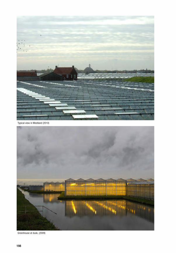
Typical view in Westland (2010)
Greenhouse at dusk, (2009)
198

SITE
The site lies in the heart of the green house area
in the West of Zuid Holland, the food chamber
of Europe. The landscape is the characteristic
polder landscape of flat fields and dikes, while the
industrialisation of agriculture has overgrown this
landscape with vast green houses. The landscape
features a striking contrast of vernacular farms
of familiar scale and enormous transparent glass
houses facilitating optimized technological food
production. The sheer amount of greenhouses and
the lightness and transparency of their construction
give the area at day and at night a very distinct
appearance.
The road itself is built on top of a dike — the
Maasdijk — and parallel feeder roads service
the farms, as such the road has local and transit
functions. This is an industrialised version of the
settlement type we have found in the Groene Hart.
The area is under-serviced, the unique industrial
monument of the greenhouses with its distinct
character hardly accessible.
Inside a typical greenhouse
Inside a typical greenhouse
Greenhouse roofs
199

Water Ponds
200

Existing situation Koningin Julianaweg, Westland(1:3000)
Green Houses
Farms
Gardens
Koningin Julianaweg
Local Access Road
Water Ponds
Water Channels
Fields
201
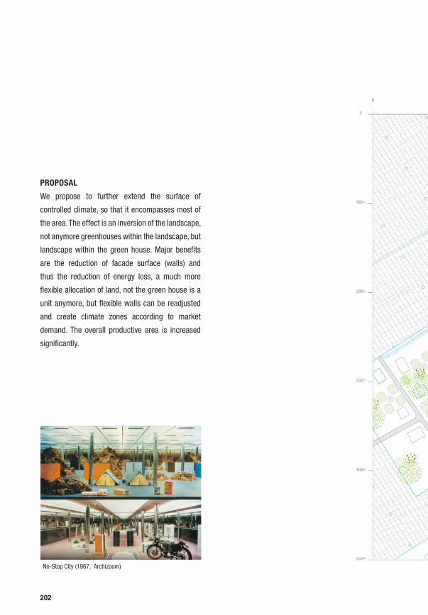
PROPOSAL
We propose to further extend the surface of
controlled climate, so that it encompasses most of
the area. The effect is an inversion of the landscape,
not anymore greenhouses within the landscape, but
landscape within the green house. Major benefits
are the reduction of facade surface (walls) and
thus the reduction of energy loss, a much more
flexible allocation of land, not the green house is a
unit anymore, but flexible walls can be readjusted
and create climate zones according to market
demand. The overall productive area is increased
significantly.
No-Stop City (1967, Archizoom)
Private Open Spaces
202

Proposal Westland – A continuous roof (1:3000)
Continuous Roof
Viewing Platform with Restaurant
Suspended Transport and Logistical System
Private Open Spaces
Green Houses
Farms
Local Access Road
Vegetable Sale
Pedestrian Path
Water Ponds
Water Channels
Fields
203

Existing situation Koningin Julianaweg, Westland(1:500)
Proposal Westland – A continuous roof (1:500)
204

205

206

Pollution free transport (e-cars and light rail) can
be employed within the roof as well for good
distribution as for individual transport. Visitors are
directly experiencing food production processes and
can buy directly at the producer. As a side effect of
decentralisation, additional services are integrated
under the roof (hotels for food and architecture
freaks, restaurants), for additional economic benefit
as well as service provisions to the locals (reduction
of travels). Local social coherence is increased, the
neighbours literally now live under one roof. The
dutch polder mentality of collaboration and joint
effort emerges again.
No-Stop City (1967, Archizoom)
Dome Over Manhattan, (Buckminster Fuller & Shoji Sadao 1960)
Ilkka Halso, Museum of Nature (2008)
207

Access
Re-Surface
Blur
Remove
Densify
Re-Progam &
Adapt
Barriers
Separation
Development pressure
Waste of Surface
Social tension
Zoning
Orientation
Vacancy
Micro-centralization
Mono-functionality
Groene Hart
Hoogvliet
Afrikaander-wijk
Coolsingel
Ypenburg
Einsteinweg
Almere
Westland
208

Road Matrix NL Conclusions
After closely looking at the eight sites, we can conclude that we were mainly
confirmed by our initial observations. Most of the sites analysed feature the
following spatial conditions:
1. Monofunctionality
2. Barriers
3. Waste of Surface
4. Zoning
5. Separation
The conditions of monofunctionality, barriers and waste of surface were
applying on nearly every site. Zoning appeared on the sites in urban areas,
where pedestrian paths, bicycle lanes or tram lanes are integrated into the
street profile. The condition of separation occurred on sites with highways or
regional roads, that allow for higher driving speeds. All these conditions - or
issues - are a direct result of post-war planning or symptoms of the post-welfare
society. Slightly more particular were more site specific issues of ‘Development
pressure’, ‘Social tension’, ‘Microcentralization’, ‘Vacancy’ and ‘Orientation’ (or
lack thereof), that were only observed in one or two sites.
Our proposed interventions are a direct reaction this condition of Dutch post-
war roads. While it was often tempting to discuss and propose changes in policy,
we focussed on addressing these conditions as planners. The crucial realisation
was certainly, that it is pointless to address the components of the street scape
individually: the traffic, the public space, the buildings. The street is made of the
road, the sidewalks, the façades, programme and architecture of the buildings
along it, and of course its inhabitants. We tried to see the streets as such an
integrated system from a holistic point of view, and tried to find adequate
answers in our proposals, that incorporated the following interventions:
209
4.10.

1. Access
Short cutting existing road hierarchies, creating connections often
perpendicular to the existing road system, overcoming barriers, generating
new possibilities for exchange
2. Blur
Blurring boundaries, creating permeability and mixing zoned areas
3. Densify
Densification through new constructions, appropriation of undefined areas
4. Re-Program & Adapt
Introducing flexibility and new programmes through adaptation of existing
built structures and plans
5. Re-Surface
Encouraging use, flexibility and communication through re-design and re-
organization of undefined surfaces and/or reduction of road lanes
6. Remove
Designing or eliminating obstacles and/or the paraphernalia of transport
security
We only applied ‘Remove’ once at the Coolsingel site, were it was most evident,
but consider it a key intervention and include it here as such.
While we assumed a pragmatic (not utopian) point of view as designers, our
proposals are an academic exercise until here. The next step would be to
present and discuss the interventions with the city councils, residents, and other
stakeholders, to see how they hold up. This would also lead to an understanding
of the processes necessary for implementation.
210

211

Oshodi Station, Lagos,

Overall Conclusion and Main Findings5
213


Throughout history roads were conceived as hybrid open spaces that were
closely integrated with their immediate urban contexts allowing for various
social and economic functions. The road enabled this socioeconomic interaction
in two directions: on the one hand its was directly connecting important cities
and European trade centres, on the other hand it was facilitating the transversal
interaction of both sides of road integrating the territories it crossed. With the
emergence of post-war planning the latter aspect was lost. Social, political,
economic and technological developments during Industrialization and after
WWII lead to the emergence and implementation of modernist planning
principles and triggered a car-oriented urban development and separated
socioeconomic functions from the roads. Roads became monofunctional solely
focussing on car-oriented mobility, neglecting the transversal interaction with
their immediate environments, disrupting the urban environment and leading
to social and spatial fragmentation of the urban territory, a situation that can be
observed in various European agglomerations today.
The Netherlands is at the core of these developments. Its centralized planning
tradition, its focus on car-oriented development and its extensive road network
lead to a situation were most of the roads are monofunctional, surface wasting
and physically and socially fragmenting the urban territory.
Taking the Randstad as an example this can be observed on two scales: On
the territorial scale the road system of the Randstad follows a hierarchic
structure that is focussed on the highway system, but is disrupted on the local
and regional scale. On the local level roads are mostly disintegrated from their
immediate urban contexts enforcing the fragmentation of the territory.
Reforms of the Dutch Welfare state, emergence of an active civil society and
various trends in road and transport development make it possible to re-
integrate Dutch roads into the urban environment and result in a possible
scenario for the Randstad that re-integrates Dutch roads on the territorial scale,
215

through the anticipation of a partial extension of the regional road network,
the implementation of an integrated public transport system, the introduction
of Intelligent Transport Technologies, the introduction of shared spaces and
the participation of the civil society. This makes it possible to re-think the
integration of roads and urban context on the local scale.
The systematic analysis and comparison of different prototypical situations
of roads and urban contexts reveals common spatial observations, that are a
result of post-war planning principles. They mostly feature the following spatial
problems:
1. Monofunctionality: Dutch roads are mostly monofunctional mainly
accommodating car-oriented mobility.
2. Barrier: Dutch roads are full of physical barriers to ensure traffic
orientation and security.
3. Zoning: Dutch roads are strictly zoned to ensure efficiency for various
transport modes.
4. Waste of Surface: Dutch roads are wasting enormous amounts of surface
because of traffic security demands.
5. Separation: Dutch roads are often physically and socially disrupting the
urban environment.
From the re-design of the selected sites into hybrid roads five general design
instruments can be derived:
1. Access: Short cutting existing road hierarchies, creating connections often
perpendicular to the existing road system, overcoming barriers, generating
new possibilities for exchange
2. Blur: Blurring boundaries, creating permeability and mixing zoned areas
3. Densify: Densification through new constructions, appropriation of
undefined areas
4. Re-Program & Adapt: Introducing flexibility and new programmes through
adaptation of existing built structures and plans
5. Re-Surface: Encouraging use, flexibility and communication through re-
design and re-organization of undefined surfaces and/or reduction of road
lanes
6. Remove: Designing or eliminating obstacles and/or the paraphernalia of
transport security
The re-design of the investigated road types can address the spatial parameters
by using these tools, but not isolatedly. It needs to be based on the specific
conditions as well as socioeconomic situation of site and population in order to
216

identify holistic design solutions. The instruments can serve as inspirations for
the transformation of a road into a hybrid infrastructure and point to the main
spatial problems that need to be solved for post-war roads. Nevertheless their
specific nature and combination, needs to result from a thorough analysis of the
spatial, socioeconomic and political situation of a given site as well as from the
participation of local stakeholders, in order to offer adequate solutions.
217


Appendix6
219


Bibliography
Alexander, Christopher “A City is not a Tree”, in: Architectural Forum, vol.122,
No. 1, (April 1965) p.58-62; vol. 122, no. 2, (May 1965) p.58-61. Reprinted
in: Design, no. 206, February 1966, pp 46-55.
Artgeneering “N4 - Towards a Living Infratructure!”, A16, Brussels 2007.
Augé, Marc “Non-Places: An Introduction to an Anthropology of
Supermodernity”, Verso, London 1995. First published: Augé, Marc
“Non-Lieux, Introduction à une anthropologie de la surmodernité”,
Editions du Seuil, Paris 1992.
Barajas, D. Dispersion: A Study of a Global Mobility and the Dynamics of a
Fictional Urbanism. episode publishers, 2003.
Bendiks, Stefan; Degros, Aglaée “Roads and City - Dissociation and
Proximity”, in: Bruyns, G.; Fuchs, A.; Hoekstra, MJ.; Meyer, H.;
van Nes, A. (Eds.) “4th International Seminar on Urbanism and
Urbanization”, International Forum on Urbanism, TU Delft 2007, pp.126-
134.
Benevolo, Leonardo “Die Geschichte der Stadt”, Campus, Frankfurt and New
York 2000. Originally published as: Benevolo, Leonardo “Storia della
città”, Editori Laterza, Rome and Bari 1975.
Bijl, Rob; Boelhouwer, Jeroen; Pommer, Evert; Schyns, Peggy “The Social
State of Netherlands 2009” The Netherlands Institute for Social Research,
The Hague 2010.
Boeijenga, Jelte, and Jeroen Mensink. Vinex Atlas . Rotterdam: Uitgeverij 010,
2008.
Boomkens, René, Charles Esche, Gijs Van Oenen, Marc Schuilenburg, and
Wouter Vanstiphout. Social Engineering : Can Society Be Engineered in
the 21St Century? Rotterdam; Amsterdam; New York, NY: Nai Publishers;
SKOR 2008.
Branzi, Andrea “No Stop City - Archizoom Associati”, Editions HYX, Orléans
2006
Burdett, R, and D Sudjic. “The Endless City: The Urban Age Project by the
London School of Economics and Alfred Herrhausen Society.” In The
Endless City . Phaidon, 2007.
6.1.
221

Buchanan, Sir Colin. Traffic in Towns. London: Penguin Books in association
with HMSO. 1964.
Busquets, Joan “The Urban Evolution of a Compact City”, Nicolodi Editore,
Rovereto 2005.
Christiaanse, Kees “The Open City and Its Enemies”, in: Rieniets, Sigler,
Christiaanse, op. cit., p. 25ff.
Calabrese, L. M.; Houben, Francine (Eds.) “Mobility, A Room with a View”, Nai
Publishers, Rotterdam 2003.
Le Corbusier, “The Master Plan” in Marg, Vol. XV No.1, 1961. Reprinted
December 1998.
Cranzler, Weert “Vernetzt unterwegs: wie sonst?”, in: Heinrich-Böll-Stiftung
(Ed.) “Urban Futures 2050 - Szenarien und Lösungen für das Jahrhundert
der Städte”, Schriftenreihe Ökologie, Vol. 18, Heinrich-Böll-Stiftung,
Berlin 2011.
Crimson Architectural Hsitorians “Wimby! Hoogvliet - Future, Past and
Present of a New Town”, Nai Publishers, Rotterdam 2007.
van Eesteren, Cornelius. Cornelius Van Eesteren: The Idea of the Functional
City. Rotterdam: Nai Publishers, 1998.
Edwards, P N. “Infrastructure and Modernity: Force, Time, and Social
Organization in the History of Sociotechnical Systems.” Modernity and
technology (2003): 185-225.
Geddes, Norman Bel. Magic Motorways. New York: Random House, 1940.
Harms, Lucas “Mostly Mobile: Social Trends, Time Use and Mobility; Insights
from the Netherlands”,Paper for 12th International conference for
Travel Behaviour Research, Jaipur 2009.
Haus, Michael; Heinelt, Hubert “Politikwissenschaftliche Perspektiven auf den
Stand der Planungstheorie”, in: Uwe Altrock et al. (Ed.) “Perspektiven der
Planungstheorie”, Edition Stadt und Region, Vol. 9, Leue, Berlin 2004.
Hilberseimer, Ludwig. Grossstadtarchitektur. Stuttgart: Julius Hoffmann
Verlag, 1927.
Hillier, Bill “Spatial Sustainability in Cities: Organic Patterns and Sustainable
Forms“, in: Koch, D.; Marcus, L.; Steen, J. (Eds.) “Proceedings of the 7th
International Space Syntax Symposium”, KTH, Stockholm 2009.
Jacobs, Jane. The Death and Life of Great American Cities. New York:
Random House, 1961.
Koolhaas, Rem “Generic City”, in: OMA, rem Koolhaas, Bruce Mau “S, M, L,
XL”, Taschen, Cologne 1997.
Kuhnert, Nikolaus; Ngo, Anh-Linh “Editorial: Governance”, in: archplus, No.
173, Aachen and Berlin, May 2005
LIN/Uberbau “Paris Peripherie Nord-Est”, unpublished study commissioned by
222

the French Government (Sécretariat dÈtat pour le dévéloppement de la
Région Capitale), Berlin and Paris, 2010
Meurs, Paul, Marc Verheijen, and Luuk Boelens. In Transit : Mobiliteit,
Stadscultuur En Stedelijke Ontwikkeling in Rotterdam. Rotterdam;
[Rotterdam]: Nai Uitgevers ; dS+V, 2003.
Ministeries van VROM “Nota Mobiliteit. Naar en berouwbare en voorspelbare
bereikbaarheid”, Ministeries van V en W en VROM, The Hague 2004.
Ministeries van VROM “Nota Ruimte. Ruimte voor ontwikkeling”, Ministerie
van Volkshuisvesting, Ruimtelijke Ordening en Milieubeheer VROM;
Ministerie van Landbouw, Natuur en Voedselkwaliteit LNV, Ministerie van
Verkeer en Waterstaat V en W en Ministerie van Economische EZ, The
Hague 2006.
Misa, T J, P Brey, and A Feenberg. Modernity and Technology. The MIT
Press, 2004.
Mitchell, William J, Chris Borroni-Bird, and Lawrence D Burns. Reinventing
the Automobile : Personal Urban Mobility for the 21St Century. Cambridge,
Mass.: Massachusetts Institute of Technology, 2010.
de Mooij, Ruud “Reinventing the Welfare State”, Den Haag: CPB Netherlands
Bureau for Economic Policy Analysis, 2006.
de Mooij, Ruud “Challenges for the Dutch Welfare State”, in: Euroframe
EFN Autumn 2007 Report “Economic Assessment of the Euro Area:
Forecasts and Policy Analysis”, Annex 7, ESRI, Dublin September 2007.
van Nes, Akkelies “Analysing Larger Metropolitain Areas: On Identification
Criteria for Middle Scale Networks”, in: Koch, D.; Marcus, L.; Steen, J.
(Eds.) “Proceedings of the 7th International Space Syntax Symposium”,
KTH, Stockholm 2009., ref. 121.
Mumford, Eric “The CIAM Discourse on Urbanism, 1928-1960”, MIT Press,
Cambridge, MA 2000.
Mumford, Lewis “Die Stadt”, Vol. 1, DTV, Munich 1980. Originally published
as: Mumford, Lewis “The City in History”, Harcourt, Brace & World, New
York 1961.
Nijenhuis, Wim; van Winden, Wilfried “De Diabolische Snelweg”, 010
Publishers, Rotterdam, 2007.
Office for Metropolitain Architecture ”Machinekamer Snelweg”, Rijksadviseur
Infrastructuur, Atelier Rijksbouwmeester, The Hague 2006.
Oswalt, Philipp (Ed.) “Shrinking Cities - Vol. 2: Handlungskonzepte”, p. 12 ff.,
Hatje Cantz, Ostfildern 2005
Pope, Albert “Ladders”, New York: Princeton Architectural Press, 1996.
Reijndorp, Arnold; Hajer, Maarten “In search of new public domain”, Nai
Publishers, Rotterdam 2001.
223

Reijndorp, Arnold “The City as Bazaar”, in: Rieniets,Tim; Sigler, Jennifer;
Christiaanse, Kees, op. cit., p.93ff.. Quoted from: Castex, J., Depaule, J.-
Ch. and Panerai, Ph. “Urban Forms: The Death and Life of the Urban
Block”, Architectural Press, Boston 2004.
Rieniets,Tim; Sigler, Jennifer; Christiaanse, Kees (Eds.) “Open City: Designing
Coexistence”, Exhibition catalogue IAB Rotterdam 2009, Amsterdam:
Uitgeverij SUN, 2009
Roes, Theo (Ed.) “Facts and Figures of the Netherlands: Social and Cultural
Trends 1995-2006”, The Hague: Netherlands Institute for Social Research,
March 2008. p. 84.
van Schaik, Martin; Macel, Otakar “Exit Utopia - Architectural Provocations
1956-76”, Prestel, Frankfurt am Main 2005.
Sennett, Richard “The Open City” in Burdett, Ricky and Dejan Sudjic. The
Endless City. London: Phaidon Press, 2007, p. 292 ff.
Smithson, Alison (Ed.) “Team 10 Primer”, MIT Press, Boston 1968
Stommer, Rainer (Ed.) “Reichsautobahn - Pyramiden des Dritten Reichs”,
Jonas Verlag, Marburg 1982.
Vanstiphout, Wouter “Social Engineering of the City an Urban Design:
Ideology as an Achilles Heel” in: Open: Cahier on Art and the Public
Domain, No.15, p. 60 ff., NAI Publishers, Rotterdam 2008
van der Vinne, Vincent “De autoproblematiek in Nederland”, MGS Siemes,
Zutphen 2010.
Venturi, Robert; Scott Brown, Denise; Izenour, Steven “Learning from Las
Vegas”, MIT Press, Cambridge 2001. First published in 1972
Wall, Alex “Victor Gruen: From Urban Shop to New City”, Actar, Barcelona
2005.
224

225

FUNDING
Rients DijkstramaxwanUrbanism
Rotterdam, NL
Henk TrompGoudappel coffengMobility & Infrastructure
Deventer, NL
EXPERT CONSULTANTS AUTHORS
Netherlands Architecture
FundThe Hague, NL
UberbauBerlin, D
Wouter VanstiphoutCrimson
Urban History & Politics
Rotterdam, NL
Team composition
226

Team & Credits
AUTHORS
Ali Saad | partner Uberbau & project leader “Street Life”
Thomas Stellmach | partner Uberbau
COLLABORATORS UBERBAU
Fabienne Boudon, Álvaro Gómez-Sellés Fernández, Clare Johnston, Alexandra
Tsampika Manou, Darrel Ronald and Marta Torres Ruiz
EXPERT CONSULTANTS
Rients Dijkstra | Urbanism | maxwan a & u | Rotterdam, NL
Henk Tromp | Transport & Mobility | Goudappel Coffeng, Deventer, NL
Wouter Vanstiphout | Urban History & Politics | Crimson | Rotterdam, NL
We would like to thank our collaborators and consultants for their invaluable
contributions and support, Vesta Nele Zareh, Thomas Hauck, Tarek Massalme,
Kristina Herresthal, Oana Rades, Clod Zillich, Vanessa Mirjam Carlow, Finn Geipel,
Lukas Feireiss for their support and valuable comments, and the Netherlands
Architecture Fund, its board and the members of the Advisory Committee for
making this study possible.
6.2.
227


Architecture & Urbanism
Lobeckstraße 30-35 / 306
10969 Berlin, Germany
I www.uberbau.eu
T +49 (0)30 322 970 506
F +49 (0)30 577 063 499
Contact person: Ali Saad
Contact6.3.
229

The Netherlands is the country with the 3rd densest roads network in
the world as well as a motorway density of 57.5 km per 1’000 km², the
most dense motorway network in the European Union. Considering this
massive amount of road infrastructure within populated areas and urban
settings it surprises that little of it relates to its immediate context.
Homogenous boulevards, isolated highways and wide thoroughfares with
excessive offsets cut through the city with little relation to neighbourhoods,
landscapes, city centres, industrial areas and suburbs, separating and
isolating them from each other.
In a current political context of deregulation, the redirection of the concept
of the welfare state in Europe and the emergence of new concepts
of mobility, we believe that there is a potential in existing roads to be
transformed into hybrid, open spaces and activate various strata of society
to participate in, collaborate on and profit from the development of their
immediate urban environments. Taking the Netherlands as an example it is
the aim of this research to develop a scenario for this social, economic and
cultural re-engagement with the city, to speculate on possible instruments
and to paint a vision of roads as hybrid infrastructures.
The project is carried out by Uberbau with the advice of the experts Rients
Dijkstra (Urbanism), Henk Tromp (Mobility and Infrastructure) and Wouter
Vanstiphout (Politics, History and Theory) and funded by the Netherlands
Architecture Fund.