The Development of a Geographic Information System(GIS) to Document Research in an Everglades...
14
Journal of Environmental Science and Engineering, 5 (2011) 289-302 The Development of a Geographic Information System (GIS) to Document Research in an Everglades Physical Model S. Aich 1 , T.W. Dreschel 2 , E.A. Cline 2 and F.H. Sklar 2 1. Photo Science Geospatial Solutions, St. Petersburg, Florida 3371, USA 2. South Florida Water Management District (SFWMD), West Palm Beach, Florida 33406, USA Received: October 5, 2010 / Accepted: December 9, 2010 / Published: March 20, 2011. Abstract: The Loxahatchee Impoundment Landscape Assessment (LILA) facility is a unique physical model of the Everglades ecosystem. LILA has a closed-loop water delivery system and consists of four 0.08 square kilometer (∼8 ha) macrocosms, created to be replicates of one another and of the Everglades landscape. Built in 2003, LILA’s purpose is to provide scientists with an opportunity to design and implement research concerning Everglades restoration techniques in an accessible, controlled and replicated Everglades environment. Key Everglades habitats were sculpted within LILA: tree islands, ridges, sloughs and alligator holes. Water levels and flows in each macrocosm are controlled independently, so that researchers can study the effects of hydrology on Everglades landscape and ecology. Studies have focused upon measuring survival and growth of native trees planted on the tree islands; measuring surface water and ground water movement and chemistry; studying wading bird feeding and the movement of prey species (crayfish); and measuring erosion and accretion on tree islands and ridges. We developed a Geographic Information System (GIS) data set to identify, characterize, and spatially reference the features of LILA and document research activities. This development included mapping the boundaries of the landscape features, creating a theoretical Digital Elevation Model (DEM) and describing the research projects being carried out. The creation of this GIS data set enhances the ability to schedule and coordinate research, assist scientists in the visualization and spatial representation of their research, and provide a resource for the storage, analysis and synthesis of valuable scientific information. Key words: CERP, everglades, everglades forever act, GIS, LILA, ridge and slough, tree island. 1. Introduction The Everglades is one of the most vast and diverse ecosystems in the world [1]. The large extent of the Everglades precludes ready access for manipulative research and so an accessible physical model of the Everglades was constructed to accommodate these kinds of investigations, the Loxahatchee Impoundment Landscape Assessment (LILA). This unique research platform is a large-scale physical model of the Everglades, where scientists perform systematic “cause and effect” field experiments to understand why changes Corresponding author: T.W. Dreschel, Ph.D., research fields: environment, ecology, wetlands. E-mail: [email protected]. may be occurring in the Everglades, and what can be done to help restore the currently impacted Everglades to its natural conditions [2]. For the studies being conducted at LILA, the cause (independent variable) is defined as the manipulation of only one aspect of the environment (water depth or flow) and the effect (dependent variable) is revealed by measuring changes in landscape patterns, and/or plant and animal responses to that cause [2]. LILA is located at the Arthur R. Marshall Loxahatchee National Wildlife Refuge (ARMLNWR) in Boynton Beach, Florida (Fig. 1). This living laboratory operates on the principles of “adaptive resource management”, which uses experiments that directly reveal process impacts. LILA
Transcript of The Development of a Geographic Information System(GIS) to Document Research in an Everglades...

Journal of Environmental Science and Engineering, 5 (2011) 289-302
The Development of a Geographic Information System (GIS) to Document Research in an Everglades Physical
Model
S. Aich1, T.W. Dreschel2, E.A. Cline2 and F.H. Sklar2 1. Photo Science Geospatial Solutions, St. Petersburg, Florida 3371, USA
2. South Florida Water Management District (SFWMD), West Palm Beach, Florida 33406, USA
Received: October 5, 2010 / Accepted: December 9, 2010 / Published: March 20, 2011.
Abstract: The Loxahatchee Impoundment Landscape Assessment (LILA) facility is a unique physical model of the Everglades ecosystem. LILA has a closed-loop water delivery system and consists of four 0.08 square kilometer (∼8 ha) macrocosms, created to be replicates of one another and of the Everglades landscape. Built in 2003, LILA’s purpose is to provide scientists with an opportunity to design and implement research concerning Everglades restoration techniques in an accessible, controlled and replicated Everglades environment. Key Everglades habitats were sculpted within LILA: tree islands, ridges, sloughs and alligator holes. Water levels and flows in each macrocosm are controlled independently, so that researchers can study the effects of hydrology on Everglades landscape and ecology. Studies have focused upon measuring survival and growth of native trees planted on the tree islands; measuring surface water and ground water movement and chemistry; studying wading bird feeding and the movement of prey species (crayfish); and measuring erosion and accretion on tree islands and ridges. We developed a Geographic Information System (GIS) data set to identify, characterize, and spatially reference the features of LILA and document research activities. This development included mapping the boundaries of the landscape features, creating a theoretical Digital Elevation Model (DEM) and describing the research projects being carried out. The creation of this GIS data set enhances the ability to schedule and coordinate research, assist scientists in the visualization and spatial representation of their research, and provide a resource for the storage, analysis and synthesis of valuable scientific information. Key words: CERP, everglades, everglades forever act, GIS, LILA, ridge and slough, tree island.
1. Introduction
The Everglades is one of the most vast and diverse ecosystems in the world [1]. The large extent of the Everglades precludes ready access for manipulative research and so an accessible physical model of the Everglades was constructed to accommodate these kinds of investigations, the Loxahatchee Impoundment Landscape Assessment (LILA). This unique research platform is a large-scale physical model of the Everglades, where scientists perform systematic “cause and effect” field experiments to understand why changes
Corresponding author: T.W. Dreschel, Ph.D., research fields: environment, ecology, wetlands. E-mail: [email protected].
may be occurring in the Everglades, and what can be done to help restore the currently impacted Everglades to its natural conditions [2]. For the studies being conducted at LILA, the cause (independent variable) is defined as the manipulation of only one aspect of the environment (water depth or flow) and the effect (dependent variable) is revealed by measuring changes in landscape patterns, and/or plant and animal responses to that cause [2]. LILA is located at the Arthur R. Marshall Loxahatchee National Wildlife Refuge (ARMLNWR) in Boynton Beach, Florida (Fig. 1).
This living laboratory operates on the principles of “adaptive resource management”, which uses experiments that directly reveal process impacts. LILA

The Development of a Geographic Information System (GIS) to Document Research in an Everglades Physical Model
290
Fig. 1 Map showing the location of Loxahatchee Impoundment Landscape Assessment (LILA) in South Florida.
applies innovative approaches for testing landscape hypotheses by developing and refining quantitative simulation models. These models are developed to define hydrologic regimes that sustain a healthy Everglades environment including wading birds, tree islands, and ridge and slough communities. Thus, LILA is used to address spatial-scale landscape questions under controlled hydrologic regimes and determine the geomorphological and biological responses.
The objective of LILA is to support the Comprehensive Everglades Restoration Plan (CERP) by defining the hydrology that will sustain a healthy Everglades ecosystem, and to give experts an opportunity to conduct research and apply restoration
techniques in a controlled environment before taking them into the 6,900 square kilometers (∼1.7 million acres) of Everglades. To address the Everglades Forever Act, LILA is used to determine the hydrological needs of the Everglades, and also the hydrologic patterns maintain physical and biological features in low nutrient environments. The research at LILA aids in reducing uncertainty and in developing targets (quantitative performance measures) in terms of ecological benefits, which include healthy tree islands, increased wading bird populations and use, and a restored ridge and slough landscape.
In the year 1999, the ARMLNWR granted permission to modify and use two impoundments historically managed for wildlife, for studies on
The Development of a Geographic Information System (GIS) to Document Research in an Everglades Physical Model
291
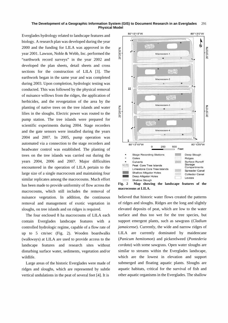
Everglades hydrology related to landscape features and biology. A research plan was developed during the year 2000 and the funding for LILA was approved in the year 2001. Lawson, Noble & Webb, Inc. performed the “earthwork record surveys” in the year 2002 and developed the plan sheets, detail sheets and cross sections for the construction of LILA [3]. The earthwork began in the same year and was completed during 2003. Upon completion, hydrologic testing was conducted. This was followed by the physical removal of nuisance willows from the ridges, the application of herbicides, and the revegetation of the area by the planting of native trees on the tree islands and water lilies in the sloughs. Electric power was routed to the pump station. The tree islands were prepared for scientific experiments during 2004. Stage recorders and the gate sensors were installed during the years 2004 and 2007. In 2005, pump operation was automated via a connection to the stage recorders and headwater control was established. The planting of trees on the tree islands was carried out during the years 2004, 2006 and 2007. Major difficulties encountered in the operation of LILA pertain to the large size of a single macrocosm and maintaining four similar replicates among the macrocosms. Much effort has been made to provide uniformity of flow across the macrocosms, which still includes the removal of nuisance vegetation. In addition, the continuous removal and management of exotic vegetation in sloughs, on tree islands and on ridges is required.
The four enclosed 8 ha macrocosms of LILA each contain Everglades landscape features with a controlled hydrologic regime, capable of a flow rate of up to 5 cm/sec (Fig. 2). Wooden boardwalks (walkways) at LILA are used to provide access to the landscape features and research sites without disturbing surface water, sediments, vegetation and/or wildlife.
Large areas of the historic Everglades were made of ridges and sloughs, which are represented by subtle vertical undulations in the peat of several feet [4]. It is
Fig. 2 Map showing the landscape features of the macrocosms at LILA.
believed that historic water flows created the patterns of ridges and sloughs. Ridges are the long and slightly elevated deposits of peat, which are low to the water surface and thus too wet for the tree species, but support emergent plants, such as sawgrass (Cladium jamaicense). Currently, the wide and narrow ridges of LILA are currently dominated by maidencane (Panicum hemitomon) and pickerelweed (Pontederia cordata) with some sawgrass. Open water sloughs are similar to streams within the Everglades landscape, which are the lowest in elevation and support submerged and floating aquatic plants. Sloughs are aquatic habitats, critical for the survival of fish and other aquatic organisms in the Everglades. The shallow

The Development of a Geographic Information System (GIS) to Document Research in an Everglades Physical Model
292
sloughs at LILA are dominated by Emergent Vegetation (EV), plants such as spikerush (Eleocharis cellulosa), whereas the deep sloughs are dominated by Submerged Aquatic Vegetation (SAV) plants such as coontail (Ceratophyllum demersum) and flat-stemmed bladderwort (Utricularia foliosa). Fragrant water lilies (Nymphaea odorata) and pickerelweed also occur in the sloughs. Periphyton, found living on rooted aquatic plants, is common in the sloughs of LILA. It is a complex mixture of algae, fungi, cyanobacteria, protozoans, heterotrophic microbes and detritus that is attached to submerged surfaces in many aquatic ecosystems. Periphyton is said to be the basis of the food web of the Everglades.
Studies within the sloughs in LILA are used to determine the effects of microtopography, flow and deep-water refuges on the abundance of small fishes and other aquatic organisms, their distribution, densities and movements. Native and exotic fish found in LILA include the eastern mosquitofish, Florida flagfish, Mayan cichlid, bluefin killifish, bluespotted sunfish, dollar sunfish, and many others.
Alligator holes at LILA are both shallow and deep holes in each slough that simulate similar depressions within the Everglades. These holes serve as refugia for fishes during the extreme dry conditions that occur in South Florida at the end of the dry season.
Tree islands are the regions of highest elevation in the Everglades and can be of different shapes and sizes. They provide drier habitats for the establishment of woody vegetation, and contain greater biodiversity than any other feature of the Everglades ecosystem [4, 5]. Although they occupy a tiny portion of the Everglades, tree islands are critical to the survival of both aquatic and terrestrial plants and animals. Scientists studying tree islands have estimated that 60% of the islands have disappeared since the 1940s, attributed to the human alteration of the Everglades.
Both peat core and limestone core tree islands were built in LILA to represent the battery tree islands and fixed or strand tree islands found in the Everglades
landscape. The LILA tree islands were built without tails to test the importance of water flow in moving organic matter downstream for the development of tails on tree islands through time. In addition to providing an accessible platform for conducting tree island research, the artificial islands at LILA were constructed for the study of the potential for creating tree islands from canal spoils within the Everglades as an active restoration effort. The islands have been used to determine survivorship of plant species [2, 6] and for carefully monitoring the health of trees through time. In addition, Price and Sullivan (2008) had studied the LILA tree islands in order to characterize groundwater and surface water hydrology related to tree growth and density on tree islands.
Through the experiments conducted at LILA, researchers produce valuable scientific information which can be used to mediate environment-related issues of public concern and provide an understanding of the consequences of perturbations [7]. A Geographic Information System (GIS) can enhance a scientist’s capability to collect, arrange, sort, analyze and synthesize data, prepare scientific research reports with visual representations, and share data and ideas with others [8]. The development of our GIS Database of LILA has allowed us to spatially document scientists’ research sites and the locations of scientific instruments. A GIS of all the landscape features and study locations spatially identifies past research and operations, and also assists in tracking changes which may be a result of the accidental addition of nutrients or other perturbations [9]. Finally, the GIS will assist in linking data to the landscape for the purpose of data analysis, interpretation and visualization.
2. Materials
We used a set of georeferenced Color Infra-Red (CIR) aerial photographs taken during the years 2000 to 2009 to map the various features of LILA. The aerial photographs are used to examine the changes in the different landscape features of LILA, such as the tree

The Development of a Geographic Information System (GIS) to Document Research in an Everglades Physical Model
293
islands. A Softcopy Workstation running Summit Evolution™ software was used for the georeferencing and stereo viewing of the aerial photographs. Mapping of the landscape features and research locations of LILA was carried out using ArcGIS™ 9.2 software marketed by ESRI®, Inc. [10-12].
The most recent aerial photographs were captured on April 17th of 2009 at 9:00 a.m. The water levels at LILA were managed for minimum water in the sloughs during the acquisition of the aerial photographs. The height for the capture of these aerial photographs was 670 meters (∼2,200 feet) above the mean terrain elevation and they were captured vertically in nadir positions on only 1 flight line oriented north to south. The number of aerial photographs captured was 17, with 80.0% overlap between the adjacent photographs. Following the capture of the 2009 aerial photographs, the imagery were delivered at a 16-Bit bandwidth in Tagged Image File Format (TIFF), which were subsequently georeferenced [13, 14] for the final production of an aerial orthophotograph (Fig. 3). The individual digital aerial photographs were referenced to standard black and white aerial targets strategically placed at LILA. The “root mean square of changes at control points” were as follows: x is 0.3 cm (∼0.01 foot), y is 1.2 cm (∼0.04 foot) and z is 1.8 cm (∼0.06 foot). The scale of the georeferenced set of aerial photographs is 1:1,200 and the number of stereo models generated for the entire extent of LILA was 16. Spatial resolution of the aerial photographs is 5 cm (∼0.16 foot) of Ground Sampling Distance (GSD). The ground area covered by each aerial photograph is 0.3 square kilometer (∼0.12 square mile), whereas the ground area covered by each stereo model is 0.2 square kilometer (∼0.08 square mile). In addition, we created a spatially interpolated, theoretical Digital Elevation Model (DEM) by mapping the footprints of the various landscape features of LILA from the historic color aerial photographs and by kriging the assigned elevation attributes of the features considering their
Fig. 3 Color infra-red (CIR) aerial orthophotograph of LILA (Printed in Grayscale).
“As Built” configurations (Figs. 4 and 5). For this purpose, we also consulted the Computer-Aided Design (CAD) drawing file of the LILA site plan and relevant information from the initial scattered elevation surveys of the proposed site. Further, as a derivative of the DEM, we were able to generate the speculative elevation contours of the impoundment [11, 15-17].
A GIS database was developed to manage and store the pertinent spatial and research information. This database will be the primary repository for any spatial data and the details of methods and results of studies conducted at LILA. The various components of the GIS database of LILA are shown using a schematic flow diagram (Fig. 6).

The Development of a Geographic Information System (GIS) to Document Research in an Everglades Physical Model
294
Fig. 4 Schematic illustration of the cross section of a macrocosm at LILA.
Fig. 5 A theoretical Digital Elevation Model (DEM) of LILA produced based on the footprints of the landscape features and “As Built” designed topography.
3. Results and Discussion
The study of Everglades hydrology is the basic purpose of LILA, where water depth and flow are continuously controlled in each macrocosm independently using a recirculating system capable of simulating the continuous flow of water through the Everglades [18]. An electric pump, equipped with a vegetation exclusion screen and rake at the pump inlet, and capable of moving more than 114 cubic meters (∼30,000 gallons) of water per minute, is used to move water from the distributor canal located at the eastern edge of LILA into the header cell located at the northern and western edge of LILA. The LILA facility has a series of separation levees to act as hydrologic barriers (Fig. 2). The experimental design includes a series of inflow, outflow and through-flow culverts and gates, spreader and collector canals, and inflow and outflow stage recording stations capable of transmitting data via a Supervisory Control and Data Acquisition (SCADA) system to the SFWMD, which

The Development of a Geographic Information System (GIS) to Document Research in an Everglades Physical Model
295
Fig. 6 A flow diagram of the various components of the GIS database of LILA.
allow scientists to continuously monitor and control the flow of water at LILA (Fig. 2). Water levels are generally manipulated on two-week intervals in accordance with the operational hydrograph, to define specific hydroperiods. Water enters the macrocosms through the culverts at the west end and leaves through culverts at the eastern end. The current experimental design includes a continuous flow through macrocosms 2 and 4 and no flow though macrocosms 1 and 3, with the stage being equal between all four macrocosms. Studying the effects of flow and stage in LILA, scientists develop recommendations for improving water management in the Everglades.
Researchers study the effects of hydrology on erosion and accretion, vegetation and wildlife. Determining the optimum water levels for wading bird foraging, the downstream critical velocity needed for the movement of sediment causing erosion and accretion, the influence of flow on tree island
morphology and the flooding tolerance of the plant species on the tree islands are a few of the studies conducted in LILA. Scientists have installed Acoustic Doppler Velocity (ADV) Meters, Acoustic Doppler Flow Meters (ADFM), Absolute Velocity Profilers (AVP) and Flow Trackers to record flows (Fig. 7). In addition, Rhodamine fluorescent red dye was injected to the LILA system on two occasions to observe the movement of water in that particular macrocosm. Using a portable fluorometer, the concentration of the dye was analyzed at different locations within each macrocosm [7] to determine the pattern of flow. Water Quality Sondes are being deployed to measure pH, temperature, conductivity, turbidity, dissolved oxygen and chlorophyll in the sloughs to determine the impact of flow on these parameters.
Scientists have installed wells across the macrocosms and deployed barometric pressure transducers/temperature probes within them to measure

The Development of a Geographic Information System (GIS) to Document Research in an Everglades Physical Model
296
Fig. 7 Map showing the research sites for the experiments on groundwater movement and the meteorological observation stations at LILA.
and record groundwater stages and changes in groundwater temperature. The spatial distribution of these wells and instruments allows an analysis of groundwater and surface water movement (both vertically and horizontally) within the macrocosm.
Shallow, Intermediate and Deep Groundwater Wells were installed to study the effects of hydrology on tree islands, and to examine the geochemical interactions between the groundwater and surface water using
temperature as a hydrologic tracer [2] (Fig. 7). Groundwater and surface water samples are
collected regularly from the wells using a peristaltic pump, and the samples are analyzed for alkalinity, anions, cations, stable isotopes of oxygen and hydrogen, and total and dissolved nutrients (nitrogen, carbon and phosphorus).
Groundwater levels measured in peat islands indicate a year round groundwater discharge, and groundwater levels in limestone islands indicate a year round surface water recharge (except during rain events). The measurement of stable isotopes of hydrogen and oxygen in groundwater and surface water suggest increased interactions between groundwater and surface water during the wet season [19]. Researchers are investigating the variation of nutrient availability in tree islands with seasonal hydrodynamics and the differences in the groundwater chemistry between tree island types and between the edge and center of the tree islands. In addition, studies of the LILA tree islands are providing insight into the differences in the groundwater hydrology and the shallow groundwater chemistry between tree islands with peat versus limestone cores.
A weather station is installed on a tree island to record LILA meteorological conditions (Fig. 7). In addition, precipitation data from a SFWMD Weather Station in close proximity to LILA is used to correlate large change in groundwater levels and rain events [19].
Scientists carried out two separate dual signature tracer (fluorescent and magnetic) pilot projects at LILA for a flocculent (floc) material transport hydrodynamics study, which were designed to determine the erodibility of the soil-bed under low and high flow regimes (under a range of 0 to 10 cm/sec). Linear flumes were placed in the deep slough of one macrocosm, equipped with magnets, sentinel sediment traps and self-logging turbidity sensors to quantify tracer movement (Fig. 8). The objectives were to study the physics of erosion and sediment transport in the

The Development of a Geographic Information System (GIS) to Document Research in an Everglades Physical Model
297
Florida Everglades in response to flow, using a sedimentological approach, and considering that sheet flow has played a critical role in shaping the historic ridge and slough landscape through erosive forces. LILA was used to develop the protocols to deploy and capture the tracer within the flowing and non-flowing macrocosms. The studies were used to estimate threshold water velocities with reference to sediment movement [2].
Surface Elevation Tables (Sedimentation and Erosion Tables, a.k.a. SETs) are installed both in the ridge and slough and on the tree islands in LILA (Fig. 8). The SETs on the ridge and slough regions are to examine soil microtopographic variations caused by various factors such as flow and vegetation. The SETs on the tree islands are installed to quantify peat accumulation dependent upon flow with a focus on the “tail” or downstream region of the tree islands. The study also involved establishing feldspar markers to allow the quantification of peat accretion by allowing
for the measurement of the amount of sediment deposited upon the feldspar layer over time [20].
The elevation of a tree island determines the habitat’s suitability for the various types of plants and animals [5]. On the LILA tree islands, detailed elevations are established by the installation of vertical control benchmarks and by routine topographic surveys of elevation transects across the macrocosms. The purpose is to observe the differences in hydroperiod between the elevated centers of the tree islands and the lower fringes. Native species of trees were planted on the LILA tree islands to quantify the hydrologic (drought and flood) tolerances of individual plant species (Fig. 9). The LILA trees were planted in 4 groups high density, medium high density, medium low density and low density quadrants. In each quadrant, seedlings of plant species were randomly assigned positions to ensure good representation along the hydrologic gradient. This is to determine the plant community composition and competition for survival
Fig. 8 Map showing the research sites for the experiments on sediment erosion and deposition at LILA.

The Development of a Geographic Information System (GIS) to Document Research in an Everglades Physical Model
298
Fig. 9 Map showing the spatial distribution of the different species of trees planted on the tree islands of macrocosm-2 (some provided with nutrients) at LILA.
between plants. A total of 5,736 native tree seedlings with varied flood tolerances were planted on the tree islands to study plant physiology, survival, growth and productivity using allometric biomass estimates. To remove unwanted vegetation, manual and mechanical weed control, prescribed burns and herbicide applications were conducted. The effects of tree density on groundwater movement, the effect of tree island substrate (peat or limestone) on seedling performance and characterizing tree mortality related to hydrology were also studied [2, 21].
Tree island development through soil accretion depends greatly on tree productivity, which in turn varies with soil nutrient availability. At present, an experiment is being carried out to determine the response by two tree species (Pond Apple and Coco Plum) to the addition of a growth-limiting nutrient (Fig. 9). The goal is to determine whether nutrient resorption efficiency, in terms of a harvested senescent foliar N/P ratio, can be an indicator of wetland plant productivity [22].
In the Ridge And Slough Transplant (RAST) experiment, three common Everglades ridge and slough species were planted in the flowing and non-flowing macrocosms within individual plots (Fig. 10). Sawgrass is the dominant Everglades macrophyte and forms the ridges in the ridge and slough landscape, spikerush is found in sloughs and wet prairies, and white water lily is one of the signature slough species [23]. The plots are located in shallow sloughs, in deep sloughs, on the edge of ridges and in the middle of ridges. Growth and mortality rate of plants in the plots are monitored. Plants were removed from plots initially and transplants were made with one of the three study species. Six subplots within a plot are randomly selected for quarterly biomass estimates. Sediment accretion pins are also installed within the RAST plots to estimate relative change in soil elevation. The natural colonization plots associated with the RAST experiment are devoid of any specific planted species and scientists are observing the natural propagation of

The Development of a Geographic Information System (GIS) to Document Research in an Everglades Physical Model
299
Fig. 10 Map showing the spatial distribution of the Ridge And Slough Transplant (RAST) plots within the macrocosms 1 and 2 of LILA. Inset (a): the planted subplots and the sediment pins within a RAST plot.
various plant species within the colonization plots, as it would happen within the ridge and slough environment of the Everglades [2, 7].
LILA is home to many piscivorous (fish-eating) wading birds, such as white ibis, great blue heron, great egret, snowy egret, glossy ibis, little blue heron and tricolored heron. The sloughs of LILA are dominated by a wide variety of freshwater fish that includes eastern mosquitofish, Florida flagfish, bluefin killifish, bluespotted sunfish and dollar sunfish. The purpose of studying wildlife in LILA is to investigate management options that optimize habitat function, thus improving animal survival and increasing reproductive success.
Scientists at LILA examined the vegetation structural complexity (density), fish density and water levels within the aquatic slough system that affect prey
vulnerability to avian foraging and their predation (feeding) success. A series of studies have been conducted on the foraging efficiency of white ibis (Eudocimus albus). By manipulating the water depths at LILA, researchers determined the optimum water levels for bird foraging and its implication on food availability. The experiment was repeated with varied sizes of enclosures and wildlife observation cameras were deployed to observe wildlife activity [2] (Fig. 11).
Crayfish are an important food source to wading birds. Three experiments have been conducted to study the dispersal response of the slough crayfish population to water recession. These studies utilized a mark recapture and radio telemetry technique to determine crayfish dispersal behavior between the ridges, sloughs and alligator hole habitats. Minnow traps, throw traps, hoop nets and fyke nets were also deployed to estimate

The Development of a Geographic Information System (GIS) to Document Research in an Everglades Physical Model
300
Fig. 11 Map showing the research sites for the experiments on the movements of wildlife at LILA. Inset (a): paired fyke nets (gray arrow) and the natural fish nests. Inset (b): paired fyke nets, throw traps and snail traps. Inset (c): a wildlife observation camera, the throw traps, enclosures for the wading bird experiments and enclosures for the exotic fish experiments. Inset (d): throw traps, the minnow traps, the enclosures for wading bird experiments and hoop nets.
the activity-density of small-scale centrarchids (potential crayfish predators) within the deep-water refugia of LILA [2].
A study of the mortality of caged exotic fishes in relation to temperatures in canals and marsh habitats was conducted during a cold front using Mayan cichlids [2]. In another study, the effect of the Mayan cichlid on the growth and behavior of the native spotted sunfish in the deep sloughs of LILA are to be determined.
The endangered snail kite utilizes LILA as foraging grounds. Snail kites primarily eat apple snails. To study the abundance of apple snails, the A.R.M. Loxahatchee National Wildlife Refuge researchers deployed snail traps within the deep sloughs of LILA (Fig. 11). Recent studies indicate that the slough benthic faunal communities of LILA may differ between the flowing versus the non-flowing macrocosms [2].
4. Conclusions
LILA is a unique resource for research in terms of its scale and design, which reduces uncertainty by allowing the testing ecological hypotheses under controlled, replicated conditions. The South Florida Water Management District partners with the Florida International University, the Florida Atlantic University, the University of Florida, the Florida Department of Environmental Protection, the U.S. Fish and Wildlife Service, the U.S. Environmental Protection Agency, the U.S. Army Corps of Engineers, the Audubon Society of the Everglades and the A.R. Marshall Foundation to conduct research at LILA. The main objective is to provide a research platform for multidisciplinary and multiagency teams of scientists to collaborate on multifunctional studies aimed primarily at determining the effects of water

The Development of a Geographic Information System (GIS) to Document Research in an Everglades Physical Model
301
management scenarios on the ecology of tree islands and ridge and slough habitats.
A GIS is the only way to reference and link temporal data on a spatial basis. We have created a GIS database which provides a repository, allowing the archiving of the spatial characteristics and the results of experiments conducted at LILA. This will allow scientists to preserve and effectively link data from various studies being conducted at LILA with research in the greater Everglades. This can be done both temporally and spatially for future analyses, synthesis and the visualization of results. The results can then be translated for the management and restoration of the greater Everglades ecosystem.
Acknowledgements
The authors are thankful to Scot E. Hagerthey, Colin J. Saunders, Mark I. Cook, Robert M. Kobza, Theodore N. Schall, Ryan P. Desliu, Kathleen D. Warren, Rebecca A. Stanek, Leonard J. Scinto, Peter W. Harlem, René M. Price, Pamela L. Sullivan, Michael S. Ross, Suresh Subedi, Dale E. Gawlik, Nathan J. Dorn and Craig van der Heiden for providing us with valuable information.
References [1] M.C. Godfrey, T. Catton, River of Interests: Water
Management in South Florida and the Everglades, 1948-2000, U.S. Army Corps of Engineers, CERP, Jacksonville, FL, 2006.
[2] SFWMD (South Florida Water Management District), 2006, 2007, 2008, 2009 and 2010. Ecology of the Everglades Protection Area, South Florida Environmental Report, 1(6). West Palm Beach, FL.
[3] SFWMD (South Florida Water Management District), Loxahatchee Impoundment Landscape Assessment Earthwork: Record Survey, Palm Beach County, Florida-Location Map, Plan Sheets, Cross Sections Sheet and Detail Sheet, Lawson, Noble & Webb, Inc., West Palm Beach, FL, 2002, 03.
[4] S.M. Davis, J.C. Ogden, W.A. Park (Eds.), Everglades: The Ecosystem and Its Restoration, St. Lucie Press, Delray Beach, FL, 1994,
[5] F.H. Sklar, A. van der Valk, J. VanArman, J. Johansen (Eds.), Tree Islands of the Everglades, Kluwer Academic Publishers, Dordrecht, 2002.
[6] L.J. Scinto, R.M. Price, M.S. Ross, Loxahatchee Impoundment Landscape Assessment (LILA): Tree Island Experiments and Management: Semi-Annual and Final Reports to the South Florida Water Management District, Southeast Environmental Research Center and Department of Earth & Environment, Florida International University, Miami, FL, 2009.
[7] G.F. Bonham-Carter, Geographic Information Systems for Geoscientists: Modelling with GIS, Pergamon/Elsevier Science, Tarrytown, NY, 1994,
[8] L.J. Scinto, P.W. Harlem, A Supplemental Spatially Explicit GIS-based Water Velocity Data Set for the Loxahatchee Impoundment Landscape Assessment (LILA) Facility, Final Report to the South Florida Water Management District, Southeast Environmental Research Center, Florida International University, Miami, FL. 2008.
[9] S. Aronoff, Remote Sensing for GIS Managers, ESRI Press, Redlands, CA. 2005.
[10] ESRI, ArcGIS® 9: Geoprocessing in ArcGIS®, Using ArcGIS® Spatial Analyst and Using ArcGIS® Geostatistical Analyst, ESRI, Inc., Redlands, CA, 2004.
[11] P.R. Wolf, B.A. Dewitt, Elements of Photogrammetry with Applications in GIS, 3rd ed., McGraw-Hill, New York, NY, 2000.
[12] Joint Committee of the American Society of Civil Engineers (ASCE), American Congress on Surveying and Mapping (ACSM) and American Society of Photogrammetry and Remote Sensing (ASPRS), Glossary of the Mapping Sciences, ASPRS, ACSM and ASCE, Bethesda, MD and New York, NY, 1994.
[13] E.M. Mikhail, J.S. Bethel, J.C. McGlone, Introduction to Modern Photogrammetry, John Wiley & Sons, Inc., Danvers, MA, 2001.
[14] S. Aronoff, Geographic Information Systems: A Management Perspective, WDL Publications, Ottawa, ON, 1989.
[15] C.P. Lo, A.K.W. Yeung, Concepts and Techniques of Geographic Information Systems, Prentice-Hall, Upper Saddle River, NJ, 2002.
[16] T. Wade, S. Sommer (Eds.), A to Z GIS: An Illustrated Dictionary of Geographic Information Systems, ESRI Press, Redlands, CA, 2006.
[17] H. Fling, N. Aumen, T. Armentano, F. Mazzotti, The Role of Flow in the Everglades Landscape, University of Florida–IFAS Extension, CIR 1452, 2004.
[18] R.M. Price, P.L. Sullivan, A Geochemical Investigation of Groundwater-Surface Water Interactions at Loxahatchee Impound Landscape Assessment (LILA), Final Report to the South Florida Water Management District, Southeast Environmental Research Center and Department of Earth & Environment, Florida International University, Miami, FL, 2008.

The Development of a Geographic Information System (GIS) to Document Research in an Everglades Physical Model
302
[19] L.J. Scinto, Measurement of Initial Elevations at Tree Island SET Locations, Letter Report to the South Florida Water Management District, Southeast Environmental Research Center, Florida International University, Miami, FL, 2009.
[20] S. Stoffella, M.S. Ross, J.P. Sah, B. Shamblin, M. Kline, J. Espinar, E. Hanan. Developing Allometric Biomass Equations for Saplings of Tree Species Common in Everglades Tree Islands, Progress Report II to the South Florida Water Management District, Southeast Environmental Research Center, Florida International University, Miami, FL 2008.
[21] S. Subedi, Determination of nutrient limitation on trees growing in LILA tree islands, M.S. Thesis Proposal, Department of Earth & Environment, Florida International University, Miami, FL, 2009.
[22] E. Whitney, D. Bruce Means, A. Rudloe, Priceless Florida: Natural Ecosystems and Native Species, Pineapple Press, Sarasota, FL, 2004.
[23] N.J. Dorn, M.I. Cook, Crayfish Population Studies in LILA: Proposal for Drought and Fish Removal, and Crayfish Populations Update to the South Florida Water Management District, Department of Biological Sciences, Florida Atlantic University, Boca Raton, FL, 2009.