The Ayabacas Formation, southern Peru
26
Giant submarine collapse of a carbonate platform at theTuronian^Coniacian transition: The Ayabacas Formation, southern Peru Pierre Callot, n Thierry Sempere, n Francis Odonne n and Emmanuel Robert w n LMTG, Universite¤ deToulouse, CNRS, IRD, OMP, Edouard Belin,Toulouse France wOSUG, Universite¤ Joseph Fourier, Institut Dolomieu, Grenoble cedex, France ABSTRACT The Ayabacas Formation of southern Peru is an impressive unit formed by the giant submarine collapse of the mid-Cretaceous carbonate platform of the western Peru back-arc basin (WPBAB), near theTuronian^Coniacian transition (90^89 Ma). It extends along the southwestern edge of the Cordillera Oriental and throughout the Altiplano and Cordillera Occidental over 480 000 km 2 in map view, and represents a volume of displaced sediments of 410 000 km 3 .The collapse occurred down the basin slope, i.e. toward the SW. Six zones are characterised on the basis of deformational facies, and a seventh corresponds to the northeastern ‘stable’area (Zone 0). Zones1^3 display increasing fragmentation from NE to SW, and are composed of limestone rafts and sheets embedded in a matrix of mainly red, partly calcareous and locally sandy, mudstones to siltstones. In contrast, in Zones 4 and 5 the unit consists only of displaced and stacked limestone masses forming a‘sedimentary thrust and fold system’, with sizes increasing to the southwest. In Zone 6, the upper part of the limestone succession consists of rafts and sheets stacked over the regularly bedded lower part.The triggering of this extremelylarge mass wasting clearly ensued from slope creation, oversteepening and seismicity produced by extensional tectonic activity, as demonstrated by the observation of synsedimentary normal faults and related thickness variations. Other factors, such as pore pressure increases or lithi¢cation contrasts probably facilitated sliding.The key role of tectonics is strengthened by the speci¢c relationships between the basin and collapse histories and two major fault systems that cross the study area.The Ayabacas collapse occurred at a turning point in the Central Andean evolution. Before the event, the back-arc basin had been essentially marine and deepened to the west, with little volcanic activity taking place at the arc. After the event, the back-arc was occupied by continental to near-continental environments, andwas bounded to the southwest by a massive volcanic arc shedding debris and tu¡s into the basin. INTRODUCTION Mass-wasting processes are recognised as a major me- chanism of sediment redistribution over continental mar- gins, but how they are triggered is incompletely understood. Most giant submarine landslides have been described from the Recent on the basis of bathymetric and geophysical data (e.g. Collot et al., 2001; Huvenne et al., 2002; Ha£idason et al., 2004, 2005; Frey-Mart|¤nez et al., 2005, 2006) but ancient examples of such phenomena are scarce (Martinsen & Bakken, 1990; Steen & Andresen, 1997; Payros et al., 1999; Graziano, 2001; Floquet & Hen- nuy, 2003; Lucente & Pini, 2003;Vernhet et al., 2006; Sp˛rli & Rowland, 2007) and their anatomy has been rarely described at scales 4100 km. This paper deals with the Ayabacas Formation of south- ern Peru, an interesting rock unit that has received a puz- zling variety of interpretations. Here, we con¢rm one of these by demonstrating that the unit was formed by the giant submarine collapse, at theTuronian-Coniacian tran- sition, of a carbonate platform that had developed in the Andean back-arc basin during the Albian-Turonian inter- val.The unit mostly consists of millimetric to kilometric size limestone fragments and can therefore be described as a limestone megabreccia ( sensu Spence & Tucker, 1997). In the northeastern half of the study area, these fragments are enclosed in reddish siltstones and mudstones reworked from the underlying stratigraphic unit, and rock frag- ments from older units also occur; only limestones are involved in the southwestern half. The Ayabacas Formation forms a single mass-wasting body, which displays noteworthy internal facies variations. It irregularly crops out over 460 000 km 2 and is inferred to extend over more than 80 000 km 2 . Its thickness varies Correspondence: Pierre Callot, LMTG, Universite¤ deToulouse, CNRS, IRD, OMP, 14 av. Edouard Belin, F-31400 Toulouse France. E-mail: [email protected]. Basin Research (2008) 20, 333–357, doi: 10.1111/j.1365-2117.2008.00358.x r 2008 The Authors. Journal compilation r 2008 The Authors 333
-
Upload
khangminh22 -
Category
Documents
-
view
0 -
download
0
Transcript of The Ayabacas Formation, southern Peru

Giant submarine collapse of a carbonate platformattheTuronian^Coniacian transition:The AyabacasFormation, southern PeruPierre Callot,n Thierry Sempere,n Francis Odonnen and Emmanuel RobertwnLMTG, Universite¤ deToulouse, CNRS, IRD, OMP, EdouardBelin,Toulouse FrancewOSUG, Universite¤ Joseph Fourier, Institut Dolomieu, Grenoble cedex, France
ABSTRACT
The Ayabacas Formation of southern Peru is an impressive unit formed by the giant submarinecollapse of the mid-Cretaceous carbonate platform of the western Peru back-arc basin (WPBAB),near theTuronian^Coniacian transition (�90^89Ma). It extends along the southwestern edge of theCordillera Oriental and throughout the Altiplano and Cordillera Occidental over480 000 km2 inmap view, and represents a volume of displaced sediments of410 000 km3.The collapse occurreddown the basin slope, i.e. toward the SW. Six zones are characterised on the basis of deformationalfacies, and a seventh corresponds to the northeastern ‘stable’area (Zone 0). Zones1^3 displayincreasing fragmentation fromNE to SW, and are composed of limestone rafts and sheets embeddedin a matrix of mainly red, partly calcareous and locally sandy, mudstones to siltstones. In contrast, inZones 4 and5 the unit consists only of displaced and stacked limestone masses forming a‘sedimentarythrust and fold system’, with sizes increasing to the southwest. In Zone 6, the upper part of thelimestone succession consists of rafts and sheets stacked over the regularly bedded lower part.Thetriggering of this extremely large masswasting clearly ensued from slope creation, oversteepening andseismicity produced by extensional tectonic activity, as demonstrated by the observation ofsynsedimentary normal faults and related thickness variations. Other factors, such as pore pressureincreases or lithi¢cation contrasts probably facilitated sliding.The key role of tectonics isstrengthened by the speci¢c relationships between the basin and collapse histories and two majorfault systems that cross the study area.The Ayabacas collapse occurred at a turning point in theCentral Andean evolution. Before the event, the back-arc basin had been essentially marine anddeepened to the west, with little volcanic activity taking place at the arc. After the event, the back-arcwas occupied by continental to near-continental environments, andwas bounded to the southwest bya massive volcanic arc shedding debris and tu¡s into the basin.
INTRODUCTION
Mass-wasting processes are recognised as a major me-chanism of sediment redistribution over continental mar-gins, but how they are triggered is incompletelyunderstood. Most giant submarine landslides have beendescribed from the Recent on the basis of bathymetricand geophysical data (e.g. Collot et al., 2001; Huvenneet al., 2002; Ha£idason et al., 2004, 2005; Frey-Mart|¤ nezetal., 2005, 2006) but ancient examples of such phenomenaare scarce (Martinsen & Bakken, 1990; Steen & Andresen,1997; Payros et al., 1999; Graziano, 2001; Floquet & Hen-nuy, 2003; Lucente&Pini, 2003;Vernhet etal., 2006; Sp˛rli& Rowland, 2007) and their anatomy has been rarelydescribed at scales4100 km.
This paper deals with theAyabacas Formation of south-ern Peru, an interesting rock unit that has received a puz-zling variety of interpretations. Here, we con¢rm one ofthese by demonstrating that the unit was formed by thegiant submarine collapse, at theTuronian-Coniacian tran-sition, of a carbonate platform that had developed in theAndean back-arc basin during the Albian-Turonian inter-val. The unit mostly consists of millimetric to kilometricsize limestone fragments and can therefore be describedas a limestone megabreccia (sensu Spence & Tucker, 1997).In the northeastern half of the study area, these fragmentsare enclosed in reddish siltstones andmudstones reworkedfrom the underlying stratigraphic unit, and rock frag-ments from older units also occur; only limestones areinvolved in the southwestern half.
The Ayabacas Formation forms a single mass-wastingbody, which displays noteworthy internal facies variations.It irregularly crops out over 460 000 km2 and is inferredto extend over more than 80 000 km2. Its thickness varies
Correspondence: Pierre Callot, LMTG, Universite¤ deToulouse,CNRS, IRD, OMP, 14 av. Edouard Belin, F-31400 ToulouseFrance. E-mail: [email protected].
BasinResearch (2008) 20, 333–357, doi: 10.1111/j.1365-2117.2008.00358.x
r 2008 The Authors. Journal compilation r 2008 The Authors 333

from 0 to � 500m, and its volume is estimated to be410 000 km3 (41013m3). Although it is formed by a num-ber of coalescent landslides, these can be clearly distin-guished only in some cases. No undisturbed strata dividethe Ayabacas Formation into subordinate sliding units.The Ayabacas collapse is � 500 km in width and4100min average thickness, and when compared with the pub-lished dimensions of mass-wasting bodies it plots at thefar end of Lucente & Pini’s (2003) compilation diagram.The Ayabacas thus appears as the most extensive ancientsubmarine mass-wasting body currently known, and oneof the thickest. Its extension and thickness are of the samemagnitude as the largest and thickest recent bodiesdescribed to date, e.g. the Storegga Slide (Ha£idasonet al., 2004, 2005), the Bj�rn�yrenna Slide (Vorren &Laberg, 2001), the Cape Fear Slide (Popenoe et al., 1993),the Saharan Debris Flow (Gee et al., 1999), the IsraelSlump Complexes (Frey-Mart|¤ nez et al., 2005) or theOrotava-Icod-Tino Avalanche (Wynn et al., 2000).Here, we focus on the age and anatomy of the AyabacasFormation, and on the cause(s) of the collapse.
Absolute stratigraphic ages mentioned in this paper aretaken from Hardenbol et al.’s (1998) chart unless speci¢edotherwise.We use the abbreviation Ma (mega-annum) for apoint in time, andMyr (millions of years) for a duration oftime.
THE AYABACAS FORMATION IN ITSGEOLOGICAL SETTING
Location of the study area and basinarchitecture
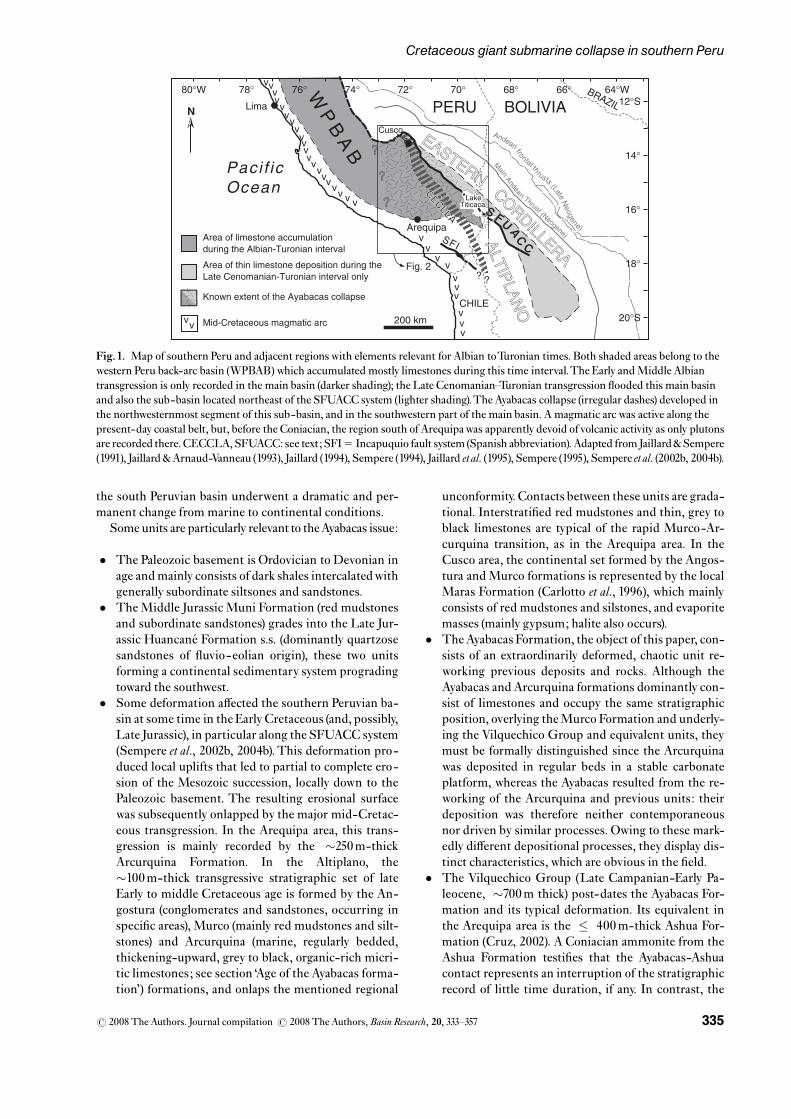
The study area extends in southern Peru, along the south-western rim of the Cordillera Oriental and throughout theAltiplano and Cordillera Occidental, including the Are-quipa area (Figs 1 and 2). The number and extension ofAyabacas Formation outcrops decrease markedly towardthe west- southwest due to an increasing cover of Neogenevolcanic rocks and other deposits. No mid-Cretaceouslimestone unit has been mapped so far immediately westand south of the study area.
The study area includes a few important Andean-agestructural systems that have also controlled a number ofdepositional characteristics of the pre-orogenic accumu-lations, such as facies and thicknesses (Sempere, 1995;Sempere et al., 2002a, b, 2004b, c; Pino et al., 2004). In par-ticular, Mesozoic subsidence has constantly been lower,and depositional environments shallower, northeast ofthe Urcos-Ayaviri-Copacabana-Coniri fault system(abbreviated as SFUACC in Spanish; Fig.1), a major litho-spheric boundary (Carlier etal., 2005) that has behaved as amainly sinistral fault system during the Andean orogeny(Sempere et al., 2002b, 2004b; Sempere & Jacay, 2006,2007).TheCusco-Lagunillas-Laraqueri-Abaroa structur-al corridor (abbreviated asCECLLA inSpanish; Fig.1) is abroad structural systemwhich separates two domains that
behaved very distinctly during the Cenozoic and at leastthe Jurassic, more subsidence and a much deeper deposi-tional environment being recorded west of the CECLLA(Sempere et al., 2002b, 2004b).We provide evidence belowthat the SFUACC and CECLLA fault systems played asigni¢cant role during the Ayabacas collapse as they sepa-rate domains characterised bydi¡erent facies distribution,subsidence, and depositional processes.
The Ayabacas Formation and underlying units were de-posited in the southern region of the western Peru back-arc basin (WPBAB), which was active in the Jurassic andCretaceous (Jaillard et al., 1995).This basin had developedin an extensional tectonic context and deepened overall tothe west. Subsidence was greatly enhanced in the mid-Cretaceous, starting in the Early Albian, as a consequenceof the westernWPBAB evolution toward a state of margin-al basin in central Peru, due to considerable lithosphericthinning there (Casma sub-basin; Atherton & Webb,1989;Atherton,1990; Jaillard,1994; and references therein).Myers (1974) proposed that the accumulation of42 km ofeastward-tapering carbonates and marls during the EarlyAlbian-Turonian interval ( �109^89Ma) east of theCasmasub-basin implied signi¢cant subsidence, which musthave been facilitated by the ongoing lithospheric thinning.The edge of the continental domain, along which the Al-bian-Turonian carbonate platform developed, thus techni-cally behaved as a kind of passive margin in relation to themuch deeper Casma sub-basin to the west. To the south( �13^151S), 1^2 km of calc-alkaline basalts and basalticandesites interbedded with locally bituminous Albianmarine strata were deposited in the southern extension ofthe WPBAB, which was narrowing in a southeastward di-rection (Atherton&Aguirre,1992; Jaillard,1994). A‘passivemargin’ setting similar to that in central Peru can thus beproposed for the carbonate platform in southern Peru,although lithospheric thinning was much less intense inthis region.
Stratigraphy of southern Peru
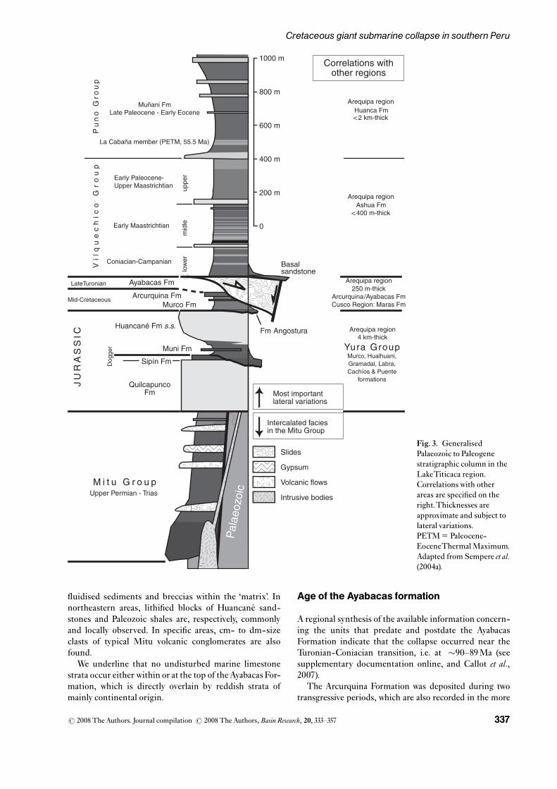
The Mesozoic stratigraphy of southern Peru is sum-marised in Fig. 3 (see supplementary documentation on-line for details). Before the Ayabacas collapse, theMesozoic units of southern Peru were deposited in a lar-gely marine basin, with continental to shallow-marine fa-cies in the northeast, and deeper water facies in thesouthwest and west. In contrast, the units younger thanthe Ayabacas Formation were deposited in an almost ex-clusively continental basin thatwas bounded to the south-west by topographic highs, apparently volcanic in nature.In particular, the Arcurquina Formation (and equivalentdeposits) mostly consists of marine limestones, whereasthe Lower Vilquechico Formation (and equivalents) isdominated by abundant red mudstones that testify to acontinental or near-continental environment (Jaillard,1995). In the Central Andean domain, away from the coast,true marine deposits are extremely rare afterwards. TheAyabacas Formation was thus deposited at the time when
r 2008 The Authors. Journal compilation r 2008 The Authors,Basin Research, 20, 333^357334
P. Callot et al.
the south Peruvian basin underwent a dramatic and per-manent change from marine to continental conditions.
Some units are particularly relevant to theAyabacas issue:
� The Paleozoic basement is Ordovician to Devonian inage andmainly consists of dark shales intercalatedwithgenerally subordinate siltsones and sandstones.
� TheMiddle Jurassic Muni Formation (red mudstonesand subordinate sandstones) grades into the Late Jur-assic Huancane¤ Formation s.s. (dominantly quartzosesandstones of £uvio-eolian origin), these two unitsforming a continental sedimentary system progradingtoward the southwest.
� Some deformation a¡ected the southern Peruvian ba-sin at some time in the EarlyCretaceous (and, possibly,Late Jurassic), in particular along the SFUACC system(Sempere et al., 2002b, 2004b).This deformation pro-duced local uplifts that led to partial to complete ero-sion of the Mesozoic succession, locally down to thePaleozoic basement. The resulting erosional surfacewas subsequently onlapped by the major mid-Cretac-eous transgression. In the Arequipa area, this trans-gression is mainly recorded by the �250m-thickArcurquina Formation. In the Altiplano, the�100m-thick transgressive stratigraphic set of lateEarly to middle Cretaceous age is formed by the An-gostura (conglomerates and sandstones, occurring inspeci¢c areas), Murco (mainly red mudstones and silt-stones) and Arcurquina (marine, regularly bedded,thickening-upward, grey to black, organic-rich micri-tic limestones; see section ‘Age of the Ayabacas forma-tion’) formations, and onlaps the mentioned regional
unconformity.Contacts between these units are grada-tional. Interstrati¢ed red mudstones and thin, grey toblack limestones are typical of the rapid Murco-Ar-curquina transition, as in the Arequipa area. In theCusco area, the continental set formed by the Angos-tura andMurco formations is represented by the localMaras Formation (Carlotto et al., 1996), which mainlyconsists of red mudstones and silstones, and evaporitemasses (mainly gypsum; halite also occurs).
� TheAyabacas Formation, the object of this paper, con-sists of an extraordinarily deformed, chaotic unit re-working previous deposits and rocks. Although theAyabacas andArcurquina formations dominantly con-sist of limestones and occupy the same stratigraphicposition, overlying theMurco Formation and underly-ing the Vilquechico Group and equivalent units, theymust be formally distinguished since the Arcurquinawas deposited in regular beds in a stable carbonateplatform, whereas the Ayabacas resulted from the re-working of the Arcurquina and previous units: theirdeposition was therefore neither contemporaneousnor driven by similar processes. Owing to these mark-edly di¡erent depositional processes, they display dis-tinct characteristics, which are obvious in the ¢eld.
� The Vilquechico Group (Late Campanian-Early Pa-leocene, �700m thick) post-dates the Ayabacas For-mation and its typical deformation. Its equivalent inthe Arequipa area is the � 400m-thick Ashua For-mation (Cruz, 2002). A Coniacian ammonite from theAshua Formation testi¢es that the Ayabacas-Ashuacontact represents an interruption of the stratigraphicrecord of little time duration, if any. In contrast, the
v
v
v
v
v
vvvv
vv
v
vv
vv
vvvvv
vv
vv
v
vvv
v
? ?
SFI
CECLLA
CECLLA
Fig. 2
Lima
Arequipa
Cusco
Pacif icOcean
CHILE
200 km
N
BRAZIL
Area of limestone accumulation during the Albian-Turonian interval
Known extent of the Ayabacas collapse
Mid-Cretaceous magmatic arcvv
Area of thin limestone deposition during the Late Cenomanian-Turonian interval only
12°S
14°
16°
18°
20°S
80°W 78° 76° 74° 72° 70° 68° 66° 64°WWP
BA
B
?
?
?
PERU BOLIVIA
EASTERN
EASTERN
S FU AC
C
CORDILLERA
ALTIP
LAN
O
ALTIP
LAN
O
Fig.1. Map of southern Peru and adjacent regions with elements relevant for Albian toTuronian times. Both shaded areas belong to thewestern Peru back-arc basin (WPBAB) which accumulated mostly limestones during this time interval.The Early andMiddle Albiantransgression is only recorded in the main basin (darker shading); the Late Cenomanian Turonian transgression £ooded this main basinand also the sub-basin located northeast of the SFUACC system (lighter shading).The Ayabacas collapse (irregular dashes) developed inthe northwesternmost segment of this sub-basin, and in the southwestern part of the main basin. A magmatic arc was active along thepresent-day coastal belt, but, before the Coniacian, the region south of Arequipawas apparently devoid ofvolcanic activity as only plutonsare recorded there.CECCLA,SFUACC: see text;SFI5 Incapuquio fault system (Spanish abbreviation).Adapted fromJaillard&Sempere(1991), Jaillard&Arnaud-Vanneau (1993), Jaillard (1994), Sempere (1994), Jaillard etal. (1995), Sempere (1995), Sempere etal. (2002b, 2004b).
r 2008 The Authors. Journal compilation r 2008 The Authors,Basin Research, 20, 333^357 335
Cretaceous giant submarine collapse in southern Peru

Ayabacas-Vilquechico contact, more to the north, ap-parently marks a �5Myr-long hiatus, during whichsome erosion must have occurred (Sempere et al.,2002a, 2004a). However, the preservation of stromato-lites at the very top of the Arcurquina Formation, eastof Huancane¤ , suggests that this hiatus may have beenmuch shorter at least locally.
Stratigraphic and depositional characteristicsof the Ayabacas formation
The Ayabacas Formation typically lacks internal strati¢ -cation and presents a highly disrupted to chaotic aspect,
in marked contrast with the underlying and overlyingunits. Its thickness is irregular but generally increasesfrom a fewmetres in the northeasternmost sections,whereit can be locally lacking, to � 500m in thewest and south-west.
The Ayabacas mainly consists of mm- to km-size frag-ments of regularly strati¢ed and/or folded limestones,mostly or entirely reworked from the Arcurquina Forma-tion, and enclosed in a largely red-siltstone ‘matrix’ remi-niscent of the Murco deposits (given their similar facies,presence of fragments of the Sip|¤ n limestones and involve-ment of Muni red siltstones cannot be excluded). Particu-larly signi¢cant is the frequent local occurrence of
Fig. 2. Distribution of main deformational facies in the Ayabacas Formation, localities cited in text, and location of the SFUACCand CECLLA fault systems. According to deformational facies, outcrops of the Ayabacas Formation are distributed into six zones,numbered1^6 (see details in the text). Zone 0 is formed by the Arcurquina Formation, i.e. the deposits of the stable carbonate platform.Pz andH indicate sites where massive blocks respectively derived from the Palaeozoic andHuancane¤ Formation occur within theme¤ lange; these sites are located near the SFUACC fault system, or near local normal faults (San Anto¤ n and Cabanillas). Note the NW^SEvariations in zone width, in particular between northern (Cusco^Abancay^Chalhuanca) and southern (Huancane¤ ^Juliaca^SantaLuc|¤ a^Lagunillas Yura) transects; see details in the text.
r 2008 The Authors. Journal compilation r 2008 The Authors,Basin Research, 20, 333^357336
P. Callot et al.
£uidised sediments and breccias within the ‘matrix’. Innortheastern areas, lithi¢ed blocks of Huancane¤ sand-stones and Paleozoic shales are, respectively, commonlyand locally observed. In speci¢c areas, cm- to dm-sizeclasts of typical Mitu volcanic conglomerates are alsofound.
We underline that no undisturbed marine limestonestrata occur either within or at the top of theAyabacas For-mation, which is directly overlain by reddish strata ofmainly continental origin.
Age of the Ayabacas formation
A regional synthesis of the available information concern-ing the units that predate and postdate the AyabacasFormation indicate that the collapse occurred near theTuronian-Coniacian transition, i.e. at �90^89Ma (seesupplementary documentation online, and Callot et al.,2007).
The Arcurquina Formation was deposited during twotransgressive periods, which are also recorded in the more
Quilcapunco Fm
Muni Fm
Huancané Fm s.s.
Murco Fm
Vil
qu
ec
hic
o
Gr
ou
pMuñani Fm
Late Paleocene - Early Eocene
Sipín Fm
1000 m
600 m
400 m
200 m
800 m
0
JU
RA
SS
IC
M i t u G r o u p Upper Permian - Trias
Ayabacas FmLateTuronian
Mid-Cretaceous
Dog
ger
low
erup
per
mid
le
Coniacian-Campanian
Early Paleocene- Upper Maastrichtian
Early Maastrichtian
Fm Angostura
Basalsandstone
Pu
no
Gro
up
Most important lateral variations
Intercalated facies in the Mitu Group
Pal
aeoz
oic
Slides
Gypsum
Volcanic flows
Intrusive bodies
La Cabaña member (PETM, 55.5 Ma)
Arcurquina Fm
Correlations withother regions
Yura Group Murco, Hualhuani, Gramadal, Labra, Cachíos & Puente
formations
Arequipa region 250 m-thick
Arcurquina/Ayabacas Fm Cusco Region: Maras Fm
Arequipa region Ashua Fm
< 400 m-thick
Arequipa region Huanca Fm< 2 km-thick
Arequipa region 4 km-thick
Fig. 3. GeneralisedPalaeozoic to Paleogenestratigraphic column in theLakeTiticaca region.Correlations with otherareas are speci¢ed on theright.Thicknesses areapproximate and subject tolateral variations.PETM5 Paleocene-EoceneThermalMaximum.Adapted from Sempere et al.(2004a).
r 2008 The Authors. Journal compilation r 2008 The Authors,Basin Research, 20, 333^357 337
Cretaceous giant submarine collapse in southern Peru
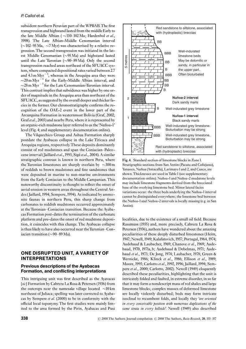
subsident northern Peruvian part of theWPBAB.The ¢rsttransgression and highstand lasted from themiddleEarly tothe late Middle Albian ( �110^102Ma; Hardenbol et al.,1998). The Late Albian-Middle Cenomanian interval(�102^95Ma, �7Myr) was characterised by a relative re-gression.The second transgression was initiated in the lat-est Middle Cenomanian (�95Ma) and highstand lasteduntil the Late Turonian (�90^89Ma). Only the secondtransgression reached areas northeast of the SFUACC sys-tem,where compacted depositional rates varied between2.7and 4.3mMyr�1, whereas in the Arequipa area they were�20mMyr�1 for the Early-Middle Albian interval, and�28mMyr�1 for the Late Cenomanian-Turonian interval.This contrast implies that subsidencewas higher by one or-der of magnitude in theArequipa area than northeast of theSFUACC, as suggested by the overall deeper and thicker fa-cies in the former. Our chronostratigraphy con¢rms the re-cognition of the OAE-2 event in the lower part of theArcurquina Formation in westernmost Bolivia (Graf, 2002;Graf etal., 2003) and nearbyPeru,where it is represented byan organic-rich mudstone layer referred to as the ‘Nun� oa-1’level (Fig. 4; and supplementary documentation online).
The Vilquechico Group and Ashua Formation sharplypostdate the Ayabacas collapse in the Lake Titicaca andArequipa regions, respectively.These deposits dominantlyconsist of red mudstones and span the Coniacian^Paleo-cene interval (Jaillard etal.,1993; Sige¤ etal., 2004). A similarstratigraphic contrast is known in northern Peru, wheretheTuronian limestones are sharply overlain by �300mof reddish to brown mudstones and ¢ne sandstones thatwere deposited in marine to non-marine environmentsfrom the Early Coniacian to the Middle Campanian.Thisnoteworthy discontinuity is thought to re£ect the onset ofaerial erosion inwestern areas throughout the Central An-des (Jaillard,1994; Sempere,1994). As indicated by ammo-nite faunas in northern Peru, this sharp change fromcarbonates to reddish mudstones occurred approximatelyat theTuronian^Coniacian transition. Because the Ayaba-cas Formation post-dates the termination of the carbonateplatform and pre-dates the onset of red mudstone deposi-tion, it coincides with this change.The Ayabacas collapseis thus likely to have also occurred near theTuronian^Con-iacian transition (�90^89Ma).
ONE DISRUPTED UNIT, A VARIETYOFINTERPRETATIONS
Previous descriptions of the AyabacasFormation, and conflicting interpretations
This intriguing unit was ¢rst described as the Ayavacas[sic] Formation by Cabrera La Rosa & Petersen (1936) fromthe outcrops near the namesake village located �10 kmnortheast of Juliaca; spelling was later corrected to Ayaba-cas by Sempere et al. (2000) to be in conformity with theo⁄cial local toponymy.The ¢rst studies were mainly lim-ited to the area formed by the Pir|¤ n, Ayabacas and Pusi
localities, due to the existence of a small oil ¢eld. BecauseRassmuss (1935) and, more precisely, Cabrera La Rosa &Petersen (1936), authors have wondered about the amazingpeculiarities of these deeply disturbed limestones (Heim,1947; Newell, 1949; Kalafatovich, 1957; Portugal,1964, 1974;Audebaud & Laubacher, 1969; Chanove et al., 1969; Aude-baud, 1970, 1971a, b; Audebaud & Debelmas, 1971; Aude-baud et al., 1973; De Jong, 1974; Laubacher, 1978; Green &Wernicke, 1986; Klinck et al., 1986; Ellison et al., 1989;Moore, 1993; Carlotto et al., 1992, 1996; Jaillard, 1994; Sem-pere et al., 2000; Carlotto, 2002). Newell (1949) eloquentlydescribed these peculiarities, highlighting that the unit isintricately folded and faulted, in extreme disorder, in so farthat it may form a nondescript mass of red shales and largelimestone blocks; complex masses of deformed limestoneare locally violently disturbed; beds may form intricateisoclinal to recumbent folds, and locally they ‘are orientedin every conceivable position with numerous duplications of thesame strata in every hillside’. Newell (1949) also described
BBB
BBB
Nuñoa-2 intervalDark sandy marls
B
Nuñoa-1 intervalBlack sandy marls
BBBBB
BBB
B
BB
BB
Well-indurated limestone bedsMay be dolomitic or sandy, in particular in the upper part.Often bioturbated
Well-indurated grey limestone
Well-indurated grey limestone.Bioturbation may be strong
Well-indurated grey limestone. Bioturbation may be strong
1
2
Red sandstone to siltstone, associated with (hydroplastic) breccias
Red sandstone to siltstone, associated with (hydroplastic) breccias
BBB
5 m
etre
s
Fig.4. Standard section of limestone blocks in Zone1.Stratigraphic sections from San Anto¤ n (Pacuta and Con� ejuno),Yanaoco, Nun� oa (Antacalla), Larimayo1and 2, and Cusco, areshown.Thicknesses are used inTable1 (see supplementarydocumentation online). Nun� oa-1 andNun� oa-2 mudstone levelsmay include limestone fragments derived from the brecciatedbase of the overlying limestone bed.Minor lateral faciesvariations occur: the three beds underlying the Nun� oa-1 intervalcannot be distinguished everywhere; the limestone bed betweenthe Nun� oa-1 andNun� oa-2 intervals is locally missing (e.g. in SanAnto¤ n).
r 2008 The Authors. Journal compilation r 2008 The Authors,Basin Research, 20, 333^357338
P. Callot et al.

fragments of older units involved in the Ayabacas Forma-tion, and emphasised that the formation displays a ‘verycharacteristic’deformation that contrasts with the underly-ing and overlying units.
However, although descriptions of the Ayabacas Forma-tion have been generally similar, interpretations have di-vided between tectonic and gravitational processes, and,among the latter, between subaerial and submarine sliding(discussed below).
Compressional tectonic interpretations, andwhy they are untenable
The ¢rst work concerning the Ayabacas Formation wasproduced by Rassmuss (1935), who described the lime-stone unit as a chaotic formation and suggested a tectonicexplanation for its disrupted aspect.Heim (1947) andNew-ell (1949) both observed multiple repetitions of strati¢edlimestone blocks and interpreted them as the result of An-dean tectonics. Audebaud (1967) wondered whether earlymass sliding might have been partly responsible for the de-formation, but considered that the deformation wasmainly of tectonic origin (Audebaud & Laubacher, 1969;Audebaud, 1970, 1971a, b; Audebaud & Debelmas, 1971;Audebaud etal., 1973), locally complicated by early karsti¢ -cation (producing the noteworthy breccias mentioned be-low), gypsum diapirs, and hypovolcanic intrusions(Audebaud, 1971a). In the Pir|¤ n area (SWof Pusi), Chanoveetal. (1969) interpreted theAyabacas Formation as a piling-up of tectonic nappes.
The observed deformation has however a markedly‘soft’ aspect and is hardly compatible with tectonic pro-cesses. Tectonic thrusting and folding would have pro-duced typical features, such as slickenslides and striatedfaults, oriented tectonic breccias, cleavage, and/or perva-sive calcite veining. But all of these elements are missing.Away from Andean structures, faults in limestone blocksneither display calcite slickenslides nor are they striated.Limestone blocks are piled up without signs of tectonicthrusting, as noted by Heim (1947) and Portugal (1964,1974). Limbs of recumbent folds are generally unthinned(Portugal, 1964, 1974), suggesting a low overlying load dur-ing folding (Audebaud,1967). Contrary to what is expectedin the case of tectonic phenomena, orientations of foldsand faults in the Ayabacas Formation are usually extremelyvariable at each locality (Fig. 5a).
It is also noteworthy that the grade of deformation intheAyabacas Formation decreases toward the EasternCor-dillera, i.e. in the direction of increasing Andean deforma-tion. Andean folding and faulting has very generallydeveloped at much larger scales than the Ayabacas defor-mation. As underlined above, the Ayabacas Formationcontrasts greatly with the underlying and overlying units,which have similar bedding attitudes at each locality andhave generally been only tilted by Andean deformation atthe outcrop scale. Furthermore, in all visited localities,the basal and top contacts of the Ayabacas Formation areevidently stratigraphic, not tectonic.
All these observations are compelling evidence againstany idea that the Ayabacas deformation results from large-scale Andean tectonic deformation.
Subaerial gravity sliding: also untenable
De Jong (1974) published interesting descriptions of theAyabacas Formation in the Puno-Juliaca area and right-fully criticised Newell’s (1949) and Chanove et al.’s (1969)tectonic interpretations. However, he favoured that theunit resulted from subaerial sliding in the mid-Cretac-eous, drawing a comparison with the Amargosa Chaos inDeath Valley, western USA. Laubacher (1978) discussedthe diverse interpretations published at that time, andconcluded that both Chanove et al.’s (1969) and De Jong’s(1974) interpretations were warranted. Klinck et al. (1986)and Ellison et al. (1989) also favored subaerial gravity slid-ing, but of Late Neogene age.
Green&Wernicke (1986) andMoore (1993) claimed thatthe Ayabacas Formation was a continental collapse pro-duced in the Late Miocene by large-magnitude crustalextension, caused by the gravitational spreading of theoverthickened Andean crust.They mapped low-angle de-tachments at the base of the Ayabacas Formation, andestimated that they accomodated 10s of kilometers ofextension.They agreed with De Jong’s (1974) observations
(a)
(b) (c)
Fig. 5. Schmidt stereonets (lower hemisphere) of data fromZones 2 and 3. (a) Fold axes in rafts (N5 52) in the Ilave-Juli (left),corrected (right) for tectonic tilting (using underlying and/oroverlying units). Scattering is evident before correction, implyingthat deformationwas not produced by orogenic shortening. A�NW^SE preferential orientation becomes apparent aftercorrection, suggesting sliding occurred to the NE or SW. (b)Bedding attitudes of rafts (solid lines,N5 35) andHuancane¤blocks (dashed lines,N5 5) dispersed in the me¤ lange in the Pusiarea, where Chanove et al. (1969) interpreted the unit as resultingfrom the piling up of tectonic nappes.Their random distributionis not compatiblewith orogenic tectonics. (c)Bedding attitudes ofPalaeozoic rafts in the Ayabacas me¤ lange, from a �3 km2 area�15 km south of Chucuito (N5 34); their random distributioncon¢rms they are elements in a sedimentary me¤ lange, and notthe result of tectonic deformation.
r 2008 The Authors. Journal compilation r 2008 The Authors,Basin Research, 20, 333^357 339
Cretaceous giant submarine collapse in southern Peru

of similarities between the Ayabacas Formation and theAmargosa Chaos.
A subaerial sliding interpretation is precluded, how-ever, by the abundance of plastic, soft-deformation fea-tures, hydroplastic breccias and £uidised sediment facies.The fact that the Ayabacas deformation is regionally post-dated by Late Cretaceous strata precludes any Neogeneprocess as its cause. Interpretations by Klinck et al.(1986), Green & Wernicke (1986), Ellison et al. (1989), andMoore (1993) are contradicted by the fact that the base ofthe Ayabacas Formation is clearly not a tectonic contact,at any locality visited by us.
It is interesting that the Ayabacas could be interpretedas the product of contractional tectonics by some authorsand of extensional tectonics by others. In particular, thesame area of Pir|¤ n (southwest of Pusi) has been mapped asa piling-up of contractional nappes byChanove etal. (1969)and as structured by low-angle normal faults, interpretedto express � 5 km of extension, by Green & Wernicke(1986) and Moore (1993). In addition to the fact that keycharacteristics have been overlooked, such contrasts ininterpretations are intriguing.
Evidence for submarine sliding
Cabrera La Rosa & Petersen (1936) were the ¢rst to pre-cisely describe the Ayabacas Formation. In particular, theynoted that generation of its typical limestone brecciascould not be explained by any tectonic deformation, andproposed instead that submarine sedimentary processeswere responsible for their facies and the overall disruptiondisplayed by the unit. Although the notion of submarinemass wasting was largely ignored at that time, theseauthors reached conclusions close to modern models, un-derstanding that limestone strata had been fragmentedbefore their lithi¢cation and that brecciation had occurred‘on the sea bottom’, probably due, in their mind, to a tsuna-mi-triggered instability.
Portugal (1964, 1974) was the ¢rst to clearly identify, inthe Puno-Santa Lucia area, that the Ayabacas Formationwas the result of submarine mass wasting, toward thesouthwest, necessarily on a slope, and that sliding had pos-sibly been facilitated by the underlying red mudstones;among other features, he emphasised that the chaotic dis-tribution of limestone blocks was evidence that they hadmoved independently from one another, and that deforma-tion preserved unthinned limbs and produced no cleavage.
In the Cusco area, Carlotto et al. (1992, 1996) re-inter-preted the intriguing disruption displayed by Kalafato-vich’s (1957) Yuncaypata Formation as a result ofsynsedimentary deformation, and identi¢ed this unit asthe local expression of the Ayabacas Formation.The pecu-larities and size of this formation in southern Peru wereunderlined by Sempere et al. (2000), who recognised againthat the unit, best described as a limestone megabreccia,resulted from submarine sliding.
In the northeastern half of the study area (Zones 1^3 asde¢ned below), the Ayabacas Formation generally has a
chaotic appearance (Fig. 5b). The limestones are highlydisturbed, folded, disrupted, fragmented and brecciated(e.g.Newell’s (1949) description above).When folded, lime-stone strata yielded plastically, and are deformed withoutcleavage. Other evidence of soft-deformation includes:slumps, £uidised sediments, hydroplastic breccias, clasticand/or mud dykes. Limestone blocks are often chaoticallydistributed, and have clearly moved independently fromone another. All these characteristics are strongly indica-tive of gravitational submarine deformation, especially asshown by 3D seismic images of recent landslides (e.g.Collot etal., 2001;Huvenne etal., 2002; Frey-Mart|¤ nez etal.,2005, 2006), and con¢rm the interpretation of the Ayaba-cas Formation as a giant submarine mass-wasting body.
ORGANISATION OF THE AYABACASCOLLAPSE INTO DEPOSITIONALZONES
Distribution of deformation faciescharacterises depositional zones
Restriction of previous studies to limited areas has ob-viously hampered accurate and precise interpretations ofthe intriguing Ayabacas deformation. Here we attempt tounderstand the collapse as a whole, i.e. over its entireknown extension. Such a large-scale vision of the basinconsolidates the interpretation of the Ayabacas Formationas the collapse of a major part of the regional Albian-Turo-nian carbonate platform.
The Arcurquina Formation, which marks the parts ofthe platform that were not destabilised, mainly occurs inthe eastern part of the basin. The Ayabacas Formationcharacteristically occurs in all localitiesWSWof this area.Six di¡erent zones are characterised on the basis of the de-formational facies exhibited by the Ayabacas Formation(Fig. 2), and a seventh corresponds to the northeastern‘stable’ area. Facies evolve progressively from Zones 1 to 3,and from Zones 4 to 5. In contrast, sharp facies di¡erencesseparate Zone 3 from Zone 4, whereas Zone 5 is somewhatdistinct from Zone 6 in some aspects.
Zone 0:Northeastern, undisturbed part of theplatform
In Peru, the Arcurquina Formation is entirely preservednortheast of Lake Titicaca (Figs 1 and 2), where it iso25m-thick and overlies the red mudstones and silt-stones of the Murco Formation. The Arcurquina Forma-tion displays lagoonal to supratidal facies; bioturbation isoften intense in the former. East ofHuancane¤ , the very topof the unit exhibits numerous stromatolites which havebeen buried by the overlying red mudstones (LowerVilquechico Formation). This unit is neither fragmentednor folded and there is no indication of soft- sediment de-formation, testifying to the stability of this part of the basinduring the Ayabacas collapse.
r 2008 The Authors. Journal compilation r 2008 The Authors,Basin Research, 20, 333^357340
P. Callot et al.

Zone 1:Gravitational sliding, folding andthrusting of rafts and sheets
Zone1is entirely located northeast of theSFUACC. In thiszone, theAyabacasFormation displays synsedimentaryde-formation of diverse intensity. It consists of a me¤ lange oflimestone blocks and a mainly red, partly calcareous andlocally sandy, mudstone to siltstone matrix, sometimesturning to yellow near the limestone masses. The unit isvery variable in thickness: locally, the Vilquechico Groupdirectly overlies the Huancane¤ Formation and the Ayaba-cas and Murco formations are totally absent; in otherareas, the Ayabacas Formation consists of a chaos of lime-stone rafts and folded strata £oating in the red matrix,whose thickness can be over several hundreds of metres.
In Zone 1, the unit mainly consists of limestone sheetsor rafts ‘£oating’ in the red matrix.These sheets and raftsare generally � 20m-thick, fairly re£ecting the deposi-tional thickness before the collapse when compared withZone 0, and clearly exhibit the same internal stratigraphy(Fig. 4). Although relatively thin, the sheets display a fairto excellent lateral continuity, ranging from40m (raft-typeend-member) to over several kilometres (sheet-type end-member, as observed in aerial photography). These lime-stone rafts can overlap each other and form stacks of twoor more elements separated by breccias and red marly silt-sones (Fig. 6). Some rafts are strongly folded; folds aregenerally asymmetric and recumbent, rarely with thinnedlimbs, and without any cleavage (Portugal, 1964, 1974; Au-debaud, 1967; De Jong, 1974; Sempere et al., 2000).
Although a large-scale organisation is generally evidentin aerial photographs, the folds are chaotically organisedat the outcrop scale. Orientation of fold axes is variable,but folds are generallyNE- or SW-vergent, indicating thatsliding occurred in opposite directions. Along with evi-dence for synsedimentary normal faulting, this suggeststhat opposite slopes were locally created by tectonic tiltingof the substratum.
The base of the standard stratigraphic section (Fig. 4) ofthese rafts and sheets consists of two (or sometimes three)0.5^3m-thick lithi¢ed limestone beds that display incipi-ent hard-grounds at their tops.These limestones are sepa-rated by two to three darker and marlier beds (theNun� oa-1andNun� oa-2 intervals, and a lower, similar, �0,5m-thickbed; see supplementary documentation online for details)that may include limestone fragments derived from thebrecciated base of the overlying limestone; this brecciationapparently developed at the interface between the twolithologies through injection of the unlithi¢ed mudstonesinto the already partly lithi¢ed limestones. An 8^14m-thick set of limestone beds forms the upper part of the sec-tion and is often highly bioturbated. Bioturbation a¡ectsall beds, with among-block vertical and lateral variations,but ranges fromvery intense to nearly absent.
Other breccias, generally hydroplastic in origin, are fre-quently observed at the bases and tops of rafts and sheets(they are particularly well-exposed at Yanaoco, �8 kmWSW of Huancane¤ , with abundant £uidised sediments,and randomly oriented clastic and/or mud dykes). In goodoutcrops, the matrix that usually separates rafts and sheets
Fig. 6. (a) Deformation typical of Zone1near Larimayo ( �9 kmNNWof San Anto¤ n, UTM0354876^8396892^4081m, Zone19L).Limestone rafts (interpretative outline highlighted in (b) ‘£oat’ in a matrix of siltstones and hydroplastic breccias and overlap each otherwith some gentle folding. Stratigraphic sections from each raft (Fig. 4) are identical.The Ayabacas Formation is underlain by theHuancane¤ Formation (SW) and overlain by theVilquechico Formation (NE), which includes here its basal sandstone member (Fig. 3);both units have been only tilted by Andean tectonics, very unlike the Ayabacas Formation.
r 2008 The Authors. Journal compilation r 2008 The Authors,Basin Research, 20, 333^357 341
Cretaceous giant submarine collapse in southern Peru

appears itself as a breccia of red to locally yellow marly silt-stones, and includes clearly £uidised sediments (Fig. 7).Clasts are of mm- to m-size and somewhat heterogeneousin nature, usually from surrounding limestone blocks;reddish and yellowish sandstones are also found. Clasticand mud dykes partly or completely intersect some lime-stone blocks, and others commonly cut across brecciaswithin the matrix.
Two sub-zones, one limestone-rich and the other lime-stone-poor, are respectively distinguished in the SE (fromHuancane¤ to Sicuani) and NW (Cusco-Urubamba area)parts of Zone 1 (Fig. 2).The NW part of Zone 1 displays apeculiar large-scale facies characterised by sporadic(either isolated or concentrated in limited areas), chaoticlimestone blocks dispersed within large stretches coveredby the Maras Formation, which is the local equivalent ofthe Murco Formation and consists of red calcareous silt-stones and subordinate gypsum and halite bodies. Thepresence of evaporites beneath thin carbonate deposits islikely to have favoured sliding, and facilitated larger displa-cements of limestone sheets, rafts and blocks during thecollapse (Vendeville & Cobbold, 1987; Demercian et al.,1993; Spathopoulos, 1996; Brun & Fort, 2004; Gradmannet al., 2005). The sporadic occurrence, and thus rarity, oflimestone blocks in this area is explained by their massiveremoval toward the SW, due to a regional facilitation andenhancement of sliding by the evaporite horizons that un-derlay the carbonate platform.
Zone 2: Chaotic melange of commonlystrongly folded rafts
Zone 2 forms a strip running from the southern (Juli,Ilave) and western (Pusi, Juliaca) shores of LakeTiticaca,to Sangarara through Santa Luc|¤ a and Sicuani. Threesub-zones are distinguished, respectiveley in the SE, cen-tre (sub-zone 2Ce), and NW (Fig. 2). Sub-zones 2SE and2NWare located southwest of theSFUACC system and ex-hibit very similar facies; in contrast, sub-zone 2Ce is
located northeast of the SFUACC and displays somewhatdi¡erent facies. No sharp boundary separates the adjacentzones1 and 2; the change in deformational facies is transi-tional, in particular between Zone 1 in the northeast andsub-zones 2SE and 2NW in the southwest. In the threesub-zones, and in particular in sub-zone 2Ce, the Ayaba-cas Formation is on the whole thicker than in Zone 1. Itsthickness varies generally rapidly, from locally 0m to4400m.
Limestone rafts are similar to those in Zone 1, butsheets are less common.They are thicker, generally about20^30m, suggesting that subsidence had been higher intheir source area during initial deposition of theArcurqui-na Formation.The limestones are often very bioturbated,in particular at their stratigraphic top. A majority of raftsin sub-zones 2NWand 2SE exhibit a somewhat similar in-ternal stratigraphy, albeit less markedly than inZone1.Theinternal stratigraphy of rafts usually di¡ers from that re-corded in Zone 1 in that limestone beds are thicker andmore frequently separated by marly interbeds. As in Zone1, rafts are wrapped in a red calcareous siltstone to mud-stone matrix. Hydroplastic breccias are also found,although less commonly than in Zones1and 3.
In sub-zones 2SE and 2NW, limestone rafts (and sheets)are more folded and fragmented than in Zone1 (Figs 8 and9). However, their lateral continuity remains signi¢cant,and is generally over a few hundreds of metres. Sheets ap-pear to have been fragmented into discontinuous succes-sions of rafts that can generally be followed over a fewkilometres in aerial photographs (Fig.8).Outcrops are alsolocally particularly chaotic and fragmented, notably nearUyuccasa (E ofMazo Cruz) at the southeastern end of thezone, and near Sangarara in the northwestern end of thezone.
Deformational facies in sub-zones 2SE and 2NW clo-sely resemble that in Zone 1.The similitude of facies andthe presence of recumbent folds with a majority of ENEandWSWvergences suggest that these sub-zones behavedsimilarly to Zone 1 during the collapse. We thus assumethat a sliding mechanism in two opposite directions wasalso active in Zone 2, pointing to the creation of local op-posite slopes by tectonic tilting of the substratum.
Sub-zone 2Ce, i.e. the part of Zone 2 located northeastof the SFUACC, is characterised by the occurrence oflarge and massive blocks of older units (Huancane¤ Forma-tion, Palaeozoic rocks) within the Ayabacas me¤ lange, in as-sociation with the usual limestone rafts.These blocks arelocally abundant, and such concentrations of displacedolder units have no known equivalent in any other part ofthe study area.They are variable in size, but on the wholeclearly larger and thicker than limestone rafts in sub-zones2SE and 2NW, exceeding100 s of m in length and10 s of min thickness.They form rigid rafts that are generally muchmore massive than the limestone rafts; unlike the lime-stone rafts, they are not a¡ected by folding, although theylocally exhibit incipient bending. They must thereforehave been already fully lithi¢ed at the time of collapse. In-ternal cross-strati¢cation in sandstone rafts shows that
Fig.7. Fluidised sediments in Zone1, nearYanaoco ( �8 kmWSWofHuancane¤ ). Real size of the picture is �14 � 10.5 cm.Note the cm-sized limestone clasts, tilted and £oating in a£uidised matrix of marly^sandy sediments.
r 2008 The Authors. Journal compilation r 2008 The Authors,Basin Research, 20, 333^357342
P. Callot et al.

some of them are upside down.Their distribution is chao-tic to the point that clear orientations appear neither inthe ¢eld (Fig. 5c) nor in aerial photographs. The only ex-ception is provided, in some of these rafts, by a regularlyspaced and regularly oriented fracturation that developedat a �30^401 angle with the raft sole, revealing the senseof displacement of the rigid mass.
The abundance and huge size of Early Cretaceous-Jur-assic and Paleozoic olistolites in sub-zone 2Ce imply thatthese older units were being exposed to catastrophic ero-sion, down to the Paleozoic basement, in a nearby area.This could only be achieved by the creation and subse-quent collapse of a major fault scarp in the vicinity ofsub-zone 2Ce.
Zone 3: Chaotic me¤ lange of more fragmentedlimestone blocks
Deformational facies in Zone 2 transitionally grade intothose in Zone 3, to the point that they are often di⁄cult todistinguish, particularly in the southeast.Here, theAyaba-cas Formation generally consists of a mix of limestoneblocks, 10^100 s of m in size, enclosed in a matrix of redmudstone and siltstone including a large amount of £ui-dised sediments and hydroplastic breccias.Good outcropsare found north ofMazo Cruz; south of Ilave and Puno; inthe Cabanillas-Santa Luc|¤ a-Lagunillas area; south ofSanta Rosa, Sicuani and Combapata; and in the Sangararaarea.The thickness of the unit is di⁄cult to measure dueto the fact that its stratigraphic base and/or top are rarelyexposed, and due to the gentle relief in this area. Thick-ness is however estimated to be approximately 500m, andappears variable as in other zones.
Maximum stratigraphic thickness of limestone blocksincreases in Zone 3 to reach 30^40m, but blocks can alsobe �20^25m-thick as in Zone 2. However, blocks are
much more fragmented, and rarely display signi¢cant lat-eral continuity. At Cabanillas a �25 cm-thick stromatoli-tic bed locally duplicated by minor thrusts during thesliding is observed in the lowermost part of the unit, belowthe mainwasting body, indicating that facies deposited in asupratidal environment during the early stage of trans-gression were here involved in the collapse. Folded blocksare rare, in contrast with Zone 2 (Figs10 and11). Althoughblocks are generally roughly oriented ENE-WSW, someoutcrop areas are strongly disorganized (for example SWof Juli-Ilave, as shown by the disparate orientation of thefold axes in Fig. 5a).
Zone 3 is particularly rich in sedimentary breccias, theabundance of which varies in all outcrops. The brecciasconsist of a mix of red and yellow marly and sandy mud-stones to siltstones, locally £uidised, and heterogeneousangular clasts derived from theMurco andArcurquina for-mations, and less frequently from the Angostura Forma-tion; all facies known in the Arcurquina Formation arerepresented; cm- to dm-size rounded clasts of theTriassicMitu Group occur in breccias 13 km west of Santa Rosa.Limestone clasts are of mm- to m-size, but grade intostrati¢ed blocks that can be up to 10^100 s of m in size.Breccia clast shapes often indicate that they were pro-duced by fracturing under an isotropic state of stress (Cos-grove, 1995). Some outcrops reveal that injection of£uidised breccia into a more lithi¢ed block locally splitthe limestone and fragmented it into clasts that were in-corporated into the breccia.
The outcrops along the Cabanillas-Santa Luc|¤ a roadare impressively rich in breccias. They are clearly asso-ciated here with a series of normal faults a¡ecting thesubstratum (including here the Angostura Formation).They exhibit heterogeneous masses mixed with sedimen-tary breccias, on the whole up to 100m-thick (but the topdoes not crop out). These masses are derived from the
Fig. 8. Aerial photo of Zone2 typical large-scale faciesnorth of Sangarara, andinterpretative outline of itsfolded rafts. Sheets,although folded andfragmented into rafts, canstill be recognised (see text).
r 2008 The Authors. Journal compilation r 2008 The Authors,Basin Research, 20, 333^357 343
Cretaceous giant submarine collapse in southern Peru
Arcurquina Formation, and less frequently from theAngostura Formation.
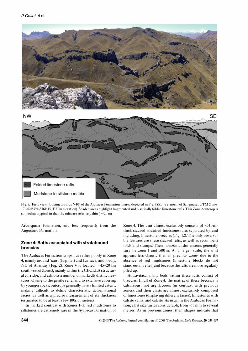
Zone 4:Rafts associated with strataboundbreccias
The Ayabacas Formation crops out rather poorly in Zone4, mainly around Yauri (Espinar) and Livitaca, and, badly,NE of Abancay (Fig. 2). Zone 4 is located �15^20 kmsouthwest ofZone 3,mainlywithin theCECLLA structur-al corridor, and exhibits a number of markedlydistinct fea-tures. Owing to the gentle relief and to extensive coveringby younger rocks, outcrops generallyhave a limited extent,making di⁄cult to de¢ne characteristic deformationalfacies, as well as a precise measurement of its thickness(estimated to be at least a few100s of meters).
In marked contrast with Zones 1^3, red mudstones tosiltstones are extremely rare in the Ayabacas Formation of
Zone 4. The unit almost exclusively consists of o40m-thick stacked strati¢ed limestone rafts separated by, andincluding, limestone breccias (Fig. 12).The only observa-ble features are these stacked rafts, as well as recumbentfolds and slumps. Their horizontal dimensions generallyvary between 1 and 500m. At a larger scale, the unitappears less chaotic than in previous zones due to theabsence of red mudstones (limestone blocks do notstand out in relief) and because the rafts are more regularlypiled up.
At Livitaca, many beds within these rafts consist ofbreccias. In all of Zone 4, the matrix of these breccias iscalcareous, not argillaceous (in contrast with previouszones), and their clasts are almost exclusively composedof limestones (displaying di¡erent facies), limestones withcalcite veins, and calcite. As usual in the Ayabacas Forma-tion, clast size varies considerably, fromo1mm to severalmetres. As in previous zones, their shapes indicate that
Fig.9. Field view (looking towards N40) of the Ayabacas Formation in area depicted in Fig. 8 (Zone 2, north of Sangarara, UTM Zone19L 0215394/8461415, 4377m elevation). Shaded areas highlight fragmented and plastically folded limestone rafts.This Zone 2 outcrop issomewhat atypical in that the rafts are relatively thin ( �20m).
r 2008 The Authors. Journal compilation r 2008 The Authors,Basin Research, 20, 333^357344
P. Callot et al.
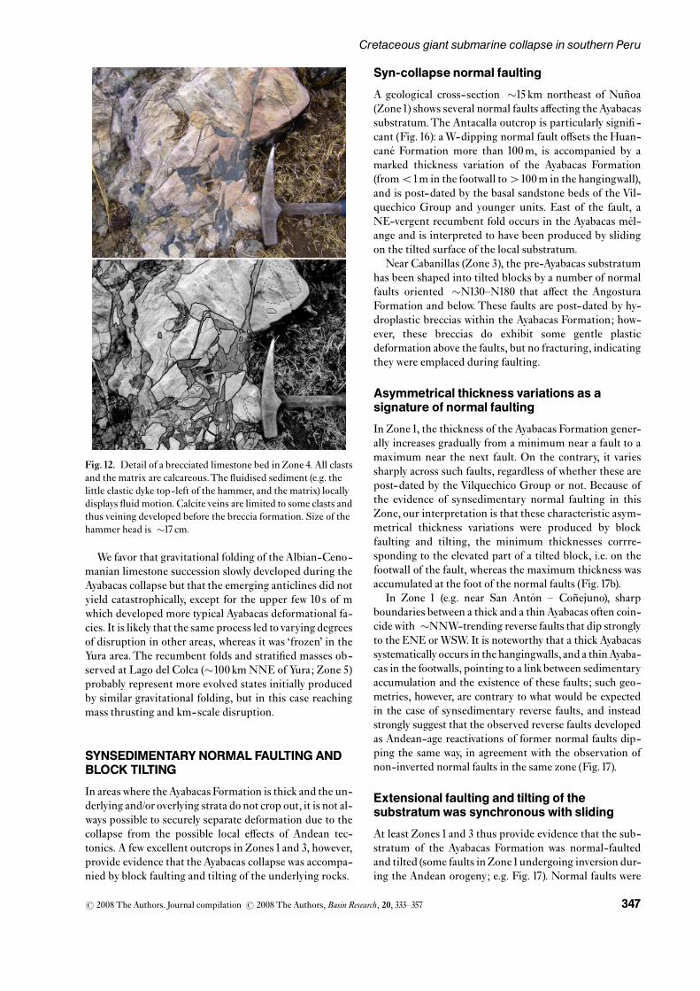
they were initially fractured by hydrostatic stress. Somebreccias or parts of breccias were clearly £uidised and lo-cally even show £uid motion (e.g. in Fig.12).
In contrast with Zone 3, the breccias locally includeclasts of calcite and of calcite-veined limestones. In somelimestone rafts, £uidised-sediment dykes may cut calciteveins.These observations demonstrate that calcite veiningdeveloped quite early in the diagenesis, before the Ayaba-cas collapse.
Zone 5: Chaotic me¤ lange of very large raftsand sheets
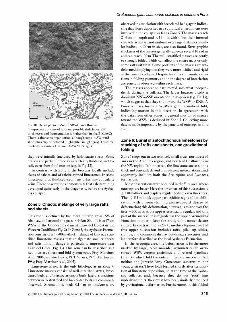
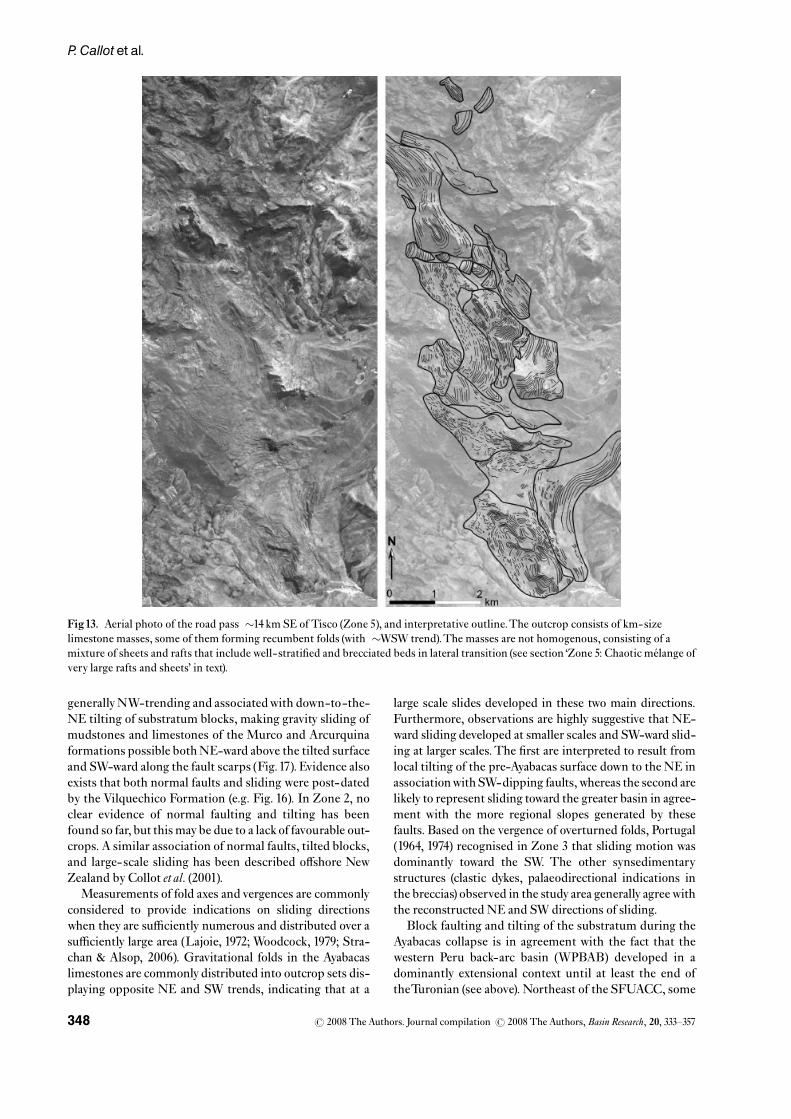
This zone is de¢ned by two main outcrop areas: SW ofAbancay, and around the pass �14 km SE of Tisco (7 kmWSW of the Condoroma dam at Lago del Colca) in theWesternCordillera (Fig. 2). InZone 5, theAyabacasForma-tion consists of a4500m-thick me¤ lange of km-size stra-ti¢ed limestone masses that amalgamate smaller sheetsand rafts. This me¤ lange is particularly impressive nearLago del Colca (Fig. 13). This zone can be described as a‘sedimentary thrust and fold system’ (sensu Frey-Mart|¤ nezet al., 2006; see also Lewis, 1971; Varnes, 1978; Martinsen,1989; Frey-Mart|¤ nez et al., 2005).
Limestone is nearly the only lithology, as in Zone 4.Limestone masses consist of well- strati¢ed strata, brec-ciated beds, and/or associations of both; lateral transitionsbetweenwell- strati¢ed and brecciated beds are commonlyobserved. Stromatolitic beds 0.1^1m in thickness are
observed in associationwith brecciated beds, again indica-ting that facies deposited in a supratidal environmentwereinvolved in the collapse as far as Zone 5.The masses reach2^4 km in length and o1km in width, but their internalcharacteristics are not uniform over large distances; smal-ler bodies, �100m in size, are also found. Stratigraphicthickness of the masses generally exceeds several 10 s of mand can reach100m.The well- strati¢ed masses are gentlyto strongly folded. Folds can a¡ect the entire mass or onlysome rafts within it. Some portions of the masses are un-deformed, implying that theywere more lithi¢ed and rigidat the time of collapse. Despite bedding continuity, varia-tions in folding geometry and in the degree of brecciationare generally observedwithin each mass.
The masses appear to have moved somewhat indepen-dently during the collapse. The larger however display adominant NNW-SSE orientation in map view (e.g. Fig. 13),which suggests that they slid toward the WSWor ENE. Akm-size mass forms a WSW-vergent recumbent fold,indicating motion in this direction. In agreement withthe data from other zones, a general motion of massestoward the WSW is deduced in Zone 5. Collecting moredata is made impossible by the paucity of outcrops in thiszone.
Zone 6:Burial of autochthonous limestones bystacking of rafts and sheets, and gravitationalfolding
Zone 6 crops out in two relatively small areas: northwest ofYura in the Arequipa region, and north of Chalhuanca inthe NWregion. In both areas, the limestone succession isthick and generally devoid of mudstone intercalations, andapparently includes both the Arcurquina and Ayabacasformations.
Most observationswere obtained in theYura area, whereoutcrops are better.Here the lower part of this succession is� 130m-thick and displays regular beds of even thickness.The � 135m-thick upper part exhibits signs of destabili-sation, with a somewhat increasing-upward degree ofdeformation; this deformation, however, is minor over the¢rst �100m as strata appear essentially regular, and thispart of the succession is regarded as the upper ArcurquinaFomation in order to keep the stratigraphic nomenclaturesimple. In contrast, the �25^40m-thick topmost part ofthis upper succession includes rafts, piled-up slides,slumps, and commonly display boudinage structures, andis therefore described as the local Ayabacas Formation.
In the Arequipa area, the deformation is furthermoremarked by large, 4500m-wide, asymmetrical to over-turned WSW-vergent anticlines and related synclines(Fig. 14), which fold the entire limestone succession butneither the Jurassic-Early Cretaceous substratum noryounger strata.These folds formed shortly after termina-tion of limestone deposition, i.e. at the time of the Ayaba-cas collapse, and, because they do not ‘root’ intounderlying units, they must have been similarly producedby gravitational deformation. Furthermore, in this folded
Fig.10. Aerial photo in Zone 3 SWof Santa Rosa andinterpretative outline of rafts and possible slide lobes. Raftthicknesses and fragmentation is higher than in Fig. 8 (Zone 2).There is almost no organisation, although some �SW-wardslide lobes may be detected (highlighted in light grey).This viewmarkedly resembles Huvenne et al.’s (2002) Fig. 3.
r 2008 The Authors. Journal compilation r 2008 The Authors,Basin Research, 20, 333^357 345
Cretaceous giant submarine collapse in southern Peru

section northwest of Yura, the upper stratigraphic sets thatconsist of ‘cobbly marls’ are thicker (up to �15, �30, and�40m-thick, respectively, for beds 30, 33 and 35) in thesynclinal depressions, and much thinner (�1m, �0.5m,and �1m, respectively) in the anticlinal crests (Fig. 14),whereas the underlying and immediately overlying lime-stone beds do not show any variation in thickness.Thick-ness variations across the folds are clearly restricted to the‘cobbly marl’ lithology, which appears as a mix of plasti-cally crushed, smooth-shaped fragments of limestonebeds in a marly matrix (Fig. 15); many limestone ‘cobbles’exhibit £attening parallel to the bedding plane andstretching perpendicular to the anticlinal axis.These ob-servations strongly suggest that the ‘cobbly marl’ bedswererelatively unlithi¢ed at the time of deformation and thatduring folding they underwent a dominantly plastic £owthat redistributed their mass gravitationally, producingthickening in the synclinal axes from thinning in the anti-clinal axes, in marked contrast with the limestone beds,which were folded concentrically because they werealready lithi¢ed at that time. It is also noteworthy that the
upper �25^40m of the Ayabacas Formation are made upby plastically deformed limestone beds and rafts (Fig.14c),that testify that these were partially unlithi¢ed at the timeof deformation, in contrast with the underlying lime-stones. As lithi¢cation is delayed in marls relative to lime-stones (cementation of carbonates is much faster than thatof argillaceous sediments; Mˇller, 1967; Bathurst, 1971;Bryant et al., 1974), the simplest interpretation is that fold-ing developed at a time when the most recent limestones,over the upper 25m, and marls, down to a depth of�135m, were only partly lithi¢ed.
The limbs of these gravitational folds are locally a¡ectedby normal and reverse synsedimentary faults that cut bed-ding over10 s of cm to a few m.These faults generally agreewith a downslope movement along the fold limbs (i.e.ENE-vergent reverse fault andWSW-vergent normal faultin the short limbs; WSW-vergent inverse fault and ENE-vergent normal fault in the long limbs). NNW- and ENE-trending minor synsedimentary normal faults have alsobeen locally observed by Jaillard (1994) in the upper partof the limestone succession.
Fig.11. Field view of the Ayabacas Formation in Zone 3, south of the Cabanillas-Santa Luc|¤ a road (UTM Zone19L 0343000/8267000,4000m elevation), and interpretative outline.The unit consists of a mixture of limestone rafts (light grey) and a few lithi¢ed sandstone-conglomerate blocks derived from the Angostura Formation (dark grey; see Fig. 3) within a matrix mainly composed of hydroplasticbreccias and £uidised marly siltstones (medium grey). It is likely that syndepositional normal faults, as those known elsewhere in thisarea (see text), were responsible for exposing the Angostura Formation at scarps and causing blocks to slide.
r 2008 The Authors. Journal compilation r 2008 The Authors,Basin Research, 20, 333^357346
P. Callot et al.
We favor that gravitational folding of the Albian-Ceno-manian limestone succession slowly developed during theAyabacas collapse but that the emerging anticlines did notyield catastrophically, except for the upper few 10 s of mwhich developed more typical Ayabacas deformational fa-cies. It is likely that the same process led to varying degreesof disruption in other areas, whereas it was ‘frozen’ in theYura area.The recumbent folds and strati¢ed masses ob-served at Lago del Colca (�100 kmNNE of Yura; Zone 5)probably represent more evolved states initially producedby similar gravitational folding, but in this case reachingmass thrusting and km-scale disruption.
SYNSEDIMENTARYNORMAL FAULTINGANDBLOCK TILTING
In areaswhere theAyabacas Formation is thick and the un-derlying and/or overlying strata do not crop out, it is not al-ways possible to securely separate deformation due to thecollapse from the possible local e¡ects of Andean tec-tonics. A few excellent outcrops in Zones1and 3, however,provide evidence that the Ayabacas collapse was accompa-nied by block faulting and tilting of the underlying rocks.
Syn-collapse normal faulting
A geological cross-section �15 km northeast of Nun� oa(Zone1) shows several normal faults a¡ecting theAyabacassubstratum.The Antacalla outcrop is particularly signi¢ -cant (Fig. 16): aW-dipping normal fault o¡sets the Huan-cane¤ Formation more than 100m, is accompanied by amarked thickness variation of the Ayabacas Formation(fromo1m in the footwall to4100m in the hangingwall),and is post-dated by the basal sandstone beds of the Vil-quechico Group and younger units. East of the fault, aNE-vergent recumbent fold occurs in the Ayabacas me¤ l-ange and is interpreted to have been produced by slidingon the tilted surface of the local substratum.
Near Cabanillas (Zone 3), the pre-Ayabacas substratumhas been shaped into tilted blocks by a number of normalfaults oriented �N130^N180 that a¡ect the AngosturaFormation and below. These faults are post-dated by hy-droplastic breccias within the Ayabacas Formation; how-ever, these breccias do exhibit some gentle plasticdeformation above the faults, but no fracturing, indicatingthey were emplaced during faulting.
Asymmetrical thickness variations as asignature of normal faulting
In Zone1, the thickness of the Ayabacas Formation gener-ally increases gradually from a minimum near a fault to amaximum near the next fault. On the contrary, it variessharply across such faults, regardless of whether these arepost-dated by the Vilquechico Group or not. Because ofthe evidence of synsedimentary normal faulting in thisZone, our interpretation is that these characteristic asym-metrical thickness variations were produced by blockfaulting and tilting, the minimum thicknesses corrre-sponding to the elevated part of a tilted block, i.e. on thefootwall of the fault, whereas the maximum thickness wasaccumulated at the foot of the normal faults (Fig.17b).
In Zone 1 (e.g. near San Anto¤ n ^ Con� ejuno), sharpboundaries between a thick and a thin Ayabacas often coin-cide with �NNW-trending reverse faults that dip stronglyto the ENE orWSW. It is noteworthy that a thick Ayabacassystematically occurs in the hangingwalls, and a thinAyaba-cas in the footwalls, pointing to a linkbetween sedimentaryaccumulation and the existence of these faults; such geo-metries, however, are contrary to what would be expectedin the case of synsedimentary reverse faults, and insteadstrongly suggest that the observed reverse faults developedas Andean-age reactivations of former normal faults dip-ping the same way, in agreement with the observation ofnon-inverted normal faults in the same zone (Fig.17).
Extensional faulting and tilting of thesubstratumwas synchronouswith sliding
At least Zones 1 and 3 thus provide evidence that the sub-stratum of the Ayabacas Formation was normal-faultedand tilted (some faults inZone1undergoing inversion dur-ing the Andean orogeny; e.g. Fig. 17). Normal faults were
Fig.12. Detail of a brecciated limestone bed in Zone 4. All clastsand the matrix are calcareous.The £uidised sediment (e.g. thelittle clastic dyke top-left of the hammer, and the matrix) locallydisplays £uid motion. Calcite veins are limited to some clasts andthus veining developed before the breccia formation. Size of thehammer head is �17 cm.
r 2008 The Authors. Journal compilation r 2008 The Authors,Basin Research, 20, 333^357 347
Cretaceous giant submarine collapse in southern Peru
generallyNW-trending and associatedwith down-to-the-NE tilting of substratum blocks, making gravity sliding ofmudstones and limestones of the Murco and Arcurquinaformations possible bothNE-ward above the tilted surfaceand SW-ward along the fault scarps (Fig.17). Evidence alsoexists that both normal faults and sliding were post-datedby the Vilquechico Formation (e.g. Fig. 16). In Zone 2, noclear evidence of normal faulting and tilting has beenfound so far, but this may be due to a lack of favourable out-crops. A similar association of normal faults, tilted blocks,and large-scale sliding has been described o¡shore NewZealand by Collot et al. (2001).
Measurements of fold axes and vergences are commonlyconsidered to provide indications on sliding directionswhen they are su⁄ciently numerous and distributed over asu⁄ciently large area (Lajoie, 1972; Woodcock, 1979; Stra-chan & Alsop, 2006). Gravitational folds in the Ayabacaslimestones are commonly distributed into outcrop sets dis-playing opposite NE and SW trends, indicating that at a
large scale slides developed in these two main directions.Furthermore, observations are highly suggestive that NE-ward sliding developed at smaller scales and SW-ward slid-ing at larger scales.The ¢rst are interpreted to result fromlocal tilting of the pre-Ayabacas surface down to the NE inassociationwithSW-dipping faults,whereas the second arelikely to represent sliding toward the greater basin in agree-ment with the more regional slopes generated by thesefaults. Based on the vergence of overturned folds, Portugal(1964, 1974) recognised in Zone 3 that sliding motion wasdominantly toward the SW. The other synsedimentarystructures (clastic dykes, palaeodirectional indications inthe breccias) observed in the study area generally agreewiththe reconstructed NE and SWdirections of sliding.
Block faulting and tilting of the substratum during theAyabacas collapse is in agreement with the fact that thewestern Peru back-arc basin (WPBAB) developed in adominantly extensional context until at least the end oftheTuronian (see above). Northeast of the SFUACC, some
Fig13. Aerial photo of the road pass �14 km SE of Tisco (Zone 5), and interpretative outline.The outcrop consists of km-sizelimestone masses, some of them forming recumbent folds (with �WSW trend).The masses are not homogenous, consisting of amixture of sheets and rafts that include well-strati¢ed and brecciated beds in lateral transition (see section ‘Zone 5: Chaotic me¤ lange ofvery large rafts and sheets’ in text).
r 2008 The Authors. Journal compilation r 2008 The Authors,Basin Research, 20, 333^357348
P. Callot et al.

normal faults underwent inversion when Andean-ageshortening developed in the Eastern Cordillera (similar tofaults described by Bond & McClay, 1995). Normal faultswere not inverted in the Cabanillas area, i.e. southwest ofthe SFUACC where Andean shortening has been weak orabsent (Sempere & Jacay, 2006, 2007).
Catastrophic erosion along fault scarps
Large blocks of lithi¢ed sandstones derived from the An-gostura and/or Huancane¤ formations, and others from
older units, down to the Palaeozoic basement, occasionallyoccur chaotically in areas of high thickness [at variousplaces in Zone 2 (see Fig. 2)].These blocks are up to 100 sof m in length andwidth, and up to several10 s of m in stra-tigraphic thickness. The occurrence of such large blocksimplies that the pre-Ayabacas units were exposed to cata-strophic erosion.We suggest that thiswas made possible bycreation of signi¢cant fault scarps.These particular faciesrich in older blocks are therefore interpreted to have accu-mulated at the foot of such scarps, from which they wereremoved catastrophically. Huancane¤ blocks 10^100m insize are indeed observed in associationwith the small syn-sedimentary normal faults in zones 1SE (near San Anto¤ n)and 3 [near Cabanillas (e.g. Fig.11)].However, the localitieswhere the largest blocks are observed closely follow theSFUACC fault system (Fig. 2), strongly suggesting thatthis major, old, subvertical structure (Carlier et al., 2005)came to form a signi¢cant scarp during the Ayabacas col-lapse. Normal faulting being documented in Zones 1SEand 3 in association with the collapse, it is likely that theSFUACC scarpwas also created by normal fauting.Takinginto account the stratigraphic thicknesses known in thearea, and the caveat that the Paleozoic basement had beenlocally uplifted in the Early Cretaceous, this fault scarp isestimated to have been at some time at least �100m high,in order to enable catastrophic erosion of basement blocks.It is likely that this scarp was created by accumulated o¡-sets along the SFUACC.
In contrast with Zone 2, where blocks derived from theHuancane¤ Formation commonly occur, Huancane¤ clastsof only cm^dm size are observed in Zone 3 and only atsome localities; this implies that some Huancane¤ blocksunderwent pervasive desintegration during collapse ofthe SFUACC scarp and acquired an impetus su⁄cient totransport large fragments several km away from this scarp.Near Santa Rosa and Cabanillas, clasts of volcanic con-glomerates typical of the Mitu Group are observed, like-wise suggesting that the Mitu Group had been exhumedin some fault scarp located in the local upslope area.
Fig14. Photographs and interpretative outlines of the sameasymmetrical fold 20 kmNWof Yura (Zone 6), taken fromdi¡erent points of view from SW to NE (a to c). Bed numbersare those used by Benavides-Ca¤ ceres (1962).Vergence is to theWSW (underlying and overlying units evidence that Andeandeformation has tilted the local section down to the NE).The‘cobbly marl’ beds (no. 30, 32 and 35, in grey in the line drawings;see also Fig.15) are clearly thicker in the synclinal depressionsand much thinner in the anticlinal crests. Older beds (29 andbelow) do not display such thickness variations, whereaslimestone beds 31, 33 and36 are hardly a¡ected.Beds 29 and beloware typical of the Arcurquina Formation; although they displayminor deformation, beds 30^36 are su⁄ciently regular to be alsoassigned to the Arcurquina Formation. In contrast, deformationin the topmost part of the succession (beds 37^43 in dark grey) ismuch more pronounced, due to sliding of unlithi¢ed marls andlimestone rafts and slumps, typical of the Ayabacas Formation.
r 2008 The Authors. Journal compilation r 2008 The Authors,Basin Research, 20, 333^357 349
Cretaceous giant submarine collapse in southern Peru
DISCUSSION
Anatomyof the Ayabacasmass-wasting body
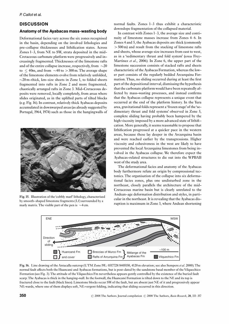
Deformational facies vary across the six zones recognisedin the basin, depending on the involved lithologies andpre-collapse thicknesses and lithi¢cation states. AcrossZones 1^3, from NE to SW, strata deposited in the mid-Cretaceous carbonate platformwere progressively and in-creasingly fragmented.Thicknesses of the limestone raftsand of the entire collapse increase, respectively, from �20to � 40m, and from �40 to4300m.The average shapeof the limestone elements evolve from relatively unfolded,�20m-thick, km-size sheets in Zone 1, to folded sheetsfragmented into rafts in Zone 2 and more fragmented,chaotically arranged rafts in Zone 3. Mid-Cretaceous de-posits were removed, locally completely, from areas whereslides originated, as in the uplifted parts of tilted blocks(e.g. Fig.16). In contrast, relatively thick Ayabacas depositsaccumulated in downwarped areas (as already suggested byPortugal, 1964, 1974) such as those in the hangingwalls of
normal faults. Zones 1^3 thus exhibit a characteristicdownslope fragmentation of the collapsed material.
In contrast with Zones 1^3, the average size and conti-nuity of limestone masses increase from Zones 4^6. InZones 4 and 5, the Ayabacas deposits are thick (commonly4500m) and result from the stacking of limestone raftsand sheets, whose average size increases from east to west,as in a ‘sedimentary thrust and fold system’ (sensu Frey-Mart|¤ nez et al., 2006). In Zone 6, the upper part of thelimestone succession consists of stacked rafts and sheetscharacteristic of the Ayabacas Formation, whereas the low-er part consists of the regularly bedded Arcurquina For-mation.Thus, no sliding occurred during at least the ¢rstpart of the depositional interval, dismissing the hypothesisthat the carbonate platformwould have been repeatedly af-fected by mass-wasting processes, and instead con¢rmsthat the Ayabacas collapse represents a unique event thatoccurred at the end of the platform history. In the Yuraarea, gravitational folds represent a ‘frozen stage’of the ‘se-dimentary thrust and fold systems’ observed in Zone 5,complete sliding having probably been hampered by thehigh viscosity imposed by a more advanced state of lithi¢ -cation.More generally, it seems reasonable to propose thatlithi¢cation progressed at a quicker pace in the westernareas, because these lay deeper in the Arcurquina basinand were reached earlier by the transgressions. Higherviscosity and cohesiveness in the west are likely to haveprevented the local Arcurquina limestones from being in-volved in the Ayabacas collapse. We therefore expect theAyabacas-related structures to die out into the WPBABwest of the study area.
The deformational facies and anatomy of the Ayabacasbody furthermore refute an origin by compressional tec-tonics.The organisation of the collapse into six deforma-tional facies zones, plus one undisturbed zone in thenortheast, closely parallels the architecture of the mid-Cretaceous marine basin but is clearly unrelated to theAndean-age deformation distribution and styles, in parti-cular in the northeast. It is revealing that the Ayabacas dis-ruption is maximum in Zone 3, where Andean shortening
Fig.15. Illustration of the ‘cobbly marl’ lithology, characterisedby smooth-shaped limestone fragments (Lf) surrounded by amarly matrix.The visible part of the pen is �4 cm.
ENE WSW
~100 mHuancané Fm
and cover} Breccias of Murco Fm
Rafts of Arcurquina Fm} Mélange of theAyabacas Fm Vilquechico Fm
Directionof
sliding
Fig.16. Line drawing of the Antacalla outcrop (UTM Zone19L: 0317728/8405150, 4120m elevation; see also Sempere et al. 2000).Thenormal fault a¡ects both the Huancane¤ and Ayabacas formations, but is post-dated by the sandstone basal member of theVilquechicoFormation (see Fig. 3).The attitude of theVilquechico Fm nevertheless appears gently controlled by the existence of the buried faultscarp.The Ayabacas is thick in the hanging-wall. In the footwall, the Huancane¤ Formation is tilted down to the NE and its top isfractured close to the fault (black lines). Limestone blocks occur SWof the fault, but are absent just NE of it and progressively appearNE-wards, where one of them displays soft, NE-vergent folding, indicating that sliding occurred in this direction.
r 2008 The Authors. Journal compilation r 2008 The Authors,Basin Research, 20, 333^357350
P. Callot et al.

wasweak or absent (Sempere & Jacay, 2006, 2007), whereasit is minimum in Zone 1 to non-existent in Zone 0, i.e.close to the Eastern Cordillera where Andean shorteningwas maximum.
What triggered the Ayabacas collapse?
Submarine slides are widely viewed to result from avarietyof short-term triggering mechanisms such as oversteepen-ing of the depositional surface, increase in pore pressure,seismic loading, storm-wave loading, rapid sediment ac-cumulation and under-consolidation, gas charging, gashydrate dissociation, low tides, seepage, diapirism, glacialloading and volcanic island processes (Locat & Lee, 2002;Mienert et al., 2002; Sultan et al., 2004). Factors such asslope angle, mass-movement history and unloading, maybe insu⁄cient to initiate failures but can favour them,and therefore constitute long-term, ‘slow’ triggers. Sea-level changes have also been proposed as a potentiallyfavourable factor for slope failure (Spence &Tucker, 1997).
Increase in pore pressure and di¡erences in lithi¢cationrate (Nichols, 1995; Spence & Tucker, 1997; Mourgues &Cobbold, 2003; Vendeville & Gaullier, 2003) were indeedlikely to be present at the time of the Ayabacas collapse,
and to have facilitated sliding, but they quite probably ex-isted also during the entire deposition of the Arcurquinalimestones andyet no sliding is recorded before theAyaba-cas event: therefore they cannot be invoked as a triggeringfactor for the collapse. At the end of the Early-MiddleAlbian transgression, sediment characteristics in thewestern part of the basin (Arequipa region)must have beensimilar to those that later preceded the Ayabacas collapsemore to the northeast: the water-laden Murco siltstonesand sandstones were underlying partly lithi¢ed Arcurqui-na limestones, probably generating some excess pore pres-sure, but, although this potential sliding sole was presentthroughout the deposition of the carbonate platform, slid-ing did not occur in any part of the basin until theAyabacasevent.
Absence of slides interstrati¢ed in the Arcurquina For-mation, where this unit is preserved (Zones 6 and 0), dis-misses relative sea-level fall or rise as triggering factorsbecause neither the Early Albian and Late Cenomaniantransgressions, nor the Late Albian regression, had anynoticeable e¡ect on the stability of the southern Peruviancarbonate platform.The Ayabacas event, however, appar-ently occurred during a marked global regression that wasabruptly initiated in the late Middle Turonian ( �91Ma)
H H
H H H
H H H H H
NE SW
NE SW
NE SW
A
B
H
1000 m
H
Arcurquina Fm
Murco Fm
Huancané Fm
Vilquechico Fm
Ayabacas Fm
Arcurquina Fm
Murco Fm
C
Huancané FmH Submarine sliding
Quat.
Antacalla fault (Fig. 16)Actual
Andean−age compression
Late Turonian extension => sliding
Late Cenomanian Turonian arcurquina limestone deposit
A' A
Fig.17. Present (C) and reconstructed (B, A) sections nearNun� oa (Zone1). (a) Deposition of the Arcurquina limestones during the LateCenomanian-Turonian tectonic quiescence. (b) Intense extensional tectonics at theTuronian-Coniacian transition ( �90^89Ma); thepre-Ayabacas substratum is shaped into tilted blocks by �NW-trending normal faults; theArcurquina andMurco formations collapseon the created, oversteepening slopes to form the Ayabacas Formation, which is very thin or absent in the origination areas of the slidesand very thick (up to4100 s of m) in the hanging-wall of the normal faults. (c) During the Andean-age shortening of the EasternCordillera, some normal faults undergo inversion; others, as the Antacalla fault (Fig.16), do not, making clear that the normal faultingand Ayabacas deformation are post-dated by theVilquechico Formation.
r 2008 The Authors. Journal compilation r 2008 The Authors,Basin Research, 20, 333^357 351
Cretaceous giant submarine collapse in southern Peru

and slowly terminated near the Turonian-Coniacianboundary ( �89Ma) (Hardenbol et al., 1998). However, atriggering role of this �91Ma sharp sea-level fall appearsunlikely because its age apparently disagrees with the am-monite record from northern Peru, which documents thatcarbonate sedimentation continued into theLateTuronian(Jaillard, 1990, 1994), and with our own chronostrati-graphic model (see above and supplementary documenta-tion online). Furthermore, the global sea-level wasdominantly high again during the Senonian, whereas theAyabacas collapse was immediately followed by nearlyexclusively continental sedimentation in the southernPeruvian basin.The collapse in fact coincided with other,non-eustatic, geological phenomena in southern Peru,an intriguing observation that should provide valuableinsights into this triggering mechanism.
Onemain clue lies in the striking association of theAya-bacas collapsewith extensional tectonic activity, as demon-strated by synsedimentary normal faults and relatedthickness variations. As documented in outcrops, normalfaulting produced tilting of the substratum as well asscarps, and thus created seismicity and slopes on whichsliding of the Arcurquina and earlier strata was enabled.The nearly constant thickness and standard internal stra-tigraphy of the limestone rafts and/or sheets within eachzone (as observed in Zones1^3, and therefore also inferredto be true in Zones 4^6) suggest that the bottom of the ba-sin had been remarkably £at before the Ayabacas collapse,con¢rming that slopes had to be created in order to makethe mass-wasting process possible. In the Late Albian^Early Cenomanian limestone succession of northern Peru,slumps, breccias, and large clastic dykes, likewise occur inassociationwith synsedimentary normal faulting (Jaillard,1994). Such associations between extensional tectonicsand sedimentary sliding in theWPBAB, at di¡erent times,strongly suggest that the triggering of mass wasting in thiscarbonate platform ensued from slope creation and seis-micity produced by extensional tectonic activity, and thatother factors, such as pore pressure increases or lithi¢ca-tion contrasts, only facilitated sliding.
The relationship between regional extensional tectonicactivity and the Ayabacas collapse is strengthened by theoccurrence of some peculiar features in the vicinity of thetwo major fault systems that cross the study area(SFUACC, CECLLA; Figs 1 and 2). During the Cenozoicand in particular the Central Andean orogeny, these twoancient fault systems have had signi¢cant tectonic activity,and have been the loci of considerable magma emplace-ment, revealing that they represent major crustal to litho-spheric heterogeneities (Sempere et al., 2002b, 2004b;Carlier et al., 2005, for the SFUACC). Although synsedi-mentary normal faults and related thickness variationswere observed inZones1and 3, thanks to outcrops provid-ing spectacular exposures, there is evidence that theSFUACC and CECLLAwere activated during the Ayaba-cas collapse.
The SFUACC had had some syndepositional activityduring the mid-Cretaceous carbonate sedimentation
(Arcurquina depositional interval) as it formed the north-eastern boundary of the depositional area during the EarlyandMiddle Albian transgression and highstand.This bar-rier was over£owed by the Late Cenomanian-Turoniantrangression and highstand, but subsidence and waterdepth apparently remained much lower northeast of theSFUACC.During the Ayabacas collapse, older rock units,down to the Paleozoic, were exposed along � 100m-high,southwest-facing scarps formed by the SFUACC activity;giant blocks of these lithi¢ed units were catastrophicallyremoved as these scarps collapsed and slid down to thesouthwest, and their fragments were transported away inthe same general direction.The occurrence of large blocksalong the northeast fringe of the SFUACC (Fig. 2) docu-ments that some of them underwent little transport andremained stuck in the slope. It is likely that the smallernormal faulting documented inZone1, i.e. a fewkm north-east of the SFUACC, developed in relation to major nor-mal faulting along the SFUACC. Occurrence of blocks ofPaleozoic shales southwest of this fault system (i.e. in itsdownwarped side) re£ects that the Paleozoic basementhad been locally uplifted in the Early Cretaceous, ratherthan implying that its cumulated vertical o¡set was4400m during the Ayabacas collapse, which seems unli-kely.Given the relative shortness of the event, even a100mthrow is by itself suggestive of a considerable tectonic up-heaval in the region.
Activity of the CECLLA system during the Ayabacascollapse is inferred from the sharp facies di¡erences be-tween Zones 3 and 4, which are respectively located eastof, and within, this broad fault system.Whereas in Zones1^3 the mass-wasting body abundantly involved redsiltstones derived from the Murco Formation, it onlyreworked Arcurquina limestones in Zones 4^6, where theMurco Formation was not involved in the collapse. Thiscontrast indicates that, from the CECLLA system to thewest, the Murco Formation was located below the sole ofthe collapse, whereas it lay well above it east of the CECL-LA. This geometry suggests that the domain within andwest of the CECLLAwas structurally downwarped whenthe collapse was initiated, and it is likely that this resultedfrom normal faulting along andwithin this broad fault sys-tem. Respective estimated thicknesses of the involvedunits suggest that vertical o¡sets within the CECLLAmust have beeno100m, as theydid not form scarpswherepre-Arcurquina units could be exposed (unlike what oc-curred along the SFUACC system), but su⁄cient enoughto downwarp the pre-Arcurquina units to a positionwherethey could be preserved from involvement into the col-lapse.This was possibly due to the broad, di¡use characterof the CECLLA structural system (Fig.1).
Facies zones distinguished in the Ayabacas Formationvary laterally in map view.The northern Cusco-Abancay-Chalhuanca transect is 120 km-long, clearly shorter thanthe 200 km-long southern Huancane¤ -Juliaca-SantaLuc|¤ a-Lagunillas-Yura transect (Fig. 2), a di¡erence thatcannot be explained by a higher Andean-age shorteningin the north but rather re£ects the di¡erent position of
r 2008 The Authors. Journal compilation r 2008 The Authors,Basin Research, 20, 333^357352
P. Callot et al.

these transects relative to the SFUACC and CECLLA.Furthermore, this asymmetry is matched by di¡erencesin the deformational facies of the Ayabacas collapse.Southern deposits are limestone-rich along a �100 km-long transect across Zones 1^3 and their matrix consistsexclusively of mudstones to siltstones. From there thewidth of the set formed by these three zones progressivelydecreases northwards, down to �30 km in the Cusco-Ur-ubamba area, which was mapped as a whole as Zone 1NWbecause facies typical of Zones 2 and 3 could not be recog-nised; here the Ayabacas Formation presents an atypicallimestone-poor facies, its abundant matrix includes volu-minous gypsum masses, but its limestone rafts exhibitpre-collapse stratigraphic thickness and facies similar tothose in Zone1SE.
This northern area is likely to have behaved in a particu-lar manner because the SFUACC coalesces with theCECLLA in this area (Figs 1 and 2), suggesting that morepronounced scarps and cumulated reliefwere created hereduring the event, enhancing the regional slope and signif-icantly favouring collapse of the local platform.Limestonerafts and sheets disintegrated downslope and were mas-sively transported toward the southwest, explaining thelimestone-poor facies observed in this area, which wouldhave resulted from a di¡erential transport of the denserlimestone blocks in this direction. The thick stacking ofexclusively limestone sheets observed in Zones 4^6 in thesame transect is in agreementwith this idea. Sliding wouldhave been furthermore facilitated by the abundance ofgypsum and halite in the Maras (5 Murco) Formation,which provided a weaker sole for the collapse.
The Ayabacas event of southern Peru correlates wellwith the also extensional Vilcapujio event inferred in cen-tral Bolivia (Sempere, 1994) on the basis of (1) rapid thick-ness variations limited to the Coniacian? Aroi¢llaFormation (interpreted to result from synsedimentarynormal faulting) and (2) local partial to total erosion of theBolivian equivalent of the Arcurquina Formation (whichotherwise testi¢es to a tectonically quiescent Cenoma-nian-Turonian period). Extensional tectonics thus appearto have abruptly developed near theTuronian-Coniaciantransition over a largeCentral Andean region, at least fromcentral Bolivia to southern Peru.The duration of this ex-tensional deformation is poorly constrained in Peru, butthe case of the Bolivian Aroi¢lla Formation suggests itpossibly lasted someMyr.
CONCLUSION
The mid-Cretaceous carbonate platform of southern Peruwas brutally disrupted and terminated by a giant collapseat about theTuronian-Coniacian transition (�90^89Ma).The resulting mass-wasting body was very large,480 000 km2 in map view and410 000 km3 in volume. Itnow forms the Ayabacas Formation, which is organisedinto six deformational zones from NE to SW. The ob-served directions of sliding and of material disintegration
are consistent and indicate that the platform regionallycollapsed toward the southwest, i.e. down the general slopeof the pre-Senonian basin. Consistently, most part of theshallow and little subsident sub-basin located northeastof the SFUACC system was not a¡ected by the collapseand remained stable.
The Ayabacas Formation unequivocally appears to bethe result of a major submarine mass redistribution, whichwas triggered by signi¢cant slope creation and subsequentoversteepening abruptly forced at that time by extensionaltectonic activity. The key role of tectonics in triggeringmass movement has often been underlined (e.g. Spence&Tucker,1997; Payros etal., 1999;Graziano, 2001;Mienertet al., 2002; Floquet & Hennuy, 2003; Canals et al., 2004).Seismicity may have been signi¢cant, in particular in thevicinity of the two major fault systems (SFUACC andCECLLA) where large lithi¢ed blocks from underlyingunitswere involved in the collapse. Increase in pore pressureand di¡erences in lithi¢cation rates facilitated the slidesbut cannot be considered as the main triggering factor.
The Ayabacas Formation records the only sedimentarycollapse that disrupted the mid-Cretaceous marine suc-cession of southern Peru. It thus represents a unique andpeculiar event in the history of the regional Andean mar-gin and back-arc. Although it is likely that the collapse re-sulted from several sliding episodes, the AyabacasFormation is neither intercalated with, nor post-dated by,limestone strata similar to those involved in it. The col-lapse was submarine and yet abruptly terminated the car-bonate platform evolution. It must therefore have takenplace during a limited time span, and can technically beconsidered as one event.
It seems highly meaningful that the Ayabacas event oc-curred at a turning point in the Central Andean evolution,namely when the south Peruvian back-arc basin underwenta dramatic and permanent change from marine to conti-nental conditions. Before the event, this basin had been es-sentially marine since the Early Jurassic and deepened tothe west. After the event, the back-arc was bounded to thesouthwest by topographic highs, apparently volcanic in nat-ure, and occupied by continental to near-continental envir-onments.This regional association of extraordinary events,including a signi¢cant reactivation of arc volcanism, is likelyto shed considerable light on the regionalAndean evolutionandwill be dealt with elsewhere.
ACKNOWLEDGEMENTS
This workwas funded by the Institut de Recherche pour leDe¤ veloppement (IRD), and the GDR ‘Marges’.We thankthe Instituto Geolo¤ gico Minero y Metalu¤ rgico de Peru(INGEMMET) for helpful collaboration and orientationinLima.We are especially grateful to the IRD o⁄ce in Peruand its director PierreSoler. Special thanks to Jose¤ Berrospifor invaluable help and e⁄ciency during ¢eld work, and toC.Le¤ zin andB.Andreu (LMTG,Toulouse) for fruitful dis-cussions. This paper was improved by constructive com-ments from Joe Cartwright and an anonymous reviewer.
r 2008 The Authors. Journal compilation r 2008 The Authors,Basin Research, 20, 333^357 353
Cretaceous giant submarine collapse in southern Peru

REFERENCES
Atherton,M.P. (1990) The coastal batholith of Peru: the pro-duct of rapid recycling of ‘‘new’’ crust formed within riftedcontinental margin.Geol. J., 25, 337^349.
Atherton, M.P. & Webb, S. (1989) Volcanic facies, structure,and geochemistry of the marginal basin rocks of central Peru.J. South Am. Earth Sci., 2, 241^261.
Atherton,M.P.&Aguirre,L. (1992) Thermal and geotectonicsetting of Cretaceous volcanic rocks near Ica, Peru, in relationto Andean crustal thinning. J. South Am. Earth Sci., 5, 47^69.
Audebaud,E. (1967) Etude ge¤ ologique de la re¤ gion de Sicuani etOcongate (Cordille' re Orientale du Sud Pe¤ ruvien). The' se de3e' me cycle, Universite¤ de Grenoble, 60 p.
Audebaud, E. (1970) Premie' res observations sur la tectoniquetangentielle polyphase¤ e des terrains secondaires de la Cordil-le' reOrientale duSud-Est pe¤ ruvien.C.R.Acad.Sci., Se¤ r.D, 270,3190^3193.
Audebaud, E. (1971a) Mise au point sur la stratigraphie et latectonique des calcaires Ce¤ nomaniens du Sud-Est pe¤ ruvien(formation Ayavacas).C. R. Acad. Sci., Se¤ r. D, 272, 1059^1062.
Audebaud, E. (1971b) Photoge¤ ologie de reconnaissance et di⁄ -culte¤ s d’interpre¤ tation dans une zone a' structure complexe(Cordille' re Orientale duSud duPe¤ rou : hameauHanchipacha,nord de Sicuani). Photo-interpre¤ tation, 5, fascicule 3, Technip,Paris, 15^21.
Audebaud, E., Capdevila, R.,Dalmayrac, B.,Debelmas, J.,Laubacher, G., Lefevre, C.,Marocco, R.,Martinez, C.,Mattauer,M.,Megard, F., Paredes, J. & Tomasi, P. (1973)Les traits ge¤ ologiques essentiels des Andes Centrales (Pe¤ rou-Bolivie).Rev. Ge¤ ograph. Phys. Ge¤ ol. Dynam., 15, 73^114.
Audebaud, E. &Debelmas, J. (1971) Tectonique polyphase¤ e etmorphotectonique des terrains Cre¤ tace¤ s dans la Cordille' re Or-ientale du Sud pe¤ ruvien. Etude d’une structure caracte¤ ris-tique.Cahiers ORSTOM, Se¤ r. Ge¤ ol., 3, 59^66.
Audebaud, E. & Laubacher, G. (1969) Pre¤ sence du Tertiaireplisse¤ (groupe Puno) dans la Cordille' re Orientale du sud duPe¤ rou.C. R. Acad. Sci., Se¤ r. D, 269, 2301^2304.
Bathurst,R.G.C. (1971)Carbonate sediments and their diagen-esis. Developments in Sedimentology, 12. Elsevier, Amsterdam,620 p.
Benavides-Ca¤ ceres,V. (1962) Estratigraf|¤ a pre-Terciaria de laregio¤ n de Arequipa.Bol. Soc. Geol. Peru¤ , 38, 5^45.
Bond,R.M.G.&McClay,K.R. (1995) Inversion of aLowerCre-taceous extensional basin, south central Pyrenees, Spain. In:Basin Inversion (Ed. by J.G. Buchanan & P.G. Buchanan), Spec.Pfubl. Geol. Soc. London, 88, 415^431.
Brun, J.-P. & Fort, X. (2004) Compressional salt tectonics(Angolan margin).Tectonophysics, 382, 129^150.
Bryant,W.R.,Deflacke, A.P. &Trabant, P.K. (1974) Conso-lidation of marine clays and carbonates. In:DeepSeaSediments;Physical and Mechanical Properties; Determination of MechanicalProperties inMarineSediments (Marine Science, 2, 209^244. Ple-num, NewYork.
Cabrera La Rosa, A. & Petersen, G. (1936) Reconocimientogeolo¤ gico de los Yacimientos Petrol|¤ feros del Departamentode Puno.Bol. Cuerpo Ingenieros deMinas del Peru¤ , 115, 100 p.
Callot, P., Sempere,T.,Odonne, F. &Robert, E. (2007) TheMid-Cretaceous carbonate platform of southern Perucollapsed at theTuronian-Coniacian transition. 4th EuropeanMeeting on the Palaeontology and Stratigraphy of LatinAmerica (EMPSLA). Cuadernos del Museo Geominero,Instituto Geolo¤ gico yMinero de Espan� a, Madrid, 8, 75^80.
Canals, M., Lastras, G., Urgeles, R., Casamor, J.L., Mie-
nert, J., Cattaneo, A., De Batist, M., Haflidason, H.,Imbo, Y., Laberg, J.S., Locat, J., Long, D., Longva, O.,Masson,D.G., Sultan,N.,Trincardi, F. & Bryn, P. (2004)Slope failure dynamics and impacts from sea£oor and shallowsub-sea£oor geophysical data: case studies from the COSTAproject.Mar. Geol., 213, 9^72.
Carlier,G.,Lorand, J.P.,Lie¤ geois, J.P.,Fornari,M.,Soler,P.,Carlotto,V.&Ca¤ rdenas, J. (2005) Potassic-ultrapotassicma¢c rocks delineate two lithospheric mantle blocks beneaththe southern Peruvian Altiplano.Geology, 33, 601^604.
Carlotto,V. (2002) Evolution andine et raccourcissement au ni-veau de Cusco (13^161S) Pe¤ rou.The' se de Doctorat Universite¤Joseph Fourier, Grenoble. Ge¤ ologie Alpine, Me¤ moire Hors Se¤ rie,39, 203 p.
Carlotto, V., Gil, W., Ca¤ rdenas, J. & Cha¤ vez, R. (1996)Geolog|¤ a de los cuadra¤ ngulos de Urubamba y Calca hojas 27-ry 27-s. Bolet|¤ n INGEMMET, 65, serie A, Carta Geolo¤ gicaNacional, 245 p.
Carlotto,V., Jaillard, E. &Mascle,G. (1992) Relacio¤ n entresedimentacio¤ n, paleogeograf|¤ a y tecto¤ nica en la regio¤ n deCus-co (Sur del Peru¤ ) entre el Jura¤ sico Superior-Paleoceno.Bol. Soc.Geol. Peru¤ , 83, 1^20.
Chanove, G., Mattauer, M. & Me¤ gard, F. (1969) Pre¤ cisionssur la tectonique tangentielle des terrains secondaires du mas-sif de Pirin (Nord-Ouest du lac Titicaca, Pe¤ rou). C. R. Acad.Sci., Se¤ r. D, 268, 1698^1701.
Collot, J.,Lewis,K.,Lamarche,G.&Lallemand,S. (2001)The giantRuatoria debris avalanche on the northernHikuran-gi margin, New Zealand: result of oblique seamount subduc-tion. J. Geophys. Res. (B9), 106, 19271^19298.
Cosgrove, J.W. (1995) The expression of hydraulic fracturing inrocks and sediments. In: Fractography: Fracture Topography as aTool in Fracture Mechanics and Stress Analysis (Ed. by M.S. Am-een), Spec. Publ. Geol. Soc. London, 92, 187^196.
Cruz,M. (2002) Estratigraf|¤ a y evolucio¤ n tectono-sedimentariade los depo¤ sitos sin-oroge¤ nicos del cuadra¤ ngulo de Huambo:Las formaciones Ashua yHuanca, departamento de Arequipa.Tesis de la Universidad Nacional San Agust|¤ n de Arequipa,127 p.
De Jong,K.A. (1974) Melange (Olistostrome) near LagoTitica-ca, Peru.AAPGBull., 58, 729^741.
Demercian,S.,Szatmari,P.&Cobbold,P.R. (1993) Style andpattern of salt diapirs due to thin-skinned gravitational glid-ing, Campos and Santos basins, o¡shore Brazil.Tectonophysics,228, 393^433.
Ellison, R.A., Klinck, B.A. & Hawkins, M.P. (1989) Defor-mation events in Andean orogenic cycle in the Altiplano andWestern Cordillera, southern Peru. J. South Am Earth Sci., 2,263^276.
Floquet, M. & Hennuy, J. (2003) Evolutionary gravity £owdeposits in the MiddleTuronian ^ Early Coniacian southernProvence Basin (SE France): origins and depositional pro-cesses. In: Submarine Mass Movements and their Consequences(Ed. by J. Locat & J. Mienert), pp. 417^424. Kluwer AcademicPublishers, Dordrecht (the Netherlands).
Frey-Mart|¤nez, J.,Cartwright, J.&Hall, b. (2005) 3D seis-mic interpretation of slump complexes: examples from thecontinental margin of Israel.Basin Res., 17, 83^108.
Frey-Mart|¤nez, J., Cartwright, J. & James, D. (2006)Frontally con¢ned versus frontally emergent submarine land-slides: a 3D seismic characterisation. Mar. Petrol. Geol., 23,585^604.
r 2008 The Authors. Journal compilation r 2008 The Authors,Basin Research, 20, 333^357354
P. Callot et al.
Gee,M.J.R.,Masson, D.G,Watts, A.B. & Allen, P.A. (1999)TheSaharan debris £ow: an insight into the mechanics of longrunout submarine debris £ows. Sedimentology, 46, 317^335.
Gradmann, S.,Hˇbscher, C., Ben-Avraham, Z.,Gajewski,D. &Netzeband,G. (2005) Salt tectonics o¡ northern Israel.Mar. Petrol. Geol., 22, 597^611.
Graf, A.A. (2002) Le Ce¤ nomanien supe¤ rieur en Bolivie: Etudese¤ dimentologique et stratigraphique de la Formation Ma-tilde-Mira£ores. Travail de diplo“ me, Universite¤ de Fribourg,Suisse.
Graf, A.A., Strasser, A. & Caron, M. (2003) OAE-2 equiva-lent (Upper Cenomanian) recorded in Bolivian shallow-watersediments. Abstract11th Swiss Sed.Meeting, Fribourg, 39^40.
Graziano, R. (2001) The Cretaceous megabreccias of the Gar-gano Promontory (Apulia, southern Italy): their stratigraphicand genetic meaning in the evolutionary framework of theApulia Carbonate Platform.TerraNova, 13, 110^116.
Green, A. & Wernicke, B. (1986) Possible large-magnitudeNeogene extension on the southernPeruvianAltiplano: impli-cations for the dynamics of mountain building.EosTrans.AGU,67(44), Jt. Assem. Suppl., Abstract T52C-02.
Haflidason, H., Lien, R., Sejrup, H.P., Forsberg, C.F. &Bryn, P. (2005) The dating and morphometry of the StoreggaSlide.Mar. Petrol. Geol., 22, 123^136.
Haflidason,H.,Sejrup,H.P.,Nyg�rd,A.,Mienert, J.,Bryn,P., Lien, R., Forsberg, C.F., Berg,K. &Masson,D. (2004)The Storegga Slide: architecture, geometry and slide-devel-opment.Mar. Geol., 213, 201^234.
Hardenbol, J., Thierry, J., Farley, M.B., Jacquin, T., De
Graciansky, P.-C. & Vail, P.R. (1998) Mesozoic and Ceno-zoic sequence chronostratigraphic framework of European ba-sins, chart 1. In: Mesozoic and Cenozoic Sequence Stratigraphy ofEuropean Basins (Ed. by P.-C. de Graciansky, J. Hardenbol, T.Jacquin & P.R.Vail), SEPMSpec. Publ., 60, 363^364.
Heim, A. (1947) Estudios tecto¤ nicos en la regio¤ n del campo pet-rol|¤ fero de Pir|¤ n, ladoNWdel LagoTiticaca. Bolet|¤ n O¢cial delaDireccio¤ n deMinas yPetro¤ leo (Ministerio deFomento),An� oXXVI, 79, 47 p.
Huvenne,V.A.I.,Croker,P.F.&Henriet, J.P. (2002)A refresh-ing 3Dview of an ancient collapse and slope failure.TerraNova,14, 33^40.
Jaillard, E. (1990) Evolucio¤ n de la margen andina en el nortedel Peru¤ desde el Aptiano superior hasta el Senoniano. Bol.Soc. Geol. Peru¤ , 81, 3^13.
Jaillard, E. (1994) Kimmeridgian to Paleocene tectonic andgeodynamic evolution of the Peruvian (and Ecuadorian) mar-gin. In: Cretaceous Tectonics of the Andes (Ed. by J.A. Sal¢ty), pp.101^167. Earth Evolution Sciences Monograph Series,ViewegPublications,Wiesbaden.
Jaillard, E. (1995) La sedimentacio¤ n Albiana Turoniana en elSur del Peru¤ (Arequipa^Puno^Putina). Soc. Geol. Peru¤ , Vol.Jubilar Alberto Benavides, 135^157.
Jaillard, E. &Arnaud-Vanneau,A. (1993) The Cenomanian^Turonian transition on the Peruvian margin.Cretaceous Res., 14,585^605.
Jaillard, E., Cappetta, H., Ellenberger, P., Feist, M.,Grambast-Fessard, N., Lefranc, J.-P. & Sige, B. (1993)The Late Cretaceous Vilquechico Group of southern Peru.Sedimentology, paleontology, biostratigraphy, correlations.Cretaceous Res., 14, 623^661.
Jaillard,E.&Sempere,T. (1991) Las secuencias sedimentariasde la Formacio¤ n Mira£ores y su signi¢cado cronoestratigra¤ ¢ -co.Rev.Te¤ cn.YPFB, 12, 257^264.
Jaillard,E.,Sempere,T.,Soler,P.,Carlier,G.&Marocco,R. (1995) The role of Tethys in the evolution of the northernAndes between Late Permian and Late Eocene times. In:TheOcean Basins and Margins, Volume 8: The Tethys Ocean (Ed. byA.E.M. Nairn, L.-E. Ricou, B. Vrielynck & J. Dercourt), pp.463^492. Plenum Press, NewYork.
Kalafatovich, V. (1957) Edad de las calizas de la Formacio¤ nYuncaypata, Cuzco.Bol. Soc. Geol. Peru¤ , 32, 127^139.
Klinck, B.A., Ellison, R.A. & Hawkins, M.P. (1986) Thegeology of the Cordillera Occidental and Altiplano west ofLake Titicaca, southern Peru. Preliminary report, INGEM-MET, Lima, Peru, 353 p.
Lajoie, J. (1972) Slump fold axis orientations: an indication ofpaleoslope? J. Sedimen. Petrol., 42, 584^586.
Laubacher,G. (1978) Ge¤ ologie des Andes pe¤ ruviennes: Ge¤ olo-gie de la Cordille' re Orientale et de l’Altiplano au nord etnord-ouest du lacTiticaca (Pe¤ rou). Travaux et Documents del’ORSTOM, 95, 219 p.
Lewis, K.B. (1971) Slumping on a continental slope inclined at1^41. Sedimentology, 16, 97^110.
Locat, J.&Lee,H.J. (2002) Submarine landslides: advances andchallenges.Can. Geotech. J., 39, 193^212.
Lucente, C.C. & Pini,G.A. (2003) Anatomy and emplacementmechanism of a large submarine slide within a Miocene fore-deep in theNorthern Apennines, Italy: a ¢eld perspective.Am.J. Sci., 303, 565^602.
Martinsen, O.J. (1989) Styles of soft- sediment deformation onaNamurian (Carboniferous) delta slope, western IrishNamur-ian Basin, Ireland. In: Deltas: Sites and Traps for Fossil Fuels(Ed. by M.K.G.Whateley & K.T. Pickering), Spec. Publ. Geol.Soc. London, 41, 167^177.
Martinsen, O.J. & Bakken, B. (1990) Extensional and com-pressional zones in slumps and slides in the Namurian ofCounty Clare, Ireland. J. Geol. Soc. London, 147, 153^164.
Mienert, J., Berndt, C., Laberg, J.S. & Vorren,T.O. (2002)Slope Instability of Continental Margins. In: Ocean MarginSystems (Ed. byG.Wefer, D. Billet, D.Hebbeln, B.B. J�rgensen,M. Schlˇter & T. van Veering), pp. 179^193. SpringerVerlag,Berlin.
Moore,A. (1993)Neogene crustal extension in the southernPer-uvian Altiplano: Implications for the dynamics of mountainbuilding.Unpublished PhDThesis, HarvardUniversity, 279 p.
Mourgues, R. & Cobbold, P.R. (2003) Some tectonic conse-quences of £uid overpressures and seepage forces as demon-strated by sandbox modelling.Tectonophysics, 376, 75^97.
Mˇller,G. (1967) Diagenesis in argillaceous sediments. In:Di-agenesis in Sediments (Ed. by G. Larsen &G.V. Chilingar),Devel-opments in Sedimentology, 8, 127^177. Elsevier, Amsterdam.
Myers, J.S. (1974) Cretaceous stratigraphy and structure, wes-tern Andes of Peru between latitudes 101 and 101300S. Am. As-soc. Petrol. Geol. Bull., 58, 474^487.
Newell,N.D. (1949) Geology of the LakeTiticaca region, Peruand Bolivia.Geol. Soc. Am.Memoir, 36, 111p.
Nichols, R.J. (1995) The liqui¢cation and remobilization ofsandy sediments. In:Characterization ofDeepMarineClastic Sys-tems (Ed. by A.J. Hartley & D.J. Prosser), Spec. Publ. Geol. Soc.London, 94, 63^76.
Payros, A., Pujalte, V. & Orue-Etxebarria, X. (1999) TheSouth Pyrenean Eocene carbonate megabreccias revisited:new interpretation based on evidence from the Pamplona Ba-sin. Sediment. Geol., 125, 165^194.
Pino,A.,Sempere,T., Jacay, J.&Fornari,M. (2004)Estratigra-f|¤ a, paleograf|¤ a y paleotecto¤ nica del intervalo Paleozoico
r 2008 The Authors. Journal compilation r 2008 The Authors,Basin Research, 20, 333^357 355
Cretaceous giant submarine collapse in southern Peru

Superior ^ Creta¤ ceo inferior en el a¤ rea de Mal Paso ^ Palca(Tacna). Publ. Especial Soc. Geol. Peru¤ , 5, 15^44.
Popenoe, P., Schmuck, E.A. &Dillon,W.P. (1993) The CapeFear Landslide; slope failure associated with salt diapirismand gas hydrate decomposition. In: Submarine Landslides; Se-lected Studies in the U.S. Exclusive Economic Zone (Ed. by W.C.Schwab, H.J. Lee & D.C.Twichell), pp. 40^53. U.S. GeologicalSurvey Bulletin.
Portugal, J. (1964) Geology of the Puno-Santa Lucia area, De-partment of Puno, Peru. Unpublished PhDThesis, Universityof Cincinnati, 141p.
Portugal, J. (1974) Mesozoic and Cenozoic stratigraphy andtectonic events of Puno-Santa Lucia area, Department ofPuno, Peru.AAPGBull., 58, 982^999.
Rassmuss, J.E. (1935) Informe sobre la regio¤ n petrol|¤ fera dePuno. Bol. Dir. Minas y Petro¤ leo Ministerio Fomento del Peru¤ , an� o15, 45, 85^105.
Sempere,T. (1994) Kimmeridgian? to Paleocene tectonic evolu-tion of Bolivia. In: Cretaceous Tectonics in the Andes (Ed. by J.A.Sal¢ty), pp.168^212 EarthEvolution SciencesMonograph Ser-ies,Vieweg Publications,Wiesbaden.
Sempere,T. (1995) Phanerozoic evolution ofBolivia and adjacentregions. In: Petroleum Basins of South America (Ed. by A.J. Tan-kard,R. Sua¤ rez &H.J.Welsink),AmericanAssociation of PetroleumGeologists Memoir 62, 207^230.
Sempere,T., Acosta, H. & Carlotto,V. (2004a) Estratigraf|¤ adel Mesozoico y Paleo¤ geno al Norte del Lago Titicaca. Publ.Especial Soc. Geol. Peru¤ , 5, 81^103.
Sempere,T., Carlier,G., Soler, P., Fornari,M., Carlotto,V., Jacay, J., Arispe, O., Ne¤ raudeau, D., Cardenas, J., Ro-sas, S. & Jime¤ nez, N. (2002a) Late permian^middle Jurassiclithospheric thinning in Peru and Bolivia, and its bearing onAndean-age tectonics.Tectonophysics, 345, 153^181.
Sempere,T. & Jacay, J. (2006) Estructura tecto¤ nica del sur delPeru¤ (antearco, arco, y Altiplano suroccidental). Extended ab-stract,XIIICongreso Peruano de Geolog|¤ a, Lima, 324^327.
Sempere,T.& Jacay, J. (2007) Synorogenic extensional tectonicsin the forearc, arc and southwest Altiplano of southern Peru.EosTrans. AGU, 88 (23), Jt. Assem. Suppl., Abstract U51B-04.
Sempere,T., Jacay, J., Carrillo,M.-A.,Go¤ mez, P., Odonne,F. & Biraben,V. (2000) Caracter|¤ sticas y ge¤ nesis de la Forma-cio¤ n Ayabacas (Departamentos de Puno y Cusco). Bol. Soc.Geol. Peru¤ , 90, 69^76.
Sempere,T., Jacay, J.,Carlotto,V.,Mart|¤nez,W.,Bedoya,C.,Fornari, M., Roperch, P., Acosta, H., Acosta, J., Cerpa,L.,Flores,A., Ibarra, I.,Latorre,O.,Mamani,M.,Meza,P., Odonne, F., Oro¤ s,Y., Pino, A. & Rodr|¤ guez, R. (2004b)Sistemas transcurrentes de escala litosfe¤ rica en el Sur del Peru¤ .Publ. Especial Soc. Geol. Peru¤ , 5, 105^110.
Sempere,T., Jacay, J., Fornari,M., Roperch, P., Acosta, H.,Bedoya, C., Cerpa, L., Flores, A., Husson, L., Ibarra, I.,Latorre,O.,Mamani,M.,Meza, P.,Odonne, F.,Oros,Y.,Pino, A. & Rodr|¤ guez, R. (2002b) Lithospheric- scale trans-current fault systems in Andean southern Peru. Extended ab-stract, V International Symposium on Andean Geodynamics,Toulouse, 601^604.
Sempere,T., Jacay, J., Pino, A., Bertrand, H., Carlotto,V.,Fornari, M., Garc|¤ a, R., Jime¤ nez, M., Marzoli, A.,Meyer, C.A., Rosas, S. & Soler, P. (2004c) Estiramiento li-tosfe¤ rico del Paleozoico Superior al Creta¤ ceoMedio en el Peru¤y Bolivia. Publ. Especial Soc. Geol. Peru¤ , 5, 45^79.
Sige¤ , B., Sempere,T., Butler, R.F.,Marshall, L.G. & Cro-
chet, J.-Y. (2004) Age and stratigraphic reassessment of thefossil-bearing Laguna Umayo red mudstone unit, SE Peru,from regional stratigraphy, fossil record, and paleomagnetism.Geobios, 37, 771^794.
Spathopoulos, F. (1996) An insight on salt tectonics in the An-gola Basin, South Atlantic. In: Salt Tectonics (Ed. by G.I. Aslop,D.J. Blundell & I. Davison), Spec. Publ. Geol. Soc. London, 92,187^196.
Spence, G.H. & Tucker, M.E. (1997) Genesis of limestonemegabreccias and their signi¢cance in carbonate sequencestratigraphic models: a review. Sediment. Geol., 112, 163^193.
Sp˛rli, K.B. & Rowland, J.V. (2007) Superposed deformationin turbidites and syn-sedimentary slides of the tectonically ac-tive Miocene Waitemata Basin, northern New Zealand. BasinRes., 19, 199^216.
Steen,�. & Andresen, A. (1997) Deformational structures as-sociated with gravitational block gliding: examples from sedi-mentary olistoliths in the Kalv�g Melange, western Norway.Am. J. Sci., 297, 56^97.
Strachan, J.L. & Alsop,G.I. (2006) Slump folds as estimatorsof palaeoslope: a case study from the Fisherstreet Slump ofCounty Clare, Ireland.Basin Res., 18, 451^470.
Sultan,N., Cochonat, P., Canals,M., Cattaneo, A.,Den-
nielou, B., Haflidason, H., Laberg, J.S., Long, D.,Mie-
nert, J., Trincardi, F., Urgeles, R., Vorren, T.O. &Wilson,C. (2004) Triggering mechanisms of slope instabilityprocesses and sediment failures on continental margins: ageotechnical approach.Marine Geol., 213, 29^321.
Varnes, D.J. (1978) Slope movement types and processes. In:Landslides-Analysis and Control. Special Report (Ed. by R.L.Shuster & R.J. Krizek). 176 (pp. 11^33. National Academy ofSciences,Washington.
Vendeville,B.&Cobbold,P.R. (1987)Glissements gravitairessynse¤ dimentaires et failles normales listriques: mode' les ex-pe¤ rimentaux.C. R.Acad. Sci., Se¤ r. II, 305, 1313^1319.
Vendeville, B. & Gaullier,V. (2003) Role of pore- £uid pres-sure and slope angle in triggering submarine mass move-ments: natural examples and pilot experimental models. In:Submarine Mass Movements and their Consequences (Ed. by J. Lo-cat & J. Mienert), pp. 137^144. Kluwer Academic Publishers,Dordrecht (the Netherlands).
Vernhet, E.,Heubeck,C., Zhu,M.-Y. & Zhang, J.-M. (2006)Large-scale slope instability at the southern margin of theEdiacaran Yangtze platform (Hunan province, central China).Precambrian Res., 148, 32^44.
Vorren,T.O. & Laberg, J.S. (2001) Late Quaternary sedimen-tary processes and environment on theNorwegian-GreenlandSea continental margins. In: Sedimentary Environments O¡shoreNorway ^ Palaeozoic to Recent (Ed. by O.J. Martinsen & T.Dreyer), pp. 451^456. Elsevier, Amsterdam.
Woodcock,N.H. (1979) The use of slump structures as paleo-slope orientation estimators. Sedimentology, 26, 83^99.
Wynn, R.B.,Masson,D.G., Stow,D.A. &Weaver, P.P. (2000)The Northwest African slope apron: a modern analogue fordeep-water systems with complex sea £oor topography. Mar.Petrol. Geol., 17, 253^265.
Manuscript received 10 July 2007; Manuscript accepted 10March 08.
r 2008 The Authors. Journal compilation r 2008 The Authors,Basin Research, 20, 333^357356
P. Callot et al.

Supplementary material
The following supplementary material is available for thisarticle:
Table S1.Table of abbreviations used in the paper.Appendix S1.Detailed documentation about the stra-
tigraphy of southern Peru and the data and discussion re-lative to the age of the Ayabacas collapse.
This material is available as part of the online articlefrom: http://www.blackwell-synergy.com/doi/abs/10.1111/j.1365-2117.2008.00358.x
(This linkwill take you to the article abstract).Please note:BlackwellPublishing are not responsible for the
content or functionality of any supplementary materials sup-plied by the authors.Anyqueries (other thanmissingmaterial)should be directed to the corresponding author for the article.
r 2008 The Authors. Journal compilation r 2008 The Authors,Basin Research, 20, 333^357 357
Cretaceous giant submarine collapse in southern Peru