
Legge regionale Puglia n. 7 del 2015 e caos postelettorale: chi è causa del suo mal pianga sé stesso

The 2002 Molise, Italy, Earthquake:Geological and Geomorphological Dataon the San Giuliano di Puglia Area
Emilio Casciello,a) Massimo Cesarano,a) Giuseppe Naso,b)
Gerardo Pappone,a) and Carmen Rosskopfa)
The small village of San Giuliano di Puglia sustained the most severedamage from the Molise earthquake sequence of 2002. This study involveddetailed geological and geomorphological mapping and is supported by alarge set of geotechnical, geophysical and drill-hole data available from ex-isting studies. These data were used to compile a seismic microzonation mapof the San Giuliano di Puglia area as part of a study officially commissionedby the Department of Civil Protection. The map provides seismic hazard in-formation that will be useful in the repair and reconstruction of the town.[DOI: 10.1193/1.1765105]
INTRODUCTION
After the October 31 and November 1, 2002 earthquakes (Mw 5.7), a detailed mul-tidisciplinary study was commissioned by the Department of Civil Protection to compilea seismic microzonation map of the San Giuliano di Puglia area. This paper discussesthe geological and geomorphological data that were used to define the geological modelon which geophysical and engineering analyses were tested. The resulting microzonationmap represents a primary tool that will be used to identify areas subject to ground mo-tion amplification and the possible coseismic effects, and thereby to support the recon-struction of the damaged areas.
REGIONAL GEOLOGICAL FRAMEWORK
The Southern Apennines are a fold and thrust belt generated by progressive north-eastward stacking of passive margin sediments, mainly during the Cenozoic (Lonerganand White 1997; Patacca et al. 1990). The foreland of this orogenic system is repre-sented by the Puglia and Gargano areas, where the Apulian carbonate platform depositsare exposed (Figure 1). These consist of a succession of Mesozoic carbonate deposits ofshallow water and scarp facies attaining a thickness in the range of 6 to 8 km (Mostar-dini and Merlini 1986). Toward the west/south-west the outcropping foreland flexes be-low the Apennine chain where it is involved in the deformation and forms the deeperstructural elements of the Apennine chain (Figure 2).
Thrusting in the Southern Apennines occurred predominantly during the MiddleMiocene-Middle Pliocene time span; in the northeastern part of the Molise region this
a) Dipartimento S.T.A.T., Universita degli Studi del Molise, Via Mazzini 8, 86170 Isernia, Italyb) Department of Civil Protection, National Seismic Survey, via Curtatone, 3, 00185 Roma, Italy
S53Earthquake Spectra, Volume 20, No. S1, pages S53–S64, July 2004; © 2004, Earthquake Engineering Research Institute

S54 E. CASCIELLO, M. CESARANO, G. NASO, G. PAPPONE, AND C. ROSSKOPF
led to the stacking, on the flexed Apulian foreland, of a number of rootless thrust sheetscomposed by Late Cretaceous to Miocene basinal and terrigenous deposits (MoliseUnits auct.; Patacca et al. 1992). The tectonic structures recognized in the S. Giuliano diPuglia area and described in this paper pertain to this last described shortening processand to minor extensional and transtensional deformation, which from Middle Pleis-tocene affected the region (Doglioni 1994). The source area for the October-November
Figure 1. Geological sketch of the Southern Apennines with the location of the study area andthe trace of the geological section in Figure 2.

THE 2002 MOLISE, ITALY, EARTHQUAKE: GEOLOGICAL AND GEOMORPHOLOGICAL DATA S55
seismic sequence has been located at a depth ranging between 15 and 20 km. The seis-mogenic source can be traced to a deep and subvertical structure, trending approxi-mately E-W, with a right lateral focal mechanism (Figure 2; Galli and Molin 2004, thisissue). This seismogenic source falls well below the sedimentary cover of the Apulianmicroplate, and below the deepest structural levels related to the Apennine orogenesis.
STRATIGRAPHIC DATA
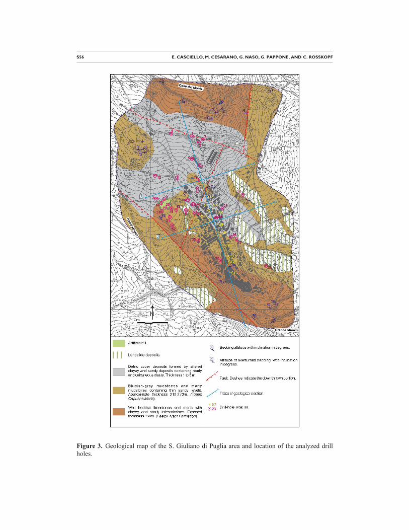
The area investigated is centered on the village of San Giuliano di Puglia. It is boundon the north by the Colle del Monte relief, on the south by the Grande stream, and on thewest and east by the Ranci and Vailato streams, respectively (Figure 3). Two main lithos-tratigraphic units characterize the substratum of this area, on which rest debris, landslidematerial, and accumulations of artificial fill.
CALCAREOUS-MARLY UNIT
This is the oldest lithostratigraphic unit in the study area. It is formed by a well-bedded succession of light-colored limestones and marly limestones, forming beds 2 to30 cm thick, with intercalations of greenish, beige or reddish marls and clayey marlsranging in thickness from 1 to 10 cm. Limestones beds are formed by calcarenite, oftenshowing parallel layers or undulated lamination and convolutions, and/or rudstones con-taining pelecypod and bryozoa fragments. Vertical burrows filled by greenish marlysediments are also frequent.
The thickness of this succession is 300 to 350 m in the analyzed area. However, asthe base of the succession is not exposed, this is an underestimated value. Thiscalcareous-marly succession can be interpreted as the Miocene Faeto Flysch formation
Figure 2. Schematic geological section of the external portions of the Apennine chain in theMolise region. Also shown is the approximate and projected location of the 31 October 2002seismic source.
S56 E. CASCIELLO, M. CESARANO, G. NASO, G. PAPPONE, AND C. ROSSKOPF
Figure 3. Geological map of the S. Giuliano di Puglia area and location of the analyzed drillholes.
THE 2002 MOLISE, ITALY, EARTHQUAKE: GEOLOGICAL AND GEOMORPHOLOGICAL DATA S57
(Crostella and Vezzani 1964), which crops out extensively in this portion of the SouthernApennines. In the analyzed area this formation forms the northernmost part of Colle delMonte (north of the village) and is present in the NW-SE elongated ridge on which theold part of the village is built.
CLAYEY–MARLY UNIT
The Faeto Flysch formation is stratigraphically overlain by about 200 meters ofbluish-gray mudstones and marly mudstones containing orbulinid microfossils. Sandylevels a few millimeters to a decimeter thick form irregular intercalations in the mud-stone succession and facilitate the recognition of bedding. Locally, intercalations can becomposed by light-colored calcarenite or marls forming beds up to a decimeter thick;less frequently such intercalations are composed of brownish sandstones. Sandstone lev-els appear to be particularly localized at the base of the clayey-marly succession, imme-diately overlying limestones of the Faeto Flysch formation. This succession can be in-terpreted as part of the Miocene formation known as Toppo Capuana Marls (Crostellaand Vezzani 1964) and crops out along a NW-SE oriented belt in the central part of thestudied area.
SURFICIAL COVER DEPOSITS
Detritic cover deposits are widespread in the north central portion of the analyzedarea. They are represented by a surficial layer varying in thickness from a few decime-ters to few meters (locally up to 5 m) and composed of a dark, clayey-marly matrix con-taining a variable amount of heterogeneous angular-subangular clasts of a calcareous,marly and, subordinately, arenaceous nature. Accumulations of landslide deposits arepresent primarily where the clayey-marly unit is exposed and are representative of slideand/or flow phenomena (see the geomorphology discussion below). Artificial fill ispresent in the relatively newer portions of the village and forms the terrace on which thesports center is built.
TECTONICS
The lithostratigraphic units making up the substratum in the area display two gen-erations of folds characterized by almost orthogonal axial trends (Figures 4 and 5). Themost evident and widespread set is represented by NW-SE trending folds, which showan asymmetry towards the NE. One such fold is well-exposed in the southernmost endof the ridge on which the old part of the village is built, where it displays a N 130E/10axis and a N 220E/25 axial plane. The vertical strata of this anticline fold, which tendsto overturn towards the northeast, can be traced northwestward up to the sports centerand produces the almost rectilinear boundary between the limestone-marly unit and theoverlying clayey-marly unit. The larger-scale fold structure, made apparent from the dis-tribution of bedding attitude data, consists of a northeastward asymmetric synformstructure, characterized by a slightly plunging axis (107 to the southeast), which extendsfrom the area of the cemetery to the old part of the village. Geological sections in Fig-ures 4 and 5 show the shape of this synform structure.

S58 E. CASCIELLO, M. CESARANO, G. NASO, G. PAPPONE, AND C. ROSSKOPF
The second and less apparent set of folds is represented by mesoscale structures dis-playing subhorizontal axial planes and an average axis orientation trending N 70E/15.The main fold structure is displaced by sub-vertical faults oriented from N-S to NW-SEand characterized by a prevalently extensional movement (Figures 3, 4, 5). Such faultsare responsible for the juxtaposition of the Toppo Capuana clayey-marly unit with theFaeto Flysch calcareous-marly unit along the southwestern limb of the main synclinestructure and in the northern part of the Ranci stream.
The recognized fold structures represent deformations inherited from the Late Mi-ocene to Early-Middle Pliocene contractional tectonics, which have subsequently re-corded limited extension in approximately SW-NE and WNW-ESE directions. Accord-ing to surveys in the analyzed area, none of the described faults bear signs of activationand/or reactivation.
GEOMORPHOLOGY
A geomorphological study, based on field surveys and indirect analyses, was carriedout with the aim of defining the slope instabilities present in the area and recording thesurface effects of the earthquake. Field surveys were carried out immediately after theseismic event in the area located between the village and the Ranci stream, and contin-ued from January to April 2003 in the whole study area.
Indirect analyses were based on aerial photographs and topographic maps at variousscales and different dates, in particular the following:
• 1:50.000 I.G.M.I. topographic maps (plate 155 ‘‘Serracapriola,’’ 1883 and 1907editions);
Figure 4. Geological cross-section showing the main synform structure that characterizes the S.Giuliano di Puglia area. The older part of the village is built on the southern limb of this struc-ture where the Faeto Flysch formation crops out. Trace of section and captions in Figure 3.

THE 2002 MOLISE, ITALY, EARTHQUAKE: GEOLOGICAL AND GEOMORPHOLOGICAL DATA S59
Figure 5. Cross sections perpendicular to section 1 (in Figure 4).

S60 E. CASCIELLO, M. CESARANO, G. NASO, G. PAPPONE, AND C. ROSSKOPF
• 1:25.000 I.G.M.I. topographic map (plate 155 III S.O-S. Croce di Magliano,1955);
• 1:5.000 topographic map (C.T.R., Molise);
• 30.000 and 36.000 scale I.G.M.I. aerial photographs dated 1955 and 1991;
• Aerial photograph of the village taken immediately after the quake.
In the San Giuliano area, slope processes involve channeled and diffuse erosion dueto running waters, and superficial gravity processes (Figure 6). Flows, slides(translational/rotational) and complex (slide-flow) phenomena are located mostly in theeastern portion of the study area, between the village and the Vailato stream, where theclayey-marly unit crops out. The larger landslides in this area, consisting of flows andcomplex movements, predate the 1955 I.G.M.I. aerial photographs and, as one can seeon historical maps (1:50.000 scale) from the I.G.M.I. archive, some of them already ex-
Figure 6. Geomorphological map of the S. Giuliano di Puglia area.
THE 2002 MOLISE, ITALY, EARTHQUAKE: GEOLOGICAL AND GEOMORPHOLOGICAL DATA S61
isted in 1869. Portions of the major landslides are now reactivated by processes that re-mobilize the surficial detritus (e.g., creep) or involve a greater thickness in relation toplastic deformations in saturated conditions (solifluction).
Besides the mass movements, various scarp-like morphologies were observed in asector located immediately east of the village which corresponds to the boundary be-tween the more competent, steep part of the slope and its lower, less-inclined portion.These forms are very degraded and it is difficult to define their singular shapes. The de-posits most probably related to these slide forms, and possibly to other ones which arenot preserved, create an indistinct detritic cover characterized by landslide morphologies(Figure 6).
In the western part of the area slopes are more stable and, with the exception of alarge slide-flow predating 1954 whose toe diverts the course of the Ranci stream imme-diately southwest of the village, no evidence of major landslides was observed. Massmovements in this western sector are limited to superficial creep, solifluction, and small-scale rotational and translational slides.
On the whole, the earthquake appears to have produced only very localized effects.The only surface evidence that can be attributed with certainty to the seismic shaking isin the east central part of the study area which is characterized by the more remote andcomplex landslide forms described above. Disruptions formed in patches of tarmac,which constitute repair work for pre-existing mass movements involving the road imme-diately to the east of the village (Figure 6). Fresh damage was also observed in wallsuphill from the disrupted segment of the street.
MICROZONATION
The seismic microzonation of San Giuliano di Puglia was a multidisciplinary effortthat integrated results of analyses coming from different areas of expertise. Geologicaland geomorphologic studies characterized the stratigraphy, the lithology and the geo-morphology of the site. Geophysical and geotechnical measurements (shear wave veloc-ity, Vs profiles, shear modulus and damping) were carried out to define a realistic physi-cal model with local details. Low-level seismic inputs were recorded by a mobileaccelerometric network (registration of aftershocks for about 30 days). Probabilistic seis-mic hazard and historical seismicity analysis were used to estimate site strong motion,defined by an exceedance probability of 10% in 50 years. Lastly, numerical analyses us-ing 1-D and 2-D schemes accounted for variability in the mechanical characteristic ofthe soil, the topography and of the shape of the deep soil layers.
In terms of elastic pseudo-acceleration spectra and amplification factors, as a ratiobetween spectral intensity of output and input, the results expressed form the basis forseismic microzonation. The damage to buildings was also analyzed in order to obtain anestimate of the soil motion. The damage was correlated with building vulnerability andthe spatial observations. All the information was used to characterize the microzonationmap (Baranello 2003) that contains the amplification factors (defined as the ratio ofspectral acceleration, integrated between 0.01 and 1 sec), as well as rules for the landuse.

S62 E. CASCIELLO, M. CESARANO, G. NASO, G. PAPPONE, AND C. ROSSKOPF
Figure 7. Microzonation map of the S. Giuliano di Puglia area.

THE 2002 MOLISE, ITALY, EARTHQUAKE: GEOLOGICAL AND GEOMORPHOLOGICAL DATA S63
The data and the results of the analysis were compared and organized using a GISsoftware system. The operational synthesis of the present analysis is summarized by twobroad categories of zones characterized by differing seismic behavior:
• Zones characterized by the amplification factors, defined as the ratio of spectralacceleration, integrated between 0.01 and 1 sec.
• Zones in which slope instabilities, with different degrees of severity, may be trig-gered.
The seismic hazard is defined as follows:
• High: zones characterized by a thick layer (more than 5 m) of detritus or artifi-cial fill and zones that occupy the axial portion of main syncline structure(B1.6);
• Medium: zones that present a strong impedance contrast within the first 30 m ofdepth (B1.4);
• Medium-low: zones that occupy the limbs of the main syncline structure (A1.2);
• Low: zones corresponding to outcrops of the Faeto Flysch calcareous-marly unit.The Faeto Flysch lithology in the analyzed area may be considered as the seis-mic bedrock (A1.0).
Areas of landslide hazard were defined and differentiated according to the severity ofthe hazard as a function of the thickness of the involved mass and the type of movement.The value of slope instability hazard was defined according to the following classes:
• High: landslide areas with a thickness of involved material greater than 3 m(Gma);
• Medium: areas subject to solifluction or creep, with a thickness of the involvedmaterial between 1 and 3 meters (GMm);
• Low: areas subject to solifluction or creep, with a thickness of the involved ma-terial less than 1m (GMb).
A microzonation map is presented in Figure 7.
REFERENCES
Baranello, B., Bernabini, M., Dolce, M., Pappone, G., Rosskopf, C., Sano, T., Cara, P. G., DeNardis, R., Di Pasquale, G., Goretti A., Gorini, A., Lembo, P., Martucci, S., Marsan, P., Mar-tini, M. G. and Naso, G., 2003. Microzonazione di San Giuliano di Puglia, Report of thescientific-technical committee created by the Head of Department of Civil Protection for themicrozonation of S. Giuliano di Puglia.
Crostella, A., and Vezzani, L., 1964. La geologia dell’Appennino foggiano, Boll. Soc. Geol. It.83 (1), 121–141.
Doglioni, C., 1994. The Puglia uplift (SE) Italy: An anomaly in the foreland of the Apenninicsubduction due to the buckling of a thick continental lithosphere, Tectonics 13 (5), 1309–1321.
Galli, P. and Molin, D., 2004. Macroseismic Survey of the 2002 Molise, Italy, Earthquake andHistorical Seismicity of San Giuliano di Puglia, Earthquake Spectra 20 (Special Issue 1,

S64 E. CASCIELLO, M. CESARANO, G. NASO, G. PAPPONE, AND C. ROSSKOPF
2002 Molise, Italy, Earthquake Reconnaissance Report, edited by P. Bazzurro and J. Maffei),S39–S52 (this issue), July.
Lonergan, L., and White, N., 1997. The origin of the Betic-Rif mountain belt, Tectonics 16 (3),504–522.
Mostardini, F., and Merlini, S., 1986. Appennino centro meridionale. Sezioni geologiche e pro-poste di un modello strutturale, Mem. Soc. Geol. Ital. 12, 3–6.
Patacca, E., Sartori, R., and Scandone, P., 1990. Tyrrhenian Basin and Apenninic Arc: Kine-matic relations since late Tortonian times, Mem. Soc. Geol. Ital. 45, 425–451.
Patacca, E., Scandone, P., Bellatalla, M., Perilli, N., and Santini, U., 1992. La zona di giunzionetra l’arco appennico settentrionale e l’arco appennico meridionale nell’Abruzzo e nel Mo-lise. Studi geologici Camerti, volume speciale, CROP 11, 417–441.
(Received 18 July 2003; accepted 6 April 2004)
Copyright © 2022 FDOKUMEN


![Strumenti musicali nelle collezioni siciliane [Musical instrumentas in Sicilian collections], in Strumenti musicali in Sicilia, ed. by G. P. Di Stefano, S. G. Giuliano, S. Proto, Palermo,](https://static.fdokumen.com/doc/165x107/63377df2d102fae1b607646b/strumenti-musicali-nelle-collezioni-siciliane-musical-instrumentas-in-sicilian.jpg)

