Te_Whakatau_Kaupapa_-_resource-mgmt-strategy-canterbury-region
170
Te Whakatau Kaupapa Ngai Tahu Resource Management Strategy for t e Canterbury Region Te Maire Tau, Anake Goodall David Palmer & Raldihia Tau
Transcript of Te_Whakatau_Kaupapa_-_resource-mgmt-strategy-canterbury-region

Te Whakatau Kaupapa
Ngai Tahu Resource Management Strategy for t e
Canterbury Region
Te Maire Tau, Anake Goodall
David Palmer & Raldihia Tau

Introduction The Ngai Tahu Claims Settlement Act 1998
(the Settlement Act) gives effect to the Deed
of Settlement signed by the Crown and
Te ROnanga 0 Ngai Tahu on 21 November
1997 to achieve a final settlement of Ngai
Tahu's historical claims against the Crown.
The Settlement Act includes a new instrument
called a Statutory Acknowledgement.
Statutory Acknowledgements recognise
Ngai Tahu's mana in relation to a range
of sites and areas in the South Island,
and provide for this to be reflected in the
management of those areas. Statutory
Acknowledgements impact upon Resource
Management Act 1991 (RMA) processes
concerning these areas.
This pamphlet provides a brief outline
of Statutory Acknowledgements, and how
they may affect you, as an applicant for
a resource consent. The information provided
in this flyer relates only to Statutory
Acknowledgements under the Ngai Tahu
Claims Settlement Act 1998.
STATUTORY ACKNOWt EDGEMENTS
Information for resource consent applicants
What are Statutory Acknowledgements?
A Statutory Acknowledgement is an acknowledgement by the Crown of Ngai Tahu's special relationship
with identified areas, namely Ngai Tahu's particular cultural, spiritual, historical, and traditional association
with those areas (known as statutory areas). The statutory areas are indicated on the attached map.
Information relating to specific Statutory Acknowledgements will be attached to regional policy statements,
district plans and regional plans.
What are the Purposes of Statutory Acknowledgements?
The purposes of Statutory Acknowledgements are:
• to ensure that Ngai Tahu's particular association with certain significant areas in the South Island are identified,
and that Te ROnanga 0 Ngai Tahu is informed when a proposal may affect one of these areas; and
• to improve the implementation of RMA processes, in particular by requiring consent authorities to have regard
to Statutory Acknowledgements when making decisions on the identification of affected parties.
Who may be Affected by Statutory Acknowledgements?
You may be affected by a Statutory Acknowledgement if you are applying for a resource consent for an activity
that is within, adjacent to, or impacting directly upon a statutory area.
What happens when you apply?
If you are applying for a resource consent for an activity within, adjacent to, or impacting directly upon
a statutory area:
• the consent authority must send a summary of your resource consent application to Te ROnanga 0 Ngai Tahu;
and
• the consent authority must have regard to the Statutory Acknowledgement in going through the process
of making a decision on whether Te ROnanga 0 Ngai Tahu is an affected party in relation to the resource
consent application.
Use of Statutory Acknowledgements in Submissions
Members of Ngai Tahu will also be able to cite Statutory Acknowledgements in submissions to consent authorities,
the Environment Court and the Historic Places Trust, as evidence of their particular association with statutory
areas. In this context, the Statutory Acknowledgement does not of itself prove the association for the purpose
of consent proceedings but may be taken into account by decision-makers.
More Information
You can obtain further information on Statutory Acknowledgements from:
• your local council.
• NGAI TAHU Group Management Limited
Level 7, Te Waipounamu House
158 Hereford Street
PO Box 13-046, CHRISTCHURCH
Phone 03-366 4344, Fax 03-377 7833
• Ministry for the Environment
South Island Office
Level 3, Westpark Towers
56 Cashel Street
PO Box 1345, CHRISTCHURCH
Phone 03-365 4540, Fax 03-3532750

Statutory Acknowledgements Deeds of Recognition
1 Okari Lagoon 2 Taramakau River 3 Kotuku-Whakaoho (Lake Brunner / Moana) 4 Lake Kaniere 5 Pouerua (Salt Water Lagoon) 6 Okarito Lagoon 7 Makaawhio (Jacobs) River 8 Karangarua Lagoon 9 Aoraki 10 Lake Paringa 11 Whakarukumoana (Lake McGregor) 12 Takapo (Lake Tekapo) 13 Lake POkaki 14 Lake Ohau 15 Lake Hawea 16 Lake Wanaka 17 Tititea (Mount Aspiring) 18 TOtoko 19 Pikirakatahi (Mount Earnslaw) 20 Te Wairere (Lake Dunstan) 21 Whakatipu-wai-maori (Lake Wakatipu) 22 Manawapopore / Hikuraki (Mavora Lakes) 23 Te Ana-au (Lake Te Anau) 24 Motorau (Lake Manapouri) 25 Waiau River 26 Lake Hauroko 27 Aparima River 28 Ururewa (Lake George) 29 Oreti River 30 Motupohue (Bluff Hill)
Rordland
Otago
Foveaux Strait / Rakiura
~ Coastal Statutory Acknowledgements
Kaikoura
Banks Peninsula
31 Waituna Wetland 32 Mataura River 33 Kuramea (Lake Catlins) 34 Tokata (The Nuggets) 35 Pomahaka River 36 Waihola / Waipori Wetland 37 Mata-au (Clutha River) 38 Ka Moana Haehae (Lake Roxburgh) 39 Te Tauraka Poti (Merton Tidal Arm) 40 Matakaea (Shag Point) 41 Kakaunui River 42 Waitaki River 43 Punatarakao Wetland 44 Hakataramea River 45 Mahi Tikumu (Lake Aviemore) 46 Te Ao Marama (Lake Benmore) 47 Orakipaoa Wetland 48 Rangitata River 49 Hekeao (Hinds River) 50 0 TO Wharekai (Ashburton Lakes) 51 Hakatere (Ashburton River) 52 Wairewa (Lake Forsyth) 53 Whakamatau (Lake Coleridge) 54 Kowai River 55 Kura Tawhiti (Castle Hill) 56 Moana Rua (Lake Pearson) 57 Waipara River 58 Hoka Kura (Lake Sumner) 59 Hurunui River 60 TOtae Putaputa (Conway River) 61 Lake Rotorua 62 Uerau (Mt Uwerau) 63 Hananui (Mt Anglem) 64 Toi Toi Wetland 65 Whenua Hou

7
Te VVhakatau Kaupapa
NgaiTahu Resource Management Strategy
for the Canterbury Region
by
Te Maire Tau, Anake Goodall
David Palmer & Rakiihia Tau
First pUblished November 1990
Reprinted September 1992 .

Cover de~gn by Maarire Goodall
National Library of New Zealand Cataloguing-in-publication data
Te Whakatau Kaupapa : Ngai Tahu Resource Management Strategy for the Canterbury Region I by Te Maire Tau, Anake Goodall ... ret al.l. Wellington, N.Z. : Aoraki Press, 1990 (reprinted 1992).
I v. Includes bibliographical references. Includes index. Includes maps. ISBN 0-908925-06-9
I. Waitangi, Treaty of. 1840. 2. Ngai Tahu (Maori people) -- History. 3. Ngai Tahu (Maori people) -- Land tenure. 4. Maori (New Zealand people) -- New Zealand -- Canterbury Region -- Land tenure .
. 5. Maori (New Zealand people) -- New Zealand -- Canterbury Region -- History. 6. Natural resources -- New Zealand -- Canterbury Region -- Management.
I. Tau, Te Maire; Goodall. Anake.
333.309937 (993.7)
First published in November 1990
Second Printing September 1992
Aoraki Press Post Office Box 11-699,
Wellington, New Zealand (also at Post Office Box 25-029. Christchurch)
© COPYRIGHT BY THE AUTHORS AND AORAKI PRESS.
ALL RIGHTS RESERVED.
Published, with typesetting and computer graphics by Aoraki Press.
Fint printed and bound by Government Printin, Office
Reprinted 1992 by Thames Publications Ltd, Martin Square
Wellington. New Zealand.

( I
h
HE MIHI ATU
E nga mana, e nga reo
E nga karangaranga 0 nga herenga waka
Tena koulou i raro i te maru 0 Te Matua, Tama, Wairua Tapu, me nga Anahera Pono
Tena hoki koutou nga kilnolzi ora 0 ratou
Kua wehe i tua 0 te Arai
Haere e nga mate, Izaere, haere, haere
Te hunga ora Tena koutou, tena tatou katoa.
He tapa tu a ko i uta
He tapa tu a ko i tai
He tapa tu a Tane
He tapa tu a Tangaroa
He kaha ko i uta
He kaha ko i tai
He kaha a Tane
He kaha a Tangaroa
Hei tapa tu a Tane
Hei tapa tu a Tangaroa
The inland boundaries have been defined
The sea coast has been defined
Tane is responsible for the interior
Tangaroa is responsible for the sea
The inland areas are important
The coastal areas are important
Tane's influence is very strong
Tangaroa's influence is very strong
Tane stands for the land
Tangaroa stands for the sea
ii
J
He Mihi Atu

iii
Ko 0 matou whakaaro ki te whenua
Nga roto, nga awa, te moana
Hei here i a tatou
o nga tuputupunga
o Te Aka 0 Tu Whenua
Hei whakato whakatipu
I nga mahinga kai
ate Iwi
Ko 0 matou tumanako
Te tatau 0 te matauranga
o nga whakaaro
Hei here ai a Iwi, a mana
Ka whakapuakina
Ngai Tahu Resource Management Strategy for the Canterbury Region
Our thoughts are to the land
To the lakes. the rivers and the sea
That bind us together
To preserve the well-being
Of the vines of Tu Whenua (land & water)
That gave rise to
The people's food gathering places
Our hopes are that
The doors of knowledge
And the doors of thought
That have held our people
And our authority captive
Will be opened

z
Kia marino ai te wai
o te whakaaro kotahi
Kia tau ki uta
Tenei waka tumanako
Tenei waka aroha
Kia tau te rangimarie.
Ko Aoraki te maunga
Ko nga wai huka e rere ana
Ko nga waitapu
Ko Ngai Tahu te Iwi
Tenei te tangi
o nga whakatupuranga
o Ngai Tahu Whanui
Kia koutou, nga iwi
o nga marae maha
Kia ora tatou e tau nei.
That the waters of these thoughts
Be calmed and settled
As one thought
That this canoe of hope
That this canoe of love
May reach shore safely
And that peace may prevail amongst us.
Aoraki is the mountain
The snow-fed rivers
Are the sacred streams
Ngai Tahu are the people
This is the call
Of the rising generations
Of the Ngai Tahu people
To you. the people
Of the many marae
Greetings to you all.
iv
He Mihi Atu

•
( AUTHORS' NOTE J Legal Status
This document has been prepared in an attempt to assist planners, resource managers and politicians at both regional and district levels. It had no binding status at law at the time that it was completed, but that does not mean that it should be ignored. Under existing statutes and case law, our report has at least persuasive value, in accord with the requirements of reasonable consultation and considerate behaviour as between Treaty Partners acting towards each other with good faith.
This document is a statement of Ngai T ahu beliefs and values which should be taken into account when Town and Country Planning Schemes, or plans under the Water and Soil Conservation Act, are being prepared or changed. The same will apply for their successors under new legislation expected to be enacted in the near future, Resource Management Schemes, Regional Policy Statements and Coastal, District and Regional management Plans.
Ngai T ahu have conducted private and open marae discussions, spending many hours of effort, in preparing this report, incomplete though it must be in some respects. We hope it will assist our Treaty partners in Local Government, as they wrestle with their own legal and planning obligations.
We hope that this document will be adopted by the Canterbury
Regional Council as part of its resource management policy, and we hope that it will assist planners in identifying the resource values and the objectives of the tangata whenua.
Maps
In an effort to limit the bulk of this document no maps showing locations of the Maori reserves have been included, but those maps needed to indicate the location of important, unprotected wahi tapu are included in the text. Any wahi tapu areas on Maori reserve land have not been mapped. The maps showing these "silent files" are based on the Historic Places Trust series of A4 cadastral maps, and are included as Appendix A.
The New Zealand Historic Places Trust has published an extensive inventory of important cultural and historic sites and their precise locations. Ngai Tahu refer planners to these detailed reports as a necessary preliminary step in considering any future development options within the Ngai T ahu tribal rohe potae (traditional tribal boundary).
All of those sites recorded by the Historic Places Trust in the Canterbury Regional Council area have been
VI
Authors' Note

vii
consolidated onto ten maps and attached to this report as Appendix B. These maps are accompanied by a full schedule of those sites in Appendix C which contains the site number, a site classification and specific grid references. The maps are based on the 1:250,000 NZMS 262 senes.
It should be noted that Appendix B is neither complete or definitive. It is, however, an accurate, easy to read, and quick reference to the distribution of important sites in the region.
Language
The authors are aware that many readers of this report may have had no prior experience with the Maori language, and also that Maori in other tribal areas may be interested in both the contents and format of this document.
F or these reasons, a deliberate attempt has been made to use "national" Maori terminology. We hope that this will allow a direct "translation" of the Maori terms contained herein, as far as is practicable. We have also consistently used the more common 'ng' orthography in preference to our own dialectal 'k' for these same reasons.
This notwithstanding, we appreciate that all tribal groups, as well as our own, have their own unique vocabulary and definitions.
Ngai Tahu Resource Management Strategy for the Canterbury Region
We have attached a glossary of Maori terms and names at the end of this report, and a translation is provided immediately after the first instance of every Maori term used within the text.
Methodology
Finally, we would like to provide a brief introduction to the methodology used in the compilation of this document.
The number, range and complexity of the issues discussed is considerable. The authors have, therefore, been conscious that this material needs to be well organised if it is to be read, understood and of some practical benefit to our target audience.
We have started, as we believe all discussion on resource-related issues must, with the implications of the Treaty of Waitangi. This section also includes a cursory comment on the Ngai Tahu Claim currently before the Waitangi Tribunal.
This is followed by a discussion on Ngai Tahu attitudes and values as they relate to natural resources. It also attempts to show how Ngai Tahu managed their activities within the environment in pre-European times. The overall aim of this section is to give the reader a backdrop against which to view the following text.
The third section focuses solely on specific categories of resources and includes Ngai Tahu
j

h
policy statements concerning their future management.
The final, and largest, section is a comprehensive schedule of Maori Reserved lands, including their block numbers, and also other resources of importance to the tangata whenua. The Canterbury Region has been subdivided into logical, and traditional, areas. Each of these is in turn introduced by . relevant historical data and, where appropriate, is followed by sitespecific policies.
A number of case studies have also been included to further expand certain points. While these are site-specific, the underlying issues are surprisingly common, and the case studies therefore also help place the various discussions in context.
Such a report as this must necessarily be incomplete in the sense that limitations of tribal resources and people and time prevent us from doing similar detailed case studies of every area of known interest and concern to planners working within our tribal rohe. It is our hope that the particular Case Studies included here will enable planners in Local Government to make intelligent extrapolations to cover some of the problem areas that are likely to emerge in their future work, and so provide preliminary guidance until such time as Ngai T ahu themselves can progressively expand the present study. We envisage this as a work extending over many years into the future, in co-operation with government and local authorities.
To further improve the accessibility of the information
contained in this report, we have structured the policy section so that it mirrors the organisation of each geographical section in the following schedule. We hope that our efforts have enhanced the usefulness of this information to the reader.
Finally, we recommend that planning issues in particular districts should not be taken in isolation, and that this document is read in its entirety.
Te Maire Tau
Anake Goodall
David Palmer
Rakiihia Tau
November 1990
Christchurch
Note on second printing, September 1992:
While ft was, and remains, our intention to publish updated commentaries and new regional supplements to this book, pressure of other work and lack of resources has delayed these efforts somewhat. In the meantime continuing demand for the present book has made it necessary to reprint; apart from the new ISBN no changes have been made to the original text or maps. On several Ngai Tahu marae members of our various Runanga are working on supplemental reports for their own regions, and we hope these may be ready for publication during the next year or so.
The Authors and Publisher take this opportunity to thank the many people who have wrftten letters or spoken to us directly to comment on this work. We espedal/y thank Kaumatua and research workers belonging to many North Is/and Iwi for their support and generous remarks on the marae and in correspondence. We are grateful too for the comments and suggestions from many Planning and Legal professionals, and those experts working for Maruwhenua and the Ministry for the Environment, Department of Conservation, Department of Justice and several other Government departments who have helped us with their questions and commentary. So far, the only critical response has been from our own whanauka. He tika tena! We'll try to do a bft better next time, e hoa mao
Aoraki Press & TlreAuthors
September 1992
Authors' Note

b
TABLE OF CONTENTS
Mihi
vi Authors' Note
ix TABLE OF CONI'ENfS
xvi List of Figures & Maps
xx PREFACE by David F G Sheppard, Principal Planning Judge
xxi FOREWORD by Tipene O'Regan, Chainnan Ngai Tabu Maori Trust Board
1 INTRODuCTIoN
2 THE TRFATY OF WAITANGI AND TIlE NGAI TAHU CLAIM
2-1 The Treaty of Waitangi
2-1 Introduction
2-1 Treaty Principles
2-2 The &sential Bargain
2-2 Definition of Taonga
2-2 Responsibility to Protect
2-3 The Right to Manage
2-3 Cannot Transfer Responsibilities
2-3 The Obligation of Good Faith
2-3 Te Kereme, The Ngai Tahu Claim
2-4 Conclusion
2-5 Policy
3 THE NGAI TAIIU RElATIONSIIIP wmI TIlE ENVIRONMENT
3-1 Introduction
3-1 I Te Timatatanga, In the Beginning
3-3 Resource Values
3-3 Whakapapa, Genealogical Relationship
3-6 The Ngai Tahu Migration Southwards
3-9 Rights to Resources
3-9 Manawhenua
3-10 Rangatiratanga
ix
Table of Contents

x
4
3-11 AhiKaa
3-12 Resource Allocation
3-13 FIShing Rights
3-14 Cultural Values
3-14 Traditional Resource Management Controls
3-15 Summary
NGAI TAHU OBJECllVFS AND POUCY STATEMENTS
4-1 Methodology
4-1 The Treaty of Waitangi
4-2 Maori Land
4-2 Introduction
4-2 Ngai Tabu Relationship with the Land
4-3 Mining
4-4 Marae
4-6 Land Use Changes
4-6 Rural Land Use
4-8 Forests
4-10 Ngai Tahu Fishing Easements
4-10 Introduction
4-12 Water Values
4-12 Introduction
4-14 Spiritual Values
4-15 Wai-whakaheke-tupapaku (water burials)
4-16 Wai-tohi
4-16 Wai-mataitai
4-16 Wai-ora
4-16 Waterways: Rivers, Tributaries, Lagoons & Lakes
4-17 Inland Waters
4-18 ShellfISh Seeding
4-19 General Water Policy
4-21 Mahinga Kai
4-25 Wahi Tapu
4-25 Urupa
4-29 Nga Wahi Taonga, Tribally Treasured Areas
4-30 Archaeological and Rock Art Sites
4-30 Introduction
4-30 Archaeological Sites
Ngai Tahu Resource Management Strategy for the Canterbury Region

b
4-32 Rock Art Sites
4-33 Mountains and Mountain Ranges
4-33 CASE STUDY: AORAKI
4-37 Tauranga Waka
4-37 Buried Whakairo
4-37 Ngai Tabu History, Culture and Whakapapa
5 SCHEDULE OF MAORI REsERVE l..ANn, WIDI CASE STUDIES
5-1 Methodology
5-2 Introduction
5-2 KAIAPoI
5-2 Reserves
5-2 CASE STUDY: KAIAPoI MAORI RESERVE 873
5-6 - Pakiaka
5-6 - Piki Tu Roa
5-6 - Waituere
5-6 - Maori Reserve, Sections 34-35
5-7 - Te Tuahiwi Marae
5-7 - Tuahiwi School
5-8 - Orohaki
5-8 - Oxford
5-9 - Tawera
5-9 - Kaikanui
5-9 - Puharakekenui
5-10 FIShing Easements
5-10 - Waimaiaia
5-10 - Torotoroa
5-11 - Te Akaaka
5-12 - Taerutu
5-12 Mahinga Kai
5-12 - Waipara and Kowai Rivers
5-13 - Rakahuri, Ashley River
5-14 - Tutaepatu
5-15 - Taerutu
5-16 - Ruataniwha, Cam River
5-17 - Rakiwhakaputa
xi
Table of Contents

xii
5-17 - Waimakariri
5-19 Urupa
5-19 - Otukaikino
5-19 - Te Uri Ti
5-19 - Pekapeka
5-19 - Massacre Hill
5-20 OrAurAHI, CHRIsraruRCH
5-20 Introduction
5-21 FIShing Easements
5-21 Te Thutai
5-22 Mahinga Kai
5-22 Opawa (Heathcote)
5-22 Otakaroro (A von River)
5-23 Te Oranga (Horseshoe Lake)
5-23 Otautahi
5-23 Puari
5-23 Oruapaeroa
5-24 Te Kai a Te Karoro
5-24 Putaringamotu
5-24 Waitakari
5-24 Ohikaparuparu
5-25 TE PATAKA ATE RAKAIIIAunJ (BANKS PENINSUlA)
5-25 Nga Maunga 0 Horomaka: The Peninsula Hills
5-26 Important Places
5-26 Te Iringa 0 Kahukura
5-26 Urupa
5-27 RAPAKI
5-27 Reserves (MR 875)
5-29 CASE STUDY: RAPAKI RESERVE
5-30 - Mulitple ownership
5-30 - Turangawaewae
5-31 - Conflict with Planning Ordinances
5-32 - Sections of importance
Ngai Tahu Resource Management Strategy for the Canterbury Region

L
5-32 - Te Wheke Hall
5-33 - Rapaki School
5-33 CASE Snmy: PuBuc BEACH ACCESS
5-35 Urupa
5-35 - Taukahara
5-35 - Rapaki
5-36 Koukourarata
5-36 - Koukourarata (MR 874)
5-36 Important sections
5-36 Section 6
5-36 Urupa
5-36 - Section 5
5-37 - Sections 11-12
5-37 Tutehuarewa
5-37 - Section 7D
5-37 Urupa
5-37 Horomaka
5-37 Reserve (MR 2840)
5-38 Onuku (MR 886)
5-38 Opukutahi, Akaroa
5-38 Reserve (MR 885)
5-38 Urupa (ss. 7-8)
5-38 Wairewa
5-38 - Wairewa Reserve (MR 887)
5-39 - Otawiri (MR 887)
5-39 - Takiritawai (MR 835)
5-39 - Te Pourua (MR 2574 & 2533)
5-40 Mahinga Kai
5-40 - Ohiriri
5-40 CASE Snmy: W AIREWA, I..A.KE FORSYTII
5-43 Urupa (s. 7)
5-44 TE TAUMUI1J
5-44 Reserves
5-44 - 1848 Reserves (MR 878,879)
5-44 - 1868 Reserves (MR 889, 901)
. 5-44 - 1883 Reserves (MR 806, 3667)
xiii
Table of Contents

xiv
5-45 - Ngati Moki Marae (s. 16, 11 & 14b)
5-46 - Te Koroha, Ellesmere Reserve
5-47 Mahinga Kai
5-47 CASE STUDY: KArroREI'B Sprr
5-49 CASE STUDY: TH W AlHORA, LAm EU.BSMERE
5-49 Traditional Management
S-50 Drainage and Reclamation Legislation
S-51 Drainage Effects
S-52 Water Quality
S-52 Reserve Legislation
S-53 Commercialisation
S-56 Urupa
S-56 - Orariki
S-56 Taumutu MR 878 (ss. 15, 22)
S-56 Rakaia
S-56 Rakaia (MR 2058)
S-57 Ashburton
S-57 Ashburton MR (2060)
5-57 AROWHBNUA
S-57 Reserves
S-57 - Kapunatiki (MR 90S)
S-58 - Raukapuka (MR 913)
5-58 - Waipopo 2 (MR 14168)
S-58 - Arowhenua (MR 881)
5-58 - Whareraki (ss. la, Ib, 3b, 18b)
S-59 - Temuka School (ss. 11, 6, 10)
S-59 - Te Hapa 0 Niu Tireni (ss. 12a, 12b)
5-60 - Waipopo (MR 882)
S-60 - Te Upoko 0 Rakaitauheke (MR 884)
S-60 Fishing Easements
5-60 - Turumanu (MR 910)
5-60 - Ohapi (MR 909)
5-61 - Kaikataha (MR 908)
5-61 - Harakeketautoro (MR 914)
5-62 - Waitarakao (MR 911)
5-62 CASH SruDY: TilE OPIIII RIVBR & CATCHMENT
5-62 Abstraction
Ngai Tahu Resource Management Strategy for the Canterbury Region

D
5-63 Pollution
5-64 Results of Mis-management
5-64 The future
5-66 CASE Sruny: ROCK ART, WAITAKI VAllEY
5-66 Rock Art Sites
·5-66 South Islands Rock Art Project.
5-67 Preservation
5-67 Rock Art Deterioration
5-68 Site Surveys
5-69 Urupa (MR 881)
5-69 - A warua (ss. 62, 5)
5-70 - Tuhawaiki Point
5-70 Waihao
5-70 - Waika wa (MR 891)
5-70 - Waihao (MR 903)
5-70 - Waitaki (MR 12373)
5-71 - Waimate (MR 888, 904)
5-71 - Tauhinu (MR 880)
5-71 - Puna-o-Maru
5-72 - Glenavy (ss. 103, 108, Ill, 114)
5-72 Fishing Easements
5-72 - Pukakati (MR 907)
5-73 - Te Houiri (MR 906)
5-73 - Te A wakokomuka (MR 912)
5-73 Mahinga Kai
5-73 - Wainono
5-74 - Waihao
5-75 - Omarama
5-75 - Punatarakaoa
5 - 78 (A - K) Appendix A, Silent File Maps
5 - 79(A - K) AppendixB, Maps of Historic Places Trust Registered Sites
5 - 8l(A - X) Appendix C, Schedule for Maps 5 -79 (A-K), site-specific data
6 ACKNOWLEDGMENfS
7 GLOSSARY
8 BIBLIOGRAPHY
9 INDEX
xv
Table of Contents

LIST OF FIGURES AND MAPS
Ap,pendixA
Silent File Maps based on the Historic Places Trust Inventory Series
5.78 A Historic Places Inventory series, M 35 C
5.78 B Historic Places Inventory series, M 35 F
5.78 C Historic Places Inventory series, N 36 D
5.78D
5.78 E
5.78F
5.78G
5.78H
5.781
5.78J
5.78K
Historic Places Inventory series, M 36 1
Historic Places Inventory series, N 37 B
Historic Places Inventory series, N 36 H
Historic Places Inventory series, M 37 C
Historic Places Inventory series, M 36 C
Historic Places Inventory series, N 36 A
Historic Places Inventory series, J 41 C
Historic Places Inventory series, J 40 F
AppendixB
Historic Places Trust registered sites in the Canterbury region (aggregated onto topographic maps by region)
5.79 A Key to Map Location, Historic Places Trust Registered Sites
5.79 B Inland North Canterbury
5.79C
5.79D
5.79E
5.79F
5.79G
5.79H
5.791
5.79J
5.79K
North Canterbury
Inland Mid Canterbury
Kaiapoi
Inland South Canterbury
TeTaumutu
Banks Peninsula and Otautahi
Upper Waitaki
Arowhenua
Waihao
Appendix C
5.81 A - XSchedules showing site-specific data, maps 5.79 A-K.
Ngai Tahu Resource Management Strategy for the Canterbury Region
xvi

xvii
ILLUSTRATIONS ~e acknowledge members of Ngai Tahu past and present in providing photographs and
drawings and thank them for the loan of family pictures, only some of which could be included. We especially thank Trevor Howse and David Palmer for their contributions.)
1.1 Earth mapped in projection with New Zealand centered. hemisphere marked by dark circle
2.7 Cliff Whiting's design evoking the Treaty signing. and evolving Maori-Pakeha relationships
(throughout this marks references to the Waitangi Tribunal)
3.1 Star pathways in the Southern sky
3.3 Whirpool Galaxy M51 (NGC5194). a type Sb spiral galaxy. with companion Galaxy (NGC5195) at the end of one arm (Kitt Peak National Observatory)
3.4 Milky Way (negative image)
3.5 Solar eclipse 1983
3.5 Milky Way and celestial sphere. picture as if seen from distant space (Lund Observatory)
3.9 Cadastral map (part) area of Kaiapoi Pa
3.9 Aoraki and Southern Alps
3.10 Aoraki
3.11 Te Puna-o-Maru. 1848. sketched by WBD Mantell (Alexander Turnbull Library)
3.12 Arowhenua Marae
3.13 Man casting a drop fishing net
3.13 Iron Maori fishing hooks (one foot rule included) (Okain's Bay Museum)
3.14 Women in traditional costume preparing to welcome important visitors on Tuahiwi Marae
3.17 Kaiapoi Pa Site built up in the image of a whale by Turakautahi. second son of Tuahuriri
Sites marked include: 1-Monument (see photo 5.3). 2-Kaitangata gate (for visitors). 3-Hui rapa gate (for ariki and chiefs). 4-Te Whetu Poroa gate (for tohunga). 5-Tuahu. 6-Te Maara Tuhoro Kaka (experimental horticulture gardens). 7-Marae atea. 8-Pukukura (central meeting house. the parliament of the iwi). 9-Manukau (landing for food bearing canoes). 11.12.13-Kauae. Mako and Wheke (food storehouses). The Tuna (eel) and bird Kahu (hawk) represent Kaitiaki (guardians) for the waterways and forests of the Pa.
3.18 Sketch Map and Index of Canterbury Native Reserves. 1870
4.2 Mount Sefton and The Footstool
4.5 Tuahiwi Marae
4.8 Trees
4.10 Fish designs for Te Taumutu Marae by Cath Brown
4.11 Lake Whakatipua
4.13 Kaiapoi. mahinga kai swamps and river
4.14 Rapaki church
4.16 Wairewa
4.21 Whata (food storage platform) at Waiateruaiti. sketched by Mantell
4.28 Ngai Tahu clubs. three taonga in the Canterbury Museum
4.29 Southern Alps
4.30 Rock drawing. bird
Table of Conten

[Illustrations contdJ
4.31 Taniwha rock drawings
4.33 Aoraki
4.34 Southern Alps, from Hooker Glacier to Tasman Glacier
4.35 Christchurch City, with sunlit snow covered Alps
5.3 Monument to Ngai Tahu, ~t Kaiapoi Pa site (it is actually inscribed with the wrong name, "Kaiapohia", at the instigation of Canon Stack)
5.5 Tuahuriri, meeting house on Tuahiwi Marae
5.10 St Stephen's church, Tuahiwi
5.13 Ashley River, Kaiapoi
5.15 Cadastral map (part), Woodend and Waikuku Beaches
5.15 Swamps and eel drains near Kaiapoi Pa site
5.16 Waimakariri
5.17 Cadastral map (part) Rangiora district
5.20 Nga Hau E Wha, National Marae, Christchurch
5.21 Te Amorangi, gateway to the National Marae
5.22 Cadastral map (part) Christchurch City central
5.24 Bridge of Remembrance, Christchurch
5.26 Rapaki kaika
5.27 Rapaki church and urupa
5.28 Rapaki church
5.29 Harbour jetty at Rapaki
5.31 Te Wheke meeting house
5.31 Fishing net fragment. sinker attached, a taonga in Caterbury museum
5.33 Rapaki and the harbour
5.350nawe
5.37 Heru (hair dressing comb), in the Canterbury Museum
5.37 Tutehuarewa meeting house. Port Levy marae
5.39 Wairewa
5.40 Iron fishing hooks (Okains Bay)
5.40 Traditional hei matau and fishing hook (Canterbury Museum)
5.41 Marama (the Moon)
5.43 Matariki, The Pleiades, cluster galaxy M45 of young hot stars
5.43 Sketch Map of Canterbury Maori Reserves, 1870, C. Heaphy
5.44 Te Taumutu church at Orariki, the Pa of Te Ruahikihiki
5.45 Ngati Moki meeting house, Te Taumutu Marae
5.46 Waihora
5.47 Bank's Peninsula sketch map
Its Ngai Tahu Resource Management Strategy for the Canterbury Region

[Illustrations contdJ
5.48 Hei matau ornament, Canterbury Museum
5.49 Waihora sketch
5.50 Fish design, drawn by Cath Brown
5.51 Bone fish hook
5.53 Rock drawing
5.54 Rock drawing, human forms
5.55 Church at Orariki
5.57 Rakaia looking east, sketch by WBD Mantell (Alexander Turnbull)
5.59 Te Hapa 0 Niu Tireni meeting house, Arowhenua Marae
5.61 Franz Joseph Glacier, Westland
5.62 Mount Cook (left) and Mount Tasman above Lake Matheson
5.62 Rock drawing, fish form
5.63 Rock drawing, mokihi (reed canoe)
5.65 Lake Matheson
5.66 Kuri, rock drawing, dog form
5.67 Manu, rock drawings of bird forms
5.68 Rock drawings, birds
5.68 Kuri, a small sculpture, a taonga in Canterbury Museum
5.69 Taniwha figure, rock drawing
5.69 Takiroa, taniwha figure, rock drawing
5.70 Moko of Chief Tuhawaiki (Hocken Library, Dunedin)
5.70 Rock drawing, legendary bird
5.72 Rock drawing, bird figure
5.73 Rock drawing. legendary bird
5.74 Rock drawing. whale or dolphin figure
5.75 Rock drawing. whale or dolphin figure
5.76 Rock drawings of taniwha figures
5.79 Lake Wanaka
5.81 Traditional mahinga kai areas. now covered by Christchurch City.
sketch map (C Heaphy 1870)
5.81 Traditional and uniquely Ngai Tahu design for the embryonic kiwi. used as a rafter pattern in Te Whatumanawa 0 Te Maoritanga meeting house on Rehua Marae. in Christchurch City
6.2 Rock drawings. waka forms
7.14 Embryonic kiwi in the shell
8.3 Tiwakawaka (fantail) by Riki Ellison and Cath Brown. Te Taumutu
9.14 Aoraki overlooking Bank's Peninsula and Christchurch region
Cover Aoraki and the Southern Alps
xix

(
h
Preface J Everyone involved in management of natural resources in these islands in
the 1990s has to take into account the views and values of the tangata whenua. That is necessary for several reasons. It is required by the law, responding to the Crown's obligation under the Treaty of Waitangi and to the needs of the nation. It is required by respect for the tangata whenua as inhabitants of long-standing. It is required, too, by appreciation of the value of their experience in observing our natural features and using them with respect over scores of generations.
The duty of resource managers to take into account the needs of the Maori people has not been fully performed in the past. In part that has been because many planning and resource management authorities have not obtained ready and reliable sources of information about the attitudes and interests of the tangata whenua. Planning decisions have been the poorer for that.
The present document, although it.is modestly described as an interim contribution, provides a substantial source of understanding for those engaged in planning and resource management in the region where Ngai Tabu are tangata whenua. It contains a treasury of information about specific tribal interests in that rohe. In that respect it provides an example which might with profit be followed in other regions. The work also sets out Ngai Tabu beliefs and values relevant to natural resources, and their policies for their future management. Although each tribal group has its own beliefs and values, that chapter will have general interest and value throughout the country.
The authors and publisher are to be commended for their initiative and enterprise in producing this valuable work, for its attractive design and for its timely publication. Planning authorities in the Canterbury region are fortunate indeed to have such a source available to them and to their advisers. It is to be hoped that other tribal groups will be encouraged to produce similar collections.
David FG Sheppard
Principal Planning Judge
xx
Preface

( xxi
Foreword J NGAITAHU MAORI TRUST BOARD
4 December 1990
Tena koutou
4th FLOOR, TE WAIPOUNAMU HOUSE, 127 ARMAGH STREET, TELEPHONE 667-154.
P.O. BOX 13042, CHRISTCHURCH 1. FAX No. (03)654098.
Te Whakatau Kaup~p~ has been a major project deriving from the Ngai Tahu need to clarify and define a Resource Management Strategy.
This need has been brought firmly to our peoples' attention by the long drawn hearings before the Waitangi Tribunal on the Ngai Tahu Claim. Those hearings dwelt long on the issues of our traditional mahika kai and the values inherent in them.
Underlying those mahika kai, the more basic resources of water, land and habitat. We can only manage our Treaty responsibilities in terms of these important natural values in co-operation with and collaboration with our Treaty partners.
The authors of this study have brought together a strategy for the Canterbury region which could well serve as a model for the other regions within our vast rohe of Ngai Tahu. The Ngai Tahu Maori Trust Board is proud that we have accumulated such competence amongst us and congratulates the authors on the quality, depth and honesty of the Strategy Document.
Heoi ano
Tipene O'Regan CHAIRMAN NGAI TAHU MAORI TRUST BOARD
Foreword

page 1-1
~1] INTRODUCTION ]
F or the last three years Government has been preparing a new Resource Management Law Reform Bill, which is currently before the House, having been carried over into the new 1990-1993 Parliament. The Bill brings together a large number of Acts of Parliament each of which deals with isolated aspects of resources and planning law. While it is not yet known what changes of detail the new Government will propose, the legislative Policy which underlies the whole of the Bill is the creation of a system which will provide for the sustainable use of the country's resources, and reach a better balance between development and conservation. Ngai Tahu subscribe to the belief that "We did not inherit the earth, rather we have borrowed it from our grandchildren".
Ngai Tahu, the tangata whenua (people of the land) of the Canterbury region, support this new approach to planning. They wish to be part of the process and believe that they have much to contribute to it. With that and the proposed Local Government No 8 Amendment Bill establishing Maori Advisory Committees in mind, the Ngai T ahu appointee to the former Canterbury United Council, Mr Rakiihia Tau, proposed to the staff of the newly established Canterbury Regional Council that a ReSOurce Management Strategy be
prepared for the region. It was proposed that such a Strategy should reflect Ngai Tahu's beliefs and values in regard to natural resources.
It is hoped that this book will also be of assistance to those who are researching and preparing new resource management plans for the other Regional Councils that span the Ngai T ahu boundaries in Otago, Southland, Westland and the Nelson-Marlborough areas.
In the past, Maori have been largely overlooked when management plans have been prepared, perhaps because those preparing the plans have not known who in the Maon world they should approach to obtain The Hemishere
the Maori view. As a conse- (heavy line) celllered
quence, Maori have had little on New Zealand
Introduction

page 1-2
Decision of the Court of Appeal in the case of New Zealand Maori Council v Attorney General 1987 requires recognition of Treaty rights and obligations by both partners.
input into planning. Their participation has usually been limited to reacting when the results of the planning process have been contrary to Maori beliefs and wishes.
Perhaps the new legislation recently enacted in the Runanga Iwi Act 1990 will help ensure that in future the proper place of the T angata Whenua will be better recognised by both central and local Governmental authorities.
This document attempts to be pro-active and to assist the planning authorities by spelling out both general and particular attitudes, beliefs and policies which Maori have in regard to natural resources. It is not suggested that this is the final word from Ngai T ahu, rather it can be seen as an interim contribution towards a Ngai T ahu Resource Regional Strategy; a more definitive document will have to be prepared when more time and human resources are available.
The general form of this document is different from plans which in the past have been prepared under the provisions of the Town and Country Planning Act. This is deliberate because Ngai Tahu believe that part of the process of being involved in planning, involves assisting the other Treaty Partner to understand Maori approaches to resource and planrung.
The first part of the document sets out the Ngai Tahu
Ngai Tahu Resource Management Strategy for the Canterbury Region
understanding of the legal relation.ships and mutual obligations which flow from T e Tiriti 0 Waitangi (The Treaty ofWaitangi). This is followed by a short description of T e Kereme (The Claim) currently before the Waitangi Tribunal. Despite a growing awareness of these matters, the majority of New Zealanders still have little understanding of what Maori, and in this case Ngai Tahu, are "on about". In the past Maori attitudes to the Treaty have been largely ignored. This is no longer possible since the decision of the Court of Appeal in the case of New Zealand Maori Council v Attomtqr General 1987.
In that case all five Judges of the Court ruled that the Treaty is not a nullity, and that it creates obligations on both partners. The President of the Court of Appeal, Sir Robin Cooke, began his decision with the words:
"This case is perhaps as important for die future of our country as any that has come before a New Zealand Court".
His Honour concluded his judge ment by saying:
"In short the present decision together with the two Acts l The Treaty of W aitan~ Act and the State Owned- Enterprises Act] means that there will now be an effective legal remedy by' which grievous wrongs sUffered by one of the Tr~ty partners in breach of the pI"inciples of the TreatY. of Waitangi can be rightcil. I have called this a success for the Maori, but let what

I
~
opened the way enabling tlie Court to reach the deasion not be overlooked. Two crucial st~ were taken by Parliament in enacting the Tr~tY. of W aitangi ~ct and on ~ on th~ pnnciples of the Treaty m ~he State Owned Enterpnses Act. H the judiciary has been able to play' a role tp some extent creatIve, that 15 because the legisla~e ,!tas given the opportumty.
The Ngai Tahu claim before the Waitangi Tribunal has been heard and a decision is awaited. When a ruling is given the result may be a readjustment of both land holdings and rights to manage resources as between the Crown and Ngai T ahu. For present purposes it is sufficient to re-state Ngai Tahu's stance that the dispute is solely between the Crown and the Tribe, and that any acceptable settlement will involve a transfer of some Crown resources to Ngai Tahu. There is no claim against any privately owned property because Ngai T ahu maintain that it is wrong to remedy one injustice by perpetrating another.
At this point it is appropriate to briefly discuss Maori Reserves and Fishing Easements as they figure largely in all site specific parts of the document. The emphasis on these relatively small parcels of land arises from the mechanisms of the Ngai T ahu land sales to the Crown. In the case of all the lands in the Canterbury region which Ngai T ahu sold, they stipulated that in respect of each block certain specified areas should be excluded from the sales. The Crown refused those requests but promised that once the sales were completed "adequate" reserves would be set aside for the Maori vendors.
The Reserves were created by the Maori Land Court and reflect the Court's judgement as to the use of each reserve by local Maori. However, they did not reflect Ngai Tahu wishes. Where a number of Ngai Tahu lived there would be an "occupation reserve" and where they traditionally gained access to fishing waters in rivers, lakes or the sea there would be "fishing easements" allowing them access to the water bodies and the resources they contained.
The number and size of the reserves that were created were totally inadequate and the Waitangi Tribunal has already made a finding to that effect. As time has gone by the pressure on these small reserves has become greater. Also with the passage of time, land drainage, catchment correction and river control have rendered nearly all the fishing easements useless for that purpose. Further, imposed restrictions denied the owners the opportunity to utilise the reserves for either occupational or mahinga kai purposes.
Inadequate as they may be, and often no longer usable for their original purposes, these reserves have remained the only land where Ngai Tahu scattered throughout the country can
page 1-3
"There is no claim against any privately owned property
"
Turangawaewae and legal zoning boundary conflicts.
Introduction

page 1-4
Case Study examples
exercise their turangawaewae, that is, their right to stand on a particular piece of land and to speak and to be heard on matters affecting them and their relationships to that land and its resources.
This point is stressed because the exercise of turangawaewae in respect of some pieces of land will often not fit into a pattern of planned land use zoning or resource management. In the future there will need to be some sensitive approach to this problem, and a recognition that simply because Maori use of their reserves for their own purposes does not slot neatly into regional or district plans is not a prima facie reason for ignoring them.
Next the document deals with traditional Ngai T ahu approaches to resource use. The text has been kept as short as possible, consistent with clear exposition of these matters. To some extent it mirrors what some Ngai Tahu believe is not understood about them and their culture and traditions. If it transpires that their view is too pessimistic then that will be a cause for rejoicing. It is not meant to be patronising and it is hoped that it will not be seen as such.
Probably the most novel feature of the document, in a planning sense, is the use of "case studies" showing by actual example some of the various difficulties which Maori have
Ngai Tahu Resource Management Strategy for the Canterbury Region
found with the present processes. Each case study is site specific but it should not be thought that the difficulties shown by that study are limited to that site alone. Each site has been chosen as one example of a more general problem and the lessons learned from each case are applicable to other sites with similar problems. The studies are designed to illustrate problems and, where possible, we suggest solutions to them. They are not cries of recrimination but are expositions of problems which will have to be addressed in any thorough resource management plan.
In its fine detail, this document identifies those areas and sites which are of historical and cultural importance. It is not suggested that this list exhausts those within the region. In the time available to research and compile this document, it was not possible to locate all the sites which have accumulated over the last 1,200 years. Having said that, the sites which are listed are important to Ngai T ahu, and that importance should be recognised in any regional or district plans.
The other departure from normal plans is the use of the "silent file". This is an attempt to identify the general location of wahi tapu (sacred places) or other special sites, without disclosing their precise location. This is a recognition of the fact that these sites have different scales of value. There are sites known to most Ngai T ahu and these are described with particularity. Other sites may be the wahi tapu of small groups - sometimes as small as an extended family. In
J

these cases, the groups or families will make their own decisions as to what, if anything, should be revealed at the time when any development affecting that site is proposed. In an attempt to assist in the resolution of problems at this level, the Ngai Tahu Maori Trust Board has offered its services as an intermediary between the planners, the developers and those to whom the sites are sacred.
No introduction to this document would be complete unless it mentioned the very real support which has been given to the researchers and those assisting them. At the end of this document is a list of organizations and individuals who have contributed their time and expertise. That so many have been prepared to give time, when in most cases that is their most valuable and scarcest commodity, is an indication of the current level of meaningful communication between the Treaty partners. The financial contributions of the Canterbury Regional Council, the Iwi Transition Agency, the Department of Conversation and the Department of Internal Affairs have greatly assisted the researching of this document.
A note on the use of the Maori language completes this introduction. Throughout the document, Maori names for places, flora, fauna and Maori values have been used without apology. To assist nonMaori readers, on the first occasion that a Maori name or word is used, the English equivalent appears
alongside in brackets. At the end of the document is a glossary listing the Maori terms used in the text. A note is given on spelling, because our usage in this report varies, which in turn is due to the unfortunately inconsistent spellings of common usage at present; it is too large a task to try to correct and unify placenames in this context. There are some tribal differences in the Maori language, both in pronunciation (affecting spelling) and in vocabulary, some words being unique to the South, and others having meanings different from dictionary entries which are usually derived from Northern tribes. For this reason it is suggested that our glossary is a better guide to the meaning of the language used in' . this document than standard Maori dictionaries.
Note.
1. 1987 (1) NZlR: 651.
page 1-5
This document and the tribal policies contained in it were discussed by Ngai Tahu Runanga within the Canterbury Region and drafts were approved by them at marae meetings. The issues are complex and tribal discussions continue; meanwhile the Authors take responsibility for this interim statement.
Introduction

page 1-6
Ngai Tahu Resource Management Strategy for the Canterbury Region

'" The TREA TV of WAITANGI and
The Ngai ·Tahu Claim
THE TREATY OF WAlTANGI
Introduction
Ngai Tahu rangatira (chiefs) signed the Treaty of Waitangi at four different locations in T e Waipounamu (the South Island), on behalf of the Iwi (Tribe) as a whole.
(1)
The Rangatira of Ngai T ahu considered that the Treaty bound the whole Tribe of Ngai Tahu irrevocably to an agreement which imposed certain conditions, duties and obligations, on both signatories. However, although it was honoured in important respects by the Queen's executive government during the first decade or so of the New Zealand Colony, and was at first upheld by the Courts, the Treaty was to spend most of its first 135 years in obscurity, because a politically influenced Supreme Court wrongly declared it legally to be a "simple nullity".
(2)
Since the passing of the Treaty of Waitangi Act, 1975, both the Courts and the Waitangi Tribunal have been interpreting the principles of the Treaty and their practical implications in the modern Context.
The Tribe list below those Treaty principles which are most relevant to this study. Ngai Tahu continue to maintain that all Crown actions must be based on the Treaty of Waitangi, and that their performance must be measured against it.
The Treaty Principles
The Treaty principles are being interpreted in their modern context and Ngai T ahu concentrate particularly here on the significance of Article the Second:
"Her Majesty the Queen of England confirms and guarantees to the Chiefs and Tribes of New Zealand and to the respective families and indiVIduals thereof the full exclusive and undisturbed possession r tino rangatiratan~a] of their Lands and EStates Forests F isheries and other prop.erties [taonga katoa J wIllch they may collectIvely or individually possess so lonz as it IS their wish ana desire to retain the same in their possession;
" (3)
page 2-1
The Treaty of Waitangi & the Ngai Tahu Claim

page 2-2
" ... the principles of the Treaty and their practical implications in the modem context ... If
" Taonga embraces the concept ofa resource ... the wise use of resources and the maintenance of the health of a resource. "
The Essential Bargain
Ngai Tahu contend that the Crown's right to govern (kawanatanga), as gifted in Article the First, is totally dependent on the honouring of Article the Second. That is, the recognition and protection of the Tribe's resource ownership and authority rights (tino rangatiratanga), including the rights to use and have access to those resources. This principle is aptly described by the Commissioner for the Environment as
"The Essential Bargain". (4)
Ngai Tabu maintain that they did not alienate their resources or taonga (treasured possessions) by signing the Treaty of Waitangi. As the Crown has not formally acquired the ownership of the Tribe's water, fishery, and mahinga kai (food and other resources), Ngai Tabu maintain that these taonga still belong to them.
Taonga are both Tangible and Intangible
Ngai Tabu claim that all natural resources are taonga to them, and quote from "The Treaty of Waitangi and its Significance to the Reform of Resource Management Laws":
"The term taonga includes values that are peculiar to Maori belief and outside a Western perception. This does not mean, however, that taonga has no relevance to Western thoughts and
Ngai Tahu Resource Management Strategy for the Canterbury Region
attitudes to resource use. Taonga embraces the concept of a resource - an anthropocentric term which, by definition, contains an aspect of utility. It ~c~orates the already f .. ar notion of the wise use of resoun:es and the maintenance of the health of a resource. Sustainability and the need to preserve 9PtiC?ns for future generations 15 also recognised in the term. T aonga demands a respect for die past - aspects of the environment which merit preservation for their historical value".
The Crown's Responsibility to Actively Protect
(5)
The Waitangi Tribunal have stated that the guarantees of the second article must be read in the context of the Treaty preamble which states that the Crown is "anxious to protect" the "natives" from the consequences of immigration.
As the Tribunal stated in the Manukau Report:
"The Treaty of Waitangi obliges the Crown not only to recognise the Maori interests ~ed in the Treaty but actively to protect them .... It follows that the omission to provide protection is as much a breach of the Treaty as a positive act that removes those rights".
This includes values attached to ancestral lands, as defined by the High Court ruling in
Royal Forest & Bird Protection Society Inc v W.A.Habgood Ltd:
"It is now clear that it is the relationship that Maori
(6)
(7)

have with any particular land, and the manner in whiCh any development may affect it, that is important, not the historical accidents that have given rise to the current legal tenure".
The Right to Manage
(8)
Ngai Tahu claim that tino ran- _. gatiratanga, as guaranteed in Article the Second, includes the right to contribute to resource allocation and management decisions where these impact on Tribal resources. This view is supported by Helen Hughes, the Parliamentary Commissioner for the Environment, who states in her 1988 report:
"Tino rangatiratanga includes management of resources and other taonga according to Maori cultural preferences" .
The Crown Cannot Transfer its Treaty Obligations
This principle, also stated by Helen Hughes, is important in the context of this report. She states:
(9)
"The Crown cannot evade its Tre?-ty obligati~:>ns by confernng autnonty on some other body".
(10)
Ngai Tahu maintain that the Canterbury Regional Council, as an agent of the Crown, is responsible for the application of the Treaty principles and guarantees within its region, when exercising any of the the delegated powers given to them by statute.
The Obligation of Mutual Good Faith
Finally, Ngai Tahu accept and support the statement of Sir Robin Cooke, President of the Court of Appeal, in
New Zealand Maori Council v Attorney-General. 1987
that the principles of the Treaty of Waitangi require the Pakeha (Crown, government) and Maori Treaty partners to act towards each other
"reasonably and in the utmost good faith".
TE KEREME (THE NGAJ TAHUCLAlM)
(11)
Ngai T ahu consider that it is important to make some general statements at the outset about "Te Kereme", or "The Claim", which has been part of their Tribal tradition for over 140 years. As such, it is the longest running claim of its type in the world: it has been the continual focus of attention for generations of Ngai Tabu and remains so for Tribal members today. Every Ngai Tahu shares this responsibility.
The first "formal" protest was made by the famous elder Matiaha Tiramorehu, of Moeraki, in 1849. Ngai Tabu
page 2-3
H ... tino rangatiratanga, as guaranteed in Article the Second, includes the right to contribute to resource allocation and management decisions where these impact on Tribal resources. "
The Treaty of Waitangi & the Ngai Tahu Claim

page 2-4
" ... failures of the Crown to meet its Treaty, its common law, and its contractual obligations to Ngai Tahu under major land purchase agreements made subsequent to the signing of the Treaty of Waitangi, as well as on breaches of the Treaty itself. "
have continued to state their . position over the intervening
142 years and have only recently completed the presentation of their evidence on the land claims to the Waitangi T ribunal.At the time of writing, the Tribunal is still receiving evidence on the fishery claims of Ngai T ahu, which are a major part of their broader "Mahinga Kai" claim relating to all aspects of their cultural and economic base.
Briefly, Te Kereme is based on the triple failures of the Crown to meet its Treaty, its common law, and its contractual obligations to Ngai T ahu under major land purchase agreements made subsequent to the signing of the Treaty of Waitangi, as well as on breaches of the Treaty itself.
The range of issues before the Waitangi Tribunal is very diverse, including: the unsold Fiordland National Park; the sale by the Crown of land . which belonged to Ngai Tahu, despite the fact that the Tribe wished to retain that land; the threat of military force in various land sales; the inequitable effect of certain legislation; the failure to reserve land for the Tribe; and the list goes on.
An important component of T e Kereme is the loss of access to and damage to the Tribe's mahinga kai (food and other resources, and the areas that they are sourced from). Ngai T ahu are claiming compensation from the Crown for their lost
Ngai Tahu Resource Management Strategy for the Canterbury Region
mabjoga kai and effective partnership with the Crown in the management of those few that remain -including the fisheries. They claim that the Crown is obliged under the Treaty to protect their rights in these resources, to arrest their decline and where possible to bring about their restoration. Tipene O'Regan states:
"For generations, Ngai T ahu have petitioned Parliament over deprivation of their mahizwt kai. The tribe claims the t:rown guaranteed our people all our fisheries and other natural food resources under Article 2 of the Treaty and, in terms of the Kemp D~ absolutely." (12)
Ngai T ahu refer here to T e Kereme in the interests of keeping their current position perfectly clear. The Tribe is expecting the Waitangi Tribunal to report its findings on the Ngai Tahu case toward the end of 1990. As the Claim includes elements of both ownership and authority, those findings may alter the Tribe's present position on resource management. Ngai Tahu therefore maintain that no resourcemanagement related decisions should be made which will prejudice Treaty-based claims currently before the Courts or the Waitangi Tribunal.
SUMMARY
Ngai T ahu have consistently argued for their Treaty-based rights since the late 1840s. Their Claim

has taken many forms over the ensuing one and a half centuries, but the contentions remain the same.
The Tribe has just concluded the presentation of its evidence to the Waitangi Tribunal, and is expecting their findings to be reported towards the end of 1990 or early 1991. As the Claim deals with matters of both ownership and authority, the current Tribal position on some aspects of this plan may change.
Policy
1. That the Crown's right to govern, given in Article the FIrSt, is dependent on the recognition and protection oC Ngai Tabu Treaty rights, as guaranteed by Article the Second.
2. That it is the Crown's responsibility to recognise and protect the Tribe's ownership and authority rights (tino rangatiratanga) over its taonga, including the rights to use and have access to them.
3. That it is the Crown's responsibility to actively protect Ngai Tahu interests as specified in the Treaty oC Waitangi. These interests include values attached to ancestral land,
regardless oC its present ownership. Any omission to afford such protection would constitute a further breach of the Treaty principles.
4. That water, rlSheries and mahinga kai resources are Ngai Tabu taonga, as are their cultural and spiritual values. As these resources have never been alienated by Ngai Tahu, they remain Tribal property.
s. That Ngai Tahu retain the right to be involved in, and contribute to, resource allocation and management decisions which impact on Tribal resources.
6. That the Crown cannot evade its Treaty obligations by conCerring authority on some other body. Ngai Tahu thereCore maintain that the Canterbury Regional Council, p0ssess
ing powers delegated by the Crown, is responsible Cor the application oC the Treaty principles and guarantees. The Council's actions must be consistent with the principles of the Treaty of
page 2-5
The Treaty of Waitangi & the Ngai Tahu Claim

page 2-6
"The Crown cannot evade its Treaty obligations by conferring authority on some other body. "
Waitangi and allow for the fact that the implications of these are still being dermed.
7. That no resource-management related decisiom should be made which will prejudice Treaty-based claims currently before the Courts or the Waitangi Tribunal.
8. That the principles of the Treaty require both parties to act towards each other "reasonably and in the utmost good faith".
Ngai Tabu have listed these Treaty principles with the aim of clarifying their position on resource-related matters such as those contained in this strategy document. The Tribe contend that the principles of the Treaty of Waitangi must be the rnm guide-lines for any future relationship. The exact Corm that relationship may take is a matter to be agreed between the Treaty partners.
Ngai Tahu Resource Management Strategy for the Canterbury Region
Notes
1. The Treaty was signed by Ngai Tahu at Cloudy Bay, Akaroa, Otakou and Ruapuke Island.
2. Wi Parata v Bishop of Welling-ton, 1877, Judge Prendergast, October 15 1877, (1877) 3 NZLR 72.
3. Translation printed in 1869 by order of the Legislative Council, from AJLC, 1869, pp.69-71.
4. Parliamentary Commissioner for the Environment, Environmental Management and the Principles of the Treaty of Waitangi, 1988, p.19.
5. Ministry for the Environment, Working PaDer No.8, "The Treaty of Waitangi and its Significance to the Reform of Resource Management Laws", August 1988, p.16.
6. Environmental Management, p.107.

7. Waitangi Tribunal Reports:
Manukau Report p.95,
Qrakei Report p.135,
Te Reo Report p.27,
Muriwhenua Fishing Report p.194.
8. Wellington, M655/86, March 31 1987.
9. Environmental Management, p.110.
10. .ibid, p.1 08.
11 . Decision of the Court of Appeal, p.44.
12. Tipene O'Regan, "The Ngai Tahu Claim" in Hugh Kawharu (ed), Waitangi, Maori and Pakeha Perspectives of the Treaty of Waitangi, Auckland 1989, p.253.
page 2-7
It is strongly recommended that anyone wishing to learn more of Ngai Tahu recent Tribal history read these texts:
- Harry Evison, Ngai Tahu land Rights, 3rd edition, Christchurch 1987;
- Harry Evison (ed), The Treaty of Waitangi and the Ngai Tahu Claim, Christchurch 1988;
- and Tipene O'Regan, "The Ngai Tahu Claim" in Hugh Kawharu (ed), Waitangi. Maori & Pakeha Perspectives of the Treaty of Waitangi, Auckland 1989, pp. 234-262.
The Treaty of Waitangi & the Ngai Tahu Claim

[3] NGAITAHU & 11-£ ENVIRONMENT
THE NGAI TAHU RElATIONSHIP WITII THE ENVIRONMENT
Introduction
Ngai Tahu concepts involving land, water and resources are determined by a very complex system of inter-relationships. While free to utilise the available resources, Ngai T ahu are also restrained by a system of controls.
The abundance, or lack, of resources directly determines the welfare of every tribal group, and so affects their mana (prestige). Traditionally, the acquisition and maintenance of the exclusive right to those resources was central to the core of Maori society.
This relationship is further modified by cultural values, circumstances and unique geographical environments. A combination of pragmatism and concepts concerning the environment provide the guide-lines for resource manage~ent and control, and sustainability 15 the over-riding consideration.
I Te Timatanga (In The Beginning)
The first Maori arrived in T e Waipounamu {the South Island} approximately 1200 years ago. Their migrations originated in Eastern Polynesia, coming particularly from the Marquesas Islands group. They had left a tropical climate which had allowed a large range of horticultural products to be grown yearround, and had highly developed technologies to enhance horticultural production. The tropical climate supported rapid regeneration, allowing the
page 3-1
Star pathways in the southern sky
Ngai Tahu relationship with the Environment
page 3-2
"A combination of pragmatism and concepts concerning the environment provide the guide-lines for resource management and control, and sustainability is the over-riding consideration. "
planting/cultivating/harvesting process to be repeated many times a year. This food base was supplemented by fish from both coastal areas and the deep sea.
Initially, Maori tried to continue practicing those agricultural methods used in Polynesia, but forest regeneration in New Zealand was a much slower process because of the relatively harsh climate. Also, crops such as kumara would only grow as far south as T e T aumutu in {he South Island, and even then only after the development of labour-intensive technologies to create suitable micro-climates.
Over the centuries, a different system of resource management suited to New Zealand conditions was developed. Careful observation led to an advanced understanding of the habitats and breeding cycles of all of the fish, birds and plants that were of utilitarian value. These resources were then harvested in the "flush of the season", i.e. when they were prolific and in prime condition.
New storage technologies were developed to take advantage of this seasonal abundance. It was discovered that seed kumara could be stored in cool, dark shelters over the winter period. Food that had a high fat content could be stored in poha (kelp containers) and preserved in their own fat, for example hapuku (groper) in certain seasons and titi (muttonbirds). These foods were doubly impor-
Ngai Tahu Resource Management Strategy for the Canterbury Region
tant as they provided high quality meat protein, and the fat itself is a good energy-producing food and an important dietary component. Over time there was a shift towards a higher level of fishing activity and a resulting accumulation of knowledge about those species and their population dynamics.
Complex systems were established whereby particular resources were harvested at their seasonal optimum and then attention shifted and focused on the next resource. However, great care was taken to ensure that only the young birds and fish were taken, leaving the breeding stock and thereby sustaining the resource. This system is analogous to "modern" livestock farming systems where the welfare of the capital stock is always considered paramount.
These mahinga kai activities were timetabled according to the resources available in any given area and their seasonally optimal harvest times. This complex and sophisticated system entailed travel over long distances: ranging from deepsea fishing expeditions in doublehulled canoes, to regular journeys across the Southern Alps. These food-gathering expeditions largely determined the social and work activities of the year and tribal life was based around them.
An extension of these resource management activities, developed over time, was the active manipulation of resources to maximise both quality and quantity.

Shellfish beds were seeded with superior strains taken from other areas, and established beds were both enhanced and depleted by biological methods.
Stands of trees such as karaka (Corynocarpus laevigatus) and tikouka (Cordyline australis, Cabbage Tree) were planted from selected stock and were actively managed to optimise their production. Examples of these managed plantings can still be seen in the contemporary landscape.
Resource Values
(1)
In a fundamental way, the abundance and quality of the resources available to a tribal group directly determined their welfare and future. It was a simple reality that those with resources flourished and those without perished, therefore the management and maintenance of resources was the foremost concern. This acknowledged inter-dependence with the environment is central to the Maori creation stories, religious belief and resource management techniques.
Whakapapa (Genealogical Relationship)
Whakapapa is an integral part of Maori society. It is used both extraand intra-tribally to establish and maintain relationships between people, their speaking and leadership rights and their environment. These relationships determine acc.ess to resources and the philosophies for their use, and also the
responsibilities of people to others.
Whakapapa and turangawaewae (traditional land rights) establishes a person's right to participate in tribal life, and constitutes a statement of identity, both genealogically and geographically.
As well as reciting their genealogical relationship with each other and with other tribal groups, Ngai Tahu also recite the whakapapa which links humankind to the atua (deities) and to the earth, to the waters, forests, animals and birds.
Galaxy M51 (NGC5194),
page 3-3
" ... the abundance and quality of the resources available to a tribal group directly . determined their welfare and future. "
with companion galaxy NGC5195 at end olone arm.
Ngai Tahu relationship with the Environment

page 3-4
He Po! He Po! ... aeons before the stars tookjire
A Ngai Tahu rangatira, Matiaha Tiramorehu, cited the following whakapapa in song form:
T e Po (The Night)
TeAo (The Day)
Te Aomarama (The Bright Day)
Te Aoturoa (The Long-standing Day)
Te Koretewhiwhia (The Unattainable Void)
Te Koreterawea (The Intangible Void)
Te Koretetamaua (The Unstable Void)
Te Korematua (The Parentless)
Te Maku (The Damp), who coupled with Mahoranuiatea, and Raki (The Sky) was born ...
(2)
Ngai Tahu Resource Management Strategy for the Canterbury Region
Raki coupled with a number of wives including Papatuanuku, the Earth Mother. From Raki's various unions came vegetation, animals, birds, the mountains and people; and a host of departmental atua. For example, Tane is the atua of the forests and those plants and creatures within them.
Like other Maori Tribes, Ngai T ahu claim the same whakapapa through Rakinui and Papatuanuku and see themselves as connected to the other descendants of Raki and his wives. Whakapapa then, binds Ngai T ahu to the mountains, forests and waters, and the life supported by them. In this way, all things are considered to have a mauri (life force) and to be living, and to have a genealogical relationship with each other. People are therefore related to the natural world.
This shared whakapapa, uniting all things, reinforces the tribal philosophy that all things are from the same origin and that the welfare of any part of the environment

determines the welfare of people. This is best portrayed by the whakatauki (proverb):
Toi tu te marae 0 T ane
Toi tu te marae 0 T angaroa
Toi tu te iwi ...
If the marae of T ane (Deity of the Forest) survives
If the marae of Tangaroa (Deity of the Sea) survives
The people live on ... (3)
As allliving creatures are born from Papatuanuku (mother earth), and all return to her on their death, Maori consider that they belong to the land and not vice versa.
On the following page we give a very brief history of the Ngai Tabu people and their migration into the South Island, Te Waipounamu.
page 3-5
He Ao! He Ao! ... bursts of energy, and the creation of the world begins
Ngai Tahu relationship with the Environment

page 3-6
The Ngai Tahu Migration to the Greenstone Isle
Ko enei tamariki 0 Raki me Papatuanuku
ka noho etahi i runga i Te Aomarama.
Ko etahi ka heke mai ki raro
ka noho i te taha 0 te tangata.
E tuku ana koe
I aRaki e tu nei
E wha kimi ana koe .
Te Uri a Haremaii tua
AtiatuKoe
Hounuku
KoHouraki
KoHoutea
KoHoumia
Ia Uenuku
Ai atu ki a Paikea
Nanako
Whatiua Te Ramarama
Ko Porouraki
Ko Tawhiri ki te Raki
Ko Raki Papa ki a T ane
KoRaki Tane
Ko Hine Matiora
E tu maira
I teRaki
I to Ariki tapu
INgai Tabu
Tihei Mauri Ora!
You have released
The heavens which stand above
The four winds which draw towards you
And the descendants of Haere mai tua
Who descended into the earth
To our ancestors Hounuku
Houraki, Houatea, Houmea
And Uenuku, who lived in
Hawaiki and begat
Paikea, who rode the whale
To the shores of Aotearoa
And bore Whatiua Te Ramarama
Who died at Tokatikitiki
But who bore Porouraki
Of the Ngati Porou
Whose son was Tawhiri ki te Raki
Who begat RakiPapakia Tane
Who begat Rakitane who coupled with
The great chieftainess, Hine Matiora
From who comes Hinekaitaki
The weeping daughter
From whom comes
the supreme head
Of the Ngai Tabu people
Tihei Mauri Ora!
Ngai Tahu Resource Management Strategy for the Canterbury Region

This waiata is known as a waiata whakapapa, or a song that traces the genealogy of the composer's tribe. Waiata such as these are taught to children at a young age so that they are able to recite their genealogies to other Maori whenever the need arises. This particular waiata, "E Tuku Ana", was composed before the turn of the century and has been retained by successive generations of the Ngai Tuahuriri people, a well-known hapu (sub-tribe) of Ngai Tahu.
In this case the waiata traces the descent of Ngai T ahu from the atua (gods) to humankind and eventually to the supreme head of Ngai Tahu. As the song suggests, Ngai T ahu originated in Aotearoa (the North Island) where their ancestor Paikea rode a whale from Hawaiki in the Pacific Islands to Turanga. After a series of migrations Ngai Tahu eventually came to settle and control Te Waipounamu.
Prior to the Ngai Tahu migration the two principal tribes in the South Island were Ngati Mamoe and Ngati Wait aha. The former came from the East Coast of the North Island and the latter were an older tribe of Maori who came from Hawaiki on the Uruao canoe and are believed by many to have settled directly in T e Waipounamu.
However, both of these more ancient Tribes, now merged with Ngai Tahu, have well recognised genealogical and historical connections with the older tribal entities, such as Ngati Kuri and Te Aupouri, in the Muriwhenua region of the far north of the North island, and SOme other northern tribes also
have traditions of the Uruao canoe and the same ancestors from whom Waitaha and Mamoe peoples descend. There is no connection with the much more recent Wait aha associated with T e Arawa canoe peoples, despite the mistaken statements to that effect by Canon Stack and other Pakeha writers.
A number of much smaller early tribal groups are also known in the traditions of Ngati Mamoe - Kati Waitaha, as being tangata whenua groups who preceded them in even more ancient times in T e Waipounamu. Today Ngai T ahu incorporate all of these ancient groups as well as the two main preceding tribes Ngati Mamoe - Kati Wait aha, as part of their genealogy, and as emphasised in our tribal identification as Ngai Tahu Whanui.
We return to Ngai Tahu itself to briefly sketch the ultimate entry of their chiefly authority into T e Waipounamu, and their incorporation over time of the Ngati Mamoe and earlier Maori into the wider developing Ngai T ahu whakapapa. This was a complex process that ultimately absorbed all the earlier Maori inhabitants of Te Waipounamu, and which at the same time transformed the nature of the originating Ngai Tahu sub-tribal groups themselves as our historical destiny shaped us into the modern tribe now known as Ngai Tahu Whanui.
Some additional material relating to tribal history will be found also in the evidence given before the Waitangi Tribunal
page 3-7
" ... Ngai Tahu originated in Aotearoa (the North Island) where their ancestor· Paikea rode a whale ... [they] eventually came to settle and control Te Waipounamu"
Ngai T ahu relationship with the Environment

page 3-8
" ... Ngai Tahu leaders were often fighting their own-
. " COUSinS
for T e Kereme, although it is a brief and incomplete history as it includes only material relevant to the Claim for the most part.
The two Ngai Tahu sub-tribes which initiated the settlement of the South Island were Ngati Kuri, who established themselves in the Kaikoura region, and Ngai Tuhaitara who came to settle and control the Canterbury area. Major sub-tribal descendants of Ngati Kuri and Ngai Tuhaitara, such as Ngati Huirapa and Ngai T e Ruabikibiki, eventually headed further southwards and came to control those places as far south as Rakiura (Stewart's Island) and the smaller offshore islands. Indeed Ngai Tahu tribal authority extended into the freezing southern oceans, to where the land is always white (with ice and snow), as poetically expressed in traditional evidence to the Waitangi Tribunal in relation to T e Kereme.
Ngai Tahu established their control of T e Waipounamu in three ways. The first was through strategic inter-marriages, most of which were initiated by the Ngati Mamoe who saw Ngai Tahu as a closely related ally. The second method was purchase where the land was paid for or given for various reasons, and the third method was by conquest, where Ngai Tahu gained the land by warfare.
Intermarriage between Ngai Tahu and Ngati Mamoe occurred even before both tribes
Ngai Tahu Resource Management Strategy for the Canterbury Region
had migrated to the South Island. In fact T uhaitara, the ancestor of Ngai Tahu's principal hapu, was herself half Ngati Mamoe. And the husband of Tuhaitara, Marukore, was a mixture of Ngati Mamoe and other older tribes.
Regarding the purchase of lands, Ngai Tahu traditions recall the land was sometimes traded for valuable taonga such as mere pounamu and elaborate cloaks. The Rakaia inland for example was paid for by two greenstone mere and Omihi was purchased from a local chief for a canoe. In these purchases boundaries were established between the buyers and sellers and they were kept to. If any intrusion was made onto other lands fighting usually followed.
The issue of taking land by conquest is usually the most controversial and needs explaining. Prior to the Ngai Tahu migration into the South Island, Ngai T ahu were already connected to Ngati Mamoe through a series of inter-tribal marriages which meant that in many cases Ngai Tahu leaders were often fighting their own cousins. This is best depicted perhaps in the stories of Tuahuriri and his sons, and Tutekawa.
T uahuriri, the tipuna of the Tuahiwi Ngai Tahu, came into conflict with Tutekawa during his residence in the southern North Island (near to modem Wellington). Although Tutekawa had gained the upper hand on that occasion, he thought it better to move away from the scene of dispute to Waikakahi, between Little River and

Lake Ellesmere in the South Island.
Later, Turakautahi and Moki, the sons of Tuahuriri, followed Tutekawa into the South Island to take revenge and Tutekawa was eventually killed. Having reached Canterbury, Turakautahi and his brother Moki established the Kaiapoi Pa, north of modern day Kaiapoi, which was to become the power-house of the South Island. (F or an authoratative account of the true name Kaiapoi, as opposed to "Kaiapohia" which is of North Island origin and was wrongly promoted by Canon Stack, see Evison footnote #6). From Kaiapoi Ngai Tahu headed their penetration of the southern end of Te Waipounamu through both war and political alliances with Ngati Mamoe. As a consequence, Ngati Mamoe were driven further south into Murihiku. Peace was arrived at when a Ngati Mamoe chief, Te Raki Ihia, went to Kaiapoi to determine an armistice between the two parties. This was reached and was secured with an arranged marriage between the senior chiefly family lines of the two tribes.
Although the peace was not immediate, it initiated the political union between the two tribes, confirmed by frequent inter-marriages, until by the turn of this century it had become impossible to distinguish between Ngati Mamoe and Ngai T ahu. Prior to this, Kati Waitaha had become similarly closely absorbed into Ngati Mamoe so that no separation was any longer possible by that more ancient group, and as sketched earlier the other very old but rather small
tribes such as Te Rapuwai had also been merged with Ngati Mamoe - Kati Wait aha.
Today Ngai Tahu Whanui thus represents the three principal historic tribes of T e Waipounamu, Kati Wait aha, Ngati Mamoe and Ngai Tahu.
Rights to Resources
Manawhenua
Traditional Maori rights to resources were founded on the manawhenua of a particular Tribe which was based on the lands, waterways and all resources controlled by the Tribe.
page 3-9
Ngai Tahu relationship with the Environment

I
.1,1
page 3-10
Manawhenua is described as the political and occupational authority over a particular area, usually defined by natural boundaries. The verbal expression of a Tribe's manawhenua typically refers to dominant physical features such as mountains, rivers and lakes.
Such assertions of traditional boundaries are commonly included in whaikorero (formal speeches) on the marae, serving to reinforce the relationship between the tribal group and its territories. For example:
Ko Aoraki te Maunga
Ko Waitaki te Awa
Ko Ngai Tahu te lwi
Aoraki is my Mountain
Waitaki is my River
Ngai T ahu is my Tribe
Aoraki
Ngai Tahu Resource Management Strategy for the Canterbury Region
As such, these references are a strong statement of tribal, and therefore personal, identity.
Rangatiratanga
Rangatiratanga -was traditionally embodied in the concepts of turangawaewae and manawhenua which centred on the status, role and authority of the rangatira (chief) of the group. He or she was the embodiment of the Tribe and carried the practical, moral and spiritual force of the community.
The rangatira obtained their tapu (spiritual protection) and mana (authority, influence) from a combination of their whakapapa, personality and abilities. However, their
authority was not always absolute, and was usually moderated by the rights of the individual, and always had to respond to what the community required. While the rangatira exercised their mana on behalf of the tribal group, that mana was dependent on the continued recognition and support of the tribal members both as individuals and as a group.
In this way land areas were, in practice, controlled by local hapu (sub-tribe) for their own benefit
and the benefit of those other tribal

members who had usage rights there. This also reinforced the philosophy that the welfare of the group as a whole was paramount to the welfare of any sub-group or single individual within that group.
AhiKaa
While the dominion over land and resources was vested in the Tribe and its chiefly leadership, occupation of the land and access to the resources contained within an area were held,bY,individuals and wh~au (extended family) groups by way of whakapapa. Once acquired, manawhenua had to b~ secured by continued occupation (ahi kaa) and resource use in order to be recognised by other groups.
The principle of ahi kaa. ap~l~ed to both the Tribe and the mdiVldual within the Tribe. In practice it meant that the Tribe's "fires" had to be kept burning on the land. Invasion and conquest by another Tribe was insufficient to destroy manawhenua if the original group remained in occupation, or soon returned to their homes, and the invaders failed to establish their dominion by continuous occupation.
As a general principle, either the individual or whanau groups had to occupy and! or use resources on a regular basis to maintain their ahi kaa. Traditionally there were differences between tribes as to how 1011g OCCUpation ~r use could lapse before rights became maataotao (i.e their fires Went cold).
Individuals within the Tribe traditionally occupied land, or had access to resources as a member of a whanau, or extended family, headed by a kaumatua (elder). This meant that as long as the whanau was exercising a resource use right the individual could be said to have been occupying it, and his or her rights were maintained.
The whanau would often, for various reasons, give gifts which were sourced from that area to a neighbouring whanau, hapu or tribal group. This was an overt statement of their right to take these resources, and if the gift went unchallenged, was considered to be recognition of these usage rights by the recipients.
The on-going occupation of an area by a particular tribal group led to the naming of the prominent natural features by them. These features were often named after important ancestors and atua, both recent and archaic and became a reinforcement' of that Tribe's relationship with that environment.
page 3-11
Te Puna-o-Maru, 1848 (sUtch by WBD Ma1Jlell, Alexander Turnbull Library)
Ngai Tahu relationship with the Environment

page 3-12
1\
Continued occupation and usage over time were thus both a confirmation and a condition of land and resource rights. These in turn gave turangawaewae to the whanau and hapu and resulted in emergence of an Iwi identity.
Resource Allocation
As resource management techniques were developed and improved by Maori, and as the population increased, a structured social organisation evolved. This hierarchical framework defined the control, management and allocation of resources through specialisation. The advent of this complex social organisation also saw more emphasis placed on the intelligence and skills of leaders, as opposed to relying on their whakapapa merits alone.
Each hapu had its own definite area, carefully determined by natural boundaries such as mountain ranges and rivers. All of these prominent landmarks were named by the tangatawhenua (local people) and were a statement of their identity. Within these areas, permission to take resources had to come from those rangatira who held the mana for that area.
The whanau, or extended family, was the main economic unit of the Tribe. Whanau groups specialised in the production of the products sourced
Ngai Tahu Resource Management Strategy for the Canterbury Region
from their respective areas and these would be transported to a central storage area. These products were then exchanged or traded with groups from other areas who specialised in different products. This was known as kai-hau-kai.
On a national basis this trade saw South Island pounamu (greenstone), taramea (the scented resin from the Wild Spaniard) and kotuku feathers (white heron) distributed throughout the North Island, in exchange for canoes, cloaks, cutting stones and other items.
Within a hapu's area, each whanau group had the exclusive usage rights to certain, well-defined areas. To Ngai T ahu, these sections were known as wakawaka. A wakawaka would be marked by a natural feature such as a ridge or stream, or by erected markers of rocks or posts and the whanau would have exclusive rights within those areas.
Arowhenua Mara

I
L
Fishing Rights
Hapu (sub-tribal) and lwi (Tribal) rights to fishing areas were based on the same criteria as those to land and its resources. These rights were not general and open to all, any more than land was. This right to control water-based, and particularly sea-based resources is
page 3-13
Ngai T ahu knew the best fishing grounds, which were found in the waters above the continental shelf. Techniques for locating the fishing grounds were evolved. These were quite complex and included the use of knowledge of the local sea currents, the stars, and trigonometry, the latter involving a technique known to modem "mariners" as running a fix. Recent trials by Ngai Tabu
called mana-moana and incorporates all of those principles included in manawhenua.
fishermen comparing traditional
p;1 , • __ - .. -. .... :' .,.. I,. ;,.- .... 11
,. .- ... rT ~~3J hods ..• .. . . ~ .:r ~ . ~ met with
(4)
To Ngai Tabu, fish were of great cultural, social and economic significance. Their collection was a communal task involving cooperation at a community level and they were traded for the delicacies of other areas, for example, potted birds from inland groups.
-- .
As well as developing extensive knowledge about each species lifecycle, Ngai Tahu developed the technologies to store excess catches for long periods of time.
However, because these southern fishing areas were so productive, and fish were of such great dietary importance, they would often be shared immediately between different whanau groups. The traditional concepts of whakapapa, turanga~aewae and ahi kaa were important m the establishment and mainte~ance of these fishery usufructuary nghts.
modem satellite radio navigation, conducted for presentation to the Waitangi T ribunal, revealed astonishingly small discrepancies in accurately locating traditional fishing grounds over twenty miles off shore.
As for land, these coastal and deep-sea fisheries were jealously guarded and vigourously defended.
.. '
.. ~~.~.~ • '" ;~~ "f
: .. ? ~.~t I
Ngai Tahu relationship with the Environment

page 3-14
Cultural Values
In an economic sense, the resources of an area determined the welfare of the people, but the collection of these resources and the resulting community effort also formed a very important part of the community strength. These seasonal activities were a time of renewing contacts with distant relations; of reinforcing traditional and cultural values; of maintaining controls; and so they provided a tangible link with the past.
Another important example of cultural resource values is that of 'manaakitanga' (hospitality, as towards guests): Tradition demands that the hosts of a given area prepare local foods for their guests. By providing the best food available, the tangata whenua are paying respect to their important visitors, and also enhancing their own mana. This use of resources is another important statement of identity, as each area has its own local specialties.
Ngai Tahu Resource Management Strategy for the Canterbury Region
Traditional Resource Management Controls
Within Maori society there were a number of co~trol mechanisms used to either forbid or limit the access to, and the use of, particular areas and resources. These controls limiting the actions of individuals by use of rahui (restrictions) and tapu were approved and removed by tohunga (experts) working in concert with rangatira, and were reinforced by the fear of both spiritual and physical retribution. Controls were important tools in the pro-active management of all resources.
A rahui is a form of restriction on the access to, and use of, a certain area or resource at, or for, a particular time. They also proclaim that a resource is being actively managed. Rahui were mainly, but not always, used to control food resources and generally took two forms:
The first of these was the rahui symbolised in the form of the Pou Rahui. In this case a post or similar marker was fixed into the ground, stre~, lake or coastline. An infringement of the rahui resulted in the trespasser becoming subject to
tribal discipline.
Another form of rahui was used fqr purposes of conservation. If a shellfish bed was being depleted, a pourahui was placed to restrict the use and to ensure sustainability. All economic resources were conserved

this way.
A traditional Ngai T ahu example is the wakawaka (boundaries defined between hapu in hunting grounds or fishing grounds) known as T e Kohaka a Kaikai Oaro, or Pegasus Bay as it is now known. This was a triangular shaped fishing reserve that Ngai Tahu considered a fish breeding ground. Because of this, a rahui was set in this area for part of the year to ensure that the fishery resource was successfully perpetuated.
Sometimes the limits of sustainability would be signalled by nature itself. At Wairewa, for example, the presence of pou tuna (guardians) signal the end of the eeling season.
Another contemporary example is on the Titi (Muttonbird) Islands which the bird, hakuai, is said to also inhabit. The hakuai is considered by some as a guardian of the titi and when the people hear the hakuai call in the night it foretells the end of the season for taking titi. The rahui then remains until the following year.
(5)
In a modern context rahui are used mainly for conservation reasons, or to protect culturally important sites. Ngai T ahu still have rahui existing within the tribal rohe and these places are identified throughout this paper.
SUMMARY
The Maori system of traditional rights to, and attitudes towards land, water and natural resources evolved over time to incorporate a unique blend of religious belief, societal struc-ture, the nature of the surrounding environment and people's reliance on that environment.
While retaining traditional values, this framework also absorbed the changes in social organisation which emerged through adaptation to new environments and the development of a new economy. These changes required the adoption of new skills, new technologies, and new methods of resource control and labour utilisation.
The land, water and resources in a particular area are representative of the people who reside there. They relate to the origin, history and tribal affiliation of that group and are for them a statement of identity. These natural resources also determine the welfare and wealth of the tribal group which owns or controls them.
In principle all individuals were guaranteed resource rights necessary for their survival and well-being, but that ideal was tempered with the practical control mechanisms of manawhenua, turangawaewae, rangatiratanga, whakapapa and
page 3-15
Ngai Tahu relationship with the Environment
----------------------

page 3-16
ahi kaa. The further controls of rahui and tapu imposed by tohunga and rangatira were used to protect and manage individual resource areas, and to restrict the actions of individuals in the higher interests of the wider tribal group.
These controls regulated the acquisition and maintenance of resource rights and preserved those rights for those who remained within their kin group. Individual rights were strong,however, and could only be abrogated by a serious breach of the laws of the tribal community. At all times the behaviour of individuals, and the controls imposed by tohunga and rangatira, were tempered and moderated by pragmatism, and were directed to the paramount welfare of the larger tribal groupmg.
While some early Pakeha observers claimed that this was a world ruled by might alone, that is far from true. Indeed, it could be said that the acknowledged "rules of the game" successfully ensured that only sustainable, managed actions endured. Ngai Tahu consider that their systems were far more highly developed and far more successful than modem conservation law and practice in New Zealand today in certain areas, for example in fishery management.
The traditional Ngai Tahu system of resource allocation and control contained and reflected all of those beliefs and
Ngai Tahu Resource Management Strategy for the Canterbury Region
practices which were important to society's welfare and identity. In this way, the physical environment and the Ngai Tahu interaction with it was an unbroken combination of the past, the present and the unfolding future.
WKahore te wehenga 0 te aroha,
ko te hinengaro make
tekaiwehiw
Love and regard have no place in decision-making,
rather, it is skills
first and foremost.
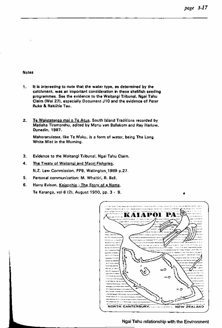
Notes
1. It is interesting to note that the water type, as determined by the catchment, was an important consideration in these shellfish seeding programmes. See the evidence to the Waitangi Tribunal, Ngai Tahu Claim (Wai 27), especially Document J10 and the evidence of Peter Ruka & Rakiihia Tau.
2. Te Waiatatanga mai 0 Te Atua, South Island Traditions recorded by Matiaha Tiramorehu, edited by Manu van Ballekom and Ray Harlow, Dunedin, 1987.
Mahoranuiatea, like Te Maku, is a form of water, being The Long White Mist in the Morning.
3. Evidence to the Waitangi Tribunal, Ngai Tahu Claim.
4. The Treaty of Waitangi and Maori Fisheries,
N.Z. Law Commission, PP9, Wellington, 1 989 p.27.
5. Personal communication: M. Whaitiri, R. Bell.
6. Harry Evison, Kaiapohia - The Story of a Name,
Te Karanga, vol 6 (2), August 1990, pp. 3 - 9.
page 3-17
•
Ngai Tahu relationship with the Environment

page 3-18
,+
•
. """""' INDEX TO NATIVE RESERVES,
Ifn." •. Nu
" IZ
I~
I·'
1 •
:t t
:t
fli
" I
Sl'hl~ ",r It .... ,,..·.
$..'C ;1:12. 1",LI.h"n :o\Ct', 1~373. \Y.ik" .. a
Old X.I • .,u' ,. •. "'''''.p"J K.'kauui
n.J .. lei
.·urau K""kourArftla O.J"kwtahi (lllIllcu
\\· ... Ir"w.
T"u.nul"
Aruwh,',.u.
\\'.1,'01'" .,. ... LfpnktJ, ". U ... k.I.,. .. ,. ...
"'a .. hinu ." CJ? tl
A. k. ' ••
15ft U
.\ n f'
., .... 0 U
.... J U
.. !,u IJ , I~G' " " .. ~~ U . .. .. "
7"
Ngai Tahu Resource Management Strategy for the Canterbury Region
hult·. Nu,
I.
IV
:,u
'" :1:1
;1."1
C' I 11f..~'" .. ~~_1~ o-tr4~ '..f'lJ
~~iJ 71-,..-,,...,,,,, / _,.. . 7 ____ t_,411( a-k'a..~~ tJ-L;. '-0 r .......... 'r,."mu," ''''ul.lth.,

page 4-2
Ngai T ahu believe that the Treaty is always speaking, and it becomes not less but more significant as we go into the future.
Maori Land
Introduction
Maori-owned land differs from European-owned land in two major ways:
Firstly, it is not seen in terms of its commercial value alone. To Ngai Tahu, land confers dignity and rank, provides the means for manaakitanga, is the resting place for the dead, a spiritual base for traditional beliefs and a heritage for future generations.
Further, land establishes personal and Tribal identity, is a symbol of social stability and is an important source of emotional and spiritual strength.
Ngai Tahu Resource Management Strategy for the Canterbury Region
. Ngai T ahu ties with the land are as strong today as they once were, even though the majority of Ngai Tahu now live in the urban environment.
Maori land tenure takes several forms, the situation being very complex in some cases. The problems arising from particular forms of land tenure pose a major challenge to both owners and planners. Perhaps the best description of the various forms of tenure is to be found in the "Report of the Royal Commission of Enquiry into Maor Land, 1975".
The Ngai Tahu Relationship with the Land
Ngai T ahu also have rights in land which is no longer in their direct ownership. They point to the decision of the High Court on the

Maori relationship with land in Royal Forest and Bird Protection Society v W A Habgood Ltd.
(1)
In this case, The Royal Forest and Bird Protection Society opposed a renewal of a mining application set before the Planning Tribunal by W.A.Habgood Ltd to mine sand on Kaitorete. They took the case to the High Court and argued on the basis that section 3 (1) (g) of the Town and Country Planning Act, 1977, stated:
"(1) In the preparation, impl~entation ana administration of regional district ~d map~ime.schemes, and In adm1Dtstenng the provisions of Part II of this Act the following matters whic~ are declared to be of national importance shall in partic;ular be recognised and !>rovlde for:- ... (g) The relationship of the Maori p'eople and their culture with their ancestral land."
Mr Justice Holland of the High Court stated:
"I can see no logical or le~al reason why section 3 (1) (g) of the Act should be of no application solely because the land in question is no longer owned by Maoris."
This ruling resulted in W .A.Habgood Ltd being granted a t~mporary mining right limited to fIve years and due to expire in 1991.
. In effect this case allows for land In respect of which Maori have ancestral connections, to be considered when regional, district and m " an~u:ne schemes are proposed or aWDI Dlstered.
Since this ruling, many important cases have been heard and these have resulted in the creation of a wealth of case history. Ngai Tahu maintain that this significant progress should not be circumvented by future legislation and! or plans and that the findings should be incorporated into future planning decisions.
Policy
1. That as a matter of policy the Canterbury Regional Council will treat as a matter of regional importance the Ngai Tabu ancestral relationship and cultural values concerning the land and waters within the Canterbury region.
Mining
One issue concerning the land itself is mining. While Ngai Tahu are not opposed to mining of itself, they are opposed to mining which destroys or interferes with land or waterways that are culturally important.
Ngai Tahu evidence to the Waitangi Tribunal highlighted some of the problems associated with mining on the West Coast, and particularly the practice of using waterways as 'slurry channels' for mining operations.
page 4 - 3
Ngai Tahu Objectives & Policies

page 4-4
These practices are highly detrimental to fish and plant populations.
Ngai T ahu maintain that they
associated waterways where there is a Ngai Tabu interest unless the mining company has the assent of the tangata whenua.
have an interest in all water- ,.;: .... "'.:::,':':': ",,:::/::,},'::::'::::: ... :::::/,:,,:;:,::::,',',: ... ;:.;.: :.::::,:::::,:,,:::::::},:::<.::::>,.,.: ..
ways, and a very real responsi-bility for the management of Marae them.
The above-mentioned High Court hearing on the Habgood case heard evidence on the number of archaeological sites and urupa located on Kaitorete Spit where the company was mining. The company's operations were destroying these sites and in one case a worker reported seeing human bones on the loading conveyor. These events highlight Ngai T ahu concerns about uncontrolled . . . llllIllDg operatIons.
Policy
1. Mining should not be permitted in areas which are important to Ngai Tabu, including uropa, wabi tapu and mahinga kai areas.
2. All existing and future mining operations must take due regard of the tangata whenua interest in the land and associated waterways.
3. Mining licenses should not be granted in respect of land and
The marae is the focal point of the hapu or Iwi that possesses turangawaewae in that area. It is a place to meet and discuss birth, life and death; and those matters concerning their rangatiratanga.
It will normally be the meeting place for the local Runanga and for that reason , will be the centre of discussion of the issues of the day. While serving these functions, the marae has important social, cultural and religious uses and serves as a gathering place for all people and their visitors.
Marae are not open to the public. Those who go onto a marae must do so as of right, that is, because they are the owners and possess turangawaewae or as manuhiri (visitors) who are made welcome. Each marae has its own kawa (protocol) and for present purposes that is Ngai T ahu kawa within Tribal rohe.
In the Canterbury region most marae are found in rural areas upon Maori Reserved lands. This reflects the fact that until the end of the Second World War, Ngai Tahu were a rural people. Since then, at an increasing rate, Maori everywhere have been moving into the larger urban centres in search of
Ngai Tahu Resource Management Strategy for the Canterbury Region
ployment, education and economic advancement.
This trend has resulted in pressure for the construction of urban marae which do not sit well with land-use-based Town and Country Planning Schemes or with local body bylaws.
In a land-use sense, a marae cannot be classified as a place of ·public assembly·, and, because the whare runanga is often used for overnight accommodation, it cannot meet local body bylaws governing such use.
Any new urban marae will have to provide for off-street parking, comply with bylaws relating to places of occupation, and buildings which meet strict engineering standards. For these reasons they may not fit well into existing landuse patterns. Thus, any proposals for new marae will have to be treated with sensitivity on all sides.
In today's mobile society, the Maori community in any large urban area will be made up of members of many Tribal affiliations. Those who have turangawaewae in any particular area will have or want their own marae. T~ose without turangawaewae may wIsh to construct Maori Community Centres where all Tribes may gather. There is a difference between a marae which is the property of those with turangawaewae and a Community Centre for other
Tribes, but both can live together. Any marae for other T ribespeople would be a gross affront to the tangata whenua whose permission to construct a marae would have to be obtained.
Ngai Tahu have outlined these matters in an attempt to illustrate that failure to take account of Maori kawa could lead to land-use planning difficulties and potentially serious political problems if the requirements of inter-Tribal custom are not observed by planners.
Policy
1. New marae must have the consent of those with turangawaewae in the relevant area. That is tikanga Maori.
page 4 - 5
Ngai Tahu Objectives & Policies

I I
, ~
'I·. i "
page 4- 6
2. In the preparation of new planning schemes the detailed ordinances should provide an opportunity to establish new marae and Maori Community Centres.
Lan~ Use Changes
There are instances where land was gifted by Ngai T ahu individuals, whanau or hapu for the benefit of the wider community. These sites were often gifted for school sites or churches.
In other instances, land was compulsorily acquired by the Crown for some form of public works, for example, defence installations.
In many of these cases, the original purpose for which the land was gifted and! or acquired no longer applies and Ngai T ahu maintain that such land, and any buildings thereon, should be returned to the original owners.
Policy
1. If land use changes result in gifts of land and/or buildings being no longer required for their original use, such land and buildings should be returned to their original owners or the local Runanga as appropriate.
Ngal Tahu Resource Management Strategy for the Canterbury Region
Rural Land Use
Maori Reserves were originally -granted- to Ngai Tahu to provide an economic base for the communities living in those areas.·However, changes in land-use patterns, the economics of certain industries, the moving of many families to the cities and the vast increase in the numbers of OWDers has often led to these areas being neglected. Many traditional Ngai Tahu settlements . have communally-owned land blocks situated close to them. However, due to the above problems, these areas often remain undeveloped.
In other instances, planning laws forbid people to build on blocks of land that do not fit the criteria of -an economically viable unit·. This further alienates people from their own turangawaewae and again hinders the re-establishment of their communities.
Associated with the problem of the required -economically viable unit- is the obstacle that this creates for those attempting to re-establish macae or Runanga-based enterprises. Because an individual or a Runanga may not meet a particular requirement of, say, a minimum area of 50 acres, they are prevented from undertaking any activity.
These factors all contribute to a general sense of frustration at being denied the opportunity to develop one's own resources, and are seen as a major impediment to Ngai Tahu development in the future.

Ngai T ahu would like to see an environment where there are as few hindrances to rural community development as possible and therefore maintain that applications by the T angata Whenua to build on or near Maori land should be considered favourably.
Applications to start community business ventures should also be given favourable consideration, particularly if they are communal buSiness ventures. Such communal businesses offer many opportunities for Ngai Tahu to gain commercial independence, reinforce family and cultural ties, and participate in and contribute to local economies.
Ngai Tahu therefore maintain that planners should bear in mind the original intention of Maori Reserves, that is, to support the welfare and aspirations of their owners. They should also consider the problems associated with developing multiple-owned and communally-owned land, and help the respective individuals and communities overcome these.
Policy
1. That planners should consider applications for building permits on such land in light of their original provision as community resources.
2. That planners should consider applications to initiate business ventures on such land in
light of the original intention to provide an economic base for the communities associated with that land.
3. That at the tnne of the review of any District Planning Scheme, or the prepa- . ration of resource management plans, both Regional and District Plans should provide recognition of the originally intended purposes of Maori Reserve lands. This will involve consultation with the owners.
4. That the original purpose should be generously interpreted to include any activities which support the development of Ngai Tabu's communal base.
5. That applications to initiate community-owned business ventures should be actively encouraged, and that unnecessary constraints should not be applied.
6. That applications to construct buildings for communal Ngai Tabu use, for example whare runanga (meeting houses), should be viewed favourably and actively assisted.
7. That Ngai Tahu individuals and Runanga should be permitted to buy areas ofland
page 4-7
"Many traditional Ngai Tahu settlements have communallyowned land blocks situated close to them. "
Ngai T ahu Objectives & Policies

I "
page 4 - 8
" a growing understanding that Canterbury water bodies are being seriously compromised. "
near their rural marae for the purposes of buDding dwellings or establishing business ventures. Minimum area requirements should not apply in these circumstances.
8. That similar policies should also apply to proposals in 'urban areas.
9. That public parking places and areas of public recreation not be sited on Maori Reserve land without the consent of the owners of that reserve.
10. That the local Runanga be consulted on all matters affecting Maori Reserve land in their area.
11.' That in determining applications by Ngai Tabu individuals or Runanga to initiate aquaculture ventures, whether water or landbased, the responsible authority should have a duty to consider the Treaty of Waitangi.
Ngai Tahu Resource Management Strategy for the canterbury Region
Forests
Hundreds of years ago, most of Canterbury was covered by forest. Over the years, first Maori and then European cleared the forest to make way for agriculture and grazing operations. In recent years, and especially since the Water and Soil Conservation Act, 1967 became law, there has been a growing understanding that Canterbury water bodies are being seriously compromised.
The run-off of agricultural chemi cals, and the entry of nitrates and phosphates into water bodies through accelerated soil erosion, is seriously affecting water quality in all waterways. Lake Wairewa (Lak Forsyth) is a good example of this problem, and there are signs that r Waihora (Lake Ellesmere) is also b coming eutrophic. Eutrophication
is a natural process but in the cases of Wairewa and Waihora that process has been vastly accelerated by human intervention. Matters have reached the stage where water scientists believe that the only way to slow down this process is to reafforest the catchments of the two lakes. Those catchments comprise approximately 285,000 hectares, practically all of it in private hands and used for extensive or intensive agricultural purposes and most unlikely to ever be re-afforested.
Within the Canterbury region there are only small isolated stands of indigenous forests left. These are valuable as examples of what was once a climax vegetation cover and are worth preserving for that reason alone. They serve another purpose in providing the habitat for fast disappearing native bird species. Most of the native birds have now left the Canterbury region following the destruction of their habitat; all of them are under threat and most are classified as endangered species.
Ngai Tahu believe that these forests and their inhabitants are now so scarce that there is justification for stopping the felling of all indigenous trees, even if they are on privately owned land. Plainly in the latter case compensation would have to be paid to the owners, but Ngai T ahu believe that the cost of compensation is outweighed by the need to preserve a heritage that is nearly gone.
There are large exotic forests in the Canterbury region most of Which were owned by the Crown but are now in the process of being
sold to private enterprise. There have been suggestions that what will be sold is the cutting rights, not the land. If that is to be the case then there is a strong possibility that after one or two cycles of cutting the Crown may be left owning the bare land where once the forests stood. Who would then pay to replant the forests? For the reasons already given Ngai Tahu believe that large parts of Canterbury should be forested and, for that reason, stipulate that owners of forests should not be allowed to cut the timber and leave the land bare. Forest should be replaced by forest.
Policy
1. That logging of indigenous forests should stop forthwith.
2. That owners of indigenous forests be compensated for any loss of income caused by such a ban.
3. That where possIDle the owners of such forests should be encouraged to enter into heritage covenants and suitable incentives should be made available.
4. 1bat when exotic forests are felled, the owners should be encouraged to replant them.
page 4 - 9
"Within the Canterbury region there are only small isolated stands of indigenous forests left. "
" ... the need to
preserve a heritage that is nearly gone. "
Ngai T ahu Objectives & Policies

I
,i Ii I,
page 4 -10
S. That the detrimental effects of ero-
, sion and noxious weed invasion restIJtmg from the clearance of exotic forests should be considered, and suitable conditions applied to avoid these outcomes.
6. Wherever possible, but especially at the margins of lakes and rivers, vegetation should be established to assist in stemming the flow of nutrients into these water bodies.
7. A concerted effort should be made to conserve, protect and enhance exNing indigenous vegetation, for their own sake, as a habitat for native birdlife and as a mechanism in assisting in erosion control and the absorption of fertiliser run-off.
8. lOOt a concerted effort to control noxious plants which are threatening indigenous vegetation should be maintained at all times. This effort should treat river-beds as a priority.
Ngai Tahu Resource Management Strategy for the Canterbury Region
9. That the formation and management of any reserves be done with the full involvement and with the assent of the appropriate Runanga.
10. That Ngai Tabu access to, and rights to use resources from public forests, parks and reserves be guaranteed. This includes the use of traditional materials silch as pingao and harakeke.
11. That representative native flora be used in revegetation projects, and where possible this should be of local genetic origin.
Ngai Tahu Fishing Easements
Introduction
The following section is a review of the fishing easements set aside fOJ Ngai Tahu in 1868 by the Native Land Court, presided over by Judge Fenton.
The easements or reserves were part of the promises made in Kemp's Deed which promised Ngai T ahu that their mahinga kai would be set aside for them and their descendants.
The Crown took a limited approach when interpreting mabinga kai and took the to phrase ~o mean "cultivations". On the other hand, Ngai T ahu understand mahinga kai

to mean all food and other resource producing places. This phrase means exactly what it states, that is, Ngai Tahu have a right to take food and other resources from all places, including the ocean, coastline, rivers, inland waterways, swamps, plains, high country, mountains and forests.
Mantell did not reserve any mabinga kai for Ngai Tahu in' 1848 when he was instructed to set aside Reserves for the Tribe by Lieutenant-Governor Eyre. This failure of Mantell to set aside adequate reserves of mahinga kai was one of the reasons, among others, why Ngai Tahu sought to have their case heard in the Native Land Court in 1868.
Ngai Tahu faced a new problem in the Court, as Judge Fenton ruled that the Court was bound to take the Crown's interpretation of mahinga kai as the Reserves were to be Crown grants. Fenton then produced an Order of Reference which required the Court to allocate reserves within the area of the Canterbury purchase. Ngai T ahu counsel withdrew in protest on the basis that the Postmaster General of the area, John Hall, did not have
the authority to sign the Order of Reference, and that that privilege belonged to the Governor alone. The outcome was that Ngai Tahu were left without counsel.
Fishing easements were sections of land sited near rivers, lagoons and estuaries that allowed Ngai Tahu to use them as a camping site from where they could take fish, eel or shellfish. The easements did not give any property rights to the water or the beds of the lakes or rivers.
However, from the mid to late 1870s Ngai Tahu began to complain that the water levels of the lagoons, lakes and rivers were falling due to nearby drainage operations by local farmers. The drainage of the waters bought about a decline in the quantity of fish because of the destruction of their habitat.
A common feature of these easements is that they are often subject to erosion which periodically changes their topography as in the case of Waitarakao in the Arowhenua District
page 4 -11
Ngai Tahu Objectives & Policies

: II I
I I
page 4 -12
which now lies out to sea.
Policy
1. That Ngai Tabu should be permitted to develop projects on these easements which reflect the original intention of providing an
'economic base for Tribal communities.
2. That the gazetting of Wairewa as a Maori FIShing Reserve be altered to a N&ru Tabu FIShing Reserve for Ngai Tabu who descend from kaumatua listed under the land grants of the Maori Reserves from Wairewa, Rapaki, Kaiapoi, Port Levy and Te Taumutu.
3. See also policies on Maori Reserved land, especially in Section 5, and the Index (Section 9).
Ngai Tahu Resource Management Strategy for the Canterbury Region
Water Values
Introduction
This text aims to show the pivotal importance of water to Ngai . Tahu. Water, and the resources it supports, determines the siting of their>!t~ga (vil!ages),their id~ntity, and the rhythm of their lives.
The traditional values and controls regarding water are included in the Tribe's spiritual beliefs and practices. This recognises and reinforces the absolute importance of water quality in relation to both mabinga kai and hygiene.
.Water is held in the highest esteem because the welfare of the life that it contains determines the welfare of the people reliant on those resources.
Traditionally, water was the centre of all activity within Maori society. It provided the preferred transport medium; supported fish and shellfish populations; was used in religious ceremony; and was als used for recreation. For these reasons, and like most other cultures, settlements were centred beside, or in close proximity to major waterways.
As mentioned earlier in the text water-sourced foods were particularly important in Te Waipounam because of the harsh climate whi precluded the easy or extensive growing of horticultural crops.
This dependence on kai-moana (sea-food), kai-awa (river-sourced food) and kai-roto ~ake-sourced food) is a theme which has remained through to present times. After the Land Sales of the mid-1800s, many Ngai T ahu families were forced to rely on that food which could be sourced from the waterways as their land reserves were of inadequate area and! or quality.
These resources were equally essential during times of great hardship, such as the depressions. For these reasons, and also because this source of mahinga kai is one of the very few opportunities for modern-day Ngai Tahu to participate in the food and practices of their tupuna (ancestors), water and the food that it supports are at the forefront of Ngai T ahu concerns today.
Over a long period of time, Ngai T ahu accumulated an extensive amount of knowledge about the resources within their rohe, particularly water-sourced foods.
Harvesting methods reflect a sophisticated understanding of the breeding cycles, migration times and feeding habits of all the important fresh and salt-water species, with different names being used for the same fish at different parts of its life-cycle. Many species can be harvested at different times of the year by understanding their habits at those times and adjusting the catching .method to suit. To ensure the continuation of the resource, strictly observed restrictions are enforced to protect breeding stock.
Evidence given to the Waitangi Tribunal in particular, hints at a vast and sophisticated traditional knowledge of resource management and enhancement techniques. These include the technologies to both increase and decrease populations of shellfish to provide an optimal product. Genetically superior strains were recognised and transplanted to other areas, often near kainga.
(2)
Extensive knowledge also exists of the various sea currents, winds, stars and tides, and which combinations of these indicate which fish can be caught and where. Specific catching methods were developed for each species, whether fresh or salt-water, and appointed specialists controlled the management of each resource.
As mentioned in an earlier section, food and the presentation and gifting of it is central to the Maori culture. Not only is it very important to show 'aroha ki te iwi' (regard to people), but also to be able to support the kaumatua (elders) of the community and to help cater at functions such as twaue (funeral ceremony).
page 4 -13
Ngai Tahu Objectives & Policies

page 4-14
Spiritual Values
As already mentioned, all life came into being when Maku mated with Mahoroanuiatea, another form of water, and begat Raki. Water, therefore, is the promoter of all life and represents the life-blood of the environment. Its condition is a reflection on the health of Papatuanuku (the Earth Mother).
... ~.' . '~~,,~ .. ~ ~
"U •••••• - •
.-..... ~.~ ......•
. A",~... , .... • _.-- ~¥ •• - ••• ,-••• -~, ••
. ~ ~ ..... - ..... --•...
.._ ......• ,.-... ,.!~, ····~-···1 .... ~ ..... -'l: ~~"""1 ~"---'
.~ ...... -~~ ..... _ ... \ .•. -... ~.¥".! .. ~, .... .....,
~--""--i ....... - i - ..... ~----.. , .• -.. ~
Ngal Tahu Resource Management Strategy for the canterbury Region
Water was used by tohunga in various religious ceremonies, including the lifting of tapu from warriors I
returned from batde; baptisms; initiation ceremonies; and funerary rites. Each ceremony was performed only with water suitable for that function and certain areas were set aside for these purposes. These various water classifications are: waitapu, waitohi and waiora; each having their own characteristics and spiritual function.
Because of the sacred nature and pragmatic importance of water, specific practices and restrictions are enforced. For example, it is unacceptable to discharge sewerage into waterways where food is collected.
One ofthe most prominent spiritual notions that Ngai T ahu has in relation to waterways is that the sea, rivers, lakes and streams were all guarded by taniwha or kaitiaki (guardians). In some cases
, they acted as guardians of a particular area, or of particular people. In other cases they acted as messengers, signalling the end to a fishing season, or worse, impending .L.I..U'U,",~ tune .
The Canterbury region has a number of examples. Tikao two taniwha who live in a rua (cave) each, near Opukutahi . taniwha were left there by Te Ake, a Ngai Tahu rangatira, to safeguard friendly people on the sea.
The waterways of Kaiapoi are also guarded by two taniwha, the tuere and the koiro. The tuere is a

lamprey that is spotted and creamy in colour. The koiro is a large black eel that inhabits the waters in the Kaiapoi Pa. The Ngai Tuahuriri and Ngai Te Ruabjkjbikj hapu believe that these eels, when very young, travel from Kaiapoi through the underground waterways as far as T e Waihora (Lake Ellesmere).
(3)
Connected to the concept of water guardianship is the matter of tapu. Water was declared tapu for several reasons. The best example of waltapu (sacred waters) are those waterways that act as burial places. Because of their primary use, food is not taken from these places.
There is another rabui in the Kaiapoi region, on a site known as o Tu Kai Kino in the Puharakeke (Styx River), this water being used by tohunga for embalming.
At Ihutai, near Sumner, Ngai T ahu fishermen avoid an area known as Tuawera because of an incident where a hapu, Ngati Pohoareare, were killed by makutu (witchcraft).
All of the above are examples of areas of water which have, or have had, a rahui laid over them.
(4)
In conclusion, there are waters V:ithin the Ngai T ahu rohe (tradit~onal boundaries) which are categonzed as entities with their own distinct characteristics. The classification of these waters determines how they may, and may not, be use? Where water types are incompatible, the mixing of those waters
is unacceptable to Ngai Tahu.
According to Ngai Tahu tradition, it was the Rapuwai people who classified the waters of T e Waipounamu. Water is classified according to its uses, and that classification then determines the future uses of that waterway. For example, it would be inappropriate to drink water used for embalming the dead, or to bury a tupapaku (corpse) in a tauraka (fishing ground). Areas of water were set aside for various types of use by tohunga, either because of their location or because the waters were considered to have special qualities.
(5)
Wai whakaheke tupapaku
Waiwhakaheketupapaku translates as water burial sites. Within this repon we refer to some of these water-burials in the Canterbury region. Tupapaku (human corpses) were weighted down in lagoons, rivers, springs and in the ocean in secret places.
To identify the location of these waters identifies the funerary places which Ngai T ahu are less than anxious to do. For this reason Ngai Tahu require some restriction on the information about these sites, and they are therefore identified in the silent file.
These waters themselves have no special qualities, although
page 4 -15
Ngai Tahu Objectives & Policies

page 4-16
they are regarded as culturally sensitive. However, Ngai Tahu would strongly object if a sewerage outlet was sited over a water burial or if some form of industrial waste was discharged there.
Waitohi
These waters were used by tohunga durIng initiation and baptismal ceremonies. The function was to remove the tapu from people (whakanoa). For this reason restrictions were imposed on these waters in order to ensure their continued purity.
Waimataitai
This refers to the coastal sea and waters in the estuaries where salt and fresh water mix.
All estuaries were, and are, important mabinga kai for Ngai Tahu. However, waimataitai should not be taken in the limited context of waters only but also in the wider meaning of the word "estuary". Waimataitai also includes areas of
Ngai Tahu Resource Management Strategy for the Canterbury Region
coastal swamp near the estuary. The water quality of these places was formerly good enough to sustain food.
Waiora
These waters were used for healing by tohunga. Like waitohi, these waters were pure.
Today it is difficult to identify all such waters in the Canterbury district because that knowledge is now incomplete and most places have been interfered with by modern developments. However, there are some still significant to Ngai Tahu today.
Waterways: Rivers, Tributaries, Lagoons and Lakes
Planners need to be able to identify traditional Maori fisheries in order to protect them and maint . appropriate standards of water quality. The purpose of this part 0
the paper is to give effect to the "Draft R~onal Planning Scheme Report", which stated as one of its policies:
"That traditional Maori fishing .&.rounds in Canterb~ be iCientified and practical measures be taken to protect these and maintain appropriate standards of water quality. "

[Proposed Section 3.1 -Land & Water(Nth Canterbury) 1990 (policy 4.7), Canter· bury RegionAl Planning Scheme]
There is a problem here already. There is a mistaken belief that Maori fishing grounds are 'sitespecific', whereas in reality all waterways are a source of mab;nga kai for Ngai Tahu and are therefore important. The concept of 'sitespecific' fishing grounds completely ignores the mobility and migratory habits of fish species. .
Take for example the problem of Te Akaaka, a fishing reserve set aside in 1868 by the Native Land Court, for the use by the Kaiapoi Ngai T ahu, near the mouth of the Ashley River. The main foods taken here are the cockle and pipi, but these shellfish move with the mouth of the river. According to one report, the Ashley River has been slowly moving northwards since 1979. The kai moana and kai awa have followed the movement of the river mouth - away from the T e Akaaka reserve.
(6)
Sitilllar cases can be made for virtually all Ngai Tahu fishing reserves in the North Canterbury area, as all of the lagoons sited next to the reserves have been drained. The Reserves therefore no longer provide access to resources as originally intended.
The idea of 'site-specific' fishing grounds within the inland water'Ways and estuarine systems should be resisted. The concept is more applicable to coastal and deep-sea areas 'Where fishing grounds are frequently 1~e4 over reefs or trenches. -
However, there are traditional fishing grounds and fishing easements which need to be discussed further. The following section will deal with some of the principal water bodies in the Canterbury region which are still used as mab;nga kai.
Inland Waters
According to T e Waipounamu traditions, the inland lakes were dug by T e Rakaihautu and his ko (digging stick) which was named Tuhiraki - present day Mount Bossu.
Ngai Tahu interests in the waterways extend beyond coastal shellfish beds and off-shore fishing grounds. In the Canterbury region Ngai Tahu have interests in all of the lakes that are fed from the mountains because they support fish populations.
Lakes specifically used up till the middle part of this century by the Ngai Tuahuriri were: Whakamatau (Lake Coleridge), Oporea (Lake Pearson), Oporea iti (Lake Grassmere) and Kai Moana (Lake Howden). The lakes fed the Waimakariri, and Rakahuri.
Further south, across the Waimakariri to the Rakaia River, Ngai Tuahuriri used the lakes that led into the Rakaia,
page 4 -17
Ngai Tahu Objectives & Policies

II I
Ii ,'II
page 4 -18
Waikirikiri (Selwyn River), Waiwhio (Irwell River) and Hakatere River. Evidence of Ngai Tuahuriri presence in this region was at Wbakaepa which sits at Coalgate. This was an outpost Pa of the Kaiapoi Ngai Tahu which was used by foraging parties.
The principal foods taken from these lakes were eels, putangitangi (paradise duck), parera (grey duck), pateke (brown duck), whio (blue duck) and pukeko (swamp hen).
The inland lakes further south down to the Waitaki were used mainly by whanau subdivisions of the Ngati Huirapa as mabioga kai and the foods of those are described above.
Shellfish Seeding
Seeding was a traditional form of aquaculture practiced by Ngai T ahu. It took two forms: the first was that people skilled in the management of specific mahinga kai were given the task of planting (seeding) different types of shellfish in new areas; the second is when shellfish were taken out of their natural habitat and stored in artificial environments - usually in rua (storage pits).
Knowledgeable people would choose their kai moana mataitai (seafood) at a time when they were ready to seed and place
Ngai Tahu Resource Management Strategy for the Canterbury Region
them in poha rimurapa (a container made from seaweed). The poha would be placed along the shoreline near the kainga where the pressure of the waves over the buried poha would trigger the release of the seeds from the kai moana mataitai. Alternatively, the poha would be gently kneaded by the cultivator s6 that the seeds were pressured out.
This is an oversimplification of a complex process, but it gives a general description. Water quality must be suitable to allow regeneration of the shellfish. This means that the mauri of the river that enters the estuary or coastline where the kai mataitai is to be planted should be compatible with the mauri of the waters from where the shellfish was originally taken. Besides the biological factors involved, social controls were also practised.
The practise of seeding was seldom done in the last few decades, so that many whanau lost part of their tradition. However, to some whanau the art is still known and because of recent commercial stress upon traditional fisheries the fami! traditions are being shared amongst Ngai T ahu, and most of the coastal kainga are once again reviving this important conservation and re- ' source enhancement practice. Many different areas were seeded b Ngai T ahu in the Canterbury Region, including coastal waters, rivers and estuaries. Ngai T ahu commercial fishermen in their sp time have frequently assisted in transplanting wai mataitai species all around the extensive coastline T e Waipounamu, trying out prospective breeding sites.

The second form of aquaculture practised was the storage of kaimoana in rua or coastal storage pits. All Ngai Tabu kainga sited near the coastline have whanauowned rua. The location of these places are known only to the families and are owned exclusively by them.
These pits are usually hollows in the rocks which the tide covers at high water. In these pits are stored shellfish, usually mussels and paua. Foods are taken from the coastline and stored in the pits which are then used as a cupboard, avoiding unnecessary trips to the ocean. For these pits to work, the sea must be constantly moving in and out of the rocks. Also, only the best shellfish can be stored in the rua as diseased shellfish placed in a small rua will infect the rest.
A smaller scale version of this was that some kainga, such as Koukourarata, would communally go to a neighbouring bay and make up small beds of shellfish and store them under piles of rocks for the winter. This was done in the autumn.
Policy
1. That the Canterbury Regional Council should promote the protection or traditional seeding rights in consultation with Ngai Tabu.
2. That in determining applications by Ngai Tabu individuals or Runanga to
initiate aquaculture ventures, whether water or land-based, the I"fSPOnsible authority should have a duty to consider the Treaty or Waitangi.
General Water Policy Statement
The maintenance of water quality and quantity are perhaps the paramount resource management issues to Ngai Tabu.
The important challenge in the modern context is the wise use of our natural resources in a way which is consistent with those values passed onto us by our tupuna. This challenge includes the wise use of natural resources, knowledge and technology passed on to Ngai Tabu by their tupuna, while not forgetting or belittling the sound accumulated wisdom of the past. A combination of balance, realism and an acceptance of Ngai Tahu values is needed.
As mentioned above, Ngai Tahu resource management is primarily focused on the ethic of sustainability and the longterm welfare of the environment, and therefore the longterm welfare of the people within that environment.
It is recognised that the welfare of people and the success of their activities within the environment depended on water being maintained in the best
page 4-19
Ngai Tahu Objectives & Policies

, I ,I
i I I,
f 1
I page 4 - 20
"Further deterioration, of either water quality or quantity is unacceptable
"
possible condition.
To this end, the utmost effort must be made to maintain and increase both the quality and quantity of water in all waterways. Funher deterioration, of either water quality or quantity is unacceptable to Ngai T ahu.
Policy
1. That no discharge into any water body should be permitted if it will result in contamination of the receiving water.
2. That no lowering of water levels in identified wai whakaheketu papaku (water burial sites) should be allowed.
3. That the quality and quantity of water in all waterways be improved to the point where it supports those fIsh and plant populations that were sourced from them in the past and that these mahinga kai are fit for human consumption.
4. That the Canterbury Regional Council should actively encourage the disposal of effluent onto land rather than into water, provided that the groundwater is not polluted in the process.
5. Management
Ngai Tahu Resource Management Strategy for the Canterbury Region
Plans should be prepared for each river, their tributaries and catchments, and a coherent list of all water rights made, whether to abstract water or to discharge emuent. These management plans should be developed in consultation with the appropriate Runanga, and only adopted with their consent.
6. That when water rights to discharge emuent come up for renewal, investigations should be undertaken to determine if more modem technology would permit an improvement in the quality of any discharge.
7. That in the case of abstraction, more efficient use of water be encouraged. Any water "saved" in this manner should be returned to the waterways to enhance river flows, and not reallocated to other users.
8. That water right charges should reflect the extent to which the Canterbury Regional Council needs to monitor and supervise rights and ensure compliance.
9. That methods of storing excess water, for example wetlands and dams, should be actively encouraged.
10. That wetland areas be created and expanded. All existing wetlands
--

should be maintained at their present area at kast, in recognition of their wIue as "buffers" in times of high rainfall and also their crucial importance to fish and plant communities.
11. That no further reclamation of wetlands be allowed.
12. 1bat those RUD3ng3 which possess beneficial rights to a particular water body should be consulted on all management practices which will impact on that waterway or its resources.
13. That Maori Advisory Committees at both Regional and District levels should be consulted before any Catchment Management Plan is adopted, and the Committee advise the Council of any issues of concern to the tangata whenua and any requirements to be met in the preparation of the plan.
14. That agricultural and chemical spraying be prohibited in any case where the effects of such spraying will be to degrade the quality of any water body or affect the flora and fauna in the immediate vicinity of such water bodies.
15. That the Canterbury Regional Council should encourage land owners or occupiers to plant vegetation on ripar-
ian strips to prevent contaminated run-off into any wetland, waterway or lake.
16. That efforts to improve the quality of eutrophic water bodies such as Wairewa (Lake Forsyth) and Te . Waihora (Lake Ellesmere) should be initiated.
17. That the Canterbury Regional Council, in consultation with the Ngai Tabu Maori Trust Board, appoint an Iwi Liaison Officer and provide appropriate administrative support for that Officer.
............................... :.:.:.:-: ..• :.: ....... :.:.:.:.: ... :.:.;.:-:.:.: ............. : .... :;:;.:.:; ..... : -:':',':':':' ;:;:::::::::::,:::::::;';::::.::::::
Mahingakai
Introduction
Mahinga kai was one of the taonga (treasured possessions) reserved from sale in the terms used in the Maori version of Kemp's Deed in 1848.
page 4 -21
Ngai Tahu Objectives & Policies

page 4 - 22
"To Ngai Tahu, mahinga kai means, and has always meant, the whole resource chain from mountain top to the ocean floor. "
Kemp's Deed was a deed of sale drafted by the Crown, and negotiated on the Crown's behalf by Henry T acy Kemp. The intention of the Deed was to purchase 20,000,000 acres in the South Island from the Ngai T ahu for the sum of 2,000 pounds. The coastal boundary of Kemp's Block ran from Kaiapoi down to Otakou (Otago). The Crown and Ngai T ahu have never agreed as to where the inland boundary of the purchase is located and this matter is part of the Ngai T ahu claim presently before the Waitangi Tribunal.
The Deed also promised that Ngai Tahu would retain all their "mahinga kai" for their own use and for the use of their descendants. The Crown originally interpreted mahinga kai as being 'cultivations' and 'fixed eel weirs'. To Ngai Tahu, mahinga kai means, and has always meant, the whole resource chain from mountain top to the ocean floor.
The Canterbury plains were originally worked as one large mahinga kai. It would take too long to list all of those foods taken from this region and so, for the purpose of this paper, it is simply noted that the majority of the foods available and taken then are not now available.'Ngai Tahu have consistently argued that this is a serious breach of the Crown obligation under both Kemp's Deed and the Treaty of Waitangi.
Ngai Tahu Resource Management Strategy for the Canterbury Region
This problem has not simply crept up on Ngai T ahu this century Ngai Tahu kaumatua in the 1870s recalled the scarcity of bird-life in their time. Rawiri Te Maire, a Ngai Tahu kaumatua, recalled in 1876:
"The tuis and all other birds are gone, and the roots of the Kauru and the fern have been destroyed by fire. "
(i
One Tuahiwi kaumatua, the late Rima Bell, recalled her childhood ir the 1930s:
"The old people would travel up there [North Canterbury J for weka and pigeons, which are no longer there because the forests have been cut away."
Other kaumatua of Ngai T ahu have similar recollections, Wiremu T e Uki explained mahinga kai thus before the Smith-Nairn Commission in 1879:
"We used to get food from allover our island; it was all mahinga kai. And we considered our island in a far superior position to any' other, because it is calleCl Waipounamu, the greenstone island, the fame thereof reaches all. "
Highly organised seasonal timetables were followed to best utilise the resources available, and were unique to each hapu depending on the resources coming under their manawhenua. A large number of trails were used to gain access to

these areas, including those that traversed Te Tiritiri 0 te Moana (the Southern Alps) and lead to the treasured pounamu. The defence of these trails was delegated to specific hapu and whanau.
Besides the kakapo, a whole host of other kai (foods) were taken as well including: kaka, kea, tui and flora such as tikumu (Celmisia sp.), taramea (Wild Spaniard, highly valued for the perfume produced from it) and aruhe (fernroot). The Torlesse Range was a huge mahinga kai used by families from Kaiapoi Pa and the surrounding area.
Resource usage was determined by whakapapa and occupation, and traditional boundaries were jealously guarded by the individual hapu. The actual usage itself reinforced the user's manawhenua rights. These rights also carried with them the responsibility to manage the resource so that it would be available for future generations.
The high country was all part of the Ngai Tahu mahinga kai. The Ngai Tahu food gathering boundaries covered the whole inland range.
The loss of mahinga kai is due to four main factors:
1. Much of the mahinga kai is now depleted due to the destruction of the habitat.
2. Denial of access to mahinga k'b at y local by-laws and Govern-Illent legislation,
3. The fencing of land for subdivision and occupation by pastoral farmers.
4. The introduction of predators such as rabbits, cats, dogs, ferrets and stoats which have severely reduced the traditional foods of Ngai Tahu.
Re-afforestation of the Canterbury plains is not a realistic goal, when much of it is in livestock and agricultural production. For these reasons, there seems little point in citing places as mahinga kai which are no longer available. Nevertheless, there are places in the Canterbury region to which Ngai T ahu still go to obtain foods.
It is important that all areas of remaining native bush be protected. These places must be retained as a mahinga kai, and they must be managed by Ngai T ahu, The Tribe have always argued that Kemp's Deed and the Treaty of Waitangi ensured full access and rights to all food producing places.
Ngai T ahu have been aware since last century that the native wildlife was being destroyed by introduced predators. For example, titi (muttonbirds) were formerly taken in many places on Banks Peninsula. Today there are not enough muttonbirds to take. The main reason is that each titi lays one egg in a burrow, triennially. On the
page 4 - 23
"The other big pests are Government officials who in ignorance destroy the b " urrows ...
Ngai Tahu Objectives & Policies

! ~
I.'
I
I
"
,
" ;1
1
"I
:i "I
page 4-24
"Mahinga kai was, and is, central to the Ngai Tahu way of life. "
mainland the eggs are prone to attacks from ferrets, stoats and rats. The adult birds are game for cats and dogs. The other big pests are Government officials who in ignorance destroy the burrows thinking that they are rabbit burrows.
Mahinga kai was, and is, central to the Ngai T ahu way of life. As mentioned in an earlier section, the collection and processing of mah;nga kai is an important social and economic activity. Ngai Tabu are concerned that the collection of mab;nga kai, in its numerous forms, should continue to remain an integral part of their culture.
Policy
1. That the quality and quantity of water in all waterways be improved to the point where it supports those nsh and plant populations that were sourced from them in the past, and that these mabinga kai are nt for human consumption.
2. That wetland areas be created and expanded. All existing wetlands should be maintained at their present area at least, in recognition of their value as "buffers" in times of high rainfall and also their crucial importance to fISh and plant communities.
Ngai Tahu Resource Management Strategy for the Canterbury Region
3. Ngai Tabu maintain that future planning procedurt5 mould consider the fact that areas such as wetlands are important mabinga kat to Ngai Tabu.
4. Where productive mabinga kai areas still remain, strong policies should be adopted to maintain and enhance them. The Canterbury Regional Council shoold support the attainment of access provisions where necessary.
S. That local Ngai Tabu be allowed to establish temporary camps for the purpose of collecting mabinga kai during the appropriate seasons. '
6. That the local Runanga should be involved in the management of an mahinga kai resources, including fresh and salt-water fISh.
7. That the Canterbury Regional Council actively encourage and support all initiatives to restock lagoons and other waterways with native fISh species, and all initiatives to maintain those places as a suitable fIShery habitat.
8. See also the Tribal policies on water, especially as stated in Section 4, at 4-20 and 4-21.

WahiTapu
Introduction
In modern terms - in the Ngai T ahu rohe - the term wahl tapu refers to places held in reverence according to tribal custom and history. Some wahl tapu are important to the lwi, while others are important to individual hapu or whanau. For example, Kaiapoi Pa is a wahi tapu of Tribal importance.
Wahi tapu in the Waitaha (Canterbury) region are places such as section 88 on the Kaiapoi Maori Reserve. Another category which comes under this term are those areas traditionally used by tohunga, for example, streams used during waitohi ceremonies.
Urupa
Of all wahi tapu the urupa is the most significant. They are important to Ngai Tahu as in these areas lay the bones of celebrated ancestors who are gone but never forgotten.
"Our dead are v~ close to us. Th~ do not lie alone in that short space between death and burial. We stay' with them every minute ana talk and sing to them. When we have returned them to the earth we remember them ~ speech and song. Each tIme we meet one another after being ap~, we pause and weep agam, no matter how happ'ythe occasion for our meetmg".
The dead are a link to the past and to the land. By protecting the urupa, the mana of the ancestors and their descendants is also remembered.
Knowledge of urupa is often only retained by certain individuals within an lwi. These individuals are not always willing to divulge the locations of urupa for fear of them being disturbed. The protection of urupa is discussed because of their deep significance and importance in Ngai Tahu culture.
Urupa can have statutory protection under the following Acts:
1. The Historic Places Act, 1980;
2. The Maori Affairs Act, 1953;
3. The T()fJ)n and Country Plan ning Act, 1977.
However, the above Acts may be over-ridden in the Courts by other legislation, for example, the Petroleum Act 1981. Because of this, urupa do not have the absolute protection that Ngai Tahu require.
Urupa should have the same statutory protection afforded
page 4 - 25
Ngai Tahu Objectives & Policies

page 4 -26
cemeteries, at least, in both the rural and urban situation. We say 'at least', because we are aware that Pakeha seem to be able to forget about their dead and when convenient just go ahead and bulldoze a cemetary to make way for some modem project; for example the Bowen Street Cemetary for the Wellington motorway, or in Dunedin the Arthur Street playing field ..
We want the Canterbury Regional Council to be quite clear that such behaviour in relation to any of our Maori cemeteries, officially recognised or not, would be entirely unacceptable. We believe that we currently have the sympathy and agreement of the Council in this respect, but the matter must be mentioned as it may indicate a need for future clarification of the law.
It is wrong that there should be any rule of precedence of statutes in the courts which would legally permit any of our urupa to be desecrated. In that respect, Ngai T ahu say that such statutary or Court rules of precedence, and so the statutes themselves, are contrary to the Treaty and should not be applied in the courts.
The Canterbury Regional Council should maintain a register of all wahi tapu and include them in District Planning Schemes.
Besides actually identifying an urupa in its scheme, the local authority should acknowledge the importance of existing urupa whether known or not. Further,
Ngai Tahu Resource Management Strategy for the Canterbury Region
planners should allow for the establishment of new urupa in the future.
Generally, urupa are unmarked burial sites and can be found throughout the Canterbury Regional Council area. The term is also used to describe present~ay cemeteries.
Urupa were usually first set aside on a family basis, that is people were placed in areas where they had a right to go. That right was based on whakapapa and turangawaewae. If such sites are accidentally uncovered it is important that the local Ngai T ahu Runanga be contacted and that the connected families be identified and notified before those sites are altered or affected in any way. This needs to be the shared duty of the local Runanga and the Ngai Tahu Maori Trust Board. Maps relevant to these Silent Files are to be found at 5-78 Appendix A.
Ngai Tahu are concerned that their urupa are not disturbed and for this reason have used silent files which cite the urupa in a general 10-cation. The "silent file" gives a general identification of a place where an urupa or any other ·' ... .,.",nr ...
tant place is sited. Silent files are to be used only by kaitiaki approved by the Ngai T ahu Maori Trust Board and the families concerned.
Urupa were often marked by tikouka (Cordyline australis, Cabbage Tree). In general, any which likely to disturb the ground near a visible ti-kouka should be unedertaken with care in case an old

is accidentally opened. On the other hand and affecting our listings here, because these marker ti-kouka have frequently died or have been removed over time, an exact location is often now unclear. Therefore, if an urupa is sited in a paddock then that paddock will be identified but a site-specific location within the paddock cannot be given.
It will be for the Regional Council to approach the Ngai Tahu Maori Trust Board if the prescribed area is to be affected in any way. The Tribal Trust Board will be able to ensure the appropriate Runanga is involved (sometimes this will require two or more Runanga to confer), and they can also decide whether any non-Maori authorities such as the Police or the Historic Places Trust should also be informed. The Regional Council should never try to 'go it alone' and should always seek the assistance of the Ngai T ahu authorities at the earliest possible time, whenever bones, or taonga Maori such as cloaks or other artefacts are uncovered.
The purpose of contact with the Ngai Tahu Maori Trust Board is to allow the descendants the opportunity to recover, in a culturally appropriate manner, bones that may be under threat.
L
Throughout the whole Ngai T ahu rohe there are many urupa and it is impossible to identify all of them in the short time-frame available for this study. However, there are a number of burial sites which are important Tribally and which need to be protected and left as they
are.
Urupa are a sensitive issue. Ngai Tahu believe that in most cases they should be strictly left alone.
In some instances it may be desirable to re-inter the skeletal remains, for example perhaps if the site was known to contain only one ancestor and it is deemed by the Runanga and connected interests to be necessary to give way to development. In other cases, however, this would be inappropriate.
The uri (descendants) of the tupapaku are the only people who can make this decision, with assistance from Ngai Tahu kaumatua. The methods used to define the uri of the koiwi (llUman bones; also wheua) and which uri have the right to decide what happens is a complicated Tribal process. Therefore, our policy statements are:
Policy
1. That urupa must be given full statutory protection and access to those sites must be guaranteed.
2. That the Canterbury Regional Council should support moves to gain such protection, and should encourage others to acknowledge and respect Ngai Tahu's position.
3. That district
page 4 - 27
Ngai Tahu Objectives & Policies

page 4-28
schemes should provide for urupa to be subdivided from larger lots. This is important as many Ngai Tabu sites have urupa on them.
4. That urupa should be recognised as a predominant use on Maorl-owned ancestral land.
s. That urupa should be recognised as a predominant use in any rural zone.
6. That if wheua are uncovered on privately owned land then immediate contact must be made with the Ngai Tabu Maori Trust Board, and the local Papatipu Marae and Runanga Oocal representative groups) for the internment in an appropriate Ngai Tabu urupa or cemetery, if that is the desire of the descendants.
7. That for wheua uncovered on Crownowned property, these remains be reinterred on site and fenced orr, after consultation with the Ngai Tabu Maori Trust Board. Free access to these sites must be guaranteed.
8. A silent fIle will be kept on known burial sites by the Ngai Tahu Maori Trust Board. Where these sites are located out-
Ngai Tahu Resource Management Strategy for the Canterbury Region
side Maori Reserved land they have been given a number and the general area bas been marked on the relevant map in A~ pendix A to Chapter S. Anyone proposing any change on or near one of these sites should consult the Ngai Tabu Maori 1imt Board through the Regional Councn's lwi liaison OfIicer. The Ngai Tabu Maori Trust Board in tum can initiate contact with those people who have a direct interest in that particular site. All decisions will be made on a site by site basis.

Nga Wah; Taonga: Tribally Treasured Areas
Introduction
This passage should be read in conjunction with that on Wahi Tapu. While treasured areas can also be correctly referred to as wahi tapu, the authors have chosen, for the purposes of this report, to make a distinction between the two categones.
Ngai T ahu Whanui have a perso~al relationship with the land which extends beyond mere occupation. This relationship begins at birth with the placenta, like the land, being called whenua. Traditionally, when the child is born the placenta is buried in the earth which expresses the belief that humankind originates from Papatuanuku and returns to her. This is an example of an individual's close relationship with the land, and the loss of land is the loss of self.
Tribally, Ngai Tahu Whanui have a similar relationship with the land. For example, when Ngai Tahu turn to Aoraki (Mt Cook), in one sense they see him as an old man - a relation. The same principle applies to the whole of the Southern Alps.
For these reasons it is important to identify those areas that are culturally important to Ngai T ahu. This is difficult because as the following lines indicate, Ngai Tahu can:
"Find tongues in trees, books in the running brooks, sermons in stones, and good in everything."
This section develops the concept introduced above and aims to expand on the Ngai Tahu relationship with special places in the landscape.
The classes of sites that are covered are, in order:
1. Archaeological and Rock Art sites, including a case study on the lower Waitaki River;
2. Mountains and Mountain Ranges;
3. Fowling Trees, Historic Pa and Other Sites;
4. Tauranga Waka (canoe landing sites);
5. Buried Whakairo (important art and pounamu).
page 4 - 29
Ngai Tahu Objectives & Policies

1
, I
1
III \ 'I
,I
'j
page 4 - 30
It should be noted that the sites listed are indicative only and should not be considered a comprehensive listing. Rather, it is an attempt to show the importance of these sites and express their significance to Ngai Tahu Whanui.
ARCHAEOLOGICAL AND ROCK ART SITES
Introduction
Archaeological and rock art sites exist, not only as entities in their own right, but as part of a much larger Ngai Tahu identity. Logically extended, this relationship ties these sites into a more general picture over both time and space. Some areas must be considered in light of the contribution they make to the greater picture, not merely on the basis of their individual and isolated attributes as historical, archaeological and rock art sites.
These taonga are very important to Ngai Tahu Whanui (the entire Ngai Tahu Tribe), as the study and analysis of them furthers the academic understanding of their tupuna and their world. Through scientific study the Tribe learn more of their tupuna, and therefore, learn more of themselves. These sites and taonga are an integral part of Ngai T ahu.
~chaeologicalSftes
Ngai Tahu c~ncem with archaeological sites extends beyond that of ancestral connection alone. They are also valuable sources of information on the activities of their tupuna which those in the present world know little about.
In the past, knowledge gained from academic pursuits has been of great in shaping Ngai T ahu understanding of their ancestors. This is particularly so with regard to the more mundane aspects of their lives which are not so well defined in traditions.
In this respect, Ngai T ahu note the value of archaeological investigation, although such undertakings are in Lll~"" selves destructive of the sites. Because the sites are destroyed, it is desirable as much information as possible is gained in the process.
Each site must be considered on its own merits. However, on the whole there is little objection to the 10..,," .. " .... 1"111
of archaeological sites, and depending the results, the subsequent use of the l~d - provided thatthe following na are met:
Ngai Tahu Resource Management Strategy for the Canterbury Region

Policy
1. That all archaeological sites of interest to Ngai Tabu Whanui be given fonnal protection, and that the right to modify them shall remain solely with Ngai Tabu.
2. That the decision as to whether or not any such site is excavated rests with the affected Runanga and the Tribe alone - in consultation with family members where appropriate -and permission will be granted for each site individually. All such decisions shall be at the sole discretion of the affected individuals.
3. That, consistent with the policies on uropa above, no burials should be disturbed. Should human remains be revealed, the excavation should stop immediately until approval for recommencement is given by the Runanga concerned.
4. That, with due deference to the Historic Places Act, Ngai Tabu retains the right to approve those who undertake the excavations and agree their criteria.
s. That a site is to be excavated in its entirety.
6. That all the material from the site must be processed and analysed in
full as soon as possible following excavation. Ngai Tabu is dissatisfied with the amount of material which is removed from sites and then placed in storage awaiting future analysis. This results in the potential loss of information, and of the material itself, and often such material, we believe, becomes neglected by the investigators in favour of "fresh" material.
7. That if the excavation reports, either individually or collectively, suggest that further investigation or research is warranted, then this should be undertaken, up to the professional or scientific publication level if justified. The commitment to complete the task must be evident as a pre-requisite for Ngai Tabu approval.
8. T hat strict academic and professional criteria and procedures must be met. In this respect Ngai Tahu request that consultants approved by the Runanga and Trust Board be involved, as several Ngai Tahu may qualify.
page 4 - 31
Ngai Tahu Objectives & Policies

page 4 -32
9. That an excawtjug and subsequent p~ing must be undertaken with the measure of cultural sensitivity that the sites merit, and that tikanga Maori must be observed.
10. In addition to the above points, Ngai Tabu insist that all archaeological sites which reasonably may be expected to be affected by any development activities are investigated. These activities include sites that are in the line of, or nearby to any road, working area, dumping site, stockpiling areas and so on. Such sites are as much at risk as any site directly affected by a development proposal.
Rock Art Sites
See the Case Study in the Arowhenua schedule, which appears in section 5 - 66.
Policy
After investigating the records covering the area of this case study, Ngai Tabu have come to the following conclusions:
1. Rock Art sites of exceptional traditional, spiritual or scientifIC interest should not be dis-
NnAi Tahu Resource Management Strategy for the canterbury Region
turbed. Before any development proceeck that could disturb rock art sites, the developer (or planning authority if planning consents are required) shall coosult with. the Ngai Tahu Maori Trust Board. Ngai Tabu retain the sole right to determbie which, if any, sites may be disturbed, and consider that they are entitled to be told, if necessary in confidence, all planning and policy data that are needed to form a reasoned determination.
2. Before the Tn"be could state its position in respect of any particular major development affecting rock art sites it would require: a) a map of all areas that will be affected in the process of development;
b) a comprehensive and factually informed picture of the distn"bution of sites.
3. To fulf"ill Ute needs of above paragraph, an extensive survey should be undertaken in order to pinpoint all rock art sites p0-tentially to be affected by future development. This would allow all parties to consider which develop- I
ment option is preferable, ' in a balance of all the proper interests, on the basis of sound factual information.

I~
page 4 - 33
Mountains and Mountain Ranges The importance of geographical features to the tangata whenua has been outlined in some
detail in earlier sections. The following case study attempts to highlight the significance of these features by concentrating on Aoraki (Mount Cook).
CASE STUDY; AQRAKI
Ka tahiau Kakiteaai
I aAoraki
Etumaira
E ngaro ana koe I roto i te kohu metehukarere
Auera
EAorangi
Te Maunga Ariki Maringi ai
Oroimata Ki roto 0 Pukaki
Katahi ra Ka haruru mai
Ki te awa 0 Waitaki
Ka ata titiro Ngamania
T ekateka 0 Waitaha
Mehemeaau
Katuohoai
Me maunga teitei
Nohomairae
Kei te hoki ahau Ki teohonga o te ra e-e-e
I stand alone
And gaze upon
Aoraki who stands paramount over all
You are lost, bidden in the mists and heavy snows
Alas, there you are
Aoraki, our mountain
who reigns supreme
and whose tears
ill SP. intoPukaki
Behold, there
resounds the mighty waters of Pukaki as they thunder into the swirling pools of the Waitaki
to where I see the many pastures
of the Canterbury Plains
Indeed, if I must
bow my head then let it be to a lofty mountain
Remain there, majestic Aoraki
As I shall return to humble .myself before you ag.un
On that bst day.
Aoraki
(8)
Ngai Tahu Objectives & Policies

page 4-34
In part, this song is a tribute to Aoraki and to the significance he holds to his people, Ngai Tahu. The song reveals how Lake Pukaki is fed by the tears of Aoraki which in turn flow into the Waitaki River and finally nourish the Canterbury Plains and the Ngai Tahu living there. It is because of Aoraki's natural importance as well as his celestial significance to the tribe ~hat the composer concludes with a version of the Ngai Tahu whakatauki:
Kia tuohu koe
H you must bow your hC21 Then let it be to a lohy
mountain
To Aoraki alone
Much of this report has dealt with resources primarily in a functional manner. However, Aoraki is extremely important to Ngai T ahu Whanui for another reason. He is the centrepoint for the Ngai T ahu creation stories and he explains the
Ngai Tahu Resource Management Strategy for the canterbury Region
Ngai Tahu presence in the South Island. One of Ngai Tahu's creation stories involving Aoraki, and accounting for some major geological and geographical features of T e Waipounamu, is in brief as follows:
Aoraki was the son of Rakinui,. the. sky father. AlonE WIth his brotherS he left die heavens in a canoe to visit their step-mother, Papatuanuku, or Mother Earth. They explored the Earth and tbe Seas, sailing their powerful waka through the dark, empD' southern oceans. Shortly after this Aoraki and his brothers became h~ and began fishing. They were unsuccessful and as a result decided to return to the heavens, to go back to the domain of their father Rakinui. Aoraki started the k~aJmcantation) needed to la their massIVe waka into space, free of the Earth's surface, to take them back. But his courage wavered momentarily as he was distracted by the fearful cries of his crew, and he faltered at a crucial stage before completing the earth s~aration karakia. He whati, he aitua ano. To the Maori such a mistake or break in a serious karakia signals a misfortune, an inevitable disaster. The waka had beguI! its sep'aration into s'p~e but owy the bow had lifted, the mam body and Murihiku (the stern) remained fmnly

held by' the cold dark ocean. As the karakia stumbled into error, theupwardflightlost momentum and die bow and forward part of the waka crashed baCK to the surface. Thus the p'row of the waka was smashed into many f~ments, which you can still see as the many' islands and ~ sounds ana fissures at the north of the South Island. That n:~gion today': is known as Te Tau Ihu 0 Te Waka (but the northern tribes now living there attribute the canoe to Maui, not Aoraki who was much more ancient.)
}Uierthis crash landiog the great canoe overturned and Aoraki and his brothers were forced to climb on to the back of it to avoid drowning. They were stranded m the ocean with no way to return home and eventually the broken karakia caused the canoe and all of the crew to be turned into stone. The bodies of Aoraki and his brothers, all of them great chiefs in their own ~t,were ~ed into mountains, formin~ the Southern Alps so famous t~,with Aoraki being the higHest.
It Was this canoe which became the South Island (one old Maori tlaIne for which is T e Waka 0
AOraki, The Canoe of Aoraki) and
Aoraki and his brothers thus became the first mountains in New Zealand. (It will be remembered of course that Aotearoa, the North Island of New Zealand, came into existence very much later, when the explorer Maui fished it up from the depths of the sea, while standing on the Waka-o-Maui (another later name for the South Island), at a place now known as Te Taumata-a-Maui in the Bank's Peninsula region.)
Returning to the ancient times of Aoraki and the creation story of T e Waipounamu, for a long time after the aitua i runga o Aoraki (disastrous petrification of the waka and of Aoraki and his crew), there was only a stark rocky landscape utterly devoid of life, and of fresh water and other features required for life to become established. Because of the aroha (pity) of the beings who became the gods of Kati Wait aha, Kati Mamoe and Kai T ahu, the heavenly realm again intervened. And so there were many other events related by Ngai Tahu traditions involving visits by other Atua (gods) and their energetic feats transforming the landscape and
page 4 - 35
Ngai Tahu Objectives & Policies

page 4-36
introducing various forms of life so that the fate of their sacred relatives of the original crew would no longer be barren.
We do not need to relate all these traditional stories here, except to say that the events which took place later by courtesy of the gods and of Rakinui and Papatuanuku made the petrified canoe of Aoraki into a beautiful and habitable place for ordinary human beings (Tangata Maori). However, this story shows the central role of Aoraki in the Ngai Tahu creation stories, and the part he therefore plays in maintaining their unique identity. Modem Ngai T ahu regard Aoraki as a sacred mountain, and they know many Pakeha also share that regard.
As Aoraki represents the beginning of human presence on the South Island, he is also the last place referred to by some Ngai Tahu families in the takiaue (tangihanga, or funereal services) as they send the spirits of their dead away on their last journey, to pause and get their bearings, and to look back towards us for the last time to acknowledge our crying for them, and then to journey back to Hawaiki, the homeland of all Maori. Aoraki in this instance becomes the first stepping stone from which the soul departs finally from the world of the living, leaping off from the last step at T e Rerenga Wairua in the far north at Cape T e Reinga.
(9)
Ngal Tahu Resource Management Strategy for the Canterbury Region
In a modem context, Aoraki has become the unifying symbol of Ngai Tahu Whanui and is the one paramount image which signifies the Tribe as a whole. In earlier times, Ngai T ahu consisted of many more loosely affiliated hapu and whanau, who often shifted loyalties and even fought amongst themselves. However, over time Ngai T ahu Hapu throughout their large territory began instead to bind themselves together at a higher level and identify as an Iwi unified on a "national" basis.
Just as Aoraki is a taonga of Ngai T ahu Whanui, so too are the other mountains standing on T e Waka 0
Aoraki.
Mountains associated with Aoraki also serve as memory maps to the many Ngai T ahu trails \AI'"W'_ spread across T e Waipounamu. They were also the distant locators used by fishermen when they were sailing to their tauranga hi ika (fishing grounds) far out to sea. Much traditional evidence of these major and regularly repeated tions at sea, as well as the ~ ....... ",,~ ... <>C!J_
inland across difficult tramping country, was given in some detail the W aitangi Tribunal hearing Claim Wai-27 (Te Kereme).
All of these natural features great importance to Ngai T ahu Whanui and must be protected from both physical and spiritual desecration. Ngai T ahu will a1 maintain that they alone own histories to Tribal taonga, . for example, Aoraki and the Moeraki Boulders.

Pollcy
1. That any interpretation of Ngai Tabu histories for either publlc or commercial reasons must be approved by the appropriate Rnnanga and its members and beneficiaries. ~ pollcy includes identirlCltion of traditional place-names.
2. Any development which physically impacts on these taonga must have the approval of the appropriate Runanga and the Tribe before proceeding.
Tauranga Waka
Tauranga waka are places where Ngai Tahu beached their canoes. Ngai T ahu have a number of historical tauranga waka that are culturally important to them, and these can be found throughout the South Island.
The importance of these tauranga waka to Ngai Tahu is similar to the significance of, say, Cook's Cove in Queen Charlotte Sound where Captain Cook anchored the Endeavour, as seen by the Pakeha.
Buried Whakairo
Ngai T ahu have a number of places where Tribal taonga in the fonn of carvings or pounamu are buried.
In order to avoid citing these locations exactly, and therefore risk disturbance to these sites by Wcurio huntersw
, they have been listed as Silent Files.
Ngai Tahu History, Culture and Whakapapa
There are a number of organisations who appoint researchers to write the local histories of their regions. Because Ngai T ahu histories are so complex it is essential tthat the Ngai Tahu Maori Trust Board be approached when organisations require information.
The detailed historic and traditional evidence of Maori in the South Island which has been put before the Waitangi T ribunal is now available in the Canterbury Public Library and the Canterbury University Library. Without question this is the best record of South island Maori from pre-history to the present time. It is the work of four professional historians and two anthropologists, assisted by Ngai Tahu university graduates and our supporting lawyers, and based on information obtained from expert Ngai T ahu sources as well as the extensive literature and records on Ngai Tahu written by Pakeha officials or experts over the past 200 years.
Even so the record is far from perfect, and in particular it omits a large amount of Ngai
page 4-37
Ngai Tahu Objectives & Policies

I
I ,
,'I
page 4 - 38
T ahu traditional knowledge T ahu T ahu traditional knowledge which was considered not necessarily directly relevant to the case put before the Waitangi Tribunal. Also some relevant material was omitted just because of lack of time or sheer exhaustion amongst the small team of people struggling to keep up to the very demanding timetable of public hearings set by the Tribunal to deal with this very complex Claim.
However, most such difficulties were overcome by the Tribal authorities and scholars assisting the Tribunal, and the huge body of material now in the official Record of Documents for the Claim forms undoubtedly the most extensive account of Ngai T ahu history, and the struggle of the Tribe to survive against overwhelming odds, that is likely to be seen for a long time.
Ngai T ahu can take no responsibility for any material written by people that have not been approved by the Ngai T ahu Maori Trust Board and the affected Runanga, and will not be bound by such work.
Policy
1. That any interpretation of Ngai Tabu histories for either public or commercial reasons must be approved by the appro-
Ngai Tahu Resource Management Strategy for the Canterbury Region
priate Runanga and its beneficiaries. This policy includes identification of traditional place-names.
2. That only that work done by consultants approved by the Ngai Tabu Maori Trust Board and the appropriate Runanga will be acceptable to Ngai Tabu.
Notes
1. NZTPA 1987: 76.
2. The Ngai Tahu Claim, Wai 27, Document J10.
3. Personal comm: R.Bell.
4. Cowan 1987, p.105; Beattie 1939, pp.86-87.
5. Te Rapuwai were an early small Tribe resident in Te Waipounamu, prior to the Ngati Mamoe and Ngai Tahu occupations.
6. Ashley River Mouth Stability: Issues and Options, North Canterbury Catchment Board and Regional Water Board, 1986.
7. AJHR, 1891 G-7: 47-48.
8. This song was composed in the early 1970s by a Ngai Tahu tau a (grandmother or an elder aunt) for her niece who was leaving to live in Auckland.
9. Te Waka 0 Aoraki, personal communications Dr Maarire Goodall, Rima Te Aotukia Bell and others.

page 5-1
" MAORI RESERVED LAND
In this Chapter we provide a detailed schedule of Maori reserve lands, and some exemplary case studies.
Methodology
This section follows the general layout established in the Policy Section given earlier, and as far as possible conforms to the following format:
GEOGRAPHICAL REGION
Reserves
Fishing Easements
Mahinga Kai
Urupa
Maps
Case Studies and specific policies have been included at appropriate places throughout the text.
The policy statements, in a general form, are all included in the Policy Section, and all relevant policies should be considered when evaluating a particular site.
Each area mentioned in the text
& CASE STUDIES
..J
is accompanied by basic data about its reserve, block, and where appropriate, section number. A Maori Reserve is identified by the letters MR, followed by that particular reserve's number. Areas are given in hectares or acres wherever the data is available, together with the date of the most recent aerial survey (where available the metric measures are used).
The records of Maori Reserves are held in the Maori Land Court, where they can be searched by the public in the same way as general land is searched in the District Land Registry Office. The Christchurch Maori Land Court holds the records for the entire Canterbury region and can be found in the Government Departments section of the telephone book, under Justice.
Where silent files have been used, a map showing the general location of that site is given in Appendix A. All sites registered (so far) with the Historic Places T rust are mapped in Appendix B, and schedules in Appendix C record details for each site. It must not be assumed that any site not yet registered will not be subject to the Trust's legislation. The study and registration of historic and traditional sites well known to the T angata Whenua is an ongoing process that is far from complete at present.
Maori Reserve Land & Case Studies

" ... reserves were included in the sale of various blocks of land to the Crown, usually against Ngai Tahu wishes. "
" ... [Waitangij Tribunal considers Ngai Tahu claims in this regard to be highly justified. "
Introduction
The reserves mentioned within this part of the report lie within the boundaries of the Canterbury Regional Council. These reserves were included in the sale of various blocks of land to the Crown, usually against Ngai Tahu wishes. The Tribe sought to have lands set aside from each of these sales for their own use. However, the Crown insisted on buying all lands and promised that it would later create reserves for Ngai T ahu. For present purposes those reserves were "granted" by the Government in 1848 and by the Native Land Court in 1868, 1880 and 1887.
Ngai Tahu have constantly claimed that the reserves were always and are still inadequate. In the remarks made by the Deputy Chairman of the Waitangi T ribu- . nal at the end of the Ngai T ahu Claim, Wai 27 on the Tribunal's register, it was made clear that the Tribunal considers Ngai Tahu claims in this regard to be highly justified.
(46)
The first reserve dealt with is the Kaiapoi Maori Reserve. It is treated as a case study because it is the largest reserve in the South Island, and one in which many Ngai Tahu have an interest. Kaiapoi exemplifies the issues which have affected all other Ngai T ahu reserves.
Ngai Tahu Resource Management Strategy for the Canterbury Region
KAIAPOI
Reserves
CASE STUDY:
KAIAPOI MAORI RESERVE 873
Maori Reserve 873, Block ix, Rangiora SO.
Area: 2,640 acres
Description
While the legal description for this area is the Kaiapoi Maori Reserve, it is widely known as Tuahiwi after the principal settlement within it. The name Tuahiwi, properly Te Tuahiwi, literally means 'the back ridge'.
Traditionally, Tuahiwi was a mahinga kai outpost of the Kaiapoi Pa. It was primarily an area of gardens and was guarded by a number of local whanau.
Kaiapoi Maori Reserve 873
This reserve was set aside in 1848 following the signing of the Canterbury Purchase (Kemp's Deed). Following Kemp's visit, Walter Mantell, the Land Purchase Commissioner, was instructed by Lieutenant-Governor Eyre to finalise the negotiations entered into by Kemp and Ngai Tahu. Mantell's principal task

was to set aside ample reserves for Ngai Tabu, for both their present and future needs.
Mantell considered 10 acres per person was ample to live on but the Native Land Court later added an additional 4 acres. As a result, the reserve amounted to 2,640 acres. It should be noted that 50 acres per head was considered to be the bare minimum for Europeans at that time.
As a result of pressure, Governor Gore Browne approved the sub-division of the Kaiapoi Reserve into individual titles in 1860. This was the first model experiment in the individualisation of Maori land in New Zealand. All other Reserves in the Canterbury region were soon to follow the Kaiapoi example.
Despite what the Kaiapoi chiefs were encouraged to believe, the results of individualisation of title were disastrous. Married women and children did not receive any land allocations, and the granting of separate titles opened the way for the accelerated alienation of Maori-owned land. The Government had achieved its objectives. By the late 1800s the Kaiapoi Ngai T ahu were severely disadvantaged - both socially and economically.
With the subdivision of the Kaiapoi Reserve, alienation quickly followed. Many Ngai Tabu were forced to lease their sections, often for less than their market value, because they could
not afford to work the land. Of this practise Buller noted:
"The propriety of giving power to lease to Europeans admits serious doubt. Common experience suggests the dallger of openmg thereby a way for the inroad of a class whose influence far from promoting the welfare of the Natives, would rather tend to demoralize and degrade them, and thus deflect the primary design of this scheme."
Taituha Hape, a Ngai Tabu kaumatua, explained to the 1891 Commission how the practise of leasing trapped the people in a cycle of poverty:
"The 14 acre farms at KaiilPoi were all the people had to live on. The supplementary land belongmg to them was comparatively useless. The rents of· the Kaiapoi lands in most cases had been drawn for several years in advance. The areas owned by the people were too small to crop. Debts were contracted, and tradesmen were urgent for payment; tbfs drove people to obtam money m advance on their rents, and the result is that they have nothing left to live on."
(1)
page 5 - 3
Kaiapoi monument
" results of individualisation of title were disastrous. "
" ... Ngai Tahu were severely disadvantaged -both socially and economically. "
" ... they have nothing left to live on. II
Maori Reserve Land & Case Studies

page 5 - 4
" ... the 1865 Land Act ,. objective was to , .. encourage the extinction of [native] propriety customs N
•
One of the few options left open to these people to pay their debts was to sell the land, which many did.
In the 1950s, many Ngai Tahu migrated into the urban areas and in Canterbury, Ngai T ahu from traditional kainga moved to Christchurch. This rural to urban drift of Maori was part of an overall pattern being experienced throughout New Zealand.
Reasons for the urban drift are many. Personal desire to leave an economically stagnant kainga in the hope of finding a better future beyond the reservation was one reason. Often the employment opportunities were in the urban areas. Also, the loss of land through Government alienation policies led to families having to leave the "Pa".
By the early 1980s a significant portion of land had passed out of Maori ownership and it was estimated in 1981 that approximately one third only of the Kaiapoi Reserve remained in Maori ownership.
Tuahiwi, as with all Ngai Tahu kainga, was a reserve that consisted of too little land. One hundred years after the reserve
" ed" h was grant ,t ere was not enough land to provide an economic base for a community which had, by that time, grown much larger.
Ngai Tahu Resource Management Strategy for the Canterbury Region
The unwelcome result of transferring Maori land into individual title was multiple ownership of land. By the turn of the century ownership had come to mean unpaid rates and numerous owners, which in turn meant that the land became uneconomic. Multiple owned land and the resulting problems were created by Government actions. Successive Land Acts have made the matter worse and have usually hastened the alienation of Maori land. Sewell, a southern Member of Parliament, said that the purpose of the 1865 Native Land Act was:
" ... to destroy, if it were possible, ~he principle of communism ... !f0n which their [Maori so-cial system was bas .".
(3)
The preamble to the 1865 Land Act stated its objective was to:
... encourage the extinction of [native] propriety customs",
(4)
By 1907 the Stout-Ngata Com-mission on Native Land stated:
"It is difficult for a European settler to acquire Maori land owing to complications of tit1e, it is still more difficult for a Maori owner to acquire his own land .... His energy is dissipated in the Land Courts in a protracted struggle, first to establish his own right to it] and secondly' to detach himself from the numerous other owners to whom ~e is geI;leal<;>pically bound ill the title.

The problem of unpaid rates is an unfair burden on Maori landowners. Usually for a multiple owned section any identifiable shareholder is rated. Ngai Tabu maintain that the Crown should be responsible for finding the owners of multiple owned land so that each individual owner can be made responsible for his or her proportionate share of rates and other charges.
This may seem pedantic but Ngai Tabu have lost too much land, time and energy, dealing with a problem not of their own making. The other major problem associated with multiple owned land is to do with building. This is discussed in more detail in the Rapaki section, 5.27.
By the late 1970s, the local Runanga became concerned that their reserve was slowly being alienated.
There was a problem, however, in rebuilding on Tuaruwi land because of the zoning policy under the Town and Country Planning Act, 1953. The Tuaruwi land was classified as Rural A, the classification which covered the rural land within the Kaiapoi, Rangiora, and W oodend regions. The purpose of this zoning was to:
"... retain the land surrounding the main urban centres for farming p'urposes and a small number of other residential uses
"
In practice this meant that the land was meant only for farming, afforestation, market gardening and plant nurseries, apart from some factory farming and the housing or keeping of any animals other than in a paddock. Dwellings could only be built as an accessory to these 'economic farm units' .
(6)
This meant that Ngai T ahu who wanted to build in Tuaruwi could not do so if they did not meet the above requirements. In 1978 a meeting was called at the Tuaruwi marae where Ngai Tuahuriri met with the Rangiora County Council. The Ngai Tuahuriri Runanga presented their argument, stating that the 1848 Canterbury Purchase (Kemp's Deed) provided that:
ce ... our [Ngai Tahu] places of residence and our cultivations are to be reserved for us and our children af " ter us... .
(7)
However, the zoning policies of the County Council disallowed
page 5 - 5
/I for us and our children after us ... "
Maori Reserve land & Case Studies

page 5 - 6
this. Mer a number of subsequent negotiations, an agreement was reached which allowed the building of houses on the Kaiapoi Maori Reserve. This occurred because the Rangiora District Council and their planners discussed the historical background of the Reserve with the local Tuahiwi land-owners and reached an agreement giving effect to the original intention of the reserved land.
Tuahiwi is now classed as a Rural D Zone (Tuahiwi Community Zone). This means that the Rangiora County Council recognises the traditional and cultural interests that Ngai Tuahuriri has in its ancestral land and permits the descendants of the original grantees to occupy the land and build residences as was intended by the original Crown grant.
Within the Kaiapoi Maori Reserve there are several culturally important and historical sites. Those sites are listed as follows:
PAKIAKA
Maori Reserve: " ... culturally Section 543-544.
important and Area: 10 acres historical sites"
Description
This was formerly an outpost mahinga kai of Kaiapoi Pa and was known as T otaranui. Pakiaka was the name given to it by Ngai Tahu when they established themselves
Ngai Tahu Resource Management Strategy for the Canterbury Region
in the Kaiapoi district - as it records the name of an older Ngai Tahu Pa in the Nonh Ishmd. The main food taken here was eel.
In 1886 the Native Land Court granted Pakiaka to six claimants.
Silent file: 011
Map 5.78 A
PIKI Tu ROA
Section 88b.
Silent file: 012
Map 5.78 A
WAITUERE
Maori Reserve: Section 2
Description
Waituere is sited on the banks of the Ruataniwha (Cam River). Within this site is an urupa which is now unfenced and unmarked. This place also has other significant cultural associations.
Ownership is vested in Trustees nominated by the Ngai Tuahuriri Runanga.
Maori Reserve: Section 34 - 35

Area: 1 rood 25 perches
Description
This section is located adjacent to the Tuahiwi Marae (sections 32 and 33).
In 1981 it was in danger of being vested in the Rangiora County because the rates were not being paid. The owners decided that the best solution was to set the section aside as an ancillary to the Tuahiwi Marae.
As a result, the section was vested in the Runanga in 1984.
TE TUAHIWI MARAE
Sections 32 & 33.
Area: Section 32: 1 rood 23 perches Section 33: 1 rood 23 perches
Description
The Tuahiwi marae is sited on two sections of land gifted by the original owners to the Ngai Tuahuriri Hapu for the purposes of a marae.
In 1980, sections 32 and 33 were re-gazetted as Maori Reserves under Section 439 of the Maori Affairs Act, 1953. The land is vested in Trustees nominated by
the Ngai Tuahuriri Runanga.
TUAHIWI SCHOOL
Section 91 a.
Area: 20 acres
Description
The site where the Tuahiwi School now sits was part of the site set aside by the Kaiapoi Ngai T ahu for a Church and a school which were to be run by the Anglican Church. This site (section 91) was given for these purposes in 1859. However, for a whole host of bureaucratic reasons, the Tuahiwi School did not start up until 1865. In 1870 the school was razed by fire.
(8)
Under the Kaiapoi Native Industrial School Grant Act, 1870, the land passed into the ownership of the Government which set aside 16 acres for the Anglican Church and 4 acres for the Tuahiwi Native School. The section where the Tuahiwi School now sits is section 91a.
On most Ngai Tahu occupation reserves some families gifted land to the Government so that school buildings could be erected. Generally, Ngai Tahu also did a large amount of fund raising to purchase the timber for these schools. However, the land was given only for the purpose of maintaining a
page 5 - 7
" most Ngai Tahu .. gifted land to the Government so that school buildings could· be erected. "
Maori Reserve Land & Case Studies

page 5 - 8
school site and if the school should close, then Ngai Tahu considered that the land would return to the original owners. Often this has not occurred and the Education Board has sometimes tried to sell the land in ignorance.
Policy
1. If any land is no longer required for its original purpose then the land is to be returned to the original owners or the Runanga concerned.
OROHAKI
Maori Reserve 893-894, Block xiii/xiv,
Mt Thomas SD.
Area: In 1880;
MR 893 was surveyed to 213 acres 2 roods 18 perches
MR 894 was surveyed to 363 acres 0 roods 6 perches
Description
In its modern context Orohaki refers to those Maori Reserves sited beneath Birch Hill in the Mount Thomas district.
Orohaki was one of the Ngai Tahu mahinga kai, specifically used to catch kiore (bush rat). It was also part of the Kaiapoi food gathering network.
Ngai Tahu Resource Management Strategy for the Canterbury Region
Ownership was determined by the Court in 1887 and today the land is vested with Trustees who lease the lands to local farmers.
OXFORD
There are a number of parcels of land in the Oxford district, specifically:
Maori Reserve 2034, Block v Maori Reserve 2035, Block !)! Maori Reserve 2036, Block III Maori Reserves 2037 & 2038
Block vii.
Area: The area was sur-veyed in 1878;
MR 2034 18 acres 2 roods 18 perches
MR 2035 13 acres 2 roods 12 perches
MR 2036 108 acres
MR 2037 14 acres 3 roods 37 perches
MR 2038 314 acres
Description
This land in the Oxford district has been farmed, mainly by Pakeha farmers, since it was surveyed. Reserves 2034, 2035, 2036 and 2037 are in general title today.
MR 2038 has been subject to a whole host of partitions. Today

only about 113 acres remains as Maori land. This reserve is otherwise known as Mairaki or Starvation Hill. This was formerly an area where ti kouka was cultivated and worked by the Kaiapoi Ngai Tahu.
There are urupa in this area but a site-specific location cannot be made today.
TAWERA
T awera includes three Maori reserves in its district. They are:
MR 893, Blocks viii & ix MR 2061, Block iii RS 18776, Block vii.
Description
MR 893 has been farmed by the Dawson family who are partowners in this reserve. The other
Description
Kaikanui is an old Ngai T ahu kainga nohoanga (established village area of occupation) which is sited near the Waimakariri River. As with all occupational sites, this area was sited to give access to the mabinga kai within the area. It was traditionally an outpost of the Kaiapoi Pa.
This reserve was surveyed in 1848 by Walter Mantell, who gave the area as 5 acres. However, in 1898 it was properly surveyed and the area was declared to be 4 acres 1 rood.
In 1969 this reserve was sold by the Maori Trustee.
page 5 - 9
" an area where ti kouka was cultivated"
two Reserves are vested with the PUHARAKEKENUI
" ... kainga nohoanga ... [were] sited to
give access to the mahinga kai within the
Maori Trustee who lease the sections.
KAIKANUI
Maori Reserve 877, Block xv, Rangiora SO.
Area: The area surveyed in 1898 was 4 acres 1 rood
Maori Reserve 892.
Area: 72 acres
Description
This was a Crown grant made in 1868. However, this was not part of the reserve allocations made by the Native Land Court in the same year. Rather, it was a Crown grant to the owners of the Kaikanui Reserve.
Although this reserve was requested as a 'fishery station', it
area. "
Maori Reserve Land & Case Studies

'tn'
page 5 -10
Tuahiwi, St Stephens
was separated from the rivermouth of the Waimakariri by a one chain reserve.
The area surveyed in 1868 was stated as being 72 acres .
(9)
There are urupa either near or on this reserve, but a site-specific location cannot now be made. Ngai Tahu policies on urupa are outlined in the preceding section, at 4 - 20 (#2), and 4 - 27 to 4 - 28.
Fishing Easements
WAIMAIAIA
Maori Reserve 899, Block viii Teviotdale SO
Area: 4.3503 hectares
Description
Traditionally, Waimaiaia was
Ngai Tahu Resource Management Strategy for the Canterbury Region
part of the Ngai Tahu mabinga kai network.
It was reserved as a fishing easement by the Native Land Court in 1868 and ownership was determined by that Court in 1886. The Court recognised the original 116 original owners of the Kaiapoi Reserve and their issue as the owners.
(10)
In 1971 the Ngai Tuahuriri Runanga recommended to the Maori Land Court that Waimaiaia be set aside as a Maori Reservation. The purpose of the Reservation was to be a place of recreation and use for the Ngai Tahu living in the Tuahiwi-Kaiapoi district. The Court also appoints Trustees on the nomination of the Ngai Tuahuriri Runanga.
(11)
TOROTOROA
Maori Reserve 895, Block ix Teviotdale SO.
Area: 14.1640 hectares
Description
As with Waimaiaia, T orotoroa was gazetted as a Native Reserve in 1868 by the Native Land Court. The area at that time was 26 acres. It was supposed to have been 20 acres in the original survey but the area increased due to drainage.

By 1879 the lagoon had become useless because of the continuing drainage operations of local farmers and so, in 1880, the Kaiapoi Ngai Tahu lodged a petition to have the bed of the lagoon granted to them. The Court consented to this and under the 1877 Native Land Act another reserve was added, known as Maori Reserve 2557. This added a further 9 acres, increasing the Reserve area to 35 acres.
(12)
Ownership of MR 895 was determined in 1887 by the Native Land Court. The Court listed 108 Ngai T ahu who were origin~ly ~n the Kaiapoi Reserve and theIr un (descendants).
Ownership of MR 2557 remained uncertain until 1970 when the reserve, along with MR 895, was vested in Trustees nominated by the Ngai Tuahuriri Runanga. The land was to be leased and/or afforested and the proceeds were to go towards the upkeep of the Tuahiwi Hall and Cemetery.
TE AKAAKA
Maori Reserve 896, Block viii Rangiora SD.
Area: 4.0468 hectares
Description
Te Akaaka was an outpost mahinga kai and tauranga waka
(canoe landing site) of the Kaiapoi Pa, within the estuary of the Rakahuri (Ashley River).
Its main foods were two types of cockle, pipi, eels of various types, tuatua (Amphidesma subtriangulatum, a bivalve mollusc) and fish. Harakeke was also taken from the area and it was used as a dressing for wounds.
T e Akaaka was granted by the Native Land Court in 1868. It is sited at the mouth of the Ashley River.
In 1880 an addition was made to this reserve by joining another 13 acres (Maori Reserve MR 2486) on to it. The reason for this was that the Kaiapoi Ngai Tahu petitioned Government over the destruction of their mahinga kai at the mouth of the Ashley River. However, on the survey in 1883 it was discovered that MR 2486 had also been eroded and that only 3 acres 3 roods could be given. Also, MR 896 had been further eroded and in 1890 the area came to only 6 acres 1 rood instead of the original 10 acres.
(13,14)
Ownership of MR 896 was determined in 1887 by the Native Land Court. The owners numbered 116 and were the original owners of the Kaiapoi Reserve and their successors. MR 2486 re-mained in Crown ownership unti11970 when the Court awarded the land to the same people as MR 896. Later in 1971, the Court appointed the Trustees to T e Akaaka, after they had been nominated by the Ngai Tuahuriri Runanga. The Trustees had the power to lease the land and any
page 5 -11
" ... By 1879 the lagoon had become useless because of the continuing drainage operations "
" ... Ngai Tahu petitioned Government over the destruction of their mahinga kai II
Maori Reserve Land & Case Studies

page 5 -1~
/I h .•. were a significant ancestor lies. "
proceeds were to go to the upkeep of the Tuahiwi Marae.
In 1979 the area had altered yet again, leaving dry land near MR 896 which was vested in the North Canterbury Catchment Board. This was changed and a new survey in 1981 showed 10 acres as being part of MR 896.
(15)
Besides being a mahinga kai, there is also an urupa in the area, where a significant ancestor lies.
TAERUTU
Maori Reserve 898, Block viii, Rangiora SO.
Area: 4.8562 hectares
Description
This area was previously a swamp. As with Tutaepatu, a portion of it was used by the local Ngai Tahu as a mahinga kai. T aerutu properly refers to a lagoon sited near the Kaiapoi Pa. Before the area was drained the lagoon covered the outer part of the Pa site and provided canoe access. Eels were taken from it as well as various types of freshwater and coastal shellfish.
In 1868 the Native Land Court granted a 15 acre fishing easement near the lagoon (MR 898). However, in 1890 the area surveyed was only 12 acres. (Wai-27, #P 10)
(40)
Ngai Tahu Resource Management Strategy for the Canterbury Region
The owners were those listed in the Kaiapoi Reservation, and the Reserve is vested in trustees nominated by the Ngai Tuahuriri Runanga and a member appointed by the Ngai Tahu Maori Trust Board.
T aerutu is also an urupa and wahi tapu of the Ngai Tahu.
Silent File: 014, Map 5.78 A
MAHINGAKAI
WAIPARA AND KOWAl
RIVERS
The Waipara and Kowai Rivers meet alongside the Amberley Beach. These two rivers need to be considered together as the coastal area between them was a large mahinga kai resource.
The first river is properly known as the Kowhai River, as the name recalls the native tree (Sophora microphylla). Waipara is a reference to a fish caught in the rivers. Both rivers were used to catch eel, and raupo and harakeke were collected from the surrounding area.
At the mouth of the Waipara River is the Waimaiaia Reserve (MR 899). Next to this reserve is a lagoon which was used to catch both fish and water-fowl.
Today the lagoon is at times covered with a yellow substance which sits around the lakes edges. This appears to be caused by farm run-off and the uncontrolled use of agricultural chemicals.

RAKAHURI
(ASHLEY RIVER)
The Ashley River has long been a source of mahinga kai for the Kaiapoi Ngai Tahu. The most important place of taking food was at the mouth of the river, known as T e Akaaka, where pipi and cockles had been seeded. There are also a number of mahinga kai along the river.
(16)
The Ashley is fed by the Okuku (which runs from (Mount) Karetu), the Makirikiri and SaltWater Creek - all of which lead to T e Akaaka Island at the mouth.
The lower tributaries are important as breeding habitats for inanga, waikoura, eels and other fish species. They also sustain several species of waterfowl. Various types of freshwater shellfish were taken from the river, but this local resource has now largely disappeared.
One reason for the depletion of these mahinga kai is the decline in water quality. This in turn is due to farm run-off, waste discharge from dairy farms and the discharge from the Canterbury Timber Products Plant at Salt Water Creek.
The most important mahinga kai in a modern context on the Ashley River is the Taranaki, a tributary near the Taranaki floodgate. During the whitebait season, Kaiapoi Ngai Tahu have tra-
ditionally camped on the Taranaki to catch the fish. They used to set up make-shift huts on the banks of the Taranaki, but in 1987 the Rangiora County Council passed a by-law which stopped the erection of temporary buildings in the area. This in effect forced a number of Ngai T ahu to abandon their customary food gathering activities.
Ngai Tahu maintain that the bylaw contradicts the guarantees of Article Two of the Treaty of Waitangi and the guarantees set out in Kemp's Deed, both of which promised to retain all the mahinga kai of Ngai T ahu for the Tribe.
As well as the actual river, the nearby tributaries and lagoons are also important sources of food. The two lagoons connected with Rakahuri are known as Taerutu and Tutaepatu.
Recent Negotiations
In 1986 an Officer from the Department of Lands and Survey met with representatives from the N gai Tuahuriri Runanga. The intention of the meeting was to provide information about Maori
"
page 5 -13
Ashley River, Kaiapoi
tributaries are important as breeding habitats for inanga, waikoura, eels and other fish species. They also sustain several species of wateifowl. "
Maori Reserve Land & Case Studies

page 5 -14
" a by-law which .. in effect forced a number of Ngai Tahu to abandon their customary food gathering activities. "
use of the estuary. A number of concerns were expressed, includmg:
1. The decline in the water quality caused by discharge from the Canterbury Timber Products plant. Both the physical and spiritual aspects of the poor water quality were discussed.
2. The reduction in the whitebait spawning habitat due to the land use practises of the local farmers.
Ngai Tahu policy statements on general principles of Mahinga Kai and riverine or coastal fishing resources are:
Policy
1. That the quality and quantity of water in all waterways be improved to the point where it supports those fIsh and plant populations that were sourced from them in the past. This mahinga kai must be fIt for human consumption.
2. That local Ngai Tuahurlri Ngai Tahu be allowed to establish temporary camps for the purpose of collecting mahinga kai during the appropriate seasons.
3. That the Ngai Tuahuriri Runanga should be involved in the management of all mahinga kai resources, including fresh and salt-
Ngai Tahu Resource Management Strategy for the Canterbury Region
water fIsh.
TUTAEPATU
Wildlife Reserve 40464 •. Block xii, Rangiora District.
Area: 49.2357 hectares
Description
Tutaepatu is the name of the Ngai T ahu lagoon sited near W oodend Beach. It is fed by the Ashley River through a number of creeks.
Eels were the principal fish taken from this lagoon, either by netting or spearing, and eel continued to be an important source of food for the Tuahiwi Community up until the early 1970s. Annual eel-catching competitions have been a regular event since the mid-1800s.
In 1973 the Internal Affairs Department declared Tutaepatu a Wildlife Reserve. They saw the eel as a threat to the bird populations and advertised for a commercial fisherman to remove them. No response was received because in the interim the water level of the lagoon was drastically lowered by drainage activities.
The Ngai Tuahunn Runanga proposed to the Wildlife Service, who advertised for submissions on the management of the lagoon,

that they be part of the management committee. To date there has been no reply.
At present Tutaepatu is not used by Ngai Tuahuriri because there are few eel left in the lagoon. However, some of the Tuahiwi women continue to use the paru (mud) from the lagoon as a black dye for their harakeke and kiekie.
Because the land around the lagoon is now covered in willow, broom, gorse and blackberry, and as the level of the lagoon has fallen, it no longer supports the mahinga kai that it once did.
Policy
1. That the quality and quantity of water in all waterways be improved to the point where it supports those fish and plant populations that were sourced from them in the past. This mahinga kai must be fit for human consumption.
2. That wetland areas be created and expanded. All existing wetlands should be maintained at their present area at least in recognition of their value as "buffers" in times of high rainfall and also their crucial importance to fish and plant communities.
3. That local Ngai Tahu be allowed to establish temporary camps for the purpose of coI-
lecting mahinga kai during the appropriate seasons.
4. That the local Runanga should be involved in the management of all mahinga kai resources, including fresh and salt-water fish.
5. That the Canterbury Regional Council actively encourage and support all initiatives to restock lagoons and other waterways with native fish species, and all initiatives to maintain those places as a suitable fishery habitat.
Silent file: 013
Map5.78A.
page 5 -15
" To date there has been
Swamps near Kaiapoi Pa
Maori Reserve Land & Case Studies

t
page 5 -16
RUATANIWHA
(THE CAM RIVER)
The Cam River has several named sections including Ruataniwha, Whakahume and Korotuaheke. This river runs close to several Ngai Tahu kainga in the Kaiapoi district, namely Tuahiwi, Waituere, Pakiaka, Kaikanui and Rakiwhakaputa. Because of the close proximity of the kainga to the river, the Cam was an important source of food for the local Ngai Tahu.
The Ruataniwha section supports two types o~ eel which act as kaitiaki (guardians) of the river. The first is the [wai)tuere, a blind lamprey which is a creamy spotted colour. The second is the koiro, a large black eel. These eel travel between Kaiapoi and Te Taumutu via underground waterways.
Ngai Tahu Resource Management Strategy for the Canterbury Region
Ruataniwha also sustained a number of other fish, bird-life and vegetation.
The Cam River also provided a place of recreation such as swimming and picknicking. Many local residents remember when, as children, they would virtually live on the banks of the river.
The combined effects of drainage and the serious decline in water quality have dramatically reduced the quantity of available kai-awa, and have also made swimming an unpleasant and potentially dangerous practice.
The kai-awa traditionally taken from the Cam River are: waikoura (freshwater crayfish), waikakahi (fresh-water mussel), patiki (flounder), inanga (whitebait), marearea (adult whitebait), tuna (eel), kanakana ~amprey), and [wai]tuere.

RAKIWHAKAPUTA
Maori Reserve 873, Block xi, Rangiora SD.
Description
This was the Pa of T e Rakiwhakaputa, an important ancestor of the Kaiapoi and Peninsula Ngai Tahu.
Today it is part of the Kaiapoi Maori Reserve, but is sited behind the Kaiapoi Woollen Mills on the banks of the Cam River.
In addition to the abundant river resources, there were a number of important gardens in this area. The gardens are known as "Nga Mara 0 T e Wera" .
(17)
The Ruataniwha, as a reliable source of kai, declined during the late 1960s and continued to do so into the 1970s. Today the Cam River is mainly used by Ngai T ahu for catching whitebait during certain parts of the season.
The quantity and quality of shellfish, waikoura, and kanakana caught in this river has also declined. Sometimes the Kaiapoi Ngai Tahu will catch patiki in the river but there is a general aversion to eating foods out of parts of this river because of the poor water quality.
Policy
1. That the quality and quantity of water in all waterways be improved to the point where it supports those fIsh and plant populations that were sourced from them in the past. This mahinga kai must be fIt for human consumption.
2. Refer also to Waterways policies, especially at pages 4 - 20 and 4-21.
WAIMAKARIRI
The name Waimakariri refers to the cold (makariri) mountain-fed waters. Not only has the river been a source of nourishment for the local Ngai Tahu, but it is also a river which they refer to when identifying themselves:
Ko Maungatere te maunga ki runga
Ko Waimakariri te awa
Ko Tuahuriri te tangata.
page 5 -17
" combined effects of drainage and the serious decline in water quality have dramatically reduced ... available kaiawa, and ... made swimming ... unpleasant and ... dangerous."
Maori Reserve Land & Case Studies

n
page 5 -18
It ••• Ngai Tahu use o/the Waimakariri was banned by I . I' " egzs atzon •..
Maungatere (Mt Grey) stands above
Wairnakariri is the river
and T uahuriri is the chief man.
Traditionally, it provided several trails to the West Coast for Ngai Tahu taua (war) and trading parties. But more often it was used as access into the mahinga kai areas such as lakes Lyndon, Pearson, Howdon and Sarah.
The river has always been an important source of food for the Kaiapoi Ngai T ahu. All along the banks of the river are urupa, permanent and temporary occupation sites, and mahinga kai sites.
Ngai Tahu use of the Waimakariri was banned by legislation in the mid to early 1880s. One Ngai Tahu, Pita Mutu, stated his concern to the 1876 Royal Commission as follows:
"Waimakariri is the onI y river that fish can be got in, and we are now barred from going there."
(18)
Mutu is referring to the fact that the Kaiapoi Ngai T ahu were being continually fined for catching trout in their eel weir. Also in 1890, regulations under the Fisheries Conservation Act prohibited the setting of nets near the mouth of the Waimakariri. This Act had the effect of stopping the local people setting up their eel weirs, because of the risk of conviction.
Ngai Tahu Resource Management Strategy for the Canterbury Region
Today, the Waimakariri is rarely used as a source of mahinga kai for a number of reasons. The principal one being that the lower end of the river is heavily polluted with effluent from both the Kaiapoi and Canterbury Frozen Meat Freezing Works, and three community sewage schemes. This does not mean that eels cannot be caught from the river, but Ngai T ahu are averse to taking food from polluted waters.
Pollution is also evident in Brooklands Lagoon, where the tide carries industrial effluent onto the mud-flats.
The hearing for the water rights application to discharge effluent into the Waimakariri by the Canterbury Frozen Meat Company Ltd in 1983 is a good example of Ngai Tahu's interests in waterways being ignored. This was possible because the Water and Soil Conservation Act did not specifically require Maori interests to be taken into consideration. Ngai Tahu maintain that such legislation is inconsistent with the principles of the Treaty of Waitangi.
There is also the problem of culturally inconsistent water types being mixed. This is particularly true of the waters of the Otukaikino which were traditionally used for embalming. Refer to
silent file 015.

tr
Urupa
OTUKAIKINO
Silent file: 015
Map 5.78 B.
TE URI TI
Maori Reserve: Section 101.
Traditionally, this had been an area of cultivations on which tikouka and kumara were grown.
In pre-contact times the area became the urupa for certain whanau of Ngati Rakiamoa, an important Ngai Tahu hapu. It remained an urupa of this hapu till after the 1914-18 World War when it became an urupa for all Ngai Tahu.
Ownership is vested in three Trustees nominated by the Ngai Tuahuriri Runanga.
KAI-A-TE-ATUA
Kaiapoi Maori Reserve, Block ix, Rangiora SO.
Rakiwhakaputa Section 205.
Area: 3 acres 2 roods 23 perches
Description
This is a cemetery which lies on the banks of the Ruataniwha in the Rakiwhakaputa section. It is an old urupa still used by Ngai Tahu.
Silent file: 016
Map5.78A.
PEKAPEKA
Silent file: 017
Map 5.78A
MASSACRE Hill
Map 5.78 A.
This is a very important site to Ngai Tuahunn and Ngai Tahu Whanui because it is here that the skeletal remains of many Ngai T ahu were reinterred after the fall of Kaiapoi Pa.
page 5 -19
It ••• the Water and Soil Conservation Act did not specifically require Maori interests to be taken into consideration.
Ngai Tahu maintain that such legislation is inconsistent with the principles of the Treaty of Waitangi. 11
Maori Reserve land & Case Studies

,
~ ..
page 5 - 20
This site lies beside Highway 1 at the turn-off to Kaiapoi Pa and has been registered as a historic site (M35/11).
OTAUTAHI
(CHRISTCHURCH)
Introduction
Christchurch, like many major cities in New Zealand, is an important centre for many Maori.
In pre-European times, the wider Christchurch area included a number of Tribally important sites. For example, Opawaho (present-day Opawa) was a resting place for Ngai T ahU travelling between Kaiapoi and the Banks Peninsula.
Otautahi was formerly the name of a specific site in central Christchurch and it was this name that was adopted by Mr T e Ari Taua Pitama of Ngai Tuahuriri as the general name for Christchurch in the 1930s. Before this, Ngai T ahu generally referred to Christchurch city as Karaitiana.
Ngai Tahu Resource Management Strategy for the Canterbury Region
The Christchurch area has traditionally been a mahinga kai of the Kaiapoi Ngai Tahu and Kaiapoi rangatira all claimed mahinga kai in the area now known as Christchurch before the 1868 Native Land Court. Their claims were made on behalf of the Kaiapoi Ngai Tahu, and other hapu did not dispute this. Formerly, the Kaiapoi Ngai Tahu were the owners of Ihutai, a fishing easement in the New Brighton - Sumner area.
Therefore, the Ngai Tuahuriri Runanga have the predominant Maori interest in the affairs of Christchurch, and must be in-
volved in all matters dealing with the management of resources within this area.
The Heathcote and the Avon Rivers were both important to the maintenance of the food-rich wetlands in the Christchurch area. " Because of the importance of this area as a mahinga kai, the lands were divided into wakawaka (boundaries) and controlled by the rangatira of certain hapu and whanau.

The Avon River once supported extensive wetlands in the Christchurch region, and between the Waimakariri and the Port Hills there were countless mahinga kai.
Today the situation is very different. Due to drainage, the wetlands are no longer evident. P laces such as Travis Swamp and Bottle Lake are the only places that faintly remind us that Christchurch once was a place of swamps.
Although Ngai Tahu have always been present in Christchurch, their numbers began to increase during the 1930s. Most Ngai Tahu came from Tuahiwi and Rapaki. Others came from Wairewa, Port Levy, Akaroa and Murihiku (Southland).
Later in the 1950s and 1960s, Christchurch became a settlement for North Island Maori who migrated to T e Waipounamu to work in the freezing industry. This influx of Maori into the Christchurch area lead to the establishment of urban marae such as Rehua. This marae also includes a hostel which supported newly urbanised Maori learning technical trades in the city.
However, the notion of an urban marae in Christchurch is nothing new. The idea has been around since the 1850s when it was first advocated by Paora Tau and Hakopa Te Ata-o-Tu. The marae was originally intended to be sited at Little Hagley Park.
Fishing Easements
TE IHUTAI
Maori Reserve 900, Block xii Christchurch SO
Area: 4.0468 hectares
Description
Te Ihutai is sited in the Christchurch district on the SumnerNew Brighton coastline.
Traditionally, Te Ihutai was part of a larger fishery used by Ngai Tahu. There are a number of hapu and whanau who have used T e Ihutai as part of their mahinga kai. The owners were those of the Kaiapoi Reserve and their uri.
page 5 - 21
National Marae, "Nga Hau e Muz", Christchurch (opposite, gateway below)
Maori Reserve Land & Case Studies

b
page 5 -22
n Te lhutai Reserve was considered so valuable that the owners would not accept the money offered as compensation to them. "
However, in 1956 the Reserve was taken under the Public Works Act 1928, as part of a site for the sewage scheme proposed by the Christchurch Drainage Board. This Reserve was considered so valuable that the owners would not accept the money offered as compensation to them. The only acceptable compensation would be a similar area of land having similar characteristics to that which was compulsorily taken.
(19)
The taking of Ihutai has long been a sore point with the owners. The compensation offered was minimal and still lies unused with the Ngai Tahu Maori Trust Board.
Mahinga Kai
The Avon and Heathcote Rivers supported various types of fish and shellfish. Tuna, kanakana, tuere and patiki were some of the fish caught in these areas. Also, waikoura and waikakahi were collected from the banks of the nver.
As well as various fish types, birds such as putangitangi and parera were also taken from the swamps. Forest birds were mainly taken in the Papanui forests.
Ngai Tahu Resource Management Strategy for the Canterbury Region
OPAWA
(HEATHCOTE)
Properly known as O-pa-waho which refers to this Pa as being an . outpost (waho) of Kaiapoi. It is where present-day Judges Street and Vincent Place intersect.
The people of this Pa used the Heathcote River and the surrounding swamps as mahinga kai, with the Opawa River itself being an important source of both blind eel and lamprey.
OTAKARORO
(AVON R,VER)
The Avon River has a number of names, each relating to a particular section of the river. To-
. day, Ngai Tahu generally refer to
the River as Otakaroro.
The Mouth of the Avon River was a permanent mahinga kai. It was this part of the Avon which was traditionally known as Otakaroro. Foods taken were tuna, inanga (whitebait), kokopu (native trout), parera and putangitangi. Cultivated foods included kumara and aruhe.
Wairarapa was the middle part of the Avon River, where Ilam stands today.

! I i I
t
I l
The river was also important because of the three springs on it which were used by tohunga for healing puzposes. They were sited in the Orakipaoa area (Fendalton), one being in the Wairarapa Stream and another in the Waiwhetu Stream.
The following mahinga kai were places that the Native Land Court refused to reserve for the claimants. This refusal caused great bitterness which has persisted to the present day. All of these mahinga kai sites are based in Christchurch and are either sited on the Avon River or are connected to it.
TE ORANGA
(HORSESHOE LAKE)
This lagoon was sited in the Wainoni area of Christchurch. In 1868 T e Oranga was claimed by Aperehama T e Aika as part of the Kaiapoi Ngai Tahu mahinga kai. T e Aika also claimed this area because part of it was an urupa.
t20)
The Native Land Court dismissed the claim on the basis that it had already been sold. The Crown sold the land before honouring its promises in terms of the Deed, then used its own actions as an excuse for dishonouring the Deed.
OTAUTAHI
In 1868 Hakopa Te Ata-o-Tu claimed this site as a mabinga kai for the Kaiapoi Ngai T ahu. His claim was also dismissed because the land had already been sold by the Crown.
Otautahi in a modern context is used when referring to the whole of Christchurch, although strictly it was a kainga situated on present day Kilmore Street, near the Fire Station.
PUARI
Puari was sited on the Banks of the Avon River where the High Court is now situated.
. In 1868 Puari was claimed by Pita T e Hori but his claim was dismissed because the land had already been sold by the Crown.
ORUAPAEROA
This is near Travis Swamp and Queen Elisabeth Park.
Ngai Tahu traditions state that shark were caught here at certain t~es of the year. This was posslble as an opening in the area extended to the sea, and the resulting brackish salt water supported marine fish.
page 5 - 23
" The Crown sold the land ... then used its own actions as an excuse for dishonouring the Deed. "
Maori Reserve land & Case Studies

b
page 5 - 24
" I' ... c azm was dismissed because the land had already been sold by the Crown. "
This name also applied to the beach nearby where various types of flounder and sole were taken. Shellfish were also taken from the shore.
TE KAI A TE KARORO
This kainga is where Jellicoe Park is now sited. The original Pa was occupied all year round and eel was the main food taken.
PUTARINGA-MOTU
This formerly swampy region, present-day Riccarton Bush and the surrounding area, was frequented by Ngai Tahu tohunga. However, it was also a place where the kai-mahi (workers) of Kaiapoi would work the wetlands, waterways and off-shore fisheries.
Harakeke was also collected here, especially from the St Martins district.
WAITAKARI
This was the old name for what is now Bottle Lake near the Queen Elisabeth Park.
Ngai Tahu Resource Management Strategy for the Canterbury Region
OHIKAPARUPARU
This area was near the mud-flats on the beach near Sumner, where shellfish could be gathered.
The previously high quality water of the area supported aquaculture as well as an abundance of natural mahinga kai. The Avon and Heathcote Rivers also supplied shellfish, fish and waterfowl throughout the year.
Today, the water quality of the A von River and Heathcote Rivers is affected by run-off from urban residential and industrial areas. Ngai Tahu are concerned at the number of recent oil "spillages" into these two rivers.
Policy
1. That the remaining wetland areas around Christchurch be' maintained and expanded. All existing wetlands should be maintained at their present area at least in recognition of their value as "buffers" in times of high rainfall and also their crucial importance to iIsh and plant communities.
2. Ngai Tabu maintain that future planning procedures should consider the fact that areas such as wetlands are

important mahinga kai to Ngai Tahu.
3. That the Ngai Tuahuriri Runanga should be consulted and actively involved in the management of all mahinga kai resources, including fresh and saltwater iIsh.
4. That no further reclamation be allowed in the A von and Heathcote Rivers, or their estuaries.
5. That Ngai Tahu access to, and rights to use resources from public forests, parks and reserves be guaranteed. This includes the use of traditional materials such as pingao and harakeke.
TE PATAKA A
TE RAKAIHAUTU
(BANKS PENINSULA)
Introduction
T e Pataka aTe Rakaihautu refers to Banks Peninsula being the storehouse (pataka) of T e Rakaihautu, an important Waitaha ancestor. This area was referred to as a storehouse because of the abundant natural resources that could be found on and around the Peninsula. In particular, the vast amounts of eel, fish and bird-life were a great attractIOn.
There are several issues which concern Ngai Tahu on Banks Peninsula:
* soil erosion caused by the clearance of native vegetation;
* nutrient run-off from the hills into the waterways and lakes and harbours;
* the effect of sewerage on water quality;
* conservation of the native vegetation.
NGA MAUNGA 0
HOROMAKA:
THE PENINSULA HILLS
The hills surrounding Banks Peninsula are also important, not only as a source of mahinga kai, but also because of the number of wahi tapu located there.
In the pre-contact era, the Banks Peninsula hills were covered in native bush and this area was renowned for its bird-life. Titi originally inhabited the coastline between Akaroa and Koukourarata, and as with the titi in the Rakiura (Stewart Island) region, the habitat around the breeding colonies was protected. The taking of titi was an activity controlled by selected hapu and whanau.
The titi, as a food resource on Banks Peninsula, became depleted
page 5 -25
II issues which concern Ngai Tahu on Banks Peninsula: "
Maori Reserve Land & Case Studies

page 5 - 26
" a widespread reduction in available mahinga kai, and the near elimination of the native bird populations. "
in the 1870s, although Ngai Tahu still gathered the bird in small numbers into the 1950s. The main reason for its decline is that the titi nests in the ground. Erosion of the soil along the coastline and the introduction of predatory species, including cats and rats, severely limited the breeding capacity of the titi which only lays one egg tri-annually.
Soil erosion has also led to the build-up of silt in the Lyttelton harbour and the surrounding harbours and water bodies such as Wairewa.
Much of the soil erosion has been caused by land clearance for livestock-farming, road construction, the excavation of house sites and the laying of pipelines. As a result, much of the indigenous vegetation has been removed. The net outcome for Ngai T ahu has been a widespread reduction in available mahinga kai, and the near elimination of the native bird populations.
Ngai Tahu Resource Management Strategy for the Canterbury Region
Important Places
TE IRINGA 0 KAHUKURA
On the track between St Martins in Christchurch and Te Poho o Tamatea (the ridge of the Port Hills, to the east of Dyers Pass) lies a carved wooden image of Kahukura, similar to the one buried at Tuahiwi.
TE TIHI 0 KAHUKURA
Otherwise known as Castle Rock. A crevice in this mountain protects the Kahukura.
Urupa
There are a number of urupa on the Peninsula Hills. Some have been uncovered while others still remain as urupa. Many of these places have been forgotten but there are some which Ngai T ahu are still able to record.
Silent file: 019
Map 5.78 C.
Silent file: 020
Map 5.78 D.

Silent file: 021
Map 5.78 C.
Silent file: 022
Map 5.78 E
Silent file: 023
Map 5.78 F.
Silent file: 024
Map 5.78 F.
Silent file: 025
Map 5.78 F
Silent file: 026
Map 5.78 F
Silent file: 027
Map 5.78 F.
Silent file: 028
Map 5.78 F.
Silent file: 029
Map-M37C
RAPAKI
The following section deals with the historic Rapaki Pa, Marae
and associated reserves.
Reserves
Maori Reserve 875, Block iv, Halswell SD
Area: 850 acres
History
This Pa was founded by T e Rakiwhakaputa, a significant Ngai T ahu ancestor who featured during the Ngai Tahu heke (migration) to Wait aha. Te Rakiwhakaputa settled his people here to catch pioke (sandshark), a delicacy of the region. In time, Rapaki became one of the central mahinga kai areas because of the abundance of natural resources within Lyttleton Harbour.
page 5 - 27
Maori Reserve Land & Case Studies

page 5 - 28
There are two concerns which the Rapaki Ngai T ahu have in regards to the harbour, namely pollution and commercial fishing.
Traditionally, the whole of the harbour was used as a mahinga kai, however, there are some specific places which Ngai Tahu use regularly. One of these is the Rapaki beach. Formerly, the beach front was important to the local people as cockle, pipi and papaka (crab) were taken here. During the month of February, the whakarua (north-easterly) blew the pioke up the harbour and the Rapaki people would assemble at Governors Bay and take the
Ngai Tahu Resource Management Strategy for the Canterbury Region
pioke from the shallows. Other types of shark were also taken.
Patiki (flounder) were also taken from the harbour, as were pipi, tuangi, papaka (mudcrabs), koiro (Conger eel), hoka (red cod), kina (sea urchin), paua, mussels, and other types of fish.
Today, little food is taken from either the beach or the harbour due to the amount of effluent discharged into the harbour area. The main source of sewerage is Lyttelton township, but there are discharges from the other residential communities located around the bay. Ships also discharge sewerage and their bilge water into the harbour waters. While tidal flushing within the harbour is not yet fully understood, it appears that the tide carries the sewerage up the harbour rather than out to sea.
(21)
The effect of these discharges, combined with the effects of soil erosion, is evident at Rapaki where there has been a build-up of silt on what was once a sandy beach. Although shellfish can still be taken from the beach, the Rapaki people are less than anxious to eat something fed on sewerage for both cultural reasons and out of concern for their personal health. The Rapaki Ngai T ahu have been advised to cook all shellfish taken from the harbour. However, many Ngai Tahu prefer their shell!ish ra;, - and. maintain that this mahinga bu shouldn't have to be cooked

simply to compensate for poor resource management.
In 1986 the Ngai T ahu Maori Trust Board, in conjunction with the Rapaki Ngai Tahu Runanga, made a submission to the Standing Tribunal Hearings on a Mount Herbert County Council water right application. They proposed the establishment of a single treatment plant for the whole harbour basin which could treat raw sewerage from the harbour communities. However, this proposal was not considered as it was deemed to be outside jurisdiction.
As a result, the Mount Herbert
County Council were given the right to discharge up to 600 cubic metres of secondary treated effluent into the harbour per day, thus adding to the already unacceptable levels of discharge into the harbour area.
The Rapaki Ngai Tahu also consider that commercial fishing has depleted stocks of pioke and other fish within the harbour. The local Ngai Tahu would like to see commercial fishing within the harbour zone stopped and the establishment of both rahui areas and marine reserves.
CASE STUDY:
page 5 - 29
" ... problems experienced with Maori land. ::
Multiple ownership.
Turangawaewae.
Conflict with Town and Country Planning Ordinances. "
RAPAKI RESERVE
The Rapaki Reserve is a result of the Port Cooper Purchase signed between Ngai Tahu and the Crown in 1859. As provided in the purchase agreement, a reserve was set aside for the Rapaki Ngai Tahu. The original owners were from both Rapaki and Tuahiwi, reflecting the close relationship between these two communities.
Maori Reserve land & Case Studies

page 5 - 30
" [After] ... the land sales to the Crown in the J840sJ870s, Ngai Tahu have never had sufficient land of their own. II
"Waitangi Tribunal ... has publicly stated that Ngai Tahu have established their claim that the reserves set aside for the Tribe at the time of the land sales were inade quate. "
This reserve is a good example of many of the problems experienced with Maori land.
In this case the problems are:
(a) Multiple ownership.
(b) Turangawaewae.
(c) Conflict with Town and Country Planning Ordinances.
Taking these problems in turn:-
(a) Multiple Ownership
When Maori Land was originally owned by more than one person, then each of those persons could bequeath his/her interest to successors who, in turn, could do the same. Over time, the number of owners has increased exponentially to the point where there are so many owners that it is very difficult to get agreement to do anything at all with the land. Further, these owners are scattered all around New Zealand making a representative meeting next to impossible to organise.
Ngai Tahu Resource Management Strategy for the Canterbury Region
(b) Turangawaewae
Turangawaewae is the right to stand on a particular piece of land and to take part in any decisions concerning that land or the community associated with it. From the time of the land sales to the Crown in the 1840s-1870s, Ngai Tahu have never had sufficient land of their own.
Although the Waitangi Tribunal decision on the Ngai Tahu claim has not yet been given, the Chairman of the Tribunal has publicly stated that Ngai Tahu have established their claim that the reserves set aside for the Tribe at the time of the land sales were inadequate. With the passage of time and the increase in population, that inadequacy becomes more and more oppressive. Because of the inadequacy of their land reserves, Ngai Tahu were forced to leave their settlements and thus became scattered throughout New Zealand.
(46)
For many of these people, their only turangawaewae is a share in a small reserve owned in common with many others. Lacking turangawaewae in the place where they now live, they become all the more determined to retain an interest in a piece of land where they have the right to stand and speak.
The result is that in many cases it is extremely difficult for anyone to make any use of Maori Reserved land. With each generation that passes, the number of owners increases still further, and the

I
I l u\
challenge of putting the land to some constructive use becomes more and more difficult and, in many cases, impossible.
It is important that local Government and its rate-payers should understand that Ngai Tahu never wanted multiple ownership. In their scheme of things, ownership consisted of a complex series of rights which were recognised by other whanau (families), hapu (sub-tribes), and Iwi (tribes). The rights themselves could vary from place to place, but in all cases were recognised by those concerned. At the time of the land sales, Ngai T ahu had a different understanding of the concepts of "sale" and "title" to those of the Europeans. For them, if a question of ownership rights arose, it was settled by consent or conquest. Once settled, the ownership rights remained within the whanau, hapu or Iwi.
The Crown determined that Maori land should be owned by individuals rather than by the Tribe or one of its sub-groups, and that the land should be multiply owned. That decision created the present impasse. For that reason, Ngai Tahu maintain that it is up to the Crown or its delegated representatives, the territorial local authorities, in consultation with the Tribe, to try to find and to promote a solution to this problem.
(c) Conflict with Town and Country Planning Ordinances
Many Maori Reserves were created for particular purposes which were noted in the Maori Land Court records. With the advent of Town and Country Planning in 1953, a number of
h "d" f suc reserves were zone out 0
the uses for which they were created. As an example, see the case of the Morven peoples' urupa in the Waihao section of this schedule at 5 - 70.
The Rapaki case is more complex than "zoning out". In this instance, the land was originally reserved for habitation and the Council zoning reflected that purpose by creating a residential zone. Despite a zoning which recognised the purposes of the reserve, few houses have been built on it because there are so many owners that agreement to sell any part of the reserve to an individual cannot be reached. It is for this reason that the local authority has to deal with a number of specified departure applications to build houses on general land, zoned rural, outside the reserve.
page 5 - 31
"The Crown detennined that Maori land should be owned by individuals rather than by the Tribe ... and that the land should be mUltiply owned . .. created the present impasse. /I
Maori Reserve Land & Case Studies

-
page 5 - 32
As part of the review of its District Scheme, that same local authority has extended the residential zoning at Rapaki to cover land held in general title outside the reserve. Trus is a recognition of the impossibility of getting owners' agreement to sell land in the reserve. Unfortunately, the District Council proposals are contrary to the provisions of the Canterbury Regional Council Planning Scheme and the matter will therefore have to proceed to a hearing in the Planning Tribunal. The Rapaki owners should become involved in any such hearing, but for the reasons already given, a decision to do so is unlikely to be reached. Even if it was, there is no money available to prosecute meaningful participation in such a hearing.
Policy
1. That Regional and District Councils should support tangata-whenua initiatives to establish appropriate land use zonings on multiple owned Maori land.
2. That at the time of the review of any District Planning Scheme, or the preparation of resource management plans, both Regional and District Plans should provide recognition of the purposes for which Maori Reserve lands are used. This will involve consultation with the owners.
Ngai Tahu Resource Management Strategy for the Canterbury Region
Sections of Importance
The Rapaki sections wruch are set aside as Maori Reserves were given by the following Rapaki kaumatua in 1886 for the use of the Rapaki people. Those kaumatua were: Reihana Tau, T eone Watene, T eoti Pitama Karatiti, Henare Manihera and Moru Rakuraku. The one exception is the land given by Rewi Koruarua who gifted sections 19 and 20 for a marae.
Today the reserves are managed by Trustees elected by the Rapaki people.
TE WHEKE HAll
Section 19 & 20.
Area: Section 19, 1 acre 0 roods 11 perches
Section 20, 1 acre 0 roods 11 perches
Description
This land was originally owned by Rewi Koruarua but was gifted by rum for the purposes of a marae. Today it is managed by Trustees elected by the Rapaki people.
This hall is in constant use for tangihanga, Tribal and Government hui and is also used by the local people for social reasons.
<

Section 42 Section 42 was set aside as a site
for a whare hui and marae. However, for the time being sections 19-20 are used for this purpose.
The section is held by the Rapaki Trustees.
RAPAKI SCHOOL
Sections 44 and 45.
Area: Section 44, 38 perches
Section 45, 30 perches
Description
The Rapaki Ngai T ahu wrote to the Native Affairs Department in 1877 requesting a school for the local children. As part of the Rapaki contribution, sections 44 and 45 were set apart by Retimana Momo of Rapaki for the school site.
In 1946 this section was officially gazetted as a school site.
. This gazetting was revoked in 1949, and the land should therefore be returned to the descendants of the original owners.
(22,23)
Policy
1. Hland use changes result in gifts of land and! or buildings being no longer required for their
original use, such land and buildings should be returned to their original owners or the local Runanga as appropriate.
CASE STUDY:
PUBLIC BEACH ACCESS
In proposed changes in Bills before Parliament and carried over during the interregnal period for consideration by the next Parliament, several far reaching alterations are contemplated. In New Zealand law it has been considered, until now, that the public has unrestricted access to the New Zealand coastline. Most New Zealanders not schooled in law believe they have free access as of inherent right.
In fact, when Hobson was Governor of New Zealand in 1841 he declared:
" ... no grant of land is to be recommended '" which shall comprehend any headland, promontory, bay, or island that may hereafter be required for any purpose of defence or for the SIte of any town or village reserve or for any
page 5 - 33
Maori Reserve Land & Case Studies

page 5 - 34
" The acquisition of land by the Crown for the future settlement of British subjects must be confined to such districts as the natives can alienate without distress
If
other purpose of public utility; not of any land situated on the sea shore within a 100 feet of the high water mark."
(24)
In effect this initiated and ensured the public right of access to the coastline. The Town and County Planning Act, 1977, the Land Act, 1848, and similar Acts ensure that the New Zealand Public has the right of access through private lands to the coastline.
However, the instructions given by Hobson for drawing up the Treaty of Waitangi concerning Maori land were:
"You will not, for example, p,urchase from ~em any terntory the retention of which by them would be essential or highly conducive to their own comfort, safety, or subsistence. The acquisition of land by the Crown for the future settlement of British subjects must be confined to such districts as the natives can alienate without distress or seri-, , ous InconvenIence to themselves. "
(25)
Unrestricted public access to the Rapaki beach front has resulted in the beach becoming both polluted and littered. This beach has long been cherished by the Rapaki people as being 'theirs', and parts of the beach were sectioned off for the use of local kaumatua. Further, each family had their own storage pits along the beach where sea food could be stored in the pools along the rocks. Also, food was not allowed to be taken onto that area between the church and the beach. These customs and restrictions are some of the tradi-
Ngai Tahu Resource Management Strategy for the Canterbury Region
tional controls used by the local people when managing the beach.
In the summer months, Rapaki Beach is a popular spot for the public. An associated problem is that during these months the roadway is blocked by the public parking on Maori land near the beach-front. By the end of the holidays the beach is covered with broken glass and litter discarded by the visiting public. While wading in the water some of the Rapaki locals have been cut by broken glass which has been washed ashore from those bottles cast into the sea by recreational boat users.
This is an issue of concern for the Rapaki Ngai Tahu. They already suffer from the pollution affecting their kai moana. Broken glass left by bathers and boat users makes the prospect of swimming in the waters even less appealing.
Rapaki Ngai T ahu oppose the policy proposed in the Canterbury Regional Draft Scheme (section 8, policy 7) which states that Territorial Authorities:
will seek to develop or acquire these areas or D;egotlate covenant on tIdes.
will seek to provide appropriate access and to manage these areas;
will seek to encour age provision of access to, and appropriate use of river" fake and coastal margms.

Rapaki Ngai Tahu also oppose policy 9, section 7 which states in its implementation that the:
Department of Conservation and Territorial Authorities
-will seek to negotiate road end pa.r:king and indicate pedestnan access routes where this is in the public interest.
Further, Ngai Tahu oppose territorial authorities buying land on Maori Reserves which were set aside as places of occupation.
Policy
1. That Rapaki remain as a place of settlement for Ngai Tahu and that local governments fonnulate policies that retain Rapaki as such.
2. That public parking places and areas of public recreation not be sited on Maori Reserve land without the consent of the owners of that reserve.
Urupa
TAUKAHARA
Within section 1c, a cemetery was set aside as a Maori Reserve. Urupa in this area extend beyond the gazetted Maori Reserve.
Silent file: 030
Map 5.78 H
RAPAKI
Maori Reserve 875, Block iv, Halswell SO.
Sections 41, 39a & 39 b
Sections 41, 39a and 39b are ancient urupa which are still used today by many Ngai Tahu. They were gazetted in 1949 as a cemetery, and are sited on a hill above T e Wheke, the Rapaki Hall.
(26)
Besides the headstones there now, there are a number of unmarked plots where people of both Ngai T ahu and Ngati Mamoe descent are buried.
Section 37
Section 37 is sited above section 41 on the same hill. This land is now held in general title. However, some of the wheua (human bones) from section 41 are also spread through parts of section 37.
Silent file: 031, Map 5.78 H
page 5 - 35
Maori Reserve land & Case Studies

page 5 - 36
If ••• Ngai Tahu still continue to use the harbour as part of their mahinga kai. "
KOUKOURARA TA
Maori Reserve 874, Block v, Pigeon Bay SD.
Area: 1,361 acres
Description
Traditionally, Ngai Tahu occupied the Port Levy Bay in three main centres:. Koukourarata, Puari and Kai-Tara. Koukourarata and Puari are both included in the reserve. Pum is at the end of Koukourarata near sections 1 E 2, and Kai-T ara is at the mouth of the harbour where the signal station is now located.
Mter the fall of Kaiapoi Pa, Koukourarata and Puari became the main centres of Ngai Tahu activity in the Canterbury region up to the turn of the century. It was the Pa populated primarily by Ngai Tuahuriri.
However, in 1849 Ngai Tahu signed the Port Levy Purchase which saw the local Ngai Tahu confined to a small reserve on the eastern side of the Bay.
The harbour was the place that nourished the people of the area with pioke and other types of shark being taken and traded with other hapu. Koiro (Conger Eel), various types of shellfish, and patiki were taken near the mudflats, and inanga were taken in the nearby creeks. Red and Blue Cod were also taken here.
Ngai Tahu Resource Management Strategy for the Canterbury Region
Today Ngai T ahu still continue to use the harbour as part of their mahinga kai. Therefore, the water-quality of this harbour must be maintained.
Important sections
As with most Ngai Tahu occupation reserves, Koukourarata Maori Reserve had lands set aside by the original owners for the purposes of urupa, a wharenui or a church. Those sections are as follows:
Section 6
Section 6 is adjacent to section 5 (below) and is one acre in area. Today the sections are vested with the Port Levy Maori Committee.
The fence line is a modern boundary marker as there are some burials which over-run the urupa down to the shoreline.
Urupa
SectionS
One of the sections set aside as an urupa is section 5, which is an area of 4 acres 2 roods and 10 perches.

Sections 11-12
Two urupa are sited at the end of the reserve. Section 12 is an area of 6 acres 2 roods 0 perches. Section 11 is 1 acre.
Both urupa are vested with the Port Levy Maori Committee.
TUTEHUAREWA
Section7D
This is where the wharenui, Tutehuarewa, sits. Tutehuarewa was an important ancestress of Ngai Tahu. The area of land is 3 roods and 8.7 perches.
Today the land is vested in the Port Levy Maori Committee.
Urupa
Silent file: 032
Map 5.78 I
HOROMAKA
Reserve
Maori Reserve 2840, Pigeon Bay SD.
Area: 3 acres 2 roods 24 perches
Description
Horomaka properly refers to the island sited in the Port Levy Harbour across from the Koukourarata Maori Reserve. It is an important place as it is the tauranga where the Makawhiua canoe first landed on Banks Peninsula.
">.;
The Makawhiua is a Tribally _ important canoe which bought the Ngai Tuhaitara (Ngai Tuahuriri) from the Wakatu (Nelson) region into the Waitaha area, which Ngai Tahu eventually came to dominate.
page 5 - 37
Maori Reserve land & Case Studies

page 5 - 38
Some Ngai Tabu consider that part of the island is a breeding ground for shark. Also kaimoana is taken from the rocks near the island.
ONUKU
Reserve
Maori Reserve 886, Block viii, Akaroa SO.
Area: 426 acres
Description
Onuku was set aside as a Maori Reserve as a result of the Akaroa Purchase.
OPUKUTAHI
Opukutahi was never a large settlement and by the 1950s there were very few Ngai Tabu living there permanently.
Urupa
Sections 7 & 8
These two sections were set aside by the following Opukutabi kaumatua: Hone Taare Tikao, Paurini Hirawhea, Timoti Ropatini, Irai Tihau and Hone Tukutaua.
Today the reserves are managed by Trustees elected by the Onuku people.
(AKAROA) WAIREWA
Reserves Reserves
Maori Reserve 885, WAIREWA RESERVE Block iii & iv, Akaroa SO.
Area: 432 acres
Description
Opukutahi is sited across from Akaroa near Wainui, and has been a Ngai Tabu kainga since the initial Ngai Tabu settlement of Te Waipounamu. During the 1820-30s Opukutahi and the connected kainga of Akaroa harbour participated in extensive trading with the whalers and sealers.
Maori Reserve 887, Block iii, Pigeon Bay SD.
Area: 440 acres
Description
Wairewa has long been a settlement of South Island tribes as it was, and still is, an important source of mahinga kai for Ngai T ahu. Wairewa was settled by Mako, an important Ngai Tabu
Ngai Tahu Resource Management Strategy for the Canterbury Region

Waipounamu with the Ngai Tuhaitara hapu. Mer Kaiapoi Pa had been settled, the lands were sectioned off amongst the whanau of Ngai Tuhaitara. As a result Mako was allocated the district Otawiri to guard as a mabinga kai. Wairewa lies within the Otawiri district.
This reserve was set aside in 1856 as a result of the Akaroa Purchase made in the same year.
OTAWIRI
Section 10, Block iv
Maori Reserve 887, Block iii, Pigeon Bay SO.
Area: 1 acre
The marae of the Ngati Irakehu, Otawiri, is sited on this section.
TAKIRITAWAI
Maori Reserve 835, Block it Akaroa SO.
Area: 70 acres 2 roods 33 perches
Description
This reserve sits near the Takiritawai River which runs into Wairewa at the head of the lake.
This reserve was later re-gazetted as "T akiritawai (Little River) Maori Reserve 385".
TE POURUA
Te Pourua consists of two Reserves, which are:
Maori Reserves MR 2574 and MR 2533,
Block viii, Akaroa SO.
Area: MR 2574 2.0761 hectares
MR 2533 5.7290 hectares
Description
This reserve was set aside to allow the local Ngai Tahu to set up a "fishing station" near Wairewa.
Today the reserve is classified as Maori freehold land vested in Trustees from the Ngati Irakehu hapu.
page 5 - 39
Maori Reserve land & Case Studies

•
page 5 - 40
t I i.' ~' L JL
Mahinga kai
Besides the lake itself, there are a number of tributaries and fowling places that are important mahinga kai to Ngai Tahu.
OHIR/RI
This is a stream which runs into Lake Wairewa. It is now called Okane. This tributary was fished in the spring and summer months, prior to the eels' whakaheke into the lake and finally the sea.
Ngai Tahu Resource Management Strategy tor the Canterbury Region
CASE STUDY:
WAIREWA
(LAKE FORSYTH,)
Traditionally, Wairewa was sectioned into food gathering boundaries which were used by different whanau and hapu. The principal guardian hapu of this lake, however, is Ngati Irakehu.
The Ngai Tahu tradition of using Wairewa as a mahinga kai gathering area was acknowledged under the Lake Forsyth Lands Vesting Act, 1896, which stated:
, 'Nothing in this Act contained shall be deemed to prejudice or affect any Native fishing rights which may be in existence at the time of the passing hereof with respect to any part of Lake Forsyth which may not be so reclaimed or drained."
Two reserves, Te Pourua and T akiritawai, were set aside to allow local Ngai Tahu to fish from them.
In the modern context, Wairewa is one of
• the central food baskets of Ngai Tahu in the Canterbury region with eel and whitebait being the main foods taken. Other food sources have been depleted due to eutrophication and overfishing.
Although there are a number of methods

whakaheke (migrate) to the sea through the trenches dug by the eelers. As the eels make their way up the trenches, the men gaff or hook them into the parua, a pit dug in the shingle.
The whakaheke, or the season for taking eel, is between February and April. During the summer months the eels have migrated down from the surrounding tributaries and creeks. Between February and April the eels take to the sea to spawn. To do this the mouth of the lake must be opened yearly to allow spawning to take place and new stock to return.
From the 1950s onwards, Ngai T ahu have expressed a concern at the reduction in the number of eel taken from Wairewa. There are a number of reasons for this:
1. The removal of the forest and the "run-off" of farm fertilizers have both affected the water quality. This has led to the eutrophication of the lake.
2. Because of the low lake level, the water warms during the summer, reducing oxygen levels in the lower portions of the lake.
3. The appearance of a toxic blue-green algae (Nodularia spumigena). This causes stock deaths through drinking the water.
4. Commercial fishing has been a prime reason for the depletion of eel stocks. Because the lake is left exclusively for Maori use, commercial fishermen fish the tributaries and thereby limit the
number of eels returning to the lake.
A solution is possible. This
involves the interception of farm run-off by planting vegetation strips around the lake and afforesting the nearby hills that constitute the Wairewa catchment. Such vegetation should be appropriately fenced to isolate stock from the lake and to minimise damage to this vegetation strip. A similar programme has been undertaken at Lake Tutira with success.
The Ngai Tahu concern about the fishing of the tributaries was presented to the Waitangi T ribunal. Ngai T ahu consider that one way to stop the commercial fishing of the tributaries is to have them included in the Maori Fishery. (Wai-27, #H 9,10,12 & 13)
(46)
page 5 - 41
" ... food sources have been depleted due to eutrophication and oveTjishing. 11
Maori Reserve Land & Case Studies -

page 5 -42
Ngai Tahu also maintain that they should have a half share in the management of all freshwater fisheries. This would mean that Ngai Tahu would need to consult with the Acdimatisation·Societies, the Canterbury Regional Council and the Banks Peninsula District Councils.
Another easily overcome concern of Ngati lrakehu is that the Banks Peninsula District Council fails to consider the welfare of the fishery when it co-ordinates the opening of the lake. Ngati Irakehu believe that the success of the eel migrations depends on unrestricted access to and from Wairewa at these critical times.
Legal Status
Lake Forsyth is gazetted as a Maori Reserve under the Fisheries (South East Area Commercial Fishing) Regulations, 1986. This is the only Maori Reserve set aside for fin-fish, the others being reserved for rock oysters.
Policy
1. That the gazetting of Wairewa as a Maori FJShing Reserve be altered to a Nt:ai Tahu FIShing Reserve for Ngai Tabu who descend from kaumatua listed under the land grants of the Maori Reserves from Wairewa, Rapaki, Kaiapoi, Port Levy and Te Taumutu.
Ngai Tahu Resource Management Strategy for the Canterbury Region
2. Wherever possible, but especially at the margins of lakes and rivers, vegetation should be established to assist in stemming the flow of nutrients into these water bodies.
3. A concerted effort should be made to conserve, protect and enhance existing indigenous vegetation, for its own sake, as a habitat for native birdlife and as a mechanism in assisting in erosion control and the absorption of fertiliser run-off.
4. That representative native flora be used in revegetation projects, and where possible this should be oflocal genetic origin.
5. That the quality and quantity of water in all waterways be improved to the point where it supports those rlSh and plant popUlations that were sourced from them in the past. This mahinga kai must be fit for human consumption.
6. That wetland areas be created and expanded. All existing wetlands should be maintained at their present area at least in recognition of their value as "buffers" in times of high rainfall and also their crucial importance to IlSh and plant communities.

7. That no further reclamation of wetlands be allowed.
8. Ngai Tabu maintain that future planning procedures should consider the fact that areas such as wetlands are important mabinga kai to Ngai Tabu.
9. That those Runanga which possess beneficial rights to a particular waterway should be consulted on all management practices which will impact on that waterway or its resources.
10. That local Ngai Tabu be allowed to establish temporary camps for the purpose of collecting mahinga kai during the appropriate seasons.
11. That the local Runanga should be involved in the management of all mahinga kai resources, including fresh and salt-water fIsh.
12. That the Canterbury Regional Council actively encourage and support all initiatives to restock lagoons and other waterways with native fish species, and all initiatives to maintain those places as a suitable fIshery habitat.
Urupa
Silent file: 034
Map5.78G
Section 7. BJock ii
The cemetery is sited here.
Area: 2 acres
.,; .. :' 8 ~ .. .<: ...
page 5 - 43
Matariki The Pleiades stars
Maori Reserve Land & Case Studies

page 5 - 44
TE TAUMUTU
Located on the southern shores of Te Waihora (Lake Ellesmere).
History In terms of historical Ngai
T ahu occupation, T e T aumutu was settled by the Chiefs T e Ruabjkjbikj and Kaweriri who were both rangatira of Ngai Tuhaitara and Ngati Kuri.
As with all mahinga kai, parts of the lake were subdivided into the working and foraging boundaries of whanau and hapu who worked the foods in the lake separately. Sometimes a communal effort by all parties occurred in activities such as fowling for putangitangi (paradise duck).
Ngai Tahu Resource Management Strategy for the Canterbury Region
Reserves
The T aumutu Reserve has a fairly complex history.
Unlike the Kaiapoi Reserve, there were several land allocations made throughout the 1800-1900s. Those allocations are as follows:
1. 1848 allocation
Maori Reserve 878, Block vii, Southbridge SO.
Maori Reserve 879, Block vi, Southbridge SO.
Area: MR 878 46 acres MR 879 33 acres
2. 1868 allocation
Maori Reserve 889.
Maori Reserve 901.
Area: MR 889 63 acres
MR 901 128 acres
3. 1883 allocation
Maori Reserve 806, Block vii, Southbridge SO.
Maori Reserve 3667, Block vii, Southbridge SO.
Area: MR 806
62 acres MR 3667
711 acres 3 roods 20 perches

Description
The first reserves at T aumutu, MR 878 and MR 897, were set aside by Mantell in 1848. The latter was named Waiwhakaheketupapaku. However, due to a survey in 1872 the area of MR 878 increased to 76 acres and that of MR 879 to 42 acres.
In 1868 more reserves were granted to the Taumutu people by the Native Land Court. Those Reserves were MR 889 and MR 901. On survey in 1883 the acreage increased with MR 889 increasing to 66 acres 2 roods and MR 901 increasing to 129 acres 1 rood.
Two further reserves were granted under the Taumutu Commonage Act, 1883. The Taumutu Commonage consists of two reserves (MR 806 and MR 3667) which are located on the shores of Te Waihora.
Ownership of the Reserves (MR 878, MR 879, MR 889 and MR 901) was determined in 1886 by the Native Land Court. The Reserves were partitioned in the same year. To allow access throughout the partitions, "private roads" were lain which were accepted as Maori Roadways and were subject to the jurisdiction of the Maori Land Court.
One private road which came under dispute was the "road" that went through MR 878, and was considered by some to be a public road. In 1971 the Department of Lands and Survey determined that
the road was a Maori Roadway, although no court ruling has been made.
Important sites and sections
TE TAUMUTU
MARAE
Section 16
This was formerly known as section 13. The whare runanga stands here, on the original site of Moki's Pa. The Pa is listed as an historical site.
Sections 14b and 11
Section 14b (formerly section 10) was set aside by the local Runanga as a recreation area. Section 11 was formerly known as section 13.
page 5 - 45
Maori Reserve Land & Case Studies

page 5 - 46
TE KOROHA
(ELLESMERE RESERVE)
Ellesmere Reserve 959, Block X, Halswell SO.
comprised of lots 11, 12, 13.
Area: 166 acres 1 rood 11 perches
Description
This reserve is sited near the southern bank of the Ahuriri Lagoon, Lake Ellesmere. As with the rest of T e Waihora, Ahuriri Lagoon was an important mahinga kai.
Ownership was determined in 1913 by the Native Land Court, presided over by Judge Gilfedder. Justice Gilfedder ruled that the Maori of Kaiapoi, Port Levy, Wairewa, T e T aumutu and Rapaki
"'" ,:r: "II" 'I 'Ii .!
Ngai Tahu Resource Management Strategy for the Canterbury Region
were the persons who should have ownership. A census of those communities was taken by a Ngai T ahu Committee and submitted to the Court. The Committee listed 573 Ngai T ahu, distributed as follows:
Kaiapoi 275 persons
Wairewa 134 persons
Rapaki 86 persons
Te Taumutu 40 persons
Port Levy 38 persons
Total 573
As a result, the shares in the reserve were allocated proportionately with Kaiapoi being granted 275 of the 573 shares - and so on.
The Maori Trustee took over management of the reserve from the Public Trustee in 1958 under s. 50 (1) of the Maori Reserved Land Act 1955. In 1978 the Maori Land Court ordered that the proceeds be distributed communally rather than to individuals.
A Case Study of Mahinga Kai in the region follows.

MAHINGAKAI
CASE STUDY:
KAITORETE SPIT
TEWAIHORA
(LAKE ELLESMERE)
KAITORETE SPIT
Kaitorete is a long strip of land which separates T e Waihora (Lake Ellesmere) and the Pacific Ocean. It can be located on the New Zealand Map Series, 262, sheet 13.
Kaitorete lies between two blocks (vi-vii) of the Ellesmere Survey District and covers an area of 170.6151 hectares. In 1978, a portion of the spit within the two blocks was set aside as a reserve for scientific purposes.
(27)
Description
Kaitorete Spit is included in the Ngai T ahu claim before the Waitangi Tribunal. Title to the spit was claimed by the Tribe during the 1868 Native Land Court hearings in Christchurch, on the basis that it was a place of occupation for their ancestors. Further, it was, and still is, an important source of mahinga kai such as bird eggs and weaving materials such as pingao (Desmoschoenus spiralis).
Judge Fenton dismissed the claim stating that Kemp's Deed included Kaitorete. But Fenton also recognised the importance of Kaitorete to Ngai Tahu as a mahinga kai and place of occupation in his following statement:
"I should say, speaking in a way in which I must not be bound by if the matter comes before me judicially, that this pah with the easement over the whole of the strip would satisfy the Natives, without gIving them freehold. That is, to give them leave to make a drain for eel fishing where they liked, filling it up agam as they need to. That ~ght be done witho~t mJ~ to Europe~, while at the same time it would be very valuable to the Natives to have the privilege."
(28)
Since Judge Fenton's ruling the claim has been restated in a number of forums.
Kaitorete is an important eeling place for Ngai Tahu. In former times they dug channels from T e Waihora into the spit and the tuna (eels) would enter these during
page 5 ~ 47
. Maori Reserve Land & Case Studies

page 5 - 48
their migration. The tuna were then easily caught and stored in paarua (storage pits) ready for further processing.
It was also the traditional thoroughfare to and from the Peninsular at a time when the lake covered twice the area that it does today. This high level of usage is evidenced by the numerous campsites and urupa located on Kaitorete.
In a modern context, Kaitorete is still an important Ngai Tahu mahinga kai. One of the important mahinga kai left on Kaitorete is the pingao (Desmoschoenus spiralis), a fibrous plant used for decorative purposes such as tukutuku panelling and weaving kete (baskets, kits), as well as for other weaving purposes.
Policy
1. Sand mining should be terminated
when W. A. Habgood's temporary license expires in 1991.
2. Mining must not be permitted in areas which are important to Ngai Tahu, including urupa, wahi tapu and some mahinga kai areas.
Ngai Tahu Resource Management Strategy for the Canterbury Region
3. Further mining licenses should not be granted if the mmmg company does not have the assent of the tangata whenua.
4. All present and future reserves on Kaitorete should be formed and managed with the full involvement of the . Taumutu Runanga, and full access and protecion of mabinga kai usage rights, as guaranteed by the Treaty of Waitangi.
5. The implication of any future development on Ngai Tahu resource values should be considered before such consents are granted. Taumutu Ngai Tabu should be fully involved in such decisions.
6. That Ngai Tabu access to, and rights to use resources from public forests, parks and reserves be guaranteed. This includes the use of traditional materials such as pingao and harakeke.
70 That representative native flora be used in revegetation projects, and where possible this should be of local genetic origin.

h
TE WAIHORA
Introduction
Ngai T ahu attitudes to T e Waihora are similar to Wairewa , the difference being that T e Waihora is not afforded the protection of a Maori Fishing Reserve.
Today T e Waihora is considered by many to be solely a commercial fishery - primarily eel and patiki. However, T e Waihora was also famous as a "mahinga manu wai maori" which literally means a "place for taking water fowl". Putangitangi (paradise duck), parera (grey duck), pateke (grey teal) and a number of swamp hens were all taken as food from the lake.
Fish of various sorts were taken during the year, but eel, aua (yellow-eyed mullet) and flounder are the main sources of food taken here in large quantities. In fact, the local Ngai T ahu were noted among other Ngai T ahu kainga for their eel. In part, T e Waihora identified who they were.
Eel were not taken from the lake alone and, when discussing the lake, its tributaries need to be considered as well. Ngai Tahu believe that the waterways in the North Canterbury region are all connected and that tuna and fish travel from Kaiapoi to T e Waihora via. underground waterways. Eel catching therefore
starts inland and proceeds to the coastline by following the tributaries into the main lakes and lagoons. This process takes a whole season.
The well-being of this lake is of paramount importance to the Tribe as it is from this lake that the upper lakes in the high country are stocked with fish, the fingerlings travelling via the underground waterways.
Since European colonisation, the management of the lake has been determined by the demands of agriculture and the economics of reclamation, with the result that Te Waihora's mahinga kai value is now negligible.
T raditionaJ Management
T e Waihora was traditionally controlled by a number of whanau and hapu, with each working their own section of the lake. Today,
page 5 - 49
" h ... w en discUSSing the lake, its tributaries need to be considered as well. "
Maori Reserve Land & Case Studies
4

page 5 - 50
"Settlements as far south as Awarua (Bluff) would know when the lake had been opened ... "
II the tangata-whenua have had their most valued resource dramatically affected by legislation which did not consult or consider their position. 11
five Canterbury Runanga have interests in the lake. They are: Rapaki, Port Levy, Ngai Tuahuriri, Wairewa and the resident Taumutu Runanga.
The T aumutu people used to open the lake occasionally to lower the water level of the wetlands which surrounded their settlements. This was accomplished with the use of sticks and would have occurred at much higher lake levels than at present, the lake area then being nearly twice that of today. Settlements as far south as Awarua (Bluff) would know when the lake had been opened by the appearance of the distinctive patiki mohoao (black flounder) in their rivers.
Drainage and Reclamation Legislation
Legislation has approached the management of T e Waihora largely as a drainage and reclamation exercise. The preamble to the Ellesmere and Forsyth Reclamation and Akaroa Railway Trust Act, 1876, stated its intention:
"... great public benefit and convenience would arise from the drainage of Lakes Ellesmere and F orsy'!h, in the Middle Island ofN ew Zealand, and from the reclamation of land from the said lakes .... "
(29)
Ngai Tahu Resource Management Strategy for the Canterbury Region
This Act was repealed by the Railways Construction Act, 1878, perhaps because of the economic conditions of the time. The 1878 Act also declared extensive lands around the side of T e Waihora to be 'Crown lands of special value'.
"The 1888 Ellesmere Lake Lands Act provided that protective works to . keep lake overflows from affecting the lands referred to in dle 1878 Act should be constructed. This Act also provided that any of the nvers flowing into T e Wamora could be diverted or stopbanked. The sale of the lands referred to was to pay for the work."
(30)
Following Acts were designed to facilitate and finance the further draining of T e Waihora and speed the passage of river water through the lake to sea.
The Ahuriri Lagoon was vested in the Ellesmere Drainage Board in 1912, and the Board was given the authority to drain the lagoon, lease the reclaimed land, and apply the funds to the further draining of T e Waihora. Despite vigourous opposition from Ngai Tahu's Parliamentary representatives, Taare and Tame Parata, the unmodified Bill was passed.
Further legislation, in the form of the 1924 Land Act, placed all unsold lands described in the 1876 and 1878 Acts, under perpetual lease as Crown lands. The revenue was to finance survey, drainage and railway costs.
(31)

I
~
In the case of T e Wamora, the tangata-whenua have had their most valued resource dramatically affected by legislation which did not consult or consider their position. To add insult to injury, the revenue from the sale of their resources was applied to further destroy the water and mahinga kai values of the lake. Ngai Tahu consider all of the above legislation to be blatant breaches of the Treaty of Waitangi and have advanced this argument to the Waitangi Tribunal.
Drainage Effects
The lake is now managed at a low level by the periodic cutting of an opening through Kaitorete Spit into the sea. This ensures that the bordering farmland remains productive, but also reduces the feeding grounds of both tuna and some birds. The lowered water level has destroyed the shellfish beds on the lake shore, although the shells can still be seen today.
As outlined above, the lakeedge wetlands are an important fish and bird habitat. Drainage of these areas removes both the food supply and breeding grounds, resulting in reduced numbers. All reclamation schemes have serious adverse effects on the wetland plant and fish communities.
Water regulation and flood control are also important recog-
nised functions of wetlands. The greater the wetland area, the greater the controlling effect in times of high rainfall. This in turn means that the lake does not have to be opened as frequently to maintain a relatively constant water level, and therefore reduces the management cost.
(32)
Eighty-one per cent of the surrounding wetland area has now been drained through the use of stop banks and pumping stations. As well as harming the fishery, this practice has hastened the flow of nutrient-laden water into the lake, as wetlands are very effective filters of inflowing water.
(33)
This ability to filter nutrientladen water can best be demonstrated by the proposed Mangonui sewerage-treatment plant. In this instance, a man-made wetland has been proposed to filter sewerage effluent. Engineering evidence before the Waitangi Tribunal claims that the combined effects of evaporation, transpiration and soakage will remove sufficient nutrients to allow the water to reenter the rivers in as pure form as possible.
(34)
page 5 - 51
"Ngai Tahu consider all of the above legislation to be blatant breaches of the Treaty of UT • • " rraztangz •..
1/ wetlands are very effective filters of injlowing water. 1/
Maori Reserve Land & Case Studies J .

page 5 - 52
Present lake management policies do not recognise the importance of the wetlands, nor do they safeguard the habitat of the tuna, despite extensive scientific evidence showing the advantages of doing so.
(35)
Water Qua/fty
The water quality of T e Waihora has always been of concern to Ngai T ahu because of the many resource values it supports. Research has been initiated since the mid 1970s in an effort to better understand the effects of different land use regimes on the lake.
The lake water is becoming saturated with nutrients, i.e. eutrophic. This is a natural process in lakes, but is being accelerated in T e Waihora due to land management practices in its catchment. These increased levels of nutrients enhance the growth of some water plants and algae, which eventually die, and in turn, lower the oxygen content of the water as they decompose.
The important nutrients involved are phosphates and nitrates, both of which occur naturally in soils. However, modern farming methods require the application of large quantities of these nutrients to sustain increased production, and subsequent leaching places abnormally high loadings on the lake. Of this, a Lands and Survey report stated:
"At Lake Ellesmere, the danger <?f t?is continuing eutrophication process and
Ngai Tahu Reso~rce Management Strategy for the Canterbury Region
associated detritus buildup will be to see: - a replacement of oxy
gen-demanding fish (t:.g. trout and flounder) Wlth 'coarse' fish (e.g. perch); - a substantial alteration
of the lake-bed and lakewater fauna and flora; -no recovery of lake-weed
beds; . - a probable reduction ill
eel populatjon through food reCiuctlOns; - some modification of
lake-edge vegetation." (36)
Another serious concern is the presence of the blue-green algae N odularia spumigena. This algae is flourishing in nearby Wairewa (Lake Forsyth), and renders the water lethal to stock under certain conditions. Wairewa is now completely eutrophic and the water is slightly saline (as is that in T e Waihora), and these conditions appear to encourage the growth of the algae. The concern is that T e Waihora may also become seriously infested with the Nodularia algae.
Kaumatua have described T e Waihora as originally having clear water and a shingle bottom, however, the water is now a murky green-brown and the lake bottom is muddy.
Reserve Legislation
In 1883, some 770 acres was set aside for Ngai T ahu as the T aumutu Commonage. It was "granted" as a lease in perpetuity free of rent and other costs. However, the Crown retained the right to use any land which it needed

for public works. Mr James McAloon, a Ngai Tahu Maori Trust Board historian, said of the Commonage Act:
"The 1905 Taumutu Native Commonage Act vested the land m the Public Trustee ' ... for the use and benefit of such Natives as the Native Land Court ... determines.' Althou~h this Act_ gave the land-the status of Maori Land the Trustee was given discretion to lease ' ... any portion of the said lands not needed for the use or occupation of the Natives, for any term not excee~mg twenty-one years, m such manner and subject to such conditions as he thinks fit.' As was usual the rents were to be app'1ied by the Trustee for the benefit of the owners. This lease, it should be noted, was not a lease in perpetui ty. "
"The 1955 Maori Reserved Land Act, in section 8, gave the Maori Trustee (who had replaced the Puolic Trustee) ' ... authority to do all such things as he considers necess~ for the due administration thereof, and which are, in his opinion, in the interest of the beneficiaries on whose behalf it is administered'''.
(37)
This legislation gave the Maori Trustee the right to issue leases on any terms thought fit, and gave lessees the right to buy a lease in perpetuity. The Maori Trustee was not required to consult with the owners.
Two blocks on the Commonage have been leased in perpetuity. The rent being 5% of the unimproved value at the time of the
rent renewal. The rent becomes negligible after the first few years of the lease and, for this reason, leases in perpetuity sell for amounts close to freehold land.
The owners rightly feel that they should be able to run their own affairs and charge normal market rates for their land, and if they so wish, use the land themselves . This legislation has again prevented Ngai Tahu from participating in the economy on an equal footing with the wider European society and has been called into question before the Waitangi Tribunal.
(38)
Commercialisation
For many, the 1984 removal of fishing licenses (from those who earned less than 80% of their total income from that source) marked the end of a long family involvement with the lake.
Local Ngai Tahu have always been seasonal fishermen, but now
page 5 -53
" This legislation has again prevented Ngai Tahufrom participating in the economy on an equal fi · II ootzng ...
Maori Reserve land & Case Studies

page 5 - 54
there is not one Ngai Tahu licenseholder on T e Waihora. These regulations have denied Ngai Tahu the right to continue an integral part of their traditional lifestyle.
Perhaps because of the initial abundance of the resource, there is no minimum weight requirement for T e Waihora tuna, although all other New Zealand fisheries require a minimum weight of 150 grams.
However, the T aumutu Runanga and Ngai Tahu in general have consistently argued against commercialisation of the tuna, whether it be in T e Wamora, Wairewa or anywhere else. It is recorded in the minutes of April 1968:
"The Chairman [Riki T e Mairaki Ellison] had been approached by a company
Ngai Tahu Resource Management Strategy for the Canterbury Region
seeking the right to take eels. Tlie Chairman stated that he was not in favour of the scheme and would not support it."
This resulted in the following motion;
"That the [Mid-Canterbury Maori] Committee is not in favour of losing any rights as far as eeling is concerned, and supports the Trustees in keepinR and holding what we liad.
(39)
Regardless of the desires of the Taumutu Runanga, commercial interests knew the value of T e Waihora. The 1976 catch was 56% of the national total from this one area alone. This percentage declined markedly until quotas were eventually introduced.
The absence of size limits has also affected the eel population. As the numbers of larger tuna declined, markets were developed for the juvenile "fingerlings", and this has removed the replacement population also.
Ngai Tahu have traditionally practised the taking of the younger stock and the adults are left as the breeding stock. Traditional husbandry practice meant

that muttonbird chicks are taken rather than the adult titi. Ngai Tabu also believe that the larger "pou tuna" are the breeding stock and therefore they are not taken. This approach is analogous to 'modern' livestock farming practices.
Commercialisation of the tuna resource, especially without adequate quantity and size restrictions, is seen as a major reason for the reduction of the tuna fishery.
Policy
1. That the local Runanga be consulted on all matters affecting Maori Reserve land in their areas.
2. The Canterbury Regional Council should encourage land owners or occupiers to plant vegetation on riparian strips to prevent contaminated run-off into any wetland, waterway or lake.
3. Those Runanga which possess beneficial rights to the lake or its shore should be consulted on all management practices which will impact on the lake and its resources, including the appropriate time for opening and closing the lake.
4. Where accessible, productive mahinga kai areas still remain, strong
policies should be adopted to maintain and enhance them. The Canterbury Regional Council should support the attainment of ~ provtiions where necessary.
5. That local Ngai Tabu be allowed to establish temporary camps for the purpose of collecting mahinga kai during the appropriate seasons.
6. That those Runanga with beneficial rights should be involved in the management of all mabinga kai resources, including fresh and saltwater iIsh.
7. That the Canterbury Regional Council actively encourage and support all initiatives to restock lagoons and other waterways with native iIsh species, and all initiatives to maintain those places as a suitable iIshery habitat.
8. That no drainage of waiwhakaheke-tupapaku (water burial sites) should be allowed.
page 5 - 55
"These regulations have denied Ngai Tahu the right to continue an integral part of their traditional lifestyle. "
Maori Reserve Land & Case Studies

page 5 - 56
9. That the quality and quantity of water in all waterways be improved to the point where it supports those fIsh and plant populations that were sourced from them in the past. This mahinga kai must be fIt for human consumption.
10. That wetland areas be created and expanded. All existing wetlands should be maintained at least their present area in recognition of their value as "buffers" in times of high rainfall and also their crucial importance to fish and plant communities.
11. That no further reclamation of wetlands be allowed.
12. Ngai Tahu maintain that future planning procedures should recognise the fact that areas such as wetlands are important mahinga kai to Ngai Tabu.
13. That agricultural and chemical spraying be prohibited in any case where the effects of such spraying will be to degrade the quality of any water body or affect the flora and fauna in the immediate vicinity of such water bodies.
Ngai Tahu Resource Management Strategy for the Canterbury Region
Urupa
ORARIKI
Taumutu Maori Reserve 878
Section 15 (formerty section 11).
The Taumutu cemetery and church are located within the old Pa of Te Ruabikibiki, Orariki.
Section 22
An urupa exists on the sand dunes in this section. However, the majority of the wheua have been reinterred as the sea has eaten into the coast.
RAKAIA
Maori Reserve 2058, Block ix, Rakaia SD.
Area: , ,830 acres
Description
This area was traditionally a mahinga kai of the Ngai Tuahuriri hapu.
It was granted to the original owners of the Kaiapoi Maori reserve under the Kaiapoi Native Reserves Act 1877. Ownership was determined in 1880.
~ ...... ---------------------

In 1883 a road was put through the reserve under the Public Works Act 1872.
(40)
In 1889 the Kaiapoi Maori sought the partitioning of the reserve and the land was surveyed into sections in the same year.
Today most of the land has been alienated and an incorporation has administered section 3 since its establishment in 1975.
ASHBURTON
Maori Reserve 2060, Block ix, Ashburton SO.
Area: 253 acres
Description
The history for this reserve is similar to that of the Rakaia Maori Reserve.
This reserve was set aside for the original owners of the Kaiapoi Reserve under the Kaiapoi Native Reserve Act, 1877. Ownership was established in 1880 by the Native Land Court.
Today the land has passed into general title.
Rakaia camp site, 1848, lVBD Mantell
AROWHENUA
Reserves
KApUNATIKI
Maori Reserve 905, Block viii.
"Area: 600 acres
Description
This section of land was granted to the Arowhenua Maori by the Native Land Court in 1868. In 1887 the reserve was partitioned into 17 sections.
In 1968 the Maori Land Court approved the amalgamation of all the titles into 573 acres 0 roods and 1.6 perches. One section had been sold prior to the amalgamation in 1921.
This reserve was leased by the Maori Trustee but in 1984 the owners appointed their own Trustees.
=""-=---~'-'
page 5 - 57
Maori Reserve Land & Case Studies

page 5 - 58
"Arowhenua is the tribal headquarters for the Ngati Huirapa Hapu of Ngai Tahu. "
RAUKAPUKA
Maori Reserve 913, Block viii.
Area: 150 acres
Description
The history of this reserve is similar to Kapunatiki. It was granted to the Arowhenua Ngai Tahu by the Native Land Court in 1868.
In 1887 the reserve was partitioned amongst the Arowhenua Ngai Tahu, but in 1968 Raukapuka was amalgamated into one title with Waipopo 2 which came to 170 acres, 0 roods and 5 perches.
WAIPOPO 2
Reserve 14168
Area: 20 acres
Description
This reserve was allocated by the Native Land Court in 1868 and partitioned in 1968 into two sections. However, in 1985 it was amalgamated with Raukapuka into one title of 170 acres, 0 roods and 5 perches.
Ngai Tahu Resource Management Strategy for the Canterbury Region
AROWHENUA
Maori Reserve 881
Area: 376 acres
Description
Arowhenua is the tribal headquarters for the Ngati Huirapa Hapu of Ngai Tahu. It was established by their ancestor T e Ariki shortly after Ngai Tahu had located themselves at Kaiapoi Pa.
This reserve was granted by Mantell in 1848 to the Ngai Tahu of Waiateruaati and Arowhenua.
Ownership was determined in 1868 by the Native Land Court and the land was surveyed in the same year. The reserve was partitioned in 1887 by the Native Land Court with the land being individualised and portions set aside for a marae and urupa.
WHARERAKI
Sections 1 a & 1 b
The name Whareraki refers to section 1 and includes 2 acres.

Sited on section la is a church and on section 1 b is the cemetery which holds local Ngai Tahu. Section 1 b is vested with the T emuka Trustees.
This section is easily sighted as you come off the highway and enter Arowhenua.
Sections 3b and 18b
These sections sit opposite section la and Ib where the church and cemetery are situated. It is identified by the stone carved archway which stands at the entrance of the section. This section was set aside as a Maori Reserve to site a model Maori Pa and meeting house which was proposed in the early part of this century.
Connected to section 3b is section 18b which was set aside for the same reasons.
The sections are now vested in the T emuka Marae Trustees.
TEMUKA SCHOOL
Section 11
This section was gifted to the Crown for a school site in 1894.
Sections 6 and 10.
These two sections were taken under the Public Works Act, 1928, because the Arowhenua School needed more land to expand. Originally, it was intended to take section 9 but it was later agreed that the school should have section 6 instead.
(41,42)
The school then decided that it only needed section 10. Section 6, which was taken under the Public Works Act, 1928, was declared to be surplus to requirements.
(43)
TE HAPA 0 NIU TIRENJ
Sections 12a1 & 2b
Te Hapa 0 Niu Tireni is the name of the whare runanga (meeting house) at Temuka. Translated, it means "The Unfulfilled Promise of New Zealand", and was so named to remind the Government
page 5 - 59
"Te Hapa 0 Niu Tireni means
'The Unfulfilled Promise of New Zealand' ... "
Maori Reserve Land & Case Studies

page 5 - 60
that the promises of Kemp's Deed and the Treaty of Waitangi have not been honoured.
Section 12a
This section was set aside as a recreational area for the T emuka Ngai Tahu. The land is vested in the T emuka Trustees.
WAIPOPO
Maori Reserve 882, Block ii, Arowhenua SD.
Area: 187 acres 1 rood 15 perches
Description
This Pa was an old mahinga kai connected with Waiteruati. The reserve is sited on the banks of the Opihi River.
Waipopo was set aside by Mantell in 1848 and surveyed in 1889. Ownership was determined in 1868 by the Native Land Court.
TE UPOKO 0 RAKAITAUHEKE
Maori Reserve 884, Block x Arowhenua SD.
Area: 20 acres
Description
Ngai Tahu Resource Management Strategy for the Canterbury Region
This Reserve was granted by Mantell in 1848 and ownership of the reserve was determined by the Native Land Court in 1887. In 1914 the reserve was partitioned into 66 small town sections.
However, due to unpaid rates, the land was sold by the South Island District Maori Land Board to the Timaru Borough Council in 1926.
The Council set aside 9 acres as a public recreation reserve, known today as Maori Park.
Fishing Easements
TURUMANU
Maori Reserve 910, Block iv, Arowhenua SD.
Area: 7.8913 hectares (20 acres)
OHAPI
Maori Reserve 909, Block iv, Arowhenua District.
Area: 1.7452 hectares
Description
These fishing easements are

sited near the mouth of the Oraci River. Turumanu sits on the north bank of the river and Ohapi is located on the south side of the river mouth.
The mouth of the river occasionally alters and changes the acreage of the reserves. In 1889, when the river was being surveyed, the river had shifted away from Turumanu and had submerged half of Ohapi. The acreage decreased slightly from 20 acres to 19 acres 2 roods. Ohapi went from 10 acres down to 4 acres 1 rood 10 perches.
Ownership of the two sections was determined in 1887 where the owners were to be those who appeared on the 1848 Arowhenua census and the 1868 Native Court list for the fishing easements of that district.
In 1972 Trustees were appointed - as nominated by the Runanga - with the power to determine leases. Proceeds were to go to the upkeep of the marae.
KAIKATAHA
Maori Reserve 908, Block vii, Arowhenua SO.
Area: 20 acres
Description
This reserve is sited near the
Orakipaoa Creek. The owners were listed in 1887 as all Arowhenua Maori who appeared in the 1848 Arowhenua census and the 1868 Native Court list for the fishing easements of that district.
HARAKEKETAUTORO
Maori Reserve 914, Block vii Arowhenua SO.
Area: 30 acres
Description
This easement is sited near the mouth of the Opihi and Orakipaoa Rivers.
Ownership is the same as that of Turumanu, Ohapi and Kaikataha. The Trustees for the Reserves were appointed in 1972 and they were given the power to lease the land, the proceeds going
page 5 - 61
Maori Reserve land & Case Studies

page 5 - 62
" ... fanngenerated nutrient run-off, abstraction of water for irrigation, and the discharge of industrial effluent into the river, have reduced the waterways to waste removal channels and all but destroyed their mahinga kai value. "
towards the upkeep of the marae.
WAITARAKAO
Maori Reserve 911, Block xi, Arowhenua SD.
Certificate of Title: 140 1103f
Area: 2 acres
Description
This easement sits at the mouth of the Washdyke Lagoon. The easement, through erosion of the coastline, is now covered by the sea. However, there are Trustees for the reserve.
Ngai Tahu Resource Management Strategy for the Canterbury Region
CASE STUDY:
THE OPIHI RNER AND ITS
CATCHMENT.
Before European settlement, the Opihi River and its catchment supported a large Maori population. The whole catchment was one vast mahinga kai providing a comprehensive range of fish, fowl and plant life. In later years it became internationally famous for the quantity and size of its trout. Today the combined effects of farm-generated nutrient run-off, abstraction of water for irrigation, and the discharge of industrial effluent into the river, have reduced the waterways to waste removal channels and all but destroyed their mahinga kai value.
Abstraction
As the river crosses the plains, its natural flow is progressively reduced by the abstraction of water for use in irrigating the fertile but dry soils of the plains. Most rights to abstract the water have been granted since the passage of the Water and Soil Conservation Act 1967.
These rights have been granted piece-meal and in the absence of any catchment management plan. The rights themselves each stipulate how much water can be taken from the river, the maximum rate of abstraction, and the hours, days and months when it can be taken.

In theory each farmer knows exactly how much water he can take and can therefore make his investment and management decisions with confidence.
In practice this apparent certainty does not exist. Because of an inadequate management plan and because the rights were granted one after the other over a period of years, the total quantity of water permitted to be taken pursuant to these rights now exceeds the total flow of the river in the dry months when it is most needed. For this reason a system of rationing has had to be imposed based upon an agreed trigger indicator. The rationing relies upon the honesty of all abstractors because, due to sloppy legislation, lack of manpower for inspection, and the absence of any systematic method of metering pumping operations, enforcement is impossible.
The Opihi also supplies water to Timaru, although for the reasons already given, that supply is becoming less certain each year and the city has had to plan for an alternative supply. The result of all these abstractions is that the river is now all but dry for three months during summer.
Pollution
As it travels across the plains, the river picks up nutrients and chemical run-off from farming operations along with dairy farm and factory discharges and aerially
applied agricultural sprays. Near Timaru it receives effluent discharges from a woolscour and from the Temuka sewerage treatment plant. Some of the point discharges are subject to conditions imposed in the water rights which permit them, but simple observation suggests that either the discharges do not meet the conditions of the water rights, or that the conditions themselves are so slight as to be meaningless.
The Milford Lagoon was once the most prized mahinga kai along the river but pollution there has reached the point where it was described to the Waitangi T ribunal thus:
"The water is of very poor quali~, not fit for recreational purposes let alone to drink, the grease and slime that is VIsible both fl~ating . and attached to shmgle m the stream is both vile and filthy" (W.Torepe, Wai-27 #R 9)
(46)
page 5 - 63
" ... simple observation suggests that either the dischqrges do not meet the conditions of the water rights, or that the conditions themselves are so slight as to be meaningless. 1/
Maori Reserve Land & Case Studies

page 5 - 64
Results
The "before and after" of the Opihi river is left to the observation of others.
Before
After
"The entire area is a well integrated estuarine region being parti~arly i~por-tant for vanous specIes of fish and bird life. This is one of the few estuarine areas alon~ the south east coast of die South Island and is an important breed-ing and fishing ground for ffilgrating birds and fish". (44)
"I have seen the Opihi turn from a recreational resource into somethin~ unfit for dogs to swim in' .
"In its lower reaches it is at best semi-stagnant and at worst 4rYi in either case it is a foul stinking mess" l45, 46)
The Future
F or some years now the inadequacy of the river flow, measured against the permitted abstractions from it, has been a cause of concern to farmers. The possibility of diverting water from one of the hydro lakes or canals into the river to increase its flow has been the subject of preliminary investigations.
Public discussion of such a diversion has suggested that its purpose would be to make more water available to farmers rather than to partially remedy the
Ngai Tahu Resource Management Strategy for the Canterbury Region
deplorable state of the river itself. It must be accepted that farmers who have acquired rights to take river water for irrigation have made heavy capital investments in pumps, pipes, sprays and specialised farming systems. Plainly these cannot be rendered useless overnight by cancellation of existing water rights.
Policy
1. That no discharge into any water body should be permitted if it will result in contamination of the receiving water.
2. That the quality and quantity of water in all waterways be improved to the point where it supports those fIsh and plant populations that were sourced from them in the past. This mahinga kai must be fIt for human consumption.
3. That the Canterbury Regional Council should actively encourage the disposal of effluent onto land rather than into water.
4. Man age men t Plans should be prepared for each river, their tributaries and catchments, and a coherent list of all water rights made, whether to abstract water or to discharge effluent. In the meantime new water rights should only be granted in exceptional
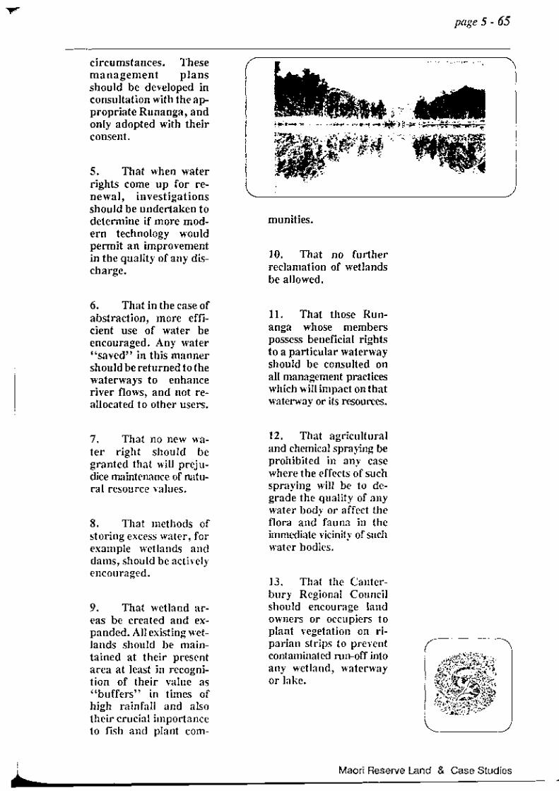
circumstances. These management plans should be developed in consultation with the appropriate Runanga, and only adopted with their consent.
5. That when water rights come up for renewal, investigations should be undertaken to determine if more modern technology would permit an improvement in the quality of any discharge.
6. That in the case of abstraction, more efficient use of water be encouraged. Any water "saved" in this manner should be returned to the waterways to enhance river flows, and not reallocated to other users.
7. That no new water right should be granted that will prejudice maintenance of natural resource values.
8. That methods of storing excess water, for example wetlands and dams, should be actively encouraged.
9. That wetland areas be created and expanded. All existing wetlands should be maintained at their present area at least in recognition of their value as "buffers" in times of high rainfall and also their crucial importance to iIsh and plant com-
munities.
10. That no further reclamation of wetlands be allowed.
11. That those Runanga whose members possess beneficial rights to a particular waterway should be consulted on all management practices which will impact on that waterway or its resources.
12. That agricultural and chemical spraying be prohibited in any case where the effects of such spraying will be to degrade the quality of any water body or affect the flora and fauna in the immediate vicinity of such water bodies.
13. That the Canterbury Regional Council should encourage land owners or occupiers to plant vegetation on riparian strips to prevent contaminated run-off into any wetland, waterway or lake.
page 5 - 65
Maori Reserve Land & Case Studies .. --------------------------------------------------------------.~

page 5 - 66
CASE STUDY;
ROCK ART IN THE
LOWER WAlTAKI VALLEY
This case study concentrates specifically on the Waitaki Valley area. However, other rock art sites are known, for example at Weka Pass, and the comments here apply equally to all such sites.
Given that heke Gourneys) were undertaken regularly up the Waitaki Valley, it is not surprising that it is part of the country's major collection of rock art sites. On stylistic grounds, the Waitaki River appears to have acted as a form of cultu '!"al barrier in rock art design. Understanding of such matters will hopefully become more enlightened as a result of current rock art study and recording projects.
RockMSites
Despite various studies into different facets of rock art, little is actually understood about what these taonga represent. Their significance; the styles and vari-
ations; their role as boundary markers; and their relationship to other art forms of the prehistoric peoples are not well understood. Similarly, there is a paucity of information relating to the
Ngai Tahu Resource Management Strategy for the Canterbury Region
total distribution and antiquity of rock art, and its tolerance of environmental change.
South Island Rock M Project
To shed some light on the above questions before these taonga are lost, the South Island Rock Art Project has been initiated.
The intentions of the Project are to survey, pin-point and record, using specialised photographic equipment, all rock art sites in the South Island. The second phase is to undertake any conservation measures required to preserve these taonga for future generations and future study. Although a mammoth task, this project was started immediately because of the rapid deterioration of the art and its susceptibility to changing conditions.
The project is proceeding under the authorisation of the Moeraki, Waihao and Arowhenua Runanga, and the Ngai Tahu Maori Trust Board.
In order to gain an early understanding of the project's requirements, and to build a case for future funding, a pilot study is currently underway in the Waitaki area. The study covers the area extending from Oamaru to the Kakanui River, with the coast and State Highway No.1 as the longitudinal boundaries.

Already the results have been unexpectedly impressive, and have indicated the following factors:
1. A considerable amount of the art is previously unrecorded or insufficiently recorded. It is common to recognise further art in already known sites. For example, Trotter and Harrowfield claim that all the recognisable art of site 5136/10 is reproduced, whereas study shows that at least half of that material is not recorded.
2. The potential for the discovery of many unrecorded sites. Within the area of the pilot study there were only fifteen sites previously recorded. However, the survey has revealed thirty more, making the new total forty-five. It should be emphasised that these are all separate sites, and not merely further art in already known sites. There is no reason to expect results to differ in any other area to be studied. The ~oordinator of the survey project IS of the opinion that the areas around Duntroon, Maraewhenua, Kokoamo and Earthquakes have potential for many more rock art sites.
3. The rapid deterioration of some of these taonga.
4. The inadequacies of previous surveys, and hence:
5. The inadequacies of the
current rock art records. These are demonstrated by the new findings which strongly suggest that past studies are of an insufficient standard on which to base conclusive interpretations and! or future management decisions.
Preservation
As with any site of traditional, spiritual or ethnological significance, the preservation of rock art sites is of great concern to the tangata whenua. It should be noted here that there are two important considerations:
1. The preservation of the art itself;
2. The preservation of the site and the support medium for the art.
Rock Art Deterioration
The greatest threat to the rock and the art that it supports appears to be indirect. Although not
page 5 - 67
Maori Reserve Land & Case Studies

page 5 - 68
immediately damaging in the same way as direct human or animal interference, wind-borne dust appears to be a major threat. Wind-borne dust abrades and erodes the pigment of the art itself andthesupponingrock.~t which has settled above the art or shelter may be washed down in rain seepage, covering the art from view. An example of the effects of wind-borne dust can be seen at the renown T akiroa Site, famous for its 'T aniwha'. ~t stirred up on the neighbouring road is abrading the art and undercutting the blocks supponing it. The implications of land developers being unaware as to the presence of art is obvious.
Further, the dust factor can deteriorate the support medium. Moisture gathers in hair-line cracks in the rock surface, but usually evaporates. However, if dust is added to the moisture the evaporation rate is retarded. Any material which will cause expansion and contraction when combined with moisture will cause instability in the supporting rock, potentially causing the loss of the art. A related threat is the possibility of seed germination in the "soil" filled cracks.
Ngai Tahu Resource Management Strategy for the Canterbury Region
The rock on which the art is drawn exists in, and is part of, a fragile micro-environment. This environment is susceptible to damage from changing conditions - such as the increase of windborne dust. The dust factor is perhaps the major concern, in that it potentially threatens all of the taonga. Distance from the dust . source is no guarantee of safety, and the effects are indiscriminate.
Site SUNeys
Ngai Tahu, the Historic Places Trust and Electricorp Production are presently attempting to decide the future of the archaeological and rock art sites in the midWaitaki Valley, on the basis of past anthropological surveys and the Historical Places site records.
Due to the nature of site recording in the past, the present records could best be considered to be of a "hit and miss" nature. Funher, the site records suggest that future investigations are warranted.

According to the papers of Brian Allingham, the coordinator of the rock art survey, the only two extensive surveys and investigations to have occurred in the area under consideration are those of Trotter, 1977, and Vincent, 1980. Vincent writes:
"Much of the previous field work has oeen of a piece-meal nature, and with the exception of Trotter's 1977 [work], no systematic examination by archaeologists [has been] undertaken" .
(30)
In consideration of the following facts:
* past surveys;
* the recommendation of Vincent (1980);
* the recommendation of the Tribe's own consultants;
* the findings of the South Island Rock Art Project pilot study;
* and unease about the present state of the site records;
Ngai Tahu accordingly have arrived at the opinion that a full archaeological and rock art survey needs to be completed in the Waitaki area.
Policy
1. See policies in Wahi Taonga above 4 -31 & 4 - 32.
Urupa
Maori Reserve 881
AWARUA
Section 62
A warua was gazetted and was set aside as both an urupa and a Maori Reserve in 1941.
(47)
Today it is vested in Trustees elected by the Temuka Ngai Tahu.
Section 5
This section was gazetted in 1941 as an urupa for the common use of the Maori residents of Arowhenua. The land is now vested in Trustees elected by the Temuka Ngai Tahu.
(48)
page 5 - 69
Maori Reserve land & Case Studies

t
page 5 -70
TUHAWAIKI POINT
Tuhawaiki Point is sited just below Timaru. It is located on map K 39 D of the Historic Places Trust series. This area was where Tuhawaiki, the senior rangatira of the Murihiku Ngai Tabu, was drowned in 1845. Ngai Tabu do not fish this area out of respect to a tribal tragedy, and the area is presently being considered as a Marine Reserve.
WAIHAO
Reserves
WAIKAWA
Maori Reserve 891, Block iv I Waitaki SO
Area: 150 acres
Description
This reserve was granted by the Native Land Court in 1868.
Ngai Tahu Resource Management Strategy for the Canterbury Region
WAIHAO
Maori Reserve 903, Block iv! vii, Waitaki SO.
Area: 502 acres 0 roods 18 perches
Description
It is on this reserve that the Morven Maori community situated themselves. There is an urupa and marae sited on section 3~ and both are set aside as a Maori Reservation.
However, the Waihao Ngai Tabu faced the problem of not being allowed to be buried in their own urupa because the District Scheme zoning ordinances did not permit that use. This meant that many were buried in Pakeha cemeteries - away from their rightful resting place. This matter is specifically discussed in the Urupa Policy section on pp. 4.27 and 4.28.
WAITAKI
Maori Reserve 12373, Waitaki SO.
Area: 150 acres
Description
As with Waihao, this reserve was set aside by the Native Land Court in 1868. All the sections here have passed into general title.
WAIMATE
Maori Reserve 888
Maori Reserve 904
Area: MR 888 40 acres MR 904 30 acres
Description
Traditionally, this area was a mahinga kai for fowling. Tui, kereru, kaka and weka were taken from the bush.
MR 888 was granted in 1854 by the Native Land Court, and was sold in 1965 by the Maori Trustee.
MR 904 was vested in the Maori Trustee in 1970 and sold by him in 1971.
MR 888, section 5, is the burial place of Huruhuru, the local chief of the area in the mid 1800s. Because of desecration of the urupa, the local council sought to vest the urupa in the Waimate Borough Council. The Land Court actioned the Council's wishes in 1935 under the Native Purposes Act, 1933.
TAUHINU
Maori Reserve 880, Block xvi & xiii, Waitaki SO.
Area: 23 acres 1 rood 13 perches
Description
This reserve was set aside by Mantell in 1848 and surveyed in 1877. The area has been vested in the Maori Trustee since 1985 who has leased it for a period of ten years.
Silent File: 035
Map 5.78}
PUNA-Q-MARU
Maori Reserve, Block i, Awamoko SO.
Area: 456 acres
Description
Traditionally, Puna-o-Maru was a launching place for mokihi travelling up the Waitaki River and on the return journey the mokihi would beach at Tauhinu across the other side of the river.
This reserve lies at the junction of the Waitaki and Awakokomuka Rivers. It was reserved in 1848 by
page 5 - 71
Maori Reserve Land & Case Studies

page 5 - 72
---------------------------------------------------------------------Mantell and surveyed in 1890.
In 1928 three partitions of section 92 were acquired by the Crown and leased in 1929 for 66 years. In 1979 the lease was converted into a deferred payment licence which would see the land given freehold title on or before the year 2000.
The rest of the reserve is now leased by the Waihao Maori Committee.
According to the local Ngai Tabu, there is an urupa sited in the middle of the reserve. However, the farmer who leased the land has removed the fence, making the exact location unclear.
GlENAVY
Land set aside in G lenavy for "half-castes" were sections of larger reserves in the area. The sections were:
1. Section 103, Rsve 642, Block xiv, Waitaki SO.
Area: 5 acres
2. Section 108, Rsve 1644, Block xiv & xv, Waitaki SO.
Area: 235 acres 1 rood 30 perches
3. Section 111, Rsve 1644, Block xiv & xv, Waitaki SO.
Area: 12 acres
4. Section 114, Rsve 1644, Block xiv, Waitaki SO.
Ngai Tahu Resource Management Strategy for the Canterbury Region
Area: 18 acres
Description
All of these sections were surveyed off in 1881, but due to the Middle Island Half Castes Act, 1885, not all the land was allocated to the listed half-castes arid the Crown retained part of section 114. The unallocated parts of section 114 were then taken by the Railways Department in 1955. In 1929 a further 4 acres were taken from section 114 for the Waitaki hydro-electric power scheme.
Today much of the land has passed into general title.
Fishing Easements
PUKAKATI
Maori Reserve 907, Block xii, Waimate SO.
Area: 20 acres
Description

I I
•
In 1982 this reserve was vested in the Maori Trustee.
TE HOUIRI
Maori Reserve 906, Waimatemate SO.
Area: 10 acres 3 roods 15 perches
Description
This easement is sited near the ,!,ainono Lagoon. Traditionally It has been a camping site where the local Ngai Tahu would catch the various types of tuna and duck that the lake sustained.
Ownership was determined in 1887 by the Native Land Court who determined that the owners in the Waimatemate Reserve had an interest in T e Houiri.
In 1969 the Maori Land Court vested the reserve in Trustees who
had the power to lease the lands. The proceeds were to go to the upkeep of the Morven Maori Hall, the Morven Maori Cemetery and the Puna-o-Maru Cemetery.
TE AWAKOKOMUKA
Maori Reserve 912, Waimatemate SO.
Area: 10 acres 1 rood 10 perches
Description
This was originally a fishing easement at the mouth of the Waitaki on the northern side.
In 1887 the Native Land Court listed the owners as those who had interests in the Waimatemate Reserve, and in 1969 the reserve was vested in Trustees who were to use the proceeds from the lease to maintain the Morven Maori Hall and the Morven Maori Cemetery.
MAHINGAKAI
WAINONO
This lake is flanked by two fishing easements, Houiri (MR906) and Pukakati (MR 907).
page 5 - 73
" an important mahinga kai of the local Ngai Tahu ... "
Maori Reserve Land & Case Studies

page 5 - 74
" It is an important tribal tauranga ika
. (fishing ground). "
Wainono is the South Canterbury equivalent to lakes T e Waihora and Wairewa near Banks Peninsula. Wamono was an important mahinga kai of the local Ngai Tabu and was used to take lake-sourced food, in a similar manner to that at Wairewa.
Today the bottom of Wainono is covered in a thick mud which, in some parts, is knee-deep. The area of Wamono has been reduced by drainage activities which have also caused the destruction of the fish and waterfowl habitat.
An example is the declineof the swan at Wainono. Swan eggs were taken by local Ngai Tabu in the right season. The swans were cared for and nursed by the Waihao Ngai Tabu and the nests were strengthened by raupo and driftwood. During this period, the eggs were collected but this activity was regulated to maintain a continual supply. However, due to regulations introduced by the Acclimatisation Society the Waihao Ngai Tabu had their custodianship role removed.
The Waihao Ngai Tahu have always had problems fishing and caring for the lake because of the actions of Government bodies and
Ngai Tahu Resource Management Strategy for the Canterbury Region
the Acclimatisation Society. One petition in 1931, from Korerehu Mihaka and 65 other Ngai Tabu, asked that legislation be passed to give the Waihao Ngai Tabu:
"[ the] ... free and undisturbed right of catching and fishllig and torching for eels, flounders and kanakana on Lake Wamono and Waihao and Waitaki Rivers situated in !he Canterbury Provmce ... ... Today we, the descendants of those elders, are stopped from catching and torching eels on the Waihao and Waitaki Rivers by the Waimate Acclimatisation Sociery. We also claim the wliole of the lake and land adjoined to our lake reserves and the present water line of the lake."
(49)
Nothing came of this petition and today swan numbers are insufficient to allow the taking of their eggs. This outcome could have been avoided if the Waihao Ngai Tabu had not been ignored when management plans for the lake were drawn.
Waihao Ngai Tabu, however, are still familiar with the traditional conservation practises relating to Wainono. Their principal concern is that commercial fishing should be banned in the Waihao River and all of the connecting tributaries.
WAIHAO
This river is important to the Ngai Tabu of the Waihao, Waimate and Waitaki districts.

The mouth of the river is known as "The Box" or more properly as Tu-Karae-o-Pito. The name of the river recalls that T e Rakaihautu landed here in his journey along the Waitaha coastline. It is an important tribal tauranga ika (fishing ground).
The river is a mahinga kai and the waimataitai waters at the mouth of the river run into Wainono. This part of the river is an important regulator which adjusts the flow of kai mataitai in and out of the river. As with Wairewa and T e Waihora, the timing of the opening and closing of the mouth needs to consider the requirements of migrating fish. This should be done in consultation with the local Ngai Tahu.
As with all waterways, the tributaries which run into the main river are also important. The important tributaries connected to Waihao are:
OMARAMA
Omarama is the first creek which runs off from Pt 14, just off Bradshaw's Road. For a more specific location see map 5.78 K.
The water quality of this part of the river was ideally suited to eel and trout, and while these
species are still taken there, the quantities are greatly reduced. Also, freshwater mussel and crayfish were farmed in this river but have not been seen for some time.
PUNATARAKAOA
Punatarakaoa refers to part of the Omarama tributary which is also shown on map 5.78 K. Many Ngai Tahu have been drowned here and, therefore, local Ngai T ahu are reluctant to take food from this area.
Silent file: 036
Map 5.78 K.
page 5 -75
"As with all waterways J the tributaries which run into the main river are also important. "
Maori Reserve Land & Case Studies

page 5 - 76
Ngai Tahu Resource Management Strategy for the Canterbury Region

Notes
1. Mackay 1872: Papers Relative to the Kaiapoi Reserve.
2. AJHR. 1891 Go 7: 56. Report by Alexan-der Mackay, under Royal Commission on Middle Island Native Claims.
3. Orakei Report IWai 9): 30.
4. ibid.
5. Rangiora County Council, Proposed District Scheme, Part 4 11.1).
6. ibid., Part 4, 1.2. Ic).
7. Mackay, 1871: 210-211.
8. New Zealand Gazette, 1861.
9. New Zealand Gazette, 1868: 263.
10. New Zealand Gazette, 1868: 145.
11. New Zealand Gazette. 1972: 789.
12. New Zealand Gazette, 1883: 22.
13. New Zealand Gazette, 1880: 114-115.
14. The claim of Te Oti Pita Mutu and 25 others concerning the destruction of their fisheries. AJHR, 1880 1-2: 28.
15. New Zealand Gazette, 1956: 718.
16. Refer to section on the fishing easements.
17. Refer to Brailsford.
page 5 -77
18. AJHR, 1891 G-7: 56.
19. New Zealand Gazette, 1956: 1179.
20. Mackay 2: 208.
21. DLS, 1982: 48.
22. New Zealand Gazette, 1946: 703.
23. New Zealand Gazette, 1949: 1811.
24. Anderson G.E., "The Queens Chain", The Landscape, J1, New Zealand Institute.
25. Buick, 1976 (36): 75.
26. New Zealand Gazette, 1949, 1811.
27. New Zealand Gazette, 1979. (1): 20.
28. AJHR, 1881, G-6: 90.
29. J.P. McAloon, Document H 9, "Wai 27".
Ngai Tahu Evidence to the Waitangi Tribunal, p.2.
30. ibid., p.4.
31. ibid., p.6.
32. Lands & Survey: 13.
33. ibid., p.12.
34. Waitangi Tribunal: Report Wai-17:6.
35. Lands & Survey: 12.
Maori Reserve Land & Case Studies
page 5 - 78
36. ibid., p.41.
37. McAloon, p.6.
38. C. Brown, Document H 9, "Wai 27", Ngai Tahu Evidence to the Waitangi Tribunal. p.5.
39. Taumutu Runanga Minutebook.
40. New Zealand Gazette, 1883: 1529-1530.
41. New Zealand Gazette, 1941: 1465.
42. New Zealand Gazette, 1945: 82.
43. New Zealand Gazette, 1947: 904.
44. lands and Survey Department Report.
45. Timaru Herald.
46. Waitangi Tribunal Hearings into the Ngai Tahu Claim. Wai-27. (Evidence Documentation referred to is available in the Canterbury Public and Canterbury University libraries, presented by the Ngai Tahu Maori Trust Board).
47. New Zealand Gazette. 1941: 1479.
48. New Zealand Gazette, 1941: 1479.
49. Petition of Korerehu Mihaka and 65 others, MA 1931/292.
Section 5 maps follow
Appendix A
:: .. Silent File" Maps at pp 5 - 78 A - K.
Appendix B
:: specially made Historic Places Trust aggregated sites maps
at pp. 5 - 79 A - K.
Appendix C
:: provides detailed site-specific information for the maps
of Appendix B at pp 5 - 81 A-X.
Ngai Tahu Resource Management Strategy for the Canterbury Region