Redalyc.Process simulation-based improvements to maximize ...
Upload
khangminh22Category
view
0download
0
TERMINAL AREA IMPROVEMENTS FINAL ENVIRONMENTAL ASSESSMENT
Hilton Head Island Airport Hilton Head Island, South Carolina
Federal Aviation Administration Atlanta Airports District Office
1701 Columbia Avenue Campus Building, Suite 2-260 College Park, Georgia 30337
April 24, 2020 Mr. Jon Rembold, Director of Airports Hilton Head Island Airport P.O. Box 23739 120 Beach City Road Hilton Head Island, SC 29925-3739 Dear Mr. Rembold: Enclosed is a copy of the Environmental Assessment (EA) Cover Sheet and Finding of No Significant Impact (FONSI)/Record of Decision (ROD) for the proposed Terminal Area Improvements at Hilton Head Island Airport. The development projects have been evaluated and environmentally approved. This is not an obligation for funding. The FONSI/ROD addresses the immediate proposed action as defined and analyzed in the corresponding EA. If there are changes to the proposed action or if the improvements are not initiated within three (3) years, the proposed project would need to be reevaluated to determine if it still adequately fulfills the requirements of the National Environmental Policy Act. A Public Notice announcing the availability of the EA and FONSI/ROD and the location they may be reviewed should be made. A draft example of this notice is enclosed for your use. This notice is not to solicit public comments but rather notify the public that the Final EA and FAA decision document has been issued and is available for review. If you have any questions or require additional information please contact me at (404) 305-6708. Sincerely, Lee Kyker Environmental Program Manager Enclosures cc: Mr. James Stephens, South Carolina Aeronautics Commission Ms. Judy Elder, Talbert, Bright & Ellington

FINDING OF NO SIGNIFICANT IMPACT/ RECORD OF DECISION
FOR
TERMINAL AREA IMPROVEMENTS AT
HILTON HEAD ISLAND AIRPORT HILTON HEAD, SOUTH CAROLINA
April 2020
DEPARTMENT OF TRANSPORTATION FEDERAL AVIATION ADMINISTRATION ATLANTA AIRPORTS DISTRICT OFFICE
U.S. DEPARTMENT OF TRANSPORTATION

Finding of No Significant Impact/Record of Decision
Terminal Area Improvements Hilton Head Island Airport 2
FEDERAL AVIATION ADMINISTRATION FINDING OF NO SIGNIFICANT IMPACT/RECORD OF DECISION
INTRODUCTION/BACKGROUND In compliance with the National Environmental Policy Act (NEPA), this Finding of No Significant Impact (FONSI) and Record of Decision (ROD) announces final agency determinations and approvals for those Federal actions by the Federal Aviation Administration (FAA) that are necessary to support implementation of a capital improvement project to conduct terminal area improvements at the Hilton Head Island Airport (HXD), as requested by the airport sponsor, Beaufort County, South Carolina. This FONSI/ROD provides the FAA's final determinations and approvals based on analyses described in detail in the Final Environmental Assessment for the Terminal Area Improvements at Hilton Head Island Airport, April 2020. The agency decision is based on information contained in the Final Environmental Assessment (EA), incorporated herein by reference, and all other applicable documents available to the agency. This ROD is issued in accordance with the requirements of the Council on Environmental Quality (CEQ) Regulations, 40 Code of Federal Regulations (CFR) 1505.2. PROPOSED FEDERAL ACTION The Sponsor has requested FAA Airport Improvement Program (AIP) financial assistance and approval to conduct terminal area improvements at the Hilton Head Island Airport, located in Beaufort County, South Carolina. Elements of the proposed capital improvement project include:
• Expansion and renovation of the commercial service terminal to add four aircraft gates (with the ability to expand to six), improve the ticketing, baggage claim and rental car area, improve and expand the United Stated Department of Homeland Security (USDHS) Transportation Security Administration (TSA) security checkpoints, as well as provide renovated and new restrooms on both sides of the TSA security checkpoints
• Expansion of the commercial service parking apron to accommodate four aircraft and have holding areas for two additional aircraft, as necessary
• Expansion of the existing vehicular parking area
• Acquisition of five property parcels along Hunter Road, south of the commercial terminal
service area, to accommodate the commercial service terminal area improvements

Finding of No Significant Impact/Record of Decision
Terminal Area Improvements Hilton Head Island Airport 3
• Strengthening of Runway 03/21 and Taxiway F from 75,000 pounds dual wheel gear to 120,000 pounds dual wheel gear to accommodate the existing commercial service aircraft or any other aircraft
PURPOSE AND NEED The Sponsor has defined the purpose and need for implementing the Proposed Action as necessary to provide for an improved level of service for commercial service passengers and enhance safety for aircraft currently using HXD, resulting in the continuation of meeting current needs, as well as increased aviation demand. The need for the terminal area imrpvements are a result of the completion of the 700-foot runway extension project in July 2018. Since that time Hilton Head Island Airport has experienced rapid airline growth. In less than one year, the Airport has increased from a single airline, single destination facility to a thriving airport with three network airlines serving seven destinations. American Airlines (AA) transitioned from Bombardier Q200 and Q300 turboprop aircraft to Embraer (E) 175 regional jets in July 2018 serving Charlotte-Douglas International Airport (CLT) with three daily flights and adding weekend flights to Ronald Reagan Washington National Airport (DCA) in May 2019. United Airlines (UA) started seasonal (April through mid-September) service with Embraer 175 aircraft in late March 2019 with two daily flights to Washington Dulles International Airport (IAD) and weekend service to Chicago O'Hare International Airport (ORD) and Newark Liberty International Airport (EWR). Delta Air Lines (DL) started service in May 2019 with Embraer 170 aircraft, providing three daily flights to Hartsfield-Jackson Atlanta International Airport (ATL) and seasonal (June through August) weekend service to LaGuardia Airport (LGA, June 2019). REASONABLE ALTERNATIVES Federal guidelines concerning the environmental review process require that all reasonable and practicable alternatives that might accomplish the objectives of a proposed project be identified and evaluated. Such an examination ensures that an alternative that addresses the project's purpose and that might enhance environmental quality, or have a less detrimental effect, has not been prematurely dismissed from consideration. In the EA, reasonable and practicable alternatives were carefully examined. The alternatives considered are described below: Several alternatives were carried forward for the preliminary screening criteria analysis.
• No-Action • Commercial Service Terminal Improvements – Options 1 through 4 • Commercial Service Aircraft Parking Ramp Improvements • Commercial Service Automobile Parking Improvements • Runway 03/21 and Taxiway F Strengthening

Finding of No Significant Impact/Record of Decision
Terminal Area Improvements Hilton Head Island Airport 4
After applying preliminary screening criteria, Commercial Service Terminal Option 4 along with the expansion of the commercial service aircraft parking ramp and automobile parking and Runway 03/21 and Taxiway F strengthening met the Sponsor's established screening criteria and could reasonably and feasibly be accomplished. Thus, the alternative considered in greater detail in the EA included on the No-Action alternative, as described below: No-Action Alternative The No-Action Alternative is included in the Alternatives Analysis as part of the NEPA process. It describes the existing conditions at the Airport, and provides a baseline for comparing the Reasonable Alternatives in terms of fulfilling the Purpose and Need of the proposed project and impacts to resources within and in the vicinity of the project area. Commercial Service Terminal Option 4 along with the expansion of the commercial service aircraft parking ramp and automobile parking and Runway 03/21 and Taxiway F (Sponsor's Preferred Alternative) ENVIRONMENTAL IMPACTS As documented in the attached EA, the Proposed Action and No-Action Alternatives were evaluated for potential impacts to all environmental resource topic areas outlined in FAA Order 1050.lE, Environmental Impacts: Policies and Procedures, FAA's Order implementing the NEPA. Under the No-Action Alternative, no action would be taken and there would be no associated environmental impacts. The following is a discussion of those resources identified as present and with potential to be significantly affected under the Proposed Action (Sponsor's Preferred Alternative): Jurisdictional waters of the US are located within area of potential effect (APE) totaling 3.05 acres would have permanent direct impacts. Current United States Army Corps of Engineers (USACE) policy is to provide mitigation based on credit calculations. However, mitigation credits are not available on Hilton Head Island. Therefore, the wetland mitigation credits required under the proposed action will be obtained from a USACE-approved commercial mitigation bank. ENVIRONMENTAL MITIGATION There are regulatory permits or certifications that impose mitigation requirements to minimize environmental impacts during implementation of the Proposed Action. The Sponsor is responsible to acquire and comply with all applicable permits and certifications throughout the implementation/construction of the Proposed Action.

Finding of No Significant Impact/Record of Decision
Terminal Area Improvements Hilton Head Island Airport 5
Since no significant impacts have been identified in association with implementing the Proposed Action, aside from required by FAA grant assurances as outlined in FAA Advisory Circular (AC) 150/5370-10, Standards for Specifying Construction of Airports, and minimization and mitigation measures mandated by permitting requirements and/or other special purpose laws, no additional mitigation measures are necessary to ensure less than significant impacts, with the exception of those described in the previous section related to wetlands. SPECIAL CONDITIONS TO BE INCLUDED ON ALL FAA GRANTS PROVIDED TO SUPPORT THE COMPLETION OF ALL PROJECTS INCLUDED IN THE PROPOSED ACTION The airport sponsor or the sponsor's designated consultant must provide the FAA with courtesy copies of all Section 404 Permit deliverables and reporting documentation required by the USACE until such time as the permit requirements are fulfilled. PUBLIC PARTICIPATION The airport sponsor held a public hearing to outline the results of field work performed and for preparation of the EA. The public hearing took place on January 30, 2020, between 5:00 p.m. and 7:00 p.m., at the Hilton Head Island Branch Library, 11 Beach City Road on Hilton Head Island, approximately one mile from the Hilton Head Island Airport. The hearing allowed the project team to provide an opportunity for the public to ask questions. To facilitate the process, each attendee was asked to sign in and complete a public comment form. These forms were completed at the public hearing, mailed, or e-mailed. The project team set up displays that included the results of the impacts on the environmental categories outlined in the EA. Project team representatives were available to answer questions. A table was set up for those who wished to fill out the public comment form at the meeting. Eight people attended the January 30, 2020, public hearing. No comment forms were turned in at the meeting and no comment forms were received by mail during the 45-day open comment period. A summary of agency comments and responses can be found in the Final EA in Appendix F. AGENCY FINDINGS In accordance with applicable law, the FAA makes the following findings/dete rminations for the Proposed Action, based upon the appropriate information and data contained in the EA. The following determinations are prescribed by the statutory provisions set forth in the Airport Airway Improvement Act of 1982, as codified in 49 U.S.C. Sections 44502, 47106, and 47107. The proposed improvement project is reasonably necessary for use in air commerce or for national defense [49 U.S.C. §44502(b)].
Finding of No Significant Impact/Record of Decision
Terminal Area Improvements Hilton Head Island Airport 6
The project is reasonably consistent with existing plans of public agencies for development of the area surrounding the airport [49 U.S.C. §47106(a)(l)]. The interests of the community in or near which the project may be located have been given fair consideration [49 U.S.C. §47106(b)(2)]. The airport sponsor certifies that it has provided an opportunity for a public hearing [49 U.S.C. §47106(c)(l )(A)(i)]. The airpott sponsor certifies that the airport management board has voting representation from the communities in which the project would be located or that the sponsor has advised communities they have a right to petition the secretary of transportation about a proposed project [49 U.S.C. §47106(c)(l)(A)(ii)]. The airport sponsor has taken or will take actions to restrict land uses in the airport vicinity, including adoption of zoning laws, to ensure the uses are compatible with airport operations [49 U.S.C. §47107(a)(l0)]. In accordance with Executive Order 11990, Wetlands, there is no practicable alternative to the proposed action, and the proposed action includes all practicable measures to minimize resultant unavoidable harm to wetlands. DECISION AND ORDER The FAA has determined that environmental and other relevant concerns presented by interested agencies and private citizens have been addressed sufficiently in the EA, hereby acknowledged and fully and properly considered in the decision-making resulting in this FONSI/ROD. The FAA concludes there are no outstanding environmental issues to be resolved by it with respect to the proposed project. The No-Action Alternative fails to meet the purpose and need for the proposed project. For reasons summarized earlie r in this FONSI/ROD, and supported by disclosures and analysis detailed in the EA, the FAA has determined that the Sponsor's proposed project is a reasonable, feasible, practicable and prudent alternative for a Federal decision in light of the established goals and objectives. An FAA decision to take the actions and approvals required by the Sponsor is consistent with its statutory mission and policies supported by the findings and conclusions reflected in the environmental documentation and this FONSI/ROD. After reviewing the EA and all of its related materials, I have carefully considered the FAA's goals and objectives in relation to various aeronautical aspects of the proposed development actions discussed in the EA, including the purpose and need to be met by this project, the alternative means of achieving them, the environmental impacts of these alternatives, the mitigation necessary to preserve and enhance the environment, and the costs and benefits of achieving the purpose and need.

Finding of No Significant Impact/Record of Decision
Terminal Area Improvements Hilton Head Island Airport 7
While this decision does not approve Federal funding for the proposed airport development and does not constitute a Federal funding commitment, it does provide the environmental findings and approval for proceeding to funding actions in accordance with established procedures and applicable requirements. After careful and thorough consideration of the facts contained herein, the undersigned finds that the proposed Federal action is consistent with the national environmental policies and objectives as set forth in Section 101(a) of the National Environmental Policy Act of 1969 (NEPA) and that with the mitigation that is a part of the project it will not significantly affect the quality of the human environment or otherwise include any condition requiring consultation pursuant to Section 101(2)(C) of NEPA. Issued in College Park, Georgia April 23, 2020 Larry F. Clark, Manager FAA, Atlanta Airports District Office
Date

This environmental document becomes a federal document when evaluated and signed by the responsible FAA official. Responsible FAA Official Date
FINAL ENVIRONMENTAL ASSESSMENT
Beaufort County in cooperation with the
Federal Aviation Administration and
South Carolina Aeronautics Commission
Terminal Area Improvements Hilton Head Island, South Carolina
April 2020
Documentation Prepared by:
TALBERT, BRIGHT & ELLINGTON, INC.
April 22, 2020 Date Carl M. Ellington, Jr., P.E., Principal April 22, 2020 Date Judith Elder, Project Manager
For the:
BEAUFORT COUNTY DEPARTMENT OF AIRPORTS
April 22, 2020 Date Jon Rembold, Airports Director
April 22, 2020

HILTON HEAD ISLAND AIRPORT Terminal Area Improvements Environmental Assessment
Table of Contents TALBERT, BRIGHT & ELLINGTON i
TABLE OF CONTENTS 1.0 PROPOSED ACTION ............................................................................... 1
1.1 Proposed Action Overview ......................................................................................................... 1 1.2 Responsible Reviewing Agency ................................................................................................... 3 1.3 Human and Natural Environment Impacts .............................................................................. 3 1.4 Evaluated Impacts ......................................................................................................................... 3 1.5 Avoid and Minimize Impacts to the Human and Natural Environments ............................ 4
2.0 PURPOSE AND NEED FOR THE PROPOSED ACTION ................... 5
2.1 Purpose of the Environmental Assessment .............................................................................. 5 2.2 Purpose and Need of the Proposed Action .............................................................................. 6
2.2.1 Purpose of the Proposed Action ...................................................................................... 6 2.2.2 Need for the Proposed Action .......................................................................................... 6
2.2.2.1 Commercial Service Terminal ................................................................................. 7 2.2.2.2 Commercial Service Aircraft Parking Ramp ....................................................... 10 2.2.2.3 Automobile Parking ................................................................................................ 10 2.2.2.4 Runway 03/21 Strengthening ................................................................................ 13
2.2.3 Prior HXD Environmental Analyses ............................................................................. 13 2.2.4 HXD Aircraft Operational Activity ............................................................................... 14
3.0 ALTERNATIVES ..................................................................................... 16
3.1 Alternatives Analysis ................................................................................................................... 16 3.2 No-Action Alternative ................................................................................................................ 16 3.3 Reasonable Development Alternatives for the Commercial Service Terminal
Improvements .............................................................................................................................. 16 3.3.1 Commercial Service Terminal Option 1 ........................................................................ 17 3.3.2 Commercial Service Terminal Option 2 ........................................................................ 17 3.3.3 Commercial Service Terminal Option 3 ........................................................................ 21 3.3.4 Commercial Service Terminal Option 4 ........................................................................ 23
3.4 Reasonable Development Alternative for the Commercial Service Aircraft Parking Ramp Improvements .................................................................................................................. 26
3.5 Reasonable Development Alternative for the Commercial Service Automobile Parking Improvements ............................................................................................................... 28
3.6 Reasonable Development Alternative for the Runway 03/21 and Taxiway F Strengthening ............................................................................................................................... 31
3.7 Reasonable Alternatives for the Proposed Action ................................................................. 31 4.0 AFFECTED ENVIRONMENT AND ENVIRONMENTAL
CONSEQUENCES .................................................................................. 35 4.1 Air Quality .................................................................................................................................... 35
4.1.1 Definition ........................................................................................................................... 35

HILTON HEAD ISLAND AIRPORT Terminal Area Improvements Environmental Assessment
Table of Contents TALBERT, BRIGHT & ELLINGTON ii
4.1.2 Conformity Requirements ............................................................................................... 36 4.1.3 Existing Conditions .......................................................................................................... 38 4.1.4 Potential Air Quality Impacts .......................................................................................... 38
4.1.4.1 No-Action Alternative ............................................................................................ 38 4.1.4.2 Proposed Action ..................................................................................................... 38
4.1.5 Significance Threshold ..................................................................................................... 39 4.1.6 Potential Air Quality Construction Impacts ................................................................. 40
4.1.6.1 No-Action Alternative ............................................................................................ 40 4.1.6.2 Proposed Action ..................................................................................................... 40
4.2 Biological Resources ................................................................................................................... 40 4.2.1 Definition ........................................................................................................................... 40 4.2.2 Biotic Communities .......................................................................................................... 41 4.2.3 Threatened and Endangered Species ............................................................................. 43
4.2.3.1 Plants ......................................................................................................................... 44 4.2.3.1.1 American Chaffseed (Schwalbea americana) ...................................................... 44 4.2.3.1.2 Carolina Birds-in-a-Nest (Macbridea caroliniana) .......................................... 47 4.2.3.1.3 Cilate-leaf Tickseed (Coreopsis integrifolia) ......................................................... 47 4.2.3.1.4 Pondberry (Lindera melissifolia) .......................................................................... 47 4.2.3.1.5 Raven's Seedbox (Ludwigia ravenelii) ................................................................. 48
4.2.3.2 Birds .......................................................................................................................... 48 4.2.3.2.1 Bald Eagle (Haliaeetus leucocephalus) ................................................................... 48 4.2.3.2.2 Black-Capped Petrel (Pterodroma hasitata) ........................................................ 49 4.2.3.2.3 Eastern Black Rail (Laterallus jamaicensis)......................................................... 49 4.2.3.2.4 Kirtland's Warbler (Dendroica kirtlandii) ....................................................... 50 4.2.3.2.5 Least Tern (Sterna antilarum) ............................................................................. 50 4.2.3.2.6 MacGillivray's Seaside Sparrow (Ammodramus maritimus macgillivraii) .......... 51 4.2.3.2.7 Piping Plover (Charadrius melodus) .................................................................... 51 4.2.3.2.8 Red-Cockaded Woodpecker (Picoides borealis) ................................................ 52 4.2.3.2.9 Rufus Red Knot (Calidris canutus rufa) ............................................................. 53 4.2.3.2.10 Wood Stork (Mycteria americana) ..................................................................... 53
4.2.3.3 Amphibians and Reptiles ....................................................................................... 54 4.2.3.3.1 American Alligator (Alligator mississippiensis) ................................................... 54 4.2.3.3.2 Eastern Diamondback Rattlesnake (Crotalus adamanteus) ............................. 54 4.2.3.3.3 Flatwoods Salamander (Ambystoma cingulatum) ............................................... 55 4.2.3.3.4 Florida Pine Snake (Pituophis melannoleucus) ..................................................... 55 4.2.3.3.5 Southern Hognose Snake (Heterodon simus) .................................................... 56 4.2.3.3.6 Spotted Turtle (Clemmys guttata) ..................................................................... 56
4.2.3.4 Insects ....................................................................................................................... 57 4.2.3.4.1 Monarch Butterfly (Danaus plexippus) .............................................................. 57
4.2.3.5 Mammals .................................................................................................................. 57 4.2.3.5.1 Northern Long Eared Bat (Myotis septentrionalis) ............................................ 57 4.2.3.5.2 Tricolored Bat (Perimyotis subflavus) .................................................................. 58
4.2.4 Migratory Birds .................................................................................................................. 58

HILTON HEAD ISLAND AIRPORT Terminal Area Improvements Environmental Assessment
Table of Contents TALBERT, BRIGHT & ELLINGTON iii
4.2.5 Invasive Species ................................................................................................................. 61 4.3 Climate .......................................................................................................................................... 61
4.3.1 Definition ........................................................................................................................... 61 4.3.2 Greenhouse Gases and Climate Change........................................................................ 62 4.3.3 Potential Greenhouse Gases Impacts ............................................................................ 63
4.4 Coastal Resources ........................................................................................................................ 63 4.4.1 Definition ........................................................................................................................... 63 4.4.2 Coastal Zone Management Act ...................................................................................... 63 4.4.3 Coastal Barrier Resource Act .......................................................................................... 66 4.4.4 Potential Coastal Resources Impacts ............................................................................. 66
4.4.4.1 South Carolina Heritage Trust Program Preserves ............................................ 66 4.4.4.2 State Wildlife Preserves .......................................................................................... 68 4.4.4.3 State Parks ................................................................................................................ 68 4.4.4.4 Scenic Rivers ............................................................................................................ 68 4.4.4.5 Marine and Estuarine Sanctuaries......................................................................... 68 4.4.4.6 Shellfish Areas ......................................................................................................... 69 4.4.4.7 Groundwater Resources......................................................................................... 69 4.4.4.8 Threatened and Endangered Species Habitats ................................................... 69 4.4.4.9 State Ports ................................................................................................................ 69 4.4.4.10 Navigation Channels............................................................................................... 69 4.4.4.11 Mining Operations .................................................................................................. 69 4.4.4.12 Areas of Special Historic, Archaeological, or Cultural Significance ................ 69 4.4.4.13 Coastal Barrier Resouce Act .................................................................................. 69
4.4.5 South Carolina Coastal Zone Consistency Determination ......................................... 69 4.5 Department of Transportation Act: Section 4(f) .................................................................... 71
4.5.1 Definition ........................................................................................................................... 71 4.5.2 Potential Section 4(f) Impacts ......................................................................................... 71
4.6 Farmlands ..................................................................................................................................... 71 4.6.1 Definition ........................................................................................................................... 71 4.6.2 Existing Soils ...................................................................................................................... 72 4.6.3 Potential Farmland Impacts ............................................................................................ 74
4.7 Hazardous Materials, Solid Waste, and Pollution Prevention .............................................. 75 4.7.1 Hazardous Materials ......................................................................................................... 75
4.7.1.1 Definition ................................................................................................................. 75 4.7.1.2 Existing Conditions ................................................................................................ 76 4.7.1.3 Potential Hazardous Materials Impacts ............................................................... 76
4.7.1.2.1 On-Site Findings ................................................................................................ 76 4.7.1.2.2 Off-Site Findings ............................................................................................... 80 4.7.1.2.3 Conclusions ........................................................................................................ 80
4.7.2 Solid Waste ......................................................................................................................... 80 4.7.2.1 Existing Conditions ................................................................................................ 80 4.7.2.2 Potential Solid Waste Impacts............................................................................... 80
4.7.2.2.1 No-Action Alternative ...................................................................................... 80

HILTON HEAD ISLAND AIRPORT Terminal Area Improvements Environmental Assessment
Table of Contents TALBERT, BRIGHT & ELLINGTON iv
4.7.2.2.2 Proposed Action ................................................................................................ 81 4.7.3 Pollution Prevention ......................................................................................................... 81
4.7.3.1 Definition ................................................................................................................. 81 4.7.3.2 Existing Conditions ................................................................................................ 82 4.7.3.3 Potential Pollution Prevention Impacts ............................................................... 82
4.7.3.3.1 No-Action Alternative ...................................................................................... 82 4.7.3.3.2 Proposed Action ................................................................................................ 82
4.8 Historic, Architectural, Archaeological, and Cultural Resources ......................................... 82 4.8.1 Definition ........................................................................................................................... 82 4.8.2 Cultural Resources Investigation .................................................................................... 83
4.8.2.1 Previous Cultural Resources Investigations ........................................................ 83 4.8.2.2 Archaeological Survey Results............................................................................... 83 4.8.2.3 Architectural Survey Results .................................................................................. 89 4.8.2.4 Summary and Management Recommendations ................................................. 89
4.9 Compatible Land Use ................................................................................................................. 90 4.9.1 Definition ........................................................................................................................... 90 4.9.2 Location .............................................................................................................................. 90 4.9.3 Existing Land Use and Zoning ....................................................................................... 90 4.9.4 Airport Overlay District ................................................................................................... 94 4.9.5 Comprehensive Plan Land Use ....................................................................................... 94 4.9.6 Potential Compatible Land Use Impacts ....................................................................... 96 4.9.7 Future Land Use Changes................................................................................................ 98 4.9.8 Town of Hilton Head Island Land Use Consistency Determination ....................... 98
4.10 Natural Resources and Energy Supply ..................................................................................... 98 4.10.1 Definition ........................................................................................................................... 98 4.10.2 No-Action Alternative on Natural Resources and Energy Supply ............................ 99 4.10.3 Proposed Action on Natural Resources and Energy Supply ...................................... 99
4.11 Noise ............................................................................................................................................. 99 4.11.1 Definition ........................................................................................................................... 99 4.11.2 Existing (2019) Noise Contours ................................................................................... 101 4.11.3 Future (2029) Noise Contours ...................................................................................... 101 4.11.4 Significance Threshold ................................................................................................... 109
4.11.4.1 No-Action Alternative .......................................................................................... 109 4.11.4.2 Proposed Action ................................................................................................... 109
4.11.5 Potential Construction Noise Impacts ......................................................................... 109 4.11.5.1 No-Action Alternative .......................................................................................... 109 4.11.5.2 Proposed Action ................................................................................................... 109
4.12 Socioeconomic Impacts, Environmental Justice, and Children’s Health and Safety Risks ............................................................................................................................................ 110
4.12.1 Socioeconomic Impacts ................................................................................................. 110 4.12.1.1 Socioeconomic Environment .............................................................................. 110 4.12.1.2 Potential Socioeconomic Impacts ...................................................................... 111
4.12.1.2.1 No-Action Alternative .................................................................................. 111
HILTON HEAD ISLAND AIRPORT Terminal Area Improvements Environmental Assessment
Table of Contents TALBERT, BRIGHT & ELLINGTON v
4.12.1.2.2 Proposed Action ............................................................................................ 111 4.12.2 Environmental Justice .................................................................................................... 115
4.12.2.1 Definition ............................................................................................................... 115 4.12.2.2 Minority Populations ............................................................................................ 117 4.12.2.3 Low-Income Populations .................................................................................... 117 4.12.2.4 No-Action Alternative Potential Impacts ......................................................... 117 4.12.2.5 Proposed Action Potential Impacts ................................................................... 119
4.12.3 Children’s Health and Safety Risks ............................................................................... 119 4.12.3.1 Definition ............................................................................................................... 119 4.12.3.2 No-Action Alternative .......................................................................................... 119 4.12.3.3 Proposed Action ................................................................................................... 120
4.13 Visual Effects ............................................................................................................................. 120 4.13.1 Light Emissions ............................................................................................................... 120
4.13.1.1 Existing Conditions .............................................................................................. 120 4.13.1.2 Potential Light Emissions Impacts ..................................................................... 121
4.13.1.2.1 No-Action Alternative .................................................................................. 121 4.13.1.2.2 Proposed Action ............................................................................................ 121
4.13.2 Visual Impacts ................................................................................................................. 121 4.13.2.1 Existing Conditions .............................................................................................. 121 4.13.2.2 Potential Visual Impacts ...................................................................................... 121
4.13.2.2.1 No-Action Alternative .................................................................................. 121 4.13.2.2.2 Proposed Action ............................................................................................ 121
4.14 Water Resources ........................................................................................................................ 122 4.14.1 Wetlands ........................................................................................................................... 122
4.14.1.1 Definition ............................................................................................................... 122 4.14.1.2 Wetlands or Waters of the United States Delineation ..................................... 123 4.14.1.3 Impacted Wetlands or Waters of the United States ......................................... 126
4.14.2 Floodplains ....................................................................................................................... 128 4.14.2.1 Definition ............................................................................................................... 128 4.14.2.2 Existing Condition ................................................................................................ 128 4.14.2.3 Potential Floodplain Impacts .............................................................................. 128
4.14.2.3.1 No-Action Alternative .................................................................................. 128 4.13.2.3.2 Proposed Action ............................................................................................ 130
4.14.3 Surface Waters ................................................................................................................. 130 4.14.3.1 Definition ............................................................................................................... 130 4.14.3.2 Surface Water Resources...................................................................................... 130
4.14.4 Groundwater Resources ................................................................................................. 132 4.14.4.1 Surficial Aquifer ................................................................................................... 134 4.14.4.2 Brunswick Aquifer ................................................................................................ 134 4.14.4.3 Floridan Aquifer System ...................................................................................... 134 4.14.4.4 Potential Groundwater Resource Impacts ........................................................ 134
4.14.5 Wild and Scenic Rivers ................................................................................................... 134 4.14.5.1 Definition ............................................................................................................... 134

HILTON HEAD ISLAND AIRPORT Terminal Area Improvements Environmental Assessment
Table of Contents TALBERT, BRIGHT & ELLINGTON vi
4.14.5.2 Designated Federal Wild and Scenic Rivers in South Carolina ...................... 135 4.14.5.3 Designated State Scenic Rivers in South Carolina ........................................... 135 4.14.5.4 Potential Wild and Scenic River Impacts .......................................................... 137
4.14.6 Potential Short-Term Impacts to Water Quality ........................................................ 137 4.14.7 Potential Long-Term Impacts to Water Quality ........................................................ 137 4.14.8 Potential Water Quality Impacts due to Construction .............................................. 138
4.14.8.1 No-Action Alternative .......................................................................................... 138 4.14.8.2 Proposed Action ................................................................................................... 138
4.15 Cumulative Impacts .................................................................................................................. 139 4.16 Irreversible and Irretrievable Commitment of Resources ................................................... 139 4.17 Regulatory Permits and Concurrence ..................................................................................... 141 4.18 Conclusions and Summary ....................................................................................................... 143
5.0 COMMENTS AND COORDINATION ............................................... 145
5.1 Interagency Coordination ......................................................................................................... 145 5.2 Public Information Meeting ..................................................................................................... 145
5.2.1 January 30, 2020, Public Information Meeting ........................................................... 146 6.0 PREPARERS ........................................................................................... 147
6.1 Federal Aviation Administration ............................................................................................. 147 6.2 South Carolina Aeronautics Commission .............................................................................. 147 6.3 Hilton Head Island Airport...................................................................................................... 147 6.4 Talbert, Bright & Ellington, Inc. ............................................................................................. 147 6.5 Ward Edwards, Inc. .................................................................................................................. 148 6.7 S&ME, Inc. ................................................................................................................................. 148 6.8 Brockington and Associates, Inc. ............................................................................................ 148
APPENDICES Appendix A – Correspondence .................................................................................................................. A-1
A.1 Agency Scoping ............................................................................................................................ A-2 A.2 Property Owner Notification ................................................................................................... A-25 A.3 Draft Environmental Assessment Notice of Availability and Public Hearing ................. A-35
Appendix B – Biological Assessment ......................................................................................................... B-1 Appendix C – Phase I Environmental Site Assessment .......................................................................... C-1 Appendix D – Cultural Resources Survey ................................................................................................. D-1 Appendix E – Wetland Jurisdictional Determination and Permit ..........................................................E-1
E.1 Wetland Jurisdictional Determination .......................................................................................E-2 E.2 Wetland Permit........................................................................................................................... E-36 E.3 Responses to Wetland Permit Comments ............................................................................. E-67
Appendix F – Public Participation .............................................................................................................. F-1
HILTON HEAD ISLAND AIRPORT Terminal Area Improvements Environmental Assessment
Table of Contents TALBERT, BRIGHT & ELLINGTON vii
F.1 Public Information Meeting ........................................................................................................ F-2 F.1 Agency Comments........................................................................................................................ F-8
TABLES 2.2.4-1 Aviation Forecast Summary ................................................................................................ 15 3.3.1-1 Commercial Service Terminal Option 1 – Rough Cost Opinion .................................. 19 3.3.2-1 Commercial Service Terminal Option 2 – Rough Cost Opinion .................................. 21 3.3.3-1 Commercial Service Terminal Option 3 – Rough Cost Opinion .................................. 24 3.3.4-1 Commercial Service Terminal Option 4 – Rough Cost Opinion .................................. 26 3.4-1 Commercial Service Ramp Expansion – Rough Cost Opinion .................................... 28 3.5-1 Commercial Service Automobile Parking Expansion – Rough Cost Opinion ........... 29 3.6-1 Runway 03/21 and Taxiway F Strengthening – Rough Cost Opinion ......................... 32 3.7-1 Proposed Action Analysis Matrix ....................................................................................... 33 3.7-2 Rough Cost Opinion Summary .......................................................................................... 33 4.1.1-1 National Ambient Air Quality Standards .......................................................................... 37 4.1.4-1 Air Emissions Inventory ...................................................................................................... 39 4.2.3-1 Protected Flora and Fauna Summary ................................................................................ 45 4.2.4-1 Migratory Birds Found in Open Habitat .......................................................................... 59 4.6.2-1 Soils within the Vicinity of the Airport ............................................................................. 74 4.7.1.2.1-1 Phase I ESA Findings of Environmental Concern ......................................................... 78 4.8.2.1-1 Previous Cultural Resource Investigations within 0.5 Mile of the Proposed
Action APE ........................................................................................................................... 85 4.8.2.1-2 Previous Recorded Archaeological Sites within 0.5 Mile of the Proposed
Action APE ........................................................................................................................... 86 4.8.2.1-1 Previous Recorded Cultural Resourceswithin 0.5 Mile of the Proposed
Action APE ........................................................................................................................... 97 4.9.6.1 Compatible Land Use for Noise Levels ............................................................................ 97 4.11.2-1 Aviation Forecast Summary .............................................................................................. 103 4.11.2-2 Aircraft Included in Noise Analysis ................................................................................. 104 4.11.2-3 AEDT Flight Tracks .......................................................................................................... 105 4.11.2-4 AEDT Version 2d Noise Model Data ............................................................................ 105 4.11.3-1 65 dB DNL Noise Contour Areas ................................................................................... 107 4.11.5-1 Construction Equipment Noise ....................................................................................... 110 4.12.1-1 Population Projections ....................................................................................................... 111 4.12.1-2 General Demographic Characteristics (2010)................................................................. 112 4.12.1-3 Major Employers in Beaufort County ............................................................................. 113 4.12.1-4 Labor Data for Beaufort County ...................................................................................... 113 4.12.1.2.2-1 Parcel Information.............................................................................................................. 114 4.12.2.1-1 USDHHS Poverty Guidelines .......................................................................................... 116

HILTON HEAD ISLAND AIRPORT Terminal Area Improvements Environmental Assessment
Table of Contents TALBERT, BRIGHT & ELLINGTON viii
4.12.2.2-1 United States Census Minority Populations ................................................................... 117 4.12.2.3-1 United States Census Low-Income Populations ............................................................ 119 4.14.3.2-1 Land Use Within Watershed ............................................................................................. 132 4.15-1 Indirect/Cumulative Impacts Matrix ............................................................................... 140 4.18-1 Impact Summary ................................................................................................................. 144 FIGURES 1.1-1 Proposed Action Overview ................................................................................................... 2 2.2.2.1-1 Temporary Terminal Improvements ................................................................................... 8 2.2.2.2-1 Temporary GSE Area Paving ............................................................................................. 11 2.2.2.3-1 Temporary Automobile Gravel Parking Lots .................................................................. 12 3.3.1-1 Commercial Service Terminal Option 1 ........................................................................... 18 3.3.2-1 Commercial Service Terminal Option 2 ........................................................................... 20 3.3.3-1 Commercial Service Terminal Option 3 ........................................................................... 22 3.3.4-1 Commercial Service Terminal Option 4 ........................................................................... 25 3.4-1 Commercial Service Ramp Expansion .............................................................................. 27 3.5-1 Commercial Service Automobile Parking Expansion ..................................................... 30 4.2.2-1 Biotic Communities .............................................................................................................. 42 4.2.4-1 Atlantic Flyway ...................................................................................................................... 60 4.4.2-1 South Carolina Coastal Zone .............................................................................................. 64 4.4.3-1 South Carolina Barrier Resources ...................................................................................... 67 4.4.4.6-1 Beaufort County Shellfish Areas ........................................................................................ 70 4.6.2-1 Soils ......................................................................................................................................... 73 4.7.1.2.1-1 Phase I ESA On-Site Findings ........................................................................................... 77 4.8.2.1-1 Previous Cultural Resource Investigations ....................................................................... 84 4.8.2.2-1 Shovel Test Locations .......................................................................................................... 88 4.9.3-1 Existing Land Use ................................................................................................................ 91 4.9.3-2 Zoning .................................................................................................................................... 93 4.9.4-1 Airport Overlay District ...................................................................................................... 95 4.11.1-1 Levels of Common Sounds ............................................................................................... 100 4.11.2-1 Existing (2019) Noise Contours ....................................................................................... 102 4.11.3-1 Future (2029) Noise Contours .......................................................................................... 108 4.12.2.2-1 Environmental Justice Evaluation Area .......................................................................... 118 4.14.1.2-1 Jurisdictional Waters of the US ........................................................................................ 124 4.14.2.2-1 Floodplain ............................................................................................................................ 129 4.14.3.2-1 Broad River-Port Royal Sound and May River-Calibogue Sound Watersheds ......... 131 4.14.4-1 Groundwater Resources .................................................................................................... 133

HILTON HEAD ISLAND AIRPORT Terminal Area Improvements Environmental Assessment
Table of Contents TALBERT, BRIGHT & ELLINGTON ix
4.14.5.3-1 South Carolina Scenic Rivers ............................................................................................ 136 4.15.1 Proposed Improvements 2020-2024 ............................................................................... 142 ACRONYMS AND ABBREVIATIONS § Section µg Micrograms AA American Airlines AC Acre ACCRI Aviation Climate Change Research Initiative ACRP Airport Cooperative Research Program AD Anno Domini AEDT Aviation Environmental Design Tool ALP Airport Layout Plan AOD Airport Overlay District APE Area of Potential Effect AR Arkansas AR At-Risk Species AST Above-Ground Storage Tank ASTM American Society of Testing and Materials ATCT Air Traffic Control Tower ATL Hartsfield-Jackson Atlanta International Airport B206L Bell 206 Jet Ranger Ba Baratari Fine Sand BEC58P Beechcraft Model 60 Duke, Beechcraft Baron 58 BGEP Bald and Golden Eagle Protection Act BMP Best Management Practice CAA Clean Air Act CBRA Coastal Barriers Resources Act CC Commercial Center District CE Capers Association CEQ Council of Environmental Quality CERCLA Comprehensive Environmental Response, Compensation, and Liability Act CFC Chlorofluorocarbon CFR Code of Federal Regulations CH4 methane CIP Capital Improvement Program CL600 Falcon 200, 2000; Gulfstream 200; Hawker 4000, Bombardier Challenger
600 CLT Charlotte-Douglas International Airport CNA55B Cessna Citation II, Cessna Citation XLS CO Carbon monoxide

HILTON HEAD ISLAND AIRPORT Terminal Area Improvements Environmental Assessment
Table of Contents TALBERT, BRIGHT & ELLINGTON x
CO2 carbon dioxide CY Cubic Yard CZMA Coastal Zone Management Act dB Decibel dB-A A-Weighted Sound Level DCA Ronald Reagan Washington National Airport DHC6 Beech King Air 200, 300, 300B, Pilatus PC-12 DL Delta Air Lines DNL Day-Night Average Sound Level E Embraer E Endangered E-170 Embraer E170 E-175 Embraer E175 EA Environmental Assessment ECHO Enforcement and Compliance History Information EIS Environmental Impact Statement EMAS Engineered Materials Arresting System ESA Environmental Site Assessment EWR Newark Liberty International Airport F Favorable FAA Federal Aviation Administration FAC Facultative FACW Facultative Wetland FBO Fixed Base Operator FEMA Federal Emergency Management Agency FOD Foreign Object Debris FONSI Finding of No Significant Impact FPPA Farmland Protection Policy Act FR Federal Register GA Georgia GAPC Geographical Areas of Particular Concern GASEPF Piper PA-28-181, PA-28-180, PA-28-140, Cessna 150 GASEPV Cirrus SR-22, Cessna 182 GB Groundwater GDC Greenwood Development Corporation GHG Greenhouse Gas GSE Ground Support Equipment H2O water vapor HAP Hazardous Air Pollutant HCFC Hydro chlorofluorocarbon HSF Heated Square Feet HXD Hilton Head Island Airport Hz Hertz

HILTON HEAD ISLAND AIRPORT Terminal Area Improvements Environmental Assessment
Table of Contents TALBERT, BRIGHT & ELLINGTON xi
IAD Washington Dulles International Airport IL Light Industrial/Commercial Distribution District IPCC Intergovernmental Panel on Climate Change LF Linear Foot LGA LaGuardia Airport LMO Land Management Ordinance LS Lump Sum LUST Leaking Underground Storage Tank M11 Harbor Island M12 St. Phillips Island M13 Daufuski Island m3 Cubic Meter MIRL Medium Intensity Runway Light MITL Medium Intensity Taxiway Light N Not Favorable N No N2O Nitrous Oxide NAAQS National Ambient Air Quality Standards NASA National Aeronautics and Space Administration NEM Noise Exposure Map NEPA National Environmental Policy Act NFA No Further Action NH3 Ammonia NLR Noise Level Reduction NM Nautical Mile NO2 Nitrogen Dioxide NOx Nitrogen Oxide NPDES National Pollutant Discharge Elimination System NRCS Natural Resources Conservation Service NRHP National Register of Historic Places NY New York O3 Ozone OBL Obligate Wetland ORD Chicago O’Hare International Airport ORW Outstanding Resource Water PAPI Precision Approach Path Indicator PARTNER Partnership for AiR Transportation Noise and Emissions Reduction Pb Lead PD-1 Planned Unit Development PL Public Law PM Particulate Matter (10 and 2.5) Po Polowana Loamy Fine Sand ppb Parts per Billion

HILTON HEAD ISLAND AIRPORT Terminal Area Improvements Environmental Assessment
Table of Contents TALBERT, BRIGHT & ELLINGTON xii
ppm Part per Million R Rare for State Listing RCRA-CESQG Resource Conservation and Recovery Act – Conditionally Exempt Small
Quantity Generators RCRA-Non-Gen Resource Conservation and Recovery Act – Non-Generators RCRA-SQG Resource Conservation and Recovery Act – Small Quantity Generators Rd Ridgeland Fine Sand REC Recognized Environmental Condition REIL Runway-End Identifier Light RM-12 Moderate to High Density Residential District (12 units per acre) RM-4 Low to Moderate Density Residential District (4 to 8 units per acre) Ro Rosedhu Fine Sand SA Tidal Saltwaters SB Tidal Saltwaters SC South Carolina SC Species of Concern SC-09P Hunting Island SC-10P Turtle Island SCAC South Carolina Aeronautics Commission SCCMP South Carolina Coastal Management Program SCDAH South Carolina Department of Archives and History SCDHEC South Carolina Department of Health and Environmental Control SCDHEC-BAQ South Carolina Department of Health and Environmental Control Bureau of
Air Quality SCDHEC-BWQ South Carolina Department of Health and Environmental Control Bureau of
Water Quality SCDHEC-OCRM South Carolina Department of Health and Environmental Control Office of
Coastal Resource Management SCDNR South Carolina Department of Natural Resources SCDOT South Carolina Department of Transportation SCIAA South Carolina Institute of Archaeology and Anthropology SCSHPO South Carolina State Historic Preservation Office SF Square Foot SFH Shellfish Harvesting Waters SIP State Implementation Plan Sk Seabrook Fine Sand SO2 Sulfur Dioxide SOx Sulfur Oxide SPCC Spill Prevention, Control, and Countermeasures Plan SPL Sound Pressure Level SY Square Yard T Threatened TCP Traditional Cultural Property
HILTON HEAD ISLAND AIRPORT Terminal Area Improvements Environmental Assessment
Table of Contents TALBERT, BRIGHT & ELLINGTON xiii
TRB Transportation Research Board TSA Transportation Security Administration UA United Airlines US United States USACE United States Army Corps of Engineers USC United States Code USCG United States Coast Guard USDA United States Department of Agriculture USDHHS United States Department of Health and Human Services USDHS United States Department of Homeland Security USDOT United States Department of Transportation USEPA United States Environmental Protection Agency USFWS United States Fish and Wildlife Service USGAO United States General Accounting Office USGS United States Geological Survey USGS United States Geologic Survey UST Underground Storage Tank VOC Volatile Organic Compounds Wd Wando Fine Sand Y Yes
FLORA AND FAUNA Flora American chaffseed Schwalbea americana black gum Nyssa sylvatica black stemmed chain fern Woodwardia virginica blueberries Vaccinium spp. bracken fern Pteridium aquilinum) Carolina birds-in-a-nest Macbridea caroliniana cilate-leaf tickseed Coreopsis integrifolia cinnamon fern Osmunda cinnomomea dwarf palmetto Sabal minor fetter bush Lyonia lucida gallberry Ilex glabra loblolly pine Pinus teada longleaf pine Pinus palustris pond pine Pinus serotina pondberry Lindera melissifolia raven's seedbox Ludwigia ravenelii red maple Acer rubrum saw palmetto Serenoa repens
HILTON HEAD ISLAND AIRPORT Terminal Area Improvements Environmental Assessment
Table of Contents TALBERT, BRIGHT & ELLINGTON xiv
sweet gum Liquidambar styraciflua water oak Quercus nigra wax myrtle Myrica cerifera wiregrass Aristida stricta) Fauna American alligator Alligator mississippiensis American goldfinch Carduelis tristis American pipit Anthus rubescens Atlantic right whale Eubalaena glacialis Atlantic sturgeon Acipenser oxyinchus bald eagle Haliaeetus leucocephalus Baltimore oriole Icterus galbula black-capped petrel Pterodroma hasitata blue grosbeak Guiraca caerulea blueback herring Alosa aestivalis cattle egret Bubulcus ibis cedar waxwing Bombycilla cedrorum eastern black rail Laterallus jamaicensis eastern diamondback rattlesnake Crotalus adamanteus eastern kingbird Tyrannus tyrannus evening grosbeak Coccothraustes vespertinus finback whale Balaenoptera physalus flatwoods salamander Ambystoma cingulatum Florida manatee Trichechus manatus Florida pine snake Pituophis melannoleucus grasshopper sparrow Ammodramus savannarum green sea turtle Chelonia mydas humpback whale Megaptera novaeangliae indigo bunting Passerina cyanea Kemp’s Ridley sea turtle Lepidochelys kempii Kirtland's warbler Dendroica kirtlandii least tern Sterna antilarum leatherback sea turtle Dermochelys coriacea loggerhead turtle Caretta caretta MacGillivray's seaside sparrow Ammodramus maritimus macgillivraii monarch butterfly Danaus plexippus northern long eared bat Myotis septentrionalis orchard oriole Icterus spurious piping plover Charadrius melodus prairie warbler Dendroica discolor red-cockaded woodpecker Picoides borealis rough-winged swallow Stelgidopteryx ruficollis

HILTON HEAD ISLAND AIRPORT Terminal Area Improvements Environmental Assessment
Table of Contents TALBERT, BRIGHT & ELLINGTON xv
Rufus red knot Calidris canutus rufa Savannah sparrow Passerculus sandwichensis short nose sturgeon Acipenser brevirostrum song sparrow Melospiza melodia southern hognose snake Heterodon simus spotted turtle Clemmys guttata swamp sparrow Melospiza Georgiana tricolored bat Perimyotis subflavus wood stork Mycteria americana yellow-breasted chat Icteria virens

HILTON HEAD ISLAND AIRPORT Terminal Area Improvements Environmental Assessment
Proposed Action TALBERT, BRIGHT & ELLINGTON 1
1.0 PROPOSED ACTION
This Environmental Assessment (EA) provides analysis of impacts to environmental resources resulting from the proposed commercial service terminal area improvements (terminal, aircraft parking apron and vehicular parking expansion) and the strengthening of Runway 03/21 to accommodate commercial service jet aircraft at the Hilton Head Island Airport (HXD or the Airport), located on Hilton Head Island, South Carolina.
As per federal guidelines, this EA has been prepared in accordance with United States Department of Transportation (USDOT), Federal Aviation Administration (FAA) Order 5050.4B – National Environmental Policy Act (NEPA) Implementing Instructions for Airport Projects,1 FAA Order 1050.1F – Environmental Impacts: Policies and Procedures,2 and 1050.1F Desk Reference.3 These documents provide instructions for addressing the environmental consequences for airport federally funded actions as required by the Council of Environmental Quality’s (CEQ) regulations for implementing the National Environmental Policy Act of 1969 (NEPA) and other laws and statutes. In addition, as part of the project formulation process, a scoping letter was sent to federal, state, and local regulatory agencies in April 2019 to ensure that the EA reflected appropriate environmental values and considerations (Appendix A, pages A-10 through A-25).
1.1 Proposed Action Overview
Beaufort County, as Airport Sponsor, initiated this EA subsequent to the completion of the Runway 03/21 extension and the arrival of commercial service jet aircraft on July 5, 2018.
The Proposed Action (Figure 1.1-1, page 2) includes the:
• Expansion and renovation of the commercial service terminal to add four aircraft gates (with the ability to expand to six), improve the ticketing, baggage claim and rental car area, improve and expand the United Stated Department of Homeland Security (USDHS) Transportation Security Administration (TSA) security checkpoints, as well as provide renovated and new restrooms on both sides of the TSA security checkpoints
1Federal Aviation Administration, “Order 5050.4B – National Environmental Policy Act (NEPA) Implementing Instructions for Airport Projects,” April 28, 2006, <http://www.faa.gov/>, accessed May 31, 2019. 2Federal Aviation Administration, “Order 1050.1F – Environmental Impacts: Policies and Procedures,” July 16, 2015, <http://www.faa.gov/>, accessed May 31, 2019. 3Federal Aviation Administration Office of Environment and Energy, “1050.1F Desk Reference,” July 2015, <http://www.faa.gov/>, accessed May 31, 2019.

HILTON HEAD ISLAND AIRPORT Terminal Area Improvements Environmental Assessment
Proposed Action TALBERT, BRIGHT & ELLINGTON 2
HILTON HEAD ISLAND AIRPORT Terminal Area Improvements Environmental Assessment
Proposed Action TALBERT, BRIGHT & ELLINGTON 3
• Expansion of the commercial service parking apron to accommodate four aircraft and have holding areas for two additional aircraft, as necessary
• Expansion of the existing vehicular parking area
• Acquisition of five property parcels along Hunter Road, south of the commercial terminal service area, to accommodate the commercial service terminal area improvements
• Strengthening of Runway 03/21 and Taxiway F from 75,000 pounds dual wheel gear to 120,000 pounds dual wheel gear to accommodate the existing commercial service aircraft or any other aircraft
1.2 Responsible Reviewing Agency
The FAA has accepted the role of lead agency for the Proposed Action, as the project would involve federal funding.
1.3 Human and Natural Environment Impacts
There may be a number of alternative solutions that accomplish the purpose and need of the Proposed Action. Each alternative would impact the human and natural environment differently, and each alternative would provide varying benefits. In developing the Proposed Action, impacts to the human and natural environment would be minimized when avoidance is not possible.
The purpose of the NEPA document is to provide decision makers with the best available information so an informed decision about the Proposed Action can be made. The intent of NEPA is to promote better decision making by agencies when they undertake actions that may have effects on the environment.
1.4 Evaluated Impacts
Impacts to the human and natural environment are studied through detailed analyses, as required by the CEQ. There are three types of impacts that may occur when an action takes place: direct, indirect, and cumulative.
• Direct impacts are caused by the Proposed Action and occur at the same time and place (e.g., sediment runoff associated with construction)

HILTON HEAD ISLAND AIRPORT Terminal Area Improvements Environmental Assessment
Proposed Action TALBERT, BRIGHT & ELLINGTON 4
• Indirect impacts are caused by the Proposed Action and are later in time and farther removed in distance but are still reasonably foreseeable. Indirect impacts may include growth-inducing effects and other effects related to induced changes in the pattern of land use; population density; or growth rate and the related impacts on air, water, and other natural systems, including ecosystems (e.g., runoff associated with future runway/taxiway use)
• Cumulative impacts are impacts on the environment, which result from the incremental impact of the action when added to other past, present, and reasonably foreseeable future actions regardless of what agency (federal or nonfederal) or person undertakes such other actions. Cumulative impacts can result from individually minor but collectively significant actions taking place over a period of time (e.g., impacts to wetlands associated with other aviation-related projects and/or private development projects)
1.5 Avoid and Minimize Impacts to the Human and Natural Environments
As alternatives meeting the purpose and need of the Proposed Action are identified, avoidance of impacts would be the first consideration. Where avoidance is not possible, impacts would be minimized to the extent practical. In seeking to minimize relevant impacts, reasonable mitigation measures that may improve the Proposed Action would be identified. If the Proposed Action has significant impacts, those impacts would be considered, and mitigation measures would be developed where appropriate.
HILTON HEAD ISLAND AIRPORT Terminal Area Improvements Environmental Assessment
Purpose and Need for the Proposed Action TALBERT, BRIGHT & ELLINGTON 5
2.0 PURPOSE AND NEED FOR THE PROPOSED ACTION
2.1 Purpose of the Environmental Assessment
The purpose of the EA is to determine if the commercial service terminal area improvments and Runway 03/21 strengthening projects at HXD would significantly impact the quality of environmental resources within the Proposed Action area of potential effect (APE). Beaufort County is seeking environmental acceptance from the FAA for the commercial service terminal area improvments and Runway 03/21 strengthening projects. To ascertain this for the Airport, the EA contains a level of analysis necessary to achieve the following.
• Identify and satisfy special purpose federal, state, and local rules and regulations applicable to the Proposed Action
• Coordinate and solicit comments from local, state, and federal agencies concerning planned improvements for the recommended airport development plan
• Provide a review of current and planned conditions to establish a baseline for any subsequent environmental requirements
• Prepare sufficient analysis for the FAA to support a conclusion of a Finding of No Significant Impact (FONSI) to the EA or determine whether further environmental analysis is required as part of an Environmental Impact Statement (EIS)
• Identify any applicable permits, certifications, licenses, or other entitlements required by the Proposed Action
• Identify development recommendations that may require more extensive environmental analysis, along with possible mitigation strategies
This EA utilizes a systematic interdisciplinary approach and involves local, state, and federal officials, as well as firms or individuals having expertise in identifying environmental issues. The environmental document and consultation process are to provide officials, airport representatives, and members of the public with an understanding of the potential environmental impacts of the Proposed Action.
As part of the environmental process, it is the objective of the Airport to enhance environmental quality and avoid or minimize adverse environmental impacts in a manner consistent with the FAA’s mission to provide for the safety of aircraft operations.

HILTON HEAD ISLAND AIRPORT Terminal Area Improvements Environmental Assessment
Purpose and Need for the Proposed Action TALBERT, BRIGHT & ELLINGTON 6
2.2 Purpose and Need of the Proposed Action
2.2.1 Purpose of the Proposed Action Beaufort County proposes to improve the commercial service terminal area and strengthen Runway 03/21, as described in Section 1.1 – Proposed Action Overview (page 1). The purpose of the Proposed Action is to provide for an improved level of service for commercial service passengers and enhance safety for aircraft currently using HXD and is described in Section 2.2.2. As a result, HXD would be able to continue to meet the current needs, as well as the increased aviation demand.
2.2.2 Need for the Proposed Action Following completion of the 700-foot runway extension project in July 2018, Hilton Head Island Airport has experienced rapid airline growth. In less than one year, the Airport has increased from a single airline, single destination facility to a thriving airport with three network airlines serving seven destinations. American Airlines (AA) transitioned from Bombardier Q200 and Q300 turboprop aircraft to Embraer (E) 175 regional jets in July 2018 serving Charlotte-Douglas International Airport (CLT) with three daily flights and added weekend flights to Ronald Reagan Washington National Airport (DCA) in May 2019. United Airlines (UA) started seasonal (April through mid-September) service with Embraer 175 aircraft in late March 2019 with two daily flights to Washington Dulles International Airport (IAD) and weekend service to Chicago O'Hare International Airport (ORD) and Newark Liberty International Airport (EWR). Delta Air Lines (DL) started service in May 2019 with Embraer 170 aircraft, providing three daily flights to Hartsfield-Jackson Atlanta International Airport (ATL) and seasonal (June through August) weekend service to LaGuardia Airport (LGA, June 2019). The commercial service airline schedule at HXD is as follows:
• American Airlines (year-round) (E-175 regional jet):
Three (3) daily flights to CLT
Two (2) weekly flights to DCA
• United Airlines (seasonal, April through mid-September, E-175 regional jet):
Two (2) daily flights to IAD
Two (2) weekly flights to ORD
One (1) weekly flight to EWR
• Delta Air Lines (year-round) (E-170 regional jet):
Three (3) daily flights to ATL
One (1) weekly flight to LGA (June through August)
HILTON HEAD ISLAND AIRPORT Terminal Area Improvements Environmental Assessment
Purpose and Need for the Proposed Action TALBERT, BRIGHT & ELLINGTON 7
In 2017, the last full year of commercial turboprop service to Hilton Head Island, the enplanements numbered 26,220. Estimates for the newly expanded service, based on the schedule outlined above, on an annual basis is approximately 180,000 enplanements.
This increase in service developed very quickly following the completion of the runway extension project and the transition by American Airlines to the E-175 regional jet. The Airport focused on ensuring safe and efficient operations in order to best fulfill its role in the transportation network. The projects described below have been undertaken immediately in order to accommodate the needs of the airlines until implementation of the Proposed Action Section 1.1 – Proposed Action Overview (page 1).
2.2.2.1 Commercial Service Terminal
The 18,000-square-foot commercial service terminal building for Hilton Head Island Airport was built in 1995. It is a one-story, vaulted-ceiling building located between the commercial aircraft parking apron and commercial service automobile parking lot off Beach City Road. The terminal building includes space for the lobby, airport administration offices, commercial air carrier services, restrooms, rental cars, vending machines, passenger hold room, and baggage claim
The addition of UA and DL along with AA service came with demands that tested the capability of certain parts of the existing terminal building. Specifically, the existing passenger hold room was inadequate to handle three flights on the ground simultaneously and additional hold room space and restrooms were needed immediately to meet this demand. The existing hold room capacity did not allow for multiple full flights of passengers to pass through TSA’s security checkpoint screening and wait in the hold area. Local fire codes would have been violated without the addition of a modular hold room. The existing hold room does not contain restrooms because the building was completed prior to September 11, 2001 and the resulting changes to airport security. These changes added the TSA screening checkpoint, which effectively isolated the existing restrooms on the non-secure side of the Airport terminal. This constituted a serious concern as the Airport experienced such tremendous growth so quickly. The modular hold room provides restroom facilities post-security.
It was determined by the Airport that the best and only way to meet the airline demand in the extremely short timeframe was to use modular building units placed at a strategic location on the existing commercial airline parking ramp. Figure 2.2.2.1-1 (page 8) depicts the location of the temporary passenger hold room/restrooms (capacity of 78 seated passengers), the reconfigured existing passenger hold room (re-arranged seating to accommodate up to approximately 110 seated passengers), and the proposed TSA administrative space. Figure 2.2.2.1-1 (page 8) also depicts the Phase 1 temporary restrooms that were needed by March 31, 2019 to meet the requirements of providing restrooms past the TSA security checkpoint with the added United Airlines flights. The temporary restrooms were removed once the modular hold room was installed and in use.

HILTON HEAD ISLAND AIRPORT Terminal Area Improvements Environmental Assessment
Purpose and Need for the Proposed Action TALBERT, BRIGHT & ELLINGTON 8

HILTON HEAD ISLAND AIRPORT Terminal Area Improvements Environmental Assessment
Purpose and Need for the Proposed Action TALBERT, BRIGHT & ELLINGTON 9
TSA’s CT-80DR baggage screening equipment was originally located beside American Airlines ticket counter, but was relocated to accommodate Delta Air Lines’ ticketing area. This also required the relocation of TSA staff into the Airport Administration space; which resulted in the relocation of Airport Administration into a temporary office trailer adjacent to the Airport fire station. The projects associated with the larger effort of making the space-limited existing terminal building function for three network airlines, TSA, and necessary ancillary tenants; such as rental car agencies, included:
• Renovation of the glass curtain wall at TSA’s CT-80DR for baggage transit from the terminal to the airlines’ baggage makeup area. This included removal of the glass wall, installation of a new wall with a coiling baggage door (access control) and a full-size door
• Purchase and installation of a roller conveyor system in airlines’ baggage makeup area
• Design, purchase, and installation of a canopy to provide weather protection for the outbound baggage makeup roller system
• Construction of a partition wall in terminal lobby to provide dedicated space for TSA’s baggage screening operation
• Construction of a new entrance to the existing men’s restroom to provide for additional TSA security checkpoint screening and queueing area
• Demolition and renovation of the inside portions of the entrance vestibules in order to provide more space for safe and efficient passenger movement
• Demolition and renovation of the additional rental car counter area in order to create additional space for safe and efficient operations in the baggage claim area
• Relocation of the vending area to the rental car area to provide for additional TSA security checkpoint screening and queueing area
• Installation of concrete around the exterior of existing hold room in order to create additional space for ground support equipment (GSE), passenger exit lanes, and to reduce foreign object debris (FOD) on the ramp
The modular hold room and projects associated with the larger effort of making the space-limited existing terminal building function will be left in place and in use until the proposed terminal building expansion is completed; part of the Proposed Action.
The Proposed Action planned improvements include additional airline ticketing space, gate configuration, improved baggage claim, new TSA areas, concessions areas, new restrooms. The proposed renovation and expansion of the pre-911 era terminal is a critical component of the Proposed Action to ensure the long-term economic viability and self-sustainability of the airport.

HILTON HEAD ISLAND AIRPORT Terminal Area Improvements Environmental Assessment
Purpose and Need for the Proposed Action TALBERT, BRIGHT & ELLINGTON 10
2.2.2.2 Commercial Service Aircraft Parking Ramp
Another area that needed immediate attention was the aircraft parking ramp area as it related to airline GSE operations, transit, and parking (Figure 2.2.2.2-1, page 11). Asphalt was installed at the outer edges of the existing ramp to support the GSE needed by the airlines for operations at HXD. It is important to note that with the potential of three E-170/175 regional aircraft at the terminal at one time, and with ground boarding of passengers onto the aircraft, there is very little room for GSE travel from one side of the terminal to the other. The number of pieces of GSE equipment on the ramp roughly tripled between January 2019 and May 2019. The amount of area that was available to park GSE was very limited due to the larger boarding area required for the E-175. The addition of two more airlines and their associated GSE resulted in serious safety concerns related to operating the GSE in such close proximity to either the aircraft safety envelope or the areas where passengers walk from the gate to the boarding ramps. Adding asphalt to the north and south edges of the ramp areas allowed the airlines to move their GSE around the perimeter of the ramp and to store equipment that was not in use or that is seasonal (deicing units). The Airport also replaced the ramp lighting on the commercial service ramp as most of it was deficient from age and/or storm damage.
2.2.2.3 Automobile Parking
Adjacent to the commercial service terminal is the automobile parking lot (Figure 2.2.2.3-1, page 12). Existing parking spaces include:
• Cell/Ride Share
26 plus 0 handicapped
• Employee
25 plus 2 handicapped
Off pavement areas are being utilized as parking spaces
• Short-Term
64 plus 4 handicapped
• Long-Term
106 plus 2 handicapped
• Rental
101 plus 0 handicapped
12 (approximate/unmarked) improvised in drive aisles
Off pavement areas are being utilized as parking spaces
The commercial service terminal is accessed by Beach City Road (two-lane road).

HILTON HEAD ISLAND AIRPORT Terminal Area Improvements Environmental Assessment
Purpose and Need for the Proposed Action TALBERT, BRIGHT & ELLINGTON 11

HILTON HEAD ISLAND AIRPORT Terminal Area Improvements Environmental Assessment
Purpose and Need for the Proposed Action TALBERT, BRIGHT & ELLINGTON 12

HILTON HEAD ISLAND AIRPORT Terminal Area Improvements Environmental Assessment
Purpose and Need for the Proposed Action TALBERT, BRIGHT & ELLINGTON 13
In an effort to provide additional parking for commercial service passengers, gravel parking lots were implemented in areas outlined on Figure 2.2.2.3-1(page 12). These gravel lots avoided the jurisdictional wetlands and provide an additional 175 spaces for the traveling public. It is the intent of the Proposed Action to pave the gravel lots and remove and mitigate the jurisdictional wetlands in the parking area to allow for additional surface parking.
2.2.2.4 Runway 03/21 Strengthening
HXD’s Runway 03/21 is 5,000 feet long by 100 feet wide, with displaced thresholds and engineered materials arrestor systems (EMAS) on either end. The pavement surface was last rehabilitated in 2004. Over the past 15 years, HXD has been proactive in airfield pavement maintenance as required per federal and state grant assurances. The pavement currently has a strength of 75,000 pounds dual wheel gear. This runway strength was capable of accommodating the Bombardier Q200 (36,300 pounds) and Q300 (43,000 pounds) turboprop aircraft maximum weights. The transition from turboprop aircraft to jet aircraft resulted in an increase in maximum weights, E-170 85,098 pounds and E-175 89,000 pounds, respectively.
In an effort to maintain the integrity of the runway, it is recommended that Runway 03/21 be strengthened to 120,000 pounds dual wheel gear to accommodate the existing commercial service aircraft or any other aircraft using HXD now and in the future.
2.2.3 Prior HXD Environmental Analyses HXD has been subject to previous environmental studies conducted in accordance with planned implementation for improvements requiring federal approval. The applicability of these environmental studies has expired given the duration (typically three to five years) in which environmental clearance is granted, although reference is drawn to these studies as part of this EA with regards to identifying environmental issues, concerns, and past coordination efforts. The past formal environmental analyses include:
Record of Decision and Finding of No Significant Impact for Proposed Removal of Tree Obstructions at Hilton Head Island Airport, Hilton Head, South Carolina (March 4, 2010)
Categorical Exclusion for Compliance with FAA Design Standards (December 2013)
Categorical Exclusion for Obstruction Removal between the ATCT and General Aviation Ramp (July 2014)
Finding of No Significant Impact/Record of Decision for Runway 03/21 Extension at Hilton Head Island Airport, Hilton Head, South Carolina (February 6, 2015)
Finding of No Significant Impact/Record of Decision for Runway 03 Off-Airport Obstruction Removal at Hilton Head Island Airport, Hilton Head, South Carolina (June 22, 2015)
Categorical Exclusion for GSE Apron Pavement Expansion (April 11, 2019)
As part of the Master Plan Update, an environmental overview was conducted for the 20-year development program. The environmental overview served to document potential environmental

HILTON HEAD ISLAND AIRPORT Terminal Area Improvements Environmental Assessment
Purpose and Need for the Proposed Action TALBERT, BRIGHT & ELLINGTON 14
actions per FAA Order 5050.4B – National Environmental Policy Act (NEPA) Implementing Instructions for Airport Projects and FAA Order 1050.1F – Environmental Impacts: Policies and Procedures, and 1050.1F Desk Reference and identified significant issues that would later be formally addressed in a more extensive environmental effort. The information obtained as part of the environmental overview was gathered from previously approved, but expired, environmental documentation and verified with secondary sources of information. Although primarily used to point out areas of environmental concerns, the environmental overview is referenced herein.
2.2.4 HXD Aircraft Operational Activity To accurately assess the current affected environment, baseline airport activity levels were reevaluated in comparison with the Master Plan Update aviation forecasts. This validated environmental impacts assimilated with aircraft noise impacts and the commitment of resources necessary to accommodate projected demand levels for both short- and long-term needs.
The forecasts of aviation activity developed as part of the Master Plan Update indicated a consistent growth in activity over the next 20 years. The forecast numbers indicated a reduction in the growth rate of based aircraft and operations at the Airport partially due to the trend after 2008 of fewer annual operations at the Airport. This reduction is due primarily to the contraction of the economy at the time. However, the restoration of the economy has resulted in increased activity at the Airport including based aircraft and commercial operations. Table 2.2.4-1 (page 15) provides a summary of the forecasts for the Hilton Head Island Airport throughout the 20-year Master Plan Update planning period. It should be noted that years 2019 and 2029 were revised based on the increase in commercial service operations.

HILTON HEAD ISLAND AIRPORT Terminal Area Improvements Environmental Assessment
Purpose and Need for the Proposed Action TALBERT, BRIGHT & ELLINGTON 15
Table 2.2.4-1 Aviation Forecast Summary Hilton Head Island Airport
2009 Master
Plan
2014 Master
Plan
2019 2029 Master
Plan Revised Master
Plan Revised Based Aircraft
Single-Engine Piston 60 68 74 74 86 86 Multi-Engine Piston 12 13 15 15 18 18 Turboprop 6 7 7 7 9 9 Jets 3 3 4 4 5 5 Helicopters 0 0 1 1 2 2 TOTAL BASED AIRCRAFT 81 91 101 101 120 120
Aircraft Operations General Aviation Local 3,062 3,353 3,714 4,614 4,435 5,743 General Aviation Itinerant 24,638 26,985 29,884 37,124 35,682 44,189 Commercial 9,353 11,441 12,532 4,392 15,069 5,254 Military Itinerant 635 696 771 771 920 920 Military Local 549 601 666 666 795 795 TOTAL OPERATIONS 38,237 43,076 47,567 47,567 56,901 56,901 Instrument Operations 22,950 26,578 29,349 29,349 35,108 35,108 Operations per Based Aircraft 348 348 348 471 348 474
Commercial Service Passengers Enplanements 66,823 74,393 77,908 180,252 84,094 215,623 Peak Hour Enplanements1 67 78 89 144 110 172 Source: Talbert & Bright, Inc. (2010), “Hilton Head Island Airport Master Plan Update Final Report,” prepared for Beaufort County and approved by the FAA November 16, 2011. Talbert, Bright & Ellington, Inc., June 2019.

HILTON HEAD ISLAND AIRPORT Terminal Area Improvements Environmental Assessment
Alternatives TALBERT, BRIGHT & ELLINGTON 16
3.0 ALTERNATIVES
3.1 Alternatives Analysis
Reasonable alternatives are those that meet the underlying purpose and need for the Proposed Action and that would cause a reasonable person to inquire further before choosing a particular course of action. If a large number of reasonable alternatives are identified, limited alternatives may be selected for detailed environmental analysis to a reasonable range or to a reasonable number of examples covering the full spectrum of alternatives.
3.2 No-Action Alternative
The No-Action Alternative is considered the basis of comparison for evaluating the benefits and impacts of other reasonable alternatives. The No-Action Alternative is also defined as the do nothing alternative, which means no construction of the commercial service terminal expansion and renovation, aircraft parking apron expansion, automobile parking lot expansion and strengthening of Runway 03/21 (as described the Proposed Action Section 1.1 – Proposed Action Overview, page 1). This alternative is mandated to be considered as part of this EA to provide baseline information and consider the ramifications of a decision not to construct the commercial service terminal expansion and renovation, aircraft parking apron expansion, automobile parking lot expansion and strengthen Runway 03/21 at HXD. This alternative would result in the least amount of impact to the natural environment; however, it would not meet the purpose and need for the Proposed Action, as temporary modifications have been made to the existing terminal building, aircraft parking ramp, and automobile parking lots to accommodate the increase in passenger traffic at HXD. Runway 03/21 is capable of accommodating the larger jet aircraft currently landing at HXD, but continued use will eventually result in deterioration of the runway.
3.3 Reasonable Development Alternatives for the Commercial Service Terminal Improvements
Reasonable development alternatives were developed to meet the purpose and need for the commercial service terminal expansion and renovations; considered four options, As discussed in the following subsections, each option presents unique challenges. Also, it should be noted that each alternative provides for only minor flexibility in considering various configuration options, as most airfield design components are fixed by function per FAA standards.

HILTON HEAD ISLAND AIRPORT Terminal Area Improvements Environmental Assessment
Alternatives TALBERT, BRIGHT & ELLINGTON 17
3.3.1 Commercial Service Terminal Option 1 Option 1 for the expansion and renovation of the commercial service terminal included (Figure 3.3.1-1, page 18):
• Expansion and renovation of the existing terminal building from 18,000 square feet to 36,266 square feet
• Expansion of the existing terminal building to the south to create an area for stairs, escalators, and an elevator to the second-floor security check checkpoint area
• Construction of a second-floor with the TSA security checkpoint, hold room with four second level jet bridges, TSA offices, restrooms, and retail space, with the ability for storage and movement of airline GSE for out-bound and in-bound tug circulation under the hold room and between the first-floor ticketing, rental car and baggage claim area
• Expansion of the existing terminal building to the north to create an area for stairs, escalators, and an elevator from the second-floor hold room to baggage claim
• Installation of a baggage claim belt and expansion of the in-bound baggage claim area behind the belt
• Expansion of the airline offices and TSA offices behind the ticketing area
• Replacement of the existing restrooms
• Expansion of the center entrance with a covered area for passenger drop off and leading to the parking lot
• Renovation of the current terminal lobby, ticketing, baggage claim, and rental car area
The estimated program cost for this alternative is $41.44 million (Table 3.3.1-1, page 19).
3.3.2 Commercial Service Terminal Option 2 Option 2 for the expansion and renovation of the commercial service terminal included (Figure 3.3.2-1, page 20):
• Expansion and renovation of the existing terminal building from 18,000 square feet to 34,216 square feet
• Expansion of the existing terminal building to the south to create a corridor for the TSA security check checkpoint area and offices
• Construction of an area for stairs, escalators, and an elevator to the second-floor hold room

HILTON HEAD ISLAND AIRPORT Terminal Area Improvements Environmental Assessment
Alternatives TALBERT, BRIGHT & ELLINGTON 18

HILTON HEAD ISLAND AIRPORT Terminal Area Improvements Environmental Assessment
Alternatives TALBERT, BRIGHT & ELLINGTON 19
Table 3.3.1-1 Commercial Service Terminal Option 1 – Rough Cost Opinion
Hilton Head Island Airport
Building Level Square
Footage Unit Cost Unit
Estimated Total
Main/Second Level (New): Concourse (2nd Level) 22,556 HSF Terminal Expansion 13,710 HSF Terminal Renovation 14,040 HSF Bag Make‐up Equipment (mini in‐line) Bag Claim (new belt)
First Level Concourse: Covered Area/Mechanical 21,130 SF
Costs Terminal and Concourse 36,266 HSF $600 SF $21,759,600 Bag Make‐up Equipment (mini in‐line) $2,000,000 Bag Claim (1 flat plate device) $500,000 Light Renovation 14,040 HSF $300 SF $4,212,000 First Level Covered/Mechanical 21,130 SF $100 SF $2,113,000 Additional Front Canopy 4,000 SF $100 SF $400,000 Construction Cost ‐ Building Only $30,984,600 Jet Bridges 4 $800,000 each $3,200,000
Subtotal: $34,184,600 Soft Costs (Fees, Testing, Special Inspections, Permitting, Master Plan) $4,500,000
Subtotal: $38,684,600 10% Contingency $2,754,000
TOTAL: $41,438,600 HSF – Heated Square Foot SF – Square Foot Source: The Wilson Group, October 2018.
• Construction of a second-floor hold room with four second level jet bridges, restrooms, and retail space, with the ability for movement of airline GSE at either end of the hold room for out-bound and in-bound tug circulation between the first-floor ticketing, rental car and baggage claim area
• Construction of an area for stairs, escalators, and an elevator from the second-floor hold room
• Expansion of the existing terminal building to the north to create to create a corridor for the arriving passengers to access baggage claim
• Installation of a baggage claim belt and expansion of the in-bound baggage claim area behind the belt
• Expansion of the airline offices and TSA offices behind the ticketing area

HILTON HEAD ISLAND AIRPORT Terminal Area Improvements Environmental Assessment
Alternatives TALBERT, BRIGHT & ELLINGTON 20

HILTON HEAD ISLAND AIRPORT Terminal Area Improvements Environmental Assessment
Alternatives TALBERT, BRIGHT & ELLINGTON 21
• Replacement of the existing restrooms
• Expansion of the center entrance with a covered area for passenger drop off and leading to the parking lot
• Renovation of the current terminal lobby, ticketing, baggage claim, and rental car area
The estimated program cost for this alternative is $39.33 million (Table 3.3.2-1).
Table 3.3.2-1 Commercial Service Terminal Option 2 – Rough Cost Opinion
Hilton Head Island Airport
Building Level Square
Footage Unit Cost Unit
Estimated Total
Main/Second Level (New): Concourse (2nd Level) 13,145 HSF Terminal Expansion 21,071 HSF Terminal Renovation 14,040 HSF Bag Make‐up Equipment (mini in‐line) Bag Claim (new belt)
First Level Concourse: Covered Area/Mechanical 13,145 SF
Costs Terminal and Concourse 34,216 HSF $600 SF $20,529,600 Bag Make‐up Equipment (mini in‐line) $2,000,000 Bag Claim (1 flat plate device) $500,000 Light Renovation 14,040 HSF $300 SF $4,212,000 First Level Covered/Mechanical 13,145 SF $100 SF $1,314,500 Additional Front Canopy 4,000 SF $100 SF $400,000 Construction Cost ‐ Building Only $28,956,100 Jet Bridges 4 $800,000 each $3,200,000
Subtotal: $32,156,100 Soft Costs (Fees, Testing, Special Inspections, Permitting, Master Plan) $4,500,000
Subtotal: $36,656,100 10% Contingency $2,670,0000
TOTAL: $39,326,100 HSF – Heated Square Foot SF – Square Foot Source: The Wilson Group, October 2018.
3.3.3 Commercial Service Terminal Option 3 Option 3 for the expansion and renovation of the commercial service terminal included Figure 3.3.3-1, page 22):

HILTON HEAD ISLAND AIRPORT Terminal Area Improvements Environmental Assessment
Alternatives TALBERT, BRIGHT & ELLINGTON 22

HILTON HEAD ISLAND AIRPORT Terminal Area Improvements Environmental Assessment
Alternatives TALBERT, BRIGHT & ELLINGTON 23
• Expansion and renovation of the existing terminal building from 18,000 square feet to 44,078 square feet
• Expansion of the existing terminal building to the south to create the TSA security check checkpoint area and offices with area past the security checkpoint for stairs, escalators, and an elevator to access the hold room
• Construction of a second-floor hold room with four second level jet bridges, restrooms, and retail space, with the ability for movement of airline GSE for out-bound and in-bound tug circulation between the first-floor ticketing, rental car and baggage claim area
• Expansion of the existing terminal building to the north for the relocation of the rental car counters and construction of stairs, escalators, and an elevator from the hold room for the arriving passengers to access baggage claim
• Installation of two baggage claim belts and expansion of the in-bound baggage claim area behind the belt
• Expansion of the airline offices and TSA offices behind the ticketing area
• Replacement of the existing restrooms
• Expansion of the center entrance with a covered area for passenger drop off and leading to the parking lot
• Renovation of the current terminal lobby, ticketing, and baggage claim areas
The estimated program cost for this alternative is $47.24 million (Table 3.3.3-1, page 24).
3.3.4 Commercial Service Terminal Option 4 Option 4 for the expansion and renovation of the commercial service terminal included (Figure 3.3.4-1, page 25):
• Expansion and renovation of the existing terminal building from 18,000 square feet to 31,854 square feet
• Expansion of the existing terminal building to the south to create the TSA security check checkpoint area, hold room with four first level jet bridges (with expansion capability to six gates if needed in the future), retail space, and restrooms
• Expansion of the existing terminal building to the north for the relocation of the rental car counters
• Installation of two baggage claim belts and expansion of the in-bound baggage claim area behind the belt
• Expansion of the airline offices behind the ticketing area

HILTON HEAD ISLAND AIRPORT Terminal Area Improvements Environmental Assessment
Alternatives TALBERT, BRIGHT & ELLINGTON 24
Table 3.3.3-1 Commercial Service Terminal Option 3 – Rough Cost Opinion
Hilton Head Island Airport
Building Level Square
Footage Unit Cost Unit
Estimated Total
Main/Second Level (New): Concourse 22,556 HSF Terminal Expansion 21,522 HSF Terminal Renovation 14,040 HSF Bag Make‐up Equipment (mini in‐line) Bag Claim (new belt)
First Level Concourse: Covered Area/Mechanical 21,130 SF
Costs Terminal and Concourse 44,078 HSF $600 SF $26,446,800 Bag Make‐up Equipment (mini in‐line) $2,000,000 Bag Claim (2 flat plate device) $1,000,000 Light Renovation 14,040 HSF $300 SF $4,212,000 First Level Covered/Mechanical 21,130 SF $100 SF $2,113,000 Additional Front Canopy 4,000 SF $100 SF $400,000 Construction Cost ‐ Building Only $36,171,800 Jet Bridges 4 $800,000 each $3,200,000
Subtotal: $39,371,800 Soft Costs (Fees, Testing, Special Inspections, Permitting, Master Plan) $4,500,000
Subtotal: $43,871,800 10% Contingency $3,367,500
TOTAL: $47,239,300 HSF – Heated Square Foot SF – Square Foot Source: The Wilson Group, October 2018.
• Airline tug circulation occurs behind the new concourse and terminal
• Renovation of the current terminal lobby, ticketing, and baggage claim areas, as well as renovation of the existing restrooms and hold room for either the location of a restaurant or outbound baggage inspection area by TSA
The estimated program cost for this alternative is $38.60 million (Table 3.3.4-1, page 26).

HILTON HEAD ISLAND AIRPORT Terminal Area Improvements Environmental Assessment
Alternatives TALBERT, BRIGHT & ELLINGTON 25
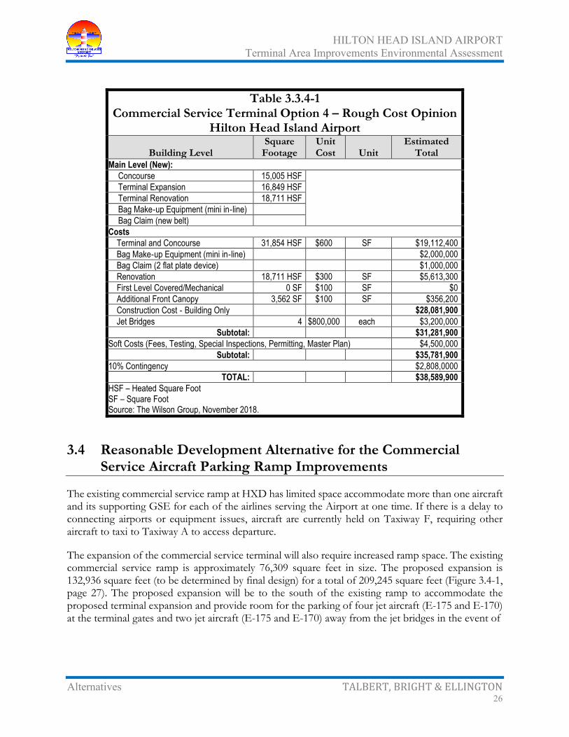
HILTON HEAD ISLAND AIRPORT Terminal Area Improvements Environmental Assessment
Alternatives TALBERT, BRIGHT & ELLINGTON 26
Table 3.3.4-1 Commercial Service Terminal Option 4 – Rough Cost Opinion
Hilton Head Island Airport
Building Level Square
Footage Unit Cost Unit
Estimated Total
Main Level (New): Concourse 15,005 HSF Terminal Expansion 16,849 HSF Terminal Renovation 18,711 HSF Bag Make‐up Equipment (mini in‐line) Bag Claim (new belt)
Costs Terminal and Concourse 31,854 HSF $600 SF $19,112,400 Bag Make‐up Equipment (mini in‐line) $2,000,000 Bag Claim (2 flat plate device) $1,000,000 Renovation 18,711 HSF $300 SF $5,613,300 First Level Covered/Mechanical 0 SF $100 SF $0 Additional Front Canopy 3,562 SF $100 SF $356,200 Construction Cost ‐ Building Only $28,081,900 Jet Bridges 4 $800,000 each $3,200,000
Subtotal: $31,281,900 Soft Costs (Fees, Testing, Special Inspections, Permitting, Master Plan) $4,500,000
Subtotal: $35,781,900 10% Contingency $2,808,0000
TOTAL: $38,589,900 HSF – Heated Square Foot SF – Square Foot Source: The Wilson Group, November 2018.
3.4 Reasonable Development Alternative for the Commercial Service Aircraft Parking Ramp Improvements
The existing commercial service ramp at HXD has limited space accommodate more than one aircraft and its supporting GSE for each of the airlines serving the Airport at one time. If there is a delay to connecting airports or equipment issues, aircraft are currently held on Taxiway F, requiring other aircraft to taxi to Taxiway A to access departure.
The expansion of the commercial service terminal will also require increased ramp space. The existing commercial service ramp is approximately 76,309 square feet in size. The proposed expansion is 132,936 square feet (to be determined by final design) for a total of 209,245 square feet (Figure 3.4-1, page 27). The proposed expansion will be to the south of the existing ramp to accommodate the proposed terminal expansion and provide room for the parking of four jet aircraft (E-175 and E-170) at the terminal gates and two jet aircraft (E-175 and E-170) away from the jet bridges in the event of

HILTON HEAD ISLAND AIRPORT Terminal Area Improvements Environmental Assessment
Alternatives TALBERT, BRIGHT & ELLINGTON 27

HILTON HEAD ISLAND AIRPORT Terminal Area Improvements Environmental Assessment
Alternatives TALBERT, BRIGHT & ELLINGTON 28
delays to connecting airports or equipment issues, as well as provide sufficient space for the movement of GSE and vehicles around the ramp.
The estimated program cost for the expansion of the commercial service ramp is $6.93 million (Table 3.4-1).
Table 3.4-1 Commercial Service Apron Expansion – Rough Cost Opinion
Hilton Head Island Airport Description Quantity Unit Unit Price Total
Mobilization 1 LS $429,000 $429,000 Remove Fence 800 LF $8 $6,400 Clearing and Grubbing 3 AC $20,000 $60,000 Unsuitable Excavation 20,000 CY $25 $500,000 Unclassified Excavation 15,000 CY $15 $225,000 Erosion and Sediment Control 1 LS $115,000 $115,000 8" Cement Treated Base Course 14,800 SY $40 $592,000 8" Portland Cement Concrete Pavement 14,800 SY $120 $1,776,000 Pavement Markings 1,200 SF $3 $3,600 Concrete Sidewalk 400 SY $50 $20,000 Storm Drainage 1 LS $700,000 $700,000 Miscellaneous Electrical 1 LS $125,000 $125,000 8' Chain Link Fence 700 LF $20 $14,000 20' Electric Gate 1 EA $50,000 $50,000 Landscaping 1 LS $100,000 $100,000 10% Contingency $429,000
CONSTRUCTION TOTAL $5,145,000 Engineering - Design, Bidding, Construction Admin., Inspection and Testing $1,286,250
PROJECT TOTAL $6,431,250 AC – Acre CY – Cubic Yard LF – Linear Foot LS – Lump Sum SF – Square Foot SY – Square Yard Source: Talbert, Bright & Ellington, Inc., May 2019.
3.5 Reasonable Development Alternative for the Commercial Service Automobile Parking Improvements
There are currently 345 total automobile parking spaces in the short- and long-term parking lots in front of the commercial service terminal and the temporary gravel lots. Using a ratio 1.5 parking spaces times the number of peak hour passengers plus 15 percent, the current parking lots would need to be expanded another 50 spaces to accommodate peak hour passenger through 2029 (Figure 3.5-1, page

HILTON HEAD ISLAND AIRPORT Terminal Area Improvements Environmental Assessment
Alternatives TALBERT, BRIGHT & ELLINGTON 29
30). Should additional parking be required for the rental car agencies, expansion to the south toward Hunter Road would be possible.
The estimated program cost for the expansion of the commercial service automobile parking is $1.09 million (Table 3.5-1).
Table 3.5-1 Commercial Service Automobile Parking Expansion –
Rough Cost Opinion Hilton Head Island Airport
Description Quantity Unit Unit Price Total Mobilization 1 LS $72,100 $72,100 Contractor Quality Control Program 1 LS $80,000 $80,000 Clearing and Grubbing 2 AC $9,000 $18,000 Miscellaneous Demolition 1 LS $25,000 $25,000 Unclassified Excavation 5,400 CY $25 $135,000 Unsuitable Excavation 1,000 CY $30 $30,000 Sediment and Erosion Control Measures 1 LS $25,000 $25,000 Crushed Aggregate Base Course 1,470 CY $130 $191,100 Bituminous Surface Course, Type S-9.5c 1,020 TN $185 $188,700 Precast Concrete Wheelstop 48 EA $150 $7,200 Pavement Marking 1,930 SF $4 $7,720 Miscellaneous Signage 1 LS $5,000 $5,000 Temporary Seeding (Mulched) 2 AC $2,000 $4,000 Permanent Seeding (Mulched) 1 AC $4,000 $4,000 10%Contingency $79,300
CONSTRUCTION TOTAL $872,120 Engineering - Design, Bidding, Construction Admin., Inspection and Testing $218,030
PROJECT TOTAL $1,090,150 AC – Acre CY – Cubic Yard EA – Each LS – Lump Sum SF – Square Foot TN – Ton Source: Talbert, Bright & Ellington, Inc., May 2019.

HILTON HEAD ISLAND AIRPORT Terminal Area Improvements Environmental Assessment
Alternatives TALBERT, BRIGHT & ELLINGTON 30
HILTON HEAD ISLAND AIRPORT Terminal Area Improvements Environmental Assessment
Alternatives TALBERT, BRIGHT & ELLINGTON 31
3.6 Reasonable Development Alternative for the Runway 03/21 and Taxiway F Strengthening
This development alternative involves the strengthening of Runway 03/21 and Taxiway F from 75,000 pounds dual wheel gear to 120,000 pounds dual wheel gear to accommodate the existing commercial service jet aircraft or any other aircraft, as well adding width to accommodate the runway and taxiway lights to reduce maintenance and FOD.
The project will include a bituminous concrete overlay of the existing runway pavement with an average thickness of four inches (variable thickness). Also included will be sawcut grooving of the completed overlay, new pavement markings, shoulder buildup along the new overlay pavement edge, required edge light/threshold light elevation adjustments adjacent to the new overlay pavement edge, and required sediment and erosion control measures.
The proposed runway overlay pavement will include grade corrections to the existing runway pavement surface if/as needed. Transitions of the proposed runway pavement overlay onto the intersecting connector taxiways and parallel taxiway ends will also be included. Sawcut grooving will be included as required by FAA Advisory Circular 150/5320-12C Measurement, Construction, and Maintenance of Skid Resistant Airport Pavement Surfaces, Change 8 (February 7, 2007) since the runway serves turbojet and commercial service aircraft. Phasing of the construction work will be based on input from Beaufort County and main airport tenants to minimize impacts during the construction of the project.
The estimated program cost for the strengthening of Runway 03/21 and Taxiway F is $9.34 million (Table 3.6-1, page 32).
3.7 Reasonable Alternatives for the Proposed Action
Evaluation of the extension alternatives was conducted using qualitative descriptors of favorable or not favorable. Explanations of the descriptors are as follows:
• Topography and Construction Considerations
Favorable – utilizes conventional design and construction techniques
Not favorable – utilizes specialized design and construction techniques
• Property Acquisition
Favorable – no additional property required
Not favorable – property acquisition required
• Environmental Requirements

HILTON HEAD ISLAND AIRPORT Terminal Area Improvements Environmental Assessment
Alternatives TALBERT, BRIGHT & ELLINGTON 32
Favorable – obtainable environmental permits and avoidance of incompatible land use
Table 3.6-1 Runway 03/21 and Taxiway F Strengthening –
Rough Cost Opinion Hilton Head Island Airport
Description Quantity Unit Unit Price Total Mobilization 1 LS $643,100 $643,100 Crack Repair 12,000 LF $4 $48,000 Tie-In Milling 10,000 SY $15 $150,000 Herbicide Application 1 LS $10,000 $10,000 Shoulder Buildup 22,700 LF $10 $227,000 Erosion Control 1 LS $150,000 $150,000 Bituminous Concrete Surface Course 26,000 TN $190 $4,940,000 Bituminous Tack Coat 20,500 GAL $2 $41,000 Airfield Pavement Marking 1 LS $125,000 $125,000 Grooving 45,000 SY $2.75 $123,750 Temporary Seeding (Mulched) 12 AC $2,000 $24,000 Permanent Seeding (Mulched) 12 AC $3,500 $42,000 Airfield Electrical 1 LS $550,000 $550,000 10% Contingency $707,400 $707,400
CONSTRUCTION TOTAL $7,781,250 Engineering - Design, Bidding, Construction Admin., Inspection and Testing $1,556,250
PROJECT TOTAL $9,337,500 AC – Acre GAL - Gallon LF – Linear Foot LS – Lump Sum SY – Square Yard TN – Ton Source: Talbert, Bright & Ellington, Inc., May 2019.
Not favorable – strenuous environmental permitting and impacts to incompatible land use
• Satisfies Aeronautical Demand
Favorable – meets requirements for aviation activity
Not favorable – does not meet requirements for aviation activity
Table 3.7-1 (page 33) illustrates each of the analysis criteria and its descriptor. Table 3.7-2 (page 33) illustrates a preliminary project cost comparison.

HILTON HEAD ISLAND AIRPORT Terminal Area Improvements Environmental Assessment
Alternatives TALBERT, BRIGHT & ELLINGTON 33
Table 3.7-1 Proposed Action Analysis Matrix
Hilton Head Island Airport
Preliminary Costs Commercial Service Terminal Aircraft
Ramp Automobile
Parking Runway
Strengthening Option 1 Option 2 Option 3 Option 4 Topographic and Construction Considerations F F F F F F F
Property Acquisition F F F N N N F Environmental Requirements F F F F F F F Satisfies Demand F F F F F F F F = Favorable N = Not favorable Source: Talbert, Bright & Ellington, Inc., June 2019.
Table 3.7-2 Rough Cost Opinion Summary
Hilton Head Island Airport
Rough Cost Opinion Commercial Service Terminal
Option 1 Option 2 Option 3 Option 4 Terminal Construction (includes design) $41,438,600 $39,326,100 $47,239,300 $38,589,900 Aircraft Ramp Construction (includes design) $6,431,250 $6,431,250 $6,431,250 $6,431,250 Automobile Parking Construction (includes design) $1,090,150 $1,090,150 $1,090,150 $1,090,150 Runway Strengthening Construction (includes design) $9,337,500 $9,337,500 $9,337,500 $9,337,500 EA $289,938 $289,938 $289,938 $289,938 Land Acquisition (5 parcels, 9 relocations, estimated) $9,000,000 $9,000,000 $9,000,000 $9,000,000 Environmental Mitigation (estimated) $250,000 $250,000 $250,000 $250,000 TOTAL $67,837,438 $65,724,938 $73,638,138 $64,988,738 Source: Talbert, Bright & Ellington, Inc., June 2019.
Of the reasonable alternatives considered, the No-Action Alternative and Commercial Service Terminal Option 4 along with the expansion of the commercial service aircraft parking ramp and automobile parking and Runway 03/21 and Taxiway F strengthening were identified for further consideration and are evaluated separately in Section 4 – Affected Environment and Environmental Consequences (page 35). Although the commercial service aircraft parking ramp and automobile parking and Runway 03/21 and Taxiway F strengthening involves more impacts than the No-Action Alternative, from an initial evaluation of environmental thresholds, the Proposed Action is not viewed as insurmountable by type or intensity. Accordingly, the commercial service aircraft parking ramp and

HILTON HEAD ISLAND AIRPORT Terminal Area Improvements Environmental Assessment
Alternatives TALBERT, BRIGHT & ELLINGTON 34
automobile parking and Runway 03/21 and Taxiway F strengthening is viewed as offering the safest, most economically responsive, and most environmentally plausible alternative available to HXD for meeting Section 2 – Purpose and Need for the Proposed Action (page 5). Consequently, Section 4 – Affected Environment and Environmental Consequences (page 35) advances the commercial service aircraft parking ramp and automobile parking and Runway 03/21 and Taxiway F strengthening as the County’s Proposed Action.

HILTON HEAD ISLAND AIRPORT Terminal Area Improvements Environmental Assessment
Affected Environment and TALBERT, BRIGHT & ELLINGTON Environmental Consequences 35
4.0 AFFECTED ENVIRONMENT AND ENVIRONMENTAL CONSEQUENCES
Potential impacts on the human and natural environment have been evaluated for the Proposed Action (Commercial Service Terminal Option 4 along with the expansion of the commercial service aircraft parking ramp and automobile parking and Runway 03/21 and Taxiway F strengthening). Based on this evaluation, the following subsections describe the affected environment and potential impacts associated with implementation of the Proposed Action. Impacts considered to have long-term effects and would be an area of potential concern for the implementation of the Proposed Action have been addressed in the appropriate subsections through efforts to avoid, minimize, and mitigate these impacts.
The outline of this section is based on Appendix A – Analysis of Environmental Impact Categories in FAA Order 1050.1F – Environmental Impacts: Policies and Procedures and 1050.1F Desk Reference.
4.1 Air Quality
4.1.1 Definition In accordance with the Clean Air Act of 1990 (as amended, 42 United States Code [USC] 7401 et seq.), the United States Environmental Protection Agency (USEPA) established the National Ambient Air Quality Standards (NAAQS), which defined six criteria pollutants and established ambient concentration limits to protect public health. Monitoring sites report data to the USEPA for the following six criteria air pollutants.
• Carbon monoxide (CO)
• Lead (Pb)
• Nitrogen dioxide (NO2)
• Ozone (O3)
• Particulate matter (PM10 and PM2.5)4
• Sulfur dioxide (SO2)
4PM10 and PM2.5 are acronyms for particulate matter consisting of particles smaller than 10 and 2.5 micrometers, respectively.
HILTON HEAD ISLAND AIRPORT Terminal Area Improvements Environmental Assessment
Affected Environment and TALBERT, BRIGHT & ELLINGTON Environmental Consequences 36
The South Carolina Department of Health and Environmental Control Bureau of Air Quality (SCDHEC-BAQ) was granted authority by the USEPA to administer the Clean Air Act in South Carolina.
The Clean Air Act established primary (protect public health) and secondary (protect public welfare) standards, which are based on a pollutant’s effect on plants and animals. Table 4.1.1-1 (page 37) illustrates the primary and secondary standards for the six criteria pollutants.
Geographic areas of the United States have been divided into attainment and nonattainment areas. Attainment areas are defined as those areas where the NAAQS for each pollutant is not exceeded. Nonattainment areas are defined as any portion of an air quality control region for which any pollutant exceeds NAAQS for a particular pollutant. In nonattainment areas, regional goals for achieving attainment of the NAAQS are addressed in the State Implementation Plan (SIP), as approved by the USEPA. Beaufort County is an attainment area for all NAAQS pollutants.
USEPA collects emissions data for three criteria air pollutants:
• CO
• SO2
• PM10 and PM2.5
and three precursors/promoters of criteria air pollutants:
• Volatile organic compounds (VOC)
• Nitrogen Oxide (NOx)
• Ammonia (NH3)
The Clean Air Act also lists 188 hazardous air pollutants (HAPs), which are known as toxic air pollutants or air toxics. However, monitoring of ambient concentrations of HAPs is not mandated by the Clean Air Act, but USEPA is developing regulations to limit HAP emissions, thereby preventing ambient HAP concentrations from reaching levels that would pose significant health risks.
4.1.2 Conformity Requirements The FAA has established a listing of presumed to conform activities,5 including
…3. Non-Runway Pavement Work...6. Terminal and Concourse Upgrades....
5FAA, Federal Presumed to Conform Actions, Under General Conformity, Federal Register / Vol. 72, No. 145/Monday, July 30, 2007 / Notices, <http://www.faa.gov/airports/resources/publications/federal_register_notices/media/environmental_72fr41576.pdf>, accessed June 25, 2019.

HILTON HEAD ISLAND AIRPORT Terminal Area Improvements Environmental Assessment
Affected Environment and TALBERT, BRIGHT & ELLINGTON Environmental Consequences 37
Table 4.1.1-1 National Ambient Air Quality Standards
Hilton Head Island Airport
Pollutant Primary/ Secondary
Averaging Time Level Form
Carbon Monoxide (CO)
1
Primary 8-hour 9 ppm Not to be exceeded more than once per year 1-hour 35 ppm
Lead (Pb)2 Primary and
Secondary Rolling 3-month
average 0.15 µg/m3, 7
Not to be exceeded
Nitrogen Dioxide (NO2)
3
Primary 1-hour 100 ppb 98th percentile, averaged over three years
Primary and Secondary
Annual 8 Annual mean
Ozone (O3)4 Primary and
Secondary 8-hour 0.075 ppm
9 Annual fourth-highest daily maximum 8-hr
concentration, averaged over three years Particulate Matter
5
PM2.5 Primary Annual 12 µg/m3 Annual mean, averaged over three years
Secondary Annual 15 µg/m3 Annual mean, averaged over three years Primary and secondary
24-hour 35 µg/m3 98th percentile, averaged over three years
PM10 Primary and Secondary
24-hour 150 µg/m3 Not to be exceeded more than once per year on average over three years
Sulfur Dioxide (SO2)6 Primary 1-hour 75 ppb10 99
th percentile of 1-hour daily maximum concentrations, averaged over three years
Secondary 3-hour 0.5 ppm Not to be exceeded more than once per year Notes: ppb = parts per billion, ppm = parts per million, µg/m3 = micrograms per cubic meter of air Federal Registers: 176 Federal Register (FR) 54294; 273 FR 66964; 375 FR 6474 and 61 FR 52852; 473 FR 16436; 578 FR 3086; 675 FR 35520 and 38 FR 25678 7Final rule signed October 15, 2008. The 1978 lead standard (1.5 µg/m3 as a quarterly average) remains in effect until one
year after an area is designated for the 2008 standard, except that in areas designated nonattainment for the 1978, the 1978 standard remains in effect until implementation plans to attain or maintain the 2008 standard are approved. 8The official level of the annual NO2 standard is 0.053 ppm, equal to 53 ppb, which is shown here for the purpose of clearer comparison to the 1-hour standard. 9Final rule signed March 12, 2008. The 1997 ozone standard (0.08 ppm, annual fourth-highest daily maximum 8-hour concentration, averaged over 3 years) and related implementation rules remain in place. In 1997, EPA revoked the 1-hour ozone standard (0.12 ppm, not to be exceeded more than once per year) in all areas, although some areas have continued obligations under that standard (“anti-backsliding”). The 1-hour ozone standard is attained when the expected number of days per calendar year with maximum hourly average concentrations above 0.12 ppm is less than or equal to 1. 10Final rule signed June 2, 2010. The 1971 annual and 24-hour SO2 standards were revoked in that same rulemaking. However, these standards remain in effect until one year after an area is designated for the 2010 standard, except in areas designated nonattainment for the 1971 standards, where the 1971 standards remain in effect until implementation plans to attain or maintain the 2010 standard are approved. Source: USEPA, National Ambient Air Quality Standards (NAAQS), 2013, <http://www.epa.gov/air/criteria.html>, accessed June 25, 2019.

HILTON HEAD ISLAND AIRPORT Terminal Area Improvements Environmental Assessment
Affected Environment and TALBERT, BRIGHT & ELLINGTON Environmental Consequences 38
4.1.3 Existing Conditions Beaufort County currently has no criteria pollutant monitoring sites; however, Beaufort County is considered an attainment area for all NAAQS pollutants.
4.1.4 Potential Air Quality Impacts 4.1.4.1 No-Action Alternative
The No-Action Alternative would have no change in current operations and development and, therefore, would not result in any impact to the current air quality.
4.1.4.2 Proposed Action
Based on the conformity requirements discussed in Section 4.1.2 – Conformity Requirements (page 36); an air quality analysis is not required for expansion of the terminal, aircraft parking ramp, automobile parking area and strengthening of Taxiway F.
The primary source of emissions from the Proposed Action (strengthening Runway 03/21) includes additional aircraft operating at the Airport. Any associated emissions of nitrogen oxides and volatile organic compounds (precursors to ozone) will be below the de minimis levels as identified in Title 40 – Protection of Environment of the Code of Federal Regulations (CFR) Part 93 – Determining Conformity of Federal Actions to State or Federal Implementation Plans, Section (§)153 – Applicability and illustrated in Table 4.1.4-1 (page 39). The emissions inventory reflects the existing and proposed emissions associated with the Proposed Action (strengthening Runway 03/21) and was determined using the Aviation Environmental Design Tool (AEDT) version 2d. Air quality impacts will be minimal and are below the de minimis thresholds for air quality.
The FAA Desk Reference states:
When the sum of the increases in direct and indirect emissions caused by a project would be less than the de minimis levels, a project would not require a general conformity determination.6
The emission threshold levels are defined in the General Conformity Rule, 40 CFR Part 93. However, HXD’s existing and future emissions are below the annual threshold levels (de minimis levels) and are not regionally significant; therefore, the requirements of the general conformity regulation do not apply.
6 Federal Aviation Administration Office of Environment and Energy, “1050.1F Desk Reference, Appendix B Other Environmental Laws and Requirements, B.1. Air Quality, B.1.1.4 Conformity, General Conformity ¶3,” <http://www.faa.gov/>, accessed June 26, 2019.

HILTON HEAD ISLAND AIRPORT Terminal Area Improvements Environmental Assessment
Affected Environment and TALBERT, BRIGHT & ELLINGTON Environmental Consequences 39
Table 4.1.4-1 Air Emissions Inventory
Hilton Head Island Airport
Proposed Action Alternative
Emissions (tons/year) CO NOx VOC PM10 PM2.5 SOx
Existing Emissions 0.86831 0.06417 0.05579 0.00479 0.00479 0.01146 Proposed Emissions 1.03973 0.0768 0.0668 0.00574 0.00574 0.01371 Total 1.90804 0.14097 0.12259 0.01053 0.01053 0.02517 Net Increase 0.17142 0.01263 0.01101 0.00095 0.00095 0.00225 Nonattainment Area Threshold 100 100 100 100 100 100 CO – Carbon Monoxide NOx – Nitrogen Oxide VOC – Volatile Organic Compounds PM – Particulate matter (PM10 and PM2.5) SOx – Sulfur Oxide Source: Federal Aviation Administration, “Aviation Environmental Design Tool (AEDT) Version 2d,” released on March 13, 2017. Talbert, Bright & Ellington, Inc., June 2019.
Table 4.1.4-1 lists the existing and proposed emissions associated with the Proposed Action (strengthening Runway 03/21). Existing emissions are associated with the current aircraft operating at HXD, while proposed emissions occur after completion of the federal action including the additional aircraft operations at the Airport resulting from the implementation of the Proposed Action. The nonattainment area threshold is listed at the bottom of Table 4.1.4-1. The existing and proposed emissions inventory is below the conformity determination thresholds. However, periodic review of the USEPA attainment status should be conducted so that future projects are developed in a manner consistent with air quality guidelines and requirements.
4.1.5 Significance Threshold FAA Order 5050.4B Table 7-1 in coordination with FAA Order 1050.1F Exhibit 4-1 outline the significance thresholds for some environmental impact categories. The significance threshold to consider for air quality as determined by FAA would be if;
the action would cause pollutant concentrations to exceed one or more of the NAAQS, as established by the EPA under the Clean Air Act (CAA), for any of the time periods analyzed, or to increase the frequency or severity of any such existing violations.
Factors to consider for airport actions per FAA Order 5050.4B Table 7-1 would be:

HILTON HEAD ISLAND AIRPORT Terminal Area Improvements Environmental Assessment
Affected Environment and TALBERT, BRIGHT & ELLINGTON Environmental Consequences 40
The responsible FAA official must determine if air quality impacts of a reasonable alternative would exceed a NAAQS standard for the time periods analyzed. For General Conformity requirements under the CAA, as amended. Analyze only the proposed or preferred alternative.
4.1.6 Potential Air Quality Construction Impacts Air quality impacts could occur during construction of the Proposed Action due to dust and fumes from construction equipment, earthwork activities, and vehicles accessing the construction site. BMPs that limit dust generation could include vegetative cover, mulch, spray-on adhesive, calcium chloride application, water sprinkling, stone, tillage, wind barriers, and construction of a temporary graveled entrance/exit to the construction site. In an effort to limit the amount of dust that could be generated, construction activities could be staged. The contractor should also comply with county and/or other local air pollution regulations. In addition, for emissions from diesel equipment, it is suggested that alternatively fueled equipment be utilized, equipment should have applicable emission controls, equipment idling time should be reduced, and fugitive dust emissions should be minimized through good operating practices.
4.1.6.1 No-Action Alternative
The No-Action Alternative would have no construction development and, therefore, would not result in any impact to the current air quality.
4.1.6.2 Proposed Action
A number of best management practices (BMPs) are recommended to further aid in minimizing airborne dust during construction. The contractor would implement BMPs for fugitive dust control measures some of those recommended BMPs include: applying water during land clearing, grading, and construction; covering transported material; temporarily grassing disturbed areas; fully or partially enclosing materials or stockpiles, and promptly removing earth or other material from paved roads which could become airborne. There would be and is no proposed open burning as part of this Proposed Action. The contractor will coordinate with South Carolina Department of Health and Environmental Control (SCDHEC) and obtain the necessary permits associated with the Proposed Action, if required.
4.2 Biological Resources
4.2.1 Definition For the purposes of this analysis, the term “biological resources” includes vegetation and forestry, wildlife, and listed threatened and endangered species.

HILTON HEAD ISLAND AIRPORT Terminal Area Improvements Environmental Assessment
Affected Environment and TALBERT, BRIGHT & ELLINGTON Environmental Consequences 41
4.2.2 Biotic Communities7 Review of National Wetland Inventory (NWI) mapping, true color aerial photography, and pedestrian surveys reveals that the Proposed Action APE consists predominantly of mowed grass and infrastructure and buildings. The remaining consists of mixed pine and hardwood areas and wetlands that have been impacted by tree trimming to reduce height and clearing to improve safety. In addition, Hurricane Matthew in 2016 caused storm damage to a significant number of mature trees located in the wetland areas. Geographic Information System (GIS) estimates indicate the Proposed Action APE consists of approximately (Figure 4.2.2-1, page 42):
• 44.2 percent mowed/open area
• 35.0 percent infrastructure and buildings
• 9.1 percent mixed pine and hardwood forest
• 5.7 percent scrub shrub area
• 2.7 percent commercial use
• 2.5 percent freshwater wetlands
• 0.3 percent open area
• 0.3 percent storm water retention areas
Because of the high percentage of land that is intensively utilized for airport services, the biotic communities with potential to contain threatened and endangered species habitat are considered to be mixed pine/hardwood maritime forest and hardwood bottom freshwater wetlands. A habitat survey was conducted within the freshwater wetlands and mixed pine/hardwood uplands. It appears that the small and fragmented areas possess limited potential for suitable threatened and endangered species habitat or immigration into the site. It is also important to note that heavy vehicular traffic poses a significant threat to species migration into new areas.
The mixed pine/hardwood forest identified on Figure 4.2.2-1 (page 42) has been impacted by tree cutting and by Hurricane Matthew. A significant number of live oak trees (Quercus virginiana) were observed in each upland area. Water oak (Quercus nigra), sweet gum (Liquidambar styraciflua), and loblolly pine (Pinus teada) are also present. The sapling/shrub layer in the areas observed is dominated by wax myrtle (Myrica cerifera). The herbaceous layer in the Proposed Action APE is limited due to mature overstory shading, with bracken fern (Pteridium aquilinum) being the dominant plant. Each wetland’s
7Ward Edwards Engineering (July 2019), “Threatened and Endangered Species Survey Update, Hilton Head Island Airport, Hilton Head Island, South Carolina,” prepared for Talbert, Bright & Ellington.

HILTON HEAD ISLAND AIRPORT Terminal Area Improvements Environmental Assessment
Affected Environment and TALBERT, BRIGHT & ELLINGTON Environmental Consequences 42

HILTON HEAD ISLAND AIRPORT Terminal Area Improvements Environmental Assessment
Affected Environment and TALBERT, BRIGHT & ELLINGTON Environmental Consequences 43
vegetation is described in Section 4.14.1.2 – Wetlands or Waters of the United States Delineation (page 123). It does appear that each of the wetlands is ephemeral and site visits for the threatened and endangered species survey8 conducted in 2014 substantiates this premise. The ditch, which connected wetlands through the Airport that was lined with granite rip-rap in 2012 is now entirely piped to meet FAA guidelines for the removal of runway hazards.
4.2.3 Threatened and Endangered Species A literature review of available local, state, and federal species records was conducted, including, but not limited to:
• United State Fish and Wildlife Service (USFWS) Endangered and Threatened Species for the Southeastern United States
• USFWS South Carolina Endangered and Threatened Species List
• South Carolina Department of Natural Resources (SCDNR) Natural Heritage Program List of Protected Species
• South Carolina Heritage Trust’s Occurrences of Rare and Endangered Species Maps
• Internet-distributed databases maintained by the regulatory agencies
A list of state and federal threatened and endangered species was obtained for Beaufort County and screened to develop a target list of threatened and endangered species and preferred habitat that could possibly exist within the Proposed Action APE. Species that require habitat not found within the Proposed Action APE were excluded, these include:
• Blueback Herring (Alosa aestivalis)
• Atlantic Sturgeon (Acipenser oxyinchus)
• Short nose sturgeon (Acipenser brevirostrum)
• Finback whale (Balaenoptera physalus)
• Leatherback sea turtle (Dermochelys coriacea)
• Atlantic right whale (Eubalaena glacialis)
• Kemp’s Ridley sea turtle (Lepidochelys kempii)
• Humpback whale (Megaptera novaeangliae)
• Loggerhead turtle (Caretta caretta)
8Ward Edwards, Inc. (June 20, 2014), “Threatened and Endangered Species Survey, Hilton Head Island Airport, Hilton Head Island, South Carolina,” prepared for Talbert & Bright, Inc.

HILTON HEAD ISLAND AIRPORT Terminal Area Improvements Environmental Assessment
Affected Environment and TALBERT, BRIGHT & ELLINGTON Environmental Consequences 44
• Green sea turtle (Chelonia mydas)
• Florida manatee (Trichechus manatus)
Table 4.2.3-1 (page 45) identifies threatened and endangered species known to occur in Beaufort County and preferred and or critical habitat was developed using the South Carolina Rare, Threatened, and Endangered Species Inventory and South Carolina Distribution Records of Endangered, Threatened, Candidate, and Species of Concern.
Appropriate United States Geological Survey (USGS) 7.5-minute topographic quadrangles, available aerial photography, and the 1980 Soil Survey of Beaufort County, South Carolina, were also reviewed for database information. Pedestrian and vehicular tours of the Proposed Action APE were performed in December 2018 and June 2019, including an escorted survey of restricted areas within the Airport. During the tours, each habitat type was visited for observation. Existing conditions, biotic communities, and status (natural, impacted, or degraded) were assessed.
4.2.3.1 Plants
4.2.3.1.1 American Chaffseed (Schwalbea americana)
American chaffseed (Schwalbea americana) is federal and state listed as endangered in Beaufort County. American chaffseed is an erect perennial herb with un-branched stems, large, purplish-yellow tubular flowers, which are borne singly on short stalks in the axils of the uppermost reduced leaves (bracts). The leaves are alternate, lance-shaped to elliptic, stalkless, 0.2 to 2 inches long, and entire. The entire plant is hairy throughout, including the flowers. Flowering occurs from April to June in the South. Chaffseed fruits are long, narrow capsules enclosed in a sac-like structure, which mature in the early summer. Chaffseed is a semi-parasite (partially dependent upon another plant as host). The plant occurs in acidic sandy peat or sandy loam soils, which are seasonally moist to dry. Chaffseed prefers open habitats which may be found in moist pine flatwoods, fire-maintained savannas, transitional areas between peaty wetlands and xeric sandy soils, and open grass-sedge systems.
Habitat suitability is dependent on factors which reduce competition from other plants and provide open habitat, such as fire, mowing, or fluctuating water tables. There is no evidence either of mowing or of controlled burning in the areas that are not within the cleared utility right-of-way (ROW) and the methods used to control vegetation within the ROW preclude chaffseed growth. The Proposed Action APE did not possess suitable habitat, nor did adjoining areas. No individuals

HILTON HEAD ISLAND AIRPORT Terminal Area Improvements Environmental Assessment
Affected Environment and TALBERT, BRIGHT & ELLINGTON Environmental Consequences 45
Table 4.2.3-1 Protected Flora and Fauna Summary
Hilton Head Island Airport
Species State Status
Federal Status Habitat Description
Plants American chaffseed (Schwalbea americana)
E E Prefers sandy, acidic, and seasonally moist soils in sunny or partly sunny areas subject to frequent fires in the growing season
Carolina birds-in-a-nest (Macbridea caroliniana)
AR Grows in sulphuric blackwater creek swamps, wet pinelands and in roadside ditches
Cilate-leaf tickseed (Coreopsis integrifolia)
AR Limestone-based soils of floodplains along small stream.
Pondberry (Lindera melissifolia)
E E Bottomland hardwood forests in inland areas, poorly drained swampy depressions, and edges of limestone sinks and ponds closer to the coast
Raven's seedbox (Ludwigia ravenelii)
AR Restricted to open, wet, peaty places, such as ditches and the margins of swamps, ponds, and bogs
Birds Bald eagle (Haliaeetus leucocephalus)
BGEPA Open areas, forest edges, and mountains near large lakes and rivers. Requires tall trees for nesting
Black-capped petrel (Pterodroma hasitata)
T Spends most of its life at sea. It travels long distances to forage as far north as open ocean waters off the coast of Virginia. It is a colonial nesting species that comes ashore only once each year to nest in crevices or burrows in steep, forested mountain cliffs
Eastern black rail (Laterallus jamaicensis)
T Tidally or non-tidally influenced, and range in salinity from salt to brackish to fresh
Kirtland's warbler (Dendroica kirtlandii)
E Homogeneous thickets of five-and six-year-old jack pines (Pinus banksiana) interspersed with grassy clearings
Least tern (Sterna antilarum) T Nest on barren to sparsely vegetated sandbars along rivers, sand and gravel pits, lake and reservoir shorelines, and occasionally gravel rooftops
MacGillivray's seaside sparrow (Ammodramus maritimus macgillivraii)
AR Spend their entire life in coastal salt and brackish marshes, breed in lower elevation areas of high marsh and in managed impoundments, which are often brackish and non-tidal
Piping plover (Charadrius melodus)
T T Open, sandy beaches, and tidal mudflats and sandflats
Red-cockaded woodpecker (Picoides borealis)
E E Open, mature pine woodlands that have a diversity of grass, forb, and shrub species
Rufus red knot (Calidris canutus rufa)
E Preferred wintering and migration microhabitats are muddy or sandy coastal areas, more specifically, the mouths of bays and estuaries, unimproved tidal inlets and tidal flats
Wood stork (Mycteria americana)
E E Wet places (e.g., ponds, marshes, river edges, mangroves, and mud flats)
Amphibians and Reptiles American Alligator (Alligator mississippiensis)
T T Aquatic systems, usually fresh water, occasionally live in brackish water, some frequently occupied habitats include lakes, ponds, streams, wetlands, swamps, marshes, and more

HILTON HEAD ISLAND AIRPORT Terminal Area Improvements Environmental Assessment
Affected Environment and TALBERT, BRIGHT & ELLINGTON Environmental Consequences 46
Table 4.2.3-1 Protected Flora and Fauna Summary
Hilton Head Island Airport
Species State Status
Federal Status Habitat Description
Eastern diamondback rattlesnake (Crotalus adamanteus)
AR Dry sandy areas, palmetto or wiregrass flatwoods, pinewoods, coastal dune habitats, or hardwood hammocks
Flatwoods salamander (Ambystoma cingulatum)
T T Seasonally wet, pine flatwoods, and pine savannas
Florida pine snake (Pituophis melannoleucus)
AR Prairies, pine-oak woodlands, pine flatwoods, cultivated fields, rocky deserts, and chaparrals
Southern hognose snake (Heterodon simus)
AR Sandhills, pine flatwoods, and coastal dune habitats
Spotted turtle (Clemmys guttata)
T Variety of freshwater wetland habitats including marshes, swamps, wet meadows, bogs and vernal ponds, clean, slow-moving or still-water wetlands
Insects Monarch butterfly (Danaus plexippus)
AR Open fields and meadows with milkweed
Mammals Northern long eared bat (Myotis septentrionalis)
T Forested habitats, especially boreal forests, since they typically roost in hardwood trees during the summer
Tricolored bat (Perimyotis subflavus)
SC Open woods near the edges of water, as well as over water, roost in rock crevices, caves, buildings, and tree foliage in the summer, winter, caves, mines, and deep crevices serve as hibernacula
Note: AR – At-risk species BGEPA – Bald and Golden Eagle Protection Act E – Endangered R – Rare for state listing SC – Species of concern T – Threatened Source: Ward Edwards Engineering (July 2019), “Threatened and Endangered Species Survey Update, Hilton Head Island Airport, Hilton Head Island, South Carolina,” prepared for Talbert, Bright & Ellington.
were observed during site investigations and a review of available literature did not reveal any known populations within the Hilton Head quadrangle. Activity within the Proposed Action APE should have no effect on the species.

HILTON HEAD ISLAND AIRPORT Terminal Area Improvements Environmental Assessment
Affected Environment and TALBERT, BRIGHT & ELLINGTON Environmental Consequences 47
4.2.3.1.2 Carolina Birds-in-a-Nest (Macbridea caroliniana)
Carolina birds-in-a-nest (Macbridea caroliniana) is under review for federal listing and is a perennial herb with erect stems, 23.6 to 35.4 inches tall, and alternate leaves. The pink to lavender flowers is in clusters in a terminal mixed inflorescence, the petals striped with purple and white, bloom at the top of the stems above whorls of overlapping bracts. Flowering mid-July to September (first-frost). Carolina birds-in-a-nest usually occurs in a variety of habitats including wet longleaf pine (Pinus palustris), pond pine (Pinus serotina) savannas, and acidic (blackwater) swamp forests. These types of habitats do not exist within the Proposed Action APE. Consequently, any activity within the Proposed Action APE should have no effect on the species.
4.2.3.1.3 Cilate-leaf Tickseed (Coreopsis integrifolia)
Cilate-leaf tickseed (Coreopsis integrifolia) is under review for federal listing and is described as a perennial herb, 11.8 to 39 inches tall, that flowers in late summer with flower heads that have bright yellow ray flowers surrounding a purple-red disk. Cilate-leaf tickseed is found in Riparian, Palustrine habitats including, but not limited to, the edges of small blackwater streams, the edges of swamp forests, or on the edges of brackish marshes. None of the described wetland types exist within the Proposed Action APE. Consequently, activity within the Proposed Action APE should have no effect on the species.
4.2.3.1.4 Pondberry (Lindera melissifolia)
Pondberry (Lindera melissifolia) is federal listed as endangered in Beaufort County. Pondberry is a deciduous shrub approximately 6.6 feet tall, which spreads vegetatively by stolons. Pale yellow flowers appear in the spring before the leaves begin growth. The mature fruits are oval, bright red, approximately 0.5 inches in length, and mature in the fall. Pondberry is associated with wetland habitats such as the margins of sinks, ponds and depressions in coastal sites. The plants prefer shaded areas but may also be found in full sun. The most significant threats to pondberry are drainage, ditching, and conversion of its habitat to other uses. Alterations to hydrology by draining may reduce the plant's vigor or create unsuitable habitat.
Suitable habitat may be present in wetland areas. Site visits indicate these wetlands may be seasonally inundated with normal rainfall. No individuals were observed during site investigations
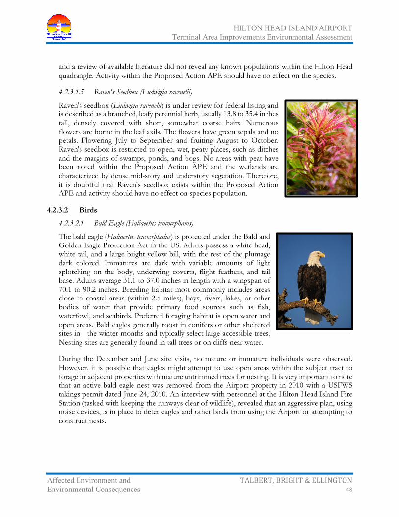
HILTON HEAD ISLAND AIRPORT Terminal Area Improvements Environmental Assessment
Affected Environment and TALBERT, BRIGHT & ELLINGTON Environmental Consequences 48
and a review of available literature did not reveal any known populations within the Hilton Head quadrangle. Activity within the Proposed Action APE should have no effect on the species.
4.2.3.1.5 Raven's Seedbox (Ludwigia ravenelii)
Raven's seedbox (Ludwigia ravenelii) is under review for federal listing and is described as a branched, leafy perennial herb, usually 13.8 to 35.4 inches tall, densely covered with short, somewhat coarse hairs. Numerous flowers are borne in the leaf axils. The flowers have green sepals and no petals. Flowering July to September and fruiting August to October. Raven's seedbox is restricted to open, wet, peaty places, such as ditches and the margins of swamps, ponds, and bogs. No areas with peat have been noted within the Proposed Action APE and the wetlands are characterized by dense mid-story and understory vegetation. Therefore, it is doubtful that Raven's seedbox exists within the Proposed Action APE and activity should have no effect on species population.
4.2.3.2 Birds
4.2.3.2.1 Bald Eagle (Haliaeetus leucocephalus)
The bald eagle (Haliaeetus leucocephalus) is protected under the Bald and Golden Eagle Protection Act in the US. Adults possess a white head, white tail, and a large bright yellow bill, with the rest of the plumage dark colored. Immatures are dark with variable amounts of light splotching on the body, underwing coverts, flight feathers, and tail base. Adults average 31.1 to 37.0 inches in length with a wingspan of 70.1 to 90.2 inches. Breeding habitat most commonly includes areas close to coastal areas (within 2.5 miles), bays, rivers, lakes, or other bodies of water that provide primary food sources such as fish, waterfowl, and seabirds. Preferred foraging habitat is open water and open areas. Bald eagles generally roost in conifers or other sheltered sites in the winter months and typically select large accessible trees. Nesting sites are generally found in tall trees or on cliffs near water.
During the December and June site visits, no mature or immature individuals were observed. However, it is possible that eagles might attempt to use open areas within the subject tract to forage or adjacent properties with mature untrimmed trees for nesting. It is very important to note that an active bald eagle nest was removed from the Airport property in 2010 with a USFWS takings permit dated June 24, 2010. An interview with personnel at the Hilton Head Island Fire Station (tasked with keeping the runways clear of wildlife), revealed that an aggressive plan, using noise devices, is in place to deter eagles and other birds from using the Airport or attempting to construct nests.

HILTON HEAD ISLAND AIRPORT Terminal Area Improvements Environmental Assessment
Affected Environment and TALBERT, BRIGHT & ELLINGTON Environmental Consequences 49
A review of available literature and SCDNR GIS data indicates that several eagle nests are located on and near Hilton Head Island, with the closest recorded nest being approximately 3.1 miles south of the Proposed Action APE. Given the aggressive Airport stance on eagle use of the site and the need for avoiding bird strikes, it appears that any bald eagle activity on or near the Proposed Action APE will be of short duration. Therefore, any activity within the Proposed Action APE should have no effect on the species.
4.2.3.2.2 Black-Capped Petrel (Pterodroma hasitata)
The black-capped petrel (Pterodroma hasitata) is proposed to be listed as threatened. The bird is described as pelagic and nesting on steep forested cliffs. Black-capped petrel is a distinctive gadfly petrel with a clearly defined black cap separated from the dark mantle by a white collar and with conspicuous white upper-tail coverts that form a broad U shape. Literature suggests the black-capped petrel is migratory and follows the Gulf stream south to nest in Cuba. The Proposed Action APE is not associated with the sea habitat this bird frequents. No individuals have been noted during frequent site visits; therefore, activity within the Proposed Action APE should have no effect on the species.
4.2.3.2.3 Eastern Black Rail (Laterallus jamaicensis)
The eastern black rail (Laterallus jamaicensis) is federal proposed threatened and are small rails, approximately 4 to 6 inches in length with adults possessing blackish-gray bills and red eyes. They appear to utilize salt, brackish, and freshwater marshes, pond borders, wet meadows, and grassy swamps. No suitable habitat exists within the Proposed Action APE and no individuals were sighted during site visits. A review of available literature does not indicate any sightings in the Hilton Head quadrangle. Therefore, any activity within the Proposed Action APE should not have any effect on the species.

HILTON HEAD ISLAND AIRPORT Terminal Area Improvements Environmental Assessment
Affected Environment and TALBERT, BRIGHT & ELLINGTON Environmental Consequences 50
4.2.3.2.4 Kirtland's Warbler (Dendroica kirtlandii)
Kirtland's warbler (Dendroica kirtlandii) is federal listed as endangered in Beaufort County. Adult upperparts are blue-gray, tending to be more-brown in the fall and winter, streaked with black. The underparts are yellow with black streaks on the sides and a white eye ring is broken by black lores and eye line; whitish wing bars are indistinct. The female possesses plumage, which is dull with brownish upperparts. Breeding is limited mainly to a small area in Michigan and less than a thousand pairs exist. It appears that Kirtland's warbler enters and exits the US along the coasts of South and North Carolina during migration. The warbler prefers little or no hardwoods and areas of dense scrubby pine, less than 19.7 feet in height. When trees reach 11.5 feet in height, with no live needles present below 3.3 feet, the habitat becomes unfavorable. In addition, Kirtland's warbler seldom nests in tracts less than 75 acres with minimal ground cover. Kirtland's warbler depends on active management such as controlled burning to maintain habitat.
The Proposed Action APE does not possess any areas with pine and little to no hardwoods. No individuals were observed during site investigations and a review of available literature did not reveal any known populations within the Hilton Head quadrangle. Activity within the Proposed Action APE should have no effect on the species.
4.2.3.2.5 Least Tern (Sterna antilarum)
The least tern (Sterna antilarum) is listed as state threatened in South Carolina. The least tern is approximately 8.3 to 9.5 inches and as a breeding adult is mainly gray above, with a black cap and nape, white forehead, black line running from the crown through the eye to the base of the bill, orange-yellow bill often with a dark tip, white or grayish underparts, short deeply forked tail, and yellow-orange legs and feet; a black wedge on the outer primaries is conspicuous in flight. The least tern appears to migrate north to breed in northern states. The least tern uses sandy flats and dune areas for roosting. The Proposed Action APE does not possess suitable habitat. Therefore, none of the planned activity should have an effect on the species.
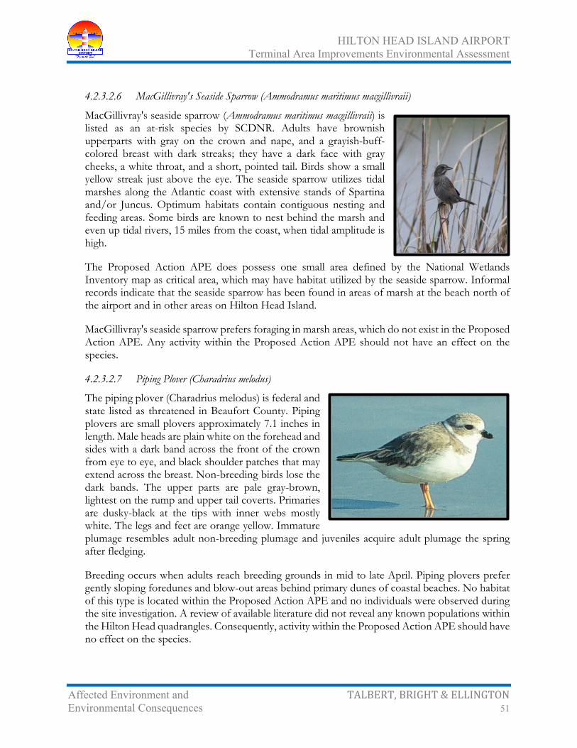
HILTON HEAD ISLAND AIRPORT Terminal Area Improvements Environmental Assessment
Affected Environment and TALBERT, BRIGHT & ELLINGTON Environmental Consequences 51
4.2.3.2.6 MacGillivray's Seaside Sparrow (Ammodramus maritimus macgillivraii)
MacGillivray's seaside sparrow (Ammodramus maritimus macgillivraii) is listed as an at-risk species by SCDNR. Adults have brownish upperparts with gray on the crown and nape, and a grayish-buff-colored breast with dark streaks; they have a dark face with gray cheeks, a white throat, and a short, pointed tail. Birds show a small yellow streak just above the eye. The seaside sparrow utilizes tidal marshes along the Atlantic coast with extensive stands of Spartina and/or Juncus. Optimum habitats contain contiguous nesting and feeding areas. Some birds are known to nest behind the marsh and even up tidal rivers, 15 miles from the coast, when tidal amplitude is high.
The Proposed Action APE does possess one small area defined by the National Wetlands Inventory map as critical area, which may have habitat utilized by the seaside sparrow. Informal records indicate that the seaside sparrow has been found in areas of marsh at the beach north of the airport and in other areas on Hilton Head Island.
MacGillivray's seaside sparrow prefers foraging in marsh areas, which do not exist in the Proposed Action APE. Any activity within the Proposed Action APE should not have an effect on the species.
4.2.3.2.7 Piping Plover (Charadrius melodus)
The piping plover (Charadrius melodus) is federal and state listed as threatened in Beaufort County. Piping plovers are small plovers approximately 7.1 inches in length. Male heads are plain white on the forehead and sides with a dark band across the front of the crown from eye to eye, and black shoulder patches that may extend across the breast. Non-breeding birds lose the dark bands. The upper parts are pale gray-brown, lightest on the rump and upper tail coverts. Primaries are dusky-black at the tips with inner webs mostly white. The legs and feet are orange yellow. Immature plumage resembles adult non-breeding plumage and juveniles acquire adult plumage the spring after fledging.
Breeding occurs when adults reach breeding grounds in mid to late April. Piping plovers prefer gently sloping foredunes and blow-out areas behind primary dunes of coastal beaches. No habitat of this type is located within the Proposed Action APE and no individuals were observed during the site investigation. A review of available literature did not reveal any known populations within the Hilton Head quadrangles. Consequently, activity within the Proposed Action APE should have no effect on the species.

HILTON HEAD ISLAND AIRPORT Terminal Area Improvements Environmental Assessment
Affected Environment and TALBERT, BRIGHT & ELLINGTON Environmental Consequences 52
4.2.3.2.8 Red-Cockaded Woodpecker (Picoides borealis)
The red-cockaded woodpecker (Picoides borealis) is federal and state listed as endangered in Beaufort County. The red-cockaded woodpecker is 7.1 to 7.9 inches long with a wing span of 13.8 to 15.0 inches. Plumage on the bird's back has black and white horizontal stripes with white cheeks and underparts. The flanks are generally black streaked and the cap and stripe on the side of the neck and the throat are black. The male has a small red spot on each side of the black cap. After the first post-fledgling molt, fledgling males have a red crown patch. Egg laying occurs during April, May, and June in roosting cavities constructed in living pine trees. Generally, the parent birds and some of their male offspring from previous years form a family unit called a group. A group may include one breeding pair and as many as seven other birds. Rearing young birds is a shared responsibility of the group. Preferred trees for nesting have a minimum age range of 80 to 120 years. Longleaf pines are most commonly used, but other species of southern pine are also acceptable. Dense stands, stands that are primarily hardwoods, or stands with a dense hardwood understory are avoided. Foraging habitat is provided in pine and pine hardwood stands 30 years old or older with a preference for pine trees 10 inches or larger in diameter.
Available literature indicates that the rapid re-growth of hardwood species and other tree species in the areas opened by the timber harvest may render the subject site unsuitable for red-cockaded woodpecker foraging. However, there is one recorded red-cockaded woodpecker colony located on Sherwood plantation, which is approximately 4.5 miles from the approximate center of the subject site. Home range estimates in some available literature suggests 37 to 543 acres, and most available literature agrees that red-cockaded woodpeckers prefer pine stands with decreased percentages of slash, decreased percentages of loblolly, decreased percentages of loblolly pine between 20 and 39 years of age, and increased percentages of long leaf pine.
In addition, the available literature indicates that suitable foraging habitat is not significant if suitable cavity trees are not available for nesting. No trees suitable for nesting exist within the Proposed Action APE or on visible areas of the adjacent site containing uplands. Existing colonies are often associated with large tracts of land that are managed for quail populations and which are not used for timber production. These areas are managed to produce limited understory with a mature pine overstory. No individuals were observed during site investigations and a review of available literature did not reveal any known populations within the Hilton Head or Bluffton quadrangles. The Proposed Action APE and the surrounding areas do not possess suitable habitat. No individuals or cavity trees were observed during site investigations. Consequently, activity within the Proposed Action APE should have no effect on the species.

HILTON HEAD ISLAND AIRPORT Terminal Area Improvements Environmental Assessment
Affected Environment and TALBERT, BRIGHT & ELLINGTON Environmental Consequences 53
4.2.3.2.9 Rufus Red Knot (Calidris canutus rufa)
The Rufus red knot (Calidris canutus rufa) is federal listed as endangered in Beaufort County. The red knot is 9.8 to 11.0 inches in length and is finely mottled Adults in the spring are finely mottled with grays, black, and light ochre running into stripes on the crown. The throat, breast, and sides of the head are cinnamon-brown with a dark gray line through the eye. The abdomen and under tail coverts are white and the upper tail coverts are white barred with black. The Rufus red knot may be found during migration on coastal mudflats, tidal zones, and occasionally on open sandy beaches. Food sources include invertebrates and horseshoe crab. The subject site does not possess any habitat suitable for the Rufus red knot.
Habitat as described above does not exist within the Proposed Action APE. No individuals were observed during site investigations and a review of available literature did not reveal any known populations within the Hilton Head quadrangle. Activity within the Proposed Action APE should have no effect on the species.
4.2.3.2.10 Wood Stork (Mycteria americana)
The wood stork (Mycteria americana) is federal and state listed as endangered in Beaufort County. Mature wood storks are long-legged wading birds, approximately 50.0 inches in height, with a wingspan of 59.9 to 65.0 inches. Plumage is white with black primaries and secondaries and a short black tail. The head and neck are mostly un-feathered and dark gray in color. The bill is black, thick at the base, and slightly decurved. The plumage of immature birds is dingy gray plumage and the decurved bill is yellow. Wood storks in South Carolina lay eggs from March to late May, with fledging occurring in July and August. Nests are frequently located in the upper branches of large cypress trees. Wood storks usually feed in freshwater marshes, narrow tidal creeks, or flooded tidal pools and are attracted to depressions in marshes or swamps where fish become concentrated during periods of falling water levels. Wood storks prefer water depths of 6 to 10 inches as their prey location is tactile. Wood storks are highly colonial and may travel as far as 80 miles to find suitable foraging habitat. Habitat which appears suitable for foraging and roosting may exist on the subject site.
During numerous site visits, no individuals were sighted foraging and evening visits did not reveal any use of these areas for roosting. The Proposed Action APE does not appear to possess any suitable roosting habitat and may possess limited foraging habitat following heavy rainfall events. However, no feathers or droppings were noted in any of the wetlands visited and continuous activity and noise associated with the Airport may deter wood stork use of storm water retention
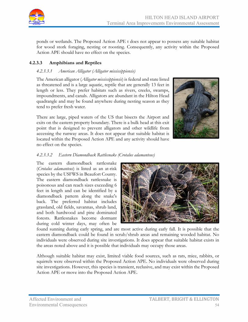
HILTON HEAD ISLAND AIRPORT Terminal Area Improvements Environmental Assessment
Affected Environment and TALBERT, BRIGHT & ELLINGTON Environmental Consequences 54
ponds or wetlands. The Proposed Action APE t does not appear to possess any suitable habitat for wood stork foraging, nesting or roosting. Consequently, any activity within the Proposed Action APE should have no effect on the species.
4.2.3.3 Amphibians and Reptiles
4.2.3.3.1 American Alligator (Alligator mississippiensis)
The American alligator (Alligator mississippiensis) is federal and state listed as threatened and is a large aquatic, reptile that are generally 13 feet in length or less. They prefer habitats such as rivers, creeks, swamps, impoundments, and canals. Alligators are abundant in the Hilton Head quadrangle and may be found anywhere during nesting season as they tend to prefer fresh water.
There are large, piped waters of the US that bisects the Airport and exits on the eastern property boundary. There is a bulk head at this exit point that is designed to prevent alligators and other wildlife from accessing the runway areas. It does not appear that suitable habitat is located within the Proposed Action APE and any activity should have no effect on the species.
4.2.3.3.2 Eastern Diamondback Rattlesnake (Crotalus adamanteus)
The eastern diamondback rattlesnake (Crotalus adamanteus) is listed as an at-risk species by the USFWS in Beaufort County. The eastern diamondback rattlesnake is poisonous and can reach sizes exceeding 6 feet in length and can be identified by a diamondback pattern along the snake's back. The preferred habitat includes grassland, old fields, savannas, shrub land, and both hardwood and pine dominated forests. Rattlesnakes become dormant during cold winter days, may often be found sunning during early spring, and are most active during early fall. It is possible that the eastern diamondback could be found in scrub/shrub areas and remaining wooded habitat. No individuals were observed during site investigations. It does appear that suitable habitat exists in the areas noted above and it is possible that individuals may occupy those areas.
Although suitable habitat may exist, limited viable food sources, such as rats, mice, rabbits, or squirrels were observed within the Proposed Action APE. No individuals were observed during site investigations. However, this species is transient, reclusive, and may exist within the Proposed Action APE or move into the Proposed Action APE.

HILTON HEAD ISLAND AIRPORT Terminal Area Improvements Environmental Assessment
Affected Environment and TALBERT, BRIGHT & ELLINGTON Environmental Consequences 55
4.2.3.3.3 Flatwoods Salamander (Ambystoma cingulatum)
The flatwoods salamander (Ambystoma cingulatum) is listed as federal threatened in Beaufort County. The flatwoods salamander possesses variable gray or grayish dorsal markings that may form a "frosted" or netlike pattern or narrow light rings. The belly is black with scattered small gray spots and total length ranges 3.5 to 5.1 inches. Larvae are long and slender with a black to brown body coloring with white to yellow stripes, slender legs, and fragile tail fins. Movements to breeding ponds occur usually between early October and January during rainy evenings when the barometric pressure is falling. Eggs are laid terrestrially before depressions fill with water. The eggs develop to hatching size within three weeks, but do not hatch until inundated. Post- larval individuals inhabit mesic longleaf pine-wiregrass (Aristida stricta) flatwoods and savannas. The terrestrial habitat is best described as topographically flat or slightly rolling wiregrass-dominated grassland having little to no mid-story and an open overstory of widely scattered longleaf pine. Low-growing shrubs, such as saw palmetto (Serenoa repens), gallberry (Ilex glabra) and blueberries (Vaccinium spp.), co-exist with grasses and forbs in the groundcover. Wiregrass is dependent on regular burning during the summer months to stimulate growth and flowering.
The Proposed Action APE has not experienced controlled burning due to its location. Wiregrass is not indigenous to Hilton Head Island, was not noted within the Proposed Action APE, and individuals were not noted during site visits. Based on reviews of available literature, it does not appear that the Proposed Action APE possesses suitable habitat. Consequently, it appears that activity within the Proposed Action APE should have no effect on the species.
4.2.3.3.4 Florida Pine Snake (Pituophis melannoleucus)
The Florida pine snake (Pituophis melannoleucus) is listed as an at-risk species and is a large stocky snake with dark brown to reddish dorsal blotches (generally indistinct anteriorly in adults) on a light gray to sandy-colored background; 4 prefrontal scales; dorsal scales keeled; anal undivided; adults usually 35.4 to 66.1 inches in total length. Their habitat includes high sandy pine/turkey oak areas where pocket gophers are present.

HILTON HEAD ISLAND AIRPORT Terminal Area Improvements Environmental Assessment
Affected Environment and TALBERT, BRIGHT & ELLINGTON Environmental Consequences 56
Since the Proposed Action APE does not include suitable habitat, the Florida pine snake is not likely to inhabit the site. Any activity within the Proposed Action APE should have no effect on the species.
4.2.3.3.5 Southern Hognose Snake (Heterodon simus)
The southern hognose snake (Heterodon simus) is listed as an at-risk species by the USFWS in Beaufort County. The southern hognose snake is a small snake with a brownish to light brown color and averages 18 inches in length and can be identified by the upturned nose tip. They spend a significant amount of time burrowed in soil and the inhabit open, xeric habitats with well drained sandy or sandy loam soils. Habitat examples in the Hilton Head Island area include stabilized coastal sand dunes, pine flatwoods, mixed oak/pine woods, and old fields. Limited habitat may exist in the remaining scrub/shrub, forested, and wetland areas.
No individuals were observed during site investigations. It does appear that suitable habitat exists in the area noted above and it is possible that individuals may occupy those areas. Further investigation may be warranted before significant land disturbance is performed.
4.2.3.3.6 Spotted Turtle (Clemmys guttata)
The spotted turtle (Clemmys guttata) is state listed as threatened in Beaufort County. The spotted turtle is a small black turtle with small round and yellow spots on a broad, smooth, and keelless carapace. Small and old individuals may not possess spots and some individuals may have growth layers evident on the carapace scutes. The plastron is yellow to yellow-orange and has a large black blotch on each scute. The head is mostly black with scattered yellow spots and blotches and the limbs are gray to black above and often have yellow spots. The skin under the legs and neck is orange or pinkish. Suitable habitat includes unpolluted small shallow bodies of water such as small marshes, marshy pastures, bogs, fens, woodland streams, swamps, small ponds, and vernal pools. Ponds surrounded by relatively undisturbed meadow or undergrowth are most favorable and the preferred bottom is soft. The spotted turtle often basks along water edges, brush piles in water, logs, or vegetation clumps. The spotted turtle hides in bottom mud and detritus when it is inactive.

HILTON HEAD ISLAND AIRPORT Terminal Area Improvements Environmental Assessment
Affected Environment and TALBERT, BRIGHT & ELLINGTON Environmental Consequences 57
The Proposed Action APE does possess stormwater retention areas that contain water and one area that is ponded where the ditch that was piped exits the property. It also appears that the spotted turtle likes areas that are unpolluted and protected by undisturbed meadows or undergrowth. Since the permanent water located within the Proposed Action APE consists of waterflow from systems designed to drain infrastructure, it is unlikely that suitable habitat exists. No individuals were observed during site investigations and a review of available literature did not reveal any known populations within the Hilton Head quadrangle. Activity within the Proposed Action APE should have no effect on the species.
4.2.3.4 Insects
4.2.3.4.1 Monarch Butterfly (Danaus plexippus)
The monarch butterfly (Danaus plexippus) is state listed as an at-risk species by SCDNR. The monarch wingspan ranges from 3.5 to 4.0 inches. The upper side of the wings are tawny orange, the veins and margins are black, and there are two series of small white spots in the margins. The monarch migrates through South Carolina to southern Florida and the possibly the Yucatan Peninsula to breed. The habitat they utilize includes, but is not limited to wetlands, open field, forests, and sand dunes.
It is possible that monarch butterflies migrate through and utilize the available habitat within the Proposed Action APE. Migration occurs during the fall months as they migrate to northern climates to overwinter. Since monarchs are transitory and are in migration through the area, activity within the Proposed Action APE should not affect the species.
4.2.3.5 Mammals
4.2.3.5.1 Northern Long Eared Bat (Myotis septentrionalis)
The northern long eared bat (Myotis septentrionalis) is federal listed as threatened and is a small insect eating bat. This bat generally is associated with old-growth forests composed of trees 100 years old or older and relies on intact interior forest habitat, with low edge-to-interior ratios. Relevant late-successional forest features include a high percentage of old trees, uneven forest structure (resulting in multilayered vertical structure), single and multiple tree-fall gaps, standing snags, and woody debris.

HILTON HEAD ISLAND AIRPORT Terminal Area Improvements Environmental Assessment
Affected Environment and TALBERT, BRIGHT & ELLINGTON Environmental Consequences 58
No individuals were sighted during site visits and the Proposed Action APE does not possess suitable habitat. Therefore, any activity within the Proposed Action APE should have no effect on the species.
4.2.3.5.2 Tricolored Bat (Perimyotis subflavus)
The tricolored bat (Perimyotis subflavus) is listed as a species of concern in South Carolina. Tricolored bats are associated with forested landscapes, where they forage near trees, forest perimeters, and along waterways. Maternity and other summer roosts may be in dead or live tree foliage, lichen clumps, and Spanish moss.
No waterways are present within the Proposed Action APE. However, it is possible that the tricolored bat may use the woods perimeter that is formed by maintenance of the open areas of the Airport. Since these bats are not migrant, further investigation may be warranted if forested areas of the airport that are located on the perimeter of the mowed areas are impacted.
4.2.3.6 Summary
The findings of this investigation indicate that the potential habitat exists for the existence of the spotted turtle and southern hog nosed snake, which are listed as federal at-risk species and state threatened. In addition, potential habitat for MacGillivray's seaside sparrow, eastern diamondback snake, monarch butterfly, and tricolored bat may exist within the Proposed Action APE. The potential for other listed species to exist within the Proposed Action APE is unlikely due to natural and anthropogenic impacts, as well as the natural characteristics of the Airport and surrounding and use. The natural characteristics, which are long-term, include noise, vehicular traffic, and future development. Also, the potential habitat areas are relatively small and fragmented by infrastructure. The characteristics above will likely limit habitat use by the species listed above.
Therefore, activities such as permitted wetland impacts and upland land use for commercial, residential, agricultural, or silvicultural purposes should not have any impact on threatened and endangered species populations. However, it should be noted that both threatened and endangered plant and animal populations are considered transitory and may be subject to change due to habitat alterations over time and seasonal variations. Consequently, potential findings in the future should be evaluated and assessed.
4.2.4 Migratory Birds The Migratory Bird Treaty Act includes a list of species of birds native to North America that are protected by the Act. Executive Order 13186, Responsibilities of Federal Agencies to Protect Migratory Birds,9
9Federal Register, Vol. 63, No. 1156 Pg. 32701, June 16, 1998, “Executive Order 13089 of June 11, 1998, Coral Reef Protection,” <http://www.gpo.gov/>, accessed June 28, 2019.
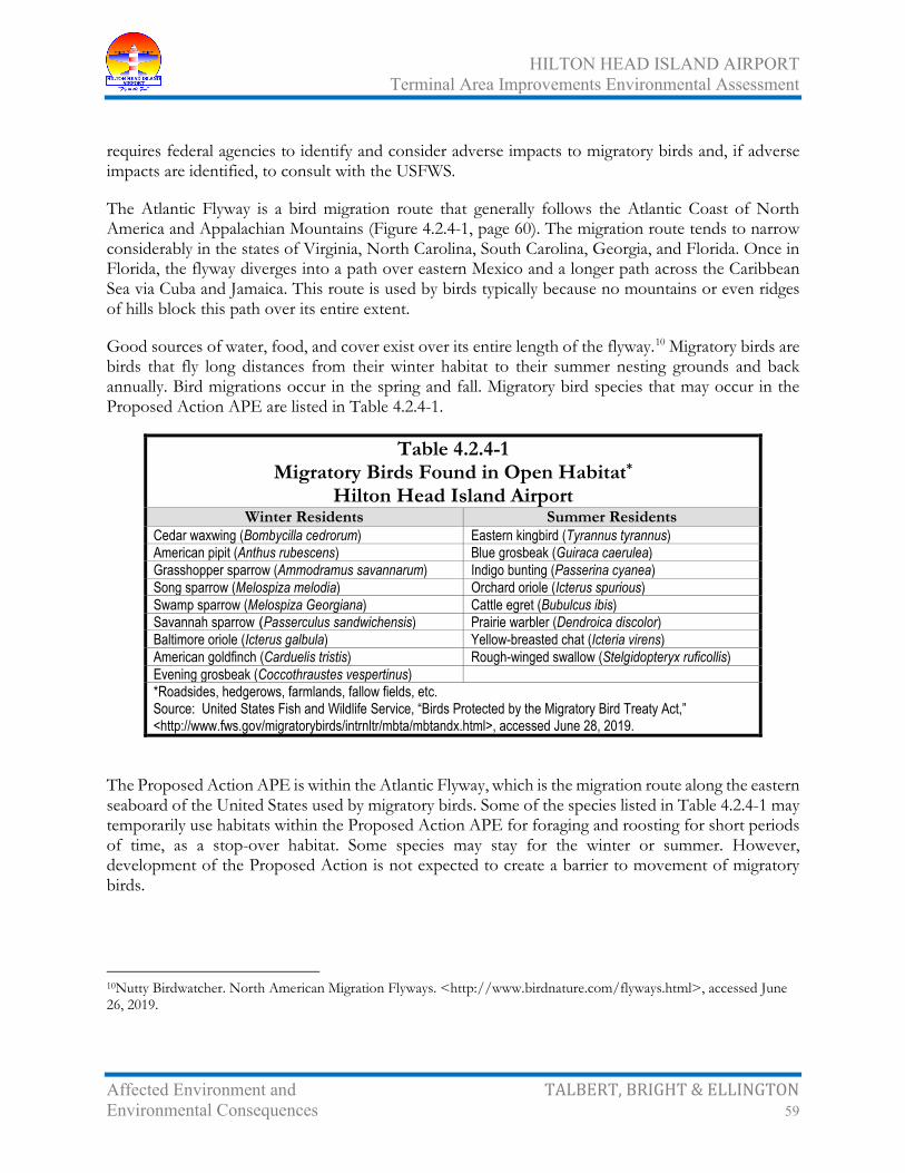
HILTON HEAD ISLAND AIRPORT Terminal Area Improvements Environmental Assessment
Affected Environment and TALBERT, BRIGHT & ELLINGTON Environmental Consequences 59
requires federal agencies to identify and consider adverse impacts to migratory birds and, if adverse impacts are identified, to consult with the USFWS.
The Atlantic Flyway is a bird migration route that generally follows the Atlantic Coast of North America and Appalachian Mountains (Figure 4.2.4-1, page 60). The migration route tends to narrow considerably in the states of Virginia, North Carolina, South Carolina, Georgia, and Florida. Once in Florida, the flyway diverges into a path over eastern Mexico and a longer path across the Caribbean Sea via Cuba and Jamaica. This route is used by birds typically because no mountains or even ridges of hills block this path over its entire extent.
Good sources of water, food, and cover exist over its entire length of the flyway.10 Migratory birds are birds that fly long distances from their winter habitat to their summer nesting grounds and back annually. Bird migrations occur in the spring and fall. Migratory bird species that may occur in the Proposed Action APE are listed in Table 4.2.4-1.
Table 4.2.4-1 Migratory Birds Found in Open Habitat*
Hilton Head Island Airport Winter Residents Summer Residents
Cedar waxwing (Bombycilla cedrorum) Eastern kingbird (Tyrannus tyrannus) American pipit (Anthus rubescens) Blue grosbeak (Guiraca caerulea) Grasshopper sparrow (Ammodramus savannarum) Indigo bunting (Passerina cyanea) Song sparrow (Melospiza melodia) Orchard oriole (Icterus spurious) Swamp sparrow (Melospiza Georgiana) Cattle egret (Bubulcus ibis) Savannah sparrow (Passerculus sandwichensis) Prairie warbler (Dendroica discolor) Baltimore oriole (Icterus galbula) Yellow-breasted chat (Icteria virens) American goldfinch (Carduelis tristis) Rough-winged swallow (Stelgidopteryx ruficollis) Evening grosbeak (Coccothraustes vespertinus) *Roadsides, hedgerows, farmlands, fallow fields, etc. Source: United States Fish and Wildlife Service, “Birds Protected by the Migratory Bird Treaty Act,” <http://www.fws.gov/migratorybirds/intrnltr/mbta/mbtandx.html>, accessed June 28, 2019.
The Proposed Action APE is within the Atlantic Flyway, which is the migration route along the eastern seaboard of the United States used by migratory birds. Some of the species listed in Table 4.2.4-1 may temporarily use habitats within the Proposed Action APE for foraging and roosting for short periods of time, as a stop-over habitat. Some species may stay for the winter or summer. However, development of the Proposed Action is not expected to create a barrier to movement of migratory birds.
10Nutty Birdwatcher. North American Migration Flyways. <http://www.birdnature.com/flyways.html>, accessed June 26, 2019.

HILTON HEAD ISLAND AIRPORT Terminal Area Improvements Environmental Assessment
Affected Environment and TALBERT, BRIGHT & ELLINGTON Environmental Consequences 60
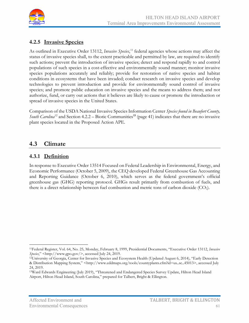
HILTON HEAD ISLAND AIRPORT Terminal Area Improvements Environmental Assessment
Affected Environment and TALBERT, BRIGHT & ELLINGTON Environmental Consequences 61
4.2.5 Invasive Species As outlined in Executive Order 13112, Invasive Species,11 federal agencies whose actions may affect the status of invasive species shall, to the extent practicable and permitted by law, are required to identify such actions; prevent the introduction of invasive species; detect and respond rapidly to and control populations of such species in a cost-effective and environmentally sound manner; monitor invasive species populations accurately and reliably; provide for restoration of native species and habitat conditions in ecosystems that have been invaded; conduct research on invasive species and develop technologies to prevent introduction and provide for environmentally sound control of invasive species; and promote public education on invasive species and the means to address them; and not authorize, fund, or carry out actions that it believes are likely to cause or promote the introduction or spread of invasive species in the United States.
Comparison of the USDA National Invasive Species Information Center Species found in Beaufort County, South Carolina12 and Section 4.2.2 – Biotic Communities13 (page 41) indicates that there are no invasive plant species located in the Proposed Action APE.
4.3 Climate
4.3.1 Definition In response to Executive Order 13514 Focused on Federal Leadership in Environmental, Energy, and Economic Performance (October 5, 2009), the CEQ developed Federal Greenhouse Gas Accounting and Reporting Guidance (October 6, 2010), which serves as the federal government’s official greenhouse gas (GHG) reporting protocol. GHGs result primarily from combustion of fuels, and there is a direct relationship between fuel combustion and metric tons of carbon dioxide (CO2).
11Federal Register, Vol. 64, No. 25, Monday, February 8, 1999, Presidential Documents, “Executive Order 13112, Invasive Species,” <http://www.gpo.gov/>, accessed July 24, 2019. 12University of Georgia, Center for Invasive Species and Ecosystem Health (Updated August 6, 2014), “Early Detection & Distribution Mapping System,” <http://www.eddmaps.org/tools/countyplants.cfm?id=us_sc_45013>, accessed July 24, 2019. 13Ward Edwards Engineering (July 2019), “Threatened and Endangered Species Survey Update, Hilton Head Island Airport, Hilton Head Island, South Carolina,” prepared for Talbert, Bright & Ellington.
HILTON HEAD ISLAND AIRPORT Terminal Area Improvements Environmental Assessment
Affected Environment and TALBERT, BRIGHT & ELLINGTON Environmental Consequences 62
4.3.2 Greenhouse Gases and Climate Change14 The impact of proposed projects on climate change is of increasing concern. GHGs are those that trap heat in the earth's atmosphere. Both naturally occurring and anthropogenic (man-made) GHGs include water vapor (H2O), CO2,15 methane (CH4), nitrous oxide (N2O), and O3.16
Research has shown that there is a direct link between fuel combustion and GHG emissions. Therefore, sources that require fuel or power at an airport are the primary sources that would generate GHGs. Aircraft are probably the most often cited air pollutant source, but they produce the same types of emissions as cars. Aircraft jet engines, like many other vehicle engines, produce CO2, H2O, NOx, CO, sulfur oxide (SOx); unburned or partially combusted hydrocarbons (also known VOCs); particulates; and other trace compounds.
According to most international reviews, aviation emissions comprise a small but potentially important percentage of anthropogenic (man-made) GHGs and other emissions that contribute to global warming. The Intergovernmental Panel on Climate Change (IPCC) estimates that global aircraft emissions account for about 3.5 percent of the total quantity of GHGs from human activities.17 In terms of United States contribution, the United States General Accounting Office (USGAO) reports that aviation accounts for about 3 percent of total US greenhouse gas emissions from human sources compared with other industrial sources, including the remainder of the transportation sector (23 percent) and industry (41 percent).18
The scientific community is developing areas of further study to more precisely estimate aviation's effects on the global atmosphere. The FAA is currently leading or participating in several efforts intended to clarify the role that commercial aviation plays in GHGs and climate change. The most comprehensive and multi-year program quantifying climate change effects of aviation is the Aviation Climate Change Research Initiative (ACCRI) funded by FAA and National Aeronautics and Space Administration (NASA). The ACCRI will reduce key scientific uncertainties in quantifying aviation-related climate impacts and provide timely scientific input for policy-making decisions. FAA also funds Project 12 of the Partnership for AiR Transportation Noise and Emissions Reduction (PARTNER) Center of Excellence research initiative to quantify the effects of aircraft exhaust and contrails on global and US climate and atmospheric composition. Finally, the Transportation Research Board’s
14Thomas Cuddy, “Considering Greenhouse Gases and Climate under the National Environmental Policy Act (NEPA): Interim Guidance,’ memorandum (FAA Order 1050.1E, Change 1, Guidance Memo #3), January 12, 2012. 15All greenhouse gas inventories measure carbon dioxide emissions, but beyond carbon dioxide, different inventories include different greenhouse gases (GHGs). 16Several classes of halogenated substances that contain fluorine, chlorine, or bromine are also greenhouse gases, but they are, for the most part, solely a product of industrial activities. For example, chlorofluorocarbons (CFCs) and hydro chlorofluorocarbons (HCFCs) are halocarbons that contain chlorine, while halocarbons that contain bromine are referred to as bromofluorocarbons (i.e., halons) or sulfur (sulfur hexafluoride: SF6). 17IPCC Report as referenced in United States General Accounting Office (USGAO), “Environment: Aviation’s Effects on the Global Atmosphere are Potentially Significant and Expected to Grow,” GAO/RCED-00-57, February 2000, page 4. 18Ibid, page 14, GAO cites available USEPA data from 1997.

HILTON HEAD ISLAND AIRPORT Terminal Area Improvements Environmental Assessment
Affected Environment and TALBERT, BRIGHT & ELLINGTON Environmental Consequences 63
(TRB) Airport Cooperative Research Program (ACRP) completed project 02-06, publishing ACRP Report 11: Guidebook on Preparing Airport Greenhouse Gas Emission Inventories.19 While not policy, airports use this as a resource to assist them in preparing GHG emission inventories when applicable.
4.3.3 Potential Greenhouse Gases Impacts Based on FAA data, aircraft operational activity (January 2018 through December 2018)20 at HXD represents less than 0.07 percent of US aviation activity. Therefore, assuming that GHGs occur in proportion to the level of activity, GHG emissions, associated with existing and future aviation activity at HXD, would be expected to represent less than 0.07 percent of US-based GHGs. Therefore, it is not expected that the emissions of GHGs from the Proposed Action would be significant.
4.4 Coastal Resources
4.4.1 Definition Federal activities involving or affecting coastal resources are governed by the Coastal Zone Management Act (CZMA), Coastal Barriers Resources Act (CBRA), and Executive Order 13089, Coral Reef Protection.21
4.4.2 Coastal Zone Management Act The Coastal Zone Management Act of 1972 (Public Law [PL] 104-150, as amended) requires that development projects in the coastal zone comply to the maximum extent practicable with approved state coastal management programs. SCDHEC Office of Coastal Resource Management (SCDHEC-OCRM) is the federally approved coastal zone management authority and administers the South Carolina Coastal Management Program (SCCMP, South Carolina Coastal Management Act of 1977).22 SCDHEC-OCRM has direct permitting authority over tidelands, coastal waters, beaches, and beach/dune systems (critical areas) east of US Highway 17. Based on the location of HXD, any development at the Hilton Head Island Airport would have to be in compliance with the SCCMP (Figure 4.4.2-1, page 64).
19Transportation Research Board, Airport Cooperative Research Program, “ACRP Report 11: Guidebook on Preparing Airport Greenhouse Gas Emission Inventories,” 2009, prepared by Wylie Laboratories, Inc., Arlington, VA. 20Federal Aviation Administration, Air Traffic Activity System (ATADS), Airport Operations, “ATADS: Airport Operations: Standard Report,” <http://aspm.faa.gov/opsnet/sys/Airport.asp>, accessed June 26, 2019. 21Federal Register, Vol. 63, No 115, Pg. 32701, June 16, 1998, “Executive Order 13089 of June 11, 1998, Coral Reef Protection,” < http://www.gpo.gov/>, accessed June 26, 2019. 22South Carolina Department of Health and Environmental Control Office of Ocean and Coastal Resource Management, “Policies and Procedures of the South Carolina Coastal Management Program, An Excerpt of the South Carolina Coastal Management Program Document,” updated July 1995, <http://www.scdhec.gov/>, accessed June 26, 2019.

HILTON HEAD ISLAND AIRPORT Terminal Area Improvements Environmental Assessment
Affected Environment and TALBERT, BRIGHT & ELLINGTON Environmental Consequences 64
HILTON HEAD ISLAND AIRPORT Terminal Area Improvements Environmental Assessment
Affected Environment and TALBERT, BRIGHT & ELLINGTON Environmental Consequences 65
SCDHEC-OCRM has certification authority over federal and state permits within the coastal zone, which includes Beaufort County. This includes United States Army Corps of Engineers (USACE) and United States Coast Guard (USCG) permits. The guidelines for SCDHEC-OCRM certification for airport projects are contained in the SCCMP. Review of the SCCMP identified the following policies and recommendations with regard to airport projects:
• To the extent feasible, the best available techniques and methods shall be used during design, construction, and maintenance of airports to avoid erosion or sedimentation problems and prevent concentrated runoff water from aircraft use areas, parking areas, and support facilities from directly entering and degrading adjacent surface water bodies or underground resources
• Proposals for airport facilities must demonstrate that they will meet applicable federal and state air quality and noise control guidelines
• Consideration of the existing and planned transportation system or network in the area, for example, relationship to other airports and access to adequate transportation service by other modes
• Encouragement of joint use of regional airport facilities where feasible (for example, joint military and civilian airports)
• Compatibility with character and use of the area, local governments are encouraged to develop plans and procedures, which maintain appropriate, compatible use areas around existing airports
• Alignment of approach corridors and corresponding noise zones during airport planning should consider any bird rookeries located in the area.
Twelve (12) categories of geographical areas of particular concern (GAPC) are listed in the Plan that should be avoided when possible; these are:
• South Carolina Heritage Trust Program Preserves
• State Wildlife Preserves
• State Parks
• Scenic Rivers
• Marine and Estuarine Sanctuaries
• Shellfish Areas
• Groundwater Resources
• Threatened and Endangered Species Habitats
• State Ports

HILTON HEAD ISLAND AIRPORT Terminal Area Improvements Environmental Assessment
Affected Environment and TALBERT, BRIGHT & ELLINGTON Environmental Consequences 66
• Navigation Channels
• Mining Operations
• Areas of Special Historic, Archaeological, or Cultural Significance
Throughout the planning stages of the proposed improvements, efforts should be made to adhere to the policies and recommendations of the SCCMP, as well as avoidance of the GAPCs listed in the SCCMP, where practicable.
4.4.3 Coastal Barrier Resource Act The Coastal Barrier Resource Act of 1982 (CBRA, Public Law [PL] 97-348, 16 USC 3501 et seq.), Coastal Barrier Improvement Act of 1990, and Coastal Barrier Resources Reauthorization Act of 2000 prohibit the use of federal funds for projects that would impact undeveloped coastal barrier units in the Coastal Barrier Resources System. Coastal barriers are unique land forms that provide protection for diverse aquatic habitats and serve as the first line of defense against the impacts of severe coastal storms and erosion. Located at the interface of land and sea, the dominant physical factors responsible for shaping coastal land forms are tidal range; wave energy; and sediment supply from rivers and older, preexisting coastal sand bodies. Relative changes in local sea level also profoundly affect coastal barrier diversity. CBRA units have been designated, and maps showing their locations are on file with the USFWS.23
There are five units designated in Beaufort County (Figure 4.4.3-1, page 67):
• M11 (Harbor Island)
• SC-09P (Hunting Island)
• M12 (St. Phillips Island)
• M13 (Daufuski Island)
• SC-10P (Turtle Island)
4.4.4 Potential Coastal Resources Impacts 4.4.4.1 South Carolina Heritage Trust Program Preserves
There is one preserve and one bird sanctuary on Hilton Head Island in the vicinity of HXD:
23United States Fish and Wildlife Service, John H. Chafee Coastal Barrier Resources System, Habitat and Resource Conservation, <http://www.fws.gov/>, accessed June 28, 2019.
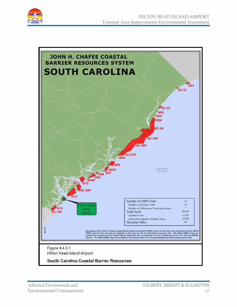
HILTON HEAD ISLAND AIRPORT Terminal Area Improvements Environmental Assessment
Affected Environment and TALBERT, BRIGHT & ELLINGTON Environmental Consequences 67

HILTON HEAD ISLAND AIRPORT Terminal Area Improvements Environmental Assessment
Affected Environment and TALBERT, BRIGHT & ELLINGTON Environmental Consequences 68
• Greens Shell Enclosure Heritage Preserve, located 3.6 miles west of HXD, is a three-acre archaeological site dating back to 1335 A.D. The preserve, purchased in 1991, is a passive park focusing on archaeological features.
• Joiner Bank Seabird Sanctuary, located 2.3 miles east of HXD, is a sand spit formed by deposits from associated river systems. It shifts in position and structure due to erosion and deposition of sand. Presently, it is a tidal bar and is underwater at high tide. Because it is covered by water at high tide, this sanctuary does not presently support water bird nesting. It was designated a seabird sanctuary because in the past it was higher in elevation and supported colonial seabird and shorebird nesting. This sanctuary may, in the future, grow in elevation and again support colonial water bird nesting. It remains important as a rest and foraging area for birds.
These sites would not be directly impacted by the No-Action Alternative or the Proposed Action.
4.4.4.2 State Wildlife Preserves
There is one preserve and one wildlife refuge in the vicinity of HXD:
• Audubon Newhall Preserve, located 6.1 miles south of HXD, is a 50-acre sanctuary that preserves a unique natural environment and provides a protected habitat for plants and animals indigenous to the South Carolina Lowcountry. It is a woodland community known as a pine/saw palmetto flatwoods
• Pinckney Island National Wildlife Refuge, located 3.7 miles northwest of HXD, is a 4,053-acre refuge, which includes Pinckney Island, Corn Island, Big and Little Harry Islands, Buzzard Island, and numerous small hammocks. Pinckney is the largest of the islands and the only one open to public use. Nearly 67 percent of the refuge consists of salt marsh and tidal creeks
These sites would not be directly impacted by the No-Action Alternative or the Proposed Action.
4.4.4.3 State Parks
There are no state parks in the vicinity of HXD; therefore, there is no impact by the No-Action Alternative or the Proposed Action.
4.4.4.4 Scenic Rivers
Section 4.14.5 – Wild and Scenic Rivers (page 134).
4.4.4.5 Marine and Estuarine Sanctuaries
There are no marine and estuarine sanctuaries in the vicinity of HXD; therefore, there is no impact by the No-Action Alternative or the Proposed Action.

HILTON HEAD ISLAND AIRPORT Terminal Area Improvements Environmental Assessment
Affected Environment and TALBERT, BRIGHT & ELLINGTON Environmental Consequences 69
4.4.4.6 Shellfish Areas
Figure 4.4.4.6-1 (page 70) represents shellfish areas in the vicinity of HXD. Areas bordered in red are public shellfish grounds and are open for recreational harvest only. Areas bordered in green are state shellfish grounds, which are available for recreational and commercial harvest. Areas labeled ‘C’ represent culture permits, which are needed to harvest on these areas. Shading denotes SCDHEC harvest classifications. Recreational harvest is not allowed in areas colored red or orange. Areas colored yellow may be closed to shell fishing after heavy rainfall. There is one shellfish area in the vicinity of HXD, but this area is shaded red not allowing recreational harvesting. It is not anticipated that the No-Action Alternative or the Proposed Action would impact this area.
4.4.4.7 Groundwater Resources
Section 4.14.4 – Groundwater Resources (page 132).
4.4.4.8 Threatened and Endangered Species Habitats
Section 4.2.3 – Threatened and Endangered Species (page 43).
4.4.4.9 State Ports
There are no state ports in the vicinity of HXD; therefore, there is no impact by the No-Action Alternative or the Proposed Action.
4.4.4.10 Navigation Channels
There are no navigation channels in the vicinity of HXD; therefore, there is no impact by the No-Action Alternative or the Proposed Action.
4.4.4.11 Mining Operations
There are no mining operations in the vicinity of HXD; therefore, there is no impact by the No-Action Alternative or the Proposed Action.
4.4.4.12 Areas of Special Historic, Archaeological, or Cultural Significance
Section 4.8 – Historic, Architectural, Archaeological, and Cultural Resources (page 82).
4.4.4.13 Coastal Barrier Resouce Act
Based on review of CBRA unit location map (Figure 4.4.3-1, page 67), it has been determined that the Proposed Action at the Hilton Head Island Airport would not impact the CBRA units in the vicinity of HXD.
4.4.5 South Carolina Coastal Zone Consistency Determination Concurrence with the South Carolina Coastal Zone Consistency Program has been requested.

HILTON HEAD ISLAND AIRPORT Terminal Area Improvements Environmental Assessment
Affected Environment and TALBERT, BRIGHT & ELLINGTON Environmental Consequences 70

HILTON HEAD ISLAND AIRPORT Terminal Area Improvements Environmental Assessment
Affected Environment and TALBERT, BRIGHT & ELLINGTON Environmental Consequences 71
4.5 Department of Transportation Act: Section 4(f)
4.5.1 Definition Section 4(f) of the USDOT Act of 1966 states that the Secretary of Transportation shall not approve any program or project, which requires the use of any publicly owned land from a public park; recreation area; wildlife and waterfowl refuge of national, state, or local significance as determined by federal, state, or local officials having jurisdiction thereof; or any land from an historic structure of national, state, or local significance as so determined by such officials unless:
• There is no feasible and prudent alternative to the use of such land
• The project includes all possible planning to minimize harm to the land resulting from such use
4.5.2 Potential Section 4(f) Impacts The No-Action Alternative and Proposed Action would not impact Section 4(f) facilities as there are none located within the APE.
4.6 Farmlands
4.6.1 Definition The United States Department of Agriculture (USDA) oversees the Farmland Protection Policy Act of 1981 (FPPA, PL 97-98). The purpose of the FPPA is to minimize the extent to which federal programs contribute to the unnecessary and irreversible conversion of farmland to nonagricultural uses. The FPPA establishes the protocol and criteria to be used by federal agencies to:
• Identify and take into account the adverse effects of their programs on the preservation of farmland
• Consider alternative actions, as appropriate, that could lessen adverse effects
• Ensure that their programs are compatible with state and units of local government and private programs and policies to protect farmland
The FPPA does not provide authority to withhold federal assistance for projects that convert farmland to nonagricultural uses. For the purposes of implementing the FPPA, farmland is defined as prime or unique farmlands or farmland that is determined by the state or unit of local government agency to
HILTON HEAD ISLAND AIRPORT Terminal Area Improvements Environmental Assessment
Affected Environment and TALBERT, BRIGHT & ELLINGTON Environmental Consequences 72
be farmland of statewide or local importance.24 The Natural Resources Conservation Service (NRCS) farmland definitions are:25
• Prime farmland is land that has the best combination of physical and chemical characteristics for producing food, feed, forage, fiber, and oil seed crops and that is available for these uses. It has the combination of soil properties, growing season, and moisture supply needed to produce sustained high yields of crops in an economic manner if it is treated and managed according to acceptable farming methods. In general, prime farmland has an adequate and dependable water supply from precipitation or irrigation, a favorable temperature and growing season, an acceptable level of acidity or alkalinity, an acceptable content of salt or sodium, and few or no rocks. Its soils are permeable to water and air. Prime farmland is not excessively eroded or saturated with water for long periods of time, and it either does not flood frequently during the growing season or is protected from flooding.
• Unique farmland is land other than prime farmland that is used for the production of specific high-value food and fiber crops. It has the special combination of soil quality, location, growing season, and moisture supply needed to economically produce sustained high quality and/or high yields of a specific crop when treated and managed according to acceptable farming methods.
• Statewide or local importance is land, in addition to prime and unique farmlands, that is of statewide or local importance for the production of food, feed, fiber, forage, and oil seed crops. Criteria for defining and delineating this land are to be determined by the appropriate state agency or agencies. Generally, additional farmlands of statewide or local importance include those that are nearly prime farmland and economically produce high yields of crops when treated and managed according to acceptable farming methods. Some may produce as high a yield as prime farmlands if conditions are favorable.
4.6.2 Existing Soils As shown on Figure 4.6.2-1 (page 73), eight soil types are identified within the Proposed Action APE.
Table 4.6.2-1 (page 74) illustrates the degree and soil limitations that affect small commercial buildings, buildings without basements, and roads and streets.
The limitations indicate the extent to which the soils are limited by soil features that affect the specified use.
24Code of Federal Regulations Title 7 – Agriculture, Chapter VI – Natural Resources Conservation Service, Department of Agriculture, Part 658 – Farmland Protection Policy Act. (January 1, 2006 edition). 25United States Department of Agriculture (October 1993). Soil Survey Manual Handbook No. 18.

HILTON HEAD ISLAND AIRPORT Terminal Area Improvements Environmental Assessment
Affected Environment and TALBERT, BRIGHT & ELLINGTON Environmental Consequences 73

HILTON HEAD ISLAND AIRPORT Terminal Area Improvements Environmental Assessment
Affected Environment and TALBERT, BRIGHT & ELLINGTON Environmental Consequences 74
• Not limited – indicates that the soil has features that are very favorable for the specified use. Good performance and very low maintenance can be expected
• Somewhat limited – indicates that the soil has features that are moderately favorable for the specified use. The limitations can be overcome or minimized by special planning, design, or installation. Fair performance and moderate maintenance can be expected
• Very limited – indicates that the soil has one or more features that are unfavorable for the specified use. The limitations generally cannot be overcome without major soil reclamation, special design, or expensive installation procedures. Poor performance and high maintenance can be expected
4.6.3 Potential Farmland Impacts As defined in the FPPA, land is not considered prime or unique farmland if it has been committed to urban development. Prime or unique farmland committed to urban development includes land that
Table 4.6.2-1 Soils Within the Vicinity of the Airport
Hilton Head Island Airport
Map Unit
Symbol Map Unit Name
Development Suitabilities and Limitations for Use
Farmland Classification
Small Commercial
Buildings
Buildings without
Basements
Roads and
Streets Ba Baratari fine sand, 0% to 2%
slopes very limited very limited somewhat
limited prime farmland, if irrigated and
drained CE Capers association, 0% to 2%
slopes very limited very limited very limited not prime
farmland Po Polowana loamy fine sand, 0%
to 2% slopes very limited very limited very limited prime farmland,
if irrigated and drained
Rd Ridgeland fine sand, 0% to 2% slopes
very limited very limited very limited prime farmland, if irrigated
Ro Rosedhu fine sand, 0% to 2% slopes
somewhat limited
somewhat limited
somewhat limited
prime farmland, if irrigated and
drained Sk Seabrook fine sand, 0% to 2%
slopes not limited not limited not limited prime farmland,
if irrigated Wd Wando fine sand, 0% to 6%
slopes not limited not limited not limited prime farmland,
if irrigated Source: Soil Survey Staff, Natural Resources Conservation Service, United States Department of Agriculture, “Web Soil Survey,” <http://websoilsurvey.nrcs.usda.gov/>, accessed June 26, 2019.

HILTON HEAD ISLAND AIRPORT Terminal Area Improvements Environmental Assessment
Affected Environment and TALBERT, BRIGHT & ELLINGTON Environmental Consequences 75
has been designated for commercial, industrial, or residential use and is not intended at the same time to protect farmland in either a
• Zoning code or ordinance adopted by a unit of government or
• Comprehensive land use plan
The No-Action Alternative would have no impact on undeveloped land and, therefore, would not result in any farmland impacts.
Development of the Proposed Action will have an impact on soils by converting undeveloped land; however, these soils are not considered prime, unique, or statewide important because of the presence of zoning and land use ordinances for the Town of Hilton Head Island.26 Therefore, there would be no impact to farmland.
Geotechnical studies will be performed where soil limitations are determined to be very limited prior to development of the Proposed Action.
4.7 Hazardous Materials, Solid Waste, and Pollution Prevention
4.7.1 Hazardous Materials27 4.7.1.1 Definition
The purpose of a Phase I Environmental Site Assessment (ESA) is to identify, to the extent feasible, pursuant to American Society of Testing and Materials (ASTM) E 1527-13 – Standard Practice for Environmental Site Assessments: Phase 1 Environmental Site Assessment Process, Recognized Environmental Conditions (RECs), the RECs in connection with the property. The ASTM Standard Practice E 1527-13 – Standard Practice for Environmental Site Assessments: Phase 1 Environmental Site Assessment Process defines good commercial and customary practice for conducting an environmental site assessment of a parcel of commercial real estate with respect to the range of contaminants within the scope of the Comprehensive Environmental Response, Compensation and Liability Act (CERCLA) and to petroleum products. This practice is intended to permit a user to satisfy one of the requirements to qualify for the innocent landowner defense to CERCLA liability.
26Town of Hilton Head Island, “Land Management Ordinance, Town of Hilton Head Island, South Carolina, Chapter 16-3: - Zoning Districts. Codified through Ordinance No. 2017-19, enacted December 5, 2017. (Supplement No. 5),” <http://www.municode.com/>, accessed June 26, 2019. 27S&ME, Inc. (August 2, 2019), “Phase I Environmental Site Assessment, Hilton Head Island Airport Expansion, Hilton Head Island, Beaufort Co., SC,” prepared for Talbert, Bright & Ellington, Inc.

HILTON HEAD ISLAND AIRPORT Terminal Area Improvements Environmental Assessment
Affected Environment and TALBERT, BRIGHT & ELLINGTON Environmental Consequences 76
4.7.1.2 Existing Conditions
The Proposed Action APE consists of the Hilton Head Island Airport commercial service terminal building, automobile parking, aircraft parking apron, and runway; as well as nine commercial business on five adjacent properties. The commercial/light industrial businesses consist of the following:
• Hilton Head Floor Covering Center
• Beachside Tire and Auto
• Stone Works
• H&H Autobody
• SCE Auto
• Carolina Contractors
• Window Fashions of Hilton Head (formerly by Rhonda)
• Farmers Heating and Air Conditioning
• Avis Rent A Car
Small areas of woodland are also located on the Proposed Action APE. Land use surrounding the Proposed Action APE consist of commercial business, office buildings, a church, and open areas surrounding the runway of the Hilton Head Island Airport.
4.7.1.3 Potential Hazardous Materials Impacts
4.7.1.2.1 On-Site Findings
Figure 4.7.1.2.1-1 (page 77) illustrates the locations of potential hazardous material sites within the Proposed Action APE. A copy of the results of the Phase I ESA is provided in Appendix C (page C-1).
The following findings of environmental concern were identified (Table 4.7.1.2.1-1, page 78):
• A portion of HXD (TSA at Hilton Head Airport) is listed as a Resource Conservation and Recovery Act – Conditionally Exempt Small Quantity Generators (RCRA-CESQG). The RCRA-CESQG listing did not have documented violations and is not considered a REC at this time.
• Active 2,000-gallon gasoline underground storage tank (UST) at Avis Rent A Car (36 Hunter Road). The UST and associated underground fuel lines is considered a REC in connection with the Proposed Action APE. This UST would require compliance with SCDHEC if and when it is removed.

HILTON HEAD ISLAND AIRPORT Terminal Area Improvements Environmental Assessment
Affected Environment and TALBERT, BRIGHT & ELLINGTON Environmental Consequences 77

HILTON HEAD ISLAND AIRPORT Terminal Area Improvements Environmental Assessment
Affected Environment and TALBERT, BRIGHT & ELLINGTON Environmental Consequences 78
Table 4.7.1.2.1-1 Phase I ESA Findings of Environmental Concern
Hilton Head Island Airport
Facility
Location Direction/ Distance/
Topographic Relationship Record Comment
Avis Rent A Car 36 Hunter Road Proposed Action APE
UST Active UST (2,000-gallons) site; no documented releases
TSA at Hilton Head Airport
120 Beach City Road Proposed Action APE
RCRA-CESQG No violations found
H&H Auto Service Center
31A Hunter Road 300 feet west, cross-gradient
RCRA-CESQG No violations found
Island T-Shirt Sales 29 Hunter Road. 150 feet west, cross-gradient
RCRA-CESQG No violations found
Coastal Transmission Service (Land Speed Auto)
6 Finch Street 150 feet north, down-gradient
RCRA-CESQG No violations found
Air East HH 61 Airport Road 500 feet east, down-gradient
RCRA-Non-Gen, ECHO
No violations found
UPS Hilton Head 24 Hunter Road 350 feet south, down-gradient
UST, LUST, RCRA-CESQG
UST site; petroleum release in 1991; NFA status was granted by SCDHEC in 1992; based on USGS topographic map, groundwater flow is southwest away from Proposed Action APE
Budget Rent A Car 35 Dillon Road 500 feet east, down-gradient
UST, LUST Former UST site; release documented in 1998. NFA issued by SCDHEC in 1998; based on USGS topographic map, groundwater flow is east away from Proposed Action APE
TBC Retail Group 144 Beach City Road 1,200 feet north, down-gradient
RCRA-CESQG No violations found
Circle K 71 Matthews Drive 900 feet south, down-gradient
UST UST site; no documented releases; based on USGS topographic map, groundwater flow is east away from Proposed Action APE
Island Repair Service
32-A Cardinal Road 675 feet west, down-gradient
RCRA-Non-Gen No violations found
Collision Repair LLC 17 Cardinal Road 800 feet west, down-gradient
RCRA-Non-Gen No violations found
Carolina Air Center 52 Gateway Circle 450 feet west, down-gradient
AST No violations found

HILTON HEAD ISLAND AIRPORT Terminal Area Improvements Environmental Assessment
Affected Environment and TALBERT, BRIGHT & ELLINGTON Environmental Consequences 79
Table 4.7.1.2.1-1 Phase I ESA Findings of Environmental Concern
Hilton Head Island Airport
Facility
Location Direction/ Distance/
Topographic Relationship Record Comment
Collision Repair Specialist/Advanced Autobody/Island Body Shop
10A Cardinal Road 730 feet southwest, down-gradient
RCRA-Non- Gen, RCRA-SQG
No violations found
Hilton Head Air Services
38 Gateway Circle 520 feet west, down-gradient
UST, LUST Former UST site; release documented in 2000; NFA issued by SCDHEC in 2001; based on USGS topographic map, groundwater flow is east away from Proposed Action APE
Airport Well Site Dillon Road 225 feet northeast, down-gradient
UST, LUST Former UST site; release documented in 1999; NFA in 2000; based on USGS topographic map, groundwater flow is northeast away from Proposed Action APE
Hilton Head Auto Service Center
2 Southwood Park Drive 2,900 feet southwest, down-gradient
UST Abandoned UST site; no documented releases
APE – Area of Potential Effect AST – Above-Ground Storage Tank ECHO – Enforcement and Compliance History Information LUST – Leaking Underground Storage Tank NFA – No Further Action RCRA-CESQG – Resource Conservation and Recovery Act – Conditionally Exempt Small Quantity Generators RCRA-Non-Gen – Resource Conservation and Recovery Act – Non-Generators RCRA-SQG – Resource Conservation and Recovery Act – Small Quantity Generators SCDHEC – South Carolina Department of Health and Environmental Control TSA – Transportation Security Administration USGS – United States Geologic Survey UST – Underground Storage Tank Source: S&ME, Inc. (August 2, 2019), “Phase I Environmental Site Assessment, Hilton Head Island Airport Expansion, Hilton Head Island, Beaufort Co., SC,” prepared for Talbert, Bright & Ellington, Inc.
• Two above-ground storage tanks (ASTs)/mixer tanks used for adhesive, epoxy, sealers, and impregnators at Stone Works (28 Hunter Road). The two ASTs/mixer tanks are used for storage of stone cutting liquids (adhesives, epoxy, sealers, and impregnators) do not contain hazardous chemicals and are not considered a REC at this time.
• The presence of hydraulic lifts at Beachside Tire and Auto (26 Hunter Road). The of hydraulic lifts at Beachside Tire and Auto is considered a REC in connection with the Proposed Action APE. Removal of the hydraulic lifts would require SCDHEC compliance if and when removal is determined.

HILTON HEAD ISLAND AIRPORT Terminal Area Improvements Environmental Assessment
Affected Environment and TALBERT, BRIGHT & ELLINGTON Environmental Consequences 80
• An approximate 250-gallon diesel fuel AST at Carolina Contractors (30 Hunter Road). The AST appears to be in good condition with no apparent signs of leakage (stained pavement, odors, or stressed vegetation) and is not considered a REC at this time
• Two propane ASTs at Carolina Contractors (30 Hunter Road). The two ASTs appear to be in good condition and are not considered a REC at this time
4.7.1.2.2 Off-Site Findings
There are multiple regulated facilities (Table 4.7.1.2.1-1, page 78) located within the ASTM-designated radius from the Proposed Action APE. Based on current regulatory status, distance, and topographic relationship to the Proposed Action APE, the off-site facilities are not considered RECs in connection with the Proposed Action APE.
4.7.1.2.3 Conclusions
The Phase I ESA was performed in compliance with the scope and limitations of ASTM E1527-13 – Standard Practice for Environmental Site Assessments: Phase 1 Environmental Site Assessment Process for the Proposed Action APE. The assessment revealed no evidence of RECs, historical recognized environmental conditions (HRECs), or controlled recognized environmental conditions (CRECs) in connection with the Proposed Action APE with the exception of:
• Active 2,000-gallon gasoline UST at Avis Rent A Car located at 36 Hunter Road
• The presence of hydraulic lifts at Beachside Tire and Auto located at 26 Hunter Road
These RECs would require SCDHEC compliance if and when removal is determined.
4.7.2 Solid Waste 4.7.2.1 Existing Conditions
Existing buildings and hangars generate solid waste for disposal, which is the responsibility of the occupants of the facilities. The collection and disposal of solid waste are provided by private companies that contract with businesses and residents on the Island to collect waste and remove it to disposal facilities. Solid waste is disposed of at the Hickory Hill Landfill in Jasper County, which has an estimated 20-year life span remaining. Construction and demolition material are disposed of at either Barnwell Resources in Beaufort County or the Oakwood Landfill in Jasper County.
4.7.2.2 Potential Solid Waste Impacts
4.7.2.2.1 No-Action Alternative
The No-Action Alternative would not result in the increased generation of solid waste.

HILTON HEAD ISLAND AIRPORT Terminal Area Improvements Environmental Assessment
Affected Environment and TALBERT, BRIGHT & ELLINGTON Environmental Consequences 81
4.7.2.2.2 Proposed Action
The Proposed Action would not have a direct effect on solid waste collection or disposal, other than during actual construction of the proposed projects. Construction debris would be disposed of off-site at either Barnwell Resources in Beaufort County or the Oakwood Landfill in Jasper County.
4.7.3 Pollution Prevention 4.7.3.1 Definition
HXD must comply with applicable regulations pertaining to the use, storage, and disposal of hazardous materials as outlined in FAA Order 1050.10B – Prevention, Control and Abatement of Environmental Pollution at FAA Facilities; FAA Order 1050.14A – Polychlorinated Biphenyls (PCB) in the National Airspace System; FAA Order 1050.15A – Underground Storage Tanks at FAA Facilities; FAA Order 1050.18 – Chlorofluorocarbons and Halon Use at FAA Facilities; and FAA Advisory Circular 150/5320-15 – Management of Airport Industrial Wastes. This compliance can be in the form of a Spill Prevention, Control, and Countermeasures Plan (SPCC).28
Although each SPCC is unique to the facility, there are certain elements that must be included in order for the SPCC to comply with the provisions of 40 CFR 112, Oil Pollution Prevention. Three areas, which should be addressed in the Plan, are:
1) Operating procedures the facility implements to prevent oil spills
2) Control measures installed to prevent oil from entering navigable waters or adjoining shorelines
3) Countermeasures to contain, clean up, and mitigate the effects of an oil spill that has an impact on navigable waters or adjoining shorelines. Other important elements of a SPCC include, but are not limited to, the following: professional engineer certification, notification requirements in the event of a spill, and reporting requirements for spills of various quantities
The Plan must follow the sequence of 40 CFR 112.7 – General Requirements for Spill Prevention, Control, and Countermeasures Plans or provide cross-references to the requirements in 40 CFR 112.7 – General Requirements for Spill Prevention, Control, and Countermeasures Plans:
• Facility diagram
• Oil spill predictions
• Facility drainage
• Facility inspections
28Code of Federal Regulations, “Title 40, Protection of Environment, Part 112 – Oil Pollution Prevention,” <http://ecfr.gpoaccess.gov/>, accessed June 28, 2019.
HILTON HEAD ISLAND AIRPORT Terminal Area Improvements Environmental Assessment
Affected Environment and TALBERT, BRIGHT & ELLINGTON Environmental Consequences 82
• Site security
• Five-year plan review
• Management approval
• Appropriate secondary containment or diversionary structures
• Loading/unloading requirements and procedures for tank trucks
• Personnel training and oil discharge prevention briefings
• Bulk storage container compliance
• Transfer procedures and equipment (including piping)
4.7.3.2 Existing Conditions
Signature Flight Support, the fixed base operator (FBO), is responsible for fuel operations at HXD and has a SPCC in place.
4.7.3.3 Potential Pollution Prevention Impacts
4.7.3.3.1 No-Action Alternative
The No-Action Alternative would not result in the increased activities that would affect the SPCC currently in place.
4.7.3.3.2 Proposed Action
The Proposed Action would not result in increased activities that would affect the SPCC currently in place. As growth occurs at the Airport, the SPCC would be updated to outline requirements pertaining to increased activities that may have the potential for spillage of hazardous materials.
4.8 Historic, Architectural, Archaeological, and Cultural Resources
4.8.1 Definition Section 106 of the National Historic Preservation Act of 1966, as amended through 1992 (16 USC 470), and the Archaeological and Historic Preservation Act of 1974 require that a state or federal agency with jurisdiction over a specific project must identify and evaluate affected cultural resources, assess the project’s effect on such resources, and grant opportunity for comment. Cultural resources are evaluated by their eligibility for placement on the National Register of Historic Places (NRHP).
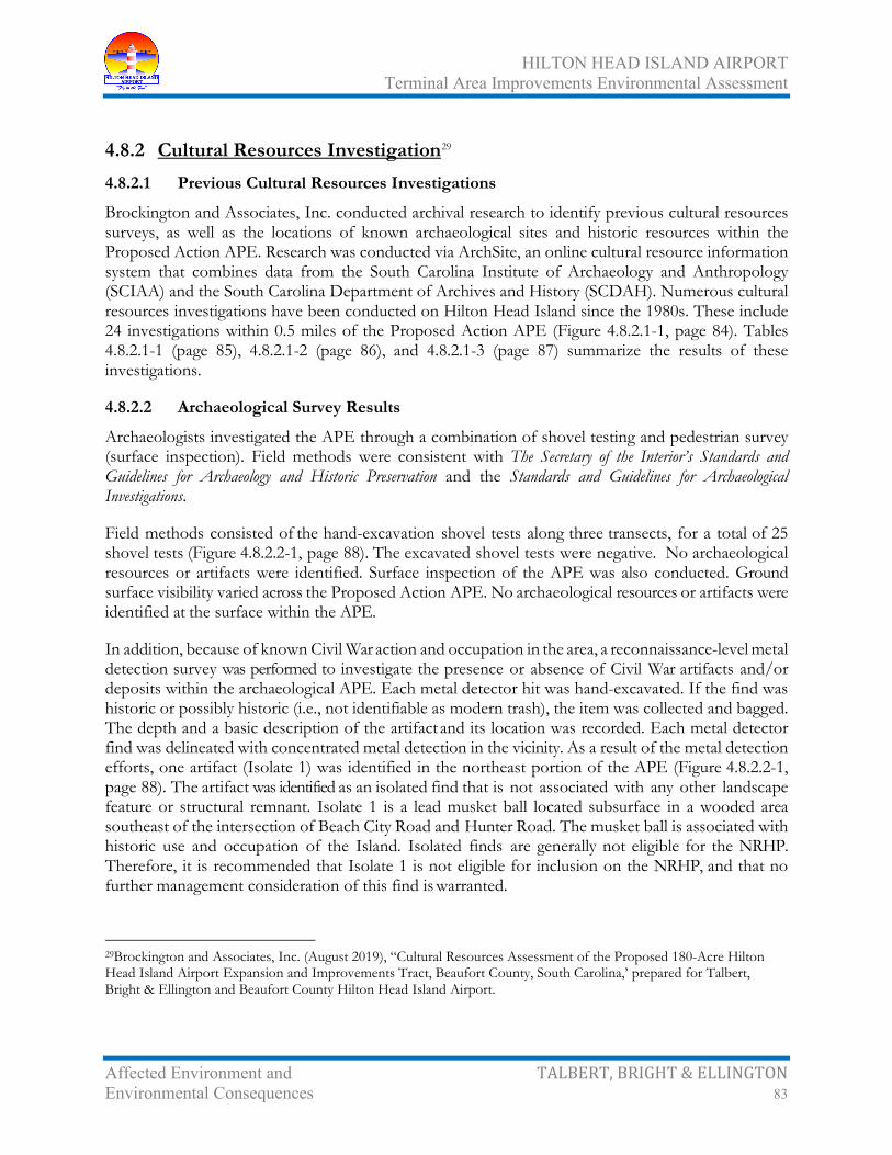
HILTON HEAD ISLAND AIRPORT Terminal Area Improvements Environmental Assessment
Affected Environment and TALBERT, BRIGHT & ELLINGTON Environmental Consequences 83
4.8.2 Cultural Resources Investigation29 4.8.2.1 Previous Cultural Resources Investigations
Brockington and Associates, Inc. conducted archival research to identify previous cultural resources surveys, as well as the locations of known archaeological sites and historic resources within the Proposed Action APE. Research was conducted via ArchSite, an online cultural resource information system that combines data from the South Carolina Institute of Archaeology and Anthropology (SCIAA) and the South Carolina Department of Archives and History (SCDAH). Numerous cultural resources investigations have been conducted on Hilton Head Island since the 1980s. These include 24 investigations within 0.5 miles of the Proposed Action APE (Figure 4.8.2.1-1, page 84). Tables 4.8.2.1-1 (page 85), 4.8.2.1-2 (page 86), and 4.8.2.1-3 (page 87) summarize the results of these investigations.
4.8.2.2 Archaeological Survey Results
Archaeologists investigated the APE through a combination of shovel testing and pedestrian survey (surface inspection). Field methods were consistent with The Secretary of the Interior’s Standards and Guidelines for Archaeology and Historic Preservation and the Standards and Guidelines for Archaeological Investigations.
Field methods consisted of the hand-excavation shovel tests along three transects, for a total of 25 shovel tests (Figure 4.8.2.2-1, page 88). The excavated shovel tests were negative. No archaeological resources or artifacts were identified. Surface inspection of the APE was also conducted. Ground surface visibility varied across the Proposed Action APE. No archaeological resources or artifacts were identified at the surface within the APE.
In addition, because of known Civil War action and occupation in the area, a reconnaissance-level metal detection survey was performed to investigate the presence or absence of Civil War artifacts and/or deposits within the archaeological APE. Each metal detector hit was hand-excavated. If the find was historic or possibly historic (i.e., not identifiable as modern trash), the item was collected and bagged. The depth and a basic description of the artifact and its location was recorded. Each metal detector find was delineated with concentrated metal detection in the vicinity. As a result of the metal detection efforts, one artifact (Isolate 1) was identified in the northeast portion of the APE (Figure 4.8.2.2-1, page 88). The artifact was identified as an isolated find that is not associated with any other landscape feature or structural remnant. Isolate 1 is a lead musket ball located subsurface in a wooded area southeast of the intersection of Beach City Road and Hunter Road. The musket ball is associated with historic use and occupation of the Island. Isolated finds are generally not eligible for the NRHP. Therefore, it is recommended that Isolate 1 is not eligible for inclusion on the NRHP, and that no further management consideration of this find is warranted.
29Brockington and Associates, Inc. (August 2019), “Cultural Resources Assessment of the Proposed 180-Acre Hilton Head Island Airport Expansion and Improvements Tract, Beaufort County, South Carolina,’ prepared for Talbert, Bright & Ellington and Beaufort County Hilton Head Island Airport.

HILTON HEAD ISLAND AIRPORT Terminal Area Improvements Environmental Assessment
Affected Environment and TALBERT, BRIGHT & ELLINGTON Environmental Consequences 84

HILTON HEAD ISLAND AIRPORT Terminal Area Improvements Environmental Assessment
Affected Environment and TALBERT, BRIGHT & ELLINGTON Environmental Consequences 85
Table 4.8.2.1-1 Previous Cultural Resources Investigations within 0.5 Mile of the Proposed
Action APE Hilton Head Island Airport
Date Description Agency/Client Consultant Reference 1986-1987 Archaeological survey of Hilton Head
Island SCDAH Chicora
Foundation Trinkley 1987
1986 Investigations of the Indian and Freedmen occupation at the Fish Haul Site (38BU805)
Environmental and Historical Museum of Hilton Head Island
Chicora Foundation
Trinkley 1986
1989 Archaeological survey and testing of the Palmetto Headlands Tract
Greenwood Development Corporation (GDC)
Brockington Espenshade and Grunden 1989
1989 Archaeological survey of the Baker Field Expansion Project
Town of Hilton Head Island; Beaufort County Recreation Commission
Chicora Foundation
Trinkley 1989
1989-1990 Archaeological and historical investigations of the western fringe of Mitchelville
GDC Brockington Espenshade and Grunden 1991a
1989-1990 Archaeological and historical investigation of Camp Baird
GDC Brockington Legg et al. 1991
1989-1990 Archaeological investigations of two turn of the century farmsteads (38BU966 and 88BU967)
GDC Brockington Espenshade and Grunden 1991b
1991 Archaeological survey of US 278 intersection improvements
South Carolina Department of Transportation (SCDOT)
SCDOT Roberts 1991
1991 Cultural resources survey of the 20-acre Commuter Terminal Tract
Wilbur Smith Associates Brockington Espenshade et al. 1991
1991 Archaeological survey of the 29-acre Palmetto Headlands Phase V Tract
GDC Brockington Espenshade and Grunden 1991c
1998 Cultural resources survey of the Dillon Road Tract development site
Franklin Development Corporation
R.S. Webb Associates
Webb 1998
1998 Beaufort County above-ground historic resources survey
Beaufort County Brockington Harvey et al. 1998
2001 Archaeological survey of a portion of the Dillon Road pathway
Beaufort County Chicora Foundation
Trinkley and Southerland 2001
2002 Archaeological investigations of a 16-acre Barker Field Expansion project
Town of Hilton Head Island William Green Green 2002
2002 Cultural resources assessment of the Dolphin Head cell tower
Unknown R.S. Webb Associates
Webb 2002
2006 Cultural resources survey of the Beach City Road tract
USACE Brockington Agha et al. 2006
2006 Cultural resources survey of a 4.23-acre tract on Dillon Road
Thomas and Hutton Engineering Company
Brockington Poplin et al. 2006
2006 Cultural resources survey and testing of the Beach City Place tract
D&N Partnership Brockington Agha et al. 2008
2007 Metal detector investigations of the Beach City Place Tract
SCDAH Brockington Fletcher and Page 2008
2008 Historic assessment for a tree obstruction removal project for Runway 21
FAA Wilbur Smith Associates
Bean 2008

HILTON HEAD ISLAND AIRPORT Terminal Area Improvements Environmental Assessment
Affected Environment and TALBERT, BRIGHT & ELLINGTON Environmental Consequences 86
Table 4.8.2.1-1 Previous Cultural Resources Investigations within 0.5 Mile of the Proposed
Action APE Hilton Head Island Airport
Date Description Agency/Client Consultant Reference 2012 Cultural resources survey of the Hilton
Head Island Airport improvements study area
FAA Brockington Butler and Roberts 2012a
2012 Traditional Cultural Property evaluation for three church properties
FAA Brockington Butler and Roberts 2012b
2013 Archaeological data recovery at Mitchelville (38BU2301)
FAA Brockington Butler et al. 2013
2014 Cultural resources assessment of the Hilton Head Island Airport tree removal project
FAA Brockington Whitacre 2015
Source: Brockington and Associates, Inc. (August 2019), “Cultural Resources Assessment of the Proposed 180-Acre Hilton Head Island Airport Expansion and Improvements Tract, Beaufort County, South Carolina,’ prepared for Talbert, Bright & Ellington and Beaufort County Hilton Head Island Airport.
Table 4.8.2.1-2 Previously Recorded Archaeological Sites within 0.5 Mile of the Proposed Action
APE Hilton Head Island Airport
Site No. Name Cultural Affiliation Type NRHP Status 38BU79/1151 Fort Howell/
Mitchelville/Camp Baird Civil War; Late nineteenth to early twentieth century
Earthen Civil War fort; Freedmen’s town; US Colored Infantry camp
Listed (Fort Howell [NR No. 11000371]); Eligible
38BU80/1153/ 1154/1155
Port Royal Plantation/ Fort Walker
Nineteenth century; Civil War Plantation; Civil War fort Unassessed
38BU805 Fish Haul Plantation/ Mitchelville
Early/Middle/Late Woodland; Nineteenth to twentieth century
Shell midden; Plantation; Freedmen’s town
Previously Listed
38BU806/1152 Drayton/Fish Haul Slave Row
Nineteenth century Plantation slave row Eligible
38BU807 N/A Nineteenth century Historic midden Potentially Eligible 38BU808 N/A Civil War Camp Potentially Eligible 38BU811 N/A Early/Middle/Late Woodland;
Nineteenth to twentieth century Shell midden; Artifact scatter
Eligible
38BU962 N/A Twentieth century African American
Artifact scatter Not Eligible
38BU963 N/A Twentieth century African American
Tenant house Not Eligible
38BU965 N/A Nineteenth to twentieth century African American
School Eligible
38BU966 N/A Nineteenth to twentieth century African American
Tenant house Eligible
38BU1931 N/A Nineteenth century Artifact scatter Potentially Eligible 38BU1932 N/A Middle Woodland Shell midden Not Eligible

HILTON HEAD ISLAND AIRPORT Terminal Area Improvements Environmental Assessment
Affected Environment and TALBERT, BRIGHT & ELLINGTON Environmental Consequences 87
Table 4.8.2.1-2 Previously Recorded Archaeological Sites within 0.5 Mile of the Proposed Action
APE Hilton Head Island Airport
Site No. Name Cultural Affiliation Type NRHP Status 38BU1966 N/A Late nineteenth century Tenant house Not Eligible 38BU2163 N/A Unknown pre-contact; Nineteenth
to twentieth century Artifact scatter Not Eligible
38BU2164 N/A Late nineteenth century (Mitchelville house)
Domestic artifact scatter Potentially Eligible
38BU2223 N/A Unknown pre-contact; Nineteenth century
Artifact scatter Unknown
38BU2224 N/A Early/Middle Woodland; Mississippian; Nineteenth to twentieth century
Artifact scatter Eligible
38BU2301 Mitchelville Civil War; Late nineteenth to early twentieth century
Artifact scatter; Freedmen’s town
Eligible
38BU2302 N/A 1950s-1960s Moonshine still Not Eligible 38BU2314 N/A Middle Woodland Shell midden Not Eligible
N/A Fish Haul Plantation/ Mitchelville
Nineteenth to Twentieth Centuries Archaeological District Potentially Eligible
N/A – Not Available. Source: Brockington and Associates, Inc. (August 2019), “Cultural Resources Assessment of the Proposed 180-Acre Hilton Head Island Airport Expansion and Improvements Tract, Beaufort County, South Carolina,’ prepared for Talbert, Bright & Ellington and Beaufort County Hilton Head Island Airport.
Table 4.8.2.1-2 Previously Recorded Cultural Resources within 0.5 Mile of the Proposed Action
APE Hilton Head Island Airport
Resource No. Name Address
Construction Date(s) Type
NRHP Status
231-5042 Cherry Hill School 210 Dillon Road 1931 Building (school) Listed (NR No. 12000965) 231-5043 Saint James
Baptist Church 209 Dillon Road 1972; 2005 Traditional Cultural
Property (TCP) Eligible as TCP
231-5053 Unnamed House (Bungalow)
233 Beach City Road
c. 1954 Building (Bungalow house)
Not Eligible
231-5054 Queen Chapel AME Church
114 Beach City Road
1952; 2002 TCP Eligible as TCP
231-5055 First African Baptist Church
70 Beach City Road
1963; 1988 TCP Eligible as TCP
Source: Brockington and Associates, Inc. (August 2019), “Cultural Resources Assessment of the Proposed 180-Acre Hilton Head Island Airport Expansion and Improvements Tract, Beaufort County, South Carolina,’ prepared for Talbert, Bright & Ellington and Beaufort County Hilton Head Island Airport.

HILTON HEAD ISLAND AIRPORT Terminal Area Improvements Environmental Assessment
Affected Environment and TALBERT, BRIGHT & ELLINGTON Environmental Consequences 88

HILTON HEAD ISLAND AIRPORT Terminal Area Improvements Environmental Assessment
Affected Environment and TALBERT, BRIGHT & ELLINGTON Environmental Consequences 89
4.8.2.3 Architectural Survey Results
An intensive architectural survey of the Proposed Action APE was performed and consisted of a windshield and pedestrian inspection and documentation of aboveground resources within adjacent parcels. Architectural resources meeting the 50-year age guidelines for inclusion in the NRHP were assessed for eligibility. The survey was conducted in accordance with the Survey Manual: South Carolina Statewide Survey of Historic Places. As a result of the architectural survey, no new architectural resources were identified within 0.25 mile of the Hilton Head Island Airport Proposed Action APE.
4.8.2.4 Summary and Management Recommendations
The field investigations for cultural resources assessment of the Proposed Action included both archaeological and architectural surveys. Archaeological field methods included pedestrian surface inspection, interval shovel test excavation, and reconnaissance-level metal detection in undeveloped areas. As a result, one artifact (Isolate 1) was identified in the northeast portion of the Proposed Action APE. Isolate 1 is a lead musket ball associated with the historic use and occupation of the Island. Isolated finds are generally not eligible for the NRHP; therefore, Isolate 1 is recommended as not eligible for inclusion on the NRHP, and that no further management consideration of this find is warranted.
The architectural survey consisted of a windshield and pedestrian inspection and documentation of aboveground resources, which resulted in the identification of no new architectural resources within the Proposed Action APE.
In summary, no new NRHP-eligible resources were identified during the survey. The Mitchelville archaeological site (38BU2301) was previously located within the Proposed Action APE. However, a Phase III data recovery investigations and associated public exhibits to mitigate adverse effects to the site was conducted in 2013. Therefore, no additional archaeological investigations or mitigation is needed at Site 38BU2301 for the Proposed Action. Additionally, it is recommended that there would be No Adverse Effect to previously recorded NRHP-eligible or -listed architectural properties (SHPO Site No. 5042 [Cherry Hill School]; SHPO Site No. 5043 [Saint James Baptist Church]; SHPO Site No. 5054 [Queen Chapel AME Church]) within the Proposed Action APE. The Proposed Action would not result in a change in the character of the properties’ use. There are no direct or indirect effects anticipated to the Cherry Hill School (231-5042), the Saint James Baptist Church property (231-5043), or the Queen Chapel AME Church property (231-5054) that would alter the character of the continued traditional use of the properties. SCDAH concurrence with FAA’s no adverse effect determination has been received (Appendix A, pages A-58 through A-60).30
30South Carolina Department of Archives & History (John D. Sylvest, Project Review Coordinator), “Hilton Head Island Airport Terminal Area Improvements, Draft Environmental Assessment (EA), Additional Information, FAA Consultation, Hilton Head Island, Beaufort County, South Carolina, SHPO Project No. 19-JS0164 (ref. 19-KL0275),” letter to Lee Kyker, April 17, 2020.

HILTON HEAD ISLAND AIRPORT Terminal Area Improvements Environmental Assessment
Affected Environment and TALBERT, BRIGHT & ELLINGTON Environmental Consequences 90
4.9 Compatible Land Use
4.9.1 Definition Land use is the measure and description of activities on local and regional natural systems.
4.9.2 Location The Hilton Head Island Airport is owned and operated by Beaufort County but is located within the municipal limits of the Town of Hilton Head Island. HXD is generally bounded by Dillon Road (S-7-334) to the east and north, William Hilton Parkway (US Highway 278) to the south, and Matthews Drive (S-7-44) and Beach City Road (S-7-333) to the west.
4.9.3 Existing Land Use and Zoning The Town of Hilton Head Island is comprised of 21,862 acres (34.2 square miles) above the high tide mark. Of the 21,862 acres, 20,524 acres (94 percent) are classified by specific land use types:
• Residential – 50.3 percent
• Public/Civic (parks, recreation beach access) – 32.3 percent
• Vacant – 9.8 percent
• Commercial – 5.0 percent
• Industrial – 1.3 percent
• Other – 1.3 percent
The remaining 1,338 acres (6 percent) are classified as road rights-of-way or other areas that may be water, wetlands, or other land.
Land use surrounding HXD includes (Figure 4.9.3-1, page 91):
• North – single-family housing (including manufactured housing), multifamily housing (including manufactured housing), undeveloped land, and institutional (St. James Baptist Church)
• East – undeveloped land, government facilities (Hilton Head Island Fire Training Center), light industrial, multifamily housing, and a golf course
• South – self storage and light industrial and commercial services
• West – retail and sales services, light industrial services, undeveloped land, and institutional (Queen Chapel A.M.E. Church)
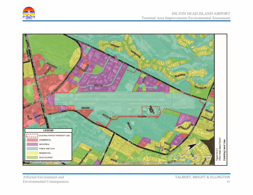
HILTON HEAD ISLAND AIRPORT Terminal Area Improvements Environmental Assessment
Affected Environment and TALBERT, BRIGHT & ELLINGTON Environmental Consequences 91

HILTON HEAD ISLAND AIRPORT Terminal Area Improvements Environmental Assessment
Affected Environment and TALBERT, BRIGHT & ELLINGTON Environmental Consequences 92
HXD and the area around the Airport are zoned by the Town of Hilton Head Island31 (Figure 4.9.3-2, page 93). Town zoning includes:
• Commercial Center District (CC) – provides lands for community-scale commercial activity centers that attract people from the island and the mainland. The district is more auto-oriented than some business districts, and provides land for moderate-sized retail stores. The district also provides opportunities for limited vehicle sales and service uses
• Light Industrial/Commercial Distribution District (IL) – provides for light industrial and service-related land uses with large buildings or outdoor storage requirements
• Planned Unit Development (PD-1) – recognizes the existence within the Town of certain unique Planned Unit Developments (PUDs) that are greater than 250 acres in size. Generally, these PUDs have served to establish the special character of Hilton Head Island as a high-quality resort and residential community. It is the intent in establishing this district to allow the continuation of well-planned development within these areas. In limited situations, some commercially planned portions of PUDs are placed within other base districts to more specifically define the types of commercial uses allowed
• Low to Moderate Density Residential District (4 to 8 units per acre, RM-4) – protects and preserves the character of these areas and neighborhoods at densities up to four dwelling units per net acre. This district is used to encourage a variety of residential opportunities, including multifamily residential units, single-family residences, and group living. The regulations of the district are intended to discourage development that would substantially interfere with, or be detrimental to, residential character
• Moderate to High Density Residential District (12 units per acre, RM-12) – allows higher density residential uses in locations which are served by adequate infrastructure, while maintaining the character of these areas and neighborhoods at densities up to twelve units per net acre. This district is used to encourage a variety of residential opportunities, including multifamily residential units, single-family residences, and group living. The regulations of this district are intended to discourage development that would substantially interfere with, or be detrimental to, moderate to high density residential character
31Town of Hilton Head Island, “Land Management Ordinance, Town of Hilton Head Island, South Carolina, Chapter 16-3: - Zoning Districts. Codified through Ordinance No. 2017-19, enacted December 5, 2017, updated February 9, 2018 (Supplement No. 5),” <http://www.municode.com/>, accessed February 17, 2020.

HILTON HEAD ISLAND AIRPORT Terminal Area Improvements Environmental Assessment
Affected Environment and TALBERT, BRIGHT & ELLINGTON Environmental Consequences 93

HILTON HEAD ISLAND AIRPORT Terminal Area Improvements Environmental Assessment
Affected Environment and TALBERT, BRIGHT & ELLINGTON Environmental Consequences 94
4.9.4 Airport Overlay District The Town of Hilton Head Island32 has an airport overlay district (AOD, Figure 4.9.4-1, page 95), which protects HXD’s imaginary surfaces and sections within their zoning ordinances specifically dedicated to aviation and states:
The Airport Overlay (A-O) District is hereby established to ensure against safety hazards, noise, and obstruction problems associated with aircraft utilizing the Hilton Head Island Airport. All development proposed within the A-O District shall be subject to the standards specified in this section in addition to the standards and regulations contained in the particular base district in which the development occurs. Development in the A-O District is subject to regulation primarily to mitigate safety and noise problems. However, uses within the district also shall be regulated to ensure they are compatible with airport operations. The regulations governing use and height within the A-O District shall conform to the standards recommended by the Federal Aviation Administration's (FAA) Advisory Circular, 150/5190-4A, "Model Zoning Ordinance to Limit Height of Objects Around Airports"
4.9.5 Comprehensive Plan Land Use Hilton Head Island’s future land use goals33 represent those of a maturely developed community and therefore address issues of infill development, redevelopment, and the build out. The Plan emphasizes the balance of land uses: human activity and the natural environment and the balance between land uses and public infrastructure and services.
The Air Transportation section of the Plan reads as follows:
The Hilton Head Island Airport (HXD) is operated by Beaufort County and the Beaufort County Aviation Board. Facilities include a 4,300-foot runway with two parallel taxiways, one commercial and two general aviation terminals, and professionally trained and equipped fire, crash and rescue teams. The current Hilton Head Island Airport Master Plan (updated in 2010) called for capital improvements, including; expansion of the runway to 5,400 linear feet, commercial service terminal expansion, airfield deficiency corrections, tree removal within the avigation easements, commercial service parking lot expansion, general aviation apron expansion and hanger expansion, some of which have been implemented. The Land Management Ordinance (LMO) of the Town limits the length of an airport runway to 5,000 feet. The LMO will need to be amended for the airport runway to be lengthened to the full 5,400 linear feet. The recommendations from the Hilton Head Island Airport Master Plan effort should be monitored and used to evaluate future airport development and operations.
32Town of Hilton Head Island, “Land Management Ordinance, Town of Hilton Head Island, South Carolina, Section 16-3-106 – Overlay Zoning Districts. Codified through Ordinance No. 2017-19, enacted December 5, 2017, updated February 9, 2018. (Supplement No. 5),” <http://www.municode.com/>, accessed February 17, 2020. 33Town of Hilton Head Island (July 18, 2017), “Town of Hilton Head Island Comprehensive Plan, Charting the Island’s Future – From Here to 2030,” <http://www.hiltonheadislandsc.gov/publications/plans/CompPlan2010.pdf>, accessed June 28, 2019.

HILTON HEAD ISLAND AIRPORT Terminal Area Improvements Environmental Assessment
Affected Environment and TALBERT, BRIGHT & ELLINGTON Environmental Consequences 95

HILTON HEAD ISLAND AIRPORT Terminal Area Improvements Environmental Assessment
Affected Environment and TALBERT, BRIGHT & ELLINGTON Environmental Consequences 96
The Air Transportation Goals and Implementation Strategies in the Town’s Plan are:
• Goal A. To ensure that airport operations remain safe while providing air travel to Island B. To ensure that development surrounding the airport is designed and constructed to
minimize the negative impacts of being located near the airport
• Implementation Strategies A. Assist Beaufort County with pre-planning for airport modifications
B. Continue to review development proposals within the Airport Overlay District to ensure the site is designed with the maximum safety possible for the occupants of the site
C. Coordinate and plan with Beaufort County to utilize the airport as a staging ground during a disaster recovery
4.9.6 Potential Compatible Land Use Impacts Potential land use impacts associated with future development of the Hilton Head Island Airport, as outlined on the Airport Layout Plan34 (ALP), are described in terms of airport and community planning efforts, jurisdictional coordination, and development patterns. The compatibility of existing and planned land uses in the vicinity of an airport is usually associated with two factors:
• The extent of noise impacts from and to the airport and related development
• Consistency with local land use plans and development policies
The principal factors influencing land use in the vicinity of an airport often include height obstructions, airport safety zones, and noise. Overall, noise exposure is often the most objectionable interference of the airport with the surrounding environment, as the compatibility with existing and planned land uses in the airport’s vicinity is normally associated with the extent of noise impacts. Table 4.9.6-1 (page 97) identifies FAA land use compatibility standards, as identified by the 65, 70, 75, and 80 day-night average sound level (DNL) noise contours.
It should be noted that the responsibility for determining the acceptable and permissible land use in the vicinity of an airport remains with local authorities in response to local needs and values in achieving compatible land use.
34Talbert & Bright, Inc. (2010), “Hilton Head Island Airport Master Plan Update Final Report,” prepared for Beaufort County and approved by the FAA November 16, 2011.

HILTON HEAD ISLAND AIRPORT Terminal Area Improvements Environmental Assessment
Affected Environment and TALBERT, BRIGHT & ELLINGTON Environmental Consequences 97
Table 4.9.6-1 Compatible Land Use for Noise Level Ranges
Hilton Head Island Airport
Land Use Yearly DNL in Decibels (dB)
Below 65 65–70 70–75 75–80 80–85 Over 85 Residential, other than mobile homes and transient lodgings
Y N N N N N
Mobile home parks Y N N N N N Transient lodgings Y N N N N N Public Use
Schools Y N N N N N Hospitals and nursing homes Y 25 30 N N N Churches, auditoriums, and concert halls Y 25 30 N N N Government services Y Y 25 30 N N Transportation Y Y Y Y Y Y Parking Y Y Y Y Y Y
Commercial Use Offices, businesses, and professional Y Y 25 30 N N Wholesale and retail – building materials, hardware, and farm equipment
Y Y Y Y Y N
Retail trade – general Y Y 25 30 N N Utilities Y Y Y Y Y N Communication Y Y 25 30 N N
Manufacturing and Production Manufacturing – general Y Y Y Y Y N Photographic and optical Y Y 25 30 N N Agriculture (except livestock) and forestry Y Y Y Y Y Y Livestock farming and breeding Y Y Y N N N Mining and fishing, resource production and extraction
Y Y Y Y Y Y
Recreational Outdoor sports areas and spectator sports Y Y Y N N N Outdoor music amphitheaters Y N N N N N Nature exhibits and zoos Y Y N N N N Amusements, parks, resorts, and camps Y Y Y N N N Golf courses, riding stables, and water recreation Y Y 25 30 N N
Notes: Y (Yes) – Land use and related structures compatible without restrictions. N (No) – Land use and related structures are not compatible and should be prohibited. NLR – Noise level reduction (outdoor and indoor) to be achieved through incorporation of noise attenuation into the design and construction of the structure. 25 or 30 – Land use and related structures generally compatible; measures to achieve NLR of 25, 30, or 35 dB must be incorporated in design and construction of structure. Source: Federal Aviation Administration, Advisory Circular 150/5020-1 – Noise Control and Compatibility Planning for Airports, August 1983, <http://www.faa.gov/>, accessed June 26, 2019.

HILTON HEAD ISLAND AIRPORT Terminal Area Improvements Environmental Assessment
Affected Environment and TALBERT, BRIGHT & ELLINGTON Environmental Consequences 98
Future land use in the vicinity of the Proposed Action is not expected to change from current uses surrounding the Airport. Overall, noise exposure is often the most objectionable interference of the airport with the surrounding environment, as the compatibility with existing and planned land uses in the airport’s vicinity is normally associated with the extent of noise impacts. However, since no significant noise impacts are expected (Section 4.11 – Noise, page 99), a similar conclusion is drawn in reference to land use compatibility. It should be noted that the responsibility for determining the acceptable and permissible land use remains with local authorities (Town of Hilton Head Island) in response to local needs and values in achieving compatible land use.
Based on existing and future land use and current zoning, the No-Action Alternative and the Proposed Action are considered compatible with surrounding land use.
4.9.7 Future Land Use Changes It is anticipated that HXD will expand in the future as the need for additional aviation-related facilities are developed. This expansion could include additional hangars for based aircraft and facilities associated with aviation operations, as outlined in the approved Master Plan Update.
4.9.8 Town of Hilton Head Island Land Use Consistency Determination Concurrence with the Town of Hilton Head Island land use plan has been received (Appendix A, pages A-48 through A-51).
4.10 Natural Resources and Energy Supply
4.10.1 Definition Executive Order 13123, Greening the Government through Efficient Energy Management,35 encourages each federal agency to expand the use of renewable energy within its facilities and in its activities. Executive Order 13123, Greening the Government through Efficient Energy Management, also requires each federal agency to reduce petroleum use, total energy use and associated air emissions, and water consumption in its facilities.
The assessment of natural resources and energy supply generally entails altered requirements for stationary facilities. The Proposed Action would require the use of basic materials (gravel, fill dirt, asphalt, etc.) required for construction. Small amounts of fossil fuels and construction materials (cement, aggregate, and bituminous material) would be expended, and these materials are generally not retrievable. However, these materials are not in short supply, and their use would not have an
35Federal Register, Vol. 64, No. 109, June 8, 1999, “Greening the Government through Efficient Energy Management,” <http://www.ofee.gov/>, accessed June 28, 2019.

HILTON HEAD ISLAND AIRPORT Terminal Area Improvements Environmental Assessment
Affected Environment and TALBERT, BRIGHT & ELLINGTON Environmental Consequences 99
adverse effect upon continued availability of these resources. The additional lights would have a minimal increase in the required energy supply for HXD.
4.10.2 No-Action Alternative on Natural Resources and Energy Supply Under the No-Action Alternative, no additional consumption of energy supply and natural resources would occur. No impacts are expected, and no mitigation is required.
4.10.3 Proposed Action on Natural Resources and Energy Supply The Proposed Action is expected to have a slight increase in ground vehicles per day at HXD. This would create a minimal increase in the automobile fuel consumption. Although slight increases in fuel consumption are expected from the Proposed Action, the increase is considered minimal and is not expected to create an exorbitant demand or draw upon natural resources in short supply.
4.11 Noise
4.11.1 Definition Noise is unwanted sound. Sound has three basic characteristics: frequency (or pitch), magnitude (technically called level and popularly called loudness), and time pattern. Frequency is measured in cycles per second or hertz (Hz). The human ear is capable of discerning sounds in the range from 20 Hz (a rumbling sound) to 20,000 Hz (a hissing sound). The level of a sound is measured as the sound pressure level (SPL). The unit of SPL is the decibel (dB). Because hearing is logarithmic, not linear, the SPL is a logarithmic quantity. Thus, a 10-dB increase in level reflects a 10-time increase in sound energy, and a 20-dB increase in level reflects a 100-time increase in sound energy. There are many different time patterns of sounds, ranging from a sound that is continuous in frequency and level for a long period (such as the 60 Hz hum from a fluorescent lamp) to a complex mixture of frequencies and levels over a short period (such as a door slam). Environmental noises are typically described in terms of the A-weighted sound level (dB-A), a measure that reflects human hearing, which is most sensitive at 2,000 Hz and decreasingly sensitive below and above 2,000 Hz. Figure 4.11.1-1 (page 100) illustrates A-weighted sound levels of common sounds.
An assessment of airport noise establishes a baseline of existing and future noise impacts relative to the Proposed Action (expressed in DNL). This analysis identifies potential increases in noise levels in the area surrounding the EA study area. Two sets of noise contours were developed for this EA including the existing 2019 baseline case and the 2029 contours for the Proposed Action. The year 2029 was chosen as the future analysis year as it represents the year by which the Proposed Action will be constructed. AEDT version 2d was used to calculate these noise contours for the existing and future cases at HXD. Information from the HXD forecasts as well as FAA flight records was used to determine the AEDT input data. Measured in decibels, the 65 DNL ambient noise contour represents

HILTON HEAD ISLAND AIRPORT Terminal Area Improvements Environmental Assessment
Affected Environment and TALBERT, BRIGHT & ELLINGTON Environmental Consequences 100

HILTON HEAD ISLAND AIRPORT Terminal Area Improvements Environmental Assessment
Affected Environment and TALBERT, BRIGHT & ELLINGTON Environmental Consequences 101
the threshold for noise impacts. The DNL is determined from a cumulative exposure of sound (time and level), measured in decibels, and averaged over the span of one year.
4.11.2 Existing (2019) Noise Contours The existing condition (2019) noise contour encompasses a total of 118.6 acres within the 65 DNL contour (Figure 4.11.2-1, page 102), which is centered on the runway and located primarily on airport property. The highest recorded DNL resulting from the 2019 Noise Exposure Map (NEM) is approximately 85 decibels, which results from takeoff thrust applied as it pools near the runway ends as shown in Figure 4.11.2-1 (page 102). This illustration serves as a baseline for comparing the EA alternative noise contours.
As previously stated, the threshold for noise impacts (65 dB DNL) occurs primarily on airport property, which greatly reduces the impacts on the surrounding community. However, the Airport should strive to limit impacts upon the surrounding community when able through outreach programs and noise abatement procedures implemented by the air traffic control tower (ATCT).
More operations can be expected with the implementation of the Proposed Action as the expanded terminal would be available to accommodate future commercial air traffic demand. If the No-Action Alternative is selected, growth at the Hilton Head Island Airport may be limited as facilities would not be available to accommodate future commercial aviation activity.
The 2019 noise contours represent a baseline from which to compare the Proposed Action noise levels. Noise levels were modeled using the total number of daily operations averaged over each of the approach and departure for existing and future traffic. Figure 4.11.2-1 (page 102) illustrates the existing (2019) noise contours. The 65, 70, 75, and 80 decibel unit contours are depicted. Table 4.11.2-1 (page 103) lists the existing and future annual operations, which were obtained from the Hilton Head Island Airport Master Plan Update Final Report and updated to include the change in commercial service equipment. Table 4.11.2-2 (page 104) describes the assigned aircraft used to calculate the noise contours.
Table 4.11.2-3 (page 105) describes the flight tracks used to prepare the noise contours. The assignment of runway use was determined with respect to wind conditions and track segments designed in accordance with standard traffic patterns. Table 4.11.2-4 (page 105) illustrates the results of AEDT model.
4.11.3 Future (2029) Noise Contours The 2029 Proposed Action noise contours encompasses a total of 138.2 acres (Table 4.11.3-1, page 107) and represents the potential impacts of the Proposed Action, as shown in Figure 4.11.3-1 (page 108). The 2029 Proposed Action 65 dB DNL contours extend slightly beyond the 2019 contours and are predominantly on existing airport property. No planned public or private residences, schools, or churches would experience noise levels at or above 65 DNL with either the existing or future contours.

HILTON HEAD ISLAND AIRPORT Terminal Area Improvements Environmental Assessment
Affected Environment and TALBERT, BRIGHT & ELLINGTON Environmental Consequences 102

HILTON HEAD ISLAND AIRPORT Terminal Area Improvements Environmental Assessment
Affected Environment and TALBERT, BRIGHT & ELLINGTON Environmental Consequences 103
Table 4.11.2-1 Aviation Forecast Summary Hilton Head Island Airport
2009 Master
Plan
2014 Master
Plan
2019 2029 Master
Plan Revised Master
Plan Revised Based Aircraft
Single-Engine Piston 60 68 74 74 86 86 Multi-Engine Piston 12 13 15 15 18 18 Turboprop 6 7 7 7 9 9 Jets 3 3 4 4 5 5 Helicopters 0 0 1 1 2 2 TOTAL BASED AIRCRAFT 81 91 101 101 120 120
Aircraft Operations General Aviation Local 3,062 3,353 3,714 4,614 4,435 5,743 General Aviation Itinerant 24,638 26,985 29,884 37,124 35,682 44,189 Commercial 9,353 11,441 12,532 4,392 15,069 5,254 Military Itinerant 635 696 771 771 920 920 Military Local 549 601 666 666 795 795 TOTAL OPERATIONS 38,237 43,076 47,567 47,567 56,901 56,901 Instrument Operations 22,950 26,578 29,349 29,349 35,108 35,108 Operations per Based Aircraft 348 348 348 471 348 474
Commercial Service Passengers Enplanements 66,823 74,393 77,908 180,252 84,094 215,623 Peak Hour Enplanements1 67 78 89 144 110 172 Source: Talbert & Bright, Inc. (2010), “Hilton Head Island Airport Master Plan Update Final Report,” prepared for Beaufort County and approved by the FAA November 16, 2011. Talbert, Bright & Ellington, Inc., June 2019.
Noise levels higher than 65 dB DNL are not expected to contribute to substantial noise impacts based on the projected frequency of additional aircraft using the Hilton Head Island Airport.
With respect to departures, typically, higher performance aircraft are capable of much steeper departure angles than single-engine and multi-engine piston aircraft, which results in lower noise exposure. The projected increase in commercial turbine traffic, including small-cabin business jets, does not significantly add to noise levels at the Hilton Head Island Airport. Noise from turbine aircraft is largely a function of aircraft model, engine type, and pilot operating characteristics, including the use of power settings that are largely based on payload weight, flap settings, and use of thrust-reversers. Also, the newest generation of Stage 3/4 jets is quieter than older generations of jets. As a matter of comparison, business jets, such as the Eclipse 500 and Cessna Citation Mustang, have a noise level equal to that of the medium turboprop planes, such as the Beechcraft King Air.

HILTON HEAD ISLAND AIRPORT Terminal Area Improvements Environmental Assessment
Affected Environment and TALBERT, BRIGHT & ELLINGTON Environmental Consequences 104
Table 4.11.2-2 Aircraft Included in Noise Analysis
Hilton Head Island Airport AEDT Aircraft
Designation Aircraft Type Equivalent AEDT
Aircraft Aircraft Category GASEPF 4 to 6 Seat
Constant-Speed Propeller
Grumman AA-5 Tiger Cessna 150/152 Socata Tampico
Small Single-Engine Propeller
GASEPV 4 to 6 Seat Variable-Speed Propeller
Beechcraft 33 Bonanza Cirrus SR-22 Mooney M-20 Piper P28R Arrow
Small Single-Engine Propeller
BEC58P 6 to 8 Seat Variable-Speed Propeller
Piper PA-23 Apache Piper PA-34 Seneca Piper PA-44 Seminole Piper Aerostar
Small Twin-Propeller
DHC6 11 to 13 Seat Turboprop
Beech King Air 200 Beech King Air 350 Pilatus PC12
Twin-engine Turboprop
CL601 8 to 12 Seat Turbofan
Bombardier Challenger 604 Medium-Cabin Business Jet
CNA550 4 to 6 Seat Turbofan
Cessna Citation II Small-Cabin Business Jet
B206L 4 to 6 Seat Turbine Helicopter
Bell 206 Jet Ranger Light Turbine Helicopter
E-170 66 Seat Turbofan
Embraer E-170 Twin-engine commercial jet
E-175 76 Seat Turbofan
Embraer E-175 Twin-engine commercial jet
B206L – Bell 206 Jet Ranger BEC58P – Beechcraft Model 60 Duke, Beechcraft Baron 58 CL600 – Falcon 200, 2000; Gulfstream 200; Hawker 4000, Bombardier Challenger 600 CNA55B – Cessna Citation II, Cessna Citation XLS DHC6 – Beech King Air 200, 300, 300B, Pilatus PC-12 E-170 – Embraer E170 E-175 – Embraer E175 GASEPF – Piper PA-28-181, PA-28-180, PA-28-140, Cessna 150 GASEPV – Cirrus SR-22, Cessna 182 Source: Federal Aviation Administration, “Aviation Environmental Design Tool (AEDT) Version 2d,” released on March 13, 2017. Talbert, Bright & Ellington, Inc., June 2019.

HILTON HEAD ISLAND AIRPORT Terminal Area Improvements Environmental Assessment
Affected Environment and TALBERT, BRIGHT & ELLINGTON Environmental Consequences 105
Table 4.11.2-3 AEDT Flight Tracks
Hilton Head Island Airport Runway End Departure Track Arrival Track
Runway 03 1. Straight Departure (50 NM)
1. Straight Arrival (50 NM)
Runway 21 1. Straight Departure (50 NM)
1. Straight Arrival (50 NM)
NM – Nautical Mile. Note: Under visual flight conditions, aircraft arrive and depart the airport traffic area along unspecified vectors for the purpose of AEDT, it is assumed arriving and departing itinerant traffic fly the runway heading. It should be noted that changes in the track configuration (traffic pattern) have relatively small impacts on the noise contours, since the most significant noise incidents are caused at the point of takeoff and during the initial climb out beyond the opposite runway threshold. Source: Federal Aviation Administration, “Aviation Environmental Design Tool (AEDT) Version 2d,” released on March 13, 2017. Talbert, Bright & Ellington, Inc., June 2019.
Table 4.11.2-4 AEDT Version 2d Noise Model Data
Hilton Head Island Airport
Runway 03/21 Operations
2019 Daily Operations 2029 Daily Operations Operations Aircraft Operations Aircraft
Single Engine Piston 14,464 17,302 Runway 03 4,918 GASEPV GASEPF 5,883 GASEPV GASEPF
Day Approach 2,385 3.27 3.27 2,853 3.91 3.91 Night Approach 74 0.10 0.10 88 0.12 0.12 Day Departure 2,385 3.27 3.27 2,853 3.91 3.91 Night Departure 74 0.10 0.10 88 0.12 0.12
Runway 21 9,546 11,419 Day Approach 4,630 6.34 6.34 5,538 7.59 7.59 Night Approach 143 0.20 0.20 171 0.23 0.23 Day Departure 4,630 6.34 6.34 5,538 7.59 7.59 Night Departure 143 0.20 0.20 171 0.23 0.23
Multi-Engine Piston 2,953 3,532 Runway 03 1,004 BEC58P 1,201 BEC58P
Day Approach 487 1.33 582 1.60 Night Approach 15 0.04 18 0.05 Day Departure 487 1.33 582 1.60 Night Departure 15 0.04 18 0.05

HILTON HEAD ISLAND AIRPORT Terminal Area Improvements Environmental Assessment
Affected Environment and TALBERT, BRIGHT & ELLINGTON Environmental Consequences 106
Table 4.11.2-4 AEDT Version 2d Noise Model Data
Hilton Head Island Airport Runway 03/21
Operations 2019 Daily Operations 2029 Daily Operations
Operations Aircraft Operations Aircraft Runway 21 1,949 2,331
Day Approach 945 2.59 1,131 3.10 Night Approach 29 0.08 35 0.10 Day Departure 945 2.59 1,131 3.10 Night Departure 29 0.08 35 0.10
Turboprop 15,214
18,201
Runway 03 5,173 DHC6 6,188 DHC6 Day Approach 2,509 6.87 3,001 8.22 Night Approach 78 0.21 93 0.25 Day Departure 2,509 6.87 3,001 8.22 Night Departure 78 0.21 93 0.25
Runway 21 10,041 12,013 Day Approach 4,870 13.34 5,826 15.96 Night Approach 151 0.41 180 0.49 Day Departure 4,870 13.34 5,826 15.96 Night Departure 151 0.41 180 0.49
General Aviation Jet 10,401 12,441 Runway 03 3,536 CNA55B CL600 4,230 CNA55B CL600
Day Approach 1,715 2.35 2.35 2,052 2.81 2.81 Night Approach 53 0.07 0.07 63 0.09 0.09 Day Departure 1,715 2.35 2.35 2,052 2.81 2.81 Night Departure 53 0.07 0.07 63 0.09 0.09
Runway 21 6,865 8,211 Day Approach 3,329 4.56 4.56 3,982 5.46 5.46 Night Approach 103 0.14 0.14 123 0.17 0.17 Day Departure 3,329 4.56 4.56 3,982 5.46 5.46 Night Departure 103 0.14 0.14 123 0.17 0.17
Commercial Service Jet 4,392 5,254 Runway 03 1,493 ERJ170 ERJ175 1,786 ERJ170 ERJ175
Day Approach 724 0.50 1.48 866 0.60 1.77 Night Approach 22 0.02 0.05 27 0.02 0.05 Day Departure 724 0.50 1.48 866 0.60 1.77 Night Departure 22 0.02 0.05 27 0.02 0.05
Runway 21 2,899 3,468

HILTON HEAD ISLAND AIRPORT Terminal Area Improvements Environmental Assessment
Affected Environment and TALBERT, BRIGHT & ELLINGTON Environmental Consequences 107
Table 4.11.2-4 AEDT Version 2d Noise Model Data
Hilton Head Island Airport Runway 03/21
Operations 2019 Daily Operations 2029 Daily Operations
Operations Aircraft Operations Aircraft Day Approach 1,406 0.98 2.87 1,682 1.17 3.44 Night Approach 43 0.03 0.09 52 0.04 0.11 Day Departure 1,406 0.98 2.87 1,682 1.17 3.44 Night Departure 43 0.03 0.09 52 0.04 0.11
BEC58P – Beechcraft Model 60 Duke, Beechcraft Baron 58 CL600 – Falcon 200, 2000; Gulfstream 200; Hawker 4000, Bombardier Challenger 600 CNA55B – Cessna Citation II, Cessna Citation XLS DHC6 – Beech King Air 200, 300, 300B, Pilatus PC-12 E-170 – Embraer E170 E-175 – Embraer E175 GASEPF – Piper PA-28-181, PA-28-180, PA-28-140, Cessna 150 GASEPV – Cirrus SR-22, Cessna 182 Source: Federal Aviation Administration, “Aviation Environmental Design Tool (AEDT) Version 2d,” released on March 13, 2017. Talbert, Bright & Ellington, Inc., June 2019.
Table 4.11.3-1 65 dB DNL Noise Contour Areas
Hilton Head Island Airport Year 65 dB DNL Coverage 65 dB DNL Coverage outside the Fence
2019 Existing Conditions 118.6 acres 17.53 acres 2029 Proposed Action 138.2 acres 26.84 acres Source: Talbert, Bright & Ellington, Inc., June 2019.
Cumulative noise levels at the Hilton Head Island Airport would be consistent with an increase in total operations, as the larger noise footprint in the future would be attributed to increases in both local and transient flights.
The development of the Proposed Action would accommodate the trend towards more based aircraft, including turbines, and the increase of transient operations. However, this general increase in activity is not expected to pose a significant noise impact based on FAA noise modeling standards, as the majority of the 65 dB DNL contour is, and would be, contained to airport property. The existing 65 dB DNL noise contour encompasses 118.6 acres. The future 65 dB DNL noise contour encompasses 138.2 acres which is a 16 percent increase. This is below the 17 percent threshold for a significant noise impact (Table 4.11.2-1, page 103).
The No-Action Alternative would result in no increase to the 65 dB DNL noise contour.
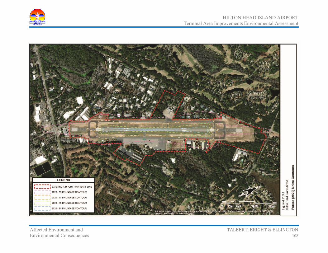
HILTON HEAD ISLAND AIRPORT Terminal Area Improvements Environmental Assessment
Affected Environment and TALBERT, BRIGHT & ELLINGTON Environmental Consequences 108

HILTON HEAD ISLAND AIRPORT Terminal Area Improvements Environmental Assessment
Affected Environment and TALBERT, BRIGHT & ELLINGTON Environmental Consequences 109
4.11.4 Significance Threshold FAA Order 5050.4B – National Environmental Policy Act (NEPA) Implementing Instructions for Airport Projects Table 7-1 in coordination with FAA Order 1050.1F – Environmental Impacts: Policies and Procedures Exhibit 4-1 outline the significance thresholds for some environmental impact categories. The significance threshold to consider for noise as determined by FAA would be if;
The action would increase noise by DNL 1.5 dB or more for a noise sensitive area that is exposed to noise at or above the DNL 65 dB noise exposure level, or that will be exposed at or above the DNL 65 dB level due to a DNL 1.5 dB or greater increase, when compared to the No-Action alternative for the same timeframe. For example, an increase from DNL 65.5 dB to 67 dB is considered a significant impact, as is an increase from DNL 64.5 to 65 dB.
4.11.4.1 No-Action Alternative
The No-Action Alternative and the Proposed Action Alternative would not have an adverse or significant impact on noise compatibility surrounding the Airport.
4.11.4.2 Proposed Action
This represents approximately a 1 percent increase in noise level. The Proposed Action for HXD would result in a 16 percent increase in the 65 dB DNL contour over the existing 2019 conditions.
4.11.5 Potential Construction Noise Impacts Noise impact may occur in the vicinity of the construction site for the Proposed Action. Table 4.11.5-1 (page 110) illustrates the typical sound levels associated with various pieces of construction equipment that could be used during construction.
Noise generated from construction activities would be mitigated through use of BMPs, such as use of mufflers on construction equipment. The contractor would be required to comply with county and/or other local noise regulations.
4.11.5.1 No-Action Alternative
The No-Action Alternative would have no construction development and, therefore, would not result in any noise impacts.
4.11.5.2 Proposed Action
Construction of the Proposed Action would implement BMPs to construction noise impacts, as well as require the contractor to comply with county and/or other local noise regulations.

HILTON HEAD ISLAND AIRPORT Terminal Area Improvements Environmental Assessment
Affected Environment and TALBERT, BRIGHT & ELLINGTON Environmental Consequences 110
Table 4.11.5-1 Construction Equipment Noise
Hilton Head Island Airport
Equipment Type Typical Sound Level
dB(A) at 50 feet Backhoe 85 Bulldozer 87 Concrete Mixer (truck) 85 Dump Truck 88 Generator 76 Jackhammer 88 Paver 89 Pile Driver 101 Pneumatic Tools 85 Portable Air Compressor 81 Pump 76 Rock Drill 98 Scraper 88 Source: Handbook of Noise Assessments, page 215 (Edited by Daryl N. May, Ph.D., 1978).
4.12 Socioeconomic Impacts, Environmental Justice, and Children’s Health and Safety Risks
4.12.1 Socioeconomic Impacts 4.12.1.1 Socioeconomic Environment
The population of Beaufort County was 162,233 in 2010, according to the United States Census Bureau. The population of Beaufort County increased by 39.9 percent between 1990 and 2000 and 34.1 percent between 2000 and 2010, respectively. Current projections by the South Carolina Budget and Control Board Office of Research and Statistics anticipate that Beaufort County would increase its population an additional 14.0 percent by 2020. From 2010 to 2035, it is expected to increase an additional 42.0 percent, as illustrated in the Table 4.12.1-1 (page 111).
The total permanent resident population of the Town of Hilton Head Island in 2010 was 37,099 persons. When compared with the 2010 population of Beaufort County, the Town comprises nearly 22.9 percent of the County’s population. However, data for the permanent population of Hilton Head Island does not take into account the number of people that occupy the Island during different times of the year. Hilton Head Island is a large resort and retirement community. The Town’s population has fluctuations according to season, making the actual number of persons greater than the permanent population tabulated by the United States Census Bureau.

HILTON HEAD ISLAND AIRPORT Terminal Area Improvements Environmental Assessment
Affected Environment and TALBERT, BRIGHT & ELLINGTON Environmental Consequences 111
Table 4.12.1-1 Population Projections
Hilton Head Island Airport
Town of Hilton Head
Island Beaufort County South Carolina
Year Population Percent Change Population
Percent Change Population
Percent Change
1940 22,037 1,899,804 1950 26,993 22.5% 2,117,027 11.4% 1960 44,187 63.7% 2,382,594 12.5% 1970 51,136 15.7% 2,590,516 8.7% 1980 11,344 65,364 27.8% 3,121,820 20.5% 1990 23,694 108.9% 86,425 32.2% 3,486,703 11.7% 2000 33,862 42.9% 120,937 39.9% 4,012,012 15.1% 2010 37,099 9.6% 162,233 34.1% 4,625,364 15.3% 2015 170,640 5.2% 4,784,700 3.4% 2020 185,220 8.5% 5,020,400 4.9% 2025 199,780 7.9% 5,256,080 4.7% 2030 215,270 7.8% 5,488,460 4.4% 2035 230,240 7.0% 5,722,720 4.3%
Source: South Carolina Budget and Control Board Office of Research and Statistics, “South Carolina Statistical Abstract” (2011) <http://abstract.sc.gov/index.php>, accessed June 26, 2019.
Table 4.12.1-2 (page 112) illustrates the general demographic characteristics for Beaufort County.
Beaufort County has a wide range of businesses, from manufacturers of power transmission components and hydraulic hoses to textiles and aircraft parts and equipment. Major employers in Beaufort County are outlined on Table 4.12.1-3 (page 113).
A brief synopsis of Beaufort County’s labor data is presented in Table 4.12.1-4 (page 113).
4.12.1.2 Potential Socioeconomic Impacts
4.12.1.2.1 No-Action Alternative
Under the No-Action Alternative, there would not be any relocations, noise, or visual or aesthetic impacts; therefore, there would be no impacts.
4.12.1.2.2 Proposed Action
Potential socioeconomic impacts include the acquisition of real property and/or the displacement of businesses. Properties potentially impacted by the Proposed Action are outlined in Table 4.12.1.2.2-1 (page 114). It is estimated that five properties would be impacted by the Proposed Action. These properties are considered light industrial development with a total of nine business

HILTON HEAD ISLAND AIRPORT Terminal Area Improvements Environmental Assessment
Affected Environment and TALBERT, BRIGHT & ELLINGTON Environmental Consequences 112
Table 4.12.1-2 General Demographic Characteristics (2010)
Hilton Head Island Airport
Subject Evaluation
Area*
Hilton Head Island
Beaufort County
South Carolina
Population Total population 9,554 37,099 162,233 4,625,364
Sex and Age Male 4,673 18,206 80,089 2,250,101 Female 4,881 18,893 82,144 2,375,263 Under 5 years 556 1,694 10,960 302,297 5 to 9 years 586 1,676 9,566 295,853 10 to 14 years 487 1,650 8,553 297,286 15 to 19 years 436 1,681 9,956 328,989 20 to 24 years 455 1,640 11,756 332,494 25 to 34 years 946 3,719 20,137 592,056 35 to 44 years 1,037 3,839 17,534 601,293 45 to 54 years 1,082 4,567 18,580 659,428 55 to 59 years 540 2,535 9,886 303,240 60 to 64 years 788 3,395 12,273 280,555 65 to 74 years 1,380 5,733 20,137 369,043 75 to 84 years 900 3,493 9,698 192,114 85 years and over 361 1,477 3,197 70,717 Median age (years) 49.0 50.9 40.6 37.9 18 years and over 7,621 30,954 127,885 3,544,890 Male 3,673 15,061 62,689 1,699,463 Female 3,948 15,893 65,196 1,845,427 Average household size 2.45 2.45 2.42 2.49 Average family size 2.85 2.66 2.84 3.01
Housing Occupancy Total housing units 5,222 33,306 93,023 2,137,683 Occupied housing units 3,990 16,535 64,945 1,801,181 Vacant housing units 1,232 16,771 28,078 336,502
For seasonal, recreational, or occasional use 642 9,767 14,902 112,531 Homeowner vacancy rate (percent) 3.7 4.9 4.1 2.8 Rental vacancy rate (percent) 18.0 55.1 30.7 14.3 Occupied housing units 3,990 16,535 93,023 1,801,181 Owner-occupied housing units 2,665 12,039 45.868 1,248,805 Renter-occupied housing units 1,325 4,496 19,077 552,376 Average household size of owner-occupied unit 2.25 2.25 2.31 2.51 Average household size of renter-occupied unit 2.62 2.62 2.66 2.45
*Census Tract 107, Block Groups 1 and 2; Census Tract 108, Block Groups 1 and 2; and Census Tract 109, Block Groups 1 and 2. Source: United States Census Bureau, Census 2010, “Profiles of General Demographic Characteristics 2010 Census of Population and Housing, South Carolina,” <http://www2.census.gov/>, accessed June 26, 2019.

HILTON HEAD ISLAND AIRPORT Terminal Area Improvements Environmental Assessment
Affected Environment and TALBERT, BRIGHT & ELLINGTON Environmental Consequences 113
Table 4.12.1-3 Major Employers in Beaufort
County Hilton Head Island Airport
Company Atlantic Personnel Inc Beaufort County School District Beaufort Memorial Hospital Carecore National LLC County of Beaufort Cypress Club, Inc. Department of Defense Hargray Communications Group Inc Lowes Home Centers Inc Marine Corps Community Services Marriott Resorts Hospitality Corporation Montage Hotels and Resorts LLC Publix Super Markets, Inc Sea Pines Resort LLC Technical College of the Lowcountry Tenet Physician Services of Hilton Head The Greenery, Inc Town of Hilton Head Island University of South Carolina Wal-Mart Associates, Inc Source: SC Department of Employment and Workforce, “2018 4th Quarter,”
Table 4.12.1-4 Labor Data for Beaufort County
Hilton Head Island Airport Year
Criteria 2000 2005 2010 2015 207 Labor Force 53,372 61,381 63,125 70,234 72,553 Employment 51,130 58,372 57,397 67,680 71,174 Unemployment 1,574 3,009 5,728 3,921 3,024 Unemployment Rate 3.1% 4.9% 9.1% 5.5% 4.1% Average Annual Wage per Worker $25,618 $30,476 $32,595 $40,673 $42,052 Per Capita Income $33,4081 $39,8241 $42,4301 $50,785 $52,763 1Per capita personal income was computed using Census Bureau midyear population estimates. Estimates for 2000-2010 reflect county population estimates available as of April 2012. Source: US Department of Commerce Bureau of Economic Analysis, “Regional Data,” <http://www.bea.gov/>, accessed June 26, 2019.

HILTON HEAD ISLAND AIRPORT Terminal Area Improvements Environmental Assessment
Affected Environment and TALBERT, BRIGHT & ELLINGTON Environmental Consequences 114
Table 4.12.1.2.2-1 Parcel Information
Hilton Head Island Airport
Parcel Number Property Owner
Acreage Business
Displacements Current Proposed Taking
R510 004 000 0325 0000 Hillbilly Holding Corporation 2.75 2.75 1 Billing Address: 24300 Chenal Parkway
Little Rock, AR 72223 Location: 36 Hunter Road
R510 004 000 0323 0000 Fraser Fishburne 1 1 1 Billing Address: P.O. Box 21441
Hilton Head Island, SC 29925-1441 Location: 32 Hunter Road
R510 004 000 0307 0000 Deveer Gersuk Capital LLC 4 Billing Address: 36 East Ridge Road
Albany, NY 12211 Location: 30 Hunter Road
R510 004 000 0306 0000 28 Hunter Road LLC 1 Billing Address: 8 Huntingwood Retreat
Savannah, GA 31411 Location: 28 Hunter Road
R510 004 000 0305 0000 Kinnard Holdings LLC 1.27 1.27 2 Billing Address: 26 Hunter Road
Hilton Head Island, SC 29926 Location: 26 Hunter Road
Source: Beaufort County, “Propertymax,” <http://sc-beaufort-county.governmax.com/svc/>, accessed June 26, 2019.
displacements. Most of the relocations would occur on Hilton Head Island. The proposed relocations are not considered to have a significant effect on the community surrounding HXD because of the availability of commercial/light industrial property in the area.
Under the federal program, the acquisition of property and provisions for relocation must follow the Uniform Relocation Assistance and Real Property Acquisition Policies Act of 1970, as outlined in FAA AC 150/5100-17 Land Acquisition and Relocation Assistance for Airport Improvement Program Assisted Projects.36 Land acquisition only proceeds if the FAA is satisfied that the airport sponsor has met, or would meet, certain requirements, including environmental clearance.
Meetings with the affected land owners would be held to provide general information about land acquisition associated with the Proposed Action. At this meeting, or by request, FAA Advisory Circular 150/5100-17, Land Acquisition and Relocation Assistance for Airport Improvement Program
36Federal Aviation Administration, “Advisory Circular 150/5100-17 – Land Acquisition and Relocation Assistance for Airport Improvement Program Assisted Projects, Change 6, November 7, 2005, <http://www.faa.gov/>, accessed June 26, 2019.

HILTON HEAD ISLAND AIRPORT Terminal Area Improvements Environmental Assessment
Affected Environment and TALBERT, BRIGHT & ELLINGTON Environmental Consequences 115
Assisted Projects would be made available to individuals directly affected. As stated, under the relocation program, services would include determining the relocation needs and preferences of each person to be displaced and explaining relocation assistance available; providing current and continuing information of the availability and costs of comparable commercial operations; informing each person in writing of benefits available; supplying displaced persons with information on Small Business Administration programs, and other assistance programs; and other services as detailed in FAA Advisory Circular 150/5100-17, Land Acquisition and Relocation Assistance for Airport Improvement Program Assisted Projects, Section 4-8. If needed, a translator would inform persons about the relocation process and benefits.
The amount of benefit an owner or business receives is based on appraised value. In addition to the appraised value of the property and improvements, businesses are reimbursed for costs associated with moving the business to another location. Businesses are also reimbursed for property searching expenses up to $1,000 (for actual reasonable expenses in searching for a replacement site) and reestablishment expenses up to $10,000. In lieu of payment for actual moving and related expenses and actual reasonable reestablishment expenses, a business may be eligible to choose a fixed payment between $1,000 and $20,000 based on the average annual net earnings of the business. As part of the land acquisition process, relocation specialists would offer advisory services to assist in the effort to locate suitable sites and reestablishing the businesses.
In addition, it is not anticipated that traffic congestion would occur during construction of the Proposed Action, as construction would occur on-airport property. Measures that could be incorporated to provide maintenance of traffic include flagmen at the construction entrances to the Airport.
4.12.2 Environmental Justice 4.12.2.1 Definition
Executive Order 12898, Federal Actions to Address Environmental Justice in Minority Populations and Low-Income Populations,37 states that to the greatest extent practicable and permitted by law, each federal agency shall make achieving environmental justice part of its mission by identifying and addressing, as appropriate, disproportionately high and adverse human health or environmental effects of its programs, policies, and activities on minority and low-income populations.
Disproportionate can mean that an impact occurs predominantly in environmental justice populations (those populations with percentages of low-income and/or minority individuals above the percentages for the county in which the individuals live) or that the impact is more severe in these populations than non-environmental justice populations. The terms minority persons, minority population, low-
37Federal Register, Vol. 59, No. 32, February 16, 1994, “Executive Order 12898 of February 11, 1994, Federal Actions to Address Environmental Justice in Minority Populations and Low-Income Populations,” <http://www.gpo.gov/>, accessed June 28, 2019.
HILTON HEAD ISLAND AIRPORT Terminal Area Improvements Environmental Assessment
Affected Environment and TALBERT, BRIGHT & ELLINGTON Environmental Consequences 116
income persons, and low-income populations as defined are useful in understanding environmental justice.
• Minority populations are
Origins of any of the black racial groups from Africa
Hispanic origins such as Mexican, Puerto Rican, Cuban, Central or South American, or other Spanish culture or origin, regardless of race
Asian origins such as any of the original peoples of the Far East, Southeast Asia, or the Indian subcontinent
America Indian and Alaskan Native people such as those with origins in any of the original people of North America and who maintain cultural identification through tribal affiliation or community recognition
Native Hawaiian or Other Pacific Islander people such as those having origins in any of the original peoples of Hawaii, Guam, Samoa, or other Pacific Islands
• Minority persons are any readily identifiable groups or minority populations who live in close geographic proximity and, if circumstances warrant, geographically dispersed/transient persons (such as migrant workers or Native Americans) who would be similarly affected by a proposed activity.
• Low-income populations are any readily identifiable community or group whose median household income is at or below the United States Department of Health and Human Services (USDHHS) poverty guidelines (Table 4.12.2.1-1). The United States Census Bureau Office of Statistics also provides census data used in calculating low-income populations.
• Low-income persons – persons whose household income is at or below the USDHHS poverty guidelines outlined in Table 4.12.2.1-1.
Table 4.12.2.1-1 USDHHS Poverty Guidelines Hilton Head Island Airport
Size of Family Unit
Weighted Average Thresholds Size of Family Unit
Weighted Average Thresholds
One person $12,490 Six people $34,590 Two people $16,910 Seven people $39,010 Three people $21,330 Eight people $43,43 Four people $25,750 Each Additional Person +$4,420 Five people $30,170 Source: USDHHS, “2019 Poverty Guidelines for the 48 Contiguous States and the District of Columbia,” <https://aspe.hhs.gov/2019-poverty-guidelines>, accessed June 26, 2019.

HILTON HEAD ISLAND AIRPORT Terminal Area Improvements Environmental Assessment
Affected Environment and TALBERT, BRIGHT & ELLINGTON Environmental Consequences 117
4.12.2.2 Minority Populations
A block group analysis was conducted to identify minority areas within the vicinity of HXD.
Total minority population in the APE (Census Tract 107, Block Groups 1 and 2; Census Tract 108, Block Groups 1 and 2; and Census Tract 109, Block Groups 1 and 2, Figure 4.12.2.2-1, page 118) in 2010 was estimated at approximately 21.8 percent (Table 4.12.2.2-1). This percentage is 10.6 percent lower than South Carolina (32.4 percent), as a whole.
Table 4.12.2.2-1 United States Census Minority Populations
By Individuals (2010) Hilton Head Island Airport
Location Total Population Total Minority Population
Percent Minority Population
United States 308,745,538 77,803,876 25.2% South Carolina 4,625,364 1,498,618 32.4% Beaufort County 162,233 45,588 28.1% Hilton Head Island 37,099 6,344 17.1% Evaluation Area* 9,554 2,083 21.8% *Census Tract 107, Block Groups 1 and 2; Census Tract 108, Block Groups 1 and 2; and Census Tract 109, Block Groups 1 and 2. Source: United States Census Bureau, American FactFinder (2010) <http://factfinder2.census.gov/>, accessed June 26, 2019.
4.12.2.3 Low-Income Populations
A block group analysis was conducted to identify low-income areas within the vicinity of HXD.
The total percentage of people in the APE (Census Tract 107, Block Groups 1 and 2; Census Tract 108, Block Groups 1 and 2; and Census Tract 109, Block Groups 1 and 2) classified as living below the poverty level in 2010 was approximately 13.0 percent (Table 4.12.2.3-1, page 119). This rate is 5.2 percent lower than South Carolina (18.2 percent) as a whole.
As a result, the minority and/or low-income populations that reside within the environmental justice evaluation area do not exceed the thresholds for the state of South Carolina.
4.12.2.4 No-Action Alternative Potential Impacts
Under the No-Action Alternative, there would not be any relocations, noise, or visual or aesthetic impacts; therefore, there would be no environmental justice impacts.

HILTON HEAD ISLAND AIRPORT Terminal Area Improvements Environmental Assessment
Affected Environment and TALBERT, BRIGHT & ELLINGTON Environmental Consequences 118
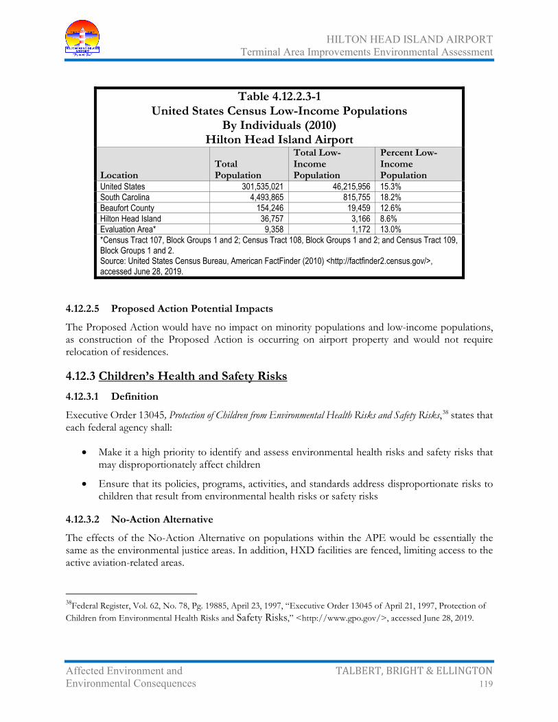
HILTON HEAD ISLAND AIRPORT Terminal Area Improvements Environmental Assessment
Affected Environment and TALBERT, BRIGHT & ELLINGTON Environmental Consequences 119
Table 4.12.2.3-1 United States Census Low-Income Populations
By Individuals (2010) Hilton Head Island Airport
Location Total Population
Total Low-Income Population
Percent Low-Income Population
United States 301,535,021 46,215,956 15.3% South Carolina 4,493,865 815,755 18.2% Beaufort County 154,246 19,459 12.6% Hilton Head Island 36,757 3,166 8.6% Evaluation Area* 9,358 1,172 13.0% *Census Tract 107, Block Groups 1 and 2; Census Tract 108, Block Groups 1 and 2; and Census Tract 109, Block Groups 1 and 2. Source: United States Census Bureau, American FactFinder (2010) <http://factfinder2.census.gov/>, accessed June 28, 2019.
4.12.2.5 Proposed Action Potential Impacts
The Proposed Action would have no impact on minority populations and low-income populations, as construction of the Proposed Action is occurring on airport property and would not require relocation of residences.
4.12.3 Children’s Health and Safety Risks 4.12.3.1 Definition
Executive Order 13045, Protection of Children from Environmental Health Risks and Safety Risks,38 states that each federal agency shall:
• Make it a high priority to identify and assess environmental health risks and safety risks that may disproportionately affect children
• Ensure that its policies, programs, activities, and standards address disproportionate risks to children that result from environmental health risks or safety risks
4.12.3.2 No-Action Alternative
The effects of the No-Action Alternative on populations within the APE would be essentially the same as the environmental justice areas. In addition, HXD facilities are fenced, limiting access to the active aviation-related areas.
38Federal Register, Vol. 62, No. 78, Pg. 19885, April 23, 1997, “Executive Order 13045 of April 21, 1997, Protection of Children from Environmental Health Risks and Safety Risks,” <http://www.gpo.gov/>, accessed June 28, 2019.

HILTON HEAD ISLAND AIRPORT Terminal Area Improvements Environmental Assessment
Affected Environment and TALBERT, BRIGHT & ELLINGTON Environmental Consequences 120
4.12.3.3 Proposed Action
The Proposed Action is not expected to result in any environmental health risks or safety risks on children, as hazardous materials associated with aviation-related activities would not be readily accessible to children. In addition, HXD facilities are fenced, limiting access to the active aviation-related areas.
4.13 Visual Effects
4.13.1 Light Emissions 4.13.1.1 Existing Conditions
The following is a summary of the lighting in use for Runway 03/21 at HXD:
• Medium intensity runway lights (MIRLs) outline the edge of Runway 03/21 during periods of darkness or restricted visibility conditions. The runway edge lights are white, except the last 2,000 feet, which are yellow to form a caution zone for landings. The lights marking the ends of the runway emit red light toward the runway to indicate the end of runway to a departing aircraft and emit green outward from the runway end to indicate the threshold to landing aircraft. The lights are located not more than ten feet from the edge of the pavement and are at 200-foot intervals.
• Medium intensity taxiway lights (MITLs) are used to outline the edges of the taxiways during periods of darkness or restricted visibility conditions and emit blue light. The lights are located not more than ten feet from the edge of the pavement and are at 200-foot intervals.
• Runway-end identifier lights (REILs) provide rapid and positive identification of the approach end of a particular runway. The system consists of a pair of synchronized flashing lights located laterally on each side of the runway threshold. REILs may be either omnidirectional or unidirectional facing the approach area.
• Precision approach path indicators (PAPIs) provide visual glide slope guidance in non-precision approaches environment. These systems have an effective visual range of at least three miles during the day and up to 20 miles at night. The row of light units is normally installed on the left side of the runway, and the glide path indications are as two red and two white when on proper glide path angle of approach.
• Rotating beacon identifies the location of HXD at night and is identified by projecting green and white beams of light 180 degrees apart.
No complaints have been received to date concerning light emission impacts. This appears to be primarily because of the 75-foot vegetative buffer around the periphery of the Airport, including the distance to the nearest residential development.

HILTON HEAD ISLAND AIRPORT Terminal Area Improvements Environmental Assessment
Affected Environment and TALBERT, BRIGHT & ELLINGTON Environmental Consequences 121
4.13.1.2 Potential Light Emissions Impacts
4.13.1.2.1 No-Action Alternative
The No-Action Alternative would not result in light emission impacts because of the 75-foot buffer required between developments.
4.13.1.2.2 Proposed Action
Relocation of the lighting systems associated with the Proposed Action would have no expected effect on residential development within the vicinity of HXD. This is due to the vegetation in the area that would shield homes from lighting resulting from the operation of the Proposed Action.
Mitigation for lighting impacts, if necessary, may include landscape architecture, such as the provision of a vegetative buffer, but the light impacts are not expected to be adverse.
4.13.2 Visual Impacts 4.13.2.1 Existing Conditions
Visual impacts are identified by examining the visual viewshed of the Proposed Action APE. The visual viewshed, which takes into account the entire landscape, is comprised of two main aspects: views to and views from the Proposed Action.
The existing viewshed of the Proposed Action APE is primarily a developed environment with viewsheds typical of residential, commercial, industrial, and institutional development. Development requirements outlined in the Town of Hilton Head Island Land Management Ordinance39 require buffer areas (75 feet in depth) between developments.
4.13.2.2 Potential Visual Impacts
4.13.2.2.1 No-Action Alternative
The No-Action Alternative would not result in visual impacts because of the 75-foot buffer required between developments.
4.13.2.2.2 Proposed Action
Construction of the Proposed Action would result in both temporary and permanent visual impacts. Temporary impacts would be the sighting of construction equipment during construction. Permanent impacts are the conversion of undeveloped land to a developed environment.
39Town of Hilton Head Island, “Land Management Ordinance, Town of Hilton Head Island, South Carolina, Chapter 16-3: - Zoning Districts. Codified through Ordinance No. 2017-19, enacted December 5, 2017. (Supplement No. 5),” <http://www.municode.com/>, accessed June 26, 2019.

HILTON HEAD ISLAND AIRPORT Terminal Area Improvements Environmental Assessment
Affected Environment and TALBERT, BRIGHT & ELLINGTON Environmental Consequences 122
From the standpoint of visual appeal from the Proposed Action, occupants would see commercial and industrial development, vegetation (buffer areas), and HXD facilities.
Potential mitigation of adverse visual impacts would be focused in the area adjacent to existing residential development. Measures that could be used to screen the Proposed Action include land forming to create earthen berms and planting of new trees and shrubs. Plantings could include a mix of regionally native, noninvasive trees and shrubs in a diversity of sizes.
4.14 Water Resources
4.14.1 Wetlands 4.14.1.1 Definition
Executive Order 11990, Protection of Wetlands,40 requires federally supported projects to preserve wetlands and avoid and minimize wetland impacts to the maximum extent practicable.
The currently accepted methods of wetland determination described in the 1987 United States Army Corps of Engineers Manual for Identifying and Delineating Wetland Areas41 were utilized. The manual states that under normal circumstances, an area must demonstrate the presence of three components to be declared a jurisdictional wetland: 1) hydrophytic vegetation, 2) hydric soils, and 3) wetland hydrology.
In accordance with the three-component approach to identifying wetland areas, the soils, hydrology, and vegetation were simultaneously characterized at each observation point (sample location). The collected field data were then utilized to make a routine wetland determination. Upland/wetland boundaries were determined by proceeding away from the wetlands toward uplands and noting any changes in soil, vegetation, and hydrology. The boundaries of any wetland areas identified within the Proposed Action area were flagged at the locations where hydrophytic vegetation and/or hydric soils gave way to non-hydrophytic vegetation and/or non-hydric soils. When the three components tested positively, a wetland designation was assigned. The specific testing conducted at each sample location was as follows:
• Vegetation – Vegetation in each stratum was examined at each sample location. Herbaceous vegetation, saplings, and shrubs were examined within a 5-foot radius. Trees and woody vines were examined within a 30-foot radius. Dominant plant species were identified in each stratum. The wetland indicator status for each dominant plant was recorded using the USFWS
40Federal Register, Vol. 42, Pg. 26961, May 24, 1977, “Executive Order 11990 of May 24, 1977, Protection of Wetlands,” <http://www.gpo.gov/>, accessed June 28, 2019. 41US Army Corps of Engineers Waterways Experiment Station (January 1987). Wetlands Research Program Technical Report Y-87-1 (online edition) Corps of Engineers Wetlands Delineation Manual. <http://el.erdc.usace.army.mil/elpubs/pdf/wlman87.pdf>, accessed June 28, 2019.

HILTON HEAD ISLAND AIRPORT Terminal Area Improvements Environmental Assessment
Affected Environment and TALBERT, BRIGHT & ELLINGTON Environmental Consequences 123
National List of Plant Species that Occur in Wetlands (1996).42 Where greater than 50 percent of the dominant species were identified as obligate wetland (OBL), facultative (FAC, excluding FAC-), or facultative wetland (FACW, including FACW- and FACW+), the sample location was considered to have hydrophytic vegetation.
• Soils – Excavations with a Dutch auger were made by hand to a depth of approximately 16 inches at each sample location. Soil below the “A” horizon was examined at a depth of 12 inches to 16 inches and compared to the following hydric soil indicators:
Gleying (gray coloring)
Matrix chroma of two or less in both mottled and unmottled mineral soils
High organic content in the upper layers
Organic streaking (sandy soils)
Iron and manganese concretions
Soil colors were evaluated using Munsell Soil Color Charts. Additional soil characteristics, including texture, soil series, and drainage class, were also examined at each sample location.
• Hydrology – Each sample location was examined for indicators of wetland hydrology, especially inundation; soil saturation of the upper 16 inches; drift lines; drainage patterns; watermarks; and sediment deposits.
4.14.1.2 Wetlands or Waters of the United States Delineation
The jurisdictional wetlands delineation in 201243, 44 identified the following waters of the US within the HXD property boundary (Figure 4.14.1.2-1, page 124):
• Wetland A (0.06 acres) – determined by the USACE to be a non-jurisdictional borrow pit that no longer exists.
• Wetland B (0.99 acres) – is an ephemeral depression that is possesses wooded fringes and an interior of herbaceous vegetation. Wetland B is piped under Dillon Road to another wetland and examination of aerial photography indicates this wetland eventually drains into St. Helena Sound. Hydrology appears to be maintained by drainage from surrounding higher
42Ecology Section – National Wetlands Inventory – United States Fish and Wildlife Service (March 1997). National List of Vascular Plant Species that Occur in Wetlands: 1996 National Summary (as amended) <http://library.fws.gov/Pubs9/wetlands_plantlist96.pdf >, accessed June 28, 2019. 43Ward Edwards, Inc. (February 13, 2012), “Wetland Verification Request, Hilton Head Island Airport,” submitted to the USACE. 44Department of the Army Charleston District, Corps of Engineers (Charles R. Crosby), “Preliminary Jurisdictional Determination for the Hilton Head Island Airport,” letter to Jim Gentry, Land Consulting Company, July 10, 2012.

HILTON HEAD ISLAND AIRPORT Terminal Area Improvements Environmental Assessment
Affected Environment and TALBERT, BRIGHT & ELLINGTON Environmental Consequences 124

HILTON HEAD ISLAND AIRPORT Terminal Area Improvements Environmental Assessment
Affected Environment and TALBERT, BRIGHT & ELLINGTON Environmental Consequences 125
elevations. The overstory contains red maple (Acer rubrum), black gum (Nyssa sylvatica), and sweet gum; the shrub layer contains wax myrtle and dwarf palmetto (Sabal minor); and the herbaceous layer appears to be dominated by cinnamon fern (Osmunda cinnomomea) and black stemmed chain fern (Woodwardia virginica). Wetland B has also been impacted by the removal of mature trees and the vegetation is now dominated by an herbaceous and scrub/shrub regime to clear the approach to Runway 21.
• Wetland C (0.77 acres) – appears to have been separated when the ditch that exits the Airport was constructed. Hydrology appears to be maintained by surface sheet flow from higher elevations. The overstory is dominated by water oak, red maple, and sweet gum; the shrub layer contains wax myrtle and red bay (Persia borbonia); and the herbaceous layer is dominated by cinnamon fern.
• Wetland D (0.12 acres) – refer to Wetland C.
• Wetland E (1.19 acres) - appears to be a system that was historically old dune swales. It also appears that Wetlands I, J, and K were separated from Wetlands E, F, and G, located adjacent to the commercial service terminal building, by a previously constructed upland drainage swale. No jurisdictional connections were evident at the time of delineation. Hardwood trees such as sweet gum and red maple are dominant in the overstory, with a shrub layer that includes wax myrtle and fetter bush (Lyonia lucida). The herbaceous layer appears to be dominated by cinnamon fern and black stemmed chain fern. The plants observed are listed as hydric plants in the National List of Plant Species that Occur in Wetlands: Southeast (Region 2), which is published by the USFWS. Hydrology in Wetlands E, F, G, I, J, and K appears to be dependent on rainfall and natural drainage. Wetland F does receive runoff drainage from an adjacent parking lot. A significant number of mature trees were uprooted by Hurricane Matthew.
• Wetland F (0.48 acres) – refer to Wetland E
• Wetland G (0.41 acres) – refer to Wetland E.
• Wetland H (0.60 acres) – permitted and mitigated by USACE Permit 2017-00150 (August 10, 2017)
• Stormwater Retention 1 (0.08 acres) – constructed stormwater retention area located in the vicinity of the hangars on the east side of the Airport.
• Stormwater Retention 2 (0.21 acres) – constructed stormwater retention area located in the vicinity of the hangars on the east side of the Airport.

HILTON HEAD ISLAND AIRPORT Terminal Area Improvements Environmental Assessment
Affected Environment and TALBERT, BRIGHT & ELLINGTON Environmental Consequences 126
• Jurisdictional Drainage Conveyance (1.99 acres) – permitted and mitigated by USACE Permit 2015-00606-1T (April 11, 2016)
The 201945 jurisdictional wetlands delineation, added the following waters of the US within the five properties along Hunter Road proposed for land acquisition:46
• Wetland I (0.49 acres) – refer to Wetland E.
• Wetland J (0.47 acres) – refer to Wetland E.
• Wetland K (0.01 acres) – refer to Wetland E.
• Stormwater Retention 3 (0.01 acres)
• Stormwater Retention 5 (0.06 acres)
4.14.1.3 Impacted Wetlands or Waters of the United States
The Hilton Head Island Airport would require wetland permitting to accommodate the Proposed Action. The initial USACE criteria for evaluating wetland impacts are based on if the project is a water dependent project. A water dependent project is one that must be sited on or near water to be viable. Since the Proposed Action is not water dependent, the USACE requires confirmation that other alternatives do not exist that would reduce or eliminate wetland impacts. Therefore, an alternatives analysis is required to demonstrate that other alternatives have been explored and documented to prove the submitted plan is the best course of action. The alternatives analysis (Section 3 – Alternatives, page 16) outlines that the Proposed Action is an expansion to the existing facilities and, therefore, alternative site(s) are not an option and no action can be provided for an alternative site.
For the Proposed Action, it is anticipated that the following wetlands would be impacted in their entirety (Appendix E):47
• Wetland E (1.19 acres)
• Wetland F (0.48 acres)
• Wetland G (0.41 acres)
• Wetland I (0.49 acres)
• Wetland J (0.47 acres)
45Ward Edwards, Inc. (June 20, 2014), “Threatened and Endangered Species Survey, Hilton Head Island Airport, Hilton Head Island, South Carolina,” prepared for Talbert & Bright, Inc. 46Jim D. Gentry Jr. (August 29, 2019), “Wetland Verification Request Hilton Head Island 5 Additional Lots, Beaufort County, South Carolina,” submitted to USACE. 47Jim D. Gentry Jr. (August 23, 2019), “Permit Application Hilton Head Island Airport, Terminal Expansion, Beaufort County, South Carolina,” submitted to USACE.

HILTON HEAD ISLAND AIRPORT Terminal Area Improvements Environmental Assessment
Affected Environment and TALBERT, BRIGHT & ELLINGTON Environmental Consequences 127
• Wetland K (0.01 acres)
To support the wetland impacts, mitigation would be provided. Mitigation is calculated using the USACE standard operating procedures (SOP), which assigns values to the current condition (health) of the wetland, time span of the impact (over ten years), and preservation and buffering of the remaining wetlands. Additionally, the buffer area/length of the remaining wetlands onsite would be evaluated to confirm if they meet the USACE requirements to reduce the required preservation mitigation credits. Current USACE policy is to require purchasing mitigation through an approved mitigation bank. The USACE policy also requires that half the mitigation credits acquired be preservation credits and half be restoration credits. The mitigation for the Proposed Action would be satisfied using mitigation from an available mitigation bank; e.g., Sweetleaf Swamp Mitigation Bank.
The proposed mitigation includes the 0.07-acres of water resources that currently exist as stormwater retention areas. Required mitigation for the wetland impacts as determined by the USACE Mitigation Standard Operating Procedure (SOP) totals approximately 35.33 credits, which will be rounded to 36 credits.
Prior to applying for the USACE permit, a joint pre-application meeting with the USACE and SCDHEC-OCRM would be requested for review and comment of the proposed conceptual mitigation. Based on the findings, the wetland permit submittal package would include a project narrative, survey, drawings, calculations, and mitigation requirements. Concurrently with the USACE wetland permit, the project would be submitted to SCDHEC Bureau of Water (SCDHEC-BW) for water quality certification and SCDHEC-OCRM for coastal zone consistency.
USACE would review the permit package. Once the initial review is completed by USACE, the project would be placed on public notice in local and statewide circulation newspapers. During the public notice period, groups, including, but not limited to, SCDHEC Bureau of Water Quality (SCDHEC-BWQ), SCDHEC-OCRM, National Marine Fisheries Service (NMFS), USFWS, National Oceanic and Atmospheric Administration (NOAA), the general public, and SHPO could comment on the project and approve or request modifications. The public notice process and comments are processed by USACE. If USACE determines modifications are appropriate due to the public notice process, the comments would be addressed. Upon successfully completing the initial USACE review, public notice process, SCDHEC coastal zone consistency, SCHDEC-OCRM water quality certification, and a final internal legal department review on behalf of the USACE Chief of the Regulatory Division, the USACE wetland permit would be issued.
In addition, in accordance with the Town of Hilton Head Island’s Land Management Ordinance, Section 16-6-102. – Wetland Protection, E – Wetland Alteration and Mitigation Requirements, the wetlands impacted by the proposed action would either mitigated or fees paid in lieu of mitigation.48
48Town of Hilton Head Island, “Land Management Ordinance, Town of Hilton Head Island, South Carolina, Section 16-6-102 – Wetland protection. Codified through Ordinance No. 2017-19, enacted December 5, 2017, updated February 9, 2018. (Supplement No. 5),” <http://www.municode.com/>, accessed February 17, 2020.
HILTON HEAD ISLAND AIRPORT Terminal Area Improvements Environmental Assessment
Affected Environment and TALBERT, BRIGHT & ELLINGTON Environmental Consequences 128
4.14.2 Floodplains 4.14.2.1 Definition
As outlined in Executive Order 11988, Floodplain Management,49 agencies are required to reduce the risk of flood loss; minimize the impact of floods on human safety, health, and welfare; and restore and preserve the natural and beneficial values served by the floodplain.
Federal regulations permit development in the 100-year floodplain if it is demonstrated through hydraulic analysis that the development would meet the requirements set forth by the Federal Emergency Management Agency (FEMA) for the National Flood Insurance Program. These requirements allow encroachment in the floodplain as long as the base flood elevation does not increase by more than one foot. When a regulatory floodway has been defined for a waterway, the encroachment should remain outside the floodway limits
4.14.2.2 Existing Condition
Review of the Beaufort County floodplain maps provided by the FEMA Map Service Center50
indicates that the Airport is located within Zones C, B, and A7 (Figure 4.14.2.2-1, page 129):
• Zones B and C – are areas outside the 1 percent annual chance floodplain; areas of 1 percent annual chance sheet flow flooding where average depths are less than 1 foot; areas of 1 percent annual chance stream flooding where the contributing drainage area is less than 1 square mile; or areas protected from the 1 percent annual chance flood by levees. No base flood elevations or depths are shown within this zone. Insurance purchase is not required in these zones.
• Zone A7 – is an area with a 1 percent annual chance of flooding and a 26 percent chance of flooding over the life of a 30-year mortgage. In most instances, base flood elevations derived from detailed analyses are shown at selected intervals within these zones.
The majority of HXD is located within an area zoned C.
4.14.2.3 Potential Floodplain Impacts
4.14.2.3.1 No-Action Alternative
The No-Action Alternative would have no construction development and, therefore, would not result in any impacts to the existing floodplain.
49Federal Register, Vol. 42, Pg. 26951, May 24, 1977, “Executive Order 11988, Floodplain Management,” <http://www.gpo.gov/>, accessed June 28, 2019. 50Federal Emergency Management Agency Map Service Center, “FEMA issued Flood Maps – Flood Insurance Rate Map Town of Hilton Head Island, South Carolina, Beaufort County, Panel 9 of 15, Community Panel Number 450250 0009 D, Map Revised September 29, 1986,” <http://msc.fema.gov/>, accessed June 27, 2019.

HILTON HEAD ISLAND AIRPORT Terminal Area Improvements Environmental Assessment
Affected Environment and TALBERT, BRIGHT & ELLINGTON Environmental Consequences 129

HILTON HEAD ISLAND AIRPORT Terminal Area Improvements Environmental Assessment
Affected Environment and TALBERT, BRIGHT & ELLINGTON Environmental Consequences 130
4.13.2.3.2 Proposed Action
The Proposed Action APE is located predominantly within an area zoned C and, therefore, would not require a hydrologic or hydraulic study to determine that there would be no impact because of flooding. Even though fill would be placed for the commercial service terminal area, the impact would meet FEMA requirements of no more than a one-foot increase in backwater for the base flood elevation. Any increase in runoff would be controlled using BMPs. Proper utilization and management of sediment controls during construction would substantially reduce impacts to the floodplain. Coordination with resource agencies would occur throughout construction of the Proposed Action to ensure impact minimization and compliance with requirements.
4.14.3 Surface Waters 4.14.3.1 Definition
Water quality is the physical, chemical, and biological characteristics of water, which is protected under the Clean Water Act and other federal, state, and local regulations.
4.14.3.2 Surface Water Resources
Hilton Head Island is located in Watershed 03060110-03 that consists primarily of Calibogue Sound and its tributaries, including the May River, Cooper River, Broad Creek, and MacKay Creek and Watershed 03050208-06 that consists primarily of the Broad River and Port Royal Sound and their tributaries. Watershed 03060110-03 encompasses 78,814 acres of the coastal zone region, while Watershed 03050208-06 encompasses 226,599 acres (Figure 4.14.3.2-1, page 131).51,52 Land use in each watershed is outlined in Table 4.14.3.2-1 (page 132).
Waters in the area are classified as:
• Outstanding Resource Waters (Class ORW) are freshwaters or saltwaters that constitute an outstanding recreational or ecological resource, or those freshwaters suitable as a source for drinking water supply purposes, with treatment levels specified by SCDHEC.
• Shellfish Harvesting Waters (Class SFH) are tidal saltwaters protected for shellfish harvesting and are suitable also for uses listed in Classes SA and SB.
• Tidal Saltwaters (Class SA) are suitable for primary and secondary contact recreation, crabbing, and fishing. These waters are not protected for harvesting of clams, mussels, or oysters for market purposes or human consumption. The waters are suitable for the survival and propagation of a balanced indigenous aquatic community of marine fauna and flora.
51South Carolina Department of Health and Environment Control Division of Water, “Watershed Water Quality Assessment Salkehatchie River Basin,” 2010, <http://www.scdhec.gov/>, accessed June 27, 2019. 52South Carolina Department of Health and Environment Control Division of Water, “Watershed Water Quality Assessment Savannah River Basin,” 2010, <http://www.scdhec.gov/>, accessed June 27, 2019.

HILTON HEAD ISLAND AIRPORT Terminal Area Improvements Environmental Assessment
Affected Environment and TALBERT, BRIGHT & ELLINGTON Environmental Consequences 131

HILTON HEAD ISLAND AIRPORT Terminal Area Improvements Environmental Assessment
Affected Environment and TALBERT, BRIGHT & ELLINGTON Environmental Consequences 132
Table 4.14.3.2-1 Land Use Within Watershed Hilton Head Island Airport
Land Use Watershed
03060110-03 03050208-06 Agricultural Land 5.0% 10.7% Barren Land 0.7% 0.2% Forested Land 31.6% 29.3% Forested Wetland 7.4% 14.9% Non-Forested Wetland 25.7% 17.3% Urban Land 10.8% 5.7% Water 18.8% 21.9% Source: South Carolina Department of Health and Environment Control Division of Water, “Watershed Water Quality Assessment Salkehatchie River Basin,” 2010, <http://www.scdhec.gov/>, accessed June 28, 2019. South Carolina Department of Health and Environment Control Division of Water, “Watershed Water Quality Assessment Savannah River Basin,” 2010, <http://www.scdhec.gov/>, accessed June 28, 2019.
• Tidal Saltwaters (Class SB) are suitable for the same uses listed in SA. The difference between the Class SA and SB saltwater concerns the dissolved oxygen (DO) limitations. Class SA waters must maintain daily DO averages of not less than 5.0 mg/l, with a minimum of 4.0 mg/l, and Class SB waters must maintain DO levels not less than 4.0 mg/l.
• Groundwaters (Class GB) include all groundwaters of the state, unless classified otherwise, which meet the definition of underground sources of drinking water.
There is one shellfish monitoring station (20-27) in the vicinity of the Hilton Head Island Airport, at Fish Haul Creek at Port Royal Sound. This station is on the SCDHEC 2010 303(d) list of impaired water bodies, which was approved by USEPA on July 23, 2010, for fecal coliform.
4.14.4 Groundwater Resources Hilton Head Island is located over the Floridan Aquifer, which underlies an area of about 100,000 square miles in southern Alabama, southeastern Georgia, southern South Carolina, and all of Florida (Figure 4.14.4-1, page 133).

HILTON HEAD ISLAND AIRPORT Terminal Area Improvements Environmental Assessment
Affected Environment and TALBERT, BRIGHT & ELLINGTON Environmental Consequences 133

HILTON HEAD ISLAND AIRPORT Terminal Area Improvements Environmental Assessment
Affected Environment and TALBERT, BRIGHT & ELLINGTON Environmental Consequences 134
4.14.4.1 Surficial Aquifer53
The surficial aquifer consists of layers of sand and is present throughout the coastal area. It yields small quantities of water that can be an alternative or supplemental source of water to the Upper Floridan aquifer.
4.14.4.2 Brunswick Aquifer54
Underlying the surficial aquifer are the sandy upper and lower Brunswick aquifers.
4.14.4.3 Floridan Aquifer System55
The Floridan aquifer system consists of carbonate rocks of varying permeability and, in the coastal area, has been divided into the Upper and Lower Floridan aquifers. The Upper Floridan is the aquifer of choice in the coastal area because it lies at a relatively shallow depth, has high water-yielding capabilities, and yields water of good quality. Although the Lower Floridan aquifer contains highly permeable zones, its utilization is limited by the excessive depth and locally poor water quality.
4.14.4.4 Potential Groundwater Resource Impacts
It is not anticipated that surface water discharge from the No-Action Alternative or the Proposed Action would have an adverse impact on groundwater quality, which is currently experiencing saltwater intrusion from the demand for public potable water.
4.14.5 Wild and Scenic Rivers 4.14.5.1 Definition
The Wild and Scenic Rivers Act (PL 90-542, as amended, 16 USC 1271-1287) established the National Wild and Scenic Rivers System and prescribed the methods and standards through which rivers were identified and added to the system. The Act authorizes the Secretaries of the Interior and Agriculture to study areas and submit proposals for addition to the system. It describes procedures and limitations for control of lands in federally administered components of the system and for dealing with disposition of lands and minerals under federal ownership. Rivers are classified as wild, scenic, or recreational. Definitions of each are presented below:
• Wild river areas are rivers or sections of rivers that are free of impoundments and generally inaccessible except by trail, with watersheds or shorelines essentially primitive and waters unpolluted. These represent vestiges of primitive America.
53United States Geological Survey, “Coastal Ground Water at Risk Saltwaters Contamination at Brunswick, GA. and Hilton Head Island, S.C. – Geology and Ground Water Resources,” <http://ga2.er.usgs.gov/coastal/geology.cfm>, accessed June 27, 2019. 54Ibid. 55Ibid.

HILTON HEAD ISLAND AIRPORT Terminal Area Improvements Environmental Assessment
Affected Environment and TALBERT, BRIGHT & ELLINGTON Environmental Consequences 135
• Scenic river areas are rivers or sections of rivers that are free of impoundments, with shorelines or watersheds still largely primitive and shorelines largely undeveloped but accessible in places by roads.
• Recreational river areas are rivers or sections of rivers that are readily accessible by road or railroad, may have some development along their shorelines, and may have undergone some impoundment or diversion in the past.
4.14.5.2 Designated Federal Wild and Scenic Rivers in South Carolina
There is currently one river, or portions thereof (19 miles), in South Carolina listed as a federal wild and scenic river – Chattooga River (P.L .93-279 – May 10, 1974), which forms the boundary between South Carolina and Georgia.
4.14.5.3 Designated State Scenic Rivers in South Carolina
South Carolina enacted the South Carolina Scenic Rivers Act of 1989 (SC Code of Laws Title 49 – Waters, Water Resources and Drainage, Chapter 29 – South Carolina Scenic Rivers Act), which protects unique or outstanding scenic, recreational, geologic, botanical, fish, wildlife, historic, or cultural values of selected rivers or segments of rivers in the state. Rivers or portions thereof, protected by this Act, include (Figure 4.14.5.3-1, page 136):
• Ashley River – 24-mile segment extending from Sland's Bridge (US Highway 17A) near Summerville to the Mark Clark Expressway (I-526) bridge in Charleston
• Black River – 75-mile segment beginning at S-14-40 in Clarendon County and extends southeast through Williamsburg County to Pea House Landing at the end of S-22-38 in Georgetown County
• Broad River – 15-mile segment extending from the 99 Islands dam to the confluence with the Pacolet River
• Catawba River – a section from the Lake Wylie Dam downstream to SC Highway 9
• Great Pee Dee River – 70-mile segment extending from US Highway 378 bridge between Florence and Marion Counties to the US Highway 17 bridge in Georgetown.
• Little Pee Dee River – 14-mile segment from US Highway 378 to the confluence with the Great Pee Dee River
• Little Pee Dee River of Dillon County – 48-mile segment through Dillon County from the Marlboro County line above Parish Mill Bridge on S-17-363 to the confluence with Buck Swamp at the Marion County line
• Lynches River – 54-mile segment between US Highway 15 in Lee County and the eastern boundary of Lynches River State Park.

HILTON HEAD ISLAND AIRPORT Terminal Area Improvements Environmental Assessment
Affected Environment and TALBERT, BRIGHT & ELLINGTON Environmental Consequences 136

HILTON HEAD ISLAND AIRPORT Terminal Area Improvements Environmental Assessment
Affected Environment and TALBERT, BRIGHT & ELLINGTON Environmental Consequences 137
• Middle Saluda River – five-mile segment, extending from US Highway 276 to a point about one mile upstream of the abandoned Cleveland Fish Hatchery in Greenville County
• Saluda River – 10-mile segment beginning one mile below Lake Murray dam to its confluence with the Broad River
4.14.5.4 Potential Wild and Scenic River Impacts
There are no rivers listed on the National Wild and Scenic Rivers System or South Carolina Scenic Rivers Act located on Hilton Head Island; therefore, compliance with the National Wild and Scenic Rivers Act is not required for development projects outlined in Proposed Action.
4.14.6 Potential Short-Term Impacts to Water Quality Short-term impacts, which may occur as a result of the Proposed Action, are a result of construction activities. Erosion could occur during the construction phase when the vegetation would be cleared and the surface layer disturbed for the Proposed Action. Soil erosion may lead to silt deposits and increased turbidity in surface waters (ditches), which could temporarily upset flow and impact aquatic organisms.
Oil and grease spills during construction are another possible source of water pollution. The chance for serious mishaps of this type is small. However, such incidents would be handled by a SPCC, as specified in a National Pollutant Discharge Elimination System (NPDES) permit; and any undetected accidental leakage would be absorbed and/or filtered by slopes and ditches before reaching major streams. Appropriate BMPs would be used during construction for erosion control and water quality protection, as well as other mitigative measures required for NPDES permit approval and as discussed in Section 4.14.8 – Potential Water Quality Impacts due to Construction (page 138).
4.14.7 Potential Long-Term Impacts to Water Quality Long-term water quality impacts resulting from the Proposed Action would be pollutant wash off. The primary constituents of pollutant wash off include the following potential contaminants: biochemical oxygen demand, chemical oxygen demand, volatile suspended solids, oil, grease, pesticides, polychlorinated biphenyls, total and suspended solids, algal nutrients, heavy metals, salts, asbestos, and coliform bacterial indicators. Pollutant concentration and discharge rates of runoff are dependent on rainfall rates. Rainfall energy dislodges deposited particles on the impervious surfaces, which are then conveyed in stormwater runoff to the receiving drainage appurtenances. However, BMPs based on NDPES requirements would be implemented to reduce introduction of contaminants to adjacent surface water resources.
Sedimentation basins would be designed to provide the level of treatment necessary to ensure that stormwater discharges would not result in degradation of the physical, chemical, or biological integrity of the receiving waters, for example, Fish Haul Creek located within the Proposed Action APE. Sedimentation basins use a permanent pool of water as the primary mechanism to treat stormwater. The pool of water allows settling of sediments (including fine sediments) and removal of soluble

HILTON HEAD ISLAND AIRPORT Terminal Area Improvements Environmental Assessment
Affected Environment and TALBERT, BRIGHT & ELLINGTON Environmental Consequences 138
pollutants. Sedimentation basins also can be used to control the peak rate of stormwater runoff. In addition, swales for collecting and conveying stormwater runoff can be an effective BMP for water quality enhancement. The primary components of swales for water quality enhancement are the length of the swale and the velocity of the stormwater runoff as it travels through the swale. Pollutant removal efficiency of grass swales increases proportionately to their length. In addition, appropriate BMPs would be used for erosion control and water quality protection, as well as other mitigative measures required for NPDES permit approval and as discussed in Section 4.14.8 – Potential Water Quality Impacts due to Construction.
4.14.8 Potential Water Quality Impacts due to Construction Water quality could potentially be impacted by surface water runoff, accidental release of fuel or hydraulic fluids, sedimentation from soil erosion, and changes in stream channel grades. Several BMPs, which could be utilized during construction, include land grading; construction of temporary diversions to dispose of runoff to control erosion and sedimentation; construction of diversion dikes to prevent sediment-laden runoff from exiting the construction site; construction of temporary sediment traps, which could detain sediment-laden runoff and trap the sediment to prevent impacts to surrounding water bodies; and construction of sediment basins, straw bale dikes, and rock dams to retain sediment on the construction site and prevent sedimentation to water bodies. The contractor would be required to comply with current federal and state laws and regulations regarding water quality and stormwater management.
Oil and grease spills during construction are another possible source of water pollution. The chance for serious mishaps of this type is small. However, since such incidents would be handled by a Spill Prevention, Control, and Countermeasures Plan (SPCC), as specified in a National Pollution Discharge Elimination System (NPDES) permit that is required during construction, any undetected accidental leakage would be absorbed and/or filtered by slopes and ditches before reaching major streams. Appropriate BMPs would be used during construction for erosion control and water quality protection, as well as other mitigative measures required for NPDES permit approval.
4.14.8.1 No-Action Alternative
The No-Action Alternative would have no construction development and, therefore, would not result in any water quality impacts.
4.14.8.2 Proposed Action
Construction of the Proposed Action would implement BMPs to limit water quality impacts, as well as obtain an NPDES permit.

HILTON HEAD ISLAND AIRPORT Terminal Area Improvements Environmental Assessment
Affected Environment and TALBERT, BRIGHT & ELLINGTON Environmental Consequences 139
4.15 Cumulative Impacts
This EA considers the indirect and cumulative impacts created by the Proposed Action and the consequences of subsequent related actions. Indirect impacts may include growth of the community and changes in land use, demographics, and socioeconomics that are created as a by-product of the Proposed Action. Cumulative impacts could result from several individual actions that are each minor in nature, but together create a combined effect that may be considered significant. Table 4.15-1 (page 140) outlines the projects that have occurred at HXD between 2017 to 2019, as well as proposed to occur through 2024. Figure 4.15-1 (page 142) outlines the projects proposed to occur at HXD through 2024.
Anticipated induced and cumulative impacts, which are not associated with the continued expansion of HXD as outlined in its capital improvement program (CIP, Table 4.15-1, page 140), are as follows:
• A number of indirect impacts to wetlands and water resources within the surrounding area may occur as a result of secondary development, such as additional discharge of stormwater into adjacent watercourses, pollutant loadings, and reduction in groundwater recharge from increased area of impervious surfaces.
• Loss of pervious surfaces by the Proposed Action that do not allow for rainfall infiltration and groundwater recharge.
• Potential purchase of the St. James Baptist Church and Cherry Hill School property and relocation of the school and church congregation out of the Runway 03/21’s runway protection zone.
• Mitigation measures for secondary and cumulative impacts involve the management of land use and development. The future landscape and environmental health of the surrounding area would be determined by the planning and zoning decisions made today.
4.16 Irreversible and Irretrievable Commitment of Resources
Implementation of the Proposed Action would involve the commitment of a range of natural, physical, human, and fiscal resources. The Proposed Action would result in an irreversible and irretrievable use of:
• Vegetation
• Wildlife habitat

HILTON HEAD ISLAND AIRPORT Terminal Area Improvements Environmental Assessment
Affected Environment and TALBERT, BRIGHT & ELLINGTON Environmental Consequences 140
Table 4.15-1 Indirect/Cumulative Impacts Matrix
Hilton Head Island Airport
Project Time Frame
Anticipated Temporary
Impacts Permanent Impacts ARFF Building (Design/Bidding, Construction Services, Construction)
2007-2009 Minor erosion and sedimentation during
construction
Provides increased safety for aircraft
Master Plan Update 2009-2011 Improves airfield safety Extend Runway 03/21 Environmental Assessment
2012-2015 Improves airfield safety
Relocate Taxiway A and Expand General Aviation Apron (Design/Bidding Construction Services, Mitigation, and Construction)
2015-2017 Improves airfield safety
Runway 03/21 Off Airport Approach Tree Removal (Design/Bidding, Construction Services, Mitigation and Construction)
2014-2019 Minor erosion and sedimentation during
construction
Provides increased safety for aircraft
Runway 03/21 Lighted Sign Relocation (Construction)
2014 Minor erosion and sedimentation during
construction
Improves airfield safety
Runway 03/21 Airfield Standards, Extension to 5,000 Feet (including Runway 03/21 EMAS’), and Runway Safety Area East-West Drainage Improvements (Design/Bidding Construction Services, Mitigation, and Construction)
2011-2019 Minor erosion and sedimentation during
construction
Improves airfield safety
Terminal Area Improvements and Runway Strengthening Environmental Documentation and Mitigation
2019-2020 Improves airfield safety and improves passenger
capacity Commercial Service Terminal Renovation and Expansion (Design/Bidding)
2019 Provides increased safety for aircraft
Commercial Service Ramp Expansion (Design/Bidding)
2019 Improves airfield safety
Commercial Service Automobile Parking Expansion (Design/Bidding)
2019 Improves passenger capacity
New ARFF Vehicle 2020 Improves airfield safety Commercial Service Terminal Expansion (Construction Services and Construction)
2020 Minor erosion and sedimentation during
construction
Improves passenger capacity
Commercial Service Ramp Expansion (Construction Services and Construction)
2020 Minor erosion and sedimentation during
construction
Provides increased safety for aircraft

HILTON HEAD ISLAND AIRPORT Terminal Area Improvements Environmental Assessment
Affected Environment and TALBERT, BRIGHT & ELLINGTON Environmental Consequences 141
Table 4.15-1 Indirect/Cumulative Impacts Matrix
Hilton Head Island Airport
Project Time Frame
Anticipated Temporary
Impacts Permanent Impacts Commercial Service Automobile Parking Expansion (Construction Services and Construction)
2020 Minor erosion and sedimentation during
construction
Improves passenger capacity
Runway Strengthening (Design/Bidding) 2021 Improves airfield safety Land Acquisition Reimbursement – 5 parcels south of Commercial Service Terminal
2022 Provides increased safety for aircraft
Runway Strengthening (Construction Services and Construction)
2022 Minor erosion and sedimentation during
construction
Provides increased safety for aircraft
ALP Update 2022 General Aviation Ramp Rehabilitation and Expansion (Design/Bidding)
2024 Provides increased safety for aircraft
Source: Talbert & Bright, Inc., August 2019.
4.17 Regulatory Permits and Concurrence
Various activities associated with the construction of the Proposed Action would require permits and concurrence from local, state, and federal regulatory agencies, including but not limited to:
• USFWS Section 7 of the Endangered Species Act Consultation Concurrence
• SCDNR Section 7 of the Endangered Species Act Consultation Concurrence
• SCSHPO Section 106 of the National Historic Preservation Act of 1966 Concurrence (received September 6, 2019)
• USACE Wetland Jurisdictional Determination
• SCDHEC-OCRM Coastal Zone Consistency
• Town of Hilton Head Island Land Use Compatibility
• USACE Section 404 Wetland Impact Permit (to be applied for during design)
• SCDHEC-OCRM 401 Water Quality Certification (to be applied for during design)
• Town of Hilton Head Island Wetland Alteration Permit (to be applied for during design)
• SCDHEC-OCRM NPDES Permit (to be applied for during design)

HILTON HEAD ISLAND AIRPORT Terminal Area Improvements Environmental Assessment
Affected Environment and TALBERT, BRIGHT & ELLINGTON Environmental Consequences 142

HILTON HEAD ISLAND AIRPORT Terminal Area Improvements Environmental Assessment
Affected Environment and TALBERT, BRIGHT & ELLINGTON Environmental Consequences 143
• Town of Hilton Head Island Design Plan Review Permit (to support construction activity, includes Town departments [Natural Resources, Engineering, Emergency – EMS/Fire, Planning, etc.] to be applied for during design)
• Hilton Head Public Service District Permit (if any utilities need to be added or relocated for the expansion; if not, simple notification of construction activity, to be applied for during design)
• Local Dry Utilities Permit (e.g., Palmetto Electric, Hargray Communications, etc.; if any dry utilities need to be added or relocated for the expansion; if not, simple notification of construction activity, to be applied for during design)
• Beaufort County Engineering (plan review, to be performed during design)
4.18 Conclusions and Summary
Table 4.18-1 (page 144) provides a summary of the potential social, economic, and environmental impacts associated with the Proposed Action.
The Proposed Action was evaluated without prejudice and based on the impacts and benefits. There are no foreseen conflicts between the Proposed Action and the objectives of federal, regional, state, and local land uses plans, policies, and controls for the area concerned. Therefore, an environmental impact statement is not required, and Beaufort County is respectfully requesting approval of this EA and a FONSI issued by the FAA.
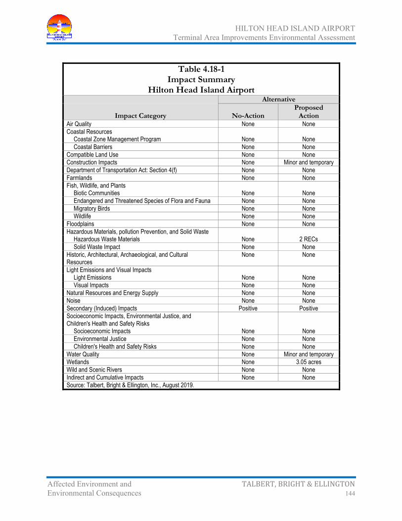
HILTON HEAD ISLAND AIRPORT Terminal Area Improvements Environmental Assessment
Affected Environment and TALBERT, BRIGHT & ELLINGTON Environmental Consequences 144
Table 4.18-1 Impact Summary
Hilton Head Island Airport Alternative
Impact Category No-Action Proposed
Action Air Quality None None Coastal Resources
Coastal Zone Management Program None None Coastal Barriers None None
Compatible Land Use None None Construction Impacts None Minor and temporary Department of Transportation Act: Section 4(f) None None Farmlands None None Fish, Wildlife, and Plants
Biotic Communities None None Endangered and Threatened Species of Flora and Fauna None None Migratory Birds None None Wildlife None None
Floodplains None None Hazardous Materials, pollution Prevention, and Solid Waste
Hazardous Waste Materials None 2 RECs Solid Waste Impact None None
Historic, Architectural, Archaeological, and Cultural Resources
None None
Light Emissions and Visual Impacts
Light Emissions None None Visual Impacts None None
Natural Resources and Energy Supply None None Noise None None Secondary (Induced) Impacts Positive Positive Socioeconomic Impacts, Environmental Justice, and Children's Health and Safety Risks
Socioeconomic Impacts None None Environmental Justice None None Children's Health and Safety Risks None None
Water Quality None Minor and temporary Wetlands None 3.05 acres Wild and Scenic Rivers None None Indirect and Cumulative Impacts None None Source: Talbert, Bright & Ellington, Inc., August 2019.

HILTON HEAD ISLAND AIRPORT Terminal Area Improvements Environmental Assessment
Comments and Coordination TALBERT, BRIGHT & ELLINGTON 145
5.0 COMMENTS AND COORDINATION
Coordination with federal, state, and local agencies and the interested public has been ongoing throughout the development of the Proposed Action. Comments and information received during the EA have been considered in development of the proposed alternatives and in determining impacts of the reasonable development alternatives on the existing environment.
5.1 Interagency Coordination
Interagency coordination was initiated on April 24, 2019, when a scoping letter was sent to regulatory and permitting agencies requesting information in their areas of expertise and jurisdiction (Appendix A, pages A-2 through A-9). The information received was used to assist in minimizing and avoiding potential environmental impacts, while following engineering criteria. Since the beginning of the preparation of the EA, coordination with various federal, state, and local agencies, as well as interested individuals, has occurred (Appendix A, pages A-10 through A-24).
On December 23, 2019, the Draft EA was sent to the regulatory and permitting agencies for review and comment; with comments requested no later than January 30, 2020 (Appendix A, page A-36 through A-52). Comments received from the USACE and SHPO have been addressed (Appendix E, pages E-67 through E-142). Comments received from other agencies (Appendix F, pages F-8 though F-24) have been addressed in pertinent sections of this EA document.
5.2 Public Information Meeting
Public participation is an essential element in the NEPA process. FAA Order 5050.4B – National Environmental Policy Act (NEPA) Implementing Instructions for Airport Projects and FAA Order 1050.1F – Environmental Impacts: Policies and Procedures emphasize public participation in the environmental and decision-making process.
The intent of public involvement is to encourage and facilitate public input and comments in the decision-making process of a project that may have an effect on the human and natural environment. The opportunities for input should be made available to all people including Americans with disabilities and minority and low-income populations.
It is the goal of the public participation process to inform, educate, and seek input from the public about the Proposed Action and the NEPA process. The public participated through one public information meeting.

HILTON HEAD ISLAND AIRPORT Terminal Area Improvements Environmental Assessment
Comments and Coordination TALBERT, BRIGHT & ELLINGTON 146
5.2.1 January 30, 2020, Public Information Meeting The public information was held to outline the results of the EA. The meeting allowed the project team to provide an opportunity for the public to ask questions. To facilitate the process, each attendee was asked to sign in and complete a public comment form. These forms were completed at the public information meeting, mailed, or e-mailed.
The meeting took place on January 30, 2020, between 5:00 p.m. and 7:00 p.m., at the Hilton Head Island Branch Library, 11 Beach City Road on Hilton Head Island, approximately one mile from the Hilton Head Island Airport. A certified copy of the newspaper advertisement is in Appendix A (page A-35). The project team set up displays that included the results of the impacts on the environmental categories outlined in the EA. Project team representatives were available to answer questions. A table was set up for those who wished to fill out the public comment form at the meeting.
Eight (8) people attended the January 30, 2020, public information meeting. No comment forms were turned in at the meeting and none were received by mail during the 45-day open comment period. Copies of the presentation materials and sign-in sheets s are in Appendix F (pages F-2 through F-7).

HILTON HEAD ISLAND AIRPORT Terminal Area Improvements Environmental Assessment
Preparers TALBERT, BRIGHT & ELLINGTON 147
6.0 PREPARERS
6.1 Federal Aviation Administration
Felecia Reeves, Planning/Environmental Program Manager, responsible for review and approval of the environmental assessment.
Kyle Cody, Program Manager, responsible for review of the environmental assessment.
6.2 South Carolina Aeronautics Commission
James Stephens, Executive Director, responsible for review of the environmental assessment.
Gary Siegfried, Aviation Engineer, responsible for review of the environmental assessment.
6.3 Hilton Head Island Airport
Jon Rembold, Airports Director, responsible for review of the environmental assessment.
6.4 Talbert, Bright & Ellington, Inc.
Carl M. Ellington, Jr., P.E., Principal, responsible for project oversight and review of the environmental assessment.
Roy Johnson, Facilitator, responsible for public meeting oversight.
Judith Elder, Project Manager, primary author, and coordinator and responsible for review of sections created by others for the environmental assessment.
Patrick E. Turney, P.E., PLS., Principal, responsible for engineering design and cost coordination.
Michael W. Player, P.E., Engineer, responsible for preparation of graphics and cost estimates
Troy McNall, Senior Planner, responsible for preparation of graphics

HILTON HEAD ISLAND AIRPORT Terminal Area Improvements Environmental Assessment
Preparers TALBERT, BRIGHT & ELLINGTON 148
6.5 Ward Edwards, Inc.
James D. Gentry, Jr., Wetland Scientist, provided wetland and threatened-endangered species support of environmental assessment.
Greg A. Baisch, P.E., provided wetland and threatened-endangered species review support of environmental assessment.
6.7 S&ME, Inc.
Chris Daves, P.W.S., Biologist/Natural Resources Project Manager, field work and report preparation for Phase I Environmental Site Assessment.
Thomas Behnke, P.G., Senior Reviewer, quality review of Phase I Environmental Site Assessment.
6.8 Brockington and Associates, Inc.
Scott Butler, Principal, Phase I survey and report author.
Stacey Whitacre, Archaeologist, Phase I survey and report author.
James Page, Crew Chief Technician, Phase I survey.
John O’Donnell, Senior Technician, Phase I survey.
Copyright © 2022 FDOKUMEN