Species protection from current reserves: Economic and biological considerations, spatial issues and...
34
Species Protection From Current Reserves : Economic and Biological Considerations, Spatial Issues and Policy Evaluation Bertrand Hamaide * Faculté des Sciences Economiques, Sociales et Politiques, CEREC Facultés Universitaires Saint-Louis 1000 Brussels BELGIUM And Jack Sheerin University of Arizona Tucson, Arizona 85739 USA * Corresponding author: Tel. +32.2.211.78.75 ; fax : +32.2.211.79.97. E-mail address: [email protected] (B. Hamaide)
-
Upload
independent -
Category
Documents
-
view
2 -
download
0
Transcript of Species protection from current reserves: Economic and biological considerations, spatial issues and...
Species Protection From Current Reserves : Economic and Biological Considerations, Spatial Issues and Policy Evaluation
Bertrand Hamaide* Faculté des Sciences Economiques, Sociales et Politiques, CEREC
Facultés Universitaires Saint-Louis 1000 Brussels
BELGIUM
And
Jack Sheerin University of Arizona
Tucson, Arizona 85739 USA
* Corresponding author: Tel. +32.2.211.78.75 ; fax : +32.2.211.79.97. E-mail address: [email protected] (B. Hamaide)

2
Abstract
The expansion of nature reserves is an important public policy strategy for the protection of
biological diversity. In this paper, the authors use integer programming model structures derived
from Location Set Covering Problem and Maximal Covering Location Problem approaches of
location science as tools for selectively augmenting nature reserve sites for special status species
protection. The linear programming models presented incorporate the following: biological
constraints in the form of species’ area needs; economic constraints in the form of opportunity
costs of converting smaller administrative districts into nature reserves; and spatial constraints in
the form of required connectivity among districts in site selection. The construction of a
taxonomic data set for Thailand enables the implementation of the models, the comparison of
results and evaluation of the differences in outcomes. The models build upon the existing nature
reserve network in Thailand and suggest various public policy options that would augment the
reserves for enhancing species protection and for possibly improving national conservation
efforts at lowest costs.

3
1. Introduction
One of the goals of the Convention on Biological Diversity, opened for signature at the United
Nations Conference on Environment and Development, held in Rio de Janeiro in 1992, and
ratified by a large number of countries, including Thailand, was to achieve a significant reduction
in the current rate of biodiversity loss by 2010.
The establishment and enhancement of nature reserves is a highly important strategy for
the conservation of biological biodiversity. Since Thailand ratified the Convention, the
Government expanded, among other conservation actions, the country’s national nature reserve
network.
The first national park in Thailand, Khao Yai National Park, was established in 1962 and
has been managed by the Royal Forestry Department since it became a protected area (Albers and
Robinson, 2007). Thailand was one of the first developing countries to implement an ambitious
system of protected areas, currently composed of 31 wildlife sanctuaries and 57 national parks.
Over the years, protected areas were not selected at random but were more likely to be considered
if they had higher historical forest cover, were located further from high quality agricultural land,
further from mineral and timber resources, were close to national borders due to security reasons
and included endemic species (Sims, 2010).
For more than twenty years, ecologists, economists and others have formulated
mathematical models whose broad aim is to support efficient methods to protect special status
animal and plant species in such nature reserves. Some analytical models have examined
strategies aimed at protecting as many species as possible, while others have been directed at
only the most critically endangered species.

4
Most such modeling efforts implicitly incorporate biological, economical or spatial
parameters and generally have been constructed using available data to show their potential use
to public officials charged with effective protection of biodiversity. This paper explicitly
considers biological, economic and spatial constraints, applied to a large data set from the
Kingdom of Thailand, as these three parameters seem critical in protecting species and hence,
contribute to a reduction in biodiversity loss. More precisely, area needs of each species under
consideration, heterogeneous land costs, and spatial restrictions such that sites added to reserves
must be adjacent to existing reserves, will all be taken into account.
Furthermore, the analysis begins using the existing national nature reserve network in
Thailand, then moves to identify an enhanced level of protection for the set of endangered
vertebrate species through the selective addition of land in a cost-efficient way, so as to preserve
additional species, previously unprotected in the current reserve network.
All component parts of the models have been analyzed and described in previous studies,
but they have not all appeared together in a similar context featuring a large data set in a
developing country application.
2. Methodology and Scope of Analysis
2.1. EARLY LITERATURE REVIEW AND SCOPE OF ANALYSIS
The analytic methods in which a nature reserve system is formulated parallels that of location
science, which seeks to identify a set of geographic sites for locating economic activities
(ReVelle et al., 2002) in some optimal way. Two such location science techniques, the Location

5
Set Covering Problem (LSCP) and the Maximal Covering Location Problem (MCLP), developed
in the 1970s, seek to locate the fewest number of facilities in such a way that all demand nodes
are covered within a certain distance or time standard (Toregas et al., 1971; Toregas and ReVelle,
1973), or alternatively, to cover as many demand nodes as possible with a limited number of
facilities (Church and ReVelle, 1974). Over the subsequent three decades, analysts began to
apply these location science models to nature reserve problems. In nature reserve applications,
the parallel objective is either: (1) to choose the smallest number of land sites from a population
of sites for a nature reserve such that each species of interest is present in at least one selected site
(Possingham et al., 1993; Underhill, 1994), or (2) to identify a nature reserve system in which the
habitats of the largest number of species is preserved, even if the system of sites may not be
sufficient to preserve every species of interest (Church et al., 1996; Camm et al., 1996).
More recently, several authors developed probabilistic (e.g., Haight et al., 2000) and
dynamic models (e.g., Costello and Polasky, 2004) for selecting nature reserves. Examples of
other interesting research directions included the introduction of cost-efficient reserve selection,
the introduction of individual habitat range for every species under consideration, and spatial
issues in designing a reserve network. The purpose of this paper is to enrich the deterministic
literature by incorporating these elements together and by applying them to a developing country
data set, taking existing reserves into account.
2.2. METHODOLOGY
This paper uses 0-1 programming models of the Location Covering Problem types. Following
Marianov et al. (2008) and Polasky et al. (2008), it explicitly takes into account geographic range,
differentially articulated for individual species, in establishing a reserve network.

6
The paper also incorporates cost-efficient site selection as in Ando et al. (1998) and
Polasky et al. (2001), because, for a given level of species protection, selecting sites based on the
total surface or on the quantity of land parcels is always more expensive than selecting them
based on the opportunity cost of converting a site to a nature reserve.
Based on these earlier studies, a first model starts with the set of nationally endangered
species that already can be considered as protected, that is, those that are part of an existing
reserve system. Then, using area needs for each remaining species, it mathematically attempts to
determine in an iterative process the most cost efficient method to protect each additional species,
until all species are included in the augmented reserve system. Further, this computation makes
possible the derivation of the marginal cost of additional species protection.
Adding requirements for spatial coherence has been shown to enhance further the
protection of critical species. Williams et al. (2005) reviewed various spatial attributes in reserve
design, while Moilanen et al. (2009) reviewed current theory and methodologies that deal with
spatial aspects of species conservation. This latter review considered basic methodological
structures, optimization methods for solving spatial problems and biological applications that
include habitat modeling, metapopulations, spatial population viability, conservation planning
issues and software packages developed for planning needs.
In the biological literature, species persistence is often modeled as a function of spatial
pattern of protection, and is employed to justify spatially explicit requirements such as compact
reserves or reserves otherwise located close together. As a matter of fact, such reserves may
increase local persistence by reducing edge effects and by facilitating dispersal and allowing
recolonization of unoccupied but suitable sites (i.e. Cabeza and Moilanen, 2001; Cabeza et al.,
2004, Araujo and Williams, 2000).

7
Spatially explicit reserve selection models over the years have considered the delineation
of core areas and buffer zones (i.e. Williams and ReVelle, 1998), proximity and compactness (i.e.
Önal and Briers, 2002), connectivity (i.e. Nalle et al., 2002, Önal and Briers, 2006) and boundary
shape or convexity (i.e. Williams, 2003). All of these spatial questions may be addressed using
integer programming tools and are reviewed in detail in Haight and Snyder (2009) who also
underscore the difference between structural and functional connectivity. Another paper by Nalle
et al. (2004) proposes a sophisticated economic and ecological model combining a spatial and
dynamic analysis in a single species study. Using the Haight and Nalle studies as a basis, we
propose two further models that utilize spatial analysis in that only “connected” parcels of current
reserves are considered as eligible sites. Thus they seek to protect as many (if not all) additional
species by selecting the least-costly connected land sites.
This paper uses an existing reserve network as a starting point. Typically, models are
applied to a data set with the presumption that no species protection exists, even though, in
reality, countries and sub-national jurisdictions set aside land as nature reserves and devote
manpower and other resources to conservation goals. Thus, it is more realistic, for policy
purposes, to take the existing reserve network into consideration and to evaluate whether the
current network is satisfactory and also whether it should be amended to better protect species.
Haight et al (2004) concentrate on a reserve expansion for protecting one single species while
Nalle et al (2002) explore a reserve augmentation having spatial characteristics in which all
habitat types, used as a proxy measure for species coverage, are sufficiently represented. Another
technique, not used in this paper, is GAP analysis (Jennings, 2000). This method identifies
‘gaps’ in the conservation network: biodiversity elements in the existing conservation areas that
are poorly represented or not represented at all. It then considers methods to expand the network
by setting priorities for subsequent conservation actions. In this paper, the current reserve system

8
is augmented in a cost-effective way, taking into consideration spatial needs of each protected
species, to cover those species that are not represented in the original network.
3. Species Data for Thailand
Thailand is comprised of 76 provinces; each province is divided into “amphoes”, the nation’s
smallest administrative districts. This study considers 567 amphoes, ranging from a few square
kilometres to 2407 square kilometresi, leaving aside the Bangkok metropolitan area because of its
highly urbanized character and disturbed environment with few species of interestii. Henceforth,
in this paper, amphoes are referred to by the English term “districts”.
A total of 68 terrestrial vertebrates, classified as rare, threatened or endangered by the
International Union for the Conservation of Nature and Natural Resources (IUCN, 2006) are
considered in this study. Of these, 57 are mammals, 9 are reptiles and 2 are amphibian species.
The species set for Thailand is detailed in Hamaide et al. (2008). The construction of a
presence-absence matrix of all species in all districts is based on endangered species information
from Humphrey and Bain (1990), which updates and extends Legakul and McNeely’s seminal
study (1977) on mammals in the country. Where multiple estimates of distribution are available,
the more conservative or restrictive alternative is used. Also, constructed data are crosschecked
with the electronic Bioinventories of the World (2006), which applies to protected areas and can
be readily mapped to districts and the correspondence with the presence-absence matrix is
extremely close.
With the passage of time since distribution estimates were made, and subsequent human
development and encroachment, it seems clear that the ranges as coded to districts are best
considered to be historical ranges. This may be considered a caveat in the analysis. However,
9
these ranges, even if only accurate historically, offer conditions that provide suitable natural
habitats, and have been used in this regard for species reintroduction. Hence, we feel that these
presence-absence data may be helpful as a tool for conservation management issues in Thailand.
The data on district surface area are collected from the websites of the Ministry of
Interior, Royal Thai Government. The sites of the most relevance are the listing by province
(http://www.moi.go.th/province.htm#3) and the site www.amphoe.com/menu.php , which allows
the user to search for district information in each province.
The Thai Wildlife Research Division, located within the Ministry of Natural Resources
and Environment, has estimated home ranges for about 20 large mammal species. The home
range consists of a more or less restricted area within which a species typically moves in the
course of its normal activity (Harris et al, 1990). These estimates were produced either from their
own field research in Thailand or from other researchers’ work such as Khan (1967) and
Eisenberg (1997) who respectively studied the elephant and the tapir.
For other species, home ranges are taken from existing literature. For example,
Humphrey and Bain (1990) and Mason and McDonald (1986) provide estimates for various types
of ottersiii. Area needs for gibbons come from Leighton (1987) and Rowe (1996). In addition,
Grassman et al. (2005), Grassman (2001), Odden et al. (2005), Nowak (1999) and De Lisle
(1996) provide data for binturong, various cat species, hog deer, wild water buffalo and several
species of monitor, respectively. Home range computations for various macaques and langur are
also found in Nunn et al. (2004) and in Kaplan (2007). For all these species, when a range is
proposed in the literature, the more geographically extensive estimate, or upper bound, is used.
Similarly, if male and female range data differ, the larger of the two ranges – typically the male
home range – is used. These two considerations lend, if anything, a more cautious bias to the

10
analysis. When data for a particular species are not available, the area need of a similar species
(i.e. a member of its taxonomic family) is used.
Conservation of rare species entails costs. As mentioned in Naidoo et al. (2006), these
include acquisition costs, transaction costs, potential damage costs and opportunity costs.
Acquisition costs often are available in developed countries but generally are not available in
developing nations. As spatially explicit cost data across a study region such as Thailand is not
available at a resolution appropriate for the analysis undertaken, it is necessary to develop
surrogates, such as areas, to represent the cost of conservation (Wilson et al., 2009). This
process, however, ignores spatial variation and assumes that costs are homogeneous across space.
The surrogate used here is the opportunity cost of conserving land.
A worst-case (or highest cost) scenario of opportunity cost for each site under
consideration is estimated as the annual loss of economic output, Gross Product Originating
(GPO), at the district leveliv. Recent data on rural population and income at the district (and
smaller) levels recently have been derived by Healy and Jitsuchon (2007). Source population and
income data used are public data from the Thailand National Statistical Office (Royal Thai
Government, 2000). These data enable the computation of this particular measure of opportunity
costs when converting a site into a nature reserve.
A new nature reserve, if selected, must cover the larger part of a district but generally
does not include the entire district; some districts are very large and may have significant
settlements outside the reserve. Therefore, equating the cost of the selected land parcel with the
loss of economic output may be an overestimation. A more fine-tuned proxy for a developing
country is used in Naidoo and Adamowicz (2006), who focus on the opportunity cost of
acquiring land or otherwise protecting land for conservation, but their analysis considers a much
more limited territory (a 2920 square kilometers reserve in Paraguay). This approach is not

11
readily applicable to Thailand. It would require calculations of alternative land uses and/or net
rents in all districtsv. Therefore, even though this rough proxy may overestimate costs in some
(large) districts, it may be considered as a credible, yet imperfect, upperbound estimate.
Another question may concern the choice of Thailand as a case study. Strange et al.
(2007) evaluated the usefulness of conservation planning in developing countries, such as
Cambodia, where data are limited and implementation of institutions are weak. We feel that the
construction of this data set for Thailand and its application to the models described in the
following section is worthwhile. Not only was it suggested by government officials during our
visits on site but more importantly, apart from Malaysia, Thailand seems to be the only country in
the Indo-Burma hotspot (Mittermeier et al., 1998) to which a systematic reserve selection model
could be applied. Indeed, Vietnam’s information seems uneven and incomplete in some respects,
barely better than Cambodia’s, which is in turn better than that for Burma, which appears to
militate against even investigation. This is confirmed by Sims (2010), who underlines the fact
that Thailand provides an interesting case study because of its unusually ambitious system of
protected areas for a developing country and because of its relatively well-documented selection
process. Moreover, Thailand seems willing to improve species protection and augment nature
reserves even though its current network is already fairly intensive in comparison to its
neighbors.
4. The Models

12
The starting point of the analysis is the current nature reserve network in Thailand. This network
requires the identification of the number of endangered species that are represented in the system,
comprised of districts currently set aside as nature reserves.
Among terrestrial vertebrate species represented in this study, some may be considered as
short range while others can be qualified as long range. For example, a squirrel needs little
territory to sustain itself, find food and reproduce if it is living in a suitable habitat. Some
carnivorous species need a much larger area for their hunting, breeding and other daily activities.
As sites generally represent large patches of land, it is feasible that each species can breed in one
parcel, provided the model finds a parcel large enough for the species’ area needs. However, for
increasing the breeding option of large mammals such as the tiger and the elephant that need
extended range, this study imposes the need to have home-range spread over two connected sites.
Most site selection models in the literature have used regular geometric areas (see for
example, Csuti et al., 1997; Haight et al., 2000, Polasky et al., 2001, Arthur et al., 2004, Hamaide
et al., 2006 and others). In reality however, sites rarely, if ever, have identical areas and when
natural boundaries, like counties, provinces or districts are used to delineate sites, these will vary,
often considerably, in surface area. Snyder et al. (2004) imposed limits on the total area of
selected sites or minimized the surface of the reserved network while trying to protect as many
species as possible while Polasky et al. (2008) do not use regular geometric areas. This analysis
also uses site-specific surface.
Model 1 seeks to determine the most cost efficient method to protect species that
are not currently represented in a reserve by augmenting the protected area in Thailand.
Let there be n parcels of land indexed by j and represented by the set of sites J (J = {1, 2,
.., n}) and m species, indexed i, and represented by the set of species I (I ={1, 2, .., m}). The
model, considering all of the above elements is formulated as the following integer program:

13
!
Min Z1
= c j x j
j"NR
# (1)
s.t.
!
yi " # + $i=1
m
% (2)
!
Riyi " s j lij x j
j=1
n
# $i % I1 (3)
!
Riyi " s j fijv j
j=1
n
# $i % I2 (4)
!
v j " fik xkk#H j
$ %j # J, %i # I2 (5)
Jjxv jj !"# (6)
!
x j =1 "j # NR (7)
!
x j " 0,1}, v j " 0,1{ }, yi " 0,1{ }, lij " 0,1{ }, f ij " 0,1{ }{ #j " J,#i " I (8)
where the following variables are defined as such:
!
x j =1 if district j is selected as part of the reserve network
0 otherwise
" # $
!
yi =1 if species i is included in at least one district of the reserve system
0 otherwise
" # $
!
lij =1 if district j belongs to the set of sites that contains a short range species (species needing 1 site)
0 otherwise
" # $
!
fij =1 if district j belongs to the set of sites that contains a long range species (species needing 2 sites)
0 otherwise
" # $
!
v j =1 if j is selected as one of the two connected districts
0 otherwise
" # $
cj = cost of converting district j to a nature reserve
sj = surface (in km2) of each district j
Ri = area need (in km2) for each species i

14
Hj = set of adjacent districts to j and excluding j itself
I1 = set of species whose home range requires one site, referred to as short range species
I2 = set of species whose home range requires two sites, referred to as long range species
NR = set of districts which together comprise the current nature reserve network
Λ = number of species protected in the current reserve system
The model’s objective (1) is to minimize the cost of reserve augmentation, since it
considers only those costs to be borne in the course of new district selections. Constraint (2)
allows the incremental growth in the number of species protected at each run, beginning at Λ and
increasing to full protection (hence,
!
" = 1,.., m # $[ ]). This constraint is placed first to show its
importance in biodiversity conservation. Indeed, if ξ were equal to zero, the optimal solution
would be to spend nothing (Z1=0). At each additional run of the model, the cost increases.
Hence, solving Model 1 until the protection of all species is achieved, with a Linear
Programming (LP) software, enables us to derive the marginal cost of successively greater
species protection.
Constraint (3) states that a shorter range species i ∈ I1 is protected if the surface of the
current reserve network within a district (
!
s j lij x j
j=1
n
" ) exceeds or meets its area need (
!
Riyi).
Constraint (4) is the counterpart of equation (3) for species having longer range. Since it is
assumed that all longer range species should be present in two connected sites in order to be
considered protected, constraint (5) ensures that, for each species i (i ∈ I2 ), if vj is selected
(vj=1), then at least one adjacent district k in which the species in question is present (fik=1 for
species i) is also part of the reserve (
!
fik xkk"H j
# ≥ 1). Further, constraint (6) ensures that xj is

15
considered a part of the reserve once vj is equal to 1 (vj ≤ xj) and constraint (7) verifies which
districts are part of the original reserve system.
Constraints (3) through (7) are used to estimate Λ, the number of species protected in the
current reserve system, knowing that a district is considered as part of the network if more than
half of its area is covered by protected parks.
The spatial constraint introduced in Model 2 and used thereafter serves to restrict site
selection to those districts connected with the current reserve network, while adhering to the
species range constraint.
The problem can be formulated in two different ways. On one hand, the model can
maximize the number of species protected while selecting one additional district connected to the
current reserve network system at each run (Model 2, Z2). Alternatively, it can minimize the cost
of converting additional districts, linked to existing parcels in the reserve, into conservation areas
while requiring that one additional species is protected at each run (Model 3, Z3).
The latter model (Model 3) is in the line of thought of the non-spatial reserve
augmentation (Model 1) and is a cost-sensitive spatial model while the former model (Model 2)
essentially aims at finding additional sites that, at first, protect the largest number of non-covered
species, therefore placing a lower importance on the economic efficiency of site selection. These
two new models are formulated below.
!
Max Z2
= yii=1
m
" (9)
s.t.
!
w j " Sj#W
$ (10)
!
Riyi " s j lijw j
j#W
$ %i # I1 (11)

16
!
Riyi " s j fijv j
j#W
$ %i # I2 (12)
!
v j " fikwk
k#H j
$ %j #W &NR, %i # I2 (13)
!
v j " w j #j $W (14)
!
w j " 0,1}, v j " 0,1{ }, yi " 0,1{ }, lij " 0,1{ }, f ij " 0,1{ }{ #j " J,#i " I (15)
where the following variables are defined as such:
!
w j =1 if district j is connected to an existing reserve and selected as part of the network
0 otherwise
" # $
W = set of sites connected to NR (nature reserve) sites
Model 2 maximizes the number of non-covered species (equation 9) for various runs.
Indeed, the right hand side of equation (10) increases monotonically by one unit at each run of
the model, so that S=1 in the first run (one new district connected to the current reserve is
selected by the model). The model stops when the objective function ceases to increase
following a steady increase of S in the last few runs. This means that either the model stops when
all species are protected or when it is not possible to protect additional species in contiguous
parcels of land.
The other constraints are similar to the first model. Each short and long range species
must have enough breeding space in the selected district connected to the existing reserve
(equations 11 and 12). The model also requires that once a new district is selected for longer
range species, a connected parcel in which the species is present and that is either connected to
the existing reserve or part of it must be selected as well (equation 13). Finally, constraint (14)
ensures that wj is a newly selected district once vj is part of the reserve.

17
!
Min Z3
= c jw j
j"W
# (16)
s.t.
!
yi " # + Si=1
m
$ (17)
(11) to (15)
Model 3 minimizes the opportunity cost of converting additional districts, connected to
some portion of the existing reserve network, to nature reserves under the same constraints as
before. As shown in constraint (17), Model 3 starts with the existing reserves where Λ species
are protected and the number of species protected increases monotonically by one unit (starting
from S=0) at each run and the model stops either when all species are protected at minimal cost
or when the model is not able to cover the number of species required by equation (17) in sites
connected to the existing network. It is in this respect that equation (17) differs from equation
(2).
5. Applying the models on the Thailand Data Set
The Thai nature reserve system as reflected in the database above offers protection to 58 of the 68
special status species. This reserve system, comprised of whole districts, includes numerous
national parks and wildlife areas, although these protected areas do not exhaust the area of any
but a few districts. A district is thus considered to be part of the network if the formally protected
areas account for half or more of the district’s surface area. Even within a protected park, few
commercial activities exist and population is limited, but altogether, Sims (2010) estimates that
more than 500,000 people live inside national parks and wildlife sanctuaries; elsewhere in the

18
inclusive district(s), activities and residential settlements may exist. This situation is analogous to
published research studies using the Oregon data set (e.g., Csuti et al., 1997, Polasky et al., 2001;
Arthur et al., 2004, and others), since the hexagon parcels also exhaust all the area of Oregon,
including cities. Hence, when a parcel is selected as a nature reserve in the present study, its
complete surface area not only includes national and regional parks and forests, but may also
include some residential and rural commercial activities.
Most of the 68 species of interest have small home ranges: from less than 1 km2 to a few
km2. Some species require larger home ranges (from 5 to 60 km2) and only two species, the
Asian elephant and the tiger, are considered for this paper to be longer-range species, as they may
respectively cover a maximum of 300 and 100 km2 for their activities. Since many available
districts are very large, up to 2,407 km2 in area, equation (5), which requires the selection of at
least two contiguous sites for each longer-range species, might be considered as unnecessary. If
that equation were deleted, the model would select a sufficiently large district so that each longer-
range species is able to utilize at least its own home range within the nature reserve portion of
that district. The equation is retained, however, to allow for the selection of two connected sites,
and thus to account for edge effects. Species occurrences near a natural district boundary are in
fact common and the existence of administrative boundaries in this context is obviously without
meaning. Thus, it might be advisable to select its neighboring site as well. Clearly, this is less
true for shorter-range species.
Respecting constraints (3) to (7) gives a solution Λ=58; 22 districts are thus defined as
biological reserves and they altogether cover 58 of the 68 species in the set. Figure 1 shows the
locations, in light grey, of those districts that constitute the current reserves in Thailand.
Figure 1: Current Nature Reserve (Light Grey) and Site Selection for Full Coverage (Dark Grey)
19
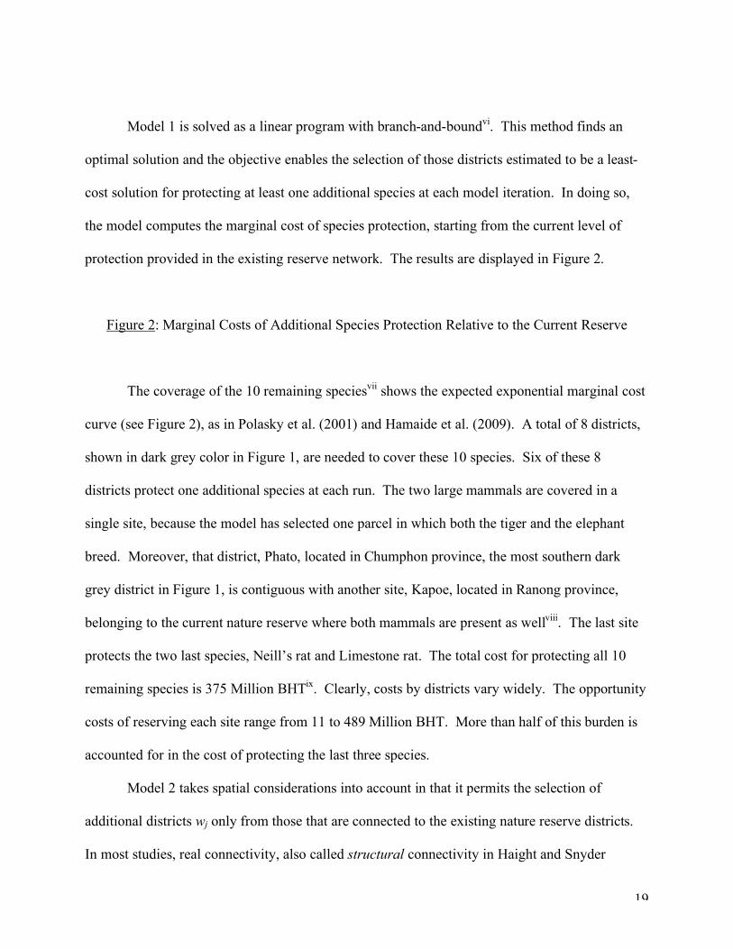
Model 1 is solved as a linear program with branch-and-boundvi. This method finds an
optimal solution and the objective enables the selection of those districts estimated to be a least-
cost solution for protecting at least one additional species at each model iteration. In doing so,
the model computes the marginal cost of species protection, starting from the current level of
protection provided in the existing reserve network. The results are displayed in Figure 2.
Figure 2: Marginal Costs of Additional Species Protection Relative to the Current Reserve
The coverage of the 10 remaining speciesvii shows the expected exponential marginal cost
curve (see Figure 2), as in Polasky et al. (2001) and Hamaide et al. (2009). A total of 8 districts,
shown in dark grey color in Figure 1, are needed to cover these 10 species. Six of these 8
districts protect one additional species at each run. The two large mammals are covered in a
single site, because the model has selected one parcel in which both the tiger and the elephant
breed. Moreover, that district, Phato, located in Chumphon province, the most southern dark
grey district in Figure 1, is contiguous with another site, Kapoe, located in Ranong province,
belonging to the current nature reserve where both mammals are present as wellviii. The last site
protects the two last species, Neill’s rat and Limestone rat. The total cost for protecting all 10
remaining species is 375 Million BHTix. Clearly, costs by districts vary widely. The opportunity
costs of reserving each site range from 11 to 489 Million BHT. More than half of this burden is
accounted for in the cost of protecting the last three species.
Model 2 takes spatial considerations into account in that it permits the selection of
additional districts wj only from those that are connected to the existing nature reserve districts.
In most studies, real connectivity, also called structural connectivity in Haight and Snyder

20
(2009), is applied empirically with small cells: Nalle et al. (2002) use 1km2 sites and Önal and
Briers (2006) divide their data set in 4km2 cells. Structural connectivity calls for strict adjacency
of reserves and effectively is required here for large mammals. Sites available for selection when
large mammals are present must therefore have a common boundary with an existing reserve.
Said differently, the newly acquired area must be connected to the portion of the district that is
considered reserved. For all other species in this study, the spatial requirement is that of
functional connectivity, that is, reserves must lie within a certain distance of each other. It is
therefore a requirement of reserve proximity, rather than pure connectivity, in the way that Önal
and Briers (2002) ,who minimize the sum of pairwise distances between reserves, used.
The successive runs of Model 2 require that the right hand side term of equation (10)
increases by one unit at each run. In the first run, the model selects one district in which the two
large mammals – tiger and elephant – are present and that has a structural connection with
another reserved site containing these species. Hence, the model first selects a somewhat
species-rich contiguous district. The other runs result in the protection of but one additional
species at a time. In 6 successive runs, the model was able to protect 7 out of the 10 remaining
species. These districts are depicted in dark grey color in Figure 3 (light grey cells representing
the original nature reserve network). Adding supplementary districts would not change species
coverage since the 3 last species are not present in any site with a functional connection to the
current reserve system. The model therefore ends with a protection of 65 species (Z2=65) at a
cost of 587.3 Million BHT. Hence, the spatial constraint of Model 2 does not allow the
protection of Neill’s rat, the Limestone rat and the Island rat. Two additional scattered parcels
would have been necessary to reach full protectionx. Total cost is much higher than in Model 1
even though not all species are protected, mostly because the choice in site selection is much

21
more limited, but, to a lesser extent, also because the objective of the model is not to minimize
costs.
Figure 3: Contiguous Site Selection in Model 2 (Dark Grey Cells) and Model 3 (Striped Cell) from Current Reserve (Light Grey Cells)
Very similar results are found with the cost-minimizing spatial model (Model 3). First,
the model selects the least costly districts for protecting 7 additional species, but cannot go
further because the last three species are not found in parcels with a functional connection to the
current reserve. The newly protected districts are depicted in dark grey in Figure 3. Second,
Model 3 provides only a very small cost reduction compared with Model 2 because, from the
limited number of sites to choose from, the model is able to find only one different and least
costly district from Model 2’s solution, for the Burmese python – striped cell in Figure 3
replacing the dark grey cell connected to it. All other districts selected are identical in Models 2
and 3. Hence, total cost amounts to 563.5 instead of 587.3 Million BHT. The newly protected
species, listed in order of increasing cost are the following: The Giant frog, the Tiger and the
Asian elephant, the endemic Kitti’s hog-nosed bat, the Black-striped weasel, the Burmese python
and Pere David’s vole.
6. Conclusion and Caveats
This paper formulates various set covering models aimed at protecting vertebrate species in
Thailand that are considered as threatened and/or endangered by the IUCN. Starting with the
existing reserve network and those species already protected within the network, the first model
minimizes the cost of selecting additional districts to protect the remaining species of interest.

22
The last two models reduce the range of choice in district selection by considering only those
districts that are connected (structural or functional connectivity) to some portion of the existing
reserves. Under this spatial requirement, the second model selects additional connecting districts
so as to protect as many additional species as possible, while the third model chooses additional
non-covered species found in the least costly districts adjacent to the already selected network.
The geographic sites selected, which are the various outcomes of these models, are displayed in
maps in Figures 1 and 3.
Table I: Protected Area by Province as Share of Province Total Area in the 3 Models
Among the three selection sets identified in the paper, the various reserve networks
comprise from 9.9 percent (in Model 1) to 10.9 percent (in Model 2) of the total land area of
Thailand, as Table I shows. A total of 26 Thai provinces, or about one-third of the national total,
contain areas that enjoy reserve protection. These range from approximately 77 percent each in
Kanchanaburi, Uthai Thani, and Petchaburi provinces down to less than 5 percent of the area in
Chonburi and Narathiwat provinces.
Nature reserves cover the majority (from 57% to 93%) but not the whole surface area of
selected districts. As a matter of fact, as shown in Williams et al. (2003), a selected site may be
thought of as a general locale in which specific parcels may be identified as protected land by
local planners and decision makers. But population centers and various economic activities may
be found in the portion of the district outside of the reserve. Current reserves protect 58 of the 68
threatened species of the study. By standards of most of the developing world, the Thai
authorities’ aggressive policies of adding new protected areas for several decades has done an
enviable job in conserving biodiversity.

23
Species protection can nevertheless be improved by converting additional districts to
nature reserves. Model 1 shows that expansion of reserves can be done at a modest cost, even
though protecting the last species is always very costly as these generally are located in few
districts and/or in expensive ones, including places where human activities are more important.
If spatial protection is favored, both for economic reasons (reduction of management costs) and
biological reasons (large connected territory), the cost of additional species protection increases
at a higher pace and the connectivity requirement prevents full protection since some species only
breed in areas that are not linked to the current reserve network system.
There are obviously caveats in this paper that need to be mentioned. First, competition
among species and problems of co-location of habitat are not considered. It is well established in
the biology and ecology literature that, for a variety of reasons, some species do not occur in the
same area as other species. On the contrary, some species may need to live in the same
surroundings as other species. These biological elements are not taken into account here and
might somewhat modify the results. Second, the cost computations, which are based on existing
studies, and using gross district product as a proxy, in the absence of available land cost data, on
converting districts into nature reserves are certainly very rough approximations of direct costs.
Moreover, the presence of a village or a town in a district might make it appear as costly even
though there may be large tracts of rural land that are not particularly costly. Third, this study
does not include any dynamics; the models are therefore once-and-for-all decisions whereas
conservation budgets and gross products typically vary over the years. Fourth, the amount of
protected area within a district is modelled as 0 or 1 (1 if the majority of the district is covered by
protected parks) which may be less accurate than if it was modelled as a continuous variable.
Similarly, reserve expansion requires selection of additional whole districts instead of an increase
in protected area within a district, if it were a continuous variable. Fifth, the types of models

24
described here take the hypothesis that a species is protected if it is breeding in at least one site;
in reality, this may not ensure species survival. Finally, species’ area needs considered here are
different than species’ habitat needs because specific habitat elements, resource needs, carrying
capacity, population levels or habitat quality are not taken into account. Notwithstanding these
caveats, we feel that such analyses may help decision makers fine tune conservation policies for
species protection and survival.
Acknowledgements
The authors would like to thank the Editor-in-Chief and the Managing Editor as well as
two anonymous reviewers for their precise and constructive comments. One of the authors
benefited from a partial financial support from the Belgian Federal Government under the IAP
contract P6/09, which is gratefully acknowledged. The authors are of course responsible for all
remaining mistakes.

25
References
Albers, H. J., Robinson, E. (2007). Spatial-temporal aspects of cost-benefit analysis for park management: An example from Khao Yai National Park, Thailand. Journal of Forest Economics, 13, 129-150. Ando, A., Camm, J., Polasky, S., Solow, A. (1998). Species distributions, land values and efficient conservation. Science, 279, 2126-2128. Araujo, M., Williams, P.H. (2000). Selecting areas for species persistence using occurrence data. Biological Conservation, 96, 331-345. Arthur, J., Camm, J., Haight, R., Montgomery, C., Polasky, S. (2004). Weighing conservation objectives: maximum expected coverage versus endangered species protection. Ecological Applications, 14, 1936-1945. Bioinventories of the world (2006). Biological inventories of the world’s protected areas. International center for the environment, University of California, Davis. www.ice.ucdavis.edu/bioinventory/bioinventory.html Cabeza, M., Moilanen, A. (2001). Design of reserve networks and the persistence of biodiversity. Trends in Ecology and Evolution, 16 (5), 242-248. Cabeza, M., Araujo, M., Wilson, R., Thomas, C., Cowley, M., Moilanen, A. (2004). Combining probabilities of occurrence with spatial reserve design. Journal of Applied Ecology, 41, 252-262. Camm, J, Polasky, S., Solow, A. and Csuti, B. (1996). A note on optimal algorithms for reserve site selection. Biological Conservation, 78, 353-355. Church, R., Stoms, D., Davis, F. (1996). Reserve selection as maximal covering location problem. Biological Conservation 76, 105-112. Costello, C., Polasky, S., 2004. Dynamic Reserve Site Selection. Resource and Energy Economics, 26, 157-174. Csuti, B., Polasky, S., Williams, P., Pressey, R., Camm, J., Kershaw, M., Keisler, A., Downs, B., Hamilton, R., Huso, M., Sahr, K (1997). A comparison of reserve site selection algorithms using data on terrestrial vertebrates in Oregon. Biological Conservation, 80, 83-97. De Lisle, H. (1996). Natural History of Monitor Lizards. Krieger Piblishing Company, Florida. Eisenberg, F. (1997). Tapirs, status survey and conservation action plan. In Brooks, D. (Ed.). IUCN Tapir Specialist Group. IUCN. Switzerland. Grassman, L., Tewes, M., Silvy, N. (2005). Ranging, habitat use and activity patterns of binturong ‘arctictis binturong’ and yellow-throated marten ‘mates flavigula’ in north-central Thailand. Wildlife Biology, 11, 49-57.

26
Grassman, L. (2001). Spatial ecology and conservation of the felid community in Phu Khien wildlife sanctuary. Progress report to CAT. Haight, R., ReVelle, C., Snyder, S. (2000). An integer optimization approach to a probabilistic reserve site selection problem. Operations Research 48, 697-708. Haight, R., Cypher, B., Kelly, P., Phillips, S., Ralls, K., Possingham, H. (2004). Optimizing reserve expansion for disjunct populations of San Joaquin kit fox. Biological Conservation 117, 61-72. Haight, R., Snyder, S. (2009). Integer programming methods for reserve selection and design. In A. Moilanen, K. Wilson, H. Possingham (Ed.). Spatial conservation prioritization. Oxford University Press, UK. Chapter 4. Hamaide, B., ReVelle, C.S. and Malcolm, S, (2006). Biological Reserves, Rare Species and the Trade-off between Species Abundance and Species Diversity. Ecological Economics, 56, 570-583. Hamaide, B., Sheerin, J., Tingsabadh, C. (2008). Nature reserve selection for endangered species considering habitat needs: the case of Thailand. Chapter 10. In Pertsova, C. (Ed.). Ecological economics research trends. Nova Science Publishers, Inc., NY, NY. Hamaide, B., Williams, C., ReVelle, C. (2009). Cost-efficient reserve site selection favoring persistence of threatened and endangered species. Geographical Analysis, 41, 83-101. Harris, S., Cresswell, W., Forde, P., Trewhella, W., Woollard, T., Wray, S. (1990). Home range analysis using radio tracking data: a review of problems and techniques particularly as applied to the study of mammals. Mammal Review, 20, 97-123. Healy, A. J., & Jitsuchon, S., (2007). Finding the Poor in Thailand, Journal of Asian Economics, 18, 739-759. Humphrey, S., Bain, J. (1990). Endangered animals of Thailand. Sandhill Crane Press, 468p. IUCN (2006). Summary statistics for globally threatened species. 1990, 1994, 1995, 2002, 2006. Gland, Switzerland. www.iucnredlist.org Jennings, M. (2000). Gap analysis: concepts, methods, and recent results. Landscape Ecology, 15, 5-20. Kahn, M. (1967). Movement of a herd of elephants in the upper Perak area. Malay Nat. Journal, 20, 18-23. Kaplan, H. (2007). Primate database. www.unm.edu/-hkaplan/pnas/primatedatabase.xls

27
Legakul, ., McNeely, A. (1977). Mammals of Thailand. Association Conservation Wildlife, Bangkok, 758p. Leighton, S. (1987). Gibbons: territoriality and monogamy. In Smuts, B., Cheney, D., Seyfarth, R., Wrangham, R. and Struhsaker, T. (Ed.). Primate societies. University of Chicago Press, Chicago, 135-145. Marianov, V., ReVelle, C., Snyder, S. (2008). Selecting compact habitat reserves for species with differential habitat size needs. Computers and Operations Research, 35, 475-487. Mason, C., McDonald, S. (1986). Otters: ecology and conservation. Cambridge University Press, Cambridge. Ministry of Interior. Royal Thai Government. www.moi.go.th www.amphoe.com Mittermeier, A., Myers, N., Thomsen, J.B., da Fonseca, G.A.B., Olivieri, S. (1998). Biodiversity hotspots and major tropical wilderness areas: approaches to setting conservation priorities. Conservation Biology 12, 516-520. Moilanen, A., Wilson, K., Possingham, H. (2009). Spatial Conservation Prioritization. Quantitative Methods and Computational Tools. Oxford University Press, UK, 328p. Naidoo, R., Adamowicz, W. (2006). Modeling opportunity costs of conservation in transitional landscapes. Conservation Biology, 20 (2), 490-500. Naidoo, R., Balmford, A., Ferraro, P., Polasky, S., Ricketts, T., Rouget, M. (2006). Integrating economic costs into conservation planning. Trends in Ecology and Evolution, 21 (12), 681-687. Naidoo, R., Wamura, T. (2007). Global-scale mapping of economic benefits from agricultural lands: implications for conservation priorities. Biological Conservation, 140, 40-49. Nalle, D., Arthur, J., Montgomery, C., Sessions, J. (2002). Economic and spatial impacts of an existing reserve network on future augmentation. Environmental Modeling and Assessment, 7, 99-105. Nalle, D., Montgomery, C., Arthur, J., Polasky, S., Schumaker, N. (2004). Modeling joint production of wildlife and timber. Journal of Environmental Economics ad Management, 48, 997-1017. Novak, R. (1999). Walker’s mammals of the world. 6th edition. The Johns Hopkins University Press, Baltimore. Nunn, C., Altizer, S., Sechrest, W., Jones, K., Barton, R., Gittleman, J. (2004). Parasite species richness and evolutionary diversity of primates. American Naturalist, 164, S90-S103. Odden, M., Wegge, P., Storaas, T. (2005). Hog-deer ‘axis procinus’ need threatened tallgrass floodplains. Animal Conservation, 8, 99-104.

28
Önal, H., Briers, R. (2002). Incorporating spatial criteria in optimum reserve network selection. Proceedings of The Royal Society, 269, 2437-2441. Önal, H., Briers, R. (2006). Optimal selection of a connected reserve network. Operations Research, 54 (2), 379-388. Polasky, S., Camm, J., Garber-Yonts, B. (2001). Selecting biological reserves cost-effectively: an application to terrestrial vertebrate conservation in Oregon. Land Economics, 77, 68-78. Polasky, S., Nelson, E., Camm, J., Csuti, B., Fackler, P., Lonsdorf, E., Montgomery, C., White, D., Arthur, J., Garber-Yonts, B., Haight, R., Kagan, J., Starfield, A., Tobalske, C. (2008). Where to put things? Spatial land management to sustain biodiversity and economic returns. Biological Conservation, 141, 1505-1524. Possingham, H., Day, J., Goldfinch, M., Salzborn, F. (1993). The mathematics of designing a network of protected areas for conservation. In: Sutton, D., Cousins, E., Pierce, C. (Eds.), Decision sciences, tolls for today, Proceedings of the ASOR Conference, Adelaide, Australia. ReVelle, C., Williams, J., Boland, J. (2002). Counterpart models in facility location science and reserve selection science. Environmental modeling and assessment 7, 71-80. Rowe, N. (1996). The pictorial guide to the living primates. Pogoneas Press, East Hampton, NY. Royal Thai Government (2000). Socio-economic survey: 2000. Thailand Population and housing census. Sims, K. (2010). Conservation and development: evidence from Thai protected areas. Journal of Environmental Economics and Management, 60, 94-114. Snyder, S., ReVelle, C., Haight, R. (2004). One and two objective approaches to an area- constrained habitat reserve site selection problem. Biological Conservation, 119, 565-574. Strange, N., Theilade, I., Thea, S., Sloth, A., Helles, F. (2007). Integration of species persistence, costs and conflicts: An evaluation of tree conservation strategies in Cambodia. Biological Conservation, 137, 223-236. Toregas, C., Swain, R., ReVelle, C., Bergman, L. (1971). The location of emergency service facilities. Operations Research 19, 1363-1373. Toregas, C., ReVelle, C. (1973). Binary logic solutions to a class of location problems. Geographical Analysis, 5, 145-155. Underhill, L. (1994). Optimal and suboptimal reserve selection algorithms. Biological Conservation 35, 85-87.

29
Williams, J.C., ReVelle, C.S. (1998). Reserve assemblage of critical areas: a zero-one programming approach. European Journal of Operational Research, 104 (3), 497-509. Williams, J.C. (2003). Convex land acquisition with zero-one programming. Environment and Planning B, 30, 255-270. Williams, J.C., ReVelle, C.S., Bain, D. (2003). A decision model for selecting protected habitat areas within migratory flyways, Socio-Economic Planning Sciences 37, 239-268. Williams, J., ReVelle, C., Levin, S. (2005). Spatial attributes and reserve design models: a review. Environmental Modeling and Assessment, 10, 163-181. Wilson, K., Cabeza, M., Klein, C. (2009). Fundamental concepts of spatial conservation. In A. Moilanen, K. Wilson, H. Possingham (Ed.). Spatial conservation prioritization. Oxford University Press, UK. Chapter 2, 16-27. Xpress MP, (2006). Xpress MP software development, Dash optimization, Release 2006, Englewood Cliffs, NJ, USA.

30
Figures and Tables
Figure 1: Current nature reserve (light grey) and site selection for full coverage (dark grey)
Figure 2: Marginal costs of additional species protection relative to the current reserve

31
Figure 3: Connected site selection in Model 2 (dark grey cells) and Model 3 (striped cell) from current reserve (light grey cells)

32
Province Km.2 (000) Model 1 Model 2 Model 3
Chiang Mai 20.1 0.238 0.365 0.365 Chiang Rai 11.7 0.087 0.087 0.087 Chonburi 4.4 0.039 -- -- Chumphon 6.0 0.170 0.170 0.170 Khon Kaen 10.9 -- -- -- Kanchanaburi 19.5 0.496 0.668 0.668 Lobburi 6.2 -- 0.289 0.083 Lampang 12.5 0.082 0.082 0.082 Mae Hong Son 12.7 -- -- -- Nan 11.5 0.153 0.153 0.153 Nakhon Ratchasima 20.5 0.089 0.089 0.089 Narathiwat 4.5 0.038 0.038 0.038 Prachinburi 7.2 0.362 0.362 0.362 Petchabun 12.7 -- -- -- Prachuap Khiri Khan 6.4 0.282 0.282 0.282 Phitsanuloke 10.8 -- -- -- Phetchaburi 6.2 0.773 0.773 0.773 Ranong 3.3 0.319 0.319 0.319 Sakhon Nakhon 9.6 0.106 0.106 0.106 Saraburi 3.6 0.262 -- -- Surat Thani 12.9 0.365 0.352 0.352 Tak 16.4 0.264 0.264 0.264 Trang 4.9 0.088 0.088 0.088 Satun 2.5 0.435 0.435 0.435 Uthai Thani 6.7 0.762 0.762 0.762 Uttaradit 7.8 0.216 -- --
Thailand 513.1 0.099 0.109 0.106
Table I: Protected area by province as share of province total area in the 3 models

33
i The average size of all districts is approximately 906 km2.
ii Since the 1990’s, there have been changes in many provincial and districts delineations. Hence,
for the purpose of our analysis, all districts have been classified back into the set of district in
place in the early 1990’s so that all scientific and geospatial data remain comparable and at the
same scale.
iii Note that otters’ area needs are often computed in river length, that is, in kilometers, instead of
km2. The value is used as if it were a km2 value for considering the complete length of the home
range. Failure to do so might underestimate the range of the otters’ daily activities.
iv If the purpose of the analysis is to determine absolute cost values, it might have been more
appropriate to estimate the capital value of income streams over time to get a global discounted
cost number for each site. However, in addition to the fact that no dynamics are used in this
study, the purpose is not to work with precise cost figures but to have estimates for comparing the
various alternatives. Since all data are computed with the same methodology, the comparison
therefore seems acceptable.
v Another option would be to use agricultural land values as a proxy for conservation costs, as in
Polasky et al. (2001) and Naidoo and Iwamura (2007) who produce a global map of economic
rents from agricultural land by estimating the flow of economic benefits derived from crops and
livestock. This option was not pursued because of the limited availability of land cost data and
other data at the districts level and because of the availability of previous work from Healy and
Jitsuchon (2007).
vi This model and the two subsequent models are solved in less than 9 seconds on a PC dual core.

34
vii The unprotected species are: Craseonycteris thonglongyai (Kitti’s hog-nosed bat),
Eothenomys melanogaster (Pere David’s vole), Rattus sillimensis (island rat), Rattus neilli
(Neill’s rat), Rattus hinpoon (limestone rat), Mustela strigidorsa (black striped weasel), Panthera
tigris (tiger), Elephas maximus (Asian elephant), Rana fasciculispina (spine-breasted giant frog)
and Python molurus bivattatus (Burmese python).
viii And even though the surface of the district already protected is very large and can contain both
mammals as far as area need is concerned, the model nevertheless requires selection of a
connected site where these two species are present as well to prevent for potential edge effects.
ix BHT stand for Baht, which is the Thai currency. The approximate exchange rate is the
following : 1€ ≈ 44 BHT and 1$ ≈ 32 BHT.
x The former two species are present in the same single district and cannot be found elsewhere in
the system whereas the island rat is present in various districts but not in the same one as the
other two.