Southeast Baffin volcanic margin and the North American-Greenland plate separation
19
TECTONICS, VOL. 20, NO. 4, PAGES 566-584, AUGUST 2001 Southeast Baffin volcanic marginand the North American- Greenlandplate separation Laurent Geoffroy, •'2 Jean-Paul Callot, •'3 St6phane Scaillet, 4 Andy Skuce, s J.P. G61ard, 3 M.Ravilly, 3 J. Angelier, 6 B. Bonin, 4 C. Cayet, 3 K. Perrot, 3 and C. Lepvrier 6 Abstract. Plate breakup over plumes is characterized by the development of margins showing extensive magma production both underplated at Moho level and extruded asthick piles of seaward dipping lava formations. The Disko-Svartenhuk areain west Greenland is one of the few places in the world with exposed seaward dippingbasalts forming a prism whose thickness increases seaward. We present a quantitative tectonic study of this margin,which we tentatively restored in its geodynamic position during the different stages of plate separation between Greenland andNorth America.Our structural data are constrained withrecently published 39Ar/4øAr and new andcoherent 4øK/4øAr geochronology in dikes of different orientations. The first-order structure is thatof a tectonically- driven seaward crustal flexure linked to definitive plate breakup between Greenland and Baffin Island during theEocene, coeval with the formation of the upper part of the exposed seaward dippingvolcanic prism. This flexing is associated with a significant crustal stretching associated with arrays of continentward dipping normal faults. This across-strike structure is correlated to a fundamental along-strike segmentation withthe three"segments" adopting a "zigzag" strike. There is a clear increase of extensional strain at the extremities of thesegments. Eocene extension trended N060 on average in the northern and southern segments but was NW trending in the central NE trending Nugssuaq segment. We discuss the interpretation of such an extension perpendicular to the different margin segments. From a regional point of view the N060 extension is distinct in orientation from theapproximately N-S trend of plate separation between North America and Greenland in the Baffin Bay during the Eocene. However, the extension recorded in themargin is nearly perpendicular to the obliquely spreading Eocene accretion axis in the Baffin Bay. This latter point suggests amantle or ridge control of thedevelopment of themargin over regional far-field lithospheric stress models. •Laboratoire de G6ologie du CNRS, Ecole Normale Sup6rieure, Paris, France. 2Now at Laboratoire de G6ologie, Universit6 du Maine, Le Mans, France. 3Laboratoire de G6ologie, Umversit6 du Maine, Le Mans, France. 4D6partement des Sciences de laTerre, Universit6 de Paris Sud, Orsay,France. 5AEC International, Calgary, Alberta, Canada. 6Dfpartement de G6ologie Structurale, Universit6 de Pierre et Marie Curie, Paris,France. Copyright 2001 by the American Geophysical Union. Paper number 2001TC900003. 0278-7407/01/2001 TC900003 $12.00 1. Introduction Volcanic passive margins commonly form large igneous provinces (LIPs) [White et al., 1987; Richards et al., 1989; White and McKenzie, 1989; Hill, 1991; Coffinand Eldholm, 1994; Eldholm et al., 1995].Whenclearly associated with (1) an abnormally thick adjacent oceanic crust and (2) a hot spot track, these margins canbe related to plate separation overa mantle plume [Holbrook and Kelemen, 1993; Eldholm etal., 1995]. Volcanic margins differfromnonvolcanic margins in several key factors. Regarding magmatism, they display (1) large volumes of extrusives forming prisms of seaward dipping basaltic flows extruded in subaerial conditions and which are visible as seaward dipping reflector sequences (SDRS) in reflection seismic sections[Hinz, 1981; Eldholm, 1991 ], (2) intense crustal plumbing by intrusions (dikes, sills, hypovolcanic annular complexes, etc.), and (3) large volumes of"underplated" material atMoho level, characterized by high P wave velocity [e.g., White et al., 1987; White and McKenzie, 1989;Coffin andEldholm, 1994]. Whether or not volcanicmargins have undergone significant crustal stretching and thinning is unclear. In nonvolcanic passive margins, crustal stretching isusually marked in theupper crust by arrays of continentward tilted blocks limited by seaward dipping normal faults [Le Pichon andSibuet, 1981; Boillot et al., 1989]. Thisevidence of stretching is accompanied by progressive crustal thinning toward the continent-ocean boundary, until the continental crusthas a thickness closeto the "normal" thickness of oceanic crust, i.e., 6-8 km [White et al., 1987; Le Pichon andSibuet, 1981; Boillot et al., 1989;White and McKenzie, 1989]. However, crustal-scale seismic refraction data and gravity modeling at thecontinent-ocean transition of plume related volcanic margins [Bott, 1983; White et al., 1987; Myhre et al., 1992; Watts and Fairhead,1997] suggest thatthe thinned area ismuch narrower than at nonvolcanic margins. At volcanic margins, lavas areerupted both before and during lithospheric breakup and early oceanic accretion [Whiteand McKenzie, 1989; Eldholm et al., 1995; Tegner et al., 1998], therefore crustal stretching shouldbe recorded in the SDRS themselves and the adjacent sub-horizontal LIP lava flow sequences. However, the resolution of smaller-scale structures within the SDRSis usually poor on seismic reflection profiles, although continentward dipping normal faults have several times been described inside theSDRS [e.g., Tard et al., 1991;Larsen et al., 1994]. In summary, the understanding of platebreakup mechanisms over plumes remains poor, using offshore geophysical investigation only. Crucialinformation may arise from thestudy of exposed parts of volcanic margins. ThePaleogene Thulean magmatic province isproposed to bea consequence of the wide distribution of the Icelandic mantle 566
-
Upload
independent -
Category
Documents
-
view
3 -
download
0
Transcript of Southeast Baffin volcanic margin and the North American-Greenland plate separation

TECTONICS, VOL. 20, NO. 4, PAGES 566-584, AUGUST 2001
Southeast Baffin volcanic margin and the North American- Greenland plate separation
Laurent Geoffroy, •'2 Jean-Paul Callot, •'3 St6phane Scaillet, 4 Andy Skuce, s J.P. G61ard, 3 M. Ravilly, 3 J. Angelier, 6 B. Bonin, 4 C. Cayet, 3 K. Perrot, 3 and C. Lepvrier 6
Abstract. Plate breakup over plumes is characterized by the development of margins showing extensive magma production both underplated at Moho level and extruded as thick piles of seaward dipping lava formations. The Disko-Svartenhuk area in west Greenland is one of the few places in the world with exposed seaward dipping basalts forming a prism whose thickness increases seaward. We present a quantitative tectonic study of this margin, which we tentatively restored in its geodynamic position during the different stages of plate separation between Greenland and North America. Our structural data are constrained with recently published 39Ar/4øAr and new and coherent 4øK/4øAr geochronology in dikes of different orientations. The first-order structure is that of a tectonically- driven seaward crustal flexure linked to definitive plate breakup between Greenland and Baffin Island during the Eocene, coeval with the formation of the upper part of the exposed seaward dipping volcanic prism. This flexing is associated with a significant crustal stretching associated with arrays of continentward dipping normal faults. This across-strike structure is correlated to a fundamental along-strike segmentation with the three "segments" adopting a "zigzag" strike. There is a clear increase of extensional strain at the extremities of the segments. Eocene extension trended N060 on average in the northern and southern segments but was NW trending in the central NE trending Nugssuaq segment. We discuss the interpretation of such an extension perpendicular to the different margin segments. From a regional point of view the N060 extension is distinct in orientation from the approximately N-S trend of plate separation between North America and Greenland in the Baffin Bay during the Eocene. However, the extension recorded in the margin is nearly perpendicular to the obliquely spreading Eocene accretion axis in the Baffin Bay. This latter point suggests a mantle or ridge control of the development of the margin over regional far-field lithospheric stress models.
•Laboratoire de G6ologie du CNRS, Ecole Normale Sup6rieure, Paris, France.
2Now at Laboratoire de G6ologie, Universit6 du Maine, Le Mans, France.
3Laboratoire de G6ologie, Umversit6 du Maine, Le Mans, France. 4D6partement des Sciences de la Terre, Universit6 de Paris Sud,
Orsay, France. 5AEC International, Calgary, Alberta, Canada. 6Dfpartement de G6ologie Structurale, Universit6 de Pierre et Marie
Curie, Paris, France.
Copyright 2001 by the American Geophysical Union.
Paper number 2001 TC900003. 0278-7407/01/2001 TC900003 $12.00
1. Introduction
Volcanic passive margins commonly form large igneous provinces (LIPs) [White et al., 1987; Richards et al., 1989; White and McKenzie, 1989; Hill, 1991; Coffin and Eldholm, 1994; Eldholm et al., 1995]. When clearly associated with (1) an abnormally thick adjacent oceanic crust and (2) a hot spot track, these margins can be related to plate separation over a mantle plume [Holbrook and Kelemen, 1993; Eldholm et al., 1995].
Volcanic margins differ from nonvolcanic margins in several key factors. Regarding magmatism, they display (1) large volumes of extrusives forming prisms of seaward dipping basaltic flows extruded in subaerial conditions and which are visible as
seaward dipping reflector sequences (SDRS) in reflection seismic sections [Hinz, 1981; Eldholm, 1991 ], (2) intense crustal plumbing by intrusions (dikes, sills, hypovolcanic annular complexes, etc.), and (3) large volumes of"underplated" material at Moho level, characterized by high P wave velocity [e.g., White et al., 1987; White and McKenzie, 1989; Coffin and Eldholm, 1994]. Whether or not volcanic margins have undergone significant crustal stretching and thinning is unclear. In nonvolcanic passive margins, crustal stretching is usually marked in the upper crust by arrays of continentward tilted blocks limited by seaward dipping normal faults [Le Pichon and Sibuet, 1981; Boillot et al., 1989]. This evidence of stretching is accompanied by progressive crustal thinning toward the continent-ocean boundary, until the continental crust has a thickness close to the "normal" thickness of oceanic crust, i.e., 6-8 km [White et al., 1987; Le Pichon and Sibuet, 1981; Boillot et al., 1989; White and McKenzie, 1989]. However, crustal-scale seismic refraction data and gravity modeling at the continent-ocean transition of plume related volcanic margins [Bott, 1983; White et al., 1987; Myhre et al., 1992; Watts and Fairhead, 1997] suggest that the thinned area is much narrower than at nonvolcanic margins.
At volcanic margins, lavas are erupted both before and during lithospheric breakup and early oceanic accretion [White and McKenzie, 1989; Eldholm et al., 1995; Tegner et al., 1998], therefore crustal stretching should be recorded in the SDRS themselves and the adjacent sub-horizontal LIP lava flow sequences. However, the resolution of smaller-scale structures
within the SDRS is usually poor on seismic reflection profiles, although continentward dipping normal faults have several times been described inside the SDRS [e.g., Tard et al., 1991;Larsen et al., 1994]. In summary, the understanding of plate breakup mechanisms over plumes remains poor, using offshore geophysical investigation only. Crucial information may arise from the study of exposed parts of volcanic margins.
The Paleogene Thulean magmatic province is proposed to be a consequence of the wide distribution of the Icelandic mantle
566

GEOFFROY ET AL.' SOUTHEAST BAFFIN VOLCANIC MARGIN 567
Baffin Bay
Studied area
Figure 1. Sketch map of the Brito-Arctic Province during the Paleocene and products of the Thulean mantle plume. After Ziegler [1988], deeply modified, AAPG¸[1988], reprinted by permission of the AAPG whose permission is required for further use. 1, Paleocene sedimentary formations. 2, Oceanic crust (Cretaceous to Paleocene). 3, Thulean volcanic formations. 4, Main Paleocene faults. 5, dike swarms.
plume under the Greenland-Europe lithosphere [Upton, 1988; White and McKenzie, 1989] (Figure 1). Subcontemporaneous plateau basalts of Paleocene age crop out in Scotland, Faeroes, and west and east Greenland [Upton, 1988; Tegner et al., 1998] (Figure 1). Large areas with seaward dipping basalts, comprising early to breakup-contemporaneous piles of basalts and intrusions, are notably observed along the North Atlantic plate separation area [e.g.,White et al., 1987; Myhre et al., 1992; Eldholm et al., 1995; Larsen et al., 1994]. Because of multistage Tertiary and Quaternary uplift [e.g., Dam et al., 1998], seaward dipping basalts are exposed onshore in east Greenland (from 68 ø to 70 ø in latitude) [e.g., Nielsen, 1975; Nielsen and Brooks, 1981] and also in west Greenland, from Disko to Svartenhuk [Clarke and Pedersen, 1976; Geoffroy et al., 1998; Geoffroy et al., 1999] (Figure 1).
This contribution is a tectonic synthesis of the whole Baffin Bay flexed margin based, mainly, on unpublished onshore structural data. Our aim is to elucidate the existence, geometry, timing, and evolution of crustal extension in an exposed volcanic margin.
The position of the studied onshore SE Baffin margin in the kinematic history of plate breakup between Greenland and Canada has first to be carefully considered.
2. Geodynamical Setting and Kinematic Evolution of the Labrador-Baffin Bay System
Lithospheric stretching between the North American plate (NAM) and Greenland began -130 Ma [e.g., Chian et al., 1995]. During the Cretaceous a continental rift system existed between west Greenland and North America from the present-day Labrador Sea to the northern end of Baffin Bay [Ziegler, 1988; Whittaker et al., 1997] (Figure 2). Although it looks clear that definitive plate breakup and oceanization propagated from the south to the north, the time and location of the onset of formation of oceanic lithosphere along the Labrador-Baffin axis is a matter of debate. Roest and Srivastava [1989] and Srivastava and Roest [1999] inferred that very slow-spreading oceanic accretion began in the Labrador Sea in the Late Cretaceous (chron 33). Alternatively, based on seismic data north of the Labrador Sea and magnetic modeling at the continent-ocean boundary, Chalmers and Laursen [1995] favored a Paleocene age for the earlier oceanic spreading (chron 27N). We briefly consider separately the postulated structure and opening history of the Labrador Sea, the Davis Strait, and the Baffin Bay (Figure 2).
78 ø
: 76 ø
700 :. 68 ø
ß
ß
66 ø
64
62'
58 ø
200 km
284ø 288 ø 2920 296 ø 300 ø 304 ø 308 ø 312 ø Figure 2. Offshore geology of the Labrador Sea-Baffin Bay area. After Whittaker et al. [ 1997], modified, AAPG¸[ 1997], reprinted by permission of the AAPG whose permission is required for further use. 1, Postulated or proved sedimentary basins. 2, Transitional crust or oceanic crust. 3, Oceanic crust. 4, Paleocene-Eocene volcanic formations. 5, Extinct spreading axes and transform faults. 6, trends of NAM-Greenland separation between C24 and C13. Rectangle is studied area. B. Bay is Baffin Bay. L. Sea is Labrador Sea. Note that this map is based on the Chalmers and Laursen [1995] assumptions of the extent of oceanic crust in the Labrador Sea, a debatable issue ß see, for example, Srivastava and Roest [1999] for a quite different interpretation.

568 GEOFFROY ET AL.: SOUTHEAST BAFFIN VOLCANIC MARGIN
2.1. Labrador Sea
Plate 1 displays bathymetric contours (isobaths are 100 m) superimposed on gridded aeromagnetic data extracted from the recent compilation of Verhoef et al. [1996]. We both compare with published surface magnetic data [e.g., Srivastava and Roest, 1999] and crustal seismic profiles [Chian and Louden, 1994; Chian et al., 1995] in order to investigate the limit between unextended buoyant continental crust and very thin (6 km) continental crust [Chalmers and Laursen, 1995], Cretaceous oceanic crust [e.g., Srivastava and Roest, 1999], or else extremely thin (< 2 km) transition crust [Chian et al., 1995].
The Labrador Sea basin is clearly associated with linear marine magnetic anomalies of-150 to +150 nT, symmetric on either sides of the ridge axis (Plate 1). The continental slope (depth between 500 and 2000 m) is marked by a pronounced negative (from -150 to -600 nT) magnetic anomaly, which can be followed continuously along the western margin of the Labrador- Baffin system (arrows in Plate 1). This magnetic anomaly cannot easily be related to oceanic accretion process as oceanic accretion was not simultaneous along the whole system [e.g., Srivastava and Roest, 1999].
We did not perform advanced modeling to explain this anomaly. Several explanations could explain it, but all of them suggest that the anomaly marks the continent-ocean boundary in the Labrador-Baffin system. A first hypothesis would be an edge effect associated with the strongly magnetized adjacent continental shelves (Plate 1). The aeromagnetic fabric of unextended continental crust on the continental shelves displays quite a particular signature with alternating positive and negative, circular or elliptical magnetic anomalies from -1000 to 600 nT. These intensities are high when compared to intensities of the oceanic basin and may partially reflect a shallower location of the magnetic bodies. However, our preliminary simple modelling suggests that this depth effect does not overcome 50% of the observed signal. It is thus possible that part of the negative linear anomaly reflects the edge effect of the high-intensity shelves but this explanation fails in explaining (1) the apparent continuity of the anomaly and (2) its clear existence at the southeast of the Baffin Island, where the shelf has a moderate positive magnetization.
Another explanation, which we favor, is that this anomaly marks the existence of transitional crust. This interpretation of the magnetic signal could imply (1) initial "plate breakup" occurred during a period of reversed polarity (hence chron 33R?), (2) magnetized source displays a Koenisberger ratio (Q) largely superior to unity (i.e., remanent component dominates induced component of magnetization). The transitional crust is often regarded as an intimate association of blocks of brittle crust in a matrix of denuded serpentinized peridotites resulting from extreme lithospheric thinning and stretching [e.g., Boillot et al., 1989; Chian and Louden, 1994; Brun and Beslier, [996]. Serpentinization of peridotites results in the formation of secondary magnetite (see Toil et al. [1990] for a review). As a consequence, most serpentinized peridotites bear high induced and/or remanent magnetizations [e.g., Bina et al., 1990; Hamano et al., 1990; Nazarova, 1994]. The observed negative magnetic anomaly along the Labrador-Baffin conjugated margins may therefore reflect the presence of serpentinized peridotites. However, dikes injected in the transitional crust may also account
for the observed negative magnetic anomaly. East of Greenland, Schlindwein and Jokat [1999] demonstrated using deep seismic profiles that a quite similar strongly negative linear anomaly could be interpreted as magmatic underplate during the North- Atlantic breakup. Whatever the magnetic source is (i.e., serpentinized peridotites, dikes swarm, magmatic underplate, or a combination of both), the observed magnetic anomaly probably marks the early plate breakup boundary. It will hereinafter be designed as OCBMA (ocean-continent boundary magnetic anomaly). Marine magnetic anomalies are observed inside the Labrador basin between the two OCBMAs of the western and
eastern margins (Plate 1), so we infer OCBMA could be used as a guideline for plate reconstruction in the basin.
The foot of the steep continental slope, which is quite close to the west-Greenland coast (Plate 1) [Chian and Louden, 1994], marks a reliable limit for the Greenland and NAM plate breakup boundary in the central and southern Labrador Sea only. As seen hereinafter, the bathymetry is dominated north of the Labrador Sea by Tertiary transpression and by crustal thickening by mantle plume products.
The southern Labrador Sea is dissected by transform-like faults clearly displaying two trends, N60ø-70øE and N20ø-30øE [Kristoffersen and Talwani, 1977; Roest and Srivastava, 1989; Chalmers and Laursen, 1995; Whittaker et al., 1997] (Figure 2). According to Roest and Srivastava [1989] the former system would represent the true oceanic transform faults of the Cretaceous Labrador spreading axis from chrons 33 to 24. For all authors the N20ø-30øE trend is clearly associated with the Eocene (C24) to Oligocene (C13) oceanic opening of the Labrador Sea [Kristoffersen and Talwani, 1977; Roest and Srivastava, 1989; Chalmers and Laursen, 1995], thus reflecting a major change of position of the Eulerian pole between Greenland and NAM plates at the time of the C25-C24 transition (see Figure 3). Note, in the free-air gravity map of Plate 2, that the northern part of the extinct Labrador Sea rift is distinguishable (arrow), trending approximately N125øE. Thus, as in the southern Labrador Sea [Roest and Srivastava, 1989; Srivastava and Keen, 1995], this extinct axis was not perpendicular to the nearly N-S trending C24-C13 local transform faults (Figure 2 and Plate 2) demonstrating that seafloor spreading was oblique during this period, along this axis.
2.2. Davis Strait
At the Davis Strait, Baffin Bay is separated from the Labrador Sea by the "Ungava sinistral transform-fault system" (Figure 2, Plates 1 and 2) [Srivastava, 1978; Srivastava et al., 1981; Klose et al., 1982]. The crustal composition and complex structure (Plate 2) of this bathymetric ridge are poorly constrained. Early petroleum exploration (deep drilling and geophysics) [Klose et al., 1982], as well as further investigations [Chalmers et al., 1995], showed that most of this area was covered with lavas of Paleocene age (Figure 2). Srivastava et al. [ 1982] have suggested that the Davis Strait was not a true transform fault until the
Paleocene but, rather, was a sinistral transtensional opening axis. A clear Eocene transpression is expressed in the Davis Strait
[Klose et al., 1982; Chalmers et al., 1995]. This transpression and the apparent pattern of rotated (?) crustal blocks in the Davis Strait (Plate 2) could be explained by the reworking of this early transtensional system during the anticlockwise change in trend of

GEOFFROY ET AL.' SOUTHEAST BAFFIN VOLCANIC MARGIN 569
68
66
64
60.
58
288 292 296
.
ß
-,
30O 3O4
9OO
6OO
30O
150
9O
6O
3O
0
-30
-60
-90
-150
-600
n
Plate 1. Mixed aeromagnetic [Verhoefet al., 1996] and Etopo5 bathymetric map (in meters) of the Labrador-Baffin area. White arrows are OCBMA (ocean-continent boundary magnetic anomaly) on the western side of Labrador Sea, Davis Strait, and Baffin Bay (see text).
570 GEOFFROY ET AL.: SOUTHEAST BAFFIN VOLCANIC MARGIN
opening of the Labrador Sea-Baffin Bay axis at the Paleocene- Eocene transition (see Figure 3). The OCBMA is expressed on both sides of the Davis Strait, especially on its western side, where it is nicely continuous with the magnetic anomaly observed in the Labrador Bay and Baffin Bay. As will be seen in the section 2.3, closing the whole system according to the two distinct trends of NAM and Greenland plate separation since the Late Cretaceous makes this magnetic anomaly coincident on both sides of the Davis Strait. This outlines an obvious conclusion, i.e. that the Davis Strait has never been a large transform fault (as shown in Figure 2) but, rather, a simple N10 ø trending bend of the Labrador Sea-Baffin Bay opening axis, probably inherited from a pre-Phanerozoic basement discontinuity. Whether this bend was accommodated by several small transform faults or else was acting as a highly oblique spreading axis is a question to investigate for a full understanding of this area.
2.3. Baffin Bay
Baffin Bay is certainly floored by Tertiary oceanic crust [see, e.g., Jackson et al., 1979; Rice and Shade, 1982], although its precise extent remains unmapped. Interestingly, a previously unrecognized extinct riff axis can be identified immediately north of Davis Strait in Plate 2 (arrow), parallel to the northern Labrador extinct spreading axis (lower arrow in Plate 2). This axis seems to join approximately NS trending Baffin-Bay transform faults immediately to the north and south (Figure 2 and Plate 1). The precise age of the Baffin Bay oceanic crust is still unknown. The similarity between the magnetic anomalies in the Baffin Bay and the central Labrador Sea (Plate 1), as well as the
identical approximately NS trend of the transform faults in the northern Labrador Sea and in the Baffin Bay that affect the C24- C13 seafloor (Figure 2) are striking. It seems to us very probable that since the early Eocene, the Baffin Bay acted as the northern termination of the northwestward propagating Labrador oceanic rift. Note that the Eocene oceanic spreading had a greater component of sinistral opening in the Baffin Bay than in the Labrador Sea taking into account the position of the Eulerian pole between Greenland and NAM during the Eocene (see Figure 3). Along Baffin Island, south of 72øN, the OCBMA is coincident with the continental slope, while it is not the case at the east of the Baffin Bay. Possibly the OCBMA there, up to 73øN, is covered by both inversely and normally magnetized Paleocene- Eocene basalts. Oligocene sediments (C13 age) overlying all structures both in the Labrador Sea and in the Baffin Bay fix an upper time limit to plate separation between Canada and Greenland [Chalmers and Laursen, 1995; Whittaker et al., 1997].
2.4. Kinematic Interpretation
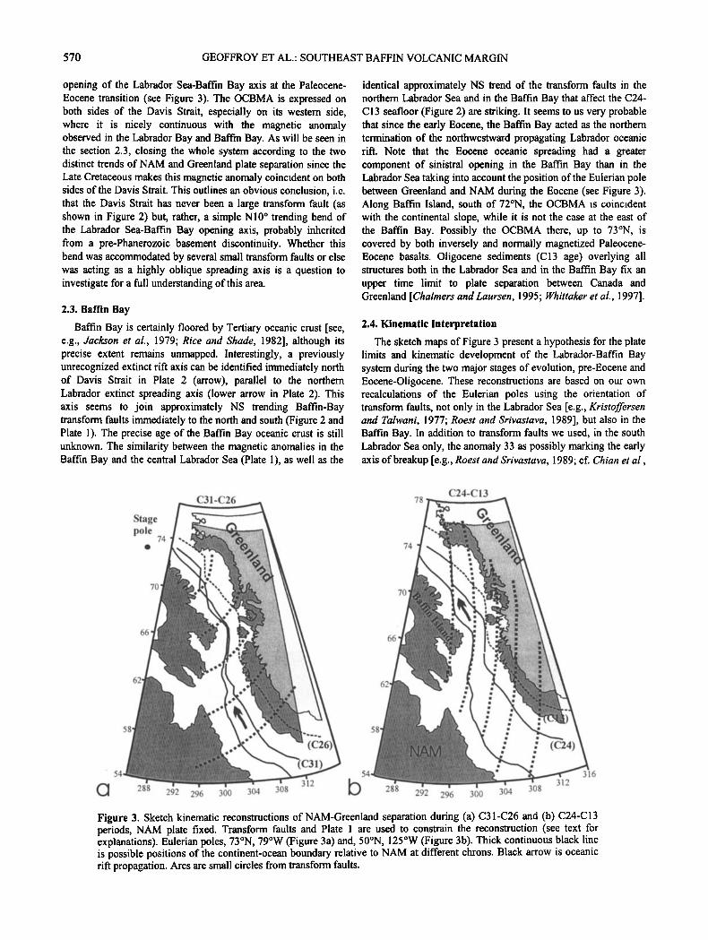
The sketch maps of Figure 3 present a hypothesis for the plate limits and kinematic development of the Labrador-Baffin Bay system during the two major stages of evolution, pre-Eocene and Eocene-Oligocene. These reconstructions are based on our own recalculations of the Eulerian poles using the orientation of transform faults, not only in the Labrador Sea [e.g., Kristoffersen and Talwani, 1977; Roest and Srivastava, 1989], but also in the Baffin Bay. In addition to transform faults we used, in the south Labrador Sea only, the anomaly 33 as possibly marking the early axis of breakup [e.g., Roest and Srivastava, 1989; cf. Chian et al.,
Stage •• C31-C•••.• pole
.' •'•... • •:.'.•-•. ß
' 54 •- ...:,•...•,• 288 292 296 300 304 308
(c26)
312
C24-C13 78
74 ß
:.:•.•.-. .•
66 • • /" ' -•:• • •. • •
.,
•" '' 3•6
288 292 296 300 304 308 Figure 3. Sketch kinematic reconstructions of NAM-Greenland separation during (a) C31-C26 and (b) C24-C13 periods, NAM plate fixed. Transform faults and Plate 1 are used to constrain the reconstruction (see text for explanations). Eulerian poles, 73øN, 79øW (Figure 3a) and, 50øN, 125øW (Figure 3b). Thick continuous black line is possible positions of the continent-ocean boundary relative to NAM at different chrons. Black arrow is oceanic riff propagation. Arcs are small circles from transform faults.

GEOFFROY ET AL.: SOUTHEAST BAFFIN VOLCANIC MARGIN $71
1995, Figure 2]. Our reconstruction is certainly not the definitive one for this complex area, and significant improvements shall notably occur when the crustal structure and nature of the Baffin Bay and Davis Strait become better constrained. Note, however, that the a posterJori fitting of the OCBMA on both sides of the opening axis is quite good using this reconstruction.
The important point is that although there is large uncertainty in the location of the OCBMA southeast of the Baffin Bay, the Disko-Svartenhuk area was certainly located front and north to a bending of the Baffin Bay axis during the Paleogene (period C24- C13). As seen hereinafter, this bending had strong effect on the along axis structure of the exposed margin.
3. Disko-Svartenhuk Area and the Thulean Plume
An extensive amount of onshore [Clarke and Pedersen, 1976] and offshore [Klose et al., 1982; Chalmers et al., 1995] Tertiary basalt is known in the Baffin-Bay/Labrador-Sea area, representing, probably, a total volume of up to 300,000 km 3 [Graham et al., 1998]. Basalts crop out from Disko to Svartenhuk (Figure 4) as well as in Baffin Island (Cape Dyer; Plate 2). They form prominent piles of volcanic breccias, tuffs and lavas (up to 5-7 km in thickness locally, 2 km on average) [Clarke and Pedersen, 1976; Storey et al., 1998]. South of the area, the extrusion of basalts apparently occurred in two steps [Storey et al., 1998]: 2 km of early Paleocene olivine-rich breccias and flood basalts were emitted in- 1 m.y. followed, 5 m.y. later, by the extrusion of, at the least, a 2-km-thick lava pile (-52 Ma) [Storey et al., 1998] corresponding to the W-Nugssuaq outcrops. North of the area, in Ubekendt-Ejland and Svartenhuk, the stratigraphy and petrology of the lowermost part of the tholeiitic volcanic series resembles the Paleocene-in-age Mg-rich formations of the southern area. The remaining thick volcanic pile could be analogous in age with the Eocene basalts of the southern area. The large volumes of picritic magmas in the initial products [Clarke and Pedersen, 1976] suggest melting from an anomalously hot mantle. This aspect, as well as He isotope composition [Graham et al., 1998], suggests an origin through the partial melting of a primitive mantle. As the west Greenland early basalts are similar in age to the east Greenland lower series [Hitchen and Ritchie, 1993; Tegner et al., 1998] and to basalts from the British Tertiary Igneous Province [Hitchen and Ritchie, 1993], they have long been proposed to be associated with the melting of the head of the early Icelandic mantle plume (Figure 1).
The early Paleocene breccias overlie a thick formation of Cretaceous to Early Paleocene sediments, predominantly deltaic, with marine affinity increasing northward (Figure 4). This sedimentary basin has a complex rift-like structure [Chalmers, 1991 ], which is still poorly constrained in the Disko-Svartenhuk area. However, north of 73øN, the horst and graben structure of the Melville Bay basin (Figure 2) [Whittaker et al., 1997] may illustrate the structure of the partly masked Disko-Svartenhuk basin. Along Greenland, both the Melville and Disko-Svartenhuk basins are separated from the Precambrian basement by a complex of large down-to-the-west normal border faults (Figure 4). Most of the major faults active during the Mesozoic-early Paleocene rifting are blanketed by the plume-associated lavas. This important observation means that extension in the exposed basin stopped or else mostly shifted oceanward during the early
Paleocene, as the area suffered an important uplift (> 500 m), perhaps correlated to the plume impact [Dam et al., 1998].
We shall not consider anymore, in this paper, the detailed structure of the Mesozoic sedimentary basin which developed before the plume impact and decompression. In this paper, we are especially concerned with the existence, location, amount and orientation of extension coeval with the plume melting and with the successful breakup between North America and Greenland during the Tertiary period• As seen hereinafter, a real volcanic margin developed during the Paleogene, with a distinct geometry relative to the previous sedimentary riff. A major aim of this paper is to describe the evolution of this volcanic margin along the 300 km long Disko-Svartenhuk area, north of the Davis Strait (Figure 2).
We conducted three field summer expeditions in W-Greenland (1995, 1996, 1997) collecting more than 4000 quantitative tectonic and volcano-tectonic measurements, as well as numerous rock samples, in order to constrain the tectonic development of this margin during the Paleogene breakup between NAM and Greenland.
4. Structure and Construction of the West
Greenland Volcanic Margin
We shall first consider the first-order structures affecting the exposed margin to better define its general geometry. However, these major structures do not provide key indications such as the trends of extension during the development of the margin. Therefore, in a second stage, we shall present a more detailed quantitative tectonic study giving some keys to understand the tectonic and kinematic evolution of this margin.
4.1. First-Order Structures and Margin Segmentation
4.1.1. Across-strike structure. From northern Disko to
Upernavik the western coast of Greenland is characterized by the major oceanward flexure of a thick pile of basalts of Paleocene- Eocene age (Figure 4 and Plate 3) [Henderson, 1973]. As seen hereinafter, the axis of this west Greenland flexure varies in trend along-strike. One has to constrain the time and space relationships between this flexure and the inland horizontal traps in order to interpret the flexure geodynamically.
In the inland area (Figure 4 and Plate 3) the basalts were extruded subaerially during the Paleogene with an uniform horizontal geometry, often filling the topographic relief inherited from the Late Cretaceous rifted topography [Geoffroy et al., 1998; Geological Survey of Greenland, 1993]. Extension coeval with volcanism is marked by conjugate normal and strike-slip faults with small throws [Geoffroy et al., 1998] (Plate 4a). Few larger normal faults displace the lower part of the basalts with hectometric-in-scale throws. The upper basalts cancel them in most cases. All of them develop at the emplacement of the large Mesozoic faults of the sedimentary basin that they thus slightly reactivated during the Paleocene.
In the whole Disko-Svartenhuk area, the sharp transition from inland subhorizontal plateau basalts (Plate 4a) to coastal flexed basalts (Plate 4b) clearly defines an across-strike oceanward strain gradient (Figure 4 and Plate 3) [Geoffroy et al., 1998]. The Ubekendt and south Svartenhuk coasts are the best places to define the geometry and evolution of the west Greenland coastal

572 GEOFFROY ET AL.: SOUTHEAST BAFFIN VOLCANIC MARGIN
72N
681V
70N
!
,
308E
mgal 160 150 140
- 130 - 120 - 110
•:-' t- 100 90 8O 70 60 5O 40 3O 2O 10
0 -10 -20 -30 -40 -50 -60 -70 -80
310E
Plate 2. Satellite-derived free-air gravity map [Sandwell et al., 1994] of the Labrador Sea and Baffin Bay (B. Bay) area. Arrows indicate the location of the Labrador Sea and Baffin-Bay extinct spreading axes. 1, Possible Riedel- type sinistral faults limiting crustal blocks (two of them are underlined by a thin white line). 2, Limit between transitional-type crust and continental crust, after Chalmers and Laursen [1995]. 3, Cretaceous continent-ocean transition, after Srivastava and Roest [1999]. D, Disko. N, Nugssuaq. U.E., Ubekendt Ejland. S, Svartenhuk. C.D., Cape Dyer.

GEOFFROY ET AL.: SOUTHEAST BAFFIN VOLCANIC MARGIN 573
North segment
N=965 ax=59 Max=121
•L '• ] .Max=31 Max=168
N JV=209 Max JV=11 Max JV=9 N JN=159 Max JN=21 Max JN=20
Max JV=37
f h
Central segment ~ Max=13
N=272. Max=
- e c
N Jr=74 Max JV=9
Max JV=21 Max JN=8
ß •
h
Disko segment
N=431 Max=30 -!
c•-.
Max=19
Max=73
M =1 •"'•d Max=85
e
( Svartenhuk
nh
( ,
1
,,,,6
7
South Ubekend Nugssuaq
%9X' -7 1o 11
•14 15 Plate 3. (left) Detailed tectonic analysis of lava beds, dikes and normal faults. (right) Structural map of the Disko- Svartenhuk area showing the three main margin segments and indicating the main strain gradients. Stereograms are lower hemisphere Schmidt projection of poles of lava beds. 1, Normal faults: a, strike; b, trend of dip, c, trend of plunge of slip-vectors on faults; d, dip of faults; e, pitch of fault-slip vectors. 2 and 3, lava beds and dikes, showing f, strike; g, trend of dip and h, dip. 4, 5 and 6, across-strike strain gradients (4, flexure gradient over 1.5 ø/kin; 5, between 1 and 1.5 ø/km; 6; below 1 ø/km). 7, along-strike flexure gradient. 8, tabular stratigraphy (average dip < 2ø). 9, approximate inland limit of synvolcanic crustal flexure. 10, magmatic intrusive center. 11, postulated intrusive center from gravity and petrological data. 12, major faults in basalts. 13, sites of measurements. 14, trend of Greenland-NAM plates separation. 15, trends of regional (large arrow) and local (small arrow) extension in the Disko-Svartenhuk area.

574
l
70 ø
I\
55 ø
, 50 km
r'=l 1
r• 3
•4
!
it ! 1
DISKO
.I.
Figure 4. Geological map of the Disko-Svartenhuk area. After Clarke and Pedersen [1976] and Dunham [1974], strongly modified. 1, Late Cretaceous-early Paleocene sedimentary formations. 2, Lower basalt formation (Paleocene). 3: Upper basalt formation (Paleocene-Eocene). 4, Major sill. 5, Granophyre intrusion. 6, Precambrian basement. 7, Volcanic neck. 8, Strike and dip of lavas. 9, Interpreted fault. 10, Mapped Fault. 11, Onshore limit of the exposure of Cretaceous Basin.

GEOFFROY ET AL.' SOUTHEAST BAFFIN VOLCANIC MARGIN 575
.:.• * .:.- •,.*;..'..,:.•. ..
•. .... .:
N
X1 -axis of maximum finite stretching
N.B. The prebasaltic sedimentary formations are not represented
Figure $. Schematic interpretation of the 3 D structure of the west Greenland volcanic margin at the scale of the Svartenhuk segment only. This figure is based on the interpretation of Geological Survey of Greenland geological maps [Geological Survey of Greenland, 1993] constrained by our field observations. An identical pattern is proposed for Ubekendt-Ejland and NW Disko, although the large continentward fault controlling the inland flexure is probably located offshore.
flexure (Figure 4 and Plate 3), as the hinge line of the flexure is too close to the coastline in Disko and Nugssuaq to get a full appreciation of its across-strike structure. Everywhere, stretching coeval with the coastal flexure and with the outburst of the upper part of the volcanic pile was significantly greater than in the inland plateau basalts, although still poorly quantified (Plate 3). A number of medium-scale (throws > 30 m; Plate 4b) or smaller- scale continentward dipping faults (Plate 4c) accommodate the seaward flexure [Munther, 1973; Dunham, 1974; Geoffroy et al., 1998, 1999]. Several major continentward dipping normal faults (with vertical throws > 0.5 km) are observed or inferred, often expressed in the topography by valleys or fjords. The existence of hidden major continentward-dipping normal faults,'subparallel to the axis of the flexure is geometrically necessary to explain (1) the high dip of the flexured lavas [Munther, 1973] (Figure 4 and Plate 3) and (2) the frequent increase in the dip and cumulative thickness of lava flows and projections near the valleys, which suggests syntectonic control of extrusion and deposition of the lava and tuffs. Concerning the flexured lavas, an average dip of 25 ø for the lava pile in southern Svartenhuk would lead, if there were no normal faults, to a thickness of more than 9 km of basalts, probably twice as much as the actual value [Munther, 1973]. Small angles (< 10 ø) local angular discordances are common in the lava pile. The bottom to top decrease in dip of the lava formations is everywhere the rule along the studied profiles, suggesting fan-like geometries. The discordance angles that we observed are always open seaward and often close to the main faults in valleys. Also, hectometric- to kilometric-scale frequently asymmetric grabens can be recognized locally in the lower and
intermediate parts of the lava pile. These are filled with syntectonic volcano-sedimentary deposits and then covered discordantly by lavas or tuffs, secondary tilted seaward. In Svartenhuk (Figure 5) the continentward throw of the largest of the faults, the Arfertuarssuk fault (Figure 4), exceeds 2 km (our deduction and T.C.R. Pulvertafi, personal communication, 1999) (Plate 3). This fault controls the flexure of its hanging wall on the east, for a distance of more than 50 km, with lava dips reaching up to 40 ø (Figure 5). Interestingly, the throw along this major fault (as well as along the largest other continentward dipping faults) decreases northward as does the average dip of the basalts (Figures 4 and 5). A less pronounced flexure is observed west of the Arfertuarssuk fault (Figure 5).
4.1.2. Along-strike onshore structure. The exposed Baffin Bay eastern margin is segmented along its length into a "zigzag" structure. This pattern resembles the "zigzag" pattern of the OCBMA (Figure 3).
From south to north, the exposed coastal flexure strikes NW to N-S in Disko, NE in western Nugssuaq, and NW from Ubekendt- Ejland to Svartenhuk (Figure 4 and Plate 3). The straight Nugssuaq NE trending segment has an intrusive center at each end, the Ubekendt-Ejland center [Clarke and Pedersen, 1976; Whittaker, 1996] and the postulated NW-Disko centre [Clarke and Pedersen, 1976] (Plate 3). Lamprophyres and volcanic necks at the NW part of Disko have provided young ages (37 and 27 Ma, respectively) [Storey et aL, 1998]. This indicates•a long-term persistence of magmatic activity at the location of igneous centers, much after the main lava extrusion, as is commonly observed throughout the Thulean Province [e.g., Hitchen and

576 GEOFFROY ET AL.: SOUTHEAST BAFFIN VOLCANIC MARGIN
Plate 4. (a) Example of tabular stratigraphy of the inland basalts of Disko Island (Mellern•ord). Note the existence (arrows 1 and 2) of newly formed conjugate normal faults or shear joints with nonsignificant throw. (b): Seaward dipping flows in the coastal flexure in southern Svartenh•k (SW on left, NE on right) and example of a low-dipping continentward dipping fault, nearly perpendicular to the lava beds. The down-slip throw of-40 m is indicated by the displacement of the level associated with arrow 1. This fault follows an older dike (arrow 2), which we infer was tilted after an early stage of injection during crustal flexing. (c): Detail of a continentward normal fault in south Svartenhuk, which we infer was initiated with a 60 ø dip before the westward flexing of the lava pile and was then tilted to low angle by the westward flexing. 1, displaced lava bed; 2, fault plane; and 3, small-scale conjugate normal faults inferred to be tilted and steeped from an initial dip to the west at- 60 ('.

GEOFFROY ET AL.: SOUTHEAST BAFFIN VOLCANIC MARGIN 577
Ritchie, 1993]. In W-Nugssuaq, the NE trending segment includes the steeply NW dipping Itivdle normal fault (see section 4.1.3.; Figure 4 and Plate 3).
The dips of the oceanward flexure increase along strike toward the two igneous centers (Plate 3). This pattern defines first-order longitudinal strain gradients (Plate 3).
4.1.3. Offshore structures in the basalts. Early petroleum exploration [Dunham, 1974] and recent multifold reflection seismic investigations in the southern Baffin Bay [Whittaker, 1996] provided preliminary results about the offshore structure of southern Baffin Bay.
From Disko to Ubekendt-Ejland the margin is bounded by a fault system (Figure 2) trending NS offshore Disko to N35øE offshore Nugssuaq and NW west of Svartenhuk, subparallel to the coastal flexure. The faults recognized offshore through reflection profiling along the Disko coast and affecting the basalts have both continentward and seaward dips [Whittaker, 1995; 1996]. One of these faults, west of Disko, is a major seaward dipping NS trending structure (see its expression in the free-air gravity map, Plate 2) [Chalmers et al., 1999]. All of the offshore faults offset the top of the basalts and are coeval to part of the marine sedimentary section located over the basalts. These faults postdate the faults which were synchronous with and controlled the construction of the onshore-exposed seaward-open volcanic prism (see discussion by Geoffroy et al. [1999]) (e.g., Figure 5). They seem (1) post magmatic and (2) tentatively associated with the readjustments of the volcanic pile during its posttectonic late- Eocene to Oligocene thermal subsidence. Some of these faults probably reactivated larger faults blanketed by the basaltic pile, inherited from the Cretaceous rift system or the Precambrian basement.
Onshore, in west Nugssuaq, the westward dipping Itivdle fault (Figure 4) is often considered as the onshore continuation or a branch of the largest seaward dipping discontinuity observed west of Disko. It parallels the trend of the west-margin OCBMA in the Davis Strait area, so we suggest it probably corresponds to an old discontinuity reactivated during the Mesozoic and the Cenozoic. Note that the coastal flexure is seaward (i.e., westward) from this fault in Nugssuaq.
The internal attitude of the offshore lava pile is unknown from seismic reflection due to the too strong reflectivity of the top of the lavas (see discussion by Geoffroy et al. [ 1999]). Therefore no seaward dipping basalts analogous to SDRS could be recognized offshore, immediately west of the sharp coastal flexure. This may also mean that the conspicuous onshore coastal flexure either (1) ends up close to the coastline or (2) is blanketed by more recent subhorizontal lavas [Geoffroy et al., 1999]. The "intrabasement reflections" in Rice and Shade's [ 1982] Figure 15 probably correspond to eastward dipping SRDS facing the Disko- Svartenhuk half-margin, in continuity of the Cape Dyer volcanics. Similar conjugate westward dipping SDRS have not yet been formerly recognized in the Disko-Svartenhuk basin but probably exist.
The timing and orientation of flexing and extension during the plate breakup between North America and Greenland across and along this Paleogene margin will be addressed in section 5 through quantitative study of smaller scale structures.
5. Tectonic and Magmatic Extension During the Flexing of the Margin 5.1. Data Collection
We present a statistical analysis of the orientation at all scales of normal faults (including slip-vector orientation), as well as basaltic dikes and lavas from the three margin segments: (1) the Disko segment, (2) the Svartenhuk-Ubekendt Ejland segment, and (3) the Nugssuaq segment, west of Itivdle fault (Figure 4 and Plate 3). The Disko data reported in Plate 3 were already discussed by Geoffroy et al. [1998].
Normal faults dominate in number and amount of
displacement in the Nugssuaq-Svartenhuk area (-1200 faults). We also measured the orientation of up to 630 minor strike-slip faults (slip-vectors with pitches lower than 45 ø ) as well as numerous hydrothermal veins. The vein geometries resemble the geometry of dikes to be described and will not be discussed further. As previously remarked in Disko by Geoffroy et al. [ 1998], most of the strike-slip faults are (1) very minor structures with throws not exceeding 10 cm and (2) linked to normal faulting through simple a l/a2 principal stresses permutations, a common occurrence in extensional volcanic areas [Geoffroy et al., 1994]. As the observed strike-slip faulting had no obvious effects on the tectonic development of the area, we shall not consider anymore its meaning in the present paper.
5.2. Tectonic Extension and Flexing of the Margin
The data on normal faults reported in Plate 3 include fault- strike, trend of dip of faults, azimuth of slip-vectors, fault dip values and pitch of slip-vector on fault planes [cf. Angellet, 1989]. All data come from the coastal flexed area and not from the tabular area. Also reported in Plate 3 are the orientations of lava flows and dikes.
Note that although basaltic lavas sometimes present intensive thermal jointing, the great majority of minor faults (with 1 cm to 5 m throws) in basalts (•- 70%) were newly formed faults, cut the joints, and exhibit a simple Andersonian conjugate pattern (Plates 4a and 4c). In the other cases, inherited joints (or faults) apparently presenting the best orientation with regard to the stress tensor were recruited. Larger faults (with displacements over 5 m) commonly are along older dikes (and in this case are subperpendicular to the lava bedding; see Plate 4b). Some of the larger faults correspond to the continentward dipping faults of early conjugate systems since tilted by a later stage of margin flexure, the other one (seaward dipping) aborting (Plate 4c).
Analysis of the structural data (Plate 3) can be summarized as follows:
1. In each of the three segments most of the normal faults strike subparallel to the local axis of the flexure. This could suggest that the extension was everywhere subnormal to the flexure, independently of its orientation. In more details, in the northern segment and in Disko the component of lateral shear on dip-slip normal faults is nearly identically sinistral or dextral (compare stereograms c and a of the north and Disko segments). However, the sinistral components seem to dominate in the west Nugssuaq Eocene-in-age basalts. This latter aspect is indicated by the trend of plunge of slip-vectors, which are dominantly E-W

578 GEOFFROY ET AL.: SOUTHEAST BAFFIN VOLCANIC MARGIN
(stereogram c, central segment, Plate 3), whereas normal faults trend NNE (stereogram a, central segment, Plate 3). This component of oblique tectonic extension in west Nugssuaq basalts is moderate, < 20 ø in amplitude. The Itivdle fault is associated with a significant vertical Palaeogene throw (> 2 km according to all published studies). The Eocene E-W to NW-SE trend of extension in west Nugssuaq is slightly oblique on the perpendicular to the trend of this fault. This apparent obliquity was probably responsible for a slight component of sinistral shear on the inherited fault plane during the Eocene functioning.
2. The asymmetry in dip direction of the normal fault planes (Plate 3b) and in the trend of plunge of slip-vectors (Plate 3c) slip-vectors being considered as parallel to shear stresses on fault planes [see Angelier, 1989], marks the importance of the continentward dipping shear inside the flexure. This also outlines a common field observation for the larger faults, i.e., the rotation (and flattening) of early newly formed faults (and steepening of conjugate partner faults) as a consequence of the margin flexing, in a direction opposite to the tilt of lava flows. This is especially true in the northern margin segment where most of the faults were observed in the older, Paleocene flows, which are the most tilted.
5.3. Magmatic Dilatation
5.3.1. Dike swarms parallel to the axis of margin segments. A dike swarm parallels the axis of the coastal flexure, whatever its local trend (Plate 3f) [Geoffroy et al., 1998]. The magmatic extension associated with this swarm is mostly normal to the axis of the flexure, that is, parallel to the dominant direction of extension by normal faulting. Magmatic dilatation does not exceed 2-5% in average on the exposed area.
If one considers (1) that noninherited dikes are analogous to mode-I fractures and (2) that the vertical lithostatic pressure is one of the principal stresses in the upper crust, dikes are thought to inject vertically. Most of the dikes dip opposite to the dip direction of the tilted lavas (Plates 3g and 3h). These opposing dips for the dikes compared to the lavas suggest that vertical dikes were injected early in the flexure development and were passively tilted during the margin flexing. Field observations show that a majority of dikes are perpendicular to tilted beds as if tilted from vertical during flexure. Other dikes show smaller deviation from vertical than the dip of the beds and are interpreted as having been injected vertically during the incremental steps of margin flexing, so they are less tilted. In Plate 5 the reddish dikes parallel in strike to the lava beds were injected vertically when the flexure had already a-10 ø dip to the southwest and were passively tilted 50-7 ø seaward, whereas the flexing continued. Identical conclusions were reached in Disko [Geoffroy et al., 1998]. This analysis suggests that vertical dikes were emplaced throughout the flexing of the margin, most of them before any tilting of early tabular lavas and during the following flexing increments. Therefore dike geometry confirms the result from angular discordance in the lava pile that the W- Greenland coastal flexure is synmagmatic. The preceding reasoning is based on vertical and horizontal principal stresses in the crust, a conclusion of many in situ measurements [e.g., Engelder, 1993]. It should not be forgotten, however, that important stress modifications are known to occur inside flexures at all scales, such as extensional stresses plunging toward the dip
of the flexure [Jaeger and Cook, 1969]. Such stresses are strongly controlled by the unknown erosional topography at the time of flexuring. However, oblique stresses during flexuring would not change the above conclusion that the flexure is synmagmatic.
5.3.2. Dikes oblique to margin flexing. Two dike swarms are recognized in the Disko area, striking approximately NS and NW-SE, probably reflecting two separate trends of extension [Geoffroy et al., 1998]. In addition, in the Svartenhuk NW trending margin segment (Plate 3), dikes in a subsidiary swarm strike ENE, perpendicular to the main swarm (Plate 5). This across-strike dike swarm in the northern part of the west Greenland volcanic margin deserves particular attention. This swarm indicates inflation in a NNW-SSE or NS direction of
transtension. Up to 5% extension has been locally estimated from this across-strike swarm. Although some subparallel normal faults and strike-slip faults are mechanically consistent with this dike intrusion, magmatic extension seems to predominate over tectonic extension in the NS trend. Magma overpressure normal to dike walls [e.g., Pollard and Segall, 1987] may increase the magnitude of the minimum horizontal stress leading to an interchange in the horizontal plane between •3 and (•2 in a N- type stress regime. This new stress regime may lead to magma fracturing in a perpendicular direction. However, in Svartenhuk, the distance between dikes seems too large to interpret the two swarms as mechanically associated.
Because dikes parallel to the coastal flexure were injected throughout its evolution, dating these dikes represents a convenient way to date the flexing itself. In addition, the two main dike swarms in southern Svartenhuk may reflect very different trends of magmatic extension, approximately trending NE-SW and N-S. We therefore concentrated our study on the analysis of these two swarms and investigated their relative and absolute ages.
5.3.3. K-At dating of the two generations of dikes. In the field the NW trending dike swarm both crosscuts and is crosscut by ENE trending dikes. Such relationships suggest a contemporaneous injection of the two sets of dikes. Our dating experiments focused on five basaltic dikes of the southern coast of the Svartenhuk peninsula (Figure 4). Results are tabulated in Table 1. Two of these samples belong to the N50-70 striking dike generation (GR24, GR6b), three come from the N130-150 generation (GRlla, 134, b2). These dikes are aphyric, all displaying a doleritic texture with interlocked clusters of plagioclase microphenocrysts set in a groundmass of very fine grained olivine, plagioclase (+ clinopyroxene), and disseminated opaques. Alteration of olivine into iddingsite ñ chlorite (both in groundmass and rare relict microphenocrists) is ubiquitous and well developed in all samples analyzed. Plagioclase appeared the least altered phase in all samples examined and was selected for K-Ar dating. Nearly pure mineral separates were obtained by crushing and sieving to 150-180 gm, with density separation and further magnetic separation to remove primary olivine- and plagioclase-hosted opaques and other stained alteration phases. No acid etching was applied prior to Ar analysis. Between 30 and 300 mg of plagioclase separates were dissolved in diluted HF + HNO3, and the evaporated residues dissolved with C1Cs in deionized water for triplicate K analysis by atomic and flame emission spectrophotometry. The argon isotopic composition and abundance were determined in duplicate by the unspiked

GEOFFROY ET AL.: SOUTHEAST BAFFIN VOLCANIC MARGIN 579
Table 1. K-Ar Dates of Basaltic Dikes (With Orientations) Belonging to the Two Swarms From Svartenhuk
Sample Geographic Mass, g K, wt % Ar*, • % Ar*, • lx10 -•3 atom/g Age +lc•, Ma Orientation
GR24 N64øE,85øS 0.30130 0.064 + 5.0 27.6 + 0.6 0.37 + 7.6 55.0 + 2.7 - 0.60289 24.8 + 0.4 0.36 + 6.7 53.7 + 2.7
GR6b N72øE,75øS 0.30117 1.852 + 3.5 72.6 + 2.0 10.88 + 5.1 55.4 ñ 1.9 - 0.09976 71.2 + 5.7 11.07 + 5.1 56.4 + 2.0
GR1 la N152øE,66øE 0.30015 0.259 + 4.5 57.7 =• 0.2 1.50 + 5.4 54.5 + 2.4 - 0.36761 54.9 + 0.1 1.52 + 5.2 55.3 + 2.5
[34 N127øE,78øN 0.06079 1.594 ñ 1.0 34.0 + 0.2 9.15 + 5.4 54.1 + 0.6 - 0.30008 37.1 + 0.1 9.19 ñ 5.1 54.4 + 0.6
b2 N117øE,72øN 0.05257 1.362 ñ 1.3 17.0 ñ 5.9 7.89 + 5.9 54.7 + 0.8 - 0.03730 15.3 ñ 1.3 7.94 •: 0.3 55.0 + 0.8
•Ar*, radiogenic Ar.
technique [Gillot and Cornette, 1986] without further treatment of the separates. Ages are reported at +1 c• and were calculated using recommended isotopic abundances and decay constants [Steiger and aliiget, 1977]. The K content of the different separates varies by a factor of 30 between 0.064% (sample GR24) and 1.85% (GR6b), the low K abundance (and associated poor precision) being the primary source of uncertainty in most age determinations.
Our five ages cluster around 54.6 + 0.6 Ma (mean and standard deviation of the pooled mean) and are statistically not resolved within their individual error limits. Our pooled estimate for these samples (54.6 Ma) is fully consistent with the 4øAr/39Ar ages determined on two N-S and NW-SE trending basaltic dikes from Disko and Nugssuaq that yielded concordant flat release spectra at 53.6 + 0.5 Ma and 54.8 ñ 0.5 Ma (external errors rounded to 1%) [Storey et al., 1998].
Our K-Ar results are consistent with relative chronology evidence, suggesting that the different generations of dike emplacement occurred within a very short interval around 54.6 ñ 1.5 Ma, that is, lower Eocene, during chron 24 [Cande and Kent, 1995]. As Table 1 shows, the dikes trending N130-150 (i.e., parallel to the axis of the flexure) were formed early in the flexure evolution as they present a continentward tilt similar in amplitude to the local seaward dip of lavas. We can thus affirm that most of the crustal flexing postdates these ages, that is, is of Eocene age. Our data further demonstrate that the two contemporaneous trends of magmatic extension in Svartenhuk can be temporally related to the major plate reorganization at the C25-C24 boundary.
As (1) the NW-SE trending dikes are mechanically consistent with the major tectonic extension recorded by faults and the seaward flexure and (2) NW trending late Eocene dikes are also known in Ubekendt-Ejland [Storey et al., 1998], we conclude that the main structuring regime was a NE-SW to locally EW extension throughout the Eocene along the Baffin Bay volcanic margin.
6. Discussion and Conclusion
We can infer important and new conclusions about the development of the west Greenland volcanic margin over the Thulean mantle plume. We shall focus, in this conclusion, on two major points: (1) the four-dimensional structure of the margin (spatial evolution through time), and (2) the relationships between margin deformation, plate kinematics, plume activity, and early oceanic accretion in the Baffin Bay.
6.1. Margin Structure
During the early part of the Eocene epoch (C24), the west Greenland coastal area flexed seaward during the extrusion of the Eocene part of the plume-related basaltic pile (Figures 6a and 6b). Perhaps the flexure began as early as the late Paleocene, but if so the flexing rate was much slower then. As shown by the tilting of along-strike dikes, a sudden increase of crustal flexing occurred probably during the extrusion of the uppermost 2 km of Eocene basalts i.e. at the possible time of complete plate separation and earliest oceanic accretion between North America and Greenland (note also that according to Storey et al. [1998] an angular discordance is known at the base of the postulated Eocene series in Ubekendt-Ejland). The Disko-Svartenhuk margin as a whole seems to typify what is observed at any scale in the exposed area (from outcrop scale to 100 km in length of cross section): The synextension and synmagmatic crustal flexing of the margin was accommodated by continentward dipping faults progressively tilted and inactivated (blanketed by volcanics) as the flexure developed seaward (Figure 6b). The west Greenland flexure mimics remarkably the east Greenland tectonic flexure, which also exposes, along the coastline, stretched seaward dipping basalts associated with continentward dipping normal faults [e.g., Nielsen, 1975; Nielsen and Brooks, 1981; Neuhoff et al., 1997]. Geoffroy et al. [1998, 1999] have proposed that the Greenland onshore-exposed seaward dipping basalts presented strong analogies, although in continental domain, with offshore SDRS whose internal structure remains enigmatic. Analogous continental SDRS-like prism (or "seaward dipping volcanics", SDV, as in Figure 6b) with clear rollover geometry and continental-dipping faults has also been identified offshore in the Aden Gulf [Tard et al., 1991]. Similarly, Barton and White [1997, Figure 6] also describe fault-controlled internal SDRS prism in continental domain at Edora Banks in the North Atlantic. Margin internal SDRS are imaged in Namibia at the edge of the Africa craton at the top level of a transitional-type igneous crust [Baer et al., 2000]. Note, finally, that the analogy in structure between the Greenland internal continental SDRS-like
prism and SDRS prisms at the continent-ocean boundary in Norway seems strikingly identical from unpublished commercial data (L. Gernigon et al., personal communication, 1999), suggesting a common mode of emplacement and deformation. It is hypothetically suggested by Geoffroy et al. [1999, Figure 5] that the west Greenland margin at the latitude of Svartenhuk- Ubekendt Ejland is made of two magmatic-infilled rollover anticlines controlled by continentward dipping shear zones

580 GEOFFROY ET AL.' SOUTHEAST BAFFIN VOLCANIC MARGIN
ß \
.
- ,

GEOFFROY ET AL.: SOUTHEAST BAFFIN VOLCANIC MARGIN :581
JBefore breakup J Dike swarm
r-a Traps/early ..:,; :::•,,::•.:.:.,:.:,.,.,.•.•.> ,:,.•:.:,.•:•:........::,..:.:..• .......... :.:. • ,.,:.......,.•.:..:.::.<..•.•.,.• ..•:...:.:..,........::...: <:.,..........
.•:%:•:;•:•*•:•<•::::•::•::•:•:•:;.::;;•;:::•:•`:4?•e•:•:•:::•::•:•;•:•`•*•``•
a b
Breakup stage Late Paleocene[?]-Eocene
Newly formed dikes
•'X •lted dikes /.
;S..,,DVi:::..: ...... ß
c
• • Soft area at • depth
Longitudinal • ........ extensional
strain gradient
Central
•i• Far-field intrusive extension centre
Extensional total strain gradient in 2D
Figure 6. Three distinct steps in the development of the seaward coastal flexure (view looking north). (a) Paleocene stage with magmatic extension dominating tectonic extension. Only conjugate normal faults are associated with this stage. Local grabens infilled with lake deposits of hyaloclastites developed during the earlier Paleocene. (b) Late Paleocene (7) to Eocene stage of sudden flexing associated with both the intrusion of some dikes during the flexing and, above all, large horizontal stretching through mainly continentward dipping normal faults. Late Eocene postmagmatic subsidence of the offshore area and possible associated slight reactivation of Mesozoic faults are not represented. (c) Schematic 3-D tectonic organization of the west Greenland volcanic margin at the latitude of the postulated Ubekendt-Ejland "soft-point". No faults are represented. ((a) and (b) are reprinted from Geoffroy [2001 ] with permission from Elsevier Science.)

582 GEOFFROY ET AL.: SOUTHEAST BAFFIN VOLCANIC MARGIN
extending to the probable Baffin Bay oceanic crust. In fact, a duplex organization of seaward flexures whose ages decrease westward is suggested in westernmost Svartenhuk, where tilted basalts are found oceanward of the main fault controlling the observed coastal flexure (Figure 5). Note, however, that the deep offshore structure south of Baffin Bay remains largely enigmatic although Dunham [ 1974] first postulated the existence of offshore SDRS.
The along-strike segmentation and strain gradients recognized along the west Greenland volcanic margin (Plate 3) suggest a complex 3 D organization of the margin with an apparent strong control of the geometry of the margin by the two magmatic centers of Ubekendt-Ejland (Figure 6c) and NW-Disko. The long-lived Ubekendt-Ejland igneous center (Figures 4 and 6c and Plate 3) persisted after plate breakup and basaltic lava extrusions [Clarke et al., 1983], as in many other similar Thulean-related central complexes [Hitchen and Ritchie, 1993]. It marks a "melting point" at depth, as both dike injection and cumulative thickness of basalts (Figure 5) culminate over it. These centers can be inferred to mark the location at depth of small-scale mantle diapirs cross-cutting the lithosphere [Thompson, 1982; Rohrman and Van der Beek, 1996; Geoffroy, 1998]. The location of the two centers near the ends of the inherited Itivdle fault is
unlikely to be fortuitous. In the Hebrides part of the British Tertiary Igneous Province, the early Tertiary igneous centers are also located along the projection tracks of the largest subvertical faults inherited from the late Caledonian, such as the Great Glen Fault [e.g., Vann, 1978]. The increase of margin extension and thickness of volcanic prism toward the west Greenland centers is of prime interest (Plate 3). We propose that these igneous centers and their probable deep melting diapir played a fundamental rheological role during plate breakup. They would act as "soft points" focusing extension toward them (Figure 6c). These melting areas could also be the feeders of part, at least, of the SDRS-like volcanic prisms through lateral injection of magma in dikes [Geoffroy, 2001]. This would explain both the along-axis segmentation as well as extension nearly perpendicular to the NE trending segment. This segment was oblique to the extension which was trending NE-SW to EW. A very similar pattern for the coastal flexure can be observed along the east Greenland volcanic margin, where the coastal flexure is regionally "bent" along its axis, over a distance of up to 200 km, toward the major Kangerdlussuaq igneous complex (including the Skaergaard intrusion) with a clear increase of the intensity of the flexure toward the igneous center. Similarly, there is in eastern Greenland a clear increase of the flexure and of the magnitude of tectonic and magmatic extension toward other magmatic centers extending southward of the Kangerdlussuaq area (Myers [ 1980]; our observations during two summer field campains in east Greenland during 1998 and 1999). We recently performed a 4- layers in-extension continental lithosphere modeling including
nonaligned "soft-points" (silicone punctual putties at the emplacement of the brittle mantle), which strikingly reproduces the observed volcanic margins 3-D tectonic organization in continental domain (J.P. Callot et al., manuscript in preparation, 200•).
6.2. Margin Extension and Geodynamics
By dating the main flexing and tectonic stretching as Eocene, we demonstrate in this paper that the W-Greenland crustal flexure is contemporaneous with the probable earliest stage of oceanization in the Baffin Bay between North America and Greenland. At the scale of the whole margin, the dominant trend of extension is NE-SW, N59øE if the oblique Nugssuaq segment is excluded (unpublished tensorial computation from fault data sets). This regional extension deviates to an EW trend in Nugssuaq because of the effect of the structural inheritance of the Itivdle fault or/and the rheological control of igneous centers. There is, in any case, a strong contradiction between the expected NS trend of plate separation between Greenland and Canada at Eocene time in the Baffin Bay (Figures 2 and 3) and the coeval trend of stretching of the margin. This could illustrate a major point that can also be deduced from tectonic studies along the Aden Gulf northern margin close to the Afar hotspot (P. Huchon and K. Khanbari, personal communication, 2000): the extension along volcanic margins is not controlled solely by far-field stresses associated with plate separation (Plate 3). In west Greenland, only the transient and coeval synmagmatic extension associated with the E-W to WSW-ENE trending dike swarms (and some associated normal faults) can tentatively be associated with the C25-C24 global plate reorganization in this area (in Figure 2, note also that the Tertiary basalts are mapped as bounded by an EW trending extensional fault, south of Melville Bay). Note that the Labrador Sea-Baffin Bay breakup line is subparallel to the general orientation of the Baffin Bay onshore and offshore tectonic flexure (Plates 1 and 2 and Figure 3). This breakup line is itself parallel to the early oceanic axis. Finally, we suggest that extension across the volcanic margin is more likely controlled by the position of magmatic centers related to mantle upwelling and/or by the geometry of structures inherited from the old lithosphere (respectively defining the general trend of the spreading and breakup axes) than by the far-field stresses driving the NS plate-displacement between the North American and Greenland plates (Plate 3).
Acknowledgments. Field investigation in west Greenland was supported by the Institut Francais de Recherche et de Technologie Polaire (IFRTP, program n ø 290). We thank Copenhagen University for the use of the Porsild boat during three summer expeditions. The native crew and skipper of' the PorsiM brought a prime-quality and friendly assistance during numerous delicate operations. We also are grateful to K.A. Howard and B. Schreckenberger for very sound review of this manuscript.
References
Angelier, J., From orientation to magnitudes in paleostress determination using fault slip data, J. Struct. Geol., 11, 37-50, 1989.
Baer, K., S. Neben, B. Schreckenberger, R. Emmermann, K. Hinz, N. Fechner, K. Gohl, A. Schulze, R. B. Trumbull, and K. Weber, Deep structure of the Namibia continental margin as
derived from integrated geophysical studies, J. Geophys. Res., 105, 25,829-25,853, 2000.
Barton, A. J., and R. S. White, Volcanism on the Rockall continental margin, J. Geol. Soc. London, 153, 530-536, 1997.
Bina, M. M., B. Henry, and M. Cannat, Magnetic anisotropy and some other magnetic properties of
serpentinized peridotites from ODP hole 670A, Proc. Ocean Drill. Program Sci. Results, 106-109, 263-267, 1990.
Boillot, G., G. Feraud, M. Recq, and J. Girardeau, "Undercrusting" by serpentinite beneath rifted margins: The examples of the west Galicia margin [Spain], Nature, 341, 523-525, 1989.
GEOFFROY ET AL.: SOUTHEAST BAFFIN VOLCANIC MARGIN 583
Bott, M. H. P., The crust beneath the Iceland-Faeroe Ridge, in Structure and Development of the Greenland-Scotland Ridge, edited by M H. P. Bott et al., pp. 63-90, Plenum Press, New York, 1983.
Brun, J.P., and O. Beslier, Mantle exhumation at passive margins, Earth Planet. Sci. Lett., 96, 161- 173, 1996.
Cande, S.C., and D. V. Kent, Revised calibration of the geomagnetic polarity timescale for the Late Cretaceous and Cenozoic, d. Geophys. Res., lO0, 6093-6095, 1995.
Chalmers, J. A., New evidence on the structure of the Labrador sea Greenland continental margin, J. Geol. Soc. London, 148, 899-908, 1991.
Chalmers, J. A., and K. H. Laursen, Labrador Sea: The extent of continental crust and the timing of the start of sea-floor spreading, Mar. Pet. Geol., 12, 205-217, 1995.
Chalmers, J. A., T. Dahl-Jensen, K. J. Bate, and R. C. Whittaker, Geology and petroleum prospectivity southern West Greenland - a sunm•ary, Rep. Groenl. Geol. Unders, 165, 13-21, 1995.
Chalmers, J. A., R. C. Whittaker, N. Skaarup, and T. C. R. Pulvertaft, Discussion on the coastal flexure of Disko [West Greenland], onshore expression of the "oblique reflectors": Reply, d. Geol. Soc. London, 156, 1051-1055, 1999.
Chian, D., and K. E. Louden, The continental crustal transition across the southwest Greenland margin, J. Geophys. Res., 99, 9117-9135, 1994.
Chian, D., C. Keen, I. Reid, and K. E. Louden, Evolution of non volcanic rifted margins: New results from the conjugate margins of the Labrador Sea, Geology, 23, 589-592, 1995.
Clarke, D. B., and A. K. Pedersen, Tertiary volcanic province of West Greenland, in Geology of Greenland, edited by A. Escher and W.S. Watts, pp. 364-385, Geol. Surv. of Greenland, Copen- hagen, 1976.
Clarke, D. B., G. K. Muecke, and G. Pc-Piper, The lamprophyres of Ubekendt-Ejland, West Green- land: Products of renewed partial melting or extreme differentiation, Contrib. Mineral. Petrol., 83, 117-127, 1983.
Coffin, M. F., and O. Eldholm, Large igneous pro- vinces: Crustal structure, dimensions, and external consequences, Rev. Geophys., 32, 1-36, 1994.
Dam, G., M. Larsen, and M. Sonderholm, Sedimentary response to mantle plumes: Implications from Paleocene onshore successions, West and East Greenland, Geology, 26, 207-210, 1998.
Dunham, L. R., Offshore geology of northern West Greenland, Rep. Groenl. Geol. Unders., 55, 14-18, 1974.
Eldholm, O., Magmatic-tectonic evolution of a vol- canic rifted margin, Mar. Geol., 102, 43-61, 1991.
Eldholm, O., J. Skogseid, S. Planke, and T. Glad- czenko, Volcanic margins concepts, in Rifled Continent-Ocean Boundaries, edited by E. Banda et al., NATO ASI Series: Ser. C, vol. 463, pp. 1-16, Kluwer Acad., Norwell, Mass., 1995.
Engelder, T., Stress regimes in the lithosphere, 457 pp., Princeton Univ. Press, Princeton, New York, 1993.
Geoffroy, L., Diapirism and intraplate extension: Cause or consequence?, C. R. Acad. Sci. Ser. II, 326, 267-273, 1998.
Geoffroy, L., The structure of volcanic margins: Some problematics from the North-Atlantic/Labrador- Baffin system, Mar. Pet. Geol., in press, 2001.
Geoffroy, L., F. Bergerac, and J. Angelier, Tectonic evolution of the Greenland-Scotland ridge during the Paleogene: New constraints, Geology, 22, 653- 656, 1994.
Geoffroy, L., J.P. Gelard, C. Lepvrier, and P. Olivier, The coastal flexure of Disko (West Greenland), onshore expression of the "oblique reflectors", d. Geol. Soc. London, 155, 463-473, 1998.
Geoffroy, L., A. G. Skuce, J. Angelier, J.P. Gelard, C. Lepvrier, and P. Olivier, Discussion on the coastal flexure of Disko (West Greenland), onshore
expression of the oblique reflectors: Reply, J. Geol. Soc. London, 156, 1051-1055, 1999.
Geological Survey of Greenland, GGU 1/100000 geological maps over Greenland, sheets 71 V.1. Nord and Syd, 70 V. 1. Nord and Syd, 70 V.2. Syd, 69 V. 1. Nord, 1993.
Gillot, P. Y., and Y. Comette, The Cassignol technique for potassium-argon dating, precision and accu- racy: Examples from late Pleistocene to recent volcanics from southern Italy, Chem. Geol., 59, 205-222, 1986.
Graham, D. W., L. M. Larsen, B. B. Hanan, M. Storey, A. K. Pedersen, and J. E. Lupton, Helium isotope composition of the early Iceland mantle plume inferred from the Tertiary picrites of West Greenland, Earth Planet. Sci. Lett., 160, 241-255, 1998.
Hamano, Y., M. M. Bina, and K. Krammer, Palcomagnetism of serpentinized peridotites from ODP hole 670A, Proc. Ocean Drill. Program Sci. Results, 106-109, 257-262, 1990.
Henderson, G., The geological setting of the West- Greenland basin in the Baffin Bay region, Pap. Geol. Surv. Can., 71-23, 521-544, 1973.
Hill, R. I., Starting plumes and continental breakup, Earth Planet. Sci. Lett., 194, 398-416, 1991.
Hinz, K., A hypothesis on terrestrial catastrophes: Wedges of very thick oceanward dipping layers beneath passive margins - Their origin and paleo- environment significance, Geol. Jahrb., 22, 345- 363, 1981.
Hitchen, K., and J. D. Richtie, New K-At ages and a provisional chronology for the offshore part of the British Tertiary Igneous Province, Scott. J. Geol., 29, 73-85, 1993.
Holbrook, W. S., and P. B. Kelemen, Large igneous province on the United States Atlantic margin and implications for magrnatism during breakup, Na- ture, 364, 433-436, 1993.
Jackson, H. R., C. E. Keen, R. K. H. Falconer, and K. P. Appleton, New geophysical evidence for sea- floor spreading in central Baffin bay, Can. J. Earth Sci., 16, 2122-2135, 1979.
Jaeger, J. C., and N. G. W. Cook, Fundamental of rock mechanics, 463 pp., Chapman and Hall, New York 1969.
Klose, G. W., E. Malterre, J. McMillan, and C. G. Zinkan, Petroleum exploration offshore southern Baffin Island, Northern Labrador Sea, Canada, in Arctic Geology and Geophysics, edited by A. F. Embry and H. R. Balkwill, Mem. Can. Soc. Pet. Geol., 8, 233-244, 1982.
Kristoffersen, Y., and M. Talwani, Extinct triple junction south of Greenland and the Tertiary motion of Greenland relative to North America, Geol. Soc. Am. Bull., 88, 1037-1949, 1977.
Larsen, H. C., A.D. Saundersand, and P. D. Cliff, Proceedings of the Ocean Drilling Program, Initial Report, vol. 152, Ocean Drill Program, College Station, Tex., 1994.
Le Pichon, X., and J. C. Sibuet, Passive margins: A model of formation, J. Geophys. Res., 86, 3708- 3720, 1981.
Munther, V., Results from a geological reconnaissance around Svartenhuk Halvo, West Greenland, Rapp. Groenl. Geol. Under., 50, 26 pp., 1973.
Myers, J. S., Structure of the coastal dike swarm and associated plutonic intrusions of East Greenland, Earth Planet. Sci. Lett., 46, 407-418, 1980.
Myhre, A.M., O. Eldholm, J. L. Faleide, J. Skogseid, S. Gudlaugsson, S. Planke, L. M. Stuevold, and E. Vagnes, Norway-Svalbard continental margin: Structural and stratigraphical styles, in The Evolution of Atlantic Continental Rises, edited by C.W. Poag and P.C. Graciansky, pp. 157-185, Van Nostrand Reinhold, New York, 1992.
Nazavora, K. A., Serpentinized peridotites as possible source for oceanic magnetic anomalies, Mar. Geophys. Res., 16, 455-462, 1994.
Neuhoff, P. S., W. S. Watt, D. K. Bird, and A. K. Pedersen, Timing and structural relation of regional
zeolite zones in basalts of the East Greenland
continental margin, Geology, 25, 803-806, 1997. Nielsen, T. F. D., Possible mechanism of continental
breakup in the North Atlantic, Nature, 253, 182- 184, 1975.
Nielsen, T. F. D., and C. K. Brooks, The East Greenland rifted continental margin: An exanfi- nation of the coastal flexure, J. Geol. Soc. London, 138, 559-568, 1981.
Pollard, D. D., and P. Segall, Theoritical displacement and stresses near fractures in rocks with application to faults, joints, veindikes and solution surfaces, in Fracture Mechanics of Rocks, edited by B. K. Atkinson, pp. 277-350, Academic Press, San Diego, Calif., 1987.
Rice, P. D., and B. D. Shade, Reflection seismic interpretation and seafloor spreading history of Baffin Bay, in Arctic Geology and Geophysics, edi- ted by A. F. Embry and H. R. Balkwill, Mere. Can. Soc. Pet. Geol., 8, 245-265, 1982.
Richards, M. A., R. A. Duncan, and V. Courtillot, Flood basalts and hot-spot tracks: Plume heads and tails, Science, 246, 103-107, 1989.
Roest, W. R., and S. P. Srivastava, Sea-floor spreading in the Labrador Sea: A new reconstruction, Geo- logy, 1, 1000-1003, 1989.
Rohrman, M., and P. Van der Beck, Cenozoic postrift domal uplift of North-Atlantic margins: An asthe- nospheric diapirism model, Geology, 24, 901-904, 1996
Sandwell, D. T., M. M. Yale, and W. H. F. Smith, ERS-1 geodetic mission reveals detailed tectonic structures, Eos Trans. A GU, 75 (44), Fall Meet. Suppl., F155, 1994.
Schlindwein, V., and W. Jokat, Structure and evolution of the continental crust of northern east Greenland
from integrated geophysical studies, J. Geophys. Res., 104, 15227-15245, 1999.
Srivastava, S. P., Evolution of the Labrador Sea and its bearing on the early evolution of the North Atlan- tic, Geophys. J. R. Astr. Soc., 52, 313-357, 1978.
Srivastava, S. P., and C. E. Keen, A deep seismic reflection profile across the extinct mid-Labrador sea spreading center, Tectonics, 14, 372-389, 1995.
Srivastava, S. P., and W. R. Roest, Extent of the oceanic crust in the Labrador Sea, Mar. Pet. Geol., 16, 65-84, 1999.
Srivastava, S. P., R. K. H. Falconer, and B. MacLean, Labrador Sea, Davis Strait, Baffin Bay: Geology and geophysics - A review, in Geology of the North Atlantic Borderlands, edited by J. W. Kerr and A. J. Fergusson, Mem. Can. Soc. Pet. Geol., 7, 333-398, 1981.
Srivastava, S. P., B. MacLean, R. F. Macnab, and H. R. Jackson, Davis Strait: Structure and evolution as obtained from a systematic geophysical survey, in Arctic Geology and Geophysics, International Symposium on Arctic Geology, Mem. Can. Soc. Pet. Geol., 8, 267-278, 1982.
Steiger, R. H., and E. J/iger, Subcommission on geochronology: Convention on the use of decay constants in geo- and cosmo-chronology track, Earth Planet. Sci. Lett., 36, 359-362, 1977.
Storey, M., R. A. Duncan, A. K. Pedersen, L. M. Larsen, and H. C. Larsen, 4øAr/39Ar geochronology of the West Greenland Tertiary volcanic province track, Earth Planet. Sci. Lett., 160, 569-586, 1998.
Tard, F., P. Masse, F. Walgenwitz, and P. Gruneisen, The volcanic passive margin in the vicinity of
Aden, Yemen, Bull. Cent. Rech. Explor. Prod. Elf- Aquitaine, 15, 1-9, 1991.
Tegner, C., R. A. Duncan, S. Bernstein, C. K. Brooks, D. K. Bird, and M. Storey, 4øAr/39Ar geochro- nology of Tertiary mafic intrusions along the east Greenland rifled margin: Relation to flood basalts and the Iceland hotspot track, Earth Planet. Sci. Lett., 156, 75-88, 1998.
Thompson, R. N., Geochemistry and magma genesis, in Igneous Rocks of the British Isles, edited by D. S. Sutherland, pp. 461-480, John Wiley, New York, 1982.

584 GEOFFROY ET AL.: SOUTHEAST BAFFIN VOLCANIC MARGIN
Toil, P. B., J. Arkani-Hamed, and S. E. Haggerry, The effects of serpentinization on density and magnetic susceptibility: A petrophysical model, Phys. Earth Planet. Int., 65, 137-157, 1990.
Upton, B. G., History of Tertiary Igneous activity in the N-Atlantic borderlands, in Early Tertiary Volcanism and the Opening of the NE-Atlantic, edited by A. C. Morton and L. M. Parson, pp. 429- 453, Geol. Soc. Spec. Pub. London, 9, 1988.
Vann, I. R., The sitting of Tertiary vulcanicity, in Crustal Evolution in NW Britain and Adjacent Regions, edited by D. R. Bowes and B. E. Leakes, pp. 393-414, Geol. Soc. London Spec. issue, 10, 1978.
Verhoef, J., R. Macnab, W. Roest, J. Arkani-Hamed, and members of the project team, Magnetic anomalies of the artic and north atlantic oceans and
adjacent land areas (GAMM-AAS: (G)ridded (A)eromagnetic and (M)arine (M)agnetics of the north (A)tlantic and (A)rtic, 5 kin), Geol. Surv. Can., Open File Rep. 3125a, 1996.
Watts, A. B., and J. D. Fairhead, Gravity anomalies and magmafism along the western continental margin of the British Isles, J. Geol. Soc. London 154, 523-529, 1997.
Wh{te, R. S., and D. P. McKenzie, Magmatism at riff zones: The generation of volcanic continental mar- gins and flood basalts, J. Geophys. Res., 94, 7685- 7729, 1989.
White, R. S., G. D. Spence, S. R. Fowler, D. P. McKenzie, G. K. Westbrook, and A. N. Bowen, Magmatism at rifted continental margins, Nature, 330, 439-444, 1987.
Whittaker, R. C., A preliminary assessment of the structure, basin development and petroleum po- tential offshore central west Greenland, Groenl. Geol. Unders. Open File Set., 95, 1995.
Whittaker, R. C., A preliminary seismic interpretation of an area with extensive Tertiary basalts offshore central West Greenland, Bull. Groenl. Geol. Un- ders., 172, 28-31, 1996.
Whittaker, R. C., N. E. Hamann, and T. C. R. Pulvertaft, A new frontier province offshore northwest Greenland: Structure, basin develop- ment, and petroleum potential of the Melville Bay Area, AAPG Bull., 81,978-998, 1997.
Ziegler, P. A., Evolution of the Arctic-North Atlantic and the Western Tethys, AAPG Mem., 43, 198 pp., 1988.
J. Angelier and C. Lepvrier, D6partement de G•ologie Structurale, Universit6 de Pierre et Marie Curie, 4 place Jussieu, cedex 05, 1•75252 Paris, France. (jacques.angelier•lgs.jussieu.fr; pepe•lgs.jussieu.fr)
B. Bonin and S.Scaillet, D6partement des Sciences de la Terre, Universit• de Paris Sud, Bat. 504, F-91405 Orsay cedex, France.
(bbonin•geol.u•)sud.fr; stephane.scaillet•lsce .cnrs-gif. fr)
J.P. Callot, Laboratoire de G6ologie, UMR 8538 du CNRS, Ecole Normale Sup•rieure, 24 rue Lhomond, cedex 05, F-75231 Paris, France. (callot•geologie.ens.fr)
C. Cayet, J.P. G6lard, L. Geoffroy, K. Perrot and M. Ravilly, Laboratoire de G•odynamique des rifts et marges passives, avenue Olivier Messiaen, F-72017 Le Mans, France. (Jean-Pierre. Gelard•univ4emans.fr; Laurent. Geoffroy•univ-lemans. fr; Karine. Per rot•univ4emans.fr; Morgane. Ravilly•univ- rennesl.fr)
A. Skuce, AEC International, 3700, 707 8th Ave., SW, Calgary, Alberta, Canada T2P 1HS. (As kuce•o il. city in vest. corn )
(Received July 7, 2000; accepted November 6, 2000.)