The Jurassic of Kuhn O, North-East Greenland
28
865 The Jurassic of Kuhn Ø, North-East Greenland Per C. Alsgaard,Vince L. Felt, Henrik Vosgerau and Finn Surlyk The Middle–Upper Jurassic succession of Kuhn Ø, North-East Greenland accumulated in a major half-graben and is an excellent analogue for the subsurface of the mid-Norwegian shelf. On Kuhn Ø, peneplaned crystalline basement was incised by a drainage system during a major base-level lowstand, probably in late Early or early Middle Jurassic times. It was filled with fluvial conglomerates of the newly defined Middle Jurassic Bastians Dal Formation during subsequent base-level rise. As sea level continued to rise, precursor-peat of the coals of the Muslingebjerg Formation formed in swamps which covered the conglomerates and filled the remaining space of the incised val- ley system. The valley and interfluve areas were flooded in Late Bathonian – Callovian times and tidally-dominated, shallow marine sandstones of the Pelion Formation were deposited on top of the valley fill and over the adjacent basement peneplain. These sandstones are overlain by the newly defined shallow marine Oxfordian Payer Dal Formation which is subdivided into a lower unit and an upper unit, separated by a major drowning surface. The Payer Dal Formation sands were flooded in the Late Jurassic and organic-rich, offshore mudstones of the Bernbjerg Formation were deposited. The Jurassic succession of Kuhn Ø can thus be subdivided into large-scale sed- imentary units separated by major drowning surfaces. They are of regional extent, and in com- bination with biostratigraphic and 87 Sr/ 86 Sr isotope data they allow the correlation of the sedimentary units on Kuhn Ø with more offshore deposits to the south in Wollaston Forland and more land- wards successions to the north in Hochstetter Forland. Petrographically, the trough cross-bedded sandstones of the Pelion Formation and the lower unit of the Payer Dal Formation include both calcite-cemented and poorly cemented quartz sand- stones. The calcite cement was derived from dissolution of abundant calcareous fossils and forms concretionary horizons. The upper unit of the Payer Dal Formation mainly consists of weakly- cemented quartz sandstones with porosities around 30%. The sandstones of the Pelion and Payer Dal Formations on Kuhn Ø are petrographically very similar to Jurassic sandstones from the mid- Norwegian shelf and the Barents Sea with regard to original mineralogical composition, sorting and grain size. The Bernbjerg Formation mudstones are comparable to the Upper Jurassic source rock of the mid-Norwegian shelf and the Barents Sea, but have lower hydrogen index (HI) val- ues due to terrigenous input in a relatively proximal setting. Coals of the Muslingebjerg Formation have significant source rock potential with measured HI values up to 700, kerogen types II–III and total organic carbon (TOC) values above 50%. Keywords: Kuhn Ø, North-East Greenland, Middle–Upper Jurassic, lithostratigraphy, sedimentology, petrography, source rocks P.C.A. * & V.L.F. ‡ , Amoco Norway Oil Company. Present addresses: * Norsk Hydro, N-0246 Oslo, Norway. E-mail: [email protected] ‡ BP Amoco – Egypt, 14, Road 252, Digla, Maadi Cairo, Egypt; P.O. Box 2409. H.V., Geological Survey of Denmark and Greenland, Geocenter Copenhagen, Øster Voldgade 10, DK-1350 Copenhagen K, Denmark. F.S., Geological Institute, University of Copenhagen, Geocenter Copenhagen, Øster Voldgade 10, DK-1350 Copen- hagen K, Denmark. Geological Survey of Denmark and Greenland Survey Bulletin 1, 865–892 (2003) © GEUS, 2003
-
Upload
independent -
Category
Documents
-
view
0 -
download
0
Transcript of The Jurassic of Kuhn O, North-East Greenland

865
The Jurassic of Kuhn Ø, North-East Greenland
Per C. Alsgaard,Vince L. Felt, Henrik Vosgerau and Finn Surlyk
The Middle–Upper Jurassic succession of Kuhn Ø, North-East Greenland accumulated in a majorhalf-graben and is an excellent analogue for the subsurface of the mid-Norwegian shelf. On KuhnØ, peneplaned crystalline basement was incised by a drainage system during a major base-levellowstand, probably in late Early or early Middle Jurassic times. It was filled with fluvial conglomeratesof the newly defined Middle Jurassic Bastians Dal Formation during subsequent base-level rise.As sea level continued to rise, precursor-peat of the coals of the Muslingebjerg Formation formedin swamps which covered the conglomerates and filled the remaining space of the incised val-ley system. The valley and interfluve areas were flooded in Late Bathonian – Callovian times andtidally-dominated, shallow marine sandstones of the Pelion Formation were deposited on top ofthe valley fill and over the adjacent basement peneplain. These sandstones are overlain by thenewly defined shallow marine Oxfordian Payer Dal Formation which is subdivided into a lowerunit and an upper unit, separated by a major drowning surface. The Payer Dal Formation sandswere flooded in the Late Jurassic and organic-rich, offshore mudstones of the Bernbjerg Formationwere deposited. The Jurassic succession of Kuhn Ø can thus be subdivided into large-scale sed-imentary units separated by major drowning surfaces. They are of regional extent, and in com-bination with biostratigraphic and 87Sr/86Sr isotope data they allow the correlation of the sedimentaryunits on Kuhn Ø with more offshore deposits to the south in Wollaston Forland and more land-wards successions to the north in Hochstetter Forland.
Petrographically, the trough cross-bedded sandstones of the Pelion Formation and the lowerunit of the Payer Dal Formation include both calcite-cemented and poorly cemented quartz sand-stones. The calcite cement was derived from dissolution of abundant calcareous fossils and formsconcretionary horizons. The upper unit of the Payer Dal Formation mainly consists of weakly-cemented quartz sandstones with porosities around 30%. The sandstones of the Pelion and PayerDal Formations on Kuhn Ø are petrographically very similar to Jurassic sandstones from the mid-Norwegian shelf and the Barents Sea with regard to original mineralogical composition, sortingand grain size. The Bernbjerg Formation mudstones are comparable to the Upper Jurassic sourcerock of the mid-Norwegian shelf and the Barents Sea, but have lower hydrogen index (HI) val-ues due to terrigenous input in a relatively proximal setting. Coals of the Muslingebjerg Formationhave significant source rock potential with measured HI values up to 700, kerogen types II–IIIand total organic carbon (TOC) values above 50%.
Keywords: Kuhn Ø, North-East Greenland, Middle–Upper Jurassic, lithostratigraphy, sedimentology, petrography,
source rocks
P.C.A.* & V.L.F.‡, Amoco Norway Oil Company. Present addresses: *Norsk Hydro, N-0246 Oslo, Norway. E-mail:
‡ BP Amoco – Egypt, 14, Road 252, Digla, Maadi Cairo, Egypt; P.O. Box 2409.
H.V., Geological Survey of Denmark and Greenland, Geocenter Copenhagen, Øster Voldgade 10, DK-1350
Copenhagen K, Denmark.
F.S., Geological Institute, University of Copenhagen, Geocenter Copenhagen, Øster Voldgade 10, DK-1350 Copen-
hagen K, Denmark.
Geological Survey of Denmark and Greenland Survey Bulletin 1, 865–892 (2003) © GEUS, 2003

The proximity of North-East Greenland to the mid-Norwegian shelf during Mesozoic times makes it anobvious candidate in the search for exposed analoguesof reservoir facies, source rocks and structural frame-
work of the potential hydrocarbon systems. Kuhn Ø,in particular, may be analogous to areas on the mid-Norwegian shelf that are characterised by a relativelythin Jurassic succession between basement and the‘base-Cretaceous unconformity’ that accumulated adja-cent to a subaerially exposed landmass.
The ‘Wollgan project’ was a co-operative research pro-ject involving Statoil, Saga, Amoco, the NorwegianPetroleum Directorate (NPD) and the Geological Instituteof the University of Copenhagen. The three weeks offield work in 1994 focused on the Jurassic early rift andrift-climax successions of Kuhn Ø and Wollaston For-land, and the Cretaceous post-rift deposits of WollastonForland (Figs 1, 2). Within this framework, geologistsfrom Amoco and the University of Copenhagen stud-ied the Jurassic of Kuhn Ø, forming the basis for thispaper. The field work took place in central and southKuhn Ø (Figs 3–5). The geology was mapped ontonon-orthographic vertical aerial photographs enlargedto a scale of 1:25 000.
The Middle–Late Jurassic structural development oftilted fault blocks in the Kuhn Ø – Wollaston Forlandregion was first unravelled by Vischer (1943). Maync(1947) documented the Jurassic and Lower Cretaceoussections of Kuhn Ø and identified many good outcrops.The geological map by Koch & Haller (1971) gives ageneral structural and stratigraphic overview, and alithostratigraphic scheme was erected by Surlyk (1977).
866
MilneLand
Traill Ø
GeographicalSociety Ø
ClaveringØ
KuhnØ
StoreKoldewey
100 km
22°W 18°W
26°W 22°W
72°N
74°N
76°N
Normal fault
Reverse fault
Fault, indeterminate type
HochstetterForland
WollastonForland
Hold withHope
JamesonLand
K
TT
C
Gre
enla
nd
Fig. 1. Map of the East Greenland basin complex showing faultzones active during Mesozoic times. C, Cardiocerasdal; K, Kulhus,Søndre Muslingebjerg; TT, Th. Thomsen Land.
GroupSeries Formation Member
Bernbjerg
Niesen
Rigi
Laugeites Ravine
Payer Dal
PelionMuslingebjerg
Super-group
Jam
eson
Lan
d
WollastonForland
HallBredning
VardekløftMiddleJurassic
UpperJurassic
LowerCretaceous
Jakobsstigen
Bastians Dal
LindemansBugt
Palnatokes Bjerg
RødryggenAlbrechts Bugt
Falske BugtYoung Sund
Ugpik Ravine
Spath Plateau
Fig. 2. Stratigraphic scheme for the Jurassic–Cretaceous of Holdwith Hope, Wollaston Forland, Kuhn Ø and Hochstetter Forland;slightly modified from Surlyk (2003, this volume, fig. 5). Note thatthe Jakobsstigen Formation is restricted to Wollaston Forland andTh. Thomsen Land and is not recognised on Kuhn Ø. It is later-ally equivalent to the lower Payer Dal Formation on Kuhn Ø (seeFig. 23).

867
FligelyFjord
Bastians Dal
?
?
?
KapHamburg
KapMaurer
Basti
an B
ugt
Kingofjeld
SchwarzeWand
Bernbjerg
Paye
r Dal
Cross-section
5 km
N
043
C-58C-57
157
C-87, C-88
Baselbjerg
Quaternary alluvium
Basaltic lavas/intrusions
Wollaston Forland Groupand younger strata
Bernbjerg Formation
Palaeogene
Upper Jurassic – Lower Cretaceous
Upper Jurassic
Payer Dal Fm (upper unit)
Pelion Fm and Payer Dal Fm (lower unit)(boundary indicated wheredifferentiation possible)
Bastians Dal and Muslingebjerg Fms
Caledonian crystalline basement
Sample locality
Measured section
Stratigraphic boundaries observed
Stratigraphic boundaries inferred
Normal fault, tick on downthrow side
Inferred fault line
Peaks
Strike and dip
Middle–Upper Jurassic
Basement
Fig. 3. Geological map of Kuhn Ø, East Greenland. The cross-section indicated is shown in Fig. 7. The two areas outlined show thelocation of the detailed maps in Figs 4, 5. Based on Koch & Haller (1971) and own data.

Surlyk & Clemmensen (1983) interpreted the sedimen-tary succession in terms of a series of backsteppingunits reflecting the combined effects of progressive rift-ing and eustatic sea-level rise. Surlyk (1991) interpretedthe Middle–Upper Jurassic succession within a loworder sequence stratigraphic framework.
This paper presents a revised lithostratigraphic schemefor the Jurassic of Kuhn Ø and two new formations aredefined, the fluvial Bastians Dal Formation at the baseof the succession and the shallow marine Payer DalFormation (Fig. 2). The Jurassic sediments are describedaccording to their facies, diagenesis and geochemistry,and an interpretation of the depositional environments
is presented. Thickness and facies changes from the crestof a tilted fault block in the east (Schwarze Wand) to arelatively deeper structural setting on the hangingwallin the west (west Payer Dal) is illustrated by an east–weststratigraphic profile through southern Kuhn Ø, paral-lel to structural dip. Finally, the Jurassic succession ofKuhn Ø is compared to more offshore contemporane-ous deposits to the south in Wollaston Forland and amore landwards succession to the north in HochstetterForland described by Clemmensen & Surlyk (1976),Surlyk (1977, 1978a), Surlyk & Clemmensen (1983),Bojesen-Koefoed et al. (1996), Petersen et al. (1998)and Vosgerau et al. (2000).
868
N
2 km
C-10C-8 C-6
C-13
C-20
C-21C-22
C-23, C-24
C-2
C-59
C-3C-43
C-51C-54
C-49
037
C-47C-46C-11
C-38
C-42
C-41C-39 C-40
C-15 C-16
C-17
C-17A
C-60, C-62
?
?
?
A
B4
B3
CD3
E
D4
D2
D1
B2B1
C-19
11
11
12
KapHamburg
UgpikRavine Kingofjeld
SchwarzeWand
Bernbjerg
Paye
r D
al
Fig. 4. Geological map of the Payer Dal area, south Kuhn Ø (see Fig. 3). Based on Koch & Haller (1971) and own data. For legend,see Fig. 3.

Geological settingThe Jurassic succession of Kuhn Ø was deposited inthe northern part of the Wollaston Forland basin ofNorth-East Greenland, which was situated on the west-ern margin of the Jurassic rift complex between Green-land and Norway. Deposition took place in a rift-con-trolled embayment which was open to marine circulationtowards the south (Fig. 6). Regional sediment transportwas axial from north to south, down a low-gradient basin
floor sloping to the south (Surlyk 1977, 1990, 1991;Surlyk & Clemmensen 1983).
The island of Kuhn Ø is positioned on the hang-ingwall slope of a tilted fault block, within which MiddleJurassic strata rest unconformably on crystalline base-ment (Fig. 7). The Jurassic succession thickens west-wards into the half-graben and onlaps eastwards ontoCaledonian basement. The Middle–Upper Jurassic suc-cession of Kuhn Ø comprises, in ascending order, theBastians Dal, Muslingebjerg, Pelion, Payer Dal and
869
2 km
C-74
C-79, C-80A
C-66
C-85
C-67,C-68,C-69
C-77, C-78
Fligely Fjord
Bastians Dal
6
5–17
14–30
N
Baselbjerg
Fig. 5. Geological map of the Bastians Dal area, central Kuhn Ø (see Fig. 3). Based on Koch & Haller (1971) and own data. For leg-end, see Fig. 3.

Bernbjerg Formations which form a series of backstep-ping early rift units separated by major drowning sur-faces (Figs 2, 8; Surlyk 1977, 1991; Surlyk & Clemmensen1983). It is overlain by conglomerate-dominated rift-cli-max deposits of the Wollaston Forland Group of latestJurassic – earliest Cretaceous age (Surlyk 1978b).
MethodsThe Jurassic sediments were studied in southern KuhnØ around the valley of Payer Dal and in central KuhnØ around the valley of Bastians Dal (Figs 3–5). The ex-posed section extends from the basal unconformityoverlying crystalline basement, through the BastiansDal, Muslingebjerg, Pelion, Payer Dal and BernbjergFormations (Figs 8–11). The outcrops are partially cov-ered by scree slopes, such that the sections are com-posite and combined from smaller segments.
A total of 93 samples were collected on Kuhn Ø forpetrographic, geochemical and biostratigraphic analy-sis. To avoid the effects of surface weathering, geo-chemical samples were normally collected at depths of30 cm into the permafrost, or almost one metre fromthe surface. A total of 33 samples were evaluated bio-stratigraphically, ten for calcareous nannoplankton, nine-teen for foraminifers and four for ammonites (Table 1).Dinocysts are absent in the non-marine Bastians DalFormation; the marine Pelion Formation and the lowerPayer Dal Formation show higher dinocyst diversitiesthan the upper Payer Dal Formation. The samplesanalysed for micropalaeontology were barren of nanno-plankton and there were only a few poorly preservedforaminifers with long stratigraphic age ranges. Am-monites were only found in the Bernbjerg Formation.Previous biostratigraphic data (Sykes & Surlyk 1976;Surlyk 1977) were utilised in dating and correlating theJurassic succession on Kuhn Ø with adjacent areaswithin the Wollaston Forland basin. In addition, stron-tium isotope analysis has been performed on a fewbelemnites from the Jurassic succession in Payer Dal andfrom a more offshore succession in the Cardiocerasdal
870
22°W 18°W
76°N
75°N
25 km
HochstetterForland
Kuhn Ø
WollastonForland
Paralic
Estuary with tidal shoals
Offshore, marine
Th. ThomsenLand
Fligely Fjord
Bernbjerg
Payer Dal
A BC D
EKingofjeld SchwarzeWand
Dep
th/A
ltitu
de (
km)
SW (250°) NE
Bernbjerg Fm, Wollaston Forland Groupand Lower Cretaceous
Payer Dal Fm (upper unit)
Pelion Fm and Payer Dal Fm (lower unit)
Caledonian crystalline basement
1
0
-1
0 5 10 15 20 km
Fig. 6. Late Bathonian – Callovian palaeogeography of the WollastonForland basin (modified from Surlyk & Clemmensen 1983).
Fig. 7. Cross-section of south Kuhn Ø (for location, see Fig. 3).The profile intersects measured sections A and E, while theother sections are projected onto the line of section.

871
Bernbjerg Fm(?Upper Oxfordian –
Kimmeridgian)Hall Bredning Gp
Vardekløft Gp
UpperJurassic
MiddleJurassic
Series
Caledonian crystalline basement
Group
Upper unit(Upper Oxfordian)
Paye
r D
al F
orm
atio
n
Lower unit(Lower–Middle
Oxfordian)
Pelion Fm(Upper Bathonian –Upper Callovian)
Muslingebjerg Fm
Bastians Dal Fm
Formation
Cla
y
Silt
Sand
Gra
vel
Coal
Mudstone
Mudstone/sandstone heterolith
Sandstone ( calcareous cement)
Conglomerate/pebbly sandstone
Planar cross-bedding
Composite planar cross-bedding
Trough cross-bedding
Hummocky cross-stratification
Parallel lamination/stratification
Wavy bedding
Sand lenses (cross-laminated)
Shell-rich
Wave ripples (cross-lamination)
Current ripples (cross-lamination
Siltstone clast
Fossil wood
Belemnite
Bivalve
Oysters
Horizontal burrow
Vertical burrow
Calcite concretion
Oyster bed
50 m
Fig. 8. Generalised stratigraphic columnof the Jurassic early syn-rift succession ofKuhn Ø. The accompanying legend alsoapplies to Figs 11, 17.

872
S
A
Pay
er D
al
Dyk
e
Ber
nb
jerg
B3,
B4
B1,
B2
Bje
rnb
jerg
Fm
Top
Pay
er D
al F
m
Top
low
er u
nit
Pay
er D
al F
m
NSA
A
Pay
er D
al
Dyk
e
Ber
nb
jerg
B3,
B4
B1,
B2
Bje
rnb
jerg
Fm
Top
Pay
er D
al F
m
Top
low
er u
nit
Pay
er D
al F
m
N
Lith
ostr
atig
raph
ic b
ound
ary
Nor
mal
faul
tM
easu
red
sect
ion
SBS
chw
arze
Wan
dTo
p lo
wer
un
itP
ayer
Dal
Fm
?
Bas
emen
t
Pay
er D
al
Top
low
er u
nit
Pay
er D
al F
mTo
p Pe
lion
Fm
C
Top
Pay
er D
al F
mB
ern
bje
rg F
mP
alae
ogen
e b
asal
ts
Top
base
men
t
Top
Pelio
n Fm
?
Kin
gofje
ld
NSB
Sch
war
ze W
and
Top
low
er u
nit
Pay
er D
al F
m?
Bas
emen
t
Pay
er D
al
Top
low
er u
nit
Pay
er D
al F
mTo
p Pe
lion
Fm
C
Top
Pay
er D
al F
mB
ern
bje
rg F
mP
alae
ogen
e b
asal
ts
Top
base
men
t
Top
Pelio
n Fm
?
Kin
gofje
ld
N
?
Fig.
9. A
: W
est side
of Pay
er D
al, so
uth
Kuhn Ø
, sh
ow
ing
the
positio
ns
of se
ctio
ns
Aan
d B
1–4
. The
refe
rence
sec
tion o
f th
e Pay
er D
al F
orm
atio
n illu
stra
ted b
y Su
rlyk
(19
77, fig
. 4)
was
mea
sure
d in the
south
ernm
ost
gully
(U
gpik
Rav
ine,
arr
ow
). T
he
upper
unit
of th
e Pay
er D
al F
orm
atio
n is
c. 6
0m
thic
k. B
: Eas
t side
of Pay
er D
al. The
righ
t-han
d p
art of th
e pan
ora
ma
illust
rate
s th
e bes
t ex
posu
res
of th
e Pel
ion a
nd P
ayer
Dal
Form
atio
ns
on s
outh
Kuhn Ø
and incl
udes
the
type
sect
ion o
f th
e Pay
er D
al F
orm
atio
n (
sect
ion C
, se
e al
so F
igs
16, 17
). T
he
low
er u
nit
of th
e Pay
er D
al F
orm
atio
n is
c. 9
0 m
thic
k.

873
Fig.
10.
A: Sc
hw
arze
Wan
d o
n s
outh
Kuhn Ø
show
ing,
to the
righ
t (N
E), the
cres
t of a
Jura
ssic
rota
ted fau
lt blo
ck. N
ote
the
north-e
astw
ards
onla
p a
nd thin
nin
g of th
e se
dim
enta
rypac
ket bet
wee
n b
asem
ent an
d the
top o
f th
e lo
wer
Pay
er D
al F
orm
atio
n; th
is inte
rval
is
c. 4
0 m
thic
k at
the
north-e
ast en
d o
f th
e ill
ust
rate
d s
ectio
n (
see
Fig.
10B
). T
he
hill
is
capped
by
Pal
aeoge
ne
bas
alts
. Fo
r le
gend, se
e Fi
g. 9
A.
B: Clo
se-u
p o
f th
e north-e
aste
rn p
ortio
n o
f th
e se
ctio
n in F
ig. 10
A; a
com
posi
te s
ectio
n (
sect
ion E
) w
as m
easu
red a
long
the
do
tted
lines
. C
: Pan
ora
ma
of th
e pen
epla
ned
top o
f th
e cr
ysta
lline
bas
emen
t ove
rlai
n b
y th
e Bas
tians
Dal
(?)
, Pel
ion a
nd P
ayer
Dal
Form
atio
ns
on the
east
sid
e of K
ingo
fjeld
; th
e Ju
rass
icse
ctio
n is
capped
by
Pal
aeoge
ne
bas
alts
. Fo
r le
gend, se
e Fi
g. 9
A.
SW
SW
AB
Top
base
men
to
p ba
sem
ent
Top
low
er u
nit
Pay
er D
al F
mTo
p lo
wer
uni
t
Pay
er D
al F
m
Top
low
er u
nit
, Pay
er D
al F
mTo
p lo
wer
un
it, P
ayer
Dal
Fm
Top
bas
emen
t
Pal
aeog
ene
bas
alts
NE
NE
Top
base
men
t
SEC
Top
bas
emen
t
Pal
aeo
gen
eb
asal
ts
Top
low
er u
nit
Pay
er D
al F
mTo
p lo
wer
un
itP
ayer
Dal
Fm
NW

area, south-western Wollaston Forland (Table 2; M.Engkilde, personal communication 1997). The 87Sr/86Srisotope values were used for correlating the Jurassic suc-cession between the two areas and with the strontium
isotope curves constructed for the Jurassic Period forthe United Kingdom (Jones et al. 1994) and East Green-land (M. Engkilde, personal communication 1997).
874
Formation Age Sample* Diagnostic flora/fauna – mainly dinocysts, together with pollen (P), ammonites (A), foraminifers (F)
Early–Middle Barremian C-57 Pseudoceratium anaphrissum, Muderongia australis,Pseudoceratium pelliferum, Muderongia staurota, Muderongiatestudinaria
Early–Middle Barremian C-58 P. anaphrissum, Batioladinium longicornutum
Bernbjerg Late Callovian – Oxfordian C-22 Scriniodinium crystallinum
Bernbjerg Middle–Late Jurassic C-23 Cerebropollenites mesozoicus (P), Haplophragmoides sp. (F)
Bernbjerg Kimmeridgian C-24 Aulacostephanus eudoxus (A)
Bernbjerg Bathonian–Kimmeridgian C-41, C-42, C-79 Gonyaulacysta jurassica
Bernbjerg Kimmeridgian–Volgian C-74 Rhynchodiniopsis cladophora, G. jurassica, Oligosphaeridiumpulcherrimum, Ammobaculites sp. (F), Haplophragmoides sp. (F)
Bernbjerg Oxfordian–Kimmeridgian C-77, C-78 R. cf. R. cladophora
Bernbjerg Kimmeridgian C-80A Aulacostephanus mutabilis (A)
Bernbjerg Kimmeridgian–Volgian C-87 Tubotuberella apatela, ?Atopodinium sp., Sirmiodinium grossii, Hystrichodinium cf. amphiacanthum.
Bernbjerg Volgian C-88 Oligosphaeridium patulum, Scriniodinium sp. A,Cribroperidinium sp. of the perforans/cauda group
Bernbjerg Late Callovian – Oxfordian, 037, sect. D4 Escarisphaeridum sp. hyalina, Sentusidinium pelionense,probably Late Oxfordian Sirmiodinium grossii, G. jurassica
Bernbjerg Kimmeridgian 157 Oligosphaeridium patulum, Ellipsoidictyum cinctum,Mendicodinium groenlandicum, C. mesozoicus (P)
Bernbjerg Kimmeridgian A4 sect. D4 Amoeboceras sp. baylei (A)
Bernbjerg Kimmeridgian 65 m below C-87 Amoeboceras subkitchini Spath (A)
Payer Dal (upper unit) Middle–Late Jurassic C-15, C-49 C. mesozoicus (P)
Pelion/Payer Dal (lower unit) Oxfordian C-3P G. jurassica, M. groenlandicum, Rigaudella aemula
Pelion/Payer Dal (lower unit) Middle–Late Jurassic C-10, C-11, C-21 C. mesozoicus (P)
Pelion/Payer Dal (lower unit) Callovian–Oxfordian C-13 Sentusidinium rioultii, Rhynchodiniopsis cf. cladophora
Payer Dal (lower unit) Late Callovian – C-38 Liesbergia scarburghensis, G. jurassica, ?SurculosphaeridiumMiddle Oxfordian vestitum, R. cladophora
Pelion/Payer Dal (lower unit) Late Callovian – C-46 L. scarburghensisMiddle Oxfordian
Pelion/Payer Dal (lower unit) Callovian C-47 Pareodinia prolongata
Pelion/Payer Dal (lower unit) Late Bathonian – C-54 Batiacasphaera dictydia, Sirmiodinium grossii, G. jurassica, Late Callovian G. pectinigera, Escharisphaeridia sp., molluscs, brachiopods
Pelion/Payer Dal (lower unit) ?Callovian C-59 Chytroeisphaeridia chytroeides
Pelion/Payer Dal (lower unit) Middle–Late Jurassic 043 C. mesozoicus (P), ?Rhynchodiniopsis cladophora
Payer Dal ?Callovian C-66 C. chytroeides
Pelion Middle–Late Jurassic C-85 C. mesozoicus (P)
Bastians Dal Middle–Late Jurassic C-19, C-68, C-69 C. mesozoicus (P)
* Location of samples shown on Figures 3–5, 11, 17.
Table 1. Biostratigraphic data, Jurassic – Lower Cretaceous of Kuhn Ø

Stratigraphy and sedimentologyThe Jurassic succession on Kuhn Ø is subdivided intofive formations, the Bastians Dal (new), Muslingebjerg,Pelion (redefined), Payer Dal (new) and BernbjergFormations (Fig. 2). The first four formations occurwithin the Vardekløft Group whereas the BernbjergFormation is referred to the Hall Bredning Group (Fig.2). The new and redefined formations are described for-mally below, together with a brief account of the char-acteristic features of the Muslingebjerg and BernbjergFormations on Kuhn Ø. It should be noted that therevised lithostratigraphic scheme presented in Figure 2and in Surlyk (2003, this volume, fig. 5) must be con-sidered as provisional, pending publication. In thispaper, this relates especially to the Muslingebjerg andPelion Formations which are described here from KuhnØ, as these units are elevated in status from memberto formation in the revised scheme.
Bastians Dal Formation
new formation
History. A unit of cobble conglomerates, 5 m thick, atthe base of the Pelion Formation and directly overly-ing crystalline basement was described from one local-ity on the mountain of Kingofjeld, eastern Payer Dal byMaync (1947, p. 15). This unit is included in the newBastians Dal Formation which is erected here for a suc-cession of mainly conglomerates and pebbly sandstonesforming the basal unit of the Jurassic succession onKuhn Ø. The type area of the formation was mappedby Vischer (1943, p. 42–43) but rocks belonging to the
new Bastians Dal Formation were not recognised, prob-ably due to deep snow cover (A. Vischer in: Koch 1955,p. 562–564).
Name. After the NW–SE-trending valley of Bastians Dal,in western central Kuhn Ø (Figs 3, 5; Vischer 1943,plate 1).
875
Section* Formation Level* (m) Fe (ppm) Mg (ppm) Mn (ppm) Sr (ppm) 87Sr/ 86Sr‡ Age§
1 Pelion 50 38 1275 10 850 0.706856 (Middle)–Late Callovian
1 Jakobsstigen 130 75 850 55 816 0.706823 Early–Middle Oxfordian
1 Bernbjerg 195 382 1350 70 924 0.706890 Late Oxfordian
1 Bernbjerg 215 40 1000 23 999 0.706876 Late Oxfordian
1 Bernbjerg 230 10275 1000 100 663 0.706881 Late Oxfordian
2 Pelion 107 30 1250 40 974 0.706850 (Middle)–Late Callovian
2 Bernbjerg 284 70 1175 18 930 0.706917 Latest Oxfordian –Early Kimmeridgian
Table 2. Strontium isotopic data, Wollaston Forland and Kuhn Ø
* See Fig. 23.‡ The uncertainty of the 87Sr/ 86Sr isotope ratio is ± 1 x 10⁻⁵.§ Relative ages were obtained by comparing isotope values with strontium
isotope curve of Jones et al. (1994; M. Engkilde, personal communication 1997).
C-85
Locally up to c. 150 m thick conglomerate
C-68C-69
C-67
30
m
PelionFormation
MuslingebjergFormation
Bastians DalFormation
Basement
20
0
Cla
y
Silt VF F M C
VC P C
Gravel
B
Sand
Fig. 11. Stratigraphic log of the Bastians Dal succession, includ-ing the type section of the Bastians Dal Formation. The upper-most part of the Pelion Formation is not shown. For legend, seeFig. 8; C-67, sample number.

876
Type locality and type section. The east side of BastiansDal, where the type section is located (Figs 5, 11).
Thickness. Maximum thickness of 100–150 m in BastiansDal, estimated from photographs and measured sections;the formation thins rapidly towards the south within theBastians Dal area and is only 1–5 m thick on southernKuhn Ø (Maync 1947).
Lithology. The Bastians Dal Formation consists of quartzpebble conglomerates and pebbly sandstones. The for-mation has a distinctive grey weathering colour, due toa high content of carbonaceous material and coal lenses,
and contrasts with the light brown weathering colourof the Pelion Formation above (Fig.12).
Boundaries. The formation rests directly on crystallinebasement rocks on Kuhn Ø. The upper boundary isplaced where the conglomerates and pebbly sandstonesof the Bastians Dal Formation are overlain by coals ofthe Muslingebjerg Formation or, where the MuslingebjergFormation is not developed, by fine- to medium-grainedsandstones of the Pelion Formation.
Distribution. The formation overlies crystalline basementin central and southern Kuhn Ø. In Bastians Dal, the
Fig. 12. Grey fluvial conglomerates of theBastians Dal Formation overlain by lightbrown shallow marine sandstones of thePelion Formation (c. 20 m thick PelionFormation section crops out along theridge, centre foreground). Bastians Dal,central Kuhn Ø, viewed towards thenorth with Th. Thomsen Land in thebackground. Arrow indicates location ofexposed conglomerates illustrated in Fig.13.
Fig. 13. Stacked fining-upwards conglom-eratic units with cut and fill structures,typical of the Bastians Dal Formation.Hammer, 30 cm long, for scale. Forlocation, see Fig. 12.
877
formation seems to fill a valley incised into the crys-talline basement whereas in the Payer Dal area, it is thinand locally absent.
Geological age. The Bastians Dal Formation is of gen-eral Middle Jurassic age based on the presence ofCerebropollenites mesozoicus pollen within the forma-tion and the occurrence of dinocysts within the over-lying Pelion Formation which indicate a Late Bathonian– Late Callovian age (Table 1).
Facies. In Bastians Dal, the formation is characterisedby stacked fining-upwards units, 0.1–2 m thick, consistingof coarse-grained pebble and cobble conglomerateswith quartzite clasts overlying a basal erosional surface
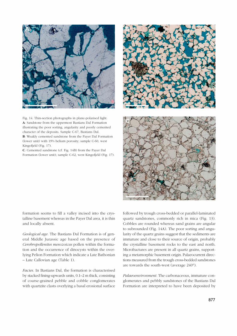
followed by trough cross-bedded or parallel-laminatedquartz sandstones, commonly rich in mica (Fig. 13).Cobbles are rounded whereas sand grains are angularto subrounded (Fig. 14A). The poor sorting and angu-larity of the quartz grains suggest that the sediments areimmature and close to their source of origin, probablythe crystalline basement rocks to the east and north.Microfractures are present in all quartz grains, support-ing a metamorphic basement origin. Palaeocurrent direc-tions measured from the trough cross-bedded sandstonesare towards the south-west (average 240°).
Palaeoenvironment. The carbonaceous, immature con-glomerates and pebbly sandstones of the Bastians DalFormation are interpreted to have been deposited by
Fig. 14. Thin-section photographs in plane-polarised light. A: Sandstone from the uppermost Bastians Dal Formationillustrating the poor sorting, angularity and poorly cementedcharacter of the deposits. Sample C-67, Bastians Dal. B: Weakly cemented sandstone from the Payer Dal Formation(lower unit) with 19% helium porosity; sample C-60, westKingofjeld (Fig. 17). C: Cemented sandstone (cf. Fig. 14B) from the Payer DalFormation (lower unit); sample C-62, west Kingofjeld (Fig. 17).
A
C
B
11mmmm 11mmmm
11mmmm

878
south-westwards flowing braided rivers. The fining-upwards units reflect decreasing energy conditions dur-ing deposition and were probably formed by fluvialchannel erosion followed by the migration of channelbars towards the south-west within the channels (Cant& Walker 1976; Miall 1977).
The formation appears to be mainly restricted to theBastians Dal area (Fig. 3). The overall marked pene-planed nature of the basement surface and the pro-nounced lateral thinning of the formation suggest thatit is restricted to a valley system incised into the base-ment surface. It is not possible to define the orienta-tion of the axis of the valley or the northwards extentof the formation due to Quaternary cover. Incision isinterpreted to have resulted from relative base-levellowering, probably in association with late Early orearly Middle Jurassic regional uplift enhanced by the
onset of half-graben block rotation in Middle Jurassictime. Incised drainage systems possibly followed zonesof weakness in the crystalline basement such as faultzones or less resistant metamorphic facies. During asubsequent rise in base level, a south-west flowing flu-vial system filled the valley with sandstones and conglo-merates. On southern Kuhn Ø, the Bastians DalFormation was apparently deposited on the peneplainmarginal to the incised valley system inferred for cen-tral Kuhn Ø.
Muslingebjerg FormationFacies. Coal beds overlying the Bastians Dal Formationare referred to the coal-bearing Muslingebjerg Formation.This lithostratigraphic unit was given member status by
5 m
20 mCoal
Coal
Pelion Fm(fine-grained sandstone)
Very coarse-grained sandstone
River level
Fig. 15. Exposure of the coal-dominatedMuslingebjerg Formation, overlain byfine-grained, well-sorted marine sand-stones of the Pelion Formation; BastiansDal, central Kuhn Ø. As illustrated in thesketch (no vertical exaggeration), thecoals interdigitate laterally with verycoarse-grained fluvial sandstones (arrowin photograph), comparable to those ofthe underlying Bastians Dal Formation.The sandstone is partially covered bycoal dust and is thus difficult to see onthe photograph.

Surlyk (1977) but is upgraded to formation in the revisedscheme of Surlyk (2003, this volume, fig. 5). At the typelocality at Kulhus in southern Hochstetter Forland, theformation is at least 20 m thick and consists of coalsinterbedded with lagoonal siltstones and sandstonesand subordinate shoreface sandstones (Clemmensen &Surlyk 1976; Petersen et al. 1998). In Bastians Dal, theMuslingebjerg Formation is up to 11 m thick and con-sists of coals interbedded locally with fluvial depositscomparable to those of the underlying Bastians DalFormation (Figs 11, 15). In Payer Dal, a coal bed up to0.15 m thick overlies weathered crystalline basementor thin fluvial deposits of the Bastians Dal Formation.The coal beds are overlain by fine- to medium-grainedsandstones of the Pelion Formation on Kuhn Ø and thePayer Dal Formation on Hochstetter Forland. TheMuslingebjerg Formation on Kuhn Ø is of early MiddleJurassic age based on the occurrence of Middle–UpperJurassic pollen in the underlying fluvial sediments ofthe Bastians Dal Formation and Upper Bathonian –Upper Callovian dinocysts in the overlying Pelion
Formation (Table 1). Dinocysts immediately above thecoals in the type section at Kulhus, Hochstetter Forland,are indicative of the Upper Callovian P. athleta Chrono-zone (Piasecki & Stemmerik in press).
Palaeoenvironment. The coal beds of the MuslingebjergFormation represent lagoonal swamps that formed ona coastal plain during base-level rise. The alternationof coal beds and shoreface deposits at Kulhus demon-strates that the peat-forming mires were repeatedly ter-minated by marine transgressions (Clemmensen & Surlyk1976; Petersen et al. 1998). Interfingering of coals withfluvial deposits in Bastians Dal on Kuhn Ø suggeststhat the coal beds were also confined within the incisedvalley system within which the fluvial Bastians DalFormation was deposited. The thin coal beds that directlyoverlie or occur close to basement in Payer Dal werepossibly deposited immediately adjacent to the easternlow-angle margin of the incised valley. As flooding con-tinued, the incised valley and interfluves were drownedand the coal-bearing sediments were abruptly overlain
879
SE NW
Top lower unitPayer Dal FmTop lower
unitPayer Dal
Fm
Top Pelion Fm
Top Payer Dal Fm(projected)
Fault
Fig. 16. Type section (section C) of the Payer Dal Formation, west Kingofjeld (see Figs 4, 9B, 17); the line of section is indicated bythe dotted lines. The boundary between the Payer Dal Formation and the overlying Bernbjerg Formation is exposed about one kilo-metre east (left) of this locality (see Fig. 9B). The lower unit of the Payer Dal Formation is c. 90 m thick. For legend, see Fig. 9A.
by shallow marine sands of the Pelion or Payer DalFormations. The Muslingebjerg Formation thus marksthe transition from fluvial sedimentation of the BastiansDal Formation to fully marine sedimentation of thePelion and Payer Dal Formations.
Geochemistry. Coal samples from Payer Dal have highhydrogen indices (HI) in the range 430–695 mg HC/gTOC (mg hydrocarbons/g total organic carbon content)(Fig. 4; samples C-6, -8, -19, -20). Values of Tmax are inthe range 429–432°C, and TOC values are 51–59%. Acoal sample from central Kuhn Ø (Fig. 5, C-68) gave aHI value of only 170 mg HC/g TOC. The coals are rel-atively ‘liptinitic’, corresponding to kerogen types II–III.The organic matter is dominantly derived from landplants, and has a good potential for generation of prob-ably waxy oil. The coals of Hochstetter Forland are alsopotential oil-prone source rocks (Bojesen-Koefoed et al.1996; Petersen et al. 1998).
Pelion Formation
redefined
History. The shallow marine sandstones on Kuhn Ø thatoverlie crystalline basement or in some areas succeedthe Bastians Dal or Muslingebjerg Formations were pre-viously all included in the Pelion Member (Surlyk 1977);this lithostratigraphic unit is promoted to the rank of for-mation in the revised lithostratigraphic scheme (Surlyk2003, this volume, fig. 5). The sandstones are here sub-divided into the Pelion Formation (below) and the newPayer Dal Formation (above) which are separated by amajor drowning surface expressed as a sharp boundarybetween mainly medium-grained sandstones and theoverlying siltstones, heteroliths and fine-grained sand-stones. The description presented here only covers theoccurrence on Kuhn Ø.
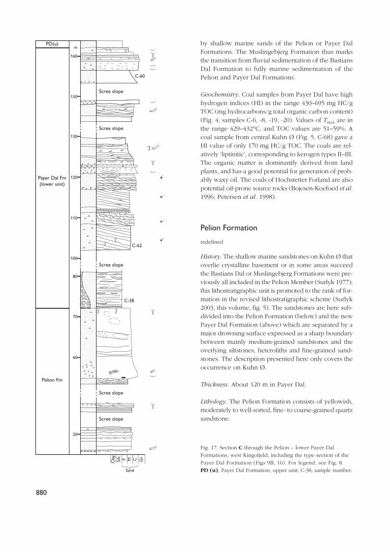
Thickness. About 120 m in Payer Dal.
Lithology. The Pelion Formation consists of yellowish,moderately to well-sorted, fine- to coarse-grained quartzsandstone.
880
C-60
C-62
C-38
160
150
Scree slope
Scree slope
Scree slope
Scree slope
Scree slope
130
120
110
100
80
70
60
20
m
Pelion Fm
Payer Dal Fm(lower unit)
PD(u)
Cla
ySi
lt F M C Gr
Sand
Fig. 17. Section C through the Pelion – lower Payer DalFormations, west Kingofjeld, including the type section of thePayer Dal Formation (Figs 9B, 16). For legend, see Fig. 8.PD (u), Payer Dal Formation, upper unit; C-38, sample number.

881
N
A
B
C
D
E1.
7km 2.8km
2.7km
5.4k
m
Kuhn Ø
Datum
Top basement
Top basement
?
E
D
C
B
A
100 m
N
A
B
C
D
E1.
7 km
2.8 km
2.7 km
5.4
km
Kuhn Ø
BernbjergFormation
Payer DalFormation
(upper unit)
Payer DalFormation
(lower unit)
PelionFormation
?Bastians DalFormation
?
?
?
Mud F M C
VC
Mud F M C
VC
Mud F M C
VC
Mud F M C
VC
Mud F M C
VC
Sand
Sand
Sand
Sand
Sand
Mudstone
Sandstone
Fig. 18. West–east stratigraphic profile ofthe Jurassic in southern Kuhn Ø. Thedatum is defined by the boundarybetween the lower and upper units ofthe Payer Dal Formation. According tothis correlation, the succession beneaththe datum (Pelion Formation and lowerPayer Dal Formation) thins markedlyeastwards. Section C (type section of thePayer Dal Formation) is shown in detailin Fig. 17. Section D is composite,constructed from segments D1–4 (seeFig. 4).
Boundaries. Overlies crystalline basement or pebblyfluvial sandstones of the Bastians Dal Formation, andthe coal-bearing Muslingebjerg Formation in southernand central Kuhn Ø. The upper boundary is sharp andseparates Pelion Formation sandstones from siltstonesand heteroliths of the overlying Payer Dal Formation.It can be correlated with a similar surface at the top ofthe Pelion Formation in Cardiocerasdal, WollastonForland, and can possibly be traced as far south asJameson Land. The Pelion Formation and the lowerunit of the Payer Dal Formation cannot be clearly sep-arated in Bastians Dal, central Kuhn Ø.
Distribution. The Pelion Formation is persistent through-out the Jurassic outcrop on Kuhn Ø and regionally isrecognised from Store Koldewey in the north (Piaseckiet al. in press) to Jameson Land in the south (Fig. 1).
Geological age. The formation is poorly dated on KuhnØ due to a lack of ammonites. However, a Late
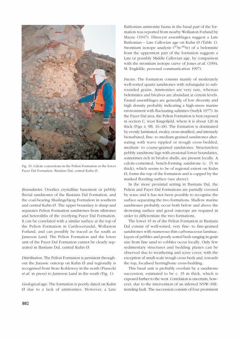
Bathonian ammonite fauna in the basal part of the for-mation was reported from nearby Wollaston Forland byMaync (1947). Dinocyst assemblages suggest a LateBathonian – Late Callovian age on Kuhn Ø (Table 1).Strontium isotope analysis (87Sr/86Sr) of a belemnitefrom the uppermost part of the formation suggests aLate or possibly Middle Callovian age, by comparisonwith the strontium isotope curve of Jones et al. (1994;M. Engkilde, personal communication 1997).
Facies. The formation consists mainly of moderatelywell-sorted quartz sandstones with subangular to sub-rounded grains. Ammonites are very rare, whereasbelemnites and bivalves are abundant at certain levels.Faunal assemblages are generally of low diversity andhigh density probably indicating a high-stress marineenvironment with fluctuating salinities (Surlyk 1977). Inthe Payer Dal area, the Pelion Formation is best exposedin section C, west Kingofjeld, where it is about 120 mthick (Figs 4, 9B, 16–18). The formation is dominatedby evenly laminated, swaley cross-stratified, and intenselybioturbated, fine- to medium-grained sandstones alter-nating with wave rippled or trough cross-bedded,medium- to coarse-grained sandstones. Structurelesspebbly sandstone lags with erosional lower boundaries,sometimes rich in bivalve shells, are present locally. Acalcite-cemented, bench-forming sandstone (c. 15 mthick), which seems to be of regional extent on KuhnØ, forms the top of the formation and is capped by themarked flooding surface (see above).
In the more proximal setting in Bastians Dal, thePelion and Payer Dal Formations are partially coveredby scree and it has not been possible to recognise thesurface separating the two formations. Shallow marinesandstones probably occur both below and above thedrowning surface and good outcrops are required inorder to differentiate the two formations.
The lower 45 m of the Pelion Formation in BastiansDal consist of well-sorted, very fine- to fine-grainedsandstones with numerous thin carbonaceous laminae.Layers of pebbles and poorly sorted beds ranging in grainsize from fine sand to cobbles occur locally. Only fewsedimentary structures and bedding planes can beobserved due to weathering and scree cover, with theexception of small-scale trough cross-beds and, towardsthe top, localised herringbone cross-bedding.
This basal unit is probably overlain by a sandstonesuccession, estimated to be c. 35 m thick, which isexposed further to the west. Correlation is uncertain, how-ever, due to the intervention of an inferred NNW–SSE-trending fault. The succession consists of four prominent
882
Fig. 19. Calcite concretions in the Pelion Formation or the lowerPayer Dal Formation. Bastians Dal, central Kuhn Ø.

exposed sections, each c. 3–8 m thick, that comprise lightbrown, concretionary sandstones overlain by light grey,calcite-cemented sandstones; these benches are sepa-rated by poorly exposed, scree-covered intervals of sim-ilar thickness. The concretionary sandstones displaycharacteristic ‘cannon ball’ concretions which litter theslopes below (Fig. 19). The concretions, which rangefrom a few centimetres to 30 cm in diameter (average10 cm), commonly obscure sedimentary structures. Thecalcite-cemented sandstone intervals show trough cross-bedding and are typically capped by structureless orparallel-laminated beds. The upper part of the forma-tion is poorly exposed in this area.
Palaeoenvironment. Onset of deposition of the PelionFormation records regional marine flooding of the crys-talline basement peneplain or the sediments of theBastians Dal and Muslingebjerg Formations. Depositiontook place in the lower to upper shoreface based onthe dominance of evenly laminated, swaley cross-strat-ified, and intensely bioturbated fine- to medium-grainedsandstones alternating with wave rippled or troughcross-bedded, medium- to coarse-grained sandstones.The pebbly sandstone lags with erosional lower bound-aries which occur locally in the formation are inter-preted as transgressive lags, formed by wave winnowingof underlying upper shoreface and foreshore deposits.A detailed account of the sedimentology and sequencestratigraphy of the Pelion Formation further south inJameson Land is given by Engkilde & Surlyk (2003, thisvolume).
Payer Dal Formation
new formation
History. The rocks of this new formation were firstrecognised by Maync (1947) who included them in theupper part of his Yellow Series. They form the upperpart of the Pelion Member of Surlyk (1977).
Name. After the valley of Payer Dal in southern KuhnØ (Figs 4, 9).
Type locality and type section. The eastern side of PayerDal; the type section (section C) is located on the westflank of Kingofjeld (Figs 4, 9B, 16, 17).
Reference section. Ugpik Ravine, west Payer Dal (Fig.9A; Surlyk 1977, fig. 4).
Thickness. In Payer Dal, the formation is about 150 mthick. The thickness of the formation in Bastians Dal isunknown due to difficulties in defining the base of theformation in poor exposure.
Lithology. Fine- to coarse-grained cross-bedded or struc-tureless, light coloured, mainly yellowish quartz sand-stone. Pebbly sandstone lags commonly rich in marinebivalves and belemnites occur locally. Siltstones and het-eroliths form the basal part of the formation in Payer Dal.
Boundaries. In Payer Dal, the lower boundary is a dis-tinct surface separating the carbonate-cemented sand-stone unit of the uppermost Pelion Formation from thesiltstones and heteroliths of the basal Payer DalFormation. The upper boundary is placed where sand-stones of the Payer Dal Formation are sharply overlainby offshore siltstones and heteroliths of the BernbjergFormation.
Distribution. The formation occurs on Kuhn Ø, StoreKoldewey, Hochstetter Forland and Hold with Hope(Piasecki et al. in press Vosgerau et al. in press).
Geological age. The age of the formation is not well-constrained due to a lack of ammonites. Dinocyst assem-blages suggest a mainly Early – early Late Oxfordianage (Table 1).
Subdivision. The formation is subdivided into a lowercoarsening-upwards siltstone–sandstone unit and anupper sandstone-dominated unit. These two units areseparated by a succession of pebbly sandstones, up to3 m thick, and are considered informal members.
Facies. In Payer Dal, the basal part of the lower PayerDal Formation consists of a succession of siltstones andheteroliths which has a minimum lateral extent of afew hundred metres but cannot be traced further dueto extensive scree cover (Figs 16, 17). These basal sed-iments coarsen upwards into cross-bedded, medium-to coarse-grained sandstones which alternate with evenlylaminated, fine- to medium-grained sandstones or waverippled, medium-grained sandstones (Fig. 17). The setsof the cross-bedded sandstones are up to 2 m thick. Thesandy foresets are commonly separated by single anddouble mud drapes. Foreset dip azimuths are mainlytowards the south-west, but bi-directionally orientatedforesets also occur. A pebbly sandstone interval, up to3 m thick, containing abundant thick-shelled bivalvesand belemnites locally forms the top of the unit.
883

884
The upper unit of the Payer Dal Formation consistsmainly of fine- to medium-grained sandstone and isgenerally less cemented than the underlying shallowmarine quartz sandstones of the lower unit and thePelion Formation. The best section through the upperunit is section A (Figs 9A, 18; see also Surlyk 1977, fig.4) where it consists of stacked successions of troughcross-bedded, fine- to medium-grained sandstones,commonly capped by oyster-rich, calcite-cemented,coarse-grained sandstones. Cross-bedded sandstoneswith sets up to 3 m thick and foresets commonly sep-arated by single and double mud drapes occur in theupper part of the unit in section D, south Kingofjeld(Fig. 18). Palaeocurrent directions of the cross-beds ofsections A and D are towards the S–SW.
In Bastians Dal, the lower Payer Dal Formation (pos-sibly including the uppermost Pelion Formation) con-sists of a sandstone succession, c. 50 m thick, whichforms a series of prominent benches separated by reces-sive slopes. The benches are composed of trough cross-bedded, structureless and parallel laminated, calcite-cemented sandstones, whereas the poorly exposedslopes appear to correspond to weakly cemented sand-stones. The last sandstone bench that forms the top ofthe lower unit is capped by a thin persistent oyster bedoverlain in many places by a thin pebble lag. The upperunit is composed of buff to yellow-red quartz sand-stone; the exposed section is about 20 m thick. It showslarge trough cross-sets at the base, up to 4 m thick,which grade up to small trough cross-sets in the upper-
most metre (Fig. 20). The sandstones are well-sortedand composed of subangular to subrounded grains atthe base of the coset, with more poorly sorted andangular grains towards the top. The cross-bedded sand-stone unit is fine- to very coarse-grained and shows anoverall coarsening-upwards trend. Palaeocurrents ofthe cross-beds are towards the south-west. The unit isnot exposed above the coset of trough cross-beds, butis probably present west of the area beneath Quater-nary alluvium deposits.
Palaeoenvironment. The Payer Dal Formation wasdeposited in a tidally-influenced environment as indi-cated by the abundance of cross-bedded sandstones withforesets separated by single and double mud drapes andthe local occurrence of herringbone cross-bedding. Thecross-bedded sandstones are interpreted to representsouth-westwards migrating tidal bars or sandwaves ina shallow marine embayment (Surlyk 1977; Surlyk &Clemmensen 1983).
Deposition of the siltstones and heteroliths that formthe base of the lower unit in the Payer Dal area, tookplace in an offshore transition to offshore environmentafter drowning of the shallow marine sandstones of thePelion Formation. Drowning was followed by shorefaceprogradation as reflected by the coarsening-upwardstrend within the succession of siltstones, heterolithsand cross-bedded sandstones.
The pebbly sandstones with bivalves and belemnitesat the top of the lower unit represent a composite lag
Fig. 20. Sandstone showing large-scaletrough cross-bedding in the upper PayerDal Formation. Bastians Dal, centralKuhn Ø. View towards the west.
deposit that is interpreted to have formed by trans-gressive wave ravinement of the underlying shallowmarine sands. Drowning resulted in a deeper waterregime as reflected by the generally finer grain size ofthe upper unit compared to the lower unit. The cosetof cross-bedded sandstones which occurs at the baseof the upper unit in the Bastians Dal area may repre-sent a large, composite tidal sand bar which migratedtowards the south-west.
Bernbjerg FormationFacies. The Bernbjerg Formation covers much of thewest side of Kuhn Ø and has been estimated to havea stratigraphic thickness of c. 450 m on Kuhn Ø (Figs3, 7; Maync 1947; Surlyk 1977; Surlyk & Clemmensen1983). It is dominated by dark grey to black mudstonesthat are generally thin-bedded to laminated and weatherto form a yellow-tan fissile mudstone. The sedimentsare generally rich in plant debris, ammonites, belem-nites and locally the bivalve Buchia (Surlyk 1977). Theformation overlies the Payer Dal Formation with a sharpboundary (see definition above). It is separated fromoverlying rift-climax sediments of the Wollaston ForlandGroup by an erosional, and locally angular, unconfor-mity in the eastern part of the Wollaston Forland basinwhere elevated fault block crests were eroded, and bya conformity in the western down-tilted part of theblock (Surlyk 1977, 1978b, 1991). On Kuhn Ø, the ageof the Bernbjerg Formation ranges from Late Oxfordian– Kimmeridgian on the basis of ammonites and dinocysts.
The Bernbjerg Formation is readily subdivided intoa lower heterolithic unit, the Ugpik Ravine Member ofSurlyk (2003, this volume, fig. 5), and an upper unit dom-inated by uniform dark mudstones. In the Payer Dal area,the Ugpik Ravine Member is approximately 75 m thick(Surlyk 1977, figs 4, 24). It is of (?)Late Oxfordian –Early Kimmeridgian age based on ammonites (Sykes &Surlyk 1976; Surlyk 1977) and dinocysts. 87Sr/86Sr iso-tope values from a belemnite (Table 2) found a fewmetres above the base of the Bernbjerg Formation, indi-cate a latest Oxfordian – Early Kimmeridgian age (M.Engkilde, personal communication 1997). In section D,south Kingofjeld (Fig. 4), the Ugpik Ravine Membercomprises seven coarsening-upwards heterolithic cycles,5–14 m thick (Fig. 18). The lower part of each cycletypically consists of parallel to slightly undulatingheterolithic laminae and thin beds. In the upper, morecoarse-grained part, wave ripple and current ripplecross-lamination may occur. The cycles are separated
by sharp erosional boundaries and, in some cases, bya lag rich in belemnites, wood fragments and well-rounded quartzite pebbles up to 4 cm in diameter.
The Ugpik Ravine Member is capped by a sharp sur-face where heterolithic sediments are succeeded by asuccession of dark grey to black mudstones. This upperunit of the Bernbjerg Formation is estimated to be sev-eral hundred metres thick on Kuhn Ø but was not mea-sured or described in detail.
Palaeoenvironment. The sharp boundary at the baseof the Bernbjerg Formation is interpreted as a majordrowning surface formed during transgressive ravine-ment of the shallow marine sandstones of the under-lying Payer Dal Formation. The coarsening-upwardsheterolithic cycles in the Ugpik Ravine Member repre-sent progradational events that resulted in progressiveshallowing from the offshore to the lower or middleshoreface zone. The erosional boundaries and thelocalised lag deposits on top of the coarsening-upwardscycles are interpreted to have formed by transgressivereworking and winnowing. The sharp upper surface ofthe lower unit of the Bernbjerg Formation is interpretedas a major drowning surface marking the transition tooffshore mudstones.
Geochemistry. Hydrogen index (HI) values of six mud-stone samples from the Bernbjerg Formation fall in therange 32–143 mg HC/g TOC; TOC values range between2.8% and 5.4%. The low HI values are thought to be aconsequence of the proximal setting, close to the cra-tonic mainland towards the west and north. Most of theBernbjerg Formation samples contain plant debris orcoal fragments.
Thickness variations and sediment geometryIn the Payer Dal region, the total thickness of the shal-low marine sandstones of the Pelion and Payer DalFormations varies from a minimum of 40 m at the crestof the fault-block to the east, to more than 350 m inPayer Dal itself and probably more than 500 m furtherwest (Figs 7, 18). It is unclear if the thinning towardsthe east is due to onlap, depositional thinning, trunca-tion or some combination of these. However, subtle bed-ding plane features seen on the aerial photographs andpanoramas suggest that some of the thinning is due toeastwards onlap of the formations onto the peneplanedbasement or the Bastians Dal Formation (Fig. 10A). The
885

depositional onlap probably reflects differential subsi-dence due to the onset of fault block tilting, possiblycombined with eustatic sea-level rise. In this context,it is noteworthy that some very coarse-grained, poorlysorted sandstones occur in the Pelion Formation or thelower unit of the Payer Dal Formation in the east of thePayer Dal area, suggesting a proximal setting close tothe sediment source (Figs 4, 18; section E, SchwarzeWand).
On south Kuhn Ø, the peneplaned surface of thebasement has a regional strike of 160° and a dip of 9°to the WSW, mainly reflecting Jurassic and later faultblock rotation. The top of the lower unit of the PayerDal Formation has an average calculated regional strikeof 160° and a dip of 6–7° to the WSW and representsa major drowning surface which was most likely closeto horizontal at the time of deposition. Bedding planeswithin the Pelion Formation and the lower unit of thePayer Dal Formation dip 5–13° towards the WSW withan average strike of 165°.
The dip variations observed in the Pelion Formationand the lower Payer Dal Formation may be explainedby a sigmoidal clinoform model (Fig. 21). The clino-form surfaces are represented by individual dips mea-sured on bedding planes at discrete localities. The largerof these dips (10–13°) may represent foresets of sandbars or, on a larger scale, the slopes of prograding cli-noforms. The smaller values (5–7°) probably representbeds originally closer to horizontal with superimposedpost-depositional structural rotation. Clinoforms are dif-
ficult to define in the field, with the exception of alocality near the crest of Schwarze Wand, where clino-forms dip up to 15°. A sigmoidal model explains thevariability of dips and fits the interpreted depositionalsetting with numerous progradational events separatedby drowning.
DiagenesisThe heterogeneous distribution of calcite cement andthe abundance of concretions, especially in the PelionFormation and the lower unit of the Payer Dal Formation,is a striking and characteristic feature of the shallowmarine sandstones. Concretions range in size from a fewcentimetres to over 30 cm in diameter. Concretionarycalcite-cemented zones typically follow bedding planes,but in some places cut vertically up section. The sourceof the calcite cement is probably biogenic carbonatederived from the abundant calcareous shelly fauna thatis associated with the cemented sandstones. The high vol-umes of calcite cement (34–42%) in several samples fromthe Pelion Formation and the lower Payer Dal Formationsuggest that calcite precipitation took place at shallowto moderate burial depths. Concretionary zones alongbedding planes are a common feature of similar agesandstones on the Norwegian continental shelf, and inonshore exposures in north-west Scotland and elsewherein East Greenland (Fürsich 1982; Walderhaug et al. 1989;Bjørkum & Walderhaug 1990). Bjørkum & Walderhaug
886
A ESW (250°) NE
Top lower unit
Payer Dal Fm
Top basement
6–7°5–7° 5–7°
10–13°10–13°
9°
Fig. 21. Simplistic sigmoidal clinoform model constructed to explain structural data from south Kuhn Ø. The dips of the top of thelower Payer Dal Formation and the top basement surface are regional estimates based on calculations, whereas the slope angles ofthe dashed surfaces are based on measured dips from bedding planes at discrete localities. The higher dip values (10–13°) probablyrepresent foresets of sand bars or, on a larger scale, the slopes of prograding clinoforms. The lower values (5–7°) probably representbeds deposited in a sub-horizontal attitude with superimposed post-depositional structural rotation. Sections A and E are c. 7 kmapart; the lower Payer Dal Formation is c. 40 m thick in section E (Fig. 18).

(1990) offered a detailed discussion of the nucleation andgrowth processes that create this fabric. Porosity andpermeability measurements from core plugs taken fromthe sandstones of the Pelion and Payer Dal Formationsreflect a strongly bimodal distribution of porosity and per-meability between the cemented and weakly cementedsandstones (Figs 14B, C, 22).
Petrographic studies of sandstone samples from theupper Payer Dal Formation (Fig. 4, samples C-2, -16,-17, -39, -40, -43, -51) show that the sandstones haveundergone mechanical compaction, but have not beenburied deeply enough to induce silica cementation.Measurements undertaken on some of the sandstonesgive helium porosity values of 28–32% and permeabil-ity values of 438–4900 mD.
The Jurassic sandstones from the Pelion and PayerDal Formations of Kuhn Ø are very similar to Jurassicsandstones found on the mid-Norwegian shelf and inthe Barents Sea with regard to original mineralogicalcomposition, sorting and grain size. A minor differenceis that parts of the correlative Fangst Group of the mid-Norwegian shelf are coarser grained and contain lessbiogenic carbonate. Calcite cement is not as volumet-
rically important in the Jurassic sandstones of the mid-Norwegian shelf as it appears to be in samples fromKuhn Ø. This is probably a function of the higher con-tent of biogenic carbonate in the Kuhn Ø samples.Quartz cement is typically extensive in the deeply buriedsandstones of the Norwegian shelf, but is lacking in thesamples from Kuhn Ø, suggesting that the Jurassicdeposits of Kuhn Ø have not been buried to depthswhere temperatures exceed 60–100°C (McBride 1989).
Regional correlationRecognition of correlative regional surfaces in the Jurassicsuccession of the Wollaston Forland basin is difficult dueto the abundance of local erosion surfaces in the tidaldeposits and the restricted lateral extent of many of theoutcrops. The most distinctive regional surfaces are themajor drowning surfaces which separate the Jurassic suc-cession into a series of backstepping sedimentary unitsreflecting the overall Middle–Late Jurassic transgression(Surlyk & Clemmensen 1983; Surlyk 1991). Identificationand tracing of the major drowning surfaces allow cor-
887
100 000
10 000
1000
100
10
1.0
0.1
0.010 10 20
Porosity (%)
Perm
eabi
lity
(mD
)
30 40
Fig. 22. Porosity and permeabil-ity of sandstones from thePelion Formation and the lowerPayer Dal Formation, Kuhn Ø.The bimodal distributionreflects the occurrence ofcemented and poorly cementedsandstones (see Fig. 14B, C).

888
Sand
Sand
Sand
Sand
Sand
Sand
?
Sect
ion
1
Sect
ion
2
Sect
ion
3
Sect
ion
4
Sect
ion
5
Cen
tral
Kuh
n Ø
Bast
ians
Dal
SW W
olla
ston
For
land
Car
dioc
eras
dal
Sout
hern
Kuh
n Ø
Paye
r D
alSo
uth
Nor
th
Sect
ion
6
Sout
hern
Hoc
hste
tter
For
land
Kul
hus
/ Søn
dre
Mus
linge
bjer
g?
??
?
?
Bast
ians
Dal
Fm
Shel
ls
Cal
cite
con
cret
ions
Loca
tion
of b
elem
nite
s co
llect
ed fo
rSr
isot
opic
ana
lysi
s (T
able
2)
100
m
Bern
bjer
gFm
Jako
bsst
igen
Fm
Pelio
n Fm
Perm
ian
carb
onat
es a
ndev
apor
ites
32 k
m19
km
31 k
m
Mus
linge
bjer
gFm
Ds
Ds
Ds
Ds
Ds
Ds
Cro
ss-b
eddi
ng
Trou
gh c
ross
-bed
ding
Wav
e ri
pple
cro
ss-la
min
atio
n
Plan
ar la
min
atio
n an
d be
ddin
g
Stru
ctur
eles
s
Coa
l or
carb
onac
eous
bed
s
Cal
edon
ian
crys
talli
ne b
asem
ent
Pebb
les
Maj
or d
row
ning
sur
face
Pelio
n Fm
Paye
r D
al F
mlo
wer
uni
t
Paye
r D
alFm
uppe
r un
it
Bern
bjer
gFm
Bern
bjer
gFm
Fig.
23.
Corr
elat
ion o
f th
e Ju
rass
ic s
ucc
essi
on o
n K
uhn Ø
with
more
offsh
ore
dep
osi
ts t
o t
he
south
in W
olla
ston F
orlan
d a
nd m
ore
pro
xim
al, co
ast-nea
r dep
osi
ts t
o t
he
north in
Hoch
stet
ter
Forlan
d, bas
ed o
n b
iost
ratig
raphic
and 87
Sr/86
Sr iso
tope
dat
a. S
ectio
n 1
is b
ased
on S
urlyk
(19
77), V
osg
erau
(19
97)
and V
osg
erau
et
al.
(200
0). Se
ctio
ns
2–5
are
bas
edon S
urlyk
(19
77) an
d this
stu
dy;
sec
tion 2
corr
esponds
to s
ectio
ns
Can
d D
, sec
tion 3
to s
ectio
n A
(Fig
s 4,
18)
. Sec
tion 6
is b
ased
on C
lem
men
sen &
Surlyk
(19
76) an
d S
urlyk
(19
77).

relation of the sedimentary units, in combination withbiostratigraphic and 87Sr/86Sr isotope data. The majordrowning surfaces are, however, difficult to recognisein both the most proximal landwards areas wherenearshore sandstones occur both below and above thesurfaces and in the most distal areas where the sur-faces separate offshore mudstones. Biostratigraphic con-trol is limited at some levels due to the scarcity ofammonites in the sandstones and the low diversity andgenerally low biostratigraphic resolution of the dinocystassemblages.
Kuhn Ø occupies an intermediate position betweenthe generally more offshore deposits to the south inWollaston Forland and the more proximal successionto the north in Hochstetter Forland (Fig. 6). The suc-cessions in Wollaston Forland and Hochstetter Forlandare briefly described below and a correlation with thesections on Kuhn Ø is suggested.
In the Cardiocerasdal area, in south-west WollastonForland, crystalline basement is overlain by a thinPermian succession of carbonates and evaporites butthe contact with overlying Jurassic sediments is notwell-exposed. Maync (1947) reported a coarse-grainedlag, 3–4 m thick, rich in shells and logs occurring nearthe basement in Cardiocerasdal. It is interpreted as acomposite transgressive lag formed by shallow marinewinnowing during transgression of basal fluvial depositsequivalent to the Bastians Dal Formation. The occur-rence of the ammonite Kepplerites tychonis Ravn at thislevel indicates a Late Bathonian age for the lag deposit(Maync 1947; Callomon 1993). In northern WollastonForland, the Pelion Formation rests directly on crys-talline basement.
The basal part of the Pelion Formation is not wellexposed in the Cardiocerasdal area and faulting makesthickness estimates uncertain. The uppermost 50 m ofthe formation are well-exposed, however, and consistof cross-bedded, tidally influenced sandstones show-ing S–SW palaeocurrent directions (Fig. 23). Calciteconcretions are locally abundant, as observed in thesandstones of Kuhn Ø. The cross-bedded sandstonesare interpreted to reflect shallow marine south-westmigrating tidal bars or sandwaves (Surlyk 1977; Surlyk& Clemmensen 1983). The Pelion Formation is sepa-rated from the overlying Jakobsstigen Formation by amajor drowning surface which can be correlated withthat at the top of the Pelion Formation on Kuhn Ø (Fig.23). On Kuhn Ø, this surface caps a regional, bench-forming, carbonate-cemented sandstone and in the westKingofjeld section it is overlain by siltstones and het-eroliths of the lower Payer Dal Formation (Fig. 17). The
age of this major drowning surface is not well-con-strained but it probably developed in Late Calloviantime as indicated by dinoflagellate cysts from sedimentsbelow and above the surface and by a few finds ofammonites in the middle part of the JakobsstigenFormation in Cardiocerasdal (Fig. 23). The strontium iso-topic ratios from belemnites from the uppermost PelionFormation in the two areas are similar (Table 2) andindicate a Late or possibly a Middle Callovian age (M.Engkilde, personal communication 1997).
The Jakobsstigen Formation is c. 130 m thick inCardiocerasdal. It is of Early–Middle Oxfordian age, butthe dating is not well-constrained. The formation con-sists of rhythmically interbedded coastal plain and shal-low marine deposits (Bojesen-Koefoed et al. 1997;Vosgerau et al. 2000). The Jakobsstigen Formation iscapped by the next major drowning surface which isthought to correlate with the surface separating thelower and upper units of the Payer Dal Formation onKuhn Ø (Fig. 23). The presence of coastal plain depositswithin the Jakobsstigen Formation is indicative of depo-sition in a more up-dip position on the hangingwall thanthat represented by the cross-bedded tidal sandstonesof the Payer Dal Formation.
In Cardiocerasdal, the Jakobsstigen Formation is over-lain by a strongly bioturbated, faintly wave and currentrippled heterolithic unit, c. 55 m thick, deposited in theshallow offshore zone, and forming the basal part ofthe Bernbjerg Formation. Ammonites indicate the UpperOxfordian Amoeboceras glosense Chronozone (Fig. 23),and 87Sr/86Sr isotope values from three belemnites (Table2) indicate a Late Oxfordian age (M. Engkilde, personalcommunication 1997). It is capped by a major drown-ing surface of late Amoeboceras glosense Chron age;this zone extends a few metres above the drowning sur-face. The drowning surface is correlated with the majordrowning surface separating the upper unit of the PayerDal Formation and the Bernbjerg Formation on KuhnØ (Fig. 23). In Cardiocerasdal, the succession above thisdrowning surface consists of more than 200 m of off-shore mudstones of the Bernbjerg Formation.
The Jurassic succession on Hochstetter Forland wasdeposited at the head of the embayment in a moreproximal setting than the succession on Kuhn Ø (Fig.6). It overlies Upper Proterozoic dolomites on the south-west side of Søndre Muslingebjerg, a few kilometressouth-east of Kulhus. Coal-bearing sediments of theMuslingebjerg Formation occur in an isolated down-faulted block at Kulhus in southern Hochstetter Forland(Clemmensen & Surlyk 1976; Petersen et al. 1998). Thelower boundary is not exposed but the formation is con-
889

sidered to be c. 20 m thick. It consists of four coal beds,up to 3.5 m thick, interbedded with lagoonal and sub-ordinate shoreface sediments. Only one coal bed occursat Søndre Muslingebjerg. It is c. 0.15 m thick and is sit-uated c. 3 m above basement. The coal beds at Kulhusthus wedge out towards the south-east within a distanceof a few kilometres. Dinoflagellate cysts from marinesediments immediately above the uppermost coal bedat Kulhus indicate the top Upper Callovian P. athletaChronozone (Fig. 23). The coal-bearing deposits of theMuslingebjerg Formation are overlain by a poorlyexposed succession of shallow marine sandstones, c.100 m thick, referred to the Payer Dal Formation. Thetop of the sandstone succession is dated by ammonitesto the Upper Oxfordian, Amoeboceras glosense orAmoeboceras serratum Chronozone (Fig. 23; Sykes &Surlyk 1976). Further north in Hochstetter Forland, smalloutcrops of Lower Kimmeridgian offshore mudstoneshave been reported (Surlyk 1978a).
Summary and conclusionsKuhn Ø offers an excellent study locality of Middle–Upper Jurassic early syn-rift stratigraphy in a half-grabensetting. The Jurassic succession rests directly on thepeneplaned surface of the crystalline basement. Themain geometrical features are a marked thickening ofthe Jurassic from the eastern crestal area into the grabento the west and eastwards onlap onto the crystalline base-ment peneplain. The main conclusions are as follows.
1. Five Jurassic early rift formations are recognisedbelow the rift-climax Wollaston Forland Group onKuhn Ø. They include the Bastians Dal (new) andMuslingebjerg Formations of Middle Jurassic age,the Pelion Formation (revised) of Late Bathonian –Late Callovian age, the Payer Dal Formation (new)of Early – early Late Oxfordian age, and the BernbjergFormation of (?)Late Oxfordian – Kimmeridgian age.
2. The Bastians Dal Formation consists of a succes-sion of fluvial conglomerates and pebbly sandstonesup to 150 m thick. On central Kuhn Ø, the coarse-grained deposits are interpreted to fill an incisedvalley system, probably of Early and early MiddleJurassic age. On southern Kuhn Ø, the unit is thin-ner, possibly because the exposures are located atthe margin of the valley system. The position of theincised valley system was probably controlled byzones of structural weakness. The fluvial conglom-
erates and sandstones were deposited during earlybase-level rise. During continuing and possibly accel-erating base-level rise, the fluvial environmentsbecame covered with peat swamps shortly beforethe valley was completely filled. Eventually the val-ley and the adjacent interfluves were flooded, prob-ably in Late Bathonian – Early Callovian times.
3. Coals of the Muslingebjerg Formation on south KuhnØ comprise kerogen types II–III, contain over 50%TOC and give high hydrogen index values (up to700 mg HC/g TOC), thus indicating that they rep-resent a good oil-prone source rock.
4. The Pelion Formation on Kuhn Ø is interpreted toreflect deposition in the lower to upper shorefacebased on the dominance of evenly laminated, swa-ley cross-stratified, or strongly bioturbated fine- tomedium-grained sandstones alternating with waverippled or trough cross-bedded, medium- to coarse-grained sandstones.
5. The Payer Dal Formation is subdivided into twounits separated by a major drowning surface. Theformation is dominated by trough cross-beddedsandstones formed by migration of shallow marinetidal sandwaves and sand bars towards the S–SW.The generally finer grain size of the upper unit ofthe formation suggests a deeper water setting thanthat represented by the Pelion Formation and thelower unit of the Payer Dal Formation.
6. The Pelion and Payer Dal Formations are petro-graphically very similar to Jurassic sandstones fromthe mid-Norwegian shelf and the Barents Sea withregard to original mineralogical composition, sort-ing and grain size. However, the Pelion and PayerDal Formations have not been buried to sufficientdepths to induce silica cementation. Porosity andpermeability data from the Pelion Formation andthe lower unit of the Payer Dal Formation show astrongly bimodal distribution between calcite-cemented and weakly-cemented quartz sandstones.The calcite cement was probably derived from car-bonate fossils and developed into concretionary fab-rics. The upper unit of the Payer Dal Formation isgenerally a weakly-cemented quartz sandstone withhelium porosities around 30%.
7. The Bernbjerg Formation mudstones are compara-ble to the Upper Jurassic source rock of the mid-
890
Norwegian shelf, but give low HI values (32–143 mgHC/g TOC) reflecting the proximal setting relativeto the cratonic mainland to the west.
8. The most distinct regional key stratigraphic surfacesare the major drowning surfaces which separate theJurassic package into a succession of backsteppingsedimentary units. Identification and tracing of themajor drowning surfaces in combination with bio-stratigraphic and 87Sr/86Sr isotope data allow corre-lation of the sedimentary units within the WollastonForland basin. In proximal settings, however, shal-low marine sandstones may occur both below andabove the major drowning surfaces making it diffi-cult or impossible to distinguish the sedimentaryunits.
AcknowledgementsP.C. Alsgaard and V.L. Felt are grateful to their main spon-sor Amoco Norway Oil Company who also gave thempermission to publish, and to Statoil and the otherWollgan partners who let Amoco participate in the pro-ject. We thank the following colleagues for biostrati-graphic and isotope stratigraphic information: D.G.Benson and S. Piasecki (palynology), J.A. Bergen andJ.R. Groves (nannoplankton and foraminifera), J.H.Callomon (ammonites), and M. Engkilde (Sr isotopes).Statoil and Saga are thanked for providing dinoflagel-late cyst data from the Pelion, Jakobsstigen, andBernbjerg Formations in the Cardiocerasdal area.Petrography was performed by O. Walderhaug and L.Bonnell of Rogaland Research. Core analysis was doneby D. Russel of Schlumberger Geoquest, and source rockanalysis by G. von Graas of Statoil and I.L. Ferriday ofGeolab Nor. G. Artigas and other Amoco employees gavevaluable contributions to the article. We are grateful toA.G. Whitham, T. Olsen and especially J.R. Ineson forconstructive and helpful reviews. S. Broen-Jensen wasan effective base camp manager; we thank him and theSirius Sledge Patrol for their help. Support to F. Surlykfrom the Danish Natural Science Research Council isgratefully acknowledged.
ReferencesBjørkum, P.A. & Walderhaug, O. 1990: Geometrical arrangement
of calcite cementation within shallow marine sandstones.Earth-Science Reviews 29, 145–161.
Bojesen-Koefoed, J.A., Christiansen, F.G., Petersen, H.I., Piasecki,S., Stemmerik, L. & Nytoft, H.P. 1996: Resinite coals of north-east Greenland – a hitherto unrecognised, highly oil-proneJurassic source rock. Canadian Petroleum Geology Bulletin 44,458–473.
Bojesen-Koefoed, J.A., Petersen, H.I., Surlyk, F. & Vosgerau, H.1997: Organic petrography and geochemistry of inertinite-richmudstones, Jakobsstigen Formation, Upper Jurassic, northeastGreenland: indications of forest fires and variations in relativesea-level. International Journal of Coal Geology 34, 345–370.
Callomon, J.H. 1993: The ammonite succession in the MiddleJurassic of East Greenland. Bulletin of the Geological Societyof Denmark 40, 83–113.
Cant, D.J. & Walker, R.G. 1976: Development of a braided flu-vial facies model for the Devonian Battery Point Sandstone,Quebec. Canadian Journal of Earth Sciences 13, 102–119.
Clemmensen, L.B. & Surlyk, F. 1976: Upper Jurassic coal-bearingshoreline deposits, Hochstetter Forland, East Greenland.Sedimentary Geology 15, 193–211.
Engkilde, M. & Surlyk, F. 2003: Shallow marine syn-rift sedi-mentation: Middle Jurassic Pelion Formation, Jameson Land,East Greenland. In: Ineson, J.R. & Surlyk, F. (eds): The Jurassicof Denmark and Greenland. Geological Survey of Denmarkand Greenland Bulletin 1, 813–863 (this volume).
Fürsich, F.T. 1982: Rhythmic bedding and shell bed formation inthe Upper Jurassic of East Greenland. In: Einsele, G. & Seilacher,A. (eds): Cyclic and event stratification, 208–222. Berlin:Springer Verlag.
Jones, C.E., Jenkyns, H.C., Coe, A.L. & Hesselbo, S.P. 1994: Stron-tium isotopic variations in Jurassic and Cretaceous seawaters.Geochimica et Cosmochimica Acta 58, 3061–3074.
Koch, L. 1955: Report on the expeditions to central East Greenland1926–1939, conducted by Lauge Koch. Part II. Meddelelser omGrønland 143(2), 642 pp.
Koch, L. & Haller, J. 1971: Geological map of East Greenland72°–76°N. Lat. (1:250 000). Meddelelser om Grønland 183,26 pp, 13 maps.
Maync, W. 1947: Stratigraphie der Jurabildungen Ostgrönlands zwis-chen Hochstetterbugten (75°N) und dem Kejser Franz JosephFjord (73°N). Meddelelser om Grønland 132(2), 223 pp.
McBride, E.F. 1989: Quartz cement in sandstones: a review. Earth-Science Reviews 26, 69–112.
Miall, A.D. 1977: A review of the braided river depositional envi-ronment. Earth-Science Reviews 13, 1–62.
Petersen, H.I., Bojesen-Koefoed, J.A., Nytoft, H.P., Surlyk, F.,Therkelsen, J. & Vosgerau, H. 1998: Liptinite-enriched coalfacies cycles and sequence stratigraphy of a paralic coal-bear-ing succession, Middle Jurassic, Hochstetter Forland, North-East Greenland. International Journal of Coal Geology 36, 1–30.
Piasecki, S. & Stemmerik, L. in press: Jurassic dinoflagellate cystsfrom Hochstetter Forland, North-East Greenland. In: Stemmerik,L. & Stouge, S. (eds): The Jurassic of North-East Greenland.Geological Survey of Denmark and Greenland Bulletin.
Piasecki, S., Callomon, J.H. & Stemmerik, L. in press: Jurassic dino-flagellate cyst stratigraphy of Store Koldewey, North-East Green-land. In: Stemmerik, L. & Stouge, S. (eds): The Jurassic ofNorth-East Greenland. Geological Survey of Denmark and
891

892
Greenland Bulletin.Surlyk, F. 1977: Stratigraphy, tectonics and palaeogeography of
the Jurassic sediments of the areas north of Kong Oscars Fjord,East Greenland. Bulletin Grønlands Geologiske Undersøgelse123, 56 pp.
Surlyk, F. 1978a: Mesozoic geology and palaeogeography ofHochstetter Forland, East Greenland. Bulletin of the GeologicalSociety of Denmark 27, 73–87.
Surlyk, F. 1978b: Submarine fan sedimentation along fault scarpson tilted fault blocks (Jurassic–Cretaceous boundary, EastGreenland). Bulletin Grønlands Geologiske Undersøgelse 128,108 pp.
Surlyk, F. 1990: Timing, style and sedimentary evolution of LatePalaeozoic – Mesozoic extensional basins of East Greenland.In: Hardman, R.P.F. & Brooks, J. (eds): Tectonic events respon-sible for Britain’s oil and gas reserves. Geological SocietySpecial Publication (London) 55, 107–125.
Surlyk, F. 1991: Sequence stratigraphy of the Jurassic – lowermostCretaceous of East Greenland. American Association ofPetroleum Geologists Bulletin 75, 1468–1488.
Surlyk, F. 2003: The Jurassic of East Greenland: a sedimentaryrecord of thermal subsidence, onset and culmination of rift-ing. In: Ineson, J.R. & Surlyk, F. (eds): The Jurassic of Denmarkand Greenland. Geological Survey of Denmark and GreenlandBulletin 1, 659–722 (this volume).
Surlyk, F. & Clemmensen, L.B. 1983: Rift propagation and eustacyas controlling factors during Jurassic inshore and shelf sedi-mentation in northern East Greenland. Sedimentary Geology34, 119–143.
Sykes, R.M. & Surlyk, F. 1976: A revised ammonite zonation ofthe Boreal Oxfordian and its application in Northeast Green-land. Lethaia 9, 421–436.
Vischer, A. 1943: Die postdevonische Tektonik von Ostgrönlandzwischen 74° und 75°N. Br., Kuhn Ø, Wollaston Forland,Clavering Ø und angrenzende Gebiete. Meddelelser omGrønland 133(1), 195 pp.
Vosgerau, H. 1997: Depositional environments and sequencestratigraphy of a Middle–Upper Jurassic early syn-rift succes-sion deposited in a low gradient epeiric seaway, the WollastonForland Basin, Northeast Greenland 1–3, 110 pp. UnpublishedPh.D. thesis, University of Copenhagen, Denmark.
Vosgerau, H., Bojesen-Koefoed, J.A., Petersen, H.I. & Surlyk, F.2000: Forest fires, climate and sea-level changes in a coastalplain – shallow marine succession (Early–Middle OxfordianJakobsstigen Formation, North-East Greenland). Journal ofSedimentary Research 70, 408–418.
Vosgerau, H., Larsen, M., Piasecki, S. & Therkelsen, J. in press:A new Middle–Upper Jurassic succession of Hold with Hope,North-East Greenland. In: Stemmerik, L. & Stouge, S. (eds):The Jurassic of North-East Greenland. Geological Survey ofDenmark and Greenland Bulletin.
Walderhaug, O., Bjørkum, P.A. & Nordgård Bolås, H.M. 1989:Correlation of calcite-cemented layers in shallow-marine sand-stones of the Fensfjord Formation in the Brage Field. In:Collinson, J.D. (ed.): Correlation in hydrocarbon exploration,367–375. London: Graham & Trotman for the NorwegianPetroleum Society (NPF).
Manuscript received 7 November 1996; revision accepted 27 January 1998.