The epicontinental Lower Jurassic of Poland
121
Grzegorz Pieñkowski The epicontinental Lower Jurassic of Poland Polish Geological Institute Special Papers, 12 WARSZAWA 2004
Transcript of The epicontinental Lower Jurassic of Poland

Grzegorz Pieñkowski
The epicontinental Lower Jurassic of Poland
Polish Geological Institute Special Papers, 12
WARSZAWA 2004

CONTENTS
Introduction . . . . . . . . . . . . . . . . . . . . . . . . . . . . . . . . . . . . . . . . . . . . . . . . . . . . . . . . . . . . . . . . . . 7
Previous works on the epicontinental Early Jurassic of Poland . . . . . . . . . . . . . . . . . . . . . . . . . . . . . . . . . . . . . . . . 8
Tectonic setting . . . . . . . . . . . . . . . . . . . . . . . . . . . . . . . . . . . . . . . . . . . . . . . . . . . . . . . . . . . . . . 8
Biostratigraphy . . . . . . . . . . . . . . . . . . . . . . . . . . . . . . . . . . . . . . . . . . . . . . . . . . . . . . . . . . . . . . 9
Petrography . . . . . . . . . . . . . . . . . . . . . . . . . . . . . . . . . . . . . . . . . . . . . . . . . . . . . . . . . . . . . . . 11
Lithostratigraphy and cyclic sedimentation . . . . . . . . . . . . . . . . . . . . . . . . . . . . . . . . . . . . . . . . . . . . . . . 11
Sedimentology . . . . . . . . . . . . . . . . . . . . . . . . . . . . . . . . . . . . . . . . . . . . . . . . . . . . . . . . . . . . . 13
Methods applied in description of exposures and boreholes . . . . . . . . . . . . . . . . . . . . . . . . . . . . . . . . . . . . . . . . . 14
Lithofacies. . . . . . . . . . . . . . . . . . . . . . . . . . . . . . . . . . . . . . . . . . . . . . . . . . . . . . . . . . . . . . . . 14
Animal biofacies . . . . . . . . . . . . . . . . . . . . . . . . . . . . . . . . . . . . . . . . . . . . . . . . . . . . . . . . . . . . 18
Palynofacies . . . . . . . . . . . . . . . . . . . . . . . . . . . . . . . . . . . . . . . . . . . . . . . . . . . . . . . . . . . . . . . 19
Ichnofacies . . . . . . . . . . . . . . . . . . . . . . . . . . . . . . . . . . . . . . . . . . . . . . . . . . . . . . . . . . . . . . . 23
Chemofacies. . . . . . . . . . . . . . . . . . . . . . . . . . . . . . . . . . . . . . . . . . . . . . . . . . . . . . . . . . . . . . . 27
Depositional systems and subsystems . . . . . . . . . . . . . . . . . . . . . . . . . . . . . . . . . . . . . . . . . . . . . . . . . . . . 28
Alluvial depositional systems . . . . . . . . . . . . . . . . . . . . . . . . . . . . . . . . . . . . . . . . . . . . . . . . . . . . . . 33
Lacustrine depositional system . . . . . . . . . . . . . . . . . . . . . . . . . . . . . . . . . . . . . . . . . . . . . . . . . . . . . 36
Transition between the alluvial depositional system and the deltaic depositional system . . . . . . . . . . . . . . . . . . . . . . . 36
Transgression and its nonmarine correlative surfaces within alluvial/lacustrine/delta plain depositional systems . . . . . . . . . . 37
Deltaic depositional system . . . . . . . . . . . . . . . . . . . . . . . . . . . . . . . . . . . . . . . . . . . . . . . . . . . . . . . 37
Barrier-lagoon depositional system . . . . . . . . . . . . . . . . . . . . . . . . . . . . . . . . . . . . . . . . . . . . . . . . . . . 42
Nearshore depositional system . . . . . . . . . . . . . . . . . . . . . . . . . . . . . . . . . . . . . . . . . . . . . . . . . . . . . 46
Marine basin — open marine shelf depositional system . . . . . . . . . . . . . . . . . . . . . . . . . . . . . . . . . . . . . . . . 49
Tide-influenced shore zone depositional system . . . . . . . . . . . . . . . . . . . . . . . . . . . . . . . . . . . . . . . . . . . . 49
Sedimentation and depositional sequences of the epicontinental Lower Jurassic deposits in the Polish Basin . . . . . . . . . . . . . . . . 49
Sequence stratigraphic terminology adopted in this paper . . . . . . . . . . . . . . . . . . . . . . . . . . . . . . . . . . . . . . . 49
Early Jurassic sedimentation in the Holy Cross Mts region . . . . . . . . . . . . . . . . . . . . . . . . . . . . . . . . . . . . . . 52
Early Jurassic sedimentation in the Czêstochowa region . . . . . . . . . . . . . . . . . . . . . . . . . . . . . . . . . . . . . . . . 66
Early Jurassic sedimentation in the Wielkopolska region . . . . . . . . . . . . . . . . . . . . . . . . . . . . . . . . . . . . . . . 72
Early Jurassic sedimentation in the Fore-Sudetic Monocline . . . . . . . . . . . . . . . . . . . . . . . . . . . . . . . . . . . . . 74
Early Jurassic sedimentation in the Pomerania region . . . . . . . . . . . . . . . . . . . . . . . . . . . . . . . . . . . . . . . . . 78
Early Jurassic sedimentation in the Mazury region (part of the Baltic Syneclise) . . . . . . . . . . . . . . . . . . . . . . . . . . . 87

Lithostratigraphy of the epicontinental Lower Jurassic deposits in the Polish Basin . . . . . . . . . . . . . . . . . . . . . . . . . . . . . 90
Kamienna Group . . . . . . . . . . . . . . . . . . . . . . . . . . . . . . . . . . . . . . . . . . . . . . . . . . . . . . . . . . . . 90
Sequence stratigraphy of the Early Jurassic epicontinental deposits in Poland in comparison to the West European standards . . . . . . . . 96
Depositional sequence I (Hettangian) . . . . . . . . . . . . . . . . . . . . . . . . . . . . . . . . . . . . . . . . . . . . . . . . . 97
Depositional sequence II (Early Sinemurian) . . . . . . . . . . . . . . . . . . . . . . . . . . . . . . . . . . . . . . . . . . . . . 101
Depositional sequence III (Late Sinemurian) . . . . . . . . . . . . . . . . . . . . . . . . . . . . . . . . . . . . . . . . . . . . . 102
Depositional sequence IV (latest Sinemurian–Early Pliensbachian) . . . . . . . . . . . . . . . . . . . . . . . . . . . . . . . . . 104
Depositional sequence V (late Early Pliensbachian) — davoei Zone . . . . . . . . . . . . . . . . . . . . . . . . . . . . . . . . 105
Depositional sequence VI (Late Pliensbachian) — early–mid margaritatus Zone . . . . . . . . . . . . . . . . . . . . . . . . . . 105
Depositional sequence VII (latest Pliensbachian) — latest margaritatus–spinatum Zones . . . . . . . . . . . . . . . . . . . . . 108
Depositional sequence VIII (Early Toarcian) . . . . . . . . . . . . . . . . . . . . . . . . . . . . . . . . . . . . . . . . . . . . . 108
Depositional sequence IX and X (Middle–Late Toarcian) . . . . . . . . . . . . . . . . . . . . . . . . . . . . . . . . . . . . . . 110
Summary and conclusions . . . . . . . . . . . . . . . . . . . . . . . . . . . . . . . . . . . . . . . . . . . . . . . . . . . . . . . . . 111
References . . . . . . . . . . . . . . . . . . . . . . . . . . . . . . . . . . . . . . . . . . . . . . . . . . . . . . . . . . . . . . . . . 113
Plates . . . . . . . . . . . . . . . . . . . . . . . . . . . . . . . . . . . . . . . . . . . . . . . . . . . . . . . . . . . . . . . . . . . . 124
*
CD — the borehole profiles ( Figs. 5, 18, 19, 21–23, 27, 31–38, 41, 43–45, 47, 50–54, 56–60, 63, 64, 66)
4
Pieñkowski G., 2004 — The epicontinental Lower Jurassic of Poland. Polish Geological Institute Special Papers, 12: 1–152.
Grzegorz Pieñkowski, Polish Geological Institute, Rakowiecka 4, PL-00-975 Warszawa, Poland. E-mail: [email protected]
Abstract: During the Early Jurassic times terrigenous, continental, marginal-marine and marine sediments up to 1400 min thickness were deposited in a large epeiric basin extending across Poland. These strata are defined herein as the KamiennaGroup, which is subdivided into 12 newly distinguished or re-defined lithoformations (Fm.). Two new members (Mb.) arealso defined. Detailed study of exposures and 35 fully cored boreholes has integrated data from lithology, sedimentary struc-tures, trace fossils, body fossils, boron content, clay minerals and palynology. This has allowed lithofacies description, recog-nition of depositional systems and subsystems and determination of their fluctuation in space and time leading toa high-resolution sequence stratigraphic analysis. Sedimentation in the shallow, epeiric Early Jurassic basin of Poland wasparticularly sensitive to reflect changes in sea level. Analyses of accommodation space within regular progradational succes-sions associated with highstand systems tracts shows that the Early Jurassic basin in Poland was generally not deeper thansome tens of meters, most frequently it was less than 20 m deep. Except for the ammonite-bearing Pliensbachian deposits inWestern Poland, biostratigraphical resolution in marginal-marine and continental deposits is usually of a lesser precision.However, an internally consistent sequence stratigraphic scheme of Poland can be compared with fossiliferous marine sedi-ments of the Ligurian cycle of United Kingdom and France. The minor sequences identified within the Ligurian cycle playvery important role in correlation as they can be recognised in the Polish Basin, although they may show some differences indating and range. In the Polish Basin, lowstand (LST) and falling stage systems tract (FSST) correspond with erosion/non de-position stages at the sequence boundaries. Concerning the range of sea level changes, the Exxon model was also adopted andten of the Exxon Early Jurassic depositional sequences were identified in the Polish Lower Jurassic and are labelled I–X.Transgressive systems tracts prevail in sedimentary record and are represented either by retrogradational or aggradational fa-cies architecture, and high-stand systems tracts are represented by progradational facies architecture. Parasequence bound-aries (flooding surfaces) were defined based on careful regional/spatial facies analysis. A marginal-marine parasequence isusually more complex than a simple “quick flooding- gradual prograding” model, conventionally interpreted in the marinebasins. Due to common preservation of transgressive deposits within marginal-marine parasequences, besidesthe well-defined flooding surfaces the “parasequence maximum flooding surfaces” were distinguished. The best correlativehorizons, particularly in the basin centre, are represented by sequence boundaries, while the maximum flooding surfaces ortheir correlatives are well identifiable in the marginal parts of the basin. Intensity and frequency of erosional processes inthe marginal parts of the basin mean that depositional sequence boundaries are difficult to recognise because of “amalgam-ation” of stacked and highly reduced depositional sequences. Correlative significance is of transgressive surfaces is enhancedwhen they are coupled with their nonmarine correlative surfaces. Development of transgression with its coeval effects in con-tinental deposits is discussed and non-marine correlative surfaces of the transgressive surfaces are documented. Once recog-nised and arranged, sequences and parasequences in the marginal basins (like the Polish Basin) can help to solve someproblems concerning identification and range of major bounding surfaces and systems tracts in open marine basins in Europe,particularly in the Early Toarcian. The regional cross sections and cross sections of the whole Polish Basin showing dominantdepositional systems and sequence stratigraphic correlation, as well as “time-tuned” palaeogeographical maps of the PolishBasin in Early Jurassic are presented. Subsidence varied through time along the Mid-Polish Trough, between the Holy CrossMts and Pomerania. In Hettangian and Late Sinemurian the subsidence rate was higher in the Holy Cross Mts and lower
Polish Geological Institute Special Papers, 12 (2004): 1–152
I dedicate this work to the Memory of
Dr W³adys³aw Karaszewski (1911–2003),
an outstanding scientist and a worthy Man.
Pracê tê dedykujê Pamiêci
Docenta Doktora W³adys³awa Karaszewskiego (1911–2003),
wybitnego badacza i zacnego Cz³owieka.

in Pomerania region, while in Early Sinemurian and Early Pliensbachian times the situation was opposite. Despite existenceof some regional dislocation zones occurring along the edges of the Mid-Polish Trough, which shaped the sedimentation andsediment thickness contrast (for example the Nowe Miasto–I³¿a fault), a gradual decrease of sediment thickness outwardsthe axis of the Mid-Polish Trough prevails. Additionally, occurrence of conspicuous zones of increased subsidence, which areactually perpendicular to the Mid-Polish Trough (for example the “Mazurian Way”), there is no reason to regard the Mid--Polish Trough in any respect as a “rift basin”, at least in the Early Jurassic times.
Key words: continental and marginal-marine depositional systems, sea level changes, sequence analysis, sequence stratigra-phic correlation, Lower Jurassic, Poland.
Abstrakt. We wczesnej jurze, w rozleg³ym epikontynentalnym basenie rozci¹gaj¹cym siê na obszarze Polski, osadzi³o siêdo 1400 metrów utworów terygenicznych pochodzenia l¹dowego, marginalno-morskiego i morskiego. Utwory te s¹ zdefi-niowane w niniejszej pracy jako Grupa Kamiennej (Gr.), która zosta³a podzielona na 13 nowo wyró¿nionych lub zredefinio-wanych litoformacji (Fm.). Wyró¿niono te¿ dwa nowe ogniwa (Mb.). Szczegó³owe badania obejmuj¹ce dane litofacjalne,petrologiczne, ichnologiczne, paleontologiczne, geochemiczne i palinologiczne przeprowadzono w ods³oniêciach i 35pe³nordzeniowanych otworach wiertniczych. Pozwoli³y one na wyró¿nienie litofacji, interpretacjê systemów i subsystemówdepozycyjnych oraz ich czasoprzestrzennej zmiennoœci, a nastêpnie na przeprowadzenie wysokorozdzielczej analizy se-kwencyjnej. Wczesnojurajska sedymentacja w p³ytkim, epikontynentalnym basenie Polski w sposób szczególnie wyraŸnyodzwierciedla³a zmiany poziomu morza. Analiza przestrzeni akomodacji depozycyjnej w obrêbie regularnych sukcesji pro-gradacyjnych ci¹gów systemowych stabilizacji wysokiego poziomu morza (HST) wskazuje, ¿e g³êbokoœci wczesnojuraj-skich zbiorników sedymentacyjnych Polski nie przekracza³y wartoœci rzêdu kilkudziesiêciu metrów, a najczêœciej by³y tog³êbokoœci maksymalnie do 20 metrów. Z wyj¹tkiem morskich utworów pliensbachu na Pomorzu, które zawieraj¹ amonity,podzia³ biostratygraficzny marginalno-morskich i l¹dowych utworów dolnej jury charakteryzuje siê na ogó³ s³ab¹ rozdziel-czoœci¹. Mimo to, spójny podzia³ stratygraficzno-sekwencyjny dolnej jury w Polsce pozwala na jego porównanie ze schema-tami sporz¹dzonymi dla bogatych w skamienia³oœci przewodnie utworów dolnej jury cyklu liguryjskiego w Wielkiej Brytaniii Francji. Zw³aszcza sekwencje krótkookresowe wyró¿nione w obrêbie tego cyklu s¹ przydatne w korelacji sekwencji, ponie-wa¿ s¹ one rozpoznawalne w basenie polskim. Ci¹gi systemowe niskiego poziomu morza (LST) i ci¹gi systemowe opa-daj¹cego poziomu morza (FSST) odpowiadaj¹ czasowo w basenie polskim lukom zwi¹zanym z erozj¹ lub brakiem depozycjina granicach sekwencji. Jeœli chodzi o skalê zmian poziomu morza, równie¿ model Exxon Research Group okaza³ siê przy-datny do przeprowadzenia korelacji, a dziesiêæ „exxonowskich” sekwencji depozycyjnych (I–X) zosta³o wyró¿nionychw obrêbie utworów dolnojurajskich basenu polskiego. W zapisie osadowym dominuj¹ utwory transgresywnych ci¹gów sys-temów i s¹ one reprezentowane zarówno przez retrogradacyjne jak i agradacyjne sukcesje facjalne. Utwory ci¹gów systemo-wych stabilizacji wysokiego poziomu morza odpowiadaj¹ wy³¹cznie progradacyjnym, regresywnym sukcesjom facjalnym.Granice parasekwencji w obrêbie sekwencji depozycyjnych zosta³y zdefiniowane na podstawie dok³adnej czasoprzestrzen-nej analizy facjalnej w poszczególnych regionach. Parasekwencje marginalno-morskie maj¹ na ogó³ bardziej z³o¿on¹ archi-tekturê depozycyjn¹, ni¿ przyjmowano do tej pory w prostym schemacie szybkiego zalewu i stopniowej, powolnejprogradacji. Konieczne by³o wyró¿nienie powierzchni maksymalnego zalewu dla poszczególnych parasekwencji, wystêpuj¹one w ró¿nych odleg³oœciach od powierzchni zalewu bêd¹cych dolnymi granicami parasekwencji. Najlepszymi powierzch-niami korelacyjnymi w centrum basenu s¹ granice sekwencji, podczas gdy w obszarach marginalnych naj³atwiej wyró¿niæpowierzchnie maksymalnego zalewu i ich odpowiedniki. W marginalnych partiach basenu sedymentacyjnego czêstotliwoœæi intensywnoœæ erozji oraz niewielka subsydencja powodowa³y czêsto nak³adanie siê na siebie poszczególnych sekwencjii ich granic, co utrudnia ich wyró¿nianie i korelacjê. Dok³adnoœæ korelacji powierzchni transgresji zwiêksza siê, kiedy s¹ oneskorelowane z ich l¹dowymi odpowiednikami. Udokumentowano szczegó³owo rozwój transgresji i efekty tego procesu nas¹siaduj¹cych obszarach l¹dowych i podano kryteria wyró¿niania niemorskich, korelatywnych odpowiedników powierzchnitransgresji. Okreœlona w polskim basenie sedymentacyjnym sukcesja sekwencji i parasekwencji mo¿e byæ pomocna w roz-wi¹zywaniu problemów zwi¹zanych z identyfikacj¹ i zasiêgiem g³ównych granic korelacyjnych i ci¹gów systemowychw pe³nomorskich, g³êbszych basenach Europy, co szczególnie przydatne okaza³o siê dla utworów wczesnego toarku. Wyko-nano regionalne oraz ogólnopolskie przekroje stratygraficzno-sekwencyjne basenu wczesnojurajskiego w Polsce wraz z ma-pami sporz¹dzonymi dla konkretnych, czasowych powierzchni korelacyjnych, które przedstawiaj¹ zmiennoœæczasowo-przestrzenn¹ dominuj¹cych systemów depozycyjnych. Tempo subsydencji wzd³u¿ bruzdy œrodkowopolskiej zmie-nia³o siê w czasie, wykazywa³o te¿ fluktuacje regionalne — w hetangu i póŸnym synemurze tempo subsydencji w segmencieœwiêtokrzyskim bruzdy œródpolskiej by³o wiêksze ni¿ w segmencie pomorskim, a we wczesnym synemurze i wczesnympliensbachu sytuacja by³a odwrotna. W pliensbachu i toarku zaznacza³y siê strefy zwiêkszonej subsydencji usytuowane pro-stopadle do rozci¹g³oœci bruzdy œródpolskiej (tak zwana „droga mazurska”). Wzd³u¿ krawêdzi bruzdy istnia³y regionalne
6 Abstract

strefy dyslokacyjne, wywieraj¹ce wp³yw na sedymentacjê i kontrast mi¹¿szoœci (np. strefa Nowe Miasto–I³¿a). Bior¹c jed-nak pod uwagê na ogó³ stopniowe zmniejszanie siê mi¹¿szoœci osadów na zewn¹trz od osi bruzdy i wspomniane strefy zwiêk-szonej subsydencji prostopad³e do osi bruzdy œródpolskiej, nie mo¿na w ¿aden sposób wi¹zaæ wczesnojurajskiego etapurozwoju bruzdy œródpolskiej z procesami ryftowania.
S³owa kluczowe: kontynentalne i marginalno-morskie systemy depozycyjne, zmiany poziomu morza, analiza sekwencyjna,korelacja stratygraficzno-sekwencyjna, dolna jura.
INTRODUCTION
Early Jurassic deposits in Poland occur in two different re-gions: one is a vast epicontinental basin of the Polish Lowlandsand the Polish Uplands, the second is represented byoverthrusted, geosynclinal deposits belonging to the Tethysrealm (Carpathians — Tatra Mountains and Pieniny KlippenBelt). This paper deals with the epicontinental Early Jurassicdeposits, representing the vast majority of the Early Jurassicsediments in Poland (Fig. 1).
The Lower Jurassic sediments in the epicontinental basinof Poland developed as the platform type association ofthe terrigenous deposits. They are represented by siliciclasticterrigenous sediments with thin, subordinate intercalationsofsiderite, lignite and very rarely dolomites or limestones.
Sedimentology, lithofacies, ichnofacies, as well as sequencestratigraphy have been a main pursuit of the present author’sstudies over more than two decades (Pieñkowski, 1980, 1983,1984, 1985, 1988, 1991a, 1997, 1998; Pieñkowski, Gierliñski,1987; Gierliñski, Pieñkowski, 1999). Most of these papersconcerned Hettangian and Sinemurian deposits in the HolyCross Mts region. One paper (Pieñkowski, 1988) focused onthe Pliensbachian and Toarcian deposits of the Czêstochowaregion. In another paper (Pieñkowski, 1997), a preliminaryoutline of the Early Jurassic sedimentation in Poland has beenpresented, but it was based on very limited data. Since then, im-portant new material has been obtained and new publicationscreated much better opportunities for detailed sequence strati-
Introduction 7
Fig. 1. General distribution of the Early Jurassic deposits and main regions described herein

graphic correlation (particularly, the volume "Mesozoic andCenozoic Sequence Stratigraphy of European Basins" —de Graciansky, Hardenbol, Jacquin, Vail, Eds., 1998, Soc.Econ. Paleont. Min., Spec. Publ., 60 and "The Jurassic of Den-mark and Greenland" — Ineson, Surlyk, Eds., 2003, Geol.Surv. Denmark, Bull. 1).
The scope of the present paper can be recapitulated as fol-lows:
— summary of the all the existing data, including new data ob-tained in the past few years;
— detailed, integrated sedimentological interpretation ofthe existing material;
— interpretation of depositional systems and their evolution inspace and time with respect to local and regional tectonics;
— interpretation of depositional sequences and parasequences;— new lithostratigraphic subdivision;— new, “time-tuned” palaeogeographical maps of the selected
regions and the whole country;— new sequence stratigraphic correlation with modern strati-
graphic results from Europe.
With regard to method, this study embraces classicalsedimentological investigations of lithofacies and analysesof ichnofacies, chemofacies and palynofacies. As far as con-cerns borehole material, only fully cored boreholes were stud-ied (with one exception of the Kamieñ Pomorski IG 1 borehole,where the core recovery was 30 %). Wire-line logs, (most ofthem produced twenty or more years ago) are practically use-less for sedimentological studies. Recognition of depositionalsystems and subsystems was based mainly on the exposuresand shallow, fully cored boreholes from the Holy Cross Mts re-gion. The second important region is Czêstochowa, where nu-merous shallow, fully cored boreholes were available. The restof the country, including the Pomerania region, where studiedbased on several fully cored boreholes and biostratigraphicaldata obtained from the previous work. Regional developmentof sedimentation is presented on profiles, cross sections andmaps, and a new sequence stratigraphic scheme suggestedwhich can be compared both with the Exxon curve and withnew relative sea level curves and sequence stratigraphicschemes from Western Europe (the volume “Mesozoic andCenozoic Sequence Stratigraphy of European Basins” —de Graciansky, Hardenbol, Jacquin, Vail, Eds, op. cit.).
PREVIOUS WORKS ON THE EPICONTINENTAL EARLY JURASSIC OF POLAND
TECTONIC SETTING
Lower Jurassic deposits occurring in the Polish Basin wereformed in the eastern arm of the Early Jurassic NE Europeanepicontinental basin. The zone of maximum thickness runs ap-proximately from west part of Pomerania region (NW) tothe Holy Cross Mts (SE) and is called the Mid-Polish Trough(Fig. 1). Maximum thickness of the Early Jurassic deposits inthe Polish Basin exceeds 1300 m in the depocentre in the Kutnodepression of the Mid-Polish Trough (Feldman-Olszewska,1997, 1998) and wedges out to 0 meters to NE, SW and SE di-rections. It was since the beginning of Early Jurassic thatthe conspicuous axial zone of the Polish Basin was finallyplaced along the Mid-Polish Trough and remained there for150 million years until its inversion. Therefore, the Early Juras-sic deposits commence the major geological cycle inthe epicontinental basin of Poland. The Mid-Polish Trough (ofwhich the recent regional tectonic unit — the Mid-Polish Swell— emerged in the earliest Paleogene), is one of many invertedbasins recognised in Western and Central Europe (Ziegler,1990). It is the largest of these basins, with a length of morethan 700 km and a depth of the order of 10 km, and was initiatedas an elongated sedimentary basin in the latest Permian due tothermal subsidence and densification of the lower crust cou-pled with extensional and transtensional tectonic stresses andrapid changes of the crust thickness along the south-westernborder of the East-European Craton (Dadlez, 1997, 2000,2001; Dadlez et al., 1995). Interestingly, the Mid-PolishTrough runs generally along the Teisseyre-Tornquist Zone(TTZ) and the Trans-European Suture Zone (TESZ), which
shows that the particular crustal rheology contrast (weaknesszone) played a significant role in its development (Poprawa,1997; Królikowski et al., 1999). According to Poprawa (1997),transtentional reactivation of both the main depocentre alongthe TTZ (50–90 m/Ma) and the secondary depocentreto the SW (separated by a local uplift) occurred duringthe Hettangian–Early Sinemurian. It was probably related tominor strike-slip reactivation of the TTZ. For the rest ofthe Early Jurassic, subsidence rates of both depocentres subse-quently decreased. The boundaries of the Mid-Polish Troughwere in places controlled by the synsedimentary fault zonesor narrow tectonic grabens — such as the Koszalin–ChojniceGraben, Laska–Poznañ Graben, Kalisz–Kamieñsk Graben(Dadlez, 2001) and the Nowe Miasto–I³¿a Fault (Hakenberg,Œwidrowska, 1997). This latter fault-zone was active inthe Early Jurassic times and in the same time it constitutedthe northeastern boundary in the Holy Cross Mts segment ofthe Mid-Polish Trough. However, in most cases a gradualthickness increase towards the axis of the Mid-Polish Troughmay be observed (Dadlez et al., 1995; Dadlez, 2001), whichcan be also explained by a decoupled style of the sedimentarybasin (Withjack, Calloway, 2000; Krzywiec, 2002). Tectonicmovements, and displacement of rock salt masses of the LatePermian age, both taking place mainly at the end of LateToarcian, resulted in formation of paleostructures of differentorder, whose characteristic general arrangement followsthe NW–SE orientation (Deczkowski, Franczyk 1988).
8 Previous works on the epicontinental Early Jurassic of Poland

BIOSTRATIGRAPHY
Scarcity of sediments containing marine or brack-ish-marine fauna was claimed by most of the researchers asthe main problem in establishing precise stratigraphy ofthe Early Jurassic deposits in Poland. However, results of suc-cessive studies allowed creation of a stratigraphic framework,although it shows substantially varied precision, both betweenthe regions and in geological time (Fig. 2). Most valuable in
this respect were finds of ammonites, but so far they have onlybeen reported from the west part of Pomerania region and onlyfrom the Pliensbachian deposits. In a series of papers (Kopik,1962, 1964; Dadlez, Kopik 1972; Kopik, Marcinkiewicz,1997) the successive finds of ammonites were documented. Sofar, four standard biochronozones (Fig. 2) have been distin-guished: jamesoni (with polymorphus, brevispinum, and
Biostratigraphy 9
Fig. 2. Biostratigraphy of the Early Jurassic deposits in Poland

jamesoni subzones), ibex (with valdani and luridum subzones),margaritatus (no subzones specified) and spinatum (withapyrenum Subzone) — Fig. 2. It is worth mentioning, thatthe ibex Zone is most complete and documented by most nu-merous and diversified ammonites. Moreover, the range of de-posits containing ammonites of the ibex Zone is most extensiveof all ammonite-bearing deposits in Pomerania (Dadlez,Kopik, 1972).
Next, finds of dinoflagellate cysts, particularly Luehndeaspinosa (Morgenroth) defines the stratigraphic position(Barski, Leonowicz, 2002) of the lower part of the CiechocinekFormation in Koz³owice and Boroszów exposures (Czêsto-chowa region). This palynomorph occurs between, inclusively,the margaritatus Zone (Upper Pliensbachian) and tenui-costatum Zone (Lower Toarcian). Other dinoflagellate cystsare also reported, but they are of lesser stratigraphic significance (Fig. 2). Noteworthy dinoflagellate cysts of the Liasidium,Mendicodinium and Nannoceratopsis genera were reportedfrom several horizons of the Early Jurassic deposits in theFore-Sudetic Monocline (Gorzów Wielkopolski IG 1 bore-hole; Gedl, pers. comm.), but their stratigraphic significance isyet to be worked out. Occurrence of Dapcodinium priscumEvitt was noted in the Hettangian strata (Gliniany Las 1 bore-hole) of the Holy Cross Mts region (Barski, pers. comm). Gen-erally, dinoflagellate cysts have the best palynostratigraphicalresolution potential in marine Jurassic sediments, but unfortu-nately from the Toarcian onward (Riding, Ioannides, 1996).Additionally, a number of forms generally assignedto Acritarcha occur in Early Jurassic deposits, althoughthese are of little stratigraphic significance (Pieñkowski,Waksmundzka, 2002).
Early Jurassic bivalves (Pl. I, 1–12) are of a lesser strati-graphic significance than palynomorphs due to the generallongeitivity of bivalve genera in geological time. The otherproblem is connected with their generally poor preservationand, consequently, difficulties with their precise determina-tion. Bivalve fossils in the epicontinental Lower Jurassic of Po-land have been recorded from marine, brackish-marine andcontinental deposits (Karaszewski, 1962; Kopik, 1962, 1988,1998; Karaszewski, Kopik, 1970; Dadlez, Kopik, 1972;Pieñkowski, 1980, 1983, 1997; Kopik, Marcinkiewicz, 1997).Only few forms have been reported to have any stratigraphicalsignificance (Fig. 2). The earliest forms of some disputablestratigraphic value are represented by Cardiinidae — Cardiniafollini Ludgren (Pl. I, 8) and Cardinia ingelensis Troedsson. Inhis monograph on Early Jurassic deposits of Scania, Troedsson(1951) assigned both forms to Lias alpha 1 and alpha 2(Hettangian). Although it is not definitely confirmed if thementioned bivalves truly existed in such a narrow time intervalonly, it is fact that neither Cardinia follini Ludgren nor Cardi-nia ingelensis Troedsson have been found in deposits youngerthan Hettangian. Rapid world-wide migrations of representa-tives of environmentally opportunistic representatives of Car-dinia in the earliest Jurassic times, which was associated withbreaking up of Pangea (Krobicki, 2001), could substantially in-crease the rate of their radiation. Therefore, it is possible
that during that remarkable period in evolution of theCardiinidae family, many short-lived genera of Cardinia couldappear and they may be of a biostratigraphic importance. An-other form of possible stratigraphic significance is Tancrediaerdmanni (Lundgren) (Pl. I, 12), an endemic form reportedfrom Sinemurian deposits of Scania (Kopik, 1962), as well asother forms like Cardinia phillea d’Orbigny, Pleuromyaforchhammeri Lund, Nuculana (Dactryomya) zieteni Brauns,Pronoella cf. elongata Cox (Pliensbachian). Bivalves may betentatively used as auxiliary stratigraphic tool, but their greatestsignificance is in palaeoenvironmental interpretation.
Foraminifera also are generally of a poor stratigraphic sig-nificance, but they provide valuable palaeoenvironmental in-formation (Kopik, 1960, 1964; Jurkiewiczowa, 1967;Karaszewski, Kopik, 1970; Dadlez, Kopik, 1972). The richforaminifera assemblage from the marine deposits of EarlyPliensbachian age from Pomerania is dominated by Nodo-sariidae. Primitive agglutinating forms are indicative of thepenetration of the inland basin by marine transgressions the in-tensity of which were, however, too small to change radicallythe existing physico-chemical conditions of the aquatic envi-ronment (Kopik, 1988).
In continental and marginal-marine deposits the mainstratigraphic indices are megaspores (Marcinkiewicz, 1971,1988). The stratigraphic framework based on megaspores isbased on material from boreholes in Pomerania region, whereintercalations of deposits with marine fauna allow correlationof the megaspore ranges with index marine fossils.Marcinkiewicz (1988) proposed three megaspore assemblages(Nathorstisporites hopliticus assemblage, Horstisporitesplanatus assemblage and Paxillitriletes phyllicus assemblage),dividing the Early Jurassic into the three megaspore zones(Hettangian–Early Sinemurian, Late Sinemurian–Pliesnba-chian and Toarcian, respectively). These assemblages are char-acterised by a predominance of one or two species, with a si-multaneous presence of other megaspores in smaller numbers(Fig. 2).
Miospores (bisaccate pollen and spores) are of regionalstratigraphic significance, particularly in the Hettangian–Sine-
murian strata (Lund, 1977; Dybkj�r, 1988; 1991; Waksmun-dzka, 1998; Ziaja, 1991; 2001). Occurrences of the pollen spe-cies Pinuspollenites minimus (Couper) Kemp accompanied byConcavisporites toralis (Leschik) Nilsson, Concavisporitesdivisitorus Kedves & Simoncsics, Trachysporites asperNilsson 1958, Dictyophyllidites mortoni (de Jersey) Playford& Dettmann and Zebrasporites interscriptus (Thiergart) Klaus
point to the Hettangian age (Lund, 1977; Dybkj�r, 1988; 1991– Pinuspollenites–Trachysporites zone). Regular presence ofthe spore species Lycopodiumsporites semimuris Danze-Corsin & Laveine suggests an Early Sinemurian age (youngerthan Hettangian) within the Nathorstisporites hopliticus zone
(Lund, 1977; Dybkj�r, 1988; 1991; Pieñkowski, Waksmundz-ka, 2002 — Cerebropollenites macroverrucosus zone). An-other miospore which has well established stratigraphic signif-icance is Aratrisporites minimus Schulz (Schulz, 1967;
10 Previous works on the epicontinental Early Jurassic of Poland

Karaszewski, 1974; Rogalska, 1976; Ziaja, 1991; 2001) whichoccurs in the Hettangian–Early Sinemurian deposits. Anothersignificant form but of much wider range is represented byCupressacites subgranulatus Rogalska occurring fromPliensbachian to the beginning of Middle Jurassic, and mostcharacteristic for the Toarcian (Rogalska, 1976). Generally,miospores are of a lesser stratigraphic significance in stratayounger than the Early Sinemurian (Fig. 2). Miospores play
an important role in determining palynofacies and inpalaeoenvironmental interpretations (Pieñkowski, Waksmun-dzka, 2002).
Finds of well-preserved floristic macrofossils (Pl. II, 6) arespotty, except for very common plant roots. Their biostratigra-phical significance is of a lesser importance, although some as-semblages may be helpful also for stratigraphy (Makare-wiczówna, 1928; Wcis³o-Luraniec, 1991).
PETROGRAPHY
General petrographical description of lithological types(based mainly on studies in transmitted light and some thermalanalyses) has been published by Maliszewska (1967, 1997)and Przyby³owicz (1967). According to the authors, micro-lithofacies of quartz arenite dominates, accessory minerals arerepresented by microcline, oligoclase, heavy minerals, biotite,chlorite and rock fragments. Floral detritus is common. Ce-ment is built mainly of illite or kaolinite, sometimes silica,in places siderite is common. Rarely, calcite-dolomite orchamosite cements do occur in the Pomerania region. Kaolinitepseudooids are found in the same area and they representpseudomorphs after chamosite. Microlithofacies of quartzwacke is less common and it occurs either in the marginal areasof the basin or opposite, in the central parts represented byopen-marine deposits.
Mudstones are mainly represented by grey, grey-brown orgrey-green quartz mudstones built of illite and subordinate
kaolinite. Claystones and shales are also composed mainlyof illite and subordinate kaolinite, sometimes admixturesof chlorite and swelling clay minerals (Pieñkowski, 1980,1983) are present. Characteristic siderite clays occur particu-larly in the Przysucha Ore-bearing Formation (UpperHettangian) in the Holy Cross Mts region.
Conglomerates occur in the marginal areas of the PolishBasin and are represented mainly by polymict conglomeratesor conglomerates composed of local mudstone/claystone frag-ments. Heavy mineral composition may bring an answer con-cerning provenance of sandstones. Rapid change in heavy min-eral composition occurs for example in the Pliensbachian de-posits in Bartoszyce IG 1 borehole (Maliszewska, 1974). Sucha rapid change in heavy mineral composition is interpreted bythe present author as a change in sedimentary source areawhich occurred at the depositional sequence boundary.
LITHOSTRATIGRAPHY AND CYCLIC SEDIMENTATION
Subdivision of the Lower Jurassic deposits in Poland intolithostratigraphic units has been presented and discussed byDadlez (1978). The main problem in the past was that therewere no clear and unified criteria in naming new units — pure"lithostratigraphy" was often mixed with “sedimentary cycles”and sometimes with chronostratigraphy. Lithostratigraphicsubdivision of the Lower Jurassic deposits appeared to be diffi-cult even in fully cored boreholes. This can be explained bythe fact that the general lithology is usually monotonous (ex-cept for the characteristic Ciechocinek Formation), whilethe lithofacies and depositional systems are actually variedboth in space and time. The vast majority of some 1000 bore-holes penetrating Lower Jurassic deposits in Poland were notcored or the core recovery was minimal within this interval.Most authors tried to introduce their own units it the regionsthey studied. In result, over 60 informal lithostratigraphic sub-divisions exist in the literature. Deczkowski (1997) presentedthe latest lithostratigraphical subdivision of the Lower Jurassicdeposits of Poland, comprising only those units, which arewidely accepted in literature. This scheme (with some correc-tions and amendments) has been adopted in the present paper asa starting point for preparing the new lithostratigraphical
scheme of the Lower Jurassic in Poland (Fig. 3). Dadlez (1978)was first to propose introduction of two Poland-wide formalunits — Ciechocinek Formation and Borucice Formation(Toarcian), which are very characteristic. The present author(Pieñkowski, 1997) postulated, that most of the informal “se-ries” introduced by Karaszewski (1962) in the Holy Cross Mtsregion should be actually named as formations. The new for-mal lithostratigraphical subdivision is within the scope ofthe present paper and is presented on the Fig. 3. In theCzêstochowa region, the first comprehensive study presentingsedimentation and lithostratigraphy of the Lower Jurassic de-posits was that of Znosko (1955), with later stratigraphic revi-sions (Znosko, 1959; Marcinkiewicz, 1960; Mossoczy, 1961).
Besides lithostratigraphy, development of sedimentarybasins and cyclicity of sedimentation were discussed in num-ber of papers. Ró¿ycki (1958) subdivided the Early Jurassic de-posits in the Kujawy region (central Poland) into sixdepositional cycles (Fig. 3). A similar approach was adopted byDadlez (1969) who based the local lithostratigraphic subdivi-sion of the Lower Jurassic in Pomerania on observation ofthe rhythm of sedimentation (i.e. marine transgressions and re-gressions, which were inferred mainly from presence of fauna)
Petrography 11

12 Previous works on the epicontinental Early Jurassic of Poland
Bio
chro
no
-zo
nes
mln
years
ag
o
op
alin
um
leve
sq
ue
tho
ua
rse
nse
va
ria
bili
s
bifro
ns
falc
ife
rum
ten
uic
osta
tum
spin
atu
m
ma
rga
rita
tus
da
vo
ei
ibe
x
jam
eso
ni
rari
co
sta
tum
oxyn
otu
m
ob
tusu
m
turn
eri
se
mic
osta
tum
bu
ckla
nd
i
an
gu
lata
liasic
us
pla
no
rbis
NW
NW
SE
SE
Wes
tern
and
cent
ral P
olan
d
Nor
th-e
aste
rnP
ola
nd
(Da
dle
z,19
74)
Nor
ther
nm
argi
nof
the
Hol
yC
ross
Mou
ntai
ns
(Kar
asze
wsk
i,19
60,
196
2)
Hol
yC
ross
Mou
ntai
nsre
gion
LI
TH
OS
TR
AT
IG
RA
PH
Y
K³o
daw
ase
ries
Ksa
wer
ów(=
Ksa
wer
ówek
)se
ries
Kal
isz
serie
s
Sno
chow
ice
beds
Zag
aje
serie
s
Low
erK
³oda
wa
serie
s
Zag
aje
Fm
.H
.M
.M
b.
W.K
.M
b.
Sk³
oby
serie
sS
k³ob
yF
m.
Sk³
oby
Fm
.
P.O
.B. F
m.
Ore
-bea
ring
serie
s
Ost
row
iec
serie
s
Ost
row
iec
Fm
.
Kos
zoró
wse
ries
Drz
ewic
ase
ries
Drz
ewic
aF
m.
£obe
zF
m.
Kom
orow
oF
m.
Gie
lnió
wF
m.
Bla
now
ice
Fm
.
Gro
mad
zice
serie
s
Zar
zecz
ese
ries
¯ar
nów
serie
s
Gie
lnió
wse
ries
sub-
coal
beds
coal
beds
Bro
nów
serie
s
sub-
Est
heria
serie
s
Est
heria
serie
s
Bor
ucic
ese
ries
Bor
ucic
ebe
ds
Cie
choc
inek
Fm
.
NN
WS
SE
Po³
omia
beds
Ole
win
serie
s
Blanowicebeds£ysiecbeds
Wie
luñ
serie
s
uppe
r
low
er
£ysi
ecse
ries
Ma
inS
³aw
êcin
serie
s
Upp
erS
³aw
êcin
serie
s
Cie
choc
inek
serie
sC
iech
ocin
ekse
ries
Cie
choc
inek
beds
Ols
ztyn
beds
Ols
ztyn
Fm
.
Liw
iec
beds
Cie
choc
inek
beds
Bor
ucic
ebe
dsB
oruc
ice
serie
s
?
Bor
ucic
eF
m.
Bla
now
ice
Fm
.O
lszt
ynF
m.
Info
rmal
units
of t
he
Rha
etia
nag
eIn
form
alun
itso
fth
eR
hae
tian
age
Bor
ucic
eF
m.
Par
szów
bed
sB
arto
szyc
ebe
ds
Drz
ewic
aF
m.
Zag
aje
Fm
.
Zag
aje
Fm
.
Kam
ieñ
beds
Gry
fice
beds
Kom
orow
obe
ds
£obe
zbe
ds
Rad
owo
beds
Wie
licho
wo
beds
NW
SE
uppe
r
mid
dle
low
er
Mechowobeds
STA
ND
AR
DS
TR
AT
IGR
AP
HY
LowerLowerLower LowerM.U.UpperUpperUpper Middle
HETTANGIAN
RH
AE
TIA
N
SINEMURIANPLIENSBACHIANTOARCIAN
202
190
195
206
We
ste
rnP
ola
nd
(Dadle
z,19
64;
Dad
lez,
Kop
ik,
19
72)
Ce
ntr
al P
ola
nd
-K
uja
wy
(Ró¿y
cki,
195
8)
Cra
cow
-Ka
lisz
Up
lan
d
(Decz
kow
ski,
19
62)
Cra
cow
-Ka
lisz
Up
lan
d
(Pie
ñko
wsk
i,198
8,
19
97;
Kopik
,19
98)
We
ste
rnm
arg
ino
fth
eH
oly
Cro
ssM
ou
nta
ins
(Jurk
iew
iczo
wa,
1967
;D
adle
z,1
96
2)
Aft
er
Decz
kow
ski,
19
97
(am
en
de
d)
Th
isst
ud
y
POLAND KAMIENNAGROUP
180
Czê
stoch
ow
are
gio
nB
alti
cS
ynecl
ise
Lock
of
sedim
ents
Lock of
sedim
en
ts
Lock of
sedim
en
ts
Lockofsediments
Fig
.3.
Lit
host
rati
grap
hica
lsu
bdiv
isio
nsof
the
Ear
lyJu
rass
icde
posi
tsin
Pol
and
inth
epr
evio
usw
orks
(lef
t)an
dpr
opos
edhe
rein
(rig
ht)
Abb
revi
atio
ns:P
.O.B
.Fm
.—P
rzys
ucha
Ore
-bea
ring
For
mat
ion;
H.M
.Mb.
—H
uta
Mud
ston
eM
embe
r;W
.K.M
b.—
Wol
aK
orze
niow
aM
embe
r

and on distinction of sedimentary cycles. These cycles weregrouped into bigger units called macrocycles or “beds” (Fig. 3).Such an innovative approach indicating “tendencies” in sedimen-tation marked new step in analysis of the sedimentary basin andcould substantially improve stratigraphic correlations. However,in a “pre-sedimentology” era assignment of certain rock bodies toa given “transgressive” or “regressive” tendency was risky andcould result in erroneous correlation. For example, the Ore--bearing Series — renamed as Przysucha Ore-bearing Formation— has been regarded by all previous authors as a “transgressive”series, whereas this formation represents a regressive succession— see later discussion in this paper). Dadlez and Kopik (1972)presented an updated reconstruction of the Early Jurassic sedi-mentation in the Pomerania region, which was mainly based onnew ammonite finds and resulted in confirmation of strongdiachroneity between the Pliensbachian units (depositional cy-cles) — the £obez Beds and the Komorowo Beds. Karaszewski(1962) summarised his studies on the Lower Jurassic deposits inthe northern slope of the Holy Cross Mts. He put together allaccessible data and proposed stratigraphical and lithostrati-graphical scheme which, with some changes, remained up todate. He observed that intensification of marine influence wasconnected with more numerous trace fossils. This allowed him topresent a more precise picture of cyclicity of sedimentation. Healso correctly claimed a Hettangian age for the Ore-bearing Se-ries (Karaszewski 1974). Jurkiewiczowa (1967) and Kara-szewski, Kopik (1970) gave more complete stratigraphic docu-mentation of the Lower Jurassic deposits in the Holy Cross Mtsregion. Karaszewski (1971, 1974, 1975) gave also description ofinvertebrate trace fossils and first dinosaur footprints fromPoland. Works of Wyrwicki (1966), Kozydra (1968) and Cieœla(1979) described deposits of Liassic fire clays in the Holy Cross
Mts region and gave insights into many aspects of regionalgeology. Unrug (1962) presented directions of clastic mate-rial transport in the Lower Jurassic deposits of this region.However, without genetic studies on the sedimentary struc-tures that he measured, his conclusions about palaeoslopesare misleading. Measurements performed in so calledSnocho- wice beds and Po³omia beds in the southern part ofthe Polish Basin gave much more accurate results. In relationto the southern part of the basin, one should mention twoworks, dealing with transport of clastic material inthe so-called Snochowice and Po³omia conglomeratic beds(Unrug, Calikowski, 1960; Dadlez, 1962). These conglom-erates were deposited in braided river depositional systemwith transport direction generally from SE to NW. The age ofthe conglomerates was a matter of controversy and althoughthey were assigned to the Late Toarcian (Kopik, 1998) it ispossible that isolated “patches”of conglomerates lying onvarious Triassic deposits may represent any age from LateTriassic to the end of Early Jurassic.
More recently, Deczkowski (1997) gave an outline of de-velopment of sedimentation in the Early Jurassic Polish Ba-sin, which generally followed that of Dadlez (1969, 1978)and Karaszewski (1962). Feldman-Olszewska (1997) hasproposed a general outline of depositional cyclicity of theEarly Jurassic sedimentation in Poland, and generalisedpalaeogeographical maps have been presented (Feldman-Olszewska, 1998). However, these represent only very gen-eral hypotheses of depositional systems inferred fromlithofacies, without actual sequence correlation. With the ex-ception of beds with marine fauna from Pomerania, these in-terpretations of depositional systems are rather hypothetical.
SEDIMENTOLOGY
Sedimentological studies commenced in the early eightieswith the works of the present author (Pieñkowski, 1980 unpubl.;1983; 1984). They encompassed description of lithofacies (in-cluding sedimentary structures) in exposures and shallow bore-holes, interpretation of cyclicity of sedimentation and pa-laeoenvironment, direction of transport of clastic material andpreliminary conclusions on eustatic cycles in Hettangian andSinemurian deposits of the Holy Cross Mts region. A summary ofbiogenic invertebrate structures from the Lower Liassic depositswas given (Pieñkowski, 1985) and new dinosaur footprints weredescribed (Pieñkowski, Gierliñski, 1987; Gierliñski, Potemska,1987). In 1988, a facies analysis of the Pliensbachian-Toarciandeposits in the Czêstochowa region was performed (Pieñkowski,
1988). Brañski (1988, 1996, 1998) studied in detail clayeyformations of the Early Jurassic deposits of the Holy CrossMts region and prepared quantitative lithofacies maps. Com-parative studies between Poland and Sweden resulted in se-quence stratigraphic scheme (Pieñkowski, 1991, 1997). Inthe nineties and beginning of new century, many papers re-garding dinosaur footprints from the Holy Cross Mts regionappeared (Gierliñski, 1990, 1991, 1994, 1995, 1996, 1997,1999, Gierliñski, Pieñkowski, 1999; Gierliñski et al., 2001a,b). There was also find of a dinosaur nesting ground de-scribed by Pieñkowski (1998). A generalised description ofdepositional systems and depositional sequences of the EarlyJurassic deposits is given by Pieñkowski (1997).
Sedimentology 13

METHODS APPLIED IN DESCRIPTION OF EXPOSURES AND BOREHOLES
LITHOFACIES
Following Reading (1986) and Miall (1990), in the presentpaper lithofacies are understood very broadly, as all the pri-mary depositional attributes observed in beds, such as bedding,grain size (average and maximum), texture and sedimentarystructures.
Description of sedimentary structures is based on Collinsonand Thompson (1982) and follows the rule that a givenlithofacies represents characteristic depositional forms whichoriginated in a certain environment (depositional system orsub-system). Internal structures of different scale observed insandstones comprise those of sandwave migration (producingtabular cross bedding) and dune migration (producing troughcross bedding) — Harms et al., 1975. Horizontal bedding isproduced either by upper regime currents or those of lower re-gime. Characteristic cross stratification is hummocky crossstratification (H.C.S.). Micro-hummocky cross stratification(Pls. III, 4; IV 5; V 2) which was produced during waning stormevents (Dott, Bourgeois, 1982) is particularly abundant inheteroliths. Hummocky cross stratification (Harms et al.,1975) can be recognisable in the boreholes (Pl. V, 1), becausethe diameter of the core usually exceeds 12 cm. Hummockyand micro-hummocky cross stratification are indicative sedi-mentary structures, pointing to a storm-dominated nearshoredepositional system (shoreface depositional subsystem, in-cluding transition between shoreface and offshore).
The variety of cross lamination resulting from mixedlithologies of sand and mud, called heteroliths, requires somecomment. Classification of heteroliths is based on proportionsof finer-grained sediment (mud) and sand, and follows Reineckand Wunderlich (1968). More detailed description and classifi-cation of mud-dominated heteroliths was given by Schieber(1999). Where fine-grained sediment dominates, sand ripplesmay occur as isolated ripple form sets forming lenticular bed-ding (Pl. III, 3, 5). When sandy/silty lamina or lenses occurringin mudstone do not show cross lamination, such type ofheterolith is called lenticular lamination (Pls. III, 1–3, 5; IV, 2;V, 3). Such a mudstone lithofacies was described by Schieber(1999) as silt-laminated mudstone (CM-2 lithofacies) charac-terised by graded, laminated silt layers. Otherwise, when crosslamination in lenses is visible, such heterolith is assigned tolenticular bedding (Pls. III, 3, 5; IV, 1–4). Schieber (1999) as-signed such lithofacies to laminated sandy mudstone (SM-1)lithofacies, embracing both lenticular and wavy bedding. Suchlithofacies imply alternating current flow and slackwater con-ditions. Heteroliths of wavy bedding (Pls. III, 4; IV, 2; V, 4, 8)and flaser bedding (Pl. III, 7) types correspond to classicalcharacteristics of those types of heteroliths given by Reineckand Wunderlich (1968). In flaser bedding, the muddy sedimentoccurs as thin and often discontinuous laminae which draperipple forms or are confined to ripple troughs (Pl. III, 6, 7). Fea-tures of sandy-silty layers such as opposing foresets, draping
lamina (micro-hummocky cross lamination) and cross-strataloffshots are interpreted as an indication of wave action (DeRaaf et al., 1977; Pls. III, 4, 6; V, 4,7).
The scale of an individual lithofacies unit depends onthe level of detail incorporated in its definition. In the presentwork, the lithofacies are defined finely to accommodate the levelof detail in the centimeter-by-centimeter logging. Description ofthe lithofacies is included it the columns 1–7 in borehole pro-files and in the exposure profiles (Figs. 4, 4a, 5 CD). For exam-ple, a lithofacies set (sandstone bedset) from the interval 82–84m in the Gliniany Las 1 borehole (Fig. 5 CD) is described as:light-grey, fine-grained, average to well sorted sandstone(there is no or little difference between the average and maxi-mum grain size); horizontal bedding, tabular cross bedding,disturbed bedding; erosion surfaces; fodinichnia, cubichniaand repichnia; rare plant detritus (explanation Fig. 4a).
Taking into account all limitations (Miall, 1996), cyclic (orautocyclic) stratification and event stratification have been re-cognised as two useful, descriptive terms in characteristics ofthe Early Liassic sedimentation. Autocyclic sedimentation ischaracterised by continuous facies evolution within cycles,while event mechanism involves introduction of “event” faciesinto “background” facies (Strasser, 1991). Both “cycles” and“events” are strictly related to the depositional systems. For ex-ample, fining-upward fluvial cycles dominate in alluvial plain(meandering or braided rivers) depositional systems. These cy-cles were mostly produced by an autocyclic mechanism (theshifting of facies in meandering or braided rivers; Beerbower,1964). Coarsening-upward cycles dominate in brackish-marineand marine sediments. Again, that cyclicity is attributed toautocyclic processes of sedimentation, i.e. local variations insediment supply, directions of wind and waves, shifting ofdelta lobes, migration of spits and barriers, etc. Individual sedi-mentary cycles reflecting such autocyclic processes are pre-sented in columns 6 and 7 in the borehole columns or in the pro-files of exposures and their thickness is usually a few metres,rarely exceeding 10 metres.
Facies/cycles models accepted in the present work werebased both on the analysis of existing literature and on the pres-ent author’s own studies, based in most cases on three-dimen-sional or at least two-dimensional exposures.
Event stratification is usually regarded as a result of rela-tively short-time events occurring during “normal”, autocyclicsedimentation. However, it is disputable if much longerallocyclic processes occurring in the regional, basin or evenworld-wide scale still represent “events”. Main driving forcesof such allocyclic processes are tectonics, climate changes andsuperregional ocean level changes. For example, regional orworld-wide sea level falls are often associated with widespreadsubaerial erosion or ravinement surfaces, corresponding withsequence boundaries (Strasser, 1991).
14 Methods applied in description of exposures and boreholes

Lithofacies 15
Fig. 4. Gliniany Las 2 borehole profile1
1 All the other borehole profiles (Figs. 5, 18, 19, 21–23, 27, 31–38, 41, 43–45, 47, 50–54, 56–60, 63, 64, 66) are included in the CD insert1 All the other borehole profiles (Figs. 5, 18, 19, 21–23, 27, 31–38, 41, 43–45, 47, 50–54, 56–60, 63, 64, 66) are included in the CD insert

16 Methods applied in description of exposures and boreholes
Wcoal
1 – white
2 – light-grey
3 – grey
4 – dark-grey
5 – yellow
6 – brown
7 – red
7a – pink
8 – green/grey
9 – green
10 – black
mmuscovite
chchamosite
ooids/dispersedchamosite
Ssiderite bands/
dispersed siderite
sideriteconcretions
pyriteconcretions
dolomite
Column 2(occurrenceof selectedlithological
types)
Column 3(additionalerosional/
sedimentary/deformationstructures
Column 4(fauna,
trace fossils)
Column 6(maximum grain size,sedimentary cycles
and structures)
Column 8(depth in metres)
Column 9(lithoformationssequences andparasequences)
Column 11(depositional
systems)
Column 10
Column 7(lithofacies)
Column 5(plant remains)
Column 1(colour)
presenceof swelling
clay minerals
erosion surfaces
quartz pebbles
clay intraclasts
varve-likelaminations
microhummockycoss-laminations
wave ripples
current ripples
large woodfragments
climbing ripples
dessication cracks
dehydration -compaction or
synaeresis cracks
loading casts
slump structures
current marks
ammonites
marine andbrackish marine
bivalves
fresh-water bivalves
foraminifera
phyllopoda
domichnia
fugichnia
cubichnia
repichnia
fodinichnia
Diplocraterion
l – largesm – small
ChChondrites
plant roots
large plantremains
plant debris
mhs. st.c.
sequence andparasequence
boundaries
cycles boundaries
subordinate cycles/event layers boundaries
maximum grain size(column 6)
lack of visiblesedimentary structures
horizontal bedding
tabular cross bedding
low-angle tabularcross bedding
flaser bedding
lenticular lamination
laminated mudstone orclaystone
disturbed bedding withvarious content of mud
shown
mean grain size(column 7) :
h –
m – udstone-claystonest. – siltstone-mudstones – sandstonec – conglomerate
range ofheteroliths
SC
AL
ES
Z
S
P
O
Ol
Bl
G
D
£
C
B
K
Zagaje Fm.
Sk³oby Fm.
Przysucha Ore-bearing Fm.
Ostrowiec Fm..
Gielniów Fm.
£obez Fm.
Olsztyn Fm.
Blanowice Fm.
Drzewica Fm.
Komorów Fm.
Ciechocinek Fm.
Borucice Fm.
I–Xnumber ofsequence
a–k parasequences
O.M.M.M.C.
Relative sea level :
Boron contentin illite in ppm
identified regionalerosional surfaces
Palynofacies
spores
bisaccatepollen
marine palynomorphs(dinoflagellate cysts,Acritarcha)
sporangia andtetrads
mechanicallydestroyedspores andpollens
sequenceboundary
parasequenceboundary/floodingsurface andtransgressivesurface
parasequencemaximum floodingsurface
maximum floodingsurface (m.f.s.)
storm deposits
clay minerals
illite kaolinitechlorite
A.F. – alluvial fansA.B. – braided riversA.M. – meandering/
anastomosingrivers
ch. – channel fill/point bars
lv. – leveecr. – crevasse splay
L.k. – lacustrineb.s. – backswamp
D – deltad.ch. – distributary
channelcr. – crevasse splayd.pl. – delta plainm – marshi.b. – interdistributary
bayf.d. – delta frontp.d. – prodelta
B-L – Barrier/LagoonB – barrier (general)b. – barrier cresti.ch. – inlet channelw.f. – washover fanb.b. – backbarrierm – marshL – lagoonL-o.s. – embayment
S – nearshore andopen brackish-marineshelf basin
b.s. – backshoree – eolian dunes
f.s. – foreshores.f. – shorefaceo.s. – offshore
T – tide-influencedshore zone
t.ch. – tidal channelt.pl. – tidal plain
SM – marine shelf basinm.o.s – open marine
shelf basin
f.p. – floodplain
o.s.-L – openembayment(restrictedbrackishshelf basin)
(increasedmarineinfluence)
palynofaciesinversion type 2
undulatedhorizontal bedding
lenticular bedding
wavy bedding
trough cross bedding
hummocky cross stratification(H.C.S.)
ripple-drift cross lamination
number of spores :< 25 – small circle>25 <100 – medium circle>100 – large circle
calcium carbonate
300ppm200100B/i
lack
of
core
conglomerate
sand (coarse)
sand (medium)
mud
C – continentalM.M. – marginal marineO.M. – open marine
1–6 – numberof palynofacies
(for detailedinformation see
the text and Fig. 9)
Fig. 4a. The legend explaining lithofacies, ichnofacies, chemofacies, palynofacies, cyclicity of sedimentation, lithoformations,depositional sequences, parasequences and interpretation of depositional systems/subsystems is applicable for all
the borehole profiles (see also profiles on CD) and exposures profiles included in this work

Tectonics played a local role and was most clearly related tocertain fault zones, which were active during sedimentation(Fig. 1). Subsidence pace in Poland was higher in Hettangiantimes, compared to the rest of Early Jurassic (Poprawa, 1997),but this is part of a long-time trend. Climate changes were
rather insignificant in the Early Jurassic sedimentation in Po-land, except perhaps for the earliest Hettangian (Hubbard,Boutler, 2000), although alternative interpretation (McElwainet al., 1999) should also be regarded in that respect. The mostimportant allocyclic factor was superregional sea level
Lithofacies 17
msd stc
ou
tcro
p
Upper Triassic
0
5
10
15
20
25
30
m
channel
leveechannel
crevasse splay -levee
crevasse splay-lacustrine delta
alluvial plain -lacustrine(swamp)
allluvial plain
crevasse splay
crevasse splays-channels
braided channels
arid alluvial plain
INTERPRETATION
c – conglomerate
erosional surfaces
plant roots andpalaeosols
drifted flora
tabular cross bedding
horizontal lamination
trough cross bedding
contorted bedding
microlaminated or massivemudstones and claystones
ripple-drift cross lamination
cycles - fining-upwards (left)and coarsening-upwards (right)and their boundaries
erosional surfaceswith mud clasts
bivalve burrows, tracks and trails(
)Lockeia, Imbrichnus,
Conostichus, Conichnus
supposed basal ornitishianfootprints ( sp.)Anomoepus
dinosaur nesting ground
medium-sized theropodfootprints ( sp.)Anchisauripus
large theropod tracks(Kayentapus soltykovensis)
gigantic theropod tracks(cf. sp.)Megalosauripus
arthropod burrows and trails( , ,
, .and others)
Scoyenia SpongeliomorphaSteinichnus Isopodichnus
sauropod tracks( sp.)Parabrontopodus
sd – sandstone st – siltstone m – mudstone
GRAIN SIZE BAR
QuaternaryDominating colour
of thesediments
orange-yellow(secondary)
grey
orange-yellow
(secondary)
olive-grey
dark-grey toblack
olive-grey
grey
orange(secondary)
red
Me
an
de
ri
ng
ri
ve
rd
ep
os
it
io
na
ls
ys
te
mB
raid
ed
rive
rd
ep
osi
tiona
lsys
tem
Fig. 6. Profile of the So³tyków shallow borehole and the interval exposed in the outcrop (marked with the bar)and sedimentological interpretation
Depositional sequence Ia, basal Hettangian, the lowermost Zagaje Formation (See also: Pl. I, 1 — Unionoidea Pl. VII, 1, 2, 5, 6 — large or giant theropod andsauropod footprints; Pl. VII, 4a, b — Lockeia czarnockii (Karaszewski) and Pl. XII, 1)

changes, which controlled formation of depositional sequencesand parasequences. This subject will be discussed in the nextchapters of this paper.
Short-term events occurring on the background of “nor-mal”, autocyclic sedimentation are related to the weather con-ditions and consequently, such allocyclic event deposits repre-sent very short time intervals — usually lasting between min-utes to hours, maximum few days. In continental deposits suchevent stratification is represented mainly by flood events prod-ucts — inundites (Seilacher, 1982). Such cycles are character-ised by erosional base, sandstone with trough cross beddinglithofacies, fining-upward grading, rippled top with plant roots.Their thickness usually range from several centimetres to about
1 metre. Examples of such “event bedding” come from theSo³tyków section, depth 17.0–20.2 m (Fig. 6). Inundites areusually recognisable only in meandering river floodplaindepositional subsystem and they can be often identified withparts of crevasse splay deposits.
In nearshore depositional systems, storms are the mostcommon turbulent events. Sedimentlogically, individual stormbeds can be recognised by distinctive erosional features and se-quence of sedimentary attributes (Dott, Bourgeois, 1982;Aigner, 1985), and they are called tempestites. An amendedscheme of proximal and distal tempestites is presented inFig. 7. Examples of tempestites are presented in Pl. IV, 7 (dis-tal) and Pls. V, 5; IX, 5 (proximal).
ANIMAL BIOFACIES
Animal body fossil finds described by the previous authorsare described in the previous chapter. Some new bivalvesfound by the present author are shown in Plate I. The new findscomprise both fresh-water bivalves found in the Ia and Ibparasequences (Zagaje Formation) and brackish-marine bi-valves found in the Ib–k parasequences and higher sequences.Fresh-water forms are represented mainly by the Unionoidea(Pl. I, 1–3). Brackish-marine bivalve assemblages of the HolyCross Mts comprise mainly representatives of such orders
and families as Veneroida (Cardiniidae, Cardinia), Mytiloida(Mytilidae, Modiolus), Pterioida (Ostreidae, Liostrea),Nuculoida (Nuculidae, Nuculana; Ctenodontidae, Palaeoneilo), Pholadomyoida (Pholadomyidae, Homomya, Pho-ladomya), and bivalves incertae sedis (Taeniodon na- thorstiLundgren) — Pl. I, 4, 5, 7–10. In deltaic depositional system,joint occurrence of bivalves representing both Unionoideaand some non-freshwater forms (Cardiniidae, Mytyloida)points to a faunal mixing and considerable adaptive abili-
18 Methods applied in description of exposures and boreholes
mudstone–heterolith
H.C.S
H.C.S
H.C.S
sto
rmla
ye
r
mud sedimentation
SPILL-OVER RIPPLES
growing depth
middle–lowershoreface
proximal (uppershoreface–foreshore)
transition
distal(offshore)
vaning storm effect
erosion
erosion
bio
turb
atio
n
oscillation oscillation
wave ripples
horizontal bedding
graded bedding
Fig. 7. Storm cycles in shorefaceand offshore depositional subsystemsof the Lower Jurassic in Poland
Based on Dott and Bourgeois (1982) with someamendments. Sketch of the spill-over ripples isbased on description of Seilacher (1982). H.C.S. —hummocky cross stratification. Note that the sketchpresents "ideal" storm cycles. Availabilityof coarse-grained sediments is crucial for presenceof graded bedding, ensuing erosion commonly re-moves upper parts of the storm layers, and heavilybioturbation may obliterate primary sedimentarystructures. Thus, the occurrence of truncated layerswith hummocky cross stratification or less fre-quently horizontal bedding is common in shorefaceand transition zones, while the storm layers ho-mogenised by bioturbation are common in the distal(offshore) zone

ties among these bivalve families. Determination of the bi-valves was based mainly on Troedsson (1951), Cox (1961),Martinson (1961) and Good (1998).
Presence of foraminifera in Lower Jurassic deposits wasconfirmed by several authors (see the chapter “Previousworks”). Besides the Lower Pliensbachian and some parts ofthe Lower Toarcian deposits in Pomerania region, which con-tain fairly diversified, marine foraminiferal assemblages, mostof the epicontinental Lower Jurassic deposits of Poland arecharacterised only by impoverished assemblages of aggluti-nated foraminifera, including such genera as: Ammodiscus,Saccammina, Haplophragmoides, Crithionina, Ammo-baculites and Trochammina. Ammobaculites and Trocham-mina were reported for example from very shallow marsh de-posits of the Lower Carboniferous deposits in Canada (Tibert,Scott, 1999) and other similar formations (Wall, 1976), al-though all the mentioned forms can also occur in deeper facies.In lowered pH and brackish conditions, simple agglutinatedforaminifera dominate (Walton, 1964; Wall, 1976). Finds ofpaleoniscid fish (Maœlankiewiczowa, 1965; Karaszewski,Kopik, 1970) also confirm brackish-marine conditions (Maœ-lankiewiczowa, 1965; Tibert, Scott, 1999). Generally, mar-ginal-marine, marine-brackish environments are characterisedby such faunistic/ecological features as: low diversities, highdominances, large populations and very few marine organisms(Tibert, Scott, 1999). This rule is in concordance with most ofthe Early Jurassic brackish marine bivalve and foraminiferalassemblages.
Finds of floristic remains (of macroscopic scale) fromthe Holy Cross Mts region were summarised by Makare-wiczówna (1928). More recently, studies on floristic remainshave been helpful in interpretation of some palaeoclimatic con-ditions (Reymanówna, 1991; Wcis³o-Luraniec, 1991).
Plant roots are included in the present work intomacrofloristic „body fossil” category. They are of great impor-tance for interpretation of palaeoenvironment, cyclicity of sed-imentation and identifying the depositional sequence/parasequence boundaries. Plant roots are common in Early Ju-rassic deposits and they represent a great variety of forms
(Pl. II). Plant roots may be preserved either as coalified struc-tures (Pl. II, 1, 4, 6, 8, 9a) or as sediment-filled structures, usu-ally with thin coaly lining on the outer surface (Pl. II, 2, 3, 5, 9b,10, 11), which reflects diagenetic changes in oxygen conditions— the less oxygen in sediment the higher chance for “coalifiedform” of preservation. Precipitation of diagenetic pyrite con-firms that interpretation (Pls. II, 9a; IV, 3). Another feature islength of plant roots. Long plant roots preserved in sandstone(Pl. II, 7) point to lowered water table and more oxygenatedsoil, which is usually associated with coarser sediments(the Podzols type of palaeosol — Arndorff, 1993). On the otherhand, long roots found below palaeosols in lagoonal/interdistributary mudstones (Fig. 8) may also point towardssedimentation along with the plant growth, and it looks essen-tially like a “reed swamp” (op. cit.). Short, coalified or pyritizedplant roots (Pls. II, 1, 4, 8, 9a; IV, 3) point to a high water tableand reducing, often acidic conditions (which is usually asso-ciated with more fine-grained sediments and Gleysol typeof palaeosol — Arndorff, 1993). Moreover, in such type ofpalaeosol plant roots may develop large, internal chamberswhich facilitate gas exchange with the outer environment.Some of the Early Jurassic plant roots show collapse structures,which points to existence of such chambers (Pl. II, 8, 9a). Plantroots developed in thin, horizontal layers may point to in-creased salinity of the soil (Sarjeant, 1975).
Plant roots document the existence of palaeosol. Palaeosolsmark hiatuses in sedimentation and often are associated withtops of shallowing-upward sequences and parasequences.In the levee bank, crevasse splay and other freely drained sandyparent material, Polish Early Jurassic palaeosols seem to repre-sents Podzols, while Gleysols and Histosols were developed inthe low relief, poorly drained areas covered with backswampsand marshes (Arndorff, 1993).
The presence of pyrite concretions in the palaeosols or coalseams, which are overlain by brackish, marginal marine sedi-ments (Pls. II, 9a, b; IV, 3), suggests that the pyrite was precipi-tated due to the introduction of sulphate ions by percolatingmarine water (Martini, Johnson, 1987; Arndorff, 1993).
In some cases, the whole plants in life position were found(Pl. II, 5, 6). Such situation points to a very rapid deposition.
PALYNOFACIES
Palynofacies is regarded as a certain type of biofacies. Thepalynofacies concept was based on Combaz (1964), who usedthat palynofacies to embrace all HF and HCl-proof organic re-mains in a rock sample. In other words, it represents insolublepart of SOM (sedimentary organic matter). The definition ofPowell et al. (1990), that palynofacies refers to a distinctiveassemblage of palynoclasts (= palynological matter, palyno-macerals — PM), whose composition reflects a particular sedi-mentary environment, was regarded by Batten (1996) as toorestricting, but for this study this definition is appropriate. Fur-ther definition of palynological matter (PM) follows that ofBatten (1996), with some amendments based on Van Bergenand Kerp (1990) and Tyson (1995). Palynological matter (PM)comprises the following elements found in the Early Jurassic:
— palynomorphs (sporomorphs = pollen grain and spore,plus phytoplankton including dinoflagellate cysts andAcritarcha);
— structured organic matter (STOM) herein it meansphytoclasts or plant detritus (in the present work zooclasts areincluded in animal biofacies) comprising wood (black andbrown), charcoal and other black phytoclasts, cuticles andother non-cuticular tissues. One should be bear in mind, that itis difficult or impossible to discern the opaque structuredphytoclasts from the opaque unstructured organic matter is inthe transmitting light studies;
— unstructured (structureless) organic matter (USTOM),including amorphous organic matter (AOM), both of terrestrialderivation (AOMT) — dark and usually opaque, and that ofaquatic origin (AOMA) — usually light and translucent.
Palynofacies 19

20 Methods applied in description of exposures and boreholes
Fig. 8. Profile of the Gromadzice upper exposure showing deltaic and nearshore facies of the depositional sequence I(c and d parasequences, Sk³oby Formation)
Note presence of the flanking barrier facies and restricted interdistributary bay/interdeltaic lagoon with very long plant roots at the top, which points to sedimen-tation going on along with the plant growth. Note that the individual coal/clastics contacts (arrowed) are of different character and rank — only the uppermostone represents the flooding surface (i.e. bounding surface of a regional significance). Formation of this “barren-deltaic sequence” required an equilibrium be-tween wave and fluvial processes; e — erosional surface. This section approximately corresponds with the 58.0 – 68.0 m interval in the Mi³ków-Szewna bore-hole profile (Fig. 19 CD)

PALYNOMORPHS
Sporomorphs
In the material studied, the sporomorphs are represented bythe miospores, conventionally identified with bisaccate pollenand other miospores (spores or precisely microspores).Megaspores are relatively rare and they are insignificant in sta-tistics of palynofacies. Most studies of marine facies show thatproximal sediments are comparatively impoverished inbisaccate pollen relative to spores (Muir, 1964). Sporomorphs(particularly miospores) and phytoclasts are strongly corre-lated with fluvio-deltaic influence (Tyson, 1995). Experimentson Lycopodium spores in artificial shallow channels indicatethat spore distribution is influenced primarily by water depthand current velocity (Reynolds et al., 1990). Tschudy (1969)reported that in Lake Maracaibo larger fern spores are mainlyrestricted to the vicinities of river mouths. In the Orinoco delta,Muller (1959) found that delta top assemblages are character-ised by a marked overrepresentation of sporomorphs producedin the local swamp, but that in the marine realm they were con-centrated in belts offshore of the larger delta distributaries (Fig.9). On the other hand, bissaccate pollens become preferentiallyconcentrated in more fine-grained and deeper water sediments,either of marine or lacustrine origin, due to their high buoyancyand wind transport (Brush, Brush, 1972; Horowitz, 1992). Thepalynological record is generally strongly biased towards thewind-dispersed bisaccate pollen because of the much largernumbers in which these grains are produced. It is generally esti-mated that 90 % of pollen grains are finally deposited within50–100 km of their source (Stanley, 1969). Up to 95 % of allpollen may be deposited initially within 1 km of the parentplant (Traverse, 1988). Assuming all that, the ratio bisaccatepollen/spore is taken in this paper as one of palynofacies indi-cators, although it must be used with caution. The character ofthe vegetation can significantly influence the bisaccate pol-len/spore ratio and number of all miospores. Spores can con-centrate in a great number in “hydrodynamic traps”, for exam-ple in delta-fringing lagoons (interdistributary bays) or in ox-bow lakes on the alluvial plains (Fig. 9). On alluvial or deltaplains, the bisaccate pollen/spore ratio is of a lesser signifi-cance for interpretation of hydrodynamic conditions, as this ra-tio depends mainly on the character of local vegetation. For ex-ample, in a delta plain — marsh depositional system sporesdominate in Gliniany Las 1 borehole (depth 33.0 m, Fig. 5 CD),while bisaccate pollen dominate in a similar setting in GlinianyLas 2 borehole (depth 51.2–51.5 m, Fig. 4). The patterns arebrought about because relative proximity of higher lands domi-nated by coniferous forests increases number of pollen grainsin the miospore spectrum. On the other hand, swampy low-lands are characterised by a high water-table and abundance ofthe spore-producing plants. Generally, sporomorphs are mostnumerous in delta plain and fringing lagoonal deposits. Thehighest spore/bisaccate pollen ratios occur near river mouths(distributaries) and locally in delta-fringing lagoons (“hydro-
dynamic traps”; Fig. 9). Also in high-energy nearshore zones,the spores may be relatively more frequent than bisaccate pol-len, because they are more robust than pollen grains and theycan be positively selected by turbulent hydrodynamic condi-tions. In high-energy environments (both fluvial andnearshore), sporomorphs are often mechanically destroyed (Pl.VI, 3). On the other hand, presence of sporangia, including tet-rads, point to a very short distance of transport because of theirvulnerability to dynamic factors such as currents or waves.Therefore they usually indicate proximity of vegetated areas —except for the case of palynofacies inversion described herein.
Acritarchs and dinoflagellate cysts
Acrirarchs are primarily restricted to shelf environmentsand they had a meroplanktonic lifestyle similar to that of fossiland modern cyst-forming dinoflagellates (Dufka, 1990). Moststudies have consistently demonstrated that a relative abun-dance of small micrhystridid Acritarcha occurring in the mate-rial studied is most characteristic of shallow water marginalmarine conditions (Prauss, 1989). This seems to occur mainlyin brackish marginal facies. There is no simple relationship be-tween dinoflagellate cyst abundance or diversity and inferred“marinity” of the environment. Generally, they indicate marineor brackish-marine environment. Acritarcha or dinoflagellatecysts — if present — occur in low numbers in the Early Jurassicmaterial from Poland. Thus, they are insignificant as far as con-cerns quantitative abundance/diversity ratios. However, theyare very useful as a general indicator of marine influences andare more frequent in sediments associated with maximumflooding surfaces, where they can be additionally corroded(Pl. VI, 4).
STRUCTURED ORGANIC MATTER (STOM)= PHYTOCLASTS
Coarse phytoclast material (> 1mm) is usually only domi-nant in high, first and second order, headwater streams(Minshall et al., 1985). The amount of organic matter trans-ported by streams and rivers (Pl. VI, 1, 2) is partly a function ofdischarge of streams and rivers, because the bulk of the terres-trial material is transported during periods of high dischargerate associated with heavy rains. Wood is especially abundantin the vicinity of the delta (Shepard, 1956; Pl. VI, 2). Accumu-lations of medium to coarse grained plant detritus and recycledcoal and lignite debris are apparently common in the swashzone of barrier beaches near the mouths of the Mississippi(Burgess, 1987). The offshore decrease in terrestrial organicmatter away from the Mississippi is correlated with a decline inthe siliciclastic coarse sediment fraction. The same trend can beobserved in Early Jurassic material (Pl. VI). Large and dark an-gular fragments (Pl. VI, 1) are regarded as oxidized phytoclastscharacteristic for high energy, organic-poor facies such as
Palynofacies 21

distributary channels, point bars levees and proximal crevassesplays (Scott, Collinson, 1978). Moreover, dark phytoclasts aregenerally more abundant than translucent brown material indeltaic environment (Williams, 1992).
“Cuticle” (cutin) has been considered to be the most resis-tant substance produced by plants (Van der Merve, Jootse, 1988).Cuticle (Pl. VI, 2) is most common in deltaic, lagoonal, lacus-trine and marsh deposits (Batten, 1973), although a relativeabundance of cuticle debris was reported from ancient “oce-anic” sediments deposited nearest to active submarine fans(Habib, 1982).
UNSTRUCTURED ORGANIC MATTER (USTOM)
Unstructured (structureless) organic matter (USTOM) isrepresented in the samples studied only by AOM (amorphousorganic matter), which is divided into AOMT (amorphous mat-ter of terrestrial derivation, dark and usually opaque) andAOMA (amorphous organic matter of aquatic origin, usuallylight and translucent).
AOMT (amorphous matter of terrestrial derivation)
AOMT is represented by dark, opaque fragments beingmainly oxidised, transformed fragments of plant tissue(AOMT). The amorphous group (Tyson, 1995) embraces het-erogeneous, fluorescent amorphous organic matter, humic geland resin. Recognition of charcoal is a matter of controversy(Batten, 1996; Tyson, 1995). Relatively small, rounded opaquefragments of AOMT (Pl. VI, 3) can be arguably found in mar-ginal marine and marine facies (Bustin, 1988). It should bepointed out, that in many cases it is difficult or impossible todistinguish between the opaque AOMT and dark, opaqueSTOM (oxidized phytoclasts) under transmitting light studies.Usually, larger fragments of heavily oxidized STOM may be ofa more angular appearance (Pl. VI, 1).
AOMA (amorphous matter of aquatic origin)
It is usually of planktonic/bacterial origin and it shows“spongy”, translucent structure (Batten, 1996). It is not deter-mined if it is of plant or animal origin. It is light-brown to pale
22 Methods applied in description of exposures and boreholes
Fig. 9. Palynofacies of the Early Jurassic deposits in Poland and their palaeoenvironmental background(after Pieñkowski, Waksmundzka, 2002)
1 — very abundant palynological matter, varied frequency of sporomorphs, varied bisaccate pollens/spores ratio (depending on a local vegetation), very abun-dant dark-brown to opaque phytoclasts or AOMT (amorphous organic matter of terrestrial derivation); 2 — abundant dark to opaque phytoclasts (or AOMT)and cuticle, abundant sporomorphs (spores dominate over bisaccate pollens), sporadic presence of dinoflagellate cysts and acritarchs; 3 — abundantsporomorphs, varied bisaccate pollens/spores ratio (usually spores and pollens are in approximate ballance, but sometimes huge number of spores accompaniedby tetrads and sporangia occurs in “hydrodynamic traps”), moderate amount of phytoclasts — mostly cuticle, relatively rare dark phytoclasts, raredinoflagellate cysts and acritarchs; 4 — dispersed and rounded fragments of black, opaque phytoclasts or AOMT, rare to moderate sporomorphs (bisaccate pol-lens and spores in ballance or slight dominance of spores), sporomorphs often mechanically destroyed, rare dinoflagellate cysts and acritarchs; 5 — rare translu-cent AOMA (amorphous organic matter of aquatic derivation), very rare small and rounded fragments of opaque phytoclasts or AOMT, rare sporomorphs(bisaccate pollens dominate over spores), occurrence of dinoflagellate cysts and acritarchs; 6 — translucent AOMA, rare bisaccate pollens, spores absent orvery rare, occurrence of dinoflagellate cysts and acritarchs
5
56
6-2
4
4
4
4
6-4
4-3
4-2
3
2
1
1-2(2-1)
3-2
4-3lagoon
lagoon
barrier
marshes,distributarychannels
interdistributarybay alluvialplain
delta
front
shor
efac
e-
fore
shor
e
offsh
ore
delta
plai
n

yellow and white. Translucent AOMA dominate in marine de-posits (Tyson, 1995) and it has been found in marine deposits ofPliensbachian age in Pomerania and less frequently in other de-posits of marine/brackish-marine origin (Pl. VI, 4).
Palynomorph abundance is generally related to sedimentgrain size (Tyson, 1995). Therefore, palynological samples de-scribed in the present work were taken only from strictly de-fined lithofacies — mudstones.
Based on unpublished work (Pieñkowski, Waksmundzka,2002), six palynofacies were proposed for the Early Jurassicdeposits in Poland. They are explained in the context of themain depositional systems in Fig. 9. The most characteristicpalynofacies are presented in Plate VI.
Important and new in palynofacies studies are palynofaciesinversions. The term palynofacies inversion is introduced toexplain abnormal composition of palynomacerals. Two typesof palynofacies inversions have been recognised (Pieñkowski,Waksmundzka, 2002). The first one represents coexistence inone sample of palynomorphs of the same geological age show-ing different colour, conventionally identified with TAI (ther-mal alteration index). It is explained by different burial historyof the palynomorphs. Some of them, showing light-yellow col-our (typical of the Lower Jurassic material taken from the areaslocated outside the maximum tectonic burial zones) were set-tled in the sediment just after their release from the parent plant.Others, showing much darker orange-brownish colours, wentthrough diagenetic cycle in the alluvial plain/delta plain/lagoonswamps and marshes. Subsequently, those darkenedpalynomorphs were redeposited and included to the sediment.The burial period in swamp/marsh deposits was short enough,however, to consider the palynomorphs as practically contem-poraneous, though they show different colours. This type of in-version points to the sedimentary “cannibalism” processes as-sociated both with autocyclic factors (lateral migration of chan-nels, shifting of delta lobes) or allocyclic mechanisms (excep-tional floods, storms and changes of sea level). Moreover, suchinversion shows that in certain cases colour measurementsmust be taken with due caution, as they may indicate something
else than "conventional"TAI reflecting anepigenetic “tec-tonic”, burial history.
The second type of palynological inversion is characterisedby presence of deltaic/lagoon palynofacies elements in evidentopen marine deposits. This mixture of different palynofacieselements in one sample is explained by influence of heavystorms, which could introduce marginal-marine palynofaciesinto an open marine environment. Offshore-directed currentsare capable of transporting the sediment far away from shore(Davidson-Arnott, Greenwood, 1976). Moreover, the bulk ofterrestrial material is transported during periods of high dis-charge associated with storms, which is connected withthe so-called “wash-out” effect. Offshore — directed currentsprovide a potential mechanism by which buoyant woody mate-rial from continental/marginal marine settings including tet-rads and sporangia may be seasonally flushed out and depos-ited in nearshore or shelf environment (Hedges et al., 1988).
Palynological inversions must be taken in account ininterpretation of both colour and palynofacies composition.In such cases, the “background” palynofacies elements mustbe observed when performing correct palaeoenvironmentalinterpretations.
Enormous number of miospores, concentrated in “hydro-dynamic traps” should also be regarded as a local abnormality,but such cases are relatively rare and they have not been distin-guished as another type of “palynological inversion”.
Some „micro-scale” fluctuation of palynofacies attributedto seasonal changes have been noted from lacustrine and la-goonal „laminites” (laminated, varve-like mudstone withlight-grey and dark-grey lamina — Pl. III, 1).
Palynofacies in the borehole columns are presented as cir-cular diagrams showing the bisaccate pollen/spore ratio andnumbers indicating the palynofacies, based on all the otherproperties, including presence of STOM, AOMT, AOMA(Fig. 9). Presence of sporangia and tetrads, as well as presenceof dinoflagellate cysts and Acritarcha, are marked separately.Palynological inversion of second type is also shown sepa-rately in the borehole profiles (Fig. 4a — explanations).
ICHNOFACIES
Animal biogenic structures (trace fossils) are important ad-ditional descriptive attributes of lithofacies and are divided intobasic ethological groups of Seilacher (1967) and Ekdale(1985). Specific assemblages of trace fossils were distin-guished (Fig. 10). The assemblages represent the response ofanimals to number of factors, e.g. substrate, food distribution,oxygenation, salinity and bathymetry. Systematics and distri-bution of Hettangian–Sinemurian trace fossils in the HolyCross Mts region in different sedimentary environments (par-ticularly with its relation to the sedimentary cycles) have beenpresented by Pieñkowski (1985). The present work givesa broadened view — it describes trace fossils assemblages fromthe open sea sediments and additionally gives a new and morecomplex description of the continental ichnocoenoses (Fig.10). Particularly interesting are dinosaur tracks ichnocoenoses
(Pieñkowski, Gierliñski, 1987; Gierliñski, Pieñkowski 1999;Gierliñski et al., 2001a, b). Inland, a humid to semi-dry envi-ronment of alluvial plain with both low- and high-growing veg-etation was dominated by high-browsing herbivores (sauropodtrackmakers of large Parabrontopodus) and large-size preda-tors (allosauroid and ceratozauroid trackmakers of Megalo-sauripus sensu Lockley et al., 1996 and Kayentapus — Pl. VII,1, 2, 5, 6). Smaller dinosaur tracks (Anchizauripus) also occur.On the other hand, delta plain–barrier/lagoon–marshy environ-ments with low and dense vegetation was invaded by lowbrowsing herbivores such as ornitischian trackmakers ofAnomoepus and Moyenisauropus, and small- to medium-sizedpredators, such as ornitischian trackmakers of Grallator andAnchizauripus (Pl. VIII, 1–5). Presence of some small sauro-pod tracks in this assemblage indicates that small (diminutive
Ichnofacies 23

or juvenile) sauropods were low-browsing. Large sauropodtracks are absent from this assemblage. Therefore, two distinctdinosaur tracks assemblages (dinosaur ichnocoenoses) may bedistinguished (Fig. 10). The first one (alluvial plain environ-ment) comprise ichnofacies-specific large Parabrontopodus,Megalosauripus sensu Lockley et al., 1996 and Kayentapustracks (Fig. 6). The second one (delta plain–barrier/lagoon en-vironment) is characterised by the lack of large Para-brontopodus and Megalosauripus sensu Lockley et al., 1996tracks and by the occurrence of Anomoepus and Moyeni-sauropus tracks associated with small theropod (Grallator)tracks (Figs. 8, 11). Ichnofacies-specific forms seem to be repre-sented by basal thyreoforan footprints: Anomoepus pienkovskiiGierliñski and Moyenisauropus natator Ellenberger (Fig. 11; Pl.VIII, 1, 2). Small sauropod footprints (small Parabrontopodus)and Anchizauripus footprints seem to represent facies-independ-ent forms (Figs. 6, 8, 10).
Description of invertebrate trace fossils representing conti-nental deposits (Pieñkowski, 1985) needs mendment. LockeiaJames (= Pelecypodichnus Seilacher — the junior synonym)bivalve resting-burrowing traces do occur in fresh-water envi-ronment. The density of the Lockeia varies enormously, withsome slabs showing only the occasional specimen while onothers they are very densely packed (Pl. VII, 4 a, b; Fig. 6). Bur-rowing bivalves can produce a variety of ichnoforms(Pieñkowski, NiedŸwiedzki in prep.). Shallow (resting) formsare traditionally named Lockeia amygdaloides(Seilacher) anddeeper, asymmetrical dwelling burrows are assigned tothe ichnospecies Lockeia czarnockii (Karaszewski) —Pieñkowski, 1985. In some cases the vertical burrowing struc-
tures are up to 20 cm long and they resemble the bivalve bur-rows described by Thoms and Berg (1985) and Hanken et al.(2001). The bivalve-produced structures can be ethologicallyattributed to the shallow resting tracks (cubichnia) = Lockeiaamygdaloides(Seilacher), deeper dwelling structures(domichnia) = Lockeia czarnockii (Karaszewski), and yetdeeper, dwelling-escape burrows (domichnia–fugichnia) =Conichnus sp., Conostichus sp. (Pl. VII, 4a, b) or Scalichnusphiale Hanken, Bromley and Thomson. The deepest/longeststructures with menniscate infillings are interpreted as upwardescape structures (fugichnia) from anastrophic burial byflood-deposited sediment.
Arthropod-made trails and burrows are the most commonichnofossils in the fresh-water facies. Unbranching Scoyeniaburrows have been found there (Pl. VII, 3), together withbranching forms, assigned to such ichnogenera as Steinichnus(Bromley, Asgaard, 1979) and Spongeliomorpha (Schlirf,2000). It is worth mentioning, that the insect body fossils havebeen found in the So³tyków exposure (Wegierek, Zherikhin,1997). Invertebrate burrows are most numerous in sedimentsdeposited in the floodplain/crevasse splay depositional subsys-tem (Fig. 10). Generally, one can distinguish an aquaticfresh-water association (Lockeia, Conichnus, Conostichus,Scalichnus, Imbrichnus, Cochlichnus, Isopodichnus and otherforms) and subearial to “wet” association (Scoyenia, Stein-ichnus, Isopodichnus, Spongeliomorpha and other forms)(Pieñkowski, NiedŸwiedzki, in prep.).
Brackish-marine trace fossil assemblage is richer and morediversified than non-marine traces (Pieñkowski, 1985; Pls.VIII, 6, 7, 9; IX, 6, 7; Fig. 10). Some new forms have been
24 Methods applied in description of exposures and boreholes
a
ParabrontopodusMegalosauripus
Kayentapus soltykovensis
dult sauropod andlarge theropod tracks
( sp. –sp. –
association)
s
(Anomoepus pienkovskii –Moyenisauropus natator
mall to medium ornitischian tracksand small theropod tracks
association)
Scoyenia –Steinichnus – Isopodichnus –Spongeliomorpha – Lockeia
association
Diplocraterion – Teichichnus –Rosselia – Chondritessmall
associationSkolithos –
Monocraterionassociation
large
("pyritized tubes")association
Chondrites –Palaeophycus
P l a n tr o o t s
LAKE
LAGOON
DELTA PLAINALLUVIAL PLAIN BRACKISH
BRACKISH–MARINE BRACKISH FULLY-MARINEWATER
BRACKISH MARINE + MARINE
CONTINENTAL
Fig. 10. Trace fossils assemblages from the Early Jurassic deposits in Poland with palaeoenvironmental background

described (such as Scolicia — Pl. IX, 6). Trace fossils play animportant role in differentiating sedimentary environments,because their ethology reflects environmental conditions.Domichnia (dwelling structures), particularly SkolithosHaldeman (Pl. VIII, 8), Monocraterion Torell (Pl. VIII, 6) andArenicolites Salter (Pl. VIII, 9) are common in foreshores–horeface, high-energy sandy deposits, while deposit feeders(fodinichnia) dominate in offshore settings (Fig. 10). Gradualupward increase in size and density of dwelling burrows indi-cate both autocyclic or allocyclic shallowing (Pls. VIII, 9; XIV,
7). In shallow-marine, high-energy lithofacies there are also bi-valve resting tracks Lockeia amygdaloides (Seilacher) and var-ious locomotion trails (Pl. IX, 6). In coarse-grained, delta frontdeposits of fluvial-dominated, birds-foot deltas domichnia arerare due to large amounts of mineral suspension, which is unfa-vourable for the suspension feeders (Rhoads, Young, 1970;Pieñkowski, 1985). Escape structures (fugichnia) are commonin storm cycles (Pieñkowski, 1985).
The Diplocraterion dwelling burrow is of importance as apalaeosalinity indicator (Fig. 10). Taxonomy of Diplocraterion
Ichnofacies 25
Fig. 11. Mixed meandering-avulsion controlled alluvial depositional system (A.M. — lower part of the exposure) andaggradational, avulsion-controlled delta/alluvial plain depositional subsystem (d.pl. — upper part of the exposure). Lower
Gromadzice exposure, Early Hettangian, depositional sequence I b, uppermost Zagaje Formation
Note channelised, lenticular sandstone bodies in the lower part of the exposure (channel-fill subsystem lithofacies with lateral-accretion bedding and plantroots in the uppermost part; dinosaur — sauropod tracks Parabrontopodus sp.; Unionacea bivalves such as Pseudocardinia sp. — Pl. I, 3 and other forms werefound in the dark-grey, organic-rich mudstone floodplain deposits; transport directions generally from SE to NW — sum of vectors). Overlying deposits inthe upper part of the exposure (d.pl.) represent laterally persistent sandstone (wackestone) beds of prograding, micro-delta crevasse splays, mudstones are lightgrey and contain mixed brackish-marine and fresh-water bivalve fauna: Modiolus hillanus (Pl. I, 5), ?Cardinia follini Ludgren and Unionacea. Numerous dino-saur footprints (marked) represent characteristic assemblage containing smaller forms left by basal ornitishians, such as Moyenisauropus natator (Pl. VIII, 2;see also Fig. 10). Transport directions generally from SSE to NNW. Note that the boron content is slightly higher in the upper part of the exposure (120 ppm)than in the lower part (110 ppm). This exposure documents a “transitional” pattern of transgression (alluvial plain/meandering channel deposits passing intothe delta plain deposits of aggradational, avulsion-controlled character with brackish water incursions). The transgressive surface occurs 5 metres above thisexposure. This section approximately corresponds with the 70.0–75.0 m interval in the nearby Mi³ków-Szewna borehole (Fig. 19 CD)

ichnogenera was discussed by Fürsich (1974b). Only oneichnospecies — Diplocraterion parallelum Torell — has beendistinguished in the Early Jurassic deposits of Poland. The traceoccurs as either small forms (Pl. IX, 2, 3) or large forms (Pl. IX,1, 4) in deposits obviously connected with environments of atleast brackish to normal or nearly normal salinity. Salinity is in-dicated independently by biofacies, boron content andpalynofacies. Salinity was probably the main factor controllingthe size of Diplocraterion, bathymetry played a subordinaterole (Fig. 10). Otherwise, Diplocraterion occurs in a variety oflithofacies — mudstones and lenticular heteroliths (Pl. IX, 1,2), flaser heteroliths (Pl. IX, 4) and in sandstones. It seems thateven short-lasting increase of energy of environment was suffi-cient for the trace-maker to colonise the muddy bottom.Deep-burrowing habitat was an effective strategy to avoid ex-posure to the harsh environmental conditions. Joint-occurrenceof protrusive and retrusive burrows (Pl. IX, 4) confirms an ex-cellent adaptation of Diplocraterion trace-makers to the rapidchanges in energy of environment (Goldring, 1962, p. 242).Genesis of the retrusive and protrusive spreite forms ofDiplocraterion was discussed by Fürsich (1974b). He con-firmed the view of Goldring (1962) that such preservation wasa response of trace-maker to sedimentation or erosion. Both theretrusive as well as the protrusive spreite (Pl. IX, 4) are there-fore an expression of the same behaviour: to keep the deep endof the burrow at an optimum distance from the depositional in-terface. This is consistent with its interpretation as the dwellingburrow of a suspension-feeder (Fürsich, 1974b). In Early Ju-rassic deposits in Poland, Diplocraterion occurs in a variety ofsediments of the nearshore depositional system, from foreshoreintertidal zone to shoreface–offshore heteroliths or mudstones,although it seems to be most common in the shoreface–fore-shore depositional subsystem, particularly in sediments inter-preted as tidal flats. It is worth mentioning, that Olóriz and Ro-driguez-Tovar (2000) assigned Diplocraterion to theCruziana–Skolithos ichnofacies — distal shoreface to upperoffshore (Seilacher, 1967), while Ager and Wallace (1970) andAhlberg (1990) regarded Diplocraterion as characteristic ele-ment in intertidal deposits. Fürsich (1974a) regardedDiplocraterion as characteristic of a high-energy, Skolithosichnofacies. Diplocraterion is characteristic either oftransgressive successions or beginning of sea level fall, i.e. theend-HST successions. Dam (1990) interpreted the occurrenceof deposits with dense burrows of Diplocraterion parallelumTorell and Diplocraterion habichi (Lisson) as characteristic ofomission at transgressive surfaces. Olóriz and Rodri-guez-Tovar (2000) regarded horizons with Diplocraterionparallelum Torell as good correlative horizons related to therelative sea level fall and increased energy of environment.Other research also identified Diplocraterion parallelumTorell in horizons related to relative sea level rises of differentorders (Mason, Christie, 1986; Taylor, Gawthorpe, 1993;Goldring et al, 1998). This paper further confirms thatDiplocraterion is often associated with successions character-ised by changes of sea level. In the Lower Jurassic of PolandDiplocraterion seems to be a salinity-related form of ratherbroad bathymetric spectrum (mixed Skolithos–Cruzianaichnofacies) — Fig. 10. Pieñkowski (1991a) noted characteris-tic appearance of Diplocraterion in basinward facies with in-
creased salinity — meaning salinity above an oligohaline one.Ahlberg (1990) and Taylor and Gawthorpe (1993) relatedDiplocraterion to marine flooding surfaces reflectingshort-lived marine incursions in Mesozoic deposits. The pres-ent work fully confirms conclusion of Olóriz and Rodri-guez-Tovar (2000) that Diplocraterion parallelum Torell isan unique component with respect to relative sea level changeand it may be an indicator of both transgressive or regressivepulses. Bromley and Uchman (2003) claimed that Diplocra-terion is chiefly related to a tidal flat environment characterisedby lowered salinity. According to these authors it can be alsoassociated with very shallow pools on a tidal flat. Nevertheless,Diplocraterion parallelum Torell in Lower Jurassic of Polandis usually associated with at least mid-mesohaline to polyhalineconditions. Moreover, it is practically absent from deltaic envi-ronment (except for deltas strongly reworked by wave pro-cesses), which points that there was a certain salinity treshold(probably mid-mesohaline conditions) that allowed occurrenceof Diplocraterion parallelum Torell.
Recurrent colonisation by Skolithos may appear in upperparts of storm cycles — tempestites (Fig. 7), reflecting local andperiodical elevation of energy of environment against the “back-ground” Cruziana ichnofacies reflecting lower depositional en-ergy (Pl. IX, 5). Storms not only affect the background infaunaldeposit feeders and their preservation, but commonly create dif-ferent bottom conditions with different suspension feeders.These allow the short-term establishment of a differentpost-event ichnofauna (Seilacher, 1981; Aigner, 1985).
Another dwelling burrow occurring in Cruzianaichnofacies is Rosselia (Pl. IX, 8a, b). Other ichnogenera ofthe Cruziana ichnofacies comprise feeding burrows (fodi-nichnia), such as Spongeliomorpha (Pl. IX, 5), Teichichnus (Pl.X, 1a, b), Chondrites (Pl. X, 2, 3, 5), Tuberculichnus (Pl. X, 4)and most common form, Planolites (Pl. X, 8). It should benoted, that all forms previously named Ophiomorpha havebeen revised and synonymised as Spongeliomorpha (Fürsich,1973; Schlirf, 2000). Also resting tracks of bivalves — Lockeiaamygdaloides (Seilacher) (Pl. IX, 7) — and various locomo-tion trails (Pieñkowski, 1985) are common. Escape structures(fugichnia) occur in tempestites (Pieñkowski, 1985). Cruzianaichnofacies is by far the most diversified — both in terms ofichnofabric density and number of ichnotaxa. The most charac-teristic ichnotaxa are used in the present work to define this as-sociation (Fig. 10): small and large dwelling structures(domichnia): Diplocraterion parallelum and Rosselia, and feed-ing burrows (fodinichnia): Teichichnus, and small Chondrites.Dense colonisation of Rosselia socialis was described by Nara(2002) from the Pleistocene inner shelf deposits. This colonis-ation was connected with a transgessive systems tract, when in-creased rate of deposition prevented colonisation by most ben-thic animals. In the Lower Jurassic deposits of Poland, Rosseliasp. is connected also with transgressive systems tract and occursnear maximum flooding surface within offshore marinesediments of the depositional sequence V (Early Pliensbachian,davoei Zone) in the Pomerania region.
Deep marine, grey mudstone lithofacies, for long periods oftime deposited below storm-weather wave base, occur only inthe west part of Pomerania region in the Pliensbachian. Tracefossil associations in this offshore depositional subsystem are
26 Methods applied in description of exposures and boreholes

characteristic, containing mainly larger tiers of Chondrites and“pyritized tubes” — representing lined Palaeophycus tubularisHall burrows as well as the burrows Helminthopsis andPlanolites (Pl. X, 3, 6–8; Fig. 10). Dwelling burrows (do-michnia) are very rare or absent from this association. Palaeo-phycus is strictly defined by its lining (Pl. X, 3, 6, 7) and iscommonly interpreted as an open burrow produced probablyby polychaetes, filled generally with the same sediment as thehost sediment (Schlirf, 2000). Sometimes concentrations ofshell fragments within the burrow (Pl. X, 6) are also found. It isnot clear if the trace-making organism was swallowing the sed-iment, leaving behind digested matter enriched in small bivalveshell fragments or it was actively feeding on them. Assuminglow-energy conditions below storm-weather wave base, whichwas the dominant condition, action of a predatory animalswould be the most probable explanation of such infillings ofsome Palaeophycus burrows.
Chondrites is represented by smaller and larger forms.The suite is dominated by larger forms representing a shallowertier than the smaller form (Bromley, Ekdale, 1984). Chondritesis juxtaposed on shallower Palaeophycus (Pl. X, 3). Shallowforms are represented also by Planolites and Helminthopsis(Pl. X, 8). Despite apparent tiering, trace fossils in these depos-its are not diverse, probably owing to ephemeral oxy-gen-deficient conditions at or beneath the sea floor. Manyforms are pyritized (Pl. X, 7, 8). Chondrites occurs in all typesof sediment, including those deposited under anaerobic condi-tions. Sometimes, Chondrites occurs in black, laminated, car-bonaceous sediment that was deposited during chemically re-ducing conditions (Brenner, Seilacher, 1978; Bromley, Ekdale,1984). Thus, the presence of Chondrites in a deposit indicatesvery low oxygen levels in the interstitial waters. Oxygen-poorconditions influence the distribution of Chondrites-making or-ganisms to a much more significant degree than do bathymetryor sediment type (Bromley, Ekdale, 1984).
CHEMOFACIES
Further information has come from analysis of boron con-tent in mudstones. It is known that boron concentrations aregenerally higher in marine deposits than in fresh-water deposits(Degens et al., 1957; Harder, 1961; Stewart, Parker, 1979).Only boron content in illite is a reliable indicator ofpalaeosalinity, as boron is chiefly concentrated in illite andonce absorbed in this clay mineral, becomes rather stable(Harder, 1961). Therefore, in every sample also the content ofK2O must be indicated, as it is proportional to the content ofillite. All the samples were calculated according to the follow-ing formula: content of boron in illite = content of boron in araw sample � 8.5/content of K2O.
Generally, boron should be also examined in separated sam-ples (fraction < 2�m), and about 50% of the samples wentthrough this procedure. However, comparison of results ob-tained from 102 samples from five boreholes, in which boroncontent was measured both in raw mudstone samples and inthe fraction < 2�m from the same samples, shows Pearsoniancorrelation coefficient between 0.5 to 0.8 in respective bore-holes, thus pointing to moderate/high correspondence of the re-sults obtained from raw and separated samples. It means thatthe measurements taken from the raw samples are also reliable— provided that they are carefully taken only from mudstones.
It should be emphasized that in the present work determina-tion of boron content was performed using one method — spec-trography, but first analyses were performed some 20 years ago.Different equipment and different chemical patterns were used,although not within samples from the same borehole. It meansthat one can compare the relative boron content in a given bore-hole (more boron–less boron), but absolute boron content in ppmmust be treated as a crude estimation. However, what is reallyimportant is the relative boron content. It should be also men-tioned, that the same amount of boron in rocks of different agesreflects different environments (Ernst, 1970).
Generally, boron content points to palaeosalinity, but thisindicator must be treated with caution. It is known, that also
organic matter can concentrate boron (Walijew, 1977; Ulièny,1989). Due to that, Ulièny (1989) rejected boron content asa palaeosalinity indicator, but his samples from Cenomanian ofBohemia were composed mainly of kaolinite and representedvaried lithologies, so they were rather not suitable for suchanalyses. Another problem is, that boron content may dependon its content in a sediment-source area (Spears, 1965). Indeed,such situation seems to occur in some samples taken fromthe lowermost part of the Lower Jurassic deposits in the HolyCross Mts (lowermost Zagaje Formation). Underlying Triassicdeposits contain high amounts of boron. Subsequent earliestHettangian erosion could derive boron-rich sediments tothe earliest Hettangian deposits, causing abnormally high bo-ron content in these rocks. The other problem is associated withlagoon–barrier depositional system. It seems that in such envi-ronments the boron content is very unstable and can vary rap-idly in the profile (see Gliniany Las 1 profile — depth between10.0 and 35.0 m, Fig. 5 CD). The variability can be explained intwo ways: concentration of boron in palaeosols (marshes) orlocal evaporation, which can substantially increase the boroncontent. Despite such irregularities, boron content can be usedas a general palaeosalinity indicator, provided that it is not thesingle indicator. Moreover, each basin has its own conditionsof boron distribution, reflected in the overall concentration ofboron in the deposits.
Clay minerals of the Early Jurassic deposits in Poland arerepresented mostly by illite and kaolinite (Maliszewska, 1967,1997). It is now widely accepted, that clay mineral assemblagesdo not simply relate to distance from shoreline (Meade, 1972;Edzwald, O’Melia, 1975), instead registering predominantlychanges in source area, climate and topography and sedimenttransport mechanism, or authigenetic and diagenetic develop-ment of clay minerals after deposition (Bonorino, 1966; Wil-son, 1972; Deconinck, Vanderaveroet, 1996; Hesselbo, 1996;Deconinck et al., 2003).
Higher content of magnesium in sideritic clays and presenceof sideroplesite may possibly point to increased palaeosalinity
Chemofacies 27

(Wyrwicki, 1966; Pieñkowski, 1980), as higher content ofmagnesium is usually associated with marine waters (Müller,1964; Makiedonow, 1977).
It is generally accepted that a high pyrite content ina palaeosols and coaly facies suggests marine influence(Postma, 1982). In the Early Jurassic deposits of Poland, py-rite-bearing palaeosols and coals often underlie flooding andtransgressive surfaces (Pls. II, 9a, b; IV, 3). The same rule re-lated to diagenesis of coal was shown by Ketzer et al. (2003).Moreover, dolomite/calcite cementation often occurs above orat the parasequence boundaries (flooding surfaces), particu-larly in Pomerania region and in the Fore-Sudetic Monocline.Sometimes this cementation is also associated with subordi-nate sedimentary cycles, usually at the top of submerged
barrier facies. It is consistent with Ketzer et al., 2003 (theirstratabound calcite/dolomite cementation).
Occurrence of chamosite in Early Jurassic deposits in Po-land (Maliszewska,1967, 1997) is restricted to marine andbrackish-marine deposits. Chamosite ooids are sometimes as-sociated with parasequence boundaries (flooding surfaces) inthe Pomerania–Fore-Sudetic Monocline area. However, thismineral cannot be regarded as an indicator of marine condi-tions: chamosite or its precursor berthierine is known to occuralso in terrestrial settings (Sheldon, Retallack, 2002).
It should be pointed out that in this paper chemofacies (bo-ron content, clay minerals and magnesium content) were ap-plied only as additional palaeosalinity indicators and no inter-pretation was made based only on these indicators.
DEPOSITIONAL SYSTEMS AND SUBSYSTEMS
The concept of the term “depositional system” is based onprinciples summarised by Galloway and Hobday (1996). Ac-cording to the authors, the depositional basin defines theboundaries and general conditions of the accumulation of asediment pile. The depositional systems provide “meaningfulsections” of the basin fill. The approach to depositional systeminterpretation used in the present work emphasises the pro-cess-oriented, palaeogeomorpological elements that formed apalaeolandscape and the particularly important attribute ofpalaeosalinity. The present work follows definition of adepositional system given by Galloway and Hobday (1996),based also on the original application of Fisher and McGowen(1967). This definition says: “a depositional system is a contig-uous suite of process-related sedimentary environments”.Abandoned systems are buried and become three-dimensionalrock bodies with defined areal extent and stratigraphic thick-ness. Differing depositional environments and systems arecharacterised by the interplay of specific processes, resulting,in turn, in diagnostic erosional and depositional features. Anactive depositional system consists of a family of related envi-ronments, in the present work classified as depositional subsys-tems. Each environment (subsystem) is represented by a spe-cific genetic facies consisting of one or more lithofacies. Inter-pretation of individual genetic facies and lithofacies(depositional subsystems) is most effectively accomplishedwithin a depositional system framework. Galloway andHobday (1996) distinguished eight primary genericterrigenous clastic depositional systems: alluvial fan, fluvial,delta, shore-zone, shelf, slope and base-of-slope, eolian, andlacustrine. In the present work, slope and base-of-slopedepositional system do not occur. Eolian depositional systemplays a very subordinate role and it was included within thenearshore (foreshore, backshore) depositional system. Theshore-zone system in Early Jurassic deposits of Poland is verycomplex, comprising both nearshore and barrier-lagoon sys-tems. Nine depositional systems with depositional subsystemshave been distinguished: alluvial fans, braided rivers withfloodplains, meandering rivers and anastomosing rivers with
floodplains, lacustrine, delta (fluvial-dominated and interme-diate fluvial- and wave-dominated),barrier-lagoon, nearshoreand open brackish-marine shelf basin, marine shelf basin,tide-influenced shore zone. All the depositional systems withsubordinate subsystems are enlisted in Fig. 4a (column 11)
In distinguishing lithofacies, biofacies, ichnofacies,chemofacies, as well as depositional sequences, one of the mostimportant factors was palaeosalinity. This feature was particularlychanging inEarly JurassicepicontinentaldepositsofPoland. Alsocirculation in the basin was important for generation of specificlithofacies. Therefore, an “expanded” depositional systems andsubsystems classification within the shore zone and shelf zonewas necessary. The classification embraces such depositionalsubsystems as open-marine shelf, open brackish-marine shelfbasin, open embayment, embayment and semi-closed lagoon.
This classification was uniformly applied in both exposureand borehole description (Figs. 4, 5, 6, 8, 11). The most com-mon depositional systems and subsystems are presented onthe background of modern sedimentary environments, whichare good counterparts for the Early Jurassic depositional sys-tems: they are summarised in Figs. 12 (alluvial-meanderingriver and lacustrine systems), 13, 14 (delta depositional systemand its different depositional subsystems) and 15 (nearshore andbarrier-lagoon depositional systems). Construction of regionaldepositional systems/sequences cross sections and palaeogeo-graphical maps needed some simplifications.
Identification of epicontinental Early Jurassic depositionalsystems and subsystems in Poland is based on the exposuresand fully cored boreholes from the Holy Cross Mts region. Ex-posures provide sufficient data in both vertical and horizontal di-mension, which is of fundamental significance for sedimentologicalinterpretation. Only alluvial fan and tide-infuenced shore zonedepositional systems were recognised solely in boreholesections (in the latter case from Wielkopolska region —Pobiedziska IGH 1 borehole).
Data from fully cored boreholes were useful in tracing re-gional changes of depositional systems, sedimentary cycles and
28 Depositional systems and subsystems

parasequences in space and time (Fig. 16). Moreover, compari-son between exposures and boreholes from the Holy Cross Mtsregion allowed extension of interpretation from the exposures tothe corresponding parts of boreholes (So³tyków exposure and
So³tyków S³-2 borehole, depth 5.0–21.0 m — Fig. 6; Podole ex-posure — Fig. 17 and Podole OS-3 borehole, depth 58.0–75.0 m— Fig. 18 CD; Gromadzice exposures and Mi³ków-Szewna bore-hole, depth 58.0–75.0 m — Figs. 8, 11, 19 CD).
Depositional systems and subsystems 29
Fig. 13. Birds-foot delta depositional system and subsystems adopted in this work;this fluvial-dominated delta is weakly transformed by wave processes
Abbreviations are explained in Fig. 4a
Fig. 12. Alluvial plain depositionalsystem and subsystems of recentanastomosing/high sinuosity BiebrzaRiver (north-eastern Poland) duringflood
Photo: Wo³kow(WSiP) — modified.
This depositional system has been taken as a goodanalogue for the Early Jurassic alluvial plain depo-sitional subsystems: ch. — channel subsystem; l.v.— levees; cr. — crevasse splay; f.p. — floodplain;b.s. — backswamp

30 Depositional systems and subsystems
Fig. 14. Reconstructionof the Gromadzice deltasystem (Fig. 8), showingthe barren-deltaic sequencein two stages — progra-dation of the delta (A)and sea flooding stage (B)
Fluctuations of the local sea-level,caused by number of factors (changesin discharge rate, local sediment bud-get, local tectonics/subsidence rate,eustacy) are reflected in characteristiccyclicity of the deltaic deposits. For-mation of this “barren-deltaic” envi-ronment required an equilibriumbetween wave and fluvial processes.Abbreviations of depositional subsys-tems are explained in the Fig. 4a
Fig. 15. Nearshore andbarrier-lagoon deposi-tional systems and sub-systems presented onthe background of the HelPenninsula (Baltic Seacoast, northern Poland)
Photo: Grabowiecki (ARW PANDragon Gdañsk) modified
Recent Baltic Sea — Hel–Puck Baydepositional systems has been taken asa good analogue for the Early Jurassicnearshore–barrier/lagoon depositionalsystems. Abbreviations: nearshore de-positional system: o.s. — offshore; s.f.— shoreface; f.s. — foreshore; bar-rier-lagoon depositional system: e —eolian dunes; B — barrier core; b.b. —backbarrier; i.ch. — inlet channel; w.f.— washover fan; m — marshes; L —lagoon; o.s.-L. — embayment — tran-sition between lagoon and open sea

Depositional systems and subsystems 31
Fig. 16. Cross-section between selected intervals from the Gliniany Las 1 and Gliniany Las 2 borehole profiles(Figs. 5 CD and 4, depositional sequence I e–f, Early Hettangian)
Note the lateral changes of lithofacies, palynofacies and depositional systems/subsystems at a distance of 1 km. There is a general continuity of depositional sys-tems, subsystems and local cycles at that distance, although some lateral facies changes are visible. Blue horizontal line = reference horizon = boundary betweenparasequence “e” and “f “ (correlative flooding sufrace). Note a gradual development of transgression above the flooding surface, which produces more com-plex facies architecture of marginal-marine parasequences. The legend explaining depositional systems is applicable for other regional cross sections and maps
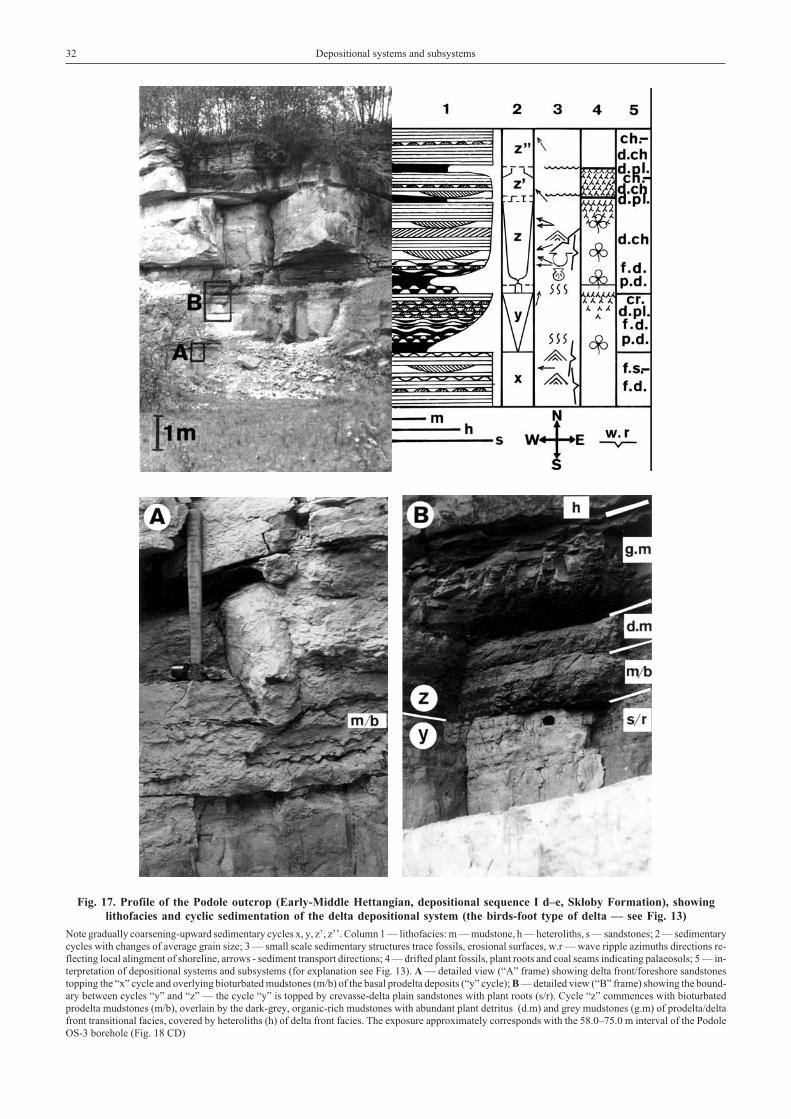
32 Depositional systems and subsystems
Fig. 17. Profile of the Podole outcrop (Early-Middle Hettangian, depositional sequence I d–e, Sk³oby Formation), showinglithofacies and cyclic sedimentation of the delta depositional system (the birds-foot type of delta — see Fig. 13)
Note gradually coarsening-upward sedimentary cycles x, y, z’, z’’. Column 1 — lithofacies: m — mudstone, h — heteroliths, s — sandstones; 2 — sedimentarycycles with changes of average grain size; 3 — small scale sedimentary structures trace fossils, erosional surfaces, w.r — wave ripple azimuths directions re-flecting local alingment of shoreline, arrows - sediment transport directions; 4 — drifted plant fossils, plant roots and coal seams indicating palaeosols; 5 — in-terpretation of depositional systems and subsystems (for explanation see Fig. 13). A — detailed view (“A” frame) showing delta front/foreshore sandstonestopping the “x” cycle and overlying bioturbated mudstones (m/b) of the basal prodelta deposits (“y” cycle); B — detailed view (“B” frame) showing the bound-ary between cycles “y” and “z” — the cycle “y” is topped by crevasse-delta plain sandstones with plant roots (s/r). Cycle “z” commences with bioturbatedprodelta mudstones (m/b), overlain by the dark-grey, organic-rich mudstones with abundant plant detritus (d.m) and grey mudstones (g.m) of prodelta/deltafront transitional facies, covered by heteroliths (h) of delta front facies. The exposure approximately corresponds with the 58.0–75.0 m interval of the PodoleOS-3 borehole (Fig. 18 CD)

ALLUVIAL DEPOSITIONAL SYSTEMS
Using term “alluvial”, not “fluvial” needs some explana-tion. Latin “flumen” or “fluvius” means current, stream orriver, so it refers to water running in a river channel. The word“alluvio” means sediment (“earth”) deposited by river, itmeans also flood. Assuming the fact that not all deposits asso-ciated with rivers are deposited in channels — substantial de-position occurs actually in floodplains — it seems that the term“alluvial” is more appropriate, as it embraces in one word bothchannel and floodplain deposits. Nevertheless, term “alluvial”used in this paper is regarded as synonym of more popularname “fluvial”. In classification adopted in this paper, three al-luvial depositional systems were distinguished: alluvial fandepositional system, braided river depositional system (=bed-load, low sinuosity alluvial system) and meandering riverdepositional system (mixed load–suspended load, high sinuos-ity to anastomosing/avulsion alluvial system). It should benoted that Miall (1977) distinguished four principal typesof river, recognisable on the basis of plan-view morphology:braided, meandering, straight and anastomosing. The typesof river are controlled by such chief factors as: water discharge,sediment load, channel slope and type of vegetation. Distinc-tion of a separate depositional system of anastomosing riverwas regarded as inadvisable for the Early Jurassic alluvial de-posits in Poland. Anastomosing/avulsion patterns of intercon-nected network of low-sinuosity channels occur where con-temporaneous branches of a single river weave around perma-nent, commonly vegetated islands or disconnected segments offloodplain. Anastomosing/avulsion patterns are most commonon extremely low-gradient alluvial plains, where streampower is low and banks consist of muddy, cohesive sediment orare highly vegetated (Nanson, Croke, 1992; Emery, Myers,1996). The present work shows, that the anastomosing/avul-sion pattern can be associated with meandering channel allu-vial system and mixed patterns of sinuous channel/avulsionsedimentation style can occur (see discussion below). More-over, “meandering regime” and “anastomosing regime” canappear in one floodplain basin within very short — from geo-logical point of view — time intervals of a mere 5000 years(Aslan, Autin, 1999). Identification of alluvial plains domi-nated by highly sinuous, laterally migrating channels oranastomosing/avulsion processes must be based on either largeexposed areas or 3-D, high-resolution seismic studies. Largeroutcrops represent only the Early Hettangian deposits (Figs. 6,11; Pls. XI, 4–6; XII, 1) and they show a prominent share ofanastomosing/avulsion processes, although some features typ-ical of meandering rivers are also present (Fig. 11; Pl. XI, 5).Therefore, a general “meandering and anastomosing riverdepositional system” has been distinguished and it comprisesboth alluvial systems: with dominance of lateral channel mi-gration and anastomosing/avulsion processes (Fig. 6; Pl. XI, 4,6). Such an approach is more appropriate for the material stud-ied and it largely follows the classification of Ouchi (1985),where fluvial deposits were subdivided into bedload braidedriver system and two meandering river systems: mixed loadand suspended load. The anastomosing pattern was thusmerged with the meandering river system, as transitions be-
tween meandering and anastomosing patterns are typical. Such“mixed pattern” is well visible in the recent Biebrza valley in east-ern Poland (Fig. 12). This pattern with intensive crevassing andavulsion processes on one hand, and presence of high-sinuosity,laterally migrating channels leaving oxbow lakes behind onthe other hand, is particularly useful for the alluvial depositionalsystems in the Early Jurassic deposits of Poland.
Apart from the system- and subsystem-specific lithofaciesdiscussed further in this chapter, other types of facies represent-ing the alluvial depositional systems are characterised by :
— dominance of characteristic fining-upward cycles (Allen,1964b; Cant, Walker, 1976);
— abundantplant roots,plant remainsandcoal intercalations;— palynofacies with very rich palynomacerals dominated
by large fragments of phytoclasts, and numerous sporomorphs(Pl. VI, 1);
— characteristic biofacies of fresh-water bivalves (Pl. I, 1–3)and other fossils such as insects (Wegierek, Zherikin, 1997);
— non-marine ichnofacies containing characteristic arthro-pod burrows and bivalve burrows; dinosaur footprints are partic-ularly characteristic, typical (facies-specific forms) include largeParabrontopodus (sauropod tracks) and large theropod tracks(Megalosauripus sensu Lockley et al., 1996 and Kayentapus) —Figs. 6, 10; Pl. VII;
— generally, low boron content.
ALLUVIAL FAN DEPOSITIONAL SYSTEM
Alluvial fan deposits occur only in a few places in proximalparts of the earliest Jurassic basin. This depositional system isdistinguished only in the Podole OS-3 borehole (depth 82.0–83.5 m — Fig. 18 CD) and from the Mi³ków-Szewna boreholeprofile (depth 120.0–123.0 m — Fig. 19 CD). Presence of thisdepositional system, forming aggradational coarse clasticwedge, is associated with the synsedimentary fault (Fig. 20)running between these boreholes and active during EarliestHettangian times. The lack of sufficient data does not allow con-firmation of the presence of similar alluvial fan systems alongother active faults, particularly the Nowe Miasto–I³¿a Fault(Figs. 1, 20). This depositional system was distinguished onthe basis of presence of characteristic massive gravel-sandlithofacies, is represented by deposits of gravely-sandy braidedchannels with perennial flow (stream flow fan facies). Plantroots and trace fossils were not found in deposits representingthis system, due to unfavourable living conditions and lowpreservational potential.
ALLUVIAL — BRAIDED RIVER DEPOSITIONAL SYSTEM
Characteristics of the Early Jurassic, the braided riverdepositional system is based on number of exposures from theSzkucin–Lipa area near Przedbórz (Fig. 20; Pl. XI, 1, 2, 3), rep-
Alluvial depositional systems 33

resenting the lowermost part of the Zagaje Formation(Pieñkowski, 1980). Coarse-grained lithofacies (conglomerates)prevail in the lowermost part of the section (Pl. XI, 1). Conglom-erates show horizontal and trough-cross bedding sets of largescale. They represent low-sinuosity braid channel-fill deposits.Higher up in the section sediment is more fine-grained andtrough- and tabular cross-bedded, sand and sand-gravellithofacies dominate (Pl. XI, 2, 3). Conspicuous trough- and tab-ular cross bedding sets point to deposition mainly in longitudinalbars and transverse bars. In longitudinal bars and channel-fill de-posits, sand-gravel, trough cross-bedded conglomerates domi-nate. In transverse bars, sediment moved down the lee side atflood’s peak producing foresets of low-to moderate angle, tabu-lar or tangential cross bedding sets. Characteristic lateral barsoccurred at the slopes of large longitudinal bars (Pl. XI, 3).They were formed during a waning high-discharge period, withdepositional directions perpendicular to the mean channel flowdirection (Rust, 1972). Channel-fill is the only depositionalsubsystem distinguished within this depositional system.
Overbank alluvial plain fines are rare and insignificant or theyare absent. Plant roots and trace fossils are very rare in braidedriver depositional system, due to unfavourable living condi-tions and extremely low preservational potential. This systemshows many similarities that described by Jones et al. (2001)from the Miocene Rio Vero Formation of Spain. It implies de-position in broad, low-sinuosity, perennial but seasonal moder-ate-energy streams.
ALLUVIAL — MEANDERING AND ANASTOMOSINGRIVER DEPOSITIONAL SYSTEM
This depositional system is characterised herein basedon two exposures: So³tyków exposure and borehole (Fig. 6;Pls. XI, 4, 5, 6; XII, 1) and Gromadzice exposure (Fig. 11; Pl.XI, 7). So³tyków exposure shows many similarities to a mean-dering river alluvial plain with avulsion processes (Smith et al.,
34 Depositional systems and subsystems
Fig. 20. Location of studied exposures and boreholes in the Holy Cross Mts region(tectonic map after Hakenberg, Œwidrowska, 1997)
Exposures: 1 — Szkucin Lipa; 2 — Wolica; 3 — Bielowice; 4 — Zapniów; 5 — Niek³añ/Piek³o; 6 — So³tyków; 7 — Szyd³owiec–Œmi³ów area; 8 —Starachowice; 9 — Adamów; 10 — Gromadzice; 11 — Podole.Boreholes: Pl — Pilichowice P-1; Mr — Mroczków-Kraszków 160; Gl — Gliniany Las 1 and Gliniany Las 2; E — Eugeniów-Korytków; W-G — WolaNosowa-G¹siorów WG-2; Zy — Zychorzyn; Gr — Gródek OP-2; Za — Zawada PA-3 and Zawada ZA-9; G-D — G³êboka Droga 2; G-M —Gajówka-Modrzew; R — Ruszkowice K-2; N — Ninków; H — Huta OP-1; Bu — Budki 1; B-K — Broniów-Krawara SP-4; S — Szyd³owiec N-1; Mi —Mirzec Mkr; J — Jagodne 1; B-L — Brody-Lubienia; M-S — Mi³ków-Szewna; Pd — Podole OS-3 (profiles of boreholes Gajówka-Modrzew, Ruszkowice,Ninków and Broniów-Krawara are not published herein, however, some specimen taken from these boreholes are illustrated in this paper)

1989; Farrell, 2001). This depositional system is widely devel-oped in the lower part of the Zagaje Formation (LowerHettangian) all over the Holy Cross Mts region (Huta OP-1borehole, depth 120.0–190.0 m — Fig. 21 CD, Eugeniów-Korytków borehole,depth96.0–121.0m—Fig.22CD).Amodernanalogue of the meandering (high-sinuosity) — anastomosingriver depositional system with prominent avulsion processes ispresented in Fig. 12.
Channel-fill subsystem
Meandering channels exhibit the features most commonlyassociated with alluvial sedimentation (Galloway, Hobday,1996). The channel floor, the deepest part of the channel, ischaracterised by a channel lag consisting of locally derivedmud clasts, waterlogged plant debris and coarse bed-loadgravel and sand — depending on their availability. Sand trans-port in meandering channels is dominantly by dune migration.Hence, grey medium- to large-scale trough cross bedded sand-stones rich in plant detritus is the most characteristic lithofaciesfor channel fill deposits (Figs. 6, 11; Pl. XI, 5, 7). The size ofbed-sets and grain size decreases upward which produce char-acteristic fining-upward, channel fill cycles composed of chan-nel lag, point-bar sand and topstratum sediment (Allen, 1964b;Beerbower, 1964; Jackson, 1976; Galloway, Hobday, 1996;Miall 1996). Lateral accretion beds, identical to those pre-sented by Jackson (1978) and Galloway, Hobday (1996, theirfig. 4.8) characterise the Polish Early Jurassic point-bar depos-its (Fig. 6; Pl. XI, 5). Fine sand, silt and some clay is depositedalong the margins of the channels as decelerating, sus-pended-load-rich waters spill over the banks. Best examples ofthe alluvial channel subsystem come from the lower part oflower Gromadzice exposure (Fig. 11; Pl. XI, 7) and from theSo³tyków exposure (Fig. 6; Pl. XI, 5). The lower part of thelower Gromadzice exposure comprises mixed meander-ing/anastomosing alluvial plain with channel depositional sub-system (medium to poorly sorted, trough-cross bedded, later-ally accreted sandstone lithofacies) with underlying both type 1and type 2 crevasses (Fig. 19 CD, depth 72.7–72.9 m; Farrel,2001). The fact that the type 2 crevasse appear in the uppermostpart of the section, indicates growing aggradational/avulsiontendency associated with the rise of base-level (e.g. Aslan,Autin, 1999). Sandstones are rich in plant detritus (sometimesrepresented by log fragments up to 1 m long) and contain char-acteristic large Parabrontopodus tracks. The alluvial channelsubsystem is associated with the floodplain subsystem repre-sented by dark-grey to black mudstones with abundant plant de-tritus, palaeosoils with plant roots and Unionoidea freshwaterbivalve assemblage. In the So³tyków exposure a channelisedbody of poorly-sorted sandstone lithofacies with lateral accre-tion bedding is encased in the floodplain muddy subsystem(Pl. XI, 5). The presence of sand sheets at the beginning of thechannel development (Fig. 6, depth 4.0–12.0 m; Fig. 19 CD,depth 72.7–72.9 m; Fig. 21 CD, depth 179.5–179.8 m) is note-worthy. These rapidly deposited sand sheets are interpreted
as crevasse splay sediments. According to the avulsion model(Smith et al., 1989; Farrel, 2001) the sand sheets representan initial avulsion stage accomplished predominantly by thedevelopment of crevasse splay complexes which cause the en-largement of new channels and abandonment of old ones. Thusthe sedimentation in So³tyków (Fig. 6) and in the Huta OP-1borehole (depth 120.0–180.0 m — Fig. 21 CD, ) is compatiblewith the avulsion-controlled fluvial sedimentation model ofSmith et al. (1989), Aslan and Autin (1999) and Farrel (2001).On the other hand, the presence of laterally-accreted beddingwithin the channel depositional subsystem (Pl. XI, 5) and gen-eral domination of sharply based, “type 1” crevasse splays(Fig. 6; Pl. XI, 4, 6) point to lateral accretion and overbank flood-ing — i.e. sedimentation processes typical of meandering, notanastomosing/avulsion regime. As the anastomosing/avulsionmodel does not preclude some lateral migration of channels(Aslan, Autin, 1999), the So³tyków exposure represents ratheranastomosing/avulsion-dominated pattern of alluvial plain.Above all, the general lithofacies architecture (Pl. XI, 4) is char-acteristic for crevassing — anastomosing/avulsion processes(Smith et al., 1989; Pieñkowski, 1991b) and for high rates of flu-vial aggradation and fluvial avulsion rate. It is also noteworthy,however, that the avulsion/anastomosing alluvial sedimenta-tion pattern and high sinuosity/meandering/overbank deposi-tion alluvial sedimentation pattern are sometimes difficult to beseparated from each other, particularly in isolated boreholesections or in limited exposures.
Levee subsystem
Increments of sediment are built up with each successiveflood to form natural levees. Some examples of levee deposi-tion are known from the So³tyków exposure and borehole(Fig. 6), and from several other boreholes (Eugeniów-Korytków borehole, depth 96.0–99.0 m — Fig. 22 CD), butthe preservation potential of levee deposits is rather low, asthey are prone to subsequent erosion. Lithofacies of modernnatural levees are dominated by fine sandstones, siltstones andmudstones with ripple, climbing ripple, wavy and planar lami-nation. Plant roots associated with the Podzol type ofpalaeosoil (Arndorff, 1993) are associated with this subsystem.
Crevasse splay subsystem
Local breaches in the levees funnel the flow from the chan-nel during the flood and provide conduits for suspended- andbed-load sediment dispersal into near-channel portions ofthe floodplain (Galloway, Hobday, 1996). Small anastomo-sing, distributary or braided channel systems extend acrossthe splay surface, and both channelised and unconfined flowoccurs during flood event, often forming local alluvial fans or“microdeltas” (Fig. 12). Crevasse splay models were charac-terised in details by Farrell (2001). According to that author,
Alluvial depositional systems 35

the problem with defining crevasse splays is that two processescan produce the same landform: (1) the sudden incursion ofsediment-laden water; or (2) the basinward progradation ofa minor mouth bar/crevasse channel couplet. In the alluvialsubsystem of the Early Jurassic sediments of Poland the firstprocess seems to play more prominent role, as most of the cre-vasse splay deposits show pronounced erosional and strongcurrent features in their bases as mud clasts and partinglineation (Fig. 6). In Early Jurassic alluvial sediments of Polandcrevasse splays are frequent. Classic crevasse splay depositsoccur in So³tyków exposure (Fig. 6; Pls. XI, 4, 6; XII, 1), theyare also known from boreholes (Figs. 19 CD, depth 103.0–107.0m; 21 CD depth 120.0–183.0 m). Most characteristic lithofaciesof crevasse splay deposits comprise poorly-sorted sandstoneswith trough cross bedding and ripple drift cross lamination, al-though their internal structure is usually heterogeneous. Theyoften contain mud clasts. Splays are sedimentary “garbagepiles”, accumulating large amounts of plant debris and mudclasts. Grain sizes and unit thicknesses are generally less thanthose of associated channel subsystem deposits (Fig. 6; Pls. XI,4–6; XII, 1). Palaeosols of the Podzol type (Arndorff, 1993)and plant roots are abundant (Pl. XII, 1). Crevasse splay sub-system was particularly favourable for preservation of the di-nosaur footprints (Pieñkowski, Gierliñski, 1987; Gierliñski,Pieñkowski, 1999; Gierliñski et al., 2001b; see also the previ-ous chapter). Also invertebrate burrows concentrate mostly inlevee and crevasse splay deposits (Fig. 6), and to lesser extentin floodplain deposits.
Floodplain depositional subsystem
Fine bed-load to suspended load sediment is deposited in thefloodplain as “overbank” sediments during floods. It should benoted, that Aslan and Autin (1999) believe that avulsion, ratherthan simple overbank deposition, contributes to the constructionof fine-grained floodplains to a greater degree than generally re-cognised. The most frequent lithofacies is represented by dark, or-ganic-rich, laminated mudstones (Pls. XI, 4–6; XII, 1). They areusually deposited in shallow lakes or backswamps, thus, as far asconcerns lithofacies, the floodplaindepositional systemand lacus-trine depositional system are often very similar or identical (Figs.21 CD, depth 32.5–184.0 m; 22 CD, depth 56.0–117.0 m; 23 CD,depth 51.6–53.2 m). Classic examples of floodplain deposits aredescribed fromthe lowerpartof lowerGromadziceexposure (Fig.11) and So³tyków exposure (Fig. 6; Pl. XII, 1). Mudstones aredark-grey toblack, laminatedorofamassiveappearance,withnu-merous plant roots. Plant growth and pedogenic processes oftenobliterate primary structures. Levels with abundant small sideriteconcretions (“siderite sphaerulites”) represent characteristic, earlydiagenetic product of pedogenic processes in this permanentlysaturated soil. Plants represent largely a wetland association, alsoof a character of “reed swamp”. Shallow water tables occurring inbackswamps or oxbow lakes (Fig. 12) created favourable condi-tions for deposition and preservation of plant debris, which is typi-cal for the Gleysol type of palaeosol (Arndorff, 1993). Mudstonelithofacies are similar to those described by Schieber (1999) fromthe Upper Devonian floodplain deposits.
LACUSTRINE DEPOSITIONAL SYSTEM
This system does not differ much from the floodplaindepositional subsystem described in the previous chapter —generally, the sediments tend to be more fine-grained than infloodplain depositional system (Fig. 21 CD; depth 32.5–120.0 m).Dominating lithofacies are represented by dark-grey and olive-
grey, laminated mudstones and claystones, sometimes withvarve-like lamination (Pl. III, 1). Gleysol type of palaeosols withabundant plant roots and well-preserved plant fragmentstransformed into coal intercalations are characteristic for thisdepositional system.
TRANSITION BETWEEN THE ALLUVIAL DEPOSITIONAL SYSTEMAND THE DELTAIC DEPOSITIONAL SYSTEM
The lower Gromadzice outcrop (Fig. 11) reveals a remark-able sequence of alluvial depositional system and upper deltaplain depositional subsystem. The lower part of the outcropcomprises typical meandering (high-sinuosity) alluvial chan-nel subsystem with trough-cross bedded sandstone revealingbounding, lateral accretion bedding (see the previous descrip-tion of alluvial meandering depositional system). In the nearbyMi³ków-Szewna borehole (Fig. 19 CD, depth 70.0–74.0 m),these channels are associated with “transitional”, coarsen-ing-upward crevasse splay deposits below the channel base,which points also to avulsion processes. On the other hand,some other crevasses in this complex show erosional bases(Fig. 19 CD, depth 74.8–76.0 m). This system (Fig. 19 CD;depth 71.0–115.0 m) was dominated by mixed crevasse pro-
cesses (Farrel, 2001), and development of lateral channel mi-gration shows that there was an equilibrium between verticaland lateral sediment accretion rate (Collinson, 1978; Aslan,Autin, 1999).
The overlying complex of grey, laminated mudstones,siltstones and grey, fine-grained sandstones are of differentcharacter. Laterally-continuous layers of siltstones and sand-stones show coarsening-upward character, some low-anglebounding surfaces and tabular cross bedding sets showing di-rections of transport dispersed between West and North direc-tions. Notably, there is lack of erosional features at the bottomof each cycle. Such pattern is substantially different in compar-ison to crevasse splay deposits described from the alluvial sys-tem (So³tyków outcrop — Fig. 6, Pl. XI, 4, 6). It points to
36 Depositional systems and subsystems

the basinward progradation of a minor mouth bar/crevassechannel couplet (Farrell, 2001), which results is a sequence re-sembling deltaic crevasses (bayfill analogue). Such succes-sions are 50 cm–1 m thick and include a mud facies overlain bylenticular lamination, laminated silt and cross bedded/lami-nated, fine-grained, poorly-sorted sandstones. Plant debris oc-curs in the whole sequence and plant roots are most abundant atthe coarse-grained, top parts of each sequence. Bivalve findsshed light on the character of the mudstones. The bivalve as-semblage contains both fresh-water Unionoidea and rarebrackish-water Cardiniidae and Mytilidae. Additionally, boroncontent is slightly higher than in the underlying alluvial plainmudstones. Interestingly, numerous dinosaur tracks found inthe section represent the Anomoepus–Moyenisauropus–Anchizauripus–Grallator association (Pl. VIII, 2). The trackswere left by small- to medium sized low-browsing animals be-longing to basal ornitishians and small- to medium-sizedtheropods. This assemblage is regarded as typical of delta plainand barrier-lagoon deposits (Gierliñski, Pieñkowski, 1999).Collectively, all those features point to a delta plain (upperdelta plain) deposit, where the muddy overbank plain was atleast periodically occupied by brackish water with a “bay bi-valve” association. Sandstone/siltstone layers representdeltaic, basinward prograding crevasse splay deposition. These
features are consistent with rapid aggradation during whichcrevassing, lacustrine/marsh sedimentation, and avulsion dom-inated delta plain/floodplain construction in the Holocene Mis-sissippi river floodplain (Aslan, Autin, 1999).
It is noteworthy that the change of depositional system fromalluvial plain to delta plain is very gradual, without a “clear”transgressive surface. It should be mentioned, that the “clear”or “true” transgressive surface can be noted (particularly inboreholes) when nearshore deposits cover the continental (al-luvial/lacustrine) deposit. In the Gromadzice outcrop (Fig. 11)only types of crevasse development, meandering/avulsion char-acter of faces architecture and biofacies/chemofacies character-istics make a difference. However, contact between the twosuccessions exposed in Gromadzice represents change from al-luvial (mixed lateral accretion-avulsion controlled) todeltaic-alluvial (highly aggradational, avulsion-dominated)depositional system. Some 5 metres above this sequence,a well-defined transgressive surface occurs (recognisable alsoin Mi³ków-Szewna borehole, depth 69.2 m — Fig. 19 CD) withcontact between delta plain/lacustrine deposits and offshoreembayment sediments above (Pieñkowski, 1991a, his fig. 2.1).Such a change in facies, immediately preceding the transgres-sion, suggests a slight diachroneity of transgressive surface in aregional scale (Figs. 24, 25).
TRANSGRESSION AND ITS NONMARINE CORRELATIVE SURFACESWITHIN ALLUVIAL/LACUSTRINE/DELTA PLAIN DEPOSITIONAL SYSTEMS
Good correlation between transgression and transgressivesurface can be observed basinward, in Pomerania and the Dan-ish basin (Fig. 26), where the marine sediments lie sharply onalluvial deposits (ravinement surface), without any “transi-tional facies” predating the transgression — compare withCatuneanu et al., 1998. At the same time, a rapid base level risehas a pronounced effect on sedimentation in the continental ba-sin — alluvial deposition is rapidly replaced by a fine-grained,lacustrine deposition and consequently, the nonmarine correla-tive surface (time equivalent) of transgressive surface can beobserved within continental deposits (Figs. 24, 25, 26 — seethe correlative surfaces marked with green lines). Change froman alluvial depositional system with laterally shifting fluvialchannel belts to highly aggradational lacustrine depositionalsystem or avulsion-dominated alluvial plain system, associatedwith a base level rise, is confirmed in many works (Shanley,McCabe, 1994; Olsen et al., 1995; Surlyk et al., 1995; Aslan,Autin, 1999). Further progress of a transgression leads to de-velopment of nearshore depositional systems overlying
lacustrine depositional systems. A scheme of such “step-wise”,retrogradational development of transgression (transgression sys-tems tract) with its nonmarine correlative surfaces within alluvialand deltaic systems is particularly well recognised within thedepositional sequence I in the Holy Cross Mts region and is pre-sented in Figs. 25 and 26. The succession of retrogradational con-tinentaldepositsoccurringbetween thenonmarinecorrelativesur-face within continental deposits and the transgressive surface atthe base of marine/nearshore deposits was named tentatively asthe “pre-transgressive systems tract” (Pieñkowski, 1991a; 1997).Such aggradational/retrogradational succession of sediments be-longs to the transgressive systems tract, although it occurs belowthe transgressive surface (Figs 25, 26). It should be noted, that thepresent work documents non-marine correlative of thetransgressive surface, which has been regarded as unidentifi-able within the fluvial succession (Catuneanu et al., 1998).Surlyk et al. (1995) also claimed that distinguishing of correla-tive surfaces of marine transgressions is possible in fluvial/lac-ustrine facies (their lacustrine-flooding surfaces).
DELTAIC DEPOSITIONAL SYSTEM
A delta forms where a river transporting significant quanti-ties of sediment enters a receiving basin. Interaction ofsubaerial fluvial (alluvial) processes and subaqueous processesof marine basins produces distinctive facies assemblages (Gal-loway, Hobday, 1996). Depositional architecture of a delta sys-
tem is characteristically progradational, which typically resultsin coarsening-upward sequences. Sediment input (construc-tional processes — fluvial) and wave-energy flux (redistribu-tion processes) controls the lithofacies and depositionalsubsytems distribution in delta systems (Postma, 1995). In
Transgression and its nonmarine correlative surfaces... 37

38 Depositional systems and subsystems
Fig
.24
.C
ross
-sec
tion
ofth
eH
oly
Cro
ssM
tsre
gion
show
ing
apa
rtof
depo
siti
onal
sequ
ence
I(b
,c
para
sequ
ence
s)an
dde
velo
pmen
tof
the
Ear
lyH
etta
ngia
ntr
ansg
ress
ion
corr
elat
edw
ith
the
wor
ld-w
ide
tran
sgre
ssio
nin
the
pla
norb
isZ
one
Ref
eren
cele
vel—
tran
sgre
ssiv
esu
rfac
eof
the
depo
siti
onal
sequ
ence
I.T
hree
infe
rred
tim
eli
nes
(fro
mth
ebo
ttom
toth
eto
p)co
rres
pond
wit
hm
aps
A,B
,C,r
espe
ctiv
ely.
Gra
dual
deve
lopm
ento
ftra
nsgr
essi
onis
visi
ble,
wit
hin
itia
lla
goon
altr
ansg
ress
ion
drow
ning
the
lacu
stri
nede
posi
tion
alsy
stem
inth
eba
sin’
sce
ntre
.E
nsui
ngde
velo
pmen
tof
the
brac
kish
mar
ine
basi
nis
show
non
the
map
C.
The
figu
resh
ows
asl
ight
diac
hron
eity
ofth
etr
ansg
ress
ive
surf
ace
inth
eH
oly
Cro
ssM
tsba
sin’
s(b
etw
een
the
basi
n’s
cent
rean
ded
ges)
.For
furt
her
expl
anat
ion
see
Fig
.16

Transgression and its nonmarine correlative surfaces... 39
Fig
.25
.C
ross
-sec
tion
ofth
eH
oly
Cro
ssM
tsb
asin
show
ing
dep
osit
ion
alsy
stem
san
dco
rrel
ativ
esu
rfac
esof
the
low
erpa
rtof
de-
posi
tion
alse
quen
ceI
(a,
b,c
para
sequ
ence
s—
basa
ltr
ansg
ress
ive
syst
ems
trac
t,Z
agaj
eF
orm
atio
nan
dba
sal
Sk³o
byF
orm
atio
n)
Ref
eren
cele
vel—
tran
sgre
ssiv
esu
rfac
eof
the
depo
siti
onal
se-
quen
ceI.
Not
eco
nspi
cuou
sbo
unda
rybe
twee
nth
em
eand
er-
ing/
anas
tom
osin
gan
dbr
aide
dri
ver
depo
siti
onal
syst
ems
and
the
lacu
stri
nede
posi
tion
alsy
stem
(bou
ndar
ybe
twee
n“a
”an
d“b
”pa
rase
quen
ce,
gree
nli
ne).
Thi
sbo
unda
ryre
pres
ents
the
nonm
arin
eco
rrel
ativ
esu
rfac
eof
the
tran
sgre
ssiv
esu
rfac
e,w
hich
deve
lope
din
the
sam
eti
me
inN
WP
olan
d(F
ig.
26).
Bra
ckis
h-m
arin
etr
ansg
ress
ion
(blu
eli
ne)
reac
hed
the
Hol
yC
ross
Mts
regi
onla
ter.
For
expl
anat
ion
see
Fig
.16

deltaic system, the term "fluvial" is more appropriate, as deltaconstructioning processes are related mainly to river channelsactivity. All actively prograding deltas have at least one com-mon attribute: a river supplies clastic sediments to the receivingbasin more rapidly than they can be removed by marine pro-cesses (Coleman, 1981). As tidal activity was not prominent inthe Early Jurassic basin in Poland, tide-dominated deltas do notoccur. Therefore two basic types of deltas were distinguishedin the Early Jurassic deposits of Poland: fluvial-dominated(birds-foot) deltas (Fig. 13), and wave-dominated (or mixedwave-fluvial) deltas (Fig. 14). The stratigraphical patterns in asmall-scale delta complexes are distinguished by outcrop-scalelithofacies features (Figs. 8, 17). The deltaic cycles wereformed by reoccupation-abandonment autocyclic processes.
As far as concern palynofacies, the delta plain palynofacies issimilar to the alluvial one. Delta front and interdistributary baypalynofacies show increased number of sporomorphs (Fig. 9;Pl. VI, 2). In the Early Jurassic deposits of Poland, the boroncontent is usually relatively low in comparison with other mar-ginal marine depositional systems.
FLUVIAL-DOMINATED (BIRD-FOOT DELTAS)
Postma (1995, his fig. 5) distinguished twelve delta proto-types of fluvial-dominated deltas prograding in a low energybasin characterised by low wave energy, low littoral drift and
40 Depositional systems and subsystems
Fig. 26. Development of the transgressive systems tract (TST) of the depositional sequence I in marine (Danish Basin),marine to marginal marine (Pomerania region) and marginal-marine to continental settings (Holy Cross Mts region)
LST — lowstand systems tract (corresponding with erosion in the areas studied). Note the “backstepping” of sedimentary package in the initial phase of trans-gression, step-wise, retrogradational development of parasequences and rapid replacement of the alluvial depositional system by the aggradational, lacus-trine/delta plain depositional system (“pre-transgression” stage), which is caused by the base-level rise. The coeval correlative surface of the transgressivesurface, associated with the base level rise, can be observed within continental deposits (nonmarine correlative surface, green line). “Bifurcation” oftransgressive surface and its nonmarine correlative surface separates a package of the aggradational, lacustrine/delta plain deposits between the nonmarine cor-relative surface and transgressive surface in the Holy Cross Mts (see Fig. 25). Note that a general style of parasequences is different in marginal-marine settings(type 1 parasequences) and in areas close to the marine basin (type 2 parasequences) — flooding surfaces in marine basin approximately correspond withparasequence maximum flooding stages, while in marginal marine settings these surfaces are apart from each other

high discharge of fines as suspended load. One of his types fitsconditions occurring in the Early Jurassic epicontinental de-posits of Poland. This is type D8, associated with shallow bas-ins, with low-gradient, highly stable suspension-load rivers withlevees. Birds-foot deltas built vertical sequences of regular,coarsening-upward character (Figs.13,17,18CD—PodoleOS-3,depth 48.0–80.0 m). Such sequences represent prograding envi-ronments (subsystems) which can be ordered from the bottomto the top in the following way: prodelta (laminated mudstoneand heterolith lithofacies), delta front — mouth bar (laminatedto cross-bedded siltstones, heteroliths and fine-grained sand-stones — Pl. XII, 3), interdistributary bay (organic-rich mudstones— Pl. XIII, 7), distributary channel (trough cross-bedded sand-stones — Pls. XII, 2; XIII, 3, 4, 7) and complex delta plain subsys-tem, comprising flood plain deposits (organic-rich mudstones)and crevasse and levee deposits (ripple-laminated siltstones,cross-bedded sandstones) — Fig. 11, Pl. XI, 8. In all thedepositional subsystems, Unionoidea bivalves are commonwith very rare, uncertain representatives of Cardiniidae inprodelta deposits, which points to freshwater — lowoligohaline faunas (Hudson et al., 1995). In this type of deltasystem buoyant sediment plumes plays a very important role indevelopment of subaqueous elements of delta (prodelta anddelta front). The dispersal of sediment suspension off the frontof a fluvial-dominated delta involves the transport of clay, siltand fine sand on a buoyant plume of fresh water that is pro-pelled from the stream-channel mouth by an effluent jet andspreads basinward above a denser, saline or brackish, basinalwater (Bates, 1953). The suspended sediment particles tend tosettle out from the buoyant plume, giving rise to a continuous“rain” of fines that progressively cover the deltaic slope andprodelta zone. Mixing of fresh and brackish-marine water fa-voured flocculation processes (Gibbs et al., 1989). As the waveprocesses in the basin were not strong enough for a completeremoval of the mud fraction in the sandstones, the flu-vial-controlled delta front subsystem was the area where thecharacteristic “diffuse heteroliths” were formed (Pls. IV, 2;XII, 3). The “poor sorting” in the heterolithic facies (called“diffuse heteroliths”), is documented by an intermixing of frac-tions. The mud fraction occurs abundantly within the sandylenses and laminae, while the sandy fraction is present in mudintervals. As a result diffuse contacts or low contrast betweenthe sandy lenses and mudstones can be observed and the sandylenses are irregular. The “diffuse heteroliths” were formed dur-ing quick sedimentation under continuous “rain” of sediment,while fluctuations in wave/current activity created heterolithiccharacter of the sediment. Such “diffuse” heteroliths were de-scribed by Pieñkowski (1991b) from fluvial-dominated deltasystems from Hettangian deposits from Southern Sweden.They seem to be characteristic lithofacies for delta-frontdepositional subsystem in fluvial-dominated deltas. Theoreti-cal mechanism of activity of deltaic buoyant plumes was givenby Nemec (1995). Interestingly, in fluvial-dominated delta sys-tem trace fossils spectrum is poor in dwelling structures(domichnia), due to a high concentration of suspended mineralmatter, which is not favourable to suspension-feeders (Rhoads,Young, 1970; Pieñkowski, 1985). Plant roots (the Histosol typeof palaeosol – Arndorff, 1993) colonise the topsets of deltaiccycles (Pl. II, 3, 5, 10), while trace fossils (mostly fodinichnia)
are grouped mainly within prodelta and delta front subsystems.Characteristic dinosaur footprint associations occur withindelta-plain deposits (see previous chapter). The distributarychannel subsystem is very similar to alluvial channel subsys-tem (Pl. XII, 2), although general scale of sedimentary structuresand maximum and medium grain size of bed load sediment arelower. Plant fragments are abundant in all depositional subsys-tems. Also palynofacies reflects the proximity of vegetation(Fig. 9). Examples of such a deltaic system is presented on Figs.17, 18 CD, and summarised in Fig. 13. Deltaic deposition dom-inated the most marginal parts of the Early Jurassic brackishmarine basin. It is possible to estimate the depth of the receiv-ing basin in the case of Podole delta system (Figs. 17, 18 CD),based on the rule that the progradational sequence of sedimentsapproximately reflects the local water depth. The averagethickness of a delta cycle is 4 metres and the cycles are regularand continuous, comprising complete sets of depositional sub-systems from prodelta to subaerial distributary and delta plainsubsystems. Assuming the compaction factor of mudstones,siltstones and fine-grained sandstones (at the estimated burialdepth of 800.0 m) as 1.4, the primary depth of the basin is esti-mated at about 5–6 metres.
INTERMEDIATE FLUVIAL-AND WAVE-DOMINATED DELTAS
Intermediate fluvial- and wave-dominated deltas occurredin basins of intermediate wave energy, apparent littoral driftand very flat offshore slope, with the same characteristics offluvial influx as in the previous, fluvial-dominated type of deltasystem. Basinal processes reworked, modified and distributedsediments within the outer part of the delta, which resulted ina “composite” vertical sequence of individual delta-progradationcycles (upper Gromadzice exposure, Fig. 8). Individual deltacycles reflecting prograding subsystems are divided into twoparts separated by flanking barrier belt-facies (reworked mouthbars) formed at the wave-breaking zone. The outer deltaic zoneis composed of muddy and heterolithic prodelta deposits andsandstone flanking barrier deposits (delta-front zone,wave-reworked mouth bars). The inner deltaic subsystem isdominated by stagnant lagoons and interdistributary bays, withmarshes and coal accumulation and poorly-drained types ofpalaeosols of Histosol to Gleysol type (Arndorff, 1993; Fig. 8;Pl. II). The lagoon-marsh deposits are overlain by quicklyprograding, relatively low-energy distributary channels(Mi³ków-Szewna borehole, three cycles between 42.0 and69.0 metres, separated by intervals of nearshore deposits —Fig. 19 CD). Progradational and flooding stages were con-nected with reoccupation-abandonment autocyclic processes,identical to those presented by Boyd and Penland (1984, theirfig. 8). However, such fluctuations were responsible for com-posite vertical successions of stacked, aggradational orprogradational cycles instead of simple coarsening-upward cy-cles (Fig. 17). Modern analogues (although in much biggerscale) are known from the Nile delta (Coleman et al., 1981) andMississippi delta (Boyd, Penland, 1984). Spatial reconstruc-tion of this delta type, showing progradational and flooding
Deltaic depositional system 41

stage, is presented on Fig. 14. As in all deltas, plant roots andplant debris are abundant in inner delta zone, but they are lessfrequent in outer delta zone. Also domichnia appears in theouter delta (barrier) zone (Fig. 8), while they are generally ab-sent from delta-front subsystem in birds-foot deltas (Fig. 17).Bivalve association shows a characteristic “mixed” character —both Cardiniidae (mostly Cardinia follini Lungren) andUnionoidea are present, pointing to low oligohaline faunas(Hudson et al., 1995). It points that the Unionoidea bivalveswere not confined to fresh water but could occur in some abun-dance in low-oligohaline waters. Numerous dinosaur footprintsof Anomoepus–Moyenisauropus–Anchizauripus–Grallator as-sociation occur in the delta plain (inner delta) zone. This type ofdelta depositional system is rather poorly known from previouswork, particularly in vertical sequences from the geological re-cord. Best counterparts were described by Horne et al. (1978,their fig. 1), Pieñkowski (1991b, his fig. 7; pl. 9) and Emery,Myers (1996, his fig. 8.10).
Development of this deltaic succession, particularly atthe contact between coal and distributary channel facies (Fig. 8),allows some conclusions concerning time span and accommo-dation space. Large-scale autocyclicity such as delta switchinggenerates coals of subregional extent (Hamilton, Tadros, 1994).A contact between coal or peat and clastic sediment usually rep-resents a considerable hiatus in clastic deposition (McCabe,1984). For peat to form, the rate of increase of vertical accom-modation space must equal the rate of accumulation of peat,and clastics must be excluded from the environment (Bohacs,Suter, 1997). In some interpretations of deltaic deposits,the contact between coal or peat and overlying clastic sedi-ments usually represents a regional flooding surface (Farrell,2001). Other authors (Coe et al., 2003) identify bottoms of coalseams occurring in delta plains with flooding surfaces.However, in the Gromadzice exposure (Fig. 8) three differentcontacts between coal and clastic sediments occur in one pro-file. The lowermost contact (3.25 m) represents flooding ofa backbarrier marsh by a lagoon/interdistributary bay, causedby local rising of water table associated with basinward migra-tion of a flanking barrier/mouth bar. It represents a local flood-ing stage, associated with local creation of some accommoda-
tion space and fine-grained clastic sedimentation, but certainlyit does not represent a regional flooding surface. The secondcontact (2.20 m) is associated with erosion (Fig. 8, surfacemarked with “e”), and in this case the clastic sediment suppliedby autocyclic processes (delta lobe switching), which stopspeat production and generates a facies contact cannot be identi-fied with a regional flooding surface or any flooding stage (seeFarrell, 2001). Oppositely, the facies transition represents rapidprogradation of a low-energy distributary channel facies ontolagoon/marsh deposits. Peat accumulation (occurring probablyin a water-logged reducing environment of a permanently satu-rated palaeosol, where plant growth catched up with sedimen-tation – note very long plant roots) was stopped shortly beforeprogradation of the distributary channel. This model requiresthat the coals be initiated as low-lying coastal swamps behindthe shoreline. Subsequent accumulation of distributary channelfacies needed some accommodation space, which was createdby subsidence, largely associated with gradual compaction ofunderlying clays and peats. The uppermost contact representstrue, “classic” regional flooding surface – the delta plainbackswamp was flooded by brackish-marine basin, which rap-idly stopped peat production and led to deposition of clasticsediments. The Gromadzice exposure (Fig. 8) shows threecoal/clastic sediment contacts in one delta progradational cy-cle, developed accordingly to the classic Walther’s rule. There-fore, contacts between peat and overlying clastics, althoughthey always form conspicuous marking horizons, must betreated with due caution concerning their proper interpretation.Despite the fact that the coal seams in marginal-marine settingsusually herald local or regional sea level rises, the character offacies lying above the coal/clastic sediment contact and carefulstudies of the whole succession is crucial in that respect.
A high degree of wave reworking and basinal processes can leadto near total redistribution of fluvio-deltaic sediments. In such cases itis hard to differentiate such systems as deltaic ones, particularly inboreholes, and the wave reworked sediments were usually regardedas representing the nearshore or barrier-lagoon depositional system.Therefore, the interpretation of palaeoenvironments (depositionalsystems) inEarlyJurassicsedimentsofPolandmaybeslightlybiasedtowards a “non-deltaic” interpretation.
BARRIER-LAGOON DEPOSITIONAL SYSTEM
Barrier coast successions reflect three main environments(depositional subsystems): — the shore parallel barrier islandsor spits, including eolian dunes, back-barrier eolian sheets andwashover fans behind the barrier/spit crest; — the enclosed la-goon or embayment; — inlets that facilitate exchange ofstorm-driven circulation (Galloway, Hobday, 1996). Tidal ac-tivity is not discussed widely as it is of rather lesser significancein Early Jurassic epicontinental basin in Poland. Moreover,barrier islands and spits are best developed in tideless ormicrotidal shore zones (Hayes, 1975). The origin of barriershas been attributed to at least three different mechanisms(Hoyt, 1967; Swift, 1975; Wilkinson, 1975): — the verticalgrowth and emergence of offshore bars; — downdrift growth
of spits; — detachment of beach ridges from the mainland bya rise in sea level. What is characteristic for the barrier-lagoonsystems is the presence of lagoonal deposits, separated fromthe open basin by a belt of nearshore/barrier deposits. An excel-lent modern analogue of barrier/spit/lagoon/ embayment systemfrom the Baltic coast of Poland is presented in Fig. 15.
BARRIER DEPOSITIONAL SUBSYSTEM
The basinward part of the barrier-lagoon depositional sys-tem is treated as part of the nearshore depositional system (seethe next chapter). Microtidal or tideless barriers tend to belong
42 Depositional systems and subsystems

and narrow, with conspicuous washover fans and few inlets.Barrier lithosomes depend very much on the wave energy inthe basin. Lower wave energy leads to preservation of morecomplete barrier profile reflecting palaeomorphology (Pl. XIII,3, 4). Beach deposits with low-angle tabular foresets and bar-rier crest eolian dunes with buried plants are often preserved(Pls. II, 6; XIII, 4, 6, 7). High energy produces more inlets andwashover fans and destroys barrier crest deposits, which resultsin dominance of trough-cross bedding sets within the preservedbarrier body (Pl. XIV, 6). Yet another kind of barrier is a sub-merged type (Pl. XII, 5). These are unstable and quicklytranslocating forms, separating open basin from an embayment orembayment from a lagoon. In the Polish Early Jurassic such sub-merged barriers modified the dynamic conditions duringfair-weatherbutdidnot formasignificantobstacleduring increasedwave action (Pieñkowski, 1991b) and were breached during verystrong storms. Their vertical profile is usually “incomplete”, with-out coarse, foreshore and backshore deposits of barrier crest — forexample Pl. XII, 5; Figs. 16, 27 CD (Wola Nosowa-G¹siorówWG-2,depth20.0–23.5m)and28.Their tops showsometimes do-lomite cementation. Submerged barriers or bars may belong both toshoreface or foreshore depositional subsystems.
LAGOON DEPOSITIONAL SUBSYSTEM
The lagoonal environment is highly variable depending onhydrological conditions. The barrier belt or spit separates the la-goon from the open basin with different effectiveness. A contin-uous barrier belt is associated with a closed lagoon characterisedby low energy sedimentary processes, dark, often oxy-gen-depleted sediments, frequent well-preserved plant fragments(which indicates a calm sedimentary environment), poor and in-frequent fauna, limited bioturbation, frequent siderite bands andnodules (Pls. II, 4; V, 6). Therefore, lagoonal sediments are repre-sented by dark-grey to brown-reddish mudstones. Mudstones arefinely laminated. Lenticular lamination is common, otherheteroliths are rare. A relatively high admixture of iron in sideriteand sideritic mudstone beds is caused by proximity of marsh/swampareas, a prominent source of iron. This results in the occurrence ofsecondary reddish colours, which is the effect of epigenetic oxi-dation. If there is a river mouth on the landward shore of the la-goon (a so called “bayhead delta”), the lagoon is usuallyquickly infilled by deltaic/alluvial sediments (Roy et al., 1980)— for example Fig. 18 CD (Podole OS-3, depth 34.0–55.0 m).Palynofacies (Pl. VI, 2) are rich in both opaque phytoclasts andcuticle. Number of palynomorphs, particularly spores some-times (hydrodynamic traps) is very high.
Boron content can be very unstable in such deposits(Gliniany Las 1, depth 10.0–35.0 m — Fig. 5 CD). It is caused ei-ther by evaporation (in case of high contents) or influx of freshwater (in case of low contents).
MARSH DEPOSITIONAL SUBSYSTEM
Plant roots and palaeosols are common in shallow parts ofthe lagoon subsystem, which leads to formation of marshdepositional subsystem with accumulation of dark-greymudstones with plant roots (Pl. II, 1, 2, 8, 9a, b, 11) and brackishmarsh peat. Siderite nodules are common, but also pyrite concre-tions occur, which differentiates the marsh mudstones fromfresh-water lacustrine mudstones. Both mottled and laminated(lenticular silty lamina) structures occur (Schieber, 1999). Marshsubsystems tend to contain more boron as this element is ab-sorbed by organic matter (Ulièny, 1989).
EMBAYMENT DEPOSITIONAL SUBSYSTEM
If the contact with sea is wider (such as in the case of spits),lagoons are transformed into embayments and their sedimentsshow higher energy of depositional processes, which causesmuch frequent presence of heteroliths. Colour of sediments ispaler, and in places bioturbation by deposit-feeding organisms ishigh, which leads to obliteration of primary sedimentary struc-tures. Plant fragments, coal and plant roots are less frequent thanin the deposits of closed lagoon, as are sideritic bands.Palynofacies show transitional character between closed la-goons and open basin (Fig. 9).
Gradual transgression, with development of lagoon,embayment, barrier and offshore-shoreface sediments in one ver-tical section occurs for example in Gliniany Las area (Fig. 16 —above the flooding surface) and in Mi³ków-Szewna borehole(depth 35.0–42.0 m — Fig. 19 CD). It is important for definingof the parasequences in marginal-marine settings, which will bediscussed later.
The barrier-lagoon depositional system occurs in bothtransgressive (retrogradational) and high-stand (progradational) sys-temstracts.Transgressivesurfacesandfloodingsurfacesareoftenas-sociated with development of barrier-lagoon depositional systems,particularly when the sediment input to the basin was relatively high.Barrier-lagoon system is regarded as typical of transgressive coasts(Boyd et al., 1992). Examples are numerous: Gliniany Las area (Fig.16),HutaOP-1borehole(Fig.21CD,depth10.0–32.0m,withflood-ing surfaces of Ic and Id parasequence); Eugeniów-Korytków bore-hole (Fig. 22 CD, depth 48.0–52.0 m, with flooding surface of Idparasequence), Eugeniów-Korytków borehole (depth 45.0– 50.0 m),Wola Nosowa-G¹siorów WG-2 borehole (Fig. 27 CD, depth55.0–63.0 m with flooding surface of Id parasequence),Eugeniów-Korytków–Wola Nosowa-G¹siorów area (Figs. 28, 29).
Therearealsoexamplesof“regressive”barrier-lagoondepositio-nal systems associated with progradational high- stand systems tractsor regressive, progradational tops of parasequences. However, suchsituations seem to be less frequent. Examples are shown in:Eugeniów-Korytków borehole, depth 9.0–13.0 m, and WolaNosowa-G¹siorów WG-2 borehole, depth 18.5–20.0 m.
Barrier-lagoon depositional system 43

44 Depositional systems and subsystems
Fig. 28. Cross-section between Eugeniów-Korytków and Wola Nosowa-G¹siorów WG-2 boreholes(depositional sequence I b–f), showing changes of lithofacies and depositional systems/subsystems at a distance of 4 km
Note that many lithofacies and depositional subsystems (local sedimentary cycles) wedge out, while parasequences, parasequence boundaries (flooding sur-faces) and maximum flooding surface of sequence I are of correlative significance. Reference level — transgressive surface of the depositional sequence I.For explanation see Fig. 16

Barrier-lagoon depositional system 45
Fig
.29
.C
ross
sect
ion
ofth
eH
oly
Cro
ssM
tsre
gion
show
ing
deve
lopm
ent
ofde
posi
tion
alsy
stem
san
dbo
undi
ngsu
rfac
esw
ithi
nth
etr
ansg
ress
ive
syst
ems
trac
tof
depo
siti
onal
sequ
ence
Ib–f
,Sk
³oby
For
mat
ion
Ref
eren
ceho
rizo
n—
max
imum
floo
ding
surf
ace
ofth
ede
posi
tion
alse
quen
ceI.
The
near
shor
ede
posi
tion
alsy
stem
stil
ldom
inat
esin
the
farw
este
rnm
argi
nof
the
basi
n,w
hite
delt
aic
depo
siti
onal
syst
emis
prom
inen
tin
the
cast
ern
mar
gin
ofth
eba
sin.
.Thi
sis
prob
ably
caus
edby
sign
ific
antd
iffe
renc
esin
rive
rdi
scha
rge
and
sedi
men
tsup
ply
betw
een
east
ern
and
wes
tern
mar
gins
ofth
eba
sin.
For
expl
anat
ion
see
Fig
.16

NEARSHORE DEPOSITIONAL SYSTEM
The shore zone, excluding deltas, comprises the relativelynarrow, high-energy transitional environment that extendsfrom the landward limit of marine processes down tofair-weather wave base, commonly at about 10 m (Fig. 15). Theoffshore subsystem (shallow brackish-marine shelf basin) isalso included to this system, as generally the basin’s depth wasprobably no more than about 80 m, and storm wave-base stillaffected the bottom (Fig. 30). Although shore zones were rela-tively narrow, shoreline migration over time left a recordof widespread nearshore deposits (Figs. 24, 26, 29).The nearshore depositional system is primarily nourished bylongshore sediment transport, which is diagnostic of thenearshore depositional system. Reworking of abandoned deltalobes or active delta margins to gather with reworking of chan-nel-mouth deposits of small coastal plain streams was mainsource of sediment in the Early Jurassic basin in Poland. Addi-tional sediment input was via residual concentration during re-gional coastal plain transgression and erosion of headlands(Galloway, Hobday, 1996). Concerning lithofacies, quartzsandstones are characteristic particularly in the shallowdepositional subsystems. Labile components are reduced or re-moved by physical and chemical breakdown that accompanieswave and current recycling, and the finer fraction is winnowed,leaving well-sorted quartz arenites. The nearshore zone is dis-cussed in whole, irrespective whether facies represent thebasinward part of strandplain sand body or of a barrier-spitdepositional subsystem.
Chief processes which modified the nearshore depositionalsubsystems of the Early Jurassic basin in Poland were wavesand long-shore marine currents. The following subsystemswere distinguished within nearshore depositional subsystem(compare with Figs. 15, 30):
BACKSHORE, EOLIAN DUNESAND WASHOVER FANS
This subsystem is related to the zone situated abovethe fair-weather range of waves. Generally, this subsystem isrepresented by sandstone and mudstone lithofacies on a vege-tated coastal plain. The dominant process was wind reworkingof subaerial coastal sands, which led to formation of eoliandunes, sometimes with buried plants and plant roots (Pl. XIII,2, 6). During storms, washover fans were formed with sand-stone, horizontally- or trough-cross bedded lithofacies.
FORESHORE DEPOSITIONAL SUBSYSTEM
Foreshore or beach face environments corresponds tothe zone of wave swash. Well-sorted quartz arenite is the typi-cal lithology. Wind can also play a role in reworking the sand.The dominant structure is planar bedding dipping gently sea-
ward, with low-angle discordances representing adjustment ofthe beach to changes in wave regime or sediment supply(Clifton, 1969). Heavy minerals tend to be concentrated in dis-crete laminae. Storms in the foreshore zone are usually markedby erosional surfaces or graded bedding if the coarse-grainedmaterial is available (Fig. 7). Foreshore deposits are knownfrom several outcrops (Pls. XII, 4; XIII, 2, 4, 7; XIV, 2, 6) andnumber of boreholes.
SHOREFACE DEPOSITIONAL SUBSYSTEM
Shoreface zone is almost continuously subjected to a com-plex variety of currents, which owe their origin to waves andwind (Davis, Fox, 1972). The constantly changing nature ofthese driving forces dictates that the currents vary in speed anddirection in both space and time. In this paper, the shorefacedepositional subsystem was extended by including to it thehummocky cross stratification zone and transitional, flaser- towavy heterolithic zone (Fig. 30). Therefore, the lower,basinward limit of the shoreface depositional subsystem is iden-tified with a range of average storm wave-base (excluding exce-ptionally violent storms, which can affect the offshore zone).
Upper shoreface environments corresponding to the inner surfzone are dominated by powerful onshore, offshore and long-shorecurrents (Clifton et al., 1971; Dabrio, Polo, 1981). A ridge and run-nel system is a combination of a swash bar and a trough (Fig. 30).The ridge is a tabular body of sand, which is built after storms and itmigrates toward the landuntil itweldsonto the foreshore/backshoreto form a berm. Therefore alongshore-directed trough cross-bedsarecharacteristic (Pl.XII,4)withonshore-dippingplanarcrossbed-ding deposited by ridge migration, and irregular truncation surfacesreflecting storms and rip channels (Galloway, Hobday, 1996; Pl.XIV, 6. Ridges of wave ripple crests are generally parallel to theshoreline (Dabrio, Polo, 1981), which can be used to reconstruct thelocalpalaeoshorealingnment (Pl.XIII,4,7).Biogenicstructuresarerare and they are represented almost exclusively by dwelling struc-tures (domichnia) such as Skolithos, Arenicolites andMonocraterion. Storms in this zone are marked by erosional sur-facesorgradedbeddingif thecoarsematerial isavailable(Fig.7).
The middle shoreface in tideless seas is subject to intensivewave action and associated long-shore and geostrophic rip cur-rents, leaving a complex depositional record (Emery, Myers,1996, their fig. 8.10). Long-shore bars are the most characteris-tic forms and as they move landward they produceshoreward-dipping tabular cross bed sets (Davidson-Arnott,Greenwood, 1976). Their analogues are common in the EarlyJurassic sediments of Poland (Pl. XIV, 1, 2) and they are repre-sented by tabular, landward-dipping cross-bedding sets. Pres-ence of long-shore bars implies, that for most of the time the as-tronomical tides were absent or tidal range must have beenwithin micro-tidal range, as tidal conditions are detrimal to for-mation of wave-built long-shore bars parallel to coastline.Bidirectional long-shore currents (usually with dominance of
46 Depositional systems and subsystems

one direction) are also very common (Dupre, 1984; Massari,Parea, 1988). Such currents cause the greatest amount of sedi-ment transport in the recent nearshore zones (Davis, 1978).Early Jurassic analogues with the same suite of structures indi-cate significant long-shore currents with unidirectional or, lessfrequently, bimodal, shore-prograding azimuths (Pl. XIV, 1).
Horizontal bedding, sometimes with parting lineation iscommon (Pls. XII, 4, 7; XIII, 1; XIV, 5). Such structures are in-dicative of strong currents (upper flow regime) (Allen, 1964a).One should note, that lee-side grain avalanching on ripples anddunes with low height/length ratios is not capable of producingwell-defined cross-strata. Bedform migration in such casesproduces “horizontal” stratification (Smith, 1971).
Trough cross-bedding sets and horizontal bedding ofa scour- and fill-character occur within tabular sets or horizon-tally bedded sheet sandstones (Pl. XII, 7). In some cases, con-glomeratic lags occur at the bottoms of the troughs and in mostcases they are infilled with coarser sandy sediment. The troughaxes show mostly an orientation perpendicular or slightlyoblique to inferred palaeoshore direction and the currents wererunning toward an open basin. The sediment grading alone in-dicates rapid deposition from suspension, but the presence ofcross-stratification in many troughs points to a depositiondriven by migrating bedforms with low height/length ratios.The fining-upward textures, sharp erosional bases, and sedi-mentary structures within the sediments filling the “troughs”
point to a rapid deposition by episodic, waning flows (Fig. 30).Storm-associated rip currents (precisely, storm surge ebb) in ashoreface environment could provide the best explanation ofmechanism of deposition of these “troughs” (Ingle, 1966).Davidson-Arnott and Greenwood (1976) suggested that ripcurrents expand seaward of a breaker zone, which causes a sud-den decrease in flow velocity, and results in the deposition oflarge volumes of sediment in the offshore direction (Fig. 30).Walker (1984) believes that such flows could be effective sedi-ment transporters to a few hundred meters offshore.
In high wave energy regimes of middle shoreface zone, par-allel-laminated sand is deposited under conditions of intensebottom shear (Kumar, Sanders, 1976) and may preservelow-amplitude undulations or hummocky cross-stratification(Walker, 1984). Storms in this zone are still usually marked byerosional surfaces or graded bedding if the coarse material isavailable (Fig. 7), but some truncated storm layers withhummocky cross stratification may appear in this zone.
Biogenic structures are dominated by dwelling structures(domichnia) such as Skolithos, Arenicolites and Monocraterion.Intense bioturbation can lead to obliteration of primary depo-sitional structures (Pl. V, 5).
Lower shoreface deposits accumulate in the zone affectedby average storms (Fig. 7). Storm-wave surge produces irregu-larly undulating surfaces of low hummocks and swales (Fig.30; Harms et al., 1982). This is the zone of formation of
Nearshore depositional system 47
Fig. 30. Nearshore depositional system and subsystems of Early Jurassic deposits in Poland with most common lithofacies;white — sandstones, black — heteroliths and mudstones
The sketch shows offshore, shoreface, foreshore and backshore subsystems (compare with Figs. 7 and 15). Based on Handford, 1985 with changesand amendments

hummocky cross-stratification — the most common type ofcross bedding in the lower shoreface setting (Pls. XII, 8;. XIII,1, 5; XIV, 2–4). Thus, hummocky cross-bedding is indicativeof high-energy, storm-influenced nearshore environment situ-ated approximately between fair-weather and storm-weatherwave base (see previous chapter on lithofacies). Hummockycross-stratification is largely restricted to very fine sand. Inmost cases the hummocky cross-stratification occurs in socalled “amalgamated” sequences (Dott, Bourgeois, 1982), butseparated cosets are also common (Pl. XII, 8). Below thehummocky cross-stratification zone, the so-called transitionalzone between shoreface and offshore zone occurs. It is in-cluded by some authors to the inner shelf/offshore zone(Leckie, Krystynik, 1989; Galloway, Hobday, 1996). The pro-portion of sand, silt, and mud and the dominant physical andbiogenic structures depend on the sediment available and thewave-energy regime. Wavy to flaser heteroliths are dominanthere (Pls. III, 4, 6, 7; V, 4, 7, 8). Microhummockycross-lamination is common (Pls. III, 4; IV, 5; V, 1, 2, 4) as wellas with graded, storm-generated beds — tempestites (Dott,Bourgeois, 1982; Aigner, 1985; Fig. 7; Pl. IX, 5).
Concerning the ichnofacies, the largest population of inver-tebrates is commonly found just below average storm wavebase, at the shoreface/offshore transition (Howard, 1978).Biogenic structures are represented by mixed dwelling-feedingstructures of Cruziana ichnofacies (see the chapter onichnofacies). In fully marine conditions, Diplocraterionparallelum structures are common in marine salinity conditions.
Palynofacies characteristics show that many sporomorphsare mechanically destroyed and other palynomacerals are re-worked and dispersed (Fig. 9; Pl. VI, 3).
OFFSHORE DEPOSITIONAL SUBSYSTEM
The offshore zone extends deeper basinward from an aver-age-storm wave base (Fig. 30). It can be identified with the in-ner shelf zone of an epicontinental, broad shelf type (Galloway,Hobday, 1996, their fig. 7.1A). Only strong storms affected thebottom producing lenticular bedding or lenticular lamination(Pls. III, 3, 5; IV, 1; XIV, 8) and distal storm cycles or“microturbidites” with graded bedding (Fig. 7; Pls. IV, 7; IX,8b). Ichnofacies are represented by deposit feeders, such asTeichichnus (Pl. X, 1a, b), Tuberculichnus (Pl. X, 4) andChondrites (Pl. X, 5). A "post-storm" ichnofacies may alsocomprise dwelling burrows Rosselia, which are normally typi-cal of more shallow environment (Pl. IX, 8a, b).
Depth of the epicontinental Early Jurassic brackish marinebasin can be estimated based on two methods. The first one iscomparison with modern, semi-closed, epeiric, tideless, brack-ish-marine basins. Such analogue is the Baltic Sea (Fig. 15).Comparison of modern Baltic Sea lithofacies (Uœcinowicz, 2000)with Early Jurassic lithofacies shows that muddy-heterolithiclithofacies occur below 60 m. However, results from the BalticSea can be biased towards coarser facies due to the reworkingof relict Pleistocene deposits. Another result come from
the German Bight of the North Sea (Aigner, 1985). Coastalsand passes into a sand-mud transition zone at about only 7 mdepth, and the transition zone passes into a zone of shelf mud atabout 15 m deep. According to Walker and Plint (1992), thefair-weather wave base (i.e. lower limit of dominant sandstonelithofacies) in modern seas generally ranges from about 5–15m and average storm wave base is about 20 m. However, oneshould bear in mind that heavy storms may reach the bottomeven below 150 m.
Another method is based on the approximate reconstruc-tion of accommodation space of the basin. If it is based onthe following assumptions:
— thickness of a sediment column is counted between a maxi-mum flooding surface and deposits with plant roots, which rep-resent emersion;— relatively continuous sedimentation in a fairly regularprogradational sequence representing highstand systems tractwith relatively stable sea level is assumed;— average compaction rate of 1.4 is accepted;— subsidence is disregarded as insignificant due to relativelyshort period of time— one obtains a maximum water depth of about 21 m inthe marginal part of the Middle Hettangian basin (depositionalsequence I, Gliniany Las 1, depth 63.0–78.0 m, Fig. 5 CD). Itshould be noted, that the sediment-loading factor cannot be ac-counted for, therefore the results may be somewhat exagger-ated. It means that the muddy, basinal lithofacies in Early Ju-rassic brackish-marine basins appeared at depths 20–30 m.Probably, they were not exceeding some 40–50 m deep. Suchestimations are somewhat higher than those given by Aigner(1985), but are generally in good accordance with the figuresgiven by Walker and Plint (1992).
It should be noted that narrowness and isolation of manyparts of the Early Jurassic epicontinental basins in Poland cre-ated conditions where even much lower basin depths mightcreate hydrodynamic conditions similar to those occurring atgreater depths in the shelf basins. Such relatively small andshallower “restricted brackish-marine shelf basins” were de-fined as “open embayments” or bights. Muddy/heterolithic fa-cies could occur there at depth range between 10 and 20 m —similar to figures given by Aigner (1985) from the modern Ger-man Bight. Those “open embayments” differ from semi-closedembayments and lagoons in absence of apparent barriers orspits separating them from the open shelf basin. Shorefacezones of “open embayments” are usually narrower than thoseassociated with the open shelf basins. In fact, Early Jurassicmarine/brackish marine basins in Poland were similar to large,semi-closed embayments, except for the Pliensbachian marinebasin in Pomerania region. It became particularly clear in EarlyToarcian times, when almost the whole basin was chiefly ofsuch character.
Palynofacies of the open brackish-marine basin (Fig. 9)show scarce palynomacerals, white, translucent AOMA(amorphous organic matter of aquatic origin) and more fre-quent dinoflagellate cysts (Pl. VI, 4).
48 Depositional systems and subsystems

MARINE BASIN — OPEN MARINE SHELF DEPOSITIONAL SYSTEM
Open marine shelf basin deposits occurred only in EarlyPliensbachian and perhaps in Early Toarcian in the west part ofPomerania region and is described based on the borehole mate-rials (Mechowo IG 1, depth 600.0–660.0 m, Fig. 31 CD;Kamieñ Pomorski IG 1, depth 250.0–287.0 m, Fig. 32 CD; Pl.X, 3, 6–8). With regard to hydrodynamic conditions, thisdepositional system is very similar to the offshore depositionalsubsystem described above. In the deepest parts of the basin,dark grey to brown grey mudstones and shales with pyrite, sid-erite and marine fauna (including ammonites) dominate. Theyresemble burrow-mottled silty mudstone lithofacies or moder-ately laminated grey mudstone lithofacies of Schieber (1999).The ichnofacies is dominated by Chondrites and pyritizedtubes of Palaeophycus (Pl. X, 3, 7). At least temporarily,the bottom environment was oxygen-depleted (dysaerobic),which is evidenced by presence of Chondrites (Pl. X, 3). Someexceptionally heavy storms could affect the bottom, leavingdistal storm cycles, improving temporarily living conditions(post-event ichnofacies) and bringing "exotic" palynofacies
elements (second type of palynofacies inversion). The typical“background” palynofacies is characterised by scarcepalynomacerals. White-translucent AOMA (amorphous or-ganic matter of aquatic origin) and dinoflagellate cysts arecharacteristic.
Estimation of accommodation space obtained from thick-ness of sediments between the maximum flooding surface andsubaerial deposits at the base of next depositional sequence in-dicates that the Early Pliensbachian marine shelf basin inPomerania region would be some 90 m deep (assuming com-paction ratio 1.6 appropriate for clays and mudstones,Mechowo IG 1, depth 573.0–628.0 m, Fig. 31 CD, depositionalsequence IV, Early Pliensbachian). However, erosion at thebase of overlying depostional sequence V has removed an un-known portion of sediments, thus the basin could have beendeeper. Lack of conspicuous tempestites (even the distal ones)suggests that the depth of the marine shelf basin in the west partof Pomerania region in Early Pliensbachian (ibex Zone) mighthave reached 100–150 m.
TIDE-INFLUENCED SHORE ZONE DEPOSITIONAL SYSTEM
This system is discussed separately, as its share indepositional processes in Early Jurassic times in epicontinentalPoland was of little significance due to the semi-closed, shal-low character of the basin. However, one should bear in mindthat the available data from nearshore system of the marinePliensbachian and Early Toarcian basins are scarce and theirshare of tidal deposits could be more significant. As far as con-cerns exposures of Early Jurassic deposits in the Holy CrossMts, neither specific vertical sequences intersected by runnelsand channels (Reineck, 1972) nor other diagnostic structuressuch as cross strata separated by erosion surfaces with muddrapes (de Raaf, Boersma, 1971) or vertically accreted tidalbundles (Kreisa, Moiola, 1986; Tessier, Gigot, 1989;Murakoshi et al., 1995) have been observed. A local occur-rence of “herringbone” cross stratification (Pl. XIV, 1) cannotserve as sufficient evidence. Reversed currents driven by
changing wind and waves in the shoreface zone seem to pro-vide a simpler and better explanation. So far, probable tidal de-posits have been found only in the Early Pliensbachian depositsin the Wielkopolska region (Pobiedziska IGH-1 borehole —Fig. 1) and in the Late Pliensbachian heteroliths occurring inthe Fore-Sudetic Monocline (Gorzów Wielkopolski IG 1 bore-hole — Fig. 1). These few metres thick intervals comprise bothcharacteristic bi-directional “rhytmites” with mud drapes andfrequent, regularly repeating erosional surfaces with mudclasts, and evidences of rapid shifts between erosion and sedi-mentation periods. Diplocraterion paralellum Torell dwellingstructures of both pro- and retrusive character, bivalve restingtracks of Lockeia amygdaloides (Seilacher) and fodinichnia(deposit feeders structures) are common. It points thatmesotidal influence could reach central Poland, at least inPliensbachian times.
SEDIMENTATION AND DEPOSITIONAL SEQUENCESOF THE EPICONTINENTAL LOWER JURASSIC DEPOSITS IN THE POLISH BASIN
SEQUENCE STRATIGRAPHIC TERMINOLOGY ADOPTED IN THIS PAPER
Sequence stratigraphy may be applied in two ways, either involv-ing detailed sequence analysis based on depositional architecture andcyclicity in the rock record (Surlyk, Ineson, 2003), or construction ofagemodelsbasedon thecorrelationwithglobal (Haqetal., 1987)oratleast superregional sea level charts (Hesselbo, Jenkyns, 1998; de Gra-ciansky et al., 1998a, b). Both approaches have been integrated
in the present work, aimed at determination of correlative signi-ficances and ages of key surfaces and derived sea level curves.
In the present work, the original definition of depositional se-quence is adopted (Mitchum et al., 1977; Haq et al., 1987;Jervey, 1988; Posamentier et al., 1988): a depositional sequenceis "a stratigraphic unit composed of relatively conformable
Marine basin — open marine shelf depositional system 49

succession of genetically related strata and bounded at its topand base by subaerial unconformities and their correlative con-formities". The depositional sequence is defined in relationshipto the relative sea level (base level) changes (Fig. 26). Relativesea level is understood as the sum of superregional sea levelchanges and tectonic subsidence (the term “eustatic” is gener-ally avoided it the present work, due to unproven synchroneityof most sea level changes in global scale). The timing of forma-tion of the depositional sequence boundary is generally relatedto the stage of base level fall. Consequently, an "Exxon ap-proach" to sequence stratigraphy was adopted in this paper.This approach offers more advantages for the Early Jurassicmaterials from outcrops and boreholes (predictive, detailedmodels with unconformities and flooding surfaces and morereliable time framework provided by unconformities) than inthe case of genetic stratigraphic sequences (Galloway, 1989).Genetic sequences do not contain predictive systems tracts andthey do not account for erosion at unconformities. According toCatuneanu et al. (1998), the depositional sequence comprisesfour systems tracts (understood as a linkage of contemporane-ous depositional systems) with distinct stratal stacking pattern:the transgressive systems tract (TST), which forms when sedi-ment supply is insufficient to maintain progradation during rel-ative sea level rise (Fig. 26); the highstand systems tract (HST)which forms, when the sedimentation rate exceeds the rate ofrelative sea level rise in the shoreline area ("normal regres-sion"); the falling stage systems tract (FSST) which forms dur-ing relative fall of sea level (forced regression); the lowstandsystems tract (LST) which forms during early relative rise,when the sedimentation rate exceeds the rate of relative rise inthe shoreline area. The latter three systems tracts (HST, FSSTand LST) form together a progradational package known as aregressive systems tract (RST) (Embry, Johannessen, 1992).Recognition of the FSST and LST is possible only in the marineportion of the basin. In shallow, shelf marginal-marine andcontinental Early Jurassic basins in Poland, both FSST andLST deposits are missing or strongly reduced, as the time oftheir formation in the marine basin was usually associated witherosion occurring landward. This means that the time equiva-lent of both FSST and LST systems is simply a sequenceboundary, comprising both erosional and non-depositional hia-tus, or they can be hypothetically represented by some of thinpackages of coarse-grained alluvial deposits at the bases ofTST systems tracts (within their “pre-transgression” succes-sions). If such “packages” are present, they should be regardedas equivalents of LST or lower TST systems tracts, formed dur-ing an earliest stage of relative sea level rise. However, distin-guishing between such a LST equivalent and overlying alluvialdeposits commencing the TST is impossible. It led the presentauthor to distinguishing of only two systems tracts within adepositional sequence: retrogradational TST andprogradational, regressive HST. Consequently, type-1 andtype-2 sequences (van Wagoner et al., 1988) can be recognisedonly tentatively, based on more or less incised character of thesequence boundary and comparison with its equivalents(Ligurian cycle, Exxon curve).
Major bounding/correlative surfaces within depositionalsequences are:
— sequence boundary (erosional, subaerial surface), as-sociated with hiatus.
Characteristics: superregional range, erosional/non-depositional hiatus more prominent in the landward direction,often channelised erosion cutting down into underlying sedi-ments, sharp facies contrast (usually alluvial depositional sys-tem above the sequence boundary contact with different mar-ginal-marine/nearshore systems below the boundary),kaolinization of the sediments underlying the sequence bound-ary, coarse grained sediments above the sequence boundary,sometimes sediment provenance change. Particularly impor-tant is differentiation between erosional surfaces caused by lo-cal tectonism and those representing sequence boundaries.The most important difference is their lateral extent. In case oftectonic origin, the erosional surfaces and associated coarse al-luvial/deltaic sediments are local and associated with faultzones (Fig. 25). Deltaic progradation is particularly limitedin space when the faults are active, as their activity create spacein the hanging wall that can accommodate sediments (Figs. 24,25). At the same time sequence boundaries and associatedcoarse-grained alluvial/deltaic sediments are of much widerextent (Figs. 24, 25, 26). A sequence boundary of this character(regional occurrence, marked truncation of the underlying de-posits, marked lag deposits/coarse sediments above) corre-sponds to that described by Surlyk et al. (1995). Kaolinizationof the underlying sediments (Pls. XII, 5, XIII, 3) is attributed tometeoritic water percolation during the non-deposition periodat the sequence boundary (Pieñkowski, 1988; Brañski, 1996,1998; Ketzer et al., 2003).
— transgressive surface (ravinement surface) and itsnon-marine correlative.
Characteristics: superregional range, reworking of under-lying sediments, sometimes dolomite and pyrite cementation(Ketzer et al., 2003), long-lasting transformation ofdepositional systems occurring above the surface (Figs. 25, 28,29). Contrary to Catuneanu et al. (1998) and accordingly toSurlyk et al. (1995), this paper shows that recognition ofthe non-marine correlative of the transgressive surface can beidentified within alluvial/lacustrine successions (Figs. 24–26;see previous chapter for characteristics). The high preservationof fine-grained material and the upward-fining trend suggesthigh and increasing rates of base level rise that eventually led tomarine flooding (Figs. 24, 25). A similar characteristic oftransgressive surfaces and their non-marine correlatives wasgiven by Olsen et al. (1995) and Surlyk et al. (1995).
— maximum flooding surface (downlap surface) and itsnon-marine correlative.
Characteristics: this is the level of a superregional rangewhich shows the most pronounced marine influence withina given sequence. It usually contains rich and diversifiedichnofauna, shows maximum landward extension of mar-ginal-marine, usually fine-grained sediments and sometimes isassociated with siderite or ankerite cementation (Figs. 28, 29).The maximum flooding surface separates a retrogradationaltransgressive succession from progradational, regressivesuccession, i.e. it separates transgressive systems tract (TST)from highstand systems tract (HST).
50 Sedimentation and depositional sequences...

Within TST and HST successions, parasequences are dis-tinguished. Parasequence is commonly considered the basicbuilding block in sequence stratigraphy. According to VanWagoner et al., 1990 a parasequence is a “relatively conform-able succession of genetically related beds or bedsets boundedby marine-flooding surfaces or their correlative surfaces”. Inthis paper parasequences are understood as successions relatedto broader, allocyclic fluctuations of relative sea level (at leaston a regional scale), not autocyclic sedimentary processes on alocal scale. Therefore, not every flooding-prograding succes-sion is regarded in this paper as a parasequence. Most local suc-cessions (or cycles), usually one to several metres thick (Figs.16, 28), can be produced by autocyclic mechanisms (such asfluctuations in a local sediment supply). Applying an alterna-tive interpretation, such minor-scale successions could be de-fined as parasequences, eventually grouped in regionally rele-vant sets of parasequences. However, I doubt if such approachis justified, because the mentioned above definition requiresthat parasequences should constitute the basic building block insequence stratigraphy, therefore they should reflect more sig-nificant changes in the relative sea level and they should be ofat least regional significance (Figs. 16, 24, 25, 28, 29). More-over, introducing “sets of parasequences” would complicateboth terminology and hierarchy, in my opinion, “sets ofparasequences” are better defined as systems tracts. Assumingthese arguments, the following hierarchy of sequence strati-graphic successions is applied:— superregional sequences — which can be identified at a dis-
tance of hundreds to thousands of kilometres; the sequences arecomposed of
— regional parasequences — which can be traced at a dis-tance of tens to hundreds of kilometres; in the parasequences onecan distinguish numerous
— local cycles (successions) — produced by autocyclicprocesses or sedimentary events, which can be traced usually ata distance of few hundred metres to several kilometres.
In this paper, marine flooding surfaces, often representedby their correlative surfaces, are called flooding surfaces.Parasequences represent prograding, generally upward-shallowing successions beginning with flooding surfaces andending with shallow facies, which are frequently associatedwith emersion and palaeosol development (plant roots; Figs.16, 28, 29). In the Early Jurassic basin of Poland (mostly ofmarginal-marine character), palaeosol development processesassociated with the end of progradation and parasequence de-velopment extended far to the basin. The wide range of suchpalaeosol horizons is a major criterion allowing differentiationbetween parasequences and other subordinate cycles (autocyclicsuccessions). The Early Jurassic marginal-marine parasequencesfrom the Polish epicontinental basin usually show a more com-posed lithofacies and depositional systems development (Figs.16; 26 — type 1 parasequences; 28) and can not be describedexactly in terms of simplified, “ideal” models of rapid flooding— gradual prograding, where the parasequence maximumflooding stage is practically identified with the lowerparasequence’s boundary (Emery, Myers, 1996, their fig. 2.24;Coe et al., 2003, their figs 4.5; 4.6; 8.11). These conventionalmodels assume that deepening parts of parasequences are usu-ally not preserved as transgressive sediments. However, care-
ful facies analysis of the Lower Jurassic parasequences in Po-land shows that in most cases deepening parts of parasequencesabove the clearly defined flooding surfaces are preserved astransgressive sediments (Figs. 16; 28). It is probably related toa semi-closed, shallow character of the Early Jurassic basin inPoland, which enabled a wide basinward redistribution oftransgressive sediments. Consequently, one can distinguishthe parasequence maximum flooding surfaces within mostparasequences (Fig. 26, type 1 parasequences). The parasequencemaximum flooding surface is not associated with flooding sur-face, as the flooding surface represents a first conspicuoustransgressive impulse commencing facies back-stepping (retro-gradation) at the base of parasequence, while the maximum rangeand depth of basin occurred later in a parasequence development(and higher in the parasequence’s profile). Thus, these mar-ginal-marine parasequences resemble rather “mini-sequences”than simple coarsening-upward, regularly prograding succes-sions (Fig. 26, type 1 parasequences; for example see a vast ma-jority of parasequences from the Holy Cross Mts region —Figs. 16, 28, 29 and CD — Figs. 4, 5, 18, 19, 21–23, 27). Suchparasequences seem to be typical of marginal-marine settings,as distance from the open marine basin, flat palaeoslope incli-nation, much more dynamic changes of depositional systemsand wide re-distribution of transgressive sediments delaysflooding processes, making them more gradual. It should beemphasised that the more “symmetrical” and composite faciesarchitecture of the type 1 parasequence model is well estab-lished, because it usually represents a succession between veryreliable bounding surfaces, such as well-defined flooding sur-faces represented by palaeosol horizons/flooding surfaceboundaries, often accompanied by pyrite cementation (Figs.CD — 4, 5, 18,19, 21, 23 and 28, 29; Pl. IV, 3). Lack of cal-cite/dolomite cementations (Ketzer et al., 2003) at most of theseparasequence boundaries can be explained by epigenetic disso-lution of carbonates, because traces of diagenetic silicate graindissolution and pyrite cementations are common. It proves thatdistinguishing of “composed” parasequences is justified by theirreal internal lithofacies succession and they are not a mere resultof misplacing of the parasequence boundaries.
One of the important practical implications of suchdevelopment of marginal-marine parasequences (Fig. 26, type 1parasequences) is that their recognition based only on wire-linelogs can be doubtful. On the other hand, nearshore-marineparasequences from Pomerania region (Fig. 26, type 2 parase-quences; Fig. 31 CD, depth 926.0–1105.0, parasequences I b, c,e, f, i) are often more similar to the “ideal” parasequence mod-els with simple flooding-prograding successions (Emery,Myers, 1996; Coe et al., 2003). The maximum flooding stageswithin the parasequences are usually closer to their lowerboundaries (flooding surfaces). It should be noted that deepen-ing parts of parasequences are still preserved as transgressivesediments, although transgressions are usually marked by rela-tively thin sediments. Flooding surfaces are often linked tothe dolomite/calcite cementation (Ketzer et al., 2003).
Sea level cycles (forming sequences and parasequences)occur over many time scales (Emery, Myers, 1996; Strasser,Hampson, 2002). In the present work, mainly 3rd order cycles(duration 0.5–10 million years) are distinguished. They arethe foundation of sequence stratigraphy because they are often
Sequence stratigraphic terminology adopted in this paper 51

of a scale well-resolved by seismic data. Principal forcingmechanisms of such cycles include such superregional sea levelchanges as: glacio-eustasy (global scale), geoidal eustasy (globalscale) and intra-plate stress (superregional scale). Such 3rd ordercycles represent sequences and some parasequences. Mostparasequences represent 4th order cycles (duration 200–500 thou-sands of years). Principal forcing mechanisms include:glacio-eustasy (global) and Milankovitch cyclicity–eccentricity,precession and obliquity (also global). They may be related in partto autocyclic processes within the depositional system, particu-larly in the marginal parts of the basin. Influence of the global 2nd
order cycles (10–100 million years, caused by changes insea-floor spreading rates and ocean-ridge volumes) can be addedto some particularly characteristic and widespread bounding sur-faces, related also to some truly eustatic events (Early Hettangian,Early Toarcian — Hallam, 1997). A “linear” influence of the 1st or-der cycles (200–400 million years — break-up of Pangaea) is alsopossible, but it is too long a term to be of practical use forhigh-resolution sequence stratigraphy.
Discussion on the nature of observed sea level changes is be-yond the scope of the present work. The interpretation of eustaticchanges from the rock record is a complex and controversial topic.The dilemma as to which change is really global, and which only ofintra-plate, superregional scale is not resolved (for discussion seeCloetingh et al., 1985; Miall, 1986; 1992). However, results ofmodern projects, aimed at the accurate dating and correlation of se-quence boundaries and other correlative surfaces in Western Eu-rope (de Graciansky et al., 1998a, b; Hesselbo, Jenkyns, 1998;
Dumont, 1998) offered a framework — on European scale — forsequence stratigraphy of the Early Jurassic deposits, regardless ofongoing discussion on complex nature of the sea level changes. Inthat respect, the Exxon curve (Haq et al., 1987) is useful template,calibrated also from European sections. It arranged sequences inthe stratigraphic order and despite some amendments suggested bythe mentioned authors of the sequence stratigraphy in Western Eu-rope, the “Exxon curve” remains an important reference, particu-larlyconcerningtherangeofcertainbounding/correlativesurfaces.
In this work, identification of major bounding surfaces (se-quence boundaries, transgressive surfaces, maximum floodingsurfaces) is built up progressively from a local to regional (Figs.16,25,28,29)andsuperregional scale (Fig.26).Sedimentologicalanalysis coupled with biostratigraphy play an important role indistinguishing of sequences in a local to regional scale (seethe borehole profiles), while overall biostratigraphical controll(Fig. 2) is of a key importance for superregional correlation.An overall biostratigraphical framework shows substantiallyvaried precision, both between the regions and in geologicaltime. The most precise correlation based on finds of ammonitescomes from Pliensbachian deposits of Pomerania region (Figs.2, 31 CD, 32 CD). Correlations in other regions are less precise,but they still provide a reliable biostratigraphical framework(for example Fig. 5 CD, depth interval 35.0–40.0 m with guid-ing miospores). More precise ages assigned to some key sur-faces described in this paper are largely based upon a compari-son with sequence stratigraphic templates from other parts ofEurope (Hesselbo, Jenkyns, 1998; de Graciansky et al., 1998).
EARLY JURASSIC SEDIMENTATION IN THE HOLY CROSS MTS REGION
This region plays a key role in interpreting of Early Jurassicdepositional systems and depositional sequences in Poland. Datafrom this region are also important for identification of some ma-jor bounding surfaces (Figs. 25, 28, 29). This is the only region inPoland (with exception of one exposure near Czêstochowa)where the Early Jurassic deposits may be observed on the sur-face. Additionally, there are many shallow, fully cored boreholeswhich provided excellent material for sedimentological anddepositional sequence studies. Therefore, the characteristics ofthe Early Jurassic lithofacies, depositional systems and depo-sitional sequences is largely based on materials coming from thisregion. The localization of existing exposures and boreholes ispresented in the Fig. 20. Additional exposures of the Hettangianand Sinemurian deposits were described in previous work(Pieñkowski, 1980), although some no longer exist. Nineteenshallow boreholes from this region are documented herein.
DEPOSITIONAL SEQUENCE I
Sedimentation of Jurassic deposits was preceded by con-spicuous erosion. Jurkiewiczowa (1967) reported buriedpalaeovalleys of rivers from the Przedbórz area (Fig. 20),which were cut down to 60 m into the Upper Triassic red beddeposits. On the other hand, near the depocentre (Parszów be-
tween Starachowice and Skar¿ysko-Kamienna and adjacent bore-holes — see Fig. 20) the hiatus at the Triassic–Jurassic boundaryembraces only Upper Rhaetian, as shown by palynological data(Marcinkiewicz, 1957; Or³owska-Zwoliñska, 1962; Fija³kowska,1989). The Triassic/Jurassic transition was undoubtedly con-nected with climatic change, as Upper Triassic deposits representgenerally red beds and the lowermost Lower Jurassic depositsrepresent coal-bearing association. Transformation from aridto more humid climate could, however, occur over a longer pe-riod as the latest Rhaetian deposits show already features ofmore humid climate (Pieñkowski, 1991b; Arndorff, 1993,1994). Analysis of palaeosols from Hettangian– Sinemurian de-posits of Bornholm point to a humid subtropical climate(Arndorff, 1993), on the other hand, the xeromorphicHirmerella, the dominant plant in the Early Hettangian forestcommunity of So³tyków (Fig. 6; Pl. XI, 4–6; Pl. XII, 1) maysuggest a dry season (Reymanówna, 1991) in the earliest Juras-sic climate of Poland. Forest fires are indicated by charcoal oc-currences (Reymanówna, 1993). The erosion occurring at theTriassis/Jurassic boundary is identified with the lower bound-ary of depositional sequence I, which is very striking, as the redbeds contact with the coal-bearing association. The Triassicrocks below the sequence boundary are often kaolinized(Kozydra, 1968).
Basal Lower Jurassic sediments are represented by coarse,conglomerate lithofacies, passing upwards into sandstone/con-
52 Sedimentation and depositional sequences...

glomerate lithofacies with trough- and tabular cross bedding(Szkucin–Lipa exposures — Pl. XI, 1–3; Mi³ków-Szewnaborehole, depth 116.0–123.0 m, Fig. 19 CD; So³tyków S³-2,depth 22.0–29.0 m, Fig. 6). These lithofacies represent alluvialfan and braided river depositional systems. At the edges of thebasin this complex may be very thin or absent (Podole OS-3,depth 82.0–83.5 m, Fig. 18 CD). In the south-east margin of thebasin, a characteristic aggradational prism of alluvialfan–braided river deposits occurs between Mi³ków-Szewnaand Podole OS-3 boreholes (Fig. 25). It is associated with rapiddecrease of thickness of the whole complex of continental de-posits in the Podole OS-3 borehole. A similar situation occursat the western edge of the basin (Pilichowice P-1 borehole, Fig.25). Such thickness contrasts and stacked alluvial fan/braidedriver deposits clearly point to the activity of synsedimentaryfaults at the beginning of Early Jurassic sedimentation (Figs.20, 24 A, 25). In the basin depocentre, the profile commenceswith meandering river depositional system (Huta OP-1 bore-hole, depth 185.0–190.0 m, Fig. 21 CD; Fig. 25). The coarse--grained succession commencing Early Jurassic sedimentationmay represent partly LST, but this cannot be proved. As dis-cussed above, LST and FSST systems tracts are usually associ-ated with erosion and the beginning of sedimentation is usuallyassociated with initial TST.
Higher up, the section is dominated by sandy-muddylithofacies of a meandering - anastomosing river depositionalsystem (Pls. XI, 4–7; XII, 1; Huta OP-1, depth 120.0–190.0 m,Fig. 21 CD; Mi³ków-Szewna, depth 71.0–116.0 m, Fig. 19 CD;Eugeniów-Korytków, depth 96.0–121.0 m Fig. 22 CD). Again,at the edges of the Holy Cross Mts region this complex thins out(Gliniany Las 2, depth 65.0–67.0 m — Fig. 4).
The meandering-anastomosing river depositional systemwas then abruptly replaced by mudstone/claystone/coallithofacies with palaeosols of lacustrine-backswampdepositional system, particularly well developed in the basindepocentre (Huta OP-1, depth 32.5–120.0 m, Fig. 21 CD). Thissedimentary event formed an easily identifiable boundaryacross the whole Holy Cross Mts region (Fig. 25). This bound-ary is regarded as a parasequence boundary (Ia/Ib). Interest-ingly, at that time deposition of lacustrine deposits expandedrapidly onto the elevated marginal areas of the basin(Mi³ków-Szewna, Fig. 17; Pilichowice P-1, Figs. 23 CD, 25).Such rapid change of depositional systems can be explainedeither by rapid increase in the subsidence in the whole HolyCross Mts region or by rapid rise of the base level. The firstpossibility is unlikely, as the lacustrine depositional systemextended over the edges of the basin, but its thickness is stillstrongly reduced in the marginal areas. Rapid base level rise ismore likely explanation. Such a base level rise had a pro-nounced effect on sedimentation in the continental basin, as al-luvial deposition is rapidly replaced by lacustrine deposition(lacustrine-flooding surface coeval with marine transgressivesurface — Surlyk et al., 1995) and advancing transgressionsubsequently led to development of a transgressive surface andnearshore depositional system over lacustrine depositional sys-tem forming a “step-wise” (delayed), retrogradational, en-croachment of transgression onto a continental area (Figs.24–26; see discussion in the previous chapters). The whole al-luvial fan/braided river/meandering-anastomosing river/lacus-
trine complex shows a general decrease in the energy ofdepositional environments both in space (toward the basin cen-tre) and time (in vertical section).
Progradational features, observed in the parasequence Ibin the eastern part of the Holy Cross Mts region (Figs. 19 CD,24, 25 — note alluvial sediments in the uppermost part ofthe parasequence Ib), have been probably caused by a decelera-tion of superregional sea level rise. This progradation cannot beexplained by possible reactivation of the Ostrowiec fault, be-cause many models suggest that widespread progradation fromfault blocks cannot occur when the fault is active, as its activitycreates space available for deposition. Sedimentation at the ba-sin’s edges was controlled by synsedimentary faults, but duringthe early stage of sedimentation of the whole continental com-plex, which is evidenced by sharp contrasts in thickness of sed-iments (Fig. 25).
The whole complex of alluvial-lacustrine, retrogradationaldeposits belongs to the lower part of the first Jurassicdepositional sequence (depositional sequence I) and it comprisestwo parasequences “a” and “b” separated by a non-marine corre-lative of transgressive surface. Both parasequences are not youn-ger than Hettangian (as evidenced by miospores) and they areprobably of the Early Hettangian age (planorbis Zone). In the Pome-rania region, the transgressive surface–ravinement surface oc-curs at the bottom of parasequence Ib (Mechowo IG 1, Fig. 31CD; Kamieñ Pomorski IG 1, Fig. 32 CD). In Kamieñ PomorskiIG 1 the parasequence Ia is thin and it probably wedges outbasinward towards the Danish Basin, where transgressive ma-rine deposits overlie directly sequence boundary or its marinecorrelative conformity (Fig. 26).
All the basal continental deposits (alluvial, lacustrine andupper delta plain deposits) of depositional sequence Ia and b inthe Mid-Polish Trough (including the Holy Cross Mts region)and all higher continental deposits of younger depositional se-quences occurring in a continuous succession are included tothe Zagaje Formation. Marine-influenced trace fossil andbrackish-marine fauna (sporadic foraminifera and bivalves),reported by Karaszewski (1962), Paw³owska (1962),Jurkiewiczowa (1967) and Karaszewski and Kopik (1970)from the “Zagaje series”, belong to the parasequences Ic–f (i.e.to the Sk³oby Formation). Ostracodes Darwinula sp., reportedby Karaszewski and Kopik (1970) from the alluvial deposits ofparasequence Ia from So³tyków exposure (Zagaje Formation),are regarded as non-marine, mostly fresh-water forms in Juras-sic deposits of China, Israel and Scotland (Mao-Yu Xu, 1988;Rosenfeld et al., 1988; Hudson et al., 1995).
A characteristic departure of coeval non-marine correlativesurface from more and more landward-diachronoustransgressive surface (Figs. 24–26) leads to a separation of suc-cession of the aggradational, lacustrine/delta plain deposits be-tween the nonmarine correlative surface and transgressive sur-face itself. Parasequence Ib in the Holy Cross Mts region (up-per, mostly lacustrine aggradational/progradational part of theZagaje Formation) represents such a sedimentary succession.Similar pattern of transgression development can be observedalso in other Early Jurassic depositional sequences, although inthe sequence I this pattern is most conspicuous (Figs. 24, 25).
In addition to “pre-transgression” parasequences Ia and Ib,there are four subsequent parasequences within the TST above
Early Jurassic sedimentation in the Holy Cross Mts region 53

the transgressive surface: Ic, d, e, f (Figs. 4, 5, 18, 19, 21–23, 27— CD; 28, 29; CD — 33–38). In the Holy Cross Mts regionthese parasequences are generally included within the Sk³obyFormation (Figs. 3–5, 8, 16, 17, 28, 29). In the margins of this re-gion (except for the western margin) the deltaic depositional sys-tem prevailed (Figs. 8, 17, 18 CD, 19 CD), while the basin centrewas dominated by nearshore and barrier-lagoon depositionalsystems (Figs. 4, 5, 21, 27 — CD, 28). The transgressive surfaceof the depositional sequence I occurring at the base ofparasequence Ic is commonly associated with development ofbarrier-lagoon depositional system in the basin centre, whichslightly preceded development of transgression in the basin’smargins (Fig. 24, 29). The transgressive barrier-lagoondepositional system was probably associated with detachmentof beach ridges from the mainland by a rise in sea level anddrowning the lower areas. The deltaic depositional system wasdeveloped particularly along the eastern and northern edge ofthe basin (Figs. 24, 29, 39) with characteristic joint occurrenceof bivalves representing both Unionoidea and brackish-marineforms — Cardiniidae and Mytyloida. Recurrent deltaicdepositional systems with coarse clastics, developing inthe transgressive systems tract (Fig. 39, Id, Ie and If parase-quences) along the northern edge of the basin (Zawada PA-3borehole, depth 60.0–70.0 m — note coarse-grained sedi-ments, Fig. 33), reflect activity of the Nowe Miasto–Il¿a fault(Fig. 20). The local, spatially-limited (i.e. fault-related) extentof the coarse alluvial/deltaic sediments and associated ero-sional surfaces is very clear on the background of wide extentof sequence boundaries and overlying coarse sediments.Kowalczewski (2002) claimed sharp thickness contrasts inthe Hettangian strata (Zagaje, Sk³oby and PrzysuchaOre-bearing formations) and postulated conspicuous activityof the parallel Skrzynno fault (Fig. 20) in the Hettangian times.However, his thickness measurements are erroneus (Brañski,pers. comm.) and no significant thickness and facies contrastsoccur across the Skrzynno fault in the Hettangian times. Appar-ently, the Skrzynno fault played rather a subordinate role.However, even a weak activity of this fault coupled with muchhigher activity of the Nowe Miasto–I³¿a fault could trapecoarse deltaic deposits along the NE side (footwall) of theSkrzynno fault (Pogroszyn 1 borehole, Pieñkowski, 1980).This increased accumulation rate would be associated with ad-ditional accomodation space created in a long but faint tectonictrough which was formed between the Nowe Miasto–I³¿a fault(with its footwall block located to the south-west) and Skrzynno fault(with its footwall located to the north-east). When the Skrzynno faultwas inactive, coarse deltaic sedimentation could reach further tosouth-east, i.e. to the Przysucha area (Fig. 39). In contrast tothe northeastern margin of the basin, its western edge showsdominance of barrier-lagoon deposits, which was probably as-sociated with lack of larger river mouths, and indirectly withweaker tectonic activity at this margin (Figs. 29, 39). The maxi-mum flooding surface of the whole depositional sequence oc-curs within parasequence I f (Figs. 28, 29, 39) and it is associ-ated by wide expansion of the offshore depositional subsystem.In the depocentre of sedimentary basin, offshore mudstones de-posited below the storm wave-base prevail (Wola Nosowa--G¹siorów WG-2, depth 8.0–13.0 m, Fig. 27 CD). Since the earlysixties (Karaszewski, 1962) this complex, called the “sub-ore
beds”, was noted for its pronounced marine influence. Such a view isreinforced by the present author’s studies (Pieñkowski, 1980, 1983,1991a, 1997; Pieñkowski, Waksmundzka, 2002). These stratacontain the most diversified ichnofauna in the Hettangian HolyCross Mts region, particularly in the marginal settings (for ex-ample Mi³ków-Szewna borehole, depth 30.0–37.0 m, Fig.19 CD; Pilichowice P-1, depth 31.0–35.0 m, Fig. 23 CD).The widespread mudstone/heterolithic offshore-subsystemlithofacies show that the basin of depositional sequence I wasboth deepest and widest at that time (Figs. 29, 39). Alsopalynofacies with dinoflagellate cysts and Acritarcha, includ-ing Dapcodinium priscum Evitt (Barski, pers. comm.), showpronounced marine influences (Gliniany Las 1, depth 75.0–78.0 m, Fig. 5 CD; Pl. VI, 4). The TST deposits are identifiedwith the Sk³oby Formation (Figs. 29, 39), except for somesmall parts in the Holy Cross Mts region’s edge (Fig. 18 cd),where part of the parasequence If belongs to the next PrzysuchaOre-bearing Formation, which is based solely on lithology andlithostratigraphical principles.
Above the maximum flooding surface the progradational,regressive HST is developed, comprising five parasequences(Ig, Ih, Ii, Ij, Ik — Figs. 34–38 CD, 40). The mentionedparasequences are generally characterised by lower energy,more shallow-water depositional systems than parasequencesIc–f. Barrier-lagoon depositional cycles dominate (Zapniówexposure, Pl. XII, 5), also fluvial-dominated deltaic cycles arecommon. Offshore, open basin depositional subsystem depos-its are rare and limited only to the central part of the basin (Fig.40). Particularly characteristic are lagoonal deposits, repre-sented by sideritic clays and mudstones forming characteristic“ore-bearing” horizons. In the past, these “ore-bearing” hori-zons were targeted as source of iron ores (Pl. II, 4) and are pres-ently mined for their clay resources, chiefly kaolinite-richmudstones (for example Zapniów exposure, Pl. XII, 5). Vastmarsh/swampy areas developed around lagoon coasts pro-vided high quantities of iron. In the Holy Cross Mts region,they are usually three ore-bearing horizons pointing to three ep-isodes of widespread development of lagoon depositional sub-system (for example Mirzec MKR borehole — Fig. 35 CD). La-goonswere broad but shallow, often associated with marsh depos-its with palaeosol development (Pl. II, 4). The wave-producedstructuresarepoorlydevelopeddue to theshallownessof thebasin— wave energy was quickly dissipated and reduced by the bot-tom friction. In places, closer to the basin centre, connectionswith the open sea situated to NW were wider, which led to for-mation of wider embayments and migrating barriers (Zapniówexposure, Pl. XII, 5). In embayments, wave-generated struc-tures are more common and siderite bands and palaeosols areless frequent. Marine influence is more prominent, which is ev-idenced by marine fauna (Pl. I, 7). On the other hand, tempo-rarily emerged barriers provided good environment both fordinosaur penetration and preservation of their tracks, andthe Anomoepus–Moyenisauropus–Anchizauripus–Grallatorfootprint association (Fig. 10) assemblage is common in manylocalities with barrier-lagoon/deltaic deposits representing theHST regressive deposits of depositional sequence I (Gierliñski,Pieñkowski, 1999). The best-known dinosaur track locality isGliniany Las exposure, representing the parasequence Ii.Lagoons and embayments were quickly filled in by prograding
54 Sedimentation and depositional sequences...

Early Jurassic sedimentation in the Holy Cross Mts region 55
Fig. 39. Cross-section of the Holy Cross Mts region (perpendicular to those presented in the Figs. 24, 29, 40)showing development of depositional systems and bounding surfaces of the depositional sequence I
Note the transgressive systems tract (I a–f, including pre-transgression deposits) and the highstand systems tract (I f–k), separated by the maximum floodingsurface. Reference level — boundary between depositional sequences I and II. Notepersistent deltaic depositional system in the NNE margin of the area studied(Zawada PA-3, ZA-9) and the dominance of nearshore depositional system in the basin’s depocentre. For explanation see Fig. 16

56 Sedimentation and depositional sequences...
Fig
.40
.C
ross
-sec
tion
ofth
eH
oly
Cro
ssM
tsre
gion
show
ing
the
high
-sta
ndsy
stem
str
act
ofde
posi
tion
alse
quen
ceIf
–k(P
rzys
ucha
Ore
-bea
ring
For
mat
ion,
Upp
erH
etta
ngia
n)an
dth
eov
erly
ing
depo
siti
onal
sequ
ence
IIa,
b(l
ower
mos
tO
stro
wie
cF
orm
atio
n,lo
wer
mos
tSi
nem
uria
n)
Ref
eren
cele
vel—
eros
iona
lbou
ndar
ybe
twee
nde
posi
tion
alse
quen
ces
Iand
II.N
ote
dom
inan
ceof
lago
onal
and
delt
aic
depo
siti
onal
syst
ems
and
eros
ion
atth
eba
seof
sequ
ence
II,p
arti
cula
rly
mar
ked
inth
em
argi
nala
reas
(Pod
ole
OS
-3bo
reho
le).
For
expl
anat
ion
see
Fig
.16

deltaic deposits in places where river mouths occurred. La-goonal deposits are characterised by unstable boron content(Fig. 5 CD) and characteristic palynofacies (Pl. VI, 2). De-velopment of the highstand systems tract of sequence I inthe Holy Cross Mts region is presented in the Figs. 39 and 40.It shows, that major delta depositional systems reached the ba-sin centre at the ends of Ig and Ii parasequences (Fig. 40). As itwas stated many times by the present author (Pieñkowski,1980, 1983; 1991a; 1997), contrary to previous views,the Przysucha Ore-bearing Formation represents not trans-gressive, but regressive, progradational characteristics. Thisformation occurs only in the Holy Cross Mts region (Fig. 3),thus pointing to an isolated character of this basin in the LateHettangian times.
Depositional sequence I is the best documented of all se-quences of the Early Jurassic deposits in Poland. The cross sec-tion of the whole sequence I is presented on the Fig. 39.
Depositional sequence I falls within the Nathorstisporiteshopliticus megaspore zone (Hettangian–Early Sinemurian —Marcinkiewicz,1971).OccurrencesofpollenspeciesPinuspollenitesminimus (Couper) Kemp and other characteristic miospores ofthe Pinuspollenites–Trachysporites Zone through the wholesequence indicate its Hettangian age (Pieñkowski, Waks-mundzka, 2002). Occurrences of bivalves Cardinia folliniLungren and Cardinia ingelensis Troedsson are restricted onlyto this sequence (Fig. 2).
DEPOSITIONAL SEQUENCE II
This sequence is fully documented in Mroczków-Krasz-ków 160 (Fig. 36 CD), Gródek OP-2 (Fig. 38 CD) andSzyd³owiec N-1 borehole (Fig. 41 CD). A cross section ofthe sequence is presented on Fig. 42.
The end of progradational sedimentation of highstand sys-tems tract of the depositional sequence I (Przysucha Ore-bearingFm.) is followed by regional erosion surface (Pl. XII, 6; Fig. 39).In places, erosion removed sediments of the underlyingparasequences. In Podole OS-3 (Figs. 18 CD, 40) deposits ofparasequences Ij and Ik were eroded. In Gliniany Las 1 (Fig. 5CD) parasequence Ik is missing. Maximum erosion rate can beestimated at about 20 m. Commonly, the uppermost part ofthe parasequence Ik is eroded. This erosional surface is associ-ated with a substantial fall in sea level and it forms sequenceboundary as it ends progradational HST and commencesthe TST of next sequence (Figs. 39, 40, 42). Usually, sedimentsunderlying the sequence boundary are kaolinized (Pl. XII, 5),which is important for the clay minerals prospecting (Kozydra,1968; Brañski 1998).
Initial sediments above the sequence boundary (Pl. XII, 6)form parasequence IIa and are represented by medium- tocoarse-grained, trough cross bedded sandstone lithofacies. Inplaces locally-derived mud clasts occur and plant detritus is abun-dant everywhere. This lithofacies is exposed in Zapniów exposure(Pl. XII, 6) and is also known from numerous boreholes (Figs. 5,18,35,36,37,38—CDandFig.39).Generally, thecoarse-grainedlithofacies with few muddy overbank deposits points to alluvialdeposits representing meandering, non-anastomosing channel
subsystem. Most of the cross bedded sandstone represents chan-nel fill or point bar deposits. Overbank fines (lacustrinedepositional system) are concentrated in the upper part ofparasequence IIa (Szyd³owiec N-1, depth 226.0–227.0 m,Fig. 41 CD). The uppermost few metres of the parasequence Iarepresent lacustrine-crevasse/?delta plain deposits (GródekOP-2 borehole, Fig. 38 CD, depth 129.5–131.5 m; Szyd³owiecN-1 borehole, Fig. 41, depth 224.0–226.0 m). It indicates thatthe transgressive surface was preceded by development offine-grained deposits, which reflected the rising sea level — aswas the case for depositional sequence I (Fig. 11), although thethickness of these deposits in sequence II was much smaller.Alluvial or subordinately the lacustrine deposition occurred itthe whole Holy Cross Mts region and development of thesedepositional systems represents the initial base level rise ofTST, which followed the sea level fall represented by the I/IIsequence boundary (Figs. 39, 40, 42).
The next parasequence IIb starts from the transgressive sur-face (ravinement) of depositional sequence II. Transgressionwas quick, because in the whole area studied facies ofnearshore depositional system overlie the parasequence IIa.Parasequence IIb is composed of nearshore depositional sys-tem deposits (well-developed offshore depositional subsystemshows that the basin was periodically relatively deep) with somebarrier/lagoon and embayment deposits. The parasequence isterminated by deltaic/barrier–lagoon/marsh depositional sys-tems deposits (Fig. 42).
The next parasequence IIc commences with a flooding sur-face. The flooding event was powerful and quick, as the maxi-mum flooding surface of the whole depositional sequence II issituated only a few metres above the parasequence IIc floodingsurface. Grey offshore mudstones, associated with maximumflooding surface (Fig. 36 CD, depth 83.0–86.0 m; Fig. 38 CD,107.5 m), are uniform over the large area (Fig. 42), whichpoints to a wide extent of the basin. Also the filling of the basinwas fast; shoreface and subsequent barrier-lagoon depositsform the upper part of the parasequence IIc.
The whole depositional sequence II is thin in the HolyCross Mts region — its maximum thickness reaches some 53 min Mroczków-Kraszków 160 borehole (Fig. 36 CD). However,the primary thickness of the depositional sequence II could behigher as the present-day thickness of the depositional se-quence II can be additionally reduced by subsequent erosion atthe base of depositional sequence III.
Depositional sequence II still falls within the Nathorstisporiteshopliticus megaspore zone (Hettangian–Early Sinemurian —Marcinkiewicz, 1971). Abundant occurrences of miosporeLycopodiumsporites semimuris Danze-Corsin and Laveine(Pieñkowski,Waksmundzka,2002)allownarrowing theageof thissequence to the Early Sinemurian (Dybkj�r, 1988; 1991).
DEPOSITIONAL SEQUENCE III
The sequence begins with conspicuous erosion, whicheroded valleys at least 10 m deep (Gródek OP-2, depth95.5–105.0 m, Fig. 38 CD). In places, the erosion was deeper(Gajówka-Modrzew 1 borehole, Pieñkowski 1980) or shallower
Early Jurassic sedimentation in the Holy Cross Mts region 57

58 Sedimentation and depositional sequences...
Fig. 42. Cross-section Mroczków-Kraszków 160–Gródek OP-2–Szyd³owiec N-1 showing development of depositional systemsand bounding surfaces in depositional sequences II and III (Sinemurian, Ostrowiec Formation)
Reference horizon — maximum flooding surface of the depositional sequence II. Note conspicuous erosion associated with sequence boundaries, particularlyat the base of depositional sequence III in Gródek OP-2 borehole. For explanation see Fig. 16

(Mroczków-Kraszków 160, Fig. 36 CD; Szyd³owiec N-1, Fig.41 CD). A significant portion of underlying parasequence IIcwas eroded below the palaeovalleys, e.g. in Gródek OP-2 bore-hole the erosion reached almost the maximum flooding surfacedeposits of the depositional sequence II (Fig. 42).
Development of the transgressive surface of depositionalsequence III depends on the characteristics of local sedimen-tary conditions. In areas influenced by intense river discharge,the transgressive sediments of parasequence III b commencewith a delta depositional system (Gródek OP-2, depth 95.5 m,Fig. 38 CD). In areas without river discharge or with low riverdischarge, the transgression immediately established anearshore depositional system at the base of parasequence IIIb(Mroczków-Kraszków 160 and Szyd³owiec N-1, Fig. 42). Rel-atively high sediment input associated with intensive wave re-working led to the development of barrier-lagoon depositionalsystem — particularly evident from the Szyd³owiec N-1 bore-hole. Maximum basin extent (maximum flooding surface) andthe highest share of offshore depositional subsystem is associ-ated with parasequence IIIc. This parasequence is largely builtof heteroliths (Pl. III, 4, 5) with very abundant and diverseichnofauna. Parasequence IIIc with basinal deposits is particu-larly well developed in the Gródek OP-2 (depth 48.0–57.0 m,Fig. 38 CD) and Szyd³owiec N-1 borehole (depth 130.0–137.0m, Fig. 41 CD). In Gródek OP-2 borehole (depth 36.0–37.0 m)the top of parasequence IIIc is characterised by the bar-rier-lagoon depositional system and emersion of the basin wasvery brief or did not occur. In contrast in Mroczków-Kraszków160 borehole (Fig. 36 CD) the offshore depositional system de-posits are much thinner and significant progradation of an activedelta system ended the parasequence IIIc (Fig. 42). The evidenceis of conspicuous bathymetric contrasts in the parasequence IIIc,that were caused by relatively significant depth of the basin atthat time and by development of an active delta system from thenorth, which was probably associated with activity ofsynsedimentary faults: the Nowe Miasto–I³¿a fault and possiblythe Skrzynno fault (Fig. 20). Above the maximum flooding sur-face is the higstand systems tract composed of the upper partof parasequence IIIc and parasequences IIId and IIIe.Parasequence IIId is documented between Gródek OP-2 andSzyd³owiec N-1 borehole (Fig. 42) — it is fairly uniform and itcomprises nearshore deposits terminated by birds-foot deltadepositional system. Parasequence IIIe shows varied develop-ment of the nearshore and barrier-lagoon depositional subsys-tems, with a clearly visible progradational succession in the up-per part of the parasequence (Szyd³owiec N-1, depth 77.0–85.0m, Fig. 41 CD). Sequence III falls within the Horstisporitesplanatus megaspore zone (Late Sinemurian–Pliensbachianage, Fig. 3; Marcinkiewicz, 1971).
Both depositional sequences II and III form the OstrowiecFormation. Sediments of depositional sequence III are morethan twice as thick as those of sequence II (Fig. 42). Besidesthe Mroczków–Szyd³owiec area, depositional sequences II andIII are known fromotheroutcrops (Pl.XIV,1,5,7). The outcropsshow development of the nearshore depositional system inboth sequences.
DEPOSITIONAL SEQUENCE IV
This depositional sequence is described in details from thearea between Budki 1 borehole and Jagodne 1 borehole (Figs.20, CD — 41, 43, 44) and from the Drzewica area (Fig. 45 CD).Initial parasequence IV a is preceded by erosion associated witha sequence boundary, which was much deeper in the Jagodne 1(depth 72.0–87.0 m, Fig. 44 CD) than in Szyd³owiec N-1 andBudki 1 borehole. Alluvial deposits (meandering rivers) domi-nated in Jagodne and Szyd³owiec, while delta system occurredin Budki area (Fig. 46).
Next parasequence IVb commences with rapid and wide-spread transgression, which created clear ravinement (Budki 1,depth 87.5 m, Fig. 43 CD) or quickly drowned the area(Szyd³owiec N-1, depth 74.0 m, Fig. 41 CD; Jagodne 1, depth71.8 m, Fig. 44 CD). This parasequence is generally built ofoffhore-shoreface deposits, but in the area around Szyd³owiec, avery conspicuous and rapid delta progradation occurred (Fig. 41CD, depth 46.0–67.0 m; Fig. 46). The well-visible lenticularlithosome of delta distributary channel and delta front subsystemrapidly wedges out at a distance of several kilometres, particularlyin a SW direction. Development of this delta lobe with coarsefluvio-deltaic deposits was limited in space and was clearly as-sociated with a short-lived rejuvenation of the bordering NoweMiasto–I³¿a fault. Coarse deltaic sediments extend beyond theSkrzynno fault, which points that this fault was probably inac-tive during the Early Pliensbachian times. This clearly contrast-ing lithosome (Szyd³owiec N-1, depth 46.0–67.5 m) of isolateddelta lobes (Fig 45) is named herein as the Wola KorzeniowaMember (Mb.) — see the chapter on lithostratigraphy. Develop-ment of the delta system ended deposition of parasequence IVb.The flooding surface of parasequence IVc reinstated basinalconditions in the Holy Cross Mts region and led to develop-ment of the marine offshore-shoreface depositional subsys-tems. In this parasequence the maximum flooding surface ofthe sequence IV occurs. Offshore mudstones and heterolithsnear this surface show marine character associated with the ap-pearance of marine bivalves and Diplocraterion pallalelumTorell (Fig. 44 CD, depth 51.5–57.0 m) indicating marine sa-linity. This package of sediments could be also associated withsome condensation. Heterolithic deposition of the offshoredepositional subsystem extended far to the east, it is recordedfrom Brody-Lubienia borehole (depth 276.0 m, Fig. 47 CD)and near the village of Hultajka, east of OstrowiecŒwiêtokrzyski, where Karaszewski and Kopik (1970) recordedpresence of marine fauna (Cardinia sp.) in sandstonelithofacies. According to those authors, this bivalve is associ-ated with the Lower Pliensbachian strata of maximum“marinity”. Also in the western margin of the Holy Cross Mts,marine or brackish-marine deposits with forami- nifera markpronounced marine influences within succession identified asLower Pliensbachian (Jurkiewiczowa, 1967). The stage ofmaximum marine flooding in parasequence IVc is shown in theFig. 48: 11. The area of Szyd³owiec and to lesser extent the areanear Budki (Figs. 20, 46) was still affected by a waning activityof the Wola Korzeniowa delta system (Fig. 48: 11). This influence
Early Jurassic sedimentation in the Holy Cross Mts region 59

60 Sedimentation and depositional sequences...
Fig
.46
.B
udki
1–Sz
yd³o
wie
cN
-1–J
agod
ne1
cros
s-se
ctio
nsh
owin
gde
velo
pmen
tof
depo
siti
onal
syst
ems
and
boun
ding
surf
aces
ofde
posi
tion
alse
quen
ces
IV,
Van
dV
I(L
ower
Plie
nsba
chia
n,G
ieln
iów
For
mat
ion
and
low
erpa
rtof
the
Drz
ewic
aF
orm
atio
n)
Ref
eren
ceho
rizo
n—
tran
sgre
ssiv
esu
rfac
eof
the
depo
siti
onal
sequ
ence
IV.N
ote
deve
lopm
ento
fthe
delt
ade
posi
tion
alsy
stem
inde
posi
tion
alse
quen
ceIV
inS
zyd³
owie
cN
-1bo
reho
lean
dm
igra
tion
ofth
ede
lta
syst
emto
the
NW
dire
ctio
nth
roug
hth
eP
lien
sbac
hian
tim
es.F
orex
plan
atio
nse
eF
ig.1
6

is indicated by wider extension of shoreface sandstones andflaser/wavy heteroliths, representing reworked delta products,as well as by disappearance of Diplocraterion parallelumTorell, reflecting reduced salinity.
The strata associated with the maximum flooding surface arefollowed by a progradational nearshore depositional succession,but in the area studied no shallower facies than shoreface subsys-tem were recorded. Development of the shoreface depositionalsystem was soon interrupted by the next flooding surface of theparasequence IVd, which briefly reinstated offshore, basinalconditions in the whole area, again soon followed bythe shoreface depositional system (Fig. 46) or lagoonal-deltaicdepositional system (Zychorzyn borehole, depth 96.0–100.0 m,Fig. 45 CD). In the Szyd³owiec area, the whole parasequenceIVd was eroded during the next forced fall of the sea level asso-ciated with the sequence IV/V boundary.
Sequence IV deposits in the Holy Cross Mts region be-tween Budki and Jagodne are thin (about 40 m ), but they arevery varied in their sedimentary architecture and parasequencedevelopment. This sequence marked the most pronounced ma-rine influence in this region (Figs. 46, 48: 11).
Outcrops of depositional sequence IV are rare and dis-persed over the whole Holy Cross Mts region. Twenty-thirtyyears ago they were more outcrops, also around the Gielniówarea, which gave the name to the Gielniów Formation. One il-lustrated outcrop documents the shoreface depositional sub-system (Pl. XIII, 1), probably of parasequence IVd. The se-quence IV deposits still falls within Horstisporites planatusmegaspore zone (Late Sinemurian–Pliensbachian age, Fig. 2;Marcinkiewicz, 1971).
DEPOSITIONAL SEQUENCE V
Besides Drzewica area (Fig. 45 CD) and Budki–Szyd³o-wiec–Jagodne area (Fig. 46), this sequence is also known fromthe Brody-Lubienia borehole (Fig. 47 CD). This borehole is sit-uated in the eastern part of the Holy Cross Mts region (Fig. 20)and its profile gives an insight into development ofPliensbachian deposits in the marginal parts of this basin.
Beginning of deposition of the sequence V is again associ-ated with widespread sea level fall associated with subaerialerosion at the IV/V sequence boundary. Erosion caused by thesea level fall removed deposits of parasequence IVd in theSzyd³owiec area (Fig. 46). On the other hand, erosion in theDrzewica area (Zychorzyn borehole, depth 96.1 m, Fig. 45 CD)is less conspicuous. The erosional, regressive period must havebeen quickly followed by transgression, as the overlying de-posits are generally thin and represent not alluvial, butdelta-distributary depositional subsystem (Zychorzyn, depth94.0–96.1 m, Fig. 45 CD). Around the Budki area, sediments ofthe delta depositional system were slightly thicker. InBrody-Lubienia borehole (depth 265.0–270.0 m, Fig. 47 CD),an alluvial-meandering channel deposition system developed.Distributary facies are covered by the transgressive surface ofsequence V. The rapid transgression quickly reinstated marine
sedimentation (Zychorzyn borehole, depth interval 86.0–94.0m with rich and diversified trace fossils, Fig. 45 CD). Somebarrier-lagoonal deposits occurred around the Budki area andin Brody-Lubienia (depth 258.0–264.0 m, Fig. 47 CD). Trans-gressive systems tract deposits are very thin (except forZychorzyn borehole) and the sequence V maximum floodingsurface is situated several metres above the transgressive sur-face in the whole Holy Cross Mts region. The maximum flood-ing sediments (Szyd³owiec N-1, depth 29.0 m, Fig. 41 CD)contain relatively rich and diversified marine bivalves such asPleuromya forchhammeri Lund, Nuculana (Dactryomya)zieteni Brauns, Pronoella (cf. elongata Cox), which tend topoint to the Pliensbachian age (Kopik, 1962; 1964). In Zycho-rzyn (depth 86.0 m) and Jagodne 1 borehole (depth 39.0–40.0 m),the maximum flooding sediments contain Diplocraterion paralle-lum Torell, pointing to marine salinity. On the other hand, themaximum flooding surface deposits in Budki 1 borehole (depth35.0 m, Fig. 43 CD) and in Brody-Lubienia borehole (depth260.0 m, Fig. 47 CD) are developed in embayment-lagoon fa-cies. Lateral replacement of marine facies by embayment/deltaicfacies in sequences IV and V along the Jagodne–Szyd³owiec–Budki cross section clearly points to a shifting fluvial discharge,which was continuously moving along the Nowe Miasto–I³¿afault to the NE direction during the Early Pliensbachian times.Above the maximum flooding surface, continuous regression ofparasequence Vb led to the development of barrier-lagoondepositional system topped by delta depositional system (Fig. 46).Particularly thick lagoonal deposits (connected with a biggeraccommodation space in an isolated embayment/lagoon?) occurin the Jagodne 1 borehole (depth 14.2–37.0 m, Fig. 44 CD).In the area between Budki and Jagodne (Fig. 46), only two para-sequences — Va and Vb can be distinguished. Depositional se-quence V is generally thin in this area. This is caused by deep ero-sion at the base of next sequence VI, which is particularly visiblenear Szyd³owiec N-1 (Figs. 41 CD, 46 — the total thickness ofdepositional sequence V there is only 16 m). Reduced primarythickness of the sequence V in this area could be also associatedwith locally lower subsidence rate caused by local tectonics. Fur-ther to the NW (Zychorzyn borehole, depth 27.0–94.0 m, Fig. 45CD), the depositional sequence V is substantially thicker (67 m)and three superimposed parase- quences: Vc, Vd and Ve belong-ing to the HST are distinguished in this area.Sedimentationof theseparasequences is dominated by nearshore depositional systems, withrelatively thickbarrier-lagoondepositsoverlying the floodingsurfaceof the parasequence Vc (Fig. 46). Also in the Brody-Lubienia bore-hole deposits of the sequence V are thicker (43 m), probably due toincreased subsidence rate, similarly as it was in the Zychorzyn area.InBrody-Lubienia,parasequenceVedoesnotoccur.PrarasequencesVc and Vd are developed by a delta depositional system.
Exposures of the depositional sequence V are quite numerous,although they are scattered around a large area. The biggest expo-sure is in an operating quarry near Bielowice (Fig. 20). It exhibitsa high-energy shoreface depositional subsystem with horizontalbedding, hummocky cross bedding and rip channel scour-and-fillstructures (Pl. XII, 7). The trace fossils assemblage is representedby dwelling structures (Monocraterion — Pl. VIII, 6, Areni-colites and Skolithos) and resting tracks Lockeia amygdaloides
Early Jurassic sedimentation in the Holy Cross Mts region 61

62 Sedimentation and depositional sequences...
Fig. 48. Spatial development of depositional systems in the Holy Cross Mts region
Note recurrent expanding and shrinking stages of the basin caused by the sea level changes. Note that activity of syn-sedimentary faults (particularly the Nowecies/sequence development in the earliest Hettangian times are presented in the Fig. 24 (See explanation Figs. 16, 20, 24)

Early Jurassic sedimentation in the Holy Cross Mts region 63
in the Hettangian, Sinemurian and Pliensbachian times
Miasto–I³¿a Fault) controlled spatially limited alluvial/deltaic deposition along the NW boundary of the Mid-Polish Trough. Three additional maps showing fa-

(Seilacher) — Pl. IX, 7. Another large, partly abandoned exposureis Skrzynno near Przysucha. This exposure again shows a shore-face depositional subsystem with hummocky cross stratification(Pl.XII, 8) and large-scale tabular crossbeddingset—theproductof onshore migration of nearshore bars.
The age of the depositional sequence V deposits falls withinHorstisporites planatus megaspore zone (Late Sinemurian–Pliensbachian age, Fig. 2; Marcinkiewicz, 1971). The bivalvesfound in this sequence (Pleuromya forchhammeri Lund,Nuculana (Dactryomya) zieteni (Brauns), Pronoella (cf. elon-gata Cox) point to the Early Pliensbachian age (Kopik, 1962,1964). Sequence V deposits belong to the upper part of GielniówFormation, but in Brody-Lubienia borehole, due to the facieschanges, they form the lower part of Drzewica Formation.
DEPOSITIONAL SEQUENCE VI
This depositional sequence rests on an erosional surface ofexceptional range and scale. An erosional hiatus is also signifi-cant. Only the Triassic/Jurassic erosion was probably of a simi-lar scale in Early Jurassic times in the Mid-Polish Trough. Inthe more marginal parts of the Holy Cross Mts region threeparasequences of sequence V were eroded away. In places, thescale of that erosion can be estimated at about 30–40 m.Coarse-grained sediments occur above the sequence boundary(Fig. 46) in the Jagodne 1 borehole (depth 14.0 m, Fig. 44 CD)— very large mud clasts are characteristic, which points to in-tensive erosion of the underlying lagoonal sediments. Nearerthe basin centre (Zychorzyn borehole, depth 27.0 m, Fig. 45CD) erosion was probably on a lesser scale, but the presence ofmud clasts at the bottom of the parasequence VI a again pointsto erosion of underlying muddy sediments.
Sediments which overlie the erosional sequence boundary(parasequence VIa) are uniformly represented by coarse allu-vial deposits. As sandstone lithofacies with trough cross bed-ding dominate and overbank fines are preserved in some cy-cles, the depositional system is generally interpreted as mean-dering river. However, this system must have been character-ised by conspicuous share of bed load transport. It is possiblethat the lower portions of coarse-grained alluvial package, par-ticularly in Budki 1 borehole, where large scale tabular crossbedding sets dominate and quartz pebbles occur (depth12.0–14.5 m, Fig. 43 CD), can represent low-sinuosity braidedchannels.
Transgression was associated with ravinement and fore-shore/shoreface/barrier deposits (Szyd³owiec N-1, depth 10.0 m,Fig. 41; Budki 1, depth 4.7 m, Fig. 43 CD) or lagoonal deposits(Jagodne 1, depth 5.0–12.0 m, Fig. 44 CD; Zychorzyn, depth19.0–23.0 m, Fig. 45 CD). Transgressive facies of this charac-ter is typical of rapid drowning of the palaeorelief with alluvialvalleys and coastal plains, resulting in embayed coastline withdetached beach/barrier ridges (Boyd et al., 1992). Overlyingdeposits represent further transgressive facies (TST) —Zychorzyn borehole, depth 0.0–14.5m. Here the succession de-veloped in nearshore depositional system with extensiveshoreface deposits. This points to lasting equilibrium between
sea level, subsidence and a relatively high rate of sediment sup-ply. The maximum flooding surface of the depositional se-quence VI occurs in the middle part of parasequence VIb(Zychorzyn, depth 4.2 m). These TST–HST transitional de-posits are represented by very well sorted sandstonelithofacies with hummocky cross stratification, horizontalbedding and tabular cross bedding. They are known asSzyd³owiec sandstones, praised for their building proper-ties since the medieval times. These sandstones occur inthe Szyd³owiec area (Pl. XIII, 2–7), specifically in the lowerpart of the Szyd³owiec and Œmi³ów exposure. Higher up inthe sequence, a regressive trend associated with HST is devel-oped in the eolian dune depositional subsystem (Pl. XIII, 2) orbarrier-lagoon depositional system (Pl. XIII, 3–7). The Œmi³ówexposure shows well developed barrier form with preservedseaward-dipping clinoforms (Pl. XIII, 7) and barrier cresteolian deposits with plants buried in whole (Pl. II, 6) and dino-saur footprints, covered by lagoonal mudstones with plantroots (Pl. XIII, 3, 4, 7).
In the more marginal area, parasequence VIb is developedas partly reworked deltaic deposits (Brody-Lubienia borehole,depth 207.0–225.0 m, Fig. 47 CD). Here, the sequence VI max-imum flooding surface occurs in the lower part of the VIbparasequence and consequently the TST deposits are re-duced only to a few metres. The palaeogeographical mapshowing depositional systems of parasequence VIb is shownin Fig. 48: 12.
Generally, depositional sequence VI is thin (about 30–40metres in Zychorzyn, Fig. 45 CD — it is only inferred primarythickness, as the upper surface is unknown), and it is precisely 20.5m thick in Brody-Lubienia borehole (Fig. 47 CD). Development ofthis sequence reflects rapid sea level changes — from low stand atthe sequence V/VI boundary to rapid sea level rise afterwards.
Depositional sequence VI deposits falls within Horstisporitesplanatus megaspore zone (Late Sinemurian–Pliensbachian age,Fig. 2; Marcinkiewicz, 1971). As the underlying sequence V isof an Early Pliensbachian age (bivalves finds), the sequence VIis of the early Late Pliensbachian age. This sequence belongs tothe Drzewica Formation.
DEPOSITIONAL SEQUENCE VII
Depositional sequence VII in the Holy Cross Mts regionis known from the marginal part of the basin in the Brody-Lubienia borehole (190.0–207.0 m, Fig. 47 CD). Its lower,alluvial portion is exposed also at Œmi³ów (Pl. XIII, 3, 4, 7).The Œmi³ów exposure exhibits sequence VI/VII boundary,which is rather flat, without conspicuous channelised ero-sional features (Pl. XIII, 3). It shows that the sea level fallwas not so significant, as it was in the base of the previous se-quence. The transgressive surface of the depositional se-quence VII in the Holy Cross Mts region shows a rise of sealevel and quick drowning of the whole area. This drowningwas preceded by delta system/marsh subsystem develop-ment (Brody-Lubienia, depth 194.5–195.5 m). The resultingretrogradational succession can be compared with the pattern
64 Sedimentation and depositional sequences...

presented on Fig. 12. Overlying nearshore depositional systemsediments indicate, that the amplitude of this transgression wasquite high — in the Brody-Lubienia area (Fig. 47 CD) it wassurpassed only by the transgression of Early Pliensbachiantimes (depositional sequence IV). The primary thickness of thedepositional sequence VII was certainly higher than the presentthickness of 16 m, but the depth of subsequent erosion at thebase of depositional sequence VIII is unknown.
Depositional sequence VII deposits still falls withinHorstisporites planatus megaspore zone (Late Sinemurian–Pliensbachian age, Fig. 2; Marcinkiewicz, 1971). This se-quence belongs to the Drzewica Formation and is likely ofa latest Pliensbachian age.
DEPOSITIONAL SEQUENCE VIII
At present time, this sequence in the Holy Cross Mts regionis known only from the Brody-Lubienia borehole (101.5–191.0 m, Fig. 47 CD). Previously described exposures andborehole cores (Karaszewski, 1962; Jurkiewiczowa, 1967) areno longer accessible. The erosional surface of the sequenceboundary is marked by thin layer with quartz pebbles. Erosionat the sequence boundary could be significant (an unknownportion of underlying deposits of the parasequence VII was re-moved prior to sedimentation of sequence VIII). Initial sedi-mentation of the parasequence VIII proceeded within alluvial— meandering river depositional system (Brody-Lubienia,depth 189.6–191.2 m).
The rest of the overlying deposits of parasequence VIII arerepresented by a delta depositional system with three delta-prograding cycles (autocyclic successions), each ending withdeposition in a distributary channel subsystem. This package(Brody-Lubienia, depth 181.5–189.6 m) clearly representsa “pre-transgression” succession (compare with Fig. 26) pre-ceding generation of the transgressive surface and associatedwith rising relative sea level. The transgressive surface occursat a depth of 181.5 m. The initial stage of transgression was as-sociated with a barrier-lagoon depositional system (175.0–181.5 m). A nearshore depositional system developed above.Around a depth of 170.0 m and higher up, between 159.0 and162.0 m, numerous Diplocraterion parallelum structures indi-cate a marine salinity. The sideritic clay layer, occurring atthe depth 165 m, is interpreted as the maximum flooding sur-face of the depositional sequence VIII. Basinal deposits are de-veloped as green-grey mudstones and lenticular — wavyheteroliths with microhummocky cross stratification. Most ofthe silty-sandy intercalations represent distal storm events.
The succession between 156.0 m and the maximum flood-ing surface at 165.0 m is coarsening-upward and regressive,topped by 3 metres of shoreface-foreshore deposits with somedrifted plant fossils, terminated with palaeosol horizon withplant roots. Interestingly, Diplocraterion parallelum Torell oc-curs through nearly the whole succession, proving that salinitywas quite stable and the succession is not associated with anydelta influx, but rather with gradual shallowing of the wholebasin. The gradual character of this shallowing associated withthe HST allows an estimation of the accommodation space and
consequently Holy Cross Mts region’s depth at its maximum is9 � 1,6 (estimated compaction ratio) = 14,4 m. This means thatthe basin, though of nearly fully marine character, was shallow.It may be defined as broad, shallow marine embayment.
The next parasequence (VIIIc) starts with a flooding surfaceoverlain by basinal heteroliths with Diplocraterion parallelumTorell. The basinal deposits are thin (153.5–156.0 m) andquickly pass into deposits of a very shallow lagoonal-marshdepositional subsystem with green-dark grey-reddish mud-stones, claystones and heteroliths with phyllopods, numerousplant roots, palaeosol horizons and desiccation cracks. Sideriticnodules and bands and coaly clays are common. The action ofwaves created wave ripples and silty-sandy components ofheteroliths. The shallow lagoonal/marshy basin of the parase-quence VIIIc was quickly filled in by deltaic deposits ending theparasequence VIIIb (depth 124.0–134.0 m). Analysis offully-developed cycles (depth 152.0–156.0 m; 142.0–144.0 m)toppedbypalaeosol shows that the lagoonwasofmaximumabout6 m deep assuming compaction rate of 1.6.
The succeeding parasequences VIIId and VIIIe representcontinuing lagoonal sedimentation in a similar, maybe slightlydeeper, basin. The characteristic green-grey colour coming fromchlorite is replaced by grey-brownish colours. Plant fossils areabundant but some trace fossils also occur.
General remarks on the basins in which the depositional se-quence VIII was deposited can be summarised as follows: the basinswerebroad, shallowtoveryshallow, frequentlyemergedwith subse-quent development of a vegetation and high water-table palaeosols.
Depositional sequence VIII deposits falls within the Paxilli-triletes phyllicus megaspore zone (Toarcian age, Fig. 2; Marcin-kiewicz, 1971). This sequence is assigned an Early–MiddleToarcian age and it belongs to characteristic (”green mudstone-bearing”) Ciechocinek Formation.
DEPOSITIONAL SEQUENCES IX AND X
Similarly to depositional sequences VII and VIII, the upper-most Early Jurassic sequences IX and X in the Holy Cross Mtsregion are known principally from the Brody-Lubienia borehole(Fig. 47 CD). Besides that borehole, the deposits assigned tothese uppermost sequences occur in small, isolated outcropsaround Brody-Lubienia and in the westernmost part of the HolyCross Mts region (Idzikowice near Opoczno, alluvial, dinosaurtrack bearing deposits — Pl. VII, 2).
These sequences are considered together, as they representuniform, alluvial-deltaic depositional systems. Depositional se-quence IX commences with greyish-brownish sandy deposits. Inthe lowermost part of the parasequence above the sequenceboundary the core is poorly preserved, but the rest ofthe parasequence IX a shows features typical of alluvial,anastomosing river or delta plain depositional systems witha prominent share of type 2 (progradational) crevasse deposits(Farrell, 2001). This indicates a “pre-transgression” backsteppingof the sedimentary succession prior to the transgressive surface atthedepth71.0m(Fig.26). In the lowerpartsofparasequences IXband IXc some features of deltaic depositional system are present.The rest of parasequences IXb and IXc show typical fluvial
Early Jurassic sedimentation in the Holy Cross Mts region 65

(deltaic-distributary/alluvial) character. Thenon-marine correla-tive surface of the maximum flooding surface is tentatively placedat a depth of 67.0 m, within interdistributary-lagoon facies withless frequent plant remains.
Conspicuous erosion at the depth 42.5 m marks the begin-ning of the last Early Jurassic depositional sequence X. Erosionis marked by conglomerate lag composed of mud clasts andlarge wood fragments. The overlying 6 m thick trough cross bed-ded, fining-upwards sandstone package is characterised by veryabundant drifted plant fossils (including large wood fragments)and plant detritus. It represents a laterally-migrating channel fillor point bar deposits (meandering river depositional system) andit is identified with parasequence Xa.
Overlying parasequences Xb, Xc and Xd represent variousdelta plain depositional system and alluvial (meandering-anastomosing river) facies. These sediments are characterised byvery abundant plant remains. Flooding surfaces were tentativelydistinguished on the horizons with trace fossils (fodinichnia).
The age of the depositional sequence IX and X deposits fallswithin Paxillitriletes phyllicus megaspore zone (Toarcian age,Fig. 2; Marcinkiewicz, 1971), therefore they are of the Mid-dle–Late Toarcian age. The uppermost erosional surface (Fig.47 CD, depth 6.7 m) can mark the sequence boundary and be-ginning of the next depositional sequence, representing alreadyMiddle Jurassic age. It is also possible that the lowermost partof this succession is still of latest Toarcian age.
* **
The presented development of the Early Jurassic sedimentarybasin in the Holy Cross Mts gives some hints concerning develop-ment of the whole Early Jurassic basin in Poland as the Holy CrossMts region is located still in the Mid-Polish Trough. The possibilityof combining materials from the exposures and from the boreholesis of great significance for understanding the depositional systemsand depositional sequence development. The preceding analysis al-lows presentation of palaeogeographical evolution for the HolyCross Mts area. Three maps are shown in Fig. 24 and ten maps arepresented in Fig 48, showing the “time-tuned” palaeogeography ofthe Holy Cross Mts region. The maps were constructed based onanalysis of coeval depositional systems at chosen “time horizons”
inferred from correlative bounding surfaces. Each map is con-structed based on a given “time line” linking certain parasequencesdistinguished in profiles (see cross sections presented on Figs. 24,25, 28, 29, 39, 40, 42, 46). The age was inferred frombiostratigraphical data (Fig. 2) and correlation to the Pomerania re-gion (Figs. 26, 31 CD, 32 CD), Danish Basin (Nielsen, 2003) andthus,with thecurvepresentedbyHesselboandJenkyns (1998),Ex-xon curve (Haq et al. 1987) and time scale (Gradstein et al, 1995).The maps show the basin expanding and shrinking in response tosuperregional sea level changes and modified by local tectonics(particularly Nowe Miasto–I³¿a Fault, which was active for longperiodsduringsedimentation—forexampleseeFigs.39,46,48).
EARLY JURASSIC SEDIMENTATION IN THE CZÊSTOCHOWA REGION
In this region, Early Jurassic deposits are described basedon eleven shallow, fully cored boreholes (Fig. 49). Early Juras-sic sediments are strongly reduced — Hettangian andSinemurian sediments are missing and Pliensbachian andToarcian sediments show reduced thickness. This is due to theposition of the Czêstochowa region, which is far beyond theMid-Polish Trough (Fig. 1). Depositional systems anddepositional sequences are presented in borehole profiles (CD— Figs. 50–54, 56–60), in two cross section (Figs. 55, 61) andon four palaeogeographical maps (Fig. 62).
DEPOSITIONAL SEQUENCE IV
Pliensbachian deposits in the Czêstochowa region rest onerosional surface, which represents a significant hiatus embrac-ing at least the latest Triassic (Rhaetian — Bilan, 1976),Hettangian and Sinemurian. Existence of older Jurassic depositsin this region was debated in previous works (for summarisingcomments see Pieñkowski, 1997; Kopik, 1998). I would like toreiterate my previous view (Pieñkowski, 1997) that alternatelydepositional — erosional periods occurred in Hettangian–Sinemurian times in the Czêstochowa region. Following therules of sequence stratigraphy and extending the periods of basin
expansion in the Holy Cross Mts region on the Czêstochowa re-gion, one can conclude that the periods with sedimentation coin-cided particularly with Middle Hettangian (mid-liasicus Zone),Early Sinemurian (mid-semicostatum Zone) and mid-LateSinemurian (earliest oxynotum Zone). Between these periods,subsequent erosion stages particularly those of the latestHettangian (latest angulata Zone), Late Sinemurian (turneri/obtusum Zone transition), latest Sinemurian (mid-raricostatumZone) could have removed previously deposited sediments.However, it is possible that some isolated remnants of theHettangian–Sinemurian deposits could be preserved, particu-larly in palaeomorphological depressions such as palaeovalleys.I have not found them, but some microfloristic finds (Rogalska,1962) may point to their isolated existence. Deczkowski (1967)assigned basal deposits of the “Kalisz series” and overlying“Olewin series” (totally some seventy-two m thick) in the Wieluñ1-KW borehole (for location see Fig. 49) to the Hettangian–Sinemurian age, based on their lithologic affinities to theHettangian–Sinemurian deposits occurring near Kalisz (Fig. 1).However, this view is unfounded as the deposits of “Kalisz se-ries” in Wieluñ KW-1 borehole contain palynomorphs (bothmegaspores and miospores) pointing to the Pliensbachian age(Marcinkiewicz, Rogalska, in: Deczkowski, 1967; Marcin-kiewicz, 1971) — see also Dadlez, 1964 b. The Hettangian--Sinemurian deposits are generally absent from the Wieluñ–
66 Sedimentation and depositional sequences...

Czêstochowa region. The Upper Triassic deposits, underlyingthe amalgamated sequence boundary below the Pliensbachiandeposits, show intense kaolinization caused by a longnon-depositional period, weathering and percolation of meteoricwater, which is of crucial importance for clay minerals prospect-ing (Pieñkowski, 1988).
Deposits associated with this sequence are thin (maximum17 m in the Przystajñ borehole, Fig. 53 CD). In the NW part ofthe area studied (£êka Opatowska borehole — Fig. 50 CD andBoles³awiec borehole — Fig 51 CD) the depositional sequenceIV is developed as a fining-upward succession of grey sand-stones, in places with trough-cross bedding. In £êka Opatowska(Fig. 50 CD, depth 40–46 m), the sandstone lithofacies (the coreis poorly preserved) is topped by dark-grey mudstone with plantroots and plant remains (palaeosol). In Boles³awiec (Fig. 51 CD)mudstone intercalations are more frequent and the whole se-quence is only 2 m thick. The lithofacies and presence of fin-ing-upward cycles point to alluvial (meandering river)depositional system. Nowa Wieœ 12 borehole (Fig. 52 CD) ter-minated at the top of sequence IV, but nearby Praszka 1/81borehole yielded the fully cored profile of the sequence IV(Pieñkowski, 1988, 1997). In Praszka borehole (Fig. 55), depo-sition starts with alluvial — meandering river depositional se-quence represented by trough cross bedded sandstones.The next parasequence is developed as lagoonal deposits withtrace fossils (fodinichnia) and plant detritus. The lower surfaceof these deposits is identified with the transgressive surface ofdepositional sequence IV. The lagoon was quickly filled in by
the overlying deltaic deposits, which terminate the depositionalsequence IV. In the south-easterly direction, the lagoonal de-posits are gradually replaced by deltaic deposits (Przystajñ 2/81borehole, Fig. 53 CD), and further to SE by alluvial, meanderingriver deposits (Wrêczyca 3/81 borehole, Fig. 54 CD). The lackof lagoonal deposits in both £êka Opatowska 7–Boles³awiec 6area and Wrêczyca 3/81 area points to existence of anembayment or lagoon in the Praszka–Przystajñ area. Maximumflooding surface of the depositional sequence IV is associatedwith the horizon with numerous trace fossils (fodinichnia)within the lagoonal-embayment deposits. Its non-marine corre-lative surface is probably associated with floodplain deposits inboth £êka Opatowska–Boles³awiec area and Wrêczyca area.
Further to the SE (Suliszowice–Parkoszowice area, Fig. 61),the deltaic deposits of depositional sequence IV (mostly delta front— prodelta depositional subsystems) are thicker in the Suliszowice38 BN borehole, where this sequence can be tentatively subdividedinto three parasequences IVa–c (Fig. 56 CD — except for the lower-most, 0.5 m thick bed of coarse, possibly alluvial or strand line de-posits). Six kilometres to the south (¯arki 89 ,̄ Fig. 57 CD), a deltalobe with distributary facies had been built around an active rivermouth. Increased influx of sediment delayed development oftransgressive surface, although its non-marine correlative surfaceoccurs at the base of sequence IV (Fig. 61; compare with Fig. 26).Deltaic deposits thin out to the SE, and locally (W³odowice 52BN, Fig. 59 CD; Fig. 61) they are absent. In W³odowice 52 BNborehole transgressive deposits overlie directly the sequenceboundary. Ravinement/reworking processes occurring during
Early Jurassic sedimentation in the Czêstochowa region 67
Fig. 49. Location of the boreholes and cross sections in the Czêstochowa region

68 Sedimentation and depositional sequences...
Fig
.55
.C
ross
-sec
tion
betw
een
£êk
aO
pato
wsk
a7
and
Wrê
czyc
a3/
81sh
owin
gde
velo
pmen
tof
depo
siti
onal
syst
ems,
depo
siti
onal
sequ
ence
san
dco
rrel
ativ
esu
rfac
es
Ref
eren
ceho
rizo
n—
tran
sgre
ssiv
esu
rfac
eof
the
depo
siti
onal
sequ
ence
VII
I.D
ashe
dna
vy-b
lue
line
mar
ksa
max
imum
floo
ding
surf
ace
ofth
epa
rase
quen
ceV
IIIc
(dat
edto
the
late
falc
ifer
umZ
one)
,whi
chpa
sses
late
rall
yin
toth
em
axim
umfl
oodi
ngsu
rfac
eof
the
who
lese
quen
ceV
III(
see
Fig
.61)
.In
sout
hern
Pol
and,
the
max
imum
floo
ding
surf
aces
ofV
IIIb
para
sequ
ence
(ten
uico
stat
umZ
one)
and
VII
Icpa
rase
quen
ce(l
ate
falc
ifer
umZ
one)
are
ofsi
mil
arm
agni
tude
,whi
chis
conc
orda
ntw
ith
the
data
from
the
Ger
man
Bas
in(R
öhle
tal.,
2001
).N
ote
amal
gam
ated
depo
siti
onal
sequ
ence
sin
the
Pli
ensb
achi
ande
posi
tsin
the
£êk
aO
pato
wsk
a7–
Bol
es³a
wie
c6
area
and
Wrê
czyc
a3/
81bo
reho
le.F
orex
plan
atio
nse
eF
ig.1
6

Early Jurassic sedimentation in the Czêstochowa region 69
Fig
.61
.C
ross
sect
ion
betw
een
Sulis
zow
ice
38B
Nan
dP
arko
szow
ice
58B
Nsh
owin
gde
velo
pmen
tof
depo
siti
onal
syst
ems,
depo
siti
onal
sequ
ence
san
dco
rrel
ativ
esu
rfac
es
Ref
eren
ceho
rizo
n—
tran
sgre
ssiv
esu
rfac
eof
the
depo
siti
onal
seqe
unce
VII
I.N
ote
that
the
max
imum
floo
ding
surf
ace
betw
een
Jaw
orzn
ik13
2¯
and
W³o
dow
ice
52B
Noc
curs
inV
IIIb
para
sequ
ence
(ten
uico
stat
umZ
one)
,w
hile
betw
een
Sul
iszo
wic
e38
BN
and
Par
kosz
owic
e58
BN
the
max
imum
floo
ding
surf
ace
isde
fine
dw
ithi
nth
eV
III
cpa
rase
quen
ce(l
ate
falc
ifer
umZ
one)
.For
expl
anat
ion
see
Fig
.16

transgression completely reworked or removed underlying al-luvial deposits. The next complex (parasequence IVc, Fig. 56CD) is developed in an embayment-nearshore depositional sys-tem. Maximum flooding surface is situated within this complex.In W³odowice 52 BN borehole (depth 156.0–159.0 m) this com-plex is represented by high-energy, shoreface-foreshore depos-its. Embayment- nearshore depositional system extends far tothe SE (Parkoszowice 58 BN, depth 165.0–168.0 m, Fig. 60CD). Marine bivalve Cardinia phillea d’Orbigny was found inthis complex (Pl. I, 6).
DepositionalsequenceIVfallswithintheHorstisporitesplanatusmegaspore zone (Late Sinemurian–Pliensbachian age, Fig. 2;Marcinkiewicz, 1971). Presence of Cardinia phillea d’Orbigny in-dicates Pliensbachian age of the sequence (Kopik, 1998).
DEPOSITIONAL SEQUENCES V AND VI
These sequences are very thin and they are absent fromsome places (W³odowice 52 BN, Fig. 59 CD). Usually, it isvery difficult to distinguish sequences V and VI from eachother. For example, in Wrêczyca 3/81 borehole (Fig. 54 CD) allthree sequences (V, VI and VII) represent amalgamated alluvial— meandering river deposits. Between £êka Opatowska andWrêczyca (Fig. 55) both sequences are represented by the allu-vial — meandering river deposits. Between Suliszowice andParkoszowice, the depositional systems are more varied:deltaic-lagoonal facies occur in Suliszowice 38 BN borehole(depth 343.5–345.5 m, Fig. 56 CD), alluvial facies occur in ¯arki89 ¯ borehole (Fig. 57 CD) and again deltaic facies occur inJaworznik 132 ¯ borehole (Fig. 58 CD) and Parkoszowice 58 BNborehole (Fig. 60 CD).
Depositional sequences V and VI fall within Horstisporitesplanatus megaspore zone (Late Sinemurian–Pliensbachianage, Fig. 2; Marcinkiewicz, 1971). Position above the occur-rence of Cardinia phillea d’Orbigny points to a Pliensbachianage of the sequences (Kopik, 1998).
DEPOSITIONAL SEQUENCE VII
In the £êka Opatowska–Boles³awiec area, this sequence isrepresented by coal-bearing deposits with numerous palaeosolhorizons deposited by a lacustrine/backswamp depositional sys-tem. The thickness of coal deposits reaches some 6 m inthe Boles³awiec 6 borehole (Figs. 51 CD, 55). Similar, but muchthinner coal-bearing lacustrine facies occur in W³odowice 52BN borehole (depth 157.5–158.5 m, Fig. 59 CD) and inParkoszowice 58 BN borehole (Fig. 60 CD). The coal-bearinglacustrine depositional system is developed on the edges of the localembayments (Fig. 62: 2) and is associated with a penecontem-poraneousembayment—lagoonaldepositional system.This systemwasin turncoevalwith thenearshore-embaymentfacies,well devel-oped in the Nowa Wieœ 12 borehole (depth 94.5–99.5 m, Fig. 52CD) and further to SE in Suliszowice 38 BN borehole (depth338.0–343.0 m), ¯arki 89 ¯ (depth 124.0–128.0 m), Jaworznik132 ¯ (138.0–147.0 m) and W³odowice 52 BN (depth
160.0–165.5m).Noticeably, therangeofnearshore-embayment fa-cies of the sequence VII is approximately the same as in the se-quenceIV(Fig.62),which isexceptional in thePolishBasin. Itmaypoint to a nearby connection with the Tethys. The coal-bearing lac-ustrine depositional system corresponds to the maximum floodingsurface of depositional sequence VII, according to the rule sug-gested by Bohacs and Suter (1997) and Coe et al. (2003).
In the region near the town of Czêstochowa (Wrêczyca3/81, Fig. 54 CD), amalgamated alluvial (meandering river)deposits representing sequences V, VI and VII indicates persis-tent alluvial sedimentation through Pliensbachian times(“Wrêczyca River”, Fig. 62: 1–3).
Deposits of sequences IV, V, VI and VII make up the BlanowiceFormation (Fig 3). All four sequences are of Pliensbachian age,which is documented by megaspores (Horstisporites planatusmegaspore zone — Marcinkiewicz, 1971) and position abovethe occurence Cardinia phillea d’Orbigny (Kopik, 1998).
DEPOSITIONAL SEQUENCE VIII
Over the whole area, the beginning of the sequence VIII isassociated with an erosional surface and superimposed thin,alluvial deposits (parasequence VIIIa). In some places, the tra-nsgressive surface above the alluvial deposits is associatedwith ravinement and reworking of the underlying sediments(Nowa Wieœ 12, depth 92.0 m; Wrêczyca 3/81, depth 124.0 m;W³odowice 52 BN, depth 157.5 m — CD Figs. 52, 54, 59). Inother places, the transgressing basin quickly drowned the un-derlying sediments. This process occurred in the areas of previ-ous swamp (phytogenic) sedimentation (Boles³awiec 6, depth43.0 m, Fig. 51 CD) and was probably accelerated by the highcompaction rate of the underlying peat. Depositional sequenceVIII is developed as embayment-lagoonal deposits (character-istic greenish-grey, in places also grey mudstones, claystonesand heteroliths, Pl. XIII, 8). Occurrences of Diplocraterionparallelum Torell in some boreholes (Nowa Wieœ 12, depth75.0 m; Suliszowice 38 BN, depth 331.5 m — CD Figs. 52, 56),increased boron content (CD Figs. 53, 59, 60) and presence ofdinoflagellate cysts (Barski, Leonowicz, 2002) point to brack-ish marine or marine conditions. On the other hand, presence ofabundant plant detritus, phyllopods and palaeosols point toa relative shallowness of the basin and proximity of land. Openembayment deposits of a more pronounced marine characteroccur in some parts of parasequences VIIIb (Figs. 52 CD, 55,56 CD, 61) and VIIIc (CD Figs. 56, 58, 59; Fig. 61). Inthe south-easterly direction, the thickness of parasequenceVIIIb diminishes and the embayment deposits are replaced bydeltaic deposits. Interestingly, maximum flooding surface ofthe depositional sequence VIII occurs within parasequenceVIIIb between £êka Opatowska 7 and Wrêczyca 3/81 (Fig.55), while between Suliszowice 38 BN and Parkoszowice 58BN (Fig. 61) it occurs either in the parasequence VIIIb(Suliszowice, ¯arki, Parkoszowice) or parasequence VIIIc(Jaworznik, W³odowice). The maximum sea level in bothparasequences was in fact very similar and choosing whichparasequence maximum flooding surface (that of parasequenceVIIIb or VIIIc) should be defined as the maximum flooding
70 Sedimentation and depositional sequences...

surface of the whole sequence VIII depends on local sedimen-tary conditions, chiefly sediment supply. Both maximumflooding surfaces (VIIIb and VIIIc) are separated by sedimentscharacteristic of a shallowing stage, such as nearshore-deltaic--marshy deposits, with palaeosol horizons developed in moremarginal parts of the basin. Plant roots and emersion/palaeosolsurfaces occur in Wrêczyca 3/81 borehole (Fig. 54 CD) and inSuliszowice 38 BN (Fig. 56 CD).
Estimation of sedimentary accommodation space obtainedfrom the regularly prograding successions occurring betweenthe maximum flooding and emersion surfaces in these twoboreholes shows that the maximum depth of the basin wasabout 14 m (assuming compaction factor of 1.6).
As it was mentioned above, the next parasequence (VIIIc)is similar to parasequence VIIIb. The basin was generally ofmore shallow (lagoonal) character in the Praszka–Wrêczycaarea (Fig. 55). This is proved by a more abundant plant detritus;D. parallelumTorell burrows are absent from this area withinthis parasequence. However, the basin between ¯arki andParkoszowice was equally deep or deeper than this ofthe parasequence VIIIb (Fig. 61 — note also elevated boron con-tent in W³odowice 52 BN, depth 144.0–145.0 m, Fig. 59 CD, ordistal storm deposits (tempestites) in Parkoszowice 58 BN,depth 145.0–150.0 m, Fig. 60 CD). The parasequence VIIIc endswith prograding deltaic deposits. The parasequence maximumflooding surface, running within embayment deposits in
Early Jurassic sedimentation in the Czêstochowa region 71
Fig. 62. Palaeogeographical maps of the Czêstochowa region, showing spatial development of depositional systemsin the Pliensbachian and Toarcian times
Note some persistent palaeogeographical features, like area around Wrêczyca 3/81with increased river discharge and sediment supply (the Wrêczycariver/delta) and the Czêstochowa Bay. The Boles³awiec River and Praszka Bay were less persistent. A local coal basin developed in the western part ofthe Czêstochowa region in the latest Pliensbachian times and very conspicuous expansion of the basin occurred in the Early Toarcian times. For explanationsee Fig. 16
the lower part of parasequence VIII c, is easily recognisable insuperregional scale and is of important correlative significancein the whole Polish Basin. This surface probably coresponds tothe maximum flooding event in Toarcian of Europe.
Depositional sequence VIII is of the constant character overthe whole Czêstochowa region and in the whole basin in Poland.It is assigned to the Early Toarcian age. Finds of dinoflagellatecysts Luehndea spinosa (Morgenroth) in Ciechocinek Forma-tion in Koz³owice and Boroszów exposures, Czêstochowa re-gion (Barski, Leonowicz, 2002) allowed more precise dating ofthe lower part of this sequence. This palynomorph spans, in-clusively, the margaritatus Zone (Late Pliensbachian) andtenuicostatum Zone (Early Toarcian) age. Moreover, occur-rence of megaspores Paxillitriletes phyllicus (Murray) Hall etNicolson and Minerisporites institus Marcin- kiewicz and lackof Horstisporites planatus (Marcinkiewicz) Marcinkiewicz(Fig. 2; Marcinkiewicz, 1971) provide a strong argument thatthe transgressive deposits of sequence VIII are of the EarlyToarcian age (Koppelhus, Nielsen, 1994).
DEPOSITIONAL SEQUENCES IX AND X
These sequences are developed mostly as alluvial, meanderingriverdepositswithsubordinate lacustrine lithofacies.Deltaicdepos-its occur between Suliszowice 38 BN (Fig. 56 CD) and ¯arki 89 ¯boreholes (Fig. 57 CD). Development of the delta depositional sys-temwasprecededbyashort-livedbrackish-marine ingressionasso-ciated with lagoonal mudstones and heteroliths. These mudstonesand heteroliths show somewhat higher boron content, presence ofpyrite concretions and more abundant fodinichnia. This “deltaic ep-isode” was associated with depositional sequence IX (Fig. 61).Depositional sequence X is developed as alluvial deposits (sand-stones with trough cross bedding and rich plant fossils) with someintercalations of lacustrine deposits. Sequence boundaries are tenta-tively placed at the bottoms of coarse-grained, usually conglomer-atic deposits. The uppermost sequence boundary commencesdepositional sequence XI, which is associated with Middle Jurassicdeposits, althoughthebasalalluvialdepositsoverlying thesequenceboundary may be of the latest Toarcian age.
* **
An Early Jurassic sedimentary succession and palaeogeogra-phy in the Czêstochowa region is presented in Fig. 62. The mapswere constructed based on analysis of coeval depositional systemsat chosen “time horizons” inferred from correlative bounding sur-faces. Several long-lasting palaeogeographical elements are visi-ble: the Praszka Bay, the Czêstochowa Bay and the £êka Coal Ba-sin in Pliensbachian times and Wrêczyca River (or delta), whichwas active during most of the Pliensbachian/Toarcian times.The Czêstochowa region yielded information on the facies archi-
tecture of marginal parts of the Early Jurassic basin in Poland,showing generally highly reduced thickness, numerous hiatusesrepresenting relatively long time intervals and “amalgamated” se-quence successions.
Deposits of sequences IV, V, VI and VII are assigned tothe Blanowice Formation (= “sub-coal beds"), sequence VIII isidentified with the Ciechocinek Formation, and sequences IX andX, with lowermost part of sequence XI, represent the BoruciceFormation (Fig. 3).
EARLY JURASSIC SEDIMENTATION IN THE WIELKOPOLSKA REGION
Sedimentation in the Wielkopolska region is characterisedbased on the fully cored Pobiedziska IGH-1 borehole (Fig. 63CD), situated East of the town of Poznañ (Fig. 1). This corecomprises Hettangian, Sinemurian and Plliensbachian depos-its. The Toarcian section was not cored.
This setting is associated with a reduced thickness of EarlyJurassic sediments on the slope of Wielkopolska Ridge(Dadlez, Franczyk, 1976). The reduced thickness of Lower Ju-rassic deposits (which are totally ~300 m thick) affected partic-ularly Hettangian and Sinemurian deposits and was associatedwith local tectonic movements, accelerated by rock salttranslocations in the basement. Lower Toarcian deposits(Ciechocinek Formation) show only slight thickness reduction,but the Upper Toarcian deposits are absent.
DEPOSITIONAL SEQUENCE I
Sediments of depositional sequence I rest on an erosionalsurface (sequence boundary). Underlying sediments are repre-
sented by red-beds of the Norian age (Gajewska, 1997);Rhaetian deposits are missing. This depositional sequence isgenerally developed in alluvial facies (meandering or braidedriver deposits) represented by medium- to coarse-grained sand-stones with subordinate conglomerates. There are three remark-able mudstone intercalations (Pobiedziska IGH-1,depth1577.0–1578.5; 1566.0–1567.0; 1554.0–1555.0 m). The mudstoneintercalations (prticularly those between 1566.0–1567.0 m and1554.0–1555.0 m) represent sharp lithofacies changes and wereprobably associated with rapid base level rises. The second in-terval shows conspicuously higher boron content, which pointsto a short-lived incursion of saline water (lagoonal-coastalplain depositional system), possibly associated with the maxi-mum flooding. The maximum flooding surface allows a tenta-tive subdivision of the whole sequence into the TST (parase-quences b–f) and HST (parasequences f–k) systems tracts.Thus, deposits with high boron content (1586.0–1587.0 m)would represent the maximum flooding surface of parase-quence If, probably reflecting maximum expansion of the basinin the liasicus Zone.
72 Sedimentation and depositional sequences...

DEPOSITIONAL SEQUENCE II
This sequence rests on an erosional surface and commenceswith 3 m of pebbly, coarse-grained sandstone with trough crossbedding. This bed was deposited by a meandering or braided riversystem, dominated by bed-load processes. The sandy-conglomer-atic bed is followed by grey sandstones and a mudstone bed withabundant plant fossils. This mudstone bed (Fig. 63 CD, depth1546.5 m) contains some pyrite concretions and may represent acontinental correlative surface of transgressive surface. Overlyingcoarse, cross bedded sandstones are monotonous (depth 1517.0–1541.0 m) and they may represent parasequence IIb. The maxi-mum flooding surface of depositional sequence II is probablymissing, possibly due to a subsequent erosion of the uppermostparasequence IIc. An erosional surface at the depth 1517.0 m withquartz pebbles is regarded as the next sequence boundary.
DEPOSITIONAL SEQUENCE III
As the bulk of previous sequences, this sequence commenceswith a sandstone lithofacies with trough cross bedding (Fig. 63CD, depth 1489.0–1508.0 m — parasequence IIIa). Seven fin-ing-upward cycles have been distinguished within this interval.They show gradual upward decrease of both average grain sizeand thickness of individual cycles. The transgressive surface oc-curs at the depth 1489.0 m. It is overlain by lithofacies showingfeatures of transgressive facies, such as much better sorting, pres-ence of varied trace fossils, hummocky cross stratification andmuch higher boron content in mudstones. These transgressivesediments of parasequence IIIb are developed by a nearshoredepositional system and they are represented by white-grey,fine-grained sandstones with hummocky cross stratification(lower shoreface depositional subsystem). They are followed byslightly coarser, laminated sandstones with Skolithos. The sand-stones with Skolithos represent an upper shoreface-foreshoredepositional subsystem, which terminates the parasequenceIIIb. The next parasequence IIIc starts with flooding surfacecovered by offshore heteroliths. The maximum flooding sur-face of depositional sequence III is placed within theseheteroliths. The overlying, 8 m thick nearshore (shoreface)sandstones are topped with laminated and cross-bedded sand-stones with dispersed pebbles and abundant plant fossils andmudstone beds. These strata (1463.5–1472.0 m) are character-ised by an upward decrease of boron content and they representa coarsening-upward succession of a prograding delta. At thedepth 1463.5 m this succession is interrupted by an erosionalsurface covered by coarse-grained, conglomeratic sandstoneswith quartz pebbles and mud clasts. This surface marks the se-quence boundary of depositional sequence IV.
DEPOSITIONAL SEQUENCE IV
This sequence commences with the two metres thickcoarse-grained, conglomeratic sandstone. Higher up in the sec-
tion, the grain size and thickness of minor fining-upward cyclesdiminish. Also thickness of ten superimposed fining-upward cy-cles diminishes upwards. The interval between 1444.5 m and1462.0 m represents medium- to coarse-grained, trough crossbedded sandstones deposited by an alluvial, meandering orbraided river depositional system. Drifted plant remains are veryabundant. This interval is identified with the parasequence IVa.
A ravinement surface (transgressive surface) occurs at 1444.5m. It is overlain by conglomeratic lag, representing residual de-posits left over after marine reworking of underlying fluvial sedi-ments (typical strand-line deposits). The strand-line deposits areoverlain by fine-grained sandstones. These sandstones containcalcareous cement and are horizontally laminated in the lower partthey, while in the higher part they show hummocky cross stratifi-cation (Fig. 63 CD, depth 1440.5– 1444.5 m). These strata repre-sent foreshore sediments passing into the shoreface deposits.The overlying 50 cm thick flaser heteroliths represent the lowershoreface depositional subsystem with the parasequence IVbmaximum flooding surface. The overlying strata of parasequenceIVb represent progradational, regressive succession.
Parasequence IVb contains possibly the tidal deposits, whichare rare in the Early Jurassic deposits of Poland. Features pointingto the tide-influenced shore zone depositional system have beendiscussed in detail in the chapter describing depositional systems.The 5 m-thick succession between 1435.0–1440.0 m (Fig. 63 CD)shows characteristic bi-directional “rhytmites” with mud drapesand frequent, regularly repeating erosional surfaces with mudclasts. Diplocraterion paralellum Torell dwelling structures, bi-valve resting tracks of Lockeia amygdaloides (Seilacher)andfodinichnia are common. It points that the mesotidal facies coulddevelop incentralPolandat least in theEarlyPliensbachian times.
The tidal deposits are covered by coarsening-upward,progradational succession of nearshore (shoreface-foreshore),high-energy sandy deposits showing various cross beddingsets. This section, topped with medium- to coarse-grained fore-shore sandstones, represents a wave- dominated (possibly stilltide-influenced) shoreface-foreshore depositional system.
The whole nearshore-tidal succession between 1428.0 and1444.5 m builds up the parasequence IVb, represented byprograding nearshore/tidal facies.
The next parasequence IVc starts with conspicuous flood-ing surface marked by calcareous heteroliths, quickly passinginto medium-grained, laminated sandstones representinga high-energy shoreface depositional subsystem with abundantand diversified trace fossils (including Diplocraterionparallelum Torell, pointing to the marine salinity). Storm eventsare represented by the scouring surfaces with mud clasts and es-cape structures (fugichnia). A brief shallowing trend, probablycaused by higher sediment input, is followed by deeper facies(heteroliths) of an offshore depositional system with the maxi-mum flooding surface of the depositional sequence IV (Fig. 63CD, depth 1417.2 m). Overlying sediments represent a shorefacedepositional subsystem (depth 1414.0–1418.0 m) characterisedby a higher boron content. The shoreface deposits are followed byquickprogradationofdeltaic sediments (depth1412.0–1413.5m),which end the sequence IV. The erosional surface (depth 1412.2 m)represents beginning of the next depositional sequence V.
Early Jurassic sedimentation in the Wielkopolska region 73

DEPOSITIONAL SEQUENCE V
The sequence begins with erosional surface (Fig. 63 CD,depth 1412.2 m) covered by a conglomeratic lag composed ofmud clasts. Overlying trough cross bedded, medium grainedsandstones represent an alluvial depositional system (meander-ing river or distributary channels — parasequence Va).The transgressive surface occurs at the depth of 1410.5 m andbegins deposition of shoreface deposits represented byfine-grained sandstones with hummocky cross stratification,containing trace fossils (domichnia) and tempestites. The max-imum flooding surface is placed at the mudstone intercalation(Fig. 63 CD, depth 1408.0 m). A whole succession representedby the nearshore sediments (shoreface depositional subsystem)builds up the parasequence Vb. This is the last parasequence ofthe depositional sequence V, but the lack of youngerparasequences is probably caused by subsequent erosion.
DEPOSITIONAL SEQUENCE VI
The erosional surface at the base of depositional sequence VIis very conspicuous (Fig. 63 CD, depth 1398.5 m). Moreover,the erosional hiatus must have been substantial as the coarse-grained alluvial deposits lie directly on the shoreface, basinal de-posits. It is possible that the lacking parasequences Vc, Vd and Ve,known from the Holy Cross Mts region (Fig. 46 CD) and fromPomerania region (Fig. 31 CD), have been eroded away. Thesedi-ments of depositional sequence VI are thin (less than 10 m) andcomposed entirely of coarse-grained, alluvial deposits (meanderingor braided river depositional system). Small thickness of the se-
quence VI may be also connected with a subsequent erosion, pre-ceding deposition of the depositional sequence VII.
DEPOSITIONAL SEQUENCE VIIAND HIGHER SEQUENCES
The erosional surface (sequence boundary) at the depth1383.8 m (Fig. 63 CD) is covered by conglomeratic sandstonescontaining numerous quartz pebbles and mud clasts pointing toerosion of underlying sediments. Similarly to the depositional se-quence VI, the lower part of depositional sequence VII(parasequences VIIa) is composed of coarse-grained, trough bed-ded sandstones with numerous drifted plant fossils. These faciesrepresent meandering or braided river depositional system. Over-lying sediments (depth 1358.0–1370.0 m) are represented by me-dium- and fine-grained sandstones with trough cross bedding de-posited in an alluvial, meandering river depositional system. Up-permost part of this package with very abundant plant fossils mayrepresent distributary channels.
The transgressive surface of sequence VII occurs at the depth1358.0 m. The overlying sediments are represented by white-grey,laminatedsandstones representingnearshore (foreshore–shoreface)depositional system, beginning the next parasequence VIIb.
The section above 1354.0 m was not cored (except for severalshort, about 1 m-long intervals). The approximate lithological profileof the rest of sequence VII and depositional sequence VIII is inter-preted based on neutron-gamma wire-logs. Sequences IX and X areprobably absent from Pobiedziska IGH-1 borehole or they are verythin (Feldman-Olszewska, 1998).
* **
Besides general reduction in the thickness of Hettangian–Pliensbachian deposits (their thickness slightly exceeds 350m), the Pobiedziska profile shows generally a more continentalcharacter than the other profiles from the Mid-Polish Trough.Most of the sequences are built of coarse-grained alluvial fa-cies, deposited probably by altered braided and meanderingdepositional systems. Marginal-marine depositional systemsare reported from the Upper Sinemurian, Lower Pliensbachian,Upper Pliensbachian and Lower Toarcian deposits, althoughthe latter are known only fragmentary. The positions of correla-tive surfaces representing the Hettangian and Lower Sinemuriantransgressive surfaces and maximum flooding surfaces are in-terpreted based on occurrence of mudstones, which are some-times rich in boron. Thus, the mudstone intercalations may re-flect weak influences of saline waters, associated with a la-
goonal (“bay-line”) depositional system. These strata probablycorrespond to the correlative non-marine surfaces of floodingevents. All the erosional surfaces representing sequenceboundaries are very conspicuous and they are associated withcoarse, conglomeratic facies of alluvial origin. Significant hia-tuses were probably connected with the lower boundary of se-quence I, the sequence I/II boundary and the sequence V/VIboundary, as shown by lithofacies contrasts and inferred ero-sion scale. Specific lithofacies development implies a differentlithostratigraphic division, with significantly expanded ZagajeFormation and lack of the Sk³oby Formation and PrzysuchaOre-bearing Formation (see the chapter on lithostratigraphyand Fig. 3). Stratigraphy of the Early Jurassic deposits inPobiedziska IGH-1 borehole is based on megaspore finds(Marcinkiewicz, pers.comm.) and sequence stratigraphy.
EARLY JURASSIC SEDIMENTATION IN THE FORE-SUDETIC MONOCLINE
Characterization of Early Jurassic depositional systems andsequences in the Fore-Sudetic Monocline (Fig. 1) is based onone fully cored borehole — Gorzów Wielkopolski IG 1 (Fig.
64 CD). The borehole was drilled in the late fifties and some inter-vals of the core are poorly preserved and some fragments are lack-ing. Therefore the profile was confronted with neutron-gamma
74 Sedimentation and depositional sequences...

wire-log and with previous lithological and paleontological de-scription performed in the early sixties (Dadlez, Marcinkiewicz,1964). Comprehensive biostratigraphical subdivision of the GorzówWielkopolski IG 1 borehole section, based on megaspores, waspublished by Marcinkiewicz (1971, her table 5). Recent studies ondinoflagellate cysts are in progress (Gedl, in prep.). GorzówWielkopolski IG 1 is located outside the Mid-Polish Trough,which results in diminished subsidence and, consequently, withreduced thickness of the Lower Jurassic sediments (~ 376 m).
DEPOSITIONAL SEQUENCE I
The Lower Jurassic sediments rest on the grey mudstonesof Wielichowo beds, probably of the an Early Rhaetian age(Gajewska, 1997). The lowermost Jurassic sediments are rep-resented by grey sandstones and mudstones and their age is es-tablished as the Hettangian–Lower Sinemurian, based on findsof Nathorstisporites hopliticus Jung megaspore (Marcin-kiewicz, 1971). These lowermost sediments of depositional se-quence I are disturbed by a local fault zone, which was encoun-tered at the depth 1130.0–1137.0 m. Between 1125.2 and 1132.0m, the grey, medium-grained sandstones with trough cross bed-ding prevail. This succession is interpreted as a parasequence rep-resented by facies deposited by an alluvial (most probably mean-dering river) depositional system. The grey mudstones with plantremainsandsideritenodulesoccurringbetween1122.0and1125.2mrepresent a lacustrine depositional system. These mudstones proba-bly correspond to the parasequence Ib. The boundary between allu-vial and lacustrine sediments (1125.2 m) probably representsthe continental correlative of transgressive surface of the depositionalsequence I. The overlying grey, medium-grained sandstones withtrough cross bedding (1118.5–1122.0 m) represent recurring allu-vial sedimentation (progradation stage). Uppermost part of this sec-tion can represent a delta plain facies, as shown by palynofaciesrecord.
The transgressive surface occurs at the depth of 1118.5 m.This transgressive surface marks the base of a set of parase-quences Ic–e (the individual parasequences are probably amal-gamated within sandstones between 1112.0 and 1118.5 m).These sandstones show tabular cross bedding, horizontal lami-nation and hummocky cross stratification and they containbrackish-marine bivalves and abundant calcareous cementboth in the lowermost, 2 m thick interval and in the uppermostsection. These sandstones represent mostly a shorefacedepositional subsystem. Mudstones and calcareous sand-stone-mudstone intercalations with hummocky cross stratifica-tion occurring between 1107.5 and 1112.0 m point to a deeper,shoreface–offshore transition zone. Dinoflagellate cystLiasidium variabile Drugg has been found at the depth1112.0 m (Gedl, pers. comm.). According to Brenner (1986),this palynomorph occurs in the Late Hettangian of southwestGermany. Riding and Thomas (1992) confirmed, that its firststratigraphical appearance datum in continental Europe is ear-lier than in England (Late Sinemurian), casting doubts on theSinemurian age of its appearance. On the other hand, Poulsen
and Riding (2003) maintained their view of Sinemurian age ofthis palynomorph. The appearance of Liasidium variabileDrugg in Gorzów Wielkopolski IG 1 is probably even earlierthan in Germany (the upper limit of Pinuspollenites–Trachysporites pollen assemblage in this borehole is locatedsome 12 m above the occurence of Liasidium variabile Drugg).Consequently, the age of this palynomorph is probably ofa broader range than believed before. The maximum floodingsurface of depositional sequence I, dated at a mid-Hettangianage, occurs at a depth of 1111.0 m and broadly coincides withthe Liasidium variabile Drugg occurrence. It is thought to beassociated with the parasequence If. Accordingly, the wholesuccession between 1111.0 and 1132.0 m would representthe transgressive systems tract of depositional sequence I.Above the maximum flooding surface, the palynofacies showgradual shallowing and isolation of the basin resulting in devel-opment of a barrier-lagoon depositional system, topped withmudstone containing palaeosol level with plant roots and coal(marsh depositional subsystem). The overlying sediments rep-resent mixed barrier-lagoon–marshy-delta plain deposits withthree flooding surfaces associated with embayment lithofaciesand they contain more abundant ichnofauna, brackish-marinebivalves, agglutinated foraminifera and Acritarcha. Thesestrata (1096.5–1111.0 m) would represent parasequence setIg–k ? (the highstand systems tract of depositional sequence I).A sample from the depth of 1102.6 m yielded numerousmiospores, including Pinuspollenites minimus (Couper) Kemp,Concavisporites toralis (Leschik) Nilsson, C. divisitorus Kedves& Simoncsics, Dictyophyllidites mortoni (de Jersey) Playford &Dettman. Collectively, these taxa point to the Hettangian age(Pinuspollenites–Trachysporites zone).
The section represented by continental deposits (1118.5–1132.0 m)have been assigned to the Zagaje Formation, and the strata repre-senting nearshore-barrier/lagoon-deltaic deposits (1096.5–1118.5 m) belong to the Sk³oby Formation. Both lithoformationsare reduced in their thickness. The age of the sequence I fallswithin the Nathorstisporites hopliticus megaspore zone(Hettangian–Early Sinemurian). Characteristic miospores ofthe Pinuspollenites–Trachysporites zone occurring in this se-quence allow narrowing its age to the Hettangian.
DEPOSITIONAL SEQUENCE II
An erosional surface (1095.5 m) is interpreted as the sequenceboundary. Erosion was probably significant and it removed partof the underlying sediments of depositional sequence I. The se-quence boundary is covered with conglomeratic lag andcoarse-grained or medium-grained, poorly sorted sandstones.This section is interpreted as the alluvial facies passing upwardsinto deltaic facies (parasequence IIa). The erosional sequenceboundary marks also the base of Ostrowiec Formation.
The core interval between 1050.0 and 1095.5 m is poorlypreserved and sedimentological interpretation is largely basedon palynofacies characteristics obtained from several mudstoneintercalations. Palynofacies point generally to the lagoonal/
Early Jurassic sedimentation in the Fore-Sudetic Monocline 75

embayment depositional system. Sandstones may represent ei-ther the barrier-nearshore facies or deltaic-distributary facies.Better core recovery from the interval between 1028.5 and1056.0 m allowed interpretation of these strata (wavy and lentic-ular heteroliths with intercalations of calcareous sandstones rep-resenting tempestites) as the facies of a nearshore depositionalsystem, mostly offshore–shoreface transition zone. Ichnofaunais fairly rich, representing mainly deposit feeders (fodinichnia)and some domichnia (suspension feeders). Palynofacies are typi-cal of an offshore–shoreface environment, dinoflagellate cysts(Gedl, pers. comm.) and Acritarcha point to a marine–brack-ish-marine conditions. The maximum flooding surface is placedon depth 1043.5 m, within the mudstone intercalation showing anopen-basin, offshore palynofacies.
The nearshore depositional system is replaced by the bar-rier-lagoon depositional system (depth 1028.5–1033.0 m), representedby grey-brownish mudstones with siderite bands and plant detritus.These deposits terminate deposition of the depositional sequence II.
The age of the depositional sequence II falls withinthe Nathorstisporites hopliticus megaspore zone (Hettangian–EarlySinemurian). The guiding miospore Aratrisporites minimus Shultzindicates the same age. The uppermost occurrence of this miosporehas been reported at the depth of 1034.0 m (Rogalska, 1976).The sequence II is assigned to the lower Ostrowiec Formation.
DEPOSITIONAL SEQUENCE III
An erosional surface at the depth of 1028.5 m is identified withthe sequence boundary. The sequence boundary is covered bythe medium-grained, poorly sorted sandstones. A poorly preservedcoredoesnot allowrecognitionof sedimentarystructures,but a sharplithological contrast with the underlying lagoonal mudstones sug-gests a fluvial origin of the interval between 1025.0 and 1028.5 m(parasequence IIIa).
Mudstone intercalation occurring between 1023.0 and1024.0 m shows the typical offshore palynofacies withdinoflagellate cysts and Acritarcha, which points that thetransgressive surface occurs below this intercalation.
The core interval between 987.5 m and 1023.0 m is poorlypreserved and interpretation of this section is based largely onpalynofacies description. The palynofacies point generally tothe offshore/embayment depositional system, separated by thenearshore/barrier facies represented by sandstones. A sampletaken from the depth of 997.0 m shows the typical offshorepalynofacies characterised by rare palynomacerals andsporomorphs (pollens are dominating) and presence of Acritarchaand dinoflagellate cysts. This bed is interpreted as the maximumflooding surface. The strata between 980.2 and 987.5 m are builtof the heteroliths interpreted as lagoonal-embayment deposits.These strata end sedimentation of the depositional sequence III.
The whole sequence shows significant share of the facies de-posited by a nearshore depositional system and due to the poorlypreserved core it was only tentatively subdivided into threeparasequences. Occurrence of Horstisporites planatus megasporepoints to the Late Sinemurian–Pliensbachian age. Depositionalsequence III is assigned to the Ostrowiec Formation.
DEPOSITIONAL SEQUENCE IV
The erosional surface with mud clasts, occurring at depth980.2 m, is conspicuous and represents the sequence boundary.The overlying trough cross bedded sandstones and dark-greymudstones are rich in plant fossils and they represent facies ofdelta plain and distributary channel depositional subsystems (thisinterpretation is also confirmed by palynofacies). The transgressivesurface at depth 978.0 m is connected with heavily bioturbatedsandstones. These sandstones commence the facies of a shore-face depositional system, developed between 969.0 and 978.0m (parasequence IVb). Trace fossils, as well as marine bivalves,are numerous and diversified. Chamosite is frequent. Storm cy-cles are also characteristic (Pl. IX, 5). The transgressive surfacemarks the lower boundary of Gielniów Formation, characterisedby domination of marine/nearshore facies. The parasequence IVbis of the type 2 (marine) parasequence (Fig. 26), characterised bythe sediments associated with a rapid flooding, passing quicklyinto deposits associated with a parasequence maximum flood-ing surface (marine heteroliths). The maximum flooding sedi-ments gradually pass upward into the high-energy,storm-dominatedmedium-grainedsandstonesdepositedbyauppershoreface subsystem. The next parasequence (IVc) begins withflooding surface, which commences development of the off-shore deposits (lenticular to wavy heteroliths). The distaltempestite beds are frequent (see Fig. 7). Marine conditions,probably of a somewhat stressed character, are confirmed bynumerous (although not very diversified) foraminifera, bi-valves, Acritarcha and dinoflagellate cysts. The palynofaciespoint to a marine, offshore depositional system, althoughthe relatively high frequencies of palynomorphs and spores in-dicate a relative proximity of shoreline and storm-induced trans-port of palynomacerals. The maximum flooding surface ofdepositional sequence IV (depth 965.0 m) is marked by the finestfraction and the most “marine” palynofacies with dinoflagellatecysts (Gedl, pers. comm.). Upper part of the parasequence IVc(depth 945.2–960.0 m) is representedbyashallowing,progradingsuccession (the offshores–shoreface transition facies passing intothe shoreface facies). The core representing an uppermost part ofparasequence IVc is missing, but based on archival descriptionsthis interval is dominated by fine-grained, well-sorted sand-stones. Similarly to the parasequence IVb, parasequence IVc isbuilt up of the type 2 parasequences (Fig. 26).
DEPOSITIONAL SEQUENCE V
The lower boundary of depositional sequence V occurswithin an interval with poorly preserved core, but presence ofmedium- to coarse-grained sandstones suggests occurrence ofthe sequence boundary with basal sediments belonging tothe next depositional sequence. The overlying fragments ofgrey and pink sandstones with plant fossils and ferruginousconcretions (depth 943.0–948.0 m, parasequence Va) are inter-preted as facies of a delta front depositional subsystem.
Heteroliths between 941.0 and 942.0 m show basinal, off-shore features (marine palynofacies and abundant trace fos-
76 Sedimentation and depositional sequences...

sils). It means, that the transgressive surface of the depositionalsequence V should be placed below these heterolithic strata.
The whole core interval between 914.2 and 940.8 m ispoorly preserved. Fragments of core with heteroliths containpalynofacies pointing to an offshore depositional system.The fine-grained sandstones prevailing in this interval repre-sent probably a nearshore (shoreface) depositional system.The maximum flooding surface is placed at the depth 934.0–935.0 m, where palynofacies point to an offshore environment(very few palynomacerals). It allows subdivision of the depo-sitional sequence V into the TST and HST systems tracts.The uppermost part of depositional sequence V containsmore intercalation of the medium-grained sandstones, whichpoint to a shallowing of the sedimentary basin. Two to fourparasequences can be distinguished, but only tentatively due toa poorly preserved core.
Depositional sequence V falls within Horstisporites planatusmegaspore zone (Marcinkiewicz, 1971), which points to the LateSinemurian–Pliensbachian age. The depositional sequences IVand V show mostly a marine/nearshore character and they buildup the Gielniów Formation (Fig. 3).
DEPOSITIONAL SEQUENCE VI
Depositional sequence VI is relatively thin. Sedimentation ofthis sequence was preceded by significant erosion. The erosionalsurface occurring at the depth 914.2 m is very conspicuous.The erosional surface is covered by a conglomeratic lag com-posed of large mud clasts deriven from eroded underlyingmudstones. This surface is correlated with the lower boundary ofdepositional sequence VI. Similarly to the other regions in Po-land, this erosion is probably associated with significantnon-depositional/erosional hiatus. The beginning of sedimenta-tion followed a rise of base level, leading first to the initial fluvialsedimentation. The whole succession between 903.5 and 914.2m (parasequence VIa) is dominated by the medium-grained,trough cross bedded sandstones with plant detritus and local ho-rizons with mud clasts. This succession (parasequence VIa) rep-resents an initial deposition, probably in eroded valleys.Depositional system is interpreted as an alluvial (meanderingriver) or a coarse-grained deltaic (distributary channel)depositional subsystem. Above 903.5 m (transgressive surface),the sandstones are more fine-grained and the horizontal beddingand tabular cross bedding replace through cross bedding. More-over, trace fossils (both domichnia and fodinichnia) appear inthese strata. Based on these features, the complex between ~894.2 and 903.5 m (parasequence VIb) is interpreted asthe nearshore (shoreface) facies followed by the lagoonal--embayment heteroliths, containing abundant plant fossils andfodinichnia burrows. The maximum flooding surface (897.2 m)is placed within these heteroliths. The age of depositional se-quence VI still falls within the Horstisporites planatusmegaspore zone (Marcinkiewicz, 1971), which points to the LateSinemurian–Pliensbachian age. The prominent erosional base ofthis sequence is also regarded as the lower boundary ofKomorowo Formation (Fig. 3).
DEPOSITIONAL SEQUENCE VII
The overlying sandstone strata (Fig. 64 CD, depth879.0–895.5 m) are not preserved in the core material. Basedon the neutron-gamma wire-logs and archival description,the sequence boundary can be tentatively placed at the depth ofabout 894.0 m. The overlying strata (860.0–879.0 m) are repre-sented by homogenous, grey mudstones and lenticularheteroliths with siderite bands, pyrite concretions and fodini-chnia burrows. Palynofacies point to an embayment-lagoonaldepositional system with developing upward shallowing/isola-tion tendencies. The flooding surface at depth 860.0 m com-mences the parasequence VId deposits represented by wavyheterolithic-sandstone facies. These strata are characterised bynumerous Diplocraterion parallelum Torell dwelling struc-tures (Pl. IX, 4) and dinoflagellate cysts (Gedl, pers. comm.).The Diplocraterion parallelum Torell burrows show boththe protrusive and retrusive character, even if occurring atthe same horizon. This feature points to very unstable sedimen-tary conditions, i.e. rapid shifts from the erosion stages to rapidsedimentation periods (Pl. IX, 4). The unstable sedimentary con-ditions and other features (such as regular rhytmites observed inthis section), may suggest that this section was deposited ina tide-influenced shore zone. The maximum flooding surface isassociated with subtidal sandstones with hummocky crossstratification, while the heteroliths would represent a shallowsubtidal/tidal flat environment. Presence of Diplocraterionparallelum Torell, foraminifera and Acritarcha points to a marinesalinity, while palynofacies indicate rather nearshore–marginalmarine (lagoonal) conditions. Collectively, it fits well the tidal in-terpretation. Subtidal sandstones would represent the maximumflooding surface of the whole depositional sequence VII.
Depositional sequence VII shows the increasing marine in-fluences towards the top, therefore the highstand systems tractis thin (tidal plain deposits). The uppermost part of sequenceVII could have been removed by erosion. A gradual develop-ment of the transgressive systems tract of sequence VII is associ-ated with development of a barrier-lagoonal depositional system.Depositional sequence VII still falls within the Horstisporitesplanatusmegasporezone(Marcinkiewicz,1971;LateSinemurian–Pliensbachian age).
DEPOSITIONAL SEQUENCE VIII
Thesequenceboundary (Fig.64CD,depth852.2m) is associ-ated with a sharp lithological contrast. The core interval between848.3–852.2mispoorlypreserved,but it showsoccurrenceofcoarserfraction (sandstones) and plant roots. This indicates an emersion(supertidal, probably delta plain environment).
The transgressive surface at the depth 848.3 m marks the begin-ning of sedimentation of wavy heteroliths with Diplocraterionparallelum Torell and fodinichnia burrows. Abundantdinoflagellate cysts (Nannoceratopsis spp.; Gedl, pers. comm)point to a marine environment, while other palynofacies featurespoint to a proximity of shore or the type 2 palynological inver-
Early Jurassic sedimentation in the Fore-Sudetic Monocline 77

sion, associated with storm activity. The overlying mudstones/claystones are grey in their lowermost part (839.7–842.7 m) andgrey-greenish higher up in the profile (817.0–845.3 m). Theycontain typical offshore palynofacies, but sometimes features ofmarginal-marine palynofacies can be observed (depth825.0–834.0 m). Such a “mixed” palynofacies characteristic isprobably associated with the type 2 palynological inversion(storm events). Presence of foraminifera and quite numerousdinoflagellate cysts (mainly Nannoceratopsis spp.) points to themarine origin of this section. The maximum flooding surfacewas placed at the depth of 842.0 m, where the palynofacies showthe most pronounced marine character. On the other hand, a gen-eral abundance of continental miospores indicates that thecoastal plain was situated still not far away from the sedimentarybasin. Presence of siderite bands and dispersed siderite, togetherwith the lack of heteroliths and other wave-generated features,point to an isolation of the sedimentary basin. The characteristicgreenish colour is caused by chlorite content. Estimation of thebasin’s depth at its maximum flooding stage (842.0 m), assum-ing that the 22 m of overlying HST sediments reflects approxi-mately the accommodation space, points to a basin depth ofabout 35.0 m (assuming compaction factor of 1.6). It must havebeen an extensive basin of embayment character, showing manysimilarities to the recent Maracaibo Bay (Hyne et al., 1979). Per-haps the lowermost basinal sediments with foraminifera and off-shore palynofacies (Fig. 64 CD, depth 839.7–842.7) were depos-ited in more open marine basin. The whole succession between817.0–845.3 m represents the parasequence VIIIb and is toppedwith the palaeosol level with plant roots. Sandy facies withdolomitic cement occurring at the top of this parasequence arevery thin and represent incipient, submerged barrier belts. Thepalaeosol level occurs in the claystones of similar character tothose occurring in the deeper parts of the basin. It indicates thatthewaveenergyin thesedimentarybasinwasweak.Theshorezoneof this basin was of a flat, muddy/marshy coastal plain character. It
is yet another argument supporting the view that the whole basin ofdepositional sequence VIII was extensive but generally shallow.
The next parasequences VIIIc, VIIId and VIIIe representrecurred flooding-progradational successions, each one endingwith marsh deposits. Diplocraterion parallelum Torell bur-rows occurring in the parasequence VIIId (depth 778.5 m)points to a short-lived marine water ingression, while the rest ofsediments are typical of a shallow, lagoonal basin. In the mid-dle part of the parasequence VIIIc one can find few strata withmicro-hummocky cross lamination (Pl. V, 2) interpreted astempestites, which points to periodically higher wave energy.However, for its most part the parasequence set VIIIc–e isdominated by the deltaic/coastal plain/marshy facies.
Depositional sequence VIII is of an Early Toarcian age,based on occurrence of megaspores Minerisporites richardsoni(Murray) Potonié and Paxillitriletes phyllicus (Murray) Hall &Nicolson (Marcinkiewicz, 1971). Finds of the dinoflagellate cysts(Gedl, pers. comm.) confirm this age. Depositional sequenceVIII builds up the Ciechocinek Formation.
DEPOSITIONAL SEQUENCES IX AND X
The coarse-grained, in places conglomeratic lithofacies oc-curring between 756.5 and 767.2 m (Gorzów WielkopolskiIG 1, Fig. 64 CD) represent amalgamated alluvial deposits be-longing to the Late Toarcian sequences IX and X and probablyto the lowermost part of the next depositional sequence of a lat-est Toarcian or an early Middle Jurassic age. The sample takenfrom the mudstone intercalation at the depth of 761.3 m con-tains delta plain palynofacies, which points to the occurence fa-cies separating the sequence IX from sequence X. Allu-vial/deltaic sedimentation is characteristic for the final periodof Late Toarcian sedimentation in the Polish Basin.
EARLY JURASSIC SEDIMENTATION IN THE POMERANIA REGION
Characterization of Early Jurassic sedimentation in this region(Fig. 1) is based on two boreholes: Mechowo IG 1 (Fig. 31 CD,fully cored) and Kamieñ Pomorski IG 1 borehole (Fig. 32 CD,with 30% of core, taken mostly from Sinemurian and LowerPliensbachian deposits). The Mechowo IG 1 section is a full EarlyJurassic profile (Dadlez, 1964a; Kopik, 1964; Marcinkiewicz,1964) and in Kamieñ Pomorski IG 1 (Dadlez, 1972) the Toarciansection is lacking, except for the lowermost 18 m interval (ofwhich only 1 m of core is preserved). Although it was only coredpartially, the Chabowo IG 2 borehole (Fig. 1) yielded newammonites representing the margaritatus Zone (Feldman--Olszewska, 1998; det. Kopik). Published data from other coresnow lost or from partially cored boreholes was also taken in ac-count (see the chapter “Previous works”). Continuous cored sec-tions of Sinemurian deposits from Kamieñ Pomorski IG 1 bore-hole and Mechowo IG 1 borehole allowed presentation of a cross
section showing the development of depositional systems anddepositional sequences between these boreholes (Fig. 65).
DEPOSITIONAL SEQUENCE I
In the Mechowo IG 1 borehole (Fig. 31 CD) depositional se-quenceIbeginswithanerosionalsurface(depth1130.0m).Selectionof thatparticularsurfacewasbasedonbio-stratigraphicaldata—sed-iments below the surface contain the characteristic Late Triassicmegaspore — Trileites pinguis (Harris) Potonié. In Pomerania,the underlying Rhaetian sediments are developed as alluvial (mean-dering river) depositional system (coal-bearing association), whichclosely resembles Early Jurassic alluvial facies. A similar situationoccurs in Southern Sweden (Pieñkowski, 1991b). Consequently,in the Pomerania region, the lower boundary of the depositional
78 Sedimentation and depositional sequences...

sequence I is placed within alluvial deposits of Late and MiddleRhaetian–Hettangian age and recognition of depositional sequenceI must be based solely on biostratigraphical criteria. As far as con-cerns lithostratigraphy, the whole sedimentary column between1105.0 and 1200.0 m belongs to the same Zagaje Formation —therefore, this formation in Pomerania is much thicker and spansboth the Rhaetian and Lower Hettangian deposits. The sedimentsbelow 1200.0 m already contain calcium carbonate (Dadlez, 1964a),which indicates transition to the arid climate and typical red-beds as-sociation. The same situation occurs in Southern Sweden (Scania),where the Höganäs Formation represents coal-bearing deposits ofboth Rhaetian and Hettangian age (Sivhed, 1984) overlying red-bedsof Upper Triassic Kageröd Formation.
The lowermost part of the depositional sequence I(parasequence Ia, Fig. 31 CD, depth 1105.0–1130.0 m) containsthe Hettangian–Early Sinemurian megaspore Nathorsti-sporites hopliticus Jung (Marcinkiewicz, 1971) and is developedas medium-grained, trough cross bedded sandstone representingentirely the alluvial (meandering channel–point bar) depositionalsubsystem. In Kamieñ Pomorski IG 1 (25 km to NW, depth665.5–678.2 m, Fig. 32 CD), the grain size of sediments is sig-nificantly finer and overbank subsystems (floodplain, lacustrineand crevasse splays) dominate. Also the thickness of parase-quence Ia is smaller at Kamieñ Pomorski IG 1. This indicates asubstantial limitation of depositional energy of the alluvialpalaeoenvironment, which probably reflects palaeoslope(Mechowo IG 1 was closer to the sedimentary source area situ-ated to the East). Palynofacies from the Kamieñ Pomorski IG 1borehole point to alluvial plain environment.
At the depth 1105.0 m at Mechowo IG 1 (Fig. 31 CD) a con-spicuous transgressive surface occurs. The overlying sedi-ments are represented by medium-grained to fine-grainedsandstones with dolomitic cement, containing horizontal bed-ding, trough cross bedding and hummocky cross stratification.This complex (depth 1100.0–1105.0 m) is identified as beingdeposited within the shoreface-foreshore-barrier depositionalsubsystems. Transgression began with development of bar-rier-lagoon depositional system as the overlying mudstones(depth 1096.0–1100.0 m) show typical features of la-goonal/marsh sediments with palaeosol levels and horizonswith abundant floral remains. The succession between 1096.0and 1105.0 m, starting from shoreface deposits and passing intobarrier/lagoonal deposits form parasequence Ib. There is con-spicuous progradational trend in the upper part of the parase-quence Ib. The transgressive surface at Kamieñ Pomorski IG 1is not known as it is situated within the uncored section. It istentatively placed at the depth 665.0 m.
Lagoonal deposits in the Mechowo IG 1 borehole (1096.0–1100.0 m) are overlain by wavy- and flaser dolomiticheteroliths with microhummocky cross lamination andforaminifera representing flooding stage (in this case the flood-ing surface is identified by a contact of dark, lagoonal depositsbelow with thin nearshore, basinal/offshore deposits above).Progradation in parasequence Ic (1087.5–1096.0 m) is againrepresented by succession of nearshore/barrier and lagoondepositional system, ending with marshy deposits withpalaeosol and thin coal seams. At Kamieñ Pomorski IG 1the parasequence Ic is of a similar character, but it shows morepronounced marine influence, reflected by thicker, more distal
offshore deposits with abundant, diversified ichnofauna andmarine palynomorphs.
The flooding surface of next parasequence (Id) at KamieñPomorski IG 1 was studied in detail and it shows gradual char-acter over 2 m of section (638.0–640.0 m). This gradual floodingevent was associated with drowning of lagoon/marsh/delta-coastalplain depositional subsystems and shows short-lived substages ofrecurring flooding and reoccupation by a vegetation. This succes-sion is also reflected in the palynofacies. Moreover, some minorfluctuations of palynofacies from lagoonal/interdistributary-deltaplain environment, reflecting probably seasonal changes, weredescribed from this section (Pl. III, 1). Nevertheless, the firstconspicuous flooding event is identified with the flooding sur-face (Pl. IV, 3). This flooding event was associated with eleva-tion of water table and changes in O2 conditions in the sediment,resulting in pyritization of deeper plant roots (Pl. IV, 3). InMechowo IG 1 the flooding surface is related to one-stage eventof quick re-establishment of nearshore (offshore) depositionalsystem with typical tempestites (Mechowo borehole, Fig. 31 CD,depth 1087 m). Further development of parasequence I d(Mechowo IG 1, depth 1062.5–1087.0 m) represents typicalaggradational-progradational succession of a shoreface depo-sitional subsystem ending with wave-reworked deltaic sedi-ments. Development of parasequence Id in Kamieñ PomorskiIG 1 (Fig. 32 CD) was probably similar (a fragment of core from627.0–628.0 m represents the shoreface depositional system),but lack of core does not allow any details to be determined.
Parasequence Ie (Fig. 31 CD, depth 1032.0–1062.5 m)shows a similar pattern to parasequence Id: flooding surface, off-shore depositional subsystem with mudstones, dolomiticheteroliths and sandstones, trace fossils and tempestites passinginto deposits of a prograding shoreface depositional subsystem.
The next parasequence (If) contains the maximum floodingsurface of depositional sequence I (Fig. 31 CD, depth 1031.0 m),whichoccurs1.5mabove thefloodingsurface(offshoremudstoneswith numerous but not diversified agglutinated foraminifera —Crithionina sp. (Kopik, 1964). The basin of the maximum floodingof sequence I was of restricted character (abundant, but not diver-sified foraminifera). Moreover, a conspicuous increase in bo-ron content indicates elevated salinity, possibly close to a nor-mal marine level. The character of the restriction causing eco-logical stress might have been poor oxygen conditions at thesea floor or immediately below it, which is supported by pres-ence of dispersed siderite and pyrite concretions.
Tosumup, thewholesuccessionbetween1031.0and1105.0m(Fig. 31 CD) represents a transgressive systems tract of the depo-sitional sequence I. The general “step-wise”, retrogradational char-acter of the TST is conspicuous, as well as its clear subdivision intofiveparasequences.Parasequences Ib and Ic represent nearshore–barrier/lagoon progradation during initial stage of the transgres-sion, while parasequences Id, Ie and If represent further develop-ment of transgression with “classical”, marine-type parase-quences similar to the ideal parasequence model (Van Wagoneret al., 1990; Emery, Myers, 1996). Transgressive systems tractsof depositional sequence I in the Pomerania region (MechowoIG 1 and Kamieñ Pomorski IG 1) can be well correlated intothe Holy Cross Mts region. The number of parasequences isidentical between the two regions, the only difference is thatthe transgressive surface in Pomerania region occurs earlier — at
Early Jurassic sedimentation in the Pomerania region 79

the base of the parasequence Ib, while in the Holy Cross Mts re-gion it appears at the base of parasequence Ic (Figs. 24, 25, 28,29). This is explained earlier in this work by a landward delay oftransgression caused mainly by the sediment input and, to lesserextent, by a palaeoslope inclination (Fig. 26).
The higher part of the parasequence If (above the maximumflooding surface) commences the highstand systems tract(HST) of depositional sequence I. The progradational part ofthe parasequence is represented by shoreface–barrier-la-goon–foreshore-deltaic deposits.
An overlying thick package of sandstones with horizontalbedding and hummocky cross bedding (Fig. 31 CD, depth947.0–1001.0 m) is interpreted as HST aggradational shorefacedeposits, represented by parasequences Ig and Ih. Quickprogradation resulted in development of deltaic depositionalsystem and barrier-lagoon depositional system in the parase-quences i, j and k (Fig. 31 CD, depth 926.0–947.0 m).
In the Kamieñ Pomorski IG 1 borehole (Fig. 32 CD, depth522.5–637.0 m) parasequences Id, Ie, If, Ig and Ih were notcored, except for few fragments. By comparison withthe Mechowo IG 1 borehole, it is possible that the maximumflooding surface occurs at depth 580.0–585.0 m. Slightly coarsersediments occurring between 510.0 and 522.5 m suggest the se-quence boundary there, but characteristics of the overlying sedi-ments points to its location higher in the profile. In that case, thesection between 485.0 and 522.5 m represents the aggra-dational/progradational end of the sequence I, divided intothree parasequences with flooding surfaces and developmentof regressive barrier-lagoon depositional system. Such inter-pretation is further confirmed by palynofacies and comparisonwith the Holy Cross Mts region, where faunistically docu-mented, brackish-marine sediments are associated witha flooding surface occur in the parasequence Ik (Pl. XII, 5).Progradation of the parasequence Ik is terminated withemersion, evidenced by palaeosols and marsh deposits. At thesame time in the Mechowo area, a deltaic depositional systemdeveloped (Fig. 31 CD, 947.0–1001.0 m).
According to previous work, megaspore (Nathorstisporiteshopliticus Jung) and miospore (Aratrisporites minimus Schulz)finds, and sequence stratigraphic correlation, the whole depositionalsequence I is of Hettangian age. The “pre-transgression” parase-quence Ia (alluvial sediments) would belong to the Zagaje For-mation, while the rest of sequence from the transgressive sur-face up represents nearshore–barrier/lagoon deposits ofthe Sk³oby Formation.
DEPOSITIONAL SEQUENCE II
The sequence I/II boundary was identified at depth 926.0 min Mechowo IG 1 borehole, where the overlying sandstonesand mudstones with an abundant flora and palaeosol levels rep-resents alluvial/delta-plain deposits. In the Kamieñ PomorskiIG 1 borehole, the sequence I/II boundary occurs at depth 485.0m and is covered with a thin alluvial (meandering river chan-nel) depositional system covered with delta plain deposits witha profuse flora and extensive palaeosol development and char-
acteristic palynofacies (Fig. 32 CD; depth 476.0–485.0 m).The thickness of the parasequence IIa is much greater atMechowo IG 1 (depth 892.5–926.0 m; Fig. 31 CD), which re-flects higher subsidence and deposition rate. Erosion at the se-quence I/II boundary was on rather a small scale and short livedin the Pomerania region.
The transgressive surface of the sequence II is associatedwith development of sandstones with dolomitic cementationsdeposited by the shoreface depositional subsystem inMechowo IG 1 (depth 885.0–892.5 m) while in KamieñPomorski IG 1 (depth 476.0 m, Fig. 32 CD) drowning ofthe delta plain area was very rapid — marshy deposits withpalaeosol levels are covered immediately by offshoreheteroliths. Further development of the sequence II in bothboreholes (Mechowo IG 1, depth 839.0–892.5 m; KamieñPomorski IG 1, depth 445.0–476.0 m) areas is similar —the nearshore (offshore) depositional system dominates. Twoparasequences (IIb and IIc) are separated by a shallowing pe-riod with subordinate deltaic-lagoonal influences visible inpalynofacies (Fig. 32 CD, depth 466.0 m). Emersions andpalaeosols have not been found. The ensuing flooding surfaceof parasequence IIc is marked by the calcareous sandstone(Fig. 32 CD, depth 465,0 m). Marine or near-marine salinity ofthe transgreding sea is indicated by Diplocraterion parallelumTorell dwelling structures — they occur in parasequence IIc(Mechowo IG 1), where they are associated with elevated bo-ron content. In both boreholes, the maximum flooding surfacewas found in the parasequence IIc, which is also consistentwith the Holy Cross Mts region. The depositional sequence isterminated with emersion and palaeosol (marsh depositionalsubsystem) development in both boreholes, but apparently ero-sion was minimal.
The age of depositional sequence II still falls within the Na-thorstisporites hopliticus megaspore zone (Hettangian– EarlySinemurian); it represents lower part of the Ostrowiec Formation.
DEPOSITIONAL SEQUENCE III
Erosion at the base of the sequence was rather insignificant,and the sequence boundary was marked by emersion andpalaeosol (marsh depositional subsystem) development. Parase-quence IIIa is built of marsh deposits.
The transgressive surface in both boreholes was associatedwith drowning of the marsh area and development of shoreface(Mechowo IG 1, depth 836.0 m, Fig. 31 CD) or embayment facies(Kamieñ Pomorski IG 1, depth 439.5 m, Fig. 32 CD). In bothboreholes, parasequence IIIb is built mostly of nearshoreheterolithic (partly calcareous) deposits (an offshore depositionalsubsystem), in places with chamosite ooids. Presence ofDiplocraterion parallelum Torell in both boreholes indicates ma-rine or nearly marine salinity. Lithofacies and palynofacies atKamieñ Pomorski indicate slight isolation of the basin at the top ofparasequence IIIb (lagoons and submerged shoals).
Overlying sandy shoal/barrier facies with carbonate ce-ment and chamosite ooids mark the flooding surface and bot-tom of the parasequence IIIb in Kamieñ Pomorski IG 1 bore-
80 Sedimentation and depositional sequences...

Early Jurassic sedimentation in the Pomerania region 81
Fig. 65. Cross-section between Kamieñ Pomorski IG1and Mechowo IG 1 borehole showing developmentof depositional systems, depositional sequences andcorrelative surfaces in the uppermost Hettangian andSinemurian deposits
Reference horizon — maximum flooding surface of the depositionalsequence III. For explanation see Fig. 16

hole (depth 425.0–426.0 m, Fig. 32 CD). Ensuing lenticularheteroliths with tempestites contain characteristic palynofacieswith translucent amorphous organic matter of aquatic origin(AOMA) and dinoflagellate cysts. This level is regarded asa fully-marine interval and it occurs near the maximum flood-ing surface placed at depth 423.5 m (Fig. 32 CD). Similarly, inthe Mechowo IG 1 borehole the same heterolithic interval (Fig.31 CD, depth 797.0–811.0 m) is characterised by the presenceof Diplocraterion parallelum Torell and the marine bivalve,Tancredia aff. erdmanni Lundgren (coll. et det. Kopik, 1964; -Pl. I, 12). According to Troedsson (1951), in southern Swedenthis bivalve occurs only in the Sinemurian deposits. Kopik(1964) confirms such a stratigraphical position of Tancrediaerdmanni Lundgren.
The next three parasequences (IIIc , IIId and IIIe) representthe nearshore depositional system, barrier-lagoon depositionalsystem and wave-reworked delta depositional system. How-ever, poor core recovery in this section made an exactlithofacies interpretation impossible, and this interval is inter-preted only tentatively. In the Mechowo IG 1 borehole, wherelarger part of the uppermost part of the parasequence IIIe wascored, a conspicuous progradational/regressive succession oc-curs and the parasequence IIIe (and the whole depositional se-quence III) with regressive lagoon/delta plain depositional sys-tems (Fig. 31 CD, depth 750.2–757.0 m). The inference of a la-goon-embayment depositional system for the upper part ofdepositional sequence III is confirmed also in the KamieñPomorski IG 1 borehole (Fig. 32 CD) where, in a heterolithiccore fragment, (depth 350.0–352.0 m) characteristic embay-ment-lagoon palynofacies has been found.
Nearly complete core, representing the whole depositionalsequence II and large section of the depositional sequence III,allowed construction of a cross section of Sinemurian depositsbetween Kamieñ Pomorski IG 1 and Mechowo IG 1 (Fig. 65).This shows the two-dimensional architecture of depositionalsystems and depositional sequences and parasequences. Subsi-dence and sedimentation rate must have been differentiated be-tween the two boreholes, particularly at the end of Hettangian/beginning of Sinemurian, when a local delta complex was devel-oped from NE, affecting Mechowo area. The subsidence ratewas higher in Mechowo IG 1 during at least Hettangian andEarly Sinemurian times. Despite that, marine influences areequal or more pronounced at Kamieñ Pomorski IG 1, which wasapparently closer to the marine basin. It shows, that the regionalsea level changes and their consequences for the regional sedi-mentary development were largely independent of the local tec-tonic movements. It is worth mentioning that in the Wolin IG 1borehole (20 km west of Kamieñ Pomorski IG 1) marine depos-its with chamosite have been found. These represent the wholeSinemurian section, but more pronounced marine influencesseem to occur in the Upper Sinemurian (Dadlez, 1975; Kopik,1975). This section of marine origin would represent depositionalsequence III.
Depositional sequence III, at least within parasequencesIIIc–e, falls within the megaspore Horstisporites planatus zone(Late Sinemurian–Pliensbachian). In the Mechowo IG 1 bore-hole (Fig. 31 CD) megaspores are absent from the section ofmainly marine character between the last appearance ofNathorstisporites hopliticus Jung (depth 863.0 m) and first ap-
pearance of Horstisporites planatus (Marcinkiewicz) Marcin-kiewicz (depth 793.0 m). Presence of Tancredia aff. erdmanniLundgren points to the Sinemurian age. Therefore, the depo-sitional sequence III is likely of Late Sinemurian age. It belongsto the Ostrowiec Formation.
DEPOSITIONAL SEQUENCE IV
In the Mechowo IG 1 borehole (depth 750.2 m, Fig. 31 CD)the sequence boundary occurs in the cored section and is repre-sented by a conspicuous erosion surface, covered with me-dium-grained, trough cross bedded sandstones with abundantplant remains. This lithofacies represents alluvial (meanderingriver) depositional system, which prograded onto underlyinglagoon-marsh deposits of the uppermost depositional sequenceIII. At Mechowo IG 1, the alluvial depositional system is repre-sented by a 30 m thick sedimentary package (depth 720.0–750.2 m), identified with the parasequence IVa. The overlying,10 metre thick sandstone/mudstone package may representdelta plain deposits and it was included to the nextparasequence IVb. Considerable thickness of alluvial/deltaicdeposits suggests point to sedimentation in a river valley occur-ring in the Mechowo area. The thickness of possible initial allu-vial/deltaic deposits (parasequence IVa) in Kamieñ PomorskiIG 1 borehole (depth 304.0–336.0 m, Fig. 32 CD) is at least 25% lower, although this section was not cored and this interpre-tation is based only on the wire-line log data proving existenceof more coarse intervals (sandstones) and on analogy withMechowo IG 1 borehole.
Initial alluvial sediments of the parasequence IVa are fol-lowed by transgressive lagoonal sediments in KamieñPomorski IG 1 borehole (depth 300.0 m, Fig. 32 CD). Thesemay partly represent the time equivalent of deltaic sediments inMechowo IG 1 (depth 710.0–720.0 m, Fig. 31 CD) — accord-ing to the rule of pre-transgression facies backstepping (Fig.12), associated with locally higher sediment input and develop-ment of a delta depositional system. The transgressive surfacein Mechowo IG 1 (depth 710.0 m) is very conspicuous and as-sociated with ravinement and subsequent sedimentation offoreshore/shoreface deposits. In Kamieñ Pomorski IG 1 (depth287.0 m), the flooding surface of parasequence IVb is associ-ated with development of a transgressive lagoonal system withdinoflagellate cysts and lagoonal palynofacies.
The next flooding stage of parasequence IVc is associatedwith pronounced expansion of the marine basin. In MechowoIG 1 (depth 675.0–691.0 m), initial nearshore cycles are devel-oped, pointing to a locally higher sediment input. Marine con-ditions are evidenced by the presence of Diplocraterionparallelum Torell. In Kamieñ Pomorski IG 1 (depth 287.0 m),marine flooding was rapid and almost no shoreface facies weredeveloped. The rapid transgression was caused by local palaeo-geographical-hydrological conditions, as the Early Pliensba-chian sea drowned the pre-existing lagoon area. Fully marineconditions were established over the whole Pomeranian regionduring sedimentation of the parasequence IV c. Marine sedi-ments are of a considerable thickness (Mechowo IG 1, depth607–675 m; Kamieñ Pomorski IG 1, depth 248.0–287.0 m).
82 Sedimentation and depositional sequences...

Marine sediments (marine basin depositional system) are rep-resented by grey, dark-grey, in places brownish, sideriticmudstones, claystones and shales with numerous pyrite con-cretions and characteristic Chondrites–Palaeophycus tracefossil assemblage (Pl. X, 3, 6–8). The range of this characteris-tic marine lithofacies extends at least as far as the Chabowo IG2 borehole, which is situated beyond the Mid-Polish Trough(Fig. 1; Feldman-Olszewska, 1988). In Kamieñ Pomorski IG 1,the mudstones are more calcareous and are a marly lithofacies.The calcium carbonate component is lacking or rare inMechowo IG 1, which likely is due to more acidic waters andrelative proximity of a delta complex. Marine sediments con-tain a rich fauna, including ammonites, which allowed datingof this marine complex (parasequence IVc) to EarlyPliensbachian jamesoni and ibex Zones (Kopik, 1964; Dadlez,1972). The location of the maximum flooding surface wasnot an easy task, as the marine facies of jamesoni–ibex Zonesare rather uniform. It was finally located in place wherethe palynofacies showed the most offshore, marine character(Kamieñ Pomorski IG 1, depth 256.0 m — ibex Zone) andwithin dark-grey mudstones with pyrite in the same bio-chronozone in Mechowo IG 1 (depth 626.5 m, few metresabove Acanthopleuroceras maugenesti (d'Orbigny) location).Moreover, brownish claystones occurring at the depth of256.7 m in Kamieñ Pomorski IG 1 (Fig. 32 CD) contain impov-erished ichnofauna, reduced only to the shallow-penetratingChondrites sp., which suggets oxygen-defficient bottom con-ditions (Bromley, Ekdale, 1984), in this case probably associ-ated with deepening of the basin. Dadlez (1964a) placedthe “maximum marinity level” somewhat deeper, withinjamesoni Zone, as the foraminiferal assemblage was more di-versified there. However, the diversity of marine benthos doesnot depend only on bathymetry. Moreover, deepest marinePliensbachian sediments show that they were deposited underoxygen deficiency conditions (darker colours, abundant pyrite,occurrences of Chondrites), which could actually impoverishbottom fauna. In its uppermost part, the parasequence IVcshows shallowing trends, inferred from the palynofacies(Kamieñ Pomorski IG 1, depth 235.0–238.0 m). In MechowoIG 1 (depth 603.8–606.3 m) this shallowing trend is indicatedby impoverishment of marine fauna, admixture of silty/sandyfraction and more numerous plant detritus. These features show arestrictedenvironment,probablyofembayment-lagooncharacter.
The next, thin, sedimentary succession shows short-livedrestoration of more marine conditions, indicated by pa-lynofacies and presence of Diplocraterion parallelum Torell(Kamieñ Pomorski IG 1, depth 232.0–235.0 m) or by reappear-ance of calcareous foraminifera and increased boron content(Mechowo IG 1, depth 600.0–604.0 m). The overlying succes-sion was not cored in Kamieñ Pomorski, but in Mechowo theuppermost 1 m of the mudstone package (Fig. 31 CD, depth595.5–600.0 m) shows a slight shallowing (more numerousplant detritus), probably associated with progradation of a deltadepositional system. This thin, muddy-heterolithic successionwas distinguished as parase- quence IVd, based mainly onmicrofaunal, palynological and geochemical features.
Depositional sequence IV is faunistically-documented ma-rine succession. It represents the most pronounced marine in-fluence in the Early Jurassic basin in Poland. Fully-marine sed-iments are dated to jamesoni–ibex Zones (parasequence IVc,possibly parasequence IVd). The ammonite finds shows(Dadlez, Kopik, 1972), that the polymorphus Subzone is prob-ably documented in Pomerania, presence of taylori Subzone isuncertain. Assuming rather considerable thickness of sedi-ments below faunistically documented deposits of the Ibexbiochronozone, one might conclude that the lowermost part ofdepositional sequence IV (part of parasequence IVa) could beof the latest Sinemurian age — late raricostatum Zone. Marineor restricted marine sedimentation would start from the tayloriSubzone and transgressive surface (= flooding surface ofthe parasequence IVb) should be dated accordingly to the tayloriSubzone. Some shallowing effects visible in Mechowo IG 1(depth 678.0–687.0 m) could be tentatively dated tothe polymorphus–brevispina Subzones. Depositional sequenceIV forms the lower part of the £obez Formation.
DEPOSITIONAL SEQUENCE V
At depth 599.0 m in Mechowo IG 1 borehole (Fig. 31 CD),the mudstone of parasequence IVd is covered by grey-pinkish,trough cross bedded sandstones with numerous plant detritus(depth 595.5–599.0 m). The lithofacies is typical of the deltadepositional system (possibly delta front–distributary subsys-tems), indicating a fast delta progradation in the marine basin.The boundary between basinal — embayment mudstones ofthe parasequence Id and the prograding delta system(Mechowo IG 1, depth 599.0 m), is regarded as sequenceboundary, and the sandy lithofacies of a delta depositional sys-tem represents parasequence Va.
Delta progradation in Mechowo IG 1 was rather short--lived. A prominent transgressive surface occurs at depth595.5 m. The transgressive surface occurs within a sandstonepackage, but the change of sedimentary structures (appearanceof hummocky cross stratification between 591.0 and 595.5 m)provides clear sedimentological clue defining the shorefacedepositional subsystem. Moreover, presence of Diplocraterionparallelum Torell indicates return of marine salinity. Theshoreface depositional subsystem represents the transgressivephase within parasequence Vb. An overlying mudstone pack-age (depth 587.0–591.0 m) with numerous fodinichnia bur-rows in its is lower part represents the offshore depositionalsystem with clear delta progradation above. This mudstonepackage seems probably represents the maximum flooding sur-face, but as the core recovery was poor for the rest of sequenceV, this interpretation can only be tentative. Distinction ofthe next parasequences (depth 533.0–733.0 m) is also tentative.Occurrence of coarse-grained, partly conglomeratic sand-stones, points to a high-energy, probably fluvial environmentin Mechowo IG 1. On the other hand, the few cored intervalsfrom the Kamieñ Pomorski IG 1 borehole (depth: 205.0–206.0,
Early Jurassic sedimentation in the Pomerania region 83

178.0–182.0, 154.0–156.0, 139.0–143.5 m; Fig. 32 CD) showbasinal heteroliths and, except for the lowermost section, theyshow palynofacies typical of a marine basin. This is also con-firmed by presence of diversified foraminifera, marine bivalvesand ichnofauna (including Rosselia sp. — Pl. IX, 8a, b), pointingto substantial facies differences of the depositional sequence Vbetween Kamieñ Pomorski area, dominated by the marine basindepositional system (with some nearshore or lagoonal facies)and Mechowo area, dominated by the deltaic/marginal-marinefacies. One should conclude, bearing in mind the pronouncedmarine or marginal-marine influences in the depositional se-quence V which reached the Holy Cross Mts region, that the in-tensive sediment input and development of delta depositionalsystem in Mechowo area is a local (regional — Pomeranian)phenomenon, possibly associated with tectonic rejuvenation ofthe north-eastern edge of the sedimentary basin. Such tectoni-cally-induced fluctuations did not change the general se-quence/parasequence arrangement, but it altered depositionalsystems, which in turn must dictate lithostratigraphic changes —the marine £obez Formation embraces a much thicker section inKamieñ Pomorski IG 1 (Fig. 32 CD) than in Mechowo IG 1 (Fig.31 CD), where the marginal marine/deltaic Komorowo Forma-tion replaces marine sediments for the majority of the profile ofdepositional sequence V. This sedimentary pattern was also ob-served by Dadlez (1969) and Dadlez and Kopik (1972).
Depositional sequence V lies between the documented ibexZone deposits below and margaritatus Zone deposits above(Chabowo IG 2 borehole), therefore its age represents the davoeiZone. Together with depositional sequence IV it belongs tothe marine £obez Formation.
DEPOSITIONAL SEQUENCE VI
As in other regions in Poland, sedimentation of sequenceVI was preceded by deep and extensive erosion. In the Me-chowo IG 1 borehole (depth 533.0 m, Fig. 31 CD), an unknownportion of underlying heteroliths of parasequence Ve was eroded.Depositional sequence VI (parasequence VIa) commences withcoarse, conglomeratic sediments indicative of the high-energy,alluvial (braided river) depositional system. The same bound-ary in Kamieñ Pomorski IG 1 (depth about 135.0 m, Fig. 32CD), although it falls within poorly-cored section, shows rapidlithofacies contrasts and coarse-grained sediments above, indi-cating exposure of the basin and subaerial erosion. The wholeparasequence VIa (Mechowo IG 1, depth 517.0–533.0 m;Kamieñ Pomorski IG 1, depth about 113.0–135.0 m) repre-sents initial, coarse-grained alluvial deposition correspondingwith the beginning of sea level rise. Alluvial (?deltaic) sand-stone deposits extend far basinward — they occur in Wolin IG1 borehole (1001.5–1011.0 m), in westernmost Pomerania(Dadlez, 1975), where the sandstone package separates under-lying Early Pliensbachian marine deposits from overlyingLate Pliensbachian marine deposits documented by am-monites (spinatum Zone, apyrenum Subzone). Thus the sealevel fall at the base of depositional sequence VI was verywidespread and pronounced. This sea-level fall caused for-mation of widespread coarse, alluvial facies separating
the Lower Pliensbachian marine deposits from the similar Up-per Pliensbachian deposits. Despite their close lithofacies simi-larity, merging the upper (Upper Pliensbachian marine pack-age — Komorowo Formation) with lower (LowerPliensbachian marine package — £obez Formation) is not pos-sible, at least within boundaries of Poland.
In both boreholes (Mechowo IG 1, depth 517.8 m; KamieñPomorski IG 1, depth 117.7 m), alluvial deposits are replacedby marginal-marine or marine deposits, which represent the en-suing transgression. In Mechowo, the transgressive surface israther inconspicuous, as the deltaic deposits with pyrite concre-tions replace those of the alluvial depositional system. AtKamieñ Pomorski, the transgressive deposits represent the off-shore depositional subsystem (indicated by palynofacies).
Further useful data were obtained from the Chabowo IG 2borehole (Feldman-Olszewska, 1988). Although the borehole(see Fig. 1 for its locality) was only cored partially, it yieldedimportant ammonite fossils allowing more precise dating of theUpper Pliensbachian deposits. In this borehole (at a depth ofabout 960.0 m), Amaltheus (?Proamaltheus) cf. wertheriLange has been found (Feldman-Olszewska,1997; det. Kopik),indicative of the margaritatus Zone. It is not clear if thisammonite belongs to the sequence VI or VII, both representingthe margaritatus Zone. However, it is more likely that this findis within the sequence VI, as this sequence spans most ofthe margaritatus Zone (Hesselbo, Jenkyns, 1998). Moreover,the uppermost gibbosus Subzone of margaritatus Zone proba-bly coincides with the sequence VI/VII boundary and relatedhiatus or alluvial sedimentation.
Depositional sequence VI is characterised by the rapid sealevel fall at its base and a following rapid transgression, whichrestored sedimentation over Pomerania region and the Mid-PolishTrough. The age of depositional sequence VI is earliest LatePliensbachian (stokesi–subnodosus subzones of margaritatus Zone).It belongs to the lowermost part of the Komorowo Formation.
DEPOSITIONAL SEQUENCE VII
Depositional sequence VII is again preceded by erosion(Mechowo IG 1, depth 515.2 m, Fig. 31 CD). In KamieñPomorski IG 1 (non-cored section, Fig. 32 CD) the erosion sur-face is inferred at the depth of about 107.0 m. Sharp contrast be-tween medium-grained, in places conglomeratic, trough crossbedded sandstones above the erosion surface (sequence bound-ary) and underlying mudstones of parasequence VIb showsthat unknown portions of sediment were eroded. Sedimenta-tion of the depositional sequence VII in the Mechowo IG 1(depth 492.0–515.0 m) commenced with variable grain-size,trough cross bedded sandstones with abundant plant remains(parasequence VIIa) and pressumably the upper part of depos-its of sequence VI were eroded. In the Kamieñ Pomorski IG 1(depth 93.5–107.0 m), the same parasequence is represented byfiner sediments, not coarser than fine-grained sandstones, asevidenced by the cutting samples. In the uppermost part,brownish mudstones with lenticular lamination and plant rootsoccur — they represent marsh depositional system. Inthe Mechowo IG 1, the alluvial depositional system (depth
84 Sedimentation and depositional sequences...

492.0–515.0 m) is topped by a thin coal seam, representinga palaeosol. Overlying parasequences VIIb and VIIc atMechowo are represented by the deltaic depositional system,although poor core recovery does not allow a detailed interpre-tation. Relatively high boron content in a mudstone sampletaken from a depth of 481.0 m (Fig. 31 CD) indicates a morepronounced marine influence. Marine influences in KamieñPomorski IG 1 (depth 91.0–93.0, 65.0–67.5 m) are evidencedby marine to lagoonal palynofacies with dinoflagellate cysts.Collectively, the data show the upper part of depositional se-quence VII was deposited in marine and marginal-marine envi-ronments (nearshore, barrier-lagoon and deltaic depositionalsystems). Nearshore, subordinately barrier-lagoon depo- sitionalsystems prevailed at Kamieñ Pomorski IG 1 (Fig, 65), while inthe Mechowo area deltaic depositional system dominated.
In the Wolin IG 1 borehole, situated 20 km to the west ofKamieñ Pomorski borehole (Fig. 1), an ammonite fauna repre-senting the spinatum Zone (apyrenum Subzone) has beenfound (Dadlez, 1975; Kopik, 1975). The whole Wolin profileshows pronounced marine character, particularly in Sinemurianand Pliensbachian sections. Marine to marginal marine depositsfrom depositional sequence VII of Kamieñ Pomorski IG 1borehole would be an equivalent of the ammonite-bearingstrata from Wolin and they would represent the early spinatumZone age.
Ammonite dating shows, that the thickness fluctuations be-tween Kamieñ Pomorski IG 1 and Wolin IG 1 are significant:in Kamieñ Pomorski IG 1 and in Mechowo IG 1 combined se-quences IV and V are twice as thick as in Wolin IG 1, while the se-quence VII in Wolin is approximately 2.5 times thicker than inKamieñ Pomorski and in Mechowo. Such differences in a dis-tance of 20 km can be explained by local, synsedimentary tecton-ics — this part of Pomerania region is intersected by number offaults (Dadlez, Kopik, 1972). The Wolin IG 1 borehole is situatedwithin Œwinoujœcie dislocation zone, while Kamieñ Pomorski IG1 is situated close to the edge of the Kamieñ dislocation zone(Dadlez, Kopik, 1972). Besides the thickness of deposits,synsedimentary tectonics could influence also lithofacies anddepositional systemdevelopment.The overprint of regional sealevel changes is however still “readable”. Depositional se-quence VII belongs to the Komorowo Formation.
DEPOSITIONAL SEQUENCE VIII
In the Kamieñ Pomorski IG 1 borehole (depth 24.0–57.5 m,Fig. 32 CD), this sequence is represented only in a fragmentaryfashion in the non-cored section. Its base is marked by coarse,conglomeratic sandstones at depth 58.0 m. This represents anerosion and sequence boundary. In the Mechowo IG 1 bore-hole, between 408.5 and 456.0 m, the core recovery was poor.The sequence boundary was tentatively placed at depth 456.0 m,where coarse-grained sandstones with quartz pebbles and mudclasts point to erosion and high-energy, alluvial environment.The position of the sequence boundary means that the overlyingalluvial/deltaic sediments (408.5–456.0 m) would belong toparasequence VIIIa, representing initial, pre-transgression allu-
vial/deltaic succession. It is possible, however, that the se-quence boundary is situated higher — for example at 434.0 m.
A transgressive surface in Kamieñ Pomorski IG 1 at depth42.0 m, at the bottom of a continuous mudstone complex (1 mof core with greenish-grey mudstone with lenticular laminationwas taken from basal part of the complex). This complex endsthe Lower Jurassic section in the Kamieñ Pomorski IG 1 bore-hole. In the Mechowo IG 1 borehole, at depth 407.0–408.5 m,reworked shoreface sandstones indicate the establishment ofa nearshore depositional system. These deposits are followedby basinal facies — grey mudstones with lenticular lamination.The lowermost section (Fig. 31 CD, depth 405.0–407.0 m)contains drifted plant fossils and even thin coal accumulation(possibly drifted logs), which points to a semi-closed basin ofembayment-lagoon character. The following section (depth370.0–405.0 m) represent uniform grey and brownish-greymudstones, in places with lenticular lamination. Pyrite nodulesare common; biogenic structures (only fodinichnia) are rare.An arenaceous foraminiferal assemblage, which is impover-ished in number of genera but rich in number of individuals, oc-curs in the whole complex and boron content is conspicuouslyelevated. This complex is interpreted as a marine basin (off-shore depositional system). The poor diversity andhighdominance character of foraminiferal assemblage may be as-sociated not with lowered salinity or bathymetry, but rather withoxygen deficiency at the sea floor. The offshore mudstones arefollowed by progradational succession (depth 360.2–370.0 m) ofshoreface heteroliths and sandstones. Presence of Diplocraterionparallelum Torell indicates marine or near-marine salinity.The whole succession between transgres- sive surface and topof the shoreface-prograding succession (depth 360.2–408.5 m)represents parasequence VIIIb. The maximum flooding sur-face of the whole depositional sequence VIII is inferred atdepth 384.0 m.
The next flooding surface occurs at a depth of 360.2 m. Thiscommences deposition of parasequence VIIIc. In thisparasequence, the basinal mudstones (Fig. 31 CD, depth341.3–360.2 m) have typical greenish-grey colour ofthe Ciechocinek Formation (Pl. IV, 4). In the lower part thereare tempestite intercalations and the mudstone complex con-tains quite diversified foraminiferal assemblages, includingcalcareous and agglutinated forms (Dadlez, 1964a). In its upperpart (depth 341.3–348.0 m), the same mudstone complexshows features of decreasing salinity – foraminifera fauna dis-appear and dispersed plant detritus occur. The overlying thicksandstone complex (depth 308.5–341.3 m) representsprograding nearshore, barrier or deltaic depositional systems.The deltaic depositional system dominates in the uppermostfour metres, indicated by relatively more numerous plant detri-tus, coaly particles and abundant muscovite. More precise de-termination of the remaining part of this complex is difficultbecause of the poor core recovery.
The next flooding surface (Fig. 31 CD, depth 308.5 m) re-stores the barrier-lagoonal depositional system with character-istic greenish-grey mudstones (depth 301.7–308.5 m), decreas-ing-upward boron content and an overlying sandstone-siltstonecomplex (298.5–301.7 m) representing submerged bar-
Early Jurassic sedimentation in the Pomerania region 85

rier-backbarrier environment, with plant roots in its upper part.Above that barrier-backbarrier complex, lagoon-marshdepositional subsystem is developed — greenish-brownishmudstones with siderites, remains of Phyllopoda and palaeosollevels. The progradational succession between 298.5 and308.5 m represents parasequence VIIId.
The marsh area was then drowned again (lagoon-marshdepositional subsystem is replaced by very shallow lagoonwith numerous plant remains — depth 291.2–298.5 m). Thisflooding is associated with the last parasequence ofdepositional sequence VIII (parasequence VIIIe). The pre-served fragment of the parasequence VIIIe shows a slight deep-ening upward tendency and is abruptly truncated at the top dueto subsequent erosion, which removed an unknown portion ofsediment including upper, retrogradational succession of thisparasequence.
Depositional sequence VIII is of Toarcian age, as evi-denced by continuous, abundant occurrences of Paxillitriletesphyllicus megaspore association with Minerisporites richard-soni (Murray) Potonié (Marcinkiewicz, 1971). The stratigraphi-cal position of the grey mudstone complex between 370.0 and407.0 m needs some comment. Dadlez (1964a) assigned thiscomplex to the Upper Pliensbachian Komorowo beds, chang-ing his own, previous interpretation (Dadlez, 1957, 1958).The main argument for the change was his concept of cyclicaldivision of the Early Jurassic deposits — he believed, that theheterolithic-sandstone complex between 360.2 and 370.0 mcommenced a transgressive cycle. In my opinion, the trans-gressive systems tract of depositional sequence VIII com-mences at the depth 408.5 m. Consequently, the grey mudstonecomplex between 370.0 and 401.0 m actually representsthe maximum extension phase of the Early Toarcian basin inthe Pomerania region. Therefore, I prefer the original conceptof Dadlez (1957; 1958). However, the most important argu-ment against assigning this complex to the Late Pliensbachian,is based on biostratigraphical clues — these strata are charac-terised by fairly rich, continuous occurrence of the megasporePaxillitriletes phyllicus (Murray) Hall & Nicolson and first ap-pearance of Triletes sparassis Murray. Although Marcin-kiewicz (1964) reluctantly accepted the new boundary ofthe Toarcian proposed by Dadlez (1964a), she claimed thatthe Toarcian deposits are characterised by continuous occur-rences of Paxillitriletes phyllicus and Triletes sparassisMurray (Marcinkiewicz, 1962; 1964). Thus, the Marcin-kiewicz’s opinion is (her pers. comm.) that the lower boundaryof Toarcian in Mechowo IG 1 borehole should be situated atthe 480.0 m, in accordance with the view of the present author.
Another argument is the position of the maximum floodingsurface. The lower part of overlying greenish-grey mudstonecomplex between 341.2 and 360.2 m contains quite diversifiedforaminifera fauna, indicating marine conditions, while the up-per part is of lagoonal character — without apparent lithofaciescontrast. On the basis of diversity of foraminiferal assem-blages, one could conclude that the maximum marine influence(and maximum flooding surface) would be somewhere be-tween 347.0 and 357.0 m. On the other hand, the complex be-
tween 370.0 and 405.0 m shows conspicuously higher boroncontent and abundant pyrite concretions and number offoraminifera individuals is higher. Moreover, in the GorzówWielkopolski IG 1 borehole (depth 840.0–847.0 m, Fig. 64CD) analogous grey mudstones represent the most basinal, off-shore palynofacies. This complex certainly represents a re-stricted, stressed environment, but the stress factor was not sa-linity — it was oxygen deficiency. Therefore, the parasequenceVIIIb is regarded as this one containing maximum floodingsurface despite the low-diversity microfauna.
On the basis of these facts, the depositional sequence VIIIrepresents an Early Toarcian deposit, with pronounced, nearlyequal marine influences in parasequences VIIIb and VIIIc, di-minishing up through the section. Sedimentation of parase-quences VIIIb and VIIIc was separated by a shallowing event.Depositional sequence VIII corresponds with the CiechocinekFormation, except in its lowermost part (parasequence VIIIa).
DEPOSITIONAL SEQUENCE IX
The sequence begins with an erosional surface (MechowoIG 1, depth 291.2 m, Fig. 31 CD). Sedimentation begins withmedium- to fine-grained sandstones with trough cross beddingand horizontal bedding, assigned to the alluvial channel —distributary channel depositional subsystems (parasequenceIXa, depth 276.5–291.2 m).
The overlying sediments (depth 237.0–276.5 m) havea much larger share of mudstone and heterolithic lithofacies.This points to a rise in base level, but it is not clear whether theyrepresent alluvial floodplain deposits, delta plain deposits or,at least for some heterolithic parts, delta-front deposits.The presence of coarsening-upwards cycles as well as slightlyelevated boron content suggest that the deltaic depositionalsystem dominated between 237.0–276.5 m (parasequenceIXb), but this interpretation is tentative, particularly for the sec-tion with poor core recovery.
Depositional sequence IX falls within the Paxillitriletesphyllicus megaspore zone and consequently is of Toarcian(most likely Late Toarcian) age. It belongs to the BoruciceFormation.
DEPOSITIONAL SEQUENCE X
This depositional sequence is tentatively indicated as a thinsedimentary package of coarse alluvial sediments resting onthe erosional surface (Mechowo IG 1, depth 232.5–236.0 m, Fig.31 CD) and topped with a thin mudstone bed with the Paxilli-triletes phyllicus (Murray) Hall & Nicolson megaspore. It is ofLate Toarcian age and belongs to the Borucice Formation.
The lowermost part of the next depositional sequence com-mences Middle Jurassic sedimentation. It is represented bycoarse alluvial deposits, overlying an erosional surface (depth
86 Sedimentation and depositional sequences...

* **
Determination of the Early Jurassic depositional history inthe Pomerania region (supported by the biostratigraphical data— Fig. 2) gives an opportunity for comparison with other WestEuropean basins. Through well-dated marine sediments inWestern Europe, correlation with the Exxon eustatic curve(Haq et al., 1987), other regional relative sea level curves(Hesselbo, Jenkyns, 1998; Nielsen, 2003) and the time scale(Gradstein et al., 1995) could be attempted, detailed in the fol-lowing chapters of the present work. In Pomerania region, ma-rine depositional systems existed in the Early and LateSinemurian, in the Pliensbachian, and in the Early Toarcian. Inthe Middle Hettangian the basin was probably of almost marinesalinity. The thus well-defined sequences and parasequencescould then be compared with the other regions: Fore-SudeticMonocline, Wielkopolska region and Holy Cross Mts region.Using sections with full core recovery, it is possible to presentdetailed development of most of the Sinemurian deposits inthe region. The Pomerania region was subjected to synsedimen-tary tectonic activity, which resulted in variable thicknesses ofEarly Jurassic deposits (particularly in Pliensbachian times).The “overprint” of regional sea level changes is yet still readableand overwhelming any local tectonics (Fig. 65).
Based on the regional sequence development in Pomeraniaregion (supported by the ammonite dating and other
biostratigraphical data) and the mentioned comparison withother sea level curves, reduction in the size of the basin oc-curred possibly in the latest Hettangian (latest angulata Zone),Late Sinemurian (early obtusum Zone), latest Sinemurian(mid-raricostatum Zone), disputably late Early Pliensbachian(latest ibex Zone), earliest Late Pliensbachian (transition be-tween latest davoei and earliest margaritatus Zone), mid-LatePliensbachian (late margaritatus Zone), latest Pliensbachian(late spinatum Zone), mid-Toarcian (early variabilis Zone),Late Toarcian (mid-thouarsense Zone, latest Toarcian (latelevesquei Zone).
Increase in the basin extent occurred in the MiddleHettangian (mid-liasicus Zone), Early Sinemurian(mid-semicostatum Zone), mid-Late Sinemurian (earlyoxynotum Zone), Early Pliensbachian (beginning of ibexZone), latest Early Pliensbachian (mid-davoei Zone), earlyLate Pliensbachian (early margaritatus Zone), LatePliensbachian (early spinatum Zone), Early Toarcian(tenuicostatum Zone) and disputably in the late MiddleToarcian (mid-variabilis Zone) and late Toarcian (latethouarsense Zone).
Moreover, similar sequence development in the Holy CrossMts (Fig. 48) suggests that this pattern may be extended overthe whole Polish Basin.
EARLY JURASSIC SEDIMENTATION IN THE MAZURY REGION(PART OF THE BALTIC SYNECLISE)
The Baltic Syneclise is situated in the North-Eastern Poland(Fig. 1). Development of Early Jurassic deposition was recog-nised in one fully cored borehole Bartoszyce IG 1 (Fig. 66 CD).This region is situated far beyond the Mid-Polish Trough, andconsequently, the Early Jurassic deposits are strongly reduced intheir thickness. Hettangian and Sinemurian deposits are lacking,similarly to the Czêstochowa region. Lithostratigraphical char-acteristic of the Bartoszyce IG 1 borehole was given by Dadlez(1974). This characteristic was supplemented by petrographicalstudies performed by Maliszewska (1974).
DEPOSITIONAL SEQUENCE IV
The Early Jurassic sedimentation in the Baltic Syneclisefollowed a long erosion/non-depositional period, extendingfrom the Rhaetian (Bartoszyce beds — age confirmed bymegaspores — Dadlez, 1974) to Pliensbachian. According toDadlez (1974), the Early Jurassic deposits in Bartoszyce IG 1
borehole cannot be older than Sinemurian, because theycontain megaspore Erlansonisporites reticulatus (Zernt)Marcinkiewicz, which does not occur in Hettangian. In the pre-vious work, the oldest Early Jurassic deposits in the BalticSyneclise have been tentatively assigned to the Late Pliens-bachian (Dadlez, 1974; Šimkevièius, 1998). In the presentwork, the sedimentary succession between 735.0 and 821.0 mis assigned to both the Early and Late Pliensbachian, based onthe sequence stratigraphic correlation. It is possible thatthe Pliensbachian sedimentation was preceded by recurrent sedi-mentation–erosion periods in the Hettangian–Sinemurian times,but due to the lack of any Hettangian and Sinemurian sedimentsin the Baltic Syneclise this is only a hypothetical assumption.
The erosional surface at the depth of about 821,0 m representsthe sequence boundary (the position of this boundary is based onthe archival description because this core interval is poorly pre-served). The sequence boundary is overlain by coarse-grained sedi-ments — conglomerates and coarse/medium-grained sandstones(Fig. 66 CD, depth 817.0–821.0 m). Recognition of sedimentarystructures is difficult because of a poorly preserved core, but coarse-
Early Jurassic sedimentation in the Mazury region 87
228.0–232.5 m). In its lowermost part this succession may stillbe latest Toarcian age, but it is only a hypothetical assumption.The overlying, very conspicuous erosion surface (depth228.0 m) represents ravinement (strand line) marked with
a conglomeratic bed — the effect of reworking of the underly-ing sediments by the transgressing sea. This is the transgressivesurface of the next depositional sequence, associated withthe Middle Jurassic, probably Aalenian, deposits.

-grained, poorly-sorted sediiments are indicative of alluvial deposits,possibly representing braided or/and meandering river facies.
The core interval between 814.5 and 817.0 m is also poorlypreserved. It represents sandstone lithofacies (with two hori-zons containing mud clasts) and mudstone lithofacies. A sam-ple taken from the mudstone lithofacies contains palynofaciescharacteristic of lagoonal deposits (presence of Acritarcha), thusindicating a brackish marine-marine transgression reachingthe Baltic Syneclise. This basin was probably of an embaymentcharacter. The basin must have formed a wide branch of the EarlyPliensbachian marine basin in Poland extending fromthe Mid-Polish Trough to the northeastern Poland (Fig. 1) as thereis no other possible way of a marine influence. The transgressivesurface is inferred at the depth 817.0 m. Themaximum floodingsurface is represented by the mudstone bed with brackish-marinepalynofacies (Fig. 66 CD, depth 816.1 m).
Effects of the brackish marine transgression must have beenlasting for some time and the following sedimentary succession(depth 808.0–814.5 m) was likely deposited in a delta plain grad-ually passing into alluvial plain, as shown by palynofacies. Sedi-ments above 808 m show features typical of meandering riverdepositional system. Numerous fining-upward sedimentary cy-cles reflect autocyclic sedimentation processes, associated withthe lateral migration of channels (thicker cycles) or crevassesplay development (thinner cycles with erosional bases).The overbank mudstone litho- facies with abundant plant fossilsand palaeosol horizons account for considerable part of this in-terval (depth 800.2–814.7 m). Palynofacies contain abundantphytoclasts. Interestingly, the bisaccate pollen grains are signifi-cantly more frequent than spores and the spore/pollen ratio ispretty stable through the profile. It shows that the surroundingvegetation was dominated by a coniferous (gymnosperms) for-est and the low-standing vegetation characteristic of a swampyenvironment and a high water table was of a lesser extent.
DEPOSITIONAL SEQUENCE V
The erosional surface at depth 800.2 m (Fig. 66 CD) com-mences a new sedimentary succession of different character.The fine-grained, overbank deposits are rare (except for the up-permost 3 m) and the whole succession (depth 778.2–800.2 m)is dominated by sandstones. This core interval is poorly pre-served, but in places trough cross bedding can be observed.The whole succession is interpreted as alluvial (meanderingriver) depositional system, dominated by a channel subsystem.
DEPOSITIONAL SEQUENCES VI AND VII
The erosional surface at depth 778.2 m (Fig. 66 CD), over-lain by the 50 cm thick bed of quartz conglomerate and sand-stone, represents an important boundary separating facies oftwo different petrographical provenances. The depositional se-quences VI and VII (depth 738.2–778.2 m) differ from the un-derlying depositional sequences IV and V. Relevant data wereprovided by Maliszewska (1974, p. 285, her table 29), althoughher information was overlooked in further interpretations.
The data show some radical changes in accessory mineral com-position (Fig. 66 CD):
— garnet is totally absent from the samples between 782.5and 813.7 (sequences IV and V), while in the samples takenfrom the interval between 741.0 and 765.8 m (sequences VIand VII) garnet is by far the most frequent translucent acces-sory mineral
— zircon and tourmaline are much more frequent in the in-terval between 782.5 and 813.7 m than in the interval between741.0 and 765.8 m
— rutile is much more frequent in the interval between 741.0and 765.8 m than in the interval between 782.5 and 813.7 m
— epidote does not occur in the samples between 782.5 and813.7 m, while it does occur in samples from the interval be-tween 750.0 and 757.0 m
These differences were certainly associated with differentpetrographical composition of the sediment source areas.The general palaeogeographical situation in NE Poland and di-rections of sediment transport does not show any significantchanges in the Pliensbachian times — the Belorussian massive(the Mazury-Belorussian anteclise; Fig. 1) provided a stable sed-iment source area (Maliszewska, 1967, 1974; Dadlez, 1974). Thus,the rapid and prominent change of sediment provenance musthave been associated either with the grooving/retrogressive ero-sion in the sedimentary source area caused by a rapid fall of baselevel in sedimentary basin, or a tectonic uplift in the sedimentsource area. As the second factor lacks any evidence, the baselevel fall seems to be the most probable explanation. The ap-pearance of epidote is noticeable, as this mineral is relativelyless stable than the garnet, zircon, tourmaline and rutile. Thus itis rather unlikely that the epidote comes from older sedimen-tary rocks. This mineral was probably delivered from exposedcrystalline rocks. This exposure was probably associated withdeeper erosion caused by the base level fall. Consequently, de-position of the sequence VI was preceded by a widespread ero-sion marking a prominent bounding surface separating sand-stones of different provenance.
The depositional sequences VI and VII are built up of grey,medium- to coarse-grained sandstones (in places conglomer-atic), with plant fossils or coaly detritus. Generally, troughcross bedding sets dominate in these sequences, althoughpoorly preserved core does not allow more detailed observa-tion. The lithofacies are interpreted as deposits of an alluvial —braided channel depositional subsystem (overbank mudstonesare very rare). A single occurrence of mudstone interval(758.5–759.5 m) represents probably overbank deposits, end-ing the depositional sequence VI. The erosional surface abovethese mudstones, followed by sandstones with mud clasts, isinterpreted as the base of depositional sequence VII.
Depositional sequences VI and VII are thought to be ofa Late Pliensbachian age, based on sequence stratigraphic corre-lation. The base of depositional sequence VI can be correlatedwith the most conspicuous Early Jurassic fall of sea level inthe Polish Basin.
Depositional sequences IV, V, VI and VII are dominated bythe alluvial deposits (except for a thin bed representing marineembayment facies — Fig. 66 CD, depth 814.5–817.0 m). Thesesequences are assigned after Dadlez (1968, 1974) to the OlsztynFormation.
88 Sedimentation and depositional sequences...

DEPOSITIONAL SEQUENCE VIII
The depositional sequence VIII commences with an ero-sional surface marked with coarse-grained sediments (Fig. 66CD, depth 735.5–738.5 — parasequence VIIIa). The transgres-sion surface occurs at depth 735.5 m, where sandstones showfeatures of reworking by the transgression. The transgressivesediments are followed by greenish-grey mudstones, heterolithsand fine-grained sandstones with abundant plant fossils andplant roots (depth 727.0–734.5 m) representing a local deltaprogradation (delta plain–interdistributary bay–crevasse depos-its). The greenish-grey heteroliths occurring between 725.0 mand 727.0 m contain specific palynofacies — number ofmiospores is extremely high (almost 2500 specimen in one sam-ple). This exceptionally high number of miospores indicatestheir local concentration. Likely it was connected with a rapidlydecelerating fluvial flow in a delta-fringing lagoon forminga “hydrodynamic trap”. Miospores were delivered by a nearbydistributary channel into an isolated and shallow lagoon/inter-distributary bay and they were not redistributed by the basinal pro-cesses due to a low-energy of wave and currents.
Deeper facies (heteroliths with some calcareous ooids) oc-cur at depth 723.8–725.0 m; the maximum flooding surfaceoccurs at the depth of 724.2 m (Fig. 66 CD). Marine influencesare indicated by the palynofacies (Acritarcha are present).The overlying interval between 721.5 and 723.8 m represents amarsh depositional subsystem with numerous palaeosol levels.The succession between 721.5 and 735.5 m represents theparasequence VIIIb, showing a gradual upward deepening of fa-cies, characteristic of the type-1 marginal-marine parasequences(Fig. 26).
The next flooding surface (721.5 m) commences sedimen-tation of brackish-marine embayment deposits. These faciesare represented by the greenish-grey heteroliths andfine-grained calcareous sandstones with microhummockycross-lamination, domichnia dwelling structures, storm cycles
with characteristic spill-over wave ripples at the top (Pl. IV, 6;see Fig. 7) and wave ripples with characteristic chevron-likelamina (Pl. V, 7). The embayment deposits are thin and they areoverlain by lagoon-marsh facies with numerous plant roots andpalaeosol levels, ending the succession (Fig. 66 CD, depth710.5–720.0 m). The succession between 710.5 and 721.5 mrepresents parasequence VIIIc.
Palynofacies confirm that the sedimentary basin ofdepositional sequence VIII in the Baltic Syneclise was shallowand isolated. This basin was surrounded by a flat coastal/deltaplain with marshes, delivering abundant spores and phytoclasts.Marine influences are documented by palynofacies with sparseAcritarcha and occasionally by presence of the lighter amor-phous organic matter of aquatic origin (AOMA).
DEPOSITIONAL SEQUENCES IX AND X
The succession between 702.0 and 710.5 m (Fig. 66 CD) isrepresented by sandstones. The core is poorly preserved andonly in few places some additional features (plant fossils andtrough cross bedding sets) can be observed. These sandstonesrepresent alluvial facies of meandering or braided riverdepositional system and are assigned to the depositional se-quence IX or X (or both of them). The mudstones between700.0 and 702.0 m represent lagoonal deposits withdinoflagellate cysts and are probably of a Middle Jurassic age.In Poland, Toarcian deposits of the sequences IX and X are rep-resented by alluvial, subordinately deltaic deposits, thus it isunlikely that the Late Toarcian embayment/lagoonal depositswould occur so far away from the Mid-Polish Trough. Presenceof megaspore Paxillitriletes phyllicus (Murray) Hall &Nicolson does not contradict the Middle Jurassic age of thesestrata, as this megaspore occasionally occurs in the lowermostMiddle Jurassic deposits (Marcinkiewicz, 1962, 1964).
* **
The Early Jurassic sedimentation in the Baltic Syneclise,similarly to that of the Czêstochowa region, shows depositionalarchitecture typical of marginal parts of the sedimentary basin(Fig. 67). The thickness of the Lower Jurassic sediments ismuch thinner than in the Mid-Polish Trough and Hettangianand Sinemurian deposits are lacking. The marine/brackish ma-rine facies discovered in Lower Pliensbachian in the BalticSyneclise point to a wide extent of the Early Pliensbachiantransgression. The boundary between Lower and LatePliensbachian is associated with a major erosional event andchange of petrographical provenance. Presence of thegrey-greenish mudstone-heterolithic lithofacies of the EarlyToarcian age confirm that at that time this lithofacies waswidely extended over the whole Polish Basin (Fig. 67). The oc-currence of marginal-marine deposits far from the Mid-Polish
Trough indicates that the area between the Mid-Polish Troughand Baltic Syneclise was generally of a lowland character. Thiswas conductive for the north-easterly development of marinetransgressions, along a way called herein the “MazuryEmbayment”. Sequence stratigraphic correlation allows distin-guishing of both Lower and Upper Pliensbachian deposits andmodification of the upper boundary of Early Jurassic depositsin this region. Accordingly, the lithostratigraphy of Jurassic de-posits in the south-eastern Baltic area (Šimkevicius, 1998;Feldman-Olszewska, 1998), should be amended. The majorpart of the Neringa Formation would be of an EarlyPliensbachian age. It is worth mentioning, that any marinetransgression in the Baltic Syneclise could develop only fromthe Mid-Polish Trough, as there was no alternative way(Šimkevicius, 1998).
Early Jurassic sedimentation in the Mazury region 89
LITHOSTRATIGRAPHY OF THE EPICONTINENTAL LOWER JURASSIC DEPOSITSIN THE POLISH BASIN
As it was mentioned in the first chapter, in the previous worksthere were no clear and unified criteria in naming newlithostratigraphical units. Therefore, one of the scopes of the pres-ent paper is introduction of newly defined lithostrati- graphic sub-division of the whole Polish Basin (Fig. 3).
Newly defined lithoformations are based on the internationalprinciples of lithostratigraphical nomenclature (Hedberg et al.,Eds., 1976; Alexandrowicz et al., In: Birkenmajer, Ed., 1975).The new lithostratigraphical division is by far clearer — numberof units (formations) was reduced by three times (from 36 to 12).The units are defined in terms of lithofacies, boundaries and stratig-raphy. The lithostratigraphic boundaries are clearly defined and less
subjective — many of them are associated with sequence bound-aries or transgressive surfaces, therefore lithofacies contrasts areeasily identifiable. In the same time, the present author avoided in-troduction of new names of formations. All the lithoformations’names have already been in use for many years, so they are famil-iar to geologists. It was necessary to introduce two new subunits— Huta Mudstone Member (within Zagaje Formation) and WolaKorzeniowa Member (within Gielniów Formation). Definition ofthe superior unit (Kamienna Group) was also necessary. Anotherpursuit was to include natural exposures as hypostratotypes incharacteristics of lithoformations. All localitiesof litho- stratotypesand hypostratotypes are shown on the Figs. 1 and 20.
KAMIENNA GROUP
All the defined herein formations (see the following text)can be arranged in the superior unit (group). The Early Jurassicepicontinental deposits of Poland represent siliciclastic depos-its of varied continental, marginal-marine and marine originand these deposits have their counterparts in the Danish, Swed-ish, German and Lithuanian basins. The dominant lithofacies(sandstones, heteroliths and mudstones) represent typicalcoal-bearing association and quartz sandstone association withsubordinate shelf mudstone association.
Name: after the river Kamienna, which runs betweenSkar¿ysko Kamienna and Opatów across the area of natural andartificial exposures of the Early Jurassic deposits in the HolyCross Mts region. Building stones, iron ores and clays of the EarlyJurassic age have been exploited along the Kamienna river atleast since the Early Medieval times.
Type area: exposures in the town of Starachowice (Pl. XIV,2, 3) and other exposures along the Kamienna river and its tribu-taries (Gromadzice — Figs. 8, 11; Pl. XI, 7,8; OstrowiecŒwiêtokrzyski — Pl. XIV, 1; Opatów-Podole — Figs. 17, 18 CD;Pl. XII, 2, 3). Typical profiles: compound profile of the Early Ju-rassic deposits in Holy Cross Mts (Fig. 67), compiled from the fol-lowing borehole profiles: Huta OP-1(Fig. 21 CD), Gliniany Las 2(Fig. 4), Gliniany Las I (Fig. 5 CD), Mirzec MKR (Fig. 35 CD),Szyd³owiec N-1 (Fig. 41 CD), Brody-Lubienia (Fig. 47 CD);Mechowo IG-1 profile (Fig. 31 CD) in the Pomerania region.Coresarestored in thearchivesof thePolishGeological Institute.
Thickness: maximum about 1400.0 m (central Poland,Mid-Polish Trough).
Dominant lithofacies: sandstones,heterolithsandmudstones.Boundaries: lower — the erosional surface (= sequence
boundary), truncating pre-Jurassic sediments; upper — contact withoverlying Middle Jurassic deposits.
Age:EarlyJurassic. InPomerania it embracesalso theRhaetiandeposits.
Distribution: the epicontinental basin of Poland. It is sug-gested, that theKamiennaGroupcanbealsoextendedonto thead-jacent areas (Southern Sweden, Bornholm, Lithuania).
Equivalents: Höganäs Formation and Rya Formation in Swe-den; Fjerritslev Formation and Gassum Formation in the DanishBasin; R�nne Formation, Hasle Formation and Bag� Formationin Bornholm; Jotvingiai Group in Lithuania.
ZAGAJE FORMATION
Name: after the village of Zagaje near Gromadzice inthe Holy Cross Mts region (Ostrowiec Œwiêtokrzyski County,Œwiêtokrzyskie Voivodship) — natural exposures of the forma-tion occur around the village. The name introduced by Kara-szewski (1960, 1962) as an informal lithostratigraphic unit.
Type locality: Mi³ków-Szewna borehole (depth 69.0–123.0 m, Fig. 19 CD), nearby the Zagaje village.
Hypostratotypes: Huta OP-1 borehole (depth 32.5–190.0 m,Fig. 21 CD), Szkucin exposures (Pl. XI, 1–3); So³tyków exposure(Pls. XI, 4–6; XII, 1); the lower Gromadzice outcrop (Fig. 11; Pl.XI, 7, 8). Cores are stored in the archives of the Polish GeologicalInstitute.
Thickness: maximum 157.5 metres (Huta OP-1 borehole).Dominant lithofacies: poorly-sorted sandstones (wackes
and quartz arenites) with trough cross-bedding sets; conglomer-ates are common in the lower part dominante in the upper part,mudstones with plant roots, plant fossils and coal seams. Origin— continental (alluvial and lacustrine depositional systems).
Boundaries: lower—isplacedat the superregional erosionalsurface separating the underlying Upper Triassic red beds (con-taining calcareous nodules, hardpans, caliche horizons) fromthe overlying early Hettangian (in Pomerania also Rhaetian) grey
90 Lithostratigraphy of the epicontinental Lower Jurassic deposits...

sandstones and subordinately conglomerates; upper —a transgressive surface, representing contact between the underly-ing coal-bearing mudstones and the overlying heteroliths andsandstones of a nearshore (in places also lagoonal) origin.
Age: in the Holy Cross Mts — Earliest Hettangian (depositionalsequenceIa,b); in the Wielkopolska region — Hettangian–EarlySinemurian (depositional sequence I–II); in Pomerania region— Middle–Late Rhaetian–Earliest Hettangian.
Distribution: Polish epicontinental basin except of the Mazu-ry region and Czêstochowa region.
Equivalents: The lower part of the Höganäs Formation inScania (Southern Sweden) — Bjuv Member and the lowermostpart of the Helsingborg Member (Boserup beds); MunkerupMember in Bornholm (Gravesen et al., 1982); Gassum Forma-tion (Denmark) — Bertelsen, 1978. Abandoned names of in-formal units in Poland: lower Mechowo beds, K³odawa series,lowermost Kalisz series, lower Po³omia beds, lower Snocho-wice beds, Liwiec beds.
Zagaje Formation is built up mostly of sandstones(subordinately also conglomerates) of alluvial origin. However,its upper part in the Holy Cross Mts and in the central Polandshows dominance of the coal-bearing mudstones with plantroots and palaeosol levels (lacustrine depositional system).These strata (parasequence Ib) represent the “pre-transgression”succession associated with rising base level with clearly indi-vidualised lithology. Therefore, this sussession is distinguishedand defined as the Huta Mudstone Member.
Huta Mudstone Member
Name: after the borehole located near the village of Huta(Fig. 20).
Type locality: Huta OP-1 borehole (depth 32.5–120.0 m,Fig. 21 CD), county Skar¿ysko-Kamienna.
Hypostratotype: Eugeniów-Korytków borehole (depth56.1–95.0 m, Fig. 22 CD). The cores are stored in the archivesof the Polish Geological Institute.
Thickness: maximum 87.5 metres.Dominant lithofacies: dark-grey/olive-grey, laminated or
massive mudstones and claystones (kaolinite-illite, sometimescontaining swelling clay minerals), subordinate siltstones andfine-grained sandstones, abundant plant fossils, plant roots,palaeosol levels, siderite nodules and coal seams. Origin: lac-ustrine/backswamp depositional system.
Boundaries: lower — contact with the underlying coarseralluvial deposits; upper — a transgression surface — contact withoverlying heteroliths or sandstones of brackish-marine origin.
Age: Early Hettangian, parasequence Ib.Distribution: Holy Cross Mts region and probably the cen-
tral Poland. Absent from the Wielkopolska region, Fore-SudeticMonocline and central Pomerania (Mechowo IG 1).
Equivalents: lower Mechowo beds, the lowermost part oftheKalisz series,Liwiecbeds (abandoned informal unit names).
SK£OBY FORMATION
Name: after the village of Sk³oby in the Holy Cross Mts re-gion (Fig. 20). Introduced by Krajewski (1947) as an informallithostratigraphic unit.
Type locality: Gliniany Las 2 (depth 11.0–51.0 m, Fig. 4)and Gliniany Las 1 (depth 50.0–90.0 m, Fig. 5 CD) — composedborehole profiles (in total, 90.0 m). Both boreholes (Fig. 20) arelocated in the Koñskie County, Œwiêtokrzyskie Voivodship.
Hypostratotypes: Mi³ków-Szewna borehole (depth28.0–69.0 m, Fig. 19 CD); Eugeniów-Korytków borehole (depth1.0–56.0 m, Fig. 22 CD); Pilichowice P-1 borehole (depth27.0–50.0 m, Fig. 23 CD), Zawada PA-3 borehole (depth 3.0–89.0m, Fig. 33 CD); Mechowo IG 1 borehole (depth 947.0–1105.0 m,Fig. 31 CD), Podole exposure (Fig. 17; Pl. XII, 2); the upperGromadzice exposure (Fig. 8; Pls. XI, 7, 8; XII, 3); Wolica expo-sure (Pl. XII, 4); Starachowice exposure (Pl. XIV, 2, 3). Cores arestored in the archives of the Polish Geological Institute.
Thickness: maximum 160.0 m in the Pomerania region;104.0 m in the Holy Cross Mts region.
Dominant lithofacies: well-sorted sandstones (quartzarenites) with hummocky cross stratification, horizontal beddingand cross bedding; heteroliths; abundant and diversified trace fos-sils. Origin — nearshore depositional system, deltaic and bar-rier/lagoon deposits prevail in the marginal parts of the basin.
Boundaries: lower — a transgressive contact with the underly-ingZagaje Formation; upper (diachronous)—inmostof thePolishBasinanerosional contact (sequenceboundary)with theoverlyingalluvial sediments. In the Holy Cross Mts region — contact withthe overlying siderite-bearing lagoonal mudstones (the lowermost“ore-bearing level”) of the Przysucha Ore-bearing Formation.
Age: Middle Hettangian — depositional sequence I,parasequences Ic–f (Holy Cross Mts); Middle Hettangian–LateHettangian — parasequences Ig–k (Pomerania region).
Distribution: the Mid-Polish Trough, Fore-SudeticMonocline (Gorzów Wielkopolski IG 1 borehole). It is absent fromthe Wielkopolska region where it is replaced by the Zagaje Forma-tion, from the Czêstochowa region and the Baltic Syneclise.
Equivalents: middle part of the Helsingborg Member inScania (cycles 5, 6, 7, 8 — Troedsson, 1951); Fjerritslev For-mation (Danish Basin, central part) or Gassum Formation(Danish Basin, marginal parts — Bertelsen, 1978); lower SoseBugt Member of the Rrnne Formation (Bornholm — Surlyk etal., 1995), Stanstorp Member — Höör Sandstone (Pieñkowski,2002). Abandoned informal units in Poland: lower Mechowobeds, lower part of the Kalisz beds, Liwiec beds.
PRZYSUCHA ORE-BEARING FORMATION
Name: after the town of Przysucha, around which numerousoutcrops and boreholes with deposits belonging to this formationoccur. The name “Ore-bearing series” has been in traditional usesince the early XIX-th Century (Push, 1833–1836); introducedas an informal lithostratigraphic unit by KuŸniar (1943).
Kamienna Group 91

Type locality: Gródek OP-2 borehole (depth 138.0–204.5 m,Fig. 38 CD) near Przysucha.
Hypostratotypes: Zapniów exposure (Pl. XII, 5), PodoleOS-3 borehole (depth 27.0–57.0 m, Fig. 18 CD), Mirzec MKRborehole (depth25.5–84.5m,Fig.35CD),G³êbokaDroga2bore-hole (depth 20.0–73.2 m, Fig. 37 CD). Cores are stored in the ar-chives of the Polish Geological Institute.
Thickness: maximum about 80.0 metres.Dominant lithofacies: mudstones and claystones with char-
acteristic siderite bands; sandstones with various structures;heteroliths; plant fossils and plant roots common; trace fossils inplaces are common, dominated by fodinichnia. Origin — barier/la-goon and deltaic depositional system, in the basin’s centrenearshore/embayment depositional systems.
Boundaries: lower — contact between the characteristicmudstones with sideritic bands (the so called “III-rd ore hori-zon”) and the underlying pedogenic horizons (the uppermostpart of Sk³oby Formation); upper — erosional contact withoverlying alluvial/deltaic sandstones.
Age: late Middle Hettangian–Late Hettangian; depositionalsequence Ig–k.
Distribution: Holy Cross Mts region.Equivalents: upper part of the Sk³oby Formation in
Pomerania (= middle part of the Mechowo beds), lower Kaliszseries; upper Helsingborg Member (Scania, Southern Sweden);Gassum Formation, in basin’s centre possibly also FjerritslevFormation (Danish Basin), Sose Bugt Member (Bornholm).
Abandoned informal units in Poland: Ore-bearing series,Zarzecze series.
OSTROWIEC FORMATION
Name: after the town of Ostrowiec Œwiêtokrzyski, aroundwhich exposures of the formation occur (Pl. XIV, 1). Intro-duced by Samsonowicz (1929) in the Holy Cross Mts regionand described by Karaszewski (1960) as an informal lithostrati-graphical unit.
Type locality: Szyd³owiec N-1 borehole (depth 74.0–227.0 m,Fig. 41 CD, plus the lowermost 10 m of the formation based onthe nearby Broniów-Krawara SP-4 borehole — Fig. 42).
Hypostratotypes: natural exposures near OstrowiecŒwiêtokrzyski (Pl. XIV, 1), Piek³o exposures near Niek³añ (Pl.XIV, 4, 6), quarries in ¯arnów (Pl. XIV, 5), Pobiedziska IGH-1borehole (depth 1463.5–1517.0 m, Fig. 63 CD), GorzówWielkopolski IG 1 borehole (depth 980.2–1096.5 m, Fig. 64 CD),Mechowo IG 1 borehole (depth 710.0–947.0 m, Fig. 31 CD).Coresarestored in thearchivesof thePolishGeological Institute.
Thickness: maximum about 240.0 metresDominant lithofacies: sandstones (most often quartz
arenites) with hummocky cross bedding, other types of crossbedding and horizontal bedding; heteroliths; abundant and di-versified trace fossils (in places Diplocraterion parallelumTorell); subordinate intervals of the profile are represented bycoarser sandstones with abundant plant fossils and plant roots.Origin — nearshore depositional subsystem dominate, someintervals in Pomerania region represent marine lithofacies. At
the base, in the middle and at the top of the formation threepackages of alluvial/deltaic origin occur. At marginal parts ofthe basin, barrier-lagoon and deltaic depositional systems ac-count for a substantial part of the formation.
Boundaries: lower — an erosional contact with the under-lying Przysucha Ore-bearing Formation (Holy Cross Mts),Zagaje Formation (Wielkopolska region) or Sk³oby Formation(in Pomerania region); upper — a transgressive contact withoverlying marine/nearshore sediments of the Gielniów Forma-tion or £obez Formation.
Age: Sinemurian;depositional sequences II, III and the lower-most part of depositional sequence IV.
Distribution: Mid-Polish Trough, Fore-Sudetic Monocline;primary extend might have been wider.
Equivalents: Döshult Member, Pankarp Member, lower-most part of the Katslösa Member (Rya Formation) andVittseröd Member (Pieñkowski, 2002) in Scania (southernSweden); Fjerritslev Formation, at basin’s margins GassumFormation (Danish Basin); upper Sose Bugt Member andGalgel�kke Member (Bornholm). Abandoned informal unitsin Poland: upper Mechowo beds, Radowo beds, upperKsawerów series, lower Main S³awêcin series, Kalisz series,¯arnów series, Koszorów series.
GIELNIÓW FORMATION
Name: after the town of Gielniów (Fig. 20), around whichexposures of the formation occur. Introduced by Karaszewski(1960) in the Holy Cross Mts region as an informallithostratigraphical unit.
Type locality: Jagodne 1 borehole (depth 14.0–87.0 m,Fig. 44 CD).
Hypostratotypes: Budki 1 borehole (depth 14.5–90.0 m,Fig. 43 CD); Szyd³owiec N-1 borehole (depth 17.5–77.0 m, Fig.41 CD); Pobiedziska IGH-1 borehole (depth 1398.5–1444.5 m,Fig. 63 CD); Gorzów Wielkopolski IG 1 borehole (depth914.2–980.2 m, Fig. 64 CD); Rogów near Koñskie exposure (Pl.XIII, 1); Bielowice exposure (Pl. XII, 7). Cores are stored in thearchives of the Polish Geological Institute.
Thickness: maximum about 75 metres.Dominant lithofacies: heteroliths, mudstones, horizon-
tally-bedded fine-grained sandstones (quartz arenites), inplaces with chamosite, subordinately mudstones and sand-stones with plant fossils. Trace fossils very abundant and diver-sified, Diplocraterion parallelum Torell is common. Marinebivalve fauna. Origin: marine — nearshore depositional sys-tems (predominantly offshore-shoreface subsystems),subordinately barrier/lagoon depositional system and at theedges of the basin — deltaic depositional system.
Boundaries: lower — transgressive surface of the EarlyPliensbachian marine deposits; upper — conspicuous erosionalbase of the sequence VI.
Age: Early Pliensbachian; depositional sequences IV and V.Distribution: Holy Cross Mts region, Wielkopolska region,
Fore-Sudetic Monocline.
92 Lithostratigraphy of the epicontinental Lower Jurassic deposits...

Kamienna Group 93
Fig
.67
.Se
ctio
nof
the
Ear
lyJu
rass
icde
posi
tsin
the
Pol
ish
Bas
in(s
eeF
ig.
1),
runn
ing
acro
ssth
eba
sin
from
the
Czê
stoc
how
are
gion
,th
roug
hth
eH
oly
Cro
ssM
tsre
gion
toth
eM
azur
yre
gion
Not
esu
bsta
ntia
linc
reas
eof
sedi
men
tthi
ckne
ssin
the
Mid
-Pol
ish
Tro
ugh
(Hol
yC
ross
Mts
regi
on).
Het
tang
ian–
Sin
emur
ian
depo
siti
onal
sequ
ence
san
dli
thof
orm
atio
nsw
edge
outb
oth
inth
eS
Wan
dN
Edi
rect
ions

Equivalents: £obez Formation (Pomerania region), lowerpart of Blanowice Formation (Czêstochowa region), lower partof Olsztyn Formation (Baltic Syneclise), Katslösa Member ofthe Rya Formation (Southern Sweden), Fjerritslev Formation(Danish Basin), Hasle Formation (Bornholm), lower NeringaFormation (Lithuania).
Wola Korzeniowa Member
Name: after theWolaKorzeniowavillagesouthofSzyd³owiec.The stratotype borehole Szyd³owiec N-1 is actually situated atthe road from Szyd³owiec to Wola Korzeniowa (Fig. 20).
Type locality: borehole Szyd³owiec N-1 (depth 46.0–67.5m, Fig. 41 CD). Core stored in the archives of the Polish Geo-logical Institute.
Thickness: maximum about 22.0 metres.Dominant lithofacies: grey, medium- and fine-grained,
trough cross bedded sandstones with abundant plant fossils.Mud clasts are frequent. Origin: deltaic depositional system(distributary channel subsystem).
Boundaries: lower — contact with the underlying ma-rine/brackish marine deposits of parasequence IVb; upper — atransgressive contact with the overlying shoreface sandstonesof parasequence IVc (Fig. 41 CD).
Age: Early Pliensbachian; a part of parasequence IVb.Distribution: northern edge of the Holy Cross Mts region.
Wola Korzeniowa Member forms an isolated, some 12 km-wideand 20–25 m thick lenticular lithosome of deltaic depositswithin nearshore-marine deposits of the Gielniów Formation(Fig. 46). Development of the Wola Korzeniowa Member wasassociated with rejuvenation of the Nowe Miasto–³¿a faultzone (Fig. 20).
Equivalents: it is a time equivalent of the parasequenceIVb (Early Pliensbachian).
£OBEZ FORMATION
Name: after town of £obez in Pomerania, name introducedas an informal lithostratigraphic unit by Dadlez (1964a).
Type locality: Mechowo IG 1 borehole (depth 573.0–710.0 m,Fig. 31 CD).
Hypostratotype: Kamieñ Pomorski IG 1 borehole (depth135.0–291.0 m, Fig. 32 CD). Cores are stored in the archives ofthe Polish Geological Institute.
Thickness: maximum about 160.0 metres.Dominant lithofacies: dark-grey mudstones with dis-
persed pyrite concretions and lenticular heteroliths. Trace fossilsare represented by Chondrites, Palaeophycus and Helminthoida.Marine fauna, including ammonites. Origin — open marine shelf,subordinate parts represent nearshore depositional system orembayment depositional subsystem.
Boundaries: lower — a transgressive surface of the EarlyPliensbachian marine deposits; upper — conspicuous ero-sional surface at the base of sequence VI.
Age: Early Pliensbachian, parasequence IV and lower partof parasequence V.
Distribution: Pomerania region.Equivalents: Gielniów Formation, the lower part of
Blanowice Formation (Czêstochowa region), the lower part ofOlsztyn Formation (Baltic Syneclise), Katslösa Member ofthe Rya Formation (Southern Sweden), Fjerritslev Formation(Danish Basin), Hasle Formation (Bornholm), lower NeringaFormation (Lithuania).
DRZEWICA FORMATION
Name: after the town of Drzewica (Holy Cross Mts region;Fig. 20), name introduced by Karaszewski (1962) as an infor-mal lithostratigraphical unit.
Type locality: Brody-Lubienia borehole (depth 181.2–270.0 m,Fig. 47 CD).
Hypostratotypes: Zychorzyn borehole, (Fig. 45 CD, depth0.0–96.0 m); Skrzynno exposure (Pl. XII, 8); Szyd³owiec ex-posure (Pl. XIII, 2), Œmi³ów near Szyd³owiec exposure (Pl.XIII, 3–7), Pobiedziska IGH-1 borehole (depth about1310.0–1398.5 m, Fig. 63 CD). Cores are stored in the archivesof the Polish Geological Institute.
Thickness: maximum about 100.0 metres.Dominant lithofacies: sandstones with all types of cross
bedding, subordinately heteroliths and mudstones. Diversifiedtrace fossils are common. Plant fossils are common. Origin —nearshore depositional system, delta depositional system, bar-rier-lagoon depositional system.
Boundaries: lower — erosional contact with the underlyingmarine sediments of the Gielniów Formation; upper —transgressive contact with the overlying greenish-greymudstones of Ciechocinek Formation.
Age: Late Pliensbachian; in the Holy Cross Mts region —latest Early Pliensbachian–Late Pliensbachian; parasequencesVI, VII and lowermost part of parasequence VIII, in Pomeraniaregion also the upper part of the parasequence V.
Distribution: Holy Cross Mountains region, central Poland.Equivalents: Komorowo Formation (Pomerania region),
the upper part of Blanowice Formation (Czêstochowa region),Rydeback Member of the Rya Formation (Southern Sweden),Fjerritslev or Gassum Formation (Danish Basin), lower Bag�
Formation (Bornholm), upper Neringa Formation (Lithuania).Abandoned informal units in Poland: upper S³awêcin beds,Wieluñ series, Bronów series.
KOMOROWO FORMATION
Name: after small town of Komorowo in Pomerania re-gion. Name introduced by Dadlez (1964a) as an informallithostratigraphical unit.
Type locality: Mechowo IG 1 borehole (depth 408.5–573.0 m, Fig. 31 CD).
94 Lithostratigraphy of the epicontinental Lower Jurassic deposits...

Hypostratotypes: Kamieñ Pomorski IG 1 borehole(42.0–135.0 m, Fig. 32 CD), Gorzów Wielkopolski IG 1 bore-hole (depth 848.2–914.0 m, Fig. 64 CD). Cores are stored inthe archives of the Polish Geological Institute.
Thickness: maximum about 165.0 metres.Dominant lithofacies: sandstones with all types of cross
bedding, subordinately heteroliths and mudstones. Heterotithsare more frequent in the western part of the Pomerania regionand in the upper part of the Komorowo Formation, where abun-dant and diversified trace fossils and fauna with ammonites oc-cur. Origin: in the lower part predominantly alluvial/deltaicdepositional system, in the upper part — a nearshoredepositional system and an open marine shelf depositional sys-tem.
Boundaries: lower — erosional (the base of sequence VI),very conspicuous contact with the underlying marine sedi-ments of the £obez Formation. Alluvial (?deltaic) sandstonedeposits are extended far basinward — they occur in Wolin IG 1borehole (depth 1001.5 m–1011.0 m) in westernmost Pomerania(Dadlez, 1975). In Pomerania region, the sequence boundaryand overlying coarse alluvial/deltaic clastics separate the ma-rine deposits of £obez Formation from the upper, marine partof the Komorowo Formation. (thus, even in the westernmostPomerania the upper Komorowo Formation does not mergewith the £obez Formation). Upper boundary — a transgressivecontact with the overlying greenish-grey mudstones ofCiechocinek Formation.
Age: Late Pliensbachian; depositional sequences VI, VIIand the lowermost part of depositional sequence VIII.
Distribution: Pomerania region, western part of theFore-Sudetic Monocline.
Equivalents: Drzewica Formation (Holy Cross Mts andcentral Poland), upper part of the Blanowice Formation(Czêstochowa region), Rydeback Member of the Rya Forma-tion (Southern Sweden), Fjerritslev or Gassum Formation(Danish Basin), lower Bag� Formation (Bornholm), upperNeringa Formation (Lithuania). Abandoned informal units inPoland: upper S³awêcin beds, Wieluñ series, Bronów series.
BLANOWICE FORMATION
Name: after the Blanowice suburb of Zawiercie (Figs. 1,49), where the Early Jurassic coal seams were exploited; nameintroduced by Znosko (1955) as an informal lithostratigraphicalunit, stratigraphically reinterpreted by Dadlez (1969) andDeczkowski, Daniec (1981).
Type locality: Parkoszowice 58 BN borehole (depth 159.0–172.2 m, Fig. 60 CD).
Hypostratotypes: Jaworznik 132 ¯ borehole (136.3–152.0m, Fig. 58 CD); Wrêczyca 3/81 borehole (depth 124.0–146.5m, Fig. 54 CD); Boles³awiec 6 borehole (depth 44.5–60.0 m,Fig. 51 CD). Cores are stored in the archives of the Polish Geo-logical Institute.
Thickness: maximum about 42.0 metres (Przystajñ 2/81,depth 108.2–149.8 m, Fig. 53 CD).
Dominant lithofacies: sandstones with different cross bed-ding sets and horizontal bedding, subordinately mudstones,heteroliths, coal seams. Plant fossils and plant roots are abun-dant, only in some places (W³odowice52 BN, Fig. 59 CD) plantfossils are rare and trace fossils are numerous. Origin: predomi-nately deltaic-distributary/alluvial/lacustrine, locally marginalmarine (nearshore, barrier-lagoon/embayment depositionalsystems).
Boundaries: lower — the erosional sequence boundarywith large hiatus (at least Rhaetian, Hettangian, and Sinemuriandeposits are lacking); upper — a transgressive surface, overlainby the greenish-grey mudstones of Ciechocinek Formation.
Age: Pliensbachian; depositional sequences IV, V, VI, VIIand in places lowermost part of depositional sequence VIII.
Distribution: Czêstochowa region (Fig. 49).Equivalents: Gielniów Formation and Drzewica Formation
(Holy Cross Mts and central Poland), £obez Formation andKomorowo Formation (Pomerania region), Olsztyn Formation(Baltic Syneclise), Rydeback Member of the Rya Formation(Southern Sweden), Fjerritslev or Gassum Formation (DanishBasin), Bag� Formation (Bornholm), Neringa Formation(Lithuania). Abandoned Polish equivalents: upper S³awêcinbeds, Wieluñ series, Bronów series.
OLSZTYN FORMATION
Name: after town of Olsztyn, name introduced by Dadlez(1968) as an informal lithostratigraphical unit.
Type locality: Bartoszyce IG 1 borehole (depth 735.5–821.0 m, Fig. 66 CD); core is stored in the archives of the Pol-ish Geological Institute.
Thickness: according to Dadlez (1968), maximum about180.0 metres.
Dominant lithofacies: medium- to coarse-grained, troughcross bedded sandstones, subordinate fine-grained sandstones,mudstones are very rare. Origin: alluvial (braided and/or mean-dering channel depositional systems), in the lower part –embayment/nearshore/deltaic depositional system.
Boundaries: lower — the erosional sequence boundarytruncating the Upper Triassic deposits (large hiatus); upper —transgressive contact with the nearshore sandstones and green-ish-grey mudstones of Ciechocinek Formation.
Age: Pliensbachian; depositional sequences IV, V, VI, VIIand the lowermost part of depositional sequence VIII.
Distribution: Baltic Syneclise (Mazury region, Kaliningradregion, Lithuania).
Equivalents: Gielniów Formation and DrzewicaFormation (Holy Cross Mts and central Poland), £obez For-mation and Komorowo Formation (Pomerania region),Rydeback Member of the Rya Formation (Southern Sweden),Fjerritslev or Gassum Formation (Danish Basin), Bag� For-mation (Bornholm), Neringa Formation (Lithuania). Aban-doned informal units in Poland: upper S³awêcin beds, Wieluñseries, Bronów series.
Kamienna Group 95

CIECHOCINEK FORMATION
Name: after the town of Ciechocinek in central Poland. Nameintroduced by Ró¿ycki (1958) as an informal lithostratigraphicalunit, based on description of then existing cores.
Type locality: as no sufficient core material is availablefrom the Ciechocinek area (a former type locality region), in or-der to retain the long-used name, a neolithostratotype is estab-lished in the Mechowo IG 1 borehole (depth 291.2–408.5 m,Fig. 31 CD). The Ciechocinek Formation is widely distributedall over the Polish Basin.
Hypostratotypes: Brody-Lubienia borehole (depth 101.5–181.5 m, Holy Cross Mts region, Fig. 47 CD); GorzówWielkopolski IG 1 borehole (depth 767.2–848.2 m, Fore--Sudetic Monocline, Fig. 64 CD); Nowa Wieœ 12 borehole(depth 26,2 – 92 m, Czêstochowa region, Fig. 52 CD);Koz³owiec outcrop (Czêstochowa region, Pl. XIII, 8);Bartoszyce IG 1 borehole (depth 710.5–735.5 m, BalticSyneclise, Fig. 66 CD). Cores are stored in the archives ofthe Polish Geological Institute.
Thickness: maximum 140.0 metres (central Poland — Dadlez,1978).
Dominant lithofacies: greenish-grey, locally greyheterotiths (predominantly lenticular bedding occur), mud-stones, in places claystones; intercalations of siltstones andfine-grained sandstones with all types of cross-bedding. Hori-zons with abundant plant fossils and plant roots are common,but intervals with numerous trace fossils (including Diplo-craterion parallelum Torell) also occur. Characteristic greencolour (“verdine facies”) comes from chlorite content. Origin:a large, shallow, brackish marine embayment; in the marginalparts delta facies occur. Some parts in Pomerania representsomewhat deeper, nearly fully-marine basin.
Boundaries: lower — a transgressive surface overlyingthe underlying alluvial/deltaic sandstones of the uppermostDrzewica or Komorów Formation; upper — erosional surfacewith overlying coarse deposits of the lowermost Borucice For-mation (sequence IX lower boundary).
Age: Early Toarcian; depositional sequence VIII.Distribution: Early Jurassic epicontinental basin in Poland
(the widest distribution of all the Early Jurassic formations).Equivalents: Posidonia Shale (Germany), upper part of
the Rydeback Member, Rya Formation (Southern Sweden),
Fjerritslev Formation (Danish Basin), Bag� Formation (Born-holm), Lava Formation (Lithuania). Abandoned informalunits in Poland: Gryfice beds (Pomerania region), lower £ysiecbeds (Czêstochowa region), “Estheria series”.
BORUCICE FORMATION
Name: after the village of Borucice in the Kujawy area,central Poland (Fig. 1). Name introduced by Ró¿ycki (1958) asan informal lithostratigraphical unit, based on description ofthen existing cores (Fig. 3).
Type locality: as no sufficient core material is availablefrom the Kujawy area (a former type locality region), in orderto retain the long-used name, a neolithostratotype is establishedin the Brody-Lubienia borehole (depth 6.7–101.5 m; HolyCross Mts region, Fig. 47 CD). The Borucice Formation iswidely distributed in the Polish Basin.
Hypostratotypes: Mechowo IG 1 borehole (depth 228.0–291.2 m, Pomerania region, Fig. 31 CD). Gorzów WielkopolskiIG 1 borehole (depth 756.5–767.2 m; Fore-Sudetic Monocline,Fig. 64 CD), Suliszowice 38 BN borehole (depth 290.8–313.5 m;Czêstochowa region, Fig. 56 CD); Bartoszyce IG-1 borehole(depth 702.0–710.5 m; Baltic Syneclise, Fig. 66 CD). Cores arestored in the archives of the Polish Geological Institute.
Thickness: maximum about 120.0 metres (central Poland— Dadlez, 1978).
Dominant lithofacies: medium- to coarse-grained, troughcross bedded sandstones, subordinate fine-grained sandstones;mudstones are rare. Plant fossils and plant roots are common.Origin: alluvial (braided or meandering channel) depositionalsystems; subordinate intervals of deltaic deposits occur only inthe Mid-Polish Trough.
Boundaries: lower — erosional sequence boundary withCiechocinekFormation;upper—transgressivecontactwithoverlyingnearshore sandstones of the Middle Jurassic age (Koœcielisko beds).
Age: Late Toarcian; depositional sequences IX and X, it maycomprise lowermost parts of the first Middle Jurassic sequence.
Distribution: epicontinental basin in Poland.Equivalents: upper Rya Formation (Southern Sweden),
Bag� Formation (Bornholm). Abandoned informal units in Po-land: Kamieñ beds (Pomerania region), upper £ysiec beds(Czêstochowa region).
SEQUENCE STRATIGRAPHY OF THE EARLY JURASSIC EPICONTINENTALDEPOSITS IN POLAND IN COMPARISON TO THE WEST EUROPEAN STANDARDS
Depositional system development and arrangement ofdepositional sequences has been presented in form of cross sec-tions (both across the basin and parallel to its axis) — Figs.67–70 and palaeogeographical maps — Fig. 71. Majorcross-sections were constructed along the following lines(Fig.1): from the region of Czêstochowa, through the Holy
Cross Mts region, to the Baltic Syneclise (Bartoszyce IG 1) —Fig. 67; from the Wielkopolska region (Pobiedziska IGH 1),through the Fore-Sudetic Monocline (Gorzów WielkopolskiIG 1) to the Pomerania region (Chabowo IG 2 and MechowoIG 1) — Fig. 68; and from the Czêstochowa region, throughthe Holy Cross Mts region to the Pomerania region. The sec-
96 Sequence stratigraphy of the Early Jurassic epicontinental deposits...

tions show the lateral extent of depositional sequences and theirmajor bounding surfaces: sequence boundaries, transgressivesurfaces (and correlative surfaces) and maximum flooding sur-faces, against a background of general lithofacies anddepositional systems (Figs. 69, 70).
Poland-wide comparison of sequence boundaries showsthat the erosional boundaries of depositional sequences: I, II,VI and IX are particularly conspicuous and, additionally, lowerboundaries of sequences I and VI are characterised by deepesterosion. Therefore initial sedimentation of coarse alluvial sedi-ments of those sequences is characterised by very wide lateralextent (in case of the sequences I and VI possibly down to shelfmargins), producing particularly conspicuous superregionalbounding surfaces. Within the continental deposits at the basinmargins (usually beyond the Mid-Polish Trough), the lowerboundaries of depositional sequences: I, II, VI and IX, are asso-ciated with intense erosion, which could remove part (orwhole) of the previously deposited sediments in the marginalparts of the basin (Figs. 70, 71). It is believed that erosion at se-quence boundaries were coeval with development elsewhere ofthe lowstand (LST) and falling stage systems tract (FSST).
In contrast, maximum flooding surfaces corresponded withphases of maximum expansion of the basin and basinal faciesonto marginal-marine and continental areas.
Thus, sequence boundaries play particularly important cor-relative role in basinal facies, while maximum flooding sur-faces are of particular correlative significance in continental ar-eas. Stratigraphic significance of the transgressive surfaces isenhanced if they are coupled with their continental correlatives(Figs. 24–26, 61, 68, 69).
Finally, regional cross sections can be correlated withsuperregional sea level changes — the Exxon curve (Haq et al.,1987) and the regional sea level curve presented by Hesselboand Jenkyns (1998) — Figs. 69, 70, 72, adjusted to the timescale of Gradstein et al. (1995). Moreover, some striking simi-larities occur between inferred sea level fluctuations in the Pol-ish Basin and the sequence order from France (de Graciansky etal., 1998b) and Denmark (Nielsen, 2003) Sedimentation wasinfluenced by number of factors, such as local subsidence andcompaction, tectonic movements (for example active inPliensbachian times in Pomerania as well as along the NoweMiasto–I³¿a Fault zone in the Holy Cross Mts region), associ-ated with displacement of rock salt masses and sedimentsupply. Nevertheless, the Early Jurassic sedimentation in the
Polish epicontinental basin was chiefly controlled bysuperregional sea level changes, which left its super-regionalimprint comparable with mentioned curves (Figs. 69–72). Asfar as concerns number and range of sequences, the Exxoncurve (Haq et al., 1987) seems to present better frameworkwhen compared to the Polish material. All ten of Exxon’sdepositional sequences were distinguished in the Polish LowerJurassic, although the two uppermost ones from Poland (IXthand Xth — Late Toarcian) are often amalgamated and difficultto differentiate. On the other hand, regional sea level changespresented by Hesselbo and Jenkyns (1998) and de Gracianskyet al.. (1998b) — Figs. 69, 72, give more precise dating of cer-tain events and much more detailed record of sea level changes,which even allow correlation of some parasequences distin-guished in the Polish Basin.
It should be pointed out that the term “superregional sealevel changes” used in this paper means changes of sea levelregistered and dated in North European basins, chiefly theNorth Sea, onshore United Kingdom and France (Ligurian Cy-cle — de Graciansky et al., 1998a). Most of these changes arebelieved to be of global (eustatic) character (Duval et al.,1998), although concept of coeval world-wide sea levelchanges is a matter of controversy (Cloetingh et al., 1985;Ziegler, 1988; Cathles, Hallam, 1991). One should bear inmind that rift development, including the rate of crustal exten-sion and the rate of subsidence, differed from one structuralprovince to the other (Ziegler, 1988). This, however, does notimpact greatly on the correlations between the North–CentralEuropean basins (Ligurian Cycle — Jacquin, de Graciansky,1998; de Graciansky et al., 1998a), which show fairly uniformdevelopment of transgressive-regressive phases, and, conse-quently, should not greatly affect the Polish Basin, situated onthe same plate.
Comparison of transgressive/regressive facies cycles anddepositional sequences for the Early Jurassic Epoch in WesternEurope show that ages of peak transgressions and main cycleboundaries can vary regionally according to the localextensional tectonic development (de Graciansky et al.,1998a). However, most of the twenty seven 3rd-orderdepositional sequences comprising the Ligurian major cyclecan be documented from the North Sea to Southern Europe.Sea level changes (both 3rd and 2nd order) in the Northern areasof Europe (Boreal province) were taken as the basic “pattern”for the sea level comparison in the present work (Fig. 72).
DEPOSITIONAL SEQUENCE I (HETTANGIAN)
The earliest Jurassic (Hettangian) was a time of widespreadigneous activity and thick accumulation of strata in the rift bas-ins of the Atlantic margins. The observed changes around the Tri-assic/Jurassic boundary and the coeval extensional events associ-ated with reorganisation of the subsidence pattern, onset of plat-form breakup and volcanism are surprisingly synchronous withTethyan or Atlantic events (Dumont, 1998). This was a likelymechanism of the sea level changes (de Graciansky et al, 1998b).The earliest Hettangian is also associated with major turnoverin evolution: at the end of the Triassic, the Ceratitida went ex-
tinct and were replaced in the Early Hettangian by firstAmmonitida, which was associated with a regressive latest Tri-assic phase followed by the Hettangian transgression (Hallam,1997; Sandoval et al., 2001).
Thanks to the most complete exposure and core recovery,recognition of the depositional sequence I is best of all the EarlyJurassic depositional sequences in Poland. The sequenceboundary coincidences with the Triassic–Jurassic boundary.The Triassic-Jurassic boundary involves successive shallowing,with widespread emergence and erosion (Hallam, 1997; Niel-
Depositional sequence I (Hettangian) 97

98 Sequence stratigraphy of the Early Jurassic epicontinental deposits...
Fig
.68
.Se
ctio
nof
the
Ear
lyJu
rass
icde
posi
tsin
the
wes
tern
–cen
tral
Pol
and,
runn
ing
part
lyac
ross
the
basi
nfr
omth
eP
omer
ania
regi
onto
the
Cha
bow
oIG
2b
oreh
ole
and
alon
gth
eb
asin
from
the
Ch
abow
oIG
2,th
rou
ghG
orzó
wW
ielk
opol
ski
IG1
toP
obie
dzis
kaIG
H-1
The
sect
ion
isli
nked
toth
ese
quen
cest
rati
grap
hica
l—ch
rono
stra
tigr
aphi
cals
chem
eba
sed
onH
aqet
al.,
1987
and
Gra
dste
inet
al.,
1995
.S
impl
ifie
dpr
ofil
eof
the
Cha
bow
oIG
2bo
reho
leis
base
don
Fel
dman
-Ols
zew
ska
(198
8).F
orex
plan
atio
nse
eF
ig.6
7;fo
rlo
cali
ties
see
Fig
.1

sen, 2003)), which is exactly the case in the Polish Basin.When Rhaetian sediments are missing, this boundary ismerged with even more significant sequence boundary of theLate Norian (Early Cimmerian unconformity — Jacquin,de Graciansky, 1998).
Depositional sequence I in Poland commences with pack-age of “pre-transgression” package of alluvial sediments,which are thicker in the Holy Cross Mts region and thinner inthe Pomerania region (Figs. 24 A, B; 26; 69; 71: 1). Ensuingsedimentation marks the beginning of the transgressive sys-tems tract and correspond with the world-wide (? truly eustatic— Hallam, 1997) sea level rise of the earliest Jurassic age(Early Hettangian, planorbis Zone, psilonotum Subzone),which immediately followed the latest Rhaetian shallowingevent (Haq et al., 1987; Bloos, 1990; Hallam, 1997). Sea levelrise of the planorbis Zone is confirmed by many authors (Don-ovan et al., 1979; Haq et al, 1987; Bloos, 1990; de Gracianskyet al, 1998b; Dumont, 1998). In Poland, sea level rise led firstlyto the initial sedimentation of alluvial deposits (pre-transgres-sion package, parasequence Ia: Figs. 24 A, B; 25, 70, 71: 1).The lowermost parasequence Ia is generally restricted to theMid Polish Trough or its nearby edges (Figs. 70, 71: 1), as evi-denced by its spatial range in the Holy Cross Mts section of theMid-Polish Trough (Fig. 25). Possibly, this lowermostparasequence is in part an equivalent of the “pre-planorbis”beds (Dumont, 1998).
Further sea level rise occurred in the planorbis Zone and ledto the rapid expansion of the basin beyond the Mid-PolishTrough, associated with replacement of coarse alluvial sedi-ments by fine lacustrine sediments — also in the marginal partsof the basin (Figs. 24, 25, 70, 71: 2). This lithofacies shift corre-sponds with the parasequence Ia/Ib boundary, which is likelycoeval with the transgressive surface in the Pomerania region(Figs. 26, 69) and in Germany — immediately above thefluviatile, “channelised” Hettangian deposits (Bloos, 1976,1984, 1990). Thus, the lacustrine deposits in the Holy CrossMts region (Huta Mudstone Member) are coeval with thenearshore/barrier-lagoon deposits in the Pomerania region(lowermost part of the Sk³oby Formation), and both representparasequence Ib.
Progradational trends are visible in the uppermost part ofthe parasequence Ib in the fringe areas of the Holy Cross Mtsregion (re-appearance of the alluvial deposits — Figs. 11, 25;Figs. CD: 19, depth 70.0–90.0 m; 23, depth 50.8–54.0 m), aswell as in the Fore-Sudetic Monocline (Fig. 64 CD, depth1120.0–1122.0 m) and in Pomerania region (lagoonal-marshdeposits — Fig. 31 CD, depth 1096.0–1098.0 m). This may indi-cate a decrease in pace of the sea level rise, as the progradationoccurred in the whole basin.
In that context, it is noteworthy that the Hettangian sectionin France is actually divided into two sequences: He1 and He2
(de Graciansky et al., 1998b), the next He3 sequence compriseboth uppermost Hettangian and lowermost Sinemurian.The He1 and He2 sequences are separated by a regression, cul-minating at a sequence boundary dated to the latest planorbisZone (latest johnstoni Subzone — transition with portlockiSubzone). Hesselbo and Jenkyns (1998) also reported regres-sion trend in latest planorbis Zone (latest johnstoni Subzone),although their interpretation of the Hettangian section was ten-
tative. The same regression/progradation is noted by Dumont(1998) from the Western Alps. The question remains aboutthe rank of mentioned sea level fluctuations — if theyareofase-quence or rather parasequence scale. Nevertheless, the progradationof lithofacies observed in the uppermost part of the parasequenceIb in Poland may well corresponds to the similar trends inthe Lower Jurassic of United Kingdom and France, thus it wouldbe likely dated to the johnstoni/portlocki subzone transition.
Brackish marine transgression reached the Holy Cross Mtsregion slightly later, at the base of the next parasequence Ic.From that time on, sedimentation in the Holy Cross Mts,Pomerania region and Fore-Sudetic Monocline became unified(with domination of nearshore deposition). The remaining partof thetransgressivesystemstract isrepresentedbyaretrogra-dationalset of parasequences Ic–f (Figs. 48: 1, 2; 71: 3). The maximumflooding surface occurred in the parasequence If (Figs. 48: 2; 71:3). Deposits of parasequences Ic, Id, Ie and particularly that ofthe parasequence If extend far beyond the Mid-Polish Trough.However, beyond the Mid-Polish Trough they are much thin-ner and may be represented either by nearshore-marginal ma-rine (Fore-Sudetic Monocline, Fig. 64 CD), or continentaldepositional systems (Figs. 63 CD; 71: 3. This expansion isparticularly visible in the Wielkopolska region (PobiedziskaIGH 1, depth 1554.0–1585.0 m, Fig. 63 CD), wheredepositional sequence I is developed for the most part as coarsealluvial sediments. The thin mudstone intercalation of lagoonalorigin marks expansion phase of the basin associated with themaximum flooding surface (depth 1586.0–1587.0 m). Thispart of transgressive systems tract in Poland would correspondto the liasicus Zone (portlocki–lower laqueus subzones).The maximum flooding surface would be dated to the lateliasicus Zone (lower laqueus Subzone), which is associatedwith maximum flooding surface in Europe (Haq et al.,1987; Hallam, 1988, 1997; Hesselbo, Jenkyns, 1998; deGraciansky et al, 1998b).
The occurrence of pronounced marine influences in theparasequence If (marine palynofacies with dinoflagellatecysts) in the southern part of the Holy Cross Mts region (Fig. 5CD, Gliniany Las 1, depth 70.0–80.0 m; Pl. VI, 4; Paw³owska,1962) should be addressed. The Hettangian marine influencesin the Holy Cross Mts region are at least equal to those inPomerania region, where marine influences are expected to bestronger. It may suggest that the Early Jurassic basin in theMid-Polish Trough was episodically connected with theTethys Basin (an unknown “southern way”). Moreover, the rel-atively pronounced marine influences in the Pliensbachian andEarly Toarcian deposits in Czêstochowa region (Figs. 61, 62;71: 8, 11) could also suggest proximity of a connection with theopen sea. This connection was already postulated byKaraszewski and Kopik (1970) and as the Fore-CarpathianLand was rather narrow (Fig. 1), this would be theoreticallypossible (Fig. 71: 3). Some episodic connections with theTethys Basin could occur particularly during the periods ofhighest sea level (Fig. 71: 6, 8, 11). These connections couldprovide ways for migrations of marine organisms, thus ex-plaining their presence in the southernmost section of theMid-Polish Trough and even further migration to thePomerania region and East German area. Moreover, short--lived existence of such connections could enhance faunal or
Depositional sequence I (Hettangian) 99

100 Sequence stratigraphy of the Early Jurassic epicontinental deposits...
Fig
.69
.O
vera
llse
ctio
nof
the
Ear
lyJu
rass
icde
posi
tsin
the
Pol
ish
Bas
inru
nnin
gac
ross
the
basi
nfr
omth
eC
zêst
ocho
wa
regi
onto
the
Hol
yC
ross
Mts
regi
on,
and
then
alon
gth
eba
sin
(Mid
-Pol
ish
Tro
ugh)
toth
eP
omer
ania
regi
on
The
sect
ion
isco
rrel
ated
wit
hth
ese
quen
cest
rati
grap
hic
inte
rpre
tati
onan
dre
lati
vese
ale
velc
hart
of1
—th
eL
ower
Jura
ssic
ofth
eB
riti
shar
eaba
sed
onH
esse
lbo,
Jenk
yns,
1998
(red
bars
—th
eirm
ajor
cand
idat
ese
quen
cebo
unda
ries
,blu
eba
rs—
thei
rmaj
orca
ndid
ate
max
imum
floo
ding
surf
aces
);2
—th
ew
orld
-wid
ese
quen
cest
rati
grap
hic
sche
me
base
don
Haq
etal
.,19
87,w
ith
resp
ecti
venu
mbe
rsof
the
Upp
erA
bsar
oka
cycl
es(2
nd-a
nd3rd
-ord
er);
3—
the
chro
nost
rati
grap
hica
lsch
eme
base
don
Gra
dste
inet
al.,
1995
.For
gene
rall
itho
faci
esex
plan
atio
nse
eF
ig.6
7;fo
rlo
cali
ties
see
Fig
.1

algae exchange and promote appearance of new forms — itmight particularly regard the dinoflagellate cysts. Possibly,connections with the Tethys could provide an explanation whysome dinoflagellate cysts seem to appear earlier in the German(Brenner, 1986) and Polish Basin (this paper) than in Britishand Danish areas (Poulsen, Riding, 2003). It particularly re-gards sparse appearances of some dinoflagellate cysts relatedto the maximum flooding surfaces — such as occurrence ofLiasidium variabile Drugg near the maximum flooding surfaceof sequence I in Gorzów Wielkopolski IG 1 borehole, dated tothe Middle Hettangian (Fig. 64 CD, depth 1112.0 m) or occur-rence of Mendicodinium sp. (Gedl, pers. comm.) in the sameborehole at the depth 1044.0 m, close to the maximum floodingsurface of sequence II ( dated to the Early Sinemurian). Possi-bly, these dinoflegellate cysts evolved in the Polish and easternGerman basins, subsequently migrating westwards. However,this supposition remains theoretical until more data are re-vealed (Gedl, in prep.)
In the overlying highstand systems tract, sedimentation wasdominated by aggradation/progradation in the Pomerania re-gion, which led to development of relatively thick, stacked de-posits of shallower nearshore depositional subsystems. In theHoly Cross Mts region, the progradational HST depositionalsystems were of more isolated character, which gave way to de-velopment of semi-closed lagoons, embayments anddelta-plain/marsh deposits (Przysucha Ore-bearing Formationwith characteristic sideritic horizons, Figs. 48: 3, 4; 71: 4). Inthe uppermost part of the highstand systems tract ofdepositional sequence I, a short-lived but relatively widespreadflooding event occurred (parasequence Ik), documented bymarine bivalve fauna (Pl. I, 7) and transgressive lithofacies suc-cession (Pl. XII, 5; G³êboka Droga 2 borehole, depth 16.0–20.0m, Fig. 37 CD). The flooding surface of parasequence Ik isquite widespread. It corresponds with the following lithofacies:the mudstone intercalation within coarse fluvial deposits inPobiedziska IGH 1 borehole (depth 1554.0–1555.0 m, Fig. 63CD); lagoonal mudstones with Acritarcha in GorzówWielkopolski IG 1 borehole (depth 1099.0 m, Fig. 64 CD); andwith the nearshore/embayment facies in the Kamieñ PomorskiIG 1 borehole (depth 490.0–500.0 m, Figs. 32 CD; 65 — herethe parasequence Ik is amalgamated with the underlyingparasequence Ij). Moreover, this flooding episode may well
correspond with the uppermost Hettangian deposits withLiasidium variabile Drugg dinoflagellate cysts in Germany(Brenner, 1986) and the flooding event in the Danish Basin(Nielsen, 2003 — his MFS 10). Deposition of the highstandsystems tract of parasequence I was followed by the forced fallin sea level, which formed the sequence boundary of the nextdepositional sequence II.
Extensive data documenting sea level fluctuations from adjacentareas: Germany (Bloos, 1976), Southern Sweden (Pieñ- kowski,1991b),Denmark(Gravesenetal.,1982;Surlyketal.,1995;Nielsen,2003), England (Donovan et al., 1979; Hallam, 1997; Buchem,Knox, 1998; Hesselbo, Jenkyns,1998), France (de Graciansky et al.,1998b) as well as those from Poland (the present paper) show clearrelationship between the eustatic events and sedimentary evolu-tion of Hettangian deposits. It was already postulated by the pres-ent author (Pieñkowski, 1991a). The transgressive systems tract(parasequences Ia–f, Zagaje Formation and Sk³oby Formation) isassociated with transgressive surface and its correlative confor-mity at the base of parasequence Ib (Figs. 26, 69). It is likely thatthis transgressive impulse occurred in the early planorbis Zone.Hallam (1997) estimated minimum rate of the earliest Hettangiansea level rise at about 1 cm in 0.2 ka (200 years), which shows thatthe pace of sea level rise was high (although the uncertainties ofthis calculation can be very large).
The highstand systems tract, associated with progradationand resulting regressive trends (Przysucha Ore-bearing Forma-tion in Holy Cross Mts and the uppermost part of the Sk³obyFormation in Pomerania region and Fore-Sudetic Monocline),can be correlated with Late Hettangian in Europe (Bloos, 1976;Pieñkowski 1991a, b). It is consistent with the Exxon curve(Haq et al., 1987) and that presented by Hallam (1988),Hesselbo and Jenkyns (1998) and de Graciansky et al., 1998b(their fig. 13). Nielsen (2003) introduced additional sequenceboundary (his SB 10, placed at the beginning of angulata Zone)with ensuing minor sequence, and his figure 25 shows overallregressive tendencies in the angulata Zone in the Danish Basin.Assuming all that, the similarity of the sedimentary trends be-tween the Polish Basin and other parts of Europe in Hettangiantimes is very conspicuous (Figs. 69, 70, 72).
The whole depositional sequence I is identified withthe whole 2nd-order supercycle 1.1 of the Upper Absarokamegacycle of Exxon curve (Haq et al., 1987) – Figs. 69, 72.
DEPOSITIONAL SEQUENCE II (EARLY SINEMURIAN)
An aggradational/progradational trend occurring in LateHettangian times was followed by a period of forced regressionin latest Hettangian to the Hettangian/Sinemurian boundary, orslightly later (Nielsen, 2003). Since recognition of seismic un-conformities in the North Sea area (Vail, Todd, 1980), the forcedsea level fall at the Hettangian/Sinemurian boundary (mostprobably, it occurred in the latest Hettangian in complanataSubzone — mid-angulata Zone), is confirmed by many authors(Haq et al., 1987; Hallam, 1988; de Graciansky et al., 1998b, andHesselbo, Jenkyns, 1988). Thesealevel fall ledtoextensiveerosionand associated sequence boundary. According to Hallam (1990),this world-wide regression caused a major turnover of Jurassic
ammonoids — the forms belonging to the family Psiloceratidaeand many Schlotheimiidae went extinct and were later replacedby Arietitidae. This interpretation is also consistent with datapresented by Sandoval et al. (2001).
Above the sequence boundary, initial sedimentation of al-luvial/deltaic sediments (lowermost part of the Ostrowiec For-mation, parasequence IIa) formed a characteristic lithofacies inthe entire Polish Basin, including the Mid-Polish Trough (Figs.48:5;71:5).Alluvial sedimentscommence the following transgressivesystems tract (“pre-transgression” package of the transgressive sys-tems tract, parasequence IIa). Erosion and following fluvial sedi-mentation is less conspicuous in the axial part of the basin —
Sequence stratigraphy of the Early Jurassic epicontinental deposits... 101

G³êboka Droga 2 borehole (Figs. 37 CD; 40; 42). This initial al-luvial sedimentation probably started at the same time when theearliest Sinemurian sea level rise, dated by Hesselbo andJenkyns (1998) to conybeari Subzone (early bucklandibiochronozone). According to these autors, this transgressiveimpulse was followed by a sea level fall in early rotiformeSubzone, followed by another sea level rise (late bucklandiZone). Rapid and frequent sea level changes in the bucklandiZone could result in amalgamated alluvial-deltaic deposits inthe Polish Basin (Figs. 48: 5; 71: 5), while in Southern Sweden itmay be represented by shallow, brackish-marine facies (“Ostreabank” — Troedsson, 1951; Pieñkowski, 1991b).
The following transgressive trend of the semicostatum Zoneis widespread all over the world (Haq et al., 1987; Hallam, 1988;Buchem, Knox, 1998; Hesselbo, Jenkyns, 1998; de Gracianskyet al., 1998b). Hesselbo and Jenkyns (1998) dated the beginningof major transgression at the lyra Subzone. De Graciansky et al.(1998b) dated maximum flooding surface of this transgression(their Si1 sequence) at infra-scipionianum Subzone (middlesemicostatum Zone), which is in good accordance with Haq etal. (1987). Interestingly, Hesselbo and Jenkyns (1998) markedtwo shallowing-deepening successions within their compositeprofile of semicostatum deposits, the upper accounting forthe maximum flooding surface (their earliest deepen-ing-shallowing cycle in the Early Sinemurian section would then
correspond to the parasequence IIa). Their cycles could be identi-fied as parasequences IIb and IIc of this paper (Figs. 42, 65, 72),with maximum flooding surface in parasequence IIc. In thePomerania region, the maximum flooding surface is associatedwith development of the marine lithofacies (Fig. 65). Conse-quently, the following highstand systems tract (upper part ofthe parasequence IIc), associated with progradation of rela-tively thin nearshore, deltaic and barrier-lagoon lithofacies(Fig. 42; Fig. 64 CD, depth 1028.2–1047.0 m) would correspondto the upper semicostatum–turneri Zones. On the Wielkopolskaregion (Pobiedziska IGH 1, depth 1508.0–1554.0 m, Fig. 63CD), sedimentation of the whole depositional sequence II isdominated by coarse, alluvial depositional system. It is likelythat deposits of the whole parasequence IIc were removed bysubsequent erosion (Fig. 63 CD).
Depositional sequence II is generally represented bythe lower part of Ostrowiec Formation (Figs. 3, 42, 65, 69, 70),and it expands beyond the Mid-Polish Trough (Fig. 48: 6). Onthe Wielkopolska region, this sequence is represented entirelyby alluvial deposits, thus the Zagaje Formation embraces alsothe Early Sinemurian there (Figs. 3; 63 CD). This sequence isconsiderably thicker in the Pomerania region than it is inthe Holy Cross Mts region (Figs. 69, 70). Depositional sequenceII is identified with the 3rd-order cycle 2.1 of the Upper Absarokamegacycle of Exxon curve (Haq et al., 1987) — Figs. 69, 72.
DEPOSITIONAL SEQUENCE III (LATE SINEMURIAN)
Erosion preceding sedimentation of this sequence is veryconspicuous in the Holy Cross Mts region (Fig. 42), althoughthe scale of erosion differs from place to place. In theFore-Sudetic Monocline and Pomerania regions, the erosionwas less conspicuous (perhaps due to the local tectonic regime)and a hiatus associated with emersion and palaeosol develop-ment occurred. The erosional base of the depositional sequenceIII is correlated with one of the major sequence boundarieswhich occurred in Early Jurassic in boreal Europe dated atthe late turneri Zone (birchi Subzone) — Hesselbo, Jenkyns(1998), de Graciansky et al. (1998b).
The following deltaic (Fore-Sudetic Monocline and Pomeraniaregions) or alluvial (Holy Cross Mts — Fig. 48: 7) sedimentationrepresents a “pre-transgression” stage of the transgressive sys-tems tract (parasequence IIIa). These sediments are rather thin,except perhaps in the Gródek area (Fig. 42), where precedingerosion created a larger accommodation space. Only inthe Wielkopolska region did the alluvial sedimentation leavea coarser deposit (Pobiedziska IGH 1 borehole, depth 1490.0–1508.0 m, Fig. 63 CD). Initial alluvial/deltaic sedimentationwould correspond with beginning of transgression in Europe(earliest obtusum Zone, early obtusum Subzone).
Following transgression (parasequence IIIb), dated atthe mid-obtusum Subzone, was widespread and rapid (Fig. 48:8), as in all areas studied basinal facies rest directly on allu-vial/deltaic deposits. This is true also of the elevatedWielkopolska region (Pobiedziska IGH 1 borehole, depth1489.5 m, Fig. 63 CD). The transgressive systems tract em-
braces parasequences IIIb and lower part of parasequence IIIc,arranged in a retrogradational succession (Figs. 42; 48: 8, 9;65). A maximum flooding surface was associated with marineshelf sediments in Pomerania region, while in the Holy CrossMts this stage is associated with strong marine influences (richand diversified ichnofauna, marine palynofacies — Figs. 36CD, depth 35.0 m; 42). Expansion of the basin far beyondthe Mid-Polish Trough is evident: brackish-marine/marinelithofacies occur in Fore-Sudetic Monocline (Fig. 64 CD,depth 997.0 m) and Wielkopolska region (Fig. 63 CD, depth1481.0 m). This expansion stage of the basin is shown onthe palaeogeographical maps — Figs. 48: 9 and 71: 6. Accord-ing to Hesselbo and Jenkyns (1998) and de Graciansky et al.(1998), the obtusum Zone transgressive phase was one of mostsignificant ones of the Liassic Anglo-Paris Basin and is consid-ered a 2nd-order transgression. Additional transgressive im-pulse in obtusum/stellare subzones transition could correspondto the parasequence IIIb maximum flooding. The maximumflooding surface of the whole depositional sequence III in Po-land (parasequence IIIc, Figs. 48: 9; 71: 6) is correlated withone of major maximum flooding surfaces in Early Jurassic inEurope, dated by Hesselbo and Jenkyns (1998) at the obtusum/oxynotum zones transition.
The following highstand systems tract embraces the upperpart of parasequence IIIc and parasequences IIId and IIIc,forming a progradational succession characterised by more andmore pronounced development of barrier-lagoon and deltaicdepositional systems upwards in the profile (Figs. 42; 48: 10).
102 Sequence stratigraphy of the Early Jurassic epicontinental deposits...

Depositional sequence III (Late Sinemurian) 103
Fig
.70
.D
epos
itio
nal
arch
itec
ture
ofth
eE
arly
Jura
ssic
basi
nin
Pol
and
show
ing
dom
inan
tde
posi
tion
alsy
stem
san
dse
quen
cest
rati
grap
hic
corr
elat
ion
Not
eth
atth
ehi
gh-f
requ
ency
sea-
leve
lcha
nges
are
bett
erm
arke
din
shal
low
-mar
ine
and
mar
gina
l-m
arin
een
viro
nmen
ts(P
omer
ania
regi
on–H
oly
Cro
ssM
tsre
gion
)tha
nin
the
mar
ine
faci
esof
Wes
tEur
opea
nba
sin.
Inth
em
ostm
argi
nalp
arts
ofth
eba
sin
(Czê
stoc
how
are
gion
),m
any
ofth
ese
quen
ces
are
mis
sing
,oth
erar
est
rong
lyre
duce
dan
dbe
stco
rrel
ativ
esu
rfac
esar
epr
ovid
edby
the
mos
tpro
noun
ced
max
imum
floo
ding
surf
aces
(Ear
lyP
lien
sbac
hian
and
Ear
lyT
oarc
ian)
.Not
e,th
atth
eP
olis
hse
ctio
npr
esen
tsth
ere
alfa
cies
cros
s-se
ctio
n,w
hile
the
sche
mat
icW
este
rnE
urop
epr
ofil
esh
ows
only
the
tim
esc
ale,
maj
orse
quen
cebo
unda
ries
and
dom
inan
tfac
ies.
The
lege
ndex
plai
nsge
nera
lise
dde
posi
tion
alsy
stem
s.F
orge
nera
llit
hofa
cies
expl
anat
ion
see
Fig
.67

DEPOSITIONAL SEQUENCE IV (LATEST SINEMURIAN–EARLY PLIENSBACHIAN)
According to Hesselbo and Jenkyns (1998), the general sealevel fall associated with recurrent hiatuses and erosion in theLower Jurassic of the British area occurred in upper raricostatumZone (macdonelli and aplanatum subzones). Also in France,the uppermost Sinemurian deposition is marked by an overallregression in both the Tethyan and Paris Basin areas (de Gra-ciansky et al., 1998b). Transgressive impulse within this over-all regressive period is also noted (Hesselbo, Jenkyns, 1998;de Graciansky et al., 1998b). Noteworthy, a major hiatus existsat the top of Sinemurian in Germany (Brandt, 1985) and the re-gressive Pankarp Member in Southern Sweden represents lateSinemurian (most probably mid-raricostatum Zone; Norling,1972; Sivhed, 1984; Pieñkowski, 1991b). Haq et al. (1987)dated this sea level fall and sequence boundary to themid-raricostatum Zone. De Graciansky et al. (1998b) dated itat the base of aplanatum Subzone (Si5 sequence).
The regressive latest Sinemurian stage (or stages) is identi-fied with the sequence boundary and conspicuous erosion, oc-curring in the Polish Basin at the bottom of depositional se-quence IV (Holy Cross Mts — Figs. 42; 46; Wielkopolska re-gion — Fig. 63 CD, depth 1463.5 m; Fore-Sudetic Monocline— Fig. 64 CD, depth 980.2 m; Pomerania region — Fig. 31CD, depth 750.3 m). The sequence boundary is overlain bycoarse clastic deposits, followed by sandstone lithofacies of al-luvial depositional system (parasequence IVa, Fig. 71: 7),which are also correlated with latest Sinemurian of the An-glo-Paris Basin. Thus, the sequence boundary would be ofthe mid-raricostatum age which is in concordance with Haq etal. (1987) and Hesselbo and Jenkyns (1998).
Following transgression begins the most pronounced ex-pansion of marine facies in the Polish Basin. According toHesselbo and Jenkyns (1998), de Graciansky et al. (1998b) andHesselbo et al. (2000), early jamesoni Zone (taylori Subzone)is associated with the major marine transgression and begin-ning of transgressive systems tract. Such is the case in the Pol-ish Basin, although the earliest marine deposits in Pomeraniaregion dated by ammonites are reported from the polymorphusand brevispinum Subzones (Dadlez, Kopik, 1972). Goodammonite documentation comes from the jamesoni Subzone,and the richest ammonite fauna was reported from the ibexZone (valdani and luridum Subzones). The profile of Mechowo
IG 1 (Fig. 31 CD) shows that the Early Pliensbachian transgres-sion commenced with nearshore deposits (the whole parase-quence IVb and lowermost part of the parasequence IVc). Theymay well represent taylori, polymorphus and brevispinaSubzones. In such a scenario, the rapid taylori (basal jamesoniZone) transgression of Anglo-Paris Basin would correspond tosimilar event in the Polish Basin, but the transgression itselfwas less rapid due to more marginal setting of the Polish Basinand a higher siliciclastic sedimentary input. Successive rise ofsea level and development of transgression led to establishmentof marine depositional systems in the Polish Basin. An openmarine, shelf basin occurred in Pomerania (£obez Formation),while shallow-marine basin dominated by nearshoredepositional system (Gielniów Formation) continued along theMid-Polish Trough, down to the Holy Cross Mts region (Figs.46; 48: 11). The nearshore deposits (Gielniów Formation) oc-curred also beyond the Mid-Polish Trough in the Fore-SudeticMonocline and Wielkopolska region (Fig. 71: 8). Somewhatmore restricted marine-brackish marine conditions extendedmuch further, to the Czêstochowa region (Fig. 62: 1 —Blanowice Formation) and Baltic Syneclise (Figs. 66; 71: 8 —lower Olsztyn Formation). It proves extensive lateral range ofthe Early Pliensbachian transgression. As far as concerns char-acter of sedimentation, it seems that in Pomerania quite stableshelf deposition occurred from later part of jamesoni Zone(jamesoni Subzone) to latest ibex Zone (luridum Zone:parasequence IVc), as evidenced by ammonite dating (Dadlez,Kopik, 1972) and lithofacies characteristics (this paper).Palynofacies analysis shows that shallowing or basin-isolationstage could have occurred below the faunally documentedluridum Subzone (Kamieñ Pomorski IG 1 borehole, depth265.0–268.0 m, Fig. 32 CD). It might represent a weak sealevel fall reported by Hesselbo and Jenkyns (1998) from theBritish Lower Jurassic, dated at the valdani Zone. The evidencein support of a mid-ibex Zone relative sea level fall in the PolishBasin is also weak. Overlying deeper facies dated at theluridum Subzone would coincide with similarly deepening fa-cies of luridum Subzone in England — which is, along withtaylori Subzone, candidate maximum flooding zone in EarlyPliensbachian (Hesselbo, Jenkyns, 1998). Assuming the pre-sented facts, the present author regards the transgressive sur-
104 Sequence stratigraphy of the Early Jurassic epicontinental deposits...
This highstand phase would correspond to oxynotum (sim-psoni–oxynotum Subzone)–earliest raricostatum Zone — sim-ilarly as in France (de Graciansky et al., 1998b). Again, twoconspicuous transgressive impulses marked by Hesselbo andJenkyns (1998) within this section of the sea level curve wouldtentatively correspond to parasequences IIId and IIIe in the Pol-ish Basin (Figs. 42, 69, 72). Depositional sequence III is repre-sented by the upper part of Ostrowiec Formation in whole Pol-ish Basin.
Sea level correlation between the Late Sinemurian Euro-pean basins needs some comments. It should be reiterated that
the sea level changes and sequence stratigraphy in the PolishBasin should be compared to North European (Boreal) realms,because correlation between Tethys realms and Boreal onesshow some differences, for example in Sinemurian. It shouldbe also noted that Hesselbo and Jenkyns (1998), in contrast toHallam (1988) recognised an important oxynotum Zone deep-ening, casting some doubts on this section of Hallam’s sea levelcurve.
Depositional sequence III is identified with the 3rd-ordercycle 2.2 of the Upper Absaroka megacycle of Exxon curve(Haq et al., 1987) — Figs. 69, 72.
face of depositional sequence IV (the base of parasequenceIVb) as an equivalent of the maximum flooding surface in thetaylori Subzone in the United Kingdom (jamesoni Zone),while the maximum flooding surface of depositional sequenceIV (parasequence IVc) would correspond to the next maximumflooding surface in the United Kingdom, dated at themid-luridum Subzone (ibex Zone). Thus, the deepening in thejamesoni Zone is fully confirmed, although the most diversifiedammonite fauna point to the luridum Subzone as the one of a high-est sea level in the Early Jurassic in Poland.
The following highstand systems tract is characterised bygradual regression in Pomerania region (upper part ofparasequence IVc and parasequence IVd — Figs. 31 CD, 32 CD,68–70). A similar progradational trend occurs in Fore-SudeticMonocline (Gorzów Wielkopolski IG 1, depth 948.0–960.0 m,Fig. 64 CD), Czêstochowa region (Figs. 55, 61) and in the Bal-
tic Syneclise (Fig. 66 CD). In the studied fragment of the HolyCross Mts region, the parasequence IVd has been largely re-moved by subsequent erosion (Fig. 46), but in places thisprogradation is well visible (Brody-Lubienia borehole, depth270.0–275.0 m, Fig. 47 CD). The highstand systems tractwould then correspond to the uppermost ibex Zone (uppermostluridum subzone) and lowermost part of davoei Zone, whichshows similar character in United Kingdom (Phelps, 1985;Hesselbo, Jenkyns, 1998). In France, an additional sequenceboundary (Pl2) was distinguished in masseanum Subzone (low-ermost ibex Zone), and consequently two maximum floodingsurfaces were differentiated (in jamesoni and luridumsubzones; de Graciansky et al., 1998b).
Depositional sequence IV is identified with the 3rd-ordercycle 3.1 of the Upper Absaroka megacycle of Exxon curve(Haq et al., 1987) — Figs. 69, 72.
DEPOSITIONAL SEQUENCE V (LATE EARLY PLIENSBACHIAN) — DAVOEI ZONE
This sequence is well-defined in the Holy Cross Mts region,where an erosional sequence boundary is overlain by sandstonealluvial facies (parasequence Va) and can be traced over longdistance (Figs. 46; 47 CD, depth 270.0 m). In the Wielkopolskaregion this boundary is even more conspicuous — the wholeunderlying parasequence IVd was removed and the sequenceboundary is covered by conglomeratic alluvial deposits. Inthe Czêstochowa region the whole of sequence V is difficult torecognise — it is amalgamated within alluvial deposits repre-senting three sequences, or is eroded away (Figs. 55, 61).The erosional sequence boundary is less conspicuous inPomerania region (Fig. 31 CD), and the whole sequence isthickest in this region. An ensuing transgression led to develop-ment of a nearshore depositional system in the Mid-PolishTrough (parasequences Vb), where the maximum flooding sur-face is placed (Figs. 46; 71: 9). Beyond the Mid-Polish Trough,nearshore deposition reached part of the Fore-Sudetic
Monocline and Wielkopolska region. The following depo-sition is represented by highstand systems tract deposits,divided in Pomerania region (Fig. 31 CD) into two progra-dational parasequences Vb and Vc (plus the upper part ofthe parasequence Vb).
Depositional sequence V is identified with the 3rd-order cy-cle 3.2 of the Upper Absaroka megacycle of Exxon curve (Haqet al., 1987) — Figs. 69, 72. Comparison with the relative sealevel curve of Hesselbo and Jenkyns (1998) allows identifica-tion of the sea level fall at the base of capricornus Subzone asa probable equivalent of the sequence V lower boundary, whilea sea level rise recorded between capricornus and figulinumSubzones may correspond to the maximum flooding surface. Itwould correspond to sequence Pl3 (de Graciansky et al, 1998b).It should be pointed out, that possible sea level correlation withthe Western Europe are not very clear, as those changes wererather less conspicuous at that time.
DEPOSITIONAL SEQUENCE VI (LATE PLIENSBACHIAN) — EARLY–MID MARGARITATUS ZONE
The sequence boundary of depositional sequence VI ischaracterised by most prominent erosion among all the se-quence boundaries in the Lower Jurassic of Polish Basin. Itpoints to a significant sea level fall, associated with erosionalremoval of underlying deposits. Usually the upperparasequences of the depositional sequence V were eroded(Fig. 46), in some places the whole of sequence V was erodedaway (Figs. 55; 61). In the Baltic Syneclise area, the fall of baselevel caused grooving/retrogressive erosion in sediment sourcearea, which is proved by change of the sandstone provenance.Presence of coarse alluvial lithofacies in the centre of theMid-Polish Trough (Fig. 31 CD, depth 494.0–515.2 m; Fig. 32CD, depth 120.0–135.0 m) points that at the sequence bound-ary the whole Polish Basin was dominated by erosion and
non-deposition. Therefore the Fig. 71: 10 shows a little bit laterstage (initial stage of transgressive systems tract), when a risingbase level allowed alluvial deposition in the Mid-PolishTrough. The sequence VI lower boundary provides one of themost significant correlative surfaces in the Polish Basin, partic-ularly in the basin centre.
Certainly, this sequence boundary has to be correlated withthe base of the 2nd-order cycle 4.1 of the Upper Absarokamegacycle of Exxon curve (Haq et al., 1987) — Figs. 69, 72.The bottom of this cycle is associated with the only type-I se-quence boundary in Lower Jurassic, which is dated at theboundary between davoei and margaritatus Zones. The rela-tive sea level curve of Hesselbo and Jenkyns (1998) is alsoclosely comparable. According to these authors, the sea level
Depositional sequence V (late Early Pliensbachian) — davoei Zone 105
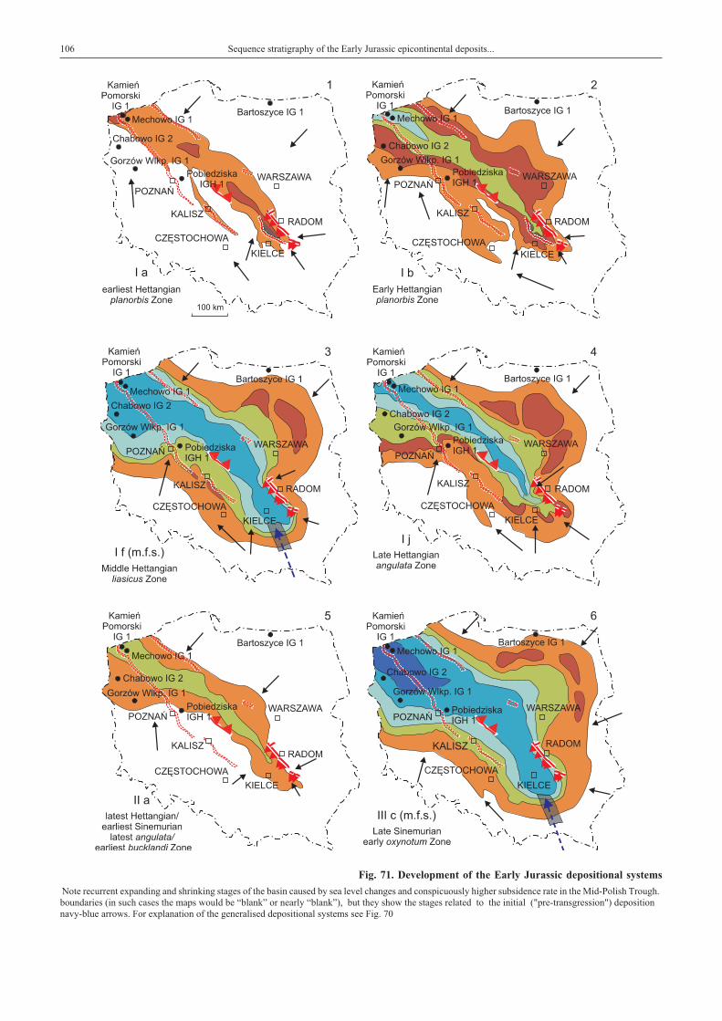
106 Sequence stratigraphy of the Early Jurassic epicontinental deposits...
Fig. 71. Development of the Early Jurassic depositional systems
Note recurrent expanding and shrinking stages of the basin caused by sea level changes and conspicuously higher subsidence rate in the Mid-Polish Trough.boundaries (in such cases the maps would be “blank” or nearly “blank”), but they show the stages related to the initial ("pre-transgression") depositionnavy-blue arrows. For explanation of the generalised depositional systems see Fig. 70

Depositional sequence VI (Late Pliensbachian) — early–mid margaritatus Zone 107
in the epicontinental Polish Basin (generalised)
The shrinking phases presented in the figure do not exactly correspond to the lowest sea level stages associated with maximum erosion at the sequenceassociated with basal transgressive systems tracts of overlying sequences. Hypothetical short-lived connections with the Tethys Basin are marked with dashed,

fall at the davoei/margaritatus Zone transition was fast andthe sea level was at its lowest point in the Early Jurassic times(Fig. 69). Similarly, Nielsen (2003) marks a sequence boundaryin the Danish Basin (his SB 14) between davoei andmargaritatus Zones. Results from France are less clear, but thissea level fall would correspond to the base of short-lasting Pl4 orPl5 sequence, dated at the latest figulinum Subzone (latest davoeiZone) or earliest stokesi Subzone, respectively (de Graciansky et al.,1998b).
The rapid sea level fall was followed by equally rapid sealevel rise, which led to restoration of nearshore depositionalsystems in the Mid-Polish Trough (Figs. 46; 48: 12; Pl. XIII, 4,5). Maximum flooding surface (parasequence VIb) would cor-
respond to the latest stokesi/earliest subnodosus Subzone tran-sition (Hesselbo, Jenkyns, 1998) and the following highstandsystems tract (parasequence VIc) would correspond withthe subnodosus Subzone. It is confirmed by the ammoniteAmaltheus (?Proamaltheus) cf. wertheri Lange found inChabowo IG 2 borehole (Fig. 68). The whole depositional se-quence VI of the Polish Basin would then correspond to the se-quences Pl4, Pl5 and Pl6 of de Graciansky et al. (1998b).The accommodation space created by erosion at the davoei/margaritatus zones transition and subsequent significant andrapid sea level rise created accommodation space that allowedsedimentation in the Polish Basin, which could reach some30 m (Fig. 45 CD).
DEPOSITIONAL SEQUENCE VII (LATEST PLIENSBACHIAN)— LATEST MARGARITATUS–SPINATUM ZONES
The erosional sequence boundary is well exposed inthe Œmi³ów quarry (Pl. XIII, 3, 4, 7) and can be identified inthe whole Polish Basin, thanks to overlying alluvial deposits(Figs. 69, 70, 72). It would correspond to the base of Pl7 se-quence according to de Graciansky et al. (1998b) and to anabrupt coarsening of sediments associated with sequenceboundary, occurring in the gibbosus Subzone (latemargaritatus Zone) — Hesselbo and Jenkyns, 1998. The fol-lowing transgressive systems tract of depositional sequenceVII would comprise deposits of the latest margaritatus–earlyspinatum Zone (late gibbosus–apyrenum Subzone), with maxi-mum flooding surface in lower/middle part of apyrenumSubzone (spinatum Zone). In Poland the age is documented by
ammonites (Dadlez, Kopik, 1975). Such a scheme fits well tothe sequence stratigraphy of United Kingdom (Hesselbo,Jenkyns, 1998) and France (de Graciansky et al., 1998b). Thehighstand systems tract would correspond with upper part ofapyrenum Subzone and lower part of hawskerense Subzone.
Deposits of this sequence have a wide regional extent —marginal-marine deposits occur far beyond the Mid-PolishTrough, reaching Czêstochowa region (Figs. 55, 61, 62: 2). Allu-vial deposition occurred in the Baltic Syneclise (Fig. 66 CD).
The depositional sequence VII is identified with the 3rd-or-der cycle 4.2 of the Upper Absaroka megacycle of Exxon curve(Haq et al., 1987) — Figs. 69, 72.
DEPOSITIONAL SEQUENCE VIII (EARLY TOARCIAN)
The erosional sequence boundary, which occurs in the Pol-ish Basin, can be identified with the Pl8 sequence boundary(de Graciansky et al., 1998b) and the sequence boundary re-ported by Hesselbo and Jenkyns (1998). This has been dated atthe late hawskerense Subzone (latest spinatum Zone). It wasfollowed by sea level rise in the tenuicostatum Zone. Accord-ing to Haq et al. (1987), Hallam (1988; 1997) and Hesselbo andJenkyns (1998), this transgression was of a linear trend, culmi-nating in maximum flooding surface, placed between the earlyfalciferum Zone (exaratum subzone) to falciferum/bifronsbiochronozonal transition. According to de Graciansky et al.(1998), in Paris Basin the maximum flooding surface occurredslightly later, in the bifrons Zone. However, in Paris Basin the sec-tion between the base of tenuicostatum Zone and the bifronsZone is subdivided into sequences Pl8, To1, To2 and To3 , withadditional (3rd order) maximum flooding surfaces occurring inclevelandicum and strangewaysi Subzones of tenuicostatumZone. According to Hallam (1988, 1997), the Early Toarcianmaximum flooding surface (he placed it in the falciferum Zone)is one of the best authenticated eustatic events in the Jurassic,marked by evident deepening in marine successions and marinetransgression in extensive parts of the world. It is also marked by
an Early Toarcian oceanic anoxic event, associated with thewidespread deposition of organic-rich shales (Jenkyns, 1988).
Similarly, the Early Toarcian transgression in Poland wasextensive and it also reached the marginal parts of sedimentarybasin (Fig. 71: 11). It occurred during deposition ofparasequences VIIIb and VIIIc. The age of parasequence VIIIblikely represents the tenuicostatum Zone, as evidenced by findsof dinoflagellate (Barski, Leonowicz, 2002) — Luehndeaspinosa (Morgentoth) combined with finds of megaspores(Marcinkiewicz, 1971, 1988).
Where the maximum flooding surface is defined withinthe parasequence VIIIb (tenuicostatum Zone), it does notmatch the age of maximum flooding surface of the Exxon’scurve (Haq et al., 1987), or the age of maximum flooding sur-face postulated by Hallam (1997), Hesselbo and Jenkyns(1998) and de Graciansky et al. (1998b). If the maximumflooding surface is placed within the VIIIc parasequence of thePolish Basin (Fig. 72), it may well correspond with the maxi-mum flooding surface of the European basins, usually dated atthe late falciferum Zone or falciferum/bifrons biochronozonaltransition. Such “shifting” position of the maximum floodingsurface in the Polish Basin (Figs. 55, 61) is associated with
108 Sequence stratigraphy of the Early Jurassic epicontinental deposits...

Depositional sequence VIII (Early Toarcian) 109
sequence maximum flooding non-depositional hiatus
Fig.72. Sequence stratigraphic correlation between Western Europe (Haq et al., 1987; Hesselbo, Jenkyns, 1998;de Graciansky et al., 1998) and the Polish Basin

approximately similar sea level in parasequences VIIIb andVIIIc, separated by a shallowing stage. The shallowing stage issometimes associated with nearshore-deltaic-marshy deposits,sometimes — in marginal parts of the basin — with palaeosolhorizons. Plant roots and emersion/palaeosol surfaces occur inthe Wrêczyca 3/81 borehole (Fig. 54 CD) and in Suliszowice38 BN (Fig. 56 CD). Such “interruption” of the transgressivetrend in the lower Toarcian is not shown on the Exxon curveand on the sea level curve from the United Kingdom (Hesselbo,Jenkyns, 1998). However, it was reported from the Paris Basin(de Graciansky et al., 1998b) and, most importantly, fromthe adjacent German Basin (Röhl et al., 2001) where thetenuicostatum Zone flooding is of the same magnitude as theflooding of falciferum/bifrons biochronozonal transition. Bothflooding stages in Germany are separated by a shallowing pe-riod, dated at the lower falciferum Zone. This shallowingwould correspond with the base of To2 sequence from France(de Graciansky et al., 1998b). Therefore, it is fully justified tocompare development of the Early Toarcian transgression inPoland with that from Germany (Röhl et al, 2001). Conse-quently, some differences between these two basins andthe rest of Europe would occur. The shallowing period, separat-ing otherwise “linear development” of the transgression, couldbe simply overlooked or impossible to observe in deeper ma-rine facies. Moreover, comparison between individual basinsin Western Europe shows generally marine conditionsthroughout tenuicostatum–bifrons times, but stratigraphicalposition of the maximum flooding surface varies from place toplace between early falciferum and early bifrons Zones. As-suming influence of coeval epeirogenic movements occurringin the vast area of German and Polish basins, without effects inthe Anglo-Paris Basin and North Sea Basin, seems to be ratherunrealistic. Shift in sediment supply could influence thebathymetry of the basin, particularly in Poland, where it wasshallow. However, it would be rather of a local scale. Assuming
all that, it is advisable to accept, that the apparent effects ofshallowing/deepening phases are most marked in the shallowfacies and they are less elaborate when inferred from deeperwater facies. Therefore, the detailed pattern of sea levelchanges inferred from the Polish Basin and correlated withmore precisely dated sedimentary succession from the GermanBasin (Röhl et al, 2001) provides more detailed informationconcerning the actual sea level changes, than those inferredfrom the deeper marine basins.
It is advisable to correlate the transgressive surface inthe Polish Basin with the base of tenuicostatum Zone, while thesequence stratigraphic correlation of the maximum floodingsurface seems to be more complicated (either in VIIIb or VIIIcparasequence). Perhaps, it would be advisable to propose sub-division of the Early Toarcian deposits into two sequences withtwo maximum flooding surfaces, but than these sequenceswould not be clearly separated by a marked sequence boundaryassociated with a pronounced effect of sea level fall.
It also regards the highstand systems tract, which wouldcorrespond to the whole bifrons Zone of the Exxon curve (Haqet al., 1998) or to the early bifrons Zone according tode Graciansky et al. (1998b). In Poland, it is divided into VIIIdand VIIIe parasequences. Depending on position of the maxi-mum flooding surface, parasequence VIIIc and the upper partof parasequence VIIIb may also be regarded as highstand sys-tems tract. Parasequences VIIIc, VIIId and VIIIe are generallyof a shallowing-upward character, shown by denser and denserpalaeosol horizons, plant roots and plant debris, more landwardpalynofacies and gradually decreasing boron content. How-ever, flooding surfaces of parasequences VIIIc and VIIId arestill quite pronounced in the axial part of the Mid-PolishTrough (Figs. 31 CD, 47 CD).
The depositional sequence VIII is identified with the 3rd-or-der cycle 4.3 of the Upper Absaroka megacycle of Exxon curve(Haq et al., 1987) — Figs. 69, 72.
DEPOSITIONAL SEQUENCE IX AND X (MIDDLE–LATE TOARCIAN)
In the Polish Basin, a conspicuous erosional boundary oc-curs above deposits of depositional sequence VIII. The erosionsurface is overlain by alluvial deposits (parasequence IXa),which covered the whole Polish Basin (in the axial parts ofthe Mid-Polish Trough they can be replaced by deltaic deposits).The sequence boundary and following alluvial/deltaic depositsare correlated with the base of 3rd-order cycle 4.4 of the Exxoncurve (Haq et al., 1987), dated at the early variabilis Zone. Ac-cording to de Graciansky et al. (1998b) the sequence boundaryshould be dated slightly earlier, to the late bifrons Zone.
The overlying deltaic deposits (parasequence IXb,transgressive systems tract) are associated with base level rise,dated by Haq et al. (1987) at the lower/mid-variabilis Zone.De Graciansky et al. (1998b) came to a similar conclusion(transgressive systems tract and maximum flooding surface ofthe To4 sequence). It should be noted that deltaic deposition as-sociated with a flooding event is generally restricted tothe Mid-Polish Trough (Fig. 71: 12), although deltaic deposi-tion reached briefly a small part of the Czêstochowa region
(Fig. 62: 4) and possibly northernmost part of the Fore-SudeticMonocline. The overlying fluvial deposits would representthe progradational highstand systems tract, tentatively correlatedwith the variabilis–early thouarsense Zone (highstand systemstract of the To4 sequence — de Graciansky et al., 1998b).
Depositional sequence IX is identified with the 3rd-ordercycle 4.4 of the Upper Absaroka megacycle of Exxon curve(Haq et al., 1987) — Figs. 69, 72.
Overlying sediments of the depositional sequence X over-lie the next erosional boundary and they are entirely alluvial inorigin. The erosional lower boundary is tentatively correlatedwith the base of 3rd-order 4.5 cycle of the Exxon curve (Haq etal., 1987). Alluvial deposition ending the Early Jurassic sedi-mentation in the Polish Basin would correspond with 4.5 cycleof the Exxon curve (Haq et al., 1987) or To5 sequence (latethouarsense Zone, de Graciansky et al., 1998b). It is likely thatalluvial deposits in the Polish Basin would represent mainlytransgressive systems tract (particularly maximum floodingsurface sediments) of that sequence. As Late Toarcian times is
110 Sequence stratigraphy of the Early Jurassic epicontinental deposits...

characterised by a progressive, overall sea level fall (Hesselbo,Jenkyns, 1998), it is a logical conclusion that the sedimentation inmarginalbasins isrepresentedbyalluvialsediments, restrictedintimeand space. Consequently, the depositional seuence X in the PolishBasin would represent the late thouarsense Zone (Figs. 69, 72).
Beginning of the next sequence would still fall withinthe latest Toarcian (late levesquei Zone), which correspondswith the base of 4.6 cycle of the Exxon curve (Haq et al., 1987).As the base of this cycle represents the shelf margin wedge de-posits (SMW), it is regarded as an erosional/non-deposition pe-
riod in the Polish Basin. It would span quite a long time, ac-cording to Haq et al. (1987) and de Graciansky et al. (1998b)the upper half of the long-lasting levesquei Zone (from the in-signe Subzone or To6 sequence base upwards). In the PolishBasin, this sequence boundary would merge with the sequenceboundary of aalensis Subzone (To7 sequence boundary —de Graciansky et al., 1998b) or even with the (type 1) sequenceboundary in Early Aalenian (Haq et al., 1987). Consequently,the deposits overlying the uppermost sequence boundary in LowerJurassic of Poland would represent the Middle Jurassic age.
SUMMARY AND CONCLUSIONS
Comparison between sea level changes in Poland (inferredfrom arrangement of depositional sequences andparasequences within a biostratigraphical framework) and sealevel changes in adjacent areas (Sweden, Germany), as well ascomparison with other European (Ligurian Cycle — Hesselbo,Jenkyns, 1998; de Graciansky et al., 1998b, Denmark —Frandsen, Surlyk, 2003; Nielsen, 2003 — the latter with somedifferences in Sinemurian), or world-wide sea level changes(Upper Absaroka Megacycle — Exxon curve — Haq et al.,1987), allows presentation of a coherent and detailed stratigra-phy of the epicontinental Early Jurassic deposits in Poland(Figs. 69–72). The Polish Basin was connected with the WestEuropean basin chiefly through the Northern Germany, South-ern Sweden and Denmark (Fig. 1), but episodic connectionswith the Tethys were also possible (Fig. 71).
The sequence correlation of the Polish Basin is not based onindividual (local) deepening-shallowing cycles, which wereproduced by number of factors, including local tectonic pro-cesses, but on regional trends of relative sea level change.These trends are dated stratigraphically on the basis ofpalaeontological evidence with varying degrees of precision.However, the close similarity between trends of relative sealevel change and continuity of correlative surfaces overthe whole area studied allowed quite precise sequence stratig-raphy and advocates an super-regional sea level changes as pri-mary sedimentation-controlling factor.
Coeval or approximately coeval character of major fluctua-tion in sea level related sedimentation in the Early Jurassic ofPoland is confirmed by similarities of depositional sequencesobserved between the Polish Basin and basins in Western Eu-rope (United Kingdom and France) as well as the Exxon curve.Regardless of discussion of the character of the sea levelchanges (eustatic or intraplate tectonic-related), the relative sealevel curves from Western Europe (Hesselbo, Jenkyns, 1998)as well as depositional sequence succession (de Graciansky etal., 1998a, b) provide a very useful tool for stratigraphic corre-lation. On that basis, the Early Jurassic epicontinental basin inPoland, containing sediments only sporadically dated byammonites, could be “attached” to the European stratigraphicalframework. Striking similarities with relative sea level curves(particularly that of Hesselbo, Jenkyns, 1998) allows determi-nation of even minor and short-lived events. As the Polish Ba-
sin was extensive and shallow, it was prone to reflect even minorrelative sea level changes. Apparent effects of these changes areusually most marked in the shallowest water facies.
Therefore, results of the present work may be helpful in rec-ognition of magnitude, and sometimes even of direction of in-dividual sea level related sedimentary changes in open-marinebasins in Europe. It is a known dilemma that, if linked to sealevel, then condensation within medium-scale cycles in distalsettings may be a consequence of relative sea level fall, as wellas rise (Hesselbo, Jenkyns, 1998; sediment starvation — sedi-mentary winnowing/hiatus dilemma). Moreover, the structureof the relative sea level curve is strongly influenced by the super-position of medium-scale cycles upon large-scale cycles; it issimply less elaborate when inferred from deeper water facies.
Concerning the magnitude of sea level changes, inferredfrom the sedimentary architecture of the Polish Basin, the num-ber of depositional sequences, characterised by truly basin-widerange and unambiguous, well-identified boundaries seems to beidentical with those ten distinguished by Haq et al. (1987). How-ever, most of the minor sea level changes and sequences distin-guished by Hesselbo and Jenkyns (1998) correspond tothe parasequences identified within the mentioned 10 depo-sitional sequences in the Polish Basin (Fig. 72), particularly inthe Sinemurian and Pliensbachian. Major sea level falls inthe Polish Basin (shrinking phases of the basin), associated withlarge-scale (“2nd-order”) cycles of Haq et al. (1987) and Hesselboand Jenkyns (1998), are identified with the following stages:
— latest Hettangian (latest angulata Zone — Fig. 71: 5),— Late Sinemurian (latest turneri–early obtusum Zone),— latest Sinemurian (mid-raricostatum Zone — Fig. 71: 7),— late Early Pliensbachian (earliest davoei Zone),— earliest Late Pliensbachian (transition latest davoei–earliestmargaritatus Zone),— mid-Late Pliensbachian (late margaritatus Zone),— latest Pliensbachian (late spinatum Zone),— MiddleToarcian (late bifrons–early variabilis Zone),— Late Toarcian (mid-thouarsense Zone),— Latest Toarcian (late levesquei Zone).
On the other hand, maximum sea level stages, associatedwith expanding phases of the Polish Basin occurred in:— Middle Hettangian (mid-liasicus Zone) – Fig. 71:3),
Summary and conclusions 111

— Early Sinemurian (mid-semicostatum Zone),— mid-Late Sinemurian (early oxynotum Zone) — Fig. 71: 6,— Early Pliensbachian (late ibex Zone) — Fig. 71: 8,— Late Pliensbachian (early spinatum Zone),— Early Toarcian (depending on the region, tenuicostatum orfalciferum Zone) — Fig. 71: 11,— MiddleToarcian(disputable—mid-variabilisZone)—Fig.71:12.
Short-term, 3rd-order or 4th-order cycles are superimposedon those major sea level fluctuations (Fig. 72). Particularlyclear is the Hettangian section, which shows a characteristic“step-wise” development of transgression in the Polish Basin.The earliest Hettangian transgression gives a good example ofthe continental correlative surface of transgression. This trans-gression (dated in Western Europe at the psilonotum/johnsonisubzonal transition) is correlated with the transgressive surfacein Pomerania (Fig. 31 CD) or with the continental correlativesurface of transgression in the Holy Cross Mts. The continentalcorrelative surface of transgression is associated with begin-ning of sedimentation of the lacustrine, “pre-transgressive” de-posits (Figs. 24, 25, 39). The early Hettangian transgression cul-minates in maximum flooding surface correlated with the early--mid liasicus Zone (Figs. 29, 39). The following progra- dationalhighstand systems tract (parasequences If–k) corresponds to thelate liasicus–early-mid angulata Zones (Fig. 40). Noteworthy,such sequence stratigraphy and sedimentary architecture devel-opment is very similar to that presented from the Hettangian ofthe Paris Basin (de Graciansky et al., 1998b — their fig. 13).
Similarly, the Sinemurian sequences and parasequencesfrom the Polish Basin show close similarities to those presentedby Hesselbo and Jenkyns (1988), including even in the numberof parasequences identified with their minor sequences. As-suming correlation of the Polish Sinemurian with ammonite--bearing strata from Southern Sweden (Pieñkowski, 1991a, b),the present work fully supports the view of Hesselbo andJenkyns (1998) and de Graciansky et al. (1998) that the impor-tant deepening occurred at the obtusum/oxynotum zonal transi-tion (contrary to Hallam, 1988). On the other hand, the evi-dence in support of a mid-ibex Zone relative sea level fall in thePolish Basin is weak. However, deepening in the jamesoniZone is fully confirmed. In the Polish Basin, relative sea levelrose rapidly during the jamesoni Zone, then the sea level risedecelerated, although the most diversified ammonite faunaspoint to the ibex Zone (luridum Subzone) as the one of a highestsea level in the Early Jurassic in Poland. In this exceptionalcase, the Polish Pomerania Basin was probably too deep to reg-ister minor sea level changes in later jamesoni–ibex Zones.
Rapid and pronounced sea level fall at the davoei/marga-ritatus zonal transition is one of the major sedimentary events inthe Polish Basin. This is in accordance with Exxon curve andthe only Ist-type sequence boundary in the Early Jurassic times.
Depositional system development and ammonite finds pointsto the early-mid margaritatus and particularly early spinatumZones as the times of pronounced marine transgresions.
Sequence/depositional systems architecture of the EarlyToarcian deposits of Poland shows, that sequence correlationwith the nearest German Basin (Röhl et al., 2001) is of primaryimportance for solving the sedimentary development prob-lems. Maximum flooding stages of parasequences VIIIb andVIIIc (tenuicostatum Zone and late falciferum Zone, respec-
tively) are of a very similar magnitude in the Polish Basin andvery subtle, local factors can determine, which one should be de-fined as the maximum flooding surface of the whole sequenceVIII. This sedimentary pattern of both Polish and German basinsdiffers from the “linear” style of the Early Toarcian transgression(Haq et al., 1987; Hesselbo, Jenkyns, 1998). It provides furtherevidence that the apparent effects of shallowing/deepeningphases are most marked in the shallow facies and they are lesselaborate when inferred from deeper water facies.
Sea level fall and the resulting erosional boundary occur-ring at the bifrons/variabilis zonal transition is much more pro-nounced in Poland in comparison to Western Europe. Again,this could also be the result of the general shallow and marginalcharacter of the Polish Basin. The same applies at the UpperToarcian erosional boundary, which might correspond tothe mid-thouarsense Zone.
Local tectonism could influence the regional sedimentation(change of local subsidence and thickness, creation of an addi-tional accommodation space, renewed erosion, supply ofcoarser material) but was still not strong enough to determinethe essential trends in the sedimentary development (Figs. 25,39, 46, 70). Influences of local tectonism are limited to certainzones, while the effects of sea level changes can be observed ina much wider spatial extent. This is the most important featureallowing differentiation between sedimentary architecture in-fluenced by local tectonism and sea level changes — see the ex-amples presented in Figs. 25, 39, 46, 48. Early Jurassic times inPoland were characterised by generally weak synsedimentarytectonism. However, some local tectonic structures played moreimportant roles. The Nowe Miasto–I³¿a fault (Hakenberg,Œwidrowska, 1997), which constituted the northeastern bound-ary in the Holy Cross Mts segment of the Mid-Polish Troughwas active in the Early Jurassic times. This fault influenced sedi-mentation along the North-East margin of the Holy Cross Mtsregion (Fig.48).Recurrent activityof this fault, in theHettangian–Sinemurian times coupled with a much lesser activity of the paral-lel Skrzynno fault, produced coarser and somewhat thicker, butspatially limited deltaic sediments in Hettangian (Fig. 39 — inthe region of Zawada, parasequences Id, Ih, Ii and Ij), LateSinemurian (Fig. 42, region between Mroczków-Kraszków 160and Gródek OP-2, parasequence IIIa and IIIc) and EarlyPliensbachian (Fig. 46, Szyd³owiec area, parasequence IVb —WolaKorzeniowaMember).Activityofother faults (like the localOstrowiec fault or the N–S fault running through Koñskie —Fig. 20) is documented in the Hettangian times (Figs. 25, 29).
Results of the present work show some subsidence fluctua-tions along the Mid-Polish Trough between the Holy Cross Mtsregion and Pomerania region. Such fluctuation (Figs. 69, 70)occurred in Hettangian, Early Sinemurian and Early Pliens-bachian times. In the Hettangian subsidence was higher inthe Holy Cross Mts and slightly lower in Pomerania region. InEarly Sinemurian times the situation was opposite. In the EarlyPliensbachian times, the subsidence rate was higher again inthe Pomerania region. This extends conclusions of Wagner etal. (2002) that subsidence rate in Mesozoic was varied betweenindividual segments of the Mid-Polish Trough (Pomeranian seg-ment–Kuiavian segment–Holy Cross Mts segment).
Low subsidence rate beyond the Mid-Polish Trough re-sulted in sharply reduced thickness or lack of Hettangian–
112 Summary and conclusions

Sinemurian deposits (Figs. 67–70). However, in the area ofgenerally low subsidence (beyond the Mid-Polish Trough),some zones of higher subsidence rate appear. Besides the slight“secondary depocentre” in the Kalisz area (Fig. 71: 1, 2, 4;Poprawa, 1997), the extension of the marine/brackish marinefacies to the north-east is very conspicuous. This occurred par-ticularly in Early Pliensbachian and Early Toarcian times (Fig.71: 8, 9, 11). Persistence of this northern “Mazurian way”, con-ductive for expanding of basinal facies, was indicated by Wag-ner (1998) as “Peribaltic Bay” in the Late Permian times and byLeszczyñski (1998) for the Late Valanginian. The boundariesbetween the Mid-Polish Trough and areas of low subsidenceare characterised by a gradual thickness increase towards theaxis of the Mid-Polish Trough (Dadlez et al., 1995; Dadlez,2001). Only along some sections of the boundary the gradientsof thickness are more pronounced (Chojnice Graben, part ofLaska-Poznañ Graben, part of Kalisz–Kamieñsk Graben —
Dadlez, 2001) and particularly the Nowe Miasto–I³¿a Fault.Displacement of rock salt masses of the Late Permian age, bothtaking place mainly at the end of Late Toarcian, resulted in for-mation of paleostructures of different order, whose characteris-tic general arrangement follows the NW–SE orientation(Deczkowski, Franczyk, 1988).
A gradual thickness increase towards the axis of the Mid-Polish Trough prevails across the edges of the Mid-PolishTrough (Dadlez et al., 1995; Dadlez, 2001), which can be alsoexplained by a decoupled style of the sedimentary basin(Withjack, Calloway, 2000; Krzywiec, 2002).
Assuming occurrence of some conspicuous zones of in-creased subsidence, which are actually perpendicular to theMid-Polish Trough (for example the “Mazurian way”), I fullyagree with the mentioned authors, that there is no reason to re-gard the Mid-Polish Trough in any respect as a “rift basin”(Kutek, 1996), at least in the Early Jurassic times.
Acknowledgements. I am indebted to late Dr. W³adys³aw Karaszewski, who some 28 years ago encouraged me to study the socalled “difficult facies” of the epicontinental Lower Jurassic in Poland and shared with me all His vast experience and knowledge.I dedicate this work to His Memory.
My special thanks go to Dr. Stephen Hesselbo from the Oxford University for a very careful review and valuable remarks, which im-proved the paper. I deeply appreciate valuable remarks and discussion of Prof. Ryszard Dadlez. I address the words of gratefulness to myfriends and collaborators, who accompanied me in various aspects of studies on the Lower Jurassic of Poland: Dr. Marta Waksmundzkaforhervaluablecollaboration in researchon thepalynofaciesandpalynostratigraphy,Dr.GerardGierliñski andGrzegorzNiedŸwiedzki,with whom I followed the tracks of Polish dinosaurs, Dr. Przemys³aw Gedl and Dr. Marcin Barski for sharing with me their knowledgeon the Early Jurassic dinoflagellates. I thank Monika Piotrowska for preparing the digital form of borehole profiles and El¿bietaSarnecka, Wies³awa Jurkiewicz, Janina Ma³ecka and W³odzimierz Ogrodowczyk for their assistance in editorial matters.
REFERENCES
AGER D.V., WALLACE P., 1970 — The distribution and signifi-cance of trace fossils in the uppermost Jurassic rocks of theBoulonnais, Northern France. In: Trace fossils (eds. CrimesT.P., Harper J.C.). Geol. Journ. Spec. Issue, 3: 1–18.
AHLBERG A., 1990 — Provenance, stratigraphy, palaeoenviron-ments and diagenesis of the Lower Jurassic strata in theHelsingborg railway tunnel, southern Sweden. Licentiate of Phi-losophy, Historical Geology, thesis No. 2, Lund University.
AIGNER T., 1985 — Storm depositional systems. Lecture notes inEarth Sciences, 3, 1: 1–174.
ALEXANDROWICZ S., BIRKENMAJER K. (ed.), BURCHARTJ., CIEŒLIÑSKI S., DADLEZ R., KUTEK J., NOWAK W.,OR£OWSKI S., SZULCZEWSKI M., TELLER R., 1975 —Zasady polskiej klasyfikacji terminologii i nomenklaturystratygraficznej. Instr. Met. Bad. Geol., 33.
ALLEN J.R.L., 1964a — Primary current lineation in the lower OldRed Sandstone (Devonian), Anglo-Welsh Basin. Sedimento-logy, 3: 98–108.
ALLEN J.R.L., 1964 b — Studies in fluviatile sedimentation: Sixcyclothems from the lower Old Red Sandstone, Anglo-WelshBasin. Sedimentology, 3: 163–198.
ARNDORFF L., 1993 — Lateral relations of deltaic palaeosols fromthe Lower Jurassic R�nne Formation on the island of Bornholm,Denmark. Palaeogeogr.Palaeoclimat.Palaeoecol.,100,3:235–250.
ARNDORFF L., 1994 — Upper Triassic and Lower Jurassicpalaeosols from southern Scandinavia. Lund Publications in Ge-ology, 116, Lund: 1–30.
ASLAN A., AUTIN W.J., 1999 — Evolution of the Holocene Mis-sissippi River floodplain, Ferriday, Louisiana: insights on the or-igin of fine-grained floodplains. Journ. Sediment. Research, 69,4: 800–815.
BARSKI M., LEONOWICZ P., 2002 — Dinoflagellates of LowerJuarassic outcrops at Koz³owice and Boroszów (southern Po-land) [in Polish]. Prz. Geol., 50, 5: 411–414.
BATES C.C., 1953 — Rational theory of delta formation. Amer.Assoc. Petrol. Geol. Bull., 37: 2119–2162.
BATTEN D.J., 1973 — Use of palynologic assemblage-types inWealden correlation. Palaeontology, 16: 1–40.
BATTEN D.J., 1996 — Palynofacies and palaeoenvironmental in-terpretation. In: Palynology: principles and applications (eds. J.Jansonius, D.C. McGregor). American Association of Strati-graphic Palynologists Foundation, 3: 1011–1064.
BEERBOWER J.R., 1964 — Cyclothems and cyclic depositionalmechanism in alluvial plane sediments. In: Symposium on Cy-clic Sedimentation (ed. D.F. Merriam). Bull. State geol. Surv.Kansas, 169: 31–42.
BERTELSEN F., 1978 — The Upper Triassic–Lower JurassicVinding and Gassum Formations of the Norwegian-Danish Ba-sin. Danm. Geol. Unders., B 3, 1–26.
References 113

BILAN, W., 1976 — The occurrence of Upper Triassic sediments inthe eastern margin of the Upper Silesian Coal Basin [Eng. Sum.].Zesz. Nauk. AGH, Geologia, 2, 4: 65–78.
BLOOS G., 1976 — Untersuchungen über Bau and Entstehung derfeinkornigen Sandsteine des Schwarzen Jura (Hettangium u.Tiefstes Sinemurium) im schwabischen Sedimentationsbereich.Arb. Inst. Geol. Palaont. Univ. Stuttgart, N.F. 71: 1–269.
BLOOS G., 1984 — On the Lower Lias in Northern Franconia. In:International Symposium on Jurassic Stratigraphy, Erlangen1984, Guide Book: 11–45.
BLOOS G., 1990 — Sea level changes in the Upper Keuper and inthe Lower Lias of Central Europe. Cahiers de l’InstitutCatholique, Lyon, Serie Scientifique, 3: 5–16.
BOHACS K., SUTER J.R., 1997 — Sequence stratigraphic distribu-tion of coaly rocks: fundamental controls and paralic examples.Amer. Assoc. Petrol. Geol. Bull., 81: 1612–1639.
BONORINO F.G., 1966 — Soil clay mineralogy of the PampaPlains, Argentina. Journ. Sed. Petrol., 36: 1026–1035.
BOYD R., DALRYMPLE R.W., ZAITLIN B.A., 1992 — Classifi-cation of clastic coastal depositional environments. Sediment.Geol., 80: 139–150.
BOYD R., PENLAND S., 1984 — Shoreface translation and the Ho-locene stratigraphic record: examples from Nova Scotia, theMississippi Delta and Eastern Australia. Marine Geology, 60:391–412.
BRANDT K., 1985 — Sea-level changes in the Upper Sinemurianand Pliensbachian of Southern Germany. In: Sedimentary andEvolutionary Cycles (eds. U. Bayer, A. Seilacher). LectureNotes in Earth Sciences, 1: 113–126.
BRAÑSKI P., 1988 — Pozorne podobieñstwo osadów seriirudonoœnej i ciechociñskiej liasu na pó³nocnym obrze¿eniu GórŒwiêtokrzyskich. Kwart. Geol., 32, 2: 488.
BRAÑSKI P., 1996 — Paleogeograficzne uwarunkowaniawystêpowania osadów kaolinitowych w liasie dolnym regionuœwiêtokrzyskiego. Arch. Pañstw. Inst. Geol., Warszawa.
BRAÑSKI P., 1998 — Analiza facjalno-paleogeograficzna seriirudonoœnej liasu w regionie œwiêtokrzyskim, w aspekcie genezyz³ó¿ i³ów ogniotrwa³ych i ceramicznych. Arch. Pañstw. Inst.Geol., Warszawa.
BRAÑSKI P., PIEÑKOWSKI G., 1988 — Zarys sedymentacjii paleogeografii triasu i liasu w regionie œwiêtokrzyskim. Arch.Pañstw. Inst. Geol., Warszawa.
BRENNER K., SEILACHER A., 1978 — New aspects about the or-igin of the Toarcian Posidonia Shales. N. Jb. Geol. Paläont.,157: 11–18.
BRENNER W., 1986 — Bermerkungen zur Palynostratigraphie derRhät-Lias-Grenze in SW-Deutschland. N. Jb. Geol. Paläont.Abh., 173: 131–145
BROMLEY R., ASGAARD U., 1979 — Triassic freshwaterichnocoenoses from Carlsberg Fjord, East Greenland. Palaeo-geogr., Palaeoclimat., Palaeoecol., 28 (1/2): 39–80.
BROMLEY R., EKDALE A.A., 1984 — Chondrites: A Trace FossilIndicator of Anoxia in Sediments. Science, 224: 872–874.
BROMLEY R., UCHMAN A., 2003 — Trace fossils from theLower and Middle Jurassic marginal marine deposits of theSorthat Formation, Bornholm, Denmark. Bull. Geol. Soc. Den-mark, 52: 185–208.
BRUSH G.S., BRUSH L.M. Jr, 1972 — Transport of pollen in a sed-iment-laden channel: a laboratory study. Amer. Journ. Sci., 272:359–381.
BUCHEM F.S.P. VAN, KNOX R.W.O’B, 1998 — Lower and Mid-dle Liassic depositional sequences of Yorkshire (U.K.). In: Me-sozoic and Cenozoic Sequence Stratigraphy of European Basins
(eds. P.C. de Graciansky, J. Hardenbol, T. Jacquin, P.R. Vail ).Soc. Econ. Paleont. Miner. Sp. Publ., 60: 545–559.
BURGESS J.D., 1987 — Provenance, preservation, and transport ofthe detrital “coffee grounds” of the Mississippi Delta. Int. Journ.Coal Geol., 7: 135–145.
BUSTIN R,M., 1988 — Sedimentology and characteristics of dis-persed organic matter in Tertiary Niger Delta: origin of sourcerocks in a deltaic environment. Am. Assoc. Petrol. Geol. Bull.,72: 277–298.
CANT D.I., WALKER R.G. 1976 — Development of a braided flu-vial facies model for the Devonian Battery Point Sandstone,Quebec. Can. Journ. Earth Sci., 13: 102–119.
CATHLES L.M., HALLAM A., 1991 — Stress-induced changes inplate density, Vail sequences, epeirogeny and short-lived globalsea-level fluctuations. Tectonics, 10: 659–671.
CATUNEANU O., WILLIS A.J., MIALL, A.D., 1998 — Temporalsignificance of sequence boundaries. Sediment. Geol., 121:157–178.
CIEŒLA E., 1979 — Geological structure of the zone of Lias Out-crops between Gowarczów and Rozwady. [Eng. Sum.]. Kwart.Geol., 23, 2: 381–393.
CLIFTON H.E., 1969 — Beach lamination – nature and origin. Mar.Geol., 7: 553–559.
CLIFTON H.E., HUNTER R.E., PHILIPS R.L., 1971 —Depositional structures and processes in in the non-barredhigh-energy nearshore . J. Sediment. Petrol., 41: 651–670.
CLOETINGH S., McQUEEN H., LAMBECK K., 1985 — On a tec-tonic mechanism for regional sea level variations. Earth Planet.Sci. Lett., 75: 157–166.
COE A.L., BOSENCE D.W.J., CHURCH K.D., FLINT S.S.,HOWELL J.A., WILSON R.C.L, 2003 — The sedimentary re-cord of sea-level change (ed. A.L.Coe). The Open UniversityCourse, Cambridge University Press, Cambridge.
COLEMAN J.M., 1981 — Deltas: processes of deposition andmodels for exploration. Burgess Publ., Minneapolis.
COLEMAN J.M., ROBERTS H.H., MURRAY S.P., SALAMA M.,1981 — Morphology and dynamic sedimentology of the EasternNile Delta Shelf. Mar. Geol., 42: 301–326.
COLLINSON J.D, THOMPSON D.B., 1982 — Sedimentary struc-tures. Allen & Unwin, London.
COLLINSON J.D., 1978 — Vertical sequence and sand body shapein alluvial sequences. In: Fluvial sedimentology (ed. A.D.Miall). Can. Soc. Petrol. Geol. Mem., 5: 577–586.
COMBAZ A., 1964 – Les palynofaci�s; Rev. Micropaléont., 7:205–218.
COX L.R., 1961 — Observations on the family Cardiniidae (ClassBivalvia). Proc. Malacological Soc. of London, 34, 6: 325–339.
DABRIO C.J., POLO M.D., 1981 — Flow regime and bedforms in aridge and runnel system, SE Spain. Sediment. Geol., 28: 97–110.
DADLEZ R., 1957 — Preliminary note on the research of the Meso-zoic substratum in the NW part of the Pomeranian Anticlinorium[Eng. Sum.]. Kwart. Geol., 1, 1: 48–80.
DADLEZ R., 1958 — Notes on geological investigations onPomorze Anticlinorium in 1957 [Eng. Sum.]. Kwart. Geol., 2, 4:740–764.
DADLEZ R., 1962 — Equivalents of the Po³omia beds of theCzêstochowa Lias in the western margin area of the ŒwiêtyKrzy¿ Mountains [Eng. Sum.]. Kwart. Geol., 6, 3: 447–459.
DADLEZ R., 1964a — The stratigraphy and course of sedimenta-tion of the Keuper and Lower Jurassic on the basis of theMechowo IG 1 borehole [Eng. Sum.]. Biul. Inst. Geol., 189:61–92.
114 References

DADLEZ R, 1964b – Outline of the Lias stratigraphy in Western Po-land and correlation with the Lias of Central Poland [Eng. Sum.].Kwart. Geol., 8, 1: 122–144.
DADLEZ R., 1968 — Lias and Rhaetic in the Mazury region [Eng.Sum.]. Kwart. Geol., 12, 3: 561–577.
DADLEZ R. 1969 — Stratigraphy of the Lias in Western Poland[Eng. Sum.]. Pr. Inst. Geol., 57: 1–92.
DADLEZ R., 1972 — Lias. In: Kamieñ Pomorski IG 1. Profile G³êb.Otw. Wiert. Inst. Geol., 1: 15–23.
DADLEZ R, 1974 — Jura dolna. In: Bartoszyce IG 1. Profile G³êb.Otw. Wiert. Inst. Geol., 14: 33–35.
DADLEZ R., 1975 — Jura dolna. In: Wolin IG 1, Profile G³êb. Otw.Wiert. Inst. Geol., 22: 25–30.
DADLEZ R., 1978 — State of lithostratigraphy of the epicontinentalLower Jurassic in Poland and proposals of its systematization[Eng. Sum.]. Kwart. Geol., 22, 4: 773–790.
DADLEZ R., 1997 — Epicontinental basins in Poland. Devonian toCretaceous — relationships between the crystalline basementand sedimentary infill. Geol. Quart., 41: 419–432.
DADLEZ R., 2000 — Pomeranian Caledonides (NW Poland), fiftyyears of controversies: a review and nem concept. Geol. Quart.,44: 221–236.
DADLEZ R., 2001 — Mid-Polish Trough — geological cross sec-tions, 1:200 000. Pañstwowy Instytut Geologiczny. Warszawa.
DADLEZ R., FRANCZYK M., 1976 — Palaeogeographic andpalaeotectonic significance of the Wielkopolska Ridge (centralPoland) in the Lower Jurassic Epoch [Eng. Sum.]. Biul. Inst.Geol. 295 ,9: 27–54.
DADLEZ R., KOPIK J., 1972 — Selected problems of Liassic stra-tigraphy and sedimentation in the area between Œwinoujœcie andGryfice (North-West Poland) [Eng. Sum]. Kwart. Geol., 16, 2:620–636.
DADLEZ R., KOPIK J., 1975 — Stratigraphy and palaeogeographyof the Jurassic. Geol. Inst. Anniv. Bull., 252: 149–171.
DADLEZ R., MARCINKIEWICZ T., 1964 — Jura dolna. In:Wyniki wiercenia Gorzów Wielkopolski IG 1 (ed. K. Dayczak--Calikowska). Arch. Pañstw. Inst. Geol. Warszawa.
DADLEZ R., NARKIEWICZ M., STEPHENSON R.A., VISSERM.T.M., VEN WEES J.-D., 1995 — Tectonic evolution of theMid-Polish Trough: modelling implications and significance forcentral European geology. Tectonophysics, 252: 179–195.
DAM G., 1990 — Palaeoenvironmental significance of trace fossilsfrom the shallow marine Lower Jurassic Neill Klinter Forma-tion, East Greenland. Palaeogeogr., Palaeoclimat., Palaeoecol.,79: 221–248.
DAVIDSON-ARNOTT R.G.D., GREENWOOD B., 1976 — Fa-cies relationships on a barred coast, Kouchibouguac Bay, NewBrunswick, Canada. In: Beach and nearshore sedimentation(eds. R.A.Davis, Jr., R.L. Ethington). Soc. Econ. Paleont. Miner.Spec. Publ., 24: 149–168.
DAVIS R.A., 1978 — Beach and nearshore zone. In: Coastal Sedi-mentary Environments (ed. R.A. Davis ): 237–285. Springer-Verlag, New York.
DAVIS R.A., FOX W.T., 1972 — Coastal processes and nearshoresand bars. J. Sediment. Petrol, 42: 401–412.
DECONINCK J.F., HESSELBO S.P., DEBUISSER N.,AVERBUCH O., BAUDIN F., BESSA J., 2003 — Environmen-tal controls on clay mineralogy of an Early Jurassic mudrock(Blue Lias Formation, southern England). Int. J. Earth Sci.(Geol. Rundsch), 92: 255–266.
DECONINCK J.F., VANDERAVEROET P., 1996 — Eocene toPleistocene clay mineral sedimentation off New Jersey, westernNorth Atlantic (ODP Leg 150, sites 903 and 905). In: Proc.
ODSP Sci. Res., 150 (eds. G.S. Mountain, K.G. Miller, P.Blum,C.W. Poag, D.C. Twichell ): 147–170.
DECZKOWSKI Z., 1967 — Rhaetian and Liassic deposits in the1-KW borehole at Wieluñ [Eng. Sum.]. Biul. Inst. Geol., 205:89–128.
DECZKOWSKI Z., 1997 — Jura dolna — formalne i nieformalnejednostki litostratygraficzne [Eng. Sum.]. In: The EpicontinentalPermian and Mesozoic in Poland (eds. S. Marek, M. Pajchlowa).Pr. Pañstw. Inst. Geol., 153: 195–196; 205–206.
DECZKOWSKI Z., DANIEC J., 1981 — Rudy ¿elaza. In: Surowcemineralne województwa czêstochowskiego. WydawnictwaGeologiczne, Warszawa.
DECZKOWSKI Z., FRANCZYK M., 1988 — Palaeothickness,lithofacies and palaeotectonics of epicontinental Lower Jurassicin Poland [Eng. Sum.]. Kwart. Geol., 32, 1: 105–115.
DEGENS E.T., WILLIAMS E.G., KEITH M.L., 1957 — Environ-mental studies of carboniferous sediments. Part I: Geochemicalcriteria for differentiating marine from fresh-water shales. Am.Assoc. Petrol. Geol. Bull., 41: 2427–2455.
DE RAAF J.F.M., BOERSMA J.R., 1971 — Tidal deposits and theirsedimentary structures. Geol. en Mijnbouw, 59: 479–504.
DE RAAF J.F.M., BOERSMA J.R., VAN GELDER A. 1977 —Wave-generated structures and sequences from a shallow ma-rine succession, Lower Carboniferous, County Cork, Ireland.Sedimentology, 24, 3: 451–483.
DONOVAN D.T., HORTON A., IVIMEY-COOK H.C., 1979 —The transgression of the Lower Lias over the northern flank ofthe London Platform. J. Geol. Soc. London, 136: 165–173.
DOTT R.H. JR., BOURGEOIS J. 1982 — Hummocky stratification:significance of its variable bedding sequences. Geol. Soc. Am.Bull., 93, 8: 663–680.
DUFKA P., 1990 — Palynomorphs in the Llandovery black shalesequence of the Praque Basin (Barrandian area, Bohemia). Èas.Miner. Geol., 35: 15-31
DUMONT T., 1998 — Sea-level changes and early rifting of a Euro-pean Tethyan margin in the Western Alps and southeasternFrance. In: Mesozoic and Cenozoic Sequence Stratigraphy ofEuropean Basins (eds. P.C. de Graciansky, J. Hardenbol, T.Jacquin, P.R. Vail). Soc. Econ. Paleont. Miner. Sp. Publ., 60:623–640.
DUPRÉ W., 1984 — Reconstruction of paleo-wave conditions dur-ing the late Pleistocene from marine terrace deposits, MontereyBay, California. Mar. Geol., 60: 435–454.
DUVAL B.C., CRAMEZ C., VAIL P.R., 1998 — Stratigraphic cy-cles and major marine source rocks. In: Mesozoic and CenozoicSequence Stratigraphy of European Basins (eds. P.C. deGraciansky, J. Hardenbol, T. Jacquin, P.R. Vail ). Soc. Econ.Paleont. Miner. Sp. Publ., 60: 43–51.
DYBKJ�R K., 1988 — Palynological zonation and stratigraphy ofthe Jurassic section in the Gassum No. 1-borehole, Denmark.Danmarks Geologiske Unders�gelse, A, 21: 1–72.
DYBKJ�R K., 1991 — Palynological zonation and palynofacies in-vestigation of the Fjerritslev Formation (Lower Jurassic — basalMiddle Jurassic) in the Danish Subbasin.Danmarks GeologiskeUnders�gelse, A, 30: 1–150.
EDZWALD J.K., O’MELIA C.R., 1975 — Clay distributions in re-cent estuarine sediments. Clays and Clay Minerals, 23: 39–44.
EKDALE A.A., 1985 — Paleoecology of the marine endobentos.Palaeogeogr., Palaeoclimat., Palaeoecol., 50: 63–81.
EMBRY A.F., JOHANNESSEN E.P., 1992 — T-R sequence stra-tigraphy, facies analysis and reservoir distribution in the upper-most Triassic–Lower Jurassic succession, western SverdrupBasin, Arctic Canada. In: Arctic Geology and Petroleum Geol-
References 115

ogy (eds. T.O. Vorren, E. Bergsager, Ø.A. Dahl-Stamnes, E.Holter, B. Johansen, E. Lie, T.B. Lund). Norweg. Petrol. Soc.(NPF) Sp. Publ., 2: 121–146.
EMERY D., MYERS K.J. (eds), 1996 — Sequence Stratigraphy.Blackwell Science, Oxford.
ERNST W., 1970 — Geochemical facies analysis. Elsevier, Amster-dam.
FARRELL K.M., 2001 — Geomorphology, facies architecture, andhigh-resolution, non-marine sequence stratigraphy in avulsiondeposits, Cumberland Marshes, Saskatchewan. Sediment. Geol.,139: 93–150.
FELDMAN-OLSZEWSKA A., 1988 — Profil litologiczno-stratygraficzny otworu Chabowo IG 2. Arch. Pañstw. Inst. Geol.Warszawa.
FELDMAN-OLSZEWSKA A., 1997 — Depositional systems andcyclicity in the intracratonic Early Jurassic basin in Poland.Geol. Quart., 41, 4: 475–490.
FELDMAN-OLSZEWSKA A., 1998 — Palaeogeographical andthickness maps of Early Jurassic. In: PalaeogeographicalAtlas of the Epicontinental Permian and Mesozoic in Poland,1:2 500 000 (eds. R. Dadlez, S. Marek, J. Pokorski): pls.29–36Pañstw. Inst. Geol., Warszawa.
FIJA£KOWSKA A., 1989 — New palynostratigraphic data fromthe Upper Triassic of the north-western Holy Cross Mts [Eng.Sum.]. Prz. Geol. 37, 5: 252-256.
FISHER W.L., McGOWEN J.H., 1967 — Depositional systems inthe Wilcox Group of Texas and their relationship to occurrenceof oil and gas. Gulf Coast Association of Geological SocietiesTransactions, 17: 105–125.
FRANDSEN N., SURLYK F., 2003 — An offshore trensgre-ssive-regressive mudstone-dominated succession from the Sine-murian of Sk�ne, Sweden. In: The Jurassic of Denmark andGreenland (eds. J.R. Ineson, F. Surlyk). Geol. Surv. Denmarkand Grenland Bull., 1: 543–554.
FÜRSICH F.T., 1973 — A revision of the trace fossilsSpongeliomorpha, Ophiomorpha and Thalassinoides. N. Jb.Geol. Paläont., Monatsh., 12: 719–735.
FÜRSICH F.T., 1974a — Trace fossils as environmental indicatorsin the Corallian of England and Normandy. Lethaia, 8: 151–172.
FÜRSICH F.T., 1974 b — On Diplocraterion Torell, 1870 andthe significance of morphological features in vertical spreiten--bearing, U-shaped trace fossils. J. Palaeont., 48, 5: 952–962.
GAJEWSKA I., 1997 — Kajper: Sedymentacja, paleogeografia ipaleotektonika [Eng. Sum.]. In: The Epicontinental Permian andMesozoic in Poland (eds. S. Marek, M. Pajchlowa). Pr. Pañstw,Inst. Geol., 153: 166–171.
GALLOWAY W.E., 1989 — Genetic stratigraphic sequences in ba-sin analysis: architecture and genesis of flooding surfacebounded depositional units. Am. Assoc. Petrol. Geol. Bull., 73:125–142.
GALLOWAY W.E., HOBDAY D.K., 1996 — Terrigenous ClasticDepositional Systems. Springer-Verlag, Berlin.
GIBBS R.J., TSCHUDY D.M., KONVAR L., MARTIN J.M., 1989— Coagulation and transport of sediments in the Gironde Estu-ary. Sedimentology, 36: 987–999.
GIERLIÑSKI G., 1990 — First find of a carnosaur footprint in theLower Jurassic deposits of Gliniany Las, Holy Cross Mts [Eng.Sum.]. Prz. Geol., 38, 7–8: 315–317.
GIERLIÑSKI G., 1991 — New dinosaur ichnotaxa from the EarlyJurassic of the Holy Cross Mountains, Poland. Palaeogeogr.,Palaeoclimat., Palaeoecol., 85, 1–2: 137–148.
GIERLIÑSKI G., 1994 — Early Jurassic theropod tracks with themetatarsal impressions. Prz. Geol., 42, 4: 280–284.
GIERLIÑSKI G., 1995 — New theropod tracks from the Early Ju-rassic strata of Poland. Prz. Geol., 43, 11: 931–934.
GIERLIÑSKI G., 1996 — Avalian theropod tracks from the EarlyJurassic strata of Poland. Zubia, 14, 79–87.
GIERLIÑSKI G., 1997 — Sauropod tracks in the Early Jurassic ofPoland. Acta Palaeont. Pol., 42, 4: 533–538.
GIERLIÑSKI G., 1999 — Tracks of a large thyreophoran dinosaurfrom the Early Jurassic of Poland. Acta Palaeont. Pol., 44, 2:231–234.
GIERLIÑSKI G., GA�DZICKA E., NIED�WIEDZKI G.,PIEÑKOWSKI G., 2001b — New ornitischian dinosaur foot-prints in the Jurassic of Poland. Geol. Quart., 45, 2: 205–210.
GIERLIÑSKI G., NIED�WIEDZKI G., PIEÑKOWSKI G., 2001a— Gigantic footprint of a theropod dinosaur in the Early Jurassicof Poland. Acta Palaeont. Pol., 46, 3: 441–446.
GIERLIÑSKI G., PIEÑKOWSKI G., 1999 — Dinosaur track as-semblages from Hettangian of Poland. Geol. Quart., 43, 3:329–346.
GIERLIÑSKI G., POTEMSKA A., 1987 — Lower Jurassic dino-saur footprints from Gliniany Las, northern slope of the HolyCross Mountains, Poland. N. Jb. Geol. Paläont. Abh., 175, 1:107–120.
GOLDRING R., 1962 — The trace fossils of the Baggy Beds (UpperDevonian) of North Devon, England. Paläont. Zeitschr., 36:232–251.
GOLDRING R., LAYER M.G., MAGYARI A., PALOTAS K.,DEXTER J., 1998 — Facies variation in the Corallian Group (U.Jurassic) of the Faringdon-Shellingford area (Oxfordshire) andthe rockground base to the Farington Sponge Gravels (L. Creta-ceous). Proc. Geolog. Assoc., 109: 115–125.
GOOD, S.C., 1998 — Freshwater Bivalve Fauna of the Late Triassic(Carnian–Norian) Chinle, Dockum and Dolores Formations ofthe Southwest United States. In: Bivalves: An Eon of Evolution(eds. P.A. Johnston, J.W. Haggart). Paleobiological StudiesHonoring Norman D.Newell, University of Calgary Press, Cal-gary: 223–249.
GRACIANSKY, P.C. DE, JACQUIN T., HESSELBO P.S., 1998a— The Ligurian cycle: an overview of Lower Jurassic 2nd-ordertransgressive/regressive facies cycles in Western Europe. In:Mesozoic and Cenozoic Sequence Stratigraphy of European Ba-sins (eds. P.C. de Graciansky, J. Hardenbol, T. Jacquin, P.R.Vail). Soc. Econ. Paleont. Miner. Sp. Publ., 60: 467–479.
GRACIANSKY, P.C. DE, DARDEAU G., DOMMERQUES J.L.,DURLET C., MARCHAND D., DUMONT T., HESSELBOS.P., JACQUIN T., GOGGIN V., MEISTER C., MOUTERDER., REY J., VAIL P.R., 1998b — Ammonite biostratigraphiccorrelation and Early Jurassic sequence stratigraphy in France:comparison with some U.K. sections. In: Mesozoic and Ceno-zoic Sequence Stratigraphy of European Basins (eds. P.C. deGraciansky, J. Hardenbol, T. Jacquin, P.R. Vail). . Soc. Econ.Paleont. Miner. Sp. Publ., 60: 583–622.
GRADSTEIN F.M., AGTERBERG F.P. , OGG J.G. ,HARDENBOL J., VAN VEEN P., THIERRY J., HUANG Z.,1995 — A Triassic, Jurassic and Cretaceous time scale. In: Geo-chronology Time Scales and Global Stratigraphic Correlation.Soc. Econ. Paleont. Miner. Sp. Publ., 54: 95–126.
GRAVESEN P., ROLLE F., SURLYK F., 1982 — Lithostratigraphyand sedimentary evolution of the Triassic, Jurassic and LowerCretaceous of Bornholm, Denmark. Danmarks GeologiskeUndersøgelse, B 7: 1–49.
HABIB D., 1982 — Sedimentary supply origin of Cretaceous blackshales. In: Nature and Origin of Cretaceous Carbon-Rich Facies(eds. S.O. Schlanger, M.B. Cita). Academic Press, London:113–127.
116 References

HAKENBERG M., ŒWIDROWSKA J., 1997 — Propagation of thesoutheastern segment of the Polish Trough connected withbounding fault zones (from the Permian to Late Jurassic). C. R.Acad. Sc. Paris, 324: 793–803.
HALLAM A., 1988 — A re-evaluation of Jurassic eustasy in thelight of new data and the revised Exxon curve. In: Sea-LevelChanges: an Integrated Approach (eds. C.K. Vilgus, B.S.Hastings, G.St.C. Kendall, H.W. Posamentier, C.A. Ross, J.C.Van Wagoner ). Soc. Econ. Paleont. Miner. Sp. Publ., 42:71–108.
HALLAM A., 1990 — The end-Triassic mass extinction event. In:Global Catastrophes in Earth History (eds. V.I. Sharpton, P.D.Ward). Geol. Soc. Amer. Sp. Pap., 247: 577–583.
HALLAM A., 1997 — Estimates of the amount and rate of sea-levelchange across the Rhaetian–Hettangian and Pliensbachian–Toarcian boundaries (latest Triassic to early Jurassic). J. Geol.Soc., London, 154, 5: 773–779.
HAMILTON D.S., TADROS N.Z., 1994 — Utility of coal seams asgenetic stratigraphic sequence boundaries in nonmarine basins:an example from the Gunnedah Basin, Australia. Am. Assoc.Petrol. Geol. Bull., 78: 267–286.
HANDFORD C.R., 1985 — Facies and bedding sequences inshelf-storm-deposited carbonates — Fayetteville shale andPitkin Limestone (Mississippian), Arkansas. J. Sediment.Petrol., 56, 1:123–137.
HANKEN N.M., BROMLEY R.G., THOMSEN E., 2001 — TraceFossils of the Bivalve Panopea faujasi, Pliocene, Rhodes,Greece. Ichnos, 8, 2: 117–130.
HAQ B.U., HARDENBOL J., VAIL P.R., 1987 — Chronology offluctuating sea level since the Triassic. Science, 235:1156–1167.
HARDER H., 1961 — Beitrag zur Geochemie des Bors. Nachrich.Acad. Wissenschaf. Göttingen, II. Mat.-Physik. Kl., 5-6.
HARMS J.C., SOUTHARD J.B., SPEARING D.R., WALKERR.G., 1975 — Depositional environments as interpreted fromprimary sedimentary structures and stratification sequences.Short Course Soc. Econ. Paleont. Miner. , 2.Tulsa: 1–166.
HARMS J.C., SOUTHARD J.B., WALKER R.G., 1982 — Struc-tures and sequences in clastic rocks. Short Course Soc. Econ.Paleont. Miner., 9. Tulsa.
HAYES M.O., 1975 — Morphology of sand accumulation in estuar-ies. In: Estuarine research, 2 (ed. L.E. Cronin): 3–22. AcademicPress, New York.
HEDBERG H.D., GEORGE N., POMEROL C., SALVADOR A.,ST�CKLIN J. (eds.), 1976 — International Subcommission onStratigraphic Classification of IUGS Commission on Stratigra-phy. International Stratigraphic Guide — A guide to strati-graphic classification, terminology, and procedure. John Willeyand Sons, New York.
HEDGES J.I., CLARK W.A., COWIE G.L., 1988 — Organic mattersources to the water column and surficial sediments of a marinebay. Limnology and Oceanography, 33: 116–136.
HESSELBO S.P., 1996 — Spectral gamma-ray logs in relation toclay mineralogy and sequence stratigraphy, cenozoic of the At-lantic margin, offshore New Jersey. In: G.S. Mountain, K.G.Miller, P.Blum, C.W. Poag, D.C. Twichell (eds.), Proc. ODSPSci. Res., 150: 411–422.
HESSELBO S.P., JENKYNS H.C., 1998 — British Lower JurassicSequence Stratigraphy. In: Mesozoic and Cenozoic SequenceStratigraphy of European Basins (eds. P.C. de Graciansky, J.Hardenbol, T. Jacquin, P.R. Vail). Soc. Econ. Paleont. Miner.Sp. Publ., 60: 561–581.
HESSELBO S.P., MEISTER C., GRÖCKE D., 2000 — A potentialglobal stratotype for the Sinemurian-Pliensbachian boundary(Lower Jurassic), Robin Hood’s Bay, UK: ammonite faunas andisotope stratigraphy. Geol. Mag., 137: 601–607.
HORNE J.C., FERM J.C., CARUCCIO F.T., BAGANZ B.P., 1978— Depositional models in Coal Exploration and Mine Planningin Apallachian Region. Amer. Assoc. Petrol. Geol. Bull., 62, 12:2379–2411.
HOROWITZ A., 1992 — Palynology of Arid Lands. Elsevier, Am-sterdam.
HOWARD J.D., 1978 — Sedimentology and trace fossils. In: Tracefossil concepts. Short Course Soc. Econ. Paleont. Miner., 5: 13–47.
HOYT J.H., 1967 — Barrier island formation. Geol. Soc. Am. Bull.,78: 1123–1136.
HUBBARD R.N.B.L., BOUTLER M.C., 2000 — Phytogeographyand palaeoecology in Western Europe and Eastern Greenlandnear the Triassic–Jurassic boundary. Palaios, 15: 120–131
HUDSON J.D., CLEMENTS R.G., RIDING J.B., WAKEFIELDM.I., WALTON W., 1995 — Jurassic paleosalinities and brack-ish-water communities — A case study. Palaios, 10: 392–407.
HYNE N.J., LAIDIG L.W., COOPER W.A., 1979 — Prodelta sedi-mentation an a lacustrine delta by clay mineral flocculation.J. Sed. Petrol., 49: 1209–1216
INGLE J.C., 1966 — The movement of beach sand. Developmentsin sedimentology, 5: 1–221. Elsevier, Amsterdam
INTERNATIONAL SUBCOMMISSION ON STRATIGRAPHICCLASSIFICATION OF IUGS COMMISSION ON STRATIG-RAPHY (1976) — International Stratigraphic Guide — A Guideto Stratigraphic Classification, Terminology, and Procedure(eds. H.D.Hedberg, N. George, C. Pomerol, A.Salvador andJ.Stöcklin). John Willey and Sons, New York.
JACKSON R.G. II, 1976 — Depositional model of point bars in thelower Wabash River. J. Sediment. Petrol., 46: 579–594.
JACKSON R.G. II, 1978 — Preliminary evaluation of lithofaciesmodels for meandering alluvial streams. In: Fluvial sedi-mentology (ed. A.D. Miall). Can. Soc. Petrol. Geol. Mem., 5:543–576.
JACQUIN T., GRACIANSKY P.C. DE, 1998 — Majortransgressive/regressive cycles: the stratigraphic signature of Eu-ropean basin development. In: Mesozoic and Cenozoic Se-quence Stratigraphy of European Basins (eds. P.C. deGraciansky, J. Hardenbol, T. Jacquin, P.R. Vail ). Soc. Econ.Paleont. Miner. Sp. Publ., 60: 15–29.
JENKYNS, H.C., 1988 — The Early Toarcian (Jurassic) anoxicevent: stratigraphic, sedimentary and geochemical evidence.Am. J. Sc., 288: 101–151.
JERVEY M.T., 1988 — Quantitative geological modeling ofsiliciclastic rock sequences and their seismic expression. In: Sea-Level Changes: an Integrated Approach (eds. C.K. Vilgus, B.S.Hastings, G.St.C. Kendall, H.W. Posamentier, C.A. Ross, J.C.Van Wagoner). Soc. Econ. Paleont. Miner. Sp. Publ., 42: 47–69.
JONES S.J., FROSTICK L.E., ASTIN T.R., 2001 — Braided streamand flood plain architecture: the Rio Vero Formation, SpanishPyrenees. Sediment. Geol., 139: 229–260.
JURKIEWICZOWA I., 1967 — The Lias of the western part of theMesozoic zone surrounding the Œwiêtokrzyskie (Holy Cross)Mountains and its correlation with the Lias of the Cra-cow-Wieluñ Range [Eng. Sum.]. Biul. Inst. Geol., 200, 2: 5–132.
KARASZEWSKI W., 1960 — New division of the Œwiêty Krzy¿Lias [Eng. Sum.]. Kwart. Geol., 4, 4: 899–921.
KARASZEWSKI W., 1962 — The stratigraphy of the Lias in theNorthern Mesozoic Zone surrounding the Œwiêty Krzy¿ Moun-
References 117

tains (Central Poland) [Eng. Sum.]. Pr. Inst. Geol., 30, cz. 3:333–416.
KARASZEWSKI W., 1971 — Outline of geological structure of theso-called Gielniów Saddle within Liassic exposure [Eng. Sum.].Kwart. Geol., 15, 3: 517–527.
KARASZEWSKI W., 1974 — On the Hettangian-SinemurianBoundary in the Extra-Carpathian Poland. Bull. Acad. Pol. Sci.Sér. Sci. Terre, 22, 1: 33–36.
KARASZEWSKI, 1975 — Footprints of Pentadactyl Dinosaurs inthe Lower Jurassic of Poland. Bull. Acad. Pol. Sci. Sér. Sci.Terre, 23, 2: 133–136.
KARASZEWSKI W., KOPIK J., 1970 — Lower Jurassic. In: TheStratigraphy of the Mesozoic in the margin of the GóryŒwiêtokrzyskie [Eng. Sum.]. Prace Inst. Geol., 56: 65–98 .
KETZER J.M., HOLZ M., MORAD S., AL.-AASM I.S., 2003 —Sequence stratigraphic distribution of diagenetic alterations incoal-bearing, paralic sandstones: evidence from the Rio BonitoFormation (Early Permian), southern Brasil. Sedimentology, 50:855–877.
KOPIK J., 1960 — Micropalaeontological characteristic of Lias andLower Dogger in Poland [Eng. Sum]. Kwart. Geol.., 4, 4:921–936.
KOPIK J., 1962 — Faunistic criteria of stratigraphical subdivisionof the Lias in North-Western and Central Poland [Eng. Sum.].In: Ksiêga Pami¹tkowa ku czci prof. J. Samsonowicza (ed.E. Passendorfer): 271–312. Wyd. Geol. Warszawa.
KOPIK J., 1964 — Stratigraphy of the Lower Jurassic based on thefauna of the Mechowo IG 1 borehole [Eng. Sum]. Biul. Inst.Geol., 189: 43–55.
KOPIK J., 1988 — Lower Jurassic. Fauna — Invertebrates. In: Ge-ology of Poland, Atlas of Guide and Characteristic Fossils (ed.L. Malinowska), III, 2b: 21–42. Wyd. Geol., Warszawa.
KOPIK J., 1975 — Fauna osadów domeru. In: Wolin IG 1. ProfileG³êb. Otw. Wiert. Inst. Geol. , 22.
KOPIK J., 1998 — Lower and Middle Jurassic of the north-easternmargin of the Upper Silesian Coal Basin [Eng. Sum.]. Biul.Pañstw. Inst. Geol., 378: 67–120.
KOPIK J., MARCINKIEWICZ T., 1997 — Jura dolna —Biostratygrafia [Eng. Sum.]. In: In: The Epicontinental Permianand Mesozoic in Poland (eds. S. Marek, M. Pajchlowa). Pr.Pañstw. Inst. Geol., 153: 196–204.
KOPPELHUS E.B., NIELSEN L.H., 1994 — Palynostratigraphyand palaeoenvironments of the Lower to Middle Jurassic Bag�
Formation of Bornholm, Denmark. Palynology, 18: 139–194.KOWALCZEWSKI Z., 2002 — Late Palaeozoic-Mesozoic devel-
opment of the Skrzynno Fault (northeastern border of the HolyCross Mts.). Geol. Quart., 46, 3: 281–291.
KOZYDRA Z., 1968 — Deposits of Lower Jurassic refractory claysin the light of general geological structure in the northern marginof the Œwiêtokrzyskie Mountains [Eng. Sum.]. Biul. Inst. Geol.,216: 5–106.
KRAJEWSKI R., 1947 — Clayiron ores in the eastern part of the dis-trict Koñskie (Central Poland) [Eng. Sum]. Biul. Pañstw. Inst.Geol., 26: 1–134.
KREISA R.D., MOIOLA R.J., 1986 — Sigmoidal tidal bundles andother tide generated sedimentary structures of the Curtis Forma-tion, Utah. Bull. Geol. Soc. Amer., 97: 381–387.
KROBICKI M., 2001 — Pocz¹tki rozpadu Pangei wyznaczoneprzez migracje wczesnojurajskich ma³¿y. In: IInd Symposium onJurassic System, Starachowice, Polish Geological Society. Pro-ceedings (eds. G. Pieñkowski, J. Grabowski): 36. Pañstw. Inst.Geol. Warszawa.
KRÓLIKOWSKI C., PETECKI Z., ¯Ó£TOWSKI Z., 1999 — Mainstructural units in the Polish part of the East-European Platformin the light of gravimetric data [Eng. Sum.]. Biul. Pañstw. Inst.Geol., 386: 5–58.
KRZYWIEC P., 2002 — Mid-Polish Trough inversion — seismic ex-amples, main mechanisms, and its relationship to the Alpine--Carpathian collision. In: Continental Collision and the Tectonosedi-mentary Evolution of Forelands (eds. G. Bertotti, K. Schulmann, E.Cloetingh ). European Geophys. Soc., Sp. Publ., 1: 223–258.
KU�NIAR C., 1943 — ¯elaziaki ilaste w retyku i liasie powiatukoneckiego. Arch. Pañstw. Inst. Geol.
KUMAR N., SANDERS J.E., 1976 — Characteristics of shorefacedeposits: modern and ancient. J. Sediment. Petrol., 46: 145–162.
KUTEK J., 1996 — The Polish Permo-Mesosoic basin as an asym-metrical rift basin. Proc. Labor. tect. and Geol. Mapping, Univ.of Warsaw, 96: 1–4.
LECKIE D.A., KRYSTYNIK L., 1989 — Is there evidence forgeostrophic currents preserved in the sedimentary record of in-ner to middle -shelf deposits? J. Sediment. Petrol., 59: 862–870.
LESZCZYÑSKI K., 1998 — Late Valanginian palaeogeography.In: Palaeogeographical Atlas of the Epicontinental Permianand Mesozoic in Poland, 1:2 500 000 (eds. R. Dadlez, S. Marek,J. Pokorski): pl. 60. Pañstw. Inst. Geol., Warszawa.
LOCKLEY M.G., MEYER C.A. SANTOS V.F., dos, 1996 — Megalo-sauripus, Megalosauropus and the concept of megalosaur footprints.In: The Continental Jurassic (ed. M. Morales). Mus. North. ArizonaBull., 60: 113–118.
LUND J.J., 1977 — Rhaetic to Lower Liassic palynology of the on-shore south-eastern North Sea Basin. Danmarks GeologiskeUnders�gelse, 2, 109: 1–129.
MAKAREWICZÓWNA A., 1928 — Flora dolno-liasowa okolicOstrowca. Pr. Zak³. Geol. USB, 3: 1–49.
MAKIEDONOW A.W., 1977 — Konkriecionnyje kamplieksyuglienosnych formacij (II) [Eng. Sum]. Nauka, Moscow.
MALISZEWSKA A., 1967 — The petrography of the Liassic depos-its in the Polish Lowland Area [Eng. Sum]. Biul. Inst. Geol., 207:67–155.
MALISZEWSKA A., 1974 — Wyniki badañ petrograficznych —Jura dolna. In: Bartoszyce IG 1, Go³dap IG 1. Profile G³êb. Otw.Wiert. Inst. Geol., 14: 283-285.
MALISZEWSKA A., 1997 — Jura dolna — charakterystykapetrograficzna [Eng. Sum.]. In: The Epicontinental Permian andMesozoic in Poland (eds. S. Marek, M. Pajchlowa). Pr. Pañstw.Inst. Geol., 153: 206–208.
MAO-YU XU, 1988 — Ostracods from the Mesozoic Coal-BearingStrata of Northern Shaanxi, China. In: Evolutionary biology ofostracoda (eds. T. Hanai, N. Ikeya, K. Ishizaki ). Developmentsin palaeontology and stratigraphy, 11: 1285–1291, Elsevier,Amsterdam.
MARCINKIEWICZ T., 1957 — Liassic megaspores from Praszka,Zawiercie and Góry Œwiêtokrzyskie [Eng. Sum.]. Kwart. Geol.,1, 2: 299–302.
MARCINKIEWICZ T., 1960 — Megaspore analysis of Jurassic de-posits in the Gorzów Œl¹ski–Praszka area [Eng. Sum.]. Kwart.Geol., 4, 3: 713–733.
MARCINKIEWICZ T.,1962 — Rhaetian and Lias megaspores fromborehole Mechowo near Kamieñ Pomorski and their strati-graphical value [Eng. Sum.]. Pr. Inst. Geol., 30, cz. 3.
MARCINKIEWICZ T., 1964 — The stratigraphy of the Lower Ju-rassic in the Mechowo IG-1 borehole on the basis of megasporeresearch [Eng. Sum.]. Biul. Inst.Geol., 189: 57–66.
118 References

MARCINKIEWICZ T., 1971 — The stratigraphy of the Rhaetianand Lias in Poland based on megaspore investigations [Eng.Sum.]. Pr. Inst. Geol. , 65: 1–58.
MARCINKIEWICZ T., 1988 — Lower Jurassic — Megaspores. In:Geology of Poland, Atlas of Guide and Characteristic Fossils(ed. L. Malinowska)., III, 2b: 64–70. Wyd. Geol., Warszawa.
MARTINI L.P., JOHNSON D.P., 1987 — Cold-climate, fluvial toparalic coal-forming environments in the Permian Collinsville coalmeasures, Bowen Basin, Australia. Int. J. Coal Geol., 7: 365–388.
MARTINSON, G.G., 1961 — Mesozoiskie i kainozoiskie molluskicontinentalnych otlozenii Sibirskoi Platformy Zabaikalia iMongolii. Tr. Bajkalskoi Limnologiczeskoi Stancii, 19.
MASON T.R., CHRISTIE A.D., 1986 — Palaeoenvironmental sig-nificance of ichnogenus Diplocraterion (Torell) from the Perm-ian Vryheid Formation of the Karoo Supergroup, South Africa.Palaeogeogr., Palaeoclimat., Palaeoecol., 52: 249–265.
MASSARI F., PAREA G.C., 1988 — Progradational gravel beachsequences in a moderate to high-energy microtidal marine envi-ronment. Sedimentology, 35: 881–913.
MAŒLANKIEWICZOWA Z., 1965 — Semionotus cf. bergeriAgassiz from the Lias of the Holy Cross Mountains, Poland.Acta Palaeont. Pol., 10: 57–68.
McCABE P.J., 1984 — Depositional environments of coal andcoal-bearing strata. In: Sedimentology of coal and coal-bearingsequences (eds. R.A. Rahmani, R.M. Flores). Int. Ass.Sedimentol. Sp. Pap., 7: 13–42.
McELWAIN J.C., BEERLING D.J., WOODWARD F.I., 1999 —Fossil plants and global warming at the Triassic–Jurassic bound-ary. Science, 285: 1386–1390.
MEADE R.H., 1972 — Transport and deposition of sediments in es-tuaries. In: Environmental framework of coastal plain estuaries,Geol. Soc. Am. Mem., 133: 91–120.
MIALL A.D., 1977 -— Fluvial sedimentology. Can. Soc. Petrol.Geol. Notes, October, Calgary.
MIALL A.D., 1986 — Eustatic sea-level changes interpreted fromseismic stratigraphy: a critique of the methodology with particu-lar reference to the North Sea Jurassic record. Am. Assoc. Petrol.Geol. Bull., 70: 131–137.
MIALL A.D., 1990 — Principles of sedimentary basin analysis, 2nd
edition. Springer, Berlin.MIALL A.D., 1992 — Alluvial deposits. In: R.G. Walker, N.P.
James, Facies Models — Response to sea level change. Geolog.Assoc. Canada: 119–142, Waterloo, Ontario.
MIALL A.D., 1996 — The geology of fluvial deposits: sedimentaryfacies, basin analysis, and petroleum geology. Springer,Berlin–New York.
MINSHALL G.W., CUMMINS K.W., PETERSEN R.C.,CUSHING C.E., BRUNS D.A., SEDELL J.R., VANNOTER.L., 1985 — Developments in stream ecosystem theory. Can. J.Fisher. and Aquatic Sc., 42: 1045–1055.
MITCHUM R.M. Jr., VAIL P.R., THOMPSON S, III, 1977 — Seis-mic stratigraphy and global changes of sea-level, part 2:the depositional sequence as a basic unit for stratigraphicanalysis. In: Seismic Stratigraphy – Applications to Hydro-carbon Exploration (ed. C.E. Payton). Mem. Am. Assoc. Petrol.Geol., 26: 53–62.
MOSSOCZY Z., 1961 — New stratigraphic division of Lias inthe northern part of Cracow-Czêstochowa Jura [Eng. Sum.].Kwart. Geol., 5, 1: 81–100.
MUIR M.D., 1964 — The Palaeoecology of the Small Spores ofthe Middle Jurassic of Yorkshire. Unpublished PhD Thesis,University of London.
MULLER J., 1959 — Palynology of recent Orinoco Delta and shelfsediments: reports of the Orinoco Shelf expedition, 5. Micro-palaeontology, 5: 1–32.
MÜLLER W., 1964 — Unterschiede in den chemischen undphysikalischen eigenschaften von fluviatilen, brackischen unmarinen sedimenten. In: Deltaic and Shallow-Marine Deposits(ed. L.M.J.U. Van Straaten). Developments in Sedimentology, 1:293–300.
MURAKOSHI N., NAKAYAMA N., MASUDA F., 1995 — Diur-nal inequality pattern of the tide in the upper PleistocenePalaeo-Tokyo Bay: reconstruction from tidal deposits andgrowth-lines of fossil bivalves. Spec. Pub. Int. Ass. Sediment.,24: 289–300.
NANSON G.C., CROKE J.C., 1992 — A genetic classification offloodplains. Geomorphology, 4: 459–486.
NARA M., 2002 — Crowded Rosselia socialis in Pleistocene innershelf deposits: Benthic palaeoecology during rapid sea-levelrise. Palaios, 17; 268–276.
NEMEC W., 1995 — The dynamics of deltaic suspension plumes.In: Geology of deltas (eds. M.N. Oti, G. Postma): 31–96.Balkema, Rotterdam.
NIELSEN L.H., 2003 — Late Triassic–Jurassic development of theDanish Basin and the Fennoscandian Border Zone, southernScandinavia. In: The Jurassic of Denmark and Greenland (eds.J.R. Ineson, F. Surlyk). Geol. Surv. Denmark and GrenlandBull., 1: 459–526.
NORLING E., 1972 — Jurassic stratigraphy and foraminifera ofWestern Scania, Southern Sweden. Sveriges Geol. Undersökn.,C-47: 1–119.
OLÓRIZ F., RODRIGUEZ-TOVAR F.J., 2000 — Diplocraterion:A useful marker for sequence stratigraphy and correlation inthe Kimmeridgian, Jurassic (Prebeltic Zone, Betic Cordillera,southern Spain). Palaios, 15: 546–552.
OLSEN T., STEEL R., HØGSETH K., SKAR T., RØE S-L., 1995 —Sequential architecture in a fluvial succession: sequence stratig-raphy in the Upper Cretaceous Mesaverde Group, Price Canyon,Utah. J. Sediment. Res., B 65, 2: 265–280.
OR£OWSKA-ZWOLIÑSKA T., 1962 — Granica miêdzy retykiemi liasem w œwietle badañ sporowo-py³kowych. Kwart. Geol., 6,4: 729–730.
OUCHI S., 1985 — Response of alluvial rivers to slow active tec-tonic movement. Geol. Soc. Am. Bull., 96: 504–515.
PAW£OWSKA K., 1962 — The Rhaetian and the Lias of the south-ern periphery of the Œwiêty Krzy¿ Mountains [Eng. Sum.].Kwart. Geol., 6, 3: 436–446.
PHELPS M.C., 1985 — A refined ammonite biostratigraphy for themiddle and upper Carixian (ibex and davoei Zones, Lower Juras-sic) in North-West Europe and stratigraphical details of theCarixian-Domerian boundary: Geobios, 18: 321–361.
PIEÑKOWSKI G., 1980 — Sedymentologia dolnego liasupó³nocnego obrze¿enia Gór Œwiêtokrzyskich. Arch. Uniw.Warszawskiego.
PIEÑKOWSKI G., 1983 — Early Lias sedimentary environments atthe northern margin of the Holy Cross Mountains [Eng. Sum.].Przegl. Geol., 31,4: 223–231.
PIEÑKOWSKI G., 1984 — Facies and event correlation in the Pol-ish Lower Jurassic — some contribution to the stratigraphy ofmarginal marine and non-marine deposits. In: Int. Symp. Juras-sic Stratigraphy Erlangen (eds. O. Michelsen, A. Zeiss), 1:268–277. Copenhagen.
PIEÑKOWSKI G., 1985 — Early Liassic trace fossils assemblagesfrom the Holy Cross Mountains, Poland: their distribution in
References 119

continental and marginal marine environments. In: Biogenicstructures: Their use in interpreting depositional environments.(ed. H. Allen Curran ).Soc.Econ.Paleont. Miner. Spec. Publ., 35:37–51.
PIEÑKOWSKI G., 1988 — Facies analysis of the uppermost Trias-sic and Liassic of the Cracow-Wieluñ Upland and prospects foroccurrence of clay deposits [Eng. Sum.]. Przegl. Geol., 36, 8:449–456.
PIEÑKOWSKI G., 1991a — Eustatically-controlled sedimentationin the Hettangian–Sinemurian (Early Jurassic) of Poland andSweden. Sedimentology, 38: 503–518.
PIEÑKOWSKI G., 1991b — Liassic sedimentation in Scania,Southern Sweden: Hettangian–Sinemurian of the HelsingborgArea. Facies, 24: 39–86.
PIEÑKOWSKI G., 1997 — Sedymentologia i stratygrafiasekwencyjna na podstawie wybranych profilów [Eng. Sum.]. In:The Epicontinental Permian and Mesozoic in Poland (eds.S. Marek, M. Pajchlowa). Pr. Pañstw. Inst. Geol., 153: 217–235.
PIEÑKOWSKI G., 1998 — Dinosaur nesting ground from the EarlyJurassic fluvial deposits, Holy Cross Mountains (Poland). Geol.Quart., 42, 4: 461–476.
PIEÑKOWSKI, G., 2002 — Lithofacies and palaeoenvironmentalinterpretation of the Early Jurassic Höör Sandstone, SouthernSweden. Geol. Quart., 46, 3: 307–320.
PIEÑKOWSKI G., GIERLIÑSKI G., 1987 — New finds of dino-saur footprints in Liassic of the Holy Cross Mountains and itspalaeoenvironmental background. Prz. Geol., 35, 4: 199–205.
PIEÑKOWSKI G., WAKSMUNDZKA M., 2002 — Spektrapalinologiczne œrodowisk sedymentacyjnych dolnej jury wPolsce. Arch. Pañstw. Inst. Geol. Warszawa.
POPRAWA P., 1997 — Late Permian to Tertiary dynamics of thePolish Trough. Trans-European Suture Zone, EuroprobeTESZ-Meeting, Terra Nostra, 11: 104–109.
POSAMENTIER H.W., JERVEY M.T., VAIL P.R., 1988 —Eustatic controls on clastic deposition II — conceptual frame-work. In: Sea-Level Changes: an Integrated Approach (eds.C.K. Vilgus, B.S. Hastings, G.St.C. Kendall, H.W. Posamentier,C.A. Ross, J.C. Van Wagoner). Soc. Econ. Paleont. Miner. Sp.Publ., 42: 125–154.
POSTMA D. 1982 — Pyrite and siderite formation in brackish andfreshwater swamp sediments. Am. J. Sci., 282: 1174–1183.
POSTMA G. 1995 — Causes of architectural variation in deltas. In:Geology of Deltas (eds. M.N. Oti, G.Postma): 3–16. Balkema,Rotterdam.
POULSEN N.E., RIDING J.B., 2003 — The Jurassic dinoflagellatecyst zonation of Subboreal Northwest Europe. In: The Jurassicof Denmark and Greenland (eds. J.R. Ineson, F. Surlyk). Geol.Surv. Denmark and Grenland Bull., 1: 76–115.
POWELL A.J., DODGE J.D., LEWIS J., 1990 — Late Neogene toPleistocene palynological facies of the Peruvian continentalmargin upwelling. In: Proceedings of the Ocean Drilling Pro-gram, Scientific Results (eds. E. Suess, R. Von Huene), 112:297–321.
PRAUSS M., 1989 — Dinozysten-stratigraphie und Palynofazies imOberen Lias und Dogger von NW-Deutschland. Palaeonto-graphica, Abt. B, 241: 1–124.
PRZYBY£OWICZ T., 1967 — Petrography of the Lower Liassic inthe middle part of the Kamienna Valley [Eng. Sum.]. Arch.Miner., 27, 2: 121–177.
PUSH G.G., 1833–1836 — Geognostische Beschreibung von Polen,so wie der übrigen Nordkarpathenländer. Stuttgart u. Tübingen.
READING H., 1986 (ed.) — Sedimentary environments and facies;2nd edition. Blackwell Scientific Publ., Oxford.
REINECK H.E., 1972 — Tidal flats. In: Recognition of ancient sedi-mentary environments (eds. J.K. Rigby, W.K. Humblin). Soc.Econ. Paleont. Miner. Sp. Publ., 16: 146–154.
REINECK H.E., WUNDERLICH F., 1968 — Classification and or-igin of flaser and lenticular bedding. Sedimentology, 11, 1:99–104.
REYMANÓWNA M., 1991 — Two conifers from the Liassic floraof Odrow¹¿ in Poland. In: Palaeovegetational development inEurope and Regions relevant to its palaeofloristic evolution (ed.J. Kovar-Eder). Proc. Pan-European Palaeobot. Conf., Vienna:307–310. Naturhistorisches Museum, Wien.
REYMANÓWNA M., 1993 — Forest fire in the lower Liassic ofOdrow¹¿, Poland. Plants and their Environment. Résumés desCommunications presentees lors du Premier Congres Europeende Paléontologie. Organismes — paleoenvironnement interac-tions: 111. Univérsite de Lyon. Lyon.
REYNOLDS C.S., WHITE M.L., CLARKE R.T., MARKER A.F.,1990 — Suspension and sinking of particles in flowing water:comparison of the effects of varying water depths and velocity incirculating channels. Freshwater Biology, 24: 23–34.
RHOADS D.C., YOUNG D.K., 1970 — The influence of de-posit-feeding benthos on bottom sediment stability and commu-nity trophic structure. J. Marine Res., 28: 150–178.
RIDING J.B., THOMAS J.E., 1992 — Dinoflagellate cysts of theJurassic System. In: A Stratigraphic Index of DinoflagellateCysts (ed. A.J.Powell): 7–97. British Micropalaeont.Soc. Publi-cation Series, Chapman & Hall. London.
RIDING J.B., IOANNIDES N.S., 1996 — Jurassic dinoflagellatecysts. Bull. Soc. Géol. France, 167, 1: 3–14.
ROGALSKA M., 1962 — Spore and pollen grain analysis of Juras-sic sediments in the northern part of the Cracow–Wieluñ Cuesta[Eng. Sum.]. Pr. Inst. Geol., 30, cz. 3: 495–524.
ROGALSKA M., 1976 — Stratigraphy of the Lower and Middle Ju-rassic in the Polish Lowlands on the Basis of Spore and PollenAnalysis [Eng. Sum.]. Pr. Inst. Geol., 78: 43–61.
ROSENFELD A., GERRY E., HONIGSTEIN A., 1988 — Juras-sic-Cretaceous Non-marine Ostracods from Israel andPalaeoenvironmental Implications. In: Evolutionary biology ofostracoda (eds. T. Hanai, N. Ikeya, K. Ishizaki). Developmentsin palaeontology and stratigraphy, 11: 659–669, Elsevier,Amsterdam.
ROY P.S., THOM B.G., WRIGHT L.D., 1980 — Holocene se-quences on an embayed high-energy coast: an evolutionarymodel. Sediment. Geol., 26: 1–19.
RÖHL H.J., SCHMID- RÖHL A., OSCHMANN W., FRIMMELA., SCHWARK L., 2001 — Erratum to “The Posidonia Shale(Lower Toarcian) of SW-Germany: an oxygen-depleted ecosys-tem controlled by sea level and palaeoclimate. Palaeogeogr.,Palaeoclimatol., Palaeoecol., 169: 273–299.
RÓ¯YCKI S.Z., 1958 — Dolna jura po³udniowych Kujaw. Biul.Inst. Geol., 133: 1–99.
RUST B.R., 1972 — Structure and process in a braided river.Sedimentology, 18: 221–245.
SAMSONOWICZ J., 1929 — Cechsztyn, trias i lias na pó³nocnymzboczu £ysogór. Spraw. Pañstw. Inst. Geol., 5, 1–2.
120 References

SANDOVAL J., O’DOHERTY L., GUEX J., 2001 — Evoutionaryrates of Jurassic Ammonites in relation to sea-level fluctuations.Palaios, 16, 4: 311–335.
SARJEANT W.A.S., 1975 — Plant trace fossils. In: The study oftrace-fossils (ed. R.W. Frey ): 163–179. Springer-Verlag, Berlin.
SCHIEBER J., 1999 — Distribution and deposition of mudstone fa-cies in the Upper Devonian Soneya Group of New York. J. Sedi-ment. Res., 69, 4: 909–925.
SCHLIRF M., 2000 — Upper Jurassic trace fossils from theBoulonnais (northern France). Geol. et Palaeont., 34: 145–213.
SCHULZ E., 1967 — Sporenpaläontologische UntersuchungenRhätoliassichen Schichten im Zentralteil des GermanischenBeckens. Paläont. Abh., Abt. B, 2: 427–633.
SCOTT A.C., COLLINSON M.E., 1978 — Organic sedimentaryparticles: results from scanning electron microscope studies offragmentary plant material. In: Scanning Electron Microscopyin the study of sediments (ed.W.B. Whalley). Geo-Abstracts:137–167.
SEILACHER A., 1967 — Bathymetry of trace fossils. MarineGeology, 5: 413–428.
SEILACHER A., 1981 — Towards an Evolutionary Stratigraphy.Acta Geol. Hispanica, Concept and method in Paleontology,16, 1–2: 39–44.
SEILACHER A., 1982 — General remarks about event deposits. In:Cyclic and Event Stratification (eds. G. Einsele, A. Seilacher):161–174. Berlin, Springer.
SHANLEY K.W., McCABE P.J., 1994 — Perspectives on the se-quence stratigraphy of continental strata. Am. Ass. Petrol. Geol.Bull., 78: 544–568.
SHELDON N.D., RETALLACK G.J., 2002 — Low oxygen levelsin earliest Triassic soils. Geology, 30: 919–922.
SHEPARD F.P., 1956 – Marginal sediments of Mississippi delta.Am. Ass. Petrol. Geol. Bull., 40: 2537–2623.
ŠIMKEVIÈIUS P., 1998 — Jurassic of the South-Eastern Baltic: Li-thology and clay minerals. Institute of Geology, Vilnius.
SIVHED U., 1984 — Litho-and biostratigraphy of the Upper Trias-sic–Middle Jurassic in Scania, Southern Sweden. Sveriges Geol.Undersökn., C-806, 4: 1–31.
SMITH N.D., 1971 — Transverse bars and braiding in the LowerPlatte River, Nebraska. Geol. Soc. Am. Bull., 82: 3407–3420.
SMITH N.D., CROSS T.A., DUFFICY J.P., CLOUGH S.R., 1989— Anatomy of an avulsion. Sedimentology, 36: 1–23.
SPEARS D.A., 1965 — Boron in some British carboniferous sedi-mentary rocks. Geochim. Cosmochim. Acta, 29: 315–329.
STANLEY E.A., 1969 — Marine palynology. Oceanogr. and Ma-rine Biol. Ann. Rev., 7: 277–292.
STEWART A.D., PARKER A., 1979 — Palaeosalinity and environ-mental interpretation of red beds from the late Precambrian(“Torridonian”) of Scotland. Sediment. Geol., 22: 229–241.
STRASSER A., 1991 — Lagoonal-peritidal sequences in carbonateenvironments: autocyclic and allocyclic processes. In: Cyclesand Events in Stratigraphy (eds. G. Einsele, W. Ricken, A.Seilacher): 709–721. Springer, Berlin.
STRASSER A., HAMPSON G., 2002 — Facies analysis andhigh-resolution sequence- and cyclostratigraphy of fluvial toshallow-marine successions. IAS Short Course, Lecture Notes:1–31. Sofia
SURLYK F., ARNDORFF L., HAMANN N.E., HAMBERG L.,JOHANNESSEN P.N., KOPPELHUS E.B., NIELSEN L.H.,NOE-NYGAARD N., PEDERSEN G.K., PETERSEN H.L.,1995 — High-resolution sequence stratigraphy of a Hettangian–Sinemurian paralic succession, Bornholm, Denmark. Sedimen-tology, 42: 323–354.
SURLYK F., INESON J.R., 2003 — The Jurassic of Denmark andGreenland: key elements in the reconstruction of the North At-lantic Jurassic rift system. In: The Jurassic of Denmark andGreenland (eds. J.R. Ineson, F. Surlyk). Geol. Surv. Denmarkand Grenland Bull., 1: 9–22.
SWIFT D.J.P., 1975 — Barrier island genesis: evidence from theMiddle Atlantic shelf of North America. Sedim. Geol., 14: 1–43.
TAYLOR A.M., GAWTHORPE R.L., 1993 — Application of se-quence stratigraphy and trace fossil analysis to reservoir descrip-tion: examples from the Jurassic of the North Sea. In: PetroleumGeology of the Northwest Europe (ed. J.R. Parker). Proc. 4th
Conference, Geological Society, London: 317–335.TESSIER B., GIGOT P., 1989 — A vertical record of different tidal
cyclicities: an example from the Miocene Marine Molasse ofDigne (Haute Provence, France). Sedimentology, 36: 767–776.
THOMS R.E., BERG T.M., 1985 — Interpretation of bivalve tracefossils in fluvial beds of the basal Catskill Formation (Late De-vonian), Eastern U.S.A. In: Biogenic Structures: Their Use in In-terpreting Depositional Environments (ed. H. Allen Curran).Soc. Econ. Paleont. Miner. Spec. Publ., 35: 13–20.
TIBERT N.E., SCOTT D.B., 1999 — Ostracodes and agglutinatedForaminifera as indicators of palaeoenvironmental change in anEarly Carboniferous brackish bay, Atlantic Canada. Palaios, 14:246–260.
TRAVERSE A., 1988 — Paleopalynology. Unwin Hyman, Boston.TROEDSSON G., 1951 — On the Höganäs series of Sweden. Lunds
Universitets Arsskrift, N.F. Adv. 2, 47, 1: 1–269.TSCHUDY R.H., 1969 — Relationship of palynomorphs to sedi-
mentation. In: Aspects of Palynology (eds. R.H. Tschudy & R.A.Scott ): 79–96. J. Wiley & Sons Inc., New York.
TYSON R.V., 1995 — Sedimentary Organic Matter. Chapman &Hall, London.
ULIÈNY D., 1989 — Boron and the organic carbon-to-reduced sul-phur ratio in the Peruc-Korycany Formation (Cenomanian), Bo-hemia. Vest. Ustøed. Ustavu Geol., 64, 2: 121–128.
UNRUG R., 1962 — Paleocurrents in the Lower Jurassic Sedimentson the Northern Slopes of the Holy Cross Mts. (Central Poland).Bull. Acad. Pol. Sc., Sér. Sc. géol. géogr., 10: 35–39.
UNRUG Z., CALIKOWSKI A., 1960 — Sedymentacja i petrografiawarstw po³omskich. Ann. Soc. Pol. Geol., 30, 2: 129–168.
UŒCINOWICZ S., 2000 — Lithofacies of the recent sediments ofthe southern part of Bornholm Basin (the Southern Baltic) [Eng.Sum.]. Pr. Pañstw. Inst. Geol., 173: 1–49.
VAIL P.R., TODD R.G., 1980 — Northern North Sea Jurassic un-conformities, chronostratigraphy and sea-level changes fromseismic stratigraphy. In: Proceedings of the Second Conferenceon Petroleum Geology of the Continental Shelf of North-WestEurope (eds. L.V. Illing, G.D. Hobson ): 216–235. Institute ofPetroleum, London.
VAN BERGEN P.F., KERP J.H.F., 1990 — Palynofacies and sedi-mentary environments of a Triassic section in southern Ger-many. In: Proceedings of the International Symposium onOrganic Petrology, Zeist, January 1990 (eds. W.J.J. Fermont andJ.W. Weegink). Mededelingen Rijks Geologische Dienst, 45:23–37.
VAN DER MERVE W.J.J., JOOTSE W.J., 1988 — A synecologicalstudy of aquatic Hyphomycetes in the Mooi River, westernTransvaal, and their significance in the decomposition ofallochtonous leaf litter. South African J. Sc., 84: 314–320.
VAN WAGONER J.C., POSAMENTIER H.W., MITCHUM R.M.,VAIL P.R., SARG J.F., LOUTIT T.S., HARDENBOL J., 1988— An overview of the fundamentals of sequence stratigraphyand key definitions. In: Sea-Level Changes: an Integrated Ap-proach (eds. C.K. Vilgus, B.S. Hastings, G.St.C. Kendall,
References 121

H.W. Posamentier, C.A. Ross, J.C. Van Wagoner). Soc. Econ.Paleont. Miner. Sp. Publ., 42: 39–45.
VAN WAGONER J.C., MITCHUM R.M., CAMPION K.M.,RAHMANIAN V.V., 1990 — Siliciclastic sequence stratigra-phy in well logs, core and outcrops: concepts for high resolutioncorrelation of time and facies. Am. Ass. Petrol. Geol., Methodsin Exploration Series, 7: 1–55.
WAGNER R., 1998 — Zechstein — Thickness. In: Palaeogeo-graphical Atlas of the Epicontinental Permian and Mesozoic inPoland (eds. R. Dadlez, S. Marek, J. Pokorski). Pañstw. Inst.Geol. Warszawa: pl. 9.
WAGNER R., LESZCZYÑSKI K., POKORSKI J., GUMULAK K.,2002 — Palaeotectonic cross-section through the Mid-PolishTrough. Geol. Quart., 46, 3: 293–306.
WAKSMUNDZKA M., 1998 — Opracowanie palinologicznepróbek z wiercenia P¹gów 1. Arch. Pañstw. Inst. Geol. Warszawa.
WALIJEW IU. 1977 — Gieochimija bora w Jurskich otlozdieniachGissarskovo Hriebta [in Russian, Eng. Sum.]. Tr. Acad. Nauk.SSSR, 298.
WALKER R.G., 1984 — Shelf and shallow marine sands. In: Faciesmodels, 2nd edition (ed. R.G. Walker). Geological Associationof Canada. Geoscience Canada Reprint Series, 1: 141–170.
WALKER R.G., PLINT R.G., 1992 — Wave and storm-dominatedshallow marine systems. In: Facies models: response to sea-levelchange (eds. R.G. Walker, N.P. James): 219–238. GeologicalAssociation of Canada.
WALL, J.H., 1976 — Marginal-marine foraminifera from the LateCretaceous Bearpaw-Horseshoe Canyon transition, southernAlberta, Canada. J. Foraminiferal Res., 6: 193–201.
WALTON, W.R., 1964 — Recent Foraminiferal Ecology andPaleoecology. In: Approaches to Paleoecology (eds. J. Imbrie,N. Newell): 151–257. J. Wiley & Sons Inc., New York.
WCIS£O-LURANIEC E., 1991 — Flora from Odrow¹¿ in Poland— a typical Lower Liassic European flora. In: Palaeovegeta-tional development in Europe and Regions relevant to itspalaeofloristic evolution (ed. J. Kovar-Eder). Proceedings,Pan-European Palaeobotanical Conference, Vienna: 331–334.Naturhistorisches Museum, Wien.
WEGIEREK P., ZHERIKHIN V.V., 1997 — An Early Jurassic in-sect fauna in the Holy Cross Mountains. Acta Palaeont. Pol., 42:539–543.
WILKINSON B.H., 1975 — Matagorda Island, Texas: the evolutionof a Gulf Coast barrier complex. Geol. Soc. Am. Bull., 86: 959–967.
WILLIAMS G.L., 1992 — Palynology as a palaeoenvironmental in-dicator in the Brent Group, northern North Sea. In: Geology ofthe Brent Group (eds. A.C. Morton, R,S. Haszeldine, M.R.Giles, S. Brown). Geol. Soc. London Sp. Publ., 61: 203–212.
WILSON M.J., 1972 — Clay mineral studies on some Carbonifer-ous sediments in Scotland. Sedim. Geol., 8: 137–150.
WITHJACK M.O., CALLOWAY S., 2000 — Active normal fault-ing beneath a salt layer: an experimental study of deformationpatterns in cover sequences. Am. Ass. Petrol. Geol. Bull., 74, 7:1038–1054.
WYRWICKI R., 1966 — Ferruginous deposits of the wiêtokrzyskieMountains [Eng. Sum.]. Biul. Inst. Geol., 195: 71–158.
ZIAJA J., 1991 — The Lower Liassic microflora from Odrow¹¿ inPoland. In: Palaeovegetational development in Europe and Re-gions relevant to its palaeofloristic evolution (ed. J.Kovar-Eder).Proceedings, Pan-European Palaeobotanical Conference, Vi-enna: 337–339. Naturhistorisches Museum, Wien.
ZIAJA J, 2001 — Ocena wieku odkrywki w Odrow¹¿u (So³tykowie)na podstawie badañ sporowo-py³kowych. In: IInd Symposium onJurassic System, Starachowice, Polish Geological Society. Pro-ceedings (eds. G. Pieñkowski, J. Grabowski): 36. Pañstw. Inst.Geol. Warszawa.
ZIEGLER P.A.,1988 — Evolution of the Arctic-North Atlantic andthe Western Tethys. Am. Assoc. Petrol. Geol. Mem., 43: 1–198.
ZIEGLER P.A., 1990 — Geological atlas of Western and CentralEurope — second edition. Shell Int. Petr. Maatsch. B.V.
ZNOSKO J., 1955 — Rhaetic and Lias between Cracow and Wieluñ[Eng. Sum.]. Pr. Inst. Geol., 14: 1–146.
ZNOSKO J., 1959 — Preliminary description of stratigraphy ofJurassic sediments in southwestern part of Polish Lowland[Eng. Sum.]. Kwart. Geol., 3, 3: 501–528.
122 References