Draft East of England Plan > 2031 - Ipswich Borough Council |
Upload
khangminh22Category
view
0download
0
Government of the People’s Republic of Bangladesh Ministry of Local Government, Rural Development & Cooperatives
Local Government Division
SONARGAON PAURASHAVA MASTER PLAN: 2011-2031
March 2015
Technical Assistance: Local Government Engineering Department (LGED)

Government of the People’s Republic of Bangladesh
Ministry of Local Government, Rural Development & Cooperatives
Local Government Division
SONARGAON PAURASHAVA MASTER PLAN: 2011-2031
STRUCTURE PLAN
URBAN AREA PLAN:
Landuse Plan
Transportation & Traffic Management Plan
Drainage & Environmental Management Plan
WARD ACTION PLAN
March, 2015
SONARGAON PAURASHAVA SONARGAON, NARAYANGANJ

SONARGAON PAURASHAVA MASTER PLAN: 2011-2031
Published by:
Sonargaon Paurashava
Supported by Upazila Towns Infrastructure Development Project (UTIDP) of
Local Government Engineering Department (LGED) under
Local Government Division
Consultant:
Joint Venture of Development Design Consultants Limited & Divine Associates Limited
DDC Centre, 47, Mohakhali C/A, Dhaka 1212
Printed By:
Development Design Consultants Limited
DDC Centre, 47, Mohakhali C/A, Dhaka 1212
Copyright: Sonargaon Paurashava Local Government Division (LGD), Ministry of Local Government, Rural Development & Cooperatives
First Edition: March, 2015
Price: BDT 1500.00 USD 20.00

SON
AR
GA
ON
PA
UR
ASH
AV
A M
AST
ER P
LAN
: 20
11
-20
31

PREFACE
Bangladesh has been experiencing rapid urbanization in the last four decades where level
of urbanization has reached from 7.60% to nearly 29% between 1970 and 2011.
Multidimensional complex factors like; socio-economic, political, demographic and
climatic are responsible for this higher growth of spatial transformation. The fast
urbanization is putting pressure on the small towns’ limited land, urban services and
environment along with countries big cities. Whereas urbanization is also considered as
an opportunity and an integral part of the development process. Proper development
plans and guidelines with necessary legislative measures and appropriate institutional
arrangement can help to achieve sustainable urban as well as rural development.
However, presently, the Paurashavas has the legal mandate to take initiatives of
formulating development plans, providing infrastructure and other services and creating
opportunities for people to initiate developments with sustainable and harmonic
approach. In this regards, Sonargaon Paurashava had initiated steps to frame its’ Master
Plan (Physical Development Plan) by taking technical assistance from the Local
Government Engineering Department (LGED). LGED under the Local Government Division
of the Ministry of Local Government, Rural Development and Cooperatives initiated a
project titled ‘Upazila Towns Infrastructure Development Project (UTIDP)’ providing all
sorts of technical assistances to prepare long term physical development plan titled
‘Master Plan’ for Sonargaon Paurashava.
Master Plan of Sonargaon Paurashava has been prepared following the pre-requisite of
the Local Government (Paurashava) Act, 2009. To prepare the Master Plan, LGED
engaged consulting firm named Development Design Consultant Ltd. and set up a Project
Management Office (PMO) deploying a Project Director, Deputy Project Director,
experienced Urban Planners as Individual Consultant and support staffs. Regular
monitoring, evaluation and feedback from PMO had also accelerate the pace and quality
of the Master Plan preparation tasks. During formulation of the Master Plan, the
Paurashava authority along with the project and the Consultant ensure people’s opinion,
observation and expectation in various ways: conducting sharing meetings, Public
Hearing etc. At the end of the formulation process, the Paurashava completed all
procedures necessary for its approval as per the related clauses and sub-clauses of the
Local Government (Paurashava) Act, 2009. Paurashava Authority has submitted this Plan
to the Local Government Division of the Ministry of Local Government, Rural
Development and Cooperatives for final approval and gazette notification.
This Master Plan comprises of three tier of Plan in a hierarchical order, these are:
Structure Plan for 20 years, Urban Area Plan for 10 years and Ward Action Plan for 5
years. Urban Area Plan also comprises of three components namely; Land Use Plan,
Traffic & Transportation Management Plan and Drainage & Environmental Management
Plan. This Master plan will serve as guidelines for the future infrastructure development

of Sonargaon Paurashava together with land use control and effective management of
service facilities.
The Paurashava Authority acknowledges the full support and all out cooperation from the
consultant team, the Project Management office of UTIDP, LGED, Local Government
Division of the Local Government, Rural Development and Cooperatives Ministry, public
representatives, other stakeholders and civil society with deepest gratitude for
accomplishing this remarkable assignment.
Cooperation and participation from national to local authorities, all government
institutions, private entities and people of Sonargaon Paurashava will be necessary to
implement this Master Plan successfully and make this Paurashava developed and
livable. I hope Sonargaon Paurashava will be a model Paurashava in Bangladesh through
building itself green and sustainable by successful implementation of this Master Plan.
(Md. Sadakur Rahman) Mayor, Sonargaon Paurashava

Sonargaon Paurashava Master Plan: 2011-2031 Structure Plan, Urban Area Plan and Ward Action Plan
Executuve Summary III
EXECUTIVE SUMMARY
The term “Master Plan” is a guideline for future development. This guideline is being resulted on specific issues. The Government of Bangladesh has committed to prepare the Paurashava master Plan for ensuring the Paurashava environment livable. At present, development scenery of the Paurashava shows a very grave situation. Primary and secondary drains and natural streams are not functioning as an integrated drainage system due partly to silting up and unplanned and deficient construction and lack of maintenance. Encroachment on drainage reservations causes inundation to many areas, including houses and roads, during heavy storms. There is hardly any roadside drain and if any, the roadside drains are inadequate due to insufficient capacities and incorrect gradients.
Equally, traffic and transportation problems in the Paurashavas in Bangladesh are continuously increasing as the development and management of road network has not been commensurate with the increasing demand for its usage. Traffic congestion, delay, accidents, pedestrian and parking difficulties, air and noise pollution are among the problems. Traffic congestion is one of the most important and critical problems now being identified in the Paurashavas. The situation has been steadily deteriorating over time, over large areas and for longer periods of the day. If this unplanned construction goes on unabated it will make the environment of the Paurashava unsuitable and inhabitable. At present, there is no proper Master Plan for development of Paurashava to overcome those problems. In the absence of proper Master Plan construction of all types of infrastructure like houses, roads, drains, markets are going on unabated in an unplanned manner. This situation is creating an adverse milieu in the original landscape thereby creating environmental hazards.
It appears that planned development of Paurashava is very important. In view of this grave situation it has, therefore, been contemplated that preparation of Master Plan is being made with projection for a period of 20 years. Further, in support of the Master Plan there are separate plans named Landuse Plan, Drainage and Environmental Plan, Traffic Management Plan, Plan for urban services and Ward Action Plan to ensure operation and maintenance of the existing infrastructure along with those facilities proposed to be built up under the future investment program and above all, to suggest improvement of the management ability of the Paurashava Authority so that their revenue earning capability will be enhanced with a view to building up the Paurashava Authority as self-sustaining local government institution. The Master Plan will also suggest construction of roads and bridges / culverts, drainage facilities, streetlights, markets, bus stands, solid waste management, sanitation, water supply and other such infrastructure facilities.
This is the primary effort of planned development for the Sonargaon Paurashava, guided by the LGED under Package–01 of the Upazila Towns Infrastructure Development Project (UTIDP). It is expected that the implementation of the plan will induce higher level of development, ensure planned life, good community and better future of the Paurashava inhabitants.
Sonargaon Paurashava is located within and on the north-east part of the Narayanganj zila at a distance of 15 km. from the Narayanganj City Corporation. Sonargaon Paurashava was established in 25 April 2001 as ‘C’ class Paurashava. Total area of the Paurashava is 8.53 Sq.km. with 60 mahallahs, 22 mouzas and 9 wards. Sonargaon, the administrative centre of eastern Bengal under the Muslim rulers of Bengal survives at present in the name of an Upazila in the Narayanganj district and the 'golden village' (its literal meaning) is now a township about 27 kilometers to the southeast of Dhaka. Sonargaon, also known as the old Sonargaon is the former capital of Bangla. Sonargaon was the place for Deva Dynasty till the 13th century. And from then until the coming of Mughol, the fascinating Sonargaon was the capital of Sultanate of Bangla. The ancient monument and the remaining are still seen there, the tomb of Sultan Ghiasuddin, the shines of Shah Abdul Allah and Panjpirs, and there is a beautiful prayer house at Goaldi.The historical panam city located in this area. The Panam city was established as the commercial

Sonargaon Paurashava Master Plan: 2011-2031 Structure Plan, Urban Area Plan and Ward Action Plan
Executuve Summary IV
center of cotton at the time of British. After a riot in 1965, Panam City became almost vacant place. This is indeed a historic place needs for preservation. There is Lok Shilpa Jadughar (Folk art & craft museum). This museum is one of the attractions to the visitors. Folk art & craft museum was established by the most popular Joynal Abedin in 1975. This house was actually known as the Bara Sagar Bari which came into existence in 1901. Sonakanda Fort and Khsnagar Dighi are other beautiful places for sightseeing. Sonargaon needs both national and international help for its preservation.
The Upazila Towns Infrastructure Development Project (UTIDP) of LGED requires that one of its outputs is a comprehensive set of plans for Sonargaon Paurashava. The proposed set of plans consists of Structure Plan, Urban Area Plan and Ward Action Plan.
The Structure Plan sets out a long-term strategy – covering the twenty years from 2011 to 2031 for urban development and the use of land in the Paurashava Town as a whole. It extends to the entire area demarcated by the Consultant. The document sets out a series of policies to be pursued, if the broad objectives set for development of the Paurashava to be achieved.
The Urban Area Plan elaborates policies of the Structure Plan as far as they affect the area where urban development activity will be concentrated. The plan, therefore, is limited to the existing urban area and its immediate surroundings. It is for a period of ten years, covering the period from 2011 to 2021. In providing more detailed guidance available in the Structure Plan, it gives greater precision to the spatial dimension of the Structure Plan policies. The Urban Area Plan includes landuse Plan, Traffic and Transportation Plan, Drainage and Environmental Management Plan and Plan for Community Services.
The Paurashava is mainly built up area around 46.27% land are under residential use and 33.07% agricultural land. Considering the development pattern and for effective development control 46.27% land has proposed as residential, 4.75% industrial, 0.97% commercial use.
Within the Paurashava area there is 76.67 km of roads of which Pucca road is 34.06 km, Semi-pucca road is 16.67 km and Katcha Road is 26.94 km. For efficient accessibility total, 79.24 km roads have been proposed for improvement within the Paurashava of which some are fully new road and others are road widening.
There is only 1.13 km drain within the Paurashava which is not sufficient to solve the drainage problem of the Paurashava. For effective drainage system, a planned drainage network has been proposed. About 73.88 km drain is being added as a proposal of which 6.03 Km are primary drain, 23.58 Km are secondary drain and 39.27 Km are tertiary drain.
The Ward Action Plan provides guidance for areas where major change or action is expected in the short-term (5 years). According to the individual Ward of the Paurashava, this plan provide further the policies and proposals of both the Structure Plan and Urban Area Plan in more detailed and guidance for the control, promotion and coordination of development.

Sonargaon Paurashava Master Plan: 2011-2031 Structure Plan, Urban Area Plan and Ward Action Plan
Table of Contents V
MASTER PLAN REPORT FOR SONARGAON PAURASHAVA
TABLE OF CONTENTS
Preface I-II
Executive Summary III-IV
Table of Contents of Draft Master Plan Report V-IX
List of Tables X-XII
List of Figures XIII
List of Maps XIV
Annexure XV
List of Abbreviations and Acronyms XVI
Part-A: Structure Plan
CHAPTER 01: INTRODUCTION ........................................................................................ 1
1.1 Introduction ...................................................................................................................... 1 1.2 Philosophy of the Preparation of Master Plan ................................................................. 2 1.3 Objectives of the Master Plan .......................................................................................... 2 1.4 Approach and Methodology ............................................................................................. 3 1.5 Scope of Work................................................................................................................... 7 1.6 Organization of the Master Plan Report ........................................................................... 9
CHAPTER 02: INTRODUCTION TO STRUCTURE PLAN ............................................. 11
2.1 Background of the Paurashava ....................................................................................... 11 2.2 Vision of the Structure Plan ............................................................................................ 12 2.3 Concepts, Content and Format of the Structure Plan Concepts ..................................... 13 2.4 Duration and Amendment of the Structure Plan............................................................ 13 2.5 Structure Plan Area ......................................................................................................... 13
CHAPTER 03: PAURASHAVA’S EXISTING TREND OF GROWTH ............................. 19
3.1 Social Development ........................................................................................................ 19 3.2 Economic Development .................................................................................................. 22 3.3 Physical Infrastructure Development ............................................................................. 26 3.4 Environmental Growth ................................................................................................... 27 3.5 Population ....................................................................................................................... 27 3.6 Institutional Capacity ...................................................................................................... 31 3.7 Urban Growth Area......................................................................................................... 34 3.8 Catchment area .............................................................................................................. 34 3.9 Landuse and Urban Services ........................................................................................... 35 3.10 Paurashava Functional Linkage with the Regional and National network ...................... 38 3.11 Role of Agencies for Different Sectoral Activities ........................................................... 43
CHAPTER 04: CRITICAL PLANNING ISSUES .............................................................. 45
4 Introduction .................................................................................................................... 45 4.1 Transport ........................................................................................................................ 45 4.1.1 Traffic Conflict ................................................................................................................. 45 4.1.2 Unplanned and Narrow Roads ........................................................................................ 45 4.2 Environment & Drianage ................................................................................................ 46 4.2.1 Environmental Problem .................................................................................................. 46 4.2.2 Drainage Problem ........................................................................................................... 46 4.2.3 Waste Management ....................................................................................................... 47 4.2.4 Water Supply .................................................................................................................. 47 4.3 Land Use Control ............................................................................................................ 47 4.4 Disaster ........................................................................................................................... 48 4.5 Laws and Regulations ..................................................................................................... 48

Sonargaon Paurashava Master Plan: 2011-2031 Structure Plan, Urban Area Plan and Ward Action Plan
Table of Contents VI
CHAPTER 05: PAURASHAVA DEVELOPMENT RELATED POLICIES, LAWS AND REGULATIONS ....................................................................................... 51
5.1 Indicative Prescription of Policy for Paurashava in the light of the Different Urban Policies, Laws, Regulations and Guidelines ..................................................................... 51
5.2 Laws and Regulations Related to - .................................................................................. 66 5.2.1 Urban Development Control .......................................................................................... 66 5.2.2 Paurashava Development Management ........................................................................ 69 5.3 Strength and Weaknesses of the Existing Policies .......................................................... 74
CHAPTER 06: PROJECTION OF FUTURE GROWTH BY 2031 ................................... 75
6.1 Introduction .................................................................................................................... 75 6.2 Projection of Population ................................................................................................. 75 6.3 Identification of Future Economic Opportunities ........................................................... 76 6.4 Projection of Landuse ..................................................................................................... 77 6.5 Housing ........................................................................................................................... 79
CHAPTER 07: LAND USE ZONING POLICIES AND DEVELOPMENT STRATEGIES83
7.1 Zone of Structure Plan Area ............................................................................................ 83 7.1.1 Core Area ........................................................................................................................ 83 7.1.2 Fringe Area ...................................................................................................................... 83 7.1.3 Peripheral Area ............................................................................................................... 84 7.1.4 New Urban Area ............................................................................................................. 87 7.1.5 Agriculture ...................................................................................................................... 88 7.1.6 Waterbody ...................................................................................................................... 88 7.1.7 Major Circulation Network ............................................................................................. 88 7.2 Strategies for optimum use of Urban Land Resources ................................................... 88 7.2.1 Optimum use of Urban Land Resources ......................................................................... 88 7.2.2 Plans for New Area Development ................................................................................... 89 7.2.3 Areas for Conservation and Protection .......................................................................... 90 7.3 Policies for Development ................................................................................................ 91 7.3.1 Policies for Socio-economic Sector ................................................................................. 91 7.3.2 Physical Infrastructure Sector ......................................................................................... 95 7.3.3 Environmental Issues: ..................................................................................................... 97
CHAPTER 08: IMPLEMENTATION ISSUES .................................................................. 99
8.1 Institutional Capacity Building of the Paurashava .......................................................... 99 8.1.1 Staffing and Training ..................................................................................................... 100 8.1.2 Lack of Automation ....................................................................................................... 100 8.1.3 Town Planning Capacity ................................................................................................ 100 8.1.3.1 Institutional Framework (Proposed by UGIIP, LGED) ................................................... 100 8.1.3.2 Lack of Paurashava Town Planning Capacity ................................................................ 102 8.1.4 Legal Aspects ................................................................................................................ 104 8.1.5 Good Governance in Legal Provisions........................................................................... 104 8.1.6 Financial Issues ............................................................................................................. 105 8.1.7 Monitoring, Evaluation and Updating .......................................................................... 106 8.1.8 Periodic Review and Updating ...................................................................................... 106 8.2 Resource Mobilization .................................................................................................. 107 8.3 Concluding Remarks ..................................................................................................... 107
Part-B: Urban Area Plan
CHAPTER 09: URBAN AREA PLAN ............................................................................ 109
9.1 Goals and Objectives of Urban Area Plan ..................................................................... 109 9.2 Methodology and Approach to Planning ...................................................................... 109 9.3 Delineation of Planning Areas ...................................................................................... 110 9.4 Content and Form of Urban Area Plan ......................................................................... 110
CHAPTER 10: LANDUSE PLAN ................................................................................... 113
10.1 Methodology and Approach ......................................................................................... 113

Sonargaon Paurashava Master Plan: 2011-2031 Structure Plan, Urban Area Plan and Ward Action Plan
Table of Contents VII
10.2 Existing and Projected Landuse .................................................................................... 114 10.2.1 Introduction .................................................................................................................. 114 10.2.2 Analysis and Projection on Existing and Proposed Landuses ....................................... 115 10.2.3 An estimate on the Requirement of Land for Different Landuses ................................ 115 10.2.4 Distribution of Land for Existing and Proposed Landuse .............................................. 124 10.3 Introduction .................................................................................................................. 138 10.3.1 Designation of Future Landuse ..................................................................................... 138 10.3.2 Landuse Zoning ............................................................................................................. 139 10.4 Plan Implementation Strategy ...................................................................................... 141 10.4.1 Land Development Regulations to Implement the Landuse Plan ................................. 141 10.4.2 Implementation, Monitoring and Evaluation of the Landuse Plan ............................... 143
CHAPTER 11: TRANSPORTATION AND TRAFFIC MANAGEMENT PLAN ............. 147
11.1 Introduction .................................................................................................................. 147 11.2 Approach and Methodology ......................................................................................... 147 11.3 Existing Conditions of Transportation Facilities ............................................................ 148 11.3.1 Roadway Characteristics and Functional Classification ................................................ 148 11.3.2 Mode of Transport ....................................................................................................... 149 11.3.3 Intensity of Traffic Volume ........................................................................................... 149 11.3.4 Level of Service: Degree of Traffic Congestion and Delay ............................................ 152 11.4 Analysis of Existing Deficiencies ................................................................................... 153 11.4.1 Roadway Capacity Deficiencies .................................................................................... 153 11.4.2 Operational, Safety, Signal and other Deficiencies ....................................................... 154 11.5 Condition of other mode of transport (Rail/Water/Air) ............................................... 154 11.6 Future Projections ........................................................................................................ 154 11.6.1 Travel Demand Forecasting for Next 20 Years.............................................................. 155 11.6.2 Transportation Network Considered ............................................................................ 155 11.6.3 Future Traffic Volume and Level of Service .................................................................. 156 11.7 Transportation Development Plan ............................................................................... 156 11.7.1 Plan for Road Network Development ........................................................................... 156 11.7.2 Road Network Plan ....................................................................................................... 156 11.7.3 Proposal for Improvement of the Existing Road Networks ......................................... 160 11.8 List of Proposed Roads.................................................................................................. 162 11.9 Plan for Transportation Facilities .................................................................................. 164 11.9.1 Transportation Facilities Plan ....................................................................................... 164 11.9.2 Parking and Terminal Facilities ..................................................................................... 165 11.9.3 Development of Facilities for Pedestrian, Bicycle and Rickshaw .................................. 165 11.9.4 Other Transportation Facilities ..................................................................................... 165 11.10 Waterway Development / Improvement Options ........................................................ 165 11.11 Proposal for Improvement of the Existing Waterway .................................................. 165 11.12 Proposal for New Waterway Development .................................................................. 165 11.13 Railway Development Options ..................................................................................... 166 11.14 Transportation System Management Strategy (TSMS) ................................................ 166 11.14.1 Strategies for Facility Operations ................................................................................. 166 11.14.2 Strategies for Traffic Flow and Safety ........................................................................... 166 11.14.3 Strategies for Traffic Management ............................................................................... 171 11.15 Plan Implementation Strategies ................................................................................... 171 11.15.1 Regulations to Implement the Transportation Plan ..................................................... 171 11.15.2 Implementation, Monitoring, Evaluation and Coordination of the Plan ...................... 173
CHAPTER 12: DRAINAGE AND ENVIRONMENTAL MANAGEMENT PLAN ........... 177
12.1 Introduction .................................................................................................................. 177 12.1.1 Goals and Objectives .................................................................................................... 177 12.1.2 Methodology and Approach to Planning ...................................................................... 177 12.2 Existing Drainage Network............................................................................................ 186 12.2.1 Introduction .................................................................................................................. 186 12.2.2 Existing Drainage System / Network ............................................................................. 186 12.2.3 Analysis on Land Level Topographic Contour ............................................................... 187 12.2.4 Analysis of Peak Hour Run off Discharge and Identification of Drainage Outfalls ........ 193

Sonargaon Paurashava Master Plan: 2011-2031 Structure Plan, Urban Area Plan and Ward Action Plan
Table of Contents VIII
12.3 Plan for Drainage Management and Flood Control ...................................................... 193 12.3.1 Plan for Drain Network Development .......................................................................... 193 12.3.1.1 Drain Network Plan ....................................................................................................... 193 12.3.1.2 Proposal for Improvement of the Existing Drain Networks .......................................... 194 12.3.1.3 List of Proposed New Drains ......................................................................................... 197 12.3.1.4 List of Infrastructure Measures for Drainage and Flood Control Network ................... 197 12.4 Plan Implementation Strategies ................................................................................... 198 12.4.1 Regulations to Implement the Drainage and Flood Plan .............................................. 198 12.4.2 Implementation, Monitoring, Evaluation and Coordination of the Plan ...................... 199 12.5 Environmental Management Plan ................................................................................ 201 12.5.1 Introduction .................................................................................................................. 201 12.5.2 Goals and Objectives .................................................................................................... 202 12.5.3 Methodology and Approach to Planning ...................................................................... 202 12.6 Existing Environmental Condition ................................................................................. 202 12.6.1 Introduction .................................................................................................................. 202 12.6.2 Geo-morphology ........................................................................................................... 202 12.6.3 Solid Waste and Garbage disposal ................................................................................ 205 12.6.3.1 Household Waste .......................................................................................................... 205 12.6.3.2 Industrial Waste ............................................................................................................ 205 12.6.3.3 Kitchen Market Waste .................................................................................................. 205 12.6.3.4 Clinical / Hospital Waste ............................................................................................... 205 12.6.3.5 Waste Management System ......................................................................................... 205 12.6.3.6 Latrine ........................................................................................................................... 206 12.6.3.7 Industry ......................................................................................................................... 206 12.6.4 Brick Field ...................................................................................................................... 206 12.6.5 Fertilizer and Other Chemical Use ................................................................................ 206 12.6.6 Pollutions ...................................................................................................................... 207 12.6.7 Natural Calamities and Localized Hazards .................................................................... 209 12.7 Plan for Environmental Management and Pollution Control ....................................... 210 12.7.1 Proposals for Environmental Issues .............................................................................. 210 12.7.1.1 Solid Waste Management Plan ..................................................................................... 211 12.7.1.2 Open space, Wet-land and Relevant Features Protection Plan .................................... 211 12.7.1.3 Pollution Protection Proposals ..................................................................................... 211 12.7.1.3.1 Industrial ....................................................................................................................... 211 12.7.1.3.2 Air / Water / Land / Sound ........................................................................................... 212 12.7.1.3.3 Other Pollution ............................................................................................................. 212 12.8 Natural Calamities and Regular Hazard Mitigation Proposals ...................................... 212 12.8.1 Protection Plans Addressing Natural Calamities........................................................... 212 12.8.2 Protection Plan Addressing Regular Hazards ................................................................ 215 12.8.3 Protection Plan Addressing Encroachment and Other relevant issues ........................ 215 12.9 Plan Implementation Strategies ................................................................................... 216 12.9.1 Regulations to Implement the Drainage and Flood Plan .............................................. 216 12.9.2 Implementation, Monitoring, Evaluation and Coordination of the Plan ...................... 217
CHAPTER 13: PLAN FOR URBAN SERVICES ........................................................... 221
13.1 Introduction .................................................................................................................. 221 13.1.1 Introduction .................................................................................................................. 221 13.1.2 Range and Content of the Urban Services .................................................................... 222 13.2 Analysis of Existing Condition and Demand of the Services ......................................... 222 13.2.1 Introduction .................................................................................................................. 222 13.2.2 Analysis and Projection on Existing and Proposed Urban Services .............................. 222 13.3 Proposals for Addressing Urban Services and Implementation Strategies .................. 227 13.3.1 Introduction .................................................................................................................. 227 13.3.2 Proposals for Urban Services ........................................................................................ 227 13.3.3 Regulations to Address the Proposals .......................................................................... 229 13.3.4 Implementation, Monitoring and Evaluation of the Urban Services Plan .................... 233

Sonargaon Paurashava Master Plan: 2011-2031 Structure Plan, Urban Area Plan and Ward Action Plan
Table of Contents IX
Part-C: Ward Action Plan
CHAPTER 14: WARD ACTION PLAN .......................................................................... 235
14 Introduction .................................................................................................................. 235 14.1 Background ................................................................................................................... 235 14.1.1 Content and Form of Ward Action Plan ........................................................................ 235 14.1.2 Linkage with the Structure and Urban Area Plan ......................................................... 236 14.1.3 Approach and Methodology ......................................................................................... 236 14.2 Prioritization ................................................................................................................. 238 14.3 Ward-wise Action Plan for Next Five Years .................................................................. 239 14.3.1 Action Plan for Ward No. 1 ........................................................................................... 239 14.3.2 Action Plan for Ward No. 2 ........................................................................................... 246 14.3.3 Action Plan for Ward No. 3 ........................................................................................... 253 14.3.4 Action Plan for Ward No. 4 ........................................................................................... 260 14.3.5 Action Plan for Ward No. 5 ........................................................................................... 267 14.3.6 Action Plan for Ward No. 6 ........................................................................................... 275 14.3.7 Action Plan for Ward No. 7 ........................................................................................... 281 14.3.8 Action Plan for Ward No. 8 ........................................................................................... 288 14.3.9 Action Plan for Ward No. 9 ........................................................................................... 295 14.4 Implementation Guidelines .......................................................................................... 311 14.5 Concluding Remarks ..................................................................................................... 313

Sonargaon Paurashava Master Plan: 2011-2031 Structure Plan, Urban Area Plan and Ward Action Plan
Table of Contents X
LIST OF TABLES
Part-A: Structure Plan
Table 3.1 : Population growth rate of Sonargaon Upazila ....................................................................... 20 Table 3.2 : Mouza-wise land value in the Study Area .............................................................................. 20 Table 3.3 : Ward wise population of Sonargaon Paurashava, 2011 ........................................................ 28 Table 3.4 : Ward Wise population density and percentage of Sonargaon Paurashava .......................... 28 Table 3.5 : Allocated & Existing manpower for Sonargaon Paurashava ................................................. 32 Table 3.6 : General Land Use of Sonargaon Paurashava (Area in Acre) .................................................. 35 Table 3.7 : Agencies responsible for sectoral activities ........................................................................... 43
Table 5.1 : Passenger Car Unit (pcu) Conversion factors for non-urban roads ....................................... 59 Table 5.2 : Design applications ................................................................................................................ 59 Table 5.3 : Existing and Recommended design lives ............................................................................... 60 Table 5.4 : Functions in brief prescribed in the Local Government (Paurashava) Act, 2009 ................... 70
Table 6.1 : Population growth trend analysis .......................................................................................... 75 Table 6.2 : Population projection (Sonargaon Paurashava growth rate 3.43) ........................................ 76 Table 6.3 : Standard of Landuse and future need ................................................................................... 78 Table 6.4 : Ward wise housing demand (in acre) .................................................................................... 80
Table 7.1 : Structure Plan Policy Zoning .................................................................................................. 87 Table 7.2 : Policy for optimum use of urban land resources ................................................................... 89 Table 7.3 : Policy for new area development .......................................................................................... 90 Table 7.4 : Area for conservation and protection.................................................................................... 90 Table 7.5 : Policy for Population Sector ................................................................................................... 92 Table 7.6 : Policy for Economic Development and Employment Generation ......................................... 92 Table 7.7 : Housing and Slum Improvement ........................................................................................... 93 Table 7.8 : Social Amenities and Community Facilities ........................................................................... 94 Table 7.9 : Policy for Transport Sector .................................................................................................... 96 Table 7.10 : Policy for Utility Services ........................................................................................................ 96 Table 7.11 : Policy for Natural Resources .................................................................................................. 98
LIST OF TABLES
Part-B: Urban Area Plan
Table 10.1 : Existing landuses of Sonargaon Paurashava ........................................................................ 114 Table 10.2 : Existing landuses and future demand including standard ................................................... 121 Table 10.3 : Proposed new areas for Residential Purpose ...................................................................... 126 Table 10.4 : Proposed new areas for Commercial Purpose ..................................................................... 127 Table 10.5 : Proposed new areas for Industrial Purpose ......................................................................... 128 Table 10.6 : Proposed new areas for Government Office Purpose ......................................................... 128 Table 10.7 : Proposed new areas for Educatioanl Institution Purpose ................................................... 129 Table 10.8 : Proposed new areas for Open Spaces ................................................................................. 130 Table 10.9 : Proposed new areas for transportation facilities ................................................................ 130 Table 10.10 : Proposed new areas for Utility Services .............................................................................. 131 Table 10.11 : Proposed new areas for Health Services ............................................................................. 131 Table 10.12 : Proposed new areas for Community facilities ..................................................................... 132 Table 10.13 : Proposed areas for urban defferd ....................................................................................... 133 Table 10.14 : Proposed areas for recreational facilities ............................................................................ 137 Table 10.15 : Proposed landuse of the Sonargaon Paurashava ................................................................ 138
Table 11.1 : Description of the survey stations ....................................................................................... 148 Table 11.2 : Road network of Sonargaon Paurashava ............................................................................. 149 Table 11.3 : O-D purposes matrix in generated trips (in %) .................................................................... 152 Table 11.4 : Hierarchy of road ................................................................................................................. 153

Sonargaon Paurashava Master Plan: 2011-2031 Structure Plan, Urban Area Plan and Ward Action Plan
Table of Contents XI
Table 11.5 : Road standards for future development of the network .................................................... 155 Table 11.6 : Roads proposed for improvement with sufficient ROW and pavement width. .................. 159 Table 11.7 : Recommanded road standards ............................................................................................ 162 Table 11.8 : List of proposed roads ......................................................................................................... 163 Table: 11.9 : Proposed new areas for transportation facilities ................................................................ 165
Table 12.1 : Manning’s “N” Values for Channel Flow .............................................................................. 180 Table 12.2 : Storage Coefficients for flat land ......................................................................................... 180 Table 12.3 : Modified Rational Method Runoff Coefficients ................................................................... 181 Table 12.4 : Existing man-made drains of the Sonargaon Paurashava .................................................... 187 Table 12.5 : Spot Value and their Unit (Number of Spot (Z) Value and their Statistics) .......................... 188 Table 12.6 : Spot Interval and Frequency ................................................................................................ 188 Table 12.7 : Contour derived from the spot elevation ............................................................................ 188 Table 12.8 : List of proposed new drains ................................................................................................. 197 Table 12.9 : List of existing and proposed infrastructures for drainage and flood control ..................... 197 Table 12.10 : Proposed new areas for Utility Services ............................................................................. 198 Table 12.11 : SPT N-Values ........................................................................................................................ 203 Table 12.12 : Strength Characteristics ....................................................................................................... 204
Table 13.1 : Standard of utility facilities and future need ....................................................................... 226 Table 13.2 : Proposed new areas for Urban Services .............................................................................. 229
LIST OF TABLES
Part-C: Ward Action Plan
Table 14.1 : Proposed landuse for Ward no-1 ......................................................................................... 240 Table 14.2 : proposed facilities for ward no -1 ........................................................................................ 240 Table 14.3 : Proposed road for ward no-1 ............................................................................................... 245 Table 14.4 : Proposed drainage for ward no-1 ........................................................................................ 245 Table 14.5 : Proposed landuse for Ward no-2 ...................................................................................... 246 Table 14.6 : Proposed facilities for ward no -2 ........................................................................................ 246 Table 14.7 : Proposed road for ward no-2 ............................................................................................... 247 Table 14.8 : Proposed drainage for ward no-2 ........................................................................................ 248 Table 14.9 : Poposed landuse for Ward no-3 ......................................................................................... 253 Table 14.10 : Proposed facilities for ward no -3 ........................................................................................ 254 Table 14.11 : Proposed road for ward no-3 ............................................................................................... 259 Table 14.12 : Proposed drainage for ward no-3 ........................................................................................ 259 Table 14.13 : Proposed land use for Ward no-4 ........................................................................................ 260 Table 14.14 : Proposed facilities for ward no -4 ........................................................................................ 261 Table 14.15 : Proposed road for ward no-4 ............................................................................................... 261 Table 14.16 : Proposed drainage for ward no-4 ........................................................................................ 262 Table 14.17 : Proposed land use for Ward no-5 ........................................................................................ 267 Table 14.18 : Proposed facilities for ward no -5 ........................................................................................ 268 Table 14.19 : Proposed road for ward no-5 ............................................................................................... 268 Table 14.20 : Proposed drainage for ward no-5 ........................................................................................ 269 Table 14. 21 : Proposed land use for Ward no-6 ........................................................................................ 275 Table 14.22 : Proposed facilities for ward no -6 ........................................................................................ 275 Table 14. 23 : Proposed road for ward no-6 ............................................................................................... 276 Table 14.24 : Proposed drainage for ward no-6 ........................................................................................ 281 Table 14.25 : Proposed land use for Ward no-7 ........................................................................................ 281 Table 14.26 : Proposed facilities for ward no -7 ....................................................................................... 282 Table 14.27 : Proposed road for ward no-7 ............................................................................................... 287 Table 14.28 : Proposed drainage for ward no-7 ........................................................................................ 287 Table 14.29 : Proposed land use for Ward no-8 ........................................................................................ 293 Table 14.30 : Proposed facilities for ward no -8 ........................................................................................ 293

Sonargaon Paurashava Master Plan: 2011-2031 Structure Plan, Urban Area Plan and Ward Action Plan
Table of Contents XII
Table 14.31 : Proposed road for ward no-7 ............................................................................................... 293 Table 14.32 : Proposed drainage for ward no-8 ....................................................................................... 293 Table 14.33 : Proposed land use for Ward no-9 ........................................................................................ 296 Table 14.34 : Proposed facilities for ward no -9 ........................................................................................ 296 Table 14.35 : Proposed road for ward no-9 ............................................................................................... 296 Table 14.36 : Proposed drainage for ward no-9 ........................................................................................ 297

Sonargaon Paurashava Master Plan: 2011-2031 Structure Plan, Urban Area Plan and Ward Action Plan
Table of Contents XIII
LIST OF FIGURES
Part-A: Structure Plan
Figure 1-1 : Flow Chart of Planning Process ................................................................................................ 4
Figure 3.1 : Ward-wise different land type owned by household ............................................................ 22
Figure 8.1 : Scope of Work for Planning Division .................................................................................... 101

Sonargaon Paurashava Master Plan: 2011-2031 Structure Plan, Urban Area Plan and Ward Action Plan
Table of Contents XIV
LIST OF MAPS Part-A: Structure Plan
Map 1.1 : The location of Sonargaon Paurashava within Bangladesh ..................................................... 5
Map 2.1 : Sonargaon Paurashava in Regional Setup .............................................................................. 15 Map 2.2 : Jurisdiction of planning area of Sonargaon Paurashava ........................................................ 17
Map 3.1 : Existing Growth Potentiallity of Sonargaon Paurashava ..................................................... 29
Map 3.2 : Existing Landuse of Sonargaon Paurashava .......................................................................... 39
Map 3.3 : Regional/ National Road Network of Sonargaon Paurashava. .............................................. 41
Map 6.1 : Population Density of the Study Area .................................................................................... 81
Map 7.1 : Structure Plan of Sonargaon Paurashava............................................................................... 85
LIST OF MAPS
Part-B: Urban Area Plan
Map 10.1 : Exising Landuse of Sonargaon Paurashava .......................................................................... 117
Map 10.2 : Landuse Plan ........................................................................................................................ 135
Map 11.1 : Important Roads of Sonargaon Paurashava ........................................................................ 157
Map 11.2 : Proposed Circulation Network for Sonargaon Paurashava .................................................. 167
Map 11.3 : Proposed Transport Infrastructure of Sonargaon Paurashava ............................................ 169
Map 12.1 : Existing Drainage Network of Sonargaon Paurashava ......................................................... 189
Map 12.2 : Land Level of Sonargaon Paurashava .................................................................................. 191
Map 12.3 : Proposed Drainage and Flood Control Components ........................................................... 195
Map 13.1 : Existing Urban Services ........................................................................................................ 223 Map 13.2 : Proposed Urban Services ..................................................................................................... 231
LIST OF MAPS
Part-C: Ward Action Plan
Map 14.1 : Landuse Proposal for Ward No. 01 ...................................................................................... 241
Map 14.2 : Proposed Road, Drainage and Utility Services Plan for Ward No. 01 .................................. 243
Map 14.3 : Landuse Proposal for Ward No. 02 ...................................................................................... 249
Map 14.4 : Proposed Road, Drainage and Utility Services Plan for Ward No. 02 .................................. 251
Map 14.5 : Landuse Proposal for Ward No. 03 ...................................................................................... 255
Map 14.6 : Proposed Road, Drainage and Utility Services Plan for Ward No. 03 .................................. 257
Map 14.7 : Landuse Proposal for Ward No. 04 ...................................................................................... 263
Map 14.8 : Proposed Road, Drainage and Utility Services Plan for Ward No. 04 .................................. 265
Map 14.9 : Landuse Proposal for Ward No. 05 ...................................................................................... 271
Map 14.10 : Proposed Road, Drainage and Utility Services Plan for Ward No. 05 .................................. 273
Map 14.11 : Landuse Proposal for Ward No. 06 ...................................................................................... 277
Map 14.12 : Proposed Road, Drainage and Utility Services Plan for Ward No. 06 .................................. 279
Map 14.13 : Landuse Proposal for Ward No. 07 ...................................................................................... 283
Map 14.14 : Proposed Road, Drainage and Utility Services Plan for Ward No. 07 .................................. 285
Map 14.15 : Landuse Proposal for Ward No. 08 ...................................................................................... 289
Map 14.16 : Proposed Road, Drainage and Utility Services Plan for Ward No. 08 .................................. 291
Map 14.17 : Landuse Proposal for Ward No. 09 ...................................................................................... 299
Map 14.18 : Proposed Road, Drainage and Utility Services Plan for Ward No. 09 .................................. 301
Map 14.19 : Landuse Proposal for Extension Area 01 ............................................................................. 303
Map 14.20 : Proposed Road, Drainage and Utility Services Plan for Extension Area 01 ......................... 305
Map 14.21 : Landuse Proposal for Extension Area 02 ............................................................................. 307
Map 14.22 : Proposed Road, Drainage and Utility Services Plan for Extension Area 02 ......................... 309

Sonargaon Paurashava Master Plan: 2011-2031 Structure Plan, Urban Area Plan and Ward Action Plan
Table of Contents XV
LIST OF ANNEXURE AND APPENDIX
Annexure
Annexure-A : Paurashava Gazette
Annexure-B : Permitted Landuse List
Annexure-C : Resolution of Final Consultation Meeting and Attendance List.
Annexure-D : Details of Road Network Proposal
Annexure-E : Details of Drainage Network Proposal
Annexure-F : Mouza Schedule of Development Proposal
Annexure-G : Mouza Schedule of Water Retention Pond
Annexure-H : List of Photographs
Appendix
Appendix-1 : Structure Plan
Appendix-2 : Landuse Plan
Appendix-3 : Transportation & Traffic Management Plan
Appendix-4 : Drainage & Environment Management Plan

Sonargaon Paurashava Master Plan: 2011-2031 Structure Plan, Urban Area Plan and Ward Action Plan
Table of Contents XVI
List of Abbreviations and Acronyms
BBS : Bangladesh Bureau of Statistics
BDT : Bangladeshi Taka (Currency)
BM : Bench Mark
BTCL : Bangladesh Telecommunication Company Limited
BWDB : Bangladesh Water Development Board
CBO : Community Based organization
CS : Cadastral Survey
DGPS : Differential Global Positioning System
EMP : Environmental Management Plan
EPA : Environment Protection Authority
GCP : Ground Control Points
GIS : Geographic information System
Govt. : Government
GPS : Global Positioning System
H.Q. : Head Quarter
H/hold : Household
JICA : Japan International Cooperative Agency
KM/ km : Kilometer
LAN : Local Area Network
LCC : Lambert Conformal Conic
LGED : Local Government Engineering Department
LPG : Liquid Petroleum Gas
MV : Motorized Vehicle
NGO : Non-Government Organizations
NMV : Non Motorized Vehicle
O-D : Origin – Destination
Orgs. : Organizations
PCU : Passenger Car Unit
PD : Project Director
PMO : Project Management Office
R.F. : Representative Fraction
RHD : Roads and Highways Department
RoW : Right of Way
RS : Revenue Survey
RTK-GPS : Real Time Kinematics Global Positioning System
SoB : Survey of Bangladesh
SPSS : Statistical Package for Social Science
TCP : Temporary Control Point
TIN : Triangulated Irregular Network
ToR : Terms of Reference

Sonargaon Paurashava Master Plan: 2011-2031 Part A: Structure Plan
Chapter One: Introduction 1
CHAPTER 1
INTRODUCTION
1.1 Introduction
At present the rate of urbanization in Bangladesh is very high. Between1961 to 1981, the
average urban growth rate was 8%. The present average growth rate is about 4.5%.
According to the population census of 2001, the share of urban population was about
23.29% and at present it is approximately 25%. By the year 2015, the share of urban
population will be about 37% of the national population. The importance of urban
development is emphasized in terms of its role in the national economy. More than 60%
of the national GDP is derived from the non-agricultural sectors that are mainly based in
urban areas. Again, the most foreign exchange earning sectors, like, garment and
knitwear enterprises are agglomerated in urban areas. These sectors earn over 70% of
the foreign exchange. Remittance is also a major sector of foreign exchange earning and
a large share of the remittance goes into the purchase of urban land. Surplus remittance
is invested in business and manufacturing located in urban areas. These phenomena
indicate the increasing role of urban areas being played in the national economy. The
expansion of urban economy leads to the growth of urban population and concomitant
haphazard urban spatial growth without planning. The rapid urbanization is marked by
the creation of Paurashavas, whose number at present stands at 312. Paurashavas are
created not only to provide urban services to their citizens, but also to create a livable
environment through development of planned and environmentally sound living space.
The present infrastructure provisions in the Paurashavas are in a precarious state. Drains
are mostly clogged that can not drain out water during heavy rains and natural drainage
systems have either been filled up or occupied by land grabbers creating water logging
during monsoon. Traffic in Paurashavas is increasing day by day with the increase in
population and demand. But the substandard road network can not keep pace with the
growing demand for movement. As a result, congestion becomes a common problem.
Road networks are not developed in planned and systematic way leaving room for traffic
congestion that increases economic loss to the people due to travel delay. The land use
development in the Paurashavas is unorganized and unplanned, which isa major source
of environmental deterioration. Building Construction Rules are not effectively enforced
in the Paurashavas mainly for want of a well formulated Master Plan and qualified
planning professional.
Under the above circumstances, it is high time to think about solving the problems of the
Paurashavas that might otherwise be emerged critically in the future. To overcome all
likely problems to come in future, the Paurashavas should go for planned development
through preparation and implementation of a Master Plan. The Master Plan can be
prepared exercising the power conferred to them by the “Local Government

Sonargaon Paurashava Master Plan: 2011-2031 Part A: Structure Plan
Chapter One: Introduction 2
(Paurashava) Act, 2009”. The Upazila Town Infrastructure Development Project (UTIDP)
aims to prepare Master Plan for 223 Upazila level Paurashavas and Kuakata Tourism
center for a period of next 20 years. The project has provisions for separate plans forland
use control, drainage and environment, traffic and transportation management and
improvement. The project also aims to prepare a Ward Action Plan (WAP) to ensure
systematic execution of future infrastructure development projects. There is also aim to
prepare proposals to enhance Paurashava revenue so that it becomes more capable to
meet its own capital needs. of the total 223 Paurashavas Sonargaon is one of 19
Paurashavas within Dhaka Region under Package 01.
Thus the Master Plan of Sonargaon Paurashava suggests for the development of urban
infrastructure, such as new roads and bridges/culverts, drainage facilities, street lights,
markets, bus stands, solid waste management, sanitation, water supply, community
facilities and other such infrastructure in order to equip the Paurashava to face future
challenges of urbanization and economic regeneration. The Master Plan will initially focus
on growth and development, social integration and environmental improvement
following principles of sustainable development.
1.2 Philosophy of the Preparation of Master Plan
The philosophy behind preparation of Master Plan of the Upazila level Paurashava lies in
the very motive of providing community welfare through a process of spatial
organization, socio-economic rejuvenation, environmental improvement and provision of
amenities to the present and future generations. The Master Plan aims for rational use of
scarce land resources for concentrated development at urban scale following the
principles of sustainable development.
1.3 Objectives of the Master Plan
As per the Terms of Reference (TOR), the objectives of the preparation of Master Plan of
SonargaonPaurashava are to:
a) Find out development issues and potentials of the Sonargaon Paurashava and make a
20-year development vision for the Paurashava and prepare a Master Plan in line
with thevision for the development;
b) Plan for the people of Sonargaon Paurashava to develop and update provisions for
better transport and communication network, housing, roads, markets, bus
terminals, sanitation, water supply, drainage, solid waste management, electricity,
education, leisure and such other infrastructure facilities for meeting the social and
community needs of the poor and the disadvantaged groups for better quality of life;
c) Prepare a multi-sector short and long term investment plan through participatory
process for better living standards by identifying area based priority-drainage master
plan, transportation and traffic management plan, other need specific plan as per
requirementin accordance with the principle of sustainability;
d) Provide controls for private sector development, with clarity and security in regard to
future development;

Sonargaon Paurashava Master Plan: 2011-2031 Part A: Structure Plan
Chapter One: Introduction 3
e) Provide guideline for development considering the opportunity and constrains of
future development of the Upazila Town; andf. Prepare a 20-year Master Plan to be
used as a tool to ensure and promote growth of the
Sonargaon Paurashava in line with the guiding principles of the Master Plan and control
anyunplanned growth by any private and public organization.
1.4 Approach and Methodology
The UTIDP Project is aimed for substantial development of infrastructure and services for
the Paurashava with optimum provision of opportunities for Paurashava dwellers and
making scope for extending services to surrounding areas. The current project is
preparing a Master plan of the Paurashava, where the existing condition and different
problems are identified, studied and analyzed and the probable solutions are to be
sought to ameliorate the same. The study moves through a process of data collection-
analysis and fixation of objectives for planning. The approach is based on field survey for
data collection and collection of information from secondary sources. The data is
presented through maps, text and tabular form. Than the survey report and maps are
prepared and submitted. Analysis of collected data is carried out to identify the nature
and extent of problems prevailing in the Paurashava in order to fix the objectives of the
actions to be undertaken in the form of planning and the interim report prepared and
submitted. Through the process, involvement of the stakeholders has been ensured to
make the planning as much sustainable as possible. For this purpose, continuous formal
and informal discussions and meetings have been carried out throughout the project
period using participatory approach. The discussions serve two purposes, first, a sense of
belongingness develops within the minds of the stakeholders, particularly among the
citizens, about the master plan to be prepared, and secondly, identification of problems
and finding their solutions become easier with the participation of stakeholders, as the
local stakeholders are more knowledgeable about local problems and possible solutions
of those problems.

Sonargaon Paurashava Master Plan: 2011-2031 Part A: Structure Plan
Chapter One: Introduction 4
Figure 1-1: Flow Chart of Planning Process
After doing all these jobs thoroughly the Draft Master Plan had been done based on a
prepared planning standard for Paurashava level town and formulating future strategies
for the corresponding area. Again after final consultation with the stakeholders on the
prepared plan the Final Master Planhas to be completed.
Fixation of Goals and
objectives
INTERIM REPORT
• Structure Plan • Urban Area Plan • Ward Action Plan
• Topographic Survey • Physical Feature Survey • Land Use Survey • Infrastructure and Utility
Survey
Data Processing
Data Analysis and Study of Problems and Issues
Collection
Draft Plan and Report
Final Plan and Report
SURVEY REPORT
AND MAPS
Survey and Data
Collection
Survey and Data Collection

Sonargaon Paurashava Master Plan: 2011-2031 Part A: Structure Plan
Chapter One: Introduction 5
Map 1.1: The location of Sonargaon Paurashava within Bangladesh

Sonargaon Paurashava Master Plan: 2011-2031 Part A: Structure Plan
Chapter One: Introduction 6

Sonargaon Paurashava Master Plan: 2011-2031 Part A: Structure Plan
Chapter One: Introduction 7
1.5 Scope of Work
The scope of work under this consultancy services covers all aspects related to the
preparation of Master Plan, which includes Land Use Plan, Transportation and Traffic
Management Plan, Drainage and Environmental Management Plan and Ward Action Plan
for the proposed Paurashava. In order to prepare these plans, the activities contain but
not limited to the following:
1. Visits have been made to the Paurashava at different stages of work of the preparation ofMaster Plan of Sonargaon Paurashava.
2. Feasibility for preparation of Master Plan has been submitted to the office of the PD,
UTIDP.
3. An Inception Seminar has been organized at the Paurashava level to inform the Paurashava about the scope and Terms of Reference for the preparation of Master Plan. A thoroughinvestigation has been made based on potential scope and opportunities available in thePaurashava to develop a 20 year development vision for it linking the ideas and view of the Paurashava people.
4. Determination of the study area and planning area has been done based on existing condition, demand of the Paurashava and potential scope for future development. A detailed survey hasbeen conducted on the existing conditions of socio-economic, demographic, transportation and traffic, physical features, topographic, and land use of the Paurashava area following the approved format and data have been collected from primary and secondary sources. Analysis of such data and information has been carried out to find out the possible area of intervention to forecast future population of the Paurashava (15-20 years), vis-a-vis assess their requirementfor different services, such as physical infrastructure facilities, employment generation, housing,right of way and land requirement for the existing and proposed roads, drains, playgrounds,recreation centres and other environmental and social infrastructure. The following major tasks have been accomplished:
- Identification and investigation of the existing natural and man-made drains, natural river system, the extent and frequency of floods, area of planning intervention have been done.Other works include study of the contour and topographic maps produced by the relevantagencies and review of any previous drainage Master Plan available for the Paurashava.
- A comprehensive (storm water) Drainage Master Plan for a plan period of 20 years has been prepared considering all relevant issues including discharge calculation, catchments areas, design of main and secondary drains along with their sizes, types and gradients and retention areas with preliminary cost estimates for the proposed drainage system.
- Recommendations have been made on planning, institutional and legal mechanisms to ensure provision of adequate land for the establishment of proper rights of way for (storm water) drainage system in the Paurashava.
- Collection and assessment of the essential data relating to existing transport Land Use Plan,relevant regional and national highway development plans, accident statistics, number and type of vehicles registered for each Paurashava have been made.

Sonargaon Paurashava Master Plan: 2011-2031 Part A: Structure Plan
Chapter One: Introduction 8
- Assessment has been made on the requirements of critical data and data have been collected through reconnaissance and traffic surveys, which should estimate present traffic volume, forecast the future traffic growth, identification of travel patterns, areas of traffic conflicts and their underlying causes.
- Study has been conducted on the viability of different solutions for traffic management and development of a practical short term traffic management plan has been accomplished, including one way systems, restricted access for large vehicles, improved signal system, traffic islands, roundabouts, pedestrian crossings, deceleration lanes for turning traffic, suitable turning radius, parking policies and separation of pedestrians and rickshaws etc.
- Assessment has been done on the non-pedestrian traffic movements that are dominated bycycle rickshaw. Special recommendations should be made as to how best to utilize this form of transport without causing unnecessary delays to other vehicles. Proposals should also considerpedestrians and their safety, with special attention for the children.
- Assessment has been made on the current land use with regard to road transportation, bus &truck stations, railway stations etc, and recommendations to be provided on actions to optimize this land use.
- Preparation of a Road Network Plan based on topographic and base Map prepared under the project. Recommendation has been made on the road development standards, which serve as a guide for the long and short term implementation of road. Also Traffic and Transportation Management Plan and traffic enforcement measure have been suggested.
- Preparation of the Master Plan with all suitable intervention, supported by appropriate strategic policy, outline framework, institutional arrangement and possible source of fund for effective implementation of the plan.
- Preparation of a plan has been set out proposed Master Plan at 3-levels namely StructuralPlan, Urban Area Plan and Ward Action Plan.
- At the first level, policies and strategies have been worked out for the preparation of a Structure Plan for each Paurashava under the package. The Master Plan has been prepared consisting of Structural Plan, Land Use Plan, Transportation and Traffic Management Plan, Drainage and Environmental Management Plan and Ward Action Plan.
- A total list of primary and secondary roads, drains and other social infrastructures for each Paurashava for a plan period of next 20 years has been made. Examining and classifying according to the existing condition, long, medium and short term plans have been proposed and estimated cost for improvement of drain and road alignment and other infrastructures have been prepared.
- In line with the proposed Master Plan, a Ward Action Plan has been proposed with list of priority schemes for the development of roads, drains, traffic management and other social infrastructures for implementation during the first five years of plan period.
- With the help of concerned Paurashava, at least 2 public consultation meetings or seminars have been organized, one for discussion on Interim Report and the other on draft Final Report on the proposed Master Plan. Beneficiary's point of view has been integrated in the plan with utmost careful consideration.
- Preparation and submission of Master Plan and Report with required standards as per the TOR.
Sonargaon Paurashava Master Plan: 2011-2031 Part A: Structure Plan
Chapter One: Introduction 9
1.6 Organization of the Master Plan Report
The Master Plan Report is organized in three major parts with an introduction at the
beginning. The three major parts contain various components of work under the UTIDP of
LGED. The three major parts of the Master Plan of Sonargaon Paurashava are as follows:
INTRODUCTION: It describes the ToR of the UTIDP, philosophy and objectives of the
Master Plan, methodology and scope of the work and organization of the Master Plan
Report.
PART–A: The Structure Plan sets the conceptual framework and strategies for planned
development of the Paurashava based on its potentials for next 20 years up to 2031.
PART–B: Urban Area Plan includes i) Land Use Plan; ii) Transportation and Traffic
Management Plan; iii) Drainage and Environmental Management Plan; and iv) Proposals
for Urban Services.
PART–C: Ward Action Plan presents ward wise detailed proposals for implementation
within first five years of the Master Plan period of 20 years.

Sonargaon Paurashava Master Plan: 2011-2031 Part A: Structure Plan
Chapter One: Introduction 10

Sonargaon Paurashava Master Plan: 2011-2031 Part A: Structure Plan
Chapter Two: Introduction Structure Plan 11
CHAPTER 2
INTRODUCTION TO STRUCTURE PLAN
The Draft Master Plan Report is the fourth of the series of the reports to be submitted as
per the ToR of the project “Upazila Town Infrastructure Development Project -
Preparation of Sonargaon Paurashava Master Plan (Structure Plan, Urban Area Plan and
Ward Action Plan)”. Part A of this report describes the Structure Plan of Sonargaon
Paurashava and Chapter 2 describes the conceptual issues related to the preparation of
Structure Plan for Sonargaon Paurashava.
2.1 Background of the Paurashava
Sonargaon Paurashava was established in 25 April 2001 and now it is a ‘B’ class
Paurashava. According to Ek-Nojore-Paurashava the total area of the Paurashava is 9.51
Sq. km. with 60 mahallahs, 22 mouzas and 9 wards.
With the active participation of the Paurashava authority, the Consultant has identified
the Paurashava’s existing jurisdiction area is 8.53 sq. km. (2106.51 acres). With the
expansion of some new areas, the Structure Plan area of the Paurashava is 9.84 Sq. km.
(2431.38 acres). Among the nine Wards, Ward No. 1 has occupied largest area which is
391.71 acres and Ward No. 9 is the smallest (141.82 acres). A total of 1.32 sq. km. (332.26
acres) of land is being added as a Structure Plan area with the consultation of
stakeholders. Physical development trend for next 20 years has been considered for such
expansion.
Sonargaons’ importance in the pre-Muslim period is borne out by its ancient name of
Suvarnagrama, from which it is obvious that the Muslim version of the name is derived,
and by the existence of Langaband and Panchamighat, the two traditional holy bathing
places of the Hindus, in this tract of land on the west bank of the old Brahmaputra.
Suvarnavithi, mentioned in a 6th century land grant, the Ghugrahati copper-plate of
Samacharadeva, has been taken to denote this area. The 13th century local Hindu ruler
Danujamadhava Dasharathadeva (Raja Danuj Rai of Ziauddin Barani) may have shifted his
capital to Suvarnagrama from Vikramapura sometime in the middle of the century. With
the Muslim occupation of the Vanga area, Sonargaon continued to be the administrative
centre of southeastern Bengal till the rise of Dhaka.
From the capture of Sonargaon by Shamsuddin Iliyas Shah (1352) down to the coming of
the Mughals, it was a provincial metropolis except for a period when it became a capital
city under the house of Isa Khan Masnad-i-Ala. After the fall of Musa Khan (1611),
Sonargaon became one of the Sarkars of the Mughal Subah of Bengal. With the
establishment of the Mughal capital at Dhaka, Sonargaon must have fallen fast into
decay. In the late nineteenth and early twentieth century, Panam City was developed in a
part of medieval Sonargaon. Panam City was established as a trading center of cotton

Sonargaon Paurashava Master Plan: 2011-2031 Part A: Structure Plan
Chapter Two: Introduction Structure Plan 12
fabrics during British rule. Hindu cloth merchants built their residential houses following
colonial style with inspiration derived from European sources. After the Indo-Pakistani
War of 1965 and the Muslim-Hindu riot, Panam City has reduced into a vacant
community. Today this area is protected under the department of archaeology of
Bangladesh. Panam city area was linked with the main city area by three brick bridges -
Panam Bridge, Dalalpur Bridge and PanamNagar Bridge - during Mughal period. The
bridges are still in use.Lok Shilpa Jadughar (Folk Art and Craft Museum) of Sonargaon was
established by Bangladeshi painter Joynul Abedin on March 12, 1975. The house,
originally called Bara Sardar Bari, was built in 1901. Some Single dome mosques built by
Jalaluddin Fath Shah (1489 AD), Alauddin Husain Shah (1522), tomb of Sultan
Ghiyasuddin Azam Shah (1410 AD), tomb of Shah Langar (1422) are the mentionable
archaeological heritage of Sonargaon Paurashava.
2.2 Vision of the Structure Plan
The vision of the plan is the creation of an urban livable environment, where people
irrespective of their socio-economic, demographic and religious identities can live and
enjoy today within affordable means without sacrificing interests of tomorrow. The
implementation of Master Plan of the Paurashava will translate this vision into reality.
To guide long term growth within the Structure Plan Area by means of demarcation of
the future growth areas and indication of potential locations of major development areas
includes: a) indication of important physical infrastructure; and b) setting out policy
recommendations for future development. According to the Terms of Reference, the
objectives of Sonargaon Paurashava StructurePlan are:
Description of the Paurashava’s administrative, economic, social, physical environmental growth, functional linkage and hierarchy in the national and regional context; catchments area; population; land use and urban services; agencies responsible for different sectoral activities, etc.
Identification of urban growth area based on analysis of patterns and trends of development, and projection of population, land use and economic activities for next 20 years.
Identification and description of physical and environmental problems of Sonargaon
Paurashava.
Discussion of relevant policies to analyze and find out potential scopes for the use in the present exercise and also find out constraints and weakness of the existing policy to suggest appropriate measures for the development and management of Sonargaon Paurashava.
To provide land use development strategies.
To provide strategies and policies for sectoral as well as socio-economic, infrastructural andenvironmental issues of development.
To discuss about implementation issues including institutional capacity building and strengthening of Paurashava, resource mobilization etc.

Sonargaon Paurashava Master Plan: 2011-2031 Part A: Structure Plan
Chapter Two: Introduction Structure Plan 13
2.3 Concepts, Content and Format of the Structure Plan Concepts
Structure Plan is a kind of guide plan, or framework plan, or an indicative plan that is
presented with maps and explanatory texts in a broader planning perspective than other
components of Master Plan. Structure Plan indicates the broad magnitudes and
directions of urban growth, including infrastructure networks, the placement of major
facilities such as hospitals and upazila complex. A Structure Plan is not intended to specify
detailed lot by lot land use or local road configurations and development proposals.
Rather it identifies the areas where growth and change are such that more detailed local
and action plans are needed. Structure Plan does not require excessive effort in gathering
data and it is flexible and dynamic and can be changed to accommodate demanded
changes. The present Structure Plan is an overall long term strategic plan for the
Paurashava Shahar (Town), Sonargaon. Structure Plan is the 1st component of the
Master Plan package. The other two lower level components are Urban Area Plan and
Ward Action Plan. Structure Plan lays down the framework of the future plan including
strategy and the sectoral policies. The Urban Area Plan and the Ward Action Plan detail
out development proposals under the framework of Structure Plan. The extended area
was selected in consultation with the Paurashava for possible extension of the
Paurashava. But no development proposals are suggested for the extended part as
existing Paurashava area is enough to accommodate population and services during
Structure Plan period, that is, up to the year 2031.
Content and Format of the Structure Plan
The Structure Plan is an indicative plan that gives a brief on the future development of an
area with policy guidelines. It is a long-term plan with flexibility in the sense that it sets
down a broad framework for future development, but not the details. The format of a
Structure Plan comprises written document and indicative major development locations
presented in maps and diagrams as parts of the report. The written text analyses the
issues that are not possible to be presented as diagrams, drawings and maps. Therefore,
the written document is as important as the physical plan and diagrams and should be
read in conjunction with each other.
2.4 Duration and Amendment of the Structure Plan
The Structure Plan is to remain valid for a period of 20 years from the time of its approval
that is up to the year 2031. Structure Plan can contain two Urban Area Plan for the time
period of 10 years each and four Ward Action Plan for the time period of 5 years each.
2.5 Structure Plan Area
Structure Plan Area boundary has been decided with the assistance and advises received
from Sonargaon Paurashava Mayor, Councilors and other professional staffs and Gazette
notification (S R O No-83 Law/ 2001). In order to delineate this boundary, there was a
wide reconnaissance survey involving eye observation of the entire Paurashava area
including those areas which have future potential growth. But since, the formation of

Sonargaon Paurashava Master Plan: 2011-2031 Part A: Structure Plan
Chapter Two: Introduction Structure Plan 14
Sonargaon Paurashava is 10 years back (2001); the development trend do not took much
momentum as it required. In addition, the Mayor and the Councilors opinioned in favor
of keeping the Paurashava area encompassing the nine wards as exist for next 20 years.
Strong arguments from Paurashava Mayor and Councilors were advised to extend the
boundary as it is not an old Paurashava and various developments has taken place, and
the present area is not enough as study/ planning area. But some development activities
like tourist spot (Lok-O-Karushilpa Museum, Panam City) can influence the area for rapid
development. Considering the real senarion around 325.01 acres of land comprises two
separate location of 62.32 acres and 325.08 acre along Dhaka- Chittagong highway has
incorporated within the structure plan area. So, Consultant has considered 2431.38.acres
(9.84 sq km) with nine Wards as the planning area. Where the existing Paurashava area is
2106.30 acres and extension area is 325.08 acres.

Sonargaon Paurashava Master Plan: 2011-2031 Part A: Structure Plan
Chapter Two: Introduction Structure Plan 15
Map 2.1: Sonargaon Paurashava in Regional Setup

Sonargaon Paurashava Master Plan: 2011-2031 Part A: Structure Plan
Chapter Two: Introduction Structure Plan 16
Sonargaon Paurashava Master Plan: 2011-2031 Part A: Structure Plan
Chapter Two: Introduction Structure Plan 17
Map 2.2: Jurisdiction of planning area of Sonargaon Paurashava

Sonargaon Paurashava Master Plan: 2011-2031 Part A: Structure Plan
Chapter Two: Introduction Structure Plan 18

Sonargaon Paurashava Master Plan: 2011-2031 Part A: Structure Plan
Chapter Three: Paurashava’s Existing Trend of Growth 19
CHAPTER-3
PAURASHAVA’S EXISTING TREND OF GROWTH
3.1 Social Development
Age-sex structure
Age-sex distribution indicates that population mostly increase naturally. Population
census 2001 implies that female population (8805 peson) is less than male population
(9444 person) in the Paurashava. From the male female ratio, it is observed that in all the
Wards number of males are greater than the number of females. Highest population goes
under the range of years 18 to 34 age group. So, in all the Wards number of young and
workable population is highest than any other aged group population.
Household size
Out of total households 2.99%, 6.92%, 15.34%, 23.74%, 20.18%, 13.64%, 7.51%, 3.72%,
2.50%, 1.94%, and 1.52% of with 1, 2, 3, 4, 5, 6, 7, 8, 9, 10 and 11 above person
respectively. The average size of household is 5.
Family size ranges from 1-4, 5-8, 9-11and 11+ members, but most prevalent size is 1-4
and 5-8 members in the Paurashava and also in Bangladesh. There are both single and
joint family systems in the study area. Ward No. 2 has major percentage of single family
(17.59%) and Ward No. 7 is more joint-family system (25%) compared to other Wards.
Most of the family in the Paurashava is single family (77.14%).
Marital status
In the Paurashava 45.94% of male and 31.27% of female population of age 10 years and
over is never married. In the same age group percentage of currently married males and
females are 53.45% and 60.99% respectively and percentage of widowed and divorced
were 0.56% and 0.725%, and 0.05% and 7.02% respectively.
Migration pattern
According to the socio-economic sample survey-2009, about 97.8% households of
Sonargaon Paurashava are permanent residents and 2.2% households are migrated.
Migration occurred only in the ward no. 3, 6 and 9. Highest numbers of migrated people
are in ward no-6(10%).There is various reasons for the migration. It is found for ward
no.3 that migration occurred mainly for service or transfer and business or commerce
purposes. In ward no. 3, 6 and 9, the reasons for migration are mainly business or
commerce and service or transfer.
Growth rate
In the Sonargaon Upazila, from the year 1951-1961, annual growth rate of population
was 2.32%, but from the year 1961-1974 the rate rises in to 2.94%. In 2001 government
notified the urban characterized area of the Upazila as Paurashava and surprisingly then
the growth rate of the whole Upazila decreased and it was 1.67% during the year 1991-

Sonargaon Paurashava Master Plan: 2011-2031 Part A: Structure Plan
Chapter Three: Paurashava’s Existing Trend of Growth 20
2001. In addition, for urban area population of the Upazila the growth rate was 1.53%.
That’s why here for Paurashava area 1.53% growth rate is being considered.
Table 3.1: Population growth rate of Sonargaon Upazila
Year Growth rate (Decadal) Growth rate (Annual)
1951-1961 23.2 2.32
1961-1974 29.4 2.94
1974-1981 21.1 2.11
1981-1991 24.5 2.45
1991-2001 16.7 1.67 Source: BBS Population Census-2001 (Community Series, Zila: Narayanganj)
Educational status
About 31.79% households head in Sonargaon are in class VI-X, 12.5% households head
are in class I-V, 17.86% households head are in SSC/equivalent, 23.93% households head
are in HSC/ equivalent, 7.14% households head are in BSS/equivalent, 0.36% households
head are in MSS/ equivalent, and rest 6.43% household head are illiterate. The figure 5.2
represents the educational status of households head in Sonargaon Paurashava.
By considering education status according to ward wise in Sonargaon Paurashava,
maximum illiterate household heads are existed in Ward No 2 (about 15.38%), maximum
households heads who are educated at the level of BSS/equivalent are in Ward No 8.The
following table illustrate ward wise educational status according to class VI-X, SSC, BSS,
MSS.
Religion
In the Paurashava, Muslims are major religious group is 89.21% followed by Hindus is
10.76% and 0.03% is Christian. During the field survey, no Buddhist households are
identified.
Land Value
The official land value uses for calculation and collection of land revenue. In the physical
planning aspects, study of land value is necessary for land acquisition. For the
preparation of physical development project including cost involvement, an idea on land
value is necessary. In this study, the official land value is being quoted from the actual
value considers by the Sub-registry Office of the Sonargaon Paurashava.
Table 3.2: Mouza-wise land value in the Study Area
Sl Mouza name Type of land (Tk. / decimal)
Nal Aman Boro Viti Garden Home Pond Doba Fallow
01 Aminpur 43,600 23,100 23,500 106,600 67,200 166,400 16,000 10,200 10,200
02 Arjundi 52,800 24,800 35,100 76,800 47,600 95,100 16,000 10,000 10,000
03 Bagh Mahisha 23,600 11,800 12,000 28,100 14,000 75,700 10,000 8,000 8,000
04 Balia Dighirpar
20,900 10,000 10,000 17,800 14,000 61,800 8,000 6,000 6,000
05 Bhiti Adampur
31,300 46,200 22,800 12,000 12,000 20,000 10,000 7,000 7,000
06 Bagh Nazirpur 10,900 7,600 7,600 26,000 26,000 12,000 8,000 6,000 6,000
07 Chilarbagh 38,300 22,400 26,100 75,200 30,600 22,100 11,000 8,000 8,000
08 Chowdona 8,400 8,000 8,000 10,000 10,000 69,400 9,000 7,000 7,000

Sonargaon Paurashava Master Plan: 2011-2031 Part A: Structure Plan
Chapter Three: Paurashava’s Existing Trend of Growth 21
Sl Mouza name Type of land (Tk. / decimal)
Nal Aman Boro Viti Garden Home Pond Doba Fallow
09 Chhota Magh Bazar
42,800 10,000 10,000 10,000 10,000 12,000 8,000 6,000 6,000
10 Chhota Silmandi
12,500 8,400 8,400 8,000 8,000 40,700 7,000 5,000 5,000
11 Darpat Thotalia
31,800 13,600 39,000 42,700 26,600 49,500 14,000 6,000 6,000
12 Gauribardi 70,200 54,800 56,000 12,000 12,000 54,700 10,000 8,000 8,000
13 Goladi 42,700 26,700 25,700 20,800 11,600 127,600 8,000 7,000 7,000
14 Ichhapur 31,000 26,400 26,400 10,000 24,000 38,000 13,000 8,000 8,000
15 Malliker Para 38,400 15,800 40,100 31,800 10,000 34,000 10,000 9,000 9,000
16 Padmalabhdi 17,200 8,000 9,100 30,800 11,200 72,000 8,000 6,000 6,000
17 Panam Dulalpur
43,700 20,200 43,500 13,600 10,200 72,100 8,000 6,000 6,000
18 Raizdia 44,300 11,400 25,700 41,200 11,400 43,800 9,000 6,000 6,000
19 Sahapur 30,100 21,900 23,900 30,000 37,000 32,700 9,000 8,000 8,000
20 Solla Para 49,000 32,200 22,600 43,500 29,000 84,500 10,000 20,000 9,000
21 Sonargaon 32,200 22,600 28,200 25,700 34,000 40,000 12,000 12,000 8,000
22 Tipurdi 51,600 26,600 22,400 23,900 30,000 110,400 17,000 16,000 12,000
Source: Sonargaon Sub-Registry Office, 2011
In this study, nine types of land in twenty two mouzas are being considered. In the
natural land market, land for homestead / housing construction is higher than other type
of land and this scenario is prevailing in the Paurashava also. Land value is low (Tk.6000
to Tk. 12,000 per decimal) for Doba and Fallow type of land. For development activities,
in case of land cost, those lands should be emphasized, though land development cost is
higher than other type of lands.
Land Ownership Types and Patterns
Status of residence or ownership of dwelling units/ land is a key socio-economic
indicator. Residential status varies in the study area. The land ownership pattern often
determines social power and position.
Households almost all the Wards own medium high land (52.5%) followed by habitable
land (37.5%) and high land (10%). Highest amount (27.21%) of medium high land owned
by the households in the Ward No 1, habitable land (31.43%) owned in the Ward No 2
and high land (42.86%) owned in the Ward No 9. Except Ward No. 4 all other Wards have
a combination of habitable, medium and high land ownership (Figure 3.1). Since, the area
is tourism based with considerable number of agricultural activities, presence of
considerable ownership of medium high land and habitable land supports small business
as main activity.

Sonargaon Paurashava Master Plan: 2011-2031Part A: Structure Plan
Chapter Three: Paurashava’s Existing Trend of Growth
Figure 3.1: Ward-wise different land type owned by household
Source: Socio-Economic/Household Survey, 2009
3.2 Economic Development
Two basic elements of economic development i.
of productivity are found in the cities and urban areas than the rural areas. This is a
common phenomenon for the developed and developing countries. Employment
opportunities act as a strong pull factor for influx of j
areas, the centers of productivity. Special features of the study area are that it covers a
large rural area, besides an urban center of
passes through the Paurashava
showing the signs of development along with the hats, bazaars indicating the dominant
role of agriculture and fishery. This indicates general feature of the study area as a semi
urban nature. These special socio
into consideration in conducting the study of the prevailing economic situation.
Topographic survey result revealed that Mugrapara Chowrasta (Dhaka
Mugrapara GC Road and Thana Road intersecti
Karushilpa Foundation/Museum (Museum Road and Tipurdi Road intersection), besides
Upazila Health Complex (Hospital Road) and in front of Sonargaon G. R. Institution School
and College (Paurashava
the major commercial/market area of Sonargaon
extension area (Mugrapara Chowrasta), Ward No 07, 08, 09 and 05 respectively.
Industry
Industrial/ Processing and Manufacturing activity i
includes garments, melamine, poly and cable industries, handicraft, rice mill, saw mill, ice
factory, seed processing industry, bakery factory and other manufacturing and processing
activities. Major industrial/manufacturing c
occupied 15.36 acres area.
2031
Paurashava’s Existing Trend of Growth
wise different land type owned by household
Economic/Household Survey, 2009
Economic Development
Two basic elements of economic development i.e. employment generation and increase
of productivity are found in the cities and urban areas than the rural areas. This is a
common phenomenon for the developed and developing countries. Employment
opportunities act as a strong pull factor for influx of job seekers in the cities and urban
areas, the centers of productivity. Special features of the study area are that it covers a
large rural area, besides an urban center of Paurashava town. One National Highway
Paurashava. Agriculture land and sporadic homesteads, at places are
showing the signs of development along with the hats, bazaars indicating the dominant
role of agriculture and fishery. This indicates general feature of the study area as a semi
urban nature. These special socio-economic features of the study area have been taken
into consideration in conducting the study of the prevailing economic situation.
Topographic survey result revealed that Mugrapara Chowrasta (Dhaka-Chittagong NHW,
Mugrapara GC Road and Thana Road intersection), in front of Bangladesh Lok
Karushilpa Foundation/Museum (Museum Road and Tipurdi Road intersection), besides
Upazila Health Complex (Hospital Road) and in front of Sonargaon G. R. Institution School
Paurashava Road, Panam City Road and Upazila Road intersection) area are
the major commercial/market area of Sonargaon Paurashava and those are located at
extension area (Mugrapara Chowrasta), Ward No 07, 08, 09 and 05 respectively.
Industrial/ Processing and Manufacturing activity in Sonargaon Paurashava
includes garments, melamine, poly and cable industries, handicraft, rice mill, saw mill, ice
factory, seed processing industry, bakery factory and other manufacturing and processing
activities. Major industrial/manufacturing concentration is seen in Ward No 03 and
acres area.
22
e. employment generation and increase
of productivity are found in the cities and urban areas than the rural areas. This is a
common phenomenon for the developed and developing countries. Employment
ob seekers in the cities and urban
areas, the centers of productivity. Special features of the study area are that it covers a
town. One National Highway
d and sporadic homesteads, at places are
showing the signs of development along with the hats, bazaars indicating the dominant
role of agriculture and fishery. This indicates general feature of the study area as a semi-
nomic features of the study area have been taken
into consideration in conducting the study of the prevailing economic situation.
Chittagong NHW,
on), in front of Bangladesh Lok-O-
Karushilpa Foundation/Museum (Museum Road and Tipurdi Road intersection), besides
Upazila Health Complex (Hospital Road) and in front of Sonargaon G. R. Institution School
Upazila Road intersection) area are
and those are located at
extension area (Mugrapara Chowrasta), Ward No 07, 08, 09 and 05 respectively.
Paurashava mainly
includes garments, melamine, poly and cable industries, handicraft, rice mill, saw mill, ice
factory, seed processing industry, bakery factory and other manufacturing and processing
oncentration is seen in Ward No 03 and

Sonargaon Paurashava Master Plan: 2011-2031 Part A: Structure Plan
Chapter Three: Paurashava’s Existing Trend of Growth 23
The small industrial output produces in the local market. It is also found that those
establishments have problems and potentialities. Careful consideration will help to
resolve those problems and adoption of necessary policy initiatives will help to flourish
the existing units and draw more investors and entrepreneurs to set up new
manufacturing industries, which will be based mainly on local raw materials.
Commerce
Among all the structures in Sonargaon Paurashava, commercial use is the second highest
(7.04%). Commerce includes purchase and sale of various consumer and durable items
performed by the business person. In the study area, such activities are wholesale and
retail trade, hotel and restaurant business, transport, storage services, hat/bazaar, etc.
Major part of trade and commerce of the study area is conducted through hat/ bazaar
where agriculture produces, consumer items, merchandise for household and other farm
and non-farm items are transacted. The market/ bazaar performs significant role on the
Paurashava economy. It is observed that market/ bazaar provide good number of
employment and act as an economic centre for the area of influence of the market/
bazaar. This market/ bazaar remain open everyday from morning to evening. Along with
the daily business transactions, two market places are also used as hat which sits twice in
a week. On the hat day farmers, traders, businessmen and many other informal
professionals gather in the hats and run trades and business till evening. Actually, the
market/ bazaar is the key supplying centers of all sorts of agro-products to the urban
areas and other non-producing areas of the country, and similarly this market/ bazaar is
the major distribution centers of industrial products to the vast majority of the rural
people throughout the country at consumer levels. Importance of the market/ bazaar
place can not be ignored, rather needs to be facilitated with provision of infrastructure
facilities.
That hat/ bazaar are taking place in the core part of the Paurashava along with the road;
tin-shed semi-pucca structures with parcels of open lands. Those hat / bazaars are
prominent due to its availability of agro-product and fish. People from different Upazilas,
Zilas and Capital City accumulate in those hat/ bazaars as a buyer.
Services
The service sector consists of the hotel and restaurant business; transport and
communication, storage/godown, financial intermediaries, real estate, rental activities,
public administration, education, health, community service and social work including
social and personal services. The service sector significantly contributes to the local
economy. Most of the service structures are housed in permanent structures. There are
some makeshift type structures also.
There are different types of administration and government services like Paurashava
Office, Upazila Headquarters, sub-registry office, Police station and non govt.
establishments like banks and NGOs working throughout the study area. Major

Sonargaon Paurashava Master Plan: 2011-2031 Part A: Structure Plan
Chapter Three: Paurashava’s Existing Trend of Growth 24
investment by the banks are in the field of cash credit in the form of running capital and
capital loan for setting up of business establishments, besides general banking facility.
Some NGOs have also disbursed agricultural loan. The NGOs are rendering services in the
fields of poverty alleviation programs, awareness building, health care, education,
sanitation, micro-credit and training on income generating activities including skill
development. NGOs provide services in the field of micro-credit; encourage social
services, advance loan for poultry, fisheries, livestock, agriculture, house building, land
purchase and capital loan for running business. NGOs also take part in various social
activities like awareness building on environment, natural calamities, health and many
other fields. A good number of people special women and poverty-stricken has been
getting various types of services from the NGOs for quite a long period.
Primary occupation
Occupation related to any Business is more dominating in Sonargaon Paurashava; about
47.5% household heads are involved with small business and 2.14% with large business.
Besides business about 18.93% households are occupied in private service, 15.71% of
households heads are involved in farming and agriculture, the other occupations are
govt. officer 0.36%, skilled labor 0.71%, house wife 1.79%, teaching 4.29% and other
govt. employee 6.07% in Sonargaon Paurashava.
Main occupations of the Head of Households according to Individual Ward in Sonargaon
Paurashava, maximum household heads are involved with small business in all wards.
Most of the household heads are occupied with private service in ward no 1, 2, 3, 4, 5, 6,
7, 8 and 9 (about 39.02%, 23.08%, 10%, 8%, 13.33%, 10%, 13.33%, 11.43% and 30%
respectively).
Income
Major portion of income come from either business or service and other type of income
sources are agriculture and house rent. About 29% of income generates from service,
50% generates from business, 16% from agriculture, 1% from house rent and 4% come
from other sources.
Households’ income from services is most in Ward No. 9 (about 43.3 %). In Ward No. 4,
maximum incomes of the households come from agriculture (32%).
Highest income levels of households are from tk 9800-10600. Second highest range is tk
11900-12800 and third one is tk 13000-17000. 22.5% households earn tk 10000, 13.57%
earn tk 12000 and 8.93% earn tk 15000. The figure 5.3 shows the income (tk per month)
categories of various numbers of households.
Expenditure
There are various kind of expenditure of individual household in an urban area such as
food expenditure, house rent expenditure, water expenditure, electricity expenditure,
gas expenditure, health expenditure, education expenditure, transport expenditure,

Sonargaon Paurashava Master Plan: 2011-2031 Part A: Structure Plan
Chapter Three: Paurashava’s Existing Trend of Growth 25
recreational expenditure and others. Food expenditure is mandatory but other service-
oriented expenditures are depending on fiscal condition of the urban dwellers and
provisional system of urban authority. In Sonargaon Paurashava, minimum value of
monthly food expenditure is tk. 1000; median value is tk. 6000 and maximum value is tk.
20000. From the figure it is evident that highest expenditure is for food and second one is
for education purposes.
Agriculture
Agricultural land occupies 728.398 acres (31.40%) of the total of Paurashava. Agriculture
nursery and horticulture farming are most commonly used within the agricultural service
holders. Among agricultural products, important items besides paddy are wheat, jute,
potato, pulse, oil seeds, sugarcane, vegetables, and fruits production such as mango,
jackfruit, papaya, guava, carrots etc. Among the agriculture products, paddy, local fruits,
mustards and vegetables are consumed locally and a considerable percent goes to the
local market of Dhaka.
Agro-based
There are several types of agro based industry in the Paurashava. Rice mill, saw mill, ice
factory, seed processing industry and bakery factory are prominent agro based industry
here. The industrial activities cover 3.88 acres and 44.50% land of the study area. Local
woods are being processed in the Saw Mill and locally produced paddy are using in the
Rice Mill. Those industries have been established all over the Paurashava. After
completion of 4 lane Dhaka-Chittagong NHW and with the execution of DAP and DMDP,
number of agro-based industries will be increased.
Employment Pattern
In the Paurashava, 25.95% of the dwelling households depend on agriculture as the main
source of household income with 12.39% cropping, livestock, forestry and fishery and
13.56% as agricultural labor. Other sources of household income are non-agricultural
labor (2.60%), business (23.74%), employment (20.31%), construction (1.61%), religious
service (0.31%), rent and remittance (4.68%), industry (1.96%), transport and
communication (4.51%), weaving (2.31%) and others (12.01%). In urban area, main
sources of household income are employment (20.07%), transport and communication
(6.35%), construction (2.34%), religious service (0.11%), business (37.57%), non-
agriculture labor (3.68%) and others (27.32%). In rural area the main sources of
household income are agriculture (26.14%) of which cropping, livestock, forestry and
fishery (12.41%) and agricultural labor (13.73%). Other sources are non-agricultural labor
(2.59%), business (23.53%), employment (20.31%), transport and communication
(4.48%), weaving (2.35%), construction (1.60%), industry (1.98%), rent and remittance
(4.72%), religious service (0.31%) and others (11.99%).
Business related occupation in Sonargaon Paurashava is more dominating; about 47.5%
household heads are involved in small business and 2.14% large business. Besides

Sonargaon Paurashava Master Plan: 2011-2031 Part A: Structure Plan
Chapter Three: Paurashava’s Existing Trend of Growth 26
business about 18.93% households are involved in private service, 15.71% of households
heads are involved in farming and agriculture, the other occupations are govt. officer
0.36%, skilled labor 0.71%, house wife 1.79%, teaching 4.29%, other govt. employee
6.07% and rickshaw/ vanpooler/ Driver 0.71% in Sonargaon Paurashava. By considering
Main Occupation of the Head of Households according to Individual Ward in Sonargaon
Paurashava, maximum household heads are involved with small business in all wards.
Most of the household heads are occupied with private service.
Informal Economic Sector
Informal sector covers a lot of activities which may be classified as Trading and Services.
Various type of mobile or fixed salable items like food, fish, nuts, coconut, vegetables,
daily household items, old cloth/ garment, repairing of household gadgets, electronic
items repairing, hair cutting, shoe polishing, etc. are considered as informal economic
activities.
In the Paurashava, informal entrepreneurs mainly perform their business in the market/
bazaars and males are dominating this sector. Mostly 18-34 age-groups run the informal
activities followed by 35-59 age-group. In total, 18 types of occupation grouped under
two major categories of Trade and Services, adopted by the informal entrepreneurs in
the Paurashava. Of the various occupations, trade includes sale of various food items,
clothes, vegetables, meat, seed, medicines, etc. and service includes hair cutting, shoe
repairing, umbrella repairing, mobile phone service, tailoring, etc. Informal entrepreneurs
encounter many problems like dull business, unfavorable weather, fear of eviction,
extortion, lack of permanent business location, exorbitant rate of interest, lack of credit
facilities and unhygienic residential areas.
3.3 Physical Infrastructure Development
Like others Sonargaon also Paurashava has different type of physical structures. Different
types of structures such as pucca, semi-pucca and katcha have been identified from the
physical feature survey conducted in the study area. Structure types vary from one story
to multi-story of different varied dimension, size and shape. There are a total of 9755
structures within the study which is composed of pucca, semi-pucca and katcha
structures and they are 1413, 1042 and 7300 in numbers respectively. The total road
length found is about 42 km. There are 16 Bridges, 1 Telephone exchange, 2 Post offices,
1 Sub-registry offices are available in the area for the easiness of the people. The number
of market place of the Paurashava is 05 and branches of bank are 04. The number of
Governmental hospital is 01, Private clinic-01, Community clinic-01, Eyes hospital-01 and
Veterinary clinic-01 for proving the medical facilities to the people of the Paurashava.
There are 38 Mosques and 09 Temple in Sonargaon Paurashava for functioning religious
activities of municipal people. There are 1 cinema hall, 1 park, 1 tourist home and a
playground are available in Sonargaon Paurashava for providing recreational facilities.
Sonargaon Paurashava also has very high growth potential of small cottage industries;

Sonargaon Paurashava Master Plan: 2011-2031 Part A: Structure Plan
Chapter Three: Paurashava’s Existing Trend of Growth 27
this Paurashava has various small industries like Weaving 948 (including Jamdani),
Goldsmith 32, Blacksmith 42, Wood work 172 and Bamboo & Cane work 154.
On the other hand, Sonargaon Paurashava has also the growth potential of agriculture
and related industries such as Paddy, Potato, Brinjal, Patal, Cauliflower, Sugarcane, Mula
(radish) and Fishery, Poultry, Hatchery etc. Soanrgaon Paurashava can export Industrial
products, sari, Cotton fabrics and Vegetables.
If consider the settlements growth pattern of the Paurashava we can say that, the
Paurashava area is not radically growing its surrounding area. Again, there are many
water bodies like cannels and ponds are located in the Paurashava that hamper the
frequent building of settlements. The Paurashava area is physically expanding to the
northern direction.
Road: A national highway (named Dhaka-Chittagong NHW) Passed through the western
part of Sonargaon Paurashava and it is only one national highway in this Paurashava. Its
length is 0.56 km and average width is 19.51 meter. There is no Regional Highway passes
through or near the Paurashava. All other roads are local roads and their total length is
76.11 km and average width is 3.72 meter.
Waterways: A canal named Manykaly Khal is used time only for transporting vegetables,
cloths and wooden materials from besides commercial areas i.e. Baidder bazaar, Gauchia
etc.
Railway: There is railway facility in the Paurashava.
Airway: No airway facility is found in the Paurashava.
3.4 Environmental Growth
The plan has documented Sonargaon Paurashava area’s environmental conditions,
determines potentiality for present and past site contamination (e.g., hazardous
substances, petroleum products and derivatives) and identifies potential vulnerabilities
(to include occupational and environmental health risks).
3.5 Population
Accourding population census Year of 2001 the population of Sonargaon Paurashava was
18249 and in 2011 total population of the Sonargaon Paurashava was 32796 of which
16182 are males and 15984 are females. The entire population is over 9 wards with
different density. The most populous ward was ward no-07 having 4847 peoples, while
the least population was found in ward no-09 which population was 4545. The following
table (table 3.4) represents the overall demographic scenario of Sonargaon Paurashava.

Sonargaon Paurashava Master Plan: 2011-2031 Part A: Structure Plan
Chapter Three: Paurashava’s Existing Trend of Growth 28
Table 3.3: Ward wise population of Sonargaon Paurashava, 2011
Ward No Male Pop. Female Pop. Both Sexes
1. 1943 1917 3860
2. 1924 1681 3605
3. 2136 1763 3899
4. 1066 1073 2139
5. 1653 1636 3289
6. 1181 1138 2319
7. 2439 2408 4847
8. 2155 2138 4293
9. 2315 2230 4545
Total 16812 15984 32796 Source: BBS Population Census-2011 (Community Series, Zila:Dhaka)
Population distribution
Total population of Sonargaon Paurashava was 32796 according to population Census
2011. Table 3.5 represents area wise population and density per sq. km. in the Sonargaon
Paurashava.
Table 3.4: Ward Wise population density and percentage of Sonargaon Paurashava
Ward No. Area (sq. km) Ward wise Population Density /sq. km Ward wise Population (%)
1 1.59 3860 2428 11.77
2 1.06 3605 3401 10.99
3 1.06 3899 3678 11.89
4 0.81 2139 2641 6.52
5 0.94 3289 3499 10.03
6 0.74 2319 3134 7.07
7 0.81 4847 5911 14.78
8 0.94 4293 4567 13.09
9 0.57 4545 7974 13.86
Total 8.53 32796 3840 100.00 Source: BBS Population Census-2011 (Community Series, Zila:Dhaka) and field survey 2009
Population variation among the Wards is 2000 to 5000 and household size is 4.54 for all
the Wards in the Paurashava. Number of household and population is highest in ward 7,8
and in 9. In other area density is lower than those. The scenario proves that availability of
land presents around all the residential developments. Expansion of roads to increase the
width, construction of new missing links and new community services should not create
rehabilitation problem or demolishing of construction.
Population density
In the Sonargaon Paurashava, the average density was 3840 persons per sq.km according
to the Population Census, 2011. Ward no-9 was found to have the highest density of
7974 persons per sq. km while the lowest density was found in ward no-1 consisting of
2428 persons per sq. km., ward no -7 and 9 had higher density, where as the rest of the
wards had comparatively low density.

Sonargaon Paurashava Master Plan: 2011-2031 Part A: Structure Plan
Chapter Three: Paurashava’s Existing Trend of Growth 29
Map 3.1: Existing Growth Potentiallity of Sonargaon Paurashava

Sonargaon Paurashava Master Plan: 2011-2031 Part A: Structure Plan
Chapter Three: Paurashava’s Existing Trend of Growth 30

Sonargaon Paurashava Master Plan: 2011-2031 Part A: Structure Plan
Chapter Three: Paurashava’s Existing Trend of Growth 31
3.6 Institutional Capacity
The Paurashava is responsible for Paurashava administration and also responsible for
providing services, slum upgrading, infrastructure development and licensing of non-
motorized transport within its jurisdiction. To perform the responsibilities efficiently as
prescribed in the “Local Government (Paurashava) Act, 2009”existing capacity of the
Sonargaon Paurashava administration is not sufficient. The responsibility may be
categorized as two broad heads named Revenue Collection including Budget Preparation
and Delivery of Services. Three types of management system are involved with those two
responsibilities and they are Top Management, Middle Management and Supervisory
Management. A general scenario is found in those three category management system of
the Paurashava i.e. lack of efficient manpower. Shortage of technical manpower in the
Paurashava is also an administrative problem.
Allocated and Exising Manpower of the Paurashava There is acute shortage of manpower in each section of the Paurashava. Existing
manpower scenario of Sonargaon Paurashava is horrible. Paurashava has only 12 official
against 91 official mentioned in Paurashava organogram. There is no Chief Executive
Officer, Health Officer. Engineering Division is not well established. As a traditional
system of the Paurashava, engineer and secretary are appointed directly by the Ministry
of Local Government and other staffs are appointed locally through the approval of the
Ministry after the advertisement on the newspapers. Allocated and existing manpower
except the Councilors in the Sonargaon Paurashava is presented in the Table-3.5. In total
12employees as permanent staffs are in the Sonargaon Paurashava. Those employees are
under the Administrative division, Health division and Engineering division.Even, the
distribution of employees is not followed by the allocated manpower guideline. There 8
employees work under administration division, 2 under health division and 1 under
engineering division. As per the manpower allocation guideline, there should be 1 Lower
Division Assistant under administration and 1 under engineering division whereas at
Sonargaon both are under administration. Similarly, 3 and 1 MLSS should be under
accounts and health division respectively while only 2 MLSS are there and they have been
working under administration. Guard is also working under administration instead of
engineering division. Moreover, only 1 person as Assistant Tax Collector is working under
tax division, 2 persons by designation Vaccination Supervisor and Vaccinator under health
division and no more than 1 person i.e. Assistant Engineer is working for engineering
division. However, it is a matter of disappointment that there is no staff under license
division. In addition, no water supply division is found in the Paurashava as there is no
provision of water supply facilities yet. Hence, existing scenario deserves more
involvement of employees as well as strengthening the divisions by recruiting allocated
HR; otherwise execution of master plan will be very difficult through present manpower
attachment of the Sonargaon Paurashava authority.

Sonargaon Paurashava Master Plan: 2011-2031 Part A: Structure Plan
Chapter Three: Paurashava’s Existing Trend of Growth 32
Table 3.5: Allocated & Existing manpower for Sonargaon Paurashava
Manpower Status Allocated Manpower Existing Manpower Vacant Post
Mayor 1 1 0
Chief Executive Officer 1 0 1
Administrative Section
Secretary 1 1 0
Administrative Officer 1 0 1
Head Assistant 1 0 1
Upper Division Assistant 1 0 1
Accountant 1 1 1
Assessor(Tax Assessor) 1 0 1
Tax Collector 1 0 1
Bazar Collector 2 0 2
Assistant Tax Collector 6 1 6
Bazar Inspector 1 0 1
License Inspector 1 0 1
Assistant License Inspector 1 0 1
Accounts assistant 1 0 1
Assistant Assessor 1 0 1
Cashier 1 0 1
Steno Typist/ PA 1 0 1
Store Keeper 1 0 1
Lower Division Assistant/Typist
2 2 2
Jeep Driver 1 0 1
MLSS 5 2 3
Gateman G 1 0 1
Gardener 1 0 1
Night Guard 2 2 0
Sub Total 35 9 26
*Part-time/ Contractual Staffs
Education and Cultural Officer
1 - 1
*Librarian (if any) 1 - 1
*Teacher 18 - 18
*Other Officials 10 - 10
Total 30 - 30
Engineering Section
Assistant Engineer 1 1 1
Water Super (SAE) 1 0 1
Sub-Assistant Engineer Civil) 2 0 2
Sub-Assistant Engineer (Electrical)
1 0 1
Bill Clark 1 0 1
Draftsman 1 0 1
Mechanic (Pump/Vulb Operator)
2 0 2
Pipe Line Mechanic 2 0 2
Tube-well Mechanic 2 0 2
Surveyor/ Sub Overseer 1 0 1
Lower Division Assistant/Typist
2 0 2
Work Assistant 2 0 2
Street Light Inspector 1 0 1

Sonargaon Paurashava Master Plan: 2011-2031 Part A: Structure Plan
Chapter Three: Paurashava’s Existing Trend of Growth 33
Electrician 2 0 2
Lineman 2 0 2
Electric Helper 1 0 1
Road Roller Driver 1 0 1
Mixture Machine Operator 1 0 1
Truck/Tractor Driver 2 0 2
Truck Helper 2 0 2
MLSS 2 0 2
Sub Total 32 1 31
Health, Family Planning & Conservancy Division
Medical Officer 1 0 1
Conservancy Inspector 1 0 1
Sanitary Inspector 1 0 1
Slaughtering House Inspector
1 0 1
Moulvi (Contractual) 1 0 1
Lower Division assistant/Typist
1 0 1
Conservancy Supervisor 2 0 2
Vaccination Supervisor 1 1 1
Health Assistant 2 0 2
Vaccinator 6 1 5
Health Visitor 3 0 3
MLSS 2 0 2
Sub Total 22 2 22
Grand Total 91 12 79 Source: Local Government Ministry of Bangladesh, 2009.
*Part-time/ Contractual Staffs not included in grand total
Paurashava Town Planning Capacity
In Sonargaon Paurashava, there is no Town Planner; even there is no surveyor and
draftsman. Hence, it is not possible for only 1 technical person (Assistant Engineer) to
monitor and execute all the activities related to development control as well as to follow
the guidelines of Master Plan. So, indeed, no town planning capacity exists in the
Paurashava.
Implementation Capacity of the Paurashava Master Plan
In implementation procedure, preparation of Project Proposal is the primary step of the
Master Plan. Due to the absence of apposite employee for the purpose i.e. Town Planner,
the Paurashava is not capable of implementation of the Master Plan.
Conservancy and health services
In the Sonargaon Paurashava, only 1 Vaccination Supervisor and 1 Vaccinator works
under health division but there is no Conservancy Inspector to control and monitor the
conservancy activities. In total, there are 15 employees for the purpose of street
sweeping who works on casual basis. So, it is for sure, conservancy and health services
are running in the Paurashava without any systematic procedure as well as following any
healthy measures.

Sonargaon Paurashava Master Plan: 2011-2031 Part A: Structure Plan
Chapter Three: Paurashava’s Existing Trend of Growth 34
Logistic Support/Equipment
Logistic support and necessary equipment is limited for Sonargaon Paurashava which
should be a really big concern. Two garbage trucks and 15 sweepers (on contact basis)
are the only means of conservancy services. Except those trucks and road roller, other
equipments are using for Paurashava administration.
3.7 Urban Growth Area
Physical growth of Sonargaon Paurashava town depends on the road pattern. Sonargaon
Paurashava is connected with a National Highway. Concentrated development is the
common feature of the Paurashava. A National Highway named Dhaka-Chittagong NHW
Road passed through the Paurashava. So the agro product can easily transport in
different districts.
Sonargaon Paurashava falls in the region of old Brahmaputra and Meghan floodplain. In
1787, a remarkable change in the course of the Brahmaputra took place. In that year, the
river shifted from a course around the eastern edge to the western side of the Madhupur
Tract. This new portion of the Brahmaputra is named Jamuna.
For a better living environment above environmental phenomenon should be considered
with the systematic planning principles and regulatory measures. With these views,
people’s awareness should be increased about the fair living environment through
different public activities. Arrangement of landuses should be provisioned for all the
public and private organizations as their necessities.
Sonargaon Paurashava is well connected with the National Highway and railway.
Negligible urban facilities like water supply, cleaning of road, road lighting, dustbin
facilities and road maintenance (constructed by the Paurashava, LGED and RHD) are the
facilities provided by the Paurashava Authority. All urban facilities as a township
development are necessary. Most of the urban services were developed when the
Paurashava was formed as a growth centre.
Average height of the Paurashava is 2.78 meter. Among the Wards, maximum height
varies 4 meter to 10 meter. So construction cost should be minimum considered to
provide those facilities.
3.8 Catchment area
Sonargaon Paurashava is located within the Narayanganj district at a distance of 15 km.
from the district town and on the north-east part of Narayanganj district. Sonargaon, the
administrative centre of eastern Bengal under the Muslim rulers of Bengal survives at
present in the name of an Upazila in the Narayanganj district and the 'Golden Village' is
now a township about 27 kilometers to the southeast of Dhaka. Sonargaon Paurashava
has high prospects of agricultural crops production such as paddy, wheat, jute, potato,
pulse, oil seeds, sugarcane, vegetables, and fruits production such as mango, jackfruit,
papaya, guava, carrots etc.

Sonargaon Paurashava Master Plan: 2011-2031 Part A: Structure Plan
Chapter Three: Paurashava’s Existing Trend of Growth 35
3.9 Landuse and Urban Services
Landuse
Existing landuses are categorized on the basis of functional activities perform in
Sonargaon Paurashava. Detail statistics of different landuses is shown in the Table-3.6.
Table 3. 6: General Land Use of Sonargaon Paurashava (Area in Acre)
Land Use Category
Ward No Total
1 2 3 4 5 6 7 8 9 Area (acre)
(%)
Agriculture 189.30 103.64 95.74 129.48 48.95 49.86 21.63 31.49 26.39 696.44 33.07
Circulation Network
8.48 8.13 11.57 4.44 8.68 6.06 8.39 12.06 7.43 75.23 3.57
Commercial Activity
0.52 1.84 1.79 0.03 2.31 0.00 1.84 4.08 6.15 18.56 0.88
Community Services
0.75 1.04 0.27 0.58 0.50 0.23 0.37 1.57 0.52 5.83 0.28
Education & Research
0.26 0.61 0.45 0.62 0.93 1.54 0.19 3.99 0.56 9.15 0.43
Governmental Services
- 0.16 - - 0.25 - - 1.98 2.36 4.74 0.23
Manufacturing and Processing Activity
1.69 0.40 15.36 - 0.82 0.13 2.43 1.85 1.83 24.50 1.16
Mixed Use 0.05 0.09 - 0.44 0.14 0.18 0.37 1.27 0.06
Non Government Services
0.08 - - 0.05 - - 0.11 0.26 - 0.50 0.02
Recreational Facilities
7.48 24.07 9.31 0.72 41.58 1.97
Residential 138.10 102.97 94.13 48.03 115.05 63.37 101.13 141.93 75.20 879.91 41.77
Service Activity 0.13 0.54 0.26 2.48 3.41 0.16
Transport & Communication
- - 0.54 - - - - 0.25 - 0.79 0.04
Urban Green Space
0.60 0.55 0.08 0.30 0.60 0.10 0.23 2.46 0.12
Vacant Land 2.98 2.07 1.82 0.28 2.42 0.01 0.67 0.89 0.83 11.98 0.57
Water Body 48.82 40.01 39.94 16.83 42.80 38.53 54.86 31.70 16.46 329.94 15.66
Total 391.72 262.00 261.78 200.63 231.24 183.80 201.06 241.60 132.12 2106.30 100
Source: Land Use Survey, 2009
It is ascertained that 879.91 acres (41.77%) of land is presently under residential use.
Agriculture and water body occupied 696.44 acres (33.07%) and 329.94 acres (15.66%)
respectively. Circulation network occupied 75.23 acres (3.57%). An important part of this
Paurashava is using a recreational purpose that is for Lok-O-Karushilpa
Museum/Foundation and occupied 41.58 acres (1.97%).There 18.56 acres (0.88%) of land
for Manufacturing and Processing activity (industry) and only 24.39 acres (1.16%) of land
for commercial activities have been found in the land use survey.

Sonargaon Paurashava Master Plan: 2011-2031 Part A: Structure Plan
Chapter Three: Paurashava’s Existing Trend of Growth 36
Residential
Residential landuse includes urban housing, rural homestead, flats or apartments, mess/
boarding houses and informal housing (comprising thatch, katcha and semi-pucca
structures) areas. In the Paurashava, most of the residential areas are informal type
means that they are not developed in a planned manner. Residential land occupied
879.91 acres or about 41.77% of the Planning Area. The survey reveals that residential
category is the major dominated landuse. As per Ward-wise statistics, Ward No. 8
occupied highest amount of land (141.93 acres) and Ward No. 4 is minimum (48.03
acres).
Commercial
Commercial land use mainly comprises of different types of shop (book shops, cloth
shops, departmental store, grocery shops, stationary shop etc.), market, katcha bazaar
and other lands being used for commercial purpose. Survey result depicts that
commercial activities are mainly concentrated in Ward No 9, 6.15 acres of total 18.56
acres. Main commercial establishment is situated in this Ward due to hospital and upazila
HQ. Ward No 8 has 4.08 acre area, which is second highest and third highest in Ward No
5 (2.31 acre).
Industrial
There have several garments, melamine, poly and cable industries, and handicraft, rice
and saw mill in Paurashava area. Industrial/ Processing and Manufacturing activity in
Sonargaon Paurashava mainly includes garments, handicraft, rice mill, saw mill, ice
factory, seed processing industry, bakery factory and other manufacturing and processing
activities. Major industrial/manufacturing concentration is seen in Ward No 3 and
occupied 15.36 acres out of 24.50 acres of land.
Agricultural
Agricultural landuse includes paddy field, cropland, grazing land, horticulture, orchard,
etc. Around 696.44 acres of land is under agricultural use in Sonargaon Paurashava. It has
been appeared from field survey that, Ward No 1 has maximum agricultural land 189.29
acres and after it comes Ward No 4 129.63 acres.
Education
The Paurashava is not well developed with number of educational institutions like
college, high school and primary school for improvement of educational activities. The
total land are under this category is 9.15 acres.The students who like to develop him with
higher education shifts to the Dhaka or Zila Headquarters, but for general educational
services two government high school and six government primary schools are found in
the Paurashava premises. One public college and one kindergarten are showing the
demand of higher education. Major concentration of educational institutes is found in
Ward No 8 (3.99 acres) and Ward No 6 (1.54acres).However, educational institutes

Sonargaon Paurashava Master Plan: 2011-2031 Part A: Structure Plan
Chapter Three: Paurashava’s Existing Trend of Growth 37
spread over most of the wards of this Paurashava at certain percentage. Ward No 7 has
lowest area of this facility in compare to other Wards.
Government Services
Sonargaon Paurashava office, UNO office, Food Office, Sub-Register Office, Upazila
Primary and Secondary Education Office, Water Development Board, Rural Development
Board and other Upazila level government offices come under this land use category.
Government offices are located at Ward No 2, 5, 8 and 9, and occupied 0.16, 0.25, 1.98
and 2.36 acres respectively. Most of the government institutions are located at Ward No
9.
The Paurashava office is a one-storied building using as administrative building of the
Paurashava. About 0.247 acre land has been acquired for this purpose. The building is
known as Paurashava Office and located at the inner side of the Paurashava at Ward No
5. Surrounding lands are using mostly for residential and commercial purposes. For
extension of the Paurashava office another site has been selected.
Circulation network
Circulation network includes road network, waterways, railway and airway etc. Road
includes national highway, regional highway, primary, secondary, tertiary roads, local
road, access road, feeder road, walk way, etc. This landuse includes establishments to
accommodate all transport and communication facilities such as bus terminal/ stoppage,
railway station, toll station, ferry ghat, launch ghat, boat ghat, etc. Pucca road, semi
pucca road and katcha road constitutes this category of land use. Percentage of road
network is around 15.89% in Ward No 8, 13.32% in Ward No 7, 13.28% in Ward No 3,
12.87% in Ward No 5 and 12.22% in Ward No 2. Ward No 4 has minimum amount
(4.57%) of this kind of land use. Ward No 1, 6 and 9 consists 8.51%, 9.62% and 9.72%
respectively. Total area covers by road network is 75.23 acres.
No transport terminal facility exists within the Paurashava area. Buses and trucks as well
as other vehicles generally park on the adjacent roads. One bus stand is found at
Mugrapara intersection (outside of the Paurashava), known as Mugrapara Bus Stand.
Dhaka-Chittagong National Highway passes through the Mugrapara Bus Stand. This
national highway produces a hub at Mugrapara intersection. All type of vehicles stand
and park on this Bus Stand. This intersection known as bus stand, but no demarcated
area or structure is there for Bus Stand. Besides this, all the major intersections in the
Paurashava are the places where all local passengers carrying vehicles await on roads
with some stoppage time and those are mostly non-motorized vehicles.
Water Bodies
Water body of Sonargaon Paurashava is mainly consists of pond, ditches, khals, dinghies
and canals. It covers 329.94 acres of land. Ward No 01 (48.82 acres), Ward No 07 (54.86
acres) share that major percentage of water bodies in this Paurashava.

Sonargaon Paurashava Master Plan: 2011-2031 Part A: Structure Plan
Chapter Three: Paurashava’s Existing Trend of Growth 38
Recreational
According to the field survey, recreational facilities in Sonargaon Paurashava are mainly
located in Ward No 06 (24.07 acres) Ward No 01, 2, 3, 4 and 8 has no land use in this
category.Total land under this category is 41.58 acres.
3.10 Paurashava Functional Linkage with the Regional and National network
National Network
Sonargaon is approachable by a tarred road: Dhaka-Chittagong NHW using the
bifurcation at Mugrapara crossing. Sonargaon was an old capital of Hindu and Muslim
ruling houses and a flourishing centre of trade and commerce especially because of its
favorable location as an inland port on the confluence of large rivers and its access to
Dhaka by road. The Folk Art Museum of Bangladesh was set up at Sonargaon. Sonargaon
was also renowned for its fine muslin weaving and wooden toys as much as for its sufis,
saints and poets.
The setting of Sonargaon because of its cultural-historical background as well as its
authentic rustic landscape with ponds, rivers, fields, hamlets and regional flora, is ideal
for the establishment of a folk art museum.
Regional Network
Sonargaon Paurashava is located within the Narayanganj district at a distance of 15 km.
from the district town and on the north-east part of Narayanganj district. Sonargaon, the
administrative centre of eastern Bengal under the Muslim rulers of Bengal survives at
present in the name of an Upazila in the Narayanganj district and the 'Golden Village' is
now a township about 27 kilometers to the southeast of Dhaka. Sonargaon Paurashava
has high prospects of agricultural crops production such as paddy, wheat, jute, potato,
pulse, oil seeds, sugarcane, vegetables, and fruits production such as mango, jackfruit,
papaya, guava, carrots etc.

Sonargaon Paurashava Master Plan: 2011-2031 Part A: Structure Plan
Chapter Three: Paurashava’s Existing Trend of Growth 39
Map 3.2: Existing Landuse of Sonargaon Paurashava

Sonargaon Paurashava Master Plan: 2011-2031 Part A: Structure Plan
Chapter Three: Paurashava’s Existing Trend of Growth 40

Sonargaon Paurashava Master Plan: 2011-2031 Part A: Structure Plan
Chapter Three: Paurashava’s Existing Trend of Growth 41
Map 3.3: Regional/ National Road Network of Sonargaon Paurashava.

Sonargaon Paurashava Master Plan: 2011-2031 Part A: Structure Plan
Chapter Three: Paurashava’s Existing Trend of Growth 42

Sonargaon Paurashava Master Plan: 2011-2031 Part A: Structure Plan
Chapter Three: Paurashava’s Existing Trend of Growth 43
3.11 Role of Agencies for Different Sectoral Activities
Agencies responsible for utility facilities and municipal services are an important
component for an area. Utility services include water supply, gas supply, electric supply,
sewerage and drainage system, telecommunication system, fire services, solid waste
management, etc. The concerned departments / organizations responsible for planning
and development of utility services are shown in the following table.
Table 3.7: Agencies responsible for sectoral activities
Sl. No. Sectors Responsible agencies
1. Electricity Supply Rural Electrification Board (REB)
2. Water Supply DPHE / Paurashava/ Private
3. Telecommunication BTCL / Mobile Phone Companies
4. Sewerage and Sanitation DPHE / Paurashava/ Private
5. Solid Waste Disposal Paurashava / Private
6. Fire Service Fire Services and Civil Defense
7. Post office Postal Department Source: Physical Feature Survey, 2009.
The authorities (as presented in the Table-3.9) should perform other roles need to be
carried out with the assistance and support of other relevant government agencies.
Those roles are:
Provide existing and future service areas with full complement of related services to ensure that they can function efficiently.
Identify depressed areas in each of the Ward where no improvement is being made and provide services with ensuring benefits for the dwellers.
Ensure that within specific time (may be project period or private sector involvement process and a guideline frame for them) services will be provided according to the demand of the Paurashava inhabitants.
Identify the existing procedural and institutional constraints and resolve them with full cooperation of other responsible agencies.

Sonargaon Paurashava Master Plan: 2011-2031 Part A: Structure Plan
Chapter Three: Paurashava’s Existing Trend of Growth 44

Sonargaon Paurashava Master Plan: 2011-2031 Part A: Structure Plan
Chapter Four: Critical Planning Issues 45
CHAPTER 4
CRITICAL PLANNING ISSUES
4 Introduction
Chapter 4 of the planning report introduces the critical planning issues of Sonargaon
Paurashava. The discussion has been carried out on sectoral basis.
4.1 Transport
As a small town the Paurashava is yet to encounter critical transport and traffic problems
as faced by large cites with huge traffic population. Sources of Sonargaon transport
problems are associated with admixture of contrasting traffic modes, faulty road network
and disobedience of traffic rules.
4.1.1 Traffic Conflict
Traffic conflict is common and frequent phenomena in towns where there is admixture of
transport vehicles-slow and fast-in the streets. Areas of conflict occur at point where
there intensity of traffic movement is high. The consultant studied the traffic movement
in all over the town and has identified main points where the traffic conflict is the
highest. These are Bazar road Intersection, Bus stand More and Nimtola/Thana More etc.
At these points the slow moving vehicles, like, rickshaw and vans come in conflict with
motor vehicles, creating traffic congestion. Besides, bus and CNGs remain standing on
these points for long time for boarding and descending of passengers. Upcoming other
vehicles do not get required road space to cross the standing vehicles smoothly. For this
reason, a sudden but short time jam has occurred. As the number of slow moving
vehicles is higher the conflict is usually frequent.
The identified reasons for traffic conflict are, improper intersection design, parking of
vehicles on the street, waiting of operators on the roads looking for possible passengers,
absence of traffic signal, disobedience of traffic rules etc.
4.1.2 Unplanned and Narrow Roads
Road network in the town is not planned nor standardized. As there was no town plans
earlier covering road network, roads were developed in an unplanned manner. No
standards have been followed in determining road width, network design. Road widths
are of rural type. More than 84% roads of entire project area is less than or equals to 10
feet. Besides, more than 49% roads in Paurashava is less than or equals to 8 feet width.
These roads are not capable to serve an Upazila town like Sonargaon. Therefore, narrow
widths of roads and poor maintenance have been marked everywhere. These also have
been expressed in opinion survey of the households.
Narrow widths of roads have marked by most respondents as major road problems in the
town. Narrow width of roads is likely to become a major problem of traffic movement
when the town grows and density of population increases in future. As field survey

Sonargaon Paurashava Master Plan: 2011-2031 Part A: Structure Plan
Chapter Four: Critical Planning Issues 46
shows, about 40% of the households of the town reported that the road widths in front
of their houses are 8 ft. or less. This is alarming, as there will be increase in population
leading to higher density. In future traffic will rise and will create serious traffic
congestion on the narrow streets. There is little chance that the authority will be able
increase the road width in highly built up areas- especially in the crossing point of main
bazaar area, as there will be high cost involvement and social-pressure on any attempt to
demolition.
4.2 Environment & Drianage
4.2.1 Environmental Problem
In Sonargaon Paurashava, noise pollution occurred by three wheelers and sound
generates from saw mills and rice husking mills. Water contamination is observed as
“Arsenic” threat. Air pollution is caused by dust emitted from saw mill, rice husking mills
and furniture shops. Flood water and water logging creates health hazards. Dysentery
and diarrhea diseases occur due to flood and water logging. Habitual inundations,
especially in monsoon, due to external floods from canals are another threat to
environment. Pragmatic planning / solution and Drainage Master Plan are very pertinent
issues which is utmost importance in planning the Sonargaon Paurashava.
However, implementation of activities like roads, drainage, bridge / culverts, housing and
industrial establishments and bazars will radically change the natural topography and
landuse pattern. The agricultural land will be converted into urban and semi-urban
nature. Existing scenic beauty will disappear; water bodies will lost and general slope will
be diminished for earth filling due to urbanization. Therefore, in the process of
preparation Structure Plan, Urban Area Plan and Ward Action Plan, consideration of
those factors will be made for keeping the natural environment livable.
To create a better living environment, environmental phenomenon (as discussed earlier)
has been considered with the systematic planning principles and regulatory measures.
With these views, people’s awareness needed to be increased through different public
activities about the fair living environment. Arrangement of landuses should be
provisioned for all the public and private organizations as their necessities.
4.2.2 Drainage Problem
The condition of drainage service in the Paurashava is in critical shape. There is no
hierarchy of drains and they are not properly connected. Therefore, water logging occurs
at various points. Only in Paurashava Office area there are a few pucca drains. In rest of
the town, either there is no drains or where exist, they are all katcha or semi-pucca. As a
result during the concentrated heavy rainfall the water stagnation is frequent. Major
natural drainage channels have been encroached (mainly in the Bazar area as well as the
adjacent khals) causing their width to become narrow reducing the flow of water.
Reoccupying the drainage encroachments and opening up of the system is highly lacking.

Sonargaon Paurashava Master Plan: 2011-2031 Part A: Structure Plan
Chapter Four: Critical Planning Issues 47
Powerful encroachers often hinder such attempts. As a result problems of the primary
drains remain unresolved.
4.2.3 Waste Management
Although there is a formal dumping ground, it was reported and proved that, the
authority did not maintain formal dumping system. A portion of the wastes were dumped
on the drain and low land beside the road. The Poura authority could not ensure the
prohibition of waste dumping along the entire length of the canal, which has blocked the
canals at several points. The authority only collects waste from road side points and
dustbins.There is also limited Door to door collection system is in the Paurashava.
Negligence of duties/responsibilities of staff is another main problem for inadequate
operation and maintain of the drainage system.
4.2.4 Water Supply
Due to salinity of the ground water, drinking water is a critical problem in the town. Most
people use surface water from ponds. But with the advent of urbanisation these ponds
are likely to get filled up as land prices go up. Besides, in the face of increasing population
the existing ponds are unlikely to serve as the only sources of water supply for the
constantly growing population. This will create problem regarding water supply in the
town in future.
4.3 Land Use Control
Accommodation of future thrust of growth due to the rapid growth of urban population
and influence of Dhaka city demand for supply of safe drinking water, providing safe and
easy accessibility, use of agriculture production in income generating activities and create
provision for further investment will increase.
The primary motive is to exercise control over unorganized development and promotion
of planned infrastructure development to accommodate future urban growth. The
Paurashava will be developed as a self-contained town in rural environs.
To increase the agro-product and use them in income generating activities, a vast
agriculture land will be used and at the sametime, the existing agriculture land should be
preserved. Further residential expansion should be controlled through the imposition of
development control. In this context, concept of cluster development and compact
township approach should be provisioned in the plan. Vertical development will be
encouraged rather than horizontal to save the agriculture land.
Major aim of the Landuse Policy 2001 was to prevent indiscriminate conversion of
agricultural land in to non-agricultural use, because such conversion may be threatened
for food security of the country. Such conversion should be prohibited with the multi-
sectoral use of land. During implementation of Urban Area Plan / Ward Action Plan,
necessary control should be imposed according to the following manner.

Sonargaon Paurashava Master Plan: 2011-2031 Part A: Structure Plan
Chapter Four: Critical Planning Issues 48
1. High value agriculture land should be preserved only for agriculture purposes. The land produces three crops in a year are under this category. Any physical development activities should be prohibited by the Paurashava authority. In the Paurashava a major portion of land is demarcated as high value agriculture land.
2. Drainage congestion due to the indiscriminate development activities is another critical issue. With the increase of population and commercial activities, lands of the Paurashava town are being converted for habitation. Natural development of those settlements somewhere creates drainage congestions. In the core urban area the existing roads are very narrow and there is an absence of drainage network. So, water logging is a common phenomenon in this area.
3. Missing links in road transportation creates accessibility problem. In the intersections, lands are using by commercial activities including daily bazar and saw mill which are increasing traffic congestion.
4. Easy accessibility with neighbouring Upazilas and a regional linkage is needed. Those linkages will grave huge amount of agriculture land. The single crop land may be used for this purpose.
4.4 Disaster
Disaster is the tragedy of a natural or man-made hazard that negatively affects society or
environment. Disaster can be classified into two categories: natural disaster and man-
made disaster. Natural disaster is the effect of flood, volcanic eruption, earthquake or
landslide, draught, epidemic, etc. that affects environment and leads to financial,
environmental or human losses. Man-made disasters is resulting from human intent,
negligence or error, or involving a failure of a man-made system.
The Paurashava area including the Sonargaon Upazila has affected by the several major
natural disasters ranging from Cyclone, Flood to Water logging and Draughts, etc. The
periods of those disasters are 1998, 2000, 2004, 2007 and 2008. Very scanty attempt has
been made by the government to rehabilitate people after the natural disaster.
Urbanization is converting lands for residential use. Agricultural lands and water bodies
are being chosen most frequently and the lands are being converted into urban
settlement. In Sonargaon Paurashava, wet lands are being filled up and agricultural lands
are being converted. This has been identified as the major man-made disaster
accelerating the degree of conversion year to year. Use of poisonous insecticides on the
agricultural land is another man-made disaster which will affect in the long-run.
4.5 Laws and Regulations
The regulations prescribed (mentioned in the Chapter-5.2.1, Sl. No. 1 to 20) in the Local
Government (Paurashava) Act, 2009 are not directly related with the physical
development activities and their control. The East Bengal Building Construction Act, 1952
is called the mother regulation to control all type of physical development but no
instruction is being included in the “Local Government (Paurashava) Act, 2009”regarding
EBBC Act, 1952. The Paurashava authority approves the building plan and excavation of
tank without any regulatory control.

Sonargaon Paurashava Master Plan: 2011-2031 Part A: Structure Plan
Chapter Four: Critical Planning Issues 49
The regulation prescribed in the “Local Government (Paurashava) Act, 2009”on the
preparation of master plan is called traditional regulation. In the modern world, the
concept of master plan became obsolete. In this project, the so called master plan, as
mentioned in the “Local Government (Paurashava) Act, 2009”considered as a package
and the plan included in this package named Structure Plan, Urban Area Plan and Ward
Action Plan, though there is no regulation in the country on the preparation and
implementation of those plans.
In the Paurashava about 33.07 % (except water bodies) land is under agriculture use.
Most of those lands are private. Different type of help is necessary for the farmers
involved with those agriculture lands. Section 13(1a) of the Agricultural Development
Corporation Ordinance, 1961 prescribed regulation on the function of the Corporation
and said that “the Corporation shall make suitable arrangements throughout East
Pakistan (now Bangladesh), on a commercial basis, for the procurement, transport,
storage and distribution to agriculturists of essential supplies such as seed, fertilizers,
plant protection equipment, pesticides and agricultural machinery and implements.”
Where the Corporation is absent, how the farmers will get benefit prescribed in the
section 13(1a)? To increase the agricultural commodities such type of help is necessary.
Except the Paurashava Town (Township development areas), other areas are rural. To
generate rural-based township environment, those rural areas should be preserved.
Rural development components as prescribed in the section 7(1a) of the Bangladesh
Rural Development Board Ordinance, 1982 should be provisioned to control those rural
areas. As prescribed in the section 7(1a), functions of the Board shall be “to promote
village-based primary co-operative societies and Thana Central Cooperative Association
(TCCA) with a view to enabling them to be autonomous, self-managed and financially
viable vehicles for increasing production, employment generation and rural
development.”

Sonargaon Paurashava Master Plan: 2011-2031 Part A: Structure Plan
Chapter Four: Critical Planning Issues 50

Sonargaon Paurashava Master Plan: 2011-2031 Part A: Structure Plan
Chapter Five: Paurashava Development Related Policies, Laws and Regulations 51
CHAPTER 5
PAURASHAVA DEVELOPMENT RELATED POLICIES, LAWS AND REGULATIONS
5.1 Indicative Prescription of Policy for Paurashava in the light of the Different Urban Policies, Laws, Regulations and Guidelines
The preparation of Structure Plan, Urban Area Plan and Ward Action Plan for the
Sonargaon Paurashava is highly depended on the policies and relevant contemporary
rules and regulations prescribed by the government. In preparation of the above Plans,
guidelines and strategies prescribed through the policies are considered carefully.
Contemporary rules and regulations help to formulate the process and procedure for
development control.
Urban Land Management Policy
It is necessary to impose control on the use and development of urban land. A range of
urban planning tools including landuse planning, transportation planning and
management, site planning, subdivision regulations and building regulations can be
applied to minimize environmental impacts of urban development activities.
Policies - Protect sensitive land resources by minimizing activities threatening environmentally
sensitive areas.
- Manage hazard-prone lands through improvement of environmental management practices throughout the Paurashava.
- Conserve open space, as identified through a participatory planning process that will effectively preserve drainage system, provide greater opportunities for recreation and meet the minimum needs of aquifer recharge.
- Protect heritage structures and archaeological and cultural sites through appropriate schemes, projects and regulations.
- Control excessive urban sprawl and manage prime agricultural land through the implementation of regulatory reforms.
- Formulation of land information system, land market assessment regulations, efficient and transparent land record and registration system, etc.
- Increase the supply of land for the poor through reforming land transfer laws to counter trends towards land accumulation.
- Adoption of taxation policies that discourage speculative investments in land that is left undeveloped for extended periods of time.
- Implementation of land-banking and land-pooling programs that allow the government to increase its pool of land which can be exchanged for low-cost housing sites in the Paurashava;
- Undertaking land readjustment projects that include low-cost land and housing sites.
- Undertaking land-sharing schemes and tenancy reforms for establishing clear rights of tenants.
Sonargaon Paurashava Master Plan: 2011-2031 Part A: Structure Plan
Chapter Five: Paurashava Development Related Policies, Laws and Regulations 52
- Allocating khas land/acquired land for housing the poor.
- Allocating reasonable proportion of land in urban places for housing the poor.
Strategies
The strategies necessary to implement the policies of the urban land management is the
use of planning tools in land management. Those planning tools may be structure
planning, local planning and action planning. Second strategy is the landuse zoning. This
tool may be used to:
- Protect productive agricultural lands by limiting the intrusion of non-agricultural uses;
- Manage floodplains by controlling uses of land within hydrologically defined areas subject to floods of a designated frequency;
- Preserve wetlands by limiting permissible uses to those that do not entail significant surface disturbance or runoff and substantially restricting land-disturbing uses within the areas identified as wetland areas;
- Restore and conserves natural canals and ponds.
- Facilitate planned unit development by allowing flexible design and clustering of residential development with higher densities on one portion of a land parcel so as to allow agricultural development or to provide increased open space or natural cover elsewhere on the parcel;
- Preserve open space by designating land areas for a variety of purposes such as recreation, future use, green belt, etc.
Strategies of land development for the Paurashava according to the Urban Land
Management Policy may be followed through some techniques such as land pooling /
readjustment, guided land development, land sharing, sites and services schemes, etc.
Landuse Policy
Bangladesh Landuse Policy was prepared and notified in the year 2001. Major aim of the
policy is to prevent indiscriminate conversion of agricultural land in to non-agricultural
use, because such conversion may be threatened for food security of the country. The
expansion of residential, commercial, industrial and socio-economic uses will encourage
the diminishing trend of agriculture land. Through the policy, government has
encouraged Compact Township and vertical expansion of the different type of building
rather than horizontal expansion.
Objectives
The objectives of the Landuse Policy are to:
- Prohibit the recent practice on conversion of agriculture land into non-agricultural use to ensure food security for the people.
- Impose zoning provision to control the better use of land according to the nature of land located in different regions.
- Rehabilitation of landless people on the alluvion lands alluviated from river, Haor or sea.

Sonargaon Paurashava Master Plan: 2011-2031 Part A: Structure Plan
Chapter Five: Paurashava Development Related Policies, Laws and Regulations 53
- Preserve khas land for future physical development activities.
- Confirm landuses in relation with the existing natural environment.
- Use of land in favour of job creation, landlessness and poverty alleviation.
- Control land pollution.
- Construction of multi-storied building with accommodation of various purposes in public and private sector for ensuring minimum land coverage.
About 46% land of the Sonargaon Paurashava is under the agricultural practices.
According to the Landuse Policy, those lands should be preserved as agriculture land. For
such preservation, some guidelines prescribed in the Landuse Policy will be considered
they are – in case of rehabilitation of the landless people, Khas land will be emphasized
for distribution by the government.
Housing Policy
Housing, in the context of overall improvement of human settlements, is considered by
the Government of Bangladesh as an integral part of culture and planning for economic
development. The Global Strategy for Shelter by the year 2000 adopted by the United
Nations in November, 1988 calls upon governments to take steps for formulating a
National Housing Policy, 2004 in the light of "the enabling approach" for achieving the
goals of the strategy.
The housing problem in the country is of serious magnitude. In addition to the large
number of homeless households; the rapid growth of slums and unauthorized squatter
settlement; the increasing cost of land and construction materials; rampant speculation
and the phenomenal increase in house rent, the problem is compounded by non-
availability of basic civic services, including water and sanitation to the bulk of the
population and acute shortage of affordable and adequate shelter for the poor and
vulnerable groups. The housing shortage was estimated in 1991 to be about 3.10 million
units, composed of 2.15 million units in rural areas and 0.95 million units in urban areas;
with the bulk of the backlog consisting of katcha un-serviced units. The housing shortage
is likely to exceed 5 million units by the year 2000 A.D. The current housing stock is
deteriorating fast due to aging, general neglect, poverty and civic apathy on the part of
the dwellers.
Objectives
The objectives of the National Housing Policy are to:
- Make housing accessible to all strata of society and to accelerate housing production in urban and rural areas with major emphasis on needs of the low and middle-income groups, the high priority target groups will be the disadvantaged, the destitute and the shelterless poor.
- Make available suitably located land at affordable price for various target groups, especially the low and middle-income group.
- Develop effective strategies for reducing the need to seek shelter through formation of slums, unauthorized constructions, encroachments and shanty dwelling units and

Sonargaon Paurashava Master Plan: 2011-2031 Part A: Structure Plan
Chapter Five: Paurashava Development Related Policies, Laws and Regulations 54
to improve the existing ones environmentally and, where possible, to relocate them in suitable places.
- Rehabilitate disaster affected households and houses affected by fire accidents.
- Mobilize resources for housing through personal savings and other financial input's and by developing suitable financial institutions.
- Make effective implementation of the housing programs, promote use of locally developed materials and construction techniques and increase production of forest-based building materials such as timber, bamboo or grass. Attempts will be made to develop alternative and durable materials based on locally available raw material.
- Develop institutional and legal framework to facilitate housing.
- Improve and enhance the character, quality and environment of the existing residential areas.
- Develop new strategies and undertake revision of the policy from time to time to cope with the emerging housing needs and problems in the country.
- Undertake action-oriented research in all aspects related to housing and foster minimization of cost and rent.
Rural Homestead
Clause 5.9 of the Housing Policy describes about the rural housing. The Sonargaon
Paurashava is rural based urban area. Rural character is the dominating issue in the
housing sector. In the Housing Policy, following measures are suggested to improve rural
housing:
- Avoiding unnecessary displacement of rural settlements due to development projects and where unavoidable, makes proper rehabilitation of the households, with full community involvement.
- Encroachment on agricultural land by proliferation of homestead should be discouraged. Efforts should be made for planned densification of rural homesteads. Subject to availability of khas lands, programmes similar to 'Adarsha Gram' programme of the Ministry of land will be undertaken in rural areas.
- The coordinated provision of water supply, sanitation, electricity, roads and other basic infrastructure services to existing and new habitations.
- Providing assistance by way of providing credit, dissemination of appropriate technology and delivery system for promoting housing.
- Initiating schemes for increased employment opportunities and income generation by extending appropriate credits and advice, so that housing affordability is enhanced.
- Establishing suitable institutional structure including strengthening of existing organizations at district and local level, with the responsibility for planning, financing, implementation, supervision and monitoring of rural housing schemes, and with the full involvement of beneficiaries, NGOs and CBOs, giving special attention to the needs of the poorest segments, specially women and disadvantaged persons.
- Linking the development of housing sites and the upgradation of rural housing with the activities under the Bangladesh Rural Development Board (BRDB) and other programmes for the creation of rural assets and employment.

Sonargaon Paurashava Master Plan: 2011-2031 Part A: Structure Plan
Chapter Five: Paurashava Development Related Policies, Laws and Regulations 55
Slums and Squatter Settlements
Clause 5.10 of the Housing Policy describes about the slums and squatter settlements.
The poor environmental condition in slums and squatter settlements create health
problems for their residents and those in the adjoining areas. Those areas may be
Paurashava Town. Keeping in view the policies of planned growth of urbanization,
income support and poverty alleviation and together with steps to arrest the growth of
new slums in urban areas, the Government would take steps to:
- Encourage in-situ upgradation, slum renovation and progressive housing development with conferment of occupancy rights, wherever feasible, and to undertake relocation of the squatter settlements from the sites that need to be cleared in public interest.
- Expand provision of water supply, sanitation and other basic services in slum and other settlements occupied by the poor.
- Ensure proper maintenance of amenities in slums and squatter settlements through community involvement and decentralized institutional arrangements.
- Integrate the provision of physical amenities slums and squatter settlements with basic services including maternal and child welfare services and health care, structured on community participation and involvement of voluntary agencies and management by local bodies.
- Provide night shelters and pay and use public toilet for the footpath dwellers and the homeless.
Infrastructure
Clause 5.2 of the Housing Policy describes about the infrastructures related with the
housing. Most of those infrastructures are needful for housing construction and
preparation of master plan. Following measures are recommended for development and
improvement of infrastructure for housing:
- Increase investment by national and local government agencies in order to meet the rapidly growing needs of serviced land and to improve the availability of services in different settlements.
- Promote a balanced pattern of urbanization through a policy of decentralization of investments and incentives for the growth of secondary, intermediate and small towns so as to reduce pressure on metropolitan cities and to control unregulated conversion of agricultural and forest land for the purpose of housing.
- Develop economically buoyant and socially attractive secondary and intermediate towns by strengthening their linkages with contiguous rural areas and market centres as part of the integrated and planned development of the region and to reduce migration to the larger cities.
- Make necessary investments to increase within a reasonable time, the coverage of entire rural and urban population for potable water supply and basic sanitation.
- Increase investments in public transport and traffic network to improve mobility of people, particularly that of the poor.
- Encourage the use of infrastructure construction technologies, which are cost effective, incrementally upgradeable and environmentally appropriate.

Sonargaon Paurashava Master Plan: 2011-2031 Part A: Structure Plan
Chapter Five: Paurashava Development Related Policies, Laws and Regulations 56
- Provide government support for extension of infrastructure based on the participation of the people and private developers, NGOs, CBOs or on innovative systems of infrastructure leasing.
- Provide Government assistance to the local bodies for adequate cost recovery of investment on infrastructure, proper maintenance of services and upgradation of the capability of the personnel in local bodies and functional agencies.
- Provide opportunity for community participation and recognize people's initiative in the design, installation and the upkeep of services within the framework of the development programmes.
Strategies
The salient features of the housing strategy are:
- Housing will be given due priority in the national development plans treating it as a separate sector by itself.
- The role of the Government in housing will primarily be that of a facilitator or enabler in order to increase access to land, infrastructure, services and credit and to ensure availability of building materials at a reasonable price, specially for the low and middle-income groups and to create and promote housing finance institutions; whereas actual construction of housing will generally be left to the private sector developers, the people themselves, and the NGOs.
- Greater emphasis will be laid on affordability, personal savings, self-help and cost recovery. Efforts would be made to enhance affordability of the disadvantaged and low-income groups, through provision of credit for income generation and income enhancement, housing loans at especially low interest, access to space for running workshops or business and such other facilities.
- Improvements and rehabilitation of the existing housing stock will be given priority by the Government alongside new housing.
- Encroachments on public land and formation of unauthorized constructions will be discouraged.
- Austerity will be maintained in building houses and efforts will be made to economize housing costs, discourage extravagant construction, facilitate incremental house building and ensure wider application of low cost technology and optimum use of resources at the individual and national levels both in public and private sectors.
- Regeneration of forest-based building materials would be planned and environmental conservation given due consideration.
- Due attention would be given to construction, protection, replacement and rehabilitation of shelter in disaster affected and fire prone areas.
- Special care would be taken for the preservation of cultural heritage and promotion of vernacular architecture in new housing projects.
- Universities, research institutes and centres will be encouraged to conduct research on housing issues.
- The National Housing Policy will be co-ordinated with other development policies e.g. land, environment, population, employment, social welfare, fiscal and monetary policies at national and local levels.

Sonargaon Paurashava Master Plan: 2011-2031 Part A: Structure Plan
Chapter Five: Paurashava Development Related Policies, Laws and Regulations 57
Population Policy, 2004
Realizing the importance of population and development, the government prepared a
Population Policy in the year 1976 and identified population problem as a national
problem. Objectives of the Population Policy are to improve the status of family planning,
maternal and child health including reproductive health services and to improve the
living standard of the people making a desirable balance between population and
development in the context of Millennium Development Goals (MDGs) and Interim
Poverty Reduction Strategy (IPRS). Economic growth, poverty reduction and social
development has identified as national strategy through the Population Policy of 1976. In
the Policy, urgent attention should be given on the gender equity and empowerment,
welfare services for elderly and poor, control on rural to urban migration, human
resource development through skilled workforce and participation on NGOs and private
sector in the process to control the population growth.
Aims
Aims of the Population Policy as presented are:
- Aware females about family planning to reduce Total Fertility Rate (TFR) and increase to use family planning devices among the fertile groups.
- Towards stable population within the year 2060 and the net growth rate not higher than 1% within the year 2010.
- Provide importance on mother’s health to reduce maternal dead.
- To aware people about HIV / AIDS and to reduce it’s chronological expansion.
- To help for providing gender equity and women empowerment in the society.
- To increase personal quality of the planners, administrators and service delivery agencies and to develop the information collection system, research and presentation.
- To control immigration from rural to urban and considers effective steps.
- Provisioning environmental sustainability including safe drinking water supply.
Agriculture Policy
Primary goal of the Agriculture Policy is to modernize and diversify the crop sector
(including agricultural system) through initiation and implementation of a well-organized
and well-coordinated Agriculture Development Plan. Overall objective of the Agriculture
Policy is to make the nation self-sufficient in food increasing crop production (cereals
also) and ensure a dependable food security system for all.
Aims
Clause 2 of the Agriculture Policy presents aims to increase crop production and maintain
food security in the country. Some of those aims are:
- To increase income of the farmers and their buying capacity through stable and benefited agricultural development.
- To develop and preservation of productivity of the land.

Sonargaon Paurashava Master Plan: 2011-2031 Part A: Structure Plan
Chapter Five: Paurashava Development Related Policies, Laws and Regulations 58
- Removal of dependency on specific crop as a stable food.
- Introduces biological technologies, their use and expansion among the farmers.
- To encourage farmers for introducing irrigation from secondary sources during draught and introduces stable irrigation facilities for improving cropping intensity and crop production.
- Introduction of farming as an income generating sector through farming system and agro-forestry activities.
- To produce necessary agro-product for industrial use.
- To find out new opportunities for more export and minimum import of agriculture commodities.
Transportation Policy
For the country’s economic and social development and for poverty alleviation,
development of the road network is essential. For this reason the transport sector has
been accepted as a priority sector. With the development of the economy the volume of
vehicles, passengers and goods has been increasing. In the meantime a notification
regarding classification, definition and responsible organizations for all roads was issued.
In this context standardization and cost rationalization of the roads in the country,
especially the Zila, Upazila, Union and village roads, have become very essential. For the
development of Multimodal Transportation System (Road-Rail-River) such a
standardization/ cost rationalization of roads and bridges / culverts is a need of the hour.
Standardization including cost rationalization will provide the basis of appraisal of road /
bridge projects leading to optimal development of the transport system as a whole. At
present there is no standard design and national unit cost for construction and
maintenance of various roads and bridges and culverts. As a result substantial cost
difference has been proposed by the agencies for same type of road / bridges for the
same area.
Summary of Issues Covered
Following tasks of a road projects will be adopted:
- The Committee reviewed the design standards for the Union, Upazila, Zila Roads, and concluded that the key design criteria for all roads should be traffic and axle loads, and not the classification of the roads.
- The six design standards agreed by the Committee to form a logical progression in terms of road width and pavement thickness, all based on traffic considerations. They are not directly related to road classification.
- The agreed design standards are to be used by all road agencies. Road agencies will be required to use appropriate standards for roads according to traffic criteria.
- Reconstruction- full pavement reconstruction on an existing embankment
- New road Construction - completely new embankment and road pavement, including bridges, culverts and any necessary slope protection. This is likely to prove a rare category of road project in Bangladesh

Sonargaon Paurashava Master Plan: 2011-2031 Part A: Structure Plan
Chapter Five: Paurashava Development Related Policies, Laws and Regulations 59
- Widening- road widening and upgrading, including full re-construction of the existing pavement
- Strengthening- removing existing road surfacing and providing a new base layer of Base Type-1 and surfacing.
A passenger car is 1.0 pcu. Larger vehicles have higher values. Conversion factors for
vehicles to pcu’s are shown in the following table.
Table 5.1: Passenger Car Unit (pcu) Conversion factors for non-urban roads
Vehicle Type PCU factor Vehicle Type PCU factor
Car 1.0 Bicycle 0.3
Bus 3.0 Rickshaw 1.0
Truck 3.0 Motor Cycle 0.3
Autorickshaw 0.5 Tempo 1.0
Bullock Cart 4.0 Source: Transport Research Laboratory (UK) Overseas Road Note 13.
Road design will henceforth be based on traffic criteria, as opposed to road classification,
then in theory a road could take any of considerations mean that the typical applications
of the designs will be as listed in the following table.
Table 5.2: Design applications
Roads class Typical design applications
Zila Types 5,4,3*
Upazila Types 6,5,4*
Union Types 8,7 * Special type to be used under special circumstances.
The design lives, based on the pavement thicknesses for each existing design and each
recommended design are set out in Table-5.3 in terms of the cumulative number of
equivalent standard axles (ESA’s). Given typical traffic levels and a growth rate of 5% per
year the expected design life for each type of existing road is provided. For each of the
recommended designs the forecast ESA’s have been calculated from the traffic capacity
in the design year, to allow the design life to be estimated. Again, traffic growth of 5% on
all roads is assumed.

Sonargaon Paurashava Master Plan: 2011-2031 Part A: Structure Plan
Chapter Five: Paurashava Development Related Policies, Laws and Regulations 60
Table 5.3: Existing and Recommended design lives
Road Class Existing Design Recommended Design
Cumulative Million ESA’s
Typical Expected Design Life (Years)
New Class
Design Type
Desiggn Life (Million ESA’s)
Expected Design Life (years)
Rural Road/ union Road
0.5 10 Union 8 1.0 10
7 1.0 10
Feeder Road B/ Upazila Road
1.0 10 Upazila 6 1.0 10
5 1.6 10
Feeder Road A/ Zila Road
1.0 10 Zila 4* 2.0 10
5 1.6 10
4 5.0 20
3 6.5 20
** Overlaying of 25-40mm BC will be required after every 7-8 yrs. * Special type to used under special circumstances.
Environment Policy
Bangladesh National Environment Policy was approved and published in 1992. Key
elements of the Policy are –
- Maintain ecological balance and overall physical development progress of the country through protection and development of different sectors. Protection from natural disaster is one of them.
- Identification and regulation all type of activities which pollutes and degrade the environment.
- Ensuring proper Environment Impact Assessment prior to undertaking of industrial and other development projects.
- Ensuring sustainable use of natural resources.
Proposed Sectors
For the fulfillment of every component of Environment Policy, it has divided in to 15
sectors. Those sectors are – Agriculture, Industry, Health, Energy, Water Development,
Flood Control and Irrigation, Land, Forest including flora and fauna, Fish and Livestock,
Food, Seashore and Maritime, Transport and Communication, Housing and Urbanization,
Population, Literacy and awareness, Science, Technology and Research, Legal framework
and Institutional framework.
Strategies
For the implementation of policies, a large number of strategies have been framed
according to the sector. Some of those strategies are:
Agriculture: Conduct field survey for imposing sustainable farming system and increase
soil fertility. Necessary steps should be taken based on that survey. Control on the use of
chemical insecticides and pesticides and encourage farmers using bio-chemical fertilizer.
Such strategy may be implemented by the Agriculture Ministry, Bangladesh Agriculture
Research Council, Directorate of Agriculture Extension, Bangladesh Rice Research

Sonargaon Paurashava Master Plan: 2011-2031 Part A: Structure Plan
Chapter Five: Paurashava Development Related Policies, Laws and Regulations 61
Institute, Jute Research Institute, Bangladesh Agriculture Research Institute, Bangladesh
Sugar and Food Industries Corporation.
Industry: The industries identified by the Directorate of Environment in the group of
polluting industries, measures should be taken against them as early as possible. The
strategy should be imposed by the Agriculture Ministry, Directorate of Forest, Commerce
Ministry, Controller of Export Import, Plant Protection Wing, Directorate of Agriculture
Extension, Bangladesh Sugar and Food Industries Corporation.
Health: Pure drinking water supply and sanitary latrine in urban and rural areas should be
introduced. Industrial and agricultural wastes which are harmful for the health should not
be dumped in the river, pond, canal and ditches. This should be controlled through the
imposition of appropriate regulations. Those strategies will be maintained by the Local
Government Division, Directorate of Public Health Engineering, Paurashava Authority and
Directorate of Environment.
Water Development, Flood Control and Irrigation: For the expansion of the project on
Water Development, Flood Control and Irrigation, environmental audit is necessary.
Based on that audit, environmental degradation areas will be identified and appropriate
measures will be undertaken. Roads and Highways Department, Bangladesh Road
Transport Authority, Directorate of Environment, Water Development, Flood Control and
Irrigation Ministry and Bangladesh Water Development Board will responsible for
implementation of those strategies.
Land: Landuse regulations should be prepared and their effective use will be confirmed
for planned use of land. Land Ministry, Agriculture Ministry, Industrial and other relevant
Ministries, Local Government Division, Works Ministry, Directorate of Forest and Zila
Parishad will responsible for such strategies.
Industrial Policy
At first, in the year 1999, government of Bangladesh has approved and notified the
Industrial Policy. Again, in the year 2005, Industrial Policy of Bangladesh was published by
the government. Both the Policies are synonyms and foremost objective is to setup
planned industries considering the domestic demand, prospect of exporting goods and
discouraging unplanned industrial growth in the light of past experience.
Objectives
Objective of the industrial policy is –
- To expand the production-base of the economy by accelerating the level of industrial investment.
- To promote the private sector to lead the growth of industrial production and investment.
- To focus the role of the government as a facilitator in creating an enabling environment for expanding private investment.

Sonargaon Paurashava Master Plan: 2011-2031 Part A: Structure Plan
Chapter Five: Paurashava Development Related Policies, Laws and Regulations 62
- To permit public undertaking only in those industrial activities where public sector involvement is essential to facilitate the growth of the private sector and / or where there are overriding social concerns to be accommodated.
- To attract foreign direct investment in both export and domestic market-oriented industries to make up for the deficient domestic investment resources and to acquire evolving technology and gain access to export markets.
- To ensure rapid growth of industrial employment by encouraging investment in labour intensive manufacturing industries including investment in efficient small and cottage industries.
- To generate female employment in higher skill categories through special emphasis on skill development.
- To raise industrial productivity and to move progressively to higher value added products through skill and technology up gradation.
- To enhance operational efficiency in all remaining public manufacturing enterprises through appropriate management restructuring and pursuit of market-oriented policies.
- To diversify and rapidly increase export of manufactures.
Strategies
All regulatory barriers will be removed within the quickest possible lime to facilitate easy
and rapid flow of domestic private and foreign direct investment. Appropriate legal
framework will be put in place to protect both investor and consumer rights to ensure
proper market operation and consequently, for lowering cost of doing business.
- There will be no discrimination between domestic and foreign investment. Due emphasis will be given to promotion of regional and sub-regional cooperation.
- Existing public sector enterprises will be progressively privatized and public industrial investment will be limited to only those cases where there is special need to complement private investment or where there is an overriding social and national objective to be achieved.
- The capital market will be developed and strengthened to mobilize domestic savings and to attract foreign investment.
- Development of the infrastructure including port facilities, energy, transport and communication and human resource development will receive high priority Private investment including "Build, Operate and Own" (BOO) and "Build Operate and Transfer" (BOT) methods will be particularly encouraged in these sectors.
- Intensive industrial zones development will be undertaken together with balanced geographical dispersal of the zones in areas with growing potential to the utilization of local resources as more infrastructural and other facilities are put in place.
- Consistent with the charter of World Trade Organization (WTO), protection to domestic industries from external competition will be rationalized.
- To retain the competitive edge of domestic products, wage increases will he linked to productivity trends, and appropriate labour laws will be put in place to ensure congenial industrial relations.
- The industrial investment will be encouraged through tariff rationalization and (appropriate fiscal measures. The import and export policies will also be made

Sonargaon Paurashava Master Plan: 2011-2031 Part A: Structure Plan
Chapter Five: Paurashava Development Related Policies, Laws and Regulations 63
supportive of and consistent with the Industrial Policy.
The Sonargaon Paurashava is agro-based urban area. To reduce poverty and generate
employment opportunities, more efforts are needed to establish agro-based industries in
the light of Industrial Policy, 2005. This effort will ensure protection and fair price of agro-
products and employment opportunities for unemployed people. In order to create
further employment opportunities beyond the agricultural sector, initiatives should be
taken to setup small, medium and large industries across the country. A well organized
linking among those industries in case of raw materials and supply of labour will be
needed. If these types of industries setup in a planned way, unemployment rate will
decline and poverty alleviation will be accelerated.
Health Policy
National Health Policy was approved and published by the government in the year 2000.
Aim of the Health Policy is –
- To develop a system to ensure easy and availability of health services for the people living in urban and rural areas.
- To ensure optimum quality, acceptance and availability of primary health care including government medical services at the Upazila and Union level.
- To adopt satisfactory measures for ensuring improved maternal and child health at the Union level and install facilities for safe child delivery in each village.
- To improve overall reproductive health resources and services.
- To ensure the presence of full-time doctors, nurses and other officers / staffs, provide and maintain necessary equipment and supplies at each of the Upazila Health Complexes and Union Health and Family Welfare Centres.
- To formulate specific policies for medical colleges and private clinics, and to introduce appropriate laws and regulations for the control and management of such institutions including maintenance of service quality.
- To explore ways to make the family planning program more acceptable, easily available and effective among the extremely poor and low-income communities.
- To arrange special health services for mentally retarded, physical disabled and for elderly population.
- Strategies
- Some of the strategies of health policy are:
- The aim “health for all” will be implemented through awareness building strategies. Cost-effective procedures to deliver health services will be the prime consideration.
- A specific organization will perform responsibility for Epidemiological Surveillance to control the spread of epidemic dieses. Such concept will be included with different programs.
- The services delivering by the health centers to the patient should be standard and a
printed guideline on standard, monitoring and evaluation will be given to those
health centers.

Sonargaon Paurashava Master Plan: 2011-2031 Part A: Structure Plan
Chapter Five: Paurashava Development Related Policies, Laws and Regulations 64
- A Health Services Reforms Body will be formed based on the Health and Population Sector Strategy. This Body will responsible for infrastructural reformation, employment, development planning and implementation of human resources relevant with the health activities and development of carrier of workforces.
National Urban Policy
National urban policy aims to strengthen the aspects of urbanization and at the same
time effectively deal with its negative consequences in order to achieve sustainable
urbanization. Diffusion of urbanization and rural-urban linkages is an important issue in
this regard. There is need for decentralization of power from central to local government.
The major objectives of national urban policy will aim to:
- Ensure regionally balanced urbanization through diffused development and hierarchically structured urban system.
- Facilitate economic development, employment generation, reduction of inequality and poverty eradication through appropriate regulatory frameworks and infrastructure provisions.
- Ensure optimum utilization of land resources and meet increased demand for housing and urban services through public-private partnerships.
- Protect, preserve and enhance urban environment, especially water bodies.
- Devolve authority at the local urban level and strengthen local governments through appropriate powers, resources and capabilities so that these can take effective responsibility for a wide range of planning, infrastructure provision, service delivery and regulatory functions.
- Involve all sectors of the community, in participatory decision-making and implementation processes.
- Ensure social justice and inclusion by measures designed to increase the security of poor people through their access to varied livelihood opportunities, secure tenure and basic affordable services.
- Take in to account, particular needs of women, men, children, youth, elderly and the disabled in developing policy responses and implementation.
- Assure health, safety and security of all citizens through multifaceted initiatives to reduce crime and violence.
- Protect, preserve and enhance the historical and cultural heritage of cities and enhance their aesthetic beauty.
- Develop and implement urban management strategies and governance arrangements for enhancing complementary roles of urban and rural areas in sustainable development.
- Ensure good governance by enhancing transparency and establishing accountability.
Rural Development Policy
From the year 1987 to 2011, government has framed and implemented different projects
and programs for the betterment of rural people. Those projects and programs as
mentioned in the Rural Development Policy of Bangladesh are:
- Food for Works Program (L¡-Sl ¢h¢ej-u M¡cÉ LjÑp§Q£)

Sonargaon Paurashava Master Plan: 2011-2031 Part A: Structure Plan
Chapter Five: Paurashava Development Related Policies, Laws and Regulations 65
- G.R Program (Gratuitous Relief Program)
- T.R Program (Test Relief Program)
- V.G.D Program (Vulnerable Group Development Program)
- V.G.F Program (Vulnerable Group Feeding Program)
- Single-House Single-Farm Program (HL¢V h¡s£ HL¢V M¡j¡l LjÑp§Q£)
- Back to home Program (O-l ®gl¡ LjÑp§Q£)
- Food for Education Program (M¡-cÉl ¢h¢ej-u ¢nr¡ LjÑp§Q£)
- Rural Occupational Project (fõ£ S£¢hL¡ue fËLÒf)
- Poverty Reduction Project (c¡¢lâ ¢h-j¡Qe fËLÒf)
- Self-employment Program for Women (j¢qm¡-cl BaÈ-LjÑpwØq¡e fËLÒf)
- Women Empowerment Program (j¢qm¡-cl p¡j¡¢SL rja¡ue fËLÒf)
- Coordinated Women Development Program (pj¢eÄa j¢qm¡ Eæue fËLÒf)
- Peace Home Program (n¡¢¿¹ ¢eh¡p LjÑp§Q£)
- Shelter Support Program (BnËue LjÑp§Q£)
- Educational Allowance Program (¢nr¡ Efhª¢š L¡kÑH²j)
- Aged-allowance Program (huØLi¡a¡ L¡kÑH²j)
- Micro-credit Program (r¥âGZ LjÑp§Q£)
- Allowances for Widowed, Poor and Husband-renouncement Women Program (¢hdh¡, c¤xØq J ü¡j£ f¢laÉJ²¡ j¢qm¡-cl SeÉ i¡a¡ fËc¡e LjÑp§Q£)
Aims and objectives
Some of the aims and objectives of the Rural Development Policy is presented here.
- To increase the income and provision of jobs for the Villagers, especially for women and people under low-living standard in the rural areas.
- To confirm sustainable economic and social development through poverty reduction.
- To encourage self-employment opportunities in the rural areas.
- To emphasize for the development of rural wealth according to the equal distribution of economy and national development as prescribed in the Constitution of Bangladesh.
- To give confirmation to the rural people about infrastructural development, equal
distribution of wealth and marketing of the agricultural production.
- To produce technologically efficient people about education, technical education and
trainings in rural areas.
- Identification of demand and their fulfillment for socio-economic development of
rural poor, persons involved with the production, especially small farmers and
landless people.
- To reduce distances between towns and villages about services prevail through collective efforts and develop gradually.
Sonargaon Paurashava Master Plan: 2011-2031 Part A: Structure Plan
Chapter Five: Paurashava Development Related Policies, Laws and Regulations 66
Programs
Programs for the rural development may be framed on Involvement of people with the
decision-making and development activities, Poverty reduction, Rural infrastructural
development, Agro-based rural economy, Rural educational system, Village health service
and development of foodstuffs, Village population control, Development of village
settlement, Landuse and development, Village industrial expansion, Increase of capital
and financing, Women empowerment, Development of village child and youth,
Development of village backward population, Area-based special development program,
Self-employment for self-dependent, Cooperative system for rural development and
Conservation of rural environment.
5.2 Laws and Regulations Related to -
5.2.1 Urban Development Control
The President of Bangladesh is empowered through the Constitution (called
constitutional Wright) to establish, control and removal of any government office. This is
a part of national administration. The President of Pakistan, in the year 1960 was enacted
the Municipal Administration Ordinance, 1960. In the year 1977, some of the
Municipalities were upgraded and re-named as Paurashava and administered through
the Paurashava Ordinance, 1977. Again, in the year 2009, Paurashava Ordinance, 1977 is
re-named as Local Government (Paurashava) Ordinance, 2009 but the name remains
same.
The Local Government (Paurashava) Act, 2009 is the only regulation executes by the
Paurashava authority. The Paurashava authority may provide the functions as prescribed
in the Ordinance, no provision is being outlined to control and manage those functions.
The jurisdiction of this Ordinance on other regulations includes following Acts and
Ordinances. The Paurashava may enforce those regulations according to their capacity.
1. A¡¢bÑL fË¢aù¡e A¡Ce, 1993 (1993 p-el 27 ew A¡Ce)
2. AbÑ GZ A¡c¡ma A¡Ce, 2003 (2003 p-el 8ew A¡Ce)
3. ÙÛ¡e£u plL¡l L¢jne AdÉ¡-cn, 2008
4. h¡wm¡-cn nËj A¡Ce, 2006 (2006 p-el 42 ew A¡Ce)
5. Cantonments Act, 1924 (Act No. ΙΙ of 1924)
6. District Act, 1836 (Act No. Ι of 1836)
7. The Penal Code, 1890 (Act No. XLV of 1890);
8. Prevention of Corruption Act, 1947 (Act No. ΙΙ of 1947)
9. hÉ¡wL ®L¡Çf¡e£ A¡Ce, 1991 (1991 p-el 14 ew A¡Ce)
10. The Bangladesh Shilpa Rin Sangstha Order, 1972 (P.O. No. 128 of 1972)
11. The Bangladesh Shilpa Bank Order, 1972 (P.O. No. 129 of 1972)
12. The Bangladesh House Building Finance Corporation Order, 1973 (P.O. No. 17 of 1973)
13. The Bangladesh Krishi Bank Order, 1973 (P.O. No. 27 of 1973)

Sonargaon Paurashava Master Plan: 2011-2031 Part A: Structure Plan
Chapter Five: Paurashava Development Related Policies, Laws and Regulations 67
14. The Investment Corporation of Bangladesh Ordinance, 1976 (Ordinance No. XL of 1976)
15. The Rajshahi Krishi Unnayan Bank Ordinance, 1986 (Ordinance No. LV ΙΙΙ of 1986)
16. ®L¡Çf¡e£ A¡Ce, 1994 (1994 p-el 18 ew A¡Ce)
17. Local Government (Paurashava) Act, 2009
18. SeÈ J jªa¤É ¢ehåe A¡Ce, 2004 (2004 p-el 29 ew A¡Ce) (see section 53(2)(Q)
19. Evidence Act, 1872 (Act No. I of 1872) (see section 131)
20. fö ®l¡N A¡Ce, 2005
On the other hand, the Paurashava is empowered for delivery urban services, collection
of taxes and tolls, preparation of budget, control development and other physical
activities provide health and social services and electoral role. All of those activities are
guided through this Ordinance. In case of regulatory involvement, the Ordinance is wide
enough than other authorities. The Ordinance proves that the Paurashava is independent
and self regulatory body, but due to the absence of necessary manpower, technological
support and government initiative in financial matter, the Paurashava is dependent on
central government.
Building Construction Rules, 1996
Building Construction: The Paurashava Authority is the custodian and enforcement
authority of the Building Construction Act, 1952 and Building Construction Rules, 1996
for any construction in the Paurashava premises. Section 3(1) of the Act presents control
on building construction in the country. Mostly approval system of the building plan
prescribed in the Rules and punishment for the breach of regulation presented in the Act.
But the approval system is lengthy and volume of punishment is poor.
Density Control: Section 12(1) of Building Construction Rules, 1996 sets a formula for
building height determination based on the width of the front road. This rule imposes a
limit on the building height as long as the front road is less than 75 ft. (22.87 meter).
Indirectly this limits the number of family or the size of population in a building. Setback
rule of the building and approval system of the building plan also prescribed in the
Building Construction Rules.
Excavation of Tank: Section 3(2) of the Act presents control on the excavation of Tank in
the urban area. Approval for such excavation will be needed from the concerned
authority. The regulation mostly enforces by the Development Authority and the Deputy
Commissioner enforces on the areas other than the jurisdiction of Development
Authority.
Raging of Hill: Section 3(3) of the Act presents regulation on the raging of hill. In the Act it
is prescribed that anybody is not authorized for raging of hill without approval from the
concerned authority. Development Authority and Deputy Commissioner is the concerned
authority.

Sonargaon Paurashava Master Plan: 2011-2031 Part A: Structure Plan
Chapter Five: Paurashava Development Related Policies, Laws and Regulations 68
National Reservoir Protection Act, 2000
Playfield, Open space, Garden and Natural Tank in Urban Areas Preservation Act, 2000
(Act No. XXXVI of 2000), enacted in 18th September 2000. In short, this Act may be called
as National Reservoir Protection Act. The jurisdiction of this Act is covered Metropolitan
City, Divisional and District level Cities and all urban areas including Paurashava area. Aim
of the Act is to preserve play field, open space, park / garden and natural water reservoir.
For the Paurashava premises, Paurashava Authority is empowered for enforcement of
the said Act.
According to the section 5 of this Act, any area demarcated as Playfield, Open space,
Garden and Natural Tank should not be changed with other use or it is prohibited for
rent, leasing or any other procedure followed by, or handover to anybody for such
changes. Again, according to the section 6, approval from concerned authority through
application within stipulated time will be needed for any change of the area identified as
play field, open space and natural tank. Punishment for such changes without approval
from concerned authority is presented in the section 8. For such unlawful activities,
punishment may be 5 years imprisonment or Tk 50,000 as a penalty or both. For
preservation of natural water bodies in the Paurashava, this Act will be the important
tool of the Paurashava authority.
Acquisition and Requisition of Immovable Property Ordinance, 1982
For any physical development activities, acquisition of land is needed primarily. In the
Paurashava premises, for acquisition of land, the Paurashava Authority will request to the
Deputy Commissioner to acquire the land needed. It is said in the section 3 of the
Acquisition and Requisition of Immovable Property Ordinance, 1982, whenever it appears
to the Deputy Commissioner that any property in any locality is needed or is likely to be
needed for any public purpose or in the public interest, he shall cause a notice to be
published at convenient places on or near the property in the prescribed form and
manner stating that the property is proposed to be acquired.
Brick Burning (Control) Ordinance, 1989
Chairman of the Upazila Parishad is the enforcement authority of the Brick Burning
(Control) Ordinance, 1989. In this Ordinance, control imposes only on the brick burning
and said that no person should use wood for such purposes (section 5). For the violation
of this regulation, the accused person may be punished with 6 months imprisonment or
punished with a fine Tk. 10,000 or with both.
Conservation of Environment Act, 1995
Directorate of Environment is the enforcement authority of the Conservation of
Environment Act, 1995. According to the Act, government can declare ecologically critical
area through Gazette Notification (section 5(1). Such critical environment may be created
through human activities or climatic disturbances. Control on motorized vehicles who

Sonargaon Paurashava Master Plan: 2011-2031 Part A: Structure Plan
Chapter Five: Paurashava Development Related Policies, Laws and Regulations 69
exhausts smoke dangerous for human health has prescribed in the section 6. Punishment
for violation of any order presented in the Act may be 5 years imprisonment or fine with
Tk. 1, 00, 000 or with both.
Rural Electrification Board Ordinance, 1977
Government of Bangladesh has enacted the Rural Electrification Board Ordinance on 29th
October 1977. Section 8 of the Ordinance has presented functions of the Board and
among them two functions are -
(a) To establish electricity generation transmission, transformation and distribution
systems in the rural areas of Bangladesh.
(b) To take measures for effective use of electricity to foster rural development with
special emphasis on increase of use of electric power for economic pursuits such as
development of agriculture and establishment of rural industries and assisting the
advantaged sections of the community for augmenting their income and standard of
living.
Public Health (Emergency Provisions) Ordinance, 1944
Department of Public Health Engineering is the enforcement authority of the Public
Health (Emergency Provisions) Ordinance, 1944. The Department is responsible for
supply of drinking water also in the Paurashava premises. According to the section 7(1),
“a local authority may supply water to any local authority or to any other authority or
person within or without its local area upon such terms as may be agreed,
notwithstanding any provision prohibiting or restricting such supply contained in any
other law.” Based on such regulation, the Department is performing his duty in the
Paurashavas.
Land Development for Private Housing Project Act, 2004
The Act was enacted on 1st March 2004 to control land under private housing and
develop accordingly. The authority who has prepared master plan, the Act will be
enforced on those areas. It is said in the section 1(2) of this Act that, this Act will be
enforced under the jurisdiction of the master plan areas prepared under the guidance of
The Town Improvement Act, 1953 (E.B.Act XIII of 1953) and The Building Construction
Act, 1952 (E.B.Act II of 1952).” According to the regulation prescribed above, the private
housing construction in the Paurashava area may be controlled through this Act but, an
amendment will be necessary to include the name of “Local Government (Paurashava)
Act, 2009”under which the Master Plan (Structure Plan, Urban Area Plan and Ward
Action Plan) is being prepared.
5.2.2 Paurashava Development Management
After the independence (1971), all local government systems were abolished by the
Presidential Order No. 7 in the year 1972 and appointed an administrator in each of the
Municipality. After this Order, name of the Local Governments were changed as Town

Sonargaon Paurashava Master Plan: 2011-2031 Part A: Structure Plan
Chapter Five: Paurashava Development Related Policies, Laws and Regulations 70
Panchayat instead of Union Committee, Shahar Committee instead of Town Committee
and Paurashava instead of Municipal Committee. Shahar Committee was renamed as
Paurashava in the year 1973 with a Presidential Order No. 22 and introduced election
procedure for the Chairman and Vice-chairman. Thana Parishad Ordinance, 1976
(Ordinance No. XXXII of 1976) was enacted in 21st May 1976 to provide for the
constitution of Thana Parishad. Paurashava Ordinance was enacted and notified in the
year 1977. Nine Commissioner and selection of female Commissioner in every
Paurashava was provisioned in the Ordinance. According to the Paurashava (amendment)
Ordinance, 1998, re-distribution of Paurashava Wards was introduced and the
Paurashava belongs with 3 Wards proposed for 9 Wards and 12 Wards instead of 4
Wards. One Commissioner for every Ward and one-third Ward of every Paurashava was
reserved for female Commissioner who was elected by the general election of the
country. Local Government (Paurashava) Act, 2009 was provisioned 9 Wards, one Mayor
and 3 female Councilors for every Paurashava. Mayor and Councilors will be elected
through general election. The provision remains in the Local Government (Paurashava)
Act, 2009.
From the year 1977 to 2009, Paurashava Ordinance, 1977 enforces by the Paurashava
authority and the name of the statute was Paurashava Ordinance, 1977. After
promulgation of the same statute, name of the Ordinance has changed as Local
Government (Paurashava) Act, 2009. Generally, people call it “Local Government
(Paurashava) Act, 2009”.
For the management of all physical development activities, a wide range of functions
have been prescribed in the Second Schedule of the Ordinance. For efficient
management of development, three major activities are prescribed and they are – Town
Planning, Building Construction and Development. According to the Second Schedule,
functions in brief are presented in the following table.
Table 5.4: Functions in brief prescribed in the Local Government (Paurashava) Act, 2009
Major activity Specific functions
Functions in brief
Town planning
Master plan The Paurashava shall draw up a master plan for the city which shall provide for a survey of the Paurashava including its history, statistics, public services and other prescribed particulars. Development, expansion and improvement of any area within the city; and restrictions; regulation and prohibitions to be imposed with regard to the development of sites, and the erection and re-erection of buildings within the Paurashava.
Site development schemes
Where a master plan has been drawn up and approved by the government, no owner of lands exceeding such area as may be specified in this behalf in the master plan, shall develop the site or errect a building or any plot of land covered by the provisions of a site development scheme sactioned to area in the prescribed manner.

Sonargaon Paurashava Master Plan: 2011-2031 Part A: Structure Plan
Chapter Five: Paurashava Development Related Policies, Laws and Regulations 71
Major activity Specific functions
Functions in brief
Among other matters, a site development scheme may provide for-
the division of the site into plots; the street, drains and open spaces to be provided; the land to be reserved for public purposes and to be
transferred to the Paurashava; the land to be aquired by the Paurashava; the price of plots; the works that shall be excuted at the costof the owner
or owners of the site or sites; and the period during which the area shall be developed.
Execution of Site Development Schemes
If any area is developed or otherwise dealt with in contravention of the provisions of the sanctioned Site Development Scheme, the Paurashava may by notice require the owner of such area or the person who has contravened the provisions to make such alteration in the site may be specified in the notice as where such alteration is not made or for any reason cannot be carried out, the Paurashava may, in the prescribed manner require and enforce the demolition of the offending structure; and notwithstanding anything to the country contained in any law, no compensation shall be payable for such demolition.
Building construction
Building construction and re-construction
Without approval of the building site and plan by the Paurashava, nobody can construct, re-construct any building in the Paurashava area. The Paurashava will approve the plan within sixty days or refund it within that specified time frame; otherwise the plan will be considered as approved.
Completion of construction and change, etc.
After completion of the approved building, the owner will notify to the Paurashava within 15 days. The Paurashava may inspect the building and if found any violation of the provision prescribed in the Master Plan or in the Site Development Scheme, the Paurashava may demolish the building and the demolishing cost may be incurred from the building owner.
Building control
If any building or anything fixed thereon, be deemed by the Paurashava to be in a ruinous state or likely to fall or in any way dangerous to any inhabitant of such building or any neighboring building or to any occupier thereof or to passers-by, the Paurashava may be notice required the owner or occupier of such building to take such action in regard to the building as may be specified in the notice, and if there is default, the Paurashava may take the necessary steps itself and the cost incurred thereon by the Paurashava shall be deemed to be a tax levied on the owner or occupier of the building. If a building is in dangerous condition, or otherwise unfit for human habitation, the Paurashava may prohibit the occupation of such building till it has been suitable repaired to the satisfaction of the Paurashava.
Development
Development plans
The Paurashava shall prepare and implement development plans for specific time. Such Plans shall

Sonargaon Paurashava Master Plan: 2011-2031 Part A: Structure Plan
Chapter Five: Paurashava Development Related Policies, Laws and Regulations 72
Major activity Specific functions
Functions in brief
provide for- (a) the promotion, improvement and development of such function or functions of the Paurashava as may be specified; (b) the manner in which the plans shall be financed, executed, implemented and supervised; (c) the agency through which the plans shall be executed and implemented; and (d) such other matters as may be necessary.
Community Development Projects
The Paurashava may, sponsor or promote community development projects for the Paurashava or any part thereof and may in this behalf perform such functions as may be prescribed.
Commercial schemes
The Paurashava may, with the previous sanction of the Government, promote, administer, execute and implement schemes for undertaking any commercial or business enterprise.
Street Public streets The Paurashava shall provide and maintain such public street and other means of public commutation as may be necessary for the comfort and convenience of the inhabitants of the Paurashava and of the visitors thereto.
Streets No new street shall be laid out except with the previous sanction of the Paurashava. The Paurashava may by notice required that any street may be paved, matalled, drained, channeled, improved or lighted in such manner as may be specified in the notice, and in the event of default, the Paurashava may have the necessary work done through its agency, and the cost incurred thereon by the Paurashava shall be deemed to be a tax levied on the person concerned.
General provisions about streets
The Paurashava may assign names to streets and paint the names or fix the nameplates on or at conspicuous places at or near the end corner or entrance of the street. No person shall destroy, deface or in any way injure any street, name or name plate, or without the previous permission of the Paurashava, remove the same.
Street lighting The Paurashava shall take such measures as may be necessary for the proper lighting of the public streets and other public places vesting in the Paurashava.
Street watering The Paurashava shall take such measures as may be necessary for the watering of public streets for the comfort and convenience of the public, and for this purpose, maintain such vehicles, staff and other apparatus necessary.
Traffic control The Paurashava shall make such arrangements for the control and regulation of traffic necessary to prevent danger and ensure the safety, convenience and comfort of the public.
Public vehicles No person shall keep or let for hire or drive or propel within the limits of the Paurashava any public vehicle other than a motor vehicle except under a license granted by the Paurashava, and in conformity with the

Sonargaon Paurashava Master Plan: 2011-2031 Part A: Structure Plan
Chapter Five: Paurashava Development Related Policies, Laws and Regulations 73
Major activity Specific functions
Functions in brief
conditions of such license. No horse or other animal shall be used for drawing a public vehicle within the limits of the Paurashava except under a license granted by the Paurashava.
Water supply and drainage
Water supply The Paurashava may provide supply of wholesome water sufficient for public and private purposes. Frame and execute water supply scheme for the construction and maintenance of such works for storage and distribution of water.
Private sources of water supply
All private sources of water supply within the Paurashava shall be subject to control, regulation and inspection by the Paurashava. No new well, water pump or any other source of water for drinking purposes shall be dug, constructed or provided except with the sanction of the Paurashava.
Drainage The Paurashava shall provide an adequate system of public drains in the and all such drains shall be constructed, maintained, kept, cleared and emptied with due regard to the heal and convenience of the public. All private drains shall be subject to control, regulation and inspection by the Paurashava
Drainage scheme
The Paurashava may prepare a drainage scheme in the prescribed manner of the construction of drains at public and private expense. The drainage scheme as approved by the government shall be executed and implemented within specified period.
Bathing and washing place
The Paurashava may from time to time set a suitable place for use by the public for bathing, washing cloths, or for drying cloth. Specify the time at which and the sex of persons by whom such places may be used. No person shall establish, maintain or run a bath for public use except under a license granted by the Paurashava.
Dhobi ghat and washer men
The Paurashava may provide dhobi ghats for the exercise of their calling by washer men, and may regulate the use of dhobi ghats and levy fees for their use.
Public water-course
The Paurashava may declare any source of water, spring, river, tank, pond, or public stream, or any part thereof within the Paurashava, which is not private property, to be a public watercourse.
Public ferries The Paurashava may by by-laws provide for the licensing of boats and other vassals plying for hire in a public water-course to be a public ferry and may entrust the management thereof to the Paurashava, and there upon the Paurashava shall manage and operate the public ferry in such manner and levy such tolls as prescribed.
Public fisheries The Paurashava may declare any public watercourse as a public fishery, and there upon the right of fishing in such water course shall vest in the Paurashava which may exercise such right in such manner as may be prescribed.

Sonargaon Paurashava Master Plan: 2011-2031 Part A: Structure Plan
Chapter Five: Paurashava Development Related Policies, Laws and Regulations 74
5.3 Strength and Weaknesses of the Existing Policies
The Consultant has identified following weaknesses in the existing policies. These are –
accommodation of future thrust of growth likely to arise after construction of the Padma
Bridge at Dauladia point, supply of safe drinking water, providing safe and easy
accessibility, use of agriculture production in income generating activities and create
provision for further investment.
The primary motive is to exercise control over unorganized development and promotion
of planned infrastructure development to accommodate future urban growth. The
Paurashava will be developed as a self-contained town in rural environs.
Impact of construction of Padma Bridge at Dauladia point is extremely difficult to make a
growth projection with sufficient precision. Many factors are involved with this such as
landuse change, increase of commuters, increase of vehicular movement, forward
linkage of commodities and social changes of the Paurashava dwellers.
To increase the agro-product and use them in income generating activities, a vast
agriculture land will be used and at the sametime, the existing agriculture land should be
preserved. Further residential expansion should be controlled through the imposition of
development control. In this context, concept of cluster development and compact
township approach should be provisioned in the plan. Vertical development will be
encouraged rather than horizontal to save the agriculture land.

Sonargaon Paurashava Master Plan: 2011-2031 Part A: Structure Plan
Chapter Six: Projection of Future Growth By 2031 75
CHAPTER 6
PROJECTION OF FUTURE GROWTH BY 2031
6.1 Introduction
The Chapter presents future growth of the Paurashava according to the population,
economy and landuse. The projected period for those components has been considered
for the year 2010 to 2031. In case of population and landuse, projection has been
presented but in case of economy, opportunities have been considered. For the
Sonargaon Paurashava, government policy is the prime focus as economic opportunity
but that is not considered here. Existing local economic strength considers as the basis of
economic opportunity. Agriculture, fish, livestock and poultry, local fruits and availability
of labour force considers as a basic components of the economic opportunities.
6.2 Projection of Population
In the Sonargaon Upazila, from the year 1951-1961, annual growth rate of population
was 2.32%, but from the year 1961-1974 the rate rises in to 2.94%. In 2001 government
notified the urban characterized area of the Upazila as Paurashava and surprisingly then
the growth rate of the whole Upazila decreased and it was 1.67% during the year 1991-
2001. In addition, for urban area population of the Upazila the growth rate was 1.53%.
Accourding population census 2001 the population of Sonargaon Paurashava was 18249
and in 2011 the total population of the Sonargaon Paurashava was 32796. Accourding to
census data 2011 the total population of Sonargaon Paurashava was of which 16182 are
males and 15984 are females. From 2001 to 2011 the population growth rate was 1.45
which is below the upazilla growth rate as because there is a limited urban facility in this
area.
Table 6.1: Population growth trend analysis
Items 2011 2001 Growth Rate
Decadal Annual
Both sexes 32796 18249 60.4 6.04
Male 16182 9444 55.33 5.53
Female 15984 8805 61.44 6.14 Source: Population census-2011 and 2001, Community Series
Basis of population projection: Accourding to population census 2001 the population of
Sonargaon Paurashava was 18249 and it becomes 32796 in 2011 population census. So,
we have considered 2011 census data as base population and annual growth rate is 6.14
according to the Census Year 2011 which is abrormally high. Though this area is in rural
character considering real scenario the consultants recommended that the nation urban
population growth rate may considered as expected annual growth rate for this area
which is 3.43. The formula quoted in calculation of the population projection is -

Sonargaon Paurashava Master Plan: 2011-2031 Part A: Structure Plan
Chapter Six: Projection of Future Growth By 2031 76
F = A (1+r)^n
F=Projected population
A=Current population
R=Growth Rate
N=Year
The growth rate as presented and calculated in the Table-6.1 is considered for the
preparation of population projection. The projection shows that the population of the
study area was 32796 in 2011 and it will be 38830 in 2016, 45975 in 2021, 54435 in 2026
and 64451 in 2031. The scenario proves that in next 20 years the Paurashava population
will be highly increase and present growth rate will continue. In special case, government
policy on relocation of industries from Dhaka City and community facilities provided by
the Paurashava according to the Master Plan, the growth rate will be increased rather
than the normal rate at present.
Table 6.2: Population projection (Sonargaon Paurashava growth rate 3.43)
Ward No
Area (in sq.km)
Existing Population 2011
Projected Population
2016 2021 2026 2031
1 1.59 3860 4570 5411 6407 7586
2 1.06 3605 4268 5054 5984 7085
3 1.06 3899 4616 5466 6472 7662
4 0.81 2139 2533 2999 3550 4204
5 0.94 3289 3894 4611 5459 6464
6 0.74 2319 2746 3251 3849 4557
7 0.81 4847 5739 6795 8045 9525
8 0.94 4293 5083 6018 7126 8437
9 0.57 4545 5381 6371 7544 8932
Total 8.53 32796 38830 45975 54435 64451 Source: BBS, 2011 and calculated by the Consultant (Considering Urban growth rate 3.43)
6.3 Identification of Future Economic Opportunities
Some small-scale pisciculture is located in the Sonargaon Paurashava area. The
production mostly uses for the large local market of Dhaka City and Narayangonj City
Corporation. Investment in this field will bring huge prospects of the Paurashava. Other
economic prospect summarizes in the following discussions:
Availability of agriculture land. The land may be used for different agricultural production and those productions may be used for the input of agro-based industries.
Availability of unskilled and cheap manpower.
Due to the nearness of Dhaka City, the Paurashava may be developed as the fringe area of Dhaka City. This fringe area with its agriculture production will support to the Dhaka City where marketing for those productions are available.
The Paurashava has been developed as growth centre concept. Some cluster development is found around this growth centre. Planned development through this master plan will initiate to arrange the growth component in a systematic manner. At

Sonargaon Paurashava Master Plan: 2011-2031 Part A: Structure Plan
Chapter Six: Projection of Future Growth By 2031 77
the same time, economic development parallel to the physical and social development will be encouraged.
6.4 Projection of Landuse
Landuse requirement
Most of the land of this Paurashava is agricultural land. There are also a large numbers of
industries are seen in this Paurashava. Agriculture and manufacturing based township
can be encouraged in the preparation of Master Plan. Growth of population is the natural
trend and at the sametime, expansion of non-agricultural use on agriculture land is also
natural tendency of the people. This will be controlled through the Compact Township
concept with the encouragement of vertical development. In case of government
services, specific building may accommodate different type of offices.
Future landuse will be calculated according to the development control for the masses
and the standard supplied by the LGED. In case of public land, existing use and khas land
will be emphasized. Willingness and participation of the people in development activities
will be the key factor for future landuse demarcation. Slow change of landuse will be
emphasized rather than rapid change. Let the people do whatever he likes on own land –
such concept should not be considered for future projection of landuses. Three parts of
the projection are landuse change, landuse control and landuse restriction will be
included in the Master Plan. In any case, river front areas should be restricted for human
habitation. As a result, river water will safe from contamination.
In case of landuse change, the standard given by the LGED according to the projected
population and area for the specific service will be calculated. But, the agriculture land
should be preserved from any type of physical development. It should not be decreased.
The vertical expansion will be emphasized rather than horizontal. In case of road network
planning, missing links will be prescribed rather than new roads. For the development of
pisciculture, all ponds and ditches may be preserved, in some exceptional cases; small
number of ditches may be used for physical development activities. Landuse control and
landuse restriction will be imposed by the Paurashava according to the prescribed plan.
People’s willingness will be considered as important base for the projection because the
Master Plan is for the inhabitants of the Paurashava. They will be the beneficiary group of
that Master Plan. Their willingness in case of use and land allocation, location, expansion
provision will be the important consideration. On the basis of fulfillment of their demand,
they will like to involve them willingly in the implementation procedure of the Master
Plan.
Demand Analysis
Different methods will be followed for the calculation of landuse demand (such as 1 acre
land for 20000 populations in case of a primary school). Demand for utility services, will
be calculated according to the growth of people and the standard followed in the
country. In case of special allocation, emergency services and restricted use of land, any

Sonargaon Paurashava Master Plan: 2011-2031 Part A: Structure Plan
Chapter Six: Projection of Future Growth By 2031 78
method should not be considered. An amount of land will be allocated or preserved for
that service.The detailed of landuse standard and proposals have discussed in landuse
planning chapter.
Table 6.3: Standard of Landuse and future need
Types of Land Uses Recommended Standard
Existing (acre)
Future land requirement(acre)
2016 2021 2026 2031
Residential 886.91 388.30 459.7 544.34 644.50
- General residential 100 persons/1 acre 388.30 459.7 544.34 644.50
-Real Estate – Public/Private 200 population/ 1 acre - - - -
Roads 75.23 10-15% of total land
-Paurashava primary roads 150 – 100 feet - - - -
-Paurashava secondary roads 100 – 60 feet - - - -
-Paurashava local roads 40 - 20 feet - - - -
Education 9.15 68.25 80.80 95.67 113.27
-Nursery 0.5 acre/10,000 population 3.88 4.60 5.44 6.44
-Primary School/ kindergarten 2.00 acres/5000 population 15.53 18.39 21.77 25.78
-Secondary/High School 5.00 acres /20,000 population 9.71 11.49 13.61 16.11
-College 10.00 acres/20,000 population 19.42 22.99 27.22 32.22
-Vocational Training Centre 5 - 10 acres / Upazila 10.00 11.84 14.02 16.60
-Other 5.00 acres / 20,000 population 9.71 11.49 13.61 16.11
Open Space 14.29 83.48 98.85 117.03 138.57
-Play field/ground 3.00 acres/20,000 population 5.82 6.90 8.17 9.67
-Park 1.00 acre /1000 population 38.83 45.97 54.43 64.45
-Neighborhood park 1.00 acre /1000 population 38.83 45.97 54.43 64.45
Recreational 41.58 11.94 14.14 16.74 19.82
-Stadium/sports complex 5 – 10 acres/Upazila HQ 10.00 11.84 14.02 16.60
-Cinema/ Theatre 1.0 acre /20,000 population 1.94 2.30 2.72 3.22
Health 3.41 7.77 9.19 10.89 12.89
-Upazila health complex/ hospital
10 -20 acres/Upazila HQ 0.00 0.00 0.00
-Health centre/Maternity clinic 1.00 acre/ 5,000 population 7.77 9.19 10.89 12.89
Community Facilities 5.83 15.21 18.01 21.32 25.24
-Mosque/Church/Temple 0.5 acre /20,000 population 0.97 1.15 1.36 1.61
-Eidgah/ 1.0 acre/20,000 population 1.94 2.30 2.72 3.22
-Graveyard 1.00 acre /20,000 population 1.94 2.30 2.72 3.22
-Community centre 1.00 acre /20,000 population 1.94 2.30 2.72 3.22
-Police Station 3 – 5 acres/Upazila HQ 5.00 5.92 7.01 8.30
-Police Box/outpost 0.5 acre/ per box 0.50 0.59 0.70 0.83
-Fire Station 1.00 acre/ 20,000 population 1.94 2.30 2.72 3.22
-Post office 0.5 acre /20,000 population 0.97 1.15 1.36 1.61
Utility Facilities 0.00 11.76 13.20 14.88 16.88
Drainage As per requirement - - - -
Water supply 1.00 acre/ 20,000 population 1.94 2.30 2.72 3.22
Gas Station 1.00 acre/ 20,000 population 1.94 2.30 2.72 3.22
Solid waste disposal 4-10 acres/ Upazila HQ 4.00 4.00 4.00 4.00
Waste transfer station 0.25 acres/ per transfer station
0 0 0 0
Electric sub-station 1.00 acre/ 20,000 population 1.94 2.30 2.72 3.22
Telephone exchange .5 acre/ 20,000 population 0.97 1.15 1.36 1.61
Fuel station .5 acre/ 20,000 population 0.97 1.15 1.36 1.61
Slaughter House As per requirement - - - -
Others - 0
Commerce and Shopping 18.56 42.71 50.57 59.88 70.89
-Wholesale market 1.0 acres/ 10000 population 3.88 4.60 5.44 6.44
-Retail sale market 1.0 acres/ 1000 population 38.83 45.97 54.43 64.45
-Corner shops 0.25 acre/per corner shop - - - -
-neighborhood market 1.00 acre/per neighborhood market
- - - -
-Super Market 1.50 – 2.50 acres/per super - - - -

Sonargaon Paurashava Master Plan: 2011-2031 Part A: Structure Plan
Chapter Six: Projection of Future Growth By 2031 79
Types of Land Uses Recommended Standard
Existing (acre)
Future land requirement(acre)
2016 2021 2026 2031
market
Industry (Manufacturing & Processing activity)
24.50 97.08 114.9 136.09 161.12
-Small scale 1.50 acres /1000 population 58.25 68.96 81.65 96.67
-Cottage/agro-based 1.00 acres /1000 population 38.83 45.97 54.43 64.45
Transportation and Communication
0.79 9.35 11.07 13.11 15.53
-Bus terminal 1.0 acre /20,000 population 1.94 2.30 2.72 3.22
-Truck terminal 0.50 acre /20,000 population 0.97 1.15 1.36 1.61
-Launch/steamer terminal 1.00 acre /20,000 population 1.94 2.30 2.72 3.22
-Railway station 4.00 acre / per Station 4.00 4.74 5.61 6.64
-Rickshaw/van stand 0.25 acre /one baby taxi/tempo stand
0.25 0.30 0.35 0.41
-Passenger Shed 0.25 acre /one baby taxi/tempo stand
0.25 0.30 0.35 0.41
Administration 4.74 13.00 13.00 13.00 13.00
-Upazila complex 10-15.00 acres 4.31 10.00 10.00 10.00 10.00
-Paurashava office 3 – 5 acres 0 3.00 3.00 3.00 3.00
Urban Deferred 10 percent of the total build up area
- - - - -
6.5 Housing
Housing areas in the Paurashava is the composition of an admixer of housing types.
Mixed residential, poor dominated rural houses and semi-urban homesteads are found.
Most housing areas have developed in a spontaneous fashion. In the rural part of the
Paurashava, with its rural-agricultural character, has a different housing type. Population
density is very high in this Pourashva. There are a total of 9755 structures within the
study which is composed of pucca, semi-pucca and katcha structures and they are 1413,
1042 and 7300 in numbers respectively. Owners of the buildings have been found
violated the setback rule by the construction. Except labor charge there is very little
variation in building construction cost between Dhaka and Sonargaon Paurashava.
Besides the natural growth rate high rural urban migration rate is creating problem in
housing sector. In the central part there is informal housing on the abandoned land of
absentee land lord. These housing are required to be formalized. Problems relating to the
housing are mostly concerned with the poor community. Apart from dwelling, pure water
and transportation are real problems for the inhabitants. Municipal services are highly
inadequate. Drainage is major problem in rural part of the Paurashava. The Paurashava
can not solve the problems due to scarcity of fund.
For effective promotion of housing the government should change its role to a facilitator
instead of a provider. Government agencies should provide infrastructure and finance on
soft terms and the rest should be left with the private sector. Currently private
developers investment shows the future potentiality of housing sector development.
There is a great demand for rental housing in Paurashava area. Since it is very close to
Dhaka city people are interested to reside and commute to their work place in Dhaka
regularly. Small and large industries can provide housing for their employee which can
contribute to an extent in the housing sector.

Sonargaon Paurashava Master Plan: 2011-2031 Part A: Structure Plan
Chapter Six: Projection of Future Growth By 2031 80
Basis of housing projection
Existing landuse is the only basis for housing projection. Residential use and mixed-use
has considered for the year 2011 as base year and projected housing area is calculated
considering 100 persons per acre and there is no standard for industrial use, commercial
use, etc.
Demand analysis
The existing residential area is about 879.91 acres. It is estimated that housing demand
stands at 644.51 acres at the end of project period 2031 which is higher than the
demand, followed by 388 acres housing areas in 2016, 459.75 acres in 2021 and 544.35
acres in 2026. The estimate is based on the standard supplied by 100 person per acre. So,
as per standard no additional housing areas will be needed at the end of 2031.
Table 6.4: Ward wise housing demand (in acre)
Ward No.
Existing housing areas (acres)
Estimated housing demand
2011 2016 2021 2026 2031
1 138.10 45.70 54.11 64.07 75.86
2 102.97 42.68 50.54 59.84 70.85
3 94.13 46.16 54.66 64.72 76.62
4 48.03 25.33 29.99 35.50 42.04
5 115.05 38.94 46.11 54.59 64.64
6 63.37 27.46 32.51 38.49 45.57
7 101.13 57.39 67.95 80.45 95.25
8 141.93 50.83 60.18 71.26 84.37
9 75.20 53.81 63.71 75.44 89.32
Total 879.91 388.30 459.75 544.35 644.51 Source: Land use survey 2010 and calculated by the consultant

Sonargaon Paurashava Master Plan: 2011-2031 Part A: Structure Plan
Chapter Six: Projection of Future Growth By 2031 81
Map 6.1: Population Density of the Study Area

Sonargaon Paurashava Master Plan: 2011-2031 Part A: Structure Plan
Chapter Six: Projection of Future Growth By 2031 82

Sonargaon Paurashava Master Plan: 2011-2031 Part A: Structure Plan
Chapter Seven: Land Use Zoning Policies and Development Strategies 83
CHAPTER 7
LAND USE ZONING POLICIES AND DEVELOPMENT STRATEGIES
This chapter sets land use policies and development strategies for planning area. It
classifies the Structure Plan area into categories and also includes strategies for optimum
use of urban land resources, plans for new area development and areas for conservation
and protection.
7.1 Zone of Structure Plan Area
To guide long term growth within the Structure Plan Area by means of demarcation of
the future growth areas and indication of potential locations of major development zones
are broadly classified into seven categories. Table 8.1 shows the Structure Plan area
zones, its area and percentage coverage. Details of the description of structure planning
zones are given in the following paragraphs.
7.1.1 Core Area
Total 223.35 acres of land, which covers 9.19% of Structure Plan area, is declared as Core
Area. It includes major potion of ward 8 and ward 9. It is mainly the highest
concentration of service area for an example upazila complex, schools, post office, police
station, bazar area etc. and it has the highest potentiality of development. Because the
town developed based on the major roads namely thana road, Thana-musium road ,
hospital road, Upazilla Road and annanda bazaar GC road. Within this area, there are
differences in levels of provision, particularly between the formally developed and
planned areas and the majority of unplanned areas. Levels of provision should be
maintained in the planned areas. Since these areas are forecasted to show density
increase and increased demand and therefore will require regular upgrading. The main
thrust to improve services should be in the unplanned zones, particularly where the
deficiencies already are great and quality of life will sharply decline when the services
also haveto cater for the additional population.
7.1.2 Fringe Area
A total of 955.94 acres of land covering 39.32% of Structure Plan area is declared as
Fringe Area. Maximum fringe area of proposed structure plan is located at Ward 5,6,7,8
and 9. This area mainly proposed, where a slow trend of urbanization is continuing in
unplanned manner. The area is identified in the Structure Plan as the likely choice for
new urban development beyond the core area. Ideally, it might be reasonable to provide
primary infrastructure networks in this area to foster development encouraging a more
rapid urbanization in a planned way.

Sonargaon Paurashava Master Plan: 2011-2031 Part A: Structure Plan
Chapter Seven: Land Use Zoning Policies and Development Strategies 84
7.1.3 Peripheral Area
A small portion of land are within this category. A total of 64.71 acres of area, which
covers 2.66% of Structure Plan area, is declared as Urban Peripheral Area which maily is
located at the Ward no 1,2,3,4 and 5 of the Paurashava. This zone is developing areas
that will take a longer time to reach the population densities of the urban core area. Low
initial densities in these areas do not justify supply of a full range of services as they will
initially be underused. However, it is essential that planning and reservation of rights of
way, at least for primary networks, be undertaken soon to enable provision when
justified by increased density levels and allowed by resources.

Sonargaon Paurashava Master Plan: 2011-2031 Part A: Structure Plan
Chapter Seven: Land Use Zoning Policies and Development Strategies 85
Map 7.1: Structure Plan of Sonargaon Paurashava

Sonargaon Paurashava Master Plan: 2011-2031 Part A: Structure Plan
Chapter Seven: Land Use Zoning Policies and Development Strategies 86

Sonargaon Paurashava Master Plan: 2011-2031 Part A: Structure Plan
Chapter Seven: Land Use Zoning Policies and Development Strategies 87
Table 7.1: Structure Plan Policy Zoning
Zoning Description of the Zone Area (acre)
%
Core Area This area is also known as built-up area. This is defined as the area which has the highest concentration of services; it also has the highest population concentration and density. It will absorb most population growth during the Land use Plan (2011-2021) period.
223.35 9.19
Fringe Area This zone is developing areas which will take further decades to reach the population densities of the urban core area. Low initial densities in these areas do not justify supply of a full range of services as they will initially be underused. However, it is essential that planning and reservation of rights of way, at least for primary networks, be undertaken soon to enable provision when justified by increased density levels and allowed by resources.
955.94 39.32
Peripheral Area
This is the zone where a slow trend of urbanization is continuing in unplanned manner. The area identified in the Structure Plan as the likely choice for new urban development beyond the core area. Ideally, it might be reasonable to provide primary infrastructure networks in this area to foster development and encouraged to enable a more rapid urbanization in a planned way.
64.71 2.66
New Urban Area
This zone will be the required additional area for future planned urban development as per population projection. New facilities and services like road, drains, footpath, waste transfer station and other civic services will be provided. This area is proposed to grow within 2031.
421.23 17.32
Agriculture Agricultural land (also agricultural area) denotes the land suitable for agricultural production, both crops and livestock. It is one of the main resources in agriculture. The land under annual crops, such as cereals, other technical crops, potatoes, vegetables, and melons; also includes land left temporarily fallow; land under permanent crops (e.g., fruit plantations); areas for natural grasses and grazing of livestock.
192.37 7.91
Water body Water body containing an area equals to or more than 0.25 acres excluding those of khal, irrigation canal and river will be treated as this category.
314.62 12.94
Circulation Network
It covers all the major roads within the structure plan areas. 259.16 10.66
Total 2431.38 100
7.1.4 New Urban Area
Total 421.23 acres of land covering 17.32% of Structure Plan area is declared as New
Urban Area. New urban area mainly proposed western portion of the Paurashava. It is
assumed that town will be developed on north-west side of present core area. So most of
the new urban lands will be use to meet the extra pressure of development trend for this
reason. A large portion of land of the extension area be used to establish industry and
rest of the land will be used for future planned urban development as per population
projection.

Sonargaon Paurashava Master Plan: 2011-2031 Part A: Structure Plan
Chapter Seven: Land Use Zoning Policies and Development Strategies 88
7.1.5 Agriculture
Total 192.37 acres of land covering 7.91% of Structure Plan area is declared as Agriculture
Area. Eastern portion of the Paurashava is mostly declared as agriculture area.
7.1.6 Waterbody
Total 314.62 acres of land covering 12.94% of Structure Plan area is declared as
Agriculture Area. It includes ponds and ditches with an area equal to or more than 0.3
acres and river within the Paurashava.
7.1.7 Major Circulation Network
It contains Regional Highway passes over the paurashava area, road network with other
neighboring urban centers and also includes the major road way network required for
maintaining existing internal communication. Total 259.16 acres of land which covers
10.66 % of total structure plan area.
7.2 Strategies for optimum use of Urban Land Resources
7.2.1 Optimum use of Urban Land Resources
With a limited land mass, Bangladesh is the most densely populated country in the world.
The land area of the country remains static amid continuously increasing population.
Such a situation calls for strict regulation to utilize its scarce land resources for non-
agricultural purposes. Increase in urban population means more demand for houses,
roads, schools, hospitals, factories, bazars, shops, business centres, offices, other service
facilities etc. Providing all these facilities require land and that is at the cost of valuable
agricultural land, as the country has hardly any fallow land to accommodate all these land
uses. Sonargaon Paurashava is surrounded by valuable fertile agricultural land. Any urban
expansion will cost net deduction of agricultural land that will consequently affect local
food and cash crop production. Practice of thriftiness on land utilization is, therefore,
essentially needed in plans and development proposals. Such practice should start
through adoption of conservative and rational standards of space use and their proper
application in planning, designing and development.Table 7.2 shows the optimum use of
urban land resources.

Sonargaon Paurashava Master Plan: 2011-2031 Part A: Structure Plan
Chapter Seven: Land Use Zoning Policies and Development Strategies 89
Table 7.2: Policy for optimum use of urban land resources
Policy Justification Means of Implementation
Implementing Agency
Policy UA/1: Optimization of Available Land Resources Growth within the established urban area is not compact in Sonargaon. There are still large amount of land lying vacant amid all categories of land uses within the Paurashava area and beyond. Infilling of these lands should be promoted and encouraged to optimize use of land.
Keeping large land areas vacant within the existing built up area, extension of physical boundary of the town is not logical. Such a tendency might cause valuable agricultural land out of use. There is a need to economize the use of land, which is a scarce resource against an expanding population in the country.
Control: Imposition of tax on the land remaining vacant for a long time can be tried to discourage peculation on the land use practices. Measures should be adopted to minimize the use of land by public sector agencies. Policies to discourage large scale land acquisition for development by the public sector can be tried. Promotion: The public sector should develop infrastructure facilities and services in deprived areas to enable the land owners for development.
-Sonargaon Paurashava; -Ministry of Land
Policy UA/2: Utilisation of Khas Land for Urban Development
Khas lands are public land that should be made best use for community purpose. Instead of evicting people from their own land for implementing development proposals, khas land should be used as much as possible.
Taking over of khas land by Paurashava that falls under different development proposals under the current development plan. Paurashava can later on hand over the land to the concerned authority that will implement the particular development proposals.
-Sonargaon Paurashava -Ministry of Land -DC, Dhaka
7.2.2 Plans for New Area Development
Table 7.3 shows policy to develop new urban area. It includes justification of new area
development, means of implementation and agencies for implementation.

Sonargaon Paurashava Master Plan: 2011-2031 Part A: Structure Plan
Chapter Seven: Land Use Zoning Policies and Development Strategies 90
Table 7.3: Policy for new area development
Policy Justification Means of Implementation
Implementing Agency
Policy UA/3: Initiatives For New Urban Area Development
New areas with their growing stage offer excellent opportunity for organized d development with little or no compensation cost for eviction and less hindrances in motivation of the local residents in favor of organized development
Participatory approach to new urban area development is to be supported by innovative ideas of spatial development. Long motivational activities will have to be carried out for this purpose. Public sector with technical and financial support of the private sector and cooperation from service giving agencies will make the task easier.
-Sonargaon Paurashava -DPHE -Private sector.
7.2.3 Areas for Conservation and Protection
To ensure livable environment in the planning area, different areas are conserved in
various forms, namely agricultural land, low land, pond and natural drainage, green belt,
historic and heritage areas, etc. Details are given in Table 7.4.
Table 7.4: Area for conservation and protection
Type of Land Means of Implementation Implementing Agency
The historical areas: As this a historical area, the Panam city area, museum area and other historical area with the Paurashava should preserve.
As per esisting rules and regulation of Department of Arciology of Bangladesh.
-Department of Arciology of Bangladesh. -Bangladesh parjatan Corporation. -Sonargaon Paurashava
Loss of Productive Agricultural Land: The Master Plan area has a vast agricultural land in the northern side of this project. After implementation of the project, environment of agriculture will be converted into non-productive urban and semi-urban area.
The EIA Guidelines of DOE emphasized on the avoidance of productive agricultural land for any development project. Therefore, it will be wise to consider more economical use of land to avoid fertile lands. The town expansion and land acquisition should be based on the growth rate of population. According to population projection for the year 2031, the present residential land use area will grow with increasing density. So a large share of agricultural land can be spared at least for the time being.
-Sonargaon Paurashava -DOE.
Low Land, Pond and Drainage Path: Pond and ditches with an area
This area is declared as water body in the Master Plan. As per the guideline of ‘Playfield, Open
-Sonargaon Paurashava

Sonargaon Paurashava Master Plan: 2011-2031 Part A: Structure Plan
Chapter Seven: Land Use Zoning Policies and Development Strategies 91
Type of Land Means of Implementation Implementing Agency
equal to or more than 0.3 acres within the Paurashava are declared as retention area. In no way permission for filling up of these ponds should be given. Paurashava should acquire these ponds at suitable time to use them for retention and emergency use.
space, Park and Natural water reservoir Conservation Act, 2000’ this area will be conserved as water body. According to population projection for the year 2031, the present residential land use area can be developed with increasing density up to this year. So a large share of water body can be spared.
-Water Development Board
Green Belt: The river bank is declared as green belt. This area will be used for aforestation and recreational purposes for conservation of environment and creation of opportunity for tourism development in this town.
This area is declared as green belt in the Master Plan.
-Sonargaon Paurashava
7.3 Policies for Development
This section of the chapter sets forth strategies and policies for various components of
the Master Plan on sectoral basis.
7.3.1 Policies for Socio-economic Sector
Population
Controlling population should be given utmost importance nationally, as because of the
uninterrupted population growth, the country’s economic problems are being
accentuated, pressing on its resources. It makes poverty reduction difficult, which is the
key to overall national development. It is, therefore, necessary to enhance population
control drive. The people at the grassroots can play an effective role in this regard. An
efficient, well trained and well paid grassroots level work force can help profoundly in
achieving the targets of population control policy of the government. Side by side,
promotion of education can be very effective in the creation of awareness about small
family size. The Paurashava may undertake relevant measures in line with national
objectives to strengthen its own position in population planning.
Strategy:
Raise the level of education among mass people and emphasize more on grassroots level
family planning workers’ services with effective delivery of birth control services.

Sonargaon Paurashava Master Plan: 2011-2031 Part A: Structure Plan
Chapter Seven: Land Use Zoning Policies and Development Strategies 92
Table 7.5: Policy for Population Sector
Policy Executing Agency
Popu/1: Declaring population as one of the most critical sectors of national development Justification: Per capita national growth is being eaten up by constantly growing population. By controlling population, national benefits earned from economic growth can be shared in a better way, raising the level of living standard of the people.
-Ministry of Planning -Ministry of Health and Family Planning
Popu/2: Putting more efforts and resources in raising the level of education. Justification: Education would not only create awareness among the masses about the benefits of small family size, it will also help secure better job with higher pay that would reduce poverty.
-Ministry of Education -Ministry of Planning -Ministry of Health and Family Planning
Popu/3: Creation of well paid and well trained grassroots level family planning workers for motivational work. Justification: Grassroots level workers can give door to door motivational services and distribute birth control materials in a better way. To get good services they must be efficient and well paid.
-Ministry of Planning -Ministry of Health and Family Planning
Economic Development and Employment Generation
Economic development of any place is associated with generation of employment. The
generation of employment depends on the rate of investment in various sectors of an
economy. An urban economy of any town starts building up with investment in the basic
sector that leads to the building up of the non-basic sector. Investment in basic sector is
very bright in Sonargaon as it is very close to Dhaka City. Besides, it has good
communication with other adjoining urban centers. However, the Paurashava must
ensure that any foreseeable opportunity in economic development is given due attention
for its own growth and economic benefits.
Strategy:
Creating basic sector investment climate and leading the local economy forward through
promotion of Small and Medium Enterprises (SME).
Table 7.6: Policy for Economic Development and Employment Generation
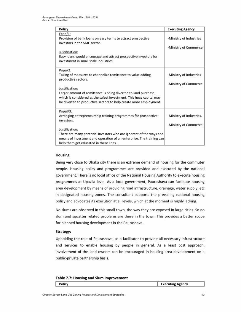
Sonargaon Paurashava Master Plan: 2011-2031 Part A: Structure Plan
Chapter Seven: Land Use Zoning Policies and Development Strategies 93
Policy Executing Agency
Econ/1: Provision of bank loans on easy terms to attract prospective investors in the SME sector. Justification: Easy loans would encourage and attract prospective investors for investment in small scale industries.
-Ministry of Industries -Ministry of Commerce
Popu/2: Taking of measures to channelize remittance to value adding productive sectors. Justification: Larger amount of remittance is being diverted to land purchase, which is considered as the safest investment. This huge capital may be diverted to productive sectors to help create more employment.
-Ministry of Industries -Ministry of Commerce
Popul/3: Arranging entrepreneurship training programmes for prospective investors. Justification: There are many potential investors who are ignorant of the ways and means of investment and operation of an enterprise. The training can help them get educated in these lines.
-Ministry of Industries. -Ministry of Commerce.
Housing
Being very close to Dhaka city there is an extreme demand of housing for the commuter
people. Housing policy and programmes are provided and executed by the national
government. There is no local office of the National Housing Authority to execute housing
programmes at Upazila level. As a local government, Paurashava can facilitate housing
area development by means of providing road infrastructure, drainage, water supply, etc
in designated housing zones. The consultant supports the prevailing national housing
policy and advocates its execution at all levels, which at the moment is highly lacking.
No slums are observed in this small town, the way they are exposed in large cities. So no
slum and squatter related problems are there in the town. This provides a better scope
for planned housing development in the Paurashava.
Strategy:
Upholding the role of Paurashava, as a facilitator to provide all necessary infrastructure
and services to enable housing by people in general. As a least cost approach,
involvement of the land owners can be encouraged in housing area development on a
public-private partnership basis.
Table 7.7: Housing and Slum Improvement
Policy Executing Agency

Sonargaon Paurashava Master Plan: 2011-2031 Part A: Structure Plan
Chapter Seven: Land Use Zoning Policies and Development Strategies 94
Policy House/1: Provision of necessary services and facilities to promote housing at private sector. Justification: It is more difficult to provide housing on public sector initiatives, as it involves funding and land acquisition that takes a long time. By providing infrastructure and services, general people can be encouraged to build their own houses.
- National Housing Authority - Ministry of LGRD - Sonargaon Paurashava
Policy House/2: Housing zone land owners can be involved in a participatory development approach, where Paurashava will provide infrastructure and the cost will be shared by land owners.
- National Housing Authority - Ministry of LGRD - Sonargaon Paurashava
Social Amenities and Community Facilities
Social amenities and community facilities include, education facilities, health facilities,
open space recreation facilities like, park and playground, amusement park and
community centre. For comfortable and healthy urban living, these facilities are the
fundamentals. Since these are social services, they must be provided by the public sector
agencies as public good. For education and health facilities, the national government
have policies and there are separate ministries and their agencies to execute the policies
through programmes and projects. There are also Upazila level offices of the concerned
agencies to take care of the execution of national education and health policies and
programmes. For providing amenities like, park and playground and community centre,
the responsibility lies with the Paurashava. For park and playground, the Paurashava may
secure local khas land. The open space recreation is difficult to provide as population
expands and land price goes higher. Once time is lost, vacant lands are also lost. Amid
soaring land price and absence of vacant land, it becomes extremely difficult to provide
open space recreation. So, it is better to secure vacant lands for open space before
density of population increases and land becomes scarce and pricier. For community
center, intensive use of land should be made by making multiple use of the same space,
for example, providing community center, ward councillor’s office, clinic or any other use
in the same building.
Strategy:
Exploring khas /public land within the Paurashava and using the unused/vacant land for
providing amenities, before density of population increases and land becomes scarce and
dearer.
Table 7.8: Social Amenities and Community Facilities
Policy Executing Agency

Sonargaon Paurashava Master Plan: 2011-2031 Part A: Structure Plan
Chapter Seven: Land Use Zoning Policies and Development Strategies 95
Policy-Amenity/1: Procurement of khas and other public land for park, playfield, community centre. Justification: Since above facilities are non-revenue earning, they should be procured at least cost.
- Ministry of Land - DC Office, Dhaka - Ministry of LGRD - Sonargaon Paurashava
Policy-Amenity/2: Land should be procured for open space facilities as quickly as possible, because when land value will be higher, cost of providing the facilities will also be very higher. Besides, with the growth of population, vacant land will disappear gradually, so no land will be available at strategic locations for providing open space facilities.
- DC Office, Dhaka - Ministry of Land - Ministry of LGRD - Sonargaon Paurashava
7.3.2 Physical Infrastructure Sector
Transport
By far, transport is the most important means to revitalize an urban center. Intra and
inter urban transportation facilities create economies of scale for prospective investors
and enables easy and comfortable mobility of the residents. Easy and cheaper
transportation of raw materials and finished goods create good investment climate for
manufacturing enterprises that lead to development of the service sector firms. New
employment generates and the non-basic sector expands leading to thriving urban
center. To create transportation facilities, quality inter-Upazila and inter-District road
network will have to be created that makes movement faster and easy. With good
transport infrastructure, economic development may become attractive. Besides, quality
of local roads will have to be upgraded to encourage people live in the town. Once
population starts increasing, it will expandlocal consumer market and will attract new
investments in consumer goods production.
Strategy:
Creation of efficient inter-city and intra-town communication for easy transportation of
goods and passengers.

Sonargaon Paurashava Master Plan: 2011-2031 Part A: Structure Plan
Chapter Seven: Land Use Zoning Policies and Development Strategies 96
Table 7.9: Policy for Transport Sector
Policy Executing Authority
Policy-Transport/1: Development of efficient inter-city road network with standard road. Justification: Increased inter-city mobility will increase business transactions and generate investment and employment.
- Roads and Highways Department (RHD)
Policy-Transport/2: Promotion of efficient road transport facilities between urban centers. Justification: Not only that communication is needed between urban centers, but to attract investment, emphasis must be laid on quality of roads built.
-Bangladesh Road Transport Authority (BRTA) -Dhaka District
Policy-Transport/3: Development of local road network through participatory approach. Justification: Development of roads will involve huge cost. Participatorydevelopment will enable cost sharing, which will reduce cost of road construction substantially.
- Sonargaon Paurashava - Local Government Engineering Department (LGED)
Utility Services
Utility services are the most essential parts of urban life. To make an urban center livable,
there must be adequate provision for utility services. Utility services include water
supply, solid waste management, power supply, sanitation and drainage. Except power
supply, the rest are the responsibilities of the Paurashava.
Strategy:
Attainment of self reliance in revenue collection and adoption of participatory approach
to service provision to ensure better services and facilities to the people.
Table 7.10: Policy for Utility Services
Policy Executing Agency
Policy-Utility/1: Exploration of alternative sources of water to ensure sustainable supply. Justification: Amid constant rise of urban population, it is time to explore alternative sources of water like, rain water harvesting and surface water supply.
- LGED - Sonargaon Paurashava
Policy-Utility/2: Involvement of beneficiaries in solid waste management. Justification: Involvement of beneficiaries in solid wastemanagement will make the operation more effective and reducefinancial responsibility of the Paurashava.
- Sonargaon Paurashava, - NGOs and CBOs

Sonargaon Paurashava Master Plan: 2011-2031 Part A: Structure Plan
Chapter Seven: Land Use Zoning Policies and Development Strategies 97
Policy Executing Agency
Policy-Utility/3: Exploring re-use and recycling of waste materials to extract resources. Justification: Re-use and recycling of waste materials will produce resources and reduce cost of waste management.
- Sonargaon Paurashava, - NGOs and CBOs
Policy-Utility/4: Publicity on the benefits of hygienic sanitation to motivate people and enable people to have easy access to sanitary materials. Justification: Motivation will encourage people to adopt healthy sanitation and reduce health risks.
- LGED - Sonargaon Paurashava - NGOs and CBOs
Policy-Utility/5: Protection of natural drainage system and preparation of hierarchical drainage network. Justification: Natural drainage systems are being grabbed and filled up, which increases the risk of water logging. Well planned hierarchical drainage network helps smooth drainage of storm and waste water.
- LGED - Sonargaon Paurashava
7.3.3 Environmental Issues:
From environmental point of view Sonargaon Paurashava is not yet badly affected. There
are some issues that must be taken care of. The issue of sanitation has already been dealt
within the utility services section. Except cyclone, there is no natural hazard. There is no
mentionable air, water or soil pollution in the Paurashava from any mentionable sources
at present.
Natural Resources
The Paurashava is not endowed with many natural resources that can be conserved.
Among the major natural resources there are 561 ponds, 453 ditches, 44 irrigational
canals and 3 natural canals/ khals naturally drain the rain water. Out of the total ponds
with an area equal to or more than 0.25 acres and the natural khals need to be protected
and conserved to ensure sustainability in drainage and water supply of the Paurashava.
Strategy:
All khas land and canals should be vested with Paurashava for use in community interest.

Sonargaon Paurashava Master Plan: 2011-2031 Part A: Structure Plan
Chapter Seven: Land Use Zoning Policies and Development Strategies 98
Table 7.11: Policy for Natural Resources
Policy Executing Agency
Policy-Nature /1: All khas lands within the Paurashava must be assessed and handed over to the Paurashava for use in community interest. Justification: This will prevent misuse of khas lands by political and powerful local people.
- Ministry of Land - Sonargaon Paurashava
Policy-Nature/2: All natural canals within the Paurashava must be vested with the Paurashava for maintenance and proper use as drainage canal. Justification: This will help prevent unauthorized occupation and filling of natural drainage.
- Ministry of Land - Sonargaon Paurashava - NGOs and CBOs

Sonargaon Paurashava Master Plan: 2011-2031 Part A: Structure Plan
Chapter Eight: Implementation Issues 99
CHAPTER 8
IMPLEMENTATION ISSUES
This chapter deals with the issues of implementation of the Master Plan. Here,
recommendations have been made about capacity building and resource mobilization for
the implementation of the plan.
8.1 Institutional Capacity Building of the Paurashava
In the present context of spatial and legal jurisdiction of the Paurashava for planned
development of its area, some recommendations are made here. Also, observing the
financial and Institutional strength of individual stakeholders in relation to their liabilities
and identifying their shortages and absence of any perfect coordinating body, some
suggestions have been made as remedial measures as a whole.
- All urban local governments including Upazila level Paurashavas must be given more independence and autonomy to perform their responsibilities. At the same time, their accountability to the government and people regarding their performance has to be ensured. For this purpose the legal framework of the urban local governments has to be reviewed and updated. The legal provisions have to be consolidated and simplified and make them compatible to changing circumstances. Opportunities must be created in the Act allowing scope for privatization of service providing activities.
- To avoid duplication of development functions, there should be clear line of separation between central government and the urban local government.
- Massive training programme has to be arranged for the municipal staff for computerized accounting, billing and infrastructure development. .
- To improve revenue collection, the urban local governments should be given more power and responsibilities. Measures should be taken for strengthening the Paurashava administration for municipal development.
- Section-50 of the Paurashava Act needs to be revised and more power should be given to the Executive Officer for appointment of employees.
It can not virtually function effectively as a Paurashava under such a stringent financial
condition. To function, effectively, it must raise its revenue earning. But it is reported that
the Paurashava can not collect all its holding tax from the citizens. Holding tax is the most
important source of its own revenue earning. It must take care to ensure 100% recovery
of holding tax. The Paurashava can not function effectively depending upon government
grant only. The existing manpower position of the Engineering, Development control and
Accounts should be substantially raised to handle future volume of work. Moreover,
additional staff especially for the implementation of Master Plan will soon be required.
The present plan package imposes a large number of development projects on Sonargaon
Paurashava for implementation. Paurashava will not only be the custodian of the plan, it
will also directly implement much of the development projects. Besides, it will also be
responsible for monitoring and implementation of the development projects by other

Sonargaon Paurashava Master Plan: 2011-2031 Part A: Structure Plan
Chapter Eight: Implementation Issues 100
urban development and service giving agencies. This situation calls for strengthening of
the existing capability of Paurashava.
8.1.1 Staffing and Training
As a traditional system of the Paurashava, engineer and secretary are appointed directly
by the Ministry of Local Government and other staffs are appointed locally through the
approval of the Ministry after the advertisement on the newspapers. The Paurashava is
capable to collect the taxes and tolls prescribed by the government. But still they have
lack of tax collection. There is no proper arrangement for staff training only few training
are received by LGED which are not sufficient enough. As a result, the staffs are mostly
unskilled. They can not deliver proper service to the citizens. Besides, most of them are
not qualified enough to render proper services.
8.1.2 Lack of Automation
Still now most works in the Paurashava are done manually. Such practice delays works
and deprives the citizens from services. This is also a source of mal-practice and
corruption. Modern office and working equipment should be installed. Use of modern
technology will increase efficiency in planning and record keeping, finally expedite
decision making process.
8.1.3 Lack of Paurashava Town Planning Capacity
At present, the Paurashava has no town planning section or any appropriate manpower
to prepare and implement the Master Plan. The Paurashava must strengthen its capacity
to implement its Master Plan when it will be completed. It will otherwise be in trouble in
the implementation, monitoring and updating the Master Plan.
8.1.3.1 Institutional Framework
To rearrange the institutional framework for the Paurashavas recently the government
has made a committee to reform the organogram of all the Paurashavas of Bangladesh.
According to the clause no. 72-78 (Paurashava Officer & staff, provident fund etc) of
Paurashava Act, 2009 and on the basis of the type and category of works, the committee
suggested appropriate section/units/divisions within the Paurashava framework.
Planning unit or division will be necessary to set sequentially as the authority can
perform it’s mandatory responsibility ‘town development and control’ well and serve the
inhabitants presently as well as in the future. The planning unit/division may have some
sections that are as follows:
Planning unit/Division: a) IT Section b) Planning Section c) Beautification and recreation Section
According to the division and it’s relevant sections, what so ever appropriate with the
necessity and capacity over time, it is recommended to set up necessary manpower for

Sonargaon Paurashava Master Plan: 2011-2031 Part A: Structure Plan
Chapter Eight: Implementation Issues 101
each category of Paurashava. Possible scope of proposed planning unit/division is given
bellow:
Figure 8.1: Scope of Work for Planning Division

Sonargaon Paurashava Master Plan: 2011-2031 Part A: Structure Plan
Chapter Eight: Implementation Issues 102
8.1.3.2 Lack of Paurashava Town Planning Capacity
At present, the Paurashava has no town planning section or any appropriate manpower
to prepare and implement the Master Plan. For proper implementation of the Master
Plan for each Paurashava under UTIDP, establishment of a separate planning unit is
indispensable. The Paurashava must strengthen its capacity to implement its Master Plan
when it will be completed. It will otherwise be in trouble for implementation, monitoring
and updating the Master Plan.
Sonargaon is a ‘B’ class Paurashava. For the ‘B’ class Paurashava Government approved
an organogram and required manpower. A comparison of the existing manpower with
the approved organogram finds that there is a huge gap between the two. Many
positions have been vacant since the inception of Paurashava. Paurashava authority
supported with the line ministry should take necessary steps to set up planning unit and
strengthen all units/division of the Paurashava for its better performance.
Support for Planned Urbanization
For creating planned urbanization, Paurashava may:
Support for preparation of Computerized Infrastructure Database.
Support for Preparation of Paurashava Base Map.
Support for Preparation of Paurashava Infrastructure Development Plan.
Orientation on preparation, use, update & implementation of Paurashava Master Plan.
Assist preparation and execution of Community Development Plan by Community Based Organization (CBO).
Introduce 3D-Modeling in Master Planning components.
Beautification of Paurashava by 3D-Modeling.
Community Mobilization Program
Following are the community mobilization support activities:
Support to establish Town Level Coordination Committee (TLCC) and make it functional
Support to establish Ward Committee (WC) and make it functional.
Support for preparation of Community Planning and implementation by forming Community Based Organization (CBO).
Support to accelerate the Paurashava Standing Committee activities.
Urban Governance Improvement Action Programme (UGIAP)
It is stipulated in the 6th 5 year plan ‘the Key constrains to the effective functioning of the Paurashavas and City Corporations are unclear mandate and service responsibilities; lack of accountability; weak finances and financial autonomy; poor coordination and control among service agencies and weak management’.
To overcome the challenges, the 6th Five year plan as well as Perspective Plan of Bangladesh, 2011-31 recommends the same issues mentioned below:
Sonargaon Paurashava Master Plan: 2011-2031 Part A: Structure Plan
Chapter Eight: Implementation Issues 103
the instructional reform and decentralization of responsibilities and resources to local authorities; participation of civil society including woman in the design, implementation and monitoring of local priorities; building capacity of all actors (Institutions, groups and individuals) to contribute fully to decision making an urban development process; and facilitate networking at all levels.
It is already tested, proven and accordingly recognized in the 6th Five year plan that urban infrastructure improvements have been proved very successful introducing governance and performance-based approach adapted by UGIIP in selected ULBs in the country. Among other suggestions the 6th Five year plan also includes nature for Urban Governance Improvement Action Progamme (UGIAP) and Capacity Building of Institutes at Municipality-level in particular.
Citizen Awareness and Participation
The Paurashava authority may initiate to buildup citizen awareness and to ensure
peoples participation in plan initiation and implementation process. Initiatives may be as
follows:
Establishment of Civil Society Coordination Committee (CSCC) and make it functional
Establishment of Ward Level Coordination Committee (WLCC) and make it functional
Citizen Charter display at Paura Bhaban.
Citizen Report Card Survey by the Paurashava.
Establishment of Grievance Redress Cell and make it functional with specific TOR
Establishment of Mass Communication Cell (MCC) and make it functional
Establishment of Urban Development Coordination Unit with inclusion of other departments for inclusive development
Urban Planning and Environmental Improvement
Master plan is a guideline and detail urban planning activities are being prescribed in the plan. To produce a livable environment in the Paurashava premises, following initiatives should be taken:
Recruitment of staffs and establish Planning Department related to administrative structure, meeting and meeting minutes preparation.
Master Plan, Base Map verification and update landuse plan preparation.
Approval of building plan and development control.
Introduction of environment and public health activities.
Urban Poverty Reduction
Following initiatives can be taken by the Paurashava for urban poverty reduction:
Establishment of Slum Improvement Committee (SIC) in selected slums and scattered area.
Preparation of poverty reduction action plan with guideline and necessary budget allocation.
Income Generating Activities
The income generating activities include:
Tax assessment software use and capacity development for staffs of assessment section.
Continue reassessment activities regularly at 5 years interval.

Sonargaon Paurashava Master Plan: 2011-2031 Part A: Structure Plan
Chapter Eight: Implementation Issues 104
Continue interim assessment regularly in whole year.
Introduction of computerized tax system and bill preparation.
Increase collection by more than 5% annually (up to 85% collection efficiency).
Increase non-tax own revenue source atleast by inflation rate.
Introduction of computerized trade license system and computer bill/license prepared and report produced.
Introduction of computerized Water bill (Tariff) system.
Introduction of Computerized non-motorized vehicle management system.
Identification of new income sources for increasing income.
Transparency and Accountability
Functions and activities perform by the Paurashava authority should be transparent and
the persons responsible for performing activities for betterment of the society should
maintain accountability to the Paurashava people as well as central government.
Following guidelines may be followed for such performances:
Administrative Reformation of Paurashava.
Set Vision, Mission and functions for each department / section of the Paurashava.
Functions to be decentralized, transfer and coordination with other authorities.
Establishment of Capacity Development Committee in Paurashava-level.
Establishment of Urban Information Services Center at Paurashava premises.
Meet the Mass people of Poura-Parishad.
8.1.4 Legal Aspects
The drive to establish strong urban local governance in the Paurashava is yet to be
legalized. The governance programmes at present are operated project wise based on
the formulated policies of the implementing agencies of the national government. The
Laws that the country inherited are mostly prepared during the colonial rule to serve its
own interests. Even after independence from the British, the issue of good governance
was not infused into the new Acts formulated.
8.1.5 Good Governance in Legal Provisions
There is hardly any Act where the elements of good governance are clearly visible. The
consultant has identified some Acts, where some elements of good governance can be
traced.
The Paurashava/Municipal Act/Ordinances prepared at different times since 1960’s have
iterated for the preparation of Master Plan by the Paurashava/Municipality for its
planned development. So far urban local government Ordinances/Acts made in 1967,
1977, 2008 and 2009, all suggested for planned development. The Paurashava Act 2009
has made the provision of having a Master Plan prepared by a Paurashava within five
years of its inception. The function of the Paurashava also includes that it ensures
planned development following the rules of the Ordinance. But there is no provision for

Sonargaon Paurashava Master Plan: 2011-2031 Part A: Structure Plan
Chapter Eight: Implementation Issues 105
public participation in the Paurashava Ordinance 2009. In all these legal documents,
people’s role has been ignored which is the violation of the norms of good governance.
The constitution of the Peoples’ republic of Bangladesh clearly spells out that the
Government should work to minimize the gap between urban and rural areas. A planned
Paurashava development in that pursuit can provide necessary services to improve
quality of life in both urban and rural areas within the Upazila.
8.1.6 Financial Issues
Governance in Sonargaon Paurashava
Financial governance refers to transparency and accountability of financial matters. All
financial matters must be transparent to all. People must know about the policies and
programs of the Paurashava, how much revenue is collected each year and the amount
of expenditure made on annual development. They must also be answerable to the
people on how the public money is being spent and accounts being maintained.
The Ministry of LGRD and Cooperative has undertaken a number of projects in respect of
establishing governance in upgrading Paurashava accounts system, like, UGIIP, STIFPP.
Computer and accessories are supplied under these projects for automation of the
accounts system. Besides, trainings are also offered to the Paurashava accounts staff for
enabling introduction of automation in accounts system. But all these services have not
yet reached Sonargaon Paurashava.
Revenue Management
The Paurashava still follows a traditional management system in tax collection and
revenue management though a scheme of computerized automotive financial system has
already been introduced in this Paurashava. Assessment section is responsible to asses
the tax of the Paurashava and tax collection, and license and bazar section are
responsible to collect the tax of the Paurashava. The public is mainly informed about tax
collection during the presentation of annual budget. They may, however, get information
from the councilor or Paurashava accounts office.
Paurashava’s Financial Capacity and Plan Execution
The main focus of Paurashava financial governance is to establish automation in entire
financial management. This includes computerization of accounts system, holding tax
management, and billing of different service charges. Software for above functions have
been supplied and installed in the Paurashavas covered by financial automotive projects.
The projects also provided training to the relevant staffs for functioning of the systems.
With the implementation of these projects people can now instantly know about the
status of their tax payment, bill payment, and licensing. This has not only made the
functions of the Paurashava easy, but also has freed the citizens for paying bribe, and
experiencing hassle.

Sonargaon Paurashava Master Plan: 2011-2031 Part A: Structure Plan
Chapter Eight: Implementation Issues 106
The size of annual budgets of the Paurashavas indicates the poor financial status of the
Paurashavas. With low income, Sonargaon Paurashava will have to depend substantially
on the government funding for implementing the development projects. But the
government has limitations of its resources. In such a situation, if the Paurashava can not
raise its own revenue adequately, it will not be able to execute much of the development
projects under the Master Plan.
8.1.7 Monitoring, Evaluation and Updating
Monitoring and evaluation is a very important part of plan implementation. Monitoring
helps check if the plan is being implemented properly. It also measures the level of
implementation of the plan. If the plan implementation is not on track, corrective
measures can be taken to put execution on the track. After expiry of any plan, evaluation
is made about the errors and omissions. Such evaluation helps take corrective measures
in the next plan. Such monitoring and evaluation must be carried out from within the
Paurashava. But Sonargaon Paurashava is not equipped with qualified manpower to
make
such evaluation. Monitoring and evaluation of a plan is essentially, the responsibility of
qualified and experienced planners. As there is no planner in the Paurashava, monitoring
of plan implementation will be seriously affected. However, plan evaluation can be
accomplished by means of out sourcing as and when it is required.
8.1.8 Periodic Review and Updating
The plan package needs to be updated regularly to make it respond to the spatial
changes over time. But such updating would require relevant technical professionals and
requisite fund that are highly lacking in Sonargaon Paurashava. As there is no planner or
planning section in the Paurashava, review and updating of the Master Plan will require
service of senior level planners that Paurashava might not be able to provide. This service
will have to be procured by out sourcing and the Paurashava is not even capable to
accomplish this financially either. This will create problem when the plans or its
components gets obsolete or need to be changed. Another problem would arise when
the duration of plans ends. It is necessary that the entire plan document (including all
planning and land use proposals) should be reviewed every 4th year of the plan period
and will come into execution from the 5th year. The aim of the review will be to analyze
the status of implementation of plan provisions, the changing physical growth pattern,
infrastructure development, and the trend of public and private physical development
including growth direction.
A new set of plans will have to be prepared replacing the old ones. This problem,
however, can be overcome by undertaking another planning project by LGED. So, for
regular updating and changes, and plan implementation monitoring, the Paurashava
should immediately set up a planning section with a number of planners and other staff.
The section will not only look after planning, but will also be responsible for development

Sonargaon Paurashava Master Plan: 2011-2031 Part A: Structure Plan
Chapter Eight: Implementation Issues 107
control, estate management, and project preparation. Since the planners would be
qualified and skilled in computer operation, they can also help achieving automation of
the Paurashava functions.
8.2 Resource Mobilization
Resource mobilization will be one of the most challenging tasks in implementing the
current plan package. Though the development proposals are said to be executed by a
large number of development agencies, but it is beyond doubt that the heaviest burdens
will have to be shouldered by the Paurashava. As a local government agency, it suffers
from resource constraint due to low level of urbanization and investment by both public
and private sectors. The land value will maintain perpetually low growth rate in the town.
Therefore, prospect of mobilization of substantial resource from sale of serviced land is
extremely meager. For the same reason, revenue earning from betterment fee, planning
permission and other sources may also remain low. Paurashava is heavily dependent on
the government for executing its development projects as it is unable to collect sufficient
revenue from its tax and non-tax sources. Therefore, it is clear that execution of
development projects under the current plan will depend heavily on the government
response to supply adequate fund. This situation calls for increasing revenue earning by
generating new revenue sources.
8.3 Concluding Remarks
From the past experience, it has been observed that plans are prepared for organized
development, but development control has been subject to negligence. In most cases,
execution has been piecemeal. It is unfortunate that town planning has not yet become a
part of our urban development culture. Individuals develop lands and construct buildings
with a little respect for planned development, and the concerned authority is also unable
to exercise full control on development. Some strict measures are necessary to make
stakeholders follow up plans and development rules. Awareness is to be built among the
people to follow the Master Plan provisions and plan. Government agencies must be
compelled to follow plans. Existing laws in this regard must be updated incorporating
provisions of plan execution.

Sonargaon Paurashava Master Plan: 2011-2031 Part A: Structure Plan
Chapter Eight: Implementation Issues 108

Sonargaon Paurashava Master Plan: 2011-2031 Part B: Urban Area Plan
Chapter Nine: Uraban Area Plan 109
CHAPTER 9
URBAN AREA PLAN
This is the first chapter of Part- B that starts with Urban Area Plan. Urban Area Plan is the
mid level plan that covers the existing Paurashava. It lays down the land use zoning plan
and infrastructure development proposals at the town level. Land use planning is an
important part of Master Plan ensuring that land is used efficiently for the benefit of
economy, society and environment of Sonargaon Paurashava. This planning means the
scientific, aesthetic, and orderly disposition of land, resources, facilities and services with
a view to securing the physical, economic and social well-being of urban communities.
9.1 Goals and Objectives of Urban Area Plan
Urban Area Plan is the first phase illustration of the Structure Plan intended to be
implemented over a time span of 10 years. The Urban Area Plan has been prepared
within the policy framework of the Structure Plan and aims to attain the overall project
objectives. So there is a hierarchical relationship between the two. In fact, Urban Area
Plan is the first phase detailed illustration of the policies and strategies of the structure
plan.
The preparation of Master Plan for Sonargaon Paurashava is aimed towards its future
development, and covers the areas that are likely to become urban in future. The Urban
Area Plan is aimed to:
Determine the present and future functional structure of the town, including its land uses; and
Provide infrastructure proposals for improving and guiding development of future urban area.
9.2 Methodology and Approach to Planning
The base map supporting for land use survey was obtained from the physical feature
survey that contained all categories of physical features within the planning area. During
physical feature survey, all structures and the functions of principal buildings were picked
up and depicted on the map. The physical features were superimposed on a mouza map
and printed for land use survey on the map. The map was carried to the field by
investigators for detailed plot to plot land use survey. The field investigators carrying the
map visited each and every plot and the structures therein and noted their uses in writing
and marking them on the map with colour pencil. They also verified the land use names
put during the physical feature survey. Back in the office, the common land uses of plots
were delineated in the map as per land use format given in the ToR. The delineated zones
were then digitized and a new land use map was prepared for the entire planning area.
After land use demarcation, field checking was done to correct possible errors.

Sonargaon Paurashava Master Plan: 2011-2031 Part B: Urban Area Plan
Chapter Nine: Uraban Area Plan 110
Urban Land Use Plan is aimed to guide the physical development of Sonargaon town
including its economic and social activities. This plan adheres to the policy directives
spelled out in the Structure Plan. The current Urban Area Plan is akin to the traditional
Master Plan approach prevalent in the country that designates plot-to-plot use of land
apart from infrastructure development proposals. Thus it will also serve as a
development control mechanism/instrument. The Urban Area Plan is, therefore, more
rigid than Structure Plan. Making a land use plan on a cadastral map makes the Urban
Area Plan more rigid. Once the plan on a cadastral map is drawn and accepted by the
government and formalized, it gains a formal status and thus becomes a binding for all
concerned.
The objectives of the Urban Area Plan have been attained through:
Orderly location of various urban land uses;
Location of appropriate transportation and drainage network; and
Orderly location of services and facilities.
9.3 Delineation of Planning Areas
Planning area has been decided with the assistance and advises received from Sonargaon
Paurashava Mayor, Councilors and other professional staffs and Gazette notification (S R
O No-83 Law/ 2001). In order to delineate this boundary, there was a wide
reconnaissance survey involving eye observation of the entire Paurashava area including
those areas which have future potential growth. But since, the formation of Sonargaon
Paurashava is 10 years back (2001); the development trend do not took much
momentum as it required. In addition, the Mayor and the Councilors opinioned in favor
of keeping the Paurashava area encompassing the nine wards as exist for next 20 years.
Strong arguments from Paurashava Mayor and Councilors were advised to extend the
boundary as it is not an old Paurashava and various developments has taken place, and
the present area is not enough as study/ planning area. But some development activities
like tourist spot (Lok-O-Karushilpa Museum, Panam City) can influence the area for rapid
development. Considering the real senarion around 325.01 acres of land comprises two
separate location of 62.32 acres and 325.08 acre along Dhaka- Chittagong highway has
incorporated within the structure plan area. So, Consultant has considered 2431.38.acres
(9.84 sq km) with nine Wards as the planning area. Where the existing Paurashava area is
2106.30 acres and extension area is 325.08 acres.
9.4 Content and Form of Urban Area Plan
The Urban Area Plan is presented in both map and textual format. The plan map is
presented in 1:1980 or 1 inch to 165 feet scale, superimposed on latest
cadastral/revenue map having plot boundaries within mouzas. The plan is accompanied
by an explanatory report supported by necessary figures, maps and data. The report
explains the various plan proposals and other components of the plan.

Sonargaon Paurashava Master Plan: 2011-2031 Part B: Urban Area Plan
Chapter Nine: Uraban Area Plan 111
The Urban Area Plan of the Master Plan of Sonargaon Paurashava contains several
components. These are:
Land Use Plan;
Transportation and Traffic Management Plan;
Drainage and Environmental Management Plan; and
Proposals for Urban Services.
The Urban Area Plan is concerned only with the area where the greatest change is
expected in the medium-term (10 years). For this area, it indicates how the Structure Plan
policies might be pursued whilst also giving greater precision to the spatial dimension of
the policies.
The outline of the Urban Area Plan gives guidance to the Paurashava as to how it can
develop the roles i.e. to promote development, to co-ordinate development and to
control development.
The Urban Area Plan has been divided into four main parts. These are preceded by four
introductory chapters which explain the scope of the report and provide background to
the Urban Area Plan including its relationship with the Structure Plan.
The Landuse Plan is the first chapter of Part-B of this report. It identifies approaches of
planning, existing and projected landuse and proposed landuse. Requirement of land for
different purposes, landuse zoning and plan implementation strategies are also included
here.
The Transportation and Traffic Management Plan includes existing conditions of
transportation facilities, intensity of traffic volume, degree of traffic congestion and
delay, analysis of existing deficiencies, travel demand forecasting for next 20 years, future
traffic volume and level of services and transportation development plan. Moreover,
transportation system management strategy and plan implementation strategies are also
presented in this plan.
Drainage and Environmental Management Plan is the third chapter of the Urban Area
Plan. The chapter again subdivided into two parts – drainage part and environment
part. Existing drainage network, land level and topographic contour, plan for drainage
management and flood control and plan implementation strategies are the components
of the drainage part. Existing environmental condition, solid waste and garbage disposal,
environment pollution, water logging, natural calamities and localized hazards, plan for
environmental management and pollution control and plan implementation strategies
are the key issues of the environment part.
Fourth part of this report is Plan for Urban Services. Existing condition and demand of the
Services, projection on existing and proposed Urban Services, Proposals for Urban
Services and Implementation, monitoring and Evaluation of the Urban Services Plan are
the key issues of this part.

Sonargaon Paurashava Master Plan: 2011-2031 Part B: Urban Area Plan
Chapter Nine: Uraban Area Plan 112

Sonargaon Paurashava Master Plan: 2011-2031 Part B: Urban Area Plan
Chapter Ten: Landuse Plan 113
CHAPTER 10
LANDUSE PLAN
The Landuse Plan is the first element of the Sonargaon Paurashava Urban Area Plan. The
Landuse Plan is being prepared for managing and promoting development over medium-
term on the basis of the strategies set by the longer-term Structure Plan. Basically the
Landuse Plan is an interpretation of the Urban Area Plan over the medium-term (10
years). The coverage of the Landuse Plan considers existing urban areas and their
immediate surroundings with the purpose of providing development guidance in the
areas where most of the urban development activities are expected to take place over
the next 10 years. Delineation of the Landuse Plan area is based on the urban growth
area identified as the Urban area Plan. It contains more details about specific programs
and policies that require to be implemented over the medium-term.
10.1 Methodology and Approach
For the preparation of Landuse Plan, spatial information or data of all existing landuses
from landuse survey was processed and stored under a comprehensive GIS database
component. GIS software such as PC ArcView and PC ArcInfo (Version as suggested in the
ToR) has been used for processing of physical feature survey data. Data was stored in
WGS-1984 format (latitude, longitude, ellipsoidal height in meter) and later on it was
projected and stored in Lambert Conformal Conic (LCC) projection system.
Landuse map has prepared applying the appropriate systematic command through GIS.
Landuse is transferred on CS Mouza map in a scale of RF 1:1980. Landuse is divided into
different categories and subcategories approved by the LGED. Landuse colours and
legend were also fixed by the PD (Project Director) of the UTIDP, LGED. Legend contains,
necessary themes, features using different symbolize schemes. As per suggestion of the
LGED for fixed legend and approved format for landuse, Consultants have prepared
existing landuse map.
Based on the existing landuse map, the landuse plan is being prepared according to the
guidelines given by the ToR. The planning starts from formulation of strategies to issues
like functional quality (meeting of space requirements for different functions, relation
between functions etc., aesthetic quality, flexibility, deviation, public agency support etc.)
for plan implementation. The planning in detail also covers the delineated existing urban
area and the new urban area.

Sonargaon Paurashava Master Plan: 2011-2031 Part B: Urban Area Plan
Chapter Ten: Landuse Plan 114
10.2 Existing and Projected Landuse
10.2.1 Introduction
Details of landuse include structures and uses of land in multi-dimensions. Every
individual structure and its details were surveyed during the survey period and find out
the uses of land. Most of the landuse information was collected through physical feature
survey. Later on, landuse map is prepared showing different use categories.
At present, except about 33.07% agriculture land, 41.77% residential development and
15.66% water bodies, rest land are using for various purposes. According to the physical
feature survey, the study area has as many as 30537 structures. There are a total of 9755
structures within the study which is composed of pucca, semi-pucca and katcha
structures and they are 1413, 1042 and 7300 in numbers respectively. For rearrangement
and enforcement of new provision those land will generate planning scope. Due to the
absence of airport and helipad, vertical expansion of the building will be easily
encouraged in anywhere of the Paurashava. New innovation for increase the agriculture
production may be encouraged easily.
The Paurashava seems a barren land area. People are not quite aware about the modern
facilities available to their door step. It is easier to inject guiding principles, modern
facilities and long run development control for the Paurashava as well as for the
inhabitants.
Table 10.1: Existing landuses of Sonargaon Paurashava
Land Use Category Area (acre) Percentage (%)
Agriculture 696.44 33.07
Circulation Network 75.23 3.57
Commercial Activity 18.56 0.88
Community Services 5.83 0.28
Education & Research 9.15 0.43
Governmental Services 4.74 0.23
Manufacturing and Processing Activity 24.50 1.16
Mixed Use 1.27 0.06
Non Government Services 0.50 0.02
Recreational Facilities 41.58 1.97
Residential 879.91 41.77
Service Activity 3.41 0.16
Transport & Communication 0.79 0.04
Urban Green Space 2.46 0.12
Vacant Land 11.98 0.57
Water Body 329.94 15.66
Total 2106.30 100
Note: Includiding 325.08 acre extension area total area stands 2431.38 acre.

Sonargaon Paurashava Master Plan: 2011-2031 Part B: Urban Area Plan
Chapter Ten: Landuse Plan 115
10.2.2 Analysis and Projection on Existing and Proposed Landuses
Due to nearness of Dhaka city and rapid urbanization and as it is a historical Panam city
area. Tourism based township should be encouraged in the preparation of Master Plan.
Growth of population is the natural trend and at the sametime, expansion of non-
agricultural use on agriculture land is also natural tendency of the people. This will be
controlled through the Compact Township concept with the encouragement of vertical
development. In case of government services, specific building may accommodate
different type of offices.
Future landuse will be calculated according to the development control for the masses
and the standard supplied by the LGED. In case of public land, existing use and khas land
will be emphasized. Willingness and participation of the people in development activities
will be the key factor for future landuse demarcation. Slow change of landuse will be
emphasized rather than rapid change. Let the people do whatever he likes on own land –
such concept should not be considered for future projection of landuses. Three parts of
the projection are landuse change, landuse control and landuse restriction will be
included in the Master Plan. In any case, river front areas should be restricted for human
habitation. As a result, river water will safe from contamination.
The People of the Paurashava are not quite aware about the modern facilities available
to their door step. It is easier to inject guiding principles, modern facilities and long run
development control for the Paurashava as well as for the inhabitants.
10.2.3 An estimate on the Requirement of Land for Different Landuses
The Paurashava is not an ideal township due to the agriculture domination. Agriculture
based township should be encouraged in the preparation of Master Plan. Growth of
population is the natural trend and at the sametime, expansion of non-agricultural use on
agriculture land is also natural tendency of the people. This will be controlled through the
Compact Township concept with the encouragement of vertical development. In case of
government services, specific building may accommodate different type of offices.
Future landuse have been calculated according to the development control for the
masses and the standard supplied by the LGED. In case of public land, existing use and
khas land may be emphasized. Willingness and participation of the people in
development activities may be the key factor for future landuse demarcation. Slow
change of landuse has emphasized rather than rapid change. Let the people do whatever
he likes on own land – such concept should not be considered for future projection of
landuses. Three parts of the projection are landuse change, landuse control and landuse
restriction has been included in the Master Plan. In any case, river front areas should be
restricted for human habitation. As a result, river water will safe from contamination.

Sonargaon Paurashava Master Plan: 2011-2031 Part B: Urban Area Plan
Chapter Ten: Landuse Plan 116
Projection of landuse depends on the growth of population. After population projection
it is found that, population of this Paurashava will be 45975 in the year 2021 and 64451in
the year 2031. Projection on landuse also depends on present trend of migration.
In case of landuse change, standard given by the LGED according to the projected
population and area for the specific service is being calculated. Minimum use of
agriculture land for physical development is emphasized in the plan. The vertical
expansion will be emphasized rather than horizontal. In case of road network planning,
missing links will get priority rather than new roads. For the development of pisciculture,
most of the ponds and ditches may be preserved, in some exceptional cases; small
number of ditches may be used for physical development activities. Landuse control and
landuse restriction will be imposed by the Paurashava according to the prescribed plan.
The standards presented in the Table-10.2 are fairly generous and considered for the
Paurashava (including extended areas). Adjustments have to be made in the core areas
and a time line may be set to gradually achieve these standards over a five, ten and
fifteen years period.
Commerce
In total, 18.56 acres commercial land is in the Paurashava.
Determination of Standard: According to the standard on Wholesale Market/bazar, 1
acre land is to be provided for every 10,000 populations and 1 acre land for every 1000
population for Retail sale market. Again, 0.25 acre of land is being standardized for per
corner shop, 1 acre per neighbourhood market, 1.5 to 2.5 acre per super market and 1
acre per 25,000 populations for bank, hotel, garage and godown. The study team has
considered 64451 populations for the study area up to the year 2031. For this population
total number of required wholesale market/bazar stands at (64451/ 10,000), means 6.45
acres land is being needed up to the year 2031 and for retail sale market, 64.45 acres.
Recommendation / Forecast: In the planning area already has retail sale market including
wholesale market/bazaar. The study team recommended a new wholesale market/bazar
and 3 super market and a community center cum market. Cosidering our country context
and development scenario probable areas for commercial development are earmarked as
mixed use area so that they may use this land for residential/commercial purpose
according to the demand. Necessary planning permission and design criteria will be
provided by the Paurashava.

Sonargaon Paurashava Master Plan: 2011-2031 Part B: Urban Area Plan
Chapter Ten: Landuse Plan 117
Map 10.1: Exising Landuse of Sonargaon Paurashava

Sonargaon Paurashava Master Plan: 2011-2031 Part B: Urban Area Plan
Chapter Ten: Landuse Plan 118

Sonargaon Paurashava Master Plan: 2011-2031 Part B: Urban Area Plan
Chapter Ten: Landuse Plan 119
Industry
In the Paurashava, 24.50 acres land is under industrial development.
Determination of Standard: According to the standard, land is being allocated as 1.5 acres
for every 1000 populations in case of small-scale industry, 5 acres per 10000 populations
for heavy industry and service industry and 1 acre per 1000 population for cottage/agro-
based industry. The study team has estimated 64451 populations for the planning area
up to the year 2031. For this population total required land for industry stands at (64451/
1,000*1.5)96.67 acres land for small-scale industry, 64.45 acres for cottage / agro-based
industry up to the year 2031.
Recommendation / Forecast: The study team observed that though this Paurashava is
rural base there is potentiality of industrial development due to nearness of Dhaka city.
Considering the real scenario the consultants has proposed a area of 115.35 acres for
industrial development of which 46.68 acres are general industries and 68.45 acres are
heavy industries. Necessary planning permission will be followed by the Paurashava. The
lands, however, should not be allowed to use other than industry. The industries which
are located dispersely should be accommodated within the prescribed industrial areas.
The industrial development proposal has proposed both side of Dhaka-Chittagong
Highway.
Primary School
There are 16 primary schools in the planning area covering together 4.08 acres land.
Determination of Standard: According to the standard on primary school, 1 school with 2
acres of land is to be provided for every 5,000 population. The study team has estimated
64451populations for the planning area up to the year 2031. For this population total
number of required primary school stands at (64451/ 5,000), means 13 schools with 26
acres land will be needed up to the year 2031.
Recommendation / Forecast: According to the standard there is no need for new primary
school. The existing area of school has proposed for extension and a new primary school
has recommended. Proposal has made not to extend the number of school but proposed
for increasing of enrollment, area extensionand expanded vertically.
Secondary School
There are 6 secondary schools in the planning area covering together 2.46 acres land.
Determination of Standard: According to standard, 5 acres of land may be provided for
every 20,000 population for one secondary school. The projected population of the
planning area is 64451 up to the year 2031. Therefore, as per standard the planning area
needs (64451/ 20,000) 4 secondary school with an area of 20 acres up to the year 2031.
Number of schools already exceeds the requirement.

Sonargaon Paurashava Master Plan: 2011-2031 Part B: Urban Area Plan
Chapter Ten: Landuse Plan 120
Forecast / Recommendation: As per above standard, no more secondary school is
needed. But considering the real senario a new secondary scool are recomanded. Existing
areas of the schools also proposed for expansion.
College / Higher Secondary School
There is only one college in the planning area. The existing colleges are located on 0.36
acres of land.
Determination of Standard: The standard for college is 10 acres per 20000 populations.
So there is a need of 4 colleges as per planning standard in 2031.
Recommendation / Forecast: two new college and a university college has recommanded
in the planning.Necessary horizontal and vertical expansion of the existing college is also
recommended.
Vocational Training Centre
An important component for the rural masses is vocational training. Multi-dimensional
training may be offered through the centre. People are being benefited directly and
prepare him as a technical person enjoying training from vocational centre. At present,
there is no vocational training centre centre in the Paurashava.
Determination of Standard: The prescribed standard for vocational training centre is 5 to
10 acres for Upazila.
Recommendation / Forecast: The study team recommends a vocational training centre.
Besides that there is 10 madrssa and 5 coaching centre in the Paurashava area.
Health Facilities
Existing health facilities are not bad in this Paurashava. There is one upazilla health
complex and three clinics in this Paurashava.
Determination of Standard: The prescribed standard for health facilities are 10 to 20
acres for Upazila Hospital and 1 acre per 5000 population for Health centre/Maternity
clinic. According to the standard, up to the year 2031, (6445/5000) means 12.89 acres of
land will be needed for Health centre/Maternity clinic.
Recommendation / Forecast: The study team recommends a new hospital zone for health
facility development. The land owners/private developer will develop such services.
Necessary planning permission will be offered by the Paurashava.
Open Space
At present there is 11.98 acres of land under this category in the Paurashava.
Determination of Standard: The standard recommends 3 acres per 20000 populations for
playground, 1 acre per 1000 population for park and 1 acre per 1000 population for
Neighbourhood Park. A total of 138.57 acres of land is needed for this category.

Sonargaon Paurashava Master Plan: 2011-2031 Part B: Urban Area Plan
Chapter Ten: Landuse Plan 121
Recommendation / Forecast: The study team is not recommended play field. A central
park cum stadium, 2 neighborhood park is being recommended. Community forest and
tourism development also prescribed without considering any standard. Amount of land
for those components have been considered through discussion with the stakeholders.
Community Facilities
Community facilities include Community centre, Graveyard/Burial ground,ward office
Electric sub-station, Water supply pump, Post office, T&T office, Public library, Eidgah,
Mosque/Church/Temple, Police station, Police box/outpost, Fire service station, club, etc.
Existing land under community facilities is 5.85 acres.
Determination of Standard: The standard suggests 1 acre per 20000 for the community
centre, Graveyard/ Burial ground and Eidgah. Again, 0.5 acre per 20,000 populations
prescribed for Mosque/Church/Temple, Post office and T&T, 1 acre per 20,000
populations for Fire service station and 3–5 acres per Upazila Headquarters and police
station.
Recommendation / Forecast: The study team recommends a community centre, a
graveyeard, a creamation, an eidgah, a area for fire service and nine ward centre. Areas
for Mosque/Church/Temple, Post office and T&T remain with existing areas.
Administration
In the Paurashava, 4.74 acres land is under administrative use.
Determination of Standard: According to the standard for administrative land, 10-15
acres of land is to be provided for every Upazila, 3 to 5 acres per Paurashava office, 0.10
acres per Union and 10 acres for jail/sub-jail. Total required land for administration
stands at 13 acres.
Recommendation / Forecast: The planning area already has one Upazila office, one
Paurashava office and other govt. offices. A new area for administrative area
development and a area for Paurashava bhaban developmet has recommended under
this category.
Table 10.2: Existing landuses and future demand including standard
Types of Land Uses Recommended Standard
Existing land (acre)
land requirement (acre) in 2031
Proposed Land
Percentage
Residential 879.91 644.50 1133.88 46.63
-General residential 100 persons/1 acre 644.50
-Real Estate – Public/Private
200 population/ 1 acre -
Roads 75.23 10-15% of total land
242.43 9.97
-Paurashava primary roads 150 –100 feet - -
-Paurashava secondary roads
100 – 60 feet - -
-Paurashava local roads 40 - 20 feet - -

Sonargaon Paurashava Master Plan: 2011-2031 Part B: Urban Area Plan
Chapter Ten: Landuse Plan 122
Types of Land Uses Recommended Standard
Existing land (acre)
land requirement (acre) in 2031
Proposed Land
Percentage
Education 9.15 113.27 68.14 2.80
-Nursery 0.5 acre/10,000 population
5.07 6.44
-Primary School/ kindergarten
2.00 acres/5000 population
25.78
-Secondary/High School 5.00 acres /20,000 population
2.47 16.11
-College 10.00 acres/20,000 population
0.88 32.22
-Vocational Training Centre 5 - 10 acres / Upazila - 16.60
-Other 5.00 acres / 20,000 population
0.79 16.11
Open Space 14.29 138.57 24.53 1.01
-Play field/ground 3.00 acres/20,000 population
- 9.67
-Park 1.00 acre /1000 population
- 64.45
-Neighborhood park 1.00 acre /1000 population
- 64.45
Recreational 41.58 19.82 4.19 0.17
-Stadium/sports complex 5 – 10 acres/Upazila HQ - 16.60
-Cinema/ Theatre 1.0 acre /20,000 population
- 3.22
Health 3.41 12.89 14.03 0.58
-Upazila health complex/ hospital
10 -20 acres/Upazila HQ - 0.00
-Health centre/Maternity clinic
1.00 acre/ 5,000 population
- 12.89
Community Facilities 5.83 25.24 14.95 0.61
-Mosque/Church/Temple 0.5 acre /20,000 population
- 1.61
-Eidgah/ 1.0 acre/20,000 population
- 3.22
-Graveyard 1.00 acre /20,000 population
- 3.22
-Community centre 1.00 acre /20,000 population
- 3.22
-Police Station 3 – 5 acres/Upazila HQ - 8.30
-Police Box/outpost 0.5 acre/ per box 0.83
-Fire Station 1.00 acre/ 20,000 population
- 3.22
-Post office 0.5 acre /20,000 population
- 1.61
Utility Facilities 0.00 16.88 6.40 0.26
Drainage As per requirement - -
Water supply 1.00 acre/ 20,000 population
0.00 3.22 0.00
Gas Station 1.00 acre/ 20,000 population
0.00 3.22 0.00
Solid waste disposal 4-10 acres/ Upazila HQ 0.00 4.00 5.61
Waste transfer station 0.25 acres/ per transfer station
0.00 0 0.30
Electric sub-station 1.00 acre/ 20,000 population
0.00 3.22 0.00
Telephone exchange .5 acre/ 20,000 population
0.00 1.61 0.00

Sonargaon Paurashava Master Plan: 2011-2031 Part B: Urban Area Plan
Chapter Ten: Landuse Plan 123
Types of Land Uses Recommended Standard
Existing land (acre)
land requirement (acre) in 2031
Proposed Land
Percentage
Fuel station .5 acre/ 20,000 population
0.00 1.61 0.00
Slaughter House As per requirement 0.00 0 0.10
Others - 0.00 0 2.27
Commerce and Shopping 18.56 70.89 23.59 0.97
-Wholesale market 1.0 acres/ 10000 population
- 6.44
-Retail sale market 1.0 acres/ 1000 population
- 64.45
-Corner shops 0.25 acre/per corner shop
- -
-Neighborhood market 1.00 acre/per neighborhood market
- -
-Super Market 1.50 – 2.50 acres/per super market
- -
Industry 24.50 161.12 115.35 4.75
- Small scale 1.50 acres /1000 population
- 96.67
- Cottage/agro-based 1.00 acres /1000 population
- 64.45
Transportation 0.79 15.53 10.46 0.43 - Bus terminal 1.0 acre /20,000
population - 3.22
- Truck terminal 0.50 acre /20,000 population
- 1.61
- Launch/steamer terminal 1.00 acre /20,000 population
- 3.22
- Railway station 4.00 acre / per Station - 6.64
- Rickshaw/van stand 0.25 acre /one baby taxi/tempo stand
0.41
- Passenger Shed 0.25 acre /one baby taxi/tempo stand
- 0.41
Administration 4.74 13.00 11.34 0.47
- Upazila complex 10-15.00 acres 4.31 10.00
- Paurashava office 3 – 5 acres 0.25 3.00
- Others 1.05
Recreational facilities and heritage site
About 41.58 acres land including heritage site is under recreational use in the
Paurashava.
Determination of Standard: According to the standard for recreational facilities, 1 acre of
land is to be provided for every 20,000 population for cinema/theatre, 5 to 10 acres land
for stadium/sports complex and 1.75 acres land per 10,000 populations for a shishu park.
The study team has estimated 64451 populations for the planning area up to the year
2031. For this population total 19.82 acres of land is being needed up to the year 2031.
Recommendation / Forecast: The study team recommends a Tourist complex under this
category.The proposed stadiumcum central park which is calculated within openspace.
Residential

Sonargaon Paurashava Master Plan: 2011-2031 Part B: Urban Area Plan
Chapter Ten: Landuse Plan 124
Existing residential areas of the Paurashava is 879.91 acres. All type of residential lands is
included with such amount of land.
Determination of Standard: The standard recommends in Table-10.1 is 100 persons per
acre (net). Again, it is recommended 200 persons per acre fore real estate or housing
areas both for public and private. No standard is being recommended for low-income
group.
Recommendation / Forecast: According to the standard (100 persons per acre), 644.50
acres land will be needed up to the year 2031. As the area is in rural character and there
is no vital potentiality for future rapid urban development, there is limited oppourtunity
for private sector housing development.The consultant team assumed that within 2031
no major change will be occoured in urban development. Considering 100 person/acre
there is a need for further residential land development. A total of 1133.88 acres of land
has been proposed for urban residential development including 102.01 acres planned
residential area and around 22.67 acre is rural settlement.
Conservation and harvesting of rain water in Government Blocks, Commercial Buildings
and Institutional Buildings. They should prove required facilities and infrastructure for
conservation and harvesting of rain water available to them.
Following requirements are optional and should be provided in residences depending on
site conditions and as per case to case basis.
Terrace Water Collection: The terrace shall be connected to a sump or well through
filtering tank by PVC pipes. A valve system shall be incorporated to enable the first part of
the rain water collected to be discharged to the soil if it is dirty and make arrangements
to collect subsequent discharge.
Open Ground: Whenever there is open ground a portion of top soil should be removed
and replaced with sand to allow percolation of rain water.
10.2.4 Distribution of Land for Existing and Proposed Landuse
After a detailed consultation between the PMO and the consultants of the project, the
land use classification for the Paurashava Master Plan has finalized. The followings are
the finalized land use zone classification recommended by the PMO.
Urban Residential Zone
Rural Settlement
Commercial Zone
Mixed Use Zone
General Industrial Zone
Government Office
Education & Research Zone
Agricultural Zone
Waterbody

Sonargaon Paurashava Master Plan: 2011-2031 Part B: Urban Area Plan
Chapter Ten: Landuse Plan 125
Open Space
Circulation Network
Transportation Facilities
Utility Services
Health Services
Community Facilities
Urban Deferred
Recreational Facilities
Forest
Beach
Miscellaneous
Heavy Industrial Zone
Historical and Heritage Site
Restricted Area
Overlay Zone
First 16 land use and Historical and heritage site, heavy industrial zone of the above list
are available and proposed for Sonargaon Paurashava Master Plan and 5 types of landuse
will not be applicable for Sonargaon. In the sections below, the general definition of the
use and description of associated permitted and conditionally permitted uses under each
land use zone have been provided. The uses that are not listed here in any of the
categories shall be treated as Restricted Use for the corresponding land use category and
shall not be permitted only except unanimously decided otherwise by the appropriate
authority. In such situations the use shall get permission in the category of New Use. The
conditional uses of land and permitted landuse under each categogy has shown in
Annexure-D.
Following is a short description recommended land use zones.
1) Urban Residential Zone
Urban residential zone refers to all categories of urban residential areas, including exiting
ones and the residential land use proposed under the present master plan. This includes
single family housing or multi-family residential. Zoning for residential use will permit
some services. It will permit high density land use. In the year 2031, total population of
the Paurashava will be 64451. If, standard of population considers 100 persons per acre
(at present net density 37 persons per acre and it will be 100 persons per acre in the year
2031), total residential land will be needed 644.51 acres. Existing residential area of the
Paurashava is 879.91 acres, So, there is no need of additional land for future residential
development. But in practical the rate of overall urbanization in country context will
influence the area for future rapid urbanization considering that some area for future
residential use and compact residential area delopment has proposed. A total of 1133.88
acres of land has been proposed for residential development of which 102.01 acre is

Sonargaon Paurashava Master Plan: 2011-2031 Part B: Urban Area Plan
Chapter Ten: Landuse Plan 126
planned residential area. Besides that a sweeper colony, a low cost housing, a sweeper
colony and a resettlement zone has proposed under his category.
Table 10.3: Proposed new areas for Residential Purpose
Proposed Facilitiles Ward Name CS Mouza Name Plot No. Area in Acre
Low Income Houseing Area Ward No. 01 Choto Maghbazar 3-46, 139 34.998
Goaldi 43 part, 44-48, 59 part, 54, 59
Re-Settlement Residential Zone
Ward No. 01 Darpat Thotalia 87-102, 104-119, 356-387, 737, 745-747
16.767
Sweeper Colony Ward No. 06 Baghmahisha 260-262, 263 part 1.117
Planned Residential Area-1 Ward No. 05 Sollapara 186-192, 193 part, 194-196, 197 part, 201-202, 205-239, 240 part, 241-246
21.144
Planned Residential Area-2 Ward No. 04 Balia Dighirpur 188-230, 234-241, 246, 334-364, 368-369, 371-372
28.043
Planned Residential Area-3 Ward No. 03 Tipurdi 86-102, 103 part, 108, 111 part, 112-115, 122-123, 161-208, 209-211 part, 212, 213 part, 309-310, 313 part
16.672
Total 118.741
2) Rural Settlement
Rural settlement includes the low dense residential area which is scattered within
Paurashava boundary and rural in nature. This use will have only low density uses and
only up to double story building will be permitted aiming to control the growth in this
zone. Less service and facilities will be provided. The zone of rural settlement is intended
to provide locations, where rural settlement including agriculture can be set up and
function. Without creating hazards and changes to surrounding land uses. A total of
22.67 acres of land under this category.
3) Commercial Zone
The land used for commercial activities is considered as commercial land use. These
activities include the buying and selling of goods and services in retail businesses,
wholesale buying and selling, financial establishments, and wide variety of services that
are broadly classified as "Business". Commercial land includes established markets and
areas earmarked for markets. The commercial zone is intended to provide locations
which can function without creating hazards to surrounding land uses. Existing
commercial area of the Paurashava is 18.56 acres. If standard of area calculate according
to the population for the year 2031, total 70.89 acres commercial land will be needed.

Sonargaon Paurashava Master Plan: 2011-2031 Part B: Urban Area Plan
Chapter Ten: Landuse Plan 127
These commercial activities may be market / bazar, different services relevant with daily
needs and shops (include General store, Grocery, Stationary, Confectionary, Medicine
Shop, Sweet Meat Shop, Fruit Shop, Fresh Corner (Vegetable, fish, meat, egg, chicken,
etc.). Considering the real scenario including a whole sale market, a poura super market a
total of 23.59 acres of land has proposed as pure commercial area has proposed.
Important nodal place and probable area of such type of development has proposed as a
mixed use area and a total of 86.06 acres of land has proposed as mixed use land.The
proposed new areas for Commercial Purpose has shown in table: 10.3.
Table 10.4: Proposed new areas for Commercial Purpose
Proposed Facilitiles Ward Name
CS Mouza Name
Plot No. Area in Acre
Wholesale Market Extension Area 01
Choto Sadipur
66-77, 81-82, 85-90, 110 part, 111-113
5.640
Poura Supper Market Ward No. 05
Aminpur 83-84 0.565
Poura Market & Community Center
Ward No. 01
Aminpur 145 0.423
Sonargaon Poura Market Ward No. 05
Aminpur 269,271 part 0.199
Poura Market Ward No. 03
Choto Silmandi
93-94 1.007
Padmalabhdi 34 part, 38 part, 40-41
Total 7.834
4) Mixed Use Zone
Mixed use zones have been recommended to allow some flexibility in development. In a
small town like Sonargaon, as the trend shows, an exclusive commercial land use is
unlikely to function. Admixture of land uses will allow flexibility of development, instead
of restricting development to any particular use. Existing land under this use is 65.87
acres. Mostly central area of the Paurashava is under mixed-use zone. Up to the year
2031, such use of land will be increase along the major road side and in CBD area. The
existing CBD area and around 30 meter both side of the major road has proposed as
mixed use zone and a total of 86.06 acres of land has proposed as mixed use land.
5) General Industrial Zone
General industries are the Green and Orange A categories of industries as per The
Environment Conservation Rules, 1997. The general industrial zone is intended to provide
locations, where general industrial establishments can be set up and function without
creating hazards to surrounding land uses. In the Paurashava, industries occupied 24.50
acres land. For the year 2031 a total of 161.12 acres land should be provisioned according
to the standard for industrial development. The land has been provisioned for
agglomeration of those industries. A total of 116.33 acres land has proposed asindustrial
zone of which 70.66 acres are heavy industrial area.
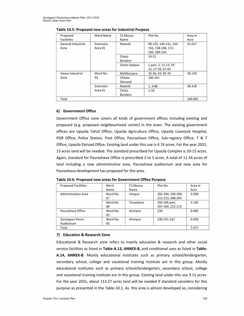
Sonargaon Paurashava Master Plan: 2011-2031 Part B: Urban Area Plan
Chapter Ten: Landuse Plan 128
Table 10.5: Proposed new areas for Industrial Purpose
6) Government Office
Government Office zone covers all kinds of government offices including existing and
proposed (e.g. proposed neighbourhood center) in the town. The existing government
offices are Upazila Tahsil Office, Upazila Agriculture Office, Upazila Livestock Hospital,
PDB Office, Police Station, Post Office, Paurashava Office, Sub-registry Office, T & T
Office, Upazila Parisad Office. Existing land under this use is 4.74 acres. For the year 2031,
13 acres land will be needed. The standard prescribed for Upazila Complex is 10-15 acres.
Again, standard for Paurashava Office is prescribed 3 to 5 acres. A total of 11.34 acres of
land including a new administrative area, Paurashava auditorium and new area for
Paurashava development has proposed for this area.
Table 10.6: Proposed new areas for Government Office Purpose
7) Education & Research Zone
Educational & Research zone refers to mainly education & research and other social
service facilities as listed in Table-A.13, ANNEX-B, and conditional uses as listed in Table-
A.14, ANNEX-B. Mostly educational institutes such as primary school/kindergarten,
secondary school, college and vocational training institute are in this group. Mostly
educational institutes such as primary school/kindergarten, secondary school, college
and vocational training institute are in this group. Existing land under this use 9.15 acres.
For the year 2031, about 113.27 acres land will be needed if standard considers for this
purpose as presented in the Table-10.1. As this area is almost developed so, considering
Proposed Facilitiles
Ward Name CS Mouza Name
Plot No. Area in Acre
General Industrial Zone
Extension Area 01
Ratandi 90-125, 140-141, 143-156, 158-168, 172-183, 189-234
31.617
Choto Bandara
19-21
Choto Sadipur 1 part, 2, 11-13, 19-22, 27-29, 37-43
Heavy Industrial Zone
Ward No. 03
Mallikerpara 35-36, 43, 45-76 30.130
Chhata Silmandi
106-161
Extension Area 01
Ratandi 1, 3-86 38.318
Choto Bandara
1-18
Total 100.065
Proposed Facilitiles Ward Name
CS Mouza Name
Plot No. Area in Acre
Administration Area Ward No. 07
Ichapur 202-204, 206-209, 212-213, 288-295
3.508
Ward No. 08
Chowdona 202-206 part, 207-209, 212-213
3.130
Paurashava Office Ward No. 05
Aminpur 234 0.400
Sonargaon Poura Auditorium
Ward No. 05
Aminpur 239,141-142 0.439
Total 7.477

Sonargaon Paurashava Master Plan: 2011-2031 Part B: Urban Area Plan
Chapter Ten: Landuse Plan 129
the real situation a total of 68.14 acres land has proposed under this category
includingone primary school, one secondary school, two new college, one vocational
institute and an university. Table 10.7: Proposed new areas for Educatioanl Institution Purpose
Proposed Facilitiles Ward Name CS Mouza Name
Plot No. Area in Acre
Primary School Extension Area 01
Bandara 84, 85 part, 89-92 1.529
High School Ward No. 02 Goaldi 361-362 part, 363, 365 part
0.508
College-1 Ward No. 04 Raishdia 263-264, 269-273, 280-297, 313-327
11.111
College-2 Ward No. 01 Darpat Thotalia
335-348, 350-352, 388-405
4.861
University College Ward No. 01 Darpat Thotalia
177-195, 200-241, 243, 245-256, 280, 283, 296-327
26.966
Vocational Training Institution
Ward No. 04 Aminpur 7, 8, 9, 10, 11 3.227
Ward No. 05 Raishdia 142-144, 154-166, 170-171, 261-262, 298-307, 311-312
10.480
Total 58.682
8) Agricultural Zone
Agricultural land denotes the land suitable for agricultural production, both crops and
livestock. It is one of the main resources in agriculture. It includes productive land (single,
double and triple cropped), seed bed, fisheries, poultry farm, dairy farm, nursery,
horticulture etc. The Paurashava has a vast area of agricultural land that demands
formation of a separate zone like, agriculture zone. Agriculture zone is primarily meant
for agriculture; land uses related to it and land uses that support it. Existing total area
under agricultural use is 696.65 acres. After implementation of the Urban Area Plan up to
the year 2031, it will be reduced. A total of 173.21 acres of land have proposed under this
category.
9) Waterbody
These will act as water retention areas which include ponds, water tanks, natural khals
and irrigation canals. The plan suggests preserving most of these water bodies for two
purposes, first, to serve as source of water, second to serve as water retention area
during monsoon. The ponds with an area equal to or more than 0.25 acres will be
preserved as the water retention ponds. No standard is being prescribed for water body.
In the Paurashava, total water body is 329.94 acres. A total of 313.54 acres of land have
proposed under this category including extension area.
10) Open Space
Open space includes play field/play ground, park, neighborhood park,
community/reserve forest, tennis ground and open tourism components. At present,
11.98 acres of land is under the open spaces. Up to the year 2031, 138.57 acres land
under open spaces will be needed. In cluding one central park cum stadium, 2

Sonargaon Paurashava Master Plan: 2011-2031 Part B: Urban Area Plan
Chapter Ten: Landuse Plan 130
neighbourhood park and community open space for forest a total of 27.45 acres of land
have proposed under this category. Proposed new areas for Open Spaces are shown in
the table-10.7
Table 10.8: Proposed new areas for Open Spaces
11) Circulation Network
Road network including primary, secondary, tertiary and local access road falls under this
category. In the Paurashava, 75.23(3.57%) acres land is under regional and local roads.
More land will be needed for provisioning proposed roads up to the year 2031. About 10-
15% of the total land may be considered for road network. But as this area has vast
agricultural area the proposed road network become below the required area. A total of
256.68 (10.56%) land has proposed under this category.
12) Transportation Facilities
Under transportation facilities, both transport and communication services are
considered. This category includes, bus terminal/ stand, filling station, garage, passenger
shed, ticket counter, transport office, etc. In the Paurashava, 0.79 acres land is under this
use. For the year 2031, 15.53 acres land will be needed according to the standard
prescribed in the Table-10.1. Transportation and Communication related services are Bus
transport terminal, Railway station, Truck terminal, Rickshaw / Van / Auto stand,
Launch/Boat ghat, Passenger shed, etc. Considering the present scenario a Intercity bus
terminal and truck terminal with loading& unloading facility has proposed on Dhaka
Chittagong highway. Besides that a poura bus terminal for regional bus service and
atempoo stand has proposed for this Paurashava. A total of 10.46 acre (0.43%) land has
proposed under this category.
Table 10.9: Proposed new areas for transportation facilities
Proposed Facilitiles Ward Name
CS Mouza Name
Plot No. Area in Acre
Central Park Cum Stadium
Ward No. 02
Aminpur 4-5, 40, 43-44, 66-73, 110
5.632
Goaldi 516-517
Sonargaon Poura Park Ward No. 05
Aminpur 243, 259 1.085
Community Park Ward No. 01
Choto Maghbazar
143, 145-147 part, 148-149
1.300
Total 8.017
Proposed Facilitiles Ward Name
CS Mouza Name
Plot No. Area in Acre
Inter city Bus Terminal Ward No. 03
Choto Silmandi
92, 97-98, 99 part 2.757
Padmalabhdi 24-27, 34-37, 38 part
Poura Bus Terminal
Ward No. 05
Aminpur 324 part, 328-330, 334-335
1.519
Track Terminal & Ward No. Mallikerpara 9 part, 10-15, 16 part 4.016
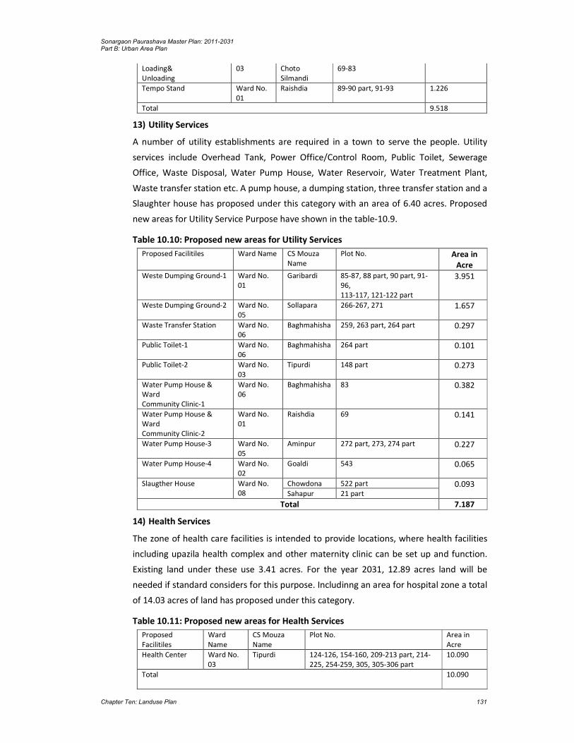
Sonargaon Paurashava Master Plan: 2011-2031 Part B: Urban Area Plan
Chapter Ten: Landuse Plan 131
13) Utility Services
A number of utility establishments are required in a town to serve the people. Utility
services include Overhead Tank, Power Office/Control Room, Public Toilet, Sewerage
Office, Waste Disposal, Water Pump House, Water Reservoir, Water Treatment Plant,
Waste transfer station etc. A pump house, a dumping station, three transfer station and a
Slaughter house has proposed under this category with an area of 6.40 acres. Proposed
new areas for Utility Service Purpose have shown in the table-10.9.
Table 10.10: Proposed new areas for Utility Services
Proposed Facilitiles Ward Name CS Mouza Name
Plot No. Area in Acre
Weste Dumping Ground-1 Ward No. 01
Garibardi 85-87, 88 part, 90 part, 91-96, 113-117, 121-122 part
3.951
Weste Dumping Ground-2 Ward No. 05
Sollapara 266-267, 271 1.657
Waste Transfer Station Ward No. 06
Baghmahisha 259, 263 part, 264 part 0.297
Public Toilet-1 Ward No. 06
Baghmahisha 264 part 0.101
Public Toilet-2 Ward No. 03
Tipurdi 148 part 0.273
Water Pump House & Ward Community Clinic-1
Ward No. 06
Baghmahisha 83 0.382
Water Pump House & Ward Community Clinic-2
Ward No. 01
Raishdia 69 0.141
Water Pump House-3 Ward No. 05
Aminpur 272 part, 273, 274 part 0.227
Water Pump House-4 Ward No. 02
Goaldi 543 0.065
Slaugther House Ward No. 08
Chowdona 522 part 0.093 Sahapur 21 part
Total 7.187
14) Health Services
The zone of health care facilities is intended to provide locations, where health facilities
including upazila health complex and other maternity clinic can be set up and function.
Existing land under these use 3.41 acres. For the year 2031, 12.89 acres land will be
needed if standard considers for this purpose. Includinng an area for hospital zone a total
of 14.03 acres of land has proposed under this category.
Table 10.11: Proposed new areas for Health Services
Proposed Facilitiles
Ward Name
CS Mouza Name
Plot No. Area in Acre
Health Center Ward No. 03
Tipurdi 124-126, 154-160, 209-213 part, 214-225, 254-259, 305, 305-306 part
10.090
Total 10.090
Loading& Unloading
03 Choto Silmandi
69-83
Tempo Stand Ward No. 01
Raishdia 89-90 part, 91-93 1.226
Total 9.518

Sonargaon Paurashava Master Plan: 2011-2031 Part B: Urban Area Plan
Chapter Ten: Landuse Plan 132
15) Community Facilities
All community facilities, including funeral places (i.e. graveyards), ward councilors offices
and other religious uses denoted as community facilities. At present, 5.83 acres of land is
under this category. The planning team has proposed a community center. Standard for
post office will be 0.5 acre per 20000 populations. According to the standard, one police
station may be covered 3 to 5 acres land for an Upazila. There is no formal poura
graveyeard in the Paurashava. According to the standard, about 25.24 acres land may be
prescribed for community facilities.
One of the important philosophies of this plan is provisioning compact township
development. Based on this concept, there may be a ward councilor office in each ward.
The Ward Councilor’s Office building may be used including family planning clinic, Union
Parishad Office and club. Land for Ward Councilor’s Office is prescribed in the plan which
is marked as community facility.
A total of 14.95 acres of land have proposed under this category.
Table 10.12: Proposed new areas for Community facilities
Proposed Facilitiles Ward Name CS Mouza Name Plot No. Area in Acre Cremation Ward No. 08 Chowdona 501-502 0.189 Poura Eidgah Ward No. 06 Baghmahisha 79 part 1.910 Poura Graveyard Ward No. 06 Baghmahisha 79 part 1.183 Fire Station Ward No. 03 Choto Silmandi 99-100 Part, 101 0.207 Ward Community Clinic Ward No. 02 Goaldi 546 0.267 Ward Center 01 Raishdia 95 part 0.220
. 02 Goaldi 478 part 0.200 03 Goaldi 677 part 0.057 04 Balia Dighirpur 137 part 0.049 05 Aminpur 324 part, 328
part 0.186
06 Baghmahisha 267 part 0.285 07 Ichapur 330 part 0.204 08 Chowdona 362 part 0.065 09 Sahapur 231 part 0.058
Total 5.08
16) Urban Deferred
According to planning standard provided by LGED seeks about 10 percent of the total
build up area. The total area under this use has been proposed as 104.11 acres (4.28%) of
the existing Paurashava area that include existing and proposed land uses. A portion of
this zone may use for housing of the poor, disadvantages and refugee for climate change
and other disasters to fulfil National Housing Policy, Disaster Policy and other policy
prescriptions of the Government. The following are permitted Uses within the Urban
Deferred (UD) Zone:
Agriculture, Livestock Based
Agriculture, Vegetation Based (mushroom farms shall not be permitted)
Existing facilities up to the date of gazette notification of the master plan. Condition is that, no further extension will be permitted.

Sonargaon Paurashava Master Plan: 2011-2031 Part B: Urban Area Plan
Chapter Ten: Landuse Plan 133
Table 10.13: Proposed areas for urban defferd
17) Recreational Facilities and heritage site
Recreational facility is covered 2.43 acres land including 43.39 acre heritage site.
Standard for recreational facility includes cinema/theatre and covered stadium/sports
complex. Up to the year 2031, about 5 acres land (1 acre per 20000 populations) will be
needed for cinema / theatre and 5 to 10 acres for stadium. Total 19.82 acres of land is
needed for this category. But stadium and park has included within open space zone. As
this is a tourism based area as per demand of pouravhava and considering the real
scenario area a new area of 4.39 acres for poura tourist complex has proposed for this
area.
Proposed Landuse
Ward Name CS Mouza Name
Plot No. Area in Acre
Urban Defferd Extension Area 02
Sreenibashdi 1-200, 204-208 60.358
Ward No. 02 Bagh Nazirpur 1-33 18.632
Goaldi 244-279, 285-291
Ward No. 03 Choto Silmandi
48-56 25.116
Tipurdi 1-75, 103-110, 116-118
Total 104.106

Sonargaon Paurashava Master Plan: 2011-2031 Part B: Urban Area Plan
Chapter Ten: Landuse Plan 134

Sonargaon Paurashava Master Plan: 2011-2031 Part B: Urban Area Plan
Chapter Ten: Landuse Plan 135
Map 10.2: Landuse Plan

Sonargaon Paurashava Master Plan: 2011-2031 Part B: Urban Area Plan
Chapter Ten: Landuse Plan 136

Sonargaon Paurashava Master Plan: 2011-2031 Part B: Urban Area Plan
Chapter Ten: Landuse Plan 137
Table 10.14: Proposed areas for recreational facilities
Proposed Facilitiles
Ward Name CS Mouza Name
Plot No. Area in Acre
Sonargaon Poura T ourist Complex
Ward No. 05
Aminpur 286, 292-293, 323-295-298, 300-306, 323-324 part, 325, 326 part, 334-335 part, 337-340, 342
4.185
18) Overlay Zone
The overlay land uses refer to those uses that are not compatible to the surrounding land
uses but, anyhow, they need to stay there and therefore will not be removed. These uses
are only sites and not zones, actually. They have local, regional or national importance,
though they don’t conform to surrounding land uses. No other use except the use of
overlay site is permitted in this zone. There is no scope for permitting or conditionally
permitting the functions or uses as the zone itself is an overlay. The present and
proposed use of the zone will continue until the next zoning regulation is imposed on
those specific parcels of land.
There are a variety of overlay zones within the project area. Some of the important types
of overlay sites are listed below including the purpose of retaining them are described
below.
Environmental Protection Area
Environmental protection overlay areas refer to the areas that need to be preserved
protected and manage for their natural resources. The purpose of this zone is to protect
the areas of environmentally sensitive, areas critical to the ecosystems.
Graveyard Sites
The sites cover existing graveyards that imposes restriction on building or acquisition of
such sites for their religious an emotional value.
Sports and Recreation Sites
Some existing open spaces, water bodies, etc. are delineated as overlay sites in order to
protect them in consideration of their future need. These places are meant exclusively for
sports and recreation.
Special Use Sites
There are some special use areas that need to be protected. Special and temporary
events like, fair, hat etc. may be permitted in this zone. The purpose for delineating this
zone is to preserve them and make them be able to render services to the present
community and future generations.

Sonargaon Paurashava Master Plan: 2011-2031 Part B: Urban Area Plan
Chapter Ten: Landuse Plan 138
Table 10.15: Proposed landuse of the Sonargaon Paurashava
Land Use Type Area (Acre) Percentage (%)
Urban Residential Zone 1,133.88 46.63
Rural Settlement 22.67 0.93
Commercial Zone 23.59 0.97
Mixed Use Zone 86.06 3.54
General Industrial Zone 46.68 1.92
Heavy Industrial Zone 70.66 2.91
Government Office 11.34 0.47
Education & Research Zone 68.14 2.80
Agricultural Zone 173.21 7.12
Water Body 313.54 12.90
Open Space 27.45 1.13
Recreational Facilities 4.19 0.17
Circulation Network 256.68 10.56
Transportation Facilities 10.46 0.43
Utility Services 6.40 0.26
Health Services 14.03 0.58
Community Facilities 14.95 0.61
Urban Deferred 104.11 4.28
Historical & Heritage Site 43.39 1.78
Total 2,431.43 100.00 Source: Landuse Survey, 2009 and proposed by the Consultant.
10.3 Introduction
Basically, landuse proposal involves with the existing conflicting landuses. Those conflicts
may be raised due to different causes. Inhabitants of the Paurashava are not aware about
the land level and slope direction of the Paurashava. Without knowing this information
they are raising their land up to a mark and constructing permanent structure. As a
result, water logging problem during rainy season is all over the residential areas.
Due to the absence of development control, the core area of the Paurashava is already
developed as mixed-use area. Commercial, residential, administrative, educational uses
are admixture in the core area. Zoning provision, landuse control should not be enforced
in such type of the core area.
At present, the Paurashava is a natural developed area. Rearrangement of the existing
use is not possible. Land acquisition for expansion of road (to increase the width of road)
will create socio-political hazards. As a result, the roads in the core area remain same as
today.
For water supply network, construction of sewerage facilities and removal of fire hazards,
at least 24 feet width road is necessary. In the Paurashava, except Regioal Highway, such
type of road is absent. New road will form new township on agriculture land. These
processes will washout agriculture domination from the Paurashava. Compact Township
will be effective for new formation, not for the mixed-use areas where most of the roads
are 8 to 10 feet width.
10.3.1 Designation of Future Landuse

Sonargaon Paurashava Master Plan: 2011-2031 Part B: Urban Area Plan
Chapter Ten: Landuse Plan 139
- Identification and development of sites for government housing. After preparation and implementation of the master plan, different types of government activities will be increased. Residential accommodation will be needed for those government employees. A site for government housing should be reserved. National Housing Authority is appropriate for performing this responsibility.
- Encourage central government to decentralize industrial development from Dhaka. Those facilities may be relevant with specific agro-product such as jute for jute industry, cane and bamboo for handicrafts, poultry and horticulture farming, export-oriented vegetation, etc. Different authorities such as Agriculture Development Corporation, Small and Cottage Industries Corporation, Directorate of Livestock and Poultry may be the responsible authority.
- Provision of sites and services schemes for the low and lowest income groups. The Paurashava authority and Schedule Bank may be appropriate for performing these responsibilities. Housing for low-income group, distribution of khas land among the lowest-income group and loan with low-interest for house construction may be the appropriate schemes.
- Upgrading of slum and squatter settlements. Mostly, the vulnerable groups are affected by river erosion, form slum and squatters on public land. If possible, those formations should be upgraded providing basic utility services. It is better, in Paurashava context, the people are living in the slum and squatters, rehabilitate them with the provisioning of housing for lowest-income group. The Paurashava and NGOs can perform such role.
- Location for new industrial development. The industrial area prescribed in the Landuse Plan will be developed provisioning all utility services. The authorities relevant with those utility services will perform the responsibilities. At first, the polluting industries (water and noise) from their original location should shift to the new location. Imposition of taxes, tax holiday and subsidized taxes may be imposed by the Paurashava for such rearrangement.
- Monitoring the principal aspects of community facility provision in the Paurashava. Wholesale or retail market, specialized clinic, etc. are under this community facility. When any difficulties will be encountered in case of suitable site selection considering demand of the inhabitants, the Paurashava will perform the lead role.
10.3.2 Landuse Zoning
Zoning is a classification of landuses that limits what activities can or cannot take place
on a parcel of land by establishing a range of development options. Zoning has been
defined as an action through legislation provided to a development authority /
Paurashava to control a) heights to which buildings may be erected; b) the area of lots
that must be left un-built upon; and c) the uses to which buildings may be constructed.
Area / Use Zoning
The objective of area zoning is to specify which types of landuse are considered
appropriate for different areas or 'zones', and it therefore indicates the planning control
objectives of the authority or municipality for its administrative area. The authority is
obliged under the planning acts to designate in its development plan objectives for the
use solely and primarily of particular areas for particular purposes.

Sonargaon Paurashava Master Plan: 2011-2031 Part B: Urban Area Plan
Chapter Ten: Landuse Plan 140
According to the landuse table, area zoning is divided as agriculture, residential,
commercial, industrial, administration and institutional. The zone has further segmented
and detailed in the Ward Action Plan. A detailed scenario as plot-to-plot basis is also
presented with the calculation of covered area in the landuse plan.
Density / Bulk Zoning
Aim of the density zoning is to provide an acceptable density which is related to the
designed facilities and amenities especially for the residential areas. This will ensure a
healthy community and enjoyable community life. In a particular area, how much
number of buildings will be permitted and constructed, the decision is under the density
zoning. Provisioning of setback rule and percent of land uses for different purposes is the
prime consideration of density zoning. The proposed percentage mentioned in the
landuse table is the only tool to control building density in the Paurashava.
Height Zoning
This zoning provides height limits for structures and objects of natural growth and
standards for use of an area which encourage and promote the proper and sound
development of areas. It is also applicable to height restrictions for flight safety around
airports or other similar purposes.
For effective development control, in addition landuse zoning individual facility and the
structures therein is complied certain regulations imposed to ensure desirable end.
Relation between ground cover of buildings and the land parcel that house it, minimum
setback of building from the adjoining plot boundaries and the maximum floor area that
can be constructed in relation to plot size and the connecting road among many other
details, are controlled by Building Construction Rules, 1996. Besides, Bangladesh National
Building Code focuses on the appropriate materials, construction method, building safety
and associated issues. In absence of Paurashava Master Plan the above rules did not have
scope for area specific rules and hence were common for the whole development
process.
According to the Building Construction Rule, 1996, minimum permissible road width for
obtaining plan permission is to shown, construction is allowed on plots connected by
narrow roads provided the plot owner leaves formally half of the addition area needed to
make the road 6m for widening the road to the permitted minimum. Perhaps the
intension behind this was that gradually the whole road would rise up to 6m in short time
and it is true for new areas. But congested unplanned area represents an alarming
picture. In commercial area, most of the plots are occupied almost entirely by pucca
structures covering the property line connected by the narrow pathways. Those owners
did not bother for Paurashava’s plan permission and a handful of those who obtained
plan permission did not care to follow them. It is suggested that existing rules need to be
modified to tackle the environmental problems created by illegal building construction.

Sonargaon Paurashava Master Plan: 2011-2031 Part B: Urban Area Plan
Chapter Ten: Landuse Plan 141
10.4 Plan Implementation Strategy
10.4.1 Land Development Regulations to Implement the Landuse Plan
Effective implementation of a plan is the most important part of the planning process.
The process of Implementation needs to be carried out with care and efficiency in order
to produce best outcomes. This chapter highlights various measures needed to be taken
in order to implement the landuse plan proposals.
Implementation of the Landuse Plan depends on successful pursuit of the policies
specified in the Structure Plan. Those policies represent a significant challenge face with
the responsibility of planning and managing the development of the Paurashava area.
However, at present no authority is responsible for planning and managing physical
development activities in the Paurashava and no regulation except Local Government
(Paurashava) Ordinance, 2009 for controlling physical development. This poses a serious
constraint to the implementation of the Landuse Plan and in fact any other form of
development plans.
The factors that have been taken into account in deciding the priority include such things
as – the importance of the issue that the policy addresses, its potential impact on the
lives of the population, the ease with which it can be implemented, its urgency and its
interdependence with other policies.
Prior to introduction of the regulations to implement the landuse plan, legislative
involvement is recommended here.
1. To control the air, water, noise and soil pollution, Conservation of Environment and
Pollution Control Act, 1995 (Act No. I of 1995) was enacted. In the Paurashava, there
is no authority for enforcing the provisions prescribed in the said Act. The pollution
related with the implementation of landuse component may be controlled with this
Act.
2. Impose control on all type of buildings in the Paurashava according to the setback
rule prescribed in the Building Construction (Amendment) Rules, 1996 (Notification
No. S. R. O. No. 112-L/96). Building permission for extended areas shall be according
to the landuse provision prescribed in the plan. Any permission for building
construction, front road width shall not be less than 16 ft. and the construction must
follow the Building Construction (Amendment) Rules, 1996.
3. Haphazard development of commercial activities is the general scenario of the
Paurashava. It is necessary to impose control on commercial activities provisioned in
the Shops and Establishments Act, 1965 (Act No. VII of 1965).
5. In case of man-made canal, regulations prescribed in the Canal and Drainage Act,
1873 (Act No. VIII of 1873) is the best weapon. For the linking of canal with others
and river considering drainage facilities the Act may be enforced.

Sonargaon Paurashava Master Plan: 2011-2031 Part B: Urban Area Plan
Chapter Ten: Landuse Plan 142
6. For the conservation of archeological monuments or structures or historical
development the Ancient Monuments Preservation Act, 1904 (Act No. VII of 1904)
may be enforced. Archeological Department of Bangladesh and Paurashava authority
through a partnership process may preserve such type of development.
7. To control air pollution due to brick burning with the establishment of brick field,
Brick Burning Control Ordinance, 1989 (Ordinance No. VIII of 1989) is the appropriate
regulation. The Paurashava authority may enforce this Ordinance with the
authorization given by the government to him.
8. To control the medical practitioner, establishment of private clinics and pathological
laboratories, the statute named Medical Practice, Private Clinics and Laboratories
(Regulation) Ordinance, 1982 (Ordinance No. IV of 1982) was enacted. For efficient
enforcement of the Ordinance, the Paurashava authority may execute the Ordinance
with the authorization of government.
9. The Paurashava will have to exercise strictly Playfield, Open space, Garden and
Natural Tank in Urban Areas Preservation Act, 2000 (Act No. XXXVI of 2000) to some
specially important areas like, riverfront and water bodies, drainage channels, low
land below certain level, designated open space, etc. Development restrictions are
needed around security and key point installations. The provision of restriction will
strengthen the power of the plan to safeguard its development proposals and
landuse provisions.
10. The government is authorized for establishment of hat and bazar with the acquisition
of land through the statute named Hat and Bazar (Establishment and Acquisition)
Ordinance, 1959 (No. XIX of 1959). In case of private hat and bazar, a management
body is being empowered through the Bangladesh Hats and Bazars (Management)
Order, 1973 (P.O. 73/72). The Paurashava authority is also empowered establishing
hat and bazar in his jurisdiction through the Local Government (Paurashava)
Ordinance, 2009. Coordination may be framed among the government (Upazila
Parishad), Paurashava and private owner for the establishment, development and
management of the hat and bazar located in the Paurashava premises.
11. In the Paurashava premises, industrial development is controlled by the Bangladesh
Cottage Industries Corporation through Bangladesh Cottage Industries Corporation
Act, 1973 (Act No. XXVIII of 1973), Industrial Development Corporation through East
Pakistan Industrial Development Corporation Rules, 1965 (No. EPIDC / 2A-2/63/354)
and Factory Inspector through Factories Act, 1965 (Act No. IV of 1965). Locational
aspects and issuing of trade license is controlled by the Paurashava authority. A joint
coordination cell among those four authorities may control the establishment of
factories and industries in the Paurashava.
12. In the Paurashava, for rain water harvesting, some specific ponds / tanks will needed
to be preserved. A number of derelict tanks may be improved through tank

Sonargaon Paurashava Master Plan: 2011-2031 Part B: Urban Area Plan
Chapter Ten: Landuse Plan 143
improvement project and in this case Tanks Improvement Act, 1939 (Act No. XV of
1939) will support the Paurashava is regulatory aspects.
13. Except Khas land, a considerable amount of public land in the Paurashava may be
identified as fallow land or unproductive land. In regulatory term those lands are
considered as culturable waste land and those lands are being fallow during five
consecutive years. Those lands may be utilized under the guidance of Culturable
Waste Land (Utilization) Ordinance, 1959 (Ordinance No. E.P. XIII of 1959).
14. The Paurashava should raise its efforts on the imposition and realization of
betterment fees to raise its income. In this case, East Bengal Betterment Fees Act,
1953 may be enforced.
10.4.2 Implementation, Monitoring and Evaluation of the Landuse Plan
Implementation through Multi-Sectoral Investment Programme: Major infrastructure
development works such as primary roads, water supply, drainage, etc., will largely be
controlled by Government. Public works requires efficient co-ordination through the
Multi-Sectoral Investment Programme (MSIP).
Objective of a Multi-Sectoral Investment Programme (MSIP) will match a list of the
development projects with the funding stream necessary to implement them. There are
two basic activities that would determine the contents of MSIP. One activity would be to
prioritize and schedule the investment projects of all public agencies so they will
collectively help to achieve the development goals and objectives of the Landuse Plan.
Second activity would be to analyze the source and availability of fund for the prioritized
list of development projects.
Implementation through Action Plans and Projects: Action Plans and Projects will be the
implementation plans to solve problems at the local level. Action plans will take a direct
approach toward plan implementation with a minimum of research, reports or elaborate
planning methods. These projects will be easily identifiable and will require minimum
resource.
Implementation through Development Control: Landuse zoning is one of several
methods of plan implementation to be considered. In all cases where some form of
development, landuse control may be applied; careful consideration requires the
following ideologies:
the purpose to be achieved by the development controls;
where controls should be applied;
what aspect of development needs to be controlled;
what type of development controls are required;
what degree or level of development control is required;
who will be affected by the required control;
who will be affected by the controls and in what manner;

Sonargaon Paurashava Master Plan: 2011-2031 Part B: Urban Area Plan
Chapter Ten: Landuse Plan 144
when the controls should be applied;
what will be the likely impact of the controls;
how and by whom will the controls be administered and enforced.
Development control as an instrument of plan implementation may be selectively applied
within the Landuse Plan. Development controls would also be varied in intensity and
detail to suit the particular circumstances. It is important that they should be clear and
easily understood by all parties concerned. Since the entire Paurashava Master Plan
‘package’ has become statutory, development controls associated with its component
plans would also be statutory.
Implementation by Facilitating Private Investment: Another approach that would be
taken by government toward plan implementation will be to guide and facilitate
investments made by the private sector. Government can achieve this with relative ease
and at very low cost by setting up a legal and operational framework, coupled with
suitable incentives, to facilitate land consolidation, plot boundary readjustment, efficient
lay out of plots and provision of local infrastructure by the private sector. The benefits of
this approach would be:
increased efficiently of the urban land market would make, more private land available to urban households;
would pass much of the development costs for local infrastructure to the private sector and land market mechanisms;
would increase in land for development without large cash outlays by government to purchase land for development schemes; and
would keep provision of land for community facilities virtually no cost to government.
Plan Monitoring
The Landuse Plan would simply be tools for guiding and encouraging the growth and
development of the Paurashava in a preferred manner. In a rapidly changing urban
environment, the Landuse Plan would require to keep up to date. If this is not done,
within a few years it will be obsolete. Therefore, it is imperative that the requirement for
regular updating of the Landuse Plan be made a legal requirement.
For implementation of the various programme components of the Landuse Plan
appropriate administrative measures will have to be undertaken. This will essentially
include project preparation and monitoring of their execution and evaluation. For
carrying out all these activities appropriate institutional measures are also be needed.
Evaluation
Monitoring and evaluation of on going and implemented projects is essential to keep the
future course of action on the right track. An on going project should be regularly
monitored and handicaps identified to enable taking appropriate measures at the right
time.

Sonargaon Paurashava Master Plan: 2011-2031 Part B: Urban Area Plan
Chapter Ten: Landuse Plan 145
Post implementation evaluation is also needed to take appropriate measures correcting
past errors-from project preparation to implementation.
The top level supervision has to be done by a high level supervisory committee headed
by Paurashava Mayor, LGED representative and Local Government Ministry. Other
members of the committee will be local Ward Councilors, local community leader/social
workers and the Town Planner of the Paurashava. The committee will supervise
implementation works regularly and issue necessary instructions to expedite the works of
implementation.
Co-ordination
A Planning Section of Paurashava should have close interaction with the citizen of
Paurashava at large in order to make people aware of the benefits of a good plan and,
therefore, their social responsibility to promote plan implementation in one hand and
also resist contraventions on the other. A specific interactive cell is recommended to
operate in this regard with following responsibilities:
Provide pre-application advice to residents, consultants and developers about landuse management issues and application procedures for the submission of development applications.
Enforce planning and landuse management related legislation and zoning scheme regulations.
Issue of property zoning certificates.
Investigate and resolve landuse management complaints, illegal landuse and prosecuting contraventions.
Such interactive windows may be opened in various convenient locations to ensure ease
of the answers to commonly asked questions may be shown in the internet. Besides,
those may be shown in the print and electronic media time to time.
In spontaneous areas, while all out people’s co-operation is needed for project
implementation; there will also be some elements of negotiation. Negotiation will be
particularly needed in case of road widening projects. It will be a crucial task for
Paurashava to convince the affected people to give up their land for road use. Efforts
should be made to convince the land owners on the ground of enhancement of property
value due to road widening. In case people refuse to offer land free of cost necessary
arrangements may have to be made for payment of compensation. This process of
negotiation will be very critical, cumbersome and time consuming, and therefore, has to
be handled with utmost care and patience. The best results can be accrued only by
wining people’s confidence. In case the authority fails to get peoples co-operation they
should exercise power of compulsory acquisition of land. Attempts may be made to
engage NGOs / CBOs to work as catalysts in negotiation.

Sonargaon Paurashava Master Plan: 2011-2031 Part B: Urban Area Plan
Chapter Ten: Landuse Plan 146

Sonargaon Paurashava Master Plan: 2011-2031 Part B: Urban Area Plan
Chapter Eleven: Transportation and Traffic Management Plan 147
CHAPTER 11
TRANSPORTATION AND TRAFFIC MANAGEMENT PLAN
11.1 Introduction
Transport study provides special attention to urban transportation planning as it greatly
influences the location decisions and travel behavior of people, goods and services.
Transportation is critical for the efficiency of towns contributing to their productivity and
economic growth. A good network of roads and other transportation mode coupled with
an efficient transport management system makes substantial contribution to the
"working efficiency" of cities and towns and enables them to become catalysts for social
and economic development. On the other hand, the impact of a poorly designed urban
transport system is manifested in terms of traffic congestion, delays, accidents, high
energy consumption, high pollution of the environment and inequitable access to
services. A well-planned transportation system results in orderly urban growth, greater
use of urban public transport, lower vehicular pollution, and shorter auto trips.
The current chapter of the report is about Transportation and Traffic Management Plan
covering its development plan proposals and traffic management up to the year 2031.
Transportation and Traffic Management Plan is a part of the second stage of the current
plan package. This planning component is based on the framework of the Structure Plan
prepared in the earlier phase. The Plan is intended to address those areas of the
Structure Plan that are likely to face urban growth during next 10 years, and obviously
that includes the existing Paurashava area and its extension areas. The report also gives
the objectives of the purpose and the role of Transportation and Traffic Management
Plan and its relation with Structure Plan and Land Use Plan.
11.2 Approach and Methodology
A comprehensive transportation study was undertaken to investigate the existing
transportation infrastructure, transportation mode and modal share scenario of Dhamrai
Paurashava and to estimate the anticipated transportation needs of the town up to the
year 2031. Transportation study was conducted to determine the present travel patterns
and the characteristics of existing transportation facilities to forecast the future travel
demand and develop a transportation plan.
Standard methodology was followed for traffic study in the project area as per the Terms
of Reference. A nine hour traffic counting was conducted to assess the traffic volume at
the most important traffic point. Three intersections have been selected for traffic count
survey. The roads at these intersections attract traffic from its surroundings to a great
extent mainly for commercial, official and educational purposes. The the concentration of
development is high along the both side of these road. The selected intersections for
traffic survey is given below at table 11.1.

Sonargaon Paurashava Master Plan: 2011-2031 Part B: Urban Area Plan
Chapter Eleven: Transportation and Traffic Management Plan 148
Table 11.1: Description of the survey stations
Intersection/
Link No.
Intersection/ Link Name
Station/ Link No.
Link name (Survey station) Traffic Direction
01
Museum (2nd gate) Intersection
01 Museum (2nd gate) Intersection to Thana Road
2
02 Museum (2nd gate) Intersection to Museum Road
2
03 Museum (2nd gate) Intersection to Tipurdi Road
2
02 Tipurdi Road Link 04 Tipurdi to Museum Road 2
05 Tipurdi to Dhaka-Chittagong NHW 2
03 Thana Road (Titas) Link
06 Thana Road to Museum Road 2
Source: Physical Feature Survey, 2009
Bus and tempo fleet data were collected from local transport owners’ offices like, Bus
Owners’ Association, Tempo Owners’ Association. They also provided information about
routes, trips and movement data. Information about bus station and tempo station were
collected from the respective owners’ associations and the Paurashava/District
Administration. Year wise data of non-motorized traffic were collected from the
Sonargaon Paurashava, where these vehicles are registered.
Data on road pattern and condition of roads with their problems and road width were
collected from the physical feature survey and verified through field visit. Data on
household mobility were also collected from socio-economic survey of the households.
Information on road ownership was collected from the Paurashava, LGED and RHD. The
same sources also provided information about future road projects in and around the
town. Information about traffic conflict and accident were collected from the field and
from Thana (police station). Mapping of major roads was done using physical feature
survey data and by thorough reconnaissance survey of roads. By considering the planning
standard and analyzing the demand, Taffic and transportation plan were made.
11.3 Existing Conditions of Transportation Facilities
11.3.1 Roadway Characteristics and Functional Classification
The planning area covers 8.54 sq. km. and road/ circulation network length is 76.67 km
with an area of 59.29 acre. The Dhaka-Chittaging highway runs through the Paurashava
and links a number of Connector Roads and Access Roads and these are the main arterial
road of the planning area. It provides connection with Sonargaon Paurashava to the
north Chittagong and Dhaka.
The roads of the Paurashava belonging to number of agencies named Roads and
Highways Department (RHD) responsible for Regional Highway, Local Government
Engineering Department (LGED) responsible for construction and maintenance of Upazila
and Union roads and Sonargaon Paurashava responsible for construction and

Sonargaon Paurashava Master Plan: 2011-2031 Part B: Urban Area Plan
Chapter Eleven: Transportation and Traffic Management Plan 149
maintenance of roads within the Paurashava area. Existing transportation system is
dominated by road network catering to the passenger service and freight transport.
The road network provides access to various places within the study area and connects
various parts of the country following bus routes. Major trips of vehicles are generated
from Upazila Road,Tipurdi Road, Thana Road, Thana-Museum Road,Sonargaon Bazaar
(Panam) Road , Raisdia Mosque Road, Paurashava Road, Museum Road, Hospital
Road,and Ananda Bazaar GC Road.
The Dhaka-Chittagong NHW attracts traffic from outside of the Paurashava because it is
an entry and exit point of the Paurashava.
Total length of pucca (bituminous carpeted) road is about 34.06 km encompassing an
area of 38.60 acre. The semi pucca road is generally constructed with brick soling called
Herring Bone Bond (HBB) road. Total length of semi pucca road is 16.67 km. In total,
14.97 of land is being used under semi pucca road in the Paurashava. Third category is
katcha road called earthen road. Total length of katcha road is 25.94 km coursing 25.94
acres of land. In total, there in Sonargaon Paurashava roads under three categories
coursing 76.67 km in length and 75.23 acre of land.
Table 11.2: Road network of Sonargaon Paurashava
Type Length Area
KM % Acres %
Pucca 34.06 44.42 38.60 51.31
Semi-pucca 16.67 21.75 14.97 19.9
Katcha 25.94 33.83 21.66 28.79
Total 76.67 100.0 75.23 100
Source: Physical Feature Survey, 2009.
Motorized and non-motorized vehicles are operated in all the nodes of the planning area.
The non-motorized vehicles are mainly operated within short distance and meet the local
needs. The motorized vehicles are mostly intercity passenger buses and trucks, mainly
carry agro product. Locally modified motorized transport vehicle named Nosimon also
uses for short distance passenger and goods transportation.
11.3.2 Mode of Transport
Modal choice behavior is destinations to work/personal business use motorcycle,
car/pickup/ jeep/microbus, bus mostly (24.25%) and 21.05% use rickshaw/van. For
school/college/ university based trips bicycle has found as the most common mode of
transport (9.95%). Trips toward home have almost equal shares of different modes like in
14.75% trips truck, 19.45% trips tempo, motorcycle (5.25%) and private car (5.3%) have
been used.
11.3.3 Intensity of Traffic Volume
Traffic volume studies are conducted to determine the number, movements and
classifications of roadway vehicles at a given location. These data help to identify critical

Sonargaon Paurashava Master Plan: 2011-2031 Part B: Urban Area Plan
Chapter Eleven: Transportation and Traffic Management Plan 150
flow time periods and determine the influence of large vehicles on vehicular traffic flow,
or document traffic volume trends. The counted traffic data for different intersections as
well as for different links at different time period and the generated PCU is presented in
the following paragraphs.
Depending on the location and landuse around that location, traffic flow varies over
different hours of the day. In this context, peak hour traffic flow has a special meaning.
Depending on the landuse and socio-economic characteristics of the Paurashava, there
could be 1 or 2 more peak hours in a day. Sometimes this peak hour could cover periods
which are more than one hour. Highest peak hour traffic is usually taken in to account in
determining the adequacy of the road section i.e. to determine whether the road section
gets congested at certain hours of the day. Traffic flow survey has been carried out in
selected intersections of the study area and the findings are presented in the following
paragraphs.
Museum (2nd gate) Intersection
At this intersection, on Hat Day there are large numbers of non motorized vehicles
(403.62 NMV/hr and 69.04% of total PCU) than motorized vehicles (256.54 MV/hr and
30.96% of total PCU). Average hourly volume is 1017.42 PCU at Museum (2nd gate)
Intersection on Hat day which is greater than that of Non-Hat day.
So, comparatively more traffic congestion occurs at this intersection on Hat day. Peak
traffic flow occurs during 10am to 11am on Hat day (1290.75 PCU/hr).
On hat day peak traffic flow occurs in the morning from 10am to 11am and in the
afternoon from 5pm to 6pm.
During peak hour (10am to 11am) rickshaw is the dominant vehicle covering 52.63% of
traffic composition on Hat day. There are also significant numbers of bicycle and motor
cycle in the traffic composition of Hat day during peak hour.
At this intersection, on Non-Hat Day there are large numbers of non motorized vehicles
(333.54 NMV/hr and 70.08% of total PCU) than motorized vehicles (194.62 MV/hr and
29.92% of total PCU). Average hourly volume is 795.73 PCU at Museum (2nd gate)
Intersection on Hat day which is less than that of Hat day. So, comparatively less traffic
congestion occurs at this intersection on Non-Hat day. Peak traffic flow occurs during
12pm to 1pm on Non-Hat day (917.25 PCU/hr).
Traffic flow on Non-Hat day is clearly understood. Peak traffic flow occurs from 12pm to
1pm and in the afternoon from 6pm to 7pm. Another peak hour is found from Figure 6.4.
During peak hour (12pm to 1pm) rickshaw is the dominant vehicle covering 58.39% of
traffic composition (detail in Figure 6.5) on Non-Hat day. There are also significant
numbers of bicycle and motor cycle in the traffic composition of Non-Hat day during peak
hour.

Sonargaon Paurashava Master Plan: 2011-2031 Part B: Urban Area Plan
Chapter Eleven: Transportation and Traffic Management Plan 151
Tipurdi Link
At this link, on Hat Day there are large numbers of non motorized vehicles (224.08
NMV/hr and 67.32% of total PCU) than motorized vehicles (154 MV/hr and 32.68% of
total PCU) (Table 6.15 and 6.16). Average hourly volume is 567.67 PCU at Tipurdi Link on
Hat day which is greater than that of Non-Hat day. So, comparatively more traffic
congestion occurs at this link on Hat day. Peak traffic flow occurs during 10am to 11am
on Hat day (701.75 PCU/hr).On hat day peak traffic flow occurs from 10am to 11am and
in the afternoon from 5pm to 6pm. another peak hour is found. During peak hour (10am
to 11am) rickshaw is the dominant vehicle covering 51.21% of traffic composition on Hat
day. There are also significant numbers of bicycle and motor cycle in the traffic
composition of Hat day during peak hour.
At this link, on Non-Hat Day there are large numbers of motorized vehicles (103.85
MV/hr and 57.51% of total PCU) than non motorized vehicles (64.85 NMV/hr and 42.49%
of total PCU) (Table 6.17 and 6.18). Average hourly volume is 218.15 PCU at Tipurdi Link
on Non-Hat day which is less than that of Hat day. So, comparatively less traffic
congestion occurs at this link on Non-Hat day. Peak traffic flow occurs during 12pm to
1pm on Non-Hat day (307.5 PCU/hr). On non-hat day peak traffic flow occurs from 12pm
to 1pm and in the afternoon from 7pm to 8pm another peak hour is found. During peak
hour (12pm to 1pm) both rickshaw and baby taxi are the dominant vehicle covering
25.11% of traffic composition on Non-Hat day. There are also significant numbers of
bicycle and motor cycle in the traffic composition of Non-Hat day during peak hour.
Thana Road (Titas) Link
At this link, on Hat Day there are large numbers of motorized vehicles (488.85 MV/hr and
37.11% of total PCU) than non motorized vehicles (390.23 NMV/hr and 62.89% of total
PCU). Average hourly volume is 1103.83 PCU at Titas Link on Hat day which is greater
than that of Non-Hat day. So, comparatively more traffic congestion occurs at this link on
Hat day. Peak traffic flow occurs during 12pm to 1pm on Hat day (1338.25 PCU/hr).On
hat day is clearly understood. Peak traffic flow occurs from 12pm to 1pm and in the
afternoon from 5pm to 6pm another peak hour is found. During peak hour (12pm to
1pm) rickshaw is the dominant vehicle covering 41.17% of traffic composition on Hat day.
There are also significant numbers of bicycle and motor cycle in the traffic composition of
Hat day during peak hour.
At this link, on Non-Hat Day there are large numbers of motorized vehicles (390.46
MV/hr and 38.46% of total PCU) than non-motorized vehicles (301.77 NMV/hr and
61.54% of total PCU). Average hourly volume is 856.06 PCU at Titas Link on Non-Hat day
which is less than that of Hat day. So, comparatively more traffic congestion occurs at this
link on Hat day. Peak traffic flow occurs during 7pm to 8pm on Non-Hat day (1073.5
PCU/hr).On Non-Hat day peak traffic flow occurs from 7pm to 8pm and in the afternoon
from 2pm to 3pm another peak hour is found. During peak hour (7pm to 8pm) baby taxi

Sonargaon Paurashava Master Plan: 2011-2031 Part B: Urban Area Plan
Chapter Eleven: Transportation and Traffic Management Plan 152
is the dominant vehicle covering 38.39% of traffic composition (detail in Figure 6.13) on
Non-Hat day. There are also significant numbers of rickshaw, bicycle and motor cycle in
the traffic composition of Non-Hat day during peak hour.
11.3.4 Level of Service: Degree of Traffic Congestion and Delay
Speed and delay survey is used to determine speed variations along a route at different
times; number, location, cause, frequency and duration of delays, and overall speed and
travel time along a route.
As traffic congestion is not very severe in Sonargaon Paurashava, generally delay of traffic
movement is not common here.
These studies are used to determine speed variations along a route at different times;
number, location, cause, frequency, duration of delays, overall speed and travel time
along a route. Non-motorized vehicles like rickshaw, van and pushcart, waits at major
intersection with a stoppage time on an average of 5 minutes. Those buses have 36 to 40
seats available for the passengers but they used to carry standing passengers.
The Origin-Destination (O-D) survey is conducted to collect information on travel and
transportation generated between zones of a study area. The study also identifies
passenger movements where and when trips are originated and ended, the socio-
economic characteristic of the trip maker, the purpose of travel and the mode of travel.
The following table-11.3 describes the trips different modes from the origin of trip to the
destination of Hat day and non-Hat day in Sonargaon Paurashava.
Table 11.3: O-D purposes matrix in generated trips (in %)
Destination Zones (%)
Ori
gin
Zo
nes
(%
)
Bo
gra
Chitta
go
ng
Dh
aka
Ga
zip
ur
So
na
rgao
n
Ma
nik
gan
j
Nara
ya
ng
anj
Nars
ing
di
Com
illa
Dhaka - - - - 5.13 - - - -
Narayanganj 2.56 2.56 38.4
6 2.56 - 2.56 23.08 2.56 2.56
Narsingdi - - - - - - 2.56 - - Gazipur - - - - - - 2.56 - - Chandpur - - - - - - 5.13 - - Comilla - - - - - - 2.56 - - Rajshahi - - - - - - 2.56 - - Rangpur - - - - - - 2.56 - -
Source: O-D survey, 2009
The data shows that people of Sonargaon Paurashava have high percentage to travel
from their own residence to the surrounding urban areas rather than attract people to
come in that area. In most cases people are traveling to Dhaka town to attain their
requirements and their second priority has found as Narayanganj.

Sonargaon Paurashava Master Plan: 2011-2031 Part B: Urban Area Plan
Chapter Eleven: Transportation and Traffic Management Plan 153
11.4 Analysis of Existing Deficiencies
11.4.1 Roadway Capacity Deficiencies
Primary Road: A National Highway named Dhaka - Chittagong Highway passed through
the Sonargaon Paurashava is the Primary Road of this Paurashava. Its length is about
0.56 km and the average width is about 19.51 meter. Road standard (ROW)
recommended in the is 80-150 feet, proves that the standard (ROW) of the existing
primary road in the Paurashava is enough.
Secondary Road: Upazila Road, Tipurdi Road, Thana Road, Hospital Road and Museum
Road are the major secondary roads of the Paurashava. Total 7.88 Km of secondary roads
are in the Paurashava.The pavement width of these roads are 5.29 to 3.34 meter
respectively. Recommended Road standard (ROW) 60 feet to 80 feet, proves that the
standard (ROW) of the existing secondary roads in the Paurashava is lower than the
standard (ROW) recommended. Moreover, in hat day and non-hat day, considering
highest volume of traffic flows on those secondary roads is there is no deficiencies
regarding the capacity of those secondary road exits at present.
Tertiary Road: Within the Paurashava major terciary roads are Kathali Katha Road, paban
bepari road, yousufpur road etc. with 2.36-3.51 meter road width. Recommended
standard (ROW) for tertiary road is 20 feet to 40 feet, proves that the standard (ROW) of
the existing tertiary roads in the Paurashava is lower than the standard (ROW)
recommended.
Access road: Road standard (ROW) recommended for access road is 20 feet to 40 feet. in
the Paurashava, all access roads are less than 12 feet and most of them are using as
footway. Non-motorized vehicles named Van sometimes use those walkways. No
deficiencies regarding the capacity of those access road exits.
Table 11.4: Hierarchy of road
Sl No. Name of Road Avg. Width(m) Length(km) Road Type
1. Dhaka-Chittagong NHW 19.51 0.56 Primary Road
2. Upazila Road 3.34 1.45 Secondary Road
3. Tipurdi Road 4.72 1.13 Secondary Road
4. Thana Road 5.29 2.21 Secondary Road
5. Hospital Road 3.76 0.92 Secondary Road
6. Museum Road 4.87 2.17 Secondary Road
7. Thana-Museum Road 2.36 1.38 Tertiary Road
8. Paurashava Road 3.51 0.42 Tertiary Road
9. Ananda Bazaar GC Road 3.21 1.1 Tertiary Road
10. Sonargaon Bazaar (Panam) Road 3.04 0.96 Tertiary Road
11. Raisdia Mosque Road 3.07 0.92 Tertiary Road Source: Physical Feature Survey, 2009

Sonargaon Paurashava Master Plan: 2011-2031 Part B: Urban Area Plan
Chapter Eleven: Transportation and Traffic Management Plan 154
11.4.2 Operational, Safety, Signal and other Deficiencies
Traffic management system is absent in the Paurashava. No operational system yet being imposed on traffic movement.
Due to the minimum PCU/hr. both in hat and non-hat day, availability of non-motorized vehicles and absent of available built-up area, road safety exists naturally in the Paurashava.
Traffic signaling system is totally absent in the Paurashava. Generally, traffic signaling system will not be needed up to the limit of the planning period. On some specific point of primary and secondary roads, traffic signaling will be needed.
11.5 Condition of other mode of transport (Rail/Water/Air)
There is no railway line in Sonargaon Paurashava. Although there is a A canal named
Manykaly Khal is used time only for transporting vegetables, cloths and wooden
materials from neighbouring area to commercial areas but still it is not a major
transportation network. There is no airport in this Paurashava.
11.6 Future Projections
Road design standards are prescribed in the section 21 of the Public Roads Act, 2004. The
regulations of the sections are:
- The Government may declare design standards for roads by publication in the Official
Gazette.
- The road design standards shall set out design requirements for roadways and road-related areas including structures located on roadways or road-related areas.
- A road authority shall comply with the road standards when carrying out works on a roadway, road-related area or when installing, modifying or maintaining a structure on a roadway or road-related area.
- Despite sub-section (3), a road authority is not required to comply with the road standards if:
o the road authority is carrying out maintenance and, in the view of the road authority, it would not be practicable to comply with the road design standards.
o the Government has, in writing, exempted the road authority from complying with the road design standards in relation to the works or structure.
- The Government may revoke or amend road design standards in the same manner as a declaration.
- The Urban Area Plan for Dhaka City has recommended road standards with the consideration of traffic volumes, which were not undertaken in conjunction with the Dhaka Integrated Transport Study (DITS). A wide range of standards was suggested for various classes of roads, ranging from 4 meters to 24 meters, as mentioned below. The required right of way (ROW) is also indicated:
- Main Road 24.0 meter (78 ft) ROW
- Arterial Road 14.5 meter (47.5 ft) ROW
- Collector Road 13.0 meter (42.6 ft) ROW
- Access Road 9.0 meter (29.5 ft) ROW
- Access Road 6.0 meter (19.7 ft) ROW

Sonargaon Paurashava Master Plan: 2011-2031 Part B: Urban Area Plan
Chapter Eleven: Transportation and Traffic Management Plan 155
- Non-motorized Road 4.0 meter (13.4 ft) ROW
- Footpath 2.5 meter (8.2 ft) ROW
In order to promote development of all roads in a systematic manner, new road
standards were recommended for both built up areas, as well as for less built-up areas.
These will replace the old standards, which were included in the Dhaka Metropolitan
Development Plan (DMDP). The standards, when adopted will facilitate earmarking the
right of way (ROW) for all major roads. The details of these standards used in this plan
are indicated below.
Table 11.5: Road standards for future development of the network
Class of Roads Standards recommended
Paurashava primary roads 200-100 ft.
Paurashava secondary roads 100-60 ft.
Paurashava local roads 40-20 ft.
Source: UTIDP, LGED, 2010.
11.6.1 Travel Demand Forecasting for Next 20 Years
Existing road network is quite enough for accommodating present volume of traffic. The
study area is rural in nature. Katcha roads needs to be constructed as pucca or at least
semi-pucca. Katcha roads become clayey in the rainy season and bring immense
sufferings for the users. As a result, social, cultural and economic activities are disrupted
significantly at that time. A very limited uses of small boats are found for transportation
of goods within the short distance particularly on hat day. Due to the absence of effective
alternatives, passengers and goods movement of the study area is largely dependent on
road transportation. This dependency will be calculated according to the increase of
accessibility, consideration of the missing links, volume of traffic movement, bulk density
of the area and economic importance of the area. Growth direction is also a considerable
component for the demand analysis of the road.
11.6.2 Transportation Network Considered
The physical feature survey has identified a number of problems constraining the
development of the Paurashava, such as:
Lack of a hierarchy of roads within the Paurashava with many of the roads unable to fulfill their intended functions adequately;
Scarcity of reserves of land for future roads; and
A tradition of encroachment in those areas where road reserves have been made.
To establish a rational hierarchy of roads in the Paurashava, it will be needed to use
development control to ensure that reserves of land, once established are maintained.
In the Transportation Plan, north, south, east and west direction links with the
Paurashava have been considered. To maintain an effective linkage, the plan proposes
one primary road and others are secondary and tertiary roads.

Sonargaon Paurashava Master Plan: 2011-2031 Part B: Urban Area Plan
Chapter Eleven: Transportation and Traffic Management Plan 156
11.6.3 Future Traffic Volume and Level of Service
The roads presented in the Table-11.3 are the important roads of the Sonargaon
Paurashava. Present population of the Paurashava is 71362 (2011) and in the year 2021 it
will be 86977. Highest PCU/hr. at hat day is 1394 and non-hat day is 745 in Ibrahimpur
road. The scenario proves that traffic congestion is not alarming will in other roads but in
Ibrahimpur Road in hatbar it becomes alarming as the PCU/hr. increased above 1000. The
income and other socio-economic condition of this area is very poor. The scenario proves
that the Paurashava dwellers have no capability to increase traffic volume provisioning
motorized vehicles. They will increase non-motorized vehicles and Nosimon.
With the expansion of administrative services, motorized public vehicles will be increased
and at the sametime, traffic volume also.
At present, all of traffic is under the private sector and above 80% people enjoying by the
non-motorized vehicles. It is expecting that the scenario will change next 20 years and
the percentage of motorized vehicle will increase.
11.7 Transportation Development Plan
11.7.1 Plan for Road Network Development
For an efficient road network development, implementation of some of the
recommendations made by the Roads and Highways Department in 2008 would be
essential. In order to serve the Paurashava, as well as the local traffic around Paurashava,
an analysis will present in the proposals. It is found that many of the roads are not well
linked and there are some missing links. Further analysis under the Transportation Plan
will be revealed that most of the links suggested by this study are infect required to be
developed in a phased manner. Under the Transportation Plan, an attempt is being made
to promote existing major link roads in the Paurashava which. The northern part of the
study area is in rural character and have limited road linkage wth the central area. There
is a need of some north south and east-west link road.The connection with national
highway with Paurashava secondary road is not enough. Considering of the above
scenario the road network plan has made.
11.7.2 Road Network Plan
The primary road will act as through-route, taking traffic from Paurashava to other
centres in the region or the country and avoiding the need for this through-traffic to
enter the internal road network of the Paurashava. The route is intended to be high

Sonargaon Paurashava Master Plan: 2011-2031 Part B: Urban Area Plan
Chapter Eleven: Transportation and Traffic Management Plan 157
Map 11.1: Important Roads of Sonargaon Paurashava

Sonargaon Paurashava Master Plan: 2011-2031 Part B: Urban Area Plan
Chapter Eleven: Transportation and Traffic Management Plan 158

Sonargaon Paurashava Master Plan: 2011-2031 Part B: Urban Area Plan
Chapter Eleven: Transportation and Traffic Management Plan 159
capacity and fast flowing. In the case of existing roads in Paurashava (designated as
secondary and tertiary roads), this may require the introduction of side collector roads
which restrict entry onto the main carriageways from roadside development. Without
this, the road may not be able to fulfill the given function.
Table 11.6: Roads proposed for improvement with sufficient ROW and pavement width.
Sl No.
Name of Road Existing Avg. Width(m)
Proposed Width(feet)
Road Type Remarks
1. Dhaka-Chittagong NHW 19.51 100 Primary Road
-
2. Upazila Road 3.34 60 Secondary Road
There is no scope to improve the road upto 80 feet
3. Tipurdi Road 4.72 60 Secondary Road
There is no scope to improve the road upto 80 feet
4. Thana Road 5.29 60 Secondary Road
There is no scope to improve the road upto 80 feet
5. Hospital Road 3.76 30 Secondary Road
There is no scope to improve the road upto 40/60 feet
6. Museum Road 4.87 60 Secondary Road
There is no scope to improve the road upto 80 feet
7. Thana-Museum Road 2.36 40 Tertiary Road
There is no scope to improve the road upto 60 feet
8. Paurashava Road 3.51 40 Tertiary Road
There is no scope to improve the road upto 60 feet
9. Ananda Bazaar GC Road 3.21 30 Tertiary Road
There is no scope to improve the road upto 40/60 feet
Source: Physical Feature Survey, 2009
New Link Roads
Followng are the major link road proposed for future urban development.
Three major new north south link roads has proposed which are:
A 60 feet wide road from Sonargaon thana to museum has proposed for easiest connection from CBD to museum.
Two 60 wide north-south link from tripurdi road to weatrn part of ward no-1 has proposed.
Three no of 60 feet east-west link passes through ward no-01 to ward no-02,ward no-03 to ward no-04 and ward no-05 to ward no-06.
Besides that a nubber of link road and road widening proposal were made in the plan.
Improvement of other local roads

Sonargaon Paurashava Master Plan: 2011-2031 Part B: Urban Area Plan
Chapter Eleven: Transportation and Traffic Management Plan 160
Improvement of other local roads which deserve priority attention and could contribute a
lot in reducing pressure on the existing focal points of the Paurashava all tertiary road is
essential all local roads has proposed for widening.
An initiative should be taken to develop an effective and efficient arterial road network,
which could provide a gridiron system with lots of alternative links for movement in
different directions.
11.7.3 Proposal for Improvement of the Existing Road Networks
Use of road reserve is the initial stage for improvement of existing primary road. The
maximum recommended reserve width for a primary road that will be adopted and
maintained is 48 meters; with an initial basis the extremities of the reserve being 24
meters on either side of the road centre line. This may vary, especially on existing roads,
due to localized circumstances.
Alternative cross-sections for the primary road is –
a primary road with no collector roads (22 meters);
a primary road with a collector road on one side only (32 or 35 meter);
a primary road with collector roads on both sides (42, 45 or 48 meters).
Regardless of which option is required, initially the full 48 meter reserve will be applied,
although not necessarily purchased in the first instance, until such time as more detailed
site investigations have been undertaken.
For new road, the 48 meter reserve will be adopted in the short-term to prevent
development encroaching in to it before construction of the road.
Within the established reserve, no further non-road related development will be
permitted, with the exception of utility networks. The utilities should not fall under the
main carriageways due to the disruption to traffic flows when the system requires repair
or maintenance. Localized drainage channels should, where possible, also fall within the
road reserve, preferably under the footpath or hard shoulder to reduce land
requirements. If, however, this is not possible an additional reserve to cover the drainage
channel will be required, increasing the overall width of the reserve.
Permanent structures that currently fall within the reserve should be permitted to
remain until such time as they are redeveloped. Redevelopment of existing properties
should fall wholly outside the reserve. Temporary structures should not be permitted
even on a short-term basis. Existing structures should be removed as and when feasible.
For new roads, where reserves have been identified but implementation is unlikely to
commence for a number of years, agricultural use of the land within the reserve should
be permitted until such time as the land is required for construction. No structures, of
whatever materials, will be permitted within the road reserve.
Sonargaon Paurashava Master Plan: 2011-2031 Part B: Urban Area Plan
Chapter Eleven: Transportation and Traffic Management Plan 161
No direct access should be allowed onto the main carriageways (of primary road). Access
should be gained only at controlled junctions–roundabouts or traffic-lights. The number
of junctions or intersections should be minimized with desired spacing being not less
than 500 meters.
Primary road with secondary roads should be provided in areas where there is
considerable roadside development. These should generally be two-way service roads
and will be used by non-motorized vehicles like rickshaw, van, pushcart and bullock carts
including pedestrians. Controlled parking will be permitted where necessary.
Where secondary roads will not be required either immediately or in the long-term, the
full reserve should be maintained (for utilities, etc.) unless there is clear reason why
these reserves should be decreased.
Functions of the secondary roads is to act as –
links between the Paurashava and primary roads;
links between various important nodes of activity within the Paurashava.
The secondary roads are also intended to be high capacity routes, although their design
speed will be significantly less than primary roads due to their being a far higher
percentage local, inter-Paurashava traffic movements rather than intra-Paurashava. On
many occasions within the Paurashava, existing routes will require the provision of
tertiary roads to provide access to shop frontages and on-street parking for those shops.
The tertiary roads also serve to collect traffic which currently enters at random from side
streets.
The maximum recommended reserve that will be adopted and maintained for secondary
road is 48 meters, preferably with the extremities of the reserve being 24 meters either
side of the road centre line, although this may vary especially on existing roads due to
localized circumstances.
Regardless of which option is required ultimately, initially the full 48 meter reserve
should be applied until such time as a more detailed site investigation has been
undertaken and the actual reserve required has been defined.
No non-road related development will be permitted within the road reserve. For new
roads which will not be constructed in the foreseeable future, agricultural use of the
reserve will be permitted until such times as the road is constructed. No permanent or
temporary structure will be permitted.
In general, no direct access will be permitted onto the main carriageways (of secondary
roads) with access gained only at controlled junctions. Occasionally, due to existing
situations, access from a side road may be entertained. The number of junctions should
be minimized with desired spacing being at 200 meter intervals. Again, this may vary
according to necessity but where deviation from this desired spacing is necessary, the
deviation should be small. Junctions will be in the form of roundabouts or traffic lights.

Sonargaon Paurashava Master Plan: 2011-2031 Part B: Urban Area Plan
Chapter Eleven: Transportation and Traffic Management Plan 162
Limited direct access will be allowed from major traffic generators such as Paurashava
Office complexes, factories and shopping centres where no other alternative access
arrangement is feasible. Car parking arrangements for those large landuses must be
provided on off-street.
Functions of the tertiary road are:
collect and distribute traffic to and from access roads from predominantly residential areas to other parts of the hierarch;
provide direct access to roadside landuses.
The recommended reserve for tertiary road is 18 meters, 9 meters either side of the
centre line. On-street parking may be permitted.
No development will be permitted within the 18 meter reserve.
Direct access will be permitted although major generators should be required to have off-
street parking areas. Junctions should be a minimum of 150 meters apart.
Access roads provide access to residential areas and properties therein. On-street
parking is permitted providing that this will not block the access road.
Recommended reserve for access is 10 meter, although in existing situations, a minimum
reserve of 6 meter will be entertained.
Junctions and access roads should be a minimum of 50 meters apart, although deviation
to this will need to be accommodated in existing areas.
Direct access from residential properties will be permitted.
Considering the overall scenario and road improvement options the proposed road with
for Sonargaon Paurashava are as follows:
Table 11.7: Recommanded road standards
Sl.No. Class of Roads Standards recommended
1. Primary Road 100 feet and above
2. Secondary Road 40-60 feet
3. Tertiary road/ Local Road 30 feet
4. Access Road 20 feet
11.8 List of Proposed Roads
A number of roads including improvement of existing roads are presented in the
following table. In the Paurashava, one primary road named Dhaka- Chittagong highway
lying with length 0.56 km under the Paurashava jurisdiction. But with the extension of the
Paurashava area the lenth of Dhaka-Chittagong Highway will be 2.61 km.
All the roads may be constructed under the road development scheme approved by the
government for the authorities named RHD, LGED and Paurashava. In total, 76.67 km
roads existing in the Paurashava and 79.24 km roads have been proposed for efficient

Sonargaon Paurashava Master Plan: 2011-2031 Part B: Urban Area Plan
Chapter Eleven: Transportation and Traffic Management Plan 163
accessibility of the Paurashava of which some are fully new road and others are road
widening.Details of Road Network proposal are shown in Annex-E.
The process that the Paurashava/RHD can undertake to establish new road reserves for
each of the proposed roads shown on the Transportation and Traffic Management Plan is
described below:
Initial step will be to determine two points between which the new road will be required. In certain instances, the precise intersection or connection point will be obvious, whilst in other cases only a generalized location is identifiable in the first instance. Determination of the exact connection points can only be made once further steps in the process have been undertaken.
Having identified two connection points (either known or vague), next step will be to conduct a search of a wide area to identify a number of alternative routes. Width of the area subjected to this search will vary according to individual circumstances, with the area being relatively narrow in dense Paurashava locations (say 80 to 100 meters), but wider in more rural settings (say 200 to 300 meters).
The number of alternative alignments to be identified will also vary, but as a general rule, a maximum of five alignments will be chosen. When identifying each of the different alignments, care will be taken to ensure that they are realistic and capable of accommodating the width of reserve required for the standard of road envisaged.
Table 11.8: List of proposed roads
Sl No Road Width (Feet) Length (Meter) Percentage Type
1 200 2,629.16 3.32 Primary road
2 60 16,779.57 21.17
Secondary road 3 40 19,909.88 25.13
4 30 22,661.77 28.60
5 20 16,583.05 20.93
Tertiary road 6 12 679.42 0.86
Total 79,242.85 100.00
During this stage of the process, number of buildings, other structures or natural
environment affected by the proposal should be seen as a constraint, but not yet as a
major constraint. That being said, following the rule for realism stated above, the
alignments will need to respect as much existing permanent development as possible,
aiming instead, in dense situations, to target gaps between developments rather than
through them. Only where the avoidance of specific buildings or groups of buildings is
unavoidable, to produce a worthwhile alignment, should their removal be seen as part of
that alternative’s cost.
Similarly, in rural locations or in areas of high natural environmental quality, extreme
care should be exercised when choosing the alternatives to respect the natural
environment and choose options that are going to minimize the visual impact of a new
road or avoid destruction of areas of the highest environmental quality.

Sonargaon Paurashava Master Plan: 2011-2031 Part B: Urban Area Plan
Chapter Eleven: Transportation and Traffic Management Plan 164
Having established the alternative alignments, these will now be assessed, against set
criteria to enable the Paurashava to choose a preferred option. The criteria that must be
taken into account during this exercise include:
The impact of the alternative on existing properties: whether these are permanent or temporary and the type of development that is being affected. This, in part, will identify the general scale of compensation that will accrue with each of the alignments and therefore the viability of a route to be chosen as the preferred option.
The impact that each alignment will have on the general and natural environment: Routes which have a high visual impact in an area of natural beauty will, for example, score badly on this criteria.
Amount of vacant public land available along each route: more land the government owns, the easier the project will be to implement and equally the lower the cost of an option, as the need to compensate landowners will be reduced.
The ease of construction: each alignment will need to be considered with again easier solutions not requiring major development items – bridges – for example, being preferred to more difficult proposals which will increase the cost of construction.
The severance of landuses and communities: need to be assessed, with preference been given to those routes that minimize severance.
Other more localized criteria may be included at the time of assessment.
The result of this assessment exercise will identify for the Paurashava the route that should be considered as its preferred alignment. The reserve for this alignment will then become the area within which no development, other than for agricultural use, will be permitted.
11.9 Plan for Transportation Facilities
11.9.1 Transportation Facilities Plan
Transportation facilities and services include Bus Terminal, Bus Stoppage with Shade,
Ticket Counter, Waiting Place for Travelers, Parking Space for Motorized and Non-
motorized Vehicles, Service Centre and Washing / Toilet Facilities. At present, no formal
transportation facilities and services are available in the Paurashava.
Considering the present scenario an inter city bus terminal and truck terminal with
loading& unloading facility has proposed on Dhaka Chittagong highway. Besides that a
poura bus terminal for regional bus service and a tempoo stand has proposed for this
Paurashava. The area and mouza schedule of this facilities has shown in the Following
table.

Sonargaon Paurashava Master Plan: 2011-2031 Part B: Urban Area Plan
Chapter Eleven: Transportation and Traffic Management Plan 165
Table: 11.9: Proposed new areas for transportation facilities
Proposed Facilitiles Ward Name CS Mouza Name Plot No. Area in Acre
Inter city Bus Terminal
Ward No. 03 Choto Silmandi 92, 97-98, 99 part 2.757 Padmalabhdi 24-27, 34-37, 38 part
Poura Bus Terminal
Ward No. 05 Aminpur 324 part, 328-330, 334-335
1.519
Track Terminal & Loading& Unloading
Ward No. 03 Mallikerpara 9 part, 10-15, 16 part 4.016 Choto Silmandi 69-83
Tempo Stand Ward No. 01 Raishdia 89-90 part, 91-93 1.226
Total 9.518
11.9.2 Parking and Terminal Facilities
Bus stand and intersections are using as bus stops including loading and unloading of
man and materials. Those intersections are also using for parking both motorized and
non-motorized vehicles. Informal economic activities also often encroaches road space.
All those factors are together resulted in traffic congestions and also for a cause of
accident. The proposed truck terminal will include the parking area and loading and
unloading facilities.
11.9.3 Development of Facilities for Pedestrian, Bicycle and Rickshaw
People of the Paurashava move using both sides of the roads. It is noted that the
Paurashava is without any footpath for pedestrian movement. Pedestrian movements
take place mostly on carriageway and right of way of the roads.
According to the standard for provisioning of footpath, 2.5 meter is necessary and it will
be demarcated on both the sides of the road. Development of facilities for pedestrians,
bicycles and rickshaws is relevant with the design criteria of the road.
11.9.4 Other Transportation Facilities
Boat ghats should be constructed. This ghat may be designed considering water-based
tourism.
11.10 Waterway Development / Improvement Options
A canal named Manykaly Khal is used only for transporting vegetables, cloths and
wooden materials from commercial areas i.e. Baidder bazaar, Gauchia etc. may improve.
11.11 Proposal for Improvement of the Existing Waterway
Existing water way may improve with providing a ghat.
11.12 Proposal for New Waterway Development
Encourage private sector to develop a water ways. BOT (Build Operate and Transfer to the Government) system for private sector will appropriate.
The Paurashava may, in collaboration with the Inland Water Transport Authority (IWTA), develop the water ways canal.

Sonargaon Paurashava Master Plan: 2011-2031 Part B: Urban Area Plan
Chapter Eleven: Transportation and Traffic Management Plan 166
11.13 Railway Development Options
In future this area may connect with rail network.
11.14 Transportation System Management Strategy (TSMS)
11.14.1 Strategies for Facility Operations
Following strategies will be adopted to operate the facilities related with the provisioning
of suitable transportation system.
- An improved traffic management system should be imposed. All facilities involved with this system should be provisioned.
- The land uses at the intersections should be controlled with the provisioning of passenger shade, public toilet, ticket counter, tea stall and other necessary facilities.
- Parking facilities for motorized and non-motorized vehicles should be provisioned during construction of roads.
11.14.2 Strategies for Traffic Flow and Safety
Following strategies will be adopted to implement circulation network in the planning
area:
A comprehensive road network plan has been prepared for the Paurashava using a hierarchy of road network. Implementation will also be followed following this hierarchy.
In case of local roads a participatory approach will be developed to realize at least a part of the development cost bears by the beneficiaries. This will also help to reduce delay and cost involved in land acquisition for road construction.
Proposed roads in those areas will be chosen for immediate construction that is needed to promote growth in that area.
Incremental Road Construction Approach will be adopted to get rid of unnecessary construction costs, where roads remain underutilized.
Service roads will be constructed along with the major roads to allow free flow of long distance traffic.
A restricted buffer zone will be created along primary roads passing through agriculture to discourage roadside development.

Sonargaon Paurashava Master Plan: 2011-2031 Part B: Urban Area Plan
Chapter Eleven: Transportation and Traffic Management Plan 167
Map 11.2: Proposed Circulation Network for Sonargaon Paurashava

Sonargaon Paurashava Master Plan: 2011-2031 Part B: Urban Area Plan
Chapter Eleven: Transportation and Traffic Management Plan 168

Sonargaon Paurashava Master Plan: 2011-2031 Part B: Urban Area Plan
Chapter Eleven: Transportation and Traffic Management Plan 169
Map 11.3: Proposed Transport Infrastructure of Sonargaon Paurashava

Sonargaon Paurashava Master Plan: 2011-2031 Part B: Urban Area Plan
Chapter Eleven: Transportation and Traffic Management Plan 170

Sonargaon Paurashava Master Plan: 2011-2031 Part B: Urban Area Plan
Chapter Eleven: Transportation and Traffic Management Plan 171
11.14.3 Strategies for Traffic Management
Linking the missing links of primary, secondary and tertiary roads on priority, and widen some tertiary roads to make networks for efficient circulation.
Provide adequate pedestrian facilities and off-street parking wherever needed.
Not to allow any development within the right of way (ROW).
Separate lane for non-motorized vehicles should be provisioned on the primary and secondary roads.
11.15 Plan Implementation Strategies
11.15.1 Regulations to Implement the Transportation Plan
Following regulations will be needed for implementation of the plan.
Public Roads Act, 2004: Objectives of the Public Roads Act, 2004 is prescribed in the
section 2. Those objectives are to:
a) establish ownership and responsibilities for roads; b) establish the framework for managing the road network; c) establish general principles for road management; d) provide for general design and planning principles for roads; e) confer powers and responsibilities on road authorities; f) commit road authorities to provide and maintain safe roads, and to do so using
resources efficiently; g) provide for the establishment and classification of public roads; h) provide for data bases of public roads, and public access to them; i) set out rights and duties of road users; j) control activities on roads; k) make special provision for restriction on access to roads; l) identify characteristics of new road types; m) provide a legal framework for private sector participation in road construction,
operation and maintenance, including tolling of roads; n) establish defenses for civil liabilities; and o) create offences and provide for penalties.
Section 5 has defined public roads as-
1) The Government may declare a public road. 2) The declaration may be made in relation to land, whether or not it is currently used
for passage by members of the public. 3) In the declaration, the Government shall classify the public road as: (a) a national road; (b) a regional road; (c) a Zila road; (d) an urban road; (e) an Upazila
road; (f) a union road; (g) a village road.
Motor Vehicles Ordinance, 1983 (Ordinance No. LV of 1983) was enacted in 22nd
September, 1983. The Ordinance will be needed mostly for the registration of motor
vehicles and issuing of driving license.
Stage Carriages Act, 1861 (Act No. XVI of 1861) was enacted in 7th July 1861. Section 1 of
the Act has defined the term Stage Carriage and said, “every carriage drawn by one or

Sonargaon Paurashava Master Plan: 2011-2031 Part B: Urban Area Plan
Chapter Eleven: Transportation and Traffic Management Plan 172
more horses which shall ordinarily be used for the purpose of conveying passengers for
hire to or from any place in Bangladesh shall, without regard to the form or construction
of such carriage, be deemed to be a Stage Carriages within the meaning of this Act.”
Again, according to the section 2, no carriage shall be used as a Stage Carriage unless
licensed by a Magistrate.
The Paurashava may, in communication with the RHD and LGED and with the prime
approval from the Government may enforce the regulations as mentioned above. Again,
some of the relevant regulations of developed countries may be enforced by the
appropriate authority for the betterment of accessibility, road safety and road
management. In connection with this concept, Highways Act of England and Wales may
be followed.
According to the section 70(1a) of the Highways Act of England and Wales, the owner or
occupier of any structure and the owner or occupier of any land on which a structure is
situated shall take all reasonable steps to ensure that the structure or the use of the
structure is not a hazard or potential hazard to persons using a public road and that it
does not obstruct or interfere with the safe use of a public road or the maintenance of a
public road.
(b) Where a structure or the use of a structure is a hazard or potential hazard to persons
using a public road or where it obstructs or interferes with the safe use of a public road
or with the maintenance of a public road, a road authority may serve a notice in writing
on the owner or occupier of the structure or on the owner or occupier of any land on
which the structure is situated to remove, modify or carry out specified works in relation
to the structure within the period stated in the notice.
(2 a) The owner or occupier of land shall take all reasonable steps to ensure that a tree,
shrub, hedge or other vegetation on the land is not a hazard or potential hazard to
persons using a public road and that it does not obstruct or interfere with the safe use of
a public road or the maintenance of a public road.
(b) Where a tree, shrub, hedge or other vegetation is a hazard or potential hazard to
persons using a public road or where it obstructs or interferes with the safe use of a
public road or with the maintenance of a public road, a road authority may serve a notice
in writing on the owner or occupier of the land on which such tree, shrub, hedge or other
vegetation is situated requiring the preservation, felling, cutting, lopping, trimming or
removal of such tree, shrub, hedge or other vegetation within the period stated in the
notice.
Again, section 71(1a) said that, any person who, without lawful authority or the consent
of a road authority-
(i) erects, places or retains a sign on a public road, or

Sonargaon Paurashava Master Plan: 2011-2031 Part B: Urban Area Plan
Chapter Eleven: Transportation and Traffic Management Plan 173
(ii) erects, places or retains on a public road any caravan, vehicle or other structure or thing (whether on wheels or not) used for the purposes of advertising, the sale of goods, the provision of services or other similar purpose, shall be guilty of an offence.
Section 76(1) of the Highways Act of England and Wales have provisioned regulations for
a road authority and said, a road authority may-
(a) construct and maintain drains in, on, under, through or to any land for the purpose of draining water from, or preventing water flowing onto, a public road, (b) use any land for the temporary storage or the preparation of any gravel, stone, sand, earth or other material required for the construction or maintenance of a public road.
11.15.2 Implementation, Monitoring, Evaluation and Coordination of the Plan
Implementation through Multi-Sectoral Investment Programme: Major infrastructure
development works such as primary roads, secondary roads, transportation facilities etc.,
will largely be controlled by Government. Public works requires efficient co-ordination
through the Multi-Sectoral Investment Programme (MSIP).
Objective of a Multi-Sectoral Investment Programme (MSIP) will match a list of the
development projects with the funding stream necessary to implement them. There are
two basic activities that would determine the contents of MSIP. One activity would be to
prioritize and schedule the investment projects of all public agencies so they will
collectively help to achieve the development goals and objectives of the Transportation
and Traffic Management Plan. Second activity would be to analyze the source and
availability of fund for the prioritized list of development projects.
Implementation through Action Plans and Projects: Action Plans and Projects will be the
implementation plans to solve problems at the local level. Action plans will take a direct
approach toward plan implementation with a minimum of research, reports or elaborate
planning methods. These projects will be easily identifiable and will require minimum
resource.
Implementation through Development Control: Landuse zoning is one of several
methods of plan implementation to be considered. In all cases where some form of
development, landuse control may be applied; careful consideration requires the
following ideologies:
the purpose to be achieved by the development controls;
where controls should be applied;
what aspect of development needs to be controlled;
what type of development controls are required;
what degree or level of development control is required;
who will be affected by the required control;
who will be affected by the controls and in what manner;
when the controls should be applied;
what will be the likely impact of the controls;
how and by whom will the controls be administered and enforced.
Sonargaon Paurashava Master Plan: 2011-2031 Part B: Urban Area Plan
Chapter Eleven: Transportation and Traffic Management Plan 174
Development control as an instrument of plan implementation may be selectively applied
within the Urban Area Plans. Development controls would also be varied in intensity and
detail to suit the particular circumstances. It is important that they should be clear and
easily understood by all parties concerned. Since the entire Paurashava Master Plan
‘package’ has become statutory, development controls associated with its component
plans would also be statutory.
Implementation by Facilitating Private Investment: Another approach that would be
taken by government toward plan implementation will be to guide and facilitate
investments made by the private sector. Government can achieve this with relative ease
and at very low cost by setting up a legal and operational framework, coupled with
suitable incentives, to facilitate land consolidation, plot boundary readjustment, efficient
lay out of plots and provision of local infrastructure by the private sector. The benefits of
this approach would be:
- increased efficiently of the urban land market would make, more private land available to urban households;
- would pass much of the development costs for local infrastructure to the private sector and land market mechanisms;
- would increase in land for development without large cash outlays by government to purchase land for development schemes; and
- would keep provision of land for community facilities virtually no cost to government.
Plan Monitoring
The Transportation and Traffic Management Plan would simply be tools for guiding and
encouraging the growth and development of an urban area in a preferred manner. In a
rapidly changing urban environment, the Transportation and Traffic Management Plan
would require to keep up to date. If this is not done, within a few years it will be
obsolete. Therefore, it is imperative that the requirement for regular updating of the
Transportation and Traffic Management Plan be made a legal requirement.
For implementation of the various programme components of the Transportation and
Traffic Management Plan appropriate administrative measures will have to be
undertaken. This will essentially include project preparation and monitoring of their
execution and evaluation. For carrying out all these activities appropriate institutional
measures are also be needed.
Evaluation
Monitoring and evaluation of on going and implemented projects is essential to keep the
future course of action on the right track. An on going project should be regularly
monitored and handicaps identified to enable taking appropriate measures at the right
time.
Post implementation evaluation is also needed to take appropriate measures correcting
past errors-from project preparation to implementation.

Sonargaon Paurashava Master Plan: 2011-2031 Part B: Urban Area Plan
Chapter Eleven: Transportation and Traffic Management Plan 175
The top level supervision has to be done by a high level supervisory committee headed
by the Paurashava Mayor, LGED representative, RHD and Local Government Ministry.
Other members of the committee will be local Ward Councilors, local community
leader/social workers and the Town Planner of the Paurashava. The committee will
supervise implementation works regularly and issue necessary instructions to expedite
the works of implementation.
Co-ordination
A Planning Section of Paurashava should have close interaction with the citizen of
Paurashava at large in order to make people aware of the benefits of a good plan and,
therefore, their social responsibility to promote plan implementation in one hand and
also resist contraventions on the other. A specific interactive cell is recommended to
operate in this regard with following responsibilities:
- Provide pre-application advice to residents, consultants and developers about landuse management issues and application procedures for the submission of development applications.
- Enforce planning and landuse management related legislation and zoning scheme regulations.
- Issue of property zoning certificates.
- Investigate and resolve landuse management complaints, illegal landuse and prosecuting contraventions.
Such interactive windows may be opened in various convenient locations to ensure ease
of the answers to commonly asked questions may be shown in the internet. Besides,
those may be shown in the print and electronic media time to time.
In spontaneous areas, while all out people’s co-operation is needed for project
implementation; there will also be some elements of negotiation. Negotiation will be
particularly needed in case of road widening projects. It will be a crucial task for
Paurashava to convince the affected people to give up their land for road use. Efforts
should be made to convince the land owners on the ground of enhancement of property
value due to road widening. In case people refuse to offer land free of cost necessary
arrangements may have to be made for payment of compensation. This process of
negotiation will be very critical, cumbersome and time consuming, and therefore, has to
be handled with utmost care and patience. The best results can be accrued only by
wining people’s confidence. In case the authority fails to get peoples co-operation they
should exercise power of compulsory acquisition of land through Acquisition of
Requisition of Immovable Property Ordinance, 1982. Attempts may be made to engage
NGOs / CBOs / RHD / LGED to work as catalysts in negotiation.

Sonargaon Paurashava Master Plan: 2011-2031 Part B: Urban Area Plan
Chapter Eleven: Transportation and Traffic Management Plan 176

Sonargaon Paurashava Master Plan: 2011-2031 Part B: Urban Area Plan
Chapter Twelve: Drainage and Environmental Management Plan 177
CHAPTER 12
DRAINAGE AND ENVIRONMENTAL MANAGEMENT PLAN
12.1 Introduction
The consultant has made an extensive drainage network study in Sonargaon Paurashava
to improve the living standard of urban dwellers. Major activities of drainage study
include:
Survey for the alignment of drains / drainage channels by using DGPS, Data Logger and Path Finder software;
Survey for the cross sections of drains by using optical level;
Survey for the bottom level and area of local depressions;
Identification of outfalls and drainage structures with their conditions;
Development of Maps showing drains (with drainage direction).
The study has conducted with the concern of Paurashava Mayor, Councilors and other
Paurashava representatives as well as PMO, LGED as per ToR in concentrating on
following major issues:
Information regarding type ofnatural and man-made drains.
Alignment and crest level of embankments, dykes and other drainage divides.
Identification of missing links.
Direction, depth of flow, maximum and minimum tidal level of river, flooding condition, condition of river side settlements during high tide and flood.
Location, number and condition of pump station, sluice gates, drainage structures.
Location and area of outfalls, ponds, tanks, ditches; condition in dry and wet season.
12.1.1 Goals and Objectives
The objective of Drainage Plan is to find out the present functions of main and secondary
drains and natural streams within the Sonargaon Paurashava. Secondly, to find out level
of encroachment over drainage reservations responsible for flooding, water logging of
neighborhoods during heavy rains. Thirdly, to find out, the existing roadside drainage
pattern including capacities and collected gradients. Since planned development of
Paurashava is very much desirable, Drainage Master Plan is necessary to ensure
operation and maintenance of the present facilities including new proposal for future.
For this, both short and long term project improvement plan involving area based
drainage master plan is necessary to ensure proper drainage of the Paurashava.
12.1.2 Methodology and Approach to Planning
In implementing various infrastructural developments, drainage is generally given less
priority and is normally considered to be the last or final steps for development. Such
scenario is particularly true for Bangladesh; although different types of drainage
infrastructures are among others by far the heaviest impact on physical infrastructure

Sonargaon Paurashava Master Plan: 2011-2031 Part B: Urban Area Plan
Chapter Twelve: Drainage and Environmental Management Plan 178
network. As a result, physical environment, health, hygiene and standard of living suffer
seriously. In development projects, Government, Semi-government and Public sector
allocated funds are mostly spend on buildings, roads and other more visible
infrastructures and drainage comes as the last item of development. By the time,
drainage development begins to start, there appears shortage of fund, consequently as a
matter of policy-do little or do-nothing situation appears and as eyewash very little is
done for drainage development. In case of urban development, if drainage is not given
priority, sufferings of the inhabitants will continuously increase with the passage of time.
Drainage development for urbanization should start with drains. Drains can be classified
as Plot drains, Block drains, Tertiary drains, Secondary drains and Primary drains. Other
natural drainage infrastructure is lowland, outfall areas, khals and rivers. Man-made
drains are Plot, Block, Tertiary, Secondary and Primary drains and others are natural
drainage infrastructures. In planning for drainage network, care has given on road
network in terms of conflict of drainage and waterways with roads. Drainage and
environmental survey was followed the proto-type questionnaire supplied and suggested
by the LGED.
Method Used
Storm and used water: The drains are designed to collect excess rainfall that comes as
surface runoff from urban area, convey the runoff and finally discharge them to outfalls.
The design of drains involves hydrological computations of rainfall intensity, its frequency
of occurrence, duration etc., and the total run off of a particular area. The modified
rational method shall be used for calculation of peak runoff for a definite frequency and
duration from particular drainage basin. One limitation of this method is that it cannot be
used for catchment area greater than 320 acres. The Natural Resources Conservation
Service (NRCS) method formerly the US Soil Conservation Service (SCS) method shall be
used.
In Modified Rational Method, the overall watershed is divided into zones that contribute
to hydraulically significant points of concentration. The boundary of the zones is
established based upon local topographic boundaries such as streets, existing drainage
systems, etc., using good engineering practice. The design flow rate by Modified Rational
Formula is –
Q = CsC r IA
Where:
Q = Design runoff flow rate (cfs)
I = Rainfall intensity (in/hr)
Cs = Storage coefficient
Cr = Runoff coefficient
A = Drainage area (acres)

Sonargaon Paurashava Master Plan: 2011-2031 Part B: Urban Area Plan
Chapter Twelve: Drainage and Environmental Management Plan 179
Rainfall Intensity (I): The rainfall intensity is the average rainfall rate for a particular
drainage basin or sub-basin. The intensity is selected on the basis of the design rainfall
duration and return period. The return period is established by design standards as a
design parameter. Rainfall intensity with 5 years return period is generally employed for
design of primary drains and canal improvement. Rainfall intensity with 3 years return
period is employed for design of secondary drains. The design duration is equal to the
time of concentration for the drainage area under consideration. Time of concentration is
a critical parameter both for the Modified Rational Equation and SCS method. Time of
concentration is generally defined as the longest runoff travel time for contributing flow
to reach the outlet or design point, or other point of interest. It is frequently calculated
along the longest flow path physically.
Estimating the time of concentration involves identification of an appropriate flow path
or paths and estimating runoff travel times along the flow paths. Where post-
development conditions include significant pervious surfaces, the time of concentration
for just impervious portions of the basin may be required to calculate and compare peak
flow response for the basin as a whole against that of the more rapidly-draining
impervious surfaces alone. The Time of Concentration composed of the Initial Time of
Concentration, sometimes referred to as the Inlet Time or Time of Entry and the Travel
Time. Initial Time of Concentration is that time required for runoff to travel from the
most remote point in the drainage area to the first point of concentration. This can be
determined using the Kirpitch equation. The Initial Time of Concentration must be five
minutes or longer. In instances where Initial Times of Concentration are estimated to be
shorter than five minutes, five minutes shall be applied.
The second part of the Time of Concentration is the Travel Time that takes the flow to
travel along the drain. Channel flow occurs in channels carrying integrated flows, pipes
(flowing partially full), and streams. Where storage is not significant, Travel Times can be
estimated by applying Manning’s Equation, and using estimates of channel characteristics
and appropriate roughness values for pipe, channel, or stream features as tabulated in
Table-12.1
V=[1.49/n] [R 2/3
] [S 1/2
]
Where
V = Velocity of flow, feet/second
N = Manning’s roughness coefficient for channel flow
S = Slope, feet/foot
R = Hydraulic radius, feet
And T t = V / (60L)
Where
T t = Travel time, minutes
V = Velocity, feet/second
L = Length, feet
Manning’s roughness coefficient for channel flow is listed in Table-3.1.

Sonargaon Paurashava Master Plan: 2011-2031 Part B: Urban Area Plan
Chapter Twelve: Drainage and Environmental Management Plan 180
Table 12.1: Manning’s “N” Values for Channel Flow
Conduit Material Manning’s “n” Conduit Material Manning’s “n”
Closed conduits Pipes 0.011-0.015
Asbestos-cement pipe 0.011-0.015 Liner plates 0.013-0.017
Brick 0.013-0.017 Open Channels
Cement-lined & seal coated 0.011-0.015 Lined channels
Concrete pipe 0.011-0.015 a. Asphalt 0.013-0.017
Helically corrugated metal pipe (12’’ – 48’’)
0.013-0.023 b. Brick 0.012-0.018
Plain annular 0.022-0.027 c. Concrete 0.011-0.020
Plan helical 0.011-0.023 d. Rubble or riprap 0.020-0.035
Paved invert 0.018-0.022 e. Vegetation 0.030-0.400
Spun asphalt lined 0.011-0.015 Earth, straight and uniform 0.020-0.030
Spiral metal pipe (smooth) 0.012-0.015 Earth, winding, fairly uniform 0.025-0.040
3 – 8 in. diameter 0.014-0.016 Rock 0.030-0.045
10 – 12 in. diameter 0.016-0.018 Un maintained 0.050-0.140
Larger than 12 in. diameter 0.019-0.021 Fairly regular section 0.030-0.070
Plastic pipe (smooth interior) 0.01.-0.015 Irregular section with pools 0.040-0.100
Source: Municipality of Anchorage. Drainage Design Guideline, March 2007 ver.4.08 pp-62.
Storage Coefficient (Cs): Due to very flat topography of Bangladesh, the runoff is
significantly slow. The rainfall after evaporation and infiltration accumulates first in the
depressions, until these have been reached their capacity and then runoff. To take these
effects a storage coefficient is used. The value of the storage coefficient is based on
average ground slope and the nature of the ground surface. Some of the storage
coefficients are listed in Table-12.2.
Table 12.2: Storage Coefficients for flat land
Characteristics of surface Storage Coefficient
Slope < 1: 1000 Slope < 1: 500 Slope < 1: 500
Residential urban 0.70 0.80 0.90
Commercial 0.80 0.90 1.00
Industrial 0.70 0.80 0.90
Residential Rural nature 0.60 0.70 0.80
Agricultural 0.50 0.60 0.70
Forest/woodland 0.30 0.40 0.50
Aquatic land 0.30 0.40 0.50
Paved area/road 0.80 0.90 1.00 Source: Countywide Comprehensive Plan (Master Drainage Plan) Exhibit-VIII.
Runoff Coefficient (Cr): The runoff coefficient (Cr) values shall be assigned to the various
land use zoning classifications. The runoff coefficient values are based on the slope of the
land surface, degree of imperviousness and the infiltration capacity of the land surface.
The type of land use can greatly affect the amount of runoff. The quantity of runoff and
peak flow rates are increased when the land is developed because the impervious surface
area increases with the addition of roads, driveways, roofs, etc. The values of the runoff
coefficient (Cr) for each land use classification are listed in Table-12.3.

Sonargaon Paurashava Master Plan: 2011-2031 Part B: Urban Area Plan
Chapter Twelve: Drainage and Environmental Management Plan 181
Table 12.3: Modified Rational Method Runoff Coefficients
Land use designation Runoff Coefficient Cr
Residential rural 0.30
Residential semi urban 0.40
Residential urban 0.50~0.60
Apartment professional 0.70
Neighborhood Commercial 0.85
Community Commercial 0.85
Industrial 0.70~0.75
Slum area 0.50~0.55
Agricultural exclusive 0.25
Forest and watershed 0.20~0.25
Public facilities 0.3~0.60
Forest/ woodland 0.25
Paved area/road 0.99 Source: Countywide Comprehensive Plan (Master Drainage Plan) Exhibit-VIII.
Catchment Area: The size and shape of the catchment or sub-catchment for each drain
shall be determined by plan metering topographic maps and by field survey. In
determining the total runoff of a catchment area the following assumptions to be made:
a. The peak rate of runoff at any point is a direct function of the average rainfall for
the time of concentration to that point.
b. The recurrence interval of the peak discharge is same as the recurrence interval of
the average rainfall intensity.
c. The Time of Concentration is the time required for the runoff to become established
and flow from the most distant point of the drainage area to the point of discharge.
Projection
In implementing various infrastructures for development, drainage is generally given less
priority and is normally considered to be the last or final steps for development. Such
scenario is particularly true for Bangladesh; although different types of drainage
infrastructures are among others by far the heaviest impact on physical infrastructure
network. As a result, physical environment, health, hygiene and standard of living suffer
seriously. In development projects, Government, Semi-government and Public sector
allocated funds are mostly spent on buildings, roads and other more visible
infrastructures and drainage comes as the last item of development. By the time,
drainage development begins to start, there appears shortage of fund, consequently as a
matter of policy-do little or do-nothing situation appears and as eyewash very little is
done for drainage development. In case of urban development, if drainage is not given
priority, sufferings of the inhabitants will continuously increase with the passage of time.
Drainage development for urbanization should start with drains. Drains can be classified
as Plot drains, Block drains, Tertiary drains, Secondary drains and Primary drains. Other
natural drainage infrastructure is lowland, outfall areas, khals and rivers. Man-made
drains are Plot, Block, Tertiary, Secondary and Primary drains and others are natural

Sonargaon Paurashava Master Plan: 2011-2031 Part B: Urban Area Plan
Chapter Twelve: Drainage and Environmental Management Plan 182
drainage infrastructures. In planning for drainage network, care will be given on road
network in terms of conflict of drainage and waterways with roads. In the following and
subsequent sections major element, their principle, purpose and function of drainage
infrastructures are discussed and presented in lower to higher order which will be
considered as a method for drainage plan.
Plot Drains: Plot drains are provided around a building on a plot. In most cases, the drain
is made of bricks and is rectangular in shape that can carry storm water generated in the
plot and from the building. Plot drain is connected to the Block or Mohallah drain. The
sketch below gives an impression of plot drain usually constructed in a plot and block
drains that follow plot drain.
Block Drain: Block drain is provided at the outside of a block that accommodates several
buildings of the block. The block drains are made of bricks like plot drains but bigger in
size so that it can serve the storm water generated within the block and the buildings and
open areas within the block. Sometimes the block drain may serve few neighboring
blocks or Mohallahs. Block drains carry storm water coming from the plot drains. Shape
of the block drain is also rectangular, bigger than plot drains and its bottom is lower than
plot drain. Sketch of the plot drain also shows the block or Mohallah drain under plot
drain.
Primary Drain: Primary drains are also called main drains. Primary drains cover larger
storm drainage area than tertiary and secondary drains. Sometimes primary drain bears
local name. In ascending order its position is third. Its cross-section is larger than other
types; carrying capacity is high and is constructed of brick, cement concrete and
sometimes reinforced concrete. Primary drains may be of earthen structure provided
sufficient land is available and land value is low. Contributing drainage water comes from
tertiary and secondary drains. Primary drains discharge its drainage water to outfall,
natural khal, river or large lowland area / Beels. Sketch below shows the typical cross-
section of the primary drain.

Sonargaon Paurashava Master Plan: 2011-2031 Part B: Urban Area Plan
Chapter Twelve: Drainage and Environmental Management Plan 183
A schematic diagram showing the origin of Tertiary, Secondary and Primary drains and
their destinations to the outfall river, presented above, are also presented here.
Schematic diagram of Tertiary, Secondary and Primary drains
Secondary Drain: Secondary drains collect discharge from tertiary drains. One secondary
drain may receive drainage discharges from several tertiary drains in its course. Size and
capacity of secondary drain is much bigger than tertiary drains; its catchment area is
much bigger than tertiary drain. Like tertiary drain, it may run parallel to bigger roads.

Sonargaon Paurashava Master Plan: 2011-2031 Part B: Urban Area Plan
Chapter Twelve: Drainage and Environmental Management Plan 184
Secondary drains may run along and through the middle of its storm water contributing
area. The typical cross-section, size and shape, and its construction material are shown
below.
Tertiary Drain: Tertiary drain carry run-off or storm water received from the above
mentioned plot drains and block or Mohallah drains. Their catchment area or storm
water contributing area is bigger than Mohallah drains. In most Paurashava areas it is
difficult to find such naming or classifications. However, such classifications can be seen
in references. Tertiary drains generally are the under jurisdiction of Paurashava. Those
drains or drainage networks are constructed and maintained directly by the Paurashava.
These drains are constructed by bricks, cement concrete and sometimes by excavating
earth in their alignments. These drains may run parallel to road or across the catchments
area. Sometimes borrow pits of the road serves as drains provided borrow pits are
uniformly and continuously excavated. Borrow pits that serve as drains may be lined or
channeled by brick works. Tertiary drains deliver its discharge usually to secondary
drains. A typical tertiary drain is shown below.
Drainage sluices, pipe sluices and siphons: Drainage sluices, pipe sluices and siphons are
provided on the embankments. Embankments protect the area from floods coming from
outside rivers and make the study area free from flood.

Sonargaon Paurashava Master Plan: 2011-2031 Part B: Urban Area Plan
Chapter Twelve: Drainage and Environmental Management Plan 185
However, storm water from rainfall-runoff within the area causes localized flood,
drainage congestion and submergence. Sketch below shows a few of such structures. A
schematic view of drainage sluice, pipe sluice and siphon on embankment, which relieve
drainage congestion presents below.
Rainfall is the source of storm drainage water irrespective of urban or rural catchments.
Average annual rainfall in Sonargaon is about 2000mm. After infiltration, deep
percolation and evaporation is about 50% of this rainfall water takes the form of drainage
water for semi-urban and urban areas.
Sluice gates, Regulators and Navigation locks: These types of structures are provided on
the flood control embankments. Sluice gates are functioning to vent out water from the
countryside to the river. Flap gates are generally installed in the riverside so that river
water cannot enter into the main land. On the other hand whenever the river water level
becomes low and countryside water level is high, countryside water drains out through
sluice.
Regulators also serve the similar purpose as sluice gates; however the size of regulators is
much bigger than sluice gates. Regulators may have control gates in the countryside and
in the riverside. Drainage of water to the river or flashing of water into countryside are
possible by operating simultaneously countryside and riverside mechanical gates.
Navigation lock sometimes is provided on the flood embankment to allow boat and ferry
passages from the river and from the countryside. It is a simple structure with bigger
chamber and large lift gates both at riverside and countryside. By operating these gates,
boats and river crafts can be transferred from the river to countryside and vice versa.
Reservoirs: Large tanks, ponds, Dighis, lakes, etc. serve as immediate detention areas for
storm water. Those structures are man-made and also natural; may be privately owned
or government-owned or khas land. These structures function as drainage relief and
source of water for emergency use, fisheries, duckeries, environment and nature
preservation. For every mouza such reservoir is available. Physical feature survey maps
and field survey maps (tank, pond and reservoir) show the existence of reservoirs and
database shows their dimensions. Those structures should not be disturbed or removed
by physical interventions by fillings or other means rather should be properly maintained
and preserved.

Sonargaon Paurashava Master Plan: 2011-2031 Part B: Urban Area Plan
Chapter Twelve: Drainage and Environmental Management Plan 186
Drainage Khals and Waterways: Khals and waterways are natural channels and act as
drainage elements. In every mouza more or less such natural channel, khals and
waterways carry the excess storm water to the connecting river lying further in the down
stream. Sometimes old and silted-up khals are re-excavated to improve drainage
efficiency. Most of the natural khals carry the local storm water particularly runoff from
the Mouza / Mouzas those it passes through. Khals are narrow and deep in cross-
sections; on the other hand waterways are shallow and wider. Physical feature survey
maps, field survey maps (river, khal / drainage) show the drainage khals and waterways
and their database shows the dimensions. The sketches below show the sectional view of
khals and waterways.
12.2 Existing Drainage Network
12.2.1 Introduction
Existing drains in the Paurashava have not formed any network; only household centered
construction to drain out waste water. Existing River, Canal, pond and ditches are trying
to manage the drainage requirements. Lack of drainage network is causing water logging
in the Paurashava area when it rains. All drainage networks require to be developed with
primary, secondary and tertiary drains to mitigate the current water logging problem.
Further development of drain should follow the bulk density and construction is being
proposed in the Drainage Plan. Length, width and depth of the drain have considered
according to the density of population, road width and out falls. Slope of the drain should
be maintained according to the slope of the area and the level of river water according to
the seasons.
12.2.2 Existing Drainage System / Network
Natural Drainage System: There are 554 ponds, 312 ditches and 6 natural khals covering
329.94 acres area of Sonargaon Paurashava. Existing canals are trying to serve the
drainage requirements of the Paurashava. The entire drainage network is required to be
developed with primary, secondary and tertiary drains to mitigate the water logging
problem. There are linkages between natural and man-made drainage system. But how
much effective and active the linkage is with the poorly maintained man-made drains is a

Sonargaon Paurashava Master Plan: 2011-2031 Part B: Urban Area Plan
Chapter Twelve: Drainage and Environmental Management Plan 187
question. Almost half of the depth of the man-made drain is filled with solid garbage; as a
result, the channel is not properly functioning.
Man-made Drains:
The existing man made drainage network condition in the Paurashava has been
highlighted in Table 12.5.These man-maid drains are both katcha and pucca. Out of these
nine Wards, Ward No 03, 05, 07, 08 and 09 has pucca drains. The quality of these drains
are very poor and without cover. It is mostly open drains. The total length is 1.13 km.
Total of 1.04 km of pucca drain and around 0.09 km of katcha drain comprise in the man-
made drainage network of Paurashava. Sonargaon Paurashava has also 29 bridges, 25
culverts and R.C.C pipe culverts for maintaining the flow of natural flow of rain water.
Table 12.4: Existing man-made drains of the Sonargaon Paurashava
Sl. No. Types of Drain Length (km)
1 Pucca Drain 1.04
2 Katcha Drain 0.09
Total 1.13 Source: Drainage and Environment Survey, 2009
Survey study demonstrates due to lack of proper planning of drainage central part,
especially the bazaar road area, has the inundation problem. The average width of drain
is 0.25 meter.
The drainage condition, the serviceability, structural conditions, obstruction, situation,
blockage are all found in the man-made drain network. The bad or poor drains usually
had damaged side walls, surfaces with obstruction, debris, solid waste, irregular water
way etc.
All pucca drains are linked with the natural water bodies like canal and river as an outfall.
As a result, waters of the river and canals are polluting through those discharging
elements. This is the natural scenario of the country.
12.2.3 Analysis on Land Level Topographic Contour
A total of 28754 measurements have taken in the Paurashava area to ascertain the
topographic condition of the Paurashava. The lowest land elevation has found in the
Ward No. 8 and highest elevation in Ward No. 3. Maximum height of the land is found in
the Chhota Silmandi mouza (10.97 meter) and minimum in the Chowdona mouza (2.78
meter). Average height of the Paurashava is 2.78 meter. Among the Wards, maximum
height varies 4 meter to 10 meter. Details of Land Levels and spot value are shown in the
Table-12.6 and Table-12.7 below:

Sonargaon Paurashava Master Plan: 2011-2031 Part B: Urban Area Plan
Chapter Twelve: Drainage and Environmental Management Plan 188
Table 12.5: Spot Value and their Unit (Number of Spot (Z) Value and their Statistics)
SI. No. Spot Unit Value
1 Total Spot Number 3166
2 Mean (Meter) 7.44
3 Maximum Height (Meter) 10.97
4 Minimum (Meter) 2.78
5 Standard Deviation 2.09 Source: Topographic Survey, 2010.
Table 12.6: Spot Interval and Frequency
SI. No. Spot Interval Spot Number (Frequency)
Percentage (%)
1 2.78-5.55 944 29.82
2 5.56-7.40 54 1.71
3 7.41-8.29 296 9.35
4 8.30-8.52 113 3.57
5 8.53-8.67 669 21.13
6 8.68-8.84 706 22.30
7 8.85-8.88 03 0.09
8 8.89-9.47 179 5.65
9 9.48-10.06 122 3.85
10 10.07-10.97 80 2.53
3166 100 Source: Topographic Survey, 2010.
From the spot level values having the x, y and z values being determined for the surveyed
area, a contour map of the surveyed area has been prepared. The dense contour areas
were generally high lands, which are shown in Map 12.2. Medium dense contour areas
were medium high land and low land area generally less dense contour value lands.
It is quite true that there would be some similarity between contour description and
appearance with land level. Wherever, the contour map showed very few contours, its
appearance was then white or blank and these were flat land areas. The flat lands may be
medium high, medium low and lowland. The medium high lands exist with medium
spacing of contours in all over the surveyed area. From the map 12.2 it is shown that
Topography of different wards of Sonargaon Paurashava is almost same to mean
elevation. In this connection, average elevation for Ward No 1, 2, 3, 4, 5, 6, 7, 8 and 9 is
6.98m, 7.01m, 7.40m, 7.25m, 7.42m, 7.32m, 7.78m, 7.67m and 7.86 respectively. On the
other hand highest value exists at Ward No 03 (10.97m) and lowest value at Ward No 08
(2.78m). Summary result of contours generated is presented in table 12.8.
Table 12.7: Contour derived from the spot elevation
SI. No. Contour Unit Value
1 Total Contour Number 1767
2 Mean (Meter) 6.48
3 Maximum Height (Meter) 10.80
4 Minimum (Meter) 3.6
5 Standard Deviation 1.40 Source: Topographic Survey, 2009
Sonargaon Paurashava Master Plan: 2011-2031 Part B: Urban Area Plan
Chapter Twelve: Drainage and Environmental Management Plan 189
Map 12.1: Existing Drainage Network of Sonargaon Paurashava

Sonargaon Paurashava Master Plan: 2011-2031 Part B: Urban Area Plan
Chapter Twelve: Drainage and Environmental Management Plan 190

Sonargaon Paurashava Master Plan: 2011-2031 Part B: Urban Area Plan
Chapter Twelve: Drainage and Environmental Management Plan 191
Map 12.2: Land Level of Sonargaon Paurashava

Sonargaon Paurashava Master Plan: 2011-2031 Part B: Urban Area Plan
Chapter Twelve: Drainage and Environmental Management Plan 192

Sonargaon Paurashava Master Plan: 2011-2031 Part B: Urban Area Plan
Chapter Twelve: Drainage and Environmental Management Plan 193
12.2.4 Analysis of Peak Hour Run off Discharge and Identification of Drainage Outfalls
Sonargaon Paurashava has three distinct seasons: winter (November-February), dry with
temperature 12° to 20°C; the pre-monsoon season (March-May), some rain and hot with
temperature reaching up to 40°C; and the monsoon (June-October), very wet with
temperatures around 30°C. Sonargaon Paurashava experiences about 2,000 mm rain
annually, of which about 80% falls during the monsoon.
No peak hour run off storm water discharge is found. During rainy season, rain water is
being drained through the natural drains. All pucca drains are linked with the Canals,
rivers, ponds and natural water bodies as an outfall. As a result, waters of the river,
canals and other water bodies are polluting through those discharging elements.
12.3 Plan for Drainage Management and Flood Control
12.3.1 Plan for Drain Network Development
Drainage network in the Paurashava is mostly under govt. initiative. There is no well
organized, well constructed drainage pattern / network encompassing all the Wards of
the Paurashava. Whatever drainage network that exists is mostly constructed by the
Paurashava authority. Drainage aspects plays a vital role in clearing waste water but the
survey finds most of the drainage network unable to function due to poor maintenance,
design, debris accumulations and faulty gradients. Drainage must receive image priority
in Ward Action Plan as water logging within selected places of Paurashava is sevear,
therefore, planning options for drainage of the future Paurashava area including Water
Development and Flood Control Projects, should be seriously pursued. The present
inefficient drainage needs to be well designed encompassing all the Wards right from
household level to main road. There is no drain for household storm waste. Existing open
drains are being obstructed with rubbish and reduce the discharge facilities, creating
health hazards.
12.3.1.1 Drain Network Plan
There is a need to develop a planned drainage network.The activity for the relevant
authority will be assisted by the preparation of the drainage master plan for the
Paurashava which details the necessary corridors, sizes and generalized locations for:
Primary Drain
Secondary and tertiary drain
Storage ponds
Silt traps
River embankment
Initially, the Paurashava will encourage implementation of the first phase
recommendation of the drainage master plan. A brief summary of the proposals to be
undertaken in Phase-1 is given below. Reference should be made to the Map for
identification of the drainage areas referred in the text.

Sonargaon Paurashava Master Plan: 2011-2031 Part B: Urban Area Plan
Chapter Twelve: Drainage and Environmental Management Plan 194
Phase-1 (Storm water drainage)
Improvements and the removal of obstacles from existing drainage areas and link up of the missing link of existing drainage. Conservation of all ditches and ponds above 0.25 acres for retaining the storm water as per guideline ‘Playfield, Open space, Park and Natural water reservoir Conservation Act, 2000’.
Construction of new secondary and tertiary canals in drainage where necessary. The provision of flood control regulators in drainage areas marked as in the map.
Phase-2 (Rain water and household drainage)
Construction of surface drain linked with the residences, may be covered or uncovered.
Provide linkages with secondary and tertiary drains.
Out-fall of such drains may be nearby low-lands and river.
For discharging of rainwater from commercial areas, covered surface drain may be constructed and they will be linked with the secondary and tertiary canals.
12.3.1.2 Proposal for Improvement of the Existing Drain Networks
A wider scope for construction of a drainage system may be provisioned in the
Paurashava. At least central areas are open for such development immediately and other
areas may be followed for projected period as designed in the plan. Except the core area
the Paurashava has wide scope for imposing drainage system. The principles required for
drainage plan are available in the area. Land slope, nearness of the natural drainage,
sparse population density and soil condition are in favour of drainage construction.
Drainage corridors: If a drainage network has to be installed, the drainage originating
hroughout the Paurashava would be carried by means of surface drains and culverts.
These should be accommodated within road reserves.
General location required: For sewerage treatment plant, large plot will be needed,
preferably on outskirts of the Paurashava. For sewerage pumping station, small plots
throughout the Paurashava will be needed and a system should be introduced.
Maintaining of land slope: Important component of the drainage network is land slope,
which was not maintained during the construction of existing drains. The slope of the
Paurashava is found towards north-west to south-east. Slope of all drains should
maintain this direction.

Sonargaon Paurashava Master Plan: 2011-2031 Part B: Urban Area Plan
Chapter Twelve: Drainage and Environmental Management Plan 195
Map 12.3: Proposed Drainage and Flood Control Components

Sonargaon Paurashava Master Plan: 2011-2031 Part B: Urban Area Plan
Chapter Twelve: Drainage and Environmental Management Plan 196

Sonargaon Paurashava Master Plan: 2011-2031 Part B: Urban Area Plan
Chapter Twelve: Drainage and Environmental Management Plan 197
12.3.1.3 List of Proposed New Drains
For the removal of existing drainage congestion and provisioning of effective drainage
system, a planned drainage network has been proposed. which are shown in the map
12.3 shows. A number of new primary and secondary drains have been prescribed. In the
Paurashava, existing length of the drain is 1.13 km. and about 73.88 km drain is being
proposed of which 6.03 Km are primary drain, 28.58 Km are secondary drain and 39.27
Km are tertiary drain. To develop a network, all Wards have been considered and in some
places emphasize has given providing on missing links rather than new.These network
should be develop with the development of the road network. The details of drainage
proposal with phasing of development are shown in Annexure-F.
Table 12.8: List of proposed new drains
Sl.No Type Length (m) Length (km) Width Length (%)
1. Primary 6,027.99 6.03 3meter and above 8.16
2. Secondary 28,576.26 28.58 1 to 3Meter 38.68
3. Tertiary 39,271.64 39.27 Upto 1 Meter 53.16
Total 73,875.89 73.88 100.00
12.3.1.4 List of Infrastructure Measures for Drainage and Flood Control Network
Different types of bridges and culverts have been identified from the physical feature
survey. There are altogether 29 Bridge and 25 culverts (Box and Pipe culverts) in the
Paurashava. Those culverts are located on the river, major canals and drainage channels.
No remarkable flood occurred during over the years at Sonargaon Paurashava.Water
logging is common, dyke is an important issue for this Paurashava, but there is no dyke or
embankment in the Paurashava.
Except the above infrastructure, more 3 bridges and 40 culverts will be needed on
different proposed roads as presented in the map.
Table 12.9: List of existing and proposed infrastructures for drainage and flood control
Name of infrastructure Existing (No.) Proposed (No.)
Bridge 29 3
Culvert/PipeBox 25 40
Sluice Gate 1 0
Flood Wall 0 0
Road cum Embankment 0 0
The utility services and facilities which are related to drainage and environmental management are shown in the table 12.10.

Sonargaon Paurashava Master Plan: 2011-2031 Part B: Urban Area Plan
Chapter Twelve: Drainage and Environmental Management Plan 198
Table: 12.10: Proposed new areas for Utility Services
Proposed Facilitiles Ward Name CS Mouza Name Plot No. Area in Acre
Dumping Site-1 Ward No. 01 Garibardi 85-87, 88 part, 90 part, 91-96, 113-117, 121-122 part
3.951
Dumping Site-2 Ward No. 05 Sollapara 266-267, 271 1.657
Waste Transfer Station
Ward No. 06 Baghmahisha 259, 263 part, 264 part 0.297
Public Toilet-1 Ward No. 06 Baghmahisha 264 part 0.101
Public Toilet-2 Ward No. 03 Tipurdi 148 part 0.273
Water Pump House & Ward Community Clinic-1
Ward No. 06 Baghmahisha 83 0.382
Water Pump House & Ward Community Clinic-2
Ward No. 01 Raishdia 69 0.141
Water Pump House-3
Ward No. 05 Aminpur 272 part, 273, 274 part 0.227
Water Pump House-4
Ward No. 02 Goaldi 543 0.065
Slaugther House Ward No. 08 Chowdona 522 part 0.093
Sahapur 21 part
Total 7.187
12.4 Plan Implementation Strategies
12.4.1 Regulations to Implement the Drainage and Flood Plan
The regulations which will be needed for the implement of drainage and flood plan are:
1. Section 3 of the Acquisition and Requisition of Immovable Property Ordinance, 1982 is needed for acquisition of land in view to construct drainage and flood control components. The Water Development Board, according to the demand, will apply to the Deputy Commissioner for such acquisition.
2. Water Development Board Ordinance, 1976 delegate power to the Water Development Board for construction of embankment. To control intrusion of flood water and improvement of drainage facilities, the Board is empowered to take necessary actions according to the regulations prescribed in the Ordinance.
3. Irrigation Act, 1876 has prescribed regulations for the improvement of irrigation facilities through the improvement of drainage facilities in view to increase agriculture production. Deputy Commissioner may enforce any regulations prescribed in the Act necessary for irrigation facilities.
4. Canal and Drainage Act, 1872 has enacted for excavation of canal and removal of drainage congestion from agriculture land. The Deputy Commissioner may authorize any person, through a written approval, for excavation of canal in view to improve irrigation facilities for agriculture practices.
5. Public Health (Emergency Provision) Ordinance, 1944 has enacted for the improvement of drainage and sanitation facilities. Department of Public Health Engineering (DPHE) is authorized to enforce the regulations prescribed in the Ordinance. The government approves project for DPHE mostly for the improvement of drainage and sanitation facilities in urban areas.

Sonargaon Paurashava Master Plan: 2011-2031 Part B: Urban Area Plan
Chapter Twelve: Drainage and Environmental Management Plan 199
12.4.2 Implementation, Monitoring, Evaluation and Coordination of the Plan
Implementation through Multi-Sectoral Investment Programme: Major infrastructure
development works such as primary roads, water supply, drainage, etc., will largely be
controlled by Government. Public works requires efficient co-ordination through the
Multi-Sectoral Investment Programme (MSIP).
Objective of a Multi-Sectoral Investment Programme (MSIP) will match a list of the
development projects with the funding stream necessary to implement them. There are
two basic activities that would determine the contents of MSIP. One activity would be to
prioritize and schedule the investment projects of all public agencies so they will
collectively help to achieve the development goals and objectives of the Urban Area Plan.
Second activity would be to analyze the source and availability of fund for the prioritized
list of development projects.
Implementation through Action Plans and Projects: Action Plans and Projects will be the
implementation plans to solve problems at the local level. Action plans will take a direct
approach toward plan implementation with a minimum of research, reports or elaborate
planning methods. These projects will be easily identifiable and will require minimum
resource.
Implementation through Development Control: Landuse zoning is one of several
methods of plan implementation to be considered. In all cases where some form of
development, landuse control may be applied; careful consideration requires the
following ideologies:
- the purpose to be achieved by the development controls;
- where controls should be applied;
- what aspect of development needs to be controlled;
- what type of development controls are required;
- what degree or level of development control is required;
- who will be affected by the required control;
- who will be affected by the controls and in what manner;
- when the controls should be applied;
- what will be the likely impact of the controls;
- how and by whom will the controls be administered and enforced.
Development control as an instrument of plan implementation may be selectively applied
within the Urban Area Plans. Development controls would also be varied in intensity and
detail to suit the particular circumstances. It is important that they should be clear and
easily understood by all parties concerned. Since the entire Paurashava Master Plan

Sonargaon Paurashava Master Plan: 2011-2031 Part B: Urban Area Plan
Chapter Twelve: Drainage and Environmental Management Plan 200
‘package’ has become statutory, development controls associated with its component
plans would also be statutory.
Implementation by Facilitating Private Investment: Another approach that would be
taken by government toward plan implementation will be to guide and facilitate
investments made by the private sector. Government can achieve this with relative ease
and at very low cost by setting up a legal and operational framework, coupled with
suitable incentives, to facilitate land consolidation, plot boundary readjustment, efficient
lay out of plots and provision of local infrastructure by the private sector. The benefits of
this approach would be:
increased efficiently of the urban land market would make, more private land available to urban households;
would pass much of the development costs for local infrastructure to the private sector and land market mechanisms;
would increase in land for development without large cash outlays by government to purchase land for development schemes; and
would keep provision of land for community facilities virtually no cost to government.
Plan Monitoring
The Urban Area Plan would simply be tools for guiding and encouraging the growth and
development of an urban area in a preferred manner. In a rapidly changing urban
environment, the Urban Area Plan would require to keep up to date. If this is not done,
within a few years it will be obsolete. Therefore, it is imperative that the requirement for
regular updating of the Urban Area Plan be made a legal requirement.
For implementation of the various programme components of the Urban Area Plan
appropriate administrative measures will have to be undertaken. This will essentially
include project preparation and monitoring of their execution and evaluation. For
carrying out all these activities appropriate institutional measures are also be needed.
Evaluation
Monitoring and evaluation of on going and implemented projects is essential to keep the
future course of action on the right track. An on going project should be regularly
monitored and handicaps identified to enable taking appropriate measures at the right
time.
Post implementation evaluation is also needed to take appropriate measures correcting
past errors-from project preparation to implementation.
The top level supervision has to be done by a high level supervisory committee headed
by Paurashava Mayor, LGED representative and Local Government Ministry. Other
members of the committee will be local Ward Councilors, local community leader/social
workers and the Town Planner of the Paurashava. The committee will supervise
implementation works regularly and issue necessary instructions to expedite the works of
implementation.

Sonargaon Paurashava Master Plan: 2011-2031 Part B: Urban Area Plan
Chapter Twelve: Drainage and Environmental Management Plan 201
Co-ordination
A Planning Section of Paurashava should have close interaction with the citizen of
Paurashava at large in order to make people aware of the benefits of a good plan and,
therefore, their social responsibility to promote plan implementation in one hand and
also resist contraventions on the other. A specific interactive cell is recommended to
operate in this regard with following responsibilities:
- Provide pre-application advice to residents, consultants and developers about landuse management issues and application procedures for the submission of development applications.
- Enforce planning and landuse management related legislation and zoning scheme regulations.
- Issue of property zoning certificates.
- Investigate and resolve landuse management complaints, illegal landuse and prosecuting contraventions.
Such interactive windows may be opened in various convenient locations to ensure ease
of the answers to commonly asked questions may be shown in the internet. Besides,
those may be shown in the print and electronic media time to time.
In spontaneous areas, while all out people’s co-operation is needed for project
implementation; there will also be some elements of negotiation. Negotiation will be
particularly needed in case of road widening projects. It will be a crucial task for
Paurashava to convince the affected people to give up their land for road use. Efforts
should be made to convince the land owners on the ground of enhancement of property
value due to road widening. In case people refuse to offer land free of cost necessary
arrangements may have to be made for payment of compensation. This process of
negotiation will be very critical, cumbersome and time consuming, and therefore, has to
be handled with utmost care and patience. The best results can be accrued only by
wining people’s confidence. In case the authority fails to get peoples co-operation they
should exercise power of compulsory acquisition of land. Attempts may be made to
engage NGOs / CBOs to work as catalysts in negotiation.
12.5 Environmental Management Plan
12.5.1 Introduction
The plan has documented Sonargaon Paurashava area’s environmental conditions,
determines potentiality for present and past site contamination (e.g., hazardous
substances, petroleum products and derivatives) and identifies potential vulnerabilities
(to include occupational and environmental health risks).

Sonargaon Paurashava Master Plan: 2011-2031 Part B: Urban Area Plan
Chapter Twelve: Drainage and Environmental Management Plan 202
12.5.2 Goals and Objectives
Based on the information and data on the air, water, noise, soil, drainage congestion,
river erosion, garbage disposal and industrial and clinical wastes an effective and action
oriented plan is required as prescribed in the ToR. Preparation of environmental
management plan is the ultimate goal of this study.
12.5.3 Methodology and Approach to Planning
Environmental survey has conducted following the standard methods and procedures to
determine environmental pollutions. Elements of pollutions of environment are air,
water, land and noise for the development of urban areas. The Consultants have taken
necessary assistance and information from the Paurashava Mayor, Councilors, Engineers
and other concerned officials as well as the general inhabitants to determine pollution in
air, water, land and noise. Based on the information and data collected from the field and
secondary sources, detailed report has been prepared. Data collection format and
questionnaire was approved by the PD of UTIDP, LGED. The data collection procedure
incorporates discussion meeting with the Paurashava Mayor, Councilors and other
Paurashava representatives. Discussions were also made with other GOs like DPHE,
BADC, etc. and NGOs representatives working in the Paurashava.
12.6 Existing Environmental Condition
12.6.1 Introduction
The Paurashava is a part of greater Faridpur district. Some information has collected from
secondary materials and they are on geology, soil and sub-soil condition, climate,
temperature, humidity, rainfall, wind direction and hydrology. Other relevant
information is being collected from field survey and they are mostly on the environment
pollution. Those information presents sequentially in the following paragraphs.
12.6.2 Geo-morphology
Geology, Soil and Sub-soil Conditions: Sonargaon Paurashava falls in the region of old
Brahmaputra and Meghan floodplain. In 1787, a remarkable change in the course of the
Brahmaputra took place. In that year, the river shifted from a course around the eastern
edge to the western side of the Madhupur Tract. This new portion of the Brahmaputra is
named Jamuna. The old course (old Brahmaputra) between Bahadurabad and Bhairab
shrank through silting into a small seasonal channel only two kilometer wide. The old
river had already built up fairly high levees on either side over which the present river
rarely spills. The Old Brahmaputra floodplain stretching from the southwestern corner of
the Garo Hills along the eastern rim of the Madhupur Tract down to the Meghna exhibits
a gentle morphology composed of broad ridges and depressions. The latter are usually
flooded to a depth of more than one meter, whereas the ridges are subject to shallow
flooding only in the monsoon season.

Sonargaon Paurashava Master Plan: 2011-2031 Part B: Urban Area Plan
Chapter Twelve: Drainage and Environmental Management Plan 203
On the other hand, Geosynclinals Basin in the southeast is characterized by the huge
thickness (maximum of about 20 km near the basin centre) of elastic sedimentary rocks,
mostly sandstone and shale of Tertiary age. It occupies the greater Dhaka-Noakhali-
Sylhet-Comilla-Chittagong areas. The huge thickness of sediments in the basin is a result
of tectonic mobility or instability of the areas causing rapid subsidence and
sedimentation in a relatively short span of geologic time. The geosynclinals basin is
subdivided into two parts i.e. fold belt in the east and a fore deep to the west.
Soil types, strength and density characteristics based on Standard Penetration Test
Values (N) have been mentioned for the different types of deposits at various depths.
Cohesive silt and clay layers having N-values less than 4 are very soft to soft and are not
considered suitable to support any civil engineering structures without ground
improvement. There are only a few areas near the waterfronts (of Bangshi Rivers) with
such low N-values in the surface underlain by comparatively strong clay and sand soil
strata. Sand layers with variable quantities of silt/clay having N-values less than 10 are
considered very loose to loose. In a few locations such weak sandy layers occurred. They
occurred usually in the surface layers.
The natural clay soils of investigated area can be divided into two major groups
distinguished by their colours as under:
Red clay : Light brown to brick red and massive, containing ferruginous and calcareous nodules.
Mottled clay : Earthy grey with patches of orange, brown colour, massive and contains ferruginous and calcareous nodules.
Again, in the filled up areas (along the National Highway, from Dhaka to Barisal via
Sonargaon) there are mixtures of many coloured soils carried from different borrowing
areas. Consistency of cohesive soil deposits (plastic silts and clays) and relative density of
cohesion less soil deposits (non-plastic silts and sands) have been described in
accordance with internationally accepted terms, which give approximate indication of
strengths of the soil strata encountered at different depths.
Table 12.11: SPT N-Values
Consistency SPT N-value Allowable bearing Capacity (kPa)
Very soft 02 < 25
Soft 24 2550
Medium 48 50100
Stiff 415 100200
Very stiff 1530 200400
Hard > 30 > 400
For plastic silts and clays consistency terms like very soft, soft, medium stiff, stiff, very
stiff and hard indicate the following approximate allowable bearing capacity of the
different soil strata estimated on the basis of SPT N-values.

Sonargaon Paurashava Master Plan: 2011-2031 Part B: Urban Area Plan
Chapter Twelve: Drainage and Environmental Management Plan 204
For cohesion less soil deposits (non-plastic silts and sands) relative density has been
described with terms like very loose, loose, medium dense, dense and very dense on the
basis of SPT N-values measured in the different cohesion less soils strata encountered
within the explored depth of 15m. These relative density terms give the following
approximate strength characteristics based on SPT N-values.
Table 12.12: Strength Characteristics
Relative Density SPT N-Value
Estimated Shearing Angles
Strength Characteristics
Very loose > 4 28 Very poor
Loose 410 30 Poor to fair
Medium dense 1030 32 Fair to good
Dense and Very dense > 30 34 Good to excellent
Climate
The Paurashava of Sonargaon has a pronounced tropical monsoon climate. The mean
temperature ranges from about 36°C in April to about 12.7°C in January. Mean annual
temperature is about 24.35°C. Physically the Paurashava is characterized by alluvial
formations caused by several rivers such as, Shitalakshya, Meghna and old Brahmaputra
River.
Temperature
Sonargaon Paurashava has three distinct seasons: winter (November-February), dry with
temperature 12° to 20°C; the pre-monsoon season (March-May), some rain and hot with
temperature reaching up to 40°C; and the monsoon (June-October), very wet with
temperatures around 30°C. The hottest months are March, April, May, June, July and
August. From November to February, Paurashava experiences cool periods when
minimum temperature varies from 14.1 C (December) to 12.7 C (January). Sonargaon
Paurashava experiences about 2,000 mm rain annually, of which about 80% falls during
the monsoon.
Humidity
Sonargaon Paurashava lies in the tropical monsoon climatic region and more specially,
represents the climate of Dhaka district. Average annual rainfall is about 2550 mm of
which occurs in six months from May to October. The dry season extends from November
to February and is cool and almost rainless, receiving less than an average of 4 inches for
the total 4 months period. March to May is the pre-monsoon season, with high
temperatures and periodic thunderstorms.
Rainfall
Sonargaon Paurashava has three distinct seasons: winter (November-February), dry with
temperature 12° to 20°C; the pre-monsoon season (March-May), some rain and hot with
temperature reaching up to 40°C; and the monsoon (June-October), very wet with
temperatures around 30°C. Sonargaon Paurashava experiences about 2,000 mm rain
annually, of which about 80% falls during the monsoon.

Sonargaon Paurashava Master Plan: 2011-2031 Part B: Urban Area Plan
Chapter Twelve: Drainage and Environmental Management Plan 205
Wind Directions
In Narayanganj district, general direction of the wind is same as Gangetic delta, south-
west, changing to east towards the head of the valley for the greater part of the year,
with a north and north-west direction during the month of April and May. It is observed
that winds are stronger in summer in the months of April and May (3 to 6.5 knots) than in
winter in the month of November and December (1.5 to 3.0 knots).
Hydrology
Khal and pond are the hydrological components of the Paurashava. Those components
are occupying 18.61% (431.64 acres) land of the Paurashava. In dry season, most of those
canals are using as agriculture land and in the rainy season they submerges lowlands of
the Paurashava. The ponds are spottedly located around the Paurashava. Small numbers
of them are larger than one acre. In dry season, ponds water are using for bathing and
washing purposes. Canal water generally uses for irrigation purposes.
12.6.3 Solid Waste and Garbage disposal
12.6.3.1 Household Waste
Condition of solid waste management system is not satisfactory. In fact, there is no waste
management system exist in the municipality. People are found to dispose their waste to
the nearby low land, ditches, drains or in the vacant land. There is no dustbin allover the
municipality. People are duping waste scatterdely, so the is need to develop a community
based solid waste management system. Paurashava has not a planned dumping site. So
there is risk of land and water pollution. There is good opportunity of involving NGO and
CBO in this process.
12.6.3.2 Industrial Waste
No industrial waste available in the Paurashava.
12.6.3.3 Kitchen Market Waste
Kitchen market waste is being dumped on the low lands available around the market.
12.6.3.4 Clinical / Hospital Waste
Existing health facilities are poor in number. There is no arrangement for clinical waste
management in the Paurashava. The clinics and hospital used to dump solid wastes here
and there or nearby ditches. This activity may bring serious health hazard to the
inhabitants specially the nearby dwellers.
12.6.3.5 Waste Management System
Solid waste collection and disposal in Sonargaon Paurashava is the responsibility of
Paurashava authority. The logistics for collection and disposal of solid wastes include 15
sweepers for collection and 1 garbage truck for transportation. Solid waste from the
point of generation to the final disposal can be grouped into three functioned elements -

Sonargaon Paurashava Master Plan: 2011-2031 Part B: Urban Area Plan
Chapter Twelve: Drainage and Environmental Management Plan 206
Waste generation and storage Collection Final disposal
Waste Generation and storage: Households within the area are producing around 2.00
tons of domestic solid wastes per day.
Collection: The waste collection is done in the following three stages:
- The residents themselves take domestic refuses from households to the intermediate dumping points.
- Street and drain wastes are collected and dumped at intermediate disposal points by the municipal sweepers and cleaners.
- Final collection from the intermediate points and its disposal to the dumping yard by the conservancy worker.
Final disposal: The authority used to dump in low lands on the basis of land owner’s
interest or nearest ditches.
12.6.3.6 Latrine
Toilet system of the study area is mostly categorized as pucca and katcha. In spite of this,
Paurashava has a modest development of pucca toilets in government zones. Sewerage
system has not been introduced on a trial basis as to their popularity and acceptance.
Ownership of toilets varies widely in most of the Wards. Most of the households have
their own toilets and at the same time there is joint toilets found in slum areas. Sanitary
toilets or pucca toilets are comparatively good in all the Wards. Only 8 % katcha toilet is
found in the Paurashava and owner of those toilets are poor people.
12.6.3.7 Industry
Industrial/ Processing and Manufacturing activity in Sonargaon Paurashava mainly
includes garments, melamine, poly and cable industries, handicraft, rice mill, saw mill, ice
factory, seed processing industry, bakery factory and other manufacturing and processing
activities. Major industrial/manufacturing concentration is seen in Ward No 03 and
occupied 15.579 acres area.
The small industrial output produces in the local market. It is also found that those
establishments have problems and potentialities. Careful consideration will help to
resolve those problems and adoption of necessary policy initiatives will help to flourish
the existing units and draw more investors and entrepreneurs to set up new
manufacturing industries, which will be based mainly on local raw materials.
12.6.4 Brick Field
There is only two brickfield is in the Paurashava premises.
12.6.5 Fertilizer and Other Chemical Use

Sonargaon Paurashava Master Plan: 2011-2031 Part B: Urban Area Plan
Chapter Twelve: Drainage and Environmental Management Plan 207
The fertilizer and chemical uses in the agriculture field for increasing agriculture
production are Urea, Potash, Gypsum and Nitrogen Sulphate, Bashudin, Diazinon,
Sumithion and Padan. Those chemicals are being contaminated with the surface water
and create water pollution. Those chemicals and insecticides are creating water pollution
of the Canals.
12.6.6 Pollutions
Pollution is the introduction of contaminants into an environment that causes instability,
disorder, harm or discomfort to the ecosystem i.e. physical systems or living organisms.
Pollution can take the form of chemical substances, or energy, such as noise, heat or light
energy. Pollutants, the elements of pollution, can be foreign substances or energies, or
naturally occurring; when naturally occurring, they are considered contaminants when
they exceed natural levels. The major forms of pollution are air pollution, water pollution,
soil pollution and noise pollution.
Water Pollution
Water is considered polluted when it altered from the natural state in its physical
condition or chemical and microbiological composition, so that it becomes unsuitable or
less suitable for any safe and beneficial consumption. The used water of a community is
called wastewater or sewage. If it is not treated before being discharged into waterways,
serious pollution is the result. Water pollution also occurs when rain water runoff from
urban and industrial areas and from agricultural land and mining operations makes its
way back to receiving waters (river, lake or ocean) and into the ground.
Quite substantial amount of water bodies totaling of 431.642 acres are exist in the
Paurashava area, which have an influence in the local microclimate. Wetland should be
carefully protected in this Paurashava because it has been found that most of the big
cities of Bangladesh lost their wetland for their development that resulted environmental
degradation. There are total water bodies 948 in this Paurashava. Among these 554 is
ponds and 312 is ditches, 2 is lake, 1 is beel/marshland and the rest is 6 khals. Total area
of ponds and ditches is 204.97 and 76.29 acres respectively and for khals is 187.28 acres.
There are various types of industries located in this Paurashava. The industrial wastes mix
with water and create water pollution.
The Paurashava also have drainage problem which create water logging as well as water
pollution. Sonargaon Paurashava has no sufficient number of waste bins and dumping
place for garbage management so this creates severe air and water pollution.
Ground water pollution also exists in the Sonargaon Paurashava. The Paurashava
authority and Department of Public Health and Engineering conducted a survey in 2004
that found 90% tube wells are contaminated by iron. No initiative has been made yet by
any local authority/ GOs/ NGOs to reduce such problem.
Air Pollution

Sonargaon Paurashava Master Plan: 2011-2031 Part B: Urban Area Plan
Chapter Twelve: Drainage and Environmental Management Plan 208
Air pollution is the introduction of chemicals, particulate matter, or biological materials
that cause harm or discomfort to humans or other living organisms, or damages the
natural environment, into the atmosphere. Operations of shallow engine driven vehicles
(Motor Cycle/Auto Rickshaw etc) that are unfriendly to the environment are responsible
for air pollution. Those vehicles use diesel as fuel. Diesel Particulate Matter (DPM)
includes diesel soot and aerosols such as ash particulates, metallic abrasion particles,
sulfates, and silicates. The small size inhaled particles may easily penetrate deep into the
lungs with acute short-term symptoms such as headache, dizziness, light-headedness,
nausea, coughing, difficult or labored breathing, tightness of chest, and irritation of the
eyes and nose and throat. Long-term exposures can lead to chronic, more serious health
problems such as cardiovascular disease, cardiopulmonary disease, and lung cancer. Only
source of air pollution is heavy movement of vehicles on the Dhaka-Chittagong NHW and
Mugrapara Intersection to Thana Road.
Air pollution depends of the level of concentration of pollutants in the air. In that
consideration smoke of the vehicles cause little difference in the ambient air quality of
Sonargaon Paurashava. Again industries that located in the Paurashava also cause air
pollution in small scale. As an important highway passes through the Paurashava, a huge
number of vehicles pollute the air of the Paurashava.
In the Paurashava area there has no brick field. But there are many saw and husking mills
located within the Paurashava area. Saw mills releases wooden dust as effluent into the
air and polluting the surroundings. The rice husking mills used to boil rice before husking.
The mills use wood, rice husks or sawdust as fuel in boiling burners. Smoke and hot gases
releasing through chimney create massive air pollution. During husking time, the mills
release dust husks into the air and polluting the nearby environment. These mills have
not installed any treatment plant. The Paurashava authority has been not yet taken any
initiatives to install effluent treatment plant (ETP) in the industry.
Soil Pollution
Soil pollution is basically about contaminating the land surface of the earth through
dumping urban wastages indiscriminately, dumping of industrial waste, mineral
exploitation and misusing the soil by harmful agricultural practices.
Soil pollution is occurring from extensive use of fertilizer in the agriculture lands and
water logging. Extensive use of fertilizer is changing the bio-chemical composition and
the lands are losing their productivity day by day. At the same way, water logging for four
months in a year is settling non decomposable materials on lands and the lands are being
polluted. Water logging, over time leads to the soaking of soils, impeding agricultural
production. The water applied in excess as a stock pollutant accumulates in the
underground hydrological system and causes damage to production.
Noise Pollution

Sonargaon Paurashava Master Plan: 2011-2031 Part B: Urban Area Plan
Chapter Twelve: Drainage and Environmental Management Plan 209
Sound/Noise pollution is basically consists of unpleasant displeasing human, animal or
machine created sound that disrupts the activity or balance of human or animal life. A
common form of noise pollution is from transportation, principally motor vehicles. Other
sources are car alarms, factory machinery, construction work, audio entertainment
systems, loudspeakers and noisy people.
In the Paurashava, shallow engine driven vehicles like auto rickshaws are playing on
roads as a mean of local transport. They are making above 1000 trips throughout the
Paurashava in a day. Engine generated sounds in their operational time on roads is a
matter of nuisance as well as a source of sound pollution. The Paurashava authority has
already noticed them to restrict their movements. Heavy vehicles are found mostly at
Dhaka-Chittagong NHW which creates sound pollution heavily. Generated sounds from
saw mills at their operational time are also a source of sound pollution but there is no
saw mill in Sonargaon Paurashava.
Arsenic Condition
The major sources of drinking water in this Paurashava are ground water, which is
extracted in the household level by hand tube-well. Ground water quality in the study
area is not influenced by arsenic. But presence of iron pollutant in ground water is
identified. According to environmental study 2009 and collected data from Department
of Public Health and Engineering (DPHE), water table fluctuates in the wet and dry
season. In the wet season ground water table found within 12 ft and in the dry season it
goes down to 30ft.
Other Pollution
From the field survey it is found that there is no arrangement for waste management.
The people are used to dump solid wastes here and there or nearby ditches. This activity
may bring serious health hazard to the inhabitants specially the nearby dwellers.
12.6.7 Natural Calamities and Localized Hazards
A disaster is the tragedy of a natural or human-made hazard (a hazard is a situation which
poses a level of threat to life, health, property or environment) that negatively affects
society or environment. Disaster can be classified into two categories: natural disaster
and man-made disaster. A natural disaster is the effect of a natural hazard (e.g. flood,
volcanic eruption, earthquake or landslide) that affects the environment and leads to
financial, environmental or human losses. Man-made disasters are disasters resulting
from an element of human intent, negligence, or error, or involving a failure of a man-
made system. There is no remarkable cyclone and earth quake occurred in Sonargaon
Paurashava yet.
Water Logging (Area, Duration, Reason, Causes, Etc)
This municipality has 554 ponds, 312 ditches and 6 khals. There is an opportunity to use
these for draining out the rainwater. According to the environmental survey 2009,

Sonargaon Paurashava Master Plan: 2011-2031 Part B: Urban Area Plan
Chapter Twelve: Drainage and Environmental Management Plan 210
Sonargaon Paurashava does not suffer water logging so much in the rainy season. Water
Most of the time water discharges to these water bodies.
Flood
No remarkable flood occurred during over the years at Sonargaon Paurashava.
Fire Hazard
No fire hazard record is found in the Sonargaon Paurashava. With the increase of
population, chances of fire incidence may increase for offices, institutions, market places
and industries. Electric short-circuit is mainly responsible for fire hazards in urban area.
Human error may also cause incidence of fire hazard sometimes.
Other Hazards
There is no arrangement for clinical waste management. The clinics, hospitals and
diagnostic centers used to dump solid wastes here and there or nearby ditches. This
activity may bring serious health hazard to the inhabitants specially the nearby dwellers.
There is an up-coming issue of land filling in the Paurashava area which will cause serious
problem in the future. Survey team found private initiatives of filling the low lands, water
bodies in different places of the Paurashava for developing private housing without any
planning intervention.
12.7 Plan for Environmental Management and Pollution Control
12.7.1 Proposals for Environmental Issues
In Sonargaon Paurashava, noise pollution is occurring from saw mills and rice husking
mills.. Air pollution is caused by dust emitted from saw mill, rice hushing mills and
furniture shops. Also flood water and water-logging are creating health hazards.
Dysentery, diarrhea, etc. diseases occurs due to Water logging. These above varies are
extremely important uses of concern for the Paurashava. Pragmatic planning / solution
and proper Drainage Master Plan are very pertinent issues which will be of utmost
importance in planning the Sonargaon Paurashava.
However, implementation of activities like roads, drainage, bridge / culverts, housing and
industrial establishments and bazars will radically change the natural topography and
landuse pattern. The agricultural land will be converted into urban and semi-urban area.
Existing scenic beauty will disappear; water bodies will lost and general slope will be
diminished for earth filling due to urbanization. Therefore, in the process of preparation
of Master Plan, Structure Plan and Ward Action Plan, consideration of those factors will
be made for keeping the natural environment.
For a better living environment above environmental phenomenon should be considered
with the systematic planning principles and regulatory measures. With these views,
people’s awareness should be increased about the fair living environment through
different public activities. Arrangement of landuses should be provisioned for all the
public and private organizations as their necessities.

Sonargaon Paurashava Master Plan: 2011-2031 Part B: Urban Area Plan
Chapter Twelve: Drainage and Environmental Management Plan 211
12.7.1.1 Solid Waste Management Plan
Solid waste management is a crucial problem for the Paurashava. The Sonargaon
Paurashava does not have the sufficient capability to handle the huge waste generated
by the residents due to narrowness of roads, lack of local collection sites stand as
impediments to waste management. Particularly in informal/spontaneous areas due to
existence of narrow roads the garbage trucks can not enter for removal and
transshipment of the garbage. In most places there is no road side open space for
locating garbage bins. Garbage is often found to be disposed off on low lands. As a result
rotten garbage spoils the local environment of the area posing health hazard of the local
residents. No dustbin is in the Paurashava whereas the daily waste produced is about
3.00 tons and most of those garbages throw to the nearby low lands. At present there is
a duping site opposite side of the pouarshava. A new dumping site with a area of 3.78
acres A 5.32 acre dumping site was proposed at the ward no-1 and northern side of the
Paurashava.
For an efficient solid waste management system, it is recommended to engage, CBOs,
NGOs and micro enterprises on contract basis for collection and disposal of solid waste
and street sweeping.
12.7.1.2 Open space, Wet-land and Relevant Features Protection Plan
- One central park cum stadium, 3 neighbourhood park has been proposed as open space for recreation of the city dwellers. Stadium and the areas for tourism development are prescribed in the extended areas.
- The authority named Bangladesh Sports Council in collaboration with the Paurashava authority may construct the stadium. The stadium should use regularly with various programs.
- The land prescribed for tourism development, Bangladesh Parjatan Corporation should be the responsible authority to implement those tourism components. Domestic tourists should be emphasized rather than international in considering establishment of tourism components. Rainwater harvesting will be the major component of this tourism site. This sector can improve economic capability of the Paurashava dwellers rapidly.
12.7.1.3 Pollution Protection Proposals
12.7.1.3.1 Industrial
Industrial/ Processing and Manufacturing activity in Sonargaon Paurashava mainly
includes garments, melamine, poly and cable industries, handicraft, rice mill, saw mill, ice
factory, seed processing industry, bakery factory and other manufacturing and processing
activities. Major industrial/manufacturing concentration is seen in Ward No 03 and
occupied 15.579 acres area. Following proposals have made for protection of industrial
pollution:
- All the industries are in mixed-use areas. Some of them will be re-arranged and shifted to the proposed industrial site.

Sonargaon Paurashava Master Plan: 2011-2031 Part B: Urban Area Plan
Chapter Twelve: Drainage and Environmental Management Plan 212
- A green buffer will create around the proposed industrial site; it will separate the area from adjacent landuses and at the same time, environment will be livable.
- In future, the proposed industrial site will also be identified as a site for polluting industry (as identified by the Directorate of Environment). In that, provision of recycling plant should be attached with the individual industry.
- Any brickfield should not be allowed in the Paurashava jurisdiction.
12.7.1.3.2 Air / Water / Land / Sound
For a better living environment above environmental phenomenon should be considered
with the systematic planning principles and regulatory measures. With these views,
people’s awareness should be increased about the fair living environment through
different public activities. Arrangement of landuses should be provisioned for all the
public and private organizations as their necessities.
The Paurashava is rural based urban area. Canal and ponds and other water bodies still
below the danger level of pollution. Let it should not be increased. Still people awareness
is possible for reducing contamination of ground water. People may aware about the use
of pesticides in agriculture field, solid waste disposal in a systematic manner and
improved sanitation facilities.
12.7.1.3.3 Other Pollution
At present, control of urbanization and dumping of clinical wastes are the major concern
of environment pollution of the Paurashava. Controlled urbanization according to this
plan may remove the pollution through urbanization. Control on area / use density,
height density and bulk density are the means of pollution protection through
urbanization. A specific site within the compound of health services should be
provisioned, thus pollution through clinical wastes will be controlled.
12.8 Natural Calamities and Regular Hazard Mitigation Proposals
12.8.1 Protection Plans Addressing Natural Calamities
Change in Topography and Mitigation: The main ground slope of the study area is
northeast to southwest direction. Natural topography of the Paurashava has already
been changed for urbanization. Implementation of Master Plan activities like roads,
drainage, bridge/ culvert, housing and industrial estates, bazars and growth centers will
radically change the natural topography and landuse pattern of the study area.
Agricultural area will be converted into urban and semi-urban area. Present green scenic
beauty will disappear, water bodies will be lost and general slope will be diminished for
earth filling due to urbanization.
1. Careful planning will be needed to minimize the change of topography.
2. Avoid water bodies during planning of roads, housing and industrial estates.
3. Practice good architectural/engineering design during planning of housing estates, buildings and the intersections of main roads.

Sonargaon Paurashava Master Plan: 2011-2031 Part B: Urban Area Plan
Chapter Twelve: Drainage and Environmental Management Plan 213
4. Enhancement of plantation and gardening to increase the scenic beauty of the Paurashava.
5. Preserve the Beels with demarking buffer distance.
Landuse Change and Mitigation: Major portion of the study area is rural setup, with
predominance of agricultural landuse. However, urban and semi-urban landuses are
observed in the Paurashava and its surrounding areas. With implementation of the
Master Plan, rural setup and agricultural landuse pattern will be changed radically into
urban landuse type.
1. Keep water bodies and productive agricultural land free from urban development as long as possible. Vertical development may be encouraged rather than horizontal.
2. Careful planning is necessary to reduce change of agricultural landuse and rural setup.
3. Economic use of land should be emphasized.
Drainage Congestion and Mitigation: Drainage congestion may increase further with
urban sprawl development. Faulty design, solid waste and rubbish dumping,
encroachment and un-authorized structures, siltation, lack of renovation and re-
excavation are the main causes of drainage congestion. Drainage system that exists in the
study area is not well enough to carry the surface run-off properly. The outlets of these
drainage networks are mostly connected with nearest khal and water bodies. These
water body is filling up, as a result, drainage congestion generates. And thus many areas
are subjected to water logging during the heavy rainfall causing inconvenience to the
people of the area.
1. Make proper drainage network in new area considering the slope and local topographical condition.
2. Remove all unauthorized structures, which developed on drainage structures.
3. Prohibit the people in dumping of rubbish and solid waste in drain.
4. Regular cleaning and maintenance by the concerned authorities.
5. Demarcation of water bodies, which can act as retention pond to avoid water logging from heavy rainfall.
Groundwater Table Declination and Mitigation: Fall of groundwater table is a common
phenomenon in the study area during dry period (February-May). With expansion of
urbanization and industrialization through the Ward Action Plan, the groundwater table
may further fall if present tradition of using groundwater is continued.
1. Introduce rainwater harvesting system and use in the study area.
2. Stop land filling of ponds and water bodies to maintain the groundwater level through recharge and leaching process.
Groundwater Pollution and Mitigation: Groundwater pollution due to manganese, iron
and hardness is a major problem of the study area. With expansion of urban area, more
dependency on groundwater sources may increase the pollution level of sub-surface
water.

Sonargaon Paurashava Master Plan: 2011-2031 Part B: Urban Area Plan
Chapter Twelve: Drainage and Environmental Management Plan 214
Use surface water of rivers for supply water.
Introduce rainwater-harvesting system.
Reduce dependency on groundwater.
Preserve surface water in ponds, khals, Beels, ditches and rivers for irrigation.
Noise Pollution and Mitigation: Although there is no data available on noise pollution of
the study area, however, it seems that present noise level does not exceed the
Bangladesh Standard. More noisy area may be the Bus Terminal area and Industrial and
Market area. Hydraulic horn of buses and rickshaw bells are the main noise sources in the
study area. However, some noises also generate during piling and construction works.
Besides, welding workshops, saw mills, musical instruments and blacksmiths are also
common sources of noise pollution in urban areas. With expansion of urban area, the
noise pollution will be increased for increasing number of motor vehicles, market places,
industries, etc.
1. Stop using hydraulic horn in buses, trucks and other motor vehicles.
2. Declare some areas like hospitals, schools, parks, etc. as silent zone.
3. Control abnormally high noise from saw mill, old machines should be repaired or replaced.
4. Foundation of machines should be specially prepared to reduce noise.
5. Special type of silencer may be attached with the machines to reduce noise.
6. Welding and blacksmith workshops can be fenced with glasses to protect the passersby from possible pollution effects.
7. People constantly working in welding and blacksmith workshops should wear earplugs and glasses. Regular medical checkups can be carried out to identify possible health problems.
Air Pollution and Mitigation: Present climatic condition of the study area is sub-tropical
monsoon. With the implementation of Master Plan this climatic condition is expected to
continue if further global climatic change does not occur. However, rainfall may slightly
decrease in the study area for cutting of trees and diminishing of green vegetation for
urban development. Trees and green vegetation keep environment cool and enhance
precipitation and rainfall. Temperature may remain same as present. Urban development
keeping vegetation, plants, water bodies and new social forestation in homesteads,
educational organizations, roads, embankment and parks will help maintain the climatic
condition same as present.
Air-pollution is not a serious problem in the study area. Vehicular emission is also
insignificant in the area. Industries are the main sources of air pollution. However, the air
pollution will be increased in near future with increase of motor vehicles and industries.
With the implementation of Master Plan more industrial zones will be developed which
will also induce air pollution in the study area.
1. Use catalytic converter in buses, trucks, taxis and tempos.
2. Use CNG instead of petrol and diesel.

Sonargaon Paurashava Master Plan: 2011-2031 Part B: Urban Area Plan
Chapter Twelve: Drainage and Environmental Management Plan 215
3. Impose ban on movement of sand carrying trucks and conservancy vehicles during office period.
Loss of Biodiversity and Mitigation: Urbanization like roads, infrastructure development,
housing, commercial places, industrialization, etc. will replace the existing natural green
environment to man made environment. Trees will be cut down, water bodies will be
filled up and polluted; sugarcane, paddy, banana, papaya and vegetable production will
be reduced and mango garden and bush will disappear for urban expansion in new area.
Wild animals, birds and fishes will lose their habitats and as a result a big loss of
biodiversity will happen for urban expansion.
1. Avoid critical ecological area and refugee sites from development activities.
2. Aware people for keeping some trees and bushes around the homesteads.
3. Increase tree plantation in roadsides and homesteads.
4. Preserve the Beels for aquatic birds and fishes and some bush areas as wildlife preservation sites.
Parasitic Diseases and Mitigation: Parasitic diseases like dengue, malaria and filaria are
not common in the project area. However, with the expansion of urban area, the
prevalence of these diseases may increase in the project area. During last 3 to 4 years,
the country faces dengue problem although this problem was negligible. This problem
may happen also in the Paurashava for increasing urbanization and industrialization.
1. Regular mosquito eradication program in the project area.
2. Dengue carrying mosquitoes live in fresh water of tire, cans, bottles and flower tubs. Segregation of old tires; cans and bottles are required before dumping.
3. Remove additional water of flower-tubs and refrigerator cans regularly.
4. Improve drainage system and remove waterlogged areas in the project.
5. Regular cleaning of drain and removal of water hyacinth and other aquatic plants are required from ponds, ditches, khals and Beels.
6. Use mosquito net during sleeping at both night and daytime.
7. Increase people's awareness on parasitic diseases and mosquito control.
12.8.2 Protection Plan Addressing Regular Hazards
- Most of the natural canals and water courses will be preserved and maintained. The ponds larger than 0.25 acres should be preserved as a water reservoir.
- To protect northern and southern part from annual flood, a road cum embankment including two sluice gates will be needed and these will be controlled by the Water Development Board.
- For the removal of drainage congestion, sufficient number of bridges and culverts should be provisioned during construction of roads.
- Indiscriminate land filling for expansion and construction of residential areas and buildings should be controlled with the imposition of agriculture policy.
12.8.3 Protection Plan Addressing Encroachment and Other relevant issues

Sonargaon Paurashava Master Plan: 2011-2031 Part B: Urban Area Plan
Chapter Twelve: Drainage and Environmental Management Plan 216
- As a measure of protection from encroachment restrictive buffer zone will be created on both sides of natural canals and other watercourses (if necessary). Walkways and plantation will be needed for the protection of those buffer zones.
- Formation of appropriate legislation on solid waste management will be necessary. People encroaches canal and river through dumping of solid wastes. Encroachment on road and canal should be removed as early as possible with the formation of joined collaboration committee. This committee may be formed with the members from Paurashava, LGED, RHD and WDB.
- Using of waste as an unutilized resource and assisting in recycling of waste for conservation of resources and protection of environment.
- Introduces environmental education especially sanitary habits in school curriculum.
12.9 Plan Implementation Strategies
12.9.1 Regulations to Implement the Drainage and Flood Plan
The regulations which will be needed for the implement of drainage and flood plan are:
1. Section 3 of the Acquisition and Requisition of Immovable Property Ordinance, 1982 is needed for acquisition of land in view to construct environmental components. The authority, according to the demand, will apply to the Deputy Commissioner for such acquisition.
2. Section 4 of the Conservation of Environment Act, 1995 have prescribed duties and responsibilities of the Director. Most of those responsibilities are on the control of pollution.
3. Section 5 of the ‘Playfield, Open space, Park and Natural water reservoir Conservation Act, 2000’ will be needed for the preservation of playfield, garden, open space and natural tank of the Paurashava.
4. Section 28 (1, 2 and 3) of the Forest Act, 1927 has prescribed regulations on village forest, which is necessary for the formation of village / Paurashava forest.
5. Water Hyacinth Act, 1936 was enacted for preventing the spread of water hyacinth
in Bangladesh and for its destruction. It is said in the section 5 that, no person shall
grow or cultivate water hyacinth in any garden or in any ornamental water or
receptacle. Again, according to the section 8(1) said, with a view to facilitating the
discovery or destruction of water hyacinth, an Authorized Officer may, subject to any
rules made under this Act, by a notice served in the prescribed manner, direct an
occupier of any land, premises or water within a notified area to cause-
(a) any branches of trees or shrubs on any such land or premises which overhang the
edge of any river, stream, waterway, ditch, marsh, bil, lake, tank, pond, pool or
pit to be cut back and any undergrowth or jungle thereon to be removed from
such edge, within a distance specified in the notice, or
(b) any vegetation appearing above the surface of any such water to be removed
from the water, within such period as may be specified in the notice.

Sonargaon Paurashava Master Plan: 2011-2031 Part B: Urban Area Plan
Chapter Twelve: Drainage and Environmental Management Plan 217
6. Section 7 of the Water Resources Planning Ordinance, 1992 will be needed for the
development of water resources available in the Paurashava.
12.9.2 Implementation, Monitoring, Evaluation and Coordination of the Plan
Implementation through Multi-Sectoral Investment Programme: Major infrastructure
development works such as primary roads, water supply, drainage, etc., will largely be
controlled by the Government. Public works requires efficient co-ordination through the
Multi-Sectoral Investment Programme (MSIP).
Objective of a Multi-Sectoral Investment Programme (MSIP) will match a list of the
development projects with the funding stream necessary to implement them. There are
two basic activities that would determine the contents of MSIP. One activity would be to
prioritize and schedule the investment projects of all public agencies so they will
collectively help to achieve the development goals and objectives of the Urban Area Plan.
Second activity would be to analyze the source and availability of fund for the prioritized
list of development projects.
Implementation through Action Plans and Projects: Action Plans and Projects will be the
implementation plans to solve problems at the local level. Action plans will take a direct
approach toward plan implementation with a minimum of research, reports or elaborate
planning methods. These projects will be easily identifiable and will require minimum
resource.
Implementation through Development Control: Landuse zoning is one of several
methods of plan implementation to be considered. In all cases where some form of
development, landuse control may be applied; careful consideration requires the
following ideologies:
- the purpose to be achieved by the development controls;
- where controls should be applied;
- what aspect of development needs to be controlled;
- what type of development controls are required;
- what degree or level of development control is required;
- who will be affected by the required control;
- who will be affected by the controls and in what manner;
- when the controls should be applied;
- what will be the likely impact of the controls;
- how and by whom will the controls be administered and enforced.
Development control as an instrument of plan implementation may be selectively applied
within the Urban Area Plans. Development controls would also be varied in intensity and
detail to suit the particular circumstances. It is important that they should be clear and
easily understood by all parties concerned. Since the entire Paurashava Master Plan

Sonargaon Paurashava Master Plan: 2011-2031 Part B: Urban Area Plan
Chapter Twelve: Drainage and Environmental Management Plan 218
‘package’ has become statutory, development controls associated with its component
plans would also be statutory.
Implementation by Facilitating Private Investment: Another approach that would be
taken by government toward plan implementation will be to guide and facilitate
investments made by the private sector. Government can achieve this with relative ease
and at very low cost by setting up a legal and operational framework, coupled with
suitable incentives, to facilitate land consolidation, plot boundary readjustment, efficient
lay out of plots and provision of local infrastructure by the private sector. The benefits of
this approach would be:
- increased efficiently of the urban land market would make, more private land available to urban households;
- would pass much of the development costs for local infrastructure to the private sector and land market mechanisms;
- would increase in land for development without large cash outlays by government to purchase land for development schemes; and
- would keep provision of land for community facilities virtually no cost to government.
Plan Monitoring
The Urban Area Plan would simply be tools for guiding and encouraging the growth and
development of an urban area in a preferred manner. In a rapidly changing urban
environment, the Urban Area Plan would require to keep up to date. If this is not done,
within a few years it will be obsolete. Therefore, it is imperative that the requirement for
regular updating of the Urban Area Plan be made a legal requirement.
For implementation of the various programme components of the Urban Area Plan
appropriate administrative measures will have to be undertaken. This will essentially
include project preparation and monitoring of their execution and evaluation. For
carrying out all these activities appropriate institutional measures are also be needed.
Evaluation
Monitoring and evaluation of on going and implemented projects is essential to keep the
future course of action on the right track. An on going project should be regularly
monitored and handicaps identified to enable taking appropriate measures at the right
time.
Post implementation evaluation is also needed to take appropriate measures correcting
past errors-from project preparation to implementation.
The top level supervision has to be done by a high level supervisory committee headed
by Paurashava Mayor, LGED representative and Local Government Ministry. Other
members of the committee will be local Ward Councilors, local community leader/social
workers and the Town Planner of the Paurashava. The committee will supervise
implementation works regularly and issue necessary instructions to expedite the works of
implementation.

Sonargaon Paurashava Master Plan: 2011-2031 Part B: Urban Area Plan
Chapter Twelve: Drainage and Environmental Management Plan 219
Co-ordination
A Planning Section of Paurashava should have close interaction with the citizen of
Paurashava at large in order to make people aware of the benefits of a good plan and,
therefore, their social responsibility to promote plan implementation in one hand and
also resist contraventions on the other. A specific interactive cell is recommended to
operate in this regard with following responsibilities:
- Provide pre-application advice to residents, consultants and developers about landuse management issues and application procedures for the submission of development applications.
- Enforce planning and landuse management related legislation and zoning scheme regulations.
- Issue of property zoning certificates.
- Investigate and resolve landuse management complaints, illegal landuse and prosecuting contraventions.
Such interactive windows may be opened in various convenient locations to ensure ease
of the answers to commonly asked questions may be shown in the internet. Besides,
those may be shown in the print and electronic media time to time.
In spontaneous areas, while all out people’s co-operation is needed for project
implementation; there will also be some elements of negotiation. Negotiation will be
particularly needed in case of road widening projects. It will be a crucial task for
Paurashava to convince the affected people to give up their land for road use. Efforts
should be made to convince the land owners on the ground of enhancement of property
value due to road widening. In case people refuse to offer land free of cost necessary
arrangements may have to be made for payment of compensation. This process of
negotiation will be very critical, cumbersome and time consuming, and therefore, has to
be handled with utmost care and patience. The best results can be accrued only by
wining people’s confidence. In case the authority fails to get peoples co-operation they
should exercise power of compulsory acquisition of land. Attempts may be made to
engage NGOs / CBOs to work as catalysts in negotiation.

Sonargaon Paurashava Master Plan: 2011-2031 Part B: Urban Area Plan
Chapter Twelve: Drainage and Environmental Management Plan 220

Sonargaon Paurashava Master Plan: 2011-2031 Part B: Urban Area Plan
Chapter Thirteen: Plan for Urban Services 221
CHAPTER 13
PLAN FOR URBAN SERVICES
13.1 Introduction
13.1.1 Introduction
Sensible urban planning is critical to the healthy growth of cities. Unplanned growth leads
a number of problems, creating misery for urban dwellers and making remedying of
those difficulties. Yet flawed urban planning is little better, or perhaps worse, than no
urban planning at all. It is thus important, when taking on such an enormous task as the
drafting of an Urban Area Plan for a Paurashava, to ensure that the plan is well
considered and likely to be conducive to good health and well-being of the urban
dwellers.
During the year 1984 to 2003, Urban Development Directorate (UDD) was prepared a
series of Landuse / Master Plans for Upazila and Zila Shahars of Bangladesh as a part of
decentralization effort of the government. Under that project, the Sonargaon Upazila
Shahar was planned but the project area considered in the plan was far away from the
planning area considered in the Paurashava Town Infrastructure Development Project.
No strategies were included in that plan. Objectives of the Landuse / Master Plan was -
- To support local and sectoral agencies plan making effort.
- To rearrange existing population within the Upazila premises.
- To provide basic urban services to the Upazila Shahar.
- To provide administrative services to the doorsteps of the Upazila people.
Components of the plan were –
- Preparation of Landuse / Master Plan for the Upazila Shahar based on certain approaches, concepts and principles.
- Preparation of road and urban services development plan
- Preparation of a drainage plan.
- Proposal for future educational, social and other service facilities.
- Reservation of land as urban deferred for future requirements.
- Phasing and implementation procedure of the plan.
However, none of the plans prepared by the UDD was implemented. This is because UDD
was responsible only for preparation of the plan. Absence of Gazette Notification in
favour of those plans and no understanding of the concerned Upazila about the plan
were the major problems of non-implementation of those plans.
The UDD was undertaken the tasks without well thought pre-project thinking about how
and who will implement the plan prepared by the UDD. Quality of the plan was not
pragmatic and directly implementable. In most Upazilas, no local government authorities

Sonargaon Paurashava Master Plan: 2011-2031 Part B: Urban Area Plan
Chapter Thirteen: Plan for Urban Services 222
to become the custodian of the plan and take care of the implementation and follow-up
actions. There was no resource mobilization effort for implementation. The funding
proposal made in the plan was not practical in nature.
After completion of the Urban Area Plan under Paurashava Town Infrastructure
Development Project, development of the Paurashava will be enhanced following some
guiding principles.
13.1.2 Range and Content of the Urban Services
The Plan for Urban Services covers planning area of Sonargaon Paurashava for a ten years
time-frame (from 2011 to 2021). It also comprises a report and maps.
The Plan concern where services will be located (expected development). It also indicates
how the Structure Plan policies will govern the areas and the standard for services
calculated (based on the population forecast).
Outline of the Plan gives guidance to the Paurashava how the urban services will be
developed and be promoted, maintained with a coordinated manner.
The Plan has been divided into five main parts i.e. existing condition and demand of the
services, implementation strategies, proposal, regulations needed for establishment and
management of the services, monitoring and evaluation of the plan. Water supply,
sewerage facility, electricity, telephone and gas supply are the major concern of this plan.
13.2 Analysis of Existing Condition and Demand of the Services
13.2.1 Introduction
The Paurashava is not enough financial capability for development of urban services.
With the development of physical condition of the Paurashava, substantial development
will be needed for those services. Drinking water supply, sewerage and sanitation
facilities and dumping of solid wastes should be emphasized as primary consideration.
People are dependent on hand tubewell for drinking water. Absence of solid waste
dumping ground creates health hazards. Absence of covered drain and sewerage system
creates sanitation problem in the Paurashava. Those problems should be removed
through the proper planning and design.
13.2.2 Analysis and Projection on Existing and Proposed Urban Services
Water Supply: There is no piped water supply provision of Sonargaon Paurashava
authority, the households themselves establish electric motor instead of hand tube well
for piped water supply to meet individuals’ water demand. In ownership of source, major
portion of households have own water source. The households in Ward No. 1, 3 and 7
has propensity to use the water of river and pond. In Ward No. 3, 3.3% households use
river water; in Ward No. 1, 3 and 7, 2.4%, 6.7% and 3.3% households use the water of
pond. The table 3.6 represents the main water options for drinking and cooking.

Sonargaon Paurashava Master Plan: 2011-2031 Part B: Urban Area Plan
Chapter Thirteen: Plan for Urban Services 223
Map 13-1: Existing Urban Services

Sonargaon Paurashava Master Plan: 2011-2031 Part B: Urban Area Plan
Chapter Thirteen: Plan for Urban Services 224

Sonargaon Paurashava Master Plan: 2011-2031 Part B: Urban Area Plan
Chapter Thirteen: Plan for Urban Services 225
Gas supply: Gas supply is not available in the Paurashava people are dependent on LPG
for cooking and other use.
Solid waste management
Solid waste collection and disposal in Sonargaon Paurashava is the responsibility of
Paurashava authority. The logistics for collection and disposal of solid wastes include 15
sweepers and 1 garbage truck is available at the Paurashava. There is no CBO or NGO
based collection system and dumping site within the Paurashava area but there are 4
dustbins within the Paurashava area.
Solid waste from the point of generation to the final disposal can be grouped into three
functioned elements:
Waste generation and storage
Collection
Final disposal
Waste Generation and Storage
Households within the area are producing 3 tons of domestic solid wastes per day
according to Sonargaon Paurashava.
Collection
The waste collection is done in the following three stages:
The residents themselves take domestic refuses from households to the intermediate dumping points.
Street and drain wastes are collected and dumped at intermediate disposal points by the municipal sweepers and cleaners.
Final collection from the intermediate points and its disposal to the dumping yard by the conservancy worker.
Swerage facility:
The Sewerage system has not introduced in the Paurashava area. Maximum households
build individual septic tanks for disposal of human excreta built on own initiatives. At
present 92% people of the Paurashava use sanitary latrines.The sewerage system in the
study area is to be developed in future with treatment plant.
Electricity: The Rural Electrification Board (REB) at present is providing electricity facility
within Paurashava area. There is no existing substation within the Paurashava. Electricity
poles of different sizes exist in the study area to carry power network and the total
number is 233. They cover almost every ward in the study area. High voltage towers are
distributed evenly and transformers are used to transform the high voltage to low
voltage for distributing to the clients. High voltage electric poles (11 KV) containing
transformers are 4 in number.
There are HT/LT transformer stations which step down high voltages into low voltages
which reach various Mohallah and Community areas through this electric supply line.

Sonargaon Paurashava Master Plan: 2011-2031 Part B: Urban Area Plan
Chapter Thirteen: Plan for Urban Services 226
Telecommunication: There is no telephone exchange having a capacity of 500 lines
maintained by Bangladesh Telecommunication Company Limited (BTCL) in the
Paurashava area. At present, there are 230 land telephone users and 30 telephone poles
in the area. There are also mobile phone networks of Grameenphone, Robi, Citycell,
Banglalink, Airtel and Teletalk, which cover the entire study area. About 13 mobile towers
are existed in this Paurashava.
Other urban services:
Waste transfer station, dumping site, slaughter house, pump house, public toilet should
considered as urban services.
Projection
The projection of utility service depends on the population growth and need assessment
of the Paurashava inhabitants. After completion of population projection it is found that,
population of the planning area will be 64451 in the year 2031. Projection on utility
services also depends on present condition of urban services and future demand of those
services.
Demand analysis: Existing utility facilities of the Paurashava are not sufficient and
established without following any standard. Therefore, Team Leaders of all packages and
urban planners from Project Management Office (PMO) have worked out and prepared
different standards for projection of future facilities as per the requirement of
Paurashava. Following of those standards have considered for the future demand with
ensuring the quality and quantity of utility facilities.But in context of present scenario and
practical situation proposal has been made.
Table 13.1: Standard of utility facilities and future need
Facility Standard Existing Facility (acre)
Requirement (acre) up to 2031
Proposed Facility including Existing
Drainage As per requirement - - -
Water supply 1.00 acre/ 20,000 population
0.00 3.22 0.00
Gas Station 1.00 acre/ 20,000 population
0.00 3.22 0.00
Solid waste disposal
4-10 acres/ Upazila HQ 0.00 4.00 5.61
Waste transfer station
0.25 acres/ per transfer station
0.00 0 0.30
Electric sub-station
1.00 acre/ 20,000 population
0.00 3.22 0.00
Telephone exchange
.5 acre/ 20,000 population
0.00 1.61 0.00
Fuel station .5 acre/ 20,000 population
0.00 1.61 0.00
Slaughter House As per requirement 0.00 0 0.10
Others - 0.00 0 2.27
Total - 16.88 8.28

Sonargaon Paurashava Master Plan: 2011-2031 Part B: Urban Area Plan
Chapter Thirteen: Plan for Urban Services 227
13.3 Proposals for Addressing Urban Services and Implementation Strategies
13.3.1 Introduction
Following strategies will be followed for implementation urban services in the planning
area:
Cost for service development will be promoted in phases, based on comprehensive plan for the demarcated entire Paurashava areas. This process will reduce cost.
Some areas will be targeted as new urban areas where urbanization is likely to be rapid and imminent.
Except waste disposal all other services (Water Supply, Sewerage, Electricity, telephone and Gas) will be provided by the concerned service giving agencies.
Water supply: Location of water treatment plant may be on a large plot (on 0.30 acres of
land) with good access, close to source of water. It should be located upstream of any
polluting development. Water reservation tanks may be constructed on medium size
plot in key locations throughout the Paurashava, preferably in an elevated positioning
relation to the area it is intended to serve, so as to maintain / increase pressure.
Sewerage facilities: Location of sewerage treatment plant may be on large plot (on 0.30
acres of land), preferably on outskirts of the Paurashava. Sewerage pumping station may
be located on small plots throughout the Paurashava and a system should be introduced.
Electricity: Existing Electricity power station may be developed into 132/33KV switching
station. These can be accommodated on the plots they serve (industries) or in road
corridors.
Telephone: There is no need of telephone exchange for the Paurashava. If required, it
will need a medium size plot (on 0.19 acres of land), unless it also has to accommodate a
transmission / reception tower, in which case it will require a fairly large plot. Medium
sized plot will be needed for local exchange, central to its catchment area. Street
exchange may be located on small plot in road corridor.
Gas supply: The standard for gas manifold station, may be located on small to medium
sized plot (on 0.30 acres of land) on the main ring. Upazila regulator station may be
located on small plots throughout the Paurashava. These will be located at the break-off
point on the main line, where smaller diameter spurs extend into the area that the gas
will serve.
13.3.2 Proposals for Urban Services
For existing urban services, the Paurashava will need to establish a communication with
each of the appropriate implementing agencies the following:
- Which of the existing services run, not currently in road corridors, could or should be relocated into road corridors to facilitate planned development bearing in mind the cost implications of doing this.
- The corridor reservations that should be applied to the service networks that cannot be moved.

Sonargaon Paurashava Master Plan: 2011-2031 Part B: Urban Area Plan
Chapter Thirteen: Plan for Urban Services 228
- The means of establishing and maintaining these reservations, free from other development.
- For future expansions of the networks (in case of sewerage, possibly a new network), the Paurashava will need to establish with the appropriate implementing agency what the future requirements are, so that reservations can be applied and maintained. The Paurashava will need as part of this process:
- Try to ensure that secondary, tertiary and where possible primary networks are located within existing or proposed road corridors to minimize the requirement for separate land reservations. In most cases, it is known that this can be achieved. The likely exception will be primary electricity networks. The scale of this will demand separate land reservations.
- Where this cannot be achieved, agree with the relevant agency about the size of the reservation required, its alignment and approximate time-scale of implementation.
- To adopt the agreed reservation and ensure that it is maintained. When development applications are received which impinge upon this reservation, the Paurashava should not permit the development within the reservation, but ensure that it will be made to setback to the limit of the reservation.
Types of urban services that will need to be considered within the Paurashava are
indicated below:
Water supply: Within all road area there should be provision of installation of water
supply network and about 0.23 acres of land has earmarked for office or relevant activity.
Solid Waste Management: A community waste management system has proposed for
this Paurashava.So, there is no need of transfer station only a duping site which was
proposed with an area of 3.78 acres will sufficient for this facility.
Sewerage facilities: If a sewerage network were to be installed, the sewerage originating
throughout the Paurashava would be carried by means of underground pipes and
culverts. These should be accommodated within road reserves.
Electricity: Primary networks; principally 132KV, pylon supported power lines from the
existing power stations which will enter the Paurashava at purpose built switching
stations. The switching stations will usually be located at the fringe of the Paurashava.
Secondary networks; 33KV or 11KV pole mounted power lines, although in cases the
33KV lines can also be pylon mounted. The 33KV lines will originate at the above
mentioned switching station and supply power around the Paurashava to smaller
switching stations at key locations around the Paurashava where they will be down-sized
to 11KV. These, in turn, will supply power to more localized electricity sub-stations. The
pole mounted lines can be located within principle road corridors (primary and district
distributors). Pylon mounted lines should be allocated their own reserve. Tertiary
networks; at the localized sub-stations, the 11KV power will be down-sized for
distribution to individual premises. Power leaving these sub-stations is usually carried by
415V pole mounted lines. These can be accommodated within road corridors.

Sonargaon Paurashava Master Plan: 2011-2031 Part B: Urban Area Plan
Chapter Thirteen: Plan for Urban Services 229
Telephone: Telephone exchange lines can be either overhead, pole mounted or
underground using newer Optical Fiber Cables. Both of these are carried to localized
exchanges and then onto small roadside exchanges. From these connections are carried
on poles to individual premises. All networks can be accommodated within road reserves.
Gas supply: All gas line will be supplied by varying diameter underground pipes. These
can be accommodated in road reserves.
Other urban services:
Waste transfer station, dumping site, pump house, slaughter house should considered as urban services. Table: 13.2: Proposed new areas for Urban Services
13.3.3 Regulations to Address the Proposals
According to the 2nd Schedule, Sl. No. 10 of Local Government (Paurashava) Act, 2009
the Paurashava may provide supply of wholesome water sufficient for public and private
purposes. Frame and execute water supply scheme for the construction and maintenance
of such works for storage and distribution of water. In case of private sources of water
supply, it is said that, all private sources of water supply within the Paurashava shall be
subject to control, regulation and inspection by the Paurashava. No new well, water
pump or any other source of water for drinking purposes shall be dug, constructed or
provided except with the sanction of the Paurashava.
The regulations, as discussed above, will be needed for provisioning of drinking water
supply both Paurashava and private sources in the Paurashava.
The sewerage facilities may be provided by the Paurashava and Directorate of Public
Health Engineering (DPHE). According to the 2nd Schedule, Sl. No. 12, of the Local
Government (Paurashava) Act, 2009, Paurashava may provide an adequate system of
public drains and all such drains shall be constructed, maintained, kept, cleared and
Proposed Facilitiles Ward Name CS Mouza Name
Plot No. Area in Acre
Dumping Site-1 Ward No. 01 Garibardi 85-87, 88 part, 90 part, 91-96, 113-117, 121-122 part
3.951
Dumping Site-2 Ward No. 05 Sollapara 266-267, 271 1.657 Waste Transfer Station Ward No. 06 Baghmahisha 259, 263 part, 264 part 0.297 Public Toilet-1 Ward No. 06 Baghmahisha 264 part 0.101 Public Toilet-2 Ward No. 03 Tipurdi 148 part 0.273 Water Pump House & Ward Community Clinic-1
Ward No. 06 Baghmahisha 83 0.382
Water Pump House & Ward Community Clinic-2
Ward No. 01 Raishdia 69 0.141
Water Pump House-3 Ward No. 05 Aminpur 272 part, 273, 274 part 0.227 Water Pump House-4 Ward No. 02 Goaldi 543 0.065 Slaugther House Ward No. 08 Chowdona 522 part 0.093
Sahapur 21 part
Total 7.187

Sonargaon Paurashava Master Plan: 2011-2031 Part B: Urban Area Plan
Chapter Thirteen: Plan for Urban Services 230
emptied with due regard to the heal and convenience of the public. All private drains
shall be subject to control, regulation and inspection by the Paurashava.
Public Health (Emergency Provisions) Ordinance, 1944 (Ordinance No. XXI of 1944) was
enacted in 20th May 1944. According to the section 2(e) “public health services” and
“public health establishment” include respectively sanitary, water-supply, vaccination,
sewage disposal, drainage and conservancy services and establishment maintained for
the purposes of such services, and any other service or establishment of a local authority
which the Government may by notification in the Official Gazette declare to be a public
health service or public health establishment for any purpose of this Ordinance.
Based on the regulation, the Directorate of Public Health Engineering (DPHE) is
performing activities for drinking water supply. If DPHE likes to render their service
according to the water supply network as presented in this plan, the regulation will be
the safeguard for them.
East Pakistan Water and Power Development Authority Rules, 1965 (No. 4-1(E) was
prepared and notified in 12th July 1965. The Power Development Board (PDB) is
empowered for power generation under the guidance of Electricity Act, 1910. At present,
PDB and Rural Electrification Board (under the Rural Electrification Board Ordinance,
1977) is performing the role relevant with the electrification of the Paurashava. The
existing authorities will be needed for electrification of the Paurashava according to the
guidelines presented in the plan.
Telegraph and Telephone Board Ordinance, 1975 (Ordinance No. XLVII of 1975) was
enacted in 30th August 1975. A Telegraph and Telephone Board (T&T Board) was
composed through this Ordinance. Section 6(1) of the Ordinance has prescribed the
functions of the Board and said, it shall be the function of the Board to provide efficient
telegraph and telephone services and to do all acts and things necessary for the
development of telegraphs and telephones. In the Paurashava, at present, a T & T Board
is performing the functions prescribed in the section 6(1). T & T Board is the sole
authority for performing the same and it will be continued in future also. But, the Mobile
telephone system generates a revolution in the society. Most of the people are depended
on the Mobile phone system. The plan does not consider this system.

Sonargaon Paurashava Master Plan: 2011-2031 Part B: Urban Area Plan
Chapter Thirteen: Plan for Urban Services 231
Map 13-2: Proposed Urban Services

Sonargaon Paurashava Master Plan: 2011-2031 Part B: Urban Area Plan
Chapter Thirteen: Plan for Urban Services 232

Sonargaon Paurashava Master Plan: 2011-2031 Part B: Urban Area Plan
Chapter Thirteen: Plan for Urban Services 233
13.3.4 Implementation, Monitoring and Evaluation of the Urban Services Plan
Implementation through Multi-Sectoral Investment Programme: Major infrastructure
development works such as primary roads, water supply, drainage, etc., will largely be
controlled by Government. Public works requires efficient co-ordination through the
Multi-Sectoral Investment Programme (MSIP).
Objective of a Multi-Sectoral Investment Programme (MSIP) will match a list of the
development projects with the funding stream necessary to implement them. There are
two basic activities that would determine the contents of MSIP. One activity would be to
prioritize and schedule the investment projects of all public agencies so they will
collectively help to achieve the development goals and objectives of the Urban Services
Plan. Second activity would be to analyze the source and availability of fund for the
prioritized list of development projects.
Implementation through Action Plans and Projects: Action Plans and Projects will be the
implementation plans to solve problems at the local level. Action plans will take a direct
approach toward plan implementation with a minimum of research, reports or elaborate
planning methods. These projects will be easily identifiable and will require minimum
resource.
Implementation through Development Control: Landuse zoning is one of several methods
of plan implementation to be considered. In all cases where some form of development,
landuse control may be applied; careful consideration requires the following ideologies:
the purpose to be achieved by the development controls;
where controls should be applied;
what aspect of development needs to be controlled;
what type of development controls are required;
what degree or level of development control is required;
who will be affected by the required control;
who will be affected by the controls and in what manner;
when the controls should be applied;
what will be the likely impact of the controls;
how and by whom will the controls be administered and enforced.
Development control as an instrument of plan implementation may be selectively applied
within the Urban Services Plans. Development controls would also be varied in intensity
and detail to suit the particular circumstances. It is important that they should be clear
and easily understood by all parties concerned. Since the entire Paurashava Master Plan
‘package’ has become statutory, development controls associated with its component
plans would also be statutory.

Sonargaon Paurashava Master Plan: 2011-2031 Part B: Urban Area Plan
Chapter Thirteen: Plan for Urban Services 234
Implementation by Facilitating Private Investment: Another approach that would be
taken by government toward plan implementation will be to guide and facilitate
investments made by the private sector. Government can achieve this with relative ease
and at very low cost by setting up a legal and operational framework, coupled with
suitable incentives, to facilitate land consolidation, plot boundary readjustment, efficient
lay out of plots and provision of local infrastructure by the private sector. The benefits of
this approach would be:
increased efficiently of the urban land market would make, more private land available to urban households;
would pass much of the development costs for local infrastructure to the private sector and land market mechanisms;
would increase in land for development without large cash outlays by government to purchase land for development schemes; and
would keep provision of land for community facilities virtually no cost to government.
Plan Monitoring
The Urban Services Plan would simply be tools for guiding and encouraging the growth
and development of an urban area in a preferred manner. In a rapidly changing urban
environment, the Urban Services Plan would require to keep up to date. If this is not
done, within a few years it will be obsolete. Therefore, it is imperative that the
requirement for regular updating of the Urban Services Plan be made a legal
requirement.
For implementation of the various programme components of the Urban Services Plan
appropriate administrative measures will have to be undertaken. This will essentially
include project preparation and monitoring of their execution and evaluation. For
carrying out all these activities appropriate institutional measures are also be needed.
Evaluation
Monitoring and evaluation of on going and implemented projects is essential to keep the
future course of action on the right track. An on going project should be regularly
monitored and handicaps identified to enable taking appropriate measures at the right
time.
Post implementation evaluation is also needed to take appropriate measures correcting
past errors-from project preparation to implementation.
The top level supervision has to be done by a high level supervisory committee headed
by the Paurashava Mayor, representatives of the service giving agencies and Local
Government Ministry. Other members of the committee will be local Ward Councilors,
local community leader/social workers and the Town Planner of the Paurashava. The
committee will supervise implementation works regularly and issue necessary
instructions to expedite the works of implementation.

Sonargaon Paurashava Master Plan: 2011-2031 Part C: Ward Action Plan
Chapter Fourteen: Ward Action Plan 235
CHAPTER 14
WARD ACTION PLAN
14 Introduction
Mere preparation of Ward Action Plan will not be sufficient due to resource constraint.
Securing Right of Way (ROW) for circulation network and utility corridor needs huge
funds which cannot be met from public exchequer. To minimize the cost of development
Paurashava should involve the landowners in the development process. This can be
achieved by declaring some of the developing corridors as concession for development
through people’s participation where landowners will become development partners and
share the development cost through contribution of a portion of their land. Paurashava
has to follow Ward Action Plan for those areas utilizing development techniques like
Guided Land Development or Land Readjustment. Paurashava has to show strong
determination and willingness as this is a very difficult task to accomplish involving
hundreds of people. Paurashava has to increase its efficiency and do the work at the
appropriate time.
14.1 Background
There are several patches of land in the Paurashava area where planned development
can be achieved through use of different land development techniques. One of those
techniques is Land Readjustment Technique, may be practiced for the development of
Ward as a Ward Action Plan. The plan prepared for designated areas in conforming to the
land development techniques is known as Action Area Plan.
It is also expected that following successful implementation of the Ward Action Plan in
one side, management would be more efficient in handling projects and in another
people residing in unplanned areas would feel the benefit of such Action Plan ensuring
more effective community participation.
14.1.1 Content and Form of Ward Action Plan
The report has been divided in to five main parts. These are preceded by introductory
chapters which explain the approach of the report and provide background with the
linkage of Structure Plan and Urban Area Plan. Part two of the report identifies strategies
and policies prescribed in the Structure Plan and Urban Area Plan and their uses for the
preparation of Ward Action Plan. The chapter also covers prioritization in case of
development needs and Ward-wise Action Plan for next five years. Ward-wise Action
Plan is being presented in the next part of the report. Proposal, priority tasks and
financial involvement with the infrastructural development as a priority basis are the
outcome of this part. Implementation guidelines are the key issues of part four.
Comparative Advantage of Master Plan and proposals for mitigation of identified issues
are the components of last part of this report.

Sonargaon Paurashava Master Plan: 2011-2031 Part C: Ward Action Plan
Chapter Fourteen: Ward Action Plan 236
14.1.2 Linkage with the Structure and Urban Area Plan
The Ward Action Plan for the Paurashava has been prepared on the basis of following
principles relevant with the Structure Plan and Urban Area Plan:
Environment friendly sustainable development of the area.
Town functions to develop as per major landuse zones.
Effective drainage system through minimum hindrance to Flood Flow zones.
Safe residential areas at proximity to place of work or major communication routes.
Smooth and effective functioning of industries, specially agro-based industries.
Safe yet faster connectivity.
Develop to serve the surrounding hinterlands.
14.1.3 Approach and Methodology
For the preparation of Ward Action Plan the planning area has been sub-divided into
Nine Planning Zones according to the individual Ward. Immediate necessary action will
be required for Ward Action Plan and this is the key outcome of Ward Action Plan.
Where, what type of action will be required and how the action will be performed
prescribed in the plan.
Pro-people Urban Planning
The Ward Action Planning approach utilizes in the Paurashava Master Plan concentrating
mainly on the building of infrastructure and roads to facilitate the movements of
vehicles. In this scenario, Paurashava society would become steadily more privatized with
private homes, offices and commercial activities, while all-important public component of
urban life is likely to slowly disappear.
The landuse and transport interaction for a modern city should be directed toward
“Planning for people, not for vehicles, roads or buildings”. Given the problems of
alienation, crime, fear of strangers and the breakdown of civic life, it is increasingly
important to make cities inviting so that people can meet their fellow citizens face-to-
face and experience human contact with those unknown to and different from them
directly through their senses. Public life in high quality public spaces is an important part
of a democratic society and full life.
Evidence-based vs. Arbitrary Planning Approach
In the era of globalization, where information on any number of issues and about any
number of places is readily accessible, there is no need for localities to continue making
the same mistakes as they did when operating in an information and experience vacuum.
While urban planning is of course a complicated process, it is also true that some
universals exist in terms of what works and what does not. The experiences of urban
areas adopting commercial-based and people-based approaches make clear the effects
of either method, and many guides are now available on implementing planning
approaches that are good for the natural environment and for urban dwellers.

Sonargaon Paurashava Master Plan: 2011-2031 Part C: Ward Action Plan
Chapter Fourteen: Ward Action Plan 237
Given the widespread availability of such information, it is highly regrettable that
important landuse and transport policy-decisions should adopt either any knowledge-
based or scientific analysis. Instead, arbitrary or so-called “common sense” approaches
should not be utilized which may favour the rich, including bureaucrats and developers
with little concern for the betterment of society overall.
Although, it is a demanding task to represent the complex dynamics of urban landuse
changes that are consistent with observable data, significant progress has been made in
recent years in the country in forecasting and evaluating landuse change on the basis of
dynamic and causal relationships between such factors as transport and landuse, and
built environment and socio-economic processes.
With the advance of the knowledge-base and technology-base, detailed and extensive
urban form and function data is becoming increasingly available, with great potential to
provide new insights for sustainable urban planning which preserves the eco-system and
maintains or even increases social equity.
Yet no attempt was made in the preparation of Upazila Master Plan / Landuse Plan (in
1980s) to conduct any analytical or empirical analysis using data related to interactions
between the built environment, transport, landuse and other socio-economic processes.
Again, in Paurashava Master Plan, the Geographic Information System (GIS)-based
technology is mainly used for mapping and visual displays, which are limited to static
displays of past and current data sets. That is, the displays only portray the current state
of the system, with neither the reasons given for its condition nor possible alternate
futures provided. As a result, policymakers and planners are now facing tremendous
difficulties, lacking as they do any insight into future urban growth and the potential
impacts of various models.
Hypothetical Planning Approach under Upazila Master Plan / Landuse Plan, no
comprehensive data collection exercise was undertaken to estimate landuse
requirements for the Paurashava. As a result, all the landuse proposals of that plan were
hypothetical in nature, providing no insight into how the actual landuse demand for
various purposes will meet in future.
Yet it is not logical to develop a Ward Action Plan, which represents the lowest tier of the
planning hierarchy, without providing precise landuse allocations for different functional
purposes.
Furthermore, in the Paurashava Plan, a significant portion of existing open space and
agriculture land have been allocated for private developers required as per the 2031
population projection. This excess land for property developers is likely not only to create
landuse speculation but also indiscipline in future landuse development. More
importantly, the preservation of land for open space and agriculture is vital for the health
and viability of the Paurashava and its inhabitants.

Sonargaon Paurashava Master Plan: 2011-2031 Part C: Ward Action Plan
Chapter Fourteen: Ward Action Plan 238
14.2 Prioritization
Immediate action is being needed for the development of Wards. Those actions are
presented here according to the priority:
1st Priority: Traffic Management and Engineering - Improvement of intersections on the regional road, including a ranked program of
roundabout construction and a reduced role and operation of Zebra Crossing.
- Removal of bus and non-motorized vehicles stops from junctions, restrictions.
- Better traffic police enforcement and additional resources.
- Adoption of design guidelines for road improvement and for parking and access arrangements in new developments.
- Priority for footpath reinstatement, signing of national standards and corrections to serious local road surface irregularities such as pole-bases.
- Enforcement of development control on the National Highway.
2nd Priority: Improvement of transport services - -Encouragement of higher quality bus services by allowing higher fares for such
services at least from Sonargaon to Dhaka.
- -Designation of separate service road both side of Dhaka-Chittagong Road.
3rd Priority: Improvement of drainage congestion - Improvement of drainage congestion as specified in the drainage plan especially in
the areas where the drainage conjestion is high.
- Control indiscriminate earth filling which may hamper natural drainage system of the Paurashava.
- Construction of box culverts before road construction/expansion as specified in the drainage plan.
- Remove encroachment from the natural drainage like ponds and rivers.
- Control earth filling activities on natural canals outside the Paurashava boundary.
4th Priority: Rainwater harvesting - The ponds indiscriminately located in the Paurashava and their size is not less than
0.3 acre is proposed for rainwater harvesting. At the sametime, solar energy may be produced using those proposed lands.
- Implementation of the above mentioned components will be selected as priority project. The priority project comprises all those works identified for implementation during the plan period. These are urgently needed to alleviate existing monsoon flooding and to prevent the risk of inundation. As a result of questionnaire survey to locate areas of flooding and discussions with Paurashava, three areas of the Paurashava are suffering with more flooding and most of them are identified for priority treatment:
- middle and northern part of the Paurashava under Ward No. 1,3 &6.
- southern part of the Paurashava under Ward No. 7&8 and
- northern part of the Paurashava under Ward No. 2.

Sonargaon Paurashava Master Plan: 2011-2031 Part C: Ward Action Plan
Chapter Fourteen: Ward Action Plan 239
The storm water drainage priority project includes the provision of adequately – sized silt
traps, removal of obstructions. The major component of work is construction of missing-
links to carry water from Paurashava Town Centre to Louhaganj River.
14.3 Ward-wise Action Plan for Next Five Years
The priority mentioned in the Clause14.2.3 follows according to the Ward for next five
years. Those priorities are the primary steps of development considering the year from
2011 to 2016.
Possible ways of financing the Master Plan assumes that:
- Funds for construction of regional road and undertaking flood defence works will be obtained from GoB in the usual way and these will not be directly recovered from the beneficiaries in Paurashava.
- Funds for providing storm water drainage and construction of local road will be provided by loans for capital expenditure. These will be recovered from the Paurashava dwellers, primarily from taxes on property. Various loan conditions have been considered, the most onerous of which is GoB’s standard on lending rate is 12.5% per annum interest, repayable over 20 years, including a 5-year grace period. It has been assumed that maintenance costs are directly recovered through local taxation.
- The implementation of Master Plan component will require funding either from grant or from increased local taxes.
14.3.1 Action Plan for Ward No. 1
Existing Situation:
It is situated on the north-weast part of the Paurashava, Ward No. 4 on the east and
Ward No.4 on the south-weast. This area is mainly peripherial area of the Paurashava.
Development pressure is comparatively low. Total planning area of the Ward is 391.71
acres and total population is 3860. Among the total planning area, 189.29 acres land is
under agriculture use, 138.10 acres residential, 0.52 acres commercial and others are in
different category. There is a total of 9.93 km road in this ward of which 3.61 km are
katcha.Within educational institution there is 1 primary schoo and 1 madrasa.
Development proposals:
Landuse Development: For planned development considering the existing landuse and
future demand landuse proposal has made. Within the total area 38.28% land proposed
for residential use, only 0.18% are commercial use1.27 % mixed use, 8.21% are
education & research, 24.37% agricultural and others are in different category which are
shown in the following table.

Sonargaon Paurashava Master Plan: 2011-2031 Part C: Ward Action Plan
Chapter Fourteen: Ward Action Plan 240
Table 14.1: Proposed landuse for Ward no-1
Land Use Type Area (Acre) Percentage (%)
Urban Residential Zone 162.85 41.57
Rural Settlement 22.67 5.79
Commercial Zone 0.48 0.12
Mixed Use Zone 4.98 1.27
General Industrial Zone 1.63 0.42
Education & Research Zone 32.16 8.21
Agricultural Zone 82.28 21.01
Water Body 43.13 11.01
Open Space 3.79 0.97
Circulation Network 30.86 7.88
Transportation Facilities 1.23 0.31
Utility Services 3.79 0.97
Health Services 0.23 0.06
Community Facilities 1.64 0.42
Total 391.72 100.00
The proposed facilities considering the demand of the ward were shown in the following
table including phasing. The proposed facilities under different category of land uses are
also shown in the following table.
Table 14.2: proposed facilities for ward no -1
Proposed Facilitiles Phase CS Mouza Name Plot No. Area in Acre
Residential
Low Income Houseing Area
2nd Choto Maghbazar 3-46, 139 34.998 Goaldi 43 part, 44-48, 59 part, 54, 59
Re-Settlement Residential Zone
1st
Darpat Thotalia 87-102, 104-119, 356-387, 737, 745-747
16.767
Commercial Facility
Poura Market & ommunity Center
1st
Aminpur 145 0.423
Transportation
Tempo Stand 1st
Raishdia 89-90 part, 91-93 1.226 Educational Institution
College-2 2nd Darpat Thotalia 335-348, 350-352, 388-405 4.861 University College 3
rd Darpat Thotalia 177-195, 200-241, 243, 245-256,
280, 283, 296-327 26.966
Open Spce
Community Park 1st
Choto Maghbazar 143, 145-147 part, 148-149 1.300 Utility & service facility
Dumping Site-1 1st
Garibardi 85-87, 88 part, 90 part, 91-96, 113-117, 121-122 part
3.951
Community Facilities
Ward Center 1st Raishdia 95 part 0.220

Sonargaon Paurashava Master Plan: 2011-2031 Part C: Ward Action Plan
Chapter Fourteen: Ward Action Plan 241
Map 14.1: Landuse Proposal for Ward No. 01

Sonargaon Paurashava Master Plan: 2011-2031 Part C: Ward Action Plan
Chapter Fourteen: Ward Action Plan 242

Sonargaon Paurashava Master Plan: 2011-2031 Part C: Ward Action Plan
Chapter Fourteen: Ward Action Plan 243
Map 14.2: Proposed Road, Drainage and Utility Services Plan for Ward No. 01

Sonargaon Paurashava Master Plan: 2011-2031 Part C: Ward Action Plan
Chapter Fourteen: Ward Action Plan 244

Sonargaon Paurashava Master Plan: 2011-2031 Part C: Ward Action Plan
Chapter Fourteen: Ward Action Plan 245
Proposal for road development:
A total of 10.23 km road has proposed for road network development of this ward of
which some are new and some are widening. Wihin all roads 5.20 km road will construct
within 1st phase. Recommanded road network are shown in the following table.
Table 14.3: Proposed road for ward no-1
Road ID Width Length(M) Phase Type
RS02 60 1754.57 2nd W
RS04 60 461.41 2nd N
RS04 60 170.34 2nd W
RS06 60 293.16 2nd W
RS10 60 242.76 1st N
RS15 40 842.15 1st W
RS29 40 16.85 1st N
RS37 40 381.70 1st N
RS38 40 583.11 1st N
RS39 40 750.16 1st N
RL54 30 431.19 3rd W
RL85 30 679.53 2nd W
RL86 30 494.04 3rd W
RL87 30 489.35 3rd W
RL101 30 244.45 3rd W
RA109 20 834.31 1st W
RA121 20 3.62 1st W
RA145 20 247.20 1st W
RA146 20 259.78 1st W
RA148 20 316.14 1st W
RA181 20 325.46 1st W
RA182 20 406.22 1st W
Total 10227.5 *Note: W= widening, N= New Road
Proposal for drianage development:
A total of 10.22 km drain has proposed for drainage network development of this ward of
which almost all are new. Wihin all drains 4.97 km drain will construct within 1st phase.
Recommanded drains are shown in the following table.
Table 14.4: Proposed drainage for ward no-1
Drain ID Type Length(M) Phase
DS02 Secondary 1,754.57 2nd
DS04 Secondary 631.76 2nd
DP06 Primary 293.16 2nd
DS10 Secondary 242.76 2nd
DS15 Secondary 842.15 1st
DS29 Secondary 16.85 1st
DS37 Secondary 380.00 1st
DS38 Secondary 584.81 1st
DT39 Tertiary 750.16 1st
DT54 Tertiary 431.19 3rd
DT85 Tertiary 677.96 2nd
DT86 Tertiary 984.96 3rd
DT101 Tertiary 244.45 3rd
DT109 Tertiary 834.31 1st

Sonargaon Paurashava Master Plan: 2011-2031 Part C: Ward Action Plan
Chapter Fourteen: Ward Action Plan 246
Drain ID Type Length(M) Phase
DT145 Tertiary 247.20 1st
DT146 Tertiary 259.78 1st
DT148 Tertiary 316.14 1st
DT182 Tertiary 731.68 1st
Total 10,223.89
14.3.2 Action Plan for Ward No. 2
Existing Situation:
It is situated on the north-weast part of the Paurashava and Ward No. 1 on the north and
Ward No.3 on the north. It is the fringe area of the Paurashava and development
pressure is comparatively low. Ward No. 2 is also important for vast agriculture land.
Total planning area of the Ward is 262.00 acres and population is 3605 person (BBS
2011). Among the total planning area, 103.64 acres land is under agriculture use, 102.97
acres residential and 1.84 acres commercial and others are in different category. There is
a total of 10.47 km road in this ward of which 5.30 km are katcha. Within educational
institution there is 2 primary school, 1 high school and 2 madrasa.
Proposals and Plans for Ward No. 2
Landuse Development: For planned development considering the existing landuse and
future demand landuse proposal has made. Within the total area 62.56% land proposed
for residential use, 0.37% are commercial use, 0.67 % mixed use, only 0.98% agricultural
and others are in different category which are shown in the following table.
Table 14.5: Proposed landuse for Ward no-2
Land Use Type Area (Acre) Percentage (%)
Urban Residential Zone 164.26 62.69
Commercial Zone 0.96 0.37
Mixed Use Zone 1.80 0.69
General Industrial Zone 0.30 0.11
Education & Research Zone 1.72 0.66
Agricultural Zone 2.53 0.97
Water Body 32.39 12.36
Open Space 6.94 2.65
Circulation Network 30.09 11.48
Utility Services 0.07 0.02
Health Services 0.81 0.31
Community Facilities 1.52 0.58
Urban Deferred 18.63 7.11
Total 262.00 100.00
The proposed facilities considering the demand of the ward were shown in the following
table including phasing. The proposed facilities under different category of land uses are
also shown in the following table.
Table 14.6: Proposed facilities for ward no -2

Sonargaon Paurashava Master Plan: 2011-2031 Part C: Ward Action Plan
Chapter Fourteen: Ward Action Plan 247
Proposed Facilitiles Phase CS Mouza Name
Plot No. Area in Acre
Educational Institution
High School 2nd
Goaldi 361-362 part, 363, 365 part 0.508 Open Spce
Central Park Cum Stadium 3rd
Aminpur 4-5, 40, 43-44, 66-73, 110 5.632 Goaldi 516-517
Utility & service facility
Water Pump House-4 1st Goaldi 543 0.065 Urban Deferred
Urban Deferred 1st
Bagh Nazirpur 1-33 18.632 Goaldi 244-279, 285-291
Community Facilities
Ward Community Clinic 1st
Goaldi 546 0.267 Ward center 1
st Goaldi 478 part 0.200
Proposal of road development:
A total of 9.54 km road has proposed for road network development of this ward of
which some are new and some are widening. Wihin all roads only 1.72 km road will
construct within 1st phase. Recommanded road network are shown in the following table.
Table 14.7: Proposed road for ward no-2
Road ID Width (ft.) Length (M) Phase Type
RS04 60 94.51 2nd N
RS06 60 468.10 2nd W
RS08 60 461.61 2nd W
RS09 60 1332.66 2nd N
RS10 60 1115.27 2nd W
RS10 60 406.15 1st N
RS29 40 391.62 1st N
RS39 40 43.93 1st N
RL45 30 1009.16 3rd W
RL46 30 296.08 2nd W
RL48 30 632.74 3rd W
RL49 30 66.50 2nd W
RL58 30 254.39 2nd W
RL59 30 214.81 2nd N
RL97 30 0.21 1st W
RL98 30 267.31 3rd W
RL99 30 270.93 2nd W
RL100 30 357.58 2nd N
RL101 30 36.08 3rd W
RL102 30 81.93 2nd W
RL103 30 221.20 2nd W
RL104 30 183.91 3rd W
RL106 30 2.82 1st W
RA109 20 27.11 1st W
RA133 20 304.87 1st W
RA134 20 23.43 2nd W
RA135 20 147.64 1st W
RA136 20 27.88 2nd W
RA137 20 56.88 1st W
RA138 20 70.41 1st W
RA139 20 181.57 2nd W
RA142 20 248.84 1st N
RA149 20 222.35 2nd W
RA183 20 19.71 1st W
Total 9540.19
*Note: W= widening, N= New Road

Sonargaon Paurashava Master Plan: 2011-2031 Part C: Ward Action Plan
Chapter Fourteen: Ward Action Plan 248
Proposal for drianage development:
A total of 9.17 km drain has proposed for drainage network development of this ward of
which almost all are new. Wihin all drains 1.02 km drain will construct within 1st phase.
Recommanded drains are shown in the following table.
Table 14.8: Proposed drainage for ward no-2
Drain ID Type Length(M) Phase
DS04 Secondary 73.33 2nd
DP06 Primary 468.10 2nd
DS08 Secondary 461.61 2nd
DS09 Secondary 1,332.66 2nd
DS10 Secondary 1,521.43 2nd
DS29 Secondary 391.62 1st
DT39 Tertiary 43.93 1st
DT45 Tertiary 1,009.16 3rd
DT46 Tertiary 296.08 2nd
DT48 Tertiary 632.74 3rd
DT49 Tertiary 66.50 2nd
DT58 Tertiary 254.39 2nd
DT59 Tertiary 214.81 2nd
DT97 Tertiary 0.21 1st
DT98 Tertiary 267.31 3rd
DT99 Tertiary 270.93 2nd
DT100 Tertiary 357.58 2nd
DT101 Tertiary 118.01 3rd
DT103 Tertiary 221.20 2nd
DT104 Tertiary 183.91 3rd
DT109 Tertiary 27.11 1st
DT133 Tertiary 304.87 1st
DT139 Tertiary 181.57 2nd
DT142 Tertiary 248.84 1st
DT149 Tertiary 222.35 2nd
Total 9,170.25

Sonargaon Paurashava Master Plan: 2011-2031 Part C: Ward Action Plan
Chapter Fourteen: Ward Action Plan 249
Map 14.3 : Landuse Proposal for Ward No. 02

Sonargaon Paurashava Master Plan: 2011-2031 Part C: Ward Action Plan
Chapter Fourteen: Ward Action Plan 250

Sonargaon Paurashava Master Plan: 2011-2031 Part C: Ward Action Plan
Chapter Fourteen: Ward Action Plan 251
Map 14.4 : Proposed Road, Drainage and Utility Services Plan for Ward No. 02

Sonargaon Paurashava Master Plan: 2011-2031 Part C: Ward Action Plan
Chapter Fourteen: Ward Action Plan 252

Sonargaon Paurashava Master Plan: 2011-2031 Part C: Ward Action Plan
Chapter Fourteen: Ward Action Plan 253
14.3.3 Action Plan for Ward No. 3
Existing Situation:
The Ward is situated at weast side of the Paurashava. Dhaka-Chittagong highway at the
west and Ward No. 7 at the southern part of this Ward. It is an urban fringe area. Total
area of the Ward is 261.78 acres and population is 3899 person (BBS 2011). Among the
total area, agriculture use is 95.74 acres, residential 94.13 acres and 1.79 acres are
commercial area. There is a total of 9.24 km road in this ward of which 3.44 km are
katcha. Within educational institution there is 1 primary school, 1 high school and 1
madrasa.
Proposals and Plans for Ward No. 3
Landuse Development: For planned development considering the existing landuse and
future demand landuse proposal has made. Within the total area 43.08% land proposed
for residential use, only 0.82% is commercial use, 1.34% mixed use, 11.88% heavy
industrial zone, only 0.06% agricultural and others are in different category which are
shown in the following table.
Table 14.9: Poposed landuse for Ward no-3
Land Use Type Area (Acre) Percentage (%)
Urban Residential Zone 112.68 43.04
Commercial Zone 2.28 0.87
Mixed Use Zone 3.72 1.42
General Industrial Zone 6.81 2.60
Heavy Industrial Zone 31.12 11.88
Education & Research Zone 0.60 0.23
Agricultural Zone 0.16 0.06
Water Body 30.60 11.69
Open Space 1.19 0.45
Circulation Network 28.19 10.77
Transportation Facilities 7.50 2.86
Utility Services 0.51 0.20
Health Services 10.09 3.85
Community Facilities 1.27 0.49
Urban Deferred 25.12 9.59
Total 261.82 100.00
The proposed facilities considering the demand of the ward were shown in the following
table including phasing. The proposed facilities under different category of land uses are
also shown in the following table.

Sonargaon Paurashava Master Plan: 2011-2031 Part C: Ward Action Plan
Chapter Fourteen: Ward Action Plan 254
Table 14.10: Proposed facilities for ward no -3
Proposed Facilitiles Phase CS Mouza Name
Plot No. Area in Acre
Residential
Planned Residential Area-3
3rd
Tipurdi 86-102, 103 part, 108, 111 part, 112-115, 122-123, 161-208, 209-211 part, 212, 213 part, 309-310, 313 part
16.672
Commercial Facility
Poura Market 2nd
Choto Silmandi
93-94 1.007
Padmalabhdi 34 part, 38 part, 40-41
Transportation
Inter city Bus Terminal
2nd
Choto Silmandi
92, 97-98, 99 part 2.757
Padmalabhdi 24-27, 34-37, 38 part
Track Terminal & Loading& Unloading
2nd
Mallikerpara 9 part, 10-15, 16 part 4.016
Choto Silmandi
69-83
Utility & service facility
Fire Station 1st
Choto Silmandi
99-100 Part, 101 0.207
Public Toilet-2 1st
Tipurdi 148 part 0.273
Industrial
Heavy Industrial Zone 3rd Mallikerpara 35-36, 43, 45-76 30.130
Chhata Silmandi
106-161
Helath Facilities
Hospital Zone 3rd Tipurdi 124-126, 154-160, 209-213 part, 214-225, 254-259, 305, 305-306 part
10.090
Urban Deffard
Urban Deffard 1st
Choto Silmandi
48-56 25.116
Tipurdi 1-75, 103-110, 116-118
Community Facilities
Ward Center 1st
Goaldi 677 part 0.057

Sonargaon Paurashava Master Plan: 2011-2031 Part C: Ward Action Plan
Chapter Fourteen: Ward Action Plan 255
Map 14.5 : Landuse Proposal for Ward No. 03

Sonargaon Paurashava Master Plan: 2011-2031 Part C: Ward Action Plan
Chapter Fourteen: Ward Action Plan 256

Sonargaon Paurashava Master Plan: 2011-2031 Part C: Ward Action Plan
Chapter Fourteen: Ward Action Plan 257
Map 14.6 : Proposed Road, Drainage and Utility Services Plan for Ward No. 03

Sonargaon Paurashava Master Plan: 2011-2031 Part C: Ward Action Plan
Chapter Fourteen: Ward Action Plan 258

Sonargaon Paurashava Master Plan: 2011-2031 Part C: Ward Action Plan
Chapter Fourteen: Ward Action Plan 259
Proposal for road development:
A total of 7.77 km road has proposed for road network development of this ward of
which some are new and some are widening. Wihin all roads only 3.25 km road will
construct within 1st phase. Recommanded road network are shown in the following table.
Table 14.11: Proposed road for ward no-3
Road ID Width (ft.) Length(M) Phase Type
RP01 200 547.15 3rd W
RS06 60 128.22 2nd W
RS08 60 1233.03 2nd W
RS10 60 2.28 2nd W
RS13 40 539.97 1st W
RS19 40 383.62 2nd N
RS20 40 204.15 3rd W
RS41 40 178.82 1st N
RS41 40 0.02 1st N
RS42 40 242.73 1st W
RS42 40 1.65 1st W
RL49 30 41.72 2nd W
RL50 30 338.53 1st N
RL50 30 0.12 1st N
RL52 30 321.91 1st W
RL60 30 244.34 2nd N
RL65 30 945.01 3rd W
RL97 30 182.44 1st W
RL104 30 428.36 3rd W
RA107 20 327.21 1st W
RA110 20 136.45 2nd W
RA115 20 230.20 2nd W
RA140 20 285.77 1st W
RA141 20 88.66 1st W
RA141 20 115.62 1st W
RA153 20 217.40 1st W
RA154 20 59.49 1st W
RA180 20 245.35 1st W
RA180 20 102.54 1st W
Total 7772.76 *Note: W= widening, N= New Road
Proposal for drianage development:
A total of 7.34 km drain has proposed for drainage network development of this ward of
which almost all are new. Wihin all roads 3.25 km drain will construct within 1st phase.
Recommanded drains are shown in the following table.
Table 14.12: Proposed drainage for ward no-3
Drain ID Type Length(M) Phase
DP01 Primary 547.15 3rd
DP06 Primary 128.22 2nd
DS08 Secondary 1,233.03 2nd
DS10 Secondary 2.28 2nd
DS13 Secondary 539.97 1st
DS19 Secondary 383.62 2nd
DS41 Secondary 178.82 1st

Sonargaon Paurashava Master Plan: 2011-2031 Part C: Ward Action Plan
Chapter Fourteen: Ward Action Plan 260
Drain ID Type Length(M) Phase
DS41 Secondary 0.02 1st
DS42 Secondary 242.73 1st
DS42 Secondary 1.65 1st
DT49 Tertiary 41.72 2nd
DT50 Tertiary 338.53 1st
DT50 Tertiary 0.12 1st
DT52 Tertiary 321.91 1st
DT60 Tertiary 244.34 2nd
DT65 Tertiary 945.01 3rd
DT97 Tertiary 182.44 1st
DT104 Tertiary 428.36 3rd
DT107 Tertiary 327.21 1st
DT110 Tertiary 136.45 2nd
DT140 Tertiary 285.77 1st
DT141 Tertiary 204.27 1st
DT153 Tertiary 217.40 1st
DT154 Tertiary 59.49 1st
DT180 Tertiary 347.89 1st
Total 7,338.4
14.3.4 Action Plan for Ward No. 4
Existing Situation:
It consists a vast agricultural area with a major portion urban fringe area. Ward 01
located at the western side of this Ward, Ward No. 5 at the south of the Ward. Total area
of the Ward is 200.78 acres and total population is 2139 person(BBS 2011). Among the
total area, agriculture use is 129.63 acres and residential 48.03 acres. There is a total of
5.97 km road in this ward of which 2.26 km are katcha. Within educational institution
there is 2 primary school and 2 madrasa.
Proposals and Plans for Ward No. 4
Landuse Development: For planned development considering the existing landuse and
future demand landuse proposal has made. Within the total area 39.60% land proposed
for residential use, only 0.01 % is commercial use, 1.45% mixed use, 29.44% agricultural
and others are in different category which are shown in the following table.
Table 14.13: Proposed land use for Ward no-4
Land Use Type Area (Acre) Percentage (%)
Urban Residential Zone 79.31 39.53
Commercial Zone 0.03 0.01
Mixed Use Zone 2.91 1.45
Education & Research Zone 21.67 10.80
Agricultural Zone 58.28 29.05
Water Body 15.38 7.67
Open Space 3.84 1.91
Circulation Network 18.08 9.01
Community Facilities 1.13 0.56
Total 200.63 100.00

Sonargaon Paurashava Master Plan: 2011-2031 Part C: Ward Action Plan
Chapter Fourteen: Ward Action Plan 261
The facilities considering the demand of the ward were shown in the following table
including phasing. The proposed facilities under different category of land uses are also
shown in the following table.
Table 14.14: Proposed facilities for ward no -4
Proposed Facilitiles Phase CS Mouza Name
Plot No. Area in Acre
Residential
Planned Residential Area-2 3rd
Balia Dighirpur
188-230, 234-241, 246, 334-364, 368-369, 371-372
28.043
Educational Institution
College-1 2nd Raishdia 263-264, 269-273, 280-297, 313-327
11.111
Vocational Training Institution
2nd Aminpur 7, 8, 9, 10, 11 3.227
Community Facilities
Ward center 1st
Balia Dighirpur
137 part 0.049
Proposal for road development:
A total of 5.93 km road has proposed for road network development of this ward of
which some are new and some are widening. Wihin all roads only 1.85 km road will
construct within 1st phase. Recommanded road network are shown in the following table.
Table 14.15: Proposed road for ward no-4
Road ID Width (ft.) Length(M) Phase Type
RS02 60 841.19 2nd W
RS06 60 419.76 2nd W
RS11 40 354.49 1st W
RS16 40 233.62 3rd W
RS18 40 29.27 2nd N
RS21 40 391.88 2nd N
RS22 40 14.73 3rd W
RS31 40 476.19 3rd W
RS33 40 669.15 2nd N
RS33 40 353.20 3rd W
RS38 40 58.00 1st N
RL67 30 7.60 2nd N
RL77 30 449.48 2nd N
RA111 20 449.91 1st W
RA119 20 318.21 1st W
RA120 20 291.66 1st W
RA147 20 365.19 1st W
RA156 20 14.29 1st N
RA157 20 141.00 2nd W
RA158 20 53.93 2nd W
Total 5932.75 *Note: W= widening, N= New Road
Proposal for drianage development:
A total of 5.92 km drain has proposed for drainage network development of this ward of
which almost all are new. Wihin all roads 1.84 km drain will construct within 1st phase.
Recommanded drains are shown in the following table.

Sonargaon Paurashava Master Plan: 2011-2031 Part C: Ward Action Plan
Chapter Fourteen: Ward Action Plan 262
Table 14.16: Proposed drainage for ward no-4
Drain ID Type Length(M) Phase
DS02 Secondary 841.19 2nd
DP06 Primary 419.76 2nd
DS11 Secondary 354.49 1st
DT16 Tertiary 233.62 3rd
DS18 Secondary 29.27 2nd
DS21 Secondary 391.62 2nd
DS22 Secondary 14.73 3rd
DS31 Secondary 476.19 3rd
DS33 Secondary 1,022.35 3rd
DS38 Secondary 58.00 1st
DT67 Tertiary 7.60 2nd
DT77 Tertiary 449.48 2nd
DT111 Tertiary 449.91 1st
DT119 Tertiary 318.21 1st
DT120 Tertiary 291.66 1st
DT147 Tertiary 365.19 1st
DT157 Tertiary 140.14 2nd
DT158 Tertiary 54.79 2nd
Total 5,918.2

Sonargaon Paurashava Master Plan: 2011-2031 Part C: Ward Action Plan
Chapter Fourteen: Ward Action Plan 263
Map 14.7: Landuse Proposal for Ward No. 04

Sonargaon Paurashava Master Plan: 2011-2031 Part C: Ward Action Plan
Chapter Fourteen: Ward Action Plan 264

Sonargaon Paurashava Master Plan: 2011-2031 Part C: Ward Action Plan
Chapter Fourteen: Ward Action Plan 265
Map 14.8 : Proposed Road, Drainage and Utility Services Plan for Ward No. 04

Sonargaon Paurashava Master Plan: 2011-2031 Part C: Ward Action Plan
Chapter Fourteen: Ward Action Plan 266

Sonargaon Paurashava Master Plan: 2011-2031 Part C: Ward Action Plan
Chapter Fourteen: Ward Action Plan 267
14.3.5 Action Plan for Ward No. 5
Existing Situation:
It consists a major portion of builtup area. The historical Panam City, Paurashava
Bhanban are located in this area. Ward 04 located at the north side of this Ward, Ward
No. 1&2 at the weast and Ward 06 at the south of the Ward. Total area of the Ward is
231.27 acres and total population is 3289 person (BBS 2011). Among the total area,
agriculture use is 48.98 acres, residential 115.05 acres and 2.32 acres are commercial
area. There is a total of 8.41 km road in this ward of which 2.52 km are katcha. Within
educational institution there is 2 primary school, 2 high school and a college.
Proposals and Plans for Ward No. 5
Landuse Development:For planned development considering the existing landuse and
future demand landuse proposal has made. Within the total area 54.22% land proposed
for residential use, 0.95% commercial use, only 0.16% mixed use, only 4.88% agricultural
and others are in different category which is shown in the following table.
Table 14.17: Proposed land use for Ward no-5
Land Use Type Area (Acre) Percentage (%)
Urban Residential Zone 122.25 52.87
Commercial Zone 2.31 1.00
Mixed Use Zone 0.37 0.16
General Industrial Zone 0.45 0.19
Government Office 1.04 0.45
Education & Research Zone 3.23 1.40
Agricultural Zone 11.09 4.80
Water Body 38.72 16.75
Open Space 7.04 3.04
Recreational Facilities 4.19 1.81
Circulation Network 26.45 11.44
Transportation Facilities 1.52 0.66
Utility Services 1.47 0.64
Community Facilities 1.36 0.59
Historical & Heritage Site 9.76 4.22
Total 231.23 100.00
The facilities considering the demand of the ward were shown in the following table
including phasing. The proposed facilities under different category of land uses are also
shown in the following table.
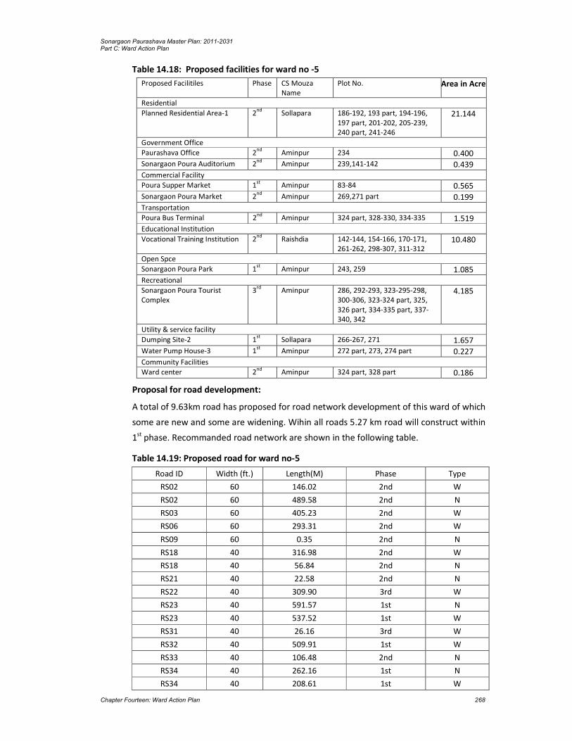
Sonargaon Paurashava Master Plan: 2011-2031 Part C: Ward Action Plan
Chapter Fourteen: Ward Action Plan 268
Table 14.18: Proposed facilities for ward no -5
Proposed Facilitiles Phase CS Mouza Name
Plot No. Area in Acre
Residential
Planned Residential Area-1 2nd
Sollapara 186-192, 193 part, 194-196, 197 part, 201-202, 205-239, 240 part, 241-246
21.144
Government Office
Paurashava Office 2nd
Aminpur 234 0.400 Sonargaon Poura Auditorium 2
nd Aminpur 239,141-142 0.439
Commercial Facility
Poura Supper Market 1st Aminpur 83-84 0.565 Sonargaon Poura Market 2
nd Aminpur 269,271 part 0.199
Transportation
Poura Bus Terminal 2nd Aminpur 324 part, 328-330, 334-335 1.519 Educational Institution
Vocational Training Institution 2nd
Raishdia 142-144, 154-166, 170-171, 261-262, 298-307, 311-312
10.480
Open Spce
Sonargaon Poura Park 1st
Aminpur 243, 259 1.085 Recreational
Sonargaon Poura Tourist Complex
3rd
Aminpur 286, 292-293, 323-295-298, 300-306, 323-324 part, 325, 326 part, 334-335 part, 337-340, 342
4.185
Utility & service facility
Dumping Site-2 1st
Sollapara 266-267, 271 1.657 Water Pump House-3 1
st Aminpur 272 part, 273, 274 part 0.227
Community Facilities
Ward center 2nd Aminpur 324 part, 328 part 0.186
Proposal for road development:
A total of 9.63km road has proposed for road network development of this ward of which
some are new and some are widening. Wihin all roads 5.27 km road will construct within
1st phase. Recommanded road network are shown in the following table.
Table 14.19: Proposed road for ward no-5
Road ID Width (ft.) Length(M) Phase Type
RS02 60 146.02 2nd W
RS02 60 489.58 2nd N
RS03 60 405.23 2nd W
RS06 60 293.31 2nd W
RS09 60 0.35 2nd N
RS18 40 316.98 2nd W
RS18 40 56.84 2nd N
RS21 40 22.58 2nd N
RS22 40 309.90 3rd W
RS23 40 591.57 1st N
RS23 40 537.52 1st W
RS31 40 26.16 3rd W
RS32 40 509.91 1st W
RS33 40 106.48 2nd N
RS34 40 262.16 1st N
RS34 40 208.61 1st W

Sonargaon Paurashava Master Plan: 2011-2031 Part C: Ward Action Plan
Chapter Fourteen: Ward Action Plan 269
Road ID Width (ft.) Length(M) Phase Type
RS36 40 429.41 2nd W
RL53 30 10.90 2nd W
RL61 30 501.70 2nd W
RL62 30 268.03 2nd N
RL66 30 282.27 3rd W
RL67 30 267.08 2nd N
RL90 30 228.18 3rd W
RL106 30 757.15 1st W
RA108 20 395.41 1st W
RA109 20 21.94 1st W
RA116 20 80.75 2nd W
RA117 20 262.22 1st N
RA117 20 164.06 1st W
RA117 20 37.95 1st W
RA121 20 73.39 1st W
RA155 20 116.12 2nd W
RA156 20 311.01 1st N
RA159 20 235.33 1st W
RA160 20 183.64 1st W
RA161 20 38.81 1st W
RA184 12 679.42 1st W
Total 9627.97
*Note: W= widening, N= New Road
Proposal for drianage development:
A total of 7.25 km drain has proposed for drianage network development of this ward of
which almost all are new. Wihin all roads 4.00 km drain will construct within 1st phase.
Recommanded drains are shown in the following table.
Table 14.20: Proposed drainage for ward no-5
Drain ID Type Length(M) Phase
DS03 Secondary 405.23 2nd
DP06 Primary 293.31 2nd
DS09 Secondary 0.35 2nd
DS18 Secondary 348.31 2nd
DS18 Secondary 0.05 2nd
DS22 Secondary 309.90 3rd
DT23 Tertiary 1,129.10 1st
DS31 Secondary 2.91 3rd
DS32 Secondary 509.91 1st
DS33 Secondary 106.48 3rd
DS34 Secondary 470.77 1st
DS36 Secondary 429.41 2nd
DT53 Tertiary 10.90 2nd
DT61 Tertiary 501.70 2nd
DT62 Tertiary 268.03 2nd

Sonargaon Paurashava Master Plan: 2011-2031 Part C: Ward Action Plan
Chapter Fourteen: Ward Action Plan 270
DT67 Tertiary 267.08 2nd
DT90 Tertiary 228.18 3rd
DT108 Tertiary 395.41 1st
DT109 Tertiary 21.94 1st
DT116 Tertiary 80.75 2nd
DT117 Tertiary 464.23 1st
DT159 Tertiary 107.43 1st
DT160 Tertiary 184.64 1st
DT161 Tertiary 38.81 1st
DT184 Tertiary 679.42 1st
Total 7,254.25

Sonargaon Paurashava Master Plan: 2011-2031 Part C: Ward Action Plan
Chapter Fourteen: Ward Action Plan 271
Map 14.9: Landuse Proposal for Ward No. 05

Sonargaon Paurashava Master Plan: 2011-2031 Part C: Ward Action Plan
Chapter Fourteen: Ward Action Plan 272

Sonargaon Paurashava Master Plan: 2011-2031 Part C: Ward Action Plan
Chapter Fourteen: Ward Action Plan 273
Map 14.10 : Proposed Road, Drainage and Utility Services Plan for Ward No. 05

Sonargaon Paurashava Master Plan: 2011-2031 Part C: Ward Action Plan
Chapter Fourteen: Ward Action Plan 274

Sonargaon Paurashava Master Plan: 2011-2031 Part C: Ward Action Plan
Chapter Fourteen: Ward Action Plan 275
14.3.6 Action Plan for Ward No. 6
Existing Situation:
Ward No. 6 is located at central area of the paurashava and major portion of the museum
located in this ward. Ward 2&3 located at the west side of this Ward and Ward No. 7 at
the southern side of the Ward.Total area of the Ward is 183.80 acres and population is
2319 person (BBS 2011). Among the total area, agriculture use is 49.86 acres and
63.37acres is residential area. There is a total of 6.72 km road in this ward of which 2.12
km are katcha. Within educational institution there is only 2 primary school.
Proposals and Plans for Ward No. 6
Landuse Development:For planned development considering the existing landuse and
future demand landuse proposal has made. Within the total area 55.73% land proposed
for residential use, 19 % water body, 1.81 are community facility, 13.14 % historical and
heritage site, no agricultural has proposed for this area.
Table 14.21: Proposed land use for Ward no-6
Land Use Type Area (Acre) Percentage (%)
Urban Residential Zone 102.45 55.74
General Industrial Zone 0.13 0.07
Government Office 0.00 0.00
Education & Research Zone 1.88 1.02
Water Body 35.69 19.42
Open Space 0.01 0.01
Circulation Network 15.10 8.22
Utility Services 0.40 0.22
Health Services 0.38 0.21
Community Facilities 3.61 1.97
Historical & Heritage Site 24.15 13.14
Total 183.79 100.00
The facilities considering the demand of the ward were shown in the following table
including phasing. The proposed facilities under different category of land uses are also
shown in the following table.
Table 14.22: proposed facilities for ward no -6
Proposed Facilitiles Phase CS Mouza Name Plot No. Area in Acre
Residential
Sweeper Colony 2nd
Baghmahisha 260-262, 263 part 1.117
Utility & service facility
Waste Transfer Station 1st
Baghmahisha 259, 263 part, 264 part
0.297
Public Toilet-1 1st
Baghmahisha 264 part 0.101
Water Pump House & Ward Community Clinic-1
1st
Baghmahisha 83 0.382
Community Facilities
Poura Eidgah 1st Baghmahisha 79 part 1.910
Poura Graveyard 1st
Baghmahisha 79 part 1.183
Ward Center 1st Baghmahisha 267 part 0.285
Proposal for road development:

Sonargaon Paurashava Master Plan: 2011-2031 Part C: Ward Action Plan
Chapter Fourteen: Ward Action Plan 276
A total of 3.96 km road has proposed for road network development of this ward of
which some are new and some are widening. Wihin all roads 1.82 km road will construct
within 1st phase. Recommanded road network are shown in the following table.
Table 14.23: Proposed road for ward no-6
Road ID Width (ft.) Length(M) Phase Type
RS03 60 10.87 2nd W
RS06 60 132.81 2nd W
RS07 60 147.35 2nd N
RS08 60 0.44 2nd W
RS14 40 1.35 3rd W
RS14 40 337.44 1st W
RS14 40 548.03 1st N
RS17 40 249.86 1st N
RS26 40 520.11 1st W
RS27 40 2.25 2nd W
RS35 40 342.85 2nd N
RS36 40 16.65 2nd W
RL64 30 416.00 2nd W
RL64 30 833.15 2nd N
RL69 30 7.57 3rd W
RL105 30 224.73 2nd W
RA161 20 166.28 1st W
Total 3957.74 *Note: W= widening, N= New Road

Sonargaon Paurashava Master Plan: 2011-2031 Part C: Ward Action Plan
Chapter Fourteen: Ward Action Plan 277
Map 14.11 : Landuse Proposal for Ward No. 06

Sonargaon Paurashava Master Plan: 2011-2031 Part C: Ward Action Plan
Chapter Fourteen: Ward Action Plan 278
Sonargaon Paurashava Master Plan: 2011-2031 Part C: Ward Action Plan
Chapter Fourteen: Ward Action Plan 279
Map 14.12 : Proposed Road, Drainage and Utility Services Plan for Ward No. 06

Sonargaon Paurashava Master Plan: 2011-2031 Part C: Ward Action Plan
Chapter Fourteen: Ward Action Plan 280

Sonargaon Paurashava Master Plan: 2011-2031 Part C: Ward Action Plan
Chapter Fourteen: Ward Action Plan 281
Proposal for drianage development:
A total of 3.96 km drain has proposed for drainage network development of this ward of
which almost all are new. Wihin all drains 1.82 km drain will construct within 1st phase.
Recommanded drains are shown in the following table.
Table 14.24: Proposed drainage for ward no-6
Drain ID Type Length(M) Phase
DS03 Secondary 10.87 D03
DP06 Primary 132.81 D06
DS07 Secondary 147.35 D07
DS08 Secondary 0.44 D08
DS14 Secondary 886.82 D14
DS17 Secondary 249.86 D17
DS26 Secondary 520.11 D26
DT27 Tertiary 2.25 D27
DT35 Tertiary 342.85 D35
DS36 Secondary 16.65 D36
DT64 Tertiary 833.69 D64
DT64 Tertiary 415.46 D64
DT69 Tertiary 7.57 D69
DT105 Tertiary 224.73 D105
DT161 Tertiary 166.28 D161
Total 3957.74
14.3.7 Action Plan for Ward No. 7
Existing Situation:
Ward No. 7 is the fringe area and corridore of the Paurashava and major portion of the
museum located in this ward. Ward 2 & 3 located at the west side of this Ward and Ward
No. 7 at the southern side of the Ward.Total area of the Ward is 201.06 acres and total
population is 4847 acre (BBS-2011). Among the total area, agriculture use is 21.63 acres
and 101.13 acres are residential area. There is a total of 8.19 km road in this ward of
which 2.03km are katcha. Within educational institution there is only one primary school.
Proposals and Plans for Ward No. 7
Landuse Development: For planned development considering the existing landuse and
future demand landuse proposal has made. Within the total area 48.26% land proposed
for residential use, only 0.65% are commercial use, 5.78% mixed use, only 0.08%
agricultural and others are in different category which are shown in the following table.
Table 14.25: Proposed land use for Ward no-7
Land Use Type Area (Acre) Percentage (%)
Urban Residential Zone 97.15 48.32
Commercial Zone 1.31 0.65
Mixed Use Zone 11.75 5.84
General Industrial Zone 2.27 1.13
Government Office 3.52 1.75
Education & Research Zone 0.21 0.10
Agricultural Zone 0.16 0.08
Water Body 53.11 26.42

Sonargaon Paurashava Master Plan: 2011-2031 Part C: Ward Action Plan
Chapter Fourteen: Ward Action Plan 282
Open Space 0.35 0.17
Circulation Network 21.24 10.57
Community Facilities 0.51 0.25
Historical & Heritage Site 9.48 4.72
Total 201.06 100.00
The facilities considering the demand of the ward were shown in the following table
including phasing. The proposed facilities under different category of land uses are also
shown in the following table.
Table 14.26: Proposed facilities for ward no -7
Proposed Facilitiles Phase CS Mouza Name Plot No. Area in Acre
Government Office
Administration Area 3rd
Ichapur 202-204, 206-209, 212-213, 288-295
3.508
Community Facilities
Ward Center 1st Ichapur 330 part 0.204

Sonargaon Paurashava Master Plan: 2011-2031 Part C: Ward Action Plan
Chapter Fourteen: Ward Action Plan 283
Map 14.13 : Landuse Proposal for Ward No. 07

Sonargaon Paurashava Master Plan: 2011-2031 Part C: Ward Action Plan
Chapter Fourteen: Ward Action Plan 284

Sonargaon Paurashava Master Plan: 2011-2031 Part C: Ward Action Plan
Chapter Fourteen: Ward Action Plan 285
Map 14.14 : Proposed Road, Drainage and Utility Services Plan for Ward No. 07

Sonargaon Paurashava Master Plan: 2011-2031 Part C: Ward Action Plan
Chapter Fourteen: Ward Action Plan 286

Sonargaon Paurashava Master Plan: 2011-2031 Part C: Ward Action Plan
Chapter Fourteen: Ward Action Plan 287
Proposal for road development:
A total of 6.79 km road has proposed for road network development of this ward of
which some are new and some are widening. Wihin all roads 3.34 km road will construct
within 1st phase. Recommanded road network are shown in the following table.
Table 14.27: Proposed road for ward no-7
Road ID Width (ft.) Length(M) Phase Type
RS06 60 857.32 2nd W
RS06 60 123.56 2nd W
RS06 60 326.37 2nd W
RS07 60 194.10 2nd N
RS07 60 277.97 2nd N
RS12 40 640.66 1st W
RS13 40 396.01 1st W
RS25 40 306.16 2nd W
RS26 40 90.40 1st W
RS40 40 77.41 2nd W
RS43 40 261.54 1st W
RL50 30 2.36 1st W
RL50 30 247.88 1st W
RL51 30 263.18 2nd W
RL52 30 139.50 1st W
RL70 30 271.94 2nd N
RA118 20 312.00 1st N
RA131 20 75.45 2nd W
RA132 20 131.59 2nd W
RA141 20 103.18 1st N
RA152 20 440.18 2nd W
RA162 20 432.34 1st N
RA167 20 58.39 1st W
RA177 20 234.49 1st W
RA178 20 421.31 1st W
RA179 20 104.38 2nd W
Total 6789.67 *Note: W= widening, N= New Road
Proposal for drianage development:
A total of 6.71 km drain has proposed for drainage network development of this ward of
which almost all are new. Wihin all roads 1.30 km drain will construct within 1st phase.
Recommanded drains are shown in the following table.
Table 14.28: Proposed drainage for ward no-7
Drain ID Type Length(M) Phase
DP06 Primary 1,307.25 2nd
DS07 Secondary 472.06 2nd
DS12 Secondary 640.66 1st
DS13 Secondary 396.01 1st
DS25 Secondary 306.16 2nd
DS26 Secondary 90.40 1st
DS40 Secondary 77.41 2nd
DS43 Secondary 261.54 1st
DT50 Tertiary 250.24 1st
DT51 Tertiary 263.18 2nd

Sonargaon Paurashava Master Plan: 2011-2031 Part C: Ward Action Plan
Chapter Fourteen: Ward Action Plan 288
Drain ID Type Length(M) Phase
DT52 Tertiary 139.50 1st
DT70 Tertiary 271.94 2nd
DT118 Tertiary 312.00 1st
DT132 Tertiary 131.59 2nd
DT141 Tertiary 103.18 1st
DT152 Tertiary 440.18 2nd
DT162 Tertiary 432.34 1st
DT167 Tertiary 58.39 1st
DT177 Tertiary 235.53 1st
DT178 Tertiary 420.27 1st
DT179 Tertiary 104.38 2nd
Total 6,714.21
14.3.8 Action Plan for Ward No. 8
Existing Situation:
Ward No.8 is the built-up area of the Paurashava consisting a major portion of core area.
Sonargaon Thana and part of Upazilla Complex are located in this ward and located at the
south-east side of the paurashava. Total area of the Ward is 232.60 acres and total
population is 4293 acre (BBS-2011). Among the total area, agriculture use is 31.49 acres,
141.93 acres are residential area and and 4.08 acres are commercial area. There is a total
of 11.19 km road in this ward of which 2.08 km are katcha. Within educational institution
there is 3 primary school, 1 high school and 3 madrasa.
Proposals and Plans for Ward No. 8
Landuse Development: For planned development considering the existing landuse and
future demand landuse proposal has made. Within the total area 58.52% land proposed
for residential use 1.91 % are commercial use, 6.35% mixed use, only o.21% agricultural
and others are in different category which are shown in the following table.

Sonargaon Paurashava Master Plan: 2011-2031 Part C: Ward Action Plan
Chapter Fourteen: Ward Action Plan 289
Map 14.15 : Landuse Proposal for Ward No. 08

Sonargaon Paurashava Master Plan: 2011-2031 Part C: Ward Action Plan
Chapter Fourteen: Ward Action Plan 290
Sonargaon Paurashava Master Plan: 2011-2031 Part C: Ward Action Plan
Chapter Fourteen: Ward Action Plan 291
Map 14.16 : Proposed Road, Drainage and Utility Services Plan for Ward No. 08

Sonargaon Paurashava Master Plan: 2011-2031 Part C: Ward Action Plan
Chapter Fourteen: Ward Action Plan 292

Sonargaon Paurashava Master Plan: 2011-2031 Part C: Ward Action Plan
Chapter Fourteen: Ward Action Plan 293
Table 14.29: Proposed land use for Ward no-8
Land Use Type Area (Acre) Percentage (%)
Urban Residential Zone 142.14 58.74
Commercial Zone 4.66 1.93
Mixed Use Zone 15.26 6.31
General Industrial Zone 3.06 1.26
Government Office 6.78 2.80
Education & Research Zone 4.28 1.77
Agricultural Zone 0.24 0.10
Water Body 31.93 13.20
Open Space 1.11 0.46
Circulation Network 29.94 12.37
Transportation Facilities 0.21 0.09
Utility Services 0.17 0.07
Health Services 0.13 0.05
Community Facilities 2.07 0.85
Total 241.97 100.00
The facilities considering the demand of the ward were shown in the following table
including phasing. The proposed facilities under different category of land uses are also
shown in the following table.
Table 14.30: Proposed facilities for ward no -8
Proposed Facilitiles Phase CS Mouza Name
Plot No. Area in Acre
Government Office
Administration Area 3rd
Chowdona 202-206 part, 207-209, 212-213
3.130
Open Spce
Cremation 1st
Chowdona 501-502 0.189 Community Facilities
Ward Center 1st
Chowdona 362 part 0.065
Proposal for road development:
A total of 11.24 km road has proposed for road network development of this ward of
which some are new and some are widening. Wihin all roads 4.82 km road will construct
within 1st phase. Recommanded road network are shown in the following table.
Table 14.31: Proposed road for ward no-7
Road ID Width (ft.) Length(M) Phase Type
RS03 60 977.51 2nd W
RS07 60 460.44 2nd N
RS07 60 479.53 2nd W
RS14 40 59.61 1st W
RS17 40 324.59 1st N
RS24 40 224.11 2nd W
RS25 40 822.72 2nd W
RS26 40 458.79 1st W
RS27 40 150.40 2nd W
RS28 40 412.41 1st N
RS28 40 302.39 1st W
RS40 40 187.90 2nd N

Sonargaon Paurashava Master Plan: 2011-2031 Part C: Ward Action Plan
Chapter Fourteen: Ward Action Plan 294
Road ID Width (ft.) Length(M) Phase Type
RS44 40 50.47 3rd W
RL53 30 94.21 2nd W
RL55 30 112.58 3rd W
RL56 30 258.93 2nd W
RL63 30 420.41 3rd W
RL68 30 135.16 3rd W
RL69 30 223.02 3rd W
RL72 30 282.99 2nd W
RL72 30 167.01 2nd W
RL73 30 107.20 2nd W
RL76 30 96.21 3rd W
RL88 30 120.14 3rd W
RL89 30 324.35 2nd W
RL91 30 310.94 2nd N
RA112 20 100.82 2nd W
RA113 20 132.57 1st W
RA114 20 51.03 1st W
RA118 20 8.26 1st W
RA122 20 66.11 1st W
RA123 20 224.73 1st W
RA125 20 54.88 1st W
RA127 20 94.90 2nd W
RA128 20 85.06 2nd W
RA129 20 78.42 2nd W
RA130 20 53.92 2nd W
RA144 20 120.92 1st W
RA150 20 10.43 1st W
RA162 20 74.26 1st W
RA163 20 102.79 1st W
RA164 20 65.35 1st W
RA165 20 161.87 1st W
RA166 20 349.53 1st W
RA167 20 118.83 1st W
RA168 20 100.52 1st W
RA169 20 93.53 1st W
RA170 20 292.68 1st W
RA171 20 71.01 1st W
RA172 20 189.09 1st W
RA173 20 76.34 1st W
RA174 20 162.59 1st W
RA175 20 61.45 1st W
RA176 20 678.26 1st W
Total 11244.17 *Note: W= widening, N= New Road
Proposal for drianage development:
A total of 10.98 km drain has proposed for drainage network development in this ward of
which almost all are new. Wihin all roads 4.33 km drain will construct within 1st phase.
Recommanded drains are shown in the following table.
Table 14.32: Proposed drainage for ward no-8

Sonargaon Paurashava Master Plan: 2011-2031 Part C: Ward Action Plan
Chapter Fourteen: Ward Action Plan 295
Drain ID Type Length(M) Phase
DS03 Secondary 977.51 2nd
DS07 Secondary 939.97 2nd
DS14 Secondary 59.61 1st
DS17 Secondary 324.59 1st
DS24 Secondary 224.11 2nd
DS25 Secondary 822.72 2nd
DS26 Secondary 458.79 1st
DT27 Tertiary 150.40 2nd
DS28 Secondary 714.80 1st
DS40 Secondary 187.90 2nd
DT44 Tertiary 50.47 3rd
DT53 Tertiary 94.21 2nd
DT55 Tertiary 112.58 3rd
DT56 Tertiary 258.93 2nd
DT63 Tertiary 420.41 3rd
DT68 Tertiary 135.16 3rd
DT69 Tertiary 223.02 3rd
DT72 Tertiary 450.00 2nd
DT73 Tertiary 107.20 2nd
DT76 Tertiary 96.21 3rd
DT88 Tertiary 120.14 3rd
DT89 Tertiary 324.35 2nd
DT91 Tertiary 310.94 2nd
DT112 Tertiary 100.82 2nd
DT113 Tertiary 132.57 1st
DT114 Tertiary 51.03 1st
DT118 Tertiary 8.26 1st
DT122 Tertiary 66.11 1st
DT123 Tertiary 224.73 1st
DT125 Tertiary 54.88 1st
DT127 Tertiary 94.90 2nd
DT128 Tertiary 85.06 2nd
DT144 Tertiary 120.92 1st
DT150 Tertiary 10.43 1st
DT162 Tertiary 72.33 1st
DT163 Tertiary 104.72 2nd
DT165 Tertiary 162.63 2nd
DT166 Tertiary 348.77 1st
DT167 Tertiary 119.46 1st
DT168 Tertiary 99.89 2nd
DT169 Tertiary 92.95 1st
DT170 Tertiary 293.26 1st
DT171 Tertiary 71.01 1st
DT172 Tertiary 189.08 1st
DT173 Tertiary 75.70 1st
DT174 Tertiary 163.23 1st
DT176 Tertiary 678.26 1st
Total 10985.02
14.3.9 Action Plan for Ward No. 9

Sonargaon Paurashava Master Plan: 2011-2031 Part C: Ward Action Plan
Chapter Fourteen: Ward Action Plan 296
Existing Situation:
Ward No.8 is the built-up area of the Paurashava consisting a major portion of core area.
Sonargaon thana health complex and part of Upazilla Complex are located in this ward
and located at the south-east side of the paurashava. Total area of the Ward is 141.51
acres and total population is 4545 person (BBS-2011). Among the total area, agriculture
use is 26.39 acres, 75.20 acres are residential area and 18.56 acres are commercial area.
There is a total of 6.55 km road in this ward of which 2.58 km are katcha. Within
educational institution there is 2 primary school and 2 madrasa.
Proposals and Plans for Ward No. 9
Landuse Development: For planned development considering the existing landuse and
future demand landuse proposal has made. Within the total area 45.85% land proposed
for residential use, 3.13% are commercial use, 15.96% mixed use, 11.69% agricultural
and others are in different category which are shown in the following table.
Table 14.33: Proposed land use for Ward no-9
Land Use Type Area (Acre) Percentage (%)
Urban Residential Zone 60.63 45.89
Commercial Zone 4.29 3.25
Mixed Use Zone 21.12 15.98
General Industrial Zone 0.78 0.59
Education & Research Zone 0.87 0.66
Agricultural Zone 15.44 11.68
Water Body 14.38 10.88
Open Space 0.10 0.08
Circulation Network 11.16 8.45
Health Services 2.40 1.82
Community Facilities 0.95 0.72
Total 132.12 100.00
The facilities considering the demand of the ward were shown in the following table
including phasing. The proposed facilities under different category of land uses are also
shown in the following table.
Table 14.34: Proposed facilities for ward no -9
Proposed Facilitiles Phase CS Mouza Name Plot No. Area in Acre
Community Facilities
Ward Center 1st
Sahapur 231 part 0.058
Proposal for road development:
A total of 4.73 km road has proposed for road network development of this ward of
which some are new and some are widening. Wihin all roads 3.34 km road will construct
within 1st phase. Recommanded road network are shown in the following table.
Table 14.35: Proposed road for ward no-9
Road ID Width (ft.) Length(M) Phase Type
RS24 40 669.77 2nd W

Sonargaon Paurashava Master Plan: 2011-2031 Part C: Ward Action Plan
Chapter Fourteen: Ward Action Plan 297
Road ID Width (ft.) Length(M) Phase Type
RL47 30 538.84 3rd W
RL53 30 918.08 2nd W
RL55 30 214.40 2nd N
RL55 30 73.50 3rd W
RL56 30 32.84 2nd W
RL71 30 316.09 2nd N
RL71 30 91.20 3rd W
RL74 30 167.17 3rd W
RL75 30 240.99 3rd W
RL88 30 15.78 3rd W
RL89 30 133.09 2nd W
RA113 20 59.51 1st W
RA114 20 129.87 1st W
RA114 20 146.61 1st N
RA126 20 353.16 2nd W
RA143 20 181.51 1st W
RA150 20 156.12 1st W
RA151 20 296.07 1st W
Total 4734.6 *Note: W= widening, N= New Road
Proposal for drianage development:
A total of 4.32 km drain has proposed for drainage network development of this ward of
which almost all are new. Wihin all roads 0.79 km drain will construct within 1st phase.
Recommanded drains are shown in the following table.
Table 14.36: Proposed drainage for ward no-9
Drain ID Type Length(M) Phase
DS24 Secondary 669.77 2nd
DT47 Tertiary 538.84 3rd
DT53 Tertiary 918.08 2nd
DT55 Tertiary 287.89 3rd
DT56 Tertiary 32.84 2nd
DT71 Tertiary 407.29 3rd
DT74 Tertiary 167.17 3rd
DT75 Tertiary 240.99 3rd
DT88 Tertiary 112.00 3rd
DT89 Tertiary 36.88 2nd
DT113 Tertiary 59.51 1st
DT114 Tertiary 276.49 1st
DT126 Tertiary 116.93 2nd
DT150 Tertiary 156.12 1st
DT151 Tertiary 296.07 1st
Total 4316.87

Sonargaon Paurashava Master Plan: 2011-2031 Part C: Ward Action Plan
Chapter Fourteen: Ward Action Plan 298

Sonargaon Paurashava Master Plan: 2011-2031 Part C: Ward Action Plan
Chapter Fourteen: Ward Action Plan 299
Map 14.17 : Landuse Proposal for Ward No. 09

Sonargaon Paurashava Master Plan: 2011-2031 Part C: Ward Action Plan
Chapter Fourteen: Ward Action Plan 300

Sonargaon Paurashava Master Plan: 2011-2031 Part C: Ward Action Plan
Chapter Fourteen: Ward Action Plan 301
Map 14.18 : Proposed Road, Drainage and Utility Services Plan for Ward No. 09

Sonargaon Paurashava Master Plan: 2011-2031 Part C: Ward Action Plan
Chapter Fourteen: Ward Action Plan 302

Sonargaon Paurashava Master Plan: 2011-2031 Part C: Ward Action Plan
Chapter Fourteen: Ward Action Plan 303
Map 14.19 : Landuse Proposal for Extension Area 01

Sonargaon Paurashava Master Plan: 2011-2031 Part C: Ward Action Plan
Chapter Fourteen: Ward Action Plan 304

Sonargaon Paurashava Master Plan: 2011-2031 Part C: Ward Action Plan
Chapter Fourteen: Ward Action Plan 305
Map 14.20 : Proposed Road, Drainage and Utility Services Plan for Extension Area 01

Sonargaon Paurashava Master Plan: 2011-2031 Part C: Ward Action Plan
Chapter Fourteen: Ward Action Plan 306

Sonargaon Paurashava Master Plan: 2011-2031 Part C: Ward Action Plan
Chapter Fourteen: Ward Action Plan 307
Map 14.21 : Landuse Proposal for Extension Area 02

Sonargaon Paurashava Master Plan: 2011-2031 Part C: Ward Action Plan
Chapter Fourteen: Ward Action Plan 308

Sonargaon Paurashava Master Plan: 2011-2031 Part C: Ward Action Plan
Chapter Fourteen: Ward Action Plan 309
Map 14.22 : Proposed Road, Drainage and Utility Services Plan for Extension Area 02

Sonargaon Paurashava Master Plan: 2011-2031 Part C: Ward Action Plan
Chapter Fourteen: Ward Action Plan 310

Sonargaon Paurashava Master Plan: 2011-2031 Part C: Ward Action Plan
Chapter Fourteen: Ward Action Plan 311
14.4 Implementation Guidelines
Implementation of the Ward Action Plan should follow the development control
procedures for determining planning applications by use of the simple and standard
planning application procedures. A simple application will be assessed quickly against a
given set of criteria, essentially consisting of the following:
1. The proposed development confirms all respects mentioned in the policies of the Structure Plan and Urban Area Plan.
2. He usage identified in the application is being considered appropriate for inclusion in an area demarcated in the Ward Action Plan. An indicative list of uses considered appropriate is below:
buildings are a maximum of four-storied;
no single building or related group of buildings is 1000 sq. m. of gross floor area; and
access and utility corridors are not impinged.
Provided that the planning application meets above criteria and the application will be
approved and planning permission is given.
Planning applications that do not meet the above criteria or are considered marginal
cases (to be known as an invalid simple application) will be subjected to a more detailed
examination in considering standard procedure.
Following development and landuses are indicative of those appropriate in the Ward
Action Plan:
1. Residential development up to four-storied.
2. Small-scale shops.
3. Primary schools/kindergartens.
4. Mosques (or other religious facilities) servicing a local area plus small graveyard if required.
5. Recreational development.
6. Local health facilities (clinics rather than hospital).
7. Small-scale office (may be public or private) development.
8. Workshops (small-scale workshops with operations only) in daylight hours and low traffic generators.
9. Open space (playgrounds, parks, etc.)
10. Access roads.
11. Utilities; and
12. Drainage channels.
When considering a standard planning application within areas zoned for Ward Action
Plan, the Paurashava will need to undertake a two-stage process. First, before
considering site specific issues, the Paurashava will need, on receipt of the planning

Sonargaon Paurashava Master Plan: 2011-2031 Part C: Ward Action Plan
Chapter Fourteen: Ward Action Plan 312
application, to consider the wider context and determine issues relating to the overall
area into which the application falls. The Paurashava will need to:
1. Determine the boundaries of the wider area. These will usually be formed by some
distinctive natural or man-made feature, for example a khal, river or road which
provides access into the area. Such areas will vary in shape and size.
2. Identify the existing landuses within these boundaries. In Ward Action Plan, the
predominant use will be residential but other uses will present in the vicinity of the
application.
3. Identify and assess the existing access and circulation arrangements of the area.
Preferably, the area should be served by 10 meter access roads which run through
the entire area providing access to all Wards. These access roads should be linked to
local roads. If this is not the case and access roads of sufficient width, are not
available, the Paurashava shall consider whether or not further development is
appropriate. New development may result in increased vehicular congestion and
increased demand for utility services, where this could be difficult to supply.
In these instances, the Paurashava will consider refusal of application or at least a delay
until access and utility provision can be made. This may require acquisition of land.
4. Identify the need for community facilities (schools, clinics, religious facilities, open
spaces, etc.) or plots for utility services. Do sufficient already exist or should more
land be sought for increased provision to the existing population? In this latter
instance, the Paurashava will again need to consider acquisition of land including the
land, either in part or in full, under consideration for development.
5. Consider areas of high landscape quality in the locality which should be preserved
and the potential impact of the proposed development on those areas.
If there is doubt in the mind of the Paurashava as to the answers to the above questions,
the planning application will require a more detailed assessment.
Secondly, the Paurashava will need to consider issues relating to the individual site and
application. These can only be determined once the overall context of the area has been
established. The questions the Paurashava will need to ask are:
1. Can be proposed use of land be considered a “good neighbour”, defined in this
situation as a use which can be carried out in any residential area without detriment
to the amenities of the area by reason of noise, vibration, smell, fumes, smoke, soot,
ash, dust or grit?
- Is the use likely to generate excessive volumes of traffic which either cannot be accommodated on the existing road system or which are likely to disturb, its neighbours?
- Will the working hours of the use (if non-residential) cause a disturbance to residential neighbours (with working late in to the evening or night or 24-hours operations likely to cause a nuisance and therefore not being permitted)?

Sonargaon Paurashava Master Plan: 2011-2031 Part C: Ward Action Plan
Chapter Fourteen: Ward Action Plan 313
- If yes to any of the above, the application should be rejected and directed to a more suitable location.
2. Is the use in conformity with the surrounding uses or with those that are compatible
with a site in a predominantly residential area?
3. Does the proposed boundary of the application impinge upon a road corridor, utility
reserve or drainage channel reserve? If it does, it should be relocated outside such a
reserve, even if this constitutes a reduction in the overall size of the plot. If excessive
land will be lost as a result, implying that the development can no longer proceed,
the application will need to be rejected.
4. Does the application provide for adequate site access from, preferably as minimum, a
6 meter access road? Does it have sufficient on-site or off-site parking facilities to
cater for the potential demand? If it does not, the plans should be amended or the
application refused.
5. Will the development destroy landscape unique to the location? If it does, its design
will need to be altered to protect the landscape, or the application will need to be
refused.
6. Is the scale of development proposed in keeping with its neighbours? If too large, it
should be reduced. Does it impinge up on the privacy of others? If it does, the design
/ layout / size should be changed. If it can not be appropriately modified, it should be
refused.
7. Will the proposed development negatively impact upon utility provision in the area
i.e. will it overload the system for some reason (like high electricity demand or high
water consumption)? Will pollution from the proposed activities cause a problem in
the neighbourhood? If this is likely to occur, the application should be refused.
If the application is for a major development, have the utility authorities being contacted
to give their assessment and approval for the infrastructure works that will be required?
Given the existing situation in some of the Ward Action Plan, where for example, access
is already poor or there is insufficient space available to provide adequate infrastructure,
the Paurashava will aim to ensure that its decision will not make the situation worse.
The Paurashava will need to process each application within one month, at the end of
which time they will either need to:
- approve the application unconditionally;
- approve the application subject to a number of conditions; or
- refuse the application.
14.5 Concluding Remarks
The Master Plan is prepared for managing and promoting development over medium
terms following the broad guidelines set by the longer term Structure Plan. It shows the
structure of sub-system in space over the medium term and identifies broad programs of

Sonargaon Paurashava Master Plan: 2011-2031 Part C: Ward Action Plan
Chapter Fourteen: Ward Action Plan 314
direct action especially related to infrastructural development, institutional issues as well
as broad financing strategies. The plan also outlines more specific Ward-wise
development policies to guide development over the medium terms. One major objective
of preparing Master Plan is the consolidation of development activities by various
agencies in areas that have strongest potential for growth in the medium term and can
accommodate anticipated volume of growth. Other purpose of preparing Master Plan is
to facilitate the development control function. It shows the broad landuse zones on a
more detailed scale of maps as derived from Structure Plan. The plan provides details of
landuse zoning and building controls, the development control function becomes easier
to implement with a Master Plan. It also shows land reservations required for essential
uses and major infrastructure development.
Comparative Advantage of Master Plan
Comparative advantages of Master Plan rather than Ward Action Plan are:
The term Master Plan deserves wider sense than the term Ward Action Plan. Policies and strategies are being prescribed in the Master Plan based on the existing trend of development and growth potentiality. The Ward Action Plan only emphasizes on those components immediate action is being necessary.
The Master Plan is for the Paurashava as a whole but the Ward Action Plan is only for individual Ward. All studies relevant and guided by the ToR is being followed for the preparation of Master Plan at first and based on those studies and findings the Ward Action Plan is being designed.
The Ward Action Plan is mostly relevant with the implementation criteria; it is called the implementation of Master Plan. The micro-component which is going to be implemented according to the Ward Action Plan is guided by the Master Plan. Therefore, any problem arises during the implementation phase of Ward Action Plan will be resolved through the guideline prescribed in the Master Plan.
Addressing Proposals for Mitigation of Identified Issues
For improvement, construction and re-construction of local roads, bridge and culvert and box culvert, a close coordination among the authorities named Paurashava, LGED, PDB, REB and WDB will be maintained. This coordination is necessary from the preparation of budget to implementation of the component.
In plan implementation phase, people’s participation will be encouraged. The process as prescribed in the Structure Plan will be initiated for this purpose.
A buffer will be needed for every important development especially for housing area, stadium and Bus terminal.
In preparing the proposed construction program priorities have been assigned to the
works mostly in the various drainage areas taking the following factors into account:
The severity of flooding in terms of depth, duration and frequency;
The views of Paurashava officials on the relative needs of different areas;
The engineering relationship of the proposed phase of construction to the preceding and subsequent phases;
The estimated time required to execute the proposed works having regard to the capacity and capability of contractors and the availability of materials;

Sonargaon Paurashava Master Plan: 2011-2031 Part C: Ward Action Plan
Chapter Fourteen: Ward Action Plan 315
The estimated amount of the capital investment required.
In general, aim should be to implement the Master Plan at a continuous steady rate
throughout the 20 years period and based upon the above considerations, the works
have been grouped broadly into four main stages:
The first stage accords priority to improve the Traffic Management and alleviation of flooding in the central area of the Paurashava.
The second stage in general covers less densely developed areas with the improvement of transport services.
The third stage covers drainage congestion areas for improvement.
The fourth stage will be the rain water harvesting for supplying drinking water to the Paurashava dwellers when scarcity will be generated.
To ensure that the procedures are being followed, the Paurashava will need to monitor
the situation. This monitoring is required to ensure that:
No illegal development is taking place i.e. no-one is attempting to develop without submitting an application; and
Approved developments are built in accordance with the approved plans.
Aevelopment will take places according to the Master Plan.

Sonargaon Paurashava Master Plan: 2011-2031 Part C: Ward Action Plan
Chapter Fourteen: Ward Action Plan 316

Sonargaon Paurashava Master Plan: 2011-2031 Structure Plan, Uraban Area Plan and Ward Action Plan
Annexure-A: Pourashava Gazette 1
ANNEXURE-A Paurashava Gazette

Sonargaon Paurashava Master Plan: 2011-2031 Structure Plan, Uraban Area Plan and Ward Action Plan
Annexure-A: Pourashava Gazette 2

Sonargaon Paurashava Master Plan: 2011-2031 Structure Plan, Uraban Area Plan and Ward Action Plan
Annexure-B: Permitted Landuse List 1
ANNEXURE-B
Proposed Land Use Categories and permitted use
Urban Residential Landuse
Landuse Permitted
The following uses in the tables are proposed to be applicable for this zone only.
Table No. A.1: Landuse Permitted
Permitted
Artisan's Shop
Assisted Living or Elderly Home
Confectionery Shop
Barber Shop
Child Daycare \ Preschool
Cleaning \ Laundry Shop
Communication Service Facilities
Communication Tower Within Permitted Height
Condominium or Apartment
Cottage
Cyber Café
Daycare Center (Commercial or Nonprofit)
Drug Store or Pharmacy
Employee Housing (Guards \ Drivers) \ Ancillary Use
General Store
Grocery Store
High School
Household Appliance and Furniture Repair Service (No Outside Storage)
Housing For Seasonal Firm Labor
Landscape and Horticultural Services
Mosque, Place Of Worship
Newspaper Stand
Nursery School
Orphanage
Eidgah
Photocopying and Duplicating Services (No Outside Storage)
Pipelines and Utility Lines
Playing Field
Primary School
Private Garages (Ancillary Use)
Project Identification Signs
Property Management Signs
Public Transport Facility
Satellite Dish Antenna
Shelter (Passers By)
Shoe Repair or Shoeshine Shop (Small)
CBO Office
Special Dwelling

Sonargaon Paurashava Master Plan: 2011-2031 Structure Plan, Uraban Area Plan and Ward Action Plan
Annexure-B: Permitted Landuse List 2
Permitted
Temporary Tent
Temporary Pandle for Permitted Function
Newspaper Stand
Specialized School: Dance, Art, Music, Physically Challenged & Others
Transmission Lines
Urban-Nature Reserve
Utility Lines
Woodlot
Children’s Park (Must Have Parking)
ATM Booth
Water Pump \ Reservoir
Monument (Neighborhood Scale)
Bill Payment Booth
Boarding and Rooming House
Dormitory
Memorial Structure (Ancillary)
Neighborhood Center* (Where Neighborhood Center exists)
Permitted
Community Center
Doctor \ Dentist Chamber
Cultural Exhibits and Libraries
Fast Food Establishment \ Food Kiosk
Flowers, Nursery Stock and Florist Supplies
Fitness Centre
Gaming Clubs
Departmental Stores
Retail Shops \ Facilities
Permission of Neighborhood Center Facilities in absence of formal neighborhood should be
subject to Landuse Permit CommitteeSource: Compiled by the Consultants
Landuse Conditionally Permitted
The following uses may be permitted or disallowed in this zone after review and approval by the
authority/committee following appropriate procedure while the application meets the criteria
mentioned in the requirement.
Table No. A.2: Landuse Conditionally Permitted
Conditional
Addiction Treatment Center
Amusement and Recreation (Indoors)
Funeral Services
Art Gallery, Art Studio \ Workshop
Automobile Driving Academy
Beauty and Body Service
Billiard Parlor \ Pool Hall
Book or Stationery Store or Newsstand
Building Maintenance \ Cleaning Services, No Outside Storage
Bus Passenger Shelter
Graveyard \ Cemetery

Sonargaon Paurashava Master Plan: 2011-2031 Structure Plan, Uraban Area Plan and Ward Action Plan
Annexure-B: Permitted Landuse List 3
Conditional
Coffee Shop \ Tea Stall
Correctional Institution
Courier Service
Crematorium
Plantation (Except Narcotic Plant)
Furniture & Variety Stores
Emergency Shelter
Energy Installation
Garages
Garden Center or Retail Nursery
Fire Brigade Station
Police Station
Temporary Rescue Shed
Guest House
Slaughter House
Static Transformer Stations
Tourist Home or Resort
Market (Bazar)
Optical Goods Sales
Outdoor Café
Outdoor Fruit and Vegetable Markets
Community Hall
Neighborhood Co-Operative Office
Overhead Water Storage Tanks
Row House
Paints and Varnishes Store
Parking Lot
Patio Homes
Photofinishing Laboratory
Post Office
Postal Facilities
Sports and Recreation Club
Tennis Club
Flood Management Structure
Telephone Sub Station
Electrical Sub Station
Source: Compiled by the Consultants
Restricted Uses
All uses except permitted and conditionally permitted uses are restricted in this zone.
General Industrial Zone
Landuse Permitted
The following uses in the tables are proposed to be applicable for this zone only.
Table No. A.3: Landuse Permitted

Sonargaon Paurashava Master Plan: 2011-2031 Structure Plan, Uraban Area Plan and Ward Action Plan
Annexure-B: Permitted Landuse List 4
Permitted
Confectionery Shop
Bank & Financial Institution
Bicycle Assembly, Parts and Accessories
Blacksmith
Bus Passenger Shelter
Communication Tower Within Permitted Height
Freight Transport Facility
Police Box \ Barrack
Fire \ Rescue Station
Grocery Store
Household Appliance and Furniture Repair Service
Machine Sheds
Meat and Poultry (Packing & Processing)
Mosque, Place Of Worship
Newspaper Stand
Photocopying and Duplicating Services
Pipelines and Utility Lines
Printing, Publishing and Distributing
Public Transport Facility
Restaurant
Retail Shops \ Facilities
Salvage Processing
Salvage Yards
Satellite Dish Antenna
Sawmill, Chipping and Pallet Mill
Shelter (Passers By)
Television, Radio or Electronics Repair (No Outside Storage)
Transmission Lines
Truck Stop & Washing or Freight Terminal
Utility Lines
Wood Products
Woodlot
ATM Booth
Water Pump \ Reservoir
Effluent Treatment Plant
Social Forestry
Source: Compiled by the Consultants
Landuse Conditionally Permitted
The following uses may be permitted or denied in this zone after review and approval by the
authority/committee following appropriate procedure.
Table No. A.4: Landuse Conditionally Permitted
Conditional
Amusement and Recreation (Indoors)
Appliance Store
Plantation (Except Narcotic Plant)
Cyber Café

Sonargaon Paurashava Master Plan: 2011-2031 Structure Plan, Uraban Area Plan and Ward Action Plan
Annexure-B: Permitted Landuse List 5
Conditional
Daycare Center (Commercial or Nonprofit)
Doctor \ Dentist Chamber
Electrical and Electronic Equipment and Instruments Sales
Employee Housing
Energy Installation
Fast Food Establishment \ Food Kiosk
Garages
Grain & Feed Mills
Incineration Facility
Super Store
Lithographic or Print Shop
Motor Vehicle Fuelling Station \ Gas Station
Motorcycle Sales Outlet
Outdoor Fruit and Vegetable Markets
Outside Bulk Storage
Overhead Water Storage Tanks
Painting and Wallpaper Sales
Paints and Varnishes
Parking Lot
Parking Lot (Commercial)
Private Garages
Retail Shops Ancillary To Studio \ Workshop
Jute Mill
Source: Compiled by the Consultants
Restricted Uses
All uses except permitted and conditionally permitted uses.
Commercial Zone (Business)
Landuse Permitted
Commercial office zone is mainly intended for supporting the official works. There are several
functions that are permitted in this zone.
Table No. A.5: Landuse Permitted
Permitted
Accounting, Auditing or Bookkeeping Services
Billboards, Advertisements & Advertising Structure
Agri-Business
Agricultural Sales and Services
Ambulance Service
Antique Shop
Appliance Store
Auction Market
Auditorium, Coliseum, Meeting Halls, and Conference Facilities, Convention
Auto Leasing or Rental Office
Auto Paint Shop
Auto Parts and Accessory Sales (Indoors)
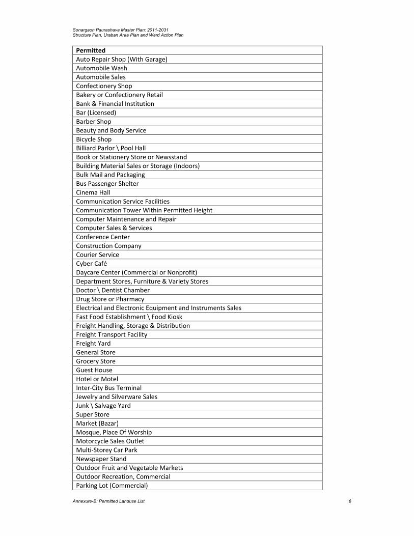
Sonargaon Paurashava Master Plan: 2011-2031 Structure Plan, Uraban Area Plan and Ward Action Plan
Annexure-B: Permitted Landuse List 6
Permitted
Auto Repair Shop (With Garage)
Automobile Wash
Automobile Sales
Confectionery Shop
Bakery or Confectionery Retail
Bank & Financial Institution
Bar (Licensed)
Barber Shop
Beauty and Body Service
Bicycle Shop
Billiard Parlor \ Pool Hall
Book or Stationery Store or Newsstand
Building Material Sales or Storage (Indoors)
Bulk Mail and Packaging
Bus Passenger Shelter
Cinema Hall
Communication Service Facilities
Communication Tower Within Permitted Height
Computer Maintenance and Repair
Computer Sales & Services
Conference Center
Construction Company
Courier Service
Cyber Café
Daycare Center (Commercial or Nonprofit)
Department Stores, Furniture & Variety Stores
Doctor \ Dentist Chamber
Drug Store or Pharmacy
Electrical and Electronic Equipment and Instruments Sales
Fast Food Establishment \ Food Kiosk
Freight Handling, Storage & Distribution
Freight Transport Facility
Freight Yard
General Store
Grocery Store
Guest House
Hotel or Motel
Inter-City Bus Terminal
Jewelry and Silverware Sales
Junk \ Salvage Yard
Super Store
Market (Bazar)
Mosque, Place Of Worship
Motorcycle Sales Outlet
Multi-Storey Car Park
Newspaper Stand
Outdoor Fruit and Vegetable Markets
Outdoor Recreation, Commercial
Parking Lot (Commercial)

Sonargaon Paurashava Master Plan: 2011-2031 Structure Plan, Uraban Area Plan and Ward Action Plan
Annexure-B: Permitted Landuse List 7
Permitted
Pet Store
Photocopying and Duplicating Services
Photofinishing Laboratory & Studio
Pipelines and Utility Lines
Post Office
Preserved Fruits and Vegetables Facility \ Cold Storage
Printing, Publishing and Distributing
Project Identification Signs
Property Management Signs
Public Transport Facility
Refrigerator or Large Appliance Repair
Resort
Restaurant
Retail Shops \ Facilities
Salvage Processing
Salvage Yards
Satellite Dish Antenna
Sawmill, Chipping and Pallet Mill
Shelter (Passers By)
Shopping Mall \ Plaza
Slaughter House
Software Development
Sporting Goods and Toys Sales
Taxi Stand
Telephone Exchanges
Television, Radio or Electronics Repair (No Outside Storage)
Theater (Indoor)
Transmission Lines
Utility Lines
Vehicle Sales & Service, Leasing or Rental
Veterinarian Clinics, Animal Hospitals, Kennels and Boarding Facilities
Warehousing
Wood Products
Woodlot
ATM Booth
Water Pump \ Reservoir
Agro-Based Industry (Rice Mill, Saw Mill, Cold Storage)
Social Forestry
Source: Compiled by the Consultants
Landuse Conditionally Permitted
Some functions are permitted with some condition in this zone.
Table No. A.6: Landuse Conditionally Permitted
Conditional
Amusement and Recreation (Indoors)
Bicycle Assembly, Parts and Accessories
Broadcast Studio \ Recording Studio (No Audience)

Sonargaon Paurashava Master Plan: 2011-2031 Structure Plan, Uraban Area Plan and Ward Action Plan
Annexure-B: Permitted Landuse List 8
Conditional
Coffee Shop \ Tea Stall
Concert Hall, Stage Shows
Construction, Survey, Soil Testing Firms
Trade Shows
Craft Workshop
Plantation (Except Narcotic Plant)
Energy Installation
Firm Equipment Sales & Service
Agricultural Chemicals, Pesticides or Fertilizers Shop
Fitness Centre
Flowers, Nursery Stock and Florist Supplies
Forest Products Sales
Fuel and Ice Dealers
Garages
Garden Center or Retail Nursery
Police Box \ Barrack
Fire \ Rescue Station
Grain & Feed Mills
Household Appliance and Furniture Repair Service
Incineration Facility
Indoor Amusement Centers, Game Arcades
Indoor Theatre
Lithographic or Print Shop
Motor Vehicle Fuelling Station \ Gas Station
Musical Instrument Sales or Repair
Optical Goods Sales
Painting and Wallpaper Sales
Paints and Varnishes
Parking Lot
Patio Homes
Postal Facilities
Poultry
Private Garages
Professional Office
Retail Shops Ancillary To Studio \ Workshop
Stone \ Cut Stone Products Sales
Restricted Uses
All uses except permitted and conditionally permitted uses.
Rural Settlement Zone
Landuse Permitted
The following uses in the tables are proposed to be applicable for this zone only.
Table No. A.7: Landuse Permitted

Sonargaon Paurashava Master Plan: 2011-2031 Structure Plan, Uraban Area Plan and Ward Action Plan
Annexure-B: Permitted Landuse List 9
Permitted
Agricultural Dwellings
Animal Husbandry
Animal Shelter
Graveyard \ Cemetery
Child Daycare \ Preschool
Primary School
Communication Tower Within Permitted Height
Cottage
Crematorium
Dairy Firming
General Store
Grocery Store
Handloom (Cottage Industry)
Housing For Seasonal Firm Labor
Mosque, Place Of Worship
Newspaper Stand
Nursery School
orphanage
Outdoor Religious Events (Eidgah)
Playing Field
Satellite Dish Antenna
NGO \ CBO Facilities
Special Dwelling (E.G. Dorm For Physically Challenged Etc.)
Temporary Shed \ Tent
Specialized School: Dance, Art, Music, Physically Challenged & Others
Static Electrical Sub Stations
Transmission Lines
Utility Lines
Woodlot
Plantation (Except Narcotic Plant)
Social Forestry
Memorial Structure
Source: Compiled by the Consultants
Landuse Conditionally Permitted
The following uses may be permitted or disallowed in this zone after review and approval by the
authority/committee following appropriate procedure while the application meets the criteria
mentioned in the requirement.
Table No. A.8: Landuse Conditionally Permitted
Conditional
Artisan’s Shop (Potter, Blacksmith, and Goldsmith Etc.)
Research organization (Agriculture \ Fisheries)
Energy Installation
Fish Hatchery
Garden Center or Retail Nursery
Emergency Shelter
Sports and Recreation Club, Firing Range: Indoor

Sonargaon Paurashava Master Plan: 2011-2031 Structure Plan, Uraban Area Plan and Ward Action Plan
Annexure-B: Permitted Landuse List 10
Source: Compiled by the Consultants
Restricted Uses
All uses except permitted and conditionally permitted uses are restricted in this zone.
Mixed use zone
Landuse Permitted
The following uses in the tables are proposed to be applicable for this zone only.
Table No. A.11: Landuse Permitted
Permitted
Accounting, Auditing or Bookkeeping Services
Addiction Treatment Center
Billboards, Advertisements & Advertising Structure
Agricultural Sales and Services
Antique Store
Appliance Store
Art Gallery, Art Studio \ Workshop
Artisan’s Shop
Assisted Living or Elderly Home
Auditorium, Coliseum, Meeting Halls, and Conference Facilities, Convention
Auto Leasing or Rental Office
Automobile Wash
Automobile Driving Academy
Confectionery Shop
Bakery or Confectionery Retail
Bank & Financial Institution
Barber Shop
Bicycle Shop
Billiard Parlor \ Pool Hall
Blacksmith
Boarding and Rooming House
Book or Stationery Store or Newsstand
Bus Passenger Shelter
Child Daycare \ Preschool
Cleaning \ Laundry Shop
Commercial Recreational Buildings
Communication Service Facilities
Communication Tower Within Permitted Height
Community Center
Condominium or Apartment
Correctional Institution
Courier Service
Cyber Café
Daycare Center (Commercial or Nonprofit)
Doctor \ Dentist Chamber
Employee Housing
Fabric Store

Sonargaon Paurashava Master Plan: 2011-2031 Structure Plan, Uraban Area Plan and Ward Action Plan
Annexure-B: Permitted Landuse List 11
Permitted
Fast Food Establishment \ Food Kiosk
Funeral Services
General Store
Grocery Store
Guest House
Hospital
Jewelry and Silverware Sales
Landscape and Horticultural Services
Mosque, Place Of Worship
Newspaper Stand
Nursery School
Photocopying and Duplicating Services
Pipelines and Utility Lines
Primary School
Project Identification Signs
Property Management Signs
Public Transport Facility
Resort
Satellite Dish Antenna
Shelter (Passers By)
Shoe Repair or Shoeshine Shop (Small)
Slaughter House
Social organization
Software Development
Special Dwelling
Toys and Hobby Goods Processing and Supplies
Training Centre
Transmission Lines
Utility Lines
Vehicle Sales & Service, Leasing or Rental
Warehousing
Woodlot
Children’s Park
ATM Booth
Water Pump \ Reservoir
Social Forestry
Dormitory
Rickshaw \ Auto Rickshaw Stand
Source: Compiled by the Consultants
Landuse Conditionally Permitted
The following uses may be permitted or disallowed in this zone after review and approval by the
authority/committee.
Table No. A.12: Landuse Conditionally Permitted
Conditional
Agricultural Chemicals, Pesticides or Fertilizers Shop
Amusement and Recreation (Indoors)

Sonargaon Paurashava Master Plan: 2011-2031 Structure Plan, Uraban Area Plan and Ward Action Plan
Annexure-B: Permitted Landuse List 12
Conditional
Beauty and Body Service
Broadcast Studio \ Recording Studio (No Audience)
Building Maintenance \ Cleaning Services, No Outside Storage
Building Material Sales or Storage (Indoors)
Graveyard \ Cemetery
Coffee Shop \ Tea Stall
Computer Maintenance and Repair
Computer Sales & Services
Concert Hall, Stage Shows
Conference Center
Construction Company
Construction, Survey, Soil Testing Firms
Cottage
Counseling Services
Craft Workshop
Crematorium
Plantation (Except Narcotic Plant)
Cultural Exhibits and Libraries
Department Stores, Furniture & Variety Stores
Drug Store or Pharmacy
Energy Installation
Fitness Centre
Flowers, Nursery Stock and Florist Supplies
Freight Handling, Storage & Distribution
Freight Transport Facility
Gaming Clubs
Garages
Garden Center or Retail Nursery
Commercial Office
Project Office
Government Office
Hotel or Motel
Household Appliance and Furniture Repair Service
Indoor Amusement Centers, Game Arcades
Indoor Theatre
Lithographic or Print Shop
Market (Bazar)
Health Office, Dental Laboratory, Clinic or Lab
Musical Instrument Sales or Repair
Optical Goods Sales
Outdoor Café
Outdoor Fruit and Vegetable Markets
Painting and Wallpaper Sales
Paints and Varnishes
Patio Homes
Photofinishing Laboratory & Studio
Poultry
Printing, Publishing and Distributing
Psychiatric Hospital

Sonargaon Paurashava Master Plan: 2011-2031 Structure Plan, Uraban Area Plan and Ward Action Plan
Annexure-B: Permitted Landuse List 13
Conditional
Retail Shops Ancillary To Studio \ Workshop
Radio \ Television or T&T Station With Transmitter Tower
Refrigerator or Large Appliance Repair
Restaurant
Retail Shops \ Facilities
Sporting Goods and Toys Sales
Sports and Recreation Club, Firing Range: Indoor
Telephone Exchanges
Television, Radio or Electronics Repair (No Outside Storage)
Source: Compiled by the Consultants
Restricted Uses
All uses except permitted and conditionally permitted uses are restricted in this zone.
Institutional Zone
Landuse Permitted
The following uses in the tables are proposed to be applicable for this zone only.
Table No. A.13: Landuse Permitted
Permitted
Addiction Treatment Center
Billboards, Advertisements & Advertising Structure
Art Gallery, Art Studio \ Workshop
Automobile Driving Academy
Confectionery Shop
Bus Passenger Shelter
Child Daycare \ Preschool
College, University, Technical Institute
Communication Service Facilities
Communication Tower Within Permitted Height
Conference Center
Correctional Institution
Cultural Exhibits and Libraries
Cyber Café
Freight Transport Facility
General Store
Grocery Store
High School
Hospital
Lithographic or Print Shop
Mosque, Place Of Worship
Multi-Storey Car Park
Newspaper Stand
Nursery School
Outdoor Religious Events
Photocopying and Duplicating Services
Post Office
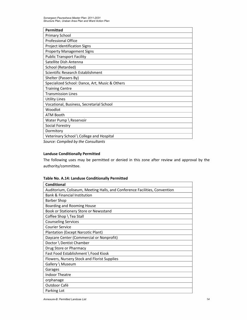
Sonargaon Paurashava Master Plan: 2011-2031 Structure Plan, Uraban Area Plan and Ward Action Plan
Annexure-B: Permitted Landuse List 14
Permitted
Primary School
Professional Office
Project Identification Signs
Property Management Signs
Public Transport Facility
Satellite Dish Antenna
School (Retarded)
Scientific Research Establishment
Shelter (Passers By)
Specialized School: Dance, Art, Music & Others
Training Centre
Transmission Lines
Utility Lines
Vocational, Business, Secretarial School
Woodlot
ATM Booth
Water Pump \ Reservoir
Social Forestry
Dormitory
Veterinary School \ College and Hospital
Source: Compiled by the Consultants
Landuse Conditionally Permitted
The following uses may be permitted or denied in this zone after review and approval by the
authority/committee.
Table No. A.14: Landuse Conditionally Permitted
Conditional
Auditorium, Coliseum, Meeting Halls, and Conference Facilities, Convention
Bank & Financial Institution
Barber Shop
Boarding and Rooming House
Book or Stationery Store or Newsstand
Coffee Shop \ Tea Stall
Counseling Services
Courier Service
Plantation (Except Narcotic Plant)
Daycare Center (Commercial or Nonprofit)
Doctor \ Dentist Chamber
Drug Store or Pharmacy
Fast Food Establishment \ Food Kiosk
Flowers, Nursery Stock and Florist Supplies
Gallery \ Museum
Garages
Indoor Theatre
orphanage
Outdoor Café
Parking Lot

Sonargaon Paurashava Master Plan: 2011-2031 Structure Plan, Uraban Area Plan and Ward Action Plan
Annexure-B: Permitted Landuse List 15
Conditional
Pipelines and Utility Lines
Postal Facilities
Psychiatric Hospital
Source: Compiled by the Consultants
Restricted Uses
All uses except permitted and conditionally permitted uses are restricted in this zone.
Administrative Zone
Landuse Permitted
The following uses in the tables are proposed to be applicable for this zone only.
Table No. A.15: Landuse Permitted
Permitted
Accounting, Auditing or Bookkeeping Services
Billboards, Advertisements & Advertising Structure
Confectionery Shop
Bus Passenger Shelter
Civic Administration
Communication Service Facilities
Communication Tower Within Permitted Height
Construction, Survey, Soil Testing Firms
Cultural Exhibits and Libraries
Cyber Café
Emergency Shelter
Freight Transport Facility
General Store
Project Office
Government Office
Grocery Store
Guest House
Multi-Storey Car Park
Newspaper Stand
Outdoor Religious Events
Photocopying and Duplicating Services
Post Office
Professional Office
Public Transport Facility
Satellite Dish Antenna
Scientific Research Establishment
Shelter (Passers By)
Training Centre
Transmission Lines
Utility Lines
Woodlot
ATM Booth
Water Pump \ Reservoir
Social Forestry

Sonargaon Paurashava Master Plan: 2011-2031 Structure Plan, Uraban Area Plan and Ward Action Plan
Annexure-B: Permitted Landuse List 16
Source: Compiled by the Consultants
Landuse Conditionally Permitted
The following uses may be permitted or denied in this zone after review and approval by the
authority/committee.
Table No. A.16: Landuse Conditionally Permitted
Conditional
Amusement and Recreation (Indoors)
Auditorium, Coliseum, Meeting Halls, and Conference Facilities, Convention
Bank & Financial Institution
Boarding and Rooming House
Book or Stationery Store or Newsstand
Coffee Shop \ Tea Stall
Conference Center
Courier Service
Plantation (Except Narcotic Plant)
Daycare Center (Commercial or Nonprofit)
Detention Facilities
Doctor \ Dentist Chamber
Energy Installation
Fast Food Establishment \ Food Kiosk
Flowers, Nursery Stock and Florist Supplies
Freight Handling, Storage & Distribution
Freight Yard
Gallery \ Museum
Garages
Police Box \ Barrack
Fire \ Rescue Station
Lithographic or Print Shop
Mosque, Place Of Worship
Outdoor Café
Parking Lot
Parking Lot (Commercial)
Pipelines and Utility Lines
Postal Facilities
Source: Compiled by the Consultants
Restricted Uses
All uses except permitted and conditionally permitted uses are restricted in this zone.
Agricultural Zone
Landuse Permitted
The following uses in the tables are proposed to be applicable for this zone only.
Table No. A.17: Landuse Permitted
Permitted
Food Grain Cultivation

Sonargaon Paurashava Master Plan: 2011-2031 Structure Plan, Uraban Area Plan and Ward Action Plan
Annexure-B: Permitted Landuse List 17
Permitted
Vegetable Cultivation
Cash Crop Cultivation
Horticulture
Arboriculture
Dairy Firming
Deep Tube Well
Shallow Tube Well
Irrigation Facilities (Irrigation Canal, Culvert, Flood Wall etc)
Temporary Structure (Agricultural)
Animal Shelter
Duckery
Aquatic Recreation Facility (Without Structure)
Tree Plantation (Except Narcotic Plant)
Aquaculture
Static Transformer Stations
Transmission Lines
Utility Lines
Woodlot
Social Forestry
Source: Compiled by the Consultants
Landuse Conditionally Permitted
Table No. A.18: Landuse Conditionally Permitted
Conditional
Graveyard \ Cemetery
Communication Tower Within Permitted Height
Crematorium
Fish Hatchery
Garden Center or Retail Nursery
Poultry
Source: Compiled by the Consultants
Restricted Uses
All uses except permitted and conditionally permitted uses are restricted in this zone.
Open Space
Landuse Permitted
The following uses in the tables are proposed to be applicable for this zone only.
Table No. A.19: Landuse Permitted
Permitted
Botanical Garden & Arboretum
Bus Passenger Shelter
Caravan Park \ Camping Ground
Carnivals and Fairs
Circus
Plantation (Except Narcotic Plant)
Landscape and Horticultural Services
Open Theater
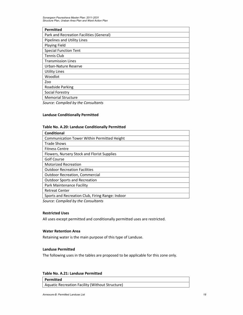
Sonargaon Paurashava Master Plan: 2011-2031 Structure Plan, Uraban Area Plan and Ward Action Plan
Annexure-B: Permitted Landuse List 18
Permitted
Park and Recreation Facilities (General)
Pipelines and Utility Lines
Playing Field
Special Function Tent
Tennis Club
Transmission Lines
Urban-Nature Reserve
Utility Lines
Woodlot
Zoo
Roadside Parking
Social Forestry
Memorial Structure
Source: Compiled by the Consultants
Landuse Conditionally Permitted
Table No. A.20: Landuse Conditionally Permitted
Conditional
Communication Tower Within Permitted Height
Trade Shows
Fitness Centre
Flowers, Nursery Stock and Florist Supplies
Golf Course
Motorized Recreation
Outdoor Recreation Facilities
Outdoor Recreation, Commercial
Outdoor Sports and Recreation
Park Maintenance Facility
Retreat Center
Sports and Recreation Club, Firing Range: Indoor
Source: Compiled by the Consultants
Restricted Uses
All uses except permitted and conditionally permitted uses are restricted.
Water Retention Area
Retaining water is the main purpose of this type of Landuse.
Landuse Permitted
The following uses in the tables are proposed to be applicable for this zone only.
Table No. A.21: Landuse Permitted
Permitted
Aquatic Recreation Facility (Without Structure)

Sonargaon Paurashava Master Plan: 2011-2031 Structure Plan, Uraban Area Plan and Ward Action Plan
Annexure-B: Permitted Landuse List 19
Permitted
Fishing Club
Utility Lines
Water Parks
Memorial Structure
Source: Compiled by the Consultants
Landuse Conditionally Permitted
The following uses may be permitted or denied in this zone after review and approval by the
authority/committee.
Table No. A.22: Landuse Conditionally Permitted
Conditional
Plantation (Except Narcotic Plant)
Marina \ Boating Facility
Motorized Recreation
Source: Compiled by the Consultants
Water body
Landuse Permitted
The following uses in the tables are proposed to be applicable for this zone only.
Table No. A.23: Landuse Permitted
Permitted
Aquatic Recreation Facility (Without Structure)
Fishing Club
Utility Lines
Water Parks
Memorial Structure
Source: Compiled by the Consultants
Landuse Conditionally Permitted
The following uses may be permitted or denied in this zone after review and approval by the
authority/committee.
Table No. A.24: Landuse Conditionally Permitted
Conditional
Plantation (Except Narcotic Plant)
Marina \ Boating Facility
Motorized Recreation
Source: Compiled by the Consultants
Restricted Uses
All uses except permitted and conditionally permitted uses are restricted.

Sonargaon Paurashava Master Plan: 2011-2031 Structure Plan, Uraban Area Plan and Ward Action Plan
Annexure-B: Permitted Landuse List 20

Sonargaon Paurashava Master Plan: 2011-2031 Structure Plan, Uraban Area Plan and Ward Action Plan
Annexure-C: Resolution of Final Consultation Meeting and Attendance List 1
ANNEXURE-C Resolution of Final Consultation Meeting and Attendance List.

Sonargaon Paurashava Master Plan: 2011-2031 Structure Plan, Uraban Area Plan and Ward Action Plan
Annexure-C: Resolution of Final Consultation Meeting and Attendance List 2

Sonargaon Paurashava Master Plan: 2011-2031 Structure Plan, Uraban Area Plan and Ward Action Plan
Annexure-D: Detailed of Road Network Proposal 1
ANNEXURE-D Detailed of Road Network Proposal
Road ID Width (ft.) Length Ward No Phase Type
RP01 200 547.15 Ward No. 03 3rd W
RP01 200 1960.32 Extension Area 01 3rd W
RS02 60 841.19 Ward No. 04 2nd W
RS02 60 1754.57 Ward No. 01 2nd W
RS02 60 146.02 Ward No. 05 2nd W
RS02 60 489.58 Ward No. 05 2nd N
RS03 60 405.23 Ward No. 05 2nd W
RS03 60 10.87 Ward No. 06 2nd W
RS03 60 977.51 Ward No. 08 2nd W
RS04 60 461.41 Ward No. 01 2nd N
RS04 60 94.51 Ward No. 02 2nd N
RS04 60 170.34 Ward No. 01 2nd W
RS05 60 446.65 Extension Area 01 3rd W
RS05 60 94.37 Extension Area 01 3rd W
RS05 60 269.71 Extension Area 01 3rd N
RS06 60 419.76 Ward No. 04 2nd W
RS06 60 293.16 Ward No. 01 2nd W
RS06 60 468.10 Ward No. 02 2nd W
RS06 60 128.22 Ward No. 03 2nd W
RS06 60 293.31 Ward No. 05 2nd W
RS06 60 132.81 Ward No. 06 2nd W
RS06 60 857.32 Ward No. 07 2nd W
RS06 60 123.56 Ward No. 07 2nd W
RS06 60 575.41 Extension Area 01 2nd W
RS06 60 326.37 Ward No. 07 2nd N
RS07 60 147.35 Ward No. 06 2nd N
RS07 60 194.10 Ward No. 07 2nd N
RS07 60 460.44 Ward No. 08 2nd N
RS07 60 277.97 Ward No. 07 2nd W
RS07 60 479.53 Ward No. 08 2nd W
RS08 60 461.61 Ward No. 02 2nd W
RS08 60 1233.03 Ward No. 03 2nd W
RS08 60 0.44 Ward No. 06 2nd W
RS09 60 1332.66 Ward No. 02 2nd N
RS09 60 0.35 Ward No. 05 2nd N
RS10 60 1115.27 Ward No. 02 2nd W
RS10 60 2.28 Ward No. 03 2nd W
RS10 60 242.76 Ward No. 01 1st N
RS10 60 406.15 Ward No. 02 1st N
RS11 40 354.49 Ward No. 04 1st W
RS12 40 640.66 Ward No. 07 1st W
RS13 40 539.97 Ward No. 03 1st W
RS13 40 396.01 Ward No. 07 1st W
RS13 40 202.41 Extension Area 01 1st W
RS14 40 1.35 Ward No. 06 3rd W
RS14 40 337.44 Ward No. 06 1st W
RS14 40 59.61 Ward No. 08 1st W
RS14 40 548.03 Ward No. 06 1st N
RS15 40 842.15 Ward No. 01 1st W
RS16 40 233.62 Ward No. 04 3rd W
RS17 40 249.86 Ward No. 06 1st N

Sonargaon Paurashava Master Plan: 2011-2031 Structure Plan, Uraban Area Plan and Ward Action Plan
Annexure-D: Detailed of Road Network Proposal 2
Road ID Width (ft.) Length Ward No Phase Type
RS17 40 324.59 Ward No. 08 1st N
RS18 40 316.98 Ward No. 05 2nd W
RS18 40 29.27 Ward No. 04 2nd N
RS18 40 56.84 Ward No. 05 2nd N
RS19 40 383.62 Ward No. 03 2nd N
RS20 40 204.15 Ward No. 03 3rd W
RS20 40 42.40 Extension Area 01 3rd W
RS21 40 391.88 Ward No. 04 2nd N
RS21 40 22.58 Ward No. 05 2nd N
RS22 40 14.73 Ward No. 04 3rd W
RS22 40 309.90 Ward No. 05 3rd W
RS23 40 591.57 Ward No. 05 1st N
RS23 40 537.52 Ward No. 05 1st W
RS24 40 224.11 Ward No. 08 2nd W
RS24 40 669.77 Ward No. 09 2nd W
RS25 40 306.16 Ward No. 07 2nd W
RS25 40 81.64 Extension Area 01 2nd W
RS25 40 822.72 Ward No. 08 2nd W
RS26 40 520.11 Ward No. 06 1st W
RS26 40 90.40 Ward No. 07 1st W
RS26 40 458.79 Ward No. 08 1st W
RS27 40 2.25 Ward No. 06 2nd W
RS27 40 150.40 Ward No. 08 2nd W
RS28 40 412.41 Ward No. 08 1st N
RS28 40 302.39 Ward No. 08 1st W
RS29 40 16.85 Ward No. 01 1st N
RS29 40 391.62 Ward No. 02 1st N
RS30 40 366.02 Extension Area 01 3rd W
RS31 40 476.19 Ward No. 04 3rd W
RS31 40 26.16 Ward No. 05 3rd W
RS32 40 509.91 Ward No. 05 1st W
RS33 40 669.15 Ward No. 04 2nd N
RS33 40 106.48 Ward No. 05 2nd N
RS33 40 353.20 Ward No. 04 3rd W
RS34 40 262.16 Ward No. 05 1st N
RS34 40 208.61 Ward No. 05 1st W
RS35 40 342.85 Ward No. 06 2nd N
RS36 40 429.41 Ward No. 05 2nd W
RS36 40 16.65 Ward No. 06 2nd W
RS37 40 381.70 Ward No. 01 1st N
RS38 40 58.00 Ward No. 04 1st N
RS38 40 583.11 Ward No. 01 1st N
RS39 40 750.16 Ward No. 01 1st N
RS39 40 43.93 Ward No. 02 1st N
RS40 40 77.41 Ward No. 07 2nd N
RS40 40 187.90 Ward No. 08 2nd N
RS41 40 178.82 Ward No. 03 1st N
RS41 40 221.17 Extension Area 01 1st N
RS41 40 0.02 Ward No. 03 1st N
RS41 40 0.02 Extension Area 01 1st N
RS42 40 242.73 Ward No. 03 1st W
RS42 40 560.07 Extension Area 01 1st W
RS42 40 1.65 Ward No. 03 1st W
RS42 40 1.65 Extension Area 01 1st W

Sonargaon Paurashava Master Plan: 2011-2031 Structure Plan, Uraban Area Plan and Ward Action Plan
Annexure-D: Detailed of Road Network Proposal 3
Road ID Width (ft.) Length Ward No Phase Type
RS43 40 261.54 Ward No. 07 1st N
RS43 40 327.93 Extension Area 01 1st N
RS44 40 50.47 Ward No. 08 3rd W
RL45 30 1009.16 Ward No. 02 3rd W
RL46 30 296.08 Ward No. 02 2nd W
RL47 30 538.84 Ward No. 09 3rd W
RL48 30 632.74 Ward No. 02 3rd W
RL49 30 66.50 Ward No. 02 2nd W
RL49 30 41.72 Ward No. 03 2nd W
RL50 30 338.53 Ward No. 03 1st N
RL50 30 2.36 Ward No. 07 1st N
RL50 30 98.91 Extension Area 01 1st N
RL50 30 247.88 Ward No. 07 1st W
RL50 30 0.12 Ward No. 03 1st N
RL50 30 0.12 Extension Area 01 1st N
RL51 30 263.18 Ward No. 07 2nd W
RL52 30 321.91 Ward No. 03 1st W
RL52 30 139.50 Ward No. 07 1st W
RL53 30 10.90 Ward No. 05 2nd W
RL53 30 94.21 Ward No. 08 2nd W
RL53 30 918.08 Ward No. 09 2nd W
RL54 30 431.19 Ward No. 01 3rd W
RL55 30 214.40 Ward No. 09 2nd N
RL55 30 112.58 Ward No. 08 3rd W
RL55 30 73.50 Ward No. 09 3rd W
RL56 30 258.93 Ward No. 08 2nd W
RL56 30 32.84 Ward No. 09 2nd W
RL58 30 254.39 Ward No. 02 2nd W
RL59 30 214.81 Ward No. 02 2nd N
RL60 30 244.34 Ward No. 03 2nd N
RL61 30 501.70 Ward No. 05 2nd W
RL62 30 268.03 Ward No. 05 2nd N
RL63 30 420.41 Ward No. 08 3rd W
RL64 30 416.00 Ward No. 06 2nd W
RL64 30 833.15 Ward No. 06 2nd N
RL65 30 945.01 Ward No. 03 3rd W
RL66 30 282.27 Ward No. 05 3rd W
RL67 30 7.60 Ward No. 04 2nd N
RL67 30 267.08 Ward No. 05 2nd N
RL68 30 135.16 Ward No. 08 3rd W
RL69 30 7.57 Ward No. 06 3rd W
RL69 30 223.02 Ward No. 08 3rd W
RL70 30 271.94 Ward No. 07 2nd N
RL71 30 316.09 Ward No. 09 2nd N
RL71 30 91.20 Ward No. 09 3rd W
RL72 30 282.99 Ward No. 08 2nd W
RL72 30 167.01 Ward No. 08 2nd W
RL73 30 107.20 Ward No. 08 2nd W
RL74 30 167.17 Ward No. 09 3rd W
RL75 30 240.99 Ward No. 09 3rd W
RL76 30 96.21 Ward No. 08 3rd W
RL77 30 449.48 Ward No. 04 2nd N
RL78 30 121.28 Extension Area 01 3rd W
RL78 30 107.03 Extension Area 01 3rd W

Sonargaon Paurashava Master Plan: 2011-2031 Structure Plan, Uraban Area Plan and Ward Action Plan
Annexure-D: Detailed of Road Network Proposal 4
Road ID Width (ft.) Length Ward No Phase Type
RL79 30 127.86 Extension Area 01 3rd W
RL80 30 135.53 Extension Area 01 3rd W
RL81 30 291.60 Extension Area 01 3rd W
RL82 30 207.42 Extension Area 01 3rd W
RL82 30 149.07 Extension Area 01 3rd W
RL83 30 219.41 Extension Area 01 3rd W
RL84 30 242.30 Extension Area 01 3rd W
RL85 30 679.53 Ward No. 01 2nd W
RL86 30 494.04 Ward No. 01 3rd W
RL87 30 489.35 Ward No. 01 3rd W
RL88 30 120.14 Ward No. 08 3rd W
RL88 30 15.78 Ward No. 09 3rd W
RL89 30 324.35 Ward No. 08 2nd W
RL89 30 133.09 Ward No. 09 2nd W
RL90 30 228.18 Ward No. 05 3rd W
RL91 30 310.94 Ward No. 08 2nd N
RL92 30 275.72 Extension Area 01 3rd W
RL93 30 170.51 Extension Area 01 3rd W
RL94 30 245.21 Extension Area 01 3rd W
RL95 30 236.09 Extension Area 01 1st N
RL96 30 335.29 Extension Area 01 1st N
RL96 30 197.68 Extension Area 01 1st W
RL97 30 0.21 Ward No. 02 1st W
RL97 30 182.44 Ward No. 03 1st W
RL98 30 267.31 Ward No. 02 3rd W
RL99 30 270.93 Ward No. 02 2nd W
RL100 30 357.58 Ward No. 02 2nd N
RL101 30 244.45 Ward No. 01 3rd W
RL101 30 36.08 Ward No. 02 3rd W
RL102 30 81.93 Ward No. 02 2nd W
RL103 30 221.20 Ward No. 02 2nd W
RL104 30 183.91 Ward No. 02 3rd W
RL104 30 428.36 Ward No. 03 3rd W
RL105 30 224.73 Ward No. 06 2nd W
RL106 30 2.82 Ward No. 02 1st W
RL106 30 757.15 Ward No. 05 1st W
RA107 20 327.21 Ward No. 03 1st W
RA108 20 395.41 Ward No. 05 1st W
RA109 20 834.31 Ward No. 01 1st W
RA109 20 27.11 Ward No. 02 1st W
RA109 20 21.94 Ward No. 05 1st W
RA110 20 136.45 Ward No. 03 2nd W
RA111 20 449.91 Ward No. 04 1st W
RA112 20 100.82 Ward No. 08 2nd W
RA113 20 132.57 Ward No. 08 1st W
RA113 20 59.51 Ward No. 09 1st W
RA114 20 51.03 Ward No. 08 1st W
RA114 20 129.87 Ward No. 09 1st W
RA114 20 146.61 Ward No. 09 1st N
RA115 20 230.20 Ward No. 03 2nd W
RA116 20 80.75 Ward No. 05 2nd W
RA117 20 262.22 Ward No. 05 1st N
RA117 20 164.06 Ward No. 05 1st W
RA117 20 37.95 Ward No. 05 1st W

Sonargaon Paurashava Master Plan: 2011-2031 Structure Plan, Uraban Area Plan and Ward Action Plan
Annexure-D: Detailed of Road Network Proposal 5
Road ID Width (ft.) Length Ward No Phase Type
RA118 20 312.00 Ward No. 07 1st W
RA118 20 8.26 Ward No. 08 1st W
RA119 20 318.21 Ward No. 04 1st W
RA120 20 291.66 Ward No. 04 1st W
RA121 20 3.62 Ward No. 01 1st W
RA121 20 73.39 Ward No. 05 1st W
RA122 20 66.11 Ward No. 08 1st W
RA123 20 224.73 Ward No. 08 1st W
RA125 20 54.88 Ward No. 08 1st W
RA126 20 353.16 Ward No. 09 2nd W
RA127 20 94.90 Ward No. 08 2nd W
RA128 20 85.06 Ward No. 08 2nd W
RA129 20 78.42 Ward No. 08 2nd W
RA130 20 53.92 Ward No. 08 2nd W
RA131 20 75.45 Ward No. 07 2nd W
RA132 20 131.59 Ward No. 07 2nd W
RA133 20 304.87 Ward No. 02 1st W
RA134 20 23.43 Ward No. 02 2nd W
RA135 20 147.64 Ward No. 02 1st W
RA136 20 27.88 Ward No. 02 2nd W
RA137 20 56.88 Ward No. 02 1st W
RA138 20 70.41 Ward No. 02 1st W
RA139 20 181.57 Ward No. 02 2nd W
RA140 20 285.77 Ward No. 03 1st W
RA141 20 88.66 Ward No. 03 1st W
RA141 20 103.18 Ward No. 07 1st W
RA141 20 115.62 Ward No. 03 1st W
RA142 20 248.84 Ward No. 02 1st N
RA143 20 181.51 Ward No. 09 1st W
RA144 20 120.92 Ward No. 08 1st W
RA145 20 247.20 Ward No. 01 1st W
RA146 20 259.78 Ward No. 01 1st W
RA147 20 365.19 Ward No. 04 1st W
RA148 20 316.14 Ward No. 01 1st W
RA149 20 222.35 Ward No. 02 2nd W
RA150 20 10.43 Ward No. 08 1st W
RA150 20 156.12 Ward No. 09 1st W
RA151 20 296.07 Ward No. 09 1st W
RA152 20 440.18 Ward No. 07 2nd W
RA153 20 217.40 Ward No. 03 1st W
RA154 20 59.49 Ward No. 03 1st W
RA155 20 116.12 Ward No. 05 2nd W
RA156 20 14.29 Ward No. 04 1st N
RA156 20 311.01 Ward No. 05 1st N
RA157 20 141.00 Ward No. 04 2nd W
RA158 20 53.93 Ward No. 04 2nd W
RA159 20 235.33 Ward No. 05 1st W
RA160 20 183.64 Ward No. 05 1st W
RA161 20 38.81 Ward No. 05 1st W
RA161 20 166.28 Ward No. 06 1st W
RA162 20 432.34 Ward No. 07 1st W
RA162 20 74.26 Ward No. 08 1st W
RA163 20 102.79 Ward No. 08 1st W
RA164 20 65.35 Ward No. 08 1st W

Sonargaon Paurashava Master Plan: 2011-2031 Structure Plan, Uraban Area Plan and Ward Action Plan
Annexure-D: Detailed of Road Network Proposal 6
Road ID Width (ft.) Length Ward No Phase Type
RA165 20 161.87 Ward No. 08 1st W
RA166 20 349.53 Ward No. 08 1st W
RA167 20 58.39 Ward No. 07 1st W
RA167 20 118.83 Ward No. 08 1st W
RA168 20 100.52 Ward No. 08 1st W
RA169 20 93.53 Ward No. 08 1st W
RA170 20 292.68 Ward No. 08 1st W
RA171 20 71.01 Ward No. 08 1st W
RA172 20 189.09 Ward No. 08 1st W
RA173 20 76.34 Ward No. 08 1st W
RA174 20 162.59 Ward No. 08 1st W
RA175 20 61.45 Ward No. 08 1st W
RA176 20 678.26 Ward No. 08 1st W
RA177 20 234.49 Ward No. 07 1st W
RA178 20 421.31 Ward No. 07 1st W
RA179 20 104.38 Ward No. 07 2nd W
RA180 20 245.35 Ward No. 03 1st W
RA180 20 102.54 Ward No. 03 1st W
RA181 20 325.46 Ward No. 01 1st W
RA182 20 406.22 Ward No. 01 1st W
RA183 20 19.71 Ward No. 02 1st W
RA184 12 679.42 Ward No. 05 1st W
Total length =78138.15 meter(78.14 km)
*Note: W= widening, N= New Road

Sonargaon Paurashava Master Plan: 2011-2031 Structure Plan, Uraban Area Plan and Ward Action Plan
Annexure-E: Detailed of Drainage Network Proposal 1
ANNEXURE-E Detailed of Drainage Network Proposal
ID Type Length Ward No Phase
DP01 Primary 547.15 Ward No. 03 3rd
DP01 Primary 1,862.82 Extension Area 01 3rd
DS02 Secondary 841.19 Ward No. 04 2nd
DS02 Secondary 1,754.57 Ward No. 01 2nd
DS03 Secondary 405.23 Ward No. 05 2nd
DS03 Secondary 10.87 Ward No. 06 2nd
DS03 Secondary 977.51 Ward No. 08 2nd
DS04 Secondary 631.76 Ward No. 01 2nd
DS04 Secondary 73.33 Ward No. 02 2nd
DS05 Secondary 810.72 Extension Area 01 3rd
DP06 Primary 419.76 Ward No. 04 2nd
DP06 Primary 293.16 Ward No. 01 2nd
DP06 Primary 468.10 Ward No. 02 2nd
DP06 Primary 128.22 Ward No. 03 2nd
DP06 Primary 293.31 Ward No. 05 2nd
DP06 Primary 132.81 Ward No. 06 2nd
DP06 Primary 1,307.25 Ward No. 07 2nd
DP06 Primary 575.41 Extension Area 01 2nd
DS07 Secondary 147.35 Ward No. 06 2nd
DS07 Secondary 472.06 Ward No. 07 2nd
DS07 Secondary 939.97 Ward No. 08 2nd
DS08 Secondary 461.61 Ward No. 02 2nd
DS08 Secondary 1,233.03 Ward No. 03 2nd
DS08 Secondary 0.44 Ward No. 06 2nd
DS09 Secondary 1,332.66 Ward No. 02 2nd
DS09 Secondary 0.35 Ward No. 05 2nd
DS10 Secondary 242.76 Ward No. 01 2nd
DS10 Secondary 1,521.43 Ward No. 02 2nd
DS10 Secondary 2.28 Ward No. 03 2nd
DS11 Secondary 354.49 Ward No. 04 1st
DS12 Secondary 640.66 Ward No. 07 1st
DS13 Secondary 539.97 Ward No. 03 1st
DS13 Secondary 396.01 Ward No. 07 1st
DS13 Secondary 202.41 Extension Area 01 1st
DS14 Secondary 886.82 Ward No. 06 1st
DS14 Secondary 59.61 Ward No. 08 1st
DS15 Secondary 842.15 Ward No. 01 1st
DT16 Tertiary 233.62 Ward No. 04 3rd
DS17 Secondary 249.86 Ward No. 06 1st
DS17 Secondary 324.59 Ward No. 08 1st
DS18 Secondary 348.31 Ward No. 05 2nd
DS18 Secondary 29.27 Ward No. 04 2nd
DS18 Secondary 0.05 Ward No. 05 2nd
DS19 Secondary 383.62 Ward No. 03 2nd
DS21 Secondary 391.62 Ward No. 04 2nd
DS22 Secondary 14.73 Ward No. 04 3rd
DS22 Secondary 309.90 Ward No. 05 3rd
DT23 Tertiary 1,129.10 Ward No. 05 1st
DS24 Secondary 224.11 Ward No. 08 2nd
DS24 Secondary 669.77 Ward No. 09 2nd
DS25 Secondary 306.16 Ward No. 07 2nd

Sonargaon Paurashava Master Plan: 2011-2031 Structure Plan, Uraban Area Plan and Ward Action Plan
Annexure-E: Detailed of Drainage Network Proposal 2
ID Type Length Ward No Phase
DS25 Secondary 81.64 Extension Area 01 2nd
DS25 Secondary 822.72 Ward No. 08 2nd
DS26 Secondary 520.11 Ward No. 06 1st
DS26 Secondary 90.40 Ward No. 07 1st
DS26 Secondary 458.79 Ward No. 08 1st
DT27 Tertiary 2.25 Ward No. 06 2nd
DT27 Tertiary 150.40 Ward No. 08 2nd
DS28 Secondary 714.80 Ward No. 08 1st
DS29 Secondary 16.85 Ward No. 01 1st
DS29 Secondary 391.62 Ward No. 02 1st
DS30 Secondary 327.70 Extension Area 01 3rd
DS31 Secondary 476.19 Ward No. 04 3rd
DS31 Secondary 2.91 Ward No. 05 3rd
DS32 Secondary 509.91 Ward No. 05 1st
DS33 Secondary 1,022.35 Ward No. 04 3rd
DS33 Secondary 106.48 Ward No. 05 3rd
DS34 Secondary 470.77 Ward No. 05 1st
DT35 Tertiary 342.85 Ward No. 06 2nd
DS36 Secondary 429.41 Ward No. 05 2nd
DS36 Secondary 16.65 Ward No. 06 2nd
DS37 Secondary 380.00 Ward No. 01 1st
DS38 Secondary 58.00 Ward No. 04 1st
DS38 Secondary 584.81 Ward No. 01 1st
DT39 Tertiary 750.16 Ward No. 01 1st
DT39 Tertiary 43.93 Ward No. 02 1st
DS40 Secondary 77.41 Ward No. 07 2nd
DS40 Secondary 187.90 Ward No. 08 2nd
DS41 Secondary 178.82 Ward No. 03 1st
DS41 Secondary 223.06 Extension Area 01 1st
DS41 Secondary 0.02 Ward No. 03 1st
DS41 Secondary 0.02 Extension Area 01 1st
DS42 Secondary 242.73 Ward No. 03 1st
DS42 Secondary 558.19 Extension Area 01 1st
DS42 Secondary 1.65 Ward No. 03 1st
DS42 Secondary 1.65 Extension Area 01 1st
DS43 Secondary 261.54 Ward No. 07 1st
DS43 Secondary 327.93 Extension Area 01 1st
DT44 Tertiary 50.47 Ward No. 08 3rd
DT45 Tertiary 1,009.16 Ward No. 02 3rd
DT46 Tertiary 296.08 Ward No. 02 2nd
DT47 Tertiary 538.84 Ward No. 09 3rd
DT48 Tertiary 632.74 Ward No. 02 3rd
DT49 Tertiary 66.50 Ward No. 02 2nd
DT49 Tertiary 41.72 Ward No. 03 2nd
DT50 Tertiary 338.65 Ward No. 03 1st
DT50 Tertiary 250.24 Ward No. 07 1st
DT50 Tertiary 99.03 Extension Area 01 1st
DT51 Tertiary 263.18 Ward No. 07 2nd
DT52 Tertiary 321.91 Ward No. 03 1st
DT52 Tertiary 139.50 Ward No. 07 1st
DT53 Tertiary 10.90 Ward No. 05 2nd
DT53 Tertiary 94.21 Ward No. 08 2nd
DT53 Tertiary 918.08 Ward No. 09 2nd
DT54 Tertiary 431.19 Ward No. 01 3rd

Sonargaon Paurashava Master Plan: 2011-2031 Structure Plan, Uraban Area Plan and Ward Action Plan
Annexure-E: Detailed of Drainage Network Proposal 3
ID Type Length Ward No Phase
DT55 Tertiary 112.58 Ward No. 08 3rd
DT55 Tertiary 287.89 Ward No. 09 3rd
DT56 Tertiary 258.93 Ward No. 08 2nd
DT56 Tertiary 32.84 Ward No. 09 2nd
DT58 Tertiary 254.39 Ward No. 02 2nd
DT59 Tertiary 214.81 Ward No. 02 2nd
DT60 Tertiary 244.34 Ward No. 03 2nd
DT61 Tertiary 501.70 Ward No. 05 2nd
DT62 Tertiary 268.03 Ward No. 05 2nd
DT63 Tertiary 420.41 Ward No. 08 3rd
DT64 Tertiary 833.69 Ward No. 06 2nd
DT64 Tertiary 415.46 Ward No. 06 2nd
DT65 Tertiary 945.01 Ward No. 03 3rd
DT67 Tertiary 7.60 Ward No. 04 2nd
DT67 Tertiary 267.08 Ward No. 05 2nd
DT68 Tertiary 135.16 Ward No. 08 3rd
DT69 Tertiary 7.57 Ward No. 06 3rd
DT69 Tertiary 223.02 Ward No. 08 3rd
DT70 Tertiary 271.94 Ward No. 07 2nd
DT71 Tertiary 407.29 Ward No. 09 3rd
DT72 Tertiary 450.00 Ward No. 08 2nd
DT73 Tertiary 107.20 Ward No. 08 2nd
DT74 Tertiary 167.17 Ward No. 09 3rd
DT75 Tertiary 240.99 Ward No. 09 3rd
DT76 Tertiary 96.21 Ward No. 08 3rd
DT77 Tertiary 449.48 Ward No. 04 2nd
DT78 Tertiary 228.32 Extension Area 01 3rd
DT79 Tertiary 127.86 Extension Area 01 3rd
DT81 Tertiary 291.60 Extension Area 01 3rd
DT82 Tertiary 356.49 Extension Area 01 3rd
DT83 Tertiary 219.41 Extension Area 01 3rd
DT84 Tertiary 242.30 Extension Area 01 3rd
DT85 Tertiary 677.96 Ward No. 01 2nd
DT86 Tertiary 984.96 Ward No. 01 3rd
DT88 Tertiary 120.14 Ward No. 08 3rd
DT88 Tertiary 112.00 Ward No. 09 3rd
DT89 Tertiary 324.35 Ward No. 08 2nd
DT89 Tertiary 36.88 Ward No. 09 2nd
DT90 Tertiary 228.18 Ward No. 05 3rd
DT91 Tertiary 310.94 Ward No. 08 2nd
DT92 Tertiary 274.32 Extension Area 01 3rd
DT93 Tertiary 171.92 Extension Area 01 3rd
DT94 Tertiary 245.21 Extension Area 01 3rd
DT95 Tertiary 236.90 Extension Area 01 1st
DT96 Tertiary 532.15 Extension Area 01 1st
DT97 Tertiary 0.21 Ward No. 02 1st
DT97 Tertiary 182.44 Ward No. 03 1st
DT98 Tertiary 267.31 Ward No. 02 3rd
DT99 Tertiary 270.93 Ward No. 02 2nd
DT100 Tertiary 357.58 Ward No. 02 2nd
DT101 Tertiary 244.45 Ward No. 01 3rd
DT101 Tertiary 118.01 Ward No. 02 3rd
DT103 Tertiary 221.20 Ward No. 02 2nd
DT104 Tertiary 183.91 Ward No. 02 3rd
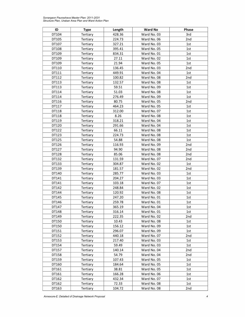
Sonargaon Paurashava Master Plan: 2011-2031 Structure Plan, Uraban Area Plan and Ward Action Plan
Annexure-E: Detailed of Drainage Network Proposal 4
ID Type Length Ward No Phase
DT104 Tertiary 428.36 Ward No. 03 3rd
DT105 Tertiary 224.73 Ward No. 06 2nd
DT107 Tertiary 327.21 Ward No. 03 1st
DT108 Tertiary 395.41 Ward No. 05 1st
DT109 Tertiary 834.31 Ward No. 01 1st
DT109 Tertiary 27.11 Ward No. 02 1st
DT109 Tertiary 21.94 Ward No. 05 1st
DT110 Tertiary 136.45 Ward No. 03 2nd
DT111 Tertiary 449.91 Ward No. 04 1st
DT112 Tertiary 100.82 Ward No. 08 2nd
DT113 Tertiary 132.57 Ward No. 08 1st
DT113 Tertiary 59.51 Ward No. 09 1st
DT114 Tertiary 51.03 Ward No. 08 1st
DT114 Tertiary 276.49 Ward No. 09 1st
DT116 Tertiary 80.75 Ward No. 05 2nd
DT117 Tertiary 464.23 Ward No. 05 1st
DT118 Tertiary 312.00 Ward No. 07 1st
DT118 Tertiary 8.26 Ward No. 08 1st
DT119 Tertiary 318.21 Ward No. 04 1st
DT120 Tertiary 291.66 Ward No. 04 1st
DT122 Tertiary 66.11 Ward No. 08 1st
DT123 Tertiary 224.73 Ward No. 08 1st
DT125 Tertiary 54.88 Ward No. 08 1st
DT126 Tertiary 116.93 Ward No. 09 2nd
DT127 Tertiary 94.90 Ward No. 08 2nd
DT128 Tertiary 85.06 Ward No. 08 2nd
DT132 Tertiary 131.59 Ward No. 07 2nd
DT133 Tertiary 304.87 Ward No. 02 1st
DT139 Tertiary 181.57 Ward No. 02 2nd
DT140 Tertiary 285.77 Ward No. 03 1st
DT141 Tertiary 204.27 Ward No. 03 1st
DT141 Tertiary 103.18 Ward No. 07 1st
DT142 Tertiary 248.84 Ward No. 02 1st
DT144 Tertiary 120.92 Ward No. 08 1st
DT145 Tertiary 247.20 Ward No. 01 1st
DT146 Tertiary 259.78 Ward No. 01 1st
DT147 Tertiary 365.19 Ward No. 04 1st
DT148 Tertiary 316.14 Ward No. 01 1st
DT149 Tertiary 222.35 Ward No. 02 2nd
DT150 Tertiary 10.43 Ward No. 08 1st
DT150 Tertiary 156.12 Ward No. 09 1st
DT151 Tertiary 296.07 Ward No. 09 1st
DT152 Tertiary 440.18 Ward No. 07 2nd
DT153 Tertiary 217.40 Ward No. 03 1st
DT154 Tertiary 59.49 Ward No. 03 1st
DT157 Tertiary 140.14 Ward No. 04 2nd
DT158 Tertiary 54.79 Ward No. 04 2nd
DT159 Tertiary 107.43 Ward No. 05 1st
DT160 Tertiary 184.64 Ward No. 05 1st
DT161 Tertiary 38.81 Ward No. 05 1st
DT161 Tertiary 166.28 Ward No. 06 1st
DT162 Tertiary 432.34 Ward No. 07 1st
DT162 Tertiary 72.33 Ward No. 08 1st
DT163 Tertiary 104.72 Ward No. 08 2nd

Sonargaon Paurashava Master Plan: 2011-2031 Structure Plan, Uraban Area Plan and Ward Action Plan
Annexure-E: Detailed of Drainage Network Proposal 5
ID Type Length Ward No Phase
DT165 Tertiary 162.63 Ward No. 08 2nd
DT166 Tertiary 348.77 Ward No. 08 1st
DT167 Tertiary 58.39 Ward No. 07 1st
DT167 Tertiary 119.46 Ward No. 08 1st
DT168 Tertiary 99.89 Ward No. 08 2nd
DT169 Tertiary 92.95 Ward No. 08 1st
DT170 Tertiary 293.26 Ward No. 08 1st
DT171 Tertiary 71.01 Ward No. 08 1st
DT172 Tertiary 189.08 Ward No. 08 1st
DT173 Tertiary 75.70 Ward No. 08 1st
DT174 Tertiary 163.23 Ward No. 08 1st
DT176 Tertiary 678.26 Ward No. 08 1st
DT177 Tertiary 235.53 Ward No. 07 1st
DT178 Tertiary 420.27 Ward No. 07 1st
DT179 Tertiary 104.38 Ward No. 07 2nd
DT180 Tertiary 347.89 Ward No. 03 1st
DT182 Tertiary 731.68 Ward No. 01 1st
DT184 Tertiary 679.42 Ward No. 05 1st
Total Length 73,875.89 meter = 73.87 Km

Sonargaon Paurashava Master Plan: 2011-2031 Structure Plan, Uraban Area Plan and Ward Action Plan
Annexure-E: Detailed of Drainage Network Proposal 6

Sonargaon Paurashava Master Plan: 2011-2031 Structure Plan, Uraban Area Plan and Ward Action Plan
Annexure-F: Mouza Schedule of Development Proposals 1
ANNEXURE-F Mouza Schedule of Development Proposals
Proposed Facilities Ward Name CS Mouza Name
Plot No. Area in Acre
Residential
Low Income Houseing Area Ward No. 01 Choto Maghbazar
3-46, 139 34.998
Goaldi 43 part, 44-48, 59 part, 54, 59
Re-Settlement Residential Zone
Ward No. 01 Darpat Thotalia 87-102, 104-119, 356-387, 737, 745-747
16.767
Sweeper Colony Ward No. 06 Baghmahisha 260-262, 263 part 1.117
Planned Residential Area-1 Ward No. 05 Sollapara 186-192, 193 part, 194-196, 197 part, 201-202, 205-239, 240 part, 241-246
21.144
Planned Residential Area-2 Ward No. 04 Balia Dighirpur 188-230, 234-241, 246, 334-364, 368-369, 371-372
28.043
Planned Residential Area-3 Ward No. 03 Tipurdi 86-102, 103 part, 108, 111 part, 112-115, 122-123, 161-208, 209-211 part, 212, 213 part, 309-310, 313 part
16.672
Commercial
Wholesale Market Extension Area 01
Choto Sadipur 66-77, 81-82, 85-90, 110 part, 111-113
5.640
Poura Supper Market Ward No. 05 Aminpur 83-84 0.565
Poura Market & Community Center
Ward No. 01 Aminpur 145 0.423
Sonargaon Poura Market Ward No. 05 Aminpur 269,271 part 0.199
Poura Market Ward No. 03 Choto Silmandi 93-94 1.007
Padmalabhdi 34 part, 38 part, 40-41
Padmalabhdi 34 part, 38 part, 40-41
Industrial
General Industrial Zone Extension Area 01
Ratandi 90-125, 140-141, 143-156, 158-168, 172-183, 189-234
31.617
Choto Bandara 19-21
Choto Sadipur 1 part, 2, 11-13, 19-22, 27-29, 37-43
Heavy Industrial Zone Ward No. 03 Mallikerpara 35-36, 43, 45-76 30.130 Chhata Silmandi 106-161
Extension Area 01
Ratandi 1, 3-86 38.318 Choto Bandara 1-18
Government Office
Administration Area Ward No. 07 Ichapur 202-204, 206-209, 212-213, 288-295
3.508
Ward No. 08 Chowdona 202-206 part, 207-209, 212-213
3.130
Paurashava Office Ward No. 05 Aminpur 234 0.400

Sonargaon Paurashava Master Plan: 2011-2031 Structure Plan, Uraban Area Plan and Ward Action Plan
Annexure-F: Mouza Schedule of Development Proposals 2
Sonargaon Poura Auditorium Ward No. 05 Aminpur 239,141-142 0.439
Educational Institution
Primary School Extension Area 01
Bandara 84, 85 part, 89-92 1.529
High School Ward No. 02 Goaldi 361-362 part, 363, 365 part
0.508
College-1 Ward No. 04 Raishdia 263-264, 269-273, 280-297, 313-327
11.111
College-2 Ward No. 01 Darpat Thotalia 335-348, 350-352, 388-405
4.861
University College Ward No. 01 Darpat Thotalia 177-195, 200-241, 243, 245-256, 280, 283, 296-327
26.966
Vocational Training Institution Ward No. 04 Aminpur 7, 8, 9, 10, 11 3.227 10.480 Ward No. 05 Raishdia 142-144, 154-166, 170-
171, 261-262, 298-307, 311-312
Open Spaces
Central Park Cum Stadium Ward No. 02 Aminpur 4-5, 40, 43-44, 66-73, 110
5.632
Goaldi 516-517
Sonargaon Poura Park Ward No. 05 Aminpur 243, 259 1.085
Community Park Ward No. 01 Choto Maghbazar
143, 145-147 part, 148-149
1.300
Inter city Bus Terminal
Ward No. 03 Choto Silmandi 92, 97-98, 99 part 2.757
Padmalabhdi 24-27, 34-37, 38 part
Poura Bus Terminal
Ward No. 05 Aminpur 324 part, 328-330, 334-335
1.519
Track Terminal & Loading& Unloading
Ward No. 03 Mallikerpara 9 part, 10-15, 16 part 4.016
Choto Silmandi 69-83
Tempo Stand Ward No. 01 Raishdia 89-90 part, 91-93 1.226
Recreational Facilities
Sonargaon Poura Tourist Complex
Ward No. 05 Aminpur 286, 292-293, 323-295-298, 300-306, 323-324 part, 325, 326 part, 334-335 part, 337-340, 342
4.185
Utility Facilities
Dumping Site-1 Ward No. 01 Garibardi 85-87, 88 part, 90 part, 91-96, 113-117, 121-122 part
3.951
Dumping Site-2 Ward No. 05 Sollapara 266-267, 271 1.657
Waste Transfer Station Ward No. 06 Baghmahisha 259, 263 part, 264 part 0.297
Public Toilet-1 Ward No. 06 Baghmahisha 264 part 0.101
Public Toilet-2 Ward No. 03 Tipurdi 148 part 0.273
Water Pump House & Ward Community Clinic-1
Ward No. 06 Baghmahisha 83 0.382
Water Pump House & Ward Community Clinic-2
Ward No. 01 Raishdia 69 0.141
Water Pump House-3 Ward No. 05 Aminpur 272 part, 273, 274 part 0.227
Water Pump House-4 Ward No. 02 Goaldi 543 0.065
Slaughter House Ward No. 08 Chowdona 522 part 0.093
Sahapur 21 part
Health Service
Health Center Ward No. 03 Tipurdi 124-126, 154-160, 209-213 part, 214-225, 254-259, 305, 305-306 part
10.090
Community Facilities
Cremation Ward No. 08 Chowdona 501-502 0.189
Poura Eidgah Ward No. 06 Baghmahisha 79 part 1.910

Sonargaon Paurashava Master Plan: 2011-2031 Structure Plan, Uraban Area Plan and Ward Action Plan
Annexure-F: Mouza Schedule of Development Proposals 3
Poura Graveyard Ward No. 06 Baghmahisha 79 part 1.183
Fire Station Ward No. 03 Choto Silmandi 99-100 Part, 101 0.207
Ward Community Clinic Ward No. 02 Goaldi 546 0.267
Ward Center 01 Raishdia 95 part 0.220
02 Goaldi 478 part 0.200
03 Goaldi 677 part 0.057
04 Balia Dighirpur 137 part 0.049
05 Aminpur 324 part, 328 part 0.186
06 Baghmahisha 267 part 0.285
07 Ichapur 330 part 0.204
08 Chowdona 362 part 0.065
09 Sahapur 231 part 0.058

Sonargaon Paurashava Master Plan: 2011-2031 Structure Plan, Uraban Area Plan and Ward Action Plan
Annexure-F: Mouza Schedule of Development Proposals 4

Sonargaon Paurashava Master Plan: 2011-2031 Structure Plan, Uraban Area Plan and Ward Action Plan
Annexure-G: Mouza Schedule of Water Retention Pond 1
ANNEXURE-G Mouza Schedule of Proposed Water Retention Pond
Ward No CS Mouza Name Plot No. Area in Acres
Ward No. 01 Arjundi_154_00 113, 1, 152, 1, 8, 10, 101, 106, 107, 111, 113, 12, 121, 127, 13-15, 57, 133,1, 152 ,1, 8, 10, 101, 106, 107, 111, 113, 12, 121, 127, 13-15, 57 , 133, 138, 140, 20, 22, 25, 26, 27, 3, 31, 4-5, 9, 16 , 46, 53-54, 56, 60, 94
16.864
Choto Maghbazar_153_00 76, 105, 114, 125, 126, 165, 54, 56, 60, 71 6.492
Darpat Thotalia_152_00 174, 176, 127, 140-142, 135, 265, 147-149, 242, 261, 274-278, 265, 286, 291, 292, 352, 425, 427, 440, 449, 496-498, 499-500, 534, 535, 536, 591, 613-614, 653, 660, 734, 750
13.244
Garibardi_146_00 123-124, 1, 102, 102, 120, 120, 137, 9 2.664
Raishdia_155_00 14, 22-23, 35, 33, 65, 67 3.946
Ward No. 02 Adampur_160_00 7,1, 39, 82,40,429,76,8 3.455
Arjundi_154_00 147-148 0.092
Bagh Nazirpur_167_00 40,37,37, 39 0.955
Goaldi_166_00 7, 109, 110-111, 115, 123, 123, 125-126, 128, 150, 139-140, 14-16, 144, 154, 159-160, 165, 186, 169, 186, 203, 21, 217-218, 220, 231-232, 233, 234, 297-298, 306, 322, 329, 337, 35-36, 359, 365, 379, 391, 393, 374-375, 395, 398-399, 402, 403, 414, 423-424, 433, 442-444, 469, 47, 495, 536, 540, 542, 541, 545, 564-657, 595, 598, 609, 609, 621-623, 641, 644, 672, 70, 93, 419
28.182
Ward No. 03 Adampur_160_00 21, 31, 17, 25, 30, 27, 32, 686 2.351
Choto Silmandi_211_00 47, 105, 122, 57 3.196
Goaldi_166_00 662, 621-626, 541, 544, 643, 658, 668-669, 669, 674, 677, 680-681, 684, 684
3.973
Ichapar_165_00 31, 111-112, 116, 118, 22, 23-25, 28, 63, 29, 31, 32, 32, 36, 39-41, 38, 43-45, 5
6.930
Mallikerpara_176_00 34, 1, 29, 28, 77, 37 4.123
Padmalabhdi_175_00 8, 11-12, 1, 27-28, 30, 29, 29, 31 1.441
Tipurdi_174_00 331-332, 119-120, 122-123, 127, 417-418, 397, 393, 13, 13, 105, 175, 13, 29, 149-150, 152,197, 200, 202-203, 258, 313,234, 282, 236, 243, 244, 260-261, 302, 269-270, 277, 280-281, 287-291, 282, 301, 320-321, 337, 386-388, 408, 410, 413, 413, 429, 50-51, 130-135
12.949
Ward No. 04 Balia Dighirpar_157_00 365-367, 370, 374,1,2,115-121, 44, 161, 206, 220, 220, 255-256, 267-269, 287, 318, 359, 423-424, 461, 66, 69, 86, 179, 184
9.725
Raishdia_155_00 223, 230, 231, 236, 109, 118, 136, 138, 177, 150, 190, 241, 208, 218, 226, 214-216, 219, 224-225, 245, 255-257
5.661
Sollapara_162_00 108 0.010
Ward No. 05 Aminpur_158_00 226, 102-105, 107, 111, 321, 322, 12,1-2, 121, 137, 146, 151, 183-185, 212, 226, 227, 230, 228, 253, 264, 294, 294, 341, 351, 37, 113-115, 42, 50-51, 80-81, 83, 61, 72, 200, 202-204, 240, 94, 351
15.692
Panam Dulalpur_159_00 141, 12, 125, 128-130, 138, 187, 187, 4, 54-55, 66, 71, 70, 73-93, 158-160, 164-180, 9, 99-100
6.270
Sollapara_162_00 283,108,115,119-121, 168,13,148,148,15,161,179,183,183, 203,183, 273,251-252, 171,256-257,260,262,70, 83-84,75,75,82,91
11.520

Sonargaon Paurashava Master Plan: 2011-2031 Structure Plan, Uraban Area Plan and Ward Action Plan
Annexure-G: Mouza Schedule of Water Retention Pond 2
Ward No CS Mouza Name Plot No. Area in Acres
Ward No. 06 Adampur_160_00 104, 108 0.601
Baghmahisha_161_00 307, 103, 112, 113, 124, 127, 131-132, 135, 147, 148, 181, 230, 159, 173, 178-179, 181, 228-229, 198, 200, 201, 206-207, 216-218, 222, 224-225, 207, 229, 231, 252, 232-234, 240-242, 235, 237, 243, 258, 250, 250, 253, 299-301, 250, 301, 251-252, 271, 275, 304, 305, 308, 309, 311, 313-314, 4, 181, 184, 186, 195, 5, 5, 10, 15-16, 57, 76, 84, 85, 91, 92
29.373
Chowdona_164_01 32, 162, 116-118, 128, 128-129, 130-131, 133, 136, 139, 33, 37, 134, 39-42, 71-72, 256, 76, 9, 92, 92, 149, 111, 124
5.711
Ward No. 07 Chilarbagh_227_00 55, 11, 25, 136-137, 143, 145, 147-148, 163-165, 167, 20-21, 203-210, 211, 40, 42-45, 41, 53-54, 64-67, 71, 59, 72, 84, 86-88, 92, 107, 110, 113-114, 117-118, 120, 89-90, 90, 91, 119, 121, 122, 125-127, 133, 94, 96
15.895
Ichapar_165_00 366-367, 103, 103, 108-109, 132-133,136, 147, 219-221, 144, 146, 147, 156, 149, 173, 185, 193, 194-195, 196-199, 204, 208, 320, 226, 274-277, 237, 239, 24, 33, 37, 241-143, 145-247, 250, 253, 244, 252, 254, 254, 260, 263, 278, 281, 296, 261-262, 266, 267, 272, 316, 322, 328, 330, 33, 334, 336, 338, 352-355, 358-362, 376-378, 38, 94-95, 97, 101-102
37.200
Ward No. 08 Chowdona_164_02 491, 165, 320, 166, 175-179, 200, 207, 233, 268, 269, 309, 319, 165, 323, 324, 326, 358-359, 369, 372-374, 486, 487, 505, 507, 520
18.111
Sahapur_121_00 4-5, 1, 3-4, 13-14, 25, 29, 9, 13 1.789
Sonargaon_163_00 28, 1, 277, 278, 10, 14, 18, 171, 115, 117, 119, 124, 130, 141, 145-146, 156, 183, 273, 21-23, 216, 236, 258, 273, 275, 277, 279, 280, 39, 39, 196, 408, 456-458, 465-466, 470, 53-57, 68, 82-83, 83, 99, 103
12.108
Ward No. 09 Sahapur_121_00 83-84, 86, 13, 22, 132, 134, 136, 14, 22, 26, 33, 181, 210, 22, 224, 224, 226, 29-30, 99, 102, 116-117
6.133
Sonargaon_163_00 228, 236, 244, 254, 258, 357, 385, 259, 260, 261, 262, 277, 319, 299, 301, 303-304, 312, 327-328, 331, 314, 319, 322, 340, 385, 398, 405-407, 408, 481, 524
8.214
Extension Area 01
Bandara_226_00 25, 35, 121, 134 1.488
Bari Mojlish_221_00 25, 104, 2-3, 10-11, 20, 55, 23-24, 26, 31, 41-44, 52, 54, 55, 83, 92-95
4.668
Choto Sadipur_223_00 17-18,1,1,103,114,25,25-26,4+5, 7, 925 1.685
Hobibpur_220_00 (Part) 198, 116-117, 83, 119, 328, 83, 85, 88-89, 96-107, 116-117, 322-326
10.425
Ratandi_225_00 186-188, 15-16, 25-28, 38-39, 87, 1-6, 87, 32 6.511
Extension Area 02
Sreenibashdi_173_00 201-203, 209 0.907

Sonargaon Paurashava Master Plan: 2011-2031 Structure Plan, Uraban Area Plan and Ward Action Plan
Annexure-H: List of Photograph 1
ANNEXURE-H List of Photographs
Sonargaon Paurashava Final Consultation Meeting (09/11/2013)

Sonargaon Paurashava Master Plan: 2011-2031 Structure Plan, Uraban Area Plan and Ward Action Plan
Annexure-H: List of Photograph 2
Copyright © 2022 FDOKUMEN