muksudpur paurashava master plan: 2011-2031
364
Government of the People’s Republic of Bangladesh Ministry of Local Government, Rural Development & Cooperatives Local Government Division MUKSUDPUR PAURASHAVA MASTER PLAN: 2011-2031 January 2015 Technical Assistance: Local Government Engineering Department (LGED)
-
Upload
khangminh22 -
Category
Documents
-
view
0 -
download
0
Transcript of muksudpur paurashava master plan: 2011-2031
Government of the People’s Republic of Bangladesh Ministry of Local Government, Rural Development & Cooperatives
Local Government Division
MUKSUDPUR PAURASHAVA MASTER PLAN: 2011-2031
January 2015
Technical Assistance: Local Government Engineering Department (LGED)

Government of the People’s Republic of Bangladesh
Ministry of Local Government, Rural Development & Cooperatives
Local Government Division
MUKSUDPUR PAURASHAVA MASTER PLAN: 2011-2031
STRUCTURE PLAN
URBAN AREA PLAN:
Landuse Plan
Transportation & Traffic Management Plan
Drainage & Environmental Management Plan
WARD ACTION PLAN
January 2015
MUKSUDPUR PAURASHAVA MUKSUDPUR, GOPALGANJ

MUKSUDPUR PAURASHAVA MASTER PLAN: 2011-2031
Published by:
Muksudpur Paurashava
Supported by Upazila Towns Infrastructure Development Project (UTIDP) of
Local Government Engineering Department (LGED) under
Local Government Division
Consultant:
Joint Venture of Development Design Consultants Limited & Divine Associates Limited
DDC Centre, 47, Mohakhali C/A, Dhaka-1212
Printed By:
Development Design Consultants Limited
DDC Centre, 47, Mohakhali C/A, Dhaka-1212
Copyright: Muksudpur Paurashava
Local Government Division (LGD),
Ministry of Local Government, Rural Development & Cooperatives
First Edition: January 2015
Price: BDT 1500.00 USD 20.00

MU
KS
UD
PU
R P
AU
RA
SH
AV
A M
AS
TE
R P
LA
N:
201
1-2
031
PREFACE Bangladesh has been experiencing rapid urbanization in the last four decades where level of
urbanization has reached from 7.6% to nearly 29% between 1970 and 2011. Multidimensional
complex factors like; socio-economic, political, demographic and climatic are responsible for this
higher growth of spatial transformation. The fast urbanization is putting pressure on the small towns’
limited land, urban services and environment along with countries big cities. Whereas urbanization is
also considered as an opportunity and an integral part of the development process. Proper
development plans and guidelines with necessary legislative measures and appropriate institutional
arrangement can help to achieve sustainable urban as well as rural development.
However, presently, the Paurashavas has the legal mandate to take initiatives of formulating
development plans, providing infrastructure and other services and creating opportunities for people
to initiate developments with sustainable and harmonic approach. In this regards, Muksudpur had
initiated steps to frame its’ Master Plan (Physical Development Plan) by taking technical assistance
from the Local Government Engineering Department (LGED). LGED under the Local Government
Division of the Ministry of Local Government, Rural Development and Cooperatives initiated a project
titled ‘Upazila Towns Infrastructure Development Project (UTIDP)’ providing all sorts of technical
assistances to prepare long term physical development plan titled ‘Master Plan’ for Muksudpur
Paurashava.
Master Plan of Muksudpur Paurashva has been prepared following the pre-requisite of the Local
Government (Paurashva) Act, 2009. To prepare the Master Plan, LGED engaged consulting firm named
Development Design Consultant Ltd. and set up a Project Management Office (PMO) deploying a
Project Director, Deputy Project Director, experienced Urban Planners as Individual Consultant and
support staffs. Regular monitoring, evaluation and feedback from PMO had also accelerate the pace
and quality of the master plan preparation tasks. During formulation of the Master Plan, the
Paurashava authority along with the project & the Consultant ensure people’s opinion, observation
and expectation in various ways: conducting sharing meetings, Public Hearing etc. At the end of the
formulation process, the Paurashava completed all procedures necessary for its approval as per the
related clauses and sub-clauses of the Local Government (Paurashava) Act, 2009. Pourashava
Authority has submitted this Plan to the Local Government Division of the Ministry of Local
Government, Rural Development and Cooperatives for final approval and gazette notification.
This Master Plan comprises of three tier of plan in a hierarchical order, these are: Structure Plan for 20
years, Urban Area Plan for 10 years and Ward Action Plan for 5 years. Urban Area Plan also comprises
of three components namely; Land use plan, Traffic & Transportation Management plan and Drainage
& Environmental Management Plan. This Master plan will serve as guidelines for the future
infrastructure development of Muksudpur Pourashava together with land use control and effective
management of service facilities.
The Paurashva Authority acknowledges the full support and all out cooperation from the consultant
team, the Project Management office of UTIDP, LGED, Local Government Division of the Local
Government, Rural Development and Cooperatives Ministry, public representatives, other
stakeholders and civil society with deepest gratitude for accomplishing this remarkable assignment.
Cooperation and participation from national to local authorities, all government institutions, private
entities and people of Muksudpur Paurashava will be necessary to implement this Master Plan
successfully and make this Paurashava developed and livable. I hope Muksudpur Paurashava will be a
model Paurashava in Bangladesh through building itself green and sustainable by successful
implementation of this Master Plan.
(Sazzad Karim Montu) Mayor, Muksudpur Paurahsava

Muksudpur Paurashava Master Plan: 2011-2031 Structure Plan, Urban Area Plan and Ward Action Plan
Executive Summary i
EXECUTIVE SUMMARY
The term “Master Plan” is a guideline for future development. This guideline is being resulted on
specific issues. The Government of Bangladesh has committed to prepare the Paurashava master
Plan for ensuring the Paurashava environment livable. At present, development scenery of the
Paurashava shows a very grave situation. Primary and secondary drains and natural streams are
not functioning as an integrated drainage system due partly to silting up and unplanned and
deficient construction and lack of maintenance. Encroachment on drainage reservations causes
inundation to many areas, including houses and roads, during heavy storms. There is hardly any
roadside drain and if any, the roadside drains are inadequate due to insufficient capacities and
incorrect gradients.
Equally, traffic and transportation problems in the Paurashavas in Bangladesh are continuously
increasing as the development and management of road network has not been commensurate
with the increasing demand for its usage. Traffic congestion, delay, accidents, pedestrian and
parking difficulties, air and noise pollution are among the problems. Traffic congestion is one of
the most important and critical problems now being identified in the Paurashavas. The situation
has been steadily deteriorating over time, over large areas and for longer periods of the day. If
this unplanned construction goes on unabated it will make the environment of the Paurashava
unsuitable and inhabitable. At present, there is no proper Master Plan for development of
Paurashava to overcome those problems. In the absence of proper Master Plan construction of
all types of infrastructure like houses, roads, drains, markets are going on unabated in an
unplanned manner. This situation is creating an adverse milieu in the original landscape thereby
creating environmental hazards.
It appears that planned development of Paurashava is very important. In view of this grave
situation it has, therefore, been contemplated that preparation of Master Plan is being made
with projection for a period of 20 years. Further, in support of the Master Plan there are separate
plans named Landuse Plan, Drainage and Environmental Plan, Traffic Management Plan,
Community Services Plan and Ward Action Plan to ensure operation and maintenance of the
existing infrastructure along with those facilities proposed to be built up under the future
investment program and above all, to suggest improvement of the management ability of the
Paurashava Authority so that their revenue earning capability will be enhanced with a view to
building up the Paurashava Authority as self-sustaining local government institution. The Master
Plan will also suggest construction of roads and bridges / culverts, drainage facilities, streetlights,
markets, bus stands, solid waste management, sanitation, water supply and other such
infrastructure facilities.
This is the primary effort of planned development for the Muksudpur Paurashava, guided by the
LGED under Package–10 of the Upazila Towns Infrastructure Development Project (UTIDP). It is
Muksudpur Paurashava Master Plan: 2011-2031 Structure Plan, Urban Area Plan and Ward Action Plan
Executive Summary ii
expected that the implementation of the plan will induce higher level of development, ensure
planned life, good community and better future of the Paurashava inhabitants.
The Muksudpur Paurashava is located in the Muksudpur Upazila under Gopalganj Zila, between
23010’ and 23022’ north latitudes and between 89048’ and 90002’ east longitudes. The
Paurashava is bounded on the north by Kumar River, on the east by Madaripur Zila, on the south
by Gopalganj Sadar Upazila and on the west by Kasiani Upazila.
The Paurashava is ‘Kha’ category. The concern Ministry uses this word for fund allocation and
administrative arrangement) and consists with 9 Wards and 15 mouzas. The Paurashava is
located at southwestern part of Bangladesh and about 70 km. (through Maowa) away from the
Dhaka City.
For the preparation of master plan, an area of 4157.21 acres (16.82 sq. km.) consider as Planning
area and at the same time Structure Plan area also.
According to the Census Year 2011, 19711 populations are living in the planning area with gross
density 5 persons per acre and it will be 23059 in 2031 with gross density 6 persons per acre.
In the Paurashava agriculture occupies 3016.84 acres and residential and circulation network
occupy 692.50 acres and 65.88 acres of land respectively. An area of 290.26 acres is covered with
water bodies.
The Paurashava is a naturally developed area. Planning effort yet not been taken by the public
authority. Therefore, a mixed landuse scenario is viewed all over the Paurashava. About 5 to 7
meter earth filling will be needed for every development activities in the Paurashava. So, bulk
development should not be encouraged due to the huge cost involvement.
Almost all the Wards have no sewerage system and toilets are mostly consists of sock pits.
Overall garbage disposal system is poor. Garbage Dumping Ground is not available and mostly
disposes on open streets. Wastes collect by the NGOs but not well organized all over the planning
area.
Muksudpur Paurashava bears rural influences and agriculture is the major source of income.
Average monthly income per household is Tk.8500. No substantial saving of the income is found.
The Upazila Towns Infrastructure Development Project (UTIDP) of LGED requires that one of its
outputs is a comprehensive set of plans for Muksudpur Paurashava. The proposed set of plans
consists of Structure Plan, Urban Area Plan and Ward Action Plan.
The Structure Plan sets out a long-term strategy – covering the twenty years from 2011 to 2031
for urban development and the use of land in the Paurashava Town as a whole. It extends to the
entire area demarcated by the Consultant. The document sets out a series of policies to be

Muksudpur Paurashava Master Plan: 2011-2031 Structure Plan, Urban Area Plan and Ward Action Plan
Executive Summary iii
pursued, if the broad objectives set for development of the Paurashava to be achieved. In
Structure Plan around 194.4 acre core area, 733.5 acre fringe area, 106.7 acre new urban area
and 290.5 acre peripheral area have been proposed to ensure future policy guideline.
The Urban Area Plan elaborates policies of the Structure Plan as far as they affect the area where
urban development activity will be concentrated. The plan, therefore, is limited to the existing
urban area and its immediate surroundings. It is for a period of ten years, covering the period
from 2011 to 2021. In providing more detailed guidance available in the Structure Plan, it gives
greater precision to the spatial dimension of the Structure Plan policies. . The Urban Area Plan
includes landuse Plan (urban residential area 787.5 acre, circulation network 161.2 acre ,
education and research 29.6 acre, community facility 12.18 acre etc), Traffic and Transportation
Plan (around 61.5 km proposed road , one bus and one truck terminal), Drainage and
Environmental Management Plan ( around 52.3 km proposed drain) and Plan for urban Services.
The Ward Action Plan provides guidance for areas where major change or action is expected in
the short-term (5 years). According to the individual Ward of the Paurashava, this plan provide
further the policies and proposals of both the Structure Plan and Urban Area Plan in more
detailed and guidance for the control, promotion and coordination of development.

Muksudpur Paurashava Master Plan: 2011-2031 Structure Plan, Urban Area Plan and Ward Action Plan
Table of Contents iv
MASTER PLAN REPORT FOR MUKSUDPUR PAURASHAVA
TABLE OF CONTENTS
Page Number
Preface
Executive Summary i-iii
Table of Contents iv-viii
List of Tables ix-x
List of Figures xi
List of Maps xii
Annexure and Appendix xiii
List of Abbreviations and Acronyms xiv
PART A: STRUCTURE PLAN
CHAPTER 01: INTRODUCTION .................................................................................... 1
1.1 Background of the Paurashava ......................................................................................... 1 1.2 Objectives of the Structure Plan ....................................................................................... 2 1.3 Concepts, Content and Format of the Structure Plan Conceptualization ........................ 2 1.4 Approach and Methodology ........................................................................................... 10 1.5 Scope of Work................................................................................................................. 12 1.6 Organization of the Master Plan Report ......................................................................... 14
CHAPTER 02: PAURASHAVA’S EXISTING TREND OF GROWTH ........................... 15
2.1 Social Development ........................................................................................................ 15 2.2 Economic Development .................................................................................................. 19 2.3 Physical Infrastructure Development ............................................................................. 23 2.4 Environmental Growth ................................................................................................... 24 2.5 Population ....................................................................................................................... 25 2.6 Institutional Capacity ...................................................................................................... 25 2.7 Urban Growth Area......................................................................................................... 27 2.8 Catchment area .............................................................................................................. 28 2.9 Landuse and Urban Services ........................................................................................... 28 2.10 Paurashava Functional Linkage with Regional and National network ............................ 32 2.11 Role of Agencies for Different Sectoral Activities ........................................................... 35
CHAPTER 03: PROJECTION OF FUTURE GROWTH BY 2031 ................................. 37
3.1 Introduction .................................................................................................................... 37 3.2 Projection of Population ................................................................................................. 37 3.3 Identification of Future Economic Opportunities ........................................................... 38 3.4 Projection of Landuse ..................................................................................................... 39
3.5 Housing ........................................................................................................................... 40
CHAPTER 04: DEVELOPMENT PROBLEMS OF THE PAURASHAVA ..................... 43
4.1 Physical Infrastructure .................................................................................................... 43 4.2 Socio-economic ............................................................................................................... 44 4.3 Environmental ................................................................................................................ 45
Muksudpur Paurashava Master Plan: 2011-2031 Structure Plan, Urban Area Plan and Ward Action Plan
Table of Contents v
CHAPTER 05: PAURASHAVA DEVELOPMENT RELATED POLICIES, LAWS AND REGULATIONS ................................................................................... 47
5.1 Indicative Prescription of Policy for Paurashava in the light of the Different Urban Policies, Laws, Regulations and Guidelines .................................................................... 47
5.2 Laws and Regulations Related to - .................................................................................. 63
5.2.1 Urban Development Control .......................................................................................... 63
5.2.2 Paurashava Development Management ........................................................................ 66
5.3 Strength and Weaknesses of the Existing Policies .......................................................... 70
CHAPTER 06: CRITICAL PLANNING ISSUES ........................................................... 71
6.1 Transport ........................................................................................................................ 71
6.2 Environment ................................................................................................................... 71
6.3 Landuse Control .............................................................................................................. 72
6.4 Disaster (if any) ............................................................................................................... 73
6.5 Laws and Regulations ..................................................................................................... 73
CHAPTER 07: LAND USE ZONING POLICY AND DEVELOPMENT STRATEGIES .. 75
7.1 Strategies for Optimum use of Urban Land Resources ................................................... 75 7.2 Plans for New Area Development ................................................................................... 80 7.3 Areas for Conservation and Protection .......................................................................... 82
CHAPTER 08: STRATEGIES AND POLICIES FOR SECTORAL DEVELOPMENT OF THE PAURASHAVA ............................................................................ 87
8.1 Socio-economic Sectors .................................................................................................. 87
8.1.1 Population ....................................................................................................................... 87
8.1.2 Economic Development .................................................................................................. 87
8.1.3 Employment Generation ................................................................................................ 89
8.1.4 Housing and Slum Improvement .................................................................................... 90
8.1.5 Social Amenities and Community Facilities .................................................................... 93
8.1.6 Tourism and Recreation Facilities ................................................................................... 94
8.1.7 Safety and Security ......................................................................................................... 94
8.2 Physical Infrastructure Sectors ....................................................................................... 95
8.2.1 Transport ........................................................................................................................ 95
8.2.2 Utility services ................................................................................................................. 96
8.2.3 Flood Control and Drainage ............................................................................................ 96
8.3 Environment Issues ......................................................................................................... 97
8.3.1 Natural Resources ........................................................................................................... 97
8.3.2 Sanitation ........................................................................................................................ 97
8.3.3 Hazards ........................................................................................................................... 98
8.3.4 Environment Aspects ...................................................................................................... 99
CHAPTER 09: IMPLEMENTATION ISSUES ............................................................. 107
9.1 Institutional Capacity Building of the Paurashava ....................................................... 107
9.1.1 Staffing and Training ..................................................................................................... 108
9.1.2 Lack of Automation ....................................................................................................... 108
9.1.3 Lack of Paurashava Town Planning Capacity ................................................................ 108
9.1.3.1 Institutional Framework .............................................................................................. 108
9.1.3.2 Lack of Paurashava Town Planning Capacity ................................................................ 111
9.1.4 Legal Aspects ................................................................................................................ 113
9.1.5 Good Governance in Legal Provisions........................................................................... 114
9.1.6 Financial Issues ............................................................................................................. 114
9.1.7 Monitoring, Evaluation and Updating .......................................................................... 115
9.1.8 Periodic Review and Updating ...................................................................................... 116
9.2 Resource Mobilization .................................................................................................. 116
Muksudpur Paurashava Master Plan: 2011-2031 Structure Plan, Urban Area Plan and Ward Action Plan
Table of Contents vi
9.3 Concluding Remarks ..................................................................................................... 117
PART B: URBAN AREA PLAN
CHAPTER 10: LAND USE PLAN .............................................................................. 121
10.1 Introduction .................................................................................................................. 121
10.2 Existing and Projected Landuse .................................................................................... 121
10.2.1 Existing Landuse............................................................................................................ 121
10.2.2 An Estimate on the Requirement of Land .................................................................... 122
10.3 Landuse Proposals ........................................................................................................ 130
10.3.1 Designation of Future Landuse ..................................................................................... 131
10.3.2 Landuse Zoning ............................................................................................................. 132
10.3.3 Classification of Land Use Zoning ................................................................................. 133
10.4 Plan Implementation Strategy ...................................................................................... 145
10.4.1 Land Development Regulations to Implement the Landuse Plan ................................. 145
10.4.2 Implementation, Monitoring and Evaluation of the Landuse Plan ............................... 147
CHAPTER 11: TRANSPORTATION AND TRAFFIC MANAGEMENT PLAN ............ 151
11.1 Introduction .................................................................................................................. 151
11.2 Approach and Methodology ......................................................................................... 151
11.2 Existing Conditions of Transportation Facilities ............................................................ 151
11.2.1 Roadway Characteristics and Functional Classification ................................................ 152
11.2.2 Mode of Transport ........................................................................................................ 153
11.2.3 Intensity of Traffic Volume ........................................................................................... 153
11.2.4 Level of Service: Degree of Traffic Congestion and Delay ............................................ 153
11.2.4.1 Traffic Congestion ......................................................................................................... 153
11.2.4.2 Delay ............................................................................................................................. 153
11.2.5 Facilities for Pedestrians ............................................................................................... 154
11.2.6 Analysis of Existing Deficiencies ................................................................................... 154
11.2.6.1 Roadway Capacity Deficiencies .................................................................................... 154
11.2.6.2 Operational, Safety, Signal and Other Deficiencies ...................................................... 157
11.2.7 Condition of Other Mode of Transport (Rail/Water/Air) .............................................. 158
11.3 Future Projections ........................................................................................................ 158
11.3.1 Travel Demand Forecasting for Next 20 Years.............................................................. 158
11.3.2 Transportation Network Considered ............................................................................ 159
11.4 Transportation Development Plan ............................................................................... 160
11.4.1 Plan for Road Network Development ........................................................................... 160
11.4.1.1 Road Network Plan ....................................................................................................... 161
11.4.2 Proposal for Improvement of the Existing Road Networks .......................................... 163
11.4.2.1 Transportation Facilities Plan ....................................................................................... 169
11.4.2.2 Development of Facilities for Pedestrian, Bicycle and Rickshaw .................................. 169
11.4.2.3 Other Transportation Facilities ..................................................................................... 170
11.4.3 Waterway Development/Improvement Options.......................................................... 170
11.4.3.1 Proposal for Improvement of the Existing Waterway .................................................. 170
11.4.3.2 Proposal for New Waterway Development .................................................................. 170
11.4.4 Railway Development Options ..................................................................................... 171
11.5 Transportation System Management Strategy (TSMS) ................................................ 171
11.5.1 Strategies for Facility Operations ................................................................................. 171
11.5.2 Strategies for Traffic Flow and Safety .......................................................................... 171
11.5.3 Strategies for Traffic Management ............................................................................... 171
11.6 Plan Implementation Strategies ................................................................................... 172

Muksudpur Paurashava Master Plan: 2011-2031 Structure Plan, Urban Area Plan and Ward Action Plan
Table of Contents vii
11.6.1 Regulations to Implement the Transportation Plan ..................................................... 172
11.6.2 Implementation, Monitoring, Evaluation and Coordination of the Plan ...................... 178
CHAPTER 12: DRAINAGE AND ENVIRONMENTAL MANAGEMENT PLAN .......... 183
12.1 Drainage Management Plan ......................................................................................... 183
12.1.1 Goals and Objectives .................................................................................................... 183
12.1.2 Methodology and Approach to Planning ...................................................................... 184
12.2 Existing Drainage Network............................................................................................ 184
12.2.1 Natural Drainage System .............................................................................................. 184
12.2.2 Man-made Drains ......................................................................................................... 185
12.2.3 Analysis on Land Level Topographic Contour ............................................................... 186
12.2.4.1 Method Used ................................................................................................................ 189
12.3 Plan for Drainage Management and Flood Control ...................................................... 194
12.3.1 Plan for Drain Network Development .......................................................................... 194
12.3.2 Proposal for Improvement of the Existing Drain Networks .......................................... 200
12.3.3.1 List of Proposed New Drains ......................................................................................... 200
12.3.3.2 List of Infrastructure Measures for Drainage and Flood Control Network ................... 202
12.4 Plan Implementation Strategies ................................................................................... 203
12.4.1 Regulations to Implement the Drainage and Flood Plan .............................................. 203
12.4.2 Implementation, Monitoring, Evaluation and Coordination of the Plan ...................... 203
12.5 Environmental Management Part ................................................................................ 208
12.5.1 Goals and Objectives .................................................................................................... 208
12.5.2 Methodology and Approach to Planning ...................................................................... 208
12.6.1 Existing Environmental Condition ................................................................................. 209
12.6.2 Geo-morphology ........................................................................................................... 209
12.6.3 Solid Waste and Garbage disposal ................................................................................ 212
12.6.3.1 Household Waste .......................................................................................................... 212
12.6.3.2 Industrial waste ............................................................................................................ 212
12.6.3.3 Kitchen market waste ................................................................................................... 212
12.6.3.4 Clinical/Hospital waste ................................................................................................. 212
12.6.3.5 Waste Management System ......................................................................................... 212
12.6.3.6 Latrine ........................................................................................................................... 213
12.6.3.7 Industry ......................................................................................................................... 213
12.6.4 Brick Field ...................................................................................................................... 213
12.6.5 Fertilizer and Other Chemical Use ................................................................................ 213
12.6.6 Pollutions ...................................................................................................................... 214
12.6.6.1 Water ............................................................................................................................ 214
12.6.6.2 Air.................................................................................................................................. 215
12.6.6.3 Sound ............................................................................................................................ 215
12.6.6.4 Land Pollution ............................................................................................................... 216
12.6.6.5 Arsenic .......................................................................................................................... 216
12.6.6.6 Other Pollution ............................................................................................................. 216
12.6.7 Natural Calamities and Localized Hazards .................................................................... 216
12.6.7.1 Cyclone ......................................................................................................................... 216
12.6.7.2 River Erosion ................................................................................................................. 217
12.6.7.3 Flood ............................................................................................................................. 217
12.6.7.4 Earth Quake .................................................................................................................. 217
12.6.7.5 Water-Logging .............................................................................................................. 217
12.6.7.6 Fire Hazard .................................................................................................................... 218
12.6.7.7 Other Hazards ............................................................................................................... 218
12.7 Plan for Environmental Management and Pollution Control ....................................... 218
12.7.1 Proposals for Environmental Issues .............................................................................. 218
12.7.1.1 Solid Waste Management Plan ..................................................................................... 219

Muksudpur Paurashava Master Plan: 2011-2031 Structure Plan, Urban Area Plan and Ward Action Plan
Table of Contents viii
12.7.1.2 Open space, Wet-land and Relevant Features Protection Plan .................................... 219
12.7.1.3 Pollution Protection Proposals ..................................................................................... 219
12.7.1.3.1 Industrial / Brickfield .................................................................................................... 219
12.7.1.3.2 Air/ Water / Land / Sound ............................................................................................ 220
12.7.1.3.3 Other Pollution ............................................................................................................. 220
12.8 Natural Calamities and Regular Hazard Mitigation Proposals ...................................... 220
12.8.1 Protection Plans Addressing Natural Calamities........................................................... 220
12.8.2 Protection Plan Addressing Regular Hazards ................................................................ 224
12.8.3 Protection Plan Addressing Encroachment and Other Relevant Issues ....................... 224
12.9 Plan Implementation Strategies ................................................................................... 224
12.9.1 Regulations to Implement the Drainage and Flood Plan .............................................. 224
CHAPTER 13: PLAN FOR URBAN SERVICES ........................................................ 229
13.1 Introduction .................................................................................................................. 229 13.2 Analysis of Existing Condition and Demand of the Services ......................................... 229 13.3 Proposals for Addressing Urban Services and Implementation Strategies .................. 230 13.4 Regulations to Address the Proposals .......................................................................... 232 13.5 Implementation, Monitoring and Evaluation of the Urban Services Plan .................... 235
PART C: WARD ACTION PLAN
CHAPTER 14: WARD ACTION PLAN ....................................................................... 239
14.1 Introduction .................................................................................................................. 239
14.1.1 Background ................................................................................................................... 239
14.1.2 Content and Form of Ward Action Plan ........................................................................ 239
14.1.3 Linkage with the Structure and Urban Area Plan ......................................................... 239
14.1.4 Approach and Methodology ......................................................................................... 240
14.2 Derivation of Ward Action Plan .................................................................................... 242
14.2.1 Revisit Structure Plan .................................................................................................... 242
14.2.2 Prioritization ................................................................................................................. 245
14.3 Ward-wise Action Plan for Next Five Years .................................................................. 245
14.3.1 Action Plan for Ward No. 01 ......................................................................................... 245
14.3.2 Action Plan for Ward No. 02 ......................................................................................... 251
14.3.3 Action Plan for Ward No. 03 ......................................................................................... 257
14.3.4 Action Plan for Ward No. 04 ......................................................................................... 263
14.3.5 Action Plan for Ward No. 05 ......................................................................................... 269
14.3.6 Action Plan for Ward No. 06 ......................................................................................... 275
14.3.7 Action Plan for Ward No. 07 ......................................................................................... 281
14.3.8 Action Plan for Ward No. 08 ......................................................................................... 287
14.3.9 Action Plan for Ward No. 09 ......................................................................................... 293
14.4 Implementation Guidelines .......................................................................................... 299
14.5 Concluding Remarks ..................................................................................................... 302
14.5.1 Introduction .................................................................................................................. 302
14.5.2 Comparative Advantage of Master Plan ....................................................................... 302
14.5.3 Addressing Proposals for Mitigation of Identified Issues ............................................. 302
14.5.4 Conclusion .................................................................................................................... 303
Muksudpur Paurashava Master Plan: 2011-2031 Structure Plan, Urban Area Plan and Ward Action Plan
Table of Contents ix
LIST OF TABLES
Part A: Structure Plan Table 1.1 : Basic Information of the Paurashava ................................................................................... 2
Table 2.1 : Occupational pattern: Ward-wise and Paurashava as a whole (in %) ................................ 16
Table 2.2 : Mouza-wise land value Muksudpur Paurashava, 2010 ...................................................... 18
Table 2.3 : Agro-based industries in the Muksudpur Paurashava ....................................................... 21
Table 2.4 : Population 10 years and over by main activity .................................................................. 22
Table 2.5 : Population and density of the Muksudpur Paurashava,2011 ............................................ 25
Table 2.6 : Household, population and density according to the Ward, 2011 .................................... 25
Table 2.7 : Allocated manpower for Muksudpur Paurashava .............................................................. 26
Table 2.8 : Existing manpower of the Muksudpur Paurashava............................................................ 27
Table 2.9 : Existing logistic support / equipment of the Paurashava ................................................... 27
Table 2.10 : Landuse pattern of the Muksudpur Paurashava ................................................................ 29
Table 2.11 : Agencies responsible for sectoral activities ....................................................................... 36
Table 3.1 : Growth Trend Analysis ....................................................................................................... 37
Table 3.2 : Population projection(growth rate 0.87%) ........................................................................ 38
Table 3.3 : Ward-wise demand of housing areas (100 person/acre) ................................................... 41
Table 3.4 : Ward-wise demand of housing areas (40 person/acre) ..................................................... 41
Table 5.1 : Passenger Car Unit (pcu) Conversion factors for non-urban roads .................................... 55
Table 5.2 : Design applications ............................................................................................................ 56
Table 5.3 : Existing and Recommended design lives ............................................................................ 56
Table 5.4 : Functions in brief prescribed in the Local Government (Paurashava) Act, 2009 ............... 67
Table 7.1 : Proposed Landuse for Structure Plan ................................................................................. 77
LIST OF TABLES
Part B: Urban Area Plan
Table 10.1 : Existing Land use in Muksudpur Paurashava ................................................................... 121
Table 10.2 : Existing and proposed landuses according to the standard ............................................. 129
Table 10.3 : Land Use Plan of Muksudpur Paurashava ........................................................................ 133
Table 10.4 : Development Proposal ..................................................................................................... 141
Table 11.1 : Road network ................................................................................................................... 152
Table 11.2 : Major roads in the Paurashava ........................................................................................ 153
Table 11.3 : Inventory of road .............................................................................................................. 157
Table 11.4 : Geometric Design Standards of Roads Proposed by LGED ............................................... 159
Table 11.5 : Proposal for Road Standard ............................................................................................. 160
Table 11.6 : Proposed New Road ......................................................................................................... 166
Table 11.7 : Proposed Widening Road ................................................................................................. 167
Table 11.8 : Proposed Transport Facility .............................................................................................. 169
Table 11.9 : Proposed footpaths on the major roads .......................................................................... 170
Table 12.1 : Existing natural drainage of the Muksudpur Paurashava ................................................ 185
Table 12.2 : Existing man-made drains in Muksudpur Paurashava ..................................................... 185
Table 12.3 : Spot Interval and Frequency ............................................................................................ 186
Table 12.4 : Spot Value and their Unit (Number of Spot (Z) Value and their Statistics) ...................... 186
Table 12.5 : Manning’s “N” Values for Channel Flow .......................................................................... 193
Muksudpur Paurashava Master Plan: 2011-2031 Structure Plan, Urban Area Plan and Ward Action Plan
Table of Contents x
Table 12.6 : Storage Coefficients for flat land ...................................................................................... 193
Table 12.7 : Modified Rational Method Runoff Coefficients .............................................................. 194
Table 12.8 : List of proposed drains ..................................................................................................... 200
Table 12.9 : List of existing and proposed infrastructures for drainage and flood control ................. 202
Table 12.10 : SPT N-Values..................................................................................................................... 210
Table 12.11 : Strength Characteristics ................................................................................................... 210
Table 12.12 : Proposed Environmental Facility ...................................................................................... 214
Table 13.1 : Standard of utility facilities and future need .................................................................... 230
LIST OF TABLES
Part C: Ward Action Plan
Table 14.1 : Population Statistic of Ward No. 01 ................................................................................. 245
Table 14.2 : Proposed Landuse ............................................................................................................ 246
Table 14.3 : Proposed road in the Ward No. 1 ..................................................................................... 246
Table 14.4 : Development Proposal .................................................................................................... 246
Table 14.5 : Population Statistic of Ward No. 02 ................................................................................. 251
Table 14.6 : Proposed Landuse ............................................................................................................ 251
Table 14.7 : Proposed road in the Ward No. 02 ................................................................................... 252
Table 14.8 : Development Proposal .................................................................................................... 252
Table 14.9 : Population Statistic of Ward No. 03 ................................................................................. 257
Table 14.10 : Proposed Landuse ............................................................................................................ 257
Table 14.11 : Proposed road in the Ward No. 03 ................................................................................... 258
Table 14.12 : Development Proposal .................................................................................................... 258
Table 14.13 : Population Statistic of Ward No. 04 ................................................................................. 263
Table 14.14 : Proposed Land use ........................................................................................................... 263
Table 14.15 : Proposed road in the Ward No. 04 ................................................................................... 264
Table 14.16 : Development Proposal .................................................................................................... 264
Table 14.17 : Population Statistic of Ward No. 05 ................................................................................. 269
Table 14.18 : Proposed Landuse ............................................................................................................ 269
Table 14.19 : Proposed road in the Ward No.05 ................................................................................... 270
Table 14.20 : Development Proposal .................................................................................................... 270
Table 14.21 : Population Statistic of Ward No. 06 ................................................................................. 275
Table 14.22 : Proposed Landuse ............................................................................................................ 275
Table 14.23 : Proposed road in the Ward No. 6 ..................................................................................... 276
Table 14.24 : Development Proposal ..................................................................................................... 276
Table 14.25 : Population Statistic of Ward No. 07 ................................................................................. 281
Table 14.26 : Proposed Land use ........................................................................................................... 281
Table 14.27 : Proposed road in the Ward No. 07 ................................................................................... 282
Table 14.28 : Development Proposal ..................................................................................................... 282
Table 14.29 : Population Statistic of Ward No. 08 ................................................................................. 287
Table 14.30 : Proposed Land use ........................................................................................................... 287
Table 14.31 : Proposed road in the Ward No. 08 ................................................................................... 288
Table 14.32 : Development Proposal ..................................................................................................... 288
Table 14.33 : Population Statistic of Ward No. 09 ................................................................................. 293
Table 14.34 : Proposed Landuse ............................................................................................................ 293
Table 14.35 : Proposed road in the Ward No. 09 ................................................................................... 294
Table 14.36 : Development Proposal ..................................................................................................... 294
Muksudpur Paurashava Master Plan: 2011-2031 Structure Plan, Urban Area Plan and Ward Action Plan
Table of Contents xi
LIST OF FIGURES
Part A: Structure Plan
Figure 1.1 : Flow Chart of Planning Process .......................................................................................... 11
Figure 9.1: Scope of Work for Planning Division ........................................................................................... 110
LIST OF FIGURES
Part B: Urban Area Plan
Figure 11.1 : Cross-section of Primary Road .................................................................................... 11-162
Figure 11.2 : Cross Section of Secondary and Tertiary Road ............................................................ 11-162
Figure 11.3 : Cross Section of Access Road ...................................................................................... 11-163
Muksudpur Paurashava Master Plan: 2011-2031 Structure Plan, Urban Area Plan and Ward Action Plan
Table of Contents xii
LIST OF MAPS
Part A: Structure Plan
Map 1-1 : Location of Muksudpur Paurashava in context of Bangladesh ............................................ 5
Map 1-2 : Jurisdiction of Structure Plan Area ....................................................................................... 7
Map 2-1 : National/ Regional Road Network ...................................................................................... 33
Map 7-1 : Structure Plan of Muksudpur Paurashava .......................................................................... 83
LIST OF MAPS
Part B: Urban Area Plan
Map 10.1 : Existing Landuse ............................................................................................................... 123
Map 10.2 : Landuse Plan of Muksudpur Paurashava ......................................................................... 137
Map 10-3 : Development Proposal ..................................................................................................... 139
Map 11-1 : Important Roads of Muksudpur Paurashava.................................................................... 155
Map 11-2 : Proposed Circulation Network for Muksudpur Paurashava ............................................. 173
Map 11-3 : Proposed Transport Infrastructure of Muksudpur Paurashava ....................................... 175
Map 12-1 : Existing Drainage Network of Muksudpur Paurashava .................................................... 187
Map 12-2 : Land Level of Muksudpur Paurashava .............................................................................. 191
Map 12-3 : Proposed Drainage and Flood Control Components ........................................................ 205
Map 13.1 : Proposed Utility Services .................................................................................................. 233
LIST OF MAPS
Part C: Ward Action Plan
Map 14.1 : Landuse Plan for Ward No 01 ........................................................................................... 247
Map 14.2 : Road and Drainage Plan for Ward No 01 ......................................................................... 249
Map 14.3 : Landuse Plan for Ward No 02 ........................................................................................... 253
Map 14.4 : Road and Drainage Plan for Ward No 02 ......................................................................... 255
Map 14.5 : Landuse Plan for Ward No 03 ........................................................................................... 259
Map 14.6 : Road and Drainage Plan for Ward No 03 ......................................................................... 261
Map 14.7 : Landuse Plan for Ward No 04 ........................................................................................... 265
Map 14.8 : Road and Drainage Plan for Ward No 04 ......................................................................... 267
Map 14.9 : Landuse Plan for Ward No 05 ........................................................................................... 271
Map 14.10 : Road and Drainage Plan for Ward No 05 ......................................................................... 273
Map 14.11 : Landuse Plan for Ward No 06 ........................................................................................... 277
Map 14.12 : Road and Drainage Plan for Ward No 06 ......................................................................... 279
Map 14.13 : Landuse Plan for Ward No 07 ........................................................................................... 283
Map 14.14 : Road and Drainage Plan for Ward No 07 ......................................................................... 285
Map 14.15 : Landuse Plan for Ward No 08 ........................................................................................... 289
Map 14.16 : Road and Drainage Plan for Ward No 08 ......................................................................... 291
Map 14.17 : Landuse Plan for Ward No 09 ........................................................................................... 295
Map 14.18 : Road and Drainage Plan for Ward No 09 ......................................................................... 297

Muksudpur Paurashava Master Plan: 2011-2031 Structure Plan, Urban Area Plan and Ward Action Plan
Table of Contents xiii
LIST OF ANNEXURE AND APPENDIX Annexure
Annexure A : Paurashava Gazettee
Annexure B : Permitted Landuse List
Annexure C : Resolution of Final Consultation Meeting and Attendance List.
Annexure D : Details of Road Network Proposal
Annexure E : Details of Drainage Network Proposal
Annexure F : Mouza Schedule of Development Proposal
Annexure G : Mouza Schedule of Water Retention Pond
Appendix
Appendix 1 : Structure Plan
Appendix 2 : Landuse Plan
Appendix 3 : Transportation & Traffic Management Plan
Appendix 4 : Drainage & Environment Management Plan

Muksudpur Paurashava Master Plan: 2011-2031 Structure Plan, Urban Area Plan and Ward Action Plan
Table of Contents xiv
List of Abbreviations and Acronyms
BBS : Bangladesh Bureau of Statistics
BDT : Bangladeshi Taka (Currency)
BM : Bench Mark
BTCL : Bangladesh Telecommunication Company Limited
BWDB : Bangladesh Water Development Board
CBO : Community Based organization
CS : Cadastral Survey
DGPS : Differential Global Positioning System
EMP : Environmental Management Plan
EPA : Environment Protection Authority
GCP : Ground Control Points
GIS : Geographic information System
Govt. : Government
GPS : Global Positioning System
H.Q. : Head Quarter
H/hold : Household
JICA : Japan International Cooperative Agency
KM/ km : Kilometer
LAN : Local Area Network
LCC : Lambert Conformal Conic
LGED : Local Government Engineering Department
LPG : Liquid Petroleum Gas
MV : Motorized Vehicle
NGO : Non-Government Organizations
NMV : Non Motorized Vehicle
O-D : Origin – Destination
Orgs. : Organizations
PCU : Passenger Car Unit
PD : Project Director
PMO : Project Management Office
R.F. : Representative Fraction
RHD : Roads and Highways Department
RoW : Right of Way
RS : Revenue Survey
RTK-GPS : Real Time Kinematics Global Positioning System
SoB : Survey of Bangladesh
SPSS : Statistical Package for Social Science
TCP : Temporary Control Point
TIN : Triangulated Irregular Network
ToR : Terms of Reference

Muksudpur Paurashava Master Plan: 2011-2031 Part A: Structure Plan
Chapter One: Introduction 1
CHAPTER 1 INTRODUCTION
1.1 Background of the Paurashava
As per the Local Government (Paurashava) Act 2009, the Paurashavas of Bangladesh
categorize as A, B and C classes based on annual income of the Paurashava. There is also
a separate category called “Special Class”, for industrial and commercial hubs of
Narayanganj and Tongi within the Dhaka Metropolitan Development Area (DMDA).
Muksudpur is a B category Paurashava with an area 16.82 sq.km. includes 15 mahallahs
and 9 Wards.
The Muksudpur Paurashava is located in the Muksudpur Upazila under Gopalganj Zila,
between 23010’ and 23022’ north latitudes and between 89048’ and 90002’ east
longitudes. The Paurashava is bounded on the north by Kumar River, on the east by
Madaripur Zila, on the south by Gopalganj Sadar Upazila and on the west by Kasiani
Upazila. The concern Ministry uses this word for fund allocation and administrative
arrangement) and consists with 9 Wards and 15 mouzas. The Paurashava is located at
southwestern part of Bangladesh and about 70 km. (through Maowa) away from the
Dhaka City.
With the active participation of the Paurashava authority, the Consultant has identified
the Paurashava existing jurisdiction 16.82 sq. km. (4157.21 acres) as a Planning area.
Among the nine Wards, Ward No. 9 has occupied largest area (861.74 acres) and Ward
No. 3 is the smallest (208.49 acres). The existing 16.82 sq. km. of land is considered for
the preparation of Structure Plan also.
Muksudpur, the second largest Upazila of Gopalganj Zila in respect of population, came in
to existence in 1961 as Thana. Nothing is definitely known about the origin of the
Paurashava name. It is said that there lived an influential man in this locality named
Mohammad Muksud after whose name the Paurashava might have derived its name as
Muksudpur.
Physiographically, Muksudpur Paurashava is same as other Paurashavas (who are on
floodplain land) in Bangladesh. It’s southern, northeastern and western parts are covered
by agriculture land. A branch of Padma River named Kumar flows on the eastern part
from north to south of the Paurashava. In the Paurashava, Ward No. 1, 2, 3 and 9 are
developed than other Wards.
During demarcation of Planning area and Structure Plan area, the urban development
along both the sides of national highway has given importance. Due to the growth and
potentiality of this highway accommodation of urban development activities along the
National Highway has been emphasized.
Muksudpur Paurashava Master Plan: 2011-2031 Part A: Structure Plan
Chapter One: Introduction 2
Nature of the plan means that its contents should remain valid for the duration of the
plan. However, in the rapidly changing circumstances of urban development in
Bangladesh, it is prudent that the plan is reviewed at regular intervals, of say 5 years.
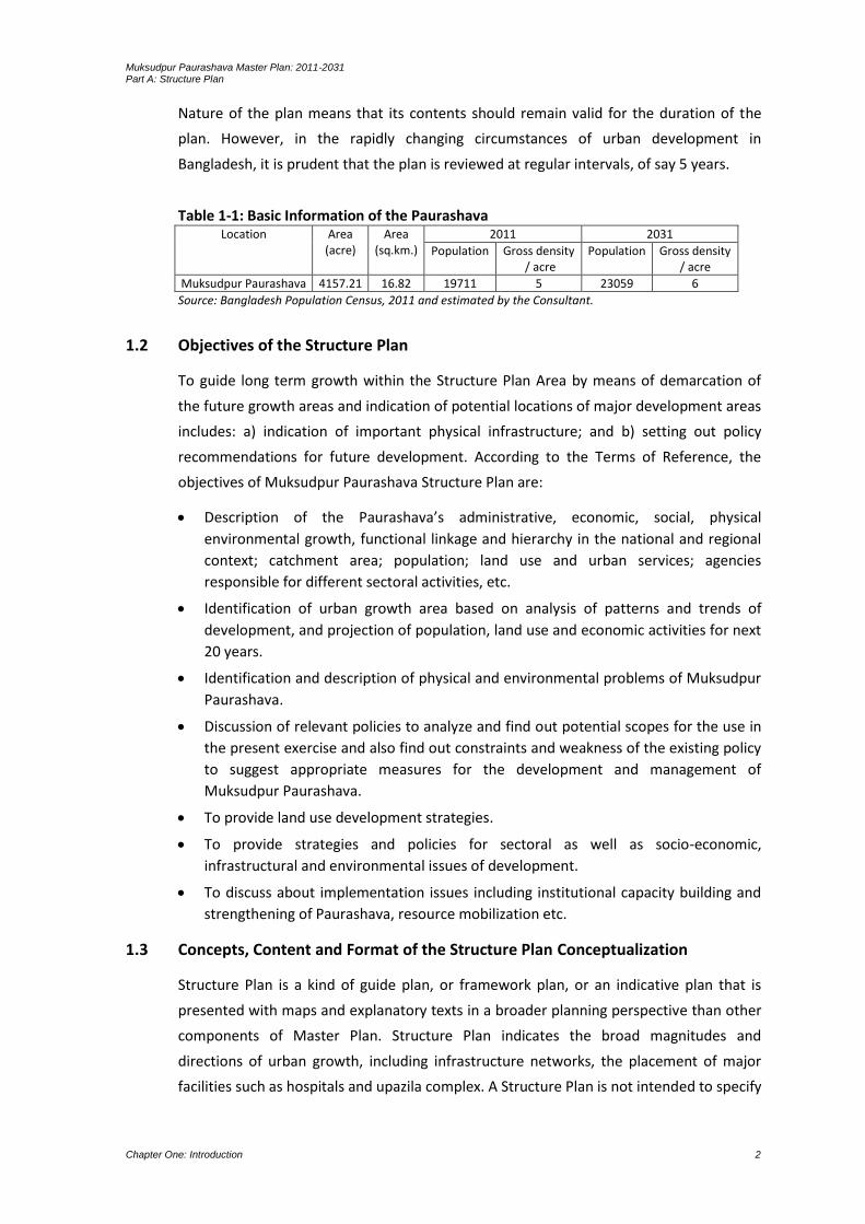
Table 1-1: Basic Information of the Paurashava Location Area
(acre) Area
(sq.km.) 2011 2031
Population
Gross density / acre
Population Gross density / acre
Muksudpur Paurashava 4157.21 16.82 19711 5 23059 6
Source: Bangladesh Population Census, 2011 and estimated by the Consultant.
1.2 Objectives of the Structure Plan
To guide long term growth within the Structure Plan Area by means of demarcation of
the future growth areas and indication of potential locations of major development areas
includes: a) indication of important physical infrastructure; and b) setting out policy
recommendations for future development. According to the Terms of Reference, the
objectives of Muksudpur Paurashava Structure Plan are:
Description of the Paurashava’s administrative, economic, social, physical
environmental growth, functional linkage and hierarchy in the national and regional
context; catchment area; population; land use and urban services; agencies
responsible for different sectoral activities, etc.
Identification of urban growth area based on analysis of patterns and trends of
development, and projection of population, land use and economic activities for next
20 years.
Identification and description of physical and environmental problems of Muksudpur
Paurashava.
Discussion of relevant policies to analyze and find out potential scopes for the use in
the present exercise and also find out constraints and weakness of the existing policy
to suggest appropriate measures for the development and management of
Muksudpur Paurashava.
To provide land use development strategies.
To provide strategies and policies for sectoral as well as socio-economic,
infrastructural and environmental issues of development.
To discuss about implementation issues including institutional capacity building and
strengthening of Paurashava, resource mobilization etc.
1.3 Concepts, Content and Format of the Structure Plan Conceptualization
Structure Plan is a kind of guide plan, or framework plan, or an indicative plan that is
presented with maps and explanatory texts in a broader planning perspective than other
components of Master Plan. Structure Plan indicates the broad magnitudes and
directions of urban growth, including infrastructure networks, the placement of major
facilities such as hospitals and upazila complex. A Structure Plan is not intended to specify

Muksudpur Paurashava Master Plan: 2011-2031 Part A: Structure Plan
Chapter One: Introduction 3
detailed plot by plot land use or local road configurations and development proposals.
Rather it identifies the areas where growth and change are such that more detailed local
and action plans are needed. Structure Plan does not require excessive effort in gathering
data and it is flexible and dynamic and can be changed to accommodate demanded
changes. The present Structure Plan is an overall long term strategic plan for the
Paurashava Shahar (Town), Muksudpur.
Structure Plan is the 1st component of the Master Plan package. The other two lower
level components are Urban Area Plan and Ward Action Plan. Structure Plan lays down
the framework of the future plan including strategy and the sectoral policies. The Urban
Area Plan and the Ward Action Plan detail out development proposals under the
framework of Structure Plan. The extended area was selected in consultation with the
Paurashava for possible extension of the Paurashava. But no development proposals are
suggested for the extended part as existing Paurashava area is enough to accommodate
population and services during Structure Plan period, that is, up to the year 2031.
Contents
The Master Plan is prepared based on the survey data. Most of the information provided
in the Survey Report is the outcome of the surveys namely Topographical Survey, Physical
feature survey, Landuse survey, Socio-economic survey, Transport survey and Drainage
and Environment survey.
Landuse survey: Landuse survey basically records the use of land by its functional activity
such as residential, industrial, commercial, health, cultural, etc. During the TS and DGPS
based physical feature survey each feature was recorded with individual ID or code
representing their use. At the same time, uses of lands without structures were coded on
mouza plots. Later on landuse features was identified and classified using the recorded
code and separated in different layers during data processing stage, from where the
category-wise landuse map has prepared using the identification layers of each landuse
features. The landuse map has prepared indicating the broad categories of landuse
described in the ToR. The landuse map has prepared on RS Mouza map at scale 1”=165’
(RF 1:1980).
Physical feature survey: Physical Features were surveyed using both Total Station (TS)
and Differential Global Positioning System (DGPS) survey technique. All structures and
installations were surveyed by TS and alignment and closed boundaries like Road, River,
Khal, Marshland, Homestead, Large Water bodies etc. have surveyed by DGPS. Where
DGPS survey was not possible for weak satellite signal due to obstruction, TS survey
technique was applied for those particular areas.
Location and dimension of the physical feature has surveyed and stored using Real Time
Kinematic Global Positioning System (RTK-GPS) supported TS and DGPS survey technique.
Data was recorded in the TS and DGPS memory with separate ID or code number for each
Muksudpur Paurashava Master Plan: 2011-2031 Part A: Structure Plan
Chapter One: Introduction 4
feature (as Line, Point and Polygon). Later on the TS and DGPS data was transferred
directly to the Geographic Information System (GIS) database where the feature was kept
in separate layer wise as per specified code or ID. Names of settlements, village, rivers,
khals, lakes, roads, markets, etc. were recorded during physical feature survey. For
supporting the TS Survey, huge numbers of Temporary Control Points (TCP) have
established using RTK fast static survey technique and GEOID Model of the project. These
TCPs were used by the TS groups as reference points (Station and Back Points) for
physical feature, topographic and landuse survey.
Topographic survey: Topographic survey has performed using TS and DGPS. The TS
survey groups / teams were responsible for measurement of spot levels (Northing,
Easting, Elevation or RL) for contour generation. In general the spot levels on the land
have taken at an interval that represents the topography of the land surface. The utility
poles and alignment of utility lines have surveyed using DGPS. The established TCPs with
RTK-GPS were used by the TS groups as reference (Station and Back Point). Contour map
has prepared at scale suggested by LGED incorporating all physical features and
infrastructures.
The Total Station (TS) survey groups were responsible for conducting topographic survey
where Total Station (TS) is used for measurement of Land levels/spot levels (Northing,
Easting, and Elevation in respect to mPWD datum) for contour generation at 0.3in
intervals. In general the spot levels on the land were taken at not exceeding 50m
internals, closer spots were taken in case of rapid undulation. In addition to the Primary
Bench Marks (BMs) established by RTK-GPS Static survey, 120 nos. of Secondary Bench
Marks/Control, Point (BMs/SCP) were established using RTK fast static and 1st order BM
carry survey for supporting the TS survey. These SCPs as well as the primary BMs were
used for Total Station survey as reference points (Station and Back Points) both for
topographic and physical feature surveys.

Muksudpur Paurashava Master Plan: 2011-2031 Part A: Structure Plan
Chapter One: Introduction 5
Map 1-1: Location of Muksudpur Paurashava in context of Bangladesh

Muksudpur Paurashava Master Plan: 2011-2031 Part A: Structure Plan
Chapter One: Introduction 6

Muksudpur Paurashava Master Plan: 2011-2031 Part A: Structure Plan
Chapter One: Introduction 7
Map 1-2: Jurisdiction of Structure Plan Area
Muksudpur Paurashava Master Plan: 2011-2031 Part A: Structure Plan
Chapter One: Introduction 8
Muksudpur Paurashava Master Plan: 2011-2031 Part A: Structure Plan
Chapter One: Introduction 9
The spot levels/land levels were transferred to GIS database and later by processing
Digital Elevation Model (DEM) as well as contour map at 0.3m interval contours were
generated using TIN (Triangular Irregular Network) Method of GIS.
Transport survey: To perform transport survey, the team was mobilized on 14th April,
2009. An introduction meeting on 15th April, 2009 was held in Muksudpur Paurashava in
presence of the Mayor, Councilors, Engineers and other professional to set the date and
time of survey as well as to identify the survey stations.
The Paurashava authority recommended 31-05-2009 as regular day and 29-05-2009 as
local Hat day to conduct transport survey. With reference to their observations, survey
time was set from 7:30 AM to 8:30 PM for those two days when traffic movements were
frequent.
In order to get an accurate scenario about the study roads / links, detailed frequency of
traffic movement was analyzed. This work was considered overall traffic volumes and the
proportion of different traffic. Frequency analysis of traffic was performed using the
collected data from traffic volume survey. This survey was included mode-wise travel
frequency on the specific road. So, that information helps to explain the variation in using
of different vehicles for different time and day of that road.
Drainage survey: Drainage channels were surveyed by Optical Level machine from the
head of the channels to the outfall. A zero datum was chosen at the head of each
channel. This zero height was then used to level the channel from the head to the toe or
outfall. In areas where blockage or refuse was observed to accumulate in the bottom of
the channel, the reason of such blockage was identified.
Environmental survey: Environmental survey was conducted following the standard
methods and procedures to determine environmental pollutions. Elements of pollutions
of environment are air, water, land and noise for the development of urban areas. The
Consultants have taken necessary assistance and information from the Paurashava
Mayor, Councilors, Engineers and other concerned officials as well as the general
inhabitants to determine pollution in air, water, land and noise. Based on the information
and data collected from the field, detailed report has been prepared. Data collection
format and questionnaire was approved by the PD of UTIDP, LGED.
Socio-economic survey: The Socio-economic survey was initiated from 12 November ’09
and ends in 26 November ’09. The Survey Team was composed with 6 field investigators
assisted by Field Supervisor. The Supervisor has been seconded from Consultant’s office.
The survey took approximately two weeks to complete with a pre-determined set of
questionnaire.
The Paurashava is consisted with 9 Wards. The Socio-economic survey covers all the
Wards. Those Wards are identified and distributed as the Core and Potential Core areas.
Muksudpur Paurashava Master Plan: 2011-2031 Part A: Structure Plan
Chapter One: Introduction 10
In total, 5% sample households are considered from above each category of area and
then again distributed into Pucca, Semi-Pucca, Katcha / Thatched (Jhupri) households
according to the respective Wards.
Format of the Structure Plan
The Structure Plan is an indicative plan that gives a brief on the future development of an
area with policy guidelines. It is a long-term plan with flexibility in the sense that it sets
down a broad framework for future development, but not the details. The format of a
Structure Plan comprises written document and indicative major development locations
presented in maps and diagrams as parts of the report. The written text analyses the
issues that are not possible to be presented as diagrams, drawings and maps. Therefore,
the written document is as important as the physical plan and diagrams and should be
read in conjunction with each other.
1.4 Approach and Methodology
The UTIDP Project is aimed for substantial development of infrastructure and services for
the Paurashava with optimum provision of opportunities for Paurashava dwellers and
making scope for extending services to surrounding areas.
The current project is preparing a Master plan of the Paurashava, where the existing
condition and different problems are identified, studied and analyzed and the probable
solutions are to be sought to ameliorate the same. The study moves through a process of
data collection-analysis and fixation of objectives for planning.

Muksudpur Paurashava Master Plan: 2011-2031 Part A: Structure Plan
Chapter One: Introduction 11
Figure 1.1: Flow Chart of Planning Process
The approach is based on field survey for data collection and collection of information
from secondary sources. The data is presented through maps, text and tabular form.
Than the survey report and maps are prepared and submitted. Analysis of collected data
is carried out to identify the nature and extent of problems prevailing in the Paurashava
in order to fix the objectives of the actions to be undertaken in the form of planning and
the interim report prepared and submitted. Through the process, involvement of the
stakeholders has been ensured to make the planning as much sustainable as possible. For
this purpose, continuous formal and informal discussions and meetings have been carried
out throughout the project period using participatory approach. The discussions serve
two purposes, first, a sense of belongingness develops within the minds of the
stakeholders, particularly among the citizens, about the master plan to be prepared, and
secondly, identification of problems and finding their solutions become easier with the
participation of stakeholders, as the local stakeholders are more knowledgeable about
local problems and possible solutions of those problems.
Fixation of Goals and Objectives
Survey and Data Collection
•Topographic Survey •Physical Feature Survey •Land Use Survey •Infrastructure and Utility Survey
Planning Process
INCEPTION REPORT
INTERIM REPORT
Data Processing SURVEY REPORT
AND MAPS
Draft Plan and Report
Final Plan and Report
Data Analysis and Study of Problems and Issues
Collection
• Structure Plan
• Urban Area Plan
• Ward Action Plan

Muksudpur Paurashava Master Plan: 2011-2031 Part A: Structure Plan
Chapter One: Introduction 12
After doing all these jobs thoroughly the Master Plan had been done based on a prepared
planning standard for Paurashava level town and formulating future strategies for the
corresponding area. Again after final consultation with the stakeholders on the prepared
plan the Final Master Plan has to be completed.
1.5 Scope of Work
The scope of work under this consultancy services covers all aspects related to the
preparation of Master Plan, which includes Land Use Plan, Transportation and Traffic
Management Plan, Drainage and Environmental Management Plan and Ward Action Plan
for the proposed Paurashava. In order to prepare these plans, the activities contain but
not limited to the following:
Visits have been made to the Paurashava at different stages of work of the preparation of
Master Plan of Muksudpur Paurashava.
Feasibility for preparation of Master Plan has been submitted to the office of the PD,
UTIDP.
An Inception Seminar has been organized at the Paurashava level to inform the
Paurashava about the scope and Terms of Reference for the preparation of Master Plan.
A thorough investigation has been made based on potential scope and opportunities
available in the Paurashava to develop a 20 year development vision for it linking the
ideas and view of the Paurashava people.
Determination of the study area and planning area has been done based on existing
condition, demand of the Paurashava and potential scope for future development. A
detailed survey has been conducted on the existing conditions of socio-economic,
demographic, transportation and traffic, physical features, topographic, and land use of
the Paurashava area following the approved format and data have been collected from
primary and secondary sources. Analysis of such data and information has been carried
out to find out the possible area of intervention to forecast future population of the
Paurashava (15-20 years), vis-a-vis assess their requirement for different services, such as
physical infrastructure facilities, employment generation, housing, right of way and land
requirement for the existing and proposed roads, drains, playgrounds, recreation centers
and other environmental and social infrastructure. The following major tasks have been
accomplished:
Identification and investigation of the existing natural and man-made drains, natural river
system, the extent and frequency of floods, area of planning intervention have been
done. Other works include study of the contour and topographic maps produced by the
relevant agencies and review of any previous drainage Master Plan available for the
Paurashava.

Muksudpur Paurashava Master Plan: 2011-2031 Part A: Structure Plan
Chapter One: Introduction 13
A comprehensive (storm water) Drainage Master Plan for a plan period of 20 years has
been prepared considering all relevant issues including discharge calculation, catchments
areas, design of main and secondary drains along with their sizes, types and gradients
and retention areas with preliminary cost estimates for the proposed drainage system.
Recommendations have been made on planning, institutional and legal mechanisms to
ensure provision of adequate land for the establishment of proper rights of way for
(storm water) drainage system in the Paurashava.
Collection and assessment of the essential data relating to existing transport Land Use
Plan, relevant regional and national highway development plans, accident statistics,
number and type of vehicles registered for each Paurashava have been made.
Assessment has been made on the requirements of critical data and data have been
collected through reconnaissance and traffic surveys, which should estimate present
traffic volume, forecast the future traffic growth, identification of travel patterns, areas
of traffic conflicts and their underlying causes.
Study has been conducted on the viability of different solutions for traffic management
and development of a practical short term traffic management plan has been
accomplished, including one way systems, restricted access for large vehicles, improved
signal system, traffic islands, roundabouts, pedestrian crossings, deceleration lanes for
turning traffic, suitable turning radius, parking policies and separation of pedestrians and
rickshaws etc.
Assessment has been done on the non-pedestrian traffic movements that are dominated
by cycle rickshaw. Special recommendations should be made as to how best to utilize this
form of transport without causing unnecessary delays to other vehicles. Proposals should
also consider pedestrians and their safety, with special attention for the children.
Assessment has been made on the current land use with regard to road transportation,
bus & truck stations, railway stations etc, and recommendations to be provided on
actions to optimize this land use.
Preparation of a Road Network Plan based on topographic and base Map prepared under
the Project. Recommendation has been made on the road development standards, which
serve as a guide for the long and short term implementation of road. Also Traffic and
Transportation Management Plan and traffic enforcement measure have been suggested.
Preparation of the Master Plan with all suitable intervention, supported by appropriate
strategic policy, outline framework, institutional arrangement and possible source of
fund for effective implementation of the plan.
Preparation of a plan has been set out proposed Master Plan at 3-levels namely
Structural Plan, Urban Area Plan and Ward Action Plan.

Muksudpur Paurashava Master Plan: 2011-2031 Part A: Structure Plan
Chapter One: Introduction 14
At the first level, policies and strategies have been worked out for the preparation of a
Structure Plan for each Paurashava under the package. The Master Plan has been
prepared consisting of Structural Plan, Land Use Plan, Transportation and Traffic
Management Plan, Drainage and Environmental Management Plan and Ward Action
Plan.
A total list of primary and secondary roads, drains and other social infrastructures for
each Paurashava for a plan period of next 20 years has been made. Examining and
classifying according to the existing condition, long, medium and short term plans have
been proposed and estimated cost for improvement of drain and road alignment and
other infrastructures have been prepared.
In line with the proposed Master Plan, a Ward Action Plan has been proposed with list of
priority schemes for the development of roads, drains, traffic management and other
social infrastructures for implementation during the first five years of plan period.
With the help of concerned Paurashava, at least 2 public consultation meetings or
seminars have been organized, one for discussion on Interim Report and the other on
draft Final Report on the proposed Master Plan. Beneficiary's point of view has been
integrated in the plan with utmost careful consideration.
Preparation and submission of Master Plan and Report with required standards as per
the TOR.
1.6 Organization of the Master Plan Report
The Master Plan Report is organized in three major parts with an introduction at the
beginning. The three major parts contain various components of work under the UTIDP of
LGED. The three major parts of the Master Plan of Muksudpur Paurashava are as follows:
INTRODUCTION: It describes the ToR of the UTIDP, philosophy and objectives of the
Master Plan, methodology and scope of the work and organization of the Master Plan
Report.
PART-A: The Structure Plan sets the conceptual framework and strategies for planned
development of the Paurashava based on its potentials for next 20 years up to 2031.
PART-B: Urban Area Plan includes i) Land Use Plan; ii) Transportation and Traffic
Management Plan; iii) Drainage and Environmental Management Plan; and iv) Proposals
for Urban Services.
PART-C: Ward Action Plan presents ward wise detailed proposals for implementation
within first five years of the Master Plan period of 20 years.

Muksudpur Paurashava Master Plan: 2011-2031 Part A: Structure Plan
Chapter Two: Paurashava’s Existing Trend of Growth 15
CHAPTER 2 PAURASHAVA’S EXISTING TREND OF GROWTH
2.1 Social Development
Age-sex structure: Age and gender distribution indicates that population mostly increase
naturally. The age-sex distribution implies that female population is less than male
population in the Paurashava. From the male female ratio, it is observed that in all the
Wards number of males are greater than the number of females. Highest population goes
under the range of years 18 to 34 age group. So, in all the Wards number of young and
workable population is highest than any other aged group population.
In 2011, population was 19711. The age and gender distribution indicates that population
mostly increases naturally. The age-sex distribution implies that somewhere female
population is less than male population in the Paurashava. From the male-female ratio, it
is seen that in all the wards, number of males are greater than the number of females.
So, in all the Wards number of young and workable population is highest than any other
age-group population.
Household size: Family size ranges from 1-3, 4-6, 7-9, 10-12 and 12+ members, but most
prevalent size is 4-6 members in the Paurashava and also in Bangladesh. There are both
single and joint family systems in the study area. Ward No. 3 has major percentage of 4-6
member family and Ward No. 2 is more joint-family system (43%) compared to other
Wards. Most of the family in the Paurashava is single family (75.4%).
Marital status: Number of male married is higher than female married. Again, number of
female divorce is higher than male divorce. The scenario proves family conflict generates
due to the financial insolvency of the household head. The unmarried or never married
data on male and female also proves that the male population is not encouraged to
marry due to their minimum income ability.
Migration: The migration data substantiates the fact that Paurashava is almost formed
with permanent settlers (85.6%). Above 92% people of the Ward No. 8 and 9 are living in
Paurashava for more than 14 years. A minimum percent (3.8%) of people are living during
10-14 years and is found in the Ward No. 2 and 7.
Migration status of the Paurashava is stable because only 16.6% resident of the
Paurashava is migrated resident. Migrated resident is found in the Ward No. 4, 5, 6 and 7.
There are various reasons for migration like inadequacy of employment opportunity,
economic backwardness, social persecution, politico-religious disturbances in the area
where they migrated from and ambition like better business opportunity. But mostly, as
survey finds out, migration in the study area occurred due to work prospects i.e. for job
purpose or transfer of the service.

Muksudpur Paurashava Master Plan: 2011-2031 Part A: Structure Plan
Chapter Two: Paurashava’s Existing Trend of Growth 16
All migration has occurred after the year 2000. Basically, it was out migration in Ward No.
1. It is very clear that better earning opportunity influences the people to live in urban
area from other parts of the district or country. But, in this Paurashava all the
opportunities is not sufficient and for this reason a little migration is occurred (16.6%,
previously mentioned). Out migration has occurred in the urban area at household level
but there is some students and service holders who migrate Dhaka or other large cities.
Among the migrated resident of the Paurashava, 24% come from other districts, 34%
from same Upazila and 42% from other Upazilas in the district.
Educational status: There are significant numbers of household heads who are illiterate
(66.7% in Ward No. 3 and 43.8% in Ward No. 9). Lowest percent illiterate population is
found in Ward No. 5. Reading between Classes-VI to X is the highest educational
achievement in the Paurashava (14.9%). SSC level (14.3%) of population is quite higher
than HSC (11.4%) and Graduate (10.9%) in the Paurashava. There is 3.4% Master degree
holder population in the planning area.
Religion: In the Paurashava, Muslims are major religious group (87.02%) followed by
Hindus (12.89%), Buddhist (0.08%), Christian (0%), others (0.005%), Tribal (0%).
Occupational status
Primary occupation: Business (small business 24% and large business 5.14%) is the
dominant occupation of the household heads in the Paurashava. Farming or agriculture
(15.43%) is the second dominant occupation. Agriculture or farming includes crops,
livestock and poultry and fish cultivation. Apart from this there are other occupations
like public or private service, informal sector work, rickshaw / van puller, teaching, skilled
and unskilled labour, handicrafts, etc. The scenario reveals that 10% as office workers
both government and semi-government including employees in private offices. The
unskilled labour includes rickshaw and van puller accounts for 6% of the total occupation
group in the study area.
In the Paurashava, small business is the dominant occupation in three Wards (Ward No.
4, 6 and 7). Farming / agricultural domination is found in two Wards (Ward No. 2 and 9).
Paurashava has numerous occupational groups who are helping the economic base to be
sustained. Being predominantly in an agricultural region, the inhabitants of Paurashava
are changing their major occupational involvement from agriculture to business.
Table 2-1: Occupational pattern: Ward-wise and Paurashava as a whole (in %) Main Occupation of the Household Head
Ward Number Paurashava As a whole 1 2 3 4 5 6 7 8 9
Govt. Officer 11.54 7.14 2.86
Other Govt. employee 23.08 6.25 4.00
Teaching 7.69 5.56 6.67 11.54 8 5.88 5.14
Farming/Agriculture 17.65 30.77 16.67 13.33 7.14 16 17.65 37.5 15.43
Housewife 5.88 7.69 5.56 6.67 3.57 8 4.00

Muksudpur Paurashava Master Plan: 2011-2031 Part A: Structure Plan
Chapter Two: Paurashava’s Existing Trend of Growth 17
Main Occupation of the Household Head
Ward Number Paurashava As a whole 1 2 3 4 5 6 7 8 9
Large Business 11.76 7.69 6.67 7.14 8 5.88 5.14
Small Business 17.65 11.11 40.00 23.08 46.43 20 17.65 25 24.00
Private Service 23.53 23.08 16.67 6.67 11.54 3.57 16 29.41 12.5 14.86
Handicrafts 11.11 5.88 1.71
Skilled Labor 7.69 11.11 10.71 8 6.25 5.14
Unskilled Labor 11.76 7.69 22.22 12 5.71
Rickshaw/Van Puller /Driver
5.88 7.69 6.67 3.85 7.14 11.76 6.25 5.14
Student 4 0.57
Unemployed/Retired 5.88 13.33 15.38 7.14 5.88 6.25 6.29
Total 100 100 100 100 100 100 100 100 100 100
Source: Socio-economic Survey, 2009.
It is apprehended that with the increasing urbanization, there will be increasing number
of people taking non-farm occupations as their primary occupation. This will happen as a
social process of deprivation in rural area leading to increased pauperization and forcing
large number of people into urban centres as destitute who would have no option but to
engage them in urban occupations.
Secondary occupation: A number of households are engaged with secondary occupation
seasonally to raise their family income. Mostly the low income groups are with secondary
occupations during off-season when they do not have any regular jobs. Secondary jobs
include, day labouring, hawkery, van / rickshaw pulling and similar other occupations. In
an average, 5.14% is involved with rickshaw/van pulling and 5.71% as a day labour.
Income level: Small business (24%) is the dominant occupation of the household heads in
the Paurashava. Farming or agriculture (15.43%) is the second dominant occupation.
Agriculture or farming includes crops, livestock and poultry and fish cultivation. Apart
from this there are other occupations like public or private service, informal sector work,
rickshaw / van puller, teaching, skilled and unskilled labour, handicrafts, etc.
Present population distribution and growth including migration shows that the area is
developing significantly in terms of trade and large business and trying to get out of
agriculture based activity. Income ranges basically support this concept which is evident
by the ranges of income earned by households. In Ward No. 9, 12.5% household earns
Tk.12000 and above compared to 25% within Tk.9001-12000 per month. There are good
numbers of households who earn Tk.12000+ per month. In the Paurashava dominant
income groups are Tk.6001-9000 (29.7%), Tk.9001-12000 (24.6%) and Tk.4001-6000
(22.9%). On the other hand, average monthly income per household is highest (Tk.13700)
in Ward No. 7 and lowest (Tk.1500) in Ward No. 4.
Expenditure level: The expenditure pattern of the Paurashava as a whole confirms
general pattern of household expenditure as obtained through survey. There are several

Muksudpur Paurashava Master Plan: 2011-2031 Part A: Structure Plan
Chapter Two: Paurashava’s Existing Trend of Growth 18
headings like food, house rent, basic utility charge, education, health, transportation /
vehicle charge, recreation and other charges.
Since Muksudpur Paurashava still has rural influences and business is the major source of
income; food relatively stands higher in expenditure list; Tk.6600 in Ward No. 9 and
Tk.5860 in Paurashava as a whole. Important finding is that, there is no expenditure for
water and others in any Ward of the Paurashava. The residents of the Paurashava save a
little money. People of the Ward No. 9 save highest amount of money (Tk.730) but the
surprising thing is that, expenditure of four Wards is above than income and their savings
are minus. Those Wards are Ward No. 2, 4, 6 and 7 among which the scenario of Ward
No. 2 and 7 is really alarming.
Land Value
Land value is an important determinant for any project related to the physical
development because; the development depends on project cost and the cost on land
value. In recent time, a rapid change of land value is found in the Paurashava premises.
Wealthy people of the community are investing on land and became landlord because
they consider it as a safe investment. As a result, land value curve is on upward. Value of
land depends on location, accessibility, height and free of natural hazards. Following
paragraphs discuss on land value of the planning area.
Official Value: The official land value uses for calculation and collection of land revenue.
In the physical planning aspects, study of land value is necessary for land acquisition. For
the preparation of physical development project including cost involvement, an idea on
land value is necessary. In this study, the official land value is being quoted from the
actual value considers by the Sub-registry Office of the Muksudpur Paurashava.
Table 2-2: Mouza-wise land value Muksudpur Paurashava, 2010 Mouza name Type of land (Tk. / decimal)
Nal Home Viti Fallow Doba Pond Chhon khola Chandina Shop vita
Chhota Bahara 21082 30395 25263 2500 3000 5000 9000 12000
Dakshin Chandibardi 10512 20588 5500 1100 2000 3000 800 7000
Golabaria 5500 7500 6100 1000 2000 1000 600 8000
Gopinathpur 7898 9000 6000 2000 1300 3000 500 10000 133333
Hogladanga 9166 14920 9333 1000 1000 3000 800 8000
Kamalapur 21726 27758 22500 1400 1500 2400 800 20000
Lakhair Char 5500 7500 6100 1000 2000 1000 600 8000
Lakhair Char 9166 14920 9333 1000 1000 3000 800 7000
Source: Sub-Registry Office, 2010.
In this study, nine types of land in eight mouzas are being considered. In the natural land
market, land for homestead / housing construction is higher than other type of land and
this scenario is prevailing in the Paurashava also. In another scenario, commercial land
value is higher than homestead / residential land value and it is in the Gopinathpur
Muksudpur Paurashava Master Plan: 2011-2031 Part A: Structure Plan
Chapter Two: Paurashava’s Existing Trend of Growth 19
mouza. Land value is low (Tk.500 to Tk. 9000 per decimal) for Doba, Pond and Chhon
Khola type of land. Those three types of land are under the jurisdiction of agriculture
land. For development activities, in case of land cost, those lands should be emphasized,
though land development cost is higher than other type of lands.
Existing Practice / Unofficial Value: In the Paurashava, land value increases with the
height of the land. It increases from low to medium high land but the maximum mean
value is found for the other land (Tk.30000 per decimal) and lowest for the medium land
(Tk.237854 per decimal).
Land Ownership Types and Patterns: Status of residence or ownership of dwelling units /
land is a key socio-economic indicator. Residential status varies in the study area. The
land ownership pattern often determines social power and position.
Low land ownership indicates most of the household’s landed property. Households
almost all the Wards own high land followed by habitable land (37.1%). Highest amount
(100%) of habitable land is owned by the households in the Ward No. 1. Medium land
ownership exists in all the Wards. Since, the area is business based with considerable
number of agricultural activities, presence of considerable ownership of high land and
habitable land supports small business as main activity.
2.2 Economic Development
Two basic elements of economic development i.e. employment generation and increase
of productivity are found in the cities and urban areas than the rural areas. This is a
common phenomenon for the developed and developing countries. Employment
opportunities act as a strong pull factor for influx of job seekers in the cities and urban
areas, the centers of productivity. Special features of the study area are that it covers a
vast rural area, besides a small urban center of Paurashava town. One National Highway
passes through the Paurashava and both the sides of the highway is occupied by huge
tracts of agriculture land and sporadic homesteads, at places showing the signs of
development along with the hats, bazars indicating the dominant role of agriculture and
fishery. This indicates general feature of the study area as a mixture of rural and semi-
urban nature. These special socio-economic features of the study area have been taken
into consideration in conducting the study of the prevailing economic situation.
Industry: In total, 27 industries with two categories (1 medium scale and 26 light
industries) are prevalent in the study area. Among those establishments, agro-based
industries account for about 73% and wood based industries 27% share of the total
running industries. It reflects the general agrarian character of the study area. All of those
enterprises are proprietorship units meaning that private sector dominates the industrial
sector of the study area.
Muksudpur Paurashava Master Plan: 2011-2031 Part A: Structure Plan
Chapter Two: Paurashava’s Existing Trend of Growth 20
Most of the industries depend on raw materials available within the study area. The
industrial output produces in the local market. It is also found that those establishments
have problems and potentialities. Careful consideration will help to resolve those
problems and adoption of necessary policy initiatives will help to flourish the existing
units and draw more investors and entrepreneurs to set up new manufacturing
industries, which will be based mainly on local raw materials.
Commerce: Commerce includes purchase and sale of various consumer and durable
items performed by the business person. In the study area, such activities are wholesale
and retail trade, hotel and restaurant business, transport, storage services, hat/bazar,
etc. Major part of trade and commerce of the study area is conducted through hat /
bazar where agriculture produces, consumer items, merchandise for household and
other farm and non-farm items are transacted. The market / bazar performs significant
role on the Paurashava economy. It is observed that market / bazar provide good number
of employment and act as an economic centre for the area of influence of the market /
bazar. This market / bazar remain open everyday from morning to evening. Along with
the daily business transactions, two market places are also used as hat which sits three
days in a week. On the hat days farmers, traders, businessmen and many other informal
professionals gather in the hats and run trades and business till evening. Actually, the
market / bazar is the key supplying centres of all sorts of agro-products to the urban
areas and other non-producing areas of the country, and similarly this market / bazar is
the major distribution centres of industrial products to the vast majority of the rural
people throughout the country at consumer levels. Importance of the market / bazar
place can not be ignored, rather needs to be facilitated with provision of infrastructure
facilities.
Two locations with agglomeration of commercial activities at Hat/Bazar area are in the
Paurashava. Those hats/bazars are taking place in the core part of the Paurashava along
with the road; tin-shed semi-pucca structures with parcels of open lands. Saturday and
Tuesday of a week are the local Hat days. Those hats/bazars are prominent due to its
availability of agro-product and fish. People from different Upazilas, Zilas and Capital City
accumulate in those hat / bazars as a buyer.
The Paurashava is composed with 158 numbers of shops. The scenario proves that the
area is identified as a rural-based commercial centre and dominating the surrounding
Upazila and Zilas with its economic commodities. Daily gross economic turnover may be
taka 1.5 lakhs to 2 lakhs (approx. one thousand taka per shop in average).
Services: The service sector consists of the hotel and restaurant business; transport and
communication, storage / godown, financial intermediaries, real estate, rental activities,
public administration, education, health, community service and social work including
social and personal services. The service sector significantly contributes to the local
Muksudpur Paurashava Master Plan: 2011-2031 Part A: Structure Plan
Chapter Two: Paurashava’s Existing Trend of Growth 21
economy. Most of the service structures are housed in permanent structures. There are
some makeshift type structures also.
There are 1 bank and 4 NGOs working in the Paurashava. Major investment by the banks
are in the field of cash credit in the form of running capital and capital loan for setting up
of business establishments, besides general banking facility. Some NGOs have also
disbursed agricultural loan. The NGOs are rendering services in the fields of poverty
alleviation programs, awareness building, health care, education, sanitation, micro-credit
and training on income generating activities including skill development. NGOs provide
services in the field of micro-credit; encourage social services, advance loan for poultry,
fisheries, livestock, agriculture, house building, land purchase and capital loan for running
business. NGOs also take part in various social activities like awareness building on
environment, natural calamities, health and many other fields. A good number of people
special women and poverty-stricken has been getting various types of services from the
NGOs for quite a long period.
Agriculture: Agriculture dominates the economy of this Paurashava. Among agricultural
produces, important items besides paddy are vegetables, local fruits, sugarcane, jute and
mustards. Among the agriculture products, paddy, local fruits, mustards and vegetables
are consumed locally and a considerable percent (about 35%) are using by the
inhabitants of adjacent Upazilas. The jute is using to the jute industries located in the
Madaripur and Narayanganj (about 40 and 75km away from the Paurashava
respectively).
Agro-based: In total, 15 agro-based industries are found in the Paurashava. The agro-
based industrial activities cover 1.41 acres or 0.05% land. Local woods are being
processed in the Saw Mill and locally produced paddy are using in the Rice Mill. Those
industries have been established all over the Paurashava. Location of those industries will
be rearranged and grouped in some selected areas. After construction of Regional
Highway, number of agro-based industries is increasing day by day.
Table 2-3: Agro-based industries in the Muksudpur Paurashava Type of agro-based industry Number
Rice mill 9
Saw mill 4
Textile Mill 1
Total 15
Source: Physical feature survey, 2009.
Employment Pattern: In the Paurashava, population age 10 years and above, recorded
idle are 12158, looking for work 518, doing household work 12597 and employed the
remaining. The employed people identified working in agriculture are 7060, industry 484,
construction 442, transportation 1116, business 2396, service 43 and others 2600.

Muksudpur Paurashava Master Plan: 2011-2031 Part A: Structure Plan
Chapter Two: Paurashava’s Existing Trend of Growth 22
Economically active age-group (15-59 years age-group) stands 65% of the total
population.
Table 2-4: Population 10 years and over by main activity Ward Total NW LW HW Agr. Ind. WEG Con. Tran. H&R Bus. Ser. Others
1 4770 1558 58 1426 1076 25 1 58 55 0 228 4 281
2 4798 1310 91 1650 967 11 0 103 146 3 217 9 291
3 4943 1755 65 1425 442 22 0 36 130 10 608 7 443
4 4251 1089 96 1532 1106 20 1 19 71 2 109 2 204
5 4484 1762 52 1156 401 36 5 29 157 3 475 1 407
6 3457 952 27 1176 802 29 0 23 170 0 124 2 152
7 4355 1390 31 1441 1026 31 0 30 114 3 157 0 132
8 4425 1258 43 1435 585 143 3 84 158 6 266 16 428
9 3970 1084 55 1356 655 167 2 60 115 12 212 2 262
Total 39453 12158 518 12597 7060 484 12 442 1116 39 2396 43 2600
Source: Population Census 2011, Community Series, BBS
Note: NW = Not Working, LW= Looking for Work, HW= Household Work, Agr.= Agriculture, Ind.= Industry, WEG= Water, electricity and gas; Con.= Construction, Tran.= Transport, H&R= Hotel and Restaurant, Bus= Business, Ser.= Service.
Informal Economic Sectors: Informal sector covers a lot of activities which may be
classified as Trading and Services. Various type of mobile or fixed salable items like food,
fish, nuts, coconut, vegetables, daily household items, old cloth / garment, repairing of
household gadgets, electronic items repairing, hair cutting, shoe polishing, etc. are
considered as informal economic activities.
In the Paurashava, informal entrepreneurs mainly perform their business in the market /
bazars and males are dominating this sector. Mostly 18-34 age-groups run the informal
activities followed by 35-59 age-group. In total, 18 types of occupation grouped under
two major categories of Trade and Services, adopted by the informal entrepreneurs in
the Paurashava. Of the various occupations, trade includes sale of various food items,
clothes, vegetables, meat, seed, medicines, etc. and service includes hair cutting, shoe
repairing, umbrella repairing, mobile phone service, tailoring, etc. It is revealed that,
major occupation is trade adopted by 32% and service is composed 8% of total informal
entrepreneurs. Sources of the capital of the informal entrepreneurs are inheritance (5%),
self-earned (87%), borrowing from friends / family members (3%) and loan from NGOs
(5%).
It has been found that, 8% (including loan from NGO) of total entrepreneurs had to
borrow money to form capital for their business. Rest of the respondents did not receive
any loan to start their business. Recipients of loan of the informal sector have received
varied amount of loans. Of the total loan recipients, 40% took loan ranging between Tk.
5000.00 to Tk. 8000.00, followed by 37% received between Tk. 8001.00 to Tk. 12000.00
and 23% between Tk. 12001.00 to Tk. 15000.00.

Muksudpur Paurashava Master Plan: 2011-2031 Part A: Structure Plan
Chapter Two: Paurashava’s Existing Trend of Growth 23
About 31% of respondents monthly earning is in the range of Tk. 6000 to Tk. 9000 and
23% is Tk. 4000 to Tk. 6000. Only 10% respondents are in the very low income range of
less than Tk. 4000 monthly. A considerable (18%) entrepreneurs has monthly income is
above Tk. 12000. Informal entrepreneurs encounter many problems like dull business,
unfavourable weather, fear of eviction, extortion, lack of permanent business location,
exorbitant rate of interest, lack of credit facilities and unhygienic residential areas.
2.3 Physical Infrastructure Development
Muksudpur Paurashava is a large sized Paurashava (16.82 sq. km.) in the Gopalganj
district. There is a unique opportunity of growth of the Muksudpur Paurashava. Dhaka is
only 70 km. away from the Paurashava. Obviously the physical growth will be occurred
towards northern and western parts of the Paurashava. As it is agriculture based
Paurashava, its present development mainly depend on the future road pattern and
urban services. According to the demand of the dwellers, urban services may be provided
by the Paurashava in any side.
Physical growth of Muksudpur Paurashava town generally depends on the road pattern
of the Paurashava. Muksudpur Paurashava is connected with Dhaka road and Faridpur
road. A concentrated development is the common feature of the Paurashava. The
Muksudpur Bus Stand is the important centre, which influences the dwellers to shift
towards this bus stand. Education facilities also attract the people. So, there is great
scope of physical growth in Ward No. 3 towards the Dhaka road due to small business.
Functional linkages include national highway, regional highway, primary road, secondary
road, tertiary road, local road, access road, feeder road, walk way, etc. This landuse also
includes establishments to accommodate all transport and communication facilities such
as bus terminal / stoppage, toll station, boat ghat, etc. This category of use covers an area
of 0.68 acres of land or 0.02% of the Planning Area. The highest amount of road coverage
is found in the Ward No. 8 (10.36 acres), next in Ward No. 2 (8.54 acres). Ward No. 9
(4.73 acres) is the lowest position in this category. All types of transport related facilities
are available in the Ward No. 2.
Road: In the Paurashava, about 33% road is pucca (bituminous carpeted) and their total
length is 30.61 km encompassing an area of 31.42 acres. The semi-pucca road is generally
constructed with brick soling called Herring Bone Bond road. Total length of semi-pucca
road is 25.27 km and this accounts 27.00% of the total roads in the Paurashava. In total,
13.50 acres of land are being used under semi-pucca road in the Paurashava. Third
category is katcha road called earthen road. About 40.09% road is katcha accounting for
37.39 km coursing 22.14 acres of land. In total, there are 272 no. of roads under three
category coursing 93.27 km in length and 66.61acres of land.

Muksudpur Paurashava Master Plan: 2011-2031 Part A: Structure Plan
Chapter Two: Paurashava’s Existing Trend of Growth 24
Ward No. 2 and 9 have highest (3 categories together) length of roads accounting for 4.8
km and 5.0 km respectively. Ward No. 2 has highest (3.70 km) length of pucca roads
followed by Ward No. 9 (3.20 km). Ward No. 7 has highest (1.10 km) semi-pucca road and
katcha roads in Ward No. 3 (0.90 km). Large-scale of pucca road (23.0 km coursing 21.40
acres) is found in the Paurashava rather than other categories of road.
No transport terminal facility exists within the Paurashava area. Buses and trucks as well
as other vehicles generally park on adjacent roads. Two bus stands are in the Paurashava
on is on the National Highway near Muksudpur College and another is adjacent with the
Muksudpur Upazila Complex. Three Link Roads crosses the Paurashava, they are Upazila
Road, Thana Road, Stadium Road, Sibgram Bazar Road, Gohailbari G.C. Road, Faridpur
Road, College Road, Chourasta Road, Boalmari to Alfadanga Road, Bazar Road and
Bangabandhu Sekh Mujibur Rahaman Sarak. All type of vehicles stands and parks on the
intersections found in the Paurashava premises. Boalmari intersection bus stand is a
nationally known bus stand, but all vehicles park on highways. Besides this, all major
intersections are the places where all local passenger carry vehicles await on roads with
some stoppage time.
Except the National Highway passes through the Muksudpur Paurashava, other internal
and link roads are not well designed and constructed. Those roads need yearly
maintenance but, due to the absence of fund the Paurashava authority is not able to do
that. The National Highway passes through the Paurashava is well designed and carpeted
but the intersections are overcrowded due to the absence of landuse control in those
areas.
Waterway: The Kumar River is not navigable. No waterway is available in the Paurashava.
There are altogether 31 bridges (RCC) and 17 culverts in the Paurashava. Those bridges
and culverts are located on the major canals and drainage channels. The study area is
flood prone area. Water logging is common, dyke is an important issue for this
Paurashava, but there is no dyke or embankment in the Paurashava.
Railway: No railway facility is in the Paurashava.
Airway: No airway facility is in the Paurashava.
2.4 Environmental Growth
The plan has documented Muksudpur Paurashava area’s environmental conditions,
determines potentiality for present and past site contamination (e.g. hazardous
substances, petroleum products and derivatives) and identifies potential vulnerabilities
(to include occupational and environmental health risks).

Muksudpur Paurashava Master Plan: 2011-2031 Part A: Structure Plan
Chapter Two: Paurashava’s Existing Trend of Growth 25
2.5 Population
According to the BBS census 2011, total population of Muksudpur Paurashava is 19711.
Range of population among the Wards is 1407 to 3095. Highest number of population is
in the Ward No. 6 (3095) and lowest in the Ward No. 2 (1407). Following table represents
the fact.
Table 2-5: Population and density of the Muksudpur Paurashava,2011 Ward No. Population 2011 Density/acre
1 1851 3
2 1407 3
3 1967 3
4 1830 9
5 2905 8
6 3095 15
7 2929 8
8 2070 5
9 1657 2
TOTAL 19711 5
Source: BBS Population Cencus, 2011(Community Series, Zila; Gopalganj)
Population density: In the Paurashava, average population density is 5 persons per acre
according to the Population Census, 2011. Ward No. 6 and 4 seems highly population
concentrated areas and density of population in those Wards are 15 and 9 persons per
acre respectively.
Population distribution: In total, 4312 households are living in the Paurashava according
to the Population Census, 2011. Highest number (734 households) of households and
population concentration is found in the Ward No. 6 and second highest concentration of
population is found in the Ward No. 5. Ward No. 2 is predominantly agriculture village;
population concentration is lower than other Wards.
Table 2-6: Household, population and density according to the Ward, 2011 Ward No. Household Population Density per sq. km.
1 412 1851 620
2 304 1407 834
3 399 1967 735
4 407 1830 2168
5 658 2905 2089
6 734 3095 3639
7 644 2929 2020
8 417 2070 1310
9 337 1657 492
Total 4312 19711 1171
Source: Population Census, 2011, Community Series, Gopalganj Zila,
2.6 Institutional Capacity
The Paurashava is responsible for Paurashava administration and also responsible for
providing services, slum upgrading, infrastructure development and licensing of non-

Muksudpur Paurashava Master Plan: 2011-2031 Part A: Structure Plan
Chapter Two: Paurashava’s Existing Trend of Growth 26
motorized transport within its jurisdiction. To perform the responsibilities efficiently as
prescribed in the Local Government (Paurashava) Act, 2009 existing capacity of the
Muksudpur Paurashava administration is not sufficient. The responsibility may be
categorized as two broad heads named Revenue Collection including Budget Preparation
and Delivery of Services. Three types of management system are involved with those two
responsibilities and they are Top Management, Middle Management and Supervisory
Management. A general scenario is found in those three category management system of
the Paurashava i.e. lack of efficient manpower. Shortage of technical manpower in the
Paurashava is also an administrative problem.
Allocated Manpower: Strength of the Paurashava can be assessed from its employment
structure and budget. The employment structure indicate weakness as some of the
important positions are lying vacant and development control function is unattended
which is demonstrated in the absence of Town Planning Division. The manpower
allocated for the Muksudpur Paurashava by the Government except the Mayor and nine
Counselors are as follows:
Table 2-7: Allocated manpower for Muksudpur Paurashava Positions under Divisions Number of
employees Positions under Divisions Number of
employees
Administration 05 Health Division 07
Secretary 01 Health Assistant 02
Head Assistant 01 Conservancy Inspector 01
Store Keeper 01 Vaccination Supervisor 01
Upper Division Clerk 01 Vaccinator 02
Lower Division Clerk 01 MLSS 01
Accounts 05 Engineering Division 11
Accountant 01 Asstt. Engineer 01
Cashier 01 Sub Asstt. Engineer (Civil) 02
MLSS 03 Sub Asstt. Engineer (Power) 01
Tax Assessment 02 Lower Division Asstt. 01
Tax Assessor 01 Work Asstt. 01
Asstt. Tax Assessor 01 Street Light Inspector 01
Tax Collection and License Division 06 Line Man 01
Tax Collector 01 Driver 01
Asstt. Tax Collector 03 Night Guard 01
License Inspector 01 Power Asstt. 01
Asstt. License Inspector 01 Total 33
Source: Local Government Ministry of Bangladesh, 2009.
Existing Manpower: Existing manpower except the Mayor and Councilors in the
Muksudpur Paurashava is presented in the Table-2.8. In total 12 employees as a
permanent staffs and 7 stuffs are temporary staffs in the Muksudpur Paurashava.

Muksudpur Paurashava Master Plan: 2011-2031 Part A: Structure Plan
Chapter Two: Paurashava’s Existing Trend of Growth 27
Table 2-8: Existing manpower of the Muksudpur Paurashava Permanent Contextual
Name of the post No. of employee Name of the post No. of employee
Administration 8 Sweeper 7
Health Division 2
Engineering Division 2
Total 12 Total 7
Source: Muksudpur Paurashava, 2010.
Logistic Support: Logistic support and necessary equipment is limited for Muksudpur
Paurashava which should be a really big concern. Only a Garbage Truck and a road roller
are available.
Table 2-9: Existing logistic support / equipment of the Paurashava Name of the equipments Total number Name of the equipments Total number
Road Roller 1 Computer 1
Pajero Jeep 1 Duplicating machine 1
Garbage truck 1 Level machine 1
Motor cycle 1 Fax machine 1
Bicycle 1 Type writer (Bengali) 1
Source: Muksudpur Paurashava, 2010.
Paurashava Office: The Paurashava office is a one-storied semi-pucca building, located in
the market area. About 0.30 acre land has been covered with the structure. Surrounding
lands are using for settlement and commercial purposes. Further provision for extension
of the Paurashava office boundary is not possible and new site will be needed for new
construction.
2.7 Urban Growth Area
Physical growth of Muksudpur Paurashava town generally depends on the road pattern
of the Paurashava. Muksudpur Paurashava is connected with Dhaka road and Faridpur
road. A concentrated development is the common feature of the Paurashava. The
Muksudpur Bus Stand is the important centre, which influences the dwellers to shift
towards this bus stand. Education facilities also attract the people. So, there is great
scope of physical growth in Ward No. 3 towards the Dhaka road due to small business.
An intersection named Muksudpur Intersection penetrates the Muksudpur Paurashava.
Vehicular movement about 7 districts passes this intersection. Once development trend
of the Muksudpur was followed the river bank and as a result Ward No. 1, 2 and 3 have
been developed linearly following the riverbank.
Once the area developed as a trade centre based on the river communication. The
traders who bring their commodities through the river the market of the Paurashava
acted as a boat ghat after unloading of commodities from the boat. From then,

Muksudpur Paurashava Master Plan: 2011-2031 Part A: Structure Plan
Chapter Two: Paurashava’s Existing Trend of Growth 28
development activities started along the riverside. This trend has been continued up to
the recent years.
After the year of 1980, when Upazila system imposed in consideration of the
decentralization of administration, some internal roads have been developed and trend
of development followed those roads.
After the year of 1990, development activities started sparsely due to the presence of
vast low lands. But, this type of development also followed the proximity of Upazila
Headquarters and market areas.
Economic activities and residential establishment are in same premises perhaps all over
the Paurashava area. Those activities should not be disturbed if the land holding by
private owners. Further arrangement on economic activities including industrial
establishment (if any) should be provided separately according to the type of economic
activities.
2.8 Catchment area
Commend area of the Muksudpur Paurashava is calculated according to the agriculture
commodities and movement of dwellers for rendering services. From Muksudpur
Paurashava, agriculture commodities marketed to the Gopalganj Zila, Kasiani Upazila,
Faridpur Zila, Bhanga Upazila and Dhaka Zila. Rice, jute and sugarcane are the major
agriculture products marketed in those areas. Except agriculture production, fish and
poultry production also distributes for marketing mostly in the Gopalganj Zila and Dhaka
City. The Paurashava dwellers for rendering their services go to the Gopalganj Zila,
Kasiani Upazila, Madaripur Zila, Faridpur Zila and Dhaka City.
2.9 Landuse and Urban Services
Landuse
Existing landuses are categorized on the basis of functional activities perform in
Muksudpur Paurashava. Out of the total area, 72.57% land is under agricultural use
which includes agricultural land, cattle shed, poultry farm, dairy farm, etc. Agricultural
category ranks highest in terms of landuse area of the Paurashava. Residential category
ranks second highest in terms of area and occupies 16.66% of the area. Water body
constitutes 6.98%, road 1.58% and manufacturing and processing activity 0.12% of the
total area. Among other categories, 0.24% education and research, 0.19% commercial
activity, 0.26% government activities and service activity occupy 0.18% area. Only 0.13%
is mixed-use and 0.69% is urban open space.
According to the landuse, agricultural domination is clear. Except Ward No. 5, 6, 7, 8 and
9, large amount of agriculture land lying in other Wards. Agriculture land conceived
below than 1 acre for Ward No. 5 and no agriculture land in the Ward No. 6, 7, 8 and 9.
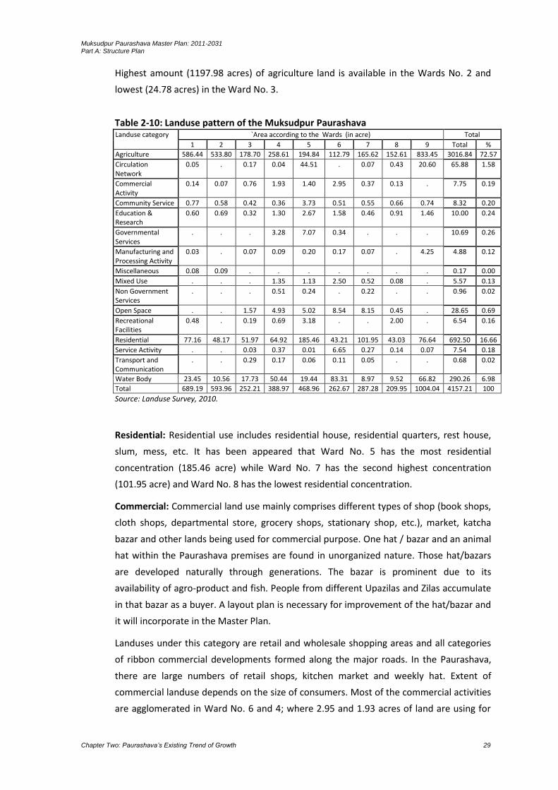
Muksudpur Paurashava Master Plan: 2011-2031 Part A: Structure Plan
Chapter Two: Paurashava’s Existing Trend of Growth 29
Highest amount (1197.98 acres) of agriculture land is available in the Wards No. 2 and
lowest (24.78 acres) in the Ward No. 3.
Table 2-10: Landuse pattern of the Muksudpur Paurashava Landuse category `Area according to the Wards (in acre) Total
1 2 3 4 5 6 7 8 9 Total %
Agriculture 586.44 533.80 178.70 258.61 194.84 112.79 165.62 152.61 833.45 3016.84 72.57
Circulation Network
0.05 . 0.17 0.04 44.51 . 0.07 0.43 20.60 65.88 1.58
Commercial Activity
0.14 0.07 0.76 1.93 1.40 2.95 0.37 0.13 . 7.75 0.19
Community Service 0.77 0.58 0.42 0.36 3.73 0.51 0.55 0.66 0.74 8.32 0.20
Education & Research
0.60 0.69 0.32 1.30 2.67 1.58 0.46 0.91 1.46 10.00 0.24
Governmental Services
. . . 3.28 7.07 0.34 . . . 10.69 0.26
Manufacturing and Processing Activity
0.03 . 0.07 0.09 0.20 0.17 0.07 . 4.25 4.88 0.12
Miscellaneous 0.08 0.09 . . . . . . . 0.17 0.00
Mixed Use . . . 1.35 1.13 2.50 0.52 0.08 . 5.57 0.13
Non Government Services
. . . 0.51 0.24 . 0.22 . . 0.96 0.02
Open Space . . 1.57 4.93 5.02 8.54 8.15 0.45 . 28.65 0.69
Recreational Facilities
0.48 . 0.19 0.69 3.18 . . 2.00 . 6.54 0.16
Residential 77.16 48.17 51.97 64.92 185.46 43.21 101.95 43.03 76.64 692.50 16.66
Service Activity . . 0.03 0.37 0.01 6.65 0.27 0.14 0.07 7.54 0.18
Transport and Communication
. . 0.29 0.17 0.06 0.11 0.05 . . 0.68 0.02
Water Body 23.45 10.56 17.73 50.44 19.44 83.31 8.97 9.52 66.82 290.26 6.98
Total 689.19 593.96 252.21 388.97 468.96 262.67 287.28 209.95 1004.04 4157.21 100
Source: Landuse Survey, 2010.
Residential: Residential use includes residential house, residential quarters, rest house,
slum, mess, etc. It has been appeared that Ward No. 5 has the most residential
concentration (185.46 acre) while Ward No. 7 has the second highest concentration
(101.95 acre) and Ward No. 8 has the lowest residential concentration.
Commercial: Commercial land use mainly comprises different types of shop (book shops,
cloth shops, departmental store, grocery shops, stationary shop, etc.), market, katcha
bazar and other lands being used for commercial purpose. One hat / bazar and an animal
hat within the Paurashava premises are found in unorganized nature. Those hat/bazars
are developed naturally through generations. The bazar is prominent due to its
availability of agro-product and fish. People from different Upazilas and Zilas accumulate
in that bazar as a buyer. A layout plan is necessary for improvement of the hat/bazar and
it will incorporate in the Master Plan.
Landuses under this category are retail and wholesale shopping areas and all categories
of ribbon commercial developments formed along the major roads. In the Paurashava,
there are large numbers of retail shops, kitchen market and weekly hat. Extent of
commercial landuse depends on the size of consumers. Most of the commercial activities
are agglomerated in Ward No. 6 and 4; where 2.95 and 1.93 acres of land are using for

Muksudpur Paurashava Master Plan: 2011-2031 Part A: Structure Plan
Chapter Two: Paurashava’s Existing Trend of Growth 30
commercial purposes. All of those Wards are the core areas of Muksudpur Paurashava. In
tota7.75acres or 0.19% land is using for commercial purposes.
Industrial: Industries are one kind of dominating landuse but not applicable for
Muksudpur. Little amount of land (4.88 acres or 0.12%) of the Planning Area is covered
by this category of landuse. This category includes husking mill, oil mill and saw mill.
About 4.25 acres of land under industrial use is occupied by the Ward No. 9. The
industrial landuse is not prominent in other Wards as well as the Paurashava. No
industrial landuse is found in the Ward No. 2 and 8.
Agricultural: Agricultural landuse includes paddy field, cropland, grazing land,
horticulture, orchard, etc. A total of 3016.84 acre (72.57% of total land) of land is under
this category in Muksudpur Paurashava. The rural agricultural landuses are spread over
the entire Planning Area. All Wards are not involved with the agriculture land. In the
Ward No. 9 agricultural landuse occupied 833.45 acres out of the total land under this
category. At the same time, Ward No. 1 and 2 are occupied 586.44 acres and 533.8 acres
respectively. Lowest amount of agriculture land is found in the Ward No. 6 (112.79
acres).
Education: The Paurashava is not well developed with number of educational institutions
like college, high school and primary school for improvement of educational activities.
The students who like to develop him with higher education shifts to the Dhaka or Zila
Headquarters, but for general educational services one government high school and
three government primary schools are found in the Paurashava premises. Total area
under this use is 10 acres or 0.24% of the Planning Area. Ward No. 3 conceived minimum
landuse under educational facilities (0.32 acres).
Public Land: This category includes all types of government offices like DC office, Zila
Parishad, Upazila Parishad, LGED, DPHE, Fisheries, Social Welfare, Statistical Bureau,
Health office, etc. Total land under this category is found 10.69 acres (0.26%). The
services are in the Ward No. 2, 3 and 9. Among those Wards, Ward No. 2 is conceived
highest (6.55 acres) land and lowest (0.38 acres) in Ward No. 9. No public land is in the
Ward No. 1, 4, 5, 6, 7 and 8.
Land under other Govt. Institutions: Muksudpur Paurashava office, UNO office, Food
Office, Sub-Register Office, Upazila Primary and Secondary Education Office, Water
Development Board, Rural Development Board and other Upazila level government
offices come under this land use category. Government offices are located at Ward No. 4,
5 and 6. Paurashava Office and UNO office are situated at Ward No. 5 and this Ward
occupy largest amount (7.07 acre) of such land. In total, 3.28 acres of total Govt. land is
situated in the Ward No. 3 and 0.34 in the Ward No. 6.
Muksudpur Paurashava Master Plan: 2011-2031 Part A: Structure Plan
Chapter Two: Paurashava’s Existing Trend of Growth 31
Khas land: The Paurashava is not maintaining the khas land record. Upazila Nirbahi
Officer is the custodian to maintain the khas land record and his office denied supplying
any information on khas land of Muksudpur Paurashava.
Other (Abandoned, etc.): In the Paurashava, 8 NGOs are with multi-disciplinary social
development activities. Most of those offices are located in the residential areas and
same compound in a residential building. The NGOs are separated from the residential
buildings and established independently. Total areas under non-government services are
0.96 acres and those establishments are in the Ward No. 2, 3 and 5.
Recreational: Recreational facilities like cinema hall, auditorium, amusement park, picnic
spot, etc. are included in this category. Recreational facility is 0.16% (6.54 acre) found in
the Muksudpur Paurashava. Ward No. 2, 3, 4, 6 and 7 are occupied with some
recreational facilities.
Water Bodies: Water body of Muksudpur Paurashava is mainly consists of pond, ditches,
khals, dinghies, irrigation canal etc. It covers 290.26 acres of land. Ward No. 4 (50.44
acres), Ward No. 6 (83.31acres) and Ward No. 9 (66.82 acres) share major percentage of
water bodies in this Paurashava.
Mixed-Use: Mixed-use areas are those where, either commerce is mixed up with
residence or residence with commerce or residence with office or admixture of all the
three. Sometimes small industrial enterprises are also found to co-exist with any one or
all the above landuses. However, other admixture of diverse landuses is also found.
Mixed
landuse is a common character of all unplanned urban centers in Bangladesh. The degree
of such admixture depends on the specific location of the area.
If the area is closer to the urban centre than the more profitable landuse takes over the
less profitable ones and co-existence of diverse landuses prevail for long till one fully
takes over the other. In such areas usually commerce gradually takes over residential
use.In the Planning Area, mixed-use is not prominent, only Paurashava town centre is
being formed. Only 5.57 acres (0.13%) land is identified as mixed-use areas in the
Paurashava. Mixed-use areas are in the Ward No. 4, 5, 6, 7 and 8. This type of landuse is
found among the main road where the ground floor is using for commercial purposes and
other floors are using for residential purposes. Among them, Ward No. 6 is highest (2.50
acres) concentrated as mixed-use area.
Urban Services: The Paurashava is formed with the urban services like Post Office, Bank,
Police Station, Monument and Mobile Tower. It covers 7.54 acres of land. Except Ward
No. 1 and 2, other services are in other Wards and highest are is occupied by the Ward
No. 6 (6.65 acres).

Muksudpur Paurashava Master Plan: 2011-2031 Part A: Structure Plan
Chapter Two: Paurashava’s Existing Trend of Growth 32
2.10 Paurashava Functional Linkage with Regional and National network
Regional network of the Paurashava: The project for “Preparation of Paurashava Town
Structure Plan, Urban Area Plan and Ward Action Plan” covers the areas between
Muksudpur Paurashava boundaries. The study area covers 16.82 sq. km. (4157.21 acres)
and road length is 66.61 km. The National Highway runs through the Paurashava and
links a number of Connector Roads and Access Roads. National Highway is the major
arterial road of the study area. It provides connection with Faridpur, Kasiani, Bhanga,
Dhaka, Gopalganj and Khulna. There is one important road intersection named College
Road Moor (in Bengali) which provided linkages with other access roads. Those access
roads are Tekerhat To Tengrakhola Road, Post Office Road, Mokudpur To Chandhat Road,
Moksudpur To Gopalganj Road, Kaoladia Road, Hospital Road, Gopinathpur mothbari
Road, Gopalgang Road, Dorgha Road and. College Road.
Motorized and non-motorized vehicles are operated in all the nodes of the study area.
The non-motorized vehicles are mainly operated within short distance and meet the local
needs. The motorized vehicles are mostly intercity passenger buses and trucks; mainly
carry agro-product from the Muksudpur towards Faridpur and Dhaka. Locally modified
motorized transport vehicle named Nosimon also uses for short distance passenger and
goods transportation.
Roads of the Paurashava belonging to number of agencies named Roads and Highways
Department (RHD) responsible for National Highway, Local Government Engineering
Department (LGED) responsible for construction and maintenance of Upazila and Union
roads and Muksudpur Paurashava is responsible for construction and maintenance of
roads within the Paurashava area. Existing transportation system is dominated by road
network catering to the passenger service and freight transport.
The Upazila is bounded on the north by Nagarkanda and Bhanga Upazilas of Faridpur
Zila, on the east by Rajoir Upazila of Madaripur Zila, on the south by Gopalganj Sadar
and Kasiani Upazilas and on the west by Kasiani Upazila. The Bhanga – Khulna
Highway via Gopalganj is adjacent with the Paurashava. This highway creates easy link
with the adjacent Paurashavas and the districts. Agriculture products of the
Paurashava as well as the Upazila are being distributed with the use of this highway
and the hats and bazars of the Paurashava performs important role to concentrate
those agriculture products.
Muksudpur Paurashava Master Plan: 2011-2031 Part A: Structure Plan
Chapter Two: Paurashava’s Existing Trend of Growth 33
Map 2-1: National/ Regional Road Network
Muksudpur Paurashava Master Plan: 2011-2031 Part A: Structure Plan
Chapter Two: Paurashava’s Existing Trend of Growth 34

Muksudpur Paurashava Master Plan: 2011-2031 Part A: Structure Plan
Chapter Two: Paurashava’s Existing Trend of Growth 35
National network of the Paurashava: The Paurashava is located at south central part of
Bangladesh and about 70 km. (through Maowa) away from the Dhaka City. Jessore on
the north and west, Gopalganj on the east and Faridpur is lying on the southern part
of the Paurashava. National importance of the Muksudpur Paurashava as well as
Muksudpur Upazila is governed with its surplus agriculture products. Rice, onion,
sugarcane and jute are the major agriculture products and fish farming. Those
products distribute among the Upazilas lying at the boundary line of the Muksudpur
Upazila and the district named Jessore, Faridpur, Gopalganj and Dhaka.
The intersection named Muksudpur Intersection with the help of regional road
penetrates the Paurashava. Vehicular movement about 5 districts passes through this
intersection. Once development trend of the Muksudpur was followed the waterway
station and as a result, a concentrated development is found in the Ward No. 2.
The Paurashava is mostly linear shaped. Bhanga - Bhatiapara - Gopalganj, Bagerhat –
Dhaka, national highway passes in the western side of the Paurashava from north to
south. Settlements are formed linearly around the internal roads. Pattern of compact
settlement is viewed in the Ward No. 3, 5, 6 and 8. Those Wards are adjacent to the
Kumar River and National Highway. Ward No. 2, 7 and 9 is mostly agriculture dominated
areas. Most of the commercial activities are formed in the Ward No. 2 and 9 because it is
nearer to the Kumar River.
The road network provides access to various places within the study area and connects
various parts of the country following bus routes. Major trips of vehicles are generated
from, within the Paurashava, Bhatiapara, Faridpur, Gopalganj, Bhanga, Khulna, Bagerhat
and Dhaka.
Muksudpur is a new Paurashava established along the National Highway. No urban
facilities yet provided by the Paurashava authority. All urban facilities as a township
development are necessary. Most of the urban services were developed when the
Paurashava was formed as a growth centre / cluster development.
2.11 Role of Agencies for Different Sectoral Activities
Agencies responsible for utility facilities and municipal services are an important
component for an area. Utility services include water supply, gas supply, electric supply,
sewerage and drainage system, telecommunication system, fire services, solid waste
management, etc. The concerned departments / organizations responsible for planning
and development of utility services are shown in the following table.
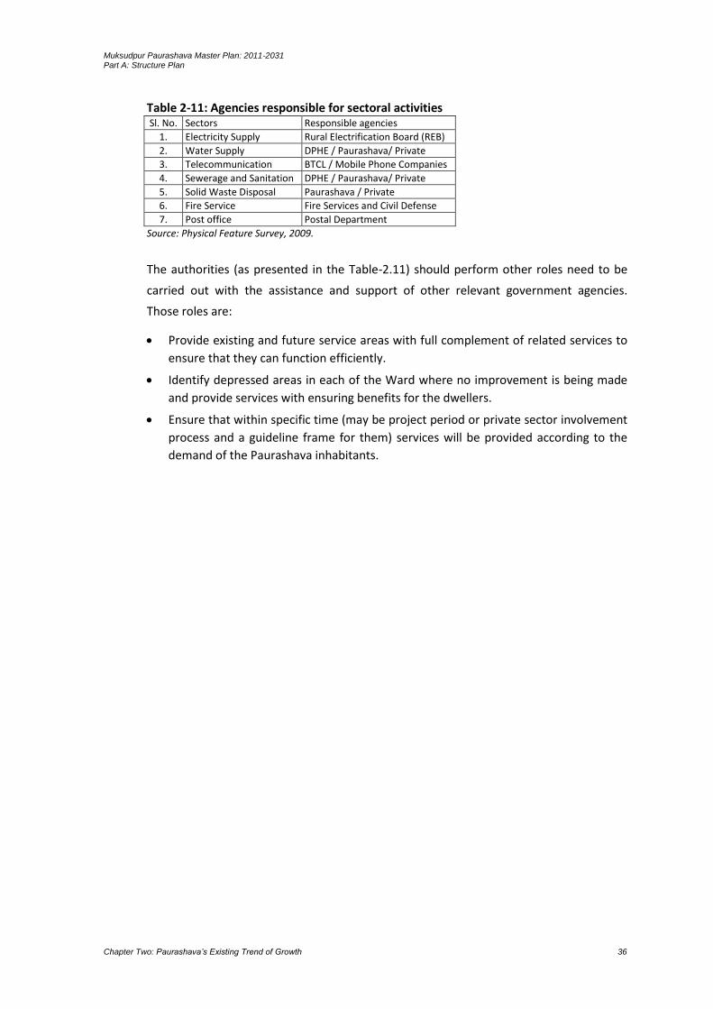
Muksudpur Paurashava Master Plan: 2011-2031 Part A: Structure Plan
Chapter Two: Paurashava’s Existing Trend of Growth 36
Table 2-11: Agencies responsible for sectoral activities Sl. No. Sectors Responsible agencies
1. Electricity Supply Rural Electrification Board (REB)
2. Water Supply DPHE / Paurashava/ Private
3. Telecommunication BTCL / Mobile Phone Companies
4. Sewerage and Sanitation DPHE / Paurashava/ Private
5. Solid Waste Disposal Paurashava / Private
6. Fire Service Fire Services and Civil Defense
7. Post office Postal Department
Source: Physical Feature Survey, 2009.
The authorities (as presented in the Table-2.11) should perform other roles need to be
carried out with the assistance and support of other relevant government agencies.
Those roles are:
Provide existing and future service areas with full complement of related services to
ensure that they can function efficiently.
Identify depressed areas in each of the Ward where no improvement is being made
and provide services with ensuring benefits for the dwellers.
Ensure that within specific time (may be project period or private sector involvement
process and a guideline frame for them) services will be provided according to the
demand of the Paurashava inhabitants.

Muksudpur Paurashava Master Plan: 2011-2031 Part A: Structure Plan
Chapter Three: Projection of Future Growth by 2031 37
CHAPTER 3 PROJECTION OF FUTURE GROWTH BY 2031
3.1 Introduction
The Chapter presents future growth of the Paurashava according to the population,
economy and landuse. The projected period for those components has been considered
for the year 2011 to 2031. In case of population and landuse, projection has been
presented but in case of economy, opportunities have been considered. For the
Muksudpur Paurashava, government policy is the prime focus as economic opportunity
but that is not considered here. Existing local economic strength considers as the basis of
economic opportunity. Agriculture, fish, livestock and poultry, local fruits and availability
of labour force considers as a basic components of the economic opportunities.
3.2 Projection of Population
No single factor isimportant for planning than the size and composition of a region’s
population and the way it will change in future. Estimating future population for a
specific period for a particular area is one of the most difficult tasks in the planning
process. For Bangladesh, population projection is a very difficult task as the required data
are not available for particular area and same is the case for Muksudpur.
Table 3.1: Growth Trend Analysis Area Population 2001 Population 2011 Growth Rate
2011 (%)
Gopalganj District (urban area) 69,191 85,461 2.13
Muksudpur Upazila (urban area) 18,069 19,711 0.87
Muksudpur Paurashava 18069 19711 0.87
On the other hand, difference of data from different secondary sources also makes the
job more complex. The population figures collected from secondary sources especially for
Paurashava were very much ambiguous. So, for the projection, several discussions were
made with experts and BBS officials. Following is the annual growth rate for the study
area available from the 2011 Population Census, the projection up to the year 2031 with
five years interval has been prepared.
To calculate the future population of the Paurashava, following formula is being used.
Pn = Po (1+ r)t
where
Po = base year population
Pn = projected year population
t = time period
r = annual growth rate

Muksudpur Paurashava Master Plan: 2011-2031 Part A: Structure Plan
Chapter Three: Projection of Future Growth by 2031 38
Basis of population projection: The data collected from several sources is not reliable to
be accepted because, as like different sources data is also different. When it is calculated
for the projection then the output shows separate result. It is the main deficiencies of
data obtained from diverse sources.
Migration information is not available in the BBS Census, only considers natural growth
rate. Actual population projection requires both natural growth rate and migration rate.
For this unavailability of migration data, calculation of population projection becomes
very difficult. To avoid this problem, population estimation presents as alternate of
population projection.
Muksudpur Paurashava was established on April 2001. In the BBS Census 2001,
Paurashava boundary was properly demarcated. So, Ward-wise population distribution
was available in the census. For this reason, population census 2001 and 2011 uses and
find out the growth rate for future population projection. According to the formula,
present growth rate (0.87) is used for projection and it is assumed that the rate will
continue upto 2031.
The projection shows that the population of the planning area is 19711 in 2011 and it will
be 20499 in 2016, 21320 in 2021, 22172 in 2026 and 23059 in 2031. The scenario proves
that in next 20 years the Paurashava population will be increased in minimum size. The
projection is showing normal increase of population. In special case, for construction of
Padma Bridge at Maowa Point, government policy on relocation of industries from Dhaka
and community facilities provided by the Paurashava according to the Master Plan, the
growth rate will be increased rather than the normal rate considered here.
Table 3-2: Population projection(growth rate 0.87%) Ward No.
Area in acre
Population 2001
Population 2011
Projected population
2016 2021 2026 2031
1 689.19 1748 1851 1925 2002 2082 2165
2 593.96 1357 1407 1463 1522 1583 1646
3 252.21 1858 1967 2046 2128 2213 2301
4 388.97 1627 1830 1903 1979 2059 2141
5 468.96 2464 2905 3021 3142 3268 3398
6 262.67 2643 3095 3219 3348 3481 3621
7 287.28 2694 2929 3046 3168 3295 3427
8 209.95 1955 2070 2153 2239 2328 2422
9 1004.04 1723 1657 1723 1792 1864 1938
Total 4157.21 18069 19711 20499 21320 22172 23059
Source: BBS, 2011 and calculated by the Consultant.
3.3 Identification of Future Economic Opportunities
Most of the entrepreneurs expressed their desire of implementing future development
plan. A major portion mentioned that their development plan is the expansion of their

Muksudpur Paurashava Master Plan: 2011-2031 Part A: Structure Plan
Chapter Three: Projection of Future Growth by 2031 39
enterprises (70%) and others intend to increase their production (30%). Expansion of
existing industries and establishment of new industries will create more jobs and thus
have multiplier effect in the overall economy leading to create more consumption
capacity, investment opportunities in diversified economic fields and thus push the
economy upward.
Some small-scale poultry farm is located in the Muksudpur Paurashava area. The
production of this poultry farm mostly uses in the Dhaka City. Such investment is showing
huge prospects of the Paurashava for capital investment. The prospect summarizes in the
following discussions:
Availability of unskilled and cheap manpower.
Availability of agriculture land. The land may be used for different agricultural
production and those productions may be used for the input of agro-based
industries.
Due to the nearness of Dhaka City, the Paurashava may be developed as the fringe
area of Dhaka City. This fringe area with its agriculture production will support to the
Dhaka City where marketing for those productions are available.
The Paurashava has been developed as growth centre concept. Some cluster
development is found around this growth centre. Planned development through this
master plan will initiate to arrange the growth component in a systematic manner. At
the sametime, economic development parallel to the physical and social
development will be encouraged.
3.4 Projection of Landuse
Landuse requirement: In Muksudpur Paurashava, major landuse is agriculture (72.57%).
Residential landuse occupies second position (16.66%) of the category. Only 1.58% land is
using for circulation network. Though, agriculture landuse dominates the Paurashava but,
after the preparation of Master Plan, a radical change in physical development will
proceed. In consideration of such concept, the Master Plan will be delighted in favour to
save the agriculture land.
The determining factors of landuse change is the income of the people, government
policy, new establishment like industry, higher level educational institute, construction of
road and embankment and availability of services. The Paurashava was developed as a
growth centre long before, than a police station. In the year 2000 it is notified as
Paurashava. Radical change of landuse in the Paurashava is not found. Before it known as
Paurashava, agricultural domination was the key landuse. During last ten years, the
landuse scenarios remain same.
The Paurashava is not an ideal township due to the agriculture domination. Agriculture
based township should be encouraged in the preparation of Master Plan. Growth of
population is the natural trend and at the sametime, expansion of non-agricultural use on
agriculture land is also natural tendency of the people. This will be controlled through the
Muksudpur Paurashava Master Plan: 2011-2031 Part A: Structure Plan
Chapter Three: Projection of Future Growth by 2031 40
Compact Township concept with the encouragement of vertical development. In case of
government services, specific building may accommodate different type of offices.
Future landuse will be calculated according to the development control for the masses
and the standard supplied by the LGED. In case of public land, existing use and khas land
will be emphasized. Willingness and participation of the people in development activities
will be the key factor for future landuse demarcation. Slow change of landuse will be
emphasized rather than rapid change. Let the people do whatever he likes on own land –
such concept should not be considered for future projection of landuses. Three parts of
the projection are landuse change, landuse control and landuse restriction will be
included in the Master Plan. In any case, river front areas should be restricted for human
habitation. As a result, river water will safe from contamination.
Basis for Projection: The projection of landuse depends on the growth of population.
After population projection it is found that, population of this area will be 23059 (that
belong to the trend line method) in the year 2031. Projection on landuse also depends on
present trend of migration.
Demand Analysis: In case of landuse change, the standard given by the LGED according
to the projected population and area for the specific service will be calculated. But, the
agriculture land should be preserved from any type of physical development. It should
not be decreased. The vertical expansion will be emphasized rather than horizontal. In
case of road network planning, missing links will be prescribed rather than new roads. For
the development of pisciculture, all ponds and ditches may be preserved, in some
exceptional cases; small number of ditches may be used for physical development
activities. Landuse control and landuse restriction will be imposed by the Paurashava
according to the prescribed plan.
3.5 Housing
Housing areas in the Paurashava is the composition of an admixer of housing types.
Mixed residential, poor dominated rural houses and semi-urban homesteads are found.
Most housing areas have developed in a spontaneous fashion. In the rural part of the
Paurashava, with its rural-agricultural character, has a different housing type. The
dwellings, comprising homesteads, encompass larger areas having low density. The
highest gross population density in the Paurashava is only 5 persons per acre. Buildings in
the Paurashava are dominated by katcha structure (79%). No building is found approved
from Paurashava. However, owners of the buildings have been found violated the
setback rule by the construction. Except labour charge there is very little variation in
building construction cost between Dhaka and Muksudpur Paurashava.
Problems relating to the housing are mostly concerned with the poor community. Due to
their low level of income a vast number of poor are squatting in public land. They are not

Muksudpur Paurashava Master Plan: 2011-2031 Part A: Structure Plan
Chapter Three: Projection of Future Growth by 2031 41
only deprived of minimum housing but also from the personal security that endanger
their health and working efficiency. Regular income can solve most of their housing
problems. Apart from dwelling, pure water and transportation are real problems for the
inhabitants. Municipal services are highly inadequate. Drainage is major problem in rural
part of the Paurashava. The Paurashava can not solve the problems due to scarcity of
fund. In the Paurashava, above 97 percent housing structures are one-storied that
includes semi-pucca, katcha and Jhupri type houses.
Basis of housing projection: Existing landuse is the only basis for housing projection.
Residential use and mixed-use has considered for the year 2011 as base year and
projected housing area is calculated considering 40 persons per acre and there is no
standard for industrial use, commercial use, etc.
Demand analysis: It is estimated that housing demand stands at 769 acres at the end of
project period 2031. The estimate is based on the assumption that the standard supplied
by the LGED for housing estimation where density is declared around 150 or 100 per
acre. But for Muksudpur Paurashava it is not possible to follow the standard properly.
The Paurashava undeveloped horizontal development is taking part rather than the
vertical expansion. By considering all these facts, the density in this Paurashava is
considered 40 persons per acre.
Table 3-3: Ward-wise demand of housing areas (100 person/acre) Ward No.
Existing Housing Area (acre), 2010
Estimated housing demand (acre)
2016 2021 2026 2031
1 77.16 28.2 31.2 34.6 38.3
2 48.17 17.7 19.6 21.7 24.0
3 51.97 28.3 31.3 34.6 38.3
4 64.92 32.7 36.2 40.1 44.4
5 185.46 36.0 39.9 44.1 48.8
6 43.21 27.2 30.1 33.3 36.9
7 101.95 11.5 12.7 14.1 15.6
8 43.03 19.7 21.8 24.2 26.7
9 76.64 33.8 37.4 41.4 45.8
Total 692.50 235.2 260.3 288.0 318.7
Source: PMO office
Table 3-4: Ward-wise demand of housing areas (40 person/acre) Ward No.
Existing Housing Area (acre), 2010
Estimated housing demand (acre)
2016 2021 2026 2031
1 77.16 64 67 69 72
2 48.17 49 51 53 55
3 51.97 68 71 74 77
4 64.92 63 66 69 71
5 185.46 101 105 109 113
6 43.21 107 112 116 121
7 101.95 102 106 110 114
8 43.03 72 75 78 81
9 76.64 57 60 62 65
Total 692.50 683 711 739 769
Source: Landuse Survey, 2010 and calculated by the Consultant.
Muksudpur Paurashava Master Plan: 2011-2031 Part A: Structure Plan
Chapter Three: Projection of Future Growth by 2031 42

Muksudpur Paurashava Master Plan: 2011-2031 Part A: Structure Plan
Chapter Four: Development Problems of the Paurashava 43
CHAPTER 4 DEVELOPMENT PROBLEMS OF THE PAURASHAVA
4.1 Physical Infrastructure
Most of the lands in the Paurashava are acting an important role on the supply of
agriculture commodities in different Paurashavas and Zilas. All of those lands submerge
in rainy season. On the other hand, development activities are reducing agriculture land
rapidly. This trend should be controlled through the imposition of development control,
but the contemporary regulations and their management is not enough to control such
development activities.
About 5 to 10 meter earth filling will be needed for every development activities in
the Paurashava. So, bulk development should not be encouraged due to the huge
cost involvement. Poor soil condition is another problem of bulk development.
Lowlands are also providing natural drainage facilities in the area.
The Paurashava is a naturally developed area. Planning effort yet not been taken by
the public authority. Therefore, a mixed landuse scenario is viewed in all over the
Paurashava. These unorganized landuses should be framed within a planning manner
with the physical and financial involvement of public authority.
All roads in the Paurashava town are narrow and irregular. Some of the roads
submerge in rainy season. Widths of all semi-pucca and katcha roads are between 4
to 6 meters and somewhere they are using as footway. Those narrow and irregular
roads may be widen and in regular shaped but not in all cases. Because some of the
roads are in densely populated areas, pucca buildings and commercial establishments
will be needed to demolish. Some roads did not preserve any scope for further
improvement. Infrastructural facilities such as water and sanitation will not be
possible to construct in those narrow roads.
Muksudpur is a new Paurashava. No urban facilities yet provided by the Paurashava
authority. All urban facilities as a township development are necessary. Most of the
urban services were developed when the Paurashava was formed as a growth centre.
Inhabitants of the Paurashava make their opinion (during consultation meeting) in
favour of Paurashava system.
North, south and eastern part of the Paurashava are under the low lands. In every
year the Kumar River submerges those lands. Urban facilities are not possible to
provide on those lands except agriculture.
Problems will be prevailed to provide central water supply and drainage system due
to the presence of ditches and low lands, only the lands in central areas appropriate
for those services.
Muksudpur Paurashava Master Plan: 2011-2031 Part A: Structure Plan
Chapter Four: Development Problems of the Paurashava 44
4.2 Socio-economic
The Paurashava is quite poor in respect of basic utility services. Information collected
through Socio-economic survey reveals basic utility facilities like piped water supply is
very negligible. Gas, drainage and sewerage and solid waste are also in same condition.
People use various types of fuel sources like cylinder gas, kerosene, wood, electric
heater, cow dung, etc. For drinking water supply, deep tubewell, community tubewell
uses, electricity supply for household lighting and for other purposes exists but with
frequent load shedding.
Almost all the Wards are connected with electricity supply in moderate level. In spite of
this, considerable number of households in all the Wards has no electricity facilities.
Almost all the Wards have no sewerage system and toilets are mostly consists of sock
pits. Overall garbage disposal system is poor. Garbage Dumping Ground is not available
and mostly disposes on open streets. Waste collection is collected through NGOs but not
well organized all over the study area. Ward-wise findings in table below highlight the
situation in this respect.
Muksudpur Paurashava bears rural influences and small business is the major source of
income. Average monthly income per household is Tk.9700. Food relatively stands higher
in expenditure list (Tk.5860 in Paurashava as a whole). The residents of the Paurashava
save little amount of money per month from their income (highest amount is Tk.730).
Due to the presence of Muksudpur Bus Stand, the Paurashava exhibits high potential of
socio-economic development. One National Highway passes through the Paurashava is
the destination of selected south Bengal movements. The activities around the bus stand
will generate employment in commercial sector. This effort will be faster with the
commissioning of 1st Padma Bridge at Maowa point. New investment will gear up in to
Muksudpur creating new jobs. This will enhance income of the local people and raise
their standard of living. Investment and employment will take place in transport,
industry, construction, trade and service sectors. There is a large scope for agro-based
development in Muksudpur. This will generate new employment.
Drainage Facility: Nearly non-existence, very shallow katcha in type is the major
characteristics of drainage facilities in the Paurashava. There are katcha drains
constructed along the access roads, but this is found rare. Those drains are not
continuous and open and not facilitated all the Wards.
Toilet Facility: Toilet system of the study area is mostly categorized as pucca. In spite of
this, Paurashava has a modest development of pucca toilets in government zones.
Sewerage system has not been introduced on a trial basis as to their popularity and
acceptance. Ownership of toilets varies widely in most of the Wards. In Muksudpur
Upazila, 49.87% of dwelling households have sanitary latrines with 76.47% in urban area.

Muksudpur Paurashava Master Plan: 2011-2031 Part A: Structure Plan
Chapter Four: Development Problems of the Paurashava 45
A total of 44.66% of the households has non-sanitary latrines with 19.00% in urban area
and 5.47% of the households have no toilet facility.
Water supply: Almost all households are using tubewell water as main source of drinking
water and cooking purposes. At least 96% households are using tubewell water to
maintain their daily needs and rest of the residents is using pond water for washing and
bathing purposes. In total, 85% households bearing tubewell owner and 15% households
are using neighbour’s tubewell. Ground water levels during dry and wet seasons are
between 30ft to 25ft respectively.
4.3 Environmental
Arsenic contamination is a great matter of concern for Muksudpur Paurashava. Proper
plan will address the priority in the main report. There is an up-coming issue of land filling
in the Paurashava area that will cause a serious problem in the future. The low lands and
water bodies in different places are being developed by private housing and commercial
settlements without planning intervention. Like the Dhaka city, Muksudpur Paurashava
also has the problem of filling the wetland. Wet land should be carefully identified and
marked as per the requirement of ‘Wet land Protection Act 2002’ in the Paurashava plan.
So that they can be save from the land grabbers in future. Well solid waste management
system is urgently necessary in this Paurashava. Private public partnership (PPP) can be a
good initiative for this purpose.
However, implementation of activities like roads, drainage, bridge / culverts, housing and
industrial establishments and bazars will radically change the natural topography and
landuse pattern. The agricultural land will be converted into urban and semi-urban
nature. Existing scenic beauty will disappear; water bodies will lost and general slope will
be diminished for earth filling due to urbanization. Therefore, in the process of
preparation Structure Plan, Urban Area Plan and Ward Action Plan, consideration of
those factors will be made for keeping the natural environment livable.
To create a better living environment, environmental phenomenon (as discussed earlier)
has been considered with the systematic planning principles and regulatory measures.
With these views, people’s awareness needed to be increased through different public
activities about the fair living environment. Arrangement of land uses should be
provisioned for all the public and private organizations as their necessities.

Muksudpur Paurashava Master Plan: 2011-2031 Part A: Structure Plan
Chapter Four: Development Problems of the Paurashava 46
Muksudpur Paurashava Master Plan: 2011-2031 Part A: Structure Plan
Chapter Five: Paurashava Development Related Policies, Laws and Regulations 47
CHAPTER 5 PAURASHAVA DEVELOPMENT RELATED POLICIES, LAWS AND
REGULATIONS
5.1 Indicative Prescription of Policy for Paurashava in the light of the Different
Urban Policies, Laws, Regulations and Guidelines
The preparation of Structure Plan, Urban Area Plan and Ward Action Plan for the
Muksudpur Paurashava is highly depended on the policies and relevant contemporary
rules and regulations prescribed by the government. In preparation of the above Plans,
guidelines and strategies prescribed through the policies are considered carefully.
Contemporary rules and regulations help to formulate the process and procedure for
development control.
Urban Land Management Policy
It is necessary to impose control on the use and development of urban land. A range of
urban planning tools including landuse planning, transportation planning and
management, site planning, subdivision regulations and building regulations can be
applied to minimize environmental impacts of urban development activities.
Policies
Protect sensitive land resources by minimizing activities threatening environmentally
sensitive areas.
Manage hazard-prone lands through improvement of environmental management
practices throughout the Paurashava.
Conserve open space, as identified through a participatory planning process that will
effectively preserve drainage system, provide greater opportunities for recreation
and meet the minimum needs of aquifer recharge.
Protect heritage structures and archaeological and cultural sites through appropriate
schemes, projects and regulations.
Control excessive urban sprawl and manage prime agricultural land through the
implementation of regulatory reforms.
Formulation of land information system, land market assessment regulations,
efficient and transparent land record and registration system, etc.
Increase the supply of land for the poor through reforming land transfer laws to
counter trends towards land accumulation.
Adoption of taxation policies that discourage speculative investments in land that is
left undeveloped for extended periods of time.
Implementation of land-banking and land-pooling programs that allow the
government to increase its pool of land which can be exchanged for low-cost housing
sites in the Paurashava;

Muksudpur Paurashava Master Plan: 2011-2031 Part A: Structure Plan
Chapter Five: Paurashava Development Related Policies, Laws and Regulations 48
Undertaking land readjustment projects that include low-cost land and housing sites.
Undertaking land-sharing schemes and tenancy reforms for establishing clear rights
of tenants.
Allocating khas land/acquired land for housing the poor.
Allocating reasonable proportion of land in urban places for housing the poor.
Strategies
The strategies necessary to implement the policies of the urban land management is the
use of planning tools in land management. Those planning tools may be structure
planning, local planning and action planning. Second strategy is the landuse zoning. This
tool may be used to:
Protect productive agricultural lands by limiting the intrusion of non-agricultural
uses;
Manage floodplains by controlling uses of land within hydrologically defined areas
subject to floods of a designated frequency;
Preserve wetlands by limiting permissible uses to those that do not entail significant
surface disturbance or runoff and substantially restricting land-disturbing uses within
the areas identified as wetland areas;
Restore and conserves natural canals and ponds.
Facilitate planned unit development by allowing flexible design and clustering of
residential development with higher densities on one portion of a land parcel so as to
allow agricultural development or to provide increased open space or natural cover
elsewhere on the parcel;
Preserve open space by designating land areas for a variety of purposes such as
recreation, future use, green belt, etc.
Strategies of land development for the Paurashava according to the Urban Land
Management Policy may be followed through some techniques such as land pooling /
readjustment, guided land development, land sharing, sites and services schemes, etc.
Landuse Policy
Bangladesh Landuse Policy was prepared and notified in the year 2001. Major aim of the
policy is to prevent indiscriminate conversion of agricultural land in to non-agricultural
use, because such conversion may be threatened for food security of the country. The
expansion of residential, commercial, industrial and socio-economic uses will encourage
the diminishing trend of agriculture land. Through the policy, government has
encouraged Compact Township and vertical expansion of the different type of building
rather than horizontal expansion.

Muksudpur Paurashava Master Plan: 2011-2031 Part A: Structure Plan
Chapter Five: Paurashava Development Related Policies, Laws and Regulations 49
Objectives
The objectives of the Landuse Policy are to:
Prohibit the recent practice on conversion of agriculture land into non-agricultural
use to ensure food security for the people.
Impose zoning provision to control the better use of land according to the nature of
land located in different regions.
Rehabilitation of landless people on the alluvion lands alluviated from river, Haor or
sea.
Preserve khas land for future physical development activities.
Confirm landuses in relation with the existing natural environment.
Use of land in favour of job creation, landlessness and poverty alleviation.
Control land pollution.
Construction of multi-storied building with accommodation of various purposes in
public and private sector for ensuring minimum land coverage.
About 48% land of the Muksudpur Paurashava is under the agricultural practices.
According to the Landuse Policy, those lands should be preserved as agriculture land. For
such preservation, some guidelines prescribed in the Landuse Policy will be considered
they are – in case of rehabilitation of the landless people, Khas land will be emphasized
for distribution by the government.
Housing Policy
Housing, in the context of overall improvement of human settlements, is considered by
the Government of Bangladesh as an integral part of culture and planning for economic
development. The Global Strategy for Shelter by the year 2000 adopted by the United
Nations in November, 1988 calls upon governments to take steps for formulating a
National Housing Policy, 2004 in the light of "the enabling approach" for achieving the
goals of the strategy.
The housing problem in the country is of serious magnitude. In addition to the large
number of homeless households; the rapid growth of slums and unauthorized squatter
settlement; the increasing cost of land and construction materials; rampant speculation
and the phenomenal increase in house rent, the problem is compounded by non-
availability of basic civic services, including water and sanitation to the bulk of the
population and acute shortage of affordable and adequate shelter for the poor and
vulnerable groups. The housing shortage was estimated in 1991 to be about 3.10 million
units, composed of 2.15 million units in rural areas and 0.95 million units in urban areas;
with the bulk of the backlog consisting of katcha un-serviced units. The housing shortage
is likely to exceed 5 million units by the year 2000 A.D. The current housing stock is
deteriorating fast due to aging, general neglect, poverty and civic apathy on the part of
the dwellers.

Muksudpur Paurashava Master Plan: 2011-2031 Part A: Structure Plan
Chapter Five: Paurashava Development Related Policies, Laws and Regulations 50
Objectives
The objectives of the National Housing Policy are to:
Make housing accessible to all strata of society and to accelerate housing production
in urban and rural areas with major emphasis on needs of the low and middle-income
groups, the high priority target groups will be the disadvantaged, the destitute and
the shelterless poor.
Make available suitably located land at affordable price for various target groups,
especially the low and middle-income group.
Develop effective strategies for reducing the need to seek shelter through formation
of slums, unauthorized constructions, encroachments and shanty dwelling units and
to improve the existing ones environmentally and, where possible, to relocate them
in suitable places.
Rehabilitate disaster affected households and houses affected by fire accidents.
Mobilize resources for housing through personal savings and other financial input's
and by developing suitable financial institutions.
Make effective implementation of the housing programs, promote use of locally
developed materials and construction techniques and increase production of forest-
based building materials such as timber, bamboo or grass. Attempts will be made to
develop alternative and durable materials based on locally available raw material.
Develop institutional and legal framework to facilitate housing.
Improve and enhance the character, quality and environment of the existing
residential areas.
Develop new strategies and undertake revision of the policy from time to time to
cope with the emerging housing needs and problems in the country.
Undertake action-oriented research in all aspects related to housing and foster
minimization of cost and rent.
Rural Homestead
Clause 5.9 of the Housing Policy describes about the rural housing. The Muksudpur
Paurashava is rural based urban area. Rural character is the dominating issue in the
housing sector. In the Housing Policy, following measures are suggested to improve rural
housing:
Avoiding unnecessary displacement of rural settlements due to development projects
and where unavoidable, makes proper rehabilitation of the households, with full
community involvement.
Encroachment on agricultural land by proliferation of homestead should be
discouraged. Efforts should be made for planned densification of rural homesteads.
Subject to availability of khas lands, programmes similar to 'Adarsha Gram'
programme of the Ministry of land will be undertaken in rural areas.
The coordinated provision of water supply, sanitation, electricity, roads and other
basic infrastructure services to existing and new habitations.

Muksudpur Paurashava Master Plan: 2011-2031 Part A: Structure Plan
Chapter Five: Paurashava Development Related Policies, Laws and Regulations 51
Providing assistance by way of providing credit, dissemination of appropriate
technology and delivery system for promoting housing.
Initiating schemes for increased employment opportunities and income generation
by extending appropriate credits and advice, so that housing affordability is
enhanced.
Establishing suitable institutional structure including strengthening of existing
organizations at district and local level, with the responsibility for planning, financing,
implementation, supervision and monitoring of rural housing schemes, and with the
full involvement of beneficiaries, NGOs and CBOs, giving special attention to the
needs of the poorest segments, specially women and disadvantaged persons.
Linking the development of housing sites and the upgradation of rural housing with
the activities under the Bangladesh Rural Development Board (BRDB) and other
programmes for the creation of rural assets and employment.
Slums and Squatter Settlements
Clause 5.10 of the Housing Policy describes about the slums and squatter settlements.
The poor environmental condition in slums and squatter settlements create health
problems for their residents and those in the adjoining areas. Those areas may be
Paurashava Town. Keeping in view the policies of planned growth of urbanization,
income support and poverty alleviation and together with steps to arrest the growth of
new slums in urban areas, the Government would take steps to:
Encourage in-situ upgradation, slum renovation and progressive housing
development with conferment of occupancy rights, wherever feasible, and to
undertake relocation of the squatter settlements from the sites that need to be
cleared in public interest.
Expand provision of water supply, sanitation and other basic services in slum and
other settlements occupied by the poor.
Ensure proper maintenance of amenities in slums and squatter settlements through
community involvement and decentralized institutional arrangements.
Integrate the provision of physical amenities slums and squatter settlements with
basic services including maternal and child welfare services and health care,
structured on community participation and involvement of voluntary agencies and
management by local bodies.
Provide night shelters and pay and use public toilet for the footpath dwellers and the
homeless.
Infrastructure
Clause 5.2 of the Housing Policy describes about the infrastructures related with the
housing. Most of those infrastructures are needful for housing construction and
preparation of master plan. Following measures are recommended for development and
improvement of infrastructure for housing:

Muksudpur Paurashava Master Plan: 2011-2031 Part A: Structure Plan
Chapter Five: Paurashava Development Related Policies, Laws and Regulations 52
Increase investment by national and local government agencies in order to meet the
rapidly growing needs of serviced land and to improve the availability of services in
different settlements.
Promote a balanced pattern of urbanization through a policy of decentralization of
investments and incentives for the growth of secondary, intermediate and small
towns so as to reduce pressure on metropolitan cities and to control unregulated
conversion of agricultural and forest land for the purpose of housing.
Develop economically buoyant and socially attractive secondary and intermediate
towns by strengthening their linkages with contiguous rural areas and market centres
as part of the integrated and planned development of the region and to reduce
migration to the larger cities.
Make necessary investments to increase within a reasonable time, the coverage of
entire rural and urban population for potable water supply and basic sanitation.
Increase investments in public transport and traffic network to improve mobility of
people, particularly that of the poor.
Encourage the use of infrastructure construction technologies, which are cost
effective, incrementally upgradable and environmentally appropriate.
Provide government support for extension of infrastructure based on the
participation of the people and private developers, NGOs, CBOs or on innovative
systems of infrastructure leasing.
Provide Government assistance to the local bodies for adequate cost recovery of
investment on infrastructure, proper maintenance of services and upgradation of the
capability of the personnel in local bodies and functional agencies.
Provide opportunity for community participation and recognize people's initiative in
the design, installation and the upkeep of services within the framework of the
development programmes.
Strategies
The salient features of the housing strategy are:
Housing will be given due priority in the national development plans treating it as a
separate sector by itself.
The role of the Government in housing will primarily be that of a facilitator or enabler
in order to increase access to land, infrastructure, services and credit and to ensure
availability of building materials at a reasonable price, specially for the low and
middle-income groups and to create and promote housing finance institutions;
whereas actual construction of housing will generally be left to the private sector
developers, the people themselves, and the NGOs.
Greater emphasis will be laid on affordability, personal savings, self-help and cost
recovery. Efforts would be made to enhance affordability of the disadvantaged and
low-income groups, through provision of credit for income generation and income
enhancement, housing loans at especially low interest, access to space for running
workshops or business and such other facilities.

Muksudpur Paurashava Master Plan: 2011-2031 Part A: Structure Plan
Chapter Five: Paurashava Development Related Policies, Laws and Regulations 53
Improvements and rehabilitation of the existing housing stock will be given priority
by the Government alongside new housing.
Encroachments on public land and formation of unauthorized constructions will be
discouraged.
Austerity will be maintained in building houses and efforts will be made to economize
housing costs, discourage extravagant construction, facilitate incremental house
building and ensure wider application of low cost technology and optimum use of
resources at the individual and national levels both in public and private sectors.
Regeneration of forest-based building materials would be planned and
environmental conservation given due consideration.
Due attention would be given to construction, protection, replacement and
rehabilitation of shelter in disaster affected and fire prone areas.
Special care would be taken for the preservation of cultural heritage and promotion
of vernacular architecture in new housing projects.
Universities, research institutes and centres will be encouraged to conduct research
on housing issues.
The National Housing Policy will be co-ordinated with other development policies e.g.
land, environment, population, employment, social welfare, fiscal and monetary
policies at national and local levels.
Population Policy, 2004
Realizing the importance of population and development, the government prepared a
Population Policy in the year 1976 and identified population problem as a national
problem. Objectives of the Population Policy are to improve the status of family planning,
maternal and child health including reproductive health services and to improve the
living standard of the people making a desirable balance between population and
development in the context of Millennium Development Goals (MDGs) and Interim
Poverty Reduction Strategy (IPRS). Economic growth, poverty reduction and social
development has identified as national strategy through the Population Policy of 1976. In
the Policy, urgent attention should be given on the gender equity and empowerment,
welfare services for elderly and poor, control on rural to urban migration, human
resource development through skilled workforce and participation on NGOs and private
sector in the process to control the population growth.
Aims
Aims of the Population Policy as presented are:
Aware females about family planning to reduce Total Fertility Rate (TFR) and increase
to use family planning devices among the fertile groups.
Towards stable population within the year 2060 and the net growth rate not higher
than 1% within the year 2010.
Provide importance on mother’s health to reduce maternal dead.
Muksudpur Paurashava Master Plan: 2011-2031 Part A: Structure Plan
Chapter Five: Paurashava Development Related Policies, Laws and Regulations 54
To aware people about HIV / AIDS and to reduce it’s chronological expansion.
To help for providing gender equity and women empowerment in the society.
To increase personal quality of the planners, administrators and service delivery
agencies and to develop the information collection system, research and
presentation.
To control immigration from rural to urban and considers effective steps.
Provisioning environmental sustainability including safe drinking water supply.
Agriculture Policy
Primary goal of the Agriculture Policy is to modernize and diversify the crop sector
(including agricultural system) through initiation and implementation of a well-organized
and well-coordinated Agriculture Development Plan. Overall objective of the Agriculture
Policy is to make the nation self-sufficient in food increasing crop production (cereals
also) and ensure a dependable food security system for all.
Aims
Clause 2 of the Agriculture Policy presents aims to increase crop production and maintain
food security in the country. Some of those aims are:
To increase income of the farmers and their buying capacity through stable and
benefited agricultural development.
To develop and preservation of productivity of the land.
Removal of dependency on specific crop as a stable food.
Introduces biological technologies, their use and expansion among the farmers.
To encourage farmers for introducing irrigation from secondary sources during
draught and introduces stable irrigation facilities for improving cropping intensity and
crop production.
Introduction of farming as an income generating sector through farming system and
agro-forestry activities.
To produce necessary agro-product for industrial use.
To find out new opportunities for more export and minimum import of agriculture
commodities.
Transportation Policy
For the country’s economic and social development and for poverty alleviation,
development of the road network is essential. For this reason the transport sector has
been accepted as a priority sector. With the development of the economy the volume of
vehicles, passengers and goods has been increasing. In the meantime a notification
regarding classification, definition and responsible organizations for all roads was issued.
In this context standardization and cost rationalization of the roads in the country,
especially the Zila, Upazila, Union and village roads, have become very essential. For the
development of Multimodal Transportation System (Road-Rail-River) such a

Muksudpur Paurashava Master Plan: 2011-2031 Part A: Structure Plan
Chapter Five: Paurashava Development Related Policies, Laws and Regulations 55
standardization/ cost rationalization of roads and bridges / culverts is a need of the hour.
Standardization including cost rationalization will provide the basis of appraisal of road /
bridge projects leading to optimal development of the transport system as a whole. At
present there is no standard design and national unit cost for construction and
maintenance of various roads and bridges and culverts. As a result substantial cost
difference has been proposed by the agencies for same type of road / bridges for the
same area.
Summary of Issues Covered
Following tasks of a road projects will be adopted:
The Committee reviewed the design standards for the Union, Upazila, Zila Roads, and
concluded that the key design criteria for all roads should be traffic and axle loads,
and not the classification of the roads.
The six design standards agreed by the Committee to form a logical progression in
terms of road width and pavement thickness, all based on traffic considerations. They
are not directly related to road classification.
The agreed design standards are to be used by all road agencies. Road agencies will
be required to use appropriate standards for roads according to traffic criteria.
Reconstruction- full pavement reconstruction on an existing embankment
New road Construction - completely new embankment and road pavement, including
bridges, culverts and any necessary slope protection. This is likely to prove a rare
category of road project in Bangladesh
Widening- road widening and upgrading, including full re-construction of the existing
pavement
Strengthening- removing existing road surfacing and providing a new base layer of
Base Type-1 and surfacing.
A passenger car is 1.0 pcu. Larger vehicles have higher values. Conversion factors for
vehicles to pcu’s are shown in the following table.
Table 5-1: Passenger Car Unit (pcu) Conversion factors for non-urban roads Vehicle Type PCU factor Vehicle Type PCU factor
Car 1.0 Bicycle 0.3
Bus 3.0 Rickshaw 1.0
Truck 3.0 Motor Cycle 0.3
Autorickshaw 0.5 Tempo 1.0
Bullock Cart 4.0
Source: Transport Research Laboratory (UK) Overseas Road Note 13.
Road design will henceforth be based on traffic criteria, as opposed to road classification,
then in theory a road could take any of considerations mean that the typical applications
of the designs will be as listed in the following table.

Muksudpur Paurashava Master Plan: 2011-2031 Part A: Structure Plan
Chapter Five: Paurashava Development Related Policies, Laws and Regulations 56
Table 5-2: Design applications
Roads class Typical design applications
Zila Types 5,4,3*
Upazila Types 6,5,4*
Union Types 8,7 * Special type to be used under special circumstances.
The design lives, based on the pavement thicknesses for each existing design and each
recommended design are set out in Table 6in terms of the cumulative number of
equivalent standard axles (ESA’s). Given typical traffic levels and a growth rate of 5% per
year the expected design life for each type of existing road is provided. For each of the
recommended designs the forecast ESA’s have been calculated from the traffic capacity
in the design year, to allow the design life to be estimated. Again, traffic growth of 5% on
all roads is assumed.
Table 5-3: Existing and Recommended design lives Road Class Existing Design Recommended Design
Cumulative Million ESA’s
Typical Expected Design Life (Years)
New Class
Design Type
Design Life (Million ESA’s)
Expected Design Life
(years)
Rural Road/ union Road
0.5 10 Union 8 1.0 10
7 1.0 10
Feeder Road B/ Upazila Road
1.0 10 Upazila 6 1.0 10
5 1.6 10
Feeder Road A/ Zila Road
1.0 10 Zila 4* 2.0 10
5 1.6 10
4 5.0 20
3 6.5 20
** Overlaying of 25-40mm BC will be required after every 7-8 yrs. * Special type to used under special circumstances.
Environment Policy
Bangladesh National Environment Policy was approved and published in 1992. Key
elements of the Policy are –
Maintain ecological balance and overall physical development progress of the
country through protection and development of different sectors. Protection from
natural disaster is one of them.
Identification and regulation all type of activities which pollutes and degrade the
environment.
Ensuring proper Environment Impact Assessment prior to undertaking of industrial
and other development projects.
Ensuring sustainable use of natural resources.

Muksudpur Paurashava Master Plan: 2011-2031 Part A: Structure Plan
Chapter Five: Paurashava Development Related Policies, Laws and Regulations 57
Proposed Sectors
For the fulfillment of every component of Environment Policy, it has divided in to 15
sectors. Those sectors are – Agriculture, Industry, Health, Energy, Water Development,
Flood Control and Irrigation, Land, Forest including flora and fauna, Fish and Livestock,
Food, Seashore and Maritime, Transport and Communication, Housing and Urbanization,
Population, Literacy and awareness, Science, Technology and Research, Legal framework
and Institutional framework.
Strategies
For the implementation of policies, a large number of strategies have been framed
according to the sector. Some of those strategies are:
Agriculture – Conduct field survey for imposing sustainable farming system and increase
soil fertility. Necessary steps should be taken based on that survey. Control on the use of
chemical insecticides and pesticides and encourage farmers using bio-chemical fertilizer.
Such strategy may be implemented by the Agriculture Ministry, Bangladesh Agriculture
Research Council, Directorate of Agriculture Extension, Bangladesh Rice Research
Institute, Jute Research Institute, Bangladesh Agriculture Research Institute, Bangladesh
Sugar and Food Industries Corporation.
Industry: The industries identified by the Directorate of Environment in the group of
polluting industries, measures should be taken against them as early as possible. The
strategy should be imposed by the Agriculture Ministry, Directorate of Forest, Commerce
Ministry, Controller of Export Import, Plant Protection Wing, Directorate of Agriculture
Extension, Bangladesh Sugar and Food Industries Corporation.
Health: Pure drinking water supply and sanitary latrine in urban and rural areas should be
introduced. Industrial and agricultural wastes which are harmful for the health should not
be dumped in the river, pond, canal and ditches. This should be controlled through the
imposition of appropriate regulations. Those strategies will be maintained by the Local
Government Division, Directorate of Public Health Engineering, Paurashava Authority and
Directorate of Environment.
Water Development, Flood Control and Irrigation: For the expansion of the project on
Water Development, Flood Control and Irrigation, environmental audit is necessary.
Based on that audit, environmental degradation areas will be identified and appropriate
measures will be undertaken. Roads and Highways Department, Bangladesh Road
Transport Authority, Directorate of Environment, Water Development, Flood Control and
Irrigation Ministry and Bangladesh Water Development Board will responsible for
implementation of those strategies.
Muksudpur Paurashava Master Plan: 2011-2031 Part A: Structure Plan
Chapter Five: Paurashava Development Related Policies, Laws and Regulations 58
Land: Landuse regulations should be prepared and their effective use will be confirmed
for planned use of land. Land Ministry, Agriculture Ministry, Industrial and other relevant
Ministries, Local Government Division, Works Ministry, Directorate of Forest and Zila
Parishad will responsible for such strategies.
Industrial Policy
At first, in the year 1999, government of Bangladesh has approved and notified the
Industrial Policy. Again, in the year 2005, Industrial Policy of Bangladesh was published by
the government. Both the Policies are synonyms and foremost objective is to setup
planned industries considering the domestic demand, prospect of exporting goods and
discouraging unplanned industrial growth in the light of past experience.
Objectives
Objective of the industrial policy is –
To expand the production base of the economy by accelerating the level of industrial
investment.
To promote the private sector to lead the growth of industrial production and
investment.
To focus the role of the government as a facilitator in creating an enabling
environment for expanding private investment.
To permit public undertaking only in those industrial activities where public sector
involvement is essential to facilitate the growth of the private sector and / or where
there are overriding social concerns to be accommodated.
To attract foreign direct investment in both export and domestic market-oriented
industries to make up for the deficient domestic investment resources and to acquire
evolving technology and gain access to export markets.
To ensure rapid growth of industrial employment by encouraging investment in
labour intensive manufacturing industries including investment in efficient small and
cottage industries.
To generate female employment in higher skill categories through special emphasis
on skill development.
To raise industrial productivity and to move progressively to higher value added
products through skill and technology up gradation.
To enhance operational efficiency in all remaining public manufacturing enterprises
through appropriate management restructuring and pursuit of market-oriented
policies.
To diversify and rapidly increase export of manufactures.
Strategies
All regulatory barriers will be removed within the quickest possible lime to facilitate easy
and rapid flow of domestic private and foreign direct investment. Appropriate legal

Muksudpur Paurashava Master Plan: 2011-2031 Part A: Structure Plan
Chapter Five: Paurashava Development Related Policies, Laws and Regulations 59
framework will be put in place to protect both investor and consumer rights to ensure
proper market operation and consequently, for lowering cost of doing business.
There will be no discrimination between domestic and foreign investment. Due
emphasis will be given to promotion of regional and sub-regional cooperation.
Existing public sector enterprises will be progressively privatized and public industrial
investment will be limited to only those cases where there is special need to
complement private investment or where there is an overriding social and national
objective to be achieved.
The capital market will be developed and strengthened to mobilize domestic savings
and to attract foreign investment.
Development of the infrastructure including port facilities, energy, transport and
communication and human resource development will receive high priority Private
investment including "Build, Operate and Own" (BOO) and "Build Operate and
Transfer" (BOT) methods will be particularly encouraged in these sectors.
Intensive industrial zones development will be undertaken together with balanced
geographical dispersal of the zones in areas with growing potential to the utilization
of local resources as more infrastructural and other facilities are put in place.
Consistent with the charter of World Trade Organization (WTO), protection to
domestic industries from external competition will be rationalized.
To retain the competitive edge of domestic products, wage increases will he linked to
productivity trends, and appropriate labour laws will be put in place to ensure
congenial industrial relations.
The industrial investment will be encouraged through tariff rationalization and
(appropriate fiscal measures. The import and export policies will also be made
supportive of and consistent with the Industrial Policy.
The Muksudpur Paurashava is agro-based urban area. To reduce poverty and generate
employment opportunities, more efforts are needed to establish agro-based industries in
the light of Industrial Policy, 2005. This effort will ensure protection and fair price of agro-
products and employment opportunities for unemployed people. In order to create
further employment opportunities beyond the agricultural sector, initiatives should be
taken to setup small, medium and large industries across the country. A well organized
linking among those industries in case of raw materials and supply of labour will be
needed. If these types of industries setup in a planned way, unemployment rate will
decline and poverty alleviation will be accelerated.
Health Policy
National Health Policy was approved and published by the government in the year 2000.
Aim of the Health Policy is –
To develop a system to ensure easy and availability of health services for the people
living in urban and rural areas.

Muksudpur Paurashava Master Plan: 2011-2031 Part A: Structure Plan
Chapter Five: Paurashava Development Related Policies, Laws and Regulations 60
To ensure optimum quality, acceptance and availability of primary health care
including government medical services at the Upazila and Union level.
To adopt satisfactory measures for ensuring improved maternal and child health at
the Union level and install facilities for safe child delivery in each village.
To improve overall reproductive health resources and services.
To ensure the presence of full-time doctors, nurses and other officers / staffs,
provide and maintain necessary equipment and supplies at each of the Upazila
Health Complexes and Union Health and Family Welfare Centres.
To formulate specific policies for medical colleges and private clinics, and to
introduce appropriate laws and regulations for the control and management of such
institutions including maintenance of service quality.
To explore ways to make the family planning program more acceptable, easily
available and effective among the extremely poor and low-income communities.
To arrange special health services for mentally retarded, physical disabled and for
elderly population.
Strategies
Some of the strategies of health policy are:
The aim “health for all” will be implemented through awareness building strategies.
Cost-effective procedures to deliver health services will be the prime consideration.
A specific organization will perform responsibility for Epidemiological Surveillance to
control the spread of epidemic dieses. Such concept will be included with different
programs.
The services delivering by the health centers to the patient should be standard and a
printed guideline on standard, monitoring and evaluation will be given to those
health centers.
A Health Services Reforms Body will be formed based on the Health and Population
Sector Strategy. This Body will responsible for infrastructural reformation,
employment, development planning and implementation of human resources
relevant with the health activities and development of carrier of workforces.
National Urban Policy
National urban policy aims to strengthen the aspects of urbanization and at the same
time effectively deal with its negative consequences in order to achieve sustainable
urbanization. Diffusion of urbanization and rural-urban linkages is an important issue in
this regard. There is need for decentralization of power from central to local government.
The major objectives of national urban policy will aim to:
Ensure regionally balanced urbanization through diffused development and
hierarchically structured urban system.
Facilitate economic development, employment generation, reduction of inequality
and poverty eradication through appropriate regulatory frameworks and
infrastructure provisions.
Muksudpur Paurashava Master Plan: 2011-2031 Part A: Structure Plan
Chapter Five: Paurashava Development Related Policies, Laws and Regulations 61
Ensure optimum utilization of land resources and meet increased demand for
housing and urban services through public-private partnerships.
Protect, preserve and enhance urban environment, especially water bodies.
Devolve authority at the local urban level and strengthen local governments through
appropriate powers, resources and capabilities so that these can take effective
responsibility for a wide range of planning, infrastructure provision, service delivery
and regulatory functions.
Involve all sectors of the community, in participatory decision-making and
implementation processes.
Ensure social justice and inclusion by measures designed to increase the security of
poor people through their access to varied livelihood opportunities, secure tenure
and basic affordable services.
Take in to account, particular needs of women, men, children, youth, elderly and the
disabled in developing policy responses and implementation.
Assure health, safety and security of all citizens through multifaceted initiatives to
reduce crime and violence.
Protect, preserve and enhance the historical and cultural heritage of cities and
enhance their aesthetic beauty.
Develop and implement urban management strategies and governance
arrangements for enhancing complementary roles of urban and rural areas in
sustainable development.
Ensure good governance by enhancing transparency and establishing accountability.
Rural Development Policy
From the year 1987 to 2011, government has framed and implemented different projects
and programs for the betterment of rural people. Those projects and programs as
mentioned in the Rural Development Policy of Bangladesh are:
Food for Works Program (L¡Sl ¢h¢eju M¡cÉ LjÑp§Q£)
G.R Program (Gratuitous Relief Program)
T.R Program (Test Relief Program)
V.G.D Program (Vulnerable Group Development Program)
V.G.F Program (Vulnerable Group Feeding Program)
Single-House Single-Farm Program (HL¢V h¡s£ HL¢V M¡j¡l LjÑp§Q£)
Back to home Program (Ol ®gl¡ LjÑp§Q£)
Food for Education Program (M¡cÉl ¢h¢eju ¢nr¡ LjÑp§Q£)
Rural Occupational Project (fõ£ S£¢hL¡ue fËLÒf)
Poverty Reduction Project (c¡¢lâ ¢hj¡Qe fËLÒf)
Self-employment Program for Women (j¢qm¡cl BaÈ-LjÑpwØq¡e fËLÒf)
Women Empowerment Program (j¢qm¡cl p¡j¡¢SL rja¡ue fËLÒf)
Coordinated Women Development Program (pj¢eÄa j¢qm¡ Eæue fËLÒf)
Muksudpur Paurashava Master Plan: 2011-2031 Part A: Structure Plan
Chapter Five: Paurashava Development Related Policies, Laws and Regulations 62
Peace Home Program (n¡¢¿¹ ¢eh¡p LjÑp§Q£)
Shelter Support Program (BnËue LjÑp§Q£)
Educational Allowance Program (¢nr¡ Efhª¢š L¡kÑH²j)
Aged-allowance Program (huØLi¡a¡ L¡kÑH²j)
Micro-credit Program (r¥âGZ LjÑp§Q£)
Allowances for Widowed, Poor and Husband-renouncement Women Program
(¢hdh¡, c¤xØq J ü¡j£ f¢laÉJ²¡ j¢qm¡cl SeÉ i¡a¡ fËc¡e LjÑp§Q£)
Aims and objectives
Some of the aims and objectives of the Rural Development Policy is presented here.
To increase the income and provision of jobs for the Villagers, especially for women
and people under low-living standard in the rural areas.
To confirm sustainable economic and social development through poverty reduction.
To encourage self-employment opportunities in the rural areas.
To emphasize for the development of rural wealth according to the equal distribution
of economy and national development as prescribed in the Constitution of
Bangladesh.
To give confirmation to the rural people about infrastructural development, equal
distribution of wealth and marketing of the agricultural production.
To produce technologically efficient people about education, technical education and
trainings in rural areas.
Identification of demand and their fulfillment for socio-economic development of
rural poor, persons involved with the production, especially small farmers and
landless people.
To reduce distances between towns and villages about services prevail through
collective efforts and develop gradually.
Programs
Programs for the rural development may be framed on Involvement of people with the
decision-making and development activities, Poverty reduction, Rural infrastructural
development, Agro-based rural economy, Rural educational system, Village health service
and development of foodstuffs, Village population control, Development of village
settlement, Landuse and development, Village industrial expansion, Increase of capital
and financing, Women empowerment, Development of village child and youth,
Development of village backward population, Area-based special development program,
Self-employment for self-dependent, Cooperative system for rural development and
Conservation of rural environment.
Muksudpur Paurashava Master Plan: 2011-2031 Part A: Structure Plan
Chapter Five: Paurashava Development Related Policies, Laws and Regulations 63
5.2 Laws and Regulations Related to -
5.2.1 Urban Development Control
The President of Bangladesh is empowered through the Constitution (called
constitutional Wright) to establish, control and removal of any government office. This is
a part of national administration. The President of Pakistan, in the year 1960 was enacted
the Municipal Administration Ordinance, 1960. In the year 1977, some of the
Municipalities were upgraded and re-named as Paurashava and administered through
the Paurashava Ordinance, 1977. Again, in the year 2009, Paurashava Ordinance, 1977 is
re-named as Local Government (Paurashava) Act, 2009 but the name remains same.
Local Government (Paurashava) Act, 2009 (Ordinance No. XLXVIII of 2009) was enacted in
6th October 2009 and this is the only regulation executes by the Paurashava authority.
The Paurashava authority may provide the functions as prescribed in the Ordinance, no
provision is being outlined to control and manage those functions. The jurisdiction of this
Ordinance on other regulations includes following Acts and Ordinances. The Paurashava
may enforce those regulations according to their capacity.
A¡¢bÑL fË¢aù¡e A¡Ce, 1993 (1993 pel 27 ew A¡Ce)
AbÑ GZ A¡c¡ma A¡Ce, 2003 (2003 pel 8ew A¡Ce)
ÙÛ¡e£u plL¡l L¢jne AdÉ¡cn, 2008
h¡wm¡cn nËj A¡Ce, 2006 (2006 pel 42 ew A¡Ce)
Cantonments Act, 1924 (Act No. ΙΙ of 1924)
District Act, 1836 (Act No. Ι of 1836)
The Penal Code, 1890 (Act No. XLV of 1890);
Prevention of Corruption Act, 1947 (Act No. ΙΙ of 1947)
hÉ¡wL ®L¡Çf¡e£ A¡Ce, 1991 (1991 pel 14 ew A¡Ce)
The Bangladesh Shilpa Rin Sangstha Order, 1972 (P.O. No. 128 of 1972)
The Bangladesh Shilpa Bank Order, 1972 (P.O. No. 129 of 1972)
The Bangladesh House Building Finance Corporation Order, 1973 (P.O. No. 17 of
1973)
The Bangladesh Krishi Bank Order, 1973 (P.O. No. 27 of 1973)
The Investment Corporation of Bangladesh Ordinance, 1976 (Ordinance No. XL of
1976)
The Rajshahi Krishi Unnayan Bank Ordinance, 1986 (Ordinance No. LV ΙΙΙ of 1986)
®L¡Çf¡e£ A¡Ce, 1994 (1994 pel 18 ew A¡Ce)
Local Government (Paurashava) Act, 2009 (Ordinance No. XLXVIII of 2009)
SeÈ J jªa¤É ¢ehåe A¡Ce, 2004 (2004 pel 29 ew A¡Ce) (see section 53(2)(Q)
Evidence Act, 1872 (Act No. I of 1872) (see section 131)
fö ®l¡N A¡Ce, 2005

Muksudpur Paurashava Master Plan: 2011-2031 Part A: Structure Plan
Chapter Five: Paurashava Development Related Policies, Laws and Regulations 64
On the other hand, the Paurashava is empowered for delivery urban services, collection
of taxes and tolls, preparation of budget, control development and other physical
activities provide health and social services and electoral role. All of those activities are
guided through this Ordinance. In case of regulatory involvement, the Ordinance is wide
enough than other authorities. The Ordinance proves that the Paurashava is independent
and self regulatory body, but due to the absence of necessary manpower, technological
support and government initiative in financial matter, the Paurashava is dependent on
central government.
Building Construction Rules, 1996
Building Construction: The Paurashava Authority is the custodian and enforcement
authority of the Building Construction Act, 1952 and Building Construction Rules, 1996
for any construction in the Paurashava premises. Section 3(1) of the Act presents control
on building construction in the country. Mostly approval system of the building plan
prescribed in the Rules and punishment for the breach of regulation presented in the Act.
But the approval system is lengthy and volume of punishment is poor.
Density Control: Section 12(1) of Building Construction Rules, 1996 sets a formula for
building height determination based on the width of the front road. This rule imposes a
limit on the building height as long as the front road is less than 75 ft. (22.87 meter).
Indirectly this limits the number of family or the size of population in a building. Setback
rule of the building and approval system of the building plan also prescribed in the
Building Construction Rules.
Excavation of Tank: Section 3(2) of the Act presents control on the excavation of Tank in
the urban area. Approval for such excavation will be needed from the concerned
authority. The regulation mostly enforces by the Development Authority and the Deputy
Commissioner enforces on the areas other than the jurisdiction of Development
Authority.
Raging of Hill: Section 3(3) of the Act presents regulation on the raging of hill. In the Act it
is prescribed that anybody is not authorized for raging of hill without approval from the
concerned authority. Development Authority and Deputy Commissioner is the concerned
authority.
National Reservoir Protection Act, 2000
Playfield, Open space, Garden and Natural Tank in Urban Areas Preservation Act, 2000
(Act No. XXXVI of 2000), enacted in 18th September 2000. In short, this Act may be called
as National Reservoir Protection Act. The jurisdiction of this Act is covered Metropolitan
City, Divisional and District level Cities and all urban areas including Paurashava area. Aim
of the Act is to preserve play field, open space, park / garden and natural water reservoir.

Muksudpur Paurashava Master Plan: 2011-2031 Part A: Structure Plan
Chapter Five: Paurashava Development Related Policies, Laws and Regulations 65
For the Paurashava premises, Paurashava Authority is empowered for enforcement of
the said Act.
According to the section 5 of this Act, any area demarcated as Playfield, Open space,
Garden and Natural Tank should not be changed with other use or it is prohibited for
rent, leasing or any other procedure followed by, or handover to anybody for such
changes. Again, according to the section 6, approval from concerned authority through
application within stipulated time will be needed for any change of the area identified as
play field, open space and natural tank. Punishment for such changes without approval
from concerned authority is presented in the section 8. For such unlawful activities,
punishment may be 5 years imprisonment or Tk 50,000 as a penalty or both. For
preservation of natural water bodies in the Paurashava, this Act will be the important
tool of the Paurashava authority.
Acquisition and Requisition of Immovable Property Ordinance, 1982
For any physical development activities, acquisition of land is needed primarily. In the
Paurashava premises, for acquisition of land, the Paurashava Authority will request to the
Deputy Commissioner to acquire the land needed. It is said in the section 3 of the
Acquisition and Requisition of Immovable Property Ordinance, 1982, whenever it appears
to the Deputy Commissioner that any property in any locality is needed or is likely to be
needed for any public purpose or in the public interest, he shall cause a notice to be
published at convenient places on or near the property in the prescribed form and
manner stating that the property is proposed to be acquired.
Conservation of Environment Act, 1995
Directorate of Environment is the enforcement authority of the Conservation of
Environment Act, 1995. According to the Act, government can declare ecologically critical
area through Gazette Notification (section 5(1). Such critical environment may be created
through human activities or climatic disturbances. Control on motorized vehicles who
exhausts smoke dangerous for human health has prescribed in the section 6. Punishment
for violation of any order presented in the Act may be 5 years imprisonment or fine with
Tk. 1, 00, 000 or with both.
Rural Electrification Board Ordinance, 1977
Government of Bangladesh has enacted the Rural Electrification Board Ordinance on 29th
October 1977. Section 8 of the Ordinance has presented functions of the Board and
among them two functions are -
a) To establish electricity generation transmission, transformation and distribution
systems in the rural areas of Bangladesh.
b) To take measures for effective use of electricity to foster rural development with
special emphasis on increase of use of electric power for economic pursuits such as
Muksudpur Paurashava Master Plan: 2011-2031 Part A: Structure Plan
Chapter Five: Paurashava Development Related Policies, Laws and Regulations 66
development of agriculture and establishment of rural industries and assisting the
advantaged sections of the community for augmenting their income and standard of
living.
Brick Burning (Control) Ordinance, 1989
Chairman of the Upazila Parishad is the enforcement authority of the Brick Burning
(Control) Ordinance, 1989. In this Ordinance, control imposes only on the brick burning
and said that no person should use wood for such purposes (section 5). For the violation
of this regulation, the accused person may be punished with 6 months imprisonment or
punished with a fine Tk. 10,000 or with both.
Public Health (Emergency Provisions) Ordinance, 1944
Department of Public Health Engineering is the enforcement authority of the Public
Health (Emergency Provisions) Ordinance, 1944. The Department is responsible for
supply of drinking water also in the Paurashava premises. According to the section 7(1),
“a local authority may supply water to any local authority or to any other authority or
person within or without its local area upon such terms as may be agreed,
notwithstanding any provision prohibiting or restricting such supply contained in any
other law.” Based on such regulation, the Department is performing his duty in the
Paurashavas.
Land Development for Private Housing Project Act, 2004
The Act was enacted on 1st March 2004 to control land under private housing and
develop accordingly. The authority who has prepared master plan, the Act will be
enforced on those areas. It is said in the section 1(2) of this Act that, this Act will be
enforced under the jurisdiction of the master plan areas prepared under the guidance of
The Town Improvement Act, 1953 (E.B.Act XIII of 1953) and The Building Construction
Act, 1952 (E.B.Act II of 1952).” According to the regulation prescribed above, the private
housing construction in the Paurashava area may be controlled through this Act but, an
amendment will be necessary to include the name of Local Government (Paurashava)
Act, 2009 under which the Master Plan (Structure Plan, Urban Area Plan and Ward
Action Plan) is being prepared.
5.2.2 Paurashava Development Management
After the independence (1971), all local government systems were abolished by the
Presidential Order No. 7 in the year 1972 and appointed an administrator in each of the
Municipality. After this Order, name of the Local Governments were changed as Town
Panchayat instead of Union Committee, Shahar Committee instead of Town Committee
and Paurashava instead of Municipal Committee. Shahar Committee was renamed as
Paurashava in the year 1973 with a Presidential Order No. 22 and introduced election
procedure for the Chairman and Vice-chairman. Thana Parishad Ordinance, 1976
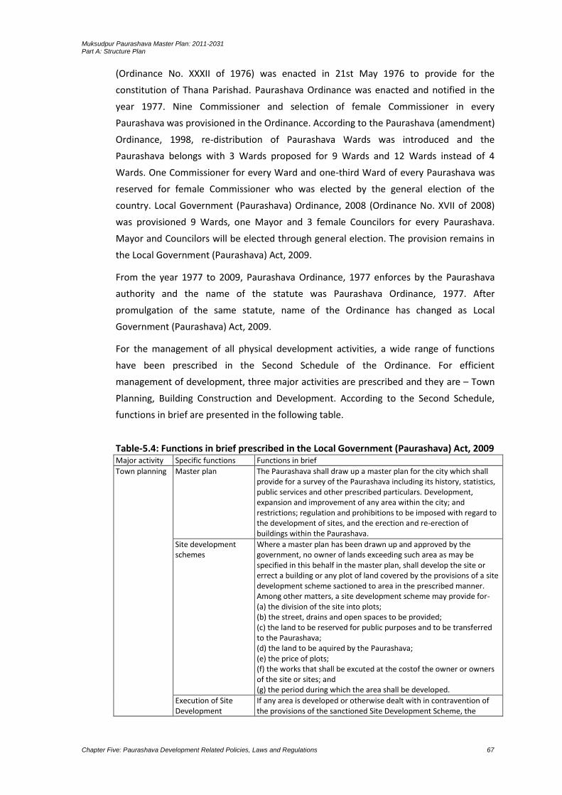
Muksudpur Paurashava Master Plan: 2011-2031 Part A: Structure Plan
Chapter Five: Paurashava Development Related Policies, Laws and Regulations 67
(Ordinance No. XXXII of 1976) was enacted in 21st May 1976 to provide for the
constitution of Thana Parishad. Paurashava Ordinance was enacted and notified in the
year 1977. Nine Commissioner and selection of female Commissioner in every
Paurashava was provisioned in the Ordinance. According to the Paurashava (amendment)
Ordinance, 1998, re-distribution of Paurashava Wards was introduced and the
Paurashava belongs with 3 Wards proposed for 9 Wards and 12 Wards instead of 4
Wards. One Commissioner for every Ward and one-third Ward of every Paurashava was
reserved for female Commissioner who was elected by the general election of the
country. Local Government (Paurashava) Ordinance, 2008 (Ordinance No. XVII of 2008)
was provisioned 9 Wards, one Mayor and 3 female Councilors for every Paurashava.
Mayor and Councilors will be elected through general election. The provision remains in
the Local Government (Paurashava) Act, 2009.
From the year 1977 to 2009, Paurashava Ordinance, 1977 enforces by the Paurashava
authority and the name of the statute was Paurashava Ordinance, 1977. After
promulgation of the same statute, name of the Ordinance has changed as Local
Government (Paurashava) Act, 2009.
For the management of all physical development activities, a wide range of functions
have been prescribed in the Second Schedule of the Ordinance. For efficient
management of development, three major activities are prescribed and they are – Town
Planning, Building Construction and Development. According to the Second Schedule,
functions in brief are presented in the following table.
Table-5.4: Functions in brief prescribed in the Local Government (Paurashava) Act, 2009 Major activity Specific functions Functions in brief
Town planning Master plan The Paurashava shall draw up a master plan for the city which shall provide for a survey of the Paurashava including its history, statistics, public services and other prescribed particulars. Development, expansion and improvement of any area within the city; and restrictions; regulation and prohibitions to be imposed with regard to the development of sites, and the erection and re-erection of buildings within the Paurashava.
Site development schemes
Where a master plan has been drawn up and approved by the government, no owner of lands exceeding such area as may be specified in this behalf in the master plan, shall develop the site or errect a building or any plot of land covered by the provisions of a site development scheme sactioned to area in the prescribed manner. Among other matters, a site development scheme may provide for- (a) the division of the site into plots; (b) the street, drains and open spaces to be provided; (c) the land to be reserved for public purposes and to be transferred to the Paurashava; (d) the land to be aquired by the Paurashava; (e) the price of plots; (f) the works that shall be excuted at the costof the owner or owners of the site or sites; and (g) the period during which the area shall be developed.
Execution of Site Development
If any area is developed or otherwise dealt with in contravention of the provisions of the sanctioned Site Development Scheme, the

Muksudpur Paurashava Master Plan: 2011-2031 Part A: Structure Plan
Chapter Five: Paurashava Development Related Policies, Laws and Regulations 68
Major activity Specific functions Functions in brief
Schemes Paurashava may by notice require the owner of such area or the person who has contravened the provisions to make such alteration in the site may be specified in the notice as where such alteration is not made or for any reason cannot be carried out, the Paurashava may, in the prescribed manner require and enforce the demolition of the offending structure; and notwithstanding anything to the country contained in any law, no compensation shall be payable for such demolition.
Building construction
Building construction and re-construction
Without approval of the building site and plan by the Paurashava, nobody can construct, re-construct any building in the Paurashava area. The Paurashava will approve the plan within sixty days or refund it within that specified time frame; otherwise the plan will be considered as approved.
Completion of construction and change, etc.
After completion of the approved building, the owner will notify to the Paurashava within 15 days. The Paurashava may inspect the building and if found any violation of the provision prescribed in the Master Plan or in the Site Development Scheme, the Paurashava may demolish the building and the demolishing cost may be incurred from the building owner.
Building control If any building or anything fixed thereon, be deemed by the Paurashava to be in a ruinous state or likely to fall or in any way dangerous to any inhabitant of such building or any neighboring building or to any occupier thereof or to passers-by, the Paurashava may be notice required the owner or occupier of such building to take such action in regard to the building as may be specified in the notice, and if there is default, the Paurashava may take the necessary steps itself and the cost incurred thereon by the Paurashava shall be deemed to be a tax levied on the owner or occupier of the building. If a building is in dangerous condition, or otherwise unfit for human habitation, the Paurashava may prohibit the occupation of such building till it has been suitable repaired to the satisfaction of the Paurashava.
Development Development plans The Paurashava shall prepare and implement development plans for specific time. Such Plans shall provide for- (a) the promotion, improvement and development of such function or functions of the Paurashava as may be specified; (b) the manner in which the plans shall be financed, executed, implemented and supervised; (c) the agency through which the plans shall be executed and implemented; and (d) such other matters as may be necessary.
Community Development Projects
The Paurashava may, sponsor or promote community development projects for the Paurashava or any part thereof and may in this behalf perform such functions as may be prescribed.
Commercial schemes The Paurashava may, with the previous sanction of the Government, promote, administer, execute and implement schemes for undertaking any commercial or business enterprise.
Street Public streets The Paurashava shall provide and maintain such public street and other means of public commutation as may be necessary for the comfort and convenience of the inhabitants of the Paurashava and of the visitors thereto.
Streets No new street shall be laid out except with the previous sanction of the Paurashava. The Paurashava may by notice required that any street may be paved, matalled, drained, channeled, improved or lighted in such manner as may be specified in the notice, and in the event of default, the Paurashava may have the necessary work done through its agency, and the cost incurred thereon by the Paurashava shall be deemed to be a tax levied on the person concerned.
General provisions about streets
The Paurashava may assign names to streets and paint the names or fix the nameplates on or at conspicuous places at or near the end
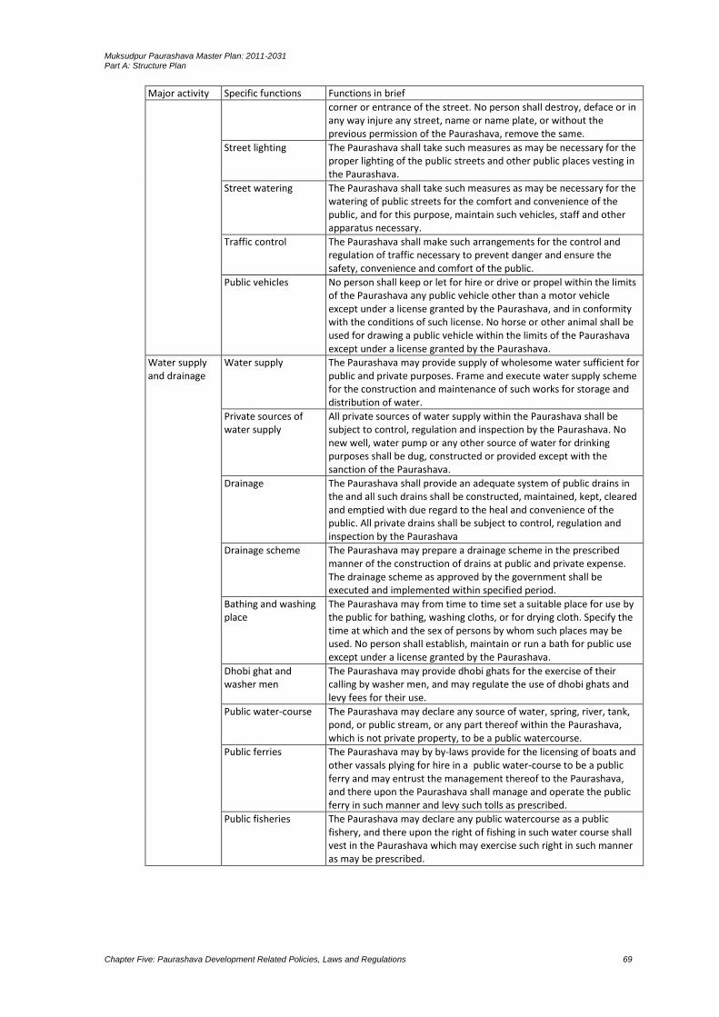
Muksudpur Paurashava Master Plan: 2011-2031 Part A: Structure Plan
Chapter Five: Paurashava Development Related Policies, Laws and Regulations 69
Major activity Specific functions Functions in brief
corner or entrance of the street. No person shall destroy, deface or in any way injure any street, name or name plate, or without the previous permission of the Paurashava, remove the same.
Street lighting The Paurashava shall take such measures as may be necessary for the proper lighting of the public streets and other public places vesting in the Paurashava.
Street watering The Paurashava shall take such measures as may be necessary for the watering of public streets for the comfort and convenience of the public, and for this purpose, maintain such vehicles, staff and other apparatus necessary.
Traffic control The Paurashava shall make such arrangements for the control and regulation of traffic necessary to prevent danger and ensure the safety, convenience and comfort of the public.
Public vehicles No person shall keep or let for hire or drive or propel within the limits of the Paurashava any public vehicle other than a motor vehicle except under a license granted by the Paurashava, and in conformity with the conditions of such license. No horse or other animal shall be used for drawing a public vehicle within the limits of the Paurashava except under a license granted by the Paurashava.
Water supply and drainage
Water supply The Paurashava may provide supply of wholesome water sufficient for public and private purposes. Frame and execute water supply scheme for the construction and maintenance of such works for storage and distribution of water.
Private sources of water supply
All private sources of water supply within the Paurashava shall be subject to control, regulation and inspection by the Paurashava. No new well, water pump or any other source of water for drinking purposes shall be dug, constructed or provided except with the sanction of the Paurashava.
Drainage The Paurashava shall provide an adequate system of public drains in the and all such drains shall be constructed, maintained, kept, cleared and emptied with due regard to the heal and convenience of the public. All private drains shall be subject to control, regulation and inspection by the Paurashava
Drainage scheme The Paurashava may prepare a drainage scheme in the prescribed manner of the construction of drains at public and private expense. The drainage scheme as approved by the government shall be executed and implemented within specified period.
Bathing and washing place
The Paurashava may from time to time set a suitable place for use by the public for bathing, washing cloths, or for drying cloth. Specify the time at which and the sex of persons by whom such places may be used. No person shall establish, maintain or run a bath for public use except under a license granted by the Paurashava.
Dhobi ghat and washer men
The Paurashava may provide dhobi ghats for the exercise of their calling by washer men, and may regulate the use of dhobi ghats and levy fees for their use.
Public water-course The Paurashava may declare any source of water, spring, river, tank, pond, or public stream, or any part thereof within the Paurashava, which is not private property, to be a public watercourse.
Public ferries The Paurashava may by by-laws provide for the licensing of boats and other vassals plying for hire in a public water-course to be a public ferry and may entrust the management thereof to the Paurashava, and there upon the Paurashava shall manage and operate the public ferry in such manner and levy such tolls as prescribed.
Public fisheries The Paurashava may declare any public watercourse as a public fishery, and there upon the right of fishing in such water course shall vest in the Paurashava which may exercise such right in such manner as may be prescribed.

Muksudpur Paurashava Master Plan: 2011-2031 Part A: Structure Plan
Chapter Five: Paurashava Development Related Policies, Laws and Regulations 70
5.3 Strength and Weaknesses of the Existing Policies
The Consultant has identified following weaknesses in the existing policies. These are –
accommodation of future thrust of growth likely to arise after construction of the 1st
Padma Bridge at Maowa point, supply of safe drinking water, providing safe and easy
accessibility, use of agriculture production in income generating activities and create
provision for further investment.
The primary motive is to exercise control over unorganized development and promotion
of planned infrastructure development to accommodate future urban growth. The
Paurashava will be developed as a self-contained town in rural environs.
Impact of construction of Padma Bridge at Maowa point is extremely difficult to make a
growth projection with sufficient precision. Many factors are involved with this such as
landuse change, increase of commuters, increase of vehicular movement, forward
linkage of commodities and social changes of the Paurashava dwellers.
To increase the agro-product and use them in income generating activities, a vast
agriculture land will be used and at the sametime, the existing agriculture land should be
preserved. Further residential expansion should be controlled through the imposition of
development control. In this context, concept of cluster development and compact
township approach should be provisioned in the plan. Vertical development will be
encouraged rather than horizontal to save the agriculture land.

Muksudpur Paurashava Master Plan: 2011-2031 Part A: Structure Plan
Chapter Six: Critical Planning Issues 71
CHAPTER 6 CRITICAL PLANNING ISSUES
6.1 Transport
Van and rickshaw are two major transport modes in the study area. Bicycle is the main
mode for private users. Movement of motorcycle is also identified as major private
mode. Inadequacy of bus service found normal scenario in the planning area. The peak
hour traffic movement is found in morning from 9am to 10am and in the afternoon from
4pm to 6pm in general. Overall traffic congestion is low, let it should not be increased.
The movements of Nosimon which is very risky need to restrict to keep the urban area
risk free, clean and sound. Establishment of bus route within the study area is another
prior demand of the people.
The hat / bazar in the planning area serves by bituminous and brick soling roads. But the
area is not served by well defined road hierarchy, nor is required now due to sparse use
of roads by motorized vehicles. However, the induced activities due to the prospects of
upward economic change may need to provide road network befitting with the need.
Highway traffic is comparatively low dominated by mixed type of vehicles including non-
motorized. Generally, surface of the highways excepting for a larger part is excellent. The
road network is not facilitated by designated parking area, bus terminal and bus bay. As a
result, sometimes congestions and chaotic situation occurs for a little while. In spite of
this situation, present road network is functioning well.
6.2 Environment
In Muksudpur Paurashava, noise pollution occurs by three wheelers and sound generated
from saw mills and rice husking mills. Water contamination is observed as “Arsenic”
threat. Air pollution is caused by dust emitted from saw mill, rice hushing mills and
furniture shops. Also flood water and water-logging creates health hazards. Dysentery,
diarrhea, etc. diseases occurs due to flood and Water-logging. Habitual inundations,
especially in monsoon, due to external floods from canals are another threat to
environment. Above causes are extremely important for the concern of the Paurashava.
Pragmatic planning / solution and proper Drainage Master Plan are very pertinent issues
in planning the Muksudpur Paurashava.
However, implementations of activities like roads, drainage, bridge / culverts, housing,
industrial establishments and bazars will radically change the natural topography and
landuse pattern if natural development remains. Agriculture land will be converted into
urban and semi-urban areas. Existing scenic beauty will disappear; water bodies will lost
and general slope will be diminished for earth filling due to urbanization. Therefore, in
the process of preparation of Structure Plan, Urban Area Plan and Ward Action Plan,
Muksudpur Paurashava Master Plan: 2011-2031 Part A: Structure Plan
Chapter Six: Critical Planning Issues 72
consideration of those factors have been made for keeping the natural environment
livable.
For a better living environment all environmental phenomenon should be considered
with the systematic planning principles and regulatory measures. With these views,
people’s awareness should be increased about the fair living environment through
different public activities. Arrangement of landuses should be provisioned for all the
public and private organizations as their necessities.
6.3 Landuse Control
Accommodation of future thrust of growth likely to arise after construction of the Padma
Bridge, supply of safe drinking water, providing safe and easy accessibility, use of
agriculture production in income generating activities and create provision for further
investment.
The primary motive is to exercise control over unorganized development and promotion
of planned infrastructure development to accommodate future urban growth. The
Paurashava should be developed as a self-contained town in rural environs.
Impact of construction of Padma Bridge is extremely difficult to make a growth projection
with sufficient precision. Many factors are involved with this. Those factors are rapid
change of landuse from agriculture to non-agricultural activities, rural homesteads will
change their character by the urban dwellers, land value will increase and the farmers
will sold their farming land and shift elsewhere where low land value exists, spotted
industrial development emerges and a mixed urbanization character will be formed, low
lands adjacent to the communication network will be filled and will create drainage
congestion.
To increase the agro-product and use them in income generating activities, a vast
agriculture land will be needed and therefore, existing agriculture land should be
preserved. Further residential expansion should be controlled through the imposition of
development control. In this context, concept of cluster development and compact
township approach should be provisioned in the plan. Vertical development should be
encouraged rather than horizontal to save the agriculture land.
Major aim of the Landuse Policy 2001 was to prevent indiscriminate conversion of
agricultural land in to non-agricultural use, because such conversion may be threatened
for food security of the country. Such conversion should be prohibited with the multi-
sectoral use of land. During implementation of Urban Area Plan / Ward Action Plan,
necessary control should be imposed according to the following manner.
1. High value agriculture land should be preserved only for agriculture purposes. The
land produces three crops in a year are under this category. Any physical

Muksudpur Paurashava Master Plan: 2011-2031 Part A: Structure Plan
Chapter Six: Critical Planning Issues 73
development activities should be prohibited by the Paurashava authority. In the
Paurashava, high value agriculture land is found in the Ward No. 1, 2 and 4.
2. Drainage congestion due to the indiscriminate development activities is another
critical issue. With the increase of population and commercial activities, lands of the
Paurashava town are being converted for habitation. Natural development of those
settlements somewhere creates drainage congestions. Pravakardi under Ward No. 2,
Nagarsundardi under Ward No. 3, Gopinathpur under Ward No. 5, Tengrakhola under
Ward No. 6 and Golabaria and Chotabahara under Ward No. 9 are the drainage
congestion areas.
3. Missing links in road transportation creates accessibility problem. In the
intersections, lands are using by commercial activities including daily bazar and saw
mill. Most of those are government lands. Vehicular accessibility became zero in
those areas.
4. Easy accessibility with neighbouring Upazilas and a regional linkage is needed. Those
linkages will grave huge amount of agriculture land. The single crop land may be used
for this purpose.
6.4 Disaster (if any)
Disaster is the tragedy of a natural or man-made hazard that negatively affects society or
environment. Disaster can be classified into two categories: natural disaster and man-
made disaster. Natural disaster is the effect of flood, volcanic eruption, earthquake or
landslide, draught, epidemic, etc. that affects environment and leads to financial,
environmental or human losses. Man-made disasters is resulting from human intent,
negligence or error, or involving a failure of a man-made system.
Inundation has been measured within Paurashava on plinth and above plinth level. In this
Paurashava flood (2007) reached plinth level. Moreover, household of the Paurashava
was not affected.
Urbanization is converting lands for residential use. Agricultural lands and water bodies
are being chosen most frequently and the lands are being converted into urban
settlement. In the Paurashava, wet lands are being filled up and agricultural lands are
being converted. This has been identified as the major man-made disaster accelerating
the degree of conversion year to year. Use of poisonous insecticides on the agricultural
land is another man-made disaster which will affect in the long-run.
6.5 Laws and Regulations
The regulations prescribed (mentioned in the Chapter-5.2.1, Sl. No. 1 to 20) in the Local
Government (Paurashava) Act, 2009 are not directly related with the physical
development activities and their control. The East Bengal Building Construction Act, 1952
is called the mother regulation to control all type of physical development but no
instruction is being included in the Local Government (Paurashava) Act, 2009 regarding

Muksudpur Paurashava Master Plan: 2011-2031 Part A: Structure Plan
Chapter Six: Critical Planning Issues 74
EBBC Act, 1952. The Paurashava authority approves the building plan and excavation of
tank without any regulatory control.
The regulation prescribed in the Local Government (Paurashava) Act, 2009 on the
preparation of master plan is called traditional regulation. In the modern world, the
concept of master plan became obsolete. In this project, the so called master plan, as
mentioned in the Local Government (Paurashava) Act, 2009 considered as a package and
the plan included in this package named Structure Plan, Urban Area Plan and Ward
Action Plan, though there is no regulation in the country on the preparation and
implementation of those plans.
In the Paurashava, 72.57% (except water bodies) land is under agriculture use. Most of
those lands are private. Different type of help is necessary for the farmers involved with
those agriculture lands. Section 13(1a) of the Agricultural Development Corporation
Ordinance, 1961 prescribed regulation on the function of the Corporation and said that
“the Corporation shall make suitable arrangements throughout East Pakistan, on a
commercial basis, for the procurement, transport, storage and distribution to
agriculturists of essential supplies such as seed, fertilizers, plant protection equipment,
pesticides and agricultural machinery and implements.” Where the Corporation is absent,
how the farmers will get benefit prescribed in the section 13(1a)? To increase the
agricultural commodities such type of help is necessary.
Except the Paurashava Town (Township development areas), other areas are rural. To
generate rural-based township environment, those rural areas should be preserved.
Rural development components as prescribed in the section 7(1a) of the Bangladesh
Rural Development Board Ordinance, 1982 should be provisioned to control those rural
areas. As prescribed in the section 7(1a), functions of the Board shall be “to promote
village-based primary co-operative societies and Thana Central Cooperative Association
(TCCA) with a view to enabling them to be autonomous, self-managed and financially
viable vehicles for increasing production, employment generation and rural
development.”
Muksudpur Paurashava Master Plan: 2011-2031 Part A: Structure Plan
Chapter Seven: Landuse Development Strategies 75
CHAPTER 7 LAND USE ZONING POLICY AND DEVELOPMENT STRATEGIES
7.1 Strategies for Optimum use of Urban Land Resources
Inhabitants of the Paurashava are not aware about the land level and slope direction of
the Paurashava. Without knowing this information they are raising their land up to a
mark and constructing permanent structure. As a result, water logging problem during
rainy season is all over the residential areas.
Due to the absence of development control, the core area of the Paurashava is already
developed as mixed-use area. Commercial, residential, administrative, educational uses
are admixture in the core area. Zoning provision, landuse control should not be enforced
in such type of the core area.
The Paurashava is a natural developed area. Rearrangement of the existing use is not
possible. Land acquisition for expansion of road (to increase the width of road) will create
socio-political hazards. As a result, the roads in the core area remain same as today.
For water supply network, construction of sewerage facilities and removal of fire hazards,
at least 24 feet width road is necessary. In the Paurashava, except National Highways,
such type of road is absent. New road will form new township on agriculture land. These
processes will washout agriculture domination from the Paurashava. Compact Township
and cluster development will be effective for new formation, not for the mixed-use areas
where most of the roads are 8 to 10 feet width.
Prior to planning, strategies have been developed for issues like, utilities, circulation and
drainage both for core urban areas and urban fringe areas. The steps of strategies for
formulation master plan are based on the policy recommendations and standards
suggested by the LGED. All those aspects are very vital for creating livability in
Paurashava area.
Policies and Strategies
In relation to the landuses, the expected cluster development policies are:
Review the selected clusters and prepare guidelines for their development: In carrying
out this task, Paurashava will pay particular attention to the scale of growth to be
accommodated in each cluster. This will be influenced by the local pressures for growth
and capacity of each cluster to absorb such growth. In relation to the tentative list of
clusters identified in the Chapter-3, the following comments need to be made:
First priority clusters are the market areas (Muksudpur Bazar in Ward No. 9 and Animal
Hat in Ward No. 2). Variations between the scales of growth to be accommodated in each
of the markets will be found. Second priority clusters are located on the fringes of the

Muksudpur Paurashava Master Plan: 2011-2031 Part A: Structure Plan
Chapter Seven: Landuse Development Strategies 76
existing Paurashava town centre. They are areas where pressure for growth is already
strong. Their inclusion in the list is therefore almost inevitability. However, the long term
costs associated with large scale development in all two of these clusters – Central part of
the Paurashava (part of the Ward No. 3, 5 and 6), - Western part of the Ward No. 6,
suggest that the policy should be provided for growth whilst containing it as much as
possible. Those clusters are in rural character, objective of the Paurashava will be to
ensure that the use of land is appropriate to this character.
Limit industrial use outside the existing town centre and the proposed extensions to
the town centre: Location of manufacturing activity may have benefits to the local
communities in which the manufacturing activity is located – through provision of direct
or indirect employment and benefits to the entrepreneur in terms of reduced costs.
However, it may also have disadvantages, say, for example, if the infrastructure is not
available to deal with the effluent (whether it be air borne, water borne or in the form of
solid waste) of the manufacturing processes being undertaken in these relatively remote
locations.
Encourage the development of non-urban uses such as agriculture and forestry on land on the periphery of the Town centre which is unsuitable for urban development.
Optimization of the existing urban land resources
Jurisdiction of the Muksudpur Paurashava is 4157.21 acres (16.82 sq. km.); population is
19711 (2011) with gross density 5 persons per acre. In the year 2031, the population will
be 23059 with gross density 6 persons per acre if growth rate (0.87%) remains.
At present, agriculture and water body includes 72.57% and 6.98% land respectively.
Some important landuse determining factors like government policy, industrial
establishment, construction of road including embankment and availability of services
may change the agriculture domination in next 20 years. Question raises that how much
this change will affect the present land resources?
During last ten years, the landuse scenarios remain same. A stagnant character of
landuse change still stand due to the existence of river named Kumar and undulating land
elevation. Rapid change of landuse will be viewed after construction of Padma Bridge at
Maowa point. Except this, present population distribution and growth including
migration shows that the area is developing significantly in terms of trade and large
business and trying to get out of agriculture based activity.
After preparation and implementation of urban area plan changes in the physical
character of the Paurashava will be viewed. These changes will be provided by the
infrastructural and community services development. According to the master plan /
urban area plan and Ward Action Plan this change should not exceed 5% to 10% from the
total land of the Paurashava for next 20 years. Conversion of agriculture land in to
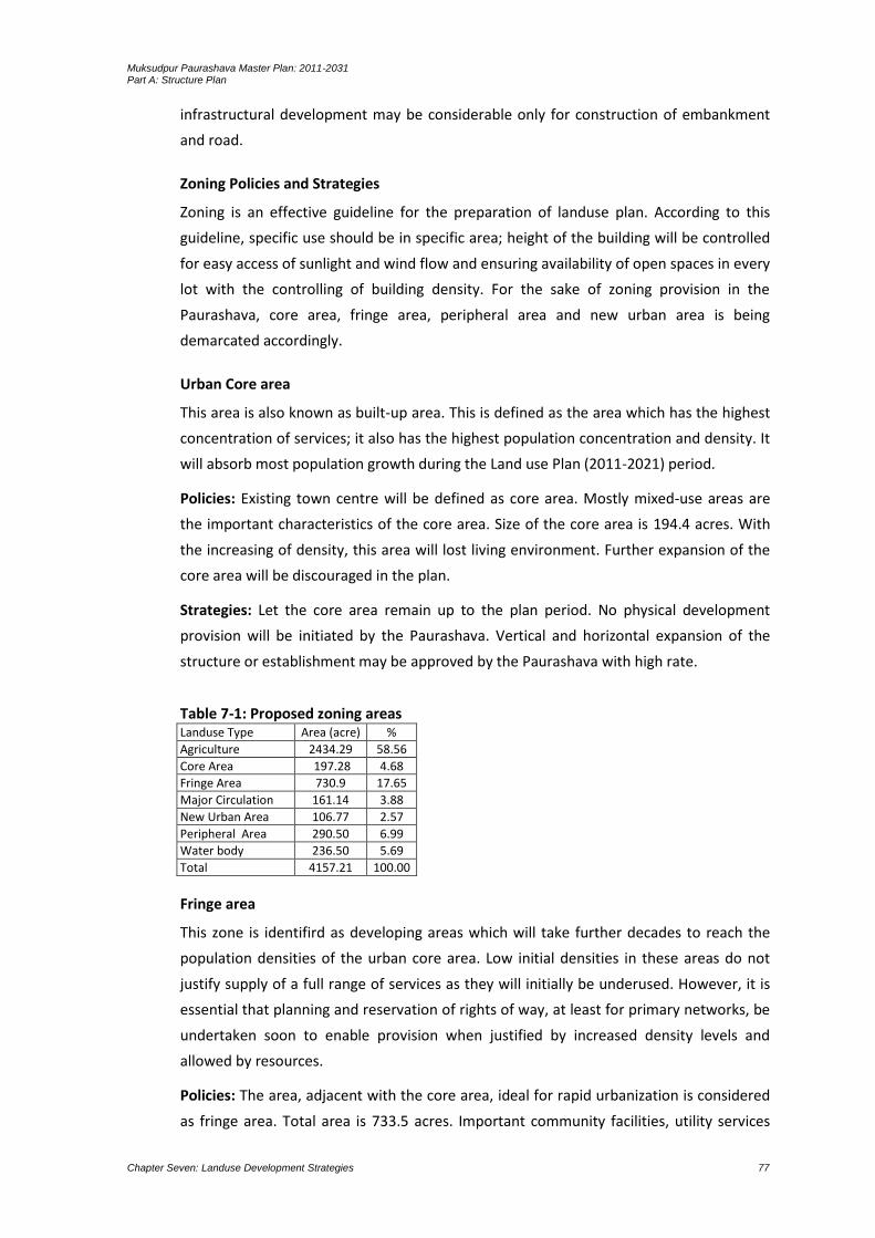
Muksudpur Paurashava Master Plan: 2011-2031 Part A: Structure Plan
Chapter Seven: Landuse Development Strategies 77
infrastructural development may be considerable only for construction of embankment
and road.
Zoning Policies and Strategies
Zoning is an effective guideline for the preparation of landuse plan. According to this
guideline, specific use should be in specific area; height of the building will be controlled
for easy access of sunlight and wind flow and ensuring availability of open spaces in every
lot with the controlling of building density. For the sake of zoning provision in the
Paurashava, core area, fringe area, peripheral area and new urban area is being
demarcated accordingly.
Urban Core area
This area is also known as built-up area. This is defined as the area which has the highest
concentration of services; it also has the highest population concentration and density. It
will absorb most population growth during the Land use Plan (2011-2021) period.
Policies: Existing town centre will be defined as core area. Mostly mixed-use areas are
the important characteristics of the core area. Size of the core area is 194.4 acres. With
the increasing of density, this area will lost living environment. Further expansion of the
core area will be discouraged in the plan.
Strategies: Let the core area remain up to the plan period. No physical development
provision will be initiated by the Paurashava. Vertical and horizontal expansion of the
structure or establishment may be approved by the Paurashava with high rate.
Table 7-1: Proposed zoning areas Landuse Type Area (acre) %
Agriculture 2434.29 58.56
Core Area 197.28 4.68
Fringe Area 730.9 17.65
Major Circulation 161.14 3.88
New Urban Area 106.77 2.57
Peripheral Area 290.50 6.99
Water body 236.50 5.69
Total 4157.21 100.00
Fringe area
This zone is identifird as developing areas which will take further decades to reach the
population densities of the urban core area. Low initial densities in these areas do not
justify supply of a full range of services as they will initially be underused. However, it is
essential that planning and reservation of rights of way, at least for primary networks, be
undertaken soon to enable provision when justified by increased density levels and
allowed by resources.
Policies: The area, adjacent with the core area, ideal for rapid urbanization is considered
as fringe area. Total area is 733.5 acres. Important community facilities, utility services
Muksudpur Paurashava Master Plan: 2011-2031 Part A: Structure Plan
Chapter Seven: Landuse Development Strategies 78
and residential development will be the basic components of the fringe area. Improved
transportation and communication linkages, better water supply and drainage facilities
including rain water reservoirs will be the planning components.
Strategies: The guidelines set in the policy may be implemented by the different public
authorities. A close coordination among those authorities should be maintained during
implementation of the planning component. Any change of the planning should instantly
be resolved with the involvement of the Paurashava authority.
Peripheral area
This is the zone where a slow trend of urbanization is continuing in unplanned manner.
The area identified in the Structure Plan as the likely choice for new urban development
beyond the core area. Ideally, it might be reasonable to provide primary infrastructure
networks in this area to foster development and encouraged to enable a more rapid
urbanization in a planned way.
Policies: Agriculture domination will be the prime characteristic of the peripheral area.
Rural homesteads, spotted important development like park, dumping ground, stadium
and agro-industries are the important planning components of this area. Total area is
290.5 acres. Any contrast regarding the implementation of those planning components
should not be encouraged.
Strategies: Phase-wise development will be encouraged. Individual authority may
implement individual component. Coordination among the authorities is not mandatory.
Locational change of the proposed components should be discouraged.
New Urban Area
This zone will be the required additional area for future planned urban development as
per population projection. New facilities and services like road, drains, footpath, waste
transfer station and other civic services will be provided. This area is being proposed to
be developed within the year 2031.
Policies: Planned development will be the prime characteristic of the new urban area.
Hosing with greeneries, important development like park, commercial centre,
educational institute, improved health facities, community centre, road with footpath
including drainage facilities, water supply and fire service are the important planning
components of this area. Total area is 106.7 acres. Any contrast regarding the
implementation of those planning components should not be encouraged.
Strategies: Phase-wise development will be encouraged. Individual authority may
implement individual component. Coordination among the authorities is not mandatory.
Locational change of the proposed components should be discouraged.

Muksudpur Paurashava Master Plan: 2011-2031 Part A: Structure Plan
Chapter Seven: Landuse Development Strategies 79
Agriculture
Agricultural land (also agricultural area) denotes the land suitable for agricultural
production, both crops and livestock. It is one of the main resources in agriculture. The
land under annual crops, such as cereals, sugercane, jute, vegetables and melons; also
includes land left temporarily fallow; land under permanent crops (e.g., fruit plantations);
areas for natural grasses and grazing of livestock.
Policies: Agricultural domination will be the prime characteristic of the Agriculture zone.
Agricultural commodities as mentioned earlier are the important components of this
area. Total area is 2434.3 acres. Any cropping combination may be encouraged.
Strategies: Any agricultural practice will be encouraged. Individual authority may
supervise and subsidize agricultural inputs to the farmers for increasing the produuction.
Coordination among the authorities is not mandatory. Any physical development should
be controlled by the Pourashasva (except bridge, culvert, drain and road).
Waterbody
Water body contains 236.3 acres excluding khal, pond, irrigation canal and river those
area more than 0.25 acre and it will be presearved as water retention pond.
Policies: Rainwater harvesting and pisciculture will be the prime characteristic of the
pond and river will be preserved for outfall of the drainage system including irrigation
purposes and water ways. Any contrast regarding the implementation of those
components should not be encouraged. Proposed Water body should be presearved
under “Water Body Act 2000”.
Strategies: Individual authority may control individual component such as pond by the
Paurashava and river by the Water Development Board. Coordination among the
authorities is not mandatory. Any change of the components should be discouraged.
Major Circulation
Major circulation contains major road network with regional and national settings.
Policies: Essy accessibility with national, regional and local will be the prime characteristic
of the circulation network. All transportation infrastructures should be incorporated as
the important planning components. Total area is 161.14 acres. Any encroachment or
contrast regarding the implementation of those transportation infrastructures should not
be encouraged.
Strategies: Phase-wise development will be encouraged. Individual authority may
implement individual component. Coordination among the authorities is not mandatory.
Locational change of the proposed components should be discouraged.

Muksudpur Paurashava Master Plan: 2011-2031 Part A: Structure Plan
Chapter Seven: Landuse Development Strategies 80
7.2 Plans for New Area Development
The Paurashava is not an ideal township due to the agriculture domination. Agriculture
based township should be encouraged in the preparation of Urban Area Plan. Growth of
population is the natural trend and at the sametime, expansion of non-agricultural use on
agriculture land is also natural tendency of the people. This will be controlled through the
Compact Township concept with the encouragement of vertical development. In case of
government services, specific building may accommodate different type of offices.
Future landuse will be calculated according to the development control for the masses. In
case of public land, existing use and khas land will be emphasized. Willingness and
participation of the people in development activities will be the key factor for future
landuse demarcation. Slow change of landuse will be emphasized rather than rapid
change. Let the people do whatever he likes on own land – such concept should not be
considered for future projection of landuses. Three parts of the projection are landuse
change, landuse control and landuse restriction will be included in the Master Plan. In
any case, river front areas should be restricted for human habitation. As a result, river
water will safe from contamination.
The agriculture land should be preserved (according to the Agriculture Policy) from any
type of physical development. It should not be decreased with the expansion of habitable
area or formation of new settlement, may be increased with the formation of char lands.
In case of road, embankment, drainage and new urban area, the agriculture land may be
used but such use should be guided according to this plan. For the development of
pisciculture, all ponds (not lower than 0.25 acres) and ditches may be preserved, in some
exceptional cases; small number of ditches and ponds may be used for physical
development activities.
People’s willingness will be considered as important base for the projection because the
Master Plan is for the inhabitants of the Paurashava. They will be the beneficiary group of
that Master Plan. Their willingness in case of use and land allocation, location, expansion
provision will be the important consideration. On the basis of fulfillment of their demand,
they will like to involve them willingly in the implementation procedure of the Master
Plan.
Policies and Strategies
A large number of constraints are involved with the development of new area. Following
strategies are involved with the development of new areas:
Low incomes;
Difficulties associated with assembling parcels of land which are large enough to
make viable development sites;
Disputes over ownership;
Muksudpur Paurashava Master Plan: 2011-2031 Part A: Structure Plan
Chapter Seven: Landuse Development Strategies 81
Absence of private sector land developers;
Lack of access (capable of resolution often only by works on land under the control of
others); and
The need in most cases for land to be prepared in some way prior development
either by filling where it is subject to flooding or by earth moving where it is too
steep to develop. In both cases, drainage works have to form an essential part of the
land preparation task.
The policies and strategies of the Paurashava related to new area development are: –
Explore and Implement means of increasing the number and pace of public sector land
development projects: This is one area where government can have a direct influence on
accelerating the rate of conversion of non-urban to urban land.
Explore and Implement, with the private sector, means of increasing the number and
pace of private sector land development projects: In moving towards realization of the
objective of government supporting the private sector in its development role (i.e. acting
as an enabler rather than a provider), the Paurashava will examine, with the private
sector, the means of overcoming the constraints to new area development.
Realization of the above two strategies is likely to require changes in legislation and
administrative procedures at the national level. The other strategies of the Paurashava
relating to new area development are set out below.
Promote upgrading of the existing urban area: As densities within the existing
Paurashava Town increase, there will be growing pressure for upgrading to ensure that
infrastructure provision is adequate and that living conditions are acceptable.
Most of the parts of the Paurashava are in agriculture practice and few parts are in urban
area will require no upgrading at all. Accordingly the Paurashava will set priorities
throughout the study area and ensure, through its own efforts or the efforts of others,
that upgrading projects are necessary. Obvious areas for early consideration will be slum
and squatter settlements. Local community and NGOs may involve with the upgrading
projects.
Assist the transition of areas on the fringes of the extension urban areas from non-
urban to urban use: The main priority here seems to be space for adequate access and
drainage. Once this space is available, the roads, drains and other services can be
installed as and when the resources are available to provide them. But without this
space, rational development of such areas is impossibility, environmental problems occur
and the pace of development is often seriously impeded.
If the Paurashava has the resources and to achieve this by acquiring land (either through
negotiation or compulsory purchase) and ensuring that it remains free from development
until needed, then the Paurashava will purchase this as a policy. If not, then a potential
alternative approach is to work with the local community, particularly the landowners, to
Muksudpur Paurashava Master Plan: 2011-2031 Part A: Structure Plan
Chapter Seven: Landuse Development Strategies 82
see if the space can be made available by readjustment of existing ownerships. Given the
importance of this task the Paurashava will pursue an active policy of assisting the
rational development of the fringe areas, by whatever means proves workable.
Ensure that land is available for all income groups: In accordance with Government’s
commitment to poverty alleviation, as expressed in the Poverty Reduction Strategy and
the objectives of the National Housing Policy, a further major task facing the Paurashava
is to ensure that land is made available for all income groups.
Reconsider the role that development control plays in the planning and management of
new area: Where development control is institutionally well-established (with adequate
legislation, administrative resources and enforcement power) it can be a very effective
‘tool’ in restricting new area development where it is considered unsuitable; encouraging
it in areas where it is considered suitable; and influencing the type of development that
takes place in any particular location. It can attempt to strengthen development control
institutionally to enable it to perform its role more adequately. On the other hand, it can
consider restricting the role of development control to those functions which it considers
critical such as ensuring that development does not take place in corridors required for
new road construction or road widening, or ensuring that polluting industry takes place
only in areas which are suitable for it.
Encourage the development of unused or underutilized land rather than new areas: The
Paurashava is characterized by having much unused or underutilized land within the
heart of the town. This land represents a wasting asset. If maximum use is to be made of
the existing investment in infrastructure and if journey times are to be kept short, then
fuller utilization of this land is essential. The Paurashava will examine the reasons why
such land remains unused or underutilized and will endeavour to overcome the
constraints to its development.
7.3 Areas for Conservation and Protection
Type of area and structure which will conserve and protect is presented here.
Historical building, monument, sculpture or any other related articles.
Park, important playfield or any other active recreational areas.
Government buildings like Dakbanglow, Court Building, Circuit House, D.C office,
Paurashava office and official residence of the Paurashava Mayor.

Muksudpur Paurashava Master Plan: 2011-2031 Part A: Structure Plan
Chapter Seven: Landuse Development Strategies 83
Map 7-1: Structure Plan of Muksudpur Paurashava

Muksudpur Paurashava Master Plan: 2011-2031 Part A: Structure Plan
Chapter Seven: Landuse Development Strategies 84

Muksudpur Paurashava Master Plan: 2011-2031 Part A: Structure Plan
Chapter Seven: Landuse Development Strategies 85
Riverfront areas where people spent their leisure time.
Any other public establishment like Zoo, Museum, Flood shelter, etc.
BM Pillars.
Rail station, Bus Terminal and Launch / boat ghat.
Policies and strategies
For the conservation and protection areas, following policies and strategies are
considered:
Take environmental issues into account in all decisions related to the future
development: By considering environmental issues in its entire decision making, the
Paurashava aims to ensure that progress is made towards resolving the environmental
problems exist and towards resisting the further deterioration of conditions beyond their
present level.
The issue of polluting manufacturing processes is best dealt with by legislation at the
national level. However, the Paurashava has a valid and important role to play in deciding
the location of industry. It can confine polluting industry to a single or a limited number
of locations, where prevailing winds will not carry airborne pollution over the Paurashava
Town and where facilities for dealing with water borne effluent and solid waste disposal
have a greater chance of being provided.
Impose restrictions on the location of new polluting manufacturing processes and
identify suitable locations for their establishment: A long term program of controlling the
emission of pollutants from existing industrial activities and removing chronic polluting
industry from unsuitable locations can also be pursued in association with the
appropriate authorities. To be effective, this will need the force of law. One case is break-
making. It is of value to the economy but is understood to have adverse environmental
consequences. This is carried out in two locations throughout the study area.
Monitor adverse environmental impacts of existing manufacturing processes and take
measures to reduce such impacts to acceptable levels: The issues of the health hazard
caused by current methods of solid waste disposal and sewage disposal can be addressed
by improving the existing methods of providing these services.
Reduce noise levels from the worst noise nuisances: The issue of pollution from vehicles
is unfortunately likely to get worse – as the rates of vehicle ownership and usage increase
– before it gets better. Some relief may however be afforded by improvements in the
quality of emissions, as older vehicles are replaced by newer ones, and as technological
developments continue to be made in emission control.
Identify and protect areas of ecological significance: It is important that such areas are
protected before they are inadvertently destroyed. This policy will extend to areas of
Muksudpur Paurashava Master Plan: 2011-2031 Part A: Structure Plan
Chapter Seven: Landuse Development Strategies 86
forest / bushes and areas of un-spoilt river line. Once the initial priority of protection is
successfully achieved, measures can be taken to enhance the quality of these areas.
Conserve buildings and monuments of cultural, architectural and historic interest: Such
buildings and monuments are an important legacy of the past, reflecting different
historical, cultural and national influences. The Paurashava will arrange for such buildings
and monuments to be identified and listed. Following this, it will be necessary to draw up
a program for their conservation. This program will need to consider the scope for
enhancing the settings of the buildings and monuments, as well as ensuring preservation
of their fabrics.
Protect and enhance significant areas of open space within the Paurashava Town: The
open spaces create character of Paurashava, distinguishing it from other Paurashavas in
the country. Unless such spaces are protected, there is a strong likelihood that they will
be gradually converted to urban uses and thus lost for the benefit of the community as a
whole.
Muksudpur Paurashava Master Plan: 2011-2031 Part A: Structure Plan
Chapter Eight: Strategies and Policies for Sectoral Development of the Paurashava 87
CHAPTER 8 STRATEGIES AND POLICIES FOR SECTORAL DEVELOPMENT OF THE
PAURASHAVA
8.1 Socio-economic Sectors
8.1.1 Population
The policies in relation to population are set out below.
Expected growth of population and changes of socio-economic characteristics: The
population projection will need to be reviewed time to time in the light of new evidence.
At a minimum this will need to be done at ten years intervals, as the results of Censuses
become available. The Paurashava authority will need to monitor the factors affecting
population growth – namely fertility, mortality and net inward migration and the factors
reflecting changes in its socio-economic characteristics.
Rational distribution of population within the Paurashava: One of the main purposes of
a master plan/development plan is to provide for the rational distribution of population,
in relation to other urban activities and suitability of land for urban purposes. The
Paurashava will pursue the policies required to achieve the spatial development strategy.
It will also monitor change, assess the effectiveness of the policies being pursued and
review the strategy as and when necessary.
Ensure availability of land, services and facilities according to the needs of the
population: As the body responsible for planning and managing urban development, the
Paurashava will ensure that land, services and facilities reflect the buildup of population
and changes in its requirements. This is a task for which it will require the co-operation of
many agencies involved in urban development in the Paurashava.
8.1.2 Economic Development
The prospect related to economic activities summarizes in the following discussions:
Some small-scale pisciculture is located in the Muksudpur Paurashava area. About 150
households are involved with such pisciculture. The production mostly uses in the Dhaka
City and Gopalgonj Zila. Investment in this field will bring huge prospects of the
Paurashava. Other economic prospect summarizes in the following discussions:
Availability of unskilled and cheap manpower.
Due to the nearness of Dhaka City, the Paurashava may be developed as the fringe
area of Dhaka City. This fringe area with its agriculture production will support to the
Dhaka City where marketing for those productions are available.
The Paurashava has been developed as growth centre concept. Some cluster
development is found around this growth centre. Planned development through this

Muksudpur Paurashava Master Plan: 2011-2031 Part A: Structure Plan
Chapter Eight: Strategies and Policies for Sectoral Development of the Paurashava 88
master plan will initiate to arrange the growth component in a systematic manner. At
the sametime, economic development parallel to the physical and social
development will be encouraged.
The Paurashava has been developed as growth centre. Some cluster development is
found around this growth centre. Planned development through the master plan will
initiate to arrange the growth component in a systematic manner. At the sametime,
economic development parallel to the physical and social development will be
encouraged.
Economic activities and residential establishment are in same premises perhaps all
over the Paurashava area. Those activities should not be disturbed if the land holding
by private owners. Further arrangement on economic activities including industrial
establishment (if any) should be provided separately according to the type of
economic activities.
The Upazila is renowned for jute cultivation. An industrial estate and trading centre
based on those raw jutes may be established in the Paurashava area. Nearness of the
Gopalganj and Dhaka for trading of those jutes and jute production will encourage to
be flourished of those trading centers and industries.
Most of the entrepreneurs expressed their desire of implementing future development
plan. A major portion mentioned that their development plan is the expansion of their
enterprises (70%) and others intend to increase their production (30%). Expansion of
existing industries and establishment of new industries will create more jobs and thus
have multiplier effect in the overall economy leading to create more consumption
capacity, investment opportunities in diversified economic fields and thus push the
economy upward.
If the standard of living of the people of the Paurashava is not to deteriorate as the
additional population discussed before, then the economy of the Paurashava must
expand at least in step with the growth of population. For unless the population has the
financial resources (through employment or business) to pay for the urban services and
facilities they want, they will either have to rely on Government subsidy or they will go
without.
Policies and Strategies
Given emphasize on the above situation following policies have been identified. These
are all additional to the general requirement to ensure that land and infrastructure are
available to support the wealth generating elements of urban development.
Encourage national business to locate in Muksudpur Upazila / Gopalganj Zila: If national
business can be encouraged to locate in promoting Paurashava / Upazila / Zila, they will
provide not only earning capacity for their locally recruited employees but the
opportunity for services to be provided to support the business. The Paurashava will,
therefore, assist central government in promoting Paurashava as a potential location for
inward investment of this type.
Muksudpur Paurashava Master Plan: 2011-2031 Part A: Structure Plan
Chapter Eight: Strategies and Policies for Sectoral Development of the Paurashava 89
Encourage central government to decentralize facilities from Dhaka: Central Government
has control over the location of many facilities which are currently located in Dhaka, such
as Government departments, the headquarters of nationalized or Government banks and
quasi Government bodies. The Paurashava will encourage Central Government to offset
the current strong tendency towards centralization of facilities in the Capital by
relocating some of these facilities to Paurashava / Upazila / Zila.
Overcome the constraints on compatible landuse: Where established agricultural,
industrial and commercial operations are compatible with the objectives of the Structure
Plan, the Paurashava will work with these operations to overcome the constraints to their
expansion. Where wealth generating activities are constrained in their desire for
expansion by lack of land, access or infrastructure provision, the Paurashava will, in
conjunction with the other relevant authorities, endeavour to overcome these
constraints.
8.1.3 Employment Generation
Two basic elements of economic development i.e. employment generation and increase
of productivity are found in the cities and urban areas than the rural areas. This is a
common phenomenon for the developed and developing countries. Employment
opportunities act as a strong pull factor for influx of job seekers in the cities and urban
areas, the centers of productivity. Special features of the study area are that it covers a
vast rural area, besides a small urban center of Paurashava town. One National Highway
passes through the Paurashava and both the sides of the highway is occupied by huge
tracts of agriculture land and sporadic homesteads, at places showing the signs of
development along with the hats, bazars indicating the dominant role of agriculture and
fishery. This indicates general feature of the study area as a mixture of rural and semi-
urban nature. These special socio-economic features of the study area have been taken
into consideration in conducting the study of the prevailing economic situation.
It is found from the study that the entrepreneurs are generally suffered from the following common problems:
Lack of cheap and dependable source of energy (gas supply).
Unreliable electricity supply.
Absence of better access facilities with the capital city.
Absence of railway connection with the capital city and with surrounding Zilas.
Insufficient communication infrastructure.
Shortage of skilled manpower.
Complex official procedures in setting up a new industry (cumbersome processes of
getting infrastructural and utility services connections, lack of manufacturing-
investment-friendly banking / credit system).
Lack of government initiatives.

Muksudpur Paurashava Master Plan: 2011-2031 Part A: Structure Plan
Chapter Eight: Strategies and Policies for Sectoral Development of the Paurashava 90
Once the area developed as a trade centre based on the river communication. The
traders who bring their commodities through the river to the market of the Paurashava
act as a boat ghat after the loading and unloading of commodities from the boat. From
then, development activities started along the riverside. This trend has been continued
up to the recent years.
Policies and Strategies
Improve industrial areas and ensure their full utilization: Conditions in the existing
industrial areas of the Paurashava especially environmental ones associated with the
disposal of effluent and waste are currently poor. It is the policy of the Paurashava to
improve these conditions and to reduce pollution from the worst offenders to acceptable
levels. In certain cases this may require cessation of an existing activity or removal to
another location.
Within each of the existing industrial areas there are vacant and underutilized areas. It
may be the policy of the Paurashava to ensure that the spare capacity available within
these should be utilized full. In the short and medium-term these will represent a better
use of resources than identify new areas.
Locations for new industrial areas: For the longer term it is expected that new industrial
areas will be required. Given the fact that the Paurashava wishes to encourage inward
investment within the Paurashava, it will identify suitable locations for such industrial
areas, will reserve them for industrial use and will plan for provision of the required
infrastructure.
Provide assistance to small-scale industrial and commercial operations: Considerable
potential growth of the economy rests with small-scale industrial and commercial
operations. The Paurashava will, in conjunction with other relevant authorities, may
provide assistance to such operations by promoting the establishment of estates
specifically suited to their needs. These will probably need to be small in size and located
within or close to residential areas.
The Paurashava will also consider other needs of small-scale industrial and commercial
operations and endeavour, through others, to ensure that these needs such as for credit
are available.
8.1.4 Housing and Slum Improvement
Housing is one of the vital components of urban life. It is a source of security, safety and
everyday comfort. Rural housing components are prevailing in the Paurashava. In most
cases, housing in growth centre is appropriate for the study of housing in the Paurashava.
Housing in rural environment (called rural homestead) according to the trend of
primitive society is the suitable word for the identification of Paurashava housing.
Muksudpur Paurashava Master Plan: 2011-2031 Part A: Structure Plan
Chapter Eight: Strategies and Policies for Sectoral Development of the Paurashava 91
Amulgation of pucca, semi-pucca and katcha housing or semi-pucca and katcha housing
in a house is viewed in most of the Wards.
Residential areas in Muksudpur Paurashava have been developed sparsely following
some degree of uniformity. According to the number of residential buildings Ward No. 5,
6 and 7 dominate the highest number of residential buildings. Pucca residential buildings
are developed on and around the commercial hub of Ward No. 2 and 9. About 18% of the
dwellings in the Paurashava are in good condition, 35% needed to be demolished due to
their dilapidated conditions, while about 6% is new construction.
Building materials used
The Paurashava is dominated by semi-urban environment; as a result about 10%
residential structures are found katcha, constructed with temporary materials like
bamboo thatch, C.I.Sheet and wood. About 74% dwellings are semi-pucca structures
including tin-shade that are wall made with brick and the roof with C.I.Sheet. On the
other hand, about 16% houses are pucca that is single-storied and multi-storied,
constructed with bricks and concretes. The building materials used for the construction
of houses reflects moderate economic condition of the owners.
Floor area
About 7489 residential structures are pucca and among them, 7430 are one-storied, 54
two-storied and 5 three-storied and above. Floor area of those pucca structures are
varied from 1200 sq. ft. to 2600 sq. ft. The semi-pucca structures are preserving two
characters according to the location; where semi-pucca structures are in rural areas
deserve large floor area rather than semi-pucca structures in urban area. In rural area,
floor area of the semi-pucca structures are varied between 1800 sq. ft. to 3000 sq. ft. but
in urban area it is within 1000 sq. ft. to 1500 sq. ft. Comparatively, floor area of the
katcha structures are larger than the floor area of the pucca and semi-pucca structures.
In an average, floor area of the katcha structures is between 2000 sq. ft. to 3500 sq. ft.
Most of those structures are living room and located in the rural environment of the
Paurashava.
Housing finance
Housing finance is one of the most important problems of housing promotion. Besides,
the Paurashava also suffers from the problems of utility services like, waste management,
sanitation and drainage. Road development can not keep pace with population and
urban physical growth. Most man-made drains are clogged, causing waste water
overflow at many points. There is no program for slum rehabilitation.
Overwhelming majority of the land owners are depended on self-financing for housing
construction. Low house rent is a major cause for small number of constructions.

Muksudpur Paurashava Master Plan: 2011-2031 Part A: Structure Plan
Chapter Eight: Strategies and Policies for Sectoral Development of the Paurashava 92
About 96 percent of the housing supply comes from informal private sources. The formal
organized private commercial housing is yet to emerge in the Paurashava. The NGOs
usually operate in low income areas where they provide services and cash finance instead
of complete housing units.
Problems concerning housing
Housing finance is one of the most important problems of housing promotion. Besides,
the Paurashava also suffers from the problems of utility services like, waste management,
sanitation and drainage. Road development can not keep pace with population and
urban physical growth. Most of the man-made drains are clogged, causing waste water
overflow at many points. There is no program for slum rehabilitation.
Overwhelming majority of the land owners are depended on self-financing for housing
construction. Low house rent is a major cause for small number of constructions.
About 96 percent of the housing supply comes from informal private sources. The formal
organized private commercial housing is yet to emerge in the Paurashava. The NGOs
usually operate in low income areas where they provide services and cash finance instead
of complete housing units.
Prospects concerning housing
In the planning area above 90 percent of the households became land owners through
inheritance, while about 10 percent became owners by way of purchase.
Land value in the Paurashava is very low compared with Dhaka and Gopalganj. In
spontaneous housing areas of the core area, habitable land sells between Tk. 30,000 to
Tk. 35,000 per decimal.
For effective promotion of housing the government should change its role to a facilitator
instead of a provider. Government agencies should provide infrastructure and finance on
soft terms and the rest should be left with the private sector. To realize the development
and service costs of public sector infrastructure projects from the beneficiaries it is
necessary to evolve new mechanism. If real estate developers encourage to come up
with housing projects the Paurashava should maintain some control over them to
safeguard public interest. Public sector may take up innovative cost recovery housing
programs for the rural poor.
Policies and Strategies
The National Housing Policy, 2004 could have a major impact on the quality of life for
Paurashava inhabitants. In this context, the Paurashava will pursue the following four
policies. These are all geared to lessening the gap between need and provision of
housing.

Muksudpur Paurashava Master Plan: 2011-2031 Part A: Structure Plan
Chapter Eight: Strategies and Policies for Sectoral Development of the Paurashava 93
Identification and development of sites for government housing schemes: Where, as
part of National Housing Policy, the Government embarks on further housing schemes
either for the construction of completed units or for the provision of serviced plots, the
Paurashava will assist the relevant body with the identification and development of
appropriate sites.
Identification and development of sites for private sector housing schemes: Where
housing is to be provided by the private sector, the Paurashava will ensure that, either by
its own efforts or by the efforts of others, the legal, technical and financial support
required by the private sector is available – to enable it to assemble sites, to carryout the
earthworks and drainage works needed for the development of the sites, to provide the
necessary tertiary infrastructure, and to provide the units of accommodation required.
The Paurashava would, in this instance, be acting as an enable to the private sector.
Provision of sites and services schemes for the low and lowest income groups: In line
with National Housing Policy, greater priority needs to be given to the low and lowest
income groups. Accordingly, the Paurashava will, therefore promote, either by its own
efforts or by the efforts of others, the provision of sites and services schemes for these
income groups.
Upgrading of slum and squatter settlements: The most disadvantaged people, in terms
of access to housing, live in slum and squatters. Modest investment in terms of provision
of facilities such as water supply, drainage, sanitation facilities, electricity and dry access-
ways can make a considerable improvement to the living conditions of a large number of
people. The Paurashava will, therefore promote, either by its own efforts or by the
efforts of others, the upgrading of slum and squatter areas.
An important contribution that the Paurashava can make to meet housing, as well as
other urban needs, is in exploring ways by which the process of converting land from an
unimproved agricultural state to an improved state on which individuals can build their
homes – can be speeded up. Because, housing is such an important landuse both in terms
of the total area of land it occupies in urban and in terms of being a major determinant of
the quality of life of its inhabitants, the Paurashava may pursue a further policy.
8.1.5 Social Amenities and Community Facilities
The Muksudpur bazar, agriculture production and nearness of Dhaka City generate high
potential of socio-economic development in the Paurashava. The said provisions
accommodate people from different corners of the Upazila. A social relation and
economic development will flourish due to that pull factor. The activities around those
establishments will generate employment in commercial sector. This effort will be faster
with the commissioning of 1st Padma Bridge at Maowa point. New investment will gear
up in to Muksudpur creating new jobs. This will enhance income of the local people and
Muksudpur Paurashava Master Plan: 2011-2031 Part A: Structure Plan
Chapter Eight: Strategies and Policies for Sectoral Development of the Paurashava 94
raise their standard of living. Investment and employment will take place in transport,
industry, construction, trade and service sectors. Besides, there is a large scope for agro-
based development in Muksudpur. This will generate new employment.
Policies and Strategies
A most important initial role of the Paurashava will be to appraise itself of the situation
with regard to both the need for and supply of community facilities in the Paurashava.
With this in mind, the Paurashava will pursue the following policies.
Monitoring the principal aspects of community facility provision in the Paurashava:
The organizations responsible for the provision of community facilities in the Paurashava
will co-operate with the Paurashava in supplying information needs to pursue the policy.
At a later stage, according to the needs of the population, the Paurashava can extend this
policy to include contributions to meeting the needs such as identifying areas where
demand is higher, identifying appropriate targets for provision, identifying sites and
assisting in ensuring that any obstacles to the development of a site can be overcome.
Until the Paurashava is in a position to devise policies which will make a positive
contribution to ensuring that the supply of community facility provision is geared to the
areas and the groups of the population most is need, it is recommended that the
Paurashava pursue only two further policies, such as –
Assist with the identification and development of sites for public community facilities:
Where needed, the Paurashava will work with the public agency responsible for the
provision of community facilities to ensure that a suitable site is chosen and developed.
In some instances the Paurashava will play the lead role in the establishment of a public
community facility. As an example, establishment of wholesale or retail markets to serve
local communities.
Assist with the identification and development of sites for private sector community
facilities: Where a private sector sponsor is encountering difficulties in providing a
community facility, the Paurashava will also work with the sponsor to ensure that a
suitable site is chosen and developed.
8.1.6 Tourism and Recreation Facilities
Recreational facilities like Cinema Hall, Theater, Shishu Park, Picnic spot, etc. are included
in this category. No recreational facility is found in the Paurashava. Policy for tourism and
recreational facilities may follow the policies prescribed before on the social and
community facilities.
8.1.7 Safety and Security
Cantonment, however, is governed by its own Act, BDR, Police, etc. areas have to be
safeguarded from any possible incompatible development. The key point installations
Muksudpur Paurashava Master Plan: 2011-2031 Part A: Structure Plan
Chapter Eight: Strategies and Policies for Sectoral Development of the Paurashava 95
including radio, television, water treatment and pump station and power station sites,
Circuit House will have to be safeguarded from any possible undesirable development
around these areas that can endanger their security.
8.2 Physical Infrastructure Sectors
8.2.1 Transport
Transportation infrastructure is a very important element to make an urban area livable.
For transportation of agro-products efficient road network is also of prime importance.
The study area is a centre of agro-product and pisciculture, need good transportation
linkages for their transportation in time. The potential economic activities due to agro-
product oriented industry. The potential economic (including agriculture) development
envisages improvement of the transportation network to facilitate development that can
meet the demand on regional basis. Actually, the area is served by only one Regional
Highway. Several new roads will be needed for efficient movement of man and goods
towards regional centres.
Policies and Strategies
Following strategies will be adopted to promote circulation network:
A comprehensive road network will be prepared for the Paurashava using a hierarchy
of road network.
In case of local roads, a participatory approach will be developed to realize at least a
part of the cost of development from the beneficiaries. This will also help to reduce
delay and cost involved in land acquisition procedure.
Proposed roads in those areas will be chosen for immediate developments that
deserves growth potentiality.
Incremental development approach will be adopted to get rid of unnecessary costs in
development of roads (the road remain underutilized).
Service roads will be created along with major roads to allow free flow of long
distance traffic.
A restricted buffer zone will be proposed along primary roads passing through
agriculture and discourage roadside development.
Role of Bangladesh Inland Water Transport Authority
The Kumar River is flowing on the western part of the Paurashava. Bangladesh Inland
Water Transport Authority (BIWTA) is responsible for maintaining its navigable character.
Unauthorized encroachment in different locations of this river is performing by the
dwellers. At present, the BIWTA is not performing any responsibility regarding this river.
Apparently no major problem in the area of water transport services is found.
Muksudpur Paurashava Master Plan: 2011-2031 Part A: Structure Plan
Chapter Eight: Strategies and Policies for Sectoral Development of the Paurashava 96
8.2.2 Utility services
Utility services found through topographic and physical feature indicates that the
Paurashava is too poor in development of those services. With the development of
physical condition of the Paurashava, substantial development will be needed for utility
services. Drinking water supply, sewerage and sanitation facilities and dumping of solid
wastes should be emphasized as primary consideration. About 90% people are
dependent on hand tubewell for drinking water. In the Paurashava there are 218
tubewells and most of them are contaminated with iron and arsenic. Absence of solid
waste dumping ground creates health hazards. Absence of covered drain and sewerage
system creates sanitation problem in the Paurashava. Those problems should be
removed through the proper planning and design.
Policies
In the Muksudpur Paurashava, average height of the Wards is 4.80 meter and differences
among the Wards are -2.09 meter to 7.50 meter, but outside the Paurashava boundary
lowest land level value is about -2.0 meter. It means a steep slope from -2.0 meter to
7.50 meter prevails in the Paurashava and its surrounding areas. Such type of land level is
ideal for construction of drain and sewerage facilities.
Due to the presence of vast agriculture land (about 73%), township should not be
expanded on those lands because height of those lands are two to three meter lower
than the habitable land and four to six meter lower than the national highway.
Substantial earth filling will be needed for creating living construction on those
agriculture lands.
Strategies
Based on the above understandings, following strategies follows for planning of utility
services:
Low-cost development will be promoted in phases, based on comprehensive plan for
the demarcated areas.
Only those areas will be targeted as new urban areas where urbanization is likely to
be rapid and imminent.
Except waste disposal, all other services will deliver by the concerned service giving
agencies.
8.2.3 Flood Control and Drainage
A wider scope for construction of a drainage system may be provisioned in the
Paurashava. At least central areas are open for such development immediately and other
areas may be followed for projected period as designed in the plan. The Paurashava is a
barren field for imposing drainage system. The principles required for drainage plan are

Muksudpur Paurashava Master Plan: 2011-2031 Part A: Structure Plan
Chapter Eight: Strategies and Policies for Sectoral Development of the Paurashava 97
available in the area. Land slope, nearness of the natural drainage, sparse population
density and soil condition are in favour of drainage construction.
Projection of Drains
Existing drains in the Paurashava have not formed any network; only household centered
construction to drain out waste water. Existing canal is trying to manage the drainage
requirements. The canal is not well linked with man-made drain and river. No pond /
ditch have been found to be connected with existing drains / canals. Lack of drainage
network is causing water-logging for 4 months in the Paurashava area when it rains. The
entire drainage network is required to be developed with primary, secondary and tertiary
drains to mitigate the present water-logging problem.
Further development of drain will be followed the bulk density and establishment will be
proposed in the Master Plan. Length, width and depth of the drain will be considered
according to the density of population, road width and out falls. Slope of the drain will be
maintained according to the slope of the area and the level of river water according to
the seasons.
8.3 Environment Issues
8.3.1 Natural Resources
Specific natural resources is absent in the Paurashava. Furthermore, in long run, if
question rises for the use and preservation of natural resources, policies prescribed here
on the environmental issues will be followed. In special case, the Paurashava may frame
new policies with the help of the government and particular department / authority
relevant with the issue.
8.3.2 Sanitation
Almost all the areas in the Paurashava are devoid of sanitation facilities. There exists a
minor process of development in certain selected Wards but limited to government
quarter only. Regarding ownership of toilets it varies widely in most of the Paurashava
area. Most of the households have their own toilets.
Toilet system of the planning area is mostly categorized as pucca and katcha. In spite of
this, Paurashava has a modest development of pucca toilets in government zones.
Sewerage system has not been introduced on a trial basis as to their popularity and
acceptance. Ownership of toilets varies widely in most of the study areas. Most of the
households have their own toilets and at the same time there is joint toilets found in
slum areas. Sanitary toilets or pucca toilets are comparatively good in all the Wards. Only
13% katcha toilet is found in the Paurashava and owner of those toilets are poor people.
The overwhelming head of the households responded service quality is not satisfactory
as most of the utility facilities are absent.

Muksudpur Paurashava Master Plan: 2011-2031 Part A: Structure Plan
Chapter Eight: Strategies and Policies for Sectoral Development of the Paurashava 98
Policies
Policies regarding sanitation facilities are -
The organization responsible for the provision of sanitation facilities in the
Paurashava should co-operate with the Paurashava authority in supplying the
information needs to pursue this policy.
According to the priorities and needs of the population, the authority (including
Paurashava) can extend this policy to include contributions to meeting the needs –
such as identifying areas where demand is greatest, identifying appropriate targets
for provision, identifying sites and assisting in ensuring that any obstacles to the
development of a site can be overcome.
Where needed, the Paurashava will work with the government agency responsible
for the provision of sanitation facilities to ensure that a suitable plan have been
prepared and implemented.
Where a private sector sponsor is encountering difficulties in providing sanitation
facilities, the Paurashava will work with the sponsor to ensure that a suitable plan
have been prepared based on the population demand and implemented.
Strategies
Following strategies have been followed for designing sanitation plan:
To protect drainage system most of the natural canals and water courses will be
preserved.
As a measure of protection from encroachment restrictive buffer zone will be created
on both sides of natural canals, rivers and other watercourses. Road and plantation
will be created on those buffer zones.
Cost of primary drainage system development in housing estates by public sector
agencies will be realized from the developers.
8.3.3 Hazards
A disaster is the tragedy of a natural or human-made hazard (a hazard is a situation which
poses a level of threat to life, health, property or environment) that negatively affects
society or environment. Disaster can be classified into two categories: natural disaster
and man-made disaster. A natural disaster is the effect of a natural hazard (e.g. flood,
volcanic eruption, earthquake or landslide) that affects the environment and leads to
financial, environmental or human losses. Man-made disasters are disasters resulting
from an element of human intent, negligence, or error, or involving a failure of a man-
made system.
The Paurashava area including the Muksudpur Upazila was affected by several major
natural disasters ranging from Cyclone, Flood to Water-logging and Draughts, etc. The
periods of those disasters are 1998, 2000, 2004, 2007 and 2008. Very scanty attempt has
been made by government to rehabilitate people after the natural disaster.

Muksudpur Paurashava Master Plan: 2011-2031 Part A: Structure Plan
Chapter Eight: Strategies and Policies for Sectoral Development of the Paurashava 99
Urbanization is taking the lands of other uses to residential use. For this purpose
agricultural lands and water bodies are being chosen most frequently and the lands are
being converted into urban settlement. In Muksudpur Paurashava, wet lands are filled up
and agricultural lands are converted. This has been identified as the major man-made
disaster accelerating the degree of conversion year to year. Use of poisonous insecticides
on the agricultural land is another man-made disaster which will affect in the long-run.
8.3.4 Environment Aspects
In Muksudpur Paurashava, noise pollution is occurring by three wheelers and sound
generated from saw mills and rice husking mills. Water contamination is observed as
“Arsenic” threat. Air pollution is caused by dust emitted from saw mill, rice hushing mills
and furniture shops. Also flood water and water-logging creates health hazards.
Dysentery, diarrhea, etc. diseases occurs due to flood and water-logging. Habitual
inundations, especially in monsoon, due to external floods from canals are another threat
to environment. These above varies are extremely important uses of concern for the
Paurashava. Pragmatic planning / solution and proper Drainage Plan are very pertinent
issues which will be of utmost importance in planning the Muksudpur Paurashava.
However, implementation of activities like roads, drainage, bridge / culverts, housing and
industrial establishments and bazars will radically change the natural topography and
landuse pattern. The agricultural land will be converted into urban and semi-urban area.
Existing scenic beauty will disappear; water bodies will lost and general slope will be
diminished for earth filling due to urbanization. Therefore, in the process of preparation
of Structure Plan, Urban Area Plan and Ward Action Plan, consideration of those factors
will be made for keeping the natural environment livable.
For a better living environment above environmental phenomenon should be considered
with the systematic planning principles and regulatory measures. With these views,
people’s awareness should be increased about the fair living environment through
different public activities. Arrangement of landuses should be provisioned for all the
public and private organizations as their necessities.
Policies on Solid waste Management: In order to improve the solid waste problem and
to improve the environmental condition of the Paurashava, following Macro and Micro
level policy measures will be needed:
Formation of legislation regarding solid waste management.
Formation of standards for collection and disposal of waste.
Incentives for introduction of environmentally clean and efficient technology for
waste disposal which would help to reduce the volume of waste and facilities more
recycling.
Construction of waste as an unutilized resource and assisting in recycling of waste for
conservation of resources and protection of environment.
Muksudpur Paurashava Master Plan: 2011-2031 Part A: Structure Plan
Chapter Eight: Strategies and Policies for Sectoral Development of the Paurashava 100
Introduction of environmental education especially sanitary habits in school
curriculum.
Environmental Issues in Agriculture Practice
The so-called Green Revolution package was introduced into Bangladesh agriculture
system in mid 1960s. It promised to increase production of cereal crops, particularly rice
by the introduction of HYV seeds, application of chemical fertilizer and pesticide and
irrigation. HYVs rice has contributed significantly to the progress towards the food self
sufficiency in Bangladesh on the contrary increased to the environmental degradation
due to the intensive use of agrochemical and other modern technology. The use of
pesticide has been increased 400% per acre and its cost increased 600% during the last
couple of decades. Between 1985 and 1990 the sales of pesticide became double. At
present, 84 pesticides active ingredients belonging to 242 trade names have been
registered in Bangladesh. Out of the total pesticide use, over 80% are used in rice fields.
The rapid increase of pesticide use is causing detrimental effect on environment and
health of farm workers and consumers. Pesticides are contaminating ground and surface
water, which is causing depletion of inland fishing resources and ecosystem.
Pesticide use in crop production has been suspected of being a major contribution to
environmental pollution. There are widespread and growing concerns of pesticide over-
use, relating to a number of dimensions such as contamination of ground water, surface
water, soils and food and the consequent impacts on wildlife and human health. Farmers
often spray hazardous insecticides like organophosphates and organochlorine
insecticides (such as DDT, lindane and toxaphene) up to five to six times in one cropping
season while only two applications may be sufficient. The usual practice of draining
paddy water into irrigation canals may cause river and lake contamination. Residues
carried by the water can be taken up by non-target flora and fauna, leach in to soil and
possibly contaminate groundwater or potable water. A greater problem lies in the
bioaccumulation of pesticides in beneficial organisms like fish.
Pesticide as agricultural input was introduced in Bangladesh in 1957 and mainly DDT and
BHC was distributed by the Government to the farmers free of cost until 1973. The
pesticides become very popular to the farmers for two reasons; firstly quick and visible
effect on pest and secondly, no cost involvement. In 1974, the subsidy was reduced to
50% and in 1979 it was withdrawn completely. Currently, 14,340.40 metric tons of
commercial pesticides are used annually, primarily in the cultivation of rice, tea, jute,
sugarcane and vegetables. About 70% of pesticides are used on rice. Pesticides used on
rice consist almost exclusively of insecticides, but fungicides are used occasionally. In
1989-90 almost 90% of pesticides were used on rice.
Increased use of pesticides leads to two primary concerns:

Muksudpur Paurashava Master Plan: 2011-2031 Part A: Structure Plan
Chapter Eight: Strategies and Policies for Sectoral Development of the Paurashava 101
1) Adverse effects on the health of farm workers as well as others exposed to the
pesticides
2) Polluted ground water and surface water, causing harm to the water users as well as
inland fisheries and other aquatic animals.
Biodiversity is declining due to the effect of pesticide and fertilizer use. Population of
native fish species is now endangered and the traditional rice-fish systems have
disappeared. The bird and other small wild animals are in threat of wide spread because
of the use of pesticides in rice and vegetables. Most of the rice farmers are dependent on
insecticides for pest control.
Most of the farmers of Bangladesh are not capable of taking decisions on pest
management and pesticide application. Often they apply pesticides when there is no real
need or they use wrong chemicals at wrong doses, methods and times. As a result they
kill the beneficial organisms easily and create pest resistance causing the greater
problems and crop losses.
There is a suspicion that pesticide residues are common in surface water system,
especially in irrigation drains, which ultimately pollute the pond and river water. There
are many undocumented cases of chronic health effect of pesticides on farmers and
other people. Several factors are supposed to be responsible for chronic health effect
such as; improper handling, lack of protective measure, improper storage, use of
obsolete pesticides, etc.
Chemical pesticides use in crop production
A total of 15 active ingredients with 21 trade names, farmers of Bangladesh uses in their
winter rice crop. Among 15 ingredients, 3 are fungicides and 12 insecticides. Most of the
insecticides use to kill the stem borer, green leafhopper and some of grasshopper and
gall midge. The fungicide uses to control the sheath blight and blast diseases. The
frequency of pesticide use is varied from 1 to 4 sprays per crop season. Rate of
application is not so high. The rate varies from about 1 kg/liter to 10 kg or liter per
hectare of land. They had the knowledge about rate and frequency of pesticide
application from the dealer and also they had considered the cost of the pesticides.
The farmers use an equal number of Organophosphates and Carbonates pesticides and
parathyroid. Fortunately no organochlorines have been found to be used by the farmers.
Bangladeshi rice farmers used mostly category Ia, Ib and II pesticides that the WHO
classifies, respectively extremely, highly and moderately hazardous. Almost all of the
carbamate insecticides they used are of extremely or highly hazardous category having
wide spectrum toxicity to the environment. The farmers used WHO category Insecticides
named Stem borer, Agrifuran, Carbofuran, Leaf hopper, Biesterin, Defoliator, Sunfuran,
Grass hopper, Furadan, Rice bug, Gall midge, Bashudin, Dioxathion, Plant hopper, Green
leaf hopper, Karate, Cyhalothrin, Defoliators, Cymbush, Cypermethrin, Rice hispa,

Muksudpur Paurashava Master Plan: 2011-2031 Part A: Structure Plan
Chapter Eight: Strategies and Policies for Sectoral Development of the Paurashava 102
Ripcord, Diazinon, Diazinon Thrips, Nogoz, Leaf roller, Sumithion, Fenitrothion, Monotaf,
Monocrotophos, Thrips, Malathion, Brown grass, Faifanon, Dimecron, Phosphamidon,
Cartap, Fungicide, Blast, Hinosan, Edifenfos, Sheath blight, Carbendazim and
Propiconazole.
Frequency of application in a crop season by the farmers is in 1st time = 11%, in 2nd time
= 11%, in 3rd time = 59% and in 4th time = 19%.
The insecticide Bashudin 10G and Organophosphates was used by the largest proportion
of the farmers (44%) followed by the Dimecron (34%) and Baycarb 500 EC (26%).
Fungicide Knowin was used by 44% of farmers. Bashudin is an obsolete insecticide which
had been used by the largest number of farmers of Bangladesh and the average
application rate was also high among the pesticides used. Monocrotophos and DDVP are
also known as their wide spectrum toxicity. The mostly used fungicide Knowin 50 WP is a
carbonate type and it is categorized as unlikely to present acute hazard in normal use.
Crop stage of pesticide use
Largest number of farmers used pesticides in the early tillering stage (30%) followed by
the late tillering and booting stages. Vegetative growth stage is the most susceptible to
the pest attack, that's why farmers applied mostly in early and late tillering stages than
the booting, flowering and milky stages. Major insect pests such as stem borer, leaf
hopper and plant hopper attacks are prevalent in these stages. Rice hispa is one of the
major insect pests of rice attacks in the mature stage like soft dough. In Bangladesh, rice
hispa infestation is common and more than 12% of farmers applied insecticides in the
soft dough stage. Ten percent farmers applied insecticides at the nursery stage which is
susceptible to thrip, defoliator, stem borer, green leaf hopper and plant hopper.
Application methods
About 57% farmers of Bangladesh use hand sprayer and 8% Knapsack sprayer to apply
the pesticides on the crop field. Remaining 18% farmers use broadcast methods and 16%
use other traditional methods. The sprayers they use are not in a good condition. The
hand sprayer they use includes a container with broom and sprinkled the pesticide with
broom. Most of the farmers don't have any sprayer of their own; they borrowed it from
relatively richer farmers. They didn't have any training about the sprayer use and
precaution. Therefore, the spray is always associated with high risk of exposure. The
farmers broadcast the granular insecticide keeping in an open bowl or basket and
broadcast by bare hands and feet. The traditional methods they used are very
unscientific. For example they brush the crop field. In this method, usually the insecticide
is mixed with water in an open bowl or a big can then date palm leaf is soaked in it and
the standing crop plant is brushed. During the mixing and brushing the farmers as well as
the environment are exposed to pollution. No farmers use any protective measure such

Muksudpur Paurashava Master Plan: 2011-2031 Part A: Structure Plan
Chapter Eight: Strategies and Policies for Sectoral Development of the Paurashava 103
as musk or gloves. According to the pesticide agent and leaflet provided by the
Department of Agricultural Extension, the measuring unit is being used as spoonful,
handful or lidful.
Alternative methods use for pest control
Because of late introduction of pesticide in Bangladesh agriculture the farmers are used
to control pest using other traditional methods besides insecticide. In these cases they
use indigenous knowledge to control pest not to avoid the hazard of pesticide, mainly to
minimize the production cost. Among the other methods, 40% of the farmers use crop
rotation as an alternative to chemical pesticides use, 19% use timely planting and 15%
use resistant varieties. Only 2% of the farmers use Integrated Pest Management (IPM)
technique to control pest of rice. Bio-controls mean that they use bird to feed the insect.
Remaining 12% farmers use other methods such as, soap, kerosene oil, light and net trap
to control insect. In certain extent they pull the insect larvae by hand also.
Ecological impact
Many types of birds, fish and plant become extinct by the effect of highly toxic
pesticide.
Unbalance use of pesticide make the ecosystem worst.
Many species of harbecious plant of medicinal value extinct by the continuous use of
highly toxic pesticides.
Many fishes are caused by diseases by the pesticidal effect.
Impact on soil
Application of toxic chemicals in the crop field harms the earthworms, soil microbes
which deteriorated soil fertility.
Use of excessive pesticide accumulates in the soil which is responsible for soil
toxicity.
Many pesticides (such as, DDT, aldrin, heptachlor, dieldrin and chlordane) remain
unchanged in the soil.
Impact on water
Long-term and heavy use of pesticides may pollute the aquatic environment through
the contamination of unused portions of pesticides.
Through irrigation water pesticides runoff to the rivers, canals, etc. and many fishes
have been extinct by the effect of pesticides used in the crop field.
Ground water is being polluted by pesticide leaching from crop field.
Impact on air and health hazard
It is very dangerous for the applicator to be affected by the poisonous pesticides if
not properly handled.
Several diseases may be observed to be caused by pesticide used.
Muksudpur Paurashava Master Plan: 2011-2031 Part A: Structure Plan
Chapter Eight: Strategies and Policies for Sectoral Development of the Paurashava 104
During the pesticide spray the air is being polluted by spray drift which causes health
hazard to the applicator neighbours.
The granular insecticide used in the paddy field exposed to the air and pollute the
surroundings.
Policies and Strategies
According to ‘The Pesticide Rules, 1985', all pesticide either manufactured or imported
should be registered to the Authority. After submission for registration to the authority
for approval, it is required to know by the authority about physical and chemical
properties, efficacy data, toxicological data, residues and their fate in the environment.
But in practice the assessment of environmental impacts or residue analysis is hardly
undertaken due to the lack of expertise in the field as well as laboratory facilities.
In chapter II, section 8 of the Pesticide Rules, it is said that the certificate of registration
may be cancelled but not mentioned when the certificate will be cancelled. Regarding
import in chapter IV it is mentioned that 'No pesticide shall be imported through a rout
other than the recognized custom frontier stations of Bangladesh'. But huge amount of
banned and highly toxic pesticides are being smuggled from India through the boarder. It
has been reported by the Institute of Development Policy Analysis that the pesticide like
Eldrin and Endrin are sold with different labels in Bangladesh. The suppliers continue to
sell many chemical pesticides pro-scribed by the government, and 12 particularly
controversial pesticides dubbed the `dirty dozen` by activists campaigning worldwide to
stop its manufacture.
There is a provision of licensing of the pesticide dealers for sale but it is not clearly stated
what will be required for the qualification of the license holder, so anyone may get
license. Therefore, it is found that the registered dealer also does not have any
knowledge about the pesticide handling. The regulation said it could be duplicated and
transferred to anybody. It is not said in the regulation that the sales dealer might have
training on pesticide. The main drawback of this regulation is in chapter VII section 33
sub-section I (a) which gives the provision to state the name of the manufacturer,
formulate or repacked in the label even he/she is not the person in whose name the
pesticide is registered. For this reason it is very difficult to identify the respective person
for punishment. Therefore, taking the advantage of the weak point of regulation the
illegal business of pesticide is going on and it is not uncommon that the violation of rules
is taking place.
The environmental degradation linked to agriculture is the impact of toxicity from
improper pesticide use. Pesticides are responsible for health hazard or food poisoning.
Unjudicial use of pesticide makes the ecosystem vulnerable. It is not possible to produce
crop without using pesticide in modern agriculture of competitive market. Therefore,
crop pests can be controlled with the timely and balanced application of pesticides.
Muksudpur Paurashava Master Plan: 2011-2031 Part A: Structure Plan
Chapter Eight: Strategies and Policies for Sectoral Development of the Paurashava 105
Considering the cropping intensity and toxicity of the pesticide, the environment and
farmers health are at high risk under the pesticides contamination. Among the
insecticides used by the farmers, Bashudin 10 G, Diazinon 60 EC, Sumithion 60 EC and
Padan 50 SP have already been banned for use on rice in other developing countries. The
use and availability of Bashudin, an obsolete pesticide indicates that existing pesticide
laws and regulations are not strictly enforced in relation to import, formulation,
repackaging, distribution, advertising and use of pesticides. Therefore, in Bangladesh the
laws and regulations of pesticide should be enforced more strictly.

Muksudpur Paurashava Master Plan: 2011-2031 Part A: Structure Plan
Chapter Eight: Strategies and Policies for Sectoral Development of the Paurashava 106

Muksudpur Paurashava Master Plan: 2011-2031 Part A: Structure Plan
Chapter Nine: Implementation Issues 107
CHAPTER 9 IMPLEMENTATION ISSUES
This chapter deals with the issues of implementation of the Master Plan. Here,
recommendations have been made about capacity building and resource mobilization for
the implementation of the plan.
9.1 Institutional Capacity Building of the Paurashava
In the present context of spatial and legal jurisdiction of the Paurashava for planned
development of its area, some recommendations are made here. Also, observing the
financial and Institutional strength of individual stakeholders in relation to their liabilities
and identifying their shortages and absence of any perfect coordinating body, some
suggestions have been made as remedial measures as a whole.
All urban local governments including Upazila level Paurashavas must be given more
independence and autonomy to perform their responsibilities. At the same time, their
accountability to the government and people regarding their performance has to be
ensured. For this purpose the legal framework of the urban local governments has to be
reviewed and updated. The legal provisions have to be consolidated and simplified and
make them compatible to changing circumstances. Opportunities must be created in the
Act allowing scope for privatization of service providing activities.
To avoid duplication of development functions, there should be clear line of separation
between central government and the urban local government.
A double entry cash accounting system has to be introduced to modernize the accounting
system. For this purpose, massive training programme has to be arranged for the
relevant municipal staff.
To improve revenue collection, the urban local governments should be given more power
and responsibilities. Measures should be taken for strengthening the Paurashava
administration for municipal development.
Section-50 of the Paurashava Act needs to be revised and more power should be given to
the Executive Officer for appointment of employees.
It cannot be virtually function effectively as a Paurashava under such a stringent financial
condition. To function, effectively, it must raise its revenue earning. But it is reported that
the Paurashava cannot collect all its holding tax from the citizens. Holding tax is the most
important source of its own revenue earning. It must take care to ensure 100% recovery
of holding tax. The Paurashava cannot function effectively depending upon government
grant only. The existing manpower position of the Engineering, Development control and

Muksudpur Paurashava Master Plan: 2011-2031 Part A: Structure Plan
Chapter Nine: Implementation Issues 108
Accounts should be substantially raised to handle future volume of work. Moreover,
additional staff especially for the implementation of Master Plan will soon be required.
The present plan package imposes a large number of development projects on
Muksudpur Paurashava for implementation. Paurashava will not only be the custodian of
the plan, it will also directly implement much of the development projects. Besides, it will
also be responsible for monitoring and implementation of the development projects by
other urban development and service giving agencies. This situation calls for
strengthening of the existing capability of Paurashava.
9.1.1 Staffing and Training
As a traditional system of the Paurashava, engineer and secretary are appointed directly
by the Ministry of Local Government and other staffs are appointed locally through the
approval of the Ministry after the advertisement on the newspapers. In Muksudpur
Paurashava, the revenue income is too low. That’s why it is not capable to pay the salary
of all the officials and staffs. The salary is recovered from the government grant and
BMDF allocation. This is the main reason for under staffing of the Paurashava.
There is no proper arrangement for staff training. As a result, the staffs are mostly
unskilled. They can not deliver proper service to the citizens. Besides, most of them are
not qualified enough to render proper services.
9.1.2 Lack of Automation
Most works in the Paurashava are done manually. Such practice delays works and
deprives the citizens from services. This is also a source of mal-practice and corruption.
Modern office and working equipment should be installed. Use of modern technology
will increase efficiency in planning and record keeping, finally expedite decision making
process.
9.1.3 Lack of Paurashava Town Planning Capacity
At present, the Paurashava has no town planning section or any appropriate manpower
to prepare and implement the Master Plan. The Paurashava must strengthen its capacity
to implement its Master Plan when it will be completed. It will otherwise be in trouble in
the implementation, monitoring and updating the Master Plan.
9.1.3.1 Institutional Framework
To rearrange the institutional framework for the Paurashavas recently the government
has made a committee to reform the organogram of all the Paurashavas of Bangladesh.
According to the clause no. 72-78 (Paurashava Officer & staff, provident fund etc) of
Paurashava Act, 2009 and on the basis of the type and category of works, the committee
suggested appropriate section/units/divisions within the Paurashava framework.
Planning unit or division will be necessary to set sequentially as the authority can

Muksudpur Paurashava Master Plan: 2011-2031 Part A: Structure Plan
Chapter Nine: Implementation Issues 109
perform it’s mandatory responsibility ‘town development and control’ well and serve the
inhabitants presently as well as in the future. The planning unit/division may have some
sections that are as follows:
Planning unit/Division: a) IT Section
b) Planning Section
c) Beautification and recreation Section
According to the division and it’s relevant sections, what so ever appropriate with the
necessity and capacity over time, it is recommended to set up necessary manpower for
each category of Paurashava. Possible scope of proposed planning unit/division is given
bellow:
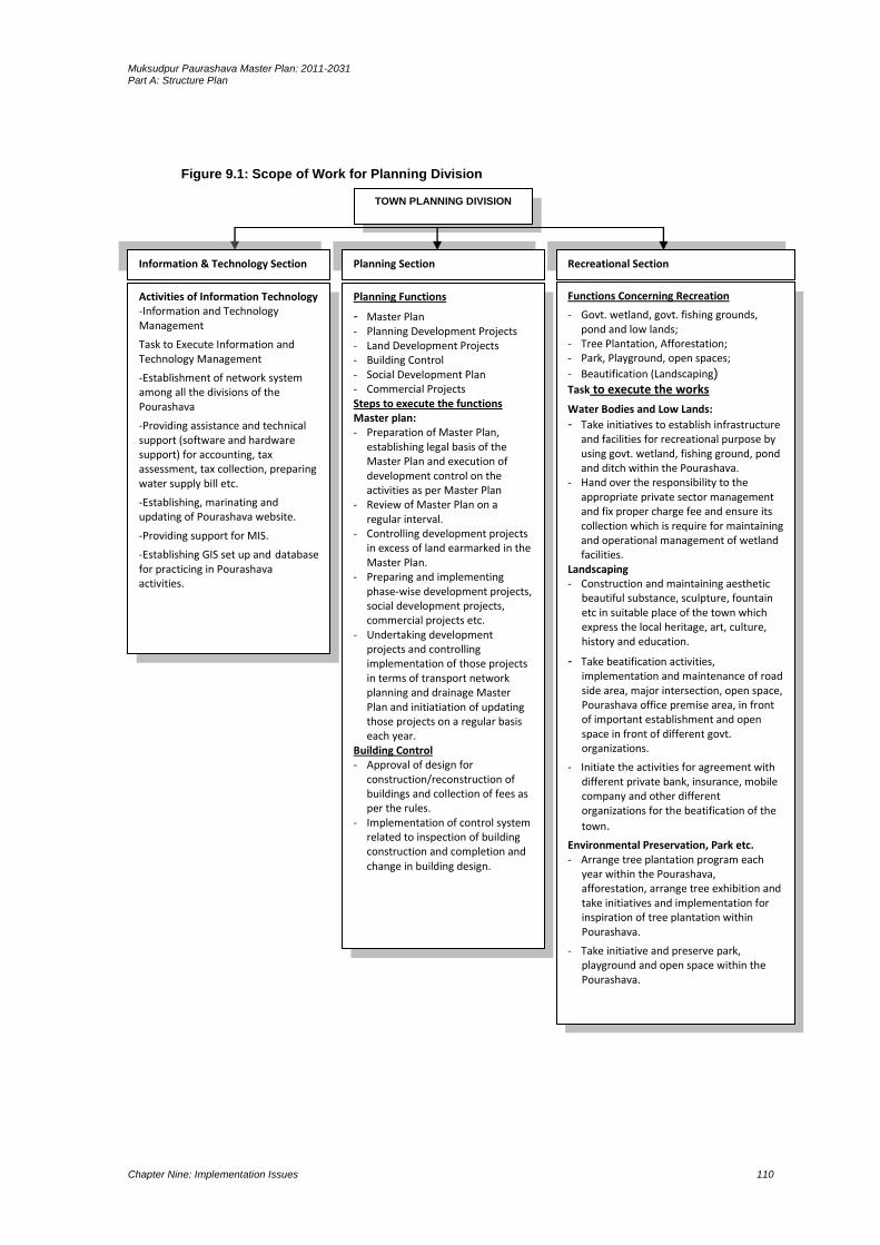
Muksudpur Paurashava Master Plan: 2011-2031 Part A: Structure Plan
Chapter Nine: Implementation Issues 110
Figure 9.1: Scope of Work for Planning Division
TOWN PLANNING DIVISION
Planning Section
Activities of Information Technology -Information and Technology Management
Task to Execute Information and Technology Management
-Establishment of network system among all the divisions of the Pourashava
-Providing assistance and technical support (software and hardware support) for accounting, tax assessment, tax collection, preparing water supply bill etc.
-Establishing, marinating and updating of Pourashava website.
-Providing support for MIS.
-Establishing GIS set up and database for practicing in Pourashava activities.
Recreational Section Information & Technology Section
Planning Functions
- Master Plan - Planning Development Projects - Land Development Projects - Building Control - Social Development Plan - Commercial Projects Steps to execute the functions Master plan: - Preparation of Master Plan,
establishing legal basis of the Master Plan and execution of development control on the activities as per Master Plan
- Review of Master Plan on a regular interval.
- Controlling development projects in excess of land earmarked in the Master Plan.
- Preparing and implementing phase-wise development projects, social development projects, commercial projects etc.
- Undertaking development projects and controlling implementation of those projects in terms of transport network planning and drainage Master Plan and initiatiation of updating those projects on a regular basis each year.
Building Control - Approval of design for
construction/reconstruction of buildings and collection of fees as per the rules.
- Implementation of control system related to inspection of building construction and completion and change in building design.
Functions Concerning Recreation
- Govt. wetland, govt. fishing grounds, pond and low lands;
- Tree Plantation, Afforestation; - Park, Playground, open spaces;
- Beautification (Landscaping)
Task to execute the works
Water Bodies and Low Lands:
- Take initiatives to establish infrastructure and facilities for recreational purpose by using govt. wetland, fishing ground, pond and ditch within the Pourashava.
- Hand over the responsibility to the appropriate private sector management and fix proper charge fee and ensure its collection which is require for maintaining and operational management of wetland facilities.
Landscaping - Construction and maintaining aesthetic
beautiful substance, sculpture, fountain etc in suitable place of the town which express the local heritage, art, culture, history and education.
- Take beatification activities, implementation and maintenance of road side area, major intersection, open space, Pourashava office premise area, in front of important establishment and open space in front of different govt. organizations.
- Initiate the activities for agreement with different private bank, insurance, mobile company and other different organizations for the beatification of the
town.
Environmental Preservation, Park etc. - Arrange tree plantation program each
year within the Pourashava, afforestation, arrange tree exhibition and take initiatives and implementation for inspiration of tree plantation within Pourashava.
- Take initiative and preserve park, playground and open space within the Pourashava.

Muksudpur Paurashava Master Plan: 2011-2031 Part A: Structure Plan
Chapter Nine: Implementation Issues 111
9.1.3.2 Lack of Paurashava Town Planning Capacity
At present, the Paurashava has no town planning division or any appropriate manpower
to prepare and implement the Master Plan. For proper implementation of the Master
Plan in each Paurashava establishment of a separate planning division is indispensable.
The Paurashava must strengthen its capacity to implement its Master Plan when it will
be completed. It will otherwise be in trouble for implementation, monitoring and
updating the Master Plan.
Muksudpur is a ‘B’ class Paurashava. For the ‘B’ class Paurashava Government approved
an organogram and required manpower. A comparison of the existing manpower with
the approved organogram finds that there is a huge gap between the two. Many
positions have been vacant since the inception of Paurashava. Paurashava authority
supported with the line ministry should take necessary steps to set up planning unit and
strengthen all units/division of the Paurashava for its better performance.
Support for Planned Urbanization
For creating planned urbanization, Paurashava may:
Support for preparation of Computerized Infrastructure Database.
Support for Preparation of Paurashava Base Map.
Support for Preparation of Paurashava Infrastructure Development Plan.
Orientation on preparation, use, update & implementation of Paurashava Master
Plan.
Assist preparation and execution of Community Development Plan by Community
Based Organization (CBO).
Introduce 3D-Modeling in Master Planning components.
Beautification of Paurashava by 3D-Modeling.
Community Mobilization Program
Following are the community mobilization support activities:
Support to establish Town Level Coordination Committee (TLCC) and make it
functional
Support to establish Ward Committee (WC) and make it functional.
Support for preparation of Community Planning and implementation by forming
Community Based Organization (CBO).
Support to accelerate the Paurashava Standing Committee activities.
Urban Governance Improvement Action Programme (UGIAP)
It is stipulated in the 6th 5 year plan ‘the Key constrains to the effective functioning
of the Paurashavas and City Corporations are unclear mandate and service
responsibilities; lack of accountability; weak finances and financial autonomy; poor
coordination and control among service agencies and weak management’.

Muksudpur Paurashava Master Plan: 2011-2031 Part A: Structure Plan
Chapter Nine: Implementation Issues 112
To overcome the challenges, the 6th Five year plan as well as Perspective Plan of
Bangladesh, 2011-31 recommends the same issues mentioned below:
the instructional reform and decentralization of responsibilities and resources to
local authorities; participation of civil society including woman in the design,
implementation and monitoring of local priorities; building capacity of all actors
(Institutions, groups and individuals) to contribute fully to decision making an urban
development process; and facilitate networking at all levels.
It is already tested, proven and accordingly recognized in the 6th Five year plan that
urban infrastructure improvements have been proved very successful introducing
governance and performance-based approach adapted by UGIIP in selected ULBs in
the country. Among other suggestions the 6th Five year plan also includes nature for
Urban Governance Improvement Action Progamme (UGIAP) and Capacity Building of
Institutes at Municipality-level in particular.
Citizen Awareness and Participation
The Paurashava authority may initiate to buildup citizen awareness and to ensure
peoples participation in plan initiation and implementation process. Initiatives may be as
follows:
Establishment of Civil Society Coordination Committee (CSCC) and make it functional
Establishment of Ward Level Coordination Committee (WLCC) and make it functional
Citizen Charter display at Poura Bhaban.
Citizen Report Card Survey by the Paurashava.
Establishment of Grievance Redress Cell and make it functional with specific TOR
Establishment of Mass Communication Cell (MCC) and make it functional
Establishment of Urban Development Coordination Unit with inclusion of other
departments for inclusive development
Urban Planning and Environmental Improvement
Master plan is a guideline and detail urban planning activities are being prescribed in
the plan. To produce a livable environment in the Paurashava premises, following
initiatives should be taken:
Recruitment of staffs and establish Planning Department related to administrative
structure, meeting and meeting minutes preparation.
Master Plan, Base Map verification and update landuse plan preparation.
Approval of building plan and development control.
Introduction of environment and public health activities.
Urban Poverty Reduction
Following initiatives can be taken by the Paurashava for urban poverty reduction:
Establishment of Slum Improvement Committee (SIC) in selected slums and scattered
area.

Muksudpur Paurashava Master Plan: 2011-2031 Part A: Structure Plan
Chapter Nine: Implementation Issues 113
Preparation of poverty reduction action plan with guideline and necessary budget
allocation.
Income Generating Activities
The income generating activities include:
Tax assessment software use and capacity development for staffs of assessment
section.
Continue reassessment activities regularly at 5 years interval.
Continue interim assessment regularly in whole year.
Introduction of computerized tax system and bill preparation.
Increase collection by more than 5% annually (up to 85% collection efficiency).
Increase non-tax own revenue source atleast by inflation rate.
Introduction of computerized trade license system and computer bill/license
prepared and report produced.
Introduction of computerized Water bill (Tariff) system.
Introduction of Computerized non-motorized vehicle management system.
Identification of new income sources for increasing income.
Transparency and Accountability
Functions and activities perform by the Paurashava authority should be transparent and
the persons responsible for performing activities for betterment of the society should
maintain accountability to the Paurashava people as well as central government.
Following guidelines may be followed for such performances:
Administrative Reformation of Paurashava.
Set Vision, Mission and functions for each department / section of the Paurashava.
Functions to be decentralized, transfer and coordination with other authorities.
Establishment of Capacity Development Committee in Paurashava-level.
Establishment of Urban Information Services Center at Paurashava premises.
Meet the Mass people of Poura-Parishad.
9.1.4 Legal Aspects
The drive to establish strong urban local governance in the Paurashava is yet to be
legalized. The governance programmes at present are operated project wise based on
the formulated policies of the implementing agencies of the national government. The
Laws that the country inherited are mostly prepared during the colonial rule to serve its
own interests. Even after independence from the British, the issue of good governance
was not infused into the new Acts formulated.

Muksudpur Paurashava Master Plan: 2011-2031 Part A: Structure Plan
Chapter Nine: Implementation Issues 114
9.1.5 Good Governance in Legal Provisions
There is hardly any Act where the elements of good governance are clearly visible. The
consultant has identified some Acts, where some elements of good governance can be
traced.
The Paurashava/Municipal Act/Ordinances prepared at different times since 1960’s have
iterated for the preparation of Master Plan by the Paurashava/Municipality for its
planned development. So far urban local government Ordinances/Acts made in 1967,
1977, 2008 and 2009, all suggested for planned development. The Paurashava Act 2009
has made the provision of having a Master Plan prepared by a Paurashava within five
years of its inception. The function of the Paurashava also includes that it ensures
planned development following the rules of the Ordinance. But there is no provision for
public participation in the Paurashava Ordinance 2009. In all these legal documents,
people’s role has been ignored which is the violation of the norms of good governance.
The constitution of the Peoples’ republic of Bangladesh clearly spells out that the
Government should work to minimize the gap between urban and rural areas. A planned
Paurashava development in that pursuit can provide necessary services to improve
quality of life in both urban and rural areas within the Upazila.
9.1.6 Financial Issues
Governance in Muksudpur Paurashava
Financial governance refers to transparency and accountability of financial matters. All
financial matters must be transparent to all. People must know about the policies and
programs of the Paurashava, how much revenue is collected each year and the amount
of expenditure made on annual development. They must also be answerable to the
people on how the public money is being spent and accounts being maintained.
Under different Government Projects computer and accessories are supplied for
automation of the accounts system of Paurashavas within Bangladesh. Besides, trainings
are also offered to the Paurashava account staffs for enabling introduction of automation
in accounts system. But Muksudpur Paurashava has not yet been enlisted under any kind
of these projects.
Revenue Management
The Paurashava still follows a traditional management system in tax collection and
revenue management. Assessment section is responsible to asses the tax of the
Paurashava and tax collection, and license and bazar section are responsible to collect
the tax of the Paurashava. Tax automation system is not established here yet. The public
is mainly informed about tax collection during the presentation of annual budget. They
may, however, get information from the councilors or Paurashava accounts office.

Muksudpur Paurashava Master Plan: 2011-2031 Part A: Structure Plan
Chapter Nine: Implementation Issues 115
Paurashava’s Financial Capacity and Plan Execution
The main focus of Paurashava financial governance is to establish automation in entire
financial management. This includes computerization of accounts system, holding tax
management, and billing of different service charges. Software for above functions will
have been supplied and installed in the Paurashavas covered by different projects. The
projects also provided training to the relevant staff for functioning of the systems. With
the implementation of these projects people can now instantly know about the status of
their tax payment, bill payment, and licensing. This has not only made the functions of
the Paurashava easy, but also has freed the citizens for paying bribe, and experiencing
hassle.
The size of annual budgets of the Paurashavas indicates the poor financial status of the
Paurashavas. With low income, Muksudpur Paurashava will have to depend substantially
on the government funding for implementing the development projects. But the
government has limitations of its resources. In such a situation, if the Paurashava cannot
raise its own revenue adequately, it will not be able to execute much of the development
projects under the Master Plan.
9.1.7 Monitoring, Evaluation and Updating
An important step for implementation of the Plan is land use clearance. Land use
clearance will be needed for every physical component whether it may be public or
private. The Paurashava will provide such clearance. To ensure the future development
according to the proposals prescribed in the Urban Area Plan and Ward Action Plan, the
Paurashava must maintain the following guidelines during the land use clearance.
Must ensure 20 ft. access road for any type of land use clearance.
No permanent land use should be allowed in the area demarcated as urban reserve and
the authority will follow the guideline provided to Annexure- A when the will provide
land use clearance.
Must ensure that no land use clearance is issued on the lands indicated as road, drainage
channel, water reservoir, educational institution, health services, open space, fruit
garden / orchard in the Urban Area Plan.
Monitoring and evaluation is a very important part of plan implementation. Monitoring
helps check if the plan is being implemented properly. It also measures the level of
implementation of the plan. If the plan implementation is not on track, corrective
measures can be taken to put execution on the track. After expiry of any plan, evaluation
is made about the errors and omissions. Such evaluation helps take corrective measures
in the next plan. Such monitoring and evaluation must be carried out from within the
Paurashava. But Muksudpur Paurashava is not equipped with qualified manpower to
make such evaluation. Monitoring and evaluation of a plan is essentially, the
Muksudpur Paurashava Master Plan: 2011-2031 Part A: Structure Plan
Chapter Nine: Implementation Issues 116
responsibility of qualified and experienced planners. As there is no planner in the
Paurashava, monitoring of plan implementation will be seriously affected. However, plan
evaluation can be accomplished by means of out sourcing as and when it is required.
9.1.8 Periodic Review and Updating
The plan package needs to be updated regularly to make it respond to the spatial
changes over time. But such updating would require relevant technical professionals and
requisite fund that are highly lacking in Muksudpur Paurashava. As there is no planner or
planning section in the Paurashava, review and updating of the Master Plan will require
service of senior level planners that Paurashava might not be able to provide. This service
will have to be procured by out sourcing and the Paurashava is not even capable to
accomplish this financially either. This will create problem when the plans or its
components gets obsolete or need to be changed. Another problem would arise when
the duration of plans ends. It is necessary that the entire plan document (including all
planning and land use proposals) should be reviewed every 4th year of the plan period
and will come into execution from the 5th year. The aim of the review will be to analyze
the status of implementation of plan provisions, the changing physical growth pattern,
infrastructure development, and the trend of public and private physical development
including growth direction.
A new set of plans will have to be prepared replacing the old ones. This problem,
however, can be overcome by undertaking another planning project by LGED. So, for
regular updating and changes, and plan implementation monitoring, the Paurashava
should immediately set up a planning section with a number of planners and other staff.
The section will not only look after planning, but will also be responsible for development
control, estate management, and project preparation. Since the planners would be
qualified and skilled in computer operation, they can also help achieving automation of
the Paurashava functions.
9.2 Resource Mobilization
Resource mobilization will be one of the most challenging tasks in implementing the
current plan package. Though the development proposals are said to be executed by a
large number of development agencies, but it is beyond doubt that the heaviest burdens
will have to be shouldered by the Paurashava. As a local government agency, it suffers
from resource constraint due to low level of urbanization and investment by both public
and private sectors. The land value will maintain perpetually low growth rate in the town.
Therefore, prospect of mobilization of substantial resource from sale of serviced land is
extremely meager. For the same reason, revenue earning from betterment fee, planning
permission and other sources may also remain low. Paurashava is heavily dependent on
the government for executing its development projects as it is unable to collect sufficient
revenue from its tax and non-tax sources. Therefore, it is clear that execution of

Muksudpur Paurashava Master Plan: 2011-2031 Part A: Structure Plan
Chapter Nine: Implementation Issues 117
development projects under the current plan will depend heavily on the government
response to supply adequate fund. This situation calls for increasing revenue earning by
generating new revenue sources.
9.3 Concluding Remarks
From the past experience, it has been observed that plans are prepared for organized
development, but development control has been subject to negligence. In most cases,
execution has been piece-meal. It is unfortunate that town planning has not yet become
a part of our urban development culture. Individuals develop lands and construct
buildings with a little respect for planned development, and the concerned authority is
also unable to exercise full control on development. Some strict measures are necessary
to make stakeholders follow up plans and development rules. Awareness is to be built
among the people to follow the Master Plan provisions and plan. Government agencies
must be compelled to follow plans. Existing laws in this regard must be updated
incorporating provisions of plan execution.
Muksudpur Paurashava Master Plan: 2011-2031 Part A: Structure Plan
Chapter Nine: Implementation Issues 118

Muksudpur Paurashava Master Plan: 2011-2031 Part B: Urban Area Plan
Chapter Ten: Urban Area Plan 119
PART B URBAN AREA PLAN
Urban Area Plan is aimed to guide physical development of Muksudpur Paurashava
including its economic and social activities. The plan adhere policy directives spelled out
in the Structure Plan. The Urban Area Plan is akin to the traditional Master Plan approach
prevalent in the country that designates plot-to-plot use of land apart from infrastructure
development proposals. Thus it will also serve as a development control
mechanism/instrument. Preparing landuse plan on a cadastral map, the Urban Area Plan
considers more rigid. Once the plan on a cadastral map is drawn and accepted by the
government and formalized, it gains a formal status and thus becomes a binding for all
concerned.
The Terms of Reference (TOR) specify (Pg. 6. Article 4) that the Urban Area Plan (UAP)
/Multi-sector Investment Plan (MSIP) will consist of the following plans:
Landuse Plan
Transportation and Traffic Management Plan
Drainage and Environmental Management Plan
Plan for Urban Services
The Urban Area Plan is presented in both, map and textual format. The plan map is
presented in 1:1980 scale, super imposed on latest cadastral/revenue map having plot
boundaries within mouzas. The plan is accompanied by an explanatory report supported
by necessary figures, maps and data.
Urban area plan is broadly divided into two parts, plan map and explanatory report. The
plan map depicts future landuse zoning, infrastructure development and other
development proposals. Report elaborates all proposals proposed in the plan, including
rules, regulations and recommendations for implementation of the plan.
The outline of the Urban Area Plan gives guidance to the Paurashava as to how it can
develop the roles i.e. to promote development, to co-ordinate development and to
control development.
The Urban Area Plan has been divided into four main parts. These are preceded by four
introductory chapters which explain the scope of the report and provide background to
the Urban Area Plan including its relationship with the Structure Plan.
The Landuse Plan identifies approaches of planning, existing and projected landuse and
proposed landuse. Requirement of land for different purposes, landuse zoning and plan
implementation strategies are also included here.
Muksudpur Paurashava Master Plan: 2011-2031 Part B: Urban Area Plan
Chapter Ten: Urban Area Plan 120
The Transportation and Traffic Management Plan includes existing conditions of
transportation facilities, intensity of traffic volume, degree of traffic congestion and
delay, analysis of existing deficiencies, travel demand forecasting for next 20 years, future
traffic volume and level of services and transportation development plan. Moreover,
transportation system management strategy and plan implementation strategies are also
presented in this plan.
Drainage and Environmental Management Plan is the third chapter of the Urban Area
Plan. The chapter again subdivided into two parts – drainage part and environment
part. Existing drainage network, land level and topographic contour, plan for drainage
management and flood control and plan implementation strategies are the components
of the drainage part. Existing environmental condition, solid waste and garbage disposal,
environment pollution, water-logging, natural calamities and localized hazards, plan for
environmental management and pollution control and plan implementation strategies
are the key issues of the environment part.
Fourth part of this report is Plan for Urban Services. Existing condition and demand of the
Services, projection on existing and proposed Urban Services, Proposals for Urban
Services and Implementation, monitoring and Evaluation of the Urban Services Plan are
the key issues of this part.
The Urban Area Plan of the Muksudpur Paurashava covers an area of 4157.21 acres
(16.82 sq km.). The reason behind choosing such area lies in fact that this is the most
urbanized part of the Paurashava, where there is still scope and possibility of urban
development in near future. Paurashava operates all parts where it provides basic urban
services and facilities. Considering future urbanization trend and potential development
projected population is assumed 21557 for 2031.
The Urban Area Plan covers nine Ward Action Plans also.
Muksudpur Paurashava Master Plan: 2011-2031 Part B: Urban Area Plan
Chapter Ten: Land Use Plan 121
CHAPTER 10 LAND USE PLAN
10.1 Introduction
The Landuse Plan is one of the four components of Urban Area Plan. The Landuse Plan is
the first element of the Muksudpur Paurashava Urban Area Plan. The Landuse Plan is
being prepared for managing and promoting development over medium-term on the
basis of the strategies set by the longer-term Structure Plan. Basically the Landuse Plan is
an interpretation of the Urban Area Plan over the medium-term (10 years). The coverage
of the Landuse Plan considers existing urban areas and their immediate surroundings
with the purpose of providing development guidance in the areas where most of the
urban development activities are expected to take place over the next 10 years.
Delineation of the Landuse Plan area is based on the urban growth area identified as the
planning area. It contains more details about specific programs and policies that require
to be implemented over the medium-term.
10.2 Existing and Projected Landuse
10.2.1 Existing Landuse
Details of landuse include structures and uses of land in multi-dimensions. Every
individual structure and its details were surveyed during the survey period and find out
the uses of land. Most of the landuse information was collected through physical feature
survey. Later on, landuse map is prepared showing different use categories.
In Muksudpur Paurashava, major landuse is agriculture (72.57%). Residential land is
16.66% and only 1.58% land is under circulation network category. Though, agriculture
landuse dominates the Paurashava but, after the preparation of Master Plan, a radical
change in physical development will proceed. In consideration of such concept, the
Master Plan will be delighted in favour to save the agriculture land.
Table 10-1 Existing Land use in Muksudpur Paurashava Landuse category Area (acre) (%)
Agriculture 3016.84 72.57
Circulation Network 65.88 1.58
Commercial Activity 7.75 0.19
Community Service 8.32 0.20
Education & Research 10.00 0.24
Governmental Services 10.69 0.26
Manufacturing and Processing Activity 4.88 0.12
Miscellaneous 0.17 0.00
Mixed Use 5.57 0.13
Non Government Services 0.96 0.02
Open Space 28.65 0.69
Recreational Facilities 6.54 0.16

Muksudpur Paurashava Master Plan: 2011-2031 Part B: Urban Area Plan
Chapter Ten: Land Use Plan 122
Landuse category Area (acre) (%)
Residential 692.50 16.66
Service Activity 7.54 0.18
Transport and Communication 0.68 0.02
Water Body 290.26 6.98
Total 4157.21 100
Source: Land Use Survey, 2010.
Determining factors of landuse change is the income of the people, government policy,
new establishment like industry, higher level educational institute, construction of road
and embankment and availability of services. The Paurashava was developed as a growth
centre long before, than a police station. In the year 2000 it is notified as Paurashava.
Radical change of landuse in the Paurashava is not found. Before it known as Paurashava,
agricultural domination was the key landuse. During last ten years, the landuse scenarios
remain same. A stagnant character of landuse change still stand due to the existence of
river named Padma. Rapid change of landuse will be viewed after the construction of
Padma Bridge at Maowa point.
10.2.2 An Estimate on the Requirement of Land
The Paurashava is not an ideal township due to the agriculture domination. Agriculture
based township should be encouraged in the preparation of Master Plan. Growth of
population is the natural trend and at the sametime, expansion of non-agricultural use on
agriculture land is also natural tendency of the people. This will be controlled through the
Compact Township concept with the encouragement of vertical development. In case of
government services, specific building may accommodate different type of offices.
The projection of landuse depends on the growth of population. After population
projection it is found that, population of this Paurashava will be 31874 in the year 2031
and 26026 in the year 2021.
In case of landuse change, the standard given by the LGED according to the projected
population and area for the specific service is being calculated. Minimum use of
agriculture land for physical development is emphasized in the plan. The vertical
expansion will be emphasized rather than horizontal. In case of road network planning,
missing links will get priority rather than new roads. For the development of pisciculture,
most of the ponds and ditches may be preserved, in some exceptional cases; small
number of ditches may be used for physical development activities. Landuse control and
landuse restriction will be imposed by the Paurashava according to the prescribed plan.
The standards presented in the Table-10.2 are fairly generous and considered for the
Paurashava. Adjustments have to be made in the core areas and a time line may be set to
gradually achieve these standards over a five, ten and twenty years period.
area up to the year 2031. For this population total number of required wholesale
Muksudpur Paurashava Master Plan: 2011-2031 Part B: Urban Area Plan
Chapter Ten: Land Use Plan 123
Map 10.1: Existing Landuse

Muksudpur Paurashava Master Plan: 2011-2031 Part B: Urban Area Plan
Chapter Ten: Land Use Plan 124

Muksudpur Paurashava Master Plan: 2011-2031 Part B: Urban Area Plan
Chapter Ten: Land Use Plan 125
Commerce
In total, 7.75 acres commercial land is in the Paurashava.
Determination of Standard: According to the standard on wholesale market/bazar, 1
acre land is to be provided for every 10,000 populations and 1 acre land for every 1000
population for Retail sale market. Again, 0.25 acre of land is being standardized for per
corner shop, 1 acre per neighbourhood market, 1.5 to 2.5 acre per super market and 1
acre per 25,000 populations for bank, hotel, garage and godown. The study team has
considered 31874 populations for the planning
market/ bazar stands at (31874 / 10,000), means 3.18 acres land is being needed up to
the year 2031 and 21.32 acres for retail sale market. The planning area already has 1
retail sale market including wholesale market/bazaar.
Recommendation / Forecast: The study team recommends expansion of present
wholesale market/bazaar on earmarking land. Necessary planning permission and design
criteria will be provided by the Paurashava. The lands may be allowed to use for other
commercial purposes like bank, hotel and godown.
Industry
In the Paurashava, 4.88 acres land is under industrial development.
Determination of Standard: According to the standard, land is being allocated as 1.5
acres for every 1000 populations in case of small-scale industry, 5 acres per 10000
populations for heavy industry and service industry and 1 acre per 1000 population for
cottage/agro-based industry. The study team has estimated 31874 populations for the
planning area up to the year 2031. For this population total required land for industry
stands 31.98 acres for small-scale industry and 21.32 acres for cottage / agro-based
industry up to the year 2031.
Recommendation / Forecast: The study team recommends earmarking land for small-
scale/agro-based industry within the Paurashava. Necessary planning permission will be
followed by the Paurashava. The lands, however, should not be allowed to use other than
industry. The industries which are located dispersely should be accommodated within the
prescribed industrial areas.
Primary School
In the Paurashava, 2.88 acres land is under Primary school.
Determination of Standard: According to the standard on primary school, 1 school with 2
acres of land is to be provided for every 5,000 population. The study team has estimated
31874 populations for the planning area up to the year 2031. For this population total
number of required primary school stands at (31874 / 5,000), means 3 schools with 2
acres land is being needed up to the year 2031.

Muksudpur Paurashava Master Plan: 2011-2031 Part B: Urban Area Plan
Chapter Ten: Land Use Plan 126
Recommendation / Forecast: According to the standard 3 acre of land is needed for
primary school. So considering the extended areas, the study team suggests a new
primary school on an area of about 1.3 acre.
Secondary School
There are 3 secondary schools in the planning area covering together 1.5 acres land.
Average area of a secondary school is 0.50 acre.
Determination of Standard: According to the standard, 5 acres of land may be provided
for every 20,000 population for one secondary school. The projected population of the
planning area is 31874 up to the year 2031. Therefore, as per standard the planning area
needs (31874 / 20,000), means no secondary school is being needed up to the year 2031.
At present, there are 3secondary schools with 1.5 acres land in the planning area.
Number of schools already exceeds the requirement.
Forecast / Recommendation: As per above standard, no more secondary school is
needed but the existing areas of the school may be expanded vertically.
College / Higher Secondary School
There is a college in the planning area. That college is located on 5.30 acres of land.
Determination of Standard: The standard for college is 10 acres per 20000 populations.
Recommendation / Forecast: The planning area already has a degree level college apart
from higher secondary level education is in the high schools. Therefore, no
recommendation for new college is prescribed but, expansion of the existing college is
required.
Vocational Training Centre
An important component for the rural masses is vocational training. Multi-dimensional
training may be offered through the centre. People are being benefited directly and
prepare him as a technical person enjoying training from vocational centre. At present,
no vocational training centre in the Paurashava. According to the standard, 5.0 acres land
may be provisioned for a vocational training centre.
Determination of Standard: The prescribed standard for vocational training centre is 5 to
10 acres for Upazila.
Recommendation / Forecast: The study team recommends a vocational training centre
on 5.0 acres land. Necessary planning permission will be offered by the Paurashava. The
lands, however, should not be allowed to use other than vocational training centre.
Muksudpur Paurashava Master Plan: 2011-2031 Part B: Urban Area Plan
Chapter Ten: Land Use Plan 127
Health Facilities
At present, three health establishments are in the Paurashava. One hospitals and one
clinic are those establishments. The health facilities are on 7.54 acres land.
Determination of Standard: The prescribed standard for health facilities are 10 to 20
acres for Upazila Hospital and 1 acre per 5000 population for Health centre/Maternity
clinic. According to the standard, up to the year 2031, (31874 / 5000) means 6.3 acres
land will be needed for Health centre/Maternity clinic.
Recommendation / Forecast: The study team recommended two hospitals for health
facilities.
Open Space
At present, 28.65 acres open space is in the Paurashava.
Determination of Standard: The standard recommends 3 acres per 20000 populations
for playground, 1 acre per 1000 population for park and 1 acre per 1000 population for
Neighbourhood Park.
Recommendation / Forecast: The study team recommended two play fields. At least one
park is being recommended with minimum area 10.0 acres depending on availability of
open land. Park with restaurant may be created on the land situated on the riverbank.
Community forest and tourism development also prescribed without considering any
standard. Amount of land for those components have been considered through
discussion with the stakeholders.
Community Facilities
Community facilities include Community centre, Graveyard/ Burial ground, Electric sub-
station, Water supply pump, Post office, T&T office, Public library, Eidgah,
Mosque/Church/Temple, Police station, Police box/outpost, Fire service station, Waste
disposal site, club, etc. Existing land under community facilities is 8.32 acres.
Determination of Standard: The standard suggests 1 acre per 20000 for the community
centre, Graveyard/ Burial ground and Eidgah. Again, 0.5 acre per 20,000 populations
prescribed for Mosque/Church/Temple, Post office and T&T, 1 acre per 20,000
populations for Fire service station and 3–5 acres per Upazila Headquarters and police
station.
Recommendation / Forecast: The study team recommends a new community centre on
one acre of land. Areas for Mosque/Church/Temple, Post office, Fire service station and
T&T remain with existing areas.
Administration
In the Paurashava, 10.69 acres land is under administrative use.

Muksudpur Paurashava Master Plan: 2011-2031 Part B: Urban Area Plan
Chapter Ten: Land Use Plan 128
Determination of Standard: According to the standard for administrative land, 15 acres
of land is to be provided for every Upazila, 3 to 5 acres per Paurashava office, 0.10 acres
per Union and 10 acres for jail / sub-jail. Total required land for administration stands at
about 28 acres. The planning area already has 10.69 acres administrative land.
Recommendation / Forecast: The planning area already has one Upazila office, one
Paurashava office and other govt. offices. Therefore, no recommendation for new
administrative area is prescribed but, expansion of the existing Paurashava office is
required.
Recreation
Only 6.54 acres land is under recreational facility in the Paurashava.
Determination of Standard: According to the standard for recreational facilities, 1 acre of
land is to be provided for every 20,000 population for cinema / theatre, 5 to 10 acres land
for stadium / sports complex and 1.75 acres land per 10,000 populations for a shishu
park. The study team has estimated 31874 populations for the planning area up to the
year 2021. For this population total land required for cinema/theatre stands at (31874 /
20,000), means 1.5 acres land is being needed up to the year 2031, 5.0 acres for stadium
and 3.73 acres for shishu park.
Recommendation / Forecast: The study team recommends a stadium / sports complex on
5.00 acres of land.
Residential
Existing residential areas of the Paurashava is 692.50 acres. All type of residential lands is
included with such amount of land. About 94% residential land belongs with the rural
homestead. Therefore, rural environment will be considered for creating better living
areas.
Determination of Standard: The standard recommends in Table-10.2 is 100-150 persons
per acre (gross). Again, it is recommended 200 persons per acre for e real estate or
housing areas both for public and private. But it is not possible for this Pourahsava.
Rather 40 persons /acre are more realistic .No standard is being recommended for low-
income group.
Recommendation / Forecast: According to the standard (40 persons per acre), about 769
acres land will be needed up to the year 2031. Existing residential area (692.50 acres) is
about 77 acres lower than the projected areas. Allocated residential land for future
should not be higher than 77 acres. The Consultant recommends one row housing area
for flood victims. The row houses may be constructed on the eastern part of the
Paurashava (adjacent with the Paurashava boundary in Ward No. 6). Mostly khas land will
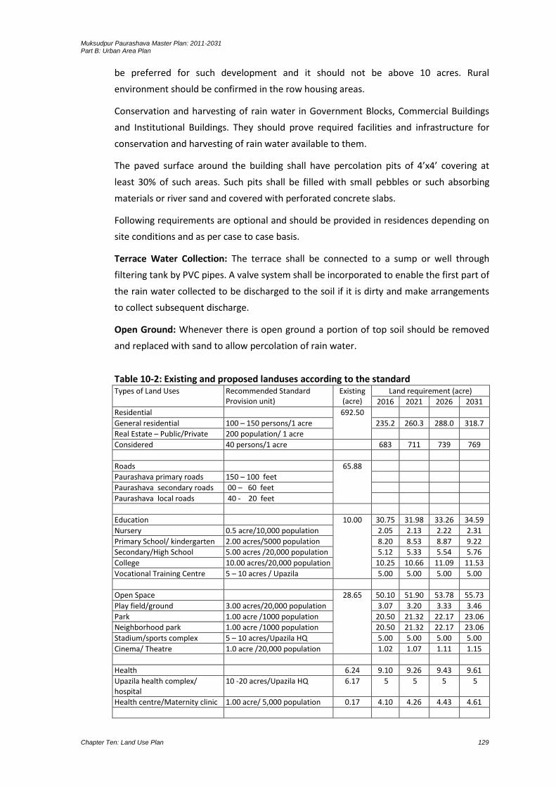
Muksudpur Paurashava Master Plan: 2011-2031 Part B: Urban Area Plan
Chapter Ten: Land Use Plan 129
be preferred for such development and it should not be above 10 acres. Rural
environment should be confirmed in the row housing areas.
Conservation and harvesting of rain water in Government Blocks, Commercial Buildings
and Institutional Buildings. They should prove required facilities and infrastructure for
conservation and harvesting of rain water available to them.
The paved surface around the building shall have percolation pits of 4’x4’ covering at
least 30% of such areas. Such pits shall be filled with small pebbles or such absorbing
materials or river sand and covered with perforated concrete slabs.
Following requirements are optional and should be provided in residences depending on
site conditions and as per case to case basis.
Terrace Water Collection: The terrace shall be connected to a sump or well through
filtering tank by PVC pipes. A valve system shall be incorporated to enable the first part of
the rain water collected to be discharged to the soil if it is dirty and make arrangements
to collect subsequent discharge.
Open Ground: Whenever there is open ground a portion of top soil should be removed
and replaced with sand to allow percolation of rain water.
Table 10-2: Existing and proposed landuses according to the standard Types of Land Uses Recommended Standard
Provision unit) Existing (acre)
Land requirement (acre)
2016 2021 2026 2031
Residential 692.50
General residential 100 – 150 persons/1 acre 235.2 260.3 288.0 318.7
Real Estate – Public/Private 200 population/ 1 acre
Considered 40 persons/1 acre 683 711 739 769
Roads 65.88
Paurashava primary roads 150 – 100 feet
Paurashava secondary roads 00 – 60 feet
Paurashava local roads 40 - 20 feet
Education 10.00 30.75 31.98 33.26 34.59
Nursery 0.5 acre/10,000 population 2.05 2.13 2.22 2.31
Primary School/ kindergarten 2.00 acres/5000 population 8.20 8.53 8.87 9.22
Secondary/High School 5.00 acres /20,000 population 5.12 5.33 5.54 5.76
College 10.00 acres/20,000 population 10.25 10.66 11.09 11.53
Vocational Training Centre 5 – 10 acres / Upazila 5.00 5.00 5.00 5.00
Open Space 28.65 50.10 51.90 53.78 55.73
Play field/ground 3.00 acres/20,000 population 3.07 3.20 3.33 3.46
Park 1.00 acre /1000 population 20.50 21.32 22.17 23.06
Neighborhood park 1.00 acre /1000 population 20.50 21.32 22.17 23.06
Stadium/sports complex 5 – 10 acres/Upazila HQ 5.00 5.00 5.00 5.00
Cinema/ Theatre 1.0 acre /20,000 population 1.02 1.07 1.11 1.15
Health 6.24 9.10 9.26 9.43 9.61
Upazila health complex/ hospital
10 -20 acres/Upazila HQ 6.17 5 5 5 5
Health centre/Maternity clinic 1.00 acre/ 5,000 population 0.17 4.10 4.26 4.43 4.61

Muksudpur Paurashava Master Plan: 2011-2031 Part B: Urban Area Plan
Chapter Ten: Land Use Plan 130
Types of Land Uses Recommended Standard Provision unit)
Existing (acre)
Land requirement (acre)
2016 2021 2026 2031
Community Facilities 8.32 8.62 8.83 9.04 9.26
Mosque/Church/Temple 0.5 acre /20,000 population 0.51 0.53 0.55 0.58
Eidgah/ 1.0 acre/20,000 population 1.02 1.07 1.11 1.15
Graveyard 1.00 acre /20,000 population 1.02 1.07 1.11 1.15
Community centre 1.00 acre /20,000 population 1.02 1.07 1.11 1.15
Police Station 3 – 5 acres/Upazila HQ 3.00 3.00 3.00 3.00
Police Box/outpost 0.5 acre/ per box 0.50 0.50 0.50 0.50
Fire Station 1.00 acre/ 20,000 population 1.02 1.07 1.11 1.15
Post office 0.5 acre /20,000 population 0.51 0.53 0.55 0.58
Commerce and Shopping 7.75 26.30 27.20 28.14 29.11
Wholesale market 1 acre/ 10000 population 2.05 2.13 2.22 2.31
Retail sale market 1 acre/ 1000 population 20.50 21.32 22.17 23.06
Corner shops 0.25 acre/per corner shop 0.25 0.25 0.25 0.25
Neighborhood market 1.00 acre/per neighborhood market
1.00 1.00 1.00 1.00
Super Market 1.50 – 2.50 acres/per super market
2.50 2.50 2.50 2.50
Industry 4.88 51.25 53.30 55.43 57.65
Small scale 1.50 acres /1000 population 30.75 31.98 33.26 34.59
Cottage/agro-based 1.00 acres /1000 population 20.50 21.32 22.17 23.06
Utilities 0 14.70 15.21 15.76 16.37
Drainage As per local requirement
Water supply 1.00 acre /20,000 population 1.18 1.30 1.44 1.59
Gas 1.00 acre /20,000 population 1.18 1.30 1.44 1.59
Solid waste disposal site 5– 10 acres/Upazila HQ 10.00 10.00 10.00 10.00
Waste transfer station 0.25 acres/per waste transfer station
Electric sub-station 1.00 acre/20,000 population 1.18 1.30 1.44 1.59
Telephone exchange 0.5 acre/20,000 population 0.59 0.65 0.72 0.80
Fuel Station 0.5 acre/20,000 population 0.59 0.65 0.72 0.80
Transportation 0.68 3.31 3.41 3.52 3.63
Bus terminal 1 acre /20,000 population 1.02 1.07 1.11 1.15
Truck terminal 0.50 acre /20,000 population 0.51 0.53 0.55 0.58
Launch/steamer terminal 1.00 acre /20,000 population 1.02 1.07 1.11 1.15
Baby taxi/tempo stand 0.25 acre /one baby taxi/tempo stand
0.25 0.25 0.25 0.25
Rickshaw/van stand 0.25 acre / stand 0.25 0.25 0.25 0.25
Passenger Shed 0.25 acre / stand 0.25 0.25 0.25 0.25
Administration 10.10 20.00 20.00 20.00 20.00
Upazila complex 15.00 acres 10.04 15.00 15.00 15.00 15.00
Paurashava office 3 – 5 acres 0.06 5.00 5.00 5.00 5.00 Agri-extension Farm 10 acres/Upazila HQ 10 10 10 10 Urban Deferred 10 percent of the total build up
area 43 47 52 58
10.3 Landuse Proposals
Basically, landuse proposal involves with the existing conflicting landuses. Those conflicts
may be raised due to different causes. Inhabitants of the Paurashava are not aware about
the land level and slope direction of the Paurashava. Without knowing this information
they are raising their land up to a mark and constructing permanent structure. As a
Muksudpur Paurashava Master Plan: 2011-2031 Part B: Urban Area Plan
Chapter Ten: Land Use Plan 131
result, water-logging problem during rainy season is found in all over the residential
areas.
Due to the absence of development control, the core area of the Paurashava is already
developed as mixed-use area. Commercial, residential, administrative, educational uses
are admixture in the core area. Zoning provision, landuse control should not be enforced
on such type of the core area.
At present, the Paurashava is a natural developed area. Rearrangement of the existing
use is not possible. Land acquisition for expansion of road (to increase the width of road)
will create socio-political hazards. As a result, the roads in the core area remain as today.
For water supply network, construction of sewerage facilities and removal of fire hazards,
at least 24 feet width road is necessary. In the Paurashava, except National Highway,
such type of road is absent. New road will form new township on agriculture land. These
processes will washout agriculture domination from the Paurashava. Compact Township
will be the effective method for new formation, not for the mixed-use areas where most
of the roads are 8 to 10 feet width.
10.3.1 Designation of Future Landuse
Identification and development of sites for government housing. After preparation
and implementation of the master plan, different types of government activities will
be increased. Residential accommodation will be needed for those government
employees. A site for government housing should be reserved. National Housing
Authority is appropriate for performing this responsibility.
Encourage central government to decentralize industrial development from Dhaka.
Those facilities may be relevant with specific agro-product such as jute for jute
industry, cane and bamboo for handicrafts, poultry and horticulture farming, export-
oriented vegetation, etc. Different authorities such as Agriculture Development
Corporation, Small and Cottage Industries Corporation, Directorate of Livestock and
Poultry may be the responsible authority.
Provision of sites and services schemes for the low and lowest income groups. The
Paurashava authority and Schedule Bank may be appropriate for performing these
responsibilities. Housing for low-income group, distribution of khas land among the
lowest-income group and loan with low-interest for house construction may be the
appropriate schemes.
Upgrading of slum and squatter settlements. Mostly, the vulnerable groups are
affected by river erosion, form slum and squatters on public land. If possible, those
formations should be upgraded providing basic utility services. It is better, in
Paurashava context, the people are living in the slum and squatters, rehabilitate
them with the provisioning of housing for lowest-income group. The Paurashava and
NGOs can perform such role.
Monitoring the principal aspects of community facility provision in the Paurashava.
Wholesale or retail market, specialized clinic, etc. are under this community facility.

Muksudpur Paurashava Master Plan: 2011-2031 Part B: Urban Area Plan
Chapter Ten: Land Use Plan 132
When any difficulties will be encountered in case of suitable site selection
considering demand of the inhabitants, the Paurashava will perform the lead role.
Location for new industrial development. The industrial area prescribed in the
Landuse Plan will be developed provisioning all utility services. The authorities
relevant with those utility services will perform the responsibilities. At first, the
polluting industries (water and noise) from their original location should shift to the
new location. Imposition of taxes, tax holiday and subsidized taxes may be imposed
by the Paurashava for such rearrangement.
10.3.2 Landuse Zoning
Zoning is a classification of landuses that limits what activities can or cannot take place
on a parcel of land by establishing a range of development options. Zoning has been
defined as an action through legislation provided to a development authority /
Paurashava to control a) heights to which buildings may be erected; b) the area of lots
that must be left un-built upon; and c) the uses to which buildings may be constructed.
Area / Use Zoning
The objective of area zoning is to specify which types of landuse are considered
appropriate for different areas or 'zones', and it therefore indicates the planning control
objectives of the authority or municipality for its administrative area. The authority is
obliged under the planning acts to designate in its development plan objectives for the
use solely and primarily of particular areas for particular purposes.
According to the landuse table, area zoning is divided as agriculture, residential,
commercial, industrial, administrative and institutional. The zone has further segmented
and detailed in the Ward Action Plan. A detailed scenario as plot-to-plot basis is also
presented with the calculation of covered area in the landuse plan.
Density / Bulk Zoning
Aim of the density zoning is to provide an acceptable density which is related to the
designed facilities and amenities especially for the residential areas. This will ensure a
healthy community and enjoyable community life. In a particular area, how much
number of buildings will be permitted and constructed, the decision is under the density
zoning. Provisioning of setback rule and percent of land uses for different purposes is the
prime consideration of density zoning. The proposed percentage mentioned in the
landuse table is the only tool to control building density in the Paurashava.
Height Zoning
This zoning provides height limits for structures and objects of natural growth and
standards for use of an area which encourage and promote the proper and sound
development of areas. It is also applicable to height restrictions for flight safety around
airports or other similar purposes.
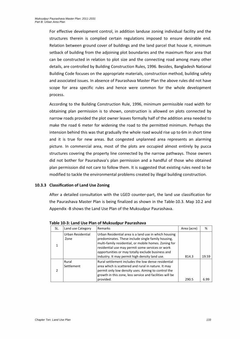
Muksudpur Paurashava Master Plan: 2011-2031 Part B: Urban Area Plan
Chapter Ten: Land Use Plan 133
For effective development control, in addition landuse zoning individual facility and the
structures therein is complied certain regulations imposed to ensure desirable end.
Relation between ground cover of buildings and the land parcel that house it, minimum
setback of building from the adjoining plot boundaries and the maximum floor area that
can be constructed in relation to plot size and the connecting road among many other
details, are controlled by Building Construction Rules, 1996. Besides, Bangladesh National
Building Code focuses on the appropriate materials, construction method, building safety
and associated issues. In absence of Paurashava Master Plan the above rules did not have
scope for area specific rules and hence were common for the whole development
process.
According to the Building Construction Rule, 1996, minimum permissible road width for
obtaining plan permission is to shown, construction is allowed on plots connected by
narrow roads provided the plot owner leaves formally half of the addition area needed to
make the road 6 meter for widening the road to the permitted minimum. Perhaps the
intension behind this was that gradually the whole road would rise up to 6m in short time
and it is true for new areas. But congested unplanned area represents an alarming
picture. In commercial area, most of the plots are occupied almost entirely by pucca
structures covering the property line connected by the narrow pathways. Those owners
did not bother for Paurashava’s plan permission and a handful of those who obtained
plan permission did not care to follow them. It is suggested that existing rules need to be
modified to tackle the environmental problems created by illegal building construction.
10.3.3 Classification of Land Use Zoning
After a detailed consultation with the LGED counter-part, the land use classification for
the Paurashava Master Plan is being finalized as shown in the Table-10.3. Map 10.2 and
Appendix -B shows the Land Use Plan of the Muksudpur Paurashava.
Table 10-3: Land Use Plan of Muksudpur Paurashava SL. Land use Category Remarks Area (acre) %
1
Urban Residential Zone
Urban Residential area is a land use in which housing predominates. These include single family housing, multi-family residential, or mobile homes. Zoning for residential use may permit some services or work opportunities or may totally exclude business and industry. It may permit high density land use. 814.3 19.59
2
Rural Settlement
Rural settlement includes the low dense residential area which is scattered and rural in nature. It may permit only low density uses. Aiming to control the growth in this zone, less service and facilities will be provided. 290.5 6.99

Muksudpur Paurashava Master Plan: 2011-2031 Part B: Urban Area Plan
Chapter Ten: Land Use Plan 134
SL. Land use Category Remarks Area (acre) %
3
Commercial Zone The land used for commercial activities is considered as commercial land use. These activities include the buying and selling of goods and services in retail businesses, wholesale buying and selling, financial establishments, and wide variety of services that are broadly classified as "business". Even though these commercial activities use only a small amount of land, they are extremely important to a community’s economy. Commercial land includes established markets and areas earmarked for markets. 13.2 0.32
4 Mixed Use Zone
Mixed land use refers to the area without a dominant land use (Residential, commercial, industrial etc.). 11.1 0.27
5 General Industrial Zone
Green and Orange A categories as per The Environment Conservation Rules, 1997 30.2 0.73
6 Heavy Industrial Zone
Other toxic and pollutions Industries (Orange B and Red categories as per The Environment Conservation Rules, 1997)
0 0
7
Government Services All Government Offices except large scale service based offices as Civil Surgeon Office, DC Office, Police Box, Police Fari, Police Station, LGED Office, Paurashava Office, Settlement Office, Union Parishad Office, Upazila Headquarter, BADC Office, Fisheries Office, Ansar/VDP Office, Agriculture Office, Zila Parishad Office, Post Office, Telephone Exchange Office and Other Government Offices. 12.2 0.29
8
Education & Research Zone
All kinds of educational institutes like Primary / secondary / other Schools / Colleges etc are mentioned to calculate the land use for education and research purpose. 29.6 0.71
9
Agricultural Zone
Agricultural land denotes the land suitable for agricultural production, both crops and livestock. It is one of the main resources in agriculture. It includes productive land (single, double and triple cropped), seed bed, fisheries, poultry farm, dairy farm, nursery, horticulture etc. 2468.2 59.37
10 Water body Equal or More than 0.25 acre and justification by the
consultant and wet land will merge with water body 236.5 5.69
11 Open Space Playground, Botanical Garden, Stadium, Zoo etc.
(Facilities without or with minimum building structure) 56.8 1.37
12 Recreational Facilities*
Facilities other than those mentioned to Open Space and indoor based facilities with designated building structure i.e. Cinema Hall, Theater Hall etc. 1.7 0.04
13 Circulation Network Road and Rail communication 161.1 3.88
14
Transportation Facilities
Under transport and communication land use both transport and communication services are considered. This category includes airport, bus terminal/stand, ferry ghat, filling station, garage, launch terminal, post office, passenger shed, telephone exchange, ticket counter, transport office etc. 5.5 0.13
15
Utility Services Utility services include Overhead Tank, Power Office/Control Room, Public Toilet, Sewerage Office, Waste Disposal, Fire Service, Water Pump House, Water Reservoir, Water Treatment Plant, etc. 0.5 0.01
16 Health Services This land will be used to provide health facility. 10.3 0.25
17 Community Facilities All community facilities including funeral places and
other religious uses. 12.3 0.30

Muksudpur Paurashava Master Plan: 2011-2031 Part B: Urban Area Plan
Chapter Ten: Land Use Plan 135
SL. Land use Category Remarks Area (acre) %
18 Historical and Heritage Site
The entire mentionable historical and heritage site. 0 0
19
Restricted Area A Restricted Area is an area where no one but certain people can enter. Here the areas which are not accessible for the general public except some high ranked personnel are considered as restricted area. 2.51 0.06
20 Overlay Zone If the consultant justify any area that should not be
defined as other given definitions but the facility(s) may not be avoidable, they may use this category.
Not applicable
21 Urban Deferred Optional depending on the Paurashava and the
Consultant’s judgment 3.0 0.07
22 Forest Designated Forest Area. Not
applicable
23 Beach Sea Beach Not
applicable
24 Miscellaneous Any other categories which are not related to above
23 categories. 0.14 0.00
Total 4157.2 100
In the paragraphs below, the general definition of the use and description of associated
permitted and conditionally permitted uses under each land use zone have been
provided. The uses that are not listed here in any of the categories shall be treated as
Restricted Use for the corresponding land use category and shall not be permitted only
except unanimously decided otherwise by the appropriate authority. In such situations,
the use shall get permission in the category of New Use. The following is a short
description of recommended land use zones.
Urban Residential Zone
Urban residential zone refers to all categories of urban residential areas, including exiting
and proposed residential land. In total, this zone covers 814.3 (19.59%) acres of land
delineated up to the year 2031, considering standard provided by LGED. Urban
residential zone refers to all categories of urban residential areas, including exiting ones
and the residential land use proposed under the present Master Plan. Potential area for
high dense residential area near to urban core area (influences of close proximity to
commercial hub, administrative, educational facilities, road way network, service
facilities and flood free suitable land for development) and large portion area both side
of Dhaka-Gopalganj via Bhanga area demarcated as such kind of use.
Rural Settlement
Muksudpur Paurashava includes some rural characteristics. The Land use category
supplied by LGED for identification of residential settlements in the agricultural belt is
categorized as rural settlements. These settlements usually constructed with temporary
building materials. Muksudpur Paurashava is mostly rural in character. About 73%
existing land is under agriculture practice and most of the settlement situated
surrounding or within the agricultural land. In planning consideration, to save agriculture

Muksudpur Paurashava Master Plan: 2011-2031 Part B: Urban Area Plan
Chapter Ten: Land Use Plan 136
land according to the Agriculture Policy of Bangladesh, a portion of land declares as rural
settlement. This settlement occupies 290.5 acres of land (6.84% of the total land). The
areas of rural settlement have some restrictions for non-agricultural development.
Annexure-A shows the permitted land use of rural settlement.

Muksudpur Paurashava Master Plan: 2011-2031 Part B: Urban Area Plan
Chapter Ten: Land Use Plan 137
Map 10.2: Landuse Plan of Muksudpur Paurashava

Muksudpur Paurashava Master Plan: 2011-2031 Part B: Urban Area Plan
Chapter Ten: Land Use Plan 138
Muksudpur Paurashava Master Plan: 2011-2031 Part B: Urban Area Plan
Chapter Ten: Land Use Plan 139
Map 10-3: Development Proposal

Muksudpur Paurashava Master Plan: 2011-2031 Part B: Urban Area Plan
Chapter Ten: Land Use Plan 140
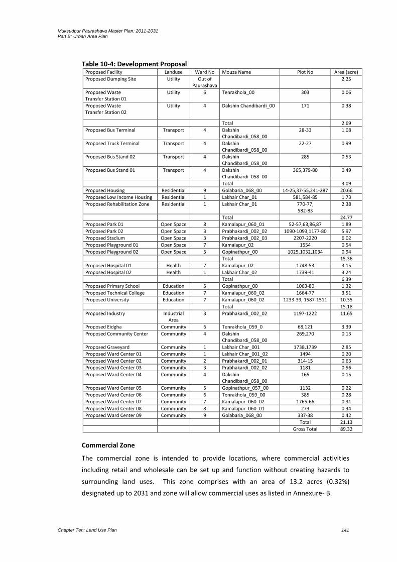
Muksudpur Paurashava Master Plan: 2011-2031 Part B: Urban Area Plan
Chapter Ten: Land Use Plan 141
Table 10-4: Development Proposal Proposed Facility Landuse Ward No Mouza Name Plot No Area (acre)
Proposed Dumping Site Utility Out of Paurashava
2.25
Proposed Waste Transfer Station 01
Utility 6 Tenrakhola_00 303 0.06
Proposed Waste Transfer Station 02
Utility 4 Dakshin Chandibardi_00 171 0.38
Total 2.69
Proposed Bus Terminal Transport 4 Dakshin Chandibardi_058_00
28-33 1.08
Proposed Truck Terminal Transport 4 Dakshin Chandibardi_058_00
22-27 0.99
Proposed Bus Stand 02 Transport 4 Dakshin Chandibardi_058_00
285 0.53
Proposed Bus Stand 01 Transport 4 Dakshin Chandibardi_058_00
365,379-80 0.49
Total 3.09
Proposed Housing Residential 9 Golabaria_068_00 14-25,37-55,241-287 20.66
Proposed Low Income Housing Residential 1 Lakhair Char_01 581,584-85 1.73
Proposed Rehabilitation Zone Residential 1 Lakhair Char_01 770-77, 582-83
2.38
Total 24.77
Proposed Park 01 Open Space 8 Kamalapur_060_01 52-57,63,86,87 1.89
Pr0posed Park 02 Open Space 3 Prabhakardi_002_02 1090-1093,1177-80 5.97
Proposed Stadium Open Space 3 Prabhakardi_002_03 2207-2220 6.02
Proposed Playground 01 Open Space 7 Kamalapur_02 1554 0.54
Proposed Playground 02 Open Space 5 Gopinathpur_00 1025,1032,1034 0.94
Total 15.36
Proposed Hospital 01 Health 7 Kamalapur_02 1748-53 3.15
Proposed Hospital 02 Health 1 Lakhair Char_02 1739-41 3.24
Total 6.39
Proposed Primary School Education 5 Gopinathpur_00 1063-80 1.32
Proposed Technical College Education 7 Kamalapur_060_02 1664-77 3.51
Proposed University Education 7 Kamalapur_060_02 1233-39, 1587-1511 10.35
Total 15.18
Proposed Industry Industrial Area
3 Prabhakardi_002_02 1197-1222 11.65
Proposed Eidgha Community 6 Tenrakhola_059_0 68,121 3.39
Proposed Community Center Community 4 Dakshin Chandibardi_058_00
269,270 0.13
Proposed Graveyard Community 1 Lakhair Char_001 1738,1739 2.85
Proposed Ward Center 01 Community 1 Lakhair Char_001_02 1494 0.20
Proposed Ward Center 02 Community 2 Prabhakardi_002_01 314-15 0.63
Proposed Ward Center 03 Community 3 Prabhakardi_002_02 1181 0.56
Proposed Ward Center 04 Community 4 Dakshin Chandibardi_058_00
165 0.15
Proposed Ward Center 05 Community 5 Gopinathpur_057_00 1132 0.22
Proposed Ward Center 06 Community 6 Tenrakhola_059_00 385 0.28
Proposed Ward Center 07 Community 7 Kamalapur_060_02 1765-66 0.31
Proposed Ward Center 08 Community 8 Kamalapur_060_01 273 0.34
Proposed Ward Center 09 Community 9 Golabaria_068_00 337-38 0.42
Total 21.13
Gross Total 89.32
Commercial Zone
The commercial zone is intended to provide locations, where commercial activities
including retail and wholesale can be set up and function without creating hazards to
surrounding land uses. This zone comprises with an area of 13.2 acres (0.32%)
designated up to 2031 and zone will allow commercial uses as listed in Annexure- B.

Muksudpur Paurashava Master Plan: 2011-2031 Part B: Urban Area Plan
Chapter Ten: Land Use Plan 142
Mixed-Use Zone
Mixed-use zone is recommended to allow some flexibility in development. In a small
urban area like Muksudpur, as the trend shows, an exclusive commercial land use is
unlikely to function. Admixture of land uses will allow flexibility of development, instead
of restricting development. Total proposed area for mixed-use is 11.1 acres (0.27% of
total area) including existing and proposed use. This zone will allow residential structures
together with commercial uses as listed in Annexure-B.
Ward Center will treat as the hub of local civic functions and it will provide the following
facilities as per the requirements of the locality:
Counselor office
Community Center
Community Clinic
Post Box
Small shops
Club
Office of Utility Services
Heavy Industrial Zone
Industrial/Manufacturing/Processing Zone intends to provide locations, where Orange B
and Red categories (as per Environmental Conservation Rule, 1997) industrial,
manufacturing and processing.
Map 10.2 of Muksudpur Paurashava, establishments can be setup and function without
creating hazards to surrounding landuses. Due to the availability of gas facilities and well
road connection by Dhaka-Gopalganj highway and availability of land creates scope
industrial development in the Paurashava. Since there is no industrial agglomeration in
the Paurashava, the industrial zone will mean for new industries. In this zone, a complex
line of industrial and supporting non-industrial land uses will be permitted as per
Annexure- B.
Government Services
Administrative zone covers all kinds of government and non-government offices.
Permitted uses in this zone is presented in Annexure-B. Total area under this use has
been estimated as 12.2 acres that include existing and proposed land uses. This land will
be used for established Paurashava office and other administrative uses as prescribed in
the plan.
Muksudpur Paurashava Master Plan: 2011-2031 Part B: Urban Area Plan
Chapter Ten: Land Use Plan 143
Education and Research Zone
Education and Research zone refers to mainly educational facilities as listed in Annexure-
B. Total area under this use has been proposed (29.6 acres) uses. Around 17.16 acre of
land is newly proposed for educational and research purposes. A little amound of land is
also proposed to redeveloped the existing educational facility to it standard size.
Agricultural Zone
The Paurashava has a vast area of agricultural land that demands formation of a separate
zone like agriculture. Agriculture zone primarily mean for agriculture and agriculture-
related functions. Detail land uses is presented in the Annexure-B. Total area under this
use has been estimated as 2468.2 acres that include existing and proposed uses.
Water Body and Retention Area
Total 243.2 acres water body (7% of total land) is in the Paurashava. The plan suggests
preserving most of those water bodies for two purposes, first, to serve as source of
water, second, to serve as water retention area during monsoon. The ponds with an area
equal to or more than 0.25 acres will be preserved as the water retention ponds (236.5
acre). There will be permitted uses in this zone as stated in Annexure-B.
Open Space
This zone has been provided to meet the active and passive recreational facility needs of
the people and at the same time, conserve the natural resources. Total area estimated
for this zone is 56.8 acres (1.37%). Details of permitted and conditional permits have
been presented in Annexure-B.
Recreational Facilities
This zone has been provided to meet the active and passive recreational needs of the
people. Details of permitted and conditional permits have been presented in Annexure-B.
Cinema hall, auditorium, gymnasium, etc. is being considered as recreational facilities.
Circulation Network
The road network is considered as circulation network. National highway, regional
highway, local road whether pucca/semi-pucca/katcha, footpath, flyover, over-bridge,
underpass, bridge, culvert, etc. are being included in circulation network. In total 161.1
acres of land covers (1.6% of total planning area) as circulation network. Details are given
in Chapter 11, Part B of this report.
Transportation Facilities
Ttransportation facilities incorporate transport and communication services. For an
example airport, bus terminal/stand, ferry ghat, filling station, garage, launch terminal,

Muksudpur Paurashava Master Plan: 2011-2031 Part B: Urban Area Plan
Chapter Ten: Land Use Plan 144
passenger shed, ticket counter, transport office, etc. In total, 5.50 acres land (0.13% of
the planning area) is being proposed for this purpose.
Utility Services
It incorporated all utilities and service facilities except health services. Utility services
include water treatment plant, water reservoir, water pump house, public toilet, fire
service, waste disposal centre, sewerage facilities including office, electricity supply
including office or control room and over head water tank. In survey stage this type of
landuse was defined as service activity.
Health Services
This land will be used to provide health facilities. In total, 10.3 acres land (0.25% of the
planning area) is being proposed for this purpose. A community based health centre will
be provided at Ward Councellor’s Office. Ward Councellor’s Office is under in mixed-use
category in land use plan proposal.
Community Facilities
Community services include community centre, club house, fire service, civic centre,
family planning facilities, religious centres, etc. In additionally all funeral places and other
religious uses incorporated in this category. In total, 12.3 acres land (0.32% of the
planning area) will be used for this purpose.
Overlay Zone
The overlay land uses refer to those uses that are not compatible to the surrounding land
uses but, anyhow, they need to stay there and therefore will not be removed. Those uses
are only identified as sites, not zones. They have local, regional or national importance,
though they do not conform to surrounding land uses. No other use except the use of
overlay site will be permitted in this zone. There is no scope for permitting or
conditionally permitting the functions or uses as the zone itself is an overlay. Present and
proposed use of the zone will continue until the next zoning regulation is imposed on
those specific parcels of land.
A variety of overlay zones are in the Paurashava. Some of the important types of overlay
sites are listed below including the purpose of retaining them.
Urban Deferred
The Urban Deferred refers to lands lying outside the urban growth area and identified as
Urban Reserve. Total area under this use is proposed as 3.0 acres (0.07%) that include
existing and proposed uses. Following are permitted uses within the Urban Reserve Zone:
Agriculture, Livestock based
Agriculture, Vegetation based (mushroom farms shall not be permitted)

Muksudpur Paurashava Master Plan: 2011-2031 Part B: Urban Area Plan
Chapter Ten: Land Use Plan 145
Existing facilities up to the date of gazette notification of the Master Plan. Condition
is that, no further extension will be permitted.
10.4 Plan Implementation Strategy
10.4.1 Land Development Regulations to Implement the Landuse Plan
Effective implementation of a plan is the most important part of the planning process.
The process of Implementation needs to be carried out with care and efficiency in order
to produce best outcomes. This chapter highlights various measures needed to be taken
in order to implement the landuse plan proposals.
Implementation of the Landuse Plan depends on successful pursuit of the policies
specified in the Structure Plan. Those policies represent a significant challenge face with
the responsibility of planning and managing the development of the Paurashava area.
However, at present no authority is responsible for planning and managing physical
development activities in the Paurashava and no regulation except Local Government
(Paurashava) Act, 2009 for controlling physical development. This poses a serious
constraint to the implementation of the Landuse Plan and in fact any other form of
development plans.
The factors that have been taken into account in deciding the priority include such things
as – the importance of the issue that the policy addresses, its potential impact on the
lives of the population, the ease with which it can be implemented, its urgency and its
interdependence with other policies.
Prior to introduction of the regulations to implement the landuse plan, legislative
involvement is recommended here.
1. Impose control on all type of buildings in the Paurashava according to the setback
rule prescribed in the Building Construction (Amendment) Rules, 1996 (Notification
No. S. R. O. No. 112-L/96). Building permission for extended areas shall be according
to the landuse provision prescribed in the plan. Any permission for building
construction, front road width shall not be less than 16 ft. and the construction must
follow the Building Construction (Amendment) Rules, 1996.
2. To control the air, water, noise and soil pollution, Conservation of Environment and
Pollution Control Act, 1995 (Act No. I of 1995) was enacted. In the Paurashava, there
is no authority for enforcing the provisions prescribed in the said Act. The pollution
related with the implementation of landuse component may be controlled with this
Act.
3. Haphazard development of commercial activities is the general scenario of the
Paurashava. It is necessary to impose control on commercial activities provisioned in
the Shops and Establishments Act, 1965 (Act No. VII of 1965).
4. In case of man-made canal, regulations prescribed in the Canal and Drainage Act,
1873 (Act No. VIII of 1873) is the best weapon. For the linking of canal with others
and river considering drainage facilities the Act may be enforced.
Muksudpur Paurashava Master Plan: 2011-2031 Part B: Urban Area Plan
Chapter Ten: Land Use Plan 146
5. For the conservation of archeological monuments or structures or historical
development the Ancient Monuments Preservation Act, 1904 (Act No. VII of 1904)
may be enforced. Archeological Department of Bangladesh and Paurashava authority
through a partnership process may preserve such type of development.
6. To control air pollution due to brick burning with the establishment of brick field,
Brick Burning Control Ordinance, 1989 (Ordinance No. VIII of 1989) is the appropriate
regulation. The Paurashava authority may enforce this Ordinance with the
authorization given by the government to him.
7. To control the medical practitioner, establishment of private clinics and pathological
laboratories, the statute named Medical Practice, Private Clinics and Laboratories
(Regulation) Ordinance, 1982 (Ordinance No. IV of 1982) was enacted. For efficient
enforcement of the Ordinance, the Paurashava authority may execute the Ordinance
with the authorization of government.
8. The Paurashava will have to exercise strictly Playfield, Open space, Garden and
Natural Tank in Urban Areas Preservation Act, 2000 (Act No. XXXVI of 2000) to some
specially important areas like, riverfront and water bodies, drainage channels, low
land below certain level, designated open space, etc. Development restrictions are
needed around security and key point installations. The provision of restriction will
strengthen the power of the plan to safeguard its development proposals and
landuse provisions.
9. The government is authorized for establishment of hat and bazar with the acquisition
of land through the statute named Hat and Bazar (Establishment and Acquisition)
Ordinance, 1959 (No. XIX of 1959). In case of private hat and bazar, a management
body is being empowered through the Bangladesh Hats and Bazars (Management)
Order, 1973 (P.O. 73/72). The Paurashava authority is also empowered establishing
hat and bazar in his jurisdiction through the Local Government (Paurashava) Act,
2009. Coordination may be framed among the government (Upazila Parishad),
Paurashava and private owner for the establishment, development and management
of the hat and bazar located in the Paurashava premises.
10. In the Paurashava premises, industrial development is controlled by the Bangladesh
Cottage Industries Corporation through Bangladesh Cottage Industries Corporation
Act, 1973 (Act No. XXVIII of 1973), Industrial Development Corporation through East
Pakistan Industrial Development Corporation Rules, 1965 (No. EPIDC / 2A-2/63/354)
and Factory Inspector through Factories Act, 1965 (Act No. IV of 1965). Locational
aspects and issuing of trade license is controlled by the Paurashava authority. A joint
coordination cell among those four authorities may control the establishment of
factories and industries in the Paurashava.
11. In the Paurashava, for rain water harvesting, some specific ponds / tanks will needed
to be preserved. A number of derelict tanks may be improved through tank
improvement project and in this case Tanks Improvement Act, 1939 (Act No. XV of
1939) will support the Paurashava is regulatory aspects.
12. Except Khas land, a considerable amount of public land in the Paurashava may be
identified as fallow land or unproductive land. In regulatory term those lands are
considered as culturable waste land and those lands are being fallow during five
Muksudpur Paurashava Master Plan: 2011-2031 Part B: Urban Area Plan
Chapter Ten: Land Use Plan 147
consecutive years. Those lands may be utilized under the guidance of Culturable
Waste Land (Utilization) Ordinance, 1959 (Ordinance No. E.P. XIII of 1959).
13. The Paurashava should raise its efforts on the imposition and realization of
betterment fees to raise its income. In this case, East Bengal Betterment Fees Act,
1953 may be enforced.
10.4.2 Implementation, Monitoring and Evaluation of the Landuse Plan
Implementation through Multi-Sectoral Investment Programme: Major infrastructure
development works such as primary roads, water supply, drainage, etc., will largely be
controlled by Government. Public works requires efficient co-ordination through the
Multi-Sectoral Investment Programme (MSIP).
Objective of a Multi-Sectoral Investment Programme (MSIP) will match a list of the
development projects with the funding stream necessary to implement them. There are
two basic activities that would determine the contents of MSIP. One activity would be to
prioritize and schedule the investment projects of all public agencies so they will
collectively help to achieve the development goals and objectives of the Landuse Plan.
Second activity would be to analyze the source and availability of fund for the prioritized
list of development projects.
Implementation through Action Plans and Projects: Action Plans and Projects will be the
implementation plans to solve problems at the local level. Action plans will take a direct
approach toward plan implementation with a minimum of research, reports or elaborate
planning methods. These projects will be easily identifiable and will require minimum
resource.
Implementation through Development Control: Landuse zoning is one of several
methods of plan implementation to be considered. In all cases where some form of
development, landuse control may be applied; careful consideration requires the
following ideologies:
the purpose to be achieved by the development controls;
where controls should be applied;
what aspect of development needs to be controlled;
what type of development controls are required;
what degree or level of development control is required;
who will be affected by the required control;
who will be affected by the controls and in what manner;
when the controls should be applied;
what will be the likely impact of the controls;
how and by whom will the controls be administered and enforced.

Muksudpur Paurashava Master Plan: 2011-2031 Part B: Urban Area Plan
Chapter Ten: Land Use Plan 148
Development control as an instrument of plan implementation may be selectively applied
within the Landuse Plan. Development controls would also be varied in intensity and
detail to suit the particular circumstances. It is important that they should be clear and
easily understood by all parties concerned. Since the entire Paurashava Master Plan
‘package’ has become statutory, development controls associated with its component
plans would also be statutory.
Implementation by Facilitating Private Investment: Another approach that would be
taken by government toward plan implementation will be to guide and facilitate
investments made by the private sector. Government can achieve this with relative ease
and at very low cost by setting up a legal and operational framework, coupled with
suitable incentives, to facilitate land consolidation, plot boundary readjustment, efficient
layout of plots and provision of local infrastructure by the private sector. The benefits of
this approach would be:
increased efficiently of the urban land market would make, more private land
available to urban households;
would pass much of the development costs for local infrastructure to the private
sector and land market mechanisms;
would increase in land for development without large cash outlays by government to
purchase land for development schemes; and
would keep provision of land for community facilities virtually no cost to government.
Plan Monitoring
The Landuse Plan would simply be tools for guiding and encouraging the growth and
development of the Paurashava in a preferred manner. In a rapidly changing urban
environment, the Landuse Plan would require to keep up to date. If this is not done,
within a few years it will be obsolete. Therefore, it is imperative that the requirement for
regular updating of the Landuse Plan be made a legal requirement.
For implementation of the various programme components of the Landuse Plan
appropriate administrative measures will have to be undertaken. This will essentially
include project preparation and monitoring of their execution and evaluation. For
carrying out all these activities appropriate institutional measures are also be needed.
Evaluation
Monitoring and evaluation of ongoing and implemented projects is essential to keep the
future course of action on the right track. An ongoing project should be regularly
monitored and handicaps identified to enable taking appropriate measures at the right
time.
Post implementation evaluation is also needed to take appropriate measures correcting
past errors-from project preparation to implementation.
Muksudpur Paurashava Master Plan: 2011-2031 Part B: Urban Area Plan
Chapter Ten: Land Use Plan 149
The top level supervision has to be done by a high level supervisory committee headed
by Paurashava Mayor, LGED representative and Local Government Ministry. Other
members of the committee will be local Ward Councilors, local community leader/social
workers and the Town Planner of the Paurashava. The committee will supervise
implementation works regularly and issue necessary instructions to expedite the works of
implementation.
Co-ordination
A Planning Section of Paurashava should have close interaction with the citizen of
Paurashava at large in order to make people aware of the benefits of a good plan and,
therefore, their social responsibility to promote plan implementation in one hand and
also resist contraventions on the other. A specific interactive cell is recommended to
operate in this regard with following responsibilities:
Provide pre-application advice to residents, consultants and developers about
landuse management issues and application procedures for the submission of
development applications.
Enforce planning and landuse management related legislation and zoning scheme
regulations.
Issue of property zoning certificates.
Investigate and resolve landuse management complaints, illegal landuse and
prosecuting contraventions.
Such interactive windows may be opened in various convenient locations to ensure ease
of the answers to commonly asked questions may be shown in the internet. Besides,
those may be shown in the print and electronic media time to time.
In spontaneous areas, while all out people’s co-operation is needed for project
implementation; there will also be some elements of negotiation. Negotiation will be
particularly needed in case of road widening projects. It will be a crucial task for
Paurashava to convince the affected people to give up their land for road use. Efforts
should be made to convince the land owners on the ground of enhancement of property
value due to road widening. In case people refuse to offer land free of cost necessary
arrangements may have to be made for payment of compensation. This process of
negotiation will be very critical, cumbersome and time consuming, and therefore, has to
be handled with utmost care and patience. The best results can be accrued only by
wining people’s confidence. In case the authority fails to get peoples co-operation they
should exercise power of compulsory acquisition of land. Attempts may be made to
engage NGOs / CBOs to work as catalysts in negotiation.

Muksudpur Paurashava Master Plan: 2011-2031 Part B: Urban Area Plan
Chapter Ten: Land Use Plan 150
Muksudpur Paurashava Master Plan: 2011-2031 Part B: Urban Area Plan
Chapter Eleven: Transportation and Traffic Management Plan 151
CHAPTER 11 TRANSPORTATION AND TRAFFIC MANAGEMENT PLAN
11.1 Introduction
Transportation system directs the urban development pattern. Performance of the
transportation system largely influences the economy and social progress of an area. It
provides mobility of people, goods and services to their destination. It has linkages with
other sections of development and for a sustainable development of any area, its traffic
and transportation system should be adequately addressed. This chapter of the report is
on Transportation and Traffic Management Plan covering scope of improvement of the
existing network and system and plan proposals for new development, the proposals on
improvement and new development are made for the planning area up to 2031. The
report also provides the purpose and the rule of Transportation and Traffic Management
Plan and its relation with Structure Plan and Land Use Plan.
11.2 Approach and Methodology
In order to identify the major causes of the congestion and the nature of the problem on
transportation networks, a number of tasks were undertaken. Those tasks included traffic
volume counting at both directions, speed and delay studies, Origin - Destination (O-D)
survey at major traffic generating intersections and consultation with the stakeholders
regarding the generated problems. The volume and movement pattern of people and
goods within the planning area were collected through a series of volume survey and O-D
survey.
In addition to collect information on volume and pattern of traffic movement by traffic
survey, the Consultant accommodates certain important questions regarding people's
attitude and preferences.
Three intersections are situated in the center of Muksudpur Paurashava have been
selected for traffic count survey. These locations can be considered as the key locations
of Muksudpur Paurashava. Those intersections are Durga Mandir Road to Chorongi Mor,
Hospital Road to Chourongi Mor and Mobarakkandi Road to Chourongi Mor.
11.2 Existing Conditions of Transportation Facilities
This section describes existing transportation facilities namely roadway characteristics,
modal share of vehicular traffic, level of service which incorporate degree of traffic
congestion and delay analysis and existing deficiencies in transport sector of Muksudpur
Paurashava.
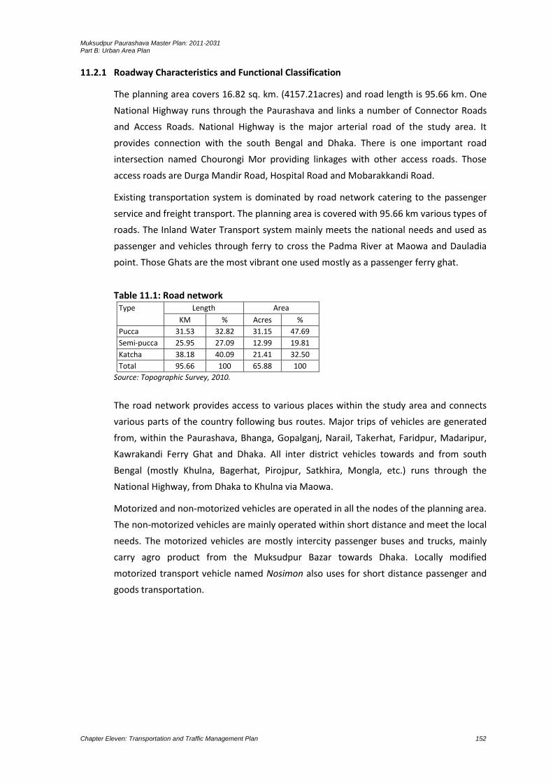
Muksudpur Paurashava Master Plan: 2011-2031 Part B: Urban Area Plan
Chapter Eleven: Transportation and Traffic Management Plan 152
11.2.1 Roadway Characteristics and Functional Classification
The planning area covers 16.82 sq. km. (4157.21acres) and road length is 95.66 km. One
National Highway runs through the Paurashava and links a number of Connector Roads
and Access Roads. National Highway is the major arterial road of the study area. It
provides connection with the south Bengal and Dhaka. There is one important road
intersection named Chourongi Mor providing linkages with other access roads. Those
access roads are Durga Mandir Road, Hospital Road and Mobarakkandi Road.
Existing transportation system is dominated by road network catering to the passenger
service and freight transport. The planning area is covered with 95.66 km various types of
roads. The Inland Water Transport system mainly meets the national needs and used as
passenger and vehicles through ferry to cross the Padma River at Maowa and Dauladia
point. Those Ghats are the most vibrant one used mostly as a passenger ferry ghat.
Table 11.1: Road network Type Length Area
KM % Acres %
Pucca 31.53 32.82 31.15 47.69
Semi-pucca 25.95 27.09 12.99 19.81
Katcha 38.18 40.09 21.41 32.50
Total 95.66 100 65.88 100
Source: Topographic Survey, 2010.
The road network provides access to various places within the study area and connects
various parts of the country following bus routes. Major trips of vehicles are generated
from, within the Paurashava, Bhanga, Gopalganj, Narail, Takerhat, Faridpur, Madaripur,
Kawrakandi Ferry Ghat and Dhaka. All inter district vehicles towards and from south
Bengal (mostly Khulna, Bagerhat, Pirojpur, Satkhira, Mongla, etc.) runs through the
National Highway, from Dhaka to Khulna via Maowa.
Motorized and non-motorized vehicles are operated in all the nodes of the planning area.
The non-motorized vehicles are mainly operated within short distance and meet the local
needs. The motorized vehicles are mostly intercity passenger buses and trucks, mainly
carry agro product from the Muksudpur Bazar towards Dhaka. Locally modified
motorized transport vehicle named Nosimon also uses for short distance passenger and
goods transportation.
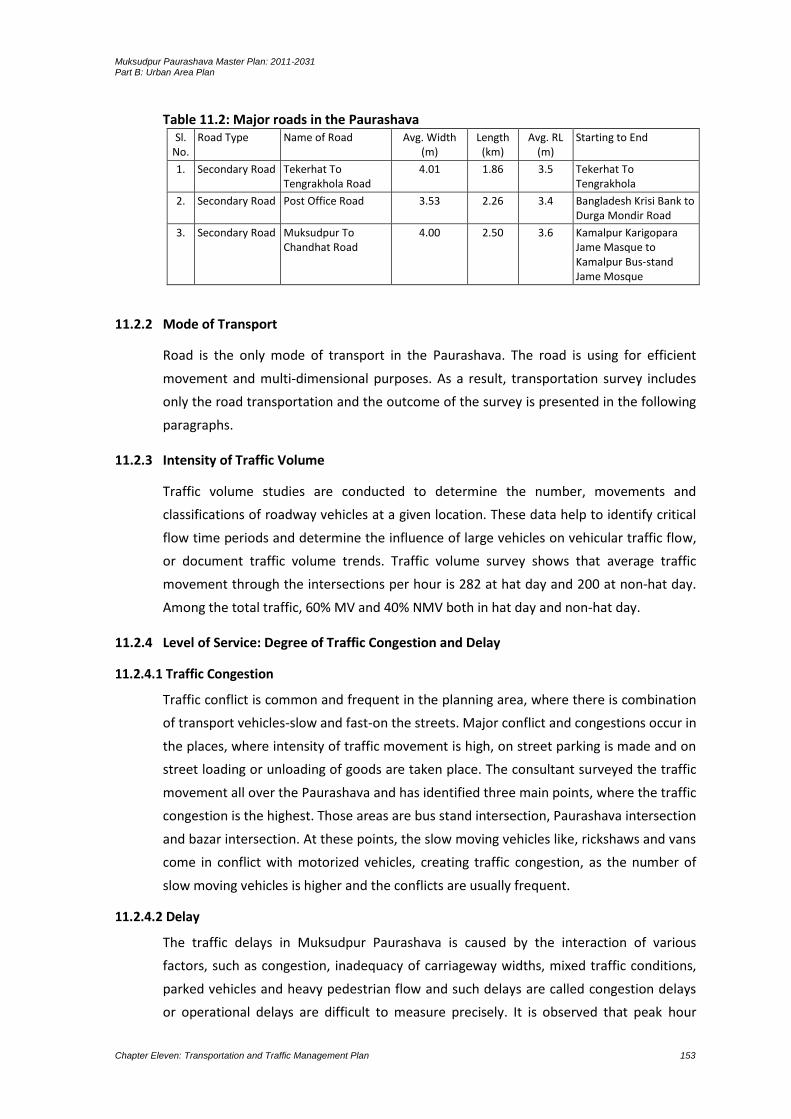
Muksudpur Paurashava Master Plan: 2011-2031 Part B: Urban Area Plan
Chapter Eleven: Transportation and Traffic Management Plan 153
Table 11.2: Major roads in the Paurashava Sl.
No. Road Type Name of Road Avg. Width
(m) Length
(km) Avg. RL
(m) Starting to End
1. Secondary Road Tekerhat To Tengrakhola Road
4.01 1.86 3.5 Tekerhat To Tengrakhola
2. Secondary Road Post Office Road 3.53 2.26 3.4 Bangladesh Krisi Bank to Durga Mondir Road
3. Secondary Road Muksudpur To Chandhat Road
4.00 2.50 3.6 Kamalpur Karigopara Jame Masque to Kamalpur Bus-stand Jame Mosque
11.2.2 Mode of Transport
Road is the only mode of transport in the Paurashava. The road is using for efficient
movement and multi-dimensional purposes. As a result, transportation survey includes
only the road transportation and the outcome of the survey is presented in the following
paragraphs.
11.2.3 Intensity of Traffic Volume
Traffic volume studies are conducted to determine the number, movements and
classifications of roadway vehicles at a given location. These data help to identify critical
flow time periods and determine the influence of large vehicles on vehicular traffic flow,
or document traffic volume trends. Traffic volume survey shows that average traffic
movement through the intersections per hour is 282 at hat day and 200 at non-hat day.
Among the total traffic, 60% MV and 40% NMV both in hat day and non-hat day.
11.2.4 Level of Service: Degree of Traffic Congestion and Delay
11.2.4.1 Traffic Congestion
Traffic conflict is common and frequent in the planning area, where there is combination
of transport vehicles-slow and fast-on the streets. Major conflict and congestions occur in
the places, where intensity of traffic movement is high, on street parking is made and on
street loading or unloading of goods are taken place. The consultant surveyed the traffic
movement all over the Paurashava and has identified three main points, where the traffic
congestion is the highest. Those areas are bus stand intersection, Paurashava intersection
and bazar intersection. At these points, the slow moving vehicles like, rickshaws and vans
come in conflict with motorized vehicles, creating traffic congestion, as the number of
slow moving vehicles is higher and the conflicts are usually frequent.
11.2.4.2 Delay
The traffic delays in Muksudpur Paurashava is caused by the interaction of various
factors, such as congestion, inadequacy of carriageway widths, mixed traffic conditions,
parked vehicles and heavy pedestrian flow and such delays are called congestion delays
or operational delays are difficult to measure precisely. It is observed that peak hour

Muksudpur Paurashava Master Plan: 2011-2031 Part B: Urban Area Plan
Chapter Eleven: Transportation and Traffic Management Plan 154
period takes on an average 6%-10% excess time than off-peak hour period due to
congestion, narrow road and improper design of intersections.
11.2.5 Facilities for Pedestrians
During field survey, it was observed that people move in both directions, going in and out
of the both sides of the roads. It is noted that the planning area is without any footpath
for pedestrian movement. Pedestrian movements take place mostly on carriageway and
right of way of the roads.
11.2.6 Analysis of Existing Deficiencies
11.2.6.1Roadway Capacity Deficiencies
As like other small towns in Bangladesh, Muksudpur has also its own road and
transportation deficiencies. The physical feature survey and traffic survey of major
intersections revealed that none of roads and transportation facilities is properly
designed. Traffic level is far behind the actual capacity of the intersections. Congestion is
created by large number of slow moving vehicles waiting for passengers at the
intersections.
Narrow Road Width
Narrow width of roads and poor maintenance of roads has been mentioned by most
respondents as the major road problems in the Paurashava. About 27% of the
respondents have pointed out the misery of road movement during monsoon when
unpaved roads get muddy. Narrow width of roads is likely to become a major problem of
traffic movement when the Paurashava will expand and density of population will
increase in future with consequent increase of road traffic. The field survey shows,
81.21% of the households reported that the road widths infront of their houses are 8 ft.
or less. This is alarming as this condition will become a source of traffic problem, when
road traffic will increase. At present, no traffic problem regarding road width is in the
Paurashava. Specific example on road width for creating traffic problem is presented
below:
Primary Road (National Highway): The Dhaka to Gopalganj Road via Bhanga is known as
primary road, length is 2987.85 meter and width 28 meter. Road standard (ROW)
recommended in the Table-11.4 is 100 feet to 150 feet, proves that the standard (ROW)
of the existing primary road in the Paurashava is lower than the standard (ROW)
recommended. Moreover, in hat day and non-hat day, highest volume of traffic flows on
the primary road and it is about 750 PCU/hour. No deficiencies regarding the capacity of
the primary road exits.
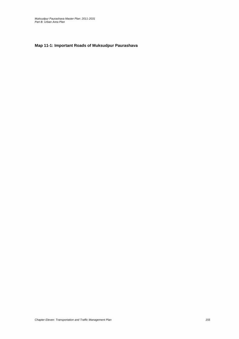
Muksudpur Paurashava Master Plan: 2011-2031 Part B: Urban Area Plan
Chapter Eleven: Transportation and Traffic Management Plan 155
Map 11-1: Important Roads of Muksudpur Paurashava

Muksudpur Paurashava Master Plan: 2011-2031 Part B: Urban Area Plan
Chapter Eleven: Transportation and Traffic Management Plan 156
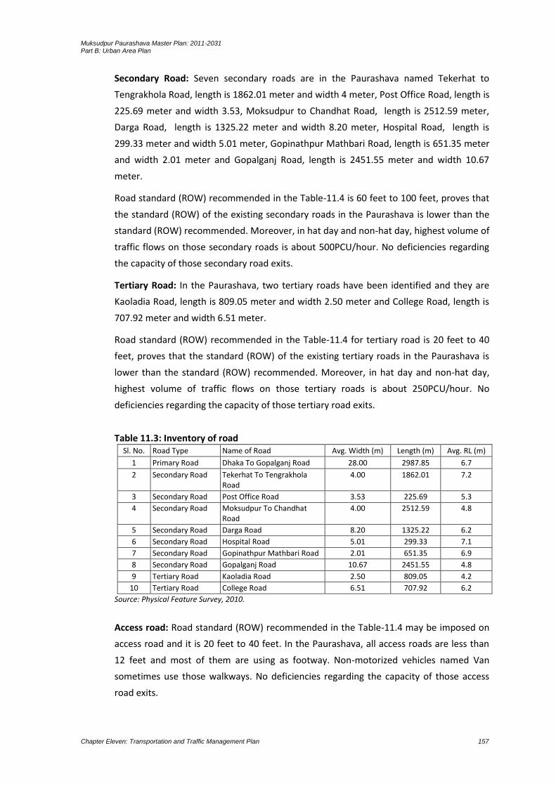
Muksudpur Paurashava Master Plan: 2011-2031 Part B: Urban Area Plan
Chapter Eleven: Transportation and Traffic Management Plan 157
Secondary Road: Seven secondary roads are in the Paurashava named Tekerhat to
Tengrakhola Road, length is 1862.01 meter and width 4 meter, Post Office Road, length is
225.69 meter and width 3.53, Moksudpur to Chandhat Road, length is 2512.59 meter,
Darga Road, length is 1325.22 meter and width 8.20 meter, Hospital Road, length is
299.33 meter and width 5.01 meter, Gopinathpur Mathbari Road, length is 651.35 meter
and width 2.01 meter and Gopalganj Road, length is 2451.55 meter and width 10.67
meter.
Road standard (ROW) recommended in the Table-11.4 is 60 feet to 100 feet, proves that
the standard (ROW) of the existing secondary roads in the Paurashava is lower than the
standard (ROW) recommended. Moreover, in hat day and non-hat day, highest volume of
traffic flows on those secondary roads is about 500PCU/hour. No deficiencies regarding
the capacity of those secondary road exits.
Tertiary Road: In the Paurashava, two tertiary roads have been identified and they are
Kaoladia Road, length is 809.05 meter and width 2.50 meter and College Road, length is
707.92 meter and width 6.51 meter.
Road standard (ROW) recommended in the Table-11.4 for tertiary road is 20 feet to 40
feet, proves that the standard (ROW) of the existing tertiary roads in the Paurashava is
lower than the standard (ROW) recommended. Moreover, in hat day and non-hat day,
highest volume of traffic flows on those tertiary roads is about 250PCU/hour. No
deficiencies regarding the capacity of those tertiary road exits.
Table 11.3: Inventory of road Sl. No. Road Type Name of Road Avg. Width (m) Length (m) Avg. RL (m)
1 Primary Road Dhaka To Gopalganj Road 28.00 2987.85 6.7
2 Secondary Road Tekerhat To Tengrakhola Road
4.00 1862.01 7.2
3 Secondary Road Post Office Road 3.53 225.69 5.3
4 Secondary Road Moksudpur To Chandhat Road
4.00 2512.59 4.8
5 Secondary Road Darga Road 8.20 1325.22 6.2
6 Secondary Road Hospital Road 5.01 299.33 7.1
7 Secondary Road Gopinathpur Mathbari Road 2.01 651.35 6.9
8 Secondary Road Gopalganj Road 10.67 2451.55 4.8
9 Tertiary Road Kaoladia Road 2.50 809.05 4.2
10 Tertiary Road College Road 6.51 707.92 6.2
Source: Physical Feature Survey, 2010.
Access road: Road standard (ROW) recommended in the Table-11.4 may be imposed on
access road and it is 20 feet to 40 feet. In the Paurashava, all access roads are less than
12 feet and most of them are using as footway. Non-motorized vehicles named Van
sometimes use those walkways. No deficiencies regarding the capacity of those access
road exits.

Muksudpur Paurashava Master Plan: 2011-2031 Part B: Urban Area Plan
Chapter Eleven: Transportation and Traffic Management Plan 158
Tortuous Road and Missing Link
A major characteristic of spontaneously developed roads is that they are tortuous in their
shapes. This is because land owners allow roads to follow the alignment of the edges of
the tortuous plot boundaries. Another problem of community initiated roads is that they
are not in a well linked network. Sometimes links to nearby roads are missing. This causes
people to travel comparatively longer distances to reach a nearby destination. In the
Paurashava, though, such type of problems is not in scenarios but with the increase of
physical growth this type of problem will specific.
11.2.6.2 Operational, Safety, Signal and Other Deficiencies
Traffic management system is absent in the Paurashava. No operational system yet
being imposed on traffic movement.
Due to the minimum PCU/hr. both in hat and non-hat day, availability of non-
motorized vehicles and absent of available built-up area, road safety exists naturally
in the Paurashava.
Traffic signaling system is totally absent in the Paurashava. Generally, traffic signaling
system will not be needed up to the limit of the planning period. On some specific
point of primary and secondary roads, traffic signaling will be needed.
11.2.7 Condition of Other Mode of Transport (Rail/Water/Air)
No railway, water way and air way faculties in the Paurashava.
11.3 Future Projections
This section presents future projection on transportation requirement of Muksudpur
Paurashava up to the year 2031. The chapter also provides information on transport
network and future traffic volume and level of service.
11.3.1 Travel Demand Forecasting for Next 20 Years
Existing road network is quite enough for accommodating present volume of traffic. The
study area is rural in nature. Most of the roads are katcha and needs to be constructed as
pucca or at least semi-pucca. Katcha roads become clayey in the rainy season and bring
immense sufferings for the users. As a result, social, cultural and economic activities are
disrupted significantly at that time. A very limited uses of small boats are found for
transportation of goods within the short distance particularly on hat day. Due to the
absence of effective alternatives, passengers and goods movement of the planning area
is largely dependent on road transportation. This dependency is being calculated
according to the increase of accessibility, consideration of the missing links, volume of
traffic movement, bulk density of the area and economic importance of the area. Growth
direction is also a considerable component for the demand analysis of the road.
Accordingly different standards have been suggested for different types of Paurashava
roads.
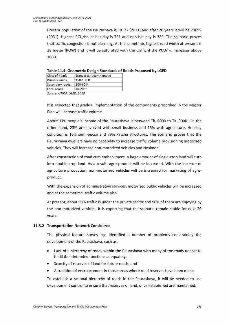
Muksudpur Paurashava Master Plan: 2011-2031 Part B: Urban Area Plan
Chapter Eleven: Transportation and Traffic Management Plan 159
Present population of the Paurashava is 19177 (2011) and after 20 years it will be 23059
(2031). Highest PCU/hr. at hat day is 751 and non-hat day is 389. The scenario proves
that traffic congestion is not alarming. At the sametime, highest road width at present is
28 meter (ROW) and it will be saturated with the traffic if the PCU/hr. increases above
1000.
Table 11.4: Geometric Design Standards of Roads Proposed by LGED Class of Roads Standards recommended
Primary roads 150-100 ft.
Secondary roads 100-60 ft.
Local roads 40-20 ft.
Source: UTIDP, LGED, 2010.
It is expected that gradual implementation of the components prescribed in the Master
Plan will increase traffic volume.
About 31% people’s income of the Paurashava is between Tk. 6000 to Tk. 9000. On the
other hand, 23% are involved with small business and 15% with agriculture. Housing
condition is 16% semi-pucca and 79% katcha structures. The scenario proves that the
Paurashava dwellers have no capability to increase traffic volume provisioning motorized
vehicles. They will increase non-motorized vehicles and Nosimon.
After construction of road cum embankment, a large amount of single-crop land will turn
into double-crop land. As a result, agro-product will be increased. With the increase of
agriculture production, non-motorized vehicles will be increased for marketing of agro-
product.
With the expansion of administrative services, motorized public vehicles will be increased
and at the sametime, traffic volume also.
At present, about 98% traffic is under the private sector and 90% of them are enjoying by
the non-motorized vehicles. It is expecting that the scenario remain stable for next 20
years.
11.3.2 Transportation Network Considered
The physical feature survey has identified a number of problems constraining the
development of the Paurashava, such as:
Lack of a hierarchy of roads within the Paurashava with many of the roads unable to
fulfill their intended functions adequately;
Scarcity of reserves of land for future roads; and
A tradition of encroachment in those areas where road reserves have been made.
To establish a rational hierarchy of roads in the Paurashava, it will be needed to use
development control to ensure that reserves of land, once established are maintained.

Muksudpur Paurashava Master Plan: 2011-2031 Part B: Urban Area Plan
Chapter Eleven: Transportation and Traffic Management Plan 160
In the Transportation Plan, north, south, east and west direction links with the
Paurashava have been considered. To maintain an effective linkage, the plan proposes
one primary road and others are secondary and tertiary roads.
11.4 Transportation Development Plan
11.4.1 Plan for Road Network Development
For an efficient road network development, implementation of some of the
recommendations made by the Roads and Highways in 2008 would be essential. In order
to serve the Paurashava, as well as the local traffic around Paurashava, an analysis will
present in the proposals. It is found that many of the road links are not recommended by
the Roads and Highways Department. Further analysis under the Transportation Plan will
be revealed that most of the links suggested by this study are infect required to be
developed in a phased manner. Under the Transportation Plan, an attempt is being made
to promote seven major link roads in the Paurashava. These could be called the “North-
South Link Roads. At present, from west to eastern part and from north to southern part,
all vehicles movement is through the National Highway (from Faridpur to Madaripur via
Bhanga and Gopalganj to Dhaka via Muksudpur) and a link road (called College Road).
Muksudpur Bus Stand (on the National Highway) has linked the Muksudpur Paurashava
from all parts of the country. The proposed link roads will be developed as local link
roads.
The standard considers here is given by the UTIDP, LGED to draw the transportation
development plan. Following are the suggested planning standards for road network
development. These road hierarchies are proposed based on the functional linkage of the
road of Muksudpur Paurashava.
Table 11.5: Proposal for Road Standard Class of Roads Standards recommended
Paurashava Primary roads Row 60+ ft.
Paurashava Secondary roads Row 40 ft.
Tertiary Road Row 30 ft.
Local roads / Access Road Row 20 ft.
Source: Consultant
Neighborhood and Local Road
The right of way (RoW) of neighborhood (mahallah) roads may be in between 20ft. to
30ft wide depending on their functions.

Muksudpur Paurashava Master Plan: 2011-2031 Part B: Urban Area Plan
Chapter Eleven: Transportation and Traffic Management Plan 161
Road Design Standard
All urban roads should have flexible pavements. The road intersection should be
designed to allow easy movement of vehicles. At bridge, the road design should provide
for an adequate sight distance and a smooth riding. The High Way must ensure the
service lane in both sides (at least 20 feet). See Figure 11.1.
Functions of Road
Each category of road has its particular function to perform. Access road carries traffic
from buildings to the collector road and collector road carries traffic to the major road
and vice versa. In reality, however, it is almost impossible to maintain this hierarchical
use of roads except in an entirely planned area. However, functions will not be
dependent on the road width, rather on the location of the road, surrounding land use
and the link it is providing or the volume of traffic it is carrying. Thus a 40 feet wide
secondary road can become a major road due to its strategic location and the purpose it
is serving.
11.4.1.1 Road Network Plan
At present, Dhaka–Khulna National Highway flows on the eastern part of the Paurashava
from north to south. A link road from Muksudpur to Madaripur intersects the National
Highway at the Muksudpur College Mor. The link road is the only east-west link road of
the Paurashava. A number of North-South Link Roads are being proposed in the plan.
Those Link Roads will connect with the National Highway flows from Gopalganj to the
Madaripur on the southern part of the Muksudpur Upazila (far beyond than the
Muksudpur Paurashava). Those link roads are – the road flows from Kumar River at the
north within the Ward No. 3 and 4, the road flows from Kumar River at the north within
the Ward No. 5 and 6 and the road flows from Kumar River at the north within the Ward
No. 7 and 9. All local roads in southwestern parts will connect those link roads. The
proposed Link Roads will serve Paurashava traffics and will reduce traffic congestion on
the internal areas of the Paurashava. It will help in distributing traffic around the
Paurashava and thereby reduce traffic congestion. The missing links of those link roads
naturally deserve priority in terms of resource allocation and emphasis on their early
implementation.

Muksudpur Paurashava Master Plan: 2011-2031 Part B: Urban Area Plan
Chapter Eleven: Transportation and Traffic Management Plan 162
Figure 11-1: Cross-section of Primary Road
Paurashava Primary Road
Dhaka–Khulna Highway will treat as primary road for Muksudpur Paurashava. Total
length of primary road will be 8.38 km with 60-120 ft RoW. Within these total 8.38 km
primary road will be widening up to with 60-120ft. Here to ensure uninterrupted traffic
flow through Dhaka-Khulna highway it’s RoW will upgraded up to 80 ft and two service
road will provide along the both side of the highway. RoW of each service road will be 20
ft. As result RoW of main primary road will be 120 ft and its total length will be 3.67 km.
Figure 11.1 shows the layout design of primary road with 120 ft RoW.
Paurashava Secondary Road
Total secondary road is 9.3 with 40 ft RoW. Within 7.7 km secondary road will be
widening and rest 1.6 km new secondary road will be constructed. Figure 11.2 shows the
layout design of primary road with 40 ft RoW.
Figure 11-2: Cross Section of Secondary and Tertiary Road
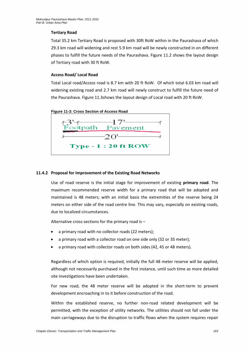
Muksudpur Paurashava Master Plan: 2011-2031 Part B: Urban Area Plan
Chapter Eleven: Transportation and Traffic Management Plan 163
Tertiary Road
Total 35.2 km Tertiary Road is proposed with 30ft RoW within in the Paurashava of which
29.3 km road will widening and rest 5.9 km road will be newly constructed in on different
phases to fulfill the future needs of the Paurashava. Figure 11.2 shows the layout design
of Tertiary road with 30 ft RoW.
Access Road/ Local Road
Total Local road/Access road is 8.7 km with 20 ft RoW. Of which total 6.03 km road will
widening existing road and 2.7 km road will newly construct to fulfill the future need of
the Paurashava. Figure 11.3shows the layout design of Local road with 20 ft RoW.
Figure 11-3: Cross Section of Access Road
11.4.2 Proposal for Improvement of the Existing Road Networks
Use of road reserve is the initial stage for improvement of existing primary road. The
maximum recommended reserve width for a primary road that will be adopted and
maintained is 48 meters; with an initial basis the extremities of the reserve being 24
meters on either side of the road centre line. This may vary, especially on existing roads,
due to localized circumstances.
Alternative cross-sections for the primary road is –
a primary road with no collector roads (22 meters);
a primary road with a collector road on one side only (32 or 35 meter);
a primary road with collector roads on both sides (42, 45 or 48 meters).
Regardless of which option is required, initially the full 48 meter reserve will be applied,
although not necessarily purchased in the first instance, until such time as more detailed
site investigations have been undertaken.
For new road, the 48 meter reserve will be adopted in the short-term to prevent
development encroaching in to it before construction of the road.
Within the established reserve, no further non-road related development will be
permitted, with the exception of utility networks. The utilities should not fall under the
main carriageways due to the disruption to traffic flows when the system requires repair

Muksudpur Paurashava Master Plan: 2011-2031 Part B: Urban Area Plan
Chapter Eleven: Transportation and Traffic Management Plan 164
or maintenance. Localized drainage channels should, where possible, also fall within the
road reserve, preferably under the footpath or hard shoulder to reduce land
requirements. If, however, this is not possible an additional reserve to cover the drainage
channel will be required, increasing the overall width of the reserve.
Permanent structures that currently fall within the reserve should be permitted to
remain until such time as they are redeveloped. Redevelopment of existing properties
should fall wholly outside the reserve. Temporary structures should not be permitted
even on a short-term basis. Existing structures should be removed as and when feasible.
For new roads, where reserves have been identified but implementation is unlikely to
commence for a number of years, agricultural use of the land within the reserve should
be permitted until such time as the land is required for construction. No structures, of
whatever materials, will be permitted within the road reserve.
No direct access should be allowed onto the main carriageways (of primary road). Access
should be gained only at controlled junctions–roundabouts or traffic-lights. The number
of junctions or intersections should be minimized with desired spacing being not less
than 500 meters.
Primary road with secondary roads should be provided in areas where there is
considerable roadside development. These should generally be two-way service roads
and will be used by non-motorized vehicles like rickshaw, van, pushcart and bullock carts
including pedestrians. Controlled parking will be permitted where necessary.
Where secondary roads will not be required either immediately or in the long-term, the
full reserve should be maintained (for utilities, etc.) unless there is clear reason why
these reserves should be decreased.
Functions of the secondary roads is to act as –
Links between the Paurashava and primary roads;
Links between various important nodes of activity within the Paurashava.
The secondary roads are also intended to be high capacity routes, although their design
speed will be significantly less than primary roads due to their being a far higher
percentage local, inter-Paurashava traffic movements rather than intra-Paurashava. On
many occasions within the Paurashava, existing routes will require the provision of
tertiary roads to provide access to shop frontages and on-street parking for those shops.
The tertiary roads also serve to collect traffic which currently enters at random from side
streets.
The maximum recommended reserve that will be adopted and maintained for secondary
road is 48 meters, preferably with the extremities of the reserve being 24 meters either
side of the road centre line, although this may vary especially on existing roads due to
localized circumstances.

Muksudpur Paurashava Master Plan: 2011-2031 Part B: Urban Area Plan
Chapter Eleven: Transportation and Traffic Management Plan 165
Regardless of which option is required ultimately, initially the full 48 meter reserve
should be applied until such time as a more detailed site investigation has been
undertaken and the actual reserve required has been defined.
No non-road related development will be permitted within the road reserve. For new
roads which will not be constructed in the foreseeable future, agricultural use of the
reserve will be permitted until such times as the road is constructed. No permanent or
temporary structure will be permitted.
In general, no direct access will be permitted onto the main carriageways (of secondary
roads) with access gained only at controlled junctions. Occasionally, due to existing
situations, access from a side road may be entertained. The number of junctions should
be minimized with desired spacing being at 200 meter intervals.
Limited direct access will be allowed from major traffic generators such as Paurashava
Office complexes, factories and shopping centres where no other alternative access
arrangement is feasible. Car parking arrangements for those large landuses must be
provided on off-street.
Functions of the tertiary road are:
collect and distribute traffic to and from access roads from predominantly residential
areas to other parts of the hierarch;
provide direct access to roadside landuses.
The recommended reserve for tertiary road is 18 meters, 9 meters either side of the
centre line. On-street parking may be permitted.
No development will be permitted within the 18 meter reserve.
Direct access will be permitted although major generators should be required to have
off-street parking areas. Junctions should be a minimum of 150 meters apart.
Access roads provide access to residential areas and properties therein. On-street
parking is permitted providing that this will not block the access road.
Recommended reserve for access is 10 meter, although in existing situations, a
minimum reserve of 6 meter will be entertained.
Junctions and access roads should be a minimum of 50 meters apart, although
deviation to this will need to be accommodated in existing areas.
Direct access from residential properties will be permitted.
The process that the Paurashava/RHD can undertake to establish new road reserves for
each of the proposed roads shown on the Transportation and Traffic Management Plan is
described below:
Initial step will be to determine two points between which the new road will be
required. In certain instances, the precise intersection or connection point will be
obvious, whilst in other cases only a generalized location is identifiable in the first
instance. Determination of the exact connection points can only be made once
further steps in the process have been undertaken.

Muksudpur Paurashava Master Plan: 2011-2031 Part B: Urban Area Plan
Chapter Eleven: Transportation and Traffic Management Plan 166
Having identified two connection points (either known or vague), next step will be to
conduct a search of a wide area to identify a number of alternative routes. Width of
the area subjected to this search will vary according to individual circumstances, with
the area being relatively narrow in dense Paurashava locations (say 80 to 100
meters), but wider in more rural settings (say 200 to 300 meters).
The number of alternative alignments to be identified will also vary, but as a general
rule, a maximum of five alignments will be chosen. When identifying each of the
different alignments, care will be taken to ensure that they are realistic and capable
of accommodating the width of reserve required for the standard of road envisaged.
During this stage of the process, number of buildings, other structures or natural
environment affected by the proposal should be seen as a constraint, but not yet as a
major constraint. That being said, following the rule for realism stated above, the
alignments will need to respect as much existing permanent development as possible,
aiming instead, in dense situations, to target gaps between developments rather than
through them. Only where the avoidance of specific buildings or groups of buildings is
unavoidable, to produce a worthwhile alignment, should their removal be seen as part of
that alternative’s cost.
Similarly, in rural locations or in areas of high natural environmental quality, extreme
care should be exercised when choosing the alternatives to respect the natural
environment and choose options that are going to minimize the visual impact of a new
road or avoid destruction of areas of the highest environmental quality.
Having established the alternative alignments, these will now be assessed, against set criteria to enable the Paurashava to choose a preferred option. The criteria that must be taken into account during this exercise include:
The impact of the alternative on existing properties: whether these are permanent or
temporary and the type of development that is being affected. This, in part, will identify
the general scale of compensation that will accrue with each of the alignments and
therefore the viability of a route to be chosen as the preferred option.
The impact that each alignment will have on the general and natural environment:
routes which have a high visual impact in an area of natural beauty will, for example,
score badly on this criteria.
Table 11.6: Proposed New Road Road Id Width (ft) Type Length (m) Phase
SR76 40 Secondary 1576.8 3rd Phasing
Total 1576.8
TR50 30 Tertiary 1683.1 3rd Phasing
TR55 30 Tertiary 1544.6 3rd Phasing
TR74 30 Tertiary 285.1 3rd Phasing
TR77 30 Tertiary 399.6 3rd Phasing
TR80 20 Tertiary 132.7 3rd Phasing
TR81 30 Tertiary 214.2 3rd Phasing
TR82 30 Tertiary 667.9 3rd Phasing

Muksudpur Paurashava Master Plan: 2011-2031 Part B: Urban Area Plan
Chapter Eleven: Transportation and Traffic Management Plan 167
Road Id Width (ft) Type Length (m) Phase
TR83 30 Tertiary 556.5 3rd Phasing
TR84 30 Tertiary 232.8 3rd Phasing
TR85 20 Tertiary 209.4 3rd Phasing
Total 5925.8
AR06 20 Access 118.5 3rd Phasing
AR11 20 Access 193.7 3rd Phasing
AR20 20 Access 177.4 3rd Phasing
AR31 20 Access 278.0 3rd Phasing
AR34 20 Access 198.3 3rd Phasing
AR42 20 Access 429.6 2nd Phasing
AR49 20 Access 389.4 3rd Phasing
AR51 20 Access 67.5 3rd Phasing
AR66 20 Access 807.4 3rd Phasing
Total 2660.0
Gross Total 10162.6
Table 11.7: Proposed Widening Road Road Id Width (ft) Type Length (m) Phase
PR03 120 Primary 3621.9 3rd Phasing
PR27 60 Primary 4647.2 1st Phasing
Total 8269.2
SR13 40 Secondary 2512.6 2nd Phasing
SR72 40 Secondary 1458.2 3rd Phasing
SR71 40 Secondary 816.8 3rd Phasing
SR70 40 Secondary 734.5 3rd Phasing
SR28 40 Secondary 2172.8 1st Phasing
Total 7694.9
TR02 30 Tertiary 326.1 1st Phasing
TR05 30 Tertiary 1117.4 3rd Phasing
TR07 30 Tertiary 180.8 3rd Phasing
TR08 30 Tertiary 139.7 2nd Phasing
TR09 30 Tertiary 447.7 3rd Phasing
TR10 30 Tertiary 206.8 3rd Phasing
TR12 30 Tertiary 468.9 3rd Phasing
TR14 30 Tertiary 1862.0 3rd Phasing
TR15 30 Tertiary 466.1 3rd Phasing
TR16 40 Tertiary 2617.5 3rd Phasing
TR26 30 Tertiary 168.8 3rd Phasing
TR29 30 Tertiary 557.6 1st Phasing
TR30 30 Tertiary 377.3 1st Phasing
TR32 30 Tertiary 1519.5 1st Phasing
TR33 30 Tertiary 262.4 2nd Phasing
TR35 30 Tertiary 715.8 3rd Phasing
TR36 30 Tertiary 506.2 1st Phasing
TR39 30 Tertiary 508.2 3rd Phasing
TR43 30 Tertiary 498.7 2nd Phasing
TR44 30 Tertiary 929.9 2nd Phasing
TR45 30 Tertiary 509.1 3rd Phasing
TR46 30 Tertiary 532.8 3rd Phasing
TR47 30 Tertiary 683.9 2nd Phasing
TR52 30 Tertiary 1203.3 3rd Phasing
TR53 30 Tertiary 679.0 3rd Phasing
TR54 30 Tertiary 437.6 2nd Phasing
TR59 40 Tertiary 2317.0 3rd Phasing
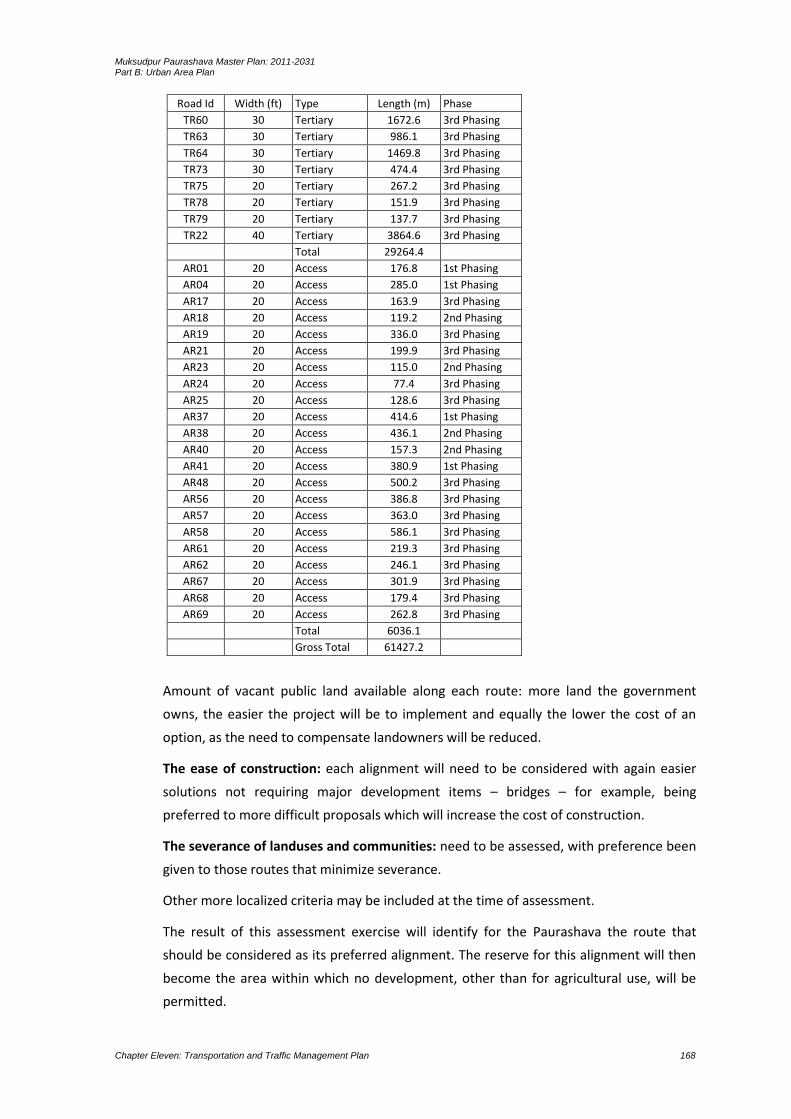
Muksudpur Paurashava Master Plan: 2011-2031 Part B: Urban Area Plan
Chapter Eleven: Transportation and Traffic Management Plan 168
Road Id Width (ft) Type Length (m) Phase
TR60 30 Tertiary 1672.6 3rd Phasing
TR63 30 Tertiary 986.1 3rd Phasing
TR64 30 Tertiary 1469.8 3rd Phasing
TR73 30 Tertiary 474.4 3rd Phasing
TR75 20 Tertiary 267.2 3rd Phasing
TR78 20 Tertiary 151.9 3rd Phasing
TR79 20 Tertiary 137.7 3rd Phasing
TR22 40 Tertiary 3864.6 3rd Phasing
Total 29264.4
AR01 20 Access 176.8 1st Phasing
AR04 20 Access 285.0 1st Phasing
AR17 20 Access 163.9 3rd Phasing
AR18 20 Access 119.2 2nd Phasing
AR19 20 Access 336.0 3rd Phasing
AR21 20 Access 199.9 3rd Phasing
AR23 20 Access 115.0 2nd Phasing
AR24 20 Access 77.4 3rd Phasing
AR25 20 Access 128.6 3rd Phasing
AR37 20 Access 414.6 1st Phasing
AR38 20 Access 436.1 2nd Phasing
AR40 20 Access 157.3 2nd Phasing
AR41 20 Access 380.9 1st Phasing
AR48 20 Access 500.2 3rd Phasing
AR56 20 Access 386.8 3rd Phasing
AR57 20 Access 363.0 3rd Phasing
AR58 20 Access 586.1 3rd Phasing
AR61 20 Access 219.3 3rd Phasing
AR62 20 Access 246.1 3rd Phasing
AR67 20 Access 301.9 3rd Phasing
AR68 20 Access 179.4 3rd Phasing
AR69 20 Access 262.8 3rd Phasing
Total 6036.1
Gross Total 61427.2
Amount of vacant public land available along each route: more land the government
owns, the easier the project will be to implement and equally the lower the cost of an
option, as the need to compensate landowners will be reduced.
The ease of construction: each alignment will need to be considered with again easier
solutions not requiring major development items – bridges – for example, being
preferred to more difficult proposals which will increase the cost of construction.
The severance of landuses and communities: need to be assessed, with preference been
given to those routes that minimize severance.
Other more localized criteria may be included at the time of assessment.
The result of this assessment exercise will identify for the Paurashava the route that
should be considered as its preferred alignment. The reserve for this alignment will then
become the area within which no development, other than for agricultural use, will be
permitted.

Muksudpur Paurashava Master Plan: 2011-2031 Part B: Urban Area Plan
Chapter Eleven: Transportation and Traffic Management Plan 169
A number of new roads including improvement of existing roads are presented in the
following table. In the Paurashava, one primary road from Dhaka to Gopalganj (as a
national highway) lying with length 2987.85 meter under the Paurashava jurisdiction.
All the roads may be constructed under the road development scheme approved by the
government for the authorities named RHD, LGED and Paurashava. In total, 9566 meter
existing roads are in the Paurashava and 61427.2 meter roads (including existing) have
been proposed for efficient accessibility of the Paurashava.
11.4.2.1Transportation Facilities Plan
Transportation facilities and services include Bus Terminal, Bus Stoppage with Shade,
Ticket Counter, Waiting Place for Travelers, Parking Space for Motorized and Non-
motorized Vehicles, Service Centre and Washing / Toilet Facilities. At present, no formal
transportation facilities and services are available in the Paurashava.
The bus terminal proposed in the plan will accommodate all type of transportation
facilities. The proposed area for bus terminal is 1.2 acres and it is proposed at the Ward
No. 6.
Table 11.8: Proposed Transport Facility Proposed Facility Ward No Mouza Name Plot No Area (acre)
Proposed Bus Terminal 4 Dakshin Chandibardi_058_00 28-33 1.2
Proposed Truck Terminal 4 Dakshin Chandibardi_058_00 22-27 1.0
Proposed Bus Stand 02 4 Dakshin Chandibardi_058_00 285 0.532
Proposed Bus Stand 01 4 Dakshin Chandibardi_058_00 365,379-80 0.487
Tempo Stand/ Powerbike Stand
Tempo is now a major and a cheaper mode of transport in small urban area and perform
important role in commuter transportation. There is a formal tempo stand in Muksudpur
bazar area which accommodates approximately 10 to 15 tempos at a time. The area of
the tempo stand is about 5 decimal. The stand is presently under utilized and the
consultant proposed to develop the stand to ensure the maximum utilization. As per the
growth trend additional tempo/powerbike stand is being proposed in the transport
development plan.
11.4.2.2 Development of Facilities for Pedestrian, Bicycle and Rickshaw
During field survey, it was observed that people move in both directions, going in and out
using both sides of the roads. It is noted that no footpath is available in this Paurashava
for pedestrian movement. Pedestrians mostly use carriageway and right of way of the
roads. In most cases, pedestrians use road shoulders for walking but they are being
obstructed by the informal business men. Separate provision for bicycle and rickshaw is
not needed.

Muksudpur Paurashava Master Plan: 2011-2031 Part B: Urban Area Plan
Chapter Eleven: Transportation and Traffic Management Plan 170
From Traffic volume survey it is gathered that following roads carry extreme pedestrian
due to eminent commercial activities in the heart of Paurashava. Following table shows
roads carrying most of the pedestrians and recommendation thereof.
Table 11.9: Proposed footpaths on the major roads Sl. No. Road Name Average width(M) Length (M)
1. Dhaka To Gopalganj Road 28.00 2987.85
2. Tekerhat To Tengrakhola Road 4.00 1862.01
3. Post Office Road 3.53 225.69
4. Moksudpur To Chandhat Road 4.00 2512.59
5. Darga Road 8.20 1325.22
6. Hospital Road 5.01 299.33
7. Gopinathpur Mathbari Road 2.01 651.35
8. Gopalganj Road 10.67 2451.55
9. Kaoladia Road 2.50 809.05
10. College Road 6.51 707.92
11.4.2.3 Other Transportation Facilities
One boat ghat and the bus stand named Muksudpur Bus Stand is found in the
Paurashava. The boat ghat is under the jurisdiction of Paurashava authority. Fish and
agro-product mostly transported through country boat from Muksudpur to small growth
centres adjacent to the Muksudpur Paurashava. Muksudpur Bus Stand is not an ideal bus
stand; it is just a stoppage on the National Highway. The bus stand should be
constructed as ideal bus stand and the boat ghat with loading-unloading and approach
road facilities.
11.4.3 Waterway Development/Improvement Options
The Kumar River is flowing on the northern part of the Paurashava. Bangladesh Inland
Water Transport Authority (BIWTA) is responsible for maintaining its navigability.
Unauthorized encroachment in different locations of this river is performing by the
dwellers. At present, the BIWTA is not performing any responsibilities regarding this river.
Apparently no major problem is found in the area on water transport services.
11.4.3.1 Proposal for Improvement of the Existing Waterway
The existing Kumar River should be re-excavated to improve the waterway through out
the year.
11.4.3.2 Proposal for New Waterway Development
Encourage private sector to involve with the construction of water ways. BOT (Build
Operate and Transfer to the Government) system for private sector will appropriate.
The Paurashava may, in collaboration with the Inland Water Transport Authority
(IWTA), develop the water ways using the Kumar River.

Muksudpur Paurashava Master Plan: 2011-2031 Part B: Urban Area Plan
Chapter Eleven: Transportation and Traffic Management Plan 171
11.4.4 Railway Development Options
No railway development is possible in the Muksudpur Paurashava.
11.5 Transportation System Management Strategy (TSMS)
11.5.1 Strategies for Facility Operations
Following strategies will be adopted to operate the facilities related with the provisioning
of suitable transportation system.
An improved traffic management system should be imposed. All facilities involved
with this system should be provisioned.
The land uses at the intersections should be controlled with the provisioning of
passenger shade, public toilet, ticket counter, tea stall and other necessary facilities.
Parking facilities for motorized and non-motorized vehicles should be provisioned
during construction of roads.
11.5.2 Strategies for Traffic Flow and Safety
Following strategies will be adopted to implement circulation network in the planning
area:
A comprehensive road network plan has been prepared for the Paurashava using a
hierarchy of road network. Implementation will also be followed following this
hierarchy.
In case of local roads a participatory approach will be developed to realize at least a
part of the development cost bears by the beneficiaries. This will also help to reduce
delay and cost involved in land acquisition for road construction.
Proposed roads in those areas will be chosen for immediate construction that is
needed to promote growth in that area.
Incremental Road Construction Approach will be adopted to get rid of unnecessary
construction costs, where roads remain underutilized.
Service roads will be constructed along with the major roads to allow free flow of
long distance traffic.
A restricted buffer zone will be created along primary roads passing through
agriculture to discourage roadside development.
11.5.3 Strategies for Traffic Management
Linking the missing links of primary, secondary and tertiary roads on priority, and
widen some tertiary roads to make networks for efficient circulation.
Provide adequate pedestrian facilities and off-street parking wherever needed.
Not to allow any development within the right of way (ROW).
Separate lane for non-motorized vehicles should be provisioned on the primary and
secondary roads.

Muksudpur Paurashava Master Plan: 2011-2031 Part B: Urban Area Plan
Chapter Eleven: Transportation and Traffic Management Plan 172
11.6 Plan Implementation Strategies
11.6.1 Regulations to Implement the Transportation Plan
Following regulations will be needed for implementation of the plan.
Public Roads Act, 2004: Objectives of the Public Roads Act, 2004 is prescribed in the
section 2. Those objectives are to:
a) establish ownership and responsibilities for roads;
b) establish the framework for managing the road network;
c) establish general principles for road management;
d) provide for general design and planning principles for roads;
e) confer powers and responsibilities on road authorities;
f) commit road authorities to provide and maintain safe roads, and to do so using
resources efficiently;
g) provide for the establishment and classification of public roads;
h) provide for data bases of public roads, and public access to them;
i) set out rights and duties of road users;
j) control activities on roads;
k) make special provision for restriction on access to roads;
l) identify characteristics of new road types;
m) provide a legal framework for private sector participation in road construction,
operation and maintenance, including tolling of roads;
n) establish defenses for civil liabilities; and
o) create offences and provide for penalties.

Muksudpur Paurashava Master Plan: 2011-2031 Part B: Urban Area Plan
Chapter Eleven: Transportation and Traffic Management Plan 173
Map 11-2: Proposed Circulation Network for Muksudpur Paurashava

Muksudpur Paurashava Master Plan: 2011-2031 Part B: Urban Area Plan
Chapter Eleven: Transportation and Traffic Management Plan 174
Muksudpur Paurashava Master Plan: 2011-2031 Part B: Urban Area Plan
Chapter Eleven: Transportation and Traffic Management Plan 175
Map 11-3: Proposed Transport Infrastructure of Muksudpur Paurashava
Muksudpur Paurashava Master Plan: 2011-2031 Part B: Urban Area Plan
Chapter Eleven: Transportation and Traffic Management Plan 176
Muksudpur Paurashava Master Plan: 2011-2031 Part B: Urban Area Plan
Chapter Eleven: Transportation and Traffic Management Plan 177
Section 5 has defined public roads as-
1) The Government may declare a public road.
2) The declaration may be made in relation to land, whether or not it is currently used
for passage by members of the public.
3) In the declaration, the Government shall classify the public road as:
(a) a national road; (b) a regional road; (c) a Zila road; (d) an urban road;(e) an
Upazila road; (f) a union road; (g) a village road.
Motor Vehicles Ordinance, 1983 (Ordinance No. LV of 1983) was enacted in 22nd
September, 1983: The Ordinance will be needed mostly for the registration of motor
vehicles and issuing of driving license.
Stage Carriages Act, 1861 (Act No. XVI of 1861) was enacted in 7th July 1861. Section 1 of
the Act has defined the term Stage Carriage and said, “every carriage drawn by one or
more horses which shall ordinarily be used for the purpose of conveying passengers for
hire to or from any place in Bangladesh shall, without regard to the form or construction
of such carriage, be deemed to be a Stage Carriages within the meaning of this Act.”
Again, according to the section 2, no carriage shall be used as a Stage Carriage unless
licensed by a Magistrate.
The Paurashava may, in communication with the RHD and LGED and with the prime
approval from the Government may enforce the regulations as mentioned above. Again,
some of the relevant regulations of developed countries may be enforced by the
appropriate authority for the betterment of accessibility, road safety and road
management. In connection with this concept, Highways Act of England and Wales may
be followed.
According to the section 70(1a) of the Highways Act of England and Wales, the owner or
occupier of any structure and the owner or occupier of any land on which a structure is
situated shall take all reasonable steps to ensure that the structure or the use of the
structure is not a hazard or potential hazard to persons using a public road and that it
does not obstruct or interfere with the safe use of a public road or the maintenance of a
public road.
(b) Where a structure or the use of a structure is a hazard or potential hazard to persons
using a public road or where it obstructs or interferes with the safe use of a public road
or with the maintenance of a public road, a road authority may serve a notice in writing
on the owner or occupier of the structure or on the owner or occupier of any land on
which the structure is situated to remove, modify or carry out specified works in relation
to the structure within the period stated in the notice.
(2 a) The owner or occupier of land shall take all reasonable steps to ensure that a tree,
shrub, hedge or other vegetation on the land is not a hazard or potential hazard to

Muksudpur Paurashava Master Plan: 2011-2031 Part B: Urban Area Plan
Chapter Eleven: Transportation and Traffic Management Plan 178
persons using a public road and that it does not obstruct or interfere with the safe use of
a public road or the maintenance of a public road.
(b) Where a tree, shrub, hedge or other vegetation is a hazard or potential hazard to
persons using a public road or where it obstructs or interferes with the safe use of a
public road or with the maintenance of a public road, a road authority may serve a notice
in writing on the owner or occupier of the land on which such tree, shrub, hedge or other
vegetation is situated requiring the preservation, felling, cutting, lopping, trimming or
removal of such tree, shrub, hedge or other vegetation within the period stated in the
notice.
Again, section 71(1a) said that, any person who, without lawful authority or the consent
of a road authority-
erects, places or retains a sign on a public road, or
erects, places or retains on a public road any caravan, vehicle or other structure or
thing (whether on wheels or not) used for the purposes of advertising, the sale of
goods, the provision of services or other similar purpose, shall be guilty of an offence.
Section 76(1) of the Highways Act of England and Wales have provisioned regulations for
a road authority and said, a road authority may-
construct and maintain drains in, on, under, through or to any land for the purpose of
draining water from, or preventing water flowing onto, a public road,
use any land for the temporary storage or the preparation of any gravel, stone, sand,
earth or other material required for the construction or maintenance of a public
road.
11.6.2 Implementation, Monitoring, Evaluation and Coordination of the Plan
Implementation through Multi-Sectoral Investment Programme: Major infrastructure
development works such as primary roads, secondary roads, transportation facilities etc.,
will largely be controlled by Government. Public works requires efficient co-ordination
through the Multi-Sectoral Investment Programme (MSIP).
Objective of a Multi-Sectoral Investment Programme (MSIP) will match a list of the
development projects with the funding stream necessary to implement them. There are
two basic activities that would determine the contents of MSIP. One activity would be to
prioritize and schedule the investment projects of all public agencies so they will
collectively help to achieve the development goals and objectives of the Transportation
and Traffic Management Plan. Second activity would be to analyze the source and
availability of fund for the prioritized list of development projects.
Implementation through Action Plans and Projects: Action Plans and Projects will be the
implementation plans to solve problems at the local level. Action plans will take a direct
approach toward plan implementation with a minimum of research, reports or elaborate
Muksudpur Paurashava Master Plan: 2011-2031 Part B: Urban Area Plan
Chapter Eleven: Transportation and Traffic Management Plan 179
planning methods. These projects will be easily identifiable and will require minimum
resource.
Implementation through Development Control: Landuse zoning is one of several
methods of plan implementation to be considered. In all cases where some form of
development, landuse control may be applied; careful consideration requires the
following ideologies:
the purpose to be achieved by the development controls;
where controls should be applied;
what aspect of development needs to be controlled;
what type of development controls are required;
what degree or level of development control is required;
who will be affected by the required control;
who will be affected by the controls and in what manner;
when the controls should be applied;
what will be the likely impact of the controls;
how and by whom will the controls be administered and enforced.
Development control as an instrument of plan implementation may be selectively applied
within the Urban Area Plans. Development controls would also be varied in intensity and
detail to suit the particular circumstances. It is important that they should be clear and
easily understood by all parties concerned. Since the entire Paurashava Master Plan
‘package’ has become statutory, development controls associated with its component
plans would also be statutory.
Implementation by Facilitating Private Investment: Another approach that would be
taken by government toward plan implementation will be to guide and facilitate
investments made by the private sector. Government can achieve this with relative ease
and at very low cost by setting up a legal and operational framework, coupled with
suitable incentives, to facilitate land consolidation, plot boundary readjustment, efficient
layout of plots and provision of local infrastructure by the private sector. The benefits of
this approach would be:
increased efficiently of the urban land market would make, more private land
available to urban households;
would pass much of the development costs for local infrastructure to the private
sector and land market mechanisms;
would increase in land for development without large cash outlays by government to
purchase land for development schemes; and
would keep provision of land for community facilities virtually no cost to government.

Muksudpur Paurashava Master Plan: 2011-2031 Part B: Urban Area Plan
Chapter Eleven: Transportation and Traffic Management Plan 180
Plan Monitoring
The Transportation and Traffic Management Plan would simply be tools for guiding and
encouraging the growth and development of an urban area in a preferred manner. In a
rapidly changing urban environment, the Transportation and Traffic Management Plan
would require to keep up to date. If this is not done, within a few years it will be
obsolete. Therefore, it is imperative that the requirement for regular updating of the
Transportation and Traffic Management Plan be made a legal requirement.
For implementation of the various programme components of the Transportation and
Traffic Management Plan appropriate administrative measures will have to be
undertaken. This will essentially include project preparation and monitoring of their
execution and evaluation. For carrying out all these activities appropriate institutional
measures are also be needed.
Evaluation
Monitoring and evaluation of ongoing and implemented projects is essential to keep the
future course of action on the right track. An ongoing project should be regularly
monitored and handicaps identified to enable taking appropriate measures at the right
time.
Post implementation evaluation is also needed to take appropriate measures correcting
past errors-from project preparation to implementation.
The top level supervision has to be done by a high level supervisory committee headed
by the Paurashava Mayor, LGED representative, RHD and Local Government Ministry.
Other members of the committee will be local Ward Councilors, local community
leader/social workers and the Town Planner of the Paurashava. The committee will
supervise implementation works regularly and issue necessary instructions to expedite
the works of implementation.
Co-ordination
A Planning Section of Paurashava should have close interaction with the citizen of
Paurashava at large in order to make people aware of the benefits of a good plan and,
therefore, their social responsibility to promote plan implementation in one hand and
also resist contraventions on the other. A specific interactive cell is recommended to
operate in this regard with following responsibilities:
Provide pre-application advice to residents, consultants and developers about
landuse management issues and application procedures for the submission of
development applications.
Enforce planning and landuse management related legislation and zoning scheme
regulations.

Muksudpur Paurashava Master Plan: 2011-2031 Part B: Urban Area Plan
Chapter Eleven: Transportation and Traffic Management Plan 181
Issue of property zoning certificates.
Investigate and resolve landuse management complaints, illegal landuse and
prosecuting contraventions.
Such interactive windows may be opened in various convenient locations to ensure ease
of the answers to commonly asked questions may be shown in the internet. Besides,
those may be shown in the print and electronic media time to time.
In spontaneous areas, while all out people’s co-operation is needed for project
implementation; there will also be some elements of negotiation. Negotiation will be
particularly needed in case of road widening projects. It will be a crucial task for
Paurashava to convince the affected people to give up their land for road use. Efforts
should be made to convince the land owners on the ground of enhancement of property
value due to road widening. In case people refuse to offer land free of cost necessary
arrangements may have to be made for payment of compensation. This process of
negotiation will be very critical, cumbersome and time consuming, and therefore, has to
be handled with utmost care and patience. The best results can be accrued only by
wining people’s confidence. In case the authority fails to get peoples co-operation they
should exercise power of compulsory acquisition of land through Acquisition of
Requisition of Immovable Property Ordinance, 1982. Attempts may be made to engage
NGOs / CBOs / RHD / LGED to work as catalysts in negotiation.

Muksudpur Paurashava Master Plan: 2011-2031 Part B: Urban Area Plan
Chapter Eleven: Transportation and Traffic Management Plan 182

Muksudpur Paurashava Master Plan: 2011-2031 Part B: Urban Area Plan
Chapter Twelve: Drainage and Environmental Management Plan 183
CHAPTER 12 DRAINAGE AND ENVIRONMENTAL MANAGEMENT PLAN
12.1 Drainage Management Plan
The consultant has made an extensive drainage network study in Muksudpur Paurashava
to improve the living standard of urban dwellers. Major activities of drainage study
include:
Survey for the alignment of drains/drainage channels by using DGPS, Data Logger and
Path Finder software;
Survey for the cross sections of drains by using optical level;
Survey for the bottom level and area of local depressions;
Identification of outfalls and drainage structures with their conditions;
Development of Maps showing drains (with drainage direction).
The study has conducted with the concern of Paurashava Mayor, Councilors and other
Paurashava representatives as well as PMO, LGED as per ToR in concentrating on
following major issues:
Information regarding type of man-made drains.
Alignment and crest level of embankments, dykes and other drainage divides.
Identification of missing links.
Direction, depth of flow, maximum and minimum tidal level of river, flooding
condition, condition of river side settlements during high tide and flood.
Location, number and condition of pump station, sluice gates, drainage structures.
Location and area of outfalls, ponds, tanks, ditches; condition in dry and wet season.
12.1.1 Goals and Objectives
Objective of Drainage Plan is to find out the present functions of main and secondary
drains and natural streams within the Muksudpur Paurashava. Secondly, to find out level
of encroachment over drainage reservations responsible for flooding, water logging of
neighborhoods during heavy rains. Thirdly, to find out, the existing roadside drainage
pattern including capacities and collected gradients. Since planned development of
Paurashava is very much desirable, Drainage Master Plan is necessary to ensure
operation and maintenance of the present facilities including new proposal for future.
For this, both short and long term project improvement plan involving area based
drainage master plan is necessary to ensure proper drainage of the Paurashava.

Muksudpur Paurashava Master Plan: 2011-2031 Part B: Urban Area Plan
Chapter Twelve: Drainage and Environmental Management Plan 184
12.1.2 Methodology and Approach to Planning
In implementing various infrastructural developments, drainage is generally given less
priority and is normally considered to be the last or final steps for development. Such
scenario is particularly true for Bangladesh; although different types of drainage
infrastructures are among others by far the heaviest impact on physical infrastructure
network. As a result, physical environment, health, hygiene and standard of living suffer
seriously. In development projects, Government, Semi-government and Public sector
allocated funds are mostly spend on buildings, roads and other more visible
infrastructures and drainage comes as the last item of development. By the time,
drainage development begins to start, there appears shortage of fund, consequently as a
matter of policy-do little or do-nothing situation appears and as eyewash very little is
done for drainage development. In case of urban development, if drainage is not given
priority, sufferings of the inhabitants will continuously increase with the passage of time.
Drainage development for urbanization should start with drains. Drains can be classified
as Plot drains, Block drains, Tertiary drains, Secondary drains and Primary drains. Other
natural drainage infrastructure is lowland, outfall areas, khals and rivers. Man-made
drains are Plot, Block, Tertiary, Secondary and Primary drains and others are natural
drainage infrastructures. In planning for drainage network, care has given on road
network in terms of conflict of drainage and waterways with roads. Drainage and
environmental survey was followed the proto-type questionnaire supplied and suggested
by the LGED.
12.2 Existing Drainage Network
12.2.1 Natural Drainage System
The natural drainage network composed of 1 river and important 3 khals/canals plying
within the Paurashava area. Generally those khals are flowing towards north-south.
Those natural canals (11 canals are in the Paurashava) have in total 12.09 km length and
covers 23.06 acres of land.
There are natural drainage systems along roadside and the linkage between natural and
man-made drainage system in somewhere. The Kumar River and the canal provide
opportunity of natural drainage system.
There are linkages between natural and man-made drainage system. But how much
effective and active the linkage is with the poorly maintained man-made drains is a
question. Almost half of the depth of the man-made drain is filled with solid garbages; as
a result, the channel is not properly functioning.

Muksudpur Paurashava Master Plan: 2011-2031 Part B: Urban Area Plan
Chapter Twelve: Drainage and Environmental Management Plan 185
Table 12-1: Existing natural drainage of the Muksudpur Paurashava SL. No. Type Name Length (KM) Width (F) Area in acres
1. River Kumar Rivar 9.72 279 159.55
2. Khal Abdar Khal 1.71 55.77
3. Khal 1.74 10.17
4. Khal 3.35 52.49
5. Ditch 263 (nos.) 29.04
6. Pond 355 (nos.) 78.20
7. Other 8 canals 5.29
Toal 21.81 289.85
Source: Topographic Survey, 2010.
12.2.2 Man-made Drains
In the Paurashava, 6 man-made drains were identified covering different parts in
different Wards. Total length of those drains is 3.79 km. covering an area of 0.67 acres
land. All the drains are pucca with one meter average width. Uncovered drains are mostly
in existence with poor condition.
Man-made drain is found in the Ward No. 2, 3, 4, 7, 8 and 9. Highest part of the drain is in
Ward No. 4 (0.77 km). All drains in the Paurashava are privately constructed. Status of
the drains is covered and uncovered. About 26% drain is covered and rest 74% is
uncovered. Covered drain is located in the Ward No. 4 and uncovered drain is in the
Ward No. 2, 3, 7, 8 and 9. All drains are in average condition. The drains in Ward No. 5
and 9 are wider than the drains are in Ward No. 7 and 8. The average or poor drains have
usually damaged side walls, surfaces with obstructions, debris, solid waste, irregular
water way, etc.
Table 12-2: Existing man-made drains in Muksudpur Paurashava Ward No. Type Length (KM) Area (Acre) Quality Status
2 Drain Pucca 0.38 0.04 Average Uncovered
3 Drain Pucca 0.26 0.04 Average Uncovered
4 Drain Pucca 0.77 0.15 Average Covered
7 Drain Pucca 0.53 0.28 Average Uncovered
8 Drain Pucca 0.28 0.05 Average Uncovered
9 Drain Pucca 0.57 0.11 Average Uncovered
Total 3.79 0.67
Source: Drainage Survey, 2010.
Uncovered drains are common feature and the result of uncovering is ultimately filling
and losing the drain. Necessity of covering the drains are not only from environmental
and safety perspective but also it is a local need. Adjacent river is using as a part of
natural drainage system.

Muksudpur Paurashava Master Plan: 2011-2031 Part B: Urban Area Plan
Chapter Twelve: Drainage and Environmental Management Plan 186
12.2.3 Analysis on Land Level Topographic Contour
The planning area of Muksudpur Paurashava has been surveyed with RTK-GPS/DGPS and
Total Station as per specification for spot interval given in the ToR. For this 8360 spot
values were collected for the study area. A contour line/contour joins points of equal
elevation (height) above mean sea level. A contour map is a map illustrated with contour
lines which shows valleys and hills, and the steepness of slopes. The contour interval of a
contour map is the difference in elevation between successive contour lines. The lowest
spot height is 1.00 m PWD and the highest spot height is 9.66 m PWD. Around 80% of the
spot heights are between 4m to 8 m and average height of land of the surveyed area is
5.7 m PWD.
Table 12-3: Spot Interval and Frequency SI No. Spot
Interval Spot Number (Frequency)
Average Percentage
1. 1.2-2.2 91 1.65 2.95
2. 2.2-3.2 120 2.7 3.89
3. 3.2-4.2 335 3.75 10.86
4. 4.2-5.2 406 4.8 13.17
5. 5.2-6.2 537 5.7 17.42
6. 6.2-7.2 1080 6.75 35.01
7. 7.2-8.2 398 7.8 12.91
8. 8.2-9.2 108 8.7 3.50
9. 8.2-9.2 9 9.45 0.29
Total 3084 5.7 100
Source: Topographic Survey, 2010.
A total of 3084 measurements have taken in the Paurashava area to ascertain the
topographic condition. According to the survey findings, the lowest land elevation has
found 1.00 and highest elevation 9.66.
Table 12- 4: Spot Value and their Unit (Number of Spot (Z) Value and their Statistics) SI No Spot Unit Value
1. Total Spot Number 3084
2. Mean (Meter) 5.81
3. Maximum Height (Meter) 9.66
4. Minimum (Meter) 1.00
5. Standard Deviation 1.09
Source: Topographic Survey, 2010.

Muksudpur Paurashava Master Plan: 2011-2031 Part B: Urban Area Plan
Chapter Twelve: Drainage and Environmental Management Plan 187
Map 12-1: Existing Drainage Network of Muksudpur Paurashava

Muksudpur Paurashava Master Plan: 2011-2031 Part B: Urban Area Plan
Chapter Twelve: Drainage and Environmental Management Plan 188

Muksudpur Paurashava Master Plan: 2011-2031 Part B: Urban Area Plan
Chapter Twelve: Drainage and Environmental Management Plan 189
A branch of Padma River named Kumar River is adjacent to the northern boundary of the
Paurashava and flowing through east to west. A sharp meandering is viewed at the
middle of the northern boundary and produces V-shaped topography on the Ward No. 3,
6 and 7. The land elevation of those Wards varies within 0.5 meter to 6 meter. Steep
slope (about 80o angle) of the side wall of the river adjacent with the Wards No. 3 and 7
are prominent. Alignment of khals and natural channels are in somewhere 1 meter to 2
meter high than the normal river water.
Analysis of Peak Hour Run off Discharge and Identification of Drainage
Outfalls
Muksudpur Paurashava lies in the tropical monsoon climatic region and more specially,
represents the climate of Dhaka district. It has a normal rainfall of 325.4 mm in the
month of June which is highest among all other months. In September, it falls to 232.5
mm; again falling to 145.8 mm in October. The rainy season begins with April/May and
usually ends in the end of October. The highest number of normal rainy day is in July,
which is the highest rainfall month. About 14 rainy days at an average in July, followed by
15 rainy days in August, 14 in June, 11 in May and September has been the characteristics
of rainy day as the data reveals.
No peak hour run off storm water discharge is found. During rainy season, rain water is
being drained through the man-made drains. All pucca drains are linked with the natural
water bodies like canal and river as an outfall. As a result, waters of the river and canals
are polluting through those discharging elements.
12.2.4.1 Method Used
Storm and used water: The drains are designed to collect excess rainfall that comes as
surface runoff from urban area, convey the runoff and finally discharge them to outfalls.
The design of drains involves hydrological computations of rainfall intensity, its frequency
of occurrence, duration etc., and the total run off of a particular area. The modified
rational method shall be used for calculation of peak runoff for a definite frequency and
duration from particular drainage basin. One limitation of this method is that it cannot be
used for catchment area greater than 320 acres. The Natural Resources Conservation
Service (NRCS) method formerly the US Soil Conservation Service (SCS) method shall be
used.
In Modified Rational Method, the overall watershed is divided into zones that contribute
to hydraulically significant points of concentration. The boundary of the zones is
established based upon local topographic boundaries such as streets, existing drainage
systems, etc., using good engineering practice. The design flow rate by Modified Rational
Formula is –
Muksudpur Paurashava Master Plan: 2011-2031 Part B: Urban Area Plan
Chapter Twelve: Drainage and Environmental Management Plan 190
Q = CsC r IA Where: Q = Design runoff flow rate (cfs) I = Rainfall intensity (in/hr) Cs = Storage coefficient Cr = Runoff coefficient A = Drainage area (acres)
Rainfall Intensity (I): The rainfall intensity is the average rainfall rate for a particular
drainage basin or sub-basin. The intensity is selected on the basis of the design rainfall
duration and return period. The return period is established by design standards as a
design parameter. Rainfall intensity with 5 years return period is generally employed for
design of primary drains and canal improvement. Rainfall intensity with 3 years return
period is employed for design of secondary drains. The design duration is equal to the
time of concentration for the drainage area under consideration. Time of concentration is
a critical parameter both for the Modified Rational Equation and SCS method. Time of
concentration is generally defined as the longest runoff travel time for contributing flow
to reach the outlet or design point, or other point of interest. It is frequently calculated
along the longest flow path physically.
Estimating the time of concentration involves identification of an appropriate flow path
or paths and estimating runoff travel times along the flow paths.
Where post-development conditions include significant pervious surfaces, the time of
concentration for just impervious portions of the basin may be required to calculate and
compare peak flow response for the basin as a whole against that of the more rapidly-
draining impervious surfaces alone. The Time of Concentration composed of the Initial
Time of Concentration, sometimes referred to as the Inlet Time or Time of Entry and the
Travel Time. Initial Time of Concentration is that time required for runoff to travel from
the most remote point in the drainage area to the first point of concentration. This can
be determined using the Kirpitch equation. The Initial Time of Concentration must be five
minutes or longer. In instances where Initial Times of Concentration are estimated to be
shorter than five minutes, five minutes shall be applied.
The second part of the Time of Concentration is the Travel Time that takes the flow to
travel along the drain. Channel flow occurs in channels carrying integrated flows, pipes
(flowing partially), and streams. Where storage is not significant, Travel Times can be
estimated by applying Manning’s Equation, and using estimates of channel characteristics
and appropriate roughness values for pipe, channel, or stream features as tabulated in
Table-12.5.
Muksudpur Paurashava Master Plan: 2011-2031 Part B: Urban Area Plan
Chapter Twelve: Drainage and Environmental Management Plan 191
Map 12-2: Land Level of Muksudpur Paurashava

Muksudpur Paurashava Master Plan: 2011-2031 Part B: Urban Area Plan
Chapter Twelve: Drainage and Environmental Management Plan 192

Muksudpur Paurashava Master Plan: 2011-2031 Part B: Urban Area Plan
Chapter Twelve: Drainage and Environmental Management Plan 193
V=[1.49/n] [R 2/3
] [S 1/2
] Where
V = Velocity of flow, feet/second N = Manning’s roughness coefficient for channel flow S = Slope, feet/foot R = Hydraulic radius, feet
And T t = V / (60L) Where T t = Travel time, minutes V = Velocity, feet/second L = Length, feet
Manning’s roughness coefficient for channel flow is listed in Table-12.5.
Table 12-5: Manning’s “N” Values for Channel Flow Conduit Material Manning’s “n” Conduit Material Manning’s “n”
Closed conduits Pipes 0.011-0.015
Asbestos-cement pipe 0.011-0.015 Liner plates 0.013-0.017
Brick 0.013-0.017 Open Channels
Cement-lined & seal coated 0.011-0.015 Lined channels
Concrete pipe 0.011-0.015 a. Asphalt 0.013-0.017
Helically corrugated metal pipe (12’’ – 48’’)
0.013-0.023 b. Brick 0.012-0.018
Plain annular 0.022-0.027 c. Concrete 0.011-0.020
Plan helical 0.011-0.023 d. Rubble or riprap 0.020-0.035
Paved invert 0.018-0.022 e. Vegetation 0.030-0.400
Spun asphalt lined 0.011-0.015 Earth, straight and uniform 0.020-0.030
Spiral metal pipe (smooth) 0.012-0.015 Earth, winding, fairly uniform 0.025-0.040
3 – 8 in. diameter 0.014-0.016 Rock 0.030-0.045
10 – 12 in. diameter 0.016-0.018 Un maintained 0.050-0.140
Larger than 12 in. diameter 0.019-0.021 Fairly regular section 0.030-0.070
Plastic pipe (smooth interior) 0.01.-0.015 Irregular section with pools 0.040-0.100
Source: Municipality of Anchorage. Drainage Design Guideline, March 2007 ver.4.08 pp-62.
Storage Coefficient (Cs): Due to very flat topography of Bangladesh, the runoff is
significantly slow. The rainfall after evaporation and infiltration accumulates first in the
depressions, until these have been reached their capacity and then runoff. To take these
effects a storage coefficient is used. The value of the storage coefficient is based on
average ground slope and the nature of the ground surface. Some of the storage
coefficients are listed in Table-12.6.
Table 12-6: Storage Coefficients for flat land Characteristics of surface
Storage Coefficient
Slope < 1: 1000 Slope < 1: 500 Slope < 1: 500
Residential urban 0.70 0.80 0.90
Commercial 0.80 0.90 1.00
Industrial 0.70 0.80 0.90
Residential Rural nature 0.60 0.70 0.80
Agricultural 0.50 0.60 0.70
Forest/woodland 0.30 0.40 0.50
Aquatic land 0.30 0.40 0.50

Muksudpur Paurashava Master Plan: 2011-2031 Part B: Urban Area Plan
Chapter Twelve: Drainage and Environmental Management Plan 194
Characteristics of surface
Storage Coefficient
Slope < 1: 1000 Slope < 1: 500 Slope < 1: 500
Paved area/road 0.80 0.90 1.00
Source: Countywide Comprehensive Plan (Master Drainage Plan) Exhibit-VIII.
Runoff Coefficient (Cr): The runoff coefficient (Cr) values shall be assigned to the various
land use zoning classifications. The runoff coefficient values are based on the slope of the
land surface, degree of imperviousness and the infiltration capacity of the land surface.
The type of land use can greatly affect the amount of runoff. The quantity of runoff and
peak flow rates are increased when the land is developed because the impervious surface
area increases with the addition of roads, driveways, roofs, etc. The values of the runoff
coefficient (Cr) for each land use classification are listed in Table-12.7.
Catchment Area: The size and shape of the catchment or sub-catchment for each drain
shall be determined by plan metering topographic maps and by field survey. In
determining the total runoff of a catchment area the following assumptions to be made:
The peak rate of runoff at any point is a direct function of the average rainfall for the
time of concentration to that point.
The recurrence interval of the peak discharge is same as the recurrence interval of the
average rainfall intensity.
The Time of Concentration is the time required for the runoff to become established and
flow from the most distant point of the drainage area to the point of discharge.
Table 12-7: Modified Rational Method Runoff Coefficients Land use designation Runoff Coefficient Cr
Residential rural 0.30
Residential semi urban 0.40
Residential urban 0.50~0.60
Apartment professional 0.70
Neighborhood Commercial 0.85
Community Commercial 0.85
Industrial 0.70~0.75
Slum area 0.50~0.55
Agricultural exclusive 0.25
Forest and watershed 0.20~0.25
Public facilities 0.3~0.60
Forest/ woodland 0.25
Paved area/road 0.99
Source: Countywide Comprehensive Plan (Master Drainage Plan) Exhibit-VIII.
12.3 Plan for Drainage Management and Flood Control
12.3.1 Plan for Drain Network Development
Drain Network Plan

Muksudpur Paurashava Master Plan: 2011-2031 Part B: Urban Area Plan
Chapter Twelve: Drainage and Environmental Management Plan 195
The activity for the relevant authority will be assisted by the preparation of the drainage
master plan for the Paurashava which details the necessary corridors, plot sizes and
generalized locations for:
Primary canal/khal (new and improved).
Secondary and tertiary canal / khal (new and improved).
Storage ponds.
Silt traps.
River embankment.
Initially, the Paurashava will encourage implementation of the first phase
recommendation of the drainage master plan. A brief summary of the proposals to be
undertaken in Phase-1 is given below. Reference should be made to the Map for
identification of the drainage areas referred in the text.
Phase-1 (Storm water drainage)
Local improvements and the removal of obstacles from existing canals in drainage areas.
Works to include:
Redesign of hydraulically inefficient bends, entrances and exists.
Rising and / or widening of bridges and culverts to give unobstructed flows.
Returning the channels to a uniform cross-section by removal of encroaching
properties and structures.
Raising crossings over roadside channels to adjacent properties above the flood level
of the waterway.
Phase-2 (Rain water and household drainage)
Construction of surface drain linked with the residences, may be covered or
uncovered.
Provide linkages with secondary and tertiary drains.
Out-fall of such drains may be nearby canals and low-lands.
For discharging of rainwater from commercial areas, covered surface drain may be
constructed and they will be linked with the secondary and tertiary canals.
Primary Drain: Primary drains are also called main drains. Primary drains cover larger
storm drainage area than tertiary and secondary drains. Sometimes primary drain bears
local name. In ascending order its position is third. Its cross-section is larger than other
types; carrying capacity is high and is constructed of brick, cement concrete and
sometimes reinforced concrete. Primary drains may be of earthen structure provided
sufficient land is available and land value is low. Contributing drainage water comes from
tertiary and secondary drains. Primary drains discharge its drainage water to outfall,
natural khal, river or large lowland area / Beels. Sketch below shows the typical cross-
section of the primary drain.

Muksudpur Paurashava Master Plan: 2011-2031 Part B: Urban Area Plan
Chapter Twelve: Drainage and Environmental Management Plan 196
A schematic diagram showing the origin of Tertiary, Secondary and Primary drains and
their destinations to the outfall river, presented above, are also presented here.
Schematic diagram of Tertiary, Secondary and Primary drains
Secondary Drain: Secondary drains collect discharge from tertiary drains. One secondary
drain may receive drainage discharges from several tertiary drains in its course. Size and

Muksudpur Paurashava Master Plan: 2011-2031 Part B: Urban Area Plan
Chapter Twelve: Drainage and Environmental Management Plan 197
capacity of secondary drain is much bigger than tertiary drains; its catchment area is
much bigger than tertiary drain. Like tertiary drain, it may run parallel to bigger roads.
Secondary drains may run along and through the middle of its storm water contributing
area. The typical cross-section, size and shape, and its construction material are shown
below.
Tertiary Drain: Tertiary drain carry run-off or storm water received from the above
mentioned plot drains and block or Mohallah drains. Their catchment area or storm
water contributing area is bigger than Mohallah drains. In most Paurashava areas it is
difficult to find such naming or classifications. However, such classifications can be seen
in references. Tertiary drains generally are the under jurisdiction of Paurashava. Those
drains or drainage networks are constructed and maintained directly by the Paurashava.
These drains are constructed by bricks, cement concrete and sometimes by excavating
earth in their alignments. These drains may run parallel to road or across the catchments
area. Sometimes borrow pits of the road serves as drains provided borrow pits are
uniformly and continuously excavated. Borrow pits that serve as drains may be lined or
channeled by brick works. Tertiary drains deliver its discharge usually to secondary
drains. A typical tertiary drain is shown below.

Muksudpur Paurashava Master Plan: 2011-2031 Part B: Urban Area Plan
Chapter Twelve: Drainage and Environmental Management Plan 198
Plot Drains: Plot drains are provided around a building on a plot. In most cases, the drain
is made of bricks and is rectangular in shape that can carry storm water generated in the
plot and from the building. Plot drain is connected to the Block or Mohallah drain. The
sketch below gives an impression of plot drain usually constructed in a plot and block
drains that follow plot drain.
Block Drain: Block drain is provided at the outside of a block that accommodates several
buildings of the block. The block drains are made of bricks like plot drains but bigger in
size so that it can serve the storm water generated within the block and the buildings and
open areas within the block. Sometimes the block drain may serve few neighboring
blocks or Mohallahs. Block drains carry storm water coming from the plot drains. Shape
of the block drain is also rectangular, bigger than plot drains and its bottom is lower than
plot drain. Sketch of the plot drain also shows the block or Mohallah drain under plot
drain.
Drainage sluices, pipe sluices and siphons: Drainage sluices, pipe sluices and siphons are
provided on the embankments. Embankments protect the area from floods coming from
outside rivers and make the study area free from flood.
However, storm water from rainfall-runoff within the area causes localized flood,
drainage congestion and submergence. Sketch below shows a few of such structures. A
schematic view of drainage sluice, pipe sluice and siphon on embankment, which relieve
drainage congestion presents below.
Rainfall is the source of storm drainage water irrespective of urban or rural catchments.
Average annual rainfall in Muksudpur is about 2000mm. After infiltration, deep

Muksudpur Paurashava Master Plan: 2011-2031 Part B: Urban Area Plan
Chapter Twelve: Drainage and Environmental Management Plan 199
percolation and evaporation is about 50% of this rainfall water takes the form of drainage
water for semi-urban and urban areas.
Sluice gates, Regulators and Navigation locks: These types of structures are provided on
the flood control embankments. Sluice gates are functioning to vent out water from the
countryside to the river. Flap gates are generally installed in the riverside so that river
water cannot enter into the main land. On the other hand whenever the river water level
becomes low and countryside water level is high, countryside water drains out through
sluice.
Regulators also serve the similar purpose as sluice gates; however the size of regulators is
much bigger than sluice gates. Regulators may have control gates in the countryside and
in the riverside. Drainage of water to the river or flashing of water into countryside are
possible by operating simultaneously countryside and riverside mechanical gates.
Navigation lock sometimes is provided on the flood embankment to allow boat and ferry
passages from the river and from the countryside. It is a simple structure with bigger
chamber and large lift gates both at riverside and countryside. By operating these gates,
boats and river crafts can be transferred from the river to countryside and vice versa.
Reservoirs: Large tanks, ponds, Dighis, lakes, etc. serve as immediate detention areas for
storm water. Those structures are man-made and also natural; may be privately owned
or government-owned or khas land. These structures function as drainage relief and
source of water for emergency use, fisheries, duckeries, environment and nature
preservation. For every mouza such reservoir is available. Physical feature survey maps
and field survey maps (tank, pond and reservoir) show the existence of reservoirs and
database shows their dimensions. Those structures should not be disturbed or removed
by physical interventions by fillings or other means rather should be properly maintained
and preserved.
Drainage Khals and Waterways: Khals and waterways are natural channels and act as
drainage elements. In every mouza more or less such natural channel, khals and
waterways carry the excess storm water to the connecting river lying further in the
downstream. Sometimes old and silted-up khals are re-excavated to improve drainage
efficiency. Most of the natural khals carry the local storm water particularly runoff from
the Mouza / Mouzas those it passes through. Khals are narrow and deep in cross-
sections; on the other hand waterways are shallow and wider. Physical feature survey
maps, field survey maps (river, khal / drainage) show the drainage khals and waterways
and their database shows the dimensions. The sketches below show the sectional view of
khals and waterways.

Muksudpur Paurashava Master Plan: 2011-2031 Part B: Urban Area Plan
Chapter Twelve: Drainage and Environmental Management Plan 200
12.3.2 Proposal for Improvement of the Existing Drain Networks
A wider scope for construction of a drainage system may be provisioned in the
Paurashava. At least central areas are open for such development immediately and other
areas may be followed for projected period as designed in the plan. The Paurashava is a
barren field for imposing drainage system. The principles required for drainage plan are
available in the area. Land slope, nearness of the natural drainage, sparse population
density and soil condition are in favour of drainage construction.
Drainage corridors: If a drainage network has to be installed, the drainage originating
throughout the Paurashava would be carried by means of surface drains and culverts.
These should be accommodated within road reserves.
General location required: For sewerage treatment plant, large plot will be needed,
preferably on outskirts of the Paurashava. For sewerage pumping station, small plots
throughout the Paurashava will be needed and a system should be introduced.
Maintaining of land slope: Important component of the drainage network is land slope,
which was not maintained during the construction of existing drains. The slope of the
Paurashava is found towards east and southeast. Slope of all drains should maintain this
direction.
12.3.3.1List of Proposed New Drains
For the removal of existing drainage congestion and provisioning of effective drainage
system, a number of new drains have been prescribed. Those drains are a part of
drainage system and another part is the natural canals and river. In the Paurashava,
existing length of the drain is 3.79 km. and more 51.9km drain is being added as a
proposal. At present, no drain is found in the Ward No. 1, 5 and 6. To develop a network.
Table 12-8: List of proposed drains Drain Id Type Width (m) Length (m) Phase
PD 01 Primary Above 3m 1927.5 2nd Phase
PD 02 Primary Above 3m 1668.7 1st Phase
PD 06 Primary Above 3m 2319.1 2nd Phase
PD 05 Primary Above 3m 643.9 3rd Phase
TD 37 Primary Less 1.5m 200.4 1st Phase
PD 04 Primary Above 3m 426.3 1st Phase
PD 01 Primary Above 3m 1443.3 2nd Phase

Muksudpur Paurashava Master Plan: 2011-2031 Part B: Urban Area Plan
Chapter Twelve: Drainage and Environmental Management Plan 201
Drain Id Type Width (m) Length (m) Phase
PD 03 Primary Above 3m 461.8 3rd Phase
PD 03 Primary Above 3m 1263.5 3rd Phase
Sub Total 10354.5
SD 13 Secondary Within 1.5m to 3m 1183.3 2nd Phase
SD 07 Secondary Within 1.5m to 3m 1324.1 3rd Phase
SD 08 Secondary Within 1.5m to 3m 3011.6 1st Phase
SD 15 Secondary Within 1.5m to 3m 1233.4 3rd Phase
SD 18 Secondary Within 1.5m to 3m 367.8 2nd Phase
SD 17 Secondary Within 1.5m to 3m 421.6 3rd Phase
SD 16 Secondary Within 1.5m to 3m 230.9 2nd Phase
SD 14 Secondary Within 1.5m to 3m 1161.7 1st Phase
SD 11 Secondary Within 1.5m to 3m 1519.1 2nd Phase
SD 10 Secondary Within 1.5m to 3m 439.5 3rd Phase
SD 09 Secondary Within 1.5m to 3m 1551.3 1st Phase
SD 12 Secondary Within 1.5m to 3m 422.1 3rd Phase
SD 13 Secondary Within 1.5m to 3m 981.3 2nd Phase
SD 07 Secondary Within 1.5m to 3m 1208.8 3rd Phase
Sub Total 15056.7
TD 22 Tertiary Less 1.5m 807.5 2nd Phase
TD 89 Tertiary Less 1.5m 754.4 1st Phase
TD 73 Tertiary Less 1.5m 400.4 3rd Phase
TD 69 Tertiary Less 1.5m 467.7 1st Phase
TD 49 Tertiary Less 1.5m 479.1 2nd Phase
TD 47 Tertiary Less 1.5m 1061.8 1st Phase
TD 46 Tertiary Less 1.5m 608.6 3rd Phase
TD 34 Tertiary Less 1.5m 689.6 2nd Phase
TD 30 Tertiary Less 1.5m 9.8 3rd Phase
TD 19 Tertiary Less 1.5m 465.9 3rd Phase
TD 20 Tertiary Less 1.5m 406.0 1st Phase
TD 21 Tertiary Less 1.5m 436.9 3rd Phase
TD 23 Tertiary Less 1.5m 236.7 3rd Phase
TD 24 Tertiary Less 1.5m 504.6 3rd Phase
TD 25 Tertiary Less 1.5m 184.6 1st Phase
TD 26 Tertiary Less 1.5m 209.8 3rd Phase
TD 27 Tertiary Less 1.5m 575.6 3rd Phase
TD 28 Tertiary Less 1.5m 379.4 2nd Phase
TD 29 Tertiary Less 1.5m 236.1 3rd Phase
TD 31 Tertiary Less 1.5m 234.0 1st Phase
TD 32 Tertiary Less 1.5m 419.1 3rd Phase
TD 35 Tertiary Less 1.5m 547.9 3rd Phase
TD 36 Tertiary Less 1.5m 60.7 3rd Phase
TD 38 Tertiary Less 1.5m 179.9 3rd Phase
TD 39 Tertiary Less 1.5m 136.5 3rd Phase
TD 40 Tertiary Less 1.5m 324.5 2nd Phase
TD 41 Tertiary Less 1.5m 148.9 3rd Phase
TD 42 Tertiary Less 1.5m 365.0 3rd Phase
TD 43 Tertiary Less 1.5m 131.2 3rd Phase
TD 44 Tertiary Less 1.5m 298.2 1st Phase
TD 45 Tertiary Less 1.5m 115.6 3rd Phase
TD 92 Tertiary Less 1.5m 956.5 2nd Phase
TD 48 Tertiary Less 1.5m 1077.0 3rd Phase
TD 90 Tertiary Less 1.5m 526.4 1st Phase
TD 50 Tertiary Less 1.5m 512.3 3rd Phase
TD 51 Tertiary Less 1.5m 485.6 1st Phase
TD 53 Tertiary Less 1.5m 735.8 3rd Phase
TD 54 Tertiary Less 1.5m 673.0 2nd Phase
TD 55 Tertiary Less 1.5m 327.3 3rd Phase
TD 56 Tertiary Less 1.5m 194.4 1st Phase
TD 57 Tertiary Less 1.5m 173.4 3rd Phase

Muksudpur Paurashava Master Plan: 2011-2031 Part B: Urban Area Plan
Chapter Twelve: Drainage and Environmental Management Plan 202
Drain Id Type Width (m) Length (m) Phase
TD 58 Tertiary Less 1.5m 184.0 2nd Phase
TD 59 Tertiary Less 1.5m 355.2 1st Phase
TD 60 Tertiary Less 1.5m 110.6 3rd Phase
TD 61 Tertiary Less 1.5m 129.5 2nd Phase
TD 62 Tertiary Less 1.5m 193.4 1st Phase
TD 63 Tertiary Less 1.5m 169.4 1st Phase
TD 64 Tertiary Less 1.5m 120.1 3rd Phase
TD 65 Tertiary Less 1.5m 386.2 1st Phase
TD 66 Tertiary Less 1.5m 500.0 3rd Phase
TD 67 Tertiary Less 1.5m 240.1 1st Phase
TD 68 Tertiary Less 1.5m 261.5 3rd Phase
TD 70 Tertiary Less 1.5m 198.9 3rd Phase
TD 71 Tertiary Less 1.5m 196.3 3rd Phase
TD 72 Tertiary Less 1.5m 209.4 2nd Phase
TD 74 Tertiary Less 1.5m 729.5 1st Phase
TD 75 Tertiary Less 1.5m 123.0 2nd Phase
TD 76 Tertiary Less 1.5m 372.7 2nd Phase
TD 77 Tertiary Less 1.5m 145.6 1st Phase
TD 78 Tertiary Less 1.5m 212.3 2nd Phase
TD 79 Tertiary Less 1.5m 158.1 3rd Phase
TD 80 Tertiary Less 1.5m 124.6 3rd Phase
TD 81 Tertiary Less 1.5m 81.0 1st Phase
TD 82 Tertiary Less 1.5m 19.9 3rd Phase
TD 83 Tertiary Less 1.5m 826.3 2nd Phase
TD 84 Tertiary Less 1.5m 478.0 3rd Phase
TD 85 Tertiary Less 1.5m 272.1 3rd Phase
TD 86 Tertiary Less 1.5m 560.8 1st Phase
TD 87 Tertiary Less 1.5m 4.3 2nd Phase
TD 91 Tertiary Less 1.5m 833.4 3rd Phase
TD 48 Tertiary Less 1.5m 346.3 3rd Phase
TD 80 Tertiary Less 1.5m 62.9 3rd Phase
TD 19 Tertiary Less 1.5m 407.7 3rd Phase
Sub Total 26550.5
Gross Total 51961.7
12.3.3.2 List of Infrastructure Measures for Drainage and Flood Control Network
There are altogether 17 bridges (RCC) and 31 culverts (RCC) in the Paurashava. Those
bridges and culverts are located on the canals and drainage channels.
Except the above infrastructure, more 5 bridges will be needed on different proposed
roads as presented in the map. Two covert have been proposed to control intrusion of
river water through the canals. About 3.1 km. road cum embankment will be needed on
the southern part of the Paurashava for prohibiting flood water intrusion from eastern
part to the western part.
Table 12-9: List of existing and proposed infrastructures for drainage and flood control Name of infrastructure Existing Proposed (No.)
Bridge 17 4
Culvert 31 2
Sluice Gate 0
Flood Wall 0
Road cum Embankment 0
Flood Embankment 0

Muksudpur Paurashava Master Plan: 2011-2031 Part B: Urban Area Plan
Chapter Twelve: Drainage and Environmental Management Plan 203
12.4 Plan Implementation Strategies
12.4.1 Regulations to Implement the Drainage and Flood Plan
The regulations which will be needed for the implement of drainage and flood plan are:
1. Section 3 of the Acquisition and Requisition of Immovable Property Ordinance, 1982
is needed for acquisition of land in view to construct drainage and flood control
components. The Water Development Board, according to the demand, will apply to
the Deputy Commissioner for such acquisition.
2. Water Development Board Ordinance, 1976 delegate power to the Water
Development Board for construction of embankment. To control intrusion of flood
water and improvement of drainage facilities, the Board is empowered to take
necessary actions according to the regulations prescribed in the Ordinance.
3. Irrigation Act, 1876 has prescribed regulations for the improvement of irrigation
facilities through the improvement of drainage facilities in view to increase
agriculture production. Deputy Commissioner may enforce any regulations
prescribed in the Act necessary for irrigation facilities.
4. Canal and Drainage Act, 1872 has enacted for excavation of canal and removal of
drainage congestion from agriculture land. The Deputy Commissioner may authorize
any person, through a written approval, for excavation of canal in view to improve
irrigation facilities for agriculture practices.
5. Public Health (Emergency Provision) Ordinance, 1944 has enacted for the
improvement of drainage and sanitation facilities. Department of Public Health
Engineering (DPHE) is authorized to enforce the regulations prescribed in the
Ordinance. The government approves project for DPHE mostly for the improvement
of drainage and sanitation facilities in urban areas.
12.4.2 Implementation, Monitoring, Evaluation and Coordination of the Plan
Implementation through Multi-Sectoral Investment Programme: Major infrastructure
development works such as primary roads, water supply, drainage, etc., will largely be
controlled by Government. Public works requires efficient co-ordination through the
Multi-Sectoral Investment Programme (MSIP).
Objective of a Multi-Sectoral Investment Programme (MSIP) will match a list of the
development projects with the funding stream necessary to implement them. There are
two basic activities that would determine the contents of MSIP.
One activity would be to prioritize and schedule the investment projects of all public
agencies so they will collectively help to achieve the development goals and objectives of
the Urban Area Plan. Second activity would be to analyze the source and availability of
fund for the prioritized list of development projects.
Implementation through Action Plans and Projects: Action Plans and Projects will be the
implementation plans to solve problems at the local level. Action plans will take a direct

Muksudpur Paurashava Master Plan: 2011-2031 Part B: Urban Area Plan
Chapter Twelve: Drainage and Environmental Management Plan 204
approach toward plan implementation with a minimum of research, reports or elaborate
planning methods. These projects will be easily identifiable and will require minimum
resource.
Implementation through Development Control: Landuse zoning is one of several
methods of plan implementation to be considered. In all cases where some form of
development, landuse control may be applied; careful consideration requires the
following ideologies:
the purpose to be achieved by the development controls;
where controls should be applied;
what aspect of development needs to be controlled;
what type of development controls are required;
what degree or level of development control is required;
who will be affected by the required control;
who will be affected by the controls and in what manner;
when the controls should be applied;
what will be the likely impact of the controls;
how and by whom will the controls be administered and enforced.
Development control as an instrument of plan implementation may be selectively applied
within the Urban Area Plans. Development controls would also be varied in intensity and
detail to suit the particular circumstances. It is important that they should be clear and
easily understood by all parties concerned. Since the entire Paurashava Master Plan
‘package’ has become statutory, development controls associated with its component
plans would also be statutory.
Implementation by Facilitating Private Investment: Another approach that would be
taken by government toward plan implementation will be to guide and facilitate
investments made by the private sector. Government can achieve this with relative ease
and at very low cost by setting up a legal and operational framework, coupled with
suitable incentives, to facilitate land consolidation, plot boundary readjustment, efficient
layout of plots and provision of local infrastructure by the private sector. The benefits of
this approach would be:

Muksudpur Paurashava Master Plan: 2011-2031 Part B: Urban Area Plan
Chapter Twelve: Drainage and Environmental Management Plan 205
Map 12-3: Proposed Drainage and Flood Control Components

Muksudpur Paurashava Master Plan: 2011-2031 Part B: Urban Area Plan
Chapter Twelve: Drainage and Environmental Management Plan 206

Muksudpur Paurashava Master Plan: 2011-2031 Part B: Urban Area Plan
Chapter Twelve: Drainage and Environmental Management Plan 207
increased efficiently of the urban land market would make, more private land available
to urban households;
would pass much of the development costs for local infrastructure to the private
sector and land market mechanisms;
would increase in land for development without large cash outlays by government to
purchase land for development schemes; and
would keep provision of land for community facilities virtually no cost to government.
Plan Monitoring
The Urban Area Plan would simply be tools for guiding and encouraging the growth and
development of an urban area in a preferred manner. In a rapidly changing urban
environment, the Urban Area Plan would require to keep up to date. If this is not done,
within a few years it will be obsolete. Therefore, it is imperative that the requirement for
regular updating of the Urban Area Plan be made a legal requirement.
For implementation of the various programme components of the Urban Area Plan
appropriate administrative measures will have to be undertaken. This will essentially
include project preparation and monitoring of their execution and evaluation. For
carrying out all these activities appropriate institutional measures are also be needed.
Evaluation
Monitoring and evaluation of ongoing and implemented projects is essential to keep the
future course of action on the right track. An ongoing project should be regularly
monitored and handicaps identified to enable taking appropriate measures at the right
time.
Post implementation evaluation is also needed to take appropriate measures correcting
past errors-from project preparation to implementation.
The top level supervision has to be done by a high level supervisory committee headed
by Paurashava Mayor, LGED representative and Local Government Ministry. Other
members of the committee will be local Ward Councilors, local community leader/social
workers and the Town Planner of the Paurashava. The committee will supervise
implementation works regularly and issue necessary instructions to expedite the works of
implementation.
Co-ordination
A Planning Section of Paurashava should have close interaction with the citizen of
Paurashava at large in order to make people aware of the benefits of a good plan and,
therefore, their social responsibility to promote plan implementation in one hand and
also resist contraventions on the other. A specific interactive cell is recommended to
operate in this regard with following responsibilities:
Muksudpur Paurashava Master Plan: 2011-2031 Part B: Urban Area Plan
Chapter Twelve: Drainage and Environmental Management Plan 208
Provide pre-application advice to residents, consultants and developers about
landuse management issues and application procedures for the submission of
development applications.
Enforce planning and landuse management related legislation and zoning scheme
regulations.
Issue of property zoning certificates.
Investigate and resolve landuse management complaints, illegal landuse and
prosecuting contraventions.
Such interactive windows may be opened in various convenient locations to ensure ease
of the answers to commonly asked questions may be shown in the internet. Besides,
those may be shown in the print and electronic media time to time.
In spontaneous areas, while all out people’s co-operation is needed for project
implementation; there will also be some elements of negotiation. Negotiation will be
particularly needed in case of road widening projects. It will be a crucial task for
Paurashava to convince the affected people to give up their land for road use. Efforts
should be made to convince the land owners on the ground of enhancement of property
value due to road widening. In case people refuse to offer land free of cost necessary
arrangements may have to be made for payment of compensation. This process of
negotiation will be very critical, cumbersome and time consuming, and therefore, has to
be handled with utmost care and patience. The best results can be accrued only by
wining people’s confidence. In case the authority fails to get peoples co-operation they
should exercise power of compulsory acquisition of land. Attempts may be made to
engage NGOs / CBOs to work as catalysts in negotiation.
12.5 Environmental Management Part
The plan has documented Muksudpur Paurashava area’s environmental conditions,
determines potentiality for present and past site contamination (e.g., hazardous
substances, petroleum products and derivatives) and identifies potential vulnerabilities
(to include occupational and environmental health risks).
12.5.1 Goals and Objectives
Based on the information and data on the air, water, noise, soil, drainage congestion,
river erosion, garbage disposal and industrial and clinical wastes an effective and action
oriented plan is required as prescribed in the ToR. Preparation of environmental
management plan is the ultimate goal of this study.
12.5.2 Methodology and Approach to Planning
Environmental survey has conducted following the standard methods and procedures to
determine environmental pollutions. Elements of pollutions of environment are air,
water, land and noise for the development of urban areas. The Consultants have taken

Muksudpur Paurashava Master Plan: 2011-2031 Part B: Urban Area Plan
Chapter Twelve: Drainage and Environmental Management Plan 209
necessary assistance and information from the Paurashava Mayor, Councilors, Engineers
and other concerned officials as well as the general inhabitants to determine pollution in
air, water, land and noise. Based on the information and data collected from the field and
secondary sources, detailed report has been prepared. Data collection format and
questionnaire was approved by the PD of UTIDP, LGED. The data collection procedure
incorporates discussion meeting with the Paurashava Mayor, Councilors and other
Paurashava representatives. Discussions were also made with other GOs like DPHE,
BADC, etc. and NGOs representatives working in the Paurashava.
12.6.1 Existing Environmental Condition
The Paurashava is a part of greater Faridpur district. Some information has collected from
secondary materials and they are on geology, soil and sub-soil condition, climate,
temperature, humidity, rainfall, wind direction and hydrology. Other relevant
information is being collected from field survey and they are mostly on the environment
pollution. Those information presents sequentially in the following paragraphs.
12.6.2 Geo-morphology
Geology, Soil and Sub-soil Conditions: Soil of the Zila is mainly formed by the very young
Ganges meander flood plain and the mixed young and the older Ganges meander flood
plain. The northern and eastern parts of the Zila are covered by grey silty clay of the
active and very young Ganges meander flood plain. Central and southern parts of the Zila
are mainly formed of brown silty clay of the mixed young and the older Ganges flood
plan. Northern part of the Zila is less productive and is mainly used for Aus paddy.
In the Paurashava, sub-soils are being eroded naturally and the soil varies from place to
place and composed of clay to fine sand from 0-40 ft depth, fine sand to very fine sand
40-160 ft, fine sand to medium sand 160-260 ft. Medium sand to coarse sand is available
from 260 ft to 380 ft depth and in rest of the depth are hard clay, fine sand and coarse
sand formed entirely by the deltaic action of the Ganges, which brought mud and
limestone from Himalayas.
To a great extent, soil of the Paurashava is uniform in character. Only variation observed
is in greater or smaller admixture of sand, silt and clay in grayish and dark gray colours.
Along the riversides, it is found that the percentage of sand is higher and in the areas
where deltaic action has ceased is lower. The load bearing capacity of this soil is very
poor.
Soil types, strength and density characteristics based on Standard Penetration Test
Values (N) have been mentioned for the different types of deposits at various depths.
Cohesive silt and clay layers having N-values less than 4 are very soft to soft and are not
considered suitable to support any civil engineering structures without ground
improvement. There are only a few areas near the waterfronts with such low N-values in

Muksudpur Paurashava Master Plan: 2011-2031 Part B: Urban Area Plan
Chapter Twelve: Drainage and Environmental Management Plan 210
the surface underlain by comparatively strong clay and sand soil strata. Sand layers with
variable quantities of silt/clay having N-values less than 10 are considered very loose to
loose. In a few locations such weak sandy layers occurred. They occurred usually in the
surface layers.
The natural clay soils of investigated area can be divided into two major groups
distinguished by their colours as under:
Red clay: Light brown to brick red and massive, containing ferruginous and calcareous nodules.
Mottled clay: Earthy grey with patches of orange, brown colour, massive and contains ferruginous and calcareous nodules.
For plastic silts and clays consistency terms like very soft, soft, medium stiff, stiff, very
stiff and hard indicate the following approximate allowable bearing capacity of the
different soil strata estimated on the basis of SPT N-values.
For cohesion less soil deposits (non-plastic silts and sands) relative density has been
described with terms like very loose, loose, medium dense, dense and very dense on the
basis of SPT N-values measured in the different cohesion less soils strata encountered
within the explored depth of 15m. These relative density terms give the following
approximate strength characteristics based on SPT N-values.
Table 12-10: SPT N-Values SPT N-value Allowable bearing Capacity (kPa)
Very soft 02 < 25
Soft 24 2550
Medium 48 50100
Stiff 415 100200
Very stiff 1530 200400
Hard > 30 > 400
Table 12-11: Strength Characteristics Relative Density SPT N-Value Estimated Shearing Angles Strength Characteristics
Very loose > 4 28 Very poor
Loose 410 30 Poor to fair
Medium dense 1030 32 Fair to good
Dense and Very dense > 30 34 Good to excellent
Climate: The climate regime of the study area is that of Faridpur which is similar to that
of the remainder of the country. The cool and dry winter of December – February is
followed by hot and showery pre-monsoon period of March – May and then a relatively
cooler but very wet monsoon season prevails during June – September. Again, a
transitional humid and showery period follows up to the beginning of winter. From mid
November the weather begins to be dry and relatively cool.

Muksudpur Paurashava Master Plan: 2011-2031 Part B: Urban Area Plan
Chapter Twelve: Drainage and Environmental Management Plan 211
Temperature: Average maximum temperature varies between 24.5 C and 36.3 C and
minimum temperature varies between 12.1 C (January) and 25.9 C (August). The
hottest months are March, April, May, June, July and August. From December to
February, Paurashava experiences cool periods when minimum temperature varies from
12.1 C (January) to 14.6 C (February).
Humidity: The study area is situated in the tropical zone. Heavy rains are experienced
during June – September with the movement of moist monsoon wind (April to October).
Almost 80 percent of the total rainfall is recorded during June – October. Average annual
rainfall of the area is about 1547 mm. Rainfall in the area is very much influenced by the
southwestern monsoon. Due to northwestern effect substantial rainfalls are also
recorded during March to May period. Winter is generally dry with little rainfall in the
months of December and January.
The weather is hot and wet from March to May with occasional storms locally known as
Kalbaishaki (Tropical Cyclone). During October and November the weather is generally
fine with some wet and stormy days. The characteristic feature of the climate of the
study area is the salt laden air throughout the year, especially when it blows from the sea
at regular intervals as a result of diurnal change.
Rainfall: The Muksudpur Paurashava has on an average, normal rainfall 325.4 mm in the
month of June which is highest among all other months. In September, it falls to 232.5
mm; again falling to 142.8 mm in October. From November to March, this rainfall varies
between 6.0 mm to 45.2 mm. The rainy season begins in April / May and usually ends in
the end of October. The highest number of normal rainy day is in July, called highest
rainfall month. About 14 rainy days at an average in July, followed by 15 rainy days in
August, 14 in June, 12 in May and September has been the characteristics of rainy day as
the data reveals.
Wind Directions: In Gopalganj district, general direction of the wind is same as Gangetic
delta, south-west, changing to east towards the head of the valley for the greater part of
the year, with a north and north-west direction during the month of April and May. It is
observed that winds are stronger in summer in the months of April and May (3 to 6.5
knots) than in winter in the month of November and December (1.5 to 3.0 knots).
Hydrology: River, Canal/Khal and pond are the hydrological components of the
Paurashava. Those components are occupying 6.97% (289.85 acres) land of the
Paurashava. The canals are linked with the adjacent Kumar River. In dry season, most of
those canals are using as agriculture land and in the rainy season they submerges
lowlands of the Paurashava. The ponds are spottedly located around the Paurashava.
Small numbers of them are larger than one acre. In dry season, ponds water are using for
bathing and washing purposes. Canal water generally uses for irrigation purposes.
Muksudpur Paurashava Master Plan: 2011-2031 Part B: Urban Area Plan
Chapter Twelve: Drainage and Environmental Management Plan 212
12.6.3 Solid Waste and Garbage disposal
12.6.3.1Household Waste
Dustbin is the only system for solid waste disposal from residence of the Paurashava. But
no dustbin is in the Paurashava. People throw their household wastes on the adjacent
low lands.
12.6.3.2Industrial waste
No industrial waste available in the Paurashava.
12.6.3.3Kitchen market waste
Kitchen market waste is being dumped on the low lands available around the market.
12.6.3.4Clinical/Hospital waste
Existing health facilities are poor in number. There are 5 numbers of health facilities in
the Paurashava (one govt. hospital, three private clinics and one diagnostic centre). Ward
No. 3 is rich in number in case of health services because, two clinics and the diagnostic
centre are located in that Ward. The hospital is in the Ward No. 6.
There is no arrangement for clinical waste management in the Paurashava. The clinics
and hospital used to dump solid wastes here and there or nearby ditches. This activity
may bring serious health hazard to the inhabitants specially the nearby dwellers.
12.6.3.5 Waste Management System
Solid waste collection and disposal in Muksudpur Paurashava is the responsibility of
Paurashava authority. The logistics for collection and disposal of solid wastes include 15
sweepers for collection and 1 garbage truck for transportation. Solid waste from the
point of generation to the final disposal can be grouped into three functioned elements -
Waste generation and storage
Collection
Final disposal
Waste Generation and storage: Households within the area are producing 2.0 tons of
domestic solid wastes per day.
Collection: The waste collection is done in the following three stages:
The residents themselves take domestic refuses from households to the intermediate
dumping points.
Street and drain wastes are collected and dumped at intermediate disposal points by
the municipal sweepers and cleaners.
Final collection from the intermediate points and its disposal to the dumping yard by
the conservancy worker.
Final disposal: The authority used to dump in low lands on the basis of land owner’s
interest or nearest ditches.
Muksudpur Paurashava Master Plan: 2011-2031 Part B: Urban Area Plan
Chapter Twelve: Drainage and Environmental Management Plan 213
Policies on Solid waste Management: In order to improve the solid waste problem and
to improve the environmental condition of the Paurashava, following Macro and Micro
level policy measures will be needed:
Formation of legislation regarding solid waste management.
Formation of standards for collection and disposal of waste.
Incentives for introduction of environmentally clean and efficient technology for
waste disposal which would help to reduce the volume of waste and facilities more
recycling.
Construction of waste as an unutilized resource and assisting in recycling of waste for
conservation of resources and protection of environment.
Introduction of environmental education especially sanitary habits in school
curriculum.
12.6.3.6 Latrine
Toilet system of the study area is mostly categorized as pucca and katcha. In spite of this,
Paurashava has a modest development of pucca toilets in government zones. Sewerage
system has not been introduced on a trial basis as to their popularity and acceptance.
Ownership of toilets varies widely in most of the Wards. Most of the households have
their own toilets and at the same time there is joint toilets found in slum areas. Sanitary
toilets or pucca toilets are comparatively good in all the Wards. Only 9% katcha toilet is
found in the Paurashava and owner of those toilets are poor people.
12.6.3.7 Industry
A number of light industrial agglomerations are found in the Paurashava. Industries are
located in the different Wards and those are of different types like bakery, engineering
workshop, ice cream factory, welding workshop, rice mill and saw mill. Total number of
industries is 17. All of those industries are light industries and are located in different
Wards.
Most of the industries in the study area depend on raw materials available within the
study area. The industrial output produces in the local market. It is also found that those
establishments have problems and potentialities. Careful consideration will help to
resolve those problems and adoption of necessary policy initiatives will help to flourish
the existing units and draw more investors and entrepreneurs to set up new
manufacturing industries, which will be based mainly on local agro-products.
12.6.4 Brick Field
No brickfield is in the Paurashava premises.
12.6.5 Fertilizer and Other Chemical Use
The fertilizer and chemical uses in the agriculture field for increasing agriculture
production are Urea, Potash, Gypsum and Nitrogen Sulphate, Bashudin, Diazinon,
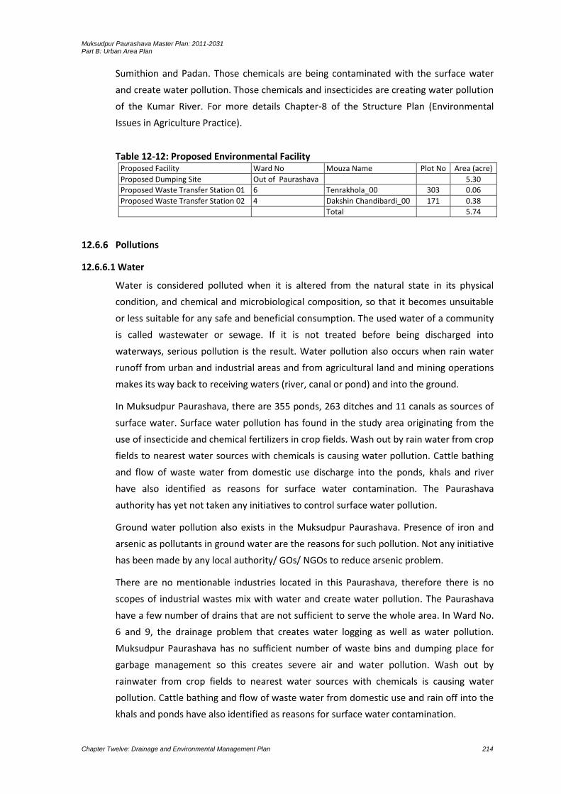
Muksudpur Paurashava Master Plan: 2011-2031 Part B: Urban Area Plan
Chapter Twelve: Drainage and Environmental Management Plan 214
Sumithion and Padan. Those chemicals are being contaminated with the surface water
and create water pollution. Those chemicals and insecticides are creating water pollution
of the Kumar River. For more details Chapter-8 of the Structure Plan (Environmental
Issues in Agriculture Practice).
Table 12-12: Proposed Environmental Facility Proposed Facility Ward No Mouza Name Plot No Area (acre)
Proposed Dumping Site Out of Paurashava 5.30
Proposed Waste Transfer Station 01 6 Tenrakhola_00 303 0.06
Proposed Waste Transfer Station 02 4 Dakshin Chandibardi_00 171 0.38
Total 5.74
12.6.6 Pollutions
12.6.6.1 Water
Water is considered polluted when it is altered from the natural state in its physical
condition, and chemical and microbiological composition, so that it becomes unsuitable
or less suitable for any safe and beneficial consumption. The used water of a community
is called wastewater or sewage. If it is not treated before being discharged into
waterways, serious pollution is the result. Water pollution also occurs when rain water
runoff from urban and industrial areas and from agricultural land and mining operations
makes its way back to receiving waters (river, canal or pond) and into the ground.
In Muksudpur Paurashava, there are 355 ponds, 263 ditches and 11 canals as sources of
surface water. Surface water pollution has found in the study area originating from the
use of insecticide and chemical fertilizers in crop fields. Wash out by rain water from crop
fields to nearest water sources with chemicals is causing water pollution. Cattle bathing
and flow of waste water from domestic use discharge into the ponds, khals and river
have also identified as reasons for surface water contamination. The Paurashava
authority has yet not taken any initiatives to control surface water pollution.
Ground water pollution also exists in the Muksudpur Paurashava. Presence of iron and
arsenic as pollutants in ground water are the reasons for such pollution. Not any initiative
has been made by any local authority/ GOs/ NGOs to reduce arsenic problem.
There are no mentionable industries located in this Paurashava, therefore there is no
scopes of industrial wastes mix with water and create water pollution. The Paurashava
have a few number of drains that are not sufficient to serve the whole area. In Ward No.
6 and 9, the drainage problem that creates water logging as well as water pollution.
Muksudpur Paurashava has no sufficient number of waste bins and dumping place for
garbage management so this creates severe air and water pollution. Wash out by
rainwater from crop fields to nearest water sources with chemicals is causing water
pollution. Cattle bathing and flow of waste water from domestic use and rain off into the
khals and ponds have also identified as reasons for surface water contamination.

Muksudpur Paurashava Master Plan: 2011-2031 Part B: Urban Area Plan
Chapter Twelve: Drainage and Environmental Management Plan 215
12.6.6.2 Air
Air pollution is the introduction of chemicals, particulate matter, or biological materials
that cause harm or discomfort to humans or other living organisms, or damages the
natural environment, into the atmosphere.
Operations of shallow engine driven vehicles (Nochiman/ Kariman) that are unfriendly to
the environment are responsible for air pollution. Those vehicles use diesel as fuel. Diesel
particulate matter (DPM) includes diesel soot and aerosols such as ash particulates,
metallic abrasion particles, sulfates, and silicates. The small size inhaled particles may
easily penetrate deep into the lungs with acute short-term symptoms such as headache,
dizziness, light-headedness, nausea, coughing, difficult or labored breathing, tightness of
chest, and irritation of the eyes and nose and throat. Long-term exposures can lead to
chronic, more serious health problems such as cardiovascular disease, cardiopulmonary
disease, and lung cancer.
There are 3 rice mills, 4 saw mills and furniture manufacturing shops in the Paurashava.
Saw mills release wooden dust as effluent into the air and polluting the surroundings. The
rice husking mills used to boil them before husking. The mills use wood, rice husks or
sawdust as fuel in boiling burners. Smoke and hot gases releasing through chimney
create massive air pollution. During husking time, the mills release dust husks into the air
and polluting the nearby environment. Those mills have not installed any treatment
plant. The Paurashava authority has not yet taken any initiatives to install treatment
plant in those industries.
Air pollution also occurs by the odor from the open municipal garbage. There is no
dustbin in the Paurashava and people are not aware to dispose their solid garbages in to
specific place rather than open ground. As a result open garbage disposal is common and
it creates serious odor which ultimately affects the surrounding air.
12.6.6.3 Sound
Noise pollution is basically consists of unpleasant displeasing human, animal or machine
created sound that disrupts the activity or balance of human or animal life. A common
form of noise pollution is from transportation, principally motor vehicles. Other sources
are car alarms, office equipment, factory machinery, construction work, audio
entertainment systems, loudspeakers and noisy people.
In the Paurashava, shallow engine driven vehicles like Nochimon/Kariman are playing on
roads as a mean of local transport. They are making above 250 trips throughout the
Paurashava in a day. Engine generated sounds in their operational time on roads is a
matter of nuisance as well as a source of noise pollution. The Paurashava authority has
already noticed them to restrict their movements. Generated sounds from industry at
their operational time are also a source of sound pollution existing in Muksudpur
Paurashava.
Muksudpur Paurashava Master Plan: 2011-2031 Part B: Urban Area Plan
Chapter Twelve: Drainage and Environmental Management Plan 216
12.6.6.4 Land Pollution
Soil pollution is basically about contaminating the land surface of the earth through
dumping urban wastages indiscriminately, dumping of industrial waste, mineral
exploitation and misusing the soil by harmful agricultural practices.
Soil pollution is occurring from extensive use of fertilizer in the agriculture lands and
water logging. Extensive use of fertilizer is changing the bio-chemical composition and
the lands are loosing their productivity day by day. At the same way, water logging for
four months in a year is settling non decomposable materials on lands and the lands are
being polluted. Water-logging, over time leads to the soaking of soils, impeding
agricultural production. The water applied in excess as a stock pollutant accumulates in
the underground hydrological system and causes damage to production.
12.6.6.5 Arsenic
Ground water quality in the planning area is influenced by arsenic and iron. Water in
most shallow aquifer is arsenic and all are contaminated with iron, not suitable for
drinking purposes. Water collects from river and ponds for irrigation purposes. The lower
deep aquifer is found at a depth of 220 m to 350 m. Deep aquifers with fresh water in the
Paurashava are exploited to meet the demand of water for inhabitants but that is small.
12.6.6.6 Other Pollution
In the planning area, sub-soils are being eroded naturally and the soil varies from place to
place and composed of clay to fine sand from 0-40 ft depth, fine sand to very fine sand
40-160 ft, fine sand to medium sand 160-260 ft. Medium sand to coarse sand is available
from 260 ft to 380 ft depth and in rest of the depth are hard clay, fine sand and coarse
sand formed entirely by the deltaic action of the Ganges, which brought mud and
limestone from Himalayas.
12.6.7 Natural Calamities and Localized Hazards
12.6.7.1Cyclone
A disaster is the tragedy of a natural or human-made hazard (a hazard is a situation which
poses a level of threat to life, health, property or environment) that negatively affects
society or environment. Disaster can be classified into two categories: natural disaster
and man-made disaster. A natural disaster is the effect of a natural hazard (e.g. flood,
volcanic eruption, earthquake or landslide) that affects the environment and leads to
financial, environmental or human losses. Man-made disasters are disasters resulting
from an element of human intent, negligence, or error, or involving a failure of a man-
made system.
The Paurashava area including the Muksudpur Upazila has affected by the several major
natural disasters ranging from Cyclone, Flood to Water-logging and Draughts, etc. The

Muksudpur Paurashava Master Plan: 2011-2031 Part B: Urban Area Plan
Chapter Twelve: Drainage and Environmental Management Plan 217
periods of those disasters are 1998, 2000, 2004, 2007 and 2008. Very scanty attempt has
been made by government to rehabilitate people after the natural disaster.
Urbanization is taking the lands of other uses to residential use. For this purpose
agricultural lands and water bodies are being chosen most frequently and the lands are
being converted into urban settlement. In Muksudpur Paurashava, wet lands are filled up
and agricultural lands are converted. This has been identified as the major man-made
disaster accelerating the degree of conversion year to year. Use of poisonous insecticides
on the agricultural land is another man-made disaster which will affect in the long run.
12.6.7.2 River Erosion
The main rivers flowing through the Zila are the Padma, the Jamuna, the Garai and the
Kumar. The Padma and the Jamuna are navigable throughout the year. These rivers are
non-tidal. In Soil formation of the study area is influenced by its river system through
sedimentation. Upper layer of the soil is mainly clay, silty and alluvial type. Those soils are
being eroded daily in the eastern and southeastern part of the Paurashava.
The Kumar River sides are erosion prone caused by seepage of water from countryside
towards the river along the banks during post-monsoon period and during high flood
period. Water waves created during the storm surge, cyclone and heavy rainfall are
causes of erosion. The seepage of water may create unbalanced pore pressure producing
severe bank scouring in loose sandy riverbank resulting river erosion.
12.6.7.3 Flood
Inundation has been measured within Paurashava on plinth and above plinth level. In this
Paurashava flood (2007) reached plinth level. Moreover, it was not harmful for
household of the Paurashava.
12.6.7.4 Earth Quake
The Paurashava is not in earth quake zone.
12.6.7.5 Water-Logging
Inundation within Paurashava areas is experienced in the months of Srabon to Ashwain.
Due to influences of rainfall during monsoon, usually most of the Wards suffer with
water-logging. Rainy season is the season when problems of water logging begin.
Generally, during rainy season, the water overflows on the both sides of the canals up to
2.5 feet. In the months of Srabon to Ashwin, the water rises with a height of 3-4 feet. This
internal flood or water-logging is experienced within the above Ward No. 2, 3, 5, 6 and 9
during peak monsoon time with high rainfall for long-duration. The water-logged areas
are found along roads, ditches and ponds within Paurashava. In the Ward No. 2 the
location is Pravakardi. In Ward No. 3 the water-logged area is Nagar Sundardi. In Ward
No. 5, it is in Gopinathpur. In Ward No. 6, it is in Tengrakhola. In Ward No. 9, water-
logging occurs in Golabaria and Chotabahara. Water-logging situation is a major issue for
Muksudpur Paurashava Master Plan: 2011-2031 Part B: Urban Area Plan
Chapter Twelve: Drainage and Environmental Management Plan 218
this Paurashava which requires be resolved immediately through Paurashava Master
Plan.
12.6.7.6 Fire Hazard
No fire hazard record is found in the Muksudpur Paurashava. With the increase of
population, chances of fire incidence may increase for offices, institutions, market places
and industries. Electric short-circuit is mainly responsible for fire hazards in urban area.
Human error may also cause incidence of fire hazard sometimes.
12.6.7.7 Other Hazards
Urbanization is taking the lands of other uses to residential use. For this purpose
agricultural lands and water bodies are being chosen most frequently and the lands are
being converted into urban settlement. In Muksudpur Paurashava wet lands are filled up
and agricultural land is converted. This has been identified as the major manmade
disaster which is accelerating the degree of conversion year to year. Use of poisonous
insecticides on the agricultural land is another man-made disaster which will affect in the
long-run.
12.7 Plan for Environmental Management and Pollution Control
12.7.1 Proposals for Environmental Issues
In Muksudpur Paurashava, noise pollution is occurring by three wheelers and sound
generated from saw mills and rice husking mills. Water contamination is observed as
“Arsenic” threat. Air pollution is caused by dust emitted from saw mill, rice hushing mills
and furniture shops. Also flood water and water-logging are creating health hazards.
Dysentery, diarrhea, etc. diseases occurs due to flood and Water-logging. Habitual
inundations, especially in monsoon, due to external floods from canals are another threat
to environment. These above varies are extremely important uses of concern for the
Paurashava. Pragmatic planning / solution and proper Drainage Master Plan are very
pertinent issues which will be of utmost importance in planning the Muksudpur
Paurashava.
However, implementation of activities like roads, drainage, bridge / culverts, housing and
industrial establishments and bazars will radically change the natural topography and
landuse pattern. The agricultural land will be converted into urban and semi-urban area.
Existing scenic beauty will disappear; water bodies will lost and general slope will be
diminished for earth filling due to urbanization. Therefore, in the process of preparation
of Master Plan, Structure Plan and Ward Action Plan, consideration of those factors will
be made for keeping the natural environment.
For a better living environment above environmental phenomenon should be considered
with the systematic planning principles and regulatory measures. With these views,
people’s awareness should be increased about the fair living environment through
Muksudpur Paurashava Master Plan: 2011-2031 Part B: Urban Area Plan
Chapter Twelve: Drainage and Environmental Management Plan 219
different public activities. Arrangement of landuses should be provisioned for all the
public and private organizations as their necessities.
12.7.1.1Solid Waste Management Plan
Solid waste management is a crucial problem for the Paurashava. The Muksudpur
Paurashava does not have the sufficient capability to handle the huge waste generated
by the residents due to narrowness of roads, lack of local collection sites stand as
impediments to waste management. Particularly in informal/spontaneous areas due to
existence of narrow roads the garbage trucks can not enter for removal and
transshipment of the garbage. In most places there is no road side open space for
locating garbage bins. Garbage is often found to be disposed off on low lands. As a result
rotten garbage spoils the local environment of the area posing health hazard of the local
residents. No dustbin is in the Paurashava whereas the daily waste produced is about 2.0
tons.
For an efficient solid waste management system, it is recommended to engage, CBOs,
NGOs and micro enterprises on contract basis for collection and disposal of solid waste
and street sweeping.
12.7.1.2 Open space, Wet-land and Relevant Features Protection Plan
The authority named Bangladesh Sports Council in collaboration with the Paurashava
authority may construct the stadium. The stadium should use regularly with various
programs.
The land prescribed for tourism development, Bangladesh Parjatan Corporation
should be the responsible authority to implement those tourism components.
Domestic tourists should be emphasized rather than international in considering
establishment of tourism components. Rainwater harvesting will be the major
component of this tourism site. This sector can improve economic capability of the
Paurashava dwellers rapidly.
The embankment cum road proposed along the western part of the Kumar River and
two sluice gates will control flood water intrusion. As a result, single-crop land
(remain wet land in nine months of a year) available in the southern part of the
Paurashava will be turned into triple-crop land.
12.7.1.3Pollution Protection Proposals
12.7.1.3.1 Industrial / Brickfield
In total, 17 industries are in the Paurashava and among them 9 are agro-based industries.
One engineering workshop, one ice cream factory, three welding workshops and three
bakeries are different then agro-based industries. Ward No. 1 is prominent for industrial
location. A significant percent of air pollution is caused by those industrial
establishments. The steps will be taken to protect pollution through industries are:
All the industries are in mixed-use areas. Some of them will be re-arranged and
shifted to the proposed industrial site.

Muksudpur Paurashava Master Plan: 2011-2031 Part B: Urban Area Plan
Chapter Twelve: Drainage and Environmental Management Plan 220
A green buffer will create around the proposed industrial site; it will separate the
area from adjacent landuses and at the same time, environment will be livable.
In future, the proposed industrial site will also be identified as a site for polluting
industry (as identified by the Directorate of Environment). In that, provision of
recycling plant should be attached with the individual industry.
Any brickfield should not be allowed in the Paurashava jurisdiction.
12.7.1.3.2 Air/ Water / Land / Sound
For a better living environment above environmental phenomenon should be considered
with the systematic planning principles and regulatory measures. With these views,
people’s awareness should be increased about the fair living environment through
different public activities. Arrangement of landuses should be provisioned for all the
public and private organizations as their necessities.
The Paurashava is rural based urban area. River, canal and pond water are still below the
danger level of pollution. Let it should not be increased. Still people awareness is possible
for reducing contamination of ground water. People may aware about the use of
pesticides in agriculture field, solid waste disposal in a systematic manner and improved
sanitation facilities.
12.7.1.3.3 Other Pollution
At present, control of urbanization and dumping of clinical wastes are the major concern
of environment pollution of the Paurashava. Controlled urbanization according to this
plan may remove the pollution through urbanization. Control on area / use density,
height density and bulk density are the means of pollution protection through
urbanization. A specific site within the compound of health services should be
provisioned, thus pollution through clinical wastes will be controlled.
12.8 Natural Calamities and Regular Hazard Mitigation Proposals
12.8.1 Protection Plans Addressing Natural Calamities
Change in Topography and Mitigation: The main ground slope of the study area is
southeast and southwest direction. Natural topography of the Paurashava has already
been changed for urbanization. Implementation of Master Plan activities like roads,
drainage, bridge/culvert, housing and industrial estates, bazars and growth centers will
radically change the natural topography and landuse pattern of the study area.
Agricultural area will be converted into urban and semi-urban area. Present green scenic
beauty will disappear, water bodies will be lost and general slope will be diminished for
earth filling due to urbanization.
1. Careful planning will be needed to minimize the change of topography. 2. Avoid water bodies during planning of roads, housing and industrial estates.
Muksudpur Paurashava Master Plan: 2011-2031 Part B: Urban Area Plan
Chapter Twelve: Drainage and Environmental Management Plan 221
3. Practice good architectural/engineering design during planning of housing estates, buildings and the intersections of main roads.
4. Enhancement of plantation and gardening to increase the scenic beauty of the Paurashava.
5. Preserve the Beels, khals as lakes with demarking buffer distance.
Landuse Change and Mitigation: Major portion of the study area is rural setup, with
predominance of agricultural landuse. However, urban and semi-urban landuses are
observed in the Paurashava and its surrounding areas. With implementation of the
Master Plan, rural setup and agricultural landuse pattern will be changed radically into
urban landuse type.
1. Careful planning is necessary to reduce change of agricultural landuse and rural setup.
2. Keep water bodies and productive agricultural land free from urban development as long as possible. Vertical development may be encouraged rather than horizontal.
3. Economic use of land should be emphasized.
Drainage Congestion and Mitigation: Drainage congestion may increase further with
urban sprawl development. Faulty design, solid waste and rubbish dumping,
encroachment and un-authorized structures, siltation, lack of renovation and re-
excavation are the main causes of drainage congestion. Drainage system that exists in the
study area is not well enough to carry the surface run-off properly. The outlets of these
drainage networks are mostly connected with the natural channels or khals. These khals
will be silted due to siltation; as a result, drainage congestion generates. And thus many
areas are subjected to water-logging during the heavy rainfall causing inconvenience to
the people of the area.
1. Make proper drainage network in new area considering the slope and local topographical condition.
2. Remove all unauthorized structures, which developed on drainage structures.
3. Prohibit the people in dumping of rubbish and solid waste in drain.
4. Regular cleaning and maintenance by the concerned authorities.
5. Demarcation of water bodies, which can act as retention pond to avoid water logging from heavy rainfall.
6. Demarcation of Right of Way to preserve the natural channels.
Groundwater Table Declination and Mitigation: Fall of groundwater table is a common
phenomenon in the study area during dry period (February-May). With expansion of
urbanization and industrialization through the Ward Action Plan, the groundwater table
may further fall if present tradition of using groundwater is continued.
1. Introduce rainwater harvesting system and use in the study area.
2. Stop land filling of ponds and water bodies to maintain the groundwater level through recharge and leaching process.
Muksudpur Paurashava Master Plan: 2011-2031 Part B: Urban Area Plan
Chapter Twelve: Drainage and Environmental Management Plan 222
Groundwater Pollution and Mitigation: Groundwater pollution due to manganese, iron
and hardness is a major problem of the study area. With expansion of urban area, more
dependency on groundwater sources may increase the pollution level of sub-surface
water.
1. Use surface water of Kumar River for supply water.
2. Introduce rainwater-harvesting system.
3. Reduce dependency on groundwater.
4. Preserve surface water in ponds, khals, Beels, ditches and rivers for irrigation.
Noise Pollution and Mitigation: Although there is no data available on noise pollution of
the study area, however, it seems that present noise level does not exceed the
Bangladesh Standard. More noisy area may be the Bus Terminal area and Industrial and
Market area. Hydraulic horn of buses and rickshaw bells are the main noise sources in the
study area. However, some noises also generate during piling and construction works.
Besides, welding workshops, saw mills, musical instruments and blacksmiths are also
common sources of noise pollution in urban areas. With expansion of urban area, the
noise pollution will be increased for increasing number of motor vehicles, market places,
industries, etc.
1. Stop using hydraulic horn in buses, trucks and other motor vehicles.
2. Declare some areas like hospitals, schools, parks, etc. as silent zone.
3. Control abnormally high noise from saw mill, old machines should be repaired or
replaced.
4. Foundation of machines should be specially prepared to reduce noise.
5. Special type of silencer may be attached with the machines to reduce noise.
6. Welding and blacksmith workshops can be fenced with glasses to protect the
passersby from possible pollution effects.
7. People constantly working in welding and blacksmith workshops should wear
earplugs and glasses. Regular medical checkups can be carried out to identify
possible health problems.
Air Pollution and Mitigation: Present climatic condition of the study area is sub-tropical
monsoon. With the implementation of Master Plan this climatic condition is expected to
continue if further global climatic change does not occur. However, rainfall may slightly
decrease in the study area for cutting of trees and diminishing of green vegetation for
urban development. Trees and green vegetation keep environment cool and enhance
precipitation and rainfall. Temperature may remain same as present. Urban development
keeping vegetation, plants, water bodies and new social forestation in homesteads,
educational organizations, roads, embankment and parks will help maintain the climatic
condition same as present.

Muksudpur Paurashava Master Plan: 2011-2031 Part B: Urban Area Plan
Chapter Twelve: Drainage and Environmental Management Plan 223
Air-pollution is not a serious problem in the study area. Vehicular emission is also
insignificant in the area. Industries are the main sources of air pollution. However, the air
pollution will be increased in near future with increase of motor vehicles and industries.
With the implementation of Master Plan more industrial zones will be developed which
will also induce air pollution in the study area.
1. Use catalytic converter in buses, trucks, taxis and tempos.
2. Use CNG instead of petrol and diesel.
3. Impose ban on movement of sand carrying trucks and conservancy vehicles during
office period.
Loss of Biodiversity and Mitigation: Urbanization like roads, infrastructure development,
housing, commercial places, industrialization, etc. will replace the existing natural green
environment to manmade environment. Trees will be cut down, water bodies will be
filled up and polluted; sugarcane, paddy, banana, papaya and vegetable production will
be reduced and mango garden and bush will disappear for urban expansion in new area.
Wild animals, birds and fishes will lose their habitats and as a result a big loss of
biodiversity will happen for urban expansion.
1. Avoid critical ecological area and refugee sites from development activities.
2. Aware people for keeping some trees and bushes around the homesteads.
3. Increase tree plantation in roadsides and homesteads.
4. Preserve the Beels for aquatic birds and fishes and some bush areas as wildlife preservation
sites.
Parasitic Diseases and Mitigation: Parasitic diseases like dengue, malaria and filaria are
not common in the project area. However, with the expansion of urban area, the
prevalence of these diseases may increase in the project area. During last 3 to 4 years,
the country faces dengue problem although this problem was negligible. This problem
may happen also in the Paurashava for increasing urbanization and industrialization.
1. Regular mosquito eradication program in the project area.
2. Dengue carrying mosquitoes live in fresh water of tire, cans, bottles and flower tubs.
Segregation of old tires; cans and bottles are required before dumping.
3. Remove additional water of flower-tubs and refrigerator cans regularly.
4. Improve drainage system and remove waterlogged areas in the project.
5. Regular cleaning of drain and removal of water hyacinth and other aquatic plants are
required from ponds, ditches, khals and Beels.
6. Use mosquito net during sleeping at both night and daytime.
7. Increase people's awareness on parasitic diseases and mosquito control.

Muksudpur Paurashava Master Plan: 2011-2031 Part B: Urban Area Plan
Chapter Twelve: Drainage and Environmental Management Plan 224
12.8.2 Protection Plan Addressing Regular Hazards
Most of the natural canals and water courses will be preserved and maintained. The
ponds larger than 0.25 acres should be preserved as a water reservoir.
To protect northern and southern part from annual flood, a road cum embankment
including two sluice gates will be needed and these will be controlled by the Water
Development Board.
For the removal of drainage congestion, sufficient number of bridges and culverts
should be provisioned during construction of roads.
Indiscriminate land filling for expansion and construction of residential areas and
buildings should be controlled with the imposition of agriculture policy.
12.8.3 Protection Plan Addressing Encroachment and Other Relevant Issues
As a measure of protection from encroachment restrictive buffer zone will be created
on both sides of natural canals, rivers and other watercourses (if necessary).
Walkways and plantation will be needed for the protection of those buffer zones.
Formation of appropriate legislation on solid waste management will be necessary.
People encroaches canal and river through dumping of solid wastes. Encroachment
on road, canal and river should be removed as early as possible with the formation of
joined collaboration committee. This committee may be formed with the members
from Paurashava, LGED, RHD and WDB.
Using of waste as an unutilized resource and assisting in recycling of waste for
conservation of resources and protection of environment.
Introduces environmental education especially sanitary habits in school curriculum.
12.9 Plan Implementation Strategies
12.9.1 Regulations to Implement the Drainage and Flood Plan
The regulations which will be needed for the implement of drainage and flood plan are:
1. Section 3 of the Acquisition and Requisition of Immovable Property Ordinance, 1982
is needed for acquisition of land in view to construct environmental components. The
authority, according to the demand, will apply to the Deputy Commissioner for such
acquisition.
2. Section 4 of the Conservation of Environment Act, 1995 have prescribed duties and
responsibilities of the Director. Most of those responsibilities are on the control of
pollution.
3. Section 28 (1, 2 and 3) of the Forest Act, 1927 has prescribed regulations on village
forest, which is necessary for the formation of village / Paurashava forest.
4. Section 5 of the Playfield, Open space, Garden and Natural Tank in Urban Areas
Preservation Act, 2000 will be needed for the preservation of playfield, garden, open
space and natural tank of the Paurashava.
5. Water Hyacinth Act, 1936 was enacted for preventing the spread of water hyacinth
in Bangladesh and for its destruction. It is said in the section 5 that, no person shall
Muksudpur Paurashava Master Plan: 2011-2031 Part B: Urban Area Plan
Chapter Twelve: Drainage and Environmental Management Plan 225
grow or cultivate water hyacinth in any garden or in any ornamental water or
receptacle. Again, according to the section 8(1) said, with a view to facilitating the
discovery or destruction of water hyacinth, an Authorized Officer may, subject to any
rules made under this Act, by a notice served in the prescribed manner, direct an
occupier of any land, premises or water within a notified area to cause-
a) any branches of trees or shrubs on any such land or premises which overhang the
edge of any river, stream, waterway, ditch, marsh, bil, lake, tank, pond, pool or pit to
be cut back and any undergrowth or jungle thereon to be removed from such edge,
within a distance specified in the notice, or
b) any vegetation appearing above the surface of any such water to be removed
from the water, within such period as may be specified in the notice.
6. Section 7 of the Water Resources Planning Ordinance, 1992 will be needed for the
development of water resources available in the Paurashava.
12.9.2 Implementation, Monitoring, Evaluation and Coordination of the Plan
Implementation through Multi-Sectoral Investment Programme: Major infrastructure
development works such as primary roads, water supply, drainage, etc., will largely be
controlled by the Government. Public works requires efficient co-ordination through the
Multi-Sectoral Investment Programme (MSIP).
Objective of a Multi-Sectoral Investment Programme (MSIP) will match a list of the
development projects with the funding stream necessary to implement them. There are
two basic activities that would determine the contents of MSIP. One activity would be to
prioritize and schedule the investment projects of all public agencies so they will
collectively help to achieve the development goals and objectives of the Urban Area Plan.
Second activity would be to analyze the source and availability of fund for the prioritized
list of development projects.
Implementation through Action Plans and Projects: Action Plans and Projects will be the
implementation plans to solve problems at the local level. Action plans will take a direct
approach toward plan implementation with a minimum of research, reports or elaborate
planning methods. These projects will be easily identifiable and will require minimum
resource.
Implementation through Development Control: Landuse zoning is one of several
methods of plan implementation to be considered. In all cases where some form of
development, landuse control may be applied; careful consideration requires the
following ideologies:
the purpose to be achieved by the development controls;
where controls should be applied;
what aspect of development needs to be controlled;
what type of development controls are required;
what degree or level of development control is required;

Muksudpur Paurashava Master Plan: 2011-2031 Part B: Urban Area Plan
Chapter Twelve: Drainage and Environmental Management Plan 226
who will be affected by the required control;
who will be affected by the controls and in what manner;
when the controls should be applied;
what will be the likely impact of the controls;
how and by whom will the controls be administered and enforced.
Development control as an instrument of plan implementation may be selectively applied
within the Urban Area Plans. Development controls would also be varied in intensity and
detail to suit the particular circumstances. It is important that they should be clear and
easily understood by all parties concerned. Since the entire Paurashava Master Plan
‘package’ has become statutory, development controls associated with its component
plans would also be statutory.
Implementation by Facilitating Private Investment: Another approach that would be
taken by government toward plan implementation will be to guide and facilitate
investments made by the private sector. Government can achieve this with relative ease
and at very low cost by setting up a legal and operational framework, coupled with
suitable incentives, to facilitate land consolidation, plot boundary readjustment, efficient
layout of plots and provision of local infrastructure by the private sector. The benefits of
this approach would be:
increased efficiently of the urban land market would make, more private land
available to urban households;
would pass much of the development costs for local infrastructure to the private
sector and land market mechanisms;
would increase in land for development without large cash outlays by government to
purchase land for development schemes; and
would keep provision of land for community facilities virtually no cost to government.
Plan Monitoring
The Urban Area Plan would simply be tools for guiding and encouraging the growth and
development of an urban area in a preferred manner. In a rapidly changing urban
environment, the Urban Area Plan would require to keep up to date. If this is not done,
within a few years it will be obsolete. Therefore, it is imperative that the requirement for
regular updating of the Urban Area Plan be made a legal requirement.
For implementation of the various programme components of the Urban Area Plan
appropriate administrative measures will have to be undertaken. This will essentially
include project preparation and monitoring of their execution and evaluation. For
carrying out all these activities appropriate institutional measures are also be needed.
Muksudpur Paurashava Master Plan: 2011-2031 Part B: Urban Area Plan
Chapter Twelve: Drainage and Environmental Management Plan 227
Evaluation
Monitoring and evaluation of ongoing and implemented projects is essential to keep the
future course of action on the right track. An ongoing project should be regularly
monitored and handicaps identified to enable taking appropriate measures at the right
time.
Post implementation evaluation is also needed to take appropriate measures correcting
past errors-from project preparation to implementation.
The top level supervision has to be done by a high level supervisory committee headed
by Paurashava Mayor, LGED representative and Local Government Ministry. Other
members of the committee will be local Ward Councilors, local community leader/social
workers and the Town Planner of the Paurashava. The committee will supervise
implementation works regularly and issue necessary instructions to expedite the works of
implementation.
Co-ordination
A Planning Section of Paurashava should have close interaction with the citizen of
Paurashava at large in order to make people aware of the benefits of a good plan and,
therefore, their social responsibility to promote plan implementation in one hand and
also resist contraventions on the other. A specific interactive cell is recommended to
operate in this regard with following responsibilities:
Provide pre-application advice to residents, consultants and developers about
landuse management issues and application procedures for the submission of
development applications.
Enforce planning and landuse management related legislation and zoning scheme
regulations.
Issue of property zoning certificates.
Investigate and resolve landuse management complaints, illegal landuse and
prosecuting contraventions.
Such interactive windows may be opened in various convenient locations to ensure ease
of the answers to commonly asked questions may be shown in the internet. Besides,
those may be shown in the print and electronic media time to time.
In spontaneous areas, while all out people’s co-operation is needed for project
implementation; there will also be some elements of negotiation. Negotiation will be
particularly needed in case of road widening projects. It will be a crucial task for
Paurashava to convince the affected people to give up their land for road use. Efforts
should be made to convince the land owners on the ground of enhancement of property
value due to road widening. In case people refuse to offer land free of cost necessary
arrangements may have to be made for payment of compensation. This process of
Muksudpur Paurashava Master Plan: 2011-2031 Part B: Urban Area Plan
Chapter Twelve: Drainage and Environmental Management Plan 228
negotiation will be very critical, cumbersome and time consuming, and therefore, has to
be handled with utmost care and patience. The best results can be accrued only by
wining people’s confidence. In case the authority fails to get peoples co-operation they
should exercise power of compulsory acquisition of land. Attempts may be made to
engage NGOs / CBOs to work as catalysts in negotiation.

Muksudpur Paurashava Master Plan: 2011-2031 Part B: Urban Area Plan
Chapter Thirteen: Plan for Urban Services 229
CHAPTER 13 PLAN FOR URBAN SERVICES
13.1 Introduction
Sensible urban planning is critical to the healthy growth of cities. Unplanned growth leads
a number of problems, creating misery for urban dwellers and making remedying of
those difficulties. Yet flawed urban planning is little better, or perhaps worse, than no
urban planning at all. It is thus important, when taking on such an enormous task as the
drafting of an Urban Area Plan for a Paurashava, to ensure that the plan is well
considered and likely to be conducive to good health and well-being of the urban
dwellers.
During the year 1984 to 2003, Urban Development Directorate (UDD) was prepared a
series of Landuse/Master Plans for Upazila and Zila Shahars of Bangladesh as a part of
decentralization effort of the government. Under that project, the Muksudpur Upazila
Shahar was planned but the project area considered in the plan was far away from the
planning area considered in the Paurashava Town Infrastructure Development Project.
13.2 Analysis of Existing Condition and Demand of the Services
The Paurashava is too poor in development of urban services. With the development of
physical condition of the Paurashava, substantial development will be needed for those
services. Drinking water supply, sewerage and sanitation facilities and dumping of solid
wastes should be emphasized as primary consideration. All the people (except 0.5%) are
dependent on hand tubewell for drinking water. In the Paurashava there are 218
tubewells and most of them are contaminated with iron and arsenic. In spite of this,
there are 4 deep tubewells in the Paurashava, supplying water 0.5% population. Absence
of solid waste dumping ground creates health hazards. Absence of covered drain and
sewerage system creates sanitation problem in the Paurashava. Those problems should
be removed through the proper planning and design.
Water Supply: Almost all households are using tubewell water as main source of drinking
water and cooking purposes. At least 90% households are using tubewell water to
maintain their daily needs. And rest of the residents is using, river and pond water for
washing and bathing purposes. Ground water levels during dry and wet seasons vary
between 12ft to 5ft respectively.
Electricity: The Rural Electrification Board (REB) at present is providing electricity facility
within Paurashava area. There is no existing substation within the Paurashava. Electricity
poles of different sizes exist in the study area to carry power. They cover almost every
ward in the study area. High voltage towers are distributed evenly and transformers are
used to transform the high voltage to low voltage for distributing to the clients. High

Muksudpur Paurashava Master Plan: 2011-2031 Part B: Urban Area Plan
Chapter Thirteen: Plan for Urban Services 230
voltage line (33KV) passed beside the highway in Ward No. 9. There are HT/LT
transformer stations which step down high voltages into low voltages which reach
various Mohallah and Community areas through this electric supply line.
Telecommunication: There is no telephone exchange maintained by Bangladesh
Telecommunication Company Limited (BTCL) in the Paurashava area. At present there are
many land telephone users in the area. There are also mobile phone networks of
Grameenphone, Aktel, Citycell, Banglalink and Teletalk which cover the entire study area.
Gas supply: Gas supply is not available in the Paurashava area.
Projection
The projection of utility service depends on the growth of population and the need
assessment of the Paurashava inhabitants. After population projection it is found that,
population of this area will be 23059 in the year 2031 and 21320 in the year 2021.
Projection on utility services also depends on present condition urban services and
facilities and future demand of those services.
Demand analysis: Existing utility facilities of the Paurashava are not sufficient and
established without following any standard. Therefore, Team Leaders of all packages and
urban planners from Project Management Office (PMO) have worked out and prepared
different standards for projection of future facilities as per the requirement of
Paurashava. Following of those standards have considered for the future demand with
ensuring the quality and quantity of utility facilities.
Table 13.1: Standard of utility facilities and future need
Facility Standard Existing Facility (acre)
Estimated area (acre) (2031)
Drainage 1.00 acre /20,000 population 0.67 1.02
Water supply 1.00 acre /20,000 population 0 1.02
Gas 1.00 acre /20,000 population 0 1.02
Solid waste disposal site 4–10 acres/Upazila HQ 0 10.00
Waste transfer station 0.25 acres/waste transfer station 0 0.25
Electric sub-station 1.00 acre/20,000 population 0 1.02
Telephone exchange 0.5 acre/20,000 population 0 0.51
Fuel Station 0.5 acre/20,000 population 0 0.51
13.3 Proposals for Addressing Urban Services and Implementation Strategies
Water supply: Location of water treatment plant may be on a large plot (on 1.02 acres
land) with good access, close to source of water. It should be located upstream of any
polluting development. Desalination plant may be located on large plot close to the river,
upstream from any polluting activities. Water reservation tanks may be constructed on
medium size plot in key locations throughout the Paurashava, preferably in an elevated

Muksudpur Paurashava Master Plan: 2011-2031 Part B: Urban Area Plan
Chapter Thirteen: Plan for Urban Services 231
positioning relation to the area it is intended to serve, so as to maintain/increase
pressure.
All water is carried by underground pipes of various diameters. The closer they are to the
original source of treated water, the larger the pipe and therefore, trench to
accommodate it must be. These pipes should be contained within road reserves.
Sewerage facilities: Location of sewerage treatment plant may be on large plot (on 1.02
acres land), preferably on outskirts of the Paurashava. Sewerage pumping station may be
located on small plots throughout the Paurashava and a system should be introduced.
If a sewerage network were to be installed, the sewerage originating throughout the Paurashava would be carried by means of underground pipes and culverts. These should be accommodated within road reserves.
Electricity: Electricity power station may be located on a large plot out of Paurashava
with good accessibility. About 132/33KV switching station may be established on a large
plot (on 1.02 acres land) on the edge of the Paurashava with good accessibility. About
33/11KV switching stations may be established on medium sized plots in a small number
of key locations throughout the Paurashava. Electricity sub-station may be constructed
on small plots throughout the Paurashava. These can be accommodated on the plots
they serve (industries) or in road corridors.
Primary networks; principally 132KV, pylon supported power lines from the existing
power stations which will enter the Paurashava at purpose built switching stations. The
switching stations will usually be located at the fringe of the Paurashava. Secondary
networks; 33KV or 11KV pole mounted power lines, although in cases the 33KV lines can
also be pylon mounted. The 33KV lines will originate at the above mentioned switching
station and supply power around the Paurashava to smaller switching stations at key
locations around the Paurashava where they will be down-sized to 11KV. These, in turn,
will supply power to more localized electricity sub-stations. The pole mounted lines can
be located within principle road corridors (primary and district distributors). Pylon
mounted lines should be allocated their own reserve. Tertiary networks; at the localized
sub-stations, the 11KV power will be down-sized for distribution to individual premises.
Power leaving these sub-stations is usually carried by 415V pole mounted lines. These
can be accommodated within road corridors.
Telephone: An additional telephone exchange is unnecessary for the Paurashava. If
required, it will need a medium-size plot (on 0.51 acres land), unless it also has to
accommodate a transmission/reception tower, in which case it will require a fairly large
plot. Medium sized plot will be needed for local exchange, central to its catchment area.
Street exchange may be located on small plot in road corridor.
Telephone exchange lines can be either overhead, pole mounted or underground using
newer Optical Fiber Cables. Both of these are carried to localized exchanges and then

Muksudpur Paurashava Master Plan: 2011-2031 Part B: Urban Area Plan
Chapter Thirteen: Plan for Urban Services 232
onto small roadside exchanges. From these connections are carried on poles to individual
premises. All networks can be accommodated within road reserves.
Gas supply: In the Paurashava, gas supply is not provisioned. If, in future (within 10
years), gas is being supplied by the government to the Paurashava, some necessary steps
should be considered by the authority. They are, in case of gas manifold station, may be
located on small to medium-sized plot (on 1.02 acres land) on the main ring, at the fringe
of the Paurashava. Upazila regulator station may be located on small plots throughout
the Paurashava. These will be located at the break-off point on the main line, where
smaller diameter spurs extend into the area that the gas will serve.
13.4 Regulations to Address the Proposals
Local Government (Paurashava) Act, 2009 (Ordinance No. XLXVIII of 2009) was enacted
in 6th October 2009. According to the 2nd Schedule, Sl. No. 10, the Paurashava may
provide supply of wholesome water sufficient for public and private purposes. Frame and
execute water supply scheme for the construction and maintenance of such works for
storage and distribution of water. In case of private sources of water supply, it is said
that, all private sources of water supply within the Paurashava shall be subject to control,
regulation and inspection by the Paurashava. No new well, water pump or any other
source of water for drinking purposes shall be dug, constructed or provided except with
the sanction of the Paurashava.
The regulations, as discussed above, will be needed for provisioning of drinking water
supply both Paurashava and private sources in the Paurashava.
The sewerage facilities may be provided by the Paurashava and Directorate of Public
Health Engineering (DPHE). According to the 2nd Schedule, Sl. No. 12, of the Local
Government (Paurashava) Act, 2009, Paurashava may provide an adequate system of
public drains and all such drains shall be constructed, maintained, kept, cleared and
emptied with due regard to the heal and convenience of the public. All private drains
shall be subject to control, regulation and inspection by the Paurashava.
Public Health (Emergency Provisions) Ordinance, 1944 (Ordinance No. XXI of 1944) was
enacted in 20th May 1944. According to the section 2(e) “public health services” and
“public health establishment” include respectively sanitary, water-supply, vaccination,
sewage disposal, drainage and conservancy services and establishment maintained for
the purposes of such services, and any other service or establishment of a local authority
which the Government may by notification in the Official Gazette declare to be a public
health service or public health establishment for any purpose of this Ordinance.

Muksudpur Paurashava Master Plan: 2011-2031 Part B: Urban Area Plan
Chapter Thirteen: Plan for Urban Services 233
Map 13.1: Proposed Utility Services

Muksudpur Paurashava Master Plan: 2011-2031 Part B: Urban Area Plan
Chapter Thirteen: Plan for Urban Services 234

Muksudpur Paurashava Master Plan: 2011-2031 Part B: Urban Area Plan
Chapter Thirteen: Plan for Urban Services 235
Based on the regulation, the Directorate of Public Health Engineering (DPHE) is
performing activities for drinking water supply. If DPHE likes to render their service
according to the water supply network as presented in this plan, the regulation will be
the safeguard for them.
East Pakistan Water and Power Development Authority Rules, 1965 (No. 4-1(E) was
prepared and notified in 12th July 1965. The Power Development Board (PDB) is
empowered for power generation under the guidance of Electricity Act, 1910. At present,
PDB and Rural Electrification Board (under the Rural Electrification Board Ordinance,
1977) is performing the role relevant with the electrification of the Paurashava. The
existing authorities will be needed for electrification of the Paurashava according to the
guidelines presented in the plan.
Telegraph and Telephone Board Ordinance, 1975 (Ordinance No. XLVII of 1975) was
enacted in 30th August 1975. A Telegraph and Telephone Board (T&T Board) was
composed through this Ordinance. Section 6(1) of the Ordinance has prescribed the
functions of the Board and said, it shall be the function of the Board to provide efficient
telegraph and telephone services and to do all acts and things necessary for the
development of telegraphs and telephones. In the Paurashava, at present, a T & T Board
is performing the functions prescribed in the section 6(1). T & T Board is the sole
authority for performing the same and it will be continued in future also. But, the Mobile
telephone system generates a revolution in the society. Most of the people are depended
on the Mobile phone system. The plan does not consider this system.
13.5 Implementation, Monitoring and Evaluation of the Urban Services Plan
Implementation through Multi-Sectoral Investment Programme: Major infrastructure
development works such as primary roads, water supply, drainage, etc., will largely be
controlled by Government. Public works requires efficient co-ordination through the
Multi-Sectoral Investment Programme (MSIP).
Objective of a Multi-Sectoral Investment Programme (MSIP) will match a list of the
development projects with the funding stream necessary to implement them. There are
two basic activities that would determine the contents of MSIP. One activity would be to
prioritize and schedule the investment projects of all public agencies so they will
collectively help to achieve the development goals and objectives of the Urban Services
Plan. Second activity would be to analyze the source and availability of fund for the
prioritized list of development projects.
Implementation through Action Plans and Projects: Action Plans and Projects will be the
implementation plans to solve problems at the local level. Action plans will take a direct
approach toward plan implementation with a minimum of research, reports or elaborate
Muksudpur Paurashava Master Plan: 2011-2031 Part B: Urban Area Plan
Chapter Thirteen: Plan for Urban Services 236
planning methods. These projects will be easily identifiable and will require minimum
resource.
Implementation through Development Control: Landuse zoning is one of several
methods of plan implementation to be considered. In all cases where some form of
development, landuse control may be applied; careful consideration requires the
following ideologies:
the purpose to be achieved by the development controls;
where controls should be applied;
what aspect of development needs to be controlled;
what type of development controls are required;
what degree or level of development control is required;
who will be affected by the required control;
who will be affected by the controls and in what manner;
when the controls should be applied;
what will be the likely impact of the controls;
how and by whom will the controls be administered and enforced.
Development control as an instrument of plan implementation may be selectively applied
within the Urban Services Plans. Development controls would also be varied in intensity
and detail to suit the particular circumstances. It is important that they should be clear
and easily understood by all parties concerned. Since the entire Paurashava Master Plan
‘package’ has become statutory, development controls associated with its component
plans would also be statutory.
Implementation by Facilitating Private Investment: Another approach that would be
taken by government toward plan implementation will be to guide and facilitate
investments made by the private sector. Government can achieve this with relative ease
and at very low cost by setting up a legal and operational framework, coupled with
suitable incentives, to facilitate land consolidation, plot boundary readjustment, efficient
layout of plots and provision of local infrastructure by the private sector. The benefits of
this approach would be:
increased efficiently of the urban land market would make, more private land
available to urban households;
would pass much of the development costs for local infrastructure to the private
sector and land market mechanisms;
would increase in land for development without large cash outlays by government to
purchase land for development schemes; and
would keep provision of land for community facilities virtually no cost to government.

Muksudpur Paurashava Master Plan: 2011-2031 Part B: Urban Area Plan
Chapter Thirteen: Plan for Urban Services 237
Plan Monitoring
The Urban Services Plan would simply be tools for guiding and encouraging the growth
and development of an urban area in a preferred manner. In a rapidly changing urban
environment, the Urban Services Plan would require to keep up to date. If this is not
done, within a few years it will be obsolete. Therefore, it is imperative that the
requirement for regular updating of the Urban Services Plan be made a legal
requirement.
For implementation of the various programme components of the Urban Services Plan
appropriate administrative measures will have to be undertaken. This will essentially
include project preparation and monitoring of their execution and evaluation. For
carrying out all these activities appropriate institutional measures are also be needed.
Evaluation
Monitoring and evaluation of ongoing and implemented projects is essential to keep the
future course of action on the right track. An ongoing project should be regularly
monitored and handicaps identified to enable taking appropriate measures at the right
time.
Post implementation evaluation is also needed to take appropriate measures correcting
past errors-from project preparation to implementation.
The top level supervision has to be done by a high level supervisory committee headed
by the Paurashava Mayor, representatives of the service giving agencies and Local
Government Ministry. Other members of the committee will be local Ward Councilors,
local community leader/social workers and the Town Planner of the Paurashava. The
committee will supervise implementation works regularly and issue necessary
instructions to expedite the works of implementation.

Muksudpur Paurashava Master Plan: 2011-2031 Part B: Urban Area Plan
Chapter Thirteen: Plan for Urban Services 238

Muksudpur Paurashava Master Plan: 2011-2031 Part C: Ward Action Plan
Chapter Fourteen: Ward Action Plan 239
CHAPTER 14 WARD ACTION PLAN
14.1 Introduction
This chapter presents Part-C of the report which contains Ward Action Plan of each
individual ward. First, the issues prevailing in different wards have been briefly described
followed by description of Development Proposals in first ward action plan (1st to 5th
year of planning period for each ward.
14.1.1 Background
There are several patches of land in the Paurashava area where planned development
can be achieved through use of different land development techniques. One of those
techniques is Land Readjustment Technique, may be practiced for the development of
Ward as a Ward Action Plan. The plan prepared for designated areas in conforming to the
land development techniques is known as Action Area Plan.
It is also expected that following successful implementation of the Ward Action Plan in
one side, management would be more efficient in handling projects and in another
people residing in unplanned areas would feel the benefit of such Action Plan ensuring
more effective community participation.
14.1.2 Content and Form of Ward Action Plan
The report has been divided in to five main parts. These are preceded by introductory
chapters which explain the approach of the report and provide background with the
linkage of Structure Plan and Urban Area Plan. Part two of the report identifies strategies
and policies prescribed in the Structure Plan and Urban Area Plan and their uses for the
preparation of Ward Action Plan. The chapter also covers prioritization in case of
development needs and Ward-wise Action Plan for next five years. Ward-wise Action
Plan is being presented in the next part of the report. Proposal, priority tasks and
financial involvement with the infrastructural development as a priority basis are the
outcome of this part. Implementation guidelines are the key issues of part four.
Comparative Advantage of Master Plan and proposals for mitigation of identified issues
are the components of last part of this report.
14.1.3 Linkage with the Structure and Urban Area Plan
The Ward Action Plan for the Paurashava has been prepared on the basis of following
principles relevant with the Structure Plan and Urban Area Plan:
Environment friendly sustainable development of the area.
Town functions to develop as per major landuse zones.

Muksudpur Paurashava Master Plan: 2011-2031 Part C: Ward Action Plan
Chapter Fourteen: Ward Action Plan 240
Effective drainage system through minimum hindrance to Flood Flow zones.
Safe residential areas at proximity to place of work or major communication routes.
Smooth and effective functioning of industries, specially agro-based industries.
Safe yet faster connectivity.
Develop to serve the surrounding hinterlands.
14.1.4 Approach and Methodology
For the preparation of Ward Action Plan the planning area has been sub-divided into
Nine Planning Zones according to the individual Ward. Immediate necessary action will
be required for Ward Action Plan and this is the key outcome of Ward Action Plan.
Where, what type of action will be required and how the action will be performed
prescribed in the plan.
Pro-people Urban Planning
The Ward Action Planning approach utilizes in the Paurashava Master Plan concentrating
mainly on the building of infrastructure and roads to facilitate the movements of
vehicles. In this scenario, Paurashava society would become steadily more privatized with
private homes, offices and commercial activities, while all-important public component of
urban life is likely to slowly disappear.
The landuse and transport interaction for a modern city should be directed toward
“Planning for people, not for vehicles, roads or buildings”. Given the problems of
alienation, crime, fear of strangers and the breakdown of civic life, it is increasingly
important to make cities inviting so that people can meet their fellow citizens face-to-
face and experience human contact with those unknown to and different from them
directly through their senses. Public life in high quality public spaces is an important part
of a democratic society and full life.
Evidence-based vs. Arbitrary Planning Approach
In the era of globalization, where information on any number of issues and about any
number of places is readily accessible, there is no need for localities to continue making
the same mistakes as they did when operating in an information and experience vacuum.
While urban planning is of course a complicated process, it is also true that some
universals exist in terms of what works and what does not. The experiences of urban
areas adopting commercial-based and people-based approaches make clear the effects
of either method, and many guides are now available on implementing planning
approaches that are good for the natural environment and for urban dwellers.
Given the widespread availability of such information, it is highly regrettable that
important landuse and transport policy-decisions should adopt either any knowledge-
based or scientific analysis. Instead, arbitrary or so-called “common sense” approaches

Muksudpur Paurashava Master Plan: 2011-2031 Part C: Ward Action Plan
Chapter Fourteen: Ward Action Plan 241
should not be utilized which may favour the rich, including bureaucrats and developers
with little concern for the betterment of society overall.
Although, it is a demanding task to represent the complex dynamics of urban landuse
changes that are consistent with observable data, significant progress has been made in
recent years in the country in forecasting and evaluating landuse change on the basis of
dynamic and causal relationships between such factors as transport and landuse, and
built environment and socio-economic processes.
With the advance of the knowledge-base and technology-base, detailed and extensive
urban form and function data is becoming increasingly available, with great potential to
provide new insights for sustainable urban planning which preserves the eco-system and
maintains or even increases social equity.
Yet no attempt was made in the preparation of Upazila Master Plan / Landuse Plan (in
1980s) to conduct any analytical or empirical analysis using data related to interactions
between the built environment, transport, landuse and other socio-economic processes.
Again, in Paurashava Master Plan, the Geographic Information System (GIS)-based
technology is mainly used for mapping and visual displays, which are limited to static
displays of past and current data sets. That is, the displays only portray the current state
of the system, with neither the reasons given for its condition nor possible alternate
futures provided. As a result, policymakers and planners are now facing tremendous
difficulties, lacking as they do any insight into future urban growth and the potential
impacts of various models.
Hypothetical Planning Approach under Upazila Master Plan/Landuse Plan, no
comprehensive data collection exercise was undertaken to estimate landuse
requirements for the Paurashava. As a result, all the landuse proposals of that plan were
hypothetical in nature, providing no insight into how the actual landuse demand for
various purposes will meet in future.
Yet it is not logical to develop a Ward Action Plan, which represents the lowest tier of the
planning hierarchy, without providing precise landuse allocations for different functional
purposes.
Furthermore, in the Paurashava Plan, a significant portion of existing open space and
agriculture land have been allocated for private developers required as per the 2031
population projection. This excess land for property developers is likely not only to create
landuse speculation but also indiscipline in future landuse development. More
importantly, the preservation of land for open space and agriculture is vital for the health
and viability of the Paurashava and its inhabitants.
Muksudpur Paurashava Master Plan: 2011-2031 Part C: Ward Action Plan
Chapter Fourteen: Ward Action Plan 242
14.2 Derivation of Ward Action Plan
14.2.1 Revisit Structure Plan
All the studies carried out at varying point of time converged to the same conclusion that
the vital contribution of the Paurashava areas are bounded by Kumar River as main flood
flow zone allowing excess flood water to pass over it during rainy season, must not be
obstructed by any development. Despite this unanimous expert cautions, the area will
experience a tremendous development pressure. The Consultant has tried to work out an
effective strategy to address the later with acceptably low obstruction to the flood water
to pass through. The strategies are as follows under some basic heads:
Drainage
Non-continuous smaller rural settlements above flood level surrounded by ample low
lying areas (agriculture, sub-flood flow, main flood flow, etc.) allowing uninterrupted
flow of water to pass through.
Minimize obstruction of flood water as is practicable.
Appropriate connectivity by roads having sufficient openings to ensure needful flow
of water across them as well as uninterrupted traditional water-based connectivity
by keeping appropriate navigation clearance at the bridges. This would help to
maintain the biodiversity of the area and contribute to sustainable environment in
turn.
Residential Development
Residential Landuse Zone is based on the potentiality, trend and opportunity.
Adaptation of neighbourhood concept for new residential developments and for
need assessment of community facilities.
Prohibition of through traffic and heavy vehicles within the neighbourhoods.
Provide adequate safe and easy to move footpaths.
Ensure community facilities and services of appropriate scale at neighbourhood level.
Industrial Development
Ensure provision of central effluent treatment plant in case of industrial clusters.
Ensure own treatment plant in case of individual facilities.
Prohibit high hazard industries within the residential area.
Relocate industries from predominantly residential zones in phases.
Provide essential support facilities for effective functioning of the industries.
Mixed-Use Development
Relocate noxious and heavy industries [red category as per DoE] to Heavy Industrial
Area within as soon as practicable.
Ensure adequate utility services to ensure uninterrupted production.
Muksudpur Paurashava Master Plan: 2011-2031 Part C: Ward Action Plan
Chapter Fourteen: Ward Action Plan 243
Allow the red industries to maintain their status under strict abiding conditions until
shifting.
Ensure adequate safety and security of the people especially of the families residing
in such mixed-areas.
Provide sufficient quantity of wide, easy to use and safe footpaths.
Provide Zebra Crossing at road crossings to ease the lives of major portion of low-
income workers likely to traverse on foot to reach their likely abode in the busy area.
Transport and Communication
Provide safe, adequate and comfortable pedestrian ways.
Provide appropriate and effective public transport routes with sufficient number of
quality public transport to carry passenger.
Grade separation of National and Regional Highways from the local roads, latter
being at grade and other two above grades.
Flood Flow Zones
Strictly preserve the riverfront area as per the area demarcated by the Water
Development Board.
Promote agricultural and passive recreational use of the area during dry season.
Non-urban Areas
Promote traditional waterways (if any) in the low-lying areas by constructing sub-
merged road for dry season connectivity.
Strictly preserve agriculture land from conversion into non-agricultural use.
Promote rural characteristics in the isolated homesteads keeping mandatory buffer
to make way for the flood water intrusion.
Water body and Open Spaces
Strictly protect canal networks providing the missing links.
Make provision for open spaces and water body at the neighbourhood level.
Strictly protect the river fronts and open it for the dwellers as a passive recreation.
Make town-scale open space with easy accessibility especially for people of densely
populated areas with meager scope for open space.
Amenities and Community Facilities
Consider neighbourhood concept of residential development for estimating
community facilities and amenities requirement.
Prohibit construction of religious structure unless built on its own land.
Relocate unauthorized religious structures from road Right of Way to safeguard
greater interest of the people specially the Paurashava dwellers.
Close/relocate existing schools with highly inadequate class rooms, play field and
essential facilities and gradually replace with standard considered in the Urban Area
Plan.

Muksudpur Paurashava Master Plan: 2011-2031 Part C: Ward Action Plan
Chapter Fourteen: Ward Action Plan 244
Evacuate unauthorized structures and uses from road’s Right of Way to safeguard
greater interest of the people specially the Paurashava dwellers.
Solid Waste Management
No more conventional disposal through dumping.
Solid Waste Processing to ensure recycling.
Conversion of traditional solid waste in to fertilizer.
Door to door collection instead of road side bin disposal.
Disposal of hospital and other hazardous waste in the proposed disposal site.
Water Supply
Harness surface water source instead of ground water.
Explore possibility of processing Kumar River water.
Continuous monitoring of tubewell water to check arsenic contamination.
Create scope of rain water harvesting.
Electricity
Priority for supplying electricity will be given to industry and irrigation pumps.
Gradually coverage of the whole Paurashava with the increase of power generation.
Gradually electricity network will be concealed through underground system.
Explore the possibility of using renewable energy source in order to minimize cost of
distribution network.
Introduce solar energy in every establishment.
Environmental Management
Grouping of hazardous industries.
Establishment of Common Effluent Treatment Plant.
Adoption of neighbourhood concepts for new residential development.
Generate waste water treatment plant.
Supporting the Surrounding Hinterland
Easy accessibility from the surrounding hinterlands especially growth centers.
Ensure facilities such as cold storage, wholesale/retail market facilities for needful
commodities (fertilizer, insecticide, agro-machineries, etc.) and shopping centers of
regional standards to support population living in the surrounding hinterlands.
Conservation of Monument and Heritage
Identify and record all historical sites and monuments.
Conserve and restore with standard procedure all historical sites and monuments.
Evict illegal occupants of the historical sites.
Gas Supply
Explore possibility of use of gas in cylinder for domestic purposes.

Muksudpur Paurashava Master Plan: 2011-2031 Part C: Ward Action Plan
Chapter Fourteen: Ward Action Plan 245
14.2.2 Prioritization
The prioritization of project proposals in Ward wise Action Plan are made on the basis of
urgency for development depending on the needs of people and the town’s requirement
for infrastructure development.
14.3 Ward-wise Action Plan for Next Five Years
The Ward Action Plan is prepared for each of the nine Wards and is presented in order of
their serial number. The Ward Action Plans are a series of detailed spatial development
plans of different use and facilities. The plans comprise maps of appropriate scale
supported by explanatory report. The Ward Action Plans have been formulated for
execution within a period of 5 years. They do not initially cover the entire Structure Plan
Area. While all sub-areas will eventually require Ward Action Plan, only priority areas are
to be dealt with initially. The aim of a Ward Action Plan is to prevent haphazard urban
development and livable environment.
14.3.1 Action Plan for Ward No. 01
Demography
Action Plan for Ward No. 1 consists of the mouza named Lakhair Char. It is situated on
the northwestern part of the Paurashava. Kumar River is surrounded the Ward on north,
east and west. The National Highway from Bhanga to Gopalganj via Bhatiapara is on the
southern part of this Ward. Four east-west and six north-south local roads serve this
Ward. This area is characterized by agriculture development and rural homesteads. There
are linear developments of rural homesteads along the local roads and river.
Development pressure is high on the northern part of the Ward.
Table 14.1: Population Statistic of Ward No. 01 Type Population
2011 Projected population
2016 2021 2026 2031
Population 1851 1925 2002 2082 2165
Area 737.5 737.5 737.5 737.5 737
Density 3 3 3 3 3
Source: BBS 2011.
Present population of the Ward is 1851 (2011) and it will be 1925 in the year 2016, 2002
in 2021, 2082 in 2026 and 2165 in 2031. Density of population is 3 persons per acre and it
will remain up to 2031.
Proposals and Plans for Ward No. 01
Landuse Proposal
Ward No. 1 is important for educational institutions, rural homesteads, agriculture land
and nearness of the national highway. Total planning area of the Ward is 737.5 acres. In

Muksudpur Paurashava Master Plan: 2011-2031 Part C: Ward Action Plan
Chapter Fourteen: Ward Action Plan 246
the total planning area, 475 acres is under agriculture use, 137.8 acres for residential and
66.7 acres water body. Other uses are below than one acre.
Table 14.2: Proposed Landuse Landuse Type Area (acre) %
Agricultural Zone 475.0 64.4
Circulation Network 18.0 2.4
Commercial Zone 0.1 0.0
Community Facilities 6.2 0.8
Education & Research Zone 0.2 0.0
General Industrial Zone 0.0 0.0
Government Office 0.0
Miscellaneous 0.1 0.0
Mixed Use Zone 0.0
Open Space 25.3 3.4
Recreational Facilities 0.5 0.1
Rural Settlement 4.2 0.6
Transportation Facilities 0.3 0.0
Urban Deferred 3.1 0.4
Urban Residential Zone 137.8 18.7
Water Body 66.7 9.0
Total 737.5 100.0
Proposed Circulation Network
Three 30 feet roads have been proposed for this Ward. Total length of the proposed road
is 5073.40 meter.
Table 14.3: Proposed road in the Ward No. 1 Road Id Road Type Road Width F) Road Length Phasing
R16 Tertiary 30 2617.5 3rd Phasing
R63 Tertiary 30 986.1 3rd Phasing
R64 Tertiary 30 1469.8 3rd Phasing
Total 5073.4
Proposed Drain
No drain is in this Ward. Three tertiary drains have been proposed along the 30 feet
roads.
Development Proposal
Though the Ward is undeveloped and it will take time to develop properly. So, one
dumping site is being located outside the Porashava with 2.3 acres of land. One
graveyard with 5.6 acres of land is being proposed on the plot no. 1738 and 1739 under
the mouza named Lakhair Char of this Ward.
Table 14.4: Development Proposal Proposed Facility Ward No Mouza Name Plot No Area(Acre)
Proposed Low Income Housing 1 Lakhair Char_01 581,584-85 1.7
Proposed Rehabilitation Zone 1 Lakhair Char_01 770-77,582-83 2.4
Proposed Hospital 02 1 Lakhair Char_02 1739-41 3.27
Proposed Graveyard 1 Lakhair Char_001 17,381,739 5.6
Proposed Ward Center 01 1 Lakhair Char_001_02 1494 0.92
Muksudpur Paurashava Master Plan: 2011-2031 Part C: Ward Action Plan
Chapter Fourteen: Ward Action Plan 247
Map 14.1: Landuse Plan for Ward No 01

Muksudpur Paurashava Master Plan: 2011-2031 Part C: Ward Action Plan
Chapter Fourteen: Ward Action Plan 248

Muksudpur Paurashava Master Plan: 2011-2031 Part C: Ward Action Plan
Chapter Fourteen: Ward Action Plan 249
Map 14.2: Road and Drainage Plan for Ward No 01
Muksudpur Paurashava Master Plan: 2011-2031 Part C: Ward Action Plan
Chapter Fourteen: Ward Action Plan 250
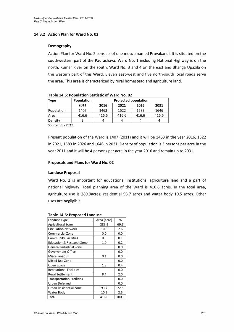
Muksudpur Paurashava Master Plan: 2011-2031 Part C: Ward Action Plan
Chapter Fourteen: Ward Action Plan 251
14.3.2 Action Plan for Ward No. 02
Demography
Action Plan for Ward No. 2 consists of one mouza named Provakandi. It is situated on the
southwestern part of the Paurashava. Ward No. 1 including National Highway is on the
north, Kumar River on the south, Ward No. 3 and 4 on the east and Bhanga Upazila on
the western part of this Ward. Eleven east-west and five north-south local roads serve
the area. This area is characterized by rural homestead and agriculture land.
Table 14.5: Population Statistic of Ward No. 02 Type Population
2011 Projected population
2016 2021 2026 2031
Population 1407 1463 1522 1583 1646
Area 416.6 416.6 416.6 416.6 416.6
Density 3 4 4 4 4 Source: BBS 2011.
Present population of the Ward is 1407 (2011) and it will be 1463 in the year 2016, 1522
in 2021, 1583 in 2026 and 1646 in 2031. Density of population is 3 persons per acre in the
year 2011 and it will be 4 persons per acre in the year 2016 and remain up to 2031.
Proposals and Plans for Ward No. 02
Landuse Proposal
Ward No. 2 is important for educational institutions, agriculture land and a part of
national highway. Total planning area of the Ward is 416.6 acres. In the total area,
agriculture use is 289.9acres; residential 93.7 acres and water body 10.5 acres. Other
uses are negligible.
Table 14.6: Proposed Landuse Landuse Type Area (acre) %
Agricultural Zone 289.9 69.6
Circulation Network 10.8 2.6
Commercial Zone 0.0 0.0
Community Facilities 0.5 0.1
Education & Research Zone 1.0 0.2
General Industrial Zone 0.0
Government Office 0.0
Miscellaneous 0.1 0.0
Mixed Use Zone 0.0
Open Space 1.8 0.4
Recreational Facilities 0.0
Rural Settlement 8.4 2.0
Transportation Facilities 0.0
Urban Deferred 0.0
Urban Residential Zone 93.7 22.5
Water Body 10.5 2.5
Total 416.6 100.0
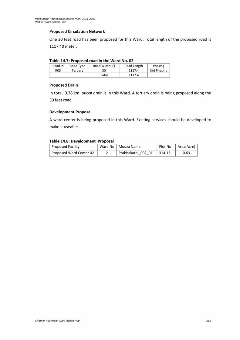
Muksudpur Paurashava Master Plan: 2011-2031 Part C: Ward Action Plan
Chapter Fourteen: Ward Action Plan 252
Proposed Circulation Network
One 30 feet road has been proposed for this Ward. Total length of the proposed road is
1117.40 meter.
Table 14.7: Proposed road in the Ward No. 02 Road Id Road Type Road Width( F) Road Length Phasing
R05 Tertiary 30 1117.4 3rd Phasing
Total 1117.4
Proposed Drain
In total, 0.38 km. pucca drain is in this Ward. A tertiary drain is being proposed along the
30 feet road.
Development Proposal
A ward center is being proposed in this Ward. Existing services should be developed to
make it useable.
Table 14.8: Development Proposal Proposed Facility Ward No Mouza Name Plot No Area(Acre)
Proposed Ward Center 02 2 Prabhakardi_002_01 314-15 0.63

Muksudpur Paurashava Master Plan: 2011-2031 Part C: Ward Action Plan
Chapter Fourteen: Ward Action Plan 253
Map 14.3: Landuse Plan for Ward No 02

Muksudpur Paurashava Master Plan: 2011-2031 Part C: Ward Action Plan
Chapter Fourteen: Ward Action Plan 254

Muksudpur Paurashava Master Plan: 2011-2031 Part C: Ward Action Plan
Chapter Fourteen: Ward Action Plan 255
Map 14.4: Road and Drainage Plan for Ward No 02

Muksudpur Paurashava Master Plan: 2011-2031 Part C: Ward Action Plan
Chapter Fourteen: Ward Action Plan 256

Muksudpur Paurashava Master Plan: 2011-2031 Part C: Ward Action Plan
Chapter Fourteen: Ward Action Plan 257
14.3.3 Action Plan for Ward No. 03
Demography
Action Plan for Ward No. 3 consists of one mouza named Nagar Sundardi and Pravakardi
(part). The Ward is situated on the middle-western part of the Paurashava. Ward No. 1
including Kumar River is on the north, Ward No. 5 on the south, Ward No. 6 on the east
and Ward No. 2 and 4 on the west. Eleven east-west and five north-south local roads
serve the area. This area is characterized by urban facilities.
Table 14.9: Population Statistic of Ward No. 03 Type Population
2011 Projected population
2016 2021 2026 2031
Population 1967 2046 2128 2213 2301
Area 660.7 660.7 660.7 660.7 660.7
Density 3 3 3 3 3
Present population of the Ward is 1967 (2011) and it will be 2046 in the year 2016, 2128
in 2021, 2213 in 2026 and 2301 in 2031. Density of population is 3 persons per acre and it
will remain up to 2031.
Proposals and Plans for Ward No. 03
Landuse Proposal
Ward No. 3 is important for light industries, Paurashava office, REB office, Upazila
headquarters, police station, bank, college, clinics, diagnostic centre and bazar. Total
planning area of the Ward is 660.7 acres. In the total area, agriculture use is 447.3 acres
and residential 139.7 acres. Except these, 12.7 acres open spaces and 17.4 acres water
body is in the Ward. Other uses are below than one acre.
Table 14.10: Proposed Landuse Landuse Type Area (acre) %
Agricultural Zone 447.3 67.7
Circulation Network 21.5 3.3
Commercial Zone 0.5 0.1
Community Facilities 0.5 0.1
Education & Research Zone 0.2 0.0
General Industrial Zone 11.8 1.8
Government Office 0.0
Miscellaneous 0.0
Mixed Use Zone 0.0
Open Space 12.7 1.9
Recreational Facilities 6.2 0.9
Rural Settlement 2.7 0.4
Transportation Facilities 0.2 0.0
Urban Deferred 0.0
Urban Residential Zone 139.7 21.2
Water Body 17.4 2.6
Total 660.7 100.0

Muksudpur Paurashava Master Plan: 2011-2031 Part C: Ward Action Plan
Chapter Fourteen: Ward Action Plan 258
Proposed Circulation Network
Three 30 feet and one 20 feet roads have been proposed for this Ward. Total length of
the proposed road is 3292.9 meter.
Table 14.11: Proposed road in the Ward No. 03 Road Id Road Type Road Width( F) Road Length Phasing
R22 Tertiary 30 633.4 3rd Phasing
R45 Tertiary 30 509.1 3rd Phasing
R46 Tertiary 30 532.8 3rd Phasing
R48 Access 20 500.2 3rd Phasing
Total 3292.9
Proposed Drain
In total, 0.26 km. pucca drain is in this Ward. Three tertiary drains have been proposed
along the 30 feet roads.
Development Proposal
An industrial area with 11.8 acres land (on plot no. 1197 and 1222), one park/shishupark
with 6.3 acres land (on plot no. 1090 to 1093 and 1177 to 1180) and a stadium with 6.10
acres land (on plot no. 2207 to 2220) have been proposed in this Ward. All the services is
being proposed in the mouza named Prabhakardi.
Table 14.12: Development Proposal Proposed Facility Ward No Mouza Name Plot No Area(Acre)
Proposed Park 02 3 Prabhakardi_002_02 1090-1093,1177-80 6.3
Proposed Stadium 3 Prabhakardi_002_03 2207-2220 6.1
Proposed Ward Center 03 3 Prabhakardi_002_02 1181 0.56

Muksudpur Paurashava Master Plan: 2011-2031 Part C: Ward Action Plan
Chapter Fourteen: Ward Action Plan 259
Map 14.5: Landuse Plan for Ward No 03

Muksudpur Paurashava Master Plan: 2011-2031 Part C: Ward Action Plan
Chapter Fourteen: Ward Action Plan 260

Muksudpur Paurashava Master Plan: 2011-2031 Part C: Ward Action Plan
Chapter Fourteen: Ward Action Plan 261
Map 14.6: Road and Drainage Plan for Ward No 03

Muksudpur Paurashava Master Plan: 2011-2031 Part C: Ward Action Plan
Chapter Fourteen: Ward Action Plan 262
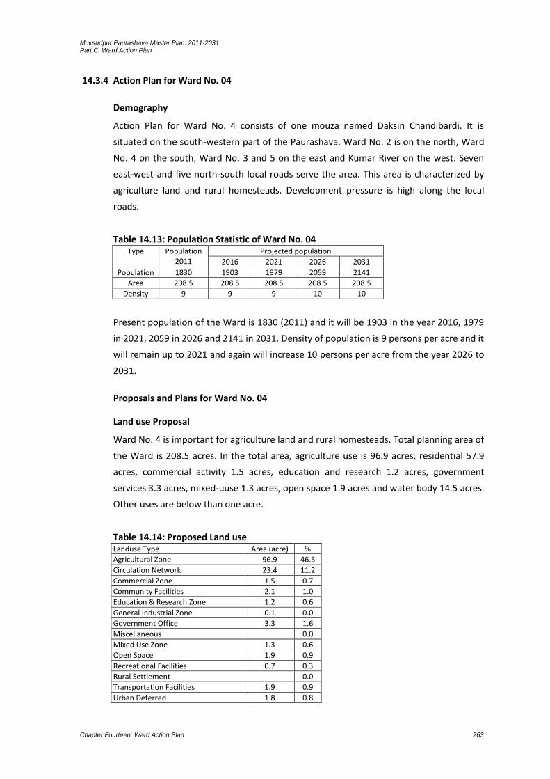
Muksudpur Paurashava Master Plan: 2011-2031 Part C: Ward Action Plan
Chapter Fourteen: Ward Action Plan 263
14.3.4 Action Plan for Ward No. 04
Demography
Action Plan for Ward No. 4 consists of one mouza named Daksin Chandibardi. It is
situated on the south-western part of the Paurashava. Ward No. 2 is on the north, Ward
No. 4 on the south, Ward No. 3 and 5 on the east and Kumar River on the west. Seven
east-west and five north-south local roads serve the area. This area is characterized by
agriculture land and rural homesteads. Development pressure is high along the local
roads.
Table 14.13: Population Statistic of Ward No. 04 Type Population
2011 Projected population
2016 2021 2026 2031
Population 1830 1903 1979 2059 2141
Area 208.5 208.5 208.5 208.5 208.5
Density 9 9 9 10 10
Present population of the Ward is 1830 (2011) and it will be 1903 in the year 2016, 1979
in 2021, 2059 in 2026 and 2141 in 2031. Density of population is 9 persons per acre and it
will remain up to 2021 and again will increase 10 persons per acre from the year 2026 to
2031.
Proposals and Plans for Ward No. 04
Land use Proposal
Ward No. 4 is important for agriculture land and rural homesteads. Total planning area of
the Ward is 208.5 acres. In the total area, agriculture use is 96.9 acres; residential 57.9
acres, commercial activity 1.5 acres, education and research 1.2 acres, government
services 3.3 acres, mixed-uuse 1.3 acres, open space 1.9 acres and water body 14.5 acres.
Other uses are below than one acre.
Table 14.14: Proposed Land use Landuse Type Area (acre) %
Agricultural Zone 96.9 46.5
Circulation Network 23.4 11.2
Commercial Zone 1.5 0.7
Community Facilities 2.1 1.0
Education & Research Zone 1.2 0.6
General Industrial Zone 0.1 0.0
Government Office 3.3 1.6
Miscellaneous 0.0
Mixed Use Zone 1.3 0.6
Open Space 1.9 0.9
Recreational Facilities 0.7 0.3
Rural Settlement 0.0
Transportation Facilities 1.9 0.9
Urban Deferred 1.8 0.8

Muksudpur Paurashava Master Plan: 2011-2031 Part C: Ward Action Plan
Chapter Fourteen: Ward Action Plan 264
Landuse Type Area (acre) %
Urban Residential Zone 57.9 27.8
Water Body 14.5 7.0
Total 208.5 100.0
Proposed Circulation Network
Six 30 feet and six 20 feet roads have been proposed for this Ward. Total length of the
proposed road is 7614.6 meter.
Table 14.15: Proposed road in the Ward No. 04 Road Id Road Type Road Width( F) Road Length Phasing
R01 Access 20 176.8 1st Phasing
R02 Tertiary 30 326.1 1st Phasing
R04 Access 20 285.0 1st Phasing
R06 Access 20 118.5 3rd Phasing
R08 Tertiary 30 139.7 2nd Phasing
R25 Access 20 128.6 3rd Phasing
R26 Tertiary 30 168.8 3rd Phasing
R30 Tertiary 30 377.3 1st Phasing
R31 Access 20 278.0 3rd Phasing
R51 Access 20 67.5 3rd Phasing
R59 Tertiary 30 2317.0 3rd Phasing
R65 Tertiary 30 3231.2 3rd Phasing
Total 7614.6
Proposed Drain In total, 0.77 km. pucca drain is in this Ward. Six tertiary drains have been proposed along the 30 feet roads.
Development Proposal
A community center with 0.30 acres land (on plot no. 269 and 270), one bus terminal
with 1.20 acres land (on plot no. 28 to 33) and a truck terminal with 1.0 acres of land (on
plot no. 22 to 27) have been proposed in this Ward. All the services will be located in the
mouza named Dakshin Chandibardi.
Table 14.16: Development Proposal Proposed Facility Ward No Mouza Name Plot No Area(Acre)
Proposed Waste Transfer Station 02 4 Dakshin Chandibardi_00 171 0.38
Proposed Bus Terminal 4 Dakshin Chandibardi_058_00 28-33 1.2
Proposed Truck Terminal 4 Dakshin Chandibardi_058_00 22-27 1
Proposed Bus Stand 02 4 Dakshin Chandibardi_058_00 285 0.53
Proposed Bus Stand 01 4 Dakshin Chandibardi_058_00 365,379-80 0.49
Proposed Community Center 4 Dakshin Chandibardi_058_00 269,270 0.3
Proposed Ward Center 04 4 Dakshin Chandibardi_058_00 165 0.15

Muksudpur Paurashava Master Plan: 2011-2031 Part C: Ward Action Plan
Chapter Fourteen: Ward Action Plan 265
Map 14.7: Landuse Plan for Ward No 04

Muksudpur Paurashava Master Plan: 2011-2031 Part C: Ward Action Plan
Chapter Fourteen: Ward Action Plan 266

Muksudpur Paurashava Master Plan: 2011-2031 Part C: Ward Action Plan
Chapter Fourteen: Ward Action Plan 267
Map 14.8: Road and Drainage Plan for Ward No 04

Muksudpur Paurashava Master Plan: 2011-2031 Part C: Ward Action Plan
Chapter Fourteen: Ward Action Plan 268

Muksudpur Paurashava Master Plan: 2011-2031 Part C: Ward Action Plan
Chapter Fourteen: Ward Action Plan 269
14.3.5 Action Plan for Ward No. 05
Demography
Action Plan for Ward No. 5 consists of one mouza named Gopinathpur. Ward No. 3 is on
the north, Ward No. 6 on the east, Ward No. 4 on the west and Gopalganj on the
southern part of this Ward. Six east-west and seven north-south local roads serve the
area. This area is characterized by agriculture land and rural homesteads.
Table 14.17: Population Statistic of Ward No. 05 Type Population
2011 Projected population
2016 2021 2026 2031
Population 2905 3021 3142 3268 3398
Area 343.4 343.4 343.4 343.4 343.4
Density 8 9 9 10 10
Present population of the Ward is 2905 (2011) and it will be 3021 in the year 2016, 3142
in 2021, 3268 in 2026 and 3398 in 2031. Density of population is 8 persons per acre and it
will increase 9 persons per acre from the year 2016 to 2021 and again will increase up to
10 persons per acre from the year 2026 to 2031.
Proposals and Plans for Ward No. 05
Land use Proposal Ward No. 5 is important for poultry farm, BADC office, light industries and bazar. Total planning area of the Ward is 343.4 acres. In the total area, agriculture use is 149 acres and residential 141 acres. Area under open space is 2.9 acres, circulation network 20.6 acres, community services 1.2 acres, education and research 2.2 acres, government services 6.1 acres, mixed-uuse 0.4 acres, open space 2.9 acres, recreational facilities 3.2 acres and water body 16.4 acres.
Table 14.18: Proposed Landuse Landuse Type Area (acre) %
Agricultural Zone 149.0 43.4
Circulation Network 20.6 6.0
Commercial Zone 0.5 0.1
Community Facilities 1.2 0.3
Education & Research Zone 2.2 0.7
General Industrial Zone 0.1 0.0
Government Office 6.1 1.8
Miscellaneous 0.0
Mixed Use Zone 0.4 0.1
Open Space 2.9 0.8
Recreational Facilities 3.2 0.9
Rural Settlement 0.0
Transportation Facilities 0.1 0.0
Urban Deferred 0.0
Urban Residential Zone 141.0 41.0
Water Body 16.4 4.8
Total 343.4 100.0

Muksudpur Paurashava Master Plan: 2011-2031 Part C: Ward Action Plan
Chapter Fourteen: Ward Action Plan 270
Proposed Circulation Network
One 120 feet, one 60 feet, one 40 feet, nine 30 feet and twelve 20 feet roads have been
proposed for this Ward. Total length of the proposed road is 18301.3 meter.
Table 14.19: Proposed road in the Ward No.05 Road Id Road Type Road Width( F) Road Length Phasing
R03 Primary 120 3621.9 3rd Phasing
R07 Tertiary 30 180.8 3rd Phasing
R09 Tertiary 30 447.7 3rd Phasing
R10 Tertiary 30 206.8 3rd Phasing
R11 Access 20 193.7 3rd Phasing
R17 Access 20 163.9 3rd Phasing
R18 Access 20 119.2 2nd Phasing
R19 Access 20 336.0 3rd Phasing
R20 Access 20 177.4 3rd Phasing
R21 Access 20 199.9 3rd Phasing
R23 Access 20 115.0 2nd Phasing
R27 Primary 60 4647.2 1st Phasing
R28 Secondary 40 1725.9 1st Phasing
R32 Tertiary 30 1519.5 1st Phasing
R33 Tertiary 30 262.4 2nd Phasing
R34 Access 20 198.3 3rd Phasing
R35 Tertiary 30 715.8 3rd Phasing
R40 Access 20 157.3 2nd Phasing
R41 Access 20 380.9 1st Phasing
R42 Access 20 429.6 2nd Phasing
R43 Tertiary 30 498.7 2nd Phasing
R44 Tertiary 30 929.9 2nd Phasing
R47 Tertiary 30 683.9 2nd Phasing
R49 Access 20 389.4 3rd Phasing
Total 18301.3
Proposed Drain
No drain is in this Ward. Two primary drains, one secondary drain and nine tertiary drains
have been proposed along the 120 feet, 60 feet, 40 feet and 30 feet roads.
Development Proposal
A ward center, a playground and a primary school is being proposed in this Ward. Existing
services should be developed to make it useable.
Table 14.20: Development Proposal Proposed Facility Ward No Mouza Name Plot No Area(Acre)
Proposed Playground 02 5 Gopinathpur_00 102,510,321,034 1.01
Proposed Primary School 5 Gopinathpur_00 1063-80 1.3
Proposed Ward Center 05 5 Gopinathpur_057_00 1132 0.22

Muksudpur Paurashava Master Plan: 2011-2031 Part C: Ward Action Plan
Chapter Fourteen: Ward Action Plan 271
Map 14.9: Landuse Plan for Ward No 05

Muksudpur Paurashava Master Plan: 2011-2031 Part C: Ward Action Plan
Chapter Fourteen: Ward Action Plan 272

Muksudpur Paurashava Master Plan: 2011-2031 Part C: Ward Action Plan
Chapter Fourteen: Ward Action Plan 273
Map 14.10: Road and Drainage Plan for Ward No 05
Muksudpur Paurashava Master Plan: 2011-2031 Part C: Ward Action Plan
Chapter Fourteen: Ward Action Plan 274
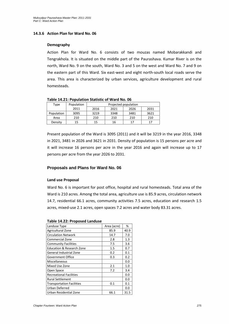
Muksudpur Paurashava Master Plan: 2011-2031 Part C: Ward Action Plan
Chapter Fourteen: Ward Action Plan 275
14.3.6 Action Plan for Ward No. 06
Demography
Action Plan for Ward No. 6 consists of two mouzas named Mobarakkandi and
Tengrakhola. It is situated on the middle part of the Paurashava. Kumar River is on the
north, Ward No. 9 on the south, Ward No. 3 and 5 on the west and Ward No. 7 and 9 on
the eastern part of this Ward. Six east-west and eight north-south local roads serve the
area. This area is characterized by urban services, agriculture development and rural
homesteads.
Table 14.21: Population Statistic of Ward No. 06 Type Population
2011 Projected population
2016 2021 2026 2031
Population 3095 3219 3348 3481 3621
Area 210 210 210 210 210
Density 15 15 16 17 17
Present population of the Ward is 3095 (2011) and it will be 3219 in the year 2016, 3348
in 2021, 3481 in 2026 and 3621 in 2031. Density of population is 15 persons per acre and
it will increase 16 persons per acre in the year 2016 and again will increase up to 17
persons per acre from the year 2026 to 2031.
Proposals and Plans for Ward No. 06
Land use Proposal
Ward No. 6 is important for post office, hospital and rural homesteads. Total area of the
Ward is 210 acres. Among the total area, agriculture use is 85.9 acres, circulation network
14.7, residential 66.1 acres, community activities 7.5 acres, education and research 1.5
acres, mixed-use 2.1 acres, open spaces 7.2 acres and water body 83.31 acres.
Table 14.22: Proposed Landuse Landuse Type Area (acre) %
Agricultural Zone 85.9 40.9
Circulation Network 14.7 7.0
Commercial Zone 2.8 1.3
Community Facilities 7.5 3.6
Education & Research Zone 1.5 0.7
General Industrial Zone 0.2 0.1
Government Office 0.3 0.2
Miscellaneous 0.0
Mixed Use Zone 2.1 1.0
Open Space 7.2 3.4
Recreational Facilities 0.0
Rural Settlement 0.0
Transportation Facilities 0.1 0.1
Urban Deferred 0.0
Urban Residential Zone 66.1 31.5

Muksudpur Paurashava Master Plan: 2011-2031 Part C: Ward Action Plan
Chapter Fourteen: Ward Action Plan 276
Landuse Type Area (acre) %
Water Body 21.6 10.3
Total 210.0 100.0
Proposed Circulation Network
Five 30 feet and three 20 feet roads have been proposed for this Ward. Total length of
the proposed road is 4088.1 meter.
Table 14.23: Proposed road in the Ward No. 6 Road Id Road Type Road Width( F) Road Length Phasing
R12 Tertiary 30 468.9 3rd Phasing
R24 Access 20 77.4 3rd Phasing
R29 Tertiary 30 557.6 1st Phasing
R36 Tertiary 30 506.2 1st Phasing
R37 Access 20 414.6 1st Phasing
R38 Access 20 436.1 2nd Phasing
R39 Tertiary 30 508.2 3rd Phasing
R50 Tertiary 30 1119.2 3rd Phasing
Total 4088.1
Proposed Drain
No drain is in this Ward. Five tertiary drains have been proposed along the 30 feet roads.
Development Proposal
A ward center, a waste transfer station and an eidgah with 3.6 acres of land (on the plot
no. 68 and 121) under Tenrakhola mouza has been proposed. Existing services should be
developed to make it useable.
Table 14.24: Development Proposal Proposed Facility Ward No Mouza Name Plot No Area(Acre)
Proposed Waste Transfer Station 01 6 Tenrakhola_00 303 0.06
Proposed Eidgha 6 Tenrakhola_059_0 68,121 3.6
Proposed Ward Center 01 6 Tenrakhola_059_00 385 0.28

Muksudpur Paurashava Master Plan: 2011-2031 Part C: Ward Action Plan
Chapter Fourteen: Ward Action Plan 277
Map 14.11: Landuse Plan for Ward No 06

Muksudpur Paurashava Master Plan: 2011-2031 Part C: Ward Action Plan
Chapter Fourteen: Ward Action Plan 278

Muksudpur Paurashava Master Plan: 2011-2031 Part C: Ward Action Plan
Chapter Fourteen: Ward Action Plan 279
Map 14.12: Road and Drainage Plan for Ward No 06

Muksudpur Paurashava Master Plan: 2011-2031 Part C: Ward Action Plan
Chapter Fourteen: Ward Action Plan 280
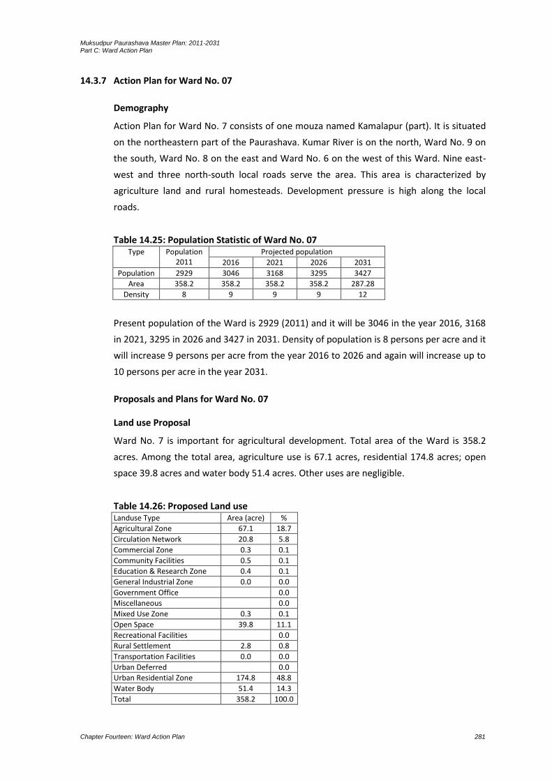
Muksudpur Paurashava Master Plan: 2011-2031 Part C: Ward Action Plan
Chapter Fourteen: Ward Action Plan 281
14.3.7 Action Plan for Ward No. 07
Demography
Action Plan for Ward No. 7 consists of one mouza named Kamalapur (part). It is situated
on the northeastern part of the Paurashava. Kumar River is on the north, Ward No. 9 on
the south, Ward No. 8 on the east and Ward No. 6 on the west of this Ward. Nine east-
west and three north-south local roads serve the area. This area is characterized by
agriculture land and rural homesteads. Development pressure is high along the local
roads.
Table 14.25: Population Statistic of Ward No. 07 Type Population
2011 Projected population
2016 2021 2026 2031
Population 2929 3046 3168 3295 3427
Area 358.2 358.2 358.2 358.2 287.28
Density 8 9 9 9 12
Present population of the Ward is 2929 (2011) and it will be 3046 in the year 2016, 3168
in 2021, 3295 in 2026 and 3427 in 2031. Density of population is 8 persons per acre and it
will increase 9 persons per acre from the year 2016 to 2026 and again will increase up to
10 persons per acre in the year 2031.
Proposals and Plans for Ward No. 07
Land use Proposal
Ward No. 7 is important for agricultural development. Total area of the Ward is 358.2
acres. Among the total area, agriculture use is 67.1 acres, residential 174.8 acres; open
space 39.8 acres and water body 51.4 acres. Other uses are negligible.
Table 14.26: Proposed Land use Landuse Type Area (acre) %
Agricultural Zone 67.1 18.7
Circulation Network 20.8 5.8
Commercial Zone 0.3 0.1
Community Facilities 0.5 0.1
Education & Research Zone 0.4 0.1
General Industrial Zone 0.0 0.0
Government Office 0.0
Miscellaneous 0.0
Mixed Use Zone 0.3 0.1
Open Space 39.8 11.1
Recreational Facilities 0.0
Rural Settlement 2.8 0.8
Transportation Facilities 0.0 0.0
Urban Deferred 0.0
Urban Residential Zone 174.8 48.8
Water Body 51.4 14.3
Total 358.2 100.0
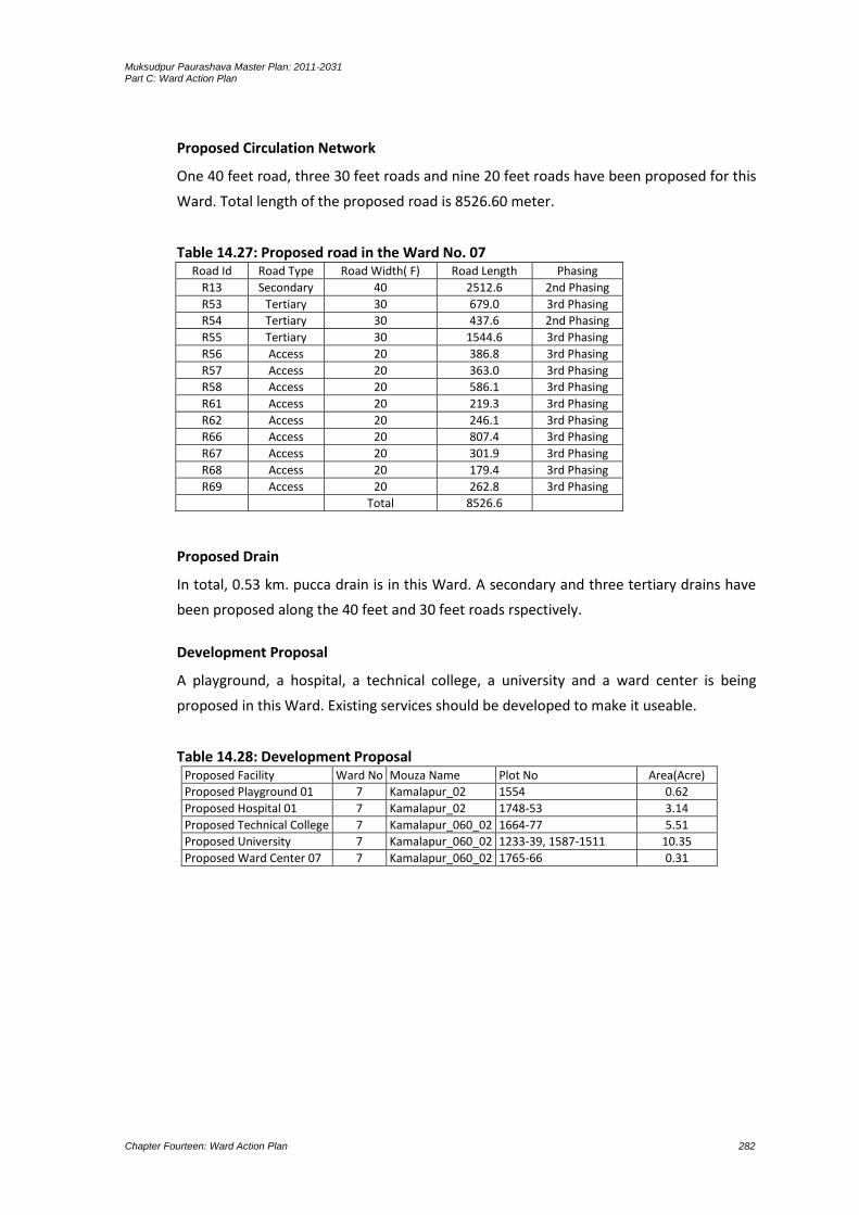
Muksudpur Paurashava Master Plan: 2011-2031 Part C: Ward Action Plan
Chapter Fourteen: Ward Action Plan 282
Proposed Circulation Network
One 40 feet road, three 30 feet roads and nine 20 feet roads have been proposed for this
Ward. Total length of the proposed road is 8526.60 meter.
Table 14.27: Proposed road in the Ward No. 07 Road Id Road Type Road Width( F) Road Length Phasing
R13 Secondary 40 2512.6 2nd Phasing
R53 Tertiary 30 679.0 3rd Phasing
R54 Tertiary 30 437.6 2nd Phasing
R55 Tertiary 30 1544.6 3rd Phasing
R56 Access 20 386.8 3rd Phasing
R57 Access 20 363.0 3rd Phasing
R58 Access 20 586.1 3rd Phasing
R61 Access 20 219.3 3rd Phasing
R62 Access 20 246.1 3rd Phasing
R66 Access 20 807.4 3rd Phasing
R67 Access 20 301.9 3rd Phasing
R68 Access 20 179.4 3rd Phasing
R69 Access 20 262.8 3rd Phasing
Total 8526.6
Proposed Drain
In total, 0.53 km. pucca drain is in this Ward. A secondary and three tertiary drains have
been proposed along the 40 feet and 30 feet roads rspectively.
Development Proposal
A playground, a hospital, a technical college, a university and a ward center is being
proposed in this Ward. Existing services should be developed to make it useable.
Table 14.28: Development Proposal Proposed Facility Ward No Mouza Name Plot No Area(Acre)
Proposed Playground 01 7 Kamalapur_02 1554 0.62
Proposed Hospital 01 7 Kamalapur_02 1748-53 3.14
Proposed Technical College 7 Kamalapur_060_02 1664-77 5.51
Proposed University 7 Kamalapur_060_02 1233-39, 1587-1511 10.35
Proposed Ward Center 07 7 Kamalapur_060_02 1765-66 0.31

Muksudpur Paurashava Master Plan: 2011-2031 Part C: Ward Action Plan
Chapter Fourteen: Ward Action Plan 283
Map 14.13: Landuse Plan for Ward No 07

Muksudpur Paurashava Master Plan: 2011-2031 Part C: Ward Action Plan
Chapter Fourteen: Ward Action Plan 284

Muksudpur Paurashava Master Plan: 2011-2031 Part C: Ward Action Plan
Chapter Fourteen: Ward Action Plan 285
Map 14.14: Road and Drainage Plan for Ward No 07

Muksudpur Paurashava Master Plan: 2011-2031 Part C: Ward Action Plan
Chapter Fourteen: Ward Action Plan 286

Muksudpur Paurashava Master Plan: 2011-2031 Part C: Ward Action Plan
Chapter Fourteen: Ward Action Plan 287
14.3.8 Action Plan for Ward No. 08
Demography
Action Plan for Ward No. 8 consists of the mouza named Kamalapur (part). It is situated
on the northeastern part of the Paurashava. Kumar River is on the north, Ward No. 9 on
the south, Madaripur Zila on the east and Ward No. 7 on the west. Four east-west and
five north-south local roads serve the area. This area is characterized by agriculture land
and rural homesteads. Development pressure is high along the local roads.
Table 14.29: Population Statistic of Ward No. 08 Type Population
2011 Projected population
2016 2021 2026 2031
Population 2070 2153 2239 2328 2422
Area 390.3 390.3 390.3 390.3 390.3
Density 5 6 6 6 6
Present population of the Ward is 2070 (2011) and it will be 2153 in the year 2016, 2239
in 2021, 2328 in 2026 and 2422 in 2031. Density of population is 5 persons per acre and it
will increase 6 persons per acre in the year 2016 and will remain up to 2031.
Proposals and Plans for Ward No. 08
Land use Proposal
Ward No. 8 is important for light industries, clinic, agriculture land and rural settlements.
Total planning area of the Ward is 390.3 acres. In the total area, agriculture use is 232.7
acres; residential 115.9 acres, recreational facilities 1.2 acres and water body 14.4 acres.
Other uses are below than one acre.
Table 14.30: Proposed Land use Land use Type Area (acre) %
Agricultural Zone 232.7 59.6
Circulation Network 14.5 3.7
Commercial Zone 0.0 0.0
Community Facilities 0.7 0.2
Education & Research Zone 1.8 0.5
General Industrial Zone 0.0
Government Office 0.0
Miscellaneous 0.0
Mixed Use Zone 0.1 0.0
Open Space 9.0 2.3
Recreational Facilities 1.2 0.3
Rural Settlement 0.0
Transportation Facilities 0.0
Urban Deferred 0.0
Urban Residential Zone 115.9 29.7
Water Body 14.4 3.7
Total 390.3 100.0

Muksudpur Paurashava Master Plan: 2011-2031 Part C: Ward Action Plan
Chapter Fourteen: Ward Action Plan 288
Proposed Circulation Network
Two 30 feet roads have been proposed in the plan for this Ward. Total length of the
proposed road is 2138.70 meter.
Table 14.31: Proposed road in the Ward No. 08 Road Id Road Type Road Width( F) Road Length Phasing
R15 Tertiary 30 466.1 3rd Phasing
R60 Tertiary 30 1672.6 3rd Phasing
Total 2138.7
Proposed Drain
In total, 0.28 km. pucca drain is in this Ward. A tertiary drain has been proposed along
the 30 feet road.
Development Proposal
A ward center and a park with 0.30 acres of land are being proposed in this Ward.
Existing services should be developed to make it useable.
Table 14.32: Development Proposal Proposed Facility Ward No Mouza Name Plot No Area(Acre)
Proposed Park 01 8 Kamalapur_060_01 52-57,63,86,87 2.1
Proposed Ward Center 08 8 Kamalapur_060_01 273 0.34

Muksudpur Paurashava Master Plan: 2011-2031 Part C: Ward Action Plan
Chapter Fourteen: Ward Action Plan 289
Map 14.15: Landuse Plan for Ward No 08

Muksudpur Paurashava Master Plan: 2011-2031 Part C: Ward Action Plan
Chapter Fourteen: Ward Action Plan 290

Muksudpur Paurashava Master Plan: 2011-2031 Part C: Ward Action Plan
Chapter Fourteen: Ward Action Plan 291
Map 14. 16: Road and Drainage Plan for Ward No 08

Muksudpur Paurashava Master Plan: 2011-2031 Part C: Ward Action Plan
Chapter Fourteen: Ward Action Plan 292

Muksudpur Paurashava Master Plan: 2011-2031 Part C: Ward Action Plan
Chapter Fourteen: Ward Action Plan 293
14.3.9 Action Plan for Ward No. 09
Demography
Action Plan for Ward No. 9 consists of three mouzas named Golabaria, Hogladanga and
Choto Bahara. It is situated on the southeastern part of the Paurashava. Ward No. 8 is on
the north, Gopalganj on the south, Madaripur on the east and Ward No. 6 and 7 on the
west. Two east-west and three north-south local roads serve the area.
Table 14.33: Population Statistic of Ward No. 09 Type Population
2011 Projected population
2016 2021 2026 2031
Population 1657 1723 1792 1864 1938
Area 832.2 832.2 832.2 832.2 832.2
Density 2 2 2 2 2
Present population of the Ward is 1657 (2011) and it will be 1723 in the year 2016, 1792
in 2021, 1864 in 2026 and 1938 in 2031. Density of population is 2 persons per acre and it
will remain up to 2031.
Proposals and Plans for Ward No. 09
Land use Proposal
This area is characterized by agriculture practice and rural homesteads. Development
pressure is high along the local roads. Total area of the Ward is 832.2 acres. Among the
total area, agriculture use is 601.8 acres, residential 97.1 acres, education and research
1.3 acres, manufacturing and processing activity 4.3 acres and waterbody 70.4 acres.
Table 14.34: Proposed Landuse Landuse Area (acre) %
Agricultural Zone 601.8 72.3
Circulation Network 17.0 2.0
Commercial Zone 0.0 0.0
Community Facilities 0.7 0.1
Education & Research Zone 1.3 0.2
General Industrial Zone 4.3 0.5
Government Office 0.0
Miscellaneous 0.0
Mixed Use Zone 0.0
Open Space 13.4 1.6
Recreational Facilities 0.0
Rural Settlement 5.5 0.7
Transportation Facilities 0.0
Urban Deferred 20.7 2.5
Urban Residential Zone 97.1 11.7
Water Body 70.4 8.5
Total 832.2 100.0

Muksudpur Paurashava Master Plan: 2011-2031 Part C: Ward Action Plan
Chapter Fourteen: Ward Action Plan 294
Proposed Circulation Network
Two 30 feet roads have been proposed for this Ward. Total length of the proposed road
is 3065.30 meter.
Table 14.35: Proposed road in the Ward No. 09 Road Id Road Type Road Width( F) Road Length (M) Phasing
R14 Tertiary 30 1862.0 3rd Phasing
R52 Tertiary 30 1203.3 3rd Phasing
Total 3065.3
Proposed Drain
In total, 0.57 km. pucca drain is in this Ward. A tertiary drain has been proposed along
the 30 feet road.
Development Proposal
A ward center and housing area with 20.70 acres land is being proposed in this Ward.
Existing services should be developed to make it useable.
Table 14.36: Development Proposal Proposed Facility Ward No Mouza Name Plot No Area(Acre)
Proposed Housing 9 Golabaria_068_00 14-25,37-55,241-287 20.7
Proposed Ward Center 09 9 Golabaria_068_00 337-38 0.42

Muksudpur Paurashava Master Plan: 2011-2031 Part C: Ward Action Plan
Chapter Fourteen: Ward Action Plan 295
Map 14.17: Landuse Plan for Ward No 09

Muksudpur Paurashava Master Plan: 2011-2031 Part C: Ward Action Plan
Chapter Fourteen: Ward Action Plan 296
Muksudpur Paurashava Master Plan: 2011-2031 Part C: Ward Action Plan
Chapter Fourteen: Ward Action Plan 297
Map 14. 18: Road and Drainage Plan for Ward No 09

Muksudpur Paurashava Master Plan: 2011-2031 Part C: Ward Action Plan
Chapter Fourteen: Ward Action Plan 298

Muksudpur Paurashava Master Plan: 2011-2031 Part C: Ward Action Plan
Chapter Fourteen: Ward Action Plan 299
14.4 Implementation Guidelines
Implementation of the Ward Action Plan should follow the development control
procedures for determining planning applications by use of the simple and standard
planning application procedures. A simple application will be assessed quickly against a
given set of criteria, essentially consisting of the following:
1. The proposed development confirms all respects mentioned in the policies of the
Structure Plan and Urban Area Plan.
2. The usage identified in the application is being considered appropriate for inclusion
in an area demarcated in the Ward Action Plan. An indicative list of uses considered
appropriate is below:
buildings are a maximum of four-storied;
no single building or related group of buildings is 1000 sq. m. of gross floor area; and
access and utility corridors are not impinged.
Provided that the planning application meets above criteria and the application will be
approved and planning permission is given.
Planning applications that do not meet the above criteria or are considered marginal
cases (to be known as an invalid simple application) will be subjected to a more detailed
examination in considering standard procedure.
Following development and landuses are indicative of those appropriate in the Ward
Action Plan:
Residential development up to four-storied.
Small-scale shops.
Primary schools / kindergartens.
Mosques (or other religious facilities) servicing a local area plus small graveyard if
required.
Recreational development.
Local health facilities (clinics rather than hospital).
Small-scale office (may be public or private) development.
Workshops (small-scale workshops with operations only) in daylight hours and low
traffic generators.
Open space (playgrounds, parks, etc.)
Access roads.
Utilities; and
Drainage channels.
When considering a standard planning application within areas zoned for Ward Action
Plan, the Paurashava will need to undertake a two-stage process. First, before

Muksudpur Paurashava Master Plan: 2011-2031 Part C: Ward Action Plan
Chapter Fourteen: Ward Action Plan 300
considering site specific issues, the Paurashava will need, on receipt of the planning
application, to consider the wider context and determine issues relating to the overall
area into which the application falls. The Paurashava will need to:
1. Determine the boundaries of the wider area. These will usually be formed by some
distinctive natural or man-made feature, for example a khal, river or road which
provides access into the area. Such areas will vary in shape and size.
2. Identify and assess the existing access and circulation arrangements of the area.
Preferably, the area should be served by 10 meter access roads which run through
the entire area providing access to all Wards. These access roads should be linked to
local roads. If this is not the case and access roads of sufficient width, are not
available, the Paurashava shall consider whether or not further development is
appropriate. New development may result in increased vehicular congestion and
increased demand for utility services, where this could be difficult to supply.
3. Identify the existing landuses within these boundaries. In Ward Action Plan, the
predominant use will be residential but other uses will present in the vicinity of the
application.
In these instances, the Paurashava will consider refusal of application or at least a delay
until access and utility provision can be made. This may require acquisition of land.
4. Identify the need for community facilities (schools, clinics, religious facilities, open
spaces, etc.) or plots for utility services. Do sufficient already exist or should more
land be sought for increased provision to the existing population? In this latter
instance, the Paurashava will again need to consider acquisition of land including the
land, either in part or in full, under consideration for development.
5. Consider areas of high landscape quality in the locality which should be preserved
and the potential impact of the proposed development on those areas.
If there is doubt in the mind of the Paurashava as to the answers to the above questions,
the planning application will require a more detailed assessment.
Secondly, the Paurashava will need to consider issues relating to the individual site and
application. These can only be determined once the overall context of the area has been
established. The questions the Paurashava will need to ask are:
1. Can be proposed use of land be considered a “good neighbour”, defined in this
situation as a use which can be carried out in any residential area without detriment
to the amenities of the area by reason of noise, vibration, smell, fumes, smoke, soot,
ash, dust or grit?
- Is the use likely to generate excessive volumes of traffic which either cannot be accommodated on the existing road system or which are likely to disturb, its neighbours?

Muksudpur Paurashava Master Plan: 2011-2031 Part C: Ward Action Plan
Chapter Fourteen: Ward Action Plan 301
- Will the working hours of the use (if non-residential) cause a disturbance to residential neighbours (with working late in to the evening or night or 24-hours operations likely to cause a nuisance and therefore not being permitted)?
- If yes to any of the above, the application should be rejected and directed to a more suitable location.
2. Is the use in conformity with the surrounding uses or with those that are compatible
with a site in a predominantly residential area?
3. Does the proposed boundary of the application impinge upon a road corridor, utility
reserve or drainage channel reserve? If it does, it should be relocated outside such a
reserve, even if this constitutes a reduction in the overall size of the plot. If excessive
land will be lost as a result, implying that the development can no longer proceed,
the application will need to be rejected.
4. Does the application provide for adequate site access from, preferably as minimum, a
6 meter access road? Does it have sufficient on-site or off-site parking facilities to
cater for the potential demand? If it does not, the plans should be amended or the
application refused.
5. Will the development destroy landscape unique to the location? If it does, its design
will need to be altered to protect the landscape, or the application will need to be
refused.
6. Is the scale of development proposed in keeping with its neighbours? If too large, it
should be reduced. Does it impinge up on the privacy of others? If it does, the design
/ layout / size should be changed. If it can not be appropriately modified, it should be
refused.
7. Will the proposed development negatively impact upon utility provision in the area
i.e. will it overload the system for some reason (like high electricity demand or high
water consumption)? Will pollution from the proposed activities cause a problem in
the neighbourhood? If this is likely to occur, the application should be refused.
If the application is for a major development, have the utility authorities being contacted
to give their assessment and approval for the infrastructure works that will be required?
Given the existing situation in some of the Ward Action Plan, where for example, access
is already poor or there is insufficient space available to provide adequate infrastructure,
the Paurashava will aim to ensure that its decision will not make the situation worse.
The Paurashava will need to process each application within one month, at the end of
which time they will either need to:
- approve the application unconditionally;
- approve the application subject to a number of conditions; or
- refuse the application.

Muksudpur Paurashava Master Plan: 2011-2031 Part C: Ward Action Plan
Chapter Fourteen: Ward Action Plan 302
14.5 Concluding Remarks
14.5.1 Introduction
The Master Plan is prepared for managing and promoting development over medium
terms following the broad guidelines set by the longer term Structure Plan. It shows the
structure of sub-system in space over the medium term and identifies broad programs of
direct action especially related to infrastructural development, institutional issues as well
as broad financing strategies. The plan also outlines more specific Ward-wise
development policies to guide development over the medium terms. One major objective
of preparing Master Plan is the consolidation of development activities by various
agencies in areas that have strongest potential for growth in the medium term and can
accommodate anticipated volume of growth. Other purpose of preparing Master Plan is
to facilitate the development control function. It shows the broad landuse zones on a
more detailed scale of maps as derived from Structure Plan. The plan provides details of
landuse zoning and building controls, the development control function becomes easier
to implement with a Master Plan. It also shows land reservations required for essential
uses and major infrastructure development.
14.5.2 Comparative Advantage of Master Plan
Comparative advantages of Master Plan rather than Ward Action Plan are:
The term Master Plan deserves wider sense than the term Ward Action Plan. Policies
and strategies are being prescribed in the Master Plan based on the existing trend of
development and growth potentiality. The Ward Action Plan only emphasizes on
those components immediate action is being necessary.
The Master Plan is for the Paurashava as a whole but the Ward Action Plan is only for
individual Ward. All studies relevant and guided by the ToR is being followed for the
preparation of Master Plan at first and based on those studies and findings the Ward
Action Plan is being designed.
The Ward Action Plan is mostly relevant with the implementation criteria; it is called
the implementation of Master Plan. The micro-component which is going to be
implemented according to the Ward Action Plan is guided by the Master Plan.
Therefore, any problem arises during the implementation phase of Ward Action Plan
will be resolved through the guideline prescribed in the Master Plan.
14.5.3 Addressing Proposals for Mitigation of Identified Issues
For improvement, construction and re-construction of local roads, bridge and culvert
and box culvert, a close coordination among the authorities named Paurashava,
LGED, PDB, REB and WDB will be maintained. This coordination is necessary from the
preparation of budget to implementation of the component.
In plan implementation phase, people’s participation will be encouraged. The process
as prescribed in the Structure Plan will be initiated for this purpose.
Muksudpur Paurashava Master Plan: 2011-2031 Part C: Ward Action Plan
Chapter Fourteen: Ward Action Plan 303
A buffer will be needed for every important development especially for housing area,
stadium and Bus terminal.
In preparing the proposed construction program priorities have been assigned to the
works mostly in the various drainage areas taking the following factors into account:
the severity of flooding in terms of depth, duration and frequency;
the views of Paurashava officials on the relative needs of different areas;
The engineering relationship of the proposed phase of construction to the preceding
and subsequent phases;
the estimated time required to execute the proposed works having regard to the
capacity and capability of contractors and the availability of materials;
the estimated amount of the capital investment required.
In general, aim should be to implement the Master Plan at a continuous steady rate
throughout the 20 years period and based upon the above considerations, the works
have been grouped broadly into four main stages:
The first stage accords priority to improve the Traffic Management and alleviation of
flooding in the central area of the Paurashava.
The second stage in general covers less densely developed areas with the
improvement of transport services.
The third stage covers drainage congestion areas for improvement.
The fourth stage will be the rain water harvesting for supplying drinking water to the
Paurashava dwellers when scarcity will be generated.
14.5.4 Conclusion
To ensure that the procedures are being followed, the Paurashava will need to monitor
the situation. This monitoring is required to ensure that:
no illegal development is taking place i.e. no-one is attempting to develop without
submitting an application; and
approved developments are built in accordance with the approved plans.
development will take places according to the Master Plan.

Muksudpur Paurashava Master Plan: 2011-2031 Part C: Ward Action Plan
Chapter Fourteen: Ward Action Plan 304

Muksudpur Paurashava Master Plan: 2011-2031 Structure Plan, Urban Area Plan and Ward Action Plan
Annexure A: Paurashava Gazette 1
ANNEXURE A: Paurashava Gazette
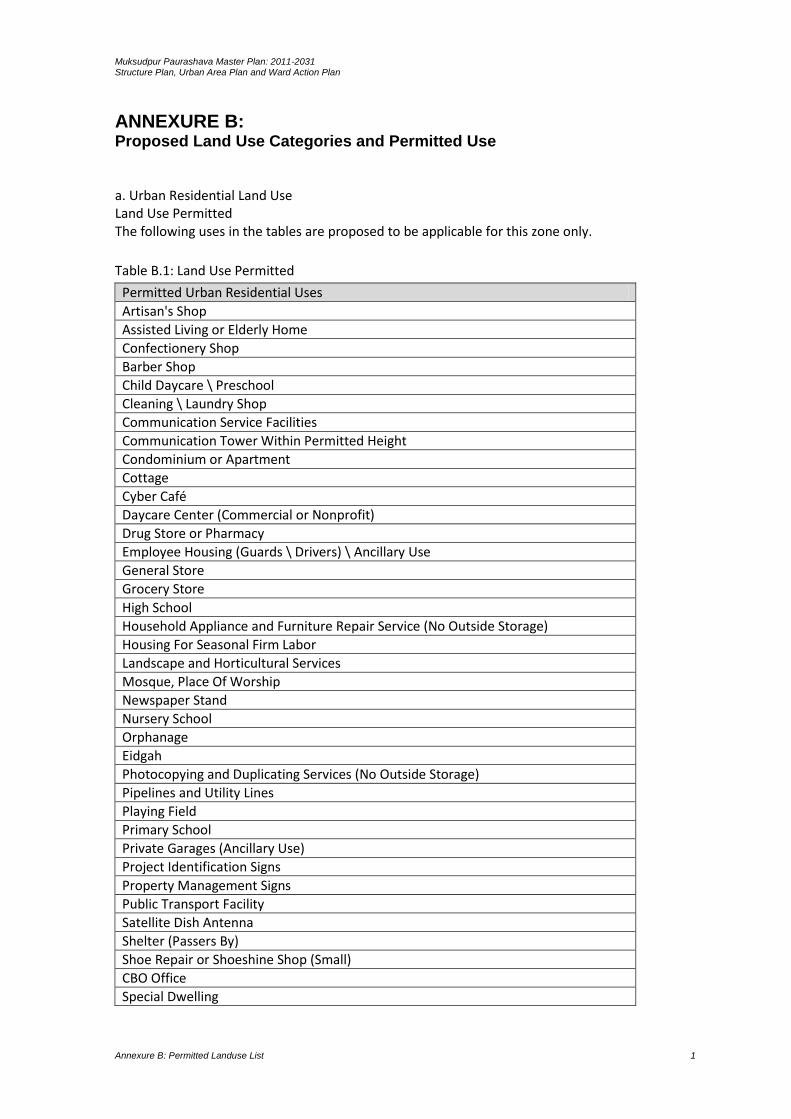
Muksudpur Paurashava Master Plan: 2011-2031 Structure Plan, Urban Area Plan and Ward Action Plan
Annexure B: Permitted Landuse List 1
ANNEXURE B: Proposed Land Use Categories and Permitted Use
a. Urban Residential Land Use Land Use Permitted The following uses in the tables are proposed to be applicable for this zone only.
Table B.1: Land Use Permitted
Permitted Urban Residential Uses
Artisan's Shop
Assisted Living or Elderly Home
Confectionery Shop
Barber Shop
Child Daycare \ Preschool
Cleaning \ Laundry Shop
Communication Service Facilities
Communication Tower Within Permitted Height
Condominium or Apartment
Cottage
Cyber Café
Daycare Center (Commercial or Nonprofit)
Drug Store or Pharmacy
Employee Housing (Guards \ Drivers) \ Ancillary Use
General Store
Grocery Store
High School
Household Appliance and Furniture Repair Service (No Outside Storage)
Housing For Seasonal Firm Labor
Landscape and Horticultural Services
Mosque, Place Of Worship
Newspaper Stand
Nursery School
Orphanage
Eidgah
Photocopying and Duplicating Services (No Outside Storage)
Pipelines and Utility Lines
Playing Field
Primary School
Private Garages (Ancillary Use)
Project Identification Signs
Property Management Signs
Public Transport Facility
Satellite Dish Antenna
Shelter (Passers By)
Shoe Repair or Shoeshine Shop (Small)
CBO Office
Special Dwelling

Muksudpur Paurashava Master Plan: 2011-2031 Structure Plan, Urban Area Plan and Ward Action Plan
Annexure B: Permitted Landuse List 2
Permitted Urban Residential Uses
Temporary Tent
Temporary tent for Permitted Function
Newspaper Stand
Specialized School: Dance, Art, Music, Physically Challenged & Others
Transmission Lines
Urban-Nature Reserve
Utility Lines
Woodlot
Children’s Park (Must Have Parking)
ATM Booth
Water Pump \ Reservoir
Monument (Neighborhood Scale)
Bill Payment Booth
Boarding and Rooming House
Dormitory
Memorial Structure (Ancillary)
Neighborhood Center* (Where Neighborhood Center exists)
Permitted
Community Center
Doctor \ Dentist Chamber
Cultural Exhibits and Libraries
Fast Food Establishment \ Food Kiosk
Flowers, Nursery Stock and Florist Supplies
Fitness Centre
Gaming Clubs
Departmental Stores
Retail Shops \ Facilities
Source: Compiled by the Consultants *Permission of Neighborhood Center Facilities in absence of formal neighborhood should be
subject to Landuse Permit Committee
Land Use Conditionally Permitted The following uses may be permitted or disallowed in this zone after review and approval by the
authority/committee following appropriate procedure while the application meets the criteria
mentioned in the requirement.
Table B.2: Land Use Conditionally Permitted
Conditionally Permitted Urban Residential Uses
Addiction Treatment Center
Amusement and Recreation (Indoors)
Funeral Services
Art Gallery, Art Studio \ Workshop
Automobile Driving Academy
Beauty and Body Service
Billiard Parlor \ Pool Hall
Book or Stationery Store or Newsstand
Building Maintenance \ Cleaning Services, No Outside Storage
Bus Passenger Shelter

Muksudpur Paurashava Master Plan: 2011-2031 Structure Plan, Urban Area Plan and Ward Action Plan
Annexure B: Permitted Landuse List 3
Conditionally Permitted Urban Residential Uses
Graveyard \ Cemetery
Coffee Shop \ Tea Stall
Correctional Institution
Courier Service
Crematorium
Plantation (Except Narcotic Plant)
Furniture & Variety Stores
Emergency Shelter
Energy Installation
Garages
Garden Center or Retail Nursery
Fire Brigade Station
Police Station
Temporary Rescue Shed
Guest House
Slaughter House
Static Transformer Stations
Tourist Home or Resort
Market (Bazar)
Optical Goods Sales
Outdoor Café
Outdoor Fruit and Vegetable Markets
Community Hall
Neighborhood Co-Operative Office
Overhead Water Storage Tanks
Row House
Paints and Varnishes Store
Parking Lot
Patio Homes
Photofinishing Laboratory
Post Office
Postal Facilities
Sports and Recreation Club
Tennis Club
Flood Management Structure
Telephone Sub Station
Electrical Sub Station
Source: Compiled by the Consultants
Restricted Uses All uses except permitted and conditionally permitted uses are restricted in this zone.
b. General Industry Land use Permitted General Industry land use category approve only Green and Orange-A category industry
mentioned in The Environmental Conservation Rule, 1997.The following uses in the tables are
proposed to be applicable for this zone only.

Muksudpur Paurashava Master Plan: 2011-2031 Structure Plan, Urban Area Plan and Ward Action Plan
Annexure B: Permitted Landuse List 4
Table B.3: Land Use Permitted
Permitted General Industrial Activities
Confectionery Shop
Bank & Financial Institution
Bicycle Assembly, Parts and Accessories
Blacksmith
Bus Passenger Shelter
Communication Tower Within Permitted Height
Freight Transport Facility
Police Box \ Barrack
Fire \ Rescue Station
Grocery Store
Household Appliance and Furniture Repair Service
Machine Sheds
Meat and Poultry (Packing & Processing)
Mosque, Place Of Worship
Newspaper Stand
Photocopying and Duplicating Services
Pipelines and Utility Lines
Printing, Publishing and Distributing
Public Transport Facility
Restaurant
Retail Shops \ Facilities
Salvage Processing
Salvage Yards
Satellite Dish Antenna
Sawmill, Chipping and Pallet Mill
Shelter (Passers By)
Television, Radio or Electronics Repair (No Outside Storage)
Transmission Lines
Truck Stop & Washing or Freight Terminal
Utility Lines
Wood Products
Woodlot
ATM Booth
Water Pump \ Reservoir
Effluent Treatment Plant
Social Forestry
Source: Compiled by the Consultants
Land Use Conditionally Permitted The following uses may be permitted or denied in this zone after review and approval by the
authority/committee following appropriate procedure.
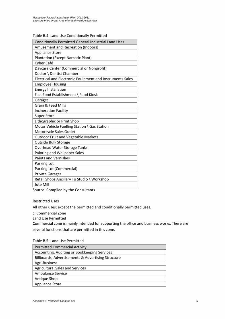
Muksudpur Paurashava Master Plan: 2011-2031 Structure Plan, Urban Area Plan and Ward Action Plan
Annexure B: Permitted Landuse List 5
Table B.4: Land Use Conditionally Permitted
Conditionally Permitted General Industrial Land Uses
Amusement and Recreation (Indoors)
Appliance Store
Plantation (Except Narcotic Plant)
Cyber Café
Daycare Center (Commercial or Nonprofit)
Doctor \ Dentist Chamber
Electrical and Electronic Equipment and Instruments Sales
Employee Housing
Energy Installation
Fast Food Establishment \ Food Kiosk
Garages
Grain & Feed Mills
Incineration Facility
Super Store
Lithographic or Print Shop
Motor Vehicle Fuelling Station \ Gas Station
Motorcycle Sales Outlet
Outdoor Fruit and Vegetable Markets
Outside Bulk Storage
Overhead Water Storage Tanks
Painting and Wallpaper Sales
Paints and Varnishes
Parking Lot
Parking Lot (Commercial)
Private Garages
Retail Shops Ancillary To Studio \ Workshop
Jute Mill
Source: Compiled by the Consultants
Restricted Uses
All other uses; except the permitted and conditionally permitted uses.
c. Commercial Zone Land Use Permitted Commercial zone is mainly intended for supporting the office and business works. There are
several functions that are permitted in this zone.
Table B.5: Land Use Permitted
Permitted Commercial Activity
Accounting, Auditing or Bookkeeping Services
Billboards, Advertisements & Advertising Structure
Agri-Business
Agricultural Sales and Services
Ambulance Service
Antique Shop
Appliance Store
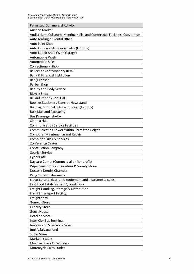
Muksudpur Paurashava Master Plan: 2011-2031 Structure Plan, Urban Area Plan and Ward Action Plan
Annexure B: Permitted Landuse List 6
Permitted Commercial Activity
Auction Market
Auditorium, Coliseum, Meeting Halls, and Conference Facilities, Convention
Auto Leasing or Rental Office
Auto Paint Shop
Auto Parts and Accessory Sales (Indoors)
Auto Repair Shop (With Garage)
Automobile Wash
Automobile Sales
Confectionery Shop
Bakery or Confectionery Retail
Bank & Financial Institution
Bar (Licensed)
Barber Shop
Beauty and Body Service
Bicycle Shop
Billiard Parlor \ Pool Hall
Book or Stationery Store or Newsstand
Building Material Sales or Storage (Indoors)
Bulk Mail and Packaging
Bus Passenger Shelter
Cinema Hall
Communication Service Facilities
Communication Tower Within Permitted Height
Computer Maintenance and Repair
Computer Sales & Services
Conference Center
Construction Company
Courier Service
Cyber Café
Daycare Center (Commercial or Nonprofit)
Department Stores, Furniture & Variety Stores
Doctor \ Dentist Chamber
Drug Store or Pharmacy
Electrical and Electronic Equipment and Instruments Sales
Fast Food Establishment \ Food Kiosk
Freight Handling, Storage & Distribution
Freight Transport Facility
Freight Yard
General Store
Grocery Store
Guest House
Hotel or Motel
Inter-City Bus Terminal
Jewelry and Silverware Sales
Junk \ Salvage Yard
Super Store
Market (Bazar)
Mosque, Place Of Worship
Motorcycle Sales Outlet
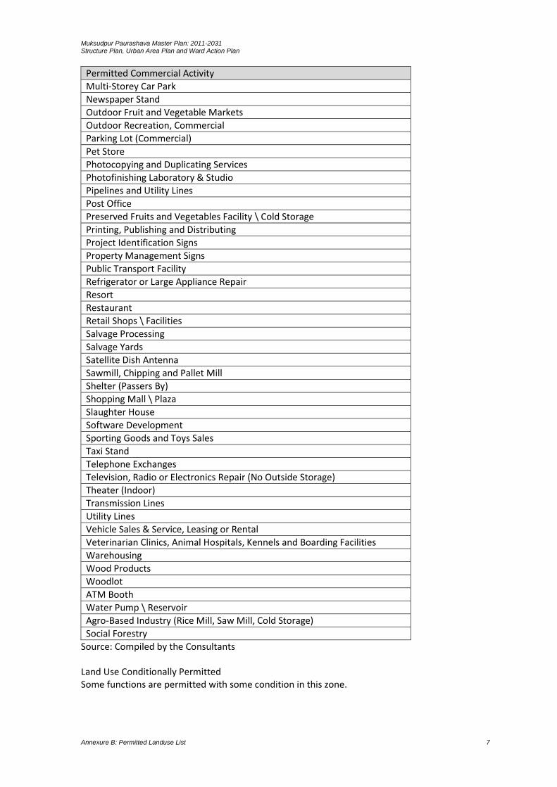
Muksudpur Paurashava Master Plan: 2011-2031 Structure Plan, Urban Area Plan and Ward Action Plan
Annexure B: Permitted Landuse List 7
Permitted Commercial Activity
Multi-Storey Car Park
Newspaper Stand
Outdoor Fruit and Vegetable Markets
Outdoor Recreation, Commercial
Parking Lot (Commercial)
Pet Store
Photocopying and Duplicating Services
Photofinishing Laboratory & Studio
Pipelines and Utility Lines
Post Office
Preserved Fruits and Vegetables Facility \ Cold Storage
Printing, Publishing and Distributing
Project Identification Signs
Property Management Signs
Public Transport Facility
Refrigerator or Large Appliance Repair
Resort
Restaurant
Retail Shops \ Facilities
Salvage Processing
Salvage Yards
Satellite Dish Antenna
Sawmill, Chipping and Pallet Mill
Shelter (Passers By)
Shopping Mall \ Plaza
Slaughter House
Software Development
Sporting Goods and Toys Sales
Taxi Stand
Telephone Exchanges
Television, Radio or Electronics Repair (No Outside Storage)
Theater (Indoor)
Transmission Lines
Utility Lines
Vehicle Sales & Service, Leasing or Rental
Veterinarian Clinics, Animal Hospitals, Kennels and Boarding Facilities
Warehousing
Wood Products
Woodlot
ATM Booth
Water Pump \ Reservoir
Agro-Based Industry (Rice Mill, Saw Mill, Cold Storage)
Social Forestry
Source: Compiled by the Consultants Land Use Conditionally Permitted Some functions are permitted with some condition in this zone.
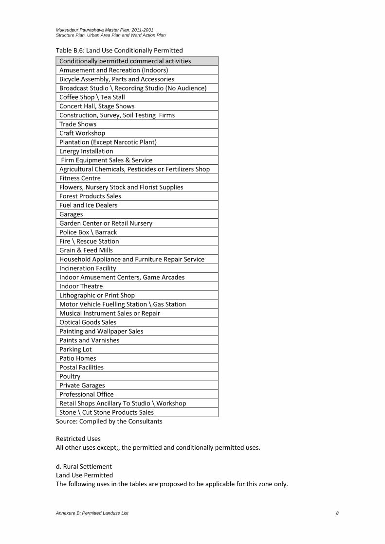
Muksudpur Paurashava Master Plan: 2011-2031 Structure Plan, Urban Area Plan and Ward Action Plan
Annexure B: Permitted Landuse List 8
Table B.6: Land Use Conditionally Permitted
Conditionally permitted commercial activities
Amusement and Recreation (Indoors)
Bicycle Assembly, Parts and Accessories
Broadcast Studio \ Recording Studio (No Audience)
Coffee Shop \ Tea Stall
Concert Hall, Stage Shows
Construction, Survey, Soil Testing Firms
Trade Shows
Craft Workshop
Plantation (Except Narcotic Plant)
Energy Installation
Firm Equipment Sales & Service
Agricultural Chemicals, Pesticides or Fertilizers Shop
Fitness Centre
Flowers, Nursery Stock and Florist Supplies
Forest Products Sales
Fuel and Ice Dealers
Garages
Garden Center or Retail Nursery
Police Box \ Barrack
Fire \ Rescue Station
Grain & Feed Mills
Household Appliance and Furniture Repair Service
Incineration Facility
Indoor Amusement Centers, Game Arcades
Indoor Theatre
Lithographic or Print Shop
Motor Vehicle Fuelling Station \ Gas Station
Musical Instrument Sales or Repair
Optical Goods Sales
Painting and Wallpaper Sales
Paints and Varnishes
Parking Lot
Patio Homes
Postal Facilities
Poultry
Private Garages
Professional Office
Retail Shops Ancillary To Studio \ Workshop
Stone \ Cut Stone Products Sales
Source: Compiled by the Consultants Restricted Uses All other uses except;, the permitted and conditionally permitted uses.
d. Rural Settlement Land Use Permitted The following uses in the tables are proposed to be applicable for this zone only.
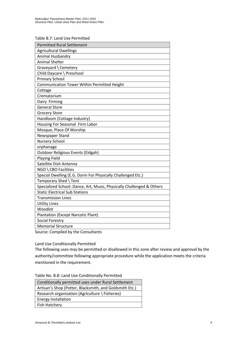
Muksudpur Paurashava Master Plan: 2011-2031 Structure Plan, Urban Area Plan and Ward Action Plan
Annexure B: Permitted Landuse List 9
Table B.7: Land Use Permitted
Permitted Rural Settlement
Agricultural Dwellings
Animal Husbandry
Animal Shelter
Graveyard \ Cemetery
Child Daycare \ Preschool
Primary School
Communication Tower Within Permitted Height
Cottage
Crematorium
Dairy Firming
General Store
Grocery Store
Handloom (Cottage Industry)
Housing For Seasonal Firm Labor
Mosque, Place Of Worship
Newspaper Stand
Nursery School
orphanage
Outdoor Religious Events (Eidgah)
Playing Field
Satellite Dish Antenna
NGO \ CBO Facilities
Special Dwelling (E.G. Dorm For Physically Challenged Etc.)
Temporary Shed \ Tent
Specialized School: Dance, Art, Music, Physically Challenged & Others
Static Electrical Sub Stations
Transmission Lines
Utility Lines
Woodlot
Plantation (Except Narcotic Plant)
Social Forestry
Memorial Structure
Source: Compiled by the Consultants
Land Use Conditionally Permitted The following uses may be permitted or disallowed in this zone after review and approval by the
authority/committee following appropriate procedure while the application meets the criteria
mentioned in the requirement.
Table No. B.8: Land Use Conditionally Permitted
Conditionally permitted uses under Rural Settlement
Artisan’s Shop (Potter, Blacksmith, and Goldsmith Etc.)
Research organization (Agriculture \ Fisheries)
Energy Installation
Fish Hatchery

Muksudpur Paurashava Master Plan: 2011-2031 Structure Plan, Urban Area Plan and Ward Action Plan
Annexure B: Permitted Landuse List 10
Conditionally permitted uses under Rural Settlement
Garden Center or Retail Nursery
Emergency Shelter
Sports and Recreation Club, Firing Range: Indoor
Source: Compiled by the Consultants
Restricted Uses All uses except permitted and conditionally permitted uses are restricted in this zone.
e. Mixed use zone Land Use Permitted The following uses in the tables are proposed to be applicable for this zone only.
Table B.11: Land Use Permitted
Permitted uses in Mixed Use Zone
Accounting, Auditing or Bookkeeping Services
Addiction Treatment Center
Billboards, Advertisements & Advertising Structure
Agricultural Sales and Services
Antique Store
Appliance Store
Art Gallery, Art Studio \ Workshop
Artisan’s Shop
Assisted Living or Elderly Home
Auditorium, Coliseum, Meeting Halls, and Conference Facilities, Convention
Auto Leasing or Rental Office
Automobile Wash
Automobile Driving Academy
Confectionery Shop
Bakery or Confectionery Retail
Bank & Financial Institution
Barber Shop
Bicycle Shop
Billiard Parlor \ Pool Hall
Blacksmith
Boarding and Rooming House
Book or Stationery Store or Newsstand
Bus Passenger Shelter
Child Daycare \ Preschool
Cleaning \ Laundry Shop
Commercial Recreational Buildings
Communication Service Facilities
Communication Tower Within Permitted Height
Community Center
Condominium or Apartment
Correctional Institution
Courier Service
Cyber Café
Daycare Center (Commercial or Nonprofit)
Doctor \ Dentist Chamber
Employee Housing
Fabric Store
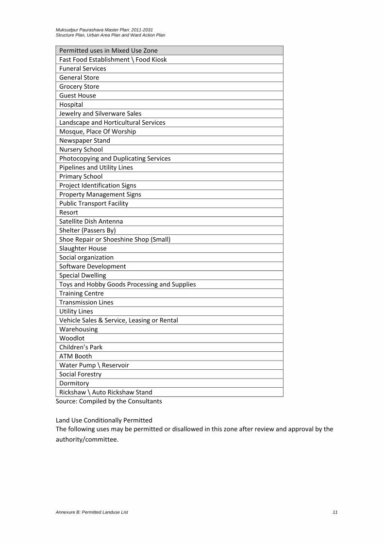
Muksudpur Paurashava Master Plan: 2011-2031 Structure Plan, Urban Area Plan and Ward Action Plan
Annexure B: Permitted Landuse List 11
Permitted uses in Mixed Use Zone
Fast Food Establishment \ Food Kiosk
Funeral Services
General Store
Grocery Store
Guest House
Hospital
Jewelry and Silverware Sales
Landscape and Horticultural Services
Mosque, Place Of Worship
Newspaper Stand
Nursery School
Photocopying and Duplicating Services
Pipelines and Utility Lines
Primary School
Project Identification Signs
Property Management Signs
Public Transport Facility
Resort
Satellite Dish Antenna
Shelter (Passers By)
Shoe Repair or Shoeshine Shop (Small)
Slaughter House
Social organization
Software Development
Special Dwelling
Toys and Hobby Goods Processing and Supplies
Training Centre
Transmission Lines
Utility Lines
Vehicle Sales & Service, Leasing or Rental
Warehousing
Woodlot
Children’s Park
ATM Booth
Water Pump \ Reservoir
Social Forestry
Dormitory
Rickshaw \ Auto Rickshaw Stand
Source: Compiled by the Consultants
Land Use Conditionally Permitted The following uses may be permitted or disallowed in this zone after review and approval by the
authority/committee.
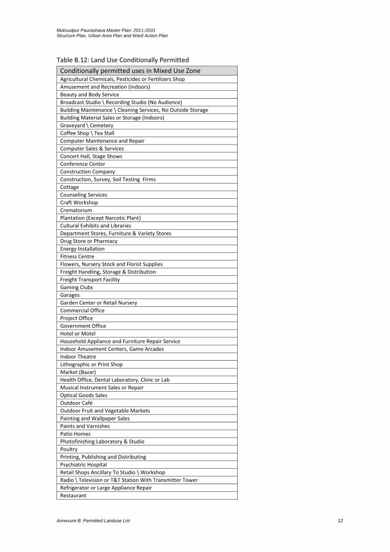
Muksudpur Paurashava Master Plan: 2011-2031 Structure Plan, Urban Area Plan and Ward Action Plan
Annexure B: Permitted Landuse List 12
Table B.12: Land Use Conditionally Permitted
Conditionally permitted uses in Mixed Use Zone Agricultural Chemicals, Pesticides or Fertilizers Shop
Amusement and Recreation (Indoors)
Beauty and Body Service
Broadcast Studio \ Recording Studio (No Audience)
Building Maintenance \ Cleaning Services, No Outside Storage
Building Material Sales or Storage (Indoors)
Graveyard \ Cemetery
Coffee Shop \ Tea Stall
Computer Maintenance and Repair
Computer Sales & Services
Concert Hall, Stage Shows
Conference Center
Construction Company
Construction, Survey, Soil Testing Firms
Cottage
Counseling Services
Craft Workshop
Crematorium
Plantation (Except Narcotic Plant)
Cultural Exhibits and Libraries
Department Stores, Furniture & Variety Stores
Drug Store or Pharmacy
Energy Installation
Fitness Centre
Flowers, Nursery Stock and Florist Supplies
Freight Handling, Storage & Distribution
Freight Transport Facility
Gaming Clubs
Garages
Garden Center or Retail Nursery
Commercial Office
Project Office
Government Office
Hotel or Motel
Household Appliance and Furniture Repair Service
Indoor Amusement Centers, Game Arcades
Indoor Theatre
Lithographic or Print Shop
Market (Bazar)
Health Office, Dental Laboratory, Clinic or Lab
Musical Instrument Sales or Repair
Optical Goods Sales
Outdoor Café
Outdoor Fruit and Vegetable Markets
Painting and Wallpaper Sales
Paints and Varnishes
Patio Homes
Photofinishing Laboratory & Studio
Poultry
Printing, Publishing and Distributing
Psychiatric Hospital
Retail Shops Ancillary To Studio \ Workshop
Radio \ Television or T&T Station With Transmitter Tower
Refrigerator or Large Appliance Repair
Restaurant

Muksudpur Paurashava Master Plan: 2011-2031 Structure Plan, Urban Area Plan and Ward Action Plan
Annexure B: Permitted Landuse List 13
Conditionally permitted uses in Mixed Use Zone Retail Shops \ Facilities
Sporting Goods and Toys Sales
Sports and Recreation Club, Firing Range: Indoor
Telephone Exchanges
Television, Radio or Electronics Repair (No Outside Storage)
Source: Compiled by the Consultants
Restricted Uses All uses except permitted and conditionally permitted uses are restricted in this zone.
f. Education and Research Area Land Use Permitted The following uses in the tables are proposed to be applicable for this zone only.
Table B.13: Land Use Permitted
Permitted uses under Education & Research Zone
Addiction Treatment Center
Billboards, Advertisements & Advertising Structure
Art Gallery, Art Studio \ Workshop
Automobile Driving Academy
Confectionery Shop
Bus Passenger Shelter
Child Daycare \ Preschool
College, University, Technical Institute
Communication Service Facilities
Communication Tower Within Permitted Height
Conference Center
Correctional Institution
Cultural Exhibits and Libraries
Cyber Café
Freight Transport Facility
General Store
Grocery Store
High School
Hospital
Lithographic or Print Shop
Mosque, Place Of Worship
Multi-Storey Car Park
Newspaper Stand
Nursery School
Outdoor Religious Events
Photocopying and Duplicating Services
Post Office
Primary School
Professional Office
Project Identification Signs
Property Management Signs
Public Transport Facility
Satellite Dish Antenna
School (Retarded)
Scientific Research Establishment
Shelter (Passers By)
Specialized School: Dance, Art, Music & Others

Muksudpur Paurashava Master Plan: 2011-2031 Structure Plan, Urban Area Plan and Ward Action Plan
Annexure B: Permitted Landuse List 14
Permitted uses under Education & Research Zone
Training Centre
Transmission Lines
Utility Lines
Vocational, Business, Secretarial School
Woodlot
ATM Booth
Water Pump \ Reservoir
Social Forestry
Dormitory
Veterinary School \ College and Hospital
Source: Compiled by the Consultants
Land Use Conditionally Permitted The following uses may be permitted or denied in this zone after review and approval by the
authority/committee.
Table B.14: Land Use Conditionally Permitted
Conditionally permitted uses under Education and Research Zone
Auditorium, Coliseum, Meeting Halls, and Conference Facilities, Convention
Bank & Financial Institution
Barber Shop
Boarding and Rooming House
Book or Stationery Store or Newsstand
Coffee Shop \ Tea Stall
Counseling Services
Courier Service
Plantation (Except Narcotic Plant)
Daycare Center (Commercial or Nonprofit)
Doctor \ Dentist Chamber
Drug Store or Pharmacy
Fast Food Establishment \ Food Kiosk
Flowers, Nursery Stock and Florist Supplies
Gallery \ Museum
Garages
Indoor Theatre
orphanage
Outdoor Café
Parking Lot
Pipelines and Utility Lines
Postal Facilities
Psychiatric Hospital
Source: Compiled by the Consultants
Restricted Uses All uses except permitted and conditionally permitted uses are restricted in this zone.
g. Government Office Land Use Permitted The following uses in the tables are proposed to be applicable for this zone only.

Muksudpur Paurashava Master Plan: 2011-2031 Structure Plan, Urban Area Plan and Ward Action Plan
Annexure B: Permitted Landuse List 15
Table B.15: Land Use Permitted
Permitted uses under Government Office Zone
Accounting, Auditing or Bookkeeping Services
Billboards, Advertisements & Advertising Structure
Confectionery Shop
Bus Passenger Shelter
Civic Administration
Communication Service Facilities
Communication Tower Within Permitted Height
Construction, Survey, Soil Testing Firms
Cultural Exhibits and Libraries
Cyber Café
Emergency Shelter
Freight Transport Facility
General Store
Project Office
Government Office
Grocery Store
Guest House
Multi-Storey Car Park
Newspaper Stand
Outdoor Religious Events
Photocopying and Duplicating Services
Post Office
Professional Office
Public Transport Facility
Satellite Dish Antenna
Scientific Research Establishment
Shelter (Passers By)
Training Centre
Transmission Lines
Utility Lines
Woodlot
ATM Booth
Water Pump \ Reservoir
Social Forestry
Source: Compiled by the Consultants
Land Use Conditionally Permitted The following uses may be permitted or denied in this zone after review and approval by the
authority/committee.
Table B.16: Land Use Conditionally Permitted
Conditionally permitted uses under Government office
Amusement and Recreation (Indoors)
Auditorium, Coliseum, Meeting Halls, and Conference Facilities, Convention
Bank & Financial Institution
Boarding and Rooming House
Book or Stationery Store or Newsstand
Coffee Shop \ Tea Stall

Muksudpur Paurashava Master Plan: 2011-2031 Structure Plan, Urban Area Plan and Ward Action Plan
Annexure B: Permitted Landuse List 16
Conditionally permitted uses under Government office
Conference Center
Courier Service
Plantation (Except Narcotic Plant)
Daycare Center (Commercial or Nonprofit)
Detention Facilities
Doctor \ Dentist Chamber
Energy Installation
Fast Food Establishment \ Food Kiosk
Flowers, Nursery Stock and Florist Supplies
Freight Handling, Storage & Distribution
Freight Yard
Gallery \ Museum
Garages
Police Box \ Barrack
Fire \ Rescue Station
Lithographic or Print Shop
Mosque, Place Of Worship
Outdoor Café
Parking Lot
Parking Lot (Commercial)
Pipelines and Utility Lines
Postal Facilities
Source: Compiled by the Consultants
Restricted Uses All uses except permitted and conditionally permitted uses are restricted in this zone.
h. Agricultural Zone Land Use Permitted The following uses in the tables are proposed to be applicable for this zone only.
Table B.17: Land Use Permitted
Permitted uses under Agricultural Zone
Food Grain Cultivation
Vegetable Cultivation
Cash Crop Cultivation
Horticulture
Arboriculture
Dairy Firming
Deep Tube Well
Shallow Tube Well
Irrigation Facilities (Irrigation Canal, Culvert, Flood Wall etc)
Temporary Structure (Agricultural)
Animal Shelter
Duckery
Aquatic Recreation Facility (Without Structure)
Tree Plantation (Except Narcotic Plant)
Aquaculture
Static Transformer Stations
Transmission Lines

Muksudpur Paurashava Master Plan: 2011-2031 Structure Plan, Urban Area Plan and Ward Action Plan
Annexure B: Permitted Landuse List 17
Permitted uses under Agricultural Zone
Utility Lines
Woodlot
Social Forestry
Source: Compiled by the Consultants Land Use Conditionally Permitted Table B.18: Land Use Conditionally Permitted
Conditionally permitted uses under Agricultural Zone
Graveyard \ Cemetery
Communication Tower Within Permitted Height
Crematorium
Fish Hatchery
Garden Center or Retail Nursery
Poultry
Source: Compiled by the Consultants Restricted Uses All uses except permitted and conditionally permitted uses are restricted in this zone.
j. Open Space Land Use Permitted The following uses in the tables are proposed to be applicable for this zone only.
Table B.19: Land Use Permitted
Permitted uses under Open Space
Botanical Garden & Arboretum
Bus Passenger Shelter
Caravan Park \ Camping Ground
Carnivals and Fairs
Circus
Plantation (Except Narcotic Plant)
Landscape and Horticultural Services
Open Theater
Park and Recreation Facilities (General)
Pipelines and Utility Lines
Playing Field
Special Function Tent
Tennis Club
Transmission Lines
Urban-Nature Reserve
Utility Lines
Woodlot
Zoo
Roadside Parking
Social Forestry
Memorial Structure
Source: Compiled by the Consultants
Landuse Conditionally Permitted

Muksudpur Paurashava Master Plan: 2011-2031 Structure Plan, Urban Area Plan and Ward Action Plan
Annexure B: Permitted Landuse List 18
Table B.20: Land Use Conditionally Permitted
Conditionally permitted uses under open space
Communication Tower Within Permitted Height
Trade Shows
Fitness Centre
Flowers, Nursery Stock and Florist Supplies
Golf Course
Motorized Recreation
Outdoor Recreation Facilities
Outdoor Recreation, Commercial
Outdoor Sports and Recreation
Park Maintenance Facility
Retreat Center
Sports and Recreation Club, Firing Range: Indoor
Source: Compiled by the Consultants
Restricted Uses All uses except permitted and conditionally permitted uses are restricted.
k. Water Body Retaining water is the main purpose of this type of Landuse.
Land Use Permitted The following uses in the tables are proposed to be applicable for this zone only.
Table B.21: Land Use Permitted
Permitted uses under Water Body
Aquatic Recreation Facility (Without Structure)
Fishing Club
Utility Lines
Water Parks
Memorial Structure
Source: Compiled by the Consultants
Land Use Conditionally Permitted The following uses may be permitted or denied in this zone after review and approval by the
authority/committee.
Table B.22: Land Use Conditionally Permitted
Conditionally permitted uses under water body
Plantation (Except Narcotic Plant)
Marina \ Boating Facility
Motorized Recreation
Source: Compiled by the Consultants
Restricted Uses
All uses except perm

Muksudpur Paurashava Master Plan: 2011-2031 Structure Plan, Urban Area Plan and Ward Action Plan
Annexure C: Resolution of Final Consultation Meeting and Attendance List 1
ANNEXURE C: Resolution of Final Consultation Meeting and Attendance List.
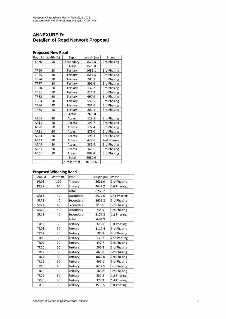
Muksudpur Paurashava Master Plan: 2011-2031 Structure Plan, Urban Area Plan and Ward Action Plan
Annexure D: Details of Road Network Proposal 1
ANNEXURE D: Detailed of Road Network Proposal
Proposed New Road Road Id Width (ft) Type Length (m) Phase
SR76 40 Secondary 1576.8 3rd Phasing
Total 1576.8
TR50 30 Tertiary 1683.1 3rd Phasing
TR55 30 Tertiary 1544.6 3rd Phasing
TR74 30 Tertiary 285.1 3rd Phasing
TR77 30 Tertiary 399.6 3rd Phasing
TR80 20 Tertiary 132.7 3rd Phasing
TR81 30 Tertiary 214.2 3rd Phasing
TR82 30 Tertiary 667.9 3rd Phasing
TR83 30 Tertiary 556.5 3rd Phasing
TR84 30 Tertiary 232.8 3rd Phasing
TR85 20 Tertiary 209.4 3rd Phasing
Total 5925.8
AR06 20 Access 118.5 3rd Phasing
AR11 20 Access 193.7 3rd Phasing
AR20 20 Access 177.4 3rd Phasing
AR31 20 Access 278.0 3rd Phasing
AR34 20 Access 198.3 3rd Phasing
AR42 20 Access 429.6 2nd Phasing
AR49 20 Access 389.4 3rd Phasing
AR51 20 Access 67.5 3rd Phasing
AR66 20 Access 807.4 3rd Phasing
Total 2660.0
Gross Total 10162.6
Proposed Widening Road
Road Id Width (ft) Type Length (m) Phase
PR03 120 Primary 3621.9 3rd Phasing
PR27 60 Primary 4647.2 1st Phasing
Total 8269.2
SR13 40 Secondary 2512.6 2nd Phasing
SR72 40 Secondary 1458.2 3rd Phasing
SR71 40 Secondary 816.8 3rd Phasing
SR70 40 Secondary 734.5 3rd Phasing
SR28 40 Secondary 2172.8 1st Phasing
Total 7694.9
TR02 30 Tertiary 326.1 1st Phasing
TR05 30 Tertiary 1117.4 3rd Phasing
TR07 30 Tertiary 180.8 3rd Phasing
TR08 30 Tertiary 139.7 2nd Phasing
TR09 30 Tertiary 447.7 3rd Phasing
TR10 30 Tertiary 206.8 3rd Phasing
TR12 30 Tertiary 468.9 3rd Phasing
TR14 30 Tertiary 1862.0 3rd Phasing
TR15 30 Tertiary 466.1 3rd Phasing
TR16 40 Tertiary 2617.5 3rd Phasing
TR26 30 Tertiary 168.8 3rd Phasing
TR29 30 Tertiary 557.6 1st Phasing
TR30 30 Tertiary 377.3 1st Phasing
TR32 30 Tertiary 1519.5 1st Phasing
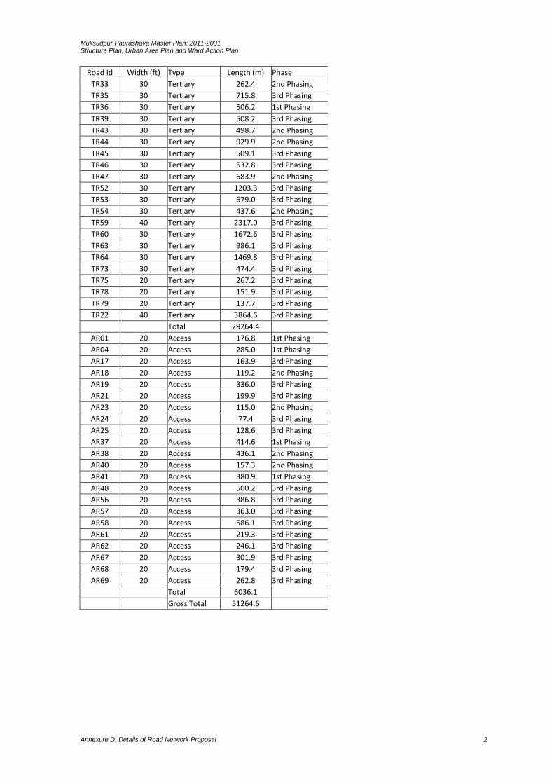
Muksudpur Paurashava Master Plan: 2011-2031 Structure Plan, Urban Area Plan and Ward Action Plan
Annexure D: Details of Road Network Proposal 2
Road Id Width (ft) Type Length (m) Phase
TR33 30 Tertiary 262.4 2nd Phasing
TR35 30 Tertiary 715.8 3rd Phasing
TR36 30 Tertiary 506.2 1st Phasing
TR39 30 Tertiary 508.2 3rd Phasing
TR43 30 Tertiary 498.7 2nd Phasing
TR44 30 Tertiary 929.9 2nd Phasing
TR45 30 Tertiary 509.1 3rd Phasing
TR46 30 Tertiary 532.8 3rd Phasing
TR47 30 Tertiary 683.9 2nd Phasing
TR52 30 Tertiary 1203.3 3rd Phasing
TR53 30 Tertiary 679.0 3rd Phasing
TR54 30 Tertiary 437.6 2nd Phasing
TR59 40 Tertiary 2317.0 3rd Phasing
TR60 30 Tertiary 1672.6 3rd Phasing
TR63 30 Tertiary 986.1 3rd Phasing
TR64 30 Tertiary 1469.8 3rd Phasing
TR73 30 Tertiary 474.4 3rd Phasing
TR75 20 Tertiary 267.2 3rd Phasing
TR78 20 Tertiary 151.9 3rd Phasing
TR79 20 Tertiary 137.7 3rd Phasing
TR22 40 Tertiary 3864.6 3rd Phasing
Total 29264.4
AR01 20 Access 176.8 1st Phasing
AR04 20 Access 285.0 1st Phasing
AR17 20 Access 163.9 3rd Phasing
AR18 20 Access 119.2 2nd Phasing
AR19 20 Access 336.0 3rd Phasing
AR21 20 Access 199.9 3rd Phasing
AR23 20 Access 115.0 2nd Phasing
AR24 20 Access 77.4 3rd Phasing
AR25 20 Access 128.6 3rd Phasing
AR37 20 Access 414.6 1st Phasing
AR38 20 Access 436.1 2nd Phasing
AR40 20 Access 157.3 2nd Phasing
AR41 20 Access 380.9 1st Phasing
AR48 20 Access 500.2 3rd Phasing
AR56 20 Access 386.8 3rd Phasing
AR57 20 Access 363.0 3rd Phasing
AR58 20 Access 586.1 3rd Phasing
AR61 20 Access 219.3 3rd Phasing
AR62 20 Access 246.1 3rd Phasing
AR67 20 Access 301.9 3rd Phasing
AR68 20 Access 179.4 3rd Phasing
AR69 20 Access 262.8 3rd Phasing
Total 6036.1
Gross Total 51264.6

Muksudpur Paurashava Master Plan: 2011-2031 Structure Plan, Urban Area Plan and Ward Action Plan
Annexure E: Details Drainage Network Proposal 1
ANNEXURE E: Details of Drainage Network Proposal
Drain Id Type Width (m) Length (m) Phase
PD 01 Primary Above 3m 1927.5 2nd Phase
PD 02 Primary Above 3m 1668.7 1st Phase
PD 06 Primary Above 3m 2319.1 2nd Phase
PD 05 Primary Above 3m 643.9 3rd Phase
TD 37 Primary Less 1.5m 200.4 1st Phase
PD 04 Primary Above 3m 426.3 1st Phase
PD 01 Primary Above 3m 1443.3 2nd Phase
PD 03 Primary Above 3m 461.8 3rd Phase
PD 03 Primary Above 3m 1263.5 3rd Phase
Sub Total 10354.5
SD 13 Secondary Within 1.5m to 3m 1183.3 2nd Phase
SD 07 Secondary Within 1.5m to 3m 1324.1 3rd Phase
SD 08 Secondary Within 1.5m to 3m 3011.6 1st Phase
SD 15 Secondary Within 1.5m to 3m 1233.4 3rd Phase
SD 18 Secondary Within 1.5m to 3m 367.8 2nd Phase
SD 17 Secondary Within 1.5m to 3m 421.6 3rd Phase
SD 16 Secondary Within 1.5m to 3m 230.9 2nd Phase
SD 14 Secondary Within 1.5m to 3m 1161.7 1st Phase
SD 11 Secondary Within 1.5m to 3m 1519.1 2nd Phase
SD 10 Secondary Within 1.5m to 3m 439.5 3rd Phase
SD 09 Secondary Within 1.5m to 3m 1551.3 1st Phase
SD 12 Secondary Within 1.5m to 3m 422.1 3rd Phase
SD 13 Secondary Within 1.5m to 3m 981.3 2nd Phase
SD 07 Secondary Within 1.5m to 3m 1208.8 3rd Phase
Sub Total 15056.7
TD 22 Tertiary Less 1.5m 807.5 2nd Phase
TD 89 Tertiary Less 1.5m 754.4 1st Phase
TD 73 Tertiary Less 1.5m 400.4 3rd Phase
TD 69 Tertiary Less 1.5m 467.7 1st Phase
TD 49 Tertiary Less 1.5m 479.1 2nd Phase
TD 47 Tertiary Less 1.5m 1061.8 1st Phase
TD 46 Tertiary Less 1.5m 608.6 3rd Phase
TD 34 Tertiary Less 1.5m 689.6 2nd Phase
TD 30 Tertiary Less 1.5m 9.8 3rd Phase
TD 19 Tertiary Less 1.5m 465.9 3rd Phase
TD 20 Tertiary Less 1.5m 406.0 1st Phase
TD 21 Tertiary Less 1.5m 436.9 3rd Phase
TD 23 Tertiary Less 1.5m 236.7 3rd Phase
TD 24 Tertiary Less 1.5m 504.6 3rd Phase
TD 25 Tertiary Less 1.5m 184.6 1st Phase
TD 26 Tertiary Less 1.5m 209.8 3rd Phase
TD 27 Tertiary Less 1.5m 575.6 3rd Phase
TD 28 Tertiary Less 1.5m 379.4 2nd Phase
TD 29 Tertiary Less 1.5m 236.1 3rd Phase
TD 31 Tertiary Less 1.5m 234.0 1st Phase
TD 32 Tertiary Less 1.5m 419.1 3rd Phase
TD 35 Tertiary Less 1.5m 547.9 3rd Phase
TD 36 Tertiary Less 1.5m 60.7 3rd Phase
TD 38 Tertiary Less 1.5m 179.9 3rd Phase
TD 39 Tertiary Less 1.5m 136.5 3rd Phase
TD 40 Tertiary Less 1.5m 324.5 2nd Phase
TD 41 Tertiary Less 1.5m 148.9 3rd Phase
TD 42 Tertiary Less 1.5m 365.0 3rd Phase
TD 43 Tertiary Less 1.5m 131.2 3rd Phase
TD 44 Tertiary Less 1.5m 298.2 1st Phase
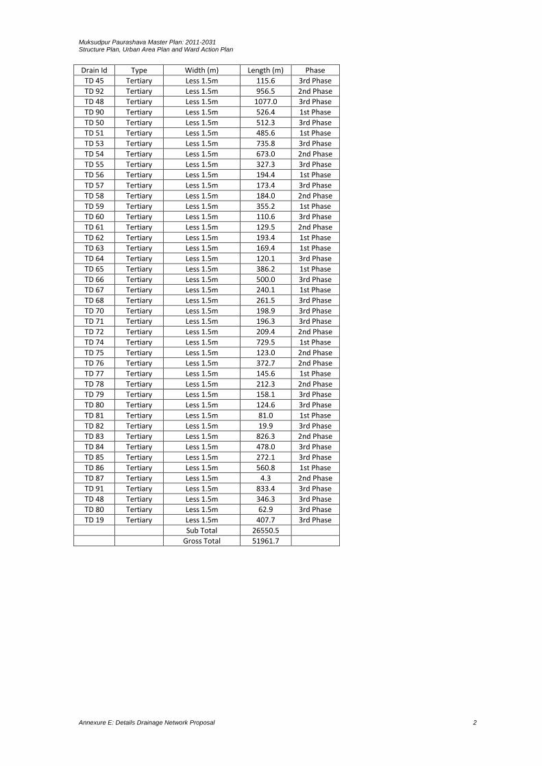
Muksudpur Paurashava Master Plan: 2011-2031 Structure Plan, Urban Area Plan and Ward Action Plan
Annexure E: Details Drainage Network Proposal 2
Drain Id Type Width (m) Length (m) Phase
TD 45 Tertiary Less 1.5m 115.6 3rd Phase
TD 92 Tertiary Less 1.5m 956.5 2nd Phase
TD 48 Tertiary Less 1.5m 1077.0 3rd Phase
TD 90 Tertiary Less 1.5m 526.4 1st Phase
TD 50 Tertiary Less 1.5m 512.3 3rd Phase
TD 51 Tertiary Less 1.5m 485.6 1st Phase
TD 53 Tertiary Less 1.5m 735.8 3rd Phase
TD 54 Tertiary Less 1.5m 673.0 2nd Phase
TD 55 Tertiary Less 1.5m 327.3 3rd Phase
TD 56 Tertiary Less 1.5m 194.4 1st Phase
TD 57 Tertiary Less 1.5m 173.4 3rd Phase
TD 58 Tertiary Less 1.5m 184.0 2nd Phase
TD 59 Tertiary Less 1.5m 355.2 1st Phase
TD 60 Tertiary Less 1.5m 110.6 3rd Phase
TD 61 Tertiary Less 1.5m 129.5 2nd Phase
TD 62 Tertiary Less 1.5m 193.4 1st Phase
TD 63 Tertiary Less 1.5m 169.4 1st Phase
TD 64 Tertiary Less 1.5m 120.1 3rd Phase
TD 65 Tertiary Less 1.5m 386.2 1st Phase
TD 66 Tertiary Less 1.5m 500.0 3rd Phase
TD 67 Tertiary Less 1.5m 240.1 1st Phase
TD 68 Tertiary Less 1.5m 261.5 3rd Phase
TD 70 Tertiary Less 1.5m 198.9 3rd Phase
TD 71 Tertiary Less 1.5m 196.3 3rd Phase
TD 72 Tertiary Less 1.5m 209.4 2nd Phase
TD 74 Tertiary Less 1.5m 729.5 1st Phase
TD 75 Tertiary Less 1.5m 123.0 2nd Phase
TD 76 Tertiary Less 1.5m 372.7 2nd Phase
TD 77 Tertiary Less 1.5m 145.6 1st Phase
TD 78 Tertiary Less 1.5m 212.3 2nd Phase
TD 79 Tertiary Less 1.5m 158.1 3rd Phase
TD 80 Tertiary Less 1.5m 124.6 3rd Phase
TD 81 Tertiary Less 1.5m 81.0 1st Phase
TD 82 Tertiary Less 1.5m 19.9 3rd Phase
TD 83 Tertiary Less 1.5m 826.3 2nd Phase
TD 84 Tertiary Less 1.5m 478.0 3rd Phase
TD 85 Tertiary Less 1.5m 272.1 3rd Phase
TD 86 Tertiary Less 1.5m 560.8 1st Phase
TD 87 Tertiary Less 1.5m 4.3 2nd Phase
TD 91 Tertiary Less 1.5m 833.4 3rd Phase
TD 48 Tertiary Less 1.5m 346.3 3rd Phase
TD 80 Tertiary Less 1.5m 62.9 3rd Phase
TD 19 Tertiary Less 1.5m 407.7 3rd Phase
Sub Total 26550.5
Gross Total 51961.7

Muksudpur Paurashava Master Plan: 2011-2031 Structure Plan, Urban Area Plan and Ward Action Plan
Annexure F: Mouza Schedule of Development Proposal 1
ANNEXURE F: Mouza Schedule of Development Proposal
Proposed Facility Landuse Ward No Mouza Name Plot No Area (acre)
Proposed Dumping Site Utility Out of Paurashava
2.25
Proposed Waste Transfer Station 01
Utility 6 Tenrakhola_00 303 0.06
Proposed Waste Transfer Station 02
Utility 4 Dakshin Chandibardi_00 171 0.38
Total 2.69
Proposed Bus Terminal Transport 4 Dakshin Chandibardi _058_00
28-33 1.08
Proposed Truck Terminal
Transport 4 Dakshin Chandibardi _058_00
22-27 0.99
Proposed Bus Stand 02 Transport 4 Dakshin Chandibardi _058_00
285 0.53
Proposed Bus Stand 01 Transport 4 Dakshin Chandibardi _058_00
365,379-80 0.49
Total 3.09
Proposed Housing Residential 9 Golabaria_068_00 14-25,37-55,241-287 20.66
Proposed Low Income Housing
Residential 1 Lakhair Char_01 581,584-85 1.73
Proposed Rehabilitation Zone
Residential 1 Lakhair Char_01 770-77, 582-83
2.38
Total 24.77
Proposed Park 01 Open Space
8 Kamalapur_060_01 52-57,63,86,87 1.89
Pr0posed Park 02 Open Space
3 Prabhakardi_002_02 1090-1093,1177-80 5.97
Proposed Stadium Open Space
3 Prabhakardi_002_03 2207-2220 6.02
Proposed Playground 01 Open Space
7 Kamalapur_02 1554 0.54
Proposed Playground 02 Open Space
5 Gopinathpur_00 1025,1032,1034 0.94
Total 15.36
Proposed Hospital 01 Health 7 Kamalapur_02 1748-53 3.15
Proposed Hospital 02 Health 1 Lakhair Char_02 1739-41 3.24
Total 6.39
Proposed Primary School
Education 5 Gopinathpur_00 1063-80 1.32
Proposed Technical College
Education 7 Kamalapur_060_02 1664-77 3.51
Proposed University Education 7 Kamalapur_060_02 1233-39, 1587-1511 10.35
Total 15.18
Proposed Industry Industrial Area
3 Prabhakardi_002_02 1197-1222 11.65
Proposed Eidgha Community 6 Tenrakhola_059_0 68,121 3.39
Proposed Community Center
Community 4 Dakshin Chandibardi _058_00
269,270 0.13
Proposed Graveyard Community 1 Lakhair Char_001 1738,1739 2.85
Proposed Ward Center 01
Community 1 Lakhair Char_001_02 1494 0.20
Proposed Ward Center 02
Community 2 Prabhakardi_002_01 314-15 0.63
Proposed Ward Center 03
Community 3 Prabhakardi_002_02 1181 0.56
Proposed Ward Center 04
Community 4 Dakshin Chandibardi _058_00
165 0.15

Muksudpur Paurashava Master Plan: 2011-2031 Structure Plan, Urban Area Plan and Ward Action Plan
Annexure F: Mouza Schedule of Development Proposal 2
Proposed Facility Landuse Ward No Mouza Name Plot No Area (acre)
Proposed Ward Center 05
Community 5 Gopinathpur_057_00 1132 0.22
Proposed Ward Center 06
Community 6 Tenrakhola_059_00 385 0.28
Proposed Ward Center 07
Community 7 Kamalapur_060_02 1765-66 0.31
Proposed Ward Center 08
Community 8 Kamalapur_060_01 273 0.34
Proposed Ward Center 09
Community 9 Golabaria_068_00 337-38 0.42
Total 21.13
Gross Total 89.32

Muksudpur Paurashava Master Plan: 2011-2031 Structure Plan, Urban Area Plan and Ward Action Plan
Annexure G: Mouza Schedule of Water Retention Pond 1
ANNEXURE G: Proposed Water body Land Schedule
Id No. Type Mouza Plot
RP1
River Prabhakardi_002_02 1052
River Prabhakardi_002_02 1024
River Prabhakardi_002_02 1025
River Prabhakardi_002_02 999
River Prabhakardi_002_02 1072
River Prabhakardi_002_02 1078
River Prabhakardi_002_02 1073
River Prabhakardi_002_02 1079
River Prabhakardi_002_02 1080
River Prabhakardi_002_02 1086
River Prabhakardi_002_02 1074
River Prabhakardi_002_02 1075
River Prabhakardi_002_02 1076
River Prabhakardi_002_02 1026
River Prabhakardi_002_02 1070
River Prabhakardi_002_02 1023
River Prabhakardi_002_02 1000
River Prabhakardi_002_02 983
River Prabhakardi_002_02 982
River Prabhakardi_002_02 981
River Prabhakardi_002_02 1008
River Prabhakardi_002_02 973
River Prabhakardi_002_02 945
River Prabhakardi_002_02 944
River Prabhakardi_002_02 943
RP10
Khal Prabhakardi_002_02 1173
Khal Prabhakardi_002_02 1175
Khal Prabhakardi_002_02 1082
Khal Prabhakardi_002_02 1172
Khal Prabhakardi_002_02 1171
Khal Prabhakardi_002_02 1170
Khal Prabhakardi_002_02 1169
Khal Prabhakardi_002_02 1179
Khal Prabhakardi_002_02 1167
Khal Prabhakardi_002_02 1166
Khal Prabhakardi_002_02 1160
Khal Prabhakardi_002_02 1158
Khal Prabhakardi_002_02 1180
Khal Prabhakardi_002_02 1190
Khal Prabhakardi_002_02 1191
Khal Prabhakardi_002_02 1157
Khal Prabhakardi_002_02 1193
Khal Prabhakardi_002_02 1168
Khal Prabhakardi_002_02 872
Khal Prabhakardi_002_02 871
Khal Prabhakardi_002_02 870
Khal Prabhakardi_002_02 869
Khal Prabhakardi_002_02 890
RP100
Ditch Kamalapur_060_03 2705
Ditch Kamalapur_060_03 2706
Ditch Kamalapur_060_03 2707
Id No. Type Mouza Plot
Ditch Kamalapur_060_03 2708
Ditch Kamalapur_060_03 2709
RP101
Pond Kamalapur_060_03 2718
Pond Kamalapur_060_03 2719
RP102
Khal Kamalapur_060_03 2721
Khal Kamalapur_060_03 2722
Khal Kamalapur_060_03 2723
Khal Kamalapur_060_03 2724
Khal Kamalapur_060_03 2747
Khal Kamalapur_060_03 2748
Khal Kamalapur_060_03 2758
Khal Kamalapur_060_03 2759
Khal Kamalapur_060_03 2760
Khal Kamalapur_060_03 2761
Khal Golabaria_068_00 306
Khal Golabaria_068_00 309
Khal Golabaria_068_00 298
Khal Golabaria_068_00 297
Khal Golabaria_068_00 271
Khal Golabaria_068_00 287
Khal Golabaria_068_00 286
Khal Golabaria_068_00 285
Khal Golabaria_068_00 272
Khal Golabaria_068_00 276
Khal Golabaria_068_00 280
Khal Golabaria_068_00 281
Khal Golabaria_068_00 282
RP103
Khal Golabaria_068_00 241
Khal Golabaria_068_00 242
Khal Golabaria_068_00 55
Khal Golabaria_068_00 54
Khal Golabaria_068_00 53
Khal Hogladanga_067_00 146
Khal Golabaria_068_00 51
Khal Golabaria_068_00 50
Khal Golabaria_068_00 49
Khal Golabaria_068_00 22
Khal Golabaria_068_00 14
Khal Golabaria_068_00 18
Khal Golabaria_068_00 16
Khal Golabaria_068_00 17
Khal Hogladanga_067_00 145
Khal Golabaria_068_00 24
Khal Golabaria_068_00 23
Khal Hogladanga_067_00 144
Khal Hogladanga_067_00 142
Khal Hogladanga_067_00 221
Khal Hogladanga_067_00 141
Khal Hogladanga_067_00 220
Khal Hogladanga_067_00 222
Khal Hogladanga_067_00 194
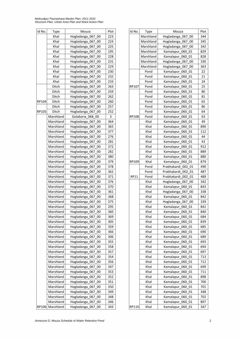
Muksudpur Paurashava Master Plan: 2011-2031 Structure Plan, Urban Area Plan and Ward Action Plan
Annexure G: Mouza Schedule of Water Retention Pond 2
Id No. Type Mouza Plot
Khal Hogladanga_067_00 223
Khal Hogladanga_067_00 224
Khal Hogladanga_067_00 225
Khal Hogladanga_067_00 195
Khal Hogladanga_067_00 228
Khal Hogladanga_067_00 231
Khal Hogladanga_067_00 229
Khal Hogladanga_067_00 230
Khal Hogladanga_067_00 232
Khal Hogladanga_067_00 233
RP104
Ditch Hogladanga_067_00 263
Ditch Hogladanga_067_00 259
Ditch Hogladanga_067_00 262
Ditch Hogladanga_067_00 260
RP105
Ditch Hogladanga_067_00 257
Ditch Hogladanga_067_00 252
RP106
Marshland Golabaria_068_00 3
Marshland Hogladanga_067_00 364
Marshland Hogladanga_067_00 365
Marshland Hogladanga_067_00 377
Marshland Hogladanga_067_00 276
Marshland Hogladanga_067_00 281
Marshland Hogladanga_067_00 372
Marshland Hogladanga_067_00 282
Marshland Hogladanga_067_00 380
Marshland Hogladanga_067_00 379
Marshland Hogladanga_067_00 378
Marshland Hogladanga_067_00 362
Marshland Hogladanga_067_00 371
Marshland Hogladanga_067_00 376
Marshland Hogladanga_067_00 370
Marshland Hogladanga_067_00 361
Marshland Hogladanga_067_00 368
Marshland Hogladanga_067_00 375
Marshland Hogladanga_067_00 295
Marshland Hogladanga_067_00 360
Marshland Hogladanga_067_00 369
Marshland Hogladanga_067_00 305
Marshland Hogladanga_067_00 359
Marshland Hogladanga_067_00 366
Marshland Hogladanga_067_00 306
Marshland Hogladanga_067_00 355
Marshland Hogladanga_067_00 358
Marshland Hogladanga_067_00 357
Marshland Hogladanga_067_00 354
Marshland Hogladanga_067_00 356
Marshland Hogladanga_067_00 347
Marshland Hogladanga_067_00 353
Marshland Hogladanga_067_00 352
Marshland Hogladanga_067_00 351
Marshland Hogladanga_067_00 350
Marshland Hogladanga_067_00 349
Marshland Hogladanga_067_00 348
Marshland Hogladanga_067_00 346
Marshland Hogladanga_067_00 343
Id No. Type Mouza Plot
Marshland Hogladanga_067_00 344
Marshland Hogladanga_067_00 345
Marshland Hogladanga_067_00 342
Marshland Kamalapur_060_01 829
Marshland Kamalapur_060_01 828
Marshland Hogladanga_067_00 330
Marshland Hogladanga_067_00 363
RP107
Pond Kamalapur_060_01 22
Pond Kamalapur_060_01 21
Pond Kamalapur_060_01 24
Pond Kamalapur_060_01 25
RP108
Pond Kamalapur_060_01 80
Pond Kamalapur_060_01 81
Pond Kamalapur_060_01 65
Pond Kamalapur_060_01 86
Pond Kamalapur_060_01 64
Pond Kamalapur_060_01 63
RP109
Khal Kamalapur_060_01 49
Khal Kamalapur_060_01 890
Khal Kamalapur_060_01 112
Khal Kamalapur_060_01 44
Khal Kamalapur_060_01 43
Khal Kamalapur_060_01 912
Khal Kamalapur_060_01 889
Khal Kamalapur_060_01 880
Khal Kamalapur_060_01 879
RP11
Pond Prabhakardi_002_01 490
Pond Prabhakardi_002_01 487
Pond Prabhakardi_002_01 489
RP110
Khal Hogladanga_067_00 342
Khal Kamalapur_060_01 843
Khal Hogladanga_067_00 338
Khal Kamalapur_060_01 842
Khal Hogladanga_067_00 339
Khal Kamalapur_060_01 841
Khal Kamalapur_060_01 840
Khal Kamalapur_060_01 684
Khal Kamalapur_060_01 839
Khal Kamalapur_060_01 685
Khal Kamalapur_060_01 690
Khal Kamalapur_060_01 689
Khal Kamalapur_060_01 693
Khal Kamalapur_060_01 694
Khal Kamalapur_060_01 697
Khal Kamalapur_060_01 713
Khal Kamalapur_060_01 712
Khal Kamalapur_060_01 699
Khal Kamalapur_060_01 711
Khal Kamalapur_060_01 898
Khal Kamalapur_060_01 700
Khal Kamalapur_060_01 701
Khal Kamalapur_060_01 348
Khal Kamalapur_060_01 702
Khal Kamalapur_060_01 897
Khal Kamalapur_060_01 347

Muksudpur Paurashava Master Plan: 2011-2031 Structure Plan, Urban Area Plan and Ward Action Plan
Annexure G: Mouza Schedule of Water Retention Pond 3
Id No. Type Mouza Plot
Khal Kamalapur_060_01 346
Khal Kamalapur_060_01 345
Khal Kamalapur_060_01 935
Khal Kamalapur_060_01 344
Khal Kamalapur_060_01 896
Khal Kamalapur_060_01 934
Khal Kamalapur_060_01 343
Khal Kamalapur_060_01 337
Khal Kamalapur_060_01 338
Khal Kamalapur_060_01 895
Khal Kamalapur_060_01 340
Khal Kamalapur_060_01 217
Khal Kamalapur_060_01 894
Khal Kamalapur_060_01 216
Khal Kamalapur_060_01 893
Khal Kamalapur_060_01 372
Khal Kamalapur_060_01 214
Khal Kamalapur_060_01 187
Khal Kamalapur_060_01 891
RP111 Pond Golabaria_068_00 219
RP112
Ditch Golabaria_068_00 213
Ditch Golabaria_068_00 214
Ditch Golabaria_068_00 114
Ditch Golabaria_068_00 113
Ditch Golabaria_068_00 236
RP113 Pond Golabaria_068_00 340
RP114
Khal Hogladanga_067_00 266
Khal Hogladanga_067_00 267
Khal Golabaria_068_00 11
Khal Hogladanga_067_00 265
Khal Hogladanga_067_00 268
Khal Hogladanga_067_00 269
Khal Hogladanga_067_00 270
Khal Golabaria_068_00 10
Khal Hogladanga_067_00 274
Khal Golabaria_068_00 3
Khal Hogladanga_067_00 233
Khal Hogladanga_067_00 364
RP115
Khal Kamalapur_060_03 2773
Khal Kamalapur_060_03 2812
Khal Kamalapur_060_03 2772
Khal Kamalapur_060_03 2769
Khal Golabaria_068_00 314
Khal Kamalapur_060_03 2767
Khal Kamalapur_060_03 2765
Khal Kamalapur_060_03 2763
Khal Kamalapur_060_03 2762
Khal Golabaria_068_00 311
Khal Golabaria_068_00 310
Khal Golabaria_068_00 296
Khal Golabaria_068_00 289
Khal Golabaria_068_00 291
Khal Golabaria_068_00 288
Khal Golabaria_068_00 284
Khal Golabaria_068_00 229
Id No. Type Mouza Plot
Khal Golabaria_068_00 238
Khal Golabaria_068_00 235
Khal Golabaria_068_00 237
RP116
Ditch Golabaria_068_00 353
Ditch Golabaria_068_00 347
Ditch Golabaria_068_00 351
Ditch Golabaria_068_00 314
Ditch Golabaria_068_00 352
Ditch Golabaria_068_00 349
Ditch Golabaria_068_00 317
Ditch Golabaria_068_00 319
Ditch Golabaria_068_00 318
RP117 Pond Golabaria_068_00 341
RP118
Ditch Golabaria_068_00 374
Ditch Golabaria_068_00 373
Ditch Golabaria_068_00 354
Ditch Golabaria_068_00 375
Ditch Golabaria_068_00 353
RP119
Pond Golabaria_068_00 386
Pond Golabaria_068_00 379
Pond Golabaria_068_00 381
Pond Golabaria_068_00 378
RP12 Pond Prabhakardi_002_01 225
RP120
Pond Golabaria_068_00 366
Pond Golabaria_068_00 367
Pond Golabaria_068_00 369
RP121
Pond Golabaria_068_00 366
Pond Golabaria_068_00 360
Pond Golabaria_068_00 361
RP122
Pond Kamalapur_060_03 2778
Pond Golabaria_068_00 359
Pond Golabaria_068_00 358
Pond Kamalapur_060_03 2777
Pond Kamalapur_060_03 2774
Pond Golabaria_068_00 356
Pond Golabaria_068_00 357
Pond Kamalapur_060_03 2773
RP123
Pond Golabaria_068_00 176
Pond Golabaria_068_00 177
Pond Golabaria_068_00 582
Pond Golabaria_068_00 581
Pond Golabaria_068_00 178
RP124 Ditch Golabaria_068_00 433
RP125 Pond Golabaria_068_00 200
RP126
Marshland Golabaria_068_00 107
Marshland Golabaria_068_00 106
Marshland Golabaria_068_00 104
RP127
Pond Golabaria_068_00 118
Pond Golabaria_068_00 119
RP128
Khal Golabaria_068_00 165
Khal Golabaria_068_00 166
Khal Golabaria_068_00 162
Khal Golabaria_068_00 159
Khal Golabaria_068_00 160
Khal Golabaria_068_00 151

Muksudpur Paurashava Master Plan: 2011-2031 Structure Plan, Urban Area Plan and Ward Action Plan
Annexure G: Mouza Schedule of Water Retention Pond 4
Id No. Type Mouza Plot
Khal Golabaria_068_00 161
Khal Golabaria_068_00 149
Khal Golabaria_068_00 150
RP129
Pond Kamalapur_060_01 423
Pond Kamalapur_060_01 444
Pond Kamalapur_060_01 446
Pond Kamalapur_060_01 445
Pond Kamalapur_060_01 443
Pond Kamalapur_060_01 449
Pond Kamalapur_060_01 450
RP13
Khal Lakhair Char_001_01 98
Khal Lakhair Char_001_01 97
Khal Lakhair Char_001_01 96
Khal Lakhair Char_001_01 95
Khal Lakhair Char_001_01 169
Khal Lakhair Char_001_01 87
Khal Lakhair Char_001_01 93
Khal Lakhair Char_001_01 107
Khal Lakhair Char_001_01 70
Khal Lakhair Char_001_01 68
Khal Lakhair Char_001_01 117
Khal Lakhair Char_001_01 69
Khal Lakhair Char_001_01 67
RP130 Pond Golabaria_068_00 161
RP131
Pond Nagar Sundardi_055_00 177
Pond Gopinathpur_057_00 541
Pond Nagar Sundardi_055_00 173
Pond Nagar Sundardi_055_00 174
Pond Gopinathpur_057_00 536
RP132
Pond Prabhakardi_002_02 1038
Pond Prabhakardi_002_02 1039
Pond Prabhakardi_002_02 1040
Pond Prabhakardi_002_02 1094
RP133
Khal Hogladanga_067_00 144
Khal Hogladanga_067_00 37
Khal Hogladanga_067_00 141
Khal Hogladanga_067_00 140
Khal Hogladanga_067_00 139
Khal Hogladanga_067_00 134
Khal Hogladanga_067_00 133
Khal Hogladanga_067_00 132
Khal Hogladanga_067_00 131
Khal Hogladanga_067_00 130
Khal Hogladanga_067_00 128
Khal Hogladanga_067_00 65
Khal Hogladanga_067_00 129
RP14
Khal Lakhair Char_001_02 1623
Khal Lakhair Char_001_02 1624
Khal Lakhair Char_001_02 1626
Khal Lakhair Char_001_02 1672
Khal Lakhair Char_001_02 1671
Khal Lakhair Char_001_02 1644
Khal Lakhair Char_001_02 1643
Khal Lakhair Char_001_02 1642
Khal Lakhair Char_001_02 1641
Id No. Type Mouza Plot
Khal Lakhair Char_001_02 1622
Khal Lakhair Char_001_02 1571
Khal Lakhair Char_001_02 1572
Khal Lakhair Char_001_02 1627
Khal Lakhair Char_001_02 1628
Khal Lakhair Char_001_02 1634
Khal Lakhair Char_001_02 1635
Khal Lakhair Char_001_02 1636
Khal Lakhair Char_001_02 1933
Khal Lakhair Char_001_02 1619
RP15
River Chhota Bahara_071_00 80
River Chhota Bahara_071_00 309
River Chhota Bahara_071_00 318
River Chhota Bahara_071_00 88
River Chhota Bahara_071_00 79
River Chhota Bahara_071_00 317
River Chhota Bahara_071_00 85
River Chhota Bahara_071_00 72
River Chhota Bahara_071_00 73
River Chhota Bahara_071_00 74
River Chhota Bahara_071_00 75
River Chhota Bahara_071_00 82
River Chhota Bahara_071_00 316
River Chhota Bahara_071_00 89
River Chhota Bahara_071_00 311
River Chhota Bahara_071_00 71
River Chhota Bahara_071_00 315
River Chhota Bahara_071_00 90
River Chhota Bahara_071_00 91
River Chhota Bahara_071_00 312
River Chhota Bahara_071_00 98
River Chhota Bahara_071_00 102
River Chhota Bahara_071_00 99
River Chhota Bahara_071_00 70
River Chhota Bahara_071_00 68
River Mabarakkandi_070_00 253
River Chhota Bahara_071_00 100
River Mabarakkandi_070_00 269
River Mabarakkandi_070_00 270
River Chhota Bahara_071_00 40
River Chhota Bahara_071_00 314
River Mabarakkandi_070_00 254
River Chhota Bahara_071_00 69
River Chhota Bahara_071_00 313
River Chhota Bahara_071_00 65
River Chhota Bahara_071_00 101
River Mabarakkandi_070_00 255
River Chhota Bahara_071_00 39
River Chhota Bahara_071_00 46
River Chhota Bahara_071_00 45
River Mabarakkandi_070_00 274
River Mabarakkandi_070_00 271
River Mabarakkandi_070_00 256
River Chhota Bahara_071_00 44
River Chhota Bahara_071_00 43

Muksudpur Paurashava Master Plan: 2011-2031 Structure Plan, Urban Area Plan and Ward Action Plan
Annexure G: Mouza Schedule of Water Retention Pond 5
Id No. Type Mouza Plot
River Chhota Bahara_071_00 66
River Mabarakkandi_070_00 262
River Mabarakkandi_070_00 273
River Mabarakkandi_070_00 257
River Chhota Bahara_071_00 42
River Mabarakkandi_070_00 175
River Mabarakkandi_070_00 260
River Mabarakkandi_070_00 261
River Mabarakkandi_070_00 171
River Mabarakkandi_070_00 168
River Mabarakkandi_070_00 169
River Mabarakkandi_070_00 174
River Mabarakkandi_070_00 259
River Mabarakkandi_070_00 272
River Mabarakkandi_070_00 176
River Mabarakkandi_070_00 258
River Mabarakkandi_070_00 252
River Mabarakkandi_070_00 173
River Chhota Bahara_071_00 62
River Mabarakkandi_070_00 251
River Mabarakkandi_070_00 250
River Kamalapur_060_03 2442
River Mabarakkandi_070_00 172
River Mabarakkandi_070_00 178
River Tenrakhola_059_00 579
River Tenrakhola_059_00 578
River Kamalapur_060_03 2438
River Tenrakhola_059_00 577
River Tenrakhola_059_00 574
River Tenrakhola_059_00 575
River Tenrakhola_059_00 576
River Kamalapur_060_03 2436
River Kamalapur_060_03 2435
River Tenrakhola_059_00 570
River Tenrakhola_059_00 571
River Tenrakhola_059_00 569
River Kamalapur_060_03 2434
River Tenrakhola_059_00 567
River Kamalapur_060_03 2433
River Kamalapur_060_03 2432
River Tenrakhola_059_00 568
River Kamalapur_060_03 2431
River Tenrakhola_059_00 562
River Kamalapur_060_03 2430
River Tenrakhola_059_00 561
River Kamalapur_060_03 2429
River Tenrakhola_059_00 558
River Tenrakhola_059_00 557
River Kamalapur_060_03 2428
River Tenrakhola_059_00 556
River Kamalapur_060_03 2427
River Tenrakhola_059_00 551
River Kamalapur_060_03 2426
River Tenrakhola_059_00 555
River Tenrakhola_059_00 550
Id No. Type Mouza Plot
River Tenrakhola_059_00 549
River Kamalapur_060_03 2425
River Tenrakhola_059_00 548
River Tenrakhola_059_00 547
River Kamalapur_060_03 2405
River Tenrakhola_059_00 546
River Kamalapur_060_03 2404
River Tenrakhola_059_00 545
River Kamalapur_060_03 2365
River Kamalapur_060_03 2364
River Kamalapur_060_03 2363
River Tenrakhola_059_00 544
River Kamalapur_060_03 2362
River Kamalapur_060_03 2361
River Tenrakhola_059_00 543
River Kamalapur_060_03 2360
River Tenrakhola_059_00 534
River Tenrakhola_059_00 533
River Tenrakhola_059_00 532
River Kamalapur_060_03 2359
River Tenrakhola_059_00 530
River Tenrakhola_059_00 531
River Tenrakhola_059_00 525
River Tenrakhola_059_00 524
River Tenrakhola_059_00 523
River Tenrakhola_059_00 518
River Kamalapur_060_03 2353
River Kamalapur_060_03 2354
River Tenrakhola_059_00 517
River Kamalapur_060_03 2337
River Kamalapur_060_03 2336
River Kamalapur_060_03 2339
River Tenrakhola_059_00 489
River Kamalapur_060_03 2334
River Kamalapur_060_03 2335
River Tenrakhola_059_00 487
River Kamalapur_060_03 2333
River Kamalapur_060_03 2330
River Kamalapur_060_03 2329
River Tenrakhola_059_00 454
River Kamalapur_060_03 2328
River Tenrakhola_059_00 453
River Kamalapur_060_03 2327
River Kamalapur_060_03 2326
River Kamalapur_060_03 2325
River Tenrakhola_059_00 452
River Kamalapur_060_03 2190
River Tenrakhola_059_00 451
River Kamalapur_060_03 2188
River Kamalapur_060_03 2189
River Tenrakhola_059_00 450
River Tenrakhola_059_00 449
River Kamalapur_060_03 2187
River Tenrakhola_059_00 448
River Kamalapur_060_03 2186
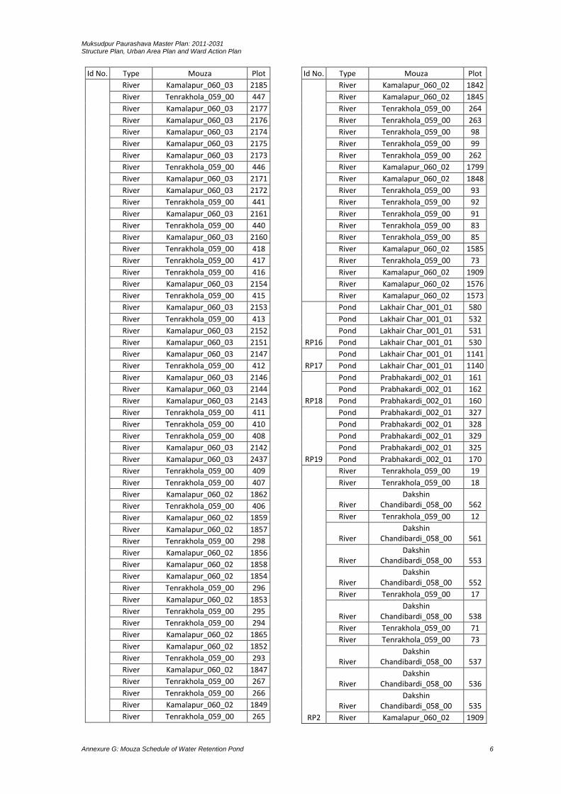
Muksudpur Paurashava Master Plan: 2011-2031 Structure Plan, Urban Area Plan and Ward Action Plan
Annexure G: Mouza Schedule of Water Retention Pond 6
Id No. Type Mouza Plot
River Kamalapur_060_03 2185
River Tenrakhola_059_00 447
River Kamalapur_060_03 2177
River Kamalapur_060_03 2176
River Kamalapur_060_03 2174
River Kamalapur_060_03 2175
River Kamalapur_060_03 2173
River Tenrakhola_059_00 446
River Kamalapur_060_03 2171
River Kamalapur_060_03 2172
River Tenrakhola_059_00 441
River Kamalapur_060_03 2161
River Tenrakhola_059_00 440
River Kamalapur_060_03 2160
River Tenrakhola_059_00 418
River Tenrakhola_059_00 417
River Tenrakhola_059_00 416
River Kamalapur_060_03 2154
River Tenrakhola_059_00 415
River Kamalapur_060_03 2153
River Tenrakhola_059_00 413
River Kamalapur_060_03 2152
River Kamalapur_060_03 2151
River Kamalapur_060_03 2147
River Tenrakhola_059_00 412
River Kamalapur_060_03 2146
River Kamalapur_060_03 2144
River Kamalapur_060_03 2143
River Tenrakhola_059_00 411
River Tenrakhola_059_00 410
River Tenrakhola_059_00 408
River Kamalapur_060_03 2142
River Kamalapur_060_03 2437
River Tenrakhola_059_00 409
River Tenrakhola_059_00 407
River Kamalapur_060_02 1862
River Tenrakhola_059_00 406
River Kamalapur_060_02 1859
River Kamalapur_060_02 1857
River Tenrakhola_059_00 298
River Kamalapur_060_02 1856
River Kamalapur_060_02 1858
River Kamalapur_060_02 1854
River Tenrakhola_059_00 296
River Kamalapur_060_02 1853
River Tenrakhola_059_00 295
River Tenrakhola_059_00 294
River Kamalapur_060_02 1865
River Kamalapur_060_02 1852
River Tenrakhola_059_00 293
River Kamalapur_060_02 1847
River Tenrakhola_059_00 267
River Tenrakhola_059_00 266
River Kamalapur_060_02 1849
River Tenrakhola_059_00 265
Id No. Type Mouza Plot
River Kamalapur_060_02 1842
River Kamalapur_060_02 1845
River Tenrakhola_059_00 264
River Tenrakhola_059_00 263
River Tenrakhola_059_00 98
River Tenrakhola_059_00 99
River Tenrakhola_059_00 262
River Kamalapur_060_02 1799
River Kamalapur_060_02 1848
River Tenrakhola_059_00 93
River Tenrakhola_059_00 92
River Tenrakhola_059_00 91
River Tenrakhola_059_00 83
River Tenrakhola_059_00 85
River Kamalapur_060_02 1585
River Tenrakhola_059_00 73
River Kamalapur_060_02 1909
River Kamalapur_060_02 1576
River Kamalapur_060_02 1573
RP16
Pond Lakhair Char_001_01 580
Pond Lakhair Char_001_01 532
Pond Lakhair Char_001_01 531
Pond Lakhair Char_001_01 530
RP17
Pond Lakhair Char_001_01 1141
Pond Lakhair Char_001_01 1140
RP18
Pond Prabhakardi_002_01 161
Pond Prabhakardi_002_01 162
Pond Prabhakardi_002_01 160
RP19
Pond Prabhakardi_002_01 327
Pond Prabhakardi_002_01 328
Pond Prabhakardi_002_01 329
Pond Prabhakardi_002_01 325
Pond Prabhakardi_002_01 170
RP2
River Tenrakhola_059_00 19
River Tenrakhola_059_00 18
River Dakshin
Chandibardi_058_00 562
River Tenrakhola_059_00 12
River Dakshin
Chandibardi_058_00 561
River Dakshin
Chandibardi_058_00 553
River Dakshin
Chandibardi_058_00 552
River Tenrakhola_059_00 17
River Dakshin
Chandibardi_058_00 538
River Tenrakhola_059_00 71
River Tenrakhola_059_00 73
River Dakshin
Chandibardi_058_00 537
River Dakshin
Chandibardi_058_00 536
River Dakshin
Chandibardi_058_00 535
River Kamalapur_060_02 1909

Muksudpur Paurashava Master Plan: 2011-2031 Structure Plan, Urban Area Plan and Ward Action Plan
Annexure G: Mouza Schedule of Water Retention Pond 7
Id No. Type Mouza Plot
River Dakshin
Chandibardi_058_00 534
River Tenrakhola_059_00 72
River Dakshin
Chandibardi_058_00 507
River Dakshin
Chandibardi_058_00 506
River Kamalapur_060_02 1574
River Dakshin
Chandibardi_058_00 505
River Dakshin
Chandibardi_058_00 504
River Dakshin
Chandibardi_058_00 503
River Dakshin
Chandibardi_058_00 502
River Dakshin
Chandibardi_058_00 539
River Dakshin
Chandibardi_058_00 501
River Kamalapur_060_02 1573
River Dakshin
Chandibardi_058_00 500
River Dakshin
Chandibardi_058_00 471
River Dakshin
Chandibardi_058_00 472
River Dakshin
Chandibardi_058_00 470
River Kamalapur_060_02 1572
River Dakshin
Chandibardi_058_00 44
River Dakshin
Chandibardi_058_00 42
River Dakshin
Chandibardi_058_00 41
River Dakshin
Chandibardi_058_00 38
River Dakshin
Chandibardi_058_00 40
River Dakshin
Chandibardi_058_00 39
River Lakhair Char_001_02 1922
River Lakhair Char_001_02 1935
River Dakshin
Chandibardi_058_00 502
River Kamalapur_060_02 1542
River Lakhair Char_001_02 1921
River Kamalapur_060_02 1537
River Kamalapur_060_02 1536
River Kamalapur_060_02 1535
River Lakhair Char_001_02 1877
River Kamalapur_060_02 1526
River Kamalapur_060_02 1525
River Kamalapur_060_02 1524
River Lakhair Char_001_02 1932
River Lakhair Char_001_02 1876
Id No. Type Mouza Plot
River Kamalapur_060_02 1518
River Kamalapur_060_02 1517
River Lakhair Char_001_02 1864
River Kamalapur_060_02 1507
River Lakhair Char_001_02 1865
River Kamalapur_060_02 1502
River Kamalapur_060_02 1500
River Kamalapur_060_02 1499
River Kamalapur_060_02 1239
River Kamalapur_060_02 1238
River Lakhair Char_001_02 1934
River Kamalapur_060_02 1233
River Lakhair Char_001_02 1647
River Kamalapur_060_02 1232
River Lakhair Char_001_02 1646
River Kamalapur_060_02 1226
River Kamalapur_060_02 1225
River Lakhair Char_001_02 1639
River Kamalapur_060_02 1218
River Lakhair Char_001_02 1933
River Lakhair Char_001_02 1637
River Lakhair Char_001_02 1638
River Kamalapur_060_02 1215
River Kamalapur_060_02 1213
River Kamalapur_060_02 1115
River Lakhair Char_001_02 1614
River Lakhair Char_001_02 1613
River Lakhair Char_001_02 1612
River Kamalapur_060_02 1112
River Kamalapur_060_02 1110
River Lakhair Char_001_02 1609
River Kamalapur_060_02 1109
River Lakhair Char_001_02 1928
River Kamalapur_060_02 1108
River Lakhair Char_001_02 1608
River Kamalapur_060_02 1107
River Kamalapur_060_02 1106
River Kamalapur_060_02 1105
River Kamalapur_060_02 1104
River Lakhair Char_001_02 1605
River Kamalapur_060_02 1103
River Lakhair Char_001_02 1604
River Kamalapur_060_02 1102
River Lakhair Char_001_01 958
River Kamalapur_060_02 1101
River Kamalapur_060_01 1
River Lakhair Char_001_02 1531
River Kamalapur_060_01 2
River Kamalapur_060_01 3
River Kamalapur_060_01 4
River Kamalapur_060_01 5
River Lakhair Char_001_01 212
River Kamalapur_060_02 1571
River Lakhair Char_001_02 1940
River Lakhair Char_001_01 207
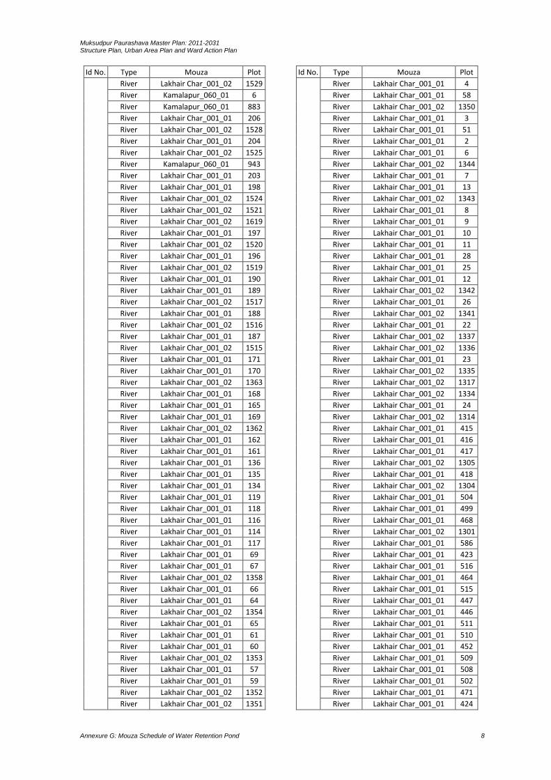
Muksudpur Paurashava Master Plan: 2011-2031 Structure Plan, Urban Area Plan and Ward Action Plan
Annexure G: Mouza Schedule of Water Retention Pond 8
Id No. Type Mouza Plot
River Lakhair Char_001_02 1529
River Kamalapur_060_01 6
River Kamalapur_060_01 883
River Lakhair Char_001_01 206
River Lakhair Char_001_02 1528
River Lakhair Char_001_01 204
River Lakhair Char_001_02 1525
River Kamalapur_060_01 943
River Lakhair Char_001_01 203
River Lakhair Char_001_01 198
River Lakhair Char_001_02 1524
River Lakhair Char_001_02 1521
River Lakhair Char_001_02 1619
River Lakhair Char_001_01 197
River Lakhair Char_001_02 1520
River Lakhair Char_001_01 196
River Lakhair Char_001_02 1519
River Lakhair Char_001_01 190
River Lakhair Char_001_01 189
River Lakhair Char_001_02 1517
River Lakhair Char_001_01 188
River Lakhair Char_001_02 1516
River Lakhair Char_001_01 187
River Lakhair Char_001_02 1515
River Lakhair Char_001_01 171
River Lakhair Char_001_01 170
River Lakhair Char_001_02 1363
River Lakhair Char_001_01 168
River Lakhair Char_001_01 165
River Lakhair Char_001_01 169
River Lakhair Char_001_02 1362
River Lakhair Char_001_01 162
River Lakhair Char_001_01 161
River Lakhair Char_001_01 136
River Lakhair Char_001_01 135
River Lakhair Char_001_01 134
River Lakhair Char_001_01 119
River Lakhair Char_001_01 118
River Lakhair Char_001_01 116
River Lakhair Char_001_01 114
River Lakhair Char_001_01 117
River Lakhair Char_001_01 69
River Lakhair Char_001_01 67
River Lakhair Char_001_02 1358
River Lakhair Char_001_01 66
River Lakhair Char_001_01 64
River Lakhair Char_001_02 1354
River Lakhair Char_001_01 65
River Lakhair Char_001_01 61
River Lakhair Char_001_01 60
River Lakhair Char_001_02 1353
River Lakhair Char_001_01 57
River Lakhair Char_001_01 59
River Lakhair Char_001_02 1352
River Lakhair Char_001_02 1351
Id No. Type Mouza Plot
River Lakhair Char_001_01 4
River Lakhair Char_001_01 58
River Lakhair Char_001_02 1350
River Lakhair Char_001_01 3
River Lakhair Char_001_01 51
River Lakhair Char_001_01 2
River Lakhair Char_001_01 6
River Lakhair Char_001_02 1344
River Lakhair Char_001_01 7
River Lakhair Char_001_01 13
River Lakhair Char_001_02 1343
River Lakhair Char_001_01 8
River Lakhair Char_001_01 9
River Lakhair Char_001_01 10
River Lakhair Char_001_01 11
River Lakhair Char_001_01 28
River Lakhair Char_001_01 25
River Lakhair Char_001_01 12
River Lakhair Char_001_02 1342
River Lakhair Char_001_01 26
River Lakhair Char_001_02 1341
River Lakhair Char_001_01 22
River Lakhair Char_001_02 1337
River Lakhair Char_001_02 1336
River Lakhair Char_001_01 23
River Lakhair Char_001_02 1335
River Lakhair Char_001_02 1317
River Lakhair Char_001_02 1334
River Lakhair Char_001_01 24
River Lakhair Char_001_02 1314
River Lakhair Char_001_01 415
River Lakhair Char_001_01 416
River Lakhair Char_001_01 417
River Lakhair Char_001_02 1305
River Lakhair Char_001_01 418
River Lakhair Char_001_02 1304
River Lakhair Char_001_01 504
River Lakhair Char_001_01 499
River Lakhair Char_001_01 468
River Lakhair Char_001_02 1301
River Lakhair Char_001_01 586
River Lakhair Char_001_01 423
River Lakhair Char_001_01 516
River Lakhair Char_001_01 464
River Lakhair Char_001_01 515
River Lakhair Char_001_01 447
River Lakhair Char_001_01 446
River Lakhair Char_001_01 511
River Lakhair Char_001_01 510
River Lakhair Char_001_01 452
River Lakhair Char_001_01 509
River Lakhair Char_001_01 508
River Lakhair Char_001_01 502
River Lakhair Char_001_01 471
River Lakhair Char_001_01 424

Muksudpur Paurashava Master Plan: 2011-2031 Structure Plan, Urban Area Plan and Ward Action Plan
Annexure G: Mouza Schedule of Water Retention Pond 9
Id No. Type Mouza Plot
River Lakhair Char_001_01 561
River Lakhair Char_001_01 501
River Lakhair Char_001_01 500
River Lakhair Char_001_01 448
River Lakhair Char_001_01 478
River Lakhair Char_001_01 449
River Lakhair Char_001_01 477
River Lakhair Char_001_01 476
River Lakhair Char_001_01 450
River Lakhair Char_001_01 475
River Lakhair Char_001_01 474
River Lakhair Char_001_01 451
River Lakhair Char_001_01 473
River Lakhair Char_001_01 465
River Lakhair Char_001_01 466
River Lakhair Char_001_01 467
River Lakhair Char_001_01 472
River Lakhair Char_001_02 1930
River Lakhair Char_001_01 1
RP20
Pond Prabhakardi_002_01 378
Pond Prabhakardi_002_01 377
Pond Prabhakardi_002_01 318
Pond Prabhakardi_002_01 320
RP21
Pond Prabhakardi_002_01 492
Pond Prabhakardi_002_01 373
Pond Prabhakardi_002_01 382
Pond Prabhakardi_002_01 381
RP22
Ditch Prabhakardi_002_01 371
Ditch Prabhakardi_002_01 370
Ditch Prabhakardi_002_01 369
RP23
Pond Prabhakardi_002_03 1803
Pond Prabhakardi_002_03 1805
Pond Prabhakardi_002_03 1801
Pond Prabhakardi_002_03 1802
RP24
Pond Prabhakardi_002_03 1769
Pond Prabhakardi_002_03 1768
Pond Prabhakardi_002_03 1772
Pond Prabhakardi_002_03 1773
Pond Prabhakardi_002_03 1750
RP25
Khal Prabhakardi_002_03 1924
Khal Prabhakardi_002_03 1928
Khal Prabhakardi_002_03 1917
Khal Prabhakardi_002_03 1910
Khal Prabhakardi_002_03 1911
Khal Prabhakardi_002_03 1901
Khal Prabhakardi_002_03 1900
Khal Prabhakardi_002_03 1888
Khal Prabhakardi_002_03 1909
Khal Prabhakardi_002_03 1903
Khal Prabhakardi_002_03 1887
Khal Prabhakardi_002_03 1889
Khal Prabhakardi_002_03 1920
Khal Prabhakardi_002_03 1902
Khal Prabhakardi_002_03 1892
Khal Prabhakardi_002_03 2062
Id No. Type Mouza Plot
Khal Prabhakardi_002_03 1885
Khal Prabhakardi_002_03 1883
Khal Prabhakardi_002_03 2064
Khal Prabhakardi_002_03 1882
Khal Prabhakardi_002_03 1881
Khal Prabhakardi_002_03 2065
Khal Prabhakardi_002_03 1848
Khal Prabhakardi_002_03 1850
Khal Prabhakardi_002_03 1851
Khal Prabhakardi_002_03 1770
Khal Prabhakardi_002_03 1844
Khal Prabhakardi_002_03 1843
Khal Prabhakardi_002_03 1782
Khal Prabhakardi_002_03 1783
Khal Prabhakardi_002_03 2075
RP26 Pond Prabhakardi_002_03 2007
RP27
Pond Prabhakardi_002_03 2007
Pond Prabhakardi_002_03 2006
Pond Prabhakardi_002_03 2007
RP28
Pond Prabhakardi_002_03 2007
Pond Prabhakardi_002_03 2009
Pond Prabhakardi_002_03 2010
Pond Prabhakardi_002_03 2008
Pond Prabhakardi_002_03 2314
RP29
Pond Nagar Sundardi_055_00 53
Pond Nagar Sundardi_055_00 52
Pond Nagar Sundardi_055_00 19
Pond Nagar Sundardi_055_00 21
RP3
Khal Prabhakardi_002_01 51
Khal Prabhakardi_002_01 62
Khal Prabhakardi_002_01 50
Khal Prabhakardi_002_01 2
Khal Prabhakardi_002_01 3
Khal Prabhakardi_002_01 4
Khal Prabhakardi_002_01 5
Khal Lakhair Char_001_01 981
Khal Lakhair Char_001_01 980
Khal Lakhair Char_001_01 978
Khal Lakhair Char_001_01 977
Khal Lakhair Char_001_01 964
Khal Lakhair Char_001_01 963
Khal Lakhair Char_001_01 961
Khal Lakhair Char_001_01 962
Khal Lakhair Char_001_01 960
Khal Lakhair Char_001_01 959
Khal Lakhair Char_001_01 956
Khal Lakhair Char_001_01 1
RP30 Pond Nagar Sundardi_055_00 8
RP31
Pond Nagar Sundardi_055_00 50
Pond Nagar Sundardi_055_00 52
Pond Nagar Sundardi_055_00 51
RP32
Pond Nagar Sundardi_055_00 18
Pond Nagar Sundardi_055_00 8
RP33
Pond Nagar Sundardi_055_00 20
Pond Nagar Sundardi_055_00 21
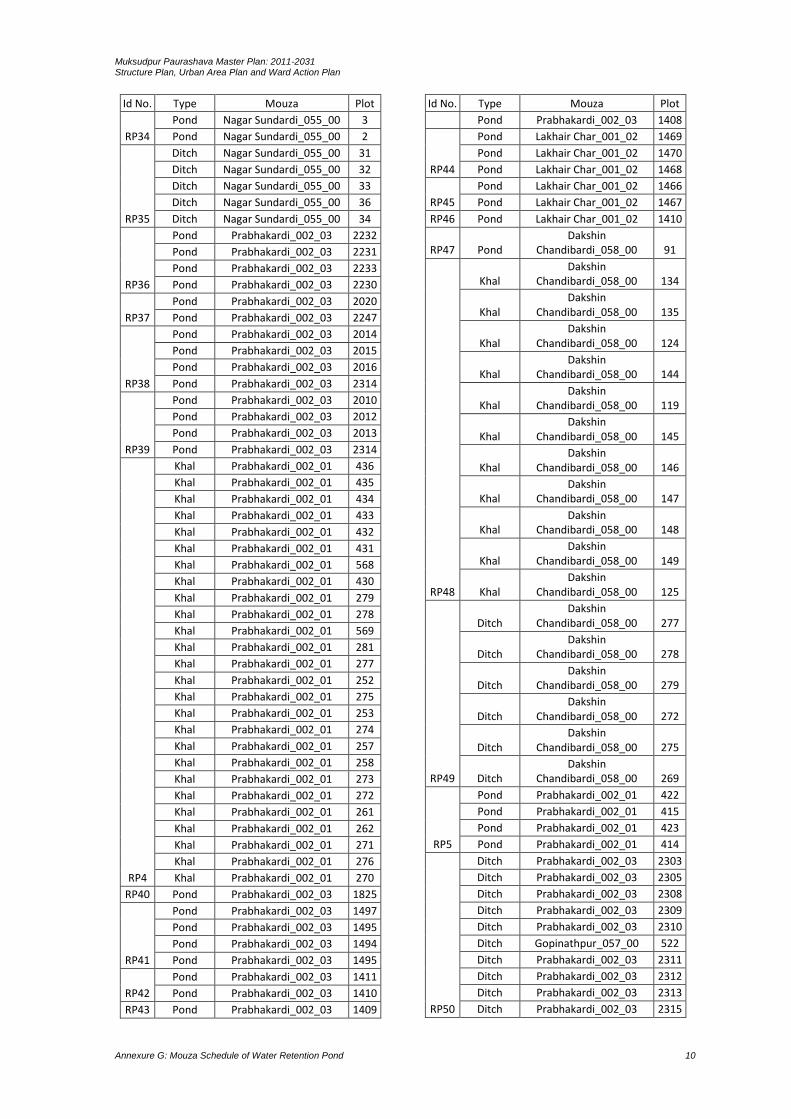
Muksudpur Paurashava Master Plan: 2011-2031 Structure Plan, Urban Area Plan and Ward Action Plan
Annexure G: Mouza Schedule of Water Retention Pond 10
Id No. Type Mouza Plot
RP34
Pond Nagar Sundardi_055_00 3
Pond Nagar Sundardi_055_00 2
RP35
Ditch Nagar Sundardi_055_00 31
Ditch Nagar Sundardi_055_00 32
Ditch Nagar Sundardi_055_00 33
Ditch Nagar Sundardi_055_00 36
Ditch Nagar Sundardi_055_00 34
RP36
Pond Prabhakardi_002_03 2232
Pond Prabhakardi_002_03 2231
Pond Prabhakardi_002_03 2233
Pond Prabhakardi_002_03 2230
RP37
Pond Prabhakardi_002_03 2020
Pond Prabhakardi_002_03 2247
RP38
Pond Prabhakardi_002_03 2014
Pond Prabhakardi_002_03 2015
Pond Prabhakardi_002_03 2016
Pond Prabhakardi_002_03 2314
RP39
Pond Prabhakardi_002_03 2010
Pond Prabhakardi_002_03 2012
Pond Prabhakardi_002_03 2013
Pond Prabhakardi_002_03 2314
RP4
Khal Prabhakardi_002_01 436
Khal Prabhakardi_002_01 435
Khal Prabhakardi_002_01 434
Khal Prabhakardi_002_01 433
Khal Prabhakardi_002_01 432
Khal Prabhakardi_002_01 431
Khal Prabhakardi_002_01 568
Khal Prabhakardi_002_01 430
Khal Prabhakardi_002_01 279
Khal Prabhakardi_002_01 278
Khal Prabhakardi_002_01 569
Khal Prabhakardi_002_01 281
Khal Prabhakardi_002_01 277
Khal Prabhakardi_002_01 252
Khal Prabhakardi_002_01 275
Khal Prabhakardi_002_01 253
Khal Prabhakardi_002_01 274
Khal Prabhakardi_002_01 257
Khal Prabhakardi_002_01 258
Khal Prabhakardi_002_01 273
Khal Prabhakardi_002_01 272
Khal Prabhakardi_002_01 261
Khal Prabhakardi_002_01 262
Khal Prabhakardi_002_01 271
Khal Prabhakardi_002_01 276
Khal Prabhakardi_002_01 270
RP40 Pond Prabhakardi_002_03 1825
RP41
Pond Prabhakardi_002_03 1497
Pond Prabhakardi_002_03 1495
Pond Prabhakardi_002_03 1494
Pond Prabhakardi_002_03 1495
RP42
Pond Prabhakardi_002_03 1411
Pond Prabhakardi_002_03 1410
RP43 Pond Prabhakardi_002_03 1409
Id No. Type Mouza Plot
Pond Prabhakardi_002_03 1408
RP44
Pond Lakhair Char_001_02 1469
Pond Lakhair Char_001_02 1470
Pond Lakhair Char_001_02 1468
RP45
Pond Lakhair Char_001_02 1466
Pond Lakhair Char_001_02 1467
RP46 Pond Lakhair Char_001_02 1410
RP47 Pond Dakshin
Chandibardi_058_00 91
RP48
Khal Dakshin
Chandibardi_058_00 134
Khal Dakshin
Chandibardi_058_00 135
Khal Dakshin
Chandibardi_058_00 124
Khal Dakshin
Chandibardi_058_00 144
Khal Dakshin
Chandibardi_058_00 119
Khal Dakshin
Chandibardi_058_00 145
Khal Dakshin
Chandibardi_058_00 146
Khal Dakshin
Chandibardi_058_00 147
Khal Dakshin
Chandibardi_058_00 148
Khal Dakshin
Chandibardi_058_00 149
Khal Dakshin
Chandibardi_058_00 125
RP49
Ditch Dakshin
Chandibardi_058_00 277
Ditch Dakshin
Chandibardi_058_00 278
Ditch Dakshin
Chandibardi_058_00 279
Ditch Dakshin
Chandibardi_058_00 272
Ditch Dakshin
Chandibardi_058_00 275
Ditch Dakshin
Chandibardi_058_00 269
RP5
Pond Prabhakardi_002_01 422
Pond Prabhakardi_002_01 415
Pond Prabhakardi_002_01 423
Pond Prabhakardi_002_01 414
RP50
Ditch Prabhakardi_002_03 2303
Ditch Prabhakardi_002_03 2305
Ditch Prabhakardi_002_03 2308
Ditch Prabhakardi_002_03 2309
Ditch Prabhakardi_002_03 2310
Ditch Gopinathpur_057_00 522
Ditch Prabhakardi_002_03 2311
Ditch Prabhakardi_002_03 2312
Ditch Prabhakardi_002_03 2313
Ditch Prabhakardi_002_03 2315
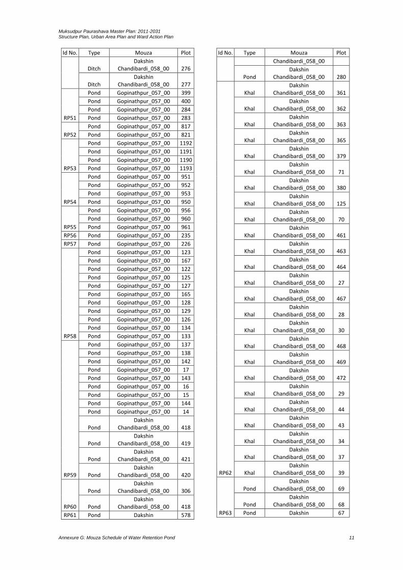
Muksudpur Paurashava Master Plan: 2011-2031 Structure Plan, Urban Area Plan and Ward Action Plan
Annexure G: Mouza Schedule of Water Retention Pond 11
Id No. Type Mouza Plot
Ditch Dakshin
Chandibardi_058_00 276
Ditch Dakshin
Chandibardi_058_00 277
RP51
Pond Gopinathpur_057_00 399
Pond Gopinathpur_057_00 400
Pond Gopinathpur_057_00 284
Pond Gopinathpur_057_00 283
RP52
Pond Gopinathpur_057_00 817
Pond Gopinathpur_057_00 821
RP53
Pond Gopinathpur_057_00 1192
Pond Gopinathpur_057_00 1191
Pond Gopinathpur_057_00 1190
Pond Gopinathpur_057_00 1193
RP54
Pond Gopinathpur_057_00 951
Pond Gopinathpur_057_00 952
Pond Gopinathpur_057_00 953
Pond Gopinathpur_057_00 950
RP55
Pond Gopinathpur_057_00 956
Pond Gopinathpur_057_00 960
Pond Gopinathpur_057_00 961
RP56 Pond Gopinathpur_057_00 235
RP57 Pond Gopinathpur_057_00 226
RP58
Pond Gopinathpur_057_00 123
Pond Gopinathpur_057_00 167
Pond Gopinathpur_057_00 122
Pond Gopinathpur_057_00 125
Pond Gopinathpur_057_00 127
Pond Gopinathpur_057_00 165
Pond Gopinathpur_057_00 128
Pond Gopinathpur_057_00 129
Pond Gopinathpur_057_00 126
Pond Gopinathpur_057_00 134
Pond Gopinathpur_057_00 133
RP59
Pond Gopinathpur_057_00 137
Pond Gopinathpur_057_00 138
Pond Gopinathpur_057_00 142
Pond Gopinathpur_057_00 17
Pond Gopinathpur_057_00 143
Pond Gopinathpur_057_00 16
Pond Gopinathpur_057_00 15
Pond Gopinathpur_057_00 144
Pond Gopinathpur_057_00 14
Pond Dakshin
Chandibardi_058_00 418
Pond Dakshin
Chandibardi_058_00 419
Pond Dakshin
Chandibardi_058_00 421
Pond Dakshin
Chandibardi_058_00 420
RP60
Pond Dakshin
Chandibardi_058_00 306
Pond Dakshin
Chandibardi_058_00 418
RP61 Pond Dakshin 578
Id No. Type Mouza Plot
Chandibardi_058_00
Pond Dakshin
Chandibardi_058_00 280
RP62
Khal Dakshin
Chandibardi_058_00 361
Khal Dakshin
Chandibardi_058_00 362
Khal Dakshin
Chandibardi_058_00 363
Khal Dakshin
Chandibardi_058_00 365
Khal Dakshin
Chandibardi_058_00 379
Khal Dakshin
Chandibardi_058_00 71
Khal Dakshin
Chandibardi_058_00 380
Khal Dakshin
Chandibardi_058_00 125
Khal Dakshin
Chandibardi_058_00 70
Khal Dakshin
Chandibardi_058_00 461
Khal Dakshin
Chandibardi_058_00 463
Khal Dakshin
Chandibardi_058_00 464
Khal Dakshin
Chandibardi_058_00 27
Khal Dakshin
Chandibardi_058_00 467
Khal Dakshin
Chandibardi_058_00 28
Khal Dakshin
Chandibardi_058_00 30
Khal Dakshin
Chandibardi_058_00 468
Khal Dakshin
Chandibardi_058_00 469
Khal Dakshin
Chandibardi_058_00 472
Khal Dakshin
Chandibardi_058_00 29
Khal Dakshin
Chandibardi_058_00 44
Khal Dakshin
Chandibardi_058_00 43
Khal Dakshin
Chandibardi_058_00 34
Khal Dakshin
Chandibardi_058_00 37
Khal Dakshin
Chandibardi_058_00 39
RP63
Pond Dakshin
Chandibardi_058_00 69
Pond Dakshin
Chandibardi_058_00 68
Pond Dakshin 67

Muksudpur Paurashava Master Plan: 2011-2031 Structure Plan, Urban Area Plan and Ward Action Plan
Annexure G: Mouza Schedule of Water Retention Pond 12
Id No. Type Mouza Plot
Chandibardi_058_00
Pond Dakshin
Chandibardi_058_00 66
Pond Dakshin
Chandibardi_058_00 22
Pond Dakshin
Chandibardi_058_00 21
Pond Dakshin
Chandibardi_058_00 45
RP64
Pond Gopinathpur_057_00 5
Pond Tenrakhola_059_00 133
Pond Gopinathpur_057_00 2
Pond Tenrakhola_059_00 132
Pond Gopinathpur_057_00 1
Pond Tenrakhola_059_00 2
Pond Tenrakhola_059_00 1
RP65 Pond Tenrakhola_059_00 129
RP66
Pond Tenrakhola_059_00 150
Pond Tenrakhola_059_00 148
Pond Tenrakhola_059_00 149
RP67
Pond Gopinathpur_057_00 150
Pond Gopinathpur_057_00 151
Pond Gopinathpur_057_00 135
Pond Gopinathpur_057_00 155
Pond Gopinathpur_057_00 149
Pond Gopinathpur_057_00 148
Pond Gopinathpur_057_00 147
Pond Tenrakhola_059_00 150
Pond Gopinathpur_057_00 146
Pond Gopinathpur_057_00 145
RP68 Pond Tenrakhola_059_00 142
RP69
Pond Tenrakhola_059_00 106
Pond Tenrakhola_059_00 108
Pond Tenrakhola_059_00 110
Pond Tenrakhola_059_00 113
Pond Tenrakhola_059_00 111
Pond Tenrakhola_059_00 112
RP7
Pond Prabhakardi_002_02 1154
Pond Prabhakardi_002_02 1157
Pond Prabhakardi_002_02 1153
Pond Prabhakardi_002_02 1156
Pond Prabhakardi_002_02 1155
Pond Prabhakardi_002_02 1152
Pond Prabhakardi_002_02 1150
Pond Prabhakardi_002_02 1151
Pond Prabhakardi_002_02 1146
Pond Prabhakardi_002_02 890
RP70
Khal Gopinathpur_057_00 999
Khal Gopinathpur_057_00 998
Khal Gopinathpur_057_00 1018
Khal Gopinathpur_057_00 997
Khal Tenrakhola_059_00 197
Khal Tenrakhola_059_00 196
Khal Tenrakhola_059_00 198
Khal Tenrakhola_059_00 186
Id No. Type Mouza Plot
Khal Tenrakhola_059_00 185
Khal Tenrakhola_059_00 187
Khal Tenrakhola_059_00 184
Khal Tenrakhola_059_00 182
Khal Tenrakhola_059_00 234
Khal Tenrakhola_059_00 183
Khal Tenrakhola_059_00 181
Khal Tenrakhola_059_00 235
Khal Tenrakhola_059_00 174
Khal Tenrakhola_059_00 238
Khal Tenrakhola_059_00 221
Khal Tenrakhola_059_00 237
Khal Tenrakhola_059_00 172
Khal Tenrakhola_059_00 215
Khal Tenrakhola_059_00 213
Khal Tenrakhola_059_00 171
Khal Tenrakhola_059_00 212
Khal Tenrakhola_059_00 169
Khal Tenrakhola_059_00 214
Khal Tenrakhola_059_00 103
Khal Tenrakhola_059_00 170
Khal Tenrakhola_059_00 104
RP71
Khal Tenrakhola_059_00 237
Khal Tenrakhola_059_00 244
Khal Tenrakhola_059_00 247
Khal Tenrakhola_059_00 245
Khal Tenrakhola_059_00 248
Khal Tenrakhola_059_00 103
Khal Tenrakhola_059_00 250
Khal Tenrakhola_059_00 249
Khal Tenrakhola_059_00 259
Khal Tenrakhola_059_00 100
Khal Tenrakhola_059_00 99
RP72 Pond Gopinathpur_057_00 973
RP73
Pond Tenrakhola_059_00 354
Pond Tenrakhola_059_00 362
Pond Tenrakhola_059_00 353
Pond Tenrakhola_059_00 363
Pond Tenrakhola_059_00 352
Pond Tenrakhola_059_00 355
RP74 Pond Gopinathpur_057_00 1029
RP75
Pond Gopinathpur_057_00 1275
Pond Gopinathpur_057_00 1276
Pond Gopinathpur_057_00 1268
Pond Gopinathpur_057_00 1270
RP76
Pond Gopinathpur_057_00 1324
Pond Gopinathpur_057_00 1323
Pond Gopinathpur_057_00 1272
Pond Gopinathpur_057_00 1328
RP77
Pond Chhota Bahara_071_00 321
Pond Chhota Bahara_071_00 319
Pond Chhota Bahara_071_00 320
Pond Chhota Bahara_071_00 322
RP78
Pond Chhota Bahara_071_00 336
Pond Chhota Bahara_071_00 333

Muksudpur Paurashava Master Plan: 2011-2031 Structure Plan, Urban Area Plan and Ward Action Plan
Annexure G: Mouza Schedule of Water Retention Pond 13
Id No. Type Mouza Plot
RP79
Pond Mabarakkandi_070_00 78
Pond Mabarakkandi_070_00 74
Pond Mabarakkandi_070_00 76
Pond Mabarakkandi_070_00 75
RP8
Pond Prabhakardi_002_02 1154
Pond Prabhakardi_002_02 1157
Pond Prabhakardi_002_02 890
RP80
Pond Kamalapur_060_03 2338
Pond Kamalapur_060_03 2343
Pond Kamalapur_060_03 2339
Pond Kamalapur_060_03 2340
Pond Kamalapur_060_03 2341
Pond Kamalapur_060_03 2342
Pond Kamalapur_060_03 2334
Pond Kamalapur_060_03 2344
Pond Kamalapur_060_03 2333
Pond Kamalapur_060_03 2330
Pond Kamalapur_060_03 2332
Pond Kamalapur_060_03 2331
RP81
Khal Kamalapur_060_03 2101
Khal Kamalapur_060_03 2097
Khal Kamalapur_060_03 2102
Khal Kamalapur_060_03 2106
Khal Kamalapur_060_03 2141
Khal Kamalapur_060_03 2140
Khal Kamalapur_060_03 2135
Khal Kamalapur_060_03 2136
Khal Kamalapur_060_03 2137
Khal Kamalapur_060_03 2130
Khal Kamalapur_060_03 2129
Khal Kamalapur_060_03 2127
Khal Kamalapur_060_03 2105
Khal Kamalapur_060_03 2125
Khal Kamalapur_060_03 2124
Khal Kamalapur_060_02 1866
Khal Kamalapur_060_03 2103
Khal Kamalapur_060_02 1888
Khal Kamalapur_060_02 1865
Khal Kamalapur_060_02 1890
RP82
Pond Kamalapur_060_03 2166
Pond Kamalapur_060_03 2167
Pond Kamalapur_060_03 2170
Pond Kamalapur_060_03 2163
Pond Kamalapur_060_03 2162
Pond Kamalapur_060_03 2161
Pond Kamalapur_060_03 2159
Pond Kamalapur_060_03 2160
Pond Kamalapur_060_03 2157
Pond Kamalapur_060_03 2158
Pond Kamalapur_060_03 2155
Pond Kamalapur_060_03 2154
RP83
Pond Kamalapur_060_02 1840
Pond Kamalapur_060_02 1839
Pond Kamalapur_060_02 1837
Pond Kamalapur_060_02 1835
Id No. Type Mouza Plot
RP84
Pond Kamalapur_060_02 1805
Pond Kamalapur_060_02 1803
Pond Kamalapur_060_02 1804
Pond Kamalapur_060_02 1806
Pond Kamalapur_060_02 1781
Pond Kamalapur_060_02 1784
RP85
Pond Kamalapur_060_02 1914
Pond Kamalapur_060_02 1265
RP86
Pond Kamalapur_060_02 1310
Pond Kamalapur_060_02 1307
Pond Kamalapur_060_02 1311
RP87
Pond Kamalapur_060_02 1431
Pond Kamalapur_060_02 1663
Pond Kamalapur_060_02 1452
RP88
Pond Kamalapur_060_02 1715
Pond Kamalapur_060_02 1716
Pond Kamalapur_060_02 1717
Pond Kamalapur_060_02 1719
Pond Kamalapur_060_02 1697
RP89
Khal Kamalapur_060_03 2435
Khal Kamalapur_060_03 2434
Khal Kamalapur_060_03 2433
Khal Kamalapur_060_03 2432
Khal Kamalapur_060_03 2431
Khal Kamalapur_060_03 2429
Khal Kamalapur_060_03 2428
Khal Kamalapur_060_03 2427
Khal Kamalapur_060_03 2426
Khal Kamalapur_060_03 2424
RP9 Pond Prabhakardi_002_02 1068
RP90
Khal Kamalapur_060_03 2012
Khal Kamalapur_060_03 2010
Khal Kamalapur_060_03 2011
Khal Kamalapur_060_03 2007
Khal Kamalapur_060_03 2006
Khal Kamalapur_060_03 2005
Khal Kamalapur_060_03 2004
Khal Kamalapur_060_03 2003
Khal Kamalapur_060_03 2002
Khal Kamalapur_060_03 2001
RP91
Khal Chhota Bahara_071_00 123
Khal Mabarakkandi_070_00 279
Khal Mabarakkandi_070_00 277
Khal Mabarakkandi_070_00 276
Khal Mabarakkandi_070_00 275
RP92 Pond Mabarakkandi_070_00 314
RP93
Pond Kamalapur_060_03 2667
Pond Kamalapur_060_03 2666
RP94
Pond Mabarakkandi_070_00 424
Pond Mabarakkandi_070_00 420
Pond Mabarakkandi_070_00 409
RP95
Ditch Mabarakkandi_070_00 419
Ditch Mabarakkandi_070_00 418
Ditch Kamalapur_060_03 2809
Ditch Kamalapur_060_03 2808
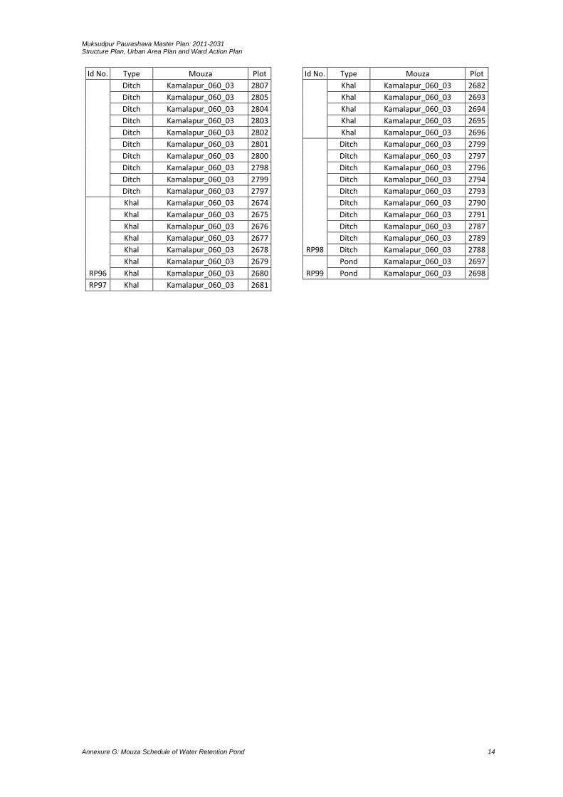
Muksudpur Paurashava Master Plan: 2011-2031 Structure Plan, Urban Area Plan and Ward Action Plan
Annexure G: Mouza Schedule of Water Retention Pond 14
Id No. Type Mouza Plot
Ditch Kamalapur_060_03 2807
Ditch Kamalapur_060_03 2805
Ditch Kamalapur_060_03 2804
Ditch Kamalapur_060_03 2803
Ditch Kamalapur_060_03 2802
Ditch Kamalapur_060_03 2801
Ditch Kamalapur_060_03 2800
Ditch Kamalapur_060_03 2798
Ditch Kamalapur_060_03 2799
Ditch Kamalapur_060_03 2797
RP96
Khal Kamalapur_060_03 2674
Khal Kamalapur_060_03 2675
Khal Kamalapur_060_03 2676
Khal Kamalapur_060_03 2677
Khal Kamalapur_060_03 2678
Khal Kamalapur_060_03 2679
Khal Kamalapur_060_03 2680
RP97 Khal Kamalapur_060_03 2681
Id No. Type Mouza Plot
Khal Kamalapur_060_03 2682
Khal Kamalapur_060_03 2693
Khal Kamalapur_060_03 2694
Khal Kamalapur_060_03 2695
Khal Kamalapur_060_03 2696
RP98
Ditch Kamalapur_060_03 2799
Ditch Kamalapur_060_03 2797
Ditch Kamalapur_060_03 2796
Ditch Kamalapur_060_03 2794
Ditch Kamalapur_060_03 2793
Ditch Kamalapur_060_03 2790
Ditch Kamalapur_060_03 2791
Ditch Kamalapur_060_03 2787
Ditch Kamalapur_060_03 2789
Ditch Kamalapur_060_03 2788
RP99
Pond Kamalapur_060_03 2697
Pond Kamalapur_060_03 2698