Draft East of England Plan > 2031 - Ipswich Borough Council |
172
East of England Plan >2031 Draft revision to the Regional Spatial Strategy for the East of England March 2010
-
Upload
khangminh22 -
Category
Documents
-
view
0 -
download
0
Transcript of Draft East of England Plan > 2031 - Ipswich Borough Council |

East of England Plan
>2031Draft revision to the Regional Spatial Strategy for the East of England
March 2010


Main Document
31. Introduction
112. Vision and Objectives
133. Spatial Strategy
274. Implementation, Monitoring and Review
335. Economic Development
456. Housing
537. Culture
558. Transport
639. Environment
7510. Carbon Dioxide Emissions and Renewable Energy
7911. Water
8512. Waste
9713. Minerals
9914. Sub-Areas and Key Centres for Development and ChangeAppendices
143Appendix A Strategic Transport Infrastructure Priorities
149Appendix B Biodiversity Action Plan priorities and targets forthe East of England
151Appendix C Total Forecasts of Quantities of Waste to beManaged
Draft East of England Plan > 2031
Contents

157Appendix D List of Policies
161Appendix E List of Policies not subject to consultation
169Key Diagram
Draft East of England Plan > 2031
Contents

1. IntroductionRegional Planning in England
1.1 The Planning and Compulsory Purchase Act 2004 strengthened the role and importance of regionalplanning, introducing Regional Spatial Strategies and making them the top tier of the statutoryDevelopment Plan in all regions of England except London, where the London Plan provides asimilar role. The Act sets an objective for Regional Spatial Strategies to contribute to sustainabledevelopment. Procedural policy on the content of Regional Spatial Strategies and the process forrevising them is set out in a Planning Policy Statement on Regional Planning, PPS11, 2004.
1.2 Regional Spatial Strategies complement and generally do not repeat national planning policies,which are set out in Planning Policy Statements, Circulars and other Government statements,including White Papers.
1.3 They provide a consistent regional framework to inform the preparation of Local DevelopmentDocuments, Local Transport Plans and other regional and sub-regional strategies and programmeswith a bearing on land use activities. The policies may also be material to decisions on individualplanning applications and appeals. The Regional Spatial Strategy for the East of England is theEast of England Plan.
The East of England Plan
1.4 The East of England Plan was published by the Secretary of State for Communities and LocalGovernment in May 2008. It covers the county and unitary authorities of Bedford, Cambridgeshire,Central Bedfordshire, Essex, Hertfordshire, Luton, Norfolk, Peterborough, Southend-on-Sea,Suffolk and Thurrock. The Plan sets out the vision and strategic framework for growth to 2021.
1.5 The document you are reading is a draft revision of that Plan. This revised Plan takes the regionforward to 2031, deepens key policy areas including climate change, the coast, energy and wasteand refreshes other policy areas including transport and economic development.
1.6 To aid comprehension, polices which have been subject to single issue reviews are embeddedwithin this revision document, however they are not subject to any consultation. This applies toPolicies H3 and H4 and in relation to Lakeside Basin Thurrock, Policies E5 and ETG5.
1.7 Regional policy for Bedford, Central Bedfordshire and Luton is also provided by the Milton KeynesSouth Midlands Sub-Regional Strategy, as well as the East of England Plan. The sub-regionalstrategy provides guidance on the scale, location and timing of growth to 2021 with some indicationof growth to 2031. The revised East of England Plan will formally replace appropriate parts of thatstrategy within a new sub regional section for the Luton, Central Bedfordshire and Bedford Borougharea.
1.8 Fundamentally, the overall spatial distribution of growth remains unaltered in this revision. Thekey focus of housing and job growth remains in the region's Key Centres of Development andChange. We are also of the view that the overall vision and objectives of the current Plan, andmany of its policies, provide a sound starting point from which to consider a strategy up to 2031.
1.9 Preparation of this revision was informed by an Integrated Sustainability Appraisal, incorporatinga Strategic Environmental Appraisal, an Appropriate Assessment as required by the HabitatsRegulations, health and equality impacts, and urban and rural proofing.
1.10 This revision includes a revised Implementation and Monitoring Framework.
3Draft East of England Plan > 2031
Introduction 1
Why review the Plan?
1.11 Although the Plan was only published in May 2008, the Government asked the Assembly to carryout an immediate review, in particular to make provision for the East of England’s developmentneeds for the period 2011 to 2031. Regional plans should set out a long term strategy for at least20 years and the current Plan now only covers the next 11 years. The current Plan needs to betaken forward to 2031 because industries and public authorities need to plan for the challengesand opportunities ahead, such as climate change and population growth. The Government indicatedthat the review should not only extend the Plan’s time horizon but further increase housing provisionin the region and, in particular, to contribute to its national target of providing 240,000 additionalhomes per year by 2016.
What evidence has informed the Plan?
1.12 There is a wide range of evidence available to help shape this review, ranging from regularlyproduced national, regional and local data through to specially commissioned studies andprojections. The Assembly and the East of England Development Agency (EEDA) have jointlycommissioned a special economic forecastingmodel. This model uses past trends and assumptionsabout the future economic performance of the East of England to estimate the scale and distributionof population and employment growth.
1.13 The Assembly has sought advice from local councils on future growth. It has also undertaken anintegrated sustainability appraisal throughout the review process. This appraisal incorporates:
a strategic environmental assessment to ensure the Plan is not likely to have significantnegative effects on the environment;equality and health impact assessments, as well as checks to ensure there are no unintendedconsequences for rural, coastal and urban areas; anda Habitats Regulations Assessment to ensure the Plan is not likely to have significant negativeeffects on internationally designated areas of conservation or protection for wildlife.
1.14 Further information about the integrated sustainability appraisal process can be found in the‘Integrated Sustainability Appraisal’ report accompanying this document. A list of sources ofinformation, including the East of England Forecasting Model, can be accessed through the Eastof England Plan webpage at www.eera.gov.uk.
1.15 To help us consider the rate of growth for a further ten years up to 2031, and where it might go,we consulted on four scenarios for the scale and distribution of growth. One was broadly basedon the advice of local councils in the region, whilst the other three took different national informationinto account. The outcome of the consultation can be found in the Pre-submission ConsultationStatement which accompanies this draft Plan.
Progress on current Plan targets
1.16 Progress against the targets in the current Plan is recorded in the Assembly’s Annual MonitoringReports. Around 179,500 dwellings were built between April 2001 and March 2009, which is belowtarget.
1.17 The number of new homes built increased each year between 2001 and 2008 and, if the rateachieved in 2007 had continued, the region would have come close to meeting its dwellings target.However, the current recession has resulted in a dramatic fall in the number of dwellingcompletions. Similarly, the amount of subsidised affordable housing provided since 2001 hasfallen short of the region's affordable housing need, although as a proportion of total dwellingprovision it increased to 26% in 2008/09 compared to the Plan target of 35%, as a consequenceof the down turn in overall provision.
Draft East of England Plan > 20314
1 Introduction

1.18 Until March 2008, the region appeared to be broadly on track to meet its 2001-2021 target of452,000 jobs, although performance within the region varied considerably. Again, the recessionhas had a significant impact; employment has fallen by around 30,000 in the last year.
1.19 The Assembly has long expressed concern that the delivery of the current Plan cannot be achievedwithout Government commitments to investment in infrastructure of all kinds, both to redresscurrent deficits and to support new growth. To help identify key infrastructure and regional prioritiesthe Assembly and EEDA have prepared the East of England Implementation Plan to show whatactions are needed to deliver the policies in the East of England Plan and the Regional EconomicStrategy.
1.20 Most local councils are in the process of updating their local development plans to conform withthe current East of England Plan. It is very unlikely that the review process will reduce the amountof growth in your council's plans as many are rolling forward the annual rate of growth in the currentPlan beyond its end date of 2021.
1.21 The next stages for the review process (assuming no changes in legislation) are:
public consultation on the Draft East of England Plan > 2031;independent planning inspectors conduct an "Examination in Public" of the Draft East ofEngland Plan;public consultation on proposed changes to the Draft East of England Plan; andthe Government publishes the revised East of England Plan > 2031.
Why is the region growing?
1.22 The population of the East of England has increased from 5.4 million in 2001 to nearly 5.7 millionand the Government predicts it will be nearly 7 million in 2031. Some of this growth is from naturalincrease as more people are being born than dying but most is attributable to migration into theregion from elsewhere in the UK or overseas. People move here for various reasons, includingemployment opportunities, quality of life, proximity to London, and housing that is more affordablethan in other parts of the Greater South East.
1.23 Since 2001 about 131,000 jobs have been created in the East of England. The region has beeneconomically buoyant, and contains many of the businesses expected to do well as we move outof recession (particularly the research and development sectors and environmental businesses).We also provide a role in helping to meet the employment needs of London’s key businesses.
1.24 People are spending a greater proportion of their lives living on their own either through choice orthrough family break up, and are generally living longer. The Government predicts that this trendwill continue so that the growth of households (and the need for homes) will be at a faster ratethan the population growth.
1.25 The underlying factors that have led to the region’s growth in the past are likely to continue toaffect the future. Planning for ‘no growth’ or ignoring migration pressures would have seriousconsequences and although the impact of the current recession on job creation and the housingmarkets is significant, we still need to prepare for when we move out of recession.
How much more growth and where should it go?
1.26 The current Plan already sets ambitious targets for how the region is expected to grow between2001 and 2021. It plans for a 10% increase in population, and a 20% increase in both householdsand jobs. This requires a significant above-trend increase in jobs, and nearly 40% increase on thenumber of homes built each year. During the production of the current Plan, our appraisal workindicated that we needed to make sure that even this level of development was very carefullyplanned and delivered to ensure that it did not have significant impacts on sustainability.
5Draft East of England Plan > 2031
Introduction 1

1.27 The current Plan concentrates most growth in or around the larger towns and cities in the region,using urban land where possible but with expansion on the edges of some towns. This includesreleases of Green Belt land at Harlow, Cambridge and Stevenage.
1.28 Advice from the Government asked us to test growth in the range of about 30,000 to 40,000 newhomes every year. This compares to about 26,000 in the current Plan and past delivery of only22,000. The Government considers this scale of growth is necessary to stabilise long-term houseprices in the region. The East of England has house prices that are many times the averageincome, and this has been getting worse since 2001 (although recently this trend has reversed).
1.29 The Assembly considered that it would not be appropriate to test the highest end of this range. Itwould represent a near doubling of the rate of house building in the region (beyond the highestrate seen over fifty years) and would rely on large scale in migration and jobs growth way beyondthe most optimistic projections.
1.30 Finally, the Government also separately produces a view on how many additional householdsthere will be in each region up to 2031. This is separate from the ranges above and is based onpast trends and information from the Census. It suggests that an additional 34,000 householdsmight be created each year.
Key drivers of policy in the East of England
1.31 The Regional Spatial Strategy responds to a number of policy drivers by:
fostering and developing European and inter-regional links. The region has global, European,and inter-regional links, for example via inward-investment, transport and communications,trading links and key employment clusters. It is also a conduit between the rest of the UKand Europe;recognising London’s role as a world city and national economic powerhouse, directly orindirectly employing a significant proportion of the region’s population and contributing toregional prosperity, whilst exerting pressures on the region, for example in terms of migration,impact on transport networks and waste management;putting in place a framework that promotes sustainable development, especially to addresshousing shortages, support the continued growth of the economy and enable all areas toshare in prosperity, whilst driving up energy efficiency and carbon performance, improvingwater efficiency and recycling an increasing percentage of waste;reconciling growth with protection of the environment and avoiding adverse effect on sites ofEuropean or international importance for nature conservation;concentrating growth at the key centres for development and change, which include all theregion’s main urban areas and have potential to accommodate substantial development insustainable ways to 2031, whilst maintaining the general extent of the Green Belt; andrecognising the importance of a number of priority areas for regeneration, which include manyof the key centres for development and change, whilst not overlooking pockets of deprivationin otherwise relatively buoyant towns and rural areas.
1.32 Policies in this Regional Spatial Strategy are illustrated by a Key Diagram which is folded into theback cover. Figure 1 shows the local authorities in the region.
Inter-regional linkages
1.33 The Regional Spatial Strategy has been informed by, and responds to, the relationships betweenthe East of England, adjacent regions and the rest of Europe. Key inter-regional linkages areidentified in the table overleaf.
Draft East of England Plan > 20316
1 Introduction
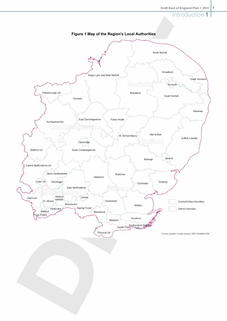
Figure 1 Map of the Region's Local Authorities
7Draft East of England Plan > 2031
Introduction 1
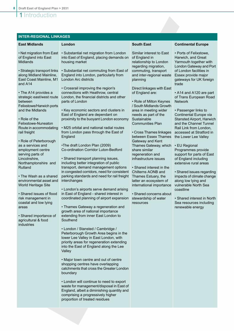
INTER-REGIONAL LINKAGES
Continental EuropeSouth EastLondonEast Midlands
• Ports of Felixstowe,Harwich, and GreatYarmouth together with
Similar interest to Eastof England inrelationship to London
• Substantial net migration from Londoninto East of England, placing demands onhousing market
• Net migration from Eastof England into EastMidlands
LondonGateway and Portregarding migration,• Substantial net commuting from East ofEngland into London, particularly fromLondon Arc districts
• Strategic transport linksalong Midland Mainline,East Coast Mainline, M1and A14
of London facilities inEssex provide majorgateways for UK foreigntrade
commuting, transportand inter-regional wasteplanning
Direct linkages with Eastof England are:
• Crossrail improving the region'sconnections with Heathrow, centralLondon, the financial districts and otherparts of London
• The A14 provides astrategic east/west routebetweenFelixstowe/Harwich portsand the Midlands
• A14 and A120 are partof Trans European RoadNetwork
• Passenger links toContinental Europe viaStansted Airport, Harwich
• Role of Milton Keynes/ South Midlands Growtharea in meeting widerneeds as part of theSustainableCommunities Plan
• Key economic sectors and clusters inEast of England are dependant onproximity to the buoyant London economy
• M25 orbital and national radial routesfrom London pass through the East ofEngland
• Role of theFelixstowe-NuneatonRoute in accommodatingrail freight
and the Channel TunnelRail Link from London,accessed at Stratford inthe Lower Lee Valley
• Cross Thames linkagesbetween Essex ThamesGateway and Kent
•The draft London Plan (2009)Co-ordination Corridor Luton-Bedford
• Role of Peterboroughas a services andemployment centre
• EU RegionalProgrammes providesupport for parts of Eastof England includingextensive rural areas
Thames Gateway, whichshare similarregeneration andinfrastructure issues
• Shared interest in theChilterns AONB andThames Estuary, thelatter an ecosystem ofinternational importance
• Shared transport planning issues,including better integration of publictransport, demand management optionsin congested corridors, need for consistentparking standards and need for rail freightinterchanges
• London’s airports serve demand arisingin East of England - shared interest incoordinated planning of airport expansion
serving parts ofLincolnshire,Northamptonshire andRutland
• The Wash as a sharedenvironmental asset andWorld Heritage Site
• Shared issues of floodrisk management incoastal and low lyingareas
• Shared issues regardingimpacts of climate changealong low lying andvulnerable North Seacoastline
• Shared interest in NorthSea resources includingrenewable energy
• Shared concerns aboutstewardship of waterresources
• Thames Gateway a regeneration andgrowth area of national importanceextending from inner East London toSouthend
• Shared importance ofagricultural & foodindustries
• London / Stansted / Cambridge /Peterborough Growth Area begins in thelower Lee Valley in East London, withpriority areas for regeneration extendinginto the East of England along the LeeValley
• Major town centre and out of centreshopping centres have overlappingcatchments that cross the Greater Londonboundary
• London will continue to need to exportwaste for management/disposal in East ofEngland, albeit a diminishing quantity andcomprising a progressively higherproportion of treated residues
Draft East of England Plan > 20318
1 Introduction

INTER-REGIONAL LINKAGES
• Outdoor recreation resources ofinter-regional importance on the edge ofLondon, including the Lee Valley RegionalPark and the London 2012 OlympicsLegacy
Why is the review taking place when the regional assemblies are to be removed?
1.34 The Government is introducing a number of key changes to the regional arrangements in April2010. All regional assemblies in England, apart from London, are to be abolished and responsibilityfor a single regional plan will rest jointly with a new local council leaders board and the regionaldevelopment agency. For now the East of England Plan, and the Regional Economic Strategywill continue to be separate documents but it is envisaged that at the next review they will bebrought together into a new integrated regional strategy for the East of England.
1.35 Despite these future changes, the Government has asked the Assembly to continue its review ofthe East of England Plan because of the urgent need for a long-term regional spatial strategy forthe East of England. Waiting for the new arrangements to come into being could have causedseveral years delay in its preparation.
Legal challenge to the current Plan
1.36 A High Court hearing in May 2009, found in favour of the legal challenge brought by HertfordshireCounty Council and St Albans District Council against the Government on aspects of the Planrelating to development in the Green Belt around the towns of Hemel Hempstead, Welwyn GardenCity and Hatfield. Further information on how the Government intends to ‘repair’ the Plan can befound on the Government Office’s website at www.goeast.gov.uk.
Your Region
The East of England region shares its boundary with London, the South East and the East Midlands.It covers the counties of Bedfordshire, Cambridgeshire, Essex, Hertfordshire, Norfolk and Suffolk.Over 5½ million people live in the region, mostly in small towns. Stretching from Watford to Cromerand from Clacton to Peterborough, it is the second largest of the English regions.
It is a highly successful region, with over 2½ million jobs, above average employment, educationalachievement and health. It is at the forefront of innovation and new research, and is especially importantto the national economy with key sectors such as biotechnology, finance and pharmaceuticals. It is aregion of contrasts, from global research institutions to local businesses, from coastal communities tothe fringes of London.
Landscapes in the East of England change from the coasts of Norfolk, Suffolk and Essex, through tothe Broads, gently rolling fields of Suffolk and Essex, the Brecks and the Fens, and across to theclaylands of Bedfordshire and the chalk hills of the Chilterns. It has many specially protected areas,noted for their wildlife, landscape and plant life. It is also of vital importance for food production.
Reflecting its qualities, the East of England has experienced long-term growth in people and businessesover the last thirty years. Despite the current recession, the long term need for homes and jobs in theregion will continue.
9Draft East of England Plan > 2031
Introduction 1

It is certainly a region of challenges. There are communities and places in need of regeneration,infrastructure to be provided, and businesses to be supported. More people are becoming pensioners,with fewer workers and young people. Much travel has to be made by car, and national transport routesand international gateways cross the region. The effects of climate change raise further challenges indealing with, for example, flood risk and water supply .
All of these issues must go into the thinking about the future of your region.
Draft East of England Plan > 203110
1 Introduction

2. Vision and ObjectivesNB Changes to the current Plan are shown throughout this document either as DEL, where policy or texthas been deleted, NEW, where new policy or text has been added, REV, where there is a significant revisionto policy or text, or AMD, where there is a minor change, for example to bring policy or text up to date. Thepolicy numbers and paragraph numbers quoted in such instances refer to the current Plan.
Overall Spatial Vision
By 2031 the East of England will be realising its economic potential and providing a high quality of lifefor its people, including by meeting their housing needs in sustainable inclusive communities. At thesame time it will continue adapting to and reducing its impact on climate change and the environment,including through savings in energy and water use and by strengthening its stock of environmentalassets.
(AMD) Objectives
To reduce the region’s impact on and adapt to the effects of climate change by:
locating development to minimise the risks arising from long term coastal change includingsea level rise, flooding, land erosion and subsidence;incorporating effective measures in new and, where possible, existing development to providefor adaptation to, and mitigation of, climate change impacts;reducing the risk of adverse impact of flooding and coastal erosion on people, property andwildlife habitats.locating development so as to reduce the need and distance travelled;effecting a major shift in travel away from car use towards public transport, walking andcycling; andmaximising water and energy efficiency of development, promoting and enabling the use ofrenewable and low carbon energy sources.
To address housing shortages in the region by:
securing a step change to deliver additional housing in the region, particularly the key centresfor development and change; andgiving priority to the provision of affordable housing to meet identified needs.
To realise the economic potential of the region and its people by:
facilitating the development needed to support the region’s business sectors, internationalgateways and clusters, improving skills and widening opportunities in line with the RegionalEconomic Strategy;providing for job growth broadly matching increases in housing provision and improving thealignment between the locations of workplaces and homes;promoting an increase in the region's educational attainment and skills, and the improvedprovision for further and higher education;maintaining and strengthening the East of England’s inter-regional, national and internationalconnections, including improving access to and supporting economic opportunities in London;andensuring adequate sustainable transport infrastructure.
11Draft East of England Plan > 2031
Vision and Objectives 2

To improve the quality of life for the people of the region by:
ensuring new development fulfils the principles of sustainable communities, including cateringfor an ageing population and providing a world class places approach for a well designedliving environment adequately supported by community and green infrastructure;promoting social cohesion and healthy lifestyles by improving access to work, services andother facilities, especially for those who are disadvantaged;maintaining cultural diversity while addressing the distinctive needs of each part of the region;promoting regeneration and renewal of disadvantaged areas; andincreasing community involvement in the implementation of the strategy at the local level.
To improve and conserve the region’s environment by:
ensuring the protection and enhancement of the region’s environmental assets, including thebuilt and historic environment, landscape, soil and water;phase the release of greenfield land to prioritise the re-use of previously developed land assupported by strategic land and market assessments, whilst seeking environmental anddevelopment gains from such growth;protecting and, where appropriate, enhancing biodiversity through the protection of habitatsand species and creating new habitats through development;providing a network of accessible multi-functional greenspace; andreducing the demand for and use of water and other natural resources and reducing waste,whilst increasing the sustainable management of waste.
Draft East of England Plan > 203112
2Vision and Objectives

3. Spatial Strategy3.1 (AMD) Policies SS1 to SS9 set out the core strategy and overall spatial strategy framework for
development in the region. They complement national planning policy statements. While regionalspatial strategies should not normally repeat national policy, national policies on sustainabledevelopment (including such fundamentals as climate change and what makes for a genuinelysustainable community) are set out in several documents. Policy SS1 therefore draws key principlestogether by referring to them in an over-arching policy, which has the weight of statutorydevelopment plan policy. In particular, Policy SS1 responds to the challenges posed by climatechange to the East of England, a theme which runs through many policies in this strategy.
3.2 (AMD) The region continues to face major growth pressures, not least due to its relationship toLondon, its business sectors and the inherent population and household changes within its currentpopulation. A key ambition of this regional strategy is to enable the region to accommodate thatgrowth sustainably. It does this by focusing the majority of development on a group of significanturban areas, termed Key Centres for Development and Change (Policies SS2 and SS3) andthrough selective Green Belt reviews in Policy SS7. Outside the key centres, Policy SS4 recognisesthe important role that market towns and other large settlements have in providing employmentand services for the surrounding rural areas. While the East of England overall is a relativelyaffluent region, there are a number of areas where the problems of economic, social andenvironmental deprivation must be tackled (Policy SS5).
3.3 (NEW) A number of scenarios for the level and distribution of housing and jobs growth in the period2011-2031 have been explored by the Regional Assembly in its review of the current strategy.Taking account of available evidence, advice from local authorities, and response to a publicconsultation on growth scenarios, the level of housing and jobs growth considered appropriate forthe region to plan for in the period to 2031 is addressed in Policies E1 and H1. This RegionalSpatial Strategy has a key role in putting in place a strategy which enables medium and long termgrowth, and recognises, in Policy IMP1, the crucial role played by supporting infrastructure inachieving sustainable growth.
(DEL Para 3.4)
Growth Areas, Growth Points and eco-towns
3.4 (AMD) The Sustainable Communities Plan was published by Government in 2003. It sets outoverall aims for four Growth Areas, the three largest of which include substantial areas within theEast of England:
Thames Gateway, a regeneration area of national importance which includes part of SouthEssex (Essex Thames Gateway);Milton Keynes South Midlands, which includes Luton, Bedford and Central Bedfordshire; andLondon-Stansted-Cambridge-Peterborough.
3.5 (REV) In addition, Haven Gateway, King's Lynn, Norwich and Thetford have been identified asGrowth Points, and St Edmundsbury as a Key Growth Area.
3.6 (AMD) The Growth Areas and Growth Points provide opportunities to capitalise on existing driversof growth, notably London, Cambridge and the international gateways. It has never been theintention that the Growth Areas would be continuous corridors of development. Rather, they arebroad areas based on key movement corridors within which there are a number of opportunitiesfocused on urban areas to deliver significant sustainable growth and regeneration over the longterm. Away from these opportunities, the remaining parts of the Growth Areas will remainpredominantly undeveloped.
13Draft East of England Plan > 2031
Spatial Strategy 3

3.7 The Growth Areas and Growth Points are where the most significant development and regenerationchallenges in the region are concentrated. They provide a framework for helping to prioritiseinvestment in infrastructure and where necessary, for establishing strengthened deliveryarrangements.
3.8 (NEW) In 2007, Government invited proposals for eco-towns, new settlements of 5,000-20,000homes with the whole settlement able to reach zero carbon standards. Nationally, three locationswere identified in a supplement to PPS1 on eco-towns (July 2009) of which one is in the East ofEngland - Rackheath, near Norwich. In addition, funding from the Government's eco-townsprogramme has been agreed (December 2009) for planning and feasibility work at Northstowe,near Cambridge, for its re-design to meet eco-town standards.
(REV) POLICY SS1: Achieving Sustainable Development
The strategy seeks to bring about sustainable development by applying:
the guiding principles of the UK Sustainable Development Strategy 2005:- living within environmental limits;- ensuring a strong, healthy and just society;- achieving a sustainable economy;- promoting good governance; and- using sound science responsibly;
the elements contributing to the creation of sustainable communities:- active, inclusive and safe in terms of community identity and cohesion, social inclusion andleisure opportunities;
- well run in terms of effective participation, representation and leadership;- environmentally sensitive;- well designed and built;- well connected in terms of good transport services;- thriving in terms of a flourishing and diverse economy;- well served in terms of public, private, community and voluntary services; and- fair for everyone; and
climate change adaptation and mitigation principles including the aim of achieving regionalreduction in CO2 emissions to 60 per cent of their 1990 level by 2031. These principles manifestlyapply to: the location of development to reduce the need to travel and ensure resilience to theeffects of climate change; the use of land and buildings so as to consume fewer resources;movement of goods and people; and new development helping to improve existing communities'response to climate change.
In particular, the spatial strategy seeks to ensure that development:- maximises the potential for people to form more sustainable relationships between theirhomes, work places, and other concentrations of regularly used services and facilities,and their means of travel between them; and
- respects environmental limits by seeking net environmental gains wherever possible, orat least avoiding harm, or (where harm is unavoidable within an integrated approach tothe guiding principles set out above) minimising, mitigating and/or compensating for thatharm.
The East of England faces considerable risk from the effects of climate change. Local developmentdocuments and other strategies relevant to spatial planning within the region should:
Draft East of England Plan > 203114
3Spatial Strategy

help meet these principles, the regional target and any other obligations on the emission ofgreenhouse gases; andadopt a precautionary, risk-based approach to the likely effects of climate change by incorporatingmeasures which adapt as far as possible to unavoidable change.
3.9 Policy SS1 refers to several Government policy statements and commitments relating to sustainabledevelopment. These and other key documents, including PPS1: Delivering sustainable developmentand the 2003 Sustainable Communities Plan, are kept under regular review. Regional and localpartners will need to keep abreast of changes to national policies for sustainable developmentand reflect these when reviewing their plans and strategies. The policies of this Regional SpatialStrategy reflect current understanding of the standards expected. Read together, they seek touse resources wisely and ensure that all development is compatible with environmental limits,including in regard to carbon performance and that no development adversely affects the integrityof sites of European or international importance for wildlife.
3.10 (NEW) Global changes to the Earth's climate have significant local impacts. The East of Englandis faced with rising sea levels, wetter winters, hotter drier summers, and more frequent extremeweather events. It is therefore vital to plan and prepare for these changes whether in the designof buildings, the protection of vital infrastructure, maintaining the supply of drinking water, oradjusting farming methods for drier summers.
3.11 (NEW) The Stern Review (2006) concluded that the benefits of strong, early action on climatechange considerably outweighs the costs, which is why this Plan needs to deliver growth that isresilient to the changing climate and ensures existing communities and infrastructure are alsoresilient to the changes that could occur beyond 2031. Therefore a precautionary, risk-basedapproach should be applied to developing plans, policies and strategies. UK climate projections(UKCP09 or the most recent projections if superseded) should be used to assess the level of riskthat should be planned for.
3.12 (NEW) Reducing the emission of greenhouse gases is vital to avoid the most dangerous effectsof climate change but past emissions mean that some changes are now inevitable. The ClimateChange Act (2008) commits the Government to achieving greenhouse gas emission reductionsof at least 80% by 2050, and carbon dioxide emissions reductions of at least 26% by 2020, bothagainst a 1990 baseline. Policy SS1 reflects an earlier, and more ambitious, regional target of an80% reduction in carbon dioxide by 2050 from 1990 levels, with an interim target of 60%, by 2031,which is set out in the Regional Economic Strategy.
3.13 (NEW)The planning system has statutory objectives to contribute to sustainable development andto the mitigation of and adaptation to climate change. Policies in the East of England Plan areintended to contribute to reducing greenhouse gas emissions by ensuring development is locatedto minimise the need to travel (Policy SS2), encouraging the provision of sustainable travel choices(Policies T1 to T4), encouraging high standard energy efficient developments (Policy ENG1), andthrough valuing the environment’s potential capacity to sequester carbon dioxide (Policies ENV1and ENV5). Achieving the regional targets will be dependent on successful delivery of nationalpolicies as well as behavioural change towards low carbon lifestyles. The Transport Carbon Study(EEDA 2009) demonstrates the difficulty in achieving a 60% reduction in carbon dioxide emissionsfrom the transport sector by 2031 in this region. This would mean the region would need to exceeda 60% reduction in carbon dioxide emissions in other sectors, in particular domestic, and industrialand commercial sectors.
3.14 (NEW) The East of England is particularly vulnerable to climate change. The predicted changeswill affect the amount and distribution of rainfall, and could have a detrimental impact on groundwaterresources and the demand for water from all sectors. This will contribute to additional pressure
15Draft East of England Plan > 2031
Spatial Strategy 3

on limited water resources in what is already the driest region in the country. Policies WAT1 andWAT2 address the need to use water more efficiently and the need for a co-ordinated approachto water supply, water quality and flood risk.
3.15 (NEW) Communities, infrastructure, and nationally important food production areas such as theFens, which includes half of all the most productive land in the country, are equally threatened bychanging climate patterns, particularly as droughts and floods may becomemore frequent in future.Infrastructure, designed to cope with past and present conditions, could be at risk in future,including infrastructure of national and international importance, notably the region's major portsand renewable and nuclear energy infrastructure from flooding and coastal storm events.
3.16 (NEW) The region is well placed to respond and take economic advantage of these changes. TheRegional Economic Strategy recognises the commercial opportunities arising from pioneering newtechnologies around renewable energy, resource-efficient housing, and ICT. The region also hasa wealth of environmental technology-focused university and research establishments withspecialism in agriculture, energy and engineering sectors, as well as expertise in understandingand adapting to the impacts of climate change. Policy E4 provides support for the many sectorsand business clusters that will underpin the move to a low-carbon economy.
(REV) POLICY SS2: Urban Concentration
In seeking the more sustainable relationships described in Policy SS1, this spatial strategy directsmost strategically significant growth to the region’s major urban areas where:
strategic networks connect and public transport accessibility is at its best and has the most scopefor improvement; andthere is the greatest potential to build on existing concentrations of activities and physical andsocial infrastructure and to use growth as a means of extending and enhancing them efficiently.
Within this context local development documents should develop policies which:
ensure new development contributes towards the creation of more sustainable communities inaccordance with the definition in Policy SS1. In particular, they should require that new developmentcontributes to improving quality of life, community cohesion and social inclusion. This shouldinclude by making suitable and timely provision for the needs of the health and social servicessectors and primary, secondary, further and higher education particularly in areas of newdevelopment and priority areas for regeneration;adopt an approach to the location of major development which prioritises the re-use of previouslydeveloped land in and around urban areas to the fullest extent possible while ensuring an adequatesupply of land for development consistent with the achievement of a sustainable pattern of growthand the delivery of housing in accordance with Policy H1; andphase the release of greenfield land to prioritise the re-use of previously developed land assupported by strategic land and market assessments, whilst seeking environmental anddevelopment gains from such growth. The regional target is for 60% of development to be onpreviously developed land.
3.17 (REV) The most effective way of managing growth pressures, contributing to the sustainabledevelopment of the region and assisting in reducing carbon emissions is to concentrate developmentat the region’s cities and other significant urban areas including market towns. Major towns andcities provide focal points for retailing and other commercial activities, administration, culture, andtourism. They provide access to public transport and are a focus for improving the interchangefacilities required to strengthen public transport. They serve not only their own geographical areasbut extensive hinterlands which include rural market towns and villages. Market towns play animportant part in a sustainable pattern development by providing service hubs for their extensive
Draft East of England Plan > 203116
3Spatial Strategy
rural hinterlands and can be served more readily by public transport. Larger villages may alsoprovide employment and everyday services, and new development should link with and relate wellto the higher order centre. In smaller villages the emphasis should be on supporting ruralcommunities by meeting local housing needs, encouraging appropriate employment and innovativeforms of public transport.
3.18 (AMD) Where new housing is proposed consideration needs to be given to its implications for thefull range of health and social infrastructure that should be provided or augmented in parallel withdevelopment. Local development documents need to take account of the most recently publishedRegional Social Strategy and Regional Health Strategy, together with advice from local educationauthorities, primary care trusts and the Strategic Health Authority, the police and other serviceproviders.
3.19 (REV) In light of the most recent monitoring information relating to local previously developed landtargets and trajectories, the continuation of a regional target of 60%, in line with national guidance,is appropriate. The extent to which the regional target is achieved will vary across the region,although as the aspiration is to maximise the use of previously developed land, local developmentdocuments should aim to exceed the 60% regional target where appropriate. The Annual MonitoringReport should continue to track performance in different parts of the region and whether the regionaltarget is being achieved. The regional target for re-use of previously developed land should bemonitored in relation to housing and employment development.
3.20 (NEW) The phasing of the release of greenfield land in this policy reflects the need for localassessments to determine brownfield land availability; whilst recognising that previous take upmay diminish reliance on brownfield allocations in some districts.
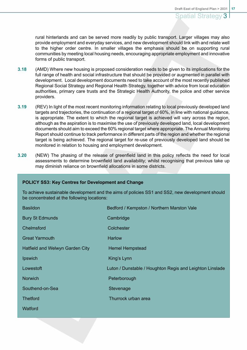
POLICY SS3: Key Centres for Development and Change
To achieve sustainable development and the aims of policies SS1 and SS2, new development shouldbe concentrated at the following locations:
Basildon Bedford / Kempston / Northern Marston Vale
Bury St Edmunds Cambridge
Chelmsford Colchester
Great Yarmouth Harlow
Hatfield and Welwyn Garden City Hemel Hempstead
Ipswich King’s Lynn
Lowestoft Luton / Dunstable / Houghton Regis and Leighton Linslade
Norwich Peterborough
Southend-on-Sea Stevenage
Thetford Thurrock urban area
Watford
17Draft East of England Plan > 2031
Spatial Strategy 3
3.21 Concentrating development at these locations will make the most of existing infrastructure andthe potential for improvements or extensions to it. The principal aims for each of the centres areset out in section 14, Sub-areas and Key Centres for Development and Change.
3.22 (REV) The key centres reflect the polycentric nature of the East of England – a region of smalland medium sized towns and cities surrounded by more rural areas which look to those towns foremployment and higher level services. The main exceptions are Essex Thames Gateway andthe London Arc. They are characterised by towns and urban areas which have been stronglyinfluenced by London and which are located close to each other with complex movements betweenthem for, amongst other things, shopping, employment and education. The spatial strategy buildson and reinforces the region’s polycentric nature by focusing development on the key centres,including within Essex ThamesGateway and the London Arc, where the strategy looks to strengthenthe role of a selected number of the towns.
3.23 (NEW) While all the key centres are a focus for growth, they vary greatly in their economic scale,role and drivers. The East of England Regional Economic Strategy identifies a sub-set of the keycentres, the larger urban sub-regions, cities and their hinterlands,as 'engines of growth'. Theseare: Thames Gateway South Essex, Greater Cambridge, Greater Peterborough, the Milton KeynesSouth Midlands growth area focusing on Luton as a regional city, London Arc, Greater Norwichand the Haven Gateway. The strong performance of these urban areas will have major benefitsto the economic and social well-being of their rural hinterlands and market towns. The RegionalEconomic Strategy also recognises the need for coastal renaissance particularly for Great Yarmouthand Lowestoft. <ADD MAP>
3.24 (REV PARA 3.15) Where key centres adjoin or cross local authority boundaries, local planningauthorities should work jointly to develop co-ordinated strategies and delivery mechanisms.
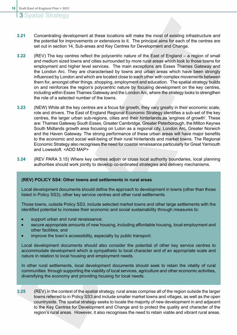
(REV) POLICY SS4: Other towns and settlements in rural areas
Local development documents should define the approach to development in towns (other than thoselisted in Policy SS3), other key service centres and other rural settlements.
Those towns, outside Policy SS3, include selected market towns and other large settlements with theidentified potential to increase their economic and social sustainability through measures to:
support urban and rural renaissance;secure appropriate amounts of new housing, including affordable housing, local employment andother facilities; andimprove the town’s accessibility, especially by public transport.
Local development documents should also consider the potential of other key service centres toaccommodate development which is sympathetic to local character and of an appropriate scale andnature in relation to local housing and employment needs.
In other rural settlements, local development documents should seek to retain the vitality of ruralcommunities through supporting the viability of local services, agriculture and other economic activities,diversifying the economy and providing housing for local needs.
3.25 (REV) In the context of the spatial strategy, rural areas comprise all of the region outside the largertowns referred to in Policy SS3 and include smaller market towns and villages, as well as the opencountryside. The spatial strategy seeks to locate the majority of new development in and adjacentto the Key Centres for Development and Change and to protect the quality and character of theregion’s rural areas. However, it also recognises the need to retain viable and vibrant rural areas.
Draft East of England Plan > 203118
3Spatial Strategy

To that end, there is an important role for market towns and other key service centres in providingemployment and services to their rural hinterlands and meeting housing needs. In smaller ruralcommunities, it will be important to maintain their economic and social sustainability.
3.26 (NEW) Market towns and other large settlements with the potential to increase their economic andsocial sustainability are those which make a contribution to the broader needs of the area. Theyhave a good service base, there is a reasonable existing level of both housing and employment,and they generally act as a node for public transport. They provide a good basis of a sustainablesettlement upon which further development can take place. The provision of new homes in thesetowns can increase support for services, such as schools, health facilities, shops and publictransport. In the context of maintaining and improving the self-sufficiency of such towns, localauthorities should seek to achieve an improved housing-employment balance thereby offering theopportunity to minimise commuting. Public and private sector investment should be used as anopportunity to bolster the role of market towns wherever possible.
3.27 (REV) Key service centres are the focus of meeting local housing and employment needs. Theyare normally large villages with a good level of services, which might include:
a primary school within the settlement and a secondary school within the settlement or easilyaccessible by public transport;primary health care facilities;a range of retail and service provision capable of meeting day-to-day needs, particularly forconvenience shopping;local employment opportunities; andfrequent public transport to higher order settlements.
3.28 (REV) Many smaller villages have very limited local services and are largely, if not wholly, dependenton key service centres, market towns, and main urban areas for everyday needs. In many cases,population growth would not be the solution to rural service decline and could increase the needfor access by car contrary to the principles of sustainable transport set out elsewhere in thisdocument. However some development, including community facilities, may well be needed toensure their continued vitality. The main challenges are securing small-scale local employmentopportunities and supporting the needs of agriculture, improving public transport access to higherorder settlements, providing housing for specific local needs and supporting the sustainability oflocal services. There may be local housing needs that can best be met at those settlements ratherthan concentrating all housing at towns and key service centres, but care should be taken to ensurenew development is directed to locations where it will have the greatest benefits for overallsustainability. It will be for local development documents to determine the appropriate balancebetween ensuring that new development is supported by adequate services and meeting genuinelocal needs.
3.29 (DEL PARA 3.19)
3.30 (REV) There is an acute shortage of affordable housing in many rural areas. Responding to thischallenge is a priority if significant sectors of the rural community are not to be excluded by high,open market house prices.
3.31 (NEW) Other policies in this plan, and Government policy, could have a bearing on the interpretationof these settlement policies at local level, in particular Policy SS7 and PPS2 in relation to GreenBelts and Policy SS9 in relation to the coast. Accordingly it may not be appropriate to see the scaleof development referred to above because of the impact on the objectives of the green belt orbecause of assessments of flood risk.
19Draft East of England Plan > 2031
Spatial Strategy 3

POLICY SS5: Priority Areas for Regeneration
The Priority Areas for Regeneration are:
areas with generally weak economic performance and significant areas of deprivation: EssexThames Gateway; Lowestoft and Great Yarmouth; King's Lynn and West Norfolk; the remoterural areas of Norfolk and Suffolk and the Fens;areas with significant areas of deprivation: Luton/ Dunstable/ Houghton Regis; Bedford/ Kempston;Harlow and the Lee Valley; HavenGateway (Ipswich/ Harwich/ Colchester/ Clacton); Peterborough;Norwich and Stevenage.
Local Development Documents and relevant non-statutory plans should set out policies to tackle theproblems of economic, social and environmental deprivation in these areas and other places withlocally significant regeneration needs.
3.32 The East of England is often regarded as an affluent area. However, many households live inrelative deprivation. They tend to be concentrated in areas of the region with relatively highunemployment and disparities in wealth, income and job opportunities. People suffering suchdisadvantages often also suffer from poor access to services, worse health and life expectancy,and a lower overall quality of life.
3.33 (REV) It is not appropriate for the Regional Spatial Strategy to identify all areas of deprivation.Policy SS5 identifies only the most significant areas as priorities. They are concentrated in someof the larger urban areas and the more peripheral north and east. Even in prosperous andeconomically buoyant areas there are often pockets of deprivation. Local development documentsand other relevant strategies should address localised regeneration needs. Local delivery agenciesand partnerships have a major role to play in ensuring the effective implementation of regenerationpolicies, including ensuring that business plans and investment programmes of various partnersare aligned.
3.34 (REV) Most of the priority areas are also addressed in policies for sub-regions and key centres insection 14 and in Policy SS9 in relation to coastal settlements. In many instances regenerationaction will need to focus on individual wards and other locally defined areas to ensure the effectivetargeting of resources.
3.35 (NEW) The exception is the remote, rural areas of Norfolk, Suffolk and the Fens where deprivationand related issues are spread over a wide area. In large part the problems are created byremoteness which leads to difficulties in access to services and affordable housing. This isexacerbated in many rural areas by a preponderance of lower skilled jobs and low wage rates.Frequently pockets of deprivation are masked in statistics covering wider areas by wealthierretirees, long distance commuters or second home owners.
3.36 (NEW) The challenge for many rural communities is to recognise that the type of developmentreferred to in Policy SS5 is often not sufficient by itself to improve these long term trends. Wideractions need to be taken by the public and private sector and by the communities themselves tolook at new ways to deliver services in rural areas, both through a physical presence and throughremote access and the internet. Measures need to be taken to improve the skill levels of theworkforce and the added value of the jobs in rural areas, thereby raising average wage levels. Inall circumstances, it will be essential to ensure that there is good access to high speed broadbandfor businesses and homes. In addition innovative approaches should be sought to retain and,where possible, improve public transport provision in rural areas.
Draft East of England Plan > 203120
3Spatial Strategy

3.37 (REV) The European Regional Development Fund funded Competitiveness Programme for theEast of England for the period 2007-2013, aims to strengthen competitiveness and promoteemployment and economic growth through innovation and knowledge transfer, enterprise andbusiness support and sustainable development, production and consumption. The CompetitivenessProgramme for the East of England is worth about €110 million and will support low carboneconomic growth in the region. Other European funding is available across the region through theEuropean Social Fund-funded Employment Programme, worth €205 million, focusing on extendingemployment opportunities and developing a skilled and adaptable workforce, and through a rangeof territorial co-operation programmes.
(AMD) POLICY SS6: City and Town Centres
Thriving, vibrant and attractive city and town centres are fundamental to the sustainable developmentof the East of England and should continue to be the focus for investment, environmental enhancementand regeneration.
Local development documents, local transport plans, sustainable community strategies and relevanteconomic, environmental and cultural strategies should:
define the role (or redefine it where necessary) of each city or town centre and include a strategyto manage change, promote a healthy mix of uses, build upon positive elements of its distinctivecharacter, and support the development and enhancement of the local cultural heritage;ensure that land is allocated or can be made available to meet the full range of the city or towncentre’s identified needs; andprotect and enhance existing neighbourhood centres and, where the need is established, promotethe provision of new centres of an appropriate scale and function to meet local day to day needs.
3.38 The East of England has a network of mainly medium and small town centres which are vitalelements of the regional economy and at the heart of economic, cultural, tourism, and other serviceprovision and social interaction. They serve both their immediate urban areas and widerhinterlands. In areas with weaker economies a successful retail sector is often important toregeneration. There is a need to support, enhance and develop the role of all centres. The publicsector and related agencies will be expected to support this strategy by locating new facilities, forexample health care, higher education and offices, in appropriate centres wherever practicable.
3.39 Urban areas and retail catchments do not follow local authority boundaries. Local authoritiesshould co-operate to develop strategies to ensure that centres are protected and enhanced andthat new provision is appropriately located.
3.40 (AMD) The role of town centres should be recognised in the preparation and review of sustainablecommunity strategies, local transport plans and local economic strategies/assessments to promotethe economic, environmental and social success of town centres.
(REV) POLICY SS7: Green Belt
The broad extent of Green Belts in the East of England are appropriate and should be maintained.However, strategic reviews of Green Belt boundaries are needed in the following areas to meet regionaldevelopment needs at the most sustainable locations(1):
1 NB Policy relating to the reviews of Hemel Hempstead andWelwyn/Hatfield, which are listed in the equivalentpolicy in the current Plan, have been remitted to the Secretary of State following legal challenges. Pendingfurther work by the Secretary of State, those elements of the policy are deemed 'not approved' and thereforenot included here
21Draft East of England Plan > 2031
Spatial Strategy 3

Stevenage, involving land in Stevenage and North Hertfordshire;Harlow, involving land in Harlow, East Hertfordshire and Epping Forest Districts; andLuton, Dunstable, Houghton Regis and Leighton Linslade Growth Area urban extensions.
These reviews will have to satisfy national criteria for Green Belt releases, accord with the spatialstrategy and ensure that sufficient land is identified to avoid the need for further review to meetdevelopment needs before 2031. Where reviews cover more than one local authority, they should beundertaken through a joint or co-ordinated approach.
The reviews at Harlow, Stevenage, and the Luton and South Bedfordshire Growth Area should identifycompensating strategic extensions to the Green Belt in East Hertfordshire, North Hertfordshire, andCentral Bedfordshire relating to Milton Keynes respectively.
The Bedfordshire Green Belt should be extended in the region to define the limits of strategicdevelopment area to the south east of Milton Keynes.
3.41 Extensive areas of the region are designated as Green Belt to constrain the growth of large urbanareas, prevent coalescence, safeguard the countryside, preserve the setting of historic towns andassist urban regeneration. However the following exceptional circumstances justify strategic GreenBelt reviews at the general locations in Policy SS7:
(AMD) Policy SS2 directs strategically significant development to major urban areas forsustainability reasons that apply equally to urban areas within, as well as beyond, the GreenBelts. Whilst Green Belt boundaries assist urban regeneration and concentration, in someareas they have acted as a constraint to sustainable development, resulting in a greaterdispersal of development and thereby contributing to unsustainable travel patterns; and
the scale of the region’s housing needs and the aim to achieve a better balance betweensupply and demand in all areas, including the London Arc where demand is particularly strong,affordability problems particularly acute and pressures are likely to intensify further becauseof the proximity to London and scale of employment growth.
3.42 (REV) The reviews will result in significant change locally but can be made without eroding theprinciples and overall functioning of the Green Belt.
3.43 (REV) The potential for more co-ordinated management of the countryside throughout the GreenBelts in the region should be investigated and consideration given to preparing joint strategies toenhance landscape character, recreational access and habitats. In doing so, regard should behad for the requirements of Policy ENV1: green infrastructure and in particular, the role of GreenBelt as part of connected networks of green space.
3.44 (AMD) The Milton Keynes South Midlands Sub-Regional Strategy identified the need for a strategicGreen Belt review at Luton/ Dunstable/ Houghton Regis and Leighton Linslade.
3.45 This spatial strategy does not provide for the strategic review of the Cambridge Green Belt beyondthat undertaken through the Cambridgeshire and Peterborough Structure Plan and related localplans/development plan documents.
3.46 (REV) Where Green Belt boundaries are reviewed, the aim should be to release sufficient land toavoid further review before 2031. Policy H1 sets out the level of development required up to 2031.Development plan documents should test whether this scale of growth will be achievable in thelocal circumstances and if not, release the maximum area commensurate with sustainabledevelopment.
Draft East of England Plan > 203122
3Spatial Strategy

3.47 (AMD) Land released for long term housing and associated development needs should besafeguarded for this purpose in accordance with annex B to PPG2. This review of spatial strategysets the rate of growth at each key centre or district to 2031. This may or may not require all theland excluded from the Green Belt and safeguarded on the basis outlined above to be developedin this period.
3.48 Policy 5 of the 1998 Hertfordshire Structure Plan described the general area of a Green Beltextension between Stevenage and Luton in North Hertfordshire district. While no longer part ofthe development plan, the provisions of that policy still provide a sound basis for redefiningboundaries in that area. The extensions between Stevenage and Luton and to the north of Harlowwill increase the overall area of Green Belt in the region, taking account of the releases in line withPolicy SS8 and at Luton.
POLICY SS8: The Urban Fringe
Local authorities should work with developers and other agencies to secure the enhancement, effectivemanagement and appropriate use of land in the urban fringe through formulating and implementingstrategies for urban fringe areas, working across administrative boundaries where appropriate.
Local development documents should:
ensure that new development in or near the urban fringe contributes to enhancing its characterand appearance and its recreational and/or biodiversity value and avoids harm to sites of Europeanand international importance for wildlife in particular;seek to provide networks of accessible green infrastructure linking urban areas with the countryside;andset targets for the provision of green infrastructure for planned urban extensions.
3.49 Policy SS8 complements Policy ENV1 in recognising the importance of improving the urban fringe,including undeveloped coast close to coastal towns.
3.50 The East of England contains considerable areas of urban fringe, which is the intermediary areabetween the urban area and open countryside. It is sometimes characterised by downgraded andunder-used agricultural land and fragmented ownership, but can offer scope for environmentalimprovements. Strategies for the urban fringe should be underpinned by assessments of landscapecharacter and the scope to enhance recreation provision and ecological diversity.
3.51 A number of initiatives are already in place to secure positive urban fringe management, includingthe Thames Chase, Watling Chase and Marston Vale Community Forests and the Lee and ColneValley Regional Parks. Such initiatives should be continued and extended. There are significantadvantages to be gained through a strategic vision for urban fringe management of an extendedarea, such as the Green Grid in Essex Thames Gateway and the Green Arc around north-eastLondon.
3.52 Some parts of the urban fringe will be used to accommodate urban extensions. Where this happens,it will be important to develop complementary strategies for the positive management of theadjoining countryside to ensure that development is successfully absorbed in the landscape, theneeds of residents for access and recreation are provided for in a manner compatible with otherobjectives, for instance long-term agricultural management and the setting of settlements takeninto account.
3.53 Green space targets for urban extensions should have regard to local circumstances and takeaccount of best practice advice, such as that provided by Natural England.
23Draft East of England Plan > 2031
Spatial Strategy 3
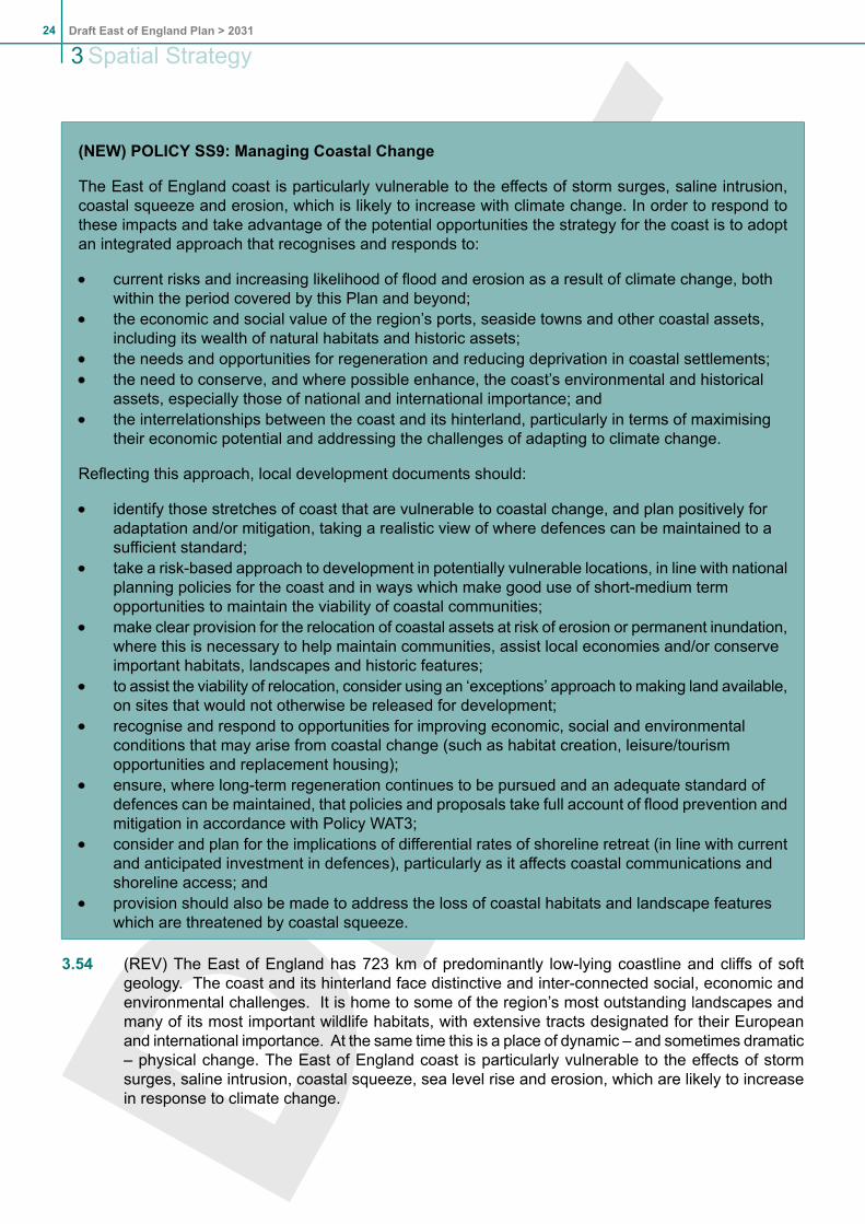
(NEW) POLICY SS9: Managing Coastal Change
The East of England coast is particularly vulnerable to the effects of storm surges, saline intrusion,coastal squeeze and erosion, which is likely to increase with climate change. In order to respond tothese impacts and take advantage of the potential opportunities the strategy for the coast is to adoptan integrated approach that recognises and responds to:
current risks and increasing likelihood of flood and erosion as a result of climate change, bothwithin the period covered by this Plan and beyond;the economic and social value of the region’s ports, seaside towns and other coastal assets,including its wealth of natural habitats and historic assets;the needs and opportunities for regeneration and reducing deprivation in coastal settlements;the need to conserve, and where possible enhance, the coast’s environmental and historicalassets, especially those of national and international importance; andthe interrelationships between the coast and its hinterland, particularly in terms of maximisingtheir economic potential and addressing the challenges of adapting to climate change.
Reflecting this approach, local development documents should:
identify those stretches of coast that are vulnerable to coastal change, and plan positively foradaptation and/or mitigation, taking a realistic view of where defences can be maintained to asufficient standard;take a risk-based approach to development in potentially vulnerable locations, in line with nationalplanning policies for the coast and in ways which make good use of short-medium termopportunities to maintain the viability of coastal communities;make clear provision for the relocation of coastal assets at risk of erosion or permanent inundation,where this is necessary to help maintain communities, assist local economies and/or conserveimportant habitats, landscapes and historic features;to assist the viability of relocation, consider using an ‘exceptions’ approach to making land available,on sites that would not otherwise be released for development;recognise and respond to opportunities for improving economic, social and environmentalconditions that may arise from coastal change (such as habitat creation, leisure/tourismopportunities and replacement housing);ensure, where long-term regeneration continues to be pursued and an adequate standard ofdefences can be maintained, that policies and proposals take full account of flood prevention andmitigation in accordance with Policy WAT3;consider and plan for the implications of differential rates of shoreline retreat (in line with currentand anticipated investment in defences), particularly as it affects coastal communications andshoreline access; andprovision should also be made to address the loss of coastal habitats and landscape featureswhich are threatened by coastal squeeze.
3.54 (REV) The East of England has 723 km of predominantly low-lying coastline and cliffs of softgeology. The coast and its hinterland face distinctive and inter-connected social, economic andenvironmental challenges. It is home to some of the region’s most outstanding landscapes andmany of its most important wildlife habitats, with extensive tracts designated for their Europeanand international importance. At the same time this is a place of dynamic – and sometimes dramatic– physical change. The East of England coast is particularly vulnerable to the effects of stormsurges, saline intrusion, coastal squeeze, sea level rise and erosion, which are likely to increasein response to climate change.
Draft East of England Plan > 203124
3Spatial Strategy

3.55 (NEW) Coastal communities need to adapt to these changes, while also responding to particularsocial and economic challenges. Some coastal settlements are relatively wealthy, but many faceproblems associated with poor transport links, weak economies, social deprivation and the needfor physical regeneration and isolation due to their physical position.
3.56 (NEW) Policies for the coastal zone need to recognise and respond to these challenges, takingan integrated and long-term view of how to address them, and not treating coastal communitiesin isolation (recognising the scope in some places to strengthen the linkages with areas inland).National policies for managing coastal change are evolving and point strongly towards a risk-basedapproach to both addressing the consequences of physical change and recognising the opportunitiesthat may derive from such change. Shoreline management plans and strategic flood riskassessments should be a key part of the evidence base for policy development, but those policieswill also need to take a realistic view of the resources available for investment (for example interms of flood defence and regeneration). Where considered appropriate, local planning authoritiesshould work collaboratively with adjacent districts and other partners to ensure administrativeboundaries do not act as constraint to sustainable management of coastal change.
3.57 (NEW) In some places a proactive approach to planning for the relocation of coastal communities(in whole or in part), and the infrastructure on which they rely, will be needed. Identifying suitablesites or an exceptions basis may be necessary to help facilitate this, to help stimulate the releaseof land at less than full market value. Enabling development should also be considered as a meansof assisting the viability of relocation.
3.58 (NEW) In some areas important contributors to the coastal economy (e.g. caravan sites) are oftenof a temporary character and their location can make them especially vulnerable to the effects offlood risk and erosion. Opportunities may however exist to retain or even introduce temporaryforms of accommodation in areas threatened by coastal change, in places where longer-termerosion/inundation is anticipated (and would rule out more permanent development) but theshort-medium term risks are much less.
3.59 (NEW) Decisions affecting the coastal zone will need to recognise the dynamic nature of coastalprocesses, and the impact that decisions affecting one stretch of coast can have on others. Localplanning authorities should adopt mutually supportive policies to protect important sites and habitatsthat cross local authority boundaries. Habitats which cannot be preserved in situ should be replacedby new areas as close as possible to those existing and wherever possible, before the originalsite is lost. Specific action should be taken to safeguard land on the coast identified for therelocation or re-creation of internationally important habitats, to offset losses elsewhere on theEast of England coast. Historic assets which cannot be preserved in situ should be relocatedand/or recorded according to their significance.
3.60 (NEW) There is considerable scope for more integrated decision-making on the coast. As well astaking full account of the evidence in shoreline management plans and strategic flood riskassessments, planning policies should be informed by (and in turn influence) marine plans, estuarystrategies and management plans and strategies for improving coastal access. The potentialimplications and benefits of developments offshore should also be considered, such as the potentialfor offshore wind schemes to provide community as well as economic benefits.
3.61 (NEW)While this policy deals specifically with the challenges and consequences of coastal change,planning for the coastal zone should consider the full range of other policies in the Regional SpatialStrategy, and in particular: Policy SS5: Priority Areas for Regeneration; Policy IMP1: Implementingthe Regional Spatial Strategy; Policy IMP2: Protection of Designated European Sites; Policy E6:Tourism; Policy ENV3: Biodiversity and Geodiversity; Policy ENV6: The Historic Environment;Policy WAT3: Flood Risk Management and the Sub-Area and Key Centre for Development andChange polices where relevant to coastal areas.
25Draft East of England Plan > 2031
Spatial Strategy 3

Draft East of England Plan > 203126
3Spatial Strategy

4. Implementation, Monitoring and Review4.1 Achieving sustainable growth depends on sufficient capacity of necessary infrastructure and
revenue streams being available, or becoming available, in time to meet the increases in demand.This will include, in some cases, overcoming existing deficits of capacity in the region. Additionalcapacity can come from better management of demand, improved efficiency of existinginfrastructure, or the provision of new infrastructure.
4.2 Effective implementation of the strategy is therefore crucial. It requires significant investment insocial, environmental and physical infrastructure from a variety of sources including: centralgovernment, local government and European funding; private market funding for the bulk ofdevelopment and contributions to the provision of necessary public/social infrastructure; andvoluntary sector funding for a range of services not otherwise provided by public or privateorganisations. Growth can only be considered acceptable if the required capacity of infrastructureis available.
4.3 (REV) Implementation will require:
a positive approach to ensure that the policies and proposals of the regional strategy areactively taken up by implementation agencies pursuing development and change;partnership working – to bring together the full range of organisations involved in schemesand programmes to pool and coordinate their efforts;innovative approaches to development finance and contributions – to maximise the contributionof development to meeting consequent community and infrastructure needs and find newways of getting earlier delivery of critical facilities in association with large, phased schemes;full use of available approaches to implementation, including use of local delivery vehicles toenable development to be implemented proactively in circumstances where market forcesalone may not be sufficient;monitoring, to ensure that the ‘plan, monitor and manage’ approach is continued, and leadsto a timely review of aspects of the regional strategy that are under-performing or need to bereview in light of changing circumstances.
(REV) POLICY IMP1: Implementing the Regional Spatial Strategy
Achieving sustainable growth depends on sufficient capacity of necessary infrastructure and revenuestreams being available or becoming available, in time to meet the increases in demand. This willinclude, in some cases, overcoming existing deficits of capacity in the region.
Additional capacity can come from better management of demand, improved efficiency of existinginfrastructure, or the provision of new infrastructure.
The East of England Regional Implementation Plan will be kept under review and enhanced toprogramme and prioritise the strategic infrastructure and interventions needed.
Where development creates a need for additional capacity, an infrastructure delivery programme needsto be agreed setting out how that capacity will be delivered.
If a delay or impediment to infrastructure delivery is identified through monitoring and/or review of alocal development document, the scale and pace of growth may need to be reconsidered (but not itsspatial distribution as described in policies H1 and E1). However, if local development documents orinfrastructure delivery programmes identify fundamental constraints of capacity that cannot be overcomein the Plan period then this will trigger the need to consider a formal review of regional policy.
27Draft East of England Plan > 2031
Implementation, Monitoring and Review 4

Co-operation is required between developers, infrastructure providers, local authorities, regional andnational bodies to produce and monitor infrastructure delivery programmes.
The resources needed to implement these delivery programmes may be pooled, levied or directlyprovided. Mechanisms to fund the delivery of strategic infrastructure, including ahead of developmentwhere necessary, will be agreed, that involve relevant organisations.
Implementation will be achieved through the private, public and voluntary sectors working in an effectivecoordinated way and in particular will be secured through:
high level regional co-ordinating arrangements which will develop and secure the implementationof the region-wide implementation plan;local planning authorities ensuring early preparation of local development documents; andthe work of local delivery vehicles and local delivery partnerships.
4.4 (DEL PARAS 4.4 - 4-12)
4.5 (NEW) The East of England Implementation Plan sets out a comprehensive framework ofinterventions in the form of programmes to be delivered throughout the region. The ImplementationPlan will be kept updated to reflect additional priorities that emerge during the revision to the spatialstrategy. Evidence demonstrating the requirement for, and delivery of, infrastructure is part offorming sound local development documents. Infrastructure planning and delivery involves abroad range of organisations and can take the form of project plans or programmes of delivery.Local infrastructure programmes provide further context for the implementation of the regionalstrategy. Infrastructure can include non-capital projects and programmes as well, such as revenuesupport to interventions that seek to affect shifts in behaviour.
4.6 (NEW) The provision of additional capacity across all forms of infrastructure can not be separatedfrom achieving the principles of sustainable development. Development should not proceed if thenecessary infrastructure can not be provided, to do so would compromise the objectives andpolicies of the regional strategy. In this respect, growth can only be acceptable on condition thatthe required capacity of infrastructure is available. As well as making use of existing capacity, thiscondition includes resolving existing deficits that local authorities and other agencies identify. Theevidence base that has been prepared as part of this revision has already identified existing deficitssuch as: the capacity of transport networks being exceeded particularly at peak times, energydistribution networks hindering development of allocated sites, and the measures needed to reducethe unsustainable consumption of resources irrespective of growth.
4.7 (NEW) The policy recognises that local development documents have a responsibility to ensurethat their detailed proposals are 'sound' which includes assessing infrastructure requirements. Itdraws a distinction between being flexible over delays with infrastructure that can be managedwithin the local development document period, and more fundamental failures in delivery thattrigger the need to review whether the regional policy should be re-examined.
(NEW) POLICY IMP2: Protection of Designated European Sites
Plans or projects implementing policies in this Regional Spatial Strategy are subject to the HabitatsDirective. Authorities must therefore develop sequential avoidance and mitigation strategies to protectthe integrity of European sites which are at risk due to proposals arising from this regional spatialstrategy, or where a spatial planning response to issues of risk is appropriate. Particular pressuresthat have been identified are water quality and resource issues, recreational pressure and coastalsqueeze. Where these pressures arise from or occur within areas of multiple authorities, theseauthorities should work together.
Draft East of England Plan > 203128
4 Implementation, Monitoring and Review

When deciding on the distribution of development allocations, local planning authorities must considera range of alternative distributions within their area and should distribute an allocation in such a waythat it avoids adversely affecting the integrity of European sites. In the event that a local planningauthority concludes that it cannot distribute an allocation accordingly, or otherwise avoid or adequatelymitigate any adverse effect, it must make provision up to the level closest to its original allocation forwhich it can be concluded that it can be distributed without adversely affecting the integrity of anyEuropean site.
4.8 (NEW) PPS9 Biodiversity and Geological Conservation, supported by wildlife and countrysidelegislation, accords the strongest possible level of protection to internationally and nationallydesignated sites; Circular 06/05 provides guidance on the protection of such sites. Designatedsites cover some 6.6% of the region, comprising 567 Sites of Special Scientific Interest of whichmany are European sites – Special Areas of Conservation and Special Protection Areas – andRamsar sites (wetlands designated for their international importance to wildlife). Some are alsonational nature reserves.
4.9 (NEW) Where a likely significant effect of a plan or project on European sites cannot be excluded,an appropriate assessment in line with the Habitats Directive and associated Regulations will berequired. If, after completing an appropriate assessment of a plan or project, local planningauthorities and other bodies are unable to conclude that there will be no adverse effect on theintegrity of any European sites, the plan or project will not be approved, irrespective of conformitywith other policies in the Regional Strategy, unless otherwise in compliance with Article 6(4) of theHabitats Directive.
4.10 (NEW) A number of European sites have been identified as being at particular risk of impactsarising from water quality and availability issues, coastal squeeze and recreational pressures.Overall, Policy IMP1: Implementing the Regional Strategy provides guidance on the provision ofinfrastructure to support growth. Policies WAT1: Water Efficiency and WAT2: Integrated WaterManagement respond to existing and future water quality and availability issues that might impacton internationally designated sites through managing water resources and planning for waterinfrastructure. Issues regarding coastal squeeze are dealt with in policy SS9: Managing CoastalChange, through which local planning authorities are required to identify opportunities for andensure that development does not prejudice options for managed realignment in the future. PolicyENV1: Green Infrastructure provides guidance on drawing up recreational green space and accessmanagement strategies for sites at risk from recreational pressure.
4.11 (NEW) To assist local planning authorities in drawing up plans that are compliant with the HabitatsDirective, it should be noted that the following European Sites have been identified as being atrisk from:
recreational pressure – the Lee Valley Special Protection Area(SPA) and Ramsar site;Broadland SPA and Ramsar site; Breckland SPA; Hamford Water SPA; the Stour and OrwellEstuaries SPA and Ramsar site; the Colne Estuary SPA and Ramsar site; the BlackwaterEstuary SPA and Ramsar site; the Benfleet and Southend Marshes SPA and Ramsar site;Minsmere and Walberswick SPA and Thames Estuary and Marshes SPA and Ramsar site;water quality issues - Lee Valley SPA and Ramsar site; Broads Special Area of Conservation(SAC) and Broadland SPA and Ramsar site;water resource issues - RiverWensumSAC, Norfolk Valley Fens SAC, Broads SAC, BroadlandSPA and Ramsar site and Blackwater Estuary SPA and Ramsar site, Waveney and LittleOuse Valley Fens SAC; andcoastal squeeze – Benfleet and Southend Marshes SPA and Ramsar site; Thames Estuaryand Marshes SPA and Ramsar site; Minsmere and Walberswick SPA; Stour and OrwellEstuaries SPA and Ramsar site; Hamford Water SPA and Ramsar site; Essex Estuaries SACand Benacre to Eastern Bavents SPA.
29Draft East of England Plan > 2031
Implementation, Monitoring and Review 4

(REV) POLICY IMP3: Monitoring the regional spatial strategy
Annual monitoring will track the delivery of development and the related components of sustainablecommunities, focusing particularly on:
progress towards delivery of infrastructure necessary to support development and economicsuccess;progress in the delivery of housing and evidence of housing need and housing market conditions,including affordability;progress in the development of the region’s economy, in particular the growth of employment andits alignment with housing and population growth; anddelivery of the environmental and other objectives of the Regional Spatial Strategy, in particularwith regard to water consumption, waste water, green infrastructure and emissions; andthe significant effects of implementation.
The results of such monitoring will be taken into account in implementing the Regional Spatial Strategy,contribute to the evidence base for its next review and inform decisions about the need for any singleissue reviews of policy.
4.12 (REV) The plan, monitor and manage approach lies at the heart of the Regional Spatial Strategy,and its implementation through local development documents, transport plans and other means.Monitoring the Regional Spatial Strategy must be in accordance with statutory requirements, andconsideration must be given to whether the findings of monitoring indicate a need for action(s) tosecure its implementation and/or its policies to be reviewed. In this way a check is kept on whetherthe strategy is working and any changes are necessary.
4.13 (NEW) Annual monitoring reports on the performance of the regional spatial strategy have beenpublished since 2001 by the Regional Assembly, and information and data is published regularlyby the East of England Development Agency on the performance of the regional economy. Bringingtogether the regional spatial and economic strategies into a new, integrated regional strategy willrequire the development of an approach to monitoring which builds on the foundations of currentmonitoring regimes whilst focusing on the overall progress of the region and those policies andfactors critical to the successful implementation of the regional strategy.
4.14 (REV) The approach to monitoring the regional spatial strategy accords with the good practice setout in Regional Spatial Strategy Monitoring; a good practice guide (ODPM December 2005), theprinciples set out in the Policy Document on Regional Strategies (CLG and BERR 2010) and theTown and Country Planning (Regional Strategy) regulations 2010.
4.15 (REV) The monitoring arrangements should be kept under review, in liaison with local authoritiesand other partners. A particular aim will be to improve the efficiency and effectiveness of monitoringby ensuring that reliable and appropriate indicators are set and mechanisms put in place to collectand report data. In addition to the matters identified in Policy IMP2, the following areas requirefurther development:
the development of an integrated approach to the monitoring of the regional strategy bringingtogether arrangements for monitoring the previous regional spatial strategy and the regionaleconomic strategy, as well as strategies covering housing, biodiversity, culture and sport;an analytical process which addresses the key relationships and linkages between differentpolicy areas (e.g. houses, jobs and infrastructure);closer links between the processes for monitoring the regional strategy and local developmentdocuments;
Draft East of England Plan > 203130
4 Implementation, Monitoring and Review

trajectories for the carbon performance of new development;sub-regional monitoring and closer working with neighbouring regions where sub-regionscross regional boundaries.
4.16 REV A draft monitoring framework, published with this draft regional spatial strategy, sets outprovisional output indicators and targets related to the draft spatial strategy objectives and policiesand contextual indicators to assist understanding of the evolving context in which the regionalspatial strategy operates. Where appropriate they reflect the national set of output indicators. Sofar as possible the targets are SMART (specific, measurable, achievable, realistic and time-bound)but in some cases further information is needed before they can be defined precisely. The regionaleconomic strategy 2008 sets out a range of indicators to assess progress towards that strategy’svision.
(DEL) Policy IMP3: 'Review of the RSS' and its supporting text - paras 14.15 -14.18
31Draft East of England Plan > 2031
Implementation, Monitoring and Review 4

Draft East of England Plan > 203132
4 Implementation, Monitoring and Review
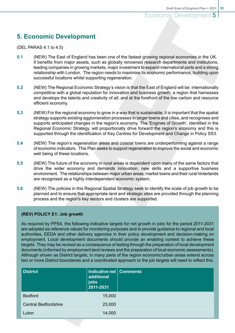
5. Economic Development(DEL PARAS 4.1 to 4.5)
5.1 (NEW) The East of England has been one of the fastest growing regional economies in the UK.It benefits from major assets, such as globally renowned research departments and institutions,leading companies in growing markets, major investment to expand international ports and a strongrelationship with London. The region needs to maximise its economic performance, building uponsuccessful locations whilst supporting regeneration.
5.2 (NEW) The Regional Economic Strategy’s vision is that the East of England will be: internationallycompetitive with a global reputation for innovation and business growth; a region that harnessesand develops the talents and creativity of all; and at the forefront of the low carbon and resourceefficient economy.
5.3 (NEW) For the regional economy to grow in a way that is sustainable, it is important that the spatialstrategy supports existing agglomeration processes in larger towns and cities, and recognises andsupports anticipated changes in the region’s economy. The 'Engines of Growth', identified in theRegional Economic Strategy, will proportionally drive forward the region’s economy and this issupported through the identification of Key Centres for Development and Change in Policy SS3.
5.4 (NEW) The region’s regeneration areas and coastal towns are underperforming against a rangeof economic indicators. This Plan seeks to support regeneration to improve the social and economicwell being of these locations.
5.5 (NEW) The future of the economy in rural areas is dependent upon many of the same factors thatdrive the wider economy and demands innovation, new skills and a supportive businessenvironment. The relationships betweenmajor urban areas, market towns and their rural hinterlandsare recognised as a highly interdependent economic system.
5.6 (NEW) The policies in this Regional Spatial Strategy seek to identify the scale of job growth to beplanned and to ensure that appropriate land and strategic sites are provided through the planningprocess and the region's key sectors and clusters are supported.
(REV) POLICY E1: Job growth
As required by PPS4, the following indicative targets for net growth in jobs for the period 2011-2031are adopted as reference values for monitoring purposes and to provide guidance to regional and localauthorities, EEDA and other delivery agencies in their policy development and decision-making onemployment. Local development documents should provide an enabling context to achieve thesetargets. They may be revised as a consequence of testing through the preparation of local developmentdocuments (informed by employment land reviews and the preparation of local economic assessments).Although shown as District targets, in many parts of the region economic/urban areas extend acrosstwo or more District boundaries and a coordinated approach to the job targets will need to reflect this.
CommentsIndicative netadditionaljobs2011-2031
District
15,000Bedford
23,000Central Bedfordshire
14,000Luton
33Draft East of England Plan > 2031
Economic Development 5

CommentsIndicative netadditionaljobs2011-2031
District
Coordination is required between the relevantauthorities for each of the Growth Areas.52,000Bedfordshire
Subject to testing (involving the East of EnglandLocal Government Association, East of EnglandDevelopment Agency and local authorities)
20,000Cambridge City
11,000East Cambridgeshire
8,600Fenland
10,800Huntingdonshire
21,200South Cambridgeshire
30,000Peterborough
101,900Cambridgeshire
12,000Basildon
5,900Braintree
3,700Brentwood
4,500Castle Point
23,500Chelmsford
18,000Colchester
3,600Epping Forest
8,100Harlow
4,000Maldon
7,000Rochford
7,000Tendring
9,200Uttlesford
12,000Southend-on-sea
30,000Thurrock
148,500Essex
6,200Broxbourne
16,500Dacorum
13,600East Hertfordshire
17,900Hertsmere
9,000North Hertfordshire
Draft East of England Plan > 203134
5Economic Development

CommentsIndicative netadditionaljobs2011-2031
District
11,400St Albans
11,400Stevenage
4,300Three Rivers
10,700Watford
7,100Welwyn Hatfield
108,100Hertfordshire
6,900Breckland
Apportionment for the Norwich Policy area will bedetermined by Broadland, Norwich and SouthNorfolk Councils
10,000Broadland
5,000Great Yarmouth
11,600King's Lynn & West Norfolk
1,100North Norfolk
Apportionment for the Norwich Policy area will bedetermined by Broadland, Norwich and SouthNorfolk Councils
12,100Norwich
Apportionment for the Norwich Policy area will bedetermined by Broadland, Norwich and SouthNorfolk Councils
17,900South Norfolk
64,600Norfolk
Apportionment for the Ipswich Policy Area will bedetermined by Babergh, Ipswich, Mid Suffolk andSuffolk Coastal Councils
9,700Babergh
6,600Forest Heath
Apportionment for the Ipswich Policy Area will bedetermined by Babergh, Ipswich, Mid Suffolk andSuffolk Coastal Councils
14,000Ipswich
Apportionment for the Ipswich Policy Area will bedetermined by Babergh, Ipswich, Mid Suffolk andSuffolk Coastal Councils
11,100Mid Suffolk
13,600St Edmundsbury
Apportionment for the Ipswich Policy Area will bedetermined by Babergh, Ipswich, Mid Suffolk andSuffolk Coastal Councils
11,700Suffolk Coastal
5,000Waveney
35Draft East of England Plan > 2031
Economic Development 5

CommentsIndicative netadditionaljobs2011-2031
District
71,700Suffolk
546,500East of England
(DEL PARAS 4.6 and 4.7)
5.7 (NEW) Policy E1 sets out indicative job targets for the region. These seek to deliver the objectivesset out in Chapter 2, particularly those related to realising the economic potential of the region andits people. The regional target represents an uplift on the level of job growth that might otherwisebe expected if the region was to maintain its current share of economic growth. This reflects thestrategy that provides particularly, but not exclusively, for Key Centres for Development and Changethat require positive management of their economic potential or require interventions to meet theirdesignation as a Priority Area for Economic Regeneration. The policy supports:
Bedford, Harlow, Stevenage, Hemel Hempstead and the Luton conurbation – to assistregeneration and ensure growth in key sectors and clusters;Thames Gateway - linked to the strategies for the key centres at Basildon, Southend-on-Seaand Thurrock Urban Area;Cambridge Sub-Region - to secure its full potential as a centre for world-class research anddevelopment;Peterborough - to achieve regeneration, attract business activities and key sectors and clustersincluding environmental services;Greater Norwich - to support regeneration and its role in bio-technology;Great Yarmouth and Lowestoft - to support development associated with port expansion,regeneration and economic diversification;Hertfordshire - at locations (other than those noted above) where this would support strong,continued growth of mature and emerging clusters and sectors, or support regeneration ofthe Lee Valley;other Key Centres for Development and Change, including Chelmsford - to meet needsidentified in local development documents; andHaven Gateway - to support growth and regeneration at Colchester and Ipswich, includingthe latter’s role in ICT, and development associated with port expansion at Harwich andFelixstowe.
5.8 (NEW) The indicative job targets identified in Policy E1 are influenced by the results of the Eastof England Forecast Model (Autumn 2009 run). The Model brings together a range of key variablesincluding economic output, productivity, employment, population and housing. The starting pointfor the district targets represents that district's share of the region's growth - based upon thedistribution of sectors (and assumptions about their growth) at a particular point in time. A viewwas also taken about the identified need for regeneration. The forecasts were also moderated totake account of local or sub regional visions, and capacity and deliverability issues. Across theregion the change in jobs and change in workforce is broadly matched, but there are differencesat the local level. In some parts of the region a conscious approach has to been taken to prioritisejob growth over increases in workforce, because the aim is to reduce existing high levels ofout-commuting and make more use of the potential local labour supply (such as bringing morepeople back into work). This also applies in policy constrained areas such as the London Arc.
Draft East of England Plan > 203136
5Economic Development

5.9 (NEW) The job targets set out in Policy E1 are presented for each District. However, there aremany functional and physical economic geographies that span District boundaries (such as Ipswichor Norwich). In such cases, local authorities need to work together to ensure that there is the mosteffective distribution of economic growth, taking into account the needs of business, land availability,environmental constraints, and a sustainable relationship with proposals for housing growth.
(AMD) POLICY E2: Provision of Land for Employment
Local Development Documents should ensure that adequate provision is made for a readily availablesupply of employment sites/premises (including sites within mixed-use areas and town/district centres)to achieve:
the job growth targets of policy E1, or revisions to those targets as allowed in that policy;the economic needs of the region’s key sectors and clusters identified in Policy E4;the economic and employment priorities of the Regional Economic Strategy; andthe needs of the local economy revealed by up-to-date employment land reviews, key economicpriorities identified in Local Economic Assessments and any additional employment land issuesidentified through the preparation of Integrated Development Programmes.
Where development proposals and issues cross local authority boundaries this approach should beapplied across the whole functional economic area. Sites of sufficient range, quantity and quality tocater for relevant employment sectors should be provided at appropriate scales in urban areas, markettowns and key rural centres at locations which:
minimise commuting and promotemore sustainable communities by achieving a closer relationshipbetween jobs and homes;recognise and plan positively for the economic benefits of open innovation;promote regeneration within the Priority Areas for Regeneration identified by Policy SS5 andrelevant sub regional and sub area policies;provide appropriately for identified needs for skills-training and education;are accessible and maximise use of public transport;support sustainable rural enterprise;minimise loss of, or damage to, environmental and social capital and where necessary substitutefor any losses and secure positive enhancements. This will often mean giving preference to there-use of previously developed land and the intensification of development within existing sitesover the release of greenfield land; andavoid any adverse impact on sites of European or international importance for nature conservation.
(DEL 4.8-4.9)
5.10 (NEW) Local Development Documents should identify readily-serviceable employment land of therange, quality and quantity required tomeet the needs of business identified through the employmentland reviews referred to in Policy E2. PPS4 (Planning for sustainable economic growth) stronglyemphasises the need for local authorities to take a proactive and flexible approach to allocatingemployment land to support wider sustainable economic development. Local EconomicAssessments and Sustainable Community Plans will form part of the evidence base whenconsidering the need for employment land.
5.11 (NEW) The East of England Regional Assembly and the East of England Development Agencyhave issued good practice advice on developing employment land reviews. Local planningauthorities should ensure that employment land reviews are undertaken using this guidancemanualto ensure a consistent approach is applied within the region. PPS4 and the guidance emphasisethe need for local authorities to work across functional economic geographies reflecting the natureof the economic markets and the real geographic reach of peoples daily lives.
37Draft East of England Plan > 2031
Economic Development 5

5.12 Allocations can promote more sustainable communities directly by redressing an imbalancebetween the availability of local workers and local jobs (and hence the need to travel) or, moreindirectly, such as through town centre office and retail development and the leisure economy.
5.13 (NEW) This policy also seeks to support the rural economy. Local Development Documents shouldenable rural enterprise in Key Service Centres in balance with the transport, urban concentrationand environment policies in this spatial strategy. Outside Key Service Centres local planningauthorities should give consideration to supporting rural enterprise, taking account of the localinfrastructure, character of place and justification for development outside a designated employmentsite.
5.14 (NEW) The region should support open innovation, a concept which promotes the sharing ofintelligence between: business, universities, government, hospitals, research and developmentinstitutes. Creating a culture of innovation which can lead to the development and commercialisationof intelligence and the strengthening of research and business clusters.
5.15 Surplus employment land may be released for housing or other pressing development needs inline with PPS3 (Housing). However it will be important to base such decisions on sound evidence.Land that is likely to be needed for employment should be safeguarded against other developmentpressures.
5.16 Local planning authorities should consider the future information and communications technologyneeds of business occupiers, including next generation broadband services in rural locations,through advice and guidance, inclusion in local planning guidance and development briefs, or bymaking provision a condition of planning permission, particularly at strategic employment locations.
(REV) POLICY E3: Strategic Employment Sites
Regional and local partners should work together to provide and maintain a range of readily availablestrategic employment sites. These sites must meet the needs of key business and economic sectorsthrough their location, access to markets and relationship to available labour supply; act as nodes forthe attraction of inward investment; and maintain and promote the region’s competitive advantage.
A hierarchy of sites should be secured to support the spatial strategy as follows:
Regional Strategic Sites
These sites should be provided and maintained in accordance with the following criteria:
high quality sites which are attractive to national and international investors;good road and public transport accessibility;a clear identity/ brand and future vision for the site;capable of accommodating regional strategic development, which could not equally beaccommodated elsewhere; andsupport specific sectoral needs as set out in Policy E4.
There are existing Regional Strategic Sites located at Adastral Park (Martlesham, Suffolk),Addenbrookes (Cambridge), Babraham (Cambridge), Butterfield Business Park (Luton), CambridgeScience Park, Cranfield Technology Park (Central Bedfordshire), GlaxoSmithKline (Stevenage), GrantaPark (south Cambridge), Hethel (south Norfolk), Norwich Research Park, Peterborough University,and University of Essex (Colchester). These sites should be rigorously safeguarded over the longterm for employment and economic uses.
Regional Gateway Sites
Draft East of England Plan > 203138
5Economic Development
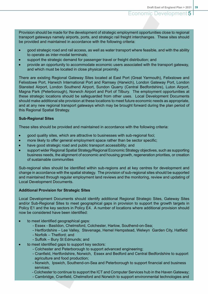
Provision should be made for the development of strategic employment opportunities close to regionaltransport gateways namely airports, ports, and strategic rail freight interchanges. These sites shouldbe provided and maintained in accordance with the following criteria:
good strategic road and rail access, as well as water transport where feasible, and with the abilityto operate as inter-modal terminals;support the strategic demand for passenger travel or freight distribution; andprovide an opportunity to accommodate economic users associated with the transport gateway,and which must be located in close physical proximity.
There are existing Regional Gateway Sites located at East Port (Great Yarmouth), Felixstowe andFelixstowe Port, Harwich International Port and Ramsey (Harwich), London Gateway Port, LondonStansted Airport, London Southend Airport, Sundon Quarry (Central Bedfordshire), Luton Airport,Magna Park (Peterborough), Norwich Airport and Port of Tilbury. The employment opportunities atthese strategic locations should be safeguarded from other uses. Local Development Documentsshould make additional site provision at these locations to meet future economic needs as appropriate,and at any new regional transport gateways which may be brought forward during the plan period ofthis Regional Spatial Strategy.
Sub-Regional Sites
These sites should be provided and maintained in accordance with the following criteria:
good quality sites, which are attractive to businesses with sub-regional foci;more likely to offer general employment space rather than be sector specific;have good strategic road and public transport accessibility; andsupport wider Regional Spatial Strategy/Regional Economic Strategy objectives, such as supportingbusiness needs, the alignment of economic and housing growth, regeneration priorities, or creationof sustainable communities
Sub-regional sites should be identified within sub-regions and at key centres for development andchange in accordance with the spatial strategy. The provision of sub-regional sites should be supportedand maintained through regular employment land reviews and the monitoring, review and updating ofLocal Development Documents.
Additional Provision for Strategic Sites
Local Development Documents should identify additional Regional Strategic Sites, Gateway Sitesand/or Sub-Regional Sites to meet geographical gaps in provision to support the growth targets inPolicy E1 and the key sectors in Policy E4. A number of locations where additional provision shouldnow be considered have been identified:
to meet identified geographical gaps:- Essex - Basildon, Chelmsford, Colchester, Harlow, Southend-on-Sea;- Hertfordshire – Lee Valley, Stevenage, Hemel Hempstead, Welwyn Garden City, Hatfield- Norfolk – Thetford; and- Suffolk – Bury St Edmunds; and
to meet identified gaps to support key sectors:- Colchester and Peterborough to support advanced engineering;- Cranfield, Hertfordshire, Norwich, Essex and Bedford and Central Bedfordshire to supportagriculture and food production;
- Norwich, Ipswich, Southend-on-Sea and Peterborough to support financial and businessservices;
- Colchester to continue to support the ICT and Computer Services hub in the Haven Gateway;- Cambridge, Cranfield, Chelmsford and Norwich to support environmental technologies and
39Draft East of England Plan > 2031
Economic Development 5

low carbon energy; and- Norwich, Peterborough, Cambridge, Haven Gateway, Hertfordshire and Essex to supportthe creative industries.
In addition, further sites will be need to be identified over the plan period to meet future growthaspirations and sectoral development needs. The hierarchy and the portfolio of sites will be regularlymonitored through the annual monitoring report and Regional Spatial Strategy review process inaccordance with Policies IMP2 and IMP3.
(DEL 4.13) (NEW 5.17- 5.23)
5.17 Strategic employment sites are expected to make a significant contribution to the growth of theregional economy over the Plan period for this Regional Spatial Strategy. In some areas appropriateland has already been allocated and the need is to safeguard and promote its use orredevelopment. In other areas additional sites will need to be allocated in locations which satisfythe criteria in Policy E3.
5.18 The East of England Development Agency and the East of England Regional Assemblycommissioned the Strategic Employment Sites Study (2009) to examine the definition and needfor the provision of strategic employment sites to meet economic needs. The study has providedthe evidence base and source for the initial list of strategic employment sites as identified in PolicyE3.
5.19 Whilst the policies in the Regional Spatial Strategy provide an overarching development framework,given the importance of Regional Strategic Employment Sites and the long term commitmentrequired for their delivery, these have been specifically identified in order to safeguard their futurefor employment use. The long term planning required to deliver such sites fits well with a regionalpolicy framework that is updated periodically.
5.20 The majority of the Regional Gateway Sites are already accorded protection through their statusas transport interchanges. These sites have been additionally identified as strategic employmentlocations reflecting their importance as strategic employment drivers. Sub regional strategic sitesare not specifically identified to allow flexibility to be maintained. The scale of development andlikely relatively short timescales associated with the delivery of sub regional strategic sites is notconsidered a good fit with the Regional Spatial Strategy timescales.
5.21 The East of England Strategic Sites Study identifies potential need for additional provision in anumber of locations in order to address geographical gaps and to meet sectoral needs. This mayrequire the identification of new sites, existing sites with a general economic focus to take on anew strategic role or for this need to be met through a number of sub-regional sites. These sitesare not exhaustive and further sites will be required over the plan period to deliver growth aspirationsand meet the requirements of different employment sectors.
5.22 The hierarchy of strategic employment sites is intended to be dynamic, so sites may move bothup and down in ranking as well as in and out of the list of identified sites. All sites will be subjectto regular review through the Annual Monitoring Report so that new sites can be added or promotedand sites which failed to realise their ambitions over a sustained period can also be re-designated.In addition to annual monitoring of site delivery, the evidence base will be updated on a regularbasis to ensure that changes in market demand are assessed and potential requirements for newsites identified.
Draft East of England Plan > 203140
5Economic Development

5.23 Strategic employment sites should also be identified in the local development framework process,in particular in employment land reviews, with the intention of safeguarding against non employmentuses and to provide focus for investment. The location and quality of employment land provisionis critical to economic success and local development documents should ensure there is a highquality employment land offer, taking account of the contribution from strategic employment sites.
(AMD) POLICY E4: Supporting Sectors and Clusters
Local Development Documents should support and provide guidance for locally important and emergingclusters which support the region's ambitions of low resource use and being a low carbon economy.Such clusters and sectors should be defined by growth area partnerships in collaboration with localauthorities and EEDA. Support should also be given to the sustainable and dynamic growth ofinter-regional and intra-regional sectors including:
the life-science, pharmaceutical and biotechnology sectors with concentrations around existingResearch and Development facilities and particularly in the Cambridge sub-region, Hertfordshire,Cranfield, Norwich and Stevenage;the environmental technologies and low carbon energy sectors in Norwich, Peterborough,Cambridge, Cranfield, Hethel, Chelmsford, Great Yarmouth and Lowestoft;the advanced engineering sector at Peterborough, Stevenage, Colchester and Cambridge witha focal point at Hethel in Norfolk linking to Cranfield;the creative industries from London to Hertfordshire and in Peterborough, Haven Gateway, andNorfolk;the ICT/telecommunications sector around Ipswich, Colchester and Cambridge;the agriculture and food production sector, particularly specialist research and development,building on existing concentrations at Cranfield, Norwich, Hertfordshire, Essex and Bedfordshire;the transport and logistics sector maximising the benefits of the regions ports, international airportsand strengths in e-commerce; andthe financial and business services sector with a focus on urban locations and Norwich, Ipswich,Southend-on-Sea, Peterborough and Cambridge.
Support for sectors and clusters should include:
ensuring the availability of a sufficient quantity, quality and choice of sites including provision forincubator units, grow-on space and larger facilities for established business clusters;addressing accommodation needs close to key institutions, such as universities; andaddressing the need for user restrictions to secure the use of premises for specific activities.
(DEL 4.14-4.16) (NEW 5.25-5.27)
5.24 Investing in growth to speed recovery and building manufacturing and services is essential toensure British people and businesses can compete successfully for the jobs of the future. Inaddition, the region must ensure that the transition to a low carbon economy is a source of qualityjobs and business savings, from our rapidly developing civil nuclear industry and renewable energysector, to energy saving in our smallest small and medium sized enterprises.
5.25 The Regional Economic Strategy, Inventing our Future – Collective Action for a SustainableEconomy (2008) indicates a series of priorities which require a positive planning framework tosupport the region's economic performance including commercialising innovation and researchand development. The sectors included in Policy E4 seek to support that commercialising, tosupport moves towards a low carbon economy and promote recognised regional knowledge andsectoral strengths.
5.26 Such sectors should be supported as essential components of a successful regional economy.
41Draft East of England Plan > 2031
Economic Development 5

(AMD) POLICY E5: Regional Structure of Town Centres
The cities and towns of strategic importance for retail and other town centre purposes are:
Regional centres: Basildon, Cambridge, Chelmsford, Colchester, Ipswich, Thurrock Lakeside,Norwich, Peterborough, Southend, Watford; andMajor town centres: Bedford, Bury St Edmunds, Great Yarmouth, Harlow, Hemel Hempstead,King’s Lynn, Lowestoft, Luton, St Albans, Stevenage, Welwyn Garden City.
Major new retail development and complementary town centre uses should primarily be located in theabove centres and be consistent in scale with the size and character of the centre and its role in theregional structure. Development plan documents should only propose higher order provision whereneed is clearly established and the development would:
result in a more sustainable pattern of development and movement, including a reduction in theneed to travel; andhave no significant harmful impact on other centres or the transport network.
Any new regional centres are subject to similar considerations and should only be brought forwardthrough a review of this Regional Spatial Strategy.
Below the level of the centres of regional strategic importance local development documents will identifya network of more local town centres, district centres, neighbourhood centres and village centres.
5.27 Policy E5 defines the regional structure of centres for retail and other town centre purposes, whilstPolicy SS6 sets the overall aims for city and town centre development. National policy on towncentres is set out in PPS4.
5.28 The retail sector is an important driver of the regional economy. There is an established structureof retail centres in the East of England from major regional centres to market towns and villages.In the north of the region centres tend to be more widely dispersed with discrete catchments. Thesouth of the region is strongly influenced by London and the larger centres are closer with morecomplex, overlapping catchments.
5.29 Retail, leisure and other services in the East of England compete with surrounding centres,particularly London, but also Milton Keynes, the Bluewater shopping centre and, to a more limiteddegree, Nottingham and Leicester. During the Regional Spatial Strategy plan period Milton Keynesis likely to continue to grow and town centres in Bedfordshire will need to respond to this by raisingand upgrading their offer.
5.30 Growth in retail provision will be needed in response to growth in population and expenditure percapita but changes such as the growth in ‘e-tailing’ mean there are uncertainties about how muchadditional floorspace and of what types will be needed. At the same time, the scale of additionalprovision needed may be significant in areas of major regeneration or housing growth .
5.31 (REV) No need has been identified for additional out of centre regional/sub-regional shoppingcentres. The only such centre within the East of England was Thurrock Lakeside regional shoppingcentre within the Lakeside Basin of Thames Gateway. Lakeside has the largest concentration ofretail floorspace in the region and as a result of the review of Policy ETG2 (now ETG5) has beendesignated a Regional Centre and identified in Policy E5. Policy ETG5 provides the strategicpolicy framework governing the approach to the area's future development as a town centre.
Draft East of England Plan > 203142
5Economic Development

5.32 There are smaller out of town centre retail sites of local, rather than sub-regional importance,notably the Brookfield Centre in Broxbourne, Hatfield Galleria, and Colney Fields near St Albans.Development plan documents should define the future role of such centres, in particular to determinewhether they should remain purely retail centres or develop into centres with a fuller range ofservice provision. This approach should only be adopted where this would improve social,environmental and economic sustainability and deliver improved sustainable transport accessibility,particularly by public transport.
POLICY E6: Tourism
Local Development Documents should:
include policies to encourage realistic and sustainable investment in the maintenance,improvement, regeneration, extension and diversification of the region’s tourist industry;recognise that much tourism potential is based upon the presence of specific local features orassets, for example the coast and the historic cities of Cambridge and Norwich. Proposals fortourism development should be fully sustainable in terms of their impacts on host communities,local distinctiveness and natural and built environments, including by avoiding adverse impacton sites of national, European or international importance for wildlife; andintegrate with other plans and strategies for managing tourism, particularly local and regionaltourism strategies and visitor management plans, especially those for regenerating seaside resortsand extending employment outside the traditional tourist season.
5.33 Tourism is one of the East of England’s key economic sectors and, with leisure and heritage, isprojected to make one of the highest contributions to the increase in the region’s gross domesticproduct. The main destinations include the historic cities of Cambridge and Norwich, long stretchesof the coast, the Broads, Chilterns and purpose built leisure developments.
5.34 The Regional Tourism Strategy will assist the preparation of Local Development Documents anddevelopment proposals. National good practice guidance on tourism planning was issued in 2006.Careful management and sustainable development of tourism can create opportunities to boostlocal economies, enhance the natural and built environment and contribute to the social well-beingof an area. Tourism can be a catalyst to stimulate investment, revitalise deprived areas andencourage growth in other employment sectors. The benefits in terms of reducing inequalities willbe particularly marked in the north and east of the region, where natural assets with scope forsupporting increased tourism and leisure enterprises are more prevalent than closer to London.
5.35 (REV) Particular attention should be given to tourism development in environmentally sensitiveareas, including both natural and built heritage. Such areas often attract large numbers of visitorsand it is important that these qualities are protected for future generations whilst maintaining thebenefits of tourism. Significant growth in numbers in such areas can have detrimental effects andit is in the interests of tourism developers to conserve the environment upon which they rely.Measures to disperse visitors away from sensitive tourist hot spots such as the Heritage Coastand the Broads to areas with the capacity to cope with larger visitor numbers can be effective.Visitor management strategies, marketing and upgrading of infrastructure may be crucial to thefuture of some popular destinations including historic towns, villages and coastal resorts.
5.36 Proposals for strategic tourism facilities should comply with Policy C2, which sets out strategicdevelopment control criteria. Regeneration proposals for these areas should address broadeningthe tourism season through culture led regeneration. The region should also encourage lessseasonal tourism sectors, such as business tourism.
43Draft East of England Plan > 2031
Economic Development 5

5.37 Regional flagship tourism projects have the potential to boost the image and profile of the region,in terms of attracting new visitors, and to stimulate further growth and investment in tourism andrelated sectors. They also have the potential to provide all-weather attractions that would spreadtourism across the year. The Olympics may act as a catalyst for such opportunities. Smaller scaletourism development can contribute to finding new uses for existing buildings. Sensitive adaptationof historic or locally distinctive buildings can capitalise on the region’s unique qualities.
5.38 Although new development is required to extend tourist infrastructure, priority should also be givento investment in existing attractions to ensure the quality of tourist products is maintained.
5.39 The East of England Tourist Board identifies five key principles of development: partnership,quality, sustainability, competitiveness and accessibility and inclusion. New tourism developmentshould meet these principles along with the requirements of strategic and local planning policies.
(REV) POLICY E7: Employment Land at Stansted Airport
Land within the boundaries of Stansted Airport should be safeguarded for operational and directlyassociated airport employment purposes. Employment development not directly related to the Airport'soperations should be located at Harlow and other nearby towns, identified through Local DevelopmentDocuments in accordance with this spatial strategy. Housing development related to employmentgrowth at the Airport should also be located at Harlow and nearby towns.
(DEL PARAS 4.30-4.33)
5.40 The housing allocations for Harlow, East Hertfordshire and Uttlesford should be sufficient for bothairport-related and other housing needs, though this will need to be kept under review as the airportdevelops. The substantial growth in housing at Harlow should provide for a growing number ofStansted employees to live there, from where they can reach the Airport conveniently by publictransport. Local Development Documents for Uttlesford and East Hertfordshire should reflect thesustainability benefits of a growing number of airport employees living in towns close to the Airport.
Draft East of England Plan > 203144
5Economic Development
6. Housing6.1 (REV) This section should be read with PPS3, which sets out national policy on planning for housing
development, together with the accompanying guidance on such matters as strategic housingmarket assessments. It complements the Regional Housing Strategy for the East of England,which covers related delivery issues, including action to improve the existing housing stock andallocation of funding to support provision of affordable housing. It reflects the context of the HousingGreen Paper, Homes for the Future: More Affordable, More Sustainable, July 2007. Policies forthe provision of accommodation for Gypsies and Travellers, and Travelling Showpeople wereadopted by the Secretary of State in 2009 and are not subject to further review through the currentprocess. The policies (H3 and H4) are set out in 'Appendix E List of Policies not subject toconsultation' for completeness.
6.2 (NEW) In publishing the current Regional Spatial Strategy in 2008, Government asked the Assemblyto carry out an immediate review, in particular to make provision for the East of England'sdevelopment needs for the period 2011 to 2031. As well as extending the time horizon, theGovernment indicated that the review should further increase housing provision with a view tocontributing to the Housing Green Paper's national target of providing 240,000 additional homesa year by 2016. Based on advice it received from the National Housing and Planning and AdviceUnit, Government asked the Assembly to test housing growth in the range of about 30,000 to40,000 new homes every year; a rate of growth that it considers necessary to stabilise long-termhouse prices in the region. The Assembly's view was that in doing the review it should ensure that:
the region's ability to deliver growth in a sustainable way was fully investigated;the new homes are linked to new jobs, and the overall growth linked to adequate infrastructureand other public services;the strategy addresses the challenge of climate change and its impact on, among other things,flooding infrastructure, habitat change and food security; andin applying national policy, the strategy reflects the particular circumstances and characteristicsof the East of England.
6.3 (NEW) During 2009 the Assembly consulted on a range of housing and job growth scenarios and,taking account of the outcome from this, advice from local authorities and evidence from variousstudies and modelling work, has concluded that the scale and distribution of housing growth setout in Policy H1 is an appropriate level of provision for the period 2011 to 2031. The particularfactors that reflect the scale of growth include:
the environmental impacts of higher levels of housing development;lack of available capacity in existing infrastructure;the impact of the recession on economic development in the early years of the Plan period;the ability of the market to accelerate development rates and the difficulties facing publiclyfinanced investment;concerns that trend-based national household projections overstate future levels of migrationinto the region;the poor fit between economic projections and the trend-based national household projections;andan expectation that London will have an increasing role in meeting needs generated in London,although it is accepted there would still be a net migration in-flow to the East of England.
6.4 (NEW) The current Regional Spatial Strategy sets out a very ambitious scale of growth for theregion and while Policy H1 is in line with a 'roll-forward' of that growth, it still represents a significantuplift on trend rates.
45Draft East of England Plan > 2031
Housing 6

6.5 Housing markets vary but there are affordability problems in nearly all parts of the East of England.Provision of sufficient high quality housing to meet the needs of the region’s growing populationis a key priority. In the most pressurised housing market areas, such as close to London andaround Cambridge, the emphasis is on maximising sustainable housing capacity on previouslydeveloped land and limited green field development in response to strong market demand andacute affordability problems. Affordability problems are also acute in many coastal and rural areas,driven by demand from long distance commuters and for second homes. In other areas, mainlytowards the north and east, the pressures are less acute and the emphasis is on creating theconditions in which the planned house building rate will be achieved in step with economic growthand without increases in long distance commuting.
DEL PARA 5.3
(REV) POLICY H1: Regional housing provision 2011-2031
Through managing the supply of land for housing in accordance with PPS3, their local developmentdocuments, and in determining planning applications, local planning authorities should facilitate thedelivery of 500,700 net additional dwellings over the period 2011 to 2031.
Local planning authorities should plan for delivery of housing for at least 15 years from the date ofadoption of the relevant development plan documents.
When bringing forward land for housing they should take account of:
the spatial strategy (Policies SS1 to SS9);the need for co-ordination and consistency of approach between neighbouring authorities; andThe conditionality approach set out in Policy IMP1 regarding the co-ordination of developmentwith necessary transport and other infrastructure provision, including provision for adequate watersupply and waste water treatment, as provided for under Policy WAT 2.
The regional housing provision is distributed as follows:
CommentsDwelling provision, 2011 to 2031(2)
Area/District/Unitary
Annualaverage
April 2011to March2031
Total netincrease target
April 2011to March2031
98019,500MKSM StrategyArea: Bedford/ Kempston/Northern Marston Vale
1,59031,700MKSM StrategyArea:Luton/Dunstable/HoughtonRegistogether with LeightonLinslade
701,300Rest of Bedford UA
2 Due to rounding the annual average rates in brackets may not match the totals. Totals take precedence.
Draft East of England Plan > 203146
6Housing

CommentsDwelling provision, 2011 to 2031(2)
Area/District/Unitary
Annualaverage
April 2011to March2031
Total netincrease target
April 2011to March2031
Figures include an assumption of 2,100homes at Milton Keynes South EastExpansion Area
60012,000Rest of Central BedfordshireUA
3,23064,500Bedfordshire and Luton
70014,000Cambridge City
55011,000East Cambridgeshire
additional potential for Fenland (up toanother 150 homes per annum) will betested to inform a future review of H1
55011,000Fenland
55011,000Huntingdonshire
1,05021,000South Cambridgeshire
1,43028,600Peterborough UA
4,83096,600Cambridgeshire andPeterborough
54010,700Basildon
Growth of Colchester has implications forTendring (for any development needs on
3306,600Braintree
the east of Colchester) and Braintree(western part of Colchester Boroughparticularly A120). A co-ordinated approachis required.
1703,400Brentwood
2004,000Castle Point
83016,600Chelmsford
Growth of Colchester has implications forTendring (for any development needs on
84016,800Colchester
the east of Colchester) and Braintree(western part of Colchester Boroughparticularly A120). A co-ordinated approachis required.
2 Due to rounding the annual average rates in brackets may not match the totals. Totals take precedence.
47Draft East of England Plan > 2031
Housing 6

CommentsDwelling provision, 2011 to 2031(2)
Area/District/Unitary
Annualaverage
April 2011to March2031
Total netincrease target
April 2011to March2031
Figures exclude provision for urbanextensions to Harlow which is includedwithin the figures for Harlow.
1603,200Epping Forest
Figures are for total housing growth atHarlow, including urban extensions in EastHertfordshire and/or Epping Forest.
80016,000Harlow
1202,300Maldon
1903,800Rochford
Growth of Colchester has implications forTendring (for any development needs on
4308,600Tendring
the east of Colchester) and Braintree(western part of Colchester Boroughparticularly A120) A co-ordinated approachis required.
4008,000Uttlesford
3006,000Southend UA
93018,500Thurrock UA
Figures are for total housing growth,including urban extensions of Harlow in EastHertfordshire and/or Epping Forest.
6,230124,500Essex, Thurrock andSouthend
2605,100Broxbourne
3106,100Dacorum
Figures exclude provision for urbanextensions to Harlow which is includedwithin the figures for Harlow.
55011,000East Hertfordshire
2505,000Hertsmere
Figures includes provision for developmentrelated to Stevenage.
79015,800North Hertfordshire
3507,000St Albans
Figures exclude provision for developmentrelated to Stevenage in North Hertfordshire
3206,400Stevenage
2004,000Three Rivers
2605,100Watford
2 Due to rounding the annual average rates in brackets may not match the totals. Totals take precedence.
Draft East of England Plan > 203148
6Housing
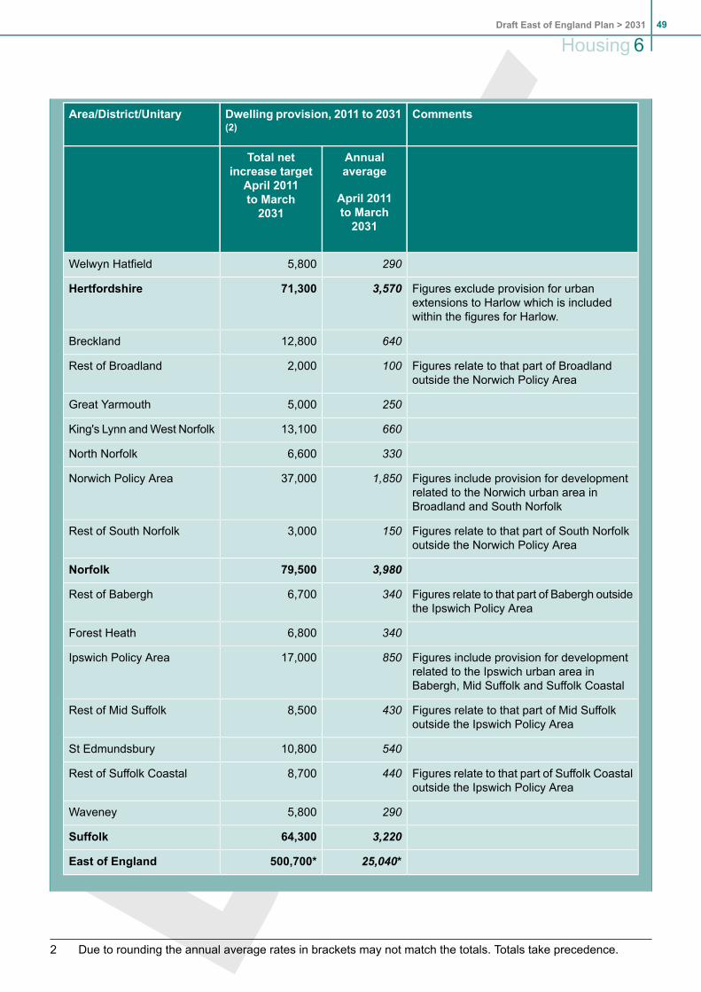
CommentsDwelling provision, 2011 to 2031(2)
Area/District/Unitary
Annualaverage
April 2011to March2031
Total netincrease target
April 2011to March2031
2905,800Welwyn Hatfield
Figures exclude provision for urbanextensions to Harlow which is includedwithin the figures for Harlow.
3,57071,300Hertfordshire
64012,800Breckland
Figures relate to that part of Broadlandoutside the Norwich Policy Area
1002,000Rest of Broadland
2505,000Great Yarmouth
66013,100King's Lynn andWest Norfolk
3306,600North Norfolk
Figures include provision for developmentrelated to the Norwich urban area inBroadland and South Norfolk
1,85037,000Norwich Policy Area
Figures relate to that part of South Norfolkoutside the Norwich Policy Area
1503,000Rest of South Norfolk
3,98079,500Norfolk
Figures relate to that part of Babergh outsidethe Ipswich Policy Area
3406,700Rest of Babergh
3406,800Forest Heath
Figures include provision for developmentrelated to the Ipswich urban area inBabergh, Mid Suffolk and Suffolk Coastal
85017,000Ipswich Policy Area
Figures relate to that part of Mid Suffolkoutside the Ipswich Policy Area
4308,500Rest of Mid Suffolk
54010,800St Edmundsbury
Figures relate to that part of Suffolk Coastaloutside the Ipswich Policy Area
4408,700Rest of Suffolk Coastal
2905,800Waveney
3,22064,300Suffolk
25,040*500,700*East of England
2 Due to rounding the annual average rates in brackets may not match the totals. Totals take precedence.
49Draft East of England Plan > 2031
Housing 6

* This does not make allowances for the outcome of the 'repair' process Government isundertaking to the current East of England Plan following a successful legal challenge. It isreconsidering recommendations about additional growth at Dacorum and Welwyn Hatfield.
DEL PARAS 5.4, 5.5 and 5.6
6.6 (NEW) Policy H1 sets out the total amount of housing to be delivered in the region in the period2011 to 2031. Annual average figures have been included for each area for monitoring purposes;they should not be regarded as annual targets. In a number of instances the district figure makesprovision for extensions of an urban area into a neighbouring authority(s). In other cases a totalprovision figure is given for an area that crosses administrative boundaries. In all these instancesa strong partnership approach to the preparation and delivery of joint or co-ordinated developmentplan documents will be required. Further guidance is provided in the relevant part of section 14.
6.7 (NEW) PPS3 requires local planning authorities to plan for continuous delivery of housing for atleast 15 years from the date of adoption of housing allocation development plan documents. 12local planning authorities in the region have adopted Core Strategies (December 2009) with theremainder to be adopted in 2010 or later. Most of the local development documents in preparationare planning to an end date of 2026 with a few planning to 2031.
6.8 (NEW) Local planning authorities whose core strategies are already programmed for adoption in2010 should take account of the Policy H1 targets in their next review. Those authorities who areat an earlier stage of preparation, where adoption will be post 2011, should work to achieve thePolicy H1 targets in their current review.
6.9 (NEW) Other development plan documents that follow on from an adopted core strategy that doesnot go to 2031, will need to demonstrate why they have not been able to plan for the full period ofthis Regional Spatial Strategy. Following adoption of this strategy, local authorities should haveregard for the targets in Policy H1, as well as any adopted core strategy target, when identifyingthe land supply element of their housing trajectories.
(REV) Policy H2: Affordable Housing (3)
Against the 25,040 dwellings per annum required for the region, an average of at least 11,600 affordablehomes per annum are required to meet need in the period to 2031. These affordable homes can comefrom either building new dwellings and/or providing mechanisms for social housing providers andresidents to purchase existing dwelling stock. If these were to come only from building new dwellingsthen that would represent 46% of all completions.
Taking into account a broad regional view of viability, the acute need for affordable housing, andmechanisms for the purchase of existing stock, this policy considers that Local Development Documentsshould ensure new development contributes to this target by making provision for at least 35% of alldwellings identified in Policy H1 to be affordable across each local authority area, subject to viability.
PPS3 states that all housing developments over 15 units, (or over 0.5 hectares), will be required toprovide affordable housing. Given the acute need for affordable housing across the region as a whole,Local development documents will be expected to set lower thresholds where it is viable and practicableto do so, as supported by PPS3.
3 For the purposes of this policy the definition of affordable housing is as in Annex B of PPS3.
Draft East of England Plan > 203150
6Housing

6.10 An adequate supply of good, affordable housing is essential to the quality of life of those of theregion’s residents who cannot afford to compete in the open market, and to the delivery of balancedand sustainable communities.
6.11 The Regional Assembly commissioned the Cambridge Centre for Housing and Planning Researchto assess the need for affordable housing in the East of England over the period covered by thePlan. Their 2009 report concluded that 11,600 affordable homes are required annually up to 2031to meet regional needs. This would equate to 46% of the H1 housing allocation if it was onlydelivered via new build.
6.12 In considering how this future regional need can be met, it is important to bear in mind that thereare a variety of ways in which affordable housing can be delivered from building new dwellings topurchasing existing dwelling stock. The region’s ability to meet its future need for affordablehousing will depend not only on the effective use of planning obligations but also on grant andnon-grant funded delivery methods. Hence, only a proportion of the 11,600 affordable homes willbe expected to be delivered via new build dwellings.
6.13 In looking at what the planning system can reasonably contribute to the delivery of affordablehousing, it is also necessary to identify an appropriate balance between overall need and siteviability. Local affordable housing needs studies have typically identified this proportion as around35%. Given the region’s high level of needs for affordable housing this is a reasonable regionalbenchmark, though a higher contribution could be expected, for example, in areas of high landvalues.
6.14 Local development documents should therefore set targets for the provision of affordable housingthat reflect the regional target of at least 35% whilst taking into account:
the objectives of Planning Policy Statement 3 (PPS3), the Regional Spatial Strategy, theRegional Housing Strategy and any successor strategy or statement;local assessments of affordable housing need, as part of strategic housing marketassessments. Assessments should examine housing need and demand in relation to bothaffordable and market housing and where markets cross boundaries should be conductedjointly between authorities;the need where appropriate to set specific, separate targets according to dwelling type, sizeand tenure to meet the assessed needs of all sectors of the community, including the needsof families with children, single person households, the disabled and older people. In doingso they should consider those elements of the current housing stock which are currentlyunder-represented;evidence of financial viability based on an informed local assessment of land for housingwithin the area, and the need to achieve an appropriate balance between the level of developercontribution that can reasonably be secured, whilst minimising the level of any public subsidyin the direct provision of affordable homes through the planning system;evidence of affordability pressures in both urban and rural areas, pursuing the use of exceptionsites in rural areas as a delivery mechanism where appropriate, and working with ruralcommunities to secure small scale affordable housing sites within or well-related to settlements;andthe need for affordable housing to be integrated effectively into new and existing communitiesto encourage the development of cohesive communities.
6.15 For the purposes of ongoing monitoring, Annual Monitoring Report data will be used to measurethe delivery of affordable housing via the planning system, against the 35% regional target.
6.16 Total annual delivery of affordable housing, against the 11,600 regional need figure, will bemeasured by data collected under National Indicator 155 (and/or other data sources as appropriate).
51Draft East of England Plan > 2031
Housing 6

6.17 Pitch provision on Gypsy and Traveller sites owned and managed by local authorities or registeredsocial landlords should count as affordable dwellings for both the NI 155 and Annual MonitoringReturn data.
Policy H3 Provision for Gypsies and Travellers
See 'Appendix E List of Policies not subject to consultation' for Policy and supporting text. Not subjectto consultation.
Policy H4 Provision for Travelling Showpeople
See 'Appendix E List of Policies not subject to consultation' for Policy and supporting text. Not subjectto consultation.
Draft East of England Plan > 203152
6Housing
7. Culture7.1 Culture consists of a number of sectors with different attributes: the arts, creative industries,
enjoyment of the natural, historic and built environment, events and festivals, use of tourism,libraries, museums, archives and galleries, the diversity of the faith communities and places ofworship, local cultural traditions and sport and recreation. Culture is inherently cross cutting, forexample linking policies on economic growth and regeneration with those on environment, heritageand infrastructure provision.
7.2 (AMD) The policy framework for culture is provided in national planning policy guidance andplanning policy statements on sustainable economic growth, archaeology, the historic environment,sport and recreation and nature conservation together with policy statements and guidance fromthe Department of Culture, Media and Sport and agencies, including Sport England, EnglishHeritage and Natural England.
(REV) POLICY C1: Cultural Development
Local Development Documents and the wider strategies of local authorities should include policiesthat support and grow the region’s cultural assets. In doing this local authorities should:
take account of the Regional Cultural Strategy and any local cultural and sustainable communitystrategies and liaise with the region's cultural agencies, including in regard to site allocations forcultural facilities; andrecognise the contribution that cultural sectors can make to regeneration, growth and urban/ruralrenaissance, particularly in the priority areas for regeneration.
7.3 The East of England provides a high quality urban and rural environment incorporating a wealthof cultural facilities, sites and activities which are enjoyed by both residents and visitors. Theregion has one of the main concentrations of creative industries in the UK. Collectively, the culturesectors employ substantial numbers, make a major contribution to the region’s economy and canplay a significant role in driving regeneration.
7.4 (DEL PARA 6.4)
7.5 (REV) Following direction from Government, the region’s cultural agencies are workingcollaboratively on four key issues: the development of regional strategy; local government;place-shaping and the London 2012 Olympic Games. The Regional Cultural Strategy identifiespriorities for the cultural sectors and until culture is reviewed through the Single Regional Strategy,these priorities will remain current.
7.6 (REV) Two of the event sites for the London 2012 Olympic Games are planned in the East ofEngland. Together with the proximity of the main Games sites in East London and the legacy thatwill be left, they can provide significant economic, cultural and sporting benefits for the region.
(REV) POLICY C2: Provision and Location of Strategic Cultural Facilities
Regionally or nationally significant leisure, sport, recreation, arts, tourism or other cultural facilitiesshould be supported in locations where proposals:
will enhance existing facilities of regional or national significance or elsewhere, reflect a sequentialapproach – with priority to locations in town centres before off-centre or out of town locations andfor the use of brownfield land in preference to greenfield sites. Exceptionally, the specific attributesof a rural site may make it appropriate for a regionally strategic proposal;
53Draft East of England Plan > 2031
Culture 7

are designed to enhance the environment and do not adversely affect areas designated for theirecological, landscape or historic value, including sites of European or international importancefor nature conservation;meet sustainable development objectives as outlined in this Regional Spatial Strategy;maximise opportunities to use means of transport other than the car and use transport networksthat have adequate capacity to accommodate passenger and rail freight requirements;are well related to this Regional Spatial Strategy's regional transport nodes;minimise their use of energy and natural resources including their impact on public services whilsthaving satisfactory proposals for minimising their long-term use and impact; andare of an appropriate scale and impact.
The above criteria may be met by the introduction of measures to ameliorate or mitigate adverseeffects. Proposals that meet the above criteria and would benefit a priority area for regeneration orcreative industry cluster as identified in this Regional Spatial Strategy should be given particular support.
7.7 (REV) A number of regionally significant development proposals are expected to come forwardfor leisure, sport, recreation, arts or tourism projects in future years. Policy C2 provides acriteria-based policy against which to assess culture development proposals of regional or nationalsignificance. It complements national policy on the importance of high quality design standards.
7.8 Wherever possible such developments should be in or close to Key Centres for Development andChange. In some cases their scale or nature may mean this would not be realistic and it may benecessary to exploit specific locations, for example former mineral workings or, in regard to facilitiesattracting large numbers of visitors, interchange facilities outside of large settlements with goodor potentially good public transport.
Draft East of England Plan > 203154
7Culture
8. Transport(Section 8 replaces all of section 7 in current Plan)
8.1 The transport policies provide a regional framework for the delivery of transport investment andpriorities which supports the aims of the spatial strategy.
8.2 The existing transport network and the scope for service improvement was an important factor inshaping the spatial strategy, which seeks to reduce dependence on car travel and deliver a shiftto more sustainable travel options. The transport policies promote a reduction in the need to traveland the reliance on road-based private transport.
8.3 An outline of the transport system is shown on the key diagram. Where possible, consideration ofthe road and public transport networks have been taken together. The hierarchy distinguishesbetween the elements that serve a national or regionally strategic purpose (strategic) and thosethat are regionally important in terms of inter-urban movements (regional).
8.4 The policies are fully consistent with national transport policy. The objectives for transport are to:
maximise the overall competitiveness and productivity of the national economy, so as toachieve a sustained high level of GDP growth;reduce transport’s emissions of CO2 and other greenhouse gases, with the desired outcomeof avoiding dangerous climate change;contribute to better health and longer life-expectancy through reducing the risk of death, injuryor illness arising from transport, and promoting travel modes that are beneficial to health;improve the quality of life for transport users and non-transport users, including through ahealthy natural environment, with the desired outcome of improved well-being for all; andpromote a greater equality of transport opportunity for all citizens, with the desired outcomeof achieving a fairer society.
8.5 The successful achievement of these objectives will lead to the following regional outcomes:
delivery of quantifiable reductions in CO2emissions;improvement of journey reliability on key economic routes;improvement of access to key business centres;support for the delivery of housing and economic growth;improvement in the resilience of network, such as to impacts and incidents of climate change;enhancement of social inclusion and regeneration by improving accessibility and reducingthe economic gap between regions;reduction in transport casualties and improved public health; andimproved journey experience aided by an enhanced quality of transport integration with theurban environment.
8.6 The region has to develop a well-evidenced understanding of the challenges it faces, now and inthe future, particularly regarding economic and carbon challenges. National and Regional studiesare being undertaken through the DfT programme - Delivering a Sustainable Transport System.The results will help to develop this Regional Spatial Strategy through its stages to adoption.
(NEW) POLICY T1: Transport, Climate Change and Air Quality
A reduction in CO2 emissions from transport will be achieved by:
requiring all regional transport interventions to demonstrate how they contribute to minimisingCO2 emissions
55Draft East of England Plan > 2031
Transport 8

prioritising, where possible, funding for those regional transport interventions that deliver quantifiedCO2 reductions, whilst recognising the need to balance this against the other policies in this spatialstrategy; andrequiring the Highways Agency, Network Rail and all local authorities to demonstrate how theyare contributing to the region's CO2 target, through their strategies and implementation plans,including the local transport plans and local development documents. Rail has a significant roleto play in reducing the carbon emissions associated with the movement of both people and freighttransport in and through the East of England. Addressing gaps in the region’s rail network, includingelectrification, will be critical to lower carbon emissions as well improving the speed, capacity,reliability and economics of the rail network. The region will work with regional partners, NetworkRail and Government to deliver full electrification of the regions rail network.
In order to improve the resilience of the regional transport network, the Highways Agency andNetwork Rail will work with local transport authorities to identify parts of the network at risk fromthe impacts of climate change. This will be used to inform not only improvement interventions butalso maintenance regimes.
Local development documents can help to achieve improvements in local air quality through:
ensuring consistency with air quality management plans;reducing the environmental impacts of transport including congestion management and the useof cleaner transport fuels; andassessing the potential impacts of new development and increased traffic levels on internationallydesignated nature / conservation sites, adopting avoidancemitigation measures to address theseimpacts.
The primary driver for national, regional and local air quality management is the protection of humanhealth, although the impact of certain pollutants on wildlife habitats and vegetation is also a concern.Local development documents and local transport plans should consider the potential impacts of newdevelopment and increased traffic levels. Significant consideration needs be be given to internationallydesignated nature conservation sites.
8.7 The Climate Change Act 2008makes the UK the first country in the world to have a legally bindinglong-term framework to cut carbon emissions. It also creates a framework for building the UK'sability to adapt to climate change. The UK Low Carbon Transition Plan plots how the UK will meetthe 34% cut in emissions on 1990 levels by 2020 as part of an ambition to reduce emissions by80% by 2050. Regionally, a target of reducing carbon emissions by 60% by 2031 has been setcompared to the 1990 baseline. The East of England Transport Carbon Study 2009 has highlightedhow challenging it will be for the transport sector in the region to make a reasonable contributionto the target. The study shows that carbon emissions from the transport sector in the region willcontinue to rise if current travel patterns persist and growth continues. It also shows that significantcuts in transport sector emissions can be achieved through a mix of interventions including newtechnologies and behavioural change. The study highlights the need for early action, which willplace the region in a stronger position to compete in a low carbon future.
8.8 In addition to mitigating climate change, parts of the transport network in the East of Englandregion are vulnerable to the impacts of climate. It will be essential to find ways of adapting so asto make the network more resilient and ensure it is able to continue functioning and delivering thewider economic and social benefits.
Draft East of England Plan > 203156
8 Transport

(NEW) POLICY T2: Transport Corridors and Nodes
The regional and strategic transport network and Regional Transport Nodes are shown on the keydiagram. This inter-urban network is economically important for the region and its development. Thefollowing places are identified as Regional Transport Nodes:
Basildon, Bedford, Brentwood, Bury St Edmunds, Cambridge, Chelmsford, Colchester, Great Yarmouth,Harlow, Harwich, Welwyn Garden City & Hatfield, Hemel Hempstead, Ipswich, King’s Lynn, Lowestoft,Luton/Dunstable, Norwich, Peterborough, Southend, Stevenage, St Albans, Stansted Airport, Thurrockurban area and Watford.
These areas are the focus for improvements to inter-urban public transport and integration betweenmodes. Improvements to journey time and reliability is a key policy objective for the regional andstrategic transport network, particularly where it links Regional Transport Nodes, connects nodes withLondon or provides access to the region’s gateways.
The objective of this policy is to maximise and sustain the economic and environmental benefits forthe region and beyond. This will be achieved through the following priorities:
enabling a higher proportion of travel to be made by public transport;complementing the emphasis on public transport improvements with targeted highwayimprovements on the strategic and regional road network, with consideration given first andforemost to interventions that maximise the efficient use of the network; andtargeting interventions that promote more efficient freight movements and minimise their impacton the environment and local transport networks.
Initiatives and interventions will be expected to demonstrate how benefits will be sustained over time.
Investment to address journey reliability will focus on corridors and Regional Transport Nodes whereinterventions will result in the greatest economic benefits, with an emphasis on boosting the role ofthe Engines of Growth.
The corridors identified by the region where transport constraints are impacting on economic growthare currently:
London/London Arc to Thames Gateway (A13/A127 and parallel rail routes);London/London Arc to Milton Keynes South Midlands (M1 and West Coast Mainline);London/London Arc to Haven Gateway (A12 and Great Eastern Mainline extending to Norwich);Greater Cambridge to Milton Keynes South Midlands (A428 / A421 corridor);Greater Cambridge to London/London Arc (M11 and West Anglia Mainline corridor); andGreater Cambridge to Greater Peterborough (A14 corridor).
Regional investment may also be directed at other parts of the regional and strategic road network topromote its continuing functionality, such as by delivering road safety and targeted capacity interventions,particularly if existing commitments within the Regional Funding Allocation and national deliveryprogrammes are not delivered. To assist this matter, Appendix A (strategic transport infrastructurepriorities) of this spatial strategy should be frequently reviewed.
8.9 The regional and strategic transport network will continue to be economically important for theregion and its development. Strategic roads cater principally for longer distance traffic but theirregional and local roles, including for the strategic bus and coach network, should also berecognised. The regional road network should be the lowest level carrying significant volumes ofheavy goods vehicles.
57Draft East of England Plan > 2031
Transport 8

8.10 The Department for Transport’s report,Delivering a Sustainable Transport System 2008, identifiesa number of strategic national corridors that are of national economic importance, linking key urbanareas and international gateways. Seven of these fall within the East of England region. Theseare:
Corridor 5: London Orbital;Corridor 8: London to West Midlands and beyond;Corridor 10: London to the East Midlands, Yorkshire and beyond;Corridor 11: Haven Ports to the Midlands;Corridor 12: London to the Haven Ports;Corridor 13: London Stansted Cambridge Corridor; andCorridor 14: London to Thames Gateway Ports.
8.11 The Transport Economic Evidence Study 2008 shows that targeted investment at key bottlenecksand corridors in the region, on regionally important corridors as well as on strategic nationalcorridors, can bring significant economic benefits. The study shows that public transportimprovements will play a pivotal role as they generally deliver both the most economic gain coupledwith the lowest CO2 impact.
8.12 The Regional Freight Strategy 2008 identified the need for preferred freight routes and the on-goingmanagement and improvement of key routes, complemented by restrictions on the use of otherroutes.
(NEW) POLICY T3: Urban Transport
Towns and cities help drive the economy of the region and are the focus for the majority of growth,however congestion on the region's network weakens their success. Local Transport Plans and LocalDevelopment Documents will need to ensure that urban areas achieve a shift to sustainable low carbontransport options. Delivering this shift in a way that makes a positive contribution to the urbanstreet-scape will also continue to promote the economic well-being and health of our urban areas.Interventions will be a priority in those urban areas that are within the:
Engines of Growth;Priority Areas for Regeneration;Key Centres for Development and Change; and/orRegional Transport Nodes.
Local Transport Plans will need to demonstrate how they are balancing the need to address congestion,local air quality, CO2 emissions, the promotion of walking and cycling and improvements to street-scape,whilst supporting urban economies. Nevertheless, they should consider giving the highest priority topromoting the use of active transport modes when developing and maintaining the street environment,including through linking local walking and cycling routes to the National Cycle Network and supportingthe on-going development of the National Cycle Network.
Demand management measures, including: parking management, road space reallocation, or pricingmechanisms should be considered for inclusion in the package of transport interventions for eachurban area. An integrated approach is required between the application of demand managementmeasures and the delivery of high quality public transport and other sustainable transport provision inorder to achieve modal shift. Local Transport Plans and Local Development Documents must besensitive to the economic well-being, as well as the social and environmental challenges of the area,especially with regard to the Engines of Growth, Priority Areas for Regeneration and the accessibilityneeds of communities within the rural hinterland.
Draft East of England Plan > 203158
8 Transport

8.13 The Transport Economic Evidence Study shows that towns and cities drive the economy of theregion and congestion on the region’s networks has the greatest adverse economic impact in theurban areas. These areas have the greatest scope for efficient public transport and more use ofwalking and cycling. It also identified how modal shift within the Engines of Growth would deliversignificant economic gains by reducing traffic and congestion. The scale of the challenge forregional and local authorities, businesses and the general public should not be underestimated.
8.14 The wide range of circumstances in the region justifies a flexible approach to maximum levels ofnon-residential parking at the local level. Parking standards should take account of three keyparameters: location, land use and accessibility. In particular, rigorous standards should beconsidered in those parts of the region where the levels of public transport accessibility are goodor improving.
(NEW) POLICY T4: Transport in Rural Areas
In rural areas priority should be given, particularly in Local Transport Plans and Local DevelopmentDocuments to improving sustainable access from villages and other rural settlements to key servicecentres, market towns and urban areas.
In particular, interventions will focus on:
developing alternative means of service delivery to reduce the need to travel;improving sustainable access options to Key Centres for Development and Change, Priority Areasfor Regeneration and Engines of Growth;improving accessibility to a range of essential rural services and opportunities that support therural economy, especially in the more deprived rural areas to the north and east of the region;delivering transport services that tackle social exclusion, in particular those which meet theidentified needs of the region’s ageing population;increasing active transport, especially where this would help to address identified rural healthissues and enhance tourism opportunities; andconnecting local walking and cycling and assisting the delivering of the National Cycle Network.
8.15 The East of England has some sparsely populated rural and coastal areas, often relatively deprived,as well as rural areas that have more dense and often more affluent, settlement patterns.Nevertheless, all rural areas have transport needs which are different from those of urban areasand a key challenge for policy is to improve accessibility to services whilst moving to moresustainable travel options. Key drivers are improving access to jobs, schools and other servicesand sustaining rural communities and their economies. The much lower density of rural movementpatterns means that meeting access needs by conventional public transport is more difficult andthe private car may remain important over the Plan period.
8.16 Innovative and less conventional schemes to provide more flexible rural transport may have a rolein increasing the accessibility of rural areas to market towns and service centres, particularly forthose without a car. Provision for walking and cycling is important regionally because of itsimplications for public health as well as quality of life.
8.17 Accessibility can also be improved by delivering services differently and so reduce the need totravel in order to access them. Delivery agencies in other sectors will need to support improvedrural accessibility, such as by providing the wider availability of new technologies.
59Draft East of England Plan > 2031
Transport 8

(NEW) POLICY T5: Access to Airports
The region's airports of national importance are Stansted and London Luton. Norwich and Southendairports also have important regional functions. These are shown on the key diagram.
Access to the region's airports will be managed and enhanced to support their development. This willbe achieved by:
requiring airport operators to have a robust and up to date surface access strategy in place forStansted, Luton, Norwich, and Southend;enabling a higher proportion of surface access trips to the region’s major airports to be made bypublic transport and other more sustainable travel options. Surface access strategies should bethe principal driver. Such strategies will need to demonstrate that improvements to sustainablelow carbon transport modes have been given a higher priority than road improvements whereverpossible; andgiving support to the development of additional air freight handling facilities at airports in the regionwhere there is an identified need.
8.18 The roles of Stansted and London Luton Airports are outlined in the Air Transport White Paper2003. Future development at these airports, including timely provision of infrastructure, surfaceaccess strategies and rigorous environmental safeguards, is the responsibility of the relevantairport operator/owner in conjunction with partners. Support is given in the White Paper for theexpansion of the regional airports at Norwich and Southend to meet more localised demand andcontribute to local economic development, subject to the same conditions as those above.
8.19 The approach to the delivery of supporting infrastructure and surface access should reflect theother policies in the Regional Spatial Strategy. Airport developers will be expected to pay the costsof surface access improvements where they are needed to cope with additional passengers andfreight travelling to and from the airports (this may be a proportionate amount if the requiredimprovements are also providing additional capacity for other new development in the vicinity).Transport investment and management required to provide for the airports will be considered inthe context of sustainable travel.
(NEW) POLICY T6: Freight Movement and Access to Ports
The region’s ports of national importance are: Bathside Bay (Harwich), Felixstowe, London (includingTilbury) and London Gateway. The smaller ports including Great Yarmouth, Lowestoft, Ipswich andKing’s Lynn also have an important regional function and potential to address niche port activities.These ports are shown on the key diagram. Access to the region’s ports should be managed andenhanced to support their development and enable them to contribute to national and regional objectivesfor economic growth and regeneration. Enabling more sustainable and reliable freight movements toand from the region’s ports will be required to reduce CO2 emissions and enhance the economicattractiveness of these ports for business. The region will therefore support initiatives that deliver thefollowing priorities:
maximising the proportion of all freight carried by rail;providing adequate rail freight capability on routes to the region’s major ports includingelectrification;requiring port operators to have a robust and up to date surface access strategy in place for eachof their ports in the region;protecting where possible and where there is a reasonable prospect of them being developed:
- previously used rail-accessible sites from non rail-based development,
Draft East of England Plan > 203160
8 Transport

- freight facilities for rail and water freight use or interchange; andsupporting the provision and use of:
- inland ports,- waterways,- coastal shipping; and- strategic rail freight interchanges (where they support identified freight needs and help bringlogistical efficiencies and enhance the capability of the rail network), as well as delivereconomic and environmental benefits. This will include supporting the development of atleast one strategic rail freight interchange, to serve London and the Greater South East,unless more suitable locations are identified within London and the South East for all three/four interchanges required. Sites must have existing good access to the strategic road andrail networks.
8.20 The region has two major port areas of national economic importance at the Haven and ThamesGateways as well as smaller regionally significant ports. Emerging national policy in 2010 is toplan for additional capacity in the ports sector in order to provide spare capacity, both to enablegreater flexibility and to improve the resilience of the sector in the event of capacity being lost ata major port. Large scale development is underway at Felixstowe and further additional capacityis planned at London Gateway, with more modest growth at Great Yarmouth.
8.21 Current port operations generate significant freight movement and the Regional Freight Strategy2008 forecasts that this will increase. The freight strategy identifies that the movement of freightin the region is largely by road. It recommends a clearer focus on maximising the use of rail,especially rail facilities and services that increase the use of low carbon technologies and improvethe use of the ports. Surface access strategies should be developed to achieve more sustainableand coordinated access to ports for freight. Three of the strategic national corridors connect to theregion’s major port areas and these will be important for accessing ports, as recognised in PolicyT2 of this spatial strategy.
8.22 Opportunities for moving freight along the coast and on inland waterways are encouraged bynational policy and coastal shipping could lead to increased use of the region’s smaller ports.
8.23 The Strategic Rail Authority Strategic Rail Freight Interchange Policy 2004 identified a need forthree to four strategic rail freight interchanges for the Greater South East and the Eastern RegionalPlanning Assessment for the Railway, 2006 envisaged development of strategic sites around theM25. Given that the region includes a third of the M25 ring and that all the main rail lines fromLondon to the North and Scotland cross the M25 within the East of England, it is likely that at leastone of the required strategic interchanges will need to be in the region. The Regional FreightStrategy 2008 also confirmed this need.
61Draft East of England Plan > 2031
Transport 8

Draft East of England Plan > 203162
8 Transport

9. Environment9.1 (AMD) National policy identifies the role of development plans in achieving proactive conservation
and enhancement of landscapes, biodiversity and the historic environment, and establishes theprinciple that planning policies should take account of the impact of development on landscapequality and the need to improve the built and natural environment in and around urban areas andrural settlements.
9.2 (REV) The following principles for the management of the East of England’s natural, built andhistoric environment reflect national guidance and underpin the policies in this section.
9.3 In their plans, policies and programmes local planning authorities and other agencies should:
conserve and enhance the natural, historic and built environment by positive managementand protect it from development likely to cause harm;adopt an approach that recognises the links between proactive conservation and meetingthe social and economic needs of local communities;protect, for their own sake, all important aspects of the countryside, including individualfeatures, special sites, protected areas, their settings, and the wider landscape;through the development plan system, conserve and enhance whenever possible regionaland local distinctiveness and variety, based on understanding gained through the IntegratedRegional Landscape Framework, the regional Environment Strategy and other assessmentsof regional and local character and scrutiny of development impacts;secure effective protection of the environment by considering the nature and location ofproposed development as part of a broadly based concern for, and awareness of, biodiversityand other environmental assets, and of issues such as light and noise pollution;recognise that the negative impacts of development can be wide-ranging and impact on theenvironment in a cumulative fashion;restore damaged and lost environmental features whenever possible;address environmental issues at appropriate scales, working across local planning authorityboundaries, andpromote a sustainable approach to the use of the region’s natural resources that recognisesthe values of ecosystem services.
9.4 The Regional Environment Strategy ‘Our Environment, Our Future’ (2003) outlined the mainenvironmental challenges facing the region and set out a number of actions needed to meetidentified aims. This, and other regional strategies, including the Regional Woodland Strategy,provide the context for policies ENV 1-7.
(REV) POLICY ENV1: Green Infrastructure
(REV) Areas and networks of multifunctional green infrastructure should be identified, created, protected,enhanced and managed as a fundamental element of sustainable communities. Green infrastructureshould be developed so as to maximise benefits for communities and biodiversity as well as to contributeto achieving the goals of climate change mitigation and adaptation.
(REV) Local Development Documents should:
define a multiple hierarchy of green infrastructure, in terms of location, function, size and levelsof use, based on analysis of natural, historic, cultural and landscape assets, and the identificationof areas where additional green infrastructure is required;require the creation of new and the retention of substantial connected networks of green space,in urban, urban fringe and adjacent countryside areas to serve the growing communities in keycentres for development and change;
63Draft East of England Plan > 2031
Environment 9

Ensure that green infrastructuremaximises opportunities for walking and cycling, including betweenurban communities and the countryside;Ensure that spatial priorities for green infrastructure recognise the role that access to biodiversity,greenspace and heritage assets can play in developing sustainable communities.Consider the role that green infrastructure can play in the conservation, restoration andenhancement of important landscapes, biodiversity assets and heritage assets, including throughreducing visitor pressure on the most sensitive sites;Ensure that policies have regard to the likely impact of new and expanded communities on thequality of existing green infrastructure and where necessary, providing new open space buffersaimed at protecting sensitive sites;Set out clear delivery and implementation mechanisms to ensure that green infrastructure isdelivered in an effective and timely manner, including the identification of funding mechanismsfor creation and long term management through S106 agreements, planning tariffs, CommunityInfrastructure Levy and other mechanisms;Be produced jointly with other relevant Local Authorities and delivery bodies where there is aneed to ensure coordinated implementation to achieve the vision set out in regional andsub-regional Green Infrastructure Plans;Provide clear planning guidance for the development of strategically significant green infrastructureprojects.
Assets of regional significance for the retention, provision and enhancement of green infrastructureinclude:
the Norfolk and Suffolk Broads; the Norfolk Coast, Suffolk Coast & Heaths, Dedham Vale andChilterns Areas of Outstanding Natural Beauty; and the Heritage Coasts (shown on the KeyDiagram);other areas of landscape, ecological and recreational importance, notably the Community Forests(Thames Chase, Marston Vale and Watling Chase), the Brecks, Epping Forest, Hatfield Forest,the Lee Valley Regional Park and areas around the Stour Estuary, and Colne Valley RegionalPark that crosses the administrative boundary into the South East.strategically significant green infrastructure projects and proposals, such as the Great Fen Project,Wicken Fen Vision, the Milton Keynes to Bedford Waterway Park, and the Green Arc Project.
9.5 (AMD) Green infrastructure, as described in Planning Policy Statement 12 and Natural England'sGreen Infrastructure guidance, refers to networks of protected sites, nature reserves, green spaces,waterways and green linkages, for example wasteland, gardens, allotments and green walls androofs. By providing for multi-functional uses, for example landscape, wildlife, recreational andcultural experience, it contributes to livability, whilst delivering biodiversity and other benefitsincluding, potentially flood relief. This can be achieved through retrofitting existing spaces to deliveradditional functions, as well as provision with new developments. Green infrastructure should beplanned strategically and implemented as part of developments at all scales. Provision shouldaim to extend and enhance existing infrastructure to create linked networks of green space.
9.6 (NEW) Local Development Documents should set policies which respond to locally identified need,including increased demand for recreational open space associated with planned development,and identify the scale and location of green infrastructure required to ensure that existing, extended,and new communities are attractive places to live and work. Any tension between the multipledemands made on such infrastructure should be addressed.
9.7 9NEW) It is not sufficient to merely develop policies which identify green infrastructure sites andopportunities. Local Planning Authorities need to be pro-active in their identification of funding anddelivery mechanisms. Green Infrastructure Plans should underpin this process and Supplementaryor Site Specific Planning Guidance should be produced to assist in the timely delivery of the greeninfrastructure necessary to support sustainable growth. This may require collaborative working on
Draft East of England Plan > 203164
9Environment

joint strategies by the Local Planning Authorities concerned and the implementation and fundingbodies involved. In addition to this, Local Development Documents should set out how greeninfrastructure assets are to be managed and maintained to ensure that the quality and provisionof green infrastructure is not compromised in the long term.
9.8 (DEL Para 8.6)
9.9 (AMD) Green infrastructure has the potential to contribute to capturing carbon emissions, and aspart of a package of measures, to achieve developments which are carbon neutral. The GreatFen project is an example of where this approach is being developed. Where development mayhave adverse effects on sites of European or international importance for wildlife, greeninfrastructure can help to avoid or mitigate that risk. Green infrastructure can also support climatechange mitigation objectives through encouraging walking and cycling, and can support adaptationobjectives by reducing flood risk and combating urban heat island effects.
9.10 (NEW) The assets and projects named in ENV1 are not an exhaustive list and there may also belocally significant projects that should be recognised in local plans. Further work is needed toreview the list of regional green infrastructure assets in ENV1 and establish, from evidence, whetherany further assets need to be identified and how the assets should be managed and enhanced.In particular, further study is needed on the role of these assets in providing for increased visitsand recreational use associated with growth, and also mitigating potential impacts of increasedrecreational pressure on European sites being assessed under the Habitats Regulation Assessment.
9.11 (NEW) Policy IMP2 identifies a number of designated European sites at potential risk fromrecreational pressure. The recreational greenspace and access management framework that localauthorities develop with regard to mitigating for recreational pressure on European sites shouldcover the following aspects in order to ensure deliverability:
Make it clear that strategic measures are required to ensure the avoidance and mitigation ofrecreational impacts on European sites;identify specific vehicle(s) (Green Infrastructure Strategies may be appropriate) for providingthe details of strategic mitigation provision regarding recreational impacts on the Europeansites and the status of this vehicle as part of the Local Development Scheme;that this document will precede or accompany the development of detailed site allocations;ensure that the development of this vehicle and of alternative greenspace will be informedby the evidence that has been collected regarding how and why visitors use the Europeansites;state that the provision of alternative greenspace will be connected into the wider greeninfrastructure framework;make it clear that the suite of measures will cover (where appropriate) some or all of a)theprovision of alternative greenspace, b) access management of the European sites and c)potentially some habitat management of those same sites, including coordinated visitor accessmanagement plans for European sites, tailored to their individual character and interestfeatures;state that the local authority will work with adjacent authorities to address the recreationalissues where necessary in order to ensure that adverse ‘in combination’ effects are adequatelymitigated;identify that the timing and phasing of the green infrastructure and access managementdelivery will be tied to the phasing of development; andmake it clear that the implementation and effectiveness of this strategic approach will bemonitored and reviewed concurrently with reviews of the delivery of housing provision andincorporated into Annual Monitoring Reports where appropriate.
65Draft East of England Plan > 2031
Environment 9

(REV) POLICY ENV 2: Landscape Conservation
In their plans, policies, programmes and proposals planning authorities and other agencies should, inaccordance with statutory requirements, afford the highest level of protection to the East of England'snationally designated landscapes (the Norfolk and Suffolk Broads, the Chilterns, Norfolk Coast, DedhamVale, and Suffolk Coast and Heaths Areas of Outstanding Natural Beauty (AONBs), and the NorthNorfolk and Suffolk Heritage Coasts) and their settings whilst having regard to the statutory managementplans prepared for them. In considering proposals for development, the emphasis should be on smallscale proposals that are sustainably located and designed. Proposals which support the economiesand social well being of the designated landscapes and their communities will be encouraged. In termsof the Broads, priority should be given to conserving and enhancing the natural beauty, wildlife, historicalenvironment and cultural heritage of the area, promoting public enjoyment and the interests ofnavigation. In terms of the AONBs, priority over other considerations should be given to conservingand enhancing the natural beauty, wildlife, historic environment and cultural heritage of each area.
(AMD) In addition to considering designated landscapes, planning authorities and other agenciesshould recognise and aim to conserve and enhance the diversity and local distinctiveness of thelandscape areas by:
developing area-wide strategies, based on landscape character assessments, setting long-termgoals for landscape change, targeting planning and land management tools and resources toinfluence that change, and giving priority to those areas subject to most growth and change;developing area-wide strategies, using the spatial framework provided by the Integrated RegionalLandscape Framework and other landscape character assessments. Such strategies shouldalso set long-term goals for landscape change and target planning and land management toolsand resources to influence that change;Locating development sensitively so that it respects and enhances landscape character andimposing criteria based policies, particularly for those areas subject to most growth and change;andsecuring mitigation measures where, in exceptional circumstances, damage to local landscapecharacter is unavoidable.
9.12 (REV Para) Some 7.5% of the land area is designated as nationally important landscape: theNorfolk and Suffolk Broads, which has equivalent status to a National Park, and the four areas ofoutstanding natural beauty (only part of the Chilterns AONB is within the East of England). TheBroads and individual AONB Management Plans set out the visions for these areas and providemore detailed context for the preparation of AONB specific policies in Local DevelopmentDocuments, planning and other decision making, provision of advice and resource allocation.Designated Landscapes will have functional links with land outside their boundaries, not leastbecause surrounding land can provide an important visual setting. As such, the characteristicsof the nationally designated areas have implications for decisions that are made beyond theirboundaries and local authorities should be aware of the requirement to take account of the statutorypurposes such landscapes, particularly when making planning decisions within their settings.Figure 5 shows the main landscape and nature conservation areas designated in the region.
9.13 (REV Para) National policy for sustainable development in rural areas in PPS7 emphasises thecontinuing need to protect the countryside for the sake of its intrinsic character and beauty. Aregional landscape typology has been developed which describes the variety of landscapes in theEast of England, as illustrated in Figure 6. Many local authorities have also published landscapestrategies, supported by character assessments and related studies that provide a finer level ofanalysis and these should inform Local Development Document preparation. Further guidanceon regional priorities for landscape conservation and enhancement will be provided through thecontinued development of the Integrated Regional Landscape Framework by Landscape East.
Draft East of England Plan > 203166
9Environment

INSERT FIGURE 5
INSERT FIGURE 6
(REV) POLICY ENV3: Biodiversity and Geodiversity
In their plans, policies, programmes and proposals planning authorities and other agencies shouldensure that internationally and nationally designated sites are given the strongest level of protectionand that development does not have adverse effects on the integrity of sites of European or internationalimportance for nature conservation. Proper consideration should be given to the potential effects ofdevelopment on the conservation of habitats and species outside designated sites, and on speciesprotected by law.
(AMD) Planning authorities and other agencies should ensure that the region’s wider biodiversity,geodiversity and natural resources are protected and enriched through the conservation, restorationand re-establishment of key resources by:
ensuring new development minimises damage to biodiversity and geodiversity resources byavoiding harm to local wildlife sites and local geological sites, and, wherever possible, achievingnet environmental gains in development sites through the retention of existing assets, enhancementmeasures, new habitat creation and mitigating and adapting to climate change or other methodsappropriate for the features of interest;promoting the conservation, enhancement, restoration, re-establishment and good managementof habitats and species populations in accordance with East of England regional biodiversitytargets (Appendix B) and the priorities in the East of England Regional Biodiversity Map (Figure7);identifying and safeguarding areas for habitat restoration and creation, in particular large-scale(greater than 200 ha) habitat restoration and creation areas which can play a key role in theregional ecological network and green infrastructure;ensuring the appropriate management and further expansion/connectivity of wildlife corridorsimportant for the migration and dispersal of wildlife and to facilitate the need for habitats andspecies to adapt in light of the changing climate;establishing networks of green infrastructure, maximising their biodiversity value (as provided forunder policy ENV1) and enhancing biodiversity within developments, making use of buildings aswell as spaces, for example through the creation of green walls and green roofs; andidentifying, safeguarding, conserving, and restoring local geological sites (regionally importantgeological and/or geomorphological sites) and promoting their positive management.
The East of England Regional Assembly and its partners should work with authorities in neighbouringregions on strategic natural resource, geodiversity and biodiversity issues in areas such as the Chilterns,the Wash and Thames Estuary.
9.14 PPS9 Biodiversity &Geological Conservation, supported by wildlife legislation, accords the strongestpossible level of protection to internationally and nationally designated sites; Circular 06/05 providesguidance on the protection of such sites. Designated sites cover some 6.6% of the region,comprising 567 Sites of Special Scientific Interest of which many are European sites – SpecialAreas of Conservation and Special Protection Areas – and Ramsar sites (wetlands designatedfor their international importance to wildlife). Some are also national nature reserves.
9.15 (AMD) National policy also reflects wider nature conservation objectives, aimed at reversing pasthabitat losses. The UK Biodiversity Action Plan (BAP) identifies ambitious targets to create andrestore new wildlife habitats and species populations. There is considerable potential for the Eastof England to achieve its targets and reverse recent reductions in biodiversity and deterioration
67Draft East of England Plan > 2031
Environment 9

of habitats. Local Development Documents should take account of BAP targets and prioritiesidentified in county biodiversity network maps. Action plans for the management of the region’sbiodiversity are set out in the East of England Biodiversity Action Plan 2008-2015. BAP prioritiesand targets are summarised in Appendix B. Local Development Documents need to take accountof the latest habitat creation targets as relevant biodiversity strategies are updated.
9.16 (NEW) In addressing national policy, the East of England should ensure that biodiversity andgeological diversity are conserved and enhanced as an integral part of social, environmental andeconomic development, seeking to integrate biodiversity and geological diversity with otherconsiderations. This is achieved by maintaining and enhancing the quality and extent of naturalhabitat and geological and geomorphological sites; the natural physical processes on which theydepend; and the populations of naturally occurring species which they support.
INSERT FIGURE 7
9.17 Opportunities for promoting the restoration and re-establishment of habitats and species populationsmay arise in conjunction with development proposals and as a result of climate change. Examplesinclude wetland creation in the Fens, saltmarsh creation on the Essex coast, and heathlandrestoration in Breckland and the Suffolk Sandlings. TheWildlife Trusts' national Living LandscapesProject includes a number of sites across the East of England with the aim of restoring, recreatingand reconnecting large areas of wildlife habitat, helping to protect against threats such as climatechange. Such schemes can also provide accessible and attractive green spaces for localcommunities and visitors to enjoy.
(REV) POLICY ENV4: Agriculture, Land and Soils
In their plans, policies, programmes and proposals planning authorities and other agencies should:
recognise the significance of agriculture to the use of land and to the rural economy;respond positively to the changes in agriculture, including any resultant implications of developmentin the countryside, such as those that arise through:
- economies of scale from collaboration in production and processing;- consumer demands for localised products, higher standards of animal welfare andfood safety;
- increasing demand for renewable crops for energy and materials, and- changes to production to reduce the emission of greenhouse gases;
promote and encourage the expansion of agri-environment schemes to:- increase the landscape, historic and wildlife value of farmland in accordance with regionalpriorities set out in other policies of this Regional Spatial Strategy including linking withgreen infrastructure networks;
- maintain and enhance the resilience and quality of soils;- increase public access; and- reduce diffuse pollution.
promote the management of land and soils to sequester carbon;encourage the more sustainable use of soil resources thereby assisting the capacity of land andbusinesses to adapt to climate change. Where soil and land have been degraded, maximiseopportunities for restoration to beneficial after-uses including agriculture, woodland, amenity andhabitat creation schemes in accordance with regional priorities set out in other policies of thisRegional Spatial Strategy;encourage more sustainable use of water resources through winter storage schemes and newwetland creation.
Draft East of England Plan > 203168
9Environment

9.18 (REV) The region has the highest proportion of high quality agricultural land in the country.National policy on food is set in DEFRA's strategy - Food 2030. PPS7, Sustainable Developmentin Rural Areas, indicates that such land should, where possible, be protected from irreversibledamage. Farming and agricultural support mechanisms have changed, with the introduction ofSingle Farm Payments. The Rural Development Programme for England contains a range ofdiversification measures to support agriculture's contribution to landscape, biodiversity, and organicfarming. However, the abolition of farm land being set aside in 2008 presents a challenge inmeeting farmland biodiversity targets.
9.19 (NEW) In 2009, the East of England Sustainable Farming & Food Group produced a strategy -2020 Vision for the East of England Food and Farming Sector - recognising the economic potentialof the food and farming sector as a major supplier of energy and raw materials for industry as wellas food production. Over this plan period, farming businesses are likely to collaborate on processingactivities beyond the farm to secure economies of scale and a larger share add value. The securityof food supply is an increasing international concern; the region's environmental, research andproduction assets are going to be at the forefront responding to this concern. Whilst food securityis not the same as self-sufficiency, the 2020 Vision reports that consumer demand and supplyproblems could bring opportunities for more fruit and vegetables (including salads) to be producedin the region. Consumer demands may also continue to raise standards and promote more localsupply networks including through farm shops.
9.20 (REV) Soil is vital for the production of food and vulnerable natural resource which, like otherenvironmental assets, needs careful management of competing uses and in adapting to the effectsof climate change. The Government’s Soil Strategy - Safeguarding our Soils - identifies the criticalroles for agriculture in protecting and improving the quality of soil, as well as enhancing the storageof carbon in soil. The Strategy also makes a clear link between the sustainable management ofwaste and improving soil, particularly by anaerobic digestion. Use of Soil Resource Plans - asidentified in DEFRA's Construction Code of Practise for the Sustainable Use of Soils - should bepromoted by planning authorities, developers and other organisations in considering measures tomitigate the impact of development and the loss of soil through development.
9.21 (REV) Climate change brings significant changes, not least from the potential area lost by raisingsea levels. Without the introduction of more efficient irrigation processes and adding to agriculturalreservoirs, the demand for irrigation for certain crops could put added pressure on water suppliesat times when water is likely to be scarce.
(REV) POLICY ENV5: Woodlands
(REV) In their plans, policies, programmes and proposals planning authorities and other agenciesshould protect and improve the conservation status of existing woodland and promote new plantingwhere consistent with landscape character. Ancient semi-natural woodland and other woodlands ofacknowledged national or regional importance should be identified in Local Development Documentswith a strong presumption against development that would result in their loss or deterioration. Woodlandunavoidably lost to development should be replaced with new woodland of at least equivalent areaand composition, preferably in the same landscape unit. Veteran trees, including those that standoutside of woodlands should also be protected.
(NEW) It is also important to recognise the contribution managed woodland and forestry make tomitigating climate change, as has recently been highlighted by Defra’s strategy document "Woodlandsfor the Future". This can have a spatial dimension, as if wood is to be used as a substitute for fossilfuels and construction materials it should be sourced locally.
New woodland creation should be targeted at:
69Draft East of England Plan > 2031
Environment 9

schemes for the restoration of derelict or contaminated land and sites formerly used formineral-extraction or industry;green infrastructure projects, including those associated with areas planned for significant growth;the Thames Chase, Watling Chase and Forest of Marston Vale Community Forests, with the aimof increasing their woodland cover to 30% by 2030;planting schemes along transport corridors;schemes to expand and link patches and areas of native woodland within an ecological networkarea; andschemes within river valleys where wet woodland (a Biodiversity Action Plan priority habitat) candevelop and also potentially help reduce flood risk.
9.22 Woodland is the second largest land use after agriculture, comprising 7.3% of the land area(139,000 ha), of which 25,000 ha. is managed by the Forestry Commission. The southern part ofthe region contains some of the most ancient wooded areas in England, whilst Thetford Forest, alargely coniferous woodland, extends over 19,000 ha. Elsewhere, woodland cover is typicallymore sparse.
9.23 Trees and woodlands contribute to regional GDP, as well as providing economic, social andenvironmental benefits. The Woodland Strategy for the East of England, Woodland for Life 2003,sets out a vision for woodlands in the region, together with measures for realising that vision.
9.24 (NEW) An increasingly important consideration is the way that woodland and forestry can beplanned and managed in response to climate change. The role that woodland and forestry playsin climate change mitigation, though acting as carbon sinks and by providing a crop of wood thatcan substitute for fossil fuels and for more energy-demanding products, must be expanded.Furthermore, woodland, forests and individual trees can help to adapt to unavoidable climatechange, including through supporting biodiversity, moderating high temperatures in urban areasand regulating water run-off which can reduce the impacts of flooding. These factors, in additionto the fact that trees and woodlands will be impacted by climate change (for example as a resultof drought) are likely to alter how trees, woodlands and forests are planned and managed overthe period of the Strategy. It will be important to ensure that management of woodlands and forestrydoes not have unintended consequences, such as reducing biodiversity.
POLICY ENV6: The Historic Environment
In their plans, policies, programmes and proposals local planning authorities and other agencies shouldidentify, protect, conserve and, where appropriate, enhance the historic environment of the region, itsarchaeology, historic buildings, places and landscapes, including historic parks and gardens and thosefeatures and sites (and their settings) especially pertinent to the East of England:
the historic cities of Cambridge and Norwich;an exceptional network of historic market towns;a cohesive hierarchy of smaller settlements ranging from nucleated villages, often marked byarchitecturally significant medieval parish churches, through to a pattern of dispersed hamletsand isolated farms;the highly distinctive historic environment of the coastal zone including extensive submergedprehistoric landscapes, ancient salt manufacturing and fishing facilities, relict sea walls, grazingmarshes, coastal fortifications, ancient ports and traditional seaside resorts;formal planned settlements of the early twentieth century, including the early garden cities, andfactory villages;conservation areas and listed buildings, including domestic, industrial and religious buildings, andtheir settings, and significant designed landscapes;
Draft East of England Plan > 203170
9Environment

the rural landscapes of the region, which are highly distinctive and of ancient origin; andthe wide variety of archaeological monuments, sites and buried deposits which include manyscheduled ancient monuments and other nationally important archaeological assets.
9.25 (REV Para) National advice on the identification and protection of historic buildings, conservationareas, archaeological remains and other elements of the historic environment is set out in PPGs15, Planning and the Historic Environment and 16, Archaeology and Planning. Draft PPS15 hasnot yet been finalised, but seeks to consolidate these PPGs and underlines that heritage assetsshould be considered for the positive contribution they make to townscape and landscape. TheRegional Environment Strategy characterises the historic environment of the East of England,identifies issues relating to the erosion of assets, and emphasises the need for more robust policiesat regional level. Information on the distribution of listed buildings, scheduled monuments andconservation areas can be obtained from ‘Heritage Counts’, an annual digest published by EnglishHeritage . Table 8.1 provides a summary from the 2009 report.
9.26 To conserve the wider historic environment, local authorities and other agencies should afford thehighest level of protection to historic and archaeological areas, sites andmonuments of international,national and regional importance. Plans and policies should ensure that new developmentpreserves or enhances historic buildings and landscapes, conservation areas and importantarchaeological features and their settings. Policies and programmes should work towards rescuingbuildings and monuments at risk, and take an active role in promoting repair and re-use of historicbuildings, especially where this would assist urban renaissance and regeneration. The landscapecontext and setting of buildings and settlements is an essential component of their quality, andshould be safeguarded in policies relating to historic assets.
9.27 In areas identified for growth and regeneration, it is important that the impact of new developmenton the historic environment is properly understood and considered. Historic character andsignificance, and the opportunities they offer, should be considered at an early stage in thedevelopment process, including master plans and planning briefs. Local Development Documentsshould be based on the identification, assessment, and evaluation of historic assets, theircontribution to local character and diversity, and their capacity to absorb change, which can beachieved by undertaking historic environment characterisation studies and sensitivity assessmentsat the local level. Policies should be founded on a robust evidence base and reflect a thoroughunderstanding of the historic environment and enhancement opportunities through approachessuch as historic environment characterisation.
9.28 (REV Table)
RegisteredParks &Gardens
ConservationAreas
ScheduledMonuments
ListedBuildings
County/Unitary
1992
27
153
69
3,355
1,331
Bedford, Central Bedfordshire &Luton
Bedford UA61831,942
Central Bedfordshire UA4282
Luton UA
3722129
32465
8,201928
Cambridgeshire (inc. Unitaries)Peterborough UA
71Draft East of England Plan > 2031
Environment 9

RegisteredParks &Gardens
ConservationAreas
ScheduledMonuments
ListedBuildings
County/Unitary
38236
14
319
6
14,323
96
Essex (inc. Unitaries)
Southend On Sea UA
717241Thurrock UA
451911778,071Hertfordshire
5128142810,544Norfolk
2316932613,217Suffolk
210(4)1,1901,72757,711Total
(REV) POLICY ENV7: Quality in the Built Environment
Local Development Documents should require new development to be of high quality whichcomplements the distinctive character and best qualities of the local area, promotes urban renaissanceand regeneration and a resilience to unavoidable climate change.
New development (including redevelopments) should:
provide buildings of an appropriate scale, founded on clear site analysis and urban designprinciples;make efficient use of land;in the case of housing development, achieve the highest possible net density appropriate to thecharacter of the locality and public transport accessibility;provide a mix of uses and building types where appropriate;incorporate areas of open space and planting to create shaded areas, to improve air quality andenhance townscape and urban design quality;have regard to the needs and well being of all sectors of the community;address crime prevention, community safety and public health;reduce pollution, including emissions, noise and light pollution; andmaximise opportunities for the built heritage to contribute to physical, economic and communityregeneration.
Conservation-led regeneration should respect the quality and distinctiveness of traditional buildingsand the value they lend to an area through their townscape quality, design and use of materials. Intheir plans, policies, programmes and proposals planning authorities should give consideration to theopportunities presented by the region’s industrial, maritime and rural heritage.
9.29 (REV Para) New development is often seen as a threat to the quality of life and attractiveness ofan area but this need not be the case. Sensitively handled, the design and layout of buildings andlandscape features can complement what already exists, strengthen the sense of place, and helpconfer new character. The Government's strategy for improving quality of place ‘World ClassPlaces' 2009 underlines the importance of key elements contributing to high quality places: a range
4 There are designated Parks and Gardens that cross LA boundaries. The total number is 210 for the region, butthis cannot be arrived at through adding up the figures.
Draft East of England Plan > 203172
9Environment

of homes, services and amenities, good design, green space and care and integration of historicbuildings and places. The changing climate is another important consideration for new developmentand this policy along with ENG1 and WAT3 aims to ensure new developments are resourceefficient, prepared to cope with projected increasing summer temperatures and increased winterrainfall and sea level rise.
9.30 (REV Para) Policy ENV7 draws together the different strands of national policy which underpinquality in the built environment from PPS1, PPS1 Supplement, PPS3, and PPS15. Under thispolicy, high quality design will be a requirement of all new built development, whether in urban orrural areas, coupled to high standards of environmental performance. The Towns and CitiesStrategy (EEDA, 2003) will be supported. In particular, local planning authorities should use thecode for sustainable homes standards (rating of new housing mandatory since May 2008 (CLG2008)) to meet local sustainability priorities. Areas with distinctive local character may warrantlocal guidance setting out how new development can be sympathetic in form and layout to thatwhich already exists.
9.31 (REV Para) To achieve innovative and high quality design, local authorities are encouraged todraw on authoritative guidance, for example ‘Streets for All' (English Heritage public realm guidance)and other Commission for Architecture and the Built Environment and English Heritage publications.They should also draw on the knowledge and expertise of appropriate advisory bodies, for examplethe Commission for Architecture and the Built Environment and Inspire East, set up local advisorypanels on design to assist decisions on planning applications, and encourage architecturalcompetitions for important developments.
9.32 In relation to conservation-led regeneration, policies should consider the potential for sensitiveexploitation of:
the maritime heritage of the East of England, including docks and waterspaces, fortifications,coastal resorts piers and historic buildings;the industrial heritage, including maltings, mills, factories and pumping stations;the traditional architecture of rural villages and market towns; andredundant historic rural buildings, including barns and churches which can provide attractivepremises for a variety of employment or community uses.
9.33 Such areas and buildings should be priorities for the region. Local authorities should liaise withEnglish Heritage, GO East and Inspire East to assess the opportunities for partnership working.
73Draft East of England Plan > 2031
Environment 9

Draft East of England Plan > 203174
9Environment

10. Carbon Dioxide Emissions and Renewable EnergyResource efficiency and renewable energy
10.1 In the UK, nearly half of carbon emissions come from buildings. The UK Low Carbon TransitionPlan (2009) charts how carbon dioxide emissions will be reduced by 18% on 2008 levels by 2020.This trajectory assumes a 29% reduction in carbon dioxide emissions from new and existing homesbetween 2008 and 2020. Government is committed to delivering zero carbon homes by 2016,public sector buildings by 2018 and non-domestic buildings by 2019.
10.2 The planning system has two statutory objectives - contributing to sustainable development andto the mitigation of, and adaptation to, climate change. As buildings are responsible for almost halfof the UK’s carbon emissions, half of our water consumption, about one third of landfill waste andone quarter of all raw materials used in the economy, effective planning policies requiring resourceefficiency in new development are paramount to delivering these objectives.
10.3 The UK also has a requirement under the EU Renewable Energy Directive (2009) to secure 15%of its energy usage from renewable sources by 2020. The UK Renewable Energy Strategy (2009),which indicates how the UK will meet this target, suggests that renewable sources could providemore than 30% of national electricity consumption, of which approximately 2% is anticipated tocome from small-scale generation. It also envisages that approximately 12% of the UK’s heatdemand will need to be generated from renewable sources. This is expected to come from a rangeof technologies including biomass, biogas, solar and heat sources pumps. The greatest potentialfor renewable heat is through incorporation of the above technologies in to new and existingdevelopment.
(NEW) POLICY ENG1: Resource Efficiency in New Development and Existing Communities
In order to improve resource efficiency during the construction and occupancy phases of newdevelopment, and to promote improvements within existing communities, local development documentpolicies should:
set demanding, evidence based, targets for carbon dioxide emission reductions from newdevelopment. Achievement of these targets should prioritise demand reduction and energyefficiency measures over renewable energy generation in the first instance; andrequire new development of more than 10 dwellings or 1000m² of non-residential floorspace tosecure at least 10% of energy consumed when occupied from decentralised, renewable and lowcarbon energy sources, unless not feasible or viable;contribute to the national aspiration of sourcing 12% of our heat from renewable sources by 2020,by, wherever possible, ensuring renewable heat technologies are incorporated into existing andnew development;integrate efficiency measures for existing buildings, including consequential improvements;recognise the importance of water efficiency in this region and the relationship between reducingwater usage and reducing carbon dioxide emissions;set demanding targets for greater efficiency in materials used in construction based on Site WasteManagement Plan data; andconsider low embodied carbon approaches in methods and materials used in construction.
10.4 (NEW Para) An effective way of implementing several of the above objectives is for localdevelopment documents to mandate compliance with nationally recognised standards of buildingsustainability such as BREEAM, or any future standards for Sustainable Buildings. TheGovernmentconsiders that the Code for Sustainable Homes will have a central role in supporting futuresustainable housing and aims to include minimum levels of on-site carbon reduction or alternativelyprovided by measures known as “allowable solutions”.
75Draft East of England Plan > 2031
Carbon Dioxide Emissions and Renewable Energy 10

10.5 (NEW Para) Demand management is a critical component of resource efficiency and can beachieved through promoting best practise in design and location of new development. The principleof a waste hierarchy (prevent, reduce, reuse, recycle) is to be supported and development shouldbe designed and constructed with this concept in mind. Government also supports the concept ofan ‘energy hierarchy’ in delivering low carbon development. Efforts should be firstly directed atdemand reduction, then at improvements in energy efficiency, thirdly at alternative zero carbonenergy sources and finally low carbon energy sources. Although proposed revisions to the buildingregulations will ensure that new development is increasingly energy efficient, the Planning andEnergy Act 2008 allows local planning authorities to set standards in advance of theserequirements. Local planning authorities should invoke these powers where it is viable to do so.Supplying drinking water to homes and treating waste water has a significant energy cost, soefficient use of water contributes to reducing the region’s carbon dioxide emissions as well asmanagement of the region's limited water resources, addressed in Policy WAT1.
10.6 (NEW Para) Local authorities, energy generators and other relevant public bodies should beinnovative in increasing the generation of renewable heat in the region. Over three quarters of theenergy we use in our homes is for heating. Particular opportunities exist in concentrating effortstowards the 755,000 households in the East of England located in areas without a mains gassupply, in developing community district heating schemes in new and existing development,installing new technologies such as air source heat pumps and ground source heat pumps, solarthermal and in upgrading existing inefficient boilers. These alternative technologies should alsobe considered in new and refurbished developments in areas with a mains gas supply.
10.7 (New Para) Embodied carbon is the carbon dioxide emitted as a result of primary energy consumedduring resource extraction, transportation, manufacturing and fabrication of a product. As theenergy efficiency of operating buildings improve, the embodied carbon will make up an increasingproportion of a buildings carbon emissions over its complete life cycle. On-line resources areavailable to estimate the embodied carbon of construction materials and projects (such as theEnvironment Agency carbon calculator for construction activities, the BRE Green Book Livematerials profile and the University of Bath's inventory of carbon and energy).
10.8 (NEW Para) Given that around two thirds of the building stock that will still be standing in 2050has already been built, and energy efficiency was not introduced to the building regulations until1985, improving the energy efficiency of the existing stock will be a critical element in deliveringthe Government’s long term carbon emission reduction targets. Local authorities should exploreinnovative mechanisms for retrofitting existing development to improve energy efficiency and/orfor connecting to a source of decentralised renewable or low carbon energy. Similarly, schemesat adapting existing development to withstand future climatic conditions should be promoted. Theapproach adopted by Uttlesford District Council is to make consequential improvements to theoverall energy efficiency of a building a condition of planning permission for extensions.
(DEL POLICY ENG2: Renewable Energy Targets)
(NEW) POLICY ENG2: Renewable Electricity Targets
The development of new facilities for renewable electricity generation will be supported, with the aimthat by 2015 at least 16% of the electricity consumed in the region is generated within the region fromrenewable sources, rising to at least 20% by 2020. These targets exclude electricity from offshorewind, and are subject to meeting European and international obligations to protect wildlife, includingmigratory birds.
Local planning authorities should assess the potential of their area to accommodate the developmentof renewable energy resources and associated facilities, with a view to maximising their contributionto these regional targets and informing Local Development Documents that promote and encouragerenewable and low carbon energy generation.
Draft East of England Plan > 203176
10Carbon Dioxide Emissions and Renewable Energy

Local planning authorities will also identify opportunities to enable appropriate development to facilitatethe operation of offshore energy production units, including connections to the national grid.
When considering individual proposals for the development of renewable energy facilities, whatevertheir scale, local planning authorities will accord significant weight to the wider environmental, communityand economic benefits to be gained from such proposals and from the establishment of a strongrenewable energy generating capability in the region. In order to minimise any adverse effects ofrenewable energy infrastructure on the region, local planning authorities should ensure best practicein securing mitigation measures.
10.9 (DEL) paras 9.5-9.8
10.10 (NEW) The EU Renewable Energy Directive (2009) requires the UK to secure 15% of its energyusage from renewable sources by 2020, considerably more than existing government targets. TheUK Renewable Energy Strategy (2009) is the government’s response to this challenge. Within thisoverall target of 15%, the Strategy suggests that renewable sources could provide more than 30%of national electricity consumption (compared to 5.5% in 2009) and that more than two-thirds ofthis could come from on-shore and off-shore wind, but there could also be important contributionsfrom hydro, sustainable bio-fuels, marine sources and small-scale technologies. It is recognisedthat demand management, including energy efficiency also has a role to play in delivering thesenational targets.
10.11 (NEW) The East of England has the highest installed capacity for renewable electricity generationof any of the English regions, but the energy generated meets only about 7% of the regionalelectricity demand (2008). The Region has the potential to make a much bigger contribution,although there are challenges to be overcome if this potential is to be realised. The waters off theRegion’s coast have great potential for offshore wind generation and while this cannot be includedin the regional target, it is important that every effort is made in the Region to facilitate thedevelopment and deployment of this technology.
10.12 (NEW) The renewable electricity targets in policy ENG2 derive from a study commissioned by theEast of England Regional Assembly. Placing Renewables in the East of England identified thesources of renewable electricity likely to offer the greatest potential in the region to 2020 andbeyond. Contributions from a range of technologies will be needed to deliver these regional targets,including wind, biomass (agricultural wastes, energy crops, managed woodland and co-firing ofwaste wood), anaerobic digestion of organic waste, photovoltaics, sewage sludge, sewage gasand landfill gas.
10.13 (NEW) Based on the estimates of regional electricity demand and outputs from the range oftechnologies envisaged in the study, achieving the generation targets would require the followingtargets for installed capacity:
1280 MW by 2015; and1600 MW by 2020
10.14 (NEW) These are challenging targets. Their achievement will require widespread acceptance ofthe deployment of renewable energy technology across the region. Local development documentsshould therefore encourage such schemes taking into account the advice in PPS22, the CompanionGuide to PPS22 and the climate change supplement to PPS1. New facilities for the recovery ofenergy from biomass as well as sewage gas plants at waste water treatment works should beencouraged throughout the region. Where electricity is generated by the combustion of bio-fuels,the heat generated should be used for district heating or heat intensive processes located nearby.However, the evidence shows that the bulk of the additional renewable electricity generatingcapacity required is likely to come from wind energy.
77Draft East of England Plan > 2031
Carbon Dioxide Emissions and Renewable Energy 10

10.15 (NEW) Wind developments should be promoted and encouraged: every part of the region isexpected to accommodate onshore wind energy development to some degree. Where settlementpatterns and dwelling distribution inhibit the potential for development of large windfarms, everyeffort should be made to accommodate small numbers of turbines, including in urban fringe andbrownfield locations.
10.16 (NEW)Whilst the information presented inPlacing Renewables in the East of England is appropriatefor a strategic regional study, it is not a sufficient basis for decisions about individual renewableenergy proposals in the region and it must not be used as such. Each application for renewableenergy development in the region must be considered on its merits, including site-specific issuesthat are not appropriate for discussion in a regional study.
10.17 (NEW) In assessing local potential for renewable energy and determining individual planningapplications, local planning authorities will need to accept that some landscape and visual effectscannot be avoided if the wider environmental, community and economic benefits of proposals areto be realised. In permitting any development, local planning authorities should ensure that thefull opportunities for mitigation are explored. This may include offsite mitigation, such as structurallandscaping to minimise visual intrusion over greater distances.
10.18 (NEW) Defence and air traffic control radar safeguarding requirements are important considerationsin the East of England and potential constraints on individual wind turbine schemes which couldprejudice the achievement of regional targets. The Government, aviation bodies and the BritishWind Energy Association are working together to identify solutions to mitigate the adverse impactsturbine developments can have on radar. A future review of regional renewable electricity targetswill need to take into account progress made in this area.
10.19 (NEW) The UK Renewable Energy Strategy (2009) proposes a new process of regional resourceassessment and target setting to ensure inter-regional consistency in contributing to the nationaltargets. While the indications are that the Placing Renewables in the East of England study followeda methodology broadly consistent with that which the Government will be seeking to introduce,and its conclusions are thus robust, a further review of regional renewable resources and targetswill be necessary for incorporation in the Single Regional Strategy which is to replace this RegionalSpatial Strategy.
Draft East of England Plan > 203178
10Carbon Dioxide Emissions and Renewable Energy

11. Water11.1 The East of England is the driest region in England, and one of the fastest growing. Water resources
are limited and there are already supply-demand issues in parts of the region. In some catchments,winter abstraction is not reliable during dry winters, and under predicted scenarios for climatechange, more frequent drought conditions are expected, leading to increased pressure onresources. Figure 8 shows the main rivers and their catchments.
11.2 (AMD) Responsibility for planning and managing water supply rests with the water companies.Their water resources management plans show how they intend to manage water supply anddemand for the following 25 years, and determine the level of service for their water resourcezones. Figure 9 shows the water supply companies and their water resources zones.
(AMD) REV POLICY WAT1: Water Efficiency
The Government will work with the Environment Agency, water companies, OFWAT, and regionalstakeholders to ensure that development in the spatial strategy is matched with improvements in waterefficiency, delivered through a progressive, year on year, reduction in per capita consumption rates.Where Water Cycle Studies demonstrate the need for water efficiency standards for new developmentbeyond the regulatory minimum, Local Development Documents should reflect these findings inspecifying standards. Savings will be monitored against the per capita per day consumption targetset out in the Regional Assembly’s monitoring framework.
11.3 (REV) (AMD) The Environment Agency’s Water Resources Strategy for England and Wales andits regional Action Plans seek a ‘twin track’ approach to meet the increasing demand for water inthe region, whereby demandmanagement (water efficiency) and resource development (increasedsupply) must go hand in hand. Government expects this approach to be reflected in the waterresources management plans.
11.4 (REV) Policy WAT1 recognises the regional requirement to use less water which will be pursuedthrough a co-ordinated programme including changes to Building Regulations, the Code forSustainable Homes, Local Development Documents, fiscal measures, incentive schemes andother measures to reduce water consumption and wastage. Water efficient fittings and appliancesshould help achieve efficiencies in both new and existing development.
11.5 (REV) (AMD) The Government published an amendment to Building Regulations in 2009 to includea requirement for a minimum standard of water efficiency in new homes. It has also committedto review the Water Supply (Water Fittings) Regulations 1999. The Code for Sustainable Homespromotes a range of water efficiency levels in new dwellings, rising to a consumption specificationnot exceeding 80 litres/ head/ day at level 5. All new social housing must be built to meet Codefor Sustainable Homes Level 3 for water efficiency.When standards beyond the regulatory minimumfor development are set in Local Development Documents, these standards should conform tonational sustainable building standards, i.e. domestic development to meet specified Code forSustainable Home Levels and non domestic development to meet BREEAM or any successorguidance standards.
11.6 (REV) Current average domestic consumption is about 150 litres per person per day, whereasthe Environment Agency has advised that an average domestic consumption of 120 litres representsa challenging but achievable long term level of consumption. Achieving this average level ofconsumption will require high levels of water efficiency in new builds as well as retrofitting of theexisting housing stock and behavioural changes of household water users. An average waterconsumption of 120 l/person per day is in line with Government’s enhanced vision for averagewater use by 2030. It is also the average per capita consumption target for 2030 as set out in the
79Draft East of England Plan > 2031
Water 11

East of England Joint Implementation Plan. Through East of England Regional Assembly’smonitoring framework, consumption will be monitored against a target for average domesticconsumption of 120 litres person per day. Progress towards this target will be an essential part ofthe conditionality approach set out in IMP1 and IMP2, as well as informing the next review ofRegional Spatial Strategy.
INSERT FIGURE 8: Rivers and catchments
INSERT FIGURE 9: Public water supply by water resource zones
(NEW) POLICY WAT2: Integrated Water Management
A co-ordinated approach to plan making should be developed through a programme of water cyclestudies to address the issues of water supply, water quality, waste water treatment and flood risk inreceiving water courses relating to development proposed in this Regional Spatial Strategy. In particular,Water Cycle Studies should be drawn upon to ensure that rates of planned development do not exceedthe capacity of water supply and waste water treatment systems and ensure that development doesnot proceed ahead of necessary improvements to these systems. As part of this, Local DevelopmentDocuments should plan to site new development so as to maximise the potential of existing water/wastewater treatment infrastructure and minimise the need for new/improved infrastructure. Plans shouldalso take account of the Environment Agency's Water Resources Strategy, the water companies' WaterResources Management Plans and other statutory plans.
In terms of new infrastructure, the Environment Agency and water companies should work with OFWAT,the East of England Regional Assembly and the neighbouring regional bodies, local authorities, deliveryagencies and others to ensure timely provision of the appropriate additional infrastructure for watersupply and waste water treatment.
All policies and proposals should contribute to meeting surface and groundwater standards and theobjectives of the Water Framework Directive by delivering appropriate actions set out in River BasinManagement Plans, and avoiding adverse impact on the water environment and sites of European orinternational importance for nature conservation.
11.7 Planned resource development will boost supply through existing networks by increasing storage,for example at Abberton Reservoir, Essex and by water transfer. This takes account ofenvironmental constraints, including the requirements of the Habitats and Water FrameworkDirectives, and of the fact that water supply to parts of the East of England involves transfers withinthe region and from other regions, which may also require infrastructure improvements, e.g. fromRutland Water and the Wing Treatment Works.
11.8 (NEW)Water is essential to the maintenance of the rivers, lakes, estuaries,coasts and groundwaterthat shape the region’s landscapes and their wildlife. It is vital to the livelihoods of those who liveand work here. Water issues can have implications for the economy (such as tourism), societyand the environment. The European Water Framework Directive introduces a more integratedsystem of water management based on river basin districts with a view to reducing water pollution,promoting the sustainable use of water resources, conserving habitats and species dependent onwater environments, reducing the effects of floods and droughts, and ensuring that most inlandand coastal waters are improving towards ‘good ecological status’ by 2015. The Anglian andThames River Basin Management Plans identify the standards in the East of England. The WaterFramework Directive introduces more stringent standards and requires 'no deterioration' fromcurrent water status. Local authorities must take this into account in their water cycle strategies.Local Authorities should also work with the Environment Agency to ensure actions to improveecological status are identified and delivered.
Draft East of England Plan > 203180
11Water

11.9 (REV) Recent studies of waste water infrastructure and water courses indicate the degree ofchallenge in reconciling timely delivery of growth with environmental limits at the different growthlocations within the region. Work on options for expanding sewage treatment capacity for the RyeMeads catchment area, which includes Stevenage, Harlow, andWelwyn, is a priority. Restrictionsin capacity at Rye Meads will need to be overcome without harm to the receiving watercourse orthe adjacent Lee Valley Special Protection Area and its qualifying features. A strategic review ofthe options is required, looking beyond incremental expansion to new facilities or other possibleworks. Depending on the necessary lead in times, this may bear on the rate of delivery. Furtherwork on river capacity is also needed in a number of other locations, including the key centres atBasildon, Chelmsford, and Luton Dunstable Houghton Regis. In addition, the environmentallysensitive areas of Greater Norwich, Breckland and the Bedford Ouse require careful assessmentas a priority to ensure increased flows can be accommodated within existing consents or thatincreased flows can be mitigated through additional wastewater treatment.
11.10 (REV) These studies should identify strategic water / waste water infrastructure requirements forinclusion in business plans which allow for appropriate protection of the water environment. Theyshould be completed to inform the preparation of Local Development Documents and the nextRegional Spatial Strategy review.
11.11 (REV) In parts of the region, existing waste water treatment infrastructure (sewage treatmentworks and the associated sewerage network) operate at the limits of their current dischargeconsents. Where capacity limits have been identified and additional infrastructure is required,development may need to be phased to ensure it does not exceed the capacity of the infrastructureand/ or environmental limits in the receiving environment. Additional capacity for waste watertreatment will need to be included in water company investment plans, unless proposed byalternative providers working within the regulatory framework provided by OFWAT and theEnvironment Agency. The scale of investment required suggests this will be a critical deliveryissue for the region. Key partners with an important role in ensuring coordinated and timelydelivery, include water companies, the East of England Regional Assembly, Local Delivery Vehicles,local planning authorities and developers, working together through the East of England WaterPartnership.
11.12 (NEW) By 2031 wastewater treatment in large parts of the region will be operating to the limits ofconventional treatment technology, with no additional scope to mitigate against increased effluentflows. Where there are no practical solutions identified for growth beyond 2031, planning shouldstart immediately to inform future Regional Spatial Strategy reviews.
(DEL Policy WAT3)
11.13 (REV) The Environment Agency’s Water Resources Strategy for England and Wales and itsRegional Action Plans published in 2009, consider the water resources situation through to the2050’s. The water industry, the Environment Agency, the responsible regional authorities andplanning authorities will need to continue to work to achieve closer alignment between theirrespective strategies with a view to informing longer term planning horizons and the the preparationof the Single Regional Strategy.
(DEL WAT4)
(NEW) POLICY WAT3: Flood Risk Management
Local Development Documents and development proposals should take a stringent approach to limitingand mitigating the risk from all forms of flooding, reflecting the principles in PPS25, and taking intoaccount the likely impacts of climate change on flood risk and the standard of defences.
81Draft East of England Plan > 2031
Water 11
Where it is necessary, following application of the sequential approach in PPS25, to locate developmentin Flood Zones 2 or 3 (such as in areas undergoing planned regeneration), policies and proposalsshould:
- ensure that the land use proposed is compatible with the standard of defences and the strategy fortheir future maintenance; and
- be contingent upon effective flood warning and response procedures being in place, so as to minimisethe risk of any increased need for rescue from land and property by the emergency services.
Areas of functional floodplain needed for strategic flood storage in the Thames Estuary should beidentified and safeguarded by local authorities in their Local Development Documents.
Surface runoff should be excluded from foul and combined sewers wherever possible to reduce riskof sewer flooding. Development proposals should incorporate sustainable drainage measures unlessthere is evidence that it is impractical to do so.
11.14 The East of England contains many low-lying areas at risk from flooding. The Fens are England’slargest river floodplain, but areas of river floodplain occur throughout the region. The coastline isalso at significant risk from coastal flooding, including inland from theWash. PPS25, Developmentand Flood Risk and its Practice Guide provide planning policy and guidance on flood riskmanagement and sets out the sequential approach and the tests that must be applied.
11.15 The extensive area vulnerable to flooding combined with existing development patterns mean thatbout 140,000 properties are within areas protected by existing flood defences. Where defencesare to be maintained, particularly in coastal towns proposed for growth and regeneration, newdevelopment may be acceptable, particularly on previously developed land. However, mainly asa result of climate change the region’s vulnerability to flooding is increasing and In parts of theregion a policy of managed realignment may be both needed and beneficial to the managementof flood risk by enabling development to be safeguarded and new habitats, such as saltmarsh,created. Where some flood risk is unavoidable it must be considered at all stages of the planningprocess, to minimise potential damage to property and loss of life, whilst avoiding harm to sites ofEuropean or international importance for wildlife.
11.16 (AMD) PPS25 sets out the principles which local planning authorities should apply in relation toflood risk for inclusion in Local Development Documents. The Environment Agency has providedinformation on flood risk to all local planning authorities. Figure 10 is the Agency's flood zonemap. Strategic Flood Risk Assessments should be carried out to refine information on areas thatmay flood from river or sea flooding and other sources of flooding, such as groundwater andsewers, and assess local flood risk. Strategic Flood Risk Assessments should take into accountthe impacts of climate change, using the latest available projections. They provide the basis fromwhich to apply the sequential test and exception test in allocating areas for development, and forpreparing policies for flood risk management and sustainable urban drainage.
11.17 (REV) The Environment Agency’s Catchment Flood Management Plans provide understandingof the factors influencing flood and flood risks at the catchment scale. They aim to identify themost sustainable approach to flood risk management by setting long term policies for areas withina catchment. They provide a similar level of guidance to Shoreline Management Plans in relationto coastal flood risk, see para 3.44.
11.18 Particular considerations apply in the Thames Estuary because of the flood defence measures toprotect London. A similar approach to addressing flood risk, i.e. strategic flood risk assessment,will be required taking into account the long-term flood defence strategies for the Thames Estuaryand London.
Draft East of England Plan > 203182
11Water

11.19 (AMD) In preparing guidance about sustainable drainage systems local authorities should stressthat ambitious measures may be required, particularly within sensitive catchments, and addressthe adoption of such systems by the relevant body and long-term liability issues.
INSERT FIGURE 10: Flood map
83Draft East of England Plan > 2031
Water 11

Draft East of England Plan > 203184
11Water

12. Waste(DEL Para 11.1 and 11.2)
(DEL Policy WM1 and Policy WM8)
(NEW) POLICY WM1: Waste Management Objectives
Sufficient facilities for collecting, sorting, treating and disposing of waste should be provided throughoutthe region in order to enable waste to be managed in the most sustainable way in accordance withPPS10 and Waste Strategy 2007, preferably by using materials for their original purpose or one of acomparable value.
Any new landfill capacity that is permitted should only accept waste that has been subjected to themaximum practicable level of pre-treatment as defined below.
Priority should be given to waste prevention through designing products in such a way as to enablethem to be dismantled and the raw materials either composted or digested, or made available for asimilar value product. This “cradle to cradle” approach will be taken forward by partners through aEuropean-funded project which will enable the region to learn from partner-regions across Europe.
Waste Prevention is at the top of the waste hierarchy and should therefore be a priority for all partnersin waste planning and waste management. Waste prevention aims to limit the amount of materialconsumed at all levels of production and use.
Actions that should be undertaken to deliver waste prevention include the following:
Developing more efficient manufacturing and ordering processes by business, with the supportof the Waste Rescourse Action Programme (WRAP) and other business support agencies;Reducing the variety of different materials employed, for example plastics, to enable more efficientsorting and reprocessing processes by business, with the support of WRAP and other businesssupport agencies;Encouraging behavioural change to reduce overall consumption by public sector bodies includinglocal government; andEncouraging behavioural change to improve home composting, sorting and recycling of wasteby public sector bodies including local government.
When devising and operating waste management strategies, waste disposal and collection authoritiesand private sector waste companies should take into account the relationship between wasteminimisation, waste collection and recycling and composting within the waste hierarchy.Waste collectionsystems which aim to minimise waste at source should be adopted throughout the region and separatecollection of recycling and compostable materials introduced. Waste disposal authorities should alsoadopt best practice, for example by ensuring that “bring sites” and household waste recycling sitesare widely available.
All collection and recycling/composting schemes should be supported by a strong waste minimisationmessage. The responsible regional authorities should work to develop markets for recycled andrecovered materials and to improve waste data quality.
(DEL Para 11.3)
(DEL Para 11.4)
(NEW Para 11.1)
85Draft East of England Plan > 2031
Waste 12

12.1 Waste should be regarded as a resource to be carefully managed by collecting it in such a wayas to retain the maximum value that can be gained from materials discarded by householders andbusinesses.
Definitions
12.2 Waste prevention aims to avoid materials entering the waste stream through the following activities:
reducing unnecessary consumption;designing and consuming products which generate less waste;reducing the amount, hazardousness or energy content of products or materials when theyenter the waste stream; andencouraging product re-use, either in its original form or for an alternative use.
12.3 Re-use is the use of items for the same or similar uses without breaking them up into theirconstituent materials.
12.4 Composting includes open windrow composting, in-vessel composting and anaerobic digestionin a process where organic waste is broken down into a digestate that contributes to the nutrientsin the soil when it is returned to land.
12.5 Recycling is the processing of materials collected at source that make up a product in order thatthey can be made into new products. “Collected at source” means material collected at the kerbsideor at recycling centres, “bring banks” etc.
12.6 Intensive residual treatmentmeans a treatment which breaks down the structure of the materialbeing treated and reduces its mass. This can include thermal treatments and mechanical andbiological treatment plants. Energy policies in the East of England Plan require that any energygenerated through such processes should be captured in the form of both electricity and heat.The output from these processes is considered to have been subject to themaximumpracticablelevel of pre-treatment. Such treatment will promote resource recovery throughout the processthrough the production of materials for further uses of value.
12.7 Intermediate infrastructure for waste includes such facilities as transfer stations, bulking andsorting facilities and bring banks which are necessary to enable the collection of materials fortreatment.
(DEL Policy WM2)
(NEW) POLICY WM2: Waste Management Targets
Municipal Waste
By 2031, all Municipal Solid Waste arising in the East of England should be subject to treatment.Treatment includes recycling, composting, anaerobic digestion and intensive residual treatments asdefined above.
Authorities should plan for total arisings of municipal waste to increase only in line with the plannedincrease in households. Waste prevention measures should result in a reduction of household wastearising from 1.21 tonnes per dwelling to 1 tonne per dwelling by 2031.
Draft East of England Plan > 203186
12Waste

Targets of total municipal solid waste to bemanaged assumingMunicipal SolidWaste arisingfalling to 1 tonne per dwelling following policy H1 (tonnes)
2030/312020/212010/11
317,300320,000314,700Central Bedfordshire, BedfordBorough & Luton
436,600437,400424,600Cambridgeshire &Peterborough
791,800803,700804,800Essex & Southend
540,300555,000562,000Hertfordshire
477,200446,400413,600Norfolk
391,100401,000403,300Suffolk
84,50080,90075,900Thurrock
3,038,9003,044,2002,999,400Total East of England
Of this total quantity, by 2031, a minimum of 65% collected at source should be recycled and / orcomposted (including anaerobic digestion) and the remainder subjected to intensive residual treatment.
The outcome of these actions should be a significant reduction in the amount of municipal waste beingsent to landfill as follows:
Maximum total municipal solid waste to be landfilled (tonnes)
2030/312025/262020/212015/16
25,40025,60025,60046,800Central Bedfordshire,Bedford Borough &Luton
39,90039,50040,20042,700Cambridgeshire &Peterborough
71,30079,00079,100383,000Essex & Southend
43,20043,90069,800111,000Hertfordshire
31,00053,50069,40083,400Norfolk
31,30031,80032,10032,200Suffolk
10,1009,9009,70014,000Thurrock
252,200283,100325,900713,100Total East of England
The full tables in Appendix C show the amounts of waste arising that should be recycled, recoveredand landfilled during the Plan period.
Commercial and Industrial Waste (C&I Waste)
The total amounts of Commercial and Industrial waste to be managed by each waste planning authorityarea is shown in the table below.
87Draft East of England Plan > 2031
Waste 12

Total quantities of Commercial and Industrial waste to be managed (tonnes)
2030/312020/212010/11
551,000522,000504,000Central Bedfordshire, BedfordBorough & Luton
904,000869,000856,000Cambridgeshire &Peterborough
1,291,0001,203,0001,141,000Essex & Southend
1,169,0001,078,0001,006,000Hertfordshire
942,000951,000988,000Norfolk
915,000887,000883,000Suffolk
156,000145,000137,000Thurrock
5,928,0005,655,0005,515,000Total East of England
By 2031, all Commercial and Industrial waste arising should be recycled, composted or subject toanaerobic digestion, or intensively treated. The amount of landfill to accept Commercial and Industrialwaste to be provided for in waste development frameworks should therefore reduce significantly overthe Plan period in accordance with the table below:
Maximum quantities of Commercial and Industrial waste to be accepted into landfill (tonnes)
203120212011
38,500148,000258,000Central Bedfordshire, BedfordBorough & Luton
64,000246,500429,000Cambridgeshire &Peterborough
89,000342,000595,000Essex & Southend
80,000307,000534,000Hertfordshire
70,000268,500467,000Norfolk
65,000251,000437,000Suffolk
11,00042,00073,000Thurrock
417,5001,605,0002,793,000Total East of England
The full tables in Appendix C show the maximum amounts of waste to be accepted into landfill overthe Plan period.
Waste planning authorities should monitor, in partnership with the Environment Agency, how muchwaste is sent to landfill in their area and the location of its arising.
Construction, Demolition and Excavation Waste
Construction, Demolition and ExcavationWaste to be managed in waste planning authority areas overthe plan period are based upon 2008 arisings as shown in the table below:
Draft East of England Plan > 203188
12Waste

Percentage of East ofEngland Total
Total quantities of Construction,Demolition and ExcavationWaste arising
Waste Planning Authority area
10.5757,000Central Bedfordshire, Bedford Borough& Luton
13.2947,000Cambridgeshire & Peterborough
27.31,967,000Essex & Southend
19.21,382,000Hertfordshire
14.81,065,000Norfolk
12.4894,000Suffolk
2.7191,000Thurrock
100.17,203,000Total East of England
Waste planning authorities should plan to manage these amounts of Construction, Demolition andExcavation waste, on the basis that the construction industry will reduce the amount of waste that issent to landfill but will require significant additional facilities to achieve increasing recycling and re-useof material from this waste stream.
Waste planning authorities should identify sites for the processing and treatment of construction,demolition and excavation waste arising to achieve 90% diversion of this waste stream from landfillby 2031.
(DEL Para 11.5 - 11.10)
(NEW Para 11.1 - 11.3)
Municipal Solid Waste (MSW)
12.8 The forecast reductions in waste arisings per household to 2031 compares with challenging targetsto 2020 contained in many municipal waste management strategies. Waste reduction is now widelyrecognised as a priority and most local authorities and businesses are beginning to address thisissue. The continuing “light-weighting” of packaging and changes in the design of goods and theirpackaging to enable dismantling of products are measures that are likely to lead to a considerabledecrease in the tonnages of waste generated in future years. The target for waste reduction is toreach a figure of 1 tonne per dwelling by 2031. Waste arisings per household in the region currentlyrange from 1.05 tonnes in Norfolk to 1.42 tonnes in Luton, a difference of over 34%. The targetfor residual household waste (ie: not source segregated material) collected is to reduce from thecurrent figure of an average of 613kg per dwelling to a maximum of 500kg per dwelling for thewhole region by 2031.
12.9 The different trends in total MSW arisings in each waste planning authority area reflect the differingrates of growth to be planned for under the preferred housing scenario. The quantity of total arisingsis counter-balanced by the planned reduction in waste arisings per household.
12.10 The definitions of municipal solid waste and commercial and industrial (C&I) waste are beingrevised by Defra and targets relating to municipal solid waste and commercial and industrial wastemay have to be amended to take account of this. Total quantities arising and managed will notvary as a result of any potential re-definition, however.
89Draft East of England Plan > 2031
Waste 12

Commercial and Industrial Waste (C&I)
12.11 The findings from background studies were that total C&I arisings in the East of England were5.51 million tonnes in 2006/07 compared to 7.26 million tonnes in the East of England Plan 2008forecast.
12.12 While the data on C&I waste arising is currently very poor, this is likely to improve in the futureand it is possible to calculate the amount of waste that is sent to landfill for monitoring purposes.
12.13 The target for all of C&I waste arising to be recycled, composted or treated by 2031 is comparableto the target for MSW.
Construction, Demolition & Excavation Waste
12.14 The survey of Construction, Demolition and Excavation waste carried out by the Department ofCommunities and Local Government has historically been the only source of data for this wastestream. This data is not available at waste planning authority area level.
12.15 The CLG study gives the total estimated arisings of Construction, Demolition and Excavation wastein 2005 as 11,553,300 tonnes.
12.16 The Environment Agency commissioned a study from BRE jointly with the East of England RegionalAssembly to produce a more up to date estimate of arisings. This gave a total estimate forConstruction, Demolition and Excavation waste arisings in 2008 as 10,324,000. The table belowgives a breakdown of this figure by waste stream:
Construction, Demolition and Excavation Waste arisings in 2008 (tonnes)(5)
377,600Residential new build construction
811,500Other new build construction
1,017,400Residential refurbishment
408,500Other refurbishment
4,587,800Demolition
3,121,300Excavation
10,324,100Total C,D&E
12.17 Of this total figure of approximately 10.32 million tonnes, approximately 3.12 million tonnes iswaste from excavation activity, with the remaining 7.20 million tonnes coming from constructionand demolition activity.
12.18 Waste planning authorities and local planning authorities should encourage the use of Site WasteManagement Plans and in particular the SMARTWaste Plan tool, a potentially important methodof obtaining data on the amount of waste arising through the construction process. This in turn willenable planning for this waste stream to become more responsive and accurate.
(DEL Part Policy WM3)
5 Source: BRE report for Environment Agency on Construction, Demolition and Excavation waste Arisings -www.eera.gov.uk/publications-and-resources/studies/topic-based-studies/waste-studies/construction-and-demolition-waste-study/
Draft East of England Plan > 203190
12Waste

(NEW) POLICY WM3: Imported Waste from London
London is expected to treat MSW and C&I arisings in the most intensive manner practicable.
The amounts of waste that the East of England should plan to accept from London will be reducedprogressively over time to 2031 to the figure of 3% of the 2007 weight of MSW and C&I waste currentlyexported to the East of England which would equate to 68,000 tonnes. The table below shows theprogressive reduction in the quantities to be accepted over time. Appendix C shows these quantitiesin full.
Maximum quantities of MSW and C&I waste to be accepted from London (tonnes)
203120212011% of regionaltotal
11,00076,000214,00015.2%Central Bedfordshire,Bedford Borough & Luton
15,000110,000308,00021.9%Cambridgeshire &Peterborough
13,00092,000256,00018.2%Essex & Southend
7,00053,000148,00010.5%Hertfordshire
5,00034,00094,0006.7%Norfolk
10,00070,000197,00014.0%Suffolk
9,00068,000190,00013.5%Thurrock
70,000503,0001,407,000100%Total East of England
Allowance should only be made for new non-landfill waste facilities dealing primarily with waste fromoutside the region where there is a clear benefit, such as the provision of specialist processing ortreatment facilities which would not be viable with a wider catchment and which would enable recoveryof more locally arising wastes.
(DEL Para 11.11)
(New Para 11.4)
12.19 The availability of landfill in the East of England has substantially reduced in recent years. Theavailability of sites in the region has been severely restricted due to the need to protect groundwaterresources, as well as the need to allocate land for the development of housing and employmentuses. Many of the landfill sites that historically received waste from London in Thurrock andBedfordshire are now closed and landfill in the region is at a premium.
(NEW Para 11.5)
12.20 National policy seeks to ensure that waste is managed as close to its source as possible. It is noeasier to identify sites for the treatment of waste in the East of England than in London,notwithstanding the issue of land values. It is therefore expected that London will intensively treatall of its municipal and commercial and industrial waste arisings and only send the residue tolandfill. The East of England could accept the residue for landfilling, if sufficient sites can beidentified for arisings from within the East of England in the first instance.
91Draft East of England Plan > 2031
Waste 12

12.21 The London plan states that London recycles 95% of its Construction, Demolition and Excavationwaste. Following this policy, specific provision will not be made in the East of England for thelandfilling of Construction, Demolition and Excavation waste from London.
12.22 The quantity of residue produced is dependent on the technology used and while incinerator bottomash may typically be 20% of the weight of the inputs, only a small proportion of this would needto be sent to landfill since the majority of it can be recycled as secondary aggregate. Responsesto consultation indicate that approximately 3% of MSW and C&I waste arisings by weight currentlyexported to the East of England would comprise residues that would require further treatment andthen disposal to landfill.
12.23 Waste from London makes up the bulk of imports into the East of England but there are alsomovements between the East of England and other regions. So that future reviews of the RegionalSpatial Strategy achieve closer alignment between the waste strategy for the East of England andthose of adjoining regions, the responsible regional authorities in the East of England should workwith the responsible regional authorities in the South East Region and the Mayor of London toensure a coordinated approach to monitoring and strategic planning for waste management acrossthe three regions
(DEL Policy WM4)
(NEW) POLICY WM4: Regional and Sub-Regional Self-sufficiency
In developing policies in their Waste Development Frameworks and when considering proposals forwaste management facilities, waste planning authorities should take responsibility for waste arisingwithin their own administrative areas. However, strict adherence to managing waste within administrativeboundaries should not take precedence over managing waste at the nearest practicable facility andthe use of sustainable modes of transport.
Waste Development Frameworks should include policies which identify the capacity to manage thewaste apportioned to their area. They should identify sites and areas suitable to accommodate therequired facilities, including for the collection, sorting and storage of waste and its treatment, recyclingand disposal and sufficient landfill capacity to meet the anticipated need across the region.
In order to develop the most sustainable pattern of waste management facilities throughout the regionand to adhere to the proximity principle for the management of waste, waste development frameworksshould define catchment areas for strategic waste facilities.
Waste should be transported by the most sustainable methods possible. Infrastructure for the transportof waste by rail and water should be safeguarded and further developed.
Where significant amounts of waste are to be imported from outside the East of England, then planningpermission will not normally be granted.
12.24 The Waste Framework Directive 2008 specifies that communities should take responsibility formanaging their own waste. An integrated network of facilities should be developed so that wastecan be sustainably disposed of in one of the nearest appropriate installations. The environmentaland social impacts of transporting waste over significant distances, particularly by road, shouldbe taken into account when considering the future of transport infrastructure for waste management.These impacts are also paramount when considering the movement of waste across regional andsub-regional boundaries. Movements of waste across administrative boundaries should beconsidered within the context of net self-sufficiency for each administrative area.
Draft East of England Plan > 203192
12Waste

12.25 The original location where waste has arisen is not always clear, since material is often managedthrough one or more transfer stations. However, data on waste arisings is improving over timeand it is the first location at which material becomes waste that must be identified whenimplementing this policy.
12.26 If material is re-processed for higher or the same value uses as the original product, the processinvolved is a manufacturing process rather than waste management and these catchment arearestrictions would not apply.
12.27 The geological conditions in the East of England mean that obtaining environmental permits forlandfill facilities for non-hazardous waste will become increasingly difficult. This is due to theextensive aquifers and sensitive groundwater resources that underlie much of the region. Thedemand for land for development, recreation, environmental and agricultural uses means thatsites for landfill will become increasingly scarce. The landfill capacity that is available in the Eastof England should therefore be preserved for regional use for as long as possible.
12.28 The national requirement that communities must take responsibility for their own waste is interpretedas an approach where waste planning authorities plan to manage the waste arising within theirown administrative areas, subject to consideration of distances travelled and modes of transport.
(DEL Policy WM5)
(NEW) POLICY WM5: Waste Management in Development
Waste management facilities should be considered part of the essential infrastructure necessary forsustainable development. Local development frameworks shall contain policies to ensure that newdevelopment is designed to enable these waste policies to be implemented and the targets in theabove policies met. In areas of two tier authorities, district planning authorities need to work closelywith county planning authorities to ensure the delivery of recycling centres and other infrastructure todeliver the targets in the waste policies of this Regional Spatial Strategy.
Existing waste management facilities and sites that have been identified for new waste managementinfrastructure in waste development frameworks should be safeguarded in waste developmentframeworks and recorded on the proposals maps of districts’ local development documents. This willensure that they are not lost or detrimentally affected through permitting other development that wouldprejudice the operation of existing or allocated waste management facilities to take place on or nearwaste management sites.
The design of waste management facilities should respect their local environment and make a positivecontribution to it.
(DEL Para 11.18-11.19)
(New para)
12.29 Sustainable waste management is highly dependent on sufficient facilities being available withindevelopments for the storage, collection and sorting of discarded materials. The need for thedelivery of new waste management infrastructure should be considered in both existing and newdevelopment.
12.30 Some planning authorities have adopted supplementary planning documents to give guidance onthe type of design appropriate for the local context and this can be an effective way of ensuringthat facilities are delivered in a way that is acceptable to the communities they serve.
(DEL Policy WM6)
93Draft East of England Plan > 2031
Waste 12
(NEW) POLICY WM6: Provision for Hazardous Waste and other Regionally Significant WasteStreams
Waste development documents should identify landfill sites suitable for Stable Non-Reactive HazardousWaste cells, sufficient to manage the amounts of relevant hazardous waste arisings.
All planning authorities should work with water companies to identify locations for facilities for thetreatment of waste water.
Agricultural waste should be managed in accordance with best practice for controlled wastes, closeto its source of arising where possible.
Anaerobic digestion facilities should be encouraged in appropriate locations close to the locations ofboth their feedstock and markets for their outputs.
The management of radioactive waste should be considered in waste development frameworks. WasteDevelopment Frameworks should ensure there is sufficient provision for the disposal of Low and VeryLow Level Radioactive Waste in appropriate landfill facilities in line with the arisings in their wasteplanning authority area.
(DEL 11.20 - 11.30)
(New para)
Hazardous waste
12.31 Some waste streams occur in small quantities but require specialist management.
12.32 Facilities for the treatment of hazardous waste should be encouraged in locations close to wherethese wastes arise such as in the vicinity of oil processing plants or chemical and pharmaceuticalplants.
12.33 The nature of hazardous waste and the ways in which it is treated means that there are significantmovements of hazardous waste in and out of the region. The analysis of hazardous wastemovements reveals that in 2007, the East of England exported 217,268 tonnes and imported205,480 tonnes. The types of waste arising can be broken down into categories which are givenin detail in Appendix 3.
12.34 For some categories of waste, the region managed more waste than it created. For example,hazardous waste water arisings in 2007 were 46,039 tonnes while 58,796 tonnes of hazardouswaste water arisings were treated in the region. Hazardous oily waste arisings were 91,112 tonneswhile 99,099 tonnes of oily waste were treated in the region.
12.35 The main category for which there appears to be insufficient management capacity is hazardousconstruction and demolition waste and asbestos which can only be managed by sending it tospecialised landfill. For this category, arisings in the region were 86,101 tonnes and 68,878 tonneswere sent to landfill. There remains a requirement to deliver additional hazardous waste landfillcapacity for this waste stream.
12.36 While the absolute tonnages remain small, the necessary capacity could be delivered through theuse of stable non-reactive hazardous waste (SNRHW) cells, rather than a regional hazardouswaste landfill site.
12.37 Operators should be encouraged to obtain environmental permits for Stable Non-ReactiveHazardous Waste Cells within existing permitted non-hazardous landfill sites.
Draft East of England Plan > 203194
12Waste

12.38 Systems for the collection of wastes arising from agricultural activities should be developed forthose materials that can be recycled such as metals and plastics.
12.39 Hazardous wastes that are generated by agricultural activities should be managed appropriately.
Agricultural waste
12.40 Agricultural wastes that can be returned to land should be managed in the most proximitypracticable.
12.41 Organic waste is the largest type of waste in both municipal and commercial waste streams andshould be efficiently processed using in-vessel composting and anaerobic digestion facilities closeto both the source of waste arisings and the end users of heat and digestate produced from theprocessing. Such facilities are particularly suitable for development in rural locations.
Radioactive Waste
12.42 Low Level and Very Low Level (LLW and VLLW) radioactive waste from the decommissioning ofnuclear power stations is likely to best be contained on site. The geological suitability of the sitesat which existing and planned nuclear power stations should be further investigated before increasedamounts of nuclear waste are disposed of at potentially unstable locations.
12.43 Low level non-nuclear waste arises from the medical and research industries and is disposed ofto landfill. Waste Planning Authorities should ensure that there is sufficient unrestricted landfillcapacity to dispose of this material.
12.44 The geological form of much of the East of England does not lend itself to deep disposal of nuclearwaste and this should therefore not be considered in any part of the Region.
(DEL Policies WM7 and WM8)
95Draft East of England Plan > 2031
Waste 12

Draft East of England Plan > 203196
12Waste

13. Minerals13.1 The region has a variety of mineral assets, notably land-won sand and gravel for construction
(aggregates) and industry (silica sand) and rock, including limestone, sandstone, chalk and clay.They are a finite resource and their exploitation is an important part of the regional economy. TheEast of England is also the point of entry for marine dredged aggregates, crushed rock from themidlands and south west, and oil and gas by sea and pipeline. There is some export of mineralsmainly for construction use in London and elsewhere. The main alternative source of aggregatesis recycled construction demolition material.
13.2 (DEL M1)
13.3 (NEW Policy M1)
POLICY M1: Land Won Aggregates and Rock
Mineral development documents should identify and safeguard mineral resources to ensure that thereare sufficient environmentally acceptable sources, avoiding harm to sites of European and internationalimportance for wildlife in particular, to maintain the following annual average level of supply during theperiod 2005 – 2020.
Total rockapportionment2005-2020(millions oftonnes)
Land wonRock(millions oftonnes pa)
Total sand & gravelapportionment2005-2020 (millionsof tonnes)
Land won sand& gravel(millions oftonnes pa)
29.441.84Bedfordshire HistoricCounty
30.246.082.88Cambridgeshire andPeterborough
71.204.45Essex, Southend andThurrock
22.241.39Hertfordshire
50.341.122.57Norfolk
25.921.62Suffolk
80.5236.0014.75East of England total
In two-tier areas of the region, districts should identify mineral safeguarding areas and mineralconsultation areas in their local development frameworks.
13.4 (NEW Supporting Text)
13.5 Planning permissions for mineral workings should ensure high environmental standards and shouldcontain conditions, particularly in the Green Belt to maintain high environmental standards, bothduring the period of operation and for the restoration of the site.
13.6 When granting permissions for mineral development, Mineral Planning Authorities should considerthe cumulative effects on the local community and the natural environment, including waterresources.
97Draft East of England Plan > 2031
Minerals 13

13.7 The quantities of mineral apportioned are in line with the National Guidelines for AggregatesProvision issued by the Government in June 2009. The crushed rock resource in the East ofEngland is not of sufficiently high quantity for it to be economic to transport any significant distanceand is therefore not a truly regional resource. The quantity of crushed rock apportioned to the Eastof England is therefore higher than will be worked in the region during the plan period and theGuideline figure should be reviewed accordingly.
13.8 The quantity of alternative material assumed to be generated from recycled aggregates is higherthan the estimate of total construction, demolition and excavation arisings in the region and is alsounlikely to be attained over the plan period. This guideline figure should also be reviewed at thenext opportunity.
Draft East of England Plan > 203198
13Minerals

14. Sub-Areas and Key Centres for Development and Change14.1 (AMD) The spatial strategy in section 3 and the generic policies in sections 4-13 apply to all parts
of the region. In most areas, these policies should be sufficient to guide local planning authoritiesin preparing local development documents and local transport strategies. In some circumstancesmore specific sub-area policies are required to amplify the spatial strategy and resolve mattersthat cannot be left to the local level. The sub-regional and Key Centre for Development and Changepolicies have to be considered in conjunction with the rest of the Plan, for example Policy IMP2refers to a number of designated sites within or around the sub-areas and Key Centres forDevelopment and Change which are at risk from likely significant effects identified by the HabitatsRegulation Assessment, if appropriate mitigation measures are not implemented.
14.2 A theme running through the sub-area policies is that future planning requires cooperation betweenlocal authorities and other agencies across administrative boundaries. In many instances, joint orcooperative working on local development documents will be required if areas are to achieve theirfull potential or successfully tackle their regeneration needs.
14.3 (AMD) The areas covered by more specific policies fall into two groups:
six areas whose coherence and where the nature of the issues justifies sub-regional treatment.These are the Cambridge sub-region, Essex Thames Gateway, Haven Gateway, the LondonArc, Milton Keynes South Midlands and the Greater Norwich sub-region. Within them are anumber of individual key centres for development and change, respectively: Cambridge;Basildon, Thurrock and Southend; Colchester and Ipswich; Hemel Hempstead, WelwynGarden City/Hatfield and Watford; and Bedford/Kemptson/Northern Marston Vale, andLuton/Dunstable/Houghton Regis/Leighton Linslade; and Norwich; and
nine other key centres for development and change. Seven are focussed on relatively freelystanding urban areas – Bury St. Edmunds, Chelmsford, Harlow, King’s Lynn, Peterborough,Stevenage and Thetford. The others relate to the two distinct but closely related towns ofGreat Yarmouth and Lowestoft, which are dealt with through a joint policy.
14.4 (NEW)Within the sub-regional policies, infrastructure requirements are listed. In some case theserepresent agreed proposals from emerging local development documents, such as the NorwichNorthern Distributor Road. Other requirements reflect the different stages that the local planningprocess has reached, with some yet to be tested in detail. It is clear that major change in the regionrequires appropriate infrastructure, and it is appropriate to set out the proposals considered sofar. These proposals will need to go through the relevant appraisal processes as normal.
14.5 (AMD) Important sub-regional relationships and issues exist in parts of the region not covered bysub-regional policies. For example, Peterborough is at the centre of a sub-region with an extensiverural hinterlands. The lack of need for policies on such areas in this Regional Spatial Strategyshould not prevent local planning authorities and their partners from undertaking joint or coordinatedwork on issues of mutual importance. They are encouraged to do so and to identify such issuesin their local development documents and related strategies.
99Draft East of England Plan > 2031
Sub-Areas and Key Centres for Development and Change 14

Bedfordshire Sub-area and Milton Keynes South Midlands Sub-region
14.6 Following local government reorganisation in April 2009, the former County of Bedfordshire is nowadministered by Bedford Borough, Central Bedfordshire and Luton Borough Unitary Councils.
14.7 The geographic area of the three unitary authorities totals some 124,000 ha and is home to apopulation of just over 610,000 people (distributed between Bedford Borough with 155,000; CentralBedfordshire 252,000; and Luton Borough 204,000) with a workforce of over 285,000. It isstrategically located mid-way between London to the south and Birmingham in the Midlands. Theuniversity cities of Oxford and Cambridge are respectively west and east of the area whilst theformer new town of Milton Keynes, a major growth focus, lies immediately to the west.
14.8 The strategic location is highlighted by key transport infrastructure including the M1 and A1, threemajor rail routes and London Luton Airport.
14.9 In land use terms, the area is largely rural and in the south and west includes a significant proportiondesignated as Area of Outstanding Natural Beauty to protect and enhance the landscape andnatural environment. An extensive area of designated Green Belt in the south and north west ofCentral Bedfordshire tightly constrains development, preventing encroachment into surroundingcountryside and the coalescence of settlements.
14.10 Despite the rural nature and its associated agricultural industry, over 70% of residents live in thelarger towns. These include the two major urban areas of Bedford and Kempston in the north andLuton, Dunstable, Houghton Regis and Leighton Linslade in the south, together with a number ofsmaller market towns.
14.11 In economic terms the area has seen a transition from a significant manufacturing base to a morediverse local economy more closely resembling both the regional and national profiles. Localgrowth sectors are food manufacturing, high tech manufacturing, specialist retail, logistics, airtransport, tertiary education, research and development, tourism and hospitality, creative andcultural business, construction and business services.
14.12 The Milton Keynes South Midlands Sub Regional Strategy identified two Growth Areas within theformer county area that were based on existing urban centres and met the criteria of achievingsustainable development:
Bedford/Kempston and the Northern Marston Vale; andLuton/Dunstable/Houghton Regis and Leighton Linslade.
14.13 The strategy sought urban renaissance and economic regeneration in the Bedford/Kempston andLuton/Dunstable/ Houghton Regis/Leighton Linslade conurbations alongside significant andinter-related increases in housing and jobs.
14.14 The East of England Plan (2008) incorporated the Growth Area targets and set housingrequirements for the rural areas not covered by the Milton Keynes South Midlands Sub-regionalStrategy. The East of England Plan replaces Part B of that strategy but through policies H1, B2and B3 maintains a discrete policy approach in relation to the two growth areas.
POLICY B1: Bedfordshire
Within Bedfordshire the emphasis will be on:
growth in, and the regeneration of, Bedford/Kempston/Northern Marston Vale;growth in, and regeneration of, Luton/Dunstable/Houghton Regis/Leighton Linslade;the relationship to Milton Keynes particularly its eastward expansion;
Draft East of England Plan > 2031100
14Sub-Areas and Key Centres for Development and Change
Green Belt – its role in constraining development and preventing settlement coalescence, protectinglandscape character; andrural areas – protecting the environmental character and quality whilst meeting the social, culturaland economic needs of their residents.
14.15 The strategy for this Key Centre for Development and Change should focus on implementing thegrowth already planned for, which includes 15,950 dwellings on growth area sites which are alreadycommitted. This will involve the delivery of the strategic infrastructure upon which new homes andthe renaissance of Bedford town centre depend. Priority should be given to establish the GrowthArea as a high tech employment location incorporating an innovation corridor centred on the A421.All new development will need to make a direct contribution towards meeting the environmentalaims of reducing greenhouse gas emissions and water use.
POLICY B2: Bedford/Kempston and the Northern Marston Vale Key Centre for Developmentand Change
The main elements of the strategy are:
regeneration of key areas of change identified in the Bedford Town Centre Area Action Plan toprovide new retail and leisure facilities and strengthen the town’s role as a regional centre;planning for 19,500 dwellings over the period 2011-2031. This requires delivering 13,000 dwellingsplus an additional 2,950 in Central Bedfordshire (totalling 15,950 homes) already planned for inthe Growth Area supported by the completion of strategic infrastructure provision including:
- the completion of the Bedford Western bypass A6/A428 link;- the provision of a new station at Wixams;- the completion of the A421 dualling between Bedford and the M1; and- a new town centre river crossing (Batts Ford Bridge) and transport relief scheme.
delivering the remaining dwellings needed to meet the target of 19,500 dwellings over the period2011-2031 by directing new housing (including any development to address any non delivery ofexisting commitments) firstly to sites within the existing urban area and Growth Area key servicecentres (where opportunities may arise from regeneration, intensification, mixed use developmentand to a lesser extent the reuse of employment land) and land adjoining the urban area followedby extensions to the key service centres in the Northern Marston Vale (Wootton, Stewartby,Wixams and Marston Moretaine);the proportions of the Growth Area total to be provided within Bedford Borough and CentralBedfordshire should be determined through local development documents. Based on the previousMilton Keynes South Midlands Sub-regional Strategy policy, this would suggest that between2011 and 2031 Bedford will provide 16,270 dwellings and Central Bedfordshire 3,230 dwellings;new development will need to contribute to necessary infrastructure provision in the Growth Areato include:
- enhancement of public transport links between the Growth Area key service centres andnew employment locations including a bus interchange at Wixams station, dedicated buslinks and cycleways;
- improvement of the link between Wootton and the Wixams via Manor Road; and- improvements to the existing Marston Vale rail line;
giving priority to further developing the local economy, in particular, building on Bedford’s improvedconnectivity to establish an innovation corridor along the A421, providing strategic employmentsites suitable for headquarters and research and development establishments and other hightech and logistics operations on strategic employment sites, and maximising employment growthpotential within town centre regeneration schemes, in particular from high quality officedevelopments;establishing a high performing schools infrastructure, further expansion and engagement fromBedford College and the University of Bedfordshire and strengthened relationships with local,
101Draft East of England Plan > 2031
Sub-Areas and Key Centres for Development and Change 14
national and international education establishments including the internationally renowned CranfieldUniversity;continuation of the programme to reduce the need to travel by private vehicle including:
- new rail and bus stations in Bedford;- increasing capacity and services on Thameslink;- implementation of the East/West Rail link, westward from Bedford to Oxford in the short term,and eastward fromBedford to Cambridge in the longer term;
- electrification of the Midland Main Line; and- new park and ride provision at Biddenham, Clapham and Cardington;
provision of measures to improve accessibility, reduce congestion and improve the pedestrianenvironment in Bedford Town Centre including:
- detrafficking of Bedford High Street;- improvements to town centre traffic management including signal optimisation; and- Batts Ford Bridge;
further develop a portfolio of high profile cultural attractions serving local people and visitors.Develop strategic leisure provision in the Marston Vale including the National Institute of Researchinto Aquatic Habitats and the Bedford Milton Keynes Waterway;significantly enhancing the provision and connectivity of green infrastructure through the creationof the Bedford Green Wheel and supporting a continued strategy of environmental regenerationin the Marston Vale including the Marston Vale Community Forest;resolving land use and environmental conflicts which may have an impact on the Growth Areastrategy;ensuring that community infrastructure provision keeps pace with the growth in the numbers ofresidents; andensuring that new development makes a direct contribution towards meeting the environmentalaims of reducing greenhouse gas emissions and water use.
POLICYB3: Luton/Dunstable/HoughtonRegis and Leighton LinsladeKeyCentre for Developmentand Change
The main elements of the strategy are:
the preparation of a joint core strategy for the defined Growth Area of Luton/Dunstable/HoughtonRegis and Leighton Buzzard conurbation and for the residual hinterland of former SouthernBedfordshire which is now within Central Bedfordshire;the local development documents will make provision to deliver housing, employment andinfrastructure growth levels to address the needs and role of the urban area as a dual regenerationarea with acute housing and social needs and also as a growth area;the environmental and economic regeneration of the town centres contributing to the urbanrenaissance of the Luton/ Dunstable/ Houghton Regis and Leighton Linslade conurbation;a sequential approach will seek to maximise the urban contribution of brownfield sites fordevelopment needs subject to safeguards against town cramming and then new provision viasustainable urban extensions to the north of Dunstable and Houghton Regis, north of Luton -outside of the Chilterns Area of Outstanding Natural Beauty - and to the south east employmentlocation adjacent to the airport;priority for strategic investment will reflect implementing the strategic infrastructure requirementsupon which the proposed growth is dependent, as set out in table 1, along with developercontributions to deliver a program of supporting, social and green infrastructure to ensure thatthe conurbation ‘works’ as a functional urban area and facilitate local town centres to fulfil locallydistinctive niches;
Draft East of England Plan > 2031102
14Sub-Areas and Key Centres for Development and Change

delivering 31,700 dwellings required by 2031 in the Growth Area subject to the completion ofstrategic infrastructure provision as set out in table 1 or other solutions delivering sustainabledevelopment outcomes;reviewing the Green Belt to provide for sustainable urban extensions with the emphasis firstaround Luton/Dunstable/Houghton Regis. The area around Leighton Linslade will provide for asmaller scale of growth. All growth should be phased in parallel with required infrastructure(including supporting social and environmental infrastructure) with limited development outsidethese locations to protect the countryside. This phasing will safeguard land for development.Safeguarding land in this way will ensure that the reviewed Green Belt provides a long termboundary to growth. Proposals for compensatory Green Belt should be identified elsewhere inCentral Bedfordshire;supporting market interventions to aid a step change in the delivery of economic growth neededto support the levels of development proposed, increasing and diversifying employmentopportunities to serve all sectors, particularly aroundM1motorway (Junction 11A), and promotingthe role of London Luton Airport whilst recognising the scale of expansion may be lower thaninitially anticipated;increasing provision and use of public transport, including modal interchanges and guided busway,and increasing and improving facilities for, and the safety of, cyclists thereby reducing dependenceupon private car use;the regeneration and enhancement of the Luton/Dunstable/Houghton Regis conurbation’s centreas the location of new retail, cultural and leisure facilities thereby strengthening its role as aregional centre; andenhancement and improvement of the Leighton Linslade town centre environment.
Table 1. Strategic infrastructure requirements
Luton Eastern bypass between Airport Way and the A505
Luton Northern bypass linking the M1 with the A5
M1 motorway widening
M1 motorway Junction 10A improvements
M1 motorway Junction 10A improvements
Relocation of Luton Town FC to a location near to M1 motorway Junction 10A
Strategic employment site at Junction 11
Luton-Dunstable busway
Completion of Luton town centre orbital road
Enhanced cross-modal transport interchange at Luton Central railway station
Proposals to improve Luton Central railway station
Three strategic park and ride schemes (with a fourth being desirable) together with improved publictransport services using bus priority measures
14.16 The towns of Luton, Houghton Regis and Dunstable form the largest continuous urban conurbationin Bedfordshire and have a heritage based on manufacturing. Within the Regional Spatial Strategy,the Luton/Dunstable/Houghton Regis conurbation is a Key Centre for Development and Changeand plays a dual role with Growth Area status and as a Priority Area for Regeneration serving theneeds of local communities.
103Draft East of England Plan > 2031
Sub-Areas and Key Centres for Development and Change 14

14.17 The Regional Spatial Strategy recognises that the Growth Area of Luton/Dunstable HoughtonRegis needs to operate as an integrated functional urban area, allowing people to both live andwork locally and to access shops and services, leisure, health and education with the minimumneed to use the private car.
14.18 Recycling of brownfield urban sites will be critical to minimise the need for greenfield land loss(and associated loss of biodiversity, productive farmland and countryside) incurred by urbanextensions as the conurbation expands. However, there will be a need to avoid the risks of ‘towncramming’ and congestion associated with the intensification of development on brownfield sites- such as employment land. Reusing employment land for other uses can increase the need forcommuting. These risks can be minimised by safeguarding the best employment sites, releasingnew strategic employment sites, and by maximising public transport, walking and cyclingopportunities. Linking transport access measures between the three town centres (Luton, Dunstableand Houghton Regis) with existing residents and businesses and the proposed new urbanextensions (providing their own housing, local shops, schools, services and jobs) will help toachieve these aims. Nevertheless, some orbital road capacity is needed to remove traffic generatedby people just passing though. This will free up road space for enhanced bus services andpassenger vehicles.
14.19 The urban area of Leighton Linslade, once two market towns now grown into each other, has amore rural heritage and is a separate settlement to the west with a stronger market town identitysurrounded by countryside.
14.20 The Luton/Dunstable/Houghton Regis Key Centre for Development and Change is starting tosuccessfully restructure its economy and benefit from growth drivers such as the flagship CapabilityGreen business park and recent Butterfield Green technology park. However, with the recessionthe conurbation is again sustaining high unemployment and is a Priority Area for Regeneration.In order to achieve the levels of growth already planned for, there is a need for concentrated effortsto: support the continued regeneration of the economy; achieve urban renaissance and regeneration;transform the image and townscape of the urban area; relieve severe levels of congestion; andimprove the quality of development.
14.21 This will involve the delivery of the strategic infrastructure upon which new homes and theenvironmental and economic regeneration contributing to the urban renaissance of theLuton/Dunstable/Houghton Regis depend. The balance between housing development and jobsgrowth should be maintained throughout the Plan period to avoid either in or out-commutinggenerated by any housing/jobs growth imbalance. All new development will need to make a directcontribution towards meeting the environmental aims of reducing greenhouse gas emissions andwater use.
14.22 The Growth Area status and local aspirations to improve on past economic performance representa step change in jobs provision for the area as a whole. Employment targets tend to reflect pasteconomic trends but it is recognised that where jobs growth has not kept pace with housing, localdevelopment documents may aspire to higher levels of economic growth.Where significant strategicemployment land has been, or is to be, made available, supported by urban regenerationdevelopments, it will be important to 'bank' such provision through the local development frameworkprocess. This will ensure that local development frameworks shape the spatial objectives ofbalancing jobs with housing, particularly by levering in new investment, supported by building newcommunities and transport systems. It will be important to keep under review, through localeconomic assessments, the capacity and performance of the existing economy and its contributiontowards employment targets, but any under achievement should not undermine the long term landuse allocation and spatial approach of the local development framework.
14.23 It is essential to release as much development capacity as possible within the towns, whilst avoidingtown cramming and loss of open space. However, there is not enough urban capacity to meet theneeds identified and the local authorities have already begun a process of identifying new urban
Draft East of England Plan > 2031104
14Sub-Areas and Key Centres for Development and Change

extensions through a joint local development framework for the area. In order for these urbanextensions to be sustainable, there needs to be careful consideration of their environmental impacton the important and sensitive landscapes in the area, in particular the Chilterns Area of OutstandingNatural Beauty. Delivery issues associated with the scale of growth may mean that delivery onsafeguarded land might extend beyond 2031 in terms of completions.
14.24 Leighton Linslade will form a subsidiary area for growth on a smaller scale to assist regenerationof the market town.
POLICY B4: Growth of Milton Keynes related to Central Bedfordshire
A substantial new city neighbourhood will be created to the south east of Milton Keynes comprisingnew homes, new employment, schools, recreation and community infrastructure.
The area, known as the South East Sustainable Development Area will be planned comprehensivelyand cohesively as a whole through a joint development framework produced by Central BedfordshireCouncil and Milton Keynes Council.
To avoid coalescence with existing settlements and to protect their distinctiveness, the Green Beltshould be extended to form a long term defensible boundary around the villages of Aspley Guise andWoburn Sands.
Based on the evidence and further testing of the level of provision that can be accommodated theremaining developable area should provide for approximately 2,000 net additional homes and supportinginfrastructure.
Sustainable transport choices should be provided within the urban area and between the city and theSouth East Sustainable Development Area.
Strategic transport infrastructure should be provided including the dualling of the A421 and safeguardingthe route of the Milton Keynes to Bedford waterway through the area.
14.25 The Milton Keynes South Midlands Sub-regional Strategy sets the framework for the growth ofMilton Keynes to 2021 and allows for some its growth to extend into the East of England and theadministrative area of Central Bedfordshire.
14.26 Subsequently, the direction for expansion of the city has been incorporated into the South EastPlan, May 2009. It identifies, as part of the growth in the Milton Keynes area, development of some10,400 dwellings on its south-eastern edge, part of which falls with Central Bedfordshire.
14.27 The implications for Central Bedfordshire have been tested as part of this review in order to identifya sustainable level of development in that location recognising the close proximity and impact ondelivery of growth in the Marston Vale.
14.28 The Milton Keynes South Midlands Sub-regional Strategy also introduced the concept of furtherGreen Belt designations or extension of existing Green Belt to compensate for the loss in otherparts of southern Bedfordshire. It is particularly relevant that the issue of compensatory GreenBelt be considered within the context of:
the continuing growth of Milton Keynes and its potential for coalescence into neighbouringsettlements;the longer term potential for expansion of Milton Keynes to the east of the M1;the need to protect important landscapes and areas of biodiversity interest;
105Draft East of England Plan > 2031
Sub-Areas and Key Centres for Development and Change 14

environmental regeneration and recreation and strategic green infrastructure in the MarstonVale; andcontinuing pressure for development along the A421 outwards from Bedford.
14.29 Therefore, notwithstanding the Secretary of State's decision with regard to the South East Plan,the strategy for this area is set out above.
Draft East of England Plan > 2031106
14Sub-Areas and Key Centres for Development and Change

Bury St Edmunds Key Centre for Development and Change
(REV) POLICY BSE1: Bury St Edmunds Key Centre for Development and Change
Provision should be made for further employment, service and housing development that reflects therole of Bury St Edmunds as an important service centre between Cambridge and Ipswich. In particular:
employment growth should be of a scale to minimise the volume of long distance out-commutingfrom the town. This should capitalise on the current diversity of the economic base and employmentallocations should ensure that there is adequate provision for such an approach. The MoretonHall/Suffolk Business Park is identified as a sub-regional strategic employment site;priority will be given to the development of vacant and underused land in the town;new development should respect and enhance the historic town centre;development and transport strategies should promote a shift to non-car modes of travel. Thisshould be both within the town and where achievable, through better bus and rail links tosurrounding urban centres; andnew development should not come forward without the appropriate infrastructure being in place,with particular consideration being given to the impact on the junctions and capacity of the A14through the town.
14.30 (REV) Bury St Edmunds is a town with historical significance. Its character is largely influencedby the former abbey and mediaeval town plan. It balances this with being the sub-regional centrefor west Suffolk. Expansion over recent years has been boosted by its strong and diverse economy,particularly attractive historic urban environment and location on the railway line and A14 betweenCambridge and Ipswich.
14.31 (REV) In the recent past, Bury St Edmunds has achieved a balanced level of growth which hasbeen sustainable in the context of the local economy. However there are some areas where aninfrastructure deficit exists as a barrier to further growth. Reflecting the role of Bury St Edmundsas a service centre, housing growth should be accompanied by employment and service growth,in the latter case represented by the major upgrade of West Suffolk College, the local base ofUniversity Campus Suffolk and the relocation of the West Suffolk Hospital. The further growthproposed in this review will require infrastructure capacity issues to be resolved. It is importantthat improvements to transport infrastructure maximise the opportunities for non-car travel modes,including improving the rail service that connects Bury St Edmunds to Cambridge and Ipswich.
107Draft East of England Plan > 2031
Sub-Areas and Key Centres for Development and Change 14
Chelmsford Key Centre for Development and Change
(REV) POLICY CH1: Chelmsford Key Centre for Development and Change
The strategy for Chelmsford should:
provide for a substantial and suitably aligned growth of 23,500 new jobs (in line with Policy E1)and 16,600 homes (in line with Policy H1) for the District as a whole;strengthen the town’s role as a county town and sub-regional centre for the Heart of Essex, andcentre for health care and further and higher education;further increase and diversify its employment base, building on strengths in economic sectorssuch as business and financial services, manufacturing, research and development, and retailingand town centre uses;deliver growth by optimising the re-use of previously developed land especially through theregeneration of opportunity sites in the town centre, and the provision of sustainable urbanextensions;assist the development of more sustainable transport systems within the town, capitalise on andimprove its strategic links within the Heart of Essex, and to London and other regional centres;protect and enhance the pattern of strategic green infrastructure within the town’s structureincluding the Green Belt, green wedges and corridors, and other areas of landscape, heritageand biodiversity importance; andprovide a strategic framework for the funding and delivery of infrastructure required to supportthe town’s development growth.
14.32 (DEL PARA 13.50 and replace with:)
14.33 Chelmsford is a county town and functions as a sub-regional centre serving the Heart of Essexsub-area for retail, employment, public administration, and other services. The wider borough andthe neighbouring districts of Braintree, Brentwood, and Maldon in the sub-area make use of thesestrategic functions; and they provide labour supply through in-commuting to support them. Thetown has substantial potential to develop further as an important economic development andgrowth focus for the Heart of Essex reflecting these roles and its diverse economy with strengthsin retailing, public administration, manufacturing, finance, and health care; and a strategic locationon the A12 and Great Eastern railway line.
14.34 The strategy will further enhance these roles, move the town towards sustainable transport withhigh quality public transport, cycling and walking and provide the potential for further growth in thelonger term.
14.35 Strategic development should provide for renewable energy generation on a district wide basiswhen proposals are brought forward. There is a need for the prioritisation of strategic highway,flood relief, and community infrastructure investment in order to support new development growthin the Chelmsford area.
Draft East of England Plan > 2031108
14Sub-Areas and Key Centres for Development and Change

(NEW) Cambridgeshire and the Cambridge Sub-Region
14.36 (REV) This suite of policies (CSR1-4) covers the administrative county of Cambridgeshire andalso the Cambridge Sub-Region which includes the southern part of the County and extendsbeyond the County boundary into Suffolk, Essex and Hertfordshire. For the purpose of thesepolicies the Cambridge Sub-Region is defined as Cambridge and the surrounding area as far as,and including, the market towns of Chatteris, Ely, Haverhill, Huntingdon, Newmarket, Royston, StNeots, St Ives and Saffron Walden. Areas of the County outside the Cambridge Sub-Region arereferred to as Northern and Eastern Cambridgeshire.
(DEL para 13.7)
(DEL para 13.8)
(NEW Introduction)
14.37 (NEW) The vision for Cambridgeshire in 2031 is a county that offers a high quality of life in a varietyof distinctive urban and rural communities, with healthy environments, attractive homes, a rangeof jobs and services, adapted to climate change and offering opportunities for all residents andworkers to achieve their maximum potential.
14.38 (NEW) It is intended that Cambridgeshire and the Cambridge Sub-Region should:
have a vibrant economy, acknowledged as a world leader in knowledge-based business andresearch, yet with a diverse job base across the county, which includes a growingmanufacturing base and low-carbon technologies, building on the acknowledged strengthsof the Cambridge Sub-Region for innovation;
possess a close relationship between homes, jobs and services, providing a high standardof accessibility to the whole population which is well served by sustainable transport including:
- frequent high quality public transport within and between Cambridge and the markettowns;
- high quality routes for cycling and walking with good links to the countryside; and- well-developed information technology infrastructure such as high speed broadband;
demonstrate exemplary low carbon living, founded on the retention of Cambridge as anefficient compact city with sustainable fringe developments and on the balanced expansionof market towns closely linked to surrounding village communities, with:
- provision of extensive green infrastructure;- energy and water efficient buildings; and- efficient use of resources, including renewable energy;
sustain a cherished environment with outstanding conservation practice and enhancementof its urban, rural and historic areas, including a vibrant university city, attractive market towns,unique fen landscapes, rolling chalklands and river valleys - all incorporating a high degreeof biodiversity; and
be well prepared for the impact of climate change and highly adapted to its effects, especiallyin the provision of flood infrastructure and sustainable drainage systems to protect theextensive low lying areas.
(DEL POLICY CSR1)
109Draft East of England Plan > 2031
Sub-Areas and Key Centres for Development and Change 14

(NEW) POLICYCSR1: Development Strategy for Cambridgeshire and the Cambridge Sub-Region
This development strategy for the expansion of jobs, housing and infrastructure seeks to underpin thestrengths of the Cambridge Sub-Region as a centre for learning, research and high technology, andto support the wider network of market towns in Northern and Eastern Cambridgeshire, recognisingtheir close links to Peterborough. Market towns will be encouraged to expand their economic, serviceand cultural roles by regeneration of the urban fabric, infrastructure investment and exploitation of newtechnologies.
Within the strategy for growth, the historic character and setting of Cambridge and the market townswill be protected and enhanced together with the important environmental qualities of the surroundinglandscapes, including the provision of green infrastructure.
A key objective of the strategy is to locate homes in and close to Cambridge and to other main centresof employment in the sub-region and county, whilst avoiding dispersed development which increasesunsustainable travel and makes access to services and community facilities difficult.
Provision for development will maximise use of existing infrastructure in sustainable locations and willbe made in the following order of preference:
within Cambridge or as sustainable extensions to the urban area, subject to environmental capacityand compatibility with Green Belt objectives;at the new town of Northstowe, linked to the guided busway;within, or as sustainable extensions to, the market towns of Wisbech, March, Ely, Huntingdon*and St Neots*, subject to the potential for economic and physical regeneration, essentialinfrastructure improvements and the improvement of public transport links to Cambridge,Peterborough or other large towns close to the county; andwithin, or as extensions to, other market towns, where development would increase theirsustainability and self-containment, where improvements to infrastructure and services are plannedor will be provided as part of new development and where high quality public transport provision(such as access to rail links) has the potential to reduce the impacts of out-commuting. **
* Huntingdon and St Neots in this policy refers to the Spatial Planning Areas as defined in theadopted Huntingdonshire Core Strategy
** Further studies will be undertaken of the development potential of the smaller market townsin Cambridgeshire.
14.39 (AMD) The sequential approach to development, focused on Cambridge, reflects the strategy forthe sub-region in the former Regional Spatial Strategy for the East of England and theCambridgeshire and Peterborough Structure Plan, 2003. Northstowe should take full advantageof the development potential of its location on the Cambridgeshire guided busway with a settlementof 10,000 new homes and associated employment, retail, leisure and other uses. FollowingCambridgeshire's success in being invited to bid for funding from the Government eco-townsprogramme (December 2009), Northstowe will undergo planning and feasibility studies to establishif it can be redesigned to meet the concepts and high sustainability standards of eco-towns. Toensure delivery of Cambridge East as a strategic development location, this Regional SpatialStrategy supports the relocation of operations at Cambridge airport to a suitable alternative location,subject to timely provision of necessary infrastructure and environmental safeguards.
14.40 (REV) The focus in the early years will be on delivery. Given its national and regional importance,the longer term framework for the sub-region looking well beyond 2021 should be an importantaspect of the review of the Regional Spatial Strategy. The successful delivery of the current strategy,
Draft East of England Plan > 2031110
14Sub-Areas and Key Centres for Development and Change

as set out in the former Regional Spatial Strategy for the East of England and the Cambridgeshireand Peterborough Structure Plan 2003, is considered the top priority. It includes urban extensionsaround Cambridge, the new settlement at Northstowe and expansion of market towns.
14.41 Development in the sub-region must be associated with measures to protect vulnerable wildlifepopulations and avoiid harm to the Special Areas of Conservation, Special Protection Areas andRamsar sites in and around the area, particularly from water resource, water quality and air qualityimpacts. In addition, the cumulative impacts of housing provision on the historic environmentshould be afforded particular significance in local development documents.
(REV) POLICY CSR2: Employment Generating Development
The continued growth of the knowledge-based economy and research and development in theCambridge Sub-Region will be supported. At the same time the development of a more diverseeconomic base in all parts of Cambridgeshire will be pursued with a strategic focus on improvingprospects for economic development in Northern and Eastern Cambridgeshire.
To assist in recovery from the economic downturn at the start of the plan period, substantial infrastructureinvestment will be sought, in addition to economic development and regeneration initiatives in Northernand Eastern Cambridgeshire, which are less represented in growth industries. Within Cambridgeshire,planning for job growth will be based on an expectation of between 2,500 and 4,000 new jobs perannum, with the lower figure more likely in the early years of the Plan.
Growth sectors, emerging technologies and important economic clusters in Cambridgeshire will beencouraged and the development of the low carbon economy will be given a very high priority.
In and close to Cambridge, within boundaries to be defined in local development documents,employment land should be reserved for development which can demonstrate a clear need to belocated in the area to serve local requirements or contribute to the continuing success of the sub-regionas a centre of high technology and research. Employment-related development proposals shoulddemonstrate that they fall into the following categories:
high technology and related industries and services concerned primarily with research anddevelopment including development of D1 educational uses and associated sui generis researchinstitutes, which can show a need to be located close to the universities, established researchfacilities, or associated services in the Cambridge area;other small-scale industries which would contribute to a greater range of local employmentopportunities, especially where this takes advantage of, or contributes to, the development ofparticular locally based skills and expertise; andthe provision of office or other development providing essential services to Cambridge as a localor sub-regional centre.
Provision will be made throughout the sub-region for the development and expansion of high-technologyclusters.
Local authorities will work with other public sector agencies and the private sector to develop acomprehensive approach to the economic growth or regeneration of Cambridgeshire’s market townsand market towns outside the County but within the Cambridge Sub-Region. This will incorporate:
the identification of land for employment development in local development documents and otherimplementation programmes where this would improve the local balance of jobs and homes,diversify and strengthen the economies of the towns;the positive promotion of the market towns as business and service centres, building on theirdistinctive strengths, developing links to existing business and encouraging high value jobs,emerging sectors and green technologies;
111Draft East of England Plan > 2031
Sub-Areas and Key Centres for Development and Change 14

support for business start ups, including the provision of incubator premises and access to businesssupport services and networks;the development of their tourism potential taking into account existing tourist assets; andimprovements to the skills and education base of the market towns to address the needs ofexisting businesses and emerging sectors.
14.42 (AMD) The sub-region has one of the most remarkable concentrations of high technology andresearch clusters in the UK. These should be fostered in the national interest and promote furthersustainable growth of the local and regional economy. The selective management ofemployment-generating development and the development and expansion of high technologyclusters is well-established in the Cambridge Sub-Region through existing policy and practice.The sectors for which this policy will be important include: computer services;telecommunications/information technology; biotechnology and biomedical; medicine; and otheremergent technologies such as environmental technologies and low carbon energy sectors.
(REV) POLICY CSR3: Cambridge Green Belt
In making provision for housing, employment and all other development a Green Belt should bemaintained around Cambridge to define the extent of urban growth in accordance with the purposesof the Cambridge Green Belt which are to:
preserve the unique character of Cambridge as a dynamic, compact city with a thriving historiccentre;maintain and enhance the quality of Cambridge’s setting; andprevent communities in the environs of Cambridge from merging into one another and with thecity.
There may be scope for a future review of the Green Belt, but this should be held in reserve until suchtime as the need for the review is confirmed through the local development framework process andcurrently planned developments are well advanced.
14.43 (REV) Further review of the Cambridge Green Belt is not currently a priority because substantialnew areas for development have been identified in the Green Belt review which followed theadoption of the 2003 Structure Plan.
(REV) POLICY CSR4: Transport and Communications Infrastructure
Further transport infrastructure provision in Cambridgeshire and the Cambridge Sub-Region, on whichproposed development is dependent, will build upon existing and planned high quality public transportsystems (including bus and rail), high levels of cycling and demand management measures, whilstensuring essential access by road. Strong support will be given to the improvement and extension ofbroadband and other information technology networks. The aim should be to reduce the need to travel,especially by car, and secure the fullest possible use of public transport, cycling and walking.
Transport provision should take into account Cambridgeshire’s position at the junction of major east-westand north-south routes and the need to maintain strategic communication by all modes.
Priority transport infrastructure provision will be:
a comprehensive and high quality network of bus services linking all major centres and markettowns;enhanced local rail services, improved links to and improved capacity on the wider network;
Draft East of England Plan > 2031112
14Sub-Areas and Key Centres for Development and Change

measures to improve the capacity, usage and safety of routes for pedestrians and cyclists inCambridge and the market towns and their connection to rural communities;park and ride interchanges for Cambridge and the market towns;rural transport interchanges and other high quality transport interchanges to facilitate sustainabletransport in the county;A14 and A47 highway improvements;A428 corridor improvements between Caxton Gibbet and St Neots including high quality publictransport linking Cambridge and St Neots;improvements to reduce environmental impact, improve safety and efficiency and maintaineconomic prosperity, including A605 Peterborough to Whittlesey schemes, improvements to theA142 at Ely and A10 and A1307 route improvements; andother schemes to support sustainable transport provision in market towns (to be identified inmarket town strategies).
More specific provision in the Cambridge area will include:
demand management measures in Cambridge City;faster rail services between Cambridge and other key centres for development and change in theregion;Chesterton railway station and interchange;the guided busway linking Huntingdon and Cambridge;improved orbital movement around Cambridge;new access/distributor roads and other transport improvements to facilitate Cambridge fringedevelopments and Northstowe new town; andextension of a high quality bus route from the City centre to serve Cambridge East and provisionof a modified or new highway interchange on the A14.
14.44 Successful implementation of the development strategy for the Cambridge Sub-Region relies onintegration of development with new and upgraded transport infrastructure. Central to this is theprovision of high quality public transport, in particular the Cambridgeshire guided bus, improvementsto the strategic and local road network, and enhanced provision for cyclists and pedestrians.Stakeholders should look beyond the existing major programme of transport investment to identifyfurther investment needs. There should be a strong emphasis on public transport, demandmanagement and traffic restraint taking full advantage of likely sources of funding, including theTransport Innovation Fund and developer contributions.
113Draft East of England Plan > 2031
Sub-Areas and Key Centres for Development and Change 14
Essex Thames Gateway Sub-Region
14.45 (13.14) Essex Thames Gateway comprises the Essex part of the Thames Gateway Growth Area,a regional and national priority for urban regeneration under the Sustainable Communities Planwhich extends into London and the South East (Kent Thames Gateway). It is the largest corridorof urban development in the East of England. It broadly encompasses the areas south of the A13in Thurrock and A127 in Basildon together with the Boroughs of Castle Point and Southend-on-Seaand London Southend Airport in Rochford District.
14.46 (REV 13.15) Essex Thames Gateway presents a unique opportunity reflecting the regenerationof areas of previously developed land, its proximity to central London, international transport linksand access to continental Europe. Urban regeneration coupled with wider infrastructure andenvironmental enhancements will enablemajor improvements in quality of life and regional economicperformance. A co-ordinated approach to the range of initiatives and projects necessary withinthe sub-region would contribute to the emergence of Thames Gateway as an eco-region. This willrequire strategic cooperation between regional and local partners to align and pool available fundsin ways that secure necessary infrastructure alongside related development provision.
14.47 (REV13.16) Separate policies are provided for the three key centres for development and change– Thurrock, Basildon and Southend. Although not containing settlements of comparable size,Castle Point will also contribute to future sub-regional change through regeneration of town centresat Canvey and Hadleigh (the latter associated with the 2012 Olympic legacy site) and employmentgrowth at South West Canvey.
14.48 13.17 Essex Thames Gateway contains the biggest assemblage of port infrastructure in the region,principally Port of London facilities at Thurrock. The London Gateway container terminal andsupporting infrastructure is planned on the former oil refinery site at Shellhaven in east Thurrock.
14.49 (REV13.18) The Gateway contains areas at risk of flooding, including substantial areas ofdevelopment within existing settlements. This must be taken into account at all stages in theplanning process to avoid inappropriate development in areas at risk. Reviews of flood riskassessments should take account of planned flood protection infrastructure, together with policiesin PPS25: Development and Flood Risk, to ensure that development is directed away from areasat highest risk, does not increase flood risk elsewhere and, where possible, reduces overall floodrisk. Development should not constrain options for future flood management measures in theThames Estuary, which are being developed through the Environment Agency’s Thames Estuary2100 project, the Essex and South Suffolk Shoreline Management Plan and catchment areamanagement plans.
(REV) POLICY ETG1: Strategy for the Sub-Region
The strategy aims to achieve transformational change throughout Essex Thames Gateway byregenerative development which will:
concentrate the majority of growth at the three Key Centres for Development and Change atBasildon, Southend and Thurrock supported to an appropriate extent by growth at other urbanareas in need of regeneration and renewal;maximise the contribution of the sub-region to the realisation of the Thames Gateway eco-region;significantly increase the overall value of the sub-regional economy and the economic conditions,living standards, aspirations, and quality of life of its residents;substantially increase the numbers of jobs in line with Policy E1 (see Policy ETG3 below) to bringabout a better alignment of homes and workplaces (in line with provisions of Policy E1 and H1)
Draft East of England Plan > 2031114
14Sub-Areas and Key Centres for Development and Change
while continuing to recognise the area’s complementary role in relation to London, especially theemerging development/transport nodes in East London at Stratford and elsewhere;local development documents should (in line with Policy H1) provide for a minimum of 43,000 netadditional dwellings during the period 2011-2031, distributed as follows:
Basildon* 10,700Castle Point 4,000Southend* 6,000Thurrock* 18,500Rochford* 3,800Total 43,000
* whole district figure, the amount within Essex Thames Gateway to be determined through localdevelopment documents
manage travel demand by improvement to existing road and passenger transport networks andfacilities and achieve greater use of sustainable modes of transport;enhance educational attainment and the skills base and improve access to higher education;strengthen the role of town centres as the economic and social focus of their local communitiesthrough broader provision of mixed uses, services and facilities and improved accessibility by alltypes of transport;protect and enhance the quality of the natural and historic environments, including retaining andmaking more positive appropriate use of the Green Belt and avoiding coalescence of settlements;give the area amore positive and attractive image by building on its strengths and assets, improvingthe quality and extent of green infrastructure, promoting excellence in the design of buildings andpublic realm, and creating townscapes and landscapes of high quality and distinctiveness;manage coastal change, minimise the risk of flooding from all sources, maintain existing settlementsand essential waterfront economic uses, and balance the maintenance of flood defences withretention of coastal attractions and a range of natural habitats and species; andprovide a strategic context for assessment of developer contributions, pooling of financial resourcesand synchronising investment in infrastructure with development provision.
(NEW) POLICY ETG2: Eco-region and Green Initiatives
Regional, sub-regional and local partners will work together to facilitate realisation of Thames Gatewayas an eco-region. This will be achieved through a co-ordinated approach to a range of independentbut linked initiatives, to include:
creation of quality environments through the Parklands Vision, the Green Grid Strategy, and otherlocal strategies and plans;implementation of the Greater Thames Coastal Habitat Management Plan to provide a frameworkfor management of habitats, flood risk and coastal erosion;management of flood risk through the Thames Estuary 2100 project, the Essex and South SuffolkShoreline Management Plan, relevant catchment area management plans, and regular reviewsof strategic flood risk assessments;provision of opportunities for environmental technology business, including support for aBio-Renewable Energy Research Park to act as a research and development centre leading onnew, sustainable bio-energy technologies for electricity, heat and transport fuel;more sustainable and innovative approaches to use of resources by new and existing development;development to the highest standards of design in accord with the Thames Gateway Design Pact;andprovision of comprehensive networks of walking and cycling routes and promotion of their leisureand health benefits.
115Draft East of England Plan > 2031
Sub-Areas and Key Centres for Development and Change 14

14.50 (NEW 13.19) Essex Thames Gateway faces a number of environmental challenges arising fromflood risk, importance of its natural habitats, and presence of damaged landscapes. In particular,measures are required to protect vulnerable wildlife populations and avoid harm to the SpecialAreas of Conservation, Special Protection Areas and Ramsar sites in and around the areas,particularly from coastal squeeze, water resource, water quality and air quality impacts andrecreational pressure. The ThamesGateway Eco-Region: A Prospectus (November 2008) identifiesthat successfully addressing these challenges in an integrated manner will confer increased benefitto the sub-region’s agenda for economic and social regeneration. Adoption of the eco-regionconcept will lead to environmental improvement that will enhance the image of Essex ThamesGateway and its attractiveness for investment. This benefit and improved appearance of thesub-region, will contribute to a better living environment and quality of life for residents, localbusinesses and visitors. Delivery of more sustainable buildings, environments and lifestyles willrequire co-operation and joint progress on planning and infrastructure issues across Essex ThamesGateway.
(REV) POLICY ETG3: Employment Generating Development
Regional, sub-regional and local partners should facilitate economic diversification and job growththrough development and regeneration to promote a competitive sub-regional business environmentsecured through:
raising skill levels at NVQ Level 2, 3 and 4 to national averages through enhanced provision offurther and higher education; new schools and university campuses;providing innovation centres at the key centres for development and change;improving opportunities for small and medium enterprises in all economic sectors, especiallytransport and logistics, environmental technologies, healthcare, education, tourism and leisure;providing for a range of sites and premises suitable for the needs of existing and future businesses;supporting port operations in Thurrock and development at London Gateway (a new containerport facility with associated business park and rail freight handling facilities) and other sites thatwill support Thurrock’s role as a leading logistics centre;focusing major retail, leisure and office developments at Basildon, Southend, and Lakeside Basin;promoting diverse employment opportunities at London Southend Airport and its environs, andat South West Canvey; andenhancing use of the River Thames as an asset for business and leisure.
Local development documents should provide for an indicative 65,500 net additional jobs during theperiod 2011-2031, distributed as follows:
Basildon* 12,000Castle Point 4,500Southend* 12,000Thurrock* 30,000Rochford* 7,000Total 65,500
* Whole district figure, the amount within Essex Thames Gateway to be determined throughLocal Development Documents
14.51 (13.20) The emphasis on improving skills and qualifications is particularly important in EssexThames Gateway. Up-skilling will also enable those residents who commute to London to bothcontribute more to, and benefit more from, growth in London’s economy.
Draft East of England Plan > 2031116
14Sub-Areas and Key Centres for Development and Change

14.52 (13.21) Currently the sub-region has about 324,000 residents in employment but a workforce ofonly about 280,000, which highlights the scale of out-commuting, particularly to London. It alsopoints to underlying weaknesses in the sub-region’s economic structure in terms of the quantity,quality and range of job opportunities. Improved alignment between homes and workplaces wouldresult in a reduction in the proportion, if not necessarily the number, of the resident workforce whocommute to London.
(NEW) POLICY ETG4: Transport Strategy
Local development documents and local transport plans should facilitate improved transport links andopportunities within the sub-region and with neighbouring areas by:
promoting multi-modal choice for residents to access jobs, services and other opportunities toimprove their quality of life;supporting sustainable patterns of development by linking new housing and jobs provision closelyto existing communities and town centres;tackling congestion by providing strategic management and improvement of key road, rail routes,and other passenger transport corridors and interchanges to secure effective and efficient use ofall elements of the transport network;improving the usage and expanding the capacity and frequency of passenger transport byreinforcing the development of key transport interchanges, particularly within town centres, andbetter integrating the sub-regional road and rail networks; andcatering for growth of port and logistics activity in Thurrock by managing the movement of freightto, from and across the sub-region by road, rail, air and pipeline.
14.53 (REV13.22) Successful regeneration and further growth on the scale planned in the sub-regionwill require substantial improvements to its transport network, to links to the national road(particularly M25 Junction 30/31) and rail networks, and to ease travel across the River Thames.Related sub-regional strategies, development plan documents and local transport plans servingEssex Thames Gateway should address these needs. Evolution of the strategy and proposalscontained in the Thames Gateway South Essex Business Plan for Transport (2005) will providethe sub-regional reference and context for consideration of transport infrastructure in the sub-region.Studies for a Lower Thames Crossing and for improved transport links between south east andnorth east Essex should be pursued.
POLICY ETG5: Thurrock Key Centre for Development and Change
See 'Appendix E List of Policies not subject to consultation' for Policy and supporting text. Not subjectto consultation.
POLICY ETG6: Basildon Key Centre for Development and Change
Local development documents for Basildon should:
facilitate the physical, economic and social regeneration of the original new town to create asustainable and balanced community;
117Draft East of England Plan > 2031
Sub-Areas and Key Centres for Development and Change 14

continue Basildon’s role as a business hub within the sub-region, building upon its existingstrengths as well as opportunities for diversification and growth of higher added value economicactivities; andpromote regeneration of the town centre to secure a full range of high quality regional servicesand facilities, including an enhanced retail and leisure offer, new jobs and homes, and thedevelopment of a strategic transport interchange.
(REV) POLICY ETG7: Southend on Sea Key Centre for Development and Change
Local development documents for Southend on Sea should:
facilitate physical, economic and social regeneration of the urban area including maximising there-use of previously developed land;achieve an urban renaissance of the town centre by establishing it as a hub for cultural andintellectual activities in the sub-region led by the development of a university campus, securinga full range of high quality regional services and facilities, and providing for mixed use developmentto secure new jobs and homes;support business development in engineering and maintenance;upgrade strategic and local passenger transport accessibility, including the development ofstrategic transport interchanges around existing transport nodes; andpromote the growth of passenger flights and aviation industries at London Southend Airport,improve surface access to the Airport and support a range of employment uses that would benefitfrom an airport location, and provide opportunities for new employment by developing a highquality business park (through coordinated Rochford and Southend Local DevelopmentDocuments).
POLICY ETG8: Implementation and Delivery
The Thames Gateway South Essex Partnership should work with its partners to ensure:
appropriate guidance and coordination is available to ensure local development documentscontribute to meeting the objectives of the Regional Spatial Strategy, with joint working whereappropriate;implementation and delivery bodies have appropriate strategies and resources to achieve theobjectives in the overall vision for the area in Policy ETG1 and the other Essex Thames Gatewaypolicies; andimplementation and delivery bodies work closely with local plan making authorities to ensure thatthe non-statutory Essex Thames Gateway policies and plans are supported by, and are supportiveof, local development documents.
14.54 The Thames Gateway South Essex Partnership has been established to develop co-operativeworking between partners and to ensure effective coordination of actions to deliver holistic,integrated regeneration and growth. The partnership draws together the local authorities, East ofEngland Development Agency, other agencies and the voluntary and private sectors to maintaina strategic overview, oversee Essex Thames Gateway wide implementation challenges and ensurethat commitment is obtained from other agencies to achieve delivery.
14.55 A range of local delivery vehicles have been established. An urban development corporationcovering the entire borough of Thurrock has responsibility for major physical redevelopment,including land acquisition and planning powers. Other local delivery vehicles are the Urban
Draft East of England Plan > 2031118
14Sub-Areas and Key Centres for Development and Change

Regeneration Company, Southend Renaissance, and the Basildon Renaissance Partnership. ForCastle Point and Rochford the local authorities and Thames Gateway South Essex Partnershiphave formed a steering group with other partners to provide a focus for delivery.
14.56 Essex Thames Gateway is a complex area where many partners are contributing to regenerationand growth. There is a need for connectivity and complementarity between statutory developmentplan-making and related non-statutory plans, for example those addressing health planning, greeninfrastructure and flood defence, along with the regeneration frameworks and master planningexercises undertaken by local delivery vehicles. A delivery plan covering the whole of ThamesGateway was published in 2007, which reflects the commitment to back the vision for the Gatewaywith cross-Government priorities and funding. It provides a framework for making the best use ofpublic investment, local ownership, big project expertise and private sector entrepreneurship, setsout shorter term spending plans and identifies the resources needed.
14.57 Waste management, including hazardous waste, is a major issue. There are limits to how far thearea can continue to provide landfill capacity for the wider London / Essex area, whilst the scaleof redevelopment on previously developed land requiring decontamination represents a particularchallenge for waste management planning. The Thames Gateway South Essex Partnership anddelivery agencies will need to work with the Environment Agency and waste planning partners toensure that the significant volumes of waste predicted to arise in the course of development aremanaged effectively.
119Draft East of England Plan > 2031
Sub-Areas and Key Centres for Development and Change 14

Great Yarmouth and Lowestoft Key Centres for Development and Change
(REV) POLICY GYL1: Great Yarmouth and Lowestoft Key Centres for Development and Change
The strategy for Great Yarmouth and Lowestoft is to continue to promote the comprehensiveregeneration of the two towns, capitalising on their strengths and protecting and enhancing theirenvironmental assets and developing an integrated approach in both towns to sea level rise and theability to adapt to climate change. Local development documents and other strategies should pursuethis strategy by:
promoting substantive change in the economy building on the area’s established sectors anddiversifying into new and emerging sectors including:- the energy sector, including the low carbon economy, building on offshore engineering skills;- a more diverse tourism cluster, which extends its year-round offer, based on the resort andleisure role of the towns, the proposal for a casino at Great Yarmouth and the heritage of thetwo towns and the attractions of the surrounding natural environment, in particular the coastand the Broads;
- environmental technologies and the green knowledge economies furthered by establishinga research and teaching centre supported by further and higher educational institutions andothers; and
- port and related activities based at Great Yarmouth's East Port and at Lowestoft, exploitingthe Gateway location of the area and strengthening links with the rest of Europe.
further promoting an urban renaissance by identifying priority areas and projects for brownfieldredevelopment to achieve economic, physical and social regeneration in inner urban areas andtaking advantage of key waterfront sites. Priority will be given to employment regeneration projectsthat can assist in dealing with concentrations of deprivation;ensuring that the two towns of Great Yarmouth and Lowestoft make a significant contributiontowards delivering the whole district figures set out in Policy H1 to support a balanced housingmarket, assist the regeneration of brownfield sites and meet local affordable housing needs;promoting improvements on key transport corridors into the area, within and between the towns,together with measures to relieve congestion, improve access to regeneration areas, and enablea significant increase in public transport, walking and cycling; andencouraging public and private investment in appropriate levels of flood defence.
14.58 The Key Centres for Development and Change encompass the built-up areas of Great Yarmouthand Lowestoft. Both towns benefit from high quality beaches, proximity to the Broads and animportant built heritage, which have traditionally attracted large visitor numbers, but face challengesincluding high unemployment, pockets of deprivation and areas vulnerable to tidal flooding events.
14.59 (REV Para) Development of existing industries and diversification into new and emerging sectorswhich make themost of the towns’ environmental and locational assets, combined with a balancedhousing market and improvements in accessibility, will contribute towards economic, social andphysical regeneration. The focus will be on brownfield redevelopment to achieve regeneration andurban renaissance, whilst protecting and enhancing the natural and historic environment andavoiding any adverse impact notably on the Winterton-Horsey Dunes and Broads Special Areasof Conservation, and the Great Yarmouth North Denes and Broadland Special Protection Areas.The continuation of management measures to protect the Little Tern colony at Great YarmouthNorth Denes will be essential.
14.60 The two ports offer scope for further development of maritime related industries and the ability toact as gateways to the rest of Europe. In particular, Great Yarmouth’s outer harbour, Eastport,will be a significant contributor to job growth and provide opportunities for improved links with therest of Europe.
Draft East of England Plan > 2031120
14Sub-Areas and Key Centres for Development and Change

14.61 Local development documents for Great Yarmouth and Lowestoft should be complementary toensure a cohesive spatial strategy for the two towns. 1st East, the urban regeneration company,is a driving force behind regeneration. The company is preparing area action plans with GreatYarmouth and Waveney Councils, which will focus on spatial planning and policies for theregeneration of brownfield and waterside areas. In supporting growth and regeneration, localdevelopment documents should take careful account of strategic flood risk assessments.
14.62 (NEW PARA) Due to its location on the North Sea coast and at the mouth of the River Yare, GreatYarmouth is considered to be at risk of fluvial, tidal and coastal flooding. Tidal flooding from defenceovertopping and breach scenarios is considered to be the most significant source of flooding inGreat Yarmouth, and this risk will increase in the future as a consequence of rising sea levels.Although the consequences of surface water flooding are typically less than the consequences oftidal flooding, the probability of occurrence is significantly greater. Lowestoft is particularly sensitiveto flooding due to the situation of Lake Lothing and the surrounding developed areas, and this riskwill also increase as a consequence of future climate change. Flooding also occurs in the townfollowing heavy rainfall due to limited sewer capacity and the tide locking of sewer outfalls.
121Draft East of England Plan > 2031
Sub-Areas and Key Centres for Development and Change 14
Harlow Key Centre for Development and Change
(REV) POLICY HA1: Harlow Key Centre for Development and Change
The strategy for Harlow is to promote the renaissance of the new town through developing its role asa major regional housing growth point, major town centre and strategic employment location to 2031and beyond. This strategy will be fulfilled through a combination of the regeneration and redevelopmentof the existing town centre, selected neighbourhoods and estate regeneration and renewal, the proposedurban extensions, transportation and infrastructure improvements, and the enhancement andconservation of green infrastructure.
Development plan documents should provide for an indicative 8,100 additional jobs (in line with PolicyE1) and 16,000 additional dwellings (in line with Policy H1) between 2011 and 2031 including urbanextensions into Epping Forest and East Hertfordshire district. Additional housing should be provided:
within the existing area of the town centre as part of the redevelopment proposals;within some of the District’s established residential areas through selective estate regenerationand renewal; andthrough urban extensions to the north, east, and on a smaller scale, to the south and west.
Joint or co-ordinated development plan documents drawn up by the three district councils, informedby the options appraisal work below, will determine the appropriate distribution between the urbanextensions, including the more detailed location and scale of required development. The objective isto put in place a development strategy which promotes Harlow’s regeneration, is as sustainable aspossible and can be implemented at the required pace.
Additional waste water treatment capacity will be required, planned and delivered working with theindustry and its regulators.
The Green Belt will be reviewed to accommodate the urban extensions. New Green Belt boundarieswill be drawn so as to maintain its purposes, specifically to maintain the integrity of the principles ofthe Gibberd Plan and landscape setting of Harlow and the physical and visual separation of the townfrom smaller settlements to the west and north. The review to the north should provide for an eventualdevelopment of at least 10,000 dwellings and possibly significantly more – of a large enough scale tobe a model of sustainable development. The review here will test the capacity to achieve the mostsustainable size of urban extension in the longer term without the need for a further Green Belt review.
Local development documents will provide for the creation and maintenance of a network ofmulti-function green spaces within and around the town, taking forward the principles of the GreenInfrastructure Plan for Harlow. This network should:
maintain the principle of ‘green wedges’ penetrating the urban fabric of the town and urbanextensions;provide for enhanced recreational facilities;protect and maintain designated wildlife sites and provide for biodiversity; andcontribute to a visually enhanced character and setting to the town.
Opportunities will be taken to retain and enhance attractive existing environmental and historic featureswithin green infrastructure provided in association with urban extensions. The Stort Valley representsa major opportunity between the town centre and development to the north of Harlow.
The town centre and employment areas will be developed to:
strengthen Harlow’s position within the regional hierarchy by enhancing Harlow’s retail offer andother town centre activities;
Draft East of England Plan > 2031122
14Sub-Areas and Key Centres for Development and Change

enhance the role of Harlow as a key centre for further and higher education, and research basedinstitutions and health care facilities;provide for growth of Harlow’s established sectors and clusters;attract employment related to the growth of Stansted Airport, which does not need to be locatedthere; andassist the growth of small and medium sized enterprises and attract new economic developmentand innovation, diversifying Harlow’s economy and providing higher levels of employment.
The transport priorities for Harlow are:
achieving a major increase in the use of public transport, walking and cycling;enhancing access between Harlow and London, Stansted and Cambridge;addressing traffic congestion for movements within and across the town without encouraging anincrease in car use;introducing measures to support the town’s regeneration and growth and improve access to thestrategic highway network including M11 from key developments and employment sites; andimproving the capacity of the West Anglia Railway Line.
The strategy should be delivered through a strong partnership approach engaging relevant stakeholdersincluding Harlow Council, East Hertfordshire District Council, Epping Forest District Council, Essexand Hertfordshire County Councils, the Regional Assembly, the Government Office, HarlowRenaissance, agencies and infrastructure providers.
Key stakeholders should provide evidence to identify key infrastructure projects including need, deliveryand implementation mechanisms.
Development plan documents will set out delivery of infrastructure requirements and implementationattributing delivery to the responsible bodies and set targets.
Local planning authorities and infrastructure providers will prepare a ‘Statement of Commitment’ todeliver a programme of implementation of key infrastructure projects that are fundamental to sustainabledevelopment, support Harlow’s regeneration, and facilitate sub-regional employment and housinggrowth.
The Harlow-Stansted Gateway Transportation Board, comprising local authorities within the Harlowarea, Highways Agency, BAA, public transport providers and other partners, will continue to work inpartnership. The Board will scope transport issues in a comprehensive way and develop animplementation programme, which compliments and supports the development strategy.
14.63 The expansion of Harlow provides amajor opportunity to address the substantial need for economicand physical regeneration of the post war new town, to meet a significant proportion of thedevelopment needs of the London-Stansted- Cambridge-Peterborough growth area to 2031 andbeyond, including in regard to employment activities related to the growth of Stansted Airport andhousing, and to enhance Harlow’s sub-regional status as an important centre for the surroundingareas of Essex and Hertfordshire.
14.64 This Regional Spatial Strategy provides for the development of 16,000 dwellings at Harlow to2031. It will be for joint or co-ordinated development plan documents drawn up by the three districtcouncils, informed by the options appraisal work referred to above to determine the appropriatedistribution, between the existing town and the urban extensions, including the more detaileddistribution, location and scale of required development. The objective is to put in place adevelopment strategy which promotes Harlow’s regeneration, is as sustainable as possible, andcan be implemented at the required pace. Factors to be taken into account include: an early andsustained emphasis on regeneration and development within the existing town, making use of
123Draft East of England Plan > 2031
Sub-Areas and Key Centres for Development and Change 14

urban capacity; the differing implementation issues in regard to the urban extensions; the emergingtransport proposals and implementation strategy; and measures to protect vulnerable wildlifepopulations and avoid harm to the Special Areas of Conservation, Special Protection Areas andRamsar sites around the area, particularly from water quality impacts.
14.65 The strategy requires a Green Belt review. The landscape and environmental character of thelocal area and the importance of the M11 as a potential boundary are likely to constrain capacitysouth of the Stort Valley. North of Harlow there is the potential to put in place a major developmentof a large enough scale to be a model of sustainable development. This is a significant and rareopportunity for somewhere so close to London. The Green Belt review should test the mostsustainable eventual scale of urban extension in this area to 2031 and beyond.
14.66 Policy SS7 indicates that the Green Belt review should identify a compensating strategic extensionto the Green Belt to the north of Harlow to define the long term limits to development. It should beseveral miles wide in accordance with PPG2: Green Belts, and contribute to ensuring the overallarea of Green Belt in the region is increased.
14.67 Key issues for joint or coordinated local development documents include:
ensuring urban extensions have a strong orientation towards the existing town and towncentre and support their regeneration; andensuring that the development strategy, particularly for the area north of Harlow, minimisesthe impact of noise from aircraft landing at Stansted Airport.
14.68 Resolving traffic congestion and achieving a major increase in the use of public transport, walkingand cycling are key objectives. This will require a strong focus on management of Harlow’s existingtransport infrastructure. However, beyond such management there is a need to address thecongestion on the approaches to and within the town through additional or enhanced infrastructurewhich will support regeneration and improve access to main employment areas and new areas ofdevelopment. The London to Stansted corridor, including Harlow and access to Stansted Airport,is one of the areas likely to come under transport pressure which should be a focus for furtherwork to identify the interventions needed.
14.69 Transport proposals should make effective use of the full range of funding sources. The regionalpriorities agreed through the Regional Funding Allocation process (appendix A) suggest thatinterventions in the early and middle years of the Plan period would need to focus on managementof existing infrastructure and more modest infrastructure investment. Funding a scheme on thescale of a Harlow by-pass before the last years of the Plan period will require an innovative useof funding sources or re-prioritisation in later Regional Funding Allocation rounds. The necessarywaste water infrastructure will need to be programmed into the water companies’ business plans,informed by the relevant studies.
14.70 The growth required by this Regional Spatial Strategy represents a significant uplift from that inrecent years. The local delivery vehicle, Harlow Renaissance, will have a key role in its deliveryand the pace of development needs to be kept under review. If appropriate, its powers may needto be extended or reviewed to ensure exemplary sustainable development and an appropriatelyfast rate of delivery.
14.71 Relevant development plan documents will set out the delivery requirements and widerimplementation policies, highlighting the appropriate responsible bodies. Targets will also be setout to assist the local development framework monitoring process. To ensure partnership workingis delivered in a succinct and efficient manner a ‘Statement of Commitment’ will be provided todemonstrate commitment to delivery of a programme of implementation for key infrastructureprojects that are fundamental to sustainable development, support Harlow’s regeneration, andfacilitate sub-regional employment and housing growth.
Draft East of England Plan > 2031124
14Sub-Areas and Key Centres for Development and Change

(REV) Haven Gateway Sub-Region
14.72 (REV) The Haven Gateway Sub-Region encompasses parts of north east Essex and south eastSuffolk. It consists of Tendring District, the Boroughs of Colchester and Ipswich and parts ofBabergh, Mid Suffolk and Suffolk Coastal Districts. It is focussed on the Key Centres forDevelopment and Change of Colchester and Ipswich, the coastal towns of Clacton, Felixstowe,and Harwich and the major ports at Felixstowe and Harwich (Bathside Bay). The sub-region hassubstantial potential to develop further as a major focus for economic development and growth,which is recognised in its identification by the Government as a Growth Point.
(DEL PARA 13.28)
14.73 (NEW) The Haven Gateway has a relatively self-contained labour market with very limited linkageswith London and other major urban centres in the region. Consequently, new housing growthneeds to be closely aligned with the capacity of its local economy. Some key infrastructuredependencies underpinning the sub-region’s growth potential have been identified in its IntegratedDevelopment Programme and Framework for Growth proposals.
14.74 The sub-region has a series of nationally and internationally important landscape and ecologicaldesignations, including the Dedham Vale and large parts of the Suffolk Coast and Heaths Areaof Outstanding Natural Beauty. All of the estuaries have national and international designationsfor nature conservation. These areas are close to likely locations for growth and regeneration.However, as well as being a possible constraint on some development, the attractive environmentcontributes to the character of the sub-region and is one of the foundations for its economic growth.The strategy needs to take into account the impact of these factors on growth and regeneration,in accordance with other policies in this Regional Spatial Strategy on protecting and enhancingthe environment.
14.75 (NEW) The Gateway has an extensive coastline, estuaries, low-lying inland areas and rivercatchment areas. Some areas are at greater risk from inland and coastal flooding, as well as fromcoastal change, including climate change impacts. Accordingly the location of new developmentshould be carefully considered taking into account the advice of relevant plans to minimise risk.There is also a need to work towards minimising flood risk more generally across the sub-regionincluding measures through flood defence works and adaptation, for example by improvingresilience.
(REV) POLICY HG1: Strategy for the Sub-Region
The sub-regional strategy aims to achieve transformational development and change throughout HavenGateway which will:
locate housing growth where it will be best aligned with the capacity of the local economy toprovide for increased employment and the delivery of transport and other infrastructure;develop the diverse economy of the sub-region by supporting the key economic sectors identifiedin Policy HG2;regenerate the sub-region to address unemployment, deprivation and social issues;increase levels of educational qualification, skills, enterprise and entrepreneurship,knowledge-intensive business and access to higher education;provide for the majority of new housing and employment growth in the sub-region to be focusedat the key regional centres of Colchester and Ipswich;support and reinforce the complementary role of market towns and coastal towns elsewhere inthe sub-region as local hubs for employment, retailing, housing (especially affordable housing),and community services and facilities;
125Draft East of England Plan > 2031
Sub-Areas and Key Centres for Development and Change 14

ensure that growth is compatible with protecting and enhancing the sub-region's distinctivelandscape, heritage, biodiversity, green infrastructure and environmental assets; andguide development to locations within the sub-region which minimises the risks arising fromflooding, storm events, land erosion and subsidence.
(REV) POLICY HG2: Employment Generating Development
Local development documents covering Districts and Boroughs which are wholly or partially within theHaven Gateway should provide an enabling context for an indicative target of 71,500 additional jobsdistributed broadly as in Policy E1.
The local authorities, supported by regional and local partners, should facilitate this increase in jobsby promoting a competitive sub-regional business environment through:
capitalising on the direct and indirect economic potential and appropriate expansion of the ports,maritime and related activities, recognising the role they play in making the sub-region a majoreconomic growth point and including approved proposals for new container handling capacity atBathside Bay and Felixstowe South;promoting the urban areas of Colchester and Ipswich as major regional centres of employment,for business, retail, creative industries, tourism, entertainment, health, higher education andcultural activities;making provision for the needs of an expanding tourism sector based upon the transport gateways,regional centres, coastal resort towns, market towns, and in rural areas where the scale andlocation of tourism activity would be appropriate;supporting existing and proposed academic, scientific and research institutions includingestablished and expanding ICT clusters;providing appropriate sites, premises and infrastructure to attract a diverse range of employmentto Ipswich, Colchester, Harwich, Felixstowe and Clacton; andregeneration initiatives with a focus on employment diversification and other social aims includingphysical renewal at the following locations,
- Colchester (St Botolphs, North Station, East and North Colchester, and the Garrison);- Ipswich (the Waterfront, Ipswich Village, the Town Centre, and Education Quarter);- the coastal settlements throughout the sub-region including Felixstowe, Harwich, Clactonand Jaywick; and
- smaller scale projects elsewhere.
14.76 The economic structure of the area is diverse, principally based on:
a concentration of transport and logistics industries related to the internationally importantHaven Ports;expanding cultural, tourism and marine leisure industries;the diverse economies of Ipswich and Colchester with a substantial service sector based onadministration, insurance, financial and professional services;academic institutions, including Essex University, the proposed Essex University SciencePark, and University Campus Suffolk on Ipswich Waterfront; andestablished and expanding ICT clusters, including Adastral Park at Martlesham and itsproposed Innovation Centre, the Cambridge to Ipswich corridor and Colchester Science Park.
14.77 (REV) Further employment is expected in these sectors reflecting the maturing of the sub-region’seconomy and expanding population base. A significant amount of growth will be at Colchester andIpswich, reflecting their roles as regional centres.
Draft East of England Plan > 2031126
14Sub-Areas and Key Centres for Development and Change
14.78 (NEW) The economic geography of Ipswich, including that the urban area extends beyond itsadministrative boundary, means that employment provision needs to be considered in a widercontext than individual districts. Accordingly, the figures for the Suffolk part of the Haven Gatewayset out in Policy E1 should be treated flexibly and the local authorities should work together toconsider the most appropriate apportionment, taking into account the needs of businesses, landavailability, urban regeneration, environmental constraints and a sustainable relationship with theparts of the Ipswich Policy Area proposed for housing growth.
(REV) POLICY HG3: Transport and Other Infrastructure
The priority locations for further investment in transport and other infrastructure in the sub-region are:
the main urban centres of Colchester and Ipswich where the aim should be to support their rolesas Regional Transport Nodes and reduce the need to travel, especially by car, and to secure thefullest possible use of public transport, cycling and walking;Haven Ports where strategic infrastructure and service investment is required to facilitate improvedaccess to and from the Ports, including enhanced provision for the movement of freight by rail;andgrowth locations - other infrastructure investment priorities intended to facilitate growth set out inthe Haven Gateway Integrated Development Programme.
14.79 (REV) Colchester and Ipswich are already key regional centres and they will be the focus ofsignificant growth up to 2031. A key transport priority will be to promote a much greater emphasisupon the use of sustainable travel modes at both centres. Freight movement to and from the HavenPorts imposes significant demands on the sub-regional infrastructure and minimising their impactsis important to allowing these networks to serve their needs as well as locally focused developments.
(REV) POLICY HG4: Implementation and Delivery
The Haven Gateway Partnership, its partners and other agencies should work to ensure that:
appropriate guidance and co-ordination is available to ensure that local development documentsfor Haven Gateway make complementary contributions towards meeting the objectives of theRegional Spatial Strategy, with joint working where appropriate;joint or coordinated local development documents are prepared where strategic growth locationsstraddle existing administrative boundaries; andthe implementation and delivery bodies have appropriate strategies and resources to achieve theobjectives in the overall vision for the area in Policy HG1 and detailed in the other Haven Gatewaypolicies.
14.80 (AMD) The Haven Gateway Partnership has prepared an Integrated Development Programme toprovide a fuller framework for the preparation of local development documents, other strategiesincluding coastal issues, and coordinated implementation. The Haven Gateway Transport Boardshould take the lead in addressing transport issues.
14.81 (NEW)Whilst the majority of strategic growth in the Gateway is focused on the key regional centresof Colchester and Ipswich, both main urban areas are under-bounded in relation to their existingadministrative areas. Their future growth through urban extensions may need to straddleadministrative boundaries. Accordingly the relevant local authorities should prepare joint orcoordinated local development documents where this arises, informed by options appraisal workto determine the most appropriate broad growth locations having considered all the reasonablealternatives.
127Draft East of England Plan > 2031
Sub-Areas and Key Centres for Development and Change 14
King's Lynn Key Centre for Development and Change
(REV) POLICY KL1: King's Lynn Key Centre for Development and Change
Local development documents should make further provision for housing, employment and otherdevelopment at King’s Lynn to achieve an urban renaissance and growth, including provision for 13,100additional dwellings and 11,600 jobs in the district. Policies should:
enhance and protect the historic fabric of the town and improve the quality of the urbanenvironment;make effective use of previously-developed land;support strengthening of communities and securing facilities including green infrastructure;provide for an improved range of services in the town, including cultural/visitor facilities,higher/further education facilities and the hospital;support economic development, job growth and the regeneration of communities;provide improved transport choices both within the urban area, between the town and its hinterlandand to other urban centres; andbalance growth and regeneration with the management of flood risk.
14.82 King’s Lynn is the principal service centre for a mainly rural hinterland that extends beyond theborough of King’s Lynn and West Norfolk, encompassing adjoining parts of the counties ofLincolnshire, Cambridgeshire, and the districts of Breckland and North Norfolk. Set in attractivecountryside, it benefits from direct rail services to London and Cambridge, sea links to northernEuropean ports, and its historic character and water frontage.
14.83 The strategy for King's Lynn is to develop a strong employment base building on and diversifyingfrom its strengths in engineering and food, providing high quality, well paid jobs, to maintain askilled and adaptable workforce and tackle social exclusion. King's Lynn’s role will grow as theprimary retail, leisure and cultural centre for western Norfolk, north east Cambridgeshire and southeast Lincolnshire, a commercial port, and a short break visitor destination built around the town’sheritage and the area’s natural environment, making the most of its maritime traditions, waterfront,and inland waterways. The development of King's Lynn must be associated with measures toprotect vulnerable wildlife populations and avoid harm to the Special Areas of Conservation, SpecialProtection Areas and Ramsar sites around the area, particularly from coastal squeeze, waterresource and water quality impacts, and recreational pressure. Parts of King’s Lynn are dependenton flood defences for protection and, in supporting growth and regeneration, local developmentdocuments should take careful account of strategic flood risk assessments.
Draft East of England Plan > 2031128
14Sub-Areas and Key Centres for Development and Change

The London Arc Sub-Region
14.84 Apart from Essex ThamesGateway, which has related but distinct issues, the London Arc comprisesthe areas closest to and most strongly influenced by London. For the purposes of this RegionalSpatial Strategy and monitoring, it is defined as the districts of Broxbourne, Dacorum, Hertsmere,St Albans, Three Rivers, Watford andWelwyn Hatfield in Hertfordshire and Brentwood and EppingForest, Essex.
14.85 Some of the characteristics of the Arc extend further, for example into East and North Hertfordshire.Chelmsford, Harlow and Stevenage are on the margins of the Arc but have not been includedbecause their commuting relationship with London is not as strong. Nevertheless parts of PolicyLA1 are broadly applicable to these areas, as they are to Essex Thames Gateway.
(AMD) POLICY LA1: London Arc
(1) Within the London Arc the emphasis will be on:
(a)retention of long-standing Green Belt restraint, supported by more positive greeninfrastructure use of neglected areas in accordance with Green Belt purposes; and
(b)urban regeneration, including the promotion of greater sustainability within the built-up areas,particularly measures that increase the use of non-car modes of transport.
(2) Exceptions to the approach in (1) (a) are made at Hemel Hempstead, Welwyn Garden Cityand Hatfield where strategic Green Belt reviews will be undertaken to permit these new townsto develop further as expanded key centres for development and change.(6)
(3) Other towns in the London Arc will retain and develop their existing individual roles within itspolycentric settlement pattern, recognising and making as much provision for newdevelopment within the built-up area as is compatible with retention and wherever possible,enhancement of their distinctive characters and identities.
(4) the local authorities should work with those in Greater London, especially Outer London, and tothe north and those responsible for delivering the strategic transport networks, to ensure that:
at the Key Centres for Development and Change, the most sustainable options for distributinggrowth up to 2031 will be considered through the production of local development documents,taking account of the constraints and opportunities in the provision of infrastructure;opportunities presented by existing and developing public transport radial routes from Londonare exploited to support sustainable development at nodal points along these routes, while ensuringthat the strategic function of radial routes is not overwhelmed by local movements; anda network-wide approach (particularly critical in the London Arc) is adopted towards increasingopportunities for inter-urban journeys by public transport, in line with the transport policies in thisstrategy.
14.86 (AMD) The London Arc is a complex polycentric area of market towns, commuter settlements andtwentieth century new towns over which London has a powerful influence. Long-standing GreenBelt policies have sought to restrain the outward spread of the capital and preserve the existingurban structure. These areas face a particular set of issues and pressures, which are distinct withinthe East of England but shared with parts of the South East. Local, county and regional bodieswill need to co-ordinate the formation of local development documents where, taking account ofurban capacity, the growth at Key Centres for Development and Change necessitates considerationof options for the direction and location of growth.
6 Text removed due to successful legal challenge on parts of the existing Plan.
129Draft East of England Plan > 2031
Sub-Areas and Key Centres for Development and Change 14

14.87 The area is characterised by a generally buoyant economy, although there are pockets of poorperformance and deprivation, particularly within the new towns. There is very strong housingdemand and development pressures are intense. There is considerable pressure on the area’sroad and rail networks reflecting both the high levels of movement to and from London and thecomplex movements for shopping, employment, education and leisure between the towns. Thereis a need to balance the priorities of restraining urban sprawl, enhancing the countryside, andmeeting development needs in sustainable ways. This will be done by retention and enhancementof the Green Belt and by accommodating development through effective use of the land withinurban areas and selective Green Belt review.
14.88 With their history as new towns, Hemel Hempstead, Welwyn Garden City and Hatfield have agood record of matching new housing with employment and are well-placed on strategiccommunications routes, which makes them both attractive for business growth and accessible tothe London jobs market. The extent of national and regional housing needs, coupled with thebenefits of increasing the towns’ size, tying into existing infrastructure and tackling regenerationissues, present exceptional circumstances justifying green belt reviews to enable their expansion.(7)
POLICY LA2: Hemel Hempstead Key Centres for Development and Change
The strategy for Hemel Hempstead couples growth in housing and employment with transformationalphysical, social and economic regeneration of the original new town to create an expanded sustainableand balanced community. The main elements of this strategy are:
(1) overall housing growth of 6,100 in Dacorum by 2031, concentrated mainly at Hemel Hempstead.Brownfield redevelopment opportunities will be maximised but sustainable urban extensions willalso be required, to be focused on the edge of the built-up area of Hemel Hempstead.Extension of Hemel Hempstead into St Albans District will probably be required, taking accountof constraints and any opportunities arising from decisions on Buncefield and involving preparationof joint or coordinated LDDs with St Albans DC. Identification of the urban extensions will requirea strategic review of the green belt that allows scope for continued growth of Hemel Hempsteaduntil at least 2031.(8)
(2) provision for substantial employment growth over the period to 2031 by:
capitalising on strategic links toWatford, proposed major development at Brent Cross/Cricklewoodand elsewhere in London, Luton and Milton Keynes;regenerating the Maylands Industrial Estate;reconstruction and potential rationalisation of Buncefield; andcreating a more attractive and vital town centre, making best use of further regeneration andredevelopment opportunities;
(3) focused and coordinated action to raise opportunities and expectations and make better provisionfor local residents in terms of health, education, employment, transport and quality of life;
(4) ensuring the strategic transport network is adequate to support the growth of the town and creatingthe conditions for significantly increased public transport, walking and cycling within and around it and
(5) substantial improvement to the image and quality of the town’s built fabric and public realm, includingmulti-functional green space.
7 Text removed due to successful legal challenge on parts of the existing Plan.8 Text removed due to successful legal challenge on parts of the existing Plan;
Draft East of England Plan > 2031130
14Sub-Areas and Key Centres for Development and Change

14.89 The regeneration and expansion of Hemel Hempstead provides a major opportunity for the townto be a key focus for growth, contributing to meeting west Hertfordshire’s development needs andwill reinforce recovery from the Buncefield fire.
14.90 The approach to the future of Buncefield needs to balance continued operations, the highest safetystandards within the site and in relation to existing and proposed neighbouring uses and thepotential of rationalisation to release land for other uses. In developing local developmentdocuments it will be essential to take account of the wider implications of decisions on Buncefield.For example, any extension to safety buffers around operations on the site and pipelines mayconstrain development options. Alternatively, rationalisation of the site may release land for otheruses, potentially increasing the overall scale of development potential at Hemel Hempstead in thelonger term.
POLICY LA3: Welwyn Garden City and Hatfield Key Centre for Development and Change
Welwyn Garden City and Hatfield are a joint key centre for development and change within the LondonArc. The strategy for the towns involves :
(1) overall housing growth of 10,000 by 2031, focused mainly at these towns; Identification of urbanextensions will require a strategic review of the Green Belt that allows scope for continued growthuntil at least 2031. Part of the 10,000 may be in St Albans District if extension of Hatfield to thewest emerges as a preferred option, involving preparation of joint or coordinated developmentplan documents with St Albans DC.(9)
Brownfield redevelopment opportunities will be maximised but sustainable urban extensions will alsobe required.
(2) provision for substantial employment growth by:
capitalising on strategic links to Stevenage and central London;ensuring an adequate supply of employment land by developing new sites and rationalising andregenerating existing ones;making the most of opportunities associated with the University of Hertfordshire;reinforcing the town centre of Welwyn Garden City; andcreating a more vital Hatfield town centre;
(3) focused and coordinated action to raise opportunities and expectations and make better provisionfor local residents in terms of health, education, employment, transport and quality of life;
(4) ensuring the strategic transport network is adequate to support the growth of the towns and creatingthe conditions for significantly increased use of public transport, walking and cycling;
(5) retention/ reinforcement of the best qualities of Welwyn Garden City and substantial improvementsto the image and quality of the two towns’ built fabric and public realm, including provision ofmulti-functional green space and enhanced green infrastructure between Hatfield and St Albans; and
(6) additional waste water treatment capacity planned and delivered working with the industry and itsregulators.
9 Text removed due to successful legal challenge on parts of the existing Plan.
131Draft East of England Plan > 2031
Sub-Areas and Key Centres for Development and Change 14

14.91 The neighbouring towns of Welwyn Garden City and Hatfield have the potential to make a greatercontribution to the pressing housing needs of the London Arc in a strategic location on the A1(M)and East Coast Main Line where prospects for economic growth are favourable, while at the sametime adding to the critical mass of the towns and assisting regeneration and urban restructuring.
14.92 The locations of future growth in Welwyn Hatfield Borough is a matter for determination throughthe local development documents. This should develop the long term strategy for the future of thetwo towns. including testing their potential to meet development needs to 2031 and beyond inaccordance with policy SS7. The green belt review should include joint or coordinated work withSt Albans District if further expansion of Hatfield to the west emerges as a preferred option. Thearea to the west of Hatfield includes land identified in the 2007 Hertfordshire Minerals Local Planfor sand and gravel extraction. If this location emerges as a preferred option for an urban extension,the relevant Development Plan Documents will need to provide guidance on the relative extent ofareas for mineral extraction and built development and on phasing for any areas where extractionshould take place before built development.(10)
14.93 Reconciling growth with the capacity constraints and pressures on the A1(M), A414 and EastCoast Main Line is a key challenge. Any necessary waste water infrastructure requirements willneed to be programmed into the water companies’ business plans, informed by the relevant studies,see paragraph 11.9, which addresses the constraints at Rye Meads sewage treatment works.
(AMD) POLICY LA4: Watford Key Centre for Development and Change
The strategy for Watford is to focus on delivering strong economic performance, regeneration andrenewal, making the most of urban capacity in a way that does not increase congestion and maximisesthe potential of public transport. In considering the most sustainable pattern of growth up to 2031,local development documents and other strategies should recognise the area’s links with London, therole of and growth at other key centres nearby, whilst recognising and protecting its separate characterand heritage.
The main elements are:
employment growth with restructuring of employment areas and parts of Watford town centre tomeet the needs of established employment sectors and clusters, including knowledge basedactivities, financial and professional services, the health and sustainable development sectors;high quality redevelopment including mixed use schemes with intensification of land uses whereappropriate, coupled with firm defence of existing Green Belt boundaries and improvements toopen spaces within the built up area;consolidation and strengthening of Watford’s role as a regional centre for retail and other higherorder services, and as a cultural and leisure destination;tackling deprivation;joint approaches to the provision of affordable housing inside and outside Watford Borough tomeet needs as close as possible to where they arise;better connectivity and more integrated operational planning with the London public transportnetwork;better east-west transport links, including the enhancement of Watford as an interchange centrelinking the strategic rail network to services serving nearby suburban areas and beyond. Thiswill include delivery of the Croxley Rail Link and the Abbey Flyer, andfurther measures to reduce congestion within Watford.
10 Text removed due to successful legal challenge on parts of the existing Plan.
Draft East of England Plan > 2031132
14Sub-Areas and Key Centres for Development and Change
14.94 Watford is a transport hub with good access to Heathrow Airport where the M1 and West CoastMain Line rail corridors converge and connect with strategic transport routes including the M25,A41 and A405/415 and the London transport network. Being on the edge of London, it ischaracterised by large commuting flows. It has much in common with the north west LondonBoroughs and shares many of the characteristics of the generally prosperous and economicallybuoyant Thames Valley to the west of London.
14.95 The scale of housing growth within the Borough boundary required in Policy H1 is less than formost other key centres. However, the built up area extends beyond Watford’s tight local authorityboundaries and the scale of housing and employment growth in the wider Watford area, includingnearby settlements in Three Rivers and Hertsmere Districts that look to Watford as their maincentre, makes the overall quantum of growth on a par with other key centres.
14.96 The Borough has experienced significant regeneration and renewal in recent decades, butchallenges remain and Policy LA4 sets out the main elements of the vision. Interchange facilitiesat Watford Junction station are to be improved. A Croxley Rail Link, extending the MetropolitanUnderground line to Watford Junction, will help reduce congestion in the town and improveinterchange possibilities.
14.97 Watford Council will need to work jointly with a range of partners including other Hertfordshire localauthorities and public transport authorities in London if all aspects of the strategy are to be delivered.
133Draft East of England Plan > 2031
Sub-Areas and Key Centres for Development and Change 14

(REV) Greater Norwich Sub-Region
14.98 (NEW Para) The Greater Norwich Sub-Region covers the three districts of Broadland, Norwichand South Norfolk. At its core a Norwich Policy Area is defined to aid the delivery of growth moredirectly related to the urban area of Norwich
14.99 Norwich exerts a powerful economic, social and cultural influence over the surrounding markettowns and villages. With a population of around 200,000, the urban area is one of the largest inthe East of England, and the city centre is the highest ranking retail centre in the region. Roadand rail links are improving, particularly on the A11 corridor and the city is served by a growingregional airport.
14.100 (REV) The sub-region provides a gateway to the Broads, and to much of Norfolk's attractive coastand countryside. It is also a major visitor destination in its own right, especially for its heritage andcultural attractions and vibrant evening economy. However, parts of the city and its rural hinterlandsuffer high levels of deprivation and regeneration remains a priority.
14.101 The area’s economic strengths include a diverse economic base with specialisms in biotechnology,food processing, finance, insurance and business services, retail leisure and tourism, media andcreative industries and an important education and training base in the University of East Anglia,Norwich University College of the Arts, Easton College and Norwich City College. There areopportunities to build on existing strengths, with Norwich and surrounding towns and villagesbenefiting from the city’s status as a major economic driver for the county and visitor destinationof international importance. This is recognised in its identification by the Government as a GrowthPoint.
14.102 The Norwich policy area covers the urban area, the first ring of villages and the market town ofWymondham. In terms of numbers it is, with Cambridge, one of the two locations with the highestlevel of growth in the region. It will be the main focus for the north-east of the region, and has thepotential to develop further as a major focus for long term economic development and growth.However, to achieve its potential and for all sectors of the community to share in success, growthwill need to be coupled with a concentrated focus on addressing the marked deprivation withinparts of the urban area.
14.103 (REV) The preparation and delivery of local development documents will require co-ordinationbetween Norwich, South Norfolk and Broadland Councils working in partnership with NorfolkCounty Council and the Broads Authority. Out of a total housing provision of 42,000 dwellings, atleast 37,000 will be delivered in the Norwich Policy Area. The assessment of housing land supplywill be undertaken separately for three sub-areas: Norwich Policy Area, Broadland outside theNorwich Policy Area and South Norfolk outside the Norwich Policy Area.
14.104 (NEW) Key delivery issues include water supply, waste water, overcoming transport constraints,and green infrastructure, including measures to protect vulnerable wildlife populations and avoidharm to the Special Areas of Conservation, Special Protection Areas and Ramsar sites in andaround the area.
14.105 (NEW) The economic potential of the Greater Norwich Sub-Region will be encouraged with anaim to facilitate an indicative net increase of 40,000 jobs. The jobs target is based on the East ofEngland Forecasting Model. It will be monitored and reviewed to ensure that it remains challenging.It is anticipated that the forecast can be exceeded through efforts to minimise unemployment,increase participation, maximise the economic potential and regional role of the sub-region, andcontinue to provide job opportunities for the surrounding hinterland. Job growth will be particularlyconcentrated in Norwich and the Norwich Policy Area. Existing and emerging economicclusters/sectors to be supported and promoted include media and creative industries, finance andinsurance, ICT, energy (including renewable energy), advanced engineering (including highperformance motor sport), environmental economy, plant biotechnology, education and tourism.
Draft East of England Plan > 2031134
14Sub-Areas and Key Centres for Development and Change

Norwich is the major focus for retail, culture, leisure and education and where possible andappropriate, growth in these sectors should be focused on the city centre. Smaller scale growthin these sectors will be focused on the sub-region’s other town centres. In addition to the strategicsites, a wide range of smaller scale employment sites, including in the market towns, should bepromoted to provide local job opportunities and support sector/cluster development.
14.106 (NEW) The Joint Core Strategy (for Broadland, Norwich and South Norfolk) preferred optionidentifies a major mixed use urban extension to the north east of the urban area that will benefitfrom good potential links to strategic employment areas. The new community will incorporate theRackheath eco-community being developed under the Government’s eco-towns programme andwill include extensive green infrastructure, very high quality public transport links and a wide rangeof local services.
14.107 (NEW Para) The growth of the Norwich Policy Area is dependent on a package of transportmeasures through the Norwich Area Transport Strategy and its supporting implementation plans.Implementation of the Norwich Area Transport Strategy will improve strategic access for growthand economic development, including orbital routes, to significantly improve quality of life andenvironmental conditions for existing and future residents, and to provide capacity for comprehensiveimprovements to public transport, cycling and walking. These measures include the NorthernDistributor Road, which has achieved programme entry to receive transport funding through theRegional Funding Allocation
(NEW) POLICY NR1: Greater Norwich Sub-Region
The Greater Norwich Sub-Region will provide for;
the delivery of an indicative increase of 40,000 jobs; and42,000 additional dwellings;
taking particular regard to interrelationships with the Broads facilitated by joint or coordinated localdevelopment documents prepared by Norwich, South Norfolk and Broadland.
(REV) POLICY NR2: Norwich Policy Area
Norwich should be a regional focus for housing, employment, retail, leisure, cultural and educationaldevelopment. Particular aims, reflecting its identification as a Growth Point, should be to:
provide for 37,000 net additional dwellings in the Norwich Policy Area in the period 2011-2031;develop a transportation system to support the role of Norwich in the region and as a servicecentre for a wide rural catchment, promote economic growth, to reduce congestion and achievea major shift in emphasis across the Norwich Policy Area towards travel by public transport,cycling and walking;support and enhance the retail, leisure and cultural role of Norwich through development whichcomplements the outstanding historic heritage of the city centre;promote the city as a destination for tourists and visitors and a gateway to the wider rural andcoastal areas of the county and the Broads; andaddress the deprivation concentrated in parts of the urban area; anddeliver Rackheath eco-community as part of a sustainable, mixed use development, includingaround 10,000 dwellings, a strategic employment area and supporting services.
Planning for employment growth should focus on:
135Draft East of England Plan > 2031
Sub-Areas and Key Centres for Development and Change 14

significant new office development in the city centre, particularly media and creative industries,finance and insurance, and information communication technologies;Thorpe St Andrew and Longwater, Costessy (business park uses);Colney/Cringleford (expansion of the research park activity reserved for research and development,higher education, and hospital/health uses and related business development);Norwich Airport (uses benefiting from an airport-related location);Rackheath area (business park uses supporting the major urban extension); andWymondham (business park uses) and Hethel (high-tech engineering).
Local delivery arrangements should be adopted to plan and deliver these aims. The broad extent ofthe Norwich Policy Area will be confirmed in local development documents.
Requirements for transport infrastructure arising from development in the Norwich area should bedetermined in accordance with the Norwich Area Transportation Strategy, which provides a strategyfor improving access by all modes of transport across the Norwich policy area. As part of this packageof measures, the Norwich Area Transportation Strategy has identified the need for the NorthernDistributor Road as essential to deliver the transport strategy and significant housing and economicgrowth is dependent upon it. It has achieved programme entry status through the Regional FundingAllocation and its delivery early in the Plan period is needed in order to underpin the growth rates setout above (it is programmed to be completed by 2016).
(NEW) POLICY NR3: Development outside the Norwich Policy Area
Development will be mainly focused on towns and key service centres with a particular emphasis onsupporting their employment and service role and sustainable transport links.
Housing provision outside the Norwich Policy Area will be:
Broadland - 2,000 dwellings; andSouth Norfolk - 3,000 dwellings.
Draft East of England Plan > 2031136
14Sub-Areas and Key Centres for Development and Change
Peterborough Key Centre for Development and Change
14.108 Peterborough is a historic cathedral city and a post war new town at the centre of a sub-regionwhich includes parts of Fenland and Huntingdonshire in the East of England and parts of EastNorthamptonshire, Rutland, South Kesteven and South Holland in the East Midlands.
(REV) POLICY PB1: Peterborough Key Centre for Development and Change
The strategy is for growth and regeneration to strengthen Peterborough’s role as a major regionalcentre serving a sub-region that extends into parts of the East Midlands. Policies should seek toachieve an indicative increase of 30,000 additional jobs in the period 2011-2031, together with stronghousing growth, sustainable transport improvements and provision of infrastructure, and should address:
the development of the city centre to provide an improved range of services and facilities includingretailing, housing, offices, leisure, cultural and greater use of the River Nene as a recreation andtransport asset;the regeneration of the city centre and inner urban areas so as to realise the potential of thecentre’s historic heritage and promote quality in the built environment;delivery of a significant and sustained increase in housing;seeking to attract investment in sectors of the economy with scope for expansion such asknowledge based industries, public administration, retail and leisure services and environmentalindustries, building on its credentials as an environment city whilst also supporting importantexisting sectors, such as food processing;improving access to locally based further and higher education facilities through a strategy toestablish and expand the provision of higher education and work towards an expanded universityprovision; andproviding improved transport choices within the urban area and between the city and its hinterland.
Requirements for transport infrastructure arising from development in Peterborough and the adjoiningparts of the East Midlands region should be prioritised by the responsible regional authorities, basedon the outcome of the Peterborough Long Term Transport Strategy.
14.109 The strategy recognises that Peterborough’s influence extends over a wide geographic area, andseeks to further develop its role as the principal commercial, retail and service centre for thenorth-western part of the East of England and adjoining areas of the East Midlands. It builds onPeterborough’s potential for sustained long term growth, its strategic location and relativelyunconstrained development opportunities. However, Peterborough is adjacent to significant areasidentified as at risk of flooding and areas of biodiversity opportunity, which will need to be takeninto account as development opportunities are assessed. Measures are required to protectvulnerable wildlife populations and avoid harm to the Special Protection Areas and Ramsar sitesaround the area, particularly from recreational pressure.
14.110 Opportunity Peterborough, the urban regeneration company for the city, is leading the regenerationof the city centre and is well placed to play an important role in stimulating and assisting housingand economic growth.
14.111 (REV) Co-operation is required across regional and local boundaries to ensure the mutualcompatibility of policies in local development documents and co-ordinated monitoring.
137Draft East of England Plan > 2031
Sub-Areas and Key Centres for Development and Change 14

Stevenage Key Centre for Development and Change
(AMD) POLICY SV1: Stevenage Key Centre for Development and Change
The strategy is to deliver a new vision for Stevenage as a regional employment and housing growthpoint twinned with transformational physical, social and economic regeneration of the original NewTown to create a more sustainable, more balanced and self-contained community.
The main elements of this strategy are:
overall housing growth of 16,000 dwellings within and on the edge of the built-up area by 2031.Development plan documents should maximise opportunities for brownfield redevelopment withinthe town but sustainable urban extensions will also be required to the west and north includingat least 5,000 dwellings west of Stevenage. A co-ordinated approach around the town, includinga review of Green Belt boundaries, is required to allow scope for further growth of the Stevenagebuilt-up area until at least 2031;provision for indicative employment growth of 11,400 jobs in Stevanage and jobs in NorthHertfordshire associated with growth at Stevenage, commensurate with dwelling growth, byimproving the competitive position of Stevenage, capitalising on its position between London andCambridge andmaintaining a broadly-based local economy. Measures to achieve this will include:retaining and developing existing advanced technology clusters; creating new sites capable ofattracting a range of employment sectors (including biosciences and R&D activities); remodellingthe town’s outworn employment areas to meet modern requirements; and encouraging small andmedium-sized enterprises;creating a hierarchy of sustainable, vital and viable retail centres, including an extensivelyexpanded, regenerated and more vital town centre, with a significantly enlarged residentialcommunity and increased office development; and a network of viable local and neighbourhoodcentres incorporating improved retail facilities and substantially more new dwellings;raised expectations and opportunities ~ and better provision for local residents ~ in terms ofhealth, training and education, working aspirations and quality of life;improved strategic transport infrastructure, including increasing capacity on the A1(M), newstrategic routes to serve new neighbourhoods and creating the conditions for a significant increasein public transport usage, walking and cycling within the town;substantial improvements to the image and quality of the town’s built fabric and public realm,including the provision of improved and new green infrastructure as an integral part of the urbanextensions, andnew waste water treatment facilities and capacity, planned and delivered with the water industryand its regulators.
The strategy for Stevenage should be delivered through a strong partnership approach, including thepreparation of joint or co-ordinated development plan documents by Stevenage, North Hertfordshireand East Hertfordshire Councils to establish the planning framework for the Green Belt review andthe urban extensions. Development to the west, north and possibly east should be brought forwardtogether, rather than sequentially, where this is consistent with making best use of existing infrastructureor with the availability of additional capacity, and prioritising the re-use of previously developed land.
14.112 Major growth at Stevenage will help address some of the town’s problems as well as making asubstantial contribution towards the region’s housing needs. This will require delivery mechanismsto address the range of physical, social and economic issues facing the town in a holistic way,working across administrative boundaries. Consideration should be given to whether existingpartnerships need to be strengthened, possibly involving a new local delivery vehicle with a role,functions and composition to be determined locally.
Draft East of England Plan > 2031138
14Sub-Areas and Key Centres for Development and Change

14.113 The main transport corridors are the A1(M), East Coast Mainline, A505 and A602. Further studiesof what improvements of capacity may be needed on these and possible other routes are requiredon these and possibly other routes, taking account of local development document level decisionson the scale of growth in different locations. Waste water infrastructure requirements will need tobe programmed into the water companies’ business plans informed by the relevant studies, seeparagraph 11.9. Measures are also required to protect vulnerable wildlife populations and avoidharm to the Special Areas of Conservation, Special Protection Areas and Ramsar sites aroundthe area, particularly from recreational pressure, and water quality and resource issues.
139Draft East of England Plan > 2031
Sub-Areas and Key Centres for Development and Change 14

Thetford Key Centre for Development and Change
(REV) POLICY TH1: Thetford Key Centre for Development and Change
Thetford will develop as a Key Centre for Development and Change, although on a smaller scale thansome of the other Key Centres, building on its role as an employment and service centre, its links toNorwich, Cambridge, Bury St Edmunds and London, and its position as a gateway to the Brecks. Theprincipal aims for development plan documents supporting Thetford's role as a Growth Point are to:
increase the number of dwellings in and on the edge of the town by 6,500 through maximisingsensitive development within the urban area which respects its historic settings and features andthrough sustainable urban extensions;avoid harm to the Breckland Special Protection Area and/or Breckland Special Areas ofConservation by:
- ensuring a buffer around the Special Protection Area and Special Area of Conservationboundary in which built development will not take place unless project-level HabitatsRegulation Assessment can demonstrate no effects. The buffer distance will be definedthrough the local development plan process, which should also identify areas outsidethe buffer for which a project-level Habitats Regulation Assessment is required;
- engaging with key stakeholders in order to develop a long-term recreation managementplan for the Special Protection Area that should be developed and in place prior to significant
development.The management plan should account for alternative recreational opportunities for Thetfordresidents, access management and control for the Special Protection Area, and provision of
alternative stonecurlew habitat where necessary, seeking developer contributions to aid in resourcing suchmeasures; and
- monitoring and reviewing the success of mitigation strategies on a regular basis;facilitate growth of a diversified employment base which maintains the town’s economicself-containment and reflects its role as a key settlement in the A11 corridor;achieve renaissance of the town centre, securing major improvements in the range and qualityof its facilities and townscape while protecting and improving its historic attributes and naturalsetting; andprovide improved transport choices both within the urban area and between the town and itshinterland and other urban centres.
14.114 Thetford is a well located service centre in a forest setting on the edge of the Brecks, equidistantbetween Norwich and Cambridge on the A11, with direct rail links to both cities. It grew rapidlybetween 1956 and 1980, boosted by a town expansion scheme, and has the potential to growfurther. By building on development opportunities in and around Thetford and making the most oftransport connections and environmental assets and strengthening links to the automotive/ motorsport industry, but recognising that the Brecks is designated as an area of European importancefor wildlife for which secure long term management is sought, local development documents cansupport social and economic regeneration objectives for the town.
14.115 (REV) Thetford has been identified as a Growth Point in recognition of its potential to grow and tobenefit from growth during the Plan period. The objective is to provide an additional 6,500 dwellingsby 2031. The development strategy, scale of development and any proposals that would increaserecreational access to the Brecks will need to take full account of the town’s proximity to vulnerableprotected species and habitats. These will be determined through decisions in local developmentdocuments by identifying a buffer area around the Special Protection Area boundary and otherareas (such as those frequently used by stone curlew) that will require an project-level HabitatsRegulation Assessment before development will be allowed. Key issues for delivery include the
Draft East of England Plan > 2031140
14Sub-Areas and Key Centres for Development and Change

development of green infrastructure and management measures to protect sensitive breeding birdpopulations from disturbance and avoid harm to designated European sites and their qualifyingfeatures as a result of new development.
14.116 (NEW Para) The ability of Thetford to grow significantly beyond 2031 will be dependant on theability to deliver new growth without causing harm to protected European habitats and speciesand infrastructure limits.
141Draft East of England Plan > 2031
Sub-Areas and Key Centres for Development and Change 14

Draft East of England Plan > 2031142
14Sub-Areas and Key Centres for Development and Change

Appendix A Strategic Transport Infrastructure PrioritiesThis appendix lists regionally significant investment in transport infrastructure that has been built since April2001, is currently under construction or is currently programmed for delivery. There are, and will be, otherschemes not listed that are important in a local context.
TABLE 1: Schemes completed since April 2001
The following schemes have been completed and are now open.
Funding Sources
A14 Rookery Crossroads Grade Separated JunctionG – N
M25/A12 Brook Street InterchangeG – N
M1 Widening to Dual 4 Lane Junction 6a-10G - N
A14 Haughley New Street to Stowmarket ImprovementG - N
A6 Clapham BypassG – R
A120 Stansted to BraintreeG – R
A10 Wadesmill to Colliers EndG – R
A11 Roudham Heath to Attleborough ImprovementG – R
A47 Thorney BypassG – R
A47 Hardwick Flyover, King’s LynnG – R
A421 Great Barford BypassG – R
A11 Attleborough Bypass DuallingG – R
A428 Caxton Common to Hardwick ImprovementG – R
A1 Carpenters Lodge Junction Grade-SeperationG - R
A143 Broome/ Ellingham Bypass, EssexLTP
A507 Arlesey Bridge Reconstruction, Central BedfordshireLTP
A131 Great Leighs Bypass, EssexLTP
West Thurrock Regeneration Route, Essex/ThurrockLTP
A142 Fordham Bypass, CambridgeshireLTP
Nar Ouse Regeneration Route, NorfolkLTP
Norwich Central Bus StationLTP
A505 Baldock Bypass, HertfordshireLTP
South Lowestoft Relief Road, SuffolkLTP
Southend Major Transport Scheme (PT Element)LTP
A1198 Papworth Everard Bypass, CambridgeshireLTP
A507 Ridgmont Bypass and Woburn Link Road, BedfordshireLTP
143Draft East of England Plan > 2031
Appendix A Strategic Transport Infrastructure Priorities

Funding Sources
M11 Junction Improvement and Access to Stansted AirportDEV
Bedford Western Bypass Phase 1, BedfordshireDEV
Felixstowe to Peterborough Gauge EnhancementDEV
A130 Bypass (A12 to A127), EssexPFI
A15 Paston Parkway Dualling, PeterboroughGAF
A15 London Road Corridor Improvement, PeterboroughGAF
A1139 Fletton Parkway Widening, PeterboroughCIF
A131 Great Notley Bypass Dualling, EssexCIF
First Avenue Mulit-Modal Corridor, HarlowCIF
East Luton Corridor ImprovementsCIF/GAF
London Tilbury & Southend Line Modernisation & New TrainsFleet
RAIL
West Anglia Route ModernisationRAIL
Midland Main Line – new trains and improved servicesRAIL
Greater Anglia Franchise – new timetable, services and trainsRAIL
West Coast Main Line UpgradeRAIL
TABLE 2: Schemes currently under construction (expected date of completion)
Funding Sources
A14 Technology Scheme (2010)G - N
M1 Capacity Improvement Junctions 10-13 (2013)G - N
M25 Widening to Dual 4 Lane Junctions 16-23 (2012)G - N
M25 Widening to Dual 4 Lane Junctions 27-30 (2012)G - N
A421 Dualling Bedford to M1 Junction 13 (2010)G – R
Cambridgeshire Guided Busway (2010)LTP
A1073 Spalding to Eye Improvement, Lincolnshire/Peterborough(October 2010)
LTP
B1115 Stowmarket Relief Road, Suffolk (June 2010)LTP
Felixstowe to Peterborough Gauge Enhancement (December2009)
DEV
Addenbrooke’s Access Road, Cambridge (2010)GAF
A12 New Junction at Cuckoo Farm, Colchester (2011)DEV
Peterborough to Nuneaton Gauge Enhancement ( Spring 2011)TIF
Thameslink Programme (2015)RAIL
Draft East of England Plan > 2031144
Appendix A Strategic Transport Infrastructure Priorities

Funding Sources
A127 Progress Road Junction Improvement, Southend (2010)CIF
A127/A13 Victoria Gateway Improvement, Southend (All otherCIF - 2 March 2011)
CIF
A127 Basildon Enterprise Corridor ImprovementCIF
Roscommon Way Extension Phase 1, CanveyCIF
Southgate roundabout improvement, King's LynnCIF
Cambridge Gateway Transport Interchange, CambridgeCIF
Ipswich Central Area Transpor ImprovementsCIF
Luton Parkway Station new entranceCIF
A414 Dualling, HarlowCIF
Postwick Hub Scheme, NorwichCIF
Table 3: Schemes currently programmed for delivery
The following schemes are being funded either through a Government programme (Highways Agency'sMajor Schemes Programme RFA/Local Transport Plans, Community Infrastructure Fund, Growth AreaFund, Transport Innovation Fund) or are being funded from developer contributions.
Funding Sources
M25 Capacity Improvements Junctions 23 – 27G – N
A14 Ellington to Fen Ditton ImprovementG – N
A12 Technology SchemeG - N
A5-M1 Link (Dunstable Northern Bypass)G – R
A11 Fiveways to Thetford ImprovementG – R
Luton Town Centre Bus Station and Access RoadsLTP – PE
Norwich Northern Distributor Road, NorfolkLTP - PE
M25 Junction 30 ImprovementDEV
Stansted Airport Access Improvements from M11 and A120DEV
Elstow (Wixams) new stationDEV
Great Eastern Colchester-Marks Tey bi-directional signallingRAIL
CrossrailRAIL
Additional Capacity on East Coast Main LineRAIL
Bedford Railway Station ImprovementsGAF
Luton Railway Station RenaissanceGAF
Additional Capacity on London, Tilbury and Southend LineHLOS
Additional Capacity on West Anglia Main LineHLOS
145Draft East of England Plan > 2031
Appendix A Strategic Transport Infrastructure Priorities

Funding Sources
Additional Capacity on Great Eastern LineHLOS
Additional Capacity on Great Northern LineHLOS
Additional Capacity on West Coast Main LineHLOS
Watford Junction Station Area ImprovementsLTP – PE
Luton-Dunstable BuswayLTP – PE
A130/A13 Sadlers Farm Junction, EssexLTP – PE
Ipswich Fit for the 21st CenturyLTP
Table 4: Schemes not yet approved
The following schemes, identified in the Regional Funding Allocation, are not yet approved. Full businesscase submissions and value for money appraisals will need to be made. Future funding may be providedthrough a number of Government streams or it may come from developer contributions.
Funding Sources
A12 Capacity ImprovmentsG - R
Croxley Rail LinkLTP
A13 Passenger Transport Corridor IILTP
TG Integrated Network of Inter Urban Buses (SERT)LTP
A421 Improvements M1 J13 to Milton Keynes (MiltonKeynes/Bedfordshire)
LTP
Elstow (Wixams) new stationDEV
Key
Central Government funding through Highways Agency Nationalnetwork
G – N
Central Government funding through Highways Agency Regionalnetwork
G – R
Local Transport Plan Major Scheme – Fully ApprovedLTP – FA
Local Transport Plan Major Scheme – Conditional ApprovalLTP – CA
Local Transport Plan Major scheme – Programme EntryLTP – PE
Developer FundedDEV
Private Finance InitiativePFI
Central Government funding through Network RailRAIL
High Level Output Specification for the RailwayHLOS
Community Infrastructure FundCIF
Growth Areas FundGAF
Draft East of England Plan > 2031146
Appendix A Strategic Transport Infrastructure Priorities

Key
Transport Innovation FundTIF
147Draft East of England Plan > 2031
Appendix A Strategic Transport Infrastructure Priorities

Draft East of England Plan > 2031148
Appendix A Strategic Transport Infrastructure Priorities

Appendix B Biodiversity Action Plan priorities and targets for theEast of EnglandExisting habitat target: to maintain and/or improve the condition of 100% of existing Biodiversity ActionPlan (BAP) habitat.
Target Definitions:
Restore - to restore areas of degraded habitat or remnant elements to a state where it isconsidered to be BAP habitat in good condition. This target is set for the total amount ofrestoration to be achieved since plan publication in 1996.Expand – to establish BAP habitat on land where it is not present and where no significantrelics of the BAP habitat currently exist. This target is set for the total amount of expansionto be achieved since plan publication in1996.
Explicit habitat targets:
Targets 1996 to 2015Priority habitat
TargetExpandTargetRestore
6444haCreate new native woodland3220haRestore non-native plantationson ancient woodland sites(PAWS) to native woodland
Nativewoodland(11)
12 sitesExpand the area ofwood-pasture and parkland, in
40 sitesRestore areas derelictwood-pasture and parkland to
favourable condition
Wood-pastureand parkland
appropriate areas, to helpreverse fragmentation andreduce the generation gapbetween veteran trees
60haRe-establish grassland ofwildlife value from arable or
improved grassland
40haRestore lowland meadow fromsemi-improved or neglected
grassland
Lowlandmeadow
1400haRe-establish grassland ofwildlife value from arable or
260haRestore lowland dry acidgrassland from semi-improved
or neglected grassland
Lowlandheathland anddry acidgrassland
improved grassland andincrease the extent of lowland
heathland
250haRe-establish grassland ofwildlife value from arable or
improved grassland
400haRestore lowland calcareousgrassland from semi-improved
or neglected grassland
Lowlandcalcareousgrassland
-Not applicable64 sitesImprove the condition ofeutrophic and mesotrophic
Lakes
standing waters of conservationimportance that have beendamaged by human activity
--400haInitiate the restoration of formerfen habitat
Fen
11 Includes wet woodland
149Draft East of England Plan > 2031
Appendix B Biodiversity Action Plan priorities and targets for the East ofEngland
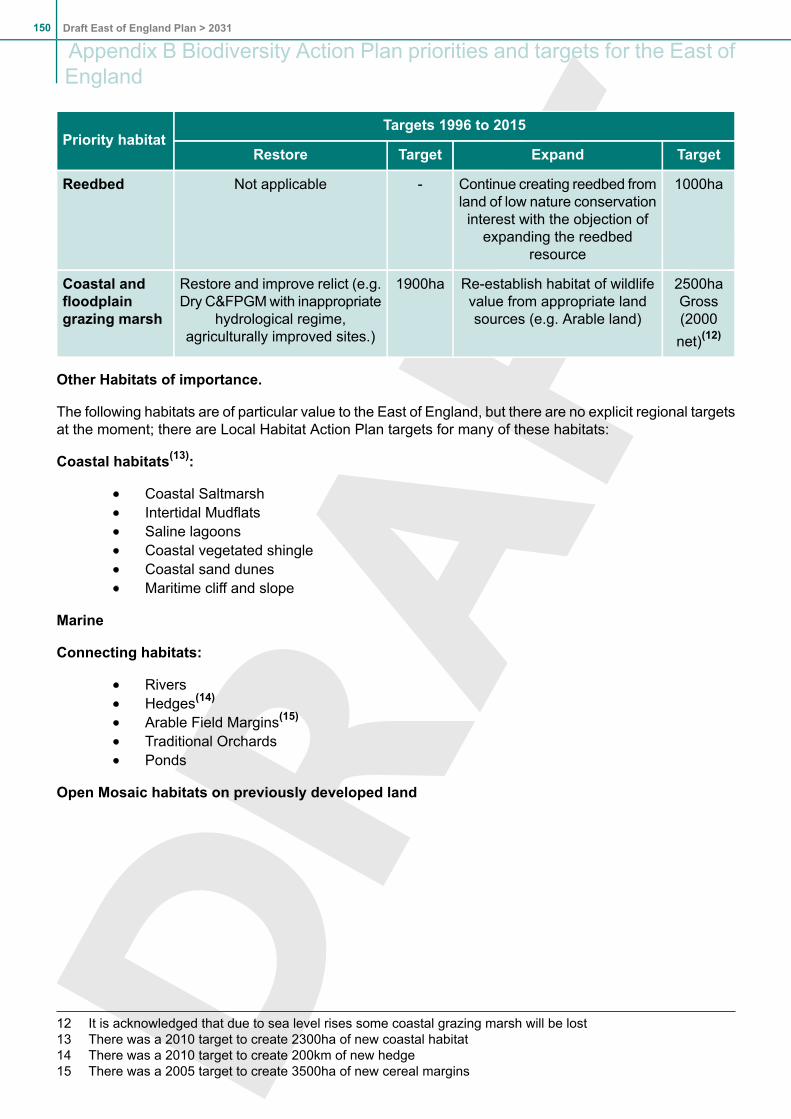
Targets 1996 to 2015Priority habitat
TargetExpandTargetRestore
1000haContinue creating reedbed fromland of low nature conservation
-Not applicableReedbed
interest with the objection ofexpanding the reedbed
resource
2500haGross
Re-establish habitat of wildlifevalue from appropriate landsources (e.g. Arable land)
1900haRestore and improve relict (e.g.Dry C&FPGMwith inappropriate
hydrological regime,agriculturally improved sites.)
Coastal andfloodplaingrazing marsh (2000
net)(12)
Other Habitats of importance.
The following habitats are of particular value to the East of England, but there are no explicit regional targetsat the moment; there are Local Habitat Action Plan targets for many of these habitats:
Coastal habitats(13):
Coastal SaltmarshIntertidal MudflatsSaline lagoonsCoastal vegetated shingleCoastal sand dunesMaritime cliff and slope
Marine
Connecting habitats:
RiversHedges(14)
Arable Field Margins(15)
Traditional OrchardsPonds
Open Mosaic habitats on previously developed land
12 It is acknowledged that due to sea level rises some coastal grazing marsh will be lost13 There was a 2010 target to create 2300ha of new coastal habitat14 There was a 2010 target to create 200km of new hedge15 There was a 2005 target to create 3500ha of new cereal margins
Draft East of England Plan > 2031150
Appendix B Biodiversity Action Plan priorities and targets for the East ofEngland

Appendix C Total Forecasts of Quantities of Waste to be Managed
RegionalTotalThurrockSuffolkNorfolkHertfordshireEssex &
Southend
Cambridgeshire&
Peterborough
CentralBedfordshire,Bedford
Borough &Luton
Waste to be managed(thousands of Tonnes)
2009/10
2,99175403410562804423314MSW (Municipal SolidWaste)
5,5801388911,0001,0181,155867511C&I (Commercial &Industrial Waste)
1,727233242116181314378263Imported waste fromLondon
10,2984461,5361,5261,7612,2731,6681,088Total
2010/11
3,00076403414562805425315MSW
5,5151378839881,0061,141856504C&I
1,568212220105165285343238Imported
10,0834251,5061,5071,7332,2311,6241,057Total
2011/12
3,00676403417562805427316MSW
5,5181378829831,0111,145855505C&I
1,40719019794148256308214Imported
9,9314031,4821,4941,7212,2061,5901,035Total
2012/13
3,00377403420561805428316MSW
5,5331388829781,0201,152856507C&I
1,24316817483131226272189Imported
9,7793831,4591,4811,7122,1831,5561,012Total
2013/14
3,01178403424561806430317MSW
5,5601408849761,0301,161859510C&I
1,08414615273114197237165Imported
9,6553641,4391,4731,7052,1641,526992Total
2014/15
3,01578403427560806431318MSW
5,5791418859731,0381,169861512C&I
9231251296297168202140Imported
9,5173441,4171,4621,6952,1431,494970Total
151Draft East of England Plan > 2031
Appendix C Total Forecasts of Quantities of Waste to be Managed

RegionalTotalThurrockSuffolkNorfolkHertfordshireEssex &
Southend
Cambridgeshire&
Peterborough
CentralBedfordshire,Bedford
Borough &Luton
Waste to be managed(thousands of Tonnes)
2015/16
3,02879403430560806433318MSW
5,5971418869701,0461,176864514C&I
7631031075180139167116Imported
9,3883231,3961,4511,6862,1211,464948Total
2016/17
3,03379403434559805434319MSW
5,6121428879661,0541,182865516C&I
720971014876131158109Imported
9,3653181,3911,4481,6892,1181,457944Total
2017/18
3,03680402437558805435319MSW
5,6241438879621,0601,188866518C&I
67691954571123148103Imported
9,3363141,3841,4441,6892,1161,449940Total
2018/19
3,04080402440557805436320MSW
5,6341448879581,0661,193867519C&I
6328589426611513996Imported
9,3063091,3781,4401,6892,1131,442935Total
2019/20
3,04280402443556804437320MSW
5,6391448869541,0711,197867520C&I
5918083406210712990Imported
9,2723041,3711,4371,6892,1081,433930Total
2020/21
3,04481401446555804437320MSW
5,6551458879511,0781,203869522C&I
547747737579912083Imported
9,2463001,3651,4341,6902,1061,424925Total
2021/22
3,04681400450554803438320MSW
5,6761468899491,0861,211871524C&I
503687034539211076Imported
Draft East of England Plan > 2031152
Appendix C Total Forecasts of Quantities of Waste to be Managed

RegionalTotalThurrockSuffolkNorfolkHertfordshireEssex &
Southend
Cambridgeshire&
Peterborough
CentralBedfordshire,Bedford
Borough &Luton
Waste to be managed(thousands of Tonnes)
9,2252951,3591,4331,6932,1061,419920Total
2022/23
3,04882400453553802438320MSW
5,6971478919471,0941,218874526C&I
460626431488410170Imported
9,2052911,3551,4311,6952,1041,413916Total
2023/24
3,04882399456551801439320MSW
5,7191488939451,1021,226876529C&I
41656582844769163Imported
9,1832861,3501,4291,6972,1031,406912Total
2024/25
3,04983398459550800439320MSW
5,7421498959441,1101,234879531C&I
37350522539688257Imported
9,1642821,3451,4281,6992,1021,400908Total
2025/26
3,04983397462549799439320MSW
4,7701508989431191,243883534C&I
33045462235607250Imported
8,1492781,3411,4277032,1021,394904Total
2026/27
3,04783396465547798439319MSW
5,7961519009421,1281,251887537C&I
28739401930526344Imported
9,1302731,3361,4261,7052,1011,389900Total
2027/28
3,04784395468546797438319MSW
5,8261529049411,1381,261890540C&I
24333341626445337Imported
9,1162691,3331,4251,7102,1021,381896Total
2028/29
3,04584394471544795438319MSW
5,8601549079411,1481,271895544C&I
153Draft East of England Plan > 2031
Appendix C Total Forecasts of Quantities of Waste to be Managed

RegionalTotalThurrockSuffolkNorfolkHertfordshireEssex &
Southend
Cambridgeshire&
Peterborough
CentralBedfordshire,Bedford
Borough &Luton
Waste to be managed(thousands of Tonnes)
19927281321364430Imported
9,1042651,3291,4251,7132,1021,377893Total
2029/30
3,04184392474542794437318MSW
5,8921559119411,1581,281899547C&I
15621221016293424Imported
9,0892601,3251,4251,7162,1041,370889Total
2030/31
3,03985391477540792437317MSW
5,9281569159421,1691,291904551C&I
1141516812212517Imported
9,0812561,3221,4271,7212,1011,366885Total
Forecasts of Municipal Solid Waste to be Managed in the East of England
Tonnagelandfilled(thousands
of tonnes)
Tonnage to be subjectto intensive residual
treatment
(thousands of tonnes)
Tonnage to berecycled(thousands
of tonnes)
Total MSW arisings(thousands of
tonnes)
Year
1,5421181,3332,9912009/10
1,4432581,3672,9982010/11
1,3323301,4013,0062011/12
1,2713301,4383,0122012/13
1,2473301,4713,0182013/14
1,1626441,5053,0232014/15
7131,1791,5393,0282015/16
5291,1751,5753,0322016/17
4471,1711,6083,0362017/18
3601,1631,6473,0392018/19
3421,1531,6853,0422019/20
3261,1431,7213,0452020/21
3161,1331,7533,0462021/22
3071,1291,7803,0482022/23
Draft East of England Plan > 2031154
Appendix C Total Forecasts of Quantities of Waste to be Managed

Tonnagelandfilled(thousands
of tonnes)
Tonnage to be subjectto intensive residual
treatment
(thousands of tonnes)
Tonnage to berecycled(thousands
of tonnes)
Total MSW arisings(thousands of
tonnes)
Year
2981,1111,8023,0482023/24
2881,1071,8243,0482024/25
2831,1031,8463,0482025/26
2791,0801,8723,0472026/27
2731,0571,8973,0462027/28
2681,0371,9273,0522028/29
2581,0131,9563,0492029/30
2529901,9793,0452030/31
Quantities of Municipal Solid Waste to be managed (tonnes)
2030/312025/262020/212015/16
Central Bedfordshire,Bedford Borough & Luton
317,300319,700320,000318,400MSW arisings
206,300191,800176,000152,800MSW recycled
85,700102,300125,000125,000MSW subject to intensivetreatment
25,40025,60025,60046,800MSW to be landfilled
Cambridgeshire &Peterborough
443,000438,700437,400432,700MSW arisings
288,000285,200280,000255,300MSW recycled
155,100153,600157,500170,000MSW subject to intensivetreatment
39,90039,50040,20042,700MSW to be landfilled
Essex & Southend
791,800799,100803,700805,600MSW arisings
514,700479,500442,000402,800MSW recycled
277,100315,000315,000315,000MSW subject to intensivetreatment
71,30079,00079,100383,000MSW to be landfilled
Hertfordshire
155Draft East of England Plan > 2031
Appendix C Total Forecasts of Quantities of Waste to be Managed
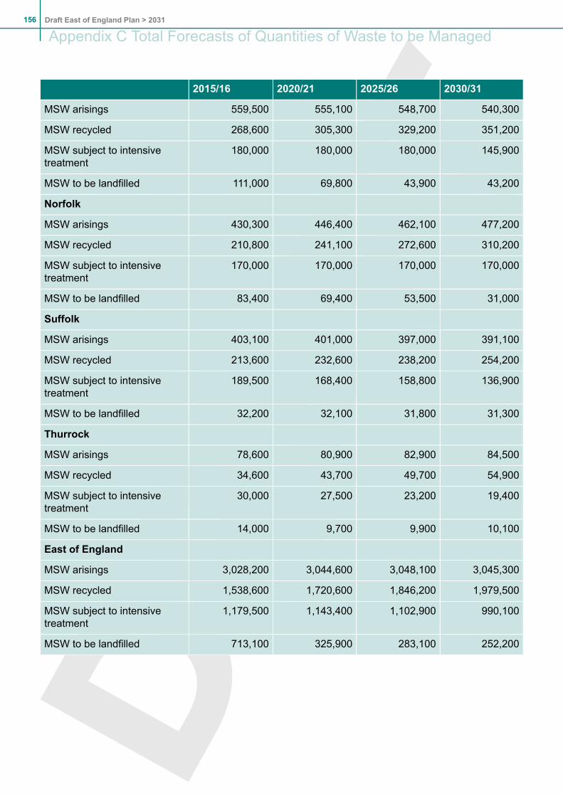
2030/312025/262020/212015/16
540,300548,700555,100559,500MSW arisings
351,200329,200305,300268,600MSW recycled
145,900180,000180,000180,000MSW subject to intensivetreatment
43,20043,90069,800111,000MSW to be landfilled
Norfolk
477,200462,100446,400430,300MSW arisings
310,200272,600241,100210,800MSW recycled
170,000170,000170,000170,000MSW subject to intensivetreatment
31,00053,50069,40083,400MSW to be landfilled
Suffolk
391,100397,000401,000403,100MSW arisings
254,200238,200232,600213,600MSW recycled
136,900158,800168,400189,500MSW subject to intensivetreatment
31,30031,80032,10032,200MSW to be landfilled
Thurrock
84,50082,90080,90078,600MSW arisings
54,90049,70043,70034,600MSW recycled
19,40023,20027,50030,000MSW subject to intensivetreatment
10,1009,9009,70014,000MSW to be landfilled
East of England
3,045,3003,048,1003,044,6003,028,200MSW arisings
1,979,5001,846,2001,720,6001,538,600MSW recycled
990,1001,102,9001,143,4001,179,500MSW subject to intensivetreatment
252,200283,100325,900713,100MSW to be landfilled
Draft East of England Plan > 2031156
Appendix C Total Forecasts of Quantities of Waste to be Managed

Appendix D List of PoliciesSection 3: Core Spatial StrategySS1: Achieving sustainable developmentSS2: Urban concentrationSS3: Key Centres for Development and ChangeSS4: Other towns and settlements in rural areasSS5: Priority Areas for RegenerationSS6: City and town centresSS7: Green BeltSS8: The urban fringeSS9: Managing coastal change
Section 4: Implementation and Delivery, Monitoring and ReviewIMP1: Implementing the Regional Spatial StrategyIMP2: Protection of Designated European SitesIMP3: Monitoring the Regional Spatial Strategy
Section 5: Economic DevelopmentE1: Job growthE2: Provision of land for employmentE3: Strategic employment sitesE4: Supporting sectors and clustersE5: Regional structure of town centresE6: TourismE7: Employment land at Stansted Airport
Section 6: HousingH1: Regional housing provision 2011 to 2031H2: Affordable housingH3: Provision for Gypsies and TravellersH4: Provision for Travelling Showpeople
Section 7: CultureC1: Cultural developmentC2: Provision and location of strategic cultural facilities
Section 8: Regional Transport StrategyT1: Transport, climate change and air qualityT2: Transport corridors and nodesT3: Urban transportT4: Transport in rural areasT5: Access to airportsT6: Freight movement and access to ports
Section 9: EnvironmentENV1: Green infrastructureENV2: Landscape conservationENV3: Biodiversity and geodiversityENV4: Agriculture, land and soilsENV5: WoodlandsENV6: The historic environmentENV7: Quality in the built environment
Section 10: Resource Efficiency and Renewable EnergyENG1: Resource efficiency in new development and existing communities
157Draft East of England Plan > 2031
Appendix D List of Policies

ENG 2: Renewable electricity targets
Section 11: WaterWat 1: Water efficiencyWat 2: Integrated water managementWat 3: Flood risk management
Section 12: WasteWM1: Waste management objectivesWM2: Waste management targetsWM3: Imported waste from LondonWM4: Regional and sub-regional self-sufficiencyWM5: Waste management facilitiesWM6: Provision for hazardous waste and other regionally significant facilities
Section 13: MineralsM1: Land won aggregates and rock
Section 14: Sub Areas and Key Centres for Development and ChangeBedfordshire Sub-area and Milton Keynes South Midlands Sub-RegionB1: BedfordshireB2: Bedford/Kempston and the Northern Marston Vale Key Centre for Development and ChangeB3: Luton/Dunstable/Houghton Regis and Leighton Linslade Key Centre for Development and ChangeB4: Growth of Milton Keynes related to Central Bedfordshire
BSE1: Bury St Edmunds Key Centre for Development and Change
CH1: Chelmsford Key Centre for Development and Change
Cambridgeshire and the Cambridge Sub-RegionCSR1: Development strategy for Cambridgeshire and the Cambridge Sub-RegionCSR2: Employment generating developmentCSR3: Cambridge Green BeltCSR4: Transport and communications infrastructure
Essex Thames Gateway Sub-RegionETG1: Strategy for the Sub-RegionETG2: Eco-region and green initiativesETG3: Employment generating developmentETG4: Transport strategyETG5: Thurrock Key Centre for Development and ChangeETG6: Basildon Key Centre for Development and ChangeETG7: Southend on Sea Key Centre for Development and ChangeETG8: Implementation and delivery
GYL1: Great Yarmouth and Lowestoft Key Centres for Development and ChangeHA1: Harlow Key Centre for Development and ChangeHaven Gateway Sub-regionHG1: Strategy for the Sub-RegionHG2: Employment generating developmentHG3: Transport and other infrastructureHG4: Implementation and deliveryKL1: King's Lynn Key Centre for Development and Change
London Arc Sub-RegionLA1: London Arc
Draft East of England Plan > 2031158
Appendix D List of Policies

LA2: Hemel Hempstead Key Centre for Development and ChangeLA3: Welwyn Garden City and Hatfield Key Centre for Development and ChangeLA4: Watford Key Centre for Development and Change
Greater Norwich Sub-RegionNR1: Greater Norwich Sub-RegionNR2: Norwich Policy AreaNR3: Development outside the Norwich Policy Area
PB1: Peterborough Key Centre for Development and Change
SV1: Stevenage Key Centre for Development and Change
TH1: Thetford Key Centre for Development and Change
159Draft East of England Plan > 2031
Appendix D List of Policies

Draft East of England Plan > 2031160
Appendix D List of Policies

Appendix E List of Policies not subject to consultationThe following policies are not subject to consultation as they have recently been through an Examinationin Public.
POLICY H3: Provision for Gypsies and Travellers (16)
Local authorities should make provision through Development Plan Documents for at least 1,237 netadditional residential pitches for Gypsy and Traveller Caravans by 2011 distributed as follows:
AdditionalProvision2011-2021
MinimumPitches 2011
MinimumAdditional
Pitches2006-2011
AuthorisedPitches in
January 2006
District
21452520Bedford
6719880118Central Bedfordshire
13351520Luton
1315150Cambridge
29943559East Cambridgeshire
7527289183Fenland
21452520Huntingdonshire
5827269203South Cambridgeshire
251253095Peterborough
5217462112Basildon
21502525Braintree
13251510Brentwood
1315150Castle Point
39814635Chelmsford
2130255Colchester
291283494Epping Forest
13491534Harlow
13541539Maldon
1318153Rochford
1317152Tendring
21622537Uttlesford
16 Gypsies and Travellers as defined in ODPM Circular 01/2006, Planning for Gypsy and Traveller CaravanSites, paragraph 15.
161Draft East of England Plan > 2031
Appendix E List of Policies not subject to consultation

AdditionalProvision2011-2021
MinimumPitches 2011
MinimumAdditional
Pitches2006-2011
AuthorisedPitches in
January 2006
District
1315150Southend
371244480Thurrock
15401822Broxbourne
17562036Dacorum
2132257East Hertfordshire
15531835Hertsmere
1321156North Hertfordshire
23802852St Albans
8241014Stevenage
13261511Three Rivers
8201010Watford
14681751Welwyn Hatfield
13471532Breckland
1317152Broadland
1319154Great Yarmouth
441465393King's Lynn and West Norfolk
1316151North Norfolk
13331518Norwich
23532825South Norfolk
1315150Babergh
15531835Forest Heath
13581543Ipswich
351114269Mid Suffolk
1722202St Edmundsbury
2631310Suffolk Coastal
13351520Waveney
1,0383,0191,2371,782East of England
Draft East of England Plan > 2031162
Appendix E List of Policies not subject to consultation

Local authorities should achieve the levels of provision required by 2011 as soon as possible throughdevelopment control decisions and Development Plan Documents. The preparation of joint orco-ordinated Development Plan Documents is encouraged and where they are produced, provisioncan be redistributed across the areas concerned. Opportunities should be taken to secure provisionthrough major developments.
Beyond 2011 provision should be made for an annual 3%(17) Compound increase in residential pitchprovision, equivalent to 1,038 additional pitches between 2011 and 2021, distributed on the basis ofdistricts accommodating the same proportion of the regional requirement as in Policy H3 for 2006-11.
Development Plan Documents should consider the need for rural exception sites and the alteration ofGreen Belt boundaries, where necessary, to meet the required provision.
Local authorities should work together to establish a network of transit pitches. Provision should bemade through Development Plan Documents for an additional 160 transit pitches by 2011, distributionas in the table below. The location and size of sites should be defined following local studies.
Locational GuidanceAdditionalPitches 2006-11
ExistingProvision(pitches)
County and unitarygroupings
10NilBedford, CentralBedfordshire and Luton
Cambridge area, Fenland,Huntingdonshire andPeterborough.
40NilCambridgeshire and
Peterborough
Distributed network aligned withtransport routes and urbancentres.
30NilEssex, Southend-on-Sea,
and Thurrock
Provision in Southern andWestern Hertfordshire,
2015
Hertfordshire
complementing the existing SouthMimms site, and in Northern andEastern Hertfordshire.
Across Norfolk, including Norwichfringe.4018Norfolk
Provision should include theIpswich/Felixstowe area.20NilSuffolk
1. There is an urgent need to address the shortage of permanent and transit accommodation for Gypsiesand Travellers, which creates problems for Gypsy and Traveller communities in terms of access to health,education, employment and other opportunities and can create tensions over the use of pitches withoutplanning permission. This is a national issue, but particularly pressing in the East of England.
2. The level of provision in Policy H3 reflects the needs of those currently resident on sites without planningpermission, natural growth and movements between pitches and other forms of accommodation. Theprovision of permanent Gypsy and Traveller pitches contributes towards meeting local housing targets andpitches provided by local authorities or registered social landlords to affordable housing targets.
17 The 3% annual compound increase in pitches after 2011 should be calculated based on the total number ofpitches required by 2011, i.e. The figures in the third column of the table in Policy H3.
163Draft East of England Plan > 2031
Appendix E List of Policies not subject to consultation

3. Accommodation is concentrated in certain parts of the region. Policy H3 balances providingmost additionalpitches in those parts of the region where most Gypsies and Travellers currently live with broadening choiceavailable to families by providing some pitches in all parts of the region which will assist delivery by ensuringall areas contribute to provision.
4. Delivery of the required pitches by 2011 will provide for the existing backlog. The 3% compound increasein provision will ensure that accommodation will be available to meet continuing needs after 2011.
5. Development Plan Documents should identify the location and capacity of sites to deliver the pitchrequirements in Policy H3 in location likely to be attractive to the local Gypsy and Traveller communitieswhile avoiding areas at risk of flooding and adverse effects on areas of wildlife and landscape importance.Provision of transit pitches need not only be on sites exclusively for their use; for instance, provision couldbe delivered alongside or on existing or new permanent sites. Guidance on site location is provided inODPM Circular 01/2006 and on site layout and design in Designing Gypsy and Traveller Sites, CLG May2008. Policies should recognise the diversity of the Gypsy and Traveller communities, for instance, provisionof sites for New Travellers may require different forms of site development.
POLICY H4: Provision for Travelling Showpeople(18)
Local authorities should make provision through Development Plan Documents for 184 net additionalplots for Travelling Showpeople by 2011, distributed as in the table below. Beyond 2011 provisionshould be made for an annual 1.5%(19) Compound increase in plots, equivalent to 94 additional plotsbetween 2011 and 2021, distributed on the basis of counties and unitaries accommodating the sameproportion of the regional requirement as in Policy H4 for 2006-11.
Locational GuidanceAdditional Plots2006-11
ExistingProvision(families)
County and unitarygroupings
Bedford and elsewhere1327Bedford, CentralBedfordshire and Luton
East Cambridgeshire andelsewhere
1854Cambridgeshire andPeterborough
Needs in Thurrock and alsoChelmsford, Basildon and
103166
Essex, Southend-on-Sea,and Thurrock
elsewhere. Locations should takeaccount of the wider distributionphilosophy in paragraph 5.13.
Needs in Broxbourne and also inEast Hertfordshire
2060Hertfordshire
Norwich and elsewhere2175Norfolk
Suffolk Coastal and elsewhere920Suffolk
18 Travelling Showpeople as defined in CLG Circular 04/2007, Planning for Travelling Showpeople, paragraph15.
19 The 1.5% annual compound increase in plots after 2011 should be calculated based on the total number ofplots required by 2011: 40 for Bedfordshire and Luton, 72 for Cambridgeshire and Peterborough, 269 forEssex, Southend-on-Sea and Thurrock, 80 for Hertfordshire, 96 for Norfolk and 29 for Suffolk.
Draft East of England Plan > 2031164
Appendix E List of Policies not subject to consultation

Local authorities should work in county and former county groupings with local Travelling Showpeopleand the Showman's Guild to identify the sites required to meet the above needs for inclusion inDevelopment Plan Documents. The preparation of joint or co-ordinated documents is encouraged.
Development Plan Documents should consider the need for rural exception sites and the alteration ofGreen Belt boundaries where necessary, to meet the required provision.
6. The interim targets in policy H4 will ensure that the accommodation needs of travelling Showpeople inthe East of England can be met, as required by CLG Circular 04/2007. The 1.5% compound increase inprovision will ensure that accommodation will be available to meet continuing needs after 2011.
7. Development Plan Documents should identify the location and capacity of sites sufficient to deliver theplot requirements in Policy H4 in locations likely to be attractive to Travelling Showpeople while avoidingareas at risk of flooding and adverse effects on areas of wildlife and landscape importance. Guidance onsite location is provided in CLG Circular 04/2007.
Delivery, Monitoring and Review
8. Delivering 1,237 additional residential pitches, 160 transit pitches and 184 plots for Travelling Showpeopleby 2011 poses challenges. The Regional Assembly, local authorities, the Homes and Communities Agency,Gypsy and Traveller communities, the Showmens Guild, registered social landlords and others should worktogether to ensure delivery. The Regional Assembly are developing a Delivery Plan, which will identify therange of delivery mechanisms and the role of the different agencies in securing delivery. Policy H3 stressesthe importance of using opportunities presented by major developments to secure deliver. In this contextmajor developments will vary relative to he range of developments in each district: the objective is to ensurethere are opportunities to help secure the required provision in each area.
9. The Regional Assembly, working with partners, should monitor net changes in numbers of permanentand transit pitches, pitches with temporary permission and unauthorised developments and encampmentsfor Gypsies and Travellers, together with net changes in plots for Travelling Showpeople, for inclusion inits annual monitoring reports.
10. The Regional Assembly (or its successors, the Regional Development Agency and Local AuthorityLeaders Board) working with the local authorities should ensure a co-ordinated review of Gypsy and TravellerAccommodation Assessments across the region and of Policies H3 and H4 in, or as soon as possible after,2011. The GTAAs should be carried out on a consistent basis and consider the needs of Gypsies andTravellers living in bricks and mortar housing, Travelling Showpeople, and New Travellers.
POLICY ETG5: Thurrock Key Centre for Development and Change
The Thurrock Urban Area (from Purfleet in the west to Tilbury/Chadwell St. Mary in the east) isa Key Centre for Development and Change, with the northern part of Lakeside Basin defined asa Regional Centre in terms of Policy E5. Local Development Documents should:
- promote an urban renaissance, re-using previously developed land and making the bestuse of the Thames riverside to bring about substantial improvement in the quality of theurban environment;
- upgrade the image of the area as a leading centre for logistics, and enhance the scale andsustainability of its role in that respect, while also seeking to diversify the employment base;- safeguard wharves and quays necessary for the strategic functioning of the Port of London;- secure the transformation of the northern part of Lakeside Basin as a town centre conditionalupon the measures set out in (2), (3) and (4) below;
- develop complementary policies for the regeneration of Grays town centre and other urbancentres in the Borough.
165Draft East of England Plan > 2031
Appendix E List of Policies not subject to consultation

Local Development Documents should guide the regeneration and remodelling of the widerLakeside Basin and West Thurrock area on sustainable mixed use lines by:
- defining the boundary of the area;- providing for a broader employment base through the identification of key strategic employmentsites;
- promoting a high quality built environment and public realm that is more coherent, legible andintegrated;
- protecting and enhancing green infrastructure including the provision of further accessiblenatural green space to meet local standards;
- promoting a greater mix of uses, including additional residential, office, hotel, and assemblyand leisure activities
- improving the range of services and facilities;- securing more sustainable movement patterns, reduced private motor vehicle-dependenceand complementary travel demand management measures including an area-wide travelplan;
- improving local accessibility and connectivity by public transport and pedestrian and cyclistpermeability throughout the area including consideration of ways to reconnect the north andthe south of the area, a new high frequency service rail station in the south, and a personalrapid transport system; and
- providing the necessary improvements to the local and strategic road network.
The attainment of Regional Centre status for the northern part of Lakeside Basin is conditionalupon the adoption of Local Development Documents providing for:
- a town centre boundary, with a designated primary shopping area;- a greater mix of uses and services including a significant increase in housing and officeaccommodation and the provision of convenience retail floorspace;
- an indicative scale of floorspace for each major town centre use;- indicative thresholds for new retail floorspace, phased with required infrastructure;- design and public realm enhancements;- improved accessibility for pedestrians and by non-car modes, including the introduction of acar parking charging and management regime; and
- an implementation plan.
Retail expansion at the new Regional Centre should be limited to 50,000 m2 of net comparisonfloorspace by 2019 together with an appropriate amount of convenience floorspace to reflect theBorough’s population growth. No retail expansion should be approved until the adoption of theappropriate Local Development Documents and the imposition of appropriate conditions andobligations to secure the objectives of paragraphs (2) and (3). Any further strategic retaildevelopment beyond the initial 50,000 m2 net of comparison retail floorspace at the new LakesideRegional Centre should be considered through future RSS reviews.
11. (NEW 13.23) The policy identifies the need to secure the transformation of the northern part of LakesideBasin as a Regional Centre as part of the regional structure of town centres set out in Policy E5. The aimis to provide a fuller range of town centre services, better employment opportunities and improve Lakeside’simage. To complement the emergence of the newRegional Centre there is a need to develop complementarypolicies for Grays and the other centres in the area.
12. (NEW 13.24) Lakeside Basin’s growth potential provides a major opportunity to address the substantialneed for economic and physical regeneration of the area, including by widening the employment base,identifying strategic employment sites, increasing housing provision and enhancing green infrastructure,with an emphasis on quality design and an improved public realm. A range of transportation measures areidentified to ensure the continuing functionality of the strategic and local road network.
Draft East of England Plan > 2031166
Appendix E List of Policies not subject to consultation

13. (NEW 13.25) The northern part of the Lakeside Basin is designated a Regional Centre. This is conditionalon the adoption of the appropriate Local Development Documents required to deliver economic,environmental and transportation objectives for the wider Lakeside Basin and Regional Centre. To safeguardthe vitality and viability of adjoining town centres the expansion of comparison goods floorspace will belimited to 50,000 m2 net. The new Regional Centre will provide the range of uses normally found in a towncentre as set out in PPS6 paragraphs 1.8 and 1.9, and will become an important focal point for publictransport services, with improved access for pedestrians and cyclists. Further strategic expansion at thenew Regional Centre will be subject to a future review of the RSS.
14. (NEW 13.26) Unrestricted traffic growth would threaten the economic and environmental objectives forthe area. Measures are proposed which will seek to actively manage travel behaviour across the LakesideBasin and particularly at the new Regional Centre. A new car parking and charging regime should beintroduced.
167Draft East of England Plan > 2031
Appendix E List of Policies not subject to consultation

Draft East of England Plan > 2031168
Appendix E List of Policies not subject to consultation

Key Diagram.1 To be updated to reflect changed policies.
Add Thurrock Lakeside as KCDC
Update dwelling figures (brown squares) against each KCDC to match new targets
Add the Transport node symbol to all KCDC apart from Thetford
Green Belt Review changesRemove GBR at Hemel & WelwynAdd /E to Luton GBR.
Add Greater Norwich Sub-regionChange name of Thames Gateway to Essex Thames Gateway
169Draft East of England Plan > 2031
Key Diagram

Draft East of England Plan > 2031170
Key Diagram