Guildford borough Strategic Development Framework ...
250
Guildford borough Strategic Development Framework Supplementary Planning Document (SDF SPD) Consultation Statement July 2020
-
Upload
khangminh22 -
Category
Documents
-
view
2 -
download
0
Transcript of Guildford borough Strategic Development Framework ...

Guildford borough Strategic Development Framework Supplementary Planning Document (SDF SPD)
Consultation Statement July 2020

If you would like this document in a different format, different
language, Braille, large print or audio, please contact the
Planning Policy Team on 01483 444471
2
1. Introduction
1.1 This Consultation Statement has been prepared in accordance with Regulation 12 of the Town
and Country Planning (Local Development) (England) Regulations 2012.
1.2 Regulation 12(a) requires that when adopting a Supplementary Planning Document (SPD), a
statement must be prepared setting out:
• the persons whom the authority consulted when preparing the SPD;
• a summary of the main issues raised by those persons; and
• how those issues have been addressed in the SPD.
1.3 The Strategic Development Framework (SDF) SPD has been prepared in order to provide
further detail and guidance to support the masterplanning process for the following strategic
sites/location for growth allocated in the Local Plan: strategy and sites (2019):
• Slyfield Area Regeneration Project – now known as Weyside Urban Village (Policy A24);
• Gosden Hill Farm (Policy A25);
• Blackwell Farm (Policy A26 and A27);
• Ash and Tongham Sites (Policy A29 - A31); and
• Former Wisley Airfield (Policy A35).
2. Preparing the draft SPD
2.1 The initial preparation of the draft SPD was undertaken by David Lock Associates (DLA).
This process was preceded by a series of technical and community workshops held in late
2018. The aim of these facilitated workshops was to explore, in broad terms, the potential
opportunities arising from each site and the existing assets and challenges that can help
shape a strategic framework for each site. The workshops involved a range of stakeholders,
representatives from public sector agencies, landowners, officers and councillors.
2.2 Outlined below is a list of all the workshops that were held. The initial Consultation
Statement1 contains a summary of each workshop with the following key information; general
comments raised, specific comments in relation to each site and the attendance list for each.
• Technical Stakeholder Workshop: Community Wellbeing (10 October 2018)
• Technical Stakeholder Workshop: Green and Blue Infrastructure (10 October 2018)
• Technical Stakeholder Workshop: Transport Infrastructure (11 October 2018)
• Community Representatives - comprising borough and parish councillors (16 November
2018)
• Community Representatives – comprising Residents’ Associations, and other groups
and societies (11 December 2018)
1 Available at https://guildford.inconsult.uk/consult.ti/SDFSPD/consultationHome
3
2.3 The comments and issues received through these workshops were all considered by
DLA in the preparation of the draft initial document and, where relevant, informed the
draft SPD.
3. Formal consultation on the draft SDF SPD
3.1 A five-week consultation was undertaken on the draft SDF SPD between 20 January
2020 (midday) to 24 February 2020 (midday). The Council notified all those
stakeholders (comprising organisations, residents, businesses and amenity groups
whose email addresses we hold) of the consultation hosted on our Get Involved
website. Additionally, the views of the Place Making and Innovation Executive Advisory
Board (EAB) were sought at a meeting held on 17 February 2020.
3.2 The consultation was publicised on the Council’s website, and the consultation
document was made available in the borough’s four libraries and in the main Council
offices at Millmead. These arrangements were in accordance with the Council’s
Statement of Community Involvement at the time that consultation was undertaken2.
4. Finalising the SDF SPD
4.1 All responses received to the consultation, including the comments made by the EAB,
have been considered. Appendix 1 contains a series of tables – one for each section of
the SDF SPD3 – which identifies all the main issues that were raised together with the
Council’s response. The Council’s response to each main issue either indicates why an
amendment to the SDF SPD was not considered appropriate, or details what
amendments have been made to the SPD which is considered to address the issue
raised. Where amendments have been made, these are indicated in bold within the
tables and, where appropriate, are shown as track changes.
4.2 Where main issues have been raised by either prescribed bodies4 or key stakeholders
then these have been individually identified at the start of each section’s table. Key
stakeholders include site promoters for the relevant strategic sites, parish councils,
borough councillors, infrastructure providers, statutory consultees and other community
groups / organisations.
4.3 The SDF SPD was adopted by Executive on 21 July 2020.
2 The Council has since adopted a new Statement of Community Involvement May 2020 3 The paragraphs against which the main issues are logged reflect the numbering in the consultation draft SPD 4 As listed in Regulation 4 of the Town and Country Planning (Local Development) (England) Regulations 2012
4

Appendix 1 - Main Issues raised
5
01. Introduction
Section Paragraph Main Issue Summary Response
Prescribed Bodies and Key Stakeholders
Guildford Residents Association
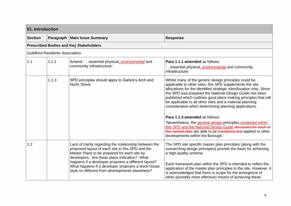
1.1 1.1.1 Amend: ‘…essential physical, environmental and community infrastructure.’
Para 1.1.1 amended as follows:
‘…essential physical, environmental and community infrastructure.’
1.1.3 SPD principles should apply to Garlick’s Arch and North Street
Whilst many of the generic design principles could be applicable to other sites, this SPD supplements the site allocations for the identified strategic sites/location only. Since the SPD was prepared the National Design Guide has been published which outlines good place making principles that will be applicable to all other sites and a material planning consideration when determining planning applications.
Para 1.1.3 amended as follows:
‘Nevertheless, the general design principles contained within this SPD and the National Design Guide discussed for each of the named sites are able to be transfered and applied to other developments within the Borough.’
1.2 Lack of clarity regarding the relationship between the proposed layout of each site in this SPD and the Master Plans to be prepared for each site by developers. Are these plans indicative? What happens if a developer proposes a different layout? What happens if a developer proposes a stock house style no different from developments elsewhere?
The SPD site specific master plan principles (along with the overarching design principles) provide the basis for achieving a high-quality scheme.
Each framework plan within the SPD is intended to reflect the application of the master plan principles to the site. However, it is acknowledged that there is scope for the emergence of other (possibly more effective) means of achieving these
6
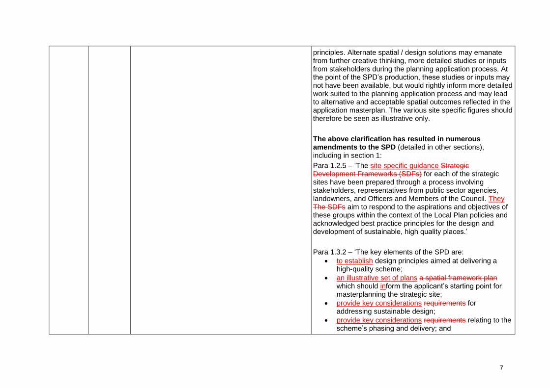
principles. Alternate spatial / design solutions may emanate from further creative thinking, more detailed studies or inputs from stakeholders during the planning application process. At the point of the SPD’s production, these studies or inputs may not have been available, but would rightly inform more detailed work suited to the planning application process and may lead to alternative and acceptable spatial outcomes reflected in the application masterplan. The various site specific figures should therefore be seen as illustrative only.
The above clarification has resulted in numerous amendments to the SPD (detailed in other sections), including in section 1:
Para 1.2.5 – ‘The site specific guidance Strategic Development Frameworks (SDFs) for each of the strategic sites have been prepared through a process involving stakeholders, representatives from public sector agencies, landowners, and Officers and Members of the Council. They The SDFs aim to respond to the aspirations and objectives of these groups within the context of the Local Plan policies and acknowledged best practice principles for the design and development of sustainable, high quality places.’
Para 1.3.2 – ‘The key elements of the SPD are:
• to establish design principles aimed at delivering a high-quality scheme;
• an illustrative set of plans a spatial framework plan which should inform the applicant’s starting point for masterplanning the strategic site;
• provide key considerations requirements for addressing sustainable design;
• provide key considerations requirements relating to the scheme’s phasing and delivery; and
7
• requirements which should be met at the Outline planning application stage and beyond, including any Hybrid applications, to ensure adequate and consistent approaches to quality and delivery.’
Para 1.3.3 – ‘The remainder of this SPD covers the following:
• Background and Context (Part 1): A summary of the location of the strategic sites, planning policy framework and consultation events.
• Overarching Design Principles and Requirements (Part 2): The design principles and requirements applicable across all strategic locations.
• Site specific guidance Strategic Development Frameworks (Part 3): A summary of the overall vision and design expectations and an expectation of what will be required in the development proposals in order to meet the key design principles for each of the five strategic sites.
• Implementation and Delivery (Part 4): A summary of the requirements for Outline application submissions, conditions and planning obligations and mechanisms for securing design excellence through’
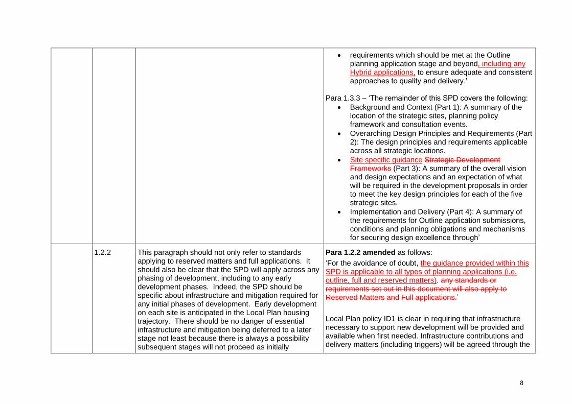
1.2.2 This paragraph should not only refer to standards applying to reserved matters and full applications. It should also be clear that the SPD will apply across any phasing of development, including to any early development phases. Indeed, the SPD should be specific about infrastructure and mitigation required for any initial phases of development. Early development on each site is anticipated in the Local Plan housing trajectory. There should be no danger of essential infrastructure and mitigation being deferred to a later stage not least because there is always a possibility subsequent stages will not proceed as initially
Para 1.2.2 amended as follows:
‘For the avoidance of doubt, the guidance provided within this SPD is applicable to all types of planning applications (i.e. outline, full and reserved matters). any standards or requirements set out in this document will also apply to Reserved Matters and Full applications.’
Local Plan policy ID1 is clear in requiring that infrastructure necessary to support new development will be provided and available when first needed. Infrastructure contributions and delivery matters (including triggers) will be agreed through the
8
envisaged. This issue should not be left to part 4 of the document but also referenced clearly at the start.
planning application process, production of an Infrastructure Delivery Statement (including s106 Heads of Terms) and the s106 agreement itself.
1.3.2 Requirements which should be met at the Outline planning application stage and beyond, including any early phase applications, to ensure adequate and consistent approaches to quality and delivery.
All strategic sites will have to submit an initial planning application which will be either an ‘Outline’ or a ‘Hybrid’ application.
Para 1.3.2 amended as follows:
‘Requirements which should be met at the Outline planning application stage and beyond, including any Hybrid applications, to ensure adequate and consistent approaches to quality and delivery.’
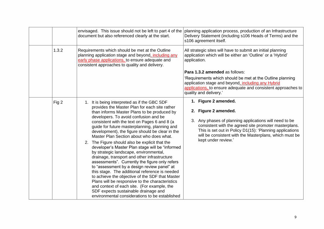
Fig 2 1. It is being interpreted as if the GBC SDF provides the Master Plan for each site rather than informs Master Plans to be produced by developers. To avoid confusion and be consistent with the text on Pages 6 and 8 (a guide for future masterplanning, planning and development), the figure should be clear in the Master Plan Section about who does what.
2. The Figure should also be explicit that the developer’s Master Plan stage will be “informed by strategic landscape, environmental, drainage, transport and other infrastructure assessments”. Currently the figure only refers to “assessment by a design review panel” at this stage. The additional reference is needed to achieve the objective of the SDF that Master Plans will be responsive to the characteristics and context of each site. (For example, the SDF expects sustainable drainage and environmental considerations to be established
1. Figure 2 amended.
2. Figure 2 amended.
3. Any phases of planning applications will need to be consistent with the agreed site promoter masterplans. This is set out in Policy D1(15): ‘Planning applications will be consistent with the Masterplans, which must be kept under review.’
9
early to inform any Master Planning process rather than be factored in as constraints once a Master Plan has taken shape.) Without inclusion of such a reference to strategic assessments, the diagram simply signals supporting information can be left to the later application stage.
3. The diagram needs to include reference to any early phase development. It should be clear early phases will be expected to deliver within the context of informed Master Plans and should provide appropriate standards of place making, landscape character, sustainability, mitigation (including landscape buffer) and infrastructure etc.
Surrey County Council
1.3 Fig 2 Ash and Tongham are omitted from the masterplan section and design code approvals section. Presumably this is because there is no requirement in the Local Plan for a masterplan as this allocation comprises several sites, most of which have already been granted planning permission. It might be helpful to make this explicit to ensure clarity and avoid confusion.
Para 1.2.2 amended as follows:
‘Once adopted, the SPD will be a material consideration in determining the appropriateness of planning applications and in moving forward through implementation, including the preparation of master plans by the developers to inform their planning applications as required by Policy D1 of the Local Plan. The Policy D1(13) requirement for site promoter masterplans applies to Slyfield Area Regeneration Project (A24), Gosden Hill Farm (A25), Blackwell Farm (A26) and the former Wisley airfield (A35) only (it does not apply to Ash and Tongham Sites (Policies A29-A31).’
Savills obo Weyside Urban Village
1.3 Fig 2 The diagram should refer to ‘Outline or Hybrid’ planning application being submitted, the latter
Figure 2 amended.
10
being likely to enable early and up front delivery of essential infrastructure
Guildford Society
1.1 1.1.3 “Nevertheless, the principles discussed for each of the named sites are able to be transferred and applied to other developments within the borough” - it should be qualified as will it for example apply to developments such as North Street.
Whilst many of the generic design principles could be applicable to other sites, this SPD supplements the site allocations for the identified strategic sites/location only. Since the SPD was prepared the National Design Guide has been published which outlines good place making principles that will be applicable to all other sites and a material planning consideration when determining planning applications.
Para 1.1.3 amended as follows:
‘Nevertheless, the general design principles contained within this SPD and the National Design Guide discussed for each of the named sites are able to be transfered and applied to other developments within the Borough.’
1.1 Fig 1 The map of sites at page 7 doesn’t appear the match the sites as displayed in Part 3 (Ash and Tongham)
Figure 1 illustrates the site areas as allocated in the LPSS. Given the extent to which the site allocation at Ash and Tongham has already been permitted/built, the SPD only provides guidance for part of the allocation that was, at the time of preparation, yet to gain planning permission.
Figure 2 Ash and Tongham is missing from Figure 2. Para 1.2.2 amended as follows:
‘Once adopted, the SPD will be a material consideration in determining the appropriateness of planning applications and in moving forward through implementation, including the preparation of master plans by the developers to inform their planning applications as required by Policy D1 of the Local Plan. The Policy D1(13) requirement for site promoter masterplans applies to Slyfield Area Regeneration Project (A24), Gosden Hill Farm (A25), Blackwell Farm (A26) and the
11
former Wisley airfield (A35) only (it does not apply to Ash and Tongham Sites (Policies A29-A31).’
Terence O’ Rourke obo Blackwell Park Ltd
1.1 Fig 1 The urban area (in grey) should include the Surrey Research Park and UniS Manor Park site.
Fig 1 reflects the extent of built development. Figure 1 key amended from ‘urban area’ to ‘developed land’
1.2 Flexibility in relation to the SDFs should be acknowledged, to ensure the illustrations and guidance is truly a guide and not a rigid structure to be strictly adhered to.
This section should state clearly that the document is not prescriptive.
The SPD site specific master plan principles (along with the overarching design principles) provide the basis for achieving a high-quality scheme.
Each framework plan within the SPD is intended to reflect the application of the master plan principles to the site. However, it is acknowledged that there is scope for the emergence of other (possibly more effective) means of achieving these principles. Alternate spatial / design solutions may emanate from further creative thinking, more detailed studies or inputs from stakeholders during the planning application process. At the point of the SPD’s production, these studies or inputs may not have been available, but would rightly inform more detailed work suited to the planning application process and may lead to alternative and acceptable spatial outcomes reflected in the application masterplan. The various site specific figures should therefore be seen as illustrative only.
The above clarification has resulted in numerous amendments to the SPD (detailed in other sections), including in section 1:
Para 1.2.5 – ‘The site specific guidance Strategic Development Frameworks (SDFs) for each of the strategic sites have been prepared through a process involving stakeholders, representatives from public sector agencies, landowners, and Officers and Members of the Council. They
12
The SDFs aim to respond to the aspirations and objectives of these groups within the context of the Local Plan policies and acknowledged best practice principles for the design and development of sustainable, high quality places.’
Para 1.3.2 – ‘The key elements of the SPD are:
• to establish design principles aimed at delivering a high-quality scheme;
• an illustrative set of plans a spatial framework plan which should inform the applicant’s starting point for masterplanning the strategic site;
• provide key considerations requirements for addressing sustainable design;
• provide key considerations requirements relating to the scheme’s phasing and delivery; and
• requirements which should be met at the Outline planning application stage and beyond, including any Hybrid applications, to ensure adequate and consistent approaches to quality and delivery.’
Para 1.3.3 – ‘The remainder of this SPD covers the following:
• Background and Context (Part 1): A summary of the location of the strategic sites, planning policy framework and consultation events.
• Overarching Design Principles and Requirements (Part 2): The design principles and requirements applicable across all strategic locations.
• Site specific guidance Strategic Development Frameworks (Part 3): A summary of the overall vision and design expectations and an expectation of what will be required in the development proposals in order to meet the key design principles for each of the five strategic sites.
13
• Implementation and Delivery (Part 4): A summary of the requirements for Outline application submissions, conditions and planning obligations and mechanisms for securing design excellence through’
Compton Parish Council
Fig 2 Development at Ash and Tongham is missing from the masterplan level
Para 1.2.2 amended as follows:
‘Once adopted, the SPD will be a material consideration in determining the appropriateness of planning applications and in moving forward through implementation, including the preparation of master plans by the developers to inform their planning applications as required by Policy D1 of the Local Plan. The Policy D1(13) requirement for site promoter masterplans applies to Slyfield Area Regeneration Project (A24), Gosden Hill Farm (A25), Blackwell Farm (A26) and the former Wisley airfield (A35) only (it does not apply to Ash and Tongham Sites (Policies A29-A31).’
Ockham Parish Council
1.2 1.2.5 Have not addressed the stakeholder comments highlighted in the Interim Consultation Statement
The comments and issues received through these workshops were all considered by DLA in the preparation of the draft initial document and, where relevant, informed the SPD.
1.3 Fig 2 Need further clarity regarding what the Design Review Panel is and how it is convened.
A new Design Review Panel specifically focussing on the strategic sites is being set up. Consideration will be given to the make-up of this group. The group will consider and provide feedback on design issues associated with the site promoter masterplans.
Fig 2 The Supporting Information section should also include instructions to show how the TBHSPA impact is mitigated.
All proposals will need to be in accordance with the SPA Strategy. This will need to be demonstrated within the Environmental Statement (listed in Fig 2).
14
RHS Wisley
1.3 Fig 2 Request to be involved in the Design Review Panel process
This is outside the scope of this SPD.
Cllr Nagaty
1.3 Figure 2 Ash and Tongham is missing from Figure 2. Para 1.2.2 amended as follows:
‘Once adopted, the SPD will be a material consideration in determining the appropriateness of planning applications and in moving forward through implementation, including the preparation of master plans by the developers to inform their planning applications as required by Policy D1 of the Local Plan. The Policy D1(13) requirement for site promoter masterplans applies to Slyfield Area Regeneration Project (A24), Gosden Hill Farm (A25), Blackwell Farm (A26) and the former Wisley airfield (A35) only (it does not apply to Ash and Tongham Sites (Policies A29-A31).’
Other respondents
Foreword Refers to the delivery of approximately 9,000 homes whereas the plan delivers more – clarification needed.
Foreword amended as follows:
‘To facilitate this level of growth, strategic sites and a location
for growth greenfield and Green Belt sites have been identified for the delivery of approximately 9,000 homes in Guildford Borough Council’s Local Plan.’
Refers to greenfield and Green Belt sites – WUV/SARP is brownfield.
Foreword amended as follows:
‘To facilitate this level of growth, strategic sites and a location
for growth greenfield and Green Belt sites have been identified for the delivery of approximately 9,000 homes in Guildford Borough Council’s Local Plan.’
15
1.2 1.2.5 Have not addressed the stakeholder comments highlighted in the Interim Consultation Statement
The comments and issues received through these workshops were all considered by DLA in the preparation of the draft initial document and, where relevant, informed the SPD.
1.3 Fig 2 Need further clarity regarding what the Design Review Panel is and how it is convened.
A new Design Review Panel specifically focussing on the strategic sites is being set up. Consideration will be given to the make-up of this group. The group will consider and provide feedback on design issues associated with the site promoter masterplans.
Fig 2 The Supporting Information section should also include evidence to demonstrate compliance with the TBHSPA Avoidance Strategy 2017 as amended
All proposals will need to be in accordance with the SPA Strategy. This will need to be demonstrated within the Environmental Statement (listed in Fig 2).
16
02. Context of Strategic Development Sites
Section Paragraph Main Issue Summary Response
Prescribed Bodies and Key Stakeholders
Stagecoach
2.1 2.1.15 Should add:
• "Better Planning, Better Transport, Better Places" (2019) published by the Chartered Institution of Highways and Transportation, supported by RTPI and TPS;
• "Bus Services and New Residential Developments" (2017), our own award-winning guidance document that is available on-line at: https://www.stagecoach.com/~/media/Files/S/Stagecoach-Group/Attachments/pdf/bus-services-and-new-residential-developments.pdf
References added.
Environment Agency
2.1 2.1.8 Welcome the inclusion of the Strategic Flood Risk Assessment (SFRA) and Water Quality Assessment (WQA)
References added.
Surrey County Council
2.1 2.1.15 Reference should be made to the recently published NHS England Putting Health into Place - Healthy New Towns:
Reference added.
17
https://www.england.nhs.uk/ourwork/innovation/healthy-new-towns/
Guildford Society
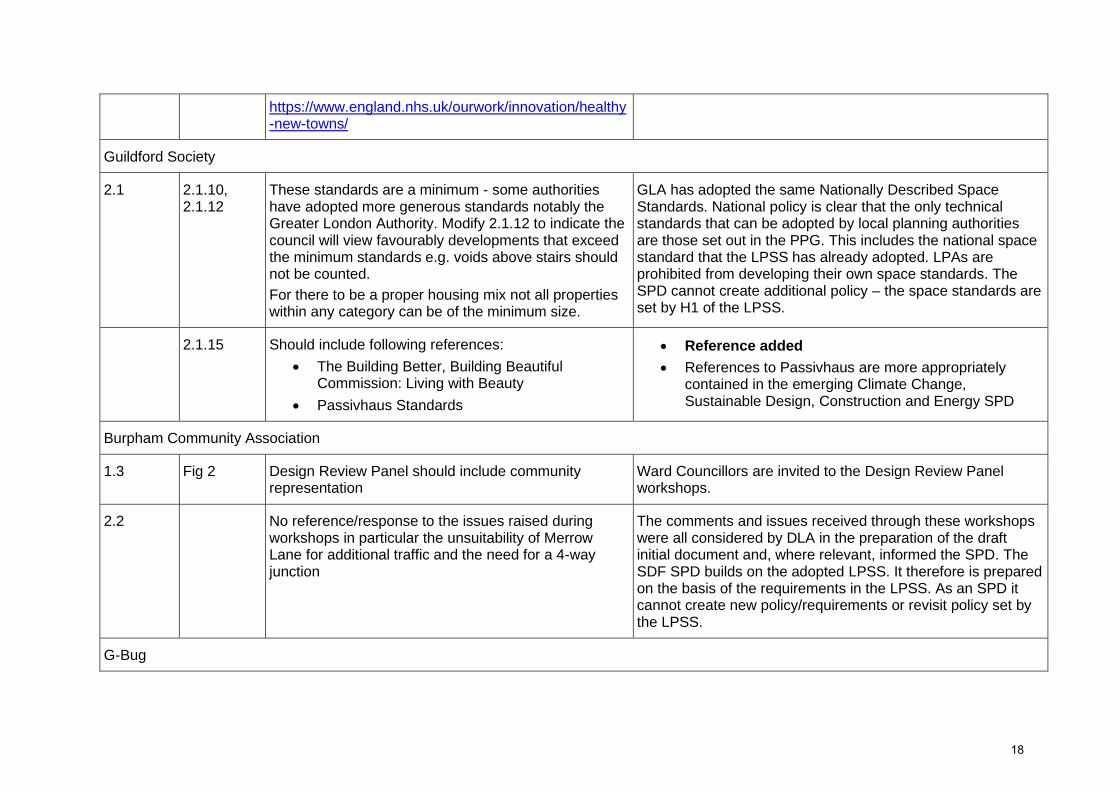
2.1 2.1.10, 2.1.12
These standards are a minimum - some authorities have adopted more generous standards notably the Greater London Authority. Modify 2.1.12 to indicate the council will view favourably developments that exceed the minimum standards e.g. voids above stairs should not be counted.
For there to be a proper housing mix not all properties within any category can be of the minimum size.
GLA has adopted the same Nationally Described Space Standards. National policy is clear that the only technical standards that can be adopted by local planning authorities are those set out in the PPG. This includes the national space standard that the LPSS has already adopted. LPAs are prohibited from developing their own space standards. The SPD cannot create additional policy – the space standards are set by H1 of the LPSS.
2.1.15 Should include following references:
• The Building Better, Building Beautiful Commission: Living with Beauty
• Passivhaus Standards
• Reference added
• References to Passivhaus are more appropriately contained in the emerging Climate Change, Sustainable Design, Construction and Energy SPD
Burpham Community Association
1.3 Fig 2 Design Review Panel should include community representation
Ward Councillors are invited to the Design Review Panel workshops.
2.2 No reference/response to the issues raised during workshops in particular the unsuitability of Merrow Lane for additional traffic and the need for a 4-way junction
The comments and issues received through these workshops were all considered by DLA in the preparation of the draft initial document and, where relevant, informed the SPD. The SDF SPD builds on the adopted LPSS. It therefore is prepared on the basis of the requirements in the LPSS. As an SPD it cannot create new policy/requirements or revisit policy set by the LPSS.
G-Bug
18
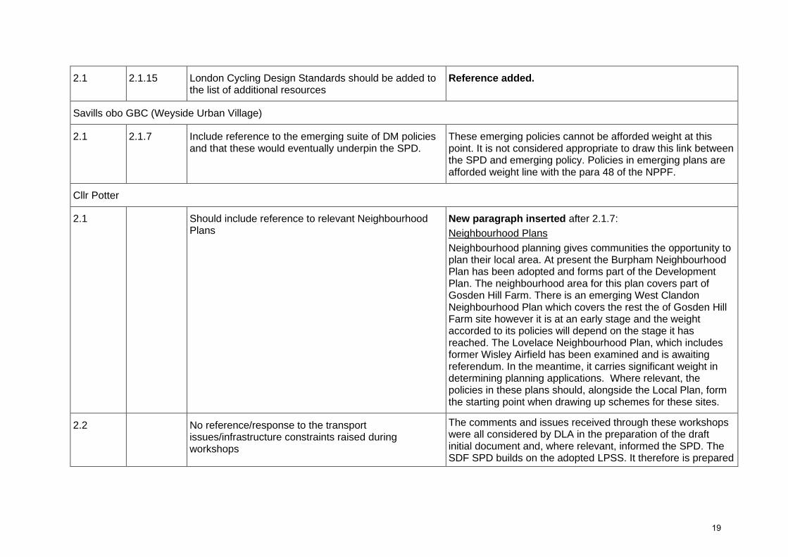
2.1 2.1.15 London Cycling Design Standards should be added to the list of additional resources
Reference added.
Savills obo GBC (Weyside Urban Village)
2.1 2.1.7 Include reference to the emerging suite of DM policies and that these would eventually underpin the SPD.
These emerging policies cannot be afforded weight at this point. It is not considered appropriate to draw this link between the SPD and emerging policy. Policies in emerging plans are afforded weight line with the para 48 of the NPPF.
Cllr Potter
2.1 Should include reference to relevant Neighbourhood Plans
New paragraph inserted after 2.1.7:
Neighbourhood Plans
Neighbourhood planning gives communities the opportunity to plan their local area. At present the Burpham Neighbourhood Plan has been adopted and forms part of the Development Plan. The neighbourhood area for this plan covers part of Gosden Hill Farm. There is an emerging West Clandon Neighbourhood Plan which covers the rest the of Gosden Hill Farm site however it is at an early stage and the weight accorded to its policies will depend on the stage it has reached. The Lovelace Neighbourhood Plan, which includes former Wisley Airfield has been examined and is awaiting referendum. In the meantime, it carries significant weight in determining planning applications. Where relevant, the policies in these plans should, alongside the Local Plan, form the starting point when drawing up schemes for these sites.
2.2 No reference/response to the transport issues/infrastructure constraints raised during workshops
The comments and issues received through these workshops were all considered by DLA in the preparation of the draft initial document and, where relevant, informed the SPD. The SDF SPD builds on the adopted LPSS. It therefore is prepared
19
on the basis of the requirements in the LPSS. As an SPD it cannot create new policy or revisit policy set by the LPSS.
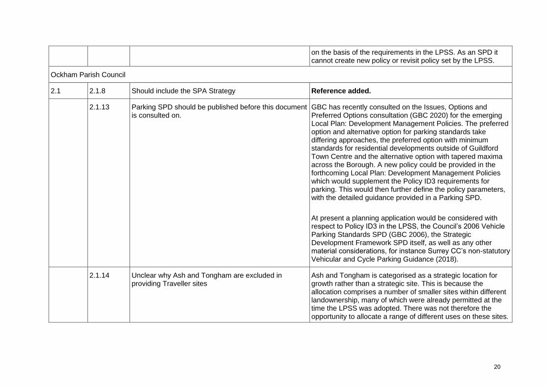
Ockham Parish Council
2.1 2.1.8 Should include the SPA Strategy Reference added.
2.1.13 Parking SPD should be published before this document is consulted on.
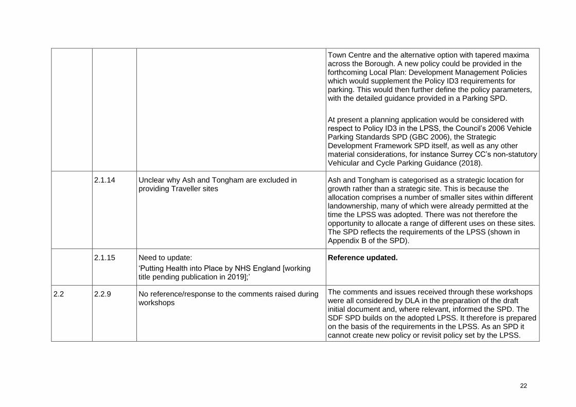
GBC has recently consulted on the Issues, Options and Preferred Options consultation (GBC 2020) for the emerging Local Plan: Development Management Policies. The preferred option and alternative option for parking standards take differing approaches, the preferred option with minimum standards for residential developments outside of Guildford Town Centre and the alternative option with tapered maxima across the Borough. A new policy could be provided in the forthcoming Local Plan: Development Management Policies which would supplement the Policy ID3 requirements for parking. This would then further define the policy parameters, with the detailed guidance provided in a Parking SPD.
At present a planning application would be considered with respect to Policy ID3 in the LPSS, the Council’s 2006 Vehicle Parking Standards SPD (GBC 2006), the Strategic Development Framework SPD itself, as well as any other material considerations, for instance Surrey CC’s non-statutory Vehicular and Cycle Parking Guidance (2018).
2.1.14 Unclear why Ash and Tongham are excluded in providing Traveller sites
Ash and Tongham is categorised as a strategic location for growth rather than a strategic site. This is because the allocation comprises a number of smaller sites within different landownership, many of which were already permitted at the time the LPSS was adopted. There was not therefore the opportunity to allocate a range of different uses on these sites.
20
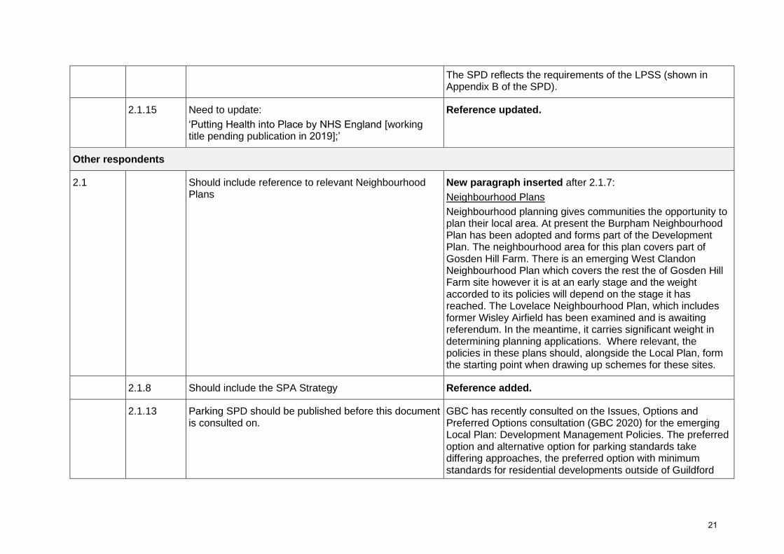
The SPD reflects the requirements of the LPSS (shown in Appendix B of the SPD).
2.1.15 Need to update:
‘Putting Health into Place by NHS England [working title pending publication in 2019];’
Reference updated.
Other respondents
2.1 Should include reference to relevant Neighbourhood Plans
New paragraph inserted after 2.1.7:
Neighbourhood Plans
Neighbourhood planning gives communities the opportunity to plan their local area. At present the Burpham Neighbourhood Plan has been adopted and forms part of the Development Plan. The neighbourhood area for this plan covers part of Gosden Hill Farm. There is an emerging West Clandon Neighbourhood Plan which covers the rest the of Gosden Hill Farm site however it is at an early stage and the weight accorded to its policies will depend on the stage it has reached. The Lovelace Neighbourhood Plan, which includes former Wisley Airfield has been examined and is awaiting referendum. In the meantime, it carries significant weight in determining planning applications. Where relevant, the policies in these plans should, alongside the Local Plan, form the starting point when drawing up schemes for these sites.
2.1.8 Should include the SPA Strategy Reference added.
2.1.13 Parking SPD should be published before this document is consulted on.
GBC has recently consulted on the Issues, Options and Preferred Options consultation (GBC 2020) for the emerging Local Plan: Development Management Policies. The preferred option and alternative option for parking standards take differing approaches, the preferred option with minimum standards for residential developments outside of Guildford
21
Town Centre and the alternative option with tapered maxima across the Borough. A new policy could be provided in the forthcoming Local Plan: Development Management Policies which would supplement the Policy ID3 requirements for parking. This would then further define the policy parameters, with the detailed guidance provided in a Parking SPD.
At present a planning application would be considered with respect to Policy ID3 in the LPSS, the Council’s 2006 Vehicle Parking Standards SPD (GBC 2006), the Strategic Development Framework SPD itself, as well as any other material considerations, for instance Surrey CC’s non-statutory Vehicular and Cycle Parking Guidance (2018).
2.1.14 Unclear why Ash and Tongham are excluded in providing Traveller sites
Ash and Tongham is categorised as a strategic location for growth rather than a strategic site. This is because the allocation comprises a number of smaller sites within different landownership, many of which were already permitted at the time the LPSS was adopted. There was not therefore the opportunity to allocate a range of different uses on these sites. The SPD reflects the requirements of the LPSS (shown in Appendix B of the SPD).
2.1.15 Need to update:
‘Putting Health into Place by NHS England [working title pending publication in 2019];’
Reference updated.
2.2 2.2.9 No reference/response to the comments raised during workshops
The comments and issues received through these workshops were all considered by DLA in the preparation of the draft initial document and, where relevant, informed the SPD. The SDF SPD builds on the adopted LPSS. It therefore is prepared on the basis of the requirements in the LPSS. As an SPD it cannot create new policy or revisit policy set by the LPSS.
22
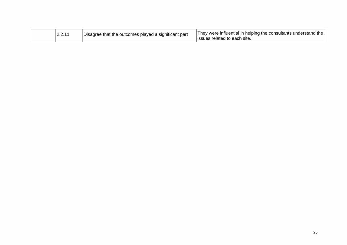
2.2.11 Disagree that the outcomes played a significant part They were influential in helping the consultants understand the issues related to each site.
23
03. Design Principles
Section Paragraph Main Issue Summary Response
Prescribed Bodies and Key Stakeholders
Thames Water Utilities Limited
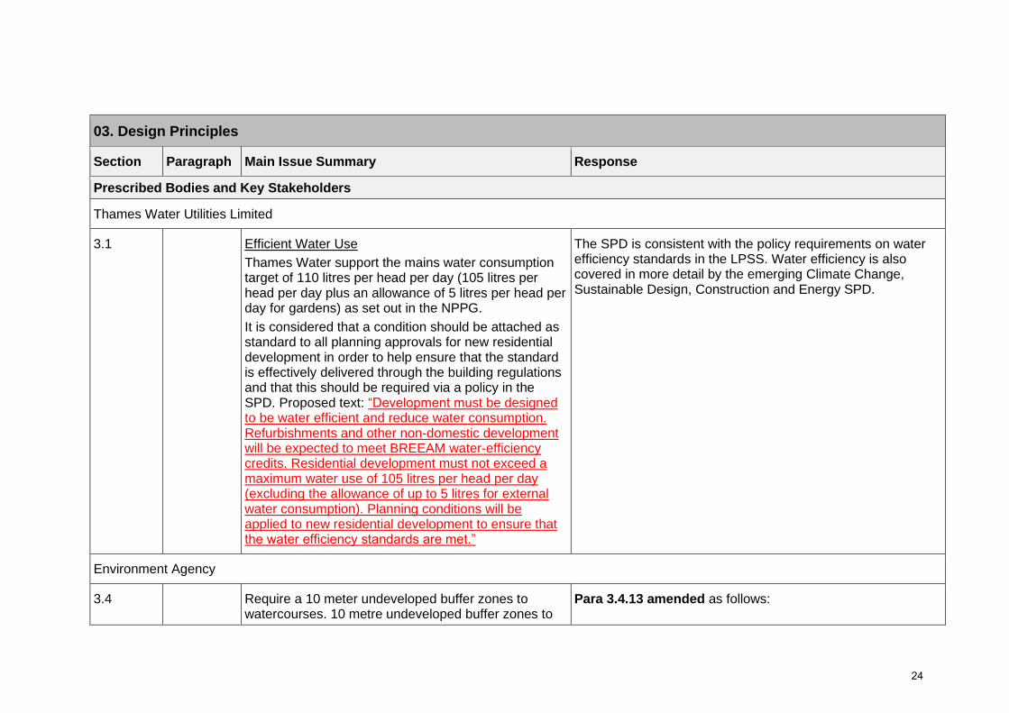
3.1 Efficient Water Use
Thames Water support the mains water consumption target of 110 litres per head per day (105 litres per head per day plus an allowance of 5 litres per head per day for gardens) as set out in the NPPG.
It is considered that a condition should be attached as standard to all planning approvals for new residential development in order to help ensure that the standard is effectively delivered through the building regulations and that this should be required via a policy in the SPD. Proposed text: “Development must be designed to be water efficient and reduce water consumption. Refurbishments and other non-domestic development will be expected to meet BREEAM water-efficiency credits. Residential development must not exceed a maximum water use of 105 litres per head per day (excluding the allowance of up to 5 litres for external water consumption). Planning conditions will be applied to new residential development to ensure that the water efficiency standards are met.”
The SPD is consistent with the policy requirements on water efficiency standards in the LPSS. Water efficiency is also covered in more detail by the emerging Climate Change, Sustainable Design, Construction and Energy SPD.
Environment Agency
3.4 Require a 10 meter undeveloped buffer zones to watercourses. 10 metre undeveloped buffer zones to
Para 3.4.13 amended as follows:
24
watercourses can significantly contribute to achieving net-gain and improve connectivity between areas by providing wildlife corridors. They are important local assets which can provide strong and resilient ecosystems, green and blue infrastructure links, water quality and human health through pleasant amenity space. Article 10 of the Habitats Directive stresses the importance of natural networks of linked habitat corridors to allow the movement of species between suitable habitats, and promote the expansion of biodiversity. River corridors are particularly effective in this way and the network of river corridors may help wildlife adapt to climate change by providing a migration corridor. This approach would ensure development provides enhancements which prevent deterioration of the ecological status of waterbodies.
‘Where water features are included at the edge of or within a strategic site, development must be designed to have a positive relationship including active frontages and a well-integrated public realm. Where possible a 10 metre undeveloped buffer zone should be provided to any watercourses designated as main rivers that run through the site. This can include permeable paths along the river for pedestrians and cyclists.’
Surrey County Council
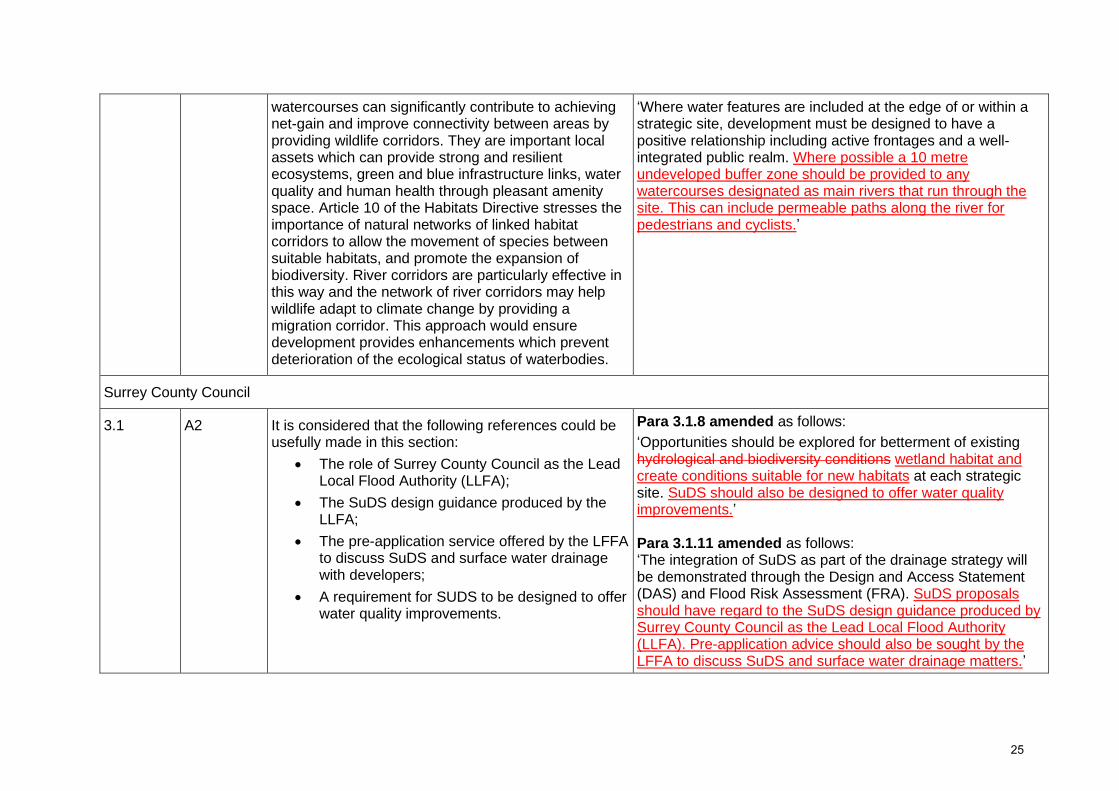
3.1 A2 It is considered that the following references could be usefully made in this section:
• The role of Surrey County Council as the Lead Local Flood Authority (LLFA);
• The SuDS design guidance produced by the LLFA;
• The pre-application service offered by the LFFA to discuss SuDS and surface water drainage with developers;
• A requirement for SUDS to be designed to offer water quality improvements.
Para 3.1.8 amended as follows:
‘Opportunities should be explored for betterment of existing hydrological and biodiversity conditions wetland habitat and create conditions suitable for new habitats at each strategic site. SuDS should also be designed to offer water quality improvements.’ Para 3.1.11 amended as follows: ‘The integration of SuDS as part of the drainage strategy will be demonstrated through the Design and Access Statement (DAS) and Flood Risk Assessment (FRA). SuDS proposals should have regard to the SuDS design guidance produced by Surrey County Council as the Lead Local Flood Authority (LLFA). Pre-application advice should also be sought by the LFFA to discuss SuDS and surface water drainage matters.’
25
3.1.9 The requirement should be for all sites to achieve pre-development greenfield run-off rates where practicable, in line with the Non Statutory Technical Standards for Sustainable Drainage, rather than for the “peak flow rates of surface water leaving the strategic locations to be no greater than the rates prior to the proposed development”.
Para 3.1.9 amended as follows:
‘Surface water drainage should achieve pre-development greenfield run-off rates where practicable, in line with the Non Statutory Technical Standards for Sustainable Drainage ensure volumes and peak flow rates of surface water leaving the strategic locations are no greater than the rates prior to the proposed development.’
Checklist Design Principle A
Water quality should additionally be mentioned, along with “surface water management, habitat creation and placemaking features,” as a required benefit to be derived from SUDs.
Checklist Design Principle A amended as follows:
‘Integration of SuDS to provide surface water management, water quality improvements, habitat creation and placemaking features.’
3.3 C4 Missed opportunity to promote streets that exclude motorised transport (main access to schools, shops, community facilities is only via non-motorised access routes, with the motorised routes behind).
Paragraph 3.3.21 has been amended to highlight the opportunity for non-motorised streets. Surrey CC guidance on parking provision for new schools (2018) is that there should only be provision for the operational requirements of staff and visitors, together with overflow parking areas for community uses, with no provision of parent parking, pupil parking and drop off/pick up areas as these are a disincentive to travelling by sustainable modes.
3.3.36 Promote low emission vehicles only for car clubs and require EVCP at 100% of car club bays.
Where car club spaces are provided, we would expect them to be provided with EVCP. Table 4 has been amended to reflect this.
3.4 3.4.12 Mention of water quality should be included. Para 3.4.12 amended as follows:
‘The surface water management strategy within the Flood Risk Assessment must demonstrate how drainage features will be designed to provide biodiversity and water quality benefits.’
Checklist Design Principle D
Mention of water quality should be added to ‘Demonstration of how existing drainage features will be designed to support biodiversity”.
Checklist Design Principle D amended as follows:
26
‘Demonstration of how existing drainage features will be designed to support biodiversity and improve water quality.’
3.5 3.5.3 Consideration should be given to including separation of noise producing environments from residential areas
This issue is dealt with in Section D2.
Sport England
3.3 C2 Sport England welcomes the reference to our Active Design guidance and principles within the draft SPD under section C2 - Active Travel. Sport England would ask that the draft SPD further considers how principles 9 and 10 within the guidance can be incorporated namely (9) Management, maintenance, monitoring & evaluation and (10) Activity promotion & local champions. These two elements can often be overlooked when designing healthy and active communities. It will be important to ensure effective management and maintenance of the environment which enables people to be active. Furthermore, once those active environments have been established it will be important to consider how those areas can be activated and promoted using local champions; groups; networks and organisations to promote and facilitate physical activity in these locations.
There may be opportunities within the document to strengthen links and references to other principles within our Active Design Guidance in addition to those highlighted within the Active Travel section under C2 referred to above.
The SPD refers to the Active Design guidance and therefore it is expected that due regard is given to all the principles contained within it.
3.5 3.5.23 Sport England notes that Guidford BC does not have an up to date and/or robust assessment of its outdoor
The Council is in the process of producing a Playing Pitch Strategy. In the absence of a published Playing Pitch Strategy,
27
and indoor sports facilities in the form of a Playing Pitch Strategy or Sports Facilities Strategy which has been developed using Sport England guidance. We have concerns about the approach to identifying the quantum of playing field to be developed under a number of these strategic sites. These include Gosden; Blackwell Farm; Ash and Tongham; and Wisley. The level of playing field provision is based on local plan open space standards from 2003.
Sport England does not support a standards based approach to new playing field provision as advocated within the draft SPD, which we consider to be too generic and does not sufficiently take into account the local context. Sport England would strongly recommend that the council seek to undertake an up to date and robust assessment of their playing field needs through a Playing Pitch Strategy to better inform the quantum and type of provision which will be needed to meet the demand generated by development on these sites.
Sport England considers that it would be helpful to make it clear within the document that all sports facilities/pitches should be designed and constructed in accordance with Sport England technical guidance and relevant national governing body for sport design guidance where appropriate.
the Council can only secure open space in accordance with the standards set in policy. If evidence is subsequently produced then this can be a material consideration in determining the planning application. The open space standards are being reviewed as part of the emerging Local Plan: development management policies.
Para 3.5.23 amended as follows:
‘The local open space standards relevant to each strategic site are set out in Part 3 of this SPD. All sports facilities/pitches should be designed and constructed in accordance with Sport England technical guidance and relevant national governing body for sport design guidance where appropriate.’
CBRE (former Wisley Airfield)
3.4 3.4.7 The second criteria, that hedgerows shall not be adjacent to a carriageway, is unclear. Hedgerows
Text deleted: ‘Shall not be retained adjacent to a carriageway;’
28
commonly form part of a road boundary and as such flexibility in design should be allowed for.
Surrey Wildlife Trust/ Surrey Nature Partnership
3.2 3.2.30 The words “..where possible” should be removed, to align and avoid any confusion with current national policy within the revised NPPF (2019).
Para 3.2.30 amended as follows:
‘Minimise the impact on the Borough’s biodiversity and habitats and provide net gains, where possible;’
3.5 3.5.22 Somewhere here it could be usefully added/emphasised that these ‘types’ largely express features related to primary recreational uses, and that certain landscaping principles should apply across them all (ie. management features to support biodiversity, for example).
Para 3.5.22 amended as follows:
‘There are a number of open space typologies that are required as part of strategic sites, to provide a range of spaces to cater for a range of activities and needs. Green infrastructure should provide a network of multi-functional green space which is capable of delivering a wide range of environmental and quality of life benefits for local communities.’
Savills obo GBC (Weyside Urban Village)
3.1 3.1.1 Should biodiversity net gain be mentioned? This matter is addressed in para 3.2.30
3.1.6 Not all buildings will be residential. Should there be explicit reference to BREEAM – excellent or very good?
Adopted policy does not require non-residential developments to achieve a BREEAM certification – an SPD cannot create new policy. The draft Climate Change, Sustainable Design, Construction and Energy SPD proposes BREEAM certification as a voluntary standard that developers can use to demonstrate compliance with the requirements of LPSS policy D2 Climate Change, Sustainable Design, Construction and Energy.
Image on page 21 reflects retrofit when new housing will incorporate solar technology into built structures. A more appropriate image should be used.
Image replaced with a photo of photovoltaic roof tiles.
29

3.1.7 Suggest change. This reflects that, whilst changes to the existing topography are not envisaged, there is the potential for significant remediation and groundworks that might cause disruption to the existing topography. ‘Minimal dDisruption to the existing topography of the strategic locations should occur be minimised and where possible masterplans should work with the existing site and watercourse in order to retain the unique character of each site.'
Para 3.1.7 wording amended as follows:
‘Minimal disruption to the existing topography of the strategic locations should occur, and master plans should, where appropriate and feasible, work with the existing site form and watercourse in order to retain the unique character of each site.’
3.1.8 Last sentence change: Opportunities should be explored for the betterment of existing hydrological and biodiversity conditions to achieve biodiversity net gain at each strategic site
Para 3.1.8 amended as follows:
‘Opportunities should be explored for betterment of existing hydrological and biodiversity conditions wetland habitat and create conditions suitable for new habitats at each strategic site.’
A3 Should reference be added to climate resilient landscape, sustainable movement and healthy placemaking.
Diagram on page 24 amended to include a label on “climate resilient landscaping”.
Sustainable movement is addressed in Section 3.3. Health is addressed in a number of the other sections in Part 2 (e.g. section 3.3)
3.2 Figure on page 30
Check density. The figure plan looks less than 60-70dph (see for instance consistency with page 36)
The diagrams on Page 36 are illustrative and not to scale.
Page 36 "with parking primarily at basement level under podium gardens with a shared landscaped courtyard under podium gardens over the podium or basement parking."
Wording amended as follows:
‘with parking primarily at basement/podium level with a shared landscaped courtyard under podium gardens’
Label amended from ‘Podium placed over car parking with landscaped areas’ to ‘Landscaped areas over car parking’
30
3.2.17 Include other sustainable travel initiatives (i.e. care share / pool car) and a statement for strategic development to consider alternative parking interventions in response to the changing attitudes to car ownership.
This subsection is concerned with parking considerations, specifically for motor vehicles, including the provision of EV charging, and bicycles. Section 3.3 addresses sustainable transport initiatives including mobility hubs.
The existing Guildford Vehicle Parking Standards SPD (2006) is designed with current car usage levels in mind. The requirement to follow standards of the Vehicle Parking Standards SPD (2006) is inconsistent with the rest of the SDF SPD and its aspiration to achieve high active and public transport usage. The wording should allow for ‘car lite’ developments to come forward.
The Council’s existing parking standards (Vehicle Parking Standards SPD) date from 2006. These were prepared in the light of the then national policy which sought reduced parking availability as a key tool in achieving a shift to more sustainable travel. The Council accordingly set maximum parking standards, which were intended to cap the amount of new car parking provided on-site. The Reasoned Justification for Policy ID3 Sustainable transport for new developments in the Local Plan: Strategy and Sites (2019) explains, at paragraph 4.6.27, that the policy does not preclude developers from bringing forward proposals for car-free new development. In this context, at present a planning application would be considered with respect to Policy ID3 and the Council’s’ 2006 Parking Standards, which are maximum standards, as well as any other material considerations, for instance Surrey CC’s non-statutory Vehicular and Cycle Parking Guidance (2018).
GBC has consulted on the Issues, Options and Preferred Options consultation (GBC 2020) for the emerging Local Plan: Development Management Policies. The preferred option and alternative option for parking standards take differing approaches, the preferred option with minimum standards for residential developments outside of Guildford Town Centre and the alternative option with tapered maxima across the Borough. A new policy could be provided in the forthcoming
31
Local Plan: Development Management Policies which would supplement the Policy ID3 requirements for parking. This would then further define the policy parameters, with the detailed guidance provided in a Parking SPD.
In summary, present local parking policy allows for developers to bring forward proposals for car-free development and new local parking policy is emerging.
3.2.18 It is not clear whether these parking requirements will be superseded by the forthcoming Parking SPD.
See response directly above to respondents’ comments regarding the parking SPD in para 3.2.17.
Table 4 The requirement for 100% of allocated parking spaces to have electric charging provision is a significantly higher requirement than in Surrey's guidance. This requirement could be unnecessarily restrictive.
The draft SDF required one fast charge socket per house, not for every allocated space associated with an individual house. Table 4 has been modified to match the preferred option for Policy ID11 Parking standards in the Issues, Options and Preferred Options consultation (June 2020) for the emerging Local Plan: Development Management Policies, to one fast charge socket per house/flat/apartment with one or more car parking space. This mirrors the policy position consulted upon by the Government in Electric Vehicle Charging in Residential and Non-Residential Buildings (2019), which is itself more onerous than Surrey CC’s Vehicular and Cycle Parking Guidance (2018).
3.3 C1 The exact route of the SMC is not known, and the design requirements are still to be provided, therefore the reference to the route or design of the SMC within the Weyside Urban Village site should be indicative.
Title of Figure 5 amended to highlight the ‘Indicative’ route of the SMC.
C2 The proposed use of GBC’s 2006 car parking standards as referenced in 3.2.17 do not coalesce with the aspirations in section C2 for active travel and public
Parking policy is part of a complex decision-set. The Council’s existing parking standards (Vehicle Parking Standards SPD) date from 2006. These were prepared in the
32
transport, with private car trips having the lowest priority.
light of the then national policy which sought reduced parking availability as a key tool in achieving a shift to more sustainable travel. The Council accordingly set maximum parking standards, which were intended to cap the amount of new car parking provided on-site. The Reasoned Justification for Policy ID3 Sustainable transport for new developments in the Local Plan: Strategy and Sites (2019) explains, at paragraph 4.6.27, that the policy does not preclude developers from bringing forward proposals for car-free new development. In this context, at present a planning application would be considered with respect to Policy ID3 and the Council’s’ 2006 Parking Standards, which are maximum standards, as well as any other material considerations, for instance Surrey CC’s non-statutory Vehicular and Cycle Parking Guidance (2018). The Borough Council has consulted on the Issues, Options and Preferred Options consultation (GBC 2020) for the emerging Local Plan: Development Management Policies. The preferred option and alternative option for parking standards take differing approaches, the preferred option with minimum standards for residential developments outside of Guildford Town Centre and the alternative option with tapered maxima across the Borough.
C3 Should state the quantum of cycle parking spaces expected.
A minimum of one cycle parking space per dwelling should be provided, as per paragraph 3.2.23. This mirrors the Council’s Vehicle Parking Standards SPD (GBC, 2006) specifying a minimum of 1 cycle space per unit for C3 Dwelling Houses outside of Guildford town centre.
33
Paragraph 3.2.17 has been amended to highlight that the 2006 Vehicle Parking Standards SPD includes standards for both vehicles and cycles. In this context, at present a planning application would be considered with respect to the Council’s’ 2006 Parking Standards, as well as any other material considerations, for instance Surrey CC’s non-statutory Vehicular and Cycle Parking Guidance (2018). Options for cycle parking standards were also considered in the preparation of the emerging Local Plan: Development Management Policies.
3.3.17 Suggest rewording the first sentence as follows: “Cycle movement within the strategic sites should be made without causing conflict to minimise conflicts with other vehicles and pedestrians." It is not possible to eradicate conflict.
We have taken this on board and amended paragraph 3.3.17.
3.3.23 The accompanying cross sections 1, 2 and 3, [showing arrangements of the Primary and Secondary streets] are too prescriptive in nature and have the potential to cause unnecessarily wide spine roads being developed. Alternative options:
• Segregated cycle lanes do not necessarily need to run parallel to the primary route
• 4.5m wide combined bus and cycle lane
• The primary street without the SMC route along it - a separate bus corridor
These sections should ideally be removed from the SPD and accompanying text should emphasise that the primary route option presented, is only one option of achieving the same aspiration.
The Council has reviewed the guidance in the SDF on the provision for buses, including the SMC, on and immediately adjacent to the strategic sites. This is as a result of responses and evidence provided with respect to potential adverse visual impacts, reduction in development densities and reduced developer contributions, colonisation of generous street widths by the parked vehicles of early residents, leading to subsequent decisions not to implement bus lanes.
The guidance that segregated and continuous bus lanes be provided for the exclusive use of buses on the primary streets as they run through the strategic sites has been modified. Segregated bus lanes and/or bus gates/modal filters would only be required in congestion hotspots, including site accesses, where queuing traffic in peak periods might be expected to delay buses on the primary streets. In cases
34
Alternative wording: ‘Primary streets form the main points of access capable of integrating public transport routes and providing an attractive environment for pedestrians and cyclists. The primary streets identified in the SDFs in each strategic site should, where constraints allow, include segregated cycle lanes to avoid conflict with vehicles. At Gosden Hill, Blackwell Farm and Slyfield, the primary streets could will accommodate the Sustainable Movement Corridor.'
where it is agreed that there is significant uncertainty as to the need for and/or extent of such bus priority measures in future years, there is potential for the incorporation of a reserve strip allowing later provision to be implemented at agreed triggers if necessary. This has been accompanied by modified guidance to protect primary streets from being colonised by overspill parking, for instance by the street design incorporating parking bays, including those suitable for deliveries, appropriately landscaped. Alternatively, the SDF also now allows that, consideration could be given to the potential for a route through the site to be provided for buses, separate from the primary street. This could utilise a series of secondary roads connected by bus gates or modal filters, so long as such a route provides good accessibility to the bus services. The council continues to require that segregated and continuous cycleways and generous pedestrian paths be provided on the primary streets of the strategic sites. Paragraphs 3.3.23 and 3.3.30 have been modified to this effect.
3.3.30 Should reflect that the design of the SMC within the Weyside Urban Village will need to respond to site and masterplanning constraints, maintaining consistency with paragraph 4.6.3. ‘The Sustainable Movement Corridor (SMC) will provide the route of the new bus network through the strategic sites in the Guildford urban area at Blackwell Farm, Gosden Hill and Slyfield. Within these strategic sites, the design format of the SMC will aim to provide segregated and prioritised continuous lanes for buses, segregated and continuous cycleways and generous pedestrian paths. Priority will be given to the SMC at junctions. Subject to site constraints and viability the
See response directly above. Paragraphs 3.3.23 and 3.3.30 modified to this effect.
35
space provided for the bus lanes and any adjacent landscaping will be sufficient to allow the future upgrading of the SMC to allow rapid Bus Rapid Transit (BRT).' Weyside Urban Village should be explicitly exempt from the requirement to facilitate landscaping sufficient to allow the upgrading of the SMC to allow Bus Rapid Transport (BRT), due to space constraints.
3.3.35 Inappropriate to prescribe that electric vehicle charging points are independently wired to a 32A spur, given future technology enhancements. To require EV facilities for every allocated space is onerous.
Surrey CC’s Vehicular and Cycle Parking Guidance (2018) sets this power requirement. SCC state that the standards will be reviewed in line with the development of technology. The draft SDF required one fast charge socket per house, not for every allocated space associated with an individual house. Table 4 has been modified to match the preferred option for Policy ID11 Parking standards in the Issues, Options and Preferred Options consultation for the emerging Local Plan: Development Management Policies, to one fast charge socket per house/flat/apartment with one or more car parking space. This mirrors the policy position consulted upon by the Government in Electric Vehicle Charging in Residential and Non-Residential Buildings (2019).
3.3.36 Car clubs are not a known quantity due to the rate of change in technology/ attitudes and flexibility must be built in to repurpose any space dedicated to these initiatives. Suggested amendment: ‘The strategic sites of Slyfield, Gosden Hill Farm and Blackwell Farm will should each provide facilities for use by a car club. A car club provides cars for short term hire on a pay per trip basis. This allows individuals and businesses affordable access to a
The DfT’s Future of Mobility: Urban Strategy (2019) identifies that increased use of car clubs could also help to alleviate congestion; having access to a shared vehicle has been shown to lead to reductions in personal car ownership and miles driven, as well as increased use of other modes of transport. It reports that the number of car club members across the UK increased almost eight-fold between 2007 and 2017, to nearly 250,000 members. Paragraph 3.3.36 amended to reflect the emerging concept of mobility hubs. Mobility hubs are a recognisable place with an offer of different and connected transport modes, such as car club vehicles,
36
vehicle without the need for ownership. Appropriate on-street locations for car club bays will be provided (sic).
bike share, cycle parking and/or a bus stop supplemented with enhanced facilities and information features.
3.3.37 Add reference to an encouragement to seek to design out car parking in the future.
While this is beyond the scope of the SDF document, a proposal for an alternative approach to parking, which still allows the objectives of the SDF to be achieved, could be made as part of a future planning application.
3.4 3.4.4 This should be more explicit that the Garden City Principles set out do not specifically apply to some of the strategic development areas, e.g Slyfield, that are heavily constrained.
Para 3.4.4 amended as follows:
‘…Reference should be made to where developments achieveing the Garden City Principles as set out by the Town and Country Planning Association (TCPA), accepting that not all garden city principles may be achieved on the strategic sites. However, where it is possible to achieve the design-led principles relevant to this SPD then it will be expected that these are met on each site.’
D5 Fig 7 needs enlarging Figure 7 has been enlarged
3.4.23 Replace ‘compact neighbourhoods’ with ‘walkable neighbourhoods’ the latter being a more appropriate term and fitting in with the terminology used to describe Figure 8 on Page 63.
Wording amended to refer to walkable neighbourhoods
3.5 3.5.8 Should add cafes and restaurants Para 3.5.8 amended as follows:
‘The clustering of a range of facilities such as schools, shops, restaurants, health centres, dentists, and youth facilities creates multiple reasons to visit a location.’
3.5.9 Add reference to Secure by Design guidance This guidance is listed in para 2.1.15.
General Many of the figures do not represent the style/character that will be developed on the strategic sites
The figures do not attempt to provide a suggestion of a design solution for the strategic sites – they merely illustrate the design principle that is being discussed with a ‘real world’ example.
37
Martin Grant Homes (Gosden Hill Farm)
3.1 3.1.7 Whilst support retention of existing topography on sites and allowing existing watercourses to retain their alignment and course, this may not always be feasible. Suggested amendment:
‘Minimal disruption to the existing topography of the strategic locations should occur, and master plans should, where appropriate and feasible, work with the existing site form and watercourse in order to retain the unique character of each site.’
Para 3.1.7 wording amended as follows:
‘Minimal disruption to the existing topography of the strategic locations should occur, and master plans should, where appropriate and feasible, work with the existing site form and watercourse in order to retain the unique character of each site.’
3.1.9 Further clarity is needed in terms of the expected contribution towards maintenance of SuDS.
May not always be practical to retain all drainage ditches on sites, particularly if site levels require altering as part of development. Suggested amendment:
‘Where feasible, the existing network of watercourses, ponds and drainage ditches on the strategic sites will be required to should be incorporated as part of the overall flood attenuation and open space strategy.’
The SPD is primarily concerned with place-making. This issue will be agreed as part of the planning application process.
Para 3.1.9 amended as follows:
‘Where feasible, the existing network of watercourses, ponds and drainage ditches on the strategic sites will be required to should be incorporated as part of the overall flood attenuation and open space strategy.’
3.2 3.2.14 Urban extensions should anchor themselves into their setting and integrate with surrounding areas. SPD should not require that urban extensions are wholly contemporary. Amend para as follows:
‘Whilst taking key design influences from the above character typologies, it is important to create high quality urban extensions which are contemporary and distinctive to their surrounding context take design
Para 3.2.14 amended as follows:
‘Whilst taking key design influences from the above character typologies, it is important to create urban extensions which are contemporary and distinctive respond positively to their surrounding context.’
38
cues from the above character typologies, whilst also incorporating elements that are distinctive to their residential surroundings.’
Perimeter block diagrams do not achieve the balanced approach to parking outlined in para 3.2.19. They should also include some of the character typology examples from Guildford, to achieve a more balanced representation of housing types.
National Design Guide makes clear that how parking is arranged has a fundamental effect on the quality of place or development; consideration should therefore be given to how parking can be appropriately accommodated within developments, particularly where higher densities are proposed. SPD should make clear that there should be a balanced approach to car parking, as opposed to relying solely on on-street parking in areas of higher density. Amend paragraph 3.2.16 as follows:
‘To understand how the requirements for of density, private and public space and car parking might shape the urban form, the drawings below considers how a typical block can convey four ways in which a block could be designed to achieve a range of densities.’
Diagrams are illustrative only and indicate examples of how different densities can be accommodated in a perimeter block. It is not intended to reflect Guildford’s character nor be prescriptive as to how the strategic sites should be delivered.
Para 3.2.16 amended as follows:
‘To understand how the requirements for of density, private and public space and car parking might shape the urban form, the drawings below considers how a typical block can convey four ways in which a block could be designed to achieve a range of densities.’
3.3 Section 1 & 2: Primary Streets
Street cross sections are welcomed but should be illustrative. Currently too prescriptive and do not provide the flexibility which is contrary to para 3.3.25. Dedicated bus lanes unlikely to be necessary in terms of capacity and not necessarily supported by SCC. Requires acknowledgment that the SMC will be delivered in a variety of different ways, and that what
The Council has reviewed the guidance in the SDF on the provision for buses, including the SMC, on and immediately adjacent to the strategic sites. This is as a result of responses and evidence provided with respect to potential adverse visual impacts, reduction in development densities and reduced developer contributions, colonisation of generous street widths
39
3.3.25
may be achievable within a strategic development site is unlikely to be achievable off site. Bus and cycle lanes could be combined, and dedicated cycle routes provided elsewhere within the development
Suggested reword as follows: ‘Detailed designs should explore the opportunities for varying degrees of formality and informality along the route, informed by the surrounding land uses and character of the development. Within built up areas, primary streets are usually defined by development that is greater in form, scale and density with a focal point for schools, shops and community facilities. Larger tree species with formal planting arrangements are typical. Within open areas, primary streets may have a more relaxed approach to planting, although trees should still be large. Different approaches are illustrated in the accompanying street sections. As a guide, two forms of SMC have been identified (type 1 and type 2 illustrated below) (see rep for details) as follows: • SMC type 1: provides separate lanes for bus, cycle and pedestrians, ideally with bus or cycle lanes co-located to one side of the carriageway, with general traffic lanes on the other side. • SMC type 2: Use of bus priority measures and bus lanes at congested sections of the highway and at interchanges. Buses share general traffic lanes where there are free-flow conditions. Shared lanes are provided for cyclists and pedestrians. While SMC type 1 represents GBC’s preferred approach, providing high priority for buses, pedestrians
by the parked vehicles of early residents, leading to subsequent decisions not to implement bus lanes.
The guidance that segregated and continuous bus lanes be provided for the exclusive use of buses on the primary streets as they run through the strategic sites has been modified. Segregated bus lanes and/or bus gates/modal filters would only be required in congestion hotspot locations, including at site accesses, where queuing traffic in peak periods might be expected to delay buses on the primary streets. In cases where it is agreed that there is significant uncertainty as to the need for and/or extent of such bus priority measures in future years, there is potential for the incorporation of a reserve strip allowing later provision to be implemented at agreed triggers if necessary. This has been accompanied by modified guidance to protect primary streets from being colonised by overspill parking, for instance by the street design incorporating parking bays, including those suitable for deliveries, appropriately landscaped. Alternatively, the SDF also now allows that consideration could be given to the potential for a route through the site to be provided for buses, separate from the primary street. This could utilise a series of secondary roads connected by bus gates or modal filters, so long as such a route provides good accessibility to the bus services. The council continues to require that segregated and continuous cycleways and generous pedestrian paths be provided on the primary streets of the strategic sites. Given the above, amendments have been made to ‘Section 1’ and ‘Section 2’, but no change has been made to paragraph 3.3.25.
40
and cyclists, it may not prove necessary or appropriate in various locations.’
Section 4: Tertiary Street
Image shows both a shared surface as well as a footway segregated from the main carriageway which is contradictory, and the footway should be removed.
Proposed to maintain figure as is. The indicative cross-section as shown with the footway separate from the shared surface is considered to be an approach which address the concerns about shared space and navigability identified in the Ministerial letter from MHCLG and DfT of 28 September 2018.
3.3.30 A one size fits all approach to the SMC should not be adopted. There are no current plans to provide Bus Rapid Transit through Guildford therefore there should not be suggestion to set aside land for this.
Proposed amendment:
‘The Sustainable Movement Corridor (SMC) will provide the route of the new bus network through the strategic sites in the Guildford urban area at Blackwell Farm, Gosden Hill and Slyfield. Within these strategic sites, where necessary and physically possible, the design format of the SMC will provide segregated and continuous lanes for buses. Segregated and Continuous cycleways and generous pedestrian paths should be provided as generously as possible to encourage walking and cycling. Where practicable, priority will be given to the SMC at junctions. The space provided for the bus lanes and any adjacent landscaping will should be sufficient to allow the future upgrading of the SMC to allow Bus Rapid Transit (BRT).
The Council has reviewed the guidance in the SDF on the provision for buses, including the SMC, on and immediately adjacent to the strategic sites. This is as a result of responses and evidence provided with respect to potential adverse visual impacts, reduction in development densities and reduced developer contributions, colonisation of generous street widths by the parked vehicles of early residents, leading to subsequent decisions not to implement bus lanes.
Paragraph 3.3.30 has been modified to the effect that:
• Segregated bus lanes and/or bus gates/modal filters will be required in priority locations, including at site access
• The design of primary streets, in preventing their colonisation by overspill parking, will allow for reliable bus operations
• Allowance for an alternative approach with route through the site for buses, separate from the primary street
• Removal of the reference to BRT The council continues to require that segregated and continuous cycleways and generous pedestrian paths be provided on the primary streets of the strategic sites. The wording to this effect has been moved from paragraph 3.3.30 to paragraph 3.3.23.
41
3.3.35 Inappropriate to prescribe that electric vehicle charging points are independently wired to a 32A spur, given future technology enhancements. Suggested change: ‘The strategic sites will be required to demonstrate the provision of electric vehicle infrastructure within the public realm. Every dwelling with a dedicated parking space should be equipped with an electric vehicle charging point (EVP). Each charging point shall be independently wired to a 32A spur to enable minimum 7kV charging. A minimum of twenty percent of non-allocated parking spaces across all uses should be provided with rapid charging points.’
Surrey CC’s Vehicular and Cycle Parking Guidance (2018) sets this power requirement. SCC state that the standards will be reviewed in line with the development of technology. GBC’s draft Issues, Options and Preferred Options (2020) consultation document for the emerging Guildford borough Local Plan: development management policies proposed, in the preferred option for parking standards (Policy ID11) to mirror the power requirement set in SCC’s guidance (2018).
3.3.36 There is no requirement for a car club within Policy 25. The SPD should provide for the potential provision, without imposing a requirement. Suggested change: ‘Where appropriate, the strategic sites of Slyfield, Gosden Hill Farm and Blackwell Farm will should each provide a car club. A car club provides cars for short term hire on a pay per trip basis. This allows individuals and businesses affordable access to a vehicle without the need for ownership. Appropriate on-street locations for car club bays will be provided.’
The DfT’s Future of Mobility: Urban Strategy (2019) identifies that increased use of car clubs could also help to alleviate congestion; having access to a shared vehicle has been shown to lead to reductions in personal car ownership and miles driven, as well as increased use of other modes of transport. It reports that the number of car club members across the UK increased almost eight-fold between 2007 and 2017, to nearly 250,000 members. We have amended paragraph 3.3.36 to reflect the emerging concept of mobility hubs. Mobility hubs are a recognisable place with an offer of different and connected transport modes, such as car club vehicles, bike share, cycle parking and/or a bus stop supplemented with enhanced facilities and information features.
3.4 3.4.4 We recognise that it may be appropriate for development to make reference to achieving the identified Garden City Principles, however, it is not considered that land value capture for the benefit of the community and community ownership of land and long-
Para 3.4.4 amended as follows:
‘…Reference should be made to where developments achieveing the Garden City Principles as set out by the Town and Country Planning Association (TCPA), accepting that not
42
term stewardship of assets in particular should be a pre-requisite of urban extensions unless any implications for viability are to be taken into account. Amend para as follows:
‘…Reference should be made to where developments achieveing the Garden City Principles as set out by the Town and Country Planning Association (TCPA).’
all garden city principles may be achieved on the strategic sites. However, where it is possible to achieve the design-led principles relevant to this SPD then it will be expected that these are met on each site.’
3.4.12 The ecological benefits of any development, including drainage features, are likely to be more appropriately addressed through ecological assessment prepared as part of any planning application, as opposed to within the Flood Risk Assessment. Amend as follows:
‘The surface water management strategy should within the Flood Risk Assessment must demonstrate how drainage features will be designed to provide biodiversity benefits, with the benefits identified as part of development proposals.’
Para 3.4.12 amended as follows:
‘The surface water management strategy should within the Flood Risk Assessment must demonstrate how drainage features will be designed to provide biodiversity benefits, with the benefits identified as part of development proposals.’
Terence O’ Rourke obo Blackwell Park Ltd
3.2 3.2.20 The aspiration for EV charging provision should not be couched as a ‘requirement.’ There may be circumstances where this cannot be met. There are issues that affect the economic of development.
Paragraph 3.2.20 has been amended to refer to the “expected provision” of EV charging infrastructure. Policy D2(1)(e) of the Local Plan: Strategy and Sites makes reference to this.
3.2 Figure 4 Green belt is not a green infrastructure resource, but a planning designation and should be removed / replaced with countryside.
Figure 4 key amended to read ‘countryside and villages’ instead of ‘Green Belt’
Compton Parish Council
43
3.1 3.1.5 Suggest choice of graphic does not align with avoidance of clutter – solar panels that blend in with the tile should be used.
Image replaced with a photo of photovoltaic roof tiles.
3.1 3.1.12 / 13 Design principles should include flexibility to cater for an aging population, new technology and provision for disabled people.
It is considered that the requirements of Policy H1 and D1 of the LPSS together with Section A3 of the SPD address these matters sufficiently.
3.3 C4 Difficult to see how screening can be achieved from the Hog’s Back/ other vantage points/PROW if buildings along primary street are 4-5 storeys high.
Building height will be assessed as part of any future planning application. Further detail regarding visual impact would be considered in LVIA and detailed masterplanning, considering the principles considered within the SDF.
Fails to consider subterranean parking options Subterranean parking is not a requirement however this does not preclude consideration at the planning application stage.
3.3.3 A sustainable development should not be at the detriment of the surrounding areas (i.e. displacement of traffic)
New developments that will generate significant amounts of movement will, at the planning application stage, be supported by a Transport Assessment, and subject to the policy tests in NPPF and Policy ID3. It is considered that, at the planning application stage, an applicant will be able to demonstrate the safe operation and performance of the Local Road Network, either as existing or improved as necessary.
3.4 3.4.5 The point should be made that manicured lawns and manicured hedges do not support wildlife to the same extent and mixed hedgerows and these should be retained.
Para 3.2.30 refers to the need to design and manage green infrastructure for multiple benefits including wildlife.
3.5 3.5.13 These interfaces should be included on all maps with the buffer indicated.
This is a detailed matter that will be considered through the masterplanning process. The interface will vary depending on the circumstances – it is not appropriate to be prescriptive.
44
Effingham Parish Council
3.1 3.1.5 Should mention the potential for a dark skies policy – many of surrounding villages already have one.
The SPD supplements the LPSS which does not include a dark skies policy. Neighbourhood Plans form part of the development plan and will be considered in determining any relevant planning applications.
Worplesdon Parish Council
3.4 8.4.11 The Council must ensure sufficient notice and that any appropriate funding is provided to the Parish Council if the asset becomes its responsibility. (see also part 9)
The SPD is concerned with place making. This level of detail is not appropriate in this SPD and will be considered as part of the planning application process.
3.5 Table 5 There is no mention of parkour, adult exercise, skate park equipment or BMX facilities which are needed within the new strategic sites alleviating the need to travel to the town centre.
This falls within the open space requirement. The exact types of fixed equipment or facilities needed will be informed by documents such as the Council's Fixed Play Equipment Strategy and Play Strategy Action plan and established on a case by case basis. The most appropriate mix of facilities will be negotiated as part of the planning application process.
3.5 There is no mention of street lighting. Suggestion that the Dark Sky movement principles be applied to all four strategic sites, but particularly Blackwell Farm given its allocation within the Surrey Hills bordering AONB.
The SPD supplements the LPSS which does not include a dark skies policy. The considerations in formulating a lighting strategy are listed in para 3.1.5.
West Horsley Parish Council
3.2 3.2.17 Should include reference to SCCs more up to date guidance (2016)
Paragraph 3.2.17 has been updated and the reference included to the 2018 guidance.
Typologies No typology for rural villages - Strategic Sites in the main are surrounded by villages.
The strategic sites either form part of the urban area or will be delivered as a standalone settlement. In accordance with Policy D1(5): Given the size, function and proposed density of the strategic allocations it may not always be desirable to reflect locally distinct patterns of development. These sites
45
must create their own identity to ensure cohesive and vibrant neighbourhoods.
3.2.24 Should refer to pavements as well. Should be moved to a different heading as not only relevant to garage design
Paragraph 3.2.24 has been relocated to the introductory statements in this section and amended to refer to pavements.
Ockham Parish Council
3.2 3.2.7 Should define the word “grain” Para 3.2.11 amended as follows:
‘When creating a narrative of place, it will be important to consider why intensity and grain may have developed in some places rather than in others. Grain is described as the pattern of streets and paths, and the layout of routes and public spaces, and the way plots have developed with this pattern.’
3.3 C5 No specific public transport provision for Wisley suggested in this section (although referenced in 8.2.2). (‘also in other respondents’)
Reference to bus service and cycle provision for the Former Wisley Airfield site has been added to section 3.3 (C1) in the final SDF.
3.4 3.4.16, 3.5.4
Should define “legibility” Legibility is explained in para 3.5.4.
3.4.18 There is ambiguity here about the requirements for a heritage and landscape assessment. This needs to be clarified with clear criteria identified and adhered to.
Detailed assessments of both heritage and landscape matters will need to be undertaken on all strategic sites. Para 3.4.18 amended as follows: ‘For strategic sites affecting the setting of a heritage asset, the Council will expect an analysis of views within and around a site to be undertaken as part of the DAS and a Heritage Statement Heritage Impact Assessment (HIA), setting out how these have been accounted for by the design process.
46
Depending on the strategic site, surrounding features, and the scale and type of development proposed, a robust heritage and landscape assessment may be required to establish existing conditions and assess the potential effects on the wider setting.’
3.4.23 ‘Easy and convenient’ is ambiguous and undefined. The SPD would not benefit from attempting to define the meaning of this term. It may vary depending on the circumstances.
Cllr Deborah Seabrook
3.1 A1 Insulation, provision of outdoor space for drying washing (where no private garden), alternative to gas fired boilers e.g. ASHP are not mentioned and would reduce demand for energy.
This document does not seek to provide a comprehensive set of criteria against which planning applications will be determined. The issues referred to are contained in other planning documents including the LPSS and the emerging Climate Change, Sustainable Design, Construction and Energy SPD.
A2 This section does not reflect the need for surface water minimisation e.g. recycling used water by making sure parking areas have permeable surfaces. (although it appears in the diagram on page 24).
This aspect is covered in more detail by the emerging Climate Change, Sustainable Design, Construction and Energy SPD.
A3 The scope should be widened to include other or new technologies which may become available.
It is not appropriate to prescribe certain technologies, just the outcome i.e the technologies that lead to the lowest carbon emissions. Policy D2 requires that the energy and waste hierarchies are followed.
3.1.17 This should also include designing homes with good ventilation to facilitate airflow and cooling in summer.
This aspect is covered in more detail by the emerging Climate Change, Sustainable Design, Construction and Energy SPD.
3.2 3.2.21 The parking size dimensions are not sufficient. Car parking spaces should be of adequate size to allow convenient parking and ingress and egress from the vehicle. Due to the proliferation of larger domestic vehicles, the
47
demand for larger spaces has increased over recent years. The dimensions of a range of popular large models of cars, including the Ford Focus (2018), Nissan Qashqai (2017), BMW 3 Series (2019) and Land Rover Discovery (2017) were considered in setting the minimum dimensions identified. These dimensions (2.5m x 5m) are greater than those typically set elsewhere, the accepted standard being 2.4m width by 4.8m length.
Table 4 EV charging provision table 4 – reference should be to 1 socket per home (not house)
The draft SDF required one fast charge socket per house, not for every allocated space associated with an individual house. Table 4 has been amended to match the preferred option for Policy ID11 Parking standards in the Issues, Options and Preferred Options consultation (June 2020) for the emerging Local Plan: Development Management Policies, to one fast charge socket per house/flat/apartment with one or more car parking space. This mirrors the policy position consulted upon by the Government in Electric Vehicle Charging in Residential and Non-Residential Buildings (2019).
3.3 3.3.33 Subsidised public transport needs to be frequent, at least at peak times.
There are specific requirements for bus services for the strategic sites of Gosden Hill, Blackwell Farm and Former Wisley Airfield set out in the Local Plan: Strategy and Sites. Policy ID(3) requirement and those in the NPPF (2019) also apply with respect to all development proposals.
3.3.36 Wisley and Ash sites should also specify the introduction of car clubs.
We have amended paragraph 3.3.36 to reflect the emerging concept of mobility hubs. Mobility hubs are a recognisable place with an offer of different and connected transport modes, such as car club vehicles, bike share, cycle parking and/or a bus stop supplemented with enhanced facilities and information features. This now refers to the new settlement at the Former Wisley Airfield but due to the patchwork of development sites in different control which comprise the Ash and Tongham allocation, it is considered this would be more
48
difficult to achieve as a project realised as part of one of these sites.
3.4 3.4.7 Why can high value hedgerows not be retained adjacent to a carriageway?
Text deleted: ‘Shall not be retained adjacent to a carriageway;’
3.5 3.5.19 Restrained could be perceived as bland and dull – some more vibrant colours can provide contrast and interest.
Is there a need to have everything inspired by the best examples in the borough as there may be good examples elsewhere.
Para 3.5.19 amended as follows:
‘A strategy for a restrained consistent palette of colours and materials across the each strategic sites’
‘all of which should be inspired by the best examples of urban development within the Borough and elsewhere.’
General Community buildings are not described in great detail – there should be more than one in each development.
Each site allocation allocates a specific floorspace for community uses (use class D1). The specific use and design of this will be explored in more detail through the masterplanning process. It is detail beyond the scope of this document.
Cllr Nagaty
3.1 3.1.12, 3.1.13
Design principles should include enough flexibility to cater for an ageing population as well as new technology and provision for disabled people.
It is considered that the requirements of Policy H1 and D1 of the LPSS together with Section A3 of the SPD address these matters sufficiently.
3.5 3.5.13 Little or no protection is incorporated within the SPDs for existing properties within and adjacent to the sites. 3.5.13 states where existing properties back onto the development land, generous rear boundary planting is encouraged to soften views from existing properties. This should read is required not merely encouraged.
This issue is covered in more detail in para 3.2.25 and 3.2.26 which requires that the Design and Access Statement submitted as part of the planning application clearly identifies and takes account of adjacent land uses in the design process.
Stagecoach
49
3.1 A2 Where SuDS swales are incorporated along the main street/sofa development they should be designed in such a manner that they are readily "legible" by all highway users as surface drainage systems so that they do not get inadvertently encroached upon by vehicles or pedestrians. We recommend that flush carriageway edges are avoided as it encourages vehicles to make excursions off the carriageway, damaging the swale. Swales immediately behind a kerbline or a highway edge also pose significant issues to the provision of bus stops. Bus stop boarders in effect need to "bridge" the swale and this requires very careful design treatment to ensure that the swale continues to be resilient while avoiding the bus stop area being unduly over-engineered and obtrusive.
It may prove to be more appropriate to keep SuDS features away from primary movement corridors within secondary streets, and larger areas of incidental and more substantial public open space. Where it is appropriate to run these features alongside bus routes we would recommend they sit offset from the carriageway edge so that any kerbside parking, verges and pedestrian and cycle provision sits between the gully line and the SuDS features.
Para 3.1.10 amended as follows:
‘Where SuDS features are present in streets, they should be
designed to fit that context and to be an integral part of the street. Consideration will be given to the design of SuDS features and their relationship to highway users.’
3.1 3.1.14 The rapid increase in home deliveries means that bus routes in particular are becoming increasing compromised by stationary vans. This makes it the more important that primary streets accommodate off-carriageway provision for high levels of visitor parking and deliveries, to avoid bus services becoming delayed by a proliferation of on-carriageway stopping and loading as well as parking.
The Council has modified the guidance in section 3.3 (C4) of the SDF on the design of the Primary Streets of the strategic sites. The design of streets will now incorporate parking bays, protecting streets from being colonised by overspill parking and deliveries.
50
3.2 3.2.19 As we make plain in our own guidance, primary streets should be designed to support efficient movement of buses, with minimal impediment or deflection. The balance of parking provision should be off-carriageway and parallel parking bays along the street are a very effective way of achieving an appropriate balance, especially where street trees are also introduced behind the kerbline. Such bays could well support electric charging infrastructure and either in future or at first occupation the provision of a high level of shared mobility provision in the form of car clubs.
As mentioned above, the guidance in relation to the design of the Primary Streets has been modified in section 3.3 (C4). In this, the expectation is that the design of streets will now incorporate parallel parking bays, also allowing space for a range of facilities including bus stops and shelters, tree planting, cycle parking and pedestrian crossings.
3.2.22 Welcome the minimum dimensions for garages of 7x3m, internally, to credibly allow cars to be parked in them. Notwithstanding this, the lack of internal storage space especially in family homes makes it most likely these will be used mainly for storage. We would urge that measures are taken to allow garages to count as additional spaces rather than contributing to minimum standards.
GBC considers that if the garage provided meets the minimum internal dimensions as described in SDF, then it is appropriate that it be counted as providing one car parking space. This approach is common with other local authorities.
3.3 C4 / SMC within the strategic sites
We endorse the conclusion [para. 3.3.23] that the primary streets should be those engineered to provide effective public transport corridors. It is important that a simple, legible and direct pattern of bus service is provided, with the highest possible choice of frequencies and where appropriate, destinations, can be reached from any given stop. This is much more important to providing a relevant and attractive choice, than a contrived pattern of bus routes that are shoehorned into a street pattern to provide some limited level of service within a strict 300-400m walking distance of every home. However, it is also vital that these primary streets are aligned optimally to secure the most convenient possible access to as
Noted, including support for guidance in paragraphs 3.3.23 and 3.3.31.
The Council has reviewed the guidance in the SDF on the provision for buses, including the SMC, on and immediately adjacent to the strategic sites. This is as a result of responses and evidence provided with respect to potential adverse visual impacts, reduction in development densities and reduced developer contributions, colonisation of generous street widths by the parked vehicles of early residents, leading to subsequent decisions not to implement bus lanes.
The guidance that segregated and continuous bus lanes be provided for the exclusive use of buses on the primary streets
51
many homes as possible. We regard the guidance set out at paragraph 3.3.31 which sets a 400m walking distance threshold, with an upper 600m limit for any flexibility required, as offering an exemplary form of words, creating a clear and generally achievable target while offering a suitable level of flexibility to accommodate the potential wider exigencies of rational master planning. We note that separate guidance will be offered on the design of the SMC in a following SPD. In some respects, it may have proven more expedient to have prepared that guidance first, to inform the preparation of this SPD, which is implicitly dependent on it. Seamless bus priority within and beyond the strategic allocations is highly desirable and justified. However, it must be practically achievable and must not compromise other best practice principles of urban design. Vital that sections of bus priority are provided early in the development trajectory when sustainable travel habits need to be established. Advantageous to deliver longer stretches and key through links, engineered to simple standards, allowing earlier service penetration. Short stand-alone sections of very heavily engineered primary street with no TRO are of no practical use in effecting high quality bus services as the development builds out, parked cars occupy the space and then new residents object to the forthcoming TRO when authority adopts the carriageway. Would urge that a flexible and scalable approach is taken, to ensure that development cash-
as they run through the strategic sites has been modified. Segregated bus lanes and/or bus gates/modal filters would only be required in congestion hotspot locations, including at site accesses, where queuing traffic in peak periods might be expected to delay buses on the primary streets. In cases where it is agreed that there is significant uncertainty as to the need for and/or extent of such bus priority measures in future years, there is potential for the incorporation of a reserve strip allowing later provision to be implemented at agreed triggers if necessary. This has been accompanied by modified guidance to protect primary streets from being colonised by overspill parking, for instance by the street design incorporating parking bays, including those suitable for deliveries, appropriately landscaped. Alternatively, the SDF also now allows that, consideration could be given to the potential for a route through the site to be provided for buses, separate from the primary street. This could utilise a series of secondary roads connected by bus gates or modal filters, so long as such a route provides good accessibility to the bus services. The council continues to require that segregated and continuous cycleways and generous pedestrian paths be provided on the primary streets of the strategic sites. Paragraphs 3.3.23 and 3.3.30 and the street cross-sections (Sections 1, 2 and 3) have been modified to this effect.
52
flow is not unduly burdened with exceptional infrastructure costs. This can then be upgraded at agreed triggers. The incorporation of segregation for buses (with futureproofing for "rapid transit"), dedicated infrastructure for cyclists and footway provision involves a very substantial width resulting front-to-front distances approaching 30m. Impact on land take, development costs as well as visual impact/ character of the SMC corridors will be excessively grand, and inappropriately traffic dominated, leading to a range of other challenges.
• Traffic speeds will tend to naturally rise above 30 mph. Achieving suitable traffic calming measures is likely to be difficult and result in perverse driver behaviour, e.g. intentional incursion in and out of the bus lanes.
• Width approaches an urban dual carriageway, making crossing movements more intimidating.
• The treatment of side road junctions demands dedicated shadow turning lanes, adding more width.
• The amount of paved surface will make the street a much greater source of surface water runoff, requiring larger attenuation features.
• It makes it exceptionally hard to justify more paved surface to accommodate parking on the street and accommodate home deliveries.
• The implications for the adoption process are especially onerous. In the current fiscal climate, we would be surprised if the County Highways Authority would adopt streets of this
53

kind within predominantly residential areas, such would the maintenance liability be.
We would suggest that a strategy for each site is defined, based on a contextually sensitive approach and featuring proportionate and scalable measures, further informed by evidence and experience. This would draw from a "menu" of highways and movement options while based on the context of the site and the degree of segregation needed as the development builds out, in certain situations incorporating a reserve strip allowing "busway" style provision to be implemented at agreed triggers. The starting point of any strategy to effect bus priority must be a minimum 6.2m clear carriageway unimpeded by any on-street parking. This should be self-enforcing and avoid the use of Traffic Regulation Orders such as double yellow lines. It is for this reasons that parking bays either side of the street are recommended. If concern exists that a bus route will attract excessive through traffic, selective (filtered) permeability in the form of bus gates can be employed. Significant off-line displacement of the all-vehicular route is recommended in such situations, but a series of smaller point closures with shorter diversions for general traffic are likely to be equally effective. Where it is clear that traffic at peak times is likely to queue to exit the development, a length of dedicated bus lane could be considered for implementation at the outset, especially if it feeds directly into an off-site section of SMC, avoiding traffic signals. However, the
54
same effect could be better achieved at lower costs, by designing and aligning the spine road with the guiding principle that it acts as a bus priority in the first instance but accommodating frontage access for all traffic within the development. Sections at either end of the development could be dedicated as short lengths of bus-only road and general traffic would use separate access points that only offered a more circuitous route. It may even be justifiable to prohibit traffic leaving a development in certain directions entirely at peak times. Such approaches applied with great thought and care, can achieve the same impacts as dedicated segregated lanes at a fraction of the cost and land take, and with radically lesser impacts on the character and appearance of the built form and place. They could easily incorporate equivalent provision to offer pedestrian permeability and cycle priority. The width and form of the streets could reflect adjoining uses and changing character along its length much more appropriately and flexibly, from higher-intensity and density mixed use areas, to much lower density residential areas.
3.4 3.4.25 "Higher density housing should be focussed at local centres and along primary streets to support viability, walkable neighbourhoods and access to public transport services." (paragraph 3.4.25) This is likely to have implications of the provision of parking however, and the treatment of frontages, thus reference should be made to Stagecoach's guidance and to other good
Reference added to Stagecoach’s guidance “Bus Services and New Residential Development” and "Parking: what works where" by English Partnerships in paragraph 2.1.15.
55
practice such as English Partnerships' seminal document "Parking: what works where" (2006)
3.5 3.5.6 "Permeability should be promoted to facilitate ease of movement, particularly by pedestrians and cyclists, by several different routes." (paragraph 3.5.6). Pedestrian and cycle corridors, where they cross the primary route, should be expected to support bus stops, which might incorporate well designed and surveilled cycle parking facilities.
New para added after 3.5.6:
Consideration should be given as to whether, at the intersection of pedestrian and cycle routes with the primary street, bus stops be provided, which could incorporate cycle parking.’
G-BUG
3.3 C3 Introduction of London Cycling Design standards is welcomes and should be emphasised by adding it to the list of additional resources in 2.1.15
This comment has been taken on board and the London Cycling Design Standards added to the list of additional resources.
3.3.27 Tertiary streets should include ‘play streets’ We consider that a mention of ‘play streets’ would be out with the scope of the SDF. However, this is something that could be accommodated on the new tertiary streets as they will be characterised as low traffic and people friendly.
General These developments must serve as a spur to bring the rest of the Borough to the same high standard of infrastructure and connectivity.
This is acknowledged in paragraph 3.3.15.
Suggest that provision of safe cycling routes to schools be emphasised. Schools should develop and adhere to active travel plans and 20mph speed limits should be imposed.
Paragraph 3.3.20 highlights the importance of active travel links to schools and other community facilities. Similarly, paragraph 3.3.21 has been amended to highlight the opportunity for non-motorised streets, in whole or part, providing the main access to schools on the strategic sites.
Reference that the range of bicycle types in common use is expanding and, due to this, barriers such as
Paragraph 3.3.13 states that the provision of cycling infrastructure should reflect the best practice set out in the
56
chicanes, steps and narrow passageways should be avoided.
London Cycling Design Standards. These standards, in section 3.2 User needs, require that cycle infrastructure should be designed in a way that is inclusive both of larger types of cycle and various models, such as cargo bikes and those used by people with mobility impairments.
Note that GBC has plans to introduce a ‘bike share’ scheme and developers must work with GBC to accommodate and deliver this (e.g. docking stations).
Paragraph 3.3.36 has been amended to reflect the emerging concepts of mobility hubs.
Space in a mobility hub could be reserved for a future bike share scheme.
Guildford Society
3.1 Should include guidance on healthy living environments
Health is addressed in a number of the other sections in Part 2 (e.g. section 3.3)
Should include guidance on aesthetics of alternative energy production e.g. PV roof tiles
The SDF, LPSS and the National Design Guide should be read as a whole. The impact of design will need to be considered alongside issues of alternative/low energy design.
3.1.15 Should include support for re-use of buildings. Use of recycled materials should be strengthened.
Given these are greenfield sites there are very limited existing buildings that could be re-used. The main opportunity exists at Gosden Hill and the existing farmhouse. The potential for these buildings to be retained as part of the scheme is already identified by the SDF at para 5.4.14. Para 3.1.5 and LPSS Policy D2 both seek to maximise opportunities for recycled materials.
3.2 3.2.7 Should not focus only on Guildford urban area – developments could draw on a wider Surrey context including villages
Para 3.2.7 amended as follows: ‘A well-designed scheme will be expected to interpret and respond to the character of those areas of the Borough/County that provide the best and most sustainable examples of urban development.’
3.2.10 Should refer to locality rather than borough. Para 3.2.10 amended as follows:
57
‘Analysing the scale and massing of existing development in the Borough locality should inform the design of proposals and help integrate them with the existing context.’
3.2.11, 3.2.12
As written it may result in a plethora of Arts and Crafts pastiche designs.
Should be amended to read:
‘An important part of the character of Guildford is the many styles of Architecture which play an important part in its architectural history. Development may take design cues from these styles; but it also must respond to the immediate built form and landscaped context. A balanced approach needs to be taken.
A style and its characteristics that can provide design principles but it shouldn’t be regarded as prescriptive to the strategic sites is the Arts and Crafts Movement designs in Guildford. The principles of simple honest design, taking inspiration from nature and using natural local materials and hand-craftsmanship where possible have been used in the Borough.’
Para 3.2.11 and 3.2.12 replaced with following wording:
‘An important part of the character of Guildford is the many styles of Architecture which play an important part in its architectural history. Development may take design cues from these styles; but it also must respond to the immediate built form and landscaped context. A balanced approach needs to be taken. A style and its characteristics that can provide design principles but it shouldn’t be regarded as prescriptive to the strategic sites is the Arts and Crafts Movement designs in Guildford. The principles of simple honest design, taking inspiration from nature and using natural local materials and hand-craftsmanship where possible have been used in the Borough.’
Typologies The SPD should more explicitly spell out the undesirable features in the study areas to be avoided, or else it could be counter-productive
This section is simply attempting to illustrate a number of local examples of how different densities have been achieved – it is not suggesting that these should be replicated, however it does state that each strategic site should deliver a variety of densities across them. Further consideration as to how aspects of built form, parking and landscaping are integrated will be undertaken through the pre-app and design review panel process.
3.2.16 Should include a scale to better understand the density Figures are diagrammatic and not to scale.
Table 4 Question whether 20% EV charging points are enough for the longer term. At the very least new
This refers to the EV charging provision for unallocated parking. Table 4 has been modified to match the preferred
58
developments should provide suitable trunking to allow new points to be added easily
option for Policy ID11 Parking standards in the Issues, Options and Preferred Options consultation (June 2020) for the emerging Local Plan: Development Management Policies. This is that for houses/flat/apartments with unallocated parking, on top of the 20% of unallocated spaces to be fitted with one fast charge socket, a further 20% of these spaces will be provided with power supply to allow for additional fast charge sockets to be installed in future.
Fig 4 Implies most villages still in Green Belt Figure 4 key amended to read ‘countryside and villages’ instead of ‘Green Belt’
3.3 3.3.6 Should include plans for SMC corridors to Stoughton and the south east of Guildford.
The SMC will connect key trip generators in the expanded Guildford urban area, including three strategic urban extensions and also town centre site allocations adjacent to the corridor as identified in the Plan. Improvements to other key radial routes used by buses and cyclists will continue to be realised through projects such as the current Guildford Quality Bus Corridors and future projects such as those to implement components of a comprehensive Guildford cycle network (Scheme AM2 in the Local Plan: Strategy and Sites).
SMC proposals urgently need defining as at least 3 sites depend on it to be a sustainable site.
The SDF provides guidance on the provision of the SMC on and immediately adjacent to the strategic sites. This guidance has been revised in the final SDF.
C2 Should mention the ability to access employment sites via active travel.
Paragraph 3.3.9 amended to include a reference to employment.
Should be recognised that alternative fuels will mean those using cars will be more sustainable.
Noted. A top range electric car, charged using low or zero carbon energy, typically has the same space footprint a conventional car. Such issues might be considerations when
59
thinking about how to prioritise different modes given, for instance, the finite road space in a neighbourhood.
Trip generation should be modelled for each scheme phase. Actual trip generation can be monitored and if necessary, additional support provided for modal shift required by the developer prior to the completion of subsequent phases
New developments that will generate significant amounts of movement will, at the planning application stage, be supported by a Transport Assessment, and subject to the policy tests in NPPF and Policy ID3. The Council and SCC, the local highway authority, have experience in requiring development trip generation to be monitored and reported on with arrangements put in place for mitigating actions if required. This should be secured via a section 106 planning agreement.
C4 Concern that the street hierarchy is a city/town-based solution. How a SMC fits into a lower density development that will occur on some sites needs definition. The SMC proposed for a primary street is approx. 16-25m wide which is a design challenge. Other configurations can be considered including total separations of traffic modes as shown below (see rep for details).
Developers need flexibility in considering how to accommodate the SMC within a policy of separating modes as far as is practical.
The Council has reviewed the guidance in the SDF on the provision for buses, including the SMC, on and immediately adjacent to the strategic sites. This is as a result of responses and evidence provided with respect to potential adverse visual impacts, reduction in development densities and reduced developer contributions, colonisation of generous street widths by the parked vehicles of early residents, leading to subsequent decisions not to implement bus lanes. Paragraph 3.3.30 has been modified to the effect that:
• segregated bus lanes and/or bus gates/modal filters will be required in priority locations, including at site access,
• The design of primary streets, in preventing their colonisation by overspill parking, will allow for reliable bus operations.
• Allowance for an alternative approach with route through the site for buses, separate from the primary street.
This allows the developers in conjunction with GBC and SCC to consider other configurations.
60
Sections 1 and 2 modified accordingly. The width of Primary Streets, for the majority of their length, is therefore reduced from that indicated in the draft SDF.
Pedestrian access appears to be omitted on Figure Section 3: Secondary Street
Section 3: Secondary street amended to show footways present at both sides of the carriageway.
Balconies are mentioned, we believe these are desirable for Flats, on grounds of private amenity, and should be encouraged. Balconies are not totally about surveillance as promoted in the SDF/SPD and more private arrangements shouldn’t be discounted.
References to ‘max surveillance’ have been amended to ‘natural surveillance’.
C5 A forward reference to Fig 8. Walkable Neighbourhood (Page 63) would support this section.
Paragraphs 3.3.11 and 3.3.31 amended to provide a reference to Principle D7/ Fig 8.
Include a paragraph to highlight potential requirement for bus turning circles, provide taxi ranks, shared car sites etc.
In relation to Blackwell Farm, the SDF indicates the need for bus turning facilities in 6.6.3. In the case of the other sites, it is considered that site accesses will allow appropriate bus routings to be achieved. This will be considered through the planning application process.
3.3.36 This should also include Ash and Tongham, and Wisley. Car clubs should be encouraged at all sites and space for car clubs adjusted as required over time.
We have amended paragraph 3.3.36 to reflect the emerging concept of mobility hubs. Mobility hubs are a recognisable place with an offer of different and connected transport modes, such as car club vehicles, bike share, cycle parking and/or a bus stop supplemented with enhanced facilities and information features. This now refers to the new settlement at the Former Wisley Airfield but due to the patchwork of development sites in different control which comprise the Ash and Tongham allocation, it is considered this would be more difficult to achieve as a project realised as part of one of these sites.
61

3.4 3.4.7ii Not clear why hedgerows cannot be retained beside carriageways as they help with air quality and can contribute to traffic calming
Text deleted: ‘Shall not be retained adjacent to a carriageway;’
3.5 3.5.13, 3.5.14
This proposal seems to be confused between hard interfaces, Frontage Developments and soft interfaces. One the features of Guildford is how countryside often integrates into developed land in a gentle way via greenways hedgerow barriers etc. These paragraphs need revision to make it clear what is proposed.
The approach is contained within 3.5.14 which mentions the role of landscaping to soften the edges. This will be considered in more detail through the planning application process as it may vary on a case by case basis.
3.5.17 Enclosure we can appreciate the idea of ratios. It needs to be also agreed that ratios can be broken to create interest e.g. varying the width of a street. It is noted that many attractive medieval towns break these ratios. To be successful mediaeval street patterns would need to be car free. We would not expect mews layouts to be appropriate at the strategic sites.
This will be considered in more detail through the planning application process as there may be opportunities for variation.
Guildford Residents Association
3.1 3.1.1 Should add new section: ‘A4. Deliver environmental net gain’ with requirements for biodiversity net gain and nature recovery networks.
Para 3.2.30 amended as follows to be consistent with the revised NPPF (2019):
‘Minimise the impact on the Borough’s biodiversity and habitats and provide net gains, where possible;’
SDF cannot create new policy – it can only provide guidance for policy in the LPSS. More detailed policy on biodiversity net gain is being progressed through the emerging LPDMP.
A1 This section should include the requirement for solar energy and other sustainability features to be designed in such a way that they do not detract from the
The SDF, LPSS and National Design Guide should be read as a whole. The impact of design will need to be considered alongside issues of alternative/low energy design. Figure 21 amended.
62
attractiveness of the roofscape and street scene. Should replace Fig 21 which is a retrofit.
A2, 3.1.7, 3.1.11
Should make clear that SuDS design should be an early requirement informing the layout of landscaping and development from the outset.
While it is to be welcomed that SuDS design will be in the design and access statement and that a flood risk assessment will be submitted, this signals to a project manager that drainage can be left to the later, more detailed stages. The drainage strategy should be an early component shaping all aspects of development.
This is covered by 3.1.7 which states that masterplans should work with the existing site form and watercourse. Whilst these studies will be submitted as part of the planning application, this does not imply that they are only done at the point in time the application is submitted. The applicants will need to demonstrate how these studies have informed the proposal. Figure 2 amended to clarify this.
A3 Should include consideration of materials which age well
Para 3.5.19 amended as follows:
‘…materials that age well across the strategic sites should be prepared as part of a Design Code and implemented at the Reserved Matters stage.’
3.2 3.2.3 Suggests that the evidence is only submitted at outline planning application stage – too late in the process.
The masterplan framework for each site will need to be agreed prior to submission of the outline planning application – this process will be informed by the site analysis referred to with the SDF. Whilst the Design and Access Statement (which summarises the various studies) will be submitted as part of the planning application, this does not imply that these matters are not assessed early in the masterplanning process. The applicants will need to demonstrate how site analysis has informed the proposal. Figure 2 amended to clarify this.
3.2.11 Should be amended: ‘Understanding how local examples of this have led to good urban places and whether traffic and parking have been issues can inform placemaking.’
This section is simply attempting to illustrate a number of local examples of how different densities have been achieved – it is not suggesting that these should be replicated however it does state that each strategic site should deliver a variety of densities across them. Further consideration as to how aspects of built form, parking and landscaping are integrated
63
Without a reference to traffic and parking, any suggestion historical patterns of development provide a model for future development is meaningless.
will be undertaken through the pre-app and design review panel process.
3.2.15 More detail should be provided on the inadequacy of space for vehicles in any character areas referred to.
The intention is not that the strategic sites will replicate these typologies across their sites. The strategic sites will need to deliver parking in accordance with the adopted parking standards. The integration of parking and the balance between on and off-street parking will be considered in more detail as part of the planning application process.
3.2.16 The density arrangements and illustrative designs shown bear no relation to the character of Guildford in design or materials. The building heights suggested are out of keeping with the height of development in Guildford’s residential areas.
The figures are not intended to be indicative of what might be appropriate in Guildford – it is simply illustrating the differing characters that can be achieved in different densities.
3.2.19 This should refer to the high priority to be given to car club provision and to appropriate well landscaped parking spaces for car club vehicles.
The expectation with respect to mobility hubs, which could incorporate car club provision, is set out in the final SDF in revisions to section 3.3 (C6).
Table 4 The proposed provision of electric charge points is inadequate to meet revised greenhouse gas emission targets and to support sustainability objectives. There need to be electric charging facilities on all allocated spaces outside the curtilage of a property and adequate charging points and spaces for business vehicles eg electric white van professionals.
Table 4 has been modified to increase the requirements for both allocated and unallocated associated with houses/ flats/ apartments. The former change mirrors the policy position consulted upon by the Government in Electric Vehicle Charging in Residential and Non-Residential Buildings (2019) and the latter mirroring Surrey CC’s non-statutory Vehicular and Cycle Parking Guidance (2018).
At present, we expect that delivery vehicles will typically be charged at locations other than on their rounds.
Page 37 This section should include not only the number and dimensions of parking spaces but also the design
This is considered to be unnecessary. The Development Plan consists of both the Local Plan, any Neighbourhood Plans
64

expectations for garages and parking spaces. These should be well landscaped such that vehicles are not overly dominant in the street scene.
relevant to the area in question and the NPPF. The Local Plan contains specific policies on design including extant elements of Policies G5 in the 2003 Local Plan and Policy D1 in the Local Plan: Strategy and Sites (2019). Further, the Residential Design Guide SPD (2004) provides specific guidance on the design of garages. This is a matter which would be considered through the planning application process.
B3 This section should expand upon the significance and implication for development of views, including into and out of the AONB. It should also provide far stronger expectations on the need to provide greenery to screen the edges of development, and to soften and break up the massing of development, when viewed from strategic transport routes such as the A3 and the railway.
The importance of views and the evidence necessary to demonstrate how these have informed proposals is set out in para 3.2.29. The landscaping strategy for each site will be considered in more detail as part of the planning application process.
3.2.29 Should mention AONB and ancient woodland Fig 4 shows AONB. Para 3.2.30 refers to woodland. Both designations are protected under national / local policy and will be a consideration for the site promoter masterplan and planning application.
3.2.30 The reference to biodiversity net gain is too vague. There is no mention of contributing to nature recovery networks.
Para 3.2.30 amended as follows to be consistent with the revised NPPF (2019):
‘Minimise the impact on the Borough’s biodiversity and habitats and provide net gains, where possible;’
SDF cannot create new policy – it can only provide guidance for policy in the LPSS. More detailed policy on biodiversity net gain is being progressed through the emerging LPDMP.
3.3 3.3.2 Useful to define what a ‘Bus Rapid Transit’ is in terms of the SMC
Text related to Bus Rapid Transit has been deleted.
65
C1 Figure 5 shows routes for the corridor that have not been consulted upon and the description “additional or alternative section” is ambiguous.
Figure 5 in the draft SDP was previously published in the GBC-LPSS-25a examination document on the SMC (GBC, 2018). The Local Plan: Strategy and Sites itself does not include a schematic transport map or a route plan of the SMC. There are two reasons for this. First, there are options for routing in various locations, including options for more direct and/or quieter routes for cyclists separate from buses. Second, we do not consider that it is necessary to show the route of the SMC where it uses land within the highway boundary of adopted local roads, land controlled by the Council, land through the campuses of the University of Surrey, or is reflected in site allocation policies. One site policy [A9] includes a map indicating a part of the route of the SMC.
Distinction should be drawn between areas where the SMC is to be retrofitted within the existing urban fabric and locations where the dedicated, segregated sustainable transport will be designed afresh within the strategic sites. Onsite, the guidance needs to be less prescriptive about how outcomes are achieved. Offsite, on existing routes, there needs to be more realism about the likely outcomes given space restrictions and the junctions to be navigated.
The SMC will be a multi-modal route which, depending on the location, provides separate lanes for bus, cycle and pedestrians, and the use of bus priority measures at congested sections of the highway and at interchanges.
The Council has reviewed the guidance in the SDF on the provision for buses, including the SMC, on and immediately adjacent to the strategic sites. See amendments in section 3.3 (C4 and C5) in the final SDF. On the existing local road network, there are options for routing in various locations, including options for more direct and/or quieter routes for cyclists separate from buses.
The strong linear design of a sustainable movement corridor within the sites could have an overbearing effect on the design and layout of the new communities. It may result in long wide central roads with oppressive walls of tall development along each
The Council has reviewed the guidance in the SDF on the provision for buses, including the SMC, on and immediately adjacent to the strategic sites This is as a result of responses and evidence provided with respect to potential adverse visual impacts and other adverse impacts. It is considered the revised guidance addresses this concern. For the revised guidance see 3.3 (C4 and C5) in the final SDF.
66
side, not an appropriate design approach for Guildford’s landscapes.
Building height will be assessed as part of any future planning application. Further detail regarding visual impact would be considered in LVIA and detailed masterplanning, considering the principles considered within the SDF.
3.3.7 No mention of the Wisley site and the need to connect to Effingham Junction Station.
Paragraph 3.3.7 amended to highlight that bus services and off-site cycle facilities will be provided to key destinations for the Former Wisley Airfield site.
C2 Fig 6 – the metric used for distance is relevant. Analysis of the likely distribution of workplace locations for residents in the sites may well indicate the continued importance of the car.
Whilst the Strategic Highway Assessment for the Local Plan: Strategy and Sites, which used standard DfT traffic forecasts, forecast an absolute increase in traffic volumes during the local plan period, to 2034, the Committee on Climate Change as well as other commentators consider that a reduction in vehicle mileage will be required to meet the UK’s climate change commitments. This will involve a modal shift to sustainable and active modes of transport for local journeys.
The 2011 census shows that for those residents travelling to work, 50.3% travel less than 10km (approx. 6 miles). In 2011, 13.2% worked mainly at or from home. For Surrey residents, commuting and business trip purposes together account for 20% number of trips and 34% of trip distance (National Travel Survey, Surrey Residents 2002-2010).
C3 Query if the London cycling Design Standards appropriate for these sites?
The DfT’s guidance dates from 2008 since which time considerable research has been undertaken and practice advanced. It is considered the London Cycling Design Standards are appropriate.
C4 Query if Section 1 and 2 bear a relationship to the sites, which are suburban rather than town centre.
Changes made to ‘Section 1’ and ‘Section 2’ due to reviewed guidance in the SDF on the provision of the bus elements of the SMC, on and immediately adjacent to the
67
strategic sites.
Building height will be assessed as part of any future planning application. Further detail regarding visual impact would be considered in LVIA and detailed masterplanning, considering the principles considered within the SDF.
The primary streets proposals mean the SMC would be 16m wide, raising issues of practicality.
The Council has reviewed the guidance in the SDF on the provision for buses, including the SMC, on and immediately adjacent to the strategic sites. It is considered the revised guidance addresses this concern. For the revised guidance see section 3.3 (C4 and C5) in the final SDF.
3.3.32 Bus stops will affect adjacent cycle lanes There are design options which allow cycle lanes and bus stops to co-exist. One possibility is a bus stop bypass.
3.3.33 Clarification required on whether subsidised or free bus travel be a cost for the developer
As part of a planning application, the developer would have to submit a Travel Plan, as mentioned in paragraph 3.3.33. Subsidised or free bus travel is one potential measure which could be included as part of this, further examples of measures are given in paragraph 4.6.31 in the Local Plan: Strategy and Sites (2019).
3.4 3.4.6 Ancient and species rich (not just arboriculturally high quality) hedges should be retained. It is not logical that other hedges should be removed.
Para 3.4.7 amended as follows:
‘Where high value hedgerows are present (Category Grade A and B), or hedgerows that are identified to be important, ancient or species rich, they should be retained in accordance with the following retention criteria’
3.4.7 The proposal hedges along roads should be removed is strongly opposed. Hedges can be a valued local landscape feature along roads
Text deleted: ‘Shall not be retained adjacent to a carriageway;’
68
D2 Needs expanding to include:
1. Making space for, and enhancing the nature conservation value of, water courses and their associated habitats.
2. Avoiding development on areas of flood risk taking account of all potential sources of flooding and designing for resilience.
3. Identifying the layout of attractive and effective sustainable drainage features from the outset responding to natural site features and nature conservation opportunities.
4. Development design and layout to promote high water quality, mitigating any pollution risk, including during construction and road runoff.
5. Promote opportunities for access enabling sensitive enjoyment of waterside areas.
6. Ensure long term management is assured including of invasive alien species.
1. Para 3.4.12 refers to habitats for a range of species and biodiversity benefits
2. The approach to flood risk will be in accordance with national policy and Policy P4.
3. This matter is covered in more detail in Section A2.
4. Para 3.4.12 amended as follows:
‘The surface water management strategy within the Flood Risk Assessment must demonstrate how drainage features will be designed to provide biodiversity and water quality benefits.’
5. This is addressed by para 3.4.13 which has been amended as follows:
‘Where water features are included at the edge of or within a strategic site, development must be designed to have a positive relationship including active frontages and a well-integrated public realm. Where possible a 10 metre undeveloped buffer zone should be provided to any watercourses designated as main rivers that run through the site. This can include permeable paths along the river for pedestrians and cyclists.’
6. The management of open spaces and the landscaping strategy which will define which plant species will be used on each site will need to be agreed as part of the planning application process. More detailed policy on planting schemes and landscaping is being progressed through the emerging LPDMP.
D3 This section is weak and wholly inadequate. Responding to topography is a very important element in capturing the valued distinctive characteristics of Guildford. Topography should be seen as presenting opportunities for good place-based design. This SDF
The SPD provides sufficient high level guidance regarding the constraints and opportunities created by topography. More detailed consideration will be given to this as part of the masterplanning and design review panel processes.
69
should encourage urban planners and architects to respond positively with layout and form that reflect topography.
D4 This section is also understated. It should provide examples of the value of views and roofscapes throughout the borough. If too much reliance is place on the cathedral and heritage assets, the rich range of views in and out, and of roofscapes, is non captured. The significance of the AONB, the highest landscape designation, and of the Wey Corridor, should be mentioned specifically. Great care should be required in the layout and design of park and ride sites. They can be prominent in important AONB views.
The SPD provides sufficient high level guidance regarding views to and from the site, views of historic assets and the opportunities to provide attractive new vistas and roofscapes. More detailed consideration will be given to this as part of the masterplanning and design review panel processes. The AONB and River Wey are referenced elsewhere in the SPD (notably in Section B3).
3.4.25 Any proposals for higher density areas should not only take account of proximity to transport and other facilities but also impact on views.
The constraints present on each site will influence the design of the site, including what parts of the site are capable of accommodating higher densities. Areas close to transport nodes and services/facilities should wherever possible be capable of being built to higher densities in order to maximise the sustainability benefits of these locations and opportunities for active travel. The SDF includes guidance regarding the importance of views - the SDF must be read as a whole.
3.5 3.5.12 Agree that buildings do not necessarily need to be tall to be landmarks. Landmarks do not need to be buildings. The many references elsewhere in the SPD to taller landmark buildings on corners be deleted.
The SPD does not prescribe taller landmarks on corners.
3.5.14 This section fails to appreciate the significance of soft green edges as a distinctive characteristic of Guildford. Attractive substantial tree belts should provide the boundary between development and surrounding green open spaces. Rather than having low hedges and exposed frontages, the impact of development
The most appropriate response to the edges of each site may vary and therefore needs to be considered on a case by case basis through the planning application process.
70
should be softened by significant belts of trees and shrubs and, if appropriate, water features.
3.5.17 Do not accept that “well enclosed” streets and spaces should be generally encouraged. For example, taller buildings benefit from spacing and set back. Inspectors often comment on variation in form as an attractive feature of Guildford’s residential areas. Continuous lines of development could be oppressive in a local context. We welcome the recognition that a looser grain of development may be appropriate in response to character and placemaking considerations. We suggest this should not be seen as “exceptional”.
The enclosure principle is based on ratios so taller buildings would be more set apart from each other than that involving low-rise buildings. A continuous building line does not necessarily mean that it is a continuous line of development. This will be considered in more detail through the planning application process.
E4 This is another section that needs expanding to illustrate the rich legacy of materials that characterise Guildford and to encourage innovative incorporation into excellent modern design. Delete “even basic” from the reference to windows – they matter! This section should include reference to the importance of considering light pollution and impact on views when selecting materials such as use of glass.
The SPD provides sufficient high level guidance regarding the importance of high quality materials. This will be considered in more detail at the detailed planning application stage. The landscape assessment will consider night-time views.
Para 3.5.19 amended as follows:
‘The image of place will also be reinforced by decorative detailing, public art and even basic features giving attention to ordinary features such as windows and doorways.’
General Criticism of the appropriateness of many of the figures in a Guildford context
The figures do not attempt to provide a suggestion of a design solution for the strategic sites – they merely illustrate the design principle that is being discussed with a ‘real world’ example.
RHS Wisley Gardens
71
3.3 3.3.1 & 3.3.4
The FWA site offers the opportunity for improved bus and cycling provision in the area, which is currently lacking and missing on maps. The reference to integration with existing settlements needs to apply as much to Wisley Village as Ripley and Ockham.
Noted. Paragraph 3.3.1 sets out the key considerations with respect to all of the strategic sites. This has not been modified. Paragraph 3.3.4 modified in this regard.
C1/C2/C3 References to sustainable travel beyond the Allocated Sites should be strengthened – both in terms of movement corridors and building communities locally.
It is considered that the improvement of sustainable travel options is adequately referenced in these sections, see paragraph 3.3.1 and modified paragraph 3.3.4.
C5 There is no SMC to the FWA site. As potentially the largest SPD site, improved public transport would reduce car usage and pollution.
The SMC serves the Guildford urban area. It will not extend to the Former Wisley Airfield. Nevertheless, bus services from the new settlement could be expected to make use of the bus priority in the Guildford urban area provided by the SMC.
There is a requirement for a significant bus network to serve the site and which will also serve Effingham Junction railway station and/or Horsley railway station, Guildford and Cobham. This will to be provided and secured in perpetuity to ensure that residents and visitors have a sustainable transport option for access to the site.
Other respondents
3.1 3.1.5 Should mention dark skies and need to reduce light pollution
The SPD supplements the LPSS which does not include a dark skies policy. The considerations in formulating a lighting strategy are listed in para 3.1.5.
A2 The section makes no reference to different soil types and their ability to accommodate SuDS
This section has been amended to refer to LLFA guidance and pre-application advice to ensure that the SuDS proposed is appropriate for the site.
72
3.1.19 Fibre optic could be soon be redundant as 5g takes over – suitable trunking for future proofing is sensible – being specific about what that is presumptive. Fire block needs to be specified if trunking is installed
LPSS Policy D1 provides sufficient policy on this matter. It seeks to enable Fibre to the premises (FTTP) where practicable whilst provision of 5g is encouraged.
3.2 3.2.7 Should define the word “grain” Para 3.2.11 amended as follows:
‘When creating a narrative of place, it will be important to consider why intensity and grain may have developed in some places rather than in others. Grain is described as the pattern of streets and paths, and the layout of routes and public spaces and the way plots have developed with this pattern.’
3.2.20 20% EV charging on unallocated spaces is too low if end of non-electric car sales is brought forward
Table 4 has been modified to match the preferred option for Policy ID11 Parking standards in the Issues, Options and Preferred Options consultation (June 2020) for the emerging Local Plan: Development Management Policies. This is that for houses/flat/apartments with unallocated parking, on top of the 20% of unallocated spaces to be fitted with one fast charge socket, a further 20% of these spaces will be provided with power supply to allow for additional fast charge sockets to be installed in future. This matches Surrey CC’s non-statutory Vehicular and Cycle Parking Guidance (2018).
3.3 3.3.27 Shared spaces seem to be the flavour – these have been proven to be unsafe and shared spaces in London are now being removed on safety grounds.
In terms of shared space, the indicative cross-section as shown in Section 4: Tertiary Street, is considered to be an approach which address the concerns about shared space and navigability identified in the Ministerial letter from MHCLG and DfT of 28 September 2018. The focus of the pause highlighted in this letter is on level-surface schemes in areas with relatively large amounts of pedestrian and vehicular movement, such as high streets and town centres (outside of pedestrian zones). The pause does not apply to streets within new residential areas, or the redesign of existing residential streets with very low levels of traffic.
73
New Railways Stations at Merrow and Park Barn are to be commended and show a long-term vision.
Noted.
C2 Fails to take account of topography In any settlement, the hierarchy of movement is an approach that is applicable in many contexts. Paragraph 3.3.9 indicates that new facilities such as shops, schools and health centres close to each other within the strategic sites, with clear active travel links, will help to encourage walking and cycling.
C3 Using London Cycling Design Standards shows lack of understanding of context. Road space here is at a premium. People do not do their weekly shop on a bike.
The London Cycling Design Standards provide a range of measures for various contexts. It is considered they can be applied in the context of Guildford Borough. The street types identified in the SDF allow for vehicular access with segregated cycle infrastructure provided in order to facilitate the use of cycles for a number of journeys.
Cycle storage was removed from the Burpham Neighbourhood Plan at the insistence of the Local Planning Authority, demonstrating lack of consistency.
The examiner, as opposed to the Local Planning Authority, of the Burpham Neighbourhood Plan recommended removing the cycle parking standards because the plan did not provide evidence to support the level of provision being sought and they were considered too high.
3.3.17 Suggestion residents are there for surveillance as opposed to balconies merely providing a nice view. Cyclists could have a route around the back and away from traffic.
References to ‘max surveillance’ amended to ‘natural surveillance’.
Segregated and continuous cycle lanes on the primary streets, and therefore benefiting from natural surveillance, are considered to be more attractive for utility cycling.
C4 The images show front accessed parking to be minimised – this is out of date. Restricting parking spaces causes on street parking to levels where emergency vehicles cannot manoeuvre.
The guidance, including cross sections, for the primary street section have been modified to protect primary streets from being colonised by overspill parking, for instance by the street design incorporating parking bays, including those suitable for deliveries, appropriately landscaped.
74
At present, a planning application would be considered with respect to Policy ID3 and the Council’s’ 2006 Parking Standards, which are maximum standards, as well as any other material considerations, for instance Surrey CC’s non-statutory Vehicular and Cycle Parking Guidance (2018).
GBC has consulted on the Issues, Options and Preferred Options consultation (GBC 2020) for the emerging Local Plan: Development Management Policies. The preferred option and alternative option for parking standards take differing approaches, the preferred option with minimum standards for residential developments outside of Guildford Town Centre and the alternative option with tapered maxima across the Borough.
C5 No specific public transport provision for Wisley suggested in this section (although referenced in 8.2.2).
Reference to bus service and cycle provision for the Former Wisley Airfield site has been added to section 3.3 (C1).
The existing community has not been asked where they want to travel to. Buses simply run to where they always have and do not reflect the changes of the modern and developing Guildford.
There are specific requirements for bus services for the strategic sites of Gosden Hill, Blackwell Farm and Former Wisley Airfield set out in the Local Plan: Strategy and Sites. Policy ID(3) requirement and those in the NPPF (2019) also apply with respect to all development proposals.
Bus operators run many commercial bus services at their own financial risk. Timetables and fares are set by the bus operators. SCC works in partnership with operators to deliver improvements to their services and also commissions socially-necessary bus services.
3.3.30 Bus route should be provided for Wisley, smaller models of bus to account for country lanes.
Bus services are a requirement of Site Policy A35.
75
3.3.36 Car clubs have proven to be unreliable The DfT’s Future of Mobility: Urban Strategy (2019) reports that the number of car club members across the UK increased almost eight-fold between 2007 and 2017, to nearly 250,000 members. CoMoUK undertake an Annual Survey of Car Club members which highlights the usage of car clubs across the country.
3.4 3.4.16, 3.5.4
Should define “legibility” Legibility is explained in para 3.5.4.
3.4.14 New drainage must always be ‘capacity led’ within the landscape and catchment area. Landscape led implies the design could be in engineering terms “under capacity” “weak in structure” and “not fit to control run off.”
This section has been amended to refer to LLFA guidance and pre-application advice to ensure that the SuDS proposed is appropriate for the site. The Drainage Strategy would need to demonstrate that the SuDS was effective and accommodates the required infrastructure to support the level of development proposed.
3.4.18 There is ambiguity here about the requirements for a heritage and landscape assessment. This needs to be clarified with clear criteria identified and adhered to.
Detailed assessments of both heritage and landscape matters will need to be undertaken on all strategic sites. Para 3.4.18 amended as follows:
‘For strategic sites affecting the setting of a heritage asset, the Council will expect an analysis of views within and around a site to be undertaken as part of the DAS and a Heritage Statement Heritage Impact Assessment (HIA), setting out how these have been accounted for by the design process. Depending on the strategic site, surrounding features, and the scale and type of development proposed, a robust heritage and landscape assessment may be required to establish existing conditions and assess the potential effects on the wider setting.’
76
3.4.23 Need to define “easy and convenient walking and cycling distance”
The SPD would not benefit from attempting to define the meaning of this term. It may vary depending on the circumstances.
3.5 3.5.3 Streets fronted by buildings to provide ‘natural surveillance’ fail to provide privacy and noise protection from passing people
This para refers to the need to balance natural surveillance with privacy - ‘Creating natural surveillance whilst maintaining privacy through configuration of windows, doors and vegetation.’
77
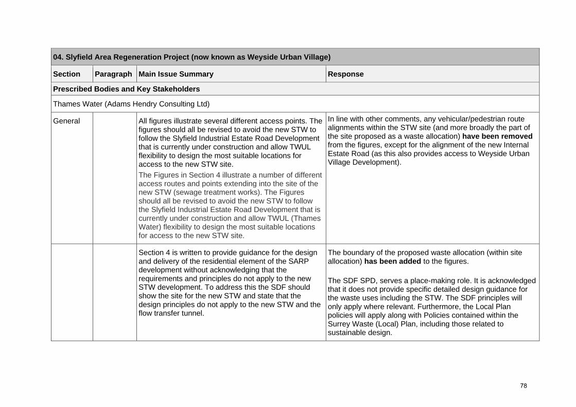
04. Slyfield Area Regeneration Project (now known as Weyside Urban Village)
Section Paragraph Main Issue Summary Response
Prescribed Bodies and Key Stakeholders
Thames Water (Adams Hendry Consulting Ltd)
General All figures illustrate several different access points. The figures should all be revised to avoid the new STW to follow the Slyfield Industrial Estate Road Development that is currently under construction and allow TWUL flexibility to design the most suitable locations for access to the new STW site.
The Figures in Section 4 illustrate a number of different access routes and points extending into the site of the new STW (sewage treatment works). The Figures should all be revised to avoid the new STW to follow the Slyfield Industrial Estate Road Development that is currently under construction and allow TWUL (Thames Water) flexibility to design the most suitable locations for access to the new STW site.
In line with other comments, any vehicular/pedestrian route alignments within the STW site (and more broadly the part of the site proposed as a waste allocation) have been removed from the figures, except for the alignment of the new Internal Estate Road (as this also provides access to Weyside Urban Village Development).
Section 4 is written to provide guidance for the design and delivery of the residential element of the SARP development without acknowledging that the requirements and principles do not apply to the new STW development. To address this the SDF should show the site for the new STW and state that the design principles do not apply to the new STW and the flow transfer tunnel.
The boundary of the proposed waste allocation (within site allocation) has been added to the figures.
The SDF SPD, serves a place-making role. It is acknowledged that it does not provide specific detailed design guidance for the waste uses including the STW. The SDF principles will only apply where relevant. Furthermore, the Local Plan policies will apply along with Policies contained within the Surrey Waste (Local) Plan, including those related to sustainable design.
78
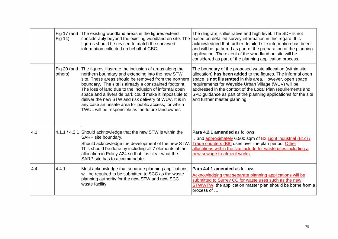
Fig 17 (and Fig 14)
The existing woodland areas in the figures extend considerably beyond the existing woodland on site. The figures should be revised to match the surveyed information collected on behalf of GBC.
The diagram is illustrative and high level. The SDF is not based on detailed survey information in this regard. It is acknowledged that further detailed site information has been and will be gathered as part of the preparation of the planning application. The extent of the woodland on site will be considered as part of the planning application process.
Fig 20 (and others)
The figures illustrate the inclusion of areas along the northern boundary and extending into the new STW site. These areas should be removed from the northern boundary. The site is already a constrained footprint. The loss of land due to the inclusion of informal open space and a riverside park could make it impossible to deliver the new STW and risk delivery of WUV. It is in any case an unsafe area for public access, for which TWUL will be responsible as the future land owner.
The boundary of the proposed waste allocation (within site allocation) has been added to the figures. The informal open space is not illustrated in this area. However, open space requirements for Weyside Urban Village (WUV) will be addressed in the context of the Local Plan requirements and SPD guidance as part of the planning application/s for the site and further master planning.
4.1 4.1.1 / 4.2.1 Should acknowledge that the new STW is within the SARP site boundary.
Should acknowledge the development of the new STW. This should be done by including all 7 elements of the allocation in Policy A24 so that it is clear what the SARP site has to accommodate.
Para 4.2.1 amended as follows:
…and approximately 6,500 sqm of B2 Light industrial (B1c) / Trade counters (B8) uses over the plan period. Other allocations within the site include for waste uses including a new sewage treatment works.
4.4 4.4.1 Must acknowledge that separate planning applications will be required to be submitted to SCC as the waste planning authority for the new STW and new SCC waste facility.
Para 4.4.1 amended as follows:
Acknowledging that separate planning applications will be submitted to Surrey CC for waste uses such as the new STWWTW, the application master plan should be borne from a process of …
79
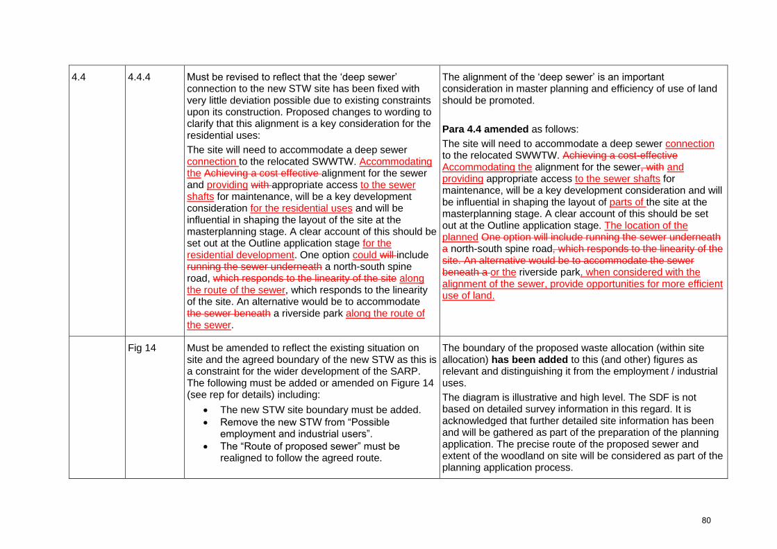
4.4 4.4.4 Must be revised to reflect that the ‘deep sewer’ connection to the new STW site has been fixed with very little deviation possible due to existing constraints upon its construction. Proposed changes to wording to clarify that this alignment is a key consideration for the residential uses:
The site will need to accommodate a deep sewer connection to the relocated SWWTW. Accommodating the Achieving a cost effective alignment for the sewer and providing with appropriate access to the sewer shafts for maintenance, will be a key development consideration for the residential uses and will be influential in shaping the layout of the site at the masterplanning stage. A clear account of this should be set out at the Outline application stage for the residential development. One option could will include running the sewer underneath a north-south spine road, which responds to the linearity of the site along the route of the sewer, which responds to the linearity of the site. An alternative would be to accommodate the sewer beneath a riverside park along the route of the sewer.
The alignment of the ‘deep sewer’ is an important consideration in master planning and efficiency of use of land should be promoted.
Para 4.4 amended as follows:
The site will need to accommodate a deep sewer connection to the relocated SWWTW. Achieving a cost-effective Accommodating the alignment for the sewer, with and providing appropriate access to the sewer shafts for maintenance, will be a key development consideration and will be influential in shaping the layout of parts of the site at the masterplanning stage. A clear account of this should be set out at the Outline application stage. The location of the planned One option will include running the sewer underneath a north-south spine road, which responds to the linearity of the site. An alternative would be to accommodate the sewer beneath a or the riverside park, when considered with the alignment of the sewer, provide opportunities for more efficient use of land.
Fig 14 Must be amended to reflect the existing situation on site and the agreed boundary of the new STW as this is a constraint for the wider development of the SARP. The following must be added or amended on Figure 14 (see rep for details) including:
• The new STW site boundary must be added.
• Remove the new STW from “Possible employment and industrial users”.
• The “Route of proposed sewer” must be realigned to follow the agreed route.
The boundary of the proposed waste allocation (within site allocation) has been added to this (and other) figures as relevant and distinguishing it from the employment / industrial uses.
The diagram is illustrative and high level. The SDF is not based on detailed survey information in this regard. It is acknowledged that further detailed site information has been and will be gathered as part of the preparation of the planning application. The precise route of the proposed sewer and extent of the woodland on site will be considered as part of the planning application process.
80
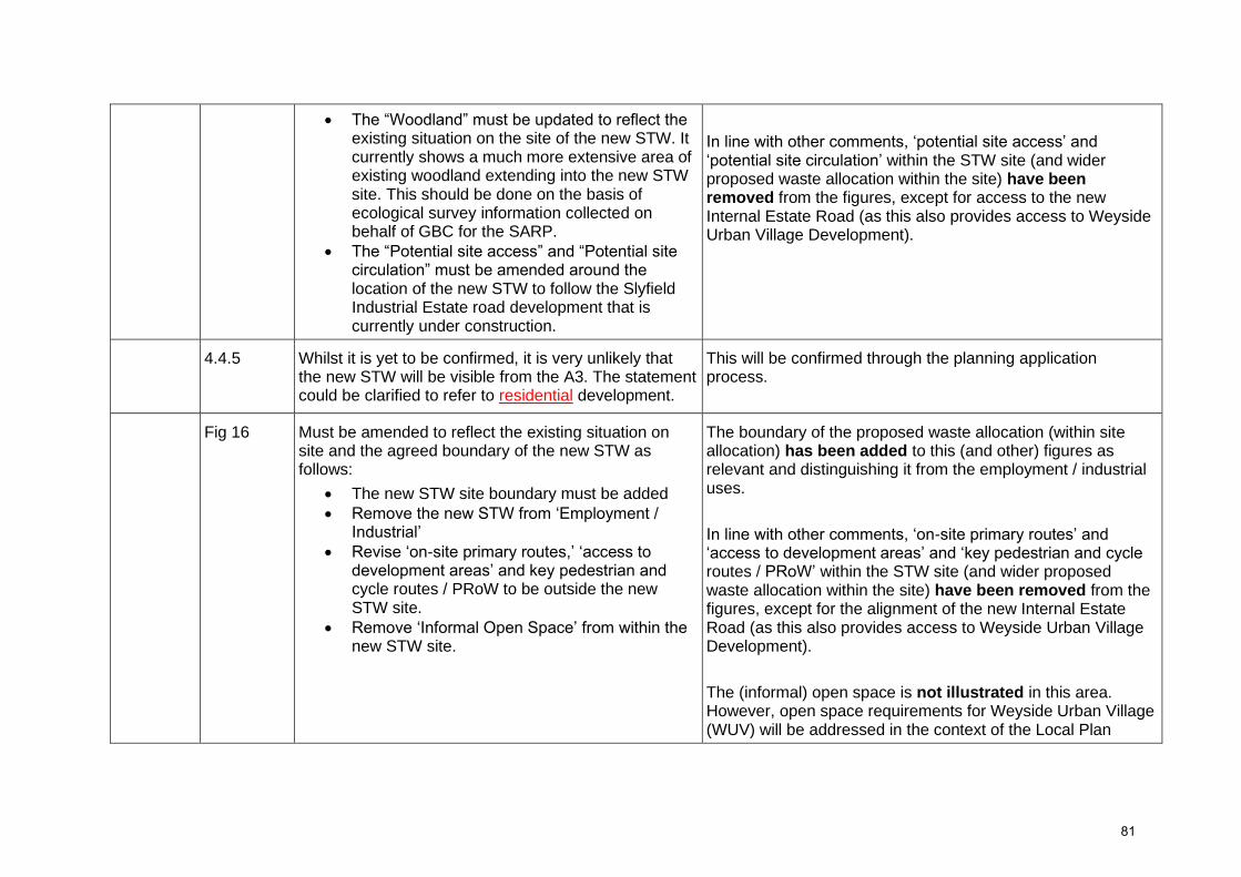
• The “Woodland” must be updated to reflect the existing situation on the site of the new STW. It currently shows a much more extensive area of existing woodland extending into the new STW site. This should be done on the basis of ecological survey information collected on behalf of GBC for the SARP.
• The “Potential site access” and “Potential site circulation” must be amended around the location of the new STW to follow the Slyfield Industrial Estate road development that is currently under construction.
In line with other comments, ‘potential site access’ and ‘potential site circulation’ within the STW site (and wider proposed waste allocation within the site) have been removed from the figures, except for access to the new Internal Estate Road (as this also provides access to Weyside Urban Village Development).
4.4.5 Whilst it is yet to be confirmed, it is very unlikely that the new STW will be visible from the A3. The statement could be clarified to refer to residential development.
This will be confirmed through the planning application process.
Fig 16 Must be amended to reflect the existing situation on site and the agreed boundary of the new STW as follows:
• The new STW site boundary must be added
• Remove the new STW from ‘Employment / Industrial’
• Revise ‘on-site primary routes,’ ‘access to development areas’ and key pedestrian and cycle routes / PRoW to be outside the new STW site.
• Remove ‘Informal Open Space’ from within the new STW site.
The boundary of the proposed waste allocation (within site allocation) has been added to this (and other) figures as relevant and distinguishing it from the employment / industrial uses.
In line with other comments, ‘on-site primary routes’ and ‘access to development areas’ and ‘key pedestrian and cycle routes / PRoW’ within the STW site (and wider proposed waste allocation within the site) have been removed from the figures, except for the alignment of the new Internal Estate Road (as this also provides access to Weyside Urban Village Development).
The (informal) open space is not illustrated in this area. However, open space requirements for Weyside Urban Village (WUV) will be addressed in the context of the Local Plan
81
requirements and SPD guidance as part of the planning application/s for the site and further master planning.
Fig 17 Must be amended to reflect the existing situation on site and agreed boundary of the new STW as follows:
• The new STW site boundary must be added.
• The “Woodland” must be updated to reflect the existing situation on the site of the new STW. It currently shows a much more extensive area of existing woodland extending into the new STW site. This should be done on the basis of ecological survey information collected on behalf of GBC for the SARP.
• Revise the “On-Site Primary Routes”, “Access to development areas” and “Key Pedestrian and Cycle Routes / PRoW" to be outside the new STW site.
• Remove the “Informal Open Space” from within the new STW site.
The boundary of the proposed waste allocation (within site allocation) has been added to this (and other) figures as relevant.
The diagram is illustrative and high level. The SDF is not based on detailed survey information in this regard. It is acknowledged that further detailed site information has been and will be gathered as part of the preparation of the planning application. The extent of the woodland on site will be considered as part of the planning application process.
In line with other comments, ‘on-site primary routes’ and ‘access to development areas’ and ‘key pedestrian and cycle routes / PRoW’ within the STW site (and wider proposed waste allocation within the site) have been removed from the figures, except for the alignment of the new Internal Estate Road (as this also provides access to Weyside Urban Village Development).
The (informal) open space is not illustrated in this area. However, open space requirements for Weyside Urban Village (WUV) will be addressed in the context of the Local Plan requirements and SPD guidance as part of the planning application/s for the site and further master planning.
4.6 Fig 18 Must be amended to reflect the existing situation on site and the agreed boundary of the new STW as follows and illustrated (see rep for details):
• The new STW site boundary must be added.
The boundary of the proposed waste allocation (within site allocation) has been added to this (and other) figures as relevant.
82
• Revise the “On-Site Vehicular Routes” to be outside the new STW site.
In line with other comments, ‘on-site vehicular routes’ within the STW site (and wider proposed waste allocation within the site) have been removed from the figures, except for the alignment of the new Internal Estate Road (as this also provides access to Weyside Urban Village Development).
Fig 19 Must be amended to reflect the existing situation on site and the agreed boundary of the new STW as follows and illustrated (see rep for details):
• The new STW site boundary must be added.
• Revise the “Key Pedestrian and Cycle Routes / PRoW” to be outside the new STW site.
The boundary of the proposed waste allocation (within site allocation) has been added to this (and other) figures as relevant.
In line with other comments, ‘Key Pedestrian and Cycle Routes / PRoW’ within the STW site (and wider proposed waste allocation within the site) have been removed from the figures.
4.8 4.8.1 Table 7 must be amended to include a specific land use allocation for the STW of approximately 6.4ha.
To align with the Local Plan Site allocation, Table 7 amended as follows:
[Row 6]: Industrial / Employment 11 0.65 [Inserted new row]: [Under Type added] Waste uses within site [Under Approximate Quantity (ha) added] 10.35
4.9 Fig 20 Must be amended to reflect the agreed boundary of the new STW as follows (see rep for details):
• The new STW site boundary must be added.
• Remove the new STW from “Employment / Industrial uses…” character area.
• Remove the “Riverside Park” from within the new STW site.
The boundary of the proposed waste allocation (within site allocation) has been added to this (and other) figures as relevant and distinguishing it from the employment / industrial uses.
The Riverside Park / (informal) open space is not illustrated in this area. However, open space requirements for Weyside Urban Village (WUV) will be addressed in the context of the Local Plan requirements and SPD guidance as part of the planning application/s for the site and further master planning.
Thames Water
83
4.4 The site includes the existing Guildford STW site. The adopted Local Plan proposes the relocation of the STW and TWUL are a critical partner. TWUL require amendments to be made to the SDF to ensure partnership working as per 4.1.2. Further detailed in Adams Hendry Consulting rep.
Comments addressed as above.
Savills obo GBC (Weyside Urban Village)
4.1 Images on page 79 - add captions and also images of the existing industrial estate for context. Given the high density and employment land to be accommodated at WUV, this page may be slightly misleading.
• The images included in the SPD are not meant to be comprehensive in terms of reflecting the context of the site. It is acknowledged that part of that varied context would include the existing industrial estate.
4.2 4.2.2 The requirement of land to facilitate the expansion of Weyfield Primary School should be removed. The Policy A24(4) refers to appropriate financial contribution.
Recognising the role of the SPD, a change has been made in order to ensure alignment with the Local Plan policy A24. Amended 4.2.2 as follows: Land Appropriate financial contribution is required to facilitate enable the expansion of Weyfield Primary School Academy along with pre-school provision on site.
4.3 The vision and design objectives are not consistent with the paragraphs and figures in the rest of this section. Para 4.3 should be revised to present a coherent vision that is consistent with the suggested revised figures supplied. In this regard:
• The vision of a tight urban grain abutting the water’s edge is not shown on the figures or in the text.
• Riverside Park should be changed to Riverside Walk.
• It is acknowledged that the figures and text do not reflect development ‘abutting the water’s edge.’
• • Statements regarding the grain are however considered
broadly consistent (see for instance Figure 20: Development character) with other aspects of the guidance. Furthermore, whilst pedestrian / cycle access is foreseen along the river corridor, this element is not considering to be necessarily confined to a ‘walk’, but should reflect a stronger open space / park role.
• • Amended 4.3 as follows:
84
References to historic riverside development in Guildford indicate intense form and a tight urban grain abutting the water’s edge in close proximity to and fronting the river.
4.3.1 Should be updated to reflect that the site is not a blank canvas (in line with para 4.4.4)
• Amended 4.3.1 as follows: …the site will in effect become a blank canvas significantly less constrained, opening up opportunities…
4.3.2 More flexibility should be provided by adding it is expected that most homes will be apartments
• It is considered to be a statement of expectation and this is reflected for clarity.
• Amended 4.3.2 as follows. • Most It is expected that most homes will be apartments.
Fig 14 Various amendments are suggested in a revised figure (see rep for details) including:
• Removal of reference to the potential for expansion of the existing primary school;
• Changes in the siting of potential vehicular site access; add access point at Bellfields Road, realign access to connect direct to eastern end of Slyfield Green as opposed to going via Carters Close, add access point connecting to ‘new Internal Estate Road’, remove two access points into the [Surrey Waste Plan allocation].
• Differentiate between accesses according to the modes which can use each; specifically identifying the existing council dept access form the A320 Woking Road as the ‘potential sustainable transport only access point’, the Bellfields Road and the Slyfield Green access as ‘potential primary vehicular access’ and the access to the new Internal Estate Road to ‘Potential Employment [only access]’
• Remove potential junction improvements
The reference to expansion of the school has been removed to ensure consistency with the Local Plan Policy A24 and within the SDF SPD. The legend ‘Potential site access’ has been changed to ‘Potential location for a multi-modal site access’ as opposed to ‘potential primary vehicular access’ (as was proposed by respondent). As a high-level constraints and opportunities plan, the modes which can use each access point have not been identified. This will be considered as part of the development management process for the site.
The plan has been revised to show potential locations for site accesses via Bellfields Road, Slyfield Green, as well as those (as previously shown on the plan in the draft SDF) via the existing Council depot access off the A320 Woking Road and via the new Internal Estates Road adjacent to the Slyfield Industrial Estate. These access points, with the exception of the new Internal Estates Road adjacent to the Slyfield Industrial Estate, are identified in the Land Availability Assessment (GBC, 2019). This amendment brings the illustrative masterplan in line with the principles set out in paragraph 4.4.8, concerning the aspiration for several access
85

• Change possible employment and industrial uses extent
points to successfully integrate VUW with the neighbouring community.
As a high-level constraints and opportunities plan, references to “Potential junction improvements” have been removed on Fig 14, as well as on the corresponding figures for other strategic sites.
The possible employment and industrial uses area has been amended as a result of the addition of the boundary of the proposed waste allocation (within site allocation) and also to align more closely with the Local Plan site allocation.
4.4 4.4.5 Edits proposed as the form layout and height of the development is not yet known.
Elements of tThe development may will be visible through the tree-lined approach to the town from the A3 south-bound carriageway and will be one of the first views from what is otherwise a tree-lined approach to the town.
• Further detail regarding visual impact and landscape elements will be provided as part of the studies that support the planning application. It is acknowledged that the SPD is not based on a Landscape and Visual Impact Assessment (LVIA) and the form, layout and height of the development is not known. The reference to ‘the development’ in the SPD does not discount that only elements of it would be visible, but these elements have not been identified or defined. It is however considered unlikely, from an initial perspective, that none of the development will be visible from the A3 south-bound carriageway (although it is possible that the LVIA may differ). The wording has thus been retained.
4.4.9 There will likely be a mixture of apartment and houses fronting the river, thus edit proposed:
Blocks should be capable of accommodating apartments and houses with the latter forming the main frontage to the river.
• It is considered that the current wording allows for a mixture of apartments and houses to front the river - ‘main frontage’ does not reflect the entirety of the frontage.
Fig 14, 16 and 20
These are too prescriptive for an SPD and inconsistent with the vision expressed in para 4.3. For instance they do not show a ‘tight urban grain abutting the water’s
The SPD master plan principles (along with the overarching design principles) provide the basis for achieving a high-quality scheme.
86
edge. They do not provide sufficient flexibility either within the figures or the keys and text alongside them.
Figure 16 is intended to reflect the application of the master plan principles to the site. However, it is acknowledged that there is scope for the emergence of other (possibly more effective) means of achieving these principles. Alternate spatial / design solutions may emanate from further creative thinking, more detailed studies or inputs from stakeholders during the planning application process. At the point of the SPD’s production, these studies or inputs may not have been available, but would rightly inform more detailed work suited to the planning application process and may lead to alternative and acceptable spatial outcomes reflected in the application masterplan. To further clarify this position, several amendments have been made to text in the Introduction of the SPD and this section on Slyfield / Weyside Urban Village (e.g. titles to the Figures) aimed at ensuring the SPD and specifically the illustrative plans are not interpreted in a fixed or blueprint manner.
It is necessary to update the figures, keys and supporting text based on the revised figures submitted. In particular (see rep for detail) Figure 16 includes amongst others:
1. Changes in the siting of potential vehicular site access; add access point at Bellfields Road, realign access to connect direct to eastern end of Slyfield Green as opposed to going via Carters Close, add access point connecting to ‘new Internal Estate Road’, remove two access points into the [Surrey Waste Plan allocation].
2. Differentiate between accesses according to the modes which can use each; specifically identifying the existing council dept access form
1. The plan has been revised to show potential locations for site accesses via Bellfields Road, Slyfield Green, as well as those (as previously shown on the plan in the draft SDF) via the existing Council depot access off the A320 Woking Road and via the new Internal Estates Road adjacent to the Slyfield Industrial Estate. These access points, with the exception of the new Internal Estates Road adjacent to the Slyfield Industrial Estate, are identified in the Land Availability Assessment (GBC, 2019). This amendment brings the illustrative masterplan in line with the principles set out in paragraph 4.4.8, concerning the aspiration for several access points to successfully integrate VUW with the neighbouring community.
87
the A320 Woking Road as the ‘potential sustainable transport only access point’, the Bellfields Road and the Slyfield Green access as ‘potential primary vehicular access’ and the access to the new Internal Estate Road to ‘Potential Employment [only access]’
3. Altered primary street including SMC route to take in the mixed use area
4. Marginally altered location of mixed use area (and locating this along the SMC)
5. A different location for the SANG 6. Relocated allotments 7. Employment use area (vs not indicated
proposed waste use allocation)
All figures should be marked as indicative or illustrative given the stage and status of the document.
2. The SDF does not set out to be prescriptive therefore the modes which can use each access point have not been identified. This will be considered as part of the development management process for the site. 3. As this will not be a local centre we do not require the SMC to connect directly to the facilities, therefore the route of the SMC will not be altered. 4. Moving mixed use area would not align with the principles (See 4.4.7) which refers to concentrating these uses in the centre of the site adjacent to the river. It is acknowledged that the masterplan may seek an alternative spatial outcome which could be justified as part of the planning application process. 5. Both proximate SANGs have been indicated. A further label has been added to reflect the SANG at Burpham Court Farm. 6. It is not considered necessary to add relocated allotments. 7. The employment / industrial area has been reflected as distinct from the part of the site proposed for waste uses.
The figure titles have been amended where relevant to reflect their role in the SPD.
4.5 4.5.1 Considering flexibility (including at 4.5.3), wording to be amended to: Figure 17 illustrates the required anticipated green infrastructure and open space components of the site.
• The wording at 4.5.1 has been retained as clarity has been added to Figure 17 by amending the title as follows: Slyfield illustrative landscape framework, consistent with the approach to other sites.
88
4.5 Table 6 This should be expanded to demonstrate how the figures were calculated. (i.e. show multipliers). The SANG should be indicated as off site as should formal playing fields as there will not be suitable locations for sports pitches on site.
• These are the Council’s normal expectation. They should be read alongside 4.5.3. Further detail with regard to open space provision will be considered as part of the planning application process.
Fig 17 Should be marked as illustrative or indicative and:
• Remove the SANG label as incorrectly placed and refer to SANG as being taken forward by GBC at Burpham Court Farm
• Include 15m offset from ancient woodland
• Informal open space to be labelled Green Infrastructure
• Existing on-site woodland to be called vegetation
• Off site woodland to be called vegetation
• The title to Figure 17 has been amended as follows: Slyfield illustrative landscape framework.
• • Both proximate SANGs have been indicated. A further label
has been added to reflect the SANG at Burpham Court Farm 3.5.21 under the bullet ‘green buffers’ refers to the provision of at least a 15m buffer to be provided to ancient woodland. It is considered that the illustrative figure does not contradict this principle. The legend item in Figure 17 has been amended as follows: Informal oOpen space (including new woodland) to reflect that this area is illustrating and potentially including a range of forms of open space. The SDF is not based on detailed survey information. It is acknowledged that studies may be undertaken as part of the planning application process that provide more detail regarding the features on site.
4.6 Fig 18 1. Should be marked as ‘illustrative’ or ‘indicative’ 2. The bus route symbol is shown on the very
northern spur of the site, where the planned SMC route will not run
3. The map shows a key off-site vehicle route along Clay Lane to the A3. Our trip distribution analysis so far conducted does not suggest any substantial number of trips would use this route
1. The legend item in Figure 18 has been amended as follows: Illustrative Slyfield highways and public transport framework
• 2. The bus route symbol has been moved to show that bus route would be expected to use Moorfield Road, travelling directly to and from a northern site access (rather than a loop route via the waste management facilities).
89
and therefore this should be removed from the drawing;
4. The “Primary multi-modal via Woking Road” access should be renamed to “Sustainable Gateway”
• 3. The ‘Off-site Vehicular Route’ along Clay Lane, which could be used to access the A3 as well as other destinations in Guildford, will be retained. For vehicular journeys towards London on the A3 it would be expected that this route would be attractive.
• 4. The label ‘Primary multi-modal via Woking Road’ has changed to ‘Site Access via Woking Road’ as opposed to ‘Sustainable Gateway’ (as was proposed by respondent). As the SDF does not set out to be prescriptive, the modes which can use each access point have not been identified. This will be considered as part of the development management process for the site.
4.6.3 Should not prescribe a tree lined boulevard at this stage. The wording of this must reflect that there are multiple possible options for designing attractive and exemplar streets.
It is considered that planting in relation to the primary street is an important place-making element to soften the urban character of the development. It is not considered that describing the street as a boulevard is limiting - the SPD reflects guidance. It is recognised that further detail studies including transport assessment and design work may provide a basis for further consideration of the design of the primary street.
4.6.6 Correct wording as follows, given the nature of off-site highway works for pedestrians and cyclists are yet to be determined in detail: "Figure 18 and 19 also identify the minimum possible off-site highway intervention in order to support sustainable and active travel..."
4.6.6 has been combined with paragraph 4.6.1 to indicate that both figures include current infrastructure as well as interventions it would be expected the developer would deliver, improve or contribute to.
Amended 4.6.1 as follows:
Figures 18 and 19 highlights the key connections to and within the site for all modes of travel. The figures include current infrastructure as well as interventions it would be expected the developer would deliver or contribute to. The developer may also improve current infrastructure
90
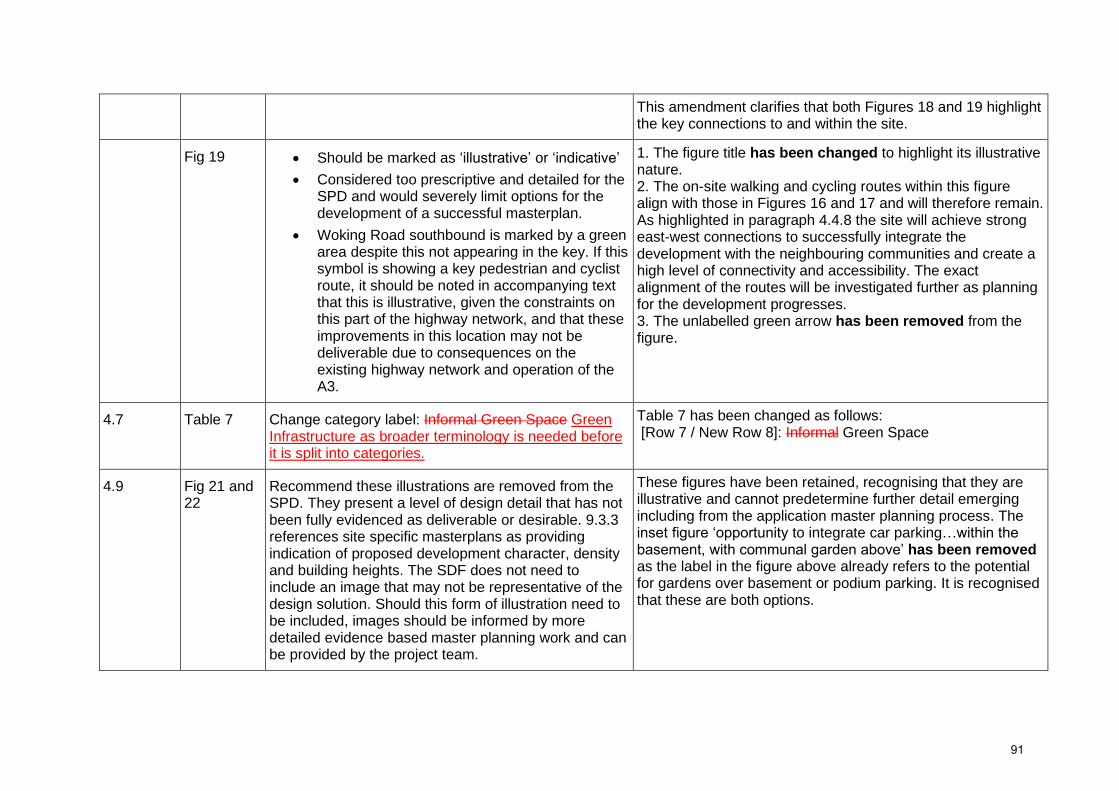
This amendment clarifies that both Figures 18 and 19 highlight the key connections to and within the site.
Fig 19 • Should be marked as ‘illustrative’ or ‘indicative’
• Considered too prescriptive and detailed for the SPD and would severely limit options for the development of a successful masterplan.
• Woking Road southbound is marked by a green area despite this not appearing in the key. If this symbol is showing a key pedestrian and cyclist route, it should be noted in accompanying text that this is illustrative, given the constraints on this part of the highway network, and that these improvements in this location may not be deliverable due to consequences on the existing highway network and operation of the A3.
1. The figure title has been changed to highlight its illustrative nature. 2. The on-site walking and cycling routes within this figure align with those in Figures 16 and 17 and will therefore remain. As highlighted in paragraph 4.4.8 the site will achieve strong east-west connections to successfully integrate the development with the neighbouring communities and create a high level of connectivity and accessibility. The exact alignment of the routes will be investigated further as planning for the development progresses. 3. The unlabelled green arrow has been removed from the figure.
4.7 Table 7 Change category label: Informal Green Space Green Infrastructure as broader terminology is needed before it is split into categories.
Table 7 has been changed as follows: [Row 7 / New Row 8]: Informal Green Space
4.9 Fig 21 and 22
Recommend these illustrations are removed from the SPD. They present a level of design detail that has not been fully evidenced as deliverable or desirable. 9.3.3 references site specific masterplans as providing indication of proposed development character, density and building heights. The SDF does not need to include an image that may not be representative of the design solution. Should this form of illustration need to be included, images should be informed by more detailed evidence based master planning work and can be provided by the project team.
These figures have been retained, recognising that they are illustrative and cannot predetermine further detail emerging including from the application master planning process. The inset figure ‘opportunity to integrate car parking…within the basement, with communal garden above’ has been removed as the label in the figure above already refers to the potential for gardens over basement or podium parking. It is recognised that these are both options.
91
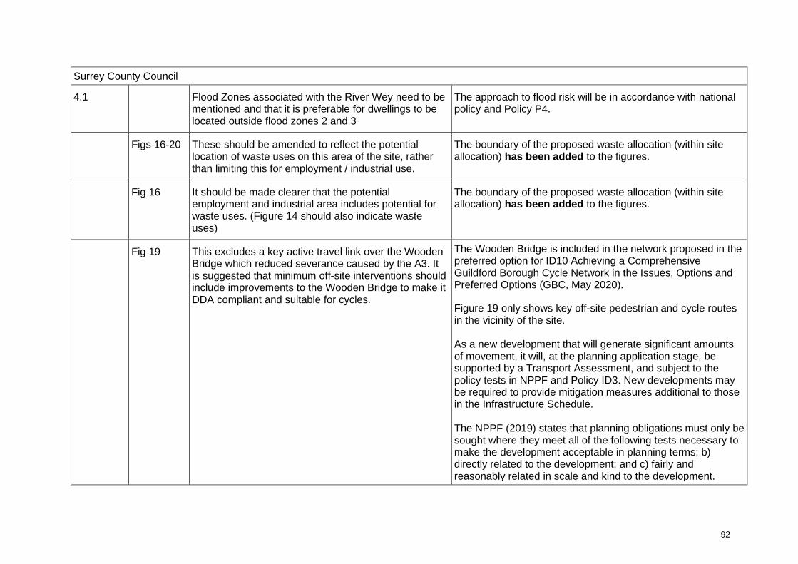
Surrey County Council
4.1 Flood Zones associated with the River Wey need to be mentioned and that it is preferable for dwellings to be located outside flood zones 2 and 3
The approach to flood risk will be in accordance with national policy and Policy P4.
Figs 16-20 These should be amended to reflect the potential location of waste uses on this area of the site, rather than limiting this for employment / industrial use.
The boundary of the proposed waste allocation (within site allocation) has been added to the figures.
Fig 16 It should be made clearer that the potential employment and industrial area includes potential for waste uses. (Figure 14 should also indicate waste uses)
The boundary of the proposed waste allocation (within site allocation) has been added to the figures.
Fig 19 This excludes a key active travel link over the Wooden Bridge which reduced severance caused by the A3. It is suggested that minimum off-site interventions should include improvements to the Wooden Bridge to make it DDA compliant and suitable for cycles.
The Wooden Bridge is included in the network proposed in the preferred option for ID10 Achieving a Comprehensive Guildford Borough Cycle Network in the Issues, Options and Preferred Options (GBC, May 2020).
Figure 19 only shows key off-site pedestrian and cycle routes in the vicinity of the site. As a new development that will generate significant amounts of movement, it will, at the planning application stage, be supported by a Transport Assessment, and subject to the policy tests in NPPF and Policy ID3. New developments may be required to provide mitigation measures additional to those in the Infrastructure Schedule. The NPPF (2019) states that planning obligations must only be sought where they meet all of the following tests necessary to make the development acceptable in planning terms; b) directly related to the development; and c) fairly and reasonably related in scale and kind to the development.
92
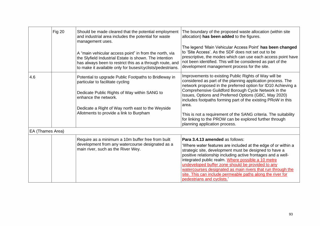
Fig 20 Should be made cleared that the potential employment and industrial area includes the potential for waste management uses.
A “main vehicular access point” in from the north, via the Slyfield Industrial Estate is shown. The intention has always been to restrict this as a through route, and to make it available only for buses/cyclists/pedestrians.
The boundary of the proposed waste allocation (within site allocation) has been added to the figures.
The legend ‘Main Vehicular Access Point’ has been changed to ‘Site Access’. As the SDF does not set out to be prescriptive, the modes which can use each access point have not been identified. This will be considered as part of the development management process for the site.
4.6 Potential to upgrade Public Footpaths to Bridleway in particular to facilitate cycling
Dedicate Public Rights of Way within SANG to enhance the network.
Dedicate a Right of Way north east to the Weyside Allotments to provide a link to Burpham
Improvements to existing Public Rights of Way will be considered as part of the planning application process. The network proposed in the preferred option for ID10 Achieving a Comprehensive Guildford Borough Cycle Network in the Issues, Options and Preferred Options (GBC, May 2020) includes footpaths forming part of the existing PRoW in this area. This is not a requirement of the SANG criteria. The suitability for linking to the PROW can be explored further through planning application process.
EA (Thames Area)
Require as a minimum a 10m buffer free from built development from any watercourse designated as a main river, such as the River Wey.
Para 3.4.13 amended as follows:
‘Where water features are included at the edge of or within a strategic site, development must be designed to have a positive relationship including active frontages and a well-integrated public realm. Where possible a 10 metre undeveloped buffer zone should be provided to any watercourses designated as main rivers that run through the site. This can include permeable paths along the river for pedestrians and cyclists.’
93
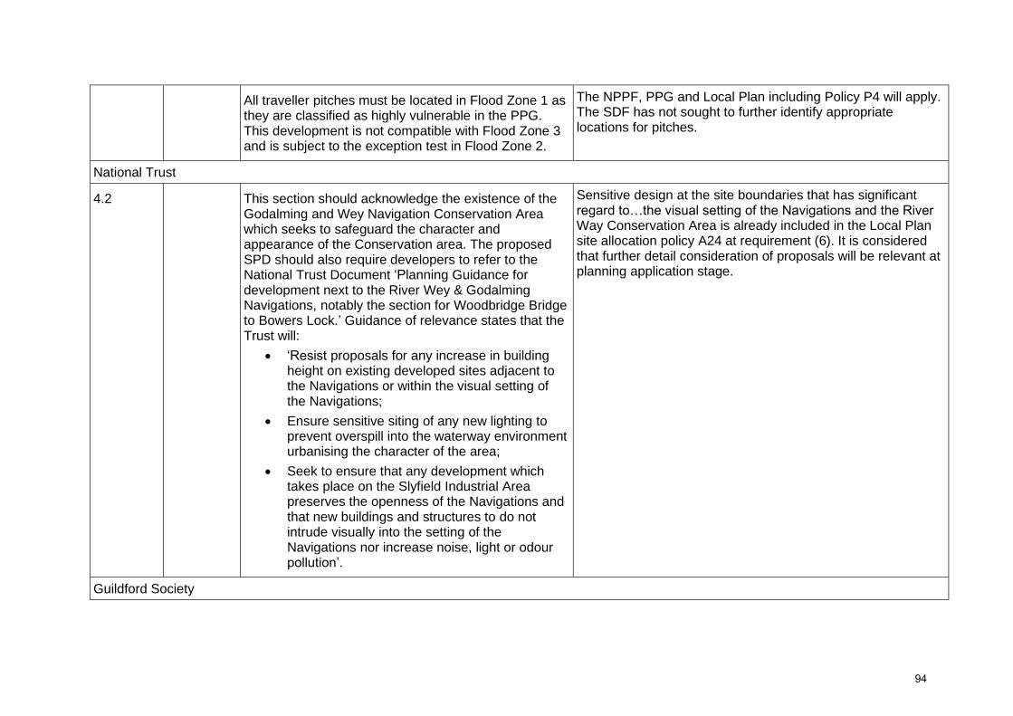
All traveller pitches must be located in Flood Zone 1 as they are classified as highly vulnerable in the PPG. This development is not compatible with Flood Zone 3 and is subject to the exception test in Flood Zone 2.
The NPPF, PPG and Local Plan including Policy P4 will apply. The SDF has not sought to further identify appropriate locations for pitches.
National Trust
4.2 This section should acknowledge the existence of the Godalming and Wey Navigation Conservation Area which seeks to safeguard the character and appearance of the Conservation area. The proposed SPD should also require developers to refer to the National Trust Document ‘Planning Guidance for development next to the River Wey & Godalming Navigations, notably the section for Woodbridge Bridge to Bowers Lock.’ Guidance of relevance states that the Trust will:
• ‘Resist proposals for any increase in building height on existing developed sites adjacent to the Navigations or within the visual setting of the Navigations;
• Ensure sensitive siting of any new lighting to prevent overspill into the waterway environment urbanising the character of the area;
• Seek to ensure that any development which takes place on the Slyfield Industrial Area preserves the openness of the Navigations and that new buildings and structures to do not intrude visually into the setting of the Navigations nor increase noise, light or odour pollution’.
Sensitive design at the site boundaries that has significant regard to…the visual setting of the Navigations and the River Way Conservation Area is already included in the Local Plan site allocation policy A24 at requirement (6). It is considered that further detail consideration of proposals will be relevant at planning application stage.
Guildford Society
94
4.4 Fig 16 The concept sets the residential scheme set back behind and surrounded by landscaped parkland. Would it be better if some development was closer to the river and more communal green space within the development itself. This may assist with the retention of the existing allotments.
The SPD master plan principles (along with the overarching design principles) provide the basis for achieving a high-quality scheme. Figure 16 is intended to reflect the application of the master plan principles to the site. However, it is acknowledged that there is scope for the emergence of other (possibly more effective) means of achieving these principles. Alternate spatial / design solutions may emanate from further creative thinking, more detailed studies or inputs from stakeholders during the planning application process. At the point of the SPD’s production, these studies or inputs may not have been available, but would rightly inform more detailed work suited to the planning application process and may lead to alternative and acceptable spatial outcomes reflected in the application masterplan. To further clarify this position, several amendments have been made to text in the Introduction of the SPD and this section on Slyfield / Weyside Urban Village (e.g. titles to the Figures) aimed at ensuring the SPD and specifically the illustrative plans are not interpreted in a fixed or blueprint manner. It is reflected that the provision of open space on site may be a challenge (see 4.5.3). Furthermore, flood risk is a consideration for any development along the river edge.
Fig 16 The layout of the site but especially the apartment blocks seem to isolate the site and the riverside park from the existing Bellfields neighbourhood. The suggested building forms prevent permeability.
Masterplan principle at 4.4.8 indicates that numerous access points should be achieved. This includes strong east west routes through the development to provide residents including those from Bellfield, with good access to the riverside park. The application masterplan will need to demonstrate how these principles are achieved. Apartment blocks need not mean that permeability could not be achieved.
95
Fig 16 Should the community focal space including retail uses be more central in the heart of the development, also making it easier for deliveries?
Moving mixed use area would not align with the principles (See 4.4.7) which refers to concentrating these uses in the centre of the site adjacent to the river. It is acknowledged that the masterplan may seek an alternative spatial outcome which could be justified as part of the planning application process. The site is not likely to reflect a new local centre – main local community facilities and shops are beyond the site boundaries.
4.4.7 There should be higher aspiration to provide facilities on site (e.g. retail, post office, community hall).
The SPD provides further guidance and is developed in line with the Local Plan site allocation. Furthermore, the permeability proposed ensures that existing surrounding facilities will be easily accessible from the site.
Fig 16 It is unclear if a full width SMC can be accommodated on the main thoroughfare through a narrow site.
The Council has reviewed the guidance in the SDF on the provision for buses, including the SMC, on and immediately adjacent to the strategic sites, see amendments to section 3.3. This is as a result of responses and evidence provided with respect to potential adverse visual impacts, reduction in development densities and reduced developer contributions, colonisation of generous street widths by the parked vehicles of early residents, leading to subsequent decisions not to implement bus lanes. In the revised SDF, segregated bus lanes and/or bus gates/modal filters would only be required in congestion hotspot locations, including site accesses, where queuing traffic in peak periods might be expected to delay buses on the primary streets.
4.5 4.5.3 The off-site open space should be more specific in terms of location.
Further detail regarding any off-site contributions and associated requirements will be determined through planning application process.
4.6 Fig 18 There is a major opportunity for innovative pedestrian/ child-friendly cycle route to the lido and Park, and to
Noted. As a new development that will generate significant amounts of movement, it will, at the planning application stage, be supported by a Transport Assessment, and subject to the
96
the Town Centre and Public Transport with 3-4000 living within 150 metres of the SMC.
policy tests in NPPF and Policy ID3. New developments may be required to provide mitigation measures additional to those in the Infrastructure Schedule. In the case of Weyside Urban Village/ Slyfield Area Regeneration Project, the Local Plan allocation requires this will include a ‘proportionate contribution to delivering the northern route section (of the SMC) off-site’
Fig 19 The plans need to consider improvement to the (cycle pedestrian) corridor linking the site to London Road area of town which depends on a very narrow bridge over the river and is dependent on a narrow towpath.
Figure 19 shows key off-site pedestrian and cycle routes in the vicinity of the site. Improvements to existing Public Rights of Way and permissive paths will be considered as part of the planning application process. The network proposed in the preferred option for ID10 Achieving a Comprehensive Guildford Borough Cycle Network in the Issues, Options and Preferred Options (GBC, May 2020) includes links forming part of the existing Public Rights of Way in this area. As a new development that will generate significant amounts of movement, it will, at the planning application stage, be supported by a Transport Assessment, and subject to the policy tests in NPPF and Policy ID3. New developments may be required to provide mitigation measures additional to those in the Infrastructure Schedule.
More detail is required on how links will be established, especially related to the site boundary, with the rest of Slyfield and Bellfield’s
The plan has been revised to show potential locations for site accesses via Bellfields Road, Slyfield Green, as well as those (as previously shown on the plan in the draft SDF) via the existing Council depot access off the A320 Woking Road and via the new Internal Estates Road adjacent to the Slyfield Industrial Estate. These access points, with the exception of the new Internal Estates Road adjacent to the Slyfield Industrial Estate, are identified in the Land Availability Assessment (GBC, 2019). This amendment brings the illustrative masterplan in line with the principles set out in paragraph 4.4.8, concerning the aspiration for several access
97
points to successfully integrate WUV with the neighbouring community. Plan intended to be indicative as it will be influenced by further detailed masterplanning undertaken as part of the planning application process. Policies D1 (6) and ID3 (2) (a) and (c) of the Local Plan: Strategy and Sites (2019) set out requirements for new development to connect to existing street patterns and existing cycle and walking routes.
Fig 21 Appears to show unrealistically low density Table 7 indicates an average density of 107dph. The SDF does not seek to deviate from policy. The figure is illustrative with lower densities only indicated on part of the site (where considered appropriate) and balanced by higher densities elsewhere. Further detail regarding densities will be developed as part of the planning application process.
Fig 22 If underground parking is omitted for viability or feasibility reasons the design would need to be fundamentally revised to deal satisfactorily with car parking.
Figure 22 is illustrative. The provision and detailed design of (underground or podium) parking will need to be considered though planning application process.
Guildford Residents Association
4.3 Concerned with the proposed objective. The proposal for a tight urban grain along the river cuts against thinking developed in the Community Forum. Concern that there will be wall of flats along the Wey. Amended wording proposed:
lt will become a vibrant riverside quarter within Guildford. Layout will be designed to achieve a sensitive balance between residents enjoying the riverside setting and ensuring views onto the site
The vision statement is not intended to give the impression of a wall of flats along the river. Indeed the figures and later text do not reflect this spatial outcome, with proposals for a River Park and development set back, rather than development ‘abutting the water’s edge.’
• Amended 4.3 as follows: References to historic riverside development in Guildford indicate intense form and a tight urban grain abutting the water’s edge in close proximity to and fronting the river.
98
across open water meadows have a green character that enhances the Wey corridor. A loose urban grain abutting the water’s edge will contrast with the more intense form of historic riverside development in the town centre.The setting of the site will ensure homes will enjoy an outlook across the River Wey to open meadows beyond. References to historic riverside development in Guildford indicate intense form and a tight urban grain abutting the water’s edge. Older examples of riverside development will provide design cues for an architectural style that will be reinterpreted to achieve a soft, varied and broken frontage assist in developing a narrative for the architecture of Slyfield. A riverside park will open access to the waterside and will include new footpaths linking north to open countryside.
The vision is high level and more detailed guidance follows. Statements regarding the grain are considered broadly consistent (see for instance Figure 20: Development character) with other aspects of the guidance.
4.3 4.3.1 The last sentence needs redrafting to ensure design is sensitive to impact on views of the site. The policy of green approaches and edges will apply. The Wey Corridor is an important landscape asset. A wall of development and excessive light pollution should be avoided. Swales running towards the river can contribute to green character and a broken frontage.
An aim to maximise views for as many residents as possible invites a developer to cram the frontage and should be deleted.
Amended 4.3.1 as follows: …The riverside location is the main asset of the site, and buildings will be orientated to the water, and designed in such a way as to create a positive relationship and interface with this environment maximise views for as many residents as possible. It was not the intent to give the impression of a wall of development on the frontage, but rather to create a positive public environment. The amendment seeks to clarify this and respond to the concern.
4.4 4.4.1 / 4.4.2 Reads as if developer writing its own planning conditions to ensure there are no constraints. Suggest: There is some mature planting the value of which will need to be established as part of and site investigations should establish where trees should be
Amended 4.4.2, bullet 1 as follows: There is some mature planting vegetation, the value of which will need to be established as part of any site investigations providing an informant to landscaping proposals addressing the River Wey edge.
99
retained and supplemented and where new or replacement areas of planting will contribute to achieving an effective green corridor along the Wey.
The general principle under ‘context and local identity’ as it relates to responding to landscape context is also relevant (see 3.2.29).
4.4.4 There should not be a road along the river frontage to avoid impact on the riverside character. This should be stated in the SPD. Placing the sewer under the road should not be a reason for routing a road along the river’s edge.
The illustrative figures reflect a riverside park along the river frontage. With regard to the sewer, the north south spine road (which is not along the river’s edge) and the Riverside park (which is along the river interface) are referenced and placing the sewer under the road was not reflected as a reason for routing a road along the river’s edge. In order to clarify this, amended 4.4.4 as follows The location of the planned One option will include running the sewer underneath a north-south spine road, which responds to the linearity of the site. An alternative would be to accommodate the sewer beneath a or the riverside park, when considered with the alignment of the sewer, provide opportunities for more efficient use of land.
4.4.5 The SPD is inadequate in its response to the prominence of the site in views of Guildford. Soft green landscape is essential and a soft open character, not a wall of development.
Amended 4.4.5 as follows: Elevational treatment, landscaping, roofscape, form, scale and mass will be key to achieving a good outcome.
4.4.5 A paragraph is needed on the fact that Slyfield is prominent in views from the AONB (eg from Merrow Downs) and the extension will increase this effect significantly. The SPD should ensure developers consider the impact on views in their design, layout, materials, colour palette, roof form and planting. Green roofs on business premises could reduce adverse impact and be more sustainable.
It is considered that this point is addressed in the general design principles relating to responding to the landscape context (see para 3.2.29) which applies to all the sites.
4.4.10 The SPD is inadequate in its design advice for the business and industrial areas. The sewage and waste
With regard to landscaping, which would include screening (and apart from reference in the general design principles), amended 4.4.5 as follows:
100
treatment works and Surrey depot will be significant developments that need robust design guidance including screening.
Will the existing Slyfield Business Park SPD apply? There are issues with design principles being flouted.
Elevational treatment, landscaping, roofscape, form, scale and mass will be key to achieving a good outcome. Furthermore, in relation to design, the Local Plan policies will apply along with, where relevant to the waste uses, policies contained within the Surrey Waste (Local) Plan, including those related to sustainable design. With regard to the Slyfield Industrial Estate SPD, this area is outside its scope, but its design principles set a framework for expansion.
4.4 The site becomes saturated. What will finished ground heights be. Are swales still proposed as per the 2015 Master Plan?
Even though GBC is doing preparatory and remedial works, the SPD should set out expectations for making the site safe, stable and resilient.
With regard to SUDS, the SPD included general design principles at section A2. The nature and extent of SUDS will require further detailed consideration informed by drainage / surface water and landscape studies as well as broader design imperatives. This would need to be considered in more detail in the process of developing the application master plan for the site and during the planning application process. It is considered that other policies will apply in terms of contamination / remediation including the NPPF Para 178. (The LPDMP proposes further policy on contaminated land). This will be addressed as part of the planning application process.
4.4.8 Refers to ‘numerous access points into the site for pedestrians and vehicles.’ This appears inaccurate as there is just one access from the A320 Woking Road (Figure 16). Is it the intention that there will be a minor road connection with existing streets e.g. via Waterside Road/Slyfield Green?
The plan has been revised to show potential locations for site accesses via Bellfields Road, Slyfield Green, as well as those (as previously shown on the plan in the draft SDF) via the existing Council depot access off the A320 Woking Road and via the new Internal Estates Road adjacent to the Slyfield Industrial Estate. These access points, with the exception of the new Internal Estates Road adjacent to the Slyfield Industrial Estate, are identified in the Land Availability Assessment (GBC, 2019). This amendment brings the illustrative masterplan in line with the principles set out in paragraph 4.4.8, concerning the aspiration for several access
101
points to successfully integrate VUW with the neighbouring community.
4.4.9 Stating “blocks” should form the main frontage to the river is far too crude a message for this guidance. It is essential the waterside frontage is softer and lower. A stepped back and broken up profile should be encouraged with substantial planting to create habitat appropriate for this riverside location. Agree that landscape planting should permeate but this needs expanding.
It is considered that guidance in this regard is sufficient. ‘Blocks’ refers to the layout rather than ‘apartment blocks’. Rather than forming a ‘hard’ and ‘tall’ waterside frontage, buildings heights are stepped back from river’s edge, as reflected in this paragraph (i.e. ‘Blocks should be capable of accommodating apartments and houses, with the latter forming the main frontage to the river’) and various illustrative figures (see for example Fig 20 and 22).
4.6 4.6.2 Residents movements will not be confined to the route of the SMC and adequate provision must be made for cars and other traffic.
Noted. The Local Plan: Strategy and Sites (2019) and the SDF recognise that a range of modes of transport are used within Guildford, nevertheless as required in Policy ID3 new development will be required to contribute to the delivery of an integrated, accessible and safe transport system, maximising the use of the sustainable transport modes of walking, cycling and the use of public and community transport. Paragraph 4.6.2 concerns trips within the local area, and to the town centre and station.
Fig 18 Should show the A3 as part of the highway framework. The figure has been revised to show connections to and from the A3.
4.6.3 Due to the constrained nature of the site, what are the implications for buses and other vehicles in terms of operation.
As a new development that will generate significant amounts of movement, it will, at the planning application stage, be supported by a Transport Assessment, and subject to the policy tests in NPPF and Policy ID3. New developments may be required to provide mitigation measures additional to those in the Infrastructure Schedule. In the revised SDF it is now proposed that segregated bus lanes and/or bus gates/modal filters would only be required in congestion hotspot locations, including at site accesses, where
102
queuing traffic in peak periods might be expected to delay buses on the primary streets. The plan has been revised to show potential locations for site accesses via Bellfields Road, Slyfield Green, as well as those (as previously shown on the plan in the draft SDF) via the existing Council depot access off the A320 Woking Road and via the new Internal Estates Road adjacent to the Slyfield Industrial Estate. These access points, with the exception of the new Internal Estates Road adjacent to the Slyfield Industrial Estate, are identified in the Land Availability Assessment (GBC, 2019). This amendment brings the illustrative masterplan in line with the principles set out in paragraph 4.4.8, concerning the aspiration for several access points to successfully integrate VUW with the neighbouring community.
Royal Society for the Protection of Birds
Fig 17 The location of the SANG at Riverside Park Nature Reserve (a strategic SANG site as per the TBH SPA avoidance strategy) appears to contradict the IDP (page 67) stating that Burpham Court Farm is assumed to contain 20ha set aside for SARP, with NE agreement that Tyting Farm and Chantry Woods will cover the remaining capacity requirements.
It should be clarified how the site will meet its SANG requirement and this should be included in Appendix B.
The layout and management plan for Burpham Court Farm and Tyting Farm should be assessed and reviewed prior to planning permission to ensure the SANG is suitable.
Both proximate SANGs have been indicated. A further label has been added to reflect the SANG at Burpham Court Farm. The SPD does not allocate capacity at the Riverside Park Nature Reserve SANG to the WUV. The layout and management plan will be determined via the planning application process.
103
G-BUG
4.6.6 Misses an opportunity to improve the surface of the towpath the provide a secondary ‘green corridor’ to connect to the town centre (and onto the Guildford to Godalming Greenway).
Off-site interventions will be discussed further as part of the planning application process. Improvements to existing Public Rights of Way and permissive paths will be considered as part of the planning application process. The network proposed in the preferred option for ID10 Achieving a Comprehensive Guildford Borough Cycle Network in the Issues, Options and Preferred Options (GBC, May 2020) includes links forming part of the existing Public Rights of Way in this area. National Trust control most of the Towpath between the site and the town centre.
Fig 19 The surface of the connection to NCN 223 could be improved to give residents a more direct and pleasant connection to local facilities.
A good crossing of the Wey Navigation is required. Either the narrow path down to and across Stoke Lock could be improved and/or a new bridge could be provided at an appropriate location
Improvements to existing Public Rights of Way and permissive paths will be considered as part of the planning application process. The network proposed in the preferred option for ID10 Achieving a Comprehensive Guildford Borough Cycle Network in the Issues, Options and Preferred Options (GBC, May 2020) includes links forming part of the existing Public Rights of Way in this area. As a new development that will generate significant amounts of movement, it will, at the planning application stage, be supported by a Transport Assessment, and subject to the policy tests in NPPF and Policy ID3. New developments may be required to provide mitigation measures additional to those in the Infrastructure Schedule. The NPPF (2019) states that planning obligations must only be sought where they meet all of the following tests necessary to make the development acceptable in planning terms; b) directly related to the development; and c) fairly and reasonably related in scale and kind to the development.
104
The new crossings at Stoke Crossroads should favour cyclists as this is a key junction.
Noted. We recognise the scheme as implemented by Surrey County Council as part of the Local Growth Fund Programme has not met the expectations of G-BUG as a representative group. As a new development that will generate significant amounts of movement, it will, at the planning application stage, be supported by a Transport Assessment, and subject to the policy tests in NPPF and Policy ID3. New developments may be required to provide mitigation measures additional to those in the Infrastructure Schedule.
Stagecoach
4.6 4.6.2 At just 1500 dwellings the total demand for local travel will be limited, and if a large proportion do walk or cycle for local journeys, the demand for bus services risks being insufficient to support the levels of service to which the Council aspires, on a commercial basis
Amended para 4.6.2 as follows. Amendment to final sentence: For journeys that cannot be made by foot or by bicycle, buses should present and obvious and affordable alternative, with high frequency services through the site using the SMC. This reflects the further discussion to be had regarding the routing and frequency of bus services in the area.
4.6.3 This picks up on a general problem that we identify in our earlier comments. It is certain that neither the costs nor the land take of the dedicated bus lanes would be justified in this case, which in any event is not expected to accommodate through traffic. It is thus unclear what purpose the bus lanes would perform.
The Council has reviewed the guidance in the SDF on the provision for buses, including the SMC, on and immediately adjacent to the strategic sites. This is as a result of responses and evidence provided with respect to potential adverse visual impacts, reduction in development densities and reduced developer contributions, colonisation of generous street widths by the parked vehicles of early residents, leading to subsequent decisions not to implement bus lanes.
Paragraph 3.3.30 has been modified to the effect that:
105
• Segregated bus lanes and/or bus gates/modal filters will be required in priority locations, including at site access,
• The design of primary streets, in preventing their colonisation by overspill parking, will allow for reliable bus operations.
Allowance for an alternative approach with route through the site for buses, separate from the primary street.
The mode filter needs to be installed at the southern end of the spine road, as opposed to the northern end indicated in Fig 18. requiring car movements to take a much more circuitous route and travel north to then continue to the main local destinations to the south
A modal filter shown on Figure 18 and its location are indicative only and in bringing forward a development proposal and its consideration through the planning application processes options for a modal filter/s can be included and their appropriate locations. Relevant to this is that the SDF does not seek to be prescriptive as to the modes which can use each access point. This will also be considered as part of the planning application processes for the site.
Worplesdon Parish Council
4.5 4.5.3 Financial contributions toward facilities and maintenance and a sink fund for replacement at Harry’s Meadow, Jacobs Well.
The text provides for contributions in line with the statutory tests. Details of contributions are to be addressed during the planning application and s106 process.
4.5 Fig 17 Are the SUDS indicated sufficient? These are indicative. The nature and extent of SUDS will require further detailed consideration informed by drainage / surface water and landscape studies as well as broader design imperatives. This would need to be considered in more detail in the process of developing the application master plan for the site and during the planning application process.
Other respondents
4.4 4.4.2 The relocation of the Bellfields allotments is a significant concern including the following issues:
The SPD has worked on the assumption that the allotments will be reprovided and thus does not address this subject.
106
• the lack of provision for the allotment shop
• the disruption to biodiversity and reduction of air quality.
• the impact on people who have put effort into the allotments, time and cost
• impact on general physical and mental well-being, and loss of social connection and educational opportunity
• the general area is lacking in open space
• reduction in surface water absorptive capacity
• the proposed relocated allotments (North Moors) is isolated, on the edge of an industrial park, access and would require people to drive there – it is difficult to cycle or walk there, let alone carry things back and forth by these means.
• The new site may not be suitable (flooding, soil, accessibility and heavy traffic impacting access, possible contamination from the landfill)
• safety of the new site
The planned density of homes on the allotments site is low, suggesting it could be kept as allotments. Replacing allotments with low density housing is not appropriate.
Furthermore the proposal to move the allotments contradicts elements of the draft SPD including:
107
• Garden City principles (see page 53) – opportunities for residents to grow their own food, including generous allotments;
• Green infrastructure principles - that new developments must integrate open space into the layout (see 3.4.5) and create a valuable community asset, specifically mentioning areas for food production in the form of allotments (see page 57, 8.4.9) as well as green space adding value to the development for both developer and home owner (see page 57, 8.4.10).
Fig 14 Views into the site from Riverside Nature Reserve footpaths have not been indicated.
The flood lines are not indicated including that the SNCI is Flood Zone 3b.
Local Green Space is not indicated.
The constraints and opportunities plan is not intended to be comprehensive. The site will be subject to LVIA as part of the planning application process.
Likewise in terms of flooding, these zones have not been indicated in the high level constraints and opportunities plan. All planning constraints will be considered as part of the planning application process and supporting studies.
4.4.4 / Fig 15
It would be inappropriate to install a deep sewer in Riverside Nature Reserve, which is SANG and flood zone 3b.
The text refers to a riverside park rather than Riverside Nature Reserve.
4.5 4.5.3 Off site provision or contributions is a concern as it contradicts earlier statements regarding the need to integrate open space into the layout (pg 56). Removing the allotments, and improving facilities elsewhere in the town may not benefit residents who are impacted.
The reference to off-site open space provision is a recognition that meeting the Council’s full requirement of provision (which relates to the high densities required and requisite quantum of open space provision) may not be possible on site. This does not imply that the open space which is provided on site would not be well integrated and designed as part of the site layout. Guidance is provided to support this occurring. Further detail with regard to open space provision will be considered as part of the planning application process.
108
4.6 Vehicle access to WUV must be from a new roundabout at the junction between the A320 and Moorfield Road a new access where the existing Council access is near the River Wey on the A320, and by extending the many dead-end roads that face the River Wey (and potentially Weyside Urban Village) in Bellfields.
A roundabout/ longer filter lane for turning left from the A320 from Woking would improve the junction of Slyfield Industrial Estate/ A320.
The plan has been revised to show potential locations for site accesses via Bellfields Road, Slyfield Green, as well as those (as previously shown on the plan in the draft SDF) via the existing Council depot access off the A320 Woking Road and via the new Internal Estates Road adjacent to the Slyfield Industrial Estate. These access points, with the exception of the new Internal Estates Road adjacent to the Slyfield Industrial Estate, are identified in the Land Availability Assessment (GBC, 2019). This amendment brings the illustrative masterplan in line with the principles set out in paragraph 4.4.8, concerning the aspiration for several access points to successfully integrate VUW with the neighbouring community. Site access will be investigated further as part of the planning application process.
As a new development that will generate significant amounts of movement, it will, at the planning application stage, be supported by a Transport Assessment, and subject to the policy tests in NPPF and Policy ID3. New developments may be required to provide mitigation measures additional to those in the Infrastructure Schedule.
Measures should be taken so the area does not become a rat-run.
Figures 16 and 18 identify a potential modal filter for bus, cycle and pedestrian only connection.
As a new development that will generate significant amounts of movement, it will, at the planning application stage, be supported by a Transport Assessment, and subject to the policy tests in NPPF and Policy ID3. New developments may be required to provide mitigation measures additional to those in the Infrastructure Schedule.
109
Clay Lane link road – this should not be built as it would disrupt the floodplain.
Completing the Clay Lane exit from Slyfield industrial area must happen pre-development.
The site allocation Policy A24 in the Local Plan: Strategy and Sites (2019) does not include a requirement for a Clay Lane link road.
Too little consideration is being given to congestion, and any consideration for vehicular movement will be massively underestimated.
Concern the increase in traffic will have on the Clay Lane/ London Rd and New Inn Lane/London Rd roundabouts.
Concern that the density of homes here will cause traffic issues. Personal transport facilities must be provided. It is not rational to expect people to cycle everywhere.
A major overhaul of the road infrastructure will be required to take the increased traffic this development will bring.
The Local Plan is supported by a transport evidence base that is considered to be adequate and proportionate. Specifically, the Strategic Highway Assessment Report: Guildford Borough Proposed Submission Local Plan “June 2016” (Surrey County Council, June 2016) (the SHAR 2016) is a technical report on the strategic highway assessment of the spatial strategy in the Draft Local Plan 2016. An addendum was also prepared (Guildford Borough Council, 2017). The Local Plan was examined, found sound subject to modifications, and adopted.
As a new development that will generate significant amounts of movement, it will, at the planning application stage, be supported by a Transport Assessment, and subject to the policy tests in NPPF and Policy ID3. New developments may be required to provide mitigation measures additional to those in the Infrastructure Schedule. It is considered that, at the planning application stage, an applicant will be able to demonstrate the safe operation and performance of the Local Road Network, either as existing or improved as necessary.
Concerns that there is not enough parking, and this would lead to inappropriate parking and access issues.
As a new development that will generate significant amounts of movement, it will, at the planning application stage, be supported by a Transport Assessment, and subject to the policy tests in NPPF and Policy ID3. New developments may
110
be required to provide mitigation measures additional to those in the Infrastructure Schedule.
At present, a planning application would be considered with respect to Policy ID3 and the Council’s’ 2006 Parking Standards, which are maximum standards, as well as any other material considerations, for instance Surrey CC’s non-statutory Vehicular and Cycle Parking Guidance (2018).
GBC has consulted on the Issues, Options and Preferred Options consultation (GBC 2020) for the emerging Local Plan: Development Management Policies. The preferred option and alternative option for parking standards take differing approaches, the preferred option with minimum standards for residential developments outside of Guildford Town Centre and the alternative option with tapered maxima across the Borough.
Supportive of proposed cycle lanes but priority for pedestrians must remain on the River Wey tow paths.
The National Trust controls most of the towpath between the site and the town centre. The towpath is shared between different users, and it is not a designated cycle route.
General The baseline ecology has not been assessed. A full impact assessment and mitigation strategies is required. This includes impact on bat species and rare and scarce arable plants.
Ecology and detailed baseline work will be considered as part of the planning application process.
This project must be completed before other sites due to lack of capacity within the foul water system. The increase in size and provision of pumped pipe work for Blackwell Farm and Gosden Hill need to be laid to relocated STW.
The SPD is focussed on place-making, rather than seeking to set the development trajectory and phasing for the strategic sites. The provisions of the Local Plan Policy ID1 indicate that the infrastructure necessary to support new development will be provided and available when first needed to serve the development’s occupiers and users.
111
05. Gosden Hill Farm
Section Paragraph Main Issue Summary Response
Prescribed Bodies and Key Stakeholders
Martin Grant Homes (Gosden Hill Farm)
5 The content of Chapter 5 must ensure that sufficient flexibility is provided to allow development proposals to be informed by more detailed technical evidence
The SPD master plan principles (along with the overarching design principles) provide the basis for achieving a high-quality scheme. Figure 27 is intended to reflect the application of the master plan principles to the site. However, it is acknowledged that there is scope for the emergence of other (possibly more effective) means of achieving these principles. Alternate spatial / design solutions may emanate from further creative thinking, more detailed studies or inputs from stakeholders during the planning application process. At the point of the SPD’s production, these studies or inputs may not have been available, but would rightly inform more detailed work suited to the planning application process and may lead to alternative and acceptable spatial outcomes reflected in the application masterplan. To further clarify this position, several amendments are proposed to text in the Introduction of the SPD, and section on Gosden Hill Farm (e.g. title to Figure 27), aimed at ensuring the SPD and specifically the illustrative plans are not interpreted in a fixed or blueprint manner.
112
5.3 Site is not a current project in the Garden Communities Programme – all references to ‘garden community’ should be removed. Some garden village principles have not been tested for feasibility. Vision should align with agreed pre-app vision: ‘Gosden Hill provides should be a high quality, sustainable, connected, new community, which will act as a key gateway to Guildford. It will provide much needed quality homes for all, in close proximity to work, leisure and sustainable travel choices provided within and adjacent to the site. The community will be outward looking and integrated with its neighbouring suburbs, the town centre of Guildford and wider destinations within the south east. The development will have a rich and abundant landscape setting, including new publicly accessible parkland, new playing fields, multi-functional green spaces and village squares and the adjacent newly created Cotts Wood SANG, providing recreational opportunities for new and existing residents.’
High level vision within the SPD remains appropriate as it enables a more detailed site promoter led vision to be developed through the planning application process. Following wording deleted from the Vision ‘– a garden community in the fullest sense of the word.’
5.4 Figure 25 Suggested amendments to Figure 25 including as follows and illustrated (see rep for details):
1. the historic carriageway route which connected Clandon Park and Sutton Place and the former site of Nettle Wood in the north of the site, both of which should be reflected in the masterplanning of the site.
2. A darker shade for all woodland, so it is clearly identified as a key site feature (like Figure 28)
3. A distinction on the Figure and in the key between the crop woodland and the ancient woodland
1. The SPD was prepared on the basis of information available at that time. Further evidence will inevitably become available as the detailed design process is undertaken through the planning application process which will influence the final masterplan.
2. Key amended. 3. This level of detail is unnecessary as it is intended to
be high level. The distinction between woodland and ancient woodland is illustrated on other figures within the SPD.
4. Key amended.
113
4. A narrower dashed line and lighter shade for the ‘Opportunity for green links’, so that the existing woodland is visible
5. A clearer distinction between the PRoW and pedestrian routes (separate key annotation for each)
6. The 60m easement for the overhead powerlines 7. The siting of potential walking/cycling links into
the SANG woodland 8. The location of the ‘Potential Site Access’ off
Merrow Lane should be moved slightly further south and should be renamed ‘Opportunity for Secondary Access’
9. The route of the ‘Potential Site Circulation’ should be moved slightly
10. The distinction between the main northern access and the southern access
5. This level of detail is unnecessary as it is intended to be high level. This will be considered in more detail through the planning application process.
6. Figure amended to illustrate the 60m easement. 7. This level of detail is unnecessary as it is intended to
be high level. Para 5.4.10 includes commentary regarding the importance of connections through the site and the SANG.
8. The figures show a range of alignments (compare Fig 25 with 26-30). The alignment and design of the access road will be a matter to be discussed during the planning application process. It is considered the proposal for renaming is not appropriate. The Council and Surrey County Council both consider that there should be at least two points of vehicular access to the site, one to the north of the site which would connect, via a new roundabout, to the improved A3 junction and to the A3100 London Road and one to the south west of the site to the B2234. A minimum of two points of vehicular access is considered essential to achieve good placemaking, transport sustainability and will also provide resilience in the event of an incident on the A3. The SDF also identifies a vehicular access towards the north of Merrow Lane providing access to approximately 100 homes and the existing buildings at Gosden Hill Farm itself.
9. The alignment of the primary road is illustrative as further detailed work will be undertaken through the planning application process. It is intended to simply illustrate the importance of site circulation.
114
10. It is not appropriate to distinguish one or other of the accesses as the “main” access. The Council and Surrey County Council both consider that there should be at least two points of vehicular access to the site, including one to the north of the site which would connect, via a new roundabout, to the improved A3 junction and to the A3100 London Road and one to the south west of the site to the B2234. Two points of vehicular access is considered essential to achieve good placemaking, transport sustainability and will also provide resilience in the event of an incident on the A3. Policy A25 for Gosden Hill Farm is silent regarding the specific access points to the development. A site access related to the improved junction with the A3 is implicit in Requirement (1) and Opportunity (3), this Opportunity also suggesting the possibility of a through vehicular route from the B2234, which suggests a vehicular access on the B2234 New Inn Lane or via Merrow Lane.
Figure 26 Suggested amendments to Figure 26 including as follows and illustrated (see rep for details):
• identifying existing hedgerows which provide localised screening and containment and amends the labels attached to different areas within the site to reflect views experienced in these areas. In particular, ‘Edge Adjacent to Railway with visual connection to existing town’ is amended to ‘Edge Adjacent to Railway in lower lying land’ reflecting site levels and the screening in this location due to existing planting.
Para 5.4.6 includes commentary regarding hedgerows. The figure is intended to be high level – this level of detail is unnecessary for the purpose of the SPD. Key amended from ‘Edge Adjacent to Railway with visual connection to existing town’ to ‘Edge Adjacent to Railway in lower lying land’
115
5.4.5 (last sentence)
While the northern-most part of the site may be suited to water management, this potential will need to be investigated further at the application stage. Sentence should be deleted.
It is recognised that more detailed work will be undertaken as part of the planning application process and that this will inform the water management measures on the site. Para 5.4.5 amended as follows: ‘In particular land within the northern-most part of the site, adjacent to the A3, is potentially suited to water management and the creation of water-based habitat.
5.4.6 SDF should recognise that Cotts Wood does not form part of allocated site. Insert the following at end of para: ‘The site sits to the west of a significant area of woodland, which will become an area of SANG and will provide an attractive, accessible amenity area for the community, with a vast network of walking and cycling, linking the site to the wider countryside and the surrounding residential areas.’
Para 5.4.6 amended as follows: ‘The site contains and is adjacent to extensive woodland’
5.4.7 Infers that the site is visually exposed. Amend to read: ‘Most of the site is inward looking and not visible from the outside, and this is seen as one of its advantages. New development would be visible from Merrow Lane and from the A3, mostly from moving traffic. This potential should be explored at the master planning stage, with the aim of enhanced placemaking, and also where relevant to celebrate local differences.’
Para 5.4.7 amended as follows: ‘It is likely that some of the new development will be visible from the rural surroundings, and at the same time will potentially benefit from views out of and across the site.’
5.4.8 Include reference to the historic carriage route which passes through the site: ‘Clandon Park is located to the site’s south-east and is a Grade II registered park and garden, containing a range of listed buildings including the Grade I listed Clandon Park Country House. The historic carriageway that connected Clandon House to Sutton House should
The SPD was prepared on the basis of information available at that time. Further evidence will inevitably become available as the detailed design process is undertaken through the planning application process which will influence the final masterplan.
116
be reinstated within the green infrastructure on the site. A full assessment of the impact of the application masterplan on nearby heritage assets will be required and pre-application discussions with Historic England are strongly encouraged to ensure the design approach is responsive to this constraint.’
5.4.9 Whilst agree that development should link with Merrow/Burpham this this needs to be considered in the context of the fact that the A3, railway line, Merrow Lane and the building line along Merrow Lane are physical barriers that create impenetrable, hard edges and will limit connectivity. Amend para as follows: ‘The site should be linked, physically and functionally, with the surrounding neighbourhoods and with the wider town. Where feasible, the site It should be well connected to the wider area town, and in particular through the SANG and to Burpham and Merrow so that neighbouring communities can become integrated over the longer term.’
It is acknowledged that there are limitations in the extent to which the site can connect with the surrounding area however opportunities should be maximised to provide these connections wherever possible.
5.4.11 Disagree that the North East corner is not suitable for a variety of uses including housing. Amend para as follows: ‘The site is bounded to the north by the A3 which will be a new vehicular access to the site and a new ‘first impression’ of the town, with onward connections via the planned Park & Ride and the Sustainable Movement Corridor. The masterplan should carefully respond to the site features in this part of the site. There is an opportunity to utilise built form within a landscape setting, alongside acoustic screening to create a high-quality entrance into the site. The
The existing wording provides sufficient flexibility regarding the future use of this area. It is more appropriate that this matter is considered in more detail through the planning application process.
117
masterplan should explore the potential for a prominent, high profile employment gateway building, a Mobility Hub (incorporating Park & Ride facilities), drainage basins, buffer planting, acoustic screening and sensitively located areas of residential in this area. The visual, air quality and acoustic impacts of the A3 corridor require consideration at the masterplanning stage. The addition of overhead power lines running broadly parallel with the A3 creates a zone with reduced potential to deliver the healthy and attractive living environment that is required by the SPD. This zone is more suited to a range of non-residential uses including employment, landscape and open space and Park & Ride, and should be planned accordingly.’
5.4.12 Amend as follows: ‘The masterplan should include a new green gateway to Guildford, with woodland along the northern site boundary, reinstating the historic Nettle Wood in some form, maximising the opportunity to make a statement about both the quality and identity of the town, whilst providing strategic open space and woodland as a buffer to the A3. New business development adjacent to set back from the junction within a richly planted landscape presents an opportunity for a unique, architect designed building of substantial quality and integrity.’
The SPD was prepared on the basis of information available at that time. Further evidence will inevitably become available as the detailed design process is undertaken through the planning application process which will influence the final masterplan. Para 5.4.12 amended as follows: ‘…whilst providing strategic open space planting as a buffer to the A3.’ ‘New business development adjacent to set back from the junction within a richly planted landscape presents an opportunity for a unique’
5.4.13 To be consistent with A25 amend as follows: ‘…Road improvements will be required along Merrow Lane and at the Merrow Lane/New Inn Lane junction, to facilitate the secondary site access onto New Inn Lane or Merrow Land and improved accessibility to the new rail station. To facilitate the opportunity for a
Para 5.4.13 amended as follows: ‘Road improvements will be required along, which may include the realignment of Merrow Lane and its at the Merrow Lane/ New Inn Lane junction with New Inn Lane, to facilitate the secondary site access onto New Inn Lane or Merrow Lane and
118
secondary site access to be taken onto New Inn Lane or Merrow Lane, which will improve accessibility to the new rail station, amendments and the potential realignment of Merrow Lane and at the Merrow Lane/ New Inn Lane junction will potentially be required.’
improved accessibility to the new rail station will be required in order to facilitate the site access to the south-west of the site.’ As indicated, it is not appropriate to distinguish one or other of the accesses as the “main” access.
5.4.11 and Figure 27
Housing should be considered appropriate in North East corner (see rep for details):
• the northern site area is in part visible for a driver on the A3 on the approach into Guildford; and development should be assessed within the context of a new, green gateway into Guildford, this context including visible residential buildings set within trees;
• a grouping of mixed use development in the North East could extend the historic farm buildings, and act as a deliberate architectural statement, appropriate to its location and part of a community woodland, thereby a true mixed use;
• development would lend itself to providing a large proportion of smaller dwellings to help meet the mix of units to accord with the Council’s housing needs;
• new housing will have a positive relationship with the secondary school, park and ride, the allotments and route to the formal sports provision, with a critical mass of residents centred around a compact and walkable neighbourhood hub, bringing activity and animation to an otherwise potentially isolated part of the site and thus generating a sense of community and wellbeing;
The existing wording provides sufficient flexibility regarding the future use of this area. It is more appropriate that this matter is considered in more detail through the planning application process.
119
• a compact, mixed use development of houses alongside education, employment and sustainable transport uses) will allow shorter travel distances and easier mobility, encourage residents to walk;
• such development will lie adjacent to newly planted community woodland to create housing which will be set within trees, which would not only soften their visual appearance when seen from the A3, but also when seen from the inside;
• new houses will be sensitively designed so that they are orientated away from views towards the pylons;
• acoustic modelling has demonstrated the potential to mitigate noise in this area in line with good acoustic design principles, with a new acoustic barrier created by a combination of a gentle tree planted mounds with an acoustic fence, overall up to 3 or 4m high, all integrated with the new buildings by linking walls;
• it is noted that acoustic barrier would be needed in any event for the school, its playing field and the open space around the school; and
• this solution for the north- east corner would form part of a comprehensive solution for the whole of the A3.
Figure 27 Suggested amendments to reflect emerging work including as follows and illustrated (see rep for details):
1. The addition of existing woodland as per Figure 25
1. Existing woodland is shown in other figures. This level of detail is unnecessary for its intended purpose.
2. This will be considered in more detail through the planning application process.
120
2. The change in use in the N/E corner from ‘Formal Playing Fields’ to ‘Development Area’.
3. The addition of the PROW to the south of the site, which is currently not shown
4. The siting of the historic carriageway from Sutton House to Clandon House as a ‘Key Pedestrian and Cycle Route’. Consequently, the most central east west ‘Key Pedestrian and Cycle Route’ should be removed.
5. A slight amendment on the plan to the ‘Potential Link for all junction movements of A3 trunk road with A3100 London Road, B2215 London Road and A247 Clandon Road’
6. A change to the alignment of the north south ‘Key Pedestrian and Cycle Route’
7. The primary school symbol is moved slightly south, to achieve frontage onto the main street
8. Southern access point to feature a slightly different symbol and be identified as ‘Opportunity for secondary site access’, so that it is separate from the ‘Primary Site Access’
9. ‘Focal point’ to change to ‘key space’ 10. ‘Access to c.100 homes and Gosden Hill Farm
only’ to change to ‘Limited Development Access to Merrow Lane’
11. ‘On-Site Primary Route’ to change to ‘Indicative alignment of on-site primary route’
12. ‘Access to development areas’ to change to ‘Potential access to development areas’
13. ‘Sustainable Movement Corridor’ to change to ‘Indicative alignment of Sustainable Movement Corridor’
14. ‘Primary School Location’ to change to ‘Potential Primary School Location’
3. This level of detail is unnecessary for its intended purpose.
4. The SPD was prepared on the basis of information available at that time. Further evidence will inevitably become available as the detailed design process is undertaken through the planning application process which will influence the final masterplan.
5. The arrow extending beyond the site indicates that, if developed, the link road would continue beyond the site
6. The alignment is indicative as further detailed work will be undertaken through the planning application process.
7. The location of the primary school is indicative as further detailed work will be undertaken through the planning application process. Issues of legibility and accessibility will be important factors to consider.
8. Both access points play an important role in the design and functioning of the site therefore it is not considered appropriate to differentiate between them.
9. Focal point more accurately describes these areas as locations within which key destination uses will be located.
10. Diagram is illustrative. Exact access arrangements to be determined at planning application stage.
11. Plan intended to be indicative as it will be influenced by further detailed masterplanning undertaken as part of the planning application process. Figure has been amended to reflect this (also applicable to comments 12 – 16)
121
15. ‘Secondary School Location’ to change to ‘Potential Secondary School Location’
16. ‘Local Centre’ to change to ‘Potential Local Centre Location’
5.5 Figure 28 Suggested amendments as follows and illustrated (see rep for details):
• amending the location of the SUDs • identifying keynote buildings at Nuthill Farm
It is acknowledged that the nature and extent of SuDS will require further detailed consideration informed by drainage / surface water and landscape studies as well as broader design imperatives. This would need to be considered in more detail in the process of developing the application master plan for the site and during the planning application process. The buildings present around Nuthill Farm are not considered to buildings of sufficient significance to identify on the figure.
5.5.2 Based on the standards in saved Policy R2 the following open space provision would be required for a development of 1,800 dwellings:
• 7.2ha formal playing field space • 3.6ha children’s play space • 1.8ha amenity space
This is consistent with the figures included in the SPD. The exact level of open space will need to be determined as part of the planning application process.
5.6 Following text recommended to identify the anticipated locations of site access, consistent with Policy A25: ‘The primary access to the site is to be via a realigned southbound off-slip and new southbound on-slip to the A3. The existing Burpham A3 off-slip will be realigned to become two-way, providing a second point of access between the A3100 and the site. The opportunity for a secondary access into the site from the south west corner of the site, providing an access onto Merrow Lane / New Inn Lane is to be investigated further.’
Policy A25 does not identify a primary access to the site. Requirement 1 in Policy A25 which specifies requirements for a vehicular access to the north of the site is anticipated to link the sites to both the A3 and the A3100 via a single roundabout and therefore it is not considered that this represents two points of access to the site. Therefore, we do not consider it appropriate to include this additional paragraph. The Council and Surrey County Council both consider that there should be at least two points of vehicular access to the site, one to the north of the site which would connect, via a new roundabout, to the improved A3 junction and to the A3100
122
London Road and one to the south west of the site to the B2234. Two points of vehicular access is considered essential to achieve good placemaking, transport sustainability and will also provide resilience in the event of an incident on the A3.
5.6.2 Proposed amendment: ‘Where appropriate, the SMC should be given priority at junctions entering and leaving the site.’
Amendments made to the guidance in Part 2 on the provision for buses, including the SMC, on and immediately adjacent to the strategic sites, see section 3.3 (C4 and C5). It is proposed that segregated bus lanes and/or bus gates/modal filters would only be required in congestion hotspot locations, including site accesses, where queuing traffic in peak periods might be expected to delay buses on the primary streets. Therefore, the text in para 5.6.2, will be retained as is.
5.6.3 Proposed amendment to refer to the ‘anticipated’ key connections.
Para 5.6.3 has been amended to clarify that both Figures 29 and 30 highlight the key connections to and within the site. It has combined paragraph 5.6.5 to indicate that both figures include current infrastructure as well as interventions it would be expected the developer would deliver, improve or contribute to.
5.6.4 Proposed amendment to ensure the SPD is consistent with policy while allowing sufficient flexibility: ‘Access to the site from New Inn Lane / Merrow Lane and the A3100 / London Road will be required. The primary street through the site should connect these points of access, and within the site should pass immediately by connect other key destinations including the station, community hub and the Park & Ride.’
The Council and Surrey County Council both consider that there should be at least two points of vehicular access to the site, one to the north of the site which would connect, via a new roundabout, to the improved A3 junction and to the A3100 London Road and one to the south west of the site to the B2234. Two points of vehicular access is considered essential to achieve good placemaking, transport sustainability and will also provide resilience in the event of an incident on the A3. In the absence of the through vehicular route from the south-west to the north of the site, additional points of vehicular access may be required in order to ensure the resilience of the network, including for emergency vehicles in the event of an incident. Therefore, the first sentence has been retained.
123
Para 5.6.4 amended as follows: ‘Access to the site from New Inn Lane / Merrow Lane and the A3100 / London Road will be required. The primary street through the site should connect these points of access, and within the site should pass immediately by connect other key destinations including the station, community hub and the Park & Ride.’
5.6.5 Proposed amendment: ‘Figure 30 identifies the minimum where off-site highway interventions which the developer must deliver may be required in order to mitigate the potential impact of the development and to support sustainable and active travel beyond the site, to encourage fewer people to travel by private car.’
Para 5.6.3 has been amended to reflect the differing infrastructure shown in Figures 29 and 30. The paragraph now states: ‘Figures 29 and 30 highlights the key connections to and within the site for all modes of travel. The figures include current infrastructure as well as interventions it would be expected the developer would deliver or contribute to. The developer may also improve current infrastructure.’
Fig 29 Proposed amendments as follows and illustrated (see rep for details):
1. Reference to ‘Part of Merrow Lane downgraded to walking and cycling route’ to be changed to ‘Potential for Merrow Lane to be downgraded to a green route’
2. Remove ref to ‘Access for 100 homes and Gosden Hill Farm only
3. Remove ref to ‘Review efficiency of underpass traffic signal operation
4. Access points marked with stars
1. The existing wording more accurately represents what is envisaged.
2. This label will remain to highlight the desire to deliver at least two points of access but has been amended to ensure consistency with Figure 27.
3. Text has been amended from “Review efficiency of underpass traffic signal operation” to “Road improvements, which may include the realignment of Merrow Lane and its junction with New Inn Lane”
4. The proposed access markers have been added to Fig 29 to align with the other diagrams.
Fig 30 Proposed amendments as follows and illustrated (see rep for details):
1. The existing wording more accurately represents what is envisaged.
124
1. Reference to ‘Part of Merrow Lane downgraded to walking and cycling route’ to be changed to ‘Potential for Merrow Lane to be downgraded to a green route’
2. Access points marked with stars
2. Access points have not been marked on the Active Travel Framework figures across the strategic sites as, due to the high levels of permeability envisaged for the sites, access markers would dominate the figures.
5.6.10 Proposed additional text: ‘A woodland management plan will be agreed, to include the replacement of crop conifers with indigenous trees.’
Para 5.6.10 amended as follows: ‘Tree, shrub and plant species should draw inspiration from the existing vegetation on site, paying careful attention to those native species which are evidently thriving on site. A woodland management plan will be agreed, to include the replacement of crop conifers with indigenous trees.’
5.8 Table 9 Should make clear that figures are indicative The figure title already states that it is an indicative land use budget.
5.9 Figure 31 Character areas lack clarity/detail. Suggest amended to reflect pre-app discussions as follows and illustrated (see rep for details):
1. Detailed character areas (Northern Edge, Gateway Quarter, Central Green, Cotts Wood Edge, Western Edge, Station Quarter)
2. Maximum building heights (4-5 Gateway Quarter and Station Quarter)
3. Inclusion of development within the Gateway area
4. Removal of the ‘Village Focus’ 5. The inclusion of the recreated Nettle Wood as a
green gateway 6. ‘Primary Road’ to change to ‘Indicative
alignment of primary route’
1. Identification of high level character areas within the SPD remains appropriate as it enables a more detailed site promoter led masterplan to be developed through the planning application process.
2. Reference to building heights removed as this is more appropriately explored in more detail through the planning application process.
3. This will be considered in more detail through the planning application process.
4. ‘Village focus’ deleted from the figure and key with associated changes made.
5. The SPD was prepared on the basis of information available at that time. Further evidence will inevitably become available as the detailed design process is undertaken through the planning application process which will influence the final masterplan.
125
7. ‘Access to Development’ to change to ‘Primary Site Access’, ‘Secondary Site Access’ and ‘Restricted Access’
8. ‘Landscape Dominated Gateway’ to change to ‘Gateway area within high quality landscape setting’
6. Plan intended to be indicative as it will be influenced by further detailed masterplanning undertaken as part of the planning application process.
7. This level of detail is not necessary given the purpose of this figure. Both access points play an important role in the design and functioning of the site therefore it is not considered appropriate to differentiate between them.
8. Wording amended from ‘Landscape Dominated Gateway’ to ‘Gateway area within high quality landscape setting’
5.10 5.10.2 There is opportunity to site medium-medium/high densities elsewhere in the site to create a critical mass of residents. This includes key nodal points and hubs such as the primary school/local centre; the secondary school and the A3 /commercial /park and ride gateway. Intensity may also be used in the northern most part of the site as a form of acoustic mitigation. Text should be amended as follows: ‘Within the site, development intensity should be a the product of a series of design decisions about the current character, the movement network, key destinations, topography and impact on views. It is anticipated that the highest densities will be development within easy walking distance of the station and community hub, and that densities will generally reduce towards the northern and eastern peripheries of the site.’
Para 5.10.2 amended as follows: ‘…and that densities will generally reduce towards the northern and eastern peripheries of the site.’
126
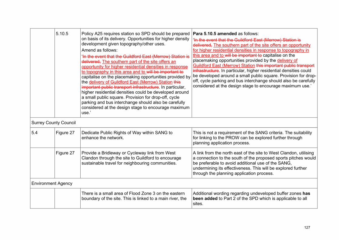
5.10.5 Policy A25 requires station so SPD should be prepared on basis of its delivery. Opportunities for higher density development given topography/other uses. Amend as follows: ‘In the event that the Guildford East (Merrow) Station is delivered, The southern part of the site offers an opportunity for higher residential densities in response to topography in this area and to will be important to capitalise on the placemaking opportunities provided by the delivery of Guildford East (Merrow) Station this important public transport infrastructure. In particular, higher residential densities could be developed around a small public square. Provision for drop-off, cycle parking and bus interchange should also be carefully considered at the design stage to encourage maximum use.’
Para 5.10.5 amended as follows: ‘In the event that the Guildford East (Merrow) Station is delivered, The southern part of the site offers an opportunity for higher residential densities in response to topography in this area and to will be important to capitalise on the placemaking opportunities provided by the delivery of Guildford East (Merrow) Station this important public transport infrastructure. In particular, higher residential densities could be developed around a small public square. Provision for drop-off, cycle parking and bus interchange should also be carefully considered at the design stage to encourage maximum use.’
Surrey County Council
5.4 Figure 27 Dedicate Public Rights of Way within SANG to enhance the network.
This is not a requirement of the SANG criteria. The suitability for linking to the PROW can be explored further through planning application process.
Figure 27 Provide a Bridleway or Cycleway link from West Clandon through the site to Guildford to encourage sustainable travel for neighbouring communities.
A link from the north east of the site to West Clandon, utilising a connection to the south of the proposed sports pitches would be preferable to avoid additional use of the SANG, undermining its effectiveness. This will be explored further through the planning application process.
Environment Agency
There is a small area of Flood Zone 3 on the eastern boundary of the site. This is linked to a main river, the
Additional wording regarding undeveloped buffer zones has been added to Part 2 of the SPD which is applicable to all sites.
127
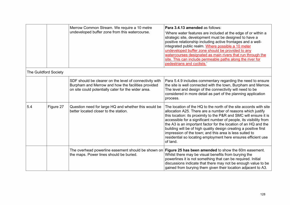
Merrow Common Stream. We require a 10 metre undeveloped buffer zone from this watercourse.
Para 3.4.13 amended as follows: ‘Where water features are included at the edge of or within a strategic site, development must be designed to have a positive relationship including active frontages and a well-integrated public realm. Where possible a 10 meter undeveloped buffer zone should be provided to any watercourses designated as main rivers that run through the site. This can include permeable paths along the river for pedestrians and cyclists.’
The Guildford Society
SDF should be clearer on the level of connectivity with Burpham and Merrow and how the facilities provided on site could potentially cater for the wider area.
Para 5.4.9 includes commentary regarding the need to ensure the site is well connected with the town, Burpham and Merrow. The level and design of the connectivity will need to be considered in more detail as part of the planning application process.
5.4 Figure 27 Question need for large HQ and whether this would be better located closer to the station.
The location of the HQ to the north of the site accords with site allocation A25. There are a number of reasons which justify this location: its proximity to the P&R and SMC will ensure it is accessible for a significant number of people, its visibility from the A3 is an important factor for the location of an HQ and the building will be of high quality design creating a positive first impression of the town; and this area is less suited to residential so locating employment here ensures efficient use of land.
The overhead powerline easement should be shown on the maps. Power lines should be buried.
Figure 25 has been amended to show the 60m easement. Whilst there may be visual benefits from burying the powerlines it is not something that can be required. Initial discussions indicate that there may not be enough value to be gained from burying them given their location adjacent to A3.
128
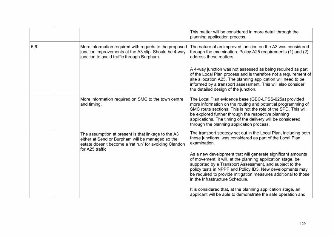
This matter will be considered in more detail through the planning application process.
5.6 More information required with regards to the proposed junction improvements at the A3 slip. Should be 4-way junction to avoid traffic through Burpham.
The nature of an improved junction on the A3 was considered through the examination. Policy A25 requirements (1) and (2) address these matters. A 4-way junction was not assessed as being required as part of the Local Plan process and is therefore not a requirement of site allocation A25. The planning application will need to be informed by a transport assessment. This will also consider the detailed design of the junction.
More information required on SMC to the town centre and timing.
The Local Plan evidence base (GBC-LPSS-025a) provided more information on the routing and potential programming of SMC route sections. This is not the role of the SPD. This will be explored further through the respective planning applications. The timing of the delivery will be considered through the planning application process.
The assumption at present is that linkage to the A3 either at Send or Burpham will be managed so the estate doesn’t become a ‘rat run’ for avoiding Clandon for A25 traffic
The transport strategy set out in the Local Plan, including both these junctions, was considered as part of the Local Plan examination. As a new development that will generate significant amounts of movement, it will, at the planning application stage, be supported by a Transport Assessment, and subject to the policy tests in NPPF and Policy ID3. New developments may be required to provide mitigation measures additional to those in the Infrastructure Schedule. It is considered that, at the planning application stage, an applicant will be able to demonstrate the safe operation and
129
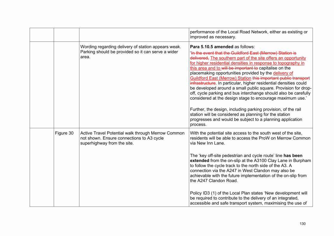
performance of the Local Road Network, either as existing or improved as necessary.
Wording regarding delivery of station appears weak. Parking should be provided so it can serve a wider area.
Para 5.10.5 amended as follows: ‘In the event that the Guildford East (Merrow) Station is delivered, The southern part of the site offers an opportunity for higher residential densities in response to topography in this area and to will be important to capitalise on the placemaking opportunities provided by the delivery of Guildford East (Merrow) Station this important public transport infrastructure. In particular, higher residential densities could be developed around a small public square. Provision for drop-off, cycle parking and bus interchange should also be carefully considered at the design stage to encourage maximum use.’ Further, the design, including parking provision, of the rail station will be considered as planning for the station progresses and would be subject to a planning application process.
Figure 30 Active Travel Potential walk through Merrow Common not shown. Ensure connections to A3 cycle superhighway from the site.
With the potential site access to the south west of the site, residents will be able to access the ProW on Merrow Common via New Inn Lane. The ‘key off-site pedestrian and cycle route’ line has been extended from the on-slip at the A3100 Clay Lane in Burpham to follow the cycle track to the north side of the A3. A connection via the A247 in West Clandon may also be achievable with the future implementation of the on-slip from the A247 Clandon Road. Policy ID3 (1) of the Local Plan states ‘New development will be required to contribute to the delivery of an integrated, accessible and safe transport system, maximising the use of
130
the sustainable transport modes of walking, cycling and the use of public and community transport.’
5.10.1 Indicative densities greater than the wider area/appropriate for an edge of urban area location
The scale of the site enables different densities across different areas of the site, notably towards the south near the proposed rail station. It is important that land that has been allocated for development is used as efficiently as possible to minimise the need for additional development sites.
With higher densities advocated, there should be a vision to adopt the best examples from other places across Europe, there are few if any examples within Guildford. A vague statement that others should be examined for relevance is insufficient.
Para 5.10.1 states “other examples.” The design of the site will be assessed by the Design Review Panel.
Guildford Residents Association
5.3 Vision and Objectives
Objective should include the importance of landscaping to soften views.
The SPD refers to a “rich and abundant landscape” which is considered to cover this issue.
5.4 Figure 27 Office headquarters and P&R should be located near station rather than A3
The location of the HQ to the north of the site accords with site allocation A25. There are a number of reasons which justify this location: its proximity to the P&R and SMC will ensure it is accessible for a significant number of people, its visibility from the A3 is an important factor for the location of an HQ and the building will be of high quality design creating a positive first impression of the town; and this area is less suited to residential so locating employment here ensures efficient use of land. The location of the park and ride adjacent to the A3 would also ensure visibility to passing vehicles which would maximise its use. It also makes best use of land which is less suited to residential use.
131
Figure 27 Will increase Burpham traffic – access northbound A3 and concern over the capacity of the junction of New Inn Lane/Merrow Lane
The transport strategy set out in the Local Plan was considered as part of the Local Plan examination. As a new development that will generate significant amounts of movement, it will, at the planning application stage, be supported by a Transport Assessment, and subject to the policy tests in NPPF and Policy ID3. New developments may be required to provide mitigation measures additional to those in the Infrastructure Schedule. It is considered that, at the planning application stage, an applicant will be able to demonstrate the safe operation and performance of the Local Road Network, either as existing or improved as necessary.
Clarification requested on the A3 slip plans The nature of an improved junction on the A3 was considered through the examination. Policy A25 requirements (1) and (2) address these matters. The planning application will need to be informed by a transport assessment. This will also consider the detailed design of the junction.
Figure 27 Not clear whether parking will be provided at the station/mixed use centre
The design of the Rail Station and ‘Mixed Use High Density Hub’, including parking provision, of the rail station will be considered as planning progresses and would be subject to a planning application process.
Merrow Residents Association
5.4.9 Do not wish to be integrated with Burpham or Gosden Integration with the wider town is important for place making purposes and to ensure that the new and existing community can access new and existing services and facilities.
132
5.4 Figure 27 Absence of a 4-way junction will increase traffic in Burpham and Park Lane/A25/A247 when new slips are delivered.
The transport strategy set out in the Local Plan was considered as part of the Local Plan examination, including the nature of an improved junction on the A3. Policy A25 requirements (1) and (2) address these matters. Requirement (2) is for a deliberative process of consideration to be undertaken as part of the development management process of the potential opportunity to provide an all movements junction of the A3 trunk road with the A3100 London Road, the B2215 London Road and the A247 Clandon Road. Land could potentially be required to be safeguarded for the provision of a connector road to the B2215 London Road/A247 Clandon Road. As a new development that will generate significant amounts of movement, it will, at the planning application stage, be supported by a Transport Assessment, and subject to the policy tests in NPPF and Policy ID3. New developments may be required to provide mitigation measures additional to those in the Infrastructure Schedule. It is considered that, at the planning application stage, an applicant will be able to demonstrate the safe operation and performance of the Local Road Network, either as existing or improved as necessary. As well as serving the new development, scheme SRN3 for a new A3/A3100 Burpham junction with a relocated A3 southbound off-slip and new A3 southbound on-slip will also allow existing residents and businesses in Burpham and Merrow to access the southbound A3 without having to drive through Guildford to access the A3 at the A322 interchange junction.
133
Object to the second access which crosses common land except potentially for cyclists/pedestrians. The second access should be the existing farm access which should not be restricted to only serving circa 100 houses and Merrow Lane for that reason should not be prioritised for pedestrians/cyclists
The Council and Surrey County Council both consider that there should be at least two points of vehicular access to the site, including one to the north of the site which would connect, via a new roundabout, to the improved A3 junction and to the A3100 London Road and one to the south west of the site to the B2234. The SDF also identifies a vehicular access towards the north of Merrow Lane providing access to approximately 100 homes and the existing buildings at Gosden Hill Farm itself.
Were the vehicular accesses to be limited to only the existing farm access and the access to the north of the site (to the A3/A3100 London Road), their close proximity is considered not to be adequate in order to achieve good placemaking, transport sustainability and to provide resilience in the event of an incident on the A3 by providing a through route.
The restriction identified for the use of the existing access to the farmhouse is necessary in order to limit the increase in vehicles on the old London Road, which is narrow and fronted by a number of residential properties.
P&R should be located at the station There are several interrelated factors which justify the indicative location of the park and ride. • A Park and Ride facility in this location is expected to
intercept a number of trips on the A3 travelling southbound that would otherwise drive onwards towards Guildford town centre, including trips through the urban area of Guildford and those continuing southbound on the A3 trunk road between the Burpham and Stoke interchanges.
• This location facilitates the potential for park and ride services to complement the existing bus services, potentially new or enhanced bus services also serving the new settlement at Wisley airfield and potentially allow them
134
to serve the intermediate local centre at Kingpost Parade in Burpham.
• A location adjacent to the Guildford East (Merrow) rail station might encourage its use as a parkway station for those travelling to London rather than reducing vehicular flows and congestion in Guildford town centre.
• The existing overhead power lines running broadly in parallel with the A3 creates a zone with reduced potential to deliver the healthy and attractive living environment that is required by the SPD and so this zone is more suited to a range of non-residential uses including employment, landscape and open space and Park & Ride, and should be planned accordingly. Draws on paragraph 5.4.11.
Figure 29 SMC should not run via Epsom Road – both road and railway bridge are narrow and unsuitable. Question feasibility of SMC6 if cannot be delivered through Burpham either.
The Sustainable Movement Corridor will be a multi-modal route which, depending on the location, provides separate lanes for bus, cycle and pedestrians, and the use of bus priority measures at congested sections of the highway and at interchanges. Funding has already been secured for the western section. Feasibility work has been undertaken and design work will be undertaken for other route sections over time. The scheme would be rolled out over the life of the plan. In respect of the Epsom Road, Surrey CC had previously undertaken concept design work which demonstrates the potential for the provision of bus priority. The existing bridge is already controlled by traffic signals to ensure one-way working. The Railway bridge on New Inn Lane with its junction with Merrow Lane is signed with ‘goalposts’ and a warning sign indicating a vehicle height limit of 14’ 0”. The existing bus network including that serving the park and ride sites is predominantly made up of single decker buses. For planning purposed Stagecoach provide dimensions for their typical single deck bus, this has an unladen height of
135
2968mm, equivalent to 9’ 8 7/8” (Bus Services and New Residential Developments, Stagecoach UK Bus (2017)).
5.10.5 Require greater certainty on timing and delivery of new station
Para 5.10.5 amended as follows: ‘In the event that the Guildford East (Merrow) Station is delivered, The southern part of the site offers an opportunity for higher residential densities in response to topography in this area and to will be important to capitalise on the placemaking opportunities provided by the delivery of Guildford East (Merrow) Station this important public transport infrastructure. In particular, higher residential densities could be developed around a small public square. Provision for drop-off, cycle parking and bus interchange should also be carefully considered at the design stage to encourage maximum use.’ At the Local Plan-making stage, it was considered that it would not be appropriate to specify that the delivery of the Gosden Hill Farm site be conditional on the delivery of the Guildford East (Merrow) railway station, given the tests of planning conditions and obligations set out in the NPPF. Rather, the site promoter’s transport strategy, including the role of a new rail station, will be developed in discussion with Network Rail, Highways England, Surrey County Council and Guildford Borough Council through the development management process for planning applications. Further, the design of the rail station will be considered as planning for the station progresses and would be subject to a planning application process.
Burpham Community Association
5.1 5.1.2 Burpham is not all low density family housing. Whilst Burpham has no railway station, London Road station is less than two miles away, on a bus route and within easy cycling distance.
Para 5.1.2 amended as follows: ‘The areas include some examples of the garden suburb style, and generally as a whole they are characterised by low density family housing with gardens.’
136
The final sentence has been changed to ‘but the area suffers from high volumes of traffic and recurrent peak period congestion” in place of “but the area is car dependant.’
5.4 5.4.5 Any strategies planned for surface water management must take into account the issue of flooding in Burpham/near A3.
More detailed work will be undertaken as part of the planning application process and this will inform the water management measures on the site.
5.6 A two-way junction will increase traffic in Burpham – GHF traffic wishing to go A3 northbound A3, northbound A3 traffic wishing to access GHF, southbound A3 traffic will use Burpham to avoid existing congested roads.
As a new development that will generate significant amounts of movement, it will, at the planning application stage, be supported by a Transport Assessment, and subject to the policy tests in NPPF and Policy ID3. New developments may be required to provide mitigation measures additional to those in the Infrastructure Schedule. It is considered that, at the planning application stage, an applicant will be able to demonstrate the safe operation and performance of the Local Road Network, either as existing or improved as necessary.
Railway bridge would need to be widened to accommodate proposals
It is considered that the local roads, including the railway bridge, can be improved and/or managed as necessary in order to maintain their safe operation and performance.
Concerns re the viability of improvements to New Inn Lane B2234 due to ancient woodland , Local Green Space and TPO ref.1947 W1, W2, W3 4363/10
The ancient woodland is located to the south of New Inn Lane. There is a legal process for the de-registering common land and it is suggested replacement common land could be provided. Further consideration will be given to constraints as part of the planning application process however there does not appear to be any other designations which would be impacted by the proposal.
Suggestion the P&R could be combined with the train station
There are several interrelated factors which justify the indicative location of the park and ride.
137
• A Park and Ride facility in this location is expected to intercept a number of trips on the A3 travelling southbound that would otherwise drive onwards towards Guildford town centre, including trips through the urban area of Guildford and those continuing southbound on the A3 trunk road between the Burpham and Stoke interchanges.
• This location facilitates the potential for park and ride services to complement the existing bus services, potentially new or enhanced bus services also serving the new settlement at Wisley airfield and potentially allow them to serve the intermediate local centre at Kingpost Parade in Burpham.
• A location adjacent to the Guildford East (Merrow) rail station might encourage its use as a parkway station for those travelling to London rather than reducing vehicular flows and congestion in Guildford town centre.
• The existing overhead power lines running broadly in parallel with the A3 creates a zone with reduced potential to deliver the healthy and attractive living environment that is required by the SPD and so this zone is more suited to a range of non-residential uses including employment, landscape and open space and Park & Ride, and should be planned accordingly. Draws on paragraph 5.4.11.
Concerns over the deliverability of the SMC on the A3100 London Road without the need for demolition. The proposed continuation of the SMC onto Merrow and Guildford via Epsom Road is unrealistic.
The Sustainable Movement Corridor will be a multi-modal route which, depending on the location, provides separate lanes for bus, cycle and pedestrians, and the use of bus priority measures at congested sections of the highway and at interchanges. Funding has already been secured for the western section. Feasibility work has been undertaken and design work will be undertaken for other route sections over time. The scheme would be rolled out over the life of the plan.
138
The council is not considering options which require demolition. In respect of the Epsom Road, Surrey CC had previously undertaken concept design work which demonstrates the potential for the provision of bus priority.
Fig 30 Had the Burpham Community Forum been consulted prior to the development of the document, they could have suggested paths which could be used as cycle paths which are more direct to Guildford.
The consultation for the SDF document provided an opportunity for interested parties to make alternative proposals.
G-BUG
5.6 Fig 30 The new cycle/pedestrian path along New Inn Lane must apply for the length of the road from the railway bridge to the ‘Aldi’ roundabout.
The transport strategy for the site will be considered as part of the planning application process.
The existing cycle track alongside the London bound carriageway of the A3, which leads to Ripley and beyond, should be added to the map. A good connection should be provided to this.
The cycle track on the north side of the A3 can be accessed via the on-slip from the A3100 Clay Lane in Burpham. This link has been added to the map. A connection via the A247 in West Clandon may also be achievable with the future implementation of the on-slip from the A247 Clandon Road.
Generous secure cycle storage should be provided at the new Guildford East station.
The details of the Rail Station will be considered as planning for the station progresses and would be subject to a planning application process.
Cllr Potter
5.4 Figure 27 Proposal will route majority of traffic to and from the site via the centre of Burpham which is already regularly congested and very slow moving. This
As a new development that will generate significant amounts of movement, it will, at the planning application stage, be supported by a Transport Assessment, and subject to the policy tests in NPPF and Policy ID3. New developments may be required to provide mitigation measures additional to those
139
includes traffic going northbound on A3 and A3 southbound traffic wishing to access Guildford.
in the Infrastructure Schedule. It is considered that, at the planning application stage, an applicant will be able to demonstrate the safe operation and performance of the Local Road Network, either as existing or improved as necessary.
Figure 27 No supermarket on-site will lead to increase in traffic in Burpham in order to access supermarkets.
The local centre will provide day to day services, including retail. As a new development that will generate significant amounts of movement, it will, at the planning application stage, be supported by a Transport Assessment, and subject to the policy tests in NPPF and Policy ID3. New developments may be required to provide mitigation measures additional to those in the Infrastructure Schedule. It is considered that, at the planning application stage, an applicant will be able to demonstrate the safe operation and performance of the Local Road Network, either as existing or improved as necessary.
All ways junction ineffective as it would require a 2.5 mile detour – likely to still use Clay Lane to go northbound on A3. Instead A3 access point to Gosden Hill to be placed opposite Potter's Lane and for land to be reserved, via planting, to allow space for a future all-access junction should it later be determined that one is needed.
The transport strategy set out in the Local Plan was considered as part of the Local Plan examination, including the nature of an improved junction on the A3. Policy A25 requirements (1) and (2) address these matters. Requirement (2) is for a deliberative process of consideration to be undertaken as part of the development management process of the potential opportunity to provide an all movements junction of the A3 trunk road with the A3100 London Road, the B2215 London Road and the A247 Clandon Road. Land could potentially be required to be safeguarded for
140
the provision of a connector road to the B2215 London Road/A247 Clandon Road.
No transport assessment/modelling to support the proposals in the SDF.
The Local Plan is supported by a transport evidence base that is considered to be adequate and proportionate. Specifically, the Strategic Highway Assessment Report: Guildford Borough Proposed Submission Local Plan “June 2016” (Surrey County Council, June 2016) (the SHAR 2016) is a technical report on the strategic highway assessment of the spatial strategy in the Draft Local Plan 2016. An addendum was also prepared (Guildford Borough Council, 2017). The Local Plan was examined, found sound subject to modifications, and adopted. As a new development that will generate significant amounts of movement, it will, at the planning application stage, be supported by a Transport Assessment, and subject to the policy tests in NPPF and Policy ID3. New developments may be required to provide mitigation measures additional to those in the Infrastructure Schedule. It is considered that, at the planning application stage, an applicant will be able to demonstrate the safe operation and performance of the Local Road Network, either as existing or improved as necessary.
Cllr Anderson
5.2.3 Insufficient certainty of delivery of new rail station/timing of delivery.
At the Local Plan-making stage, it was considered that it would not be appropriate to specify that the delivery of the Gosden Hill Farm site be conditional on the delivery of the Guildford East (Merrow) railway station, given the tests of planning conditions and obligations set out in the NPPF. Rather, the site promoter’s transport strategy, including the role of a new rail station, will be developed in discussion with Network Rail, Highways England, Surrey County Council and Guildford
141
Borough Council through the development management process for planning applications. Further, the design, including parking provision, of the rail station will be considered as planning for the station progresses and would be subject to a planning application process.
5.4.11 Phase 1 likely to access site off Merrow Lane rather than A3 – impact on road network
Phasing will need to be agreed at planning application stage. This also includes the level of mitigation required and trigger at which it must be provided.
5.4.11 Power lines should be buried Figure 25 has been amended to show the 60m easement. Whilst there may be visual benefits from burying the powerlines it is not something that can be required. Initial discussions indicate that there may not be enough value to be gained from burying them given their location adjacent to A3. This matter will be considered in more detail through the planning application process.
5.4.12 Unclear how landscaping could achieve a “green gateway”
Site allocation requires at A25(25): ‘Increased landscaped buffer/strategic planting with frontage development set back from the A3 with significant additional measures to mitigate the visual impact of development in this location.’ The character of the existing site will of necessity change however this will be softened by the proposed level of landscaping.
5.4.13 Timing of rail station /road improvements should occur prior to development
Policy ID1(1) states: ‘Infrastructure necessary to support new development will be provided and available when first needed to serve the development’s occupants and users and/or to mitigate its otherwise adverse material impacts.’ Policy ID1 of the Local Plan requires both that, at (3) 'When determining planning applications, and attaching appropriate
142
planning conditions and/or planning obligations, regard will be had to the delivery and timing of delivery of the key infrastructure, or otherwise alternative interventions which provide comparable mitigation' and, at (4), 'The imposition of Grampian conditions shall be considered as a means to secure the provision of infrastructure when it is needed. If the timely provision of infrastructure necessary to support new development cannot be secured in line with this policy, planning permission will be refused'.
Cllr Nagaty
5.4 Figure 27 A 4-way junction must be provided to avoid traffic through Burpham
The transport strategy set out in the Local Plan was considered as part of the Local Plan examination, including the nature of an improved junction on the A3. Policy A25 requirements (1) and (2) address these matters. Requirement (2) is for a deliberative process of consideration to be undertaken as part of the development management process of the potential opportunity to provide an all movements junction of the A3 trunk road with the A3100 London Road, the B2215 London Road and the A247 Clandon Road. Land could potentially be required to be safeguarded for the provision of a connector road to the B2215 London Road/A247 Clandon Road.
Cllr Seabrook
5.4 Figure 27 A 4-way junction must be provided The transport strategy set out in the Local Plan was considered as part of the Local Plan examination, including the nature of an improved junction on the A3. Policy A25 requirements (1) and (2) address these matters.
143
Requirement (2) is for a deliberative process of consideration to be undertaken as part of the development management process of the potential opportunity to provide an all movements junction of the A3 trunk road with the A3100 London Road, the B2215 London Road and the A247 Clandon Road. Land could potentially be required to be safeguarded for the provision of a connector road to the B2215 London Road/A247 Clandon Road
5.10.5 Should be written positively about the delivery of the station
Para 5.10.5 amended as follows: ‘In the event that the Guildford East (Merrow) Station is delivered, The southern part of the site offers an opportunity for higher residential densities in response to topography in this area and to will be important to capitalise on the placemaking opportunities provided by the delivery of Guildford East (Merrow) Station this important public transport infrastructure. In particular, higher residential densities could be developed around a small public square. Provision for drop-off, cycle parking and bus interchange should also be carefully considered at the design stage to encourage maximum use.’
Stagecoach
5.6 We note that no contribution is sought towards pump-priming higher levels of bus service into this area, which surely ought to represent a much higher priority, and one that would deliver graft outputs at much lower costs than some of the other interventions, which may not prove to be deliverable for some time.
LPSS Site Policy A25 states, at requirement 5, the provision of extended and/or new bus services to serve the site and which will also serve the eastern suburbs of Guildford and the town centre.
The delivery of seamless bus priority off-site will prove challenging but is likely to be greatly more effective in delivering mode shift than highly engineered bus lanes within the development. To deliver the latter without the former would be a high-cost way of achieving a
The guidance that segregated and continuous bus lanes be provided for the exclusive use of buses on the primary streets as they run through the strategic sites has been modified see section 3.3 (C4 and C5). Segregated bus lanes and/or bus gates/modal filters would only be required in congestion
144
somewhat modest impact. It would be preferable to direct expenditure to comprehensive off-site bus priority than only see bus advantage delivered at the outer end of the route within the development, where traffic pressure is much less likely to prove to be a problem.
hotspot locations, including at site accesses, where queuing traffic in peak periods might be expected to delay buses on the primary streets. The requirements in the Site Policies for Gosden Hill, Blackwell Farm and Slyfield include the provision of the relevant route section of the Sustainable Movement Corridor on-site, and a necessary and proportionate contribution to delivering the relevant route section off-site.
Other respondents
5.2 No mention of Burpham Neighbourhood Plan including its parking standards
The SPD has been amended to include reference to Neighbourhood Plans in Part 1 (section 2.1). Neighbourhood plans form part of the development plan and will be considered as part of planning application process.
5.2.3 States that a “raft of transport interventions will be required” however no details of what these will be
As a new development that will generate significant amounts of movement, it will, at the planning application stage, be supported by a Transport Assessment, and subject to the policy tests in NPPF and Policy ID3. New developments may be required to provide mitigation measures additional to those in the Infrastructure Schedule. In the case of Gosden Hill, this will include a ‘proportionate contribution to delivering the SMC on the local road network.’ It is considered that, at the planning application stage, an applicant will be able to demonstrate the safe operation and performance of the Local Road Network, either as existing or improved as necessary.
5.4 Figure 25 Map should identify Common Land and Local Green Space.
Figure 25 is intended to be high level. It focuses on the presence of physical features. All relevant designations will be considered in more detail through the planning application process.
145
5.4 Figure 27 Proposal will route majority of traffic to and from the site via the centre of Burpham which is already regularly congested and very slow moving. This includes traffic going northbound on A3 and A3 southbound traffic wishing to access Guildford.
As a new development that will generate significant amounts of movement, it will, at the planning application stage, be supported by a Transport Assessment, and subject to the policy tests in NPPF and Policy ID3. New developments may be required to provide mitigation measures additional to those in the Infrastructure Schedule. It is considered that, at the planning application stage, an applicant will be able to demonstrate the safe operation and performance of the Local Road Network, either as existing or improved as necessary.
Figure 27 No supermarket on-site will lead to increase in traffic in Burpham in order to access supermarkets.
The local centre will provide day to day services, including retail. As a new development that will generate significant amounts of movement, it will, at the planning application stage, be supported by a Transport Assessment, and subject to the policy tests in NPPF and Policy ID3. New developments may be required to provide mitigation measures additional to those in the Infrastructure Schedule. It is considered that, at the planning application stage, an applicant will be able to demonstrate the safe operation and performance of the Local Road Network, either as existing or improved as necessary.
Figure 27 Unclear if Merrow Lane will be closed to traffic as it would need to if it is to be used by pedestrians/cyclists
This is a matter which will be examined further through the planning application process. There are various ways of giving priority to pedestrians and cyclists. For instance, options might include a single modal filter, allowing vehicular access but preventing the through movement, putting in a point closure for access, or speed limits or other traffic calming.
146
Merrow Lane is not suitable in its current form and would need an upgrade prior to construction. The right-angled bend is dangerous for all, the bridge is too low for HGV’s and congested. New Inn Lane cannot take HGV’s safely.
Road improvements, which may include the realignment of Merrow Lane and its junction with New Inn Lane, will be required in order to facilitate the potential site access to the south-west of the Gosden Hill site.
5.5 Figure 28 The common land is claimed to be on the site as existing woodland. The 15 metre buffer is not included within the site for the ancient wood land
Figure 28 is primarily focussed on landscape features. These features may also be subject to other designations not shown on the figure. All relevant designations will be considered in more detail through the planning application process. The necessary buffer with the ancient woodland will be incorporated within the final masterplan design. Reference to the 15m buffer is contained in Part 2 of the SPD (para 3.5.21).
5.6 The road infrastructure around Burpham is already congested, the proposals for Gosden Hill will exacerbate this (including London Road, New Inn Lane, and at Aldi and Sainsbury’s). More homes will exacerbate the congestion/ air pollution issues at the A3100/ B2234 ‘Aldi’ roundabout. Traffic using the P&R will likely come from the north, therefore when returning home, they will have to travel S/B on the A3100 to get to the Clay Lane A3 N/B slip. Southbound access via the 2-way A3100 will attract more traffic from Slyfield that would currently use the Woking Road junction as well as central Guildford traffic going southbound who wish to avoid the congestion at Ladymead.
The Local Plan is supported by a transport evidence base that is considered to be adequate and proportionate. Specifically, the Strategic Highway Assessment Report: Guildford Borough Proposed Submission Local Plan “June 2016” (Surrey County Council, June 2016) (the SHAR 2016) is a technical report on the strategic highway assessment of the spatial strategy in the Draft Local Plan 2016. An addendum was also prepared (Guildford Borough Council, 2017). The Local Plan was examined, found sound subject to modifications, and adopted. As a new development that will generate significant amounts of movement, it will, at the planning application stage, be supported by a Transport Assessment, and subject to the policy tests in NPPF and Policy ID3. New developments may be required to provide mitigation measures additional to those in the Infrastructure Schedule. It is considered that, at the planning application stage, an applicant will be able to demonstrate the safe operation and
147
The presence of a southbound access via the 2-way A3100 will attract more traffic from Slyfield that otherwise has to contend with the Woking Road/Ladymead congestion and likewise central Guildford traffic going southbound that wishes to avoid the central 1-way system/Farnham Road congestion or the Woodbridge Road/Ladymead congestion. Will put more pressure on the A3 which is already at busting point.
performance of the Local Road Network, either as existing or improved as necessary.
In respect of air quality, AECOM undertook an Air Quality Review of Guildford Borough Proposed Submission Local Plan: Strategy and Sites “June 2017” (June 2017). This was a qualitative-risk based review, which considered the risk of significant air quality effects (in terms of annual mean concentrations of NO2, PM10 and PM2.5) occurring with the implementation of the Draft Local Plan 2017. Consideration of risk was based on the size and nature of anticipated developments, their location, ambient air quality around potential developments and the locations of sensitive receptors to air quality around potential developments (including residential properties, schools and hospitals). The findings suggest that the effect of the then Draft Local Plan on annual mean NO2 concentrations will be negligible and not a key constraint on development in the majority of the borough. Further, detailed modelling was recommended as being advisable around roads where notable changes in traffic flows are predicted, at locations in close proximity to sensitive receptors; albeit in each case it was considered unlikely that these development-related increases would lead to an exceedance of the air quality objective.
For particulate matter – both PM10 and PM2.5 – negligible effects are anticipated at all sensitive receptors for air quality.
It was also recommended that the findings of the Air Quality Review be confirmed as part of the planning application processes for specific sites. Accordingly, potential air quality issues have been added as a ‘key consideration’ including for policy A25 Gosden Hill Farm.
148
A3 access is inadequate and the proposals should include a 4-way junction, with a bridge over the A3. Northbound access is important, otherwise all traffic will have to route through Burpham onto Clay Lane N/B slip. All ways junction ineffective as it would require a 2.5 mile detour – likely to still use Clay Lane to go northbound on A3. Instead A3 access point to Gosden Hill to be placed opposite Potter's Lane and for land to be reserved, via planting, to allow space for a future all-access junction should it later be determined that one is needed. More information required with regards to the proposed junction improvements at the A3 slip/ 2-way upgrade
The transport strategy set out in the Local Plan was considered as part of the Local Plan examination, including the nature of an improved junction on the A3. Policy A25 requirements (1) and (2) address these matters. Requirement (2) is for a deliberative process of consideration to be undertaken as part of the development management process of the potential opportunity to provide an all movements junction of the A3 trunk road with the A3100 London Road, the B2215 London Road and the A247 Clandon Road. Land could potentially be required to be safeguarded for the provision of a connector road to the B2215 London Road/A247 Clandon Road.
To travel to Clandon, Gosden Hill Farm residents would have to drive towards Guildford on London Road (A3100) and turn right at the Sainsburys/Clay Lane roundabout before joining the A3 northbound.
With the southern access there will be an alternative route for vehicles via Park Lane, the A25 Epsom Road and the A247 to West Clandon. On foot or by bike there will be a more direct route to West Clandon via the north east of the site and with a new rail station at Guildford East (Merrow) West Clandon can be reached by train. Policy A25 requirements (1) and (2) of the Local Plan address this matter. Requirement (2) states land could potentially be required to be safeguarded for the provision of a connector road to the B2215 London Road/A247 Clandon Road
Concerns over safety of school children using London road.
The Council has amended the guidance in the SDF on the provision for buses, including the SMC, on and immediately adjacent to the strategic sites, see section 3.3 (C4 and C5).
149
Rather, it is proposed that segregated bus lanes and/or bus gates/modal filters would only be required in congestion hotspot locations, including site accesses, where queuing traffic in peak periods might be expected to delay buses on the primary streets. At the northern site access, the existing A3 off-slip is proposed to be incorporated into a 2-way road with a new A3 off-slip provided. The repurposed 2-way road could be provided with generous footway/s and cycle tracks or alternatively these facilities could be provided as part of a separate SMC alignment, which might for instance connect to the old London Road (the continuation of Merrow Lane). The Council and Surrey County Council both consider that there should be at least two points of vehicular access to the site, including one to the north of the site which would connect, via a new roundabout, to the improved A3 junction and to the A3100 London Road and one to the south west of the site to the B2234. The SDF also identifies a vehicular access towards the north of Merrow Lane providing access to approximately 100 homes and the existing buildings at Gosden Hill Farm itself. These different points of access will be utilised by school children on their journeys to and from the schools located on-site.
Previous proposals of a new road at Park Lane/ Kingfisher Dr junction, connecting to new station and the A3 would have kept traffic out of Burpham.
Previous planning applications for the site have been reviewed. Two planning applications were submitted in 1981. The second application included all directions interchange with the A3 and a perimeter road linking the A246 and A3. Surrey County Council, the Local Highways Authority, specified amongst other requirements that the perimeter road was necessary. The all movements junction was not specified as a requirement for the development to proceed. Department of
150
Transport recommended refusal on the grounds that the all movement junction was located too close to other A3 junctions. A planning inspector did consider it would bring relief to London Road and Clay Lane, however primarily his position was in respect to the benefit it would bring to the development of a wider orbital route. A wider orbital route is no longer under consideration by the Department for Transport, Highways England or Surrey County Council.
Consideration should be given to a bridge beside Sainsbury’s to remove the pedestrian crossing and improve flow.
In an urban setting, contemporary practice would not seek to favour vehicular traffic through measures which would impede journeys for pedestrians.
Suggesting a review of the traffic light sequencing at the railway bridge junction (New Inn/ Merrow Lane) is not an adequate response, more is required.
As a new development that will generate significant amounts of movement, it will, at the planning application stage, be supported by a Transport Assessment, and subject to the policy tests in NPPF and Policy ID3. New developments may be required to provide mitigation measures additional to those in the Infrastructure Schedule. It is considered that, at the planning application stage, an applicant will be able to demonstrate the safe operation and performance of the Local Road Network, including the railway bridge, either as existing or improved as necessary. For this reason, the text has been amended to remove this specific reference and highlighted the wider considerations to be given to this junction.
Proposed solution: Close the existing southbound A3100 slip from the A3. The SMC could be re-directed along the A3. Southbound traffic for Guildford would be encouraged to use Woking Road interchange, while
The Local Plan is supported by a transport evidence base that is considered to be adequate and proportionate. Specifically, the Strategic Highway Assessment Report: Guildford Borough Proposed Submission Local Plan “June 2016” (Surrey County Council, June 2016) (the SHAR 2016) is a technical report on
151
Burpham and Merrow traffic would follow the spine road of the new development.
the strategic highway assessment of the spatial strategy in the Draft Local Plan 2016. An addendum was also prepared (Guildford Borough Council, 2017). The Local Plan was examined, found sound subject to modifications, and adopted.
The planned closure of Merrow Lane will encourage more traffic to use Burpham, as there will be no easy route for residents in London Road/Merrow Lane to access Merrow/Epsom Road
The Council and Surrey County Council both consider that there should be at least two points of vehicular access to the site, one to the north of the site which would connect, via a new roundabout, to the improved A3 junction and to the A3100 London Road and one to the south west of the site to the B2234. This will provide through access which can be used by existing residents. As a new development that will generate significant amounts of movement, it will, at the planning application stage, be supported by a Transport Assessment, and subject to the policy tests in NPPF and Policy ID3. New developments may be required to provide mitigation measures additional to those in the Infrastructure Schedule.
The junction at New Inn Lane is overloaded and to upgrade this would destroy the character, contrary to the Local and Neighbourhood plans for the ward.
The transport strategy set out in the Local Plan was considered as part of the Local Plan examination. As a new development that will generate significant amounts of movement, it will, at the planning application stage, be supported by a Transport Assessment, and subject to the policy tests in NPPF and Policy ID3. New developments may be required to provide mitigation measures additional to those in the Infrastructure Schedule. It is considered that, at the planning application stage, an applicant will be able to demonstrate the safe operation and performance of the Local Road Network, either as existing or improved as necessary.
152
Proposal: There should be an all-way junction A3 to provide extra road space for the predicted 45,000 additional vehicles coming into the area. To Send West Clandon to the west side and east to Merrow and Burpham located just north of Potters Lane south of the A247. A spine to the A25 at the back of Surrey CC – past the phantom railway station (noting no mention in Railways 30-year plan) and up to Merrow Park and Ride. Far better these buses use the A320 onto the A3 north and A3 south from the ‘new ‘horribly insufficient on / off south bound. Save for the 5.1mile round trip if they follow current proposal and use this suggested route The cycle path should be placed through the estates down the south side of the A3 in the Burpham Local Green Spaces and out into the rear of the Spectrum. This will remove all Park and Ride buses from Merrow and Burpham villages completely
The nature of an improved junction on the A3 was considered through the examination. Policy A25 requirements (1) and (2) address these matters. A wider orbital route is not under consideration by the Department for Transport, Highways England or Surrey County Council. The transport strategy set out in the Local Plan was considered as part of the Local Plan examination. As a new development that will generate significant amounts of movement, it will, at the planning application stage, be supported by a Transport Assessment, and subject to the policy tests in NPPF and Policy ID3. New developments may be required to provide mitigation measures additional to those in the Infrastructure Schedule. It is considered that, at the planning application stage, an applicant will be able to demonstrate the safe operation and performance of the Local Road Network, either as existing or improved as necessary. This cycle route is shown on the cycle network plan as part of the Preferred Option for ID10 Achieving a Comprehensive Guildford Borough Cycle Network in the Issues, Options and Preferred Options consultation (GBC 2020).
For the P&R to be successful it would have to continue to the Hospital and the Research Park, as opposed to solely the Town Centre.
The site policy requires that, as requirement (3), the provision of land and park and ride facility of a sufficient scale as required by projected demand and in order to operate without public subsidy in perpetuity. The new development will also contribute to and connect into the Sustainable Movement Corridor which will provide a priority pathway through the urban area of Guildford for buses, pedestrians and cyclists and
153
which will connect key destinations including the town centre and, on route to the new community at Blackwell Farm, the Surrey Research Park and the Royal Surrey County Hospital.
The P&R will bring more non-local traffic to the area.
A Park and Ride facility in this location is expected to intercept a number of trips on the A3 travelling southbound that would otherwise drive onwards towards Guildford town centre, including trips through the urban area of Guildford and those continuing southbound on the A3 trunk road between the Burpham and Stoke interchanges.
The P&R car park will need ANPR facilities to prevent it being used by rail commuters.
The location of the Park and Ride is at the other end of the site from the Guildford East (Merrow) rail station.
Use the P&R car park as the station car park and use the train instead of buses.
The management of the P&R is a matter which will be considered as part of the planning application process.
The SMC through Gosden Hill could be a marooned short stretch as it is unclear how a link through to Guildford for cyclists would function. Concerns that the SMC is not practical along London Road in terms of width, including pinch point at Aldi and the numerous roundabouts/pedestrian crossings. Rail bridge will need to be widened, both for increased traffic and the proposed SMC. Not viable to fit two footpaths, two cycle lanes, two road lanes, two bus lanes under Railway bridge on Merrow Lane. No identification of improvement is made.
The Sustainable Movement Corridor will be a multi-modal route which, depending on the location, provides separate lanes for bus, cycle and pedestrians, and the use of bus priority measures at congested sections of the highway and at interchanges. Feasibility work has been undertaken and design work will be undertaken for other route sections over time. The scheme would be rolled out over the life of the plan. The guidance that segregated and continuous bus lanes be provided for the exclusive use of buses on the primary streets as they run through the strategic sites has been modified, see section 3.3 (C4 and C5). Segregated bus lanes and/or bus gates/modal filters would only be required in congestion hotspot locations, including at site accesses, where queuing traffic in peak periods might be expected to delay buses on the primary streets.
154
The Council continues to require that segregated and continuous cycleways and generous pedestrian paths be provided on the primary streets of the strategic sites. Given the size and range of uses on Gosden Hill, as with the other strategic sites, the cycle tracks and generous pedestrian facilities will support a number of short journeys on foot and by bike including those made exclusively on site.
Concern that the corridor improvements will impact vehicular access to the Kingspost Parade on the A3100.
The Local Plan is supported by a transport evidence base that is considered to be adequate and proportionate. Specifically, the Strategic Highway Assessment Report: Guildford Borough Proposed Submission Local Plan “June 2016” (Surrey County Council, June 2016) (the SHAR 2016) is a technical report on the strategic highway assessment of the spatial strategy in the Draft Local Plan 2016. An addendum was also prepared (Guildford Borough Council, 2017). The Local Plan was examined, found sound subject to modifications, and adopted. As a new development that will generate significant amounts of movement, it will, at the planning application stage, be supported by a Transport Assessment, and subject to the policy tests in NPPF and Policy ID3. New developments may be required to provide mitigation measures additional to those in the Infrastructure Schedule. It is considered that, at the planning application stage, an applicant will be able to demonstrate the safe operation and performance of the Local Road Network, either as existing or improved as necessary.
155
Proposals for bus infrastructure are interesting when there have been recent cutbacks of public transport in the area.
Site Policy A25 requires that, as requirement (3), the provision of land and park and ride facility of a sufficient scale as required by projected demand and in order to operate without public subsidy in perpetuity. The new development will also contribute to and connect into the Sustainable Movement Corridor which will provide a priority pathway through the urban area of Guildford for buses, pedestrians and cyclists and which will connect key destinations including the town centre. and; (5) The provision of extended and/or new bus services to serve the site and which will also serve the eastern suburbs of Guildford and the town centre.
Disagree with the concept of the SMC for use by buses which do not stop in the villages of Merrow or Burpham.
A number of bus services will use a road which benefits from bus priority measures provided as part of a SMC scheme. Local buses serving Burpham and/or Merrow, with stops in these communities, could therefore benefit from improved journey time and reliability.
The SMC will not improve vehicular traffic flows and will only increase the bottleneck in Burpham centre.
The Local Plan is supported by a transport evidence base that is considered to be adequate and proportionate. Specifically, the Strategic Highway Assessment Report: Guildford Borough Proposed Submission Local Plan “June 2016” (Surrey County Council, June 2016) (the SHAR 2016) is a technical report on the strategic highway assessment of the spatial strategy in the Draft Local Plan 2016. An addendum was also prepared (Guildford Borough Council, 2017). The Local Plan was examined, found sound subject to modifications, and adopted. As a new development that will generate significant amounts of movement, it will, at the planning application stage, be supported by a Transport Assessment, and subject to the
156
policy tests in NPPF and Policy ID3. New developments may be required to provide mitigation measures additional to those in the Infrastructure Schedule. It is considered that, at the planning application stage, an applicant will be able to demonstrate the safe operation and performance of the Local Road Network, either as existing or improved as necessary.
Timing of SMC does not align with delivery of site
The site Policy in the Local Plan requires, as requirement (4), ‘The provision of the eastern route section of the Sustainable Movement Corridor on-site, and a necessary and proportionate contribution to delivering the eastern route section off-site.’ Similarly, Policy ID1 (1) states that ‘Infrastructure necessary to support new development will be provided and available when first needed to serve the development’s occupants and users and/or to mitigate its otherwise adverse material impacts.’
Insufficient certainty of delivery of new rail station. No commitment from Network Rail. SDF should include timescales for delivery of station.
The case for the new station at Guildford East (Merrow) was made in both the Surrey Rail Strategy: Surrey Rail Strategy Report (Surrey County Council, September 2013) and the Guildford Town and Approaches Movement Study: Strategy Report (Arup, March 2015). Network Rail considers that, subject to further assessment and approval, the delivery of a new station at Guildford East (Merrow) is feasible and viable. South Western Trains has publically committed to work with stakeholders to progress the plans for the new station at Guildford East (Merrow). The new rail station is included in the Local Plan in the Infrastructure Schedule, as well as the requirement as specified in the site Policy for Gosden Hill Farm.
157
At the Local Plan-making stage, it was considered that it would not be appropriate to specify that the delivery of the Gosden Hill Farm site be conditional on the delivery of the Guildford East (Merrow) railway station, given the tests of planning conditions and obligations set out in the NPPF. Rather, the site promoter’s transport strategy, including the role of a new rail station, will be developed in discussion with Network Rail, Highways England, Surrey County Council and Guildford Borough Council through the development management process for planning applications.
Station should include parking, as opposed to solely a drop-off.
The design, including parking provision, of the rail station will be considered as planning for the station progresses and would be subject to a planning application process.
Proposed location of station is not favourable to those from western Merrow/Burpham. Somewhere more centrally located (New Inn Lane area) would be more attractive.
Any location for a new Rail Station needs to be adjacent to the railway line. The section of New Inn Lane adjacent to the railway line is very close to the railway bridge. The proposed location would allow for access from both sides of the railway.
The likely traffic flows to the proposed new Railway Station are unclear. New station will be convenient for some but will add yet more congestion.
As a new development that will generate significant amounts of movement, it will, at the planning application stage, be supported by a Transport Assessment, and subject to the policy tests in NPPF and Policy ID3. New developments may be required to provide mitigation measures additional to those in the Infrastructure Schedule. It is considered that, at the planning application stage, an applicant will be able to demonstrate the safe operation and performance of the Local Road Network, either as existing or improved as necessary.
The train station will not be worthwhile if the train operators do not expand capacity.
The case for the new station at Guildford East (Merrow) was made in both the Surrey Rail Strategy: Surrey Rail Strategy Report (Surrey County Council, September 2013) and
158
the Guildford Town and Approaches Movement Study: Strategy Report (Arup, March 2015). Network Rail considers that, subject to further assessment and approval, the delivery of a new station at Guildford East (Merrow) is feasible and viable. South Western Trains has publically committed to work with stakeholders to progress the plans for the new station at Guildford East (Merrow). The new rail station is included in the Local Plan in the Infrastructure Schedule, as well as the requirement as specified in the site Policy for Gosden Hill Farm.
Part of the site accessed via existing farm entrance will force traffic onto narrow old London Road. There should be no vehicular access between the site and New Inn Lane or Merrow Lane given current congestion. Site accesses are inadequate.
The Council and Surrey County Council both consider that there should be at least two points of vehicular access to the site, one to the north of the site which would connect, via a new roundabout, to the improved A3 junction and to the A3100 London Road and one to the south west of the site to the B2234. A minimum of two points of vehicular access is considered essential to achieve good placemaking, transport sustainability and will also provide resilience in the event of an incident on the A3. The SDF also identifies a vehicular access towards the north of Merrow Lane providing access to approximately 100 homes and the existing buildings at Gosden Hill Farm itself.
As a new development that will generate significant amounts of movement, it will, at the planning application stage, be supported by a Transport Assessment, and subject to the policy tests in NPPF and Policy ID3. New developments may be required to provide mitigation measures additional to those in the Infrastructure Schedule. It is considered that, at the planning application stage, an applicant will be able to demonstrate the safe operation and performance of the Local Road Network, either as existing or improved as necessary.
159
Not clear what the implications are of any non-delivery of RIS schemes
Whilst the Local Plan was prepared on the assumption that the A3 Guildford scheme would be delivered, the plan anticipates the possibilities of delay, reduction in scope or the cancellation of the scheme, with a course of action to address this eventuality described in Local Plan Policy ID2. This will involve GBC – with input from SCC and Highways England as appropriate – reviewing its transport evidence base to investigate the consequent cumulative impacts of approved development and Local Plan growth including site allocations on the safe operation and the performance of the Local Road Networks and Strategic Road Network. In particular, this review will determine whether the proposed transport measures or additional transport measures can mitigate the cumulative impacts of development traffic on the A3.
5.6.4 Concern over practicality of New Inn Lane being both an access and an active travel route. This would require widening and junction improvements.
As a new development that will generate significant amounts of movement, it will, at the planning application stage, be supported by a Transport Assessment, and subject to the policy tests in NPPF and Policy ID3. New developments may be required to provide mitigation measures additional to those in the Infrastructure Schedule. It is considered that, at the planning application stage, an applicant will be able to demonstrate the safe operation and performance of the Local Road Network, either as existing or improved as necessary.
It is considered that the local roads can be improved and/or managed as necessary in order to maintain their safe operation and performance.
Figure 29 The short section of proposed improvements on the A3100 corridor would not make a difference as this area illustrated is a small part of the corridor.
The dashed red box has been removed from Figure 30 for clarity. The proposed improvements will look at the A3100 corridor along its full length.
160
Figure 29 Concerns over access out of Weybrook Drive due to increased traffic travelling to A3 slip s/b
As a new development that will generate significant amounts of movement, it will, at the planning application stage, be supported by a Transport Assessment, and subject to the policy tests in NPPF and Policy ID3. New developments may be required to provide mitigation measures additional to those in the Infrastructure Schedule. This would include any changes to this junction if deemed necessary.
Figure 30 Cycle paths should follow more direct routes via backstreets and on the inside edge of Sutherland Park to avoid traffic, travelling directly to the George Abbot School.
The identified off-site cycle routes draw on the proposal for a comprehensive Guildford borough cycle network as identified in the Issues, Options and Preferred Options consultation (June 2020) for the emerging Local Plan: development management policies. For the urban area of Guildford, this network has drawn on the Route Assessments Feasibility Study undertaken in 2018-19. The study took a fresh look at the cycle network based on an assessment of the bikeability skills required on different routes followed by the application of cycle network design principles. Thus, the network has been considered from the perspective of the existing and potential quality and level of service for cycling. This is largely dependent on the degree of separation from traffic, or whether the route comprises of low traffic streets.
5.10 5.10.1 Medium to high density is inconsistent with the Burpham NP requirements/surrounding area
The scale of the site enables different densities across different areas of the site, notably towards the south near the proposed rail station. It is important that land that has been allocated for development is used as efficiently as possible to minimise the need for additional development sites. Neighbourhood plans form part of the development plan and will be considered as part of planning application process.
161
06. Blackwell Farm
Section Paragraph Main Issue Summary Response
Prescribed Bodies and Key Stakeholders
Terence O’ Rourke obo Blackwell Park Ltd
6.4 Fig 36 Key views have previously been jointly agreed and the annotation of sensitivity to key views is not a key view and should be removed.
The SPD master plan principles for Blackwell Farm indicate that ‘the application master plan should be borne from a process of thorough site analysis, and an evaluation of findings, leading to a considered design response.’ This would necessarily entail identification and consideration of key views. It is acknowledged however that the view cone illustrated at Fig 36 (referenced in the legend as ‘Sensitivity to key views’) has not previously been considered as a key view and may be open to misinterpretation. As such, this particular element has been removed. Views of the site from the north and south are however key considerations to be addressed (See 6.4.4 of the SPD). As such, indicative view lines have been added, which, although not intended to capture all applicable key views nor be geographically precise, reflect an acknowledgment that from an opportunity and constraints perspective, key views will need to be considered in a design response to the site. Further engagement on key views to be considered will occur during the planning application process and be considered by more detailed work including Landscape and Visual Impact Assessment (LVIA).
162

Fig 37 ‘Ancient and established footpaths’ omits some proven established routes and should be amended to include these. Further some reflected are form tracks with no evidence that they were ancient or established footpaths and should be removed.
We have amended Figure 37 to represent the key existing footpaths, bridleways and farm tracks, including Public Rights of Way. The label in the key has been amended to “Key existing footpaths, bridleways and farm tracks”.
6.4.4 / Fig 38
The number and extent of green links across the site is unnecessary to provide a strong sense of green setting and would result in a fragmented urban form, which could hinder the creation of a cohesive and legible place and the aims of a compact neighbourhood. The number and extent of green links appears unnecessary from a landscape and visual perspective. Detailed LVIA should inform the location, number and extent of green links.
The SPD Master Plan principles for Blackwell Farm include: • managing the visibility of the development from higher
ground in the north and south by a planting strategy. • incorporation of areas of new woodland running east west
to break up the roofscape and helping absorb buildings into the landscape.
Fig 38 is intended to provide an illustrative application of master plan principles to the site. These green links have been retained as part of this figure. They are not intended to be geographically definitive, but seek to reflect how the master plan principles could be achieved on site in an illustrative manner. It is acknowledged that more detailed work (e.g. LVIA) along with a range of other considerations will inform the design response to visual sensitivities as part of the planning application and associated master planning process.
6.4.5 / Fig 38 (Figs 39, 42 and 43)
The extensive north/south green fingers are not justified and could lead to a highly fragmented form encouraging a cul-de-sac layout and conflicts with principles of secure by design. Green areas should be informed by more detailed study and be better integrated with the development parcel.
The SPD Master Plan principles for Blackwell Farm include that it is preferable to retain watercourses on their natural alignment, and to tailor strategies to surface water management and water attenuation which work with existing drainage and landscape characteristics of the site.
163
The potential SUDS underplays the extent and land take necessary for drainage features and will affect the indicative land use budget.
It is not considered that a design outcome which is informed by these principles will inevitably result in negative design outcomes and fragmented urban form. Fig 38 is intended to provide an illustrative application of master plan principles to the site. In this regard it is not considered necessary to alter the indicative development areas in the north of the site, nor the green fingers following topography / incorporating SUDS. It is acknowledged that the nature and extent of SUDS will require further detailed consideration informed by drainage / surface water and landscape studies as well as broader design imperatives. This would need to be considered in more detail in the process of developing the application master plan for the site and during the planning application process.
6.4.8 (and 6.7.1) / Fig 38 (Fig 39)
The split school site (buildings / playing fields) is not ideal – they should be located as close to each other as possible. Proposal to explore pitches, as indicated outside the allocation boundary, but closer to the school buildings. Alternatively move the school buildings to next to the fields. Flexibility is required.
The SPD master plan principles for Blackwell Farm indicate that uses (including the secondary school) ‘should be concentrated together in the northern area of the site, close to the connection with the existing research park and the SMC’. Furthermore the LPSS site allocation requirement indicates that ‘the location of a secondary school should be carefully considered so as to ensure convenient access via public transport and from the urban area of Guildford.’ The secondary school playing fields are acknowledged to be off-site (outside the allocation boundary). Fig 38 is intended to provide an illustrative application of master plan principles to the site. It is not considered necessary to adjust this figure, as the indicative location of the school does not appear to conflict with these principles.
164
On the basis of information available, moving the proposed playing fields south may have impacts e.g. on woodland. Similarly moving the school site (buildings) to adjoin the playing fields may reduce convenience of access via public transport. This would need to be considered in more detail in the process of developing the application master plan for the site and during the planning application process.
Fig 38 The primary corridor should be largely fronted by residential development so that longer term vacant plots awaiting employment uses are to the rear.
Fig 38 is intended to provide an illustrative application of master plan principles to the site. Whilst this Figure is illustrative, it is noted that the area indicated as the extension to the Research Park & Mixed use includes housing. This would thus not preclude residential development fronting onto the primary route (and SMC). Furthermore, the primary route to the north of the (other primary) route along which the SMC is located, is also indicated to run through (residential) development areas. Longer term vacant plots fronting onto the primary route is thus not an inevitable outcome in relation to the illustrative application of the SPD master plan principles to the site illustrated in Figure 38. It is not considered necessary to adjust the Figure in this context.
6.4.8 / Fig 38
The northern local centre is better located further east to have a better relationship with the Research Park
The SPD master plan principles for Blackwell Farm indicate that ‘facilities within the site should be located where they can best benefit from support and patronage by the widest possible number of people, including residents and employees’ and furthermore that these uses (including those appropriate to the local centre) ‘should be concentrated in the
165
northern area of the site close to the connection with the existing research park and the SMC corridor.’ In this context, the figure reflecting the illustrative application of the masterplan principles has been amended to reflect the local centre somewhat to the east of its indicative location as per the consultation draft. This is as this new location better aligns with the principles described in the text, as it is more central to a wider number of people. It is not considered necessary that the secondary school need also be moved with the local centre. No conflicts arise with the master plan principles for the site as a result of retaining it in this location.
6.4.9 (6.7.1) / Fig 38
The local community hub in the south should allow for some mixed use (including local employment) to support vibrancy.
The SPD master plan principles indicate that ‘facilities aimed principally at residents, including the primary school and community centre, should be located centrally to maximise the number of homes within walking distance.’ It is acknowledged that text at 6.7.1 may give the impression that uses at this community hub are limited to a primary school and community hall. Para 6.7.1 amended as follows: The SDF identifies two focal points on the site: a smaller local mixed-use community hub with including a primary school and a community hall, and a larger mixed-use centre incorporating employment uses… This modification has been made such that it aligns with the master plan principles and does not appear to reflect a ‘closed list.’ Other locally appropriate uses may be explored as part of
166
detailed master planning during the planning application process.
Throughout 6
Fig 36 / Fig 38 / Fig 39 / Fig 40 / Fig 41/ Fig 42
The proposed northern access from the Surrey Research Park is indicated in a location outside the control of the site promoter. It does not reflect the information provided by BPL/the University of Surrey to GBC in consultation on the local plan, and specifically to DLA in consultation on this SPD, regarding where a deliverable access can be provided.
The figures illustrate a range of alignments (compare Figs 36, 38, 39, 40, 41 and 42). The alignment and design of the access road will be a matter to be discussed during the planning application process. The Council would expect that access would minimise impact on the ancient woodland, whilst ensuring that it is deliverable.
The SMC route should run to the southern end of the research park (via Priestly Road) rather than via the north and eastern side as indicated in the SDF (via Occam Road).
Whist the SDF does not seek to fix the route of the SMC off site, the council is now minded to realise a priority route for buses and cyclists through the Research Park which is separate from that available to general traffic. Buses and cyclists would be provided for by the north and eastern loop via Occam Road, providing close interchange with the new Guildford West (Park Barn) station, whilst general traffic from Blackwell Park is catered for on the southern loop via Priestly Road, with this southern loop to also provide continuous, segregated cycle tracks. Research park occupiers on Occam Road would continue to enjoy vehicular access to and from the entrance to the research park whilst the through movement from Blackwell Park for buses, cyclists and pedestrians only would be provided by modal filter/bus gate and/or bus priority.
The SPD should differentiate between on-site and off-site elements of the SMC. States that Local Plan policy identifies that a financial contribution towards Gill Avenue would be provided on the basis that the delivery of any changes to Gill Avenue would need to be delivered by GBC. SPD should acknowledge that the
Depending on the location, and its opportunities and constraints, off-site provision of the SMC could be by way of segregated and continuous cycleways and generous pedestrian paths, with segregated bus lanes and/or bus gates/modal filters in congestion hotspots. In other locations, these priority modes could be routed via secondary streets
167
way in which the route will be delivered will need to differ according to the constraints and ability to deliver across different parts of the route.
where these could provide direct connections in low traffic environments. The SDF does not seek to address the detailing of off-site infrastructure. The Council’s starting position is that existing off-site privately controlled sections of highway, between the eastern site access and Egerton Road (currently a publicly adopted road), should be publicly adopted roads in order to ensure in perpetuity that there is public access to Blackwell Park including the proposed schools on site and public bus services. Surrey County Council as the Local Highway Authority is able to adopt private roads, providing they meet its adoption criteria. The site Policy A26 in the Local Plan: Strategy and Sites requires, as requirement (4), ‘The provision of the western route section of the Sustainable Movement Corridor on-site, and a necessary and proportionate contribution to delivering the western route section off-site...’ Further, as per Policy ID3 (6), new development will be required to provide and/or fund the provision of suitable access and transport infrastructure and services that are necessary to make it acceptable, including the mitigation of its otherwise adverse material impacts, within the context of the cumulative impacts of approved developments and site allocations.
6.6.3 / Fig 40
Reference is made to adoption of highway, which is not a necessity. It could be omitted or at least amended.
The SDF sets out guidance as opposed to requirements. However the Council’s starting position is that existing off-site privately controlled sections of highway, between the eastern site access and Egerton Road (currently a publicly adopted road), should be publicly adopted roads in order to ensure in perpetuity that there is public access to Blackwell Park including the proposed schools on site and public bus services. For this reason, the reference will remain.
168
6.6.5 Means of controlling access through the site through street design may be difficult to achieve given its indicated straight alignment.
No change. There are various practical ways in which controlled vehicular links have been implemented. Figure 40 has been revised to indicate that there are a range of potential approaches to achieve control, for instance: through street design measures and/or differentiated routing, with a short privately controlled section for permit holders with barriers or Automatic Number Place Recognition technology, and with routing of buses through a bus gate/modal filter on the adopted highway and/or barrier control and/or ‘monitor and manage’.
Fig 41 The figure is confusing as it includes existing and proposed facilities.
No change to Fig 41 in this respect but the accompanying text (para 6.6.1) has been revised to reflect that both existing infrastructure and proposed interventions are shown. Para 6.6.1 amended as follows: Figures 40 and 41 highlights the key connections to and within the site for all modes of travel. The figures include current infrastructure as well as interventions it would be expected the developer would deliver or contribute to. The developer may also improve current infrastructure.
6.6.5 See comment under section 3.3. As the SDF is a supplementary planning document it does not set out to be prescriptive and there is therefore flexibility afforded in scope. Nevertheless, the Council has reviewed the guidance in the SDF on the provision for buses, including the SMC, on and immediately adjacent to the strategic sites. This is as a result of responses and evidence provided with respect to potential adverse visual impacts, reduction in development densities and reduced developer contributions, colonisation of generous street widths by the parked vehicles of early residents, leading to subsequent decisions not to implement bus lanes.
169
The guidance that segregated and continuous bus lanes be provided for the exclusive use of buses on the primary streets as they run through the strategic sites has been modified, see section 3.3 (C4 and C5). Segregated bus lanes and/or bus gates/modal filters would only be required in congestion hotspot locations, including at site accesses, where queuing traffic in peak periods might be expected to delay buses on the primary streets. In cases where it is agreed that there is significant uncertainty as to the need for and/or extent of such bus priority measures in future years, there is potential for the incorporation of a reserve strip allowing later provision to be implemented at agreed triggers if necessary. This has been accompanied by modified guidance to protect primary streets from being colonised by overspill parking, for instance by the street design incorporating parking bays, including those suitable for deliveries, appropriately landscaped. Alternatively, the SDF also now allows that, consideration could be given to the potential for a route through the site to be provided for buses, separate from the primary street. This could utilise a series of secondary roads connected by bus gates or modal filters, so long as such a route provides good accessibility to the bus services. The council proposes to continue to require that segregated and continuous cycleways and generous pedestrian paths be provided on the primary streets of the strategic sites.
6.9 Fig 43 The annotations suggest that the area will be delivered as phase 1 and should be omitted. The SDF should not determine phasing before more detailed master planning is complete.
The SPD does not attempt to set the phasing of the development other that at a level of principle (see Part 4 - Strategic phasing principles). This annotation has been removed from this illustrative visualisation, which was not intended to set any phasing requirements.
170
General It is important to have flexibility within the SDF to allow design development to respond to more detailed work, rather than the SPD (and SDFs) being seen as a rigid and inflexible blueprint to be strictly adhered to. This is especially relevant to Figure 38 and 42. More thorough analysis may justify variation from some of the elements illustrated in the SDF – it is important the SDF is not seen as prescriptive. Figures 38 – 42 should be titled as illustrative guidance, with masterplanning to determine final arrangements, subject to detailed site analysis.
The SPD master plan principles (along with the overarching design principles) provide the basis for achieving a high-quality scheme. Figure 38 is intended to reflect the application of the master plan principles to the site. However, it is acknowledged that there is scope for the emergence of other (possibly more effective) means of achieving these principles. Alternate spatial / design solutions may emanate from further creative thinking, more detailed studies or inputs from stakeholders during the planning application process. At the point of the SPD’s production, these studies or inputs may not have been available, but would rightly inform more detailed work suited to the planning application process and may lead to alternative and acceptable spatial outcomes reflected in the application masterplan. To further clarify this position, several amendments are proposed to text in the Introduction of the SPD (outlined elsewhere in the consultation statement), and section on Blackwell Farm, where the figure titles have been amended to ensure that the SPD and specifically the illustrative plans are not interpreted in a fixed or blueprint manner.
Surrey County Council
6.4 6.4.7 / 6.6.8 Fig 38 / 41
An additional Bridleway link should be dedicated by the landowner to create a direct link from the Research Park to the Christmas Pie cycle route which links to Ash
The SDF does not seek to propose new Public Rights of Way. This is a matter that will be discussed further during the planning application process. The research park is currently connected to the Christmas Pie Trail via a link to PRoW 446 to the west of Applegarth Avenue.
171
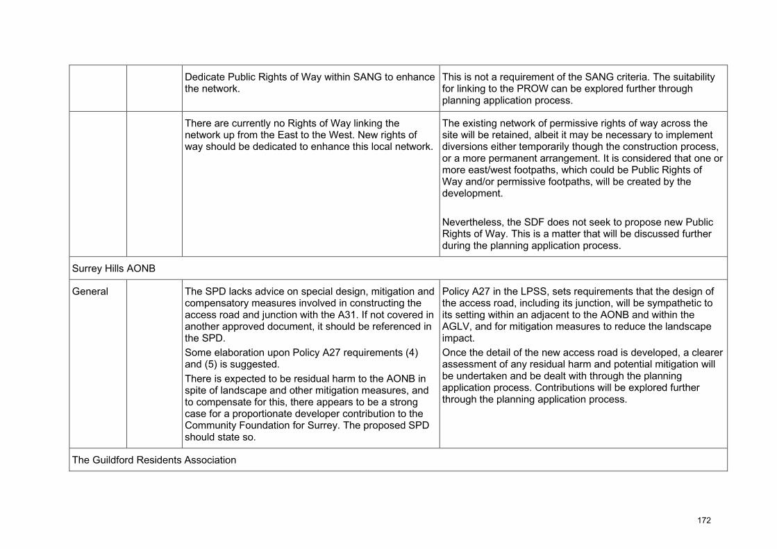
Dedicate Public Rights of Way within SANG to enhance the network.
This is not a requirement of the SANG criteria. The suitability for linking to the PROW can be explored further through planning application process.
There are currently no Rights of Way linking the network up from the East to the West. New rights of way should be dedicated to enhance this local network.
The existing network of permissive rights of way across the site will be retained, albeit it may be necessary to implement diversions either temporarily though the construction process, or a more permanent arrangement. It is considered that one or more east/west footpaths, which could be Public Rights of Way and/or permissive footpaths, will be created by the development. Nevertheless, the SDF does not seek to propose new Public Rights of Way. This is a matter that will be discussed further during the planning application process.
Surrey Hills AONB
General The SPD lacks advice on special design, mitigation and compensatory measures involved in constructing the access road and junction with the A31. If not covered in another approved document, it should be referenced in the SPD. Some elaboration upon Policy A27 requirements (4) and (5) is suggested. There is expected to be residual harm to the AONB in spite of landscape and other mitigation measures, and to compensate for this, there appears to be a strong case for a proportionate developer contribution to the Community Foundation for Surrey. The proposed SPD should state so.
Policy A27 in the LPSS, sets requirements that the design of the access road, including its junction, will be sympathetic to its setting within an adjacent to the AONB and within the AGLV, and for mitigation measures to reduce the landscape impact. Once the detail of the new access road is developed, a clearer assessment of any residual harm and potential mitigation will be undertaken and be dealt with through the planning application process. Contributions will be explored further through the planning application process.
The Guildford Residents Association
172
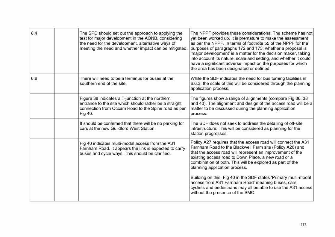
6.4 The SPD should set out the approach to applying the test for major development in the AONB, considering the need for the development, alternative ways of meeting the need and whether impact can be mitigated.
The NPPF provides these considerations. The scheme has not yet been worked up. It is premature to make the assessment as per the NPPF. In terms of footnote 55 of the NPPF for the purposes of paragraphs 172 and 173, whether a proposal is ‘major development’ is a matter for the decision maker, taking into account its nature, scale and setting, and whether it could have a significant adverse impact on the purposes for which the area has been designated or defined.
6.6 There will need to be a terminus for buses at the southern end of the site.
While the SDF indicates the need for bus turning facilities in 6.6.3, the scale of this will be considered through the planning application process.
Figure 38 indicates a T-junction at the northern entrance to the site which should rather be a straight connection from Occam Road to the Spine road as per Fig 40.
The figures show a range of alignments (compare Fig 36, 38 and 40). The alignment and design of the access road will be a matter to be discussed during the planning application process.
It should be confirmed that there will be no parking for cars at the new Guildford West Station.
The SDF does not seek to address the detailing of off-site infrastructure. This will be considered as planning for the station progresses.
Fig 40 indicates multi-modal access from the A31 Farnham Road. It appears the link is expected to carry buses and cycle ways. This should be clarified.
Policy A27 requires that the access road will connect the A31 Farnham Road to the Blackwell Farm site (Policy A26) and that the access road will represent an improvement of the existing access road to Down Place, a new road or a combination of both. This will be explored as part of the planning application process. Building on this, Fig 40 in the SDF states ‘Primary multi-modal access from A31 Farnham Road’ meaning buses, cars, cyclists and pedestrians may all be able to use the A31 access without the presence of the SMC.
173
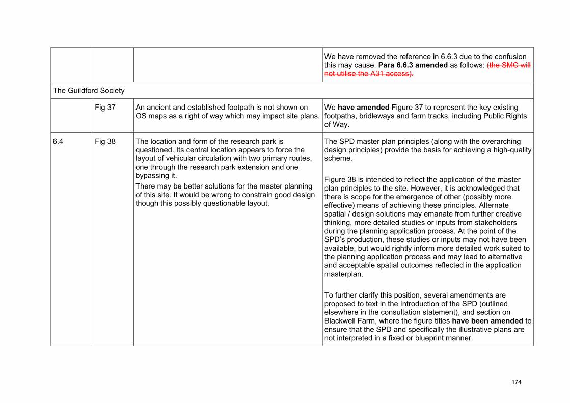
We have removed the reference in 6.6.3 due to the confusion this may cause. Para 6.6.3 amended as follows: (the SMC will not utilise the A31 access).
The Guildford Society
Fig 37 An ancient and established footpath is not shown on OS maps as a right of way which may impact site plans.
We have amended Figure 37 to represent the key existing footpaths, bridleways and farm tracks, including Public Rights of Way.
6.4 Fig 38 The location and form of the research park is questioned. Its central location appears to force the layout of vehicular circulation with two primary routes, one through the research park extension and one bypassing it. There may be better solutions for the master planning of this site. It would be wrong to constrain good design though this possibly questionable layout.
The SPD master plan principles (along with the overarching design principles) provide the basis for achieving a high-quality scheme. Figure 38 is intended to reflect the application of the master plan principles to the site. However, it is acknowledged that there is scope for the emergence of other (possibly more effective) means of achieving these principles. Alternate spatial / design solutions may emanate from further creative thinking, more detailed studies or inputs from stakeholders during the planning application process. At the point of the SPD’s production, these studies or inputs may not have been available, but would rightly inform more detailed work suited to the planning application process and may lead to alternative and acceptable spatial outcomes reflected in the application masterplan. To further clarify this position, several amendments are proposed to text in the Introduction of the SPD (outlined elsewhere in the consultation statement), and section on Blackwell Farm, where the figure titles have been amended to ensure that the SPD and specifically the illustrative plans are not interpreted in a fixed or blueprint manner.
174
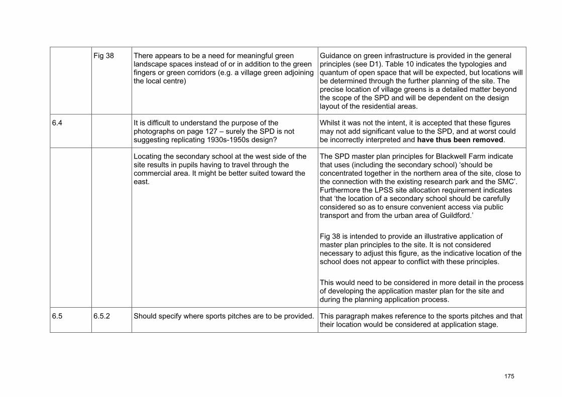
Fig 38 There appears to be a need for meaningful green landscape spaces instead of or in addition to the green fingers or green corridors (e.g. a village green adjoining the local centre)
Guidance on green infrastructure is provided in the general principles (see D1). Table 10 indicates the typologies and quantum of open space that will be expected, but locations will be determined through the further planning of the site. The precise location of village greens is a detailed matter beyond the scope of the SPD and will be dependent on the design layout of the residential areas.
6.4 It is difficult to understand the purpose of the photographs on page 127 – surely the SPD is not suggesting replicating 1930s-1950s design?
Whilst it was not the intent, it is accepted that these figures may not add significant value to the SPD, and at worst could be incorrectly interpreted and have thus been removed.
Locating the secondary school at the west side of the site results in pupils having to travel through the commercial area. It might be better suited toward the east.
The SPD master plan principles for Blackwell Farm indicate that uses (including the secondary school) ‘should be concentrated together in the northern area of the site, close to the connection with the existing research park and the SMC’. Furthermore the LPSS site allocation requirement indicates that ‘the location of a secondary school should be carefully considered so as to ensure convenient access via public transport and from the urban area of Guildford.’ Fig 38 is intended to provide an illustrative application of master plan principles to the site. It is not considered necessary to adjust this figure, as the indicative location of the school does not appear to conflict with these principles. This would need to be considered in more detail in the process of developing the application master plan for the site and during the planning application process.
6.5 6.5.2 Should specify where sports pitches are to be provided. This paragraph makes reference to the sports pitches and that their location would be considered at application stage.
175
6.6 There should be more detail on how the proposed Guildford West station will be accessed through the research park and what facilities will be provided. The station appears constrained – will there be room for bike stations, drop off’s, access. Bus route passing the station needed to link with Egerton Road, instead of Gill Avenue.
The adopted local plan includes site allocation A28 for a new station at Guildford West (Park Barn). The Council’s Corporate Programmes Team is progressing the development of the proposal for this new railway station, following Network Rail’s GRIP process. The Council has commissioned a GRIP 3/4 study, following the previous GRIP1 and GRIP2 stage work which has been accepted by Network Rail. The incorporation and the design of Station facilities has been and will continue to be considered as part this process. Whist the SDF does not seek to fix the route of the SMC off site, the council is now minded to realise a priority route for buses and cyclists through the Research Park which is separate from that available to general traffic. Buses and cyclists would be provided for by the north and eastern loop via Occam Road, providing close interchange with the new Guildford West (Park Barn) station, whilst general traffic from Blackwell Park is catered for on the southern loop via Priestly Road, with this southern loop to also provide continuous, segregated cycle tracks. Research park occupiers on Occam Road would continue to enjoy vehicular access to and from the entrance to the research park whilst the through movement from Blackwell Park for buses, cyclists and pedestrians only would be provided by modal filter/bus gate and/or bus priority. There are potential alternative routes available to the site promoter to achieve vehicular access from the site to Egerton Road. A route ‘via Gill Avenue’ is preferred.
There does not appear to be room for the SMC to run through the research park.
While the SDF indicates the need for bus turning facilities in 6.6.3, the scale of this will be considered through the planning application process.
176

The plan should ensure space for SMC termination in the form of a turnaround area.
While the SDF indicates the need for bus turning facilities it would be inappropriate to state what scale this would be. This will be determined through the planning application process.
Will routes through the UniS require adoption by the Local Highway Authority?
The SDF sets out guidance as opposed to requirements. However the Council’s starting position is that existing off-site privately controlled sections of highway, between the eastern site access and Egerton Road (currently a publicly adopted road), should be publicly adopted roads in order to ensure in perpetuity that there is public access to Blackwell Park including the proposed schools on site and public bus services.
The A31 junction should opt for left in left out access, with no right turn from the east and only exit easterly with a roundabout. There may be no need for a fully signalised junction.
Policy A27 in the adopted Local Plan, allocates land for the access road between A31 Farnham Road and Blackwell Farm. The policy requires (requirement (3)) that the junction of the access road with the A31 Farnham Road will be signalised. The Council envisages that the signalised junction will provide for all vehicle movements to be made. The design of the junction and the access road will be considered further as part of the planning application process.
6.10 It is unclear what is expected in terms of housing design Design codes would address housing design (within the context provided by the Local Plan and SPD) and this would be determined as part of the planning application process. (see figure 66 in the SDP)
6.10.1 With higher densities advocated, there should be a vision to adopt the best examples from other places across Europe, there are few if any examples within Guildford. A vague statement that others should be examined for relevance is insufficient.
It is considered that para 6.10.1 already provides scope for this to occur by referring to ‘other places.’
Compton Parish Council
177
6.3 6.3.2 The development should not be inspired by new modern, hi-tech research facilities at the research park. The site is on the foothills of the Hog’s Back (highly attractive landscape setting) and the style of the buildings should be in keeping with other villages on the Hog’s Back. It should not become suburban sprawl and adopt the 1950s architecture of Onslow Village shown on page 127 of the SDF or the 1980s architecture of Park Barn, nor inspired by the low density and low quality buildings on the research park. Further the white and glazed facades of the research park are reflective and obtrusive and do not blend into the landscape and should be avoided.
The SPD indicates it that it ‘could be’ inspired in part by these reference (and does not require it). The design of the development will be explored through the master planning and design review panel processes. It is considered beyond scope of SPD to determine the detail of design beyond principles. A design code will also be established (see Figure 66).
Whilst it was not the intent, it is accepted that these figures may not add significant value to the SPD, and at worst could be incorrectly interpreted and have thus been removed. It is further noted that the LPSS at Policy D1(5) – that the sites must create their own identify to ensure cohesive and vibrant neighbourhoods.
The visual impact of proposals will considered as part of application process and LVIA which will inform proposals in this regard.
6.4.4 Support the east west open space, but the green corridors should follow the existing medieval hedgerows, and existing field patterns should be retained as much as possible in the planning of groups of housing.
It is considered that para 6.3.1 already references hedgerows (along with other landscape features) and the masterplan response to their presence. The retention of hedgerows (and other green infrastructure) is also referenced in the general design principles at para 3.4.5 and 3.4.7.
Further screening between the development and community at Down Place should be included.
It is considered that the general design principles already address the point regarding adjacent uses (see para 3.2.26). The SPD does not address all detailed aspects of the site design and informants and the detail of this interface / design response will need to be considered as part of the planning application process within the broader guidance provided.
6.4.7 An existing network of permissive rights of way across the site should be retained.
The existing network of permissive rights of way across the site will be retained, albeit it may be necessary to implement diversions either temporarily though the construction process,
178
or a more permanent arrangement. It is considered that one or more east/west footpaths, which could be Public Rights of Way and/or permissive footpaths, will be created by the development.
Fig 38 The 15m buffer zone to protect ancient woodland should be increased to 50m circumnavigating the entire woodland. The woodland trust guidance should be followed and this would be consistent with the 50m buffer to the east of the woodland as per the previous LP. The NE guidance is under review.
The current Natural England / national guidance in relation to ancient woodlands is that a buffer zone of at least 15m should be applied. The previously suggested advice of 50m was subsequently removed from their guidance.
6.5 6.5.1 / Fig 38 / 39
Ancient woodland should not be designated as SANG. This designation is incongruent with the NPPF’s policies and at odds with Natural England’s guidance, which seeks to avoid sites of high nature conservation value. The additional recreational use would exert pressure on this sensitive woodland. The University has landholdings to the west of the site which could be designated as SANG, which could also protect from further development encroachment. Access to the ancient woodland should be allowed but this should be carefully managed. Existing public recreation land being used as SANG is unlawful.
Natural England are consulted on all SANG proposals. SANGs that include Ancient Woodland are acceptable where appropriate management practices are proposed that would prevent harm to the sensitive habitat. It is not unlawful to use existing public recreation land as SANG. Natural England's SANG guidelines explicitly allow for SANGs to be brought forward on recreation land as long as the existing use is taken into account and the space is improved through improved access and/or improvements to the quality of the land.
6.6 References are made to “Controlled access to Surrey Research Park and the wider road network” and “means of controlling vehicular access through the site will be agreed prior to the commencement of development.” Further detail required as to who would be entitled to use the new road, whether it will be
The SDF reflects the requirement in the Local Plan Policy A26, Requirement 3 that a through vehicular link which will be controlled is required via the above accesses between the A31 Farnham Road and Egerton Road to provide a new route for employees and emergency services to the Surrey Research Park, the University of Surrey’s Manor Park campus and the Royal Surrey County Hospital, as well as a choice of vehicular access for the new residents/occupiers.
179
adopted by SCC and how/by whom the usage will be controlled. Question the practicality of controlling access through 2 points. Concern that the access route linking the A31 to wider Guildford will be used as a shortcut. A thorough traffic study, considering the changes and their potential impact should be undertaken and made public.
The suggested use of ANPR systems or ticketed barriers have been replaced with ‘street design’ restrictions and ‘monitor and manage’. This should be agreed ASAP as it seems there are no acceptable solutions to date or they would be included in this document.
Require reassurance that access to the Hospital will not be further impeded at peak hours, and would recommend that GBC commission detailed traffic modelling to determine the level of traffic that can be accommodated along Gill Avenue with all mitigation measures in place, as requested by the Inspector during the EIP. The Mott MacDonald report ‘Study of Performance of A3 Trunk Road Interchanges in Guildford Urban Area to 2024 Under Development Scenarios’, April 2018 (paragraph 5.3.4), shows a 94.5% saturation of the queuing space between the Tesco roundabout and the Egerton crossroads when just 150 homes are built. Over 85% saturation means that overcapacity and junction failure is a real risk.
The nature of the controls required for the controlled access can be determined through the planning application process and secured with appropriate planning conditions and/or obligations. There are various practical ways in which controlled vehicular links have been implemented. Figure 40 has been revised to indicate that there are a range of potential approaches to achieve control, for instance: through street design measures and/or differentiated routing, with a short privately controlled section for permit holders with barriers or Automatic Number Place Recognition technology, and with routing of buses through a bus gate/modal filter on the adopted highway and/or barrier control and/or ‘monitor and manage’. In terms of road adoption, the Council’s starting position is that, as a minimum, the Primary Street through the development should be publicly adopted, except potentially for a short privately controlled section in which the ANPR control could be sited. It might also be appropriate for there to be a short parallel publicly adopted link here for bus use only, controlled by a bus gate and/or modal filter. This would ensure in perpetuity that there is public access to Blackwell Park including the proposed schools on site and public bus services. If the control of the through vehicular link was by way of ANPR, then the council envisages that this would be implemented by way of a short privately controlled section in which the ANPR could be sited, rather than at the accesses to the development. The transport strategy for the Local Plan and the Blackwell Farm site allocation was considered by the Inspector as part of
180

SDF does not allow for freedom of movement i.e. anyone can use the facilities on site and vice versa.
No information relating to the impact of the estate and its facilities on the wider community. A detailed traffic study should be undertaken.
his examination of the Local Plan. The Plan was found to be sound and has been adopted. All these matters will be considered through the planning application process, specifically thought the preparation of the Transport Assessment.
Sufficient parking will be required at Park Barn The SDF does not seek to address the detailing of off-site infrastructure. This will be considered as planning for the station progresses.
6.10 6.10.1 Densities should be applicable to urban rather than suburban forms to ensure responsible use of the former green belt and countryside. With higher density development it would be possible to provide sports pitches within the site allocation.
The SDF does not preclude higher densities. The landscape framework assumes that secondary school playing fields will be accommodated off site (as an appropriate use in the green belt) and in line with Local Plan Policy A26 requirement (11). Para 6.5.2 makes reference to the sports pitches and that their location would be considered at application stage.
General If the A3 widening does not go ahead, Blackwell Farm will not be viable.
Whilst the Local Plan was prepared on the assumption that the A3 Guildford scheme would be delivered, the plan anticipates the possibilities of delay, reduction in scope or the cancellation of the scheme, with a course of action to address this eventuality described in Local Plan Policy ID2. This will involve GBC – with input from SCC and Highways England as appropriate – reviewing its transport evidence base to investigate the consequent cumulative impacts of approved development and Local Plan growth including site allocations on the safe operation and the performance of the Local Road Networks and Strategic Road Network. In particular, this review will determine whether the proposed transport measures or additional transport measures can mitigate the cumulative impacts of development traffic on the A3.
181
The first tranche of houses should be capable of being a stand-alone development due to the timescales for build out of the site.
It is considered that this is addressed in Para 9.7.2, which provides an expectation that developers submit a phasing strategy and phasing plans which should be in accordance with the set of principles outlined. The SPD does not attempt to set the phasing of development.
Worplesdon Parish Council
6.1 6.1.2 It is not clear what opportunities to integrate the new community at Blackwell Farm with existing residential areas means. There is a public right of way no. 446 (along the back of Applegarth Ave) which would enable integration by foot and bicycle. Improvements to other rights of way and cyclepaths are needed.
Paragraph 6.1.2 has been amended as follows: ‘…and consequently opportunities to improve existing pedestrian and cycle connections between integrate the new community at Blackwell Farm with and existing residential areas should be explored and optimised through the planning process.’ Figures 38, 39 and 41 have been revised. These show existing Public Rights of Way 446, 447, 447A and 479 which provide connections between the site and Wood Street Village, as well as with the Christmas Pie Trail. Opportunities to improve existing routes will be considered as part of the planning application process.
6.2.2 What further improvements are needed to ensure patients attending the hospital are not adversely impacted due to traffic congestion?
The site policy in the Local Plan sets out requirements for the transport strategy for the site. The Plan was found to be sound and has been adopted. The Local Plan also provides the planning policy framework to allow for the consideration of potential additional mitigation either through the development management process for planning applications, having regard particularly to Policy ID3 at point (6), or through any updates to the Infrastructure Schedule provided in the latest Guildford borough Infrastructure Delivery Plan, as provided for in Policy ID1 at point (5) and in Policy ID3 at point (7).
182
6.4 Fig 37 Should include the bridleways We have amended Figure 37 to represent the key existing footpaths, bridleways and farm tracks, including Public Rights of Way. The label in the key has been amended to “Key existing footpaths, bridleways and farm tracks”.
6.4 6.4.5 This paragraph must include: “The surface water management plan must ensure the hydrology of Whitmoor Common (Special Protection Area/Site of Special Scientific Interest/Local Nature Reserve) is preserved and protected.”
It is not considered that this reference is necessary in the context of the role of this SPD. The planning application will be accompanied by an Environmental Statement to assess impacts and a surface water drainage strategy.
G-BUG
Fig 41 1) A bridge/subway should be included in proposals for Guildford West Rail Station as well as generous secure cycle storage.
2) The improvement to Manor Way using the
existing foot bridge over the A3 is welcome as this currently displays a ‘cyclists dismount’ sign which would need to be changed. This connection also provides an alternative route to reach the main station via Onslow Village.
3) The map should indicate that it is possible to
reach the ‘Active Travel Route along the Hogs Back’ via a small passageway at the western end of High View Road.
4) The ‘Active Travel Route along the Hogs Back’
should also be labelled as ‘National Cycle Network Route 22’, which provides a relatively quiet connecting route to Farnham
1) The Council’s Corporate Programmes Team is progressing the development of the proposal for this new railway station, following Network Rail’s GRIP process. The Council has commissioned a GRIP 3/4 study, following the previous GRIP1 and GRIP2 stage work which has been accepted by Network Rail. The incorporation and the design of Station facilities has been and will continue to be considered as part this process. The Engineering Feasibility Report, prepared for the GRIP2 stage, proposed that a new footbridge is intended as the means of crossing between the platforms. Further information on this study work is provided in Appendix 4 of the Topic Paper: Transport (2017). Further, Network Rail’s Investment in Stations: A guide for promoters and developers (2017) states that, for a new rail station, ‘a footbridge is likely to be required as a minimum’ (p16).
183
5) The ‘Christmas Pie Trail’ coming into Applegarth
Avenue should be added to the map. As shown on the map, there is an existing connection to the Trail from Blackwell Farm via a path using a subway under the railway, making a useful green route through to Normandy and Ash. Developer money should be sought from this development to improve the Christmas Pie Trail.
6) Access must be negotiated for any cycle routes crossing the private Surrey Research Park.
7) The Active Travel Network is shown extending
up to the new access from the ‘improved junction’ with the A31/A3. The opportunity must be taken to facilitate safe passage for cyclists to reach the southern side (eg NCN22 down to Compton and onward to Farnham)
The details of the Rail Station will be considered as planning for the station progresses and would be subject to a planning application process.
2) This is a detailed matter which could be considered as
part of the planning application process.
3) This connection has been added to Figure 41.
4) The NCN 22 has been labelled to accurately reflect the route’s status.
5) The Christmas Pie Trail been added to the figures. With respect to contributions towards improvement works, the site policy A26 requires, as part of the transport strategy, ‘Permeability for pedestrians and cyclists into and from the development’. Further to this, scheme AM2 ‘Comprehensive Guildford borough cycle network, excluding AM3’ is proposed to be developed along the principles set out in Surrey County Council’s Guildford Local Cycling Plan (Surrey County Council, undated circa 2015), as described in the Topic Paper: Transport (2017). Policy ID2 Sustainable transport for new developments, at point (2) (c), also provides direction that new developments will be required, in so far as its site’s size, characteristics and location allow, to maximise the improvement of existing cycle and walking routes to local facilities, services, bus stops and railway stations, to ensure their effectiveness and amenity.
184
6) The Council’s starting position is that existing off-site privately controlled sections of highway, between the eastern site access and Egerton Road (currently a publicly adopted road), should be publicly adopted roads in order to ensure in perpetuity that there is public access to Blackwell Park including the proposed schools on site and public bus services.
7) Policy A27 includes land for an access road connecting A31 Farnham Road to the Blackwell Farm site (Policy A26). Within this, the design of the access road, including its junction, will take into account the needs of all users, including walkers and cyclists as well as vehicles entering and leaving the site. This is a matter which will be developed further through the planning application process.
Stagecoach
6.6 Possibility to maximise the ability of bus services such as Stagecoach service 65 to enter the site from the A31 and using the SMC. This would offer a relevant public transport option from Farnham and intermediate points to the Research Park, University and Hospital that today can credibly be reached only by car, using some of the most congested sections of the A3 within the Borough.
The new signalised junction between the access road and the A31 Farnham Road is identified in Figure 40 in the SDF as ‘Primary multi-modal access from A31 Farnham Road’ meaning buses, cars, cyclists and pedestrians may all be able to use the A31 access. We have removed the reference in 6.6.3 that ‘(the SMC will not utilise the A31 access)’ due to the confusion this may cause.
Aligning the SMC along the same corridor as the road, handling potentially quite high traffic volumes, magnifies the urban design and traffic management challenges, as we have discussed. There is potential for the designation of a second parallel corridor through the allocation as the SMC, with seamless bus priority along
The Council has reviewed the guidance in the SDF on the provision for buses, including the SMC, on and immediately adjacent to the strategic sites. This is as a result of responses and evidence provided with respect to potential adverse visual impacts, reduction in development densities and reduced developer contributions, colonisation of generous street widths
185
a logical and direct route achieved through less intensively engineered features. We would suggest that short lengths of bus lanes, or a succession of 3 of more bus "plugs", or both, would have the effect of creating a "quietway" SMC for buses, perhaps with a parallell high-standard cycling corridor. All parking would be provided off the carriageway along the route, in the form of parallel parking bays, likely to be provided with intervening street trees and planting. There would be no direct frontage access which would lead to individual private drives, and cars would enter and exit side roads and shared private drives and courts only in forward gear. Great care should be taken to ensure that delivered to frontages could be effected without blocking the SMC. Urban clearway markings might be used to prevent all loading in the carriageway.
by the parked vehicles of early residents, leading to subsequent decisions not to implement bus lanes. The guidance that segregated and continuous bus lanes be provided for the exclusive use of buses on the primary streets as they run through the strategic sites has been modified, see section 3.3 (C4 and C5). Segregated bus lanes and/or bus gates/modal filters would only be required in congestion hotspot locations, including at site accesses, where queuing traffic in peak periods might be expected to delay buses on the primary streets. In cases where it is agreed that there is significant uncertainty as to the need for and/or extent of such bus priority measures in future years, there is potential for the incorporation of a reserve strip allowing later provision to be implemented at agreed triggers if necessary. This has been accompanied by modified guidance to protect primary streets from being colonised by overspill parking, for instance by the street design incorporating parking bays, including those suitable for deliveries, appropriately landscaped. Alternatively, the SDF also now allows that, consideration could be given to the potential for a route through the site to be provided for buses, separate from the primary street. This could utilise a series of secondary roads connected by bus gates or modal filters, so long as such a route provides good accessibility to the bus services.
The SMC should avoid passing near the main pedestrian access to any schools unless this in the form of an enforceable section of a bus-only road.
Paragraph 3.3.30 has been amended to highlight that segregated bus lanes and/or bus gates/modal filters will be required in congestion hotspot locations, including at site access, where queuing traffic in peak periods might be expected to delay buses on the primary streets. This could include sections of SMC in the vicinity of the Primary School.
186
We have also amended paragraph 3.3.21 to highlight the opportunity for non-motorised streets.
The delivery of an effective SMC through the site is certainly essential but must also run through to equivalent measures delivered off-site, suitably early. We would urge that the phasing of delivery of the SMC is agreed and is secured robustly, by condition
The site Policy in the Local Plan: Strategy and Sites requires, as requirement (4), The provision of the western route section of the Sustainable Movement Corridor on-site, and a necessary and proportionate contribution to delivering the western route section off-site. The Sustainable Movement Corridor will be a multi-modal route which, depending on the location, provides separate lanes for bus, cycle and pedestrians, and the use of bus priority measures at congested sections of the highway and at interchanges. Policy ID1(1) of the Local Plan states: ‘Infrastructure necessary to support new development will be provided and available when first needed to serve the development’s occupants and users and/or to mitigate its otherwise adverse material impacts.’ Policy ID1 of the Local Plan also requires both that, at (3) 'When determining planning applications, and attaching appropriate planning conditions and/or planning obligations, regard will be had to the delivery and timing of delivery of the key infrastructure, or otherwise alternative interventions which provide comparable mitigation' and, at (4), 'The imposition of Grampian conditions shall be considered as a means to secure the provision of infrastructure when it is needed. If the timely provision of infrastructure necessary to support new development cannot be secured in line with this policy, planning permission will be refused'.
Cllr Ramsey Nagaty
187
6.1 6.1.2 It is not clear what exploring opportunities to integrate with existing residential areas means in the context of the site.
Paragraph 6.1.2 has been amended as follows: ‘…and consequently opportunities to improve existing pedestrian and cycle connections between integrate the new community at Blackwell Farm with and existing residential areas should be explored and optimised through the planning process.’
The AONB should be mentioned in relation to the new link to the A31.
Policy A27 in the LPSS sets requirements that the design of the access road, including its junction, will be sympathetic to its setting within an adjacent to the AONB and within the AGLV, and for mitigation measures to reduce the landscape impact. Once the detail of the new access road is developed, a clearer assessment of any residual harm and potential mitigation will be undertaken and be dealt with through the planning application process.
6.5.2 / Fig 38 / 39
The SANG should not be located on ancient woodland. It should be located to the west of the site.
Natural England are consulted on all SANG proposals. SANGs that include Ancient Woodland are acceptable where appropriate management practices are proposed that would prevent harm to the sensitive habitat. It is not unlawful to use existing public recreation land as SANG. Natural England's SANG guidelines explicitly allow for SANGs to be brought forward on recreation land as long as the existing use is taken into account and the space is improved through improved access and/or improvements to the quality of the land.
Inadequacy of 15m buffer to protect woodland The current Natural England / national guidance in relation to ancient woodlands is that a buffer zone of at least 15m should be applied.
6.4 Fig 36 Views from to the east from the main access road should be protected, as this will become the only place to see the cathedral rising from a rural setting.
The visual impact of proposals will considered as part of application process and LVIA which will inform proposals in this regard.
188
Existing properties have not been considered and should be included on maps with a buffer.
It is considered that the general design principles already address the point regarding adjacent uses (see para 3.2.26). The SPD does not address all detailed aspects of the site design and informants and the detail of this interface / design response will need to be considered as part of the planning application process within the broader guidance provided.
6.4.2 The reference to policy constraints does not specify the AONB / AGLV designation
Policy A27 in the LPSS, sets requirements that the design of the access road, including its junction, will be sympathetic to its setting within an adjacent to the AONB and within the AGLV, and for mitigation measures to reduce the landscape impact. Once the detail of the new access road is developed, a clearer assessment of any residual harm and potential mitigation will be undertaken and be dealt with through the planning application process.
Fig 38 An existing green corridor to the south of the field at the southernmost part of the proposed housing development should be incorporated.
The figure is illustrative. The final design will define the location and extent of green corridors taking into account detailed LVIA and other informants and achieving the Local Plan policy requirements.
The photos (page 127) are misleading. Whilst it was not the intent, it is accepted that these figures may not add significant value to the SPD, and at worst could be incorrectly interpreted and have thus been removed.
Green space / playing fields should not allow buildings (changing rooms or leisure centres).
Any development off site (in the Green Belt) would need to be in accordance with Green Belt policy.
6.4.7 An existing network of permissive rights of way across the site should be retained.
The existing network of permissive rights of way across the site will be retained, albeit it may be necessary to implement diversions either temporarily though the construction process, or a more permanent arrangement.
189
6.6 It is not clear how access can be controlled through the points of access to a large development with two schools, a community centre and an extended business park. The route linking the A31 to the wider Guildford will be used as a short cut. The suggestions by the University of ANPR or ticketed barriers now have been replaced by ‘street design’ and ‘monitor and manage.’ It appears access management has not been thought through. This should not be postponed until just before commencement of development. It appears as if there are no acceptable solutions or they would be in this document.
The SDF reflects the requirement in the Local Plan Policy A26, Requirement 3 that a through vehicular link which will be controlled is required between the A31 Farnham Road and Egerton Road to provide a new route for employees and emergency services to the Surrey Research Park, the University of Surrey’s Manor Park campus and the Royal Surrey County Hospital, as well as a choice of vehicular access for the new residents/occupiers. The nature of the controls required for the controlled access can be determined through the planning application process and secured with appropriate planning conditions and/or obligations. There are various practical ways in which controlled vehicular links have been implemented. Figure 40 has been revised to indicate that there are a range of potential approaches to achieve control, for instance: through street design measures and/or differentiated routing, with a short privately controlled section for permit holders with barriers or Automatic Number Place Recognition technology, and with routing of buses through a bus gate/modal filter on the adopted highway and/or barrier control and/or ‘monitor and manage’. If the control of the through vehicular link was by way of ANPR, then the council envisages that this would be implemented by way of a short privately controlled section in which the ANPR could be sited, rather than at the accesses to the development.
Concern about access to the Hospital and that this will be impeded at peak periods. Modelling is required to ensure traffic can be accommodated on Gill Avenue. The Mott MacDonald study references the risk of
The transport strategy for the Local Plan and the Blackwell Farm site allocation was considered by the Inspector as part of his examination of the Local Plan. The Plan was found to be sound and has been adopted.
190
overcapacity between the Tesco roundabout and Egerton road crossroads.
All these matters will be considered through the planning application process, specifically thought the preparation of the Transport Assessment.
There is a need to mitigate impacts on Compton and Shalford (AQMA) due to more traffic on the B3000.
AECOM undertook an Air Quality Review of Guildford Borough Proposed Submission Local Plan: Strategy and Sites “June 2017” (June 2017). This was a qualitative-risk based review, which considered the risk of significant air quality effects (in terms of annual mean concentrations of NO2, PM10 and PM2.5) occurring with the implementation of the Draft Local Plan 2017. Consideration of risk was based on the size and nature of anticipated developments, their location, ambient air quality around potential developments and the locations of sensitive receptors to air quality around potential developments (including residential properties, schools and hospitals). The findings suggest that the effect of the then Draft Local Plan on annual mean NO2 concentrations will be negligible and not a key constraint on development in the majority of the borough. Further, detailed modelling was recommended as being advisable around roads where notable changes in traffic flows are predicted, at locations in close proximity to sensitive receptors; albeit in each case it was considered unlikely that these development-related increases would lead to an exceedance of the air quality objective.
For particulate matter – both PM10 and PM2.5 – negligible effects are anticipated at all sensitive receptors for air quality.
It was also recommended that the findings of the Air Quality Review be confirmed as part of the planning application processes for specific sites. Accordingly potential air quality issues have been added as a ‘key consideration’ including for policy A26 Blackwell Farm.
191
Sufficient parking is needed at the proposed new station or residential roads will be used by commuters for parking.
The SDF does not seek to address the detailing of off-site infrastructure. This will be considered as part of the planning application process for Guildford West (Park Barn) Rail Station.
The cycle path incorporates utilisation of a private road and right of way for residents’ access (Down Place). The route also goes straight up a field which is too steep and leads to the A31 which would need to be crossed to join the proposed path through the mount to Guildford.
The site policy A27: Land for access road between A31 Farnham Road and Blackwell Farm allows for an appropriate design solution to be developed as part of the planning application process. There are potentially various options for the alignment and design of the access road. The SDF provides illustrative guidance and the alignment will be considered through the planning application process. Figures 38 and 39 have been amended with reference in the legend to the cycle/ped access within A27 allocation.
There are no cycling, walking or transport links to the West and Christmas Pie / Wanborough.
The Christmas Pie Trail has been added to the maps to highlight this connection. At present, there is a permissive bridleway running west from the site towards Flexford Lane. The landowner has granted permission for the route to be used by the public, but they also have the right to withdraw that permission if they choose. The landowner could also choose to change the routeing. Opportunities to create routes across the site will be explored in the preparation of a masterplan for the site (by the developer) and its consideration in the planning application process. It is possible that the existing permissive bridleway, or a variant of this, might form part of a pedestrian/cycle connection towards Wanborough.
Initial housing should be located close to the employment and transport hubs.
It is considered that this is addressed in Para 9.7.2, which provides an expectation that developers submit a phasing strategy and phasing plans which should be in accordance
192
with the set of principles outlined. The SPD does not attempt to set the phasing of development.
Infrastructure delivery concerns including for water and waste water, as well as transport (A3 widening). If the A3 widening does not go ahead, the development will not be viable.
It is considered that Policy ID1 addresses policy issues around the securing delivery of infrastructure. Furthermore, whilst the Local Plan was prepared on the assumption that the A3 Guildford scheme would be delivered, the plan anticipates the possibilities of delay, reduction in scope or the cancellation of the scheme, with a course of action to address this eventuality described in Local Plan Policy ID2. This will involve GBC – with input from SCC and Highways England as appropriate – reviewing its transport evidence base to investigate the consequent cumulative impacts of approved development and Local Plan growth including site allocations on the safe operation and the performance of the Local Road Networks and Strategic Road Network. In particular, this review will determine whether the proposed transport measures or additional transport measures can mitigate the cumulative impacts of development traffic on the A3.
Objection to the suggestion that development should be inspired by the new modern, hi-tech research facilities at the research park. The site is on the foothills of the Hog’s Back (highly attractive landscape setting) and the style of the buildings should be in keeping with other villages on the Hog’s Back.
The SPD indicates it that it ‘could be’ inspired in part by these reference (and does not require it). The design of the development will be explored through the master planning and design review panel processes. It is considered beyond scope of SPD to determine the detail of design beyond principles. A design code will also be established (see Figure 66).
Densities should be applicable to urban rather than suburban forms to ensure responsible use of the former green belt and countryside. The location of the playing fields north of Wildfield Copse provides screening from the Hog’s Back.
The SDF does not preclude higher densities. The landscape framework assumes that secondary school playing fields will be accommodated off site (as an appropriate use in the green belt) and in line with Local Plan Policy A26 requirement (11). Para 6.5.2 makes reference to the sports pitches and that their location would be considered at application stage.
193
However, with higher densities it would be possible to provide pitches within the site allocation.
Trees and hedges should be protected It is considered that para 6.3.1 already references hedgerows (along with other landscape features) and the masterplan response to their presence. The retention of hedgerows (and other green infrastructure) is also referenced in the general design principles at para 3.4.5 and 3.4.7.
Flooding and subsidence risks have not been addressed. It is important that clean water runs off to the north where it joins SSI.
It is not considered that this reference is necessary in the context of the role of this SPD. The planning application will be accompanied by an Environmental Statement to assess impacts and a surface water drainage strategy.
Cllr Deborah Seabrook
6.6 Fig 41 The cycle paths need to link to Christmas Pie trail. The Christmas Pie Trail has been added to the figure to highlight this connection.
Other respondents
6.3 Fig 36 The AONB should be made more prominent. Lighting will ruin the night sky’s appearance.
The Local Plan Policy A27 at requirement (5) refers to the mitigation measures to reduce the landscape impact including sensitive lighting.
6.4 6.4.4 If buildings on the main thoroughfare are 4-5 storeys high, how will screening be achieved from the Hog’s Back and other vantage points/public rights of way?
Building heights would be assessed as part of the planning application. Further detail regarding visual impact would be considered in LVIA and detailed master planning. This will be considered alongside relevant policies and the principles contained within SDF.
6.4.5 The proposal downplays the issues arising from hard surfaces to be created. The significant current water retention on site protects those downstream. There is
It is considered that the SPD addresses the need to integrate sustainable urban drainage systems (SuDS) as part of the drainage strategy, which aim to address issues arising from run-off (See A2). Furthermore a surface water drainage
194
no recognition that the site needs to drain under the railway and whether the channels are strong enough.
strategy will be required and this matter will be dealt with in greater detail as part of the planning application process.
6.6 The access to the A31 will be used as a shortcut and a thorough study on traffic impacts should take place and be made public.
Policy A26, Requirement 3 is that a through vehicular link will be required to be controlled. Evidence was presented by the council as part of the Local Plan examination which was found to be sound and has been adopted. The transport strategy for the site, including the through vehicular link, will be considered and assessed as part of the planning application process.
6.6.3 If the bus must be turned as indicated, can other vehicles travel all the way through from the north entry to the west entry. How would this be managed and where is the precedent for introducing ANPR on a public highway. Is the structure/foundation of Gill Avenue to standard?
Fig 40 in the SDF shows ‘Primary multi-modal access from A31 Farnham Road’ and ‘Primary multi-modal access from Occam Road. It is anticipated that buses will be able to turn on site and that buses, cars, cyclists and pedestrians may all be able to use the A31 access. The nature of the controls required for the controlled access can be determined through the planning application process and secured with appropriate planning conditions and/or obligations. There are various practical ways in which controlled vehicular links have been implemented. Figure 40 has been revised to indicate that there are a range of potential approaches to achieve control, for instance: through street design measures and/or differentiated routing, with a short privately controlled section for permit holders with barriers or Automatic Number Place Recognition technology, and with routing of buses through a bus gate/modal filter on the adopted highway and/or barrier control and/or ‘monitor and manage’. If the control of the through vehicular link was by way of ANPR, then the council envisages that this would be implemented by way of a short privately controlled section in
195
which the ANPR could be sited, rather than at the accesses to the development. All these matters will be considered through the planning application process, specifically though the preparation of the Transport Assessment.
The Council’s starting position is that existing off-site privately controlled sections of highway, between the eastern site access and Egerton Road (currently a publicly adopted road), should be publicly adopted roads in order to ensure in perpetuity that there is public access to Blackwell Park including the proposed schools on site and public bus services. Surrey County Council as the Local Highway Authority is able to adopt private roads, providing they meet its adoption criteria.
6.6.5 The means of controlling access to the site should be decided now.
The nature of the controls required for the controlled access can be determined through the planning application process and secured with appropriate planning conditions and/or obligations.
6.6.8 / Fig 41
Scale of figure is misleading and distances to be walked are considerable.
While it is envisaged that day to day services will be located within walking distance from homes, as indicated in paragraph 6.6.2, for journeys that cannot be made by foot or by bicycle, buses should present an obvious and affordable alternative.
A park & ride will only generate more traffic. The schools on site will only generate more traffic at peak times.
The park and ride is already in existence. Paragraph 6.6.8 has been updated to reflect the fact some interventions in the figures exist presently. The site allocation for Blackwell Farm includes a new Primary and Secondary School. The Local Plan has been examined and subsequently adopted. The planning application process
196

will include a transport assessment and will be subject to the policy tests in the NPPF and the Local Plan, specifically Policy ID3, sustainable transport in new developments.
The cycle infrastructure plans should be maintained as a precondition for development.
The Local Plan sets out requirement for the provision and improvement of cycle infrastructure, including in site policy A26 and Policies ID1 and ID3. The SDF provides guidance, including on the cycle infrastructure existing and proposed in the vicinity of the site.
197
07. Ash and Tongham
Section Paragraph Main Issue Summary Response
Prescribed Bodies and Key Stakeholders
Bewley Homes (Neame Sutton Limited)
7.4 7.4.2 It appears that GBC intends for developers to take this responsibility on between themselves, and for GBC not to be party, or co-ordinate or, assist in the delivery of combined open space. This is not a requirement of policy and therefore not reasonable for GBC to require through the planning process. GBC needs to re-consider the delivery of open space co-ordination and whether it is appropriate/achievable to require developers to enter into agreements, prior to application submission or during the course of an application, to provide joint areas of open space without policy support. Furthermore, there are no mechanisms for those with consented schemes to enter into additional agreements. There would thus be an unbalanced burden on delivery of land parcels, in particular, those parties yet to move forward with proposals through the planning process. This has the potential to make schemes coming forward on the remainder of the allocation unviable and consequently undeliverable. The effect of this would be that the allocation would fail to deliver the minimum housing requirement set out in the adopted Local Plan
It is not intended that this reference (to a form of equalisation) was to reflect a requirement. To avoid this impression being created an amendment has been made. Para 7.4.2 amended as follows: The SDF concentrates much of the new open space around Ash Manor to reduce the impact of development on the listed building and its setting. Consequently, the responsibility for strategic open space provision does not fall equally or proportionally across the land ownerships, and it may therefore be necessary for a form of agreement to be in place at the time the applications are submitted to ensure the delivery of the strategic elements indicated in the SDF. Open space provision and required contributions are set out in terms of the Local Plan (2003) and would be sought in line with the statutory tests. The suitability of specific locations for development will need to be justified as part of a planning application.
198
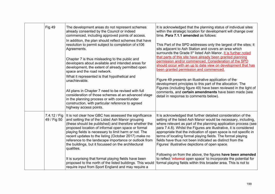
Fig 49 The development areas do not represent schemes already consented by the Council or indeed commenced, including approved points of access. In addition, the plan should reflect schemes that have resolution to permit subject to completion of s106 Agreements. Chapter 7 is thus misleading to the public and developers about available and intended areas for development, the extent of already permitted open space and the road network. What it represented is that hypothetical and unachievable. All plans in Chapter 7 need to be revised with full consideration of those schemes at an advanced stage in the planning process or with consent/under construction, with particular reference to agreed highway access points.
It is acknowledged that the planning status of individual sites within the strategic location for development will change over time. Para 7.1.1 amended as follows: This Part of the SPD addresses only the largest of the sites; it sits adjacent to Ash Station and covers an area which surrounds the Grade II* listed Ash Manor. It is further noted that parts of this site have already been granted planning permission and/or commenced. Consideration of the SPD should occur with an up to date view on development that has been granted permission and commenced. Figure 49 presents an illustrative application of the development principles to this part of the allocation. The Figures (including figure 49) have been reviewed in the light of comments, and certain amendments have been made (see detail in response to comments below).
7.4.12 / Fig 49 / Fig 50
It is not clear how GBC has assessed the significance and setting the of the Listed Ash Manor grouping (these should be published) and therefore whether the proposed location of informal open space or formal playing fields is necessary to limit harm or not. The recent updates to the listing (October 2017) make no reference to the landscape importance or outlook from the buildings, but it focussed on the architectural qualities. It is surprising that formal playing fields have been proposed to the north of the listed buildings. This would require input from Sport England and may require a
It is acknowledged that further detailed consideration of the setting of the listed Ash Manor would be necessary, including, where relevant as part of the planning application process (see para 7.4.8). Whilst the Figures are illustrative, it is considered appropriate that the indication of open space is not specific in terms of locating formal playing fields. The formal playing fields have thus not been indicated as distinct from the Figures’ illustrative depictions of open space. Following on from the above, the figures have been amended to reflect ‘informal open space’ to incorporate the potential for formal playing fields within this broader area. This is not to
199
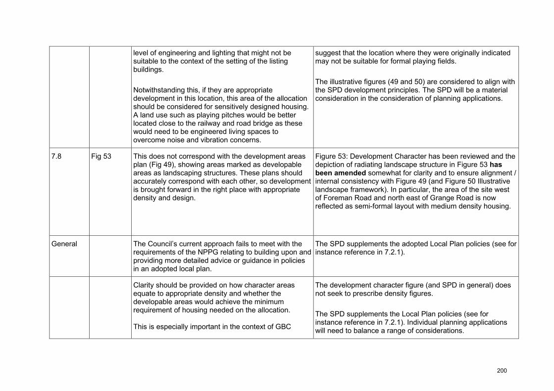
level of engineering and lighting that might not be suitable to the context of the setting of the listing buildings. Notwithstanding this, if they are appropriate development in this location, this area of the allocation should be considered for sensitively designed housing. A land use such as playing pitches would be better located close to the railway and road bridge as these would need to be engineered living spaces to overcome noise and vibration concerns.
suggest that the location where they were originally indicated may not be suitable for formal playing fields. The illustrative figures (49 and 50) are considered to align with the SPD development principles. The SPD will be a material consideration in the consideration of planning applications.
7.8 Fig 53 This does not correspond with the development areas plan (Fig 49), showing areas marked as developable areas as landscaping structures. These plans should accurately correspond with each other, so development is brought forward in the right place with appropriate density and design.
Figure 53: Development Character has been reviewed and the depiction of radiating landscape structure in Figure 53 has been amended somewhat for clarity and to ensure alignment / internal consistency with Figure 49 (and Figure 50 Illustrative landscape framework). In particular, the area of the site west of Foreman Road and north east of Grange Road is now reflected as semi-formal layout with medium density housing.
General The Council’s current approach fails to meet with the requirements of the NPPG relating to building upon and providing more detailed advice or guidance in policies in an adopted local plan.
The SPD supplements the adopted Local Plan policies (see for instance reference in 7.2.1).
Clarity should be provided on how character areas equate to appropriate density and whether the developable areas would achieve the minimum requirement of housing needed on the allocation. This is especially important in the context of GBC
The development character figure (and SPD in general) does not seek to prescribe density figures. The SPD supplements the Local Plan policies (see for instance reference in 7.2.1). Individual planning applications will need to balance a range of considerations.
200
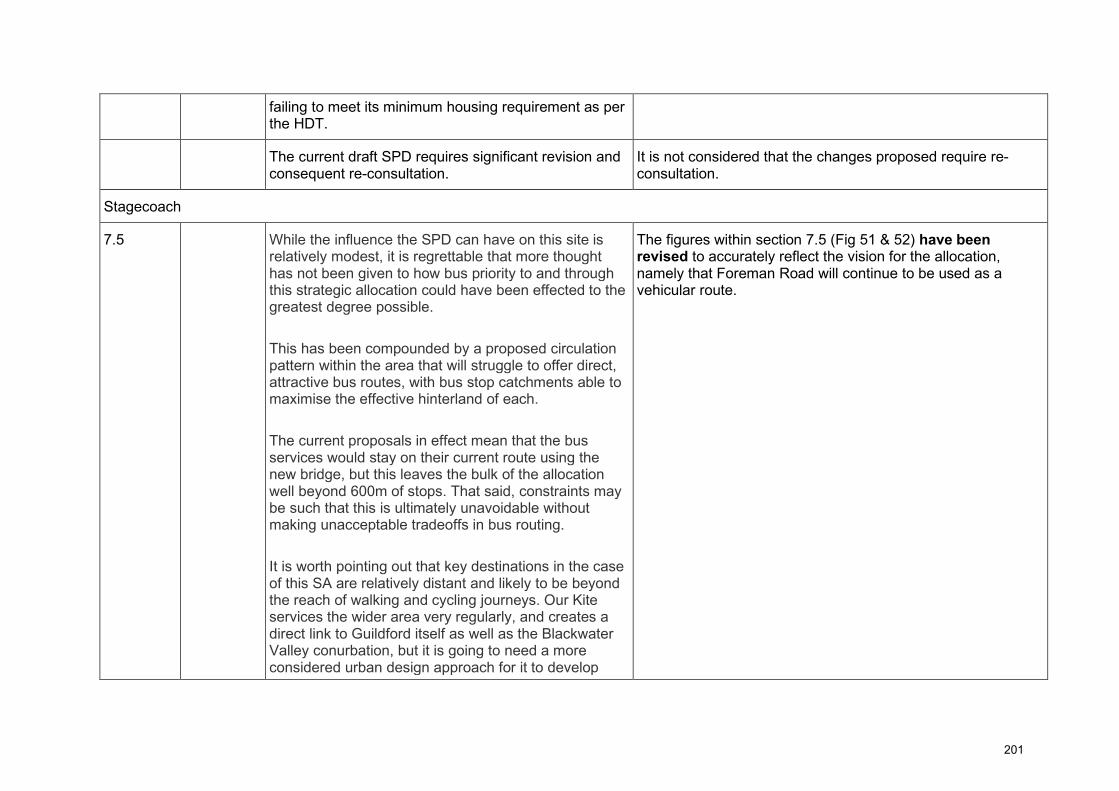
failing to meet its minimum housing requirement as per the HDT.
The current draft SPD requires significant revision and consequent re-consultation.
It is not considered that the changes proposed require re-consultation.
Stagecoach
7.5 While the influence the SPD can have on this site is relatively modest, it is regrettable that more thought has not been given to how bus priority to and through this strategic allocation could have been effected to the greatest degree possible. This has been compounded by a proposed circulation pattern within the area that will struggle to offer direct, attractive bus routes, with bus stop catchments able to maximise the effective hinterland of each. The current proposals in effect mean that the bus services would stay on their current route using the new bridge, but this leaves the bulk of the allocation well beyond 600m of stops. That said, constraints may be such that this is ultimately unavoidable without making unacceptable tradeoffs in bus routing. It is worth pointing out that key destinations in the case of this SA are relatively distant and likely to be beyond the reach of walking and cycling journeys. Our Kite services the wider area very regularly, and creates a direct link to Guildford itself as well as the Blackwater Valley conurbation, but it is going to need a more considered urban design approach for it to develop
The figures within section 7.5 (Fig 51 & 52) have been revised to accurately reflect the vision for the allocation, namely that Foreman Road will continue to be used as a vehicular route.
201
maximum patronage, sufficient to create a virtuous self-sustaining growth in frequency and usage, necessary to effectively achieve the transport mitigations likely to be required.
Royal Society for the Protection of Birds
There should be reference to considerations of access and recreational disturbance to the Thames Basin Heaths SPA within the Strategic Development Framework document. It is essential that green corridors and linkages to habitats outside of the site do not direct residents towards the SPA; this ensures that the strategic site is less likely to increase recreational disturbance of the SPA. If likely impacts upon the Thames Basin Heaths SPA were identified the site would, despite the inclusion of SANG provision, fail the Habitats Regulation Assessment.
Natural England (NE), the statutory body with responsibility for protecting the SPA, has been consulted on the proposals. The LPSS was subject to HRA, which there would be no adverse impacts on the integrity of the SPA.
G-BUG
7.0 Fig 52 Christmas Pie Trail should be improved as the basis for a safe cycle route to Guildford (and West to Farnham). A financial contribution should be mandated.
Potential improvements to off-site infrastructure will be developed further through the planning application processes or other funding sources. Scheme AM2 in the Local Plan: Strategy and Sites is to achieve a comprehensive Guildford borough cycle network.
Ash Green Residents Association
7.4 Fig 47 An indication was given during consultation on the SDF that development in the area would be guided by it. However this has not occurred.
The SPD will be material consideration in decision making on planning applications once adopted.
202
Neither Planning Application 18/P/02456, Land at Ash Manor, Ash Green Road, GU12 6HH for 73 houses approved on the 4th of December 2019, nor Planning Application 19/P/02197, Land South of Guildford Road, Ash, GU12 6BS, for 154 houses is to come before the Planning Committee soon bear resemblance to the plan on page 147. Will the SDF have any impact on future developments?
Guildford Residents Association
7.3 (6.3) …will be set within a strong green and blue infrastructure framework…
Para 7.3 (6.3) amended as follows: ‘…will be set within a strong green and blue infrastructure framework…’
7.5 Fig 51 Clarification of the proposed network in the southern part of the site is needed. Are Fig s 49 and 50 showing the same links? Figure 49 appears to show the spine road connecting to South Lane. And Fig 51 shows that access from White Lane will be possible.
The figures within section 7.5 (Fig 51 & 52) have been revised to more accurately reflect the vision for the allocation, namely that Foreman Road will continue to be used as a vehicular route and the spine road is envisaged to connect into South Lane. Figures 49 and 50 have also been amended to include the proposed vehicular connections and provide consistency. While access from White Lane will be possible, this will be promoted as a “Quiet Lane”.
Other respondents
7.1 7.1.2 Reference to Ash being part of the Aldershot urban area is incorrect. Ash is separated physically from Aldershot by the canal and the Blackwater Valley Road
Para 7.1.2 amended as follows: Ash is an enlarged village which now forms part to the east of the Aldershot urban area.
203
A331 and is therefore an entirely separate community. Ash is also in a different County to Aldershot.
7.1.3 Reference houses within Ash Green being mainly Victorian semi-detached villas. This statement should be revised to accurately describe the area. There are only approx 20 Victorian Villas the other 250 are houses and bungalows. The only Victorian semi detached villas in Ash Green are those on Ash Green Road. The other circa 250 properties in heart of the settlement along and off White Lane are twentieth century. The old Ash Green Station (the reason for the Victorian villas mentioned above being built) is worthy of further mention and consideration given its proximity to the development area. So too is Dene Lodge, a sizeable mansion tucked at the end of Drovers Way and with a gateway entrance directly off White Lane. Both are Locally Listed buildings.
Para 7.1.3 amended as follows: To the south of the site lies Ash Green Village, a hamlet comprising mainly Victorian semi-detached villas located along Ash Green Road. The SDF is by its nature strategic and will not identify all local features that might be material considerations in the planning application process. In general, locally listed buildings have not been identified in the SDF across the areas addressed.
7.1.4 The pedestrian footbridge should be mentioned. Para 7.1.4 amended after the final sentence as follows: “A potential pedestrian footbridge provided at or by the location of the existing level crossing is a separate project from the proposed new road bridge, with separate funding sources and timelines.”
7.2 7.2.2 The plans do not adequately protect the historic Ash Manor site.
It is considered that the development principles and para 7.4.8 in particular provide sufficient guidance in this regard.
7.3 7.3.3 The distance of many new developments from Ash Station mean that many people would need to drive
7.4.11 highlights that pedestrian connections should be provided to allow residents in the eastern part of the site and
204

there so parking should be provided close to the station. This could be in the form of a park and ride.
those at Ash Green to have easy access to Ash Station without the need to use the car.
There should be an opportunity for a convenience retail store close to Ash Station. This should be developed at a local centre, rather than Ash Wharf (which is seen as the centre for the area) which is less suitable and accessible.
7.6.1 mentions opportunity for local shops on land adjacent to the station. The Local Plan identifies Local Centres.
7.4 Fig 47 This shows the potential for high density development abutting the Ash Manor yet Fig 48 shows a 200m landscape setting and Fig 49 contradicts both by showing formal playing fields up to the boundary of Ash Manor. Fig 50 shows SUDS close to II* listed building threating flooding and Fig 53 provides a sensible approach. The document is confusing and incorrect.
It is acknowledged that this could appear confusing. Firstly it is important to be clear that the Figures serve different purposes. Fig 47 identifies constraints and opportunities. In some instances, these overlap spatially, for example, parts of the site present an opportunity for high density development (due to being located within walking distance of the rail station), whilst some of this same land is also constrained for development (due to it being located within the setting of Ash Manor). Figure 47 does not attempt to ‘resolve’ these constraints and opportunities. This resolution occurs through the reflection of the development principles and their illustrative application to the site (see Figure 49). The other figures attempt to illustrate more detailed aspects relating to the site such as the landscape elements (Figure 50) or more detail regarding the development character (Figure 53), both of which should generally align with Figure 49. Secondly, it is recognised that there are some inconsistencies between the figures and this has sought to be addressed. For instance, Figure 53: Development Character has been reviewed and the depiction of radiating landscape structure in Figure 53 has been amended somewhat for clarity and to ensure alignment / internal consistency with Figure 49 (and Figure 50 Illustrative landscape framework). In particular, the area of the site west of Foreman Road and north east of
205
Grange Road is now reflected as semi-formal layout with medium density housing.
Fig 49 Is the location of the formal playing fields adjacent to Ash Manor site consistent with preserving its setting?
It is acknowledged that further detailed consideration of the setting of the listed Ash Manor would be necessary, including, where relevant as part of the planning application process (see para 7.4.8). Whilst the Figures are illustrative, it is considered appropriate that the indication of open space is not specific in terms of locating formal playing fields. The formal playing fields have thus not been indicated as distinct from the Figures’ illustrative depictions of open space. Following on from the above, the figures have been amended to reflect ‘informal open space’ to incorporate the potential for formal playing fields within this broader area. This is not to suggest that the location where they were originally indicated may not be suitable for formal playing fields.
Fig 49 The route for the road bridge is inappropriate and contrived. There are other options for a more sensible routing. Harm could be reduced by an alternate route.
Site Policy A31, requirement 9, requires the provision of a new road bridge. The Local Plan is supported by a transport evidence base that is considered to be adequate and proportionate. The Local Plan was examined, found sound subject to modifications, and adopted. The exact route of the road bridge will be considered further as the planning application for this progresses.
7.4.5 There should be more reference to the substantial drainage issues in the area.
It is considered that this is addressed both within the site guidance (Part 3), including figures, as well as general principles (Part 2) – see for instance A2 – which will apply to Ash and Tongham. Surface water flooding is a key consideration for the site as per the Local Plan site allocation policy and further detail regarding surface water drainage will be considered as part of the planning application process.
206
7.4.10 The footpath/byway on Ash Green Lane West from the Yalden Gardens / Minley Nursery Site (Bewley Homes) along the southern edge of the Land south of Ash Lodge Drive development (also Bewley Homes) going eastwards to South Lane has not been made up to an all-weather footpath. There is an omission of a link path between the Yalden Gardens site and the adjacent Parsons Way site. There has been no improvement of the footpath linking Ash Green Lane West to Spoil Lane along the west boundary of the Yalden Gardens site.
The sites highlighted have been permitted and any contribution to the upgrading of existing infrastructure has been agreed as necessary.
7.4.11 The SPD states that 'A continuous pedestrian connection along the railway line to the south should be provided.’ This path floods even with small amounts of rain. There are general surface water flooding issues in the area and there is insufficient provision for this water.
Potential improvements to off-site infrastructure will be developed further through the planning application processes.
7.5 Wait until new houses close to Ash Green Meadows are complete to understand how development will impact the local community i.e. Traffic issues.
The Local Plan is supported by a transport evidence base that is considered to be adequate and proportionate. The Local Plan was examined, found sound subject to modifications, and adopted. Any future planning application will be supported by a transport assessment which takes on board cumulative growth in the area.
Network will not be adequate for the additional vehicles and further maintenance will be required.
The Local Plan is supported by a transport evidence base that is considered to be adequate and proportionate. Specifically, the Strategic Highway Assessment Report: Guildford Borough Proposed Submission Local Plan “June 2016” (Surrey County
207
Council, June 2016) (the SHAR 2016) is a technical report on the strategic highway assessment of the spatial strategy in the Draft Local Plan 2016. An addendum was also prepared (Guildford Borough Council, 2017). The Local Plan was examined, found sound subject to modifications, and adopted. As a new development that will generate significant amounts of movement, it will, at the planning application stage, be supported by a Transport Assessment, and subject to the policy tests in NPPF and Policy ID3. New developments may be required to provide mitigation measures additional to those in the Infrastructure Schedule. It is considered that, at the planning application stage, an applicant will be able to demonstrate the safe operation and performance of the Local Road Network, either as existing or improved as necessary.
Issues at junction of A323/324 at peak times, this is not addressed in the plan.
This junction is addressed via scheme LRN 22 in the Local Plan: Strategy and Sites.
How is the increased traffic flow going from developments including May & Juniper and Ash Manor to be managed?
The Local Plan is supported by a transport evidence base that is considered to be adequate and proportionate. The Local Plan was examined, found sound subject to modifications, and adopted. Any future planning application will be supported by a transport assessment which takes on board cumulative growth in the area.
Consideration should be given towards sustainable ways to reach Ash Vale station which will be the preferred route for daily travellers to London
The SDF promotes connections, encouraging active travel, to the wider area as detailed in paragraphs 7.3.3 and 7.5.1.
208
Fig 52
Disused railway culvert frequently flooded in winter therefore not a viable off-road route. Plan does not state how this will be addressed.
This is part of the PROW network and improvements to this could be achieved through planning obligations or other funding sources.
Makes reference to the importance of the Old Railway Line but the route identified by the text box and arrow east beyond Drovers Way is blocked by numerous fallen trees within the former railway cutting which limit its potential recreational amenity value and connection to other footpaths. The other footpaths are also at a different height above the cutting and there are currently no paths or steps to connect between the different levels
This is part of the PROW network and improvements to this could be achieved through planning obligations or other funding sources.
7.6 7.6.1 Does not explain how pedestrians will in future cross from one platform to another as there is no means to access the opposite platform except via the level crossing.
While the proposed road bridge will have facilities for pedestrians and cyclists, a separate footbridge is proposed. The new road bridge is subject to a current planning application and a proposed footbridge could be the subject of a future planning application.
7.8 Fig 53 The plan lacks sufficient detail to provide confidence that the densities can be achieved.
The development character figure (and SPD in general) does not seek to prescribe density figures. The SPD supplements the Local Plan policies (see for instance reference in 7.2.1). Individual planning applications will need to balance a range of considerations.
7.9 Higher density development on both sides of the station should not compromise accessibility. It would
It is considered that para 7.6.1 addresses this point.
209
compromise the opportunity for parking / drop-off and pick up spaces.
General The SPD should address housing mix as before the Local Plan, there was a surfeit of 4/5 bedroom dwellings.
The Local Plan policies with regard to Housing Mix apply and are considered sufficient at this point – the SPD has not sought to provide further detail in this regard, but rather on wider place shaping guidance.
210
08. Former Wisley Airfield
Section Paragraph Main Issue Summary Response
Prescribed Bodies and Key Stakeholders
Hallam Land Management Ltd (former Wisley Airfield)
8.4 Figure 59 SDF should not represent a fixed arrangement of land uses
The SPD master plan principles (along with the overarching design principles) provide the basis for achieving a high-quality scheme. Figure 59 is intended to reflect the application of the master plan principles to the site. However, it is acknowledged that there is scope for the emergence of other (possibly more effective) means of achieving these principles. Alternate spatial / design solutions may emanate from further creative thinking, more detailed studies or inputs from stakeholders during the planning application process. At the point of the SPD’s production, these studies or inputs may not have been available, but would rightly inform more detailed work suited to the planning application process and may lead to alternative and acceptable spatial outcomes reflected in the application masterplan. To further clarify this position, several amendments are proposed to text in the Introduction of the SPD, and the section on Former Wisley Airfield (e.g. title to Figure 59), aimed at ensuring the SPD and specifically the illustrative plans are not interpreted in a fixed or blueprint manner.
211
8.4 Figure 59 The utility of public rights of way which are the basis for the landscape wedges need to be critically evaluated. FP19 (as shown on the Definitive Footpath Map and situated east of Little Upton) connects Hatchford End, Old Lane and Wisley Common to the north east of the Site and Ockham Road along its southern boundary. It also intersects with FP13 which heads in a west and north western direction towards the centre of the Site. FP19 terminates at Ockham Lane and beyond this there are no connections to any other public right of way in a southernly direction. Its utility therefore means that it is of little value in structuring a masterplan. Consequently, its role as a focus for green space needs particular evaluation, alongside other landscape features within this part of the site that could provide a better focus.
Figure 59 is illustrative only. The footpaths are located where old lanes used to be present and are therefore significant in terms of the site’s history. Their position also enables the creation of three roughly equivalent sized built conurbations. The detailed design of the site will however be explored in more detail through the planning application and design review panel process.
8.9 Figure 63 The character and density of development north of Ockham Lane is unlikely to be of the same character as the Central Village
The key refers to decreased density towards Ockham Lane. In any case this figure is high level and illustrative only. The detailed design of the site will be explored in more detail through the planning application and design review panel process.
CBRE (former Wisley Airfield)
8.10 Figure 65 Should clarify that this is illustrative and only one interpretation of how the site might be brought forward
The SPD master plan principles (along with the overarching design principles) provide the basis for achieving a high-quality scheme. Figure 65 is labelled as being illustrative. Additionally, figure 59 is intended to reflect the application of the master plan principles to the site. However, it is acknowledged that there is scope for the emergence of other (possibly more effective) means of achieving these principles. Alternate spatial / design
212
solutions may emanate from further creative thinking, more detailed studies or inputs from stakeholders during the planning application process. At the point of the SPD’s production, these studies or inputs may not have been available, but would rightly inform more detailed work suited to the planning application process and may lead to alternative and acceptable spatial outcomes reflected in the application masterplan. To further clarify this position, several amendments are proposed to text in the Introduction of the SPD, and the section on Former Wisley Airfield (e.g. title to Figure 59), aimed at ensuring the SPD and specifically the illustrative plans are not interpreted in a fixed or blueprint manner.
Effingham Parish Council
8.4 Figure 57 Special Protection Area and Local Nature Reserves should be on the plan
Figure 57 has been amended to include the SPA as a key constraint to the site.
8.4.4 The close proximity of the SPA to the site requires a lot more than just controlling recreational use. The SPA can be damaged by light pollution, noise pollution, chemical pollution (e.g. via waterways or the air).
These detailed matters will be assessed as part of the planning application. The LPSS was subject to HRA, which was tested in the high court, and it concluded there would be no adverse impacts on the integrity of the SPA.
8.4.8 Old Lane is unsuitable as a major access to the site, as it is a narrow lane, unsuitable for heavy traffic, with a weight restriction of 7.5 T. The document fails to mention this important restriction to the road, thus giving a totally false impression of the suitability of the route.
Vehicle access routes to and from the site will be considered as part of any future planning application process for the site. The transport strategy set out in the Local Plan was considered as part of the Local Plan examination. The council’s starting position is that access for all modes will be from the Ockham Interchange (via New Wisley Lane) and Old Lane, with pedestrian and cycle access also from Elm Lane
213
and Ockham Lane. As a new development that will generate significant amounts of movement, it will, at the planning application stage, be supported by a Transport Assessment, and subject to the policy tests in NPPF and Policy ID3. New developments may be required to provide mitigation measures additional to those in the Infrastructure Schedule.
8.4.9 Rail stations need upgrades to ensure safe drop off/pick up, regular buses and additional car parking
LPSS Policy A35 requires, at requirement 5, that a significant bus network is required to serve the site and which will also serve Effingham Junction railway station and/or Horsley railway station as well as other destinations. As a new development that will generate significant amounts of movement, it will, at the planning application stage, be supported by a Transport Assessment, and subject to the policy tests in NPPF and Policy ID3. New developments may be required to provide mitigation measures additional to those in the Infrastructure Schedule.
Figure 59 Employment area is immediately adjacent to an Ancient Woodland and Local Nature reserve. This is likely to cause damage to the woodland, through noise, light and chemical pollution.
The allocation is for industrial B2/B8 uses. There is therefore flexibility on what sort of industrial land is provided. Any proposal would need to be appropriate for its location and mitigate any impacts accordingly.
8.4.11 No mention of GP surgery and car charging points It refers to community uses. Site allocation A35 allocates 500sqm of community uses (D1). Use class D1 includes GP surgeries. Guidance on Electric Vehicle Charging is contained in Part 2 of SPD. Policy requirements for electric vehicle charging was consulted upon as part of Guildford BC’s draft Issues, Options and Preferred Options (2020) consultation document for the
214
emerging Guildford borough Local Plan: Development Management Policies
8.5 Figure 60 Woodland incorrectly mapped. SPA should be mapped. Tree surveys will be undertaken as part of planning application process. This will assess the presence of important trees and inform the design of the site. Figure 57 has been amended to include the SPA.
8.6 Figure 61 The “Active travel and bus link to Cobham” is an unsuitable single track lane, which is subject to significant flooding.
As a new development that will generate significant amounts of movement, it will, at the planning application stage, be supported by a Transport Assessment, and subject to the policy tests in NPPF and Policy ID3. New developments may be required to provide mitigation measures additional to those in the Infrastructure Schedule.
Presently, the only sensible vehicular access to Cobham from the site is via the A3.
Vehicle access routes to and from the site will be considered as part of any future planning application process for the site.
Figure 62 Without major upgrade to Old Lane, it is not a safe road for pedestrian use. The B2039, a wider road, also has no pavement for pedestrian use, making it also unsafe. This is encouraging people to use their cars, and hence the SPD is failing in its objectives.
Figure 62 has been modified to better clarify walking and cycling routes in the area.
8.6 The main connection for this site with the A3 should be via the Ripley Roundabout and a new west bound slip road, not via local roads.
Primary vehicular access to the site allocation will be via the A3 Ockham interchange (LPSS site allocation policy A35 requirement 1) The transport strategy set out in the Local Plan was considered as part of the Local Plan examination. This does not include a new west bound/ south bound slip road at the Ockham interchange, rather, new north facing junctions to the A3 at the A247 Burnt Common interchange are included as requirements in site Policy A35 and as schemes SRN7 and SRN8 in the Infrastructure Schedule. These junctions are
215
being promoted to mitigate the impact of the level of strategic planned growth and in particular the development traffic flows resulting from the development of the new settlement at the former Wisley airfield, as well as limiting any increase in traffic joining and leaving the A3 at the Ockham interchange.
Improvements needed to the railway stations at Horsley and Effingham Junction, including to car parks and disabled access.
LPSS Policy A35 requires, at requirement 5, that a significant bus network is required to serve the site and which will also serve Effingham Junction railway station and/or Horsley railway station as well as other destinations. As a new development that will generate significant amounts of movement, it will, at the planning application stage, be supported by a Transport Assessment, and subject to the policy tests in NPPF and Policy ID3. New developments may be required to provide mitigation measures additional to those in the Infrastructure Schedule.
Bus services need to service a wide area and be fully funded in perpetuity and must be affordable, regular and reliable. Bus services must go to Guildford and Woking as well as Cobham, Effingham Junction and East Horsley stations.
LPSS Site Policy A35, requirement 5, states a requirement for significant bus network to serve the site, which will also serve Effingham Junction railway station and/or Horsley railway station, Guildford and Cobham. This will to be provided and secured in perpetuity to ensure that residents and visitors have a sustainable transport option for access to the site.
Cycling and Walking policies are inadequate and need to be strengthened. Safe cycle and pedestrian routes are required off site to local connections/facilities.
The SDF provides guidance. Planning policy is provided in the Local Plan: Strategy and Sites as well as the NPPF and any Neighbourhood Plans. The Local Plan Site Policy A35 states a requirement for an off-site cycle network to key destinations including Effingham Junction railway station, Horsley railway station/Station Parade, Ripley and Byfleet to be provided with improvements
216
to a level that would be attractive and safe for the average cyclist. The applicant will need to consider and address all the site allocation requirements in preparing and submitting their planning application.
A car club should be introduced. Paragraph 3.3.36 has been amended to highlight a range of mobility solutions could be provided. This would be explored further as part of the planning application process.
8.10 Intensity is inappropriate for the rural location The scale of the site enables different densities across different areas of the site, with a reduction of densities towards the edge as it transitions to countryside. It is important that land that has been allocated for development is used as efficiently as possible to minimise the need for additional development sites.
Guildford Residents Association
Vision Delete “with excellent opportunities for access to the national highway network”. Instead refer to the importance of creating sustainable travel solutions that are viable in the long term.
Following text deleted: ‘with excellent opportunities for access to the national highway network’. The vision refers to ‘excellent sustainability credentials and a good range of local services.’
8.6 Figure 61 Need greater clarity regarding what active travel is Para 3.3.8 defines what is meant by ‘active travel’
8.6 Should mention the need for mitigation The transport strategy for this strategic site was set out in the Local Plan was considered as part of the Local Plan examination. At the plan-making stage, it was considered that this strategy could mitigate the site's otherwise adverse material impacts, within the context of the cumulative impacts of approved developments and site allocations.
217
Surrey County Council
8.1 Flood Zones associated with EA main River need to be mentioned and that it is preferable for dwellings to be located outside flood zones 2 and 3.
The approach to flood risk will be in accordance with national policy and Policy P4.
8.6 Figure 62 Enhancements to the surrounding Rights of Way network should be considered to encourage sustainable travel out from the settlement.
Contributions that will be sought from this site will be negotiated as part of the planning application process.
Figure 62 Dedicate Public Rights of Way within SANG to enhance the network.
This is not a requirement of the SANG criteria. The suitability for linking to the PROW can be explored further through planning application process.
RSPB
8.4 Figure 59 Suggested location for SANG, along with key pedestrian and cycle routes/Public Rights of Way (PRoW) will harm SPA
Natural England (NE), the statutory body with responsibility for protecting the SPA, has been consulted on the proposals. NE is of the view that the proposed site and SANG will not harm the SPA. The LPSS was subject to HRA, which was tested in the high court, and it concluded there would be no adverse impacts on the integrity of the SPA.
Guildford Society
8.4 Fig 59 The principle of landscape fingers and wedges needs questioning against the concept of having more meaningful and accessible landscape spaces within the development, such as village greens.
Figure 59 is illustrative only and does not preclude alternative design schemes from being developed. However, there are landscape benefits in breaking up the built form with larger green corridors. Larger green spaces are more meaningful than smaller pockets and have greater landscape benefits in terms of breaking up the built form. There will still be smaller pockets of green spaces however this is a level of detail not appropriate for the SPD. The detailed design of the site will
218
however be explored in more detail through the planning application and design review panel process.
Area of employment is shown as green space on Highways England plan
The exact location of the employment land will need to be considered as part of the planning application process. This will need to take account of any changes in circumstances as a result of the M25 Junction 10/A3 Wisley interchange scheme
64 and 65 Appears to show a formal grid like layout which is far removed from village concept
The 3d illustrations are illustrative and simply represent one way in which development could be structured. The formal layout accords with the illustrative development character shown in Figure 63. This indicates that development adopts a looser grain towards the site’s edges. The exact design and character will be explored in more detail through the planning application process and subject to assessment by the Design Review Panel in accordance with LPSS Policy D1.
Transport Access to the South West appears poor with no Southbound slip provided from/to the A3; this will increase pressure on Ripley.
The transport strategy set out in the Local Plan was considered as part of the Local Plan examination. This does not include a new west bound/south bound slip road at the Ockham interchange, rather, new north facing junctions to the A3 at the A247 Burnt Common interchange are included as requirements in site Policy A35 and as schemes SRN7 and SRN8 in the Infrastructure Schedule. These junctions are being promoted to mitigate the impact of the level of strategic planned growth and in particular the development traffic flows resulting from the development of the new settlement at the former Wisley airfield, as well as limiting any increase in traffic joining and leaving the A3 at the Ockham interchange. As per Local Plan site Policy A35 requirement (4), the identified mitigation to address the impacts on Ripley High Street and surrounding rural roads comprises two new slip
219
roads at A247 Clandon Road (Burnt Common) and associated traffic management.
Access to Horsley and Effingham. The proposed Active Travel routes are along lanes that can be busy. The network of tracks and pathways may with upgrading provide a separate route for Pedestrians and Cyclists. This applies particularly to Horsley.
The Local Plan Site Policy A35 states a requirement for an off-site cycle network to key destinations including Effingham Junction railway station, Horsley railway station/Station Parade, Ripley and Byfleet to be provided with improvements to a level that would be attractive and safe for the average cyclist. The applicant will need to consider and address all the site allocation requirements in preparing and submitting their planning application.
Fig 61 Public Transport routes need to be re-visited. Serious lack of viable rail connections.
LPSS site allocation policy A35 requires, at requirement 5, that a significant bus network is required to serve the site and which will also serve Effingham Junction railway station and/or Horsley railway station as well as other destinations. The applicant will need to consider and address all the site allocation requirements in preparing and submitting their planning application.
Excessive use of routes through Ockham village. Major route to Horsley Station should be via Ockham Rd. B2019 - not via Ockham Lane. 2.5km to Effingham Junction via Old Lane should be a secondary option.
The Former Wisely Airfield site provides a new route between Ockham interchange and Old Lane providing the opportunity to reconfigure Ockham Lane, for instance reducing the speed limit to 20mph, adding a modal filter to prevent through movements and providing facilities for pedestrians. The site access on Ockham Lane is planned to be limited to up to approximately 100 homes. The B2039 Ockham Road North would provide the key route towards East Horsley and also the Station. Ockham lane has been removed as a bus route.
220
Traffic in village” style treatment in Ockham inappropriate.
The report 'Traffic in Villages – Safety and Civility for Rural Roads: A toolkit for communities' (Dorset AONB Partnership in conjunction with Hamilton-Baillie Associates, 2011) provides guidance on such schemes. The Topic Paper: Transport (2017) sets out the different types of measure that could feature for other traffic management and/or environmental improvement schemes included in the Local Plan.
Bus link to West Byfleet remote & unlikely. As a new development that will generate significant amounts of movement, it will, at the planning application stage, be supported by a Transport Assessment, and subject to the policy tests in NPPF and Policy ID3. New developments may be required to provide mitigation measures additional to those in the Infrastructure Schedule.
Fig 62 Show connections to A3 cycle superhighway from the site.
A ‘key off-site pedestrian and cycle route’ has been added on the north side of the A3. This reflects the proposed plans for a “new Wisley Common bridleway” by Highways England as part of their M25 Junction 10/A3 Wisley interchange scheme.
RHS Wisley Gardens
8.4 The figures/design principles need to include a wider area in recognition of the more sensitive receptors of the RHS Registered Park and Garden, SPA, SSSI and surrounding community to show how it will integrate into its surroundings.
Where relevant the SPD figures do include features beyond the site boundaries (e.g. connections, ecological features) however this level of detail will be explored in more detail as part of the planning application process. Figure 57 has been amended to show the SPA.
Building heights need to be reduced given visual impact off site and views from the Garden’s high ground at Battleston Hill and the new Hilltop building
Para 8.3.2 states that ‘The integration of the development within the landscape should be well managed, having regard to building height and mass, but also by using new planting to help ‘absorb’ the development into the wider setting.’
221
8.4.6 Seasonal changes mean new woodland planting referenced would not adequately mitigate visual impacts.
The character of the existing site will of necessity change however this will be softened by the proposed level of landscaping. The landscaping strategy will be explored in more detail through the planning application process.
8.4.8 The use of the re-aligned Wisley Lane as a site access needs to be designed and traffic modelled so as not to worsen the RHS traffic access, particularly on busy RHS days. The recent RHS influencing of the M25 J10 scheme has resulted in this realigned road, which should not in future become compromised by reducing the effect of the ‘improved access to RHS Wisley’ required by the scheme. In addition, the effects of ‘rat-running’ through the airfield site needs to be considered as part of the Local Road Network
Highways England has an active Development Consent Order process ongoing for a M25 Junction 10/A3 Wisley interchange scheme, which is scheme SRN2 in the Local Plan: Strategy and Sites. Highways England, in their DCO process, took account of and included the development quantum of the Local Plan site allocation for a settlement at the Former Wisley Airfield in their traffic model. It is expected that the new Wisley Lane alignment will allow for the future access into the new settlement. As a new development that will generate significant amounts of movement, it will, at the planning application stage, be supported by a Transport Assessment, and subject to the policy tests in NPPF and Policy ID3. New developments may be required to provide mitigation measures additional to those in the Infrastructure Schedule.
8.4.9 The RHS estate relies heavily on transport access to Woking and West Byfleet and the opportunities offered by Woking BC and its transport connections are not recognised in the SPD
LPSS Site Policy A35, requirement 5, states a requirement for significant bus network to serve the site, which will also serve Effingham Junction railway station and/or Horsley railway station, Guildford and Cobham. This will be provided and secured in perpetuity to ensure that residents and visitors have a sustainable transport option for access to the site. Furthermore the Lovelace Neighbourhood Plan, at Policy LNPI2: Public Transport and Sustainable Travel, will seek that ‘Development at the Former Wisley Airfield site is encouraged to include a regular bus service to Woking station, particularly at rush hour, provided and secured in perpetuity as part of the
222
bus network required in Guildford Local Plan: Strategy and Sites Allocation Policy A35.’
Figure 60 Lack of detail regarding how water management will be achieved. The River Wey adjoins the RHS Garden and Village and is of significance due to the water extraction licenced by the Environment Agency, as well as potential for flooding by bank management issues. Changes to water quality or the volume and flow of the Wey have the potential to cause impacts on the plant collection itself, and the accessibility to the garden in times of high water.
This is a primarily a place-shaping design document and this level of detail is therefore not appropriate. This matter will be considered in more detail in the environmental statement prepared to support the planning application.
Environment Agency
8.4 The southern side of the site is bordered by a main river, the Stratford Brook. We require a 10 meter undeveloped buffer to this watercourse. There is a historic landfill adjacent to the main river, in the south / west region of the site. The site is situated over a principal and secondary aquifer. The site was previously used as an airfield, which has a high risk of contamination. Any development proposals will need ground investigations studies. If contamination is identified appropriate remediation will need to be carried out, in order to protect controlled waters and watercourses.
Additional wording regarding undeveloped buffer zones has been added to Part 2 of the SPD which is applicable to all sites (para 3.4.13). The planning application will need to be accompanied by relevant studies to inform what mitigation/remediation may be necessary on the site.
West Horsley Parish Council
Vision and objectives
A ‘distinctly contemporary’ village is at odds with its rural location and contradicts earlier advice that sites should respect landscape character and local character. Should not say there is an absence of a host settlement given Ockham adjoins the site.
Vision amended as follows: ‘Given the absence of any attachment to a host settlement,tThe Strategic Site has greater opportunities to establish its own built character and is less fettered by an established built character but can draw inspiration from the
223
nearby villages. In response, the opportunity exists to create a distinctly contemporary village, with excellent sustainability credentials and a good range of local services.’ Whilst the presence of Ockham village on the southern boundary will clearly require careful design consideration to ensure that it respects the adjoining conservation area, there are opportunities for the remainder of the site to create its own character and deliver a unique new village. This accords with Policy D1(5). The site will be designed and delivered as a new village – it does not rely on any services/facilities within Ockham and as such there is no ‘host settlement’.
8.4 8.4.3 Should mention views to and from AONB Paragraph 3.2.29 sets out the importance of responding to the landscape context, including views between places. The proposed green corridors will help to mitigate long range views. The building design will also need to consider the impact on views.
Figure 59 Location of employment adjacent to A3 contradicts principle of connectivity
The employment at this location is the industrial element of the allocation (B2/B8). This use can be less suited to being located within residential areas and relies on good access to the strategic road network. For this reason, it is best placed adjacent to the A3 and slightly removed from the rest of the site.
8.10 Density not appropriate for its rural location/surrounding character/views from AONB
The scale of the site enables different densities across different areas of the site, with a reduction of densities towards the edge as it transitions to countryside. It is important that land that has been allocated for development is used as efficiently as possible to minimise the need for additional development sites. The exact design and character will be explored in more detail through the planning application
224
process and subject to assessment by the Design Review Panel in accordance with Policy D1.
East Horsley Parish Council
Vision and objectives
Should not say there is an absence of a host settlement given Ockham adjoins the site.
Vision amended as follows: ‘Given the absence of any attachment to a host settlement,tThe Strategic Site has greater opportunities to establish its own built character and is less fettered by an established built character but can draw inspiration from the nearby villages. In response, the opportunity exists to create a distinctly contemporary village, with excellent sustainability credentials and a good range of local services.’ Whilst the presence of Ockham village on the southern boundary will clearly require careful design consideration to ensure that it respects the adjoining conservation area, there are opportunities for the remainder of the site to create its own character and deliver a unique new village. This accords with Policy D1(5). The site will be designed and delivered as a new village – it does not rely on any services/facilities within Ockham and as such there is no ‘host settlement’.
8.10 Density not appropriate for its rural location/surrounding character
The scale of the site enables different densities across different areas of the site, with a reduction of densities towards the edge as it transitions to countryside. It is important that land that has been allocated for development is used as efficiently as possible to minimise the need for additional development sites. The exact design and character will be explored in more detail through the planning application process and subject to assessment by the Design Review Panel in accordance with LPSS Policy D1.
Ockham Parish Council
225
8.4 Figure 57 and para 8.4.3
Should make reference to the air quality issues that are applicable to the site
The key considerations in LPSS Policy A35 refers to potential air quality issues.
Figure 57 Should show views to RHS Figure 57 has been amended to add in a key view from RHS towards Site Allocation A35.
Figure 57 Should show beacon and height restrictions The Council expects the beacon to be decommissioned and once this happens the eastern part of the site will no longer be affected. The Council will consult with National Air Traffic Services (NATS) to determine and agree the phasing strategy and building heights.
Figure 58 A footpath running east-west has been completely omitted from the drawing.
Figure 58 has been amended to include all footpaths.
8.4.7 Should include the RHS, Yarne and the Semaphore Tower.
Para 8.4.7 amended as follows: ‘The new development will need to be sensitively designed to respect Ockham Conservation Area and other historic assets, and to maintain the integrity of the collection of old buildings which make up Bridge End Farm. A full assessment of the impact of the application master plan on nearby heritage assets will be required.’
8.4.8 There should be no access from Old Lane. There should only be emergency access from Ockham Lane.
Vehicle access routes to and from the site will be considered as part of any future planning application process for the site. The transport strategy set out in the Local Plan was considered as part of the Local Plan examination. The council’s starting position is that access for all modes will be from the Ockham Interchange (via New Wisley Lane) and Old Lane, with pedestrian and cycle access also from Elm Lane and Ockham Lane.
226
As a new development that will generate significant amounts of movement, it will, at the planning application stage, be supported by a Transport Assessment, and subject to the policy tests in NPPF and Policy ID3. New developments may be required to provide mitigation measures additional to those in the Infrastructure Schedule.
8.4.9 Unrealistic to expect people to cycle to Effingham Junction – the gradient is too great, there are no street lights and the traffic speed is too high
The Local Plan Site Policy A35 states a requirement for an off-site cycle network to key destinations including Effingham Junction railway station, Horsley railway station/Station Parade, Ripley and Byfleet to be provided with improvements to a level that would be attractive and safe for the average cyclist. The applicant will need to consider and address all the site allocation requirements in preparing and submitting their planning application.
8.4.10 The cycle routes must remain separate from the PROWs which are well used by pedestrians.
The Local Plan Site Policy A35 states a requirement for an off-site cycle network to key destinations including Effingham Junction railway station, Horsley railway station/Station Parade, Ripley and Byfleet to be provided with improvements to a level that would be attractive and safe for the average cyclist. It may be that public footpaths in the PRoW network in the vicinity of the site could accommodate cyclists with appropriate upgrades which would help minimise conflict. This would need to be considered as part of the planning application process. Surrey County Council would need to ensure that the proposed route(s) is to an acceptable standard or agree what works are needed and who should carry them out. Generally, a new footpath should be 2.0 metres wide and a bridleway 4.0 metres wide. Once a route has been dedicated, it would be
227
signposted and appear on Surrey's Definitive Map and Statement and other Ordnance Survey maps.
Fig 60 Does not show any provision for flood mitigation works and/or SuDS to protect the hamlet of Elm Corner/flooding of A3. Unclear on impact of SuDs on Stratford Brook and the ensuing impact on the Conservation area and listed properties at Mill Lane. Stratford Brook is a designated water course.
The exact extent, location and design of the SuDS will be informed through further detailed work undertaken as part of the planning application.
8.6 Fig 61 More information required for the junction improvement for Old Lane/A3 shown.
Junction improvements are planned as part of the Development Consent Order process as part of Highways England’s M25 Junction 10/A3 Wisley interchange scheme, which is scheme SRN2 in the Local Plan: Strategy and Sites. Further improvements could be proposed as part of a future planning application.
Some of the routes shown are unsuitable for buses. LPSS Site Policy A35, requirement 5, states a requirement for significant bus network to serve the site, which will also serve Effingham Junction railway station and/or Horsley railway station, Guildford and Cobham. This will to be provided and secured in perpetuity to ensure that residents and visitors have a sustainable transport option for access to the site. It is considered that the roads on which the buses are proposed to use are suitable. Reference to buses using Ockham Lane has been removed.
8.6.5 East Horsley is too far to expect people to travel there by foot or by bike. Road unsuitable.
The Local Plan Site Policy A35 states a requirement for an off-site cycle network to key destinations including Effingham Junction railway station, Horsley railway station/Station Parade, Ripley and Byfleet to be provided with improvements to a level that would be attractive and safe for the average cyclist.
228
We do not anticipate that residents or others travelling to and from the site would routinely walk to/from East Horsley however the site and East Horsely are connected by Public Rights of Way which do allow for recreational use. Additionally, LPSS Site Policy A35, requirement 5, states a requirement for significant bus network to serve the site, which will also serve Effingham Junction railway station and/or Horsley railway station, Guildford and Cobham. This will to be provided and secured in perpetuity to ensure that residents and visitors have a sustainable transport option for access to the site.
Inconsistency between Table 14 and Table 15 These figures will need to be worked through as part of the site promoter’s masterplanning and planning application processes. They are merely indicative at this stage and are subject to further detailed work.
8.10 Density inappropriate for the location The scale of the site enables different densities across different areas of the site, with a reduction of densities towards the edge as it transitions to countryside. It is important that land that has been allocated for development is used as efficiently as possible to minimise the need for additional development sites. The exact design and character will be explored in more detail through the planning application process and subject to assessment by the Design Review Panel in accordance with LPSS Policy D1.
G-BUG
8.6.5 Fig 62
The Active Travel Routes to Horsley and Effingham could not be classed as safe without substantial changes and investment.
This is a requirement of LPSS Policy A35 (5) and will need addressed as part of a future planning application process.
229
Does not identify the ‘cycle superhighway’ proposed alongside the A3 between the Ockham and Cobham roundabouts as part of the Highways England M25 Junction 10 development scheme. The Wisley development must link seamlessly with this cycleway, and the developers asked to contribute money to extend the scheme beyond its current limits, e.g. from the Ockham roundabout into Ripley, or from the Cobham Roundabout to Cobham town centre.
A ‘key off-site pedestrian and cycle route’ has been added on the north side of the A3. This reflects the proposed plans for a “new Wisley Common bridleway” by Highways England as part of their M25 Junction 10/A3 Wisley interchange scheme. Further improvements could be proposed as part of a future planning application.
Muddy Lane footpath, providing a link under the M25 from Wisley Lane to Byfleet, has recently been re-designated as a bridleway and, with improvement, could provide part of the connection to Byfleet.
The Local Plan Site Policy A35 states a requirement for an off-site cycle network to key destinations including Effingham Junction railway station, Horsley railway station/Station Parade, Ripley and Byfleet to be provided with improvements to a level that would be attractive and safe for the average cyclist. Upgrades to footpaths would be considered as part of the planning application process. Surrey County Council would need to ensure that the proposed route(s) is to an acceptable standard or agree what works are needed and who should carry them out.
Cllr Seabrook
8.2.2 Need to define what a significant bus service is.
Significance is measured in terms of the service frequency and hours or operation in relation to the site and the local services/facilities it is serving. A high frequency and appropriate hours of operation are important in providing an attractive bus service which will provide a real alternative to a private vehicle. An amendment has been made to section 8.6 to highlight the importance of delivering a significant bus service.
230
Off road cycle route necessary as existing roads are dangerous.
The Local Plan Site Policy A35 states a requirement for an off-site cycle network to key destinations including Effingham Junction railway station, Horsley railway station/Station Parade, Ripley and Byfleet to be provided with improvements to a level that would be attractive and safe for the average cyclist. The applicant will need to consider and address all the site allocation requirements in preparing and submitting their planning application. Likewise, it may that public footpaths in the PRoW network in the vicinity of the site could accommodate cyclists with appropriate upgrades which would help minimise conflict. This would need to be considered as part of the planning application process. Surrey County Council would need to ensure that the proposed route(s) is to an acceptable standard or agree what works are needed and who should carry them out. Generally, a new footpath should be 2.0 metres wide and a bridleway 4.0 metres wide. Once a route has been dedicated, it would be signposted and appear on Surrey's Definitive Map and Statement and other Ordnance Survey maps.
Stagecoach
8.6 The spine road needs to be designed in a manner that resolves a very fundamental tension, between maximising bus operating speeds and productivity (especially if a route is to divert through the site on and off the A3 in some manner) and minimising general traffic speeds.
The detailing of the design of the spine road (Primary Street) will be undertaken as part of the preparation of a development proposal. The design, including the routing of buses and general traffic, would then be considered as part of the planning application processes. Paragraph 8.6.3 has been amended as follows:
231
The current sinuous street alignment achieves the latter but in so doing, entirely precludes the former. As a result, providing an effective, efficient and relevant bus service is fundamentally jeopardised in an already highly challenging operating context. This is a scenario in which at least two bus plugs need to be provided on an otherwise relatively straight-line bus route, forcing general traffic to re-route substantially off-line to make progress from end-to-end of the development. The route could make a virtue of the history of the site, as an airfield, with the former runway alignment and key structuring principle as an open-space corridor, with a succession of leisure and recreation and amenity uses and features providing legibility and a basis to frame a pleasing succession of distinctive character areas on the bus journey, with car-borne traffic having to meander a greatly more circuitous route or possible routes, to access individual plots.
‘Within the site, buses will run along the primary street; whilst buses will share the carriageway with other vehicles but, the design of this street will ensure that buses can be operated efficiently and are should be afforded priority over cars as it they enters and leaves the site.’ A previous planning application for a new settlement at the site (Application ref 15/P/00012), was the subject of an appeal. In that development proposal the central spine road provides for a bus route linking all the phases of the development. The proposals for buses and bus services were discussed and debated at length and issues were considered in the Inspector’s Report. It may be worth noting that the sinuosity of the spine road and the relative impacts on bus operation and general traffic was not identified an issue in the inspector’s report.
Other respondents
8.3 Vision and objectives and para 8.3.3
Reference to a ‘distinctly contemporary village’ and ‘rural-contemporary’ is inappropriate with surrounding character of the area
Whilst the presence of Ockham village on the southern boundary will clearly require careful design consideration to ensure that it respects the adjoining conservation area, there are opportunities for the remainder of the site to create its own character and deliver a unique new village. This accords with Policy D1(5). There is an opportunity for contemporary design however this can draw on inspiration from nearby villages.
232
8.4 Figure 57 and para 8.4.3
Should make reference to the air quality issues that are applicable to the site
The key considerations in LPSS Policy A35 refers to potential air quality issues.
Figure 57 Should show views to RHS Figure 57 has been amended to add in a key view from RHS towards Site Allocation A35.
Figure 57 Should show beacon and height restrictions The Council expects the beacon to be decommissioned and once this happens the eastern part of the site will no longer be affected. The Council will consult with National Air Traffic Services (NATS) to determine and agree the phasing strategy and building heights.
Figure 58 The footpath which runs West-East (which is shown of Figure 60) is not shown
Figure 58 has been amended to include all footpaths.
8.4.7 Should include reference to impact on the RHS Wisley, Chatley Heath Semaphore Tower, Yarne.
Para 8.4.7 amended as follows: ‘The new development will need to be sensitively designed to respect Ockham Conservation Area and other historic assets, and to maintain the integrity of the collection of old buildings which make up Bridge End Farm. A full assessment of the impact of the application master plan on nearby heritage assets will be required.’
No up to date Conservation Area Appraisal for Ockham Any impact on the Conservation Area would need to be taken into account as part of the planning application process. The proposal will be informed by a Heritage Statement.
8.4.9 Cycling to Effingham Junction is not realistic due to gradient, traffic speeds and lack of street lights
The Local Plan Site Policy A35 states a requirement for an off-site cycle network to key destinations including Effingham Junction railway station, Horsley railway station/Station Parade, Ripley and Byfleet to be provided with improvements to a level that would be attractive and safe for the average cyclist.
233
The applicant will need to consider and address all the site allocation requirements in preparing and submitting their planning application.
8.4.10 Cycle routes should be separate from PROWs to protect other users (pedestrians, horses)
The Local Plan Site Policy A35 states a requirement for an off-site cycle network to key destinations including Effingham Junction railway station, Horsley railway station/Station Parade, Ripley and Byfleet to be provided with improvements to a level that would be attractive and safe for the average cyclist. It may that public footpaths in the PRoW network in the vicinity of the site could accommodate cyclists with appropriate upgrades which would help minimise conflict. This would need to be considered as part of the planning application process. Surrey County Council would need to ensure that the proposed route(s) is to an acceptable standard or agree what works are needed and who should carry them out. Generally, a new footpath should be 2.0 metres wide and a bridleway 4.0 metres wide. Once a route has been dedicated, it would be signposted and appear on Surrey's Definitive Map and Statement and other Ordnance Survey maps.
Figure 59 Local Centre is proposed at Bridge End Farm – this land is not part of the allocation and on elevated ground which will have a greater impact on Ockham CA
The masterplan principle is that the local centre with accompanying community uses should be located centrally so as to offer the great accessibility for the whole site. The exact location of the local centre on Figure 59 is illustrative however the accessibility of the location will need to be considered alongside other considerations such as potential impact on historic assets.
The reduction from four village areas in the planning application to three village areas in the SDF reduces the number of wildlife corridors
The site will still need to demonstrate biodiversity net gain. There are a variety of ways in which that can be achieved on the site.
234
Development area shown abutting Yarne which is contrary to position reached at the previous planning appeal (no building within 20m of Yarne)
This level of detail will be considered as part of the masterplanning and planning application processes. Section B2 of the SPD refers to the importance of boundary treatment. It is accepted that this is a listed building and that this will require careful consideration in the design process.
Access from Ockham Lane inappropriate Vehicle access routes to and from the site will be considered as part of any future planning application process for the site. The transport strategy set out in the Local Plan was considered as part of the Local Plan examination. The council’s starting position is that access for all modes will be from the Ockham Interchange (via New Wisley Lane) and Old Lane, with pedestrian and cycle access also from Elm Lane and Ockham Lane. The site provides a new route between Ockham interchange and Old Lane providing the opportunity to reconfigure Ockham Lane, for instance reducing the speed limit to 20mph, adding a modal filter to prevent through movements and providing facilities for pedestrians. As a new development that will generate significant amounts of movement, it will, at the planning application stage, be supported by a Transport Assessment, and subject to the policy tests in NPPF and Policy ID3. New developments may be required to provide mitigation measures additional to those in the Infrastructure Schedule.
8.5 Table 14 SANG listed as 40.48 ha whereas previously agreed with Natural England as 49.9ha in the previous planning application
This table indicates the minimum requirement according Natural England standards – this may be increased as part of negotiation during the planning application process.
235
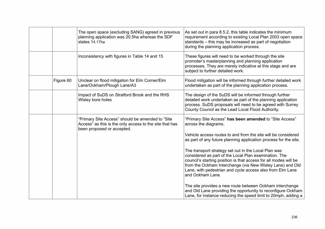
The open space (excluding SANG) agreed in previous planning application was 20.5ha whereas the SDF states 14.17ha
As set out in para 8.5.2, this table indicates the minimum requirement according to existing Local Plan 2003 open space standards – this may be increased as part of negotiation during the planning application process.
Inconsistency with figures in Table 14 and 15 These figures will need to be worked through the site promoter’s masterplanning and planning application processes. They are merely indicative at this stage and are subject to further detailed work.
Figure 60 Unclear on flood mitigation for Elm Corner/Elm Lane/Ockham/Plough Lane/A3
Flood mitigation will be informed through further detailed work undertaken as part of the planning application process.
Impact of SuDS on Stratford Brook and the RHS Wisley bore holes
The design of the SuDS will be informed through further detailed work undertaken as part of the planning application process. SuDS proposals will need to be agreed with Surrey County Council as the Lead Local Flood Authority.
“Primary Site Access” should be amended to “Site Access” as this is the only access to the site that has been proposed or accepted.
“Primary Site Access” has been amended to “Site Access” across the diagrams. Vehicle access routes to and from the site will be considered as part of any future planning application process for the site. The transport strategy set out in the Local Plan was considered as part of the Local Plan examination. The council’s starting position is that access for all modes will be from the Ockham Interchange (via New Wisley Lane) and Old Lane, with pedestrian and cycle access also from Elm Lane and Ockham Lane. The site provides a new route between Ockham interchange and Old Lane providing the opportunity to reconfigure Ockham Lane, for instance reducing the speed limit to 20mph, adding a
236
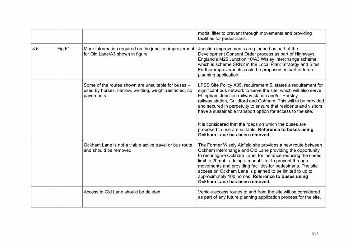
modal filter to prevent through movements and providing facilities for pedestrians.
8.6 Fig 61 More information required on the junction improvement for Old Lane/A3 shown in figure.
Junction improvements are planned as part of the Development Consent Order process as part of Highways England’s M25 Junction 10/A3 Wisley interchange scheme, which is scheme SRN2 in the Local Plan: Strategy and Sites. Further improvements could be proposed as part of future planning application.
Some of the routes shown are unsuitable for buses – used by horses, narrow, winding, weight restricted, no pavements
LPSS Site Policy A35, requirement 5, states a requirement for significant bus network to serve the site, which will also serve Effingham Junction railway station and/or Horsley railway station, Guildford and Cobham. This will to be provided and secured in perpetuity to ensure that residents and visitors have a sustainable transport option for access to the site. It is considered that the roads on which the buses are proposed to use are suitable. Reference to buses using Ockham Lane has been removed.
Ockham Lane is not a viable active travel or bus route and should be removed.
The Former Wisely Airfield site provides a new route between Ockham interchange and Old Lane providing the opportunity to reconfigure Ockham Lane, for instance reducing the speed limit to 20mph, adding a modal filter to prevent through movements and providing facilities for pedestrians. The site access on Ockham Lane is planned to be limited to up to approximately 100 homes. Reference to buses using Ockham Lane has been removed.
Access to Old Lane should be deleted.
Vehicle access routes to and from the site will be considered as part of any future planning application process for the site.
237
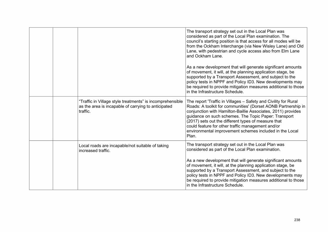
The transport strategy set out in the Local Plan was considered as part of the Local Plan examination. The council’s starting position is that access for all modes will be from the Ockham Interchange (via New Wisley Lane) and Old Lane, with pedestrian and cycle access also from Elm Lane and Ockham Lane. As a new development that will generate significant amounts of movement, it will, at the planning application stage, be supported by a Transport Assessment, and subject to the policy tests in NPPF and Policy ID3. New developments may be required to provide mitigation measures additional to those in the Infrastructure Schedule.
“Traffic in Village style treatments” is incomprehensible as the area is incapable of carrying to anticipated traffic.
The report 'Traffic in Villages – Safety and Civility for Rural Roads: A toolkit for communities' (Dorset AONB Partnership in conjunction with Hamilton-Baillie Associates, 2011) provides guidance on such schemes. The Topic Paper: Transport (2017) sets out the different types of measure that could feature for other traffic management and/or environmental improvement schemes included in the Local Plan.
Local roads are incapable/not suitable of taking increased traffic.
The transport strategy set out in the Local Plan was considered as part of the Local Plan examination. As a new development that will generate significant amounts of movement, it will, at the planning application stage, be supported by a Transport Assessment, and subject to the policy tests in NPPF and Policy ID3. New developments may be required to provide mitigation measures additional to those in the Infrastructure Schedule.
238
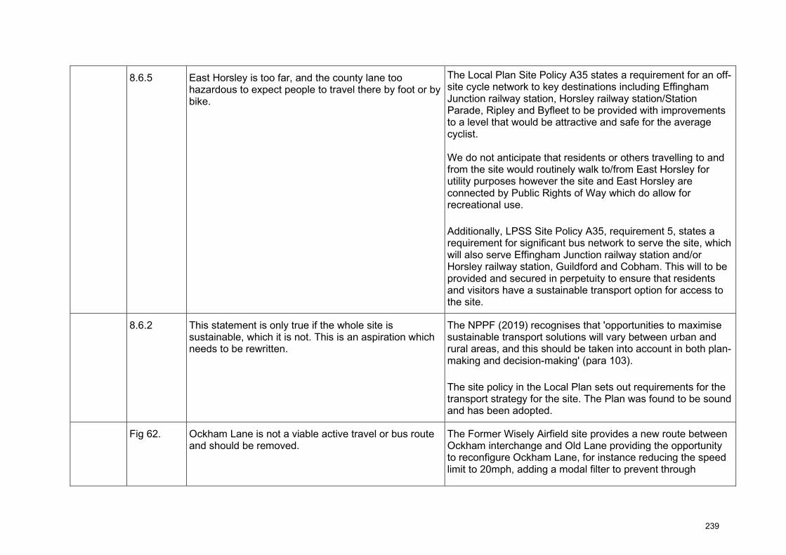
8.6.5 East Horsley is too far, and the county lane too hazardous to expect people to travel there by foot or by bike.
The Local Plan Site Policy A35 states a requirement for an off-site cycle network to key destinations including Effingham Junction railway station, Horsley railway station/Station Parade, Ripley and Byfleet to be provided with improvements to a level that would be attractive and safe for the average cyclist. We do not anticipate that residents or others travelling to and from the site would routinely walk to/from East Horsley for utility purposes however the site and East Horsley are connected by Public Rights of Way which do allow for recreational use. Additionally, LPSS Site Policy A35, requirement 5, states a requirement for significant bus network to serve the site, which will also serve Effingham Junction railway station and/or Horsley railway station, Guildford and Cobham. This will to be provided and secured in perpetuity to ensure that residents and visitors have a sustainable transport option for access to the site.
8.6.2 This statement is only true if the whole site is sustainable, which it is not. This is an aspiration which needs to be rewritten.
The NPPF (2019) recognises that 'opportunities to maximise sustainable transport solutions will vary between urban and rural areas, and this should be taken into account in both plan-making and decision-making' (para 103). The site policy in the Local Plan sets out requirements for the transport strategy for the site. The Plan was found to be sound and has been adopted.
Fig 62. Ockham Lane is not a viable active travel or bus route and should be removed.
The Former Wisely Airfield site provides a new route between Ockham interchange and Old Lane providing the opportunity to reconfigure Ockham Lane, for instance reducing the speed limit to 20mph, adding a modal filter to prevent through
239
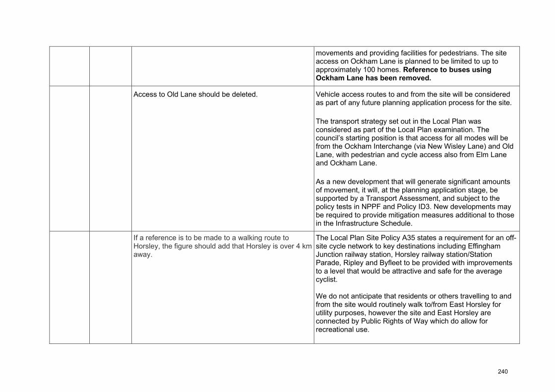
movements and providing facilities for pedestrians. The site access on Ockham Lane is planned to be limited to up to approximately 100 homes. Reference to buses using Ockham Lane has been removed.
Access to Old Lane should be deleted.
Vehicle access routes to and from the site will be considered as part of any future planning application process for the site. The transport strategy set out in the Local Plan was considered as part of the Local Plan examination. The council’s starting position is that access for all modes will be from the Ockham Interchange (via New Wisley Lane) and Old Lane, with pedestrian and cycle access also from Elm Lane and Ockham Lane. As a new development that will generate significant amounts of movement, it will, at the planning application stage, be supported by a Transport Assessment, and subject to the policy tests in NPPF and Policy ID3. New developments may be required to provide mitigation measures additional to those in the Infrastructure Schedule.
If a reference is to be made to a walking route to Horsley, the figure should add that Horsley is over 4 km away.
The Local Plan Site Policy A35 states a requirement for an off-site cycle network to key destinations including Effingham Junction railway station, Horsley railway station/Station Parade, Ripley and Byfleet to be provided with improvements to a level that would be attractive and safe for the average cyclist. We do not anticipate that residents or others travelling to and from the site would routinely walk to/from East Horsley for utility purposes, however the site and East Horsley are connected by Public Rights of Way which do allow for recreational use.
240
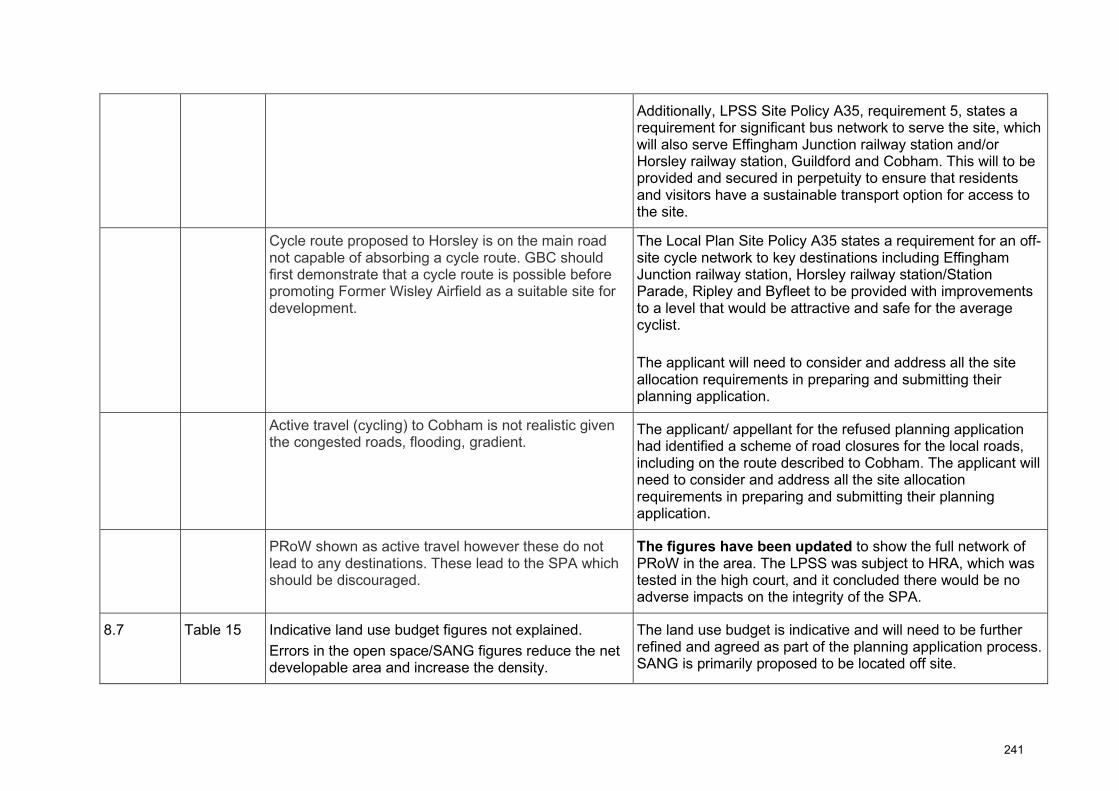
Additionally, LPSS Site Policy A35, requirement 5, states a requirement for significant bus network to serve the site, which will also serve Effingham Junction railway station and/or Horsley railway station, Guildford and Cobham. This will to be provided and secured in perpetuity to ensure that residents and visitors have a sustainable transport option for access to the site.
Cycle route proposed to Horsley is on the main road not capable of absorbing a cycle route. GBC should first demonstrate that a cycle route is possible before promoting Former Wisley Airfield as a suitable site for development.
The Local Plan Site Policy A35 states a requirement for an off-site cycle network to key destinations including Effingham Junction railway station, Horsley railway station/Station Parade, Ripley and Byfleet to be provided with improvements to a level that would be attractive and safe for the average cyclist. The applicant will need to consider and address all the site allocation requirements in preparing and submitting their planning application.
Active travel (cycling) to Cobham is not realistic given the congested roads, flooding, gradient.
The applicant/ appellant for the refused planning application had identified a scheme of road closures for the local roads, including on the route described to Cobham. The applicant will need to consider and address all the site allocation requirements in preparing and submitting their planning application.
PRoW shown as active travel however these do not lead to any destinations. These lead to the SPA which should be discouraged.
The figures have been updated to show the full network of PRoW in the area. The LPSS was subject to HRA, which was tested in the high court, and it concluded there would be no adverse impacts on the integrity of the SPA.
8.7 Table 15 Indicative land use budget figures not explained. Errors in the open space/SANG figures reduce the net developable area and increase the density.
The land use budget is indicative and will need to be further refined and agreed as part of the planning application process. SANG is primarily proposed to be located off site.
241
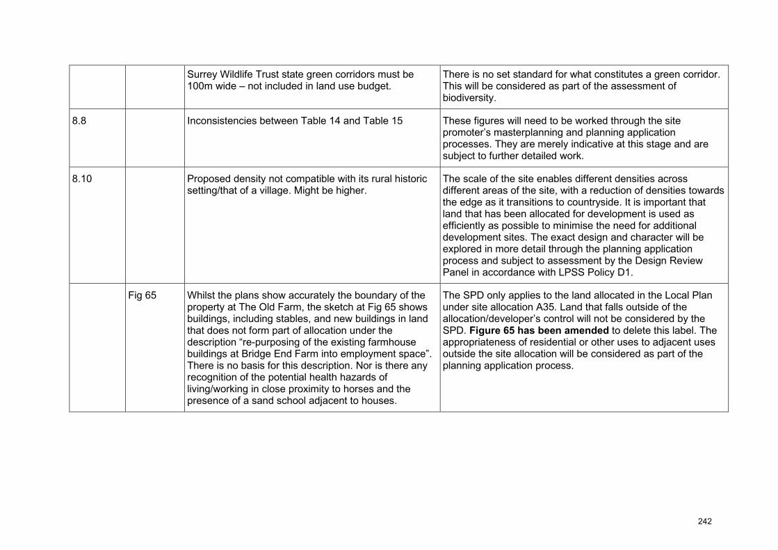
Surrey Wildlife Trust state green corridors must be 100m wide – not included in land use budget.
There is no set standard for what constitutes a green corridor. This will be considered as part of the assessment of biodiversity.
8.8 Inconsistencies between Table 14 and Table 15 These figures will need to be worked through the site promoter’s masterplanning and planning application processes. They are merely indicative at this stage and are subject to further detailed work.
8.10 Proposed density not compatible with its rural historic setting/that of a village. Might be higher.
The scale of the site enables different densities across different areas of the site, with a reduction of densities towards the edge as it transitions to countryside. It is important that land that has been allocated for development is used as efficiently as possible to minimise the need for additional development sites. The exact design and character will be explored in more detail through the planning application process and subject to assessment by the Design Review Panel in accordance with LPSS Policy D1.
Fig 65 Whilst the plans show accurately the boundary of the property at The Old Farm, the sketch at Fig 65 shows buildings, including stables, and new buildings in land that does not form part of allocation under the description “re-purposing of the existing farmhouse buildings at Bridge End Farm into employment space”. There is no basis for this description. Nor is there any recognition of the potential health hazards of living/working in close proximity to horses and the presence of a sand school adjacent to houses.
The SPD only applies to the land allocated in the Local Plan under site allocation A35. Land that falls outside of the allocation/developer’s control will not be considered by the SPD. Figure 65 has been amended to delete this label. The appropriateness of residential or other uses to adjacent uses outside the site allocation will be considered as part of the planning application process.
242
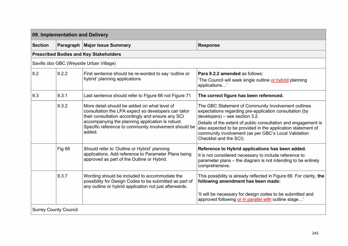
09. Implementation and Delivery
Section Paragraph Major Issue Summary Response
Prescribed Bodies and Key Stakeholders
Savills obo GBC (Weyside Urban Village)
9.2 9.2.2 First sentence should be re-worded to say ‘outline or hybrid’ planning applications
Para 9.2.2 amended as follows: ‘The Council will seek single outline or hybrid planning applications…’
9.3 9.3.1 Last sentence should refer to Figure 66 not Figure 71 The correct figure has been referenced.
9.3.2 More detail should be added on what level of consultation the LPA expect so developers can tailor their consultation accordingly and ensure any SCI accompanying the planning application is robust. Specific reference to community involvement should be added.
The GBC Statement of Community Involvement outlines expectations regarding pre-application consultation (by developers) – see section 3.2. Details of the extent of public consultation and engagement is also expected to be provided in the application statement of community involvement (as per GBC’s Local Validation Checklist and the SCI).
Fig 66 Should refer to ‘Outline or Hybrid’ planning applications. Add reference to Parameter Plans being approved as part of the Outline or Hybrid.
Reference to Hybrid applications has been added. It is not considered necessary to include reference to parameter plans – the diagram is not intending to be entirely comprehensive.
9.3.7 Wording should be included to accommodate the possibility for Design Codes to be submitted as part of any outline or hybrid application not just afterwards.
This possibility is already reflected in Figure 66. For clarity, the following amendment has been made: ‘It will be necessary for design codes to be submitted and approved following or in parallel with outline stage…’
Surrey County Council
243
9.6 9.6.3 Considering Government aspirations around gigabit speeds and FTTP, for developments of 20 or more premises, it is suggested that below is deleted. The strategic site developments should enable Fibre to the Premises (FTTP) to all residential and employment buildings. Where it can be shown it is not practical, other technologies should be provided to achieve Broadband speeds in excess of 24Mbps. Details on the proposed approach to digital connectivity should be included in the Infrastructure Delivery Statements submitted with planning applications.
Para 9.6.3 amended as follows: ‘The strategic site developments should enable Fibre to the Premises (FTTP) to all residential and employment buildings. Where it can be shown it is not practical, other technologies should be provided to achieve Broadband speeds in excess of 24Mbps. Details on the proposed approach to digital connectivity should be included in the Infrastructure Delivery Statements submitted with planning applications.’ Removing this text aligns with Local Plan policy D1(11) as well as supporting text at 4.5.17. The Council’s aspiration is that speeds of at least 1Gbps offered by full (synchronous) FTTP could be achieved.
Southern Gas Networks
9.6 9.6.1 Recommend the developer put in a connection request as early as possible to ensure capacity, especially in relation to the low pressure tier.
Noted. Addressed by LPSS ID1 and SDF section 9.6.1.
The Guildford Society
9.5 9.5.7 The Council needs to clarify for each site what infrastructure is expected at each site committed to before development starts
This is addressed in para 9.5.3. Furthermore, this will be agreed through the planning application process, production of a draft Heads of Terms for the s106 agreement and the s106 agreement itself. Local Plan policy ID1 is clear in requiring that infrastructure necessary to support new development will be provided and available when first needed.
Guildford Residents Association
9.2 9.2.2 The approach needs to be more robust in ensuring infrastructure first. This should go further in establishing the extent of infrastructure requirements for earlier
Local Plan policy ID1 is clear in requiring that infrastructure necessary to support new development will be provided and available when first needed. Infrastructure contributions and
244
phases of development. The concern is that crucial infrastructure may be left too late.
delivery matters (including triggers) will be agreed through the planning application process, production of an Infrastructure Delivery Statement (including s106 Heads of Terms) and the s106 agreement itself.
9.2.3 Detail should be provided for infrastructure requirements of the early phases for other sites, not just for phases at Ash and Tongham.
Detail is included regarding Ash and Tongham as it requires coordination across multiple sites (under differing ownership) in the delivery of infrastructure and provides additional guidance as separate applications will be received (and is not necessarily related to phasing of development). The other strategic sites are required to submit a masterplan and address infrastructure requirements in an Infrastructure Delivery Statement (including s106 Heads of Terms) and ultimately a s106 agreement. Further detail regarding the phasing / timing of delivery of infrastructure will be addressed through this process.
9.2.4 In addition to describing which documents should be submitted as part of an outline planning application, the SPD should indicate documents that should be prepared early to inform a master plan. Application should be expected to demonstrate that strategic assessments relating to issues such as landscape, drainage and transport have informed the master planning process
Para 9.2.4 amended as follows: ‘It should be evident that the masterplans are informed by the initial detailed work undertaken and to be submitted as part of the application process. The masterplans should include as a minimum:’
9.2.5 Should include a landscape and views strategy Whilst the list is not meant to be comprehensive it is agreed that landscape and visual impact assessment is an important component of the requirements for application submissions. The list at 9.2.5 has been deleted (as it is a repeat of Appendix A, with somewhat less detail) and the following text added in its place: ‘The list at Appendix A reflects the main requirements for strategic sites outline (or hybrid) planning applications and should be regarded as a starting point.’
245
Section B3 regarding responding to the landscape context is also relevant as a general principle.
9.3 9.3.3 This omits blue infrastructure and drainage which is a crucial step in determining appropriate layout.
Para 9.3.3 amended as follows: ‘…green and blue infrastructure including strategic, formal and informal open space, play area and sports provision, water courses and key drainage features.’ A Surface Water Drainage Strategy is included in the GBC Local Validation List (and Appendix A of the SPD).
9.3.9 Should refer to green, blue and grey infrastructure across sites.
Para 9.3.9 amended as follows: ‘The codes can be prepared in relation to different areas or phases; or alternatively as strategic design codes to coordinate the quality of the green, blue and grey infrastructure across sites.’
9.3.10 This list should also include water and drainage design Para 9.3.10 amended as follows: ‘green open spaces including formal sports, informal areas, place space and allotments and integration with blue infrastructure.’
9.7 9.7.2 Greater clarity is needed on how ensuring phases contribute to wider infrastructure, but avoiding later phases becoming unviable will be achieved. (e.g. transport infrastructure requirements such as A3 link roads and stations)
This will need to be demonstrated through the planning application submission and s106 agreement. Local Plan policy ID1 is clear in requiring that infrastructure necessary to support new development will be provided and available when first needed. Infrastructure contributions and delivery matters (including triggers) will be agreed through the planning application process, production of an Infrastructure Delivery Statement (including s106 Heads of Terms) and the s106 agreement itself.
246
West Horsley Parish Council
9.2 9.2.2 Given that there is no co-ordinated approach to the provision of strategic infrastructure generally, there is a lack of confidence that a coordinated approach to the provision of strategic infrastructure be achieved for the strategic sites – how will developers be held accountable for delivery.
This is addressed in para 9.5.3. Furthermore, this will be agreed through the planning application process, production of a draft Heads of Terms for the s106 agreement and the s106 agreement itself. Local Plan policy ID1 is clear in requiring that infrastructure necessary to support new development will be provided and available when first needed.
9.2.8 Further statement should be included to confirm the requirements of the NPPF Chapter 14 Decision Making para 39 and 40. The LPA should encourage developers to engage with the local community and consultees before submitting their applications and should include Parish Councils and Ward Councillors.
The GBC Statement of Community Involvement outlines expectations regarding pre-application consultation (by developers) – see section 3.2. Details of the extent of public consultation and engagement is also expected to be provided in the application statement of community involvement (as per GBC’s Local Validation Checklist and the SCI).
9.2.8 WHPC recommends a further extension of points to include 9.2.10. This should make reference to local adopted Neighbourhood Plans. NPPF Chapter 2 para 14 states “the adverse effect of allowing development that conflicts with the neighbourhood plan is likely to significantly and demonstrably outweigh the benefits as listed at points a, b, c, and d. This must be recognised in the SPD
New paragraph inserted after 2.1.7: Neighbourhood Plans Neighbourhood planning gives communities the opportunity to plan their local area. At present the Burpham Neighbourhood Plan has been adopted and forms part of the Development Plan. The neighbourhood area for this plan covers part of Gosden Hill Farm. There is an emerging West Clandon Neighbourhood Plan which covers the rest the of Gosden Hill Farm site however it is at an early stage and the weight accorded to its policies will depend on the stage it has reached. The Lovelace Neighbourhood Plan, which includes former Wisley Airfield has been examined and is awaiting referendum. In the meantime, it carries significant weight in determining planning applications. Where relevant, the policies in these plans should, alongside the Local Plan, form the starting point when drawing up schemes for these sites.
247
Worplesdon Parish Council
9.8 9.8.5 It is not clear what would be required of the PC in this regard for inclusion in its strategic plan. Groundstaff time? Management of a community centre? Management of play areas and open spaces?
Management arrangements will be clarified through the s106 agreement which would set out responsibilities in this regard. It would be within the Parish Council’s gift to agree or not with provisions for instance with regard to assets should these be offered to them for adoption.
Cllr Seabrook
9.3 9.3.10 Bullet list should also include paths and cycle routes Para 9.3.10 amended as follows: ‘public spaces, including paths and cycle routes;’
9.3.11 Indicates ‘Greater flexibility’ but greater than what? Para 9.3.11 amended as follows: Greater fFlexibility should be applied to building style within the guiding principles of ensuring distinctiveness, character and high-quality.
248
Appendix A and Appendix B
Section Paragraph Main Issue Summary Response
Prescribed Bodies and Key Stakeholders
West Horsley Parish Council
App A Should Climate Change be specifically listed? Information requirements to be submitted by applicants that address climate change will be contained in their sustainability statements (including for example adaptations for a changing climate and weather patterns) and energy statements (which demonstrates and quantifies how the energy requirements of LPSS Policy D2 are met). Both of these are listed in Appendix A. Separate further guidance is provided in the forthcoming Climate Change, Sustainable Design and Construction SPD.
Ockham Parish Council
App A Affordable housing seldom appears to be at prices within reach of the current average UK salary
Affordable housing is defined in the NPPF at Annex 2: Glossary.
Other respondents
App B A25 Comments raised against the requirements and considerations listed in A25
This part of the SDF merely reflects the wording in A25. It is beyond the scope of the SDF to amend the allocation itself. Where relevant to the contents of the SDF these have been included and responded to in the relevant section.
A31 Comments raised against the requirements and considerations listed in A31
This part of the SDF merely reflects the wording in A31. It is beyond the scope of the SDF to amend the allocation itself. Where relevant to the contents of the SDF these have been included and responded to in the relevant section.
249
A35 The site area is incorrect (95.9ha) - the original site area was 114.7ha. To that has been added land around Bridge End Farm and around Little Upton Farm shown in green on the plan below and amounting to 19.2ha. This equates to 133.9 ha
114.7 included SANG land. Site allocation A35 does not include SANG.
A35 Comments raised against the requirements and considerations listed in A35
This part of the SDF merely reflects the wording in A35. It is beyond the scope of the SDF to amend the allocation itself. Where relevant to the contents of the SDF these have been included and responded to in the relevant section.
250