IPSWICH GARDEN SUBURB
202
1 IPSWICH GARDEN SUBURB SUPPLEMENTARY PLANNING DOCUMENT DRAFT FOR PUBLIC CONSULTATION
-
Upload
khangminh22 -
Category
Documents
-
view
0 -
download
0
Transcript of IPSWICH GARDEN SUBURB

1
I P S W I C H G A R D E N S U B U R BS U P P L E M E N T A R Y P L A N N I N G D O C U M E N T
D R A F T F O R P U B L I C C O N S U LTAT I O N

Christchurch Park
IPSWICHTOWN CENTRE
Ipswich Garden Suburb
Waterfront
Westerfield
RiverOrwell
A14
A14to Felixstowe
A14 to Cambridge
A12To Colchester &
London
Urban Area
Open countryside
Key parkland
Railway line
Main roads
River
Ipswich Garden Suburb Location

Prepared byDavid Lock Associates
on behalf ofIpswich Borough Council
November 2013
I P S W I C H G A R D E N S U B U R BS U P P L E M E N T A R Y P L A N N I N G D O C U M E N T
D R A F T F O R P U B L I C C O N S U LTAT I O N
IPSW
ICH
NO
RTH
ERN
FRIN
GE
GAR
DEN
SUBU
RB :
SU
PPLE
MEN
TARY
PLA
NNIN
G D
OC
UM
ENT
4
Foreword by Portfolio MemberIpswich is Suffolk’s county town and main urban centre. We have a growing population, and one of the Council’s most important responsibilities is to ensure that sufficient land is provided to house that population over the coming years. This has necessitated some difficult choices. The Council’s Core Strategy, adopted in 2011, allocates land between Henley Road and Westerfield Road and south of the railway for up to 1,000 dwellings prior to 2021 and defines the wider Northern Fringe area as the main source of supply of housing land in Ipswich after 2021. The current review of the Core Strategy will determine the precise extent of further development within this wider area beyond 2021 and make specific allocations for an appropriate mix of housing and supporting infrastructure.
In the meantime an over-arching framework of supplementary planning guidance is required for the whole of the Northern Fringe area to ensure that any early phases of
development fit in with an area-wide plan and avoid a piecemeal approach, make provision for a good range of community facilities and other supporting infrastructure, and adhere to good standards of sustainability and urban design. It is this comprehensive planning guidance that this Supplementary Planning Document (SPD) seeks to provide.
In line with current national planning guidance for large scale urban extensions, develop-ment at the Northern Fringe will be modelled on ‘garden suburb’ principles. This means generous provision of green space, a sustain-able drainage system, a wide range of local facilities including shops, schools, allotments, community halls, health facilities, and a new country park to the north of the site. A wide choice of new homes will be provided to meet a range of needs, and super-fast broadband installed from its inception.
The site is located within one mile of Ipswich town centre, and this gives future residents
the option of walking, cycling, and using public transport to move around the town. New bus services will serve the development, and footpaths and cycle routes will be a feature of the scheme design. Two new bridges across the railway line are proposed, to ensure that the northern and southern parts of the site are well connected.
The process of drafting this Supplementary Planning Document (SPD) has been challeng-ing. It identified constraints [technical, envi-ronmental and economic], and a number of conflicting priorities and requirements that the document has sought to weigh and resolve.
The SPD has been prepared in consultation with the local community, the landown-ers, and a wide range of outside agencies including Suffolk County Council, Suffolk Coastal District Council, NHS Suffolk, Anglian Water, Natural England, Sport England, the Environment Agency, and the Suffolk Wildlife Trust. A wide range of views and technical
“

DAVI
D LO
CK A
SSO
CIAT
ES :
IPS
WIC
H B
ORO
UGH
CO
UNCI
L
5
information has thus been acquired to inform the SPD. A Community Steering Panel was set up to enable representatives of local communities, local councillors and Council officers to meet regularly to discuss a wide range of issues and to help guide its scope and content. We have been supported and advised throughout the process by ATLAS, the central government agency charged with assisting local planning authorities in the planning of major developments.
In proposing the development of the Northern Fringe, we recognise people’s concerns about the loss of open land and the additional traffic that will inevitably result. That’s why we have committed to making any development the best it can be by drawing up this comprehen-sive planning guidance.
This SPD is, at this point in time, a consulta-tion draft, and the Council invites views from all those involved and interested in the future of the site. Any representations received will be carefully considered to see if any changes to the SPD need to be made prior to its formal adoption by the Council.
My thanks go to everyone who has contributed to date, and I welcome your comments on this important document.
Councillor Carole JonesPortfolio Holder: Economic Development and PlanningIpswich Borough Council
”

IPSW
ICH
NO
RTH
ERN
FRIN
GE
GAR
DEN
SUBU
RB :
SU
PPLE
MEN
TARY
PLA
NNIN
G D
OC
UM
ENT
6
1 Introduction ................................................................... 8How the SPD has been prepared ...........................................12How the Council has Responded .......................................... 16Sustainability Appraisal ................................................................ 17
PART A: PLANNING & DESIGN ............ 192 A Vision & Core Objectives for
Ipswich Garden Suburb .............................................20Character ................................................................................................22Community .............................................................................................24Connectivity .......................................................................................... 26Climate Change ................................................................................. 28
3 Ipswich Garden Suburb Framework Plan ...............32Land Use.................................................................................................. 35
4 Spatial Strategies .......................................................48Place Making to achieve Walkable Neighbourhoods .. .........................................................................................................................50 Landscape and Open Space ................................................. 54Access & Movement ....................................................................69Sustainable Drainage .....................................................................73
5 Designing & Delivering Garden Suburb Character 78A Tried & Tested Approach .......................................................78Design at Every Scale ...................................................................80Creating Distinctive Neighbourhoods ................................80Designing Garden Suburb Streets .......................................89Blocks & Block Principles ...........................................................96Individual Homes & Plot Design .........................................106Residential Car Parking ............................................................... 112Designing the District & Local Centres ......................... 116
Contents
7
DAVI
D LO
CK A
SSO
CIAT
ES :
IPS
WIC
H B
ORO
UGH
CO
UNCI
LPART B: IMPLEMENTATION & DELIVERY .............................................................. 1216 Transport Strategy ................................................... 122
7 Infrastructure to Support the Growth of a Community .................................................................34Approach to infrastructure planning & delivery ..... 134Assumptions around the rate of housing delivery ......... ....................................................................................................................... 135Assumptions on housing mix & population profile ....... ....................................................................................................................... 135Approach to development sequencing .......................... 136Infrastructure required & triggers for delivery .......... 138Viability & Deliverability .............................................................147Implementation, Delivery and Monitoring ....................147
8 Community Development .......................................150
9 Long Term Manangement & Maintenance ........... 152Management Arrangements ................................................. 152Governance Structure ................................................................. 152Funding ................................................................................................... 152Ongoing Stakeholder Liaison and Monitoring ......... 153
10 Requirements for Future Planning Applications .. 154

IPSW
ICH
NO
RTH
ERN
FRIN
GE
GAR
DEN
SUBU
RB :
SU
PPLE
MEN
TARY
PLA
NNIN
G D
OC
UM
ENT
8
Introduction1The Role of the SPD
1.1 This document provides comprehensive supplementary plan-ning and design guidance for the masterplanning of a major urban extension of Ipswich known as the Ipswich Northern Fringe. As envisaged in the National Planning Policy Framework (Annex 2: Glossary) the SPD adds further detail to the policies in the adopted Core Strategy and provides further guidance for the development of the Northern Fringe and in respect of particular issues such as design. It is intended that this will be adopted, subject to any appropriate amendments, as a Supplementary Planning Document (SPD) in due course.
1.2 The SPD is required to provide supplementary planning guid-ance in respect of policy CS10 of the adopted Ipswich Borough Council Core Strategy and Policies Development Plan Document (hereinafter referred to as “the adopted Core Strategy”) and a draft revised policy CS10 included in the draft focused review of the Core Strategy and Policies Development Plan Document (hereinafter referred to as the “Core Strategy Focused Review”) currently taking place.
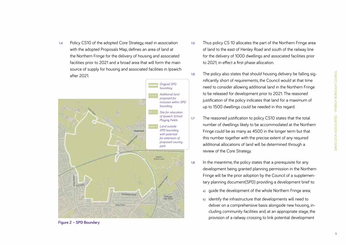
1.3 The area to which the SPD relates is as defined on the Proposals Map of the adopted Core Strategy (See Figure 1). Minor amend-ments to this boundary will be incorporated in the Core Strategy Focused Review (See Figure 2).
Figure 1 – Core Strategy Policy Map
DAVI
D LO
CK A
SSO
CIAT
ES :
IPS
WIC
H B
ORO
UGH
CO
UNCI
L
9
Figure 2 – SPD Boundary
1.4 Policy CS10 of the adopted Core Strategy, read in association with the adopted Proposals Map, defines an area of land at the Northern Fringe for the delivery of housing and associated facilities prior to 2021 and a broad area that will form the main source of supply for housing and associated facilities in Ipswich after 2021.
1.5 Thus policy CS 10 allocates the part of the Northern Fringe area of land to the east of Henley Road and south of the railway line for the delivery of 1000 dwellings and associated facilities prior to 2021; in effect a first phase allocation.
1.6 The policy also states that should housing delivery be falling sig-nificantly short of requirements, the Council would at that time need to consider allowing additional land in the Northern Fringe to be released for development prior to 2021. The reasoned justification of the policy indicates that land for a maximum of up to 1500 dwellings could be needed in this regard.
1.7 The reasoned justification to policy CS10 states that the total number of dwellings likely to be accommodated at the Northern Fringe could be as many as 4500 in the longer term but that this number together with the precise extent of any required additional allocations of land will be determined through a review of the Core Strategy.
1.8 In the meantime, the policy states that a prerequisite for any development being granted planning permission in the Northern Fringe will be the prior adoption by the Council of a supplemen-tary planning document(SPD) providing a development brief to:
a) guide the development of the whole Northern Fringe area;
b) identify the infrastructure that developments will need to deliver on a comprehensive basis alongside new housing, in-cluding community facilities and, at an appropriate stage, the provision of a railway crossing to link potential development
Original SPD boundary
Additional land proposed for inclusion within SPD boundary
Site for relocation of Ipswich School Playing Fields
Land outside SPD boundary with potential for extension of proposed country park
IPSW
ICH
NO
RTH
ERN
FRIN
GE
GAR
DEN
SUBU
RB :
SU
PPLE
MEN
TARY
PLA
NNIN
G D
OC
UM
ENT
10
phases, in the interests of sustainability and integration; and
c) set out a schedule of infrastructure charges.
1.9 Thus current adopted planning policy requires that the SPD is prepared as soon as possible to provide guidance both for, in the first instance, the future planning and development of the cur-rently allocated land south of the railway line and thereafter for such additional allocations as are made within the wider defined “broad area” of the Ipswich Northern Fringe through the Core Strategy Focused Review. The SPD is also required to identify in more detail the various supporting infrastructure requirements for the future residential development of the Ipswich Northern Fringe area already outlined in policy CS10 and associated reasoned justification.
1.10 Based on the latest population projections and information on housing need and housing land availability, a revised policy CS10 is being included in the Core Strategy Focused Review which proposes the allocation of the whole of the Northern Fringe area for new housing and associated uses. It sets out a land use budget for the various uses the area will contain and indicates a site capacity of approximately 3500 dwellings. The broad distribution of land uses across the area is indicated on the draft revised Policies Map and the detailed strategic and neighbourhood infrastructure requirements for the development are included in table 8B of Chapter 10 of the review document.
1.11 The revised policy CS10 states that a prerequisite for any development being granted planning permission in the Northern Fringe will be the preparation by the Council of a supplemen-tary planning document providing a development brief to:
a) guide the development of the whole Northern Fringe area;
b) amplify the infrastructure that developments will need to deliver on a comprehensive basis alongside new housing, including community facilities and, at an appropriate stage, the provision of a railway crossing to link potential develop-ment phases, in the interests of sustainability and integration;
c) identify the detailed location of a district and two local centres and other supporting infrastructure; and
d) provide guidance on the sequencing of housing and infra-structure delivery required for the development.
1.12 The draft SPD will provide firm guidance in respect of the land between Henley Road and Westerfield Road, south of the railway already allocated in the adopted Core Strategy and provisional guidance in respect of the other land areas of the defined Northern Fringe pending the finalisation and adoption of the Core Strategy Focused Review. The SPD is required at an early date to guide prospective planning applications for the land allocated in the adopted Core Strategy.
1.13 The draft SPD has been approved by the Council for formal public consultation and as a material consideration for use in the determination of planning applications submitted for land at the Northern Fringe.

DAVI
D LO
CK A
SSO
CIAT
ES :
IPS
WIC
H B
ORO
UGH
CO
UNCI
L
11
What the SPD Contains 1.14 The SPD provides guidance on how the allocations in the development plan will be delivered
both in spatial terms and in terms of sequencing, along with more general supplementary planning and design advice. It is arranged in two parts:
Part A: Planning & Design establishes the Council’s vision and objectives, and the overall approach to, and principles to guide the detailed master planning and design of the development. Specifically:
• Chapter 2 makes clear the Council’s vision and objectives for an “Ipswich Garden Suburb”, and sets these within the national and local policy context. It provides guidance on a suitable approach to sustainable design and development, which is focused around the key themes of Character, Community, Connectivity and Climate Change;
• Chapter 3 presents the Development Framework Plan –an overarching site plan which will guide the quantum and disposition of land uses across the site.
• Chapter 4 provides four site-wide spatial strategies to guide the co-ordinated planning of landscape, movement, walkable neighbourhoods and sustainable drainage systems (SuDS).
• Chapter 5 provides design guidance which will guide the crea-tion of a garden suburb character at the Garden Suburb.
Part B: Implementation & Delivery sets out the Council’s expec-tations about how its vision and objectives can be realised in relation to infrastructure, community development, management and the planning application process. In particular:
• Chapter 6 explains the transport strategy which should guide the outline planning application stage. The transport strategy has been prepared by Ipswich Borough Council and Suffolk County Council (the Highways Authority).
• Chapter 7 lists the infrastructure requirements to support the development of a new and expanded community at the garden suburb.
• Chapter 8 explains the intended approach to community development, including the appointment of a community development officer.
• Chapter 9 sets out guidance on the necessary long term management and maintenance of the landscape and green infrastructure within the proposed development.
• Chapter 10 explains the Council’s likely planning requirements at outline application stage and beyond to ensure a co-ordinated approach and the delivery of a high quality design.

IPSW
ICH
NO
RTH
ERN
FRIN
GE
GAR
DEN
SUBU
RB :
SU
PPLE
MEN
TARY
PLA
NNIN
G D
OC
UM
ENT
12
How the SPD has been prepared1.15 The SPD has been prepared in accordance with the provisions
of the Town and Country Planning (Local Planning) (England) Regulations 2012. It relates only to that area identified in policy CS10 (as amended by the Core Strategy Focused Review). It does not introduce any new policies.
1.16 The SPD has been prepared through a process involving the public, stakeholders, representatives from public sector agen-cies, the landowners and officers and members of the Borough and County Councils. In order to provide a platform for regular discussion and update, the Council established technical working groups in relation to spatial planning and transport. A Community Steering Panel was also established. These groups met on a regular basis to review and comment on aspects of the SPD as they emerged.
1.17 The SPD aims to balance the aspirations and objectives of these groups with acknowledged best practice principles for the design and development of sustainable high quality urban extensions.
1.18 The following key stages of work have shaped the draft SPD. Central to this process has been the consideration of a range of spatial options for the site (an explanation of all options gener-ated through the process is provided in Appendix 4 of this SPD):
• July 2012: Community Planning Day to identify development principles and master plan options for the site. This event was reported in a summary document which is available
to view at http://www.ipswich.gov.uk/site/scripts/down-load_info.php?fileID=3728
• August – November 2012: Work on master plan options and preparation of Issues & Options Report.
• January – February 2013: Non-statutory consultation on Issues & Options. The report can be viewed at
http://www.ipswich.gov.uk/site/scripts/download_info.php?downloadID=1534&fileID=4287
The summary of the responses to the Issues & Options Report can be viewed at
http://www.ipswich.gov.uk/site/scripts/download_info.php?downloadID=1534&fileID=4854
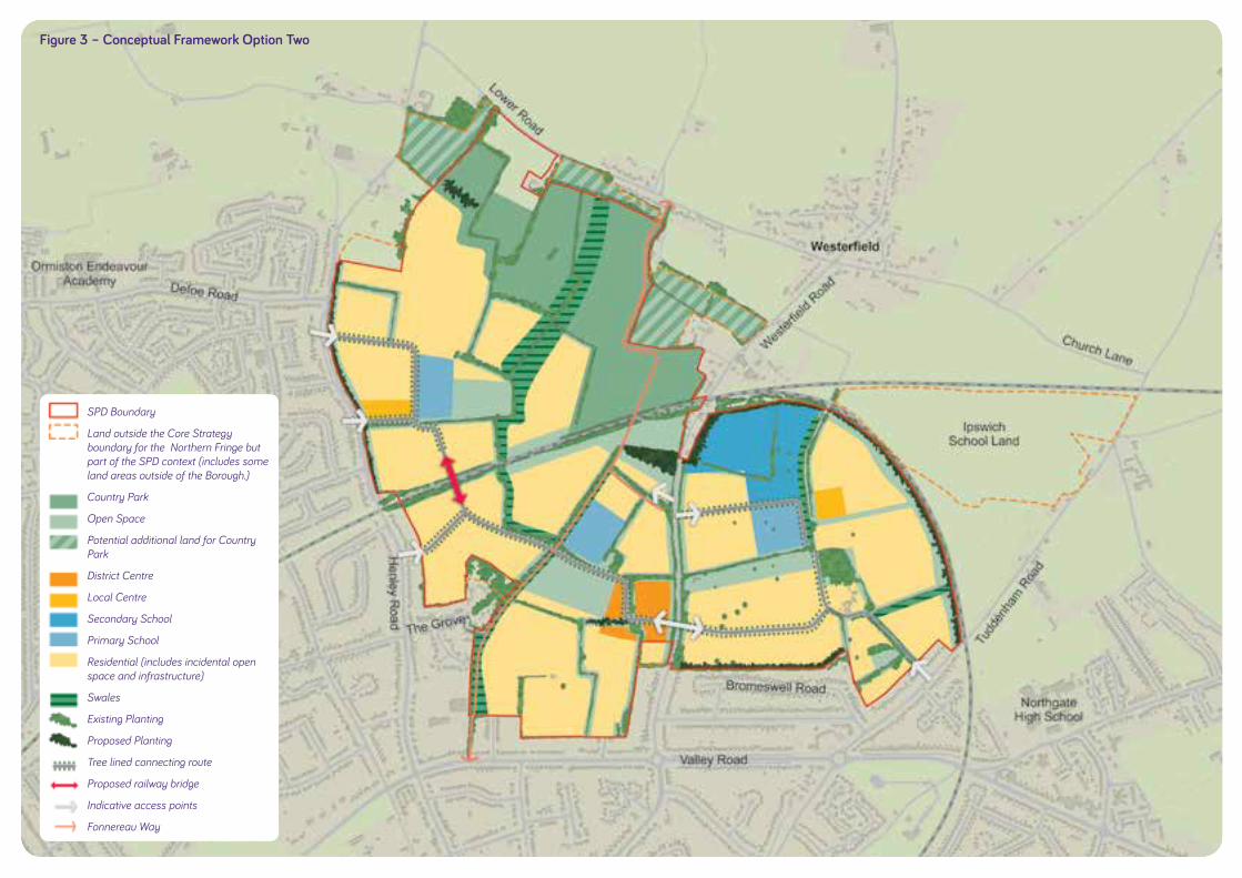
• March 2013 onwards: Identification of preferred option (Option 2) and drafting of SPD.
Identification of Preferred Option 21.19 The Issues and Options Report included three alternative spatial
options for development at the Ipswich Garden Suburb. In terms of community response, of those responding 17% preferred Option 1, 35% Option 2, and 14% Option 3. The three main developers / promoters had differing views as to a preferred option but there was a 2:1 majority in favour of either Option 2 or 3. The above informed the choice by the Council of a develop-ment option based on a variation of Option 2 for inclusion in the draft SPD (See Figure 3).
DAVI
D LO
CK A
SSO
CIAT
ES :
IPS
WIC
H B
ORO
UGH
CO
UNCI
L
13
Figure 3 – Conceptual Framework Option Two
SPD Boundary
Land outside the Core Strategy boundary for the Northern Fringe but part of the SPD context (includes some land areas outside of the Borough.)
Country Park
Open Space
Potential additional land for Country Park
District Centre
Local Centre
Secondary School
Primary School
Residential (includes incidental open space and infrastructure)
Swales
Existing Planting
Proposed Planting
Tree lined connecting route
Proposed railway bridge
Indicative access points
Fonnereau Way

IPSW
ICH
NO
RTH
ERN
FRIN
GE
GAR
DEN
SUBU
RB :
SU
PPLE
MEN
TARY
PLA
NNIN
G D
OC
UM
ENT
14
1.20 The Council concluded that Option 2 was preferred as it will, overall, create a better spatial plan for the site and the surround-ing area than either Option 1 or 3 in that it provides a central community hub including primary school, district park, and local shops within easy walking distance for each neighbourhood, and a centrally located district centre accessible from all parts of the garden suburb and conveniently located for existing residents in north Ipswich who currently have limited shopping choice locally. The location of the secondary school in the eastern neighbour-hood will assist in maintaining the required separation between Westerfield village and the development whilst being reasonably accessible to the whole of the garden suburb.
1.21 Option 2 poses relatively few impediments to an early start on the delivery of new homes at the garden suburb, alongside the provision of the necessary community facilities to form a largely self-sufficient neighbourhood during this early period. Additionally this option potentially facilitates the early delivery of the proposed district centre being on the land between Westerfield Road and Henley Road already allocated for devel-opment in the adopted Core Strategy.
Key Community Issues Arising from Issues & Options Consultation
1.22 The following is a brief summary of the key issues coming out of that consultation process that the draft SPD has sought to address.
1.23 Several strategic issues were raised by the community:
• the principle of the allocation of land at Ipswich Garden Suburb for development;
• the large scale of the development;
• the need for additional housing;
• the view that brownfield sites should be developed first, and
• the loss of agricultural land.
1.24 However, these are essentially Core Strategy matters and not within the remit of the SPD currently being formulated, which is essentially a development brief, the purpose of which is to guide the planning and design of any new development in the Ipswich Garden Suburb rather than to review land use allocations.
1.25 There was significant support for the principle of three walkable neighbourhoods, the proposed country park and other green space (including wholesale retention of existing hedgerows and trees), and the proposed new local retail, health, and community facilities. Proposals for new walking and cycling facilities were welcomed and new bus services and improved train services were highlighted as important. A need for new family housing was identified as well as serviced retirement accommodation.

DAVI
D LO
CK A
SSO
CIAT
ES :
IPS
WIC
H B
ORO
UGH
CO
UNCI
L
15
1.26 The main concerns raised by the community included:
• traffic impact (this was a primary concern for both local residents and adjoining parish councils);
• adverse impact on air quality;
• impact on outlook from existing homes;
• distribution of public open space;
• concern that essential community facilities will not be delivered;
• drainage and flood risk;
• whether the proposed housing densities will deliver a garden suburb character; and
• design of frontages to Henley Road and Westerfield Road.
Key Agency Issues Arising from Issues & Options Consultation
1.27 There was considerable support for the general approach being taken with regard to the planning and design of the garden suburb, particularly with regard to green infrastructure and sustainable urban drainage. The proposed country park was strongly supported. No agencies voiced any in principle objec-tions in response to the Issues and Options consultation.
1.28 The main issues raised by agency organisations included:
• details and emphasis of transport strategy requiring further review
• should seek to ensure high standards of sustainable develop-ment are achieved
• ensuring timely delivery of all necessary supporting infrastructure
• important to consider potential air quality impacts
• need to ensure adequate health mitigation
• consider potential to restore historic parkland around Red House Farm
• need to ensure appropriate sports facilities provided
• need to optimise potential for rail travel
Key Landowner Issues Arising from Issues & Options Consultation
1.29 The following issues were raised by the landowners:
• support for the garden suburb concept
• broad support for the vision and core objectives for future development of Ipswich Garden Suburb, and many of the key planning and design principles as set out in the Issues and Options report
• support for average net residential densities of 35 dwellings per hectare or less
• concerns that SPD should be an illustrative document that incorporates flexibility and is not too prescriptive, in part to enable it to respond to changing circumstances over the plan period, and to take account of viability issues

IPSW
ICH
NO
RTH
ERN
FRIN
GE
GAR
DEN
SUBU
RB :
SU
PPLE
MEN
TARY
PLA
NNIN
G D
OC
UM
ENT
16
• deliverability is of paramount importance and all planning policy and infrastructure requirements must therefore be considered in the context of a viability assessment for the whole scheme
• need to ensure the right balance between built development and green infrastructure is achieved
• SPD should require good national practice rather than exemplars with regard to sustainable development following national policy
• support for the vision that the Ipswich Garden Suburb will be based on excellent standards of urban design and will incorporate best practice in terms of sustainability
• detailed transport assessments carried out at the time of any future planning applications should form the basis of deci-sion making in this regard
• total provision of public open space as per adopted stand-ards in Core Strategy Appendix 6 can be achieved but site characteristics and qualities may necessitate flexible applica-tion of individual open space types.
• support for principle that new development will be compre-hensively planned and carefully phased and that any given phase must be supported with the necessary infrastructure to allow it to function well. Core Strategy review should con-sider allowing additional land release at INF prior to 2021 and countenance multiple starts to ensure the site is comprehen-sively brought forward and to ensure that infrastructure and facilities are phased appropriately and delivered alongside new housing
How the Council has Responded1.30 The Council has carefully considered the comments received,
and this draft SPD responds appropriately. In particular the following should be noted:
• Matters relating to traffic, air quality, health provision and flood risk will be subject to environmental impact assess-ment at the outline planning application stage. This SPD makes clear the Council’s expectations in this regard.
• The Council requires a development which is sustainable, and in this regard of the SPD makes clear how this should be achieved. Chapter 2 Vision and Objectives addresses this matter.
• Design and layout for Red House Farm is made clear in Chapter 5.
• Public open space is distributed across the site to ensure good access for all residents (Chapter 5). Open space is broadly consistent with the requirements of Appendix 6 of the adopted Core Strategy, with some flexibility permitted in response to the unique characteristics of the existing landscape.
• Sports facilities are required (Chapter 5), and this forms an integral part of the open space requirements. In addition, the potential for shared use with the proposed secondary school is highlighted.

DAVI
D LO
CK A
SSO
CIAT
ES :
IPS
WIC
H B
ORO
UGH
CO
UNCI
L
17
• The timing and delivery of essential community and physical infrastructure is addressed in Chapter 7. This chapter explains the required sequencing of infrastructure, and has been prepared in light of viability studies undertaken on behalf of the landowners and the Council.
• Opportunities for sustainable travel, including travel by rail are highlighted in Chapters 4 and 6.
• The Council expects residential densities to be between an average of 30 – 35 dwelling per hectare. This approach will allow lower densities to be achieved, and provides sufficient flexibility to ensure a garden suburb character prevails.
• The SPD makes clear the required design response in rela-tion to existing residential development (Chapter 4).
• The Council remains committed to a review of the Core Strategy, and this work is underway.
Sustainability Appraisal1.31 The Issues and Options Report was subject to a Sustainability
Appraisal (SA) to test its ability to help deliver the sustainable development criteria set out in the Core Strategy. Overall, the SPD has responded positively to the recommendations emerg-ing from this exercise, including:
• The inclusion of a robust transport strategy which promotes sustainable travel, informed in part by early discussions with local bus operators and a review of the potential to connect to existing cycleways and footpaths (Chapters 4, 6 and 7);
• The requirement for a waste strategy to minimise waste during construction and for the lifetime of the development (Chapter 2);
• Reference to the historic Red House Farm, and the require-ment for a clear strategy for its future integration and role within the development (Chapter 5);
• Reference in the SPD to provision for homeworking and the creation of a work hub within the district centre (chapter 5);
• The requirement for a housing mix which makes provision for all local housing needs including smaller households (Chapter 3); and
• A requirement to ensure Secure by Design Principles are applied (Chapter 2).
1.32 The draft SPD has been subject to an on-going Sustainability Appraisal process at each stage of its development. The SPD has been modified in response to the recommendations of the Sustainability Appraisal process. Where potential adverse impacts have been identified (for example, the loss of agri-cultural land and increased traffic generation) the draft SPD includes proposals to mitigate such impacts.

IPSW
ICH
NO
RTH
ERN
FRIN
GE
GAR
DEN
SUBU
RB :
SU
PPLE
MEN
TARY
PLA
NNIN
G D
OC
UM
ENT
18
Aerial perspective of new country park looking south towards new urban edge
19
DAVI
D LO
CK A
SSO
CIAT
ES :
IPS
WIC
H B
ORO
UGH
CO
UNCI
L
PART APlanning & Design

IPSW
ICH
NO
RTH
ERN
FRIN
GE
GAR
DEN
SUBU
RB :
SU
PPLE
MEN
TARY
PLA
NNIN
G D
OC
UM
ENT
20
A Vision & Core Objectives for Ipswich Garden Suburb2
Establishing Priorities2.1 The TCPA’s 2013 publication Creating Garden Cities and
Suburbs Today: A Guide for Councils includes a number of garden city principles which the Council endorses. They provide a good starting point for a vision for the Ipswich Garden Suburb:
• Strong vision, leadership and community engagement.
• Land value capture for the benefit of the community.
• Community ownership of land and long-term stewardship of assets.
• Mixed-tenure homes and housing types that are affordable for ordinary people.
• Beautifully and imaginatively designed homes with gardens in healthy communities.
• A strong local jobs offer in the Garden City itself and within easy commuting distance of homes.
• Opportunities for residents to grow their own food, including allotments.
• Generous green space, including: a surrounding belt of coun-tryside to prevent sprawl; well connected and biodiversity-rich public parks; high-quality gardens; tree-lined streets; and open spaces.
• Strong local cultural, recreational and shopping facilities in walkable neighbourhoods.
• Integrated and accessible transport systems.
2.2 In March 2012, the Government published the National Planning Policy Framework (NPPF) which states that “the supply of new homes can sometimes be best achieved through planning for larger scale development, such as new settlements or exten-sions to existing villages and towns that follow the principles of Garden Cities.”
2.3 Building on these principles the Borough Council requires the Ipswich Garden Suburb to be an exemplar sustainable urban extension. Future planning applications must clearly demon-strate that they have had full regard to the vision and objectives set out in this chapter and that proposals embrace best practice in sustainable development at the time the application is made.
Policy Framework2.4 The NPPF articulates a vision for growth in the context of
sustainable development. It is committed to a presumption in favour of sustainable development and strives to “significantly boost” the provision of housing.

DAVI
D LO
CK A
SSO
CIAT
ES :
IPS
WIC
H B
ORO
UGH
CO
UNCI
L
21
2.5 Ipswich Borough Council is required to provide a sufficient amount of deliverable and developable land through the identi-fication of key sites which are critical to the delivery of the hous-ing strategy over the plan period. Therefore, Ipswich Borough Council has a statutory obligation to plan for new homes and land for employment to meet identified growth demands.
2.6 The adopted Core Strategy establishes the principle of an urban extension in north Ipswich on land between Westerfield Village, Henley Road, Tuddenham Road and Valley Road. The Northern Fringe is the only development area of significant size that is available within the Borough to provide new homes within its boundary. The defined area comprises three distinct sub-areas: north of the railway between Henley Road and Westerfield Road, south of the railway between Henley Road and Westerfield Road, and east of Westerfield Road. The adopted Core Strategy allo-cates the land to the south of the railway between Henley Road and Westerfield Road for housing and associated facilities prior to 2021 and defines the wider area to accommodate housing and associated facilities after 2021, with the provision for a Core Strategy review to make appropriate allocations therein.
2.7 In keeping with the NPPF, Core Strategy policy CS1 sets out an overarching, comprehensive approach to tackling climate change and its implications including energy conservation, renewable energy, water conservation, capture, and recycling, and sustainable drainage.
2.8 Development of the Ipswich Garden Suburb will be required to reflect the requirements of current national and local planning
policy. However, it is estimated that building out the whole of the garden suburb may take up to twenty years and it must there-fore be recognised that planning policy will change over that period and that the planning and design of successive phases of development will need to respond accordingly. Similarly technology in many areas of life, including transport, communi-cations, and energy and water use will continue to change with implications for the way we live, work, and play and this will need to be reflected in the planning and design of later stages of the development.
2.9 In recognition of this, this SPD sets out a clear and enduring vision, and a set of core objectives, for the type of place to be created at the garden suburb, with a recognition of the need for monitoring and review in the future, to enable changing circum-stances to be accommodated as necessary, whilst maintaining adherence to the key principles of sustainable development and garden cities.
2.10 The Council’s Vision is based on four key themes:
• Character
• Community
• Connectivity
• Climate Change
2.11 These themes are explored further across the following pages as a series of specific policy compliant objectives that must inform all future development proposals.

IPSW
ICH
NO
RTH
ERN
FRIN
GE
GAR
DEN
SUBU
RB :
SU
PPLE
MEN
TARY
PLA
NNIN
G D
OC
UM
ENT
22
Character NPPF
2.12 The NPPF recognises the value of garden city principles for large scale developments such as the Ipswich Garden Suburb. This policy reference is supplemented by recent guidance on the subject produced by the Town and Country Planning Association which provides a useful set of principles and helpful design guidance that can inform the delivery of a sustainable garden suburb at the Northern Fringe. This guidance informs this SPD and developers are encouraged to utilise it in formulating their proposals for the Garden Suburb.
Ipswich Core Strategy2.13 Policy DM5 of the adopted Core Strategy 2011 requires all new
developments to be well designed and sustainable.
2.14 Core Strategy Policy DM30 requires residential densities, outside town and district centres, to be at an average of 35 dwellings per hectare. This is described in the Core Strategy as “low density”. Policy DM30 also enables exceptions to be considered where site characteristics, constraints or sustainable design justify a differ-ent approach. In order to prioritise place making objectives and to achieve the desired Garden Suburb character the Council is expecting densities across the site to vary, provided that the aver-age overall density is between 30 to 35 dwellings per hectare.
The Council’s Vision and Core Objectives2.15 Given its peripheral location and the prevailing character of
the adjoining urban area the required essential design ethos
will be that of a 21st Century garden suburb that combines the best aspects of accessible urban living with a strong emphasis on urban greening and contact with nature. Variations on that theme will, however, occur in each of the three main neighbour-hoods of the development area to give a distinct sense of identity to each one.
2.16 The garden suburb should have a distinct sense of place derived from existing natural and historic site features and high quality urban design and architecture.
2.17 The character of the garden suburb will be landscape domi-nated. Street trees and hedges will form the main boundary treatment between private and public space in the Garden City tradition of Hampstead or Letchworth. There will be generous provision of open space to deliver the garden suburb character and facilitate healthy lifestyles and wellbeing for future residents, provide space for nature (including the retention of the best of existing hedgerows and trees), accommodate sustainable drain-age, and provide opportunities for residents to grow their own food, including good sized gardens, and allotments. Extensive tree planting will assist in defining the garden suburb character of the new development area.
2.18 The street layout will generally tend to the formal grid (town) rather than organic (village) although this pattern will tend to distort towards the settlement edge and considerations of sustainable design will influence layout (e.g. designing for pas-sive solar gain). Home zone principles will be applied to form a strong character element.

DAVI
D LO
CK A
SSO
CIAT
ES :
IPS
WIC
H B
ORO
UGH
CO
UNCI
L
23
2.19 In general terms, densities will be required to reflect Core Strategy policy DM30 and will be highest around district or local centres, reducing towards the settlement margins.
2.20 This will be a 21st Century development and the architectural design will be contemporary and influenced by sustainable design considerations. The achievement of high standards of architecture will be required. Spacious, resource efficient homes will be designed to take account of changing demands and lifestyles by providing adaptable internal layouts and allowing for cost effective alterations.
2.21 The new community will be designed to be carefully and sensi-tively integrated into both the existing adjacent residential areas and the open countryside. In the latter instance the development will have a carefully designed transitional character zone that ensures that it sits well in the landscape on approaching the town from the north.
2.22 There will be a strong design focus on high quality public realm and in particular good street design – streets will be designed primarily as places for people, as advocated in Manual for Streets, not primarily for cars.
2.23 High quality and imaginative public art will be integrated into the public realm and will enliven the street scene at key locations.
2.24 The interface between homes and other buildings, and the public realm will be carefully planned to fully integrate parking, bin storage, boundary treatments, planting and sustainable drainage in a considered way.
2.25 Light pollution from artificial light should be limited through detailed design for the amenity of local residents, the landscape and nature conservation.

IPSW
ICH
NO
RTH
ERN
FRIN
GE
GAR
DEN
SUBU
RB :
SU
PPLE
MEN
TARY
PLA
NNIN
G D
OC
UM
ENT
24
CommunityNPPF
2.26 The NPPF identifies the social dimension of sustainable devel-opment. Supporting strong, vibrant and healthy communities, by providing the supply of housing required to meet the needs of present and future generations; and by creating a high quality built environment, with accessible local services that reflect the needs of the community and support its health, social and cultural well-being.
Ipswich Core Strategy2.27 Policy DM5 of the adopted Core Strategy 2011 requires areas to
function well and where possible integrate residential, working and community environments and fit well with adjoining areas. It promotes safe and secure communities.
2.28 Policy CS10 requires the provision of a range of community facilities and services at Ipswich Garden Suburb.
The Council’s Vision and Core Objectives2.29 The new garden suburb will be required to meet a full range of
identified housing needs through a varied housing mix which will include high quality social, affordable, and market homes. There will be a choice of apartments in appropriate locations. Housing should be high-quality, spacious and imaginatively designed so that it can be easily adapted to meet households’ changing needs over time. Opportunities for self-build should be created within each neighbourhood.
2.30 The proposed scale of development will enable the funding of a wide range of highly accessible on-site community facilities sufficient to meet many of the day-to-day needs of both future and existing local residents without the need to travel far.
2.31 A mixed use district centre (including shops, banks, building societies and restaurants, health facilities, employment space, residential space, and civic space), local centres, a new second-ary school, and three new primary schools will provide a key focus for community life. Schools will be designed with flexibility in mind to meet the need for crèches, nurseries, and community activities.
2.32 Good facilities will be provided for a wide range of outdoor rec-reation and sport to encourage healthy lifestyles and community interaction.
2.33 Home zones, community gardens (allotments) and orchards will provide further opportunities for new residents to meet up and socialise and grow some food.
2.34 There will be an on-going commitment to achieving successful community development, including the appointment of a com-munity development officer, the provision of appropriate accom-modation (e.g. community halls) online information (website), and by giving consideration to the community ownership of land and long-term stewardship of assets consistent with garden city principles.

DAVI
D LO
CK A
SSO
CIAT
ES :
IPS
WIC
H B
ORO
UGH
CO
UNCI
L
25
2.35 Community facilities will be provided on a phased basis consist-ent with the pace of housing provision.
2.36 There will be a range of on-site employment opportunities notably in the district and local centres, and schools and health facilities. The development will also be required to build in the capacity and facilities to accommodate high quality commu-nications infrastructure including superfast broadband and by ensuring that homes are designed to facilitate home working.
IPSW
ICH
NO
RTH
ERN
FRIN
GE
GAR
DEN
SUBU
RB :
SU
PPLE
MEN
TARY
PLA
NNIN
G D
OC
UM
ENT
26
ConnectivityNPPF
2.37 The NPPF supports the provision of high quality infrastructure to support development and economic growth.
Ipswich Core Strategy2.38 The adopted Core Strategy identifies the Northern Fringe for
major development; its proximity to the town centre means that it is well connected by an existing road network to services, jobs and other facilities, with inherently good potential for people to walk, cycle, and use buses and trains to access a range of destinations.
2.39 The Core Strategy is supported by an evidence base, which includes a Strategic Traffic Model. The model assessed the transport implications of a 5,000 dwelling scheme at the Northern Fringe on the whole of the town, accounting for trips to all major employment areas including the town centre. The model gave rise to a Transport Strategy which supports the Core Strategy. The Transport Strategy is summarised in Chapter 6 of this SPD.
The Council’s Vision and Core Objectives2.40 Ipswich garden suburb will be a well-integrated and connected
place based on three distinctive, interconnected, walkable neigh-bourhoods focused around attractive community hubs accessed by a highly permeable network of safe, convenient and attractive walking and cycling routes.
2.41 Every opportunity will be taken in designing the new community to reduce the need to travel, especially by car. Opportunities for walking, cycling and the use of public transport will be prioritised. All streets will be designed to be pedestrian and cycle friendly. This objective will influence all aspects of planning and scheme design including land use mix, layout, and the design of move-ment in and around the site.
2.42 Whilst accommodating the car, the garden suburb should priori-tise sustainable transport options that will provide opportunities for, and encourage, future residents to use their cars less both when travelling around the site and to key off-site destinations with associated benefits in terms of reduced energy use and traffic impacts, air quality and health benefit.
2.43 The main community facilities will be located so as to be within easy walking distance of as many homes as possible. The concept of walkable neighbourhoods will inform the layout of the development.
2.44 There will be frequent bus services to the town centre and the majority of homes should be within 400m of a bus stop. Consideration will be given to the promotion of new orbital bus routes subject to agreement with the bus operators and viability considerations.
2.45 Opportunities for a Westerfield Station car park will be sought in association with improvements to the station facilities them-selves. Strategic cycle routes will criss-cross the site including a key link from Westerfield Station through the site and onwards

DAVI
D LO
CK A
SSO
CIAT
ES :
IPS
WIC
H B
ORO
UGH
CO
UNCI
L
27
to Ipswich Town Centre, potentially via the northern end of Christchurch Park and the bridleway along the western edge of the Park.
2.46 The design of roads, housing and other buildings, and the integration of planting, public art, foot and cycle path layout will all contribute to the legibility of the development, making it easy for people to find their way around.
2.47 Streets will have design speeds of no more than 20mph and many will be less.
2.48 Opportunities for home-working will be provided together with super-fast broadband (i.e. greater than 30 Mbit/s to meet Government targets) to make it attractive and easy for people to work from home.
2.49 The design of car parking in both residential areas and district and local centres will be an integral part of public realm design, contributing to the quality and legibility of public spaces.
2.50 A new road bridge over the Ipswich to Lowestoft/Felixstowe railway line will be provided to ensure a high level of connectiv-ity between different parts of the site. A new pedestrian / cycle bridge will replace the existing sub-standard at grade crossing where Fonnereau Way currently crosses the railway line.
2.51 New recreational routes will provide for easy access across the site from the town out into the surrounding countryside for cyclists and walkers.
2.52 Safe crossing points of routes of surrounding main roads and across Westerfield Road running through the heart of the site for pedestrians and cyclists will be provided in appropriate locations.
2.53 Wildlife corridors will be required for protected and valuable species, to enhance the existing ecological network.
IPSW
ICH
NO
RTH
ERN
FRIN
GE
GAR
DEN
SUBU
RB :
SU
PPLE
MEN
TARY
PLA
NNIN
G D
OC
UM
ENT
28
Climate ChangeNPPF
2.54 The NPPF recognises that sustainable development can play a key role in contributing to protecting and enhancing our natural, built and historic environment; and, as part of this, helping to improve biodiversity, use natural resources prudently, minimise waste and pollution and mitigate and adapt to climate change including moving to a low carbon economy.
2.55 NPPF requires local planning authorities to support the move to a low carbon future and when setting any local requirements for a building’s sustainability, to do so in a way consistent with the Government’s zero carbon buildings policy and adopt nationally described standards.
Ipswich Core Strategy2.56 Core Strategy policies DM1 (Sustainable Development) and DM2
(Decentralised Renewable or Low Carbon Energy) set out the Council’s current more specific requirements for new buildings in respect of environmental sustainability, including, amongst other things, energy and water use, and renewable energy. These standards are expressed in terms of the nationally described standards of Code for Sustainable Homes (CfSH) for new hous-ing, and BREEAM for non-residential buildings. These policies remain NPPF compliant with the exception that the element of CfSH relating to carbon reduction as prescribed by policy DM1 must now be consistent with the Government’s zero carbon building policy, as expressed through the Building Regulations.
Both policies make provision for reduced requirements conse-quent on feasibility and viability considerations in line with the requirements of NPPF.
2.57 Policy DM2 requires all new development above certain thresholds to provide at least 15% of their energy requirements from decentralised and renewable or low carbon sources. The policy makes provision for additional carbon reductions through passive design measures (i.e. this should now be interpreted as being over and above the standard required by the Building Regulations at the time of any planning application rather than CfSH standards) in lieu of all or part of the 15% renewables requirement. The Council would generally encourage this approach as providing a more robust solution to carbon reduc-tion over the lifetime of a building than certain micro-renewable technologies.
2.58 Policy DM5 requires all new buildings to be highly sustainable and designed for long life by being capable of adaption to accommodate changing needs and uses over time.
2.59 Additionally, Core Strategy policy DM4 covers sustainable drainage and water efficiency measures, and policy CS4 covers construction materials and waste.
The Council’s Vision and Core Objectives2.60 All homes will be required to achieve the appropriate rating
under the Code for Sustainable Homes (currently prescribed as Code level 5 / 6 in the Council’s adopted Core Strategy) or
DAVI
D LO
CK A
SSO
CIAT
ES :
IPS
WIC
H B
ORO
UGH
CO
UNCI
L
29
an equivalent standard under other rating standards that may replace the Code in future years. The Council will encourage maximising low energy use and energy efficiency through pas-sive design principles in the first instance.
2.61 15% of the overall energy requirements of the development will be provided on site from renewable sources. This can be achieved on an individual dwelling basis. Additional passive design measures may be considered an appropriate alternative to on-plot renewables in some cases.
2.62 All homes will prioritise low energy use and water use, including rainwater capture and storage (responding to increasing drought stress in East Anglia).
2.63 Any development scheme will need to demonstrate a robust strategy for waste minimisation, both during construction and for the lifetime of the development.
2.64 There will be comprehensive facilities for domestic waste recy-cling; a waste management plan will be required at the outline planning stage.
2.65 High priority will be given to the creation of a strongly defined green infrastructure network that will define the character of the place and provide good access to a wide range of high quality green space and nature for both existing and future residents in combination with attractive and safe walking / cycling routes. An aim should be to deliver better and more varied access to high quality green space for existing residents for walking,

IPSW
ICH
NO
RTH
ERN
FRIN
GE
GAR
DEN
SUBU
RB :
SU
PPLE
MEN
TARY
PLA
NNIN
G D
OC
UM
ENT
30
cycling and other outdoor activities than currently exists. The green infrastructure network will build on the existing asset of the field hedgerows and trees that are such a distinctive and attractive feature of the existing site.
2.66 Working with the Suffolk Wildlife Trust and calling on existing expertise within IBC Parks and Open Spaces section, every opportunity will be taken to create space for nature (including the creation of new nature reserves) and to significantly enhance the overall biodiversity of the Site.
2.67 A new country park will be provided to serve both the new resi-dents and the wider community. The new park will also serve as a green buffer between the new garden suburb and the village of Westerfield.
2.68 The development will be laid out and designed to provide an appropriate urban edge in the wider landscape and a suitable separation distance and setting for Westerfield village.
2.69 Community gardens and orchards will be provided in appropri-ate locations and supported with robust and sustainable mainte-nance arrangements.
2.70 The design of movement, green infrastructure, and drainage strategies will be fully integrated from the outset, with surface water attenuation to manage flood risk providing associated amenity and biodiversity benefits.
2.71 The landscape design throughout the new development will take full account of climate change objectives, incorporating shelter and shading from tree canopies, facilitating and / or managing passive solar gain, assisting with flood management, and helping increase biodiversity.

DAVI
D LO
CK A
SSO
CIAT
ES :
IPS
WIC
H B
ORO
UGH
CO
UNCI
L
31
Aerial View of the Site from South East
IPSW
ICH
NO
RTH
ERN
FRIN
GE
GAR
DEN
SUBU
RB :
SU
PPLE
MEN
TARY
PLA
NNIN
G D
OC
UM
ENT
32
Ipswich Garden Suburb Framework Plan33.1 Policy CS10 of the adopted Core Strategy requires the SPD
to provide a development brief to guide the development of the whole of the Northern Fringe area as defined on the Core Strategy Proposals Map, and identify the supporting infrastruc-ture that developments will need to deliver on a comprehensive basis alongside new housing. The Development Framework Plan (figure 5) supports this requirement by establishing the main land use parameters and strategic road links for the necessary comprehensive masterplanning of the Northern Fringe required to support any future outline planning applications and to ensure that a piecemeal approach to the planning of the wider area is avoided.
3.2 A revised policy CS10 included in the Core Strategy Focused Review allocates the whole of the defined Northern Fringe area for housing and associated facilities. The required mix of land uses to be delivered over the plan period and their approximate areas are set out in the policy and the broad distribution of these uses is indicated on the Policies Map. The prerequisite require-ment for the preparation and adoption of a development brief for the whole of the Northern Fringe area in the form of an SPD prior to any development being granted planning permission
set out in the adopted policy CS10 is substituted in the revised policy CS10 by a prerequisite requirement for the preparation of an SPD. This proposed change is in recognition of the facts that (i) the provisions of the SPD as they relate to the wider Northern Fringe area may not be formally adopted unless and until that area has been allocated for development in the Core Strategy Focused Review but (ii) that as indicated by previous Government Inspectors the SPD is required at an early date to inform any planning applications that may be submitted in respect of the currently allocated land east of Henley Road and south of the railway prior to the adoption of the Core Strategy Focused Review.
3.3 The land use allocations shown in the Development Framework Plan (and associated guidance contained herein) in respect of the land allocated in the adopted Core Strategy for housing and associated facilities prior to 2021 can be regarded as firm guidance for any planning applications that may relate. Land use allocations relating to the remaining areas of the site should be regarded as guidance pending the adoption of the Core Strategy Focused Review, and indicate how these areas could be developed as part of a comprehensive plan.

DAVI
D LO
CK A
SSO
CIAT
ES :
IPS
WIC
H B
ORO
UGH
CO
UNCI
L
33
SPD Boundary
Conservation Area
Registered Parks & Gardens
Train Station
Listed Buildings
Public Rights of Way
Trees, hedgerows and ditches (retained where possible)
Tree Protection Order
Tree Protection Order (approximate location)
ASTSWF Intermediate
Reference: Areas Susceptible to Surface Water Flooding Data, Copyright Environment Agency (2008)

IPSW
ICH
NO
RTH
ERN
FRIN
GE
GAR
DEN
SUBU
RB :
SU
PPLE
MEN
TARY
PLA
NNIN
G D
OC
UM
ENT
34
Figure 4 – Environmental Site Features
3.4 The framework plan responds to the environmental site features (figure 4), which were explained in the Issues & Options Report. A full copy of that report is available at:
http://www.ipswich.gov.uk/downloads/Issues_and_Options_Report_Dec_2012_rev_C_email_version_REDUCED.pdf
3.5 At the outline application stage the framework plan will be subject to technical assessment under The Town and Country Planning (Environmental Impact Assessment) Regulations 2011, and will be refined through this process. The Council further acknowledges that minor changes to the framework plan may arise as a consequence of ongoing detailed design and techni-cal work. However, the Council expects the framework plan to form the starting point for this work, and expects the following guidance to be followed in future masterplanning and planning.
DAVI
D LO
CK A
SSO
CIAT
ES :
IPS
WIC
H B
ORO
UGH
CO
UNCI
L
35
Land Use3.6 The Development Framework Plan gives spatial expression to
the land use budget for the Northern Fringe area as set out in the revised policy CS10 and provides more detail on the broad distribution of uses indicated on the Policies Map of the Core Strategy Focused Review. In essence this can be regarded as a “balanced” budget that seeks to maximise the delivery of hous-ing land within the defined Northern Fringe area whilst ensuring that adequate land is reserved for the necessary supporting infrastructure for the number of homes proposed and an associ-ated projected future population.
3.7 The Development Framework Plan also takes into account the main site constraints that will influence future development (most notably topography, drainage and areas subject to flood-ing, the railway, existing rights of way, and hedgerow and tree cover).
3.8 The land use budget provides 102 hectares of land for new housing together with 68.5 hectares of land for supporting infrastructure and also makes provision for a country park of 24.5 hectares.
3.9 This includes provision for 40 hectares of public open space sufficient, in overall terms, to meet the policy requirements of Appendix 6 of the adopted Core Strategy for a projected devel-opment of around 3300 homes (accommodating an estimated 8250 people). The country park provision of 24.5 hectares would be additional to this.
3.10 At an average net residential density of between 30 and 35 dwellings per hectare it is envisaged, in broad terms, that between 3,000 and 3,500 new homes can be accommodated within the whole of the defined area. This seeks to strike a balance between achieving a density of development that can contribute to the achievement of a garden suburb character and that is consistent with the suburban context of the surrounding area, whilst at the same time delivering reasonable housing numbers to meet identified needs, supporting the provision of the necessary infrastructure, and making efficient use of scarce development land.

IPSW
ICH
NO
RTH
ERN
FRIN
GE
GAR
DEN
SUBU
RB :
SU
PPLE
MEN
TARY
PLA
NNIN
G D
OC
UM
ENT
36
3.11 The following table summarises the land uses that will be required within the development, and provides guidance on the broad quantities that are anticipated at the outline planning application stage.
Land Use Approximate area in hectaresPublic Open Space 40Country Park 24.5Residential 102District Centre 3.5Local Centres 1.5 including 0.5ha per local centre
within Henley Gate and Red House neighbourhoods and 0.5ha within Henley neighbourhood for the country park visitor centre / community centre
Secondary School 9.0Primary Schools 6.0Primary Road Infrastructure
8.5
Total 195
DAVI
D LO
CK A
SSO
CIAT
ES :
IPS
WIC
H B
ORO
UGH
CO
UNCI
L
37
Figure 5 – Development Framework Plan
SPD Boundary
20m Corridor
15m Corridor
Railway with minumum buffer of 60m
Footpaths including Fonnereau Way
District & Local Centres
Residential
Education
Formal Open Space
Other Informal Open Space
Country Park
0m 400m100m 200m40m
N
Title
Date Scale
DAVID LOCK ASSOCIATES LIMITED50 NORTH THIRTEENTH STREET, CENTRAL MILTON KEYNES, MK9 3BPTEL: 01908 666276 FAX : 01908 605747 EMAIL: [email protected]
Reproduced by permission of Ordnance Survey on behalf of HMSO.© Crown copyright and database right
All rights reserved.Ordnance Survey Licence number 100021566
Drawn Designed Approved Drawing Number
This drawing is for information purposes only and not for use in construction.Do NOT scale from this drawing.All dimensions are to be checked on site and any discrepancies should beimmediately reported to the originator of the drawing.All information is copyright protected and may not be used or reproducedwithout prior permission.
NOTE
2012
Development Framework Plan
--JCADW INF001 - 087
Ipswich Northern Fringe
11-07-2013 1:10,000 @ A4
A
SPD Boundary
20m corridor
15m corridor
Railway with minimum buffer of 60m
Footpaths including Fonnereau Way
District & local centres
Residential
Education
Formal open space
Other informal open space
Country park

IPSW
ICH
NO
RTH
ERN
FRIN
GE
GAR
DEN
SUBU
RB :
SU
PPLE
MEN
TARY
PLA
NNIN
G D
OC
UM
ENT
38
Public Open Space & Green Infrastructure3.12 In keeping with the garden suburb tradition, landscape charac-
ter and green open spaces will be the key defining feature of Ipswich Garden Suburb. The Council will require applicants to demonstrate high standards for the design, specification and maintenance of all landscape elements in order to secure an appropriate quality over the short, medium and long term life of the development. Landscape strategies and landscape design codes will be expected to accompany any outline planning application(s). This will apply to all landscape areas including the public realm within the built up areas.
3.13 The Framework Plan indicates the anticipated disposition of green spaces and corridors across the site. It is informed by the site’s topography and existing watercourses, and by existing hedgerows, trees and woodland, which are recognised as impor-tant structural elements within the site, providing the potential to enhance the garden suburb character. Many of the trees are covered by Tree Preservation Orders. A detailed arboricultural survey should be carried out to confirm the quality of the trees and hedgerows as part of the detailed masterplanning of the site. The alignment of existing watercourses and topography (e.g. areas at risk of flooding) also informs the distribution of open space.
3.14 The framework plan locates a formal green space at the centre of each neighbourhood to provide a focus for activity. The character and diversity to be achieved within these spaces is set out in the next section of this SPD.

DAVI
D LO
CK A
SSO
CIAT
ES :
IPS
WIC
H B
ORO
UGH
CO
UNCI
L
39
3.15 A new country park will be a defining feature of the Ipswich Garden Suburb and an integral component of the development with a high priority attached to early delivery. The country park will also play a key role in maintaining the physical separation of Westerfield village from the built up area of Ipswich and in accommodating sustainable drainage.
3.16 The Framework Plan (Figure 5) and Landscape and Open Space Typologies plan (Figure 10) includes the following open space types, and approximate measurements:
• A new country park – 24.5 ha
• Formal open space to include sports pitches – 5.5 ha*
• Parks & Gardens - 8 ha
• Natural and semi-natural green space – 16 ha
• Play areas (Destination Equipped Area for Play Neighbourhood Equipped Areas for Play and Local Equipped Areas for Play) – 1.2 ha
• Youth Provision – 0.3 ha
• Areas for food production including allotments and commu-nity orchards – 3 ha
• Amenity green space – 6 ha
* Sports Pitch provision of 12ha is required to comply with Core Strategy Appendix 6. Additional provision should be made at the secondary school and primary schools, where the installation of all-weather pitches and shared community use is sought.
3.17 In addition, the Council requires a minimum of 10% of land within the net residential areas to be provided as public open space. This space will be required to accommodate sustainable urban drainage (SuDs), retained trees and hedgerows, and to provide an attractive “garden suburb” character to each residen-tial area. The preliminary SuDS strategy indicates that this 10% figure may need to be increased to 12% in some locations to provide sufficient space for SuDs.
3.18 Open spaces across the site will support a comprehensive system of sustainable urban drainage for the whole site. Requirements for SuDS are set out in the next section of this SPD.

IPSW
ICH
NO
RTH
ERN
FRIN
GE
GAR
DEN
SUBU
RB :
SU
PPLE
MEN
TARY
PLA
NNIN
G D
OC
UM
ENT
40
Residential3.19 It is currently estimated that if the whole of the designated
Northern Fringe area were to be allocated for development a total of approximately 102 hectares of residential land could be accommodated. At an assumed average net residential density of 30-35 dwellings per hectare this quantum of land would deliver between 3000 and 3500 new homes. Work on the illustrative master plan and the framework plan has confirmed the sites capacity. It is anticipated that the majority will be family homes of different sizes, but provision should also include starter homes, retirement units, self-build plots, and apartments in order to achieve a balanced community.
3.20 It is considered that the average net residential density of development across the site as a whole is likely to be around 32.5 dwellings per hectare but with an indicative maximum capacity for the site (stated in the draft revised policy CS10) of up to 3500 dwellings. However, in practice densities will vary across the site in response to a range of factors including loca-tion, adjacent uses, planning to accommodate existing landscape features, and a balanced housing mix and place-making objec-tives will drive density rather than vice-versa. A limited number of small areas may have densities of up to 45 dwellings per hec-tare; in other areas density may be 20-25 dwellings per hectare. Further guidance on density is provided in the Design Guidance section of this SPD.
3.21 Each neighbourhood and each phase of development will be expected to deliver an appropriate mix of types and sizes of housing to provide variety and choice and meet a wide range of identified need.
3.22 Precise details of mix will be negotiated on a phase by phase basis having regard to the latest available evidence on need. Currently in Ipswich, in broad terms, there is an identified need for family housing, accommodation for smaller households (including suitable accommodation for the elderly wishing to downsize), managed accommodation for the elderly, affordable housing for first time buyers, social housing for rent, and oppor-tunities for self-build.
3.23 However, taking account of current trends and projections, and the potential size of new homes being built throughout Ipswich, and also taking account of current household sizes and housing stock in the town, current data suggests that the following mix should guide the provision of new homes at the garden suburb:
• 1 bed homes – 10%
• 2 bed homes – 23%
• 3 bed homes – 38%
• 4 bed homes – 21%
• 5+ bed homes – 8%
These percentages will be subject to confirmation following further analysis and consideration of current affordable housing need.
DAVI
D LO
CK A
SSO
CIAT
ES :
IPS
WIC
H B
ORO
UGH
CO
UNCI
L
41
3.24 With regard to housing for older people both Ipswich Borough Council and Suffolk County Council are keen to see the provi-sion of general needs / market and affordable housing that meets the changing needs of people as they age. The Lifetime Homes standard supports this principle, and as such both Councils would wish that all housing be built to this standard to improve health, independence and wellbeing outcomes, enabling older people to remain in their own homes, of what-ever size, type or tenure, for longer Core Strategy Policy DM5 f. provides support for such an approach which is also supported by the Government’s National Housing Strategy and Lifetime Neighbourhoods reports.
• See Lifetime Neighbourhoods, page 8: https://www.gov.uk/government/uploads/system/uploads/attachment_data/file/6248/2044122.pdf
• See ‘Laying the Foundations’, paragraph 37: https://www.gov.uk/government/uploads/system/uploads/attach-ment_data/file/7532/2033676.pdf
3.25 Most residential development will be two-storey, in keeping with the surrounding suburbs. In some places, for example close to mixed-use centres, adjacent to large public open spaces, or in locations where special emphasis is important, taller buildings to a maximum of four storeys may be considered.

IPSW
ICH
NO
RTH
ERN
FRIN
GE
GAR
DEN
SUBU
RB :
SU
PPLE
MEN
TARY
PLA
NNIN
G D
OC
UM
ENT
42
District Centre3.26 The Core Strategy Focused Review allocates an area of land of
approximately 3.5 hectares to the west of Westerfield Road for a new district centre. This will occupy a broadly central location within the development and provide higher order facilities that will be easily accessible from both new and existing homes. The district centre is expected to deliver the following facilities:
• A maximum of 2,000 sq. m* net of convenience shopping, to include a medium / large supermarket between 1,000 and 1,700 sq. m net;
• Up to 1,220 sq. m* net of comparison shopping;
• Up to 1,320 sq. m* net of service uses (planning Use Class A1), plus A2, A3, A4 and A5 uses;
• A reserved site for a health centre (D1);
• A library (D1);
• A police office;
• A multi-use community centre (D1);
• Appropriate residential accommodation in the form of upper floor apartments.
* To be provided in a mix of unit sizes to be agreed

DAVI
D LO
CK A
SSO
CIAT
ES :
IPS
WIC
H B
ORO
UGH
CO
UNCI
L
43
3.27 The Council’s main objective is to ensure that the district centre provides a wide range of useful services, such as a chemist, post-office, bank, restaurants, pub, community hall, and health facilities that will meet many of the everyday needs of the local community thus reducing the need to travel and maximising the centre’s vitality and viability. Proposals for non-specified uses will be assessed on their merits.
3.28 The Council would wish to see a specific effort made to facilitate the provision of a work hub type facility (c. 500 sq. m) in the dis-trict centre to support local businesses and home working and to mitigate the non-provision of a dedicated employment site within the development. This facility could be linked to another use, for example a community library.
3.29 The community centre should be designed to allow a range of activities to occur, including a crèche or pre-school, a day centre and place of worship.
3.30 The new district centre will be a key component of the Ipswich garden surburb that will help define a strong sense of place and community. Achieving an excellent standard of urban design for the centre drawing on best practice from elsewhere as high-lighted by ATLAS will therefore be regarded as essential. Phased construction of the district centre will be required to ensure a high quality environment for users is experienced at all stages of its development. The Council will require developers to prepare a detailed design brief for the district centre, in collaboration with the Borough Council, before detailed proposals are formulated.
3.31 The design of the district centre should incorporate a public space of a high quality, capable of accommodating events and outdoor activities. The micro-climate of the district centre and outdoor spaces will be an important consideration at the detailed design stage. Vehicle and cycle parking, along with service access should be carefully integrated and available on a shared use basis for all district centre facilities and visitors.
3.32 The location of the district centre on Westerfield Road provides an opportunity to establish a gateway presence on this route into Ipswich, in particular through the creation of active frontage towards the road and the design of the public realm (includ-ing car parking). The design approach will need to balance the need for a visible, legible layout with the retention of important landscape features such as trees and hedgerows.
3.33 General design principles that should inform the design of the district centre are set out in Chapter 5 of this SPD.

IPSW
ICH
NO
RTH
ERN
FRIN
GE
GAR
DEN
SUBU
RB :
SU
PPLE
MEN
TARY
PLA
NNIN
G D
OC
UM
ENT
44
Local Centres3.34 Provision is made to accommodate two local centres; in the
north close to Henley Road and in the east close to Red House Farm. These facilities will help to meet the more localised everyday requirements of the new community by providing:
• Up to 500 sq. m net convenience floorspace;
• Up to 600 sq. m comparison floorspace;
• Up to 500 sq. m of service uses including non-retail Class A1, plus Class A2, A3, A4 and A5.
3.35 These floorspace limits will be divided between the two local centre locations, with a broadly even split to avoid concentration in one place. It is anticipated that the total land take of the two centres will be approximately 1.5 hectares.
3.36 In addition, the northern neighbourhood will provide a com-munity centre measuring 500 sq. m and a visitor centre for the proposed country park. The visitor centre should make provision for a café, meeting rooms, secure equipment compound and welfare facilities and car and cycle parking. There is potential for these two facilities to be combined within one building. The size of the visitor centre will be subject to detailed discussions with Ipswich Borough Council and Suffolk County Council. Providing appropriate depot and welfare facilities for parks staff and volun-teers at or in close proximity to the visitor centre would clearly be advantageous in the coordination of work teams etc. The visitor centre will ideally be located in close proximity to the local centre (with shared car parking) to enhance vitality and viability.
3.37 Secure cycle parking, unobtrusive provision for servicing and well designed vehicle parking should be integral to each local centre.
3.38 Detailed design briefs will be required for both local centres at the appropriate time.
3.39 It will be important to ensure that the district and local centres are realised in the most effective and sustainable way. To this end it will be necessary to:
• phase development of the retail and other facilities to ensure a balance between the resident population of the garden suburb and the available shops and services; and
• seek to ensure that an appropriate range of facilities are provided at the beginning of the first phase of development. In particular the medium to large foodstore should be avail-able to support the first new residents alongside other key facilities such as a pharmacy, bank and community space, even if in temporary facilities in the first instance.

DAVI
D LO
CK A
SSO
CIAT
ES :
IPS
WIC
H B
ORO
UGH
CO
UNCI
L
45
Schools3.40 Three, two form entry primary schools and one secondary
school, including a sixth form, will be provided. The detailed requirements for each school will be subject to discussions with Suffolk County Council as the local education authority.
3.41 The primary schools will be located at the centre of each of the three neighbourhoods, where they will be within easy walking distance of the surrounding community. Each primary school will require a 2 hectare site, and should make provision for Early Years Education.
3.42 The Core Strategy Focused Review allocates land in the eastern neighbourhood for the provision of a secondary school, where its expansive playing fields will contribute to an area of green separation between Ipswich Garden Suburb and Westerfield Village. One primary school will be co-located with the second-ary school. An area of around 9 hectares will be allocated for the secondary school. The school sports pitches and sports hall will be available for shared community use in accordance with a detailed scheme to be agreed. Wider community use of other school facilities (e.g. stage art rooms, and music facilities) will be explored as well in line with recently published Town and Country Planning Association guidance on culture, sports and the arts. Core Strategy Policy CS15 supports this objective.
3.43 Notwithstanding the above, the Council expects that 9ha of land will be reserved for a secondary school in both Fonnereau and Henley Gate neighbourhoods (sitings to be agreed with IBC and
shown in any alternative Infrastructure Delivery Plan prepared and agreed by all landowners) in the event that a serviced site with access roads in Red House neighbourhood cannot be trans-ferred to Suffolk County Council as Local Education Authority immediately following the occupation of 500 dwellings across the entire site, which may occur if the developer of Red House neighbourhood has not exercised their option agreement for the purchase of this land area by this point. To achieve a sustain-able development of the Ipswich Garden Suburb a secondary school is required to commence no later than the occupation of 500 dwellings, and therefore the provision of alternative options would allow for any development in Fonnereau and/or Henley Gate to continue without the potential uncertainty of when land in Red House would be released. However, the secondary school in Red House remains the Council’s strongest preference and this will be pursued in line with the Framework Plan where development has commenced in this neighbourhood prior to the occupation of 500 dwellings.

IPSW
ICH
NO
RTH
ERN
FRIN
GE
GAR
DEN
SUBU
RB :
SU
PPLE
MEN
TARY
PLA
NNIN
G D
OC
UM
ENT
46
Access 3.44 Primary vehicular access into the site will be taken from Henley
Road and Westerfield Road. Limited vehicular access from Tuddenham Road may be possible.
3.45 Pedestrian / cycle access will be provided to surrounding areas wherever possible to optimise permeability for those modes and facilitate easy access to public transport. This will include accesses to Tuddenham Road, Valley Road, and Henley Road.
3.46 Connectivity within the site will be facilitated by the construction of primary streets and a new bridge over the railway at the point indicated in the Framework Plan. The bridge will be open to all modes of transport including buses and cars, and will make good provision for pedestrians and cyclists. The new railway bridge will be designed with a facility to prevent access by pri-vate cars at certain times should the need arise in the interests of good traffic management.
3.47 As a general principle all streets will permit access by all modes of travel. Pedestrian and cycle movement will be enhanced by a network of additional paths through open spaces. A new bridge for pedestrians and cyclists will cross the railway at the existing Fonnereau Way; this public right of way should be retained along its current alignment and incorporated into the layout of the garden suburb.
3.48 All other existing rights of way across the site will be maintained on their current alignment.

DAVI
D LO
CK A
SSO
CIAT
ES :
IPS
WIC
H B
ORO
UGH
CO
UNCI
L
47
Other Requirements3.49 Some limited provision for employment spaces is permissible
within the local and district centres. In addition, homeworking should be encouraged through the provision of dwellings with flexible spaces and rooms.
3.50 Provision of a community business hub facility (i.e. flexible facili-ties and space in a managed environment available for use by small businesses and home-workers) in the District Centre will be encouraged to support local businesses and homeworking. This facility could be linked to a community library.
3.51 The development should be supplied with super-fast broadband facilities. This will support homeworking.

IPSW
ICH
NO
RTH
ERN
FRIN
GE
GAR
DEN
SUBU
RB :
SU
PPLE
MEN
TARY
PLA
NNIN
G D
OC
UM
ENT
48
Spatial Strategies44.1 The spatial strategies set out here identify the Council’s pre-
ferred approach to the physical structure of the Ipswich Garden Suburb and the basis for ongoing masterplanning and design. The spatial strategies are important because they promote cohesion across the whole of the designated Northern Fringe area ensuring physical and functional connections between suc-cessive phases of development and continuity of character. They address the following key elements:
• Place Making;
• Walkable Neighbourhoods;
• Landscape and Open Space;
• Movement; and
• Sustainable Urban Drainage.
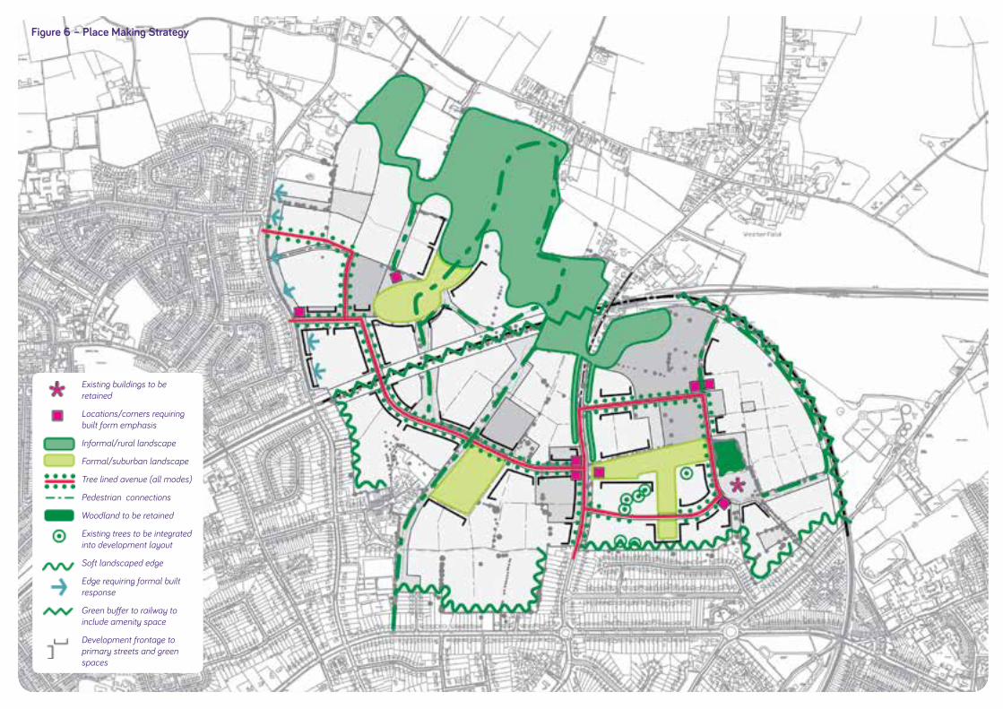
DAVI
D LO
CK A
SSO
CIAT
ES :
IPS
WIC
H B
ORO
UGH
CO
UNCI
L
49
Figure 6 – Place Making Strategy
Existing buildings to be retained
Locations/corners requiring built form emphasis
Informal/rural landscape
Formal/suburban landscape
Tree lined avenue (all modes)
Pedestrian connections
Woodland to be retained
Existing trees to be integrated into development layout
Soft landscaped edge
Edge requiring formal built response
Green buffer to railway to include amenity space
Development frontage to primary streets and green spaces

IPSW
ICH
NO
RTH
ERN
FRIN
GE
GAR
DEN
SUBU
RB :
SU
PPLE
MEN
TARY
PLA
NNIN
G D
OC
UM
ENT
50
Place Making to achieve Walkable Neighbourhoods
4.2 The Council seeks a development which is sustainable, and makes every attempt to promote social, economic and environ-mental sustainability and equality at each stage of the design and development. Central to achieving this objective will be the creation of “walkable neighbourhoods”, where the built environ-ment is friendly to the presence of people living, shopping, visiting, enjoying or spending time in their local area.
4.3 The design principles embedded in this SPD will help guide the design of walkable neighbourhoods. This includes the require-ment for a connected street and footpath network, the provision and location of a mix of local facilities and services, and an attractive environment which demonstrates best practice in urban design. Figure 6: Place Making Strategy provides a clear indication of the Council’s guidance in relation to the built form and landscape insofar as they contribute to strategic place mak-ing. This includes:
• The retention of historic buildings at Red House Farm, along with the retention of existing woodland, trees and hedgerows. Each of these will provide valuable character in the early stages of this phase of the development, and are seen as important place making assets.
• A network of informal pedestrian connections, linking centres and open spaces, to complement a network of inter-connected streets.
• A formal tree lined avenue to connect each of the proposed neighbourhoods. This will be formally planted with generous grass verges.
• Areas for formal and informal open space, to reinforce the garden suburb character and manage the transition between town and country.
• The avenue, along with formal open spaces, will have con-tinuous development frontage to provide a good sense of enclosure and create interest and activity on the street.
• Appropriate responses to the different site edges, including places where soft landscaping is required, and those where a formal built response is preferred.
• Corners and locations where built form emphasis, to help with orientation and to create distinction between the neighbourhoods.
• A green buffer to the railway to ensure separation and, where appropriate, opportunities for noise attenuation.
4.4 At the outline and detailed design stages the Council expects place making to be further reinforced through the design of the hard and soft landscape, street furniture, building design, and public realm design which should create a hospitable micro-climate and safe streets and places.
4.5 The scale and configuration of the Ipswich Garden Suburb site is such that it can support the creation of three walkable neighbourhoods, which are described below and are illustrated in Figure 7:

DAVI
D LO
CK A
SSO
CIAT
ES :
IPS
WIC
H B
ORO
UGH
CO
UNCI
L
51
Figure 7 – Walkable Neighbourhoods
Neighbourhood unit
Concentration of community services and facilities
Parks & play areas
District centre
Local centre
Secondary school
Primary school
Country park visitor centre
Red House Farm buildings
Bus route 1
Bus route 2
400m/5 minute walking distance
Existing footpath
Proposed footpath

IPSW
ICH
NO
RTH
ERN
FRIN
GE
GAR
DEN
SUBU
RB :
SU
PPLE
MEN
TARY
PLA
NNIN
G D
OC
UM
ENT
52
• Henley Gate neighbourhood lies to the north of the railway line, and is bounded to the west by Henley Road. Henley Gate neighbourhood will form the new northern edge of the town, and will accommodate the proposed country park, a local centre and a primary school.
• Fonnereau neighbourhood lies to the south of the railway and will straddle Westerfield Road. It will accommodate the proposed district centre and a primary school.
• Red House neighbourhood will lie to the east of Fonnereau. The smallest of the three neighbourhoods, it will be focused around the Red House farm buildings, existing woodland, and proposed primary and secondary schools.
4.6 As the masterplanning of Ipswich Garden Suburb progresses, particular attention should be given to:
Connectivity – The network of routes should be permeable and comprehensive, and serve significant desire lines. It should connect with existing routes and offer direct pedestrian access to local facilities.
Clustering – Local services and facilities should be clustered to provide an extra incentive to walk or cycle.
Convenience – Routes which generally follow contours, avoid steep inclines, incorporate conveniently located crossing points and negate the need to cross car parks should be planned. Bus stops should be within 400m walking distance of the majority of homes to encourage sustainable travel beyond the site.
Comfortable – Footways should be wide enough to allow easy passing and appropriate access for disabled users.
Amenity – Street furniture including signage, seating, litter bins, secure cycle racks and lighting should be well designed to encourage walking and cycling.
Integration – with existing communities, to ensure good connec-tions and facilitate new residents’ access to existing services and facilities (see Figure 8).
Safety and Security – the development should comply with the requirements of Secure by Design. Liaison with the Suffolk Constabulary will be required throughout the design and devel-opment process.

DAVI
D LO
CK A
SSO
CIAT
ES :
IPS
WIC
H B
ORO
UGH
CO
UNCI
L
53
Figure 8 – Existing Facilities & Community Infrastructure Administrative boundaries
SPD boundary
Local centre
Place of Worship
Swimming pool
Primary/infant school
Secondary school
Public and private open space
Main road (’A’ road)
Secondary road (’B’ road)
Unclassified road
Cycle route (Sustrans)
On-road cycle route
Railway line
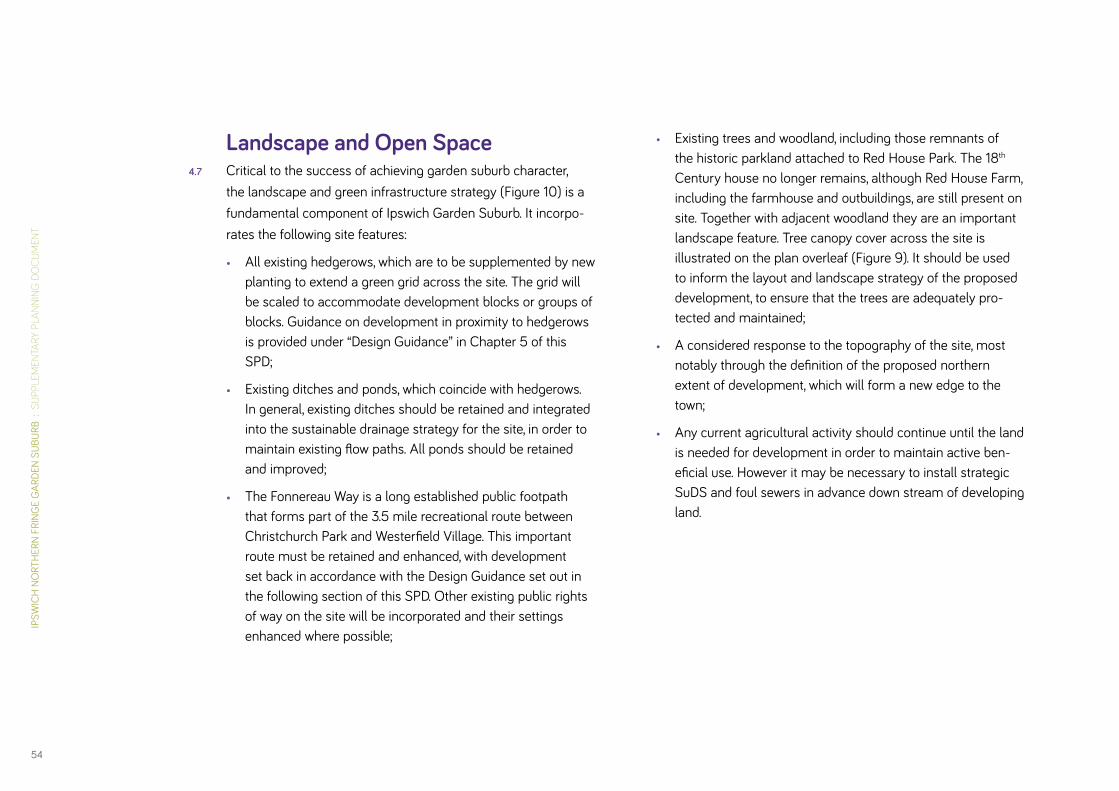
IPSW
ICH
NO
RTH
ERN
FRIN
GE
GAR
DEN
SUBU
RB :
SU
PPLE
MEN
TARY
PLA
NNIN
G D
OC
UM
ENT
54
Landscape and Open Space 4.7 Critical to the success of achieving garden suburb character,
the landscape and green infrastructure strategy (Figure 10) is a fundamental component of Ipswich Garden Suburb. It incorpo-rates the following site features:
• All existing hedgerows, which are to be supplemented by new planting to extend a green grid across the site. The grid will be scaled to accommodate development blocks or groups of blocks. Guidance on development in proximity to hedgerows is provided under “Design Guidance” in Chapter 5 of this SPD;
• Existing ditches and ponds, which coincide with hedgerows. In general, existing ditches should be retained and integrated into the sustainable drainage strategy for the site, in order to maintain existing flow paths. All ponds should be retained and improved;
• The Fonnereau Way is a long established public footpath that forms part of the 3.5 mile recreational route between Christchurch Park and Westerfield Village. This important route must be retained and enhanced, with development set back in accordance with the Design Guidance set out in the following section of this SPD. Other existing public rights of way on the site will be incorporated and their settings enhanced where possible;
• Existing trees and woodland, including those remnants of the historic parkland attached to Red House Park. The 18th Century house no longer remains, although Red House Farm, including the farmhouse and outbuildings, are still present on site. Together with adjacent woodland they are an important landscape feature. Tree canopy cover across the site is illustrated on the plan overleaf (Figure 9). It should be used to inform the layout and landscape strategy of the proposed development, to ensure that the trees are adequately pro-tected and maintained;
• A considered response to the topography of the site, most notably through the definition of the proposed northern extent of development, which will form a new edge to the town;
• Any current agricultural activity should continue until the land is needed for development in order to maintain active ben-eficial use. However it may be necessary to install strategic SuDS and foul sewers in advance down stream of developing land.

DAVI
D LO
CK A
SSO
CIAT
ES :
IPS
WIC
H B
ORO
UGH
CO
UNCI
L
55
Figure 9 – Tree Canopy Plan
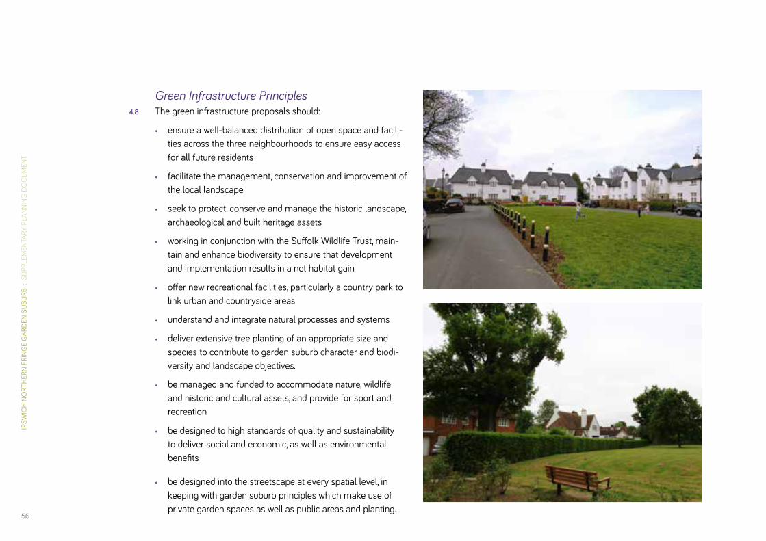
IPSW
ICH
NO
RTH
ERN
FRIN
GE
GAR
DEN
SUBU
RB :
SU
PPLE
MEN
TARY
PLA
NNIN
G D
OC
UM
ENT
56
Green Infrastructure Principles4.8 The green infrastructure proposals should:
• ensure a well-balanced distribution of open space and facili-ties across the three neighbourhoods to ensure easy access for all future residents
• facilitate the management, conservation and improvement of the local landscape
• seek to protect, conserve and manage the historic landscape, archaeological and built heritage assets
• working in conjunction with the Suffolk Wildlife Trust, main-tain and enhance biodiversity to ensure that development and implementation results in a net habitat gain
• offer new recreational facilities, particularly a country park to link urban and countryside areas
• understand and integrate natural processes and systems
• deliver extensive tree planting of an appropriate size and species to contribute to garden suburb character and biodi-versity and landscape objectives.
• be managed and funded to accommodate nature, wildlife and historic and cultural assets, and provide for sport and recreation
• be designed to high standards of quality and sustainability to deliver social and economic, as well as environmental benefits
• be designed into the streetscape at every spatial level, in keeping with garden suburb principles which make use of private garden spaces as well as public areas and planting.

DAVI
D LO
CK A
SSO
CIAT
ES :
IPS
WIC
H B
ORO
UGH
CO
UNCI
L
57
AW
A
A
AW
SPD Boundary
Parks & Gardens
Amenity Green Space
Natural & Semi-natural Green Space
Outdoor Sports Facilities
Play Area (NEAP, LEAP, LAP)
Provision for Children and YoungPeople (MUGA)
Potential Location of Allotments
Country Park
Possible Country Park Extension
Existing Woodland to be Retained
All Weather Pitches to FacilitateCommunity Use of Secondary SchoolPitches
School Playing Fields Contribute toGreen Character
Tree Lined Avenue
Destination Equipped Area for Play(DEAP)
Neighbourhood Equipped Area for Play(NEAP)
Local Equipped Area for Play (LEAP)
A
0m 400m100m 200m40m
N
Title
Date Scale
DAVID LOCK ASSOCIATES LIMITED50 NORTH THIRTEENTH STREET, CENTRAL MILTON KEYNES, MK9 3BPTEL: 01908 666276 FAX : 01908 605747 EMAIL: [email protected]
Reproduced by permission of Ordnance Survey on behalf of HMSO.© Crown copyright and database right
All rights reserved.Ordnance Survey Licence number 100021566
Drawn Designed Approved Drawing Number
This drawing is for information purposes only and not for use in construction.Do NOT scale from this drawing.All dimensions are to be checked on site and any discrepancies should beimmediately reported to the originator of the drawing.All information is copyright protected and may not be used or reproducedwithout prior permission.
NOTE
2012
Open Space Typologies
--JCADW INF001 - 088
Ipswich Northern Fringe
09-08-2013 1:5,000 @ A1
B
Figure 10 – Landscape & Open Space Typologies
SPD boundary
Parks & Gardens
Amenity green space
Natural & semi-natural green space
Outdoor sports facilities
Provision for young people (e.g. MUGA)
Potential location of allotments
Country park
Possible country park extension
Existing woodland to be retained
All weather pitches to facilitate community use of secondary school pitches
School playing fields contribute to green character
Tree lined avenue
Destination Equipped Area for Play
Neighbourhood Equipped Area for Play
Local Equipped Area for Play
AW
A
A
AW
SPD Boundary
Parks & Gardens
Amenity Green Space
Natural & Semi-natural Green Space
Outdoor Sports Facilities
Play Area (NEAP, LEAP, LAP)
Provision for Children and YoungPeople (MUGA)
Potential Location of Allotments
Country Park
Possible Country Park Extension
Existing Woodland to be Retained
All Weather Pitches to FacilitateCommunity Use of Secondary SchoolPitches
School Playing Fields Contribute toGreen Character
Tree Lined Avenue
Destination Equipped Area for Play(DEAP)
Neighbourhood Equipped Area for Play(NEAP)
Local Equipped Area for Play (LEAP)
A
0m 400m100m 200m40m
N
Title
Date Scale
DAVID LOCK ASSOCIATES LIMITED50 NORTH THIRTEENTH STREET, CENTRAL MILTON KEYNES, MK9 3BPTEL: 01908 666276 FAX : 01908 605747 EMAIL: [email protected]
Reproduced by permission of Ordnance Survey on behalf of HMSO.© Crown copyright and database right
All rights reserved.Ordnance Survey Licence number 100021566
Drawn Designed Approved Drawing Number
This drawing is for information purposes only and not for use in construction.Do NOT scale from this drawing.All dimensions are to be checked on site and any discrepancies should beimmediately reported to the originator of the drawing.All information is copyright protected and may not be used or reproducedwithout prior permission.
NOTE
2012
Open Space Typologies
--JCADW INF001 - 088
Ipswich Northern Fringe
09-08-2013 1:5,000 @ A1
B
AW
A
A
AW
SPD Boundary
Parks & Gardens
Amenity Green Space
Natural & Semi-natural Green Space
Outdoor Sports Facilities
Play Area (NEAP, LEAP, LAP)
Provision for Children and YoungPeople (MUGA)
Potential Location of Allotments
Country Park
Possible Country Park Extension
Existing Woodland to be Retained
All Weather Pitches to FacilitateCommunity Use of Secondary SchoolPitches
School Playing Fields Contribute toGreen Character
Tree Lined Avenue
Destination Equipped Area for Play(DEAP)
Neighbourhood Equipped Area for Play(NEAP)
Local Equipped Area for Play (LEAP)
A
0m 400m100m 200m40m
N
Title
Date Scale
DAVID LOCK ASSOCIATES LIMITED50 NORTH THIRTEENTH STREET, CENTRAL MILTON KEYNES, MK9 3BPTEL: 01908 666276 FAX : 01908 605747 EMAIL: [email protected]
Reproduced by permission of Ordnance Survey on behalf of HMSO.© Crown copyright and database right
All rights reserved.Ordnance Survey Licence number 100021566
Drawn Designed Approved Drawing Number
This drawing is for information purposes only and not for use in construction.Do NOT scale from this drawing.All dimensions are to be checked on site and any discrepancies should beimmediately reported to the originator of the drawing.All information is copyright protected and may not be used or reproducedwithout prior permission.
NOTE
2012
Open Space Typologies
--JCADW INF001 - 088
Ipswich Northern Fringe
09-08-2013 1:5,000 @ A1
B

IPSW
ICH
NO
RTH
ERN
FRIN
GE
GAR
DEN
SUBU
RB :
SU
PPLE
MEN
TARY
PLA
NNIN
G D
OC
UM
ENT
58
Country Park4.9 A new country park will be an integral feature of the new devel-
opment that will serve both the new residents of the garden suburb and the wider needs of north Ipswich and form a new interface between the town and the adjacent countryside. It is expected to incorporate the following:
• A network of footpaths and cycle / horse-riding routes around the park and connecting to other public rights of way in the vicinity;
• Signage for footpaths and other routes and interpretation panels relating to features of interest;
• Secure boundary treatment to prevent vehicular access into the park;
• Woodland planting;
• Water features and new habitat areas;
• High levels of pedestrian access, located to co-inside with existing and new pedestrian footpaths;
• Car parking; and
• A visitor centre and a “main entrance” to be signified by gateway feature or piece of public art.
4.10 Ipswich Borough Council, in consultation with relevant stake-holders, will prepare a detailed development brief for the country park prior to the commencement of its construction. It is antici-pated that developers will lead on the delivery of the country park in collaboration with the Borough Council, Suffolk Coastal District Council and others. The brief will include a strategy for the delivery, use, management and maintenance of the country park. It is envisaged that the Borough Council will manage the park in perpetuity through the acquisition of the freehold.
Formal Open Green Space4.11 Formal gardens and parks will be provided in a central location
of each neighbourhood. These will be in the form of district parks providing a managed town park environment with an appropriate range of sports and play facilities to be agreed. e.g. tennis courts, multi-use games area, cricket strip, play areas.

DAVI
D LO
CK A
SSO
CIAT
ES :
IPS
WIC
H B
ORO
UGH
CO
UNCI
L
59
4.12 A destination equipped area for play will be located within the new Henley Gate urban park and provide a wide range of equipment for children of all ages. The urban park, play area, and country park visitor centre will act as the “gateway” to the Country Park and wider countryside.
Natural and Semi-Natural Green Space4.13 These extensive areas of informal green space will serve a range
of functions including:
• informal recreation routes including walking, jogging and cycling;
• a range of informal sports facilities required by the develop-ment and not able to be accommodated in the district parks (e.g. skate park, BMX track and trim trail);
• important wildlife corridors and other habitat for wildlife;
• a setting for new development, to reinforce the garden suburb character;
• sustainable urban drainage;
• a mediating role between new development and existing development, and between new development and the railway, in order to ensure a suitably high level of residential amenity; and
• space for small scale activities including food production and informal play.

IPSW
ICH
NO
RTH
ERN
FRIN
GE
GAR
DEN
SUBU
RB :
SU
PPLE
MEN
TARY
PLA
NNIN
G D
OC
UM
ENT
60
Play Areas4.14 Children’s play areas should be provided in accordance with IBC
Play Strategy, the Fields in Trust: Planning & Design for Outdoor Sport and Play (2008) standards, and should comply with Sport England’s Active Design Guidance. Importantly, play space should be attractive and functional.
4.15 Provision for play should include:
• Youth facilities, for example, multi-use games areas (MUGAs) within 720m walking distance of all houses;
• A Destination Equipped Area for Play (DEAP) aimed at all ages and providing a destination type feature akin to the equipped play area provided at Holywells Park in Ipswich. This facility will be located within the park in the Henley Gate neighbourhood at the gateway to the country park;
• Neighbourhood Equipped Areas for Play (NEAPs), designed to provide a range of activities, including area for informal ball games and aimed at children of all ages, and located within 480m walking distance of houses;
• Local Equipped Areas for Play (LEAPs),designed to provide a good range of facilities to cater for children of all ages and located within 480m of houses; and
• All residents must be within 480m walking distance of either the DEAP or a NEAP or a LEAP.
4.16 In locating and designing children’s play, the following principles should be followed:

DAVI
D LO
CK A
SSO
CIAT
ES :
IPS
WIC
H B
ORO
UGH
CO
UNCI
L
61
• Play areas should be accessible without having to cross main roads or railways;
• They should be sited in open, welcoming locations;
• They must be separate from areas with major vehicle move-ments, and should be directly accessible from pedestrian footpaths;
• Good drainage should be ensured;
• Low level boundary treatment should deter dog access;
• Equipment should be designed, manufacured, installed and maintained in accordance with current European Standards (e.g. EN1176/77);
• The design should take account of topography, and the land should be capable of being landscaped for the type of play experience intended; and
• Open space, particularly that intended for active recreation (e.g. for informal ball games etc) should be of appropriate dimensions and designed to avoid potential conflicts of use / neighbourhood disputes.
4.16 In order to minimise noise on surrounding residential properties, clear zones should be planned around play areas, to the follow-ing minimum standards:
• MUGAs – 45m;
• DEAPs – 30m;
• NEAPs – 30m; and
• LEAPs – 20m.
Outdoor & Indoor Sport4.18 Access to sports facilities is an important feature of garden
suburbs, and there is a range of different sports that will be incorporated into the development in order to enhance the amenity of the new garden suburb. These facilities should be located as close to the centre of each neighbourhood as pos-sible or in other highly accessible locations with accessibility and safety in mind.
4.19 The amount and type of outdoor sports facilities provided at Ipswich garden suburb shall meet the requirements of the adopted Core Strategy (Appendix 6).
4.20 Indoor sports facilities shall be provided as per the Sport England Sports Facility Calculator for the projected Ipswich Garden Suburb population.
4.21 The range of sports facilities considered desirable include:
• Tennis courts
• Bowls or boule facilities
• Basketball/netball (as part of a youth facility)
• Trim-trails or green gyms
• Informal cricket green and/or cricket strip
• Football, including junior pitches
• Multi-use Games Areas
• Skate parks & BMX tracks
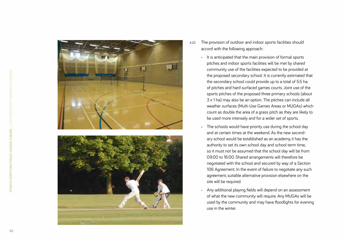
IPSW
ICH
NO
RTH
ERN
FRIN
GE
GAR
DEN
SUBU
RB :
SU
PPLE
MEN
TARY
PLA
NNIN
G D
OC
UM
ENT
62
4.22 The provision of outdoor and indoor sports facilities should accord with the following approach:
• It is anticipated that the main provision of formal sports pitches and indoor sports facilities will be met by shared community use of the facilities expected to be provided at the proposed secondary school. It is currently estimated that the secondary school could provide up to a total of 5.5 ha. of pitches and hard surfaced games courts. Joint use of the sports pitches of the proposed three primary schools (about 3 x 1 ha) may also be an option. The pitches can include all weather surfaces (Multi-Use Games Areas or MUGAs) which count as double the area of a grass pitch as they are likely to be used more intensely and for a wider set of sports.
• The schools would have priority use during the school day and at certain times at the weekend. As the new second-ary school would be established as an academy, it has the authority to set its own school day and school term time, so it must not be assumed that the school day will be from 09:00 to 16:00. Shared arrangements will therefore be negotiated with the school and secured by way of a Section 106 Agreement. In the event of failure to negotiate any such agreement, suitable alternative provision elsewhere on the site will be required.
• Any additional playing fields will depend on an assessment of what the new community will require. Any MUGAs will be used by the community and may have floodlights for evening use in the winter.

DAVI
D LO
CK A
SSO
CIAT
ES :
IPS
WIC
H B
ORO
UGH
CO
UNCI
L
63
• Internal school sports facilities also have the potential for joint use with the community (gyms, fitness suites etc).
• There must be a formal agreement in place to ensure run-ning costs and repairs are accounted for. An independent management company is one way to achieve this.
• Sport England can provide advice on joint school/community use of sport and leisure facilities.
• Secondary school sports provision will be complemented by more informal provision (e.g. open access tennis courts, cricket strip, MUGA, skate park etc) within appropriate locations either in the district parks or other areas of suitable informal green space.
• The above combined provision should be such as to meet the full requirement for sports pitches and other facilities for the projected population of the garden suburb as set out in Appendix 6 and the Sport England Calculator.
• Any shortfall of provision will be off-set by financial contribu-tions in lieu which will be used to enhance existing facilities in the surrounding areas reasonably capable of being used by residents of the garden suburb.
• In the event of there being no site-wide outline planning application and master plan, planning applications for each neighbourhood shall incorporate a robust strategy to ensure delivery of adequate provision of sports facilities for the residents of that particular neighbourhood. Developers will be jointly liable to contribute to strategic facilities.
4.23 The design of the sports provision at the school should be tailored to best facilitate community use. Local experience indicates that a free-standing sports hall facility is best suited to shared use and will be the preferred option for the Council in negotiations.
4.24 High quality walking, cycling and public transport links to the sports centre shall be designed to encourage access by non-car based modes. Adequate car parking should, however, also be provided in accordance with the Council’s standards.
4.25 The network of green corridors that will be laid out across Ipswich Garden Suburb and the country park shall accom-modate high quality facilities for cycling, recreational walking, jogging, and a trim trail, all designed to meet the objective of encouraging active lifestyles.
Design for Sports 4.26 The location, design, management and maintenance of outdoor
and indoor sports facilities should be governed by Sport England guidance, including the following:
• Better Places for Sport
• Active Design
4.27 The scale of indoor sports facilities should be calculated using Sport England’s “Facility Calculator”. This is a population based calculation.

IPSW
ICH
NO
RTH
ERN
FRIN
GE
GAR
DEN
SUBU
RB :
SU
PPLE
MEN
TARY
PLA
NNIN
G D
OC
UM
ENT
64
Food Production4.28 Areas for food production should be provided at several loca-
tions across the site. There are a number of ways in which this requirement can be met, and the Council anticipates a number of solutions will be provided:
• Allotments for rent by local people. Plots should be grouped together and should be enclosed using appropriate fenc-ing and hedging; facilities should be in secure, accessible locations with good road access and parking facilities with power and water available. Two or three strategically located allotment sites will be deemed appropriate.
• Community gardens, managed and maintained on behalf of the community, with community participation; and
• Community orchards. These can be planned in linear form to line recreation routes, and can accommodate a variety of native, flowering edible fruit trees.

DAVI
D LO
CK A
SSO
CIAT
ES :
IPS
WIC
H B
ORO
UGH
CO
UNCI
L
65
Amenity Green Space4.29 A minimum of 10% (and potentially up to 12% if required to
accommodate SuDS) of all residential areas are required to be laid out as amenity green space to ensure that the landscape permeates throughout. These will be small spaces that can fulfil a range of functions:
• Enhancing the setting of dwellings and providing an attractive outlook;
• Attenuating, intercepting, treating and conveying surface water run-off as part of the wider SuDS system;
• Accommodating informal children’s play or areas for neigh-bours to gather;
• Accommodating and providing an appropriate setting for retained trees and hedgerows; and
• Allowing for the retention and improvement of existing ponds.
4.30 In no instances should amenity green space be perceived as “left-over space”. It must be planned and designed as an integral and meaningful part of the layout for each neighbourhood.

IPSW
ICH
NO
RTH
ERN
FRIN
GE
GAR
DEN
SUBU
RB :
SU
PPLE
MEN
TARY
PLA
NNIN
G D
OC
UM
ENT
66
Garden Suburb Streets4.31 Streets will fulfil a multitude of functions, and they should not be
regarded as simply routes for movement. They will be the most shared components of place, and give identity and character to the Ipswich Garden Suburb. In addition, they will provide impor-tant green corridors for wildlife. On this basis the “greening” of the new streets will be an important design exercise.
4.32 Section 5 of this SPD identifies a hierarchy of street typologies – primary, secondary and tertiary streets – with the key objec-tive of organising movement. The landscape design of these streets should reinforce the status and function of each street, to increase legibility and cement the garden suburb character. Therefore, primary streets will be expected to feature large trees in generous verges, whereas tertiary streets will accommodate smaller scale planting.
4.33 Boundary treatments and planting within front gardens will also form part of the green character of each street; hedging will be particularly welcome.

DAVI
D LO
CK A
SSO
CIAT
ES :
IPS
WIC
H B
ORO
UGH
CO
UNCI
L
67
Biodiversity & Wildlife4.34 The landscape within the Ipswich Garden Suburb can accom-
modate biodiversity and wildlife in a number of ways. Any outline planning application should be accompanied by an ecological assessment and proposals to mitigate the impact of the devel-opment, as well as ecological management plans. In addition, as much of the site is regularly ploughed arable farmland, there is scope to enhance biodiversity through the creation of new landscape and green infrastructure features. Plant and tree spe-cies should be selected for their ability to support biodiversity. Close collaboration with the IBC Parks and Open Spaces section and Suffolk Wildlife Trust is encouraged; applicants should refer to the Suffolk Wildlife Trust Phase 1 Habitat Survey (2012), which is a key reference document.
4.35 The following features of the proposed development are seen as having potential to achieve this:
• Retained trees and hedgerows will retain important habitat and wildlife corridors. New planting will enhance this;
• The proposed country park and connected network of green spaces will support wildlife;
• The SuDS can incorporate opportunities for wetland and pond habitat, including the retention of existing ponds;
• The provision of gardens can support wildlife and birdlife especially where fruit trees and soft landscape is included.
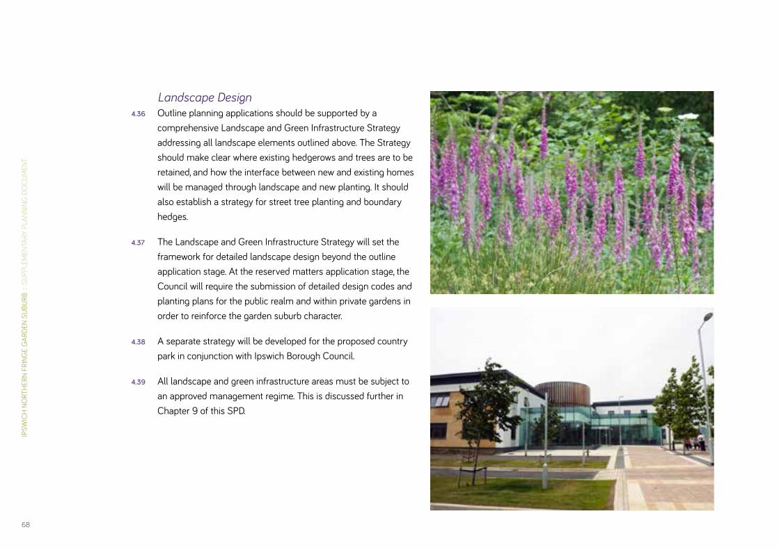
IPSW
ICH
NO
RTH
ERN
FRIN
GE
GAR
DEN
SUBU
RB :
SU
PPLE
MEN
TARY
PLA
NNIN
G D
OC
UM
ENT
68
Landscape Design4.36 Outline planning applications should be supported by a
comprehensive Landscape and Green Infrastructure Strategy addressing all landscape elements outlined above. The Strategy should make clear where existing hedgerows and trees are to be retained, and how the interface between new and existing homes will be managed through landscape and new planting. It should also establish a strategy for street tree planting and boundary hedges.
4.37 The Landscape and Green Infrastructure Strategy will set the framework for detailed landscape design beyond the outline application stage. At the reserved matters application stage, the Council will require the submission of detailed design codes and planting plans for the public realm and within private gardens in order to reinforce the garden suburb character.
4.38 A separate strategy will be developed for the proposed country park in conjunction with Ipswich Borough Council.
4.39 All landscape and green infrastructure areas must be subject to an approved management regime. This is discussed further in Chapter 9 of this SPD.
DAVI
D LO
CK A
SSO
CIAT
ES :
IPS
WIC
H B
ORO
UGH
CO
UNCI
L
69
Access & Movement Principles
4.40 The spatial arrangements set out here for access and move-ment within the site must be understood and designed within the context of the wider highway and movement network across Ipswich. Chapter 6 specifically provides guidance on the technical requirements and interventions that will be required to embed the Ipswich Garden Suburb into that network, including measures to manage the impact of travel demand arising from the development on the wider network. This section establishes the principles and broad spatial configuration of access and movement within the site and identifies the points of connection with the Ipswich network.
4.41 Whilst Ipswich Garden Suburb will be a planned community, it should seek over time to become an integral part of the wider town. This will be achieved through the interactions between residents and the communities and services already in existence across Ipswich.
4.42 Facilitating interaction, both throughout the site and beyond will be critical to achieving long term integration and equality. This Access and Movement Strategy for Ipswich Garden Suburb is intended to “plug in” to the existing network of cycleways, footpaths and roads and add to the web of routes that support movement in all directions, and to all destinations. Once the basis for connectivity is established, it is anticipated that vari-ous choices about the management of movement within that network will be available.
4.43 The following principles will inform the planning of access and movement within the site. They are intended to create a sustain-able approach to local and strategic movement and support a range of modal choices for those living within the Ipswich Northern Fringe Garden Suburb:
• Prioritise movement by walking, cycling and public transport over the car by creating a connected network of high quality, attractive and safe streets which provide direct links from homes to local destinations such as schools and shops. Cycle routes will be provided on-street, however on primary streets and bus routes, separate provision will be made for cyclist safety;
• Design a network of routes that make clear the status of the individual routes, so that way finding is easy and the streets function is easily understood by users;
• Contain trips within the development as far as possible by ensuring local services and facilities are provided in close proximity to homes, thus reducing the impact on the existing network;
• Prevent the use of the site as a short cut for local traffic to preserve the amenity and safety of the area and enhance the environment for sustainable modes;
• Create effective links into and from the existing footpath and highway system to provide improved accessibility from existing communities to facilities within the Ipswich Garden Suburb. Routes should be attractive so people living nearby are encouraged to utilise the new services in preference to those further afield, and travel by sustainable modes. New

IPSW
ICH
NO
RTH
ERN
FRIN
GE
GAR
DEN
SUBU
RB :
SU
PPLE
MEN
TARY
PLA
NNIN
G D
OC
UM
ENT
70
routes should establish physical connections to existing streets, footpaths and cycleways to establish maximum pedestrian and cycle connectivity;
• Design routes that embody best practice in urban design, affording a high quality public realm that is fronted and overlooked by development. The DfT’s Manual for Streets should inform the design of the streets and encourage low traffic speeds;
• Encourage the use of public transport for access to the town centre and places of employment in order to limit the impact on the existing network. This should be achieved by locating bus stops within walking distance of all homes, and ensuring bus priority within the site and at key junctions. Convenience for users should be increased by the provision of bus shelters and real-time information systems;
• Integrate existing public rights of way into the movement network to ensure it provides an alternative form of access for leisure and recreation, and for connecting to the planned country park and open countryside to the north;
• Make appropriate provision for emergency access.
Spatial Strategy4.44 The Access and Movement Strategy (Figure 11) for the Ipswich
Garden Suburb incorporates the following key features as the basis for delivering the principles outlined above:
• Primary routes to facilitate bus access and movement through Ipswich Garden Suburb. The design and specification for the primary routes will give a clear indication of its status and function;
• A finer grain network of secondary and tertiary routes to support movement around the neighbourhoods and to neighbourhood facilities. In the main these routes will be designed as quiet residential streets, however, there will be an emphasis on connectivity. Streets which restrict access (i.e. culs-de-sac), and in particular pedestrian and cycle access, will be strongly discouraged;
• A network of non-vehicular routes to encourage walking and cycling. This includes the integration of Fonnereau Way as a key north-south connector, along with other public rights of way and a principal cycle and pedestrian route which con-nects each of the neighbourhoods in an east-west direc-tion, including safe and convenient routes to the proposed secondary school from all neighbourhoods. Routes within the site should also be designed to connect easily to adjoining roads wherever possible (e.g. Tuddenham Road, Valley Road, Henley Road) to optimise accessibility and connectivity for those on foot or cycles and those wishing to access public transport;

DAVI
D LO
CK A
SSO
CIAT
ES :
IPS
WIC
H B
ORO
UGH
CO
UNCI
L
71
Figure 11 – Access & Movement
Primary route
Secondary route
Existing footpath upgraded to cycleway
Proposed footpath / cycleway
Primary access
Potential secondary access
Pedestrian bridge
Vehicle & pedestrian bridge
Options for Urban Traffic Management Control at junctions
Railway line
IPSW
ICH
NO
RTH
ERN
FRIN
GE
GAR
DEN
SUBU
RB :
SU
PPLE
MEN
TARY
PLA
NNIN
G D
OC
UM
ENT
72
• A ramped non-motorised user crossing of the railway line at the point where Fonnereau Way meets the railway line to offer a safe, non-vehicular connection to the country park;
• Links to National Cycle Route 48 to north of the site and to Westerfield Station via a network of paths;
• A railway crossing for all modes of transport at the most suit-able and feasible location, to ensure continuity of the primary route through the site for public transport and to assist in containing travel demand within the Ipswich Garden Suburb;
• The basis for the design of an attractive public realm, with streets designed in accordance with the principles of the DfT’s Manual for Streets. Design standards for streets are provided in Section 5 of this SPD;
• A movement network that wherever possible can support the inclusion of a sustainable urban drainage system; and
• The layout of streets and verges, along with proposed plant-ing, should take account at the earliest opportunity of the need to install and maintain underground utilities.
4.45 The successful delivery of these spatial arrangements will be dependent on good design and traffic management. Further information on the Councils’ requirements is given in Chapter 6.

DAVI
D LO
CK A
SSO
CIAT
ES :
IPS
WIC
H B
ORO
UGH
CO
UNCI
L
73
Sustainable Drainage4.46 The development of Ipswich Garden Suburb will be supported
by an integrated sustainable drainage system (SuDS) / strategy that will require both planning consent and approval by the SuDS adoption body; the latter will approve surface water drain-age proposals before any development can proceed.
4.47 The key objective is that the development must wholly contain its own surface water drainage and must not lead to increased flood risk or water pollution in adjoining areas.
4.48 As per the draft National SuDS Standards, a key principle is that wherever reasonably practicable; surface water run-off should be handled at source by the use of swales and drainage basins rather than by way of end-of-pipe systems further downstream.
4.49 The Conceptual Framework Option 2 (Figure 3) was used by the IBC Drainage Team to develop a broad, preliminary SuDS Strategy which calculated the likely area of land required for SuDS in each land parcel. The strategy includes road-side swales for all residential roads and strategic SuDS in open spaces, mainly in valley bottoms.
Insert link to IBC SuDS Strategy when available.
4.50 Figure 12 shows only the strategic SuDS, which have been allocated to the most likely locations based on topography and engineering judgement. The final locations and sizes will depend on more detailed analysis and design. Importantly open space will be required along all the main valley bottoms.
4.51 In addition, roadside swales will be required along residential roads, to provide sustainable drainage at source, and reduce the impact of run-off at the strategic scale.
4.52 The preliminary strategic areas for SuDS shown on Figure 12 are overlaid on the Development Framework Plan (Figure 5) in order to highlight areas where an ongoing and iterative process of masterplanning and SuDS design is likely to be required to adhere to the principles of the SuDS Strategy. It should be emphasised that the design of a viable development which incorporates an adoptable SuDS network for the site may gener-ate revisions and refinements to the land use allocations and other drawn guidance as set out in this document.
4.53 What the preliminary SuDS Strategy does demonstrate is that subject to certain minor modifications to the envisaged layout of development a practicable and effective SuDS system can be accommodated. It includes guidance on relevant, site related technical requirements and constraints that any future proposed drainage strategy will need to take full account of.
Key recommendations are:
• Whilst in overall terms an adequate amount of green space is being proposed to accommodate SuDS some localised redistribution of such space may be required;
• Approximately 12% of the net area of the residential blocks indicated in Figure 5 may be required to accommodate the necessary road-side swales and verges. This will be in the form of open green areas that will function as amenity open

IPSW
ICH
NO
RTH
ERN
FRIN
GE
GAR
DEN
SUBU
RB :
SU
PPLE
MEN
TARY
PLA
NNIN
G D
OC
UM
ENT
74
space providing visual benefits and potential as wildlife habitats/corridors;
• The SuDS strategy should be based on open road-side, landscaped swales, which will convey run-off from both roads and homes towards more strategic SuDS sited close to the routes of existing ditches, and finally through detention ponds before the Westerfield watercourse. Overall, such a system has the potential to make a major contribution to the required garden suburb character for the development;
• The drainage design will take account of the ecological network and opportunities to enhance the network will be taken where possible, e.g. by way of swales, basins, ditches or ponds, providing ecological stepping stones or connections to provide habitat and help link to other areas;
• Careful consideration will need to be given to the phasing of SuDS construction in relation to development phases and guidance on alternative options are provided in the draft Strategy.
4.54 The preliminary SuDS strategy follows standards currently described in IBC’s Drainage and Flood Defence Policy and included requirements from the Consultation Draft National Standards and Draft Guidance. These are similar to those described in the “Framework for SUDS in England and Wales” and the CIRAI SuDS Manual C697 (currently being updated).
4.55 The preliminary SuDS strategy will need to be refined to support planning and SAB applications and will require further updates
as the development progresses and as the National SuDS Guidance and Standards and any local requirements become effective.
4.56 A comprehensive SuDS system for the Ipswich Garden Suburb must be regarded as essential strategic infrastructure that must be the subject of a robust delivery strategy that is agreed between the various developer promoters involved at the Garden Suburb and incorporated in relevant planning and drain-age agreements.

DAVI
D LO
CK A
SSO
CIAT
ES :
IPS
WIC
H B
ORO
UGH
CO
UNCI
L
75
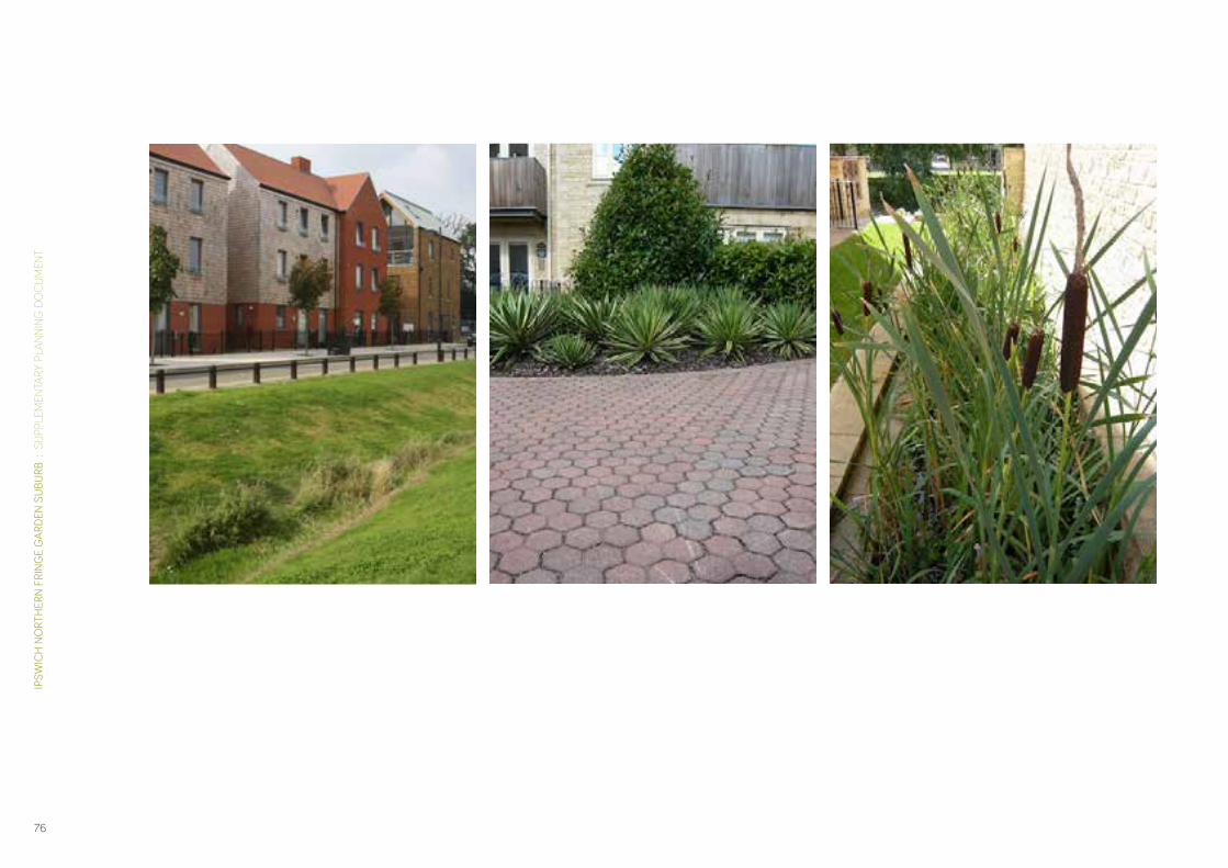
IPSW
ICH
NO
RTH
ERN
FRIN
GE
GAR
DEN
SUBU
RB :
SU
PPLE
MEN
TARY
PLA
NNIN
G D
OC
UM
ENT
76

DAVI
D LO
CK A
SSO
CIAT
ES :
IPS
WIC
H B
ORO
UGH
CO
UNCI
L
77
Figure 12 – Location of SuDS
Existing watercourses and ponds
SUDS

IPSW
ICH
NO
RTH
ERN
FRIN
GE
GAR
DEN
SUBU
RB :
SU
PPLE
MEN
TARY
PLA
NNIN
G D
OC
UM
ENT
78
Designing & Delivering Garden Suburb Character5
A Tried & Tested Approach5.1 In 2012, the TCPA published a reproduction of Raymond Unwin’s
1912 pamphlet ‘Nothing gained by overcrowding!’’. The publica-tion re-explores Unwin’s pamphlet and outlines the approach to the design and layout of the original garden cities and suburbs. This approach was seen as fundamental to the success of Letchworth and Welwyn and should be regarded as equally important to Ipswich Garden Suburb.
5.2 The approach, which underpins the Illustrative Master Plan (Figure 13) and the design guidance in this SPD, includes:
• a comprehensive and well planned structure with ef-ficient definition of blocks for development and routes for movement;
• larger development blocks with substantial enclosed areas of green space for gardens, allotments and recreation;
• well managed, green, tree-lined streets, often characterised by a section comprising road, parking, tree-lined verge, footway, soft boundary treatment, front garden and home;
• well designed groups of homes within the street, and care-ful design of the individual homes and gardens to create a distinctive garden suburb character;
• the widespread use of road side swales; and
• ensuring that new development maximises the natural land-scape and ecological assets of the area, whilst minimising its environmental impact.
In the context of North Ipswich, the following additional principles apply:
• a carefully managed and designed relationship between the town and the surrounding countryside, and the creation of a thoughtful transition between the two;
• a clearly defined and integrated hierarchy of spaces and places, from the district and local centres to the country park;
• a major enhancement of existing tree canopy cover across the site to reflect garden suburb principles and the character of existing adjoin suburbs to the south; and
• integration of parked cars in a manner which ensures they do not have a detrimental impact on the visual qualities and amenity of the garden suburb. In addition, streets should be designed in accordance with their function, and to manage traffic speeds.
5.3 Ipswich has a history of garden suburb style development; indeed much of the existing housing within North Ipswich was planned and designed in a garden suburb manner. Appendix B includes a study of the characteristics that are found within some of these areas; reference should be made to Appendix B, particularly in relation to the detailed design for the proposed Ipswich Garden Suburb.

DAVI
D LO
CK A
SSO
CIAT
ES :
IPS
WIC
H B
ORO
UGH
CO
UNCI
L
79
Figure 13 – Illustrative Master Plan

IPSW
ICH
NO
RTH
ERN
FRIN
GE
GAR
DEN
SUBU
RB :
SU
PPLE
MEN
TARY
PLA
NNIN
G D
OC
UM
ENT
80
Creating Distinctive NeighbourhoodsHenley Gate
5.7 The northern neighbourhood of Henley Gate (see Figure 14) will be distinguished in particular by:
• the interplay between the neighbourhood and the country park, including the built response to the country park, and the opportunities to draw the character of the country park into the residential area;
• the interface with Henley Road and facing development, where scope exists to mirror the existing public realm arrangement and create a new gateway into the site; and
• the clustering of local facilities and services.
A progression of spaces from the existing community, the local centre, school, park and country park
Main pedestrian / cycle links
Existing hedgerows re-inforced
New hedges planted
Main vehicular routes
Key frontages
Strategic SUDS
Community ‘Square’
Gateway
Soft edge to the park
Green edge to Henley Road
Design at Every Scale5.4 The design guidance presented here should inform the design
and layout of Ipswich Garden Suburb. Its objective is to ensure that consideration is given at each level of design and develop-ment to how a garden suburb character can be achieved within the unique context of the Ipswich Garden Suburb site.
5.5 It addresses:
• how each neighbourhood should be designed to embed garden suburb principles whilst maximising opportunities for local distinctiveness;
• how streets within the development should be laid out and designed, not only to be attractive and safe, but also to promote efficient walking and cycling, and provide a basis for sustainable urban drainage;
• how development blocks can be structured and planned to provide scope for green interiors, and to accommodate a variety of house types; and
• how garden suburb principles can be accommodated within the individual plot.
5.6 The following illustrated hierarchy of design principles are regarded as key to achieving the required garden suburb char-acter for development at the Ipswich Garden Suburb and should be carefully adhered to by future developers in formulating their proposals.

DAVI
D LO
CK A
SSO
CIAT
ES :
IPS
WIC
H B
ORO
UGH
CO
UNCI
L
81
Figure 14 – Henley Gate Distinguishing Features

IPSW
ICH
NO
RTH
ERN
FRIN
GE
GAR
DEN
SUBU
RB :
SU
PPLE
MEN
TARY
PLA
NNIN
G D
OC
UM
ENT
82
Fonnereau 5.8 The following distinguishing features will enhance the south-
west neighbourhood of Fonnereau (see Figure 15):
• the integration of Fonnereau Way as an ancient track, along with its intersection with a new pedestrian and cycle leisure route planned for the development;
• the establishment of a new district centre on Westerfield Road, providing a principal community and commercial focal point within Ipswich Garden Suburb; and
• a new public park, framed by formally laid out housing.
Fonnereau Way
Main pedestrian / cycle links
Mature hedgerows and trees retained where possible and consistent with good urban design
Main vehicular routes
Key frontages
Strategic SUDS
Community ‘Square’
Proposed planting to re-establish the landscape ‘grid’ pattern
Proposed tree-lined boulevard
Existing building

DAVI
D LO
CK A
SSO
CIAT
ES :
IPS
WIC
H B
ORO
UGH
CO
UNCI
L
83
Figure 15 – Fonnereau Distinguishing Features

IPSW
ICH
NO
RTH
ERN
FRIN
GE
GAR
DEN
SUBU
RB :
SU
PPLE
MEN
TARY
PLA
NNIN
G D
OC
UM
ENT
84
5.13 The main farmhouse has been much altered. Its original character is still recognis-able, however, and selective removal of south frontage features such as the modern dormer would improve its appearance. It is positioned slightly to one side of the farm outbuildings group and the visual separation is reinforced by a distinctive main (south) elevation of Suffolk white brick and flint. Further devel-opment is possible close to the farmhouse, but its status should be reflected in the position and scale of new development and existing landscape assets should be taken into account (for instance the driveway approach, formal garden spaces and walls).
5.14 The farm outbuildings are an interesting example of a 19th cen-tury farm group. The distinctive use of red brick, flint and clay pantile roof coverings is fairly unusual in this part of Suffolk, and provides a useful reference for a palette of new build materials, certainly within the farm area and possibly within the wider Red House Park neighbourhood. Some of the original buildings are partially preserved, particularly on the north side of the group where an entire range is still in use for stabling. This group should be restored and adapted for new uses in a way which
Red House 5.9 Several features will add to the distinct identity of the Red House
neighbourhood (Figure 16):
• the inclusion of the remaining trees from the Red House estate into the layout and open space of the residential development;
• the integration of the remaining Red House Farm buildings into the layout; and
• the linear route leading north-south through the neighbour-hood, serving as a focus for community activity.
5.10 The heritage significance of Red House should be considered as part of any future masterplanning and detailed site layout and design. The following points should be taken into account.
5.11 Red House Farm was part of the Red House Park country estate which originally occupied much of the south eastern portion of the garden suburb development area. The 18th century mansion has been demolished, but the Victorian farm group remains largely intact (though not in use as a farm for many years) (see Figures 17 and 18).
5.12 The farm, which is included on Ipswich’s Local List, dates from 1870 approximately. It includes the main farmhouse and grounds and a compact group of farm outbuildings. A gated main entrance in the south east corner of the site leads under mature trees to the front of the main farmhouse. A track skirts the south and west sides of the building group and views to the north are closed by a block of mature deciduous woodland.
Pedestrian / cycle links
Existing hedgerows re-inforced & new hedges planted
Main vehicular routes
Key frontages
SUDS incorporated as ‘ditch’ beside the road
Community ‘Square’
Prominent buildings
Green parkland edge
Green ‘finger’ parks / links
Green edge to Westerfield Road
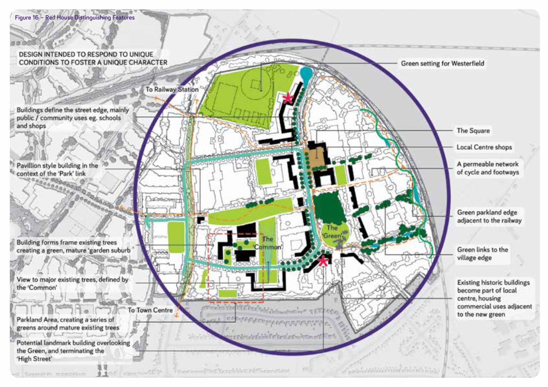
DAVI
D LO
CK A
SSO
CIAT
ES :
IPS
WIC
H B
ORO
UGH
CO
UNCI
L
85
Figure 16 – Red House Distinguishing Features

IPSW
ICH
NO
RTH
ERN
FRIN
GE
GAR
DEN
SUBU
RB :
SU
PPLE
MEN
TARY
PLA
NNIN
G D
OC
UM
ENT
86
protects as much as possible of their original character, scale and detail, including the retention of adjacent spaces.
5.15 The southern section of the farm outbuilding group is less well preserved. More recent buildings of lower quality have replaced original structures. Original walling survives around the perimeter of the group, however, and the foundations of partially demolished structures. New build is possible in this area, replacing existing structures where this can be justified and up to 2 storeys in height, reflecting the scale of existing buildings. It should retain existing fabric where possible, and the overall extent of the original building group.
5.16 Red House Farm is a heritage asset which should be integrated into the overall design. The group provides opportunities for sensitive adaptation and the creation of new floorspace for a variety of uses. The surrounding gardens and landscape features such as the woodland and site of the former pond provide the most varied set of open space assets within the garden suburb area, and these should be imaginatively adapted for both private use and public access.
5.17 It is expected that planning applications on the farm site will be supported by heritage appraisals providing clear justification for proposals, including any removal of existing structures, new build and changes to the garden / farmyard setting.
5.18 The Red House area is situated in a valley bottom with a watercourse from the Millennium Cemetery flowing around and towards the north. This is thought to have fed a large pond, which could be reinstated, and so form part of the strategic SuDS system. There is a need to provide a green corridor fro the watercourse and Strategic SuDS as shown on Figure 12.
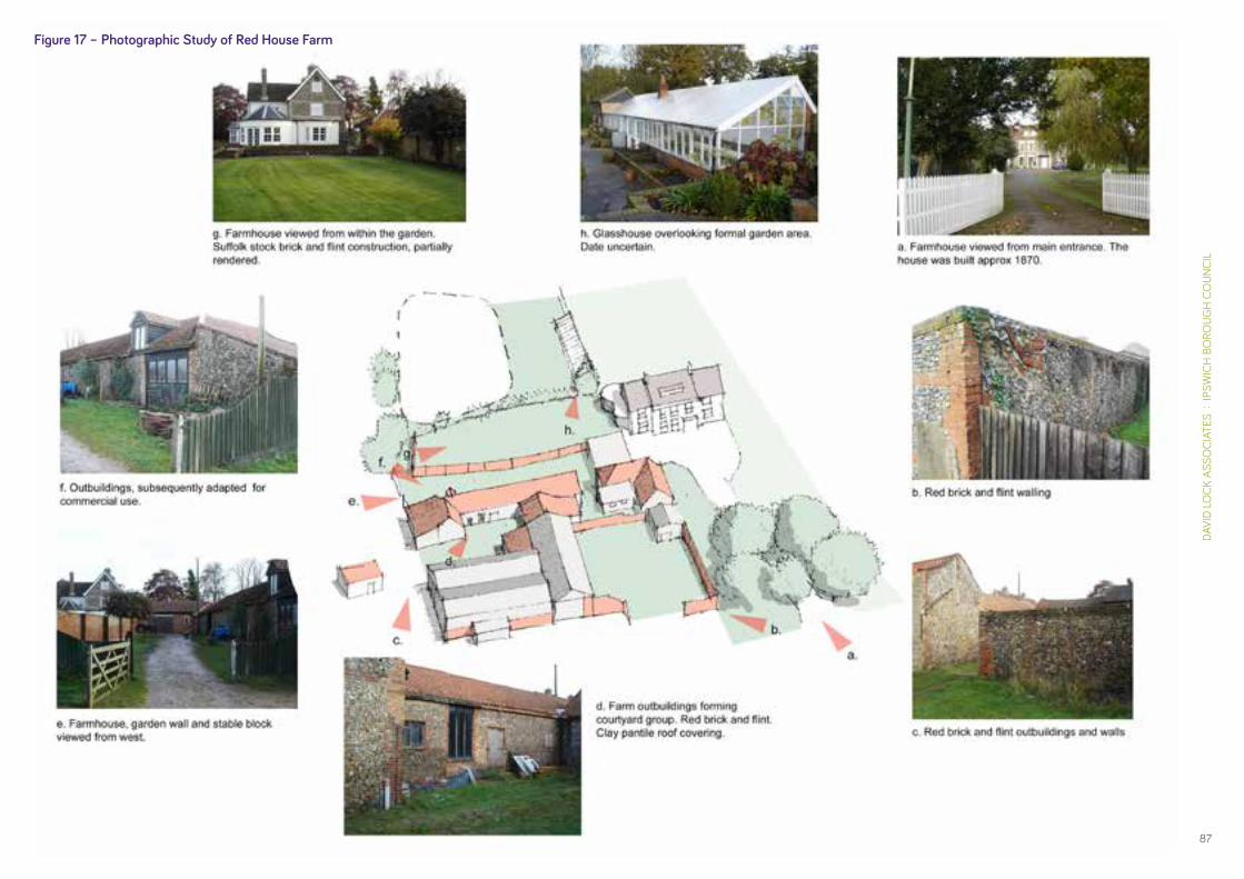
DAVI
D LO
CK A
SSO
CIAT
ES :
IPS
WIC
H B
ORO
UGH
CO
UNCI
L
87
Figure 17 – Photographic Study of Red House Farm

IPSW
ICH
NO
RTH
ERN
FRIN
GE
GAR
DEN
SUBU
RB :
SU
PPLE
MEN
TARY
PLA
NNIN
G D
OC
UM
ENT
88
Figure 18 – Red House Farm Notes
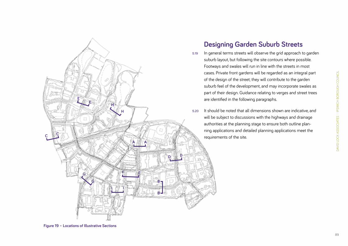
DAVI
D LO
CK A
SSO
CIAT
ES :
IPS
WIC
H B
ORO
UGH
CO
UNCI
L
89
Designing Garden Suburb Streets5.19 In general terms streets will observe the grid approach to garden
suburb layout, but following the site contours where possible. Footways and swales will run in line with the streets in most cases. Private front gardens will be regarded as an integral part of the design of the street; they will contribute to the garden suburb feel of the development, and may incorporate swales as part of their design. Guidance relating to verges and street trees are identified in the following paragraphs.
5.20 It should be noted that all dimensions shown are indicative, and will be subject to discussions with the highways and drainage authorities at the planning stage to ensure both outline plan-ning applications and detailed planning applications meet the requirements of the site.
A
I
H
F
G
E
D
C
B
A
I
H
FG
E
D
C
B
Figure 19 – Locations of Illustrative Sections
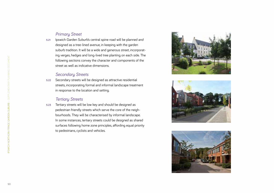
IPSW
ICH
NO
RTH
ERN
FRIN
GE
GAR
DEN
SUBU
RB :
SU
PPLE
MEN
TARY
PLA
NNIN
G D
OC
UM
ENT
90
Primary Street 5.21 Ipswich Garden Suburb’s central spine road will be planned and
designed as a tree-lined avenue, in keeping with the garden suburb tradition. It will be a wide and generous street, incorporat-ing verges, hedges and long-lived tree planting on each side. The following sections convey the character and components of the street as well as indicative dimensions.
Secondary Streets5.22 Secondary streets will be designed as attractive residential
streets, incorporating formal and informal landscape treatment in response to the location and setting.
Tertiary Streets 5.23 Tertiary streets will be low key and should be designed as
pedestrian friendly streets which serve the core of the neigh-bourhoods. They will be characterised by informal landscape. In some instances, tertiary streets could be designed as shared surfaces following home zone principles, affording equal priority to pedestrians, cyclists and vehicles.
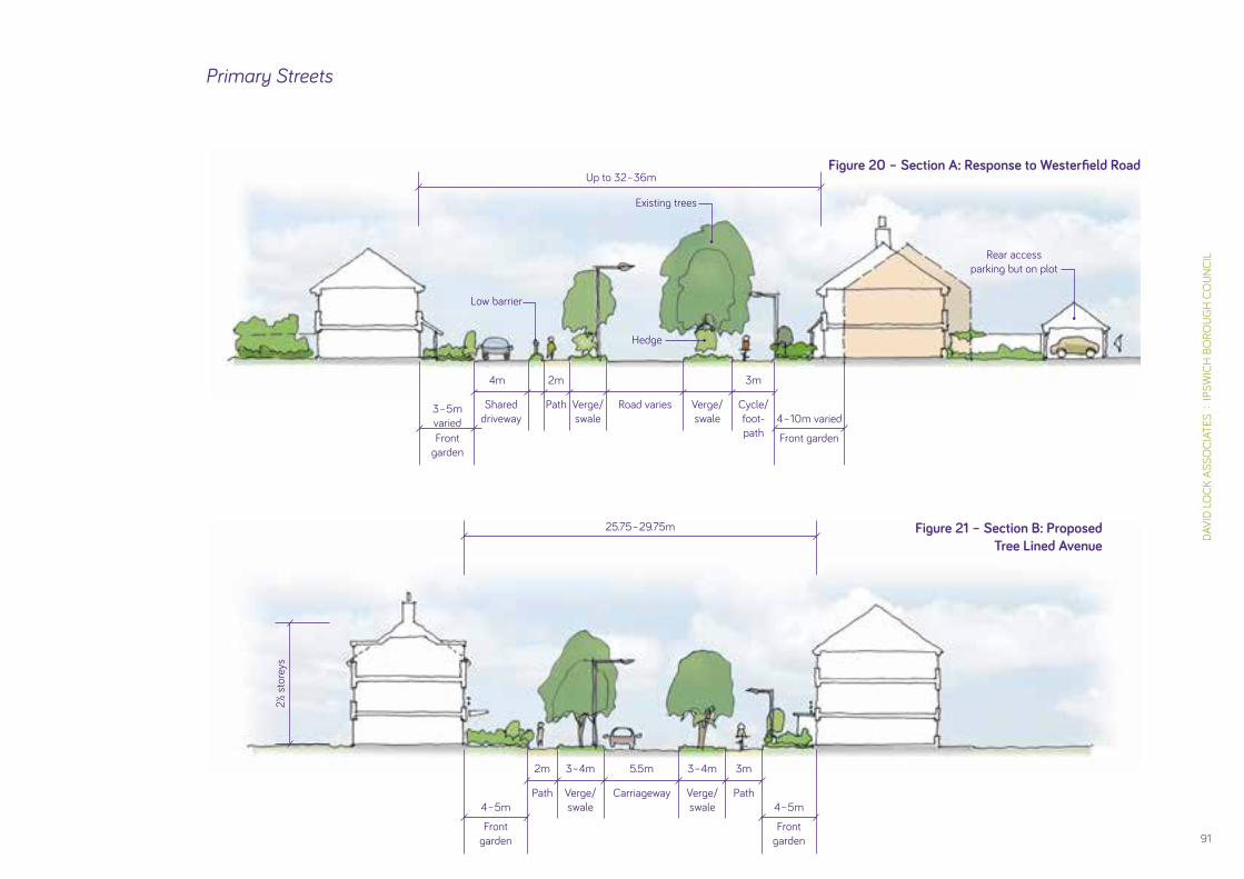
DAVI
D LO
CK A
SSO
CIAT
ES :
IPS
WIC
H B
ORO
UGH
CO
UNCI
L
91
25.75 – 29.75m
Up to 32–36m
2½ s
tore
ys
4 – 5m
3 – 5mvaried
4 – 5m
4 – 10m varied
2m
4m
Low barrier
Existing trees
Rear access parking but on plot
Hedge
3m
2m 3m
3–4m 3–4m5.5m
Front garden
Front garden
Front garden
Front garden
Path
Shared driveway
Path
Path Cycle/foot-path
Verge/swale
Verge/swale
Road varies Verge/swale
Verge/ swale
Carriageway
Figure 20 – Section A: Response to Westerfield Road
Figure 21 – Section B: Proposed Tree Lined Avenue
Primary Streets

IPSW
ICH
NO
RTH
ERN
FRIN
GE
GAR
DEN
SUBU
RB :
SU
PPLE
MEN
TARY
PLA
NNIN
G D
OC
UM
ENT
92
20–30m varied 30–35m varied
3m
Dwelling brought forward only at site access points to create a ‘gateway feature’
Service Road Henley Road
Site
bou
ndar
y
Street light as existing
2m 4–5m
Cycle/foot-path
Path Shared surface
Existing hedge reinforced& swale
Figure 22 – Section C: Response to Henley Road
19–20m 19–20m
4 – 10m varied
5m 5.5m 4.8m
Rear access parking but on plot
3m
Front garden
Cycle/foot-path
SuDS/ditch Carriageway Verge
Occ
asio
nal
lay-
by p
arki
ng
Figure 23 – Section D: Village Street
2–3
stor
eys
GardenDrop-off to school – 4.8m
Rear parking Courtyard

DAVI
D LO
CK A
SSO
CIAT
ES :
IPS
WIC
H B
ORO
UGH
CO
UNCI
L
93
Secondary Streets
4–5m
3m
3–4m
4–5m
2m 3m2m
4–5m 7.5–10m4.8m
4.8m 5.5m
4.8m
Rear access parking on square
Feature trees
Garden
Garden
Garden
Verge
Path PathPath
Verge “Green Finger” incorporaing swale
Carriageway
Carriageway Carriageway
Carriageway
Figure 24 – Section E: New street incorporating existing trees and hedges
Figure 25 – Section F: Proposed District Centre square
2–2½
sto
reys

IPSW
ICH
NO
RTH
ERN
FRIN
GE
GAR
DEN
SUBU
RB :
SU
PPLE
MEN
TARY
PLA
NNIN
G D
OC
UM
ENT
94
Tertiary StreetsFigure 26 – Section H: New street
overlooking part of the country park
Figure 27 – Section I: Proposed Mews/Courtyard
5m
4.1m (min) 3m
Garden
Shared drive
Verge
Existing trees and hedge
Surveillance of street
Park planting
Variable Width 15 – 25m
2 st
orey
s
5m 5m
5m 1.3m5.5m
Parking option on
plot or intergrated
car park
Parking option on
plot or intergrated
car park
Parking
Minimum hedged
front garden
Shared Surface
Serv
ice Z
one

DAVI
D LO
CK A
SSO
CIAT
ES :
IPS
WIC
H B
ORO
UGH
CO
UNCI
L
95
Figure 28 – Section G: New street with proposed SuDS
3–4m
3m 4–5m6–8m min. 4.1m
Front garden
Verge VergeSuDS zone Private Drive
Fonnereau Way
Existing trees and hedge
New planting
Good surveillance
Existing housing
Irregular roof line

IPSW
ICH
NO
RTH
ERN
FRIN
GE
GAR
DEN
SUBU
RB :
SU
PPLE
MEN
TARY
PLA
NNIN
G D
OC
UM
ENT
96
Blocks & Block Principles5.24 The development will be laid out in a series of development
blocks, which will support the creation of a connected network of streets. The use of culs-de-sac is strongly discouraged. The diverse character of the site, its physical edges and the proposed features of the development will encourage different design responses. Therefore, whilst a number of guiding principles will govern the design of the blocks, it is acknowledge that there can be considerable variety across the site.
Guiding Principles5.25 All blocks should be designed as “perimeter blocks”, where
buildings front the street or public space and there is a clear distinction between the public and private realm. This will ensure each dwelling has a private rear garden. It will also provide “eyes on the street” and create a safer and more secure environment.
5.26 Incursions may be made into the block, for example to accom-modate car parking where frontage access is prohibited along primary streets. However, this will only be acceptable where these spaces are designed as “living courtyards” or mews and include dwellings. They may accommodate shared gardens for residents of the block, providing play spaces, areas for food production or social gathering.
5.27 Block size should be considered alongside the need to maximise the permeability of the development and encourage walking and cycling while providing for the effective layout of homes and the efficient use of land.
5.28 The block structure around the edges of the site should support connections to existing streets, at the very least for pedestrians and cyclists, in order to encourage travel beyond the site by more sustainable means.
5.29 Incorporating well thought out strategies for car parking and bin storage that will support attractive frontages and well designed streets will be a key requirement.
5.30 Block design should have regard to sustainable drainage. Any internal courtyards should have permeable surfaces and/or rills as part of the required SuDS system to reduce surface water.
Accommodating variety5.31 The following illustrations highlight the scope for variety within
the site, and indicate where different house types might influ-ence the nature of the development block. These are intended as a guide; however, design responses which adhere to the principles set out in the illustrations should be demonstrated.

DAVI
D LO
CK A
SSO
CIAT
ES :
IPS
WIC
H B
ORO
UGH
CO
UNCI
L
97
Figure 29 – Locations of Illustrative Block Types
1
2
3
45
6
8
7

IPSW
ICH
NO
RTH
ERN
FRIN
GE
GAR
DEN
SUBU
RB :
SU
PPLE
MEN
TARY
PLA
NNIN
G D
OC
UM
ENT
98
Block Type 1: Overlooking Fonnereau Way5.32 The design of the block incorporates an informal and varied
setback as a response to the public right of way. The area between Fonnereau Way and new built development will incor-porate drainage basins and planting to retain a green corridor and ecological network for the footpath. This will have the effect of setting development away from the path, giving it a more generous width.
Efficient use of land and ability to accommodate a range of house
types and sizes
Corners require special con-sideration to create interest
and definition
Car parking is ‘on-plot’ and ‘on-street’
All homes overlook public areas
Block interior comprises enclosed rear gardens. No
public access
Dwellings may be laid out formally or informally
Figure 30 – Block Type 1 – Overlooking Fonnereau Way

DAVI
D LO
CK A
SSO
CIAT
ES :
IPS
WIC
H B
ORO
UGH
CO
UNCI
L
99
Block Type 2: District/Local Centre Housing5.33 Scope exists to accommodate a range of dwelling types in close
proximity to centres, including homes for the elderly who will benefit from easy access to local facilities and public transport routes.
5.34 Changes in dwelling types should typically occur down the centre of the block to encourage more uniformity of house type along each side.
5.35 Where apartments are developed, or where houses front the primary street, internal courtyards to accommodate car parking will be permissible. However, these must contain dwellings as well as parking provision.
Large block, scaled to accommodate different building typologies
Homes with private gardens
Larger apartment buildings with dedicated courtyard parking
Small mews homes clustered around central courtyard
Terraces with ‘on-street’ or courtyard parking
Figure 31 – Block Type 2 – District/local centre housing
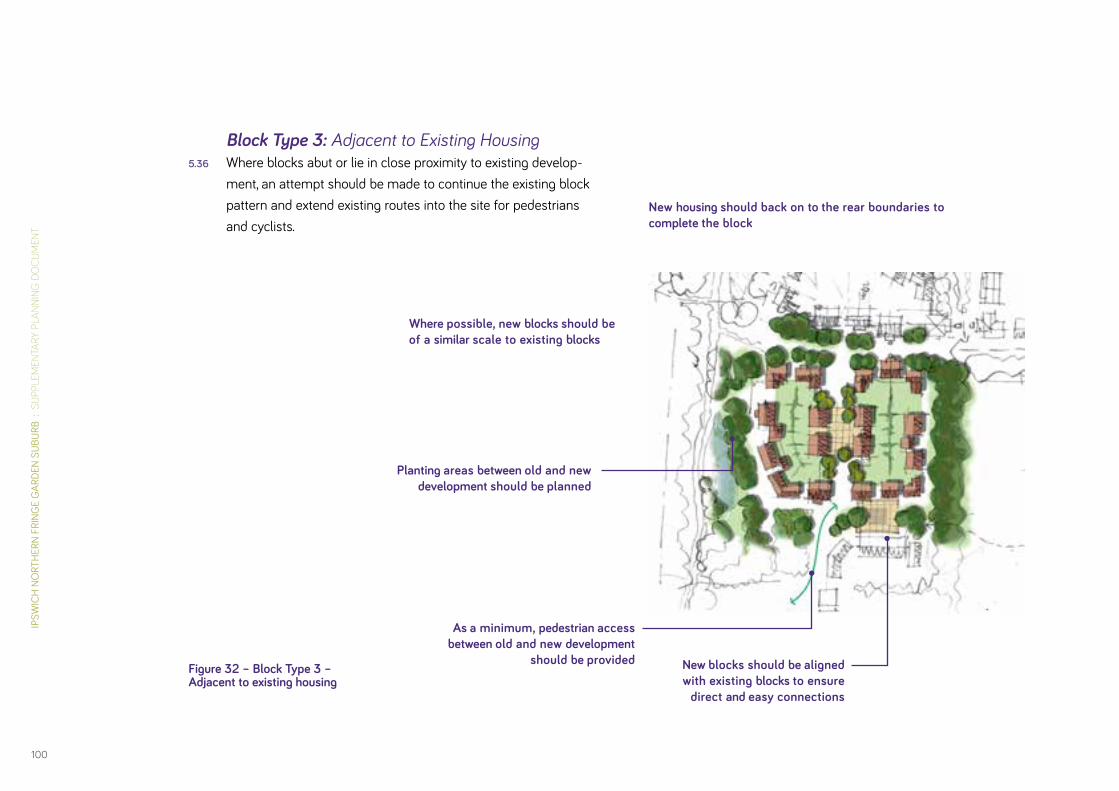
IPSW
ICH
NO
RTH
ERN
FRIN
GE
GAR
DEN
SUBU
RB :
SU
PPLE
MEN
TARY
PLA
NNIN
G D
OC
UM
ENT
100
Block Type 3: Adjacent to Existing Housing5.36 Where blocks abut or lie in close proximity to existing develop-
ment, an attempt should be made to continue the existing block pattern and extend existing routes into the site for pedestrians and cyclists.
Where possible, new blocks should be of a similar scale to existing blocks
Planting areas between old and new development should be planned
New blocks should be aligned with existing blocks to ensure
direct and easy connections
New housing should back on to the rear boundaries to complete the block
As a minimum, pedestrian access between old and new development
should be providedFigure 32 – Block Type 3 – Adjacent to existing housing
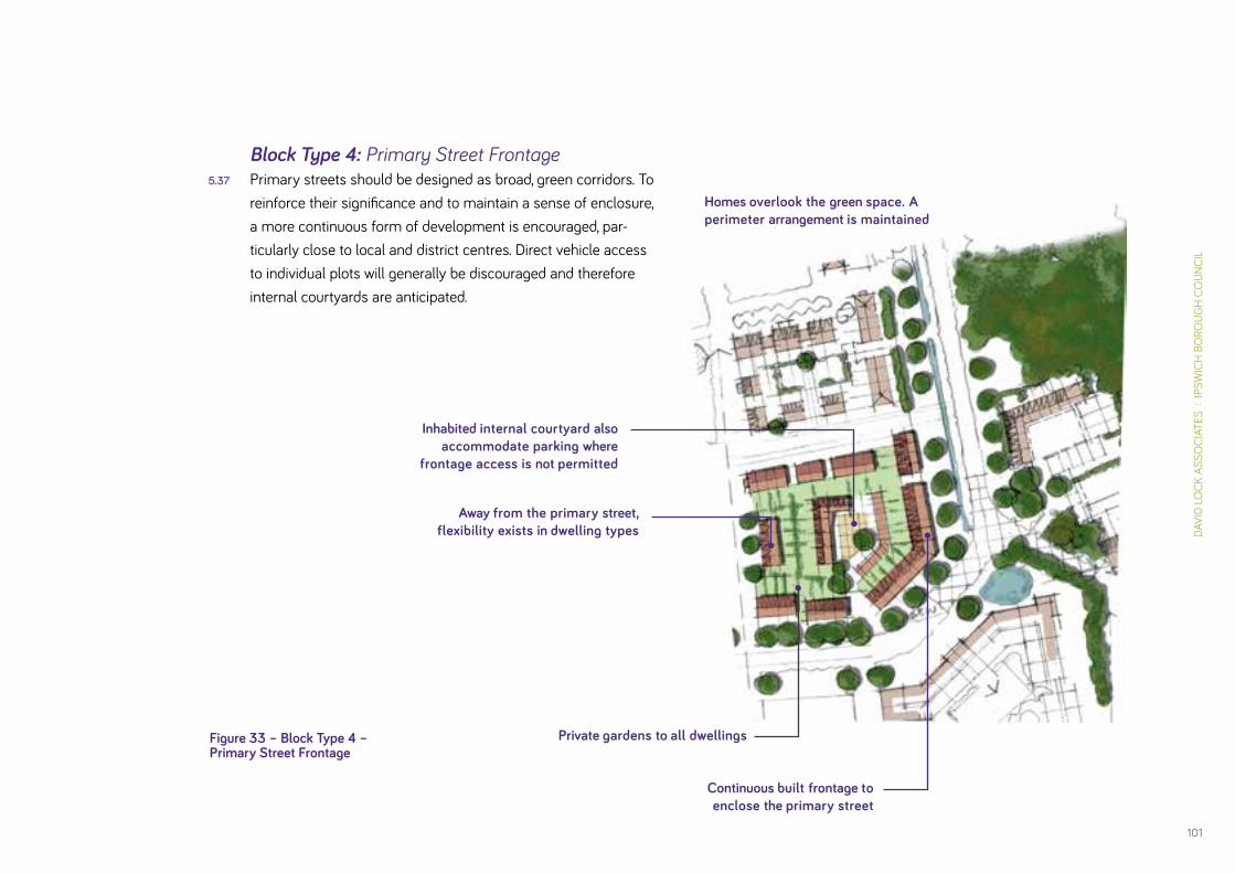
DAVI
D LO
CK A
SSO
CIAT
ES :
IPS
WIC
H B
ORO
UGH
CO
UNCI
L
101
Block Type 4: Primary Street Frontage5.37 Primary streets should be designed as broad, green corridors. To
reinforce their significance and to maintain a sense of enclosure, a more continuous form of development is encouraged, par-ticularly close to local and district centres. Direct vehicle access to individual plots will generally be discouraged and therefore internal courtyards are anticipated.
Homes overlook the green space. A perimeter arrangement is maintained
Continuous built frontage to enclose the primary street
Away from the primary street, flexibility exists in dwelling types
Inhabited internal courtyard also accommodate parking where
frontage access is not permitted
Private gardens to all dwellingsFigure 33 – Block Type 4 – Primary Street Frontage

IPSW
ICH
NO
RTH
ERN
FRIN
GE
GAR
DEN
SUBU
RB :
SU
PPLE
MEN
TARY
PLA
NNIN
G D
OC
UM
ENT
102
Block Type 5: Incorporating Existing Trees5.38 Those trees that are protected by Tree Preservation Orders
must be retained. An arboricultural survey will be required at the Outline planning stage to inform the retention of other on-site trees. Wherever possible, all trees should be kept.
5.39 Where existing trees are not incorporated into public open spaces, they will be a key consideration in the design and the layout of the block structure. They should be located within the public realm, where they can be managed appropriately and maintained over the long term.
Road access is available at the perimeter of the green, allowing frontage access
Existing tree is the focal point of a formal open green space
Block is sized and structured to ensure a generous setting for the tree
Existing tree is located within the public realm to ensure its protection
Figure 34 – Block Type 5 – Incorporating existing trees
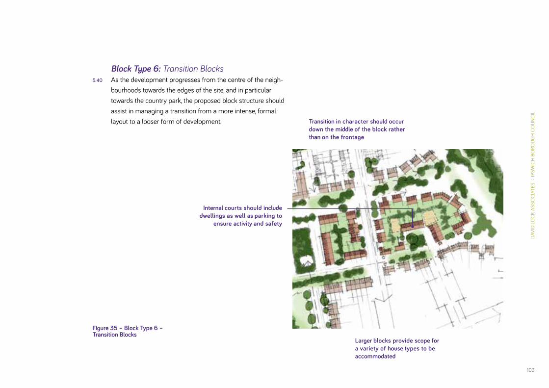
DAVI
D LO
CK A
SSO
CIAT
ES :
IPS
WIC
H B
ORO
UGH
CO
UNCI
L
103
Block Type 6: Transition Blocks5.40 As the development progresses from the centre of the neigh-
bourhoods towards the edges of the site, and in particular towards the country park, the proposed block structure should assist in managing a transition from a more intense, formal layout to a looser form of development.
Internal courts should include dwellings as well as parking to
ensure activity and safety
Transition in character should occur down the middle of the block rather than on the frontage
Larger blocks provide scope for a variety of house types to be accommodated
Figure 35 – Block Type 6 – Transition Blocks

IPSW
ICH
NO
RTH
ERN
FRIN
GE
GAR
DEN
SUBU
RB :
SU
PPLE
MEN
TARY
PLA
NNIN
G D
OC
UM
ENT
104
Block Type 7: Informal Edge5.41 Potential for informal, low density housing layouts to front onto
and overlook the country park providing additional points of access and passive surveillance.
Driveways, verge and footways edging the country park. Informal character, integrated
with planting edge.
Housing and landscape layout at the edge of the country park. Masterplanning and the design of individual units
should be coordinated with planting design so that an organic edge of landscape and built forms is created.
More conventional perimeter blocks screened by the existing hedgerow
New parkland tree planting
Landscape provides structure and enclosure and influences character
Parking is ‘on-plot’ and densities are lower than average
Visibility splays of housing as seen from within the country park
Figure 36 – Block Type 7 – Informal edge
Existing hedgerow

DAVI
D LO
CK A
SSO
CIAT
ES :
IPS
WIC
H B
ORO
UGH
CO
UNCI
L
105
Block Type 8: Addressing the Country Park5.42 The Development Framework seeks to draw the country park
into the development so that it meets the local centre within Henley Gate. This will create a green gateway to the country park. The form and character of the buildings in this location will frame this area of the country park to reinforce the connection with the community.
Blocks should accommodate a strong frontage onto the park to provide clear definition of space and maximise views
A soft edge can be created through an informal layout
Rear mews parking should be provided to avoid the need for cars along the park edge
Figure 37 – Block Type 8 – Addressing the Park

IPSW
ICH
NO
RTH
ERN
FRIN
GE
GAR
DEN
SUBU
RB :
SU
PPLE
MEN
TARY
PLA
NNIN
G D
OC
UM
ENT
106
Individual Homes & Plot Design5.43 A variety of house types will be required at Ipswich Garden
Suburb in order to support the growth of a mixed community. The design of each plot should seek to reinforce the principles and character of garden suburbs by following the principles contained in the following illustrations.
5.44 Core Strategy Policy DM3, Provision of Private Outdoor Amenity Space in New and Existing Developments requires:
• All houses, bungalows, or ground floor maisonettes with 3 or more bedrooms should have a rear garden measuring a minimum of 75 square metres;
• All houses, bungalows, or ground floor maisonettes with 1 or 2 bedrooms should have a rear garden measuring a mini-mum of 50 square metres;
• All apartments or upper floor maisonettes should have an average of 25 square metres of private outdoor amenity space.
5.45 Dimensions for gardens do not include any rear parking spaces
5.46 In addition, the Council has agreed minimum spacing between dwellings to ensure adequate privacy and amenity for individual dwellings. The degree of spacing required will vary depending on the type and height of each dwelling. The following guidelines should be followed:
• A minimum of 21 metres between main elevations to the rear of dwellings should be provided. Individual back gardens should have a minimum length of 9 metres.
• There should be a minimum distance of 12 metres between the main elevation of one dwelling and the side elevation of an adjacent dwelling where they occupy and form a corner to a block.
• Greater distances may be required where buildings exceed three storeys, or where the site’s topography will lead to one dwelling being sited above another.

DAVI
D LO
CK A
SSO
CIAT
ES :
IPS
WIC
H B
ORO
UGH
CO
UNCI
L
107
Figure 38 – House Type A: Semi-Detached, 2 storey
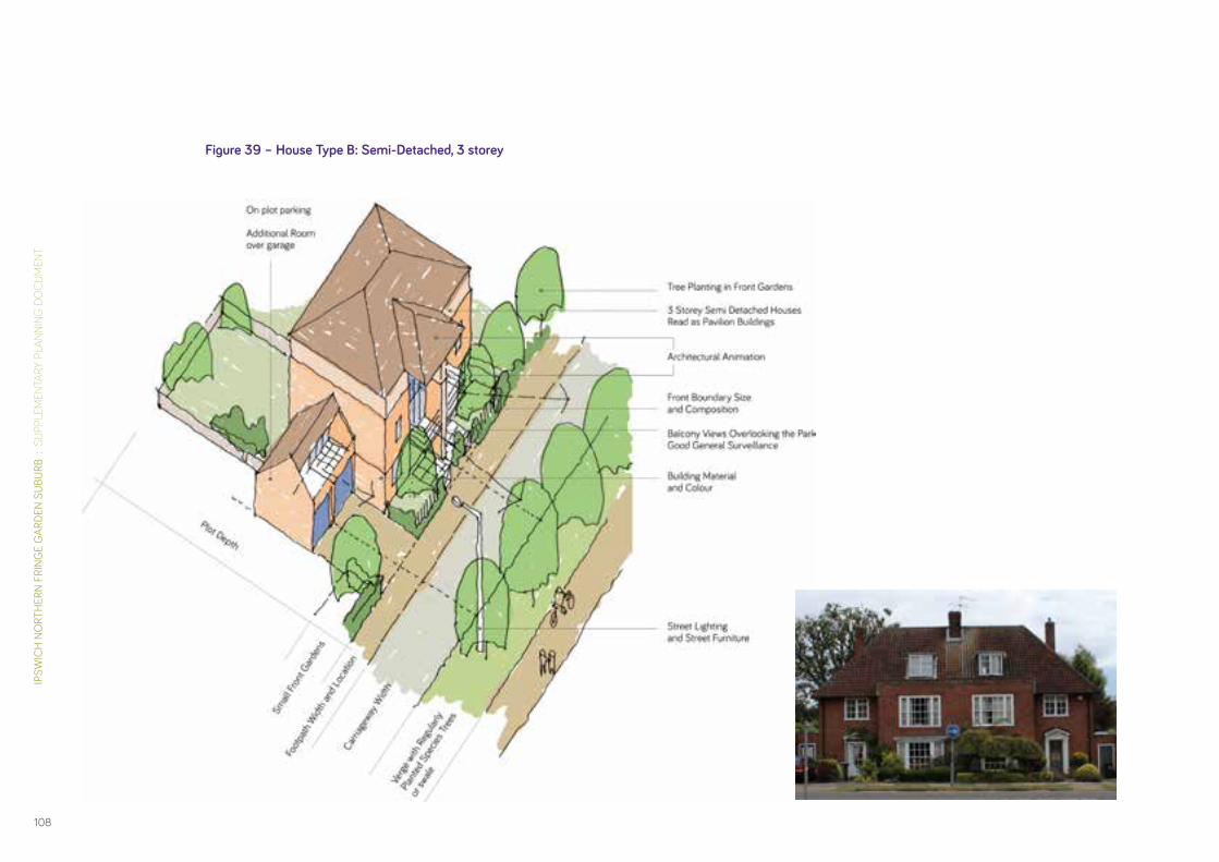
IPSW
ICH
NO
RTH
ERN
FRIN
GE
GAR
DEN
SUBU
RB :
SU
PPLE
MEN
TARY
PLA
NNIN
G D
OC
UM
ENT
108
Figure 39 – House Type B: Semi-Detached, 3 storey

DAVI
D LO
CK A
SSO
CIAT
ES :
IPS
WIC
H B
ORO
UGH
CO
UNCI
L
109
Figure 40 – House Type C: Cluster/Detached

IPSW
ICH
NO
RTH
ERN
FRIN
GE
GAR
DEN
SUBU
RB :
SU
PPLE
MEN
TARY
PLA
NNIN
G D
OC
UM
ENT
110
Figure 41 – House Type D: Terraced

DAVI
D LO
CK A
SSO
CIAT
ES :
IPS
WIC
H B
ORO
UGH
CO
UNCI
L
111
Figure 42 – House Type E: Town House

IPSW
ICH
NO
RTH
ERN
FRIN
GE
GAR
DEN
SUBU
RB :
SU
PPLE
MEN
TARY
PLA
NNIN
G D
OC
UM
ENT
112
Residential Car Parking5.47 Core Strategy Policy DM5 Urban Design Quality requires all
development to be well designed. This includes the careful planning and integration of car parking to ensure that it does not visually dominate the streetscene, and does not give rise to parking on footpaths and verges. Given its critical importance to achieving a garden suburb character the Council will require a well thought out car parking strategy, fully integrated into scheme design that embodies best practice and innovative design rather than standard solutions.
5.48 The Council’s preference is for a combination of well integrated on-street and on-plot parking that supports a safe and attractive street-scene and reflects garden suburb traditions, but some well designed small-scale mews courtyard parking may be accept-able where this is designed in combination with mews style dwellings.
5.49 A range of parking solutions is identified here. The Council expects further work to be undertaken as part of future design codes and/or design briefs to confirm acceptable residential parking solutions for the Ipswich Garden Suburb.
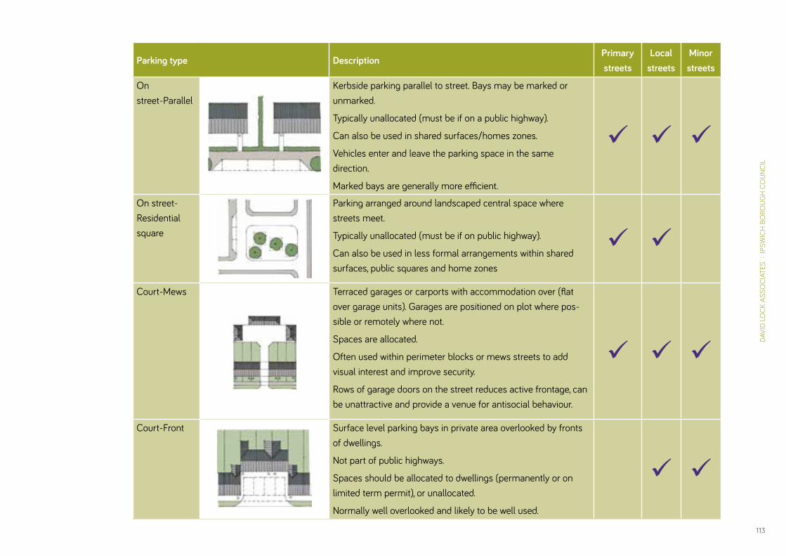
DAVI
D LO
CK A
SSO
CIAT
ES :
IPS
WIC
H B
ORO
UGH
CO
UNCI
L
113
Parking type DescriptionPrimary streets
Local streets
Minor streets
On street-Parallel
Kerbside parking parallel to street. Bays may be marked or unmarked.
Typically unallocated (must be if on a public highway).
Can also be used in shared surfaces/homes zones.
Vehicles enter and leave the parking space in the same direction.
Marked bays are generally more efficient.
On street- Residential square
Parking arranged around landscaped central space where streets meet.
Typically unallocated (must be if on public highway).
Can also be used in less formal arrangements within shared surfaces, public squares and home zones
Court-Mews Terraced garages or carports with accommodation over (flat over garage units). Garages are positioned on plot where pos-sible or remotely where not.
Spaces are allocated.
Often used within perimeter blocks or mews streets to add visual interest and improve security.
Rows of garage doors on the street reduces active frontage, can be unattractive and provide a venue for antisocial behaviour.
Court-Front Surface level parking bays in private area overlooked by fronts of dwellings.
Not part of public highways.
Spaces should be allocated to dwellings (permanently or on limited term permit), or unallocated.
Normally well overlooked and likely to be well used.

IPSW
ICH
NO
RTH
ERN
FRIN
GE
GAR
DEN
SUBU
RB :
SU
PPLE
MEN
TARY
PLA
NNIN
G D
OC
UM
ENT
114
Parking type DescriptionPrimary streets
Local streets
Minor streets
On plot- Cut through
Parking bay accessed from the front of the property past (or under) the dwelling.
The driveway may or may not be shared by the adjacent property.
Maintains a continuous frontage and removes cars from the street scene, but access to the rear of the property can be limited by the restricted opening.
On plot- Car port
Parking bay accessed from the front of the property past the dwelling.
The driveway may or may not be shared by the adjacent property.
The space is more likely to be used for the car than an enclosed garage but other opportunities for cycle storage must be explored.
If possible the positioning of the car port should allow for a car parked in front of the garage to be behind the building’s façade.
On plot- Detached shared garage
Parking bay accessed from the front of the property past the dwelling.
The driveway may or may not be shared by the adjacent property.
If possible the positioning of the garage should allow for a car parked in front of the garage to be behind the building’s façade.

DAVI
D LO
CK A
SSO
CIAT
ES :
IPS
WIC
H B
ORO
UGH
CO
UNCI
L
115
Parking type Description Primary streets
Local streets
Minor streets
On plot- Integral garage
Garage within the footprint of dwelling gives direct access to house, accommodation continues above and around.
Allocated.
Risk of inactive streets, so better used with double fronted bay windows for surveillance.
Garage doors placed close to highway.
On plot-Attached garage
Garage is located to side of house, giving access to dwelling, often with bonus rooms over.
May be paired with neighbour.
Allocated.
Garage placed close to highway.
On plot-Detached garage
Garage is located to side of house giving direct access to dwelling.
Option of accommodation over.
May be paired with neighbour.
Allocated.
On plot-Shared driveways
Residential properties share a drive reducing crossings across the footway and grass verge.
This reduces the impact of the car on the public realm and improves the environment for pedestrians for pedestrians and cyclists.

IPSW
ICH
NO
RTH
ERN
FRIN
GE
GAR
DEN
SUBU
RB :
SU
PPLE
MEN
TARY
PLA
NNIN
G D
OC
UM
ENT
116
Designing the District & Local Centres 5.50 As focal points of the proposed walkable neighbourhoods, the
district and local centres will be particularly prominent within Ipswich Garden Suburb. It is essential that they are designed as high quality places which attract customers and other users and function as vibrant, commercially successful gathering points.
5.51 The built form at these locations should be compact, and with a greater degree of intensity than found elsewhere within the garden suburb. Buildings should provide a strong sense of enclosure to the public realm. Varied heights and roof-lines are encouraged to add interest.
5.52 The design of the buildings should ensure that their primary frontages face onto the street or public space, with their main entrances accessible from these points. Ground floors should be animated, with opportunities for shop displays, and outdoor “spill-out” space for cafes and restaurants.
5.53 Streets and spaces should include specific landscape schemes which demonstrate the use of high quality materials, planting and street furniture, in order to create an environment which is attractive. Attention should be given to the micro-climate of any public spaces to provide comfort. Spaces for outdoor seating should be designed and located to capture the sun.
5.54 Car and cycle parking within district and local centres shall be provided on a shared use basis for all users. An integrated car parking strategy will be required that supports good urban design within the centres and avoids undue visual or functional dominance of car parking. Surface parking for a foodstore will be permitted provided it is well landscaped and does not present an unattractive outlook, and ensures access to the foodstore from the main street frontage.
5.55 Upper floor uses may include dwellings, and potential for busi-ness space and community space.
5.56 Within the Henley Gate neighbourhood, the local centre will include a visitor centre related to the proposed country park. This may be shared with the community centre.
5.57 A design brief should be agreed with the Council before any detailed proposals for either the district or the local centres are progressed.

DAVI
D LO
CK A
SSO
CIAT
ES :
IPS
WIC
H B
ORO
UGH
CO
UNCI
L
117
Figure 43 – Henley Gate Local Centre Illustrative Perspective
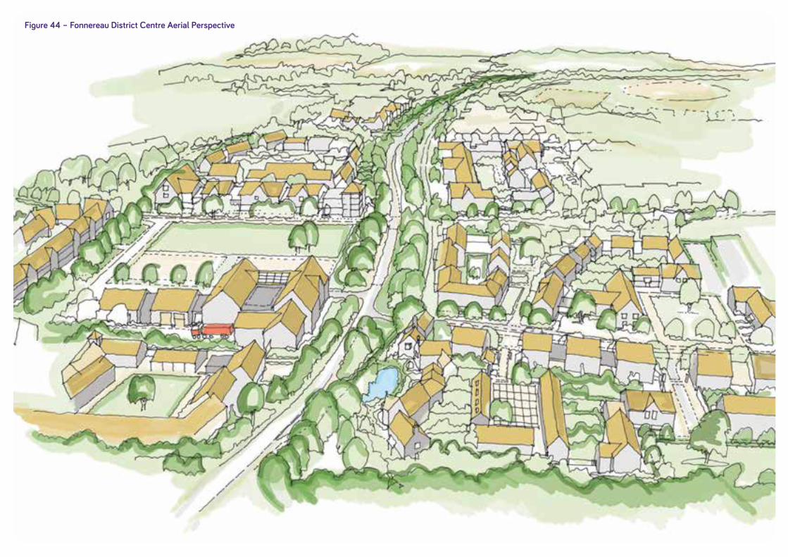
IPSW
ICH
NO
RTH
ERN
FRIN
GE
GAR
DEN
SUBU
RB :
SU
PPLE
MEN
TARY
PLA
NNIN
G D
OC
UM
ENT
118
Figure 44 – Fonnereau District Centre Aerial Perspective

DAVI
D LO
CK A
SSO
CIAT
ES :
IPS
WIC
H B
ORO
UGH
CO
UNCI
L
119
Figure 45 – Red House Farm Local Centre Illustrative Perspective

IPSW
ICH
NO
RTH
ERN
FRIN
GE
GAR
DEN
SUBU
RB :
SU
PPLE
MEN
TARY
PLA
NNIN
G D
OC
UM
ENT
120
PART BImplementation & Delivery

121
DAVI
D LO
CK A
SSO
CIAT
ES :
IPS
WIC
H B
ORO
UGH
CO
UNCI
L
PART BImplementation & Delivery
IPSW
ICH
NO
RTH
ERN
FRIN
GE
GAR
DEN
SUBU
RB :
SU
PPLE
MEN
TARY
PLA
NNIN
G D
OC
UM
ENT
122
Transport Strategy6Overview
6.1 This Transport Strategy provides guidance to ensure that Ipswich Garden Suburb is a fully integrated sustainable urban extension which offers real travel choices for its residents and retains travel demand within the development, insofar as possible, through the provision of key community services and facilities and a well-connected internal street network.
6.2 The principles and spatial strategy for access and movement are highlighted in Chapter 4 of this SPD. This Chapter focuses on how these principles and spatial plan can be delivered through planned intervention and traffic management, in order to further reduce the impact of the development on the existing highway network.
6.3 Key to the successful integration of the development will be the introduction of the Urban Traffic Management Control system (UTMC), which will provide computerised signal control and traffic management across the town centre and wider area. This system will be extended to cover the junctions around the site and will assist in giving priority to pedestrians, cyclists and public transport over private vehicles, in order to encourage travel by sustainable modes.
6.4 The transport strategy effectively combines incentives to encourage sustainable travel, and disincentives to discourage car use. Where travel by car is necessary, its impact on the local network will need to be carefully managed.
6.5 Incentives to travel by sustainable modes will include:
• High quality provision for pedestrians and cyclists;
• Convenient provision for bus travel;
• Measures to encourage travel by train;
• Travel planning to improve information on and opportunities for travel by sustainable modes;
6.6 Disincentives to travel by car, and to manage traffic impact will include:
• An approach to car parking provision at destinations within the development (such as schools and the district centre) which balances practical and commercial needs with the ability to walk, cycle and travel by bus;
• Limiting points of vehicle access onto the existing highway network to a small number of controlled junctions at Henley Road and Westerfield Road, and potentially Tuddenham Road;
• Providing access to the development for cars in such a way that the traffic impacts can be distributed across the network;
• Limiting the potential use of the site as a through route to other destinations;

DAVI
D LO
CK A
SSO
CIAT
ES :
IPS
WIC
H B
ORO
UGH
CO
UNCI
L
123
• A series of off-site highway works to manage capacity at existing junctions; and
• Measures to manage traffic speed in nearby Westerfield village and on surrounding residential streets to discourage their use as alternatives to the strategic highway network.
Accommodating Pedestrians and Cyclists6.7 Existing signed cycle routes from North Ipswich to the town cen-
tre, including Route 2 from Castle Hill, Route 12 from Rushmere, and the alternative signed Bridle Way will be enhanced to encourage cycling between Ipswich Garden Suburb and the town centre.
6.8 Christchurch Park is considered to be a direct and convenient route between the site and Ipswich town centre for pedestrians. A route for cyclists will be defined from Park Road and then incorporating the existing east-west cycle route across the park and the existing bridleway linking Henley Road and Fonnereau Road. It is acknowledged that the park has restricted opening hours but this should form part of the cycle strategy for use at certain times. An alternative route for cyclists via Ellesmere Road, Henley Road and the bridleway should be available at these times.
6.9 Westerfield Road will be designed to enable speeds to be reduced to a 30 miles per hour speed limit with toucan cross-ings provided at the new junctions to improve connectivity between Fonnereau and Red House neighbourhoods, and, most importantly, to ensure safe access to the proposed secondary school. The option of an underpass will be further investigated.

IPSW
ICH
NO
RTH
ERN
FRIN
GE
GAR
DEN
SUBU
RB :
SU
PPLE
MEN
TARY
PLA
NNIN
G D
OC
UM
ENT
124
Figure 46 – Plan of Existing Cycle and Pedestrian Routes
National cycle network on-road
National cycle network traffic-free
National cycle network temporary diversion
On-road signed cycle route
Advisory cycle route
Traffic-free cycle route
Bridleway
Footpath (sections where you should walk your bike)
On-road cycle and bus lanes
Pedestrianised street
Toucan crossing
Pedestrian crossing

DAVI
D LO
CK A
SSO
CIAT
ES :
IPS
WIC
H B
ORO
UGH
CO
UNCI
L
125
6.10 A comprehensive cycle and pedestrian network within the Ipswich Garden Suburb will be provided, and this should ensure direct connections to existing cycle routes (see Figure 46).
6.11 Leisure users will be catered for through the incorporation of Fonnereau Way into the movement network, to provide access through the garden suburb to the proposed country park and National Cycle Route 1 which runs along Lower Road to the north. A signalised toucan crossing will be provided over Valley Road to link the Fonnereau Way, and a new pedestrian and cycle bridge over the railway will be installed.
6.12 In agreement with Suffolk County Council as Highways Authority, new cycle routes will be properly signposted.
6.13 New cycle routes within Ipswich Garden Suburb will be provided on-road where traffic speeds are controlled by design. On the primary streets, which will serve as bus routes, segregated cycle paths will be provided. Typical street sections illustrating how this should be achieved are included in Chapter 5 of this SPD.
6.14 Signalled controlled toucan crossings on Valley Road will be provided to facilitate safe connections to the wider network. These crossings should be located to coincide with points of connection to pedestrian and cycle routes within Ipswich Garden Suburb.
6.15 The network of footpaths will ensure that the majority of new dwellings are within a 5 minute walk (400m) of a bus stop.

IPSW
ICH
NO
RTH
ERN
FRIN
GE
GAR
DEN
SUBU
RB :
SU
PPLE
MEN
TARY
PLA
NNIN
G D
OC
UM
ENT
126
Convenient Bus Travel6.16 High frequency bus services between Ipswich Garden Suburb
and the town centre are required. Priority measures at the points of access into the site and at the key junctions along the route must be planned to assist in reducing travel times.
6.17 Onward travel beyond the town centre will occur at the Tower Ramparts interchange; this will allow connections to Ipswich hospital and the railway station plus surrounding residential and employment areas. However, in addition, the potential to secure a direct service to Ipswich rail station and a new cross-town orbital route linking Ipswich Garden Suburb with other main employment centres and key destinations both in the town and nearby such as Ipswich hospital, and Martlesham will be inves-tigated within the context of future transport assessments and travel plans, and secured where feasible.
6.18 Both the County and Borough Councils anticipate two services between Ipswich Garden Suburb and the Tower Ramparts bus station. These should utilise Westerfield Road, with one service looping to the east and another looping to the west and north making use of the proposed railway bridge crossing (see Figure 47). This will ensure that all parts of the site are served by frequent, direct services. The bus routes through the site will serve both the District Centre and the secondary school as key destinations.
6.19 Discussions with local bus operators have confirmed that a frequency of between 10–15 minutes at peak times may be
achieved if bus priority measures at the points of access into the site and at Valley Road are provided. Applicants for plan-ning permission should work in partnership with bus operators to identify and implement measures that will encourage new residents to use the services. This could be achieved through the provision of free/subsidised fares and the provision of real-time information.
6.20 Bus services should be in place from the first phase of the development. This should be achieved through running shorter bus routes or temporary services during the early stages of development, potentially at lower frequencies; service subsidies may be needed.
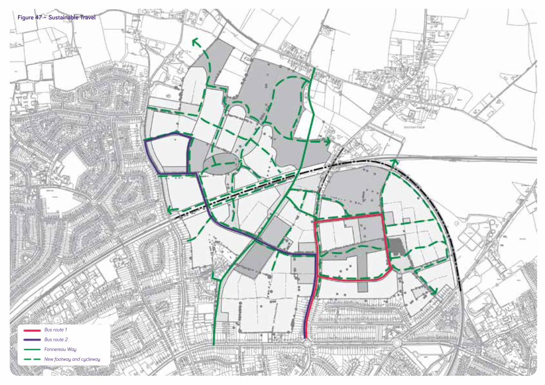
DAVI
D LO
CK A
SSO
CIAT
ES :
IPS
WIC
H B
ORO
UGH
CO
UNCI
L
127
Figure 47 – Sustainable Travel
Bus route 1
Bus route 2
Fonnereau Way
New footway and cycleway
IPSW
ICH
NO
RTH
ERN
FRIN
GE
GAR
DEN
SUBU
RB :
SU
PPLE
MEN
TARY
PLA
NNIN
G D
OC
UM
ENT
128
Encouraging Travel by Train 6.21 Pedestrian and cycle links between the Ipswich Garden Suburb
and Westerfield Station will be improved and extended to encourage onward connections by train to Ipswich Station and the coastal towns. Improved cycle parking at Westerfield Station will be required in accordance with Core Strategy Policy CS10.
6.22 There is an 8 minute journey between Westerfield Station and Ipswich Station. Increased demand from the Garden Suburb could lead to a review of the frequency of services at the station.
6.23 Network Rail and Greater Anglia are committed to future improvements to passenger services on the Lowestoft and Felixstowe lines, using the opportunities that might be presented by signalling and level crossing improvements, as well as major development at Felixstowe Port and potentially Sizewell. These opportunities should enable improvements to services at Westerfield, with the aim being to combine the minimum hourly service on each route to provide a frequency which is as close as possible to half hourly from Westerfield station. The timescales for such improvements will however be largely determined by other external factors.
6.24 Contributions to level crossing improvements, improved pas-senger facilities and the provision of some car parking at Westerfield Station will be sought.
Travel Planning6.25 The ‘Travel Ipswich’ major scheme (formerly Ipswich – Fit for
the 21st Century) aims to achieve a change in travel behaviour by changing existing patterns of travel and providing a foundation for Ipswich in the future. The scheme includes improvements to walking and cycle routes, and public transport infrastructure along with improved information provision. An area wide travel plan is required for Ipswich Garden Suburb to fulfil the objectives of Travel Ipswich. Individual Travel Plans will also be required for each component of the new development.
6.26 Travel Plans and ‘smarter choices’ programmes can reduce reliance on the private car, and encourage walking, cycling, public transport, car sharing and reduce the demand for travel.
6.27 In addition reductions in car driver mileage by existing residents can provide the capacity to absorb population growth and employment growth without unduly increasing congestion. Good travel planning can therefore enable growth without causing any deterioration in quality of life or road network efficiency.
6.28 In line with this, given the finite capacity of the local highway network, it is necessary that the sustainable transport improve-ments delivered are promoted to the wider area, and efforts to further reduce background traffic levels are made.

DAVI
D LO
CK A
SSO
CIAT
ES :
IPS
WIC
H B
ORO
UGH
CO
UNCI
L
129
6.29 DfT Good Practice Guidelines: Delivering Travel Plans through the Planning Process, 2009 should be followed in travel plan-ning for Ipswich Garden Suburb. The Guidelines highlight that ‘research has also shown that it is important to establish sus-tainable travel behaviour from the beginning’ of a development.
6.30 The travel plan for Ipswich Garden Suburb should include provi-sion for “Personal Travel Planning” (PTP). The DfT’s Making PTP Work 2008 should be utilised. This will help to establish good travel behaviour by engaging directly with new residents in order to promote the availability of sustainable travel options.
6.31 In addition, the travel plan must encompass the travel needs of local schools to encourage cycling and walking to school.
A Balanced Approach to Parking6.32 Residential car parking provision will be in line with the adopted
Council’s standards. There will be an emphasis on on-plot park-ing for new homes, with on-street parking for visitors accom-modated in designated bays.
6.33 A specific parking strategy will be produced in negotiation with Suffolk County Council and Ipswich Borough Council for non-residential uses within the site. This strategy should seek to balance commercial and practical need with the walkable and convenient layout of Ipswich Garden Suburb, in order to encour-age walking and cycling.
6.34 Secure cycle parking will be conveniently located within the district and local centres and at schools. Car parking will be integrated into the public realm design; it should be unobtrusive and well landscaped.
IPSW
ICH
NO
RTH
ERN
FRIN
GE
GAR
DEN
SUBU
RB :
SU
PPLE
MEN
TARY
PLA
NNIN
G D
OC
UM
ENT
130
Managed Access6.35 New points of access should be designed and located to mini-
mise the impact on existing trees and hedgerows.
6.36 Primary vehicular access points will be provided at Westerfield Road and Henley Road. Primary access points should be con-nected by the internal Primary Streets and the proposed new railway bridge in order to enhance the strategic road network within north Ipswich. The new railway bridge will be designed with a facility to prevent access by private cars at certain times should the need arise in the interests of good traffic management.
6.37 Limited local access from Tuddenham Road and Henley Road south of the railway may potentially be provided for emergency vehicles or public transport, subject to satisfactory design. Pedestrian and cyclist accesses at these points are required.
Westerfield Road6.38 The character of a significant section of Westerfield Road is
likely to change as a consequence of its integration into the Ipswich Garden Suburb. In urban design terms, it is critical that Westerfield Road connects rather than separates the proposed new neighbourhoods of Red House and Fonnereau. In this regard, that section of Westerfield Road that falls inside the SPD boundary will function in part as an internal route within the development, in addition to continuing as a route to Westerfield village and beyond.
6.39 Successful movement by car and cycle between the new neigh-bourhoods, particularly for those people accessing the second-ary school and district centre will be determined to a significant extent by safe and convenient crossing of Westerfield Road; any works to upgrade or change Westerfield Road should therefore ensure that pedestrian and cycle movement is afforded suf-ficient priority. The option of an underpass for the key pedestrian / cycle route linking to the new secondary school will be further investigated.
6.40 Guidance on potential access arrangements is highlighted in Figure 48 (Access & Movement), which shows two points of access from Westerfield Road into Red House, and a further three points of access into the Fonnereau neighbourhood.

DAVI
D LO
CK A
SSO
CIAT
ES :
IPS
WIC
H B
ORO
UGH
CO
UNCI
L
131
Figure 48 – Access & Movement
Primary route
Secondary route
Existing footpath upgraded to cycleway
Proposed footpath / cycleway
Primary access
Potential secondary access
Pedestrian bridge
Vehicle & pedestrian bridge
Options for Urban Traffic Management Control at junctions
Railway line

IPSW
ICH
NO
RTH
ERN
FRIN
GE
GAR
DEN
SUBU
RB :
SU
PPLE
MEN
TARY
PLA
NNIN
G D
OC
UM
ENT
132
6.41 The design of these junctions will be subject to detailed testing at the Outline Planning Application stage, when a full Transport Assessment will be required. The detailed design should take account of the requirement to utilise the Urban Traffic Management Control system to manage the impact of travel demand at Westerfield Road on the wider network. Controlled junctions are anticipated by the Highway Authority (potentially signal controlled) in order to balance local, (east-west) and through (north-south) traffic, including pedestrian and cycle traffic.
Henley Road6.42 Provision should be made for up to two traffic signal controlled
junctions onto Henley Road from the proposed Henley Gate (Figure 47 Access & Movement). The Urban Traffic Management Control system will be employed at this point to manage traffic Impact.
Off-Site Highway Works6.43 Improvements to a number of junctions within Ipswich will be
necessary to manage increased demand for travel. The required Transport Assessment must quantify the level of increased travel arising from the development, and must confirm the extent and location of the off-site works required.
6.44 Current anticipated off-site works include:
• Upgrading the existing junctions of Valley Road with Henley Road and with Dale Hall Lane as part of the UTMC network and improvements to facilities for pedestrians and cyclists.
• Replacing the Westerfield Road and Valley Road roundabout with a traffic signal controlled junction including facilities for pedestrians and cyclists and priority for bus services.
• Replacing the Tuddenham Road and Valley Road roundabout with a traffic signal controlled junction that includes facilities for pedestrians and cyclists and bus priority.
• A new Toucan crossing for Fonnereau Way on Valley Road linked to the UTMC system.
• Potentially, improvements at the junction of Bolton Lane with the town centre gyratory to provide priority for buses and improved bus journey times to Tower Ramparts.
6.45 This list of offsite highway improvements set out is not exhaus-tive and the wider implications of the proposed housing will be considered in detail through a Transport Assessment(s).

DAVI
D LO
CK A
SSO
CIAT
ES :
IPS
WIC
H B
ORO
UGH
CO
UNCI
L
133
6.46 Offsite highway improvements will benefit both new residents on the site and existing residents in the areas around the site as generally traffic levels increase.
6.47 Likely impacts on air quality will need to be carefully assessed and proposals for mitigation made where appropriate.
Traffic Calming6.48 The potential benefits of traffic calming schemes in Westerfield
village and in the roads to the north of the site must be explored and tested as part of any Transport Assessment(s).
6.49 Existing roads where traffic calming may be required include:
• East-west residential streets connecting Westerfield Road and Tuddenham Road and avoiding Valley Road;
• Rural and residential streets providing orbital routes between Henley Road and Woodbridge Road;
• Rural routes connecting Westerfield Road to the A12 through Great Bealings, and residential streets through Castle Hill to Norwich Road, Bramford Road and the A14; and
• Residential streets connecting to the town centre.
6.50 Any proposed schemes should be developed in consultation with local residents and shall take into account any existing road safety issues and safety audit findings. Any required works should be proportionate to the level of impact, and shall take into account likely increases in traffic from existing development. Measures could include, but are not limited to, enhanced gate-ways, widened footways, or surface treatments.
Construction Traffic6.51 During the construction of each phase of development there will
be construction traffic to and from the site. This traffic will be managed through the production of Construction Management Plans for each phase of development that will include details such as start and end dates of phases of work, hours of opera-tion, vehicular accesses and routes to the site. In the event of multiple starts to development, the Construction Management Plan for any given parcel of development must have regard to the arrangements for, and impacts of, construction on other parcels with a view to minimising disruption to the local com-munity overall.
6.52 This will ensure that the impacts of construction traffic are man-aged and controlled as the development progresses to minimise disruption for both existing and new residents.
6.53 To secure an approach that addresses the impacts of the construction phase, the outline planning application(s) must be accompanied by a Construction Strategy
Light Pollution6.54 In the interests of minimising additional light pollution from the
development of Ipswich Garden Suburb (and in the interests of energy conservation) street lighting shall be designed to achieve best practice in this regard.

IPSW
ICH
NO
RTH
ERN
FRIN
GE
GAR
DEN
SUBU
RB :
SU
PPLE
MEN
TARY
PLA
NNIN
G D
OC
UM
ENT
134
Infrastructure to Support the Growth of a Community7
Approach to infrastructure planning & delivery
7.1 Policy CS10 of the Ipswich Local Plan states that the supple-mentary planning document prepared for the Ipswich Garden Suburb should identify the infrastructure that developments will need to deliver on a comprehensive basis alongside new housing, including community facilities and, at an appropriate stage, the provision of a railway crossing to link potential devel-opment phases, in the interests of sustainability and integration. A revised policy CS10 is being included in the Core Strategy Focused Review. The revised policy references the detailed strategic and neighbourhood infrastructure requirements for the development and the triggers for their delivery in table form. The revised policy states that the SPD will (i) amplify these infra-structure requirements and (ii) provide guidance on the sequenc-ing and infrastructure delivery required for the development.
7.2 Policy CS10 of the adopted Core Strategy states that the delivery of 1,000 dwellings in Fonnereau Village will be expected to commence prior to 2021. The supporting text to this confirms that the Council will keep its delivery of housing under review, with any shortfall across the borough meaning that a further 500 dwellings may be required within the SPD site during this same period.
7.3 The revised policy CS10 contained in the Core Strategy Focused Review has allocated the whole of the SPD area as a strategic housing allocation for comprehensive development anytime within the plan period together with the necessary infrastruc-ture. This SPD develops the planned approach to be taken to identify the appropriate supporting infrastructure required to be delivered on a comprehensive basis alongside new housing in the interest of sustainability and integration. It provides a definite framework for delivery of infrastructure in the Fonnereau village in accordance with the allocation in the adopted policy CS10 and provisional guidance for delivery of infrastructure in the rest of the SPD area which may need to be refined following comple-tion of the Core Strategy Focused Review.
7.4 The Council has commenced work on Community Infrastructure Levy (CIL) rates, which will introduce charges on new develop-ments to fund infrastructure projects across the Borough. However, it is considered that the best option for securing infrastructure for the Garden Suburb site would be through plan-ning conditions and a site-specific Section 106 Agreement with the landowners to ensure that their commitment of either direct delivery of or financial sums towards infrastructure that relates directly to the development site. On strategic sites such as the Ipswich Garden Suburb, an exemption from CIL rates will likely be included within the Council’s Charging Schedule.

DAVI
D LO
CK A
SSO
CIAT
ES :
IPS
WIC
H B
ORO
UGH
CO
UNCI
L
135
7.5 Future CIL payments from other developments elsewhere in Ipswich could in theory contribute to some small-scale infra-structure items within the Garden Suburb that have not been secured by the landowners’ Section 106 Agreement; however the CIL regulations make clear that CIL and Section 106 Agreement contributions cannot partially fund the same infrastructure item. As such, where the delivery of new infrastructure is considered necessary but the development itself would generate only a partial need (for example where there are capacity issues in existing provision), then alternative funding sources to CIL will need to be found in order to secure the item.
Assumptions around the rate of housing delivery
7.6 It is assumed that the development in the Garden Suburb could start on site in 2015 and that following initial site preparation and enabling works, new homes could be completed from 2016 onwards. It is currently estimated that the rate of delivery would be 50 in the first year, potentially ramping up to 200 per year from 2018 onwards assuming more than one house builder being active on site at any one time.
7.7 The guide to the sequencing of development and delivery of infrastructure set out n this SPD has been structured to provide some flexibility over where and when development takes place within the site bearing in mind the provisions of policy CS10, yet ensures that appropriate and accessible infrastructure is pro-vided to deliver a sustainable and integrated development.
7.8 It is estimated that development of the site will take up to 20 years to complete.
Assumptions on housing mix & population profile
7.9 Information on the potential overall housing mix has been pro-vided elsewhere in the SPD. Local Plan policy requires that new residential developments include 35% affordable housing, sub-ject to development viability. It is expected that affordable hous-ing will be distributed throughout the Ipswich Garden Suburb, and that each neighbourhood will have a proportionate share of affordable housing. However, in the light of the provisions within the National Planning Policy Framework relating to the viability and deliverability of proposed developments, some flexibility around the provision of affordable housing in the garden suburb may be necessary to deliver a wider package of infrastructure to support a phase of development. Furthermore, variances in the provision of affordable housing within each development may be necessary where developers experience a significant difference in the costs of providing necessary infrastructure.
7.10 The Housing and Growth ministerial statement of September 2012 reaffirms the need for affordable housing provision within new developments but with flexibility through negotiation, if full compliance with affordable housing policy makes the scheme unviable. Any departure from the Local Plan policy position will only be considered by the Council if robust viability evidence is presented at the planning application stage. However, the
IPSW
ICH
NO
RTH
ERN
FRIN
GE
GAR
DEN
SUBU
RB :
SU
PPLE
MEN
TARY
PLA
NNIN
G D
OC
UM
ENT
136
quantum of affordable housing has a bearing on whether the development would be considered sustainable.
7.11 The potential housing numbers and mix envisaged for the garden suburb, and the patterns of household occupancy associ-ated with large-scale new developments in Suffolk (at approxi-mately 2½ residents per household) have been used to inform the sequencing and timing of delivery of new infrastructure to support new housing development within the garden suburb.
Approach to development sequencing7.12 This guidance on the delivery framework sets out the infrastruc-
ture required to support new housing in the garden suburb and to mitigate the impacts of development. Given the complexity of the infrastructure required and the need to have an appropri-ate balance between certainty and flexibility in how delivery of development and infrastructure is managed, it is critical that a coherent approach to development sequencing, construction management and infrastructure delivery is taken by landowners in conjunction with IBC. This will be a key consideration at all stages of the planning process and reflects the thrust of both adopted policy CS10 and the revised draft policy CS10.
7.13 In general, the approach set out here seeks to avoid develop-ment of isolated parcels of land as far as is feasible, and secure delivery of a well-planned and logically sequenced develop-ment (acknowledging that this may necessitate multiple starts) with the supporting infrastructure it needs in the interests of
sustainability and integration and to establish a sense of place for the new garden suburb as a whole.
7.14 It is intended that the Ipswich Garden Suburb will be developed as three linked neighbourhoods or villages. Given the provisions of adopted policy CS10, initial development will commence in Fonnereau neighbourhood. However, new draft policy CS10 permits development to commence in the other neighbour-hoods of the gardens suburb at an early date and at this stage, this SPD thus provides provisional guidance for the sequencing of development in the rest of the SPD area.
7.15 In accordance with the allocation embodied .in the adopted policy CS10, the main residential development will commence in the Fonnereau village area, but strategic infrastructure such as the secondary school, rail crossings, country park and key sus-tainable drainage links may need to be delivered on land within the other neighbourhoods, perhaps in advance of residential development taking place. The lead-in times for site preparation, procurement and construction of some of these elements of infrastructure may be significant, requiring implementation to start well in advance of when they are required to be operational.
7.16 Therefore, the infrastructure and development sequencing assumptions used to inform this framework are:
• Development will start in the Fonnereau neighbourhood, accessed from Westerfield Road. This will allow the initial components of the district centre, first primary school and district park to be delivered, thus forming a community focus

DAVI
D LO
CK A
SSO
CIAT
ES :
IPS
WIC
H B
ORO
UGH
CO
UNCI
L
137
for the residential development delivered in this neighbour-hood from an early stage.
• Informed by new draft policy CS10, residential development may be permitted by IBC to commence in Henley Village at a point in time to be agreed. This will be accessed from Henley Road, and may enable development of the initial stages of the country park and the first local centre and second primary school as a ‘heart’ to this neighbourhood. The trigger for delivery of the railway crossing is set out in Table 1 reflect-ing the desire to achieve integrated development
• New draft policy CS10 will also inform the extent of develop-ment in Red House Village and the point in time at which residential development of the Red House area east of Westerfield Road will be permitted to commence. An early phase of development is anticipated to deliver the required serviced site for the proposed secondary school.
7.17 To provide some flexibility in the development sequencing approach, and ensure that necessary infrastructure is delivered on a comprehensive basis alongside new housing, the following measures will be put in place:
• A process of regular monitoring and review of development delivery at the Ipswich Garden Suburb will be led by IBC in conjunction with the landowners / developers.
• Each outline planning application submitted for develop-ment will be required to include a detailed Development Sequencing and Infrastructure Delivery Plan that covers the whole of the garden suburb. This will set out how it is proposed to sequence delivery of the development proposed
in the application and the supporting infrastructure outlined in this SPD; and who will be responsible for securing procure-ment and delivery of the infrastructure identified.
7.18 In considering proposals for sequencing of development that varies from the general approach set out in this SPD, IBC will be mindful of the following factors:
• how the proposed sequencing complies with the review of the Core Strategy in relation to the provisions of policy CS10;
• how the supporting infrastructure specified in this SPD for the number of units proposed in each application will be secured;
• how appropriate sustainable access can be achieved for new residents between the housing development and supporting infrastructure (e.g. primary school), where appropriate;
• whether the development proposed will prejudice delivery of other land within the garden suburb or the whole master plan, or result in an unacceptable impact on existing resi-dents or result in development that is not sustainable or integrated.
NB the provision of a functional sustainable urban drainage network for each phase of development may have implications for sequencing of development, land release, and scheme design.

IPSW
ICH
NO
RTH
ERN
FRIN
GE
GAR
DEN
SUBU
RB :
SU
PPLE
MEN
TARY
PLA
NNIN
G D
OC
UM
ENT
138
Infrastructure required & triggers for delivery
7.19 The key elements of infrastructure required to support sustain-able form of development within the Ipswich Garden Suburb site have been based on the provisions of the adopted Core Strategy and the Core Strategy Focused Review and informed by stake-holders. In compiling this infrastructure list, the Council has been mindful of the infrastructure tests set out in legislation and the National Planning Policy Framework, i.e. that it must be:
• necessary to make the development acceptable in planning terms;
• directly related to the development; and
• fair and reasonably related in scale and kind of development.
The adopted “Section 106 Developers Guide to Infrastructure Contributions in Suffolk” is also of relevance (SCC 2012).
7.20 The overall approach taken to infrastructure delivery in the interest of securing sustainable and integrated development is to ensure that each neighbourhood is as self-sufficient as possible in terms of infrastructure to support its residents while ensuring that the more strategic elements of infrastructure are delivered in a timely way to mitigate the cumulative impacts of the Garden Suburb development.
7.21 For this reason, the infrastructure required for the garden suburb development and set out below has been divided into two categories:
• Strategic infrastructure that may be located in a single neighbourhood but is required to mitigate the cumulative impact of and serve the whole of the Garden Suburb de-velopment (and in some cases the wider community), and therefore is likely to require a comprehensive approach from all landowners to secure its delivery. These are listed in Table 1 below.
• Neighbourhood infrastructure which refers to local infra-structure required primarily to serve the needs of the resi-dents of the village or neighbourhood in which it is located and which will be delivered by the landowners / developers developing in a specific neighbourhood. These are listed in Tables 2–4 below.
7.22 The lists do not include localised physical infrastructure such as secondary and tertiary streets and footpaths, bus stops and shelters, local SuDS networks, acoustic fencing, local habitat mitigation measures or Section 106 and air quality monitoring which will be delivered by individual developers in accordance with a detailed planning permission for the phase to which they relate.

DAVI
D LO
CK A
SSO
CIAT
ES :
IPS
WIC
H B
ORO
UGH
CO
UNCI
L
139
7.23 Tables 1 – 4 set out indicative triggers for delivery of the various elements of infrastructure. In the main, the triggers relate to the occupation of housing units, or another event in the delivery of the garden suburb rather than a specific date or timeline given that the rate of construction cannot be predicted with a high degree of certainty. The tables may need to be refined following completion of the Core Strategy Focused Review.
7.24 Basing triggers on housing occupations makes a direct link between the needs of the new population arising and the meas-ures needed to mitigate their cumulative impacts. However, it will also require close monitoring to ensure that targets are met. The triggers would reflect the latest point by which the relevant infrastructure element is required, and they may be delivered before that if desired.
7.25 The triggers have been informed by:
• advice from key stakeholders in light of available evidence concerning existing capacity, likely impact and mitigation required;
• the likely sequencing and management of development;
• the desire to create cohesive neighbourhoods in the interest of securing a sustainable development pattern;
• ensuring that the development is viable and deliverable; and
• the availability of appropriate land.

IPSW
ICH
NO
RTH
ERN
FRIN
GE
GAR
DEN
SUBU
RB :
SU
PPLE
MEN
TARY
PLA
NNIN
G D
OC
UM
ENT
140
Infrastructure theme
Strategic infrastructure Trigger point for delivery unless otherwise agreed with IBC and included in the Infrastructure Delivery Plan to be submitted to and approved by the Council. Note that dwelling numbers in Table 1 apply to total number across the whole of the SPD site unless otherwise stated.
Access & transport Vehicular rail crossing To be informed by the Transport Assessment for the whole development in agreement with SCC Highways department, although to be available for public use no later than the occupation of 300 dwellings in Henley Gate.
Fonnereau Way cycle/pedestrian bridge across rail line
Prior to occupation of 300 dwellings in Henley Gate unless otherwise agreed with IBC in view of sequencing of both Fonnereau Village and Henley Gate.
Phased delivery of bus services & bus priority measures
Strategic phasing plan for delivery of service and bus priority measures to be agreed prior to the commencement of development.
Improvements to strategic town centre & east-west footpaths/cycleways
Strategic phasing plan for delivery of strategic improvements to be agreed prior to the commencement of development.
Improvements to Westerfield Station car park, cycle parking & passenger facilities (sum)
Payment for cycle parking provision at Westerfield Station prior to occupation of 100 dwellings. Payment for car parking and improved passenger facilities to be informed by the Transport Assessment for the whole development in agree-ment with SCC Highways department, although no later than the occupation of 1500 dwellings.
Controlled cycle/pedestrian crossing on Westerfield Road
Prior to the first building occupation in both Fonnereau and Red House Villages.
Traffic management scheme for Westerfield village, The Crofts and other locations
Details of and timetable for delivery of scheme to be informed by the Transport Assessment for the whole development in agreement with SCC Highways department.
Education 1 x 1200 space secondary school (including sixth form facility)
Serviced site (with access roads) to be transferred prior to occupation of 500 dwellings.Phased contributions proportionate to pupil yield thereafter.
Table 1: Strategic infrastructure requirements for Ipswich Northern Fringe Garden Suburb

DAVI
D LO
CK A
SSO
CIAT
ES :
IPS
WIC
H B
ORO
UGH
CO
UNCI
L
141
Open space, recreation & play
Country Park with joint visitor / commu-nity centre for Henley Village
Transfer of land for Country Park and completion of initial ancillary works including temporary visitor facility and works compound to be completed prior to occupation of 300 dwellings in Henley Gate. Second phase of ancillary works and permanent visitor centre (may be com-bined neighbourhood community centre) to be completed prior to occupation of 500 dwellings in Henley Gate. Both trigger points are subject to change with the agreement of IBC in view of neighbourhood sequencing.
Enhancements to school playing fields & other outdoor recreation facilities for community use
Strategic phasing plan including timetable for delivery to be agreed with IBC in consultation with Sport England prior to the commencement of development.
Enhancements to school indoor recrea-tional facilities for community use and off-site swimming contribution
Strategic phasing plan including timetable for delivery to be agreed with IBC in consultation with Sport England prior to the commencement of development. Swimming contributions to be secured following occupation of early phase of development in each neighbourhood.
Community facilities
Library & police facilities To be provided as part of the District Centre community centre (see entry under Fonnereau Village).
Reserved site for Health Centre in District Centre (DC) & two further sites for community-related facilities that would be up to 0.5ha in size subject to floor space and parking needs (a workspace hub may be integrated into one of these reserved sites or the DC community centre).
Sites to be retained for specific uses and appropriately marketed for sale during 5–10 year period following appropriate access roads and services to the bound-ary being in place, or other such arrangement to be agreed with IBC.
Funding for community development support officer(s)
Phased payments on commencement of development to ensure officer(s) in post prior to first dwelling occupation.
continued

IPSW
ICH
NO
RTH
ERN
FRIN
GE
GAR
DEN
SUBU
RB :
SU
PPLE
MEN
TARY
PLA
NNIN
G D
OC
UM
ENT
142
Utilities Any strategic improvements to electricity supply
As required
Any strategic improvements to water supply
As required
Any strategic improvements to the sewerage system
As required
Any strategic infrastructure needed to deliver low carbon development
In accordance with agreed low carbon framework to be agreed prior to the commencement of development.
Strategic SuDs infrastructure & connections
In accordance with agreed phasing plan prior to the commencement of development.
Infrastructure theme
Neighbourhood infrastructure Trigger point for delivery unless otherwise agreed with IBC and included in the Infrastructure Delivery Plan to be submitted to and approved by the Council. Note that dwelling numbers in Table 2 apply to total number in neighbourhood.
Access & transport Off-site junction improvements in sur-rounding road network
Timetable for delivery to be informed by the Transport Assessment for the whole development in agreement with SCC Highways department.
Connection to the Urban Traffic Management & Control (UTMC) system
Timetable for delivery to be informed by the Transport Assessment for the whole development in agreement with SCC Highways department.
Travel Plan development, implementa-tion & monitoring
Travel Plan to be submitted and agreed with SCC Highways department as part of full/outline application for the development of the site. To be imple-mented and monitored during and following each phase of the neighbourhood development.
Improvements to Fonnereau Way Timetable for delivery to be informed by the Transport Assessment for the whole development in agreement with SCC Highways department, although it should be delivered no later than the completion of the initial ancillary works to the Country Park to appropriately upgrade this for public access.
Table 2: Neighbourhood infrastructure requirements for Fonnereau Village

DAVI
D LO
CK A
SSO
CIAT
ES :
IPS
WIC
H B
ORO
UGH
CO
UNCI
L
143
Education & early years
2 FE primary school & nursery Serviced site (with access roads) to be transferred prior to occupation of 100 dwellings. Phased contributions proportionate to pupil yield thereafter. 1FE primary school & nursery facility to be provided prior to occupation of 400 dwellings. The need and timetable for the provision of a second form of entry will be reviewed following this.
Open space, recreation & play
Neighbourhood parks, allotments & open spaces with equipped sports & play facilities as per SPD
In accordance with phasing plan to be agreed prior to the commencement of development.
Community infrastructure
District Centre infrastructure framework; CCTV & charging points for electric vehicles
Prior to occupation of 500 dwelling.
Community centre in DC with integrated library facilities and police office (where required by Suffolk Constabulary)
Temporary community centre to be provided prior to occupation of 50 dwell-ings. Permanent community centre with integrated facilities prior to occupation of 500 dwellings.
Other items Household waste facilities (sum) Phased payments to be secured following occupation of early phase of devel-opment in neighbourhood.
Superfast broadband infrastructure To be delivered in each phase of development in neighbourhood.
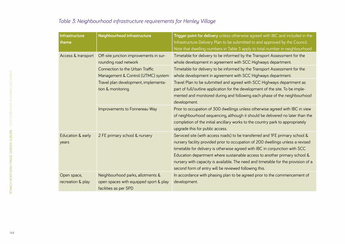
IPSW
ICH
NO
RTH
ERN
FRIN
GE
GAR
DEN
SUBU
RB :
SU
PPLE
MEN
TARY
PLA
NNIN
G D
OC
UM
ENT
144
Table 3: Neighbourhood infrastructure requirements for Henley Village
Infrastructure theme
Neighbourhood infrastructure Trigger point for delivery unless otherwise agreed with IBC and included in the Infrastructure Delivery Plan to be submitted to and approved by the Council. Note that dwelling numbers in Table 3 apply to total number in neighbourhood.
Access & transport Off-site junction improvements in sur-rounding road network
Timetable for delivery to be informed by the Transport Assessment for the whole development in agreement with SCC Highways department.
Connection to the Urban Traffic Management & Control (UTMC) system
Timetable for delivery to be informed by the Transport Assessment for the whole development in agreement with SCC Highways department.
Travel plan development, implementa-tion & monitoring
Travel Plan to be submitted and agreed with SCC Highways department as part of full/outline application for the development of the site. To be imple-mented and monitored during and following each phase of the neighbourhood development.
Improvements to Fonnereau Way Prior to occupation of 300 dwellings unless otherwise agreed with IBC in view of neighbourhood sequencing, although it should be delivered no later than the completion of the initial ancillary works to the country park to appropriately upgrade this for public access.
Education & early years
2 FE primary school & nursery Serviced site (with access roads) to be transferred and 1FE primary school & nursery facility provided prior to occupation of 200 dwellings unless a revised timetable for delivery is otherwise agreed with IBC in conjunction with SCC Education department where sustainable access to another primary school & nursery with capacity is available. The need and timetable for the provision of a second form of entry will be reviewed following this.
Open space, recreation & play
Neighbourhood parks, allotments & open spaces with equipped sport & play facilities as per SPD
In accordance with phasing plan to be agreed prior to the commencement of development.
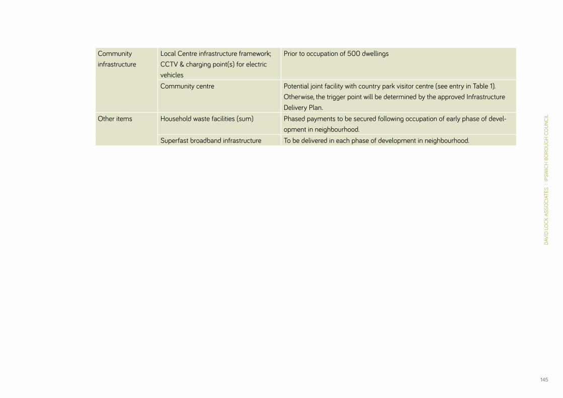
DAVI
D LO
CK A
SSO
CIAT
ES :
IPS
WIC
H B
ORO
UGH
CO
UNCI
L
145
Community infrastructure
Local Centre infrastructure framework; CCTV & charging point(s) for electric vehicles
Prior to occupation of 500 dwellings
Community centre Potential joint facility with country park visitor centre (see entry in Table 1). Otherwise, the trigger point will be determined by the approved Infrastructure Delivery Plan.
Other items Household waste facilities (sum) Phased payments to be secured following occupation of early phase of devel-opment in neighbourhood.
Superfast broadband infrastructure To be delivered in each phase of development in neighbourhood.

IPSW
ICH
NO
RTH
ERN
FRIN
GE
GAR
DEN
SUBU
RB :
SU
PPLE
MEN
TARY
PLA
NNIN
G D
OC
UM
ENT
146
Infrastructure theme
Neighbourhood infrastructure Trigger point for delivery unless otherwise agreed with IBC and included in the Infrastructure Delivery Plan to be submitted to and approved by the Council. Note that dwelling numbers in Table 4 apply to total number in neighbourhood.
Access & transport Off-site junction improvements in sur-rounding road network
Timetable for delivery to be informed by the Transport Assessment for the whole development in agreement with SCC Highways department.
Connection to the Urban Traffic Management & Control (UTMC) system
Timetable for delivery to be informed by the Transport Assessment for the whole development in agreement with SCC Highways department.
Travel Plan development, implementa-tion & monitoring
Travel Plan to be submitted and agreed with SCC Highways department as part of full/outline application for the development of the site. To be imple-mented and monitored during and following each phase of the neighbourhood development.
Education & early years
2 FE primary school & nursery Serviced site (with access roads) to be transferred and 1FE primary school & nursery facility provided prior to occupation of 200 dwellings unless a revised timetable for delivery is otherwise agreed with IBC in conjunction with SCC Education department where sustainable access to another primary school & nursery with capacity is available. The need and timetable for the provision of a second form of entry will be reviewed following this.
Open space, recreation & play
Neighbourhood parks, allotments & open spaces with equipped play & sports facilities as per SPD
In accordance with phasing plan to be agreed prior to the commencement of development.
Community infrastructure
Local Centre infrastructure framework; CCTV & charging point(s) for electric vehicles
Prior to occupation of 500 dwellings unless otherwise agreed with IBC in view of neighbourhood sequencing.
Other items Household waste facilities (sum) Phased payments to be secured following occupation of early phase of devel-opment in neighbourhood.
Superfast broadband infrastructure To be delivered in each phase of development in neighbourhood.
Table 4: Neighbourhood infrastructure requirements for Red House Village
DAVI
D LO
CK A
SSO
CIAT
ES :
IPS
WIC
H B
ORO
UGH
CO
UNCI
L
147
Viability & Deliverability7.26 Paragraph 173 of the National Planning Policy Framework
emphasises consideration of viability and costs in plan-making and decision-taking – plans should be deliverable. The require-ments around infrastructure provision and triggers for delivery set out in this SPD have been subject to viability testing that will continue to be reviewed throughout the preparation of this SPD and beyond, to ensure that the garden suburb development as envisaged will deliver the Council’s aspirations for delivery of affordable homes and a highly sustainable development.
7.27 Given the long timescale for delivery of the site and uncertainty about the economy over that period, it will be appropriate to retest the viability of the scheme at later stages, likely when subsequent planning applications are submitted. This may mean that the level of affordable housing provision required or the timing of provision of elements of infrastructure as set out in this SPD may need to be reviewed which may have implications for full provision of affordable housing, progressive Code for Sustainable Homes standards and renewable energy aspirations. Where landowners / developers wish to review scheme viability, the Council will require an open book approach to be taken. Any viability appraisals and supporting information received will be validated by an independent assessor to be appointed by the council and whose fees will be paid by the landowner / developer.
7.28 The outcomes and implications of viability testing at application stage will be evaluated by IBC in in light of the aspirations and requirements set out in this SPD.
Implementation, Delivery and Monitoring
7.29 The success of the development of the Garden Suburb will depend to a large extent on the continued partnership working of the landowners, IBC and other key stakeholders to secure delivery of a high quality and sustainable garden suburb and supporting infrastructure in a timely way.
7.30 Planning permission for the garden suburb can be secured in a number of ways:
• A single outline planning application submitted by the landowners / promoters in partnership;
• Separate outline planning applications submitted by indi-vidual landowners / promoters. These must be compliant with the provisions of this SPD and must make appropriate provision for the delivery of the strategic infrastructure requirements for the garden suburb as a whole.
7.31 IBC wishes to avoid submission of any planning applications for development of the Ipswich Garden Suburb which may preju-dice its quality or its sustainability or the provision of the local and strategic infrastructure necessary to support it. Therefore, the Council will require, inter alia, the following material to be submitted with any planning applications that do not cover the entire area:
IPSW
ICH
NO
RTH
ERN
FRIN
GE
GAR
DEN
SUBU
RB :
SU
PPLE
MEN
TARY
PLA
NNIN
G D
OC
UM
ENT
148
• A detailed master plan for the entirety of the neighbourhood to which it relates that is in accordance with this SPD.
• The application must be accompanied by an Infrastructure Delivery Plan for the whole SPD site to secure delivery of comprehensive infrastructure that relates to both strategic infrastructure listed in this SPD and the local infrastructure required for the relevant neighbourhood, prepared in conjunc-tion with all landowners .
• A Transport Assessment for the whole of the SPD area shall be submitted to enable transport requirements, traffic impacts and associated appropriate mitigation measures for the development as a whole to be properly assessed.
• Separate design codes / design and development briefs for all residential development and the major non-residential components (e.g. district centre and local centres, schools, spine road, Country Park and visitor centre, and rail bridges).
7.32 To oversee the delivery phases of the garden suburb, IBC intends to establish a Delivery Board comprising the key landowners, developers, stakeholders and community representation. The key purpose of the Delivery Board will be to:
• Manage and secure a co-ordinated approach to delivery of strategic infrastructure, and ensure that the infrastructure required will be delivered by the specified trigger;
• Secure delivery of a high quality of development in this garden suburb in accordance with the guidance set out in this SPD;
• Secure, where appropriate, external funding to help deliver infrastructure;
• Secure agreement and delivery of long term management and governance arrangements for the development;
• Monitor progress with delivery of the Garden Suburb and inform the Authority Monitoring Report (see below).
7.33 The Borough Council will monitor the implementation of this SPD and assess the extent to which the strategy, vision and spatial objectives are being achieved through its Authority Monitoring Report. Where implementation is considered to be failing, an explanation will be provided in addition to the steps that will be taken to address this. To aid monitoring, a garden suburb monitoring framework will be created. This framework will identify the key targets and indicators to be monitored in order to ensure the delivery of high quality, sustainable, mixed use neighbourhoods in the garden suburb based on the objec-tives and guidance set out in this SPD and other relevant indica-tors and development management policies set out in the Local Plan.

DAVI
D LO
CK A
SSO
CIAT
ES :
IPS
WIC
H B
ORO
UGH
CO
UNCI
L
149

IPSW
ICH
NO
RTH
ERN
FRIN
GE
GAR
DEN
SUBU
RB :
SU
PPLE
MEN
TARY
PLA
NNIN
G D
OC
UM
ENT
150
Community Development88.1 Establishing the new community and developing its links with
the surrounding neighbourhoods will be a key on-going objective for Ipswich Borough Council. This will bring significant benefits to the area, including:
• Effective communication with and between residents through a consistent effort to inform and consult the local community on key relevant issues;
• Support for the establishment of one or more Residents’ Association(s) to provide a key focus for the new community and an important vehicle in its development and progress;
• Better care for the local environment, including keeping litter and vandalism down, and alerting the relevant organisations when necessary, achieved by generating a sense of owner-ship and responsibility for residents’ home environment;
• Reducing the risk of crime and anti-social behaviour, by establishing good liaison and communication between community representatives and PCSOs, and by generating a shared sense of neighbourliness;
• Increased patronage of local facilities, and involvement in local schools, achieved through a desire to help support a successful community.
8.2 The Council will look to work with the promoters and developers of Ipswich Garden Suburb to devise a Community Development Strategy, which will centre on creating a place where people choose to live and on promoting community well-being. A key factor to delivering the Strategy will be funding to sup-port community development, including the appointment of a Community Development Officer. Such funding is expected to form part of a Section 106 Agreement related to outline plan-ning permission(s) for the proposed development. Ensuring the timely provision of adequate meeting places for community activities will also be key.
8.3 The Council will also investigate the feasibility of championing and supporting neighbourhood groups within the Garden Suburb in order to ensure that new residents have a role to play in the long-term governance of the site. This may include supporting the establishment of a Community Trust-type organisation.

DAVI
D LO
CK A
SSO
CIAT
ES :
IPS
WIC
H B
ORO
UGH
CO
UNCI
L
151

IPSW
ICH
NO
RTH
ERN
FRIN
GE
GAR
DEN
SUBU
RB :
SU
PPLE
MEN
TARY
PLA
NNIN
G D
OC
UM
ENT
152
Long Term Manangement & Maintenance9
Management Arrangements9.1 To maintain a high quality of green infrastructure and com-
munity facilities at Ipswich Garden Suburb it is important that robust and consistent management arrangements are put in place. These will need to be holistic and flexible, given the range of open space types and community infrastructure requirements, and the long construction phase of the development.
9.2 This will be achieved through a Management Plan which will be required prior to the development commencing which has been jointly prepared by IBC and the landowners. The Management Plan should cover all open spaces and buildings and cite all management objectives. The aim of this approach is to deliver effective integration of management objectives and manage-ment activities.
9.3 The Management Plan should establish medium and long-term objectives and set management procedures. The effectiveness of the plan should be reviewed at regular intervals.
9.4 Arrangements for the on-going management of the sustainable urban drainage systems, including road side swales, will need careful consideration and agreement.
Governance Structure9.5 In conjunction with the landowners and community, the Council
will explore the feasibility of transferring the open space and community assets of the garden suburb to a management trust(s) which will be responsible for protecting them in perpetu-ity. A key factor in this will be the submission of comprehensive estate management strategies designed for self-sustaining stewardship. A management company would then implement these with appropriate funding on behalf of the trust, which should have a board of Trustees comprising local stakeholders.
Funding9.6 Revenue will be generated from an annual service charge levied
upon residents and business occupiers. Hire costs or permanent shared uses of community buildings should cover general upkeep and overheads.
9.7 Revenue should be subsidised by the developer in the early stages of construction to cover the cost shortfall until sufficient revenue is derived from the site occupants. Additional revenue sources should also be explored (e.g. grant funding, sponsorship and commercial opportunities).
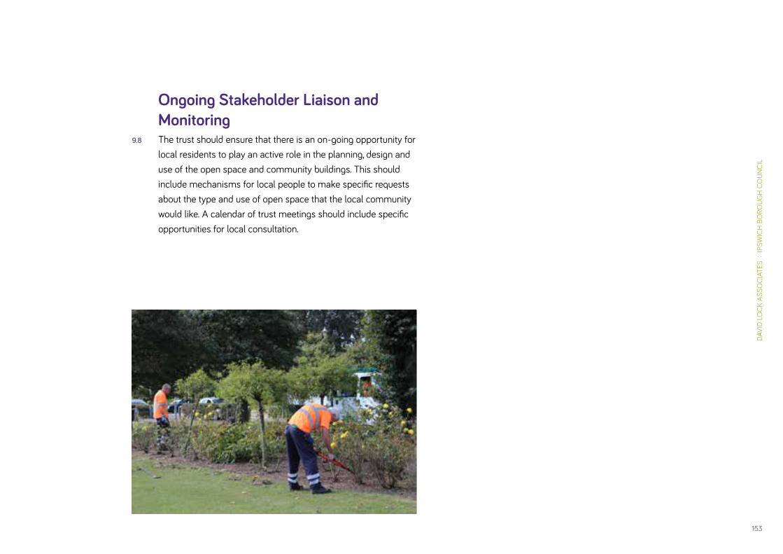
DAVI
D LO
CK A
SSO
CIAT
ES :
IPS
WIC
H B
ORO
UGH
CO
UNCI
L
153
Ongoing Stakeholder Liaison and Monitoring
9.8 The trust should ensure that there is an on-going opportunity for local residents to play an active role in the planning, design and use of the open space and community buildings. This should include mechanisms for local people to make specific requests about the type and use of open space that the local community would like. A calendar of trust meetings should include specific opportunities for local consultation.

IPSW
ICH
NO
RTH
ERN
FRIN
GE
GAR
DEN
SUBU
RB :
SU
PPLE
MEN
TARY
PLA
NNIN
G D
OC
UM
ENT
154
Requirements for Future Planning Applications1010.1 Ipswich Garden Suburb will be planned and delivered over
many years, and the proposals will require both outline planning applications, reserved matters applications and potentially Full planning applications at different stages. Each of these stages will be accompanied by supporting documentation, and will give rise to planning conditions which in themselves will require the preparation of further details and strategies to govern the design, construction and management of the garden suburb.
10.2 Figure 49 gives a broad outline of the process as currently envisaged by the Council as local planning authority. In particular it highlights where further work on the design of the scheme will take place.
10.3 Either a single outline planning application or a number of separate outline planning applications will be submitted to cover the proposed development. All outline planning applications will need to assess both the transport implications of the level of development proposed and how they will be mitigated within the overall context of the development of the whole of the area covered by the SPD showing how the objectives for the area can be met and will not be prejudiced.
10.4 In addition to the standard national requirements that are required to be submitted as part of a planning application (application form, plans, fee, Design & Access Statement and a summary of documents), the following information should be submitted as part of a detailed outline planning application for the development of the site. This list is not exhaustive and further requirements may be identified through pre-application discussions, whilst some items may be more appropriate for consideration at reserved matters stage dependent on the extent of approval sought by the applicant(s) at outline stage:
Masterplanning & Design• Illustrative master plan of site, whilst a series of site plans
should identify open space networks and different land uses with sequencing, and also outline indicative densities and building heights by land area
• Design & Access Statement also to include design details for District and Local Centres, schools, spine road, country park and visitor centre and rail bridges, and a car parking strategy
• Landscape and green infrastructure strategy, including play and sports provision strategy
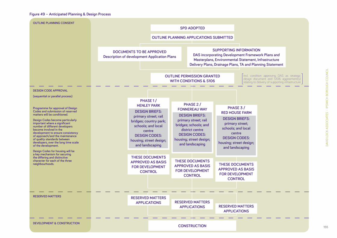
DAVI
D LO
CK A
SSO
CIAT
ES :
IPS
WIC
H B
ORO
UGH
CO
UNCI
L
155
Figure 49 – Anticipated Planning & Design Process
Incl. condition approving DAS as strategic design document and S106 aggreement(s) relating to delivery of supporting infrastructure
OUTLINE PLANNING CONSENT
DESIGN CODE APPROVAL
RESERVED MATTERS
DEVELOPMENT & CONSTRUCTION
(sequential or parallel process)
Programme for approval of Design Codes and submission of reserved matters will be conditioned.
Design Codes become particularly important where a significant number of different developers become involved in the development to ensure consistency of approach / and the maintenance of quality standards between developers, over the long time scale of the development.
Design Codes for housing will be a key mechanism for securing the differing and distinctive character for each of the three neighbourhoods.
[ ]
DOCUMENTS TO BE APPROVEDDescription of development Application Plans
SUPPORTING INFORMATIONDAS incorporating Development Framework Plans and Masterplans, Environmental Statement, Infrastructure
Delivery Plans, Drainage Plans, TA and Planning Statement
SPD ADOPTED
OUTLINE PLANNING APPLICATIONS SUBMITTED
PHASE 1 / HENLEY PARK
THESE DOCUMENTS APPROVED AS BASIS FOR DEVELOPMENT
CONTROL
DESIGN BRIEFS: primary street; rail
bridges; country park; schools; and local
centreDESIGN CODES:
housing; street design; and landscaping
THESE DOCUMENTS APPROVED AS BASIS FOR DEVELOPMENT
CONTROL
PHASE 3 / RED HOUSE FARMDESIGN BRIEFS: primary street;
schools; and local centre
DESIGN CODES: housing; street design;
and landscaping
THESE DOCUMENTS APPROVED AS BASIS FOR DEVELOPMENT
CONTROL
PHASE 2 / FONNEREAU WAYDESIGN BRIEFS:
primary street; rail bridges; schools; and
district centreDESIGN CODES:
housing; street design; and landscaping
OUTLINE PERMISSION GRANTED WITH CONDITIONS & S106
RESERVED MATTERS APPLICATIONS RESERVED MATTERS
APPLICATIONS RESERVED MATTERS APPLICATIONS
CONSTRUCTION

IPSW
ICH
NO
RTH
ERN
FRIN
GE
GAR
DEN
SUBU
RB :
SU
PPLE
MEN
TARY
PLA
NNIN
G D
OC
UM
ENT
156
Planning • Planning Statement
• Retail Impact Assessment – to include floorspace schedule outlining indicative scale of proposed land uses at District & Local Centres
• Draft Heads of Terms for Section 106 Agreement
• Viability Appraisal and independent review with details to be agreed with Ipswich Borough Council
• Affordable Housing Statement
• Statement of Community Involvement (SCI)
• Whole-site Infrastructure Delivery Plan
• Neighbourhood Management Plans – to cover future mainte-nance of community spaces and buildings
• Community Development Strategy
Sustainability• Sustainability & Energy Assessment – outlining the approach
taken to integrate sustainability during the design process. This can include topics such as water use, materials, surface water run-off, waste, pollution, health and wellbeing, manage-ment, ecology and transport. This should also include esti-mated energy loads and consumption as well as predicted CO2 (carbon) emissions of the overall development, in addi-tion to BREEAM and Code for Sustainable Homes assess-ments. The Council’s Sustainability Development Checklist should be included as an appendix to such assessments.
Traffic & Transport• Whole-site Transport Assessment
• Whole-site Framework Travel Plan – outlining measures to encourage new residents and employees on site to use sustainable modes of transport
• Whole-site Public Transport Strategy – outlining a strategy for providing viable sustainable transport options
• Public Rights of Way Statement – assessing the impact on existing access routes
• Highway/Home Zone design report and any other reports & modelling as required in consultation with Suffolk County Council Highways department

DAVI
D LO
CK A
SSO
CIAT
ES :
IPS
WIC
H B
ORO
UGH
CO
UNCI
L
157
Environmental Impact• Environmental Statements
• Landscape Assessments
• Arboricultural Survey & Landscape Plan, including tree and hedgerow removal details
• Biodiversity & Ecological Reports including Management Plan – survey timings to be agreed with Ipswich Borough Council in consultation with Suffolk County Council & Natural England
• Archaeology Assessments
• Air Quality Assessment – to include Low Emission Strategy
• Noise & Vibration Assessments
• Flood Risk Assessment
• Sustainable Drainage Strategy (subject to both planning and SAB approval)
• Heritage Statement – with particular regard to the setting of Red House Farm complex
• External lighting Assessments – to include assessment on habitat areas and where details of high-intensity lighting (e.g. MUGA floodlights) are included or indicatively shown near to sensitive/residential areas
• Land Contamination Assessments
• Site Waste Management Statement
• Construction Management Plans
• Utility Infrastructure Report

IPSW
ICH
NO
RTH
ERN
FRIN
GE
GAR
DEN
SUBU
RB :
SU
PPLE
MEN
TARY
PLA
NNIN
G D
OC
UM
ENT
158
APP 1Relevant Planning Policy

159
DAVI
D LO
CK A
SSO
CIAT
ES :
IPS
WIC
H B
ORO
UGH
CO
UNCI
L
APP 1Relevant Planning Policy

IPSW
ICH
NO
RTH
ERN
FRIN
GE
GAR
DEN
SUBU
RB :
SU
PPLE
MEN
TARY
PLA
NNIN
G D
OC
UM
ENT
160
APPENDIX 1
SCHEDULE OF POLICIES FROM THE ADOPTED IPSWICH CORE STRATEGY AND POLICIES DEVELOPMENT PLAN DOCUMENT (EDITED WHERE APPROPRIATE FOR RELEVANCE TO DEVELOPMENT AT IPSWICH NORTHERN FRINGE)
STRATEGIC POLICIES
POLICY CS1: SUSTAINABLE DEVELOPMENT – CLIMATE CHANGE In Ipswich a comprehensive approach will be taken to tackling climate change and its implications through (amongst other things):-
a. Requiring all new development to incorporate energy conserva-tion and efficiency measures, to achieve significantly reduced carbon emissions by 2016 for all new residential and major non-residential development;
b. Requiring all major developments to achieve a target of at least 15% of their energy requirements to be provided through decentralised renewable or low carbon energy sources where feasible and viable.
g. Requiring building and infrastructure design to incorporate water conservation, capture, recycling and efficiency measures, and sustain-able urban drainage systems.
POLICY CS2: THE LOCATION AND NATURE OF DEVELOPMENTThe regeneration and sustainable growth of Ipswich will be achieved through (amongst other things):
g. Development demonstrating principles of very high quality architec-ture and urban design.
POLICY CS4: PROTECTING OUR ASSETSThe Council is committed to protecting and enhancing the Borough’s built, historical, natural and geological assets.
The Council will seek to conserve and enhance local biodiversity through (amongst other things):
a. Requiring new development to incorporate provision for conserving and enhancing local biodiversity and geodiversity interests.
The Council will encourage the use of local reclaimed, renewable, recycled and low environmental impact materials in construction, in order to conserve finite natural resources and minimise environ-mental impacts. New development will also be required to minimise the amount of waste generated during construction and through the lifetime of the building.
POLICY CS5: IMPROVING ACCESSIBILITYDevelopment should be located and designed to minimise the need to travel and to enable access safely and conveniently on foot, by bicycle, and by public transport (bus and rail). This will encourage greater use of these modes. The Council will support the implementation of the

DAVI
D LO
CK A
SSO
CIAT
ES :
IPS
WIC
H B
ORO
UGH
CO
UNCI
L
161
Ipswich Major Scheme and will work with the Highway Authority to manage travel demand in Ipswich and in so doing will prioritise the introduction of an integrated cycle network.
POLICY CS8: THE BALANCE BETWEEN FLATS AND HOUSESThe Council will plan for a mix of dwelling types to be provided, in order to achieve mixed and sustainable communities. All major schemes over 10 dwellings will be expected to provide a mix of dwelling types and sizes in accordance with the Council’s Housing Needs Study and Strategic Housing Market Assessment.
Exceptions to this approach will only be considered where:
a. The site location, characteristics or sustainable design justify a differ-ent approach; or
b. A different approach is demonstrated to better meet housing needs in the area; or
c. A different approach would expedite the delivery of housing needed to meet targets and is acceptable in other planning terms.
POLICY CS10: IPSWICH NORTHERN FRINGELand at the Northern Fringe of Ipswich, north of Valley Road / Colchester Road and between Henley Road in the west and Tuddenham Road in the east, will form the main source of supply of housing land in Ipswich after 2021.
However, due to the limited availability of previously developed land in
the rest of the town, the delivery of 1000 dwellings will be expected to commence prior to 2021 on land to the east of Henley Road and south of the railway line. A prerequisite for any development being granted planning permission in the Northern Fringe will be the prior adoption by the Council of a supplementary planning document providing a development brief to:
a. guide the development of the whole of the Northern Fringe area:
b. identify the infrastructure that developments will need to deliver on a comprehensive basis alongside new housing, including community facilities, and at an appropriate stage, the provision of a railway crossing to link potential development phases, in the interests of sustainability and integration; and
c. set out a schedule of infrastructure charges.
The Borough Council will start to prepare the supplementary planning document as soon as the Core Strategy is adopted.
Any development will maintain an appropriate physical separation of Westerfield village from Ipswich and include include green walking and cycling links to Westerfield station, and provide the opportunity for the provision of a country park within the Northern Fringe as envisaged by CS16 and as shall be more particularly defined in the SPD.
Should housing delivery be falling significantly short of requirements, the Council would at that time need to consider allowing additional land in the Northern Fringe to be released for development prior to 2021.

IPSW
ICH
NO
RTH
ERN
FRIN
GE
GAR
DEN
SUBU
RB :
SU
PPLE
MEN
TARY
PLA
NNIN
G D
OC
UM
ENT
162
POLICY CS12: AFFORDABLE HOUSINGThe Council will work with partners to provide affordable housing to meet identified needs in Ipswich, All new developments of 10 dwell-ings or more are required to include provision for affordable housing (based on percentages of floorspace, not dwelling numbers) as follows:-
35% affordable housing provision for schemes of 15 or more dwellings.
At least 80% of affordable housing provision should consist of social rented housing, subject to viability.
The Council will only consider reducing the requirement for the provi-sion of affordable housing in an open market development where an independent assessment of the applicant’s development costs is carried out at the applicant’s expense, which justifies a lower percent-age figure on viability grounds.
POLICY CS15: EDUCATION PROVISIONAny education needs associated with the development at the Northern Fringe will be identified and sites safeguarded through the develop-ment brief to be prepared as a supplementary planning document.
POLICY CS16: GREEN INFRASTRUCTURE, SPORT AND RECREATIONThe Council will protect, enhance, and extend the network of green corridors, open spaces, sport and recreation facilities for the benefit of biodiversity, people, and the management of local flood risk. It will do this by:
a. requiring all developments to contribute to the provision of open space according to the Borough’s standards, identified strategic needs and existing deficits in an area;
b. requiring major new developments to include on-site public open spaces and wildlife habitat. On-site provision must create a network or corridor with existing green infrastructure where such a network exists beyond the site boundaries;
f. working with partners to improve green infrastructure provision and link radial green corridors with a publically accessible green rim around Ipswich;
g. working with partners to ensure the provision of a new country park in the urban fringe of north-eastern Ipswich (e.g. within any Northern Fringe development – see policy CS10)
POLICY CS17: DELIVERING INFRASTRUCTUREThe Council will require all developments to meet the on and off-site infrastructure requirements needed to support the development and mitigate the impact of the development on the existing community and environment.
There will be specific requirements linked to the Northern fringe that will be identified in the development brief supplementary planning document that will be prepared in advance of any development taking place there.

DAVI
D LO
CK A
SSO
CIAT
ES :
IPS
WIC
H B
ORO
UGH
CO
UNCI
L
163
DEVELOPMENT MANAGEMENT POLICIESPOLICY DM1: SUSTAINABLE DEVELOPMENTAll new residential development and non-residential buildings shall be required to achieve a high standard of environmental sustainability.
In this regard all developments exceeding the thresholds set out below shall achieve the following standards as a minimum unless, in excep-tional circumstances, it can be clearly demonstrated that this is either not feasible or not viable.
For developments of 250 dwellings or more:-
From 2013 – Level 5 of the Code for Sustainable Homes
From 2016 – Level 6 of the Code for Sustainable Homes
All other residential and non-residential development with a gross external floorspace of 500 sqm or more:-
From 2013 onwards – BREEAM Excellent.
POLICY DM2: DECENTRALISED RENEWABLE OR LOW CARBON ENERGYAll new build development of 10 or more dwellings or in excess of 1000 sqm of other residential or non-residential floorspace shall pro-vide at least 15% of their energy requirements from decentralised and renewable or low carbon sources. If it can be clearly demonstrated that this is either not feasible or viable, the alternative of reduced provision and / or equivalent carbon reduction in the form of additional energy efficiency measures will be expected.
POLICY DM3: PROVISION OF PRIVATE OUTDOOR AMENITY SPACE To ensure that new residential developments deliver a suitably high quality and environmentally sustainable living environment all such developments will be required to incorporate well designed and located private outdoor amenity space of an appropriate type and amount. Provision will be in accordance with the following standards unless this would unavoidably conflict with the need to meet other density and urban design requirements of the plan or an applicant is able to demonstrate that a lower figure would be acceptable having regard to the particular circumstances of the proposal. In all cases applicants will be expected to demonstrate that adequate provision of outdoor amenity space will be provided for the likely occupancy of the pro-posed dwellings.
• All houses, bungalows, or ground floor maisonettes with 3 or more bedrooms a minimum rear garden of 75sqm.
• All houses, bungalows, or ground floor maisonettes with 1 or 2 bedrooms a minimum rear garden of 50sqm.
• For all apartments or upper floor maisonettes an average of 25sqm of private outdoor amenity space.
POLICY DM4: DEVELOPMENT AND FLOOD RISK Development will only be approved where it can be demonstrated that the proposal satisfies all of the following criteria:
a. it does not increase the overall risk of all forms of flooding in the area through the layout and form of the development and appropriate application of Sustainable Urban Drainage Systems (SUDS);

IPSW
ICH
NO
RTH
ERN
FRIN
GE
GAR
DEN
SUBU
RB :
SU
PPLE
MEN
TARY
PLA
NNIN
G D
OC
UM
ENT
164
b. it will be adequately protected from flooding in accordance with adopted standards wherever practicable;
c. it is and will remain safe for people for the lifetime of of the develop-ment; and
d. it includes water efficiency measures such as rainwater harvesting, or use of local land drainage water where practicable.
POLICY DM5: URBAN DESIGN QUALITY The Council will require all new development to be well designed and sustainable. In Ipswich this will mean:
• layouts and designs that provide a safe, attractive, permeable, leg-ible and useable public realm for all users, which is pedestrian and cycle orientated;
• areas which function well and where possible integrate residential, working and community environments and fit well with adjoining areas;
• the promotion of safe and secure communities;
• greener streets and spaces to contribute to local biodiversity, visual amenity, and health and well-being, and offset the impacts of climate change;
• protecting and enhancing the special character and distinctiveness of Ipswich and helping to reinforce the attractive physical character-istics of local neighbourhoods;
• buildings that exhibit very good architectural quality, are highly sustainable and are designed for long life by being capable of adaptation to accommodate changing needs and uses over time;
• ensuring that new development incorporates cycle and waste stor-age, public transport infrastructure and car parking if appropriate, all designed and integrated in a way that supports the street scene and safeguards amenity; and
• new buildings in or around Air Quality Management Areas will be designed so that their size and layout will minimise, and at the very least not increase, localised retention of polluting emissions, and will include ventilation systems that protect the health of users of the buildings.
Design that is considered not to adequately meet all these criteria will be refused.
POLICY DM7: PUBLIC ART Major residential developments shall include a substantial proposal for public art likely to be equivalent to about 1% of the construction con-tract value of the development scheme unless it can be demonstrated that this percentage would render the scheme unviable or would be disproportionate to the nature, size and location of the development. Proposals must be fully integrated into the proposed development at the design stage.
POLICY DM10: TREES AND HEDGEROWSApplications for development should retain existing trees and hedge-rows of amenity or biodiversity value where possible. Where develop-ment affecting trees is proposed the application must be accompanied by:
• an accurate survey and assessment of all existing trees on site in accordance with BS5837 “Guide for trees in relation to construc-tion” 1991.

DAVI
D LO
CK A
SSO
CIAT
ES :
IPS
WIC
H B
ORO
UGH
CO
UNCI
L
165
• details of protective measures to be put in place during the devel-opment process to ensure the health and safety of each specimen to be retained; and
• where removal is proposed, a plan for replacement planting on a two for one basis and using semi-mature specimens, unless otherwise agreed by the Council.
POLICY DM15: TRAVEL DEMAND MANAGEMENTIn proposals for the development of 10 or more dwellings or 1000sqm or more of non-residential floorspace the Council will require:
a. a transport assessment to be undertaken including an assessment of the impact on the highway network with appropriate mitigation measures secured by an planning obligation;
b. where likely to have an impact on or be located in an air quality management area or other sensitive area, an assessment of the air quality impacts of the development with appropriate mitigation meas-ures proposed as necessary;
c. a travel plan outlining how the development will ensure high levels of cycling and walking together with public transport use:
d. the minimisation of the use and ownership of the car by providing an integrated solution which could include car clubs, well designed dedicated cycle and pedestrian routes, high quality cycle storage, and safe and convenient access to public transport within 400 metres of the development; and
e. for non-residential developments, high quality shower facilities and lockers to ensure that a modal shift can occur.
POLICY DM17: TRANSPORT AND ACCESS IN NEW DEVELOPMENTSEach development proposal will be assessed in terms of:
a. its impact on the road network in respect of traffic capacity, highway safety and the environmental impact of generated traffic;
b. pedestrian and cycle accessibility to and within the site as well as the wider effects of the development upon pedestrian movement;
c. its impact on rights-of-way;
d. availability of and access to public transport.
Applicants will be required to demonstrate how the development would improve provision and/or how any acceptable adverse impacts would be managed and mitigated,
The Council will require the inclusion of priority bus measures and dedicated cycle routes where appropriate.
The Council will require mitigating measures to the satisfaction of the Highway Authority where necessary.
POLICY DM18: CAR PARKINGThe Council will require local parking standards to be complied with in all new development, and will expect parking to be fully integrated into the design of the scheme to provide secure and convenient facilities.
Outside of the IP-One area there will be minimum parking standards for residential development and although a minimum standard is

IPSW
ICH
NO
RTH
ERN
FRIN
GE
GAR
DEN
SUBU
RB :
SU
PPLE
MEN
TARY
PLA
NNIN
G D
OC
UM
ENT
166
applicable, car parking must be designed so as not to dominate the development or street scene or to result in the inefficient use of land.
Across the Borough there will be maximum parking standards for non-residential development.
POLICY DM19: CYCLE PARKINGThe Council will require minimum standards of cycle parking for all new residential and major non-residential development proposals. All cycle parking is expected to be of a high quality and secure. The Council will also require the provision of secure cycle parking in any new car parks in the town.
POLICY DM24: AFFORDABLE HOUSING Affordable housing provision will be required in accordance with policy CS12.
The presumption will be in favour of on-site provision rather than the payment of commuted sums in lieu of provision.
The Council will require that affordable housing:
a. is designed and built to at least the same standard as the market housing, including the appropriate level of the Code for Sustainable Homes at the time:
b. is integrated into developments and from external appearance should be indistinguishable from market housing;
c. should not generally be grouped in clusters of more than 12-15 units; and
d. has car parking provided at the same ratio as for the development as a whole.
The appropriate type, size and mix will be determined by the findings of the Borough’s most up to date Housing Needs Survey and Strategic Housing Market Assessment for the time being, and the particular characteristics of the site.
POLICY DM28: PROTECTION OF OPEN SPACES, SPORT AND RECREATIONAL FACILITIESDevelopment involving the loss of open space, sports and recreation facilities will only be permitted if:
a. the site or facility is surplus in terms of all the functions an open space can perform, and is of low value and poor quality, as shown by the Ipswich Open Space, Sport and Recreation Facilities Study, 2009; or
b. alternative improved provision would be made in a location well related to the users of the existing facility,
POLICY DM 29: PROVISION OF NEW OPEN SPACES, SPORT AND RECREATION FACILITIESAll residential and non-residential developments of 1000sqm floor-space or more, will be required to provide, and or contribute to public open space and sport and recreation facilities to meet the needs of their occupiers.
In all major developments (10 dwellings or 1000sqm non-residential floorspace or more) at least 10% of the site area, or 15% in high density
DAVI
D LO
CK A
SSO
CIAT
ES :
IPS
WIC
H B
ORO
UGH
CO
UNCI
L
167
developments, should consist of incidental green space, useable by the public in relation to residential schemes.
Further provision or contributions will be sought according to the size of the proposed development and the quantity and quality of existing open spaces and sports and recreational facilities within the catchment area of the site, as identified by the Ipswich Open Space, Sport and Recreation Study 2009 and subsequent monitoring. Provision will be made in accordance with the standards set out in Appendix 6.
The requirements will apply to all schemes, unless it can be demon-strated that this would lead to the scheme being unviable and / or site specific matters so justify. In such cases a reduced level of provision will be negotiated with the applicant.
POLICY DM30: THE DENSITY OF RESIDENTIAL DEVELOPMENTThe density of new housing development in Ipswich will be as follows:
a. within the town centre, Ipswich Village, and Waterfront, development will be expected to achieve a high density of at least 90 dwellings per hectare (dph); the average will be taken as 110 dph;
b. within the remainder of IP-One, district centres, and an 800m area around district centres, development will be expected to achieve a medium density of at least 40 dph; and
c. elsewhere in Ipswich, low density development will be required (the average will be taken as 35 dph).
Exceptions to this approach will only be considered where:
d. the site location, characteristics, constraints or sustainable design justify a different approach; or
e. a different approach is demonstrated to better meet all housing needs in the area.
MINIMUM FLOORSPACE STANDARDS (DM30)The following minimum floorspace standards for new dwellings (gross internal floor area), based on the English Partnerships Quality Standards 2007, are encouraged by the Council and should be achieved where practicable to do so:
• minimum 51 sqm for a 1 bed / 2 person dwelling
• minimum 66 sqm for a 2 bed / 3 person dwelling
• minimum 77 sqm for a 2 bed / 4 person dwelling
• minimum 93 sqm for a 3 bed / 5 person dwelling
• minimum 106 sqm for a 4 bed / 6 person dwelling
POLICY DM31: CONSERVING LOCAL NATURAL AND GEOLOGICAL INTERESTThe Council will seek to conserve the nature conservation and geodi-versity interest of County Wildlife Sites, Local Wildlife Sites and RIGS identified on the Proposals Map, and Suffolk Biodiversity Action Plan species and habitats, by controlling the type and intensity of develop-ment. The Council will not grant planning permission for development which would be likely to cause net loss after mitigation and compensa-tion of the relevant biodiversity or geodiversity interest, or protected
IPSW
ICH
NO
RTH
ERN
FRIN
GE
GAR
DEN
SUBU
RB :
SU
PPLE
MEN
TARY
PLA
NNIN
G D
OC
UM
ENT
168
BAP species, in terms of population size or loss of extent of BAP habitat or features for which the site was designated.
POLICY DM32: PROTECTION AND PROVISION OF COMMUNITY FACILITIESThe Council will work with partners to ensure that a range of local community facilties is made available and retained to meet local needs, Where possible, and appropriate, opportunities will be taken to provide shared space for the delivery of community services.

DAVI
D LO
CK A
SSO
CIAT
ES :
IPS
WIC
H B
ORO
UGH
CO
UNCI
L
169

IPSW
ICH
NO
RTH
ERN
FRIN
GE
GAR
DEN
SUBU
RB :
SU
PPLE
MEN
TARY
PLA
NNIN
G D
OC
UM
ENT
170
APP 2Urban Context Study

171
DAVI
D LO
CK A
SSO
CIAT
ES :
IPS
WIC
H B
ORO
UGH
CO
UNCI
L
APP 2Urban Context Study
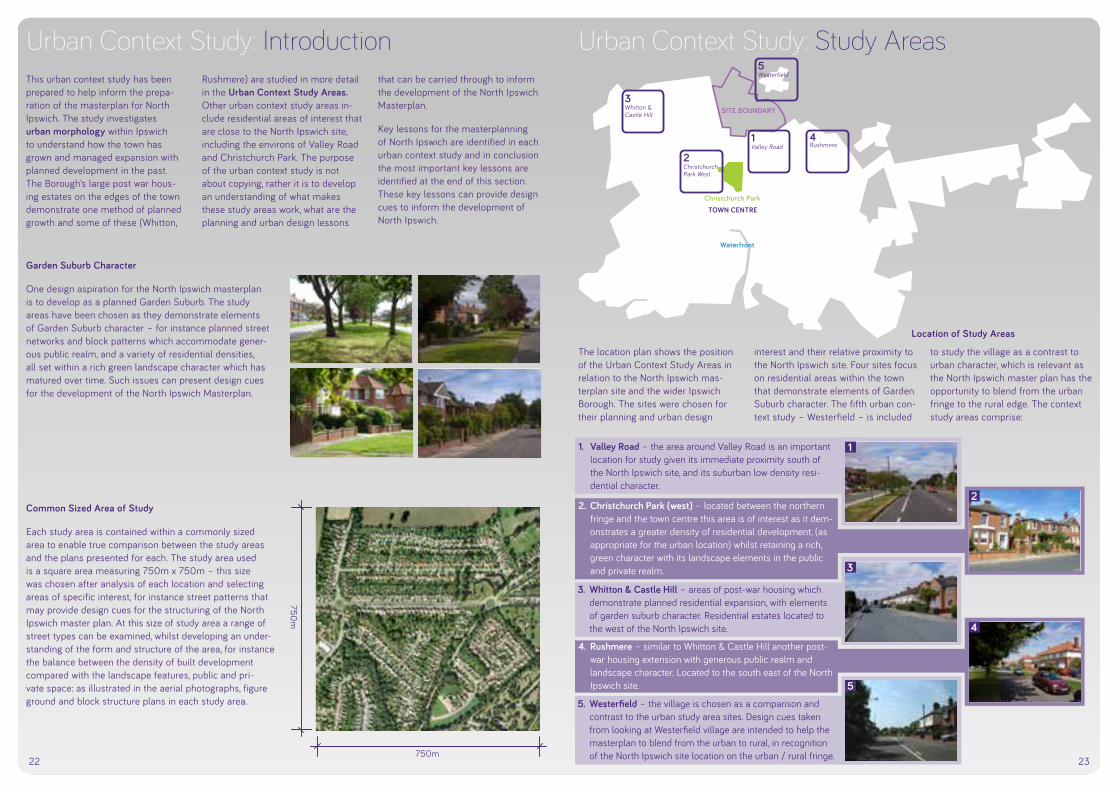
22 23
Urban Context Study: IntroductionThis urban context study has been prepared to help inform the prepa-ration of the masterplan for North Ipswich. The study investigates urban morphology within Ipswich to understand how the town has grown and managed expansion with planned dev elopment in the past. The Borough’s large post war hous-ing estates on the edges of the town demonstrate one method of planned growth and some of these (Whitton,
Rushmere) are studied in more detail in the Urban Context Study Areas. Other urban context study areas in-clude residential areas of interest that are close to the North Ipswich site, including the environs of Valley Road and Christchurch Park. The purpose of the urban context study is not about copying, rather it is to develop an understanding of what makes these study areas work, what are the planning and urban design lessons
that can be carried through to inform the development of the North Ipswich Masterplan.
Key lessons for the masterplanning of North Ipswich are identified in each urban context study and in conclusion the most important key lessons are identified at the end of this section. These key lessons can provide design cues to inform the development of North Ipswich.
Garden Suburb Character
One design aspiration for the North Ipswich masterplan is to develop as a planned Garden Suburb. The study areas have been chosen as they demonstrate elements of Garden Suburb character – for instance planned street networks and block patterns which accommodate gener-ous public realm, and a variety of residential densities, all set within a rich green landscape character which has matured over time. Such issues can present design cues for the development of the North Ipswich Masterplan.
Common Sized Area of Study
Each study area is contained within a commonly sized area to enable true comparison between the study areas and the plans presented for each. The study area used is a square area measuring 750m x 750m – this size was chosen after analysis of each location and selecting areas of specific interest, for instance street patterns that may provide design cues for the structuring of the North Ipswich master plan. At this size of study area a range of street types can be examined, whilst developing an under-standing of the form and structure of the area, for instance the balance between the density of built development compared with the landscape features, public and pri-vate space: as illustrated in the aerial photographs, figure ground and block structure plans in each study area.
1. Valley Road – the area around Valley Road is an important location for study given its immediate proximity south of the North Ipswich site, and its suburban low density resi-dential character.
750m
750m
Urban Context Study: Study Areas
Location of Study Areas
The location plan shows the position of the Urban Context Study Areas in relation to the North Ipswich mas-terplan site and the wider Ipswich Borough. The sites were chosen for their planning and urban design
interest and their relative proximity to the North Ipswich site. Four sites focus on residential areas within the town that demonstrate elements of Garden Suburb character. The fifth urban con-text study – Westerfield – is included
to study the village as a contrast to urban character, which is relevant as the North Ipswich master plan has the opportunity to blend from the urban fringe to the rural edge. The context study areas comprise:
Christchurch ParkTOWN CENTRE
1 Valley Road
2ChristchurchPark West
3 Whitton & Castle Hill
4 Rushmere
5 Westerfield
SITE BOUNDARY
Waterfront
1
4
2
5
3
2. Christchurch Park (west) – located between the northern fringe and the town centre this area is of interest as it dem-onstrates a greater density of residential development, (as appropriate for the urban location) whilst retaining a rich, green character with its landscape elements in the public and private realm.
3. Whitton & Castle Hill – areas of post-war housing which demonstrate planned residential expansion, with elements of garden suburb character. Residential estates located to the west of the North Ipswich site.
4. Rushmere – similar to Whitton & Castle Hill another post-war housing extension with generous public realm and landscape character. Located to the south east of the North Ipswich site.
5. Westerfield – the village is chosen as a comparison and contrast to the urban study area sites. Design cues taken from looking at Westerfield village are intended to help the masterplan to blend from the urban to rural, in recognition of the North Ipswich site location on the urban / rural fringe.

24 25
Urban Context Study: Urban Morphology
1905: The first in our sequence of historic maps illustrates the extent of the development within the Ipswich borough at the start of the twentieth century. The map clearly il-lustrates the still predominately compact form of develop-ment centred on the historic core of the town. The densest development is clearly around the town centre and Wet Dock, which at the time would have been the beating in-dustrial heartbeat of the town. Relatively little development had taken place around Christchurch Park, with the single streets of residential homes lining the north and eastern edges of the park providing the northern edge to the town.
1928: This historic map of the inter-war period illustrates that the urban core has expanded with densification of ur-ban development in the heart of the town, notably expand-ing south-west across the river at a higher density than the residential streets constructed on the eastern side of the town. Ribbon development along key routes a strong pattern of expansion, particularly along Woodbridge Road (north east from the town centre) and Felixstowe Road (south east from the town centre), and streets extending from Norwich Road (north west from the town centre). Some smaller settlements including Westerfield and Rush-mere remain separate from the town, with large areas of open agricultural land wrapping around the north and east of the town
1938: The Pre-Second World War map shows the con-tinued expansion of town development of an increasingly suburban form. The density of residential development is notably lower in the latest phases of expansion on outer edges of the then town boundaries, with the pattern of development showing wider development blocks with lower density detached and semi-detached housing set in gardens - as opposed to the denser development of pre-dominately terraces, townhouses and villas in the earlier periods around the town core. A significant infrastructure development to note adjacent the North Ipswich land is the construction of Valley Road – Colchester Road route which created a northern relief road around the town.
1973: The scale of development has significantly increased by the period illustrated in this map, with notable areas of expansion including the growth north from the town centre up to, and beyond the Valley Road – Colchester Road route. Large areas of post-war development are illustrated with the significant expansion of the town in the form of planned housing estates including Rushmere to the north-east, Whitton and Castle Hill to the north-west which take the area of the Ipswich Borough north of the railway line. Similar town planning interventions occur to the south of the town centre with further large housing estates shown at Gainsborough / Prior Heath (south east), Stoke Park and Chantry (south west).

26 27
Urban Context Study: Urban Morphology
River OrwellTown parksRail lineStrategic road routesTown development phase 1: Historic CoresTown development phase 2: Christchurch Park and suburbsTown development phase 3: Expansion and ribbon developmentTown development phase 4: Planned expansion of post-war housing estatesTown development phase 5: Urban infill and expansion Town core development phase 5: Waterfront regenerationTown development phase 6: North Ipswich master plan
Sequential development overview: numbers correspond with annota-tions on diagrammatic plan on page opposite.
1. The Historic Town Core
The town has grown from the banks of the Orwell (see 1a on plan oppo-site), with early development focused on the bridging of the river and the adaptation of a strategic curve in the river to create the Wet Dock and thus enable the development of industrial port (1c) which brought trade to the town, dealing with exchange between the exports from the agricultural lands of East Anglia and the imports from continental Europe, notably The Netherlands. The town centre (1b) which its rich collection of medieval churches and market places grew to the north of the river and port along regional trading routes – east to the fens, west to Woodbridge and coast, north to Norfolk and south to London.
2. Early expansion from the core
Expansion of the town saw the devel-opment move north from the historic town core with grander housing and affluent residential streets set on the higher ground to the north (2a), re-moved from the industry south of the town centre. The grandest residential development was set around the town park, Christchurch Park (2b), immedi-ately north of the town centre. Other settlements noted on the plan include Westerfield village to the north of town and Martlesham to the east.
3. Wider town development
Further development in the late nineteenth and early twentieth cen-tury focussed around expansion from the town core along key routes predominately in the form of ribbon development, with infill blocks and streets creating interconnections (3a). Further town parks established to create setting for development
such as Holywells Park to the east of the town core (3c). Villages ex-panded (such as Westerfield and Martlesham) and Kesgrave (3b) grew as a large ribbon develop-ment settlement on the Woodbridge Road route between between Ipswich – Martlesham –Woodbridge.
4. Large Scale Planned Housing Expansion of Inter-war and post-war periods
The next major phase of development was the planned expansion of the town in the form of large residential housing estates on all sides town. Developed inter-war and post war these large suburbs include: • Whitton and Castle Hill to the
north west (4a);• Rushmere (4b) and Foxhall area
(4c) to the east;• Gainsborough and Priory Heath to
the south east (4d); and • Chantry, Stoke Park and Maiden-
hall to the south west (4e).
All of these large estates include characteristics of garden suburbs with residential housing developed around Local Centre with schools and com-munity facilities. The family hous-ing (predominantly semi-detached and detached, with some terraces) is largely set in landscaped private gar-dens with wide streets and tree lined public spaces. Further town parks were established including Gippeswyk Park (4f) and Chantry Park (4g). The overall feel is spacious with wide streets, public spaces and building set backs – all offering design cues for North Ipswich.
5. Urban Regeneration and infill
Development at the end of the twen-tieth century and early twenty-first century has largely focussed on urban infill development and regeneration and a few planned housing schemes.
The most significant urban regenera-tion project has been the transforma-tion of the former industrial wet-dock and hinterland south of the Town Centre into the Ipswich Marina area (5a). Just to the west has been the re-generation of industrial land creating the Ipswich village area and additional housing infill projects (5b). Other examples of urban infill include the redevelopment of infill land between Bramford Road and Sproughton Road (5c). All of these sites have delivered higher density residential develop-ment, with the Marina in particular fo-cussing on apartments and high-rise living. The other urban infill sites have predominantly delivered townhouses, terraces and apartments. Large scale family housing sites have been in shorter supply with the notable excep-tions including Ravenswood, a master-planned community developed on the urban infill site of the former Ipswich airfield (5d). Ribbon development along the Woodbridge Road has con-tinued with the expansion of Kesgrave and the Grange Farm family hous-ing estate (5e), and prior to that the planned estate of Martlesham Heath (5f). East of the A12 lies Adastral Park and Martlesham Business Park (5g).
6. North Ipswich – the next phase of Ipswich’s planned expansion in the form of a garden suburb.
The historic maps on the previous pages illustrate the gradual development of the Ipswich during the twentieth century, and to supplement this further the diagram below illustrating the growth of Ipswich presents an overview of the
sequential development of the town. Understanding the pattern of the development in the town can help inform the understanding of the shape and form of the North Ipswich masterplan. By understanding how the town has grown it is clear that
the North Ipswich expansion area is the next logical step in the process of town development, following the established pattern of planned expansion, most notably of planned Garden Suburbs.
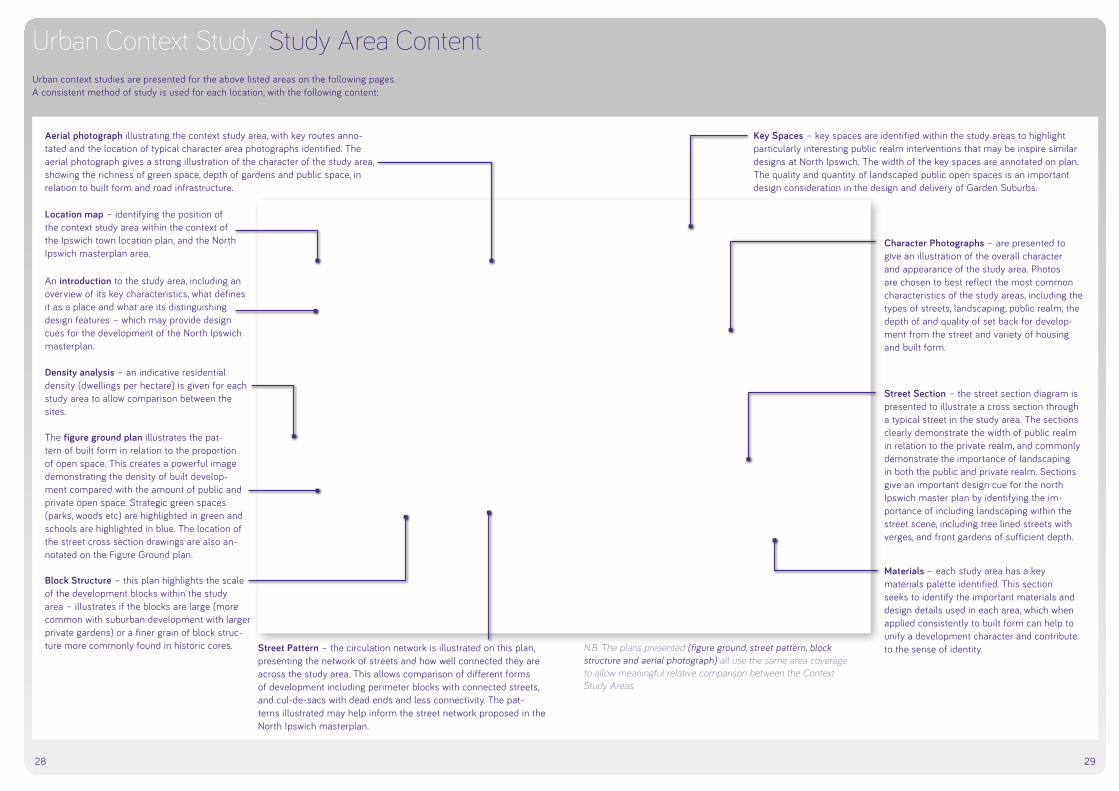
28 29
30 31
Context Study Area 1: Valley Road
3–8m variableFront Garden
3–8m variableFront Garden
4.5m Carriageway
4.5m Carriageway
1.5m Footpath1.5m Footpath
37–47m Building to Building
4.5m Verge with Footpath
10m Carriageway with cycle lanes
4.5m Verge with Footpath
28m
Valley Road
Wes
terf
ield
Roa
d
Tudd
enha
m R
oad
3
5
6
4
2
1 1
4
2
5
3
6
Valley Road
Key Space: Tuddenham Road (south of Valley Road) presents an attractive ex-ample of a landscaped setting for development: houses are set back from the main through-route behind a linear green space comprising mature trees. In common with Valley Road a lower order slip road is used to access the houses, parallel to the main route.
Materials/Design Details: Red brick is the predominant building material in the Valley Road environs. Low brick walls are used to define front gardens and plot boundaries, sometimes supple-mented by evergreen hedges.
Example tile and brick detailing on residential homes.
Lighter colour vari-ents for bricks used in homes and walls.
Grass verges: impor-tant contribution to the streetscape.
Low brick walls and hedging defines front gardens.
Aerial Photo: Tree lined streets create an attractive setting for development. Housing is low density with generous building setbacks from the street, well defined plot boundaries and landscaped gardens to the front and rear of plot.
Introduction/overview: The area around Valley Road is an important location for study given its immediate proximity south of the North Ipswich masterplan site, and its suburban residential character. Whilst Valley Road is a busy, strategic route through Ipswich the residen-tial development along its route, and streets adjacent to it present many positive characteracteristics of garden suburb development, providing design cues for North Ipswich. Wide streets and front gardens provide the space for landscaping that has matured over time to contribute much to the streetscene.
Indicative Residential Density circa
15–25dph
Figure Ground: Low density housing development is clearly illustrated with the large areas of private gardens within the housing blocks. Ribbon development along Valley Road is mirrored in streets to the north, with more organic cul-de-sacs and closes to the south.
Block Structure: The residential blocks are large in scale, reflective of the low density housing typologies comprising mainly large detached properties set in deep gardens to the front and rear.
Street Pattern: Valley Road is clearly dominant as a major circulation route, and the tree-lined slip roads running paral-lel to Valley Road provide a strong precedent for managing development adjacent to busy streets. Cul-de-sacs to the south offer limited connectivity.
Urban Context Study: Study Area ContentUrban context studies are presented for the above listed areas on the following pages. A consistent method of study is used for each location, with the following content:
Location map – identifying the position of the context study area within the context of the Ipswich town location plan, and the North Ipswich masterplan area.
An introduction to the study area, including an overview of its key characteristics, what defines it as a place and what are its distinguishing design features – which may provide design cues for the development of the North Ipswich masterplan.
Aerial photograph illustrating the context study area, with key routes anno-tated and the location of typical character area photographs identified. The aerial photograph gives a strong illustration of the character of the study area, showing the richness of green space, depth of gardens and public space, in relation to built form and road infrastructure.
Density analysis – an indicative residential density (dwellings per hectare) is given for each study area to allow comparison between the sites.
The figure ground plan illustrates the pat-tern of built form in relation to the proportion of open space. This creates a powerful image demonstrating the density of built develop-ment compared with the amount of public and private open space. Strategic green spaces (parks, woods etc) are highlighted in green and schools are highlighted in blue. The location of the street cross section drawings are also an-notated on the Figure Ground plan.
Block Structure – this plan highlights the scale of the development blocks within the study area – illustrates if the blocks are large (more common with suburban development with larger private gardens) or a finer grain of block struc-ture more commonly found in historic cores. Street Pattern – the circulation network is illustrated on this plan,
presenting the network of streets and how well connected they are across the study area. This allows comparison of different forms of development including perimeter blocks with connected streets, and cul-de-sacs with dead ends and less connectivity. The pat-terns illustrated may help inform the street network proposed in the North Ipswich masterplan.
N.B. The plans presented (figure ground, street pattern, block structure and aerial photograph) all use the same area coverage to allow meaningful relative comparison between the Context Study Areas.
Character Photographs – are presented to give an illustration of the overall character and appearance of the study area. Photos are chosen to best reflect the most common characteristics of the study areas, including the types of streets, landscaping, public realm, the depth of and quality of set back for develop-ment from the street and variety of housing and built form.
Street Section – the street section diagram is presented to illustrate a cross section through a typical street in the study area. The sections clearly demonstrate the width of public realm in relation to the private realm, and commonly demonstrate the importance of landscaping in both the public and private realm. Sections give an important design cue for the north Ipswich master plan by identifying the im-portance of including landscaping within the street scene, including tree lined streets with verges, and front gardens of sufficient depth.
Materials – each study area has a key materials palette identified. This section seeks to identify the important materials and design details used in each area, which when applied consistently to built form can help to unify a development character and contribute to the sense of identity.
Key Spaces – key spaces are identified within the study areas to highlight particularly interesting public realm interventions that may be inspire similar designs at North Ipswich. The width of the key spaces are annotated on plan. The quality and quantity of landscaped public open spaces is an important design consideration in the design and delivery of Garden Suburbs.

30 31
Context Study Area 1: Valley Road
3–8m variableFront Garden
3–8m variableFront Garden
4.5m Carriageway
4.5m Carriageway
1.5m Footpath1.5m Footpath
37–47m Building to Building
4.5m Verge with Footpath
10m Carriageway with cycle lanes
4.5m Verge with Footpath
28m
Valley Road
Wes
terf
ield
Roa
d
Tudd
enha
m R
oad
3
5
6
4
2
1 1
4
2
5
3
6
Valley Road
Key Space: Tuddenham Road (south of Valley Road) presents an attractive ex-ample of a landscaped setting for development: houses are set back from the main through-route behind a linear green space comprising mature trees. In common with Valley Road a lower order slip road is used to access the houses, parallel to the main route.
Materials/Design Details: Red brick is the predominant building material in the Valley Road environs. Low brick walls are used to define front gardens and plot boundaries, sometimes supple-mented by evergreen hedges.
Example tile and brick detailing on residential homes.
Lighter colour vari-ents for bricks used in homes and walls.
Grass verges: impor-tant contribution to the streetscape.
Low brick walls and hedging defines front gardens.
Aerial Photo: Tree lined streets create an attractive setting for development. Housing is low density with generous building setbacks from the street, well defined plot boundaries and landscaped gardens to the front and rear of plot.
Introduction/overview: The area around Valley Road is an important location for study given its immediate proximity south of the North Ipswich masterplan site, and its suburban residential character. Whilst Valley Road is a busy, strategic route through Ipswich the residen-tial development along its route, and streets adjacent to it present many positive characteracteristics of garden suburb development, providing design cues for North Ipswich. Wide streets and front gardens provide the space for landscaping that has matured over time to contribute much to the streetscene.
Indicative Residential Density circa
15–25dph
Figure Ground: Low density housing development is clearly illustrated with the large areas of private gardens within the housing blocks. Ribbon development along Valley Road is mirrored in streets to the north, with more organic cul-de-sacs and closes to the south.
Block Structure: The residential blocks are large in scale, reflective of the low density housing typologies comprising mainly large detached properties set in deep gardens to the front and rear.
Street Pattern: Valley Road is clearly dominant as a major circulation route, and the tree-lined slip roads running paral-lel to Valley Road provide a strong precedent for managing development adjacent to busy streets. Cul-de-sacs to the south offer limited connectivity.
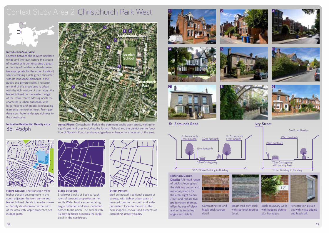
32 33
Context Study Area 2: Christchurch Park West
5–7m variableFront Garden
5–7m variableFront Garden
5.2m Carriageway 7.2m Carriagewaywith parking bays
1.5m Footpath
2.5m Footpath
2.5m Footpath
3m Front Garden
2.0m Footpath
IpswichSchool
Christchurch Park
Norwich Road
Hen
ley
Road
St. Edmunds Road
Ivry Street
St. Edmunds Road Ivry Street
3
1
4
7
2
5
8
3
6
9
15.2m Building to Building18.7–22.7m Building to Building
Materials/Design Details: A limited range of brick colours gives the defining colour and material palette for the area. Light cream / buff and red are two predominent themes, offset by use of black and white to define edges and details.
Contrasting red and black brick course detail.
Weathered buff brick with red brick footing detail.
Brick boundary walls with hedging define plot frontages.
Fenestration picked out with white edging and black sill.
Aerial Photo: Christchurch Park is the dominent public open space, with other significant land uses including the Ipswich School and the district centre func-tion of Norwich Road. Landscaped gardens enhance the character of the area.
Introduction/overview: Located between the Ipswich northern fringe and the town centre this area is of interest as it demonstrates a great-er density of residential development, (as appropriate for the urban location) whilst retaining a rich, green character with its landscape elements in the public and private realm. The south-ern end of this study area is urban with the rich mixture of uses along the Norwich Road, on the western edge of the Town Centre. Moving north the character is urban-suburban, with larger blocks and greater landscaping elements the further north. Front gar-dens contribute landscape richness to the streetscene.
Indicative Residential Density circa
35–45dph
Figure Ground: The transition from higher density development in the south adjacent the town centre and Norwich Road, blends to medium-low-er density development to the north of the area with larger properties set in deep plots.
Block Structure: Shallower blocks of back-to-back rows of terraced properties to the south. Wider blocks accomodating larger detached and semi-detached homes to the north. The school with its playing fields occupies the large block in the north/east.
Street Pattern: Well connected traditional pattern of streets, with tighter urban grain of terraced rows to the south and wider perimeter blocks to the north. The oval shaped Geneva Road presents an interesting street typology.
1 2
5
6
8
7
9

34 35
Context Study Area 3: Whitton & Castle Hill
3m Front Garden
2m Footpath2m Footpath 2m Footpath
8.5m Verge 7m Parking Bays 5m Carriageway 9m Verge
35m
Shakespeare Road
Macaulay Road
Stratford Road
6
1
2
65
4
3
1
4
2
5
3
6
37m Building to Building
Shenstone Drive
Key Space: Shenstone Drive presents a strong precedent for linear landscape features in the public realm. A wide grass verge of sufficient depth to accompodate street trees and car parking runs parallel to the lower-order road carriageway the length of the street. This creates a rich green setting for the housing that fronts the wide streetscape space.
Materials/Design Details: The garden suburb character is emphasised by the key materials - consistent use of red brick and brown-red roof tiles, some elevations picked out with light colour painted render. Hedges define plot boundaries.
Evergreen hedge-rows used to define plot boundaries.
Dominant red brick charater with brick work detailing.
Red brick detail line through white painted render.
Chimneys and front gables emphasis family housing form.
Aerial Photo: The garden suburb character is clearly apparent with green verges parallel to main routes creting a landscaped public realm, complimented by housing set in generous plots allowing for landscaping in front & back gardens.
Introduction/overview: Whitton and Castle Hill are two neigh-bouring areas of post-war housing that demonstrate planned residential expansion. The layout of both estates includes elements of garden suburb character, comprising lower density family housing set in good sized private gardens (front and rear). Wide streets have space to accompodate street trees and verges and the street network is planned to allow inter-con-nectitiy, whilst including more interest-ing cresents and gently curved routes. These residential estates located to the west of the North Ipswich site and provide a locally relevant precedent to study.
Indicative Residential Density circa
25–30dph
Figure Ground: The master planned suburb form is demonstrated in the clearly arranged from of streets, blocks and the consistent depth and set-back of residential properties from the street.
Block Structure: The depth of residential blocks is broadly consistent throughout the area, demonstrating the application of a (generous) common depth of private gardens for all homes.
Street Pattern: A well-connected network of streets permeates throughout the area, with some small cul-de-sacs in larger blocks. Interest is created in the street scene with crescents and gently sweeping curved routes.

36 37
Context Study Area 4: Rushmere
4–7m variableFront Garden
4–7m variableFront Garden
1.5m Footpath
3m Verge 3m Verge
1.5m Footpath
5m Carriageway 5m Carriageway7m Centralreservation
Renfrew Road
Dumbarton Road
Colchester Road
3
6
4
2
5
1
1
4
2
5
3
6
36m
34–40m Building to Building
Moffat Avenue
Key Space: Moffat Avenue is a central boulevard street that runs through the residential block to the east of Renefrew Road. The Boule-vard is strong precedent for North Ipswich with its central median of grass verge and street trees, com-plemented by verge on either side of the parallel street corridor. Houses fronting the boulevard benefit from the wide green streetscape setting.
Materials/Design Details: Red brick and red-orange roof tiles are the dominant mate-rial palette components for built form. Low brick walls define block boundaries, particularly front gardens. Low red brick walls
and hedging define plot boundaries.
White render used as contrast to red brick.
Red brick and con-crete plinth detail in brick pier.
Tree lined boulevard character of Moffat Avenue.
Aerial Photo: The red roofs of lower density residential development are set in green private gardens and tree-lined streets and spaces. Playing fields south of Dumbarton Road. Allotments to the east of Rushmere Hall school.
Introduction/overview: Rushmere displays similar character istics to Whitton and Castle Hill as another planned post-war housing extension. Generous public realm landscaping and residential homes set in good plots with green front gardens combine to create garden suburb identity. The comprehensive planning of Rushmere is demonstated by the good provision of local shops, services and schools, and public spaces including playing fields and a larger area of allotments. Rushmere is located to the south east of the North Ipswich site.
Indicative Residential Density circa
25–30dph
Figure Ground: Lower density housing is arranged around a connected network of streets. Significant opens spaces (in-cluding allotments and sports pitches) emphasis the green, garden suburb character. Schools and local centre facilities are centrally located.
Block Structure: The significant land areas for the al-lotments, playing fields and Rushmere Hall Primary School are evident in the ‘negative space’ shown in this dia-gram. The block structure of Renefrew Road / Moffat Avenue presents an in-teresting precedent for North Ipswich.
Street Pattern: The master planned ‘loop’ route of Renfrew Road is the most dominant street form, accessed from the pri-mary infrastructure through route of Colchester Road. The linear space of Moffat Avenue is visible as the route disecting the Renfrew Road block.

38 39
Context Study Area 5: Westerfield
6–20m variable Front Garden 16–25m variable Front Garden7.5m Carriageway
1.5m Footpath
Lower Road
Westerfie
ld RoadChurch Lane
33–54m Building to Building
Westerfield Road
Materials/Design Details: It is notable that the material palette is broadly con-sistent with the urban study areas, with red brick the core mate-rial. Painted render is an additional material feature applied to some elevations.
Low brick walls and hedging define some plot boundaries.
Painted render in light pastel shades contrasts with brick.
Red brick is the dominant material for homes.
Light buff brick is an alternative material variation.
Aerial Photo: The rural setting of Westerfield is apparent with agricultural fields surrounding the village.
Introduction/overview: The village of Westerfield is chosen as a comparison and contrast to the urban study area sites. Design cues taken from looking at Westerfield vil-lage are intended to help the master-plan to blend from the urban to rural, in recognition of the North Ipswich site location on the urban - rural fringe. The study uses the same scale grid as the urban sites, and thus fo-cuses on the village core at the cross roads of Westerfield Road and Lower Road / Church Lane. The village extends further than this study area, notably to the south with Westerfield rail station and public house.
Indicative Residential Density circa
10dph
Figure Ground: The village demonstrates a considera-bly lower density of development than the urban context studies. Residential density is lower, with less homes in total within the study. Ribbon develop-ment along the main streets has been supplemented by infill behind.
Block Structure: Four core block quarters corrspond with the street pattern of the village cross roads. Blocks are divided in some parts by short cul-de-sacs.
Street Pattern: The village cross roads is the simple street strucutre, comprising the main north-south Westerfield Road route, disected by the east-west route of Lower Road - Church Lane.
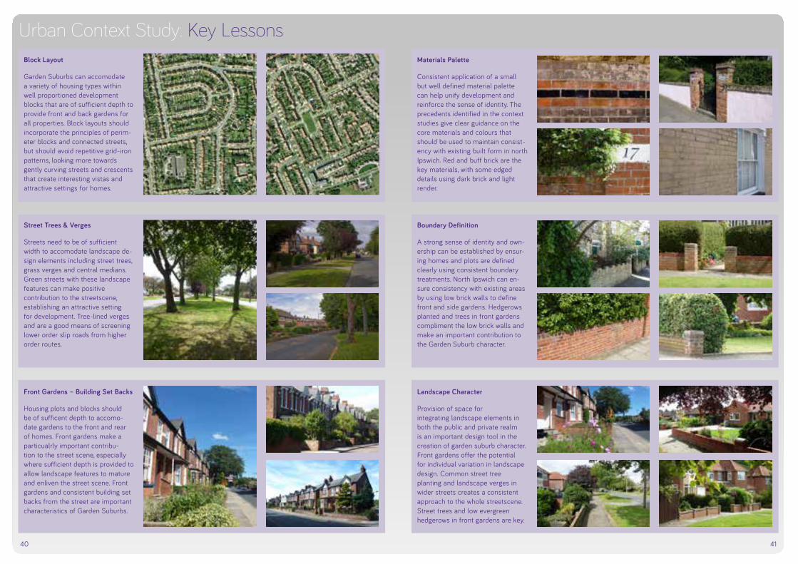
40 41
Urban Context Study: Key LessonsBlock Layout
Garden Suburbs can accomodate a variety of housing types within well proportioned development blocks that are of sufficient depth to provide front and back gardens for all properties. Block layouts should incorporate the principles of perim-eter blocks and connected streets, but should avoid repetitive grid-iron patterns, looking more towards gently curving streets and crescents that create interesting vistas and attractive settings for homes.
Materials Palette
Consistent application of a small but well defined material palette can help unify development and reinforce the sense of identity. The precedents identified in the context studies give clear guidance on the core materials and colours that should be used to maintain consist-ency with existing built form in north Ipswich. Red and buff brick are the key materials, with some edged details using dark brick and light render.
Street Trees & Verges
Streets need to be of sufficient width to accomodate landscape de-sign elements including street trees, grass verges and central medians. Green streets with these landscape features can make positive contribution to the streetscene, establishing an attractive setting for development. Tree-lined verges and are a good means of screening lower order slip roads from higher order routes.
Boundary Definition
A strong sense of identity and own-ership can be established by ensur-ing homes and plots are defined clearly using consistent boundary treatments. North Ipswich can en-sure consistency with existing areas by using low brick walls to define front and side gardens. Hedgerows planted and trees in front gardens compliment the low brick walls and make an important contribution to the Garden Suburb character.
Front Gardens – Building Set Backs
Housing plots and blocks should be of sufficent depth to accomo-date gardens to the front and rear of homes. Front gardens make a particualrly important contribu-tion to the street scene, especially where sufficient depth is provided to allow landscape features to mature and enliven the street scene. Front gardens and consistent building set backs from the street are important characteristics of Garden Suburbs.
Landscape Character
Provision of space for integrating landscape elements in both the public and private realm is an important design tool in the creation of garden suburb character. Front gardens offer the potential for individual variation in landscape design. Common street tree planting and landscape verges in wider streets creates a consistent approach to the whole streetscene. Street trees and low evergreen hedgerows in front gardens are key.

42 43
Urban Context Study: Local & District CentresThis part of the urban context study focuses on Local and District Centres in North Ipswich. By studying exist-ing centres surrounding the North-ern Fringe, lessons can be drawn for Northern Fringe. The objective is to replicate positive features while avoid-ing mistakes that have been made in the past. A detailed analysis of these centres will enable the Council and future developers to create successful places and supplement the existing offer without competing with existing facilities and services.
The location plan shows the posi-tion of the Study Areas in relation to the North Ipswich mas terplan site and the wider Ipswich Borough. The centres were chosen for their relative proximity to the site and the potential impacts the future Northern Fringe development might have. The study areas comprise the following:
3 5
4 7
2
6
1
Local Centre 1: Meredith Road
Local Centre 2: Garrick Way
Meredith Road is the closest District Centre to the Northern Fringe site, located to the west of it.
The main distinguishing feature separating Meredith Road as a District Centre is the provision of a large shopping store in the form of Aldi and the BP petrol garage on the corner of Meredith Road and Norwich Road (A1156) as well as Whitton Clinic.
Whereas the Local Centre shopping parades have been located on one side of the road, this District Centre, has both sides of the road lined with shop units and businesses. Once again where a traditional shopping parade has been used, flats are lo-cated above, some of these are avail-able to let.
Two of the retail units were currently vacant at the time of the site visit.
Meredith Road was busy with people and the off road parking was occupied showing the use. This was helped by the fact Meredith Road links the resi-dential area of Whitton to the Norwich Road. It also appeared to be a through route for a number of bus routes, increasing the pedestrian movement around the shops.
Other shops included a number of convenience stores and hot food takeaways, a hospice charity shop, a betting shop, fruit & veg/florist and bakery.
Location of Local Centres
Christchurch ParkTOWN CENTRE
SITEBOUNDARY
Waterfront
1 District Centre at Meredith Road 2 Local Centre at Garrick Way 3 Local Centre at Dales Road4 Local Centre at Brundswick Road 5 Local Centre at Colchester Road 6 Local Centre at Fircroft Road7 Local Centre at Selkirk Road
Garrick Way Local Centre is a parade of shops serving the surrounding post war semi detached dwellings.
Existing shops include:
• Co-op with ATM• Greengrocers and florist • Hair dressers• Tanning salon • Take-aways• Hardware store • Butcher• William Hill betting shop
This Local Centre has dedicated off street parking, with generous on street parking on the other side of the road.
The area is landscaped with grass verges and generous common areas which are well maintained.
The area was relatively lively with shops workers interacting with each other.
Local Centre 3: Dales RoadLocated on two sides, Dales Road is fairly large in relation to the number of units. Semi detached family houses and bungalows are located around the local centre. The first impression is that the area is slightly run down. It comprises:
• Co-op supermarket• Computer shop• Hair salon• Post office• The Dales pub • Motor and Engineers • Bakery• Estate agents• Co-op bank
There is limited parking surrounding the shops and some off street park-ing. The majority of patrons are likely to come from the surrounding resi-dential area.
The shops do not appear to be par-ticularly busy compared to other Local Centres.
This Local Centre acted as a divide for two distinct residential areas with detached family dwelling located in one area and smaller bungalow style dwellings in the other. The latter ap-peared neglected, whereas the family dwellings looked in better condition.
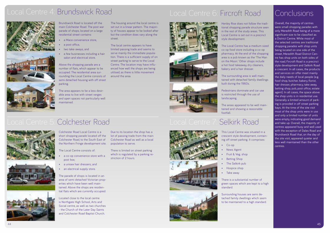
44
Local Centre 7: Selkirk RoadLocal Centre 5: Colchester RoadColchester Road Local Centre is a short shopping parade located off the Colchester Road, to the South East of the Northern Fringe development site.
The Local Centre consists of:
• a co-op convenience store with a post box;
• a unisex hair dressers; and • an electrical supply store.
The parade of shops is located in an area of semi detached Victorian prop-erties which have been well main-tained. Above the shops are residen-tial flats which are currently occupied.
Located close to the local centre is Northgate High School, Arts and Social centre, as well as two churches - the Church of the Later Day Saints and Colchester Road Baptist Church.
Due to its location the shop has a lot of passing trade from the main Colchester Road as well as a local population to serve.
There is limited on street parking which is regulated by a parking re-striction of 2 hours.
This Local Centre was situated in a crescent style development, contain-ing off street parking. It comprises:
• Co-op • News Agent• Fruit & Veg. shop• Betting Shop • The Selkirk pub• Hospice shop• Take away
There is a substantial number of green spaces which are kept to a high standard.
Surrounding houses are semi de-tached family dwellings which seem to be maintained to a high standard.
Local Centre 6: Fircroft RoadHenley Rise does not follow the tradi-tional shopping parade structure seen in the rest of the study areas. This Local Centre is set out in a precinct style development.
The Local Centre has a medium sized co-op food store including a co-op pharmacy. At the end of the shopping area is a pub known as the ‘The Man on the Moon.’ Other shops include a hot food takeaway, dry cleaners, bakery and a hair dresser.
The surrounding area is well main-tained with detached family dwellings built during the 1960s.
Pedestrians dominate and car use is restricted through the use of landscaping.
The areas appeared to be well main-tained and showing a reasonable footfall.
ConclusionsOverall, the majority of centres were small shopping parades with only Meredith Road being of a more significant size to be classified as a District Centre. While most of the selected centres are traditional shopping parades with shop units being located on one side of the street, Meredith Road District Cen-tre has shop units on both sides of the road, Fircroft Road is a precinct style development and Selkirk Road a crescent. In all cases, the products and services on offer meet mainly the daily needs of local people (e.g. food shop, butcher, bakery, florist, hair dresser, pharmacy, take away, betting shop, pub, post office, estate agent). In all cases, the space above the shop units is in residential use. Generally a limited amount of park-ing is provided in off street parking bays. At the time of the site visit most of the shop units were in use and only a limited number of units were empty, indicating good demand and take up. Overall, the majority of centres appeared busy and well used with the exception of Dales Road and Brundswick Road that, on the day of the site visit, appeared quieter and less well maintained than the other centres.
45
Local Centre 4: Brundswick RoadBrundswick Road is located off the main Colchester Road. The post war parade of shops, located on a large residential street contains:
• a Mace convenience store, • a post office, • two take-aways, and • a few businesses including a hair
salon and electrical store.
Above the shopping parade are a number of flats, which appear to be occupied. The residential area sur-rounding the Local Centre consists of semi detached housing with off street parking.
The area appears to be a less desir-able area to live with street verges and open spaces not particularly well maintained.
The housing around the local centre is set out in a linear pattern. The majori-ty of houses appear to be looked after but the condition does vary along the street.
The local centre appears to have limited passing trade and seems to serve mainly the immediate popula-tion. There is a sufficient supply of on street parking to serve to the Local Centre. The location may have influ-enced how well the shops are being utilised, as there is little movement around the area.

IPSW
ICH
NO
RTH
ERN
FRIN
GE
GAR
DEN
SUBU
RB :
SU
PPLE
MEN
TARY
PLA
NNIN
G D
OC
UM
ENT
184
APP 3Glossary of Terms

185
DAVI
D LO
CK A
SSO
CIAT
ES :
IPS
WIC
H B
ORO
UGH
CO
UNCI
L
APP 3Glossary of Terms
IPSW
ICH
NO
RTH
ERN
FRIN
GE
GAR
DEN
SUBU
RB :
SU
PPLE
MEN
TARY
PLA
NNIN
G D
OC
UM
ENT
186
Active frontageStreet frontages that bring interest, life and vitality to the public realm. They should have frequent doors and windows with few blank walls, articulated facades, and lively internal uses visible from the outside, or spilling onto the street.
Amenity Relates to the immediate environment around new development. Safeguarding residential amenity means that existing levels of privacy; degree of overlooking, and quality of environment are not compro-mised by adjacent or surrounding development.
Boundary Treatment Refers to various methods of defining boundaries (e.g. front and back gardens, open spaces, car parks and service areas). Boundary treat-ments can include walls, railings, hedges and fences, tree and shrub planting. Of particular relevance to urban design is the use of robust boundary treatments defining the boundary between public and private space.
Community Infrastructure Levy (CIL) A levy allowing local authorities to raise funds from owners or develop-ers of land undertaking new building projects in their area.
Community TrustTrust set up by the developer/local authority to hold grants or Section 106 agreement contributions. These trusts can act as the mechanism through which the community owns and manages assets within the community.
Density A measure of the average number of persons, households or units of accommodation per area of land.
Design Code A document providing detailed guidance on aspects of design which developers of individual parts of the site will be expected to adhere. Guidance is usually provided on highway design, open space, public realm and landscape design, and the layout of new housing/employ-ment development. Guidance on architectural detailing and materials is sometimes also provided. It typically includes details of dimensions and street cross-sections.
Design Speed Refers to the maximum vehicular speed which has governed the detailed design of the highway.
Desire Line The ideal route for movement, usually the most direct route between two destinations. Usually referring to pedestrian movement, desire lines often do not relate to existing streets.
Enclosure The use of buildings to create a sense of defined space. Enclosure is achieved where the buildings form a strong continuous edge and where the ratio of the width of the space or street to the height of the buildings enclosing it is sufficient for the observer to feel that they are in an enclosed rather than an open space.
Glossary of Terms

DAVI
D LO
CK A
SSO
CIAT
ES :
IPS
WIC
H B
ORO
UGH
CO
UNCI
L
187
Environmental Impact Assessment (EIA)A procedure to be followed for certain types of project to ensure that decisions are made in full knowledge of any likely significant effects on the environment.
Flood Risk Assessment (FRA)A study to assess the risk to an area or site from flooding, now and in the future, and to assess the impact that any changes or development on the site or area will have on flood risk to the site and elsewhere.
Floorspace The square meterage/footage of any given floor area multiplied by the number of storeys of a building. Often used to determine the mini-mum/maximum size of residential/commercial activity required where the total quantum of built development is restricted. Can also be used as a means of calculating density (e.g. square metres per hectare).
Formal Open Space Usually refers to areas of open space which are permanently laid out or enclosed for certain sports activities (e.g. sports pitches, courts, greens).
Frontage That part of a building/group of buildings which significantly contrib-utes to the character of an area and defines the street.
Garden City ‘A Garden City is a town designed for industry and healthy living; of a size that makes possible a full measure of social life, but not larger; surrounded by a permanent belt of rural land; the whole of the land being in public ownership or held in trust for the community.’
Formal definition adopted by the Garden Cities and Town Planning Association in 1919.
Gateway Refers to a point on a key route which creates a sense of arrival, often through the enclosure of existing buildings, or through techniques such as changes in surfacing or tree planting.
Green InfrastructureA network of multi-functional green space, urban and rural, which is capable of delivering a wide range of environmental and quality of life benefits for local communities.
Home Zones A street or group of streets where pedestrians, cyclists and vehicles share the space on equal terms, with cars travelling at little more than walking pace.
Informal Open Space Usually refers to areas of open space which are laid out for informal activity (e.g. parkland, village greens, lakeside areas, ‘kickabout’ areas).

IPSW
ICH
NO
RTH
ERN
FRIN
GE
GAR
DEN
SUBU
RB :
SU
PPLE
MEN
TARY
PLA
NNIN
G D
OC
UM
ENT
188
Landscaping Refers to the use of materials for landscaping purposes. Usually incorporates the use of paving, street furniture, public art, trees, shrubs, and water features.
Legibility The degree to which a place (its structure, form and function) can be easily understood and communicated.
Master Plan A plan or illustration which sets out the overall structure or layout of new development. Often used to convey a development concept or image of the development rather than specify elements of detailed design.
Mixed Use DevelopmentDevelopment which encompasses a variety of different land uses within close proximity. Can refer to adjacent buildings which accom-modate different land uses, or different land uses which are accommo-dated within a single building or group of buildings.
On-Plot Refers to activities located within the curtilage of a building, usually in private ownership (e.g. on-plot parking, on-plot landscaping).
On-Street Refers to activities located within the public highway, usually in public ownership (e.g. on-street parking).
Perimeter Block
All buildings need two faces: a ‘front’ onto public space (for entrances and the most public activities) and a ‘back’ where the most private activities occur. Applied consistently, designing development with a ‘front’ facing outwards onto the public space (street, square or park) and a ‘back’ which faces inwards to the centre of the block (with private outdoor space), leads to the creation of ‘perimeter block’ development.
Permeability The degree to which an area has a variety of pleasant, convenient and safe routes through it.
Primary StreetA street which by its design can be identified as the most important and connected route through an area. Often accommodating public transport, street planting and higher levels of public activity, primary streets can define and contribute greatly to the character of an area.
Public Realm Streets and spaces available for use by everyone without charge - shaped by buildings, landscaping, structures and activities alongside or within them.
Secondary Street A street which by its design can be identified as a lower key route than
DAVI
D LO
CK A
SSO
CIAT
ES :
IPS
WIC
H B
ORO
UGH
CO
UNCI
L
189
the primary street (see above), whilst still providing important connec-tions through the development. Secondary streets have lower levels of public activity, and tend to provide a second (alternative) route between destinations. Secondary streets can also contribute greatly to the character of an area, particularly in creating a sense of enclosure and human scale.
Section 106 Agreement The legal document which sometimes forms part of a planning con-sent, and which specifies the obligations which a developer must enter into or satisfy as part of the development permitted.
Secured by DesignInitiative from the Association of Chief Police Officers (ACPO) which sets out basic principles to be followed in achieving neighbourhood safety and security.).
Sense of Place A person’s perception of a location’s indigenous characteristics, based on the mix of uses, appearance and context. That which makes a place memorable.
Shared Surface These are streets within which a single surface treatment is employed. Vehicular movement, parking and pedestrian areas are integrated with no segregation of movement/space.
Soft LandscapingRefers to the use of materials for landscaping purposes. Usually incorporates the use of paving, street furniture, public art, trees, shrubs
and water features.
Street Furniture Objects desired or required as part of the laying out of a street. Includes seating, lighting, bins, cycle storage, signage, boundary treat-ments and planters). Street furniture can also incorporate public art.
Sustainable DevelopmentThe UK Sustainable Development Strategy Securing the Future set out five ‘guiding principles’ of sustainable development: living within the planet’s environmental limits; ensuring a strong, healthy and just society; achieving a sustainable economy; promoting good governance; and using sound science responsibly.
Sustainable Drainage Systems (SuDS) An approach to managing rainfall and run off in developments, with a view to replicating natural drainage. SuDS also aim to control pollution, recharge ground water, control flooding, and often provide landscape and environmental enhancement.
Town and Country Planning Association (TCPA)Founded in 1899, the TCPA is the UK’s oldest independent charity focused on planning and sustainable development.
Topography The arrangement of the natural and artificial physical features of an area.

IPSW
ICH
NO
RTH
ERN
FRIN
GE
GAR
DEN
SUBU
RB :
SU
PPLE
MEN
TARY
PLA
NNIN
G D
OC
UM
ENT
190
Transport assessmentA comprehensive process that sets out transport issues relating to a proposed development. It identifies what measures will be required to improve accessibility and safety for all modes of travel, particularly for alternatives to the car such as walking, cycling and public transport and what measures will need to be taken to deal with the anticipated transport impacts of the development.
Travel planA long-term management strategy for an organisation or site that seeks to deliver sustainable transport objectives through action and is articulated in a document that is regularly reviewed.
Viability testing An objective test of the ability of a project to meet its costs including the cost of planning obligations, whilst ensuring an appropriate site value and competitive returns for the landowner and developer.
Walkable Neighbourhood The area defined by a 400m or 5 minute walk from a local or neigh-bourhood centre. Walkable neighbourhoods have an interconnected and safe walkable street network, where shops, schools, public trans-port, community facilities and other buildings front the street.

DAVI
D LO
CK A
SSO
CIAT
ES :
IPS
WIC
H B
ORO
UGH
CO
UNCI
L
191

IPSW
ICH
NO
RTH
ERN
FRIN
GE
GAR
DEN
SUBU
RB :
SU
PPLE
MEN
TARY
PLA
NNIN
G D
OC
UM
ENT
192
APP 4Spatial Options for the
Northern Fringe

193
DAVI
D LO
CK A
SSO
CIAT
ES :
IPS
WIC
H B
ORO
UGH
CO
UNCI
L
APP 4Spatial Options for the
Northern Fringe

IPSW
ICH
NO
RTH
ERN
FRIN
GE
GAR
DEN
SUBU
RB :
SU
PPLE
MEN
TARY
PLA
NNIN
G D
OC
UM
ENT
194
Generating Spatial OptionsThe process of generating options occurred between July - November 2012, and led to the preparation of the Issues and Options Report, which was subject to informal consultation in January and February 2013.
The options were generated through an iterative design process, which sought to progressively identify a smaller number of options which could best fulfil the Borough Council’s objectives for the site, and ac-commodate the land use and infrastructure requirements in a manner which embodied best practice in urban design and place making.
Two key stages of work were undertaken:
i) A Community Planning Day in July 2012 – working in groups the participants identified a range of design and development principles and then applied these in generating spatial plans. This resulted in six spatial options, many of which have striking similarities, which is thought to stem from the fact that participants were informed about the site’s character and constraints, had visited the site and knew the area well, and had spent time considering the principles that should be applied to the plan. This indicated a degree of consensus, at a conceptual level, about how the site might be arranged .
ii) Testing and refining the six spatial options by the project master-planners (David Lock Associates) to identify three options which embodied similarities emerging from the Community Planning Day, and which were considered as having reasonable potential to be evolved through ongoing detailed design.
The outputs of these two stages are described here, and the reasons for carrying forward or discounting ideas are explained.
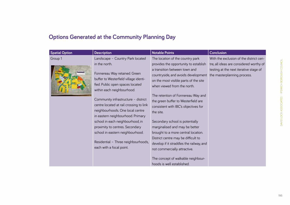
DAVI
D LO
CK A
SSO
CIAT
ES :
IPS
WIC
H B
ORO
UGH
CO
UNCI
L
195
Options Generated at the Community Planning Day
Spatial Option Description Notable Points ConclusionGroup 1 Landscape – Country Park located
in the north.
Fonnereau Way retained. Green buffer to Westerfield village identi-fied. Public open spaces located within each neighbourhood.
Community infrastructure – district centre located at rail crossing to link neighbourhoods. One local centre in eastern neighbourhood. Primary school in each neighbourhood, in proximity to centres. Secondary school in eastern neighbourhood.
Residential – Three neighbourhoods, each with a focal point.
The location of the country park provides the opportunity to establish a transition between town and countryside, and avoids development on the most visible parts of the site when viewed from the north.
The retention of Fonnereau Way and the green buffer to Westerfield are consistent with IBC’s objectives for the site.
Secondary school is potentially marginalised and may be better brought to a more central location. District centre may be difficult to develop if it straddles the railway, and not commercially attractive.
The concept of walkable neighbour-hoods is well established.
With the exclusion of the district cen-tre, all ideas are considered worthy of testing at the next iterative stage of the masterplanning process.
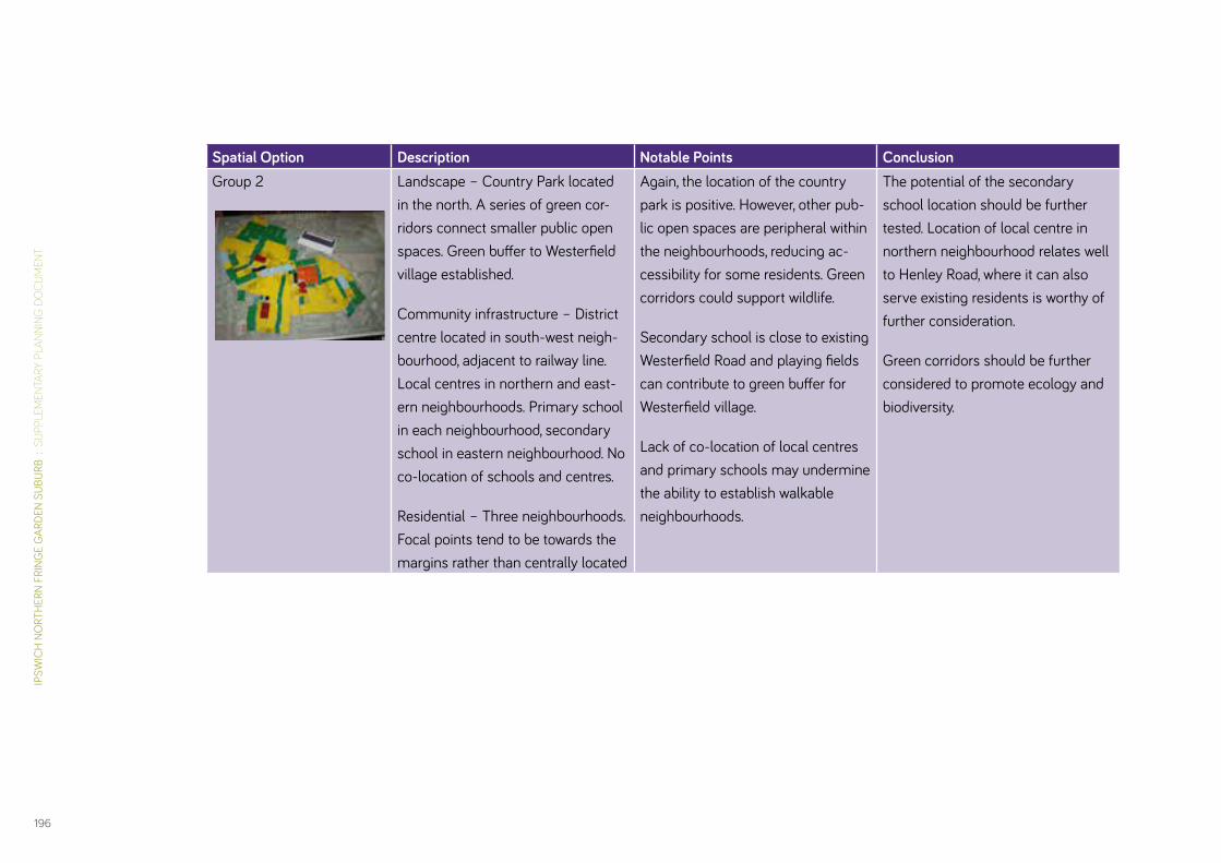
IPSW
ICH
NO
RTH
ERN
FRIN
GE
GAR
DEN
SUBU
RB :
SU
PPLE
MEN
TARY
PLA
NNIN
G D
OC
UM
ENT
196
Spatial Option Description Notable Points ConclusionGroup 2 Landscape – Country Park located
in the north. A series of green cor-ridors connect smaller public open spaces. Green buffer to Westerfield village established.
Community infrastructure – District centre located in south-west neigh-bourhood, adjacent to railway line. Local centres in northern and east-ern neighbourhoods. Primary school in each neighbourhood, secondary school in eastern neighbourhood. No co-location of schools and centres.
Residential – Three neighbourhoods. Focal points tend to be towards the margins rather than centrally located
Again, the location of the country park is positive. However, other pub-lic open spaces are peripheral within the neighbourhoods, reducing ac-cessibility for some residents. Green corridors could support wildlife.
Secondary school is close to existing Westerfield Road and playing fields can contribute to green buffer for Westerfield village.
Lack of co-location of local centres and primary schools may undermine the ability to establish walkable neighbourhoods.
The potential of the secondary school location should be further tested. Location of local centre in northern neighbourhood relates well to Henley Road, where it can also serve existing residents is worthy of further consideration.
Green corridors should be further considered to promote ecology and biodiversity.

DAVI
D LO
CK A
SSO
CIAT
ES :
IPS
WIC
H B
ORO
UGH
CO
UNCI
L
197
Spatial Option Description Notable Points ConclusionGroup 3 Landscape – Country Park to the
north. Fonnereau Way retained. Small public open spaces in each neighbourhood. Green buffer to Westerfield village established.
Community Infrastructure – District centre located adjacent to Westerfield Road, and local centres in northern and eastern neighbour-hoods. Secondary school located on site of Ipswich School playing fields. Primary school adjacent. Other primary schools co-located with local centres
Residential – Three neighbourhoods established, each with a centrally located focal point.
Landscape structure is positive, with a good distribution of open space and retention of Fonnereau Way.
The co-location of parks, primary schools and local centres within the northern and eastern neighbour-hoods is a positive response to the concept of walkable nighbourhoods.
The location of the district centre ad-jacent to Westerfield Road balances access to new and existing residents and makes good use of existing road.
Secondary school uses existing school site, but may be contrary to land owners intentions, which could hamper its delivery at the appropri-ate time.
Ideas for landscape, and local and district centres should be considered further at the next iteration.

IPSW
ICH
NO
RTH
ERN
FRIN
GE
GAR
DEN
SUBU
RB :
SU
PPLE
MEN
TARY
PLA
NNIN
G D
OC
UM
ENT
198
Spatial Option Description Notable Points ConclusionGroup 4 Landscape – Country Park lo-
cated to the north. Green buffer to Westerfield village established. Small public open spaces within each neighbourhood, and green corridor alongside railway embankments.
Community Infrastructure – District Centre located close to Westerfield Road in south-west neighbourhood. Local centres centrally located within northern and eastern neighbour-hoods. Secondary school in south-west neighbourhood adjacent to railway and as part of district centre. Primary schools co-located with local centres in northern and eastern neighbourhoods.
Residential – Three neighbourhoods established each with a central focal point.
Many green corridors would support good access throughout the site and help generate a garden suburb character.
Location of secondary school within south-west neighbourhood, adjacent to district centre, offers a more central and accessible location for new residents.
Location of district centre and secondary school should be further considered.
Concept of green corridors should be further considered.

DAVI
D LO
CK A
SSO
CIAT
ES :
IPS
WIC
H B
ORO
UGH
CO
UNCI
L
199
Spatial Option Description Notable Points ConclusionGroup 5 Landscape – Country Park located
in the east, contained by the railway. Green corridors link through the site with green open spaces adjacent to existing residential properties to function as a green buffer. Buffer to Westerfield village established.
Community Infrastructure – District centre adjacent to Westerfield Road. Local centre in northern neighbour-hood only. Secondary school located in northern neighbourhood, with primary school and local centre ad-jacent. Two primary schools located in south-west neighbourhood.
Residential – three neighbourhoods established, each with a different ap-proach to landscape and community infrastructure provision.
This is the most distinctive approach, which would perhaps create greater variety between the neighbourhoods. However, there are several perceived disadvantages:
• access to the open countryside through the country park is hampered by the railway;
• development will be more visible from open countryside to the north;
• concept of walkable neighbour-hoods is reduced – no local facili-ties are proposed in the eastern neighbourhood;
• green buffer to Westerfield village is reduced through proximity of district centre; and
• public open space is marginalised within neighbourhoods
This spatial option is not perceived as meeting sufficient number of objectives, and because it fails to establish a walkable neighbour-hood structure is considered a less sustainable form of development.
However, the ideas relating to green corridors are positive and should be carried on to the next iteration.
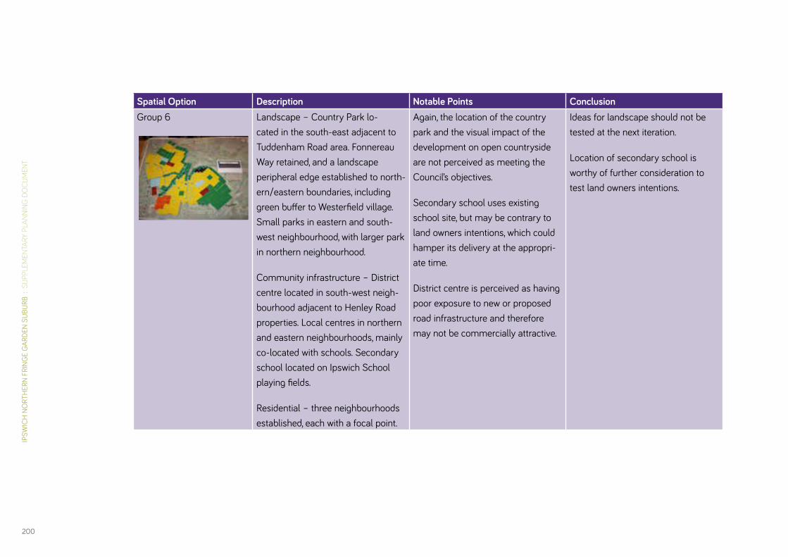
IPSW
ICH
NO
RTH
ERN
FRIN
GE
GAR
DEN
SUBU
RB :
SU
PPLE
MEN
TARY
PLA
NNIN
G D
OC
UM
ENT
200
Spatial Option Description Notable Points ConclusionGroup 6 Landscape – Country Park lo-
cated in the south-east adjacent to Tuddenham Road area. Fonnereau Way retained, and a landscape peripheral edge established to north-ern/eastern boundaries, including green buffer to Westerfield village. Small parks in eastern and south-west neighbourhood, with larger park in northern neighbourhood.
Community infrastructure – District centre located in south-west neigh-bourhood adjacent to Henley Road properties. Local centres in northern and eastern neighbourhoods, mainly co-located with schools. Secondary school located on Ipswich School playing fields.
Residential – three neighbourhoods established, each with a focal point.
Again, the location of the country park and the visual impact of the development on open countryside are not perceived as meeting the Council’s objectives.
Secondary school uses existing school site, but may be contrary to land owners intentions, which could hamper its delivery at the appropri-ate time.
District centre is perceived as having poor exposure to new or proposed road infrastructure and therefore may not be commercially attractive.
Ideas for landscape should not be tested at the next iteration.
Location of secondary school is worthy of further consideration to test land owners intentions.

DAVI
D LO
CK A
SSO
CIAT
ES :
IPS
WIC
H B
ORO
UGH
CO
UNCI
L
201
Testing and Refining the Spatial OptionsFollowing the workshop, further masterplanning sought to consolidate the strongest ideas emerging from the Community Planning Day. Given the similarities between the plans on matters such as the location of the country park, it was possible to reduce the number of options from six to three, and thereafter focus attention on testing the advantages and disadvantages on the remaining variables.
Added to this, the process of testing the options was increasingly informed by further understanding of the drainage requirements for the site by the Borough Council.
A detailed account of the three options arising from this stage of the process, how and why they were generated, and the assessment of those options is presented in Chapter 5 of the Issues and Options Report, which can be viewed at:
http://www.ipswich.gov.uk/site/scripts/download_info.php?downloadID=1534&fileID=4287
It is important to note that the options were assessed in the following ways:
• in the context of the Council’s policies and objectives for the Northern Fringe;
• against the principles established at the Community planning Day;
• through the SA/SEA process.
In the event, the early degree of consensus derived from the Community Planning Day reduced the extent of the differences between the three options. The selection of the preferred option was therefore influenced by the relative abilities of the options to satisfy the broadest number of objectives arising from all participants in the process.
Option 2 was therefore identified as the preferred option on the basis that it:
• provides a suitable spatial framework for meeting the Council’s objectives for the Northern Fringe;
• achieved the broad support of the landowners, which is considered key to achieving delivery;
• achieved a majority support through the public consultation process;
• was found through the SA/SEA process to provide a reasonable basis for the delivery of a sustainable development.

David Lock Associates50 North Thirteenth Street
Milton KeynesMK9 3BP
www.davidlock.com