Socio-Cultural Sustainability Within The Context of Geological Effects: The Case of Cappadocia...
12
Socio-Cultural Sustainability within the Context of Geological Effects: The Case of Cappadocia Vernacular Architecture Serife Ozata, Yildiz Technical University, Turkey The Asian Conference on Sustainability, Energy & the Environment 2014 Official Conference Proceedings 0399 Abstract Geology of a territory is one of the many factors such as climate, socio-cultural structure, and economy that influence the method of construction which is a part of architecture. The effects of geology on architecture differ according to regions and cultures. The geology of the region plays an active role in the diversity of the vernacular architecture of Cappadocia, the region that has an interesting architecture in the middle of Turkey. Geological factors such as variety and physical-dynamic characteristics of the rocks that belong to the region have different effects on the house types of vernacular architecture which are rock-cut, semi rock-cut and masonry. The aim of this study is to explain how the geology of a region affects socio-cultural sustainability and vernacular architecture. Cappadocia constitutes a noteworthy sample in order to generate solutions for socio-cultural sustainability of those kind of regions by evaluating the effects of geology. Key words: Socio-Cultural Sustainability, Geological Effects, Cappadocia, Vernacular Architecture iafor The International Academic Forum www.iafor.org The Asian Conference on Sustainability, Energy & the Environment 2014 Official Conference Proceedings 349
Transcript of Socio-Cultural Sustainability Within The Context of Geological Effects: The Case of Cappadocia...

Socio-Cultural Sustainability within the Context of Geological Effects: The Case of
Cappadocia Vernacular Architecture
Serife Ozata, Yildiz Technical University, Turkey
The Asian Conference on Sustainability, Energy & the Environment 2014 Official Conference Proceedings
0399
Abstract
Geology of a territory is one of the many factors such as climate, socio-cultural structure, and economy that influence the method of construction which is a part of architecture. The effects of geology on architecture differ according to regions and cultures. The geology of the region plays an active role in the diversity of the vernacular architecture of Cappadocia, the region that has an interesting architecture in the middle of Turkey. Geological factors such as variety and physical-dynamic characteristics of the rocks that belong to the region have different effects on the house types of vernacular architecture which are rock-cut, semi rock-cut and masonry. The aim of this study is to explain how the geology of a region affects socio-cultural sustainability and vernacular architecture. Cappadocia constitutes a noteworthy sample in order to generate solutions for socio-cultural sustainability of those kind of regions by evaluating the effects of geology. Key words: Socio-Cultural Sustainability, Geological Effects, Cappadocia, Vernacular Architecture
iafor
The International Academic Forum www.iafor.org
The Asian Conference on Sustainability, Energy & the Environment 2014 Official Conference Proceedings
349

1. Introduction
In the rapidly developing world, changes emerge in social structure, culture, architecture and economy in line with the development. Geology of a region has direct or indirect influence on many factors comprising a society, ranging from the architecture in the region to the social structure. Abandoning the previous data in an attempt to achieve social and cultural sustainability causes problems while producing new proposals. Especially in the areas like Cappadocia where the geology of the region has an effective role in architecture and social life, every proposal on social and cultural sustainability will remain inadequate without considering the geological and architectural data of the region. The aim of this study is to explain how geological and architectural examinations have important contributions to the process while developing proposals in order to achieve socio-cultural sustainability in the areas like Cappadocia where geology plays an effective role in the habitat and thereby in social, economic and cultural structure of the society. Within the scope of this study, two collective living spaces including underground settlements have been chosen from the examples of local architecture in the Cappadocia Region. These examples are Kayakapi (Stone door) and Mazi Underground City. The study is confined with these two sites. Stones constitute the building materials of rock-cut, rock-cut & masonry and masonry structures in the region. It is important to research the geological structures and features of the stones, and the influence of this geological structure on architecture and social structure, and to convey the socio-cultural prosperity shaped by this particular influence to next generations by also meeting the requirements of the century. Detecting the requirements for the sustainability of social values by examining the architectural and social structures based on the geology of the particular areas is designated as the method of this study. It is assumed that a general proposal on socio-cultural sustainability can be produced out of the results acquired with this method for areas like Cappadocia where the geology of the region has influence on formation of the social structure.
Figure 1: Location of Cappadocia and study areas (1, 2, 3, 4)
The Asian Conference on Sustainability, Energy & the Environment 2014 Official Conference Proceedings
350

2. Cappadocia and Sustainability
Cappadocia is located in Central Anatolia, and surrounded by Taurus Mountains in the south, Kızılırmak in the north, Kayseri in the east and Tuzgölü basin in the west (Fig.1) (Ayhan, 2004). The name Cappadocia was first used by the historian Heredotus as “Katpatuka” It means “The Land of Fine Horses” (Ayhan, 2004). 2.1. Geology of the Region
Erciyes, Hasandağ and Göllüdağ in the Cappadocia Region were active volcanoes in geologic ages eruptions of which had started in the Upper Miocene (10 million years ago) and lasted till the Pliocene (2 million years ago). Lavas extruding from the volcanoes under the Neogene lakes had formed a tuff layer, around 100 – 150 m thick and varying in rigidity, on the plateau, lakes and rivers. Besides the tuff, there are also some other geologic schist such as tuffite, volcanic mudflow, volcanic ash, clay, sandstone, marl, agglomerate and basalt (Öz, 2007). Maps displaying the types of rock peculiar to this region and the geology of the region are in Fig. 2. As it is seen in the maps, many different kinds of geologic formation and rock types exist in the region. Study areas are located in the Cappadocia Volcanic Province (CVP) as seen in Fig. 2.
Figure 2: Rock types of the region and simplified geological map of the CVP (Ayhan, 2004 and Toprak, 1998) 2.2. Socio-Cultural Sustainability
Culture is the compilation of material, moral and intellectual features; brought in the individual and sustained by a particular society through individual and social communication and interaction (Özçetin and Dikmen, 2012). The phenomenon and process of individuals’ adaptation to the environment, and their alteration of the environment based on their aims and needs is very influential in the formation of the culture. Cultural sustainability is the willingness to protect the cultural heritage and an attempt to convey the present cultural prosperity to next generations by accepting that
The Asian Conference on Sustainability, Energy & the Environment 2014 Official Conference Proceedings
351

a society has some complicated common values, beliefs, traditions and capabilities. Social sustainability, though, means to provide efficient use of natural resources in the present day and in the future by developing and protecting a social order which will support meeting the needs of human and environmental sustainability (Sönmez, 2010). When these two definitions get combined, socio-cultural sustainability means conveying every single social, cultural value and the prosperity of the society to the next generations by protecting them considering the requirements of the day. While sustainability was mainly divided into two groups as economic and environmental, later it was divided into sub-groups of social and cultural. Social and cultural sustainability are generally handled together but each has its own focal points: the former concentrates on social well-being, the latter on the sustainment of the culture (Chiu, 2006). Social structure and social life are influential in the formation of the structures in the Cappadocia Region, and these structures are losing their original function and drawn into the process of destruction as the social and cultural sustainability could not be achieved. Traditional houses should be functionalized without losing their features and in accordance with the new social infrastructure and life style of the society. Protection of the structures in accordance with the present conditions without losing their features will contribute to the socio-cultural sustainability and it will help conveying the architecture, social life and culture to the next generations. Even though protection of the architecture alone is not enough for socio-cultural sustainability, wide scale sustainability can be achieved with the accumulation of new approaches upon architectural protection. In order to achieve this goal, geologic structure which allows the formation of three main types of structure in the Cappadocia Region, rock-cut, rock-cut & masonry and masonry should be investigated; and the influences of geology should be discovered and used in the context of sustainability. 3. Cappadocia Region and Architecture
As easily-excavated volcano-sedimentary rocks are extensive in the region (Ulusay et. al., 2006), rock-cut, rock-cut & masonry and masonry structures are observable in many parts of the region. Communities and states which have lived in Cappadocia and contributed to the development of the architecture for centuries are: The Assyrian Trade Colonies and Hittites 1750 BC – Hittite Empire 1100 BC – Phrygians 950 BC – Cimmerian-Scythian Invasions and Lydians 585 BC – Persians 334 BC – Kingdom of Cappadocia 17 – 395 Roman Empire 395 – Eastern Roman (Byzantine) Empire 1072 – Settlement of Turkish Tribes 1175 – Anatolian Seljuks 1243 – Mongolians 1340 – Eretnid Dynasty 1398 – Ottoman Sovereignty
The Asian Conference on Sustainability, Energy & the Environment 2014 Official Conference Proceedings
352

1466 – Cappadocia became an Ottoman land (Görmez, 2010) 1923 – The Republic of Turkey was founded. After the ratification of the Lausanne Treaty, within the “population exchange” Greeks living in Cappadocia were sent to Greece and the Turks from Greece were settled in Cappadocia (Güney, 2011). Changing social structure after the exchange in the 20th century caused serious social and cultural alterations. While Cappadocia is world-famous for its scenic beauties, it also has very diverse and peculiar structures, which cannot be formed anywhere else in the world, in its traditional architecture. In the local architecture of the region, natural stones were used as building material for centuries, and masonry structures were built with those natural stones extracted from the rocks in the region. Rock-cut structures in the region are mostly observable in the underground cities. 4. Underground Cities Underground cities are collective living spaces formed by carving in the underground in which people mostly live with their animals and spend their time during a day. According to Ayhan’s thesis (2004), in Nevşehir, which constitutes a large portion of Cappadocia, there are 61 underground cities in various capacities. 18 of them can be visited, 34 of them are known but cannot be visited, and 9 of them can only be traced in some sources. Sterrett (1919) states that the volumes of places like Kaymaklı and Derinkuyu (Known as the two biggest underground cities in Cappadocia) which can accommodate 3000 people are no less than 30000 m3; and when one person’s capacity to excavate 100 m3 in 30 days is considered, forming these cities must have taken an intense work. Underground cities are mostly located in Ürgüp formation. Among the sequences, Pyroclastic dominant Neogene sequences are the ones mostly preferred to build underground cities, and building underground cities in other units was shunned. While the unit known as “mesa” morphologically was the one mostly preferred in carving these cities, high mountain unit was the least preferred (Ayhan, 2004). Bixio and Castellani (1995) divide underground structures into 2 groups and 2 sub-groups based on the styles of carving. These are:
• Natural cavities • Artificial cavities
-Underground structures: Towns, redoubts and tunnels. -Cliff settlements: Cone villages, cliff wall villages, rocky churches, rocky castle villages, rocky tombs, rocky pigeon lofts (Fig. 3).
Figure 3: Schematic Section of cliff settlement and underground city (Ayhan, 2004)
The Asian Conference on Sustainability, Energy & the Environment 2014 Official Conference Proceedings
353

While Mazi Underground City examined within the scope of this study is completely an underground structure, Kayakapi (Stonedoor) Neighborhood is in the group of cliff settlements, and there are masonry and rock-cut & masonry buildings in the neighborhood within the settlement. Even though the exact periods when the underground cities were formed are not known, Bixio (1995) claims that as metal tools started to be used in Anatolia in the 3rd century BC and as they are required to carve rocks, the underground cities in Anatolia could not have been formed before the use of these tools. Stea and Turan (1993) state that the underground cities certainly existed in Anatolia in the 5th century AD. Although an exact date cannot be given about the formation of the underground cities, the biggest developments in these cities occurred between 6th and 16th centuries AD namely during the Christianity period. Erguvanlı and Yüzer (1977) explained the environmental and anthropological factors of living in the underground cities in 6 groups. These are:
• Daily and annual temperature changes • Thermal insulation of the regional rock-structure • Self-supporting structure of the rock and its eligibility for construction • Easily-excavated soft tuff • Advantage of security and camouflage during an enemy-attack • Endurance and protection against the earthquake and eruption
Eligibility for agriculture on top of the underground cities can also be another factor. The issue of how frequently these cities were used is not known. Stea and Turan (1993) state that these cities might have been used for short or long terms only in cases of danger. There are living spaces for families and storages separated from the collective space by using walls, columns or random arches. Wells are built to extract water from the depth. The oldest parts of the underground cities are the entrance floors. As the animals could not get into the lower floors, the entrance floors are generally used as barns. Some wells do not reach the entrance floor in order to prevent the enemy from poisoning the water (Ayhan, 2004). Even though it is claimed that the underground cities can be connected to each other, there is no evidence for such connection. 4.1. Mazi Underground City
Mazi Underground City was explored in 1970s, in Maziköy which is 26 km from Ürgüp which is 18 km away from Nevşehir city center. Contrary to other underground cities, there is no clear information about when and by whom this underground city was built (Nihal Ergun Architecture, 2008). Typical Anatolian culture is sustained in the village and social structure constitutes of farming families in general. This underground city which is among the 18 can-be-visited underground cities is temporarily closed to visitors because of the ongoing restoration.
The Asian Conference on Sustainability, Energy & the Environment 2014 Official Conference Proceedings
354
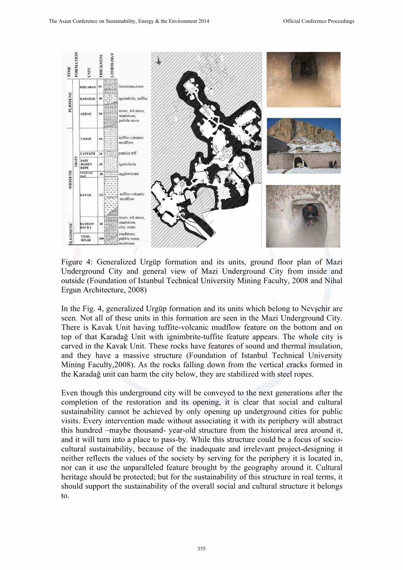
Figure 4: Generalized Urgüp formation and its units, ground floor plan of Mazi Underground City and general view of Mazi Underground City from inside and outside (Foundation of Istanbul Technical University Mining Faculty, 2008 and Nihal Ergun Architecture, 2008) In the Fig. 4, generalized Urgüp formation and its units which belong to Nevşehir are seen. Not all of these units in this formation are seen in the Mazi Underground City. There is Kavak Unit having tuffite-volcanic mudflow feature on the bottom and on top of that Karadağ Unit with ignimbrite-tuffite feature appears. The whole city is carved in the Kavak Unit. These rocks have features of sound and thermal insulation, and they have a massive structure (Foundation of Istanbul Technical University Mining Faculty,2008). As the rocks falling down from the vertical cracks formed in the Karadağ unit can harm the city below, they are stabilized with steel ropes. Even though this underground city will be conveyed to the next generations after the completion of the restoration and its opening, it is clear that social and cultural sustainability cannot be achieved by only opening up underground cities for public visits. Every intervention made without associating it with its periphery will abstract this hundred –maybe thousand- year-old structure from the historical area around it, and it will turn into a place to pass-by. While this structure could be a focus of socio-cultural sustainability, because of the inadequate and irrelevant project-designing it neither reflects the values of the society by serving for the periphery it is located in, nor can it use the unparalleled feature brought by the geography around it. Cultural heritage should be protected; but for the sustainability of this structure in real terms, it should support the sustainability of the overall social and cultural structure it belongs to.
The Asian Conference on Sustainability, Energy & the Environment 2014 Official Conference Proceedings
355

4.2. Kayakapi ( Stonedoor) Neighborhood
Kayakapi is an old neighborhood of Ürgüp which is 18 km away from the city center. This neighborhood is located in the Northeast cliff of Esbelli Hill which is a historical area (Fig. 5). In addition, this neighborhood is located in the site of “Goreme National Park and the Rock Sites of Cappadocia” (Ulusay et. al., 2006). In the neighborhood which is approximately 27 hectares, there are 1215 cliff settlements, masonry houses and ruined structures. In the neighborhood, there are about 20 officially registered structures including rock-cut churches, mosques, fountains and bath (Özdem, 2012). Neighborhood community moved to other parts of the city between 1966 and 1983 because of the rock-fall danger. After people moved from this site, it got looted and ruined (Savaş, 2012). While local population in Ürgüp displays the typical feature of Anatolian people, growth of tourism in Ürgüp caused the alteration of the authentic culture of the society (Tosun, 1998).
Figure 5: Kayakapi Neighborhood and cliff settlements (5) In the site, as it was the case in Mazi Underground City, Kavak unit of Urgüp formation has been observed. Section of Kavak tuff can be seen in the Fig. 6 (Ulusay et. al., 2006). The feature of thermal insulation of the tuffs supported the formation in the underground sections. Although some problems such as block falls, overbreak, bending, spalling, erosion and shearing of pillars (Ulusay et. al., 2006) emerge in the rock structure of the area, solutions have been provided for these problems within the scope of the restoration.
Figure 6: Section of Kavak unit of (Kayakapi) Urgüp formation (Ulusay et. al., 2006) and views from ongoing restoration of Kayakapi neighborhood
The Asian Conference on Sustainability, Energy & the Environment 2014 Official Conference Proceedings
356

In Kayakapi Neighborhood, a different understanding of protection has been developed and implemented compared to the similar cases. According to this understanding, the main aim is to protect and develop the cultural and natural resources while using them for tourism in the socio-economic development process, and to convey them to the next generations without deteriorating (Güçhan, 2012). In addition, the understanding does not only address cultural and natural issues, it also covers all aspects of the previous life in Kayakapi Neighborhood. This understanding is consistent with the clause of ICOMOS Paris Declaration (2011) under the title of “Developing a Permanent Tourism,” which proposing to protect cultural resource as the capital of tourism, and foreseeing this resource as a “condition for the long-term development of tourism” (Güçhan, 2012). With this protective understanding, primarily the problem of transportation in the area has been resolved. As the tuff, dominant in the area, can be carved and shaped easily, a new road for vehicles has been formed, thus the problem of transportation has been resolved. Project is not restricted to the restoration of the traditional structures in the area. The restoration part constitutes only one-third of the project. Restored and unregistered structures will be reused as hotels. The other one-third will be open to the public visit for daily use. In Kayakapi: there are 2 mosques, 1 rock-cut church, 1 historical bath, 8 fountains, and most importantly House of Aziz Yuhannes (House of St. John the Russian / Esat Ağa Konağı). These historical monuments will be opened to public visits when the restoration is completed (Özdem, 2012). In the last part of the project, as there are agricultural fields around the slopes of the neighborhood, these fields will be reserved for organic agriculture and endemic fruits will be grown. In addition, a marketplace will be formed for the craftsmen in order to liven up the craftsmanship, which is about to disappear, peculiar to the region (Özdem, 2012). The project named as “Protection and Development Project of the Cultural and Natural Environment” (Güçhan, 2012) has become a good example of how socio-cultural sustainability can be achieved within local architecture as it has protected and livened up the local architecture by containing social, cultural and economic factors. 5. Discussion and Conclusion
Binan (1994) states that geologic structure of Cappadocia has become an important factor for the historical development and for the formation of man-made physical environment for ages. Thanks to the facilities provided by the geology of the Cappadocia Region, people have been able to form a physical environment quickly and in an unparalleled way in order to meet their social, cultural and economic needs for centuries. Even though those geologic features still exist, their influence in the environment has decreased. Changing social, demographic and cultural structure of the society requires the facilities of the modern architecture, thus traditional architecture gradually disappears. Regional architectural traditions have been gradually forgotten, and this situation causes serious problems for the socio-cultural continuity between generations. One of these problems is the formation of a monotype culture. Every society exists with its own social structure, values and traditions. Turning these into a monotype thereby destroying them will be equal to abandoning a-thousand-year heritage of the society. As social values, norms and features are conveyed by the society, all these data should be conveyed by turning into a form which can be accepted by the society. Therefore, for socio-cultural
The Asian Conference on Sustainability, Energy & the Environment 2014 Official Conference Proceedings
357

sustainability, certain projects; which are based on the past as their source, applicable to the present conditions, and foreseeing the future, should be designed. In order to achieve socio-cultural sustainability by designing such projects: • Every region should be examined carefully with its own geologic and architectural data, and the decision should be made on which of the features should be used today for the best results in the future. • As every society exists with its own values, while working for the future generations, one should be inspired from the past. • In order to achieve sustainability in a society, it should not be forgotten that sustainabilities are related to and dependent on each other, and strategies should be defined accordingly. • If the monopoly of an institution conducting a project prevents the participation of the people, this prevention should be removed, and the society, as the lead actor shaping the values, should be directly included in the project. Otherwise failure of the project will be highly possible. Especially in the regions like Cappadocia where geology of the region has direct or indirect influence on nearly all the activity areas from living spaces to material gain, geologic and architectural structures should be examined in detail and conveyed to the next generations with all the features for socio-cultural sustainability. One should not be contented with the sustainability of material values and data, because every single feature of the society which can contribute to the future generations is worth sustainability.
The Asian Conference on Sustainability, Energy & the Environment 2014 Official Conference Proceedings
358

References
Ayhan, A. (2004). Geological And Morphological Investigations of the Underground Cities of Cappadocia Using GIS (Unpublished MSc Thesis), Istanbul Technical University, Turkey. Bixio, R. (1995). La Cultura Rupestre Nell’Area Mediterranea. In Erga Edizioni (Ed.), Le Citta Sotterranee Della Cappadocia (The Underground Towns Of Cappadocia). (pp. 19-29). Genova, Italy Bixio, R. and Castellani, V. (1995). Tipologia delle Strutture Sotterranee della Cappadocia. In Erga Edizioni (Ed.), Le Citta Sotterranee Della Cappadocia (The Underground Towns Of Cappadocia). (pp.106-120). Genova, Italy Büyükçay, H.(2010). Nevşehir ve Çevresindeki Geç Osmanlı Dönemi (19. Yy) Camilerinin Mimari Özellikleri, (Unpublished MSc Thesis), Selcuk University, Turkey. Erguvanlı, A.K. and Yüzer, A.E. (1977). Past and Present Use of Underground Openings Excavated in Volcanic Tufts at Cappadocia Area. Proc. On Rock Storage, Oslo, Norway, 15-17. Güçhan, N. Ş. (2012). Kayakapı Neden Önemlidir, Kayakapı Kültürel ve Doğal Çevre Koruma ve Canlandırma Projesi (2), 6-8 Güney, E.(2011,July). Ürgüp : 1924 Ahali Mübadelesi Öncesinde Bir, http://www.haber50.com/urgup-1924-ahali-mubadelesi-oncesinde-bir-anadolu-beldesi-5098yy. htm İTÜ Maden Fakültesi Vakfı (Foundation of Istanbul Technical University Mining Faculty). (2008) ‘‘Mazı Yeraltı Şehri ve Çevresinin Jeolojik Araştırması Raporu ’’, Nevşehir Kültür Varlıklarını Koruma Bölge Kurulu Müdürlüğü Arşivi, Turkey Nihal Ergün Architecture. (2008). ‘‘Nevşehir İli Ürgüp İlçesi Mazı Yeraltı Şehri ‘’, Nevşehir Kültür Varlıklarını Koruma Bölge Kurulu Müdürlüğü Arşivi, Turkey Öz, E. (2007). Nevşehir Dolaylarında Yüzeylenen Asidik Pomzanın Hafif Beton Agregası Olarak Kullanılabilirliği, (Unpublished MSc Thesis),Çukurova University, Turkey. Özçetin, Z. And Dikmen, Ç. (2012), Kültürel ve Sosyal Sürdürülebilirlik Bağlamında Yozgat Konaklarının Cephe Düzeni,6.Ulusal Çatı ve Cephe Sempozyumu,Istanbul,Turkey Savaş, A. (2012). Kayakapı Kapadokya’nın Yeni Yüzü, Kayakapı Kültürel ve Doğal Çevre Koruma ve Canlandırma Projesi (1), 2 Sönmez, A.L. (2010). Nitelikli Servisli Konutların (Residence) Sosyo-Kültürel Sürdürülebilirlik Boyutunun Kullanıcı Açısından İncelenmesi: Levent Loft Örneği, (Unpublished MSc Thesis), Istanbul Technical University, Turkey.
The Asian Conference on Sustainability, Energy & the Environment 2014 Official Conference Proceedings
359

Stea, T. and Turan, M.(1993) Placemaking: Production of Built Environment in Two Cultures (1), England: Avebury Ashgate Publishing Limited Strerrett, J.R.S.(1919). The Cone-Dwellers of Asia Minor, The National Geographic Magazine,(35- 4) ,281-331 Toprak, V. (1998). Vent Distribution and Its relation to Regional Tectonics, Journal of Volcanology and Geothermal Research, (85, 1-4), 55-67. Ulusay, R., Gokceoglu, C., Topal, T., Sonmez, H., Tuncay, E., Erguler, Z.A. and Kasmer, O. (2006), Assessment of Environmental and Engineering Geological Problems for the Possible Re-Use of an Abandoned Rock-hewn Settlement in Urgüp (Cappadocia), Turkey, Environmental Geology,(50),473-494 Ulusoy, B.(1994). Güzelyurt Örneğinde Kapadokya Bölgesi Yığma Taş Konut Mimarisinin Korunması İçin Bir Yöntem Araştırması (Published PhD Thesis), Yıldız Technical University, Turkey. Internet Sources (Photos)
[1] http://www.villacolumba.com/kapadokya-gezi-rehberi/kapadokya-boelge-haritasi/ [2] http://www.turkcebilgi.com/harita/t%C3%BCrkiye/dunya-uzerinde-turkiye-nerede [3] http://www.turkiye-resimleri.com/r-nevsehir-54-nevsehir-haritasi-3510.htm [4] http://www.nevsehir.gov.tr/ortak_icerik/nevsehir/contents/cografi_yapi.pdf [Online] [5] http://en.wikipedia.org/wiki/Kayakap%C4%B1
The Asian Conference on Sustainability, Energy & the Environment 2014 Official Conference Proceedings
360