The Newari vernacular revi ed - De Vlaamse ScriptieBank
451
Seismic building cultures in a context of transition in Bungamati & Khokana, Kathmandu Valley, Nepal Studio Kathmandu Volume 4 The Newari vernacular revi ed s v Yanne Gillekens, Evelien Roelands, Katrien Valcke, Sophie Van Hulle
-
Upload
khangminh22 -
Category
Documents
-
view
0 -
download
0
Transcript of The Newari vernacular revi ed - De Vlaamse ScriptieBank

Seismic building cultures in a context
of transition in Bungamati & Khokana,
Kathmandu Valley, Nepal
Studio Kathmandu Volume 4
T h e N e w a r i v e r n a c u l a r r e v i e dsv
Yanne Gillekens, Evelien Roelands, Katrien Valcke, Sophie Van Hulle


Yanne Gillekens, Evelien Roelands, Katrien Valcke, Sophie Van Hulle
Seismic building cultures in a context
of transition in Bungamati & Khokana,
Kathmandu Valley, Nepal
Studio Kathmandu Volume 4
T h e N e w a r i v e r n a c u l a r r e v i e dsv


The Newari vernacular revi[s|v]edSeismic building cultures in a context of transition in Bungamati & Khokana, Kathmandu Valley, Nepal
Yanne GillekensEvelien RoelandsKatrien ValckeSophie Van Hulle
Master of Science in de ingenieurswetenschappen: architectuur
Thesis submitted to obtain the degree of Master of
Engineering: Architecture
Promotors: Bruno De Meulder
Viviana d’Auria
Co-promotors: Sangeeta Singh
Tutors:Stefanie Dens
Annelies De NijsPadma Joshi
Academic Year 2016-2017

© Permission for Use of Content:
The authors herewith permit it that the present dissertation be made available for consultation; parts
of it may be copied, strictly for personal use. Every other use is subject to strict copyright reservations.
Particular reference is made to the obligation of explicitly mentioning the source when quoting the
present dissertation’s results. Leuven, 2017
All images presented in this booklet are, unless credits are given, made or drawn by the authors. The
satellite images used, are founded by Google Earth, unless credits say otherwise. The interpreted maps
are based on these satellite images.
© Copyright KU Leuven
Without written permission of the promotors and the authors it is forbidden to reproduce or adapt in
any form or by any means any part of this publication. Requests for obtaining the right to reproduce
or utilize parts of this publication should be addressed to dept. Architecture, Kasteelpark Arenberg
1/2431, B-3001 Leuven, +32-16-321361 or via e-mail to [email protected].
A written permission of the promotor is also required to use the methods, products, schematics and
programs described in this work for industrial or commercial use, and for submitting this publication
in scientific contests.

Yanne GillekensEvelien RoelandsKatrien ValckeSophie Van Hulle
Academic Year 2016-2017
The Newari vernacular revi[s|v]edSeismic building cultures in a context of transition in Bungamati & Khokana, Kathmandu Valley, Nepal
Thesis submitted to obtain the degree of Master of
Engineering: Architecture
Promotors: Bruno De Meulder
Viviana d’Auria
Co-promotors: Sangeeta Singh
Tutors:Stefanie Dens
Annelies De NijsPadma Joshi

8

9M a s t e r ’s T h e s i s f i l e
Students: Yanne Gillekens
Evelien Roelands
Katrien Valcke
Sophie Van Hulle
Title: The Newari vernacular revi[s|v]ed Seismic building cultures in a context of transition in
Bungamati & Khokana, Kathmandu Valley, Nepal
Abstract:
Two years after a 7.8 magnitude earthquake struck Nepal, a major reconstruction
task still lies ahead of the country. Urban sprawl and temporary shelters threaten
the vernacular seismic building culture of the Newars. The question rises how the
reconstruction process will take these contemporary challenges into account, while
preserving the values of the Newari vernacular architecture. In 2015 and 2016
respectively, two teams from KU Leuven researched two traditional settlements,
Bungamati and Khokana, in the Kathmandu Valley and published three books as
a result. This thesis is the continuation of the series and aims to revive the Newari
traditions, and simultaneously to revise them, in order to meet the contemporary
needs of the Twin Villages.
Promotors: Bruno De Meulder (KULeuven)
Viviana d’Auria (KULeuven)
Co-promotor: Sangeeta Singh (Tribhuvan University)
Tutors: Stefanie Dens (KULeuven)
Annelies De Nijs (KULeuven)
Padma Joshi (UN-Habitat)
Readers: Bruno De Meulder, Viviana d’Auria, Sangeeta Singh,
Annelies De Nijs, Stefanie Dens & Guido Geenen
Thesis submitted to obtain the degree of Master of Engineering: Architecture
Academic Year 2016-2017

10

11A c k n o w l e d g e m e n t s
We would like to express our appreciation and sincere gratitude to all the people that helped us in
making this thesis possible.
First of all, we want to thank Professor Bruno De Meulder and Professor Viviana d’Auria, our
promotors. Thank you for the guidance, all the advice you gave us and for sharing your knowledge
in this field of study with us. Without your expertise, efforts and critical remarks, we would not have been able to write this thesis. We would like to thank Stefanie Dens for her extensive advice
before, during and after the fieldwork. Your endless enthusiasm, combined with your experience in the field, kept us motivated throughout the entire process. We also want to thank Annelies De Nijs, for all of her accurate guidance both before and during the fieldwork. Special recognition goes to Professor Sangeeta Singh from the Tribhuvan University of Nepal, our local promotor. Thank you
for encouraging us and for helping us understand much about the traditional Newari settlements,
thereby making it easier for us to conduct our fieldwork in a completely new environment.
Professor Sudarshan Raj Tiwari and Professor Suresh Das Shrestha, both from the Tribhuvan
University as well, were also of great help. Thank you for sharing your enormous amount of
knowledge about the Nepalese culture, which gave us a lot of new insights in many subjects of
this thesis. We would also like to thank Mr. Padma Joshi from UN-Habitat, Mr. Rabindra Puri
from Bhaktapur, Shikshya Bastola from the NRA and Els and Betisa from Red Cross Belgium in
Nepal. Each of you showed us a different point of view on the reconstruction process after the
earthquake.
We also want to express our appreciation towards Professor Koen Van Balen, Professor Els
Verstrynge, Professor Mattias Schevenels and Tim Michiels, for their insights on the technical
details.
Our genuine gratitude goes to all the people of Bungamati and Khokana, for their hospitality,
kindness and help, despite the language barriers we were facing. For offering us food and water
during hot days, for allowing us to enter and measure their private homes and for participating in
our interviews. We want to thank Gopal and his family, for making our house into a real home,
for all the efforts to make our stay more comfortable and for making us feel welcome and safe.
A very warm thank you to Anil Tuladhar and Anatta Shresthacharya, for answering every question
we had, for helping us cross this language barrier and most importantly for being our first friends in Nepal. Thank you for always being there for us. We would also like to thank Pink-key and
Sudip, two students of the Tribhuvan University, for helping us conduct various interviews with
the inhabitants.
And last but not least, we want to thank our family, partners and friends. To Raf Valcke, thank you
for thoroughly proofreading our thesis. And to all of you, thank you for your never-ending love,
support and patience. For listening to us at impossible hours, for cheering us up when we were
down and for believing in us during every part of the journey.

12

13
2 5 a p r i l 2 0 1 5
7 . 8 m a g n i t u d e e a r t h q u a ke s t r u c k
N e p a l
S u m m e r S t u d i o 2 0 1 5
Vo l u m e 1A c t i o n P l a n f o r B u n g a m a t i
+
Vo l u m e 2L a n d s c a p e U r b a n i s m
E x p l o r a t i o n s
S p r i n g S t u d i o 2 0 1 6
Vo l u m e 3To w n E x t e n s i o n s i n
Ka r y a b i n a y a k M u n i c i p a l i t y
T h e s i s S t u d i o 2 0 1 7
Vo l u m e 4T h e N e w a r i v e r n a c u l a r
r e v i [ s | v ] e d
Pr e f a c e
In 2015, a research team from KU Leuven went to Kathmandu, Nepal in the
aftermath of the earthquake on 25 April. In close cooperation with UN Habitat and
the Tribhuvan University, they researched two traditional settlements in the southern
fringe of the Kathmandu Valley. This resulted in a first book, in the form of an action plan for Bungamati. A second book followed and explored Landscape Urbanism in
this area. In 2016, a new team went to the Valley to continue this research. A third
book about Town Extensions was published.
This thesis is the continuation of the research and forms the fourth book in the
series. This time the focus is more on the traditional Newari architecture of both
Bungamati and Khokana.

14
Collapsed house in Bungamati, 2016
Women cleaning rubble from building that broke down in Khokana, 2016
Excavating the treasures underneath the Mashhindranath temple, Bungamati, 2016

15
Courtyard filled with construction materials from collapsed buildings, Khokana, 2016
New construction of peti in front of the Rudrayanee temple, Khokana, 2016
Entrance building of the main square in Bungamati, 2016

16

17H y p o t h e s i s
On 25 April 2015, an earthquake with a 7.8 magnitude on the Richter scale struck
Nepal, followed by several aftershocks. Countless houses have collapsed entirely and
many more were severely damaged. Two years later, an enormous reconstruction task
still lies ahead of the country. At the same time, the Kathmandu Valley is developing
rapidly and urban sprawl is emerging, threatening the Newari vernacular architecture.
These Newari settlements have a unique seismic building culture that developed
over centuries, focusing on public spaces with life centred around a traditional water
system. However, much of the knowledge has faded. The temporary shelters, that
were built as an emergency relief, are still scattered in between and at the edges of
the existing tissue, further increasing the pressure on the vernacular settlements. The
question now rises: how can the reconstruction process take these challenges of
urban pressure into account, while preserving the values of the Newari vernacular
architecture? The reconstruction after the earthquake offers an opportunity to
reinterpret the tradition while meeting the contemporary needs of the settlements.

18
Course of the fieldwork: discovering alleys, observing everyday life, drawing maps, attending meetings, etc., 2016

19M e t h o d o l o g y
This thesis is a research by design. The book is divided in two main parts, that are
intertwined: the analysis and the design. The analysis builds further on the work of
the previous teams and is based on a literature study and a field study. The design is an investigation on how two traditional settlements in Nepal can be reconstructed after
the earthquake of 2015 and its many aftershocks.
On 17 August 2016, an intensive eight-week field study commenced in the Kathmandu Valley. While the mapping of the settlements and measuring of the houses was divided
between Khokana and Bungamati, the interviews were usually done as one team.
Existing maps were used as a base to make more detailed versions. The everyday life
of the inhabitants, public spaces, traditions, vegetation, local building techniques and
much more were all included in the study by making photos and observations. The
existing maps were completed and entirely new maps were created.
Furthermore, the fieldwork consisted of several interviews. With the help of local translators, the inhabitants of both settlements were able to tell their story. At the same
time, interviews with experts took place as well. Several professors of the Tribhuvan
University of Nepal, Red Cross, UN-Habitat, the municipality and local NGOs all
contributed to the information that was needed for the analysis. Additionally, local
architecture students shared their personal view on the reconstruction process.
The field study finally ended on 14 October 2016. A thorough literature study built further on these experiences to further expand the analysis. Ultimately, the analysis
ended in a design proposal. Since it is a research by design, the analysis and design
have strongly influenced one another. While the design brought along new questions that required a deeper look into the analysis, it is at the same time a conclusion and
answer to the problems and discussions raised by the analysis.

20
I. Framing the Kathmandu Valley 25The Kathmandu Valley
The Newars
Bungamati & Khokana
II. Topographical foundations & landscape logics 43Concentric patterns in the landscape
Hazards determining the use of land
The topography of Bungamati & Khokana
III. Water management in development 53Traditional water system
Wastewater management
Cultural heritage
Modern water supply
IV. Specificities of the urban tissue 69The founding legends
The Newari social structure & its spatial reflectionA hybridified caste systemThe guthi system
The maze of open spaces
V. The Newari seismic building culture challenged 121Traditional Newari building culture & appropriations
Modern building culture
Earthquake response
VI. Conclusion 232
C o n t e n t
PART ONE TRADITIONAL NEWARI SETTLEMENTS AT THE VERGE OF RAPID CHANGE
Master’s Thesis file 9Acknowledgements 11Preface 13Hypothesis 17Methodology 19

21
I. Strategy for the Twin Villages 239Recycle bank
II. Bungamati: rethinking water cycle 251Introduction
Wastewater treatment
Maximizing water collection
Public space shaped by water
III. Khokana: extending the streetscape 341The street as connecting factor
Site 1 | Reconstruction & housing
Site 2 | Reconstruction & restaurant
Site 3 | Densification & carpenter’s atelierSite 4 | Expansion & guesthouse
PART TWO DESIGN STRATEGIES FOR A REINTERPRETED SEISMIC BUILDING CULTURE
N e w a r i v o c a b u l a r y 436
Bibliography 438
Interviews 444
Image credits 445


PA R T O N ET R A D I T I O N A L N E WA R I S E T T L E M E N T S AT T H E
V E R G E O F R A P I D C H A N G E


Fr a m i n g t h e K a t h m a n d u Va l l e y
The Kathmandu Valley is situated in Nepal, South-East Asia. Its first inhabitants, called the Newars, know a turbulent history of earthquakes and civil wars. Bungamati and Khokana, two vernacular settlements, are located in the Kathmandu Valley.
——View over the Kathmandu Valley from the Swayambhunath Stupa.
I .

26
Ka t h m a n d u Va l l e y
H i m a l a y a s
L o w - m o u n t a i n a r e a
Te r a i
Map of the Kathmandu Valley, © Esri, 2017
T h e K a t h m a n d u Va l l e y
Nepal borders on China and the Tibetan plateau in the north and on India in the
south. It can be divided into three geographical areas: the plains of the Terai in the
south, the High-Mountain area of the Himalayas in the north (sometimes referred to
as Khumbu-Himal) and the hills or Low-Mountain area in between (Ives & Messerli,
1981).
The Kathmandu Valley is situated in the latter and has the highest population density
of Nepal. Several rivers flow through the Valley and all of them flow out to the Bagmati river, which ultimately ends in the Ganges.
Map of Nepal w/ different topographical areas


The birth of Buddha in Lumbini, South-Nepal
(Rose et al., 2002).
The Licchavi was a Hindu-Indian dynasty
which gained political control over the first settlements in the Kathmandu Valley around
the fourth century, but never extended their
rule over the hill areas (Rose et al., 2002). In this
era Nepal was divided in small ethnic groups,
with the Newars as most important community.
The origins of the Newari architecture can
probably be found in the architecture of their
neighbours (Sengupta & Upadhyaya, 2016).
It was the Gupta architecture of India which
influenced the houses from the Licchavi dynasty. Houses from this period were built of
stone and already showed some decorations.
High-caste Hindu families, fleeing from a Muslim invasion in India, settled in the western
hill area of Nepal (Rose et al., 2002). This new
elite gradually took over political control in
the small hill principalities. The Kathmandu
Valley was divided into three independent
kingdoms – Kantipur (Kathmandu), Lalitpur
(Patan) and Bhadgaon (Bhaktapur) - during this
period (Sharma P., 1989). Jayasthiti Malla, one
of the most popular kings in the Malla period,
introduced the caste system.
The Newari architecture reached its peak during
this dynasty (Ranjitkar, 2006). Most noticeable
is the symmetrical facade of the houses and its
beautiful woodcarvings. Whenever possible,
an uneven number of windows was built per
storey.
It was during the Malla reign that the rules
about urban planning in relation to caste were
implemented (Sengupta & Upadhyaya, 2016).
The houses of lower castes were thus restricted
to the fringes of the settlements, which also
immediately decreased their value. Often they
were also less decorated.
The rivalry between the three kingdoms
definitely stimulated the Newari architecture. Palaces and temples were regarded as the highest
in status and were thus ideal to communicate
power and enforce status. The art and design
of the rest of the cities automatically followed.
566 B.C. 300 1200R
ich
ter
mag
nit
ud
e s
cale
Kat
hm
and
u
Pat
an
Bh
akta
pu
r
K i r a t a L i c c h a v i M a l l a
7.8
1 1 0 0
8.8
7.6
5
6
7
8
Typical Newari house. Source: Shilpakar S., 2015
1 2 2 5 1 5 5 5
T h e t h r e e K i n g d o m s

Prithvi Narayan Shah unified the different principalities and founded the kingdom of
Nepal (Thapa et al.,2008). From then on
Kathmandu, capital of the newly founded
kingdom, was the seat of political, economic
and social power. During this period the Rana
dynasty took over the authority for one century,
but in the end their regime was overthrown by
the Shah rule again (Shresta B.K, 2011; Rose et
al., 2002). Eventually a constitutional monarchy,
with a democratically chosen parliament, was
established by king Birendra, but the Maoists
did not agree with this new political structure
and caused the Nepalese civil war (Rose et al.,
2002).
Houses from the Shah period mainly have
the same characteristics as the Malla period
(Ranjitkar, 2006). However, these buildings
were generally larger than their ancestors. The
typical triple window remained, but it was less
decorated. During the later years of this period,
the Shah houses also gained inspiration from
India, this time probably from the Mughal
architecture. They introduced them to the idea
of plastered facades, which were now seen for
the first time.
The Ranas, an elite family, increased their
influence in the government and eventually took over the power from the Shahs in the
second half of the 19th century (Rose et al.,
2002). The regime had close ties with the
British imperial government in India and many
Nepalese men were recruited as Gurkha units
into the British Indian Army. However, after
WWII, their authority decreased and a few
years later the Ranas were overthrown.
With the relations with the British, colonial
influences came to Nepal (Sengupta & Upadhyaya, 2016). The Newari houses got
lighter and larger windows with less details
(Ranjitkar, 2006). Very often these houses had
neoclassical or even baroque influences, with columns and plastered facades (Sengupta &
Upadhyaya, 2016).
After a decade of violence and uncertainty,
the Comprehensive Peace Accord was signed
in 2006, leading to the declaration of the
Federal Republic of Nepal in 2007 (Britannica
Academic, 2017).
In 2015, the Second Constituent Assembly
implemented a new constitution, following
the temporary constitution that was set up in
2007 (Devare, 2015). However, immediately
after that, India proposed an amendment that
would be beneficial for the Madhesi people, a group of Terai-inhabitants with Indian origins
(Pathak, 2015). When Nepal did not include
this amendment in its new constitution, India
blocked the borders with Nepal, causing
an unofficial stop of all trade between the countries. At the same time, the borders with
China were blocked by landslides caused by
the earthquake of April 2015. This caused an
enormous delay in the reconstruction process.
After 4,5 months, the embargo was finally lifted (Khanal, 2016). Nevertheless Nepal was left
with an enormous gasoline and oil shortage,
causing people to start cooking on firewood again.
S h a h R a n a R e p u b l i c
2 0 1 5 “ N e w c o n s t i t u t i o n ”
1769 20071846-1951
7.0
7.47.7 7.7
6.2
8.88.68.2
8.1
7.7
6.9
7.8
Gaddi Baithak. © Sommer, 2015
1 7 1 3
1 7 2 0
1 8 0 3 1 8 3 3 1 8 8 5
1 8 9 7
1 9 0 5
1 9 1 6
1 9 3 5 1 9 5 0 1 1 0 0 2 0 1 5
E a r t h q u a ke s o v e r t i m e
Graphic timeline, Source:Thakur, 2006

30
In prehistorical times, the Kathmandu Valley was a lake (Hosken, 1974). Over time
the lake drained and a very fertile soil was left behind. In the 5th century B.C., the
main trade route between Tibet, China and India was formed (Sen, 1971). Because it
ran through Kathmandu, the city soon completely controlled the trade between these
countries. In the 16th century, during the Malla dynasty, this trade route brought an
additional boost to the economy of the country (Hosken, 1974). It was not until the
18th century, when the Shahs took the power from the Malla reign and conquered
more land, that Nepal became more than just the Kathmandu Valley and came to
exist as it is known today. Nevertheless Kathmandu remains the largest and most
important city of the country.
In
d i a
C h i na
Trade routes through the Kathmandu Valley, Nepal. Adapted from: Wessels, 1924
Pa t n a
X i g a z e
L h a s oS a r k a

31
FR
AM
ING
TH
E K
AT
HM
AN
DU
VA
LL
EY
1 2 0 . 0 0 0 y e a r s a g o 3 0 . 0 0 0 y e a r s a g o 5 . 0 0 0 y e a r s a g o
Water evolution in the Kathmandu Valley. Adapted from: Amaya Marin et al., 2015
Kat
hm
and
u
Pat
an
Bh
akta
pu
r
The Kathmandu Valley. Source: Toffin, 1984

32
E u ra s i a n p l a t eI n d i a n p l a t e
The combination of the Himalayan tectonic belt and the collision of the Eurasian
with the Indian Ocean tectonic plate make Nepal extremely vulnerable to earthquakes
(Zhao, 2016). The 8.1 magnitude earthquake in 1934 and the 7.8 in 2015 caused great
damage to large parts of Nepal. In particular the vernacular patrimony suffered from
these seismic shocks, resulting in the erasure of almost entire settlements.
Damaged house in Bungamati, 2016 Damaged housing block in Khokana, 2016

33
FR
AM
ING
TH
E K
AT
HM
AN
DU
VA
LL
EY
Ka t h m a n d u Va l l e y
C h i na
I n d i a n p l a t e
E u r a s i a n p l a t e
H i m a l a y a sL o w - m o u n t a i n a r e aTe r a i
In
d i a
Fvaultline underneath the Kathmandu Valley. Adapted from: Searle et al., 2016

34
T h e N e w a r s
There are over 60 different ethnicities in Nepal (Niroula, 1998). More than two third
of these originate from the Hill area. The first inhabitants of the Kathmandu Valley and thus of Nepal were called the Newars (Gellner, 1986). Today they represent
about 5% of the Nepalese population and still mainly live in the Valley. The Newars
are either Hindus or Buddhists, but this distinction is not always clear (Charpentier,
1973). Most people attend festivals of both religions and some people even claim to
be Hindu and Buddhist at the same time (Gellner, 1986).
The Newars live according to a caste system, which simultaneously defines their occupation (Gellner, 1986). Almost all of them occupy a job in agriculture, crafts or
trade. More than that, almost all of the craftsmen in Nepal are from Newari origin.
They also have their own language, Newari, originating from their Tibeto-Burman
tradition (von Fürer-Haimendorf, 1957).
The Malla dynasty was Newari, so until 1768, when the Shahs took the power, the
Newars were the ruling ethnic group. Their architecture is therefore widely spread all
over the Valley in the form of houses, temples and palaces.
B h o t i y a
M a g a rT h a r u
B h o t i y a
G u r u n g
Ta m a n g
Ta m a n g
S h e r p a
R a i
T h a r u
S u n w a r
N e w a r, T h e Ka t h m a n d u Va l l e y
C h e p a n gL i m b u
M a g a r
B h o t i y a
Ethnic groups in Nepal. Adapted from: Toffin, 1984

35
FR
AM
ING
TH
E K
AT
HM
AN
DU
VA
LL
EY
Kathmandu Valley with the traditional settlements indicated.Source: Gutschow et al., 1987
1. Kathmandu2. Thecho3. Chapagaun4. Balu5. Leke6. Pyangaun
7. Badagaon8. Thaira9. Harisiddhi10. Sanagoan11. Lubhu12. Sonagutti
13. Bungamati14. Khokana15. Pharping16. Chobar17. Panga18. Nagaun
19. Kirtipur20. Chandragiri21. Satungal22. Kisipidi23. Balambu24. Thankot
25. Deochok26. Swayambhunath27.Darmathali28.Ranban29. Thokha30. Budanilkantha
31. Sundaryal32. Gokarna33. Boddhnath34. Harigaon35. Pashupatinath36. Patan
37. Thimi38. Nakadesa39. Buday40. Changunarayan41.Sankhu42. Bhaktapur
43. Nala44. Sanga45. Banepa46. Dhulikhel47. Chaukot48. Panauti
41
36
28

36
Kath
man
du
Pata
n
K h o k a n a
B u n g a m a t i
B a g m a t i R i ve r
Nakhu R ive r
H a n u m a n t e R i v e r
Manohara R ive r
Ring Road
Prithvi Highway

37
FR
AM
ING
TH
E K
AT
HM
AN
DU
VA
LL
EY
Bhak
tapu
r
Kathmandu Valley with indication of the 3 kingdoms and Bungamati & Khokana. © Esri, 2017.
+ + 0,8 km
Araniko Highway

38
B u n g a m a t i & K h o k a n a
Bungamati and Khokana are two traditional Newari settlements and are referred to
as the twin villages. They are situated approximately 8 km south of Kathmandu. The
Newari culture and architecture is very present in these agricultural settlements. Both
villages are framed by the Bagmati river in the west and the Nakkhu river in the east
(Gurung, 2000). There are cremation sites at the riverbank of the Bagmati river near
each village. Khokana and Bungamati are part of the Karyabinayak Municipality in
the Lalitpur District (Gurung, 2000). The 2015 earthquake destroyed over 200 houses
in the twin villages alone, and again twice as many were heavily damaged.
Bungamati is approximately 0,23 square kilometres large and in 2011 it had a
population of 5 966 people (Webb & Bajracharya, 2016; Bista, 2014). Most families
own or rent a piece of agricultural land, although it is mainly for personal use and
not meant to sell the crops. Furthermore Bungamati is famous for its woodcarving,
which is, apart from agriculture, the main source of income for the village.
Khokana is one of the most traditional settlements in the Kathmandu Valley. It still
maintains its agricultural based existence and is widely known for its mustard oil mills.
Although Khokana is smaller than Bungamati, it still had 4297 inhabitants in 2011
(Bista, 2014). The settlement is very dense, resulting in a lively atmosphere. In 1996,
Khokana was submitted for the UNESCO Tentative List (UNESCO, 1996).
In the last few decades, these settlements have faced the changes brought by urban
expansion (Bruneel et al., 2016). Even though most expansion takes place at the edge
of town and alongside the road to Kathmandu, urban sprawl is still spreading rapidly
and putting pressure on the historical cores.
Aerial view of Bungamati & Khokana
1 9 7 6 2 0 0 3 2 0 1 4 2 0 1 6
Urban growth evolution around Bungamati & Khokana. Source: Bruneel et al., 2016
+ + 4 km

39
FR
AM
ING
TH
E K
AT
HM
AN
DU
VA
LL
EY
Ka r y a b i n a y a k t e m p l e
A r m a t u r e r o a d
B u n g a m a t i
N e w d e v e l o p m e n t b y r e a l e s t a t d e v e l o p e r s
Bagmat i R i ve r
Nakhu R ive r
Road
to Pa
tan
K h o k a n a

40
View on the main street in Khokana, 2016
View on the main square in Bungamati where the Machhindranath temple once stood, 2016
+ +
Bungamati & Khokana
50 m

41
FR
AM
ING
TH
E K
AT
HM
AN
DU
VA
LL
EY


To p o g r a p h i c a l f o u n d a t i o n s &
l a n d s c a p e l o g i c sThe topography of traditional settlements follows the logics of the landscape. Natural hazards have influenced the appropriation of space, which is reflected in religious principles.
——Temple near the Bagmati River on the way to Chobar.
I I .

44
C o n c e n t r i c p a t t e r n s i n t h e l a n d s c a p e
The Kathmandu Valley has a fertile clay soil because it used to be a lake (Hosken,
1974). Therefore, the main use of land has been agriculture for centuries. Most
traditional settlements are thus agriculture-based settlements.
Many of the traditional towns of the Kathmandu Valley were formed nearby the
riverbanks alongside the ancient trade routes between India and Tibet (Sen, 1971).
The main streets of these villages are often remaining parts of the original roads.
Because most traditional settlements are agriculture-based, they are built on higher
land where no crops can grow. In this way they leave as much of the lower area as
possible free for cultivation (Hosken, 1974). Apart from that, a hilltop also implies
less risk of flooding during the monsoon (Korn, 2007). This has led to very dense settlements with clear boundaries, in order to avoid expansion and thus losing fertile
land.
All construction in Nepal, from single houses to entire settlements, follows an ancient
Indian principle that is over 2000 years old: vaastu-vidya, the “science of dwelling”
(MacFadyen & Vogt, 1977). This spiritual principle clarifies the link between earth and the universe.
Mandala made of food during festival in Bungamati, 2016

45
TOP
OG
RA
PH
ICA
L F
OU
ND
AT
ION
S &
LA
ND
SC
AP
E L
OG
ICS
Vaastu-vidya also defines the spatial organisation of the settlements. They are all similarly shaped according to the form of a Mandala. In general, a Mandala is a circular
pattern, regularly used by priests to represent a deity (Gurung, 2000). Mandalas are
often multi-coloured and made out of sand or powder. Sometimes, for example
during festivals, the food is also presented in such a shape.
Translated into the form of the settlements, there are three elements that can be
observed in the Newari towns and that refer to the Mandala: the centre of the town
is important, the city is not infinite (it is bounded) and there is a form of hierarchy.
Most of the traditional towns have a concentric structure, with a temple or palace
to mark the centre (MacFadyen & Vogt, 1977). The temple or palace and the rest
of the settlement form the boundary of the first inner circle, until the edge of the town. Everything inside this circle is considered sacred and in need of protection.
The second part built around this inner circle consists of the agricultural fields. They often take the form of terraces on the steep hillsides of the higher situated town. The
third circle is usually a wider area of forest. In the past, especially during the Malla
period, these forests offered extra protection against possible invasions, either by wild
animals or hostile kingdoms. Some of the older settlements were even walled.
These features can directly or indirectly be found in every Newari town that was
founded in the Malla period, whether it is a large city close to Kathmandu or a small
settlement in the outskirts of the Valley. While the concentric principles have a
spiritual meaning, they clearly reflect the topography on which the settlements were based.
Patterns in the landscape
S e t t l e m e n t
Fe r t i l e l a n d
Fo r e s t

46
H a z a r d s d e t e r m i n i n g t h e u s e o f l a n d
The middle section of the Mandala-shaped landscape can further be subdivided, based
on the use of its land (Johnson et al., 1982). The inhabitants of the Valley categorise it
as either wet or dry terrace, grazing land for farm animals, or untilled land. Including
the inner circle or settlement, and the outer circle or forest, this creates six types of
land use. The wet terraces are mainly used to cultivate rice and wheat, and are close
to irrigation sources. The dry terraces are usually on higher and steeper hillsides. The
exact cultivation of the fields depends on the season.
The use of land is in line with the hierarchy of the Mandala: inside the middle section
there is still a differentiation in value. Wet terraces are often considered most valuable,
followed by dry terraces and finally grazing land. This hierarchy is also reflected in how much labour is required for each activity: the lower the value, the lower the
required efforts. Nevertheless, these uses are all still seen as hierarchically ranking
higher than forest land, as they are in the middle section of the Mandala.
+ +
Topographical view of Bungamati & Khokana
9 km
1380 m
1250 m

47
TOP
OG
RA
PH
ICA
L F
OU
ND
AT
ION
S &
LA
ND
SC
AP
E L
OG
ICS

48
The agricultural land and settlements are liable to different threats (Johnson et al.,
1982). Most issues occur with landslides, floods and erosion, all of which can be caused by earthquakes. The terraces have thoroughly maintained walls, made of stone
and turf, to help protect the fertile areas against these threats. Information about
the hazards of a certain area is passed on through generations in order to minimize
the risks. Flooding of an irrigation canal forms a threat in itself, so the canals are
carefully checked on cracks or possible flooding zones. Another way in which the owners protect their land is by planting trees on strategic locations. Trees help to
prevent erosion and landslides. Sometimes bamboo walls are constructed alongside
the riverbanks in order to protect agricultural land against flooding. However, this needs to be done in a proper way and in consent with all farmers, because it will affect
the irrigation of the entire farmland.
The value of an area strongly determines how much effort is put into the protection
against these hazards (Johnson et al., 1982). Wet or dry terraces and housing thus
receive the most attention, although people realise that a threat on a different location
can easily spread and still affect their higher-valued land. This works both ways:
when a farmer realises that a certain area is more vulnerable to a hazard, he will
“de-intensify” the use of this land, at least for a while. For example, wet terraces can
become dry terraces for a while, and dry terraces can become grazing area, when the
risk of landslides or floods is too high. To a lesser extent, land that is deemed too exposed to hazards for any agricultural activity, can become a reforestation zone.
That way the use of land and thus the boundaries of the circles may shift over time.
Hence, the presence of hazards strongly determines whether or not certain land is
used to live on, and clarifies why most traditional settlements are located on higher land, surrounded by agricultural fields on the hillsides and forest on the lower land.
Wall in between rice fields to protect the landscape from landslides, 2016

49
TOP
OG
RA
PH
ICA
L F
OU
ND
AT
ION
S &
LA
ND
SC
AP
E L
OG
ICS

50
+ +
Vegetation map of Bungamati & Khokana
50 m
T h e t o p o g r a p h y o f B u n g a m a t i & K h o k a n a
The Mandala concept can also be seen in the twin villages. There is a clear hierarchy
in the width of the streets, and in case of Bungamati, in the location of the different
castes.
The main temple of Khokana is located almost exactly in the middle of the village at
the centre of the swastika symbol, but for Bungamati the importance of the centre
can be seen in a less literal way (Gurung, 2000). In this case the centre is the former
location of the main temple. Although it is not in the geographical middle of the
village, it forms the most lively place of the entire town. Both villages are surrounded
by rice- and cornfields (wet terraces) and have the remains of a forest at their edges.
Section through Khokana & Bungamati
K h o k a n a Ka r y a b i n a y a k Te m p l e B u n g a m a t i
Forest tree
Large/tall tree
Small tree
Fruit tree
Bushes/weeds
Flowers
Rice fields
Cornfields
Kitchen garden


W a t e r m a n a g e m e n t i n d e v e l o p m e n t
In the past, providing water for settlements situated on higher land required a sophisticated combination of different waterbodies that worked together as one system. Ever since the rise of the modern water supply, this traditional system got neglected and inhabitants are depending on the rationed amounts of water supplied through pipelines.
——Naa Pukhu, one of the ponds in Bungamati.
I I I .

54
B a g m a t i R i v e r
N a k h u R i v e r
Ko d a k u R i v e r
B i s h n u m a t i R i v e r M a n o h a r a R i v e r
B a g m a t i R i v e r
Ka s a n R i v e r
H a n u m a n t e R i v e r
G o d a w a r i R i v e r
L u b h u K h o l a
I c h u N a d i
D h o b i K h o l a R i v e r

55
VE
RN
AC
UL
AR
WA
TE
R M
AN
AG
EM
EN
T
Founding legend of the Kathmandu Valley., draining of the valley. Source: KVDA, 2015
+ +
River network in the Kathmandu Valley. Source: Amaya Marin et al., 2015
2,5 km
Bungamati & Khokana
Pond in Bungamati in 1968. Source: Danish architect students, 2015

56
Map of Rajkulo with side canals. © Esri, 2017 Adapted from: Aryal, 2005
Tr a d i t i o n a l w a t e r s y s t e m
In the past, the various water providing structures were perfectly adapted to the
physical conditions of the terrain. The basis of the traditional water system is a closed
cycle of various waterbodies, depending on the Rajkulo or royal canal. Every one of
the three former kingdoms of the Kathmandu Valley, Kathmandu, Bhaktapur and
Patan, had its own Rajkulo leading the river water to their cities, thus guaranteeing
a regular water supply. (Becker-Ritterspach, 1995). However, these canals were not
only transporters, but also water collectors, that way minimizing the water loss (Bisht,
2011). They used to irrigate numerous agricultural fields where they passed. In this way the king was able to meet the needs of his people and keep them satisfied. Following the definition of Karl Wittfogel, these kingdoms can be seen as ‘hydraulic civilizations’, since the dependence on this canal to irrigate the fields could be used to suppress the people too (Brittanica Adademic, 2017; Pariyar B., 2010). In Bungamati
and Khokana a tributary of the royal canal contributes to the water supply and
irrigates the surrounding rice fields.
Bagmati river, 2016
+ + 250 m
Rajkulo
Rivers
Bungamati & Khokana

57
VE
RN
AC
UL
AR
WA
TE
R M
AN
AG
EM
EN
T

58
Royal Bath with spout in Bhaktapur, 2016
The traditional water system is composed of various waterbodies, which are directly
connected to one another. This cycle keeps the water flowing, providing clear water through ash filtering inside the pipelines that connect the waterbodies. The main supply of water derives from groundwater resources. In the Kathmandu Valley two
aquifers, separated by a less permeable layer of clay, provide the bulk of the water
needed to meet the demand (Pandey et al., 2010). The traditional water systems, often
not able to reach the deep aquifer, depend mainly on the shallow aquifer. However,
the water extracted from the shallow aquifer is nowadays polluted (Cresswell et al.,
2001). Water of the deep aquifer is of significantly better quality, but is recharged even slower than the shallow aquifer. Therefore, the recharge of groundwater both
in shallow and deep aquifers is very important for maintaining this traditional water
system.
The main waterbodies of the settlements are the ponds, or pukhus, which are
supplied by the Rajkulo. They also serve as reservoirs of rainwater and they recharge
the groundwater. Nowadays villagers are enclosing the ponds by building small
walls around them. This prevents rainwater from flowing into the ponds, leading to less refill. Whereas the ponds recharge the groundwater, the stone spouts and the wells extract groundwater of the shallow aquifer. Stone spouts are stepwells,
often constructed in depressions of the terrain. The stepwell or the hiti is dug under
the groundwater table of the shallow aquifer and water is provided by gravity flow through a channel (Amaya Marin et al., 2015; UN-Habitat, 2008). To guarantee a
continuous supply throughout the year, some stone spouts are connected to a nearby
underground porous brick chamber by channels of brick, timber or clay (UNEP-
IETC et al., 1998). The water is then guided to vessels with filtering media, upstream of the spout. These vessels are mostly working as a sand filter, a settling basin or both.
Another important waterbody that extracts groundwater is the well. Though wells
mostly derive the water from the shallow aquifer, there are two deep wells in
Bungamati and Khokana, excavated to the level of the deep aquifer. Wells are usually
built with the image of a serpent around them, since these are the saints of the water.
59
VE
RN
AC
UL
AR
WA
TE
R M
AN
AG
EM
EN
T
Schematic construction of the stone spout.Adapted from: UNEP - ETC et al., 1998
B r i c k c h a m b e r S e t t l i n g b a s i n Ve s s e l w i t h s a n d f i l t e r
S p o u t
P O N D S (pukhus )
S TO N E S P O U T S (h i t i s )
W E L L S ( kuva )
System of the traditional waterbodies
S h a l l o w a c q u i f e r
T h i c k c l a y l a y e r
D e e p a c q u i f e r
g r o u n d w a t e r r e c h a r g e

60
The irrigation system is composed of various canals. There are permanent stone
canals and secondary mud canals, dug by the local farmers. The water used for
irrigating the fields is later on directed towards the river. Because Bungamati and Khokana are located downstream, they do not get much water from the canal,
especially in the dry season. As a result, wastewater is increasingly used for additional
irrigation of the fields.
The fast urban expansion of Kathmandu is destroying the Rajkulo since houses
are being built on it. Nowadays, the royal canal is very deteriorated and provides
less water than it used to, leading to a shortage of water. The shortage of water,
combined with the increasing demand, is being solved by extracting groundwater in
unsustainable ways. Since the Rajkulo is no longer able to supply the ponds, they are
in their turn unable to recharge the ground water, leading to an even bigger shortage
of water. However, the Environment and Heritage Conservation Nepal is planning
to restore the royal canals of both Patan and Bhaktapur, with the financial support of the Indian Government (Aryal, 2005). When the canals are fully reconstructed, 8
million litres of water will flow to Patan every day and irrigate hundreds of hectares of field along the way (Bisht, 2011; Aryal, 2005). The tributaries of the royal canal will again supply the traditional water system of Bungamati and Khokana.
Because of the abovementioned expansion, the natural infiltration of rainwater is dramatically decreasing. More houses are covering the permeable soil, preventing
water from infiltrating into the ground. In addition, the houses of reinforced concrete are characterized by a flat roof, equipped with a water pipeline directing the rainwater straight to the drainage system. This prevents the water from permeating the ground,
resulting in the inability to recharge the groundwater. A possible solution to these
problems could come from harvesting rainwater by collecting the rainfall on the roofs
and leading it to the ponds or to other recharge areas.
Formerly, the traditional water supply system worked perfectly, providing clean water
for the various settlements. However, nowadays we see that the water transported
through the old pipelines is very polluted. This is the result of the increasing problem
of (solid) waste. The terracotta pipelines are deteriorated because when new houses
are constructed, their foundations damage the pipelines. Theoretically inhabitants are
supposed to report to the Municipality when they find an ancient pipeline underneath their construction site. However, because they are afraid they will not obtain their
building permit, they conceal this discovery and build the house anyway, thereby
breaking the pipelines. On top of that, all kinds of chemicals are passing through
them as a result of an increasing use of washing products. Since the pipelines are
broken, the dirt and sewage water easily enter the water supply. Because of the highly
polluted condition of the water from the traditional system, it is no longer used as
drinking water, but rather for washing clothes and doing the dishes.

61
VE
RN
AC
UL
AR
WA
TE
R M
AN
AG
EM
EN
T
W a s t e w a t e r m a n a g e m e n t
Wastewater is collected in individual septic tanks, usually situated in a courtyard.
Following professor Suresh Das Shrestha, professor at the department of geology
at the Tribhuvan University, there was no wastewater system in the past, so the
inhabitants did not know what to do once their septic tanks were full (Shrestha
S. Personal interview. 2016, October 6). Therefore, many septic tanks were badly
constructed on purpose. That way they would leak continuously and the owners
would not have to deal with the problem of emptying their tank. This has caused
severe pollution of the soil and thus of the groundwater all over the Kathmandu
Valley.
The Newari settlements have three models of wastewater management: the standalone
system where the villagers are individually responsible for the transportation of the
wastewater, the community system which uses the wastewater for irrigation of the
fields, and finally another community system where the wastewater is transported to the ponds (Shukla et al., 2012). A serious disadvantage of transporting wastewater
to the ponds is that once the water in the ponds is contaminated, it feeds the weeds,
resulting in even worse pollution.
A potential solution might arise from the multi-use of greywater. This greywater
could be used for irrigation of the fields, kitchen gardens and so on. In addition there could be a wastewater treatment system.
Wastewater directed to the streets, 2016Irrigation canal between the rice fields, 2016

62
C u l t u r a l h e r i t a g e
The traditional water system, with all its components, did not only shape the urban
fabric of the settlements, it also played a fundamental role in the cultural and
socio-economic activities (Feyen et al., 2008). Water has great symbolic value in the
Newari culture. Most settlements are constructed near a river or stream, often with a
cremation site at their riverbanks (Gurung, 2000). The cremation sites in turn usually
have a temple nearby.
Many people prefer to be cremated near the holy Bagmati river. The river served two
purposes. The water of the river was used to bathe people in the last hour before they
died, but since this river is so polluted nowadays, bottled water is poured on their feet.
Additionally, ashes are scattered into the river after the cremation. In Bungamati and
Khokana too, cremation sites are located at the banks of the Bagmati river.
The Deopokhari Festival is another example of the religious activities connected
to waterbodies. This unique festival takes place at the main pond, or De Pukhu, of
Khokana. The ceremony represents a 900 year old tradition, derived from the belief
that the medieval gods used to drown children in this pond. During the festival, the
villagers bring a goat to the pond and the animal is sacrificed there. The man who can eventually kill the goat, is the leader of the following procession. By sacrificing a goat every year the gods will be assuaged.
Deopokhari Festival in Khokana. © AFP, 2014

63
VE
RN
AC
UL
AR
WA
TE
R M
AN
AG
EM
EN
T
Women washing themselves in Bungamati, 2016Cremetion site of Khokana near the Bagmati river, 2016
The most important festival of Bungamati, the Machhindranath Jatra, is celebrated for
one month each year during spring, or in other words, before monsoon (Webb &
Bajracharya, 2016; Hosken, 1974) and is as such also related to water. Machhindranath,
the god of rain and fertility, is one of the most important gods in an agricultural
based community, since he has power over the monsoon rains (Hosken, 1974). In
the chapter ‘specificities of the urban tissue’ this festival is discussed in more detail.
Sithinakha is the most common day to do maintenance works on the water system
(UN-Habitat, 2008). On that day there are no caste restrictions for the maintenance
of the waterbodies. However, nowadays the maintenance of the traditional water
bodies seems to be fading.
In the past, also a significant part of the social life took place around the ponds and spouts. The women would come there in the morning to wash their children,
clothes and do the dishes. This turned the water sites into the most vibrant places
in the traditional towns. Reconstructing this traditional water system could therefore
not only contribute to the solution for the present water shortage, it will revive an
important part of the cultural heritage of the Kathmandu Valley.

64
M o d e r n w a t e r s u p p l y
The first modern water supply, providing water through pipes, dates from the end of the 19th century (Juuti, 2007; Maharjan, 2014). These pipelines brought water to
the palaces of the ruling Rana dynasty. In the 1960’s Pani Goswara, the former water
work office, started distributing private taps in Patan (UN-Habitat, 2008). Around the same period the “Development Plans”, plans with goals for the next five years, were made to modernize Nepal. The Eighth Five Year Plan (1992-1997) strived for 72%
coverage of drinking water supply, but at the end of the Ninth Plan (2001-2002) this
goal was not yet achieved (Maharjan, 2014).
Bungamati and Khokana are connected to the modern water supply system, but
the rapid urban growth comes with an increasing demand for drinking water, which
has resulted in the rationing of water. The current water demand in Kathmandu
is approximately 320 million litres of water per day (MLD), where the providing
service, Kathmandu Upatyaka Khanepani Limited (KUKL), can only supply 155
MLD during wet season and 100 MLD during dry season (Shrestha et al., 2014).
Inhabitants of Bungamati and Khokana with a private connection to the water supply
only receive water during two hours a day, five days a week. On these moments, all villagers tap water at the same time and store it in plastic containers for future
use. This plastic tanks have a volume of approximately 700 to 1000 litres and are
placed on the upper floors. Consequently, these floors have to carry an enormous additional weight, which may be disastrous during an earthquake. Inhabitants who
are less fortunate and do not have a private connection to the water supply system
have to rely on the communal water tanks, big concrete reservoirs that are supplied
with the same frequency.
Women collecting water by a concrete tank in Bungamati, 2016
+ +
Permanent waterbodies in Bungamati & Khokana
50 m
Pond
Concrete tanks
Well
Stone spout

65
VE
RN
AC
UL
AR
WA
TE
R M
AN
AG
EM
EN
T
Rajkulo supply

66
According to the Nepalese government, the Melamchi Water Supply Project (MWSP)
should offer the solution (Shrestha, 2014). The project aims to bring 170 MLD of
water from the Melamchi river to a water treatment plant in Sundarijal, where the
water could be distributed over several reservoirs in the Kathmandu Valley (Grad,
2016). For future expansion, two upstream rivers, Yangri River and Larke River,
are being investigated (Shrestha, 2014). Connecting these rivers to the project can
bring an additional 340 MLD. The Melamchi project is divided in two smaller sub-
projects (Shrestha, 2014). The first subproject is the construction of a 26,5 km long tunnel and water treatment plant and is coordinated by the Melamchi Water Supply
Development Board. The second subproject consists of the construction of several
reservoirs spread over the Kathmandu Valley and the distribution pipelines from the
treatment plant to these reservoirs. It is authorized by the KUKL. The whole project
was supposed to be completed in 2008, but has experienced serious delays due to
political instability (Shrestha, 2014; Government of Nepal, 2016).
The introduction of the modern water supply has made daily life of many villagers
easier, but it has also had other consequences (Hoek, 2016). Over the years, the
dependence of the traditional water system has decreased and the vernacular water
bodies, once the most vivid places in daily life, have become neglected.
Melamchi water supply project in the Kathmandu Valley© Esri, 2017Adapted from: Shrestha, 2014
Tunne l
D is t r ibu t ion p ip e l in es
Wat e r t reat m en t p la n t
Poss ib le expa n s i o n
Wat e r rese rvo i r
Neglected pond in Bungamati, 2016

67
VE
RN
AC
UL
AR
WA
TE
R M
AN
AG
EM
EN
T


S p e c i f i c i t i e s o f t h e u r b a n t i s s u e
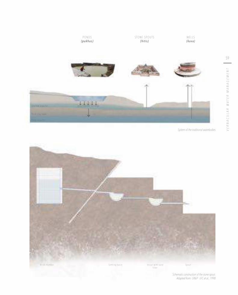
The Newari settlements exhibit a unique urban tissue. While a maze of inner courtyards, kitchen gardens and vibrant streets form the crucial building blocks, the Newar social structure gives an extra dimension to the coherence and philosophy of the traditional villages.
——The relation between different building forms at the edge of Khokana.
I V.

70
Cultural identities in Khokana, 2016

71
SP
EC
IFIC
ITIE
S O
F T
HE
UR
BA
N T
ISS
UE
––––––
The Newari settlements are dominated by a Mandala
principle in order to protect the core of the settlements
from various threats. When zooming in on the inner circle
of this Mandala, a typical Newari fabric, formed by vibrant
streets and a network of courtyards, can be observed.
However, the formation of the villages was not purely
guided by topography. The daily life of the villagers as well
as various principles contributing to the social system lie
at the basis of their development (Shrestha & Shrestha,
2008). That way, every settlement is unique, as it is based
on the social structure that is present in that village. The
basis of the formation of every settlement can be found in
its founding legends, narrating the story of how the village
was established.
––––––

72
T h e f o u n d i n g l e g e n d s
The name Bungamati originates from the words ‘buga yumi grama’, which means “god
of water resources” and was first mentioned in the year 605 (Gurung, 2000). The founding legend as written in Medieval chronicles can be summarized as follows
(Gurung, 2000). For two hundred years, there had been a draught in the kingdom
of Kathmandu. Desperate to solve this problem, the king went to a priest for help.
The priest told him that a saint had collected all the serpents of the Kathmandu
valley, made a seat out of them and had gone into meditation sitting on it. To stop
the draught, the serpents needed to be set free, because they are the symbol of water.
However, to do so, the saint had to be woken up first and the only one who could do that was his master, Machhindranath.
In that time, there were three important settlements in the Kathmandu valley:
Bhaktapur, Kantipur (Kathmandu) and Lalitpur (Patan). The king of Bhaktapur,
a priest from Kantipur and a farmer from Lalitpur together went on a quest to
bring Machhindranath to the valley. It was an adventurous route, but eventually they
succeeded in bringing the master to the saint. The saint woke up and the serpents
were set free, whereupon it finally started to rain again in the Kathmandu Valley. However, the king, the priest and the farmer were now facing another problem:
where would they keep this master? Of course, all three wanted to let him stay in their
own settlement, but finally they came to an agreement. They decided to build a new temple for the master, on a new location. The king then brought a hundred families
from each of the three settlements to live around this new Machhindranath temple, and
thus the village of Bungamati came to exist.
Illustration of the founding legend of Bungamati
B u n g a m a t i
K a t h m a n d u
Pa t a n
B h a k t a p u rFa
rmer s
M e r c h a n t s
Prie s
t s
B u n g a m a t i

73
SP
EC
IFIC
ITIE
S O
F T
HE
UR
BA
N T
ISS
UE
The Machhindranath temple of Bungamati© Dalbéra, 2013

74
The Rudrayanee temple of Khokana, 2016

75
SP
EC
IFIC
ITIE
S O
F T
HE
UR
BA
N T
ISS
UE
Location of Sikali Lawn & old Khokana
Khokana is believed to be derived from the word ‘Khona’, which means ‘telling while weeping/crying’. The legend tells a story about a very sick Maharjan priest who
fainted because of a high fever. His family believed he was dead, so they decided
to take his body to the banks of the Bagmati River to cremate him. By tradition, it
was intended to cremate the wife alive together with her dead husband. But when a
storm came up, people ran away in order to seek shelter. The man suddenly woke up
again and the couple got out of the fire. Because the villagers feared what they just witnessed, nobody wanted the couple to live in their neighbourhood. The couple ran
away crying and they settled at a place nearby Sikali Lawn, which is located south-west
of Khokana. Later, they moved to a place situated on higher grounds in order to be
safe from harassing villagers and floods, and so Khokana was founded.
K h o k a n a
S i k a l i L a w n
O l d K h o k a n a K h o k a n a t o d a y

76
T h e N e w a r i s o c i a l s t r u c t u r e & i t s s p a t i a l r e f l e c t i o n
The social life of the Newars is strongly guided by the guthi system, which, in its turn,
is linked to the well-known caste system representing the social status. These social
arrangements create a socio-hierarchical structure, strongly influencing the shape of the urban tissue (Müller-Böker, 1988). Therefore, people from the same social group
tend to build their houses in close proximity to each other, creating a variety of
neighbourhoods, or tole. Various toles compose a village, like Bungamati and Khokana.
These settlements used to belong to a VDC (Village Development Committee),
but nowadays are part of bigger whole, called a municipality. Both Bungamati and
Khokana are part of the Karyabinayak municipality.
+ +
Karyabinayak municipality© Esri, 2017Adapted from: Brinkhoff (Population) & LGCDP (Map)
0,4 km

77
SP
EC
IFIC
ITIE
S O
F T
HE
UR
BA
N T
ISS
UE
S a i n b uV i l l a g e : B h a i s e p a t i
Po p u l a t i o n : 2 0 0 1 8 , 3 3 7 2 0 1 1 1 9 , 7 2 1 ( + 8 . 9 3 % / y e a r )
A r e a : 4 . 1 2 k m 2
K h o k a n aV i l l a g e : K h o k a n a
Po p u l a t i o n : 2 0 0 1 4 , 5 4 2 2 0 1 1 4 , 9 2 7 ( + 0 . 8 1 % / y e a r )
A r e a : 3 . 1 7 k m 2
B u n g a m a t iV i l l a g e : B u n g a m a t i
Po p u l a t i o n : 2 0 0 1 5 , 6 6 7 2 0 1 1 5 , 9 6 6 ( + 0 . 5 1 % / y e a r )
A r e a : 3 . 8 9 k m 2
C h h a m p iV i l l a g e : S a l y a n t a r
Po p u l a t i o n : 2 0 0 1 4 , 1 9 2 2 0 1 1 4 , 7 5 3 ( + 1 . 2 6 % / y e a r )
A r e a : 5 . 5 2 k m 2
D u k u c h h a pV i l l a g e : D u k u c h h a p
Po p u l a t i o n : 2 0 0 1 2 , 5 0 1 2 0 1 1 2 , 6 6 9 ( + 0 . 6 5 % / y e a r )
A r e a : 4 . 9 1 k m 2

78
A h y b r i d i f i e d c a s t e s y s t e m
The caste system, implementing a socio-religious hierarchy, is a well-known principle
dominating a lot of different countries (Pant & Funo, 2007). This system originated
in the Hindu society, but is widely known for influencing various religions. As Bal Gopal Shrestha said in 2012:
“The main root of the caste system in South Asia is the Hindu Varnasrama system,
which divides the whole of Hindu society into four social categories.”
However, the caste system keeps expanding. In 1991, sixty caste and ethnic groups
were registered, while in 2011 this number had risen to 125, according to the Nepal
Population Report 2016.
The Newar caste system represents a hybrid structure, since these settlements are a
co-existence of two religions, namely Hinduism and Buddhism.
The structure of the urban tissue as well as the entire social network inside the
settlements is dominated by this system. The occupancy of the villagers is strongly
linked to the caste system, leading people from the same caste to have the same
profession. People from the same caste tend to live close to each other, since this
increases the work efficiency (Shrestha & Shrestha, 2008). In addition, “purity” is a leading factor in the relation between various people and the caste system creates
a hierarchy of people who are equally or less pure, or even impure (Gray, 2009).
Therefore, certain activities cannot be performed with people from other castes, like
eating or marrying, resulting in people from the same caste gathering in clusters. By
building their houses in each other’s proximity, the social structure and bonds are
strengthened. This building in clusters can also be observed in the location of the
temporary shelters. Tiny neighbourhoods are created by big families or members
from the same caste.
According to the founding legends, the dominant castes living inside a settlement are
generally the first ones that inhabited the village. Furthermore, it can be observed that people of higher castes live in the close proximity of the temple, thus in the
very centre of the town, while lower castes commonly live in the periphery (Shrestha,
2011). In the past, this hierarchy was very strict, leading to social rules, for example
forbidding the butchers’ caste to live within the boundaries of the towns (Gutschow,
2011).
On an architectural level, the houses of the higher castes are generally more decorated
since the house represents an important status symbol and there is the tendency
to distinguish oneself. Before, there were still other architectural implications: the
butchers’ caste was for instance prohibited to build brick houses higher than one
story (Gutschow, 2011).
Although the influence of the caste system has diminished over the centuries, it is important to understand its concepts.

79
SP
EC
IFIC
ITIE
S O
F T
HE
UR
BA
N T
ISS
UE
B U D D H I S T
B r a h m i nVa j r a c h a r y a ( G u v a j u )
S h a k y a ( B a r e )
S h r e s t h a Tu l a d h a r ( U r a y e )
M a h a r j a n D a n g o l
J y a p uM a l i
M a l a k h a r ( f l o r i s t )N a u ( b a r b e r )
Yo g i ( d e a t h s p e c i a l i s t ) : Ku s l e & Ka p a l iK h a d g i & S h a h i ( b u t c h e r s )
Ka s a i ( N y a e ) ( m u s l i m )
U n t o u c h a b l e c a s t e s ( s w e e p e r s )
H I N D U
Pr i e s t c a s t e
M e r c h a n t c a s t e
Fa r m e r c a s t e
A r t i s a n & s e r v i c e c a s t e
n o b l e , r u l i n g p o s i t i o n
s e r v a n t s t a t u s
u n c l e a r
Caste hierarchy in Nepal. Source: Gellner, 1986

80
All the illustrated castes are present in Bungamati, however, the three most dominant
castes, and thus professions, are Shakya (priests), Tuladhar/Shrestha (merchants
and craftsmen) and Maharjan (farmers owning agricultural land) (Gurung, 2000).
According to the legend on the origin of the town, these three castes were the first that came to live in Bungamati from Kantipur, Bhaktapur and Lalitpur respectively.
The three main ponds of the town, combined with three large open spaces, mark
these distinctive communities: Bhunna, Guanna and Khanna. In the overall plan of the
town, this distinction is still visible.
Within the highest caste of Bungamati, a special deity is present: one of the ten living
goddesses or Kumaris inside the Kathmandu Valley lives in the settlement (Allen,
1976). The Kumari is the daughter of a single Vajracharya family and represents the
destroyer of male demons. This Kumari is worshipped by all clean castes inside
Bungamati.
In comparison with Bungamati, the caste system in Khokana is noticeably different.
In this tiny settlement 98% of the inhabitants are from the same caste, namely the
Maharjan/Dangol or farmer’s caste (Müller-Böker, 1988).
This caste system also has a clear reflection in means of water management. Both traditional settlements are fed by the royal canal, or Rajkulo (Aryal, 2005). However,
Bungamati receives water from the Rajkulo first. This can be related to the fact that the majority of the people of Bungamati are from higher castes in comparison
with Khokana. In addition, within Bungamati, another distinction is visible. The
higher castes receive water first, making sure they receive water of higher quality. Furthermore, this makes sure that in times of water scarcity, the higher castes are
sure to receive water, while the members of the lower caste have to survive with less
or even no water supply.
B u n g a m a t i & K h o k a n a
+ +
Caste system of Bungamati & Khokana
50 m
The Kumari of Bungamati playing with a friend, 2016
Brahmin
Shakya (Bare)
Malakhar
Vajracharya (Guvaju)
Maharjan, Dangol (Jyapu)
Kapali
Kasai (Nyae)
Shrestha
Tuladhar (Uraye)
Unsurveyed

81
SP
EC
IFIC
ITIE
S O
F T
HE
UR
BA
N T
ISS
UE
Rajkulo supply

82
As a reflection of the caste system, the population is mainly composed of farmers, craftsmen and priests. The large number of priests can be explained by the presence
of the Machhindranath temple, an important deity for the entire Kathmandu Valley.
In general, there is a lot of economic activity in Bungamati. It is considered to be a self-
sufficient town, where products fabricated within the village are also consumed there (Pandey, 1969). Throughout history, Khokana has always been a centre of economic
activity, partly because it is located on a trade route to India (Pandey, 1969). Because
almost everyone belongs to the Maharjan/Dangol caste in Khokana, its economy is
mainly based on agriculture. Every family in Khokana owns approximately two to
three Ropani1 for cultivation.. Another important occupation influences the overall
economy of this settlement, namely the oil pressing industry. Khokana is known
for its oil mills, using traditional wooden machines to press the mustard seeds. The
ancient town used to own four oil mills spread over the settlement, applying an
intensive, both manual and electric process in order to provide the finest quality of mustard oil. However, due to the earthquake, only two of the original oil mills are still
in use. Nowadays there is little commercial activity, leading to a considerable amount
of import and export with the bigger cities.
1 1 Ropani = 508 m
2
+ +
Different functions in Bungamati & Khokana
50 m
Shop
Restaurant / Café
Meatshop
Crafts Atelier
Sewing Atelier
Weaving
School
Oil Mills
Metal Atelier
Barber shop / Hairdresser
Inside an oilmill in Khokana, 2016

83
SP
EC
IFIC
ITIE
S O
F T
HE
UR
BA
N T
ISS
UE

84
Being a farmer does not only entail agricultural activities. Farmer families often have
several family members who take up another profession to earn some extra money
(Gellner, 1986). These side jobs are necessary for families to survive because the land
they own, an average between one to three Ropani1, is hardly enough to provide them
with food during half of the year. In addition, the various crops that they harvest
do not cover an entire year, meaning that the rest of the year they need to have an
additional income. Therefore, the grandparents often work in the fields and harvest the crops, while the parents have a job in the city. Examples of these secondary
jobs are handicrafts, wool spinning, running a shop or catering service, … The last
mentioned arises during the holidays or festivals, when wealthy people from the
capital or larger cities want to invite their entire family for a festive meal. Sometimes
farmers then provide a catering service, so that the people organising the feast do not
have to worry about cooking.
While in the past people would stay inside their settlement for both living and
working, nowadays there is a transition towards more people travelling to the bigger
cities for their jobs.
1 1 Ropani = 508 m
2
Tr a d i t i o n a l s t r u c t u r e s o n t h e m o v e
A farmer maintaining his land, 2016

85
SP
EC
IFIC
ITIE
S O
F T
HE
UR
BA
N T
ISS
UE
A woman spinning wool on a peti in front of her house A woman working in her craft shop
Men playing chess in front of a wooden craft shop Man working in his sewing atelier
Women weaving a carpet inside a weaving atelier

86
The woodcarvers and other craftsmen, such as metal workers or weavers, can be
divided into two categories: those who have their own shop, and those who do not.
The people that do not own a shop usually have an arrangement with a shop-owner
somewhere in the city. They get all the necessary materials and tools for free and
can work in their own house. These craftsmen working inside the door opening of
their house, represent a charming characteristic of the Newari settlements. It is a
typical aspect of the vernacular architecture that the house provides space for both
the domestic and working life of the inhabitants. In general, the ground floor is linked to the profession, while the other floors are preserved for daily life. Due to this, walking through the streets immediately gives a glimpse of the various occupancies
that are present inside the settlement. However, people in this situation are often
being exploited as cheap labour forces. They get paid per produced piece, where
the salary depends on how large and detailed the final product is. Nevertheless, the money they earn by finishing a product is far less than the actual value for which it is sold in the city. Therefore, most woodcarvers would prefer to have their own shop,
but they often cannot afford it.
The weavers’ profession is dominated by women. They often go to a large atelier,
usually located in the outskirts of the town, where they can work together with other
weavers. They also get paid per piece they make.
People owning a shop either have a room at the ground floor of their house, transformed into a shop and atelier, or they rent a room somewhere else.
E x t e n s i o n o f t h e h o u s e
L i v i n g a r e a
S h o p a r e a ( l i n ke d t o t h e p r o f e s s i o n )
Building block on the bus park of Bungamati with shops on the ground floors and housing on the upper floors, 2016

87
SP
EC
IFIC
ITIE
S O
F T
HE
UR
BA
N T
ISS
UE
Weaving atelier on the armature road between Khokana & Bungamati, 2016
Shop on the ground floor of a house in Khokana, 2016

88
T h e g u t h i s y s t e m
The main social structure leading the traditional settlements is the guthi system, dating
back from the Licchavi period (Pant & Funo, 2007). As Vajracharya explains:
“The meaning of the word ‘guthi’ is derived from the Sanskrit ‘Gosthi’ meaning an
‘association’ or an ‘assembly’” (Vajracharya, 1998). It refers to a group of people within a community or town, based on territorial proximity
or religious association (Pant & Funo, 2007). The guthis are strongly intertwined with
the caste system, meaning you get born into a guthi. This results in several guthis with
their own rituals and rules of worshipping. They take the responsibility of organizing
common activities and bring specific rules to the community to achieve a common objective (Pandey, 1969). It is a well-functioning structure, based on solidarity where
every member is part of the association and has his own liability in order to succeed
in living together as a group.
Nowadays, three different kinds of guthis can be distinguished (Quigley, 1985). Firstly,
there are the de guthis, who are responsible for the festival rituals. They take care of the
maintenance of religious monuments and the organization of a festival with money
they earn from the harvest of their agricultural land. Every de guthi assembles once
a year to worship the deity representing the ancestors. These guthis own individual
buildings that are used once a year for a feast.
Ritual performed for the Sikali festival on the main square in Khokana, 2016

89
SP
EC
IFIC
ITIE
S O
F T
HE
UR
BA
N T
ISS
UE
Morning rituals on the main square in Bungamati, 2016 The god Pegasus during Dashain in Bungamati, 2016
Secondly, the si guthis, are responsible for the funerary rituals. When a member of
a si guthi dies, at least one representative of every family belonging to that guthi has
to be present at the funeral. If not, they must pay a fine that will be used for the maintenance of the guthi. If such absence repeated, expulsion from the guthi will be
requested (Quigley, 1985).
Becoming a member of a si guthi is very strict and happens through family (Gurung,
2000). If a father is already part of a si guthi, his children will be a member of this
si guthi to in the future. In general, only the head of a household is inscribed in a si guthi (Quigley, 1985). Once a family splits up, for example when there are two sons
who each start their own family, there needs to be a member from each new family
in the guthi. It is possible to join a different guthi than the one your family used to be
part of, however, this is highly unusual. In this case, a fee must be paid and a feast for
the existing members should be organised in order to merit your position within the
guthi. The most important criterion for entering a different guthi is the caste someone
belongs to. People from a lower caste can exceptionally join a guthi from a higher
caste, but sometimes this leads to internal problems and it will be very expensive. In
Bungamati, guthis have been split up because for example a Maharjan joined a guthi of
Tuladhars.
The si guthis have a strong spatial reflection and therefore have an impact on the development of the urban tissue. Members from a si guthi tend to live closely to one
another, since this is more expedient when handling corpses.
The third kind of guthi, the temple/festival guthi, is more of voluntary kind and generally
carries the name of the deity to whom a temple of the settlement is dedicated
(Quigley, 1985). These guthis organise and fund an annual festival to worship the deity
of which they carry the name. In addition, they are responsible for the maintenance
of the temple.
Every household has to be part of both a de guthi and a si guthi. If this is not the case,
a household will be considered exiled.

90
B u n g a m a t i
The guthi system in Bungamati is rather extensive. Most guthis are linked to a specific caste, but for the si guthis, there are often multiple guthis per caste. For the de guthis, the
system is slightly different (Gurung, 2000).
Usually, every guthi owns land, but in general the de guthis own more land than the si guthis. The si guthis only own land if it is donated by a rich member, whereas the de guthis need land so they can use the income it generates to pay for worshipping rituals.
In Bungamati there are several de guthis, most of which own large parts of collective
land, all in showing important differences, as can be derived from the below details.
The Falcha guthi is a rather exceptional guthi, because it does not own any land, only
funds. It is a guthi from the Shrestha community. The Bhairav guthi then, owns 1 200
Ropani1 of land. This covers an entire hill in the south of Bungamati. Further, the
Paneju Khandi guthi owns 365 Ropani1 of land in the northern part of Bungamati,
known as Nakki Port. It is a part of the land that is linked to the Machhindranath
temple. This guthi in particular is responsible for the Red Machhindranath festival. The
Wasi guthi owns 144 Ropani1 of land. This parcel also belongs to the Machhindranath
land, as do the 12 Ropani1 belonging to the Kurle guthi. Finally, the Damara and the
Praja own 12 and 64 Ropani1 respectively.
The fact that the guthis own agricultural land sometimes led to problems in the past.
This is because occasionally, the land of a guthi can be used by the members of the
guthi to cultivate their crops, and over time the users of the land start to claim it as
their own. This has led to loss of property for several guthis.1 1 Ropani = 508 m2
+ + Map with known guthis of Bungamati
50 m
Different guthis

91
SP
EC
IFIC
ITIE
S O
F T
HE
UR
BA
N T
ISS
UE
K h o k a n a
The majority of the inhabitants of Khokana belong to the same caste, so there is no
differentiation within the various guthis and their caste. There is also no clear pattern
in the localization of the members of one guthi; they are scattered around the entire
settlement.
In Khokana there are three de guthis: the Ta guthi (the largest one), the Salan guthi and the Ja guthi. The buildings of the de guthis are all centred around the same public
square, namely the Kwe Lachhi. This square, as well as the guthi system, plays an
important role in the religious rituals.
For the death rituals, the inhabitants have five associations instead of three. The si guthis that are present in Khokana are the Ta guthi, the Salan guthi, the Ja guthi, the
Tami guthi and the Nhugu guthi. These si guthis only have two buildings, which are used
collectively.
Rudrayanee guthi
Ta guthi
Salan guthi
Ja guthi
Si guthi
+ +
Map of Khokana with the different guthis
50 m
Square surrounded by the guthi buildings in KhokanaInside the Salan guthi
Ja g
uth
i
Sal
an g
uth
i
Ta g
uth
i
Symbols of the Ja guthi, Salan guthi & Ta guthi

92
Khokana also has a festival guthi; the Rudrayanee guthi, named after the deity worshipped
in the main temple of Khokana. This guthi consists of 46 (male) members, who are
the living gods of Khokana. Within this group, there are 14 masked gods, who are the
living representation of the following gods: Bhairav, Kumari, Shakti, Brahma, Vishnu,
Mahadev, Barahi, Kali, Kumar, Ganesh, Hunaman, Indrayani, Rudrayani and Mahalaxmi. Out of these gods, only Bhairav, Kumari, Barahi and Kali can drink blood from offered
animals. Furthermore, there is one unique unmasked god, the trembling god, that is
allowed to drink blood as well. Understandably this guthi plays an important role in
the organization of different festivals.
If someone of the Rudrayanee guthi dies, the spirit of that god along with his task is
transferred to the son. When becoming a god, it is mandatory to organize a big feast
for all the members (Rudrayanee guthi. Personal interview. 2016, October 10). Within
the guthi, there is a smaller group, called the Mahankel. This group consists of five members who are responsible for the management of the festivals.
The Rudrayanee guthi used to own a hundred Ropani of land outside of Khokana in
between the Rudrayanee School and the Sikali Lawn, but half of its property was sold
because it faced a small economic crisis. The grain that they get out of this land is
used for common feasts and festivals.
Two of the living gods of Khokana on the Sikali jatra, 2016
One of the masked gods performing a ritual dance during the Sikali festival, 2016

93
SP
EC
IFIC
ITIE
S O
F T
HE
UR
BA
N T
ISS
UE

94
T h e m a z e o f o p e n s p a c e s
The urban tissue of the towns is defined by two key elements, forming the backbone of Newari settlements and reflecting a varying degree of privacy. First, there are blocks of closely built Newari houses, commonly bundled around inner courtyards
and kitchen gardens. Secondly, the public squares, connected by a network of streets,
unite the various building blocks (Shrestha, 2011). The various open spaces, ranging
from the maze of private kitchen gardens and courtyards to public open spaces create
a unique urban tissue that results in a productive village answering the needs of
every household (Manandhar & Parajuli, 2015). The inhabitants of the settlements
behave as a real community and their daily life is primarily taking place in the open
air. Therefore, open spaces play an important role for the daily activities. In order
to optimize their use, the design is strongly linked to climate, either by natural or
architectural elements. The different dimensions are based on the principle of
shadow, generated both by surrounding houses and trees.
+ +
Open spaces in Bungamati & Khokana
50 m
Co n n e c t i o nc i r c u l a t i o n t h r o u g h s e t t l e m e n t
S h a d o wc o m m u n i t y s p a c e ( g a t h e r i n g , r e s t i n g , w a s h i n g , p l a y i n g . . )


96
The street network forms an important part of the open space, serving both as
connector and community space for a variety of social and religious events. In this
concept, the division between street and building is not as strict as seen in the western
part of the world. Between the streets and the buildings, there is a certain transition
zone or threshold, shaped by a different kind of pavement or even an elevated plinth,
or peti. These petis are always crowded with people, creating a lively atmosphere. The
peti also has a constructional significance: by elevating the entrance of the houses, they are better protected against floods.
The street network shows an obvious hierarchy. It is based on the order in which they
came into being and is indicated by the width of the streets as well as the presence
of some sort of pavement. The main streets, which are wider and commonly
located at the centre of the historical town, indicate the original structure of the
traditional town. Different opinions arise regarding the question whether traditional
settlements were planned or the result of organic growth. However, when looking
at the plan of both Patan and Khokana, the swastika, a typical Buddhist symbol, is
clearly noticeable. This leads to the conclusion that there must have been some sort
of planning principle. The main, traditional roads are commonly paved either with
bricks or (modern or ancient) flagstones. Within one street a variety of pavement is visible, marking the boundaries between private and public spaces.

97
SP
EC
IFIC
ITIE
S O
F T
HE
UR
BA
N T
ISS
UE
H i s t o r i c a l c o r e a r e a
O l d f l a g s t o n e s B r i c k M o d e r n f l a g s t o n e Co n c r e t e s u r f a c e S a n d
L a t e s t e x p a n s i o n

98
The other type of streets were influenced by a later expansion of the settlement due to urban growth. When the settlements started to expand, farmer routes were
widened, resulting in rather organic pathways. These secondary roads can be divided
into two types. The streets alongside the core area have been paved over the years
with bricks or flagstones, while the streets accessible by cars are usually covered with a concrete surface. The narrower streets, a result of more recent expansion, and thus
generally located at the edges of the settlements, are rarely paved, which results in
sandy or muddy lanes.
The various types of pavement and the water management within the settlement
are strongly related. The sandy lanes are perfectly permeable, allowing infiltration of water when it rains. This water infiltration in its turn, results in ground water recharge which is crucial for the water provision of the settlement. However, the roads that
are surfaced by man, influence the behaviour of the water. The paved roads are less permeable, preventing to some extent the process of infiltration. In case of roads paved with flagstone or bricks, the infiltration can still occur in the mud joints between the pavement. So, the bigger the joints, the more water can infiltrate for groundwater recharge. Conversely, the more recent, modern roads which are covered
with concrete do not allow infiltration and make the water flow down according to the topography.
In addition, paved streets usually have a gutter, in order to lead abundant water away
from the street network. The water is generally transported to the ponds of the
settlements, or through the rice fields to the rivers situated on lower lands. In the existing situation, the sewage water as well as the clean rainwater are transported
together.
Various constructions of gutters can be observed: fully covered sewage systems, to
prohibit waste from getting in, or gutters existing of just a small, lowered part of the
road. The unpaved streets, located next to houses or temporary shelters come with
more rudimentary, dug gutters.
+ +
Bungamati & Khokana with indication of different pavements & waterflow
50 m
D u g g u t t e r a r o u n d s h e l t e r L o w e r e d p a r t o f t h e r o a d G u t t e r o f i n c l i n e d b r i c k s Fu l l y c o v e r e d s e w a g e s y s t e m
Flag stones
Red bricks
Concrete
Unpaved


100
This hierarchy of pavement as well as the width of the streets is also strongly based on
religion. The wider roads represent certain routes related to processions, where gods
have to be able to travel, whereas roads merely used by humans are narrower (Singh
S. Personal interview. 2016, August 21). In the Newari tradition two fixed routes are defined, the festival route and the funeral route, followed during a festival and funeral respectively. In Khokana the significance of these routes is clearly expressed, the festival route being paved with traditional flagstone. When the town decided to renew the pavement, the middle strip of the street was preserved in traditional flagstone, while the outer parts were replaced by modern flagstones. These religious routes are remarkably important in case of a natural hazard (Manandhar & Parajuli, 2015). By
following these routes when participating in festivals, the inhabitants become familiar
with the network of open spaces and streets. In this way, they know their options and
escape routes in case of a natural disaster. In addition, the highest priority is assigned
to cleaning up these roads after an earthquake.
Festival route in Khokana with a part of the old pavement preserved, 2016
+ +
Funeral routes (brown) & festival routes (red) in Bungamati & Khokana. Source: Tomoda, 2016
200 m

101
SP
EC
IFIC
ITIE
S O
F T
HE
UR
BA
N T
ISS
UE
S i k a l i t e m p l e S h i k a l i t e m p l e
C r e m a t i o n s i t e
C r e m a t i o n s i t e
C r e m a t i o n s i t e
R u d r a y a n e e t e m p l e
Ka r y a b i n a y a kt e m p l e
M a c h h i n d r a n a t ht e m p l e
Bagmat i R i ve r
N a k h u R i v e r
Ro
ad t
o P
a tan

102
A “jatra” is a festival devoted to a specific deity. Rato Machhindranath or “Red Machhindranath” is the god of rainfall (Pujari, 2014), therefore this jatra takes place
before the monsoon, between April and May. The entire festival lasts about a month,
but the final day is the most important one.
Machhindranath has several temples in the Kathmandu Valley and one of the most
important ones lies in Bungamati, where in the past this festival was held every year.
The image of Macchinadranath was put on a chariot and carried around the town.
Nowadays the jatra has shifted to Patan, where the celebrations still take place once
a year. The chariot is carried all the way to Jawalakhel and on four different locations
animals are sacrificed. Afterwards, the deity is brought to Bungamati to rest there for six months. Around November or December, he is brought back to Patan (Gurung,
2000). He thus lives half of a year in Bungamati and the other half in Patan. It is only
every twelve years that the original festival is held in Bungamati as it used to be. On
this occasion, the chariot is built in Bungamati and then carried all the way to Patan,
to be brought back again to Bungamati at the end of the festival. The chariot is then
demolished, except for one part: a curved shaft that is seen as sacred and kept by the
Paneju Khandi, which is the guthi responsible for the Machhindranath festival.
The chariot in its totality is constructed by the villagers themselves, where every caste
is responsible for the construction of a specific part of the chariot.
R a t o M a c h h i n d r a n a t h J a t r a | m a i n f e s t i v a l o f B u n g a m a t i
Chariot of the Rato Machhindranath© Joshi, 2008
Ritual dance on the Sikali jatra performed by a member of the Rudrayanee guthi, 2016

103
SP
EC
IFIC
ITIE
S O
F T
HE
UR
BA
N T
ISS
UE
One week before the Nepali Dashain festival, the people of Khokana celebrate
their own unique five-day festival; the Sikali Jatra which is short for Siddhikali, a
representation of Parvati (Pruscha, 1975). This festival is based on the principles of
tantric Hinduism, more specific the legend of lord Shiva. The various de guthis are all
present at the festival, with their own worshipping rituals. The Rudrayanee guthi plays a
fundamental role in this festival.
On the evening of the first day of the festival three buffalos are sacrificed, one by each de guthi. The intestines of these buffalos are conserved in order to use them as
necklace for the god Bhairav.
The second day of the festival is called chholabu. On this day, every guthi prepares the
meat from the offered buffalos to have a big feast.
On the third day, the goddess Rudrayanee descends from the temple to the palanquin.
Another buffalo is sacrificed by one of the living gods of Khokana. After this ceremony there is a concert on the Kwe Lachhi.
On the fourth and most important day of the festival, the procession of the Rudrayanee goddess to Sikali Lawn is carried out. Sikali Lawn, which is situated at the west of
Khokana, is the place for ancestral worshipping. Once the goddess has arrived there,
all the inhabitants worship her in the Sikali temple. In the afternoon, the fourteen
masked gods perform dances, which are based upon the story of Shakti and lord
Shiva.
Later that day the shrine of Rudrayanee is brought back to the settlement and is placed
inside the temple of the Kwe Lachhi. The 46 gods walk around Khokana to worship
various houses of the town by offering ducks in front of them.
On the fifth and last day of the festival, the living gods dance around the festival route inside the settlement. To conclude the day, the last dances are performed on
the Kwe Lachhi.
T h e S i k a l i Fe s t i v a l | m a i n f e s t i v a l o f K h o k a n a

104

105
SP
EC
IFIC
ITIE
S O
F T
HE
UR
BA
N T
ISS
UE
Gods being carried through the steets of Khokana during Sikali festival, 2016
Shiva and Shakti are husband and wife, but the father of Shakti is not pleased, because Shiva is not a normal man. He is a god, who does not wear clothes and scrubs his skin with ashes. In an attempt to break up the marriage, the father creates another god, Mahadev. When the relationship effectively breaks up, Shakti commits suicide. Mahadev is so shocked that he decides to console Shiva with the help of the other gods. (Rudrayanee guthi. Personal
interview. 2016, October 10)

106
Nowadays, streets usually represent a means for transportation and traffic. However, the core of the villages emerged long before the existence of vehicular transport,
resulting in traffic-free roads. Narrow streets and, in the case of Bungamati, several stairs make the core of the settlements almost inaccessible for cars. The only form of
motorized transport observed in these rural settlements consists in motorcycles, and
occasionally some cars, minimizing its impact on street life. In order to cope with the
advent of vehicular traffic, both Khokana and Bungamati have a bus park located at the edges of the villages.
B u s p a r k K h o k a n a
B u s p a r k B u n g a m a t i
+ +
Bungamati & Khokana
100 m

107
SP
EC
IFIC
ITIE
S O
F T
HE
UR
BA
N T
ISS
UE
Vehicles using the streets in Khokana, 2016
Bus park Khokana, 2016
Main road in Bungamati towards the Machhindranath temple, 2016

108
In traditional Newari settlements, the urban fabric of streets and squares is typically
refined by the presence of a network of inner courtyards and kitchen gardens. Both Khokana and Bungamati can be categorized as ‘courtyard villages’. The network usually consists of narrow alleys and small corridors, often hidden behind an
entrance door of a house, leading to a diversity of courtyards and kitchen gardens.
These courtyards are very important in the daily life of the inhabitants and serve
many purposes. In general, two types of courtyards can be distinguished: the open
courtyards, or nani, and closed courtyards, or bahil (Shrestha, 2011). The public spaces
as well as both types of courtyards form an important extension of the street network.
Kitchen garden in Bungamati, 2016 Private courtyard in Khokana, 2016
+ +
Vegetation vs openspace Bungamati & Khokana
50 m
Forest tree
Large/tall tree
Small tree
Fruit tree
Bushes/weeds
Flowers
Rice fields
Cornfields
Kitchen garden

Private courtyard
Kitchen garden

110
One of the main advantages of a settlement with courtyard houses is the ability
to create a denser urban fabric (Rapoport, 2007). Looking at the inverse map of
both Bungamati and Khokana, there is a noticeable difference in the urban tissue of
the twin villages. Khokana clearly has a more advanced network of little courtyards,
allowing a more efficient use of space and the optimal preservation of agricultural land (Mathema,1999). As a result, this smaller village counts almost as many inhabitants
as Bungamati. Bungamati in its turn has a less extensive network of courtyards and
a larger variety of large open spaces in combination with an abundance of small
kitchen gardens. This difference could be explained by the fact that the degree of
privacy is status related. Khokana is primarily inhabited by the Maharjan caste, while
Bungamati is composed of relatively higher castes. People from higher castes can
afford a larger degree of privacy, resulting in bigger private courtyards. On the other
hand, the lower castes are more likely to share a courtyard with various neighbours.
In addition, the higher castes are more likely to invest in proper, individual vegetable
gardens, which is clearly tangible in Bungamati.
Because the entrances of the courtyards are to some extent hidden, passers-by do
not immediately notice a lot of the inner courtyards. Although the corridors leading
to the courtyards are never locked and therefore accessible for everyone, the small
access routes give them a more private atmosphere. As a result, the boundaries
between private and public properties are vague, leading to interesting subzones.
Another significant value of the courtyards is the fact that they offer a certain degree of protection in these areas vulnerable to earthquakes. As has been shown
worldwide, the open spaces between buildings play an essential role both during and
after the earthquake (Allan & Bryant, 2010). In courtyard villages, the courtyards are
connected by numerous passages, creating numerous escape routes even if some of
them are obstructed. Therefore, every household immediately has access to an open
space in order to get away from collapsing buildings. This open space not only acts as
a refuge, but also as a temporary home, as can be seen in Bungamati. Plenty of day
to day activities are arising from the emergency situation, creating what can be called
a ‘second city’.
For the further discussion of these open spaces we work with a division in five categories (public, semi-public, semi-private, collective and private).
+ +
Privacy gradient in Bungamati & Khokana
50 m
Public (extravert)
Private (introvert)
A maze of public spaces in Khokana, 2016Collective courtyard in Bungamati, 2016

111
SP
EC
IFIC
ITIE
S O
F T
HE
UR
BA
N T
ISS
UE
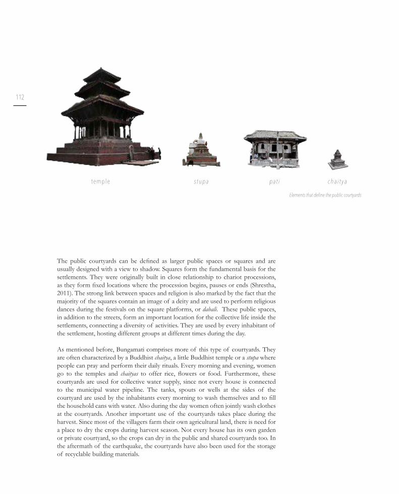
112
The public courtyards can be defined as larger public spaces or squares and are usually designed with a view to shadow. Squares form the fundamental basis for the
settlements. They were originally built in close relationship to chariot processions,
as they form fixed locations where the procession begins, pauses or ends (Shrestha, 2011). The strong link between spaces and religion is also marked by the fact that the
majority of the squares contain an image of a deity and are used to perform religious
dances during the festivals on the square platforms, or dabali. These public spaces,
in addition to the streets, form an important location for the collective life inside the
settlements, connecting a diversity of activities. They are used by every inhabitant of
the settlement, hosting different groups at different times during the day.
As mentioned before, Bungamati comprises more of this type of courtyards. They
are often characterized by a Buddhist chaitya, a little Buddhist temple or a stupa where
people can pray and perform their daily rituals. Every morning and evening, women
go to the temples and chaityas to offer rice, flowers or food. Furthermore, these courtyards are used for collective water supply, since not every house is connected
to the municipal water pipeline. The tanks, spouts or wells at the sides of the
courtyard are used by the inhabitants every morning to wash themselves and to fill the household cans with water. Also during the day women often jointly wash clothes
at the courtyards. Another important use of the courtyards takes place during the
harvest. Since most of the villagers farm their own agricultural land, there is need for
a place to dry the crops during harvest season. Not every house has its own garden
or private courtyard, so the crops can dry in the public and shared courtyards too. In
the aftermath of the earthquake, the courtyards have also been used for the storage
of recyclable building materials.
Elements that define the public courtyards
t e m p l e s t u p a p a t i c h a i t y a

113
SP
EC
IFIC
ITIE
S O
F T
HE
UR
BA
N T
ISS
UE
Public space
Buildings
Ponds
4 Wheelers
2 Wheelers
Concentration of peopleFlow of people in Bungamati
Source: Amir, 2015
Flow of people in Khokana, 2016

114
Although the larger public spaces are discussed as one type, both settlements have
an obvious main square. These squares are commonly marked with an impressive
temple, but the Machhindranath temple in Bungamati collapsed during the earthquake
of 2015. Given the importance of this building, the whole community is intensively
working to rebuild their monument.
The main square forms the lively centre of the settlement and is generally very
crowded, especially in the morning and evening because offering rituals are performed
at the main temple. In addition, in the case of Khokana, a fruit and vegetable market
is organized. Particularly during the festival period, the square is crowded with people
sitting together to sing or make music.
Morning market in Khokana, 2016Morning rituals in Bungamati, 2016
+ +
Map of the main square of Bungamati with detailed pavement
3,5 m

115
SP
EC
IFIC
ITIE
S O
F T
HE
UR
BA
N T
ISS
UE

116
The semi-public courtyards are accessible by everyone, but
they differ from the public spaces because they are only
accessible by a small corridor underneath the first floor of the houses, marked by a door opening. Therefore, they are
only frequently used by villagers living nearby or by people
who need to be there for a specific reason. They often have a chaitya where the morning rituals take place and a water tap
or tank to provide water for the nearest houses. Since most
of these courtyards have a considerable width, they are also
frequently used as a storage place for building materials.
Semi-private courtyards are like the semi-public ones, except
that they are smaller in size. And even though entering
them happens in the same way, the feeling to be intruding
is stronger when accessing them. In some cases, they are
less easy to access because they lie beneath street level and
are thus more hidden from people passing by, or there is an
actual door to offer some privacy.
All of the above described courtyards can be categorized
as open courtyards, or bahil, while the following ones
rather are closed courtyards, or nani (Shrestha, 2011). The
collective and private courtyards are courtyards which are
linked to one or several specific houses and function more as introvert spaces. They are only accessible by the inhabitants
living directly around them, be it one family or a group of
families sharing a collective courtyard, since the access to the
courtyard crosses their houses. These courtyards are often
characterized by little cupboards for the shoes, a water tap or
tank and dishes collected on the ground.
The private courtyards can also occur in the form of
courtyards inside the houses. This housing typology used to
be owned by wealthier families in the past, but nowadays it
has almost entirely vanished.
Semi-private courtyard in Khokana, 2016
Closed courtyard in Khokana, 2016
Semi-public courtyard in Bungamati, 2016

117
SP
EC
IFIC
ITIE
S O
F T
HE
UR
BA
N T
ISS
UE
+ + Section through semi-public courtyard
3 m
+ + Section through semi-private courtyard
3 m
+ + Section through closed courtyard
3 m

118
However, it is the combination of the diversified natural environment and the man-made environment that expresses the exceptional value of the Kathmandu Valley’s
settlements (Pruscha, 1975). At the outskirts of the village forests and vegetable
gardens alternate. Further away, the settlements are surrounded by large surfaces of
agricultural fields, used for planting rice or mustard according to the season and representing an important share of the economic value of the towns. The hillocks
used to be fully covered with forest trees, however a lot of these forests were replaced
by manmade structures. The remains of the forest now surround the settlement and
offer a certain degree of protection (Thapa & Murayama, 2010). However, plants are
not limited to the surroundings of the settlement. Within the urban tissue, behind
and in between numerous Newari houses lie the kitchen gardens. Their crops are used
for cooking as well as the morning rituals and offerings. These crops form a large part
of the planting and create some openness in the dense tissue. However, the amount
of kitchen gardens is decreasing noticeably because after the earthquake the space is
being used as a building plot for the temporary shelters.
+ +
Vegetation map of Bungamati & Khokana
50 m
Kitchen garden in Khokana, 2016
Forest tree
Large/tall tree
Small tree
Fruit tree
Bushes/weeds
Flowers
Rice fields
Cornfields
Kitchen garden

119
SP
EC
IFIC
ITIE
S O
F T
HE
UR
BA
N T
ISS
UE


T h e N e w a r i s e i s m i c b u i l d i n g c u l t u r e
c h a l l e n g e d
Urban trends have caused a rise of new typologies, complementing the traditional Newari architecture. At the same time, earthquakes and the response to this natural disaster have drastically changed the urban tissue. This has led to heterogenous streetscapes with a variety of indigenous building forms such as the numerous temples, patis, water spouts, … in addition to modern buildings and temporary structures.
——Main road of Khokana showing the mixture of architectural typologies.
V.

122
U r b a n s p r a w l & t y p o l o g i e s
The revolution of 1951, and the ending of the Rana dynasty, led to several political
and socio-economic changes that contributed to the commercialisation and
modernisation of Kathmandu (Chitrakar et al., 2016; Jigyasu, 2002). The Kathmandu
Valley started to expand rapidly, which also reflected in the population growth. From 1952 to 2001 the population grew with more than 500% (Singh & Pawel, 2016). The
expansion of infrastructure networks and increasing migration played key roles in
this matter (Chitrakar et al., 2016).
While urban growth puts much pressure on the larger cities, it also influences the rural landscape and the fringes of the cities. A strong need for more houses spread
out towards the traditional settlements (Thapa & Murayama, 2010). The result was
a rise of sprawl in between the existing tissue during the second half of the 20th
century. While in the Malla and Shah period the traditional settlements showed a very
isomorphic landscape, this has changed since the borders opened to the western world
(Gallagher, 1992). It was during the Rana dynasty that Nepal first gained western influences in its architecture, and this trend drastically increased when the borders opened and the country became acquainted with reinforced concrete (Sengupta &
Upadhyaya, 2016).
Tr a n s f o r m a t i o n o f t h e u r b a n t i s s u e
1 9 6 7 1 9 7 8 1 9 9 5 2 0 1 6
Urban growth evolution Kathmandu Valley. Source: Amaya Marin et al., 2015
View over the Kathmandu Valley, 2016

123
TH
E N
EW
AR
I S
EIS
MIC
BU
ILD
ING
CU
LTU
RE
CH
AL
LE
NG
ED

124
These elements have clearly altered the urban fabric of the traditional settlements
over the years. The new houses no longer follow the traditional building practice
of streets, houses and courtyards. Sometimes the contemporary architecture is
placed amidst the existing houses, but much more often a whole new area or street is
formed, expanding and transforming the former borders of the Mandala to a more
fragmented shape. In the larger cities, so-called gated communities exist as well.
Larger houses that are not a part of the gated communities usually have a fence or a
wall. In the smaller, traditional settlements or the historical part of the larger cities,
this trend is not so prominent.
New development next to Bungamati by real estate developers

125
TH
E N
EW
AR
I S
EIS
MIC
BU
ILD
ING
CU
LTU
RE
CH
AL
LE
NG
ED
Sprawl alongside the armature road between Bungamati & Khokana, 2016
1 9 7 6 2 0 0 3 2 0 1 4 2 0 1 6( S h e l t e r s a f t e r t h e E Q )
Urban growth evolution around Bungamati & Khokana. Source: Bruneel et al., 2016
arm
atu
re r
oad

+ +
Different typologies in Bungamati & Khokana
50 mThe Newari settlements are described as historical centres, characterised by many
building forms, like temples, patis and a traditional water supply, typical for the
traditional Newari architecture (Jigyasu, 2002). Nowadays the villages are composed
of a mixture of both modern and traditional buildings, representing a multi layered
settlement. However, the traditional architecture clearly forms the basis of the
settlements.
Panorama of Bungamati 1968. Source: Danish architect students, 2015
Panorama of Khokana 1968. Source: Danish architect students, 2015
Panorama of Khokana, 2016
Panorama of Bungamati, 2016
Traditional Newari
Traditional Newari w/ extension
RCC w/ masonry in frame
RCC w/ masonry before frame
RCC w/ plastered facade
Unsurveyed
Modern w/ loadbearing masonry
Namaste

127
TH
E N
EW
AR
I S
EIS
MIC
BU
ILD
ING
CU
LTU
RE
CH
AL
LE
NG
ED

Tra
dit
ion
al
Ne
wa
riL
oa
db
ea
rin
g m
as
on
ryR
CC
Ma
so
nry
in
fra
me
O v e r v i e w o f t h e v a r i o u s t y p o l o g i e s
Sh
elt
ers
PA
RT
1 P
AR
T 2
PA
RT
3

Tra
dit
ion
al
Ne
wa
ri
w/
mo
de
rn e
xte
ns
ion
RC
CP
las
tere
d f
ac
ad
e
RC
CM
as
on
ry i
n f
ron
t o
f fr
am
eR
CC
Na
ma
ste
Different typologies researched in Bungamati & Khokana
5 m

1
2
3
12
3
5
1
2
1
2
3
1
2
3
21
3

4
5
6
7
4
6
7
4
Traditional Newari
Traditional Newari w/ extension
RCC w/ masonry in frame
RCC w/ masonry before frame
RCC w/ plastered facade
Modern w/ loadbearing masonry
Namaste
3
4
5
4
1
2
4
56
+ +
Overview of all measured typologies
30 m


Tr a d i t i o n a l N e w a r i b u i l d i n g c u l t u r e & a p p r o p r i a t i o n s
1 .

134
In general, Newari houses are all organised in a similar way (Jigyasu, 2002). The
ground floor or chedi is used as a storage room or a workshop, according to the
occupancy of the inhabitants. Given its function, it serves as a damping room for the
vapour coming from the soil. In addition, it provides a thermal buffer for the rest of
the house (Bodach et al., 2014).
The bedroom and living room are located respectively on the first and second floor (called mata and cvata), and the attic or baigah contains the kitchen and some overall
storage space. Most Newari houses do not have a bathroom, because people used to
wash themselves at the ponds, spouts or wells and they would simply go to the fields for sanitary needs. In the past, people sometimes used a pile of ashes in the storage
room as a toilet, because the faeces could serve as a fertilizer for their fields and the ashes would soften the smell (Rupakheti, 2013). Nowadays many owners of a Newari
house have built a separate restroom in their backyard, or on their courtyard to share
with the neighbours.
The facade and second floor of a traditional Newari house in Bungamati, 2016
Tr a d i t i o n a l N e w a r i h o u s e
Ty p o l o g i e s

135
TH
E N
EW
AR
I S
EIS
MIC
BU
ILD
ING
CU
LTU
RE
CH
AL
LE
NG
ED
c h e d i
c v a t a
b a i g a h
m a t a
Scale 1/100 Use of space in a traditional Newari house
Co u r t y a r d S t r e e t

136
privacy & purity
The arrangement of a Newari house is based on a privacy gradient. Various degrees
of privacy are obtained throughout the different storeys by changing the type of
windows facing the street (Toffin, 1991). The facade usually directly communicates the rooms that lie behind it and therefore defines their relation to the public life outside.
The ground floor is characterised by a minimum of openings, primarily out of construction reasons. The carpentry has a lower level of detail, with a simple front
door and, in case of the shops, a larger window or an open entrance. The doors of a
Newari house are remarkably low. In that way, a person entering the house is obliged
to bow down, which is considered as a sign of respect towards the house and the
deities.
The first floor, where the bedrooms are located, requires a large degree of privacy. Therefore it has smaller windows with a wooden screen built in their frame, called
lattice windows. They provide light in the room and a view to the outer world, but
they do not allow people to look inside the house.
The second floor has one of the most striking elements of the Newari carpentry: the triple window. These three-parted windows are extremely detailed, sometimes
with religious symbols integrated in them. This floor contains the living room and is the interior equivalent of a public space. In order to enhance the communication
between the street and the living room, this triple window often inclines towards the
street. In addition, the interior window-sills are often large enough to provide a place
to sit. In older times, these windows represented an element of status: the richer the
detailing, the richer the inhabitants. As the Nepalese people told us during interviews,
there even used to be a saying in the Newari culture: “do not let your daughter marry
a man that lives in a house without a triple window”.
Window openings differ in each floor, 2016
Le v e l 2 : L i v i n g a r e ab i g w i n d o w o p e n i n g s
Le v e l 3 : K i t c h e n a r e aw i t h e x t e n s i o n
Le v e l 1 : S l e e p i n g a r e as m a l l w i n d o w o p e n i n g s
Le v e l 0 : S h o p / s t o r a g en o w i n d o w o p e n i n g s

137
TH
E N
EW
AR
I S
EIS
MIC
BU
ILD
ING
CU
LTU
RE
CH
AL
LE
NG
ED
The caste system shows an apparent influence on the Newari architecture. People from higher castes not only live closer to the centre of the village (and as such closer
to the temple), they also live in bigger and taller houses. People from the lower castes
usually live in simple one-storeyed houses (Gutschow, 2011). Until the mid-20th
century, people from sub-castes were even prohibited to build houses with a tiled
roof. The Newari houses are especially famous for their amazing carpentry details.
In this way too, buildings play an important role in translating the caste system to
the outer world: the facades of higher caste families are real artworks, making the
hierarchical system even more tangible (Sengupta and Upadhyaya, 2016).
The tradition to put the kitchen at the attic has two explanations. One is purely based
on considerations regarding safety. It derives from a lack of chimneys: by simply
positioning the kitchen on the top floor, the smoke from the cooking fire can escape without damaging the rest of the house (Ranjitkar, 2006). The other explanation is
more socially based and takes into account purity and impurity. Eating and cooking
are practices that cause impurity, since food gets contaminated with saliva (Gray,
2009). In addition, the caste system defines people from lower castes as being less pure or even impure, creating a hierarchy of people from whom you can or cannot
eat food or accept water. Therefore, inhabitants tend to protect their kitchen and
food from people of lower castes. By locating it on the top floor, the kitchen becomes a private space, only allowing the presence of the more intimate family members.
Since religion is so intertwined with the daily life of the Newars, it is only logical that
it also has a place in their homes. The richer households have a separate worshipping
room, while the more modest houses have a small area that is devoted to worshipping
the gods in a room with a different main purpose (Sengupta & Upadhyaya, 2016). For
the same reason - keeping impurity out - these rooms are generally located on the
higher floors of the house.
Kitchen in model house of Mr. Puri in Bhaktapur, 2016 Detailed woodcarving on the door of a Vajracharya family in Bungamati, 2016

M a h a r j a n D a n g o l M a h a r j a n M a h a r j a n
1 2 3 4

Va j r a c h a r y a G u v a j u Tu l a d h a r
Newari typologies
# people living in the house
+ + 3,5 m
5 6 7

Le v e l 0
Le v e l + 1
Le v e l + 2
Le v e l + 3
Le v e l + 4

+ + 3,5 mFloor plans of Newari typologies

142
Inside the Newari house
Scale: 1/250 Floor plans of the house
Le v e l 0 Le v e l + 1 Le v e l + 2 Le v e l + 3 R o o f p l a n
<
<
<

143
TH
E N
EW
AR
I S
EIS
MIC
BU
ILD
ING
CU
LTU
RE
CH
AL
LE
NG
ED
p l a s t e r e d m a s o n r y w a l l ( 4 5 c m )
m a s o n r y w a l l ( 4 5 c m )
t r a d i t i o n a l N e w a r i c a r p e n t r y( h a r d w o o d )
f l o o r :f i n i s h i n g l a y e r o f m u dt i m b e r p l a n k s ( s o f t w o o d )c o n s t r u c t i v e b e a m s ± 1 4 x 1 6 c m ( h a r d w o o d )
r o o f :c l a y r o o f t i l e sf i n i s h i n g l a y e r o f m u dt i m b e r p l a n k s ( s o f t w o o d )3 l a y e r s o f c o n s t r u c t i v e b e a m s ( h a r d w o o d )
Scale 1/150Axonometry of a typical Newari house

144
A special characteristic of the Newari house is that it tends to change over time in
order to answer to the needs of its inhabitants, which in Nepal means the increasing
number of its inhabitants. In most cases, an entire family, ranging from grandparents
to grandchildren, lives in one larger traditional house. The Nepalese tradition has it
that sons live in their parents’ house and daughters move in with their husband. This
results in the division of a house over the various sons of the original home owner
(Ranjitkar, 2006). Therefore, many houses seem like one house from the outside, but
are internally divided into several compartments. This division has implications for
the interior of the house: there is need for an additional staircase, which means extra
openings in the floor and less room for other purposes. Sometimes it even influences the facade, when the house is split exactly in the middle and a door or window gets
cut in two.
Tr a d i t i o n a l N e w a r i h o u s e w i t h e x t e n s i o n
Divided traditional house, Khokana. One part was replaced by a new, modern house, 2016
Traditional door remains useless after division in Bungamati, 2016

145
TH
E N
EW
AR
I S
EIS
MIC
BU
ILD
ING
CU
LTU
RE
CH
AL
LE
NG
ED
Le v e l 0
T h e o r i g i n a l h o u s e
T h e h o u s e s p l i t i n t w o
Le v e l + 1
Le v e l + 2
Le v e l + 3
R o o f p l a n
+ + 3,5 mThe original Newari house and its division between two
brothers.

146
Newari house with modern extension on top on main road in Khokana, 2016
As a consequence, dividing the house decreases the available space. This often leads
to expanding the house in various forms. To keep a dense urban fabric, expansions of
Newari houses during the Malla period and the later Middle Ages were almost always
vertical (Gallagher, 1992). However, in the second half of the 20th century, trends
changed and horizontal expansions also occurred more frequently.

147
TH
E N
EW
AR
I S
EIS
MIC
BU
ILD
ING
CU
LTU
RE
CH
AL
LE
NG
ED
Different forms of extension
S a f e r i n t e r m s o f e a r t h q u a ke r e s i s t a n c e
N o t v i s i b l e f r o m t h e s t r e e t
C r e a t i n g h i g h e r d e n s i t y w i t h o u t c o n s u m i n g o p e n s p a c e
M a x i m u m e x t r a s p a c e
Co n s u m p t i o n o f o p e n s p a c e O r i g i n a l f o u n d a t i o n s a r e i n g e n e r a l t o o w e a k f o r a v e r t i c a l e x p a n s i o n
Pr o m i n e n t i n f l u e n c e o n t h e f a c a d e o f t h e b u i l d i n g
O r i g i n a l f o u n d a t i o n s a r e i n g e n e r a l t o o w e a k f o r a v e r t i c a l e x p a n s i o n
I n f l u e n c e o n t h e f a c a d e o f t h e b u i l d i n g
D i f f e r e n t b u i l d i n g f o r m s h a v e d i f f e r e n t s e i s m i c c h a r a c t e r i s t i c s a n d w i l l d a m a g e e a c h o t h e r

D a n g o l M a h a r j a n Tu l a d h a r K h a d g i
1 2 3 4

Different Newari with modern extension typologies measured in Bungamati & Khokana
4 m
D a n g o l S h a h i M a l a k h a r
# people living in the house
5 6 7

Le v e l 0
Le v e l + 1
Le v e l + 2
Le v e l + 3
Le v e l + 4
Le v e l + 5

Different Newari with modern extension typologies measured in Bungamati & Khokana
4 m

152
Le v e l 0
Le v e l + 1
Le v e l + 2
Le v e l + 3
Le v e l + 4
R o o f p l a n
Level +1
Level +2
Level +3
Level +4
Facade
<
<
<
<

153
TH
E N
EW
AR
I S
EIS
MIC
BU
ILD
ING
CU
LTU
RE
CH
AL
LE
NG
ED
Scale 1/200 Axonometry of a typical Newari house with extension
p l a s t e r e d m a s o n r y w a l l ( 4 5 c m )
m a s o n r y w a l l ( N e w a r i ) ( 4 5 c m )
f l o o r :f i n i s h i n g l a y e r o f m u dt i m b e r p l a n k s ( s o f t w o o d )c o n s t r u c t i v e b e a m s ± 1 4 x 1 6 c m ( h a r d w o o d )
r e m a i n i n g s o f o r i g i n a l N e w a r i r o o f :c l a y r o o f t i l e sf i n i s h i n g l a y e r o f m u dt i m b e r p l a n k s ( s o f t w o o d )3 l a y e r s o f c o n s t r u c t i v e b e a m s ( h a r d w o o d )
c o n c r e t e f l o o r s l a b ( 2 0 c m )
r e i n f o r c e d c o n c r e t e ( R CC ) f r a m e ( 2 5 c m )
m a s o n r y i n f i l l
c o n c r e t e f l o o r s l a b ( 2 0 c m )

154
E a r t h q u a k e i m p l i c a t i o n s
Due to the 2015 earthquake, many houses now only have one or two storeys left,
because the top floors are either too heavily damaged or removed to avoid further collapse. This has resulted in a new way of living, improvised within the remaining
space. Often the inhabitants now have only one or two bedrooms left and an
improvised kitchen on one of the remaining floors. The kitchen is then also used for storage and the bedrooms play the role of a living room.
In addition, many houses are still removing their upper floor in order to prevent the entire house from collapsing. In many cases this means they have replaced their
sloped roof with horizontal corrugated iron sheets. The result is not only acoustically
unpleasant when it rains, it also is far less insulating than the original wooden beams
with mud and tiles. Additionally, the houses are less protected against heavy rainfall.
Entire row of Newari houses with removed upper floor in Khokana, 2016

155
TH
E N
EW
AR
I S
EIS
MIC
BU
ILD
ING
CU
LTU
RE
CH
AL
LE
NG
ED
Traditional house with extension, August 2016
Upper floor of traditional house with extension has been removed for safety reasons, October 2016
156
Since earthquakes play an important role in the life of the inhabitants, the Newari
architecture is consequentially based on a seismic building culture. The architecture
has developed over centuries of time on a trial-and-error basis in order to provide
resilient structures which are able to survive earthquakes (Marahatta, 2008).
Earthquakes cause seismic waves which move the soil (Murty, 2005). Both horizontal
and vertical forces are generated, provoking motion in the base of the building. In
most cases, the vertical forces cause no problems, but the horizontal forces do: when
the foundations are laterally accelerated, the inertia at the top of the building will
cause a displacement “u” between the horizontal elements of the construction, being
the different floors and the roof. This displacement generates forces and strains in the construction. The higher the stiffness of the structure, the higher these forces.
The vertical elements of a construction, walls and columns, are thus essential in
transferring the inertia forces between the horizontal parts.
Forces and displacements during an earthquake. Adapted from: Murty, 2005
House still standing but the displacements are clearly visible, 2016
S e i s m i c d e t a i l i n g & m a t e r i a l i t y

157
TH
E N
EW
AR
I S
EIS
MIC
BU
ILD
ING
CU
LTU
RE
CH
AL
LE
NG
ED
Collapsed house during the fieldwork in Bungamati, 2016
Collapsed house during the fieldwork in Khokana, 2016

158
Observing the damage caused by the earthquake of April 2015, noticeably more
traditional than modern buildings have collapsed, leading the inhabitants to believe
that concrete, modern buildings are more earthquake resilient. However, this is not
necessarily true.
The main reason for the traditional Newari houses to collapse is the fact that people
started to leave out important parts of the building to save money (Joshi P., Pesonal
interview, 2016, August 29). The ancient building knowledge, which provides resilient
buildings, is primarily tacit because of the lack of written documents. Consequently,
since people are not fully aware of the structural importance of various building
parts, they did not know that leaving them out could cause this kind of damage.
In addition, the houses were not maintained as they should, resulting in degraded
structural parts of the buildings. Another important reason for the houses to be
heavily damaged, is that the inhabitants started building extra floors on top of their house in order to increase their space. However, the builders of the original
foundations did not anticipate this kind of extension, leading to insufficient stability when an earthquake hits.
S e i s m i c d e t a i l i n g - b u i l d i n g g u i d e l i n e s
+ +
Grade of damage in Bungamati & Khokana
50 m
Collapsed building in Bungamati, 2016
B u n g a m a t i
2 6 % 4 9 %
1 2 % 3 %
9 % 2 2 %
2 2 % 8 %
1 6 % 9 %
K h o k a n a
1 5 % 9 %
8 6 %M o d e r n
8 5 %
1 5 %1 4 %
Tr a d i t i o n a l
No visible damage
Minor cracks
Major cracks
Storeys removed for safety
Partially collapsed
Completely collapsed

159
TH
E N
EW
AR
I S
EIS
MIC
BU
ILD
ING
CU
LTU
RE
CH
AL
LE
NG
ED

160
In 1988, after yet another important earthquake had struck Nepal, the country
realised there was a need for more attention to construction details. This resulted
in the National Building Code (NBC) of Nepal in 1994 (NBC 204:1994; NBC
105:1994…). The entire NBC consists of many different parts, including a separate
chapter designated to seismic design.
It is of fundamental importance that the inhabitants have comprehensive guidance
in how to properly build a resilient house. In order to optimize the seismic behaviour
of the buildings, the next paragraphs propose a set of written and graphical building
guidelines, complementing the NBC, while respecting and revitalising the Newari
architecture. Traditional building materials and techniques are implemented in order
to preserve the Newari building culture. Traditional materials are preferred since
these are the ones which are locally available. In addition, traditional techniques
should be used considering the inhabitants are familiar with these techniques.

161
TH
E N
EW
AR
I S
EIS
MIC
BU
ILD
ING
CU
LTU
RE
CH
AL
LE
NG
ED
NBC204V1.RV1 9 June 1994
10
6.3 Foundations on Sloping Sites No building shall be built on land steeper than 20° (1:3, Vertical : Horizontal).
Stepped strip footings shall be made for foundations on sloping land. The minimum depth of a foundation shall be measured from the existing ground level on the filled part and from the finished ground level on the cut part, and this shall not be less than 750 mm. Each step shall not be narrower than two times the wall thickness at the base of the superstructure, as shown in Figure 6.2.
Figure 6.2 : Foundation on Sloping Land
W X X X W
750(
min
)1.20 m (min)
1.20 m (min)
1.20 m (min)
T
4.00 m
FLOOR FINISH + 300 (min)
FINISHED GROUND LEVEL + 00
HH
ORIGINALGROUND LEVEL
Ø
V
X = MINIMUM 2T OR 1.0 m WHICHEVER IS MORE.H = NOT MORE THAN 300 mm.Ø = MAXIMUM SLOPE 20°V = NOT MORE THAN 1.0 m WITHOUT PROVISION OF RETAINING WALL.
NBC204V1.RV1 9 June 1994
21
Each post shall have a properly connected Meth (capital) on its top end. The minimum dimensions of such capitals shall be as given in Figure 9.3.
Alternatively, the capitals may be replaced by struts well-connected to the
posts and beams, as shown in Figure 9.4.
Figure 9.3 : Details of Fixing Capitals on the Posts
Figure 9.4 : Alternative Details for Fixing Struts on Posts and Beams
FLOORINGJOIST
BEAM
b/2
b/2
ba
a
b
b
bb
ELEVATION ISOMETRIC VIEW
BEAMNAIL
STRUT
POST
BEAM
NAILMETAL STRIP
POST
METAL STRIP
STRUT
POST
ELEVATION
ELEVATION
ISOMETRIC VIEW
Seismic detailing of foundations. Source: Government of Nepal,1994
Seismic detailing of post & joists. Source: Government of Nepal,1994

162
Resilient layout & appropriate planning
The evolution of the Newari architecture has led to approximately rectangular floor plans, parallel to the street (Toffin 1991). A simple floor plan, that is not substantially larger in one specific direction, is preferred since it is more resistant to earthquakes than irregularly shaped buildings (Murty, 2005). This can be explained by the fact
that torsion can occur in buildings with an asymmetrical plan, since the focus of the
building will not correspond with its middle point. In means of proportion, the rule
‘width < 3 x depth’ should be respected at all times (Government of Nepal, 1994). The openings in the walls, namely their size and localisation, are also of importance
when thinking about earthquake resilience. Large openings on the ground floor are to be avoided, since they induce a soft-storey effect, meaning the ground floor, and therefore the whole building, is more likely to collapse.
In general, Newari houses have three storeys and one extra storey underneath the
sloped roof. Building higher is not recommended for reasons of earthquake safety.
However, an additional incentive is used to prevent villagers from building higher,
namely legends claiming that houses should never be taller than the temple, in order
to respect the gods.
As to the relation between various houses, it can be observed that houses are either
standing alone or built wall-to-wall (Jigyasu, 2002). However, most traditional
residences are wall-to-wall constructions, either as a row house or as built around a
courtyard, since these configurations have better seismic behaviour due to a larger redundancy (van Wijnbergen, 2016). This also implies that buildings are preferably
built with matching storey heights, reducing the chance that they will damage one
another: parts of the roof of the higher building may fall on the lower building. When
two buildings are built close to each other, but without touching, mutual damage of
the adjacent buildings can occur as a consequence of pounding (Murty, 2005).

163
TH
E N
EW
AR
I S
EIS
MIC
BU
ILD
ING
CU
LTU
RE
CH
AL
LE
NG
ED
p r e f e r e n c e o f r e g u l a r p l a n s w i d t h < 3 x d e p t h
b u i l d i n g i n c l u s t e r s m a t c h i n g s t o r e y h e i g t s
s i z e o f o p e n i n g s a v o i d t h e s o f t - s t o r e y e f f e c t
Adapted from: de Stoppelaar et al., 2015
60 cm
60 cm

164
Foundations & walls
The walls represent the basis of a building, separating the exterior from the interior.
But they should, in their turn, have a firm basis, namely the foundations (Government of Nepal, 1994). These foundations are traditionally constructed out of a step-like
masonry structure or a simple wooden pin in a stone. This joint between wood and
stone makes sure there is some space for movement, without resulting in breaking.
In this way part of the energy from the earthquake can be dissipated.
On top of these foundations, heavy masonry walls are erected. A typical Newari
house has a rectangular plan divided in two parts by a longitudinal wall, called the
spine wall. Combined with the two parallel facades, there are three main loadbearing
walls. These thick masonry walls combined with natural mortar provide a high
thermal mass (Bodach et al., 2014), resulting in rather good insulation in winter and
a cool house in summer (Ranjitkar, 2006).
The adobe walls have relatively large dimensions in order to optimize their
structural performance and thermal inertia. Adobe walls tend to have better seismic
characteristics when right proportions are applied. Therefore, bigger stones, with a
larger overlap should be preferred over small ones (Government of Nepal, Ministery
of Urban Development & Shelter Cluster Nepal, 2015). In addition, the mortar
joints between the bricks should be well proportioned.
Traditionally Newari walls are built in multiple wythes (D’Ayala, 2003), reducing the
coherence of the wall. In order to prevent them from cracking in the middle, walls
should be constructed as whole walls, preventing mortar accumulation in the centre
of the wall (Government of Nepal, 1994). Another element which improves the
coherence of the wall during earthquakes is the use of through-stones (Government
of Nepal, Ministery of Urban Development & Shelter Cluster Nepal, 2015).
These connections make sure that the wall will work as a whole, preventing it from
collapsing easily. The connections could be realised as stones or as wooden dowels,
while keeping in mind to use hardwood for important structural elements. These
through-stones should be implemented every 60 cm vertically and 1,2 m horizontally.
Scale 1/250 Floor plans of a typical Newari house.
Le v e l + 1Le v e l 0 Le v e l + 2 Le v e l + 3
s p i n e w a l l d o u b l e r o w o f c o l u m n s
R o o f p l a n

165
TH
E N
EW
AR
I S
EIS
MIC
BU
ILD
ING
CU
LTU
RE
CH
AL
LE
NG
ED
f o u n d a t i o n s d i m e n s i o n s o f t h e w a l l s
b i g g e r s t o n e s , b i g g e r o v e r l a p m o r t a r j o i n t s
m i n 1 m
9 0 c m
3 8 0 m m < w i d t h < 4 5 0 m m
1 . 8 m < h e i g h t < 2 . 5 mh e i g h t < 8 x w i d t h
1 0 m m < m o r t a r j o i n t s
< 2 0 m m
a v o i d b u i l d i n g w a l l s i n m u l t i p l e w y t h e s
t h r o u g h - s t o n e s
Adapted from: Government of Nepal, 2015
stone wooden dowel

166
The masonry walls consist out of bricks and mortar. Various types of both bricks and
mortar are available, but careful consideration should be given to their compositions.
In the Newari architecture mud based mortar is most common. In general, it is
preferable to use a mortar that is weaker than the masonry. Cracking of the wall
during an earthquake usually happens in the weak link of the wall. Since mortar
is more easy to replace, cracks should happen in the mortar instead of the bricks.
Therefore, mud mortar stabilised with lime, in case of adobe, and lime mortar, in
case of burnt bricks, are good choices (Michiels T. Personal interview. 2017, April
20). When using a mud based mortar, the quality of the mud plays an important role
in its performance. Therefore the mud mortar should be free from pebbles and the
amount of sand should not exceed 30% of the total volume in order to maximize
the cohesiveness (Government of Nepal, 1994). In mud mortar stabilised with lime,
the amount of lime should be limited to 2-5% (Michiels T. Personal interview. 2017,
April 20).
The bricks are made of clay and are either burnt bricks (from the brick kiln) or sun-
dried bricks (Toffin, 1991). The latter are stacked with a layer of straw on top and left to dry in the sun for three days. This type of bricks is often used for interior walls
or the inner row of an outside wall (creating a composite wall), protected against the
weather. However, some parts of a construction require more solid materials. For
these parts, for example the outside parts of walls, the more expensive burnt bricks
are used. They are piled up and then baked in the kiln for 48 hours. All bricks vary
in size between 24 x 12 x 7 cm and 21 x 14 x 5,5 cm. However, in general it can be
observed that sun-dried bricks are often more irregular in shape than burnt bricks
(Toffin, 1991). Sun dried bricks cost approximately 3 rupees per piece, while the burnt bricks are more expensive: 10-20 rupees per piece, depending on the quality
(Puri R. Personal interview. 2016, September 26).
Stacking of bricks on the side of the armature road, 2016 Woman cleaning bricks from demolished house for reuse in Bungamati, 2016
+ +
Brick kilns in the surroundings© Esri, 2017Adapted from: Amaya Marin et al., 2015
0,4 km

167
TH
E N
EW
AR
I S
EIS
MIC
BU
ILD
ING
CU
LTU
RE
CH
AL
LE
NG
ED
K h o k a n a
B u n g a m a t i

168
Ka t h m a n d u Va l l e y
Te r a i
c o n n e c t i o n p o s t a n d f l o o r b e a m ( b o t t o m ) c o n n e c t i o n p o s t a n d f l o o r b e a m ( t o p )
i n t e r l o c k i n g o f t w o b e a m s

169
TH
E N
EW
AR
I S
EIS
MIC
BU
ILD
ING
CU
LTU
RE
CH
AL
LE
NG
ED
On the higher storeys, the spine wall is often replaced with a row of wooden columns.
Usually this row is doubled in order to use smaller (and thus cheaper) sections of
wood.
Because of the deforestation of Nepal, wood is becoming more and more expensive
(Toffin, 1991). Nevertheless, most Newari houses use this material in large amounts. Wood comes in two main types: hardwood and softwood.
The most common type of hardwood is Sal or Shorea robusta, which grows in the
southern part of Nepal, the Terai (Bodach et al., 2014). This type of wood is the
biggest cost in constructing a building, the Sal wood costs around 5000-7000 rupees/
m2 (Puri R. Personal interview. 2016, September 26). Since the sections are taken
from the centre of a tree trunk, they are of considerable higher quality and therefore
more expensive.
The most common type of softwood on the other hand is pine, growing in the
surroundings of the Kathmandu Valley. The important loadbearing elements must
be realised out of hardwood, since this type of wood is of much better quality.
Nevertheless, for many components the less expensive softwood can serve as well,
reducing the overall cost drastically. However, the softwood needs treatment against
beetles and rot, whereas the hardwood can last without treatment (Toffin, 1991).
Since wood is only available in certain sizes, proper connections should be made in
order to make the various parts of a bigger whole work together. In many places of
the building structure, a connection between masonry and wood, or even different
materials, is made. However, special attention should be paid to their interconnection.
The joints between two materials should be realised flexibly (with a certain tolerance), in order to allow a certain degree of displacement. If these joints would have a high
stiffness, these interconnections would be the first elements where failure occurs, resulting in severe damage.
Carpenter working in atelier, Bungamati, 2016 Carpenters working on reconstruction of the main temple in Khokana, 2016

170
Scale 1/50 Surrounding bricks adapted to double framed window.
Scale 1/50Proper support for opening in spine wall.
Spans for openings in the walls are realised out of wood. The hardwood window
frames in the Newari architecture are doubled, with a frame on the in- and outside
of the wall, in order to tie the building together and realising an opening properly.
The masonry of the walls is generally built around these double framed windows.
Therefore, the size and form of the masonry are adapted to the frames (Toffin, 1991). Usually, the window opens up towards the interior, maximizing the incidence
of light and minimizing the view from people passing by. This is realised by the
design of a frame that enlarges step-like.

171
TH
E N
EW
AR
I S
EIS
MIC
BU
ILD
ING
CU
LTU
RE
CH
AL
LE
NG
ED
Scale 1/50Detailing of the various Newari windows.
Adapted from: Ranjitkar, 2006

172
Horizontal band of the VDC building in Khokana. © UMEDP
On the scale of the whole building, houses should be reinforced with horizontal
bands (or bond beams) (Government of Nepal, 1994). However, frequently these
bond beams are left out or are poorly executed.
These bands are to be located at the plinth level, right underneath the roof and at the
level of every floor. They should be realised out of hardwood and special attention should be given to the technical realisation of the bands. They should be continuous,
therefore precise connections are to be made. The bond beams should be properly
tied to the wall by adding multiple layers of bricks and optionally adding extra anchors
(Michiels, 2014). The implementation of these horizontal bands is crucial for the
seismic performance of a building, since they make sure walls are tied together at all
times and therefore are working together, creating a box-effect.

173
TH
E N
EW
AR
I S
EIS
MIC
BU
ILD
ING
CU
LTU
RE
CH
AL
LE
NG
ED
h o r i z o n t a l b a n d
c o n n e c t i o n s - w o o d c o n n e c t i o n s - w o o d c o n n e c t i o n s - b a m b o o
Adapted from: Government of Nepal, 1994 Adapted from: Government of Nepal, 1994 Adapted from: Government of Nepal, 1994

174
When an earthquake happens, the cracking is usually located in the corners of the building.
Therefore, corner keys could optionally be integrated (Government of Nepal, 2015). These
connections reinforce the building by making sure that the (nearly) perpendicular walls will
work together, and the corners keep being tied together when forces are exerted on them.
The corner keys can be realised out of stone or hardwood (Michiels, 2014). This kind of
reinforcement can be implemented at T-junctions as well.
Another point of attention is that all kinds of moisture infiltrate the wall. Water damages the mud, which is present in both the bricks and mortar, but it also affects the wooden
elements connected to the walls. Therefore, the amount of water inside the walls should be
minimized. The overhang of the roof should thus be large enough to protect the facade
from rain. In addition, facades should not be plastered since they prevent the moisture
inside the wall from evaporating (Ranjitkar, 2006). It is also recommended to incorporate
a damp proof layer inside the wall and floor, at the plinth level, to block rising damp from the ground (Government of Nepal, 1994). Constructing a drainage system on the
street alongside the house also prevents an abundance of water to soak in the walls and
foundations.
Cracks near the corner of a building in Bungamati, 2016

175
TH
E N
EW
AR
I S
EIS
MIC
BU
ILD
ING
CU
LTU
RE
CH
AL
LE
NG
ED
d a m p p r o o f l a y e r s t r e e t d r a i n a g e s y s t e m
n o p l a s t e r e d f a c a d e s
floor finishpolythene sheetcompacted fine clayhardcore (stone)
Adapted from: Government of Nepal, 1994
o v e r h a n g o f t h e h o u s e s
sufficient overhang
c o r n e r ke y s T- j u n c t i o n s
Adapted from: Government of Nepal, 2015 Adapted from: Government of Nepal, 2015

176
Floors
The span between the various load bearing walls is realised out of constructive
wooden beams (or joists), covered with timber planks as bridging material, and a layer
of mud. Since the wooden joints are the structural basis of the floor, the maximum distance between two loadbearing walls is defined by the longest possible beam of wood. In general, the length of wooden beams, made out of Sal wood, is limited to
three or four metres.
The various joists should be interlocked with the walls. Interlocking both elements
makes sure the building will work as a whole, resulting in better seismic behaviour.
This interlocking is generally done by using timber keys on both the in- and outside
of the wall (Government of Nepal, 1994). However, when the bond beams are
properly implemented, the beams could be interlocked with them, forming one big
wooden frame that strengthens the whole building.
In addition, the floor can be strengthened by nailing the timber planks to the constructive wooden beams. A double layer of planks can be applied under an angle
of 45° in order to increase the stiffness of the floor by creating a diaphragm (Ranjitkar, 2006). When fixating the planks to the beam, it is important to use appropriate nails that reach until the centre of the constructive beams. Furthermore, the upper mud
layer can be reduced to a minimum in order to decrease the overall weight of the
building. The forces exerted on the building by the earthquake are influenced by two parameters, since force equals mass x acceleration. Therefore, minimizing the mass
means reducing the forces. However, according to Mr. Puri, expert in conservation
of the Newari architecture, it should be thick enough to maintain its contribution to
the thermal inertia of the floor, resulting in kind of a floor heating (Puri R. Personal interview. 2016, September 26).

177
TH
E N
EW
AR
I S
EIS
MIC
BU
ILD
ING
CU
LTU
RE
CH
AL
LE
NG
ED
i n t e r l o c k i n g c o n s t r u c t i v e b e a m s w i t h h o r i z o n t a l b a n d
i n t e r l o c k i n g c o n s t r u c t i v e b e a m s w i t h w a l l
u s i n g a p p r o p r i a t e n a i l s r e d u c i n g t h i c k n e s s o f m u d l a y e r
d o u b l e l a y e r s o f p l a n k s n a i l i n g d o w n f l o o r p l a n k s
Adapted from: Government of Nepal, 1994
base pad
timber key

178
Roof
On top of a Newari building we have a sloping roof structure, which is also realised
out of hardwood. The roof structure is composed of multiple layers of constructive
beams, covered with timber planks, a thick layer of mud and ceramic tiles on top.
Similar to the constructive beams of the floor, it is of fundamental importance to interlock the roof structure properly to the underlying masonry structure in order
to prevent the roof from falling down when an earthquake occurs (Ranjitkar, 2006).
In addition, it has shown that at the level of the roof, the horizontal bands should
be assisted with gable bands in order to integrate the roof (Government of Nepal,
1994).
The mud layer in the roof contributes to the general insulation of the building
but also increases its weight significantly (Ranjitkar, 2006). Therefore, it could be an interesting choice to replace both the tiles and the layer of mud by CGI sheets
(Government of Nepal, 1994).
However, these rooftiles are not expensive, since clay is widely available in the
Kathmandu Valley. The tiles cost 3 roepies per piece, while the newer ones, which are
of better quality cost around 7 roepies per piece (Puri R. personal interview. 2016,
September 26).
The hardwood inside the roof could be replaced with bamboo, a valuable alternative
for wood, which is more locally available and therefore less expensive. However, the
life span of bamboo is much less than that of Sal wood and should be replaced more
often. Therefore only parts which are relatively easy to replace, like the roof structure,
can be realised in bamboo. Hereby the remark should be made that bamboo needs to
be treated with borax salts against termites and rot.
Roof structure covered with CGI sheets in the Salan guthi building in Khokana, 2016
Roof structure covered with CGI sheets in a private house in Khokana, 2016

179
TH
E N
EW
AR
I S
EIS
MIC
BU
ILD
ING
CU
LTU
RE
CH
AL
LE
NG
ED
g a b l e b a n d
i n t e r l o c k i n g r o o f s t r u c t u r e
Adapted from: Toffin, 1991

180
d r a i n a g e s y s t e m o n s t r e e t
c o r n e r ke y s
r o o f s t r u c t u r e :c o n s t r u c t i v e h a r d w o o d b e a m s ( i n t e r l o c ke d w i t h w a l l )l a y e r o f t i m b e r p l a n k sl a y e r o f m u df i n i s h i n g l a y e r o f c l a y t i l e s
s t r e n g t h e n e d T- j u n c t i o n s
t h r o u g h - s t o n e s
p r o p e r f o u n d a t i o n s
f l o o r s t r u c t u r e :c o n s t r u c t i v e h a r d w o o d b e a m s ( i n t e r l o c ke d w i t h h o r i z o n t a l b a n d s )d o u b l e l a y e r o f t i m b e r p l a n k sl a y e r o f m u d ( m i n . t h i c k n e s s )
O v e r v i e w o f b u i l d i n g g u i d e l i n e s

181
TH
E N
EW
AR
I S
EIS
MIC
BU
ILD
ING
CU
LTU
RE
CH
AL
LE
NG
ED
m i n i m i z e t h i c k n e s s o f m u d l a y e r
n a i l i n g d o w n d o u b l e l a y e r o f p l a n k s
h o r i z o n t a l b a n d s
b a m b o o w i t h m u d s t r u c t u r e ( l e s s w e i g h t o n t o p f l o o r )

182
T h e i n t e l l i g e n c e o f m a i n t e n a n c e
by family
by neighbourhood
general maintenance moments
w a t e r m a i n t e n a n c e
by city
building maintenance
The maintenance of traditional buildings, as well as the traditional water system, is
strongly linked to religious activities. Following professor Tiwari of the Tribhuvan
University, expert in cultural heritage, various festivals are combined with specific cleaning activities in order to keep a certain regularity in the preservation (Tiwari
S.R. Personal interview. 2016, October 10). Various cleaning moments are shown,
however only the most important are described in detail.
The first important festival is called Sithinakha (Gurung, 2000). This festival takes
place in May, right before the monsoon. Before this jatra, people take all the weed
of their roof and thoroughly clean all the water facilities. Even the buildings that are
under construction are being cleaned.
In the beginning of August, Nag Panchami or “Serpent Day” takes place (Gurung,
2000). Serpents are the symbols of water, so it makes sense to hold this festival
during the monsoon. During this festival, inhabitants polish the symbols of serpents
wherever present: on doors, statues, or water resources. This is not the only time
cleaning is linked to serpents: when someone gets ill, Newari legends say this is a
curse from a serpent, adding that, to lift the curse, the water resources need to be
cleaned.
The third moment of maintenance also takes place in August, namely during a
festival dedicated to the frogs, called Byancha Janake. This is a festival about the defeat
of demons, so the cleaning is also linked to this theme. The inhabitants believe their
house is occupied by an evil spirit that needs to be chased. The inhabitants open all
the windows and doors to ventilate the house, and burn a bundle of hay filled with thorny weeds and cow dung (Tuladhar A. Personal interview. 2016, September 1).
The burning hay is then taken through every room, while dust from bricks or mortar
from each room is added to the bundle. The people believe the ghost or spirit will
be attracted by the burning bale, so they take it outside to a special area for ghosts,
called chhwase. Each neighbourhood has its own chhwase as they form the intangible
boundaries of the neighbourhoods.
Finally, before Dashain (in October) and Tihar (in November) the people clean and
repaint their entire house. These festivals celebrate the end of the monsoon and
the beginning of the harvest, so the entire family comes together and needs to be
received in a beautiful house.
Guthi houses and public rest houses such as patis are cleaned before the Indra Jatra in
September.

183
TH
E N
EW
AR
I S
EIS
MIC
BU
ILD
ING
CU
LTU
RE
CH
AL
LE
NG
ED
Jan
Feb
Mar
Ap
rJu
nJu
lA
ug
Se
pO
ctN
ov
De
cM
ay
H o l i ( f e s t i v a l o f c o l o u r s )
H i n d u ( G u r k h a ) N e w Ye a r
M a c h h i n d r a n a t h f e s t i v a l
S i t h i n a k h a f e s t i v a l
N a g Pa n c h a m i ( S e r p e n t D a y )
G a i j a t r a
D e o p o k h a r i f e s t i v a l
B y a n c h a J a n a ke ( f e e d i n g t h e f r o g s )
I n d r a j a t r a
Sy a ko Ty a ko
B u d d h i s t ( N e w a r ) N e w Ye a r
D a s h a i n f e s t i v a l
K i j a p u j a
B a l a c h a t u r d a s h i
E u r o p e a n N e w Ye a r
f o u n t a i n ss t e p w e l l sw e l l sp o n d sc h a n n e l ss o u r c e sb u i l d i n g s
Maintenance/festival calender. Source: Amay Marin et al., 2015


M o d e r n b u i l d i n g c u l t u r e
2 .

186
During the fieldwork, it became clear that the contemporary houses vary greatly in size and organisation. In some cases, the Newari traditions are still visible: the kitchen
is often on the upper floor and the ground floor is used as storage and workshop room. However, many other variations exist. There are houses where the kitchen is
on the ground floor, and even houses in which some rooms are rented to another family, creating a way of living similar to apartments.
In terms of loadbearing structure, the distinction can be made between reinforced
concrete, brick and “Namaste” houses.
The question whether the contemporary buildings are more earthquake resilient than
the traditional Newari houses is an ongoing discussion. However, as explained in the
previous paragraphs, the original Newari architecture has a very resilient detailing and
has withstood earthquakes for centuries. In Khokana and Bungamati, in general the
RCC houses remained more intact than the traditional ones, although many are also
damaged. It should be noted, however, that the risks for injuries or even death of a
collapsing concrete building are far greater than those of a brick building.
A p p r o p r i a t i o n s

187
TH
E N
EW
AR
I S
EIS
MIC
BU
ILD
ING
CU
LTU
RE
CH
AL
LE
NG
ED
View on the main street ‘Tha Lachhi’ of Khokana

RCC
| Mas
onry
bef
ore
fram
e
M a h a r j a n
M a h a r j a n
D a n g o l
M a h a r j a n
M a h a r j a n
1 2

Va j r a c h a r y a Tu l a d h a r Tu l a d h a r
Different RCC - masonry before frame typologies measured in Bungamati & Khokana
4 m
3 4# people living in the house
5

Le v e l 0
Le v e l + 1
Le v e l + 2
Le v e l + 3
Le v e l + 4

Different RCC - masonry before frame typologies measured in Bungamati & Khokana
4 m

192
The RCC buildings are often the tallest houses in a settlement. They have more and
higher storeys than their traditional neighbours. Additionally, most RCC houses have
a brick infilling and only use concrete for the loadbearing parts. Since RCC allows for lighter structures, these houses have far thinner walls than the traditional Newari
dwellings. The combination of these two factors offers more living space on the
inside (Ranjitkar, 2006). On the other hand, building thinner walls also reduces their
thermal mass, and thus the thermal insulation is no longer automatically regulated.
The use of concrete roofs or corrugated iron sheets and the lack of mud decrease
the insulation even further. Hence, while the modern houses are generally larger and
more spacious than the traditional ones, they are also hotter in summer and colder
in winter.
Since the roof is flat and hardly has any overhang, the water is not automatically directed away from the facade. This problem is solved by adding a drainpipe. Often
these houses have a private tank on top of their roof collecting the rainwater. As
mentioned earlier, the use of drainpipes and flat roofs has decreased the recharge of groundwater drastically.
The visual aspects of RCC houses can vary. Some have a plastered facade, in which
case it is painted in bright colours. Others simply leave the masonry infilling visible. Nowadays, a new trend is emerging to build RCC houses with a traditional Newari
facade. From the outside, the building then looks like a Newari house, although the
bricks are more regular in size and colour. On the inside, however, the house may
totally differ from the traditional houses. There might even be a living room or kitchen
on the ground floor, and in general the house is bigger than an authentic Newari dwelling. More and more people seem to be choosing a house of this type. While
they are still very rare in Bungamati and Khokana, there are already several RCC
houses with a traditional facade in Bhaktapur. Such houses offer modern comfort
while maintaining the traditional street view, but the traditional organisation of space
is lost on the inside. Houses of this type have a facade that is completely independent
from its construction: first the structure is built, and then the facade is constructed in front of it with a few connections.
Axonometry of a RCC building with Newari masonry facade (before RCC structure) inBungamati
1/200
Facade of the house in Bungamati, 2016
Ground floor used as a bedroom in Bungamati, 2016 Modern kitchen on the ground floor in Bungamati, 2016

193
TH
E N
EW
AR
I S
EIS
MIC
BU
ILD
ING
CU
LTU
RE
CH
AL
LE
NG
ED
Le v e l 0 Le v e l + 1 Le v e l + 2 R o o f p l a n
c o n c r e t e f l o o r s l a b ( 2 0 c m )
m a s o n r y ( 1 7 c m ) i n R CC f r a m e ( 2 6 c m )
m a s o n r y f a c a d e b e f o r e R CC s t r u c t u r e
<
<

RCC
| Mas
onry
in fr
ame
D a n g o l M a h a r j a n
1 2

S h a h i Ka s a i
Different RCC - masonry in frame typologies measured in Bungamati & Khokana
3,5 m
3 4

Le v e l 0
Le v e l + 1
Le v e l + 2
Le v e l + 3
Le v e l + 4

Different RCC - masonry in frame typologies measured in Bungamati & Khokana
3,5 m

198
Storage room on the first floor
Bedroom/living room on the ground floor
Kitchen on the ground floorFacade
Le v e l 0
Le v e l + 1
Le v e l + 2
R o o f p l a n
<
<
<

199
TH
E N
EW
AR
I S
EIS
MIC
BU
ILD
ING
CU
LTU
RE
CH
AL
LE
NG
ED
Axonometry of RCC building with masonry in frame in Khokana
1/200
t e m p o r a r y r o o f o u t o f C G I s h e e t s
s t e e l b a r s f o r f u r t h e r e x t e n s i o n
c o n c r e t e b e a m s ( p a r t o f R CC f r a m e ) ( 2 5 c m )
c o n c r e t e c o l u m n ( p a r t o f R CC f r a m e ) ( 2 3 x 2 3 c m )
c o n c r e t e f l o o r s l a b ( 2 0 c m )
m a s o n r y i n R CC f r a m e ( 2 3 c m )

RCC
| Pla
ster
ed
M a h a r j a n D a n g o l D a n g o l Tu l a d h a r
1 2 3 4

RCC
| Nam
aste
S h a k y a S h r e s t h a
Different RCC - Plastered/Namaste typologies measured in Bungamati & Khokana
3,5 m
1 2

202
Le v e l 0
Le v e l + 1
Le v e l + 2
Le v e l + 3
Le v e l + 4
Le v e l + 5

203
TH
E N
EW
AR
I S
EIS
MIC
BU
ILD
ING
CU
LTU
RE
CH
AL
LE
NG
ED
Different RCC - Plastered/Namaste typologies measured in Bungamati
& Khokana
3,5 m

204
This type of house has an RCC structure, but a very typical facade: it is plastered
and painted in bright colours, and it has a few neoclassical elements such as vividly
decorated columns and a fronton. It has many religious decorations such as paintings
of Buddha. Often these houses are very spacious on the inside, with large rooms
and several storeys. The interior is also plastered and painted in different colours.
Usually a larger family lives in a house like this, or several family members share one
house. While a Namaste house is very large and offers modern comfort such as a
fully equipped bathroom, its internal organisation still reflects parts of the Newari tradition. Kitchens are on the higher floors and there is often a worshipping room on one of the upper storeys.
Axonometry of a Namaste house in Bungamati
1/200
Kitchen on the second floor
Dining room exceptionally furnished with table and chairs on the second floor
Living room on the first floorFacade

205
TH
E N
EW
AR
I S
EIS
MIC
BU
ILD
ING
CU
LTU
RE
CH
AL
LE
NG
ED
Le v e l - 1
Le v e l 0
Le v e l + 1
Le v e l + 2
Le v e l + 3
R o o f p l a n
R CC b e a m s t r u c t u r e ( 2 6 c m ) w i t h c o n c r e t e
f l o o r s l a b ( 2 0 c m )
v a r i a t i o n o n f r o n t o n
p l a s t e r e d m a s o n r y f a c a d e ( 2 3 c m )
n e o c l a s s i c a l c o n c r e t e c o l u m n
<
<
<

Load
bear
ing
mas
onry
1 2 3
D a n g o l M a h a r j a n M a h a r j a n

Different loadbearing masonry typologies
measured in Bungamati & Khokana
3,5 m
4 5 6
S h r e s t h a Va j r a c h a r y a B u d d h i s t

Le v e l 0
Le v e l + 1
Le v e l + 2
Le v e l + 3
Le v e l + 4
Le v e l + 5

Different loadbearing masonry typologies
measured in Bungamati & Khokana
3,5 m

210
This type is usually smaller than an RCC house. During earthquakes, masonry walls
are not stable enough if the building has more than two storeys (Government of
Nepal, 1994). Nevertheless, many loadbearing masonry houses have three storeys.
Exceptions exist in the form of four-storeyed houses, but these are rare. Loadbearing
masonry houses often have concrete floor slabs. Both inside and outside, the materials are often left bare, although some houses also use plaster and brightly coloured paint.
Since this type of house is smaller than the average RCC and even Newari house, it
also requires a different way of living. Rooms often have multiple purposes, bedrooms
are shared between many family members, and in general there is no separate
worshipping room. The kitchen is still usually on the top floor, and combined with the masonry structure, this indicates that the internal organisation of these houses
often tends more towards the Newari house than to RCC variations.
Axonometry of a loadbearing masonry house in Bungamati
1/200
Entrance of the houseWindows on the first floor
Child playing on the roof terrace on the second floor
View from the kitchen on the second floor
Facade

211
TH
E N
EW
AR
I S
EIS
MIC
BU
ILD
ING
CU
LTU
RE
CH
AL
LE
NG
ED
Le v e l 0 Le v e l + 1 Le v e l + 2 R o o f p l a n
s t a i r s o u t o f c o n c r e t e & m a s o n r y
c o n c r e t e f l o o r s l a b ( 2 0 c m )
m a s o n r y f a c a d e ( 2 5 c m )
< <
<


E a r t h q u a k e r e s p o n s e
3 .

214
The unorganized urban growth caused a denser tissue and thereby the loss of
important evacuation space in an earthquake-prone area. Because of this denser
tissue, several parts of the villages are inaccessible by car and, more alarming,
inaccessible for emergency services. Furthermore, the built structures have never
been subjected to any form of quality control (Jigyasu, 2002). The consequence of
so many damaged and collapsed houses after the earthquake of April 2015, was that
many people were left without a house and thus temporary shelters arose everywhere.
While they were originally intended as temporary structures, they are still there two
years after the earthquake. The shelters were built on open spaces, partially inside
the settlements, but mostly at the edges. This implies that a lot of agricultural land
is currently occupied for living instead of farming. The shelters were built during
dry season, neglecting the fact that they would face the risk of flooding during the monsoon.
+ +
Location of shelters around the damage grade map Bungamati & Khokana
50 m
Shelters at the edge of Khokana, 2016
No visible damage
Minor cracks
Major cracks
Storeys removed for safety
Partially collapsed
Completely collapsed

215
TH
E N
EW
AR
I S
EIS
MIC
BU
ILD
ING
CU
LTU
RE
CH
AL
LE
NG
ED

216
B a m b o o s t r u c t u r e w i t h C G I s h e e t s
S t e e l b a r r e l v a u l t B a m b o o w a l l B a m b o o w a l l w i t h m o r t a r D a n i s h g r o u p
Most common, different types of shelters
+ +
Different types of shelters located around Bungamati & Khokana
50 m
Similar to the houses, there are different typologies of temporary shelters, varying
in size and construction. Nevertheless, most shelters consist of only one room. A
concrete slab serves as both foundation and floor.
From various interviews, it became clear that many inhabitants face problems while
living in a temporary shelter. People at the boundaries of the settlements mostly
complained about wild animals, while inside the settlements the issues mostly
consisted in heat and noise from the rain. A common problem was, understandably,
the lack of space. Most families suddenly needed to cook, sleep and live all together
in one room.
Bamboo frame w/ CGI sheets
Bamboo frame w/ wooden plates
Bamboo wall w/ mortar
Bamboo wall
Steel barrel vault
Steel frame w/ CGI sheets
Brick shelter
Wooden frame
Danish shelter
Tent
Indication of discussed shelters
Ty p o l o g i e s
1 2 3 4 5
3

217
TH
E N
EW
AR
I S
EIS
MIC
BU
ILD
ING
CU
LTU
RE
CH
AL
LE
NG
ED
1
2
2
3
45

218
B a m b o o s t r u c t u r e w i t h C G I s h e e t s
Scale 1/100Axonometry.
This temporary shelter has a loadbearing
structure of bamboo, with corrugated
iron sheets as walls and roof.

219
TH
E N
EW
AR
I S
EIS
MIC
BU
ILD
ING
CU
LTU
RE
CH
AL
LE
NG
ED
“My name is Dipu Dangol and I am a 22-year-old student. I share a temporary shelter with my mother. I have three sisters who are all married and live nearby in Bungamati, Khokana and Bhaisepati. I study biotechnology
and I am trying to get a scholarship to continue my studies in the U.S.
Our house is quite damaged and it is not safe to live in anymore, but we still use it for cooking. Our temporary shelter is located near our house and we have electricity inside. I like to see science fiction movies and I am a big fan of Johnny Depp!
We really want to rebuilt our house, but to pay for the house we need to sell some of the rice fields thatwe own. We also get some money from the rent we get from the weaving company that uses the building behind our house.”
Scale 1/100Plan of Dipu’s shelter.
Outside of Dipu’s shelter in Khokana, 2016Shelter cluster in the ricefields in Khokana, 2016

220
S t e e l b a r r e l v a u l t
This type of temporary shelter is the
smallest one there is, but it is the easiest
one to build. It has a roof of bended
corrugated iron sheets.
Scale 1/100Axonometry.

221
TH
E N
EW
AR
I S
EIS
MIC
BU
ILD
ING
CU
LTU
RE
CH
AL
LE
NG
ED
“I am Gyan Lal Maharjan and my family owns two traditional houses. I am a farmer and I own 8 Ropanis of rice field. The harvest is used for our own consumption. The shelter is not situated on my own land, but we do not have pay rent because the owner
does not use his land much.
The shelter is funded by my brother, who is a driver. The solar panels were donated by the school of my grandchildren. Now I am preparing new mud for the maintenance of the shelter.”
Scale 1/100Plan of Gyan’s shelter
“Our family of six people is divided over two shelters. This is the only land we have, so we built the shelters where our house used to be. It was a Newari house, with three storeys. Luckily our shelters were funded by an unknown man, because our only income comes from my father, who is a taxi driver. The other shelter lies on rented land and now the family members that live there only come here to eat, even though we used to live all together. That is because we had a lot more room in our house than we have now. On top of that, in our shelter we have a lot of noise from the rain and it is very hot in summer. That is also why I prefer the Newari architecture over concrete houses, it is more comfortable.”
Inside the vaulted shelter in Bungamati, 2016

222 Similar in structure to the first typology, yet with bamboo walls instead of
corrugated iron sheets, therefore
looking differently.
B a m b o o w a l l e d s h e l t e r
Scale 1/100Axonometry.
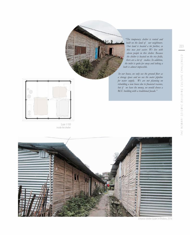
223
TH
E N
EW
AR
I S
EIS
MIC
BU
ILD
ING
CU
LTU
RE
CH
AL
LE
NG
ED
Scale 1/100Inside the shelter.
Entrance shelter cluster in Khokana, 2016
“The temporary shelter is rented and built on the land of our neighbours. Our land is located a lot further, so this was just easier. We live with eleven people in this shelter. Because the shelter is located on the rice fields, there are a lot of snakes. In addition,
the toilet is quite far away and taking a bath is almost impossible.
In our house, we only use the ground floor as a storage space and we use the water pipeline for water supply. We are not planning on rebuilding a new house due to financial reasons, but if we have the money, we would choose a RCC building with a traditional facade.”

224 This shelter has the same structure
as the previous one, but has an extra
insulation layer of red mud against
its walls. This type of shelter is most
commonly built by the association
Enfance Nepal.
B a m b o o w a l l e d s h e l t e r w i t h m o r t a r
Scale 1/100Axonometry.

225
TH
E N
EW
AR
I S
EIS
MIC
BU
ILD
ING
CU
LTU
RE
CH
AL
LE
NG
ED
“We live with eight people in this shelter that is now divided in two. Our shelter is placed right before our house, that had way more room. We do not pay rent for the shelter because it is located on public land. We built one part ourselves and the other part was funded.
Our relatives also built their shelter on the square. The climate of the shelter is
very extreme. In summer it is very hot during the day, but at night it gets very cold. We also have a lot of trouble with the mosquitos. All the shelters have the same kind of problems, so I do not think another type of shelter would be better. The house was a traditional Newari house with three storeys. Behind our house is a piece of farmland on which we cannot build, because it is the only land we own. We use it to grow fruit and crops, which is the main source of our income. Before, we used to have a balcony where we could dry our crops. Now we dry them on the roof of the shelter. We can still use the ground floor of our house as kitchen and living space, and in the back there is a place to storage our livestock. When we are going to rebuild our house, we want a traditional facade but a concrete structure, because we think it will be stronger.”
Scale 1/100 Inside the shelter
Exterior of the shelter in Bungamati, 2016Shelters at the edge of Khokana in the ricefields, 2016

226 Provided by the Danish People’s Aid,
these shelters have a timber loadbearing
structure and recognizable green walls.
This typology is especially prominent
in Bungamati, were none in Khokana.
D a n i s h Pe o p l e ’s A i ds h e l t e r
Scale 1/100Axonometry.

227
TH
E N
EW
AR
I S
EIS
MIC
BU
ILD
ING
CU
LTU
RE
CH
AL
LE
NG
ED
“We live with three people in this shelter and our house was located right across from it. We used to live with eleven people in the house, and for a few months all of us lived together in the shelter, then most of our family members moved to another shelter
close by. We used to live in a traditional Newari house with 3,5 storeys. Because
we only live with 3 people in the shelter, we have as much room as we had in our house. Because the kitchen is still located in the house, we still share it with the entire family. This shelter is only used for working and sleeping. The land here is rented, but the shelters to which the other family members moved are built on our own land. The shelter is funded by the Danish People’s Aid. We used to rent another place in Bungamati for woodcarving, but after the earthquake we also do the woodcarving in this shelter. We are very afraid of wild animals because we live so close to the forest. We are also scared of thieves because this place is so isolated, but at least we are satisfied with the type of shelter. When we are going to rebuild our house, I want a concrete building because we do not have enough money for a Newari house, and I think concrete buildings are stronger. I really want the windows to be carved like a Newari house though, so it would be a combination of modern and traditional.” Scale 1/100
Inside the shelter
Danish shelter at the edge of Bungamati, 2016Logo presented on the Danish shelters

228
The temporary shelters seem to become a long-term solution. This is mainly because
in order to start building, people need the funds provided by the government. To
receive the money, they need to have their design approved by the municipality
(Bastola S. Personal interview. 2016, October 10). However, the new by-laws for
traditional settlements are still not finalised and keep on being postponed, and as long as these by-laws are not finished, no plan can be officially approved. Hence, nobody from Khokana or Bungamati has received his grant yet.
Khokana has an additional problem to this: most inhabitants of the settlement do not
have an official land owner’s certificate (Bastola S. Personal interview. 2016, October 10). This creates extra difficulties, slowing down the reconstruction process drastically. Firstly, the government only gives the grants to inhabitants of the houses that have
officially been declared as damaged or collapsed by the survey of the National Society for Earthquake Technology (NSET). However, if the inhabitants do not officially “own” the house, they cannot receive the money because they cannot prove they own
a damaged house. Secondly, they cannot draw an official floor plan because legally they cannot make adjustments to houses they do not own.
While the reconstruction process is going slowly, there also is no plan for what to do
with the shelters afterwards. Either they will continue to take up valuable space, or
their materials will become part of the existing waste management problem.
This waste management problem arose along with the rapid urban growth when the
amount of solid waste reached new highs (Dangi et al., 2011). Since the 1980s there
was more attention for solid waste management (Pokhrel & Viraraghavan, 2005)
and since then, different institutions have been held accountable for developing
the sanitation. The Solid Waste Management and Resource Mobilization Centre
(SWMRMC) were the first to get the responsibility over the management of solid waste in the Kathmandu Valley. They received financial support from the German Technical Cooperation Agency (GTZ), but that ended in 1993. When the Local-
Self-Governance Act was established in 1999, the task was given to the different
municipalities, authorizing them to take action at a local level (Water Aid, 2008).
In Bungamati and Khokana, both part of the Karyabinayak municipality, solid waste
is collected twice a week and brought to the Okharpaunwa Landfill (Pokhrel & Viraraghavan, 2005). However, no further recycling is done there. Since the waste
collection is insufficient and poorly organised, many villagers tend to dump their waste in the forest, along the streets and even on the river banks since they do not
know where to leave it. In both Bungamati and Khokana there are several dumping
spots with large amounts of waste. This trend of dumping waste suggests the non-
reusable shelter materials will face a similar fate.
Shelters at the edge of Khokana
Fu t u r e a s p i r a t i o n s

229
TH
E N
EW
AR
I S
EIS
MIC
BU
ILD
ING
CU
LTU
RE
CH
AL
LE
NG
ED


C o n c l u s i o n
V I .
Both Bungamati and Khokana are situated in an earthquake vulnerable area,
insurmountably leading to earthquakes which occur with a cyclic frequency. Therefore,
the Newari building culture is strongly based on a seismic culture, present in both the
urban and architectural scale. However, due to a lack of knowledge and the advent of
modernity, the building culture is transforming.
The Newari architecture has evolved over centuries on a trial and error basis in
order to build structures which are earthquake resilient. However, since the ancient
building knowledge is only tacit, and in addition with the increasing use of modern
materials such as steel and concrete, the traditional building techniques are fading to
some extent. Regardless, the Newari building culture has exceptional qualities, which
should be preserved. An increased awareness can be perceived since the Government
of Nepal is working on National Building Codes, integrating distinct chapters about
the traditional core areas of Newari settlements. The building codes for the cores
prescribe rules that make sure the traditional architecture will be conserved.
In addition, there is a clear evolution within the urban tissue. The traditional core
of the Newari settlements has a unique and well thought out urban fabric. In
general, the core areas are shaped by auspicious forms, and a maze of courtyards
and kitchen gardens connect the inner tissue of the building blocks. However, this
ancient network is also exposed to contemporary conditions, both reshaping and
contributing to it. The expansion happens in a more random way than the traditional
organisation. A link between the vernacular and the contemporary is missing, leading
to a discontinuity in the urban tissue.

Both of the Twin Villages are rural and therefore agriculture based. A complex system
provided water both for irrigation and personal use in the past. However, while this
system is partially outdated, it is additionally compromised since the development
of the municipal water supply. Because the inhabitants started to prioritize the
modern water supply, the entire traditional system started to deteriorate. However,
the earthquake of 25 April 2015 and its aftershocks heavily damaged the waterpipes
of the modern system, causing the inhabitants to suddenly rely on their traditional
water sources.
The water from the vernacular water system is currently heavily polluted, because
it relies on contaminated groundwater. The lack of a proper wastewater system,
combined with an insufficient waste management system, has caused both waste and wastewater to simply flow into the rivers and ponds. The edges of the settlements are used as landfill areas, where the inhabitants discard their organic and non-organic waste. The harmful chemicals from the non-organic waste soak into the ground and
therefore pollute not only nature but also the groundwater.
The reconstruction process after the earthquake of 2015 offers an opportunity to
revive the Newari traditions, and simultaneously to revise them, in order to meet the
contemporary needs of Bungamati and Khokana.


PA R T T W OD E S I G N
S T R AT E G I E S F O R A R E I N T E R P R E T E D
S E I S M I C B U I L D I N G C U LT U R E


It is our aim to propose a reconstruction strategy, while respecting and reviving the
Newari building culture. The goal is to (re)design strategic parts of the village and
by doing this, prioritizing its durability and adaptability towards further exponential
urban growth.
First of all, a cooperative model of waste management is proposed. The design of this
model focuses on sorting and recycling waste in order to decrease the areas currently
occupied as landfill sites. Furthermore, due to the beginning of the reconstruction process, some temporary shelters are left deserted. In this regard, the question arises
on what to do with these uninhabited structures. People do not tend to clean them
up, and leaving them abandoned will waste a lot of fertile land. Therefore, the waste
management model will be supplemented by a collection of the various building
materials used for the temporary shelters.
The next aim is to restore and re-articulate the traditional water supply system. By
rethinking the vernacular system and complementing it, it will provide an integrated
use of traditional and modern where the municipal supply is insufficient, while at the same time it will be a useful backup during earthquakes. A proper wastewater system
is proposed, combined with additional features to maximize rainwater collection.
Recycled wastewater, rainwater and purified groundwater will, together with the municipal supply, meet the needs for water usage of the inhabitants. All of this will
be translated into the use of public space.
The last focus will be on the seismic building culture. Therefore, strategic locations
centred around traditional waterbodies are chosen where architecture will be the
key factor for the revitalisation of the various public places. By further detailing the
architectural scale, this design will equip the inhabitants with proper information to
build contemporary vernacular Newari buildings which are more sustainable, while
retaining the historical and cultural values of the Newari architecture.
S t r a t e g i e s


S t r a t e g y f o r t h e Tw i n V i l l a g e s
A strategy providing a solution in terms of waste and debris management. A collective structure, focusing on collecting, sorting and recycling, is implemented along the armature that connects both Newari settlements.
I .

240
As described in the analysis, the waste management of both settlements is not fully
developed. There is some sort of waste collection, however people tend to gather
their solid waste and subsequently bring it to one of the landfills at the edges of the settlements (Pokhrel & Viraraghavan, 2005). Some people even sort their waste but
dump it at the river banks afterwards, to make a statement towards the government
(Dangol B. Personal interview. 2016, October 9). Since all kinds of waste are
being dumped amidst nature, pollution of both the soil and the groundwater is an
insurmountable result (Pokhrel & Viraraghavan, 2005). In addition, people are slowly
starting to rebuild their houses and therefore leaving their temporary shelters. Once
they move out of the shelters, they are no longer of use and people are leaving them
scattered all over the edges of the settlements, occupying what could be fertile land.
Therefore, it is our aim to provide a waste and material bank, called the recycle bank.
This construction is a waste management system combined with an assembly and
recycle point for the materials of the abandoned temporary shelters.
The functioning of the proposed recycle bank is based on the system of waste
banks, which are already implemented in Thailand and a few other countries
(Singhirunnusorn et al., 2012). The idea is that the waste as well as the materials from
the (no longer useful) shelters are sorted and then brought to the recycle bank. When
bringing materials or waste to the recycle bank, you make a ‘deposit’. In return you get a certain credit according to the value of the materials that you brought in. The
value of the different possible deposits is documented in advance by specialists.
This system will stimulate the inhabitants to sort their waste and no longer dump
it in nature or on the streets. It might even motivate a few people in cleaning up
the contested areas, reducing the areas currently used as landfills and decreasing pollution (Brown & Milke, 2016). In addition, this recycle bank will create numerous
jobs, improving the economy of both settlements. Furthermore, the reconstruction
process might be slightly accelerated, since there is a recycling system for building
materials as well: this will turn the debris into a valuable resource in the recovery and
rebuilding process (Brown et al., 2011) and generate cheaper building materials. In
addition, people get a credit, which they can invest in reconstructing their houses.
R e c y c l e b a n k

241
ST
RA
TE
GY
FO
R T
HE
TW
IN V
ILL
AG
ES
Landfill at the west edge of Bungamati, 2016
Landfill at the west edge of Khokana, 2016 Landfill at the north edge of Khokana, 2016

242
The waste and various materials can be brought to the recycle bank any time. In
addition, the truck of the recycle bank will perform a solid waste collection twice
a week, giving the inhabitants the opportunity to deliver their waste in return for a
deposit.
However, the solid waste should be sorted in advance to further process it. Studies
show that 21% of the solid waste inside the Kathmandu Valley is recyclable (non-
organic waste), while an even larger proportion of 62% is compostable (organic
waste) (Pokhrel & Viraraghan, 2005). Therefore, the organic and non-organic
waste should be distinguished. Inside the recycle bank, the non-organic waste will
be further separated in three categories: plastic, metal and wood. The sorted non-
organic waste will be transported every month to a larger non-organic waste bank in
the city. In order to recycle the materials in specialized recycle factories, large amounts
of non-organic waste will be exchanged with India, since none of these factories are
settled in Nepal (Larsson et al., 2010). However, the organic waste will be further
processed locally, at the Biocomp Nepal factory located at the west edge of Khokana.
By composting it, valuable fertilizer for the agricultural fields is created.
In means of the building materials, masonry, wood, concrete and metal (including
CGI sheets) are separated. Intact bricks, good quality wood, bamboo and CGI
sheets can be further sold inside the recycle bank at a discount price, to stimulate
the inhabitants to use recycled materials. The damaged bricks will be exchanged with
the brick kiln of Bungamati, on the condition that no cement was added during
the construction or baking process. In addition, the bad quality wood will also be
transferred to the brick kiln in order to generate heat for the baking process.
Lastly, concrete will be exchanged with a cement factory, located in Kathmandu, to
re-use it for making high quality concrete.
WA S T E
OR
GA
NIC
WA
STEfertilizer for the fields, composted by
Biocomp Nepal located in Khokana
NO
N-O
RG
AN
IC W
AS
TE
p l a s t i c
m e t a l
p a p e rrecycling in India

243
ST
RA
TE
GY
FO
R T
HE
TW
IN V
ILL
AG
ESM
AS
ON
RY
WO
OD
CO
NC
RE
TEM
ETA
L
m e t a l
i n t a c t
d a m a g e d
b a d q u a l i t y
g o o d q u a l i t y
b a m b o o
Bungamati brick kiln© Kristine, 2017
selling at discount price/reused by ownerSource: Sidiq, 2016
selling at discount price for construction houses/reused by owner
selling at discount price for constructing lighter roof
C G I s h e e t s
recycling in India
recycling in cement factory, Kathmandu.© Saliy, 2016
selling at discount price for construction houses/reused by owner
D E B R I S & S H E LT E R M AT E R I A L S
recycling
heath production

244
In order to optimize the functioning and advantages of this recycle bank, a collective
system is proposed for Bungamati and Khokana, based on a cooperative model.
Therefore, the recycle bank will be implemented on the armature which connects
Bungamati and Khokana in order to minimize the distance for the inhabitants of
both settlements. Currently, the dumping spots are already located at the edges of
the settlements, so by implementing the recycle bank in between the villages, the
inhabitants do not have to walk that much further.
This location also ensures that the truck that collects the waste and debris, to transport
it to Kathmandu for further processing, can easily reach the recycle bank.
Site located on the connection road between Bungamati & Khokana, 2016
Current situation with rice fields and a number of abandoned temporary shelters, 2016
+ +
Recycle bank situated on the armature between Bungamati & Khokana and its accessibility
50 m
Temporary shelters
Buildings
People going to the recycle bank
Truck from Kathmandu going to recycle bank
Location of the dump spots


246
The building of the recycling bank is entirely constructed out of recycled materials
originating from temporary shelters. Various containers, made from brick, are
positioned underneath a collective protecting roof structure. The roof structure is
realised out of bamboo columns and beams, covered with corrugated iron sheets,
resembling the structure of most temporary shelters. Since the majority of the
shelters is constructed out of these materials, they can be recovered from the shelters
which are no longer in use.
The different containers vary in dimensions according to the category of waste
that they will collect. The average inhabitant of a municipality with less than 20 000
inhabitants inside Nepal produces 0,25 kg of solid waste per person per day of non-
organic waste (UNEP, 2001). If this kind of waste is collected by a truck once a
month, there will be approximately 75 000 kg of solid waste. This needs a container
of almost 55 m2. In addition, almost two-thirds of the solid waste is organic (UNEP,
2001), resulting in a container of 35 m2 for the organic waste and one of 20 m2 for the
non-organic waste. Since the waste will be collected more frequently (approximately
once a month) by the Biocomp Khokana and a truck from Kathmandu respectively,
these containers are located at the streets.
The dimensions of the containers used for the building materials are reasoned
according to the amount of materials and their average dimensions. Therefore, the
containers for both wood and CGI sheets are larger since these elements tend to
have bigger dimension and are more difficult to transport. For the same reason, these containers are also located closer to the street. The container for the masonry
has larger dimensions as well, since this represents a respectively large share of the
building materials inside the Newari settlements. The container for rests of concrete
is relatively small since almost no shelter uses this material.
Scale 1/150Section recycle bank

247
ST
RA
TE
GY
FO
R T
HE
TW
IN V
ILL
AG
ES
Entrance to the recycle bank

248
The different containers vary in dimensions according to the category of waste
that they will collect. The average inhabitant of a municipality with less than 20
000 inhabitants inside Nepal produces 0,25 kg of solid waste per person per day of
non-organic waste (UNEP, 2001). If this kind of waste is collected by a truck once
a month, there will be approximately 75 000 kilograms of solid waste. This needs
a container of almost 55 m2. In addition, almost two-thirds of the solid waste is
organic (UNEP, 2001), resulting in a container of 35 m2 for the organic waste and
one of 20 m2 for the non-organic waste. Since the waste will be collected more
frequently (approximately once a month) by the Biocomp Khokana and a truck from
Kathmandu respectively, these containers are located at the streets.
The dimensions of the containers used for the building materials are reasoned
according to the amount of materials and their average dimensions. Therefore, the
containers for both wood and CGI sheets are larger since these elements tend to
have bigger dimension and are more difficult to transport. For the same reason, these containers are also located closer to the street. The container for the masonry also
has bigger dimensions since this represents a respectively large share of the building
materials inside the Newari settlements. The container for remainders of concrete is
relatively small since almost no shelter uses this material.
Since the structure of the recycle bank is spacious and easily adjustable, debris from
the damaged buildings caused by the earthquake can also be collected at this point.
Research has shown that disaster waste management is an important factor in coping
with a (natural) disaster (Brown et al., 2011; Fetter & Rakes, 2011; Baycan, 2004).
Poor management has a negative impact on the recovery and environmental health.
Therefore, providing a material collection point after an earthquake is an important
factor in the disaster management (Brown et al., 2011). In addition, planning this
management of disaster waste will make the strategy more effective. If a collection
point is marked in advance, the information can be spread among the inhabitants,
increasing the preparedness in the sense that inhabitants and aids know where bring
the debris. In addition, larger open spaces can be kept clear, contributing to the safety
during aftershocks.
Currently, the guthi system and their rituals play an important role in coping with
disasters (Bhandari et al., 2011). Bhandari even suggest that following the authorities
of the guthi system might increase the efficiency of disaster management (Bhandari et al., 2011). The guthis engage in cleaning up debris and guthi buildings are even used as
storage spaces after a natural hazard. However, the available storage space is limited.
This post-disaster extension of the recycle bank will provide an appropriate support
to complement the existing guthi system in means of disaster management.

249
ST
RA
TE
GY
FO
R T
HE
TW
IN V
ILL
AG
ES
55 m2
20 m2 47 m2
20 m2
35 m2
38 m2
Scale 1/250 Layout of the recycle bank


B u n g a m a t i : r e t h i n k i n g
w a t e r c y c l e sYanne Gillekens & Katrien Valcke
__
Building further on the “Action plan for Bungamati”, this design proposal focuses on water management in Bungamati. Water shortage and water contamination are an ongoing problem in the settlement. At the same time, water has always played an important role in the social and cultural life of the Newars. This design aims to restore these values by combining and completing traditional and modern water management.
I I .

252

253
BUNGAMATI


I n t r o d u c t i o n
1 .

256
Foto waterbody? Evt oude foto aan spouts?
Ancient stone spout. © Gutschow, 2011
1/2500
Bungamati was built on a hill between two rivers, the Bagmati river and the Nakhu
river, in order to maximize the surrounding agricultural fields and at the same time be safe from flooding. However, providing water on top of a hill is more difficult than in a valley or at the base of a slope, where most water sources are located. The
climate complicates the situation even more: 80 to 90% of the rain falls during the
rainy season, which lasts only four months (from June until September) (Becker-
Ritterspach, 1995).
Therefore, systems had to be developed to keep the water supply on a constant
level. In each village, ponds or pukhus were dug. In Bungamati there are six ponds,
varying in size, and with a total surface of circa 5 300 m². There are two tables of
groundwater: a shallow and a deep aquifer (Pandey et al., 2010). Since the ponds
constantly feed the shallow aquifer, water can directly be extracted from it by using
the wells (kuva) and stone spouts (hiti). Consequently, the shallow aquifer can be seen
as an enormous water reservoir, allowing the villagers to have clean water throughout
the year, even during the dry season. This system has been functioning for hundreds
of years. Additionally a large part of the social life took place around the ponds and
spouts.
Irrigation canal or creek
Plastic water tank
Traditional well
Stone spout
Concrete water tank
Non-active traditional waterbody
Gutter for rainwater
Sewerage network
Connection with Rajkulo

257
BUNGAMATI

258
For centuries, the ponds were supplied by a canal: the Rajkulo or royal canal
(Becker-Ritterspach, 1995). The state of the royal canal was very bad, but the NGO
“Evrionment and Heritage Conservation Nepal” (EHCN) is currently restoring it
with funds of the Indian government (Bisht, 2011; Aryal, 2005). The restored Rajkulo will provide water for 40 000 inhabitants of Patan and irrigate 450 hectares of land
(Aryal, 2005). However, it is unclear how much of this water will eventually reach
Bungamati.
Due to the urban growth, the recharge area of the groundwater decreased very fast,
which has resulted in a lower groundwater table and the malfunctioning of wells and
stone spouts. Additionally, the growing population caused increasing pollution of the
groundwater. Bungamati has a sewer system, but the unclean water is discharged at
the borders of the town and flows to the nearest river.
In Bungamati, the modern tap water was introduced around 30 years ago (Webb &
Bajracharya, 2016). The water originates from two reservoirs, the Sivapuri reservoir
and the Parphing reservoir (Gurung, 2000).
Dried spout and deteriorated pond in Bungamati, 2016

259
BUNGAMATI
Cleaning up of Dyo Pukhu, Bungamati. © Tuladhar, 2017
A consequence of the introduction of the modern water supply system is that the
majority of the households are no longer depending on the traditional water system,
which caused the vernacular waterbodies to be rather neglected (Gurung, 2000). Over
decades, the maintenance of the water bodies has fallen into oblivion. Nevertheless,
there seems to be renewed attention for the vernacular water management: one of the
ponds, Dyo Pukhu, is currently being revitalised under the guidance of UN-Habitat.
Our design focuses on three aspects: wastewater treatment, rainwater collection and
revitalising public space. All three are connected to each other.

260
w a s t e w a t e r t r e a t m e n t r a i n w a t e r c o l l e c t i o n

261
BUNGAMATI
Overview of all water-related interventions
r e v i t a l i s i n g p u b l i c s p a c e


W a s t e w a t e r t r e a t m e n t
2 .

264
One of the main problems in the overall water management is the contamination of
water: groundwater for household use, and irrigation water for agricultural purposes,
get heavily polluted due to the lack of a proper wastewater system. The entire sewage
system needs to be examined and possible repaired or replaced, since many pipelines
got broken during the 2015 earthquake. Some parts of the settlements even lack a
connection to the sewer pipelines.
Additionally, there needs to be a thorough investigation of how contaminated water
can be treated. Nowadays, the wastewater simply flows into the rice fields and further down to the river. However, correctly treated wastewater can be used to irrigate the
rice fields. In Studio Kathmandu volume 2, Valentina Amaya calculated that one hectare of agricultural land needs approximately 2 350 mm of irrigation (Amaya
Marin et al., 2015). These needs are easily met during monsoon, but become more
problematic in dry season.
Although the amount of treated wastewater cannot cover the total water demand
for irrigation, it can offer a solution in terms of a constant basic supply throughout
the year. Another option, referring to the calculations of Valentina Amaya, is fully
irrigating a limited amount of 100 hectares land all year long. In these calculations, 40
litres per person per day of wastewater was taken into account.
A sewerage system is thus crucial for the preservation of the traditional water system.
Equally important is the treatment of wastewater, so it can be reused. To treat the
wastewater from black water to irrigation water, two stages are implemented in
Bungamati: biogas tanks are installed at the end of the sewer pipes for the primary
treatment of the water, and three large reed beds are implemented for the secondary
treatment. After that, the purified water can flow to the fields through irrigation canals.
Splash and WaterAid Nepal both have funded projects regarding water sanitation and
providing drinking water in the valley before. They could be interested to become
stakeholders for this project.
1/2500
Masterplan for wastewater treatment in Bungamati
Sewerage network
Biogas tank
Reedbed
Irrigation canal or creek
Rice field
Cornfield

265
BUNGAMATI

266
S e w e r a g e s y s t e m
The existing sewerage network is incomplete. It consists of three separate networks
that all have their own ending point at the edge of town. Currently the ending points
are simply dumping spots where the wastewater flows down the hills, through the rice fields and ultimately into the river.
The network needs to be updated and completed to provide the entire settlement
with a sewer.
Because the pipelines need to be resistant to several earthquakes, Earthquake Resistant
Ductile Iron Pipes (ERDIP) can be considered (Oda et al., 2015,; Haddaway, 2015).
The Japanese Kubota Corporation provides pipes that can withstand earthquakes
with a magnitude of up to 9.0. This would of course be a big financial investment, but it is a crucial consideration, since without earthquake resistant sewerage systems,
the groundwater could be contaminated each time there is an earthquake, increasing
the chances of epidemics.
Earthquake Resistant Ductile Pipes. © KUBOTA, 2017

267
BUNGAMATI
Current sewerage system
Proposed, completed sewerage system
1/5000
1/5000
Network 1
Network 2
Network 3
Network 1
Network 2
Network 3
New sewer

268
B i o g a s
When wastewater is left to rest in an airtight tank, an anaerobic environment is
created (Eawag & Spuhler, 2014). This breaks down the pollutants in black or grey
water. During the fermentation process, a combination of methane, carbon dioxide
and rest gases is formed, called biogas. For this process a temperature between 20-35°
C is needed. The pressure of the gas pushes silt into the expansion chamber, where
the digestate remains. This can be used as a fertilizer. The gas itself is pushed to the
top of the tank by its own pressure, where it can be collected in tanks or distributed
by pipelines. The effluent is sent further to the reed beds for secondary treatment.
The energy of biogas is 6 kWh/m³ (Sasse, 1988). An average human person can
provide for 0,02 m³ biogas per day (Eawag & Spuhler, 2014). Bovine animals,
however, can produce 0,4 m³ gas per kg dung. In this design strategy the assumption
is made that only human waste is added to the tanks in Bungamati, but there probably
will be a certain surplus if the dung of their livestock is added.
Part of the sewerage network in Bungamati, 2016
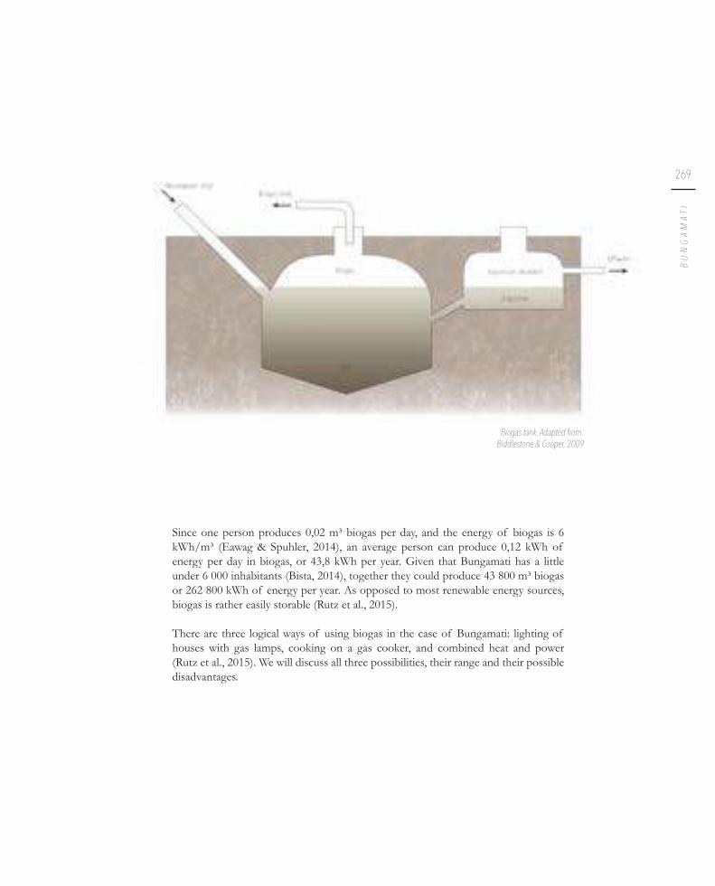
269
BUNGAMATI
Since one person produces 0,02 m³ biogas per day, and the energy of biogas is 6
kWh/m³ (Eawag & Spuhler, 2014), an average person can produce 0,12 kWh of
energy per day in biogas, or 43,8 kWh per year. Given that Bungamati has a little
under 6 000 inhabitants (Bista, 2014), together they could produce 43 800 m³ biogas
or 262 800 kWh of energy per year. As opposed to most renewable energy sources,
biogas is rather easily storable (Rutz et al., 2015).
There are three logical ways of using biogas in the case of Bungamati: lighting of
houses with gas lamps, cooking on a gas cooker, and combined heat and power
(Rutz et al., 2015). We will discuss all three possibilities, their range and their possible
disadvantages.
Biogas tank. Adapted from: Biddlestone & Cooper, 2009

270
The caloric efficiency of a biogas lamp is 3% (Eawag & Spuhler, 2014), which means that compared to the produced biogas, only a small fraction will actually be
used. Given that one lamp needs 0,1 m³/h of biogas (Eawag & Spuhler, 2014), and
assuming one family will use an average of four lamps at once for four hours per
day, one household will need 876 m³ biogas per year for their lamps on average. This
means at these rates, 50 households can use biogas lamps throughout the year in
Bungamati.
It is clear that biogas lamps have a low efficiency. It should also be noted that biogas lamps can get very hot and can therefore form a fire hazard if they are placed directly underneath the roof (Sasse, 1988). The biogas needs to be mixed with oxygen for
the lamp to work.
Biogas lamp. © Maruli, 2012
L i g h t i n g

271
BUNGAMATI
L i g h t i n g C o m b i n e d h e a t & p o w e r ( C H P )
To provide electricity and heat, the biogas needs to be dried and cleaned first (Rutz et al., 2015). Normally, a CHP unit can produce about 35% electricity and 65% heat.
This means a biogas tank has an energy efficiency of up to 90% when it comes to CHP. However, in winter a small percentage of the heat is needed to fuel the biogas
plant, in order to maintain the required temperature for the fermentation process
(Sasse, 1988). The remaining heat still accounts for up to 80% of the produced heat,
which means still 52% of the original energy can be used as heat for central heating.
If the efficiency for electricity is 35%, then the inhabitants of Bungamati can together produce 91 980 kWh of electricity per year. An average Nepalese household uses 331
kWh of electricity per year (Enerdata & World Energy Council, 2016), which means
there would be electricity for 278 households. However, an average Indian household
already uses over 1 000 kWh per year, so it is safe to assume the consumption in
Nepal will rise quickly. We will therefore calculate with a consumption of 900 kWh
per year per household. This means the electricity produced by the biogas tank will
be able to provide electricity for at least 102 families.
With a heating efficiency of 52%, 136 656 kWh per year can be yielded for heating. Given the mild climate of the Kathmandu Valley, it can be assumed that heating is
only necessary during the colder winter months. This means that there are rather low
needs for heating, compared to Northern European countries. Assuming an average
need of 120 kWh/m² per year for one household (European Environment Agency,
2013) and 90 m² of area in a house that needs to be heated (public spaces, restrooms,
storage rooms,… are excluded), an average family in Bungamati would need 10 800
kWh of energy per year for heating. Around 12 families can therefore use the energy
of the biogas tank for central heating. Since this is rather few, it would be more
interesting to use the heat for guthi buildings or other public buildings.
CHP units have high initial costs, and installing district heating takes great effort (Rutz
et al., 2015). The cost also increases with the length of the pipelines between the tank
and the eventual household, so the distance between the tank and the household
should not exceed 4 km.
Electricity wires on the road between Khokana and Bungamati, 2016

272
1/2500
Location of the biogas tanks: current wastewater dumping spots
Sewerage network
Biogas tank
The last option for biogas usage in Bungamati is a simple gas cooker. The efficiency of biogas in this case is 55%, so it is still lower than CHP but a lot higher than the
efficiency of lamps (Eawag & Spuhler, 2014). An average household in Bungamati will need 1,35 m³ biogas per day for cooking (Eawag & Spuhler, 2014), or 492,75 m³
per year. The conclusion is that around 89 households can cook on biogas.
A fixed-dome biogas tank should always be under pressure, so it must never be empty (Sasse, 1988). If not, cracks can appear in the brick dome because of the lack of
pressure from the inside, which can cause great gas losses. The inlet and outlet pipe
must not be in the gas zone. The only way to reach the gas is through the sealed
opening at the top of the tank. A fixed-dome has a longer lifespan than the so-called floating dome variant and has low installation costs (Eawag & Spuhler, 2014). Since it is an underground construction, it does not require a lot of space. For one person,
a tank of 1 m³ or 1 000 l is sufficient. Logically, for Bungamati, a tank of 6 000 m³ would be sufficient. Since reed beds will be planted on three locations, this volume can be spread over these three locations, so 2 000 m³ each.
The pressure of the gas decreases with the length of the pipes (Khoiyangbam et
al., 2011). If the distance between the gas tank and the consumer is over 2 km, an
additional pump is needed to transport the gas. Since there are three locations on
which the biogas tanks will be installed, the distance will never exceed these 2 km.
Given the high costs of CHP units and the low efficiency of biogas lamps, the easiest application of biogas in Bungamati would be cooking on gas cookers, although the
other applications also remain an option. For cooking, people can easily go to the
tank and fill up a personal tank so no additional pipelines are needed. Given the explosion danger of biogas, no large amounts of the gas should be stored inside a
house.
C o o k i n g
D e s i g n c o n s i d e r a t i o n s a n d c o n c l u s i o n
Gas cooker in Bungamati, 2016

273
BUNGAMATI

274
R e e d b e d s
Reed beds or constructed wetlands can be used to treat wastewater in a natural way
(Biddlestone & Cooper, 2009). There are two main types of reed beds: horizontal
and vertical reed beds. For secondary water treatment, a vertical reed bed is needed.
Reed beds. © Cress Water Solutions
1/2500
Overview of the three reedbeds, biogas tanks and their connection to the new sewerage network.
Sewerage network
Biogas tank
Reedbed
Irrigation canal or creek
Rice field
Cornfield

275
BUNGAMATI

276
In general, all reed beds work according to the same system. Emergent water plants
are planted in a matrix of sand and gravel (Biddlestone & Cooper, 2009). The largest
particles, like small stones and rough gravel, are at the bottom, whereas the finest particles are on top. Sand forms the top layer. The vegetation of the reed bed is
specially selected. Common reed (Phragmites Australis) and great reedmace (Typha
Latifolia) are very suitable. The most important feature of these plants is that they
have a root structure called “rhizomes”. The rhizomes consist of thick, hollow
stems from which the roots then hang down. The plants extract oxygen from above
the water surface and this oxygen is brought down through the rhizome structure.
This allows for large colonies of aerobic micro-organisms to live underneath and
in between the roots. The anaerobic micro-organisms then cluster at a different
location, further away from the roots. This creates underground zones of alternating
aerobic and anaerobic microbial populations.
The wastewater is spread across the surface and slowly dribbles to the bottom
(Biddlestone & Cooper, 2009). Apart from initiating the aerobic microbial population,
the rhizosphere also ensures hydraulic conductivity. While the water dribbles through
the matrix, it encounters the two opposite types of microbial populations. These will
modify the polluting components of the wastewater: carbonaceous, nitrogenous and
phosphate contaminants will be converted.
In a vertical reed bed, it is important that the water is conveyed in phases in order
to give the water the needed time to percolate through the matrix. To ensure this, a
regulating device is needed. A siphon is a good choice for this, because it requires no
power.
Greater reedmace - Typha Latifolia© Jeffrey Kontur, 2008
Common reed - Phragmites© Thinglink, 2015

277
BUNGAMATI
While the water drains, extra oxygen is drawn into the reed bed. This can be
combined with perforated pipes to conduct even more oxygen into the matrix. The
large amount of oxygen and thus aerobic micro-organisms is what makes a vertical
reed bed so suitable for secondary wastewater treatment, more particularly, ammonia
removal (nitrification) and removal of biochemical oxygen demand pollutants.
The inlet and outlet pipes should have a diameter of 100 mm and be made out of
PVC (Lismore City Counsel). In the inlet pipes, holes of 5 to 10 mm can be drilled
to allow the effluent to easily spread across the reed bed. The inlet pipe lies just underneath the surface to protect it against animals or vermin and to avoid the escape
of unpleasant smells.
Reed bed. Adapted from: CAT

The processes of breaking down the pollutants takes time. In order to be sufficiently cleaned, the water thus needs a residency of five to seven days (Lismore City Council, 2005). Therefore, the geometry and sizing of a reed bed is essential for it to function
properly. For a reed bed with a depth of 75 cm, 3 m² per person is needed. In
this design the reed bed is deeper than 75 cm. Moreover, the larger the amount of
people the reed bed is for, the smaller the required area is, even as small as 1 m² per
person. It is therefore a safe assumption to calculate with 2 m² per person (Centre
for Alternative Technology, 2016). Bungamati had a population of a little under 6
000 people in 2011 (Bista, 2014). Therefore, a reed bed of approximately 12 000 m²
in total is required. The reed beds are divided over three different spots, namely the
locations where the wastewater is currently being dumped. The conclusion is that an
area of 4 000 m² per spot is needed. However, since Bungamati is expected to grow
with more or less 2 500 people (Bruneel et al., 2016) it is better to already install a
reed bed that allows for expansion. A total area of 17 000 m² of reed beds would be
needed to incorporate the urban growth. Each of the three zones therefore needs a
reed bed of 5 667 m². Since the reed beds are located at the edges of the town, this
does not create a problem. For the first stage of the project, only the current need of 4 000 m² per reed bed will be provided. In later stages, the remaining 1 667 m² can be
added.
1/1500

The slopes at the edges of Bungamati are perfect for the reed beds. In vertical reed
beds, a difference in height of at least 1,5 m between the inlet and outlet is required to
avoid the need for pumps or other mechanical devices (Lismore City Council, 2005;
Centre for Alternative Technology, 2016). In this case, the slopes are steeper than
necessary, but that can easily be solved by simply placing the reed beds in a series of
terraced beds. This also immediately solves the problem of the size of the reed beds.
For reed beds in series, the highest reed bed always has a higher risk of clogging than
the others. Therefore in this case it is even more important that the reed beds follow
the primary treatment of the biogas tank. The retention time of the water will be
divided between the different beds of the series.
Based on the retention time and the overall geometry, the reed beds will be subdivided
in 50 smaller beds of 80 m² each (Schierup et al., 1990). The two most northern reed
beds touch one another but work separately.
The design of the reed beds follows the natural topography of the landscape. The
existing trees are left on their original location as much as possible, in order to provide
shade against evaporation and to prevent landslides. In addition, combined with the
paths and stairs, this creates a pleasant landscape.
1/1500

280

281
BUNGAMATI
Constructed wetlands creating a public space

282

M a x i m i z i n g w a t e r c o l l e c t i o n
3 .

284
W a t e r s u p p l y
Approximately 70% of the households in Bungamati have a private connection to
the modern water supply (Webb & Bajracharya, 2016; Bista, 2014). The majority of
these households use this water as drinking water, but also for secondary purposes
such as washing, cleaning and flushing the toilet (Webb & Bajracharya, 2016). For the less fortunate inhabitants, there are ten big concrete water reservoirs spread over the
village. This water is mainly used as drinking water, but a third of the population uses
it for secondary purposes too. For these secondary purposes, the use of rainwater
and water from the wells is a popular alternative for respectively about 50% and 70%
of the population.
Due to the earthquake of 2015, the majority of the houses in Bungamati are severely
damaged or destroyed. Furthermore, the water pipelines of the municipal water
supply were broken, causing a severe water shortage one month before the beginning
of the monsoon. Fresh drinking water had to be delivered in bottles and by tankers,
while water for other purposes, such as cleaning, was provided by the traditional, albeit
deteriorated, water system. Even though the water supply has been repaired by now,
the availability of sufficient water remains a problem. There is only water available a few hours a day, according to the schedule of Kathmandu Upatyaka Khanepani
Limited (KUKL) (Kharel, 2014). During this time most families tap as much water
as possible and store it in big plastic containers. However, the quality of the water
remains questionable. On top of that, the containers used to store the water add extra
weight to the top floor of the house, which increases the effect of an earthquake.
Plastic water tank on top of non-functional well, and concrete water tank next to pond in Bungamati, 2016

285
BUNGAMATI
Percentage of villagers using a certain water source before the earthquake.Adapted from: Webb & bajracharya, 2016
When the municipal water supply was no longer available after the earthquake, other water sources gained

286
1/2500
Irrigation canal or creek
Plastic water tank
Traditional well
Stone spout
Concrete water tank
Non-active traditional waterbody
Gutter for rainwater
Existing condition of waterbodies in Bungamati
In order to improve this situation, several calculations were made to examine whether
the traditional water system can be upgraded, or if alternatives are possible. Since
the water of the NWSC is now by a large part of the inhabitants also being used
for secondary functions, restoring and rethinking the traditional water system could
help relieve the pressure on the municipal supply. At the same time, a functioning
traditional system will provide a useful back-up during emergencies.
The Kathmandu Valley Preservation Trust has helped in restoring a traditional hiti and several squares. They might be interested in becoming funders for this project.
As mentioned, Splash and WaterAid Nepal both already have funded actions in the
Kathmandu Valley related to water sanitation and drinking water. They could be
possible stakeholders for this part of the project as well.

287
BUNGAMATI
Bungamati consists of 1 304 households, 5 966 residents and has an area of 4,03 km²
(Bista, 2014; Shrestha, 2001). When calculating the amount of water that possibly
infiltrates and contributes to the groundwater level in Bungamati, the area that lies lower than the town centre, and so below the pukhus, kuvas and hitis, cannot be taken
into account, as it does not contribute to the collection of rainwater. Therefore,
another area needs to be determined. The zone above the centre, even when it is
geographically not a part of Bungamati, does contribute. This constitutes a total
contributing area of roughly 400 000 m². Of this surface approximately 39 000 m² is
roof area, 25 000 m² is paved area and 5 300 m² are ponds.
The next factor to consider is the amount of rain per year. In Nepal the yearly average
rainfall amounts to a volume between 1 400 and 1 740 mm/m² (Thapa et al., 2008;
Shukla et al., 2012). During the wet season, which lasts roughly 4 months (June –
September), an average of 280 mm/m² of rain falls in the Kathmandu valley, while
in the dry season this is significantly less. The following graph presents the amount of rain each month.
Wa t e r t a b l eh i g h e s t l e v e l
Wa t e r t a b l el o w e s t l e v e l
G r e y / B l a c k Wa t e r r e u s e G r e y / B l a c k Wa t e r r e u s eR a i n Wa t e r Co l l e c t i o n
G r o u n d w a t e r r e c h a r g e
Using an average yearly rainfall of 1 500 mm/m², and assuming all water infiltrates in the ground, 600 000 m³ water could be added to the groundwater. The actual amount
will be lower, since water evaporates and/or flows to lower areas.
A study in preparation of the Melamchi project showed that the average water
consumption in Nepal amounts to 73 litres per capita per day (Joshi et al., 2003).
Assuming that approximately 50% of this volume is needed for drinkable water,
about 35 litres per day are needed for all other functions. In order to relieve the
pressure on the modern supply, rainwater could be used for these other purposes.
Source: Amaya Marin et al., 2015

288
M i c r o s c a l e r a i n w a t e r h a r v e s t i n g
Currently, the rainfall on the roofs is not yet systematically collected. Some houses do
have plastic tanks to harvest rainwater. This water is used in the home garden as well
as for cleaning and washing. However, because of the long dry season, these tanks
are only useful during a small part of the year. Therefore we examined whether the
investment in a direct collection system of water is feasible.
To give a well-founded answer, some data is needed. In Bungamati, the roof of an
average house has an area of 40 m² . Further, the average household in Bungamati
consists of 4,58 persons (Bista, 2014). When assuming that an average person uses
35 litres of water each day, each household would have a daily water consumption of
160 litres. Processing all these data into a table, there would be a water surplus four
months (June to September). Calculated over a whole year, this consumption level
would result in a small water excess.
S c a l e 1 / 5 0I m p l e m e n t a t i o n o f r a i n g u t t e r
Rainfall on roofsurface per household

289
BUNGAMATI
The only remaining problem is how to store the water. The answer came by looking
into the functioning of the traditional water supply. The characteristics of the soil in
the Kathmandu Valley, a deep and shallow aquifer separated by a 200 m thick clay
layer, make it a natural water reservoir (Pandey et al., 2010).
The rainwater from the roofs is guided through rain pipes to recharge areas nearby,
ideally on the courtyard. These recharge areas consist of different types of gravel and
sand, so rainwater can infiltrate easily into the ground, where pollutants stay behind. A well in the recharge area provides direct access to the groundwater and a collective
water pump supplies the surrounding houses. This water pump is supported by a
stainless steel grating that can be adjusted in depth, avoiding soil to penetrate into the
pump. The electricity for a collective pump can be provided by solar panels on the
roofs to pump up the water from the shared well.
Schematic section of shared well

290
Pavement patterns in Bungamati
1/2000
S t r e e t s d i r e c t i n g t h e w a t e r
Since it might take some time before all houses have a connection to the shared well,
a functioning traditional system is still needed for the other inhabitants. Restoring the
vernacular water system will at the same time help reviving the public spaces around
the traditional waterbodies.
Most of the streets are paved with bricks, local natural stone or concrete. In most
cases the streets do not have a gutter and the rainwater ends up in a half open sewer,
guiding the water to the edges of town together with the wastewater. Sporadically
there is a gutter at the side of the road, but these gutters almost always lead the water
ultimately to the sewerage system as well.
Different types of gutters in Bungamati, 2016
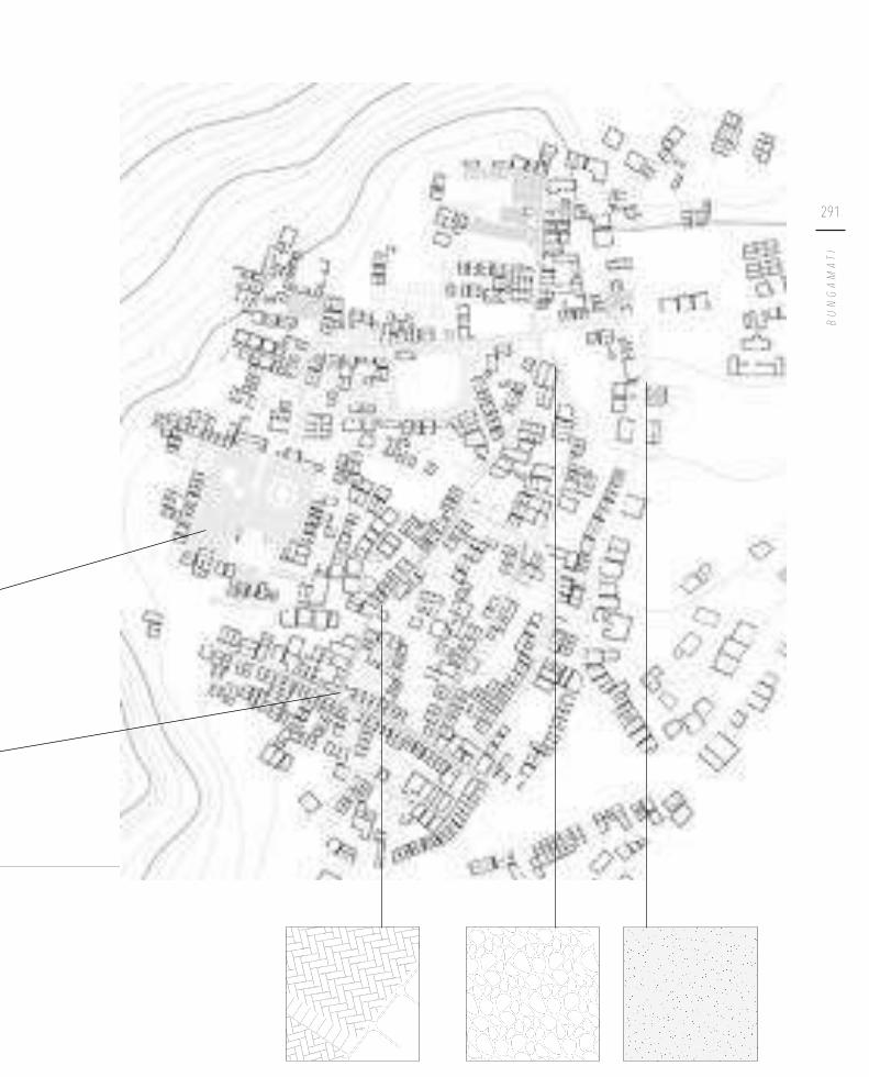
291
BUNGAMATI

292
Each street should have both a closed sewer (to prevent rainwater from getting in) and an open gutter
Leading the rainwater to the sewerage is an enormous missed opportunity. Providing
all the paved streets with a proper rain gutter, leading the water to recharge areas or
ponds, would help increase the groundwater level. Nowadays only the ponds (and the
non-paved areas) recharge the groundwater. The rainfall collected directly into the
ponds is approximately 7 844 000 litres per year. By guiding the water from the streets
to the pukhus, this yearly average can be multiplied almost six times. Because of large
evaporation rates, not all of this water will penetrate into the ground. Nevertheless,
the gains by providing gutters in the streets are substantial.

293
BUNGAMATI
Current rain gutters
Proposed completion of gutters to direct rainwater towards ponds
1/5000
1/5000
Existing gutter
Location where rain flows into the sewer
Existing gutter
New gutter

294
Furthermore, the rainwater flowing to the ponds will first be guided through a sedimentation pit and/or sand filter. The purpose of this filter is to clear the fixed particles in the water in order to prevent the clogging of the ponds and facilitating
maintenance. The ponds will also be redesigned with attention for the natural
ecosystem. Nowadays most of the ponds are surrounded by walls, obstructing the
flow of rainwater. Additionally there are no banks or water plants supporting the natural ecosystem of the ponds.
Current state of the ponds

295
BUNGAMATI
The walls will be removed and banks with a height-to-width ratio of 1:3 will be
implemented, together with several emergent water plants. This will allow oxygen
to flow through the water, thus naturally regulating the ecosystem and purifying the water.
Proposed solution

296
C o n c l u s i o n
Implementing small-scale rainwater harvesting spots can provide for up to 50% of
the average household needs, or 35 litres per day per household. On top of that,
restoring the vernacular system and recharging the groundwater level will revitalise
an important Newari tradition. It will also be a solution for those who will not
immediately have a connection with a shared well. Thus, combined with the municipal
supply and the proposed wastewater treatment, the household and irrigation needs
of Bungamati could be fulfilled. This also implies that, in time, the private watertanks to store water from the municipal supply will become smaller. Once the Melamchi
project is complete, they might even disappear completely.
1/2000
Irrigation canal
Existing gutter
Traditional well
Stone spout
New gutter
Completed cycle of rain gutters and redesigned ponds

297
BUNGAMATI


Pu b l i c s p a c e s h a p e d b y w a t e r
4 .

300
S t a r t e r p r o j e c t s a r o u n d w a t e r b o d i e s
In the past, the ponds were connected to each other with earthen conduits. However,
these connections got lost over time. They will now be restored, though in a slightly
different way: there will be two cycles of three ponds each, instead of one larger
cycle. By working with smaller cycles, the pipelines are shorter and therefore easier to
implement. This also reduces the risk during earthquakes: shorter pipes have a lower
risk of breaking at a given point. On top of that, when one pipe breaks, the entire
system will not fail: there is always still the other cycle.
The restored traditional water system and the renewed connections provide an
opportunity to shape the public spaces in relation to the water. Water has always
played an important role in the cultural and social life of the Newars, so it is only
appropriate that it is rehabilitated as having more value than merely water supply. By
redesigning the ponds ecologically while at the same time creating a pleasant public
space, this cultural and social aspect can also be restored. When the stone spouts and
wells will work properly again, they in turn will create a more lively atmosphere.
N a a Pu k h u
Po Pu k h u
K h a Pu k h u
D y o Pu k h u
D h o k a p i n i Pu k h u
1/3000

301
BUNGAMATI
The two cycles are surrounded by heavily damaged and collapsed houses, making
them ideal as starter projects. UN-Habitat is currently working on a design around
Dyo Pukhu. The last part of our design will therefore focus on the other cycle.
No visible damage
Minor cracks
Major cracks
Storeys removed for safety reasons
Partially collapsed
Completely collapsed
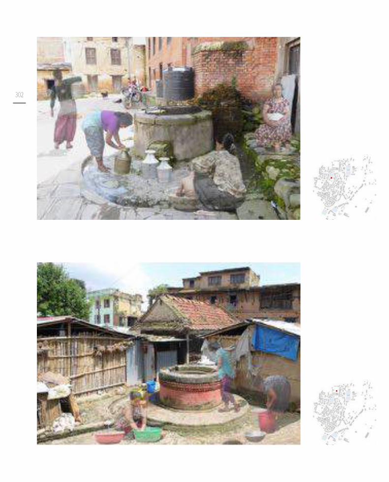
302

303
BUNGAMATI
The restored ponds will function as starter projects: by becoming lively public
spaces, more reconstruction projects will easily follow. Due to recharged and cleaner
groundwater, the spouts and wells will start working again, and the areas around them
will then in turn become more vibrant places. That way, the waterbodies all around
the settlements will catalyse further reconstruction.

304
Bladderwort - Utricularia Vulgaris Hair grass - Eleocharis Acicularis Curly pondweed - Potamogeton Crispus
Cyperus Corymbosus
Cyperus Exaltatus Cyperus Pangorei Hydroclaris Dubia Common reed - Phragmites
White Lotus - Nymphaea Lotus Monochoria Sparganium Emersum Greater reedmace - Typha Latifolia
Overview of emergent aquatic plants that can be planted alongside the banks of the pondsImage credits in bibliography

305
BUNGAMATI
Ziziphus budhensisThe seeds of the fruits are used to make malas (Buddhist prayer beads)
Butea MonospermaThe flower is used to worship Lord Shiva
Peepal tree - Ficus religiosConsidered sacred in Hinduism and Buddhism
Axlewood - Anogeissus Latifolia
Litsea CubebaThe wood can be used for woodcarving
Magnolia campbellii Hydroclaris Dubia
Rhododendron ArboreumThis shrub grows the national flower of Nepal
Nepalese bell - Capsicum Annuum LongumChili peppers grow on this plant
Taxus SumatranaNight blooming Jasmine - Nyctanthes Arbor Tristis
Sorbus Insignis
Overview of trees and shrubs that can be planted at the bus park and other public spacesImage credits in bibliography

306
D e s i g n f o r t h e b u s p a r k
The bus park is chosen as a first location for such a starter project. It is the location where everyone from outside of the settlement first arrives or finally leaves. It is a vibrant public space with direct connections to Kathmandu, Patan, Bhaisepati and
Chhampi. For many small businesses, this is a strategic location to open a shop or a
restaurant. Two entire rows of houses surrounding the square were destroyed during
the earthquake of 2015, so there is need for substantial reconstruction. The three
ponds forming the first cycle mark the edge of the bus park, which means the water can really be integrated in the public space.
1/3000
N a a Pu k h u
Po Pu k h u
K h a Pu k h u

307
BUNGAMATI
RCC w/ masonry in front
RCC w/ plastered facade
Namaste
Modern w/ loadbearing masonry
Unsurveyed
Traditional Newari w/ modern extension
Traditional Newari
No visible damage
Minor cracks
Major cracks
Storeys removed for safety reasons
Partially collapsed
Completely collapsed
Sewing Atelier
Weaving
Metal Atelier
Barber Shop/Hairdresser
School
Motor workshop
Crafts Atelier
Meatshop
Restaurant/Café
Shop
RCC w/ masonry in frame

308
View on the bus park of Bungamati, 2016
The first two ponds (Naa Pukhu and Po Pukhu) work as communicating vessels,
since they lie on the same height. The natural topography of the bus park makes
the water flow southeast, contrary to the overall flow of the settlement. Therefore, the connection between Po Pukhu and Kha Pukhu takes the form of an open river, so
the rain is immediately added to the cycle of the ponds. An open connection is also
less easy to break and, if needed, faster to restore after an earthquake. When the first two ponds flood, the connection with Kha Pukhu immediately prevents flooding of the bus park as the water flows downwards. When Kha Pukhu also floods, the water is guided to the irrigation canals of the rice fields, so no problems will occur either.
Since Bungamati has a well-known volleyball team (Lucky Star Club), a volleyball field on the square where everyone arrives will promote this aspect of the settlement. A
long peti of bamboo in front of the southern reconstruction site creates a promenade
next to the various shops and is used as a terrace for the restaurant and café. The
waiting area for the buses remains on the square. The buses only leave once they are
full, so often people need to wait for a while before their bus departs. This creates a
unique atmosphere of people who will get a drink or do some shopping while they
wait for their bus to fill. To stimulate this vibrant atmosphere, the bus stop remains on the square.

309
BUNGAMATI

310
Bricks with variable joints are used to
pave the public space. Larger joints are
used for the greener areas, allowing
more grass and moss to grow in
between the bricks. At the same time,
this lets water infiltrate into the ground.© Michèle & Miquel Landscape
Architecture, 2015
The large peti that also functions as a
terrace in front of the houses, is made
of bamboo. This creates a wooden
look, while bamboo grows excessively
in Nepal. The material needs to be
maintained and replaced about every
ten years. It is also important that air
can flow around every part of the bamboo branches.
© Alfred Molon, 2010
The street will continue the brick
pavement, albeit with much smaller
joints. This will create a sense of
uniformity, while the difference
between vehicles, pedestrian area and
green area is still clear. This pattern is
already used in Bungamati.
The green zone between the bus stop
and the houses will have a soil of
gravel. This allows for groundwater
recharge and plants can easily grow.
© A. C. Hesse, 2017

311
BUNGAMATI
1/750
Bus park design proposal and materiality

312

313
BUNGAMATI
1/250Sections

314
The Nepalese Ministry of Urban Development has currently provided funds to
reconstruct the bus park, so they could logically become the first funders. Given the fact that UN-Habitat is currently investing in parts of the other cycle, they might be
interested in funding the restoration of the cycle around the bus park as well. The
Nepal Rotary Club has also funded several projects in Bungamati before and could
become a stakeholder of this project too.
Lokajit, Bungamati Foundation Nepal and the Relief Committee of Bungamati are
all local NGOs. They all have supported small-scale projects in Bungamati before,
such as relief support, housing and guesthouses. They would be very suitable funders
for the individual housing projects. In addition, Oxfam has a program about housing
to “build back better” and they help families to kick-start their career. They might be
interested in helping several of the families with their small businesses.

315
BUNGAMATI
View on the bus park before and after reconstruction

316
View on the bus park after reconstruction

317
BUNGAMATI

318

319
BUNGAMATI
1/400
Ground floors of the houses

320
A small guesthouse will be built as a starter project behind the
southern site of heavily damaged houses. The majority of these
houses is currently still in use. Therefore, the guesthouse will
first serve as a rotation unit, a temporary home for the people who cannot live in their homes during the reconstruction
works of the further phases. Additionally, the shops on the
ground floor of the houses will have to close during this period, leading to income loss. Therefore the long peti will be
built in the same phase, providing an ideal location and base for
little temporary shelter shops.
1/200

321
BUNGAMATI
In the following phases the reconstruction of the southern
row of houses takes place. The first part of the reconstruction houses a shop and a small café that is currently located in
a temporary structure. All houses will have an as open as
possible ground floor in which all the economic functions will take place. This creates a market-like experience alongside the
street.
1/200

322
Later, two larger phases will give place to various shops and a
restaurant. A first step is already made towards later expansion.
1/200

323
BUNGAMATI
1/200

324
In the next phase, a more recent typology is introduced in
the form of apartments. In this way a higher urban density is
reached, using the traditional building techniques.

325
BUNGAMATI
1/200

326

327
BUNGAMATI
1/250
Sections

328

329
BUNGAMATI
1/250
Facade of the southern site before and after reconstruction

330
The northern site is divided in three shorter building units,
creating a passage that connects the bus park with the centre.
A restaurant and café are located on the most vibrant corner of
the site. As these are located directly next to the bus park, they
will easily become a popular meeting point.

331
BUNGAMATI
1/200

332
Various shops are located in the second building unit, making
use of the economically advantageous location next to the bus
park.
1/200

333
BUNGAMATI
In the last phase, the current motor shop gets more working
space. A small atelier completes the building block, enclosing
the courtyard. This atelier can be used as additional storage
space for the motor workshop, but it can be used for other
purposes too.
1/200

334

335
BUNGAMATI
1/250
Section 5

336

337
BUNGAMATI
1/250
Facade of the northern site before and after reconstruction

P h a s i n g


K h o k a n a : e x t e n d i n g t h e s t r e e t s c a p eEvelien Roelands & Sophie Van Hulle
__
A design proposal focused on the reconstruction, densification and expansion of the village while respecting the existing tissue. A re-interpretion of the Newari building culture is provided, both in means of architecture and urban planning by combining water, vegetation, public life, economy and housing in various projects. Based on the set of visual building guidelines, the architectural scale is further detailled in order to concretise the projects for the inhabitants.
I I I .


T h e s t r e e t a s c o n n e c t i n g f a c t o r
1 .

344 A u s p i c i o u s s y m b o lS w a s t i k a
R e l i g i o u s s y m b o l sM a i n s q u a r e
O r i g i n a l u r b a n t i s s u eFi r s t d e g r e e g r o w t h
E x p a n s i o nS e c o n d d e g r e e g r o w t h
Khokana is a typical Newari settlement
based on a Buddhist auspicious symbol,
the swastika. Today, this symbol is still
clearly tangible in the street network of
the village.
In this auspicious symbol the center,
called the main square of Khokana,
is of great importance. It consists of
various cultural identities with the
Rudrayanee temple in the middle. It
forms the core area of the village and
is extended in both directions by the
main street of the village, Tha Lachhi.
The first generation of people that inhabited the village, started to build
their houses around this main square
and the swastika symbol.
As the settlement grew over the
following decades, new public spaces
based on religious were created. The
urban growth happened in a dense way
following a straight street network.

345
KHOKANA
E x p a n s i o nO r g a n i c a l g r o w t h
Today, the growth of the settlement
happens in a less structured way than
it did before. Organic and informal
growth are characteristics of these later
stages of expansion of the settlement.
Due to this urban growth, Khokana
expanded in a rather unstructured way,
following the pathways that farmers
used to follow while going to their
fields. The structured and unstructured phases are clearly distinctive, by means
of grade of density; while the historical
core of the village is dense, the later
organic expansion is more open and
looks like the trending sprawl that is
happening all around the Kathmandu
Valley.

346
Since the further expansion of the city is an insurmountable process, a secondary
road of expansion, going from the busstop to the centre of the village, is chosen as
the focus of the design proposal. This route is situated alongside the main structure
and touches the swastika figure at certain points. The goal of the analysis is to examine how this route differs from the swastika and how it behaves in relation
to the whole settlement. In this regard, both traditional and modern buildings are
taken into account since they both affect the formation of the village. This results
in a proper basis for the various design proposals located at different sites, going
from the core area to the edges of the settlement. In providing this design proposal,
further expansion can happen in a less randomly way, providing a resourceful and
well-planned expansion which respects the historical frame of the village.
This secondary route will be used as the connector figure for the different locations of the design proposal.
Khokana in 1973 , clearly showing the swastika. © Gutschow , 2011
+ +
Evolution of Khokana
50 m

347
KHOKANA

348
A large amount of houses were badly damaged and almost no reconstruction
has started yet. Inhabitants of the various damaged houses are, 2 years after the
earthquake, still waiting for the grant which is promised by the government. In
addition, the inhabitants of Khokana are facing the problem that none of them
own an official land owner certificate (Bastola S. Personal interview. 2016, October 10). In order to receive the grant, this legal work should be completed, leading to a
enormous delay of the reconstruction process.
This route is chosen because a lot of the adjacent houses were badly damaged.
However, apart from the main route, it is the most used route of the town. In
addition, this route is composed of a variety of both housing typologies and economic
functions. A clear pattern can be seen in the presence of the various typologies;
where the secondary road touches the swastika, clearly more traditional buildings are
facing the street.
The route connects various important public spaces linked with waterbodies which
each have a unique relation. The reviving of both the public spaces and waterbodies
will form the basis for the design proposal by extending the streetscape in several
configurations. The main goal of the design proposal is to connect these elements, while taking into account sustainable reconstruction of the settlement and a diversity
of greenery. Furthermore, the economic value is of considerable importace in the
design proposal. New functions will be proposed in order to boost the local economy.

349
KHOKANA
I n t e r v e n t i o n s
Fu n c t i o n s
Ty p o l o g i e s
G r a d e o f d a m a g e
S t r e e t n e t w o r k
No visible damage
Minor cracks
Major cracks
Storeys removed for safety
Partially collapsed
Completely collapsed
Traditional Newari
Traditional Newari w/ extension
RCC w/ masonry in frame
RCC w/ masonry before frame
RCC w/ plastered facade
Modern w/ loadbearing masonry
Namaste
Meatshop
Crafts Atelier
Sewing Atelier
Weaving
Metal Atelier
Oil Mills
Shop

350
U s e a n d a p p r o p r i a t i o n o f t h e s t r e e t

351
KHOKANA
Scale 1/1000

352
R e v i v i n g o f w a t e r b o d i e s
Pu b l i c s p a c e
Pr o p o s e d p r o j e c t s
Ve g e t a t i o n
R e m o v a l o f t e m p o r a r y s h e l t e r s
S I T E 1Recons t ruc t ion
S I T E 2Recons t ruc t ion
Restoring the building block by the
implementation of various clustered
housing units which are mutually
connected by a diversity of courtyards.
The built environment, adjacent to
the building plots form important
precondicitons. Therefore, existing
and designed tissue will be integrated
properly. Completing the building
block will contribute to the reviving of
the public tissue.
Reviving the public square which is
an extension of the main square by
integrating an economical value.

353
KHOKANA
Scale 1/3000
S I T E 3Dens i f i ca t ion
S I T E 4Expans ion
Extending the public space in order
to include the existing waterbody.
Based on the principle of enclosure
and shadow, new buildings will be
added to revive the street network. A
green collective garden will be realised
in addition with a carpenter’s atelier,
representing an important economical
contribution.
Site located at the edge of the
settlement and therefore taking into
account urban growth. The design
proposal aims to connect the existing
urban tissue with an extension of the
village. Including the waterbody in the
public square by building around the
pond.
1
23
4


S i t e 1 | R e c o n s t r u c t i o n & h o u s i n g
2 .

356
Situation, site 1. Scale 1/4000
1
2
3
S i t e 1 | R e c o n s t r u c t i o n
The reconstruction site is located at the historical core of the settlement. The core
is composed of four whole building blocks and then started to expand gradually.
After the earthquake of 2015, one of the four building blocks was heavily damaged.
Almost one-third of the buildings have completely collapsed. Therefore, a lot of
people originally living there were forced to move to temporary shelters at the edges
of the village.
The public space located adjacent to the damaged edge of the building block is mainly
used by farmers who pass by while going to the fields and women who get water from the well to wash their clothes. The two patis on this public space are damaged and
in additon, one of them is currently filled with building materials, preventing people from using it as a resting space.
Since the collapsed edge of this building block is next to a carpenter’s home, this site
forms the perfect spot to start the reconstruction process.
Khokana is inscribed in the UNESCO tentative list to become World Heritage.
However a lot of traditional Newari houses have collapsed, compromising the
traditional streetscape. Since this design in situated within the historical core of
Khokana, UNESCO might be an appropriate funder for the construction process.

357
KHOKANA
Lost elements
Destroyed facades
The moment the earthquake struck, this whole row of houses was destroyed leaving behind a gap in the streetscape.
Extended public space
This scene has a great impact on the view and atmosphere of this public space. Now people are living elsewhere which means less activity around the space.
Lost elements
The movement of the square is compromised because of the collapsed buildings surrounding it.

358
e x i s t i n g c o n d i t i o n p h a s e 1
The existing situation with an
abundance of ruins inside the
building block.
Building of the first housing units to reduce the amount of temporary
shelters at the edges. In addition, the
kitchen garden inside the building
block is designed.

359
KHOKANA
p h a s e 2 p h a s e 3
Phasing of site 1. Scale 1/1000Damaged housesShelters
Building of next housing units,
segregating the kitchen garden and
completing the adjacent public space.
Building of final housing units, completing the edges of the building
block. Reviving of the public space
because of the reconstruction of the
patis and surrounding buildings.

360
e x i s t i n g c o n d i t i o n p h a s e 1 p h a s e 2
p h a s e 3

361
KHOKANA
Restoring the feeling of inclosure

362
Facades on the side of the street. Scale 1/250
This design is focused on housing, since a lot of people lost their homes within this
area. However, the houses on the side of the street have the possibility of settling a
small shop or work space on their ground floor.
The designed intervention respects the original structure inside the building block,
but creates a better thought out whole. By implementing a simple form, the open
space inside the building block gets subdivided, creating various inner courtyards
which offer added value to the surrounding houses. A true network of courtyards is
realised by providing several passages between them, reassuring the fact that there is
always an escape route during future earthquakes. The paved courtyards can be used
for washing, drying crops, ... While the larger open space inside the building block
is used as a kitchen garden for the surrounding households. Crops can be grown, in
order to provide fresh vegetables for the related neighbours.
In order to supply enough water for the variety of activities on the courtyards, two
additional wells are provided to collect the majority of the rain water and to prevent
floods during the rain season.

363
KHOKANA
Masterplan site 1. Scale 1/500Shelters

364
The design also adresses to the adjacent public space. By rebuilding the surrounding
houses, the public space will be more vibrant, since the sense of enclosure will be
restored by the facades of the building block. In additon, a lot of attention is paid to
the realisation of dynamic petis. Since the houses are North oriented, a lot of shadow
will be added to the public space, increasing the daily activities on it.
By relocating the modern water tank, the traditional well will regain space and
attention. Lastly, the two existing patis will be reconstructed, to provide more resting
space for the numerous farmers who pass by when returning from their fields.

365
KHOKANA
Sections of site 1. Scale 1/250

366
Phase 1, site 1. Scale 1/1000Shelters
H o u s i n g u n i t s
In means of having enough space for the building processs, the first phase of the construction will be the houses in the middle of the building block. These houses
belong to three households from within one wealthier family which have enough
resources to start the rebuilding of their houses.
A big house, adjoined by two smaller ones is inserted within the boundaries of
the surrounding existing buildings. The newly constructed houses are realised at a
distance of 20 cm from the existing buildings, to prevent the different houses from
damaging each other during an earthquake.
In addition, these houses are constructed with a blunt facade in order to be able to
fixate the horizontal tie beams integrated in the houses of phase 2. By doing this, both buildings will be strengthened and better seismic characteristics are realised.
The principles of the Newari architecture and its building codes form the basis of
the architectural design. However, they are slightly re-interpreted to answer to the
contemporary needs of the inhabitants. Bigger buildings are realised, securing the
possibility of properly subdividing the building later on. In addition, a bathroom is
provided on the ground floor, increasing the comfort of the inhabitants. In means of water management, an individual water tank is provided on the top floor, collecting the rain water from the roof. The collected water is used for the kitchen
and bathroom. The black water from the toilet is brought to an individual sceptic
tank, creating grey water which can flow to the collective drainage system for further processing..

367
KHOKANA
Le v e l 0
Le v e l + 1
Le v e l + 2
Le v e l + 3
Floor plans housing. Scale 1/300

368
A p p r o p r i a t i o n o v e r t i m e
The Newar men follow the tradition of living with their parents throughout their
entire life. When the resident sons get married, the house gets subdivided over the
various brothers. Currently these vertical divisions are frequently visible in the facade
since dividing walls are placed in front of windows, compromising the incident of
natural light.
In the design proposal, the future subdivision of the house is anticipated. The
impetus of the division walls are realised, indicating where the houses can be divided.
Possible appropriations are illustrated according to the desired subdivision.

369
KHOKANA
U p p e r h o u s i n g p l o t s e p a r a t e d i n 2 U p p e r h o u s i n g p l o t s e p a r a t e d i n 3 L o w e r h o u s i n g p l o t s e p a r a t e d i n 2
Appropriation of site 1. Scale 1/500

370

371
KHOKANA
Detailed sections of site 1. Scale 1/150

372
t h r o u g h - s t o n e s
c o n s t r u c t i v e r o o f s t r u c t u r e
p r o p e r f o u n d a t i o n s
f l o o r c o n s t r u c t i o n :c o n s t r u c t i v e h a r d w o o d b e a m sd o u b l e l a y e r o f t i m b e r p l a n k s ( n a i l e d d o w n t o t h e b e a m s )f i n i s h i n g l a y e r o f m u d ( m i n . t h i c k n e s s )
s p i n e w a l l

373
KHOKANA
Axonometry, site 1. Scale 1/75
s p i n e w a l l
c o r n e r ke y s
r o o f s t r u c t u r e :c o n s t r u c t i v e h a r d w o o d b e a m s ( i n t e r l o c ke d w i t h w a l l )l a y e r o f t i m b e r p l a n k sl a y e r o f m u df i n i s h i n g l a y e r o f c l a y t i l e s
h o r i z o n t a l b a n d s
s t r e n g t h e n e d T- j u n c t i o n s

374
When the rain season is over, the first step is to clear the inside of the building block which forms the site of the
reconstruction design. The remains of the deteriorated
buildings (including possible remaining foundations)
are cleaned up and taken to the recycle bank. The plot
is made ready-to-build.
p r e p a r a t i o n
The first housing units, a big house adjoined by two smaller ones, are realised. These houses belong to a
bigger family, currently in the possession of the required
recources to build new houses. The individual kitchen
gardens are constructed once the houses are finished.
p h a s e 1 - h o u s i n g
The next figure of housing units is constructed. Its structural horizontal beams are fixated inside the blunt facade of the building of phase 1 in order to provide
structures with better seismic behaviour.
p h a s e 2
The resulting housing units, adjacent to the streets are
realised. Their structural horizontal beams are, in their
turn, fixated inside the guard facade of the building of phase 2 in order to provide structures with better
seismic behaviour.
p h a s e 3
r e b u i l d i n g p a t i s
r e s t o r i n g a d j a c e n t s t r e e t n e t w o r k
Once the primary housing demand is handled, the
public spaces can be revived.
r e s e r v e Two months of extra time are included in order to
anticipate on possible delays.
Restoring the street network is the final step in the reconstruction process, in order to prevent the
newly paved streets from being damaged due to the
construction of houses.
m a i n t e n a n c eMaintenance of the various buildings is an important
factor in the durability and the preservation of the
architecture. Approximately every two months, the
houses and public structures should be managed.
1 m
on
th
P h a s i n g

375
KHOKANA
Vibrant kitchen garden inside of the building block


S i t e 2 | R e c o n s t r u c t i o n & r e s t a u r a n t
3 .

378
Situation, site 2. Scale 1/4000
This reconstruction site is located at the very centre of the traditional settlement
of Khokana and represents the node of both the swastika figure and the secundary route. This extended square is commonly crowded with people due to the presence
of various shops adjacent to the square. However, something is missing.
At the edges of the settlement, various eateries are located. However, within the
settlement there is only one, which, in addition, is frequently closed. Therefore, an
informal restaurant is proposed to fill in this damaged spot, supplementing the variety of functions located at this square.
Within Khokana, a women cooperative calles SABAH is running a small restaurant,
a sewing atelier and a weaving atelier. This cooperative also has establishments in
Patan. Since the women cooperative is succesful within the various branches and is
quite large, this cooperative can fund an extra establishment within the core are of
Khokana, expanding their business.
S i t e 2 | R e c o n s t r u c t i o n
<
<
<
1
3
2

379
KHOKANA
Extension of main square
De Pukhu
The central pond of Khokana contributes intensively to the cultural tradition and ambiance of this settlement. Although the pond is not well maintained, it is still used by playing teenagers.
Water spout
Next to the pond, a water spout is located. However, this water spout is no longer working due to the damaged traditional water system.

380
e x i s t i n g c o n d i t i o n p h a s e 1
Phasing of site 2. Scale 1/1000Shelters
The existing situation centred around
the polluted main pond.
First, the pond will be cleaned in
order to restore the traditional
water system. When these cleaning
actions are finished the restaurant (including a housing unit) is built
and the adjacent street network is
reconstructed.

381
KHOKANA
Masterplan of site 2. Scale 1/500Shelters

382
e x i s t i n g c o n d i t i o n

383
KHOKANA
p h a s e 1
Section of site 2. Scale 1/250

384
Site 2. Scale 1/1000Shelters
R e s t a u r a n t
This building spot will be filled with a single building which encloses both a housing unit and a social restaurant. The restaurant is located at the ground floor and in order to create a continuity between interior and exterior, the facade of the ground floor is kept as open as possible without compromising the eartquake resilience of the
building.
In order to open up the entire ground floor for economical purposes, the stairs serving the housing unit is located at the exterior. A balcony on both facades enlarges
the area of the housing unit, compensating its loss of the ground floor. This new typology is adapted to the surrounding context and is a variation on the existing
Newari typologies.
Like in the previous design proposal, the perimeter of the new building is kept at a
distance of 20 cm from the surrounding buildings in order to prevent mutual damage
due to the forces excerted on the buildings during an earthquake.

385
KHOKANA
Floor plans restaurant. Scale 1/200
Le v e l 0
Le v e l + 1
Le v e l + 2
R o o f p l a n

386

387
KHOKANA
Detailed sections restaurant. Scale 1/150

388

389
KHOKANA
Axonometry restaurant. Scale 1/75
h o r i z o n t a l b a n d s
t h r o u g h - s t o n e s
p r o p e r f o u n d a t i o n s
f l o o r c o n s t r u c t i o n :c o n s t r u c t i v e h a r d w o o d b e a m sd o u b l e l a y e r o f t i m b e r p l a n k s ( n a i l e d d o w n t o t h e b e a m s )f i n i s h i n g l a y e r o f m u d ( m i n . t h i c k n e s s )
r o o f s t r u c t u r e :c o n s t r u c t i v e h a r d w o o d b e a m s ( i n t e r l o c ke d w i t h w a l l )l a y e r o f t i m b e r p l a n k sl a y e r o f m u df i n i s h i n g l a y e r o f c l a y t i l e s

390
When the rain season is over, the first step is to make the building plot ready-to-build. This can happen
simultaneously with the cleaning of the pond.
p r e p a r a t i o n
When the cleaning and preparation actions are finished, the construction of the restaurant can start.
c o n s t r u c t i o n r e s t a u r a n t
During the reconstruction of the street network,
additional greenery is provided on this main square in
order to generate more shadow and therefore increasing
its use.
g r e e n e r y
m a i n t e n a n c eMaintenance of the various buildings is an important
factor in the durability and the preservation of the
architecture. Approximatly every two months, the
houses and public structures should be managed.
The main pond of the village plays an important role in
this reconstruction design. The water is currently badly
contaminated and in order to restore the traditional
water system (chapter: “Bungamati: Rethinking water
cycles”) the pond should be thoroughly cleaned. Since
the pond is filled with enormous amounts of mud, an excavator should be used. Since this requires a lot of
space, these actions should be conducted first.
c l e a n i n g p o n d
r e s t o r i n g a d j a c e n t s t r e e t n e t w o r kRestoring the street network is the final step in the reconstruction process, in order to prevent the
newly paved streets from being damaged due to the
construction of houses.
1 m
on
th
P h a s i n g

391
KHOKANA
Revitalising the main square by cleaning the pond and creating a social restaurant


S i t e 3 | D e n s i f i c a t i o n & c a r p e n t e r ’s a t e l i e r
4 .

394
Site 3. Scale 1/4000
S i t e 3 | D e n s i f i c a t i o n
Although Khokana is a very dense and crowded village, it still contains some
micro organisms or hidden oases of greenery within its urban tissue. In addition,
there is a significant waterbody located at this site. However, this pond is currently unrecognisable and even most of the villagers do not know it is there. The pond is
seperated from the adjacent street network by a row of modern houses, built as a
result of the expansion of the village. Since this micro organism contributes to the
settlement as a whole and plays a fundamental role in the groundwater recharge,
the goal of the design proposal is to preserve this green spot. The water body is
integrated into the street network by extending the public space.
In addition, within this building block a lot of economic activities are present, making
this location an interesting building spot.
Next to the building block, two earthquake related committees are located; the
Khokana Reconstruction and Rehabilitation Committee and the Khokana earthquake
Victim Committee. Since they both are strongly invested in post-disaster related
programs, they could be interesting investors for this design proposal. In addition
they could relocate towards this location contributing to the comprehensiveness of a
multi-functional building block.
<<
1
2
3
<

395
KHOKANA
Entrance to the green oase View from the street network
This public space will be extended in order to integrate the pond in the street network.
A green oase within the city borders
When entering through the narrow entrance alley, you reach an unexpected green oase. Even though the village is filled with houses connected by paved courtyards, there are some hidden green oases present within the Newari urban tissue.

396
e x i s t i n g c o n d i t i o n p h a s e 1c a r p e n t e r ’s a t e l i e r
The existing situation with the micro
organism of greenery. The facades
of the surrounding buildings will
guide the evolution of the design.
Building of a carpenter’s atelier so
that the carpenter can relocate to a
bigger work space in order to provide
wooden elements for the further
reconstruction of the settlement.

397
KHOKANA
p h a s e 2 p h a s e 3
Phasing of site 3. Scale 1/1000Shelters
Building of housing units, so shelters
on the site can dissapear. This unit
will complement the collective
garden resulting from the green oase
and bound the public space centred
around the pond.
Building of final housing units, creating a large peti and passage
towards the inside of the building
block. In addition the public space
centred around the pond is revived by
restoring the adjacent street network
and the construction of a pati.

398
This design focuses on integrating the invisible pond with the surrounding street
network. In this regard, the existing public space is extended and an extra connection
between this public space and the street at the south-east side is realised. This
connection is designed as a vibrant public space which becomes more than a pure
connector. A pati is built next to the pond, creating a resting place that stimulates
passers-by to stop for a minute.
In the Newari urban tissue, shadow plays an important role for various reasons.
Public spaces tend to be dimensioned on shadow, since it is more pleasant to reside
in a cool place within this warm climate (during the summer). In order to both bound
the new public space and optimize its use, a building with numerous housing units
is positioned at the south edge of the public space. In addition, the greenery next to
the pond provides shadow, minimizing the evaporation of the water inside the pond.
Behind these housing units a collective garden is designed with elements from the
green oase. The adjacant houses are equipped with a terrace on their top floor, enhancing the relation between the private households and semi-public garden.
An additional economical funtion is provided within the master plan for this building
site. There are currently two carpenter’s located inside Khokana, who both have only
limited working space. Therefore, a carpenter’s atelier is provided adjacent to the
collective garden, allowing the local carpenters to relocate to a bigger location.

399
KHOKANA
e x i s t i n g c o n d i t i o n p h a s e 1c a r p e n t e r ’s a t e l i e r
p h a s e 2
p h a s e 3

400
Masterplan of site 3. Scale 1/500Shelters
<

401
KHOKANA
By adding the carpenter’s atelier the space becomes more lively

402

403
KHOKANA
Sections site 3. Scale 1/250

404
Ca r p e n t e r ’s a t e l i e rphase 1, site 3 . Scale 1/1000
Shelters
The first phase of this design is the building of a carpenter’s atelier. By realising this large atelier, the carpenter can relocate and improve his business. In addition, the
atelier can be used as a learning school for the inhabitants of Khokana. Since the
people mainly build their own houses, it will be of great value if more people could
be educate. Local building techniques could be transmitted properly from generation
to generation, resulting in an optimalisation of the Newari building culture, which is
primarily famous for its outstanding carpentry. In addition, this economical value will
stimulate the micro-economy within the settlement of Khokana.
The architectural refinement of this building is slightly different from a conventional Newari house. First of all, the strucure is primarily realised of a wooden column
and beam structure, counting only one storey which is supplemented with a semi-
storey underneath the sloped roof. By minimizing the load on top of the loadbearing
structure, the facades can be designed in a more open way, allowing to create an
intense relation between the interior of the atelier and the adjacent collective garden.
Therefore, the masonry facades are alternated with slidable bamboo panels. These
panels are semi transparant, allowing more light to get in but allowing the possibility
of shielding. Furthermore, the roof is designed in an assymetrical way to create an
covered outdoor area which could be used to work outside.
On top of the wooden structure, timber planks can form a floor, creating a storage space underneath the roof which could be reached by a ladder.

405
KHOKANA
Floor plans carpenter’s atelier. Scale 1/200
Le v e l 0
R o o f p l a n

406

407
KHOKANA
Detailed sections carpenter’s atelier Scale 1/150

408
c o v e r e d o u t d o o r a r e a
r o o f s t r u c t u r e :c o n s t r u c t i v e h a r d w o o d b e a m s ( i n t e r l o c ke d w i t h w a l l )l a y e r o f t i m b e r p l a n k sl a y e r o f m u df i n i s h i n g l a y e r o f c l a y t i l e s
p r o p e r f o u n d a t i o n s

409
KHOKANA
Axonometry carpenter’s atelier. Scale 1/75
s l i d a b l e b a m b o o p a n e l s
c o v e r e d p e t i c o m p l e m e n t i n g t h e p u b l i c s p a c e s u r r o u n d i n g t h e p o n d

410
When the rain season is over, the first step is to clear the inside of the building block which forms the site of this
densification design. The bushes and weeds should be removed, however the trees are preserved at all times. In
addition, the plot is made ready-to-build.
p r e p a r a t i o n
The first step in the building process of this design is the construction of the carpenter’s atelier. Once this
atelier is finished, the carpenter can relocate in order to provide wooden elements for the further reconstruction
process of both this site and the entire settlement.
p h a s e 1 - c a r p e n t e r ’s a t e l i e r
The next step is the building of the adjacent housing
units with the help of the local carpenters.
p h a s e 2
The resulting housing units are constructed.
p h a s e 3
b u i l d i n g p a t iOnce the primary housing demand is handled, the
public spaces can be revived.
r e s e r v e Two months of extra time are included in order to
anticipate on possible delay.
m a i n t e n a n c eMaintenance of the various building is an important
factor in the durability and the preservation of the
architecture. Approximatly every two months, the
houses and public structures should be managed.
The pond at this building site is currently completely
neglected. The pond is filled with mud and almost no water is present. In order to restore the traditional water
system (chapter: “Bungamati: Rethinking water cycles”)
the pond should be thoroughly cleaned. Since the pond
is filled with enormous amounts of mud, an excavator should be used. Since this requires a lot of space, this
actions should be conducted first.
c l e a n i n g p o n d
1 m
on
thP h a s i n g

411
KHOKANA
View from the outside covered space


S i t e 4 | E x p a n s i o n & g u e s t h o u s e
5 .

414
S i t e 4 | E x p a n s i o nSituation, site 1. Scale 1/4000
When people build a house at the edges or outside the settlement, no considerations
are made about further expansion and building processes in the surrounding
environment, leading to dispersed isolated buildings. However, the expansion of the
settlement should happen in better relation to the urban tissue of the traditional
village. The village needs to foresee further expansion in a less fragmented way.
For this design view, the building site located adjacent to the buspark of Khokana is
chosen. This buspark is the main entrance of Khokana, indicated by the welcoming
ponds, and is therefore a very busy and crowded location. In the surroundings of the
building site, an abundance of economic functions are present, answering the needs
of the villagers and travelers who enter Khokana at this place.
Despite the fact that all travellers cross this point when visiting Khokana, no
accomodation possibilities are provided. Therefore, the implementation of a
guesthouse at this building site would be efficient, upgrading the economy of the village.
The SABAH cooperative would be an suitable funder for this project too. Investing in
the establishment of an extra branche, namely a guesthouse, would be an interesting
move in order to expand their business.
21
3
<<
<

415
KHOKANA
Kamal Pukhu, one of the welcoming
ponds
View from buspark to the Kamal PukhuNow a forgotten pond because of its isolated location.
Panoramic view over the design proposal

416
e x i s t i n g c o n d i t i o n p h a s e 1
The existing pond is surrounded with
consecutive ricefield and a forest. The pond is slightly hidden due to its
inefficient location.
Finishing the existing building block
by providing housing units, which
decrease the amount of shelters in
the surrounding areas.

417
KHOKANA
p h a s e 2g u e s t h o u s e
p h a s e 3
Phasing of site 4. Scale 1/1500Shelters
A guesthouse is implemented. This
project is prioritised in order to
invite voluntary workers to assist the
reconstruction process of Khokana.
Building of additional housing units,
seperating the forest from the pond
and furhter decreasing the number
of temporary shelters. In addition the
pathway connection both adjacent
streets is realised.
Building of second order housing
units oriented towards the street at
the west side.

418
This design shows an expansion of the traditional settlement, while respecting the
preconditions and context. The various elements present at the building site are
integrated in the design proposal, strenghtening their value and fully appreciating
them. By anticipating on how to plan a larger scale master plan, the effect of urban
sprawl which is affecting the whole of the Kathmandu, is reduced.
One of the welcoming pond forms the centre of the design proposal, generating
various typologies representing living adjacent to the pond. The pond is revived
by creating a vibrant public space around it and is further integrated by extending
the public space over the pond with a wooden platform. The public space around
the pond is optimized by erecting various buildings at its edges, creating a pleasant
atmosphere based on the principle of shadow. To complement this public space,
various larger building blocks are realised, positioned according to each other while
shaping different kinds of connecting and escape routes.
The housing units at the south are fitted with a gallery facing the pond. In this way, the typology of appartments can be implemented, increasing the density of the
building plot.
The building at the west side is the second order of the west street, seperated from
the first order by a collective kitchen garden. The ‘back’ side of these houses gives an additional view over the pond, increasing the qualities of these housing units. In
order to strengthen the relation between this building and the public space around the
pond, these housing units have a balcony on the second floor.
Since this site is located at the edges of the settlement, a lot of fertile land remains
free in the surrounding environment. In order to increase the amount of available
building materials for further construction processes, bamboo will be planted at this
site. After a period of 3 years (Government of Nepal, 1994) they will be fully grown
in order to use them as building materials (once they have been treated properly).

419
KHOKANA
e x i s t i n g c o n d i t i o n p h a s e 1g u e s t h o u s e
p h a s e 2
p h a s e 3

420
Masterplan site 4. Scale 1/500
<

421
KHOKANA
Path towards the guesthouse

422

423
KHOKANA
Sections, site 4. Scale 1/250

424
G u e s t h o u s e
Le v e l + 1Le v e l 0
Phase 2, site 4. Scale 1/1500

425
KHOKANA
Floor plans guesthouse. Scale 1/300
Le v e l + 3Le v e l + 2
The most important architectural project within this masterplan, is the construction
of a guesthouse. As stated before, within the urban tissue of Khokana there are no
accomodation possibilities. However, travellers do visit Khokana. In addition, a lot
of post-disaster research groups are conducting fieldwork in Khokana because of its unique value. These groups, of which we were one, generally stay for a longer period
of time. The aim of these researches is to analyse the various elements of Khokana
and provide some sort of solution in order to help the settlement. If these numerous
groups, in addition with travellers, would be able to stay inside of the village, the
overall economy would certainly benifit from it. Therefore, a proposal is made to build a relatively large guesthouse. The guesthouse includes a variety of different
rooms, going from single rooms to triple rooms.
This guesthouse is shaped as a more introvert building, focussing on its private inner
courtyard. On the ground floor, a working or informal conference room is provided, taking into consideration these various research groups. If these groups would stay
within the same building, the separately obtained information could be exchanged,
leading to an improvement of the post-disaster management.

426

427
KHOKANA
Detailed sections guesthouse. Scale 1/150

428
i n n e r c o u r t y a r d

429
KHOKANA
c o n s t r u c t i v e h a r d w o o d b e a m s
p r o p e r f o u n d a t i o n s
f l o o r c o n s t r u c t i o n :c o n s t r u c t i v e h a r d w o o d b e a m s
d o u b l e l a y e r s o f t i m b e r p l a n k s ( n a i l e d d o w n t o t h e b e a m s )
f i n i s h i n g l a y e r o f t i l e s
c o r n e r ke y s
s t r e n g t h e n e d T- j u n c t i o n s
t h r o u g h - s t o n e s
h o r i z o n t a l b a n d s

430
When the rain season is over, the first step is to make the plot ready-to-build.
p r e p a r a t i o n
The next step in the building process is finishing the building block at the buspark in order to complement
the more spread out buildings located at the edges of
the village
p h a s e 1
The next step is the building of a guesthouse, which
will collect varioius outsiders which can contribute to
the further (re)construction of the Newari settlement.
In additon, housing units are provided.
p h a s e 2 - g u e s t h o u s e
The resulting housing units are constructed.
p h a s e 3
r e s e r v e Two months of extra time are included in order to
anticipate on possible delay.
m a i n t e n a n c eMaintenance of the various buildings is an important
factor in the durability and the preservation of the
architecture. Approximatly every two months, the
houses and public structures should be managed.
The ponds located at the buspark play an important
role in this reconstruction design. The water is currently
badly contaminated and in order to restore the traditional
water system (chapter: “Bungamati: Rethinking water
cycles”) the pond should be thoroughly cleaned. Since
the pond is filled with enormous amounts of mud, an excavator should be used. Since this requires a lot of
space, these actions should be conducted first.
c l e a n i n g p o n d
1 m
on
thT i m e l i n e

431
KHOKANA
Interior view of the guesthouse

432
preparation
s i t e 1 - r e c o n s t r u c t i o n
s i t e 2 - r e c o n s t r u c t i o n
s i t e 3 - d e n s i f i c a t i o n
s i t e 4 - e x p a n s i o n
phase 1 phase 2 phase 3
nov.
2017
- st
art o
f dr
y se
ason
jan. 2
018
july
2018
PRO
JECT
PH
ASE
PRE
-PH
ASE funding strategies
community meetingsworkshop building guidelinesgeneral preparations
kitchen garden
cleaning pond
preparation
preparation
cleaning pond
phase 1carpenter’s atelier phase 2
collective garden
cleaning pond
preparation
kitchen garden
phase 1guest house
G e n e r a l t i m e l i n e o f t h e d e s i g n p r o p o s a l

433
KHOKANA
jan. 2
019
july
2019
MA
INTE
NA
NCE
PH
ASE
buildingpati
phase 1restoring adjacent street network
greenery
phase 3
restoring adjacent street network
buildingpati
restoring adjacent street network
phase 2 phase 3


436 N e w a r i v o c a b u l a r y
Bahil Closed courtyard.
Baigah The attic of a Newari house, containing the kitchen and storage space.
Byancha Janake A festival dedicated to worshipping the frogs.
Caste Hindu hierarchic principle based on someone’s ancestry.
Chaitya A Buddhist shrine, sometimes containing a relic or important manuscript.
Chedi The ground floor of a Newari house, mostly used as a storage room or workshop.
Chhwase An area where ghosts reside, forming the intangible boundary of a
neighbourhood.
Cvata Living room, situated on the second floor of a traditional Newari house.
Dabari Square platform used to perform religious dances.
Dashain One of the biggest festivals in Nepal, celebrating the ending of monsoon and
the beginning of the harvest. It lasts for two weeks in October.
Deity A god or goddess.
Ghanta karna A festival that takes place in August. During this festival evil spirits are chased
away by performing certain rituals.
Guthi An inter-caste group of people forming a community.
Hiti A stone spout, one of the traditional waterbodies.
Indra jatra A festival celebrated in September prior to which guthi houses and public rest
houses are cleaned.
Jatra Nepali word for festival.
Kumari A living goddess, representing the destroyer of the male demons.
Kuva A dug well.

437
Machhindranath The Newari god of rain.
Mandala A circular pattern, often used in a spiritual context.
Mata Bedroom, located on the first floor of a Newari house.
Nag Panchami Typical festival celebrating the serpents.
Nani Open courtyard.
Pati A public rest house for travellers and passers-by.
Peti An elevated transition zone between private houses and public spaces.
Pepal tree A holy tree, providing shadow.
Pukhu A pond, one of the traditional waterbodies.
Rajkulo Royal canal that leads water from the rivers to the cities.
Ropani Nepalese unit of area that equals 508 m2.
Rudrayanee Goddess worshipped in the main temple of Khokana.
Sikali Typical festival celebrated in Khokana, short for Siddhikali.
Sithinakha An important day for maintenance of Newari architecture.
Stupa Buddhist monument, characterised by a domed structure.
Tihar The festival of light, celebrated in November.
Tole A neighbourhood.
Vaastu-vidya Hindu principle clarifying the link between the earth and the universe, “the
science of dwelling”.

438
B i b l i o g r a p h y
Acres International (2004). Optimizing water use in Kathmandu Valley (ADB-TA) project, Final Report.
Allan, P., & Bryant, M. (2010). The Critical Role of Open Space in Earthquake Recovery : A Case Study. In NSZEE.
Retrieved from http://www.nzsee.org.nz/db/2010/Paper34.pdf
Allen, M. R. (1976). Kumari or ‘virgin’ worship in Kathmandu valley. Contributions to Indian Sociology (NS), 10(2).
Amaya Marin, V., Amir, S., d’Auria V., De Meulder B., De Nijs A., Dens S., Manna, A. K., & Matton, I. (2015). Studio Kathmandu volume 2: landscape urbanism explorations for the southern fringe of Kathmandu Metropolitan are, Kathmandu Valley, Nepal. KU Leuven.
Amir, S. (2015). Role of Public Space in post-disaster settlements: A case study of Bungamati, Nepal.
Aryal M. (2005, November 18). Reviving Patan’s royal canal. Nepali Times, Issue 273. Retrieved from http://nepalitimes.com/
news.php?id=9129#.WFqUgbbhBE6
Asian Development Bank. (2013). Solid Waste Management in Nepal. Current Status and Policy Recommendations.
Balke, K.-D., & Zhu, Y. (2008). Natural water purification and water management by artificial groundwater recharge. Journal of Zhejiang University Science B, 9(3), 221–226. Retrieved from https://doi.org/10.1631/jzus.B0710635
Baycan, F. (2004). Emergency Planning for Disaster Waste: A proposal based on the experience of the Marmara earthquake
in Turkey. Retrieved from http://www.corporate.coventry.ac.uk
Becker-Ritterspach, R. O. A. (1995). Water Conduits in the Kathmandu Valley. New Delhi: Munshiram Manoharlal Publishers
Pvt. Ltd.
Bhandari, R. B., Okada, N., & Knottnerus, J. D. (2011). Urban Ritual Events and Coping with Disaster Risk: A Case Study
of Lalitpur, Nepal. Journal of Applied Social Science, 5(2), 13–32.
Biddlestone, J., & Cooper, D. (2009). Reed Bed Systems. Ingenia, (39), 18–23.
Bista, B. (2014). National Population and Housing Census 2011 (Vol. 6). Kathmandu. Retrieved from http://cbs.gov.np/wp-
content/uploads/2012/11/National Report.pdf
Bisht K. (2011, July 31). Renovating Kathmandu’s ancient canals. ECS Nepal. Retrieved from http://ecs.com.np/features/
renovating-kathmandus-ancient-canals
Bodach, S., Lang, W., & Hamhaber, J. (2014). Climate responsive building design strategies of vernacular architecture in
Nepal. Energy and Buildings, 81(October), 227–242. Retrieved from https://doi.org/10.1016/j.enbuild.2014.06.022
Brebbia, C. A. (2014). Water Pollution XII. (C. A. Brebbia, Ed.). Southampton: WIT Press.
Brittanica Academic. (2017). Hydraulic civilization. In Encyclopaedia Britannica. Retrieved May 31, 2017 from http://academic.
eb.com/levels/collegiate/article/hydraulic-civilization/41709
Brittanica Academic. (2017). Nepal. In Encyclopaedia Britannica. Retrieved May 31, 2017 from http://academic.eb.com.
kuleuven.ezproxy.kuleuven.be/levels/collegiate/article/Nepal/108755
Brown, C., & Milke, M. (2016). Recycling disaster waste: Feasibility, method and effectiveness. Resources, Conservation and Recycling, 106, 21–32. Retrieved from https://doi.org/10.1016/j.resconrec.2015.10.021
Brown, C., Milke, M., & Seville, E. (2011). Disaster waste management: A review article. Waste Management, 31(6), 1085–
1098. Retrieved from https://doi.org/10.1016/j.wasman.2011.01.027

439
Bruneel, W., Canales, C., Hoek, R., Legrand, A., Valassa, G., & Allaert, K. (2016). Studio Kathmandu volume 3: Town Extensions in Karyabinayak Municipality. Urban design investigatons into a hazardous territory experiencing fast growth, Kathmandu Valley, Nepal. KU Leuven.
Centre for Alternative Technology. (2016). Small-Scale Sewage Treatment and Composting Toilets.
Centre for Alternative Technology. (2017). CAT Information Service. Retrieved May 27, 2017, from http://info.cat.org.uk/
questions/water-and-sewage/do-you-have-further-technical-advice-building-reed-beds/
Charpentier, C.-J. (1973). The Newar Tradition: An account of traditional Nepalese material culture. Zeitschrift Für Ethnologie, 98(1), 74–89.
Chitrakar, R. M., Baker, D. C., & Guaralda, M. (2016). Urban growth and development of contemporary neighbourhood
public space in Kathmandu Valley, Nepal. Habitat International, 53, 30–38. Retrieved from https://doi.org/10.1016/j.
habitatint.2015.11.006
Cresswell, R. G., Bauld, J., Jacobson, G., Khadka, M. S., Jha, M. G., Shrestha, M. P., & Regmi, S. (2001). A first estimate of ground water ages for the deep aquifer of the Kathmandu Basin, Nepal, using the radioisotope chlorine-36. Ground Water, 39(3), 449–457.
D’Ayala, D. F. (2003). A summary of the report Seismic vulnerability of historic buildings in Lalitpur, Nepal.
Dangi, M. B., Pretz, C. R., Urynowicz, M. A., Gerow, K. G., & Reddy, J. M. (2011). Municipal solid waste generation in
Kathmandu, Nepal. Journal of Environmental Management, 92(1), 240–249. Retrieved from https://doi.org/10.1016/j.
jenvman.2010.09.005
Devare, S. M. (2015). Political Transformation in Nepal. Retrieved from https://papers.ssrn.com/sol3/papers.cfm?abstract_
id=2665633
Eawag, Sacher, N., Dumlao, M. I. R., Gensch, R. (2014). Direct Use of Biogas. Retrieved May 27, 2017, from http://www.
sswm.info/content/direct-use-biogas
Eawag & Spuhler, D. (2014). Anaerobic Digestion (Small-scale). Retrieved May 27, 2017, from http://www.sswm.info/
content/anaerobic-digestion-small-scale
Enerdata & World Energy Council. (2016). Energy Efficieny Indicators. Retrieved May 27, 2017, from https://www.wec-indicators.enerdata.eu/world.php
European Evironment Agency. (2013). Progress on energy efficieny in Europe. Retrieved May 27, 2017, from https://www.eea.europa.eu/data-and-maps/indicators/progress-on-energy-efficiency-in-europe/assessment
Fetter, G. & Rakes, T. (2011). Incorporating recycling into post-disaster debris disposal. Socio-Economic Planning Sciences, 46(1),
14–22. Retrieved from https://doi.org/10.1016/j.seps.2011.10.001
Feyen, J., Shannon, K., & Neville, M. (2008). Water & Urban Development Paradigms: Towards an integration of engineering, design and management approaches. London: CRC Press/Balkema. Retrieved from http://books.google.com/
books?id=9hBZUdlT8MQC&pgis=1
Gallagher, K. M. (1992). Squatting in the Kathmandu Valley: A Historical Perspective. Contributions to Nepalese Studies, 19(2),
250–259.
Gellner, D. N. (1984). Cities and Mandalas. Contributions to Nepalese Studies, 12(1).
Gellner, D. N. (1986). LANGUAGE, CASTE, RELIGION AND TERRITORY: Newar identity ancient and modern.
European Journal of Sociology, 27(1), 102–148.

440
Government of Nepal. (2016). Nepal: Melamchi Water Supply Project.
Government of Nepal, Ministery of Physical Planning and Works, Department of Urban Development and Building
Construction. (1994, October). NEPAL NATIONAL BUILDING CODE NBC 202:1994 Mandatory rules of
thumb: loadbearing masonry. Nepal National Building Code.
Government of Nepal, Ministery of Physical Planning and Works, Department of Urban Development and Building
Construction. (1994, may 10). NEPAL NATIONAL BUILDING CODE NBC 105:1994 Seismic Design of
Buildings in Nepal. Nepal National Building Code.
Government of Nepal, Ministery of Physical Planning and Works, Department of Urban Development and Building
Construction (1994, June). NEPAL NATIONAL BUILDING CODE NBC 204:1994 Guidelines for earthquake
resistant building construction: earthen building (EB). Nepal National Building Code.
Government of Nepal, Minstery of Urban Development & Shelter Cluster Nepal (2015). 10 Key messages - A visual index.
Grad, P. (2016). Nepal: Moving Mountains in Melamchi. Water & Wastewater International, 31(1). Retrieved May 31, 2017 from
http://www.waterworld.com/articles/wwi/print/volume-31/issue-1/regional-spotlight/nepal-moving-mountains-
in-melamchi.html
Gray, J. (2009). Where Truth Happens: The Nepali house as Mandala. Anthropologica, 51(1), 195–208.
Gurung, P. (2000). Bungamati - The life world of a Newar Community explored through the natural and social life of water. University
of Bergen, Norway.
Gutschow, N. (2011). Architecture of the Newars: A History of Building Typologies and Details in Nepal. Chicago: Serindia
Publications.
Gutschow, N., Kölver, B., & Shresthacarya, I. (1987). Newar Towns and Buildings: An Illustrated Dictionary Newari-English. Sankt
Augustin: VGH Wissenschaftsverlag.
Haack, B. N., & Rafter, A. (2006). Urban growth analysis and modeling in the Kathmandu Valley, Nepal. Habitat International, 30(4), 1056–1065. Retrieved from https://doi.org/10.1016/j.habitatint.2005.12.001
Haddaway, A. (2015). Earthquake-Resistant Ductile Iron Pipe Makes U.S. Debut in Los Angeles. WaterWorld, 31(4). Retrieved
from http://www.waterworld.com/articles/print/volume-31/issue-4/features/earthquake-resistant-ductile-iron-
pipe-makes-u-s-debut-in-los-angeles.html
Himalayan New Service. (2006, May 8). Renovation of historic Rajkulo on anvil. The Himalayan Times. Lalitpur.
Hoek, R. (2016). Water (in)secure urbanism. Katholieke Universiteit Leuven.
Hosken, F. P. (1974). The Kathmandu Valley Towns: A Record of Life and Change in Nepal. Weatherhill Inc.
Ives, J., & Messerli, B. (1981). Mountain Hazards Mapping in Nepal Introduction to an Applied Mountain Research Project.
Mountain Research and Development, 1(3/4), 223–230.
Jigyasu, R. (2002). Reducing Disaster Vulnerability Through Local Knowledge and Capacity: The Case of Earthquake Prone Rural Communities in India and Nepal. Norwegian University of Science and Technology.
Johnson, K., Olsen, E. A., & Manandhar, S. (1982). Environmental Knowledge and Response to Natural Hazards in
Mountainous Nepal. Mountain Research and Development, 2(2), 175–188.
Joshi, J. (2015). Preserving the Hiti, Ancient Water Spout System of Nepal. In The Threads of Conservation, Australia ICOMOS Conference. Retrieved from http://www.aicomos.com/wp-content/uploads/Preserving-the-Hiti-Ancient-Water-
Spout-System-of-Nepal-full-paper.pdf

441
Joshi, P. S., Shrestha, K. B., & Shrestha, P. L. (2003). Household Water Use Survey and Research in Urban Kathmandu Valley To Support SAPI II Study for Melamchi Water Supply Project. Kathmandu. Retrieved from http://www.ngoforum.net/index.
php?option=com_docman&task=doc_view&gid=7
Juuti, P. S., Katko, T., & Vuorinen, H. (2007). Environmental History of Water. London: London IWA Publishing.
Khanal, R. (2016). Embargo fears set off gasoline panic buying. The Kathmandu Post. Kathmandu. Retrieved from http://
kathmandupost.ekantipur.com/news/2016-03-29/embargo-fears-set-off-gasoline-panic-buying.html
Kharel, S. (2014, March 10). KUKL plans schedule to ration water. The Kathmandu Post. Kathmandu.
Khoiyangbam, R. S., Gupta, N., & Sushil, K. (2011). Biogas Technology: Towards Sustainable Development. The Energy and
Resources Institute.
Korn, W. (2007). The Traditional Architecture of The Kathmandu Valley. Kathmandu: Ratna Pustak Bhandar.
Larsson, G., Sahlén, J., Martensson, L., & Khanal, S. N. (2010). A case study of Municipal Solid Waste Management in Nepal
compared to the situation in the European Union and Sweden. Linnaeus ECO-TECH, 429–433.
Lismore City Council. (2005). The Use of Reed Beds for the Treatment of Sewage & Wastewater from Domestic Households.
MacFadyen, J. T., & Vogt, J. W. (1977). The city is a mandala: Bhaktapur. Ekistics, 44(265), 307–309. Retrieved from http://
www.jstor.org/stable/43618945
Maharjan, G. R. (2014). Newar Indigenous Knowledge of Water Resources Management in Kirtipur. Kathmandu: Gyanu Raja Maharjan.
Malla, U. B., Upadhyay, L. R., Pant, A. R., Shrestha, P. L., Manandhar, P. B., Mathe, S. B., Dange, R.B., Pradhan, J. P. (1994).
Seismic Design of Buildings in Nepal. Kathmandu.
Manandhar, H., & Parajuli, Y. K. (2015, October). Urban safety through the eyes of cultural heritage.
Marahatta, P. S. (2008). Earthquake vulnerability and Newari buildings: A Study of indigenous Knowledge in traditional building technology.
Mathema, A. S. (1999). Housing and Land Markets in Kathmandu, Nepal.
Michiels, T. (2014). Seismic Retrofitting Techniques for historic adobe buildings: A state-of-the-art. International Journal of Architectural Heritage. Katholieke Universiteit Leuven. Retrieved from https://doi.org/10.1080/15583058.2014.924604
Müller-Böker, U. (1988). Spatial Organization of a Caste Society: The Example of the Newar in the Kathmandu Valley,
Nepal. Mountain Research and Development, 8(1), 22–31.
Murty, C. V. R. (2005). Earthquake Tips: Learning Eartquake Design and Construction. National Information Center of Earthquake
Engineering Indian Institute of Technology Kanpur, New Delhi.
Niroula, B. P. (1998). Cast/Ethnic composition of population of Nepal. CNAS Journal, Contributions to Nepalese Studies, 25(1), 15–56.
Oda, K., Ishihara, T., & Miyajima, M. (2015). Research of Earthquake Resistant Ductile Iron Pipe (ERDIP) for fault
crossing. In Proceedings of the 9th Water System Seismic Conference (pp. 109–118). Sendai.
Pandey, K. R. (1969). The Physical Development Plan for The Kathmandu Valley. Kathmandu: Government of Nepal.
Pandey, V. P., Chapagain, S. K., & Kazama, F. (2010). Evaluation of groundwater environment of Kathmandu valley.
Environmental Earth Sciences, 60, 1329–1342. Retrieved from https://doi.org/10.1007/s12665-009-0263-6

442
Pant, M., & Funo, S. (2007). Stupa and Swastika: Historical Urban Planning Principles in Nepal’s Kathmandu Valley. Kyoto,
Signapore: Kyoto University Press, Nus Press.
Pariyar, B. (2010). Property Rights Or Property Wrong: Do Property Rights Matter In Household Access To Irrigation Water? Evidence From Mid-hills, Nepal. The university of York. Retrieved May 31, 2017 from http://etheses.whiterose.ac.uk/1261/
Pathak, B. (2015). Impacts of India’s Transit Warfare against Nepal. World Journal of Social Science Research, 2(2), 266–288.
Retrieved from http://author-me.com/nonfiction/impactindiablockade.pdf
Pokhrel, D., & Viraraghavan, T. (2005). Municipal solid waste management in Nepal: practices and challenges. Waste Management, 25(5), 555–562. Retrieved from https://doi.org/10.1016/j.wasman.2005.01.020
Population education & health research center. (2016). Nepal Population Report 2016.
Pradhananga, N., Shrestha, K. K., & Dee, J. (2009). Sustaining Indigenous Heritage : Learning from the Guthi System in
Nepal.
Pruscha, C. (1975). Kathmandu Valley, The preservation of Physical Environment and Cultural Heritage: A Protective Inventory. Vienna:
Anton Schroll & Co.
Pujari, S. (2014). Exploring the Effects of the Chariot Festival of Rato Machindranath on the Urban Morphology of Patan.
Quigley, D. (1985). The Guthi Organisations of Dulikhel Shresthas. Kailash, 12(1–2), 5–61.
Ranjitkar, R. K. (2006). Heritage Homewoner’s Preservation Manual: Kathmandu Valley World Heritage Site, Nepal. Bangkok,
Kathmandu: UNESCO Bangkok, UNESCO Kathmandu.
Rapoport, A. (2007). The Nature of the Courtyard House: A Conceptual Analysis. Traditional Dwellings and Settlements Review, 18(2), 57–72. Retrieved from https://doi.org/10.2307/41758328
Rose et al. (2002). Nepal-history. In Encyclopedia of modern Asia Vol. 4 Malaysia to Portugese in Southeast Asia (pp. 313–315).
New York (N.Y.): Scribner.
Rose et al. (2002). Nepal-political system. In Encyclopedia of modern Asia Vol. 4 Malaysia to Portugese in Southeast Asia (pp.
315–317). New York (N.Y.): Scribner.
Rupakheti, S. (2013). Evaluation of Rural Sanitation Alternatives in Nepal Using Decision Support System (DSS) Approach. Uppsala
University.
Rutz, D., Mergner, R., & Janssen, R. (2015). Sustainable Heat Use of Biogas Plants. A handbook.
Sasse, L. (1988). Biogas Plants. Deutsche Gesellschaft Für Technische Zusammenarbeit (GTZ).
Schierup, H.-H., Brix, H., & Lorenzen, B. (1990). Wastewater treatment in constructed reed beds in Denmark - State
of the art. Constructed Wetlands in Water Pollution Control, 495–504. Retrieved from https://doi.org/http://dx.doi.
org/10.1016/B978-0-08-040784-5.50052-8
Sen, J. (1971). India’s Trade with Central Asia via Nepal. Bulletin of Tibetology, 8(2), 21–40.
Sengupta, U., & Upadhyaya, B. V. (2016). Lost in transition? Emerging forms of residential architecture in Kathmandu.
Cities, 52, 94–102. Retrieved from https://doi.org/10.1016/j.cities.2015.11.007
Seregeldin, I., Shluger, E., & Martin-Brown, J. (2000, December). Historic Cities and Sacred Sites: Cultural Roots for Urban
Futures. The World Bank, 1.

443
Sharma, P. (1989). Urbanization in Nepal. Honolulu, Hawaii: East-West Population Institute, East-West Center.
Shrestha, A., Sada, R., & Shukla, A. (2014). Dynamics of Rural Water Flows and Implications on Peri-urban Water Security.
Nepal Journal of Science and Technology, 15(1), 99–106.
Shrestha, B. G. (2012). The Sacred Town of Sankhu: The Antropology of Newar Ritual, Religion and Society in Nepal.
Shrestha, B. K. (2001). Transformation of Machendra Bahal at Bungamati: Conservation and Management Plan.
Shrestha, B. K. (2011). Street typology in Kathmandu and street transformation. Urbani Izziv, 22(2), 107–121.
Shrestha, B. K., & Shrestha, S. (2008). Conservation of an Ancient Newari Settlement of Bungamati - linking built form to
socio-cultural activities -. Center for the Study of Architecture in the Arab Region: Responsibilities & Opportunities in Architectural Conservation; Theory, Education, and Practice, 305–320.
Shrestha, M. (2014). Evaluation of Water Supply and Demand under Climate Change Scenarios in Kathmandu Valley, Nepal. Asian
Institute of Technology. Retrieved from https://doi.org/10.13140/RG.2.1.4343.3848
Shukla, A., Timilsina, U. R., & Jha, B. C. (2012). Wastewater production, treatment and use in Nepal. Retrieved from https://doi.
org/10.1016/j.watres.2014.11.002
Singh, R. B., & Prokop Pawel. (2016). Environmental Geography of South Asia: Contributions Toward a Future Earth Initiative. Springer Japan. Retrieved from https://doi.org/10.1007/978-4-431-55741-8
Singh, R. P. (2015). Design catalogue.
Singhirunnusorn, W., Donlakorn, K., & Kaewhanin, W. (2012). Household recycling behaviours and attitudes toward waste
bank project: Mahasarakham Municipality. Journal of ASIAN Behavioural Studies, 2(6).
Thakur, V. C. (2006). Reassessment of earthquake hazard in the Himalaya and implications from the 2004 Sumatra-
Andaman earthquake. Current Science, 90(8), 1070–1072.
Thapa, R. B., & Murayama, Y. (2010). Drivers of urban growth in the Kathmandu valley, Nepal: Examining the efficacy of the analytic hierarchy process. Applied Geography, 30(1), 70–83. Retrieved from https://doi.org/10.1016/j.
apgeog.2009.10.002
Thapa, R. B., & Murayama, Y. (2011). Urban growth modeling of Kathmandu metropolitan region, Nepal. Computers, Environment and Urban Systems, 35(1), 25–34. Retrieved from https://doi.org/10.1016/j.compenvurbsys.2010.07.005
Thapa, R. B., Murayama, Y., & Ale, S. (2008). City profile Kathmandu. Cities, 25(1), 45–57. Retrieved from https://doi.
org/10.1016/j.cities.2007.10.001
Toffin, G. (1991). Man and his house in the Himalayas. Vajra Books. Kathmandu: Sterling Publishers Private.
Tomoda, M. (2016). Survey of Historic Settlement. Tokyo.
United Nations Environment Programme (2001). Nepal: State of the environment.
UN-Habitat. (2008). Water Movements in Patan with Reference to Traditional Stone Spouts. Water for Asian Cities
Programme Nepal, Kathmandu.
UNEP-IETC et al. (1998). Sourcebook of Alternative Technologies for Freshwater Augmentation in some Asian countries. Osaka: United
Nations Environment Programme. Retrieved from http://webcache.googleusercontent.com/search?q=cache:http://
www.unep.or.jp/ietc/Publications/techpublications/TechPub-8e/&gws_rd=cr&ei=VjgtWaKkEcLkaLTJrfAJ

444
UNESCO. (1996). Khokana, the vernacular village and its mustard-oils seed industrial heritage. Retrieved May 31, 2017
from http://whc.unesco.org/en/tentativelists/844/
Vajracharya, P. R. (1998). Role of Guthi in Newar Buddhist Culture. Retrieved December 21, 2016, Retrieved from http://
www.aioiyama.net/lrc/papers/cbhnm-ppr-6.htm
van Wijnbergen, E. (2016). Exploration and analysis of low-cost seismic retrofit measures to improve box-action for traditional brick masonry houses in Nepal. TU Delft.
von Fürer-Haimendorf, C. (1957). The Inter-Relations of Castes and Ethnic Groups in Nepal. Bulletin of the School of Oriental and African Studies, 20(1), 243–253.
Water Aid. (2008, December). Solid waste management in Nepal. Retrieved from http://www.wateraid.org/documents/
plugin_documents/solid_waste_management_in_nepal.pdf
Webb, D., & Bajracharya, P. (2016). Bungamati 2015 Socio-economic Household Survey Report.
Wells, M. P. (2011). Socio-economic and political aspects of biodiversity conservation in Nepal.
Zhao, B. (2016). April 2015 Nepal earthquake: observations and reflections. Natural Hazards, 80(2), 1405–1410. Retrieved
from https://doi.org/10.1007/s11069-015-2001-6
Bastola S. (2016, October 10). Personal interview.
Dangol B. (2016, October 9). Personal interview.
Joshi P. (2016, August 29). Personal interview.
Michiels, T. (2017, April 20). Personal interview.
Puri R. (2016, September 26). Personal interview.
Rudrayanee guthi (2016, October 10). Personal interview.
Shrestha D.S. (2016, October 6). Personal interview.
Singh S. (2016, August 21). Personal interview.
Tiwari S.R. (2016, October 10). Personal interview.
Tuladhar A. (2016, September 1). Personal interview.
I n t e r v i e w s

445
Fr a m i n g t h e K a t h m a n d u Va l l e y
To p o g r a p h i c a l f o u n d a t i o n s & l a n d s c a p e l o g i c s
p. 26 Underlaying map: Google (2017). DigitalGlobe
Adapted from:[untitled illustration]. NEC Travels and Tours Ltd. Retrieved from https://www.nectravels.
com/nepal/geographical_information.htm
p. 27 Underlaying map: Esri (2017) ArcGIS® Retrieved May 31, 2017 from Arcgis.com
p. 28 (up) Underlaying map: Esri (2017) ArcGIS® Retrieved May 31, 2017 from Arcgis.com
(down) Shilpakar S. (2015). Retrieved May 31, 2017 from https://sujanshilpakar.files.wordpress.com/2014/08/picture1.jpg
p. 29 Timeline: Thakur, V. C. (2006). Reassessment of earthquake hazard in the Himalaya and implications from the
2004 Sumatra-Andaman earthquake. Current Science, 90(8), 1070–1072.
Image: Sommer M. (2015). Nepal - Kathmandu - Durbar Square - Gaddi Baithak – 47. Retrieved May 31, 2017
from www.flickr.com/photos/asienman/21762613718
p. 30 Wessels C. (1924). Early Jesuit travellers in Central Asia 1603-1721. New Dehli. j. Jetley. p. XVII
p. 31 (up) Toffin, G. (1984), Société et religion chez les Néwar du Népal. Paris: Centre Regional de Publications du CNRS
(Centre National de la Recherche Scientifique de Meudon-Bellevue)
(down) Adapted from: Amaya Marin, V., Amir, S., Manna, A. K., & Matton, I. (2015). Studio Kathmandu volume 2: landscape urbanism explorations for the southern fringe of Kathmandu Metropolitan are, Kathmandu Valley, Nepal. KU
Leuven. p. 22
p. 33 Adapted from: Searle M., Avouac J-P., Elliott J., Dyck B. (2016). Ductile shearing to brittle thrusting along
the Nepal Himalaya: Linking Miocene channel flow and critical wedge tectonics to 25th April 2015 Gorkha earthquake. Tectonophysics. p.2
p. 34 Adapted from: Toffin, G. (1984), Société et religion chez les Néwar du Népal. Paris: Centre Regional de Publications
du CNRS (Centre National de la Recherche Scientifique de Meudon-Bellevue)
p. 35 Gutschow N., Kölver B., Shresthacary I. (1987) Newar towns and buildings: An illustrated dictionary Newari-English. Sankt Augustin: VGH-Wissenschaftsverslag.
p. 36-37 Underlaying map: Esri (2017) ArcGIS® Retrieved May 31, 2017 from Arcgis.com
p. 38 Bruneel, W., Canales, C., Hoek, R., Legrand, A., Valassa, G., & Allaert, K. (2016). Studio Kathmandu volume 3: Town Extensions in Karyabinayak Municipality. Urban design investigatons into a hazardous territory experiencing fast growth, Kathmandu Valley, Nepal. KU Leuven. p.30
I m a g e c r e d i t s
p. 1 Cover page adapted from: Amaya Marin, V., Amir, S., d’Auria V., De Meulder B., De Nijs A., Dens S., Manna,
A. K., & Matton, I. (2015). Studio Kathmandu volume 1: revitalising Bungamati: an action plan. Design investigations for a post earthquake reconstruction process in Bungamati, Kathmandu Valley, Nepal. KU Leuven.

446
W a t e r m a n a g e m e n t i n d e v e l o p m e n t
S p e c i f i c i t i e s o f t h e u r b a n t i s s u e
p. 54 Adapted from: Amaya Marin, V., Amir, S., Manna, A. K., & Matton, I. (2015). Studio Kathmandu volume 2: landscape urbanism explorations for the southern fringe of Kathmandu Metropolitan are, Kathmandu Valley, Nepal. KU
Leuven. p. 25
p. 55 (up) Danish Architect Students. (2015). Bungmati 1968, A Survey by Danish Architect Students. p.25
(down) Kathmandu Valley Development Authority (KVDA). (2015). Kathmandu Valley 20 years strategic masterplan (2015-2035) for Kathmandu Valley. p. 9
p. 57 Underlaying map: Esri (2017) ArcGIS® Retrieved May 31, 2017 from Arcgis.com
Adapted from: Aryal M. (2005, November 18). Reviving Patan’s royal canal. Nepali Times, Issue 273. Retrieved
May 31, 2017 from http://nepalitimes.com/news.php?id=9129#.WFqUgbbhBE6
p. 59 (down) Adapted from: UNEP-IETC et al. (1998). Sourcebook of Alternative Technologies for Freshwater Augmentation in some Asian countries. Osaka: United Nations Environment Programme. Retrieved May 31, 2017
from http://webcache.googleusercontent.com/search?q=cache:http://www.unep.or.jp/ietc/Publications/
techpublications/TechPub-8e/&gws_rd=cr&ei=VjgtWaKkEcLkaLTJrfAJ
p. 62 Calderwood I. (2015, August 31). Shocking pictures show children looking on as teams of men struggle to rip
apart live goats in barbaric Nepalese festival. Mailonline. Retrieved May 31, 2017 from http://www.dailymail.
co.uk/news/article-3217371/Shocking-pictures-children-looking-teams-men-struggle-rip-apart-live-goats-
barbaric-Nepalese-festival.html#ixzz4igOh7XSn
p. 67 Underlaying map: Esri (2017) ArcGIS® Retrieved May 31, 2017 from Arcgis.com
Adapted from: Shrestha, M. (2014). Evaluation of Water Supply and Demand under Climate Change Scenarios in Kathmandu Valley, Nepal. Asian Institute of Technology. https://doi.org/10.13140/RG.2.1.4343.3848
p. 73 Dalbéra J.-P. (2013). Le temple de Rato Machhendranath (Bungamati). Retrieved from May 31, 2017. Retrieved May
31, 2017 from https://www.flickr.com/photos/dalbera/8629058200/in/album-72157633189746410/
p. 77 Underlaying map: Esri (2017) ArcGIS® Retrieved May 31, 2017 from Arcgis.com
Adapted from:
(population) Brinkhoff T. City Population. Retrieved May 31, 2017 from http://www.citypopulation.de
(Karyabinayak municipality) Local Governance and Community Development Programme (LGCDP). GIS 61 new Municipality Map. Retrieved May 31, 2017 from http://lgcdp.gov.np/gis_61mun?page=1
p. 79 Gellner, D. N. (1986). LANGUAGE, CASTE, RELIGION AND TERRITORY: Newar identity ancient and
modern. European Journal of Sociology, 27(1), 102–148.
p. 101 Tomoda, M. (2016). Survey of Historic Settlement. Tokyo. p.12
p. 102 Joshi A. (2008). God of Rain-Rato Machhindranath Jatra. Retrieved May 31, 2017 from http://www.
everestuncensored.org/05-12-2008/
p. 113 Amir S. (2015). Independent study: Revitalising Bungamati. Fieldwork on settlements & typologies. KU Leuven. p.16

447
T h e c u r r e n t r e l e v a n c e o f e a r t h q u a k e r e s i l i e n t N e w a r i t y p o l o g i e s
p. 122 Amaya Marin, V., Amir, S., Manna, A. K., & Matton, I. (2015). Studio Kathmandu volume 2: landscape urbanism explorations for the southern fringe of Kathmandu Metropolitan are, Kathmandu Valley, Nepal. KU Leuven. p. 40-41
p. 125 Bruneel, W., Canales, C., Hoek, R., Legrand, A., Valassa, G., & Allaert, K. (2016). Studio Kathmandu volume 3: Town Extensions in Karyabinayak Municipality. Urban design investigatons into a hazardous territory experiencing fast growth, Kathmandu Valley, Nepal. KU Leuven. p.30
p. 126 (up) Danish Architect Students. (2015). Bungmati 1968, A Survey by Danish Architect Students. p.9
(down) Danish Architect Students. (2015). Bungmati 1968, A Survey by Danish Architect Students. p.10
p. 156 Murty, C. V. R. (2005). Earthquake Tips: Learning Eartquake Design and Construction. National Information Center
of Earthquake Engineering Indian Institute of Technology Kanpur, New Delhi. p.9
p. 161 Government of Nepal, Ministery of Physical Planning and Works, Department of Urban Development and
Building Construction (1994, June). NEPAL NATIONAL BUILDING CODE NBC 204:1994 Guidelines
for earthquake resistant building construction: earthen building (EB). Nepal National Building Code. Retrieved
from http://www.dudbc.gov.np/uploads/default/files/bde5d6c61cd5476a11073f40cfe0c09.pdf
p. 163 de Stoppelaar A.O. , Oosterhof A.J., Can Düzgün B.C. , Spelt C.J., van Wijnbergen E.C.M. (2015). Shock Safe
Nepal. Delft. University of Technology. p.43
p. 165 Government of Nepal, Minstery of Urban Development & Shelter Cluster Nepal (2015). 10 Key messages - A visual index.
p. 167 Underlaying map: Esri (2017) ArcGIS® Retrieved May 31, 2017 from Arcgis.com
Adapted from: Amaya Marin, V., Amir, S., Manna, A. K., & Matton, I. (2015). Studio Kathmandu volume 2: landscape urbanism explorations for the southern fringe of Kathmandu Metropolitan are, Kathmandu Valley, Nepal. KU
Leuven. p. 228-229
p. 171 Ranjitkar, R. K. (2006). Heritage Homewoner’s Preservation Manual: Kathmandu Valley World Heritage Site, Nepal. Bangkok, Kathmandu: UNESCO Bangkok, UNESCO Kathmandu. p.85-90
p. 173-177 Government of Nepal, Ministery of Physical Planning and Works, Department of Urban Development and
Building Construction (1994, June). NEPAL NATIONAL BUILDING CODE NBC 204:1994 Guidelines
for earthquake resistant building construction: earthen building (EB). Nepal National Building Code. Retrieved
from http://www.dudbc.gov.np/uploads/default/files/bde5d6c61cd5476a11073f40cfe0dc09.pdf
Government of Nepal, Minstery of Urban Development & Shelter Cluster Nepal (2015). 10 Key messages - A visual index.
p. 179 Toffin, G. (1991). Man and his house in the Himalayas. Vajra Books. Kathmandu: Sterling Publishers Private. p.98
p. 242-243 Sidiq N. (2016). Kashmir’s rural landscape destroyed by thriving brick kilns. Retrieved May 31, 2017 from
https://kashmirobserver.net/2016/local-news/kashmirs-rural-landscape-destroyed-thriving-brick-kilns-
3588#gallery
Kristine L. (2017). Inferno – Nepal. Retrieved May 31, 2017 from https://www.lisakristine.com/portfolio-
items/inferno-nepal/?portfolioCats=108.
Saliy O. (2016). Retrieved May 31, 2017 from http://your-photography.com/blog/abandoned-factory-
kathmandu/
S t r a t e g y f o r t h e t w i n v i l l a g e s

p. 256 Gutschow, N. (2011). Architecture of the Newars: A History of Building Typologies and Details in Nepal vol. 1. Chicago:
Serindia Publications. p. 266
p. 259 Tuladhar A. (2017). Facebookpost on Awakened Bungamati page. Retrieved May 31, 2017 from https://www.
facebook.com/AwakenedBungamati/photos/a.1734036420207942.1073741828.1727343834210534/188028
1752250074/?type=3&theater
p. 266 KUBOTA Corporation (1996-2017). Ductile iron pipes. Retrieved May 31, 2017 from https://www.kubota-
global.net/us/products/ironpipe/
p. 269 Biddlestone, J., & Cooper, D. (2009). Reed Bed Systems. Ingenia, (39), 18–23.
p. 270 Maruli A. (2012). Lampu biogas untuk rumah tangga di Kampung Areng, Cibodas Lembang. Antara News. Retrieved May 31, 2017 from www.biru.or.id/en/index.php/news/2012/1/31/105/farmers-in-lembang-
relieved-from-elpiji-gas-by-using-biogas.html
p. 274 Cress Water Solutions. [Untitled illustration]. Retrieved May 31, 2017 from http://www.reedbeds.co.uk/
page/do-i-have-to-apply-to-the-environment-agency-for-an-environmental-permit-in-order-to-discharge-
the-treated-effluent-or-wastewater-from-my-reed-bed-system-to-a-watercourse-or-to-surface-ground.php
p. 276 Thinglink. (2015) The invasion of the Common Reed. Retrieved May 31, 2017 from https://www.thinglink.com/
scene/582208227190505474
Kontur J. (2008) Cattails. Retrieved May 31, 2017 from https://www.flickr.com/photos/jeff_kontur/2773635433/
p. 277 Centre for Alternative Technology. [Untitled illustration]. Retrieved May 31, 2017 from http://info.cat.org.
uk/questions/water-and-sewage/do-you-have-further-technical-advice-building-reed-beds/
p. 287 Amaya Marin, V., Amir, S., Manna, A. K., & Matton, I. (2015). Studio Kathmandu volume 2: landscape urbanism explorations for the southern fringe of Kathmandu Metropolitan are, Kathmandu Valley, Nepal. KU Leuven. p. 131
p. 304 from left to right:
Grand Forks County Partners (2011). Common Bladderwort. Retrieved May 31 from http://gfprairie.weebly.
com/common-bladderwort.html
Virtually 9-5 (2012). Eleocharis Acicularis - Hair Grass. Retrieved May 31 from http://harrogateaquatic.com/
product.php?id_product=813
Ševcík J. (2013). Potamogeton crispus L. – Curled Pondweed. Retrieved May 31, 2017 from http://www.biolib.cz/
en/image/id223205/
Gold S. (2009). Cyperus corymbosus. Retrieved May 31, 2017 from http://www.wildflowers.co.il/hebrew/picture.asp?ID=11287
G.M. Cunningham, WE Mulham, PL Milthorpe and J H Leigh (1981) Plants of Western New South Wales. p.
159-160. Retrieved May 31, 2017 from http://keys.lucidcentral.org/keys/v3/scotia/key/Plants%20and%20
Fungi%20of%20south%20western%20NSW/Media/Html/Cyperus_exaltatus.htm
Stüber K. (2003). Syperaceae Cyperus diffusus. Retrieved May 31, 2017 from http://caliban.mpiz-koeln.mpg.de/
mavica/high/5000/04744.html
Fischer C. (2007). Hydrocharis morsus-ranae. Retrieved May 31, 2017 from https://en.wikipedia.org/wiki/
Hydrocharis#
Thinglink. (2015) The invasion of the Common Reed. Retrieved May 31, 2017 from https://www.thinglink.com/
scene/582208227190505474
Eden Botanicals. (2017). Lotus Absolute, White. Retrieved May 31, 2017 from http://www.edenbotanicals.com/
lotus-absolute-white.html
Jacobs S. (2015) Monochoria australasica. Retrieved May 31, 2017 from http://idtools.org/id/appw/factsheet.
php?name=13026
Nejezchleba M. (2017) Sparganium emersum Rehmann – Unbranched Bur-reed. Retrieved May 31, 2017 from http://
www.biolib.cz/en/image/id36347/
Kontur J. (2008) Cattails. Retrieved May 31, 2017 from https://www.flickr.com/photos/jeff_kontur/2773635433/
B u n g a m a t i : r e t h i n k i n g w a t e r c y c l e s

p. 305 from left to right:
Dupont B. (2015). Ziziphus mucronata. Retrieved May 31, 2017 from https://nl.wikipedia.org/wiki/Ziziphus#/
media/File:Buffalo_Thorn_(Ziziphus_mucronata)_(17391300981).jpg
Prasad S.N. (2011). The Banyans of Manasagangothri. Retrieved May 31, 2017 from http://drsnprasadmysoreindia.
blogspot.be/2011/05/banyans-of-manasagangothri-personal.html
Lalithamba A. (2014). Butea monosperma (Lam.) Taubert. Retrieved May 31, 2017 from http://medplants.
blogspot.be/search/label/Butea%20monosperma
Forestowlet (Ajit). (2014). Tree seen in Ragihalli forest in Bangalore. Retrieved May 31, 2017 from http://tropical.
theferns.info/viewtropical.php?id=Anogeissus+latifolia
Zhong Wei Horticultural Products Company. Litsea cubeba seed. Retrieved May 31, 2017 from http://www.
cnseed.org/litsea-cubeba-seed.html
Ian.r (2007). Valley gardens Magnolia campbellii. Retrieved May 31, 2017 from http://www.panoramio.com/
photo/6072226
van der Molen S. (2005). Hippophae rhamnoides. Retrieved May 31, 2017 from https://en.wikipedia.org/wiki/
Hippophae#/media/File:Hippophae_rhamnoides-01_(xndr).JPG
Victory Gardeners (2017). Nepalese Bell Pepper Seeds. Retrieved May 31, 2017 from http://victorygardeners.
com/product/nepalese-bell-pepper-2-packages/
Tree rhododendron. [online image] (2017) Retrieved May 31, 2017 from http://www.atreeaday.com/atreeaday/
Rhododendron_arboreum.html
Cestrum nocturnum - Night Blooming Jasmine [online image] (2003). Retrieved May 31, 2017 from http://www.
zone9tropicals.com/cestrum-nocturnum-night-blooming-jasmine-p-213.html
Law S. (2015). Sorbus insignis. Zone 9 Tropicals. Retrieved May 31, 2017 from https://www.flickr.com/photos/peganum/17023662309
Pineresin (2009). [online image]. Houzz. Retrieved May 31, 2017 from http://forums.gardenweb.com/
discussions/1839553/taxus-sumatrana
p. 310 from left to right:
Michele & Miquel arquitectes & paisatgistes. (2015). Retrieved May 31, 2017 from http://www.flexbrick.net/en/portfolio/jardin-niel-toulouse/
A.C.Hesse (2017). Washed Jersey Shore Yellow Gravel. http://achesse.com/material/washed-jersey-yellow-gravel
Molon A. (2010). Bamboo floor. Retrieved May 31, 2017 from http://www.molon.de/galleries/Malaysia/
Sarawak/AnnaRais/
p.285 Webb D. & Bajracharya P. (2016). Bungamati 2015 Socio-economic Household Survey: Report. UN-Habitat. p.19
K h o k a n a : e x t e n d i n g t h e s t r e e t s c a p e
p. 346 Gutschow N. (2011) Architecture of the Newars: A History of Building Typologies and Details in Nepal. Chicago:
Serindia Publications. p.146


Namaste