Showers_on_Mapping_African_Soils.pdf
8
Kate B. Showers on Mapping African Soils Author(s): Kate B. Showers Source: Environmental History, Vol. 10, No. 2 (Apr., 2005), pp. 314-320 Published by: Forest History Society and American Society for Environmental History Stable URL: http://www.jstor.org/stable/3986117 . Accessed: 22/10/2013 18:10 Your use of the JSTOR archive indicates your acceptance of the Terms & Conditions of Use, available at . http://www.jstor.org/page/info/about/policies/terms.jsp . JSTOR is a not-for-profit service that helps scholars, researchers, and students discover, use, and build upon a wide range of content in a trusted digital archive. We use information technology and tools to increase productivity and facilitate new forms of scholarship. For more information about JSTOR, please contact [email protected]. . Forest History Society and American Society for Environmental History are collaborating with JSTOR to digitize, preserve and extend access to Environmental History. http://www.jstor.org This content downloaded from 148.223.141.80 on Tue, 22 Oct 2013 18:10:37 PM All use subject to JSTOR Terms and Conditions
Transcript of Showers_on_Mapping_African_Soils.pdf
Kate B. Showers on Mapping African SoilsAuthor(s): Kate B. ShowersSource: Environmental History, Vol. 10, No. 2 (Apr., 2005), pp. 314-320Published by: Forest History Society and American Society for Environmental HistoryStable URL: http://www.jstor.org/stable/3986117 .
Accessed: 22/10/2013 18:10
Your use of the JSTOR archive indicates your acceptance of the Terms & Conditions of Use, available at .http://www.jstor.org/page/info/about/policies/terms.jsp
.JSTOR is a not-for-profit service that helps scholars, researchers, and students discover, use, and build upon a wide range ofcontent in a trusted digital archive. We use information technology and tools to increase productivity and facilitate new formsof scholarship. For more information about JSTOR, please contact [email protected].
.
Forest History Society and American Society for Environmental History are collaborating with JSTOR todigitize, preserve and extend access to Environmental History.
http://www.jstor.org
This content downloaded from 148.223.141.80 on Tue, 22 Oct 2013 18:10:37 PMAll use subject to JSTOR Terms and Conditions
gV00^;^allery-
KATE B SHOWERS O N
MA PP I NG AF R IC AN SO L S
THE 1977 AFRICA map sheets of the FAO/UNESCO Soil Map of the World demonstrate how scientifically accepted techniques of data manipulation can
create apparently authoritative misinformation and perpetuate stereotypes about Africa.' Like the Mercator projection created for navigation and misused as a
66map of the world," the African map sheets moved from generalized description to misuse as a factual representation of African soils from which a range of
activities could be planned, and with which crisis narratives could be supported. In this way, the intellectually interesting exercise of mapping the African continent's soils fell prey to the biases and ignorance of an era and, using the most advanced scientific techniques, became a respected contribution to
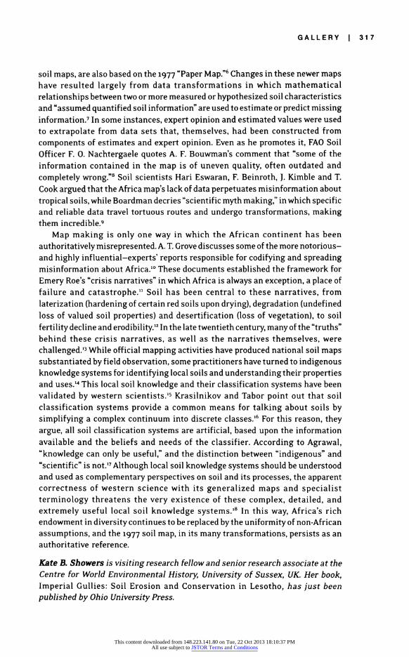
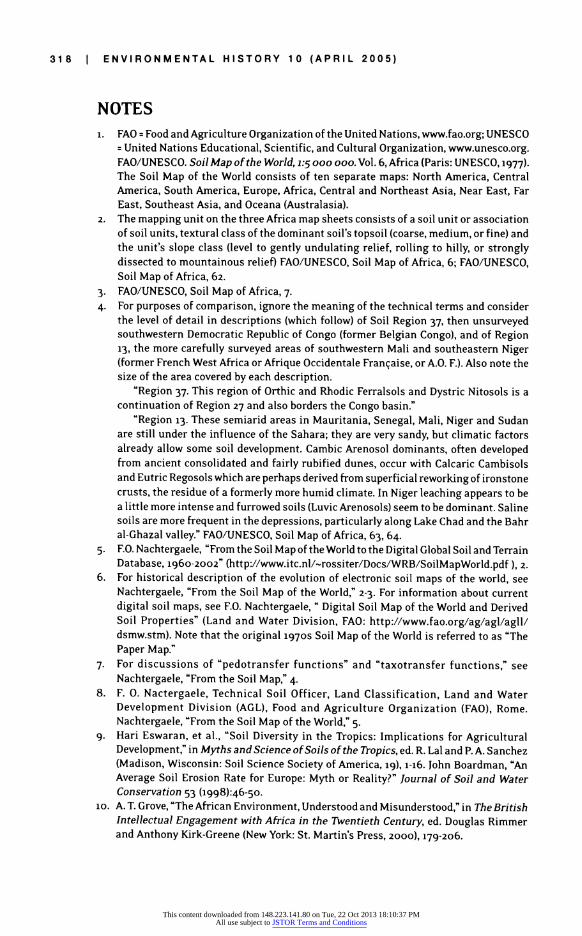
misinformation. A comparison of Maps i and 2 underscores three key points: the
ability of technology to elevate belief to fact and endow it with authority; the
power inherent in decisions about data manipulation and transformation; and the persistence of European experts' definitions of African reality.
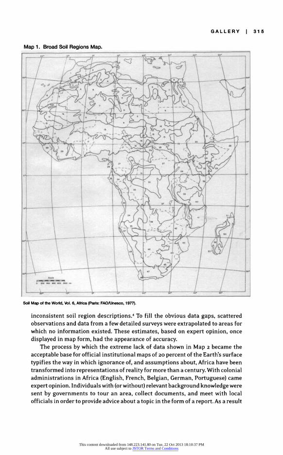
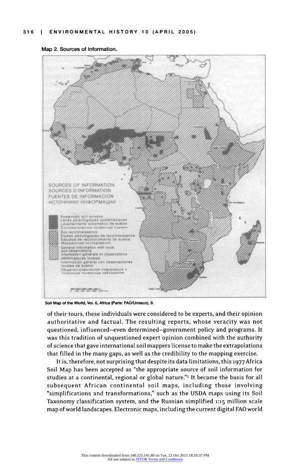
The Broad Soil Regions Map (Map i) is a summary of the Africa Map of the Soil Map of the World, which was coordinated by the Food and Agriculture Organization (FAQ) of the United Nations in Rome, and published by the United Nations Educational and Scientific Organization (UNESCO) in Paris. This
summary map was constructed by aggregating specific soil mapping units to form soil regions that corresponded roughly to Africa's major ecological regions.2 The numbers on the map link these soil regions to a descriptive key. The accompanying Map of Information Sources (Map 2) shows clearly the very limited data base from which the more detailed Africa soil map was made. When it was prepared, approximatelY 7 percent of the continent had been covered by large or medium scale survey maps with some grounds for accuracy; 38 percent had coverage by reconnaissance maps that showed soils in relation to other features such as
climate, geomorphology, or vegetation, and 55 percent of the continent was
"6virtually unknown."3 This meager data base calls into question the lines drawn
on both the Africa and the Broad Soil Region maps, and also explains the
This content downloaded from 148.223.141.80 on Tue, 22 Oct 2013 18:10:37 PMAll use subject to JSTOR Terms and Conditions
GALLERY I 315
Map 1. Broad Soil Regions Map. :;: e . :: ..: i,;:, . ::: :::: : .... .. . ..~ ~~~~~~. . .: . ... .. I . . --. -: .
..:., . : .:.:: ;'
... . .:: ..::..::: .!:...:.. .. .
r 1 ~ ~ ~
I t.
E W MI.. jlv oX; ... ' '; ' '; ;;S '~~~~~~~~~~~~~~~~~~ ~ '.........
C.. .,:,J .... ..... i
B 'i 2 't''' H"'tt00Z0S'6XEW' W4w,,; . .' SeL . , ' 'i ' a ' X ~~~~~~~~~~~~~~~~~~~~~~~~~~~~~~~~~~~~~~~~~~~~~~~~~~~~~~~~~~~~.. .. . . . .
:AW.~~~~~~~~~~~~~a ..... o. ....
4 :<
Soil Map of the World, Vol 6 Afnca (Pans FAQ/Unesco, 1 977
inconsistent soil region descriptions.4 To fill the obvious data gaps, scattered observations and data from a few detailed surveys were extrapolated to areas for which no information existed. These estimates, based on expert opinion, once displayed in map form, had the appearance of accuracy.
The process by which the extreme lack of data shown in Map 2 became the acceptable base for official institutional maps of 20 percent of the Earth's surface typifies the way in which ignorance of, and assumptions about, Africa have been
transformed into representations of reality for more than a century. With colonial administrations in Africa (English French Belgian German Portuguese) came
expert opinion Individuals with (or without) relevant background knowledge were sent by governments to tour an area, collect documents, and meet with local officials in order to provide advice about a topic in the form of a report As a result
This content downloaded from 148.223.141.80 on Tue, 22 Oct 2013 18:10:37 PMAll use subject to JSTOR Terms and Conditions
316 I ENVIRONMENTAL HISTORY 1 0 (APRIL 2005)
Map 2. Sources of Information.
Soil Map of the World, Vol. 6;, # Africa (Pars: FAO/Unesco),9.
auThoriativ and fatul.Te.eslin rprt, hoeveact.ws.o
:. . .. . ....... : ....
ft f ..U.. ..C. D.*. E W..V ... .. :: .. ...K
ues D...... . i le. .de oli an p. .I .".C TO M "#N X ~~~~~~~~~~~~~~. .H o ^ . " .. .. ... .......................................
.'.>.~~~ ~ ~~~ ~ ~ ~ ~~~ ~~~~~~ ~~~~~~~ ..B .. .. .. . 00S
~~~~~~~~~~~~~~~~~~~~~~~~~~~~~~~. : :........ .. . -... .. .... . ..... . . ~~~~~~~~~~~~~~~~~~~~~. .. .... ... .. .. .. .. ..R ~~~~~~~~~~~~~~~~~~~~~~..: .. .... .. .. ...| .......
.. : . . . . . . . , " .................................... .. .. .... .. . :. .. . . . .. . . .. .
. . ?o a.sw*.a.w ......... ..... ; ::: * t :; .: : :~~~~~~~~~~~~~~~~~~~~~~~~~~~~~~~~~~~~~~~~~~~~~~~~~~~. . ...
. .... . . ._ta , . . . . . . , . . . . l~....... . ...
Soil Map of the World, Vol. 6, Africa (Paris: FAO/Unesco), 9.
of their tours, these individuals were considered to be experts, and their opinion authoritative and factual. The resulting reports, whose veracity was not questioned, influenced-even determined-government policy and programs. It was this tradition of unquestioned expert opinion combined with the authority of science that gave international soil mappers license to make the extrapolations that filled in the many gaps, as well as the credibility to the mapping exercise.
It is, therefore, not surprising that despite its data limitations, this 1977 Africa Soil Map has been accepted as "the appropriate source of soil information for studies at a continental, regional or global nature."5 It became the basis for all subsequent African continental soil maps, including those involving "simplifications and transformations," such as the USDA maps using its Soil Taxonomy classification system, and the Russian simplified i:15 million scale map of world landscapes. Electronic maps, including the current digital FAO world
This content downloaded from 148.223.141.80 on Tue, 22 Oct 2013 18:10:37 PMAll use subject to JSTOR Terms and Conditions
GALLERY I 317
soil maps, are also based on the 1977 "Paper Map."6 Changes in these newer maps have resulted largely from data transformations in which mathematical relationships between two or more measured or hypothesized soil characteristics and "assumed quantified soil information" are used to estimate or predict missing information.7 In some instances, expert opinion and estimated values were used to extrapolate from data sets that, themselves, had been constructed from components of estimates and expert opinion. Even as he promotes it, FAO Soil Officer F. 0. Nachtergaele quotes A. F. Bouwman's comment that "some of the information contained in the map is of uneven quality, often outdated and completely wrong."8 Soil scientists Hari Eswaran, F. Beinroth, 1. Kimble and T. Cook argued that the Africa map's lack of data perpetuates misinformation about tropical soils, while Boardman decries "scientific myth making," in which specific and reliable data travel tortuous routes and undergo transformations, making them incredible.9
Map making is only one way in which the African continent has been authoritatively misrepresented. A. T. Grove discusses some of the more notorious- and highly influential-experts' reports responsible for codifying and spreading misinformation about Africa.10 These documents established the framework for Emery Roe's "crisis narratives" in which Africa is always an exception, a place of failure and catastrophe.'" Soil has been central to these narratives, from laterization (hardening of certain red soils upon drying), degradation (undefined loss of valued soil properties) and desertification (loss of vegetation), to soil fertility decline and erodibility.'2 In the late twentieth century, many of the "truths" behind these crisis narratives, as well as the narratives themselves, were challenged.'3 While official mapping activities have produced national soil maps substantiated by field observation, some practitioners have turned to indigenous knowledge systems for identifying local soils and understanding their properties and uses.'4 This local soil knowledge and their classification systems have been validated by western scientists.'5 Krasilnikov and Tabor point out that soil classification systems provide a common means for talking about soils by simplifying a complex continuum into discrete classes.'6 For this reason, they argue, all soil classification systems are artificial, based upon the information available and the beliefs and needs of the classifier. According to Agrawal, "knowledge can only be useful," and the distinction between "indigenous" and "scientific" is not.'7 Although local soil knowledge systems should be understood and used as complementary perspectives on soil and its processes, the apparent correctness of western science with its generalized maps and specialist terminology threatens the very existence of these complex, detailed, and extremely useful local soil knowledge systems.'8 In this way, Africa's rich endowment in diversity continues to be replaced by the uniformity of non-African assumptions, and the 1977 soil map, in its many transformations, persists as an authoritative reference.
Kate B. Showers is visiting research fellow and senior research associate at the Centre for World Environmental History, University of Sussex, UK. Her book, Imperial Gullies: Soil Erosion and Conservation in Lesotho, has just been published by Ohio University Press.
This content downloaded from 148.223.141.80 on Tue, 22 Oct 2013 18:10:37 PMAll use subject to JSTOR Terms and Conditions
318 I ENVIRONMENTAL HISTORY 10 (APRIL 2005)
NOTES . FAO = Food and Agriculture Organization of the United Nations, www.fao.org; UNESCO
= United Nations Educational, Scientific, and Cultural Organization, www.unesco.org. FAO/UNESCO. Soil Map of the World, i:5 ooo ooo. Vol. 6, Africa (Paris: UNESCO, 1977). The Soil Map of the World consists of ten separate maps: North America, Central America, South America, Europe, Africa, Central and Northeast Asia, Near East, Far East, Southeast Asia, and Oceana (Australasia).
2. The mapping unit on the three Africa map sheets consists of a soil unit or association of soil units, textural class of the dominant soil's topsoil (coarse, medium, or fine) and the unit's slope class (level to gently undulating relief, rolling to hilly, or strongly dissected to mountainous relief) FAO/UNESCO, Soil Map of Africa, 6; FAO/UNESCO, Soil Map of Africa, 62.
3. FAO/UNESCO, Soil Map of Africa, 7. 4. For purposes of comparison, ignore the meaning of the technical terms and consider
the level of detail in descriptions (which follow) of Soil Region 37, then unsurveyed southwestern Democratic Republic of Congo (former Belgian Congo), and of Region 13, the more carefully surveyed areas of southwestern Mali and southeastern Niger (former French West Africa or Afrique Occidentale Franqaise, or A.O. F.). Also note the size of the area covered by each description.
"Region 37. This region of Orthic and Rhodic Ferralsols and Dystric Nitosols is a continuation of Region 27 and also borders the Congo basin."
"Region 13. These semiarid areas in Mauritania, Senegal, Mali, Niger and Sudan are still under the influence of the Sahara; they are very sandy, but climatic factors already allow some soil development. Cambic Arenosol dominants, often developed from ancient consolidated and fairly rubified dunes, occur with Calcaric Cambisols and Eutric Regosols which are perhaps derived from superficial reworking of ironstone crusts, the residue of a formerly more humid climate. In Niger leaching appears to be a little more intense and furrowed soils (Luvic Arenosols) seem to be dominant. Saline soils are more frequent in the depressions, particularly along Lake Chad and the Bahr al-Ghazal valley." FAO/UNESCO, Soil Map of Africa, 63, 64.
5. F.O. Nachtergaele, "From the Soil Map of the World to the Digital Global Soil and Terrain Database, 1960-2002" (http://www.itc.nl/-rossiter/Docs/WRB/SoilMapWorld.pdf ), 2.
6. For historical description of the evolution of electronic soil maps of the world, see Nachtergaele, "From the Soil Map of the World," 2-3. For information about current digital soil maps, see F.O. Nachtergaele, " Digital Soil Map of the World and Derived Soil Properties" (Land and Water Division, FAO: http://www.fao.org/ag/agl/agll/ dsmw.stm). Note that the original 1970S Soil Map of the World is referred to as "The Paper Map."
7. For discussions of "pedotransfer functions" and "taxotransfer functions," see Nachtergaele, "From the Soil Map," 4.
8. F. 0. Nactergaele, Technical Soil Officer, Land Classification, Land and Water Development Division (AGL), Food and Agriculture Organization (FAO), Rome. Nachtergaele, "From the Soil Map of the World," 5.
9. Hari Eswaran, et al., "Soil Diversity in the Tropics: Implications for Agricultural Development," in Myths and Science of Soils of the Tropics, ed. R. Lal and P. A. Sanchez (Madison, Wisconsin: Soil Science Society of America, 19), i-16. John Boardman, "An Average Soil Erosion Rate for Europe: Myth or Reality?" Journal of Soil and Water Conservation 53 (1998):46-50.
lo. A. T. Grove, "The African Environment, Understood and Misunderstood," in The British Intellectual Engagement with Africa in the Twentieth Century, ed. Douglas Rimmer and Anthony Kirk-Greene (New York: St. Martin's Press, 2000), 179-206.
This content downloaded from 148.223.141.80 on Tue, 22 Oct 2013 18:10:37 PMAll use subject to JSTOR Terms and Conditions
GALLERY 1 319
ii. The idea that the African landscape and the African people are deficient, unable, and/ or incapable dominated discussions of Africa in the nineteenth and twentieth centuries. See Emery M. Roe, "Development Narratives, or Making the Best of Blueprint Development," World Development 19 (1991): 287-300, for a discussion of the persistence and negative consequences of "development narratives," defined as stories or arguments revolving around a sequence of events or positions in which something happens or from which something follows. These narratives are distinguished from ideology, myth, and conventional wisdom by being predictive of what will happen and having the objective of making their hearers believe or do something. The truth or validity of these narratives is irrelevant; their power comes in the telling and believing. Data to the contrary do not affect their credibility. Roe's four examples are the "tragedy of the commons"; land registration and increased productivity; systems analysis and sectoral integration; and repetitive budgeting by national governments. In "Except- Africa: Postcript to a Special Section on Development Narratives," World Development (1995): 1065-69, Roe discusses two of the narratives of immanent disaster, or crisis narratives, which so characterize descriptions of Africa: that Africa is the exception to every rule, and the Doomsday Scenario for every nation. In these narratives, conditions are bad and will only get worse if nothing is done, yet any intervention is likely to fail. Roe concludes that narratives can be displaced only by comprehensive counternarratives" which have the same compelling explanatory ability. Formulation
as story is essential-facts alone have no power. 12. To European observers, West Africa's ubiquitous red soils were very distinct, even on
a short visit. In some places, red soils cleared for crops hardened. These soils were described as "laterite," the name coined by British geologist F. Buchanan-Hamilton in 1807 for red earth (the term soil was not used) that hardened and was used for bricks in the Kerela District of India-see E. W. Russell, Soil Condition and Plant Growth, loth ed. (London: Longman, 1973), 730; and H. L. Schantz and Marbut C. F. Vegetation and Soils of Africa (New York: AMS Press, 1923),118, 180-82. In 1820, P. Berthier analyzed samples from the Fouta Djallon of West Africa, and found them to be similar to those of Kerala and, in 1911, J. D. Falconer described some Nigerian soils as "iron clay" (Encyclopaedia Britannica 1929, 13:740). Soon all red West African soils were assumed to be laterite. Many of Africa's highly weathered clay soils have a red color, signifying high iron contents. Hari Eswaran, "Taxonomy and Management Related Properties of the 'Red Soils' of Africa," The Red Soils of East and Southern Africa, proceedings of an International Symposium, Harare, Zimbabwe, 24-27 February 1986. Rapport Manuscript. IDRC-MCR 170e, 1-23 (Ottawa: IDRC, 1988), 6. The fate of this iron depends upon soil conditions. Where the water table fluctuates-either locally or on the scale of a floodplain-the soil solution can become enriched with iron, which is subsequently deposited as mottles (a stain on the surface of soil particles), concretions, nodules or continuous sheets two to five meters-or even ten meters-thick. Eswaran, "Taxonomy," 7; Colin Buckle, Landforms in Africa: An Introduction to Geomorphology (London: Longmans Press,1978), 68. Referred to variously as laterite or plinthite, this material is characteristically soft and permeable when moist, but hardens upon drying. (The word laterite has been used so broadly that its precise meaning is unclear. For this reason, many pedologists and soil scientists have refused to use the term since the 1970s. However, forms of the word are components of some international soil classification systems. See A. Faniran and 0. Areola, Essentials of Soil Study: With Special References to Tropical Areas (London: Heineman, 1978),161; Eswaran et al., "Soil Diversity in the Tropics," 7. The extent of hardness achieved, and its irreversibility varies-see Russell, Soil Condition and Plant Growth, 731. When hard, this iron-rich material can be referred to as ferricrete, lateritic duricrust, or petroplinthite-see Buckle, Landforms in Africa, 68; and Eswaran, "Taxonomy," 7). Soils with lateritic or
This content downloaded from 148.223.141.80 on Tue, 22 Oct 2013 18:10:37 PMAll use subject to JSTOR Terms and Conditions
320 i ENVIRONMENTAL HISTORY 10 (APRIL 2005)
plinthic layers have developed under both forest and savanna in West Africa, and are extensive in regions with annual rainfalls of 0oo-500mm/year, or io-16 N, such as Niger, Burkina Faso, northern Nigeria and Guinea's Fouta Djallon-see D. K. Cassel and R. Lal, " Soil Physical Properties of the Tropics: Common Beliefs and Management Restraints," in Myths and Science of Soils of the Tropics, ed. R. Lal and P.A. Sanchez (Madison: Soil Science Society of America, i992z), 61-90, 77; Buckle, Landforms in Africa, 68; Russell, Soil Condition and Plant Growth, 729. Obeng (1978, cited in Cassel and Lal, "Soil Physical Properties of the Tropics," 77) reported that approximately 113 million hectares of forested soils and 113 million hectares of savanna soils in West Africa had concretionary or iron hardpans.
13. Reviews canbe found in Ian Scoones, "The Dynamics of Soil Fertility Change: Historical Perspectives on Environmental Transformation from Zimbabwe," The Geographical Journal (1997): 161-69; Simon Batterbury, Timothy Forsyth and Koy Thompson, "Environmental Transformations in Developing Countries: Hybrid Research and Democratic Policy," The Geographical journal (1997): 126-32; and Valentina Mazzucato and David Niemeijer, Rethinking Soil and Water Conservation in a Changing Society: A Case Study in Eastern Burkina Faso (Wageningen, The Netherlands: Wageningen University and Research Centre, 2ooo), 16-go.
14. For list of national soil maps, their scales, classification system, and dates of completion, see table in Nachtergaele, "From the Soil Map " 12-i5. See also Geoderma 2003, vol. 11, ethnopedology special issue.
15. Antoinette M.G.A. WinklerPrins, "Local Soil Knowledge: A Tool for Sustainable Land Management," Society and Natural Resources (1997): 15i-66.
16. Pavel V. Krasilnikov and Joe A. Tabor, "Perspectives on Utilitarian Ethnopedology," Geoderma (2003): 197-215.
17. Arun Agrawal, "Dismantlingthe Divide Between Indigenous and Scientific Knowledge," Development and Change (1995): 413-39, quote on 433.
i8. Krasilnikov and Tabor "Perspectives on Utilitarian Ethnopedology," 202.
This content downloaded from 148.223.141.80 on Tue, 22 Oct 2013 18:10:37 PMAll use subject to JSTOR Terms and Conditions