
Short-Range Direct and Diffuse Irradiance Forecasts for Solar Energy Applications Based on Aerosol...
14
Short-Range Direct and Diffuse Irradiance Forecasts for Solar Energy Applications Based on Aerosol Chemical Transport and Numerical Weather Modeling HANNE BREITKREUZ* German Aerospace Center, German Remote Sensing Data Center, Oberpfaffenhofen, and Institute of Geography, University of Wu ¨rzburg, Wu ¨ rzburg, Germany MARION SCHROEDTER-HOMSCHEIDT AND THOMAS HOLZER-POPP German Aerospace Center, German Remote Sensing Data Center, Oberpfaffenhofen, Germany STEFAN DECH German Aerospace Center, German Remote Sensing Data Center, Oberpfaffenhofen, and Institute of Geography, University of Wu ¨rzburg, Wu ¨ rzburg, Germany (Manuscript received 24 July 2008, in final form 30 January 2009) ABSTRACT This study examines 2–3-day solar irradiance forecasts with respect to their application in solar energy industries, such as yield prediction for the integration of the strongly fluctuating solar energy into the elec- tricity grid. During cloud-free situations, which are predominant in regions and time periods focused on by the solar energy industry, aerosols are the main atmospheric parameter that determines ground-level direct and global irradiances. Therefore, for an episode of 5 months in Europe the accuracy of forecasts of the aerosol optical depth at 550 nm (AOD 550 ) based on particle forecasts of a chemical transport model [the European Air Pollution Dispersion (EURAD) CTM] are analyzed as a first step. It is shown that these aerosol forecasts underestimate ground-based AOD 550 measurements by a mean of 20.11 (RMSE 5 0.20). Using these aerosol forecasts together with other remote sensing data (ground albedo, ozone) and numerical weather prediction parameters (water vapor, clouds), a prototype for an irradiance forecasting system (Aerosol-based Forecasts of Solar Irradiance for Energy Applications, AFSOL) is set up. Based on the 5-month aerosol dataset, the results are then compared with forecasts of the ECMWF model and the fifth-generation Pennsylvania State University–National Center for Atmospheric Research Mesoscale Model (MM5), with Meteosat-7 satellite data, and with ground measurements. It is demonstrated that for clear-sky situations the AFSOL system significantly improves global irradiance and especially direct irradiance forecasts relative to ECMWF fore- casts (bias reduction from 226% to 111%; RMSE reduction from 31% to 19% for direct irradiance). On the other hand, the study shows that for cloudy conditions the AFSOL forecasts can lead to significantly larger forecast errors. This also justifies an increased research effort on cloud parameterization schemes, which is a topic of ongoing research. One practical solution for solar energy power plant operators in the meanwhile is to combine the different irradiance models depending on the forecast cloud cover, which leads to significant reductions in bias for the overall period. * Current affiliation: Stadtwerke Mu ¨ nchen GmbH, Munich, Germany. Corresponding author address: Hanne Breitkreuz, German Aerospace Center, German Remote Sensing Data Center, Postfach 1116, 82234 Wessling, Germany. E-mail: [email protected] 1766 JOURNAL OF APPLIED METEOROLOGY AND CLIMATOLOGY VOLUME 48 DOI: 10.1175/2009JAMC2090.1 Ó 2009 American Meteorological Society
-
Upload
independent -
Category
Documents
-
view
1 -
download
0
Transcript of Short-Range Direct and Diffuse Irradiance Forecasts for Solar Energy Applications Based on Aerosol...
Short-Range Direct and Diffuse Irradiance Forecasts for Solar Energy ApplicationsBased on Aerosol Chemical Transport and Numerical Weather Modeling
HANNE BREITKREUZ*
German Aerospace Center, German Remote Sensing Data Center, Oberpfaffenhofen, and Institute of Geography,
University of Wurzburg, Wurzburg, Germany
MARION SCHROEDTER-HOMSCHEIDT AND THOMAS HOLZER-POPP
German Aerospace Center, German Remote Sensing Data Center, Oberpfaffenhofen, Germany
STEFAN DECH
German Aerospace Center, German Remote Sensing Data Center, Oberpfaffenhofen, and Institute of Geography,
University of Wurzburg, Wurzburg, Germany
(Manuscript received 24 July 2008, in final form 30 January 2009)
ABSTRACT
This study examines 2–3-day solar irradiance forecasts with respect to their application in solar energy
industries, such as yield prediction for the integration of the strongly fluctuating solar energy into the elec-
tricity grid. During cloud-free situations, which are predominant in regions and time periods focused on by the
solar energy industry, aerosols are the main atmospheric parameter that determines ground-level direct and
global irradiances. Therefore, for an episode of 5 months in Europe the accuracy of forecasts of the aerosol
optical depth at 550 nm (AOD550) based on particle forecasts of a chemical transport model [the European
Air Pollution Dispersion (EURAD) CTM] are analyzed as a first step. It is shown that these aerosol forecasts
underestimate ground-based AOD550 measurements by a mean of 20.11 (RMSE 5 0.20). Using these aerosol
forecasts together with other remote sensing data (ground albedo, ozone) and numerical weather prediction
parameters (water vapor, clouds), a prototype for an irradiance forecasting system (Aerosol-based Forecasts
of Solar Irradiance for Energy Applications, AFSOL) is set up. Based on the 5-month aerosol dataset, the
results are then compared with forecasts of the ECMWF model and the fifth-generation Pennsylvania State
University–National Center for Atmospheric Research Mesoscale Model (MM5), with Meteosat-7 satellite
data, and with ground measurements. It is demonstrated that for clear-sky situations the AFSOL system
significantly improves global irradiance and especially direct irradiance forecasts relative to ECMWF fore-
casts (bias reduction from 226% to 111%; RMSE reduction from 31% to 19% for direct irradiance). On the
other hand, the study shows that for cloudy conditions the AFSOL forecasts can lead to significantly larger
forecast errors. This also justifies an increased research effort on cloud parameterization schemes, which is a
topic of ongoing research. One practical solution for solar energy power plant operators in the meanwhile is to
combine the different irradiance models depending on the forecast cloud cover, which leads to significant
reductions in bias for the overall period.
* Current affiliation: Stadtwerke Munchen GmbH, Munich, Germany.
Corresponding author address: Hanne Breitkreuz, German Aerospace Center, German Remote Sensing Data Center, Postfach 1116,
82234 Wessling, Germany.
E-mail: [email protected]
1766 J O U R N A L O F A P P L I E D M E T E O R O L O G Y A N D C L I M A T O L O G Y VOLUME 48
DOI: 10.1175/2009JAMC2090.1
� 2009 American Meteorological Society

1. Introduction
Because of the limitation of fossil fuel resources and
their impacts on climate change, our future energy sys-
tem will increasingly depend on utilizing growing shares
of renewable energy sources. This poses a major chal-
lenge to the development of future energy systems, since
energy production from most renewable resources is
highly variable in space and time. Because of this high
variability, an efficient integration of solar energy into
the existing energy supply system will only be possible if
reliable information on ground-level solar irradiance is
available. It should be noted that information on surface-
level global irradiance is needed for photovoltaic facili-
ties, whereas concentrating solar thermal power plants
can only process direct irradiance.
To calculate direct and global irradiance at the surface
level, exact information about clouds, aerosols, water
vapor, and ozone is needed. For overcast skies, knowl-
edge of cloud cover and type is most important in de-
termining irradiance values. Cloud cover information is
also important for distinguishing between overcast and
clear situations. But in the clear-sky case, precise aerosol
information is indispensable for providing accurate ir-
radiance forecasts, since up to 20%–30% of direct irra-
diance extinction has been reported for cases of high
particle occurrence (Henzing et al. 2004; Jacovides et al.
2000; Latha and Badarinath 2005). Despite the high
spatial and temporal variabilities of aerosol occurrence,
with typical scale lengths of a few hours or several tens
of kilometers (Anderson et al. 2003; Holzer-Popp et al.
2008), most irradiance calculation systems use simple
aerosol climatologies of fixed yearly or monthly values
with a spatial resolution of several degrees instead of
detailed aerosol information (e.g., Kinne et al. 2005;
Schmidt et al. 2006).
A focus of the solar energy industry lies in relatively
cloud-free regions, such as the Mediterranean area. This
explains why clear-sky calculations are of great rele-
vance for irradiance forecasts. The importance of ac-
curate aerosol information is enhanced by the fact that
these regions with comparably low cloud cover are often
situated near desert regions, such as the Sahara Desert,
which leads to frequent occurrences of dust transport and
therefore episodically high atmospheric aerosol loads
(Meloni et al. 2007).
So far, irradiance information has been primarily
available as retrospective long time series used by the
solar energy industry for site auditing and facility mon-
itoring. For example, data from Meteosat satellites
(Rigollier et al. 2004) is used to optimize solar power
plants with respect to local characteristics. In addition,
satellite-based data of the past 1–30 days are used to
monitor the performance of existing solar energy sites,
allowing for the near-real-time management of power
sites as well as for retroactive performance checks by
automatic failure detection routines (Drews et al. 2007).
However, near-real-time forecasts of direct and global
solar irradiance are also needed for forecasts of facility
yields of several hours to 2 days. Only with this information
can sensible and efficient control and maintenance of solar
power plants in combination with conventional plants be
facilitated, as well as the stability of local and regional
power grid systems. Additionally, besides air temperature,
the amount of available solar irradiance largely determines
customer consumption behavior. Therefore, irradiance
forecasts are also needed when calculating consumer de-
mands, an essential aspect in controlling both traditional
and solar energy power plants.
Satellite-based cloud motion vectors for cloud fields
and therefore surface irradiance are already used to
calculate nowcasting irradiance predictions (Hammer
et al. 1999). For example, the European Meteosat Second
Generation (MSG) satellite provides high-resolution
images of Europe and Africa every 15 min, where the
movement of the clouds is used to determine and ex-
trapolate motion vectors. Such an approach is of interest
since it allows for forecast updates during the day, such as
are needed for intraday adjustments of power plant
management (Rikos et al. 2008) or energy trading ap-
plications. The accuracy of this method can be increased
by the use of smoothing filter techniques (Lorenz 2004).
However, it should be noted that this approach is limited
to an approximate forecast horizon of up to 6 h.
One of the earliest approaches to predicting solar
irradiance dealt with 1–2-day forecasts using model
output statistics (MOS; Jensenius and Cotton 1981). The
MOS technique uses statistical correlations between
observed weather elements and climatological long-
term data, satellite retrievals, or modeled parameters to
obtain a highly localized statistical function. This allows,
for example, for the adaptation of low-resolution me-
soscale data to local conditions by considering local
effects or by correcting systematic deviations of a nu-
merical model, satellite retrievals, or climatological val-
ues. A disadvantage of this method is seen in the large
amount of measurement data needed to develop sta-
tistical correlations separately for each location. This
means that MOS-based forecasts are not available for
larger areas or for locations without a priori information
(Glahn and Lowry 1972).
For day-ahead production forecasts, global irradiance
forecasts from numerical weather predictions such as
from the European Centre for Medium-Range Weather
Forecasts (ECMWF) are already operationally available
for various grid sizes and on a global scale. However,
SEPTEMBER 2009 B R E I T K R E U Z E T A L . 1767

temporal resolutions of 3 h as well as the restriction to
global irradiance only instead of also direct irradiance
needed for concentrating solar power systems, leads to
problems when employing ECMWF irradiance fore-
casts for energy applications. Also, the forecasts are
calculated with an aerosol climatology containing annual
aerosol optical depth (AOD) cycles for four tropospheric
aerosol types (ECMWF 2008) instead of actual aerosol
forecasts, causing errors for clear-sky cases in particular.
For energy applications a combination of numerical
weather prediction and air quality modeling is more
suitable, where both meteorological and chemical fore-
casts rely on satellite- and ground-based data assimila-
tion systems. The approach discussed in this paper is
aimed at providing irradiance forecasts designed to meet
the needs of the solar energy industries. This is achieved
by improving the accuracy of clear-sky irradiance fore-
casts through the use of a chemistry transport model
(CTM) for aerosol information, in combination with
atmospheric input data from satellite and model data.
In section 2 the concept of an irradiance forecasting
model is presented, followed by a detailed description of
the atmospheric input parameters used. In section 3 the
validation data sources are presented. The performance
of the irradiance prediction system is detailed in section 4.
2. The AFSOL system
a. Concept
A modeling system of Aerosol-based Forecasts of
Solar Irradiance for Energy Applications (AFSOL) has
been developed to match the needs of the solar energy
community regarding irradiance forecasts (Breitkreuz
2008). From this system, not only global but also di-
rect irradiance information is available at high tempo-
ral resolution covering Europe and the Mediterranean
region. A focus is placed on irradiance forecasts in
clear-sky conditions since these include the most in-
teresting situations for the efficient operation of solar
energy plants.
All irradiance calculations of the AFSOL system
are performed with the library for radiative transfer
(libRadtran) program code (Mayer and Kylling 2005).
The systems main routine, uvspec, calculates direct and
global spectral irradiances at the surface level, taking
into account atmospheric multiple scattering and ab-
sorption as well as surface properties. For this study the
underlying standard atmosphere file is altered by vari-
ous additional input data sources described in the fol-
lowing sections: aerosol information, column-integrated
atmospheric water vapor, and cloud information is taken
from a numerical weather prediction model, whereas
atmospheric ozone content and ground albedo values
are provided by satellite measurements (see Fig. 1).
The model is capable of calculating spectrally resolved
irradiance values (Kato et al. 1999). However, due to the
lack of sufficient numbers of appropriate validation mea-
surements, most cases in this study consider only spectrally
integrated global and direct irradiance predictions.
Various algorithms for solving the radiative transfer
equations are available, which allows choosing accord-
ing to different applications or required accuracies, such
FIG. 1. AFSOL irradiance forecasting system scheme.
1768 J O U R N A L O F A P P L I E D M E T E O R O L O G Y A N D C L I M A T O L O G Y VOLUME 48

as between very exact time-consuming calculations or
less exact faster routines applicable to operational ser-
vices. For this study, the disort solver (Stamnes et al.
1988) is used for solar zenith angles of up to 708, and the
sdisort algorithm (Dahlback and Stamnes 1991) for solar
zenith angles between 708 and 858.
The temporal resolution of the direct and global ir-
radiance forecasts is 1 h and the spatial resolution is a
½8 grid across Europe and the Mediterranean African
coastal regions. Each forecast is calculated for 72 h.
b. Atmospheric input data
Both cloud and aerosol information needed for the
irradiance predictions are taken from the European Air
Pollution Dispersion (EURAD) model (Ebel et al.
1997). This system has been developed for air quality
monitoring and forecast purposes by the Rhenish Insti-
tute for Environmental Research at the University of
Cologne, Cologne, Germany. It incorporates physical,
chemical, and dynamical processes related to the emis-
sion, transport, and deposition of atmospheric sub-
stances. The system consists of three main submodels
treating meteorological input from the fifth-generation
Pennsylvania State University–National Center for At-
mospheric Research Mesoscale Model (MM5; Grell
et al. 1995), emission data (Memmesheimer et al. 1995),
and a chemical transport model (Hass et al. 1995).
An additional subsystem, the Modal Aerosol Dynamic
Model (MADE) treats aerosol processes, which include
particle emission, coagulation and growth, transport,
and wet and dry deposition (Ackermann et al. 1998).
Secondary organic species are accounted for within the
Secondary Organic Aerosol Module (SORGAM) sub-
system (Schell 2000).
The EURAD forecasts provide hourly data, with each
forecast run covering 72 h. Depending on the target of
the analysis, various grid sizes are available, ranging
between a resolution of 1 km for local to regional studies
and 125 km for hemispherical coverage. For the case
study presented, a grid of approximately 54 km (½8 grid)
width was chosen, allowing coverage of Europe and
the Mediterranean region from 308 to 608N and from
2108W to 408E with a reasonable amount of calculation
resources.
1) CLOUDS AND WATER VAPOR
Information on cloud parameters (cloud-top and
-bottom height, cloud liquid water content, and cloud
fraction) and total atmospheric water vapor is obtained
from the meteorological part of the EURAD model. For
information on cloud liquid water, vertically averaged
values of all cloud-containing levels are calculated. This is
a simplification of the three-dimensional EURAD cloud
water output, which can be justified by the fact that a
54-km model grid is used: neglecting subgrid cloud struc-
tures masks any possible errors caused by the simplifi-
cation of the vertical distribution of cloud liquid water.
The determination of the effective radius of cloud
droplets is not part of the EURAD output. To calculate
irradiances, a simple linear parameterization of radius
growth with height is employed, consistent with the
algorithm used at the ECMWF for shortwave irradiance
calculations (ECMWF 2008).
2) AEROSOLS
The complete EURAD system yields mass concen-
trations of all treated species in three different size
modes (nucleation, accumulation, and coarse), differ-
entiated into 23 tropospheric height levels. Primary
organic material and elemental carbon, sulfate, ammo-
nium, nitrate, anthropogenic particulate matter, and
aerosol liquid water are considered in the accumulation
and nucleation modes. Anthropogenic aerosols are ad-
ditionally included as coarse-mode particles.
A method of integrating natural coarse-mode parti-
cles (sea salt, fire particles, and dust) is in preparation
and the effects of these additional modules will be sub-
ject to further investigations. This is a crucial point since,
especially in the Mediterranean area, Saharan-based
dust storms can occur frequently (Meloni et al. 2007),
leading to a large extinction of direct irradiance. Con-
sequently, the integration of external dust information
into the aerosol model has a high priority from a solar
energy point of view.
The particle mass concentrations of different aerosol
species are usually combined to produce single PM10
values (total mass concentration of particles smaller
than 10 mm at the surface, dedicated for air quality
users) as standard output. In the case study presented,
however, separate mass concentration values of all
substances and size distributions modeled are used in
order to calculate extinction coefficients for each grid
point using a fast Mie extinction parameterization
(Evans and Fournier 1990). Extinction coefficients sext
are then vertically integrated through all height layers to
produce aerosol optical depth values for each grid point.
In accordance with most studies regarding the influ-
ence of aerosols on solar radiation, AOD values pre-
sented in this paper are given at a wavelength of 550 nm
(AOD550).
3) GROUND ALBEDO
As a source of ground albedo information data from
the National Aeronautics and Space Administration’s
(NASA) Moderate Resolution Imaging Spectroradiom-
eter (MODIS) on board the Terra and Aqua satellites
SEPTEMBER 2009 B R E I T K R E U Z E T A L . 1769
(Schaaf et al. 2002) are used. Bimonthly composites of
1-km resolution are aggregated to match the ½8 grid of
EURAD aerosol output. To improve the retrieval ac-
curacy, only pixels that were recorded in cloud-free at-
mospheres over land and with solar zenith angles of up
to 608 are considered.
Satellite-based ground albedo data are difficult to
validate since the measurement angles have to be the
same in order to avoid anisotropy effects. However,
validation studies over homogeneous semidesert terrain
show that MODIS albedo values result in a mean RMSE
of 0.02–0.07, thus deviating only slightly from ground
measurements (Wang et al. 2004).
4) OZONE
For information on atmospheric ozone content, Total
Ozone Mapping Spectrometer (TOMS) measurements
from NASA’s Earth Probe Satellite are used (Bhartia
2004). The data (available online at http://wdc.dlr.de)
offer global coverage and have a resolution of 18 3 1.258.
Accuracy studies show a deviation of TOMS total ozone
columns against ground measurements of less than 2%,
which is within the accuracy to be expected between dif-
ferent Dobson ground measurement devices (Bramstedt
et al. 2002).
For this study daily mean values of ozone columns are
used since the interdaily variability of ozone is not very
high and because ozone’s influence is restricted to less than
1% when dealing with spectrally integrated irradiances
(Mueller et al. 2004). In a few cases of limited data cov-
erage, values from adjacent days are linearly interpolated.
c. Accuracy assessment of aerosol forecasts
The main purpose of this study is the evaluation of the
coupling of an air quality model with numerical weather
predictions to improve direct solar irradiance forecasts at
the ground. Therefore, a validation of the aerosol model
has to be conducted as a first step toward quantifying the
aerosol input dataset accuracy and statistics. In a second
step irradiance forecasts are validated against radiation
measurements (section 3), in order to show the overall
improvement in direct irradiance forecasting.
This validation study of the EURAD-based aerosol
optical depth values was performed using Aerosol Robotic
Network (AERONET) ground-based sun photometer
measurements (Holben et al. 1998). The AERONET
program is operated to gather aerosol information
and provide validation data for satellite retrievals of
aerosol optical properties. Datasets are available online
(at http://aeronet.gsfc.nasa.gov) and contain AOD
measurements at 16 different wavelengths at 1640, 1020,
870, 675, 667, 555, 551, 532, 531, 500, 490, 443, 440, 412,
380, and 340 nm, as well as solar zenith angles, total
water vapor column measurements, and several vari-
ability coefficients used for automatic cloud screening
procedures. The accuracy of AERONET AOD values is
60.01 for wavelengths up to 440 nm and 60.02 for
shorter wavelengths (Holben et al. 1998).
In this study, all ground stations in Europe providing
level 2 data (automatically cloud screened and manually
inspected measurements) during a 5-month study pe-
riod from July to November 2003 are considered. This
leads to the use of 32 ground stations with a total of
more than 70 000 measurements to be included in the
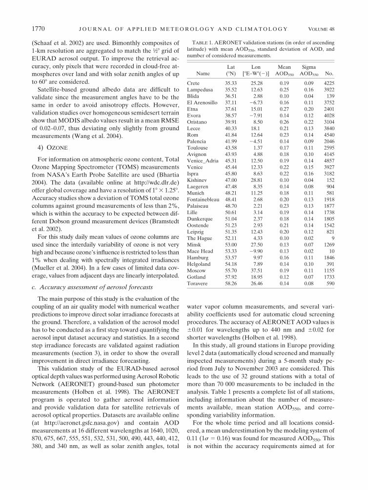
analysis. Table 1 presents a complete list of all stations,
including information about the number of measure-
ments available, mean station AOD550, and corre-
sponding variability information.
For the whole time period and all locations consid-
ered, a mean underestimation by the modeling system of
0.11 (1s 5 0.16) was found for measured AOD550. This
is not within the accuracy requirements aimed at for
TABLE 1. AERONET validation stations (in order of ascending
latitude) with mean AOD550, standard deviation of AOD, and
number of considered measurements.
Name
Lat
(8N)
Lon
[8E–W8(2)]
Mean
AOD550
Sigma
AOD550 No.
Crete 35.33 25.28 0.19 0.09 4225
Lampedusa 35.52 12.63 0.25 0.16 3922
Blida 36.51 2.88 0.10 0.04 139
El Arenosillo 37.11 26.73 0.16 0.11 3752
Etna 37.61 15.01 0.27 0.20 2401
Evora 38.57 27.91 0.14 0.12 4028
Oristano 39.91 8.50 0.26 0.22 3104
Lecce 40.33 18.1 0.21 0.13 3840
Rom 41.84 12.64 0.23 0.14 4540
Palencia 41.99 24.51 0.14 0.09 2046
Toulouse 43.58 1.37 0.17 0.11 2595
Avignon 43.93 4.88 0.18 0.10 4145
Venice_Adria 45.31 12.50 0.19 0.14 4857
Venice 45.44 12.33 0.22 0.15 3927
Ispra 45.80 8.63 0.22 0.16 3182
Kishinev 47.00 28.81 0.10 0.04 152
Laegeren 47.48 8.35 0.14 0.08 904
Munich 48.21 11.25 0.18 0.11 581
Fontainebleau 48.41 2.68 0.20 0.13 1918
Palaiseau 48.70 2.21 0.23 0.13 1877
Lille 50.61 3.14 0.19 0.14 1738
Dunkerque 51.04 2.37 0.18 0.14 1805
Oostende 51.23 2.93 0.21 0.14 1542
Leipzig 51.35 12.43 0.20 0.12 821
The Hague 52.11 4.33 0.10 0.02 9
Minsk 53.00 27.50 0.13 0.07 1269
Mace Head 53.33 29.90 0.13 0.02 10
Hamburg 53.57 9.97 0.16 0.11 1846
Helgoland 54.18 7.89 0.14 0.10 391
Moscow 55.70 37.51 0.19 0.11 1155
Gotland 57.92 18.95 0.12 0.07 1733
Toravere 58.26 26.46 0.14 0.08 590
1770 J O U R N A L O F A P P L I E D M E T E O R O L O G Y A N D C L I M A T O L O G Y VOLUME 48

aerosol input data with regard to solar energy purposes,
such as an RMSE of 0.10 (EHF and Ecole de Mines/
Armines 2001). Thus, in the following several aspects of
the accuracy analysis will be presented in order to
identify crucial points for improvement.
The general underestimation is altered by a strong
regional gradient, leading to good forecast accuracies in
northern and middle Europe and significant underesti-
mations in the central and western Mediterranean re-
gion as is clearly visible in the bias values of individual
AERONET stations shown in Fig. 2. This pattern can be
partly explained by the occurrence of forest fires in
Portugal in August 2003, which is not considered in the
model version used for the dataset analyzed in this
paper. Also, some regions might be subject to misrep-
resentation in the emission database, leading to severe
underestimations of the AOD, such as in the strongly
industrialized Po Valley in northern Italy (Breitkreuz
et al. 2007). The consideration of higher spatial resolu-
tions is also expected to lead to reduced forecast errors
in some of these cases, for example, for ground stations
near large cities such as Palaiseau near Paris, France, or
Munich, Germany, but is an approach that is neglected
in this study for computational reasons, in order to allow
the treatment of a larger study area.
However, a main reason lies in the occurrence of
Saharan dust storms, which cannot be accounted for in
the model system, thus leading to underestimations in
AOD forecasts relative to ground measurements. The
transport of Saharan dust across the Atlantic and the
Mediterranean and toward middle Europe often lasts
for 2–3 days and is typically caused by cyclones south of
the Atlas Mountains, originating from the thermal
contrast of cold maritime and warm continental air
masses. In the central Mediterranean, most cases occur
in summer, with a total occurrence of 4–5 days each
month (Meloni et al. 2007). Consequently, the most se-
vere underestimations of AOD550 can be found on days
and in regions with Saharan dust outbreaks, as identified
by visual analysis of MODIS or Advanced Very High
Resolution Radiometer (AVHRR) satellite color com-
posites (Breitkreuz 2008).
The mean forecast accuracy of single locations and
also of all stations considered can be altered significantly
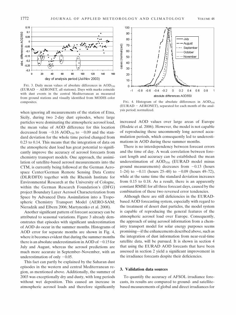
by these short dust events. As demonstrated in Fig. 3, the
daily mean values of absolute differences in AOD550 are
strongly negative in cases of dust events. Dust events,
such as on 21 July, were verified by visual analysis of
color composite images from the MSG satellite and
marked with black polygons in Fig. 3. As an example,
FIG. 2. Mean absolute bias (EURAD 2 AERONET) of AOD550 forecasts at the 32 ground measurement stations used; the sizes of the
circles correspond to the AOD forecast variability.
SEPTEMBER 2009 B R E I T K R E U Z E T A L . 1771
when ignoring all measurements of the station of Etna,
Sicily, during two 2-day dust episodes, where large
particles were dominating the atmospheric aerosol load,
the mean value of AOD difference for this location
decreased from 20.16 AOD550 to 20.09 and the stan-
dard deviation for the whole time period changed from
0.23 to 0.14. This means that the integration of data on
the atmospheric dust load has great potential to signifi-
cantly improve the accuracy of aerosol forecasts from
chemistry transport models. One approach, the assimi-
lation of satellite-based aerosol measurements into the
CTM, is currently being followed at the German Aero-
space Center/German Remote Sensing Data Centre
(DLR/DFD) together with the Rhenish Institute for
Environmental Research at the University of Cologne,
within the German Research Foundation’s (DFG)
project Boundary Layer Aerosol Characterization from
Space by Advanced Data Assimilation into a Tropo-
spheric Chemistry Transport Model (AERO-SAM;
Nieradzik and Elbern 2006; Martynenko et al. 2008).
Another significant pattern of forecast accuracy can be
attributed to seasonal variations. Figure 3 already dem-
onstrates that episodes with significant underestimation
of AOD do occur in the summer months. Histograms of
AOD error for separate months are shown in Fig. 4,
where it becomes evident that during the summer months
there is an absolute underestimation in AOD of 20.15 for
July and August, whereas the aerosol predictions are
much more accurate in September–November, with an
underestimation of only 20.05.
This fact can partly be explained by the Saharan dust
episodes in the western and central Mediterranean re-
gion, as mentioned above. Additionally, the summer of
2003 was exceptionally dry and dusty, with long periods
without wet deposition. This caused an increase in
atmospheric aerosol loads and therefore significantly
increased AOD values over large areas of Europe
(Hodzic et al. 2006). However, the model is not capable
of reproducing these uncommonly long aerosol accu-
mulation periods, which consequently led to underesti-
mations in AOD during these summer months.
There is no interdependency between forecast errors
and the time of day. A weak correlation between fore-
cast length and accuracy can be established: the mean
underestimation of AOD550 (EURAD model minus
ground measurements) decreases from 20.13 (hours
1–24) to 20.11 (hours 25–48) to 20.09 (hours 49–72),
while at the same time the standard deviation increases
from 0.15 to 0.18. As a result, there is an apparently
constant RMSE for all three forecast days, caused by the
combination of these two reversed error tendencies.
Although there are still deficiencies in the EURAD-
based AOD forecasting system, especially with regard to
the treatment of desert dust particles, the model system
is capable of reproducing the general features of the
atmospheric aerosol load over Europe. Consequently,
the approach of using aerosol information from a chem-
istry transport model for solar energy purposes seems
promising—if the enhancements described above, such as
the integration of dust information from near-real-time
satellite data, will be pursued. It is shown in section 4
that using the EURAD AOD forecasts that have been
assessed in section 2 yield a significant improvement in
the irradiance forecasts despite their deficiencies.
3. Validation data sources
To quantify the accuracy of AFSOL irradiance fore-
casts, its results are compared to ground- and satellite-
based measurements of global and direct irradiances for
FIG. 3. Daily mean values of absolute differences in AOD550
(EURAD 2 AERONET, all stations). Days with marks coincide
with dust events in the central Mediterranean as measured
from ground stations and visually identified from MODIS color
composites. FIG. 4. Histogram of the absolute differences in AOD550
(EURAD 2 AERONET), separated for each month of the anal-
ysis period; normalized.
1772 J O U R N A L O F A P P L I E D M E T E O R O L O G Y A N D C L I M A T O L O G Y VOLUME 48
the period of July–November 2003. To enable compar-
isons with other available solar forecast data, the results
are also checked against the performance of routinely
available ECMWF and EURAD–MM5-based irradi-
ance forecasts.
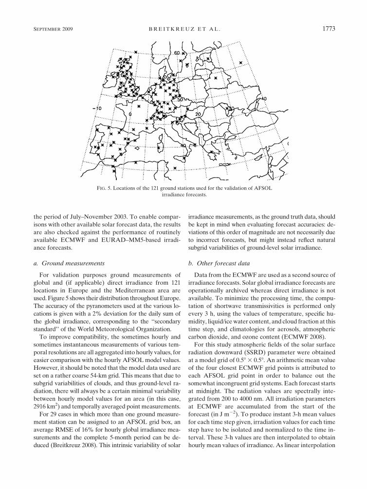
a. Ground measurements
For validation purposes ground measurements of
global and (if applicable) direct irradiance from 121
locations in Europe and the Mediterranean area are
used. Figure 5 shows their distribution throughout Europe.
The accuracy of the pyranometers used at the various lo-
cations is given with a 2% deviation for the daily sum of
the global irradiance, corresponding to the ‘‘secondary
standard’’ of the World Meteorological Organization.
To improve compatibility, the sometimes hourly and
sometimes instantaneous measurements of various tem-
poral resolutions are all aggregated into hourly values, for
easier comparison with the hourly AFSOL model values.
However, it should be noted that the model data used are
set on a rather coarse 54-km grid. This means that due to
subgrid variabilities of clouds, and thus ground-level ra-
diation, there will always be a certain minimal variability
between hourly model values for an area (in this case,
2916 km2) and temporally averaged point measurements.
For 29 cases in which more than one ground measure-
ment station can be assigned to an AFSOL grid box, an
average RMSE of 16% for hourly global irradiance mea-
surements and the complete 5-month period can be de-
duced (Breitkreuz 2008). This intrinsic variability of solar
irradiance measurements, as the ground truth data, should
be kept in mind when evaluating forecast accuracies: de-
viations of this order of magnitude are not necessarily due
to incorrect forecasts, but might instead reflect natural
subgrid variabilities of ground-level solar irradiance.
b. Other forecast data
Data from the ECMWF are used as a second source of
irradiance forecasts. Solar global irradiance forecasts are
operationally archived whereas direct irradiance is not
available. To minimize the processing time, the compu-
tation of shortwave transmissivities is performed only
every 3 h, using the values of temperature, specific hu-
midity, liquid/ice water content, and cloud fraction at this
time step, and climatologies for aerosols, atmospheric
carbon dioxide, and ozone content (ECMWF 2008).
For this study atmospheric fields of the solar surface
radiation downward (SSRD) parameter were obtained
at a model grid of 0.58 3 0.58. An arithmetic mean value
of the four closest ECMWF grid points is attributed to
each AFSOL grid point in order to balance out the
somewhat incongruent grid systems. Each forecast starts
at midnight. The radiation values are spectrally inte-
grated from 200 to 4000 nm. All irradiation parameters
at ECMWF are accumulated from the start of the
forecast (in J m22). To produce instant 3-h mean values
for each time step given, irradiation values for each time
step have to be isolated and normalized to the time in-
terval. These 3-h values are then interpolated to obtain
hourly mean values of irradiance. As linear interpolation
FIG. 5. Locations of the 121 ground stations used for the validation of AFSOL
irradiance forecasts.
SEPTEMBER 2009 B R E I T K R E U Z E T A L . 1773

leads to underestimations for high sun elevations and to
overestimations for low sun, an interpolation method us-
ing the clear-sky index—the ratio of the forecasted global
irradiance against the modeled clear-sky irradiance for
the same situation (Girodo 2006)—is implemented here.
An additional model (Skartveit et al. 1998) is needed to
separate the direct and diffuse components since the
ECMWF only offers global irradiance values. Depending
on the solar elevation and the clear-sky index, this allows
for the determination of direct normal irradiance, which
is the parameter needed for managing concentrating solar
thermal plants. It has to be noted that there are slight
distortions in the diurnal cycle of ECMWF global irra-
diances, caused by the fact that irradiance data need to be
interpolated from 3-hourly values where no additional
information on subhourly variability is available. These
deviations tend to multiply when being transferred to the
direct irradiance, leading to a slightly compressed daily
curve of the ECMWF-derived direct irradiance values.
The accuracy of these temporally and spatially im-
proved ECMWF forecasts has been analyzed for the
summers 2003 and 2004 using data from 18 ground sta-
tions in Germany, where relative RMSEs of 14%–15%
for cloud-free hourly values and of 35%–42% for all
cloud situations are reported (Girodo 2006).
The meteorological part of the EURAD model also
produces irradiance forecasts that are used as another
source of comparison. These MM5-based data do not
use aerosol climatologies to produce the global irradi-
ance, like the operationally available ECMWF data.
Instead, these data parameterize the clear-sky irradi-
ance only as a function of solar zenith and climatological
water vapor values (Grell et al. 1995). The MM5 global
irradiance forecasts are employed in this study in order
to show the importance of using accurate aerosol in-
formation instead of no explicit aerosol input, as in the
EURAD–MM5 model.
c. Satellite-based measurements
Satellite-based irradiance measurements are used to
give an impression of the theoretically possible accuracy
when comparing spatially averaged data with point
measurements. Global and direct irradiances from the
European Meteosat-7 satellite, operated by the Euro-
pean Organisation for the Exploitation of Meteorological
Satellites (EUMETSAT), at a resolution of approxi-
mately 2.5 km 3 4.5 km over middle Europe, are used for
this study. For the retrieval of ground-level irradiance,
the Heliosat algorithm (Hammer et al. 2007) is em-
ployed, which is used for Meteosat-7 and MSG opera-
tional retrievals at the Department of Energy and
Semiconductor Physics of the Institute of Physics of the
University of Oldenburg, Oldenburg, Germany.
The Heliosat method relies on the assumption that the
radiance measured at the satellite, after ground and at-
mospheric reflection processes, is proportional to the at-
mospheric reflection (Cano et al. 1986) and thus mainly
due to the impact of cloud reflection. Ground-level irra-
diance is then calculated from atmospheric transmission
characteristics in combination with a model for clear-sky
irradiance values. For the data used in this study, atmo-
spheric aerosol input for the clear-sky model consists of a
simple turbidity climatology (Dumortier 1998).
Together with geometrical corrections for the effects
of cloud heights on the spatial distribution of ground-
level irradiance as well as improvements in the deter-
mination of global irradiance in totally cloudy and
cloud-free situations, this method has been attributed an
RMSE of 19% and a bias of 20.5% for hourly values of
global irradiance at 20 German locations for a period of
9 months during 2004 (Hammer et al. 2007).
4. Accuracy assessment of the AFSOL system
a. Clear-sky situations
For the period of July–November 2003, the perfor-
mance of the AFSOL system is validated against ground-
based measurements of 121 European sites described in
section 3a (see Fig. 5). To allow for comparison with
other available solar irradiance datasets, operationally
available ECMWF global irradiance forecasts, EURAD–
MM5-based global irradiance forecasts, and Meteosat-7
irradiance measurements are included.
Clear-sky cases are defined in this study by a low
variability (s , 0.02) of the clear-sky index based on the
hourly ground measurements and a maximum cloud
cover of 10% forecasted by both the EURAD–MM5
and the ECMWF model. This is a rather strict criterion
employed to exclude any differences resulting from dif-
ferent cloud physical parameterizations in the ECMWF
and MM5 models. Both models show different error sta-
tistics regarding clear-sky prediction, which shall not be
discussed here in detail (Breitkreuz 2008).
For these clear-sky situations, AFSOL irradiance
forecasts turn out to have a higher accuracy than oper-
ationally available ECMWF products. This is especially
true for direct irradiance forecasts where the influence
of aerosols is most relevant: the AFSOL system has a
bias of 111.2% and an RMSE of 18.8%, whereas the
ECMWF-derived direct irradiance forecasts underesti-
mate by a mean of 226.3% (bias), together with an
RMSE of 31.2%. Table 2 summarizes the statistical re-
sults of the intercomparison of the various irradiance
datasets against ground-based measurements, whereas
Fig. 6 shows histograms of their absolute deviations
in global irradiance for cloud-free situations. As a
1774 J O U R N A L O F A P P L I E D M E T E O R O L O G Y A N D C L I M A T O L O G Y VOLUME 48
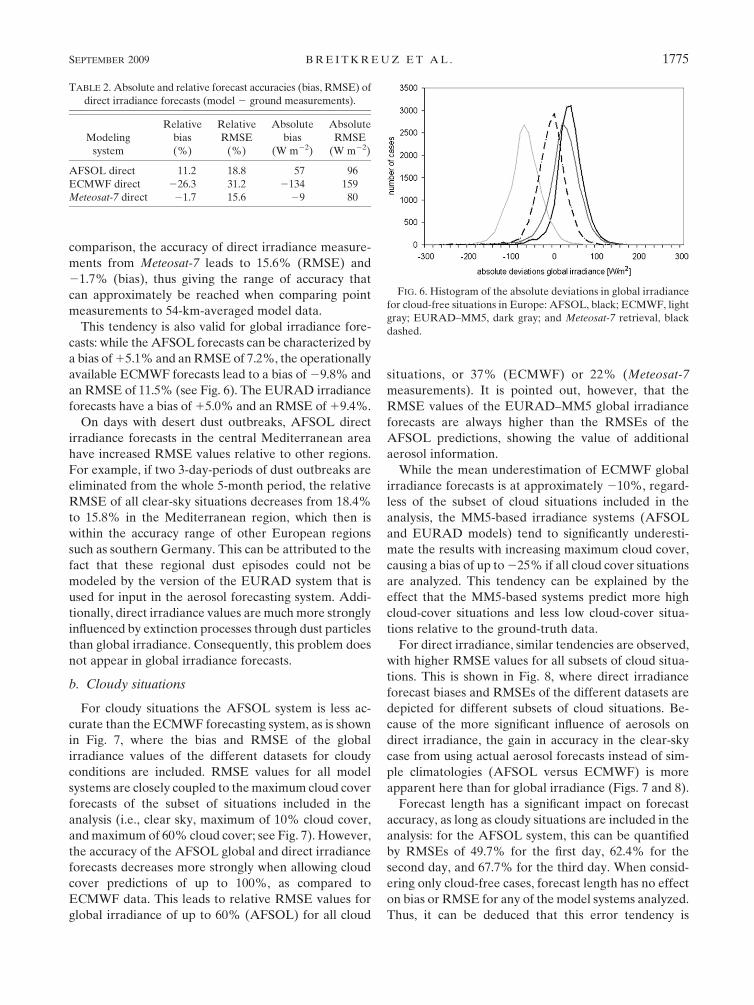
comparison, the accuracy of direct irradiance measure-
ments from Meteosat-7 leads to 15.6% (RMSE) and
21.7% (bias), thus giving the range of accuracy that
can approximately be reached when comparing point
measurements to 54-km-averaged model data.
This tendency is also valid for global irradiance fore-
casts: while the AFSOL forecasts can be characterized by
a bias of 15.1% and an RMSE of 7.2%, the operationally
available ECMWF forecasts lead to a bias of 29.8% and
an RMSE of 11.5% (see Fig. 6). The EURAD irradiance
forecasts have a bias of 15.0% and an RMSE of 19.4%.
On days with desert dust outbreaks, AFSOL direct
irradiance forecasts in the central Mediterranean area
have increased RMSE values relative to other regions.
For example, if two 3-day-periods of dust outbreaks are
eliminated from the whole 5-month period, the relative
RMSE of all clear-sky situations decreases from 18.4%
to 15.8% in the Mediterranean region, which then is
within the accuracy range of other European regions
such as southern Germany. This can be attributed to the
fact that these regional dust episodes could not be
modeled by the version of the EURAD system that is
used for input in the aerosol forecasting system. Addi-
tionally, direct irradiance values are much more strongly
influenced by extinction processes through dust particles
than global irradiance. Consequently, this problem does
not appear in global irradiance forecasts.
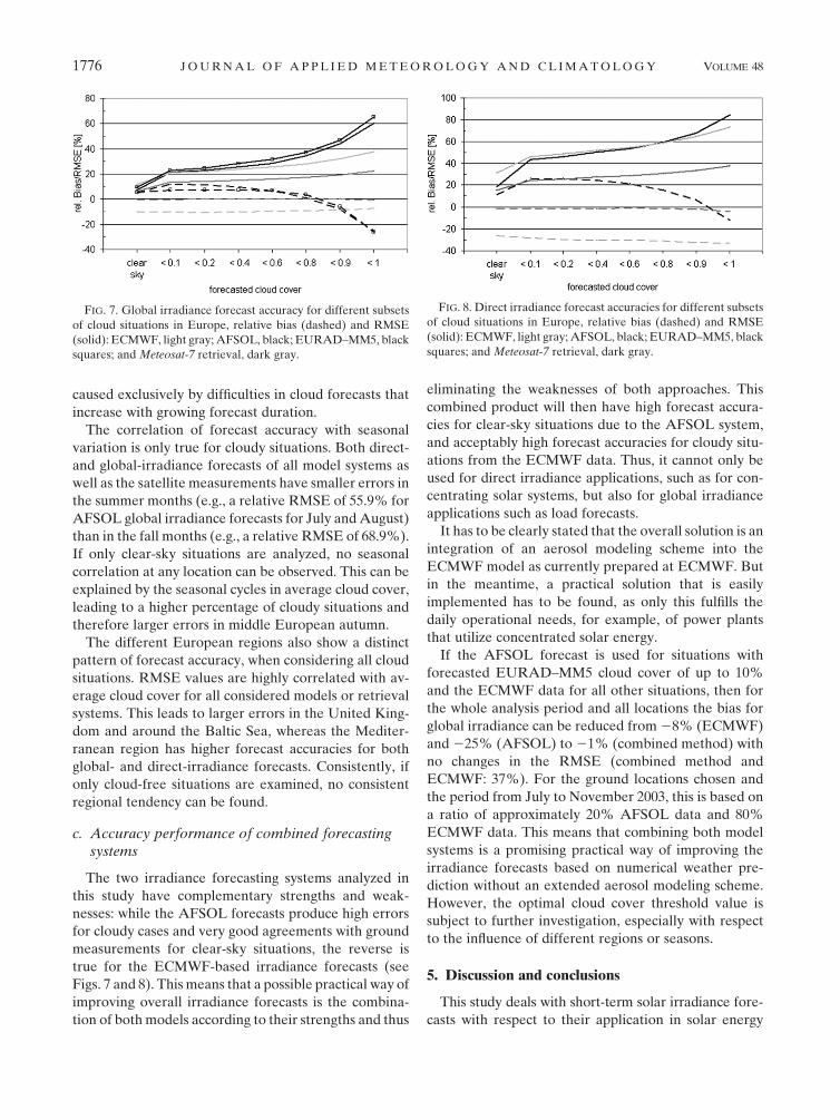
b. Cloudy situations
For cloudy situations the AFSOL system is less ac-
curate than the ECMWF forecasting system, as is shown
in Fig. 7, where the bias and RMSE of the global
irradiance values of the different datasets for cloudy
conditions are included. RMSE values for all model
systems are closely coupled to the maximum cloud cover
forecasts of the subset of situations included in the
analysis (i.e., clear sky, maximum of 10% cloud cover,
and maximum of 60% cloud cover; see Fig. 7). However,
the accuracy of the AFSOL global and direct irradiance
forecasts decreases more strongly when allowing cloud
cover predictions of up to 100%, as compared to
ECMWF data. This leads to relative RMSE values for
global irradiance of up to 60% (AFSOL) for all cloud
situations, or 37% (ECMWF) or 22% (Meteosat-7
measurements). It is pointed out, however, that the
RMSE values of the EURAD–MM5 global irradiance
forecasts are always higher than the RMSEs of the
AFSOL predictions, showing the value of additional
aerosol information.
While the mean underestimation of ECMWF global
irradiance forecasts is at approximately 210%, regard-
less of the subset of cloud situations included in the
analysis, the MM5-based irradiance systems (AFSOL
and EURAD models) tend to significantly underesti-
mate the results with increasing maximum cloud cover,
causing a bias of up to 225% if all cloud cover situations
are analyzed. This tendency can be explained by the
effect that the MM5-based systems predict more high
cloud-cover situations and less low cloud-cover situa-
tions relative to the ground-truth data.
For direct irradiance, similar tendencies are observed,
with higher RMSE values for all subsets of cloud situa-
tions. This is shown in Fig. 8, where direct irradiance
forecast biases and RMSEs of the different datasets are
depicted for different subsets of cloud situations. Be-
cause of the more significant influence of aerosols on
direct irradiance, the gain in accuracy in the clear-sky
case from using actual aerosol forecasts instead of sim-
ple climatologies (AFSOL versus ECMWF) is more
apparent here than for global irradiance (Figs. 7 and 8).
Forecast length has a significant impact on forecast
accuracy, as long as cloudy situations are included in the
analysis: for the AFSOL system, this can be quantified
by RMSEs of 49.7% for the first day, 62.4% for the
second day, and 67.7% for the third day. When consid-
ering only cloud-free cases, forecast length has no effect
on bias or RMSE for any of the model systems analyzed.
Thus, it can be deduced that this error tendency is
TABLE 2. Absolute and relative forecast accuracies (bias, RMSE) of
direct irradiance forecasts (model 2 ground measurements).
Modeling
system
Relative
bias
(%)
Relative
RMSE
(%)
Absolute
bias
(W m22)
Absolute
RMSE
(W m22)
AFSOL direct 11.2 18.8 57 96
ECMWF direct 226.3 31.2 2134 159
Meteosat-7 direct 21.7 15.6 29 80
FIG. 6. Histogram of the absolute deviations in global irradiance
for cloud-free situations in Europe: AFSOL, black; ECMWF, light
gray; EURAD–MM5, dark gray; and Meteosat-7 retrieval, black
dashed.
SEPTEMBER 2009 B R E I T K R E U Z E T A L . 1775
caused exclusively by difficulties in cloud forecasts that
increase with growing forecast duration.
The correlation of forecast accuracy with seasonal
variation is only true for cloudy situations. Both direct-
and global-irradiance forecasts of all model systems as
well as the satellite measurements have smaller errors in
the summer months (e.g., a relative RMSE of 55.9% for
AFSOL global irradiance forecasts for July and August)
than in the fall months (e.g., a relative RMSE of 68.9%).
If only clear-sky situations are analyzed, no seasonal
correlation at any location can be observed. This can be
explained by the seasonal cycles in average cloud cover,
leading to a higher percentage of cloudy situations and
therefore larger errors in middle European autumn.
The different European regions also show a distinct
pattern of forecast accuracy, when considering all cloud
situations. RMSE values are highly correlated with av-
erage cloud cover for all considered models or retrieval
systems. This leads to larger errors in the United King-
dom and around the Baltic Sea, whereas the Mediter-
ranean region has higher forecast accuracies for both
global- and direct-irradiance forecasts. Consistently, if
only cloud-free situations are examined, no consistent
regional tendency can be found.
c. Accuracy performance of combined forecastingsystems
The two irradiance forecasting systems analyzed in
this study have complementary strengths and weak-
nesses: while the AFSOL forecasts produce high errors
for cloudy cases and very good agreements with ground
measurements for clear-sky situations, the reverse is
true for the ECMWF-based irradiance forecasts (see
Figs. 7 and 8). This means that a possible practical way of
improving overall irradiance forecasts is the combina-
tion of both models according to their strengths and thus
eliminating the weaknesses of both approaches. This
combined product will then have high forecast accura-
cies for clear-sky situations due to the AFSOL system,
and acceptably high forecast accuracies for cloudy situ-
ations from the ECMWF data. Thus, it cannot only be
used for direct irradiance applications, such as for con-
centrating solar systems, but also for global irradiance
applications such as load forecasts.
It has to be clearly stated that the overall solution is an
integration of an aerosol modeling scheme into the
ECMWF model as currently prepared at ECMWF. But
in the meantime, a practical solution that is easily
implemented has to be found, as only this fulfills the
daily operational needs, for example, of power plants
that utilize concentrated solar energy.
If the AFSOL forecast is used for situations with
forecasted EURAD–MM5 cloud cover of up to 10%
and the ECMWF data for all other situations, then for
the whole analysis period and all locations the bias for
global irradiance can be reduced from 28% (ECMWF)
and 225% (AFSOL) to 21% (combined method) with
no changes in the RMSE (combined method and
ECMWF: 37%). For the ground locations chosen and
the period from July to November 2003, this is based on
a ratio of approximately 20% AFSOL data and 80%
ECMWF data. This means that combining both model
systems is a promising practical way of improving the
irradiance forecasts based on numerical weather pre-
diction without an extended aerosol modeling scheme.
However, the optimal cloud cover threshold value is
subject to further investigation, especially with respect
to the influence of different regions or seasons.
5. Discussion and conclusions
This study deals with short-term solar irradiance fore-
casts with respect to their application in solar energy
FIG. 7. Global irradiance forecast accuracy for different subsets
of cloud situations in Europe, relative bias (dashed) and RMSE
(solid): ECMWF, light gray; AFSOL, black; EURAD–MM5, black
squares; and Meteosat-7 retrieval, dark gray.
FIG. 8. Direct irradiance forecast accuracies for different subsets
of cloud situations in Europe, relative bias (dashed) and RMSE
(solid): ECMWF, light gray; AFSOL, black; EURAD–MM5, black
squares; and Meteosat-7 retrieval, dark gray.
1776 J O U R N A L O F A P P L I E D M E T E O R O L O G Y A N D C L I M A T O L O G Y VOLUME 48

industries. The main atmospheric parameter responsible
for the extinction of solar irradiance is clouds. However,
the main focus and economic potential of the solar en-
ergy industry is found in regions and time periods that
have minimal cloud cover. During these ‘‘clear sky’’
cases, it is mainly aerosols—solid and liquid particles in
the atmosphere—that influence the direct and diffuse
irradiances at ground level. Aerosols are highly variable
in space and time, which leads to difficulties in calcu-
lating and forecasting their spatiotemporal patterns and
thus their influence on irradiance.
For an episode of 5 months (July–November 2003) in
Europe, forecasts of the aerosol optical depth at 550 nm
(AOD550) based on particle forecasts of the EURAD
chemistry transport model are analyzed. It is shown that
the aerosol forecasts underestimate ground-based mea-
surements by a mean of 20.11 (RMSE of 0.20), which is
not within the accuracy required by the solar energy
industry for input parameters of irradiance forecasts. In
particular, sporadic Saharan dust storm events in the
central Mediterranean region lead to large inaccuracies
that cannot be accounted for in the version of the
EURAD model system used. Improvements in forecast
accuracy can thus be expected from the integration of
dust and also fire particle modules into the model sys-
tem; these improvements are being prepared at the
moment. Furthermore, the consideration of higher
spatial resolutions is expected to lead to reduced fore-
cast errors—an approach that has been neglected in this
study for computational reasons, due to the spatial di-
mension of the study area. However, in other case
studies the EURAD system has also been successfully
applied on 15-, 5-, and 1-km scales.
Because of the high regional variability of aerosol
presence and type, large differences in the representation
accuracy for different European regions can be distin-
guished, such as severe underestimations of particle loads
in the highly industrialized Po Valley in northern Italy or
good results for remote continental areas in northern
Europe. However, in spite of these deficiencies in the
EURAD-based AOD forecasting system, especially with
regard to the treatment of desert dust particles, the model
system is capable of reproducing the general features of
the atmospheric aerosol load over Europe.
Using these aerosol forecasts and other remote sens-
ing data (ground albedo, ozone), as well as numerical
weather prediction parameters (water vapor, clouds), a
prototype for an irradiance forecasting system is set
up: the Aerosol-based Forecasts of Solar Irradiance
for Energy Applications system. Based on the 5-month
dataset, its results are compared to forecasts of ECMWF
and the MM5, satellite-based irradiance data from
Meteosat-7, and ground measurements. It is demon-
strated that for clear-sky situations the AFSOL system
significantly improves direct irradiance forecasts com-
pared to ECMWF forecasts, with a reduction in the
relative bias from 226% to 111% and a reduction in the
relative RMSE from 31% to 19%.
On days with desert dust outbreaks, AFSOL direct
irradiance forecasts in the central Mediterranean area
have increased RMSE values relative to other regions.
This means that the integration of dust information into
the model system, such as through the assimilation of
satellite-based data in the forecasting system, would
significantly improve the direct irradiance forecast ac-
curacy for clear-sky situations especially in the Medi-
terranean region, both of which are areas of interest for
the solar energy industries.
Global irradiance forecasts in the clear-sky case are
also shown to have higher accuracies in comparison to
the operationally available ECMWF forecasts, with a
reduction in the relative bias from 210% to 15% and a
reduction in the relative RMSE from 12% to 7%.
However, for cloudy situations, the AFSOL forecasts
can lead to significantly larger forecast errors due to
cloud modeling deficiencies in the underlying mesoscale
numerical weather model. Also, it should be pointed out
that for all cloud situations except completely cloud-free
cases the accuracy of MM5 irradiance forecasts is lower
than for the ECMWF predictions.
This means that both direct and global irradiance
forecasts of the AFSOL model show higher accuracies
than ECMWF global irradiance forecasts or the derived
direct irradiance products in clear-sky cases. Since in
cloud-free situations the aerosols are the dominant pa-
rameter for determining solar irradiance at ground level,
we suggest that the enhanced aerosols’ input into the
irradiance calculation schemes significantly contributes
to this accuracy improvement. This is valid even if there
are still deficiencies within the aerosol forecasting sys-
tem, especially regarding the representation of dust
episodes, because the enhanced aerosol information still
provides an improvement relative to the AOD clima-
tologies used operationally at ECMWF.
In conclusion, regarding the application of the AFSOL
system for solar energy purposes, it can be stated that for
cloudy situations the AFSOL model in its current state is
not well suited to forecasting irradiance and power
loads: a forecast of consumer behavior and thus power
consumption is only possible when cloudy and cloud-
free situations can be forecasted accurately enough.
However, the AFSOL systems produces good agree-
ment with ground measurements for cloud-free situa-
tions and especially for direct irradiance forecasts—both
of which determine the situations of greatest relevance
for the management of solar thermal and photovoltaic
SEPTEMBER 2009 B R E I T K R E U Z E T A L . 1777
power plants. Therefore, the need for an inclusion of a
more detailed aerosol scheme into the ECMWF oper-
ational model has been clearly shown in this study. In the
meantime, the combined use of ECMWF and AFSOL
irradiance forecasts, depending on the level of fore-
casted cloud cover, can be recommended to fulfill daily
operative needs at present-day concentrating solar power
plants. This approach has been tested with satisfying re-
sults: a reduction in bias from 225% (AFSOL) and 28%
(ECMWF) to 21% (combination method) is achieved.
Possible benefits from using the AFSOL model for
optimizing the management strategies of a concentrat-
ing solar thermal power plant in Spain are described in a
separate case study (Wittmann et al. 2008). Further test
cases and the use of larger datasets for the development
of power plant operation strategies are foreseen.
Acknowledgments. We thank the Rhenish Institute
for Environmental Research of the University of Co-
logne, especially Lars Nieradzik, for providing large
amounts of EURAD-CTM aerosol and EURAD/MM5
meteorological data. As well, we thank the AERONET
PIs and their staff for establishing and maintaining the
32 sites used in this investigation.
For the provision of ground-based irradiance mea-
surements at 121 sites, we thank the ECMWF, the Deut-
sche Wetterdienst (DWD), the Spanish Instituto Nacional
de Meteorologıa, the Met Office, the AERONET net-
work, the National Observatory Athens, the Global
Atmospheric Watch Programme, the International Day-
light Measurement Project, the Sveriges Meteorologiska
och Hydrologiska Institut, the CEOP project, the Baseline
Surface Radiation Network, the Institute of Construction
and Architecture of the Slovak Academy of Sciences, the
Solar Millennium AG, the Centre Universitaire d’Etude
des Problemes de l’Energie of the University of Geneva,
and the colleagues at the Plataforma Solar de Almerıa.
Our acknowledgment also goes to the developers of
libRadtran (information online at www.libradtran.org)
for their radiative transfer tools, which were used for all
irradiance calculations.
We thank Dr. Elke Lorenz from the Energy and
Semiconductor Research Department of the University of
Oldenburg for Meteosat-7 retrieval data and for routines
and help with the ECMWF data interpolation procedures.
This work was financed by the Virtual Institute of
Energy Meteorology (vIEM), supported by the ‘‘Impuls-
und Vernetzungsfond’’ of the Helmholtz Foundation.
REFERENCES
Ackermann, I. J., and Coauthors, 1998: Modal Aerosol Dynamics
Model for Europe: Development and first applications.
Atmos. Environ., 32, 2981–2999.
Anderson, T. L., and Coauthors, 2003: Mesoscale variations of
tropospheric aerosols. J. Atmos. Sci., 60, 119–136.
Bhartia, M., 2004: Algorithm theoretical basis document. Version 8:
TOMS total ozone algorithm. NASA Goddard Space Flight
Center, MD, 23 pp. [Available online at http://toms.gsfc.nasa.
gov/version8/v8toms_atbd.pdf.]
Bramstedt, K., and Coauthors, 2002: Comparison of total ozone
from the satellite instruments GOME and TOMS with mea-
surements from the Dobson network 1996–2000. Atmos.
Chem. Phys. Discuss., 2, 1131–1157.
Breitkreuz, H., 2008: Solare Strahlungsvorhersagen fur ener-
giewirtschaftliche Anwendungen—Der Einfluss von Aero-
solen auf das solare Strahlungsangebot. (Solar irradiance
forecasts for energy applications—The influence of aerosols
on solar irradiance.) Ph.D. thesis, Universitat Wurzburg,
Wurzburg, Germany, 153 pp.
——, and Coauthors, 2007: A case study to prepare for the utili-
zation of aerosol forecasts in solar energy industries. Sol.
Energy, 81, 1377–1385.
Cano, D., and Coauthors, 1986: A method for the determination of
the global solar radiation from meteorological satellite data.
Sol. Energy, 37, 31–39.
Dahlback, A., and K. Stamnes, 1991: A new spherical model for
computing the radiation field available for photolysis and
heating at twilight. Planet. Space Sci., 39, 671–683.
Drews, A., and Coauthors, 2007: Monitoring and remote failure
detection of grid-connected PV systems based on satellite
observations. Sol. Energy, 81, 548–564.
Dumortier, D., 1998: The Satellight model of turbidity variations in
Europe. Sixth SATELLIGHT Meeting Rep., Ecole Nationale
des Travaux Publics de l’Etat Vaulx-en-Velin, France, 11 pp.
Ebel, A., and Coauthors, 1997: Air pollution studies within the
EURAD Model System (3): EURAD—European Air Pollu-
tion Dispersion Model System. Institute Geophysics and
Meteorology Rep. Tech Rep. 6/1997, University of Cologne,
Cologne, Germany, 134 pp.
ECMWF, cited 2008: 2.5: Input to the radiation scheme. Integrated
Forecast System documentation CY28r1. [Available online at
http://www.ecmwf.int/research/ifsdocs/CY28r1/Physics/Physics-
03-6.html.]
EHF and Ecole de Mines/Armines, 2001: Compilation of data
requirements. Heliosat-3 project, Contract NNE5-2000-00413,
Fifth EU Framework Programme, 14 pp. [Available online at
http://www.heliosat3.de/documents/Heliosat3_D2_data_req.pdf.]
Evans, B. T. N., and G. R. Fournier, 1990: Simple approximation to
extinction efficiency valid over all size parameters. Appl. Opt.,
29, 4666–4670.
Girodo, M., 2006: Solarstrahlungsvorhersage auf der Basis nu-
merischer Wettermodelle. (Solar irradiance forecasts based
on numerical weather prediction models.) Ph.D. thesis, Uni-
versity of Oldenburg, Oldenburg, Germany, 159 pp.
Glahn, H., and D. Lowry, 1972: The use of model output statistics
(MOS) in objective weather forecasting. J. Appl. Meteor., 11,
1203–1211.
Grell, G. A., J. Dudhia, and D. R. Stauffer, 1995: A description of the
fifth-generation Penn State/NCAR Mesoscale Model (MM5).
NCAR Technical Note NCAR/TN-3981STR, 138 pp.
Hammer, A., and Coauthors, 1999: Short-term forecasting of solar
radiation: A statistical approach using satellite data. Sol.
Energy, 67, 139–150.
——, E. Lorenz, and S. Petrak, 2007: Fernerkundung der Solar-
strahlung fur Anwendungen in der Energietechnik. (Re-
mote sensing of solar irradiance for applications in energy
1778 J O U R N A L O F A P P L I E D M E T E O R O L O G Y A N D C L I M A T O L O G Y VOLUME 48
technologies.) Proc. Deutsch–Osterreichisch–Schweizerische
Meteorologentagung 2007, Hamburg, Germany, German–
Austrian–Swiss Meteorological Association. [Available online at
http://meetings.copernicus.org/dach2007/download/DACH2007_
A_00357.pdf.]
Hass, H., H. J. Jakobs, and M. Memmesheimer, 1995: Analysis of a
regional model (EURAD) near surface gas concentration
predictions using observations from networks. Meteor. Atmos.
Phys., 57, 173–200.
Henzing, J. S., and Coauthors, 2004: Effect of aerosols on the
downward shortwave irradiances at the surface: Measure-
ments versus calculations with MODTRAN4.1. J. Geophys.
Res., 109, D14204, doi:10.1029/2003JD004142.
Hodzic, A., and Coauthors, 2006: Evolution of aerosol optical
thickness over Europe during the August 2003 heat wave as
seen from CHIMERE model simulations and POLDER data.
Atmos. Chem. Phys., 6, 1853–1864.
Holben, B. N., and Coauthors, 1998: AERONET—A federated
instrument network and data archive for aerosol characteri-
zation. Remote Sens. Environ., 66, 1–16.
Holzer-Popp, T., and Coauthors, 2008: Benefits and limitations of
the new version synergetic aerosol retrieval SYNAER. Sat-
ellite Aerosol Remote Sensing over Land, A. A. Kokhanovsky
and G. de Leeuw, Eds., Springer, 227–266.
Jacovides, C. P., and Coauthors, 2000: Spectral solar irradiance and
some optical properties for various polluted atmospheres. Sol.
Energy, 69, 215–227.
Jensenius, J., and G. F. Cotton, 1981: The development and testing
of automated solar energy forecasts based on the model out-
put statistics (MOS) technique. Proc. First Workshop on
Terrestrial Solar Resource Forecasting and on the Use of Sat-
ellites for Terrestrial Solar Resource Assessment, Washington,
DC, American Solar Energy Society, 22–29.
Kato, S., and Coauthors, 1999: The k-distribution method and
correlated-k approximation for a shortwave radiative transfer
model. J. Quant. Spectrosc. Radiat. Transf., 62, 109–121.
Kinne, S., and Coauthors, 2005: An AeroCom initial assessment—
Optical properties in aerosol component modules of global
models. Atmos. Chem. Phys. Discuss., 5, 8285–8330.
Latha, K. M., and K. V. S. Badarinath, 2005: Spectral solar atten-
uation due to aerosol loading over an urban area in India.
Atmos. Res., 75, 257–266.
Lorenz, E., 2004: Methoden zur Beschreibung der Wolke-
nentwicklung in Satellitenbildern und ihre Anwendung zur
Solarstrahlungsvorhersage (Methods for the description of
cloud development in satellite images and their application for
solar irradiance forecasts). Ph.D. thesis, University of Olden-
burg, Oldenburg, Germany, 111 pp.
Martynenko, D., and Coauthors, 2008: Sensitivity analysis of
synergetic aerosol retrieval and its application in assimila-
tion procedure. Proc. European Geophysical Union General
Assembly, Vienna, Austria, European Geophysical Union,
EGU2008-A-04030.
Mayer, B., and A. Kylling, 2005: The libRadtran software package
for radiative transfer calculations: Description and examples
of use. Atmos. Chem. Phys., 5, 1855–1877.
Meloni, D., and Coauthors, 2007: Seasonal behavior of Saharan
dust events at the Mediterranean island of Lampedusa in the
period 1999–2005. Atmos. Environ., 41, 3041–3056.
Memmesheimer, M., and Coauthors, 1995: Modeling of episodic
emission data for Europe with the EURAD emission model
EEM. Proc. Int. Specialty Conf. on Regional Photochemical
Measurement and Modeling Studies, San Diego, CA, Air and
Waste Management Association, 495–499.
Mueller, R. W., and Coauthors, 2004: Rethinking satellite-based
solar irradiance modeling: The SOLIS clear sky module.
Remote Sens. Environ., 91, 160–174.
Nieradzik, L., and H. Elbern, 2006: Variational assimilation of com-
bined satellite retrieved and in situ aerosol data in an advanced
chemistry transport model. Proc. ESA Atmospheric Science
Conf., Frascati, Italy, European Space Agency, 2006-440.
Rigollier, C., M. Lefevre, and L. Wald, 2004: The method Heliosat-
2 for deriving shortwave solar radiation from satellite images.
Sol. Energy, 77, 159–169.
Rikos, E., S. Tselepis, C. Hoyer-Klick, and M. Schroedter-Homscheidt,
2008: Stability and power quality issues in microgrids under
weather disturbances: An implementation to the Kythnos island
power system. IEEE J. Special Topics Earth Observations Remote
Sensing, 3, 170–179.
Schaaf, C. B., and Coauthors, 2002: First operational BRDF, Al-
bedo Nadir Reflectance Products from MODIS. Remote Sens.
Environ., 83, 135–148.
Schell, B., 2000: Die Behandlung sekundarer organischer Aerosole
in einem komplexen Chemie-Transport-Modell (The treatment
of secondary organic aerosols in a complex chemistry transport
model). Institute for Geophysics and Meteorology Rep. 135,
University of Cologne, Cologne, Germany, 171 pp.
Schmidt, G. A., and Coauthors, 2006: Present-day atmospheric
simulations using GISS ModelE: Comparison to in situ, sat-
ellite, and reanalysis data. J. Climate, 19, 153–192.
Skartveit, A., J. A. Olseth, and M. E. Tuft, 1998: An hourly diffuse
fraction model with correction for variability and surface al-
bedo. Sol. Energy, 63, 173–183.
Stamnes, K., and Coauthors, 1988: Numerically stable algo-
rithm for discrete-ordinate-method radiative transfer in mul-
tiple scattering and emitting layered media. Appl. Opt., 27,
2502–2509.
Wang, K., J. Liu, X. Zhou, M. Sparrow, M. Ma, Z. Sun, and
W. Jiang, 2004: Validation of the MODIS global land surface
albedo product using ground measurements in a semidesert
region on the Tibetan Plateau. J. Geophys. Res., 109, D05107,
doi:10.1029/2003JD004229.
Wittmann, M., and Coauthors, 2008: Case-studies on the use of
solar irradiance forecasts for optimized operation strate-
gies of solar thermal power plants. IEEE J. Special Topics
Earth Observations Remote Sensing, 1, 18–27, doi:10.1109/
JSTARS.2008.2001152.
SEPTEMBER 2009 B R E I T K R E U Z E T A L . 1779