selected namibian secondary school geography
182
SELECTED NAMIBIAN SECONDARY SCHOOL GEOGRAPHY TEACHERS’ PEDAGOGICAL THINKING AND PRACTICES: THE CASE OF MAPWORK. A thesis submitted in fulfilment of the requirements for the degree of MASTER OF EDUCATION (Geography Education) RHODES UNIVERSITY By JOHANNA NDAMONONGHENDA NAXWEKA Supervisor: Professor Di Wilmot December 2018
-
Upload
khangminh22 -
Category
Documents
-
view
1 -
download
0
Transcript of selected namibian secondary school geography

SELECTED NAMIBIAN SECONDARY SCHOOL GEOGRAPHY
TEACHERS’ PEDAGOGICAL THINKING AND PRACTICES: THE CASE
OF MAPWORK.
A thesis submitted in fulfilment of the requirements for the degree of
MASTER OF EDUCATION
(Geography Education)
RHODES UNIVERSITY
By
JOHANNA NDAMONONGHENDA NAXWEKA
Supervisor: Professor Di Wilmot
December 2018
ii
ABSTRACT
Learner performance in mapwork in secondary school geography in Namibia has been
consistently poor. Examiners’ reports provide detailed feedback on the difficulties learners
demonstrate with little, if any, attention paid to teachers’ perceptions, experiences and
pedagogical practices of mapwork. This qualitative study generated insights to understand
selected geography teachers’ perceptions and pedagogical practices of mapwork. Data were
generated through a questionnaire administered to thirty geography teachers in fifteen
secondary schools in the Ohangwena Circuit in the Ohangwena Region of Namibia. The
teachers’ responses were coded and analyzed and patterns and trends identified. Based on what
emerged, a purposive sample of three teachers was chosen for in-depth interviews to probe
their responses and to observe their classroom practices.
The study draws on learner centred pedagogy (LCP), the official educational policy in
Namibia, and Shulman’s perspectives of teachers’ content and pedagogical content knowledge
(PCK) (1986, 1987) to interpret what teachers say about the teaching of mapwork and how
they teach it. The qualities of teachers’ PCK that support student learning in mapwork are not
yet fully understood because there has been little research on teachers’ PCK for teaching
mapwork and spatial thinking in geography classrooms (Jo & Bednarz, 2014).
The study sheds light on the teachers’ qualifications and experience, their perceptions and
attitudes towards the teaching of mapwork, their teaching strategies and the resources they use.
The findings reveal that the teachers are conscientious but ill-equipped to teach mapwork. The
study illuminated a disjuncture between the rhetoric and practice of learner centred pedagogy.
There is evidence which suggests that the teachers’ knowledge of the curriculum is superficial
and limited to content. Their practices are focused on teaching map skills and procedural
knowledge with little, if any, attention given to spatial and map conceptual understanding and
application of knowledge to solve problems.
The study concludes that teachers’ map and spatial conceptual understanding and pedagogical
content knowledge should be strengthened if the persistent problem of poor learner attainment
is to be resolved. It provides insights that may be of value to Namibian teachers, teacher
educators, curriculum policy developers and Senior Education Officers when addressing this
problem.
iii
DEDICATION
This thesis is dedicated to:
My dear mother, Natalia (Mboshono) Sheetekela
My grandmother, Hendrina (Naango) Neshuku
My first-born daughter, Julie-Bridget Ndapandula Tunomwene (Nanguloshi) Haufiku

iv
ACKNOWLEDGEMENTS
To God almighty, for his guidance and unconditional love to enable me to successfully
complete my studies.
To Professor Di Wilmot, my supervisor, for your undivided attention, for devoted support,
patience and professional guidance throughout my research journey. Thank you for your
kindness and for always making sure I got home safely after our evening supervision.
Robert Louis Kraft, thank you for your hospitality and for being my personal “taxi driver”.
Thank you for your professional academic critique, motivation and positive feedback.
To Jean Schäfer, for proofreading and editing my work.
To Metumo Ndakukamo for a well-drawn map of Ohangwena circuit.
Ohangwena Regional Council Directorate of Education and principals of the three schools for
the permission to conduct this research study. To my research participants, thank you for your
time, patience and willingness to participate in this study. This research study could not have
been possible without you.
My colleagues in the Social Sciences Department at Ponhofi SS, I take my hat off to you.
Thank you for your understanding and keenness to make this study a reality. I know how much
you have endured in my absence. Even if I wish to, I will never afford to repay you. The entire
team Ponhofi deserves a salute.
The two ladies in my life, (My grandmother-Hendrina Naango Neshuku and my mother-
Natalia Mboshono Sheetekela), thank you for your guidance and prayers. To my mother, thank
you for deserting your own house just to come and take care of your then one-year-old
granddaughter without any hesitancy. Thank you for all the sleepless nights. Although you
have not seen the doors of a university, you have always valued education. Thank you for the
support and for believing in me. I am because you are. I love you mom.
To Mweya and Jessica, thank you for the support and for being there for Nanguloshi. Mweya,
you have been a mother, a sister and the best friend Nanguloshi could ever ask for. Tangi
Mkwana! Ndapandula and Ndakulamboli, thank you for checking up on Nanguloshi now and
then. Ndilimeke Haiyala (mom), you are one in a million. Ipawa, you know more than I do. All

v
friends and family, thank you for the support and words of encouragement.
To my first-born daughter, Nanguloshi, although too little to speak your mind, I know you
understood and supported my decision. Thank you for the love and understanding for the
missed birthdays and loss of time to play.
To Kenneth (Twahepele), I have no words, you took up responsibilities entirely not yours.
Thank you for all the sacrifices and, most importantly, thank you for taking good care of
Nanguloshi.
vi
TABLE OF CONTENTS
ABSTRACT .............................................................................................................................. iiDEDICATION ......................................................................................................................... iiiACKNOWLEDGEMENTS ...................................................................................................... ivTABLE OF CONTENTS .......................................................................................................... viLIST OF ACRONYMS ............................................................................................................. xLIST OF FIGURES ................................................................................................................ xiiLIST OF TABLES .................................................................................................................. xiiLIST OF APPENDICES ......................................................................................................... xiiCHAPTER ONE ........................................................................................................................ 1RESEARCH OVERVIEW ........................................................................................................ 11.1 Introduction ..................................................................................................................... 11.2 Contextual background of the study ............................................................................... 11.3 Research Goal ................................................................................................................. 21.4 Research methodology .................................................................................................... 31.5 Significance of the study ................................................................................................. 31.6 Structure of the study ...................................................................................................... 3CHAPTER TWO ....................................................................................................................... 5LITERATURE REVIEW .......................................................................................................... 52.1 Introduction ..................................................................................................................... 52.2 Importance of geography in education ........................................................................... 52.3 Maps: Essential tools for communicating spatial information ....................................... 92.4 Mapwork teaching and learning .................................................................................... 122.5 The language of maps ................................................................................................... 132.6 Difficulties and challenges of teaching mapwork ......................................................... 142.6.1 Teachers’ attitudes towards teaching mapwork .......................................................... 142.6.2 Teaching and learning support materials ............................................................... 142.6.3 Teacher knowledge ................................................................................................ 152.7 Mapwork in the Namibian Secondary School Curriculum ........................................... 162.8 Namibian teachers’ experiences of teaching mapwork ................................................ 182.9 Teacher support ............................................................................................................. 192.10 Conclusion .................................................................................................................... 20CHAPTER THREE ................................................................................................................. 21THEORETICAL PERSPECTIVES ......................................................................................... 213.1. Introduction ................................................................................................................... 213.2. Teacher Knowledge ...................................................................................................... 213.2.1. Pedagogical Content Knowledge (PCK) ............................................................... 213.2.3. General Pedagogical Knowledge (GPK) ............................................................... 233.2.4. Curriculum Knowledge (CK) ................................................................................ 233.2.5. Knowledge of learners’ characteristics .................................................................. 243.3. Teacher knowledge in the context of mapwork ............................................................ 243.3.1. Pedagogical Content Knowledge (PCK) ............................................................... 243.3.2. Content Knowledge (CK) ...................................................................................... 253.4. Learner Centred Pedagogy: International Perspectives ................................................ 273.4.1 Learner-centred pedagogy: Namibian perspectives .............................................. 29

vii
3.4.2 Critiques of the learner-centred pedagogy ............................................................. 313.5. Pedagogy in School Geography: International Perspectives ........................................ 323.6. Pedagogy in School Geography: Namibian Perspectives ............................................. 343.7. Teaching Methods ......................................................................................................... 343.7.1 Lecture or Chalk-and-Talk .................................................................................... 343.7.2 Project-based method ............................................................................................ 353.7.3 Enquiry-based learning .......................................................................................... 363.7.4 Field work .............................................................................................................. 363.7.5 Questioning method ............................................................................................... 373.8. Assessment for Learning (AfL) .................................................................................... 373.9. Learning and Teaching Support Materials (LTSMs) .................................................... 393.10. Analytical Framework .................................................................................................. 393.11. Conclusion .................................................................................................................... 46CHAPTER FOUR .................................................................................................................... 46RESEARCH METHODOLOGY............................................................................................. 464.1 Introduction ................................................................................................................... 464.2 Research Orientation ..................................................................................................... 464.2.1 Interpretive paradigm ............................................................................................ 464.2.2 Case study .............................................................................................................. 474.3 Research Question and Goals ....................................................................................... 474.4 Research Process ........................................................................................................... 484.5 Research Site ................................................................................................................. 494.6 Research Participants .................................................................................................... 504.7 Sampling Procedures .................................................................................................... 504.7.1 Purposeful Sample ................................................................................................. 504.7.2 Convenience sample .............................................................................................. 514.8 Data Collection Methods .............................................................................................. 514.8.1 Pilot Study ............................................................................................................. 514.8.2 Questionnaire ......................................................................................................... 514.8.3 Interviews .............................................................................................................. 534.8.4 Classroom Observation .......................................................................................... 554.8.5 Stimulated Recall Interviews ................................................................................. 564.9 Data Analysis ................................................................................................................ 574.10 Issues associated with qualitative research ................................................................... 584.10.1 Ethical considerations ............................................................................................ 584.10.2 Validity and Trustworthiness ................................................................................. 594.11 Conclusion .................................................................................................................... 60CHAPTER FIVE ..................................................................................................................... 61TEACHERS’ PERCEPTIONS OF TEACHING MAPWORK ............................................... 615.1 Introduction ................................................................................................................... 615.2 Analysis of data gathered through a questionnaire ....................................................... 615.2.1 Biographical profile of the teachers ....................................................................... 615.2.2 Teachers’ perceptions of mapwork ........................................................................ 635.2.3 Strategies used to teach mapwork ......................................................................... 635.2.4 Mapwork integration ............................................................................................. 635.2.5 Learning and teaching support materials (LTSM) ................................................ 64

viii
5.2.6 Teachers’ confidence ............................................................................................. 645.2.7 Teacher support for mapwork teaching ................................................................. 655.3 INTERVIEW DATA PRESENTATION ..................................................................... 665.3.1 Teachers’ perceptions of mapwork ........................................................................ 665.3.2 Teaching approaches ............................................................................................. 675.3.3 Integrating mapwork .............................................................................................. 705.3.4 Teaching map concepts ......................................................................................... 715.3.5 Knowledge and skills taught in mapwork lessons ................................................. 745.3.6 Assessing learning .......................................................................................................... 755.3.7 Learning and Teaching Support Materials (LTSMs) ...................................................... 765.4 Challenges and difficulties of teaching mapwork ............................................................. 765.5 Teacher support for mapwork teaching ............................................................................ 775.6 Conclusion .................................................................................................................... 79CHAPTER SIX ........................................................................................................................ 80TEACHERS’ CLASSROOM PRACTICES ........................................................................... 806.1 Introduction ................................................................................................................... 806.2 Ms Nailonga’s classroom practice ................................................................................ 806.2.1 Ms Nailonga: Lesson 1 .......................................................................................... 826.2.2 Ms Nailonga: Lesson 2 .......................................................................................... 896.3 Ms Munageni’s classroom practice .............................................................................. 936.3.1 Ms Munageni: Lesson 1 ....................................................................................... 956.3.2 Ms Munageni: Lesson 2 ...................................................................................... 1006.4 Mr Haitange’s classroom practice .............................................................................. 1066.4.1 Mr Haitange: Lesson 1 ............................................................................................... 1076.4.2 Mr Haitange: Lesson 2 ........................................................................................ 1126.5 Synthesis of what emerged ......................................................................................... 1166.6 Conclusion .................................................................................................................. 123CHAPTER SEVEN ............................................................................................................... 124DISCUSSION OF FINDINGS .............................................................................................. 1247.1 Introduction ................................................................................................................. 1247.2 What are Namibian geography teachers’ views and experiences of teaching mapwork
in secondary school geography classrooms? ...................................................... 1247.3 What pedagogical approaches are used by Namibian teachers in secondary school
geography classrooms? ....................................................................................... 1287.3.1 Teachers’ mapwork classroom practices and pedagogical approaches ............... 1297.3.2 Learner Centred Pedagogy .................................................................................. 1317.3.3 Teacher knowledge .............................................................................................. 1337.3.4 Learning and Teaching Support Materials .......................................................... 1377.3.5 Knowledge and skills promoted in mapwork lessons ......................................... 1377.3.6 Assessment .......................................................................................................... 1417.4 Synthesis and conclusion ..................................................................................... 141CHAPTER EIGHT ................................................................................................................ 143CONCLUSION ...................................................................................................................... 1438.1 Introduction ................................................................................................................. 1438.2 Synthesis ..................................................................................................................... 1438.3 Lessons learned ........................................................................................................... 146

ix
8.4 Conclusion .................................................................................................................. 150REFERENCE LIST ............................................................................................................... 151APPENDICES ....................................................................................................................... 159
x
LIST OF ACRONYMS
ACRONYM FULL NAME
AfL Assessment for Learming
BEd Bachelor of Education degree
BEd-Hon Bachelor of Education degree with Honours
BETD Basic Education Teacher Diploma
CK Content Knowledge/Curriculum Knowledge
CS Combined School
DEAL Diploma in Education African Languages
DNEA Directorate of National Examinations and Assesment
GIS Geographic Information System
GPS Global Position Satellite (GPS)
HOD Head of Department
HS High School
IGU International Geographical Union
IGU-CGE International Geographical Union Commission on Geographical
Education
IT Information Technology
JSC Junior Secondary Certificate
LCP/LCE/LCA Learner Centred Pedagogy/Learner Centred Education/Learner
Centred Approach

xi
LTSMs Learning and Teaching Support Materials
MEAC Ministry of Education, Arts and Culture
MEC Ministry of Education and Culture
MoE Ministry of Education
NCBE National Curriculum for Basic Education
NRC National Research Council
NSSCH Namibia Senior Secondary Certificate High level
NSSCO Namibia Senior Secondary Certificate Ordinary level
PCK Pedagogical Content Knowledge
PGCE Post Graduate Certificate in Education
SOE Senior Education Officer
SS Secondary School
SSA Sub-Saharan Africa
TCE Teacher Centred Education
UNAM University of Namibia
UNESCO United Nations Education Scientific and Cultural Organisation

xii
LIST OF FIGURES
Figure 2.1: Basic concepts of the analysis of spatial relationships for geography as a subject
Figure 3.1: Professional competence of teachers
Figure 4.1: Map showing schools in Ohangwena circuit
Figure 6.1: List of symbols
Figure 6.2: Class activity
Figure 6.3: Learners building a model
Figure 6.4: Models built in the lesson
LIST OF TABLES
Table 2.1: Summary of mapwork content and skills in Namibian secondary school geography curriculum
Table 3.1: Analytical Framework
Table 5.1: Summary of teachers’ age, gender, qualifications and teaching experience
Table 5.2: Number of teachers who integrate mapwork into other sections of the syllabus
Table 5.3: Teacher confidence
Table 6.1: Profile of the teachers
Table 6.2: Summary of findings
LIST OF APPENDICES
Appendix A Formal permission letter to the director of education
Appendix B Permission letter from the director of education
Appendix C Consent Form
Appendix D Teacher questionnaire
Appendix E Teacher interview schedule
Appendix F Lesson observation schedule

CHAPTER ONE
RESEARCH OVERVIEW
1.1 Introduction
This study investigates selected Namibian secondary school geography teachers’ perceptions,
experiences and classroom practices of teaching mapwork. The study responds to the question
of how mapwork is taught in secondary school geography in Namibia, where low learner
performance in mapwork in the junior and secondary examinations is a persistent and
unresolved issue.
This chapter contextualises the study, explains why I decided to undertake the research and
how it may contribute to the field of school geography research in Namibia. I outline the
research goal, research questions and methodology. I conclude the chapter with an outline of
the structure of the thesis.
1.2 Contextual background of the study
Geography is the study of the earth’s landscapes, people, places and the environment (Namibia.
Ministry of Education Arts and Culture [MEAC], 2015). What makes geography unique is its
ability to bridge the human and physical sciences (Namibia. MEAC, 2015). Geographers use
maps to communicate the spatial information about phenomena and processes in the human
and physical environment, and the patterns and changes that occur with time (International
Geographical Union-Commission of Geography Education [IGU-CGE], 2016, United Nation
Education Scientific Cultural Organisation, [UNESCO] 2017). A review of international
literature reveals that in spite of maps being an important tool used by geographers to
communicate spatial information, the teaching and learning of mapwork is an ongoing
challenge (Satterly, 1973; Andersons & Leinhardt, 2002; Bednarz, n.d.; Bednarz, Acheson &
Bednarz, 2006; Larangeira & van der Merwe, 2016). Maps are sophisticated and abstract
graphic representations that encode spatial information, using symbols together with numbers
and words. Map concepts and properties are abstract and need to be taught. These include
contours/relief, position, perspective, map projections, interpolation, direction, bearing,
distance, scale, inter-visibility, gradient, coordinates and distribution (The American National
Research Council (NRC), 2006; Namibia. MEAC, 2015).

2
During my ten years of experience teaching secondary school geography, I have become aware
that teaching and learning mapwork is a challenge in Namibian secondary school geography.
According to the Namibian Junior Secondary and Senior Secondary Certificate examiners’
reports, learners have difficulty reading, analysing and interpreting geographical data presented
to them in graphic form. Learners’ performance in Paper 2 (Mapwork) has been persistently
poor (Namibia. Directorate of National Examinations and Assesment [DNEA] 2013, 2014,
2015 & 2016). A more recent Namibia Senior Secondary Certificate Ordinary level [NSSCO]
examiners’ report highlighted that “mapwork is still a major concern and teachers should strive
to give more attention to this section of the paper” (Namibia. [DNEA], 2017, p. 289). The
problem is however not confined to Namibia. Studies in different national contexts describe
mapwork teaching and learning challenges. A study in Hong Kong for example, found that
map reading and interpretation was poor (Yau at el., 1992 as cited in Amosun, 2016). Similar
findings in Britain and Poland, and more recently in Nigeria were attributed to teachers’ lack
of proficiency teaching mapwork skills (Amosun, 2016; Ezeudu & Utazi, 2014). The literature
on mapwork focuses mostly on the difficulties learners experience with map reading and
interpretation, with less attention given to the teaching of mapwork. This study, in focusing as
it does on the teaching of mapwork from the perspective of Namibian teachers, may help to
address the gap in the literature.
1.3 Research Goal
The goal for this study is to generate insights for understanding selected Namibian geography
teachers’ perceptions and pedagogical practices of mapwork. It responds to the question: What
are selected Namibian geography teachers’ perceptions and pedagogical practices of mapwork
in secondary school geography classrooms? And the following sub-questions:
• What are Namibian geography teachers’ views and experiences of teaching mapwork
in secondary school geography classrooms?
• What pedagogical approaches are used by Namibian teachers in secondary school
geography classrooms?
• What lessons can be learned from teachers’ pedagogical practices that may be used to
strengthen and enhance mapwork teaching and inform teachers’ professional
development?
3
1.4 Research methodology
This study is a qualitative exploratory case study within an interpretive paradigm. The use of
this approach helped me to understand teachers’ perceptions and pedagogical practices of
teaching mapwork in secondary school geography. Five data collecting methods were used,
namely a questionnaire, semi-structured interviews, non-participatory classroom observations,
followed by stimulus recall interviews and document analysis. These tools enabled me to
generate insights for a deeper understanding of mapwork teaching. A detailed discussion of the
research methodology and research participants is discussed in Chapter Four of this study.
1.5 Significance of the study
The study identifies a number of lessons learned that may be of value to Namibian teachers,
teacher educators, curriculum policy developers and Senior Education Officers (SOEs) when
addressing the problem of low learning outcomes in mapwork.
1.6 Structure of the study
The thesis is organised as follows:
Chapter Two reviews the literature on the teaching and learning of mapwork concepts and
skills and the issues and challenges associated therewith. It also includes a discussion on
mapwork in the Namibian secondary school geography curriculum.
Chapter Three is a review of the theoretical perspectives informing the study, namely
Learner-Centered Pedagogy (LCP), the official pedagogy in Namibia and teacher knowledge,
particularly that offered by Shulman (1986, 1987).
Chapter Four describes and explains the research methodology and design as well as the
selection of the participants. It discusses the data collection methods and data analysis, and
issues associated with case study research.
Chapter Five presents the data analysis and findings of teachers’ responses to a questionnaire
and semi-structured interviews, the purpose of which was to elicit their perceptions and
experiences of mapwork teaching. Emergent patterns and themes are identified and discussed.
4
Chapter Six presents the data analysis and findings of the classroom observations I undertook
to understand how a sample of three teachers teach mapwork. Emergent patterns and themes
are identified and discussed.
Chapter Seven discusses what emerged in Chapters Five and Six in relation to the literature
reviewed in Chapters Two and Three.
Chapter Eight synthesizes the findings of the research, presents the lessons that can be
extrapolated from the study and makes some recommendations. The chapter concludes with a
critical reflection on the research process and limitations.
5
CHAPTER TWO
LITERATURE REVIEW
2.1 Introduction
This study, as outlined in Chapter One, focused on the teaching of mapwork in Namibian
secondary school geography. The goal of the research was to generate insights for
understanding selected teachers’ perceptions and pedagogical practices of mapwork. This
chapter reviews literature on mapwork teaching which is relevant to the study. The chapter
starts with a discussion on the importance of geography in education. This is followed by a
discussion on the importance of teaching mapwork and spatial thinking in school geography.
Issues and challenges associated with the teaching of mapwork are then discussed. A critical
commentary on mapwork in the Namibian school geography curriculum follows. The chapter
concludes with a synthesis of key points relevant to the study.
2.2 Importance of geography in education
The National Council for Geographic Education (1994) defines geography as
… an integrative discipline that brings together the physical and human dimensions of the world in the study of people, places, and environment. Its subject matter is Earth’s surface and the processes that shape it, the interrelationships between people and environments, and the connections between people and places (p.18).
More recently, the International Geographical Union’s Commission on Geographical
Education [IGU-CGE] (2016) asserts that the “high level ideas” of geography are place, space,
scale and environment. Figure 2.1 illustrates how geography bridges the physical and the
human (social) sciences, and focuses on the interrelationship between them. It shows how
geography is concerned with the structures, processes and functions of the human and physical
environment systems at different scales from the local, regional, international and global.
Geography is the only discipline that deals with “spatial variability, i.e. phenomena, events and
processes within and between places, and should therefore be regarded as an essential part of
any education for all citizen and societies” (ICU-CGE, 2016, p. 4). Geography helps us to
“appreciate and understand how places and landscapes are formed… and the Earth’s diverse
and interconnected mosaic of cultures and societies” (IGU-CGE, 2016, p. 5).

6
Figure 2.1: Basic concepts of the analysis of spatial relationships for geography as a subject. (Source: Gamerith, Hammer, & Czapek, 2014)
According to UNESCO (2017), geography is concerned with identifying processes and patterns
within and between the human and physical environment, identifying actors and their influence
on space at different levels and the implications this has for people and the environment at each
scale. Furthermore, UNESCO (2017) acknowledges the important role played by geography in
developing holistic, systems thinking and spatial understanding necessary for addressing the
complex, multi-faceted challenges and problems people face in the world today. This important
contribution of the discipline has been recognized for some time in the literature. For example,
Naish (1997, as cited in Lambert & Balderstone, 2000) contends that
School geography has the potential to develop young people’s understanding of their ‘place’ in the world and so to help them form their identity. It can enable them to perceive the structures and processes which help and hinder their development, and can also foster their commitment to social justice and democracy, and the conserving, participatory and critical forms for citizenship … and thereby help to create a better world (p. 361).
Bednarz and Bednarz (2004) argue that geography education should help inform geographers
who are interested “in how individuals … make sense of the space around them and in the
impacts on individuals’ spatial understanding caused by technology, symbols, and society” (p.
25).
The literature asserts that geography is a vital subject for the 21st century. For example, the
IGU-CGE (2016) states that “geographical education is vital to equip the next generation of

7
people with the knowledge, skills and practices to value, care and make reasonable decisions
for the planet” (p. 5). School geography contributes to young people’s education by developing
• Geographical knowledge and understanding of major natural systems of the
Earth in order to understand the interaction within and between ecosystems.
Socio-ecosystems of the Earth in order to achieve a sense of place. Spatial
concepts - key ideas unique to Geography that help students to make sense of the
world: location, distribution, distance, movement, region, spatial association,
spatial interaction and change over time.
• Geographical skills in using communication, thinking, practical and social skills
to explore geographical topics at a range of levels from local to international.
• Attitude and values dedicated to seeking thinking solutions to local, regional,
national and international questions and problems on the basis of the Universal
Declaration on Human Rights (IGU-CGE, 2007, p. 245).
Of significance to this study is spatial conceptual understanding and geographic skills,
including an ability to read and interpret maps, graphs and charts, photographs and tabular
information. According to Graves (1997), such geographical ability is closely related to the
development of one’s ability to “read, orientate oneself, and develop mental maps of the
environment in which they live, to plan routes and develop the ability to navigate and move in
their own world” (p. 27).
School geography also helps young people to answer questions of what, how, why and where,
which makes it possible for an “individual to understand relationships and responsibilities they
have to both the natural environment and each other” (IGU-CGE, 2016, p. 5). It follows that
the teaching of geography should therefore “…build on people’s own experiences and should
help them to formulate geographical questions, develop their intellectual skills and respond to
issues affecting their lives” (IGU-CGE, 2016, p. 5). Likewise, learning geography should
introduce students “not only to key 21st century skills, but also to distinctive investigative tools
such as maps, fieldwork and the use of powerful digital communication technologies such as
the Geographic Information System” (IGU-CGE, 2016, p. 5). Graves (1997) states that
In teaching geography teachers, could be said to be developing spatial skills in their pupils, to be getting them used to analysing the spatial aspects of economic and social problems and to be making them aware of the nature of the

8
environmental issues and developing in their minds the concept of environmental ethics (p. 28).
Geography is a key subject that develops spatial thinking and maps are important tools for
communicating spatial information. School geography should focus on developing an
understanding of how maps can assist young people to better understand how social-economic,
environmental and political changes at both local and global scales affect our everyday lives
(UNESCO, 2017, p. 109). “Maps and graphics are powerful tools in understanding the spatial
dimensions of an issue as well as synthesizing and communicating complex and sometimes
contradicting data” (UNESCO, 2017, p. 112). In addition, “maps and other visuals reflects the
worldviews of the people who made them, a critical point of view on how an issue represented
can be developed” (UNESCO, 2017, p. 112).
Ezeudu and Utazi (2014) contend that
… education that does not include geography in its curriculum will have a lot of social cost among which include: depriving of young people of early awareness of spatial relationships; denial of students their early exposure to maps and their uses; and it engenders a geographic literacy that will last till adulthood just to mention but a few (p. 41).
In summary, geography is a worthwhile discipline because
• It combines human and physical geography by looking at the interaction and
interdependence between societies and their natural environments at different spatial
scales
• Geography combines the description of place, the analysis of patterns in space and the
study of spatial processes shaped by actors
• Geographical thinking and skills contribute to the global citizenship.
The IGU-CGE (2016) calls all policy makers, education leaders, curriculum developers and
geography educators at local, national and international educational levels to make sure that
students receive geographical education that is “effective and worthwhile” (p. 4). My view is
that teaching young people how to use maps to communicate spatial information is a key
element of an effective and worthwhile geographical education.

9
2.3 Maps: Essential tools for communicating spatial information
Bednarz (n.d., p. 1) defines maps as a “graphic representation of a portion of Earth that is
usually drawn to scale on a flat surface. It is the central way geographers organise and analyze
information” (p. 1). Maps are powerful tools geographers use to display and communicate
geographic information (Bednarz, n.d., p. 1). A similar view is expressed by Amosun (2016)
who maintains that maps are representations of part of the earth’s physical, human/cultural
features which have been drawn to scale to fit on a flat sheet of paper. Maps and diagrams are
powerful tools used to visualize, explore, store, and communicate geographic information, and
the skills of making maps and using these visual representations of the world are very important
in the discipline of geography (Stephen, 2010; Bednarz, n.d.).
Maps promote spatial thinking, understanding and visualisation, and are a pre-requisite for
spatial thinking (Balboni, 2013). According to Bednarz (n.d.) “…learning to think
geographically is learning to think spatially” (p. 2). Maps are an essential tool which
geographers use to organize and analyze spatial information (Bednarz, n.d.). Spatial thinking
is defined as “the knowledge, skills, and habits of mind to use spatial concepts, maps and
graphs, and processes of reasoning in order to organize and solve problems” (Bednarz,
Achoson, & Bednarz, 2006, p. 398). The American National Research Council defines spatial
thinking as “a collection of cognitive skills comprised of knowing concepts of space, using
tools of representation, and reasoning processes” (2006, p. 12). Spatial thinking involves the
ability to consider objects in terms of their location in space, and question why objects are
located where they are as well as visualising relationships between and among those objects
(Bednarz, n.d.). Jo and Bednarz (2014b) maintain that teachers who value spatial thinking as
an important goal of education, teach geography in a way that promotes students’ spatial
thinking skills. Recognising that maps are social constructs that may communicate a particular
worldview, Bednarz (n.d.) contends that it is “…important to develop a healthy, critical
awareness and scepticism about maps and other graphics and images” (p. 2).
The teaching of maps is important in secondary school geography because maps promote
learners’ geospatial thinking. They also help learners to navigate in space and find their way
home or in any environment in which they find themselves (Liben, Kastens, & Stevenson,
2002). Few would refute Bednarz’s (n.d.) assertion that maps are the indispensable part of
geography, an informative core around which geographical information can be learned.
Larangeira and van der Merwe (2016) argue that map literacy is an essential skill for
10
interpreting difficult information presented visually in maps, thus this is an essential
competence that cannot be neglected in the development of a geographer. Maps help us to think
beyond our real-world experiences and to think analytically about locations and their relations
to each other (Uttal, 2000, p. 247). Maps are powerful tools for displaying and communicating
geographical information and a key way in which geographers organize and analyze
information (Bednarz, n.d.). In the classroom, maps provide a foundation on which
understanding about places, including faraway places in the world, can be introduced and used
to discuss topics such as climate, vegetation, landforms, and settlement patterns among others
(Anderson & Leinhardt, 2002, p. 314). These authors maintain that in spite of the importance
of maps, many learners struggle and lack map skills necessary to read and make sense of maps.
One way in which we experience and learn about the world is through direct experience with
the world as we move and travel within the environment from one place to another. However,
not every individual can experience and learn about the earth and the world directly. Thus, for
most individuals much of their knowledge about the earth comes from [map] representations
(Liben et al., 2002, p. 269). For example, “maps provide a concrete depiction of Earth, making
it possible to see portions of the Earth that would otherwise be unavailable …” (Liben et al.,
2002, p. 270). Uttal (2000) stresses that “…maps provide a perspective that can be difficult to
acquire from direct experience navigating in the world” (p. 247). Uttal’s view is that maps
change the way one thinks about the represented information. He explains that they give us “…
an awareness of the world beyond what we have experienced and allow us to see and study sets
of spatial relations without directly travelling through space (Uttal, 2000, p. 249). According
to Uttal (2000), knowing the world through maps provides an important ‘inroad’ into realising
other ways of thinking about and mentally representing the world beyond one’s direct
experiences (p. 250). Furthermore, maps influence how we learn and acquire spatial
information: they provide a static view of space and a different perspective from what we
usually see from navigation” (Uttal, 2000, p. 250). This is because maps show space at a small
scale which decreases the actual size of the feature. And it is this “characteristic of maps that
allows us to visualise spatial relations, and that would not be available form direct experiences”
(Uttal, 2000, p. 250). Maps bring into view and ‘highlight’ spatial and geographical
information that would have been inaccessible form direct visual experience such as relations
and projections among others (Uttal, 2000, p. 251). Anderson and Leinhardt (2002) argue for
understanding the concept of map projections because “a solid understanding of map projection

11
allows a map reader to see beyond distortion in the map and to use a map as a representational
system for reasoning about the earth’s surface” (p. 317).
Bednarz (n.d.) observes that maps are increasingly used as a means of studying a wide range of
scientific phenomena, and because of the popular use of maps in today’s world, learning how
to read and interpret maps is an essential skill (p. 1). Liben et al. (2002) express a similar view
that “… while maps are a core of geography; their importance extends beyond the geography
classroom to a diverse range of disciplines”. There is significant interest among geographers,
urban planners, geology, biology, mathematics, psychologists, cognitive scientists and many
others in map use and spatial thinking (Uttal, 2000, Liben et al., 2002, Bednarz et al., 2006,
Bednarz, n.d.). In all these fields, maps are seen as being more than just simple sources of
locating information, but rather as “realizations” in the “ah-ha sense of discovery” (Liben et al.,
2002, p. 270). Bednarz (n.d.) contends that “the ability to use maps, images and other spatial
technologies intelligently and critically is becoming a requirement to participate effectively as
a citizen in modern society” (p. 1). For this reason, map education is seen as very important in
teaching and facilitating learning with understanding of the basic properties of maps.
Bednarz et al. (2006) assert that while “maps are not the whole of geography, but there can be
no geography without maps” (p. 398). They argue that maps are the primary tools geographers
use to communicate spatial information and geographers frequently define their subject around
maps and map use (ibid.). Maps “represent a compilation of geographic information about
selected physical and human features” (National Council for Geographic Education, 1994, p.
61). Maps use “points, lines and area symbols, as well as colour, to show where phenomena
are located, and how they are arranged, distributed, and related to one another” (ibid., p. 61).
Maps show visible features such as “rivers, seacoasts, roads, and towns and invisible features
such as “subway systems, tunnels, ad geologic formations” (National Council for Geographic
Education, 1994, p. 61). Furthermore, maps are also used to ‘depict abstract features’ such as
political boundaries, population densities, and lines of latitudes and longitudes (ibid.). Liben et
al. (2002) assert that
… maps record and store information, serve as computational aids, serve as aids to mobility; summarize complex, voluminous data; help us to explore data (analyse, forecast, spot trends); help us to visualize what would otherwise be closed to us; serve as trigger devices to stimulate thoughts (p. 271).
A strong case is made for teaching learners “… how to use maps and other geographic
representations, tools, and technologies to acquire, process, and report information form a

12
spatial perspective” (National Council for Geographic Education, 1994, p. 61). A similar view
is held by Ezeudu and Utazi (2014). They contend that maps play a significant role in the
teaching and learning of geography and maps are the distinctive tools used by geographers to
achieve the objectives of geography (Ezeudu & Utazi, 2014). Maps are viewed as the
‘everyday’ tools which “…geographers rely on in order to study the world, both near and far”
(Larangeira & van der Merwe 2016, p. 120).
2.4 Mapwork teaching and learning
Mapwork teaching and learning should be taught and taught well. According to Bednarz et al.
(2006), “teaching about maps means providing students with the skills and understandings
required to read, interpret and produce maps” (p. 399). It “means using maps to help students
learn key [map] concepts and relationships” (Bednarz et al., 2006, p. 399). Teaching with maps
allows students to learn and think through maps, (that is to think spatially) in various reasoning
and problem solving activities in both the classroom and real world (Bednarz et al., 2006, p.
399). For students to use maps effectively, appropriate teaching is needed. Teaching should
take into account the difficulties students experience when learning about maps and spatial
thinking (ibid., p. 402). Maps and spatial thinking should be taught “using maps and other
graphic representations such as globes, graphs, diagrams, and … satellite-images …” (ibid., p.
402). These representations should be used to develop students’ “personal understanding about
location and characteristics of places … and their ability to describe and analyze patterns of
people, places and the environment on earth using both visual and mental maps” (Bednarz et
al., 2006, p. 403).
Bednarz (n.d.) argues that students should be taught to “think spatially to become fluent with
spatial concepts, to think in terms of patterns in space (where), and to consider the processes
that produced those patterns (how and why there)” (p. 2). She further says that when students
are allowed to think through maps, they learn to appreciate maps and the information they
communicate.
Spatial thinking can be taught using maps. It should include teaching spatial concepts, which
according to Catling (1995), cited by Wilmot (1998, p. 31) include: perspective (the view from
above); symbols (how features and objects are shown on a map); location (where things are on
a map); direction (which way), and scale (how far; reduction). Learners need to understand
these concepts and the skills for calculating, measuring and reading spatial information
encoded in a map and then be able to apply this knowledge to make sense of spatial processes,
13
relationships and patterns in the natural environment (for example, calculate the gradient to
understand slope type); and between the physical and human environment (for example how
gradient affects transport and settlement). Map conventions and properties are abstract and thus
for some, difficult to understand. Concepts such as overlay, buffer, distortion, scale, distance,
symbols, direction and projection, which are essential for basic map reading and interpretation,
and spatial analysis, need to be explicitly taught (Oda, 2016; Zwartjes et al., n.d.). Map reading,
interpretation and analysis should be taught, not simply as a skill but as a means of representing
and analyzing information about particular ideas (Bock, 2002). Wilmot (1998) argues that the
acquisition of spatial knowledge depends on spatial perception skills and spatial conceptual
understanding. She views spatial literacy as an ability to recognise objects and features, and an
ability, through cognition, to interpret and make sense of the object/feature, spatial
relationships and make spatial inferences (Wilmot, 1998). The extent to which teachers use
maps to develop learners’ spatial thinking and understanding is discussed in Chapter Seven.
The need for developing critical map literacy is described in the literature. For example,
Bednarz et al. (2006) stress that, just as texts are written by individuals with different
viewpoints, which can be read and interpreted differently for different purposes, maps too are
not just objects that represent reality; maps are socially constructed and are subjected to critical
analysis. Bednarz et al. (2006) call for “an increase in levels of carto-literacy” that “… must
include explicit instruction about how to interrogate a map — to consider the conditions under
which it was produced, the viewpoint it portrays and the messages it conveys” (p. 404).
Teaching should develop “students’ critical awareness and scepticism about maps as well other
graphics and images” (Bednarz et al., 2006, p. 404). The extent to which teachers enable spatial
thinking and understanding in their mapwork lessons and critical map literacy, is discussed in
Chapter Seven.
2.5 The language of maps
Maps are graphic representations that use a symbolic language to communicate spatial
information (Wilmot, 1998). Map makers encode spatial knowledge, using symbols often in
combination with words and figures which map readers have to decode when reading and
interpreting a map. Weeden (1997) explains that maps use three types of symbols: point, line
and area symbols to represent phenomena. These are explained in a map key. In order to
develop map literacy – the ability to read and interpret information on a map, teachers need to
understand maps as a form of communication and to give students an opportunity to become

14
fluent in the language of maps (Bednarz et al., 2006, p. 402). Wilmot (1998, 2002) asserts that
map literacy requires conceptual knowledge of the object/phenomenon represented in a map
as well as spatial perceptual skills and an understanding of spatial concepts. Teachers need to
understand the spatial information and concepts maps communicate and the conventions they
use for doing so. Map conventions and properties are abstract, and thus for some, difficult to
understand. According to Wilmot (2002), spatial literacy can be enhanced through the explicit
teaching of spatial perceptual and conceptual skills from a young age. The extent to which the
teachers in this study perceive and teach mapwork as described in the literature is discussed in
Chapters Five, Six and Seven.
2.6 Difficulties and challenges of teaching mapwork
A review of the literature describes the difficulties and challenges teachers experience when
teaching mapwork in secondary school geography which are relevant to this study.
2.6.1 Teachers’ attitudes towards teaching mapwork
It is believed that teachers’ attitudes toward their work play a significant role in how they
connect towards their work. It is however, important to note that this does not only affect the
teachers’ work but the performance of the learners.
Okwilagwe (2012), citing Anderson (1991), describes attitude as “…a moderately intense
emotion that predisposes an individual to respond consistently in a favourable or unfavourable
manner when confronted with a particular object or task (p. 68). Attitude is viewed as an
individual’s state of readiness to react in a certain way to a particular situation (Okwilagwe,
2012, p. 68). Teachers’ attitudes toward the subject they teach greatly influences the way they
teach it and it impacts on learner performance (ibid.). Teachers’ beliefs and what they do in
their classrooms have a lot to do with their attitudes. Their choice of teaching methods and
teaching materials of teaching mapwork reading will depend on the teachers’ attitude.
2.6.2 Teaching and learning support materials
Map reading can be defined as the “recognition and identification of map symbols and the
comprehension of the geographic features that they present” (Innes, n.d, unpaged). Although
maps are regarded as an important aspect of geography, one finds that there are no materials to
teach this important aspect in schools. Innes cites how research done in South African schools
revealed that the availability of maps and mapwork resources is an issue, as is the level of
training teachers receive. Textbooks contain too few map extracts, the availability of maps used

15
in the examinations is an issue and there are insufficient specialised map skills textbooks being
used. From my teaching experience, I am aware that the same can be said for Namibia. I concur
with Innes (n.d.) who argues for teachers being provided with maps of the local area and offered
training in how to use maps to teach geography. Van der Westhuizen and Fleischmann’s (2018)
research found a shortage of information technology (IT) resources and access to computers in
many schools in South Africa. They reported a low level of integration of technology in
teaching and learning in many geography classrooms, and second language learners
experiencing difficulty comprehending abstract terms. In the absence of research in Namibia,
it is not possible to comment on whether or not the difficulties and challenges described in the
international literature may be relevant in Namibia. I concur with Brooks (2010, p. 143), who
asserts that “understanding how teachers view their subject is crucial to understanding what
happens in geography classrooms”.
2.6.3 Teacher knowledge
The literature describes that the topics learners find difficult in mapwork are the same as those
teachers find difficult. For example, the findings of a recent study indicated that students found
fifty per cent of the topics difficult. These included gradients, inter-visibility, latitude and
longitude (Amosun, 2016). The research sheds light on a number of challenges teachers face
when teaching mapwork. These include learners not having basic mathematic skills, lacking
motivation to attend classes, do homework and perform in the examination, and having a
negative attitude to mapwork which they perceive as boring, hard and requiring abstract
thinking (Amosun, 2016). Amosun (2016) contends that inappropriate teaching methods may
be a contributing factor to poor performance in mapwork. Another Nigerian study found that
geography teachers do not possess the necessary competency needed for teaching mapwork
and this contributes to poor learner performance (Ezeudu & Utazi, 2014). It is widely accepted
that education cannot rise above the quality of its teachers. Teachers cannot teach what they do
not know (Ezeudu & Utazi 2014, p. 47).
Amosun’s (2016) study showed that geography teachers are scared, and often avoid teaching
mapwork because it is sophisticated and requires abstract thinking and mathematical skills. If
teachers lack the skills and competencies needed to teach mapwork, it may influence their
pedagogical choices, motivation and confidence — all of which will impact on the quality of
learning. It is widely acknowledged that there is a relationship between students’ learning and
the quality of their teachers and that “a weak teacher can have a deleterious impact on learners”
(Goodwin et al., 2014, p. 284).

16
Studies done in Britain and Poland found that the difficulties encountered by students when
reading and interpreting topographical maps may be attributed to teachers’ inability to properly
handle components of teaching mapwork skills (Reinfried, 2001, p. 68). In a South African
study, Larangeira and van der Merwe (2016) report that they also found that the student
teachers who had trouble with map literacy were not taught map skills on a regular basis at
school level, and some student teachers had not studied geography at secondary school —
which was disadvantageous (p. 134).
Bednarz et al. (2006) note that when teaching mapwork, teachers tend to teach map skills by
focusing on the content of the map. As a result, too often, learners are able to give an account
of the map but lack the ability to interpret the content and the geographic impacts illustrated
by maps (ibid.). A similar finding was made in McCall’s (2011) study with mapwork teaching
focused on “teaching factual details without requiring students to understand map and spatial
concepts such as why places are located where they are, or reasons for their physical and human
characteristics” (p. 133). The focus was on memorization of facts rather than on helping
students to thinking critically and learning with understanding (ibid.). According to Larangeira
and van der Merwe (2016) “if students are rote-taught and not encouraged to apply map skills,
then their spatial cognition with regards to map literacy is impeded” (p. 134).
The extent to which these factors are impacting on teaching in Namibian school geography
classrooms is discussed in Chapters Six and Seven.
2.7 Mapwork in the Namibian Secondary School Curriculum
An analysis shows that the purpose and aims of the Namibian secondary school geography
curriculum (Namibia. MoE, 2010, 2015) are aligned to those advocated by the international
literature (IGU-CGE, 2007, 2016). Namibian school geography aims to equip learners with
knowledge and understanding of “… the relationships and interaction of people and their
environment in response to physical and human processes, as well as aspects of changing
world, a sense of place and relative location on local, regional and global scale with emphasis
on Namibia” (Namibia. MEAC, 2015, pp. 1-2). The curriculum aims to develop learners’
understanding and appreciation of how human activities lead to environmental problems and a
need for environmental improvements and conservation (Namibia. MEAC, 2015). It also
emphasizes the need for learners to develop geographical skills including “… suitable
techniques for observation, collecting, classifying, presenting, analysing and interpreting data,
17
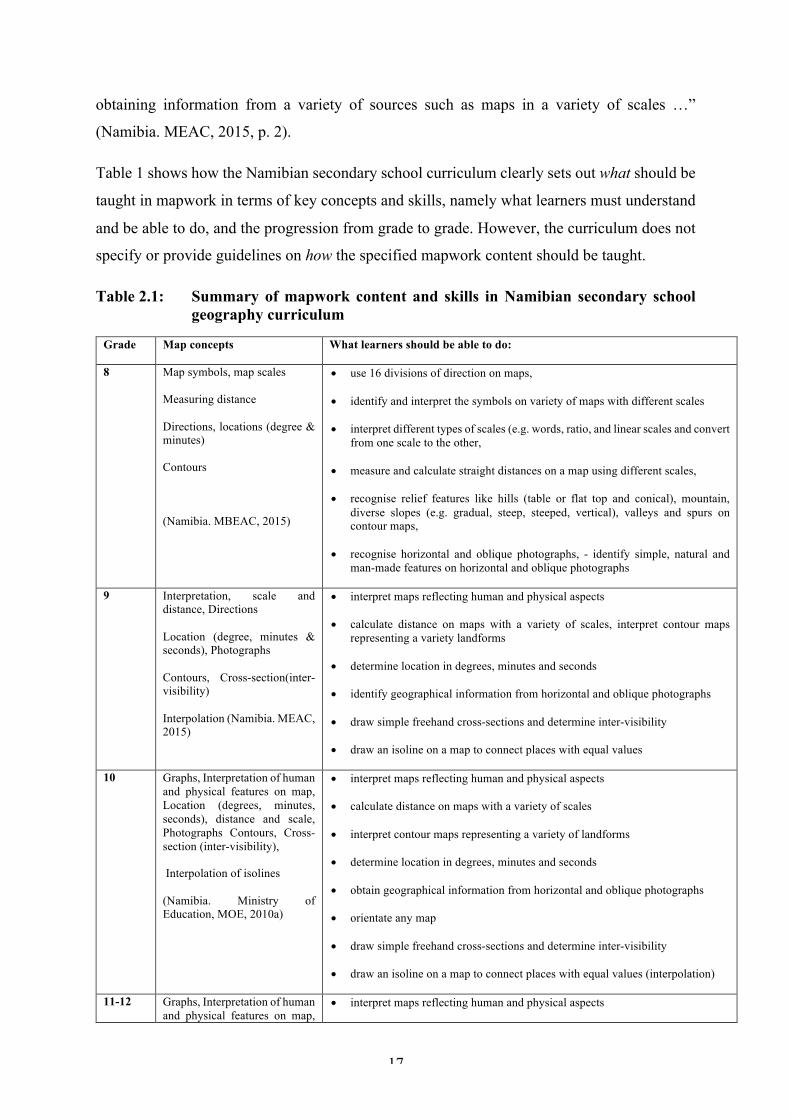
obtaining information from a variety of sources such as maps in a variety of scales …”
(Namibia. MEAC, 2015, p. 2).
Table 1 shows how the Namibian secondary school curriculum clearly sets out what should be
taught in mapwork in terms of key concepts and skills, namely what learners must understand
and be able to do, and the progression from grade to grade. However, the curriculum does not
specify or provide guidelines on how the specified mapwork content should be taught.
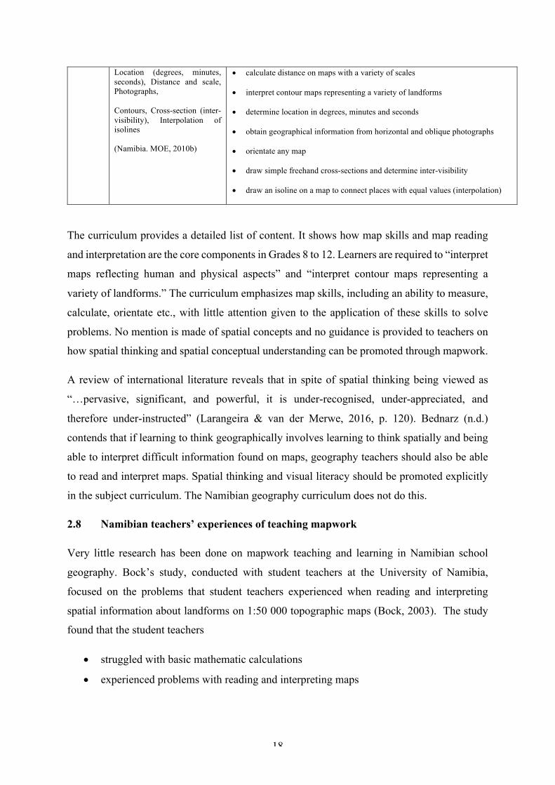
Table 2.1: Summary of mapwork content and skills in Namibian secondary school geography curriculum
Grade Map concepts What learners should be able to do:
8 Map symbols, map scales
Measuring distance
Directions, locations (degree & minutes)
Contours
(Namibia. MBEAC, 2015)
• use 16 divisions of direction on maps,
• identify and interpret the symbols on variety of maps with different scales
• interpret different types of scales (e.g. words, ratio, and linear scales and convert from one scale to the other,
• measure and calculate straight distances on a map using different scales,
• recognise relief features like hills (table or flat top and conical), mountain, diverse slopes (e.g. gradual, steep, steeped, vertical), valleys and spurs on contour maps,
• recognise horizontal and oblique photographs, - identify simple, natural and man-made features on horizontal and oblique photographs
9 Interpretation, scale and distance, Directions
Location (degree, minutes & seconds), Photographs
Contours, Cross-section(inter-visibility)
Interpolation (Namibia. MEAC, 2015)
• interpret maps reflecting human and physical aspects
• calculate distance on maps with a variety of scales, interpret contour maps representing a variety landforms
• determine location in degrees, minutes and seconds
• identify geographical information from horizontal and oblique photographs
• draw simple freehand cross-sections and determine inter-visibility
• draw an isoline on a map to connect places with equal values
10 Graphs, Interpretation of human and physical features on map, Location (degrees, minutes, seconds), distance and scale, Photographs Contours, Cross-section (inter-visibility),
Interpolation of isolines
(Namibia. Ministry of Education, MOE, 2010a)
• interpret maps reflecting human and physical aspects
• calculate distance on maps with a variety of scales
• interpret contour maps representing a variety of landforms
• determine location in degrees, minutes and seconds
• obtain geographical information from horizontal and oblique photographs
• orientate any map
• draw simple freehand cross-sections and determine inter-visibility
• draw an isoline on a map to connect places with equal values (interpolation)
11-12 Graphs, Interpretation of human and physical features on map,
• interpret maps reflecting human and physical aspects
18
Location (degrees, minutes, seconds), Distance and scale, Photographs,
Contours, Cross-section (inter-visibility), Interpolation of isolines
(Namibia. MOE, 2010b)
• calculate distance on maps with a variety of scales
• interpret contour maps representing a variety of landforms
• determine location in degrees, minutes and seconds
• obtain geographical information from horizontal and oblique photographs
• orientate any map
• draw simple freehand cross-sections and determine inter-visibility
• draw an isoline on a map to connect places with equal values (interpolation)
The curriculum provides a detailed list of content. It shows how map skills and map reading
and interpretation are the core components in Grades 8 to 12. Learners are required to “interpret
maps reflecting human and physical aspects” and “interpret contour maps representing a
variety of landforms.” The curriculum emphasizes map skills, including an ability to measure,
calculate, orientate etc., with little attention given to the application of these skills to solve
problems. No mention is made of spatial concepts and no guidance is provided to teachers on
how spatial thinking and spatial conceptual understanding can be promoted through mapwork.
A review of international literature reveals that in spite of spatial thinking being viewed as
“…pervasive, significant, and powerful, it is under-recognised, under-appreciated, and
therefore under-instructed” (Larangeira & van der Merwe, 2016, p. 120). Bednarz (n.d.)
contends that if learning to think geographically involves learning to think spatially and being
able to interpret difficult information found on maps, geography teachers should also be able
to read and interpret maps. Spatial thinking and visual literacy should be promoted explicitly
in the subject curriculum. The Namibian geography curriculum does not do this.
2.8 Namibian teachers’ experiences of teaching mapwork
Very little research has been done on mapwork teaching and learning in Namibian school
geography. Bock’s study, conducted with student teachers at the University of Namibia,
focused on the problems that student teachers experienced when reading and interpreting
spatial information about landforms on 1:50 000 topographic maps (Bock, 2003). The study
found that the student teachers
• struggled with basic mathematic calculations
• experienced problems with reading and interpreting maps
19
• either do not know how to calculate the vertical interval, or they are not familiar with
the concept in spite of the frequent use of the term ‘contour interval’ being used in
school geography
• could not identify slopes and landforms on contour maps.
These findings raise questions about teacher knowledge for teaching mapwork and their ability
to demonstrate mathematical proficiency. Bock (2003) stresses that more often geography
teachers fail to realize that geographical theory is closely linked with mathematical language
(p. 10). This implies that teachers should not only be able to read and understand graphic
representations but should equally be able to recognise relationships between “spatial
visualisation and mathematical reference” (Bock, 2003, p. 10). This is discussed in Chapter
Seven.
2.9 Teacher support
The need for research on improving teaching is described in the literature. Bednarz and Bednarz
(2004) assert that more emphasis should be placed on research that can improve the
understanding and learning of geographic literacy. They contend that research should focus on
learning that promotes problem solving and teaching strategies that support spatial literacy
through maps (p. 23). Citing Lane (2005), Larangeira and van der Merwe (2016) argue for
research on the pedagogy of teaching map skills. According to Okwilagwe (2012), teacher
training should focus on improving teacher motivation and the state should provide continuous
professional development opportunities for in-service teachers.
Universities are also seen as having an important role to play in developing teachers’ mapwork
content base, and their teaching methodologies. This point was made by Larangeira and van
der Merwe (2016) in their study with first-year geography students at the University of the
Witwatersrand. They argue for the inclusion and integration of map theory and methodology
modules in the social sciences and geography training programmes across all four years of the
university’s Bachelor of Education degree. Furthermore, they recommend a bridging or
introductory course at the beginning of the first year for geography student teachers with no
secondary school geography background. A similar view is expressed by Anderson and
Leinhardt (2002) when they call for “conceptual driven instruction for teachers to help them
understand what problems maps can solve, and the practices of working with maps” (p. 137).
20
The extent to which Namibian teachers may require similar support is discussed in Chapter
Seven.
2.10 Conclusion
This chapter has discussed why maps are important tools for communicating spatial
information about the environment. It has described the spatial concepts and skills needed for
reading and interpreting maps and how these can be enhanced through teaching. Mapwork in
the Namibian secondary school geography curriculum was commented on and finally the
challenges and difficulties associated with teaching mapwork were discussed.

21
CHAPTER THREE
THEORETICAL PERSPECTIVES
3.1. Introduction
This chapter sets out the theoretical perspectives used to analyze and interpret the data gathered
on teachers’ perspectives and pedagogical practices of mapwork. The chapter starts with a
discussion on Shulman’s (1986, 1987) ideas on teacher knowledge in general and pedagogical
content knowledge in particular. Teacher knowledge in the context of geography, particularly
mapwork is discussed. This is followed by a discussion on Learner-Centered Pedagogy (LPC),
the official pedagogy advocated by Namibian education policy and the Namibian school
geography curriculum (syllabus). These theoretical perspectives are discussed in relation to the
approaches and teaching methods put forward in the literature on school geography. Before the
chapter concludes with a synthesis of the discussion, an analytical framework is presented.
3.2. Teacher Knowledge
In this study, I draw on Shulman’s (1986, 1987) ideas about teacher knowledge. He identifies
seven categories of teacher knowledge which are worthwhile and crucial in any educational
context. These are as follows:
• Content Knowledge
• General Content Knowledge
• Pedagogical Content Knowledge
• Curriculum Knowledge
• Knowledge of learners’ characteristics
• Knowledge of educational context e.g. school
• Knowledge of educational end purposes.
3.2.1. Pedagogical Content Knowledge (PCK)
Shulman (1986) explains that pedagogical content knowledge (PCK) is knowing how to teach
and present subject content in ways that are accessible to learners. It involves going beyond
knowing subject content (p. 9). Shulman explains that

22
Mere content knowledge is likely to be as useless pedagogically as content-free skills. But to blend properly the two aspects of a teacher’s capacities requires that we pay as much attention to the content aspects of teaching as we have recently devoted to the elements of teaching process (1986, p. 8).
Smith and Lovat (2003) assert that PCK means knowing ‘what’ to teach and ‘how’ to teach as
the two cannot be separated (p. 72). A similar view is held by Vavrus, Thomas and Bartlett
(2011) who explain PCK as “bringing together the critical elements of teaching content and
pedagogy to describe the understanding and skills teachers need to transform the conceptual,
factual and theoretical knowledge of the subject … to a group of students” (p. 74). PCK is seen
as “… accumulated knowledge about the act of teaching, including the goals and procedures
that form the basis for what teachers do in the classroom” (Mullock, 2006, p. 48).
Bednarz, Bockenhauer, and Walk (2005) define pedagogical content knowledge “as the best
way to teach subject matter. It is a combination of pedagogical and content knowledge” (p.
107). Harte and Reitano (2015) maintain that pedagogical knowledge “is the knowledge base
necessary for geography teachers to achieve effective teaching of their subject areas to meet the
cognitive and emotional needs of students” (p. 226). This means that geography teachers need
to have sufficient knowledge, the necessary skills and suitable teaching approaches in order to
deal effectively with the different aspects of the subject they teach. Vavrus et al. (2011) caution
that “… without PCK teachers’ expertise in their content areas may not be fully utilised in the
classrooms as they have not learned a variety of ways to teach their subject and how to address
students' misconceptions of certain topics or adjust difficult areas in the curriculum” (p. 74).
Mullock (2006) follows that what teachers do in their classrooms and how they do what they
do, is shaped by their attitudes, values, knowledge and beliefs gathered from their experience
as students and teachers. The extent to which the teachers in this study demonstrated PCK for
teaching mapwork is discussed in Chapters Six and Seven.
3.2.2 Content Knowledge (CK)
Shulman (1986) describes content knowledge as knowledge and understanding of the most
important areas and key concepts of the discipline in the mind of the teacher. He explains that
“to think properly about the content knowledge requires going beyond knowledge of the facts
or concepts of a domain” (p. 9). Such knowledge of subject content requires an understanding
of how the subject matter is structured, that is an understanding of the conceptual framework

23
on which the discipline is built. Shulman (1986), drawing on Schwab’s (1978) ideas, elaborates
as follows:
The structures of a subject include both the substantive and the syntactic structures. The substantive structures are the variety of ways in which the basic concepts and principles of the discipline are organized to incorporate its facts. The syntactic structure of a discipline is the set of ways in which truth or falsehood, validity or invalidity, are established. (p. 9).
This means that “teachers must not only be capable of defining for students the accepted truths
in a domain. They must also be able to explain why a particular proposition is deemed
warranted, why it is worth knowing, and how it relates to other propositions, both within the
discipline and without, both in theory and in practice” (Shulman, 1986, p. 9).
3.2.3 General Pedagogical Knowledge (GPK)
According to Shulman (1987) general pedagogical knowledge is the “knowledge of generic
principles of classroom organisation and management” (p.14). Moreover, Grossman and
Richert (1988) assert that general pedagogical knowledge “includes knowledge of theories of
learning and general principles of instruction, an understanding of the various philosophies of
education, general knowledge about learners and knowledge of classroom management” (p.
54). Shulman (1987) further explains that good classroom organisation and management helps
teachers to organise learning activities, allocate and promote time on task as well as formulate
well-structured assignments. At the same time, good sound classroom management enables
teachers to create working patterns, create a healthy learning environment and motivates
learners to achieve the intended learning outcomes (ibid.). The extent to which GPK was
evident in this study is discussed in Chapters Six and Seven.
3.2.4 Curriculum Knowledge (CK)
According to Shulman (1986), curriculum knowledge includes the knowledge and
understanding of the curriculum, the teaching and learning materials and resources available
for teaching and the ability to assess a specific subject or topic at a given level. Shulman (1986)
refers to the curriculum, together with all the materials associated with it, as the “material
medica” of pedagogy, “the pharmacopeia” from which teachers draw their tools of teaching to
present specific content and to assess or evaluate what or how much the students have achieved
(p. 10). Curriculum knowledge is seen as including knowledge of the materials and resources,
including for example textbooks, films, and other curriculum materials available for teaching

24
a particular subject. Furthermore, it is also seen as including what Grossman and Richert (1988)
refer to as “… an awareness of preconditions for studying a particular content” (p. 54).
In spite of the importance of curriculum knowledge being widely acknowledged in the
literature, research undertaken in South Africa found that many geography teachers struggled
(and lacked support) to navigate their way through the national curriculum (Wilmot 2005, in
Wilmot & Dube, 2015). Teachers need to be appropriately supported in developing a deep
(theoretical) understanding of curriculum so that they can implement it in creative and
expansive ways (Wilmot, 2005). The extent to which knowledge and understanding of the
curriculum was evident in this study is discussed in Chapters Six and Seven.
3.2.5 Knowledge of learners’ characteristics
According to Shulman (1987), this category of teacher knowledge includes understanding the
different characteristics of learners, and the ability to identify and embrace individual learners’
differences. Shulman stresses that teachers need to know and understand that learners bring a
wide range of knowledge from home to school, which they need to build on and nurture through
the use of different pedagogical approaches that enable such learners to learn. The extent to
which teachers in this study understood and embraced the learners’ differences is discussed in
Chapters Six and Seven.
Teacher knowledge in the context of mapwork
3.3.1. Pedagogical Content Knowledge (PCK)
The importance of PCK for effective teaching is acknowledged in the geography education
literature (see for example Lane, 2009; Jo & Bednarz, 2014a; Harte & Reitano, 2015; Brooks,
2010; Larangeira & van der Merwe, 2016). However, the qualities of the teachers’ PCK that
support student learning in mapwork are not yet understood because there has been little
research on teachers’ PCK for teaching mapwork and spatial thinking in geography classrooms
(Jo & Bednarz, 2014a, p. 302).
According to Jo and Bednarz (2014a), PCK in mapwork teaching is the teacher’s proficiency
to present geographic concepts using a variety of maps to promote students’ spatial thinking
skills. Teachers with good PCK are able to include the bigger ideas of maps and their properties
such as space, time, overlay, scale, distance, and location in a variety of teaching practices as
well as in their lesson planning and assessment strategies (Jo & Bednarz, 2014a).
25
The IGU-CGE (1992) states that “geography should be taught in schools by well-trained,
specialized teachers … who are not only qualified in their discipline but also in geographical
education” (p. 13) including geography content knowledge which Lee and Luft (2008) refer to
as a combination of “content alongside with instruction of the content” or Pedagogical Content
Knowledge (PCK) (p. 1344). It has been argued that “knowledge of subject matter is sine qua
non in teaching” and learners cannot simply be taught how to think, but should be have
something to think about (Reitano & Harte, 2016, p. 280). It follows that “a geography teacher
is expected to have a knowledge of structure that combines both content knowledge (facts,
skills, concepts, generalization) and PCK (representations and instruction)” (Reitano & Harte,
2016, p, 280) “that helps teachers transform (geography) content into learning experiences for
students” (Lee & Luft, 2008, p. 1344).
3.3.2 Content Knowledge (CK)
Accomplished geography teachers “not only know their subject matter deeply; they also know
how to help others develop a deeper understanding of that subject matter” (Lane, 2009, p. 41).
Equally, a teacher should have a rich bank of pedagogical content knowledge that allows them
to make subject matter comprehensive to students (ibid.). It is therefore this expertise that
enables them to transform their content knowledge in a way that is understood by their students,
as well as to choose the analogies, examples, or applications of a concept or skills that make
the content accessible and interesting to a group of learners (Lane, 2009, p. 41). Shulman’s
work has influenced many researchers in the context of school geography. For example,
Golledge (2002) asserts that geography teachers need a knowledge base for teaching mapwork
which includes geographic knowledge, spatial knowledge and mapwork content knowledge.
• Geographic knowledge is the product of geographic thinking and reasoning about the
world’s natural and human phenomena (Golledge, 2002). Citing Eliot (2000), Golledge
(2002) explains that “knowledge of space is phenomenal, knowledge about space is
intellectual” (p. 1). He elaborates as follows:
In geography knowledge of space represents the accumulation of facts about the spatial arrangements and interactions … while knowledge about space consists of the recognition and elaboration of the relations among geographic primitives such as arrangement or organization, distribution, pattern, shape, hierarchy, distance, direction, orientation, regionalisation, categorization… (Golledge, 2002, p. 1).
Importantly, Golledge (2002) asserts that “geography as a discipline has a language and
knowledge that is not casually accessible, … [but] it is a concept rich and a structured body of
26
knowledge that is based on specific modes of thinking and reasoning that usually have to be
taught” (p. 10). It is this knowledge that makes a geography teacher proficient and confident
in presenting subject matter to his or her students. In addition, geographic knowledge also
emphasizes “cognitive demand such as understanding why and how in addition to where, as
equivalent to knowledge about place, culture, interactions, politics, economic, resources, and
natural environment characteristics” (ibid. p. 3). When teachers have sufficient geographic
knowledge, then they are equipped with the ability to deal with and develop spatial meaning,
but in order to do that they need to have spatial knowledge.
• Spatial knowledge is necessary to consider objects in terms of their location in space, to
question why objects are located where they are, and to visualise relationships between and
among these objects (Golledge, 2002).
When teachers are fluent in spatial knowledge or spatial concepts, they become confident in
describing and explaining patterns of objects in space (where), and in considering the process
(how and why they are there) as they observe them in the world around them (Weeden, 1997;
Bednarz, n.d.). Maps are viewed as essential tools for investigating spatial patterns because
they organise and display geographic information (Weeden, 1997; Bednarz, n.d.). However, in
order for a teacher to read and interpret spatial patterns and information found in maps they
need another form of knowledge, namely mapwork content knowledge.
• Mapwork content knowledge is the knowledge for teaching mapwork content and basic
properties of maps.
Weeden (1997) explains that both teachers and students should know the basic essential
properties of maps, such as plain view (perspective and relief), arrangement (location,
direction, and orientation), proportion (scale, distance, and selection), and map language (signs,
symbols, words, and numbers) (p. 170). He contends that “…these properties should form the
basis of mapwork skills … [and] can be taught individually and then integrated” (ibid.).
Moreover, McLaughlin and Talbert (1990 as cited in Williams, 2000, p. 140) stress that the
effectiveness of teaching depends largely on how teachers think and feel about what they are
doing and how they can do it, which centre on the following four dispositions: motivation,
conception of task, enthusiasm over subject-matter, and sense of efficacy. Shulman (1987)
explains that when teachers are uncertain about the content they teach, they tend to adopt a
certain teaching strategy in order to allay their anxiety (p. 18). The extent to which teacher

27
motivation, confidence and attitude may affect mapwork teaching is discussed in Chapter
Seven.
Another aspect of a geography teacher’s PCK is an ability to recognise and build on learners’
experiences and mental constructs and find ways of linking these to new ideas being taught
(Lane, 2009). Balboni (2013) maintains that the best strategy a teacher can use is to “build on”
what the learners already know. Similarly, it is also important for teachers to keep in mind that
“children have been decoding their world since infancy”, they have been making meaning and
seeking to understand the world around them (Balboni, 2013). Good teaching recognises and
builds on the knowledge and experiences of the learners. This is a key premise of the
constructivist epistemology underpinning Namibian Learner-Centred Pedagogy (LCP).
Learner Centred Pedagogy: International Perspectives
In this study, the terms learner-centred pedagogy (LCP), learner-centred education (LCE) and
learner-centred approach (LCA) are used interchangeably. LCP is rooted in the notion of
progressive education and constructivist epistemology. The international literature describes
how there has been a shift since the 1990s to LCP (UNESCO, 2000). A similar shift has been
observed in the educational policies of sub-Saharan African (SSA) countries post-
independence and particularly after the 1990 Education for All conference that gave birth to
the Dakar framework. According to this framework, quality education includes “active learning
techniques and a relevant curriculum … that builds upon the knowledge and experiences of the
teachers and learners …” (UNESCO, 2000, p. 17).
Increasing access to education in African countries and improving educational quality includes
addressing the issue of limited resources in schools and the quality of teaching methods in
African classrooms (Vavrus & Bartlett, 2012). It prompted countries like Botswana, Malawi,
Mali, Namibia, South Africa, and Tanzania to replace teacher-centred transmission approaches
with LCP. In spite of national differences, these policies share a common goal. They encourage
teachers at both primary and secondary levels to move away from the teacher-centred methods
toward those that encourage learning through inquiry and research and emphasise learning
outcomes other than memorization and recall (O’Sullivan, 2004, Nyambe, 2008, Vavrus &
Bartlett, 2012). LCP is seen as an “active” approach to “discovering” knowledge that
superseded the traditional “passive” approach to memorising information. This view is based
on the notion that teachers are not the knowers of knowledge but should stimulate learners’
curiosity to learn, and facilitate their learning (Vavrus & Batlett, 2012). LCP emphasizes active
28
learner participation, it puts the learner at the centre of inquiry and helps learners to develop
high-order thinking skills (Vavrus et al., 2011).
LCP is underpinned by constructivist learning theories, which argue that “learning occurs when
students are engaged actively in a process of constructing meaning and knowledge” (UNESCO,
2017, p. 24). A similar view is taken by Vavrus and Bartlett (2012) who contend that LCP
elicits and builds on learners’ interests and prior knowledge and promotes active learning,
which gives learners an opportunity to apply the learned knowledge and skills to solve real-life
problems. The extent to which this was observed in the teaching of mapwork in the Namibian
lessons I observed, is discussed in Chapter Seven.
The implementation of LCP in SSA has not been without its challenges. Longitudinal research
done on LCP in Tanzania by Vavrus and Bartlett (2012), Vavrus, Bartlett and Selema, (2013)
and globally (including Africa) by Schweisfurth (2011), identified a number of challenges.
Firstly, teachers are often taught about LCP, but not how to implement it. The theories and
teaching methods associated with LCP are unfamiliar to teachers and educators who are
expected to implement such policy reforms (Vavrus & Bartlett, 2012). This is attributed to the
fact that pre-service teachers receive little training in how to implement this pedagogical
approach during teacher training (ibid.). Furthermore, Schweisfurth (2011) argues that “teacher
education itself rarely [uses] learner-centred, and so does not provide suitable models upon
which fledgling teachers can base their practice” (p. 428). Schweisfurth (2011) contends that
teacher training is “insubstantial both in content and time” and
… even where initial or in-service teacher education is supportive of learner-centred education (LCE), if this later contrast with classroom, local monitoring, and inspection regime realities, and the demand of centralised curricula and examinations, once teachers are in classrooms, the impact of training in LCE methods diminishes over time (Schweisfurth, 2011, p. 428).
Secondly, tight, centrally controlled curricula and the backwash effect of high-stake
examinations in many SSA countries militate against engaging learners in inquiry-based
pedagogies (Vavrus & Bartlett, 2012, p. 641). A review of seventy global studies of LCP
revealed that the willingness of teachers to use the LCP methods was influenced by
examination results, and the extent to which exams test learners’ ability to reproduce fixed
bodies of knowledge (Schweisfurth, 2011, p. 429). In the context of school geography, Brooks
(2006) contends that examination specifications in a national curriculum are interpreted too

29
prescriptively by teachers. This type of examination-driven curriculum relies on textbooks that
have often been written by examiners with the examination in mind. She cautions that this
places the examination in a position of power as not only “it defines geography at this level,
but also that it defines the tools of instruction and how it should be taught” (ibid. p. 354). This
is influenced by the fact that teachers need to “cover” all the topics as required by the syllabus.
The material condition of many schools which often lack basic books and supplies, is another
challenge that makes the implementation of the constructivist pedagogy difficult (Vavrus &
Bartlett, 2012). Vavrus et al. (2013) explain that “…material and human resources constitute a
challenge, ranging from teacher training and preparation to provision of sufficient textbooks,
teaching materials, class space, number of teachers, and appropriate furniture” (p. 9). The
extent to which similar challenges are faced in Namibia, in the teaching of mapwork in school
geography is discussed in Chapter Seven.
Research conducted on the use of LCP in SSA showed that it is difficult to shift teachers’
beliefs and practices for philosophical and practical reasons (Vavrus et al., 2013, p. 9). They
found that in spite of the promotion of LCP in the national curriculum, “teachers generally
continue to rely on teacher-centred approaches … such as lecturing, rote learning and
repetition, with very little attention being paid to critical thinking, dialogue, group work and/or
reflection” (Vavrus et al., 2013, p. 9). They argue that:
Teachers take up the new ideas differently, in relation to their contexts, positioning and knowledge… Teacher characteristics, such as prior qualifications, reflective competence, grade level, subject knowledge and confidence, as well as access to resource and support structures [including support from school heads] in their schools, are all implicated in their take-up of learner-centred practices (Vavrus et al., 2013, p. 9).
The findings of research in other SSA countries show that previous experiences as student
teachers, together with the conditions of teaching in schools, deeply influence the extent to
which teachers embrace and implement LCP (Vavrus et al., 2013). The extent to which this is
evident in this study is discussed in Chapter Seven.
3.4.1 Learner-centred pedagogy: Namibian perspectives
After Namibia became independent in 1990, a learner-centred approach was adopted as the
new education reform policy. “It was considered an effective antidote to the shifting teacher-
centred practice used within the previous apartheid system” (O’Sullivan, 2003, p. 586). It was

30
also seen as being more “aligned with the newly adopted political and ideological values of
democracy and social justice that guided the new Namibia” (Nyambe & Wilmot, 2014, p. 28).
Education reform and the adoption of LCP was underpinned by the goals of access, equity,
quality and democracy (Nyambe & Wilmot, 2014; Pomuti, 1999). Education based on
democratic and participatory principles was seen as promoting mutual respect and co-operation
(Pomuti, 1999). Driven by this agenda “…learning was intended to become active, meaningful,
purposeful and goal-oriented” (Swarts, 1999, p. 37). Schooling was seen as playing an
important role in supporting enabling the realisation of the vision and goals of education reform
(ibid.). This is acknowledged in the policy.
Our teaching methods must allow for the active involvement and participation of learners in the learning process. Teachers should structure their classes to facilitate this active learner role. Often, that will mean organising learners in smaller or larger groups, or pairs, or working with them individually. It will mean as well using teaching techniques that fit the purpose and content of the lesson and at the same time encourage active learner participation, for example, explaining, demonstrating, posing questions, checking for understanding, helping, providing for active practice, and problem solving. (Namibia. Ministry of Education and Culture [MEC], 1993, p. 60).
Furthermore, the policy acknowledged the need for recognising and valuing learners’ life
experiences and the need for teachers to be able to interpret syllabi and subject content in
relation to the aims and objectives of basic education (Namibia. MEC, 1993, p. 80). It stressed
the need for teachers to be able “…to use local and natural resources as an alternative or
supplement to ready-made study materials and thus develop their own and the learner’s
creativity” (Namibia. MEC, 1993, p. 81).
LCE is seen as a social learning process that emphasizes collaboration and an exchange of
ideas through carefully planned learning experiences that enable the development of
conceptual understanding, skills, values and attitudes (Pomuti, 1999; Van Harmelen, 1999).
An LCP approach “should be an active process whereby learners are encouraged to construct
meaning for themselves and create knowledge by sharing experiences with others and through
collaborative interaction” (Pomuti, 1999, p. 15). The role of the teacher is multi-fold –
sometimes a transmitter of information, at other times a facilitator and at yet other times a
scaffolder and co-learner (Van Harmelen, 1999, p. 31). The teacher’s role is to help and
facilitate learners to construct their own knowledge as opposed to being a “supplier of
knowledge” (Johannesen, 1999, p. 19). The extent to which the teachers in this study
understand their roles in promoting and enabling learning is discussed in Chapter Seven.
31
In spite of policy documents describing what LCP should look like in practice, teachers’
implementation of LCP in their classrooms has not been without its challenges. For example,
O’Sullivan (2004) found that teachers “tended to view knowledge as fixed, objective and
detached from the learner, and were of the opinion that it was the teachers’ function to transmit,
usually using rote-learning techniques, this knowledge to the children” (p. 595). The successful
implementation of LCP “presuppose[s] [the] availability of a specially designed environment
with space, resources and small classes and that any pedagogy is feasible other than
memorisation” to a context in which learners “… often have no books or resources and teachers
are untrained in pedagogy other than drill and practice” (O’Sullivan, 2004, p. 595). Nyambe
and Wilmot (2014) argue that the lack of instructional resources and facilities such as libraries,
textbooks, and even school buildings in some cases has hindered the implementation of the
LCP in Namibia. O’Sullivan’s (2004) study also found that teachers were unfamiliar with the
types of learning, such as problem-based learning, associated with learner-centred education
(p. 595). Nyambe and Wilmot (2014) attribute this to the fact that many teachers were not
properly trained and had little exposure to, experience of, and insufficient knowledge to
implement LCP. A “clash of cultures” is another challenge (Nyambe & Wilmot, 2014, p. 35).
O’Sullivan (2004) explains how, in many Namibian cultural contexts “…the relationship
between adult and child is one of respect and authority. The child is not encouraged to
question… in the company of elders” (p. 596). This is in stark contrast to LCP’s goal to develop
critical thinking.
3.4.2 Critiques of the learner-centred pedagogy
LCP is seen as being imposed on a developing world context of Africa. It has been criticised
for having a “hidden agenda,” of being a “political artefact” and an ideology that reflects the
norms of a “liberal Western subculture” (Tabulawa, 2003, p. 10). Tabulawa argues that LCP is
driven by a political and economic agenda of “… capitalistic ideology hidden under the
pretence of democratisation” (ibid., p. 10). A similar view is expressed by Schweisfurth (2011)
who also contends that LCP “…unnecessarily excluded practices found in the global South,
where classroom interactions may look teacher-centred to an outsider, while actually being
variations of LCE adapted to local cultural practices and resource realities” (p. 429).
Another criticism of the LCP is that it is viewed as a “one-size-fits all pedagogical” approach,
and or a “universal pedagogy”, and one that works equal effectiveness irrespective of the
context (Tabulawa, 2003, p. 9). In spite of LCP being seen as enabling improved learning

32
outcomes, Tabulawa asserts that “to date there is no study that has conclusively established
that learner-centredness is necessarily superior to traditional teaching in the Third World
countries in terms of improving student achievement in test scores” (p. 10). A similar view is
held by Schweisfurth (2011).
Nyambe and Wilmot (2014) describe the arguments against LCP implementation in Namibia
which include “… allegations of watering down academic standards, and teaching little subject
content owing to the constructivist methodology, chaotic and unruly classrooms due to
democratic underpinning the LCP, learner indiscipline, and little learning going on due to the
use of group work” (p. 31). O’Sullivan (2004) found that LCP was unfit and inappropriate to
the Namibian context of large classrooms, a shortage of resources and teachers who were not
properly trained to implement it.
Nyambe and Wilmot (2012) argue that mixed pedagogies may enhance learning outcomes.
Vavrus and Bartlett (2012) call for a “blend of learner-and content-centred strands of pedagogy
…” (p. 640). This may address what O’Sullivan (2004) refers to as the “cycle of recriminating”
in which “teachers blame policy-makers and administrators for unsuitable policy and lack of
support, and policy-makers blame teachers for not implementing it” (p. 340).
Pedagogy in School Geography: International Perspectives
LCP is strongly advocated in the international literature. The IGU-CGE’s (1992) preferred
approaches to teaching geography are those which encourage students to engage in questioning
and enquiry and develop geographical skills that enable learners to seek solutions to current
and future problems. The use of maps, fieldwork and Geographic Information Systems (GIS)
are recognized. Furthermore, school geography should develop geographical knowledge and
understanding of spatial concepts that help students to make sense of “the world: location,
distribution, distance, movement, region, scale, spatial association, spatial interaction and
change over time” (IGU-CGE, 2007, p. 245). A school geography curriculum should contain
a “balanced range of knowledge dimensions, process dimensions, and applied dimensions as
well as the dimension of values and attitudes” (ibid. p. 246) that involves learners in different
geographical functional, systematic, prognostic, action-related, structure or process-related
approaches” (IGU-CGE, p. 247).
UNESCO (2017) asserts that geography content should be linked to learner-centred approaches
and it should build on and link learners’ lived experiences to the geographical knowledge being
33
learned (UNESCO, 2017). Opportunities should be provided for learners to construct
knowledge, and think critically and creatively through active participation (ibid.). In order to
keep up with the 21st Century, geography teachers need to “adopt a pedagogy that do[es] not
only teach procedural knowledge, but which also includes tasks that enable learners to identify
a geographical issue, interpret and create maps, work with methodologies to gather information
and be able to compare the information they have collected” (UNESCO, 2017, p. 111).
Therefore, “subject-centred and learner-centred approaches must be considered together and
not as opposing poles” (UNESCO, 2017, p. 114).
Lane (2009) calls for learners to be involved in “…brainstorming, diagnostic testing, probing,
and questioning [by both teacher and learners], narrative writing, as well as the use of informal
interviews with learners” (p. 47). Learning should be inquiry based and use a wide range of
strategies which include drawing or constructing maps and group problem-solving task
activities (ibid.). Mapwork lessons should include practical group work, for example drawing
maps of the school grounds and taking photographs from different perspectives to encourage
discussion and debate about key map concepts among learners (McCall, 2011).
When learners draw their own maps, they are learning about characteristics of maps such as
scales, perspectives, symbols, and map keys in a meaningful way (Brophy & Alleman, 2007;
Seefdt, 2005, as cited in McCall, 2011, p. 134). At the same time, students can compare and
contrast their maps, regard their maps’ perspectives, or the angle from which the map is drawn
such as “pictorial (front view), panoramic (elevated view), or aerial (bird’s eye view)” (Sobel,
1998, as cited in McCall, 2011, p. 134). While doing this, learners can also observe similarities
and differences in the symbols they use on their maps, or where they place the cardinal
direction, and what they choose to include and omit (McCall, 2011, p. 134). The extent to
which the learners were engaged in such activities in the observed lessons is discussed in
Chapters Six and Seven.
Recent research conducted in South Africa found that
o teachers are trapped in old fashioned content and constricted teaching styles and strategies which favour certain types of learning styles and neglect others
o teachers advocate traditional practices that follow-step-by step instructions, followed by opportunities for the learners to apply the newly taught facts or procedures
o teachers are expected to use learner-centred approaches without adequate training (Golightly, 2018, pp. 438-439).

34
This is in stark contrast to active learning and constructivist epistemology. The extent to which
this is evident in the Namibian geography mapwork classrooms that I observed, is discussed in
Chapters Six and Seven.
Pedagogy in School Geography: Namibian Perspectives
The approach to teaching and learning advocated by the Namibian secondary school geography
curriculum (syllabus) mirrors the LCP philosophy described in the literature. It demands “…a
high degree of learner participation, contribution and production … is based on a democratic
pedagogy, a practice that promotes learning through understanding” (Namibia. Ministry of
Education Arts and Culture [MEAC], 2015, p. 5). Learning should include group work, pair
work, individual and whole class work and it should promote co-operative and collaborative
learning (Namibia. MEAC, 2015).
Teaching Methods
According to Golightly (2018), teaching styles are “a combination of teaching strategies,
methods and techniques that teachers implement in their classrooms” (p. 439). It is the way in
which the content and skills of a subject are taught and how a teacher teaches and engages with
learners (ibid.). Methods used include inter alia “discussion method, project method, inquiry
method, lecture method, questioning, activity-based method, fieldwork and laboratory
technique” (Olusegun 2006, p. 65). However, a teacher’s choice and use of one or more
methods is seen to be influenced by certain factors. These include the aim of the lesson, the
content or topic, the knowledge, skill and attitudes being developed, and the size and the nature
of the classroom (Golightly 2018). These factors are also influenced by a teacher’s personality,
her teaching philosophy and skills, together with her ability to select and use such methods
(ibid.).
3.7.1 Lecture or Chalk-and-Talk
This is an oldest approach to teaching and learning. According to Golightly (2018), direct
instruction “refers to whole-class expository teaching strategies such as lecture, modelling and
demonstrations” (p. 450). It is a teacher-centred approach in which the teacher directly delivers
the geography content and directs the learning activities to maximise academic achievement
(Golightly, 2018, p. 450). Olusegun (2006, p. 80) stresses that:
… the lecture method is the oldest teaching method … It is also referred to as expository method because it is a teacher dominated and learner passive method. It
35
is also known as the talk-and-chalk method in a situation when the teacher decides to write the summary of the points s/he has taught on the board. In this method, the learners’ involvement and participation is at low ebb because communication is often one way for most of the time during the teaching-learning process.
Golightly (2018) offers a similar definition, that “a lecture is a traditional instruction method
where the teacher talks, illustrates, explains and answers questions” (p. 450). Freire (2005)
views this approach as a banking concept as this concept “involves a narrating subject (the
teacher) and patient, listening objects (the students) (p. 72). According to Freire (2005, p. 73),
the lecture method or the banking concept is characterised by the following;
• The teacher teaches and the students are taught;
• the teacher knows everything and the students know nothing;
• the teacher thinks and the students are taught about;
• the teacher talks and the students listen;
• the teacher disciplines and the students are disciplined;
• the teacher chooses and enforces his choice, and the students comply;
• the teacher acts and the students have the illusion of acting through the action of the
teacher;
• the teacher chooses the program content, and the students (who are not consulted) adapt
to it;
• the teacher is the subject of the learning process, while the pupils are mere objects.
From Freire’s perspective, it is evident that the role of the teacher is a transmitter of knowledge
and learners are passive receivers of information. Although this pedagogical practice is
associated with passivity on the side of the learners, it is still practiced in some geography
classrooms. Golightly (2018, p. 540) defends this approach, saying that it is better for the
teacher to directly explain and demonstrate geography concepts, rather than leaving learners to
discover knowledge. He argues that when using direct instruction, learners can be engaged
through questioning (Golightly, 2018, p. 450). Olusegun (2006, p. 80) expresses a similar view.
He justifies the appropriateness of direct instruction in large classes with insufficient teaching
and learning materials, and in which teachers have to use and combine different teaching
approaches such as questions and answers and note taking among other.
3.7.2 Project-based method
The project method involves practical work by learners. Golightly (2018) asserts that the
project method is a self-directed method that involves learners in various knowledge
36
construction activities and demonstrations of their understanding through presentation. In the
project method, the teacher guides, clarifies geographical concepts, assists and encourages the
learners to carry out the project (Olusegun, 2006, p. 78). It allows learners to ask questions,
find resources and apply knowledge, and it develops critical thinking, problem solving,
cooperative learning, self-directed learning and so on (Golightly, 2018, p. 457). He contends
that a project method involves learners investigating, analysing, interpreting and synthesizing
information in meaningful ways and may include working in the field, doing experiments,
building models, making posters, and creating multimedia presentations (ibid.).
3.7.3 Enquiry-based learning
A strong advocate of enquiry learning, Roberts (2013), describes the essential elements of
enquiry as follows: it is question-driven; supported by evidence; requires thinking
geographically, and reflective (p. 9).
Golightly (2018) points out that enquiry-based learning involves investigating an issue or a
problem. It requires learners to “inquire, examine information, formulate hypothesis, gather
data, test hypothesis and draw conclusions. Golightly (2018) contends that “…effective
enquiry-based learning stimulates learners’ curiosity, enabling them to seek and formulate
answers to questions” (p. 452). Similarly, Naish, Rawling, and Hart (2002) assert that enquiry-
based teaching and learning involves a range of teaching and learning methods which
encourage learner participation and problem solving. Dube (2012) argues for the effectiveness
of this teaching method for developing geographical knowledge, skills, attitudes and values in
students. The use of an enquiry method in a mapwork lesson should encourage learners to think
for themselves as they seek solutions to problems and apply their skills in a given situation.
3.7.4 Field work
Fieldwork, according to Golightly (2018), involves any kind of teaching and learning that takes
place outside the constraints of the classroom. It is supervised learning that takes place via first-
hand experience in the environment (Golightly, 2018, p. 456). Fieldwork provides learners
with opportunities to observe and practice what they have learned in the classroom (Olusegun,
2006). Bland, Chambers, Donert and Thomas (1996) maintain that
Geography without fieldwork is like science without experiments; the ‘field’ is the geographer’s laboratory where young people experience at first hand landscapes, places, people and issues, and where they can learn and practice geographical skills in a real environment (p. 165).
37
According to Olusegun, (2006) “in the geography, fieldwork has been observed as a sine qua
non aspect of the geography teaching because it fosters and enhances observational skills and
critical thinking ability in the learners” (p. 106). Fieldwork contributes to the development of
the skills including observation, description and explanation, collecting and recording data,
map reading and the use of information to solve problems (Golightly, 2018, p. 456).
3.7.5 Questioning method
The questioning method is a common teaching method in many classrooms. It is used to
synthesize what has been taught in a previous lesson, focus learners and check that they are on
the right track (Basha & Rao, 2007). Olusegun (2006) asserts that while a lesson can be taught
using the questioning method from the beginning throughout to the end, the following factors
should be considered:
The questions should deal with important areas of the subject matter, and must be of the learners’ interest and not vague and ambiguous. In addition, the questions should not be too difficult or easy for the learners to answer but should be logically expressed and structured, develop the habit of critical thinking in the learners that is encouraged through the questioning. Questioning should encourage both teachers and learners in the preparation for every lesson, it should be able to enhance both the teacher’s and learners’ performance. (Olusegun, 2006, p. 80)
It follows that good questioning should strengthen students’ knowledge, through probing
questions and clarifying their ideas. The extent to which teachers use the questioning method
in their teaching of mapwork is discussed in Chapters Six and Seven.
Assessment for Learning (AfL)
Dreyer (2018) defines assessment as the “process of gathering evidence on the achievement of
learning intentions” (p. 462). It is an integral part of the teaching and learning, multi-
dimensional and continuous/ongoing throughout the learning process. It requires teachers with
the competencies to plan and implement quality assessment (ibid.).
The Namibian secondary school geography curriculum (syllabus) is aligned to the learning and
assessment objectives described in the Namibian National Curriculum for Basic Education
(NCBE). The knowledge with understanding and skills learners need to demonstrate are clearly
stated. The document emphasizes the need for the curriculum to be learning-driven rather than
assessment or examination driven and teachers are encouraged to assess and examine to
support teaching and learning (Namibia. Ministry of Education [MoE], 2010, p. 32). Both the
national curriculum and geography curriculum are very clear on what sorts of teaching and
38
assessment should be done; however the two policy documents are not clear on how teachers
should carry out the teaching and assessment activities as outlined or how they should use
assessment to support learning.
It has been noted that in countries where LCP is central to the national curriculum (as is the
case in Namibian), the skills of analyzing, synthesis, and critical thinking are rarely tested
(Vavrus et al., 2011, p. 91). They contend that in SSA the teachers’ emphasis on the ‘right’
facts and format for answers in high-stake national examinations militates against teachers
using approaches that support the development of learners’ enquiry skills (Vavrus et al., 2011,
p. 91). The backwash effect of examinations impacts negatively on teaching. It reinforces
behaviourist assumptions about knowledge as discrete, sequential, and classifiable into correct
and incorrect categories, and the transfer of direct knowledge and information from the teachers
to the learners, as opposed to the constructivism epistemology of active and enquiry learning
(ibid.). From a constructivist perspective, assessment should promote learning with
understanding and application of knowledge to solve problems on hand rather than the
acquisition of facts (ibid.). A similar view is expressed by du Plessis and Muzaffar (2010), who
argue that if learners are the active participants in learning, then assessment instruments should
be expanded so that multiple and meaningful information is gathered about the different aspects
of their learning. Furthermore, they argue that for assessment to be effective in African
educational systems it requires a “profound shift from traditional end-of-year examinations to
a system of continuous assessment throughout the school year” (ibid., p. 68).
According to du Plessis and Muzaffar (2010) “… assessment should be formative rather than
only summative” (p. 68). Classroom assessment should be diversified and extended beyond
summative assessment; it should include a range of learning activities done throughout the
learning process so that feedback can be given to support learning (ibid., p. 71). It should help
teachers to reflect on their teaching and adopt pedagogies that meet the needs of all the learners.
Importantly, assessment should promote critical thinking based on demanding high-order
thinking skills and a “robust understanding” of the subject matter (du Plessis & Muzaffar, 2010,
p. 71). They argue for classroom-based assessment that helps teachers to identify and provide
additional support to weak learners as well as evaluate the effectiveness of the instruction. The
extent to which teachers’ assessment practices support mapwork learning is discussed in
Chapters Six and Seven.
39
Learning and Teaching Support Materials (LTSMs)
LTSMs include all forms of materials used to facilitate the teaching and learning of geography.
LTSMs help to make the teaching and learning process interesting, exciting, enjoyable and
motivating (Olusegun, 2006). He cautions that because they are important, LTSMs need to be
carefully selected according to criteria, including for example learners’ characteristics, the
lesson objectives, suitability, technicality, practicality and the teacher’s ability to use them
(ibid., 2006). In mapwork, LTSMs include globes, maps, models, printed media e.g. textbooks,
and the chalkboard.
Analytical Framework
The goal of this study is to generate insights for understanding how mapwork is being taught
in secondary school geography classrooms in Namibia. My choice of research topic was
informed by the poor learning outcomes for mapwork in Namibia. The literature reviewed in
Chapter Two reveals the important role maps play in communicating spatial information and
developing spatial thinking. It also revealed the challenges associated with teaching mapwork
because the concepts are abstract and many require a level of mathematical proficiency. In
Chapter Three, I explained how I drew on Shulman’s ideas of teacher knowledge, particularly
PCK, to help me generate insights for understanding what map concepts and skills are being
taught and how they are being taught. I was attracted to Shulman’s (1987) assertion that PCK
is “... the capacity of a teacher to transform the content knowledge he or she possesses into
forms that are pedagogically powerful” (p.15). According to Lee and Luft (2008), “PCK is the
unique combination of content and pedagogical content knowledge that helps teachers
transform [geographic] content into learning experiences for students (p. 1344).
I use PCK as an analytical lens to view teachers’ mapwork practices. In addition, it will help
me to understand the link between teachers’ knowledge and beliefs, and how this knowledge
is used in the classroom (Lane, 2009, p. 40). It will also help me to understand how the content,
curriculum and pedagogical knowledge of the participants are being integrated in their
classroom practices (ibid.). According to Lane (2009), “effective application of PCK in
geography classrooms is for a teacher to understand the importance of preconceptions in the
construction of student knowledge where teachers understand and appreciate the way students
construct naïve theories … and how they hinder or support learning is important, so that the
teachers are able to address such ideas through instructions” (p. 46). In addition, the teachers’
beliefs and understanding about how students construct knowledge, and their choice of
40
approaches or instruction that focus on building understanding of learners from scratch will
help me to understand how such beliefs influence their classroom practices to promote learning
(Lane, 2009, p. 46).
An, Kulm, and Wu (2004) identify two types of teaching beliefs regarding student learning:
“learning as knowing” and “learning as understanding” (p. 148). According to these
researchers, a teacher who holds the belief of learning as knowing often assumes that
[mapwork] is learned and understood if a “concept or skill is taught, and thus, this type of
learning is achieved by surface learning” (ibid.). Very often, teachers with beliefs such as this
are “satisfied with learners knowing or remembering facts and skills because they are not aware
of students’ thinking and misconceptions” about [geography and mapwork] (An et al., p. 149).
While for a teacher who holds the belief of learning as “understanding” realizes that “knowing
is not sufficient and that understanding is achieved through conceptual understanding and
procedural development by making sure that learners are able to complement and apply the
learned [mapwork] concepts and skills” (ibid., p. 149).
For Shulman (1986), PCK involves the blending of content and pedagogy into an
understanding of how particular content is organized, represented and adapted to the diverse
interest and abilities of the learners. These transformations “…are the essence in the act of
pedagogical reasoning of teaching as thinking, and of planning … whether explicitly or
implicitly … the performance of teaching” (Shulman, 1987, p. 16). He explains that:
The key to distinguish the knowledge base of teaching lies at the intersection of content and pedagogy, in the capacity of the teacher to transform the content knowledge he or she possesses into forms that are pedagogically powerful yet adaptive to the variations in the ability and background represented by the students (Shulman, 1987, p. 15).
Reitano and Harte (2016) explain that the point of representation lies in the ability of the teacher
to use “multiple ways of analogies, illustrations, explanations, metaphor to present ideas to
learners in a manner that combine the knowledge and of the content and pedagogy to learners
to form pedagogical content knowledge (PCK)” (p. 281). Shulman (1986) cautions that
teachers should have
… an understanding of what makes the learning of specific topics easy or difficult: the conception and preconceptions and misconceptions that students of different ages and backgrounds bring with them to the learning of those most frequently taught topics and lessons (p. 9).

41
Shulman’s (1986, 1987) ideas on teacher knowledge enabled me to organize my data according
to the conceptual categories of PCK. Shulman (1986, 1987) has identified two categories of
PCK: the first one is “representation”: this is the ability of the teacher to transform the content
knowledge into forms that are pedagogically powerful for the learners to understand; the
second category relates PCK to the teachers’ “understanding of what makes learning of specific
topics easy or difficult” (Shulman, 1986, p. 9). These categories were used to analyze the
teachers’ representations and transformations of content (discipline knowledge) into
comprehensible learning experiences for the learners (Lee & Luft, 2008, p. 1344).
This perspective will also help me to understand how teachers assess learning. According to
Lane (2009), an effective geography teacher has the patience and knowledge to look beyond
learners’ correct responses and questions their underlying understanding. In addition, I will be
able to see the extent to which learners are engaged in the lesson, share their personal theories
and beliefs and evaluate their own ideas against those of their classmates (Lane, 2009). It will
also help me to see how well the teachers are able to analyze and reflect on their classroom
practices, and to understand how teachers use subject content knowledge to “develop learners’
deep understanding of mapwork concepts, and identify students’ ideas that could potentially
act as “road-blocks” in understanding core concepts of the topic” (Lane, 2009, p. 47).
Using Shulman’s notion of teacher knowledge will help me to understand how teachers apply
their knowledge in decision making, the types of examples they use, the design of the lesson
as well as making on-the-spot judgements in the classroom (Guerriero, n.d., p. 6). According
to Guerriero (n.d.), decision making is a basic teaching skill which is regularly used by teachers,
when “processing cognitive complex information about the learners in order to find alternatives
to increase their understanding” (ibid.). The kind of decisions teachers make in classrooms is
influenced by different factors “such as students, the nature of the instructional task, the
classroom, and the school environment, which combined with teachers’ characteristics and
cognitive processes to impact the pedagogical decisions made” (Guerriero, n.d., p. 6).
Furthermore, Guerriero (n.d.) maintains that if teachers are to make informed pedagogical
decisions, they first need to “analyze and evaluate specific learning episodes, … the context
and situation factors and they should be able to connect such information to their specialised
knowledge of teaching-learning process in order to guide their teaching actions” (p. 6).
Table 3.1 shows the analytical framework I developed to help me describe, with a view to
understanding, teachers’ mapwork practices.
42
During my research, I needed to be mindful of Shulman’s caution that:
[M]ere content knowledge is likely to be as useless pedagogically as content-free skills. But to blend properly the two aspects of a teacher’s capacities requires that we pay as much attention to the content aspects of teaching as we have recently devoted to the elements of teaching process (Shulman, 1986, p.8).
The analytical framework (Table 3.1) shows how I blended content knowledge and PCK with
other theoretical perspectives discussed in Chapters Two and Three. This framework informed
the questions in the survey and semi-structured interviews, and it provided theoretical lenses
for interpreting my classroom observations. In Chapters Six and Seven I provide evidence of
how these theoretical perspectives helped me to describe and interpret teachers’ geographical
content knowledge (including their spatial conceptual and map content knowledge) and their
PCK.
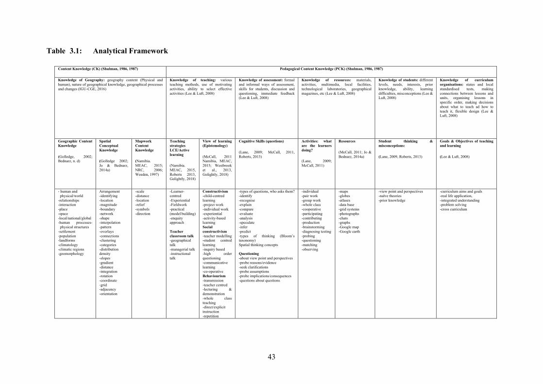
43
Table 3.1: Analytical Framework
Content Knowledge (CK) (Shulman, 1986, 1987) Pedagogical Content Knowledge (PCK) (Shulman, 1986, 1987)
Knowledge of Geography: geography content (Physical and human), nature of geographical knowledge, geographical processes and changes (IGU-CGE, 2016)
Knowledge of teaching: various teaching methods, use of motivating activities, ability to select effective activities (Lee & Luft, 2008)
Knowledge of assessment: formal and informal ways of assessment, skills for students, discussion and questioning, immediate feedback (Lee & Luft, 2008)
Knowledge of resources: materials, activities, multimedia, local facilities, technological laboratories, geographical magazines, etc (Lee & Luft, 2008)
Knowledge of students: different levels, needs, interests, prior knowledge, ability, learning difficulties, misconceptions (Lee & Luft, 2008)
Knowledge of curriculum organisations: states and local standardised tests, making connections between lessons and units, organising lessons in specific order, making decisions about what to teach ad how to teach it, flexible design (Lee & Luft, 2008)
Geographic Content Knowledge
(Golledge, 2002; Bednarz, n. d)
Spatial Conceptual Knowledge
(Golledge 2002; Jo & Bednarz, 2014a)
Mapwork Content Knowledge
(Namibia. MEAC, 2015; NRC, 2006; Weeden, 1997)
Teaching strategies LCE/Active learning
(Namibia. MEAC, 2015, Roberts 2013, Golightly, 2018)
View of learning (Epistemology)
(McCall, 2011 Namibia, MEAC, 2015; Westbrook et al., 2013, Golightly, 2018)
Cognitive Skills (questions)
(Lane, 2009; McCall, 2011, Roberts, 2013)
Activities: what are the learners doing?
(Lane, 2009; McCall, 2011)
Resources
(McCall, 2011; Jo & Bednarz, 2014a)
Student thinking & misconceptions:
(Lane, 2009, Roberts, 2013)
Goals & Objectives of teaching and learning
(Lee & Luft, 2008)
- human and physical/world -relationships -interaction -place -space -local/national/global -human processes-
physical structures -settlement -population -landforms -climatology -climatic regions -geomorphology
Arrangement -identifying -location -magnitude -boundary -network -shape -interpolation -pattern -overlays -connections -clustering -categories -distribution density -slopes -gradient -distance -integration -rotation -coordinate -grid -adjacency -orientation
-scale -distance -location -relief -symbols -direction
-Learner- centred -Experiential -Fieldwork -practical (model building) -enquiry approach Teacher classroom talk -geographical talk -managerial talk -instructional talk
Constructivism -child-centred learning -project work -individual work -experiential -activity-based learning Social constructivism -teacher modelling -student centred learning -inquiry based -high order questioning -communicative learning -co-operative Behaviourism -transmission -teacher centred -lecturing & demonstration -whole class teaching -direct/explicit instruction -repetition
-types of questions, who asks them? -identify -recognise -explain -compare -evaluate -analysis -speculate -infer -predict -types of thinking (Bloom’s taxonomy) Spatial thinking concepts Questioning -about view point and perspectives -probe reasons/evidence -seek clarifications -probe assumptions -probe implications/consequences -questions about questions
-individual -pair work -group work -whole class -cooperative -participating -contributing -production -brainstorming -diagnosing testing -probing -questioning -matching -observing
-maps -globes -atlases -data base -grid systems -photographs -chats -graphs -Google map -Google earth
-view point and perspectives -naïve theories -prior knowledge
-curriculum aims and goals -real life application, -integrated understanding -problem solving -cross curriculum

44
Shulman’s (1986, 1987) ideas of teacher knowledge have been critiqued for only focusing on the cognitive domain and neglecting the affective domain. Guerriero (n.d., p. 3) argues that besides teacher knowledge there are attitude and motivational variables that need to be considered. Blömeke and Delaney (2012) contend that both the cognitive and the affective domain should come together in the classroom. The affective domain is defined as “… the way people respond emotionally and their capability to feel other living things’ pain or joy” whereas the cognitive domain “…involves knowledge, comprehensions and critical thinking on a specific topic,” both of which both are seen as important for effective teaching (Bunt, 2018, p. 191). This has been well articulated in the Fig. 3.1. according to Blömeke and Delaney (2012).
Fig. 3.1: Professional competence of teachers, adopted from Blömeke and Delaney (2012) in Guerriero (n.d. p. 3)
It is clear from Fig. 3.1. that professional competency involves more than just knowledge. The
model above was adapted from Blömeke and Delaney (2012) who blended the cognitive
abilities (domain) and the affective-motivational characteristics (domain) as the two main
components of teachers’ professional competencies (Guerriero, n.d., p. 3). This is a very
important observation, because what teachers know and feel has a great influence on their
classroom practice. Thus, it would be a slip-up if the two were treated separately (Guerriero,
n.d.). This means having the “cognitive ability to develop effective solutions for job-related
problems and having motivational, volitional and social willingness to successfully and
responsibly apply them to solutions in various classroom situations” (Blömeke & Delaney,
2012, unpaged).
45
Conclusion
A key goal of this study is to describe in rich detail, teachers’ pedagogical practices when
teaching mapwork. This chapter responded to the question of how mapwork is taught in
Namibian secondary school geography. The chapter explained the two theoretical lenses I used
to interpret and make sense of the teaching approaches and strategies I observed in the three
teachers’ classrooms. More specifically, I discussed how I draw on Shulman’s ideas of teacher
knowledge (1986, 1987) and Learner Centred Pedagogy, underpinned by constructivist
epistemology, as analytical frameworks.
46
CHAPTER FOUR
RESEARCH METHODOLOGY
4.1 Introduction
This chapter gives an account of the research orientation and case study method. It describes
the research participants and sampling methods used, and explains the methods of data
collection and how data was analyzed. Issues associated with case study research are also
discussed.
4.2 Research Orientation
This study is a qualitative exploratory case study within an interpretive paradigm. My choice
of research orientation was guided by the research goals, namely to understand teachers’
perceptions and pedagogical practices of teaching mapwork in secondary school geography,
and the assertion that “… qualitative researchers want to know what the participants in a study
are thinking and why they think what they do” (Fraenkel & Wallen, 2008, p. 432). In addition,
Leedy and Ormrod (2010) explain that qualitative researchers “… use verbal descriptions to
portray the situation they have studied … and they seek a better understanding of a complex
situation” (p. 95). In the same vein, Cohen, Manion and Morrison (2011) contend that
qualitative research provides an in-depth, intricate and detailed understanding of meanings,
actions, from non-observable and observable phenomena as well as attitudes and behaviours
toward the phenomena being investigated.
4.2.1 Interpretive paradigm
The main purpose of interpretive research is “… to understand the meaning which informs
human behaviour” (Bertram & Christensen, 2015, p. 26). It does not aim to predict what people
will do, but rather seeks to describe and interpret how people make sense of their worlds, and
make meaning of their particular actions (ibid.). The main purpose of this study is to generate
an in-depth understanding of secondary school geography teachers’ mapwork perceptions and
practices. I am aware of Bertram and Christensen’s (2015) acknowledgement that “… the way
people generally behave and respond in a given situation depends largely on their past
experiences and circumstances: and thus, their context is very important” (p. 25). The
interpretive paradigm aims at understanding human agency, behaviour, attitudes, beliefs and
perceptions and how such influences the choice of methods they use (Bertram & Christensen,

47
2015). Equally the interpretive paradigm is characterised by a “concern for the individual”, as
well as generating a context base for understanding human experiences (Cohen et al., 2011, p.
17). The interpretive paradigm is appropriate for this study because it enables me to generate
insights for understanding what teachers say about their mapwork teaching and how they teach
mapwork.
4.2.2 Case study
This study uses a case study method because it allows for an in-depth investigation of a specific,
bounded phenomenon (mapwork). Case studies are often descriptive in nature, and they
describe what it is like to be in a particular situation (Bertram & Christiansen, 2015, p. 42).
According to Hamilton and Corbett-Whittier (2012), a case study allows a researcher to capture
rich data and offer an in-depth picture of the aspect under study (p. 10). In the same vein, Rule
and John (2011) maintain that case studies offer an in-depth “thick, rich description of the case
and illuminating to its broader context” (p. 7). I framed this study as a case study because its
focus was limited to the teaching of mapwork and was not extended to other sections of
geography. In addition, this study aims to understand selected Namibian secondary school
geography teachers’ perceptions and pedagogical practices of mapwork.
4.3 Research Question and Goals
Guided by the goal for this study, namely to generate insights for understanding Namibian
geography teachers’ perceptions and pedagogical practices of mapwork, the main research
question is: What are Namibian geography teachers’ perceptions and pedagogical practices of
mapwork in secondary school geography classrooms? The following questions serve as sub-
questions to the main research question:
• What are Namibian geography teachers’ views and experiences of teaching
mapwork in secondary school geography classrooms?
• What pedagogical approaches are used by Namibian teachers in secondary school
geography classrooms?
• What lessons can be learned from teachers’ pedagogical practices that may be used
to strengthen and enhance mapwork teaching and inform teachers’ professional
development?
The findings of this study will have the following significance to the wider geography
community in Namibia and provide insights that may be of value to Namibian teachers, teacher
48
educators, curriculum policy developers and Senior Education Officers (SEO) when addressing
the problem of low learning outcomes in mapwork. The findings will contribute to the literature
on geography education in Namibia.
4.4 Research Process
The study consisted of three phases. Before these got underway, I conducted a pilot study with
two experienced geography teachers working in schools in Grahamstown where Rhodes
University is situated. The first phase of the research consisted of a survey in the form of a
questionnaire. The questionnaire was administered to thirty secondary school geography
teachers in the Ohangwena circuit. The purpose of the questionnaire was to elicit the teachers’
views and perceptions of mapwork teaching. The questionnaire also helped me to select the
sample for further in-depth study through face to face interviews and classroom observations.
The second phase consisted of the semi-structured interviews with a sample of three teachers.
The interviews were done to probe the teachers’ responses to the questionnaire as well as their
mapwork practices. The third phase consisted of classroom observations and stimulus recall
interviews. The observations were done to complement the teachers’ responses to the
interviews and see if there is any relation between what the teachers say they do and what they
actually do in their classrooms. Informal conversations like stimulus recall interviews were
done for the purpose of reflecting on what had happened during the lessons.
The three phases described above took place over a seven-month period (August 2017 – March
2018).

49
4.5 Research Site
In the first phase, a questionnaire was administered at fifteen secondary schools out of a total
of twenty-two schools in the Ohangwena circuit. This circuit is one of the ten in the Ohangwena
Region of Northern Namibia which is within six km of the Namibian-Angolan border. The
other circuits are: Ondobe, Endola, Ongha, Eenhana, Ohakafiya, Okongo, Enyanya, Oshikunde
and Otunganga. Figure 4.1 below shows all twenty-two schools in the Ohangwena circuit.
These include primary schools (PS), combined schools (CS), secondary schools (SS) and high
schools (HS).
Given that the research was focused on mapwork teaching in secondary schools, the survey
was only carried out in the fifteen schools in the circuit that offer geography at a secondary
phase (grades 8 to10 or grades 8 to 12).
Figure 4.1: Map showing schools in Ohangwena Circuit
The second and third phases of the research (interviews and classroom observations) were
carried out at three schools where the sample of teachers participating in the research, teach.
Pseudonyms have been used for the schools and teachers who participated in the study.
Hanganeni High School is a semi-urban school situated within the boundary of Helao Nafidi
50
town. Mewiliko Combined School is situated twenty km away in a south-west direction, and
Twakulilwa Senior Secondary School is situated fifteen km away in a north-east direction. The
schools are surrounded by communal farming and settlements.
Hanganeni HS is well-known in the circuit and the region, and most of the circuit and regional
activities are held there as the school is believed to be located at the centre of both the circuit
and the region. The school formally caters for grades 8 to12, but with the implementation of
the new curriculum it will be catering only for grades 10 to12, with grade 8 already being
removed as of 2018. Academically, Hanganeni HS has performed well over a number of years.
Twakulilwa SS is run by the Anglican Church and is subsidised by the government. The
academic performance of the school is mostly average and it fluctuates from year to year. The
school caters for grades 8 to12. Mewiliko Combined School is located in the wetlands and is
surrounded by open pans (oshanas). The school caters for grades 0 to 10. The general
performance in the Junior Secondary phase is average and it fluctuates as well. During the
heavy rain and flood season from February to March, Mewiliko CS sometimes closes to ensure
the safety of both the learners and teachers. It only reopens when the water level subsides.
4.6 Research Participants
The research was carried out with thirty geography teachers in the fifteen secondary schools.
Guided by the responses to the questionnaire, a sample of three teachers was selected for further
in-depth interviews and classroom observations. A detailed profile of the three teachers is
provided in Chapter Six.
4.7 Sampling Procedures
Sampling involves making a decision about which people, settings, events or behaviours to
include in the study and deciding how many individuals, groups or objects (such as schools)
will be observed (Bertram & Christensen, 2015). For this study, I have used a combination of
purposive and convenience sampling.
4.7.1 Purposeful Sample
Purposive sampling was used to select the three participating teachers as it involves
deliberately selecting particular settings, persons, or events for the important information that
they can provide, and therefore one needs to select a sample from which one can learn the most
(Maxwell, 2008). In this study, purposive sampling was also used to select those individuals
that I thought would yield the most information about the topic under investigation (Leedy &
51
Ormrod, 2010). I selected three teachers who gave rich responses to the questionnaire. The
three included both male and female teachers of different ages and teaching experience.
4.7.2 Convenience sample
The research site (the Ohangwena Circuit) was selected for convenience purposes because most
of the schools in this circuit are within a radius of thirty km from my work place. This meant
that it was easy for me to reach the teachers at their schools (Bertram & Christensen, 2015)
when I was administering the questionnaires and conducting the follow-up interviews and
classroom observations.
4.8 Data Collection Methods
In order to gather rich data that would enable me to generate insights for a deeper understanding
of mapwork teaching, I used three data collecting methods: a questionnaire, semi-structured
interviews and classroom observations together with stimulus recall interviews.
4.8.1 Pilot Study
A pilot study is a preliminary stage where the research instruments are tested with people who
are similar to the actual research participants (Bertram & Christiansen, 2015, p. 49). In this
study a pilot study was undertaken in order to test the effectiveness of the data collection tools.
The pilot study was carried out with two experienced Grahamstown secondary school
geography teachers that I know and who were not participants in the study. Their responses
and feedback were used to make adjustments and refinements to the research tools and
questions. The piloted questionnaire revealed that one of the questions was not clear. It was
refined as per the recommendations made by the teachers. I also deleted a few questions that
they thought were irrelevant.
4.8.2 Questionnaire
My choice of questionnaires was guided by Bertram and Christiansen (2015) who argue that
questionnaires are a good way of gathering “data from a large number of people … and they
are a good way of finding out about peoples’ opinions, perceptions or beliefs” (p. 79).
The first part of the questionnaire schedule (see Appendix D) consisted of closed-ended
questions which generated general biographical information about the teachers, including their
educational background and qualifications, teaching experience, classes/grades taught etc. The
52
second part of the questionnaire schedule consisted of open-ended questions and explored
general attitudes towards the teaching of mapwork, teaching strategies, wider teaching and
learning issues e.g. resources, and teachers’ perceptions and experiences of teaching mapwork
in secondary school geography. Open-ended questions allow the respondents to give their own
opinions and experiences in relation to a particular issue without any restriction (Cohen et al.,
2011, p. 382).
Twenty-two of the thirty teachers to whom I administered the questionnaire returned completed
questionnaires to me. From these responses, I was able to select a sample of three teachers that
I could follow up with interviews and classroom observations. I chose three teachers who
provided the most detailed responses. I made the assumption that they might represent best
practice.
In making sure that the questionnaire reached the teachers without any unnecessary delay, I
visited each school and handed the questionnaires personally to the teachers. In some cases, I
waited until the teachers had completed the questionnaire, while in other cases I collected them
from the school two days later. I emailed the questionnaire to a few teachers which I then
collected from them in person. I made sure that I gave the teachers enough time to complete
the questionnaire because I noticed that most of them were busy invigilating and marking their
mid-term examinations. Their busyness may have been a reason why some did not complete
the questionnaire.
Administering and analyzing questionnaires was not without its challenges. I was disappointed
by the quality of the responses. Many responses were short and lacking in detail and some of
the open-ended questions were not answered. The same concern was expressed by Cohen et al.
(2011), that although open ended questions enable participants to freely put across their
accounts, due to their demanding nature and time needed to respond, open-ended questions can
be “overlooked” (p. 393) [and] “may lead the respondent to refuse to complete [them]” (p.
382). Some questionnaires were incorrectly filled in. Some teachers did not tick the box to
indicate their response, and some ticked the wrong box or ticked two boxes when this was not
necessary. Cohen et al. (2011) advise that after administrating the questionnaire, the researcher
needs to check that all questions are answered accurately, as inaccuracy can occur which may
reduce the validity of data, unless picked up on time (p. 407). In some cases, there were
inconsistencies or evidence of a contradiction in some teachers’ responses to the questionnaire,
53
particularly the questions about how confident teachers felt about teaching mapwork and what
they experienced as challenges/difficulties in teaching mapwork.
4.8.3 Interviews
In Phase 2 of the study I conducted a semi-structured one-to-one interview with each of the
three teachers. The interviews were necessary for this study because they have enabled me to
gain more access to the three participating teachers’ “ideas and thoughts, their perceptions …
their fears and concerns in their own words …” (Ezzy, 2002. p. 45). Using a semi-structured
interview also give me an opportunity to ask follow-up questions as well as clarify questions
and issues that interested me from their responses to the questionnaire. According to
Nieuwenhuis (2016, p. 93), interviews can be used as a way of validating and confirming data
collected through the questionnaire. The semi-structured interviews are good because they are
flexible and gave me an opportunity me to ask open-ended questions. Cohen et al. (2011) argue
that open ended questions “enable the respondents to answer as much as they wish, … and they
are suitable to for investigating complex issues to which simple answers cannot be provided”
(p. 382). I also wanted to find out whether participants have or experience any challenges or
difficulties in teaching mapwork. In addition, I also wanted to find out whether they have any
suggestions on how to enhance mapwork teaching as well as teacher mapwork professional
development.
The interview schedule, based on what emerged in the teachers’ responses to the questionnaire,
was designed to help me with probing what they had said about their mapwork practices,
perceptions and experiences (see Appendix E). The interview questions were guided by my
research questions. Following Patton (2002), the interview schedule allowed me to establish
and build a conversation with the participants and this helped to put them at ease. The schedule
guided our conversation and helped me to stay focused when I was probing the teachers’
responses and pressing for further clarity. During the interviews, I avoided talking too much as
I did not want to influence what they were saying. Following Cohen et al.’s (2011) advice,
before starting the interview, I introduced myself to the teachers and informed them of the
purpose of the interview, the nature and scope of the questions and the approximate duration
of the interview. I also asked for their permission to audio-record the interviews. None of the
teachers objected or seemed uneasy with the recording. This was clearly explained to the
teachers both orally and in writing and they signed the consent form.
54
All the interviews were done in English, because it is the language of teaching and learning in
Namibian schools. The interviews were audio-recorded and transcribed by me. This helped me
to “know my interviews better” (Seidman, 1998, p. 98). The transcription of the first two
interviewees were done soon after the interviews, and this helped me to stay close to the data
and identify gaps in the data that I needed to fill. However, the third and last interview was
done in a bit of a rush because the teacher kept on postponing it and always seemed to be busy,
so this caused a delay in the transcribing process. The interview transcripts were given back to
the participants for member checking (Bassey, 1999). This was to make sure that their accounts
were correctly presented. Ms Munageni responded positively to the member checking and
added and completed sections where I had left a space because I could not hear what she was
saying. Ms Nailonga and Mr Haitange had little to say, although Ms Nailonga filled in some
blank spaces in the transcript which was helpful.
Although I was able to carry out the interviews as planned, it was not without some challenges.
Noise was an issue when interviewing Ms Nailonga at Mewiliko Combined School. Because
there was a lack of space, the interview was conducted in a storeroom close to the Grade 1 and
2 classrooms. The Grade 1 and 2 teachers did not seem to be in their classrooms at the time of
the interview, and the noise made by the learners affected the quality of the audio-recording,
so at times we could hardly hear ourselves talk. Ms Nailonga took time to silence the learners
and the noise was minimised. In the case of Ms Munageni and Mr Haitange’s interviews, there
were a few disturbances from learners and other teachers wanting to ask something.
Another challenge encountered was that two of the teachers (Ms Munageni and Ms Nailonga)
did not see the interview schedule beforehand and we had a normal conversation and discussed
issues as they arose, and they were also able to discuss and share their normal everyday
teaching (classroom practices) of mapwork. However, Mr Haitange was given the interview
questions to read a day before the interview commenced. This was a decision I regretted
because he seemed to have planned responses to the questions, and knew what the next question
was. In the case of follow-up questions or where the question was altered or rephrased, he knew
it was not the same question as in the schedule. I am assuming this influenced the data I
collected from him. I therefore concur that if participants see the interview schedule
beforehand, the data may become “contaminated” (Henning, van Rensburg & Smith, 2007, p.
53). The interviews were done at a time most convenient for the teachers, and it was confirmed
that it did not disturb their normal teaching schedules.

55
4.8.4 Classroom Observation
According to Cohen et al. (2011), observation “offers an investigator an opportunity to gather
‘live’ data from naturally occurring social situations” and allows the investigator to look
directly at what is taking place in situ rather than relying on second-hand accounts (p. 456).
Observation gives researchers an opportunity to see things for themselves and draw meaningful
conclusions. Using classroom observation in this study allowed me to see, hear and experience
reality in the same way as participants do (Nieuwenhuis, 2016, p. 90). It also enabled me to
gather data that I could compare to what the teachers say they do and what they actually do,
and this enabled me to triangulate data from the questionnaire and interviews with the teachers.
Robson (2002, as cited in Cohen et al. 2011, p. 456) explains that;
What people do may differ from what they say they do, and observation provides a reality check; observation also enables a researcher to look afresh at everyday behaviour that otherwise might be taken for granted, expected to go unnoticed.
Thus, using observation in this study provided me with an opportunity to see beyond the
teachers’ own words about their classroom practices of teaching mapwork, by comparing their
responses to the questionnaire, to the interviews, to the real actions in the classroom. In
addition, using observation gave me an opportunity to “take advantages of unforeseen data
sources as they surface” (Leedy & Ormrod, 2010, p. 147), that I was able to use to develop a
deeper and critical understanding of the teachers’ mapwork pedagogical practices and their
perceptions and experiences of teaching mapwork in secondary school geography. For
example, how teachers relate to their learners and/or how on-spot decisions were made as the
teaching and learning process unfolded. I observed each teacher teaching two lessons, which
made a total of six lessons. With the teachers’ permission, I audio- and video-recorded each
lesson. None seemed threatened by my recording. The two recordings were necessary for
review and further analysis. Using video-recording in this study was very helpful because I
was able to review the videos many times. This helped me identify additional information each
time I watched the video or listened to the audio-recording (Simpson & Tuson as cited in Cohen
et al., 2011). The video recordings offered more ‘unfiltered’ observational records than human
observation (Cohen et al., 2011). I placed the audio recorder on the teacher’s table to capture
the verbal interactions in the classroom. The challenge was that when the teacher moved from
the table, the quality of the audio recording was affected. In addition, the audio-recording could
also not capture the distant conversations with the learners at the back of the classroom. All six
lesson observations were transcribed by myself.
56
Furthermore, guided by the analytical framework (see Chapter Three, Section 3.10, Table 3.1),
a lesson observation schedule was designed and used to observe each lesson (see Appendix F).
Cohen et al. (2011) argues that an observation tool or schedule helps the researcher to generate
additional data from real situations and it also helps the researcher to develop a sense of
ownership over the matter to be observed. The observation schedule had pre-determined
categories of what I wanted to see in the lesson, and because of the lesson observation schedule,
I had no plan to take further observation notes. However, interesting happenings in the
classroom were recorded using a video as they unfolded in the lesson, and were noted during
the transcribing process as I reviewed and watched the videos; for example, the use of body
language by the teachers to emphasise the point or silence the learners. In addition, the teachers’
lesson notes were collected and analyzed to contribute to the richness of the data description. I
also made general observations about the ethos of the school, the teaching and learning
environment including the size of the classrooms, the arrangement of furniture, class size,
LTSMs, wall displays, and the general organisation and management characteristics like
punctuality and levels of absenteeism and the attitudes and behaviours of the learners.
My role was that of non-participant observer. According to Bryman (2008), “non-participant”
is a term used to describe a situation in which the observer does not participate in the social
settings being observed (p. 257). The use of non-participant observation in this study was to
make sure that as a researcher, I did not have an influence on the way the teachers were
performing their tasks, but to observe teachers’ mapwork practices in their own natural
situations. This also meant that I did not interact with the learners or the teachers while the
lessons were underway and I did not contribute to any classroom discussions. I cannot rule out
the fact that my presence in the classroom may have had an effect on what was happening in
the classroom. To fulfil my obligation as a non-participant observer, I sat at the back of the
class. This helped me to observe all the activities taking place in the classroom and make sure
that I was not a distraction. It was also important that I sat at the back of the class in order to
reduce the impact or disturbance that might be caused by the use of the video-recording of the
lessons.
4.8.5 Stimulated Recall Interviews
A stimulated recall interview was done after each lesson observation. They took the form of an
informal conversation in which the teachers were asked to reflect on what happened in the
lesson. The lesson plan was used to prompt discussion. I planned to watch the video-recording
57
with the teacher as part of the conversation, but this did not happen as planned. Although the
stimulated recall interviews were useful to get the teachers to reflect on their lessons, not much
emerged during the interviews. Nevertheless, they allowed me to probe deeper to get the
teachers to talk about what was happening in the classroom (Nguyen, McFadden, Tangen, &
Beutel, 2013). At the same time, teachers were able to defend and “discuss their decision-
making processes as they carried out their teaching roles” (Nguyen et al., 2013, p. 3). The
stimulus recall interviews were also audio-recorded and transcribed by me. This added to the
richness of the data gathered.
4.9 Data Analysis
Data on teachers’ perceptions and experiences of mapwork teaching, gathered through the
questionnaire in Phase 1 of the research, were analyzed using conventional qualitative and
quantitative (descriptive statistics) data analysis procedures (Cohen et al., 2011). Descriptive
statistics involve transferring and summarising data into graphic presentation (Cohen et al.,
2011). Such data were converted into tables and short descriptions and conclusions of the
emerging themes were given. This follows Yin’s (2009, p. 126) notion that data analysis
involves categorising, tabulating, testing and recommending evidence in order to arrive at
meaningful conclusions. Likewise, an analysis of data involves breaking up data into
manageable themes, patterns, trends and relationships to draw empirically-based conclusions
(Mouton, 2001, p. 108). And thus, similarities and differences in the teachers’ responses were
also used to identify further emerging patterns, themes and relationships on the challenges and
difficulties of teaching mapwork, as well as on the use of learning support materials and
teachers’ mapwork professional development.
Merriam (1991, p. 123) asserts that “the process of data collection and analysis is recursive and
dynamic”. Data analysis occurs simultaneously, and should be aligned to the research
questions, theoretical framing and research approach as well as data collection tools and
methods (Merriam, 1991). For phases 2 and 3 of the study, the first circle of data analysis
involved listening to and watching audio- and video-recordings of the interviews and classroom
observations. I listened carefully as I transcribed the recordings. For Phase 2 interviews, an
analytical meme was developed according to the questions in the interview schedule. I
compared the participants’ responses to the questions by identifying similarities, differences

58
and anomalies and gave a short description of what was emerging. This made it easier for me
to pull out the emerging themes to provide answers to my research questions.
The initial analysis of data gathered from the classroom observations in Phase 3 of the study
was based on open coding. I identified six emerging themes and categories. These were:
teaching approaches, teaching strategies, knowledge, LTSMs, classroom arrangement and
assessment of learning. I worked with the analytical framework (see Table 3.1. in Chapter
Three, Section 3.10) to interpret what emerged in my data analysis.
4.10 Issues associated with qualitative research
4.10.1 Ethical considerations
A good researcher takes research ethics seriously and understands the importance of
confidentially in research. Bertram and Christiansen (2015) stress that ethics has to do with
behaviour that is considered to be right or wrong and it is very important in research that mainly
involves humans and animals (p. 65). Gravetter and Forzano (2006) point out that “it was
assumed that researchers, bounded by their own moral compasses, would protect their
participants from harm” (p. 99). Participants were made aware of the research purposes and
aims and were assured that they were not putting themselves and the institutions they represent
at risk or cause them any harm. Anonymity of data and confidentiality of the research
participants was maintained throughout the research process and the data collected were only
used for the purpose of this study. The participants’ identities and names were protected
through the use of pseudonyms. Participants were ensured of voluntary participation in the
study and were given the freedom to withdraw at any stage of the study should they feel
uncomfortable to continue or no longer interested (Bertram & Christiansen, 2015).
I obtained informed consent from the Directorate of Education, and permission to carry out the
research was granted to me by the regional director on the 3 August 2017 (see Appendices A
and B). Further consents were obtained from school principals and from all the participating
teachers in a form of a letter. Teacher participants also signed a consent form as an agreement
to participate in the study (see Appendix C). The consent letters were written by me as a
researcher and were all in accordance with Rhodes University’s Research Ethics, of which the
ethical clearance was granted to me after submitting the research proposal for this study to
Rhodes University’s Education Higher Degrees Committee (EHDC). I also obtained
permission from the participants to video-record the classroom observations and audio-record
59
the interviews. Such a request was clearly stated in the consent letters. Parental consent to video
the teacher teaching was obtained, as the learners were also likely to appear in the videos. It
was made clear to the parents that the video-recording would be focused on the teacher rather
than the learners. The parents were required to sign a reply slip. Parents responded positively
to the request and their consents were signed and returned.
4.10.2 Validity and Trustworthiness
Validity “is how accurately account represents participants’ realities of the social phenomena
and is credible to them” (Schwadt, 1997, as cited in Creswell & Miller, 2000, p. 124).
• Triangulation
To ensure validity, triangulation was done through the use of multiple sources of data collection
tools, namely questionnaires, semi-structured interviews and classroom observations together
with stimulated recall interviews. Triangulation is referred to as the “process of using multiple
sources and methods to support propositions or findings generated in a case study” (Rule &
John, 2011, p. 109). Using triangulation in my study helped me to compare what teachers think
and say, to what they do. It also helped in eliminating potential bias that might be caused by
the use of a single method of data collection (ibid.).
• Member checking
I also used member checking by providing the participants with copies of their interviews and
stimulated recall interview transcripts to check if their accounts were correctly captured
(Creswell & Miller, 2000). After the participants checked their interview transcripts they all
affirmed that everything was fine and only Ms Munageni made a few changes here and there
by deleting or lengthening some details. Using member checking did not only ensure correct
capturing of the participants’ accounts, but it also aided in creating trustworthiness and
confidence in me as a researcher by the participants.
• Particularity vs Generalisation
This study explored selected Namibian secondary school geography teachers’ pedagogical
thinking and practice of mapwork on a small scale. The findings for this study are limited by
the fact that it was a small-scale study which only focused on one level of the school system in
Namibia (secondary level grades 8 to12). The study was carried out in a few schools, in one
60
circuit, in one region in the country. Most of such schools are semi-urban and rural schools.
My viewpoint as a researcher is that school settings and teachers’ practices and experiences
may differ across the country and/or regions. Thus, in presenting rich descriptions of the
teachers’ mapwork pedagogical thinking and practices, I am not aiming at generalising the
findings of this study to the wider community of secondary school geography teachers in
Namibia. This follows Bassey’s (1999, p. 5) words that a study of a singularity does not seek
to establish generalisations about the wider population to which the case belongs. The purpose
of this study is to describe and interpret the occurrence of the cases I observed within their own
world by providing a “thick description of it” (Geertz, 1973, p. 3). The purpose is to provide a
rich description of what happened in this case study to try and understand what is probably
happening in other cases. However, I cannot rule out the fact that in this study, some claims
are made on behalf of “fuzzy propositions”, that is, “a kind of statement which makes no
absolute claims to knowledge but hedges its claims with uncertainties” (ibid., p. 12). In
addition, “naturalistic generalisations” claims (Stake, 2000, p. 449) made in this study aided in
generating a “thick description” of the case creating a “vicarious experience” for the wider
population to which the case belongs, thus making other teachers feel that they are part of the
case (Stake, 2000, p. 439).
4.11 Conclusion
This chapter described and justified the methodological orientation that guided this study. It
discussed the research design, and gave a detailed explanation of qualitative research as well
as the interpretive paradigm. Furthermore, the chapter described the research site, research
participants as well as sampling procedures. The data collection tools used for this study are
questionnaires, semi-structured interviews, and classroom observations together with
stimulated recall interviews. Details of data analysis was also discussed in the chapter. The
chapter concluded by looking at issues related to ethics and how trustworthiness and validity
were taken into consideration throughout the research process.
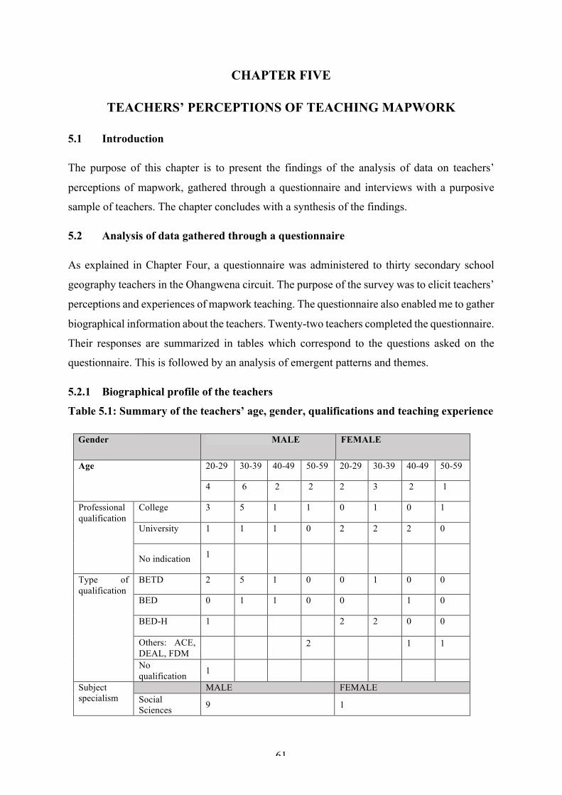
61
CHAPTER FIVE
TEACHERS’ PERCEPTIONS OF TEACHING MAPWORK
5.1 Introduction
The purpose of this chapter is to present the findings of the analysis of data on teachers’
perceptions of mapwork, gathered through a questionnaire and interviews with a purposive
sample of teachers. The chapter concludes with a synthesis of the findings.
5.2 Analysis of data gathered through a questionnaire
As explained in Chapter Four, a questionnaire was administered to thirty secondary school
geography teachers in the Ohangwena circuit. The purpose of the survey was to elicit teachers’
perceptions and experiences of mapwork teaching. The questionnaire also enabled me to gather
biographical information about the teachers. Twenty-two teachers completed the questionnaire.
Their responses are summarized in tables which correspond to the questions asked on the
questionnaire. This is followed by an analysis of emergent patterns and themes.
5.2.1 Biographical profile of the teachers
Table 5.1: Summary of the teachers’ age, gender, qualifications and teaching experience
Gender MALE FEMALE
Age 20-29 30-39 40-49 50-59 20-29 30-39 40-49 50-59
4 6 2 2 2 3 2 1
Professional qualification
College 3 5 1 1 0 1 0 1
University 1 1 1 0 2 2 2 0
No indication 1
Type of qualification
BETD 2 5 1 0 0 1 0 0
BED 0 1 1 0 0 1 0
BED-H 1 2 2 0 0
Others: ACE, DEAL, FDM
2 1 1
No qualification 1
Subject specialism
MALE FEMALE Social Sciences 9 1
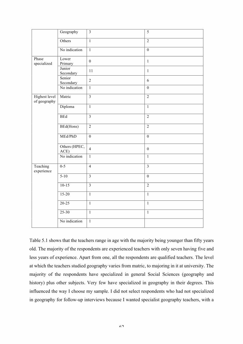
62
Geography 3 5
Others 1 2
No indication 1 0
Phase specialized
Lower Primary 0 1
Junior Secondary 11 1
Senior Secondary 2 6
No indication 1 0
Highest level of geography
Matric 3 2
Diploma 1 1
BEd 3 2
BEd(Hons) 2 2
MEd/PhD 0 0
Others (HPEC, ACE) 4 0
No indication 1 1
Teaching experience
0-5 4 3
5-10 3 0
10-15 3 2
15-20 1 1
20-25 1 1
25-30 1 1
No indication 1
Table 5.1 shows that the teachers range in age with the majority being younger than fifty years
old. The majority of the respondents are experienced teachers with only seven having five and
less years of experience. Apart from one, all the respondents are qualified teachers. The level
at which the teachers studied geography varies from matric, to majoring in it at university. The
majority of the respondents have specialized in general Social Sciences (geography and
history) plus other subjects. Very few have specialized in geography in their degrees. This
influenced the way I choose my sample. I did not select respondents who had not specialized
in geography for follow-up interviews because I wanted specialist geography teachers, with a
63
certain level of experience. The profiles of the three teachers selected for further investigation
is discussed in Chapter Six.
5.2.2 Teachers’ perceptions of mapwork
Generally, most teachers perceived mapwork as difficult and challenging for both teachers and
learners. The teachers indicated that they experienced difficulty with identifying relief features,
interpreting grid references/location, measuring distance, converting scales, drawing cross-
sections, interpreting contours and topographical maps and calculating gradient. They also
indicated that they experienced difficulties with learners’ attitudes towards mapwork and
learners struggling to read, analyze and interpret topographical maps. A lack of basic
mathematical skills among learners was also mentioned. Maps were also seen as difficult
because they are abstract and require imagination because map concepts (contours and lines of
latitude) cannot be seen in reality. The teachers also mentioned a shortage of teaching aids and
resources such as compasses, globes and maps with not enough time to teach and practice. One
of the respondents highlighted that they were not fully prepared in their teaching training
program to teach some of the mapwork topics. Three teachers acknowledged that teaching
mapwork is difficult but also interesting and fun. Eight teachers said they do not experience
any difficulties teaching mapwork; they however indicated that mapwork requires energy and
self-knowledge from the side of the teacher, as well as patience from both teachers and learners.
One teacher stated that “…it is not mapwork that is difficult, but teachers make it difficult by
not teaching it the way it should be [taught]”. This teacher asserted that “… mapwork MUST
be taught practically, however, sometimes teachers still use chalk and talk method …”
5.2.3 Strategies used to teach mapwork
Most teachers said this depended on the topic being taught. Most of the teachers said they used
expository (teacher tell) methods, and practical work. They mentioned using old examination
question papers to expose learners to different maps and teach map skills. Nine teachers
indicated that they sometimes use rote learning and memorization of map skills. The teachers
mentioned using questioning to elicit learners’ prior knowledge, and the question and answer
method to lead and facilitate classroom discussions. None mentioned fieldwork. The extent to
which I observed these strategies being used in practice is discussed in Chapter Six.
5.2.4 Mapwork integration
Table 5.2 summarises the number of teachers who indicated where they integrated mapwork
in other sections of the curriculum (syllabus). It takes place mainly in settlement, climatology

64
and population geography, with only eight teachers stating that they integrate mapwork into
geomorphology.
Table 5.2: Number of teachers who integrate mapwork into other sections of the syllabus
Topic Total
Settlement geography 17
Population geography 15
Climatology 16
Geomorphology 8
All 8
None 0
A limitation of the questionnaire is that it did not probe the reasons why the teachers integrate
mapwork in some sections and not in others. The extent to which I observed mapwork being
integrated is discussed in Chapter Six.
5.2.5 Learning and teaching support materials (LTSM)
The teachers stated that they mostly use textbooks, topographical maps, compasses and wall
charts. A few (four) teachers indicated that they sometimes use globes, newspapers, atlases,
wall maps and Google maps, and one teacher mentioned sometimes using a computer for
PowerPoint presentations. Textbooks are supplied by the government and schools may
purchase additional resources such as reference books, atlases, globes etc. Some teachers
indicated that their learners share textbooks. Many (seventeen) indicated that they make their
own LTSMs. These include sketch maps, posters and relief models. The use of resources is
discussed in Chapter Six.
5.2.6 Teachers’ confidence
All the respondents felt confident about teaching mapwork. However, their level of confidence
varied from one topic to another. This is illustrated in Table 5.3.
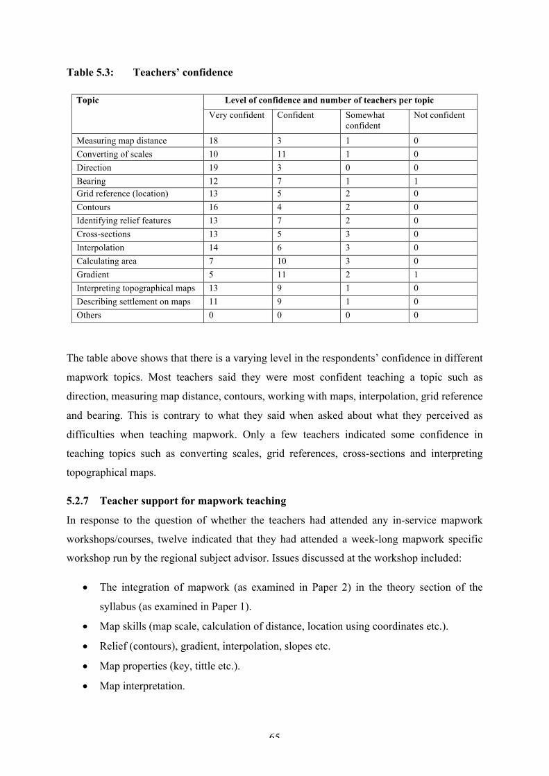
65
Table 5.3: Teachers’ confidence
Topic Level of confidence and number of teachers per topic Very confident Confident Somewhat
confident Not confident
Measuring map distance 18 3 1 0 Converting of scales 10 11 1 0 Direction 19 3 0 0 Bearing 12 7 1 1 Grid reference (location) 13 5 2 0 Contours 16 4 2 0 Identifying relief features 13 7 2 0 Cross-sections 13 5 3 0 Interpolation 14 6 3 0 Calculating area 7 10 3 0 Gradient 5 11 2 1 Interpreting topographical maps 13 9 1 0 Describing settlement on maps 11 9 1 0 Others 0 0 0 0
The table above shows that there is a varying level in the respondents’ confidence in different
mapwork topics. Most teachers said they were most confident teaching a topic such as
direction, measuring map distance, contours, working with maps, interpolation, grid reference
and bearing. This is contrary to what they said when asked about what they perceived as
difficulties when teaching mapwork. Only a few teachers indicated some confidence in
teaching topics such as converting scales, grid references, cross-sections and interpreting
topographical maps.
5.2.7 Teacher support for mapwork teaching
In response to the question of whether the teachers had attended any in-service mapwork
workshops/courses, twelve indicated that they had attended a week-long mapwork specific
workshop run by the regional subject advisor. Issues discussed at the workshop included:
• The integration of mapwork (as examined in Paper 2) in the theory section of the
syllabus (as examined in Paper 1).
• Map skills (map scale, calculation of distance, location using coordinates etc.).
• Relief (contours), gradient, interpolation, slopes etc.
• Map properties (key, tittle etc.).
• Map interpretation.
66
• Resources for teaching mapwork.
While there is evidence of professional support, it appears to be examination and content based,
focusing on the ‘what’ of mapwork, with little, if any, attention being given to the ‘how’
(pedagogy) of mapwork. A limitation of the questionnaire was that it did not ask the teachers
to evaluate the usefulness of the workshop. It was addressed in the interviews with the three
sample teachers, only one of whom had attended a mapwork specific workshop.
What emerged is as follows:
• Teachers perceive mapwork as difficult.
• Difficulties are experienced when identifying relief on maps, measuring distance and
converting to scales, calculating gradient, interpreting contours and relief and using co-
ordinates.
• A lack of mathematical skills among learners and teachers is a challenge.
• The most frequently used teaching methods are teacher-tell and practical work.
• Teachers say they integrate mapwork into settlement, climatology, population, and to a
lesser extent, geomorphology.
• Textbooks, topographical maps and compasses are the most frequently used LTSMs,
and many teachers make their own LTSMs
• Teachers feel confident about teaching mapwork although their level of confidence
varies from one topic to another.
• There is a level of support for teachers (a mapwork specific workshop).
5.3 INTERVIEW DATA PRESENTATION
Semi-structured interviews were held to probe selected teachers’ responses to the
questionnaire. The findings were as follows:
5.3.1 Teachers’ perceptions of mapwork
All three teachers acknowledged that mapwork is important and interesting, and that they felt
confident and enjoyed teaching it. Mr Haitange explained that “… mapwork gives learners an
opportunity to see most of the things they see in general life in a form of a map … how different
physical features are represented on the map.” Ms Nailonga enjoyed teaching mapwork “…
because there is a lot of practical work, for example measuring, converting contour lines into
landforms and so on,” and she enjoyed teaching calculations and interpretation of symbols. Mr
67
Haitange and Ms Munageni said they sometimes get discouraged when learners take too long
to grasp the concept being taught. Ms Munageni and Ms Nailonga agreed that teaching
mapwork is not without its difficulties and challenges. Ms Munageni explained that mapwork
is “…quite challenging especially when it comes to learners because … they have that negative
attitude and they think it is tough and hard for them to understand and pass it.” Ms Nailonga
admitted that while five years of teaching experience had made mapwork less of a challenge,
it was “…not easy to present it.”
5.3.2 Teaching approaches
In response to questions on how they taught mapwork, the three teachers indicated that they
plan and prepare their lessons according to the content and basic competencies listed in the
syllabus. Ms Munageni spent about an hour each day planning a lesson, while Ms Nailonga
and Mr Haitange prepared the lessons for a week at a time. They indicated that the preparation
time depended on the topic and type of teaching aid(s) that were required. Ms Nailonga
described her lesson preparation as follows:
Preparation is very important especially when it comes to mapwork. I have to
rehearse with my syllabus. Then I have to check what the basic competencies are.
Then I check different books that focus on the topic that I am going to teach. Then
I check if I can find teaching aids that will interest the learners…. I spend most of
the time during weekends preparing my lessons, and during the course of the week
I just have to go thought and see if there is something that I need to add.
I asked the three teachers how helpful they found the syllabus. Ms Munageni and Mr Haitange
said the syllabus is helpful, but some of the objectives were not clear. They also used textbooks
and teachers’ guides to prepare lessons. Ms Munageni explained that:
I used to take the syllabus objective and present it to the learners in the classroom
so they know what they are expected to…. Yes, the syllabus is useful [because]
that is where the examination questions are driven from.
In response to a question on whether they get help with their lesson preparation and teaching,
all three teachers said that they get help from colleagues in case there is something they do not
understand. Ms Munageni and Mr Haitange indicated that they also work in teams to prepare
notes for learners, practical activities and assessment. Ms Nailonga is the only geography
teacher at her school. She explained how she used to use her telephone to consult more
68
experienced teachers when she needed help with how to present a map competently, the sorts
of questions to ask and activities to give to the learners.
There is evidence which suggests that mapwork teaching is closely aligned to the syllabus and
that the teachers have an informal collegial support system which assists them with their
mapwork teaching.
The teachers’ approach to learning was similar. Typically, it consisted of starting a lesson with
questions to elicit the learners’ prior knowledge, explaining the lesson content and concluding
with an activity. Ms Munageni described her approach as follows:
First I like to get the learners’ prior knowledge on that specific topic if it is new
or based on a topographic map. I first ask them how they understand or give me
their knowledge, because some of the things they covered already from the
previous grade. Then from there I can give them more information and ask
questions, after I give them a class activity based on the lesson.
On the other hand, Ms Nailonga explained that the way she teaches mapwork depends on the
topic she is teaching. She explained that:
I don’t know where to start, since I have different topics in mapwork. If I have to
teach how to interpret maps … I have to ask them some general questions for
example, what is a map? After giving their answers I might give a map, where
they have to identify different features they see in that map or if the map is
available in their textbooks, I refer them to the textbooks to do the same. Then we
look at the keys that are shown on the map and explain to them which keys are
helping us to read the map. After these discussion[s] I have to explain how the
map can be interpreted and how the features in the map can be asked in the exam.
This description shows how examinations influence Ms Nailonga’s teaching and how she
focuses on knowing ‘what’ rather than explaining or applying knowledge.
In response to the question of what teaching methods were used for teaching mapwork,
expository/lecture type teacher-tell, group and practical work were mentioned. Ms Munageni
explained how she uses “…a lecture method or teaching whereby I give more information to
the learners, although I have to ask them their pre-knowledge first… and I also use group work
whereby I give each group a task to present to others in front.” Ms Nailonga said

69
Well I use the learner centered method, whereby in most cases I start with
questioning, questioning and answering method, and where I have to
demonstrate and then practical [activities], when we need to practice and let the
learners practice also. In most cases mapwork needs practice instead of just
talking.
I probed Ms Nailonga about the practical activities she does and she described how, when
teaching contours, she sometimes takes the learners into the surrounding area to identify gentle
and steep slopes and compare how they are shown using contour lines on a map. Practical
activities also involved the learners drawing a contour sketch of a conical hill, a valley and a
spur. Mr Haitange also indicated that he sometimes takes learners into the field to identify
different landforms and slopes and measure distance. In contrast, Ms Munageni indicated that
she never took learners into the field because fieldwork and enquiry methods are only
applicable to research skills. Her practical activities involved getting learners to build cut-out
cardboard models showing the contours of different landforms.
I also probed the teachers about what they understood by a learner-centered approach.
According to Ms Munageni it is one in which “… learners are doing most of the work and the
teacher is just there to guide them.” Ms Nailonga’s view was “… learner-centered approach
requires learners to get involved and play a role in their own learning, but I have to monitor
the learners or supervise how they are doing it.” Similarly, Mr Haitange said that “learner-
centered approach is that way you make the learners to be able to do most activities.”
I asked the teachers to explain how they implemented a LC approach in their mapwork
teaching. Ms Munageni replied that she only uses it for “the topic they are already familiar
with e.g. direction, bearing, but other topics e.g. gradients it has to be teacher centered.” She
elaborated as follows:
With the new topic, it is a new concept to them it’s a new thing to them. They are
not really familiar with it, so therefore I think it needs more explanation from the
teacher first, and then they can come in.
Ms Nailonga explained a LC approach as follows:
… I demonstrate on the chalkboard, I have to ask learners to identify before me,
it is them that have to draw, it is them that have to do the calculations, then I
70
have to come in after they have done something, in many cases that is how I get
them involved in a learner centered way.
There is evidence which suggests that the teachers are aware of the need for learners to be
active participants with the teacher guiding and directing them. The teachers said they used
group and peer work but it is difficult to gauge whether or not they understand social learning
processes associated with LCE. Ms Nailonga had mixed feelings about group work. She said
she uses it because it saves time and maintains a good relationship between learners, but it does
not work well with the lazy learners and they may end up not learning anything. Ms Munageni
and Mr Haitange said that a learner-centred approach does not work well with all topics because
some topics need the teacher’s input. They indicated that a teacher-centered approach is more
appropriate, especially when introducing a new concept. There is evidence which suggests a
somewhat superficial understanding of a LC approach as one in which learners are active [busy
doing something]. The teachers’ descriptions of their methods of teaching mapwork supports
a view of learning through transmission rather than learning as an active process of knowledge
construction and meaning making.
5.3.3 Integrating mapwork
I received mixed responses to the question of whether mapwork was taught as a separate topic
or integrated when teaching other sections/themes in the syllabus, and there were
contradictions between what was said in the questionnaire and interviews. For example, in the
questionnaire, Mr Haitange indicated that he integrates mapwork with settlement, population
and climatology. However, when I probed him during the interview he indicated that he teaches
mapwork separately after teaching other topics so that learners are familiar with the features,
for example, relief. Ms Munageni and Mr Haitange said that integrating mapwork confused
learners because many were not familiar with the features in the map. None of the teachers
mentioned using maps to illustrate or promote an understanding of the relationship between
human activities and the physical environment.
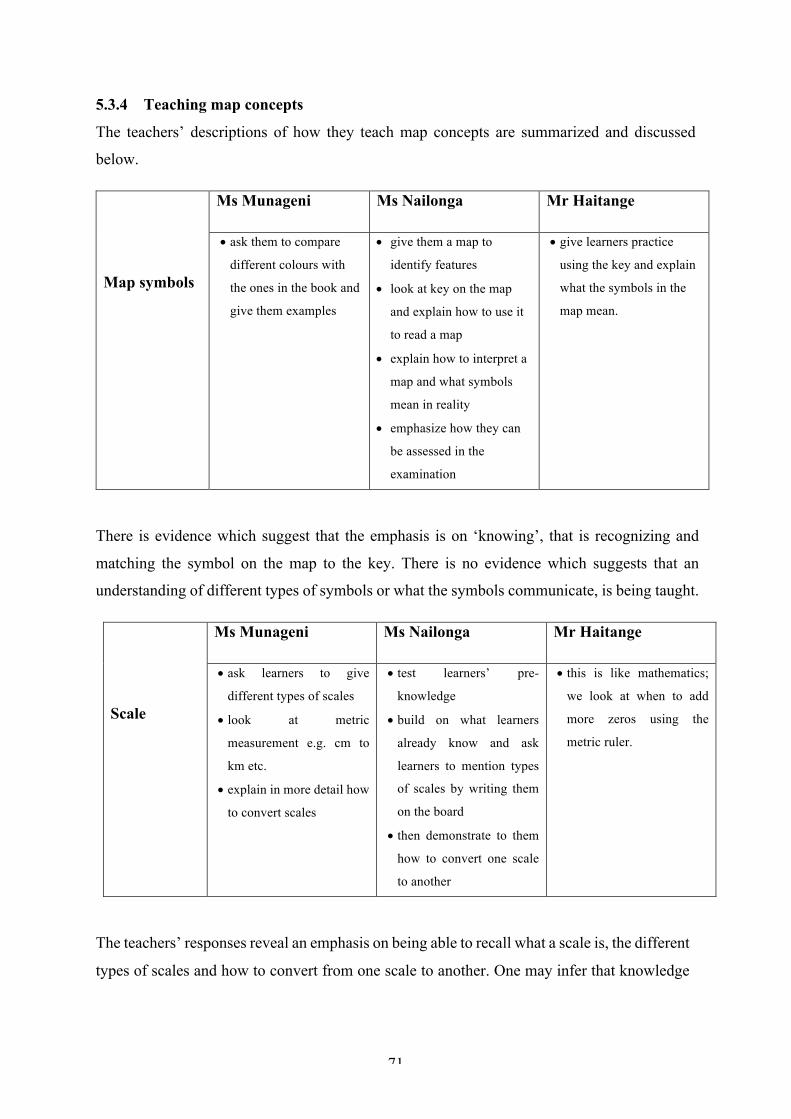
71
5.3.4 Teaching map concepts
The teachers’ descriptions of how they teach map concepts are summarized and discussed
below.
Map symbols
Ms Munageni Ms Nailonga Mr Haitange
• ask them to compare
different colours with
the ones in the book and
give them examples
• give them a map to
identify features
• look at key on the map
and explain how to use it
to read a map
• explain how to interpret a
map and what symbols
mean in reality
• emphasize how they can
be assessed in the
examination
• give learners practice
using the key and explain
what the symbols in the
map mean.
There is evidence which suggest that the emphasis is on ‘knowing’, that is recognizing and
matching the symbol on the map to the key. There is no evidence which suggests that an
understanding of different types of symbols or what the symbols communicate, is being taught.
Scale
Ms Munageni Ms Nailonga Mr Haitange
• ask learners to give
different types of scales
• look at metric
measurement e.g. cm to
km etc.
• explain in more detail how
to convert scales
• test learners’ pre-
knowledge
• build on what learners
already know and ask
learners to mention types
of scales by writing them
on the board
• then demonstrate to them
how to convert one scale
to another
• this is like mathematics;
we look at when to add
more zeros using the
metric ruler.
The teachers’ responses reveal an emphasis on being able to recall what a scale is, the different
types of scales and how to convert from one scale to another. One may infer that knowledge
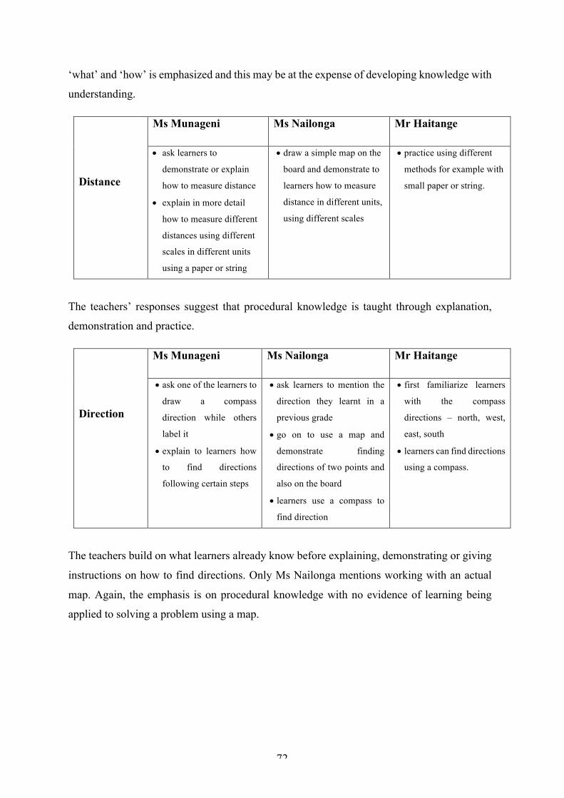
72
‘what’ and ‘how’ is emphasized and this may be at the expense of developing knowledge with
understanding.
Distance
Ms Munageni Ms Nailonga Mr Haitange
• ask learners to
demonstrate or explain
how to measure distance
• explain in more detail
how to measure different
distances using different
scales in different units
using a paper or string
• draw a simple map on the
board and demonstrate to
learners how to measure
distance in different units,
using different scales
• practice using different
methods for example with
small paper or string.
The teachers’ responses suggest that procedural knowledge is taught through explanation,
demonstration and practice.
Direction
Ms Munageni Ms Nailonga Mr Haitange
• ask one of the learners to
draw a compass
direction while others
label it
• explain to learners how
to find directions
following certain steps
• ask learners to mention the
direction they learnt in a
previous grade
• go on to use a map and
demonstrate finding
directions of two points and
also on the board
• learners use a compass to
find direction
• first familiarize learners
with the compass
directions – north, west,
east, south
• learners can find directions
using a compass.
The teachers build on what learners already know before explaining, demonstrating or giving
instructions on how to find directions. Only Ms Nailonga mentions working with an actual
map. Again, the emphasis is on procedural knowledge with no evidence of learning being
applied to solving a problem using a map.

73
Location
(latitude and
longitude)
Ms Munageni Ms Nailonga Mr Haitange
• explain to learners the
difference between
latitude and longitude
and give examples
• focus on degrees and
minutes
• draws lines of latitudes
and longitudes and
carefully follows certain
steps and formula to
calculate the seconds
• start with lines of latitude
and longitude
• link to real life situations to
make it clear to the learners
• teacher draw latitudes and
longitude line on the board
and demonstrate on the
chalkboard as she explains
to learners how to find
location and go through each
step carefully
• start by identifying the
degree of the point, then
minutes and seconds
• follow certain steps,
practice and compare
answers.
For all three teachers, the emphasis is on procedural knowledge, that is how to find a place or
phenomenon on a map using coordinates. There is little, if any, evidence of developing their
understanding of the significance of coordinates and how they are used in everyday life to solve
problems and make decisions. Instead, teaching and learning remains at the level of abstraction.
Contours
Ms Munageni Ms Nailonga Mr Haitange
• discuss in class and find slopes and landforms
• ask learners to create different models for landforms using boxes
• use PowerPoint to show different pictures.
• ask learners to define contour and their features
• use a map to explain and show different contours, slopes and landforms in reality
• use body language e.g. elbow to make a point when showing spur/valley
• give learners time to practice and do an activity.
• have some maps in the classroom as teaching aid(s)
• use maps in the text-books; do these examples with the learners to show how contour lines look.
The teachers teach contour though discussion, building models and using maps and body
language. The focus appears to be on recognizing and identifying individual relief features.
None of the teachers mention reading and interpreting how relief features, when viewed
together, enable a person to describe a physical landscape and secondly understand how relief
affects human activities.
74
The teachers’ accounts of how they taught cross-sections and gradients were consistent with
how they taught the concepts discussed above. According to Ms Nailonga, gradients are in the
syllabus for the senior grades so she has never taught it. I also asked the teachers if they taught
map projections. Their responses suggest that they do not understand (“what is that?”) the
concept and do not teach it.
What emerged was as follows:
• Examinations influence how mapwork is taught
• Teachers build on what learners already know before they start teaching
• Teachers draw sketch maps on the chalkboard to demonstrate to learners how to apply
a skill — for example measuring distance, interpreting contour lines and drawing cross-
sections
• Teaching is mostly teacher-directed with teacher-tell, and teacher demonstrations and
explanations dominating
• The focus is on teaching skills and developing procedural knowledge (how to do, follow
step-by-step instructions) at the expense of conceptual understanding
• There is no evidence of skills being applied to solve problems or interpret patterns and
relationships shown on a map
• There is little, if any, evidence of links being made to the real world of the learners
• There is no evidence which suggests that mapwork is integrated with other geography
topics
• The teachers indicated that the most commonly used resources are textbooks and maps.
5.3.5 Knowledge and skills taught in mapwork lessons
The teachers were asked about the knowledge and skills they taught in mapwork lessons. They
all said: map reading and interpretation, calculations, giving directions, identifying features on
the map and analyzing geographical information. Teachers were probed to explain how they
teach or promote such kinds of knowledge and skills in their mapwork lessons.
In response to a question about how they develop learners’ map knowledge and skills, the three
teachers’ descriptions showed that they were mostly teaching map reading skills and an
understanding of the map title, key and symbols, and the different types of maps. None
mentioned spatial thinking and spatial concepts.
75
5.3.6 Assessing learning
I asked the teachers several questions about how they gather evidence of learning and give
feedback to learners. Ms Munageni explained how she used assessment to inform her teaching:
… after each concept I give assessment or an activity but they have to do
individually and submit. I mark and give them feedback. If I realize that most of
them did not understand then I have to go back and repeat and give other
assessment.
Ms Nailonga described how she asked questions on what had been taught, and gave written
and practical activities to do. She also set questions on a map which she marked and then
worked through and discussed with the learners. She explained that if there are only a few
learners who did not do well in an activity, she works through the paper with them individually
or as a group. If there are many, then she re-teaches the whole class. Mr Haitange gave a similar
explanation. He provides remedial lessons when a few do not understand and when more than
half do not understand, he repeats the lesson using a different method.
The teachers’ assessment appears to be mostly summative, that is, taking place after the
teaching has been done and based on an assessment (presumably a test) or a written activity.
Feedback appears to be quantitative (a mark) as opposed to qualitative (a comment). There is
some evidence of summative assessment being used in a formative way.
The teachers indicated that they give homework depending on the basic competencies, or the
topic they have covered or are going to cover. Homework is given once or twice a week.
Sometimes the homework is given in a form of a worksheet generated by the teachers, or an
activity in the textbook which requires learners to work in groups or individually. On average,
teachers take a day or two to mark and give feedback to the learners. Mr Haitange emphasized
the importance of giving prompt feedback. This suggests that he understands the value of
feedback. Ms Munageni explained that she points out the common mistakes made and then she
guides the learners on how to answer these questions. She also asks the learners to give her the
answers before she gives them the correct answer. This suggest an emphasis on getting the
correct answer. Teachers’ assessment practices are discussed in Chapters Six and Seven.

76
5.3.7 Learning and Teaching Support Materials (LTSMs)
The teachers said they used different resources in their mapwork teaching, the most common
of which were the syllabus, textbooks, atlases, maps or pictures. Ms Nailonga described how
she consulted different books for maps and pictures and if she did not have the map she
required, she normally drew one. Mr Haitange was the only teacher who said he used an atlas.
Ms Munageni commented as follows:
Atlases? NO! … I get the information from the textbooks, as well as notes from
other colleagues from other schools as well as the internet…. I download videos
and images…
Mr Haitange was the only teacher who said he uses Google Maps and Google Earth. He
explained that
We use this mostly when we are teaching about different types of maps, sometimes
you can bring them to the lab and learners can log in and they can see what you
mean by contour maps and they can also be able to see how a map looks like even
from the computers that we have. …
From the three teachers’ questionnaire and interview responses, it is evident that textbooks are
an important resource that is used to guide teaching and provide examples of activities. Ms
Munageni explained that she instructs her learners “… to revise and do more activities in the
textbook at home. … There is also a map pasted at the back of the textbooks, most of the
activities and information are driven from there.” What resources the teachers use and how
they use them are discussed in Chapter Six.
5.4 Challenges and difficulties of teaching mapwork
I asked the teachers to share with me some of the challenges and difficulties they experience
when teaching mapwork. All three acknowledged learners’ lack of basic mathematical
proficiency as a challenge, and their ability to carry out simple calculations. Other challenges
include a shortage of equipment and teaching materials including textbooks, charts, posters and
maps. The teachers described how this results in the same maps being used over and over again
for tests, practical activities and even for examinations. The system of moving teachers from
one classroom meant that teachers had to carry teaching resources from class to class. A lack
of a home base militated against readily available resources. Insufficient time for mapwork
77
teaching was another challenge. Furthermore, the use of South African topographical maps in
the examinations was another challenge which Ms Munageni explained as follows:
… another thing is we are Namibians, but the maps we are using for our
examinations especially in Grade 11 and 12 are from South Africa. So, learners
are not familiar with those areas. Maybe we can get or use Namibian towns or
areas that learners and teachers are familiar with.
Ms Munageni said that she thinks the use of these maps impacts on the learner performance.
In response to a question about teacher motivation and creativity, the teachers indicated that
the shortage of resources limits their creativity. Time was another constraining factor with
teachers having to rush to cover the syllabus before the examinations. The teachers also said
that poor learner performance was discouraging and demotivating.
5.5 Teacher support for mapwork teaching
The teachers indicated that they had attended different workshops organized by the subject
advisor in the region. Ms Nailonga and Mr Haitange attended a general geography information
sharing workshop at which mapwork was discussed. Only Ms Munageni had attended a
mapwork specific workshop. She commented as follows:
I attended one last year in Windhoek, whereby we were trained by one of the
professors from the University of Cambridge. … The workshop was on how we
can teach mapwork as well as research skills.
She elaborated further:
The aim of the workshop was to inform Namibian teachers that mapwork and
research skills are not difficult and should not be taught in isolation but should
be integrated with other topics… For example, when you do landforms in
geomorphology then you should already include contours which are also part.
I probed Ms Munageni about how the workshop had shaped her practice. She explained that
the learners found the integration of mapwork and theory confusing, mainly because of the way
the examinations are structured with theory being examined in Paper 1 and mapwork separately
in Paper 2.

78
Ms Nailonga expressed her dissatisfaction with the way the workshops are conducted.
According to her, the workshops often consist of teachers sharing their practices — much of
which she already knows from talking to other teachers. She felt she should be learning
something new rather than listening to the same thing which she already knows.
Ms Nailonga also expressed her frustration:
One thing I also hate it is the time allocation, sometimes you are booked for the
whole week…, but still things are done in a rush or not done appropriately.
Perhaps because no one is prepared to do the presentation or to present and focus
on a specific area. But we have teachers who knows and understand geography
issues better, and off course they can do a better job but, we only have those
individuals.
In spite of the frustrations and expectations not always being met, Ms Nailonga acknowledged
that workshops are helpful and one can always learn something from interacting with other
teachers.
In response to questions about whether they would like support for mapwork teaching, two
teachers said they would like support as it would improve their practice. Ms Munageni wanted
help with integrating mapwork into other topics and Ms Nailonga said she would like to
observe another teacher giving a mapwork lesson. Mr Haitange indicated that he received
enough support from his HOD.
What emerged from the interviews is as follows:
• The teachers acknowledge the importance of mapwork in school geography
• The dominant pedagogical approach is teacher-centred, based on a transmission view
of learning through direct instruction/lecture/teacher-tell method
• Most lessons follow a similar pattern: asking questions to elicit prior knowledge, whole
class teaching and ending with an activity
• Teachers appear uncertain about the integration of mapwork into other topics in the
syllabus
• A number of challenges are experienced when teaching mapwork, including for
example, a lack of appropriate LTSMs.
• Textbooks are the most important LTSM used
79
• Assessment is mostly summative
• Feedback is given in the form of marks
• Mapwork teaching focuses on map skills which are taught in a procedural manner with
little evidence of application
• Learner performance discourages teachers
• There is limited professional support for mapwork teaching.
5.6 Conclusion
This chapter has presented the findings of what emerged in the analysis of the questionnaires
and interviews. It has shed light on teachers’ perceptions and experiences of mapwork teaching.
The next chapter presents the findings of the classroom observations undertaken with the three
sample teachers.
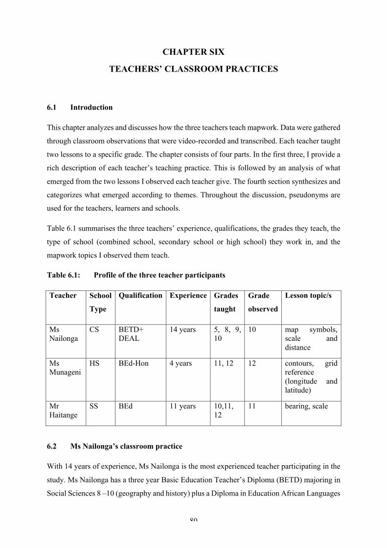
80
CHAPTER SIX
TEACHERS’ CLASSROOM PRACTICES
6.1 Introduction
This chapter analyzes and discusses how the three teachers teach mapwork. Data were gathered
through classroom observations that were video-recorded and transcribed. Each teacher taught
two lessons to a specific grade. The chapter consists of four parts. In the first three, I provide a
rich description of each teacher’s teaching practice. This is followed by an analysis of what
emerged from the two lessons I observed each teacher give. The fourth section synthesizes and
categorizes what emerged according to themes. Throughout the discussion, pseudonyms are
used for the teachers, learners and schools.
Table 6.1 summarises the three teachers’ experience, qualifications, the grades they teach, the
type of school (combined school, secondary school or high school) they work in, and the
mapwork topics I observed them teach.
Table 6.1: Profile of the three teacher participants
Teacher School
Type
Qualification Experience Grades
taught
Grade
observed
Lesson topic/s
Ms Nailonga
CS BETD+ DEAL
14 years 5, 8, 9, 10
10 map symbols, scale and distance
Ms Munageni
HS BEd-Hon 4 years 11, 12 12 contours, grid reference (longitude and latitude)
Mr Haitange
SS BEd 11 years 10,11, 12
11 bearing, scale
6.2 Ms Nailonga’s classroom practice
With 14 years of experience, Ms Nailonga is the most experienced teacher participating in the
study. Ms Nailonga has a three year Basic Education Teacher’s Diploma (BETD) majoring in
Social Sciences 8 –10 (geography and history) plus a Diploma in Education African Languages
81
(DEAL) from a former college of education. She has been teaching at Mewiliko Combined
School since 2013 when she became the Head of Department of Social Sciences Grades 5 –10.
Ms Nailonga teaches social studies (Grade 5) and geography (Grades 8 –10). She is the only
person teaching geography at the school.
Mewiliko Combined School is a village school surrounded by communal land which is utilized
for subsistence farming. The school is located in a flood prone area. During the flood season
(January to March) the school sometimes has to close. The school has an enrolment of 381
learners from pre-grade to Grade 10 and an average class size of twenty-eight per grade.
Learners’ ages range from five years in the pre-grade class, to nineteen years in Grade 10. In
the Grade 10 class I observed, eighteen of the thirty-one learners are female and 13 were male.
School attendance is generally good although it tends to drop during the flood season. Most
learners and teachers speak Oshiwambo as a first language and English as a second language.
Most of the learners come from economically challenged homes in the surrounding areas and
nearby villages. They commute to school every day. The school has no hostel facility. The
school became a non-fee-paying state school when free schooling was introduced in 2016. The
school has electricity and internet connectivity. All classrooms have chalkboards in the front
of the rooms. Some classrooms have cupboards but these have no doors and locks for the safe
storage of teaching materials. There is no administration office at the school. One of the
classrooms is used as a staffroom. Each teacher has a desk where they store their materials.
The principal and the school secretary share a store room as an office, in which printing is done
and where the copy machines are kept. The school has the basics, including for example
chalkboards, learners’ desks and chairs, a computer, a copy machine and textbooks.
The first lesson starts at 08h00 and the last ends at 14h30. The school timetable follows a five-
day cycle with eight lessons of 40 minutes per day, and a 30-minute break at 10h40. The
timetable makes provision for double lessons lasting 80 minutes, although there are no double
lessons for geography. Learners stay in the same class all day with teachers rotating. There are
study hours for Grade 5 to10 learners on Mondays, Tuesdays and Thursdays in the classrooms
from 15h00 to 16h00. Wednesday is a sports day and learners are expected to engage in
different sporting activities e.g. soccer, netball, athletics etc., which teachers supervise.
The classroom in which I observed Ms Nailonga teaching mapwork was small. The Grade 10
learners were seated in paired rows facing the front. I did not observe them working in pairs.
Worksheets were completed individually and questions were directed to individual learners.
82
There were enough desks and chairs for all the learners and they all had textbooks, notebooks
and pens with which to write. The learners were disciplined and I did not observe any unruly
or disruptive behavior. The classroom atmosphere appeared to be positive and conducive to
learning. There were no classroom displays on the walls. The chalkboard in the classroom was
in good condition but small. The teacher had to rub off the notes she made off the chalkboard
several times to create space to continue writing. There was no teacher’s desk and chair in the
classroom. The teacher used the front learner’s desk for her textbooks, chalk etc.
6.2.1 Ms Nailonga: Lesson 1
Lesson Topic: Map symbols
Duration: 40 minutes
Date: 06. 03. 18
Grade: 10
Number of learners: 31
The lesson began promptly at 13h50. Ms Nailonga greeted the class and started teaching from
a standing position in front of the class. She recapped what had been taught in Grades 8 and 9
mapwork. She asked them to define a map and wrote their answers on the chalkboard.
Approximately six minutes was spent explaining the concept of a map. She asked the learners
to name different types of maps which she wrote on the chalkboard: political, physical,
population, climatic, street maps, road maps, synoptic weather maps, topographical maps, and
vegetation maps.
Ms Nailonga did not explain the purpose or uses of the different maps the learners had named.
She highlighted the two maps (topographical, synoptic weather maps) they would be focusing
on in Grade 10, but did not explain why they were only focusing on them.
Ms Nailonga asked learners to recall the basic features of maps and wrote their responses
(scale, key, title, direction, relief, position) on the chalkboard. She spent a few minutes
describing each of the map features. No reference was made to an actual map. She did not
correct inaccurate answers, for example that relief is not a feature of all maps. She mentioned
that maps use symbols to communicate information but did not explain what this entails or
what learners need to know and understand in order to read and interpret maps.
Ms Nailonga: … Those are some of the basic features that you may find on all of the maps.
There should be a scale. Imagine a map of your country, a map of your classroom, a map of
the world to fit on a small piece of paper is because it is reduced to scale. ... all the maps they

83
are reduced in order to fit on the paper. We also have the key. This is symbols because in the
map we normally talk about the language of symbols where they are indicating what the
symbols represent on that map. We also have a title - this is just a topic based on what the map
is all about. And we have the direction, so the direction usually in most of the maps you may
find an arrow, that an arrow usually has N, do you use to see it?
Learners: Yes [in unison]
Ms Nailonga: N, that is an indication to you that North is on that side where the arrow points.
In case the map you are given does not have an arrow, always assume that on top of your book,
on top of your paper, is where north is. We have the relief, how high is the land in that map.
And this can be shown either by color, either by shade, or the lines could be use. And we have
the position, position where we use the longitude and latitude lines. We will come to it later.
Ms Nailonga then spent a few minutes reading and explaining the syllabus’ basic competencies,
describing what learners are required to learn in the lesson. She wrote the competencies on the
chalkboard and circled the word ‘interpret’ with blue chalk. She defined ‘interpret’ but did not
explain why it is important to interpret maps. The next ten minutes of the lesson were spent
looking at the map symbols. Ms Nailonga read through and showed learners the different keys
and symbols on page 8 of the textbook. The learners listened and looked at their textbooks as
she read. Ms Nailonga did not use real examples or a map to show the learners what symbols
looked like on a map. She kept on asking whether the learners were following or whether they
could find the symbols from the list of keys in the textbook (see Figure 6.1. below).
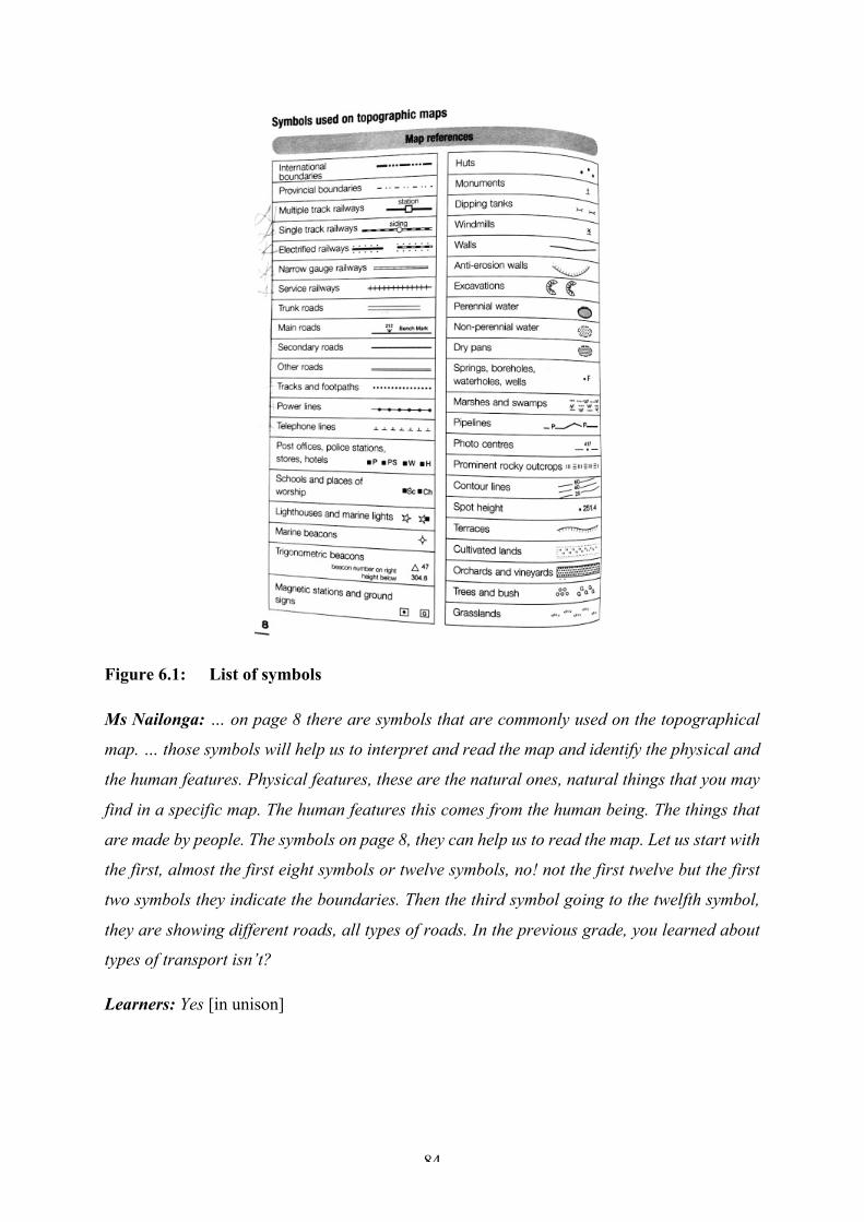
84
Figure 6.1: List of symbols
Ms Nailonga: … on page 8 there are symbols that are commonly used on the topographical
map. … those symbols will help us to interpret and read the map and identify the physical and
the human features. Physical features, these are the natural ones, natural things that you may
find in a specific map. The human features this comes from the human being. The things that
are made by people. The symbols on page 8, they can help us to read the map. Let us start with
the first, almost the first eight symbols or twelve symbols, no! not the first twelve but the first
two symbols they indicate the boundaries. Then the third symbol going to the twelfth symbol,
they are showing different roads, all types of roads. In the previous grade, you learned about
types of transport isn’t?
Learners: Yes [in unison]
85
Ms Nailonga: So, those symbols they indicate different types of roads and we call them kinds
of transport … And starting from the power line, we have power lines there, telephone lines,
are you there?
Learners: Yes [in unison]
Ms Nailonga: Aah… post office, police station, stores and hotels, schools and place of worship.
Those symbols they represent kinds of services available to people in the specific area shown
on the map. We have a trigonometric beacon symbol. Can you see that symbol?
Learners: Yes [in unison]
This continued for ten minutes until she had worked through all the symbols. Although the
teacher made some reference to real life situations, it was theoretical and abstract with no real-
world examples being given and without any reference to symbols on an actual map.
Ms Nailonga made some inter-curricula links by reminding the learners that they might have
learned what some symbols represented in agriculture.
Ms Nailonga: the dipping tanks, if you remember you have done this in agriculture. The
farmers used this thing to protect their animals from diseases using this dipping tanks. Can
you remember this?
Learners: Yes [in unison]
When going through the symbols, Ms Nailonga made reference to the types of questions that
would be asked in the examination or test. “It might be asked which settlement is here? At
place A, at place B?” Throughout the lesson, the learners listened attentively to Ms Nailonga
and copied what she had written on the chalkboard. Ms Nailonga only gave the learners an
opportunity to ask questions after she had finished reading and explaining all the keys and
symbols to the class.
Ms Nailonga: … You do not expect someone to tell you or give you a list of symbols for you to
give or explain what the symbol represents and you say excavation, wind mill, monument or
what, but you will be asked according to the activities that are taking place. Is there any
question?
When she had finished talking about the symbols, Ms Nailonga told the learners to look at the
map on the next page of the textbook. The map showed a Namibian place that was not familiar

86
to the learners. Ms Nailonga discussed the questions 3, 4 and 5 with the class (refer to Figure
6.2). Ms Nailonga wanted to find out if learners could identify and interpret the map symbols.
Figure 6.2: Class activity
Ms Nailonga: Let us start with number three [reads the question aloud]. Take that map find
out how water is available, I already told you that there is non-perennial, perennial water, dry
pans, spring water, boreholes, water holes, pipe line represents the availability of water. What
about the people of Oshikuku? How is water available to them? What are the sources of water
in Oshikuku?

87
Learners: silent
Ms Nailonga: Check the symbols, check the words, maybe they are using symbols or they are
using word, check the symbols we have learned, check the words that are related to water.
There is nothing?
Learners: There is.
Ms Nailonga: Then tell me,
Ms Nailonga: eee…… where do they get water from? Aaye! [no], who is sleeping?
Learners: silent
Ms Nailonga: Ok, Liz?
Liz: The canal?
Ms Nailonga: They get water from the canal. Thank you. Where else? Emmy!
Emmy: Dry pans?
Ms Nailonga: dry pans, dry … Emmy dry? Is there water there? It is a dry pan there is no
water, they don’t get water there, so we have a canal, we have reservoirs, we have a water
tower - those are some of the sources of water. Let us do number 4. [Describe the natural
vegetation in this area]. The natural vegetation, is there any natural vegetation in that map?
Learners: silent
Ms Nailonga: I said trees and bushes, grassland aah! What else? They represent natural
vegetation. So, which ones are available there? Shaddy?
Shaddy: Trees and bushes
Ms Nailonga: Trees and bushes! Ame ohanditi aaye! [I am saying no, it is wrong] Who know
why? The question said ‘describe’. Shaddy is correct. The problem is she did not describe; she
did not form up any sentence to talk about those trees and bushes. … Where are there the trees
and bushes? Is it all over or they are found on one side of the map? … Where are the trees and
bushes?
Learners: North of the map.

88
Ms Nailonga; So, there are trees and bushes on the northern side of Oshikuku. You have to
describe.
Ms Nailonga’s teaching emphasizes recall and comprehension. Learners read and identified
map symbols. They listened and answered questions that required no interpretation or
explanation even though Ms Nailonga told them that this would be required.
Ms Nailonga: … what I am telling you is that for the sake of knowing the symbols, you have
to study them by heart, but do not expect to be asked what does this symbol stand for or mean?
What you will be asked is the human activities that physical features that are available on that
specific map.
To round off the lesson, the learners were given a worksheet to complete in class for
consolidation purposes. The teacher instructed the learners to read the symbols and questions
carefully in order to complete the task. Learners were given about six minutes to complete the
class activity. The worksheets were collected and the lesson ended with Ms Nailonga telling
the class to learn the map symbols by heart and know what they mean so that they would be
able to interpret them in the examination.
What emerged was as follows:
• The teacher’s classroom organization and management was good. The class was well
behaved, polite and attentive
• The teacher appeared confident with no sign of self-doubt being observed
• There is evidence that the teacher knows the lesson content. However, the lesson lacked
spatial conceptual understanding of what and how maps communicate spatial
information using (map language) e.g. symbols, dots, lines etc.
• The emphasis was on teaching and learning factual information and being able to
memorise, recall and comprehend without being able to explain or apply the
information to interpret a map
• The lesson was teacher-led and consisted of teacher-talk interspersed with teacher-
initiated questions. Ms Nailonga asked all the questions and decided what sort of
activities the learners should do. The learners answered questions and when a learner
struggled, Ms Nailonga answered the questions herself
• For most of the lesson, no reference was made to an actual map. Map features were
taught in a theoretical and abstract way with little application to a real world.
89
• The only time a map was used was when the learners were completing an activity in
the textbook (see Figure 6.2), the purpose of which was to assess if they understood the
symbols taught in the lesson
• Throughout the lesson the teacher emphasized rote learning and memorization of facts
about maps. The learners were given little opportunity to ask questions or discuss the
content. The learners only spoke when answering the teacher’s questions
• No links were made to the learners’ lived experiences. There was no evidence of
application and problem solving
• Constant reference was made to what is required in the examinations. This suggests a
backwash effect of examination and testing classroom practices
• The teacher taught the whole class, without focusing or paying attention to the needs of
individual learners. There was no evidence of differentiation or support for learners
who were struggling
• The teacher taught from the front of the class. The learners listened carefully to the
teacher, and copied down what she wrote on the chalkboard
• There were no maps on display in the classroom. LTSMs consisted of the textbook and
a worksheet
• Thirty-four minutes of the forty-minute lesson was spent on instructional teaching, with
the remaining six minutes and an additional five minutes of the afternoon study break
used to complete the class activity.
6.2.2 Ms Nailonga: Lesson 2
Lesson Topic: Scale and Distance
Duration: 40 minutes
Date: 08. 03. 18
Grade: 10
Number of learners: 31
The lesson began promptly at 13h50. Ms Nailonga greeted the class and began with a recap on
what had been taught previously. She asked learners to explain how it is possible for a map to
fit onto a page or a book. When the learners did not respond, Ms Nailonga rephrased the
question.
Ms Nailonga: Alright last time we looked at the features of the map or map symbols. We also
talked about a map being reduced to fit in a flat surface or to fit in a piece of paper. So what
90
make it possible for a map to fit in a small piece of paper? Like a flipchart, a poster or a book?
Can you tell me?
Learners: silent
Ms Nailonga: Yee! Ooh! The map is reduced to what?
Learners: To a scale.
Ms Nailonga told the class they were going to look at scale and distance. She asked them to
define scale. She then wrote the definition of scale on the chalkboard.
Ms Nailonga: All the maps that we find wherever we find them they are reduced to a certain
scale. For today we are looking at scale. Scale and distance. Can you explain to us what a
scale is? What is a scale? Hafeni?
Hafeni: The relationship between the two places in the map and the same place on the ground.
Ms Nailonga: Hafeni said, scale is the relationship between two places, between our school
and Oshipale Primary school. Two places on the map, on the piece of paper, on that map you
are given and the distance in reality between the school and another school. So, the
relationship between the actual distance on the ground and the reduced distance on the map.
Ms Nailonga asked the learners to list the three types of scale and wrote their answers on the
chalkboard. She then told three learners to come and write down the examples of scales on the
chalkboard. The learners spent about three minutes doing this.
Shaddy: Word scale.
Ms Nailonga: Word scale, yes! Nelao?
Nelao: Ratio scale.
Ms Nailonga: Ratio scale, yes! Liz?
Liz: Linear scale.
Ms Nailonga: Linear scale. These are the types of scales. Thank you.
Ms Nailonga spent a few minutes pointing at the 1:50 000 ratio scale and explaining that it
always has 1 as denominator, colons and is always in centimetres. Ms Nailonga offered no

91
explanation of a representative fraction. She proceeded to spend about seven minutes
demonstrating how to convert a ratio scale into a word scale. She reminded the learners to refer
back to the metric system when they converted using the scales. After working out how many
centimetres there are in a kilometre, she proceeded to convert the ratio scale into a word scale.
Ms Nailonga: … The ratio scale it can be changed, it can be changed to became a word scale,
it can be changed. There we are given 1 cm represent 50 000 centimetres we can change it. …
Let us change it to become a word scale. … we were given a word scale here 1 cm represent
instead of writing a colon now in a word you write what?
Learners: represent
Ms Nailonga: represent, represents we have
Learners: The word represents (correcting the spelling)
Ms Nailonga: Yee! Ooh, (re-pre-se-nts) thank you. We can use the word represent or instead
of the word represent we can use the word to 1 cm to, we have 50 000 cm. here you have to go
back to mathematics so, most of the time we use when we are putting the distance in reality we
either use m or km so you have to go back to the metric system where we have to check how
many centimetre in a kilometre. How many centimeters in a kilometre?
Learners: whispering
Ms Nailonga: who is singing? Raise your hand and say something please. How many cms in
1 km? I see some are already drawing the metric system - decametre, kilometre, metre, so, how
many centimetres in 1 km? How many are they? I see someone is taking his book for
mathematics. Yes! Kauna how many centimetre?
Kauna: 100 000
Ms Nailonga: in 1 km, there are 100 000 cm. so, now on the given ratio scale we have 50 000
there you have to divide, divide this 50 000 by 100 000 can you do that? Mathematicians please
help us out.
Learners: working out the answer on their calculators.
Ms Nailonga: yes, what answer did you get?
Learners: (shouting the answers)
92
Ms Nailonga: Please put up your hand and give us the answer, Shaddy?
Shaddy: 5km
Ms Nailonga: 50 000 divided by 100 000?
Learner 1: 0,5
Ms Nailonga: 0,5 learners? Yee! Yes, Eino?
Eino: 0,5 km
Ms Nailonga: 0,5 km. so, now we have what? Another type of scale?
Learners: A word scale.
Ms Nailonga: A word scale, but we got it from a ratio scale by converting it.
Ms Nailonga moved on to a linear scale and spent about five minutes explaining how to convert
a word scale to a linear scale. She drew a diagram of a linear scale on the chalkboard and wrote
a short description of it, telling the learners to look at the chalkboard while she wrote. She
pointed out that the linear scale is divided into two sections, but she did not clarify why there
were two sections. It was only after she had finished explaining to the learners that she asked
if they had any questions and whether they had been following. The learners did not ask any
questions. The next twelve minutes of the lesson were spent explaining how to use a scale to
calculate distance on a map. Ms Nailonga drew two points on a sketch map she had drawn on
the chalkboard and then explained step by step how to measure distance between two points
on a map using a specific formula e.g. km = !"#%&'(")*+,----- ×/0123. The learners listened and
watched what she was doing and some copied what she wrote on the chalkboard. When she
had finished explaining, she wrote an activity on the chalkboard and asked learners to work on
it. She emphasized the use of the metric system and told the learners they should always divide
with 100 000 to get kms without explaining why.
Ms Nailonga did another example on the chalkboard using a linear scale, after which she asked
if learners had questions. No questions were asked so she gave learners an activity that required
measuring distance on a map. She handed out a worksheet and went through it emphasizing
what was important for examination purposes. The learners spent six minutes doing the
worksheet before Ms Nailonga concluded the lesson with a brief recap of the main points.
93
What emerged was as follows:
The teacher was confident and well prepared. There is evidence that she knew the content of
the lesson. The teacher tried to make links to the learners’ lived experiences e.g. when
calculating distance
• The teaching approach was teacher-centered. The teacher stood in front of the class and
explained the content to the learners. The teacher did most of the talking and made notes
of the important aspects of the lesson on the chalkboard
• Learners listened attentively and took notes from the chalkboard. The teacher interacted
with the learners through questions and answers
• Learners were taught as whole class. There was little discussion
• Learners were seated in paired rows facing the teacher, who remained in front for the entire
lesson
• There was no learner-learner interaction through pair work or group work
• Thirty-four minutes were used for teaching and the other six minutes were used to complete
the class activity
• The concept map scale was taught in a series of steps, focusing on how to measure and
convert map distances using different scales. The emphasis was on the steps learners need
to follow in order to complete the activity. Little, if any, attention was given to developing
a conceptual understanding of scale
• No real maps were used. The teacher drew sketch maps on the chalkboard of their school
and the neighboring school to explain how to measure distance between the two schools
• The only time a real map was used was when the learners had to do an activity towards the
end of the lesson
• The teacher made several references to the examination and assessment.
6.3 Ms Munageni’s classroom practice
Ms Munageni is the youngest and least experienced of the three teachers who participated in
the study. She has been teaching at Hanganeni High School since graduating from university
in 2013. She has a four-year Bachelor of Education degree with Honours (BEd-Hons) majoring
in geography and biology, from the University of Namibia (UNAM). Ms Munageni teaches
geography and development studies in Grades 11 and 12.
94
Hanganeni Secondary School is one of the largest schools in the region. It has 1182 learners
and thirty-eight teachers, six of whom are geography teachers. The school is located in a small
growing town in the Ohangwena Region of northern Namibia, about six km from the
Namibian-Angolan border. The school is a national symbol; it was located near the army base
during the apartheid era and the school and the community played an important role in the
liberation for independence. The school was attacked several times during the struggle for
freedom, and this resulted in the destruction of the school’s facilities, the killing of two learners,
and teachers and community members.
The school caters for learners from Grade 9 to12, with an average class size of forty. There is
an age and gender variation among the learners in the school — fifteen years in Grade 9, to
twenty-two years in Grade 12. In the Grade 12 class I observed that there were forty-five
learners of which twenty-five were females and twenty males. The school offers boarding
facilities for both boys and girls. However, the hostel facilities only accommodate half of the
learners in the hostel. The other learners have to find accommodation in the surrounding areas
in town where they have to pay rent, or in nearby villages as far as ten kilometres or more
away. The learners’ attendance is generally good, with low absenteeism among the non-
boarding learners.
The learners come from local feeder schools in the circuit and the region. Most learners and
teachers speak Oshiwambo as a first language and English as a second language. Most of the
learners live in the surrounding areas and nearby villages and a few come from the
neighbouring country Angola. Many learners are from economically challenged backgrounds
with some paying hostel fees out of the government social grants or else they are exempt from
paying the hostel fees. The school has been a non fee-paying school since free education was
introduced in 2016.
The school has electricity. The classrooms have chalkboards and some have cupboards,
although without doors and locks for teachers to store their teaching materials. The school has
an administration office and a staffroom in which each teacher has a desk where they store
their materials. There are a number of offices including one for the principal, the HODs and
secretary. The school has the basic resources for teaching, including chalkboards, learners’
desks and chairs, computers, a copy machine, textbooks, book storeroom and a printing room.
There is also a small library and science lab at the school. The school has a computer lab with

95
internet connectivity in which there are about twenty computers for the teachers and learners
to access information about maps.
The first lesson begins at 07h30 and the last one ends at 14h00. The school follows a seven-
day cycle with eight lessons of forty-five minutes per day, and a thirty-minute break at 10h30.
The school timetable makes provision for double lessons lasting ninety minutes. Both the
mapwork lessons I observed were double lessons. The learners remain in the same class all day
and teachers rotate. There are study hours for all the learners on Wednesdays and Thursdays in
the classrooms from 15h00 to 16h00. There is an evening study period from 18h00 to 20h00
for learners who board.
The Grade 12 classroom was on the small side and somewhat crowded, but this did not seem
to affect the teaching. The learners were seated in paired rows facing the front. The teaching
approach was more collaborative with learners completing a worksheet in pairs in the second
lesson I observed and working in groups in the first lesson. There were enough desks and chairs
for all the learners and they had textbooks, notebooks and pens. The learners were disciplined
and I did not observe any unruly or disruptive behavior.
The classroom walls had displays that were mostly biology related. Only one flipchart with a
diagram of the internal structure of the earth related to geography. The weekly cleaning list and
class timetable were also displayed. The chalkboard was in good condition, but small. The
teacher had to rub off the notes she made to create space for writing. There was a teacher’s
desk but no chair for her to sit on. She kept her teaching materials e.g. textbooks, chalk,
worksheets and maps on the desk.
6.3.1 Ms Munageni: Lesson 1
Lesson topic: Interpretation of contour lines
Duration: 90 minutes
Date: 20. 02. 18
Grade: 12
Number of learners: 45
The lesson began at 09h15 — fifteen minutes late, because the learners had to move from their
classroom to the library. The teacher had to search for an extension cable and adapter so that
she could set up her PowerPoint slide show. Learners were seated in groups of five. The teacher
greeted the learners and recapped what they had done previously in mapwork. She asked
learners to mention the two types of features found on topographical maps.
96
Ms Munageni: So, if I may take you back to what we covered last time on mapwork, we learned
that in a topographical map there are two types of features, isn’t [it]?
Learners: Yes,
Ms Munageni: Who can name those features for us? Yes, Panduleni?
Panduleni: We have natural features and man-made features
Ms Munageni: Yes, we have natural features and man-made features, so man-made features
are feature that are constructed by human being and we also have physical features or natural
features, features from nature. So, some of the natural features on the topographical map can
be presented using contour lines. In some cases, you can be asked to discuss the relief features
of the specific place and then you must make use of the contour lines to help you identify those
features and that is what we are going to talk about today,
Ms Munageni then asked the learners to define contours.
Ms Munageni: … but before we look at those land forms we have to remind ourselves what
are contour lines? What are contour lines? Who can help us to define that? Tuli?
Tuli: Lines on the map joining points on the map with equal height.
Ms Munageni: Contour lines are lines on the map joining places with equal height. Meaning
that we have line that are joining different places with equal height. Contour line have some
features — who can give me features of the contour lines? Characteristics of contour lines.
Who can help with that? Or rules for contour lines, contour lines have rules? What are those
rules?
Learners: Contour lines never touch.
Ms Munageni: So, they never touch, is it touch?
Learners: Cross
Ms Munageni: Contour lines never cross each other. So, they never cross each other, however
they can touch each other at some points.
Ms Munageni asked learners to identify the different landforms illustrated by contour lines.
97
Ms Minageni: List all the land forms that we can remember that are formed by contour lines.
We have a lot of them probably ten. Can you list that you know? Panduleni?
Panduleni: I know a spur
Ms Munageni: We have a spur. Hafo?
Hafo: A valley
Ms Munageni: We have a valley. Hella?
Hella: Gradual slope
Ms Mungeni: Gradual slope?
Learners: Aaye! (no)
Ms Munageni: Quiet, that one is a type of slope, we are talking of land forms.
Hella: Oho! Conical hill
Ms Munageni: Conical hill, yes, Sammy?
Sammy: A flat-topped hill
Ms Munageni: Flat-topped hill. Paula?
Paula: Saddle
Ms Munageni: We have a saddle.
Learners: Waterfall
Ms Munageni: Waterfall, a cliff
Learners: Escarpment
Ms Munageni: Escarpment, plateau and so forth.

98
Ms Munageni showed learners photographs of models of selected landforms on the projector.
She asked the learners to identify the landforms and the kinds of materials that had been used
to make such models in the photo. She then read a list of materials and equipment they needed
for a model building activity. Ms Munageni read out instructions for the activity and told the
group leaders to collect contour templates for their groups. She encouraged the class to be
creative and emphasized that they needed to “come up with a beautiful model of that specific
contour landform.”
Figure 6.3: Learners building a model Figure 6.4: Models built in the lesson
Ms Munageni read out some questions the learners needed to answer after they had completed
their models.
Ms Munageni: There we have questions do to at the end of your activity, and I hope you
brought your group books, because you will need to submit your group book when you are
done with answering those questions. … so, give the name of the landform you modelled, the
second one, state the contour interval so, you have numbers there, use those numbers and give
me the contour interval, and then lastly just describe or give the features of your land form.
Are we clear? …
Ms Munageni read out the marking criteria she would be using to mark the learners’ work. She
encouraged the learners to work as a team in order to complete the hands-on activity.
Ms Munageni: … lastly, what I am going to use to mark your work, I am going to look at
neatness, is your work neat? Creativity, you must be creative, and then originality, meaning
that it must resemble the real thing, must not look like something that is not real. And
remember, team work! Are there any questions? If there are no questions, we can start.
The next forty minutes were spent constructing models (Figs 6.3 and 6.4). Ms Munageni
walked around the class checking how learners were getting on and attending to individual
group’s questions and concerns. She kept asking the learners if they were done and encouraged
99
them to finish working before the lesson ended. The lesson concluded with Ms Munageni
asking the learners to tidy up before leaving the library.
What emerged was as follows:
• The teacher appeared confident and seemed to know the lesson content and what she was
talking about
• There was learning-by-doing. The learners were involved in hands-on practical activities
to build cardboard models of contour landforms, but using pre-drawn forms and labels
given to them, to work with
• To a certain extent there was evidence of LCP through group work. The learners worked
in groups or teams of five to complete the activity
• On the surface this looked like a very good lesson, however, the lesson focused only on the
basic characteristics of contours, labels, and examples of land forms. These are elements
already learnt in Grade 8. There was no effort to move beyond this to the use and
interpretation of contours, nor posing any problems to solve
• Although contour lines have a number of characteristics, only one received attention in the
lesson
• The learners were kept busy building ‘neat’ models. There was no evidence of spatial
conceptual understanding being developed
• The concept (contours) was taught in isolation. The learners were not required to apply
their knowledge (of contours) to read and interpret landscapes depicted in maps
• Throughout the entire lesson the teacher emphasized the steps or procedures learners had
to follow in order to complete the activity
• The questions asked in the written activity were closed-ended and recall questions that did
not require explanation or application of knowledge. Learners were not questioned or
challenged when building their models
• Apart from the PowerPoint slides, no other LTSMs used by the teacher. Only one group
used a textbook to check for answers to the questions. There were no maps or other
geography resources on the classroom walls
• No topographical maps were used to show the learners what contours look like on a map
or how landforms (relief) are shown by means of contours
• The teacher did all the talking in the first seventeen minutes of the lesson. Learners listened
attentively and only spoke when answering a question asked by the teacher
100
• Forty minutes were spent on learners building a model and fifteen minutes were lost
because of the move to the library and looking for equipment.
6.3.2 Ms Munageni: Lesson 2
Lesson Topic: Location
Duration: 90 minutes
Date: 14.03.18
Grade: 12
Number of learners: 45
Ms Munageni arrived late for the lesson which was meant to start at 09h00. The learners were
seated in paired rows when the teacher arrived. She greeted the class and asked the learners if
they had their stationary needed for the lesson. Time was lost because a few learners went
outside to look for their rulers, pencils, calculators etc. She told the learners to settle down and
proceeded to write the learning objective of the lesson on the chalkboard which she then read
to the class.
Ms Munageni: One minute, wait, wait, go back and seat. Hurry up time is going.
Learners: [coming and going in and out of the classroom for about six minutes]
Ms Munageni: Can we all have our seats. So, if you don’t have pencil, ruler and other you
can share with your neighbour. Alright can I have your attention; we are going to look at map
reading and we are going to focus on location. We will look at how to locate features in the
map, how to give the exact location of a certain feature on a topographic map. Our objectives
there, what are we expected to know at the end of this lesson? To be able to locate features on
the map using coordinates and be able to give and read degrees, minutes and second in order
for you to give the precise location of a certain feature on the map. So, that is what we are
going to look at today.
Ms Munageni drew lines representing latitude and longitude on the chalkboard and asked the
learners to differentiate between the two. She asked the class to affirm their friends’ answers
and noted keywords on the chalkboard.
Ms Munageni: … before we go into more details of how we can locate using degree, minutes
and seconds, because that is our main objectives, firstly we need to familiarize ourselves with
these two lines latitude and longitude lines. … Who can tell me the difference between the two
101
lines? How do you know that this is one is latitude line and this one is longitude line? How do
you know which one is which?
Learner 1: [Speaking very quietly]
Ms Munageni: Looks like you are just telling yourself, we can’t hear, please speak up so that
everyone can hear.
Learner 1: Latitude they are horizontal lines, while longitude they are vertical.
Ms Munageni: Latitude is horizontal and longitude is vertical, is he correct?
Learners: Yes [in unison]
Ms Munageni: So, latitudes are the horizontal lines that we find in our topographical map
while the longitudes are the vertical lines. Meaning that vertical standing, while the other ones
are…
Learners: Sleeping
Ms. Munageni: [laughs] sleeping?
Learners: Yes [in unison]
Ms Munageni: Ok, so, probably that will be the easy way that you can use in order for you to
determine which one is which. Are we clear?
Learners: Yes Ms [in unison].
Ms Munageni asked the learners to give examples of latitude and longitude lines.
Ms Munageni: Who can give an example of a latitude line? Hafo?
Hafo: Equator
Ms Munageni: So, an example of a latitude line is an Equator. While longitude?
Learners: Greenwich Meridian.
Ms Munageni: Greenwich Meridian, … So, these are vertical lines on the globe. If you look
on the globes the horizontal one are called latitude meaning that they are the ones that are
across the globe, while the latitude ones are vertical on the globe. …

102
Ms Munageni used her hands to demonstrate to the learners what horizontal and vertical look
like. She noted the characteristics of both lines on the chalkboard. She asked the learners on
which side of the Greenwich Meridian Namibia is found:
Ms Munageni: … these ones depending now on which hemisphere you find yourself, the
latitude ones show how far, how far are you from what?
Learners: Equator [in unison]
Ms Munageni: How far are you from the Equator, how far, it shows how far North or South
of Equator. So, now it depending on the hemisphere, for example we are on a southern
hemisphere and therefore, we are going to focus on how far are we south of the equator. So,
the latitude one they show how far the place is East or West from where?
Learners: Greenwich Meridian
Ms Munageni: A place is from Greenwich meridian, so Namibia is on which side of the
Greenwich meridian?
Learners: East, south, west
Ms Munageni: South?
Learners: West, East?
M Munageni: You guys don’t know? We are on the east of the Greenwich meridian. And we
are south of the equator.
Learners were uncertain about their answers. Ms Munageni corrected the learners without any
reference to a map or globe. She asked the learners to explain why the latitude lines are also
called ‘southing’ and longitude lines ‘easting’:
Ms Munageni: so, another name we call them southing and the longitude line are called the
easting. Why do we call them southing?
Learners: [murmuring] Because they are increasing towards the south.
Ms Munageni: Why we call them southing is because they are increasing towards the south.
So, you find them in a topographical map and they are increasing towards that side.
Learner 2: Ms… Ms… why are they not northing? They are northing.

103
Ms Munageni: They are northing?
Learners: Yes, they are also northing, what about those ones that are going up?
Ms Munageni: But I said we are on which side of the equator?
Learners: ooh, we are looking at Namibia?
Ms Munageni: We are on the south, and that means the lines are increasing toward the south
from the north of the equator downward to the south.
Learner 4: But Ms. what shows that they are increasing toward the south?
Ms Munageni: What shows? He is asking what shows that they are increasing toward the
south? What shows that they are increasing toward the south?
Learner 5: The degree.
Ms Munageni: The degrees will show. Because if you have 0 at the equator, is it? 0° equator,
the degree is 5, 15 and so on?
Learners: Yes [in unison].
Every time a learner asked a question Ms Munageni redirected it to the class for discussion.
She asked the learners to explain how to locate a feature on the map. The learners did not
respond. Ms Munageni repeated the question several times and wrote it on the chalkboard.
Ms Munageni: … Anyone with an idea how can you determine the degrees, minutes and
seconds? Of a certain feature? Anyone with an idea? Ndilimeke! Yes?,
Ndilimeke: [Silent]
Ms Munageni: Anyone with an idea on how to determine degrees, minutes and seconds for a
certain feature? … You may have a spot height, 220 and then they ask you to locate or give
latitude and longitude lines for the spot height given.
Learner 7: The degrees and minutes are already here.
Ms Munageni: In most cases in our topographical maps the degrees and minutes are already
given
Learners: Yes [in unison].
104
Ms Munageni: However, you still need to start there. You just don’t write the seconds alone;
you have to start from the degree. Hafo?
Hafo: You have to take a ruler and draw a vertical line straight and then you determine where
the that line lies on a certain degrees and minute and after that you measure the distance from
a certain degree to another, and then after taking the reading you take the whole reading with
two degrees which is an interval distance and then you take that distance where that point lies
on that latitude line and then you multiply it with the 60 and you divide by the total distance of
the whole minute.
Ms Munageni: Alright, thank you, did you get it?
Learners: Noo! [emphatic]
Learner 4: I am confused.
Ms Munageni: You are confused? You will find out now.
Ms Munageni told the learners that they should always give the latitude line first and then
longitude but did not explain why. She drew a rough grid representing lines of latitude and
longitude with degrees and minutes. She then demonstrated how to locate a feature on a map
using coordinates. She wrote the seven steps that needed to be followed and the formula that
must be used on the chalkboard. She asked the learners to estimate the measurements while
she was demonstrating the procedures on the chalkboard. This took about fifteen minutes. In
total, about sixty minutes of the lesson was spent explaining and demonstrating how to locate
features on a map.
It was only at this stage of the lesson that Ms Munageni distributed the topographical map of
Harrismith, South Africa. The learners worked in pairs to complete a worksheet for the
remaining fourteen minutes of the lesson. The questions on the worksheet asked the learners
to give the location of a feature on a map using degrees, minutes and seconds. Ms Munageni
walked around the classroom checking how the learners were doing and attending to individual
pairs’ questions and concerns. Ms Munageni told the learners to submit their worksheets and
maps once they were done.
105
What emerged was as follows:
• The teacher seemed prepared for the lesson on location. There was evidence of teacher-
learner interaction through questions and answers. Classroom discussion was encouraged
through guided questions and sometimes probed responses by the teachers and learners
• Latitude and longitude was discussed in relation to Namibia
• The learning and teaching environment was relaxed and non-threatening. The learners
asked questions when they did not understand. The learners corrected the teacher in a
respectful manner
• Some learners openly and freely expressed their views and misunderstandings. Learners
suggested answers
• At the end of the lesson, learners worked in pairs to complete an activity to locate features
on a map handout using latitude and longitude
• This also looked like a good lesson, however, again the content and skills being covered
here are all done from Grade 9. There was no progression beyond the review of these basic
skills and knowledge in this Grade 12 lesson, either in the questions being asked nor were
there any problems to be addressed. Learners were taught to follow certain steps and
formulae to locate a feature in a map, as the teacher had notes that she referred to in her
explanations. The lesson focus was on knowing and doing without any application to real-
life situations or problem solving
• The map concept was taught in isolation from other geography topics
• The teacher stood in front of the class explaining the content to the learners for most of the
lesson. She did most of the talking and used the chalkboard to demonstrate finding positions
using coordinates. The learners listened attentively to the teacher and one or two asked
questions where they did not understand or were confused
• The teacher’s explanations were interspersed with questions, most of which checked if the
learners were following
• Whole class teaching was done and not much attention given to learners who expressed
confusion
• Using latitude and longitude to give a location was taught using a grid sketched on the
chalkboard. No maps or globes were used to demonstrate and explain coordinates to the
learners. The only time a real map was used was towards the end of the lesson where
learners were given a worksheet for consolidation purposes
106
• The teaching and learning process was controlled by the teacher and it was closely aligned
to the leaning objectives and content listed in the syllabus.
6.4 Mr Haitange’s classroom practice
Mr Haitange is between 30 and 40 years old and has been teaching for eleven years. He has
been at Twakulilwa Secondary School since 2010. Mr Haitange has a four-year Bachelor of
Education degree (BEd) majoring in geography and history. He teaches geography and history
in Grades 10 to12.
Twakulilwa Secondary School is located near the Namibian-Angolan border in the Ohangwena
Region. It is one of the oldest schools in the country, and the first English-medium school in
northern Namibia. The school is a national symbol for the role it has played in the liberation
struggle of the country. During colonial times the missionaries were deported, students were
abducted twice and the school buildings were destroyed. The school was temporally closed
down and moved further inland to a different location and was only reopened after
independence. The school is diverse; it caters for learners with different abilities from diverse
cultural backgrounds as well as from neighbouring countries like Angola. There is also cultural
diversity among the teachers in the school. Most teachers at the school are Oshiwambo
speaking, with a few non-Oshiwambo speaking from the Zambezi Region and Zimbabwe.
Twakulilwa Secondary School is a rural school surrounded by communal land with subsistence
farming. The school is private church-run school which is subsidized by the Namibian
government. The parents are responsible for paying school and hostel fees for their children.
Very few learners depend on social grants to pay fees.
The school has seventeen teachers, four of whom are geography teachers. It has an enrolment
of 424 learners from Grades 8 to12, and a class average of thirty learners per grade. There is
age and gender variation among the learners in the school — from fifteen years in Grade 9, to
twenty-five years in Grade 12. Some of these learners have failed Grade 10 or 12 from other
schools and want to improve their grades. In the Grade 11 class I observed, there were thirty
learners, of which nineteen were female and eleven were male. Twakulilwa is a boarding
school and offers hostel facilities to both boys and girls. Like Hanganeni high school, the hostel
accommodation is a challenge. Only half of the school is accommodated in the hostel and the
other half have to find accommodation in the surrounding areas or nearby houses. The learners’
attendance is generally good, with low absenteeism among the non-boarding learners.
107
There is an administration office at the school, a staffroom and various offices, including one
for the principal and the secretary as well as other offices. The school has the basic resources
for teaching e.g. chalkboards, learners’ desks, chairs, computers, a copy machine, textbooks, a
book storeroom and printing room. There is also a small library and a computer lab at the
school. Like Hanganeni high school, the school has electricity and internet connectivity. It has
a computer lab with about ten computers connected to the internet which the teachers and
learners can use to access information.
The first lesson starts at 07h30 with the last one ending at 13h00. The school follows a seven-
day cycle with eight lessons of forty minutes per day, and a thirty-minute break at 10h30. The
school timetable makes provision for double lessons lasting eighty minutes. However, the two
lessons I observed were all single lessons lasting for only forty minutes. Unlike the other two
schools in this study, at Twakulilwa the teachers remain in the same classroom and learners
rotate for their lessons. There are study hours for all the learners on Wednesdays and Thursdays
in the classrooms from 15h00 to 16h00. There is also provision for evening study for boarders
on Mondays to Thursdays from 18h00 to 20h00.
The classroom was slightly bigger than those at the other two schools and it was subject
specific. The classroom had a storeroom where Mr Haitange kept his materials e.g. maps,
textbooks, etc. The learners were seated in straight rows facing the front. There was a desk and
chair for each learner and they all had a textbook, exercise book and pens. The atmosphere in
the classroom was orderly and conducive to learning and the learners were well disciplined. I
did not observe any unruly or disruptive behavior.
The only wall display consisted of a world map. The weekly cleaning list and class timetable
were also pinned up. The chalkboard in the classroom was small but in good condition.
6.4.1 Mr Haitange: Lesson 1
Lesson topic: Bearing
Duration: 40 minutes
Date: 12. 03. 18
Grade: 11
Number of learners: 30
This lesson was taught in the afternoon during the afternoon study period. It started at 15h00
with Mr Haitange greeting the learners and recapping what they should know about bearing
from Grade 11. He told the class they would be looking at bearing and gave them a handout
108
with notes and a few steps on how to find bearings. He reminded the class that they had done
bearings in mathematics. Mr Haitange read the handout and drew a rough sketch map on the
chalkboard. He plotted two points A and B on the chalkboard and started explaining step-by-
step how to find a bearing on a map:
Mr Haitange: I don’t know whether you have already done it in mathematics or you are going
to do it otherwise all I know is that bearing we do it in these two subjects geography and
mathematics. Now to look at this paper here that I have given you, it is written how to measure
bearing. The question in the test will ask us to find bearing from point A to point B. if you look
at that paper that I have given you there is a diagram which has got many points. ... Now it
says there the first step, it is to find the points concern, let us say we are having our two points
there. … point A here and we have point B there. … The next step you have to put a line or
connect the two points with a straight line. As we said the first step is to find the two points
concern. We have our two points A and B. The next step is to connect the two points with a
fine line. … we have joined from point A to point B. Then we go to the next step draw a across
line up on the north from feature, we are going to be have N, the bearing of B from A this what
we are trying to do here. So, our next step three draw a cross line up on the north from feature,
our bearing from feature here is which one?
Learners: A [in unison]
Mr Haitange: … if we are looking at the board here, mostly our north every time it is on the
top even if we are looking in our books our north is usually on top there. So, we are going to
establish our north here and we are going to put a line on our point. … The list says here our
last step here step four measure the bearing with your protractor. … but what is important is
these four steps.
Mr Haitange did an example on the chalkboard of how to measure bearing on a map following
the four steps. He repeatedly emphasized the four steps set out in his handout. He showed the
learners the protractor they would use to measure bearing and explained how to read bearing
on a protractor while demonstrating on the chalkboard.
Mr Haitange: (repeated the four steps) … Now what is important is that when we calculate
our bearing we are supposed to measure our bearing clockwise. Which means we are going to
measure our bearing in this direction clock wise [showing with his hand]. So, we are going to

109
measure the bearing of B from A. I got a big protractor and I hope you got smaller ones to
work with?
Learners: yes, sir [in unison]
The learners listened and watched Mr Haitange demonstrate on the chalkboard. He asked one
of the learners to come up to the chalkboard and show the class where to read the bearing on
the protractor.
Mr Haitange: … So, we are going to take our protractor we are going to first of all to place it
on our line here we have got our point A from B here. I want you to tell me where are we going
to get the readings? If we place our protractor here? And this is how you hold your protractor.
So, who is going to tell us how many readings we have here? When we hold the protractor like
this. It is reading how many degrees?
Learner 1: 143 degrees
Mr Haitange: He says 143 degrees, where did you find the 143?
Learners: [giggling]
Mr Haitange: ok, no, thank you now, I said we read on our line here, and that is how he got
the 143 degrees.
Mr Haitange did another example on the chalkboard with the class listening and watching. He
asked a learner to explain on the chalkboard how to measure bearing following the four steps.
He then asked another learner to come and do another example on the chalkboard. There was
a bit of commotion as the learner struggled to draw a straight line between the two points
without a ruler. Mr Haitange calmed the class down and the lesson continued. He affirmed the
learner’s answer and emphasized the four steps that needed to be followed.
A learner asked a question on how to find a bearing of an opposite direction. Mr Haitange
explained that they would be talking about bearings of more than 180 degrees in the next
lesson:
Learner 3: Sir. How do we measure from C to A, how do I get that C to A?

110
Mr Haitange: When you measure from C to A is the same thing, what you are told to do. We
are going to be talking about, the bearings that are more than 180 later. After this, we are
[then] going to talk about bearings [that are] more than 180. …
Mr Haitange told the class to do three examples in the handout, following the four steps. He
wrote the instructions on the chalkboard. The learners worked on the activity for about ten
minutes during which time Mr Haitange repeatedly reminded the learners of the four steps.
Mr Haitange spent about eight minutes going through the three questions. He asked the learners
to call out their answers which he wrote on the chalkboard. He picked the answer given by
most learners but did not indicate if it was correct.
Mr Haitange: Ok, let us start with this one, the bearing of E from A, Titus tell me what you got
on this one E from A.
Titus: 107
Mr Haitange: Joseph what did you get?
Joseph: 115
Mr Haitange: 115? I want someone else, yes Peter?
Peter: 117
Learners: Ooh!
Mr Haitange: 117, let see Pinehas?
Pinehas: 117
Mr Haitange: 117, yes, Paulus?
Paulus: 116
Mr Haitange: 107, 115, 117, 117, 116, these are the answers that we have. As you can see they
are a bit different but a bit close, the highest 117 and the lowest 107. This difference is too big.
We can have a difference of a degree or two. Paulina give me your paper. This one that I was
given by Paulina, the north is not straight, our north must be straight. ... Let me see one here,
Tomas what did you get? This one for Tomas I think is better with 115. Let see Leena show me
yours. Let me see this one is 116. The north is fine ok, so we take 116 degrees.
111
The same process was repeated for the other two questions. Mr Haitange recapped the four
steps of measuring bearing on the map. He asked learners if they understood what they had
been doing and if they had questions.
Mr Haitange: Does anyone have a question? Does anyone have a question? Hafeni, when we
measure, we measure [from where the direction must be given from] not from D.
Hafeni: Sir! From the beginning, I don’t understand. [Hafeni got the answers to all three
questions wrong]
Mr Haitange: You don’t understand? Ok, can we look at our paper for our steps? Find the two
points.
Hafeni: Ok sir, I found them.
Mr Haitange: you found them, ok, then connect the two points with a straight line.
Hafeni: Sir, please come here!
[Learners giggle]
Mr Haitange: [moving towards Hafeni. [Their discussion could not be picked up by the audio
or video as I was seated from the other end of the classroom]. Ok some of you here we will use
this this example from A to C let’s do this one, where do we place our protractor?
Learners: [all noisy]
Mr Haitange: Can you be quiet there? For example, in our line that we used to establishing
north, that is where we place our protractor. I said that today we are only going to do bearings
that are less than 180 degrees, maybe when we continue tomorrow we are going to do the
bearing [that are] more than 180.
Mr Haitange concluded the lesson by telling the learners what they would be doing in the next
lesson before dismissing the class.
What emerged was as follows:
• The teacher seemed to know the content of the lesson on bearing and what he was talking
about. The learners shared answers and incorrect answers were clarified. The teacher

112
emphasized very well the need for greater accuracy in measuring and drawing, so as to
reduce errors
• The teacher addressed some of the learners’ concerns and provided individual support for
a learner who had openly indicated that he was struggling
• The learners were given a number of chances to practice the measuring and orientation
skills on the board and explain to others how to work out a bearing
• To some extent there was classroom discussion, however, it was mostly teacher led. The
lesson was teacher-centred using a teacher-tell method interspersed with teacher-initiated
questions. The teacher’s questions were low order (recall and comprehension)
• The content (bearings) was taught in isolation from other mapwork topics. Knowledge
about bearings was not applied to a real map. The emphasis was on procedural knowledge.
There was no explanation and application of knowledge
• For most of the lesson the teacher did all the talking. Learners listened and only talked
when answering questions. Whole class teaching took place
• The learners were given a worksheet activity to complete. This required them to follow a
set of steps to calculate bearing. This evidence suggests learning through practice and drill
• The teacher used his notes and a handout describing the procedure to be followed for
calculating bearings.
6.4.2 Mr Haitange: Lesson 2
Lesson topic: Measuring distance on a map
Duration: 40 minutes
Date: 13. 03. 18
Grade: 11
Number of learners: 30
The lesson was taught in the afternoon, during the afternoon study period. The lesson started
at 15h00. Mr Haitange greeted the learners and told them that they would be focusing on how
to measure distance and convert to scale. He distributed a map of Thabazimbi, South Africa,
and a handout with a metric conversion table. He displayed a copy of the map on the chalkboard
and showed the learners the scale of the map — 1:50 000. He told the learners to use the keys
to read the symbols on the map.
Mr Haitange read the metric conversion table on his handout to the class. He wrote different
scales on the chalkboard (1:50 000, 1:10 000, 1:100 000, 1:250 000).

113
Mr Haitange: … On our table, we have got different scales — the scale on our map which is
1:50 000 that is the scale that is on our map. But sometime you can have other maps they can
have a scale of 1:10 000, other maps can have 1:100 000 and the last one we have here is
1:250 000 those are the scales that we normally have on the maps. We are going to start with
1:10 000 then 1:50 000, then 1:100 000 and then 1:250 000. Now when the map is written like
that we need to know what does this mean here? If we look at our table, it says this table is a
quick reference to convert distances on a map into distances on the ground. …
Mr Haitange explained to the learners that 1:50 000 means that one centimetre represents 500
metres on the ground. He gave an example of a soccer field to explain how big 100 metres is.
He drew a rough sketch of a soccer field and labelled it 100 metres on each side. He asked
learners how many metres a complete soccer field has.
Mr Haitange: … If you look at our map here it is showing us that there is a small town here in
South Africa and it is showing us about various features the distance that they have, we can be
able to calculate that distance using our scale, our scale here is 1:50 000 now what does this
mean? If we refer to the table 1:50 000 means 1cm, that is 1cm on the rule it represents how
many km or how many metres? Let’s look at the scale in our table 1:50 000 means 1cm
represents 5000m, because we have divided here into metres. …If we take for example our
sport filed there, a standard one, it is like this (drawing on the board) a standard one, here is
100m those who do athletics know this, this one 100m, this one 100m this one also 100m. So,
if you run the whole round around the field you have run how many metres?
Learners: 400 metres.
Mr Haitange: 400 metres, so, you ran 400 metres. If you run two rounds it’s how many metres?
Learners: [murmuring]
Mr Haitange: It’s going to be 400 x 2, so, that will be a total of?
Learners: 800 metres
Mr Haitange: it will be 800 metres, so we have a scale here of our map, which is 1:50 000
now which means 1cm on the ground it represents 500 metres …
114
Mr Haitange gave different types of distances found on a map e.g. straight distance, winding
(curved) distance. He explained to the learners what they need to use in order to measure such
distances. He referred them back to the metric system.
Mr Haitange: … now we can be able to convert the distance of either it’s a road, it is a railway
line, or anything that is there on our map using our scale. Now we are going to discuss one
method that we can use to calculate our distance on the map. We can be able to calculate the
distance when our feature either it is a road that we are talking about, or it can be a river or
it can be a railway line, when it is straight we can just measure that with a ruler. But if it is
winding by winding I mean when it is meandering like this (drawing on the board) you cannot
use a ruler because it is winding let’s say it is a railway line or a river when it is winding like
this we can use specific method to measure the length or the distance of our river using what
is on the map and then we convert that distance using our scale.
Mr Haitange pointed to the map displayed on the chalkboard and asked the learners to find the
Crocodile River. He asked the learners to measure the distance along the river between two
bridges. He gave the learners pieces of paper and explained to them step-by-step how to use
them to measure distance on a map. He drew a sketch of a river on the chalkboard and
demonstrated to the learners how to measure distance. He asked the learners to do the same on
their maps by dividing their rivers into small straight parts. Mr Haitange walked around the
class checking how learners were dividing their rivers. He demonstrated the second step by
copying down the distance from the map with a piece of paper. He asked the learners to do the
same on their maps. Mr Haitange asked learners to convert their measurements into centimetres
using a ruler and noted their answers on the chalkboard.
Mr Haitange: ok, after measuring our distance the distance that we have got now on our paper,
we are going to put our paper on the ruler. … Where you have got your marking, you are going
to put your paper on the ruler. And go on to the last mark where you have the last mark at
Whale. On your last point, we are going to go to the ruler and find where it is written Whale,
how many cm did you get?
Learner 3: 6.2
Mr Haitange: 6.2cm, let’s have a look at the answers we are getting. We have 6.2cm that is
what he got, yes, Hileni?
Hileni: 5.3

115
Mr Haitange: 5.3cm here,
Ndinelao: 5.2cm
Mr Haitange: 5.2cm, almost the same as this one, let’s have the last one
Learner 4: 5.4
Mr Haitange: the last one we have is 5.4. you see our answers, this one is a bit off this one 6.2
may be there is a problem with the measuring, where did you start?
Learner 2: from here to here,
Mr Haitange explained to the learners where they should start measuring on their rulers. Some
learners did not seem to understand where to start measuring on a ruler:
Mr Haitange: … ok, if you look at our ruler, you see our ruler here, there is a small space here
that is not calibrated, when you are measuring you start here from the zero, don’t start here
on the edge here. …
Mr Haitange asked the learners if they had questions. No questions were asked. Mr Haitange
collected the maps and then recapped the main points of the lesson. He told the class they
would be looking at another method of measuring and calculating distance on a map in the next
lesson and then dismissed them.
What emerged was as follows:
• In this lesson on scale the teacher came in with a definite plan for his lesson, but it turned
out that he had not predicted the real challenges of explaining how to do the conversions,
and skimmed over the details too quickly. As a result, there was a continued air of
puzzlement and confusion
• Scales are taught from Grade 8, so one would have hoped that by Grade 11 that not only
the basic operations of scale conversions would be reviewed, but application examples of
their use and problem solving would be more advanced in the Grade 11 lessons. This was
not the case in this lesson
• Learners worked individually in class. The teacher checked to see if the learners were
managing and guided them on how to measure the distance
• In the lesson, the learners were taught as a whole class with no differentiation or attendance
to learners’ different needs

116
• Although the teacher and learners had maps, the teacher’s demonstrations were done on the
chalkboard with very little reference to the actual maps on hand
• The focus was on steps to be followed
• Questions on the worksheet were mostly on working out distance following certain steps
or procedures without any real-life application.
6.5 Synthesis of what emerged
Table 6.2 summarises what emerged from the six lesson observations that were done with the
three teachers. The findings have been categorized according to six themes, namely
• Teaching approach
• Teaching strategy
• Knowledge
• LTSMs
• Classroom arrangement
• Assessment for learning

117
Table 6.2: Summary of findings
Category Ms Nailonga Ms Munageni Mr Haitange
Teaching
Approach
For both lessons the teaching approach
was teacher-centered. The teacher
dominated all the lessons. The teacher did
most of the talking and made notes of the
important aspects of the lesson on the
chalkboard. The learners listened
attentively and copied notes form the
chalkboard. The teacher asked all the
questions and the learners answered. There
was no evidence of learner-learner
interaction through group work, pair work
or classroom discussion.
For both lessons teacher-talk intercepted
with questions and answers. For both
lessons, whole class teaching was
followed by group activity in lesson one
and pair work in lesson two. All lessons
were teacher dominated. The learners
were seated in paired rows and groups
while the teacher occupied a dominant
position in front of the class.
All lessons were teacher-centred. The
teacher controlled the pace and
sequencing of the lessons. Learners were
taught as a whole class with no special
attention being given to learners with
different learning needs, except for the
end of the second lesson when the
teacher attended to one learner who was
struggling. Learners worked individually
on the class activities in both the lessons.
Feedback on the class activity was done
with the whole class.
Teaching
Strategy
For both lessons, whole class teaching was
followed by an individual activity. There
was no evidence of differentiation for
learners with different learning needs.
Learners were expected to complete the
class activities without receiving help from
No evidence of differentiation in both the
lessons with all the learners being treated
in the same way. The teacher led the
classroom discussion through guided
questions and the learners sometimes
responded. For both lessons the teaching
Both lessons consisted of teacher talk
intercepted with a few questions and
demonstrations of the learned skills on
the chalkboard. Only in the second
lesson the learners used a map to
complete a worksheet to measure

118
their friends. For both lessons, there was
no evidence of pair work, group work,
field work or classroom discussion, etc.
The teacher answered her own questions
when learners struggled to answer.
and learning process was guided by the
teacher who emphasized the learning
objectives and concepts as listed in the
syllabus. In the first lesson the learners
worked in groups to build models of
different landforms. In lesson two the
learners worked in pairs to find and
locate features on the map using degrees,
minutes and seconds. There was no
evidence of using other strategies e.g.
fieldwork, enquiry, debate etc.
distance on a map. In the second lesson
instructions were noted on the
chalkboard and learners answered
questions without any reference to a
map. There was no evidence of learner-
learner interactions through group or pair
work.
Knowledge For both lessons the map concepts were
taught in isolation from other geographical
concepts and as a stand-alone topic in the
geography junior syllabus. Questions
asked in the lessons were closed-ended,
which required recalling and identification
of facts. There is no evidence of real-life
application or problem solving. There is
evidence of rote learning and
memorization. There is visible backwash
For both lessons knowledge was factual
and was based on recalling of facts and
memorizations of facts. Questions asked
were low order thinking or required
simple responses. Both lessons focused
on an abstract way of dealing with map
concepts. The mapwork content was
taught procedurally following a series of
steps without any real-life application or
any reference to a map. The lessons
The knowledge promoted was factual,
based on recall and identification. In both
lessons, taught an abstract way of dealing
with map concepts, without any
application to the real world. The content
was procedurally taught following a
series of steps without any reference to a
map. The topics ‘bearing’ and ‘distance’
were taught in isolation from other
geographical concepts and as a stand-
119
effect of examination and its influence on
the teaching.
focused on knowing and doing without
application and problem solving. In
lesson 1, learners built models of
landforms without developing conceptual
understanding of the features or linking
them to other topics in the syllabus (e.g.
geomorphology). In both lessons the map
concepts were taught in isolation from
other geographical concepts and as a
stand-alone topic in the senior geography
syllabus. All the diagrams, calculations
and map features being located were not
real examples as they were based on
assumptions using sketch maps.
alone topic in the senior geography
syllabus. There is evidence of rote
learning and memorization and the effect
of examinations in the teaching. There is
no evidence that learners were being
prepared for after school or real-world
use of maps.
LTSMs No LTSMs displayed on the classroom
walls. No reference was made to a map
during the actual teaching. A map and
worksheet were only used at the end of
both of the lessons. The textbooks were
only used in the first lesson by both the
teacher and learners. No mapwork-specific
For both lessons no geography textbooks
or mapwork-specific books, reference
books or any other LTSMs used. A
projector was used in the first lesson and
a map and worksheet in the second
lesson. There were no maps or
geographical displays on the classroom
In both lessons no geography or
mapwork specific textbooks were used.
A map was only used in the second
lesson when the learners were working
out distance. There was a display of a
world map on the classroom wall, with
120
textbooks or reference books were used.
The teacher drew sketch maps on the
chalkboard to explain how to carry out
measuring and calculation of distance.
Learners had to imagine everything e.g.
how reduction looks like on the map.
walls. There was no use of a map or
globe to show the learners how
landforms/relief are shown on a map or a
globe and to show learners the lines of
latitude and longitude. Most displays on
the classroom walls were for biology,
with only one for geography, on the
internal structure of the earth
(geomorphology).
no other geographical displays on the
classroom walls.
Classroom
arrangement
Learners were seated in paired rows facing
the teacher. The teacher occupied a
dominant position in front of the class. The
classroom appeared small with little space.
Lesson 1 was taught in the library and
learners were seated in groups of five.
The second lesson was taught in the
actual classroom and the learners were
seated in paired rows facing in front. For
both lessons the teaching and learning
environment was well organized and
discipline was well managed. The library
had not enough chairs and some learners
stood for the entire lesson. The
classroom appeared small with not
In both lessons learners were seated in
straight rows facing the teacher. The
teacher stood in one place while
explaining the content to the learners. the
teacher only moved around the class
when the learners were doing the class
activity.
121
enough space for the teacher to move
around.
Assessment of
learning
Questions asked were low order thinking
e.g. ‘what’ and ‘how’ instead of ’why’,
and some were managerial questions
which affirmed whether the learners were
following the lessons. The written
assessment at the end of the lessons
(worksheets) consisted of closed-ended
questions which required recalling of the
facts of the concepts being learned.
For both lessons, most questions were
asked by the teacher and the learners
answered. It was only during the second
lesson that the learners asked questions
when they did not understand. For both
lessons the questions on the worksheet
consisted of closed-ended questions and
required no application or problem
solving of the mapwork concepts being
taught.
The teacher asked all the questions
during the lessons and learners answered.
The questions asked required low order
thinking skills and recalling of facts.
Most questions asked in the lessons were
managerial or affirming if learners were
following the lesson. Only a few
questions were based on the learning
content. The learners worked
individually to complete a worksheet on
bearing or measuring distance following
certain steps or procedures.

122
What emerged was as follows:
• The most frequently used teaching strategies are teacher-tell/lecture/expository methods
interspersed with the question-and-answer method. Whole class teaching dominated with
a few instances of pair- and group-work.
• The teachers’ pedagogical approach in mapwork is focused on teaching map skills and the
procedural knowledge needed to perform a skill. These skills are taught separately and
without attention being given to developing an understanding of maps or spatial concepts
underpinning them. Teaching practices support rote learning and low order thinking.
• The teachers’ pedagogical approach to mapwork teaching is not aligned to the active
learning, constructivist approaches of LCP advocated by Namibian educational policy and
the geography syllabus.
• The focus of teaching is on map skills. These are taught separately and in a technicist
manner with little, if any link being made to the map concept or spatial concepts
underpinning the skill, and with no application to a real map or the real world of the
learners.
• Procedural knowledge is developed at the expense of conceptual understanding. Teaching
is focused on how to measure, calculate or read a map with little evidence of applying the
skills to interpret information on a map (for example, the physical features and landscapes
depicted by contours and other symbols) or in the real world. There was no evidence in the
lesson observed that suggests that the teachers make links to theory (e.g. geomorphology).
• The teaching of mapwork is syllabus and textbook bounded. In the actual teaching, teachers
strictly follow what is stipulated in the syllabus and textbook with no reference to any
sources for expanding the content being taught.
• Teachers are conscientious but inadequately equipped to teach mapwork. Textbooks are
the only LTSM for mapwork. There was no evidence of maps being used in their teaching.
123
6.6 Conclusion
This chapter opened a window on how mapwork is taught by three Namibian geography
teachers. It described in rich detail what is happening in their lessons. What emerged in each
teacher’s lessons was analyzed and categorized according to themes. The chapter concludes
with a synthesis of what emerged in the six lessons when viewed in unison.
124
CHAPTER SEVEN
DISCUSSION OF FINDINGS
7.1 Introduction
This chapter discusses the findings of the analysis of the data on teachers’ perceptions and
experiences gathered through questionnaires and interviews (see Chapter Five) and the
observations of their practices (see Chapter Six) in relation to the literature reviewed in
Chapters Two and Three. The chapter consists of three parts. First, the teachers’ perceptions
and experiences are compared to the challenges and issues of teaching map skills and concepts
in school geography as described in the literature. The second part discusses the teachers’
pedagogical practices using the theoretical perspectives on teacher knowledge, particularly
PCK (pedagogical content knowledge) and LCP (learner-centered pedagogy). The last part
synthesizes and concludes the discussion.
7.2 What are Namibian geography teachers’ views and experiences of teaching
mapwork in secondary school geography classrooms?
This question was answered by analyzing the teachers’ responses to the questionnaires and
interviews. Two key findings emerged. Data from the interviews with the three teachers
selected as the sample in the study revealed the following: mapwork is important and an
interesting topic in geography; it should be taught to develop a wide range of skills such as
map reading, analysis and interpretation; the knowledge and skills to read and interpret maps
are important both in the classroom and in the field; and to prepare learners for life after school.
The views held by the three teachers about the importance of mapwork are similar to those
described in the literature. For example, Stephen (2010) and Bednarz (n.d.) explain that maps
and diagrams are powerful tools used to visualise, explore, store, and communicate
geographical information, and the skills of making maps and using these visual representations
of the world are very important in the discipline of geography. Similarly, Anderson and
Leinhardt (2002, p. 314) stress that in the classroom maps are the foundation of understanding
about places around the world and through which teachers introduce faraway places to learners.
One of the participants (Mr Haitange) emphasized that when learners are learning about maps
and mapwork, “… they get to understand more about their environment … [and] not just about
countries … they can use such knowledge even after they have completed their school …”
Liben et al. (2002) argue that “maps are a core of geography; their importance extends beyond
125
geography classrooms to diverse range of disciplines” (p. 270) including for example, geology,
biology, mathematics, and by urban planners, psychologists, cognitive scientists and others
(Uttal, 2000, Liben et al., 2002, Bednarz et al., 2006). In all these fields, maps are seen as being
more than just simple sources of locating information, but rather seen as “realizations” (Liben
et al., 2002, p. 270). It is important to note that the three teachers understand as do authors in
the literature, that teaching mapwork and the use of maps is not only confined to geography
classrooms, but that it is also important to prepare learners for life after school. In such a way,
they will be able to prepare the learners to take up other fields in the future and be able to solve
problems affecting their society both as young professionals and members of society.
While teachers acknowledge that maps are important and interesting, they did not explain
why they are important. One may infer that they may not fully appreciate the value of maps
as tools used by geographers as described in the literature. UNESCO (2017) for example, states
that studying geography through maps helps us to better understand the relevance of social-
economic environmental and political changes at both local and global scales in our everyday
lives (p. 109). The UNESCO (2017) document further states that “maps and graphics are
powerful tools in understanding the spatial dimension of an issue as well as synthesizing and
communicating complex and sometimes contradicting data” (p. 112).
The literature describes how the discipline, geography, focuses on spatial thinking and maps
are the tools for communicating spatial information (the interrelationships between the physical
and human aspects of geography) (Stephen, 2010; Bednarz, n.d.). Spatial thinking is defined
as “the knowledge, skills, and habits of mind to use spatial concepts, maps and graphs, and
processes of reasoning in order to organize and solve problems” (Bednarz, et al., 2006, p. 398).
Spatial thinking can be enhanced through teaching and school geography plays an important
role in this process (American National Research Council, 2006; Wilmot, 1998). Maps are seen
as essential tools for enabling spatial conceptual learning (Bednarz, n.d). According to Jo and
Bednarz (2014b) teachers who value spatial thinking as an important goal of education, teach
geography in a way that promotes students’ spatial thinking skills. While the three teachers
acknowledged the importance of maps and mapwork in geography, there was no evidence that
suggests that they fully understood why maps are important tools used to communicate spatial
information and develop learners’ spatial thinking abilities. The teachers made no reference to
maps being used to identify and explain interrelationships and how this information can be
applied to solve problems. Furthermore, they made no reference to how they used maps to
126
support the teaching of topics such as climate, vegetation, landforms, and settlement patterns
(Andersons & Leinhardt, 2002).
The teachers acknowledged that the teaching of mapwork had not been without challenges.
They mentioned how learners perceive mapwork as difficult and have a negative attitude to it.
Similar concerns are described in the literature. Andersons and Leinhardt (2002) note that
although maps hold such importance, many learners struggle and lack mapwork skills. Amosun
(2016) raises a similar concern of learners showing a negative attitude to mapwork and finding
it boring and difficult to understand because it requires abstract thinking. He contends that
learners also lack motivation to attend classes, do homework and perform in the examinations.
Learner motivation to attend class or do homework were raised as concerns in this study.
More than half of the twenty-two respondents to the questionnaire perceived mapwork as
difficult and challenging to both teachers and learners. The teachers mentioned the following
elements of mapwork as difficult: calculating distances using scales, scale conversions,
calculating bearings and any other map skills requiring mathematical proficiency/competency.
One respondent explained that “… mathematics is a fundamental aspect of teaching
geography, so if a teacher lacks this knowledge, like how most teachers are, it contributes to
the difficulties.” Bock (2003) notes that more often most geography teachers fail to realize
that geographical theory is closely linked with mathematical language and that without a
mathematical ability, teachers will not be able to teach such vital knowledge to the learners.
Bock asserts that teachers should also be able to recognise relationships between spatial
representations and understand the mathematical orientation of maps in order to read and
interpret maps. If teachers lack these skills and competencies, it will influence their
pedagogical choices, motivation and confidence, which in turn, may impact on the quality of
teaching and learning. Shulman (1987) notes that “when teachers are uncertain about the
content they teach, they tend to adopt a certain teaching strategy in order to allay their anxiety”
(p. 18).
In their responses to the questionnaire, the teachers also mentioned that what makes mapwork
even more difficult is that it requires visualisation and imagination because contour lines and
lines of longitude and latitude are abstractions that cannot be observed in reality. Spatial
concepts communicated by maps are abstract. These include: perspective (a view from above);
symbols (how phenomena are shown on a map); location (where phenomena are); direction
(which way); scale (reduction; how far) and purpose (what is meant to be seen) (Catling, 1995

127
as cited by Wilmot, 1998). Working with maps requires visualisation or spatial perceptual skills
(an ability to ‘see’ and recognise what an object or feature is, where it is and its relationship to
other objects/features) and spatial conceptual skills (an awareness and understanding of what
one sees and an ability to interpret relationships, make inferences and apply one’s
understanding to solve problems) (Wilmot, 1998).
Amosun (2016) argues that one of the reasons why geography teachers are scared and often
avoid teaching mapwork, is because mapwork is sophisticated and requires abstract thinking
and mathematical skills. Most of the teachers in this study perceive mapwork as difficult and
challenging because it requires some mathematical proficiency.
There was no evidence that the teachers were aware that the teaching of mapwork includes
teaching abstract spatial concepts. For example, one needs to recognise and make sense of
contour lines and patterns on a map and be able to visualise, analyze and interpret the relief
feature or landscape depicted on the map. It requires an ability to visualise and transform two-
dimensional representations on the map into three-dimensional forms (Wilmot, 2002). It is only
when this has been completed that one can start to identify relationships between the physical
and social environment and then apply one’s knowledge to solve problems. From the teachers’
responses to the questionnaire and interview and the classroom observations, there is evidence
that suggests that the teaching of map skills is foregrounded, and that the teachers understand
mapwork as the teaching of skills. There is little, if any, evidence of spatial concepts being
taught. This is a concern, given that the literature argues that spatial conceptual understanding
can be taught and enhanced through teaching (Wilmot, 2002, Bednarz et al., 2006).
Some teachers also found reading and interpreting physical features on a topographical map
difficult. It raises the question of whether the teachers fully understand the physical features
and landscapes being represented on a map using contours and other symbols. It also raises the
question of whether teachers are able to link theoretical knowledge (geomorphology) to the
relief depicted on the map and the extent to which this may point to weak content knowledge.
A study focused on illuminating the problems experienced by student teachers at the University
of Namibia when reading and interpreting maps, found that none of the student teachers could
successfully identify slopes and landforms on contour maps (Bock 2003). A similar finding,
reported by a study carried out in Britain and Poland, attributes the difficulties students
experience to the teachers’ inability to properly handle this component of teaching mapwork
(Reinfried, 2001). According to Bock (2002), map reading, interpretation and analysis should
128
be taught, not simply as a skill but as a means of representing and analysing of information
about particular ideas. There was no evidence that suggests that this was happening in this
research study.
Other challenges that the three teachers raised include a shortage of teaching and learning
materials in schools, including for example, maps, globes, atlases, and reference books. Ms
Nailonga clearly indicated that it is hard for one to teach mapwork without a map. Ms
Munageni also stressed that due to the shortage of maps, the same map has to be used
repeatedly for examinations, tests and even for class activities. She also expressed concern
about the use of South African topographical maps which require teachers and learners to read
and interpret unfamiliar places. Similar concerns are raised by Innes (n.d.) who contends that
although mapwork is regarded as an important aspect of geography, the provision of map
extracts in geography textbooks is inadequate as is the availability of maps from examination
papers and specialised mapwork textbooks in South African schools. Furthermore, Innes
argues that besides the shortage of map teaching resources in schools, teachers do not receive
adequate training on how to use resources. Innes is emphatic that “… teachers need to be
provided with maps of their local areas and offered training in using maps to teach geography”
(Innes, n.d., unpaged). A recent study found a shortage of information technology (IT)
resources and access to computers in many South African schools, and a low level of
integration of technology in the teaching and learning of geography in many classrooms (van
der Westhuizen & Fleischmann, 2018). None of the teachers in my study commented on the
use of IT in their teaching of mapwork.
7.3 What pedagogical approaches are used by Namibian teachers in secondary
school geography classrooms?
This question was answered by analyzing data from classroom observations (refer to Chapter
Six) as well as what the teachers said in the interviews. This section discusses the findings
using Shulman’s (1986, 1987) ideas about teacher pedagogical content knowledge (PCK) and
learner centered pedagogy (LCP) as theoretical lenses.
129
7.3.1 Teachers’ mapwork classroom practices and pedagogical approaches
In spite of the teachers claiming that their pedagogical approach and teaching strategy for
mapwork depends on the topic (element of mapwork) being taught, the findings of the
classroom observations was that they consistently adopt a teacher-centered approach
underpinned by a transmission view of learning. The most frequently used teaching strategy
was a teacher-tell/lecture or expository method interspersed with a question and answer
method. Whole-class teaching dominated, with very few instances of pair- and group-work
being observed.
• Lecture/Teacher-tell Method
According to Golightly (2018) the lecture method “…is a traditional instruction method where
the teacher talks, illustrates, explains and answers questions” (p. 450). A similar view is held
by Olusegun (2006) who explains that the lecture method is also known as the talk-and-chalk
method when the teacher transmits knowledge to the class and writes a point form summary of
what has been taught on the chalkboard. This was the dominant method of teaching used by
the three teachers who made notes of the main points on the chalkboard as they explained the
topic to the learners. The teachers did almost all the talking and learners only spoke when
answering a question or responding to a teacher’s request. This is similar to what Olusegun
(2006) explains — that in the lecture method, “the learners’ involvement and participation is
at low ebb because communication is often one way for most of the time during the teaching-
learning process” (p. 80). The role of the teacher is to transmit information to learners who are
viewed as passive recipients of knowledge. In one interview, a teacher acknowledged the
efficiency of the lecture method because it enabled her to give more information to the learners.
In all three cases, the layout and organization of the classrooms supported a hierarchal
teaching/learning environment and a transmission epistemology. Learners were seated in
straight paired rows facing the teacher who directed and controlled the whole class teaching
from the front of the classroom. It helps to create and reinforce unequal power relations
associated with a traditional teacher-centred approach.
• Question and answer method
The question and answer strategy was used frequently with the direct instruction/teacher-tell
method. Basha and Rao (2007) are of the view that the question and answer method helps a
teacher to consolidate what has been learned. Olusegun (2006) contends that while the
questioning method can be used for an entire lesson of whole class teaching,
130
… questions should deal with the important area of the subject matter, and must be of the learners’ interest and not vague and ambiguous. In addition, the questions should not be too difficult or easy for the learners to answer but should be logically expressed and structured (p. 80).
According to Basha and Rao (2007), the question and answer method clarifies any doubts the
learners may have and helps to ensure that they are on the right track. A good question should
probe and strengthen learners’ knowledge and help them to clarify their ideas.
In this study, the three teachers asked questions when introducing a topic at the start of the
lesson. These questions and those asked throughout the lesson were low order type questions
based on recalling information that required single answer responses from the learners. No
probing questions or questions requiring an explanation were asked, so there was no evidence
of whether or not the learners understood the topic being taught. The questions did not elicit
the type of response that would help the teacher to identify any misconceptions the learners
might have. There was no evidence of questions being used to help the learners to think
critically or creatively about the topic being taught. The learners were also asked if they were
paying attention, if they had all the materials needed for the lesson, and if they were following.
The teachers asked randomly if the learners were following and if learners gave an affirmative
answer (yes), it served as encouragement for the teacher to continue explaining without
checking whether the learners were actually following or understanding what was being taught.
There is little evidence in the findings of the study which suggests that the teachers understand
the importance of questioning in diagnosing misconceptions, and supporting, enhancing and
extending learning. Teachers’ questioning skills were poor as was their awareness of ‘what’
questions to ask and ‘how’ to ask them so that high order thinking skills are developed.
The teachers in this study use a teacher-tell transmission method to teach mapwork. This differs
from the strategies described in the literature which focus on developing geographical
knowledge and understanding of spatial concepts unique to geography and which help learners
to make sense of the world: “location, distribution, distance, movement, region, scale, spatial
association, spatial interaction and change over time” (IGU, 2007, p. 245). According to Lane
(2009), teachers should engage learners in “brainstorming, diagnostic testing, probing, problem
solving and questioning, narrative writing, as well as the use of informal interview with
learners” (p. 47). More specifically, McCall (2011) asserts that in mapwork lessons, learners
should work together in small groups to draw maps of their school grounds and take pictures

131
from different perspectives of angles. This collaborative practical work will help them to learn
the characteristics of maps such as scale, perspective, and map keys in meaningful ways. A
theme running through the literature is active, engaged learning that promotes understanding.
There is little evidence of learners being actively engaged in mapwork lessons. The teacher-
tell/lecture/direct instruction method focused on telling the learners how to do something, for
example how to measure distance and convert to scale. Procedural knowledge of how to do a
map skill was emphasized at the expense of conceptual knowledge and application. The
traditional ways of teaching mapwork constrain rather than expand learners’ understanding of
maps.
Shulman (1987) argues that “comprehensive ideas must be transformed in some manner if they
are to be taught” (p. 16). Furthermore, “PCK is the capacity of a teacher to transform the
content knowledge he or she possesses into forms that are pedagogically powerful” (p. 15). It
is evident from the classroom observations that the teachers were unable to transform their
content knowledge into a pedagogy so that the learning content became comprehensible to the
learners. Shulman’s (1986) cautions that
… Mere content knowledge is likely to be as useless pedagogically as content- free skills. But to blend properly the two aspects of a teacher’s capacities requires that we pay as much attention to the content aspects of teaching as we have recently devoted to the elements of teaching process (p. 8).
7.3.2 Learner Centred Pedagogy
LCP and constructivist epistemology underpin Namibian education policy and the school
geography curriculum.
Our teaching methods must allow for the active involvement and participation of learners in the learning process. Teachers should structure their classes to facilitate this active learners’ role. Often that will mean organising learners in smaller or larger groups, or pairs, or working with them individually. It will mean as well using teaching techniques that fit the purpose and content of the lesson and at the same time encourage active learner participation, for example, explaining, demonstrating, posing questions, checking for understanding, helping, providing for active practice, and problem solving (Namibia. Ministry of Education and Culture [MEC], 1993, p. 60).
The findings of this study provide evidence that while the teachers are aware of and understand
LCP, they are not implementing an active learning, constructivist learning approach when
teaching mapwork. The only glimpse of LCP being implemented was in one lesson given by
132
Ms Munageni. This lesson involved learners working in groups of five to build models of
landforms. For most of the lesson, the learners were kept busy building neat models as per the
teacher’s instructions. They were not probed or asked to explain or give reasons for what they
were doing.
One may infer that the teachers understand the rhetoric of LCP. They claim that they use group
and pair work activities, fieldwork, inquiry learning, peer teaching, debate and class
discussions as advocated by Namibian education policy. However, there is no evidence of their
practice being aligned to policy or LCP that “promotes active learning that places the learners
at the centre of inquiry thus enabling learners to develop high-order thinking skills” (Vavrus et
al., 2011, p. 67).
In spite of the importance of group work in LCP, Ms Nailonga had reservations about it. She
said that group work did not work well with all the learners, particularly with the lazy ones, as
in most cases they end up not learning anything from the group work. A similar concern is
raised in the literature, namely that LCP is alleged “to water down academic standards … of
little learning going on due to the use of group work” (Nyambe & Wilmot, 2014, p. 31). The
three teachers in this study stated that LCP does not work well with all the topics and that a
teacher centred approach was more appropriate, especially when introducing the new topic.
O’Sullivan, in his Namibian study (2004), argued that LCP is not appropriate to all situations.
He contends that LCP is unfit and inappropriate to the Namibian context of large classrooms,
a shortage of resources and where teachers are not properly trained to implement it. Tabulawa
(2003) cautions that LCP is often viewed as a “one-size-fits all pedagogical” approach, and or
a “universal pedagogy”, and one that works equal effectiveness irrespective of the context (p.
9). There is a view that mixed pedagogies have the potential to enhance learning and outcomes
(Nyambe & Wilmot, 2012; Nyambe, 2008). In addition, O’Sullivan (2004) advocates a notion
of a pedagogy that is “learning-centred” (one that works to help learners learn) rather than LCP
(p. 600). Similar conclusions were reached by Vavrus and Bartlett (2012) who call for a “blend
of learner- and content-centred strands of pedagogy” (p. 640).
The findings of this study show that mapwork lessons followed a sequence or series of steps
when a map skill was being taught: teacher presentation and instructions interspersed with
questions requiring short answers, and an activity towards the end of the lesson. The focus of
the lessons was on teaching — through direct instruction — learners how to do something with
no attention paid to applying the skill when using a map. In spite of LCP being the official
133
education reform policy for more than two decades, teachers are still using pedagogical
approaches and strategies that support rote learning and low order thinking when teaching
mapwork. This finding is similar to that reported by Golightly (2018) who contends that
teachers rely on traditional practices that follow step-by-step instructions, followed by
opportunities for the learners to apply the newly taught facts or procedures” (p. 438). This is in
contrast to the constructivist epistemology which advocates active learning and independent
thinking, and that learners should be given ample opportunities “to critically examine the
processes of knowledge construction” (Golightly, 2018, p. 438).
7.3.3 Teacher knowledge
According to Shulman (1986), PCK involves the blending of content and pedagogy into an
understanding of how particular content is organised, represented and adopted to the diverse
interests and abilities of the learners. Jo and Bednarz (2014a) explain how PCK in mapwork
refers to a teacher’s proficiency to present geographic concepts through a variety of maps to
promote students’ spatial thinking skills. According to them, teachers with good PCK are able
to include the bigger ideas of maps and their properties such as space, time, overlay, scale,
distance, distance, and location into a variety of teaching practices as well as in their lesson
planning and assessment strategies (Jo & Bednarz, 2014a). Similarly, Reitano and Harte (2016)
say that teachers with such PCK are able to use “multiple ways of analogies, illustrations,
explanations, metaphor to present ideas to learners in a manner that combine the knowledge
and of the content and pedagogy to learners …” (p. 281).
There is evidence that suggests that the teachers’ PCK for teaching mapwork is weak. The
lesson observations done in this study showed that the teachers’ practices were different to
those described in the literature.
According to Lane (2009), it is important for the teachers to understand the importance of
preconceptions in the construction of student knowledge; in addition, understanding and
appreciating the way students construct their naïve theories and how they hinder or support
learning is important in order for the teacher to be able to address such ideas through
instruction. However, if the teachers are unaware of what theories and perceptions learners
bring to the classroom, they will not be able to address such beliefs. For example, Shulman
(1987) stresses that teachers need to know and understand that learners bring a wide range of
knowledge from home to school, which teachers need to build on and nurture through the use
of different pedagogical approaches that enable such learners to learn. In the interviews, the
134
teachers said that the most challenging part of teaching mapwork is getting the learners to
understand the concept being taught. The lesson observations showed that the teachers did not
use the various ways of teaching mapwork described in the literature and they are unaware of
the knowledge and experience the learners bring to class. This means that the teachers do not
make links, challenge or build on the learners’ lived experiences.
The IGU-CGE (2016) states that the teaching of geography should “build on [learner’s] own
experiences, learning geography should help them to formulate questions, develop their
intellectual skills and response to issues affecting their lives” (p. 5). In addition, Lane (2009)
furthers this argument that geography teacher’s PCK should focus on learning that recognises
and builds on learners’ experiences and mental constructs and it should find ways to relate
these constructs and experiences to new aspects being taught (p. 41). The three teachers in this
case study were observed asking questions as they introduced the lesson or topic to establish
what the learners knew or what learners could remember from the previous lesson. Even though
teachers could establish what the learners knew at the beginning of the lesson, they did not
expand the learners’ knowledge or understanding or link it to the current concept being
introduced. The teachers rather asked questions at the beginning of the lesson as a stepping
stone to introduce the new concept or topic they were going to teach in that specific lesson.
It was also clear that teachers are unaware of some of the subject content and curriculum
content required for the classes they were teaching. For example, I saw that in the interviews
teachers indicated that they do not teach some mapwork concepts because they claimed it was
not part of their phase syllabus. This may have been because their curriculum knowledge was
poor or because they lacked confidence to teach some concepts. The geography curriculum
aims to equip learners with knowledge of “the relationships and interactions of people and their
environment in response to physical and human processes, as well as aspects of the changing
world. A sense of place and relative location on a local, regional and global scale with special
emphasis on Namibia examples” (Namibia. MEAC, p. 1). It also aims to develop important
geographical skills including: “suitable techniques for observation, collecting, classifying,
presenting, analysing and interpreting data, obtain information from a variety of sources such
as, maps of various scales, internet …” (Namibia. MEAC, 2015, p. 2). To achieve these aims,
policy asserts that teachers should be able to interpret the syllabi and subject content in relation
to the aims and objectives of basic education and to relate these to the learners (Namibia. MEC,
1993, p. 80). The findings of this study suggest that the teachers’ knowledge of curriculum is
somewhat superficial and limited to content. There is little, if any, evidence that they
135
understand how to translate the curriculum goals into their classroom practice. This may
account for why map skills are taught in isolation with little, if any, linking to content
knowledge (for example, geomorphology).
Wilmot (1998, 2002) argues that the acquisition of spatial knowledge depends on spatial
perception skills and spatial conceptual understanding. She views spatial literacy as an ability
to recognise objects and features and an ability, through cognition, to interpret and make sense
of the object/feature, spatial relationships, and make spatial inferences. In this study, teachers
were not observed using maps to develop learners’ understanding of how the human and natural
environment inter-relate as encouraged by the geography curriculum and the literature. The
teachers taught map skills (how to do calculations, measure and find places on map) and there
was no evidence of them using maps to develop spatial thinking or understanding. This raises
questions about the teachers’ curriculum and content knowledge. It suggests that there may be
a need for teacher workshops on how to integrate content knowledge into mapwork lessons.
In the interviews, teachers said that they integrate mapwork with other aspects of geography
such as settlement geography, climatology and population geography, with the least integration
occurring in geomorphology. However, from the observed lessons of the three teachers,
mapwork was taught in isolation with no evidence of any integration with other geography
topics. My analysis of the final national examination questions revealed that over the past five
years, questions on climatology have been included in the map section of the examination with
other sections (geomorphology, population and settlement) receiving less attention. While the
teachers said that they integrated mapwork into these sections of the syllabus, this was not
evident in the mapwork lessons I observed. According to Andersons and Leinhardt (2002) “…
teachers might as well use maps to discuss topics such as climate, vegetation, landforms, and
settlement patterns among others” (p. 314). Although the literature also advocates the use of
maps and mapwork to discuss and teach other geography topics, in the six lessons that I
observed mapwork was taught in isolation and as a stand-alone topic in both the junior and
senior secondary syllabus. This may explain why, during the interviews, teachers were unsure
about integrating mapwork with other geography topics.
There was also strong evidence which suggested that the teaching of mapwork is closely
aligned to the content prescribed by the syllabus. In the interviews, teachers indicated that
they mostly use the syllabus and the textbook to plan for their mapwork lessons. During the
actual teaching, teachers strictly follow what is stipulated in the syllabus and textbook
136
(although textbooks were not referred to in the lessons and no reference was made to any other
sources for expanding the content or extending learning). This is similar to what is described
in the literature, namely
… the national curriculum, and examination specifications … are more prescriptive as to what to be taught … thus, most teachers teaching in such examination-driven curriculum relay on a school geography textbooks that has been written specifically with that examination in mind. … and very often by the examiners responsible for that examination itself (Brooks, 2006, p. 354).
From the lesson observation, it was noted that the lesson planning focuses on the content to be
taught (as listed in the syllabus). The content is presented by the teacher to the learners,
assessed and then ticked off in the syllabus. In all three cases the teachers transmitted the
content as it appears in the textbook but without referring to the textbook during the lesson.
This was normally accompanied by long explanations on how to work with or do a map skill
like measuring distance or measuring bearings etc. The explanations focused on the ‘how’
without explaining the relevance or application of the skill to solve problems in the real world.
The teaching of map skills was done in a discrete, technical manner with no attention given to
developing conceptual understanding or the application of knowledge.
The actions and focus of the teachers on the procedures and skills as defined in the curriculum,
and textbooks, is in part the fault of the curriculum itself. The evidence for this was shown in
the analysis of the curriculum in the literature chapter (see Chapter Two, Section 2.7) and is
mirrored in all the data from the questionnaires, interviews and classroom observations.
As stated earlier, there are some real weaknesses in the curriculum. The curriculum mapwork
component is fixed throughout the secondary phase (with the same content taught at all grade
levels from 8 to12) with no progression or extension of the curriculum content as the grade
levels go higher. The focus of all but one item, viz. “interpret maps reflecting human and
physical aspects”, while necessary, it favours low level factual, procedural knowledge, and
drawing and measuring skills. The secondary school geography curriculum (mapwork content)
needs to move upwards as the grade levels proceed, beyond largely only emphasizing and
teaching the necessary map skills and procedural knowledge. The mapwork curriculum should
also include the requirement to teach application of map skills to solve problems and spatial
concepts at the higher grades. It also needs to be elaborate on what is expected under the item
“interpret and use maps reflecting human and physical aspects”. The geography curriculum
more broadly speaks of and addresses a number of environmental and other problems, and the
137
mapwork curriculum needs to elaborate and give guidance on how to engage with these in the
development and use of maps.
7.3.4 Learning and Teaching Support Materials
According to Olusegun (2006), LTSMs are “the information conveyers that facilitate teaching-
learning process” (p. 89). He is of the view that the use of LTSMs make the teaching and
learning process fun, interesting, exciting, lively and motivating. Even though LTSMs hold
such importance, in this study little use was made of LTSMs. There were no displays on the
classroom walls and no LTSMs were used during the lessons. This was in spite of the teachers
claiming that they made their own LTSMs such as maps, models etc. in the interviews. The
exception was Ms Munageni’s lesson in which the learners had to build models of different
landforms. No maps were used while the teachers taught the lessons. In some instances, they
were used to complete a worksheet at the end of the lesson.
Shulman (1986, 1987) describes two elements of PCK that impact on teaching: the first is
“representation”, that is the ability of the teacher to transform the content knowledge into forms
that are pedagogically powerful for the learners to understand. The second is described as
“teachers’ understanding of what makes learning of specific topics easy or difficult” (Shulman,
1986, p. 9). This implies that teachers need to know their subject content and appropriate
methods of teaching it, and that this would include selecting and using LTSMs that enable
learning and make it stimulating and enjoyable. This did not happen in this study. The teachers
relied on their hand drawn sketch maps for teaching concepts such as contours, scale and
distance, direction and bearing. It meant that in the absence of actual maps, map skills were
taught in an abstract, procedural and arguably boring manner with learners having to imagine
what reduction looked like etc. The absence of maps meant that there were no opportunities
for learners to apply their knowledge to solve a problem (for example, measuring and
calculating how far it was from one point to another in the real world using a map). The
teachers did not seem to be aware of the relevance and importance of working with actual maps
and they did not use mapwork specific textbooks to enhance and extend learning. The teachers
relied on the methods they themselves had experienced when being taught mapwork.
7.3.5 Knowledge and skills promoted in mapwork lessons
The literature states that map reading, interpretation and analysis should be taught, not simply
as a skill but also as a means of representation and analysis of information about particular
ideas (Bock, 2003). Although the teachers in their interviews claimed to promote map reading,

138
interpretation and analysis of geographical information, this was not evident in their teaching.
From the lesson observation, it was clear that teachers focused on teaching mapwork skills
without any application or problem solving. In all the three cases, mapwork was taught in an
abstract manner with no application to an actual map or the real world or lived experiences of
the learners. With the exception of one of Ms Nailonga’s lesson in which there was some
application of the skill being taught to the learners lived experience, the rest of the lessons
observed focused on developing procedural knowledge as opposed to conceptual
understanding or problem solving. Bednarz et al. (2006) noted that when teaching mapwork,
teachers tend to teach map skills by focusing on the content of the map. As a result, all too
often, learners are able to give an account of the map but lack the ability to interpret the content
and the geographic impact illustrated by maps (Bednarz et al., 2006).
Rote learning through memorisation and the recalling of facts was evident in the way the
teachers recited the content to the learners over and over again. Learners rehearsed the skill
being taught by repeating what they were being taught. When learners were able to repeat what
they had been taught, the teacher assumed that learning had taken place and started explaining
the next step. If learners struggled to repeat what the teacher had told them, the teacher repeated
what had been taught again. Drill and memorization were foregrounded. Larangeira and van
der Merwe (2016) caution that “if students are rote-taught and not encouraged to apply map
skills, then their spatial cognition with regards to map literacy is impeded” (p. 316). In all the
three cases, learners were not only deprived of applying their mapwork skills, but they were
also not encouraged to think critically and logically about what they were learning.
The examinations have a backwash effect which affects mapwork teaching. The teachers made
frequent reference to the examinations emphasizing what the learners should know and how
mapwork would be assessed in the examinations. The literature describes the influence of
tightly controlled centralized curricula and the backwash effect of high-stakes examinations on
teaching in sub-Saharan African countries, and how this undermines active and participatory
inquiry-based pedagogies (Vavrus & Bartlett, 2012, p. 641). Brook (2006) contends that this
places examinations in a position of power that defines what is taught and how it should be
taught. The effect of examinations not only limits the teachers creatively to teach mapwork in
a more fun and exciting manner, but it also influences their view of learning, choice of
pedagogy and assessment.
As a result, there was surface learning and direct transmission of knowledge from the teachers
139
to the learners without developing a deeper understanding of the mapwork concepts being
taught. This not only revealed the sort of mapwork teaching taking place in the classrooms, but
also the teachers’ conceptions of mapwork. From both the interviews and classroom
observations, there is evidence which suggests that the teachers think that mapwork should be
taught for the learners to know. This was evident because in all the case studies the teachers
commonly promoted the learning of mapwork skills over application and problem solving. In
all the cases, the learners were taught, but never given opportunities to discover and construct
their own knowledge and understanding of mapwork. Accord to the literature, a teacher who
holds the belief of learning as knowing often assumes that mapwork is learned and understood
if a “concept or skill is taught, and thus, this type of learning is achieved by surface learning”
(An at el., 2004, p. 48). He further says that such teachers are often “satisfied with learners
knowing or remembering facts and skills because they are not aware of students’ thinking and
misconceptions” (An at el., 2004, p. 48). From the classroom observations, the fact that learners
have to remember and rehearse the learned skills to the teachers’ satisfaction proves that they
believe that mapwork has to be taught in order to be learned.
In addition, the kind of teaching that took place in all the lessons is in contrast with what the
geography curriculum strives for, according to the Namibian, MEAC (2015), where teaching
of mapwork and geography should promote the following important geographical skills:
“suitable techniques for observation, collecting, classification, presenting, analysing and
interpreting data and obtain information from a variety of sources such as maps of variety of
scales …” (p. 2) among others. However, none of these was observed in the lessons that I
observed, and no variety of resources and maps were used in the classroom.
7.3.6 Assessment
Dreyer (2018, p. 462) defines assessment as a “process of gathering evidence of the
achievement of learning intentions.” According to Vavrus and Bartlett (2012), in many Sub-
Sahara African countries teachers continue to “assess students’ knowledge of discrete, factual
information, or declarative knowledge rather than more complex cognitive skills” (p. 641).
They maintain that this is influenced by the fact that teachers need to “cover” all the topics as
required by the syllabus, and if such delays are caused by “engaging students in active learning
and critical thinking to adopt a deeper analysis of few topics,” this may result in students
performing poorly in high stakes examinations (Vavrus & Bartlett, 2012 p. 641). In this study,
140
time constraints and the pressure to complete the syllabus before examinations start were
mentioned as constraining factors that affected how mapwork is taught.
From a LCP perspective, assessment should not be a traditional paper-and pencil test; such a
test should promote critical thinking based on demanding high order thinking skills and “robust
understanding” of the subject matter (du Plessis & Muzaffar, 2010, p. 71). This means that
assessment should not only promote remembering of information, it should promote an
understanding and demonstration of such concepts and theories to analyze and solve problems
(Vavrus et al., 2011). Assessment should inform teaching and allow teachers to reflect on their
teaching to enable them to adopt pedagogies that meet the needs of the learners.
Lane (2009) contends that an accomplished geography teacher with PCK is able to identify
“unexpected ideas” that occur during the lesson and knows how to “adopt new instructional
approaches on-the-spot to address these beliefs” (p. 47). In all the three cases, no on-the-spot
decisions were made regarding the teaching and learning process, and everything proceeded
according to the teachers’ plan. Lane (2009) is of the view that that teachers’ PCK should help
them to “develop learners’ deep understanding of mapwork concepts, and identify student ideas
that could potentially act as “road-block” in understanding core concepts of the topic” (p. 47).
In this study, the teachers used assessment activities which they had planned before the
teaching took place. Little, if any, evidence of learning was gathered while a lesson was taught.
Classroom assessment consisted of the teachers asking the learners factual questions which
required simple, often one-word responses. There was no evidence of questions being used to
elicit learners’ misconceptions or explain in their own words the skill, procedure or content
being taught. The teachers asked all the questions and learners were not encouraged to ask their
own questions for clarification or other purposes. The teachers did not use assessment to help
them to take advantage of the new learning opportunities as they arose in the classroom in order
to address the learners’ misconceptions about mapwork. I did not observe teachers using
classroom-based assessment to identify weak learners in order to give them needed support.
With the exception of Mr Haitange’s lesson in which he identified and gave support to one
learner that was struggling, in the other lessons assessment was rather used to find out how
much learners had learned and how much they could remember from the lesson. One may infer
that the teachers may not appreciate the important role of formative assessment in diagnosing
and responding to learners who are experiencing difficulties, and enabling and supporting
learning. The findings provide evidence of weak formative assessment practices. This is a
concern, given that mapwork includes the teaching and learning of abstract concepts — some
141
of which require a level of mathematical proficiency which is perceived as difficult by both
learners and teachers.
7.4 Synthesis and conclusion
The findings of the study when viewed in relation to the literature, revealed the following:
• The teachers are aware of the importance of maps and mapwork in geography but do
not explain why maps are essential tools used by geographers to communicate spatial
information about the physical and human environment.
• The teachers do not appreciate how maps develop spatial thinking. They do not appear
to understand the spatial concepts underpinning map skills — the consequence of which
is that skills are taught discretely with no application to maps and solving real world
problems.
• The teachers perceive mapwork as difficult because it requires mathematical
proficiency and an ability to recognize and interpret abstract spatial concepts and
symbolic language used by maps to communicate spatial information.
• The dominant teaching approach is whole class teaching and teacher-centred, using a
teacher-tell or lecture/direct instruction method. This militates against learners’ active
participation in knowledge construction and is contrary to the learner-centred approach
adopted in Namibian education.
• The approach to teaching mapwork focuses on map skills at the expense of conceptual
understanding and application of knowledge. Memorization and rote learning
predominate. This is contrary to the development of understanding and critical thinking
described in the literature.
• The teachers’ practices suggest that weak PCK and a superficial understanding of the
curriculum as a list of content to be taught. The teachers do not translate curriculum
goals (active learning) and orientation (learner-centred pedagogy) into practice.
• Resources for teaching mapwork are limited to the textbook. This militates against
stimulating deep learning described in the literature.
• Examinations have a backwash effect which affects the way mapwork is taught. This
is similar to what is described in the literature.
142
This chapter contains a discussion on what emerged from the analysis of teachers’ perceptions
and experiences and their mapwork teaching practices (Chapters Five and Six), in relation to
the literature reviewed in Chapters Two and Three. It has shown where the teachers’ practices
differ from those described in the literature. The lessons that can be learned from this are
discussed in the next chapter.

143
CHAPTER EIGHT
CONCLUSION
8.1 Introduction
In this concluding chapter, I synthesize and reflect on the research goal, research methodology
and findings. The lessons to be learned from the study are discussed. I conclude with a
reflection on the research journey.
8.2 Synthesis
This study addressed the problem of poor mapwork learning outcomes in Namibian school
geography. It responds to the need for research on how mapwork is taught in Namibian
secondary school geography classrooms. Guided by the research goal, namely to describe in
rich detail with a view to generating insights for understanding teachers’ perceptions and
experiences of teaching mapwork and their classroom practice, an interpretive orientation was
adopted. The research questions were as follows:
• What are Namibian geography teachers’ views and experiences of teaching mapwork
in secondary school geography classrooms?
• What pedagogical approaches are used by Namibian teachers in secondary school
geography classrooms?
• What lessons can be learned from the teachers’ pedagogical practices that may be used
to strengthen and enhance mapwork teaching and inform teachers’ professional
development?
In Chapter Two I reviewed the literature on the teaching and learning of spatial and map
concepts and skills, and the issues and challenges associated therewith. I also analyzed and
discussed the mapwork content and skills prescribed by the Namibian secondary school
geography curriculum. In Chapter Three I presented the theoretical perspectives that informed
the study, namely Learner Centred Pedagogy (LCP), the official pedagogy advocated by
Namibian education policy, and teacher knowledge, particularly Shulman’s (1986, 1987) ideas
about pedagogical content knowledge (PCK). These theoretical perspectives provided the
lenses used for analysing and making sense of what emerged in the data gathered through a
questionnaire, semi-structured interviews and classroom observations. Chapter Four outlined
144
and explained the interpretive research orientation, the research design and data gathering
methods, the selection of the teacher participants, and the data analysis. It also discussed
research ethics and issues associated with case study research.
Chapter Five addressed the question of: What are teachers’ perceptions and experiences of
teaching mapwork? I presented the data analysis and findings of the teachers’ responses to a
questionnaire, and the semi-structured interviews conducted with a purposive sample of three
teachers. Key findings were as follows:
• The teachers acknowledged the importance of maps and mapwork teaching in
geography. However, there is little evidence that suggests that they fully understand the
importance of maps as tools that help us to visualise and communicate spatial
information (through a process of encoding and decoding information using symbols
together with words and numbers) about the human and natural environment. None of
the teachers acknowledged how maps develop spatial thinking (an ability to read and
interpret spatial information and interrelationships) and how this can be applied to
address problems in the real world.
• The teachers enjoy teaching mapwork but are of the view that it is difficult because it
requires mathematical proficiency and an ability to recognize and interpret abstract map
concepts and symbols. Bock (2003) argues for the importance of teachers
demonstrating a mathematical ability for the effective teaching of mapwork.
• The teachers acknowledge the challenges and difficulties in teaching and learning
mapwork but did not explain how such issues affected their practices.
Chapter Six responded to the question: How is mapwork being taught in Namibian school
geography? I presented the data analysis and findings of the classroom observations I
undertook with three teachers. Key findings were as follows:
• The most frequently used teaching strategies are teacher-tell/lecture/expository methods
interspersed with the question and answer method. Whole class teaching dominated with
a few instances of pair- and group-work.
• The teachers’ pedagogical approach in mapwork is focused on teaching map skills and the
procedural knowledge needed to perform a skill. These skills are taught separately and
without attention being given to developing an understanding of the map or spatial
145
concepts underpinning them. Teaching practices support rote learning and low order
thinking.
• The teachers’ pedagogical approach to mapwork teaching is not aligned to the active
learning, constructivist approaches of LCP advocated by Namibian educational policy and
the geography syllabus.
• The focus of teaching is on map skills. These are taught separately and in a technicist
manner with little, if any, link being made to the map concept or spatial concept
underpinning the skill and with no application to a real map or the real world of the learners.
• Procedural knowledge is developed at the expense of conceptual understanding. Teaching
is focused on how to measure, calculate or read a map with little evidence of applying the
skill to interpret information on a map (for example, the physical features and landscapes
depicted by contours and other symbols) or in the real world. There was no evidence in the
lessons observed that suggests that the teachers make links to theory (e.g. geomorphology).
• The secondary school geography curriculum emphasizes or highlights map skills, including
an ability to measure, calculate, orientate etc. with little attention given to the application
of these skills to solve problems. Although the geography curriculum more broadly speaks
of a number of environmental and other problems, there is no requirement in the mapwork
curriculum to engage with these in the development and use of maps. No mention is made
of spatial concepts and no guidance is provided to teachers on how spatial thinking and
spatial conceptual understanding can be promoted through mapwork. The curriculum
mapwork component is fixed throughout the secondary phase (the same content is taught
at all grade levels from 8 to12), with no progression or extension of the curriculum content
as the grade level goes up. The focus of all but one item, viz. “interpret maps reflecting
human and physical aspects”, while necessary, are low level factual, procedural knowledge,
which draws on and measures skills building. The curriculum gives no guidance on the
pedagogy that might be used.
• The teaching of mapwork is syllabus and textbook bounded. In the actual teaching, teachers
strictly follow what is stipulated in the syllabus and textbook with no reference to any
sources for expanding the content being taught.
146
• Teachers are conscientious but inadequately equipped to teach mapwork. Textbooks are
the only LTSM for mapwork. There was no evidence of maps being used in their teaching
In Chapter Seven I discussed what emerged from the analysis of teachers’ perceptions and
experiences and their mapwork teaching practices (Chapters Five and Six) in relation to the
literature reviewed in Chapters Two and Three. The key findings were as follows:
• The teaching of mapwork privileges map skills rather than spatial conceptual
understanding. Skills are taught in a technical manner and develop procedural
knowledge rather than interpretation and application of knowledge to solve problems
in the world. Bednarz et al. (2006) notes that teachers tend to teach map skills by
focusing on the content of the map. As a result, too often, learners are able to give an
account of the map but lack the ability to interpret the content and the geographical
impacts illustrated by the map.
8.3 Lessons learned
There are a number of lessons that can be learned from this study that may help to address the
persistent problem of low learning outcomes in Namibian school geography. These include the
following:
Lesson #1:
Teachers’ perceptions of mapwork being difficult should be addressed by building teacher
confidence. Teacher professional development should focus on developing the teachers’
confidence in the mathematical proficiency necessary for mapwork.
Teacher confidence and motivation, associated with the affective domain, are as important as
the cognitive domain for effective teaching (Blömeke & Delaney, 2012). They assert that
teachers need both the “cognitive ability to develop affective solutions for job-related problems
as well have the motivation and social willingness to successfully and responsibly apply them
to solutions in various classroom situations” (Blömeke & Delaney, 2012, unpaged). I concur
that teachers need support for the subject content they teach as well as the motivation and
encouragement to deal with the various challenges experienced when teaching and learning
mapwork.

147
Lesson #2:
Teachers’ mapwork content knowledge needs strengthening. They need to develop a deeper
understanding of map and spatial concepts. This may help to address the (over) emphasis on
teaching map skills and rote learning evident in this study. Larangaeira and van der Merwe
(2016) assert that “if students are rote-taught and not encouraged to apply map skills, then their
spatial cognition with regards to map literacy is impeded” (p. 134).
Lesson #3:
Teachers’ curriculum knowledge needs strengthening so that their knowledge is not
superficial and limited to the content. Teachers seem not to understand the curriculum goals
and so cannot translate them into practice.
Lesson #4:
The secondary school geography curriculum (mapwork content) needs to move upwards as
the grade levels proceed, beyond largely only emphasizing and teaching the necessary map
skills and procedural knowledge. The mapwork curriculum should also include the
requirements to teach application of map skills to solve problems and spatial concepts at the
higher grades. It needs to elaborate on what is expected under the item “interpret and use of
maps reflecting human and physical activity”. The geography curriculum more broadly speaks
of and addresses a number of environmental and other problems, therefore the mapwork
curriculum needs to elaborate and give guidance on how to engage with these in the
development and use of maps.
Lesson #5:
Teachers’ PCK needs to be strengthened so that an active learning, engaged, constructivist
approach can be implemented. This may help to promote learners’ conceptual understanding
and militate against rote learning. Teachers’ repertoires of teaching strategies for mapwork
should be expanded through professional development workshops that model alternate
strategies. Teachers’ questioning skills need to be enhanced. They need to be supported in
learning how to ask questions that require high order thinking skills, that challenge learners
and promote critical thinking.
Shulman (1986, p. 8) asserts that
148
Mere content knowledge is likely to be as useless pedagogically as content-free skills. But to blend properly the two aspects of a teacher’s capacities requires that we pay as much attention to the content aspects of teaching as we have recently devoted to the elements of teaching.
Teachers need to bridge the gap to have a well-established PCK that will help them to choose
appropriate “analogies, examples, demonstrations and representations to address [what] can
challenge student questions and conceptions” (Lane, 2009, p. 48). In addition, when teachers
have a well-developed PCK they will be able to use the knowledge of the curriculum, resources
and learners, to allow their learners take ownership of the learning using appropriate curricula
resources and “stimulus materials” that can help them to build on learners’ understanding of
mapwork (Lane, 2009).
Lesson #6:
Teachers need appropriate resources for map teaching. This includes 1:50 000 maps of
Namibia and mapwork specific textbooks. There were no maps displayed on the classroom
walls. The teachers in this study relied on hand-drawn sketch maps for teaching concepts such
as contours, distance and scales, symbols and bearing. In the absence of the actual maps,
learners had to imagine what reduction looked like etc. The teachers did not seem to be aware
of the importance of working with actual maps or mapwork specific textbooks when teaching
and engaging learners in classroom activities. Teachers need appropriate Namibian LTSMs
that help learners to see the links between abstract concepts and the real world. In addition,
teachers should consider integrating IT resources and appropriate digital communication
technologies such as GIS, Google map and Google Earth etc. in their mapwork lessons. These
technologies are vital in the area of geography and mapwork of the 21st Century and learners
may have to use them in future.
Lesson #7:
The teaching of mapwork should elicit and build on learners’ experiences and make links to
the real world. This will help to concretize abstract concepts (for example, slope and gradient)
and make the mathematical dimension of mapwork more applied and less daunting (for
example by getting learners to pace out distances when teaching scale).
Lesson #8:
Examinations have a backwash effect on teaching. The way mapwork is examined should
be reviewed in terms of the knowledge it is assessing. The balance between testing map skills
149
and reading, and the application of skills to interpret spatial information and make informed
judgements should be reviewed.
The teachers continuously made reference to the examination and what learners ought to know
when map concepts are assessed in the examination. Brook (2006) articulates that in the context
of school geography, that “… the national curriculum, and examination specifications … are
more prescriptive as to what to be taught … thus, most teachers teaching in such examination-
driven curriculum rely on a school geography textbook that has been written specifically with
that examination in mind. … and very often by the examiners responsible for that examination
itself” (p. 354). As a result, this places examinations in a position of power as not only does “it
defines geography at this level, but also that, it defines the tools of instruction and how it should
be taught” (Brooks, 2006, p. 354).
Lesson #9:
If we want to improve learning, teachers’ classroom-based assessment practices need to be
strengthened so that they are able to identify weak learners and provide support during a
lesson. Du Plessis and Muzaffar (2010) argue for classroom-based assessment that helps
teachers to identify and provide additional support to weak learners as well as evaluate the
effectiveness of the instruction.
Lesson #10:
If we want to improve learner performance in mapwork in Namibia, we need to strengthen the
way in which mapwork is conceptualized and taught. Teachers need to be supported in
deepening their content, curriculum and Pedagogical Content Knowledge. Teacher
professional development for both in-service and pre-service teachers needs to be
reviewed in terms of how well it is developing teacher knowledge through theoretically
informed practices. Constructivist theory and learner-centered active learning pedagogy need
to be modelled in teacher professional development. Teachers need exposure to innovative
and effective ways of teaching mapwork. Teacher professional development workshops need
to model best practices for teaching mapwork.

150
8.4 Conclusion
This research, a small-scale study of teachers’ perceptions and practices of teaching mapwork,
focused on one level of the school system in Namibia (secondary level Grades 8 to12). The
study was carried out in one circuit of one region of northern Namibia. Most of such schools
are semi-urban and rural schools.
I acknowledge that school settings and teachers’ practices and experiences differ across
different regions of Namibia. Thus, in presenting the rich descriptions of the teachers’
mapwork pedagogical thinking and practices, my study does not seek to generalise the findings
to the wider community (of secondary school geography teachers in Namibia) to which it
belongs (Bassey, 1995, p. 5). That said, some claims are made for “naturalistic generalisations”
(Stake, 2000, p. 449) beyond the immediate study on the basis that any Namibian teacher or
teacher educator would be able to identify with the research story because of a “vicarious
experience” created through thick description (Stake, 2000, p. 439).
The lessons learned from this study may help to stimulate discussion and debate amongst
Namibian geography teachers, teacher educators, curriculum developers and Senior Education
Officers (SOE) that helps to address the persistent problem of low learning outcomes in
mapwork.
As a teacher, I myself, have been intellectually enriched through my engagement with the
literature on map skills, spatial conceptual teaching and learning, and teacher knowledge.
Furthermore, during the period I was resident at the university, I had the opportunity to observe
experienced geography teachers teaching mapwork. This helped to deepen my understanding
of what to look for in the lesson observations I conducted in my study and to better understand
how to integrate mapwork into other topics in the syllabus. I had an opportunity to hone my
observation skills when asked to undertake observations of students enrolled for the Post
Graduate Certificate in Education (PGCE) during their school-based experiences in local
schools. These experiences, together with my research experience, contributed to my personal
and professional development. I have become less judgmental and more considered about the
claims I make about professional and general issues. I am more passionate about teaching
mapwork and geography now than I was when I started my research journey. I look forward to
sharing my research findings and professional experiences with my colleagues at school, in the
circuit and wider region.
151
REFERENCE LIST
Amosun, P. A. (2016). Why Nigerian geography teachers scarcely and scantly teach map reading and why students are scared of it. African Education Research Journal, 4(2), 42-48.
An, S., Kulm, G., & Wu, Z. (2004). The pedagogical content knowledge of middle school, mathematics teachers in China and the U.S. Journal of Mathematics Teacher Education (7), 145-172.
Anderson, K. C., & Leinhardt, G. (2002). Maps as representations: Expert novice comparison projection understanding. Cognition and Instruction, 20(3), 283-321.
Balboni, B. S. (2013). Making maps and atlases an everyday tool in school: A guide to using my first atlas of Belize, atlas of Belize, and atlas of Belize and the world. Retrieved February 27, 2017 from http://dx.doi.org/10.1016/j.cosust
Basha, S. S. A., & Rao, D. B. (2007). Methods of teaching geography. New Delhi: Discovery Publishing House.
Bassey, M. (1999). Case study research in educational settings. Buckingham: Open University Press.
Bednarz, R. S., & Bednarz, S. W. (2004). Geography education: The glass is half full and it’s getting fuller. The Professional geographer 56(1), 22-27.
Bednarz, S. W. (n.d.). Maps and spatial thinking skills in the AP human geography classroom. Retrieved March 20, 2017, from http://apcentral.collegeboard.com/print/html
Bednarz, S. W., Acheson, G. & Bednarz, R. S. (2006). Maps and map learning in social studies. Social Education, 70(7), 398-432.
Bednarz, S. W., Bockenhauer, M. H., & Walk, F. H. (2005). Mentoring: A new approach to geography teacher preparation. Journal of geography, 104(3), 105-112, doi: 10.1080/00221340508978623.
Bertram, C., & Christiansen, I. (2015). Understanding research: An introduction to reading research. Pretoria: Van Schaik.
Bland, K., Chambers, B., Donert, K. & Thomas, T. (1996). Fieldwork. In P. Bailey., & P. Fox (Eds.), Geography teachers’ handbook (pp. 167-176). Sheffield: Geography Association.
Blömeke, S., & Dalaney, S. (2012). Assessment of teacher knowledge across countries: A review of the state of research. Retrieved 14 August 2018 from //link.springer.com/article/10.1007%2Fs11858-012-0429-7
Bock, L. J. (2003). Problems student teachers face in communicating spatial information about landforms on 1:50 000 topographical maps. Unpublished Master’s thesis, Grahamstown, Rhodes University.
Brook, C. (2006). Geographical knowledge and teaching geography. International Research in
152
Geographical and Environmental Education, 15(4), 353-369, doi: 10.2167/igr200.0.
Brooks, C. (2010). Why geography teachers’ subject expertise matters. Geography, 95(3), 143-146.
Bryman, A. (2008). Social research methods. (3rd ed. ). New York: Oxford.
Bunt, B. J. (2018). Cognitive development strategies within the history classroom. In E. S. Van Eeden & P. Warnich (Eds.), Teaching and learning History and geography in the South African classroom (pp. 191-213). Pretoria: Van Schaik.
Catling, S. (1995). Mapping the environment with children. In M. de Villiers (Ed.), Developments in primary geography: Theory and practice (pp. 11-18). Sheffield: The Geography Association.
Cohen, L., Manion, L., & Morrison, K. (2011). Research methods in education (7th ed.). London: Routledge.
Creswell, J. W., & Miller, D. L. (2000). Determining validity in qualitative inquiry: Theory
into Practice. 39(3), 124-130, doi: 1207/s15430421tip39032. Dreyer, J. M. (2018). Assessment in school geography. In E. S. Van Eeden & P. Warnich
(Eds.), Teaching and learning History and geography in the South African classroom (pp. 437-457). Pretoria: Van Schaik.
Du Plessis, J., & Muzaffar, I. (2010). Professional learning communities in the teacher’s college. A Resource for Teacher Educators. USAID.
Dube, C. (2012). Implementing education for sustainable development: The role of geography in South African secondary schools. Unpublished PhD dissertation, University of Stellenbosch, Stellenbosch.
Ezeundu, S. A., & Utazi, O. J. (2014). Competency gaps among geography teachers in the teaching of geography mapwork in secondary schools in Kogi State. Journal of Education and Practice, 5(25), 41-48.
Ezzy, D. (2002). Qualitative analysis. London: Routledge.
Fraenkel, J. R., & Wallen, E. (2008). How to design and evaluate research in education. (7th ed.) New York: McGraw-Hill Higher Education.
Freire, P. (2005). Pedagogy of the oppressed (30th anniversary edition). New York: Continuum.
Gamerith, W., Hemmer, I., & Czapek, F. (2014). Education standards in geography for the intermediate school certificate: With sample assignments. In I. Hemmer (Ed.), German Geographical Society. Berlin: German Geographical Society.
Geertz, C. (1973). Think description: Toward an interpretive theory of culture. In C. Geertz, The interpretation of cultures: Selected Essays (pp. 3-30). New York: Basic Books
Golightly, A. (2018). Teaching and learning styles and strategies in geography education. In E. S. Van Eeden & P. Warnich (Eds.), Teaching and learning history and geography

153
in the South African classroom (pp. 437-457). Pretoria: Van Schaik.
Golledge, G. R. (2002). The nature of geographic knowledge: Presidential address. Annals of the Association of American Geographers, 92(1), 1-14.
Goodwin, A. L., Smith, L., Souto-Manning, M., Cheruvu, R., Tan, M. Y., Reed, R., & Taveras, L. (2014). What should teacher educators know and be able to do? Perspectives from practicing teacher educators. Journal of Teacher Educators, 65(2), 284-302, doi: 10.1177/0022487114535266.
Graves, N. (1997). Geographical education in the 1990s. In D. Tilbury, & M. Williams (Eds.), Teaching and learning geography (pp. 25-31). London: Routledge.
Gravetter, F. J., & Forzano, L.B, (2006). Research methods for behavioral sciences (3rd ed.).Wadsworth: Belmort.
Grossman, P. L. & Richert, A. E. (1998). Unacknowledged knowledge growth: A re-examination of the effects of teacher education. Teaching and Teacher Education, an International Journal, 4, 53-62.
Guerriero, S. (n.d.). Teacher pedagogical knowledge and the teaching profession: Back ground report and project objectives. OECD.
Hamilton, L., & Corbett-Whittier, C. (2012). Using case study in education research. London: Sage.
Harte, W., & Reitano, P. (2015). Pre-service geography teachers’ confidence in geographical subject matter knowledge and teaching geographical skills. International Research in Geographical and Environmental Education, 23(3), 223-236, doi: 10. 1080/10382046.2015.1034458.
Henning, E., van Rensburg, W., & Smit, B. (2007). Finding your way in qualitative research. Pretoria: Van Schaik.
Innes, L. (n.d.). Evaluating learning Materials for map readings. Department of Land Affairs: South Africa.
International Geography commission [IGU] Commission on Geography Education [CGE). (2007). Lucerne Declaration on Geographical Education for Sustainable Development. Geographical views on education for sustainable development, 42, 243-250. Retrieved February 21, 2017 from http:/igue.ege.tamu.edu/charter_2htm
International Geography commission [IGU] Commission on Geography Education [CGE). (2016). International Charter on Geographical Education. Retrieved February 21, 2017 from http:/igue.ege.tamu.edu/charter_2htm
International Geographical Union [IGU] Commission on Geographical Education [CGE] (1992). International Charter on Geographical Education. Retrieved February 21, 2017 from http://www.igu-cge.org/wp-content/uploads/2018/02/1.-English.pdf
154
Jo, I., & Bednarz, S. W. (2014a). Developing pre-service teachers’ pedagogical content knowledge for teaching spatial thinking through geography. Journal of Geography in Higher Education, 38(2), 301-313, doi: 10.1080/03098265.2014.911828.
Jo, I., & Bednarz, S. W. (2014b). Dispositions toward teaching spatial thinking through geography: Conceptualization and exemplar assessment. Journal of Geography, 113(5), 198-207, doi: 10.1080/00221341.2014.881409.
Johannesen, P. (1999). The theory underpinning a learner-centred approach. Education reform and innovation in Namibia: How best can changes in classroom practice be implemented and supports? Proceedings from the 1998 NIED Educational conference. (pp 18-24).
Lambert, D., & Balderstone, D. (2000). Learning to teach geography in the secondary school: A companion to school experience: London: Routledge.
Lane, R. (2009). Articulating the pedagogical content knowledge of accomplished geography teachers. Geography Education, 22, 40-50.
Larangeira, R., & van der Merwe, C. D. (2016). Map literacy and spatial cognition challenges for student geography teachers in South Africa. Perspectives in Education, 34(2), 120-138.
Lee, E., & Luft, J. A. (2008). Experienced secondary school teachers’ representation of pedagogical content knowledge. International Journal of Science Education, 30(10), 1343-1363, doi: 10.1080/0950069080218058.
Leedy, P. D., & Ormrod, J. E. (2010). Practical research: Planning and design (9th ed.). New Jersey: Pearson.
Liben, S. L., Kastens, K. A., & Stevenson, L. M. (2002). Real-world knowledge through maps. A developmental guide for navigating the educational terrain. Developmental Review, 22(2), 267-322, doi:10,1006/drew.2002.0545.
Maxwell, J. A. (2008). Designing a qualitative study. The SAGE Handbook of Applied Social Research Methods, 2, 214-253.
McCall, A. L. (2011). Promoting critical thinking and inquiry through maps in elementary classrooms. The Social Studies, 102, 132-138, doi: 10.1080/00377996.2010.538759.
Merriam, S.B. (1991). Case study research in education: A qualitative approach. San Francisco, Calif.: Jossey-Bass.
Mouton, J. (2001). How to succeed in your Master’s and Doctoral Studies. Pretoria: Van Schaik.
Mullock, B. (2006). The pedagogical knowledge base of four TESOL teachers. Modern Language Journal, 90(1), 48-66.�
Naish, M., Rawling, E., & Hart, C. (2002). The enquiry-based approach to teaching and learning geography. In M. Smith (Ed.), Teaching geography in secondary schools: A reader (pp. 63-69). London: Routledge.

155
Namibia. Ministry Basic Education, Sports and Culture. (2003). Learner-Centred Education in the Namibian Context: A Conceptual Framework. Okahandja: NIED.
Namibia. Ministry of Education (2013). Report on the Examinations: Junior Secondary Certificate [JSC]. Windhoek: DNEA.
Namibia. Ministry of Education and Culture, (1993). Toward Education for All. Gamsberg MacMillan: Windhoek.
Namibia. Ministry of Education Arts and Culture. (2014). Report on the Examinations: Junior Secondary Certificate [JSC]. Windhoek: DNEA.
Namibia. Ministry of Education Arts and Culture. (2015). Report on the Examinations: Namibia Senior Secondary Certificate Ordinary level [NSSCO]. Windhoek: DNEA.
Namibia. Ministry of Education Arts and Culture. (2016). Report on the Examinations: Senior Secondary Certificate High level[NSSCH]. Windhoek: DNEA.
Namibia. Ministry of Education Arts and Culture. (2017). Report on the Examinations: Namibia Senior Secondary Certificate Ordinary level [NSSCO]. Windhoek: DNEA.
Namibia. Ministry of Education, Arts and Culture. (2015). Junior Secondary Phase geography syllabus grade 8-9. Okahandja: NIED.
Namibia. Ministry of Education. (2010a). Junior Secondary Phase geography syllabus grade 8-10. Okahandja: NIED.
Namibia. Ministry of Education. (2010b). Senior Secondary Phase geography syllabus grade 11-12. Okahandja: NIED.
National Council for Geographic Education. (1994). Geography for life: National Geography Standards 1994. Washington, DC: National Council for Geographic Education.
National Research Council. (2006). Learning to think spatially. Washington DC: National Academic Press.
Nguyen, T. N., McFadden, A., Tangen, D., & Beutel, D. (2013). Video-stimulated recall interview in qualitative research. AARE Conference, Adeide. Retrived 19 June 2017 from www.aare.edu.au/production
Nieuwenhuis, J. (2016). Qualitative research design and data gathering. In K. Maree (Ed.), First steps in qualitative research design (2nd ed.) (pp. 69-98). Pretoria: Van Schaik.
Nyambe, J. (2008). Teacher educators’ interpretation and practices of learner-centred pedagogy: A case study. Unpublished doctoral dissertation. Grahamstown: Rhodes University.
Nyambe, J., & Wilmot, D. (2012). New pedagogy, old pedagogic structures: A fork-tongued discourse in Namibia teacher education reform. Journal of education, 55, 54-80.
Nyambe, J., & Wilmot, D. (2014). Post-apartheid pedagogic reform in Namibia: The route to learner-centred pedagogy and its implementation. In M. Schäfer, D. Samson, & B. Brown
156
(Eds.), Namibia counts: Stories of mathematics education research in Namibia(pp. 27-37). Grahamstown: Rhodes University.
O’Sullivan, M. C. (2004). The Reconceptualization of Learner-centred Approaches: A Namibian Case Study. International Journal of Educational Development, 24(6), 585-602.�
Oda, K. (2016). Concept maps as a tool to analyse college students’ knowledge of geospatial concept. Review of International Geographical Education Online, 6(2), 177-199. Retrieved May 26, 2017 from http://www.rigeo.org
Okwilagwe, E. A. (2012). Influence of teacher factors on attitudes of geography teachers to mapwork in Nigerian secondary schools. An international Journal, 20(2),62-72.
Olusegun, E. A. (2006). Geography Methods: National Open University of Nigeria. Ahmed Bello Way, Legos.
Patton, M. Q. (2002). Qualitative research and evaluation methods (2nd ed.). London: SAGE Publisher.
Pomuti, H. (1999). Learner-centred education and democratic teaching: Constructing common understanding of learner-centred education. Education reform and innovation in Namibia: How best can changes in classroom practice be implemented and supported? Proceedings from the 1998 NIED Educational conference. (pp 14-17).
Reinfried, S. (2001). Curricular change in the teaching of geography in Swiss upper secondary schools: An attempt to develop skills for lifelong learning, Journal of geography, 100(6), 251-260, doi: 10.1080/00221340108978452.
Reitano, P., & Harte, W. (2016). Geography pre-service teachers’ pedagogical content knowledge. An International Journal, 11(4), 279-291, doi: 10.1080/1554480X.2016.1195740.
Roberts, M. G. (2013). Geography through enquiry: Approaches to teaching and learning in the secondary school. Sheffield: Geographical Association.
Rule, P., & John, V. (2011). Your guide to case study research. Pretoria: Van Schaik.
Satterly, D. J. (1973). Skills and concepts involved in map drawing and map interpretation. In J. Bale, N. Graves, & R. Woolford (Eds.), Perspectives in Geographical Education (pp. 163-169). London: Oliver & Boyd.
Schweisfurth, M. (2011). Learner-centred Education in Developing Country Contexts: From Solution to Problem? International Journal of Educational Development, 31(5), 425-432.
Seidman, I. (1998). Interviewing as Qualitative Research: A guide for researchers in education and the social sciences. New York: Teachers College Press.
Shulman, L. S. (1986). Those who understand: Knowledge growth in teaching. Educational Research, 15(2), 4-14.

157
Shulman, L. S. (1987). Knowledge and teaching: foundation of the new reform. Education Research, 57(1), 1-21, doi: 0017-8055/87/0200-0001.
Smith, L. D., & Lovat, T. J. (2003). Curriculum: Action reflection (4th ed.). South Melbourne: Cengage.
Stake, R. E. (2000). Case studies. In N.K Denzin & Y.S. Lincoln (Eds.), Handbook of qualitative research (2nd ed.) (pp.435-454). Thousand Oaks: Sage.
Stephen, P. H. (2010). Maps and diagrams. In B. Gomez, & J. P. Jones III (Eds.). Research methods in geography (pp. 259-278). Blackwell: West Sussex.
Swarts, P. (1999). Teacher education reform: Toward reflective practice. In K. Zeichner & L. Dahlström (Eds.), Democratic teacher education reform in Africa: The case of Namibia, (pp 29- 46). Windhoek: Gamsberg Macmillan.
Tabulawa, R. (2003). International aid agencies, learner-centred pedagogy and political democratization: A critique. Comparative Education, 39(1), 7-26.
UNESCO, (2000). The Dakar framework for action. Education for all: Meeting our collective commitments. Paris: UNESCO.
UNESCO, (2017). Textbooks for sustainable development: A guide to embedding. New Delhi: UNESCO MGIEP.
Uttal, D. H. (2000). Seeing the big picture: Map use and the development of spatial cognition. Developmental Science, 3(3), 247-286.
Van der Westhuizen, C.P., & Fleischmann, E. M-L. (2018). GIS, google earth, google maps and GPS as resources and their application in geography education. In E. S. Van Eeden & P. Warnich (Eds.), Teaching and learning history and geography in the South African classroom (pp. 389-436). Johannesburg: Van Schaik.
Van Harmelen, U. (1999). Is learner-centred education child-centred? Education reform and innovation in Namibia: How best can changes in classroom practice be implemented and supported? Proceedings from the 1998 NIED Educational conference. (pp 25-34).
Vavrus, F., & Bartlett, L. (2012). Comparative pedagogies and epistemological diversity: Social and materials contexts of teaching in Tanzania. Comparative Education Review, 56(4): 634-658.
Vavrus, F., & Bartlett, L., & Selema, V. (2013). Introduction. In F. Vavrus, & L. Bartlett (Eds.), Teaching in tension: International pedagogies, national policies, and teachers’ practices in Tanzania (pp. 1-22). Sense publisher: Rotterdam.
Vavrus, F., Thomas, M., & Bartlett, L. (2011). Ensuring quality by attending to inquiry: Learner-centred pedagogy in Sub-Saharan Africa. Fundamentals of Teacher Education Development. UNESCO.
Weeden, P. (1997). Learning through maps. In D. Tilbury, & M. Williams (Eds.), Teaching and learning geography (pp. 168-178). London: Routledge.
158
Williams, M. (1997). Instructional design. In D. Tilbury., & M. Williams (Eds.), Teaching and learning geography (pp. 133-142). London: Routledge.
Wilmot, D. (2002). Investigating children’s graphic skills: A South African case study, International Research in Geography and Environmental Education, 11(4), 325340, http://dx.doi: org/10.1080/10382040208667500.
Wilmot, D., & Dube, C. (2015). Opening a window into school geography in selected public secondary schools in the Eastern Cape Province. South African Geographical Journal, doi: 10.1080/03736245.2015.1028989.
Wilmot, P. D. (1998). Graphicacy as a form of communication in primary school. Unpublished MEd thesis, Rhodes University: Grahamstown.
Wilmot, P. D. (2005). Teachers as recontextualisers: A case study analysis of outcome-based assessment policy implementation in two South African schools. Unpublished PhD thesis, Rhodes University, Grahamstown.
Yin, R. K. (2009). Case study research: Design and Methods. (4th ed.). London: SAGE
Zwartjes, L., de Lazaro, M. L., Donert, K., Sanchez, I. B., Gonzalez, R. M., & Woloszynska-Wisniewska, E. (n.d.). Creating a learning line on spatial thinking: Literature review on spatial thinking. GI Learner.
159
APPENDICES
Appendix A
FORMAL LETTER OF PERMISSION TO THE DIRECTOR OF EDUCATION
Dear Sir
RE: PERMISSION TO CONDUCT A RESEARCH STUDY IN THE OHANGWENA
CIRCUIT
I am Johanna Ndamononghenda Naxweka a teacher at Ponhofi Secondary School and a
Geography Education master’s degree student at Rhodes University (RU) Grahamstown, South
Africa. I would like to be granted permission to conduct a research study with the geography
teachers in the Ohangwena circuit.
I am carrying out a research on how mapwork is being taught in Namibian Secondary School
geography classrooms, and it is guided by the following research topic: Selected Namibian
secondary school geography teachers’ pedagogical thinking and practices: The case of
mapwork. The purpose of this study is to investigate and generate insights for understanding
Namibian geography teachers’ perceptions and pedagogical practices of mapwork in secondary
school geography.
The research process will commerce in August 2017 up to April 2018 and will involve
questionnaires with all the secondary school geography teachers in the circuit. Further
interviews and classroom observations will be conducted with three geography teachers to be
selected based on what is going to emerge from the questionnaires. The interviews and
classroom observations are expected to be carried out over a period of seven months. I will
make it a priority that this does not disturb or interfere with the normal teaching of the
participating teachers. Thus, interviews will be contacted at a time most convenient with each
teacher, while classroom observations will be carried out during the normal teaching hours or
lessons.
My research proposal has already been approved by the Rhodes University’s Education Higher
Degrees’ Committee (EHDC) and I have attached a copy, which also includes a copy of the
consent form to be used in the research process. I have also attached the ethical clearance letter
from Rhodes University. As part of this I undertake to ensure that the names of the schools
160
and all participants will be replaced with pseudonyms and that all the materials I will collect
as part of the research will be accessible only to myself and my supervisor.
I hope your office will respond positively to my request. Please do not hesitate to contact me
if you may need further clarification, on 0812712222 or email [email protected].
Thank you for your consideration in this matter.
Yours sincerely
Johanna N. Naxweka (Rhodes University)
Cc: The Deputy Director of Education Cc: The Inspector of
Education Ohangwena Region Ohangwena
Circuit

161
Appendix B
PERMISSION LETTER FROM THE DIRECTOR OF EDUCATION

162
Appendix C
CONSENT FORM
Research Title: Selected Namibian secondary school geography teachers’ pedagogical thinking and practices: The case of mapwork
Researcher (s): Johanna Ndamononghenda Naxweka
Participation Information
• I understand the purpose of the research study and my involvement in it • I understand the risks and benefits of participating in this research study • I understand that I may withdraw from the research study at any stage without any penalty • I understand that participation in this research study is done on a voluntary basis • I understand that while information gained during the study may be published, I will remain
anonymous and no reference will be made to me by name • I understand that I need to fill a questionnaire, interviewed and observed in my lessons • I understand that (other data collection requirements particular to this research, e.g. test
results, personal notes, audio, video recording etc. may be used • I understand and agree that the interviews will be recorded electronically (audio recorded) • I understand that video and audio recording will be used in the classroom • I understand that I will be given the opportunity to read and comment on the transcribed
interview notes • I confirm that I am not participating in this study for financial gain
Information Explanation
The above information was explained to me by: Ms. Johanna N. Naxweka
The above information was explained to me in English and I understand this language:
Voluntary Consent
I,……………………………………………………………………………………………hereby voluntarily consent to participate in the above-mentioned research.
Signature: Date: / /
Researcher Declaration
I, Johanna N. Naxweka, declare that I have explained all the participant information to the participant and have truthfully answered all questions ask me by the participant.
Signature: Date: / /

163
Appendix D
TEACHER QUESTIONNAIRE Statement/Questions Responses
PROFILE
1 Gender(pleasetickthebox) Female
Male 2 Age
(Pleaseticktheappropriatebox/boxes)
20-29 30-39
40-49 50-59 60+
PROFESSIONALQUALIFICATION
3a Doyouhaveateachingqualification? Yes No
3b Ifyes,wheredidyougetyourinitial(first)teachereducationqualification?(Pleaseticktheappropriatebox/boxes).
College University Other,specify
3c IfCollege,whatqualificationdoyouhave?
EducationCertificatePrimary(ECP)
BasicEducationTeacherDiploma(BETD)
Other,specify:
3d IfUniversity,whatqualificationdidyouget?(Pleaseticktheappropriatebox/boxes).
Bachelorofeducationdegree Bachelorofeducationdegree(Hon)
DiplomainPrimaryEducation Other,specify:
ACADEMICQUALIFICATIONS
4 Highestacademicqualifications(Pleaseticktheappropriatebox/boxes).
Matric Bachelor’sdegree Honour’sdegree Master’s/Doctoraldegree Other,specify:
PHASESPECIALISATION
5 Indicateyourphasespecialisationduringyourinitial(first)teachertraining.
LowerPrimary(1-4) Upperprimary(5-7) JuniorSecondary(8-10) SeniorPhase(11-12) Other,Specify:
6 Indicateyoursubjectspecialisationduringyourinitial(first)teachertraining.
Major/1stoption:
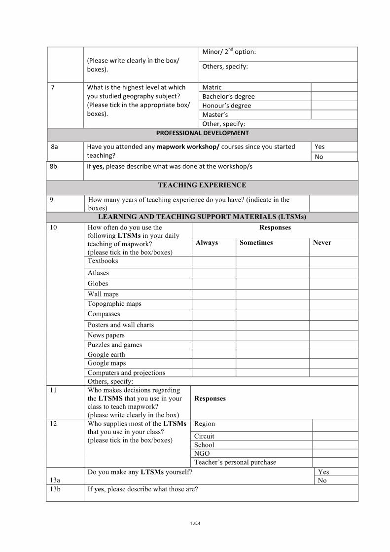
164
(Pleasewriteclearlyinthebox/boxes).
Minor/2ndoption:
Others,specify:
7 Whatisthehighestlevelatwhichyoustudiedgeographysubject?(Pleasetickintheappropriatebox/boxes).
Matric Bachelor’sdegree Honour’sdegree Master’s Other,specify:
PROFESSIONALDEVELOPMENT
8a Haveyouattendedanymapworkworkshop/coursessinceyoustartedteaching?
YesNo
8b Ifyes,pleasedescribewhatwasdoneattheworkshop/s
TEACHING EXPERIENCE
9 How many years of teaching experience do you have? (indicate in the boxes)
LEARNING AND TEACHING SUPPORT MATERIALS (LTSMs) 10
How often do you use the following LTSMs in your daily teaching of mapwork? (please tick in the box/boxes)
Responses
Always Sometimes Never
Textbooks
Atlases Globes Wall maps Topographic maps Compasses Posters and wall charts News papers Puzzles and games Google earth Google maps Computers and projections Others, specify:
11
Who makes decisions regarding the LTSMS that you use in your class to teach mapwork? (please write clearly in the box)
Responses
12
Who supplies most of the LTSMs that you use in your class? (please tick in the box/boxes)
Region
Circuit School NGO Teacher’s personal purchase
13a
Do you make any LTSMs yourself? Yes No
13b If yes, please describe what those are?

165
13c Do learners have textbooks? Yes No
MAPWORK TEACHING 14 How do you teach mapwork?
(please tick in the appropriate box/boxes)
Teach mapwork as a discrete topic Teach mapwork integrated with other topics
Focus on map reading and interpretation
Others, specify: 15 Which of the following geography
topic(s) do you integrate in your mapwork lessons? (please tick the appropriate box/ boxes)
Settlement
Population
Climatology Climatic regions Geomorphology All None Others, specify:
16 Please describe how you teach mapwork and the different strategies you use.
17 How would you describe your mapwork classroom interaction? (Please tick the appropriate box/ boxes)
Responses All the time
Sometimes Never
Teacher dominated
Pupils observe and listen
Mechanical drill Teacher – learner interaction Learner – learner interaction Active hand on learning by doing
Daily life application Others, specify:
18 How confident are you about
teaching mapwork content? (please tick in the box/ boxes) How confident are you about teaching the following? (Please tick the appropriate box/boxes)
Responses
Very confidence
Confident Somehow confident
Not confident
19
Others, specify:
Responses
Very confident
Confident
Somewhat confident
Not confident
Measuring Distance on maps Converting of scales
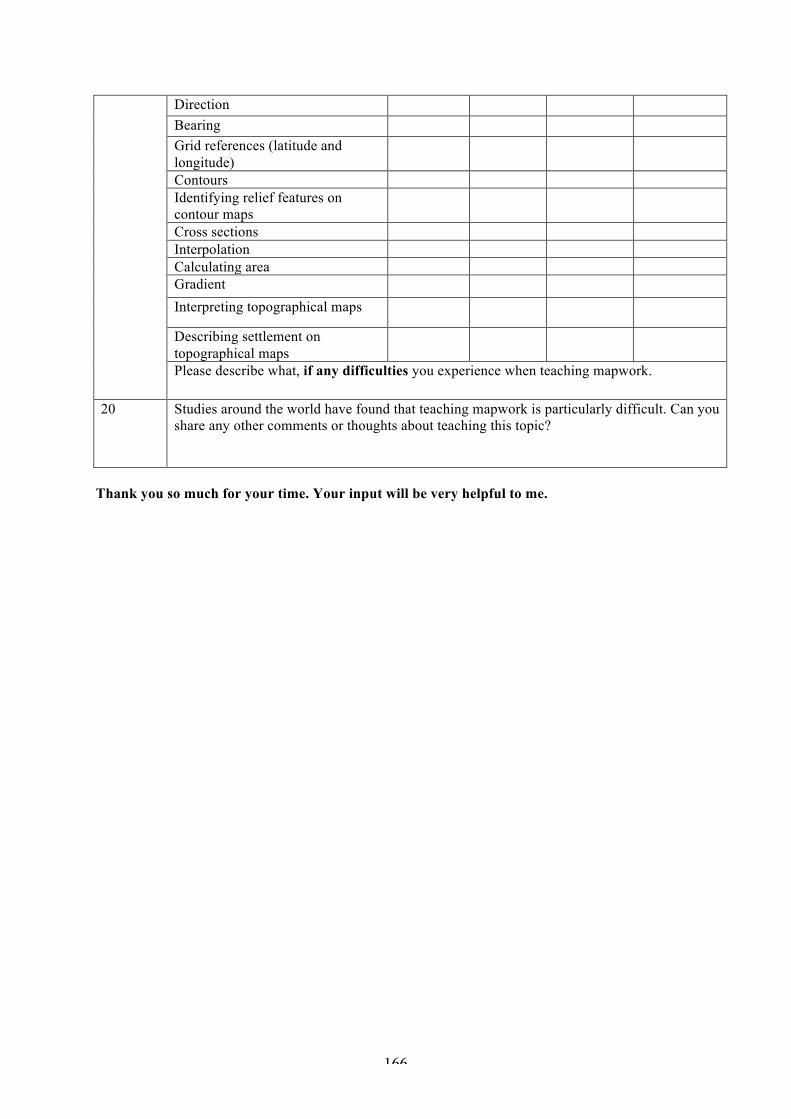
166
Direction Bearing Grid references (latitude and longitude)
Contours Identifying relief features on contour maps
Cross sections Interpolation Calculating area Gradient Interpreting topographical maps
Describing settlement on topographical maps
Please describe what, if any difficulties you experience when teaching mapwork.
20 Studies around the world have found that teaching mapwork is particularly difficult. Can you share any other comments or thoughts about teaching this topic?
Thank you so much for your time. Your input will be very helpful to me.
167
Appendix E
TEACHER INTERVIEW SCHEDULE
TEACHERS’ VIEWS AND PERCEPTIONS OF MAPWORK?
- How important is mapwork in school geography? Why? - What are your experiences of teaching mapwork? (how long have you been teaching geography
and mapwork?) - What are some of the challenges and difficulties you have encountered when teaching mapwork? - How do you feel about teaching mapwork? How confident are you when you teach mapwork? - What are the key (most important) concepts in mapwork? - Is there anything that you find difficult to teach in mapwork? Explain. - Are there some aspects of mapwork aspects that you are not comfortable to teach? Which ones?
Why? - Which ones are you mostly comfortable with? Why?
CLASSROOM PRACTICES
- How do you prepare your mapwork lessons? - What resources do you use in your mapwork lesson preparations? (e.g. textbooks, atlases- which
atlas, globes, wall maps, the outdoor environment etc.) - What documents do you use to guide your mapwork teaching? Do you find it helpful? Do they
contain enough information? How do you use them? - Where do you get the information that use to teach mapwork from? - Do you use a textbook? Which one? Is it helpful? Do you use any other textbooks or resources? Do
you have enough textbooks for all the learners?
MAPWORK TEACHING
- Please describe how you teach mapwork. - Do you teach mapwork as a separate section/topic? If so, when do you do this and with which
classes? What do you teach when you do this? - What do you understand by the term Map concepts? - Please describe how you teach each of the following map concept
1. Map symbols 2. Map scales 3. Distance 4. Direction 5. Location (degree & minute) 6. Contours 7. Cross section (inter-visibility) 8. Interpolation 9. Orientate maps 10. Gradient
- Which one of these map concepts do you find easy to teach, and why? - Which one of these concepts do you find challenging or difficult to teach and why? - Do you integrate mapwork into other sections of the syllabus? If so which sections? Please describe
how you do this (can you give me an example of a how you do this for a topic). - What do you think the most important spatial concepts are in mapwork? Can you describe how you
teach these? - What sort of skills and knowledge do you promote in your mapwork lessons? Please tell me how
you do? - Please describe how you teach each of the following map skills
1. Measuring distance

168
2. Calculating using different scales 3. Converting of sales 4. Working out gradients 5. Analyzing maps 6. Map reading 7. Map interpretation 8. Projection
- Which of these skills do you find easy to teach and why? - Which of these skills do you find challenging or difficult to teach and why? - What types of maps do you use to teach mapwork? - For what purpose, do you use them? When do you use them? And how often do you use them?
TEACHING STRATEGIES
- Please describe the different ways in which you teach mapwork. - What teaching strategies do you use when teaching mapwork? Probe their responses - do they use
Fieldwork, inquiry based, experiential, practical modelling/map construction,) which one of these do you use? And how?
- What is your understanding of the concept LCP? - Would you describe your teaching of mapwork as LC? Why? Why not? - How appropriate is LCP to teach mapwork? - These are some of the strategies underpinned by the learner LCP. What sort of activities do you
engage your learners in your mapwork lesson? Why? what do you do? - How do you assess whether if your learners have captured the learning content? What do you do if
learners did not understand? - Do you give your learners homework? If so, how often? - What sort of homework do you give your learners? - How long does it take you to mark and give feedback? What sort of feedback do you give? - What do you think need to be changed in the teaching of mapwork? - How do you think teaching and learning of mapwork can be enhanced in secondary school
geography?
TEACHER PROFESSIONAL DEVELOPMENT
- Please tell me about the teacher professional development workshop that you attended - What was the workshop about? - Did you have any expectations of the workshop? What sort? Where they met? - What sort of activities where you involved in? tell me more about them - Was the workshop interesting and informative enough? If so, what did you learn? If not, why not? - Would you like a professional support in teaching mapwork? If so, what sort of support would you
like? - What are your suggestions on geography teacher mapwork professional development?
GENERAL QUESTIONS
- Are there any problems/issues/ difficulties that you are experiencing in teaching mapwork that you want to share with me?
- Are you encouraged to teach mapwork as a geography teacher? If not, why not? - Are you encouraged and motivated to be creative in your teaching as a teacher? If not, why not? If
so, how?
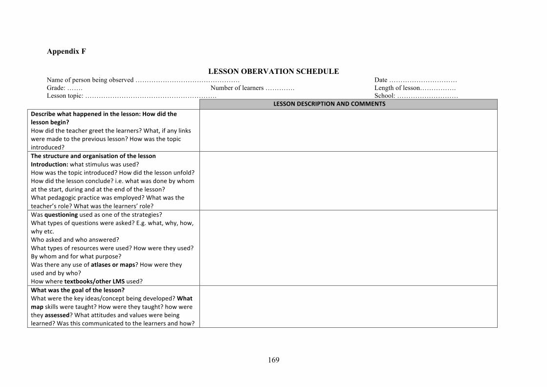
169
Appendix F
LESSON OBERVATION SCHEDULE Name of person being observed ………………………………………. Date ………………………… Grade: ……. Number of learners …………. Length of lesson……………. Lesson topic: …………………………………………………. School: ………………………
LESSONDESCRIPTIONANDCOMMENTSDescribewhathappenedinthelesson:Howdidthelessonbegin?Howdidtheteachergreetthelearners?What,ifanylinksweremadetothepreviouslesson?Howwasthetopicintroduced?
ThestructureandorganisationofthelessonIntroduction:whatstimuluswasused?Howwasthetopicintroduced?Howdidthelessonunfold?Howdidthelessonconclude?i.e.whatwasdonebywhomatthestart,duringandattheendofthelesson?Whatpedagogicpracticewasemployed?Whatwastheteacher’srole?Whatwasthelearners’role?
Wasquestioningusedasoneofthestrategies?Whattypesofquestionswereasked?E.g.what,why,how,whyetc.Whoaskedandwhoanswered?Whattypesofresourceswereused?Howweretheyused?Bywhomandforwhatpurpose?Wasthereanyuseofatlasesormaps?Howweretheyusedandbywho?Howwheretextbooks/otherLMSused?
Whatwasthegoalofthelesson?Whatwerethekeyideas/conceptbeingdeveloped?Whatmapskillsweretaught?Howweretheytaught?howweretheyassessed?Whatattitudesandvalueswerebeinglearned?Wasthiscommunicatedtothelearnersandhow?

170
Mapworkintegration:Howismapworktaughtinthelesson?Wasittaughtasaseparatetopic?Isthereintegrationwithmapskillsalongsideotherthemesandtopic?Howwasthatdone?
Whatwastheroleoftheteacherinthelesson?Whatwastheteacherdoing?Commentonthepaceandpitchofthelesson.Theteacher’svoice-audibility,toneandeyecontact?Whatwastheroleofthelearners?Whatwerethelearnersdoingduringthelesson?
Describethetypeofactivitythelearnersengagedinduringthelessonandthetypeofactivities(ifany)theyweregiventodoforhomework.
Doestheteacheridentifylearners’incorrectunderstandingofmapwork?Whatdoesshedowhenshe/hedoes?
Always
Sometimes Never
SchoolteachingandLearningcontextDescribetheethosoftheschool.Didthelessonstartontime?Howlongdidthelessonlast?Howmuchofthelessonwasusedforteachingandlearning?Weretherelatecoming?Werethereinterruptions?
TheclassroomteachingandlearningenvironmentCommentonthephysicalspace,thearrangementofdesk,theuseofthedisplayboards,cupboardsandstorage,ventilation,conditionofthefurniture,theteachingaidse.g.OHP,dataProjector,computer,TV,thelearningsupportmaterialse.g.textbooks,atlases,referencebooks,journals,newspapers,magazinesetc.