Forecasting characteristic earthquakes in a minimalist model
Upload
independentCategory
view
8download
0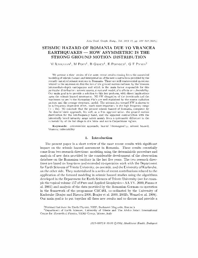
Acta Geod. Geoph. Hung., Vol. 39(2-3), pp. 309-31S (2004)
SEISMIC HAZARD OF ROMANIA DUE TO VRANCEA EARTHQUAKES - HOW ASYMMETRIC IS THE
STRONG GROUND MOTION DISTRIBUTION
M RADULIANl, M POPAl
, B GRECUl, E POPESCU l
, G F PANZA2
We present a short review of the most recent results coming from the numerical modeling of seismic hazard and interpretation of the new observations provided by the recently installed seismic stations in Romania. There are still controversial questions related to the asymmetric distribution of the ground motion radiated by the Vrancea intermediate-depth earthquakes and which is the main factor responsible for this particular distribution: seismic source, structural model, site effects or vulnerability. Our main goal is to provide a solution to this key problem, with direct implications upon the seismic hazard assessment. NE-SW elongation of the isoseismals and the maximum values in the Romanian Plain are well explained by the source radiation pattern and the average structural model. The attenuation toward NW is shown to be a frequency-dependent effect, much more important in the high frequency range (> 1 Hz). We conclude that the present seismic hazard of Romania, computed by the deterministic approach, fits well, as a first approximation, the ground motion distribution for the low-frequency band, and the apparent contradiction with the historically-based intensity maps arises mainly from a systematic difference in the vulnerability of the buildings in the intra- and extra-Carpathians regions.
Keywords: deterministic approach; lateral inhomogeneity; seismic hazard; Vrancea; vulnerability
1. Introduction
The present paper is a short review of the most recent results with significant impact on the seismic hazard assessment in Romania. These results essentially come from two research directions: modeling using the deterministic procedure and analysis of new data provided by the considerable development of the observation database on the Romanian territory in the last five years. The two research directions are based on long-term and extended co-operation work with the Department for Earth Sciences of Trieste University, on one side, and the University of Karlsruhe, on the other side. They materialized in a series of recent contributions related to the application of the forward modeling in seismic hazard studies using the algorithms developed in the Department for Earth Sciences of Trieste University (see for example the topical volume 157 of Pure and Applied Geophysics - AA.VV. 2000, Panza et al. 2001) and analysis of the data provided by the Romanian-German co-operation in the framework of the programme CRC461, co-ordinated by the University of Karlsruhe (Bonjer and Rizescu 2000, Bonjer et al. 2000, 2002b, Wenzel et al. 1998). Our main goal is to put together all these new results and to discuss and provide a
1 National Institute for Earth Physics, NIEP, Bucharest-Magurele, Romania 2Department of Earth Sciences, University of Trieste and The Abdus Salam International
Centre for Theoretical Physics, SAND Group, Trieste, Italy
1217-8977/$ 20.00 ©2004 Akademiai Kiad6, Budapest
310 M RADULIAN et al.
possible solution to the controversial aspects related to the complex pattern of the ground motion generated by the Vrancea intermediate-depth earthquakes and its implications for the seismic hazard assessment in Romania.
A key problem in the seismic hazard studies is the influence of the source, structure and site effects upon the seismic hazard distribution at local and regional scales. The knowledge of the role played by each of these factors is essential in understanding the complex shape of the macroseismic or peak ground motion observations. We cannot go too far if limiting ourselves to an empirical view based almost entirely on observed data. As the previous studies showed, the deterministic modeling is a viable approach that can provide extremely useful developments in the seismic hazard studies both at regional and local scales. However, there are still a lot of doubts and debates about the aptitude of the deterministic approach to reproduce the realistic seismic hazard distribution on the Romanian territory. One major problem is the relatively high seismic level predicted in the northern and northwestern part of the country by the deterministic approach (Radulian et al. 2000).
2. Asymmetry in the macro seismic field
The radiation of all Vrancea major shocks shows a few characteristic and invariant asymmetries: elongation along NE-SW direction and abrupt contraction towards NW. In addition, the maximum of the ground motion amplitude is observed not in the epicentral area, while very high values are recorded at relatively large distance from the epicenter (150-200 km). Some spots of persistent high amplitudes, most probably related to site effects, overlap the general image.
With the recently installed K2 network, several moderate Vrancea earthquakes (4.0 < Mw < 5.5) with varying focal mechanisms were recorded. Recently, Bonjer et al. (2002a) showed that the analysis of the peak ground motion pattern for Vrancea moderate-size events mimics surprisingly well the source radiation of the S-waves of the large events: the same elongation toward NE-SW and attenuation towards NW even if the fault plane solutions differ significantly from the predominant one. Furthermore, the same authors outlined the persistence of some areas of maximum amplitudes located about 50-100 km apart from the epicenter towards NE and S which seem not to depend on the particular focal mechanism. They were interpreted as local effects caused by the presence of the Focani sedimentary basin.
The deterministic modeling reproduces well the NE-SW elongation and the presence of large hazard values in the southeastern part (Romanian Plain), even if the computation of the complete synthetic seismograms is carried out for frequencies below 1 Hz and the structure on different profiles is one-dimensionally modeled (Radulian et al. 2000). For this region, the agreement between the computed ground motion values with the available instrumental data (for example, in Bucharest and Russe) is excellent (Moldoveanu and Panza 1999, Kouteva et al. 2000, Moldoveanu et al. 2000, Kouteva et al. 2001). However, the method predicts at the same time very high values in the Transylvanian Basin and north Moldova relative to what the macroseismic information (unfortunately scarce and sporadic for these regions) indicates.
Acta Geod. Geoph. Hung. 39, 2004

SEISMIC HAZARD OF ROMANIA 311
We shall discuss subsequently a few alternative possible solutions to this debatable issue: source effect, some important lateral inhomogeneities in the upper mantle with a strong attenuation to the NW, site effect or difference in the vulnerability.
2.1 Seismic source role
The lateral variations in the ground motion distribution, emphasized by both macroseismic and instrumental observations, could be attributed in principle to three factors: source, propagation and local site response. Surely, the source radiation pattern plays an important role in the asymmetry of the radiated field for Vrancea earthquakes, especially for the elongation at regional scale toward NE and SW and for the relatively small values in the epicentral area (Enescu and Smalberger 1980, Radulian et al. 2000). However, the amplitudes computed for the S-wave group in the case of moderate-magnitude earthquakes, exhibit the same prevailing NE-SW trends as observed for the large earthquakes, regardless the specific radiation pattern of the source (Bonjer et al. 2002a). Moreover, a strong attenuation of the amplitude toward NW is not matching the radiation of the typical Vrancea fault plane solution (Popa 2003). The inclusion of the directivity effect, which could be important in the case of Vrancea strong shocks, could explain once more the elongation along NE-SW direction, but not the attenuation toward NW. Two other possible causes are to be brought into play: seismic wave propagation and local site response.
2.2 Upper mantle attenuation vs. local site effects
Vrancea seismic region, located in a complex tectonic zone at the Southeastern Carpathians arc bend, is characterized by strong lateral variations in the crustal as well as in the subcrustal domains, as revealed by the recent tomographic images and the analysis of refraction data (Hauser et al. 2001, 2002, Martin et al. 2001). Recently, Popa (2003) and Popa et al. (2003), on the basis of the new seismological evidence, came to the conclusion that significant differences are noticed at the level of upper mantle in the attenuation of the seismic waves, and these differences are mainly responsible for the sharp attenuation to the NW (towards Transylvanian basin), one of the intriguing questions raised by the asymmetry observed in the macroseismic field of the Vrancea strong events. These results are in agreement with the Q determination using P to S ratios (Popa et al. 2000) or pP to P ratios (Ivan 2003).
It is assumed that the upper mantle in the back-arc region (tectonic active-type region) differs strongly from the upper mantle in the fore-arc region (shield-type region). The low Q values could be related to the upwelling process of the asthenosphere just behind the Vrancea seismogenic zone. It corresponds with the most recent volcanic activity in the Per ani Mountains and with the seismic tomography (Martin et al. 2001) and heat flow results (Demetrescu and Andreescu 1994). Since this is a clear 3D feature, it is difficult to be captured by the deterministic modeling,
Acta Geod. Geoph. Hung. 39, 2004

312 M RADULIAN et al.
Table I. Intermediate-depth Vrancea earthquakes considered in this study
Date hour:min:sec Lat. Lon. h
MW (W) (EO) (km)
1999/06/20 00:09:06.17 45.587 26.510 139 3.6 1999/06/29 20:04:06.87 45.601 26.530 138 4.2
based on 1D computations (Radulian et al. 2002). From other point of view, it is probable that the attenuation 'cannot be seen' at low frequencies (see the comments below).
An alternative explanation for the sharp decrease in ground motion amplitudes in the back-arc region could be the different site conditions (hard rock in back-arc side - in fact along the mountains chain - vs. sedimentary rocks in the fore-arc side). However, this hypothesis cannot explain the filtering effect of the high frequencies toward NW which is systematically observed for all the available recordings (Popa 2003, Popa et al. 2003). An example is given in Fig. 1, where the seismograms recorded at two stations located roughly at equal epicentral distance symmetrically across the Carpathians arc, on a NW-SE direction are plotted. For exemplifying matters, we select two Vrancea moderate-size earthquakes, which occurred during the tomography CALIXTO'99 experiment, and therefore for which we could use the largest possible number of recordings ever obtained in Romania (Table I). Another criterion of selection was to have two events with a clear difference in the fault plane solution (Fig. 2).
The cut out of the high frequencies could be a characteristic effect of a stronger attenuation and it is difficult to be explained by a local site effect. There is no evidence for a systematic difference in the site conditions all over the Transylvanian basin relative to Moesian platform able to support such an attenuation effect. On the contrary, the analysis of refraction data (Hauser et al. 2002) suggests more readily a similar instead of a different shallow crustal structure in the two regions.
Another significant aspect, not to be ignored, is related to the frequency dependence of the attenuation effect. The numerical computations for the deterministic hazard assessment (Radulian et al. 2000) are limited to an upper frequency of 1 Hz. For this frequency band the attenuation factor is significantly reduced as compared with the similar effect when considering the entire signal. In Fig. 3 we represent the recordings for the same two stations as in Fig. 1, but this time the seismograms are filtered for a frequency range up to 1 Hz. The amplitudes at the fore-arc side station are 40 to 110 times greater than at the back-arc side station for the unfiltered signals, while they are almost similar for the filtered signals. That means that when looking at low frequencies, there is no clear trend of attenuation in the recorded motion.
The frequency range covered by the numerical simulations (0.005-1.0 Hz) is affecting primarily the tall buildings (10-storey and higher). The severe damage experienced by the Bucharest city in the case of Vrancea intermediate-depth earthquakes (collapse of 32 all buildings during the March 3, 1977 earthquake) is explained by
Acta Geod. Geoph. Hung. 39, 2004

SEISMIC HAZARD OF ROMANIA 313
1999/06/20
l O IS 20 21 30 lS '0 4S SO
o S 10 IS 20 25 30 35 40 41 SO
2£ .2 F1 t AEc:omp.
0,1
SE·2
·SE ·2
-0.1
0.4
0.2
10 IS 20 2S 30 3S 40 45 SO
10 IS 10 IS 30 )S 40 45 SO
F1 1- E compo lE ·2 j IE ·2 *"
~ :~i ~ """ "" ,,:: ,::,';" "pi:::::" ::, ~ :: ~~J'TTT'TTTTTT'I o £ , ". j ,.'.,.:: .. U " " ~ " .. U " ,
;;~ t,,:::::2!:: lO IS 20 15 30 3S .0 ' S SO
2E ·2
;;~ ''' , ,~'-: , : ,: , : ::~: ::,: 6£-4 jO S 10 IS 20 25 )0 35 '0 '5 SO
=; ~." ..• :~ :.: .. :¥:.'~~~ ~:~ : , "' I" " I" :: r" rn "rl" " 1" " 1" "I" " I
10 IS 20 25 30 lS ' 0 45 SO 2E·)
·2E·'
-4 E·, --fTTTTT'TT'1O'TT'1"T'TTTTTI"TT'1rT'1"T'TTTTT!'TT'1O'TT'TTTTTT'T"l'T'T'1rTT'1
10 IS 10 IS )0 Jl ' 0 45 SO 0,2
0,1
-0.1
10 IS 10 2l )0 Jl 40 4S SO 4E·J
S04 · N oomp. IE·)
-4 E·) -'hTTTT'TT'1O'TT'1TTTTTTI"TT'1rT'1"T'TTTTT!'TT'1O'TT'TTTTTTTl'T'T'1rTT'1
10 IS 20 IS )0 )j .0 ,5 SO 10 IS 20 25 )0 15 '0 45 SO Hme (s) time (s)
Fig. 1. Comparative representation of the seismograms typical for a back-arc station (804 - 124 km epicentral distance) and fore-arc station (Fll - 107 km epicentral distance) for two Vrancea
events (Table I) with different fault plane solutions
the predominance of the period of oscillation around 1-1.5 s (a dramatic coincidence of the predominant period of motion in the signal generated by the source with the predominant response period of the shallow sedimentary layer beneath the city).
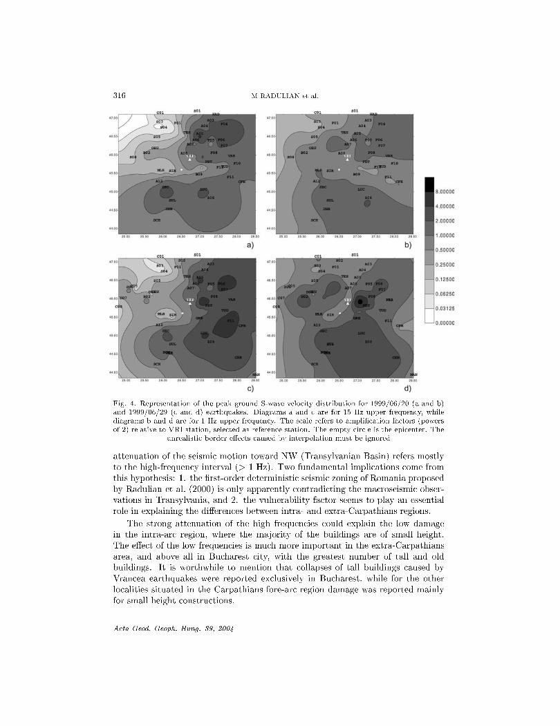
Figure 4 represents the distribution of the peak ground velocity (8 wave) for the selected Vrancea earthquakes given in Table 1. To avoid the differences due to different type of sensors (Epi8ensor, Guralp, RefTek), a low-pass Butterworth filter is firstly applied at 15 Hz for all the seismograms. For a better comparison, the peak ground velocities are taken relative to a reference station. The VRI station, in the epicentral area, was selected as reference.
Acta Geod. Geoph. Hung. 39, 2004
314
1999/06/20 N
••
M RADULIAN et al.
1999/06/29 N
Fig. 2. Fault-plane solutions for the selected earthquakes obtained using first P-wave polarities. As can be seen, the solutions are well constrained. The two stations of Fig. 1 are also represented
A difference in amplitude is outlined between back-arc and fore-arc regions equally for 15 Hz - filtered and 1 Hz - filtered seismograms, regardless the focal mechanism, but the difference is strongly reduced (about 10 times) for the second case. It seems that the attenuation refers mostly to frequencies higher than 1 Hz and therefore we can expect that for largest earthquakes the attenuation effect is even less important.
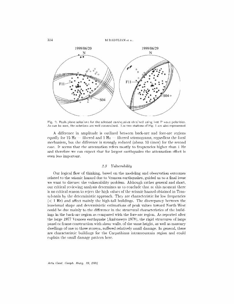
2.3 Vulnerability
Our logical flow of thinking, based on the modeling and observation outcomes related to the seismic hazard due to Vrancea earthquakes, guided us to a final issue we want to discuss: the vulnerability problem. Although rather general and short, our critical reviewing analysis determines us to conclude that at this moment there is no critical reason to reject the high values of the seismic hazard obtained in Transylvania by the deterministic approach. They are characteristic for low frequencies « 1 Hz) and affect mainly the high-tall buildings. The discrepancy between the isoseismal shape and deterministic estimations of peak values toward N orth-West could be due mainly to the difference in the structural characteristics of the buildings in the back-arc region as compared with the fore-arc region. As reported after the large 1977 Vrancea earthquake (Ambraseys 1978), the rigid structures of large panel or frame construction with shear walls, of the same height, as well as masonry dwellings of one to three storeys, suffered relatively small damage. In general, these are characteristic buildings for the Carpathians intramountain region and could explain the small damage pattern here.
Acta Geod. Geoph. Hung. 39, 2004

.!!! 20 ... ~ 0 .. >
IE-4
5E-5
-5E-5
-IE-4
IE-4
5E-5
-5E-5
-IE-4
2E-4
IE-4
-IE-4
-2E-4
IE-4
5E-5
-5E-5
-IE-4
2E-4
IE-4
-IE-4
-2E-4
-3E-4
2E-4
IE-4
-IE-4
-2E-4
SEISMIC HAZARD OF ROMANIA 315
1999/06/29
t:;~ ~::;';:~:AM~~!M ~M.,::) , ,F,ll • Z comp.
~"'~"~ o 5 10 15 20 25 30 35 40 45 50 0 10 15 20 25 30 35 40 45 50
IE 3 J 'M ".m, ::: , , , E::~ S04·Zcomp_
~""""~ o 10 15 20 25 30 35 40 45 50
~. f.:~I":"·,~ o 5 10 15 20 25 30 35 40 45 50 ~ IE 3 0 10 15 20 25 30 35 40 45 50
~::: J'M.' .. m'~MM~ -IE-31"'I"'I"~
o 5 10 15 20 25 30 35 40 45 50 0 5 10 15 20 25 30 35 40 45 50
3E 3 ~ E=ll.Ncomp. ~ 2E3 Fll·Ncomp.
IE3 :~~ -IE3 +----2E 3
, , , 1 " 'I' , I' "I'" 1 -3 E 3 -=to", ITTI T"rTTnl '" n, rTTrTTTTTITTTnTnTTrTTrTTTTTTnTTlTlI
o 5 10 15 20 25 30 35 40 45 50 0 5 10 15 20 25 30 35 40 45 50
~:::: oo." .. ~~ 2E 3 j -2E-3"'I"'I""~
10 15 20 25 30 35 40 45 50 10 15 20 25 30 35 40 45 50 lime (s) lime (s)
Fig. 3. The same seismograms like in Fig. 1, but low-passed filtered up to 1 Hz
3. Conclusions
The present paper is a short critical review of the most recent results (deterministic hazard, seismic tomography, seismic wave attenuation, peak ground motion pattern) with direct implications on the seismic hazard assessment for Romania. We focused our attention to one of the most crucial and controversial point related to the asymmetric distribution of the strong ground motion characteristic for the Vrancea intermediate-depth earthquakes. The main goal is to demonstrate that the sharp
Acta Geod. Geoph. Hung. 39, 2004
316 M RADULIAN et al.
8,00000
4,00000
2,00000
1,00000
a) b) 0,50000
025000
0,12500
0,06250
0,03125
0,00000
c) d)
Fig. 4. Representation of the peak ground S-wave velocity distribution for 1999/06/20 (a and b) and 1999/06/29 (c and d) earthquakes. Diagrams a and c are for 15 Hz upper frequency, while diagrams band d are for 1 Hz upper frequency. The scale refers to amplification factors (powers of 2) relative to VRI station, selected as reference station. The empty circle is the epicenter. The
unrealistic border effects caused by interpolation must be ignored
attenuation of the seismic motion toward NW (Transylvanian Basin) refers mostly to the high-frequency interval (> 1 Hz). Two fundamental implications come from this hypothesis: 1. the first-order deterministic seismic zoning of Romania proposed by Radulian et al. (2000) is only apparently contradicting the macroseismic observations in Transylvania, and 2. the vulnerability factor seems to play an essential role in explaining the differences between intra- and extra-Carpathians regions.
The strong attenuation of the high frequencies could explain the low damage in the intra-arc region, where the majority of the buildings are of small height. The effect of the low frequencies is much more important in the extra-Carpathians area, and above all in Bucharest city, with the greatest number of tall and old buildings. It is worthwhile to mention that collapses of tall buildings caused by Vrancea earthquakes were reported exclusively in Bucharest, while for the other localities situated in the Carpathians fore-arc region damage was reported mainly for small height constructions.
Acta Geod. Geoph. Hung. 39, 2004
SEISMIC HAZARD OF ROMANIA 317
Certainly, the source and local site properties are essential factors in shaping the hazard distribution pattern, but as concerns the striking asymmetry of the seismic motion distribution on the NW-SE direction we consider that the seismic wave attenuation in the upper mantle together with the difference in vulnerability are the most plausible causes of the observed macroseismic shape.
As a final conclusion, our study supports the deterministic modeling as an alternative option to the empirical approach for seismic hazard evaluation, taking into account that the deterministic approach offers the possibility to consistently explain the particular shape of the peak ground motion distribution and to incorporate all the available information and modeling results into the seismic hazard assessment.
Acknowledgements
The paper is largely based on different works deployed within the framework of many international co-operation projects:
Realistic Modelling of Seismic Input for Megacities and Large Urban Areas (UNESCO/IUGS/IGCP project 414)
Impact of Vrancea Earthquakes on the Security of Bucharest (NATO SfP project 972266)
We benefited from data provided by CALIXTO'99 experiment and K2 network within CRC461 programme of University of Karlsruhe (Germany) (Wenzel et al. 1998, Bonjer et al. 2000, Bonjer and Rizescu 2000, Bonjer et al. 2002b).
The work was achieved with the contribution of the Italian Ministry of Foreign Affairs (MAE), Directorate General for Cultural Promotion and co-operation and is a part of the project "Source and propagation parameters determination on the basis of the data provided by the digital accelerometer network and CALIXTO network for seismic hazard evaluation", CERES, Contract No. 33/15.10.2001 (financed by the Ministry of Education, Research and Youth).
References
AA.VV. 2000: Seismic Hazard of the Circum-Pannonian Region. Pageoph Topical Volumes, Reprint from Pure and Applied Geophysics, 157, No. 1/2, G F Panza, M Radulian, C-I Trifu eds, Birkhauser Verlag, Basel, Switzerland
Ambraseys N N 1978: The earthquake of 4 March 1977 and its principal effects, UNESCO Report pp/1977-78/2.161.4
Bonjer K-P, Rizescu M 2000: Data Release 1996-1999 of the Vrancea K2 Seismic Network. Six CD's with evt-files and KMI v1-, v2-, v3-files. Karlsruhe-Bucharest
Bonjer K-P, Oncescu M C, Rizescu M, Enescu D, Driad L, Radulian M, Ionescu C, Moldoveanu T 2000: Source- and site-parameters of the April 28, 1999 intermediate depth Vrancea earthquake: First results from the new K2 network in Romania, 27th General Assembly of the European Seismological Commission, Lisbon, Portugal, Book of Abstracts and Papers, SSA-2-13-0
Bonjer K-P, Rizescu M, Grecu B 2002a: Data Release 2000-2001 ofthe Vrancea K2 Seismic Network. Two CD's (evt-files). Bucharest-Karlsruhe
Acta Geod. Geoph. Hung. 39, 2004

318 M RADULIAN et al.
Bonjer K-P, Rizescu M, Grecu B, Sokolov V, Radulian M, Dinu C 2002b: Ground motion pattern of large and moderate intermediate depth Vrancea earthquakes: first steps towards the generation of regional shakemaps in Romania, Conference "Earthquake Loss Estimation and Risk Reduction", Bucharest, Book of Abstracts
Demetrescu C, Andreescu M 1994: Tectonophysics, 230, 265-271. Enescu D, Smalberger V 1980: Rev. Roum. Geophys., 24, 235-254. Hauser F, Raileanu V, Fielitz W, Bala A, Prodehl C, Polonic G 2001: Tectonophysics,
340, 233-256. Hauser F, Prodehl C, Landes M, Bala A, Raileanu V, Bribach J, Knapp, Diaconescu C,
Dinu C, Mocanu V, Fielitz W, Harder S, Keller G R, Hegedus E, Stephenson R A 2002: BOS, Transactions, American Geophysical Union, 83 (41), 462-463.
Ivan M 2003: Short-period QpP-P in Vrancea area - Romania, Rev. Roum. Geophys. (in press)
Kouteva M, Panza G F, Paskaleva I 2000: An example for ground motions in connection with Vrancea earthquakes (case study in EN Bulgaria, Russe site), 12 WCEE 2000, Auckland, New Zealand, Ref.2185, on CD
Kouteva M, Panza G F, Paskaleva I, Romanelli F 2001: Modeling of the Ground Motion at Russe site (NE Bulgaria) due to Vrancea Earthquakes, ICTP Preprint, IC/2001/145, University of Trieste
Martin M, Achauer U, Kissling E, Mocanu V, Musacchio G, Radulian M, Wenzel F, CALIXTO Working Group 2001: Geophs. Res. Abstr., 3, EGS, SE1.02.
Moldoveanu C L, Panza G F 1999: In: Vrancea Earthquakes: Tectonics, Hazard and Risk Mitigation, F Wenzel, D Lungu, 0 Novak eds, Kluwer Academy Publishers, 85-97.
Moldoveanu C L, Marmureanu G, Panza G F, Vaccari F 2000: Pure Appl. Geophys., 157, 249-267.
Panza G F, Romanelli F, Vaccari F 2001: Advances in Geophysics, 43, 1-95. Pop a M 2003: Contributions to the knowledge of the deep structure in Vrancea zone, PhD
Thesis, University of Bucharest Pop a M, Russo R, Mocanu V, Radulian M 2000: Seismic attenuation in and around the
Car- pathians, Romania, from K2 network data, AGU Falling Meeting, San Francisco Pop a M, Grecu B, Popescu E, Placinta A, Radulian M 2003: Asymmetric distribution of
seis- mic motion across South-Eastern Carpathians (Romania) and its implications. Romanian Reports in Physics (in press)
Radulian M, Vaccari F, Mandrescu N, Panza G F, Moldoveanu C 2000: Pure Appl. Geophys., 157, 221-247.
Radulian M, Vaccari F, Mandrescu N, Moldoveanu C L, Panza G F 2002: Seismic hazard in Romania associated to Vrancea subcrustal source: deterministic evaluation, ICTP Preprint, IC/2002/131, University of Trieste
Wenzel F, Achauer U, Enescu D, Kissling E, Russo R, Mocanu V, Mussachio G 1998: BOS, 79, 589, 592-594.
Acta Geod. Geoph. Hung. 39, 2004
Copyright © 2022 FDOKUMEN