Causes of Earthquakes and their effects
32
RESTRICTED Causes of Earthquake and their Effects on Lives & Properties Gp Capt Shafiullah, psc Introduction 1. Earthquakes are natural phenomena that have to occur because of internal geological requirements. They may occur all over the world at any time of the day or without any warning. Normally, earthquakes occur along the fault-lines but it was seen that earthquakes occurred within the tectonic plates in areas which were declared earthquake-free-zones. Japanese city of ‘Kobe’ is an example. The city was considered quite safe and many industries were developed there. A worst earthquake hit the city on 19 Jan’95, causing losses of lives and properties of billions of dollars within 20 to 30 seconds. Bangladesh is most likely to be affected by any strong to major earthquake because of its close proximity to the active seismic faults running along the southeastern, eastern and northern periphery. Expert geologists opine that if an earthquake of the Richter scale of six or above occurs within the country or around the close proximity of the Himalaya and lingers for 20 to 30 seconds or more, then a widespread destruction of lives and properties would take place on the major cities of Bangladesh. If accompanied with aftershocks, like the ones happened during recent earthquakes in Gujarat, northern Turkey and Algeria, Pakistan etc, catastrophic devastation would occur particularly over the mega-city of Dhaka. It would be very difficult for the 1 RESTRICTED
-
Upload
easternuni -
Category
Documents
-
view
0 -
download
0
Transcript of Causes of Earthquakes and their effects
RESTRICTED
Causes of Earthquake and their Effects on Lives & Properties
Gp Capt Shafiullah, psc
Introduction
1. Earthquakes are natural phenomena that have to occur because
of internal geological requirements. They may occur all over the
world at any time of the day or without any warning. Normally,
earthquakes occur along the fault-lines but it was seen that
earthquakes occurred within the tectonic plates in areas which
were declared earthquake-free-zones. Japanese city of ‘Kobe’ is
an example. The city was considered quite safe and many
industries were developed there. A worst earthquake hit the city
on 19 Jan’95, causing losses of lives and properties of billions
of dollars within 20 to 30 seconds. Bangladesh is most likely to
be affected by any strong to major earthquake because of its
close proximity to the active seismic faults running along the
southeastern, eastern and northern periphery.
Expert geologists opine that if an earthquake of the Richter
scale of six or above occurs within the country or around the
close proximity of the Himalaya and lingers for 20 to 30 seconds
or more, then a widespread destruction of lives and properties
would take place on the major cities of Bangladesh. If
accompanied with aftershocks, like the ones happened during
recent earthquakes in Gujarat, northern Turkey and Algeria,
Pakistan etc, catastrophic devastation would occur particularly
over the mega-city of Dhaka. It would be very difficult for the1
RESTRICTED
RESTRICTEDsurvivors to handle the situation during post disaster
management. Old buildings and structures would be the worst
affected. Multi-storied and non-engineered buildings, slumps,
roads, bridges, over bridges etc would be in ruins. Gas and
electric lines, sewerage lines, water lines etc established
haphazardly would be affected heavily. In this article, an
attempt is made to briefly describe the causes and effects of
earthquakes on lives and properties. Damage photographs of other
earthquake-hit countries were used to give a feeling of what
types of damages could occur in major cities of Bangladesh. If
viewed carefully, readers may develop a bitter taste of what a
strong to major earthquake can do if happens within or around our
country.
Aim
2. The aim of this article is to discuss the causes and effects
of strong to major earthquakes on lives and properties including
utility services and suggest some mitigatory measures for the
main city dwellers.
Sequence of Discussion
3. The sequence of discussion is as follows:
a. Occurrence and Background of earthquakes.
b. What is seismology?
c. Seismic waves & their characteristics.
d. What is Earthquake?2
RESTRICTED
RESTRICTEDe. Where do the earthquakes occur?
f. Effects on Lives and Properties.
g. Effects on Lifelines or Utility services.
h. Preparatory and Mitigatory Measures.
j. ‘Do’s and Don’ts’ before, during and after the earthquakes.
k. Recommendations.
l. Conclusions.
3RESTRICTED
RESTRICTEDOccurrence and background of earthquakes
4. When Earthquakes Started Occurring: Geologists believe that
Earthquakes had been occurring ever since the creation of the
earth. The earth is comprised of a dozen of ‘Tectonic plates’
known as ‘continental’ and ‘sea’ plates. At the beginning, all
the plates were clustered together to be known as ‘Super
continent Pangea’. The plates are of various thickness. For
example, the sea plates are about 8 to 10 km thick and made up of
heavy & denser basaltic rocks compared to the continental plates
which are about 65 to 70 km thick and made up of lighter granite
particles. As a result, the sea plates are comparatively heavier
than continental plates. While moving, they collide themselves
and produce quakes at the colliding boundaries. On a yearly
average, one to two great (M>8), 15 to 18 major (7<=M<7.9), 100
strong (6<=M<6.9), 800 moderate (5<=M<5.9), 6000 light
(4<=M<4.9), 50,000 minor (3<=M<3.9) and innumerable micro (M<3.0)
earth quakes occur throughout the globe.
What makes the Plates move?
5. Heat inside the earth is the driving force behind the movement
of tectonic plates. Immense internal heat was built-up at the
centre during the early days of tectonic plate formation. Heat is
also produced during breakdown of the radioactive materials like
uranium, thorium, Potassium etc in the outer and inner cores.
Different ‘Plate movement’ including Indian plate and Convective
heat cells form inside the earth which make the plates move
slowly @ of 2 cm per year.
4RESTRICTED
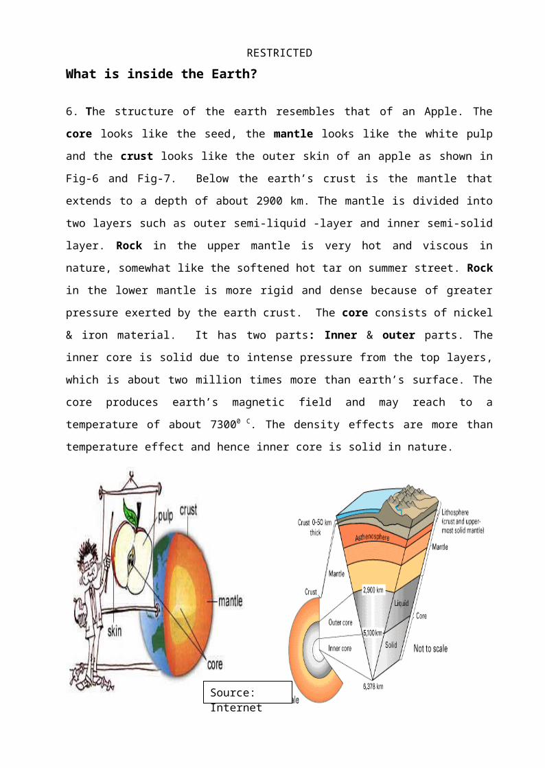
RESTRICTEDWhat is inside the Earth?
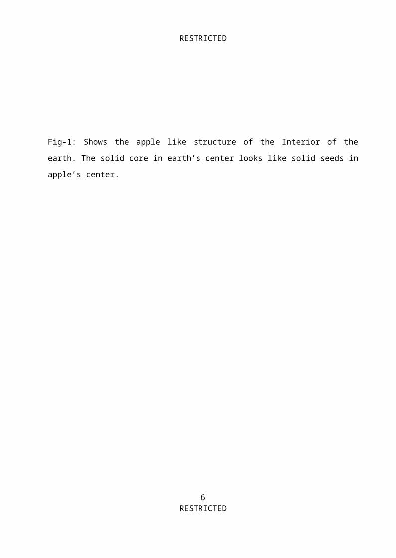
6. The structure of the earth resembles that of an Apple. The
core looks like the seed, the mantle looks like the white pulp
and the crust looks like the outer skin of an apple as shown in
Fig-6 and Fig-7. Below the earth’s crust is the mantle that
extends to a depth of about 2900 km. The mantle is divided into
two layers such as outer semi-liquid -layer and inner semi-solid
layer. Rock in the upper mantle is very hot and viscous in
nature, somewhat like the softened hot tar on summer street. Rock
in the lower mantle is more rigid and dense because of greater
pressure exerted by the earth crust. The core consists of nickel
& iron material. It has two parts: Inner & outer parts. The
inner core is solid due to intense pressure from the top layers,
which is about two million times more than earth’s surface. The
core produces earth’s magnetic field and may reach to a
temperature of about 73000 C. The density effects are more than
temperature effect and hence inner core is solid in nature.
5RESTRICTEDSource:
Internet
RESTRICTED
Fig-1: Shows the apple like structure of the Interior of the
earth. The solid core in earth’s center looks like solid seeds in
apple’s center.
6RESTRICTED
RESTRICTEDPlate Motion and effects of Collision.
7. The Earth and its inner contents are in constant motion. The
surface is fractured into a dozen of rigid plates. The plates
float on the slowly-moving molten mantle causing the plates move
slowly. During movement, the plates either collide head-on, or
split apart, or simply grind their edges together, giving rise to
different major faults. During head-on collision in the ocean
areas, the edge of the heavier plate plunges into hot mantle
below the lighter plates and deep ocean trenches or mountain
ridges are created along the line of collision. If the head-on
collision takes between two continental plates, high mountains
are created. When the plates pull away from each other, hot
‘Magma’ comes out from below, creating features like mid-oceanic
ridges and rift valleys. When the plates push past one another,
large faults develop and Earthquakes occur. Such theories of
occurrence of earthquakes were unanimously accepted by the
geologists and it is known as ’Tectonic plate theory’. Thus, when
plates collide, earthquakes occur at the collision boundaries.
What is Seismology?
8. Seismology is the study of Seismic waves generated byearthquakes:
a. A seismologist is a scientist who studies earthquakesand seismic waves.
b. A Seismograph is the instrument that measures theearthquake.
7RESTRICTED
RESTRICTEDc. A Seismogram is the recording itself. The wiggles on a
seismogram are caused by seismic waves generated by the
movement of soils along a fault line.
Seismic Waves & their Characteristics
9. What are seismic waves? Seismic waves are natural
mechanical waves caused by earthquakes. Their names came from the
Greek word ‘Seismos’, meaning ’Shaking’. Seismic waves are the
waves of energy released by the sudden breakage of rocks within
the tectonic plates or along the boundary lines of plates or
within the plates inside the earth or due to a human made nuclear
explosion. The waves emanate from the source where the quake is
generated.
Types of Seismic waves
10. Mainly, seismic waves are labeled into two groups:
a. Surface waves. They move over the earth surface and
characterized by: Large amplitude, long wave length, wide
range of band frequency or large bandwidth, slow movement
and generally are produced by shallow focus earthquakes.
They are also known as ‘Long waves’, and are most
destructive for infrastructure. They are of two types:
(1) Shear surface waves, also known as ‘Love waves’.
They move at a speed of 3 to 6 km/sec & vibrate the
ground from side to side.
8RESTRICTED
RESTRICTED(2) Compressional surface waves or Raleigh waves.They are comparatively slower and move at a speed of 2
to 5 km/sec and vibrate the ground in an elliptical
pattern..
b. Body waves. They move through the inner body of
the earth from the focus of earthquake. They are of two
types:
(1) Primary or ‘P’ waves or Compressional body waves.
They are called primary waves, because they travel at a
faster speed, 10 to 15 km/sec, to reach the seismograph
before other waves. They travel through all types of
materials including solids, liquids or gases. The
motion produced by the ‘P’-waves is an alternating
compression and expansion.
(2) Secondary or ‘S’ waves or Shear body waves.
They are called secondary waves because they are second
fastest to reach the seismograph at speed 6 to 8
km/sec. They vibrate the ground in a shearing motion,
movement being perpendicular to the direction of wave.
They are often the largest waves capable doing most of
the damage.
What is Earthquake?
11. An EQ is a sudden and rapid shaking of the earth caused
by the breaking and shifting of rock beneath the Earth's surface.
9RESTRICTED

RESTRICTEDThis shaking can cause buildings and bridges to collapse; disrupt
gas, electric, and phone services; and sometimes trigger
landslides, avalanches, flash floods, fires, and huge
destructive ocean waves (tsunamis). Buildings with foundations
resting on the un-consolidated soft landfills, old waterways, or
other unstable soil are at the risk of collapse. Earthquakes
caused by the release of elastic strain energy are called
tectonic earthquakes. The strength or size of an earthquake at
its center is determined by using Richter's scales (normally
based on instrumental recordings) while an Intensity scale is
used for describing the effects:
a. American Red Cross. ‘An earthquake is the way the Earth
relieves its stress by transferring it to the people who live
on it’. It is a sudden and rapid shaking of the earth caused
by the breaking and shifting of rocks beneath the earth
surface. Tectonic plates slowly move over, under, and past
each other. At times, the plates are locked together, unable
to release the accumulated energy. When the accumulated energy
grows strong enough, the plates break free to make earthquake
at the breaking point.’ Most of the earthquakes are
accompanied with aftershocks generated to readjust the new
position of the displaced rocks.
b. Britain Geological Society (BGS). An earthquake
is the sudden release of strained energy in the earth’s
crust resulting into shaking waves that radiate outward from
earthquake source. When the stresses in the crust exceed the
10RESTRICTED

RESTRICTEDstrength of the rocks, they break along the lines of
weakness either in a pre-existing fault or newly developed
fault plane. The point where earthquake starts is termed as
‘Focus’ or ‘hypocenter’. The point at the surface directly
above the focus is called ‘Epicenter’. The yellow portion is
the rupture surface where earthquake originates.
Where do the Earthquakes Occur?
12. Places of Occurrence: Earthquakes can occur anywhere
throughout the world, but the vast majority of the quakes occur
along narrow belts, which range from a few kilometers to hundreds
of kilometers in length and width. These belts are the boundaries
between the tectonic plates and are geologically very active.
Causes of earthquakes remained a mystery until 1960s. During that
decade, seismologists plotted the epicenters of thousands of
quakes and found that the earthquakes occur along some well-
defined belts round the globe.
The plates are irregularly shaped and move relative to each other
over upper layer of the ‘Mantle’ called ‘Asthenosphere’. Most
earthquakes are related to Compressional or tensional stresses
built up at the margins of moving plates. The mantle is hot
enough to move upward through the gaps between the plates causing
quakes to occur in the sea belt and over the fault-gap-containing
land areas over the lands. However, earthquakes can also occur
around the sub-faults within the tectonic plates as happened in
case Gujarat (26 Jan’01) and Kobe earthquakes (19 Jan’95).
11RESTRICTED
RESTRICTEDHow deep the Quakes originate?
13. Depth of the quakes depends on the depth of the faults
where the rupture takes place and it can be anywhere inside the
earth. Deep inside the earth, rocks are constantly being
pressurized to move due to tectonic plate movement. The pressure
keeps on developing and developing until the stress is so great
that the rocks can no longer bear the tension. Tensional pressure
is released at the point of rupture. Earthquakes with focal
depths (distance from epicenter to Focus) of about 70 km are
classified as shallow Quakes. Earthquakes with focal depths from
70 to 300 km are classified as intermediate and those with depth
more than 300 km are called deep earthquakes. The focuses of most
earthquakes are concentrated in the crust and upper mantle.
Why Indian Plate Boundary is so active?
14. World’s most destructive earthquakes occur along subduction
zones. Indian plate is a subducted plate. That is the reason why
the Indian plate boundary is so active. When a large continental
boundary breaks into smaller pieces under tensional stresses, a
series of cracks are created, which may develop into a major
system of faults. When two plates slide past one another in a
grinding or shearing manner, large faults or fractures develop
where severe quakes occur. Indian plate started its journey from
south and subducted steeply below the Eurasian plate to form
Himalayan mountain ranges, Like Himalayas and Tibetan plateau.
12RESTRICTED
RESTRICTED
L ikely Effects on Lives and Properties
15. The effects of earthquakes on lives and properties will
depend on a number of widely varying factors. These factors are:
a. Intrinsic to the earthquake . It depends on its magnitude,
type (moderate or severe), location (within the country or
outside), or depth of focus (shallow or deep).
b. Geologic conditions where effects are felt . It depends
on the distance from the epicenter, path of the seismic waves,
types of soil, and Liquefaction.
c. Societal/structural conditions reacting to the earthquake.
It depends on the quality of construction, preparedness of
populace, or time of day, season of the year etc. Damage
would be less if construction standards are relatively high,
and the populace relatively prepared. However, soft, highly
saturated soils near waterbeds or around the periphery loose
soils or deep ditches near the rivers or large reservoirs
would cause failures of large highway structures even if far
away from the epicenter.
d. A ftershocks. After shocks are associated with many
earthquakes. Such shocks cause further damages to the already
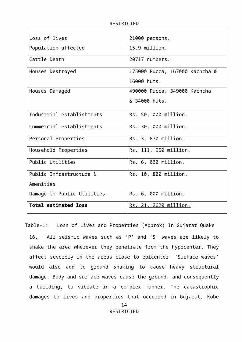
shaken structures. The damage of Gujarat city is an an example
what an moderate to severe earthquake could to the properties.
The damage list of Gujarat quake, shown in Table-1, gives an
idea how much damage Dhaka city might have in future quakes:
13RESTRICTED
RESTRICTED
Loss of lives 21000 persons.Population affected 15.9 million.
Cattle Death 20717 numbers.
Houses Destroyed 175000 Pucca, 167000 Kachcha &
16000 huts.Houses Damaged 490000 Pucca, 349000 Kachcha
& 34000 huts.
Industrial establishments Rs. 50, 000 million.
Commercial establishments Rs. 30, 000 million.
Personal Properties Rs. 3, 870 million.
Household Properties Rs. 111, 950 million.
Public Utilities Rs. 6, 000 million.
Public Infrastructure &
Amenities
Rs. 10, 800 million.
Damage to Public Utilities Rs. 6, 000 million.
Total estimated loss Rs. 21, 2620 million.
16. All seismic waves such as ‘P’ and ‘S’ waves are likely to
shake the area wherever they penetrate from the hypocenter. They
affect severely in the areas close to epicenter. ‘Surface waves’
would also add to ground shaking to cause heavy structural
damage. Body and surface waves cause the ground, and consequently
a building, to vibrate in a complex manner. The catastrophic
damages to lives and properties that occurred in Gujarat, Kobe14
RESTRICTED
Table-1: Loss of Lives and Properties (Approx) In Gujarat Quake (Source: Bhuj damage).
RESTRICTEDcity, Turkey, and Iran and very recently in northern Algeria
(May2003) bear the testimony of such seismic effects. A few
damage is shown below:
Effects on Lifelines / Utility Services
17. Lifelines or utility services are the linear systems
necessary to sustain human life and urban functions. These
systems include highways and bridges; power lines; gas lines;
hospitals; fire services; telecomm; water supply and sewerage
systems; railroads, river ports, airports etc. Dhaka city is well
clustered with the lifeline systems. Any earthquake of moderate
to severe magnitude for 20 to 30 seconds would certainly disrupt
the systems. If the Epicenters were originated within Bangladesh,
damage would certainly be more than those quakes originated
outside. Moreover, utility lines are not well structured in Dhaka
city. Lines may burst during intense body and surface seismic
wave shaking and cause massacre by igniting gas or electric fire.
Water and sewerage lines may burst or be blocked by ground
shaking or liquefaction, which practically happened in 1995 Kobe
earthquake, 2001 Gujarat quake and 2003 Algerian quakes.
Damages that are expected to occur on Dhaka city lifelines are
discussed below:
a. W ater. Moderate severe earthquake would disrupt the
lines as happened in Kobe city and Gujarat.
b. Wastewater and Sewerage lines. These lines are already in
shambles. Most of the drainages are blocked due accumulated waste15
RESTRICTED
RESTRICTEDmaterials as can be understood from the inundation of roads due
to standing water during monsoon rains. If earthquakes occur,
these lines would be subject to further deterioration as happened
in recent Algerian quake.
c. Electrical Power Stations. When the present lines cannot
tolerate a moderate Tornado, how the old lines, both overhead &
underground, would sustain earthquake? Once damaged, it would
take long time to restore the systems. Moreover, damage of power
stations may lead to fire as practically in Kobe earthquake.
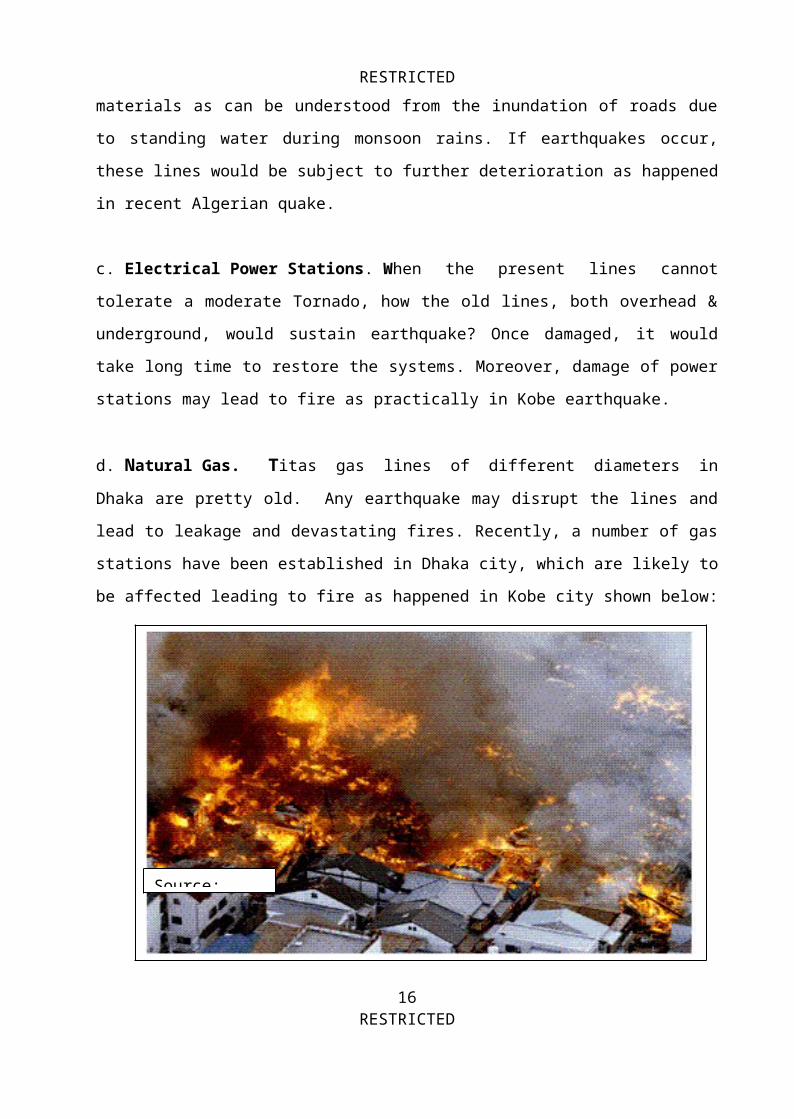
d. Natural Gas. Titas gas lines of different diameters inDhaka are pretty old. Any earthquake may disrupt the lines and
lead to leakage and devastating fires. Recently, a number of gas
stations have been established in Dhaka city, which are likely to
be affected leading to fire as happened in Kobe city shown below:
16RESTRICTED
Source:
RESTRICTEDe. Liquid Fuel. Dhaka city has a number of petrol pumps
scattered throughout the city. Earthquake shaking may lead to
leakage of petrol pumps leading to fire.
f. Roads and Highways. Dhaka city highways and narrow roads in
and around the dwelling houses would give up to the seismic wave
shaking. Some photos of damage highways in Kobe and Gujarat.
g. Railroads. Kamalapur railway complex and rail lines would
be subject to disruption as happened in Los Angeles and Gujarat
h. A irports . Zia Intl and Tejgaon airports would likely to be
affected as happened in other quake hit countries.
j. River ports and River bridges. Dhaka Sadar and
Pagla ghats are the river ports likely to be affected due to
liquefaction as happened in different river ports of California
and Japan quakes.
k. Educational Institutions, Hospitals & Medi-Care centre.
Most of educational institutions in Dhaka city are old and
fragile to tolerate earthquakes. All the hospitals in Dhaka city
are pretty old. As a result, educational institutes and medi-care
services would suffer heavily due seismic wave shaking. In
Gujarat and Algerian Quakes, most of the old hospitals and school
buildings suffered severe damages having the patients and
students killed due to falling debris. As per CNN correspondent
reports, during the recent earthquake that occurred on 8th
17RESTRICTED
RESTRICTEDOctober,2005 in Pakistan, it was seen that the hospitals and
medical centers made by the Govt employed contractors were
seriously damaged compared to privately owned ones.
18. Economic loss. The economy of the country would suffer
because of damage of business structures as well as lifelines.
Since authority is not well prepared, it would take months
together to start business activities afresh. The business and
dwelling apartments were heavily damaged in Gujarat and Kobe
cities causing losses worth of billion dollars. Economic and
lifeline losses in Gujarat alone are shown Table-2:
Railways Heavy damage to various station buildings, station
cabins, bridges, residential quarters and signaling
systems. Roads 650 km of national highways damaged, 100 km
severely.Bridges Most main road bridges were damaged. Ports Berths 1-5 at Kandla Port suffered major structural
damage.Telecomm 147 exchanges, 82,000 lines and optical fibre
systems damaged.Power 45 sub-stations, power supply to 50% of feeders and
nine towns were affected. Water Water supply to 18 towns and 1340 villages damaged
or destroyed. Fuel Jamnager refinery shutdown 26 January by power
failure. Crude oil and product pipelines were shut
18RESTRICTED
RESTRICTEDdown for checking.
Schools Out of 1359 primary schools, 992 were destroyed.
Out of 38 secondary schools, 6 were destroyed, 14
suffered heavy damage and 12 were partially
damaged. Out of 128 non-government schools, 9 were
destroyed, 11 suffered heavy damage. Most of the
Govt owned schools and institutions were damaged
heavily.Environmenta
l
A huge loss in the gardens around the main city
centre.
Preparatory and Mitigatory Measures
19. Why to prepare for earthquake? Dhaka city has changed
significantly in last few decades. Population has increased
manifold. A large amount of infrastructures have come up which
might not have been designed to withstand intense seismic
shaking. Some older buildings particularly in old Dhaka would
hardly tolerate even moderate quakes. Any future earthquakes
would cause damage to buildings, displace items within buildings,
and disrupt basic utility services in the Dhaka city. No body can
stop the occurrence of earthquake but mitigatory steps could
reduce damages. By becoming aware of the hazards posed by
earthquakes and by taking precautions, we can drastically reduce
the loss of lives and properties, and make Dhaka city a safer
19RESTRICTED
RESTRICTEDplace to live. The choice is ours. A prepared person is never
caught in surprise.
What Mitigatory Measure?
24. Major causes of human deaths and injuries are due to the
collapse of structures people live in. Therefore, the mitigatory
measure should be making the dwelling structures strong enough to
withstand the earthquake seismic forces. This can be achieved by
developing a comprehensive building code with adequate provisions
for seismic design. The recently prepared Bangladesh National
Building Code has the provisions for earthquake resistant design
of buildings. In addition there are guidelines for non-engineered
construction of non-reinforced brick masonry, which are likely to
be damaged even with moderate seismic shaking.
However, the enforcement of the provisions of the code would
require intensive efforts from the appropriate authority. People
generally do not want to follow the building codes due to high
cost. The people require to be briefed that investment in pre-
earthquake planning and preparedness would yield much higher
returns than post-disaster measures in the form of relief and
rehabilitation. Keeping this in view, an integrated earthquake
management plans needs to be developed, particularly for large
urban areas, more so for Dhaka city. This would require a
comprehensive joint effort of various professionals including
engineers, fire fighters and civil defence personnel, geologists
and health care personnel. Special ‘Implementation cell’ and
20RESTRICTED
RESTRICTED‘Search and Rescue units with air elements’ have to be formed to
handle earthquake hazards. It will require specially trained
personnel, equipments, and sniper dogs to detect people buried
under debris of collapsed structures. Efforts are to be made to
study the strength of existing buildings of Dhaka city. If
possible, retrofitting of existing structures is to be undertaken
if found that the structures do not possess adequate strength.
This includes strengthening of existing structural components by
addition of reinforcing steel and concrete to existing beams,
columns, walls etc or by adding new structural elements. Urban
people would require to be awaked on the ‘Dos’ and ‘Don’ts’ of
the earthquake hazards.
Do’s and Don’ts to Reduce Earthquake Effects
25. What to Do Before an Earthquake. Following pointsare suggested:
a. Learn about the earthquakes and their impacts on lives
and properties. Learn how vulnerable your area or your
houses are to the earthquakes! Make sure that you have a
fire extinguisher, a battery-powered radio, a flashlight,
and extra batteries always available at home for emergency
uses.
b. Learn first aid and have a first aid kit box at home and
working place.
c. Learn how to turn off the gas, water, and electricity in
case of emergency.
21RESTRICTED

RESTRICTEDd. Make up a plan to educate and rehearse the family
members from time to time.
e. Don't leave heavy objects on shelves; they'll fall
during a quake.
f. Anchor or tie-up heavy furniture, cupboards, and
appliances to the walls or floor so that they do not fall
off during seismic shaking.
g. Check your house and other belongings from time to time
to see whether they are quake resistant. If not, take
precautionary measures as per the advice of the experts.
26. What to Do During an Earthquake. Here are some suggestions:
a. Stay calm! If you're indoors, stay inside. If you'reoutside, stay outside. Do not run abruptly because falling
objects might hit you.
b. If you're indoors, stand against a wall near the center
of the building; stand in a doorway, or crawl under heavy
furniture like a heavy desk or table and keep your head
covered up as shown in Fig-53. Stay away from windows and
outside doors.
c. If you're outdoors, stay in the open area away from
power lines or anything that might fall. Stay away from
buildings; loose stuff might fall off the building or the
building could fall on you. 22
RESTRICTED
RESTRICTEDd. Don't use matches, candles, or any flame; broken gas
lines may leak and catch fire.
e. If you're in a car, stop the car and stay inside the car
until the earthquake stops.
f. Don't use elevators; they'll probably get stuck anyway.
27. What to Do After an Earthquake:
a. Check yourself and others for injuries; provide first
aid for anyone who needs it.
b. Check water, gas, and electric lines for damage. If
found damaged, shut-off the valves. Check for the smell of
gas. If you smell it, open all the windows and doors, leave
immediately, and report it to the authorities.
c. Turn on the radio to listen for any instruction.
d. Stay out of damaged buildings; debris may fall on you
due to aftershocks.
e. Be careful while walking around broken glass and debris.
Wear boots or sturdy shoes to save from cutting your feet.
Never walk on bare foot. If possible, wear helmet while
entering a damaged building.
f. Be careful of fallouts from the cracked roofs; they may
fall on you.
23RESTRICTED
RESTRICTEDg. Be careful of flushing the toilets before the sewerage
lines are checked. Be careful of children running here &
there to save them from aftershocks.
h. Stay away from damaged wall; they may fall on you during
aftershocks.
R ecommendations
28. Following recommendations are given:
a. Bangladesh National Building Code Provisions should be
strictly followed for design and construction of all
buildings and building services. Competent professionals
should evaluate the strength of existing structures to
withstand seismic shaking and retrofitting be done if
required.
b. A thorough and refined assessment of the seismic risk in
various parts of Dhaka city be done and the dwellers be
informed to take appropriate measures.
c. Study of liquefaction potentials in different parts of
Dhaka city close to river belts and arrange computerized
micro-seismic monitoring system, shown in Fig-54, for Dhaka
City.
d. Review and updating the building code at regular
intervals of 5 to 7 years to incorporate the findings of any
refined studies.
24RESTRICTED
RESTRICTEDe. Developing adequate facilities for education, training
and research. This should include:
(1) Training of teachers, students, dwellers etc.
(2) Organization of training programs for different
categories of engineers and technicians involved in
planning, design, construction and maintenance of Govt
and non-Govt installations.
f. Programmes for educating engineers specialized in
earthquakes, seismologists and geophysicists through
seminars or workshops.
g. Development of laboratory facilities for testing of
structures subjected to earthquakes.
h. Development of seismic observations, at least three, and
micro seismic instrumentation of selected new structures.
k. Development of Emergency Manual detailing the actions to
be taken before, during and after the earthquakes. This may
be made a part of the overall Disaster Preparedness Plan
under the Disaster Management Bureau.
l. Development of Public Awareness Programme including
simple instructions on do’s and don’ts through media like
radio, television, newspapers and periodicals. These may be
included in the school curriculum in high-risk areas.
25RESTRICTED
RESTRICTEDm. Organizing regular Earthquake drills in high-risk areas.
n. Development of simple guidelines for non-engineered
constructions, in Bangla, and disseminating them to people
living in the slumps through ward commissioners.
p. Establishment of at least three seismic centers at
Rangpur, Dhaka and Chittagong respectively for measuring the
location of epicenters and focus of the quakes generated
within or outside the country.
Conclusions
29. Most of the cities of the world including Dhaka city are
vulnerable to various types of natural disasters. Weak to
moderate earthquakes are occurring daily over the globe signaling
their presence and warning the people to be careful. Effects on
lives and properties any where would depend on the location of
epicenter and structural design of the affected area. The Gujarat
and Kobe Earthquakes are the striking examples of what
earthquakes can do to a modern industrialized society. Most of
what happened in quake-hit countries could have been reduced if
people were aware of what mitigatory measures could have been
adopted for quake prone areas. The loss of thousands of lives and
the hardships of hundreds of thousands of affected residents are
terribly awful. Similar situation is likely to occur in Dhaka
city at any time as warned by American Geologists and old seismic
records from UK and Indian Geological Archives say that Dhaka
city was affected in the past. People in Dhaka city are quite
26RESTRICTED
RESTRICTEDlucky in the sense that strong quakes have not occurred in or
outside the country close to Shillong massif or along Myanmar-
Bangladesh border in last fifty years. Mir Fazlul Karim,
Director, Geological Service of Bangladesh, opine that
northeastern parts of Indian plates are long due for a severe
quake. If so, Dhaka city with its massive infrastructures and
thickly concentrated population is going to be affected. Recent
quakes in northern parts of Afghanistan, Iran, Turkey and Algeria
remind us what would happen to our capital city. We have lots of
lessons to learn from those effects and the real lesson is that
we must motivate our people to rectify, replace or strengthen
deficient and faulty structures along with utility systems.
37. Vulnerable cities are fast growing in terms of
infrastructures and inhabitants. Although, Dhaka city is not
sitting on the faults, yet it is not too far away from active
faults created around Himalayas and Tibetan plateau. A good
number of faults and sub-faults were produced due to the tectonic
subduction and deformation due to Indian plate’s head-on
collision with Eurasian plates and quakes of various magnitudes
originated around the Himalayan regions.
30. The history of major earthquakes in Bangladesh and
surrounding areas indicates that the city experienced moderate
jolts during the earthquakes of 1897, 1918, 1934 and 1950. Those
earthquakes caused significant destruction in the then thinly
populated Dhaka city. Similar magnitude earthquakes will cause
unprecedented hazards in the present day mega-city of Dhaka
27RESTRICTED
RESTRICTEDhaving huge infrastructure and industrial set up. On 19 Dec’01,
an earthquake of magnitude 4.2 has severely jolted Dhaka city and
damaged Dhaka central jail. The damages caused by the quake are
insignificant but it created a very high sense of fear among
million of city dwellers. The Earthquake triggered the thinking
tanks of the city to rethink about urban structural design. It is
not known what will happen if there occurs an earthquake of
Magnitude more than Six. Study done by BUET students found that
almost all the structures in old Dhaka city would be smashed to
surface even with moderate quakes as happened to similar
structures in Gujarat and Iran.
31. For the safety of millions people and development of
earthquake hazard awareness, it is necessary for development of
micro-seismic monitoring system for Dhaka City and surrounding
regions for measurement of soil movement due to possible seismic
activity. At least three seismic centers are required to
accurately locate quake center.
32. Earthquakes cannot be predicted but damages caused by
their abrupt occurrence could be reduced if vulnerable
people are educated to make structural designs suiting to
tolerate the seismic wave shaking. Earthquakes have to occur
to meet the geological requirement inside the earth. On a
yearly average, one to two great (M>8), 15 to 18 major
(7<=M<7.9), 100 strong (6<=M<6.9), 800 moderate (5<=M<5.9),
6000 light (4<=M<4.9), 50,000 minor (3<=M<3.9) and
28RESTRICTED
RESTRICTEDinnumerable micro (M<3.0) earth quakes occur throughout the
globe. Most of them occur inside oceans, which saves us
from catastrophic damage. It is possible that major
earthquakes could take place in the Himalayan region.
Therefore, it would be appropriate to make relevant
strategic plans for Dhaka city to face any probable seismic
activity due to earthquake originating inside or outside the
country.
33. The occurrence of earthquake is a global phenomenon.
Earthquakes occur along the fault lines that were created through
tectonic and geological processes. Recent earthquake over the
Hill Tracts areas imply that Fault lines along the eastern side
of Bangladesh are getting active. In last thirty months, about
97 small magnitudes earthquakes occurred in the southeastern
parts of Bangladesh and jolted the areas resulting cracks in the
buildings, roads and hills. These mild earthquakes are the wakeup
calls to prepare city dwellers for a great earthquake in the
coming days. Photographs of recent earthquake in ‘Barkol’ area.
Earthquakes are the most disastrous of all the natural
calamities as they affect large areas causing death, injuries and
destruction of physical resources on a massive scale within few
seconds. They occur without any pre-warning. The extent of
devastation on any place depends on earthquake’s magnitude,
location, time and season of the year. Quakes may not be avoided
but damage in Dhaka city could be reduced if the inhabitants are
29RESTRICTED
RESTRICTEDmade aware and kept prepared for any eventuality. Finally,
earthquake disaster mitigation plan is required to be made for
Dhaka city incorporating pre, during and post-earthquake
measures.
References
1. Karim M.F, State of Earthquake Research and Monitoring in
Bangladesh and State of Building structures in Dhaka city,
presented in the International Workshop on Seismic Analysis in
the South Asian region, Kathmandu, Nepal, 10 to 14 Sep’01.
2. Ali, M.H. (1997). “Seismic Risk and Building Resistance inDhaka City”, Report submitted to United Nations Center for
Regional Development, Nagoya, Japan.
3. Upal Chandra, "Earthquakes of Peninsular India--A
seismotectonic study", Bulletin of the Seismological Society of
America, 1977, Vol. 67, No. 5, pp. 1387 to 1413.
4. US National Earthquake Information Centre http:// earthquakes.usgs. gov/
5. Active Tectonics, Active Tectonics Web Server
http: //www. muohio. edu/ tectonics /activetectonics.html ,
6. Lecture Notes on ‘Active tectonics, neotectonics, and crustaldeformation’ http://www- geology.ucdavis.edu/~GEL214/GEL214-2.html
30RESTRICTED
RESTRICTED7. http:
//www.seismo.unr.edu/ftp/pub/louie/class/100/interior.html
8. http: //www.seismo.unr.edu/ftp/pub/louie/class/100/seismic
waves.html
9. http: //www.asc.india.org/menu/seismic.htm.
10. http: //www.ege.com/publiccation/kobe/building.htm
11. http: //pubs.usgs.gov/publications/text/understanding.htm
12. http: //pubs.usgs.gov/publications/text/unanswered. htm
Bio-data
Group Captain Mohammad Shafiullah, psc was born on 30 June 1952
in the district of Noakhali. After completing MSc in Applied
Chemistry from Dhaka University, he joined Bangladesh Air Force
and was commissioned in the Meteorological branch in the year
1976. He attended various professional courses at home and
abroad. He attended Advance Meteorology, Cyclone & other
Disasters management and Satellite Courses in the Indian Air
Force officers’ Training Institute, Coimbatore, and Taminadu. He
also did advance courses in Officers’ Training Academy in
Mississippi and Connecticut, USA. He also attended Arabic
Language course & Advance Computer Course in BAF. He gained MBA
(Finance) degree from IBA, Dhaka University in 1996. He is a
graduate from DSCSC, Mirpur. He has number of publications in the
Military journals/Magazines. He presented a number of Keynote
31RESTRICTED
RESTRICTEDpapers on Earthquake, Disaster Management etc in different
seminars/symposiums. He is married and has two daughters. He held
various Command and Staff appointments in Bangladesh Air Force.
He served Director, Met Directorate, Education Directorate, and
Officer Commanding of Air Head Quarter (Unit). He also was the
Instructor at BAF Academy. At present he is serving as an
Assistant Professor and MBA Program Coordinator, School of
Business studies in Southeast University, Banani, Dhaka and
teaching MBA courses.
32RESTRICTED
MBA program Coordinator, Facultyoff Business Administration,Eastern University, Dhanmandi,