Sedimentary record of coseismic subsidence in Hersek coastal lagoon (Izmit Bay, Turkey) and the late...
17
Article Volume 12, Number 6 10 June 2011 Q06002, doi:10.1029/2011GC003511 ISSN: 1525‐2027 Sedimentary record of coseismic subsidence in Hersek coastal lagoon (Izmit Bay, Turkey) and the late Holocene activity of the North Anatolian Fault Sébastien Bertrand Department of Geography and Earth Sciences and Institute for the Environment, Brunel University, Uxbridge UB8 3PH, UK Now at Renard Centre of Marine Geology, University of Ghent, Krijgslaan 281 S8, 9000 Gent, Belgium ([email protected]) Lisa Doner Center for the Environment, Plymouth State University, Plymouth, New Hampshire 03264, USA ([email protected]) Sena Akçer Ön and Ummuhan Sancar EMCOL and General Geology Section, Faculty of Mines, Istanbul Technical University, 34469 Istanbul, Turkey ([email protected]; [email protected]) Ulla Schudack and Steffen Mischke Institute of Geological Sciences, Freie Universität Berlin, D‐12249 Berlin, Germany ([email protected]; [email protected]) M. Namik Çagatay EMCOL and General Geology Section, Faculty of Mines, Istanbul Technical University, 34469 Istanbul, Turkey ([email protected]) Suzanne A. G. Leroy Department of Geography and Earth Sciences and Institute for the Environment, Brunel University, Uxbridge UB8 3PH, UK ([email protected]) [1] The late Holocene activity of a restraining bend of the northern strand of the North Anatolian Fault in Izmit Bay was investigated by a sedimentological, geochemical, and paleoecological analysis of sediment cores from Hersek coastal lagoon, NW Turkey. The sediment cores show a succession of sedimentary sequences composed of three units separated by gradual transitions. The first unit is composed of a thin layer of shell debris‐rich sediment in abrupt contact with the underlying organic‐rich deposits. This unit is over- lain by a thick foraminifera‐rich mud deposit, and the sequences are capped by an organic‐rich mud unit. These sequences are interpreted as silting up, shallowing upward deposits, typical of a lagoon becoming isolated from the sea. We suggest that they represent the sedimentary signature of coseismic subsidence, which was caused by reverse slip at the Hersek bend, and tsunamis in Izmit Bay. Our radiocarbon‐dated paleoseismological record indicates (1) the atypical collapse of the hanging wall during the 740 earthquake and (2) subsidence of the footwall during the 987, 1509, and 1719 earthquakes. This study contributes to the understanding of the dynamics of restraining bends, and it highlights the potential of coastal sediments for reconstructing past earthquakes and tsunamis in regions dominated by strike‐slip deformations. Copyright 2011 by the American Geophysical Union 1 of 17
-
Upload
plymouthstate -
Category
Documents
-
view
0 -
download
0
Transcript of Sedimentary record of coseismic subsidence in Hersek coastal lagoon (Izmit Bay, Turkey) and the late...
Article
Volume 12, Number 6
10 June 2011
Q06002, doi:10.1029/2011GC003511
ISSN: 1525‐2027
Sedimentary record of coseismic subsidence in Hersek coastallagoon (Izmit Bay, Turkey) and the late Holocene activityof the North Anatolian Fault
Sébastien BertrandDepartment of Geography and Earth Sciences and Institute for the Environment, Brunel University,Uxbridge UB8 3PH, UK
Now at Renard Centre of Marine Geology, University of Ghent, Krijgslaan 281 S8, 9000 Gent,Belgium ([email protected])
Lisa DonerCenter for the Environment, Plymouth State University, Plymouth, New Hampshire 03264, USA([email protected])
Sena Akçer Ön and Ummuhan SancarEMCOL and General Geology Section, Faculty of Mines, Istanbul Technical University, 34469Istanbul, Turkey ([email protected]; [email protected])
Ulla Schudack and Steffen MischkeInstitute of Geological Sciences, Freie Universität Berlin, D‐12249 Berlin, Germany([email protected]; [email protected])
M. Namik ÇagatayEMCOL and General Geology Section, Faculty of Mines, Istanbul Technical University, 34469Istanbul, Turkey ([email protected])
Suzanne A. G. LeroyDepartment of Geography and Earth Sciences and Institute for the Environment, Brunel University,Uxbridge UB8 3PH, UK ([email protected])
[1] The late Holocene activity of a restraining bend of the northern strand of the North Anatolian Fault inIzmit Bay was investigated by a sedimentological, geochemical, and paleoecological analysis of sedimentcores from Hersek coastal lagoon, NW Turkey. The sediment cores show a succession of sedimentarysequences composed of three units separated by gradual transitions. The first unit is composed of a thin layerof shell debris‐rich sediment in abrupt contact with the underlying organic‐rich deposits. This unit is over-lain by a thick foraminifera‐rich mud deposit, and the sequences are capped by an organic‐rich mud unit.These sequences are interpreted as silting up, shallowing upward deposits, typical of a lagoon becomingisolated from the sea. We suggest that they represent the sedimentary signature of coseismic subsidence,which was caused by reverse slip at the Hersek bend, and tsunamis in Izmit Bay. Our radiocarbon‐datedpaleoseismological record indicates (1) the atypical collapse of the hanging wall during the 740 earthquakeand (2) subsidence of the footwall during the 987, 1509, and 1719 earthquakes. This study contributes tothe understanding of the dynamics of restraining bends, and it highlights the potential of coastal sedimentsfor reconstructing past earthquakes and tsunamis in regions dominated by strike‐slip deformations.
Copyright 2011 by the American Geophysical Union 1 of 17

Components: 10,300 words, 7 figures, 2 tables.
Keywords: North Anatolian Fault; coastal lagoon; coseismic subsidence; tsunami.
Index Terms: 4217 Oceanography: General: Coastal processes; 4863 Oceanography: Biological and Chemical:Sedimentation (1861); 7221 Seismology: Paleoseismology (8036).
Received 11 January 2011; Revised 31 March 2011; Accepted 31 March 2011; Published 10 June 2011.
Bertrand, S., L. Doner, S. Akçer Ön, U. Sancar, U. Schudack, S. Mischke, M. N. Çagatay, and S. A. G. Leroy (2011),Sedimentary record of coseismic subsidence in Hersek coastal lagoon (Izmit Bay, Turkey) and the late Holocene activityof the North Anatolian Fault, Geochem. Geophys. Geosyst., 12, Q06002, doi:10.1029/2011GC003511.
1. Introduction
[2] The North Anatolian Fault (NAF) is one of themost seismically active structures in the world. It isa major right‐lateral moving fault that runs alongthe tectonic boundary between the Eurasian Plate tothe north and the Anatolian Plate to the south. Thewestern segment of the NAF splits into three mainbranches [Armijo et al., 2002]. The northern one(NNAF) is the most active [Hubert‐Ferrari et al.,2000]. It passes through Izmit Bay and traversesthe Sea of Marmara (Figure 1), accommodatingmore than 80% of the current relative plate motion[McClusky et al., 2000]. The northern strand of theNAF is generally subdivided in several subseg-ments that have been the source of numerous largehistorical earthquakes [e.g., Ambraseys and Jackson,2000; Ambraseys, 2002]. The most recent majorearthquake in the region occurred in Izmit on17 August 1999 [Barka, 1999]. It was the latestearthquake in a series of seven westward migratingearthquakes caused by dextral strike‐slip ruptures ofthe NAF, and it was accompanied by extensive sur-face rupture, consisting primarily of right‐lateralstrike‐slip displacement of up to 5.2 m [Barka et al.,2002].
[3] In Izmit Bay, the NNAF consists of three sub-segments linked by bends [Cormier et al., 2006](Figure 1c). The Karamürsel and Darica segmentsmerge on Hersek Peninsula, which was formed bytectonic uplift of Quaternary deposits at a leftstepping 7° restraining bend [Cormier et al., 2006].This bend is believed to have acted as a localbarrier to westward rupture propagation, especiallyduring the 1999 Izmit earthquake [Kozaci et al.,2011]. In the near future, the Darica segment isthe most likely to rupture, as part of the sequence ofwestward migrating earthquakes [Barka, 1999;Hubert‐Ferrari et al., 2000]. It poses a significantearthquake hazard to Istanbul and surroundingdensely populated areas [Witter et al., 2000].
[4] Izmit Bay is also prone to tsunami. The 1999Izmit earthquake, for example, caused a damagingtsunami with runups of 1–2.5 m in most of the bay[Altinok and Ersoy, 2000; Altinok et al., 2001;Rathje et al., 2004; Tinti et al., 2006]. It was verylikely caused by the combined effect of coseismicvertical deformations and local mass failure (sub-marine slump) [Tinti et al., 2006] and was accom-panied by coastal landslides and subsidence [Altinoket al., 2001].
[5] Although Turkish historical data documentingpast earthquakes and tsunamis are available andrelatively reliable for the last centuries [e.g.,Ambraseys and Jackson, 2000; Ambraseys, 2001],a longer record is needed to tackle questions aboutthe frequency of great earthquakes, and theirpotential to trigger tsunamis and associated landmovements. Other sources of information are alsoneeded to verify and complement the historicaldata.
[6] In an attempt to reconstruct the past seismicactivity of Hersek bend, Witter et al. [2000] andKozaci et al. [2011] excavated several paleoseismictrenches on Hersek Peninsula. Although thesetrenches confirmed that the NNAF crosses thepeninsula and forms a local restraining bend, theinterpretation of the stratigraphic horizons wascomplicated by their close association with anthro-pogenic features, and the site did not provide usefulstratigraphic data to assess the timing of the mostrecent earthquakes [Witter et al., 2000; Kozaci,2002; Kozaci et al., 2011]. More recently, Özaksoyet al. [2010] studied the uplifted marine terracesthat compose the Hersek Peninsula north of therestraining bend. They suggest that the terracesrepresent four subsequent events of late Holocenetectonic uplift, separated by a subsidence event of∼1.2 m during the 15th century. The youngestmarine terrace was associated to the 1509 earth-quake. In addition, McHugh et al. [2006] analyzedmarine sediment cores collected on the submarine
GeochemistryGeophysicsGeosystems G3G3 BERTRAND ET AL.: COSEISMIC SUBSIDENCE IN HERSEK LAGOON 10.1029/2011GC003511
2 of 17

slope of Hersek Peninsula to reconstruct mass‐wasting events triggered by earthquakes in IzmitBay. These authors tentatively attribute a mass‐wasting deposit to the major 1509 earthquake butthe deposits do not provide information regardingolder events.
[7] Surprisingly, very little attention has been paidto the sediments deposited in the coastal environ-ments of the Sea of Marmara although Witter et al.[2000] recognize that marsh stratigraphic studiesmight reveal more information about past surfaceruptures than trenches. In other regions of theworld, coastal deposits have successfully been used
to reconstruct past tsunamis [e.g., Bondevik et al.,1997; Fujiwara et al., 2000; Pinegina et al.,2003; Cisternas et al., 2005; Kelsey et al., 2005]and coseismic subsidence [Atwater, 1987; Haywardet al., 2006; Shennan and Hamilton, 2006; Nelsonet al., 2008] using lithological and paleoecologicalanalyses (diatoms and foraminifera), combined withradiocarbon dating.
[8] This study of Hersek Lagoon aims at (1)understanding the sedimentary processes in thelagoon and (2) reconstructing the late Holoceneactivity of Hersek restraining bend through amultiproxy analysis of the lagoon sedimentary
Figure 1. (a, b) Location of Izmit Bay in the Sea of Marmara, Turkey. The northern (NNAF) and middle (MNAF)branches of the North Anatolian Fault are schematically drawn according to Armijo et al. [2002] and Hergert andHeidbach [2010]. (c) Location of the NNAF fault segments in Izmit Bay (labeled in italics), according to Kuşçuet al. [2002], Cormier et al. [2006], and Özaksoy et al. [2010]. Note the restraining bends linking the fault seg-ments. (d) Geological map of Hersek Peninsula, based on Witter et al. [2000] and Kozaci [2002]. The fault geometryis drawn according to Cormier et al. [2006], Özaksoy et al. [2010], and Kozaci et al. [2011]. The bathymetric contourline delimits the occurrence of shell‐rich sand deposits between 0 and −10 m [Eryilmaz et al., 1995]. Sites WS1, WS4,and WS7, where pH and salinity were measured are also indicated (data shown in Figure 2).
GeochemistryGeophysicsGeosystems G3G3 BERTRAND ET AL.: COSEISMIC SUBSIDENCE IN HERSEK LAGOON 10.1029/2011GC003511
3 of 17

infill. Our results, which combine lithology, geo-chemistry, mineral magnetism, paleoecology andradiocarbon dating, provide evidence for severalseismotectonic events that triggered coseismic sub-sidence of Hersek Lagoon during the late Holocene,revealing important information about the behaviorof restraining bends during major earthquakes.
2. Location and Geological Setting
[9] Hersek Lagoon is a small (surface area 1.4 km2)and very shallow (50–60 cm) coastal lagoonlocated on the southern shore of Izmit Bay, whichis the continuation of the Sea of Marmara to theeast (Figure 1). It is the westernmost place wherethe North Anatolian Fault can be studied on landbefore in enters into the Sea of Marmara [Kozaciet al., 2011].
[10] Hersek Lagoon is separated from the adjacentSea of Marmara by a sandy coastal barrier that hasbeen reinforced in its center by a low‐elevationconcrete dike. The date of the construction of thedike is unknown but it is believed to date from the1950 to 1975 period. The concrete dike is breachedat several locations, allowing a continuous exchangeof water between the lagoon and the Sea ofMarmara. Hersek Lagoon is part of Hersek Pen-
insula (25 km2), which comprises an area upliftedby the NAF to the north and Quaternary alluvialdeposits to the south [Alpar and Güneysu, 1999;Özaksoy et al., 2010] (Figure 1d). Although themodern Yalak River flows directly to the westernshore of the Peninsula, remains of ancient streamchannels that connected the river to HersekLagoon are visible (Figure 1d).
[11] The northern part of Hersek Peninsula iscrossed by the Hersek restraining bend, which linksthe Karamürsel and Darica segments of the NNAFand likely acts as a barrier in the propagation offault rupture [Özaksoy et al., 2010; Kozaci et al.,2011] (Figure 1). The exact fault trace on the pen-insula is unknown, but extrapolations of the sub-marine branches imply a 7° bend across thepeninsula [Cormier et al., 2006]. Recent studieshave demonstrated that Hersek bend is character-ized by reverse slip deformations, resulting in theuplift of a ridge at a rate of 3.5 m/kyr north of thefault [Özaksoy et al., 2010], and in the subsidenceof Hersek Lagoon south of it [Kozaci et al., 2011](Figures 1 and 2). Except for this small ridge thatreaches 27 m a.s.l. (Figure 2), the topography ofHersek Peninsula around the lagoon is very flat,with a mean elevation of 2–3 m a.s.l.
Figure 2. Location of the 10 piston cores retrieved in Hersek Lagoon (dots labeled from 1 to 10). The spots labeledWSx correspond to sites where pH and salinity were measured in July 2005 using an YSI multiprobe. Water prop-erties were measured in Hersek Lagoon, in the Sea of Marmara, and in the Yalak River. Sites WS1, WS4, and WS7are located in Figure 1. The North Anatolian Fault trace, including the Hersek restraining bend, is located according toÖzaksoy et al. [2010] and Kozaci et al. [2011].
GeochemistryGeophysicsGeosystems G3G3 BERTRAND ET AL.: COSEISMIC SUBSIDENCE IN HERSEK LAGOON 10.1029/2011GC003511
4 of 17

[12] The impact of the 17 August 1999, Mw 7.4Izmit earthquake on Hersek Peninsula is contro-versial. Witter et al. [2000] observe no significantsurface rupture during or following the event, inagreement with Lettis et al. [2002] who show thatthe surface rupture ended at the eastern margin ofHersek Peninsula and did not involve the Daricasegment. However, Barka et al. [2002] report thatthe Darica segment constitutes the westernmostlimit of the 17 August 1999 rupture zone, althoughno significant lateral movements were observed.Lettis et al. [2002] also mention that minor verticaldeformations affected Hersek Peninsula during orimmediately after the 1999 Izmit earthquake, andthat Hersek Lagoon subsided by about 20–30 cmbut had rebounded after two months. No surfacerupture was reported on Hersek Peninsula duringthe series of westward migrating earthquakes thataffected the region between 1939 and 1996 [Barka,1996; Witter et al., 2000]. Historical records sug-gest that the Darica fault segment may have suf-fered surface rupture during major earthquakes in1509, 1719 and 1894 [Barka and Kadinsky‐Cade,1988; Ambraseys and Finkel, 1990, 1991], althoughit is not known if this included surface rupture onHersek Peninsula [Witter et al., 2000]. The 1509Istanbul earthquake, which is considered as one ofthe most destructive events in the Sea of Marmararegion [McHugh et al., 2006], seems to have sig-nificantly affected Hersek Peninsula, as it isresponsible for the destruction of Hersek mosque,located on the northwestern shore of the lagoon[Witter et al., 2000].
3. Material and Methods
[13] Ten sediment cores were retrieved fromHersek Lagoon in July 2004 (Table 1). All sedi-ment cores were split into two identical halves andanalyzed for volume specific magnetic suscepti-bility at 5 mm resolution. The two longest cores
(HK04LV5 and HK04LV6), which were retrievedfrom the northern and southern side of the sug-gested trace of the restraining bend (Figure 2),respectively, were sampled for multiproxy sedimen-tological, geochemical and paleoecological analyses.
[14] Two cm thick slices of sediment were taken at10 cm intervals in the first core half. These sampleswere analyzed for bulk and clay mineralogy, min-eral magnetism (ARM, IRM), and organic (TOC)and inorganic (TIC) carbon contents. In addition,C/N ratios and Sulfur concentrations were mea-sured on samples from core HK04LV5. Theseanalyses aimed at reconstructing changes in thesources of sediment and in the nature of thedepositional environments. Sulfur concentrationswere used as a proxy for marine transgressions incoastal environments [Berner and Raiswell, 1984;Ku et al., 2001]. Analytical details are given inText S1 in the auxiliary material.1
[15] The second core half was continuously sam-pled in 5 cm slices and these samples were wetsieved at 63, 250 and 500 mm. Foraminifera weredetermined on the 63–500 mm fraction of coreHK04LV6 and ostracod absolute shell abundanceswere determined on the >250 mm fraction of coreHK04LV5. The >500 mm fraction of coresHK04LV5, 6 and 7 was used (1) to determine andquantify the nature of the coarse particles (intactand broken mollusk shells, mollusk shell fragmentsand organic matter fragments) under a binocularlens and (2) to handpick macroscopical remains ofterrestrial organic matter for radiocarbon analysis.
[16] The radiocarbon age of organic debris from allthe organic‐rich layers of cores HK04LV5, 6 and 7,was determined by AMS (9 samples). Calendarages were obtained by calibration with OxCal 4.0using the IntCal04 atmospheric calibration curve ofReimer et al. [2004]. The dated material is believed
Table 1. Location and Physical Characteristics of the 10 Sediment Cores Collected in Hersek Lagoon, NW Turkey
Coring Site Latitude (°N) Longitude (°E) Water Depth (cm) Length of Composite Core (cm)
HK04LV1 29°30.577′ 40°42.980′ 40 74HK04LV2 29°30.663′ 40°43.066′ 36 99.5HK04LV3 29°30.873′ 40°43.121′ 42 141.5HK04LV4 29°31.106′ 40°43.176′ 65 350.5HK04LV5 29°31.071′ 40°43.431′ 47 352HK04LV6 29°31.326′ 40°43.157′ 61 375HK04LV7 29°31.638′ 40°42.944′ 52 239.5HK04LV8 29°31.498′ 40°42.919′ 61 180HK04LV9 29°31.338′ 40°42.883′ 54 131HK04LV10 29°31.291′ 40°42.850′ 49 106
1Auxiliary materials are available in the HTML. doi:10.1029/2011GC003511.
GeochemistryGeophysicsGeosystems G3G3 BERTRAND ET AL.: COSEISMIC SUBSIDENCE IN HERSEK LAGOON 10.1029/2011GC003511
5 of 17

to represent in situ terrestrial vegetation that wasburied by the overlying sediments.
4. Results
4.1. Lithostratigraphy and MagneticSusceptibility
[17] The composite core lengths vary from 74 cm(HK04LV1) to 375 cm (HK04LV6). The sedimentis generally composed of homogenous dark gray togreenish gray mud (Figure 3), although the bases ofcores collected in the southern part of the lagoon(cores 7 to 10) are silty or sandy. Several shell‐richor sand/silt layers occur throughout the cores, andorganic‐rich layers have been observed in cores 5 to8 (Figure 3). Magnetic susceptibility (MS) valuesare generally low (i.e., under 100 × 10−6 S.I.), exceptat the base of cores 5 and 7–10, where values reach300 × 10−6 S.I. (Figures 4 and 5). The lower MSvalues are typical of muddy sediment rich in car-bonate and organic matter, and from pyritization ofmagnetite in sulfur‐ and iron‐rich reducing condi-tions of saline lagoons. Shell layers are generallyrepresented by extremely low MS values. They arecomposed of fragmented bivalves (Cardium, Scro-
bicularia) and intact and fragmented gastropods(Bittium reticulatum, Hydrobia, Patella, Turitella),although a few specimens of articulated Cardiumwere also observed.
4.2. Mineralogy and Mineral Magnetism
[18] Bulk mineralogy is dominated by clay miner-als (60 ± 16% in HK04LV5; 56 ± 17% inHK04LV6). The secondary minerals are quartz andplagioclase (anorthite), increasing at the base ofcore 5 (Figures 4 and 5). Halite, calcite and ara-gonite occur in lower proportions. Aragonite isabsent from the lower half of core HK04LV5.Sporadic decreases in total clay minerals are asso-ciated with shell‐ or organic‐rich layers.
[19] In both cores, the clay mineralogy is domi-nated by smectite (70 ± 6% in core 5 and 66 ± 10%in core 6), with a sharp increase at the base of core5 (Figure 4). The other clay minerals are illite (24 ±5% in core 5, 27 ± 10% in core 6) and traces ofchlorite and kaolinite (less than 5%).
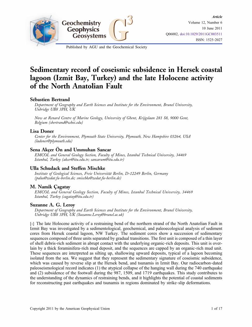
[20] In core HK04LV5, the S parameter rangesfrom 0.9 to 1 below 200 cm and from 0.65 to 0.8above 200 cm, with two exceptions at 280 and
Figure 3. Lithology of the 10 sediment cores collected in Hersek Lagoon. The intervals sampled for radiocarbonanalysis are also indicated. The radiocarbon ages are given in Table 2.
GeochemistryGeophysicsGeosystems G3G3 BERTRAND ET AL.: COSEISMIC SUBSIDENCE IN HERSEK LAGOON 10.1029/2011GC003511
6 of 17
20 cm (Figure 4). The shift at 200 cm most likelyreflects a change in sediment source.
4.3. Geochemistry
[21] TOC in core HK04LV5 varies from 0.75 to2.23%, and is significantly higher above 200 cm
(1.40 ± 0.32%) than below 200 cm (0.97 ± 0.10%).Similarly, the atomic C/N values are higher under200 cm (15.7 ± 2.4) than above 200 cm (14.2 ± 1.7;Figure 4). The CaCO3 values are relatively stablethrough the profile (5.3 ± 1.4 wt %), except withinthe three shell layers, where they increase above20% (not shown). The sulfur content ranges from
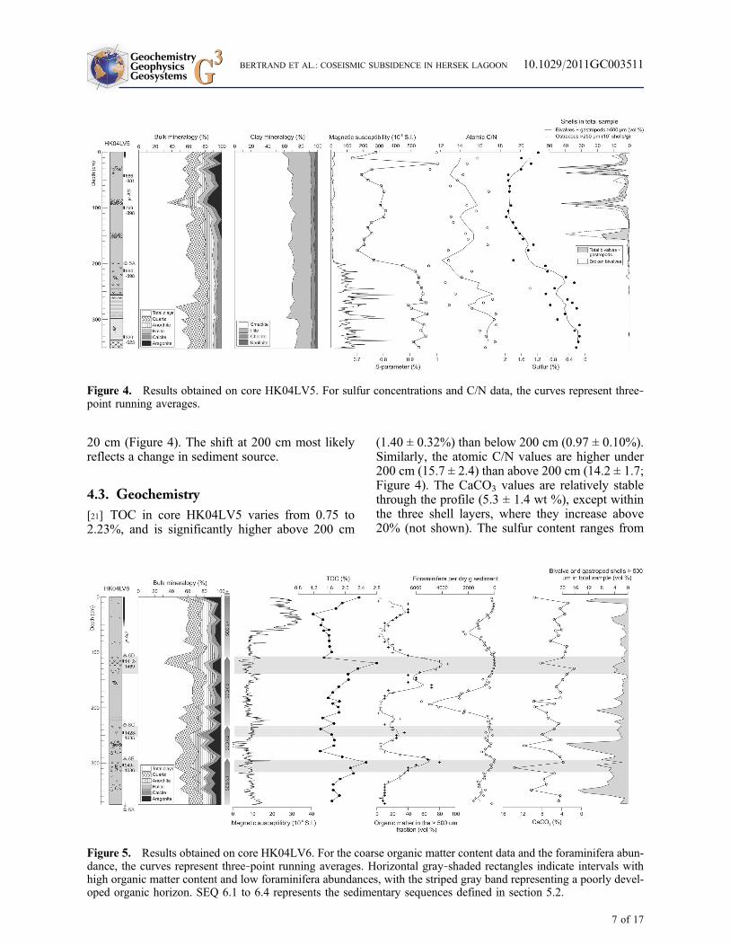
Figure 5. Results obtained on core HK04LV6. For the coarse organic matter content data and the foraminifera abun-dance, the curves represent three‐point running averages. Horizontal gray‐shaded rectangles indicate intervals withhigh organic matter content and low foraminifera abundances, with the striped gray band representing a poorly devel-oped organic horizon. SEQ 6.1 to 6.4 represents the sedimentary sequences defined in section 5.2.
Figure 4. Results obtained on core HK04LV5. For sulfur concentrations and C/N data, the curves represent three‐point running averages.
GeochemistryGeophysicsGeosystems G3G3 BERTRAND ET AL.: COSEISMIC SUBSIDENCE IN HERSEK LAGOON 10.1029/2011GC003511
7 of 17

0.07% to 1.9%, with an abrupt increase at 200 cm,from 0.42 ± 0.31% under 200 cm to 1.61 ± 0.25%above 200 cm (Figure 4).
[22] By comparison, TOC in core HK04LV6 oscil-lates between 1.18 and 2.80% and shows threeincreasing upward sequences. Twoof these sequencesend with abrupt TOC minima at 290 cm and 115 cm(Figure 5). The TOC profile closely parallels theamount of coarse (>500 mm) organic matter debris(Figure 5), mainly composed of marsh plant frag-ments. The CaCO3 content is highly variable with noclear trend with depth (5.8 ± 2.6 wt %; Figure 5), andis roughly conform to the amount of coarse shells inthe samples (Figure 5).
4.4. Paleoecology
[23] In core HK04LV5, ostracod abundance showsa sharp transition from virtually absent below 155 cmto extremely abundant above 155 cm (average99 shells/g sediment), peaking at 250–400 shells/g
in the coarse shell layers (Figure 4). The ostracodassemblages are clearly dominated by Cyprideistorosa (95.3%).
[24] Benthic foraminifera occur throughout coreHK04LV6, except within the organic‐rich zones at301–296 cm and 120–106 cm, which contain noforaminifera (Figure 5). The most abundant typesare Haynesina depressula, Ammonia tepida,Ammonia infilata, Gyroidinoides lamarckiana, El-phidium sp., and Ammonia sp. A few specimens ofElphidium macellum, Elphidium margeritaceum,Nonion depressulum and Nonion fabum were alsoidentified. Planktonic foraminifera are very rare.Total foraminifera abundances vary considerablythroughout core HK04LV6, with a pronouncedmaximum at 212–165 cm (Figures 5 and 6), whichinterestingly corresponds to the sole significantoccurrence of Gyroidinoides (Figure 6). The totalabundance data show secondary increases at 80–45 cm and at the base of the core (Figure 6). Thethree foraminifera‐rich intervals are characterized
Figure 6. Foraminifera data for core HK04LV6. The number of foraminifera taxa is used here as a proxy for diver-sity. A total of 10 species was identified. The curve corresponding to the number of foraminifera per dry g of sedimentis a three‐point running average.
GeochemistryGeophysicsGeosystems G3G3 BERTRAND ET AL.: COSEISMIC SUBSIDENCE IN HERSEK LAGOON 10.1029/2011GC003511
8 of 17

by high numbers of foraminifera taxa (used here as aproxy for diversity).
5. Interpretation
5.1. Modern Sedimentation and SedimentSources
[25] Water parameters from 11 sites (i.e., pH andsalinity; Figure 2) and field observations in July2005 indicate that Hersek Lagoon is no longer fedby the Yalak River (Figure 1). The modern HersekLagoon is primarily fed by the Sea of Marmara,through breaches in the coastal barrier on theeastern side of the lagoon (Figure 2). It is a semi-enclosed (following Bird [1994]) and slightlyevaporitic basin, as evidenced by the high salinityof the lagoon’s water (28–31‰ with maximareaching 40‰ at its western shore and in the paleo‐Yalak River channels; Figure 2) compared to thatof the Sea of Marmara (∼24‰). It is believed thatthe sediment that accumulates in the lagoon origi-nates from the Sea of Marmara, and is carried intothe lagoon by tidal currents and waves.
[26] The geological map of Hersek Peninsula(Figure 1) and field observations indicate that thelagoon was once directly fed by Yalak River,which would have been a significant additionalsource of sediment. The timing of the river dis-connection remains unknown, but in such an activeseismotectonic setting, it is possible that the riverchanged course following a major seismic event.
[27] Attempts to reconstruct the timing of the dis-connection using mineralogical analyses of HersekLagoon’s sediments were only partly successful,because the composition of sediments from theYalak River and the Sea of Marmara is nearlyidentical. Clay minerals however provide indica-tions about potential changes in sediment sources.In cores HK04LV5 and HK04LV6, smectite dom-inates (66–70%) and is relatively stable with depth.By comparison, Yalak River sediments are enrichedin smectite (80% at WS4 and 84% at WS7). Thesmectite content of Izmit Bay sediments is generallylower (∼60%) [Yalçin and Bozkaya, 1995; Erginet al., 1999]. Although such differences are closeto the quantification limit of X‐ray diffraction(±5%), these results indicate that the source of sed-iment did not radically change during the periodcovered by cores HK04LV5 and HK04LV6, andthat most of the sediment originated from the Sea ofMarmara. The disconnection between Yalak River
and Hersek Lagoon probably happened prior to theperiod covered by our sediment cores.
5.2. Late Holocene Sedimentary Processes
[28] Since cores HK04LV5 and 6 were analyzed indetails, the sedimentological interpretation is mainlybased on these two cores, and extended to the wholelagoon based on the results of mascroscopicaldescriptions andmagnetic susceptibility obtained onthe eight other cores.
5.2.1. Core HK04LV5
[29] Most of the proxies analyzed in coreHK04LV5 display an abrupt transition at 200 cm(Figure 4). Below 200 cm, the sediment is char-acterized by high magnetic susceptibility (MS) andS parameter values, low sulfur concentrations, rel-atively high C/N ratios, and virtual absence ofaragonite, ostracods, bivalves and gastropods. Ataround 200 cm all these proxies shift dramatically.The MS values decrease by 2 orders of magnitude,the sulfur concentrations increase significantlyand the C/N ratio decreases. In addition, shells andaragonite become abundant above 155 cm.
[30] The abrupt transition observed at 200 cm mostlikely reflects an abrupt shift from a terrestrial to anopen lagoon environment. This is especially clearin the distribution of sulfur (Figure 4), which isknown to be abundant in marine environments andvirtually absent from most terrestrial deposits[Berner and Raiswell, 1984]. Similarly, the decreasein bulk C/N reflects a decrease in the proportion ofterrestrial versus aquatic organic matter in sediments[Meyers and Teranes, 2001], which is confirmed bythe terrestrial nature of the coarse (>500 mm) organicmatter remains at the base of the core. The abun-dance of marine fauna and the decrease of the Sparameter above 200 cm support this interpretation.Marine shells are particularly abundant within threecoarse layers above 155 cm, indicating a high‐energy depositional environment.
[31] Below 200 cm, the deposits are organic‐richand probably represent a wetland‐type environ-ment, with relatively low accumulation rates(∼4 mm/yr according to the two radiocarbon datesobtained at the bottom of the core). The transition at200 cm most likely represents an abrupt submer-gence of the lagoon (or at least its northern part),which buried the organic‐rich, more terrestrial
GeochemistryGeophysicsGeosystems G3G3 BERTRAND ET AL.: COSEISMIC SUBSIDENCE IN HERSEK LAGOON 10.1029/2011GC003511
9 of 17

deposits under thick and rapidly accumulatingmarine sediments.
5.2.2. Core HK04LV6
[32] HK04LV6 sediments are subdivided intofour sequences with similar lithostratigraphical,geochemical and paleoecological characteristics(Figure 5). These sequences are labeled SEQ 6.1 to6.4 (from bottom to top), and are mostly composedof three units separated by gradual transitions. Atypical sequence starts with an abrupt contact withthe underlying organic‐rich deposits (e.g., 295 cm).The basal unit is composed of mud and generallycontains abundant bivalve and gastropod shelldebris, and, sometimes fining upward sand or siltlayers (e.g., 220 cm). This basal unit is generallyoverlain by foraminifera‐rich mud. It is, in turn,overlain by an upper unit, which is composed oforganic‐rich mud relatively poor in foraminifera.These sequences are particularly well marked bycontinuously increasing organic matter contents(both TOC and coarse organic matter contents;Figure 5), and are interpreted as silting up, shal-lowing upward deposits, typical of a lagoonbecoming isolated from the sea. The three abrupttransitions at 298, 232 and 107 cm most likelyrepresent three major submergence events thatburied dominantly terrestrial deposits under marinesediments. The lower parts of the sequences aregenerally coarse (shells or sand/silt layers) andtherefore indicative of high‐energy depositionalenvironments.
5.2.3. Other Cores
[33] Although only cores HK04LV5 and 6 wereanalyzed in detail, some of the other cores collectedin Hersek Lagoon also show a succession of open‐to‐close lagoon deposits. Based on macroscopicaldescriptions,we have identified twoof these sequencesin core HK04LV7, at 176–83 cm (SEQ 7.1) and 83–0 cm (SEQ 7.2; Figure 3). SEQ 7.1 shows a typicalcoarse shell layer at its base and is capped by anorganic‐rich horizon. This horizon is overlain bySEQ 7.2 through a sharp contact that indicates arapid burial, most likely linked to an abrupt sub-mergence of the lagoon. The succession of depositsin core 8 seems nearly identical to core 7, althoughcondensed. Cores 9 and 10 seem to contain the baseof one sequence. Cores 1 to 4 are generallyhomogenous and do not show any type of deposi-tional sequences. To facilitate the discussion, therapid submergence events were labeled accordingto their stratigraphic position in each core (e.g.,
event 6A led to the deposition of SEQ 6.1, seeFigure 5).
5.3. Origin of the Deposits
5.3.1. Occurrence of Similar Sequences AlongMajor Subduction Zones
[34] Sedimentary deposits similar to the sequencesdescribed above have been observed in coastalenvironments from major active subduction zones.These deposits have been particularly well stud-ied in estuaries of the northeast Pacific (BritishColumbia, Washington, Oregon and northern Cali-fornia), where sequences of buried tidal marsh orpeaty soils, abruptly overlain by intertidal mud areattributed to sudden submergence associated withcoseismic subsidence of long stretches of coast[Atwater, 1987; Guilbault et al., 1995; Nelsonet al., 1996, 2008]. These authors argue that thesedeposits represent great, prehistoric earthquakes(Mw 8–9) that produced repeated coseismic subsi-dence of 0–2 m. According to Atwater [1987], themain evidence for tectonic instability is the occur-rence of couplets of thin peaty soils (0.02–0.2 m)representing former wetlands and thick (0.5–1.0 m)beds of intertidal mud. In addition, landward thin-ning sand sheets, occurring immediately abovethe peat layer in some of the sequences havebeen interpreted as coseismic tsunami deposits[Atwater, 1987; Guilbault et al., 1995; Nelsonet al., 1996; Rhodes et al., 2006].
[35] Similar deposits have also been observed in theactive subduction zones of Alaska [Shennan et al.,1999; Atwater et al., 2001; Shennan and Hamilton,2006], New Zealand [Nichol et al., 2007] and Chile[Cisternas et al., 2005]. Observations during andafter the giant earthquake of Alaska (Mw 9.2,1964) have demonstrated that (1) sediment depo-sition occurs immediately upon submergence,(2) most of the postearthquake deposits accumulatein the first decade after the earthquake, and (3)∼50 years are needed to register back‐to‐backearthquakes [Shennan et al., 1999; Atwater et al.,2001].
[36] Based on the analysis of numerous estuariesalong the Cascadia margin, Nelson et al. [1996]proposed five criteria that must be evaluated toassign a coseismic origin to rapid submergence ofcoastal sediments: (1) the suddenness of submer-gence, (2) the amount of submergence, (3) thelateral extent of submerged tidal wetland soils,(4) the coincidence of submergence with tsunamisdeposits, and (5) the degree of synchronicity of
GeochemistryGeophysicsGeosystems G3G3 BERTRAND ET AL.: COSEISMIC SUBSIDENCE IN HERSEK LAGOON 10.1029/2011GC003511
10 of 17

submergence events at widely spaced sites. Asindicated by Shennan et al. [1996], it is unlikelythat all these criteria can be evaluated at a singlesite, but the probability that coastal submergencedeposits are linked to a seismic origin increaseswith the number of criteria recognized at each site.
5.3.2. Mechanisms Responsible for theDeposition of Hersek Sedimentary Sequences
[37] In agreement with the results of the abovementioned studies, we argue that the sequencesfound in cores HK04LV5 to 7 (and to a lesserextent HK04LV8 to 10) are the signatures of majorearthquakes that caused coseismic subsidence andtriggered tsunamis in Izmit Bay. The sequencesfound in core HK04LV6, and to a certain extentcores HK04LV5 and 7, satisfy at least three of thefollowing five criteria proposed by Nelson et al.[1996].
[38] 1. The suddenness of submergence is evidencedby abrupt organic sediment‐mud contacts that arewell marked in lithology and in organic mattercontents. The occurrence of in situ marsh plantremains within the organic‐rich layers providesadditional evidence of rapid burial.
[39] 2. The presence of coarse shell or sand layersat the base of each sequence is a clear indicator ofthe co‐occurrence of a tsunami. Shell depositspreserved in cores HK04LV5 and 6 are mainlycomposed of marine species that thrive at shallowdepths in the Sea of Marmara [Eryilmaz et al.,1995], and the mixed assemblages of highly frag-mented and articulated specimens are typical fortsunami deposits according to the criteria of Donatoet al. [2008] (extensive angular fragmentation andpresence of allochtonous articulated bivalves). Theshells most likely originate from the shallow shell‐rich sandy deposits that occur at 0–10 m depthalong Hersek Peninsula [Eryilmaz et al., 1995](Figure 1). Their transport into the lagoon by tsu-nami waves was probably facilitated by submer-gence and/or breaching of the coastal barrier. Astorm origin of the shell layers is unlikely since(1) they are restricted to the base of coseismicsequences (storm deposits would occur throughoutthe cores), and (2) they contain a mixture ofmarine, lagoonal and nonmarine ostracod shells[Mischke et al., 2011]. All the sequences describedin core 6 contain basal shell deposits, except forSEQ 6.3, which has fining upward silt and sandlayers, similar to the tsunami deposits described inestuaries from the CascadiaMargin [Guilbault et al.,1995]. This difference likely reflects (1) the coring
location in front of the sandbarrier and (2) a pos-sible delay between the tsunami and the subsidenceevent at Hersek.
[40] 3. A considerable amount of submergence isreflected in the systematic increases in foraminiferaconcentration above the tsunami deposits, andby the co‐occurrence of maxima in foraminiferadiversity, which demonstrate an open‐marineinfluence in the lagoon. These characteristics seemto indicate a sudden submergence of the coastalbarrier, most likely in relation with rapid subsi-dence, temporarily increasing the exchanges ofbenthos and sediment between the Sea of Marmaraand the lagoon, as observed in British Columbia[Guilbault et al., 1996]. The single occurrence ofGyroidines in SEQ 6.3 (Figure 6) points toexceptional submergence of the lagoon by seawaterpreviously mixed by the tsunami wave(s), sinceGyroidines is commonly found in open seas atdepths of 16–80 m [Murray, 1991].
[41] The evaluation of the last two criteria ofNelson et al. [1996] (extension of the peat‐mudcouplets and synchronicity of submergence) is lesseasily applicable to our data since they requireobservation of continuous sections across thelagoon, a higher density of cores, and a very largenumber of radiocarbon dates, none of which isavailable in the framework of this exploratorystudy. Subsurface profiling would also help inconfirming the lateral continuity, and thereforecoseismic origin of the deposits.
5.4. Chronology
5.4.1. Radiocarbon Dating
[42] Since the organic‐rich layers that constitute theupper parts of the coseismic subsidence sequencesrepresent marsh soils that were rapidly submergedby postseismic deposits, dating these layers pro-vides an accurate estimate of the age of the eventthat triggered their burial. Following this principle,all of the marsh soils in cores HK04LV5, 6 and 7were radiocarbon dated (Table 2 and Figure 7),with samples preferentially taken in the upper partof the organic‐rich layers.
[43] As shown in Figure 7, core HK04LV5, the onlycore collected north of the fault trace (Figure 2),has recorded a single event (event 5A) that isdated at 664–898 A.D. The two dates obtained onorganic macroremains incorporated in the overly-ing postseismic deposit are statistically indiscern-ible from the age of the event, providing evidence
GeochemistryGeophysicsGeosystems G3G3 BERTRAND ET AL.: COSEISMIC SUBSIDENCE IN HERSEK LAGOON 10.1029/2011GC003511
11 of 17

that SEQ 5.1 accumulated extremely rapidly afterthe coseismic subsidence (Figure 4). The three shelldeposits that occur in the upper half of the coremost likely represent three distinct tsunami waves,in‐between which silt material accumulated rap-
idly. By comparison, the date obtained at the bot-tom of the core shows that the underlying marshsoil, also about 200 cm thick, took over 300 year toaccumulate, at an average rate of ∼4 mm/yr.
Table 2. Radiocarbon Ages Obtained on Marsh Plant Remains From Cores HK04LV5, HK04LV6, and HK04LV7a
CoringSite
CompositeDepth (cm)
LabAccessionNumber
RadiocarbonAge ± 1s(year B.P.)
Calibrated Ages With2s Error Range(year A.D.)
Weighted Average(year A.D.)
HK04LV5 40–45 Poz‐14522 1235 ± 35 686–881 (95.4%) 777HK04LV5 97.5–102.5 Poz‐12826 1190 ± 30 769–898 (88.8%) 834HK04LV5 210–215 Poz‐12827 1230 ± 60 664–898 (92.1%) 792HK04LV5 329–334 Poz‐12825 1590 ± 80 320–623 (91.3%) 511HK04LV6 113.5–118.5 Poz‐12828 460 ± 30 1412–1469 (95.4%) 1438HK04LV6 242.5–247.5 Poz‐16606 400 ± 50 1428–1635 (95.4%) 1501HK04LV6 301–306 Poz‐12786 1035 ± 30 949–1036 (89.7%) 1001HK04LV7 94–98 Poz‐16607 205 ± 30 1646–1955 (95.4%) 1742HK04LV7 142–147 Poz‐16608 170 ± 30 1659–1954 (95.4%) 1746
aNo sample had F14C > 1. The results were calibrated with Oxcal 3.9 [Bronk Ramsey, 2001] using the IntCal04 calibration curve [Reimer et al.,2004].
Figure 7. Chronology of the seismic events recorded in the deposits (terraces) of Hersek ridge [Özaksoy et al.,2010] and in sediment cores HK04LV5, 6, and 7 (our results). The gray and open boxes represent 1‐ and 2‐sigmaintervals of the 14C calibrated ages, respectively. The dashed arrow indicates alternative age hypothesis for event 6D(see section 5.4). Footnote 1: from Özaksoy et al. [2010]. Footnote 2: historical earthquakes with Ms ≥ 6.8 and with anestimated epicenter located within a 100 km radius from Hersek (from Ambraseys [2002]). Footnote 3: ages assignedaccording to criteria explained in section 5.4. The ages assigned to the four events recorded in Hersek Lagoon sediment alloccur within the 1‐sigma interval of their calibrated radiocarbon ages.
GeochemistryGeophysicsGeosystems G3G3 BERTRAND ET AL.: COSEISMIC SUBSIDENCE IN HERSEK LAGOON 10.1029/2011GC003511
12 of 17

[44] The three youngest events recorded in coreHK04LV6 (Figures 5 and 7) are dated at 949–1036 A.D. (6B), 1428–1635 A.D. (6C) and 1412–1469 A.D. (6D). Although a fourth sequence isrecorded at the base of the core (SEQ 6.1), the ageof the responsible event (6A) is unknown becausethe core did not reach the underlying organic‐richdeposit. The age of event 6C, which is character-ized by an exceptional amount of submergence (seeprevious paragraph), is statistically indiscerniblefrom the age of event 6D. However, these twoevents must be separated by a significant amount oftime since at least 50 years are needed to registerback‐to‐back earthquakes [Atwater et al., 2001].This duration was likely higher because the marshsoil that underlies event 6D at 105–125 cm is rel-atively well developed.
[45] Core HK04LV7 has recorded two events(Figures 3 and 7). The younger one (7B) is datedat 1646–1955 A.D., an interval of multiple 14Cplateaus which precludes exact age determinationby radiocarbon methods [Reimer et al., 2004].The event is younger than any recorded in coreHK04LV6, except if the real age of event 6D issignificantly younger than ∼1500 A.D. (i.e., theplant remain used to date even 6D died beforeburial of the marsh soil). In this case, event 6Dmight correspond to event 7B. The absence oftsunami deposits associated with both events(6D and 7B, Figure 3) supports this interpretation.
[46] The chronological results obtained on coresHK04LV5, 6 and 7 are summarized in Figure 7,which shows that the cored sediments haverecorded a total of four, possibly five, seismicevents during the last 1200 years. It is remarkablethat site HK04LV5 has not recorded any seismicevent after (i.e., younger than) event 5A (664–898A.D.), which demonstrates that most subsidenceevents are restricted to the main lagoon, i.e., southof the fault trace. Event 5A most likely represents agravitational collapse of the hanging wall during anoncharacteristic earthquake. It is very likely thatsome of the events observed in cores HK04LV6and 7 have been recorded elsewhere in the southernpart of the lagoon, but a denser coring grid isneeded to confirm this assumption.
5.4.2. Comparison With Historical Records
[47] Fifty‐five large (estimated Ms ≥ 6.8) earth-quakes seem to have affected the Sea of Marmararegion during the last 2000 years [Ambraseys,2002]. Here, we excluded events located outsidea 100 km radius from Hersek using the estimated
epicenter locations of Ambraseys [2002]. This firstselection criterion reduced the number of largeearthquakes to 27, among which only 15 occurredafter 500 A.D. (Figure 7). The historical earth-quakes occurring within the 2 sigma error range ofthe radiocarbon age of each Hersek event were thenexamined to determine the most probable age ofeach event, using specific information such as theestimated location of the affected region and thepresence/absence of associated tsunami.
[48] Event 5A (664–898 A.D.) is only recorded incore HK04LV5, i.e., north of the fault trace. Threemajor historical earthquakes occur within this agerange: at 740, 860 and 869 [Ambraseys, 2002]. Notsunamis are associated with the weaker 860 and869 earthquakes [Ambraseys and Finkel, 1991;Altinok and Ersoy, 2000; Ambraseys, 2002] so it isvery likely that event 5A represents the 740 earth-quake (estimated Ms 7.1), which was accompaniedby a tsunami that affected Istanbul and Izmit[Altinok and Ersoy, 2000; Yalçiner et al., 2002].
[49] Event 6B is well marked in core HK04LV6.Its radiocarbon age (949–1036 A.D.) matchesremarkably well the 989 earthquake. The onlyother earthquake corresponding to this age rangeoccurred in 967 A.D. but its estimated epicenter islocated 170 km east of Hersek and it has no asso-ciated tsunami [Ambraseys, 2002]. Hence, event6B most likely represents the destructive Ms 7.2,989 earthquake, which epicenter is believed to belocated in the eastern part of the Sea of Marmara atapproximately 70 km west of Hersek [Ambraseys,2002; Yalçiner et al., 2002].
[50] Event 6C is the largest event recorded inHersek Lagoon sediments south of fault trace. Ithas a radiocarbon age of 1428–1635 A.D. The onlycorresponding major historical earthquake is thewell‐documented 1509 event that caused heavydamages in Istanbul and was followed by a tsunamiin the eastern part of the Sea ofMarmara [Ambraseysand Finkel, 1990, 1991; Altinok and Ersoy, 2000;Ambraseys and Jackson, 2000; Ambraseys, 2001,2002]. Historical documents do not mentiondamages in Izmit Bay [Ambraseys, 2001], exceptfor the destruction of Hersek Mosque in 1509[Witter et al., 2000]. Its epicenter is believed to belocated in the Sea of Marmara, immediately south ofIstanbul [Ambraseys and Jackson, 2000; Ambraseys,2001, 2002]. Most of these characteristics are inagreement with the sedimentological descriptionof event 6C, and we therefore feel confident toassign an age of 1509 A.D. to this event.
GeochemistryGeophysicsGeosystems G3G3 BERTRAND ET AL.: COSEISMIC SUBSIDENCE IN HERSEK LAGOON 10.1029/2011GC003511
13 of 17
[51] Event 7B is the most recent event recorded inHersek Lagoon sediments. It is radiocarbon datedat 1646–1955 A.D. and has no clear associatedtsunami deposit, similarly to event 6D, which maybe coeval (see above, Figure 3). Historical dataindicate that four major earthquakes occurredwithin this time range (1719, 1754, 1766 and 1894)[Ambraseys, 2002]. The well‐defined epicenterlocations of these four events are all located withinless than 50 km from Hersek [Ambraseys, 2002].The major difference between these events is theabsence of tsunami associated with the 1719earthquake, likely due to the onshore location ofmost of the rupture zone [Altinok and Ersoy, 2000;Ambraseys and Jackson, 2000; Ambraseys, 2002].It is also the earthquake with the highest estimatedsurface magnitude (Ms 7.4) [Ambraseys, 2002].Since no clear tsunami deposit is associated withevent 7B in the sedimentary record, we associatethis event with the 1719 earthquake. The 1719earthquake is known to have destroyed or badlydamaged most of the towns located on the coastsof Izmit Bay from Yalova to Duzce, includingKaramürsel [Ambraseys and Finkel, 1991].
6. Discussion
6.1. Amount of Subsidence
[52] Although no transfer function is available toquantify the amount of subsidence of each of theevents recorded in Hersek Lagoon, the importanceof the vertical deformations can be estimated usingthe thickness of the sedimentary sequences. Thisfollows the findings of Atwater et al. [2001], whodemonstrated that the thickness of the sedimentarysequences related to the 1964 Alaska earthquakefaithfully reflects the amount of vertical deforma-tion, and that background sedimentation is negli-gible. The important thickness of the Herseksequences (60–200 cm), compared to the post-seismic Cascadia deposits (generally 50–100 cm)therefore indicates particularly high amounts ofsubsidence, representing vertical deformations of60 cm (event 6B) to 200 cm (event 5A). Followingthis principle, we estimate that the verticaldeformations associated to the 1509 and 1719earthquakes are in the order of 120 cm, and that the740 earthquake caused the 200 cm subsidence ofthe northernmost side of the lagoon. By contrast,the relative thinness of SEQ 6.2 (60 cm), whichrepresents the 989 earthquake, may indicate alower amount of coseismic subsidence. In addition,we believe that only major vertical deformations
(>50 cm) are recorded in Hersek Lagoon since theaccommodation space created by minor events isnot important enough to be filled by sedimentbefore disappearing via postseismic rebound. Thiswould explain why the ∼20 cm coseismic subsi-dence that affected Hersek Lagoon after the 1999Izmit earthquake was not recorded.
6.2. Late Holocene Activity of the NNAFin Izmit Bay
[53] Paleoseismological reconstructions around IzmitBay, and in the Sea of Marmara region in general,are relatively rare. Our data indicate that 4 majorearthquakes caused coseismic subsidence on HersekPeninsula during the last 1500 years. The latest col-lapse of the northernmost side of Hersek Lagoon, i.e.,the hanging wall, occurred during the 740 earth-quake. The main lagoon (i.e., the footwall, south ofthe fault trace) subsided during the 989, 1509 and1719 earthquakes (Figure 7).
[54] The collapse of the hanging wall in 740 A.D. isatypical for Hersek Peninsula. Indeed, the data ofÖzaksoy et al. [2010] suggest that Hersek hill, i.e.,the hanging wall, was tectonically uplifted by the1343–1344 and 1509 earthquakes, and by some ofthe seismic events dated at 1719 A.D., 1754 A.D.and 1894 A.D. (Figure 7). Their data also show thatthe ridge subsided at least once, between 1350 and1500 A.D. Unfortunately, their record lacks databetween 500 and 1000 A.D., because of erosion ofthe contemporary marine terraces. Interestingly, thesingle episode of subsidence recorded in Hersekcore HK04LV5 corresponds to this period, whichsuggests that most of the hanging wall collapsedduring the 740 earthquake, explaining the erosionof the marine deposits at the tip of HersekPeninsula.
[55] The subsidence events of 989, 1509 and1719 A.D. are more typical for the area, since theyrepresent a downward movement of the footwall,which is expected for a reverse fault. Our data sug-gests that the coseismic subsidence of HersekLagoon during the 989 earthquake was accompa-nied by a tsunami. This observation is in goodagreement with the results of Özaksoy et al. [2010],who identified sand and shells deposits related tothe 989 event on Hersek Peninsula. The marinerecords of McHugh et al. [2006] in Izmit Bay donot contain sediments deposited between ∼900 and∼1450 A.D.
[56] According to our results, the 1509 earthquakewas characterized by ∼1.2 m of subsidence and by
GeochemistryGeophysicsGeosystems G3G3 BERTRAND ET AL.: COSEISMIC SUBSIDENCE IN HERSEK LAGOON 10.1029/2011GC003511
14 of 17

a considerable amount of submergence. It alsoseems that the marine terraces of Hersek ridge (i.e.,north of the fault trace) were uplifted by the 1509earthquake, which means that both the hangingwall and the footwall moved during the earthquake.Further east in Izmit Bay, about 25 km from Herseknear Gölcük, Klinger et al. [2003] identified twoburied colluvial wedges related to paleoscarps fromthe 1509 and 1719 earthquakes. In addition,McHugh et al. [2006] found sedimentary indica-tions of mass‐wasting events associated with the1509 earthquakes on the western, submarine slopeof Hersek Peninsula. Fossil‐rich mass flow depositsmost likely related to the 1509 earthquake werealso described in a sediment core collected severalkm west of Hersek in the Sea of Marmara [Çagatayet al., 2003]. All these characteristics display theexceptional magnitude and extension of the rupturezone of the 1509 event.
[57] The most recent event recorded in Herseksediment cores is the 1719 earthquake. The subsi-dence of Hersek Lagoon during this event was ofthe same order of magnitude than during the 1509earthquake. Although Özaksoy et al. [2010] did notclearly identify the 1719 earthquake in the marineterraces of Hersek ridge, these authors indicateminor terrace uplift during one of the seismicevents in 1719, 1754 or 1894 A.D. If the lateroccurred in 1719 A.D., this would suggest theco‐occurrence of subsidence of the footwall anduplift of the hanging wall, as for the 1509 earthquake.At Gölcük, the second colluvial wedge related topaleoscarps was also linked to the 1719 earthquake[Klinger et al., 2003]. McHugh et al. [2006] do notdescribe any event deposit associated to the 1719earthquake, but their record contains sedimentaryindications of submarine mass‐wasting events asso-ciated to the 1766 earthquake. This interpretationis however based on a complex core stratigraphyinterpreted as mixing and reworking of one mass‐wasting deposit by two distinct seismic events,and is therefore questionable. It is anyway notpossible to differentiate the 1719 and 1766 basedon radiocarbon data only.
[58] From these data, it appears that verticaldeformation occurred simultaneously at Hersek andGölcük during the 1509 and 1719 earthquakes,indicating that the fault rupture stepped across theKaramürsel basin during both events. Our resultstherefore confirm the observationsmade during recenthigh‐resolution bathymetrical surveys [Cormier et al.,2006], which demonstrate that the NNAF in IzmitBay is more continuous than thought by formerstudies [e.g., Barka et al., 2002; Lettis et al., 2002].
They also suggest that the amount of subsidence ofHersek Lagoon (south of the bend) is of the sameorder of magnitude than the amount of uplift ofHersek pressure ridge (3.5 m/kyr [Özaksoy et al.,2010]).
7. Conclusions
[59] The sediments deposited in Hersek coastallagoon were successfully used to reconstruct pastsubsidence associated with Hersek restrainingbend. Although coastal sediments are well‐knownfor recording coseismic subsidence in subductionzone areas, we demonstrate that they can also beused to reconstruct past earthquakes in trans-form plate boundary settings. In Hersek Lagoon,coseismic subsidence creates sedimentary sequencescomposed of a basal coarse (shells or sand/silt)tsunami layer, followed by a thick mud unit cappedby an organic‐rich horizon. These sequences resem-ble the coseismic peat‐mud couplets of the Cascadiamargin, and represent the vertical deformations thatoccur at Hersek restraining bend during majorearthquakes. The Hersek paleoseismological recordshows that coastal deformation is accommodated in60–200 cm subsidence events during major earth-quakes, which maintain the status of Hersek coastallagoon and delay its final infill. Four events wererecorded during the last 1000–1500 years. The agesof these events were estimated by comparingradiocarbon results to historical chronicles, whichindicate (1) the atypical collapse of the hanging wallduring the 740 earthquake and (2) subsidence of thefootwall during the 987, 1509 and 1719 earth-quakes. Our results also suggest the co‐occurrenceof subsidence of the footwall and uplift of thehanging wall during the 1509 and 1719 earthquakes,and they confirm that the step‐over model of Barkaet al. [2002] and Lettis et al. [2002] is not valid forthe Karamürsel basin.
Acknowledgments
[60] This research was funded by the European Union in theframework of the REL.I.E.F. (Reliable Information on Earth-quake Faulting) project (EVG1‐CT‐2002‐00069). We wouldlike to acknowledge Pedro Costa (Brunel University), SalimÖncel (Gebze Institute of Technology), Özden Ileri, and FatihUyssal (Ankara University) for assistance during our fieldworkexpeditions in Turkey. We are grateful to Lina Mehta, VanessaTomasz, and Paul Szadorsky (Brunel University) for labora-tory assistance. Andrea Lini (University of Vermont) per-formed the TOC and TN analyses. We thank Nathalie Fagel(University of Liège, Belgium) and Helge Arz (GFZ, Potsdam,
GeochemistryGeophysicsGeosystems G3G3 BERTRAND ET AL.: COSEISMIC SUBSIDENCE IN HERSEK LAGOON 10.1029/2011GC003511
15 of 17
Germany) for providing access to the X‐ray diffraction andGEOTEK multisensor core logging facilities, respectively.This paper has benefited from the detailed and constructivereview provided by James Dolan. Comments from two anony-mous reviewers led to additional improvements. During thewriting of this article, S.B. was an EU Marie Curie postdoc-toral fellow at AWI, Germany and a FWO postdoctoral fellowat UGent, Belgium.
References
Alpar, B., and A. Güneysu (1999), Evolution of the HersekDelta (İzmit Bay), Turk. J. Mar. Sci., 5, 57–74.
Altinok, Y., and Ş. Ersoy (2000), Tsunamis observed on andnear Turkish coast, Nat. Hazards, 21(2–3), 185–205,doi:10.1023/A:1008155117243.
Altinok, Y., S. Tinti, B. Alpar, A. C. Yalçıner, Ş. Ersoy,E. Bortolucci, and A. Armigliato (2001), The tsunami ofAugust 17, 1999 in İzmit Bay, Turkey, Nat. Hazards, 24,133–146, doi:10.1023/A:1011863610289.
Ambraseys, N. (2001), The earthquake of 1509 in the Sea ofMarmara, Turkey, revisited, Bull. Seismol. Soc. Am., 91(6),1397–1416, doi:10.1785/0120000305.
Ambraseys, N. (2002), The seismic activity of the MarmaraSea region over the last 2000 years, Bull. Seismol. Soc.Am., 92(1), 1–18, doi:10.1785/0120000843.
Ambraseys, N., and C. Finkel (1990), The Marmara Sea earth-quake of 1509, Terra Nova, 2, 167–174, doi:10.1111/j.1365-3121.1990.tb00059.x.
Ambraseys, N., and C. Finkel (1991), Long‐term seismicity ofIstanbul and of the Marmara Sea region, Terra Nova, 3, 527–539, doi:10.1111/j.1365-3121.1991.tb00188.x.
Ambraseys, N., and J. A. Jackson (2000), Seismicity of the Seaof Marmara (Turkey) since 1500, Geophys. J. Int., 141,F1–F6, doi:10.1046/j.1365-246x.2000.00137.x.
Armijo, R., B. Meyer, S. Navarro, G. King, and A. Barka(2002), Assymetric slip partitioning in the Sea of Marmarapull‐apart: A clue to propagation processes of the NorthAnatolian Fault?, Terra Nova, 14, 80–86, doi:10.1046/j.1365-3121.2002.00397.x.
Atwater, B. (1987), Evidence for great Holocene earthquakesalong the outer coast of Washington State, Science, 236,942–944, doi:10.1126/science.236.4804.942.
Atwater, B., D. Yamaguchi, S. Bondevik, W. Barnhardt,L. Amidon, B. Benson, G. Skjerdal, J. Shulene, andF. Nanayama (2001), Rapid resetting of an estuarine recorderof the 1964 Alaska Earthquake, Geol. Soc. Am. Bull., 113,1193–1204, doi:10.1130/0016-7606(2001)113<1193:RROAER>2.0.CO;2.
Barka, A. (1996), Slip distribution along the North Anatolianfault associated with the large earthquakes of the period1939 to 1967, Bull. Seismol. Soc. Am., 86(5), 1238–1254.
Barka, A. (1999), 17 August 1999 Izmit earthquake, Science,285, 1858–1859, doi:10.1126/science.285.5435.1858.
Barka, A., and C. Kadinsky‐Cade (1988), Strike‐slip faultgeometry in Turkey and its influence on earthquake activity,Tectonics, 7, 663–684, doi:10.1029/TC007i003p00663.
Barka, A., et al. (2002), The surface rupture and slip distribu-tion of the 17 August 1999 Izmit earthquake (M 7.4), NorthAnatolian Fault, Bull. Seismol. Soc. Am., 92, 43–60,doi:10.1785/0120000841.
Berner, R., and R. Raiswell (1984), C/S method for distinguish-ing freshwater from marine sedimentary rocks, Geology, 12,
365–368, doi:10.1130/0091-7613(1984)12<365:CMFDFF>2.0.CO;2.
Bird, E. (1994), Physical setting and geomorphology of coastallagoons, in Coastal Lagoon Processes, edited by B. Kjerfve,pp. 9–39, Elsevier, Amsterdam, doi:10.1016/S0422-9894(08)70007-2.
Bondevik, S., J. Svendsen, G. Johnsen, J. Mangerud, andP. Kaland (1997), The Storegga tsunami along the Norwegiancoast, its age and runup, Boreas, 26, 29–53, doi:10.1111/j.1502-3885.1997.tb00649.x.
Bronk Ramsey, C. (2001), Development of the radiocarbonprogram OxCal, Radiocarbon, 43(2A), 355–363.
Çagatay, N., N. Görür, A. Polonia, E. Demirbag, M. Sakınç,M.‐H. Cormier, L. Copotondi, C. McHugh, Ö. Emre, andK. Eriş (2003), Sea‐level changes and depositional environ-ments in the İzmit Gulf, eastern Marmara Sea, during the lateglacial‐Holocene period, Mar. Geol., 202, 159–173,doi:10.1016/S0025-3227(03)00259-7.
Cisternas, M., et al. (2005), Predecessors of the giant1960 Chile earthquake, Nature, 437(7057), 404–407,doi:10.1038/nature03943.
Cormier, M.‐H., et al. (2006), The North Anatolian fault inthe Gulf of Izmit (Turkey): Rapid vertical motion in responseto minor bends of a non‐vertical continental transform,J. Geophys. Res., 111, B04102, doi:10.1029/2005JB003633.
Donato, S., E. Reinhardt, J. Boyce, R. Rothaus, and T. Vosmer(2008), Identifying tsunami deposits using bivalve shelltaphonomy, Geology, 36(3), 199–202, doi:10.1130/G24554A.1.
Ergin, M., S. Kapur, Z. Karaka, E. Akca, Ö. Kangal, andS. Keskin (1999), Grain size and clay mineralogy of lateQuaternary sediments on a tectonically active shelf, thesouthern Sea of Marmara: Clues to hydrographic, tectonicand climatic evolution, Geol. J., 34(1–2), 199–210,doi:10.1002/(SICI)1099-1034(199901/06)34:1/2<199::AID-GJ821>3.0.CO;2-9.
Eryilmaz, M., F. Yücesoy‐Eryilmaz, Z. Kirca, and E. Dogan(1995), Distribution of sediments in the Gulf of Izmit andinfluencing factors, in Quaternary Sequence in the Gulf ofIzmit, edited by E. Meric, pp. 269–276, Turk. Navy Press,Istanbul, Turkey.
Fujiwara, O., F. Masuda, T. Sakai, T. Irizuki, and K. Fuse(2000), Tsunami deposits in Holocene bay mud in southernKanto region, Pacific coast of central Japan, Sediment. Geol.,135, 219–230, doi:10.1016/S0037-0738(00)00073-7.
Guilbault, J.‐P., J.‐J. Clague, and M. Lapointe (1995), Amountof subsidence during a late Holocene earthquake—Evidencefrom fossil tidal marsh foraminifera at Vancouver Island, westcoast of Canada, Palaeogeogr. Palaeoclimatol. Palaeoecol.,118, 49–71, doi:10.1016/0031-0182(94)00135-U.
Guilbault, J.‐P., J.‐J. Clague, and M. Lapointe (1996), Forami-niferal evidence for the amount of coseismic subsidence dur-ing a late Holocene earthquake on Vancouver Island, westcoast of Canada, Quat. Sci. Rev., 15, 913–937, doi:10.1016/S0277-3791(96)00058-3.
Hayward, B., H. Grenfell, A. Sabaa, R. Carter, U. Cochran,J. Lipps, P. Shane, and M. Morley (2006), Micropaleontolo-gical evidence of large earthquakes in the past 7200 years insouthern Hawke’s Bay, New Zealand, Quat. Sci. Rev., 25,1186–1207, doi:10.1016/j.quascirev.2005.10.013.
Hergert, T., and O. Heidbach (2010), Slip‐rate variability anddistributed deformation in the Marmara Sea fault system,Nat. Geosci., 3, 132–135, doi:10.1038/ngeo739.
Hubert‐Ferrari, A., A. Barka, E. Jacques, S. Nalbant, B. Meyer,R. Armijo, P. Tapponnier, and G. King (2000), Seismic haz-
GeochemistryGeophysicsGeosystems G3G3 BERTRAND ET AL.: COSEISMIC SUBSIDENCE IN HERSEK LAGOON 10.1029/2011GC003511
16 of 17
ard in the Sea of Marmara following the Izmit Earthquake,Nature, 404, 269–273, doi:10.1038/35005054.
Kelsey, H., A. Nelson, E. Hemphill‐Haley, and R. Witter(2005), Tsunami history of an Oregon coastal lake revealsa 4600 yr record of great earthquakes on the Cascadia sub-duction zone, Geol. Soc. Am. Bull., 117, 1009–1032,doi:10.1130/B25452.1.
Klinger,Y., K. Sieh, E.Altunel, A.Akoglu, A.Barka, T.Dawson,T. Gonzalez, A. Meltzner, and T. Rockwell (2003), Paleo-seismic evidence of characteristic slip on the western seg-ment of the North Anatolian Fault, Turkey, Bull. Seismol.Soc. Am., 93, 2317–2332, doi:10.1785/0120010270.
Kozaci, Ö. (2002), Hersek deltasi’nda kuzey anadolu fayi’ninYalova segmenti üzerinde paleosismolojik calismalar,MSc thesis, Istanbul Tech. Univ., Istanbul, Turkey.
Kozaci, Ö., E. Altunel, S. Lindvall, C. Brankman, andW. Lettis(2011), The North Anatolian Fault on Hersek Peninsula,Turkey: Its geometry and implications on the 1999 Izmitearthquake rupture propagation, Turk. J. Earth Sci.,doi:10.3906/yer-0910-45, in press.
Ku, H., Y. Chen, C. Hsieh, T. Liu, and J. C. Liu (2001),Paleoenvironment study at Yihju, southwestern Taiwan: Acase on geochemical analysis of sulfur and carbon, West.Pac. Earth Sci., 1(2), 175–186.
Kuşçu, I., M. Okamura, H. Matsuoka, and Y. Awata (2002),Active faults on Izmit on the North Anatolian Fault, NWTurkey: A high‐resolution shallow seismic study, Mar.Geol., 190, 421–443, doi:10.1016/S0025-3227(02)00357-2.
Lettis, W., J. Bachluber, R. Witter, C. Brankman, C. E.Randolph, A. Barka, W. D. Page, and A. Kaya (2002), Influ-ence of releasing step‐overs on surface fault rupture and faultsegmentation: Examples from the 17August 1999 Izmitearthquake on the North Anatolian Fault, Turkey, Bull. Seis-mol. Soc. Am., 92(1), 19–42, doi:10.1785/0120000808.
McClusky, S., et al. (2000), Global positioning system con-straints on plate kinematics and dynamics in the easternMediterranean and Caucasus, J. Geophys. Res., 105(B3),5695–5720, doi:10.1029/1999JB900351.
McHugh, C., L. Seeber, M.‐H. Cormier, J. Dutton, N. Çagatay,A. Polonia, W. Ryan, and N. Görür (2006), Submarineearthquake geology along the North Anatolian Fault in theMarmara Sea, Turkey: A model for transform basin sedi-mentation, Earth Planet. Sci. Lett. , 248 , 661–684,doi:10.1016/j.epsl.2006.05.038.
Meyers, P. A., and J. L. Teranes (2001), Sediment organicmatter, in Tracking Environmental Changes Using LakeSediment, vol. 2, Physical and Geochemical Methods,edited by W. M. Last, and J. P. Smol, pp. 239–269, KluwerAcad., Dordrecht, Netherlands.
Mischke, S., U. Schudack, S. Bertrand, and S. Leroy (2011),Ostracods from a Marmara Sea lagoon (Turkey) as tsunamiindicators, Quaternary Int., doi:10.1016/j.quaint.2010.11.013, in press.
Murray, J. (1991), Ecology and Palaeoecology of BenthicForaminifera, Longman, Essex, U. K.
Nelson, A., I. Shennan, and A. Long (1996), Identifyingcoseismic subsidence in tidal‐wetland Stratigraphicalsequences at the Cascadia subduction zone of western NorthAmerica, J. Geophys. Res. , 101(B3), 6115–6135,doi:10.1029/95JB01051.
Nelson, A., Y. Sawai, A. Jennings, L.‐A. Bradley, L. Gerson,B. Sherrod, J. Sabean, and B. Horton (2008), Great‐earthquake paleogeodesy and tsunamis of the past 2000 years
at Alsea Bay, central Oregon coast, USA, Quat. Sci. Rev.,27(7–8), 747–768, doi:10.1016/j.quascirev.2008.01.001.
Nichol, S., O. Lian, M. Horrocks, and J. Goff (2007), Holo-cene record of gradual, catastrophic, and human‐influencessedimentation from a backbarrier wetland, northern NewZealand, J. Coastal Res., 233, 605–617, doi:10.2112/04-0185.1.
Özaksoy, V., Ö. Emre, C. Yildirim, A. Doğan, S. Özalp, andF. Tokay (2010), Sedimentary record of late Holocene seis-micity and uplift of Hersek restraining bend along the NorthAnatolian Fault in the Gulf of Izmit, Tectonophysics, 487,33–45, doi:10.1016/j.tecto.2010.03.006.
Pinegina, T., J. Bourgeois, L. Bazanova, I. Melekestsev, andO. Braitseva (2003), A millennial‐scale record of Holocenetsunamis on the Kronotskiy Bay coast, Kamchatka, Russia,Quat. Res., 59, 36–47, doi:10.1016/S0033-5894(02)00009-1.
Rathje, E., I. Karatas, S. Wright, and J. Bachhuber (2004),Coastal failures during the 1999 Kocaeli earthquake inTurkey, Soil. Dyn. Earthquake Eng., 24(9–10), 699–712,doi:10.1016/j.soildyn.2004.06.003.
Reimer, P., et al. (2004), IntCal04 Terrestrial radiocarbon agecalibration, 0–26 cal kyr BP,Radiocarbon, 46(3), 1029–1058.
Rhodes, B.,M. Tuttle, B.Horton, L.Doner, H.Kelsey, A.Nelson,and M. Cisternas (2006), Paleotsunami research, Eos Trans.AGU, 87(21), 205–209, doi:10.1029/2006EO210002.
Shennan, I., and S. Hamilton (2006), Coseismic and pre‐seismic subsidence associated with great earthquakes inAlaska,Quat. Sci. Rev., 25(1–2), 1–8, doi:10.1016/j.quascirev.2005.09.002.
Shennan, I., A. Long, M. Rutherford, F. Green, J. Innes,J. Lloyd, Y. Zong, and K. Walker (1996), Tidal marsh stratig-raphy, sea‐level change and large earthquakes, I: A 5000 yearrecord in Washington, USA, Quat. Sci. Rev., 15, 1023–1059,doi:10.1016/S0277-3791(96)00007-8.
Shennan, I., D. Scott, M. Rutherford, and Y. Zong (1999),Microfossil analysis of sediments representing the 1964earthquake, exposed at Girdwood Flats, Alaska, USA, Quat.Int., 60, 55–73, doi:10.1016/S1040-6182(99)00007-5.
Tinti, S., A. Armigliato, A. Manucci, G. Pagnoni, F. Zaniboni,A. C. Yalciner, and Y. Altinok (2006), The generatingmechanisms of the August 17, 1999 Izmit bay (Turkey)tsunami: Regional (tectonic) and local (mass instabilities)causes,Mar. Geol., 225(1–4), 311–330, doi:10.1016/j.margeo.2005.09.010.
Witter, R., W. Lettis, J. Bachhuber, A. Barka, E. Evren,Z. Cakir, D. Page, J. Hengesh, and G. Seitz (2000), Paleo-seismic trenching study across the Yalova segment of theNorth Anatolian fault, Hersek Peninsula, Turkey, in The1999 Izmit and Düzce Earthquakes: Preliminary Results,edited by A. Barka et al., pp. 329–339, Istanbul Tech. Univ.,Istanbul, Turkey.
Yalçin, H., and Ö. Bozkaya (1995), Mineralogy and biogeo-chemistry of the Quaternary sequence in the Gulf of Izmit(Hersek Burnu‐Kaba Burun), in Quaternary Sequence inthe Gulf of Izmit, edited by E. Meric, pp. 45–60, Turk. NavyPress, Istanbul, Turkey.
Yalçiner, A., B. Alpar, Y. Altinok, I. Ozbay, and F. Imamura(2002), Tsunamis in the Sea of Marmara. Historical docu-ments for the past, models for the future, Mar. Geol., 190,445–463, doi:10.1016/S0025-3227(02)00358-4.
GeochemistryGeophysicsGeosystems G3G3 BERTRAND ET AL.: COSEISMIC SUBSIDENCE IN HERSEK LAGOON 10.1029/2011GC003511
17 of 17