Subsidence of the Miyako-Sone submarine carbonate platform, east of Miyako-jima Island, northwestern...
15
Research Article Subsidence of the Miyako-Sone submarine carbonate platform, east of Miyako-jima Island, northwestern Pacific Ocean KOHSAKU ARAI, 1, *HIDEAKI MACHIYAMA, 2 SHUN CHIYONOBU, 3 HIROKI MATSUDA, 4 KEIICHI SASAKI, 5 MARC HUMBLET, 6 AND YASUFUMI IRYU 7 1 Institution of Geology and Geoinformation, GSJ-AIST, Tsukuba, Ibaraki 305-8567, Japan (email: [email protected]), 2 Submarine Resources Research Project, JAMSTEC, Yokosuka 237-0061, Japan, 3 Research Institute of Innovative Technology for the Earth, Kyoto 619-0292, Japan, 4 Department of Earth Environmental Sciences, Graduate School of Technology and Science, Kumamoto University, Kumamoto 860-8555, Japan, 5 Department of Cultural Properties & Heritage, Kanazawa Gakuin University, Kanazawa 920-1392, Japan, 6 Department of Earth and Planetary Sciences, Graduate School of Environmental Studies, Nagoya University, Nagoya 464-8601, Japan, and 7 Institute of Geology and Paleontology, Graduate School of Science, Tohoku University, Sendai 980-8578, Japan Abstract Bathymetric mapping and observations of the seafloor using a remotely operated vehicle (ROV, Hyper-Dolphin 3K) were carried out on the slopes of the Miyako-Sone submarine platform, east of Miyako-jima in the Ryukyu Islands, northwestern Pacific Ocean. The bathymetric map indicates that terraces are present at water depths of approximately 140 m, 330 m, 400 m, and 680 m on the northwestern slope of the platform. A number of NW–SE trending lineaments, probably faults, extend perpendicular to the axis of the Ryukyu Island Arc. Two ROV surveys were conducted at water depths ranging from 519 m (on the slope) to 121 m (shallowest part of the platform). The surveys revealed that well-indurated carbonate rocks are exposed at terrace margins and on upper slopes, and that the lower slopes are covered with modern sediments consisting of unconsolidated, coarse-sand-sized bioclastic carbonates. Calcareous nannofossils from the well-indurated carbonate rocks indicate a Middle–Late Pleistocene age, which suggests that the rocks correlate with the Quaternary reef and fore-reef deposits of the Ryukyu Group (Ryukyu Limestone) on the Ryukyu Islands. No siliciclastic deposits corresponding to the upper Miocene–lower Pleistocene Shimajiri Group (as exposed on Okinawa-jima and Miyako- jima islands) were recovered during the surveys. Coeval well-indurated carbonate rocks, all of which formed in a similar sedimentary environment, have been downthrown towards the west due to displacements on the western sides of normal faults. Subsidence of the Miyako-Sone submarine platform was the result of large vertical displacements on such normal faults. The timing of initial subsidence cannot be tightly constrained, but the presence of the youngest limestone at progressively lower levels towards the west suggests the subsidence continued until after 0.265 Ma. Key words: bathymetric survey, calcareous nannofossils, Cenozoic, Ryukyu Group, Ryukyu Islands, subsidence, tectonics. INTRODUCTION The Ryukyu Island Arc extends for more than 1200 km from Kyushu to Taiwan along the Ryukyu Trench where the Philippine Sea Plate is being subducted beneath the Eurasian Plate (Fig. 1). A back-arc basin, the Okinawa Trough, lies behind the Ryukyu Island Arc, and it is generally accepted that the trough formed in the late Pliocene–early Pleis- tocene (Park et al. 1998; Sibuet et al. 1998; Shinjo 1999). The Ryukyu Island Arc is divided into three *Correspondence. Received 26 June 2013; accepted for publication 2 September 2013. Island Arc (2014) 23, 1–15 © 2013 Wiley Publishing Asia Pty Ltd doi:10.1111/iar.12051
-
Upload
independent -
Category
Documents
-
view
1 -
download
0
Transcript of Subsidence of the Miyako-Sone submarine carbonate platform, east of Miyako-jima Island, northwestern...

Research ArticleSubsidence of the Miyako-Sone submarine carbonate platform, east of
Miyako-jima Island, northwestern Pacific Ocean
KOHSAKU ARAI,1,* HIDEAKI MACHIYAMA,2 SHUN CHIYONOBU,3 HIROKI MATSUDA,4
KEIICHI SASAKI,5 MARC HUMBLET,6 AND YASUFUMI IRYU7
1Institution of Geology and Geoinformation, GSJ-AIST, Tsukuba, Ibaraki 305-8567, Japan (email:[email protected]), 2Submarine Resources Research Project, JAMSTEC, Yokosuka 237-0061, Japan, 3ResearchInstitute of Innovative Technology for the Earth, Kyoto 619-0292, Japan, 4Department of Earth Environmental
Sciences, Graduate School of Technology and Science, Kumamoto University, Kumamoto 860-8555, Japan,5Department of Cultural Properties & Heritage, Kanazawa Gakuin University, Kanazawa 920-1392, Japan,
6Department of Earth and Planetary Sciences, Graduate School of Environmental Studies, Nagoya University,Nagoya 464-8601, Japan, and 7Institute of Geology and Paleontology, Graduate School of Science, Tohoku
University, Sendai 980-8578, Japan
Abstract Bathymetric mapping and observations of the seafloor using a remotely operatedvehicle (ROV, Hyper-Dolphin 3K) were carried out on the slopes of the Miyako-Sonesubmarine platform, east of Miyako-jima in the Ryukyu Islands, northwestern PacificOcean. The bathymetric map indicates that terraces are present at water depths ofapproximately 140 m, 330 m, 400 m, and 680 m on the northwestern slope of the platform.A number of NW–SE trending lineaments, probably faults, extend perpendicular to theaxis of the Ryukyu Island Arc. Two ROV surveys were conducted at water depths rangingfrom 519 m (on the slope) to 121 m (shallowest part of the platform). The surveys revealedthat well-indurated carbonate rocks are exposed at terrace margins and on upper slopes,and that the lower slopes are covered with modern sediments consisting of unconsolidated,coarse-sand-sized bioclastic carbonates. Calcareous nannofossils from the well-induratedcarbonate rocks indicate a Middle–Late Pleistocene age, which suggests that the rockscorrelate with the Quaternary reef and fore-reef deposits of the Ryukyu Group (RyukyuLimestone) on the Ryukyu Islands. No siliciclastic deposits corresponding to the upperMiocene–lower Pleistocene Shimajiri Group (as exposed on Okinawa-jima and Miyako-jima islands) were recovered during the surveys. Coeval well-indurated carbonate rocks,all of which formed in a similar sedimentary environment, have been downthrown towardsthe west due to displacements on the western sides of normal faults. Subsidence of theMiyako-Sone submarine platform was the result of large vertical displacements on suchnormal faults. The timing of initial subsidence cannot be tightly constrained, but thepresence of the youngest limestone at progressively lower levels towards the west suggeststhe subsidence continued until after 0.265 Ma.
Key words: bathymetric survey, calcareous nannofossils, Cenozoic, Ryukyu Group, RyukyuIslands, subsidence, tectonics.
INTRODUCTION
The Ryukyu Island Arc extends for more than1200 km from Kyushu to Taiwan along the Ryukyu
Trench where the Philippine Sea Plate is beingsubducted beneath the Eurasian Plate (Fig. 1). Aback-arc basin, the Okinawa Trough, lies behind theRyukyu Island Arc, and it is generally accepted thatthe trough formed in the late Pliocene–early Pleis-tocene (Park et al. 1998; Sibuet et al. 1998; Shinjo1999). The Ryukyu Island Arc is divided into three
*Correspondence.
Received 26 June 2013; accepted for publication 2 September 2013.
bs_bs_banner
Island Arc (2014) 23, 1–15
© 2013 Wiley Publishing Asia Pty Ltd doi:10.1111/iar.12051
regions (North, Central, and South Ryukyus) bythe Tokara Strait and the Kerama Gap (e.g. Konishi1965). Geologic zones that are recognized in South-west Japan can be traced to the Ryukyu Islands.The zones are displaced by a NW–SE trendingleft-lateral fault along the Tokara Strait (Konishi1965; Kizaki 1978), beneath which a depression hasformed with water depths reaching 1400 m (Fig. 1).The Central and South Ryukyus are separated bythe Kerama Gap where water depths reach 2100 m(Kato et al. 1982) in the depression betweenOkinawa-jima and Miyako-jima islands (i.e. theMiyako Depression).
Ujiié (1980, 1983) noted that ‘the SouthernBoundary Fault of the Central Ryukyu IslandArc’ (SBF) is present along the Kerama Gap, and
it is a left-lateral fault with vertical displacementsof up to 1500 m. He considered that the SBF wasjust one of the faults that run perpendicular tothe NE–SW trending axis of the Ryukyu IslandArc, and that it formed during the final stagesof Cenozoic tectonic movement in the Ryukyus.The views of Ujiié (1983) can be summarized asfollows:1. The ‘500 m-deep Island Shelf ’, a more or less
flat plain with water depths ranging from 200to 500 m in the South Ryukyus, is commonlyrimmed by a steep slope. This planar shelfwas formed by erosion of upper Miocene–lowerPleistocene siliciclastic deposits (ShimajiriGroup), after they had been tectonicallydeformed and uplifted to the surface.
Fig. 1 Bathymetric map of the RyukyuIsland Arc. Data on submarine topo-graphic relief are from the ETOPO1Global Relief Model (Amante & Eakins2009). The study area is located to thenortheast of Miyako-jima.
2 K. Arai et al.
© 2013 Wiley Publishing Asia Pty Ltd
2. Subsequently, the plain was covered with reefdeposits that correlate with the Ryukyu Group,the Pleistocene carbonate deposits formed incoral reefs and the associated fore-reefs andshallow lagoons.
3. Finally, faults oriented perpendicular to theaxis of the Ryukyu Island Arc were formed,resulting in the uplift of the Miyako Islandsand Tarama-jima Island, and subsidence of theKerama Gap and the Miyako Saddle.Submarine topographic and geologic investiga-
tions have shown that the Kerama Gap formed inthe Pleistocene due to the activity of a group ofNW–SE trending normal faults (Kimura et al.1991, 1992; Matsumoto & Kimura 1991; Kimura1996). Some studies suggest these faults haveleft-lateral sense of displacement (Matsumoto& Kimura 1991; Kimura et al. 1992, 1994;Matsumoto et al. 1996). Kimura et al. (1992)reported that the Kerama Saddle, a NE–SWtrending ridge in the Kerama Gap, is truncatedon the top by a flat, eroded plane (that extends∼60 km from east to west). The saddle is com-posed of limestones of the Ryukyu Group, whichare younger than 0.24 Ma (corresponding to thefirst occurrence of Emiliania huxleyi [currently0.265 Ma, Sato et al. 2009]), and the plane ispartly covered with the Kerama Limestone(∼40 ka) and the Kerama Conglomerate (19–20 ka). These observations suggest that theKerama Saddle emerged and was eroded andcovered with limestones and conglomerates after0.24 Ma, and was then submerged after 20 ka. Itshould be noted that the Kerama Limestone andthe Kerama Conglomerate are lithostratigraphicunits that have yet to be formally described.
The paleogeography of the Ryukyu Islands hasbeen reconstructed on the basis of biological aswell as geologic lines of evidence (e.g. Kizaki &Oshiro 1977; Aiba & Sekiya 1979; Kimura 1985,1996; Kizaki 1985; Ota 1998). This is because theTokara Strait and the Kerama Gap are biogeo-graphical boundaries as well as tectonic/geologicalboundaries, and the Tokara Strait is recognized asa vicariant border called Watase’s Line (Kuroda1931). According to Kimura (1996), land bridgesthat connected the Ryukyu Island Arc to the Eur-asian Continent appeared twice from the late Plio-cene onwards. The first bridge appeared from 2.0to 1.0 Ma, before deposition of the PleistoceneRyukyu Group, as indicated by the unconformitybetween the Shimajiri and Ryukyu groups. Thesecond bridge was in existence between 0.4 and0.02 Ma during the deposition of the middle and
upper parts of the Ryukyu Group, and it was inexistence during the last glacial period. The exis-tence of such land bridges has been proposed byother geologists as well (e.g. Koba 1992). Thepaleogeography reconstructed by geologists is,however, in conflict with that proposed by molecu-lar biologists. The reconstruction of Ota (1998) wasbased on the phylogeographic pattern of amphib-ian and reptilian lineages, and he proposed thatthree land areas – the first extending from theYaeyama Islands to the Miyako Islands, the secondlocated to the north of Miyako-jima Island, andthe third extending from the Kume-jima to theAmami-o-shima islands – formed during the Plio-cene to early Pleistocene, and that during theMiddle Pleistocene, the Miyako Islands were iso-lated from the Yaeyama Islands. Therefore, thephylogeographic data do not support the hypoth-eses that propose the land bridge connected theRyukyu Island Arc and the Eurasian Continent.Whereas, based on the presence of animal fossilscharacteristic of the Central Ryukyus at Miyako-jima Island, it has been suggested that an areabetween Okinawa-jima and the Miyako-jimaislands emerged in the Late Pleistocene to forman island (Kizaki & Oshiro 1977; Ota & Takahashi2008). The submarine plateau between theOkinawa-jima and Miyako-jima islands, therefore,is a key for understanding the paleogeographichistory of the South and Central Ryukyu Islands.However, the tectonic history of the plateau is lesswell investigated than the Kerama Gap.
The plateau consists, from east to west, of theHigashi-Daikyu-Sone, the Nishi-Daikyu-Sone, andthe Miyako-Sone platforms (Fig. 2). In this paperwe document the bathymetry of the northwesternmargin of the Miyako-Sone submarine platform,which is located along the margin of the ‘500 m-deep Island Shelf ’ and adjacent to the MiyakoSaddle, and we present sedimentological andbiostratigraphic data obtained from rock samplescollected from this platform. The results providesignificant constraints on the geology and tectonicsof the Ryukyu Island Arc.
STUDY AREA AND METHODS
The study area lies on the northwestern margin ofthe Miyako-Sone submarine platform, 50–60 kmnortheast of Miyako-jima Island in the RyukyuIsland Arc. The area is bounded to the west by thesteep slopes of the Miyako Saddle (Fig. 2). Thestudy area extends approximately 70 km from
Subsidence of the Miyako-Sone platform 3
© 2013 Wiley Publishing Asia Pty Ltd

north to south and 50 km from east to west, andwater depths along the outer edge range from 120to 170 m (Hamamoto et al. 1979). The area is madeup of five isolated banks: the Kita-Zyuho-Tai,Zyuho-Tai, Hozan-Sone, Minami-Hozan-Sone, andHigashi-Zyuho-Tai banks (numbers 1–5, respec-tively, on Fig. 2).
This study is based on samples and other datathat were collected during the NT09-17 Leg 1cruise (September 26 to October 3, 2009) of theR/V Natsushima (operated by the Japan Agencyfor Marine-Earth Science and Technology[JAMSTEC]). Detailed data on the seafloor mor-phology were collected using a SeaBat 8160 multi-beam echo-sounder system (Teledyne RESON,Fabriksvangen, Denmark). Subsequently, obser-vations of submarine topography and substrateswere made with a remotely operated vehicle (ROV,the Hyper-Dolphin 3K). The ROV can be operatedat water depths down to 3000 m, and it is equipped
with two manipulator arms for collecting samplesfrom the seafloor, either directly or as push cores.A high-definition super-HARP TV camera, a colorCCD TV camera, and a digital photo camera wereused to acquire images of the seafloor. The ROVsurveys were undertaken during two dives (dives#1060 and #1061) along the western and easterntransects that extended, respectively, from waterdepths of 519 m (on the slope) to 318 m (on theterrace), and from depths of 390 m (on the slope) to121 m (on the terrace – the shallowest part of theplatform) (Figs 3,4). The ROV images indicatedthat well-indurated carbonate rocks are exposedalong the terrace margins and on the upper slopes(Fig. 3). In contrast, the terrace and lower slopesare covered with modern sediments that consistof unconsolidated, coarse-sand-sized bioclastic car-bonates. No limestone clasts were found on thelower slopes, but limestone clasts up to bouldersize are scattered immediately below the expo-
Fig. 2 Bathymetric map of the north-western margin of the Miyako-Sone sub-marine platform. Submarine topographicrelief in the index map (right panel) isfrom the ETOPO1 Global Relief Model(Amante & Eakins 2009). Thick lines onthe bathymetric map indicate submarinecanyons. Numbers on the index mapindicate banks developed on the plat-form: 1, Kita Zyuho-Tai; 2, Zyuho-Tai; 3,Hozan-Sone; 4, Minami Hozan-Sone;and 5, Higashi Zyuho-Tai.
4 K. Arai et al.
© 2013 Wiley Publishing Asia Pty Ltd
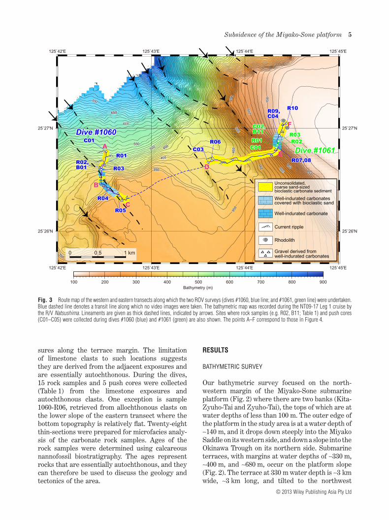
sures along the terrace margin. The limitationof limestone clasts to such locations suggeststhey are derived from the adjacent exposures andare essentially autochthonous. During the dives,15 rock samples and 5 push cores were collected(Table 1) from the limestone exposures andautochthonous clasts. One exception is sample1060-R06, retrieved from allochthonous clasts onthe lower slope of the eastern transect where thebottom topography is relatively flat. Twenty-eightthin-sections were prepared for microfacies analy-sis of the carbonate rock samples. Ages of therock samples were determined using calcareousnannofossil biostratigraphy. The ages representrocks that are essentially autochthonous, and theycan therefore be used to discuss the geology andtectonics of the area.
RESULTS
BATHYMETRIC SURVEY
Our bathymetric survey focused on the north-western margin of the Miyako-Sone submarineplatform (Fig. 2) where there are two banks (Kita-Zyuho-Tai and Zyuho-Tai), the tops of which are atwater depths of less than 100 m. The outer edge ofthe platform in the study area is at a water depth of∼140 m, and it drops down steeply into the MiyakoSaddle on its western side, and down a slope into theOkinawa Trough on its northern side. Submarineterraces, with margins at water depths of ∼330 m,∼400 m, and ∼680 m, occur on the platform slope(Fig. 2). The terrace at 330 m water depth is ∼3 kmwide, ∼3 km long, and tilted to the northwest
100 200 300 400 500 600 700 800 900Bathymetry (m)
0
125˚42'E
125˚42'E
125˚43'E
125˚43'E
125˚44'E
125˚44'E
125˚45'E
125˚45'E
25˚26'N 25˚26'N
25˚27'N 25˚27'N
4
Well-indurated carbonatescovered with bioclastic sand
Well-indurated carbonate
Current ripple
Unconsolidated,coarse sand-sizedbioclastic carbonate sediment
Gravel derived fromwell-indurated carbonates
Rhodolith
Dive #1060Dive #1060Dive #1060
Dive #1061Dive #1061Dive #1061AA
BB
CC
DD
EE
FF
0 0.5 1 km
Fig. 3 Route map of the western and eastern transects along which the two ROV surveys (dives #1060, blue line; and #1061, green line) were undertaken.Blue dashed line denotes a transit line along which no video images were taken. The bathymetric map was recorded during the NT09-17 Leg 1 cruise bythe R/V Natsushima. Lineaments are given as thick dashed lines, indicated by arrows. Sites where rock samples (e.g. R02, B11; Table 1) and push cores(C01–C05) were collected during dives #1060 (blue) and #1061 (green) are also shown. The points A–F correspond to those in Figure 4.
Subsidence of the Miyako-Sone platform 5
© 2013 Wiley Publishing Asia Pty Ltd

(Fig. 4). The terrace at 400 m water depth is ∼1 kmwide, ∼3 km long, and tilted to the northwest, andit is characterized by a ∼800 m-wide horseshoe-shaped depression in the center (Fig. 4). Theterrace at a water depth of 680 m is the narrowest,being ∼500 m wide, and 3 km long, with a tilt to thenorthwest (Fig. 2).
There are many lineaments in the study area(Fig. 3), oriented mainly NW–SE, perpendicularto the axis of the Ryukyu Island Arc. Submarinecanyons are developed on the northwestern slopewith NW–SE orientations, and the heads of thecanyons are at water depths of 270–570 m (Fig. 2).It seems probable, therefore, that the lineamentsconstrained the orientation, formation, and devel-opment of the canyons.
SUBMERSIBLE SURVEYS
Western transect (519–318 m water depth)
Submarine images acquired by the ROV on thelower slope (>400 m water depth) show that thesurface sediments consist mainly of unconsoli-dated, coarse-sand-sized bioclasts. Sand ripples
with wave-lengths of several tens of centimetersare well developed. Larger-scale dunes with wave-lengths of several tens of meters were alsoobserved. The dominant orientation of the dunecrests is NNW–SSE, suggesting currents weremoving in the ENE–WSW direction to and fromthe Miyako Saddle. Well-indurated carbonaterocks are exposed along the terrace edge at 330 mwater depth, and on the upper slopes at depthsranging from 400 to 330 m. The ROV images indi-cate that the carbonate rocks are locally coveredwith a veneer of surface sediments composed ofunconsolidated, coarse-sand-sized bioclasts andsporadically with dense masses of sponges, gorgo-nians, and other unidentified encrusting organ-isms. Cobble- to boulder-sized gravel, derivedfrom the well-indurated carbonate rocks, iscommon within the surface sediments immedi-ately below the exposures of limestone (at waterdepths of 420–380 m). The slope ends in the 330 m-deep terrace, which is covered exclusively withunconsolidated, coarse-sand-sized bioclastic car-bonates. This terrace is found at water depths of350 to 320 m, and is gently inclined towards thenorthwest.
Fig. 4 Schematic cross-sections of the western (points A–C in Fig. 3) and eastern (points D–F in Fig. 3) transects. Sites where rock samples (e.g. R02,B11; Table 1) and push cores (e.g. C01) were collected during dives #1060 (blue) and #1061 (green) are shown. Depositional ages determined bycalcareous nannofossil biostratigraphy are shown. The sites where submarine photographs were taken for Figure 5 are indicated.
6 K. Arai et al.
© 2013 Wiley Publishing Asia Pty Ltd

Eastern transect (400–121 m water depth)
Sediments on the lower slope (>300 m water depth)of the eastern transect consist mainly of unconsoli-dated, coarse-sand-sized bioclastic carbonates.The sediments on the lowest part of the upperslope (water depths of 300–210 m) include cobble-to boulder-sized gravel that is derived from thewell-indurated carbonate rocks. The steep slopeat water depths of 210 to 130 m is composed ofwell-indurated carbonate rocks on which sponges,gorgonians, and other unidentified encrustingorganisms grow sporadically or densely (Fig. 5b).The upper part of the limestone exposure (waterdepths of 170–130 m) is partly covered witha veneer of unconsolidated, coarse-sand-sizedbioclastic carbonates. The slope is truncated by aterrace with an outer margin at a water depth ofapproximately 140 m (the 140 m-deep terrace). Theseafloor on the 140 m-deep terrace is covered exclu-sively with thin unconsolidated, coarse-sand-sized bioclastic carbonates that are underlainby well-indurated carbonate rocks. Rhodoliths(sample 1060-R10) locally cover the seafloor atwater depths of less than ∼120 m (Fig. 5c), andthey are encrusted by nongeniculate corallinealgae and an encrusting foraminifer (Acervulinainhaerence). These rhodoliths are analogous tothose found off the Miyako-jima (Tsuji 1993) andOkinawa-jima islands (Iryu et al. 1995; Matsuda &Iryu 2011), where rhodoliths occur in deep fore-reefto shelf areas at water depths of 50 to 150 m. Themean diameter of the rhodoliths collected in thepresent study is less than 5 cm. A large benthicforaminifer, Cycloclypeus carpenteri, is foundamong the rhodoliths. Submarine images indicatethe common occurrence of ophiuroid echinoderms.
ROCK SAMPLES AND CALCAREOUS NANNOFOSSILS
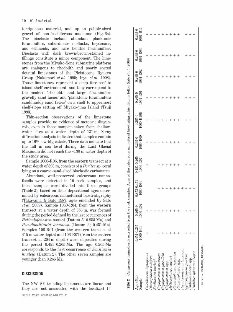
During the two dive surveys along the westernand eastern transects, six and nine rock samples,and one and four push core samples, respectively,were collected (Table 1). The push core sampleswere collected from modern sediment on theseafloor surface, which is composed of unconsoli-dated, coarse-sand-sized bioclastic carbonates.The limestone samples are divisible into fiverock types, all of which are well indurated:rhodolith floatstone, bioclastic packstone, bioclasticwackestone/packstone, bioclastic grainstone, andclayey bioclastic packstone (Fig. 6a–e; Table 1).Bioturbation is common to frequent in all types,and borings are filled with deposits that have awackestone or mudstone fabric (Fig. 6a). SampleTa
ble
1L
ist
ofro
cksa
mpl
esco
llect
eddu
ring
the
RO
Vsu
rvey
s
Div
e#
Sam
ple
no.
Dat
e(d
ay/m
onth
/yea
r)Tr
anse
ctL
atit
ude
Lon
gitu
deW
ater
dept
h(m
)Si
ze(c
m)
Lit
holo
gyof
rock
sam
ple
1060
R01
1/O
ct./2
009
Wes
tern
Tran
sect
25°2
6.64
4'N
125°
42.4
80'E
415
24×
22×
10G
ray
indu
rate
dbi
ocla
stic
pack
ston
eR
0225
°26.
624'
N12
5°42
.470
'E40
322
×16
×12
Gra
yin
dura
ted
bioc
last
icpa
ckst
one
R03
25°2
6.60
0'N
125°
42.4
66'E
388
23×
13×
10B
row
nish
gray
indu
rate
dcl
ayey
bioc
last
icpa
ckst
one
wit
hco
mm
onpe
bble
-siz
edsu
brou
nded
grav
elof
non-
foss
ilife
rous
mud
ston
eR
0425
°26.
412'
N12
5°42
.538
'E35
327
×20
×10
Bro
wni
shgr
ayin
dura
ted
bioc
last
icw
acke
ston
e/pa
ckst
one
R05
25°2
6.34
4'N
125°
42.6
55'E
318
16×
10×
4B
row
nish
gray
indu
rate
dbi
ocla
stic
pack
ston
ew
ith
som
epe
bble
-siz
edsu
brou
nded
grav
elof
non-
foss
ilife
rous
mud
ston
eB
0125
°26.
624'
N12
5°42
.470
'E40
39
×7
×7
Gra
yin
dura
ted
rhod
olit
hflo
atst
one
R06
Eas
tern
tran
sect
25°2
6.67
4'N
125°
43.6
48'E
393
9×
5×
2C
oral
frag
men
t(P
orit
essp
.)R
0725
°26.
819'
N12
5°44
.346
'E20
49
×8
×5
Gra
yin
dura
ted
bioc
alst
icw
acke
ston
e/pa
ckst
one
R08
25°2
6.81
9'N
125°
44.3
46'E
204
8×
5×
3G
ray
indu
rate
drh
odol
ith
float
ston
eR
0925
°26.
928'
N12
5°44
.371
'E13
124
×18
×9
Gra
yin
dura
ted
bioc
last
icgr
ains
tone
R10
25°2
7.04
8'N
125°
44.4
44'E
121
8pi
eces
(peb
ble-
size
d)R
hodo
lithe
s
1061
R01
2/O
ct./2
009
25°2
6.83
7'N
125°
44.3
45'E
187
12×
11×
4Ye
llow
ish
gray
indu
rate
drh
odol
ith
float
ston
eR
0225
°26.
841'
N12
5°44
.349
'E18
215
×11
×6
Gra
yin
dura
ted
rhod
olit
hflo
atst
one
R03
25°2
6.87
5'N
125°
44.3
61'E
150
10×
9×
8G
ray
indu
rate
drh
odol
ith
float
ston
eB
1125
°26.
841'
N12
5°44
.349
'E18
220
×20
×12
Bro
wni
shgr
ayin
dura
ted
rhod
olit
hflo
atst
one
Subsidence of the Miyako-Sone platform 7
© 2013 Wiley Publishing Asia Pty Ltd

1060-B01 from the western transect, and samples1060-R8, 1061-R01, 1061-R02, 1061-R03, and1061-B11 from the eastern transect are repre-sented by rhodolith floatstones (Fig. 6b). Theexternal shapes, internal structures, and organ-isms that make up the rhodoliths are comparableto those of modern rhodoliths reported from deepfore-reef to shelf areas in the Central and SouthRyukyus (Iryu et al. 1995; Matsuda & Iryu 2011).Most of the rhodoliths are embedded in a matrixof bioclastic packstone that is rich in sand-sized bioclasts derived from various carbonateskeletons/shells (most of which are too small toidentify) and planktonic foraminifers. The matrixlocally shows a wackestone fabric. The exceptionis sample 1061-R11, which has a bioclasticpackstone matrix with abundant bryozoans, largebenthic and planktonic foraminifers, and sub-ordinate Halimeda. The bioclastic packstones(samples 1060-R1, 1060-R2, and 1060-R5 fromthe western transect) are rich in planktonicforaminifers (Fig. 6c). Bryozoans, mollusks, andechinoids are common to abundant. Benthicforaminifers (including large benthic foramini-fers) and coralline algae are rare. Theintragranular porosity of the bioclastic materialmay be filled with micrite that is stained brownto dark brown. Granule- to pebble-sized (<1 cmacross), bioclast-bearing intraclasts that arestained brown are found in all three samples.The bioclastic wackestones/packstones (samples1060-R4 and 1060-R7 from the western andeastern transects, respectively) are dominated bysand-sized bioclasts and planktonic foraminifers(Fig. 6d). Bryozoans, mollusks, and echinoids arecommon, and benthic foraminifers (includinglarge benthic foraminifers) constitute only aminor component. Bioclasts occur with brown todark brown micrite infillings, and brown-stainedintraclasts, but they are less common than in thebioclastic packstones. The bioclastic grainstone(sample 1060-R9, from the eastern transect)is composed mainly of bryozoans, planktonicand large benthic foraminifers (includingAmphistegina, Baculogupsina, Cycloclypeus,and Operculina), mollusks, and coralline algae(Fig. 6e). Echinoids and Halimeda are rare.Intraclasts and fragments of rhodoliths constituteminor components. The intergranular porosity islocally filled with micrite that displays a fabricof packstone. A few dark brown/brown-stainedbioclasts or intraclasts were found. The clayeybioclastic packstone (sample 1060-R3 from thewestern transect) is characterized by clay-sized
Fig. 5 Photographs taken during the ROV surveys. (a) Larger-scaledunes consisting of unconsolidated, coarse-sand-sized, bioclasticcarbonates (water depth of 393 m along the eastern transect). (b)Well-indurated carbonate rocks inhabited sporadically by sponges, gor-gonians, and other unidentified encrusting organisms (water depth of189 m along the eastern transect). (c) Seafloor covered with rhodoliths(water depth of ca. 120 m along the eastern transect). Arrows indicate alarge benthic foraminifer (Cycloclypeus carpenteri). The sites where thephotographs were taken are shown on Figure 4.
8 K. Arai et al.
© 2013 Wiley Publishing Asia Pty Ltd

Fig. 6 Thin-section microphotographs. bf, benthic foraminifer; br, bryzoan; e, echinoid; lf, large benthic foraminifer; m, mollusk; pf, planktonicforaminifer; pt, pteropod; arrowhead, bioclasts with intragranular porosity filled with micrite stained brown to dark brown. (a) Clayey bioclastic packstone(P; sample 1060-R03; water depth of 388 m along the western transect). Note the extensive bioerosion; the borings are filled with sediments showing afabric of wackestone with planktonic foraminifers (W), and the packstone contains fragments of non-fossiliferous mudstone (M). Arrowheads indicatebioclasts with dark brown/brown-stained infillings. (b) Rhodolith floatstone with a bioclastic packstone ‘matrix’ (sample 1060-B11; water depth of 182 malong the eastern transect). Note the rhodolith with an envelope composed of nongeniculate coralline algae (ca) and an encrusting foraminifer Acervulinainhaerens (ai). (c) Bioclastic packstone (sample 1060-R02; water depth of 403 m along the western transect). Note that the bioclast-bearing intraclasts arestained brown (arrows). (d) Bioclastic wackestone/packstone (sample 1060-R04; water depth of 353 m along the western transect). Sand-sized bioclastsderived from various carbonate skeletons/shells dominate. Note a boring filled with micrite (arrowhead). (e) Bioclastic grainstone (sample 1060-R09; waterdepth of 131 m along the western transect). Note the fragment of a rhodolith envelope (arrowhead).
Subsidence of the Miyako-Sone platform 9
© 2013 Wiley Publishing Asia Pty Ltd
terrigenous material, and up to pebble-sizedgravel of non-fossiliferous mudstone (Fig. 6a).The bioclasts include abundant planktonicforaminifers, subordinate mollusks, bryozoans,and echinoids, and rare benthic foraminifers.Bioclasts with dark brown/brown-stained in-fillings constitute a minor component. The lime-stones from the Miyako-Sone submarine platformare analogous to rhodolith and poorly sorteddetrital limestones of the Pleistocene RyukyuGroup (Nakamori et al. 1995; Iryu et al. 1998).Those limestones represent a deep fore-reef toisland shelf environment, and they correspond tothe modern ‘rhodolith and large foraminifersgravelly sand facies’ and ‘planktonic foraminiferasand/muddy sand facies’ on a shelf to uppermostshelf-slope setting off Miyako-jima Island (Tsuji1993).
Thin-section observations of the limestonesamples provide no evidence of meteoric diagen-esis, even in those samples taken from shallow-water sites at a water depth of 131 m. X-raydiffraction analysis indicates that samples containup to 16% low-Mg calcite. These data indicate thatthe fall in sea level during the Last GlacialMaximum did not reach the ∼130 m water depth ofthe study area.
Sample 1060-R06, from the eastern transect at awater depth of 393 m, consists of a Porites sp. corallying on a coarse-sand-sized bioclastic carbonates.
Abundant, well-preserved calcareous nanno-fossils were detected in 10 rock samples, andthese samples were divided into three groups(Table 2), based on their depositional ages deter-mined by calcareous nannofosssil biostratigraphy(Takayama & Sato 1987; ages emended by Satoet al. 2009). Sample 1060-R04, from the westerntransect at a water depth of 353 m, was formedduring the period defined by the last occurrences ofReticulofenestra asanoi (Datum 5; 0.853 Ma) andPseudomiliania lacunosa (Datum 3; 0.451 Ma).Samples 106-R01 (from the western transect at415 m water depth) and 106-R07 (from the easterntransect at 204 m depth) were deposited duringthe period 0.451–0.265 Ma. The age 0.265 Macorresponds to the first occurrence of Emilianiahuxleyi (Datum 2). The other seven samples areyounger than 0.265 Ma.
DISCUSSION
The NW–SE trending lineaments are linear andthey are not associated with the localized U- Ta
ble
2C
alca
reou
sna
nnof
ossi
lsex
trac
ted
from
the
rock
sam
ples
.Age
sof
the
calc
areo
usna
nnof
ossi
lbio
stra
tigr
aphi
cda
tum
sfo
llow
Sato
etal
.(20
09)
Age
(Ma)
0.45
1-0.
265
0.26
5-0
0.85
3-0.
451
0.45
1-0.
265
0.26
5-0
0.26
5-0
0.26
5-0
0.26
5-0
0.26
5-0
0.26
5-0
Sam
ple
1060
-R01
1060
-R02
1060
-R04
1060
-R07
1060
-R09
1060
-R10
B10
61-R
0110
61-R
0210
61-R
0310
61-B
11
Cal
cidi
sceu
sle
ptop
orus
++
++
++
++
+D
isco
spha
era
tubi
fera
++
++
++
+E
mil
iani
cahu
xley
i+
++
++
++
Gep
hyro
caps
aoc
eani
ca+
++
++
++
++
+G
ephy
roca
psa
para
llela
++
++
++
++
++
Gep
hyro
caps
asp
p.+
++
++
++
++
+H
elic
osph
aera
cart
eri
++
++
++
++
++
Pho
ntos
phae
raja
poni
ca+
++
++
++
++
+P
hont
osph
aera
spp.
++
++
++
++
++
Pse
udoe
mil
iani
ala
cuno
sa+
Syra
cosp
haer
apu
lchr
a+
++
++
++
++
+U
mbe
llosp
haer
asp
p.+
++
++
++
++
+U
mbi
lico
spha
era
sibo
gae
++
++
++
++
++
Bar
ren
=10
60-R
03,1
060-
R05
.
10 K. Arai et al.
© 2013 Wiley Publishing Asia Pty Ltd
shaped depressions that characterize landslides.Therefore, it is highly likely that these lineamentsrepresent faults, which means that samples col-lected near the lineaments are essentially autoch-thonous, and not derived from debris or rockmasses that slid into place from another location.Faults with NW–SE trends are known in theKerama Gap and its environs (Matsumoto &Kimura 1991; Matsumoto et al. 1996).
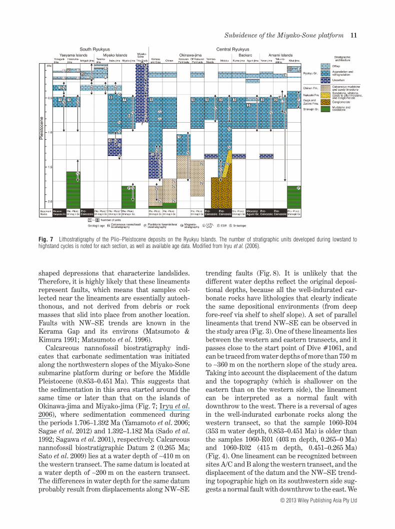
Calcareous nannofossil biostratigraphy indi-cates that carbonate sedimentation was initiatedalong the northwestern slopes of the Miyako-Sonesubmarine platform during or before the MiddlePleistocene (0.853–0.451 Ma). This suggests thatthe sedimentation in this area started around thesame time or later than that on the islands ofOkinawa-jima and Miyako-jima (Fig. 7; Iryu et al.2006), where sedimentation commenced duringthe periods 1.706–1.392 Ma (Yamamoto et al. 2006;Sagae et al. 2012) and 1.392–1.182 Ma (Sado et al.1992; Sagawa et al. 2001), respectively. Calcareousnannofossil biostratigraphic Datum 2 (0.265 Ma;Sato et al. 2009) lies at a water depth of ∼410 m onthe western transect. The same datum is located ata water depth of ∼200 m on the eastern transect.The differences in water depth for the same datumprobably result from displacements along NW–SE
trending faults (Fig. 8). It is unlikely that thedifferent water depths reflect the original deposi-tional depths, because all the well-indurated car-bonate rocks have lithologies that clearly indicatethe same depositional environments (from deepfore-reef via shelf to shelf slope). A set of parallellineaments that trend NW–SE can be observed inthe study area (Fig. 3). One of these lineaments liesbetween the western and eastern transects, and itpasses close to the start point of Dive #1061, andcan be traced from water depths of more than 750 mto ∼360 m on the northern slope of the study area.Taking into account the displacement of the datumand the topography (which is shallower on theeastern than on the western side), the lineamentcan be interpreted as a normal fault withdownthrow to the west. There is a reversal of agesin the well-indurated carbonate rocks along thewestern transect, so that the sample 1060-R04(353 m water depth, 0.853–0.451 Ma) is older thanthe samples 1060-R01 (403 m depth, 0.265–0 Ma)and 1060-R02 (415 m depth, 0.451–0.265 Ma)(Fig. 4). One lineament can be recognized betweensites A/C and B along the western transect, and thedisplacement of the datum and the NW–SE trend-ing topographic high on its southwestern side sug-gests a normal fault with downthrow to the east. We
Fig. 7 Lithostratigraphy of the Plio–Pleistocene deposits on the Ryukyu Islands. The number of stratigraphic units developed during lowstand tohighstand cycles is noted for each section, as well as available age data. Modified from Iryu et al. (2006).
Subsidence of the Miyako-Sone platform 11
© 2013 Wiley Publishing Asia Pty Ltd

do not deny the other possibility that younger car-bonates (<0.451 Ma) unconformably overlie theolder ones (0.853–0.451 Ma), and if that is the case,the unconformity lies between lithostratigraphicunits 3 and 4 (Sagae et al. 2012) within the NahaFormation (i.e. equates to the unconformitybetween the Yontan Limestone and the Naha For-mation, as described by MacNeil 1960).
Siliciclastic deposits corresponding to the upperMiocene–lower Pleistocene Shimajiri Group, whichis exposed on Okinawa-jima and Miyako-jimaislands, were not observed by us, but previousworkers reported rocks of this group around thestudy area (Aiba & Sekiya 1979; Tsuburaya & Sato1985; Kimura et al. 1992; Obata & Tsuji 1992). Parket al. (1998) reported widespread upper Miocene–lower Pleistocene pre-rift deposits of the ShimajiriGroup in an area extending from the continentalshelf of the East China Sea to the forearc regionsof the Ryukyu Island Arc. On-land and submarinedrilling on and near Irabu-jima Island by the TRC/JNOC (Technological Research Center of theJapan National Oil Corporation; currently knownas the Technology and Research Center of theJapan Oil, Gas and Metals National Corporation)penetrated Holocene and Pleistocene reef/off-reef successions, and reached the underlyingPliocene Shimajiri Group at water depths of ∼100 m(Sagawa et al. 2001). Therefore, it is likely that thesiliciclastic deposits of the Shimajiri Group occurimmediately below a cover of modern sediments orPleistocene well-indurated carbonate rocks.
It is noteworthy that as one moves westwards,coeval well-indurated carbonate rocks are foundat progressively lower levels (Fig. 8), and this isthe result of displacements on normal faults with
downthrow to the west. The westward lowering ofthe uppermost limestone suggests that the fault-ing continued after 0.265 Ma.
These various pieces of geological evidencesuggest that the Miyako-Sone submarine platformand its environs has subsided by several hundredmeters, possibly in association with faults that runperpendicular to the axis of the Ryukyu Island Arc.Because calcareous nannofossil biostratigraphicDatum (0.265 Ma) is located at water depths of∼200 m and ∼400 m on the eastern and westerntransects, respectively, a subsidence rate is roughlyestimated at ∼0.75 m/ky, if we assume constant dis-placement for the last 0.265 Myr. The fault withsuch a rate is placed in ‘Activity Rank B’ faultsdefined by Matsuda (1975). The subsidence of theMiyako-Sone submarine platform and its environsis supported by the fact that the top of the ShimajiriGroup was found 520 m below sea level in the petro-leum exploration well ‘MITI-Miyako-jima Oki’when it penetrated the forearc slope ∼15 km eastof Miyako-jima Island and 50 km south of thepresent study area (Fig. 2; Tsuburaya & Sato 1985).Whereas, the occurrence of younger (<0.4 Ma)limestones on some islands of the Central andSouth Ryukyus (Fig. 7), which offlap the main bodyof the reef-complex deposits (Ryukyu Group)forming a stratigraphic architecture of aggradationand retrogradation, implies a rapid shift in tectonicmovement: subsidence ceased after deposition ofthe main body and the islands began to uplift at0.4 Ma or later (Sagawa et al. 2001; Iryu et al. 2006).The uplift rate of southern Okinwa-jima Island wasestimated at ∼0.4 m/ky for the past 0.125–0.2 my(Nakamori et al. 1999). Although little is knownabout the subsidence rate of the seafloor around
dept
h (m
)
-100
-200
-300
-400
-500
-600
-700
-800
-900
Outcrop of well indurated carbonate rocks
0.451-0.853Ma
modern sedimentseafloor covered with rhodoliths
?
?
Datum 2 (0.265Ma)
Datum 2 (0.265Ma) modern sediment
modern sediment
mod
ern
sedi
men
t
mod
ern
sedi
men
t
ca. 1 km
Fig. 8 Topographic cross-section(east–west transect) of the western slopeof the Miyako-Sone platform, and sche-matic images of the distribution ofmodern sediments that consist of uncon-solidated, coarse-sand-sized bioclasticcarbonates that cover the well-induratedcarbonate rocks.
12 K. Arai et al.
© 2013 Wiley Publishing Asia Pty Ltd

islands of the Ryukyus, this study shows that therate is magnitudinally similar to the uplift rate ofislands of the Ryukyus.
Our data suggest that since the Middle Pleisto-cene the northwestern margin of the Miyako-Sonesubmarine platform has always been in a marineenvironment, and has not been subject to episodicsubaerial exposure or associated meteoric diagen-esis. However, the molecular biological data indi-cate a land area between Okinawa-jima andMiyako-jima islands existed until the Late Pleisto-cene (e.g. Ota 1998). This land area seems to haveenabled animals characteristic of the CentralRyukyus to migrate into the latter island. As theplatform is shallowest at Zyuho-Tai (Fig. 2) locatedto the east of the study area, it is likely that the bankand its environs emerged to form the land area.Therefore, more detailed studies, including seismicprofiling surveys, need to be conducted onNishi-Daikyu-Sone, Higashi-Daikyu-Sone, and theKerama Gap, in order to resolve this issue.
SUMMARY
Our study involved bathymetric mapping andROV observations of the northwestern slopesof the Miyako-Sone submarine platform, east ofMiyako-jima Island. The results of the survey aresummarized as follows.1. The bathymetric mapping indicates terraces at
water depths of about 140 m, 330 m, 400 m, and680 m. Several NW–SE trending lineaments,probably representing faults, run perpendicu-lar to the axis of the Ryukyu Island Arc on theslopes around the platform.
2. The ROV surveys were conducted along twotransects that extended from the slope to theshallowest part of the platform, from waterdepths of 519 m to 121 m. The surveys revealedthat well-indurated carbonate rocks crop outalong terrace margins and on the upper slopes,and that the lower slopes are covered withmodern sediments consisting of unconsolidated,coarse-sand-sized bioclastic carbonates.
3. Calcareous nannofossils, extracted from thewell-indurated carbonate rocks, indicate aMiddle to Late Pleistocene age, and these car-bonates can therefore be correlated with theQuaternary Ryukyu Group that formed in coralreefs and associated fore-reefs. Coeval well-indurated carbonate rocks are found at pro-gressively lower water depths, when traced
westwards (Fig. 8), and this is a result of dis-placements on normal faults with downthrow tothe west.
4. Subsidence of the Miyako-Sone submarine plat-form resulted from large vertical downthrows onthe western sides of NW–SE trending normalfaults. The timing of initial subsidence cannot beconstrained, but the westwards lowering of theyoungest limestone suggests that subsidencelasted until after 0.265 Ma.
ACKNOWLEDGEMENTS
This study was conducted as part of theJAMSTEC ‘Deep-sea Research Project’. We aregrateful to Captain E. Ukekura and his crew onthe R/V Natsushima, as well as the Chief Opera-tor Y. Ohno and his team for their professionaloperation of the ROV Hyper-Dolphin 3K. We alsowish to thank S. Matsunaga (University of Tokyo),who was a Chief Scientist on the NT09-17 Leg 1cruise. The ROV surveys were financially sup-ported, in part, by a Grant-in-Aid for ScientificResearch from the Japan Society for the Promo-tion of Science (23540540). We are deeply indebtedto Makoto Ito (Chiba University) as Editor-in-Chief, Akihisa Kitamura (Shizuoka University) asAssociate Editor and anonymous reviewers forgiving us valuable advice and suggestions toimprove the manuscript remarkably.
REFERENCES
AIBA S. & SEKIYA E. 1979. Distribution and character-istics of the Neogene sedimentary basins around theNansei-syoto (Ryukyu Islands). Journal of JapaneseAssociation for Petroleum Technology 44, 229–340(in Japanese with English abstract).
AMANTE C. & EAKINS B. W. 2009. ETOPO1 1 Arc-Minute Global Relief Model: Procedures, DataSources and Analysis. NOAA Technical Memoran-dum NESDIS NGDC-24, National Oceanic andAtmospheric Administration (NOAA), Washington,DC.
HAMAMOTO F., SAKURAI M. & NAGANO M. 1979. Subma-rine geology off the Miyako and Yaeyama Islands.Report of Hydrographic Researches 14, 1–38 (inJapanese with English abstract).
IRYU Y., MATSUDA H., MACHIYAMA H., PILLER W. E.,QUINN T. M. & MUTTI M. 2006. An introductoryperspective on the COREF project. Island Arc 15,393–406.
IRYU Y., NAKAMORI T., MATSUDA S. & ABE O. 1995.Distribution of marine organisms and its geological
Subsidence of the Miyako-Sone platform 13
© 2013 Wiley Publishing Asia Pty Ltd

significance in the modern reef complex of theRyukyu Island. Sedimentary Geology 99, 243–58.
IRYU Y., NAKAMORI T. & YAMADA T. 1998. Pleistocenereef complex deposits in the Central Ryukyus, south-western Japan. In Camoin G. F. and Davies P. J.(eds.) Reefs and Carbonate Platforms in the Pacificand Indian Oceans, Special Publication of the Inter-national Association of Sedimentologists, no. 25,pp. 197–213, Blackwell Science, Oxford.
KATO S., KATSURA T. & HIRANO K. 1982. Submarinegeology off Okinawa Island. Report of HydrographicResearchs 17, 31–70 (in Japanese with Englishabstract).
KIMURA M. 1985. Back-arc rifting in the OkinawaTrough. Marine and Petroleum Geology 2, 222–40.
KIMURA M. 1996. Quaternary paleogeography of theRyukyu Arc. Journal of Geography 105, 259–85.
KIMURA M., MATSUMOTO T., NAKAMURA T. et al. 1992.Diving survey of the Kerama Saddle in theeastern margin of the Okinawa Trough: Probablesunken land-bridge during the last glacial age. Pro-ceeding of JAMSTEC Symposium on Deep SeaResearch 8, 107–33 (in Japanese with Englishabstract).
KIMURA M., MONMA H., MATSUMOTO T. et al. 1991.Tectonic movement at the Kerama Saddle in theEastern Margin of the Okinawa Trough. JAMSTECDeepsea Research 7, 131–45 (in Japanese withEnglish abstract).
KIMURA M., ONO T., MATSUOKA H., OTSUKA H.,NAKAMURA T. & MITSUZAWA K. 1994. Tectonics in theEastern Margin of the Okinawa Trough – study offormation mechanism of a backarc basin. JAMSTECDeepsea Research 10, 299–321 (in Japanese withEnglish abstract).
KIZAKI K. 1978. Tectonics of the Ryukyu Island Arc.Journal of Physics of the Earth 26 (Suppl.), S301–S307.
KIZAKI K. 1985. Geology of the Ryukyu Arc. OkinawaTimes Co. Ltd., Okinawa.
KIZAKI K. & OSHIRO I. 1977. Paleogeography of theRyukyu Islands. Marine Sciences/Monthly 9, 542–9(in Japanese with English abstract).
KOBA M. 1992. Influx of the Kuroshio Current into theOkinawa Trough and inauguration of Quaternarycoral-reef building in the Ryukyu Island Arc, Japan.The Quaternary Research (Daiyonki Kenkyu) 31,359–73 (in Japanese with English abstract).
KONISHI K. 1965. Geotectonic framework of the RyukyuIslands (Nansei-shoto). Paleogeography of theRyukyu Islands. Journal of the Geological Societyof Japan 71, 438–57 (in Japanese with Englishabstract).
KURODA N. 1931. Evaluation of the Watase’s line fromthe viewpoint of vertebrate distribution. ZoologicalMagazine 43, 172–5 (in Japanese; English transla-tion from the original written in Japanese).
MACNEIL F. S. 1960. The Tertiary and QuaternaryGastropoda of Okinawa. U. S. Geological Survey,Professional Paper 339, 1–148.
MATSUDA S. & IRYU Y. 2011. Rhodoliths from deepfore-reef to shelf areas around Okinawa-jima,Ryukyu Islands, Japan. Marine Geology 282, 215–30.
MATSUDA T. 1975. Magnitude and recurrence intervalof earthquakes from fault. ZISHIN Journal of theSeismological Society of Japan 28, 269–83 (in Japa-nese with English abstract).
MATSUMOTO T. & KIMURA M. 1991. Detailed bathymet-ric survey of recent crustal deformation in theRyukyu arc – result of Leg1 of DK90-8-NSS Cruiseby the R/V ‘KAIYO’. JAMSTEC Deepsea Research26, 1–10 (in Japanese with English abstract).
MATSUMOTO T., KIMURA M., NAKAMURA A. & AOKI M.1996. Detailed bathymetric features of Tokara andKerama Gaps in the Ryukyu Arc. Journal of Geog-raphy 105, 286–96 (in Japanese with Englishabstract).
NAKAMORI T., IRYU Y. & MATSUDA S. 1999. 8th interna-tional symposium on fossil cnidaria and porifera,field trip A1, recent and pleistocene coral reefs in theRyukyu Islands, Japan. Sasaki Printing & Publish-ing Co. Ltd., Sendai.
NAKAMORI T., IRYU Y. & YAMADA T. 1995. Developmentof coral reefs of the Ryukyu Islands (southwestJapan, East China Sea) during Pleistocene sea-levelchange. Sedimentary Geology 99, 215–31.
OBATA M. & TSUJI Y. 1992. Quaternary geohistoryinferred by seismic stratigraphy of a carbonate prov-ince in an active margin, off Miyako Island, southRyukyus, Japan. Carbonates and Evaporites 7, 150–65.
OTA H. 1998. Geographic patterns of endemism and spe-ciation in amphibians and reptiles of the RyukyuArchipelago, Japan, with special reference to theirpaleogeographical implications. Researches on Popu-lation Ecology 40, 189–204.
OTA H. & TAKAHASHI A. 2008. Chapter 2. Mysteriousfauna in Miyako-jima Islands. In Society for Natureand Culture in Miyako-jima Islands (ed.) Nature andCulture in Miyako-Jima Islands No. 2, Mysteri-ously Shining Eight Islands, pp. 24–43, Borderink,Naha (in Japanese; English translation from theoriginal written in Japanese).
PARK J. O., TOKUYAMA H., SHINOHARA M., SUYEHIRO K.& TAIRA A. 1998. Seismic record of tectonic evolutionand backarc rifting in the southern Ryukyu islandarc system. Tectonophysics 294, 21–42.
SADO K., KAMEO K., KONISHI K., YUKI T. & TSUJI Y.1992. A new age assignment of Riukiu Limestone(Pleistocene) by calcareous nannofossils from theborehole cores at Irabu Island, South Ryukyus,Japan. Journal of Geography 102, 127–32.
SAGAE K., HUMBLET M., ODAWARA K. et al. 2012.Stratigraphy of the Ryukyu Group in southern
14 K. Arai et al.
© 2013 Wiley Publishing Asia Pty Ltd
Okinawa-jima, Ryukyu Islands, Japan. Journal ofthe Geological Society of Japan 118, 117–36.
SAGAWA N., NAKAMORI T. & IRYU Y. 2001. Pleisto-cene reef development in the southwest RyukyuIslands, Japan. Palaeogeography PalaeoclimatlogyPalaeoecology 175, 303–23.
SATO T., CHIYONOBU S. & HODELL D. A. 2009. Quater-nary calcareous nannofossil datums and bio-chronology in the North Atlantic Ocean, IODP SiteU1308. Proceedings of the Integrated Ocean DrillingProgram, 303/306, doi:10.2204/iodp.proc.303306.210.2009.
SHINJO R. 1999. Geochemistry of high Mg andesitesand the tectonic evolution of the Okinawa Trough–Ryukyu arc system. Chemical Geology 157, 69–88.
SIBUET J. C., DEFFONTAINES B., HSU S. K., THAREAU
N., LEFORMAL J. P., LIU C. S. & ACT PARTY 1998.Okinawa Trough backarc basin: Early tectonicand magnetic evolution. Journal of GeophysicalResearch 103 (B12), 30245–67.
TAKAYAMA T. & SATO T. 1987. Cocolith biostratigraphyof the North Atlantic Ocean, Deep Sea DrillingProject Leg 94. In Ruddiman W. F., Kidd R. B.,Thomas E. et al. (eds.) Initial Reports of the Deep
Sea Drilling Project, 94, pp. 651–702, U. S. Govern-ment Printing Office, Washington, DC.
TSUBURAYA H. & SATO T. 1985. Petroleum explorationwell Miyakojima–Oki. Journal of Japanese Associa-tion for Petroleum Technology 50, 25–53 (inJapanese).
TSUJI Y. 1993. Tide influenced high energy environ-ments and rhodolith-associated carbonate depositionon the outer shelf and slope on Quaternary carbon-ates in the Ryukyu Island Arc, Southern Japan.Marine Geology 113, 255–71.
UJIIÉ H. 1980. Significance of ‘500 m Deep Island Shelf ’surrounding the southern Ryukyu Island Arc forits Quaternary geological history. The QuaternaryResearch (Daiyonki Kenkyu) 18, 209–19 (in Japa-nese with English abstract).
UJIIÉ H. 1983. Submarine geology west off OkinawaIsland in relation to the Ryukyu Arc development.Memoirs of the Geological Society of Japan 22,131–40 (in Japanese with English abstract).
YAMAMOTO K., IRYU Y., SATO T., CHIYONOBU S., SAGAE
K. & ABE E. 2006. Responses of coral reefs toincreased amplitude of sea-level changes at the Mid-Pleistocene Climate Transition. Palaeogeography,Palaeoclimatology, Palaeoecology 241, 160–75.
Subsidence of the Miyako-Sone platform 15
© 2013 Wiley Publishing Asia Pty Ltd