Particle fluxes dynamics in Blanes submarine canyon (Northwestern Mediterranean
13
Particle fluxes dynamics in Blanes submarine canyon (Northwestern Mediterranean) Diana Zúñiga a, * ,2 , M. Mar Flexas b,2 , Anna Sanchez-Vidal a , Johan Coenjaerts c , Antoni Calafat a , Gabriel Jordà b,d , Jordi García-Orellana e,1 , Joan Puigdefàbregas d , Miquel Canals a , Manuel Espino d , Francesc Sardà f , Joan B. Company f a GRC Geociències Marines, Dept. d’Estratigrafia, Paleontologia i Geociències Marines, Universitat de Barcelona, E-08028 Barcelona, Spain b Institut Mediterrani d’Estudis Avançats (IMEDEA), UIB-CSIC, E-07190 Mallorca, Spain c Centre d’Estudis Avaçats de Blanes (CEAB), CSIC, E-17300 Barcelona, Spain d Laboratori d’Enginyeria Maritima (LIM), UPC, E-08034 Barcelona, Spain e Departament de Física, Institut de Ciència i Tecnologia Ambientals (ICTA), Universitat Autònoma de Barcelona, E-08193 Bellaterra, Spain f Institut de Ciències del Mar (ICM), CSIC, E-08003 Barcelona, Spain article info Article history: Received 3 February 2009 Received in revised form 19 June 2009 Accepted 8 July 2009 Available online 12 July 2009 abstract Within the framework of the multidisciplinary RECS project and with the aim of describing the particle flux transfer from the continental shelf to the deep basin, an array of five mooring lines equipped with a total of five pairs of PPS3/3 sequential-sampling sediment traps and RCM-7/8 current meters were deployed 30 m above the bottom from March 2003 to March 2004 inside and outside the Blanes Canyon. One mooring line was located in the upper canyon at 600 m depth, one in the canyon axis at 1700 m depth and other two close to the canyon walls at 900 m depth. A fifth mooring line was deployed in the continental open slope at 1500 m water depth. The highest near-bottom downward particle flux (14.50 g m À2 d À1 ) was recorded at the trap located in the upper canyon (M1), where continental inputs associated with the presence of the Tordera River are most relevant. On the other hand, the downward fluxes (4.35 g m À2 d À1 ) in the canyon axis (M2) were of the same order as those found in the western flank (M3) of the canyon. Both values were clearly higher than the value (1.95 g m À2 d À1 ) recorded at the eastern canyon wall (M4). The open slope (M5) mass flux (5.42 mg m À2 d À1 ) recorded by the sediment trap located outside the canyon system was three orders of magnitude lower than the other values registered by the inner canyon stations. The relevance of our data is that it explains how the transport pathway in the canyon occurs through its western flank, where a more active and persistent current toward the open ocean was recorded over the entire year of the experiment. Off-shelf sediment transport along the canyon axis showed clear differences during the period of the study, with some important events leading to strong intensifications of the current coupled with large trans- port of particle fluxes to the deepest parts of the canyon. Such events are primarily related to increases in river discharge and the occurrence of strong storms and cascading events during the winter. In summary, in this study it is shown that the dynamics of the water masses and the currents in the study area convert the sharp western flank of the Blanes Canyon in a more active region that favors erosion pro- cesses than the eastern flank, which has a smoother topography and where the absence of erosional condi- tions yields to steadier sedimentary processes. Ó 2009 Elsevier Ltd. All rights reserved. 1. Introduction The increasing interest of the research community in submarine canyons owes to the fact that these geological features are hot spots of biodiversity and biological productivity (Gili et al., 1999; Granata et al., 2004). Local modifications of the incoming flow by these abrupt discontinuities induce different shelf-slope exchanges (Alvarez et al., 1996) that in most cases convert the submarine can- yons in preferential conduits for matter transfer from the continen- tal shelf toward the deep basin (Heussner et al., 1999; Hung et al., 2003; Liu and Lin, 2004; Palanques et al., 2005; Turchetto et al., 2007). All of these specific conditions contribute to creation of a special habitat for the recruitment and maintenance of stocks of living resources (Sardà and Cartes, 1993; Cartes et al., 1994). Several studies of particle fluxes in the western Mediterranean margin have revealed that the quantities and compositions of the fluxes are strongly related to cross-slope exchange mechanisms, with particle sources dominated by intermittent fluvial discharges 0079-6611/$ - see front matter Ó 2009 Elsevier Ltd. All rights reserved. doi:10.1016/j.pocean.2009.07.002 * Corresponding author. Actual address: Instituto de Investigacións Mariñas (IIM), CSIC, E-36208 Vigo, Spain. Tel.: +34 986231930; fax: +34 986292762. E-mail address: [email protected] (D. Zúñiga). 1 School of Marine and Atmospheric Sciences, State University of New York, Stony Brook, NY 11794-5000, USA. 2 These two authors contributed equally to this work. Progress in Oceanography 82 (2009) 239–251 Contents lists available at ScienceDirect Progress in Oceanography journal homepage: www.elsevier.com/locate/pocean
-
Upload
independent -
Category
Documents
-
view
0 -
download
0
Transcript of Particle fluxes dynamics in Blanes submarine canyon (Northwestern Mediterranean

Progress in Oceanography 82 (2009) 239–251
Contents lists available at ScienceDirect
Progress in Oceanography
journal homepage: www.elsevier .com/ locate /pocean
Particle fluxes dynamics in Blanes submarine canyon (Northwestern Mediterranean)
Diana Zúñiga a,*,2, M. Mar Flexas b,2, Anna Sanchez-Vidal a, Johan Coenjaerts c, Antoni Calafat a,Gabriel Jordà b,d, Jordi García-Orellana e,1, Joan Puigdefàbregas d, Miquel Canals a, Manuel Espino d,Francesc Sardà f, Joan B. Company f
a GRC Geociències Marines, Dept. d’Estratigrafia, Paleontologia i Geociències Marines, Universitat de Barcelona, E-08028 Barcelona, Spainb Institut Mediterrani d’Estudis Avançats (IMEDEA), UIB-CSIC, E-07190 Mallorca, Spainc Centre d’Estudis Avaçats de Blanes (CEAB), CSIC, E-17300 Barcelona, Spaind Laboratori d’Enginyeria Maritima (LIM), UPC, E-08034 Barcelona, Spaine Departament de Física, Institut de Ciència i Tecnologia Ambientals (ICTA), Universitat Autònoma de Barcelona, E-08193 Bellaterra, Spainf Institut de Ciències del Mar (ICM), CSIC, E-08003 Barcelona, Spain
a r t i c l e i n f o
Article history:Received 3 February 2009Received in revised form 19 June 2009Accepted 8 July 2009Available online 12 July 2009
0079-6611/$ - see front matter � 2009 Elsevier Ltd. Adoi:10.1016/j.pocean.2009.07.002
* Corresponding author. Actual address: Instituto(IIM), CSIC, E-36208 Vigo, Spain. Tel.: +34 986231930
E-mail address: [email protected] (D. Zúñig1 School of Marine and Atmospheric Sciences, State
Brook, NY 11794-5000, USA.2 These two authors contributed equally to this wor
a b s t r a c t
Within the framework of the multidisciplinary RECS project and with the aim of describing the particleflux transfer from the continental shelf to the deep basin, an array of five mooring lines equipped with atotal of five pairs of PPS3/3 sequential-sampling sediment traps and RCM-7/8 current meters weredeployed 30 m above the bottom from March 2003 to March 2004 inside and outside the Blanes Canyon.One mooring line was located in the upper canyon at 600 m depth, one in the canyon axis at 1700 mdepth and other two close to the canyon walls at 900 m depth. A fifth mooring line was deployed inthe continental open slope at 1500 m water depth.
The highest near-bottom downward particle flux (14.50 g m�2 d�1) was recorded at the trap located in theupper canyon (M1), where continental inputs associated with the presence of the Tordera River are mostrelevant. On the other hand, the downward fluxes (4.35 g m�2 d�1) in the canyon axis (M2) were of the sameorder as those found in the western flank (M3) of the canyon. Both values were clearly higher than the value(1.95 g m�2 d�1) recorded at the eastern canyon wall (M4). The open slope (M5) mass flux(5.42 mg m�2 d�1) recorded by the sediment trap located outside the canyon system was three orders ofmagnitude lower than the other values registered by the inner canyon stations. The relevance of our datais that it explains how the transport pathway in the canyon occurs through its western flank, where a moreactive and persistent current toward the open ocean was recorded over the entire year of the experiment.
Off-shelf sediment transport along the canyon axis showed clear differences during the period of thestudy, with some important events leading to strong intensifications of the current coupled with large trans-port of particle fluxes to the deepest parts of the canyon. Such events are primarily related to increases inriver discharge and the occurrence of strong storms and cascading events during the winter.
In summary, in this study it is shown that the dynamics of the water masses and the currents in the studyarea convert the sharp western flank of the Blanes Canyon in a more active region that favors erosion pro-cesses than the eastern flank, which has a smoother topography and where the absence of erosional condi-tions yields to steadier sedimentary processes.
� 2009 Elsevier Ltd. All rights reserved.
1. Introduction
The increasing interest of the research community in submarinecanyons owes to the fact that these geological features are hotspots of biodiversity and biological productivity (Gili et al., 1999;Granata et al., 2004). Local modifications of the incoming flow by
ll rights reserved.
de Investigacións Mariñas; fax: +34 986292762.
a).University of New York, Stony
k.
these abrupt discontinuities induce different shelf-slope exchanges(Alvarez et al., 1996) that in most cases convert the submarine can-yons in preferential conduits for matter transfer from the continen-tal shelf toward the deep basin (Heussner et al., 1999; Hung et al.,2003; Liu and Lin, 2004; Palanques et al., 2005; Turchetto et al.,2007). All of these specific conditions contribute to creation of aspecial habitat for the recruitment and maintenance of stocks ofliving resources (Sardà and Cartes, 1993; Cartes et al., 1994).
Several studies of particle fluxes in the western Mediterraneanmargin have revealed that the quantities and compositions of thefluxes are strongly related to cross-slope exchange mechanisms,with particle sources dominated by intermittent fluvial discharges

240 D. Zúñiga et al. / Progress in Oceanography 82 (2009) 239–251
and surface biological production (Monaco et al., 1990; Puig andPalanques, 1998; Palanques et al., 2005; Martín et al., 2006; Bonninet al., 2008; Fabrés et al., 2008). Heussner et al. (2006) revealedthat in the Gulf of Lions (NW Mediterranean) and on an annual ba-sis, the total mass flux increases with depth and decreases seawardat an equivalent depth, indicating lateral transport of particulatematter from the adjacent shelf and upper-slope waters to the deepbasin. Additionally, recent studies have determined that the exis-tence of seasonal dense shelf-water cascading (DSWC) in the Gulfof Lions also constitutes an important mechanism for the transporthigh sediment fluxes through submarine canyons (Durrieu de Ma-dron et al., 2005; Canals et al., 2006; Heussner et al., 2006; Palan-ques et al., 2006, 2009). Numerical simulations by Ulses et al.(2008) showed that on the Catalan margin, the Blanes Canyon,which deeply incises the shelf, could be an efficient pathway forDSWC down to the basin. Going further, Company et al. (2008) re-marked that the intense cascading events recorded at the Catalanmargin affect the distribution of the rose shrimp Aristeus antenna-tus, a target species in Mediterranean fisheries.
The multidisciplinary RECS (Estudio Integral de un cañón sub-marino en el Mediterráneo occidental (Cañón de Blanes): Aplica-ción a la explotación de la gamba roja, A. antennatus) projectfocused on understanding how geological and physical interactionswith topography may lead to differentiated ecological spots. In thisframework, using sediment traps coupled with current meters in-side and outside the Blanes submarine canyon, we aimed to under-stand the particle flux transfer between the shelf and the deepbasin. Furthermore, we hoped to contribute to an understandingof how physical and biogeochemical factors may control the distri-bution of a benthic species such as deep-sea the rose shrimp A.antennatus (Sardà et al., in press).
1.1. Regional setting
The Blanes Canyon is located on the Catalan continental margin(northwestern Mediterranean), which extends from the Cap deCreus Canyon (northern limit) to the Ebro delta river (southernlimit) (Fig. 1). This margin has a narrow continental shelf, withthe shelf break located at around 150 m depth and the continental
Fig. 1. General bathymetric map of the study area (left) and detailed location of the moorand the two CTD transects (across- and along-canyon) are also shown.
slope characterized by the presence of numerous incisions atdepths up to 2000 m. The Blanes Canyon deeply cuts the continen-tal slope in a north-to-south direction.
The upper canyon is located at around 60 m depth and at a dis-tance of less than 4 km from the coastline (Díaz and Maldonado,1990), where the tortuous Tordera River bed and the sometimestorrential Lloret and Tossa streams reach the sea (Rovira andBatalla, 2006). The width of the canyon increases with depth untilit reaches a maximum of 20 km at its deepest part (Canals et al.,2004). The canyon walls show various bathymetric characteristics(Fig. 1): whereas the east canyon wall is smooth with a step at41.30�N, the west canyon wall is sharp and extremely abrupt.
The northwest Mediterranean circulation is characterized by ageneral cyclonic circulation along the continental slope (the so-called Northern Current, hereafter NC), forced by the entrance ofAtlantic Water (AW) through the Gibraltar Strait (Millot, 1999). Inthe Catalan continental margin, the AW extends from the surfacedown to 100–200 m depth (Millot, 1999). Below this water massand down to approximately 600 m depth, the basin is filled by themore saline Levantine Intermediate Water (LIW) originating in theeastern Mediterranean basin. At greater depths and extending downto the seafloor, the water column is occupied by the Western Medi-terranean Deep Water (WMDW), formed during the winter in theGulf of Lions (Millot, 1999). The NC involves AW, LIW and WMDW,following the western Mediterranean continental slope in the sameanticlockwise direction (Millot, 1999). The current has a barocliniccomponent from surface to approximately 400 m depth, associatedwith a shelf-slope density front that separates cold, fresh watersover the continental shelf from saltier waters from the open sea(Font et al., 1995). In addition, the NC has a barotropic componentthat involves the entire water column (Flexas et al., 2002).
2. Material and methods
2.1. Design of the experiment and treatment of sediment trap samples
Five mooring lines were deployed during one year in andaround the Blanes submarine canyon in the northwestern
ing lines (M1–M5) within the Blanes Canyon. Individual CTD stations (white crosses)

Table 1Location of the sediment traps in the Blanes Canyon.
Station Latitude Longitude Trap depth (m) Seafloor depth (m) Num. samples
M1 41.50556�N 02.90750�E 570 600 19M2 41.37028�N 02.86806�E 1670 1700 24M3 41.36250�N 02.80530�E 870 900 12M4 41.32806�N 02.95472�E 870 900 23M5 41.34389�N 03.23528�E 1470 1500 5
D. Zúñiga et al. / Progress in Oceanography 82 (2009) 239–251 241
Mediterranean (Fig. 1 and Table 1). One mooring line was locatedin the upper canyon (M1) (600 m depth) in a depression that con-nects the adjacent shelf with the canyon axis (Fig. 1), one in thecanyon axis (M2) at 1700 m depth, two (M3 and M4) close to thecanyon walls at 900 m depth, and a fifth mooring (M5) was locatedoutside the canyon, at 1500 m depth. The objective of the latterwas to describe the open-slope particle flux reference. At eachmooring line a Technicap PPS3/3 sequential-sampling sedimenttrap was placed 30 m above the bottom (Table 1). The employedsediment trap has a cylindrico-conical shape with a height/diame-ter ratio of 2.5 and a collecting area of 0.125 m2 (Heussner et al.,1990). The rotating carousel bears 12 receiving cups, and thesample collection interval ranged from 15 days to 1 month. Unfor-tunately, no sediment trap samples were recovered at station M1from August 2003 to October 2003 due to interference with fishingtrawlers, and at station M3 from April 2003 to September 2003 andstation M5 from May 2003 to March 2004 because of failure of therotating motor (Fig. 2).
Before deployment, all sediment traps were thoroughlycleaned. In the laboratory, the entire rotary collector was cleanedwith a detergent, soaked in HCl 0.5 N overnight and rinsed severaltimes with distilled water. Once on board, traps were rinsed withseawater. Receiving cups were filled with a 5% formaldehyde
Fig. 2. Timetable of both the sediment traps and current meters data gathered during REare also noted in the figure.
solution in 0.45 lm-filtered seawater (buffered with sodium borate)for the purpose of slowing particle degradation and preventingswimming organisms from grazing and disrupting the collectedparticles. Upon recovery, the receiving cups were stored in thedark at 2–4 �C until they were processed. Following Heussneret al. (1990), swimmers (including all organisms that do not fallgravitationally through the water column) were removed to avoiderror in the measured fluxes using a 1 mm nylon mesh to retainthe largest organisms and to dislodge any trapped fine particles.Large aggregates, as part of the passive fluxes, were returned tothe sample. The <1 mm swimmers were removed by hand undera dissecting microscope with fine tweezers. Then, to obtain sev-eral sub-samples of equal volume, a high-precision peristalticpump was used. The total mass was determined gravimetrically.The replicates were filtered using pre-weighed Millipore celluloseacetate membrane filters (0.45 lm pore size, 47 mm diameter),rinsed with distilled water to remove salts and excess formalinand dried to a constant weight at 40 �C over 24 h. Samples fortotal and organic carbon and nitrogen were filtered throughglass-fiber pre-filters (GFF). Total and organic carbon and nitrogenwere measured following Fabrés et al. (2002). Assuming that allinorganic carbon was constituted by calcium carbonate, organicmatter (organic carbon � 2) and inorganic carbon (total carbon–
CS project. Several oceanographic cruises performed during the experimental period

Fig. 3. Daily Tordera River discharge during the year of the experiment.
242 D. Zúñiga et al. / Progress in Oceanography 82 (2009) 239–251
organic carbon � 8.33) contents were calculated. Corg/Norg is ex-pressed as an atomic ratio.
2.2. Fluvial discharge, hydrographic and hydrodynamic data
Daily fluvial discharges (m3 s�1) corresponding to the study per-iod were obtained from ‘‘Agència Catalana de lAigua, GeneralitatCatalunya, Catalonia, Spain” for the Tordera River. This river deflectssouthward from the Blanes Canyon mouth, but it constitutes thenearest fluvial input to the study area (Fig. 1).
Hydrographic data were obtained during three research cruisesin June 2003, November 2003 and March 2004 (Fig. 2) by using aCTD profiler. Two CTD transects (one along the canyon axis, andone across the canyon) with individual stations spaced 4 km in lon-gitude and 8 km in latitude were carried out during each cruise inorder to assess seasonal hydrographic variability (Fig. 1).
An Aanderaa vector averaging rotor current meter RCM 7 and�8at 250 m, 600 m and close to the bottom (excepting M2, which hadno device at 250 m, and M5, which had no device at 600 m) (Fig. 2)was deployed to measure current speed and direction. Mooring M1placed the upper current meter at 375 m. Bottom current meterswere located 2 m below the trap. Main statistical data are shownin Table 2.
2.3. Sediment cores collection
Five sediment cores (C1, C2, C3, C4 and C5) were collected at thesame locations where the mooring lines were deployed. The coreswere recovered with a multi-corer sampler during cruises carriedout in April 2003 and July 2003 aboard the R/V Garcia del Cid.Immediately after retrieval, cores were visually described andsliced every 0.5 cm (from surface to 5 cm), 1 cm (from 5 to20 cm) and 2 cm (from 20 cm to bottom) and stored in sealed plas-tic bags at 4 �C until processing in the laboratory. To avoid cross-contamination during the coring operation, the outer part of eachsection was removed. All analyses reported here were performedon samples from this single replicate.
Table 2Statistical parameters from bottom current meters. S.D. refers to the standard deviation ofvectors were decomposed in the along- (X) and across- (Y) main axis directions. Unfortunatwere not recorded.
Code(water depth)
Recordingperiod
Days Average speed(cm s�1) ± S.D.
Maximum sp(cm s�1)
M1 (600 m) I (29/03/03–30/08/03) 124 5.5 ± 3.1 18.5II (25/10/03–20/03/04) 195 3.2 ± 2.9 38.7
M2 (1700 m) I (29/03/03–30/08/03) 159 3.2 ± 2.1 13.8II (10/09/03–29/03/04) 249 3.8 ± 2.8 22.6
M3 (600 m) I (29/03/03–30/08/03) 172 4.8 ± 3.5 18.0II (10/09/03–29/03/04) 248 4.4 ± 3.2 20.7
M4 (600 m) I (29/03/03–30/08/03) 159 4.5 ± 2.8 15.3II (10/09/03–29/03/04) 230 5.1 ± 2.6 14.9
M4 (900) I (29/03/03–30/08/03) 171 5.4 ± 3.6 24.3M5 (1500 m) I (29/03/03–30/08/03) 71 4.8 ± 3.4 18.5
II (10/09/03–29/03/04) 249 3.7 ± 2.7 21.2
2.3.1. Sediment analysisOnce in the laboratory samples were dried at 50 �C until con-
stant weight was achieved. Determination of 210Pb activities wasaccomplished through the measurement of its granddaughter nu-clide 210Po after roughly one year of collection time. 210Pb analysesof the sediment samples were performed following the methodol-ogy described by Sanchez-Cabeza et al. (1999), by total digestion of200–300 mg sample aliquots. 209Po was added to each samplebefore digestion as an internal tracer. Polonium isotopes werecounted with a-spectrometers equipped with low-backgroundsilicon surface barrier (SSB) detectors (EGpG Ortec). Uncertaintieswere calculated by standard propagation of the one sigma countingerrors of samples and blanks. Excess 210Pb activities (210Pbxs) weredetermined by subtracting the 226Ra activity (assumed to equalsupported 210Pb activity) from the total 210Pb activity. 210Pb-derived sediment accumulation rates were calculated based on aone-dimensional, steady-state constant 210Pb flux/constant sedi-mentation model (CF:CS) constrained by the 137Cs concentrationprofiles in cores C4 and C5 (Krishnaswami et al., 1971). The activ-ities of 137Cs and also 226Ra were determined by c-spectrometryusing a coaxial high-purity Ge detector (Canberra and EG&G Ortec).
A non-homogenized fraction of approximately 1 g was used forgrain-size analysis conducted with a Coulter Counter LS100. Forthat analysis, samples were treated with both 10% H2O2 and 1 MHCl to remove organic matter and carbonates, respectively. Resultsare expressed in percentages and three main categories wereconsidered: (i) sand (>63 lm), (ii) silt (4–63 lm), and (iii) clay(<4 lm). Finally, total and organic carbon (and nitrogen) analyseswere carried out over aliquots (20–30 mg) of non-treated and25% HCl-treated (to remove carbonates) homogenized sediment.
3. Results
3.1. Oceanographic conditions during the studied period
Major floods events of the Tordera River occurred in October2003 and at the end of March 2004 when maximum river dailydischarge reached 78 m3 s�1 and 97 m3 s�1, respectively. Smallerincreases in river discharge were also recorded in early December2003 (up to 53 m3 s�1) and February 2004 (up to 41 m3 s�1).
Temperature and transmissivity profiles along the canyonshowed that the water column was clearly stratified in June 2003and in November 2003, with higher temperatures at the surface(potential temperature >14 �C) and a representative decrease pat-tern with depth (Fig. 4a and b). At the cross-canyon section, it isimportant to note that light transmission was lower at the easterncanyon wall in both June 2003 and November 2003 (Fig. 4a and b).In March 2004 the upper water column was occupied by fresh, cold
the current speed. Considering the variant ellipse of the different devices, the velocityely, data from bottom current meters M3 and M4 (the second half of the study period)
eed Average X speed(cm s�1 ± S.D.)
Average Y speed (cm s�1 ± S.D.) Residual direction(degrees from N)
�1.8 ± 5.7 �0.7 ± 2.0 �29.4�1.2 ± 3.9 0.1 ± 1.6 3.4�0.0 ± 3.6 0.1 ± 1.6 10.5�1.9 ± 3.9 0.3 ± 1.6 35.6�4.6 ± 3.5 �0.3 ± 1.2 �36.1�3.0 ± 4.1 �0.9 ± 1.7 62.4�4.0 ± 3.0 0.8 ± 1.3 �82.6�3.0 ± 3.6 �1.9 ± 2.7 �70.7�4.4 ± 4.2 �1.2 ± 2.0 �84.3�4.1 ± 4.0 0.2 ± 1.0 �71.6�2.4 ± 3.6 0.0 ± 1.5 �101.6

Fig. 4. Temperature and transmissivity diagrams along and across the Blanes Canyon (as indicated in Fig. 1) for (a) June 2003, (b) November 2003 and (c) March 2004.
D. Zúñiga et al. / Progress in Oceanography 82 (2009) 239–251 243
shelf water. During that time, differences in light transmission be-tween the eastern and western flanks were slightly lower (Fig. 4c).In all profiles an intermediate bottom nepheloid layer was regis-tered at 600–800 m depth. This permanent feature is probablyassociated with the density gradient at the boundary of the LIWand the WMDW, which favors internal wave activity and sedimentre-suspension.
Variance ellipses from currents (Fig. 5) showed that the cur-rent was constrained to flow along the local topography at inter-mediate depths (Fig. 5b) and close to the bottom (Fig. 5c).
Intermediate and upper layers flowed following the bathymetryover the upper canyon (at M1 at all depths) and over the westernmiddle canyon wall (at M3 at intermediate depths), whereas overthe eastern middle canyon wall this topographic control occurredonly below the intermediate levels (at 600 m and 900 m). Suchbathymetric constraint is explained by the proximity of the flowto the seafloor and to the canyon walls owing to potential vortic-ity conservation (Pedlosky, 1979). Instead, when the flow is aboveabrupt density changes such as the thermocline (between 150and 300 m, Fig. 4), it is less influenced by bathymetric changes,
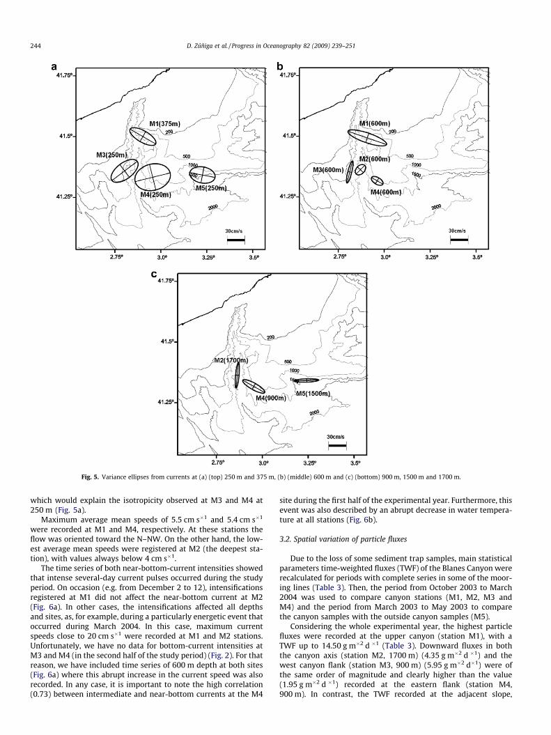
Fig. 5. Variance ellipses from currents at (a) (top) 250 m and 375 m, (b) (middle) 600 m and (c) (bottom) 900 m, 1500 m and 1700 m.
244 D. Zúñiga et al. / Progress in Oceanography 82 (2009) 239–251
which would explain the isotropicity observed at M3 and M4 at250 m (Fig. 5a).
Maximum average mean speeds of 5.5 cm s�1 and 5.4 cm s�1
were recorded at M1 and M4, respectively. At these stations theflow was oriented toward the N–NW. On the other hand, the low-est average mean speeds were registered at M2 (the deepest sta-tion), with values always below 4 cm s�1.
The time series of both near-bottom-current intensities showedthat intense several-day current pulses occurred during the studyperiod. On occasion (e.g. from December 2 to 12), intensificationsregistered at M1 did not affect the near-bottom current at M2(Fig. 6a). In other cases, the intensifications affected all depthsand sites, as, for example, during a particularly energetic event thatoccurred during March 2004. In this case, maximum currentspeeds close to 20 cm s�1 were recorded at M1 and M2 stations.Unfortunately, we have no data for bottom-current intensities atM3 and M4 (in the second half of the study period) (Fig. 2). For thatreason, we have included time series of 600 m depth at both sites(Fig. 6a) where this abrupt increase in the current speed was alsorecorded. In any case, it is important to note the high correlation(0.73) between intermediate and near-bottom currents at the M4
site during the first half of the experimental year. Furthermore, thisevent was also described by an abrupt decrease in water tempera-ture at all stations (Fig. 6b).
3.2. Spatial variation of particle fluxes
Due to the loss of some sediment trap samples, main statisticalparameters time-weighted fluxes (TWF) of the Blanes Canyon wererecalculated for periods with complete series in some of the moor-ing lines (Table 3). Then, the period from October 2003 to March2004 was used to compare canyon stations (M1, M2, M3 andM4) and the period from March 2003 to May 2003 to comparethe canyon samples with the outside canyon samples (M5).
Considering the whole experimental year, the highest particlefluxes were recorded at the upper canyon (station M1), with aTWF up to 14.50 g m�2 d �1 (Table 3). Downward fluxes in boththe canyon axis (station M2, 1700 m) (4.35 g m�2 d �1) and thewest canyon flank (station M3, 900 m) (5.95 g m�2 d�1) were ofthe same order of magnitude and clearly higher than the value(1.95 g m�2 d �1) recorded at the eastern flank (station M4,900 m). In contrast, the TWF recorded at the adjacent slope,

Fig. 6. (a) Time series of current intensity at M1 (600 m), M2 (1700 m), M3 (600 m) and M4 (600 m and 900 m). (b) Time series of water temperature at M1 (600 m), M2(600 m and 1700 m), M3 (600 m) and M4 (900 m). Unfortunately, we have no temperature data from the current meter M4 at 600 m. Shaded areas indicate the major TorderaRiver flood events.
D. Zúñiga et al. / Progress in Oceanography 82 (2009) 239–251 245
outside the canyon (station M5, 1500 m), was three orders of mag-nitude lower (5.42 mg m�2 d�1) than values recorded at the can-yon stations.
3.3. Temporal variability of bottom particle fluxes
Near bottom downward fluxes at the upper canyon (station M1)showed relatively low values during the spring 2003 with a meanvalue of 5.89 ± 3.51 g m�2 d�1 (Fig. 7). Two clear peaks in the firsthalf of December 2003 (up to 40.78 g m�2 d�1) and in March2004 (up to 29.58 g m�2 d�1) were recorded, and were the highestvalues registered during the whole experimental year.
Deeper in the canyon axis (station M2) the fluxes have decreasedsubstantially, with highest values of 8.66 and 9.78 g m�2 d�1
recorded during February 2004 and March 2004, respectively. Therest of the year particle fluxes remained quite steady, varying arounda mean value of 3.33 g m�2 d�1.
The western canyon wall particle fluxes (M3) at 900 m depth(unfortunately, sediment samples have been lost for the first halfof the year) had a similar variability, but values were slightly high-er than those recorded at station M2 at 1700 m depth. TWF oscil-lated between a minimum value of 1.68 g m�2 d�1 in September2003 and a value up to 10 g m�2 d�1 in March 2004. At a similardepth, the eastern canyon wall (M4) particle fluxes were clearly

Table 3Time weight fluxes (TWF) and total mass flux statistics (mean, maximum, minimum and standard deviation S.D.) of the sediment traps located in the Blanes Canyon. Data areexpressed in g m�2 d�1. TWF is calculated as
PFi/(collection area (0.125) �
Pdi) being Fi the total mass flux in period i and di, the number of collection days of period i. This
parameter will eliminate the disturbances due to the loss of samples.
M1 (g m�2 d�1) M2 M3 M4 M5 (g m�2 d�1)
March 2003–March 2004 Mean 13.98 3.82 5.18 1.91 5.42 � 10�3
Max. 40.78 9.78 10.76 5.23 7.88 � 10�3
Min. 3.16 0.86 1.68 0.38 4.53 � 10�3
S.D. 10.53 4.21 2.28 1.07 1.25 � 10�3
TWF 14.50 4.35 5.95 1.95 5.42 � 10�3
Mean 20.60 3.82 5.18 1.91
October 2003–March 2004 Max. 40.78 9.78 10.76 5.23Min. 8.97 0.86 1.68 0.38S.D. 9.32 4.21 2.28 1.07Mean 8.23 4.09 2.42 5.42 � 10�3
March 2003–May 2003 Max. 11.57 5.56 2.62 7.88 � 10�3
Min. 3.84 2.24 2.20 4.53 � 10�3
S.D. 3.03 1.35 0.16 1.25 � 10�3
246 D. Zúñiga et al. / Progress in Oceanography 82 (2009) 239–251
lower, with values always remaining below 4 g m�2 d�1. Oneexception was the absolute maximum of 5.23 g m�2 d�1 recordedat the end of October 2003.
3.4. Composition of sinking particles: organic matter and carbonates
Organic matter percentages were almost always higher on theeastern canyon wall (M4), with two maximums of 5.48% and5.34% in April 2003 and November 2003, respectively (Fig. 8a).Similar values were reached only at the upper canyon stationM1, where a value of 5.05% was registered at the end of April2003. On the other hand, at both M2 and M3 stations temporal vari-ability of this constituent was lower, varying around a mean valueof 2.67% and 2.28%, respectively. One exception was the relativemaximum (5.14%) registered at M2 (1700 m depth) during August2003.
The organic matter particle fluxes showed the highest values atthe upper canyon, with two strong peaks in December 2003 and
Fig. 7. Time series of total mass fluxes (g m�2 d�1) for the sedime
March 2004 when values of 660 mg m�2 d�1 and 914 mg m�2 d�1
were recorded. Following the canyon axis, organic matter fluxesat M2 were clearly lower. Values oscillated around a mean valueof 100 mg m�2 d�1 and clearly follow the pattern of the total massfluxes described in the previous section. One exception was thepeak found in August 2003 where a value of 291 mg m�2 d�1 wasregistered. Similarly to the total particle fluxes data, organic matterfluxes at the western flank (M3) were similar to those found at M2,ranging between a minimum value of 51 mg m�2 d�1 in September2003 and a maximum value of 259 mg m�2 d�1 in March 2004. Onthe other hand, values at M4 were the lowest of the whole canyon.The temporal series showed two strong peaks in April 2003 andNovember 2003 with values of 143 mg m�2 d�1 and 156 mg m�2
d�1, respectively.Highest values of carbonates were always recorded at the east-
ern canyon wall station (M4), where profiles showed low varia-tion during the whole experimental year (Fig. 8b). At the uppercanyon (M1) calcium carbonate percentage showed the widest
nt traps (M1, M2, M3 and M4) moored in the Blanes Canyon.

Fig. 8. (a) Time series of organic matter (OM) fluxes (line) and percentages (bars) of the bottom sediment traps. (b) Time series of calcium carbonate (CaCO3) fluxes (line) andpercentages (bars) of the bottom sediment traps.
D. Zúñiga et al. / Progress in Oceanography 82 (2009) 239–251 247
range of variation, ranging from a minimum value of 9.39% in July2003 up to a maximum of 24% in March 2003. At the canyon axisstation M2 (1700 m depth), values remained lower during spring2003 (mean value of 14.98%) and increased at the end of summeruntil reaching a maximum value of 25% at the end of September2003.
The calcium carbonate time series fluxes presented a similartrend than the total mass fluxes with the highest values recorded
Table 4Time-averaged fluxes (mg m�2 d�1) and relative contributions (%) of organic matter,organic nitrogen (Norg) and calcium carbonate (CaCO3) for both inside and outsidecanyon mooring lines. C/N atomic ratio was calculated as Corg/Norg.
Code Organic matter Norg flux (%) C/N CaCO3 flux (%)
Flux (%)
M1 329.51 2.50 17.49 0.14 10.9 2479.62 17.93M2 113.75 2.67 6.02 0.14 11.7 772.45 19.03M3 138.75 2.28 8.88 0.15 9.0 1041.35 17.22M4 66.46 3.53 6.45 0.30 8.2 367.89 20.89M5 0.22 3.88 0.01 0.17 9.3 1.24 23.48
at M1 (maximum value of 7016 mg m�2 d�1 in March 2004) andthe lowest at M4 (minimum value of 70 mg m�2 d�1 in November2003).
The highest mean Corg/Norg atomic ratio (11.7) was found at M2,while lower values of the ratio characterized both the eastern andwestern canyon walls, where mean values of 8.2 and 9.0 were,respectively, registered (Table 4).
3.5. Description of sediment cores
The retrieved sediments were described as fine-grained hemi-pelagic muds with higher contents in silty fraction. Silt percentagesranged between a maximum of 73% in core C1 and a minimum of64% in core C4. An exception was the core C3, characterized by thepresence of around 10% sand along the whole core (Table 5). Incontrast, cores C2, C4 and C5 were dominated by clays fractionwith values of 30%, 35% and 35%, respectively.
Mean grain size averaged values for cores C2, C4 and C5 rangedbetween 8.8 lm and 9.6 lm, being clearly lower than those foundin both core C1 (15.3 lm), located in the upper canyon, and core C3(24.3 lm), located in the western flank.

Table 5Sediment accumulation rates (SAR) and sedimentation rates (SR) obtained from 210Pb analyses and mean values of both mean grain size (MGS) and granulometric composition(percentage of clay, silt and sand) are given for the cores. Mean values of organic matter (OM) contents, Corg/Norg atomic ratios and calcium carbonate (CaCO3) contents are alsoshown for each core.
Core code Length (cm) Sedimentation data MGS (lm) Clays (%) Silt (%) Sand (%) OM (%) Corg/Norg CaCO3 (%)
Depth (cm) SAR (g cm�2 y�1) SR (cm y�1)
C1 44 0–25 Mixing 15.3 25 73 2 1.92 10.9 22.9225–44 0.26 ± 0.04 0.37 ± 0.05
C2 40 0–15 Erosion 9.6 30 68 2 1.64 11.2 22.1315–40 0.28 ± 0.03 0.47 ± 0.06
C3 30 0–30 Disturbed 24.3 24 67 10 1.12 12.1 23.71C4 45 0–45 0.082 ± 0.003 0.125 ± 0.004 9.0 35 64 0 1.76 10.5 23.66C5 45 0–45 0.078 ± 0.008 0.091 ± 0.013 8.8 35 65 0 1.38 9.7 26.86
248 D. Zúñiga et al. / Progress in Oceanography 82 (2009) 239–251
The organic matter content in superficial sediments was higherin the inside canyon cores (1.64–1.96%), especially in the one lo-cated in the vicinity of the coast. On the contrary, the lowest value(1.12%) was recorded at the western sand-dominated deposit C3.
Calcium carbonate content was the main constituent of the to-tal carbon in all cores (Table 5). Carbonate content mean valuesranged from 22.13% in core C2 to 26.86% in core C5.
3.5.1. Sediment accumulation rates (SAR) derived from 210Pb analysesThe study of sediment accumulation rates (SAR) and sedimenta-
tion rates (SR) of the sediment cores revealed that in core C1 theupper 25 cm were affected by mixing processes (Fig. 9), in congru-
Fig. 9. 210Pb activity profiles of cores C1, C2, C3, C4 and C5, recovered at the same positfigure.
ence with the presence of numerous burrows and biologicalindications observed during visual description of the sediment re-cord. Down core, a SAR of 0.26 ± 0.04 g cm�2 y�1 (SR = 0.37 ± 0.05cm y�1) was obtained.
Cores C2 and C3 were clearly affected by erosion processes.While in core C2 the erosion affected only the upper 15 cm, show-ing a SAR for the lower part of the core of 0.28 ± 0.03 g cm�2 y�1
(SR = 0.47 ± 0.06 cm y�1), in core C3 the disruption affected thewhole sediment record, so its SAR was unobtainable. In both C4and C5 the cores were unaltered and the obtained SAR’s were0.082 ± 0.003 g cm�2 y�1 (SR = 0.125 ± 0.004 cm y�1) and 0.078 ±0.008 g cm�2 y�1 (SR = 0.091 ± 0.013 cm y�1), respectively.
ions of moored sediment traps. Linear accumulation rates (r) are also shown in the

D. Zúñiga et al. / Progress in Oceanography 82 (2009) 239–251 249
4. Discussion
4.1. Spatial variation of particle fluxes: the existence of two maindomains
Particle fluxes within the Blanes Canyon were of the same orderas those recorded by Martín et al. (2006) in the Palamós Canyon,located north of our experimental site. The decreased occurrenceof the time-weighted-flux (TWF) with increasing distance fromthe coast (Table 3 and Fig. 7) reflects the high influence of terrige-nous inputs linked to the outflow of the Tordera River (Fig. 3).Otherwise, the TWF differences between the inside and outsidecanyon stations (Table 3) agreed with previous observations insimilar settings, highlighting the role of this and many other sub-marine canyons as traps and offshore conduits of continental shelfsediments (Heussner et al., 1999; Monaco et al., 1999; Palanqueset al., 2005, 2006; Martín et al., 2006). Certainly, the concomitantincrease of both down-canyon current speed and particle fluxes(Fig. 10) observed at M2 demonstrates the enormous capabilityof the canyon to channel energetic events along its axis, which con-sequently induces the transport of particulate material from thecontinental shelf to the deepest parts of the canyon (Durrieu deMadron et al., 1999).
The role of the Blanes submarine canyon as a trap for sedimenthas been also observed by the high sedimentation rates (SR) re-corded at the inside canyon cores C1 (0.37 cm y�1) and C2(0.47 cm y�1), which were slightly higher than the range of SR pre-sented by Martín et al. (2008) for the Palamós Canyon (0.05–0.35 cm y�1). These two Catalan margin canyons showed higherSR than those found in the adjacent open slope (0.07–0.14 cm y�1)(Sanchez-Cabeza et al., 1999) and in other northwestern Mediter-ranean canyons such as the Lacaze-Duthiers Canyon (0.06–0.2 cm y�1), the Grand Rhône Canyon (0.07–0.17 cm y�1) (Miralleset al., 2005) or the Planier Canyon (0.09 cm y�1) (Masqué, 1999).
On the other hand, it is worth noting the significantly higherTWF recorded at the western flank of the Blanes Canyon whencompared to the eastern flank at similar depths (Fig. 7), whichmay be explained by the existence of lateral processes close tothe bottom that contribute to the transport of particulate materialalong the western flank. As observed in other submarine canyons,(e.g. Turchetto et al. (2007)), current meter data showed that in theBlanes Canyon the circulation close to the bottom was strongly
Fig. 10. Time series of Eddy Kinetic Energy (EKE) on the mesoscale band (whichdescribes the energetic variability within the canyon) and sediment trap data (totalmass fluxes) of M2 near-bottom devices.
constrained by the local bathymetry, yielding to different currentregimes (Fig. 5c). The deep current coming from the northern openslope flows into the canyon along the shallow and wide easterncanyon wall (M4). Here, the current showed a high variability indirection (Fig. 5) favoring the vertical transport of hemipelagic par-ticulate matter. In this flank, superficial sediments were character-ized by a high content of fine material (Table 5) that has beensedimented at a relatively low rate (SR = 0.125 ± 0.004 cm y�1)(Table 5). The exponential decrease with depth of 210Pbxs profile,similar to that found in the adjacent open slope (C5) (Fig. 9),reveals that sediments are unaltered. This fact corroborates thenotion that fewer energetic processes are affecting the eastern flankof the Blanes Canyon and thus hemipelagic sedimentation is favored.
Later, the route of the bottom current along the canyon isobaths(Fig. 5c) will favor the capture of suspended sediment from thenear-shore zone by the upper canyon. Indeed, the existence ofhigher numbers of suspended particulate matter in the easterncanyon wall (Fig. 4), being the sediments detached from the bot-tom as shelf waters coming from the north cross the canyon, isan indicator of lateral advection from the shelf edge toward thecanyon. All this particulate material collected by the canyon willbe transported to the open sea through the steep western canyonwall (Figs. 1 and 7), which acts as a physical barrier that preventsthe escape of material toward the west. In this flank, the fact thatsediments were totally disturbed (as observed by the 210Pb profile,avoiding to obtain SAR, Fig. 9) and the presence of coarse particlesconfirm that more energetic processes are affecting the westernflank of the canyon. Certainly, it seems that the persistence ofthe current can erode the seafloor transporting the re-suspendedmaterial to the deep basin, and thus convert the western flank ofthe canyon to a potential additional source of sediment to the deepbasin.
4.2. Temporal variability of particle fluxes: controlling factors
Temporal evolution of particle fluxes showed abrupt changesthroughout the year, thus revealing that the transfer of particulatematter through the canyon is clearly event-dominated. This is sim-ilar to what occurs in other submarine canyons (Walsh and Nit-trouer, 1999; Palanques et al., 2006; Fain et al., 2007; Bonninet al., 2008) where the variability of particle fluxes is a conse-quence of a combination of factors involving river flood events,high wave energy processes associated with local meteorologicalforcing and margin circulation.
In the upper Blanes Canyon (M1), particle fluxes showed twomaximum peaks during the first half of December 2003 and inMarch 2004 (Fig. 7), which were clearly related to two major riverflood events (Fig. 3) that induced significant increases in the cur-rent velocities at this site (Fig. 6). A third important discharge fromthe Tordera River occurred in October 2003 (Fig. 3), but unfortu-nately, the sediment trap record at M1 was lost during that perioddue to trawling activities.
The peak in particle fluxes observed at M1 during the early partof December 2003 was related to an important E-SE storm affectingnot only the Catalan margin but also the Gulf of Lions (Bonninet al., 2008; Fabrés et al., 2008). In fact, the Tordera River dischargein December 2003 occurred at the same time as a Rhone River floodwith a 75-year recurrence period (Palanques et al., 2006). This riverflood event leads to a sporadic intensification of the current speed(Fig. 6a) and an increase in water temperature along the canyonaxis (Fig. 6b). However, in terms of mass fluxes it affected onlythe upper Blanes Canyon (M1 site) as a consequence of the stillwarmer surface water under stratification conditions and the shortduration of the storm, thus avoiding the off-shelf transport ofthe sediment re-suspended along the coast (Fabrés et al., 2008;Palanques et al., 2009).

250 D. Zúñiga et al. / Progress in Oceanography 82 (2009) 239–251
Furthermore, the transference of material from the upper can-yon to the deep sea can also occur as a consequence of denseshelf-water cascading (Canals et al., 2006). Recent observationsfrom the nearby Gulf of Lions revealed that dense shelf waterformed during dry and cold winters escapes from the shelf bycascading through the westernmost canyons (Cap de Creus andLacaze-Duthiers Canyons) (Durrieu de Madron et al., 2005),re-suspending and transporting material toward the deep sea(Canals et al., 2006; Heussner et al., 2006; Palanques et al., 2006;Sanchez-Vidal et al., 2008). Although the precondition for cascad-ing events in the Blanes Canyon is different from those in the Gulfof Lions (narrower continental shelf, different wind regimes dueto the presence of the Pyrenees range, etc.), in the numericalmodel presented by Ulses et al. (2008), the authors predicted thatdense shelf waters from the Gulf of Lions might be able to reachthe Blanes Canyon. Indeed, in March 2004 the upper 300 m of thewater column over the Blanes Canyon were occupied by cold,fresh shelf water where the transmissivity profiles showed thedown-welling of shelf turbid water (Fig. 4c) that reflected thedown-canyon transport of dense shelf water. Moreover, the peakin total mass flux (even at 1700 m depth) recorded during thisevent (Fig. 7) agrees with an intensification of the current(Fig. 6a) and an abrupt decrease of water temperature in thewhole water column (Fig. 6b). This fact also supports the ideathat a cascading event that occurred simultaneously with the ma-jor eastern storm occurring in winter 2004 (Fabrés et al., 2008)could be responsible for the rapid off-shelf transport of particu-late material re-suspended from the inner and mid-continentalshelf. Furthermore, we would like to point out that the TWF peakobserved in March 2004 took place relatively close to a denseshelf-water cascading event in the Gulf of Lions, which wasstrong enough to re-suspend and transport all of the materialstored on the shelf along the Cap de Creus Canyon toward thedeep basin (Palanques et al., 2006, 2009).
4.3. Composition of the settling particles
Near seafloor particulate fluxes in canyon systems have differ-ent sources. Biological production, terrestrial input and re-suspen-sion of bottom sediments may follow a seasonal pattern. Biogenicparticles can also have various origins, exhibiting seasonal changesfrom both a quantitative and a qualitative point of view (Rossiet al., 2003). Indeed, surface primary production in the Catalano-Balear Sea is characterized by an intense seasonality due to thewinter–spring phytoplankton bloom (Estrada, 1996).
Even if our sediment trap samples are clearly dominated by thelithogenic material associated with the river flood events, the win-ter–spring biological signal was recognized in the concentrationsof particulate organic matter registered at both M1 and M4(Fig. 8a). This confirms the existence of two main domains in thecanyon. The eastern flank of the canyon, characterized as a morestable area, favors the detection of the biological signal that oc-curred at the surface of the water column. In this case, the lowerCorg/Norg atomic ratio (8) revealed that organic material is com-posed of more labile organic matter, similar to that found in othersubmarine canyons of the western Mediterranean Sea (Buscailet al., 1990; Sanchez-Vidal et al., 2005; Fabrés et al., 2008). In con-trast, during late fall and winter, the intense Tordera River inputsconstitute an important source of more refractory particulate or-ganic matter in the canyon. These energetic events, jointly withthe action of waves, bottom currents or internal waves, can alsobe responsible for the re-suspension of older and degraded organicmatter from the sediment record as observed in the C3 eroded core,which shows the highest Corg/Norg atomic ratio (12.1) (Table 5).
On the other hand, calcium carbonate contents show valueswithin the same order of magnitude as other values found in and
near submarine canyons (Martín et al., 2006), varying between aminimum value of 17.22% recorded at the western canyon wall(station M3) and a maximum value of 23.48% recorded outsidethe canyon (station M5) (Table 4). Therefore, biogenic material inthe open slope is less diluted by the lithogenic fraction associatedwith the river discharge. This assumption is again corroborated bythe Corg/Norg atomic ratio (Table 4). The higher values were foundin the near-shore sediment trap (M1) (Corg/Norg = 10.9) likely dueto the coastal input of terrestrial organic matter, and at the canyonaxis (M2) (Corg/Norg = 11.7), which suggests that organic matter isbeing degraded and mixed with older organic matter during itstransfer to the deepest parts of the canyon.
The different composition of the settling particles associatedwith the existence of two main domains in the Blanes Canyonhas relevant biological consequences. The topographic features ofthe canyon and the variations in both currents and particle fluxesyield to important oscillations in the meiobenthic community, asexplained by Sardà et al. (in press), which revealed the importanceof the local currents in the deep rose shrimp A. antennatus distribu-tion near the Blanes submarine canyon.
5. Conclusions
The study of downward particle flux in the Blanes Canyon re-veals two main finds: (i) the canyon acts as a preferential conduitfor the transport of particulate material from the continental shelfto the open ocean, with fluxes three orders of magnitude higherthan in the adjacent open slope and (ii) two main domains withinthe canyon are clearly distinguished from the hydrodynamic con-ditions that control the transport of the particles. Whereas in thesharp western flank the unidirectional southwestward directionof the current favors the transport of the particulate material fromthe upper canyon to the deep basin, the smoother eastern flank,characterized by non-erosional hydrodynamic conditions, recoversless particulate material, mainly that associated with hemipelagicsedimentation processes.
The present study clearly found that transport through thecanyon is event-dominated. The maximum downward particle fluxepisodes were identified with processes involving increases inriver discharge during the winter, intensification of the NorthernCurrent that transferred energy along the canyon axis and denseshelf-water cascading.
In any case, it is important to consider that the influence of thebathymetric characteristics in both current and particle fluxes arespecific of the Blanes Canyon. Thus, caution is required whenextrapolating specific results of the Blanes submarine canyon toother systems.
Acknowledgments
The authors would like to thank the officers and crew of the R/VGarcía del Cid and the technicians at Unidad de Tecnología Marina(UTM-CSIC). We also thank the Laboratori de Radioactivitat Ambi-ental from ‘‘Universitat Autònoma de Barcelona” for their help withthe 210Pb analysis. D.Z. benefited from a Spanish FPU Grant(AP2000-0524), and MMF was aided by a Juan de la Cierva grantfrom the Spanish Ministry of Science. Support from the govern-ment of Spain and the Fulbright Commission for a post-doctoralfellowship to J.G-O. (ref 2007-0516) is gratefully acknowledgedby J. García-Orellana. GRC Geociències Marines was additionallyfunded by the ‘‘Generalitat de Catalunya’’ through its excellency re-search groups program (ref. 2005 SGR-00152). This study was alsosupported by the Spanish national research project RECS(REN2002-04556-C02-01).

D. Zúñiga et al. / Progress in Oceanography 82 (2009) 239–251 251
References
Alvarez, A., Tintoré, J., Sabatés, A., 1996. Flow modification and shelf-slope exchangeinduced by a submarine canyon off the northeast Spanish coast. Journal ofGeophysical Research 101, 12043–12055.
Bonnin, J., Heussner, S., Calafat, A., Fabres, J., Palanques, A., Durrieu de Madron, X.,Canals, M., Puig, P., Avril, J., Delsaut, N., 2008. Composition of horizontal anddownward particle fluxes across canyons of the Gulf of Lions (NWMediterranean): meteorological and hydrodynamical forcing. ContinentalShelf Research 28, 1957–1970.
Buscail, R., Pocklington, R., Daumas, R., Guidis, L., 1990. Fluxes and budget of organicmatter in the benthic boundary layer over the northwestern Mediterraneanmargin. Continental Shelf Research 10 (9–11), 1089–1122.
Canals, M., Casamor, J.L., Urgelés, R., Farrán, M., Calafat, A., Amblás, D., Willmot, V.,Estrada, F., Arnau, P., Frigola, J., Colás, S., 2004. Mapa de relleu submarí deCatalunya, 1:250.000. Institut Cartogràfic de Catalunya-Universitat deBarcelona.
Canals, M., Puig, P., De Madron, X.D., Heussner, S., Palanques, A., Fabres, J., 2006.Flushing submarine canyons. Nature 444 (7117), 354–357.
Cartes, J.E., Company, J.B., Maynou, F., 1994. Deep-water decapod crustaceancommunities in the Nothwestern Mediterranean: influence of submarinecanyons and season. Marine Biology 120, 221–229.
Company, J.B., Puig, P., Sardà, F., Palanques, A., Latasa, M., Scharek, R., 2008. Climateinfluence on deep sea populations. PLoS ONE 3 (1), e1431. doi:10.1371/journal.pone.0001431.
Díaz, J., Maldonado, A., 1990. Transgressive sand bodies on the Maresme continentalshelf, Western Mediterranean Sea. Marine Geology 91, 53–72.
Durrieu de Madron, X., Radakovitch, O., Heussner, S., Loye-Pilot, M.D., Monaco, A.,1999. Role of the climatological and current variability on shelf-slopeexchanges of particulate matter: evidence from the Rhône continental margin(NW Mediterranean). Deep-Sea Research I 46, 1513–1538.
Durrieu de Madron, X., Zervakis, V., Theocharis, A., Georgopoulos, D., 2005.Comments on ‘‘Cascades of dense water around the world ocean”. Progress inOceanography 64, 83–90.
Estrada, M., 1996. Primary production in the Northwestern Mediterranean. ScientiaMarina 60, 55–64.
Fabrés, J., Calafat, A., Sanchez-Vidal, A., Canals, M., Heussner, S., 2002. Compositionand spatio-temporal variability of particle fluxes in the Western Alboran Gyre,Mediterranean Sea. Journal of Marine Systems, 431–456.
Fabrés, J., Tesi, T., Velez, J., Batista, F., Lee, C., Calafat, A., Heussner, S., Palanques, A.,Miserocchi, S., 2008. Seasonal and event-controlled export of organic matterfrom the shelf towards the Gulf of Lions continental slope. Continental ShelfResearch 28, 1971–1983.
Fain, A.M.V., Ogston, A.S., Sternberg, R.W., 2007. Sediment transport event analysison the western Adriatic continental shelf. Continental Shelf Research 27, 431–451.
Flexas, M.M., Durrieu de Madron, X., Garcia, M.A., Canals, M., Arnau, P., 2002. Flowvariability in the Gulf of Lions during the MATER HFF experiment (March–May1997). Journal of Marine Systems, 197–214.
Font, J., Garcia-Ladona, E., Gorriz, E., 1995. The seasonality of mesoscale motion inthe Northern Current of the western Mediterranean: several years of evidence.Oceanologica Acta 18 (2), 207–219.
Gili, J.M., Boullion, J., Pagés, F., Palanques, A., Puig, P., 1999. Submarine canyons ashabitats of prolific plankton populations: three new deep-sea Hydrodomedusaein the Western Mediterranean. Zoological Journal of Linnean Society 125, 313–329.
Granata, T., Estrada, M., Zika, U., Merry, C., 2004. Evidence of enhanced primaryproduction resulting from relative vorticity induced upwelling in the CatalanCurrent. Scientia Marina 68, 113–119.
Heussner, S., Ratti, C., Carbonne, J., 1990. The PPS 3 time-series sediment trap andthe trap sample techniques used during the ECOMARGE experiment.Continental Self Research 10, 943–958.
Heussner, S., Durrieu de Madron, X., Radakovitch, O., Beaufort, L., Biscaye, P.E.,Carbonne, J., Delsaut, N., Etcheber, H., Monaco, A., 1999. Spatial and temporalpatterns of downward particle fluxes on the continental slope of the Bay ofBiscay (northeastern Atlantic). Deep-Sea Research II 46, 2101–2146.
Heussner, S., Durrieu de Madron, X., Calafat, A., Carbonne, J., Delsaut, N., Saragoni,G., 2006. Spatial and temporal variability of downward particle fluxes on acontinental slope: lessons from a 8-year experiment in the Gulf of Lions (NWMediterranean). Marine Geology 234 (1–4), 63–92.
Hung, J.J., Lin, C.S., Chung, Y.C., Hung, G.W., Liu, W.S., 2003. Lateral fluxes of biogenicparticles through the Min-Hua canyon in the southern East China Sea slope.Continental Shelf Research 23, 935–955.
Krishnaswami, S., Lal, D., Martin, J.M., Meybecket, M., 1971. Geochronology of lakesediments. Earth and Planetary Science Letters 11, 407–414.
Liu, J.T., Lin, H., 2004. Sedimento dynamics in a submarine canyon: a case of river–sea interaction. Marine Geology 207, 55–81.
Martín, J., Palanques, A., Puig, P., 2006. Composition and variability of downwardparticulate matter fluxes in the Palamós submarine canyon (NWMediterranean). Journal of Marine Systems 60 (1–2), 75–97.
Martín, J., Puig, P., Palanques, A., Masqué, P., García-Orellana, J., 2008. Effect ofcommercial trawling on the deep sedimentation in a Mediterranean submarinecanyon. Marine Geology 252, 150–155.
Masqué, P. 1999. Estudi del comportament del210Pb i el210Po en el marcatalonobalear i el seu us con radiotracadors. Tesi Doctoral, UniversitatAutonoma de Barcelona.
Millot, C., 1999. Circulation in the Western Mediterranean Sea (Review paper).Journal of Marine Systems 20, 423–442.
Miralles, G., Radakovich, O., Aloisi, J.-C., 2005. 210Pb sedimentation rates from theNorthwestern Mediterranean margin. Marine Geology 216, 155–167.
Monaco, A., Biscaye, P., Soyer, J., Pocklington, R., Heussner, S., 1990. Particle fluxesand ecosystem response on a continental margin: the 1985–1988Mediterranean ECOMARGE experiment. Continental Shelf Research 10 (9–11),809–839.
Monaco, A., Durrieu de Madron, X., Radakovich, O., Heussner, S., 1999. Origin andvariability of downward biogeochemical fluxes on the Rhone continentalmargin (NW Mediterranean). Deep-Sea Research I 46, 1483–1511.
Palanques, A., El Khatab, M., Puig, P., Masqué, P., Sanchez-Cabeza, J.A., Isla, E., 2005.Downward particle fluxes in the Guadiaro submarine canyon depositionalsystem (north-western Alboran Sea), a river flood dominated system. MarineGeology 220, 23–40.
Palanques, A., Durrieu de Madron, X., Puig, P., Fabres, J., Guillén, J., Calafat, A., Canals,M., Heussner, S., Bonnin, J., 2006. Suspended sediment fluxes and transportprocesses in the Gulf of Lions submarine canyons. The role of storms and densewater cascading. Marine Geology 234 (1–4), 43–61.
Palanques, A., Puig, P., Latasa, M., Scharek, R., 2009. Deep sediment transportinduced by storms and dense shelf-water cascading in the NorthwesternMediterranean basin. Deep-Sea Research I 56, 425–434.
Pedlosky, J., 1979. Geophysics I. In: Fluid Dynamics, second ed. Springer-Verlag, p.10.
Puig, P., Palanques, A., 1998. Temporal variability and composition of settlingparticles fluxes on the Barcelona continental margin. Journal of MarineResearch 56, 639–654.
Rossi, S., Grémare, A., Gili, J.M., Amouroux, J.M., Jordana, E., Vétion, G., 2003.Biochemical characteristics of settling particulate organic matter at two north-western Mediterranean sites: a seasonal comparison. Estuarine, Coastal andShelf Science 58, 423–434.
Rovira, A., Batalla, R.J., 2006. Temporal distribution of suspended sedimenttransport in a Mediterranean basin: the lower Tordera (NE Spain).Geomorphology 79 (1–2), 58–71.
Sanchez-Cabeza, J.A., Masqué, P., Ani-Ragolta, I., Merino, J., Frignani, M., Alvisi, F.,Palanques, A., Puig, P., 1999. Sediment accumulation rates in the southernBarcelona continental margin (NW Mediterranean Sea) derived from 210Pb and137Cs chronology. Progress in Oceanography 44 (1–3), 313–332.
Sanchez-Vidal, A., Calafat, A., Canals, M., Frigola, J., Fabres, J., 2005. Particle fluxesand organic carbon balance across the Eastern Alboran Sea (SW MediterraneanSea). Continental Shelf Research 25 (5–6), 609–628.
Sanchez-Vidal, A., Pascual, C., Kerhervé, P., Calafat, A., Heussner, S., Palanques, A.,Durrieu de Madron, X., Canals, M., Puig, P., 2008. Impact of dense shelf watercascading on the transfer of organic material to the deep WesternMediterranean. Geophysical Research Letters 35, L05605.
Sardà, F., Cartes, J.E., 1993. Relationship between size and depth in decapodcrustacean populations on the deep slope in the Western Mediterranean. Deep-Sea Research I 40 (11–12), 2389–2400.
Sardà, F., Company, J.B., Bahamon, N., Rotllant, G., Flexas, M.M., Sánchez, J.D.,Zúñiga, D., Coenjaerts, J., Orellana, D., Jordà, G., Puigdefàbregas, J.,Sánchez-Vidal, A., Calafat, A., Martín, D., Espino, M., in press.Relationship between environment and occurrence of the deep-waterrose shrimp Aristeus antennatus (Risso, 1826) in Blanes submarine canyon(Northwestern Mediterranean).
Turchetto, M., Boldrin, A., Langone, L., Miserocchi, S., Tesi, T., Foglini, F., 2007.Particle transport in the Bari Canyon (southern Adriatic Sea). Marine Geology246 (2–4), 231–247.
Ulses, C., Estournel, C., Puig, P., Durrieu de Madron, X., Marsaleix, P., 2008. Denseshelf water cascading in the northwestern Mediterranean during the coldwinter 2005: quantification of the export through the Gulf of Lions and theCatalan margin. Geophysical Research Letters 35, L07610. doi:10.1029/2008GL033257.
Walsh, J.P., Nittrouer, C.A., 1999. Observations of sediment flux to the Eelcontinental slope, northern California. Marine Geology 154, 55–68.