Canyon Rims (Indian Creek) Travel Management Plan ...
223
May 2021 Canyon Rims (Indian Creek) Travel Management Plan Environmental Assessment DOI-BLM-UT-Y010-2018-0220-EA Moab Field Office 82 East Dogwood Moab, Utah 84532 Phone: 435-259-2100 FAX: 435-259-2106
-
Upload
khangminh22 -
Category
Documents
-
view
1 -
download
0
Transcript of Canyon Rims (Indian Creek) Travel Management Plan ...
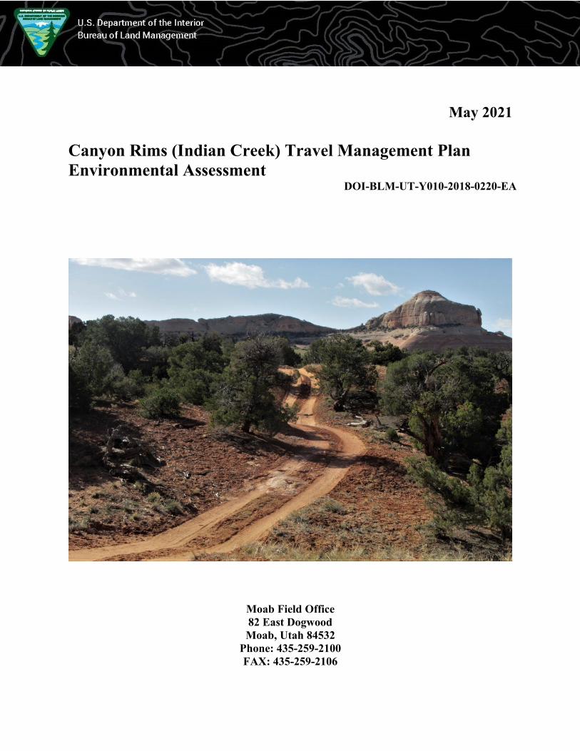
May 2021
Canyon Rims (Indian Creek) Travel Management Plan
Environmental Assessment DOI-BLM-UT-Y010-2018-0220-EA
Moab Field Office
82 East Dogwood
Moab, Utah 84532
Phone: 435-259-2100
FAX: 435-259-2106
Cover Photo Credit:
Bill Stevens, BLM
DOI-BLM-UT-Y010-2018-0220-EA
It is the mission of the Bureau of Land Management to sustain the health,
diversity, and productivity of the public lands for the use and enjoyment of
present and future generations.
Canyon Rims Travel Management Plan Environmental Assessment DOI-BLM-UT-Y010-2018-0220-EA i
TABLE OF CONTENTS
1. INTRODUCTION AND BACKGROUND ..................................................................... 1 1.1 INTRODUCTION .................................................................................................................. 1 1.2 PROPOSED ACTION ............................................................................................................ 1 1.3 PURPOSE AND NEED .......................................................................................................... 2 1.4 BACKGROUND AND TMA OVERVIEW ............................................................................... 2
1.5 CONFORMANCE WITH MANAGEMENT PLANS AND POLICIES ............................................. 3 1.6 SCOPING AND ISSUE IDENTIFICATION ................................................................................ 7
1.6.1 Overview ................................................................................................................... 7 1.6.2 Issues Carried Forward for Detailed Analysis ......................................................... 7 1.6.3 Resource/Use Topics Identified, but Eliminated from Detailed Analysis ................. 8
2. ALTERNATIVES .............................................................................................................. 9
2.1 ROUTE DESIGNATION METHODOLOGY .............................................................................. 9
2.1.1 Overview ................................................................................................................... 9 2.1.2 Route Inventory ......................................................................................................... 9
2.1.3 Route Evaluation ....................................................................................................... 9 2.1.4 Route Designations ................................................................................................. 10
2.1.5 R.S. 2477 Assertions ............................................................................................... 11 2.2 TMA ROUTE DESIGNATION SUMMARY BY ALTERNATIVE ................................................... 11 2.3 ALTERNATIVE A (NO ACTION) ........................................................................................ 12
2.4 ALTERNATIVE B .............................................................................................................. 12 2.5 ALTERNATIVE C .............................................................................................................. 12
2.6 ALTERNATIVE D .............................................................................................................. 13 2.7 IMPLEMENTATION ACTIONS COMMON TO ALL ACTION ALTERNATIVES ......................... 13
2.7.1 Signage .................................................................................................................... 13 2.7.2 Route Maintenance ................................................................................................. 13
2.7.3 Decommissioning or Reclaiming Closed Routes .................................................... 13 2.7.4 Best Management Practices and Standard Operating Procedures ........................ 14 2.7.5 Conservation Measures .......................................................................................... 14
3. AFFECTED ENVIRONMENT AND ENVIRONMENTAL EFFECTS .................... 17 3.1 OVERVIEW ...................................................................................................................... 17
3.1.1 Introduction and General Setting ........................................................................... 17 3.1.2 Effects ...................................................................................................................... 17 3.1.3 General Assumptions .............................................................................................. 18 3.1.4 General Effects Analysis Methodology ................................................................... 19 3.1.5 Additional Management .......................................................................................... 20
3.2 KEY ISSUE 1: TRAVEL NETWORK EFFECTS ON THE TMA’S NATURAL AND HUMAN
ENVIRONMENT ................................................................................................................ 20
3.2.1 Cultural Resources.................................................................................................. 20 3.2.1.1 Affected Environment ................................................................................................................... 20 3.2.1.2 Environmental Effects Analysis .................................................................................................... 21
3.2.2 Lands with Wilderness Characteristics .................................................................. 24 3.2.2.1 Affected Environment ................................................................................................................... 24 3.2.2.2 Environmental Effects Analysis .................................................................................................... 25
3.2.3 Soils, Native Vegetation, and Weeds and Invasive Species .................................... 26 3.2.3.1 Affected Environment ................................................................................................................... 27
Canyon Rims Travel Management Plan Environmental Assessment DOI-BLM-UT-Y010-2018-0220-EA ii
3.2.3.2 Environmental Effects Analysis .................................................................................................... 28 3.2.4 Special Designation Areas ...................................................................................... 31
3.2.4.1 Affected Environment ................................................................................................................... 31 3.2.4.2 Environmental Effects Analysis .................................................................................................... 32
3.2.5 Visual Resource Management ................................................................................. 34 3.2.5.1 Affected Environment ................................................................................................................... 34 3.2.5.2 Environmental Effects Analysis .................................................................................................... 35
3.2.6 Water Resources: Rivers and Streams, Riparian Areas and Floodplains, and Water
Quality .................................................................................................................... 36 3.2.6.1 Affected Environment ................................................................................................................... 36 3.2.6.2 Environmental Effects Analysis .................................................................................................... 37
3.2.7 Wildlife: Fish (T&E and BLM Sensitive Species) ........................................................ 40 3.2.7.1 Affected Environment ........................................................................................................................ 40 3.2.7.2 Environmental Effects Analysis ......................................................................................................... 41
3.2.8 Wildlife: General Wildlife ............................................................................................ 43 3.2.8.1 Affected Environment ........................................................................................................................ 43 3.2.8.2 Environmental Effects Analysis ......................................................................................................... 43
3.2.9 Wildlife: Migratory Birds, Including Raptors .............................................................. 46 3.2.9.1 Affected Environment ........................................................................................................................ 46 3.2.9.2 Environmental Effects Analysis ......................................................................................................... 46
3.2.10 Wildlife: Special Status Species, excluding Fish (Federally Listed and Utah BLM
Sensitive Species) ................................................................................................... 49 3.2.10.1 Affected Environment ...................................................................................................................... 49 3.2.10.2 Environmental Effects Analysis ....................................................................................................... 50
3.2.11 Cumulative Effects for Key Issue 1 ............................................................................. 52 3.3 KEY ISSUE 2: PROVIDING FOR RECREATION OPPORTUNITIES AND EXPERIENCES .............. 53
3.3.1 Recreation..................................................................................................................... 53 3.3.1.1 Affected Environment ................................................................................................................... 53 3.3.1.2 Environmental Effects Analysis .................................................................................................... 54
3.3.2 Cumulative Effects for Key Issue 2 ............................................................................... 57 4. CONSULTATION AND COORDINATION ................................................................ 59
4.1 LIST OF PREPARERS ......................................................................................................... 59 4.1.1 Bureau of Land Management.................................................................................. 59
4.1.2 Interdisciplinary Team Involvement and Cooperators ........................................... 59 4.1.3 Advanced Resource Solutions, Inc. (ARS) .............................................................. 59
4.2 PUBLIC REVIEW .............................................................................................................. 60
4.3 CONSULTATION ............................................................................................................... 60 4.3.1 National Historic Preservation Act (NHPA) Section 106....................................... 60 4.3.2 Endangered Species Act Section 7 .......................................................................... 62
APPENDIX A. REFERENCES ............................................................................................ A-1 APPENDIX B. ABBREVIATIONS AND ACRONYMS ................................................... B-1
APPENDIX C. ADDITIONAL POLICIES, STATUTES, AND GUIDANCE ................. C-1 APPENDIX D. SCOPING DETAILS .................................................................................. D-1
SCOPING OVERVIEW ................................................................................................................. D-1 SCOPING ISSUES ANALYZED IN EA .......................................................................................... D-1
ISSUES IDENTIFIED BUT ELIMINATED FROM DETAILED ANALYSIS ............................................ D-3 APPENDIX E. INTERDISCIPLINARY TEAM CHECKLIST ....................................... E-1 APPENDIX F. ESTIMATED ECONOMIC IMPACT ....................................................... F-1
Canyon Rims Travel Management Plan Environmental Assessment DOI-BLM-UT-Y010-2018-0220-EA iii
APPENDIX G. CONFORMANCE TO SECTION 106 OF THE NATIONAL HISTORIC
PRESERVATION ACT THROUGH THE TRAVEL AND TRANSPORTATION
PROGRAMMATIC AGREEMENT ...................................................................................... G-1 APPENDIX H. ROUTE REPORTS ..................................................................................... H-1 APPENDIX I. MAPS ............................................................................................................. I-1
MOAB FIELD OFFICE TMAS ....................................................................................................... I-1 CANYON RIMS ALTERNATIVE ROUTE NETWORKS ..................................................................... I-2
Alternative A .......................................................................................................................... I-2 Alternative B .......................................................................................................................... I-3 Alternative C .......................................................................................................................... I-4 Alternative D ......................................................................................................................... I-5
APPENDIX J. GLOSSARY .................................................................................................. J-1
APPENDIX K. PUBLIC COMMENTS AND BLM RESPONSES ................................... K-1
K.1: PUBLIC COMMENTS ON EA AND BLM RESPONSES ........................................................... K-1 K.2: PUBLIC COMMENTS PROMPTING ROUTE RE-EVALUATION ............................................. K-14
APPENDIX L. IMPLEMENTATION GUIDE ................................................................... L-1
LIST OF TABLES Table 1.1: TMA Approximate Acreage by Major Landowner/Agency Administrator .................. 3 Table 1.2: Key RMP Travel-Related Management Decisions and Goals ...................................... 4
Table 1.3: 43 CFR § 8342.1 Designation Criteria .......................................................................... 6 Table 1.4: Key Issues and Related Resource Topics ...................................................................... 7
Table 2.1: Alternative Mileages by Major Designation................................................................ 11 Table 2.2: Number of Routes by Major Designation .................................................................... 12
Table 3.1: Number of Evaluated Routes with Direct (In, Leads To, or Crosses) or Indirect
(Proximate) Access to Various Cultural Resources .................................................... 22
Table 3.2: Miles of Evaluated Routes in LWC ............................................................................. 25 Table 3.3: Miles of Evaluated Routes in Erodible Soils ............................................................... 29 Table 3.4: Miles of Evaluated Routes in Various Native Vegetation Classes .............................. 29
Table 3.5: Miles of Evaluated Routes in Existing Weed Infestation Areas.................................. 29
Table 3.6: Miles of Evaluated Routes in Areas of Critical Environmental Concern .................... 33 Table 3.7: Miles of Evaluated Routes in Wild and Scenic River Corridor................................... 33 Table 3.8: Miles of Evaluated Routes in VRM classes ................................................................ 35 Table 3.9: Number of Evaluated Routes In or Crossing Streams ................................................. 39 Table 3.10: Number of Evaluated Routes In, Crossing, or Proximate to Riparian Areas ............ 39
Table 3.11: Number of Evaluated Routes In, Crossing, or Proximate to Streams with Special
Status Fish Species ...................................................................................................... 42
Table 3.12: Miles of Evaluated Routes in Desert Bighorn Lambing Areas ................................. 44 Table 3.13: Miles of Evaluated Routes in Pronghorn Antelope Habitat ...................................... 45 Table 3.14: Miles of Evaluated Routes in Migratory Bird Habitat ............................................... 47 Table 3.15: Number of Evaluated Routes Proximate to Raptor Nests ......................................... 47 Table 3.16: Miles of Evaluated Routes in Special Status Wildlife Species Habitats ................... 50
Table 3.17: Number of Evaluated Routes Providing Access for Various Recreation Activities . 55 Table 3.18: Miles of Evaluated Routes by County Classification ................................................ 55
Canyon Rims Travel Management Plan Environmental Assessment DOI-BLM-UT-Y010-2018-0220-EA iv
Table 3.19: Number of Evaluated Routes Currently Providing Access to Particular Types of Rec
Destinations................................................................................................................. 55
Table 3.20: Number of Evaluated Routes Providing Primary Access to Recreation Destinations
..................................................................................................................................... 56 Table G.1: Stipulations of the Travel PA and the BLM’s Actions to Adhere to those
Requirements ............................................................................................................ G-1 Table K.1: Comments Generally Supportive of More Route Closures ...................................... K-1
Table K.2: Comments Generally Supportive of Fewer (or No) Route Closures ........................ K-6 Table K.3: Route-Specific Comments and BLM Responses .................................................... K-14
LIST OF MAPS
Moab Field Office TMAs ............................................................................................................. I-1 Alternative A ................................................................................................................................. I-2 Alternative B ................................................................................................................................. I-3 Alternative C ................................................................................................................................. I-4
Alternative D ................................................................................................................................. I-5
Canyon Rims Travel Management Plan Environmental Assessment DOI-BLM-UT-Y010-2018-0220-EA 1
1. INTRODUCTION AND BACKGROUND
1.1 Introduction
The Canyon Rims Travel Management Plan (TMP) will establish and implement a
comprehensive travel network of motorized routes and trails, as well as provide for the long-term
operation, monitoring, and maintenance details for the network. The Canyon Rims TMP, when
adopted, will consist of individual travel route designations that comprise the network, an
environmental assessment (EA) analyzing the route and network designation alternatives, and a
TMP Implementation Guide (Appendix L) that will support implementing the designations. This
EA provides analysis of the proposed route network and alternatives’ potential impacts on the
Travel Management Area’s (TMA) natural and human environment. Impact analysis is based on
issues raised during scoping. The final motorized travel network will be developed from the
range of alternatives considered in this EA, and may include the modification of an alternative or
a combination of the alternatives.
This EA is prepared in compliance with the National Environmental Policy Act (NEPA) and will
assist the Bureau of Land Management (BLM) decision maker in determining whether any
“significant” impacts could result from implementing the project. Following a public review and
the BLM making any appropriate changes to the EA, if there are no significant impacts
anticipated the BLM will prepare a Finding of No Significant Impact (FONSI) and a signed
Decision Record (DR) would be issued. The DR documents the decision regarding the selected
travel route network that would be carried forward for this project. The TMP may then be
implemented after all other program-specific procedural requirements (i.e., applicable protest
and appeals procedures) have been met.
1.2 Proposed Action
The BLM’s Moab Field Office (FO) is proposing to designate an off-highway vehicle (OHV)
travel route network consisting of approximately 272.5 miles of currently designated travel
routes on an estimated 90,955 acres of BLM lands in the Canyon Rims TMA (see map in
Appendix I), which was referred to as “Indian Creek” in the settlement agreement reached in
Southern Utah Wilderness Alliance, et al. v. U.S. Department of the Interior, et al., U.S. District
Court (D. Utah) Consolidated Case No. 2:12-cv-257, hereinafter referred to as the 2017
Settlement Agreement,1 and which initiated this planning effort. According to the BLM travel
management manual, in the context of BLM planning, an OHV is “any motorized vehicle
capable of, or designed for, travel on or immediately over land, water, or other natural terrain . .
.” (BLM 2016b). Emergency motorized vehicles used for emergency purposes and certain
authorized motorized vehicles are not considered OHVs in BLM planning (BLM 2016b).
Though the term “OHV” is associated with off-road vehicles, in BLM planning, OHVs include
full-size cars and trucks as well as utility terrain vehicles (UTVs), all-terrain vehicles (ATVs),
motorcycles, etc., when in use by the general public. A travel route network is a network of
1The 2017 Settlement Agreement can be accessed online at https://www.doi.gov/sites/doi.gov/files/agreements-
settlements/document/suwa-ex-1-settlement-agreement-101718.pdf
Canyon Rims Travel Management Plan Environmental Assessment DOI-BLM-UT-Y010-2018-0220-EA 2
routes occurring on public lands—or within easements granted to the BLM—that are recognized,
designated, decided upon, or otherwise authorized for use. This project is only making OHV
designation decisions on networks of routes (the OHV designations assigned in this project are
defined in section 2.1.4). Therefore, the scope of this project only involves OHV designation of
routes.
The designated network will be implemented, operated, and maintained according to the
network’s route designations and the TMP Implementation Guide (see Appendix L). The travel
network route designations chosen for this project will replace the route designations assigned in
the TMA by the BLM’s 2008 Moab Field Office Record of Decision and Approved Resource
Management Plan (2008 RMP). For details on these earlier route designation efforts, see pages
18-20 and 36-37 as well as Appendix N (page N-1) of the 2008 RMP (BLM 2008c). The
Proposed Action incorporates updated consideration and evaluation of all inventoried routes in
the TMA and establishes a proposed network of routes designated for public OHV uses. Any
subsequent route designation(s) will be completed in compliance with NEPA requirements and
subject to applicable administrative processes.
1.3 Purpose and Need
The BLM needs to comply with the 2017 Settlement Agreement. As part of this agreement, the
BLM committed, among other things, to issue a new TMP for the Canyon Rims (formerly Indian
Creek) TMA. Moreover, the proposed TMP helps the BLM comply with Presidential Executive
Orders 11644 and 11989, which state that TMPs be developed to protect the natural resources of
public lands while minimizing conflicts among the various users of those lands.
This proposed TMP brings travel management in the Canyon Rims TMA into compliance with
the 2017 Settlement Agreement and the 43 CFR 8342.1 route designation criteria. It also
provides for a variety of public OHV opportunities, while addressing other applicable laws,
regulations, and BLM travel management policies (see section 1.5 and Appendix C for more
details on compliance). Additionally, a comprehensive TMP Implementation Guide (Appendix
L) provides details for long-term operation and maintenance of the network, and for
enhancements to user navigation.
1.4 Background and TMA Overview
The 2017 Settlement Agreement refers to this area as the “Indian Creek” TMA; however, BLM
has chosen to refer to the TMA as “Canyon Rims” to more accurately reflect its geographic
location (see map in Appendix I). The Canyon Rims TMA covers about 91,000 acres of high
plateau in northern San Juan County, Utah. It lies west of U.S. Highway 191 and south of Moab.
The area, also referred to as Hatch Point, is primarily used for livestock grazing, recreation, and
mineral and energy exploration. The most popular recreational activities in the TMA are
sightseeing by vehicular travel, hiking, and backpacking. The northern end of the area accesses
the Anticline Overlook near Hatch Point with expansive views of the Lockhart Basin and
Colorado River, looking north toward Dead Horse Point State Park. The southern end includes
Windwhistle Campground, a quiet but popular developed campground in this less-visited area of
the Moab FO. The Canyon Rims TMA includes several scenic overlooks, two developed
Canyon Rims Travel Management Plan Environmental Assessment DOI-BLM-UT-Y010-2018-0220-EA 3
campgrounds (Windwhistle and Hatch Point), the Trough Springs Trailhead, and various off-
highway and backcountry recreation opportunities. The area’s features include canyons, cliffs,
mesas, and flat, grassy plains. The TMA also includes the Shafer Basin area south of Dead Horse
Point State Park. The entire TMA is managed in the 2008 RMP as part of two Special Recreation
Management Areas (SRMAs): the northern unit (Shafer Basin) of the TMA is part of the
Colorado Riverway SRMA, and the larger southern unit (Hatch Point) is part of the Canyon
Rims SRMA.
As part of its 2008 RMP, an interdisciplinary team (IDT) of BLM specialists and cooperators
completed a travel plan for the entire Moab field office (see 2008 RMP, Appendix N). In the
2008 travel plan, the BLM designated 272.5 miles of routes for OHV use in the Canyon Rims
TMA while closing 21.1 inventoried route miles to all motorized use and earmarking them for
reclamation, offering protections for the area’s natural and cultural resources. The 2017
Settlement Agreement required the BLM to take a revised look at the designations assigned in
2008, consider any additional travel-related impacts within the TMA (including route
proliferation, increased recreation use conflicts, habitat fragmentation, and erosion), and
formulate and designate a revised route network. BLM has a responsibility to also respond to
management imperatives such as ensuring access to private and State of Utah School and
Institutional Trust Lands Administration (SITLA) parcels. None of the alternatives will result in
the loss of reasonable access to SITLA or other private landowner parcels.
The BLM expects that once the 2017 Settlement Agreement requirements for OHV use are met,
additional efforts may be pursued to develop plans for nonmotorized trails, as needed. Note that,
except for mountain bike use, non-motorized use of the routes in this TMP is allowed regardless
of designation. Hikers and horseback riders are not restricted to designated travel, although
mountain bikes are. For the Canyon Rims EA, the BLM is electing to defer non-motorized
designations to a later date and document (mountain bike use and/or interest in the TMA is very
minor). The Moab FO has a long track record of designated non-motorized routes when
presented with a reasonable request.
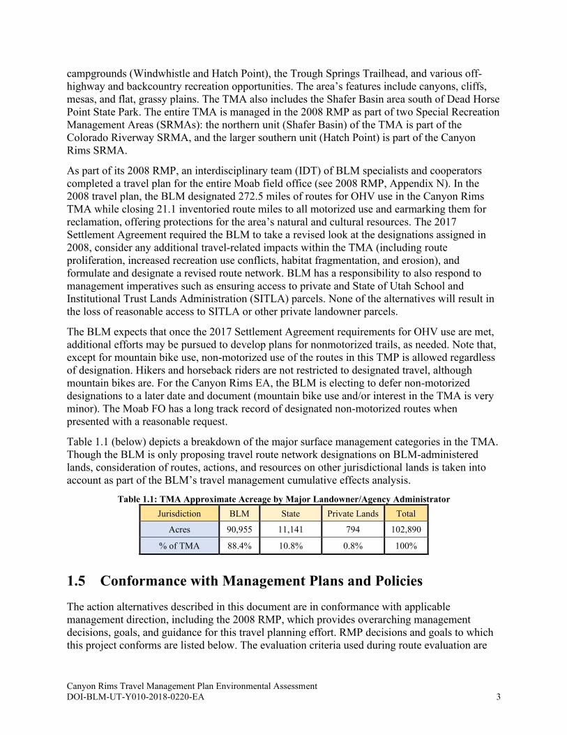
Table 1.1 (below) depicts a breakdown of the major surface management categories in the TMA.
Though the BLM is only proposing travel route network designations on BLM-administered
lands, consideration of routes, actions, and resources on other jurisdictional lands is taken into
account as part of the BLM’s travel management cumulative effects analysis.
Table 1.1: TMA Approximate Acreage by Major Landowner/Agency Administrator
Jurisdiction BLM State Private Lands Total
Acres 90,955 11,141 794 102,890
% of TMA 88.4% 10.8% 0.8% 100%
1.5 Conformance with Management Plans and Policies
The action alternatives described in this document are in conformance with applicable
management direction, including the 2008 RMP, which provides overarching management
decisions, goals, and guidance for this travel planning effort. RMP decisions and goals to which
this project conforms are listed below. The evaluation criteria used during route evaluation are

Canyon Rims Travel Management Plan Environmental Assessment DOI-BLM-UT-Y010-2018-0220-EA 4
tied to RMP decisions and goals and are listed in route reports (see Appendix H for route report
details).
Table 1.2: Key RMP Travel-Related Management Decisions and Goals
Transportation
TRV-2
BLM, in preparing its RMP designations and its implementation-level travel management plans, is
following policy and regulation authority found at: 43 CFR Part 8340; 43 CFR Subpart 8364; and 43
CFR Subpart 9268.
TRV-3
Provide opportunities for a range of motorized recreation experiences on public lands while protecting
sensitive resources and minimizing conflicts among various users. Identification of specific designated
routes will be initially established through the chosen Travel Plan accompanying this RMP (see
Appendix N) and may be modified through subsequent implementation planning and project planning
on a case-by-case basis. These identified routes will be available regardless of other management
actions. These adjustments will occur only in areas with limited route designations and will be
analyzed at the implementation planning level. These adjustments will be done through a collaborative
process with local government and will include public review of proposed route changes. Site-specific
NEPA documentation will be required for changes to the route designation system.
TRV-4
All areas are limited, open, or closed to motorized travel. Limit travel by motorized vehicle on all
lands administered by the Moab FO to designated routes, except for Managed Open Areas, and for
areas that are closed to motorized travel (see Map 30; see Appendix N for Travel Plan development).
TRV-5
BLM could impose limitations on types of vehicle allowed on specific designated routes if monitoring
indicates that a particular type of vehicle is causing disturbance to the soil, wildlife, wildlife habitat,
cultural or vegetative resources, especially by off-road travel in an area that is limited to designated
roads.
TRV-6
OHV access for game retrieval, antler collection and dispersed camping will only be allowed on
designated routes (designated routes/spurs and have been identified specifically for dispersed
camping; parking areas associated with dispersed campsites will be marked during travel plan
implementation). Adherence to the Travel Plan is required for all activities, except where otherwise
explicitly permitted.
TRV-7 Only designated roads and managed open areas are available for motorized commercial and organized
group use (see Maps 2 and 3 for route designations).
TRV-8
Where the authorized officer determines that off-road vehicles are causing or will cause considerable
adverse impacts, the authorized officer shall close or restrict such areas. The public will be notified as
to these closures and restrictions.
TRV-9
Any routes that are not baseline routes will be signed "Closed" on the ground. Such routes will be
considered as impacts to the area's natural character, and use of such routes will be considered cross
country use and not allowed. Non-inventoried routes should be rehabilitated.
TRV-10
OHV Designations:
• About 339,298 acres will be closed to OHV travel.
• About 1,481,334 acres will be limited to designated routes.
• Approximately 2,000 acres (White Wash Sand Dunes) will be open to cross country travel
(see Map 30).
TRV-11
Designated Routes – Motorized:
• Designate 3,693 miles of motorized routes.
• Designate 313 miles for motorcycles (163 miles on inventoried routes and 150 miles on
inventoried single-track).
• Designate a dirt bike route from Colorado State Line to Thompson (see Map 3), utilizing 9
miles of single-track designated above and 22 miles of inventoried Grand County roads.
These totals are reflected in the mileage under "designated routes."
Canyon Rims Travel Management Plan Environmental Assessment DOI-BLM-UT-Y010-2018-0220-EA 5
Recreation and Off-Highway Vehicles
REC-2
Where unacceptable damage to natural or cultural resources by recreational use is anticipated or
observed, BLM will seek to limit or control activities by managing the nature and extent of the activity
or by providing site improvements that make the activity more sustainable or by a combination of
management controls and facility development. Such management actions will seek to reduce or
eliminate the adverse impact while maintaining the economic benefits associated with a wide range of
recreation uses.
REC-3
BLM will consider and, where appropriate, implement management methods to protect riparian
resources, special status species, and wildlife habitat while enhancing recreation opportunities.
Management methods may include limitation of visitor numbers, camping and travel controls,
implementation of fees, alteration of when use takes place, and other similar actions to be approved
through normal BLM procedures.
REC-5
Recreational off-highway vehicle (OHV) and mechanized travel will be consistent with area and route
designations described in the travel management plan. BLM will work with agency and government
officials and permit holders to develop procedures, protocols, permits or other types of authorization,
as appropriate, to provide reasonable access for non-recreational use of OHVs for military, search and
rescue, emergency, administrative, and permitted uses.
REC-6
Dispersed camping is allowed where not specifically restricted. Dispersed camping may be closed
seasonally or as impacts or environmental conditions warrant. All vehicle use associated with
dispersed camping activities is required to stay on designated routes.
REC-14 Continue to manage Kane Creek Road to Hurrah Pass and the roads to Needles, Anticline, and Minor
overlooks as Utah Scenic Backways.
REC-33
Focus Areas are Recreation Management Zones (RMZ) for emphasizing particular types of recreation
activities while still allowing for other uses in accordance with the Travel Plan. As RMZs, Focus
Areas (Map 18) are established as a mechanism for enhancing specific recreation opportunities
through facilities and education such as route marking, parking, camping, and information. Where a
single focus SRMA or a specific RMZ (Focus Area) is not identified, the default focus of that area is
motorized, backcountry touring on designated roads. The roads are those identified in the Travel Plan
accompanying this RMP.
REC-34
The types of Focus Areas are: Non-mechanized Recreation, Mountain Bike Backcountry Touring,
Motorized Backcountry Touring, Scenic Driving Corridors, Specialized Sport Venue Non-motorized,
Specialized Sport Venue Motorized, and Managed Open OHV Area.
REC-36
Canyon Rims SRMA (excerpts):
• Manage the entire area as OHV travel limited to designated roads.
• Manage Hatch Wash and the lower section of West Coyote Creek for primitive,
nonmotorized recreation.
• Restrict backcountry motorized events to commercial and non-race special events on the Flat
Iron Mesa Jeep Safari route only. Focus Area -- Non-mechanized Recreation (3,642 acres):
Hatch Wash Hiking and Backpacking Focus Area inclusive of the area from Goodman
Canyon to the confluence of Hatch Wash with Kane Creek Canyon including the lower
section of West Coyote Creek (from private land west to confluence with Hatch Wash) and
the lower section of Troutwater Canyon.
• New motorized routes will not be considered in the Hatch Wash Hiking and Backpacking
Focus Area.
• Focus Area -- Scenic Driving Corridors: Needles and Anticline Roads – Utah Scenic
Backways. Manage for scenic driving enjoyment. The corridor is defined as having a width
of 1/2 mile from centerline (or to border of adjoining Focus Area).
REC-37
Colorado Riverway SRMA (excerpts):
• Manage the Colorado Riverway as a Destination SRMA to manage camping, boating, river
access, trail, and interpretive facilities in popular areas along or near the Colorado River and
to protect the outstanding resource values of the area. Guidance for management is included
in the Colorado Riverway Recreation Area Management Plan.
Canyon Rims Travel Management Plan Environmental Assessment DOI-BLM-UT-Y010-2018-0220-EA 6
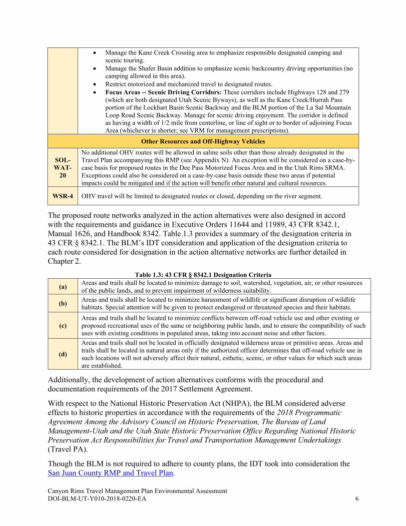
• Manage the Kane Creek Crossing area to emphasize responsible designated camping and
scenic touring.
• Manage the Shafer Basin addition to emphasize scenic backcountry driving opportunities (no
camping allowed in this area).
• Restrict motorized and mechanized travel to designated routes.
• Focus Areas -- Scenic Driving Corridors: These corridors include Highways 128 and 279
(which are both designated Utah Scenic Byways), as well as the Kane Creek/Hurrah Pass
portion of the Lockhart Basin Scenic Backway and the BLM portion of the La Sal Mountain
Loop Road Scenic Backway. Manage for scenic driving enjoyment. The corridor is defined
as having a width of 1/2 mile from centerline, or line of sight or to border of adjoining Focus
Area (whichever is shorter; see VRM for management prescriptions).
Other Resources and Off-Highway Vehicles
SOL-
WAT-
20
No additional OHV routes will be allowed in saline soils other than those already designated in the
Travel Plan accompanying this RMP (see Appendix N). An exception will be considered on a case-by-
case basis for proposed routes in the Dee Pass Motorized Focus Area and in the Utah Rims SRMA.
Exceptions could also be considered on a case-by-case basis outside these two areas if potential
impacts could be mitigated and if the action will benefit other natural and cultural resources.
WSR-4 OHV travel will be limited to designated routes or closed, depending on the river segment.
The proposed route networks analyzed in the action alternatives were also designed in accord
with the requirements and guidance in Executive Orders 11644 and 11989, 43 CFR 8342.1,
Manual 1626, and Handbook 8342. Table 1.3 provides a summary of the designation criteria in
43 CFR § 8342.1. The BLM’s IDT consideration and application of the designation criteria to
each route considered for designation in the action alternative networks are further detailed in
Chapter 2.
Table 1.3: 43 CFR § 8342.1 Designation Criteria
(a) Areas and trails shall be located to minimize damage to soil, watershed, vegetation, air, or other resources
of the public lands, and to prevent impairment of wilderness suitability.
(b) Areas and trails shall be located to minimize harassment of wildlife or significant disruption of wildlife
habitats. Special attention will be given to protect endangered or threatened species and their habitats.
(c)
Areas and trails shall be located to minimize conflicts between off-road vehicle use and other existing or
proposed recreational uses of the same or neighboring public lands, and to ensure the compatibility of such
uses with existing conditions in populated areas, taking into account noise and other factors.
(d)
Areas and trails shall not be located in officially designated wilderness areas or primitive areas. Areas and
trails shall be located in natural areas only if the authorized officer determines that off-road vehicle use in
such locations will not adversely affect their natural, esthetic, scenic, or other values for which such areas
are established.
Additionally, the development of action alternatives conforms with the procedural and
documentation requirements of the 2017 Settlement Agreement.
With respect to the National Historic Preservation Act (NHPA), the BLM considered adverse
effects to historic properties in accordance with the requirements of the 2018 Programmatic
Agreement Among the Advisory Council on Historic Preservation, The Bureau of Land
Management-Utah and the Utah State Historic Preservation Office Regarding National Historic
Preservation Act Responsibilities for Travel and Transportation Management Undertakings
(Travel PA).
Though the BLM is not required to adhere to county plans, the IDT took into consideration the
San Juan County RMP and Travel Plan.
Canyon Rims Travel Management Plan Environmental Assessment DOI-BLM-UT-Y010-2018-0220-EA 7
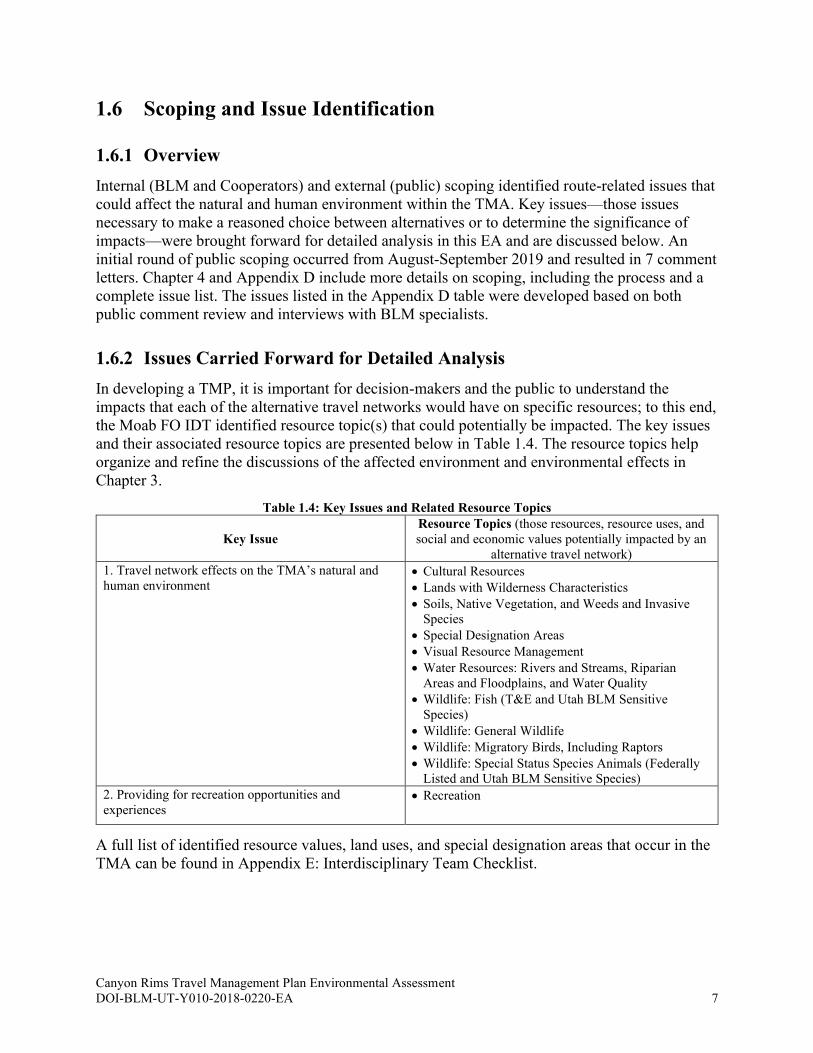
1.6 Scoping and Issue Identification
1.6.1 Overview
Internal (BLM and Cooperators) and external (public) scoping identified route-related issues that
could affect the natural and human environment within the TMA. Key issues—those issues
necessary to make a reasoned choice between alternatives or to determine the significance of
impacts—were brought forward for detailed analysis in this EA and are discussed below. An
initial round of public scoping occurred from August-September 2019 and resulted in 7 comment
letters. Chapter 4 and Appendix D include more details on scoping, including the process and a
complete issue list. The issues listed in the Appendix D table were developed based on both
public comment review and interviews with BLM specialists.
1.6.2 Issues Carried Forward for Detailed Analysis
In developing a TMP, it is important for decision-makers and the public to understand the
impacts that each of the alternative travel networks would have on specific resources; to this end,
the Moab FO IDT identified resource topic(s) that could potentially be impacted. The key issues
and their associated resource topics are presented below in Table 1.4. The resource topics help
organize and refine the discussions of the affected environment and environmental effects in
Chapter 3.
Table 1.4: Key Issues and Related Resource Topics
Key Issue
Resource Topics (those resources, resource uses, and
social and economic values potentially impacted by an
alternative travel network)
1. Travel network effects on the TMA’s natural and
human environment • Cultural Resources
• Lands with Wilderness Characteristics
• Soils, Native Vegetation, and Weeds and Invasive
Species
• Special Designation Areas
• Visual Resource Management
• Water Resources: Rivers and Streams, Riparian
Areas and Floodplains, and Water Quality
• Wildlife: Fish (T&E and Utah BLM Sensitive
Species)
• Wildlife: General Wildlife
• Wildlife: Migratory Birds, Including Raptors
• Wildlife: Special Status Species Animals (Federally
Listed and Utah BLM Sensitive Species)
2. Providing for recreation opportunities and
experiences • Recreation
A full list of identified resource values, land uses, and special designation areas that occur in the
TMA can be found in Appendix E: Interdisciplinary Team Checklist.
Canyon Rims Travel Management Plan Environmental Assessment DOI-BLM-UT-Y010-2018-0220-EA 8
1.6.3 Resource/Use Topics Identified, but Eliminated from Detailed Analysis
Some issues raised during scoping were beyond the scope of this project, were not substantive,
or were not helpful in making reasoned choices among alternatives. Resource/use topics that
were identified but eliminated from detailed analysis in the EA can be found in the IDT checklist
table in Appendix E. In this table, resource/use topics with a determination of “NI” (Not
Impacted) or “NP” (Not Present) were not carried forward for analysis, and relevant details and
explanations are provided. Resource topics are not analyzed because they are absent, because
there is definite lack of potential for significant impacts, or because the issue is not necessary to
make a reasoned choice among alternatives. For a summary informing the determination of NI
for Socioeconomics, see Appendix F: Estimated Economic Impact.

Canyon Rims Travel Management Plan Environmental Assessment DOI-BLM-UT-Y010-2018-0220-EA 9
2. ALTERNATIVES
2.1 Route Designation Methodology
2.1.1 Overview
A BLM IDT evaluated all OHV travel routes considered for designation in the Canyon Rims
TMA and created a preliminary range of alternative travel networks. During evaluation of each
travel route, the IDT applied and documented compliance with the 43 CFR 8342.1 designation
criteria (i.e., minimization criteria). BLM Manual 1626 explains that the minimization of impacts
“means to limit the degree or magnitude of the action and its implementation (40 CFR
1508.20(b) – CEQ Regulations for Implementing the Procedural Provisions of the National
Environmental Policy Act (BLM 2016b). The BLM route evaluation process along with further
review and scoping contributed to the development of a range of reasonable alternatives.
Reasonable alternatives are those that “are practical or feasible from the technical and economic
standpoint and using common sense, rather than simply desirable. . .” (BLM 2008a). Each action
alternative meets the purpose and need and responds to the key issues described in Chapter 1.
2.1.2 Route Inventory
The Canyon Rims TMA route inventory consists of the route network system designated as part
of the 2008 RMP, and includes only routes designated OHV-open in the 2008 RMP. Off-route
OHV use in the TMA is rare and new route proliferation is not an issue due to extensive
management, thus new routes beyond those designated in the 2008 RMP are not considered
through this process.
The route inventory used in the 2008 RMP was verified in 2017 and 2018 using field surveys,
aerial imagery, and IDT input. The BLM collected inventory data, which include GPS-collected
lines showing route locations and attributes. Data also include GPS-collected points describing
travel management-related features on or near routes. During IDT review, some linear features
(see Glossary for definition), generally old seismic exploration lines, were identified that are not,
nor were ever, routes authorized or designated by the BLM. BLM staff considered these linear
features and determined that they were linear disturbances that were inappropriate for
designation. None of these linear disturbances were included in any of the route network
alternatives.
2.1.3 Route Evaluation
In 2018, the BLM IDT and cooperating agencies began evaluating 272.5 miles of inventoried
routes, all of which were designated as OHV-open in the 2008 RMP Travel Plan.
The BLM’s route evaluation process included the following components:
• Consideration of the goals and objectives for resource values and uses established in the
2008 RMP
• Consideration and documentation of any purpose and need of the route, including but not
limited to activities relating to existing motorized and non-motorized uses for recreation,
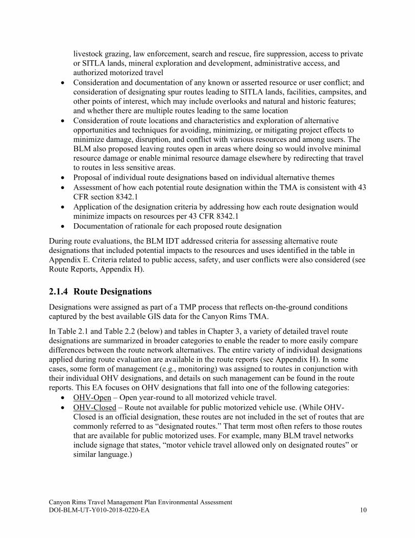
Canyon Rims Travel Management Plan Environmental Assessment DOI-BLM-UT-Y010-2018-0220-EA 10
livestock grazing, law enforcement, search and rescue, fire suppression, access to private
or SITLA lands, mineral exploration and development, administrative access, and
authorized motorized travel
• Consideration and documentation of any known or asserted resource or user conflict; and
consideration of designating spur routes leading to SITLA lands, facilities, campsites, and
other points of interest, which may include overlooks and natural and historic features;
and whether there are multiple routes leading to the same location
• Consideration of route locations and characteristics and exploration of alternative
opportunities and techniques for avoiding, minimizing, or mitigating project effects to
minimize damage, disruption, and conflict with various resources and among users. The
BLM also proposed leaving routes open in areas where doing so would involve minimal
resource damage or enable minimal resource damage elsewhere by redirecting that travel
to routes in less sensitive areas.
• Proposal of individual route designations based on individual alternative themes
• Assessment of how each potential route designation within the TMA is consistent with 43
CFR section 8342.1
• Application of the designation criteria by addressing how each route designation would
minimize impacts on resources per 43 CFR 8342.1
• Documentation of rationale for each proposed route designation
During route evaluations, the BLM IDT addressed criteria for assessing alternative route
designations that included potential impacts to the resources and uses identified in the table in
Appendix E. Criteria related to public access, safety, and user conflicts were also considered (see
Route Reports, Appendix H).
2.1.4 Route Designations
Designations were assigned as part of a TMP process that reflects on-the-ground conditions
captured by the best available GIS data for the Canyon Rims TMA.
In Table 2.1 and Table 2.2 (below) and tables in Chapter 3, a variety of detailed travel route
designations are summarized in broader categories to enable the reader to more easily compare
differences between the route network alternatives. The entire variety of individual designations
applied during route evaluation are available in the route reports (see Appendix H). In some
cases, some form of management (e.g., monitoring) was assigned to routes in conjunction with
their individual OHV designations, and details on such management can be found in the route
reports. This EA focuses on OHV designations that fall into one of the following categories:
• OHV-Open – Open year-round to all motorized vehicle travel.
• OHV-Closed – Route not available for public motorized vehicle use. (While OHV-
Closed is an official designation, these routes are not included in the set of routes that are
commonly referred to as “designated routes.” That term most often refers to those routes
that are available for public motorized uses. For example, many BLM travel networks
include signage that states, “motor vehicle travel allowed only on designated routes” or
similar language.)
Canyon Rims Travel Management Plan Environmental Assessment DOI-BLM-UT-Y010-2018-0220-EA 11
Regardless of route designations, people can engage in non-motorized forms of transportation
such as walking or riding horses anywhere on TMA BLM lands (on routes or cross-country),
unless there is a specific exclusion stating otherwise. The OHV-Closed category also includes:
• Routes that will not become part of the designated OHV route network and are often
earmarked for natural or manual reclamation.
• Routes that remain available for existing authorized or administrative uses. Some of these
routes provide access to authorized facilities (i.e., stock tanks and ponds, corrals,
communication sites, etc.).
• Routes that remain available for non-OHV use, such as hiking or equestrian trails.
As the need arises, and in accordance with applicable laws and regulations, any route (including
those that are designated OHV-Closed) could be made available to authorized or administrative
uses.
2.1.5 R.S. 2477 Assertions
The State of Utah and counties may hold valid existing rights-of-way within the TMA pursuant
to Revised Statute (R.S.) 2477, Act of July 28 1866, Chapter 262, 8,14; Stat. 252, 253, codified
at 43 U.S.C. § 932. This travel planning effort and resulting TMP is not intended to provide any
evidence bearing on or to address the validity of any asserted R.S. 2477 rights-of-way and does
not adjudicate, analyze, or otherwise determine the validity of any asserted rights-of-way. R.S.
2477 rights are determined through a process that is entirely separate from BLM travel planning
efforts. Consequently, this planning effort does not consider any R.S. 2477 assertions or
evidence and has no effect on any legal rights relating to asserted R.S. 2477 rights-of-way. At
such time as administrative or judicial determinations are made acknowledging or adjudicating
asserted R.S. 2477 rights-of-ways, the BLM will adjust its TMP accordingly.
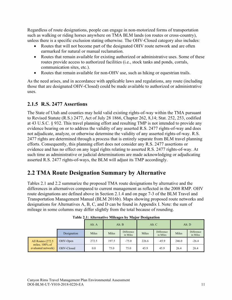
2.2 TMA Route Designation Summary by Alternative
Tables 2.1 and 2.2 summarize the proposed TMA route designations by alternative and the
differences in alternatives compared to current management as reflected in the 2008 RMP. OHV
route designations are defined above in Section 2.1.4 and on page 7-3 of the BLM Travel and
Transportation Management Manual (BLM 2016b). Maps showing proposed route networks and
designations for Alternatives A, B, C, and D can be found in Appendix I. Note: the sum of
mileage in some columns may differ slightly from the total because of rounding.
Table 2.1: Alternative Mileages by Major Designation
Alt. A Alt. B Alt. C Alt. D
Designation Miles Miles Difference
in Miles Miles
Difference
in Miles Miles
Difference
in Miles
All Routes (272.5 miles; 100% of
evaluated network)
OHV-Open 272.5 197.5 -75.0 226.6 -45.9 246.0 -26.4
OHV-Closed 0.0 75.0 75.0 45.9 45.9 26.4 26.4
Canyon Rims Travel Management Plan Environmental Assessment DOI-BLM-UT-Y010-2018-0220-EA 12
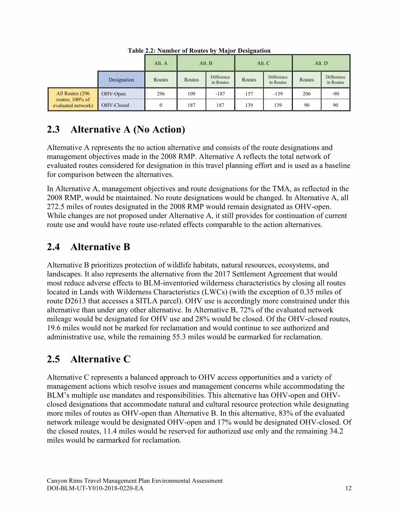
Table 2.2: Number of Routes by Major Designation
Alt. A Alt. B Alt. C Alt. D
Designation Routes Routes Difference
in Routes Routes
Difference
in Routes Routes
Difference
in Routes
All Routes (296
routes; 100% of
evaluated network)
OHV-Open 296 109 -187 157 -139 206 -90
OHV-Closed 0 187 187 139 139 90 90
2.3 Alternative A (No Action)
Alternative A represents the no action alternative and consists of the route designations and
management objectives made in the 2008 RMP. Alternative A reflects the total network of
evaluated routes considered for designation in this travel planning effort and is used as a baseline
for comparison between the alternatives.
In Alternative A, management objectives and route designations for the TMA, as reflected in the
2008 RMP, would be maintained. No route designations would be changed. In Alternative A, all
272.5 miles of routes designated in the 2008 RMP would remain designated as OHV-open.
While changes are not proposed under Alternative A, it still provides for continuation of current
route use and would have route use-related effects comparable to the action alternatives.
2.4 Alternative B
Alternative B prioritizes protection of wildlife habitats, natural resources, ecosystems, and
landscapes. It also represents the alternative from the 2017 Settlement Agreement that would
most reduce adverse effects to BLM-inventoried wilderness characteristics by closing all routes
located in Lands with Wilderness Characteristics (LWCs) (with the exception of 0.35 miles of
route D2613 that accesses a SITLA parcel). OHV use is accordingly more constrained under this
alternative than under any other alternative. In Alternative B, 72% of the evaluated network
mileage would be designated for OHV use and 28% would be closed. Of the OHV-closed routes,
19.6 miles would not be marked for reclamation and would continue to see authorized and
administrative use, while the remaining 55.3 miles would be earmarked for reclamation.
2.5 Alternative C
Alternative C represents a balanced approach to OHV access opportunities and a variety of
management actions which resolve issues and management concerns while accommodating the
BLM’s multiple use mandates and responsibilities. This alternative has OHV-open and OHV-
closed designations that accommodate natural and cultural resource protection while designating
more miles of routes as OHV-open than Alternative B. In this alternative, 83% of the evaluated
network mileage would be designated OHV-open and 17% would be designated OHV-closed. Of
the closed routes, 11.4 miles would be reserved for authorized use only and the remaining 34.2
miles would be earmarked for reclamation.
Canyon Rims Travel Management Plan Environmental Assessment DOI-BLM-UT-Y010-2018-0220-EA 13
2.6 Alternative D
Alternative D is the action alternative that would designate the most miles of evaluated routes as
OHV-open, thus representing the action alternative that would allow the most OHV-based access
opportunities for a full range of purposes while still mitigating travel-related impacts. In this
alternative, 90% of the evaluated network mileage would be designated for OHV use and 10%
would be designated OHV-closed. Of the closed routes, 5.3 miles would be reserved for
authorized use only, approximately 2 miles would not be earmarked for reclamation due to other
passive non-motorized and non-mechanized uses, and the remaining 19 miles would be
earmarked for reclamation.
2.7 Implementation Actions Common to All Action Alternatives
Although some forms of implementation-related management were specified in conjunction with
designations during route evaluation, the following activities identified in the TMP
Implementation Guide would occur with any of the action alternatives described above.
2.7.1 Signage (Appendix L (TMP Implementation Guide), Section L.3.4 and Appendix L-G)
The travel route network would be signed to identify routes and inform the public of locations,
special conditions, and limitations. Activities associated with signage include ground disturbance
(post hole excavation, minor grading) and may involve minor vegetation removal. Sign
installation will be done in previously disturbed areas as much as possible but may require
installation in previously undisturbed areas outside the roadway and shoulder. Sign placement in
areas that have not been previously disturbed is not analyzed in this EA and would be subject to
additional NEPA compliance, if proposed. According to the Travel PA, Stipulation VI.C., the
installation of signs is exempt from cultural resource survey and consultation requirements.
2.7.2 Route Maintenance (Appendix L (TMP Implementation Guide), Section L.3.5)
Route maintenance is categorized into one of two categories: 1) routine maintenance that meets
the purpose and need of the route and that does not extend beyond the edge of previous road
prism disturbance; or 2) maintenance of a route that exceeds the standard of routine maintenance
by either upgrading, widening, re-aligning, or otherwise creating new surface disturbance.
Maintenance of designated routes would typically be conducted as described in the first category.
Maintenance of designated routes that fall into the second category (i.e., more than routine) may
be conducted only after additional site-specific analysis.
2.7.3 Decommissioning or Reclaiming Closed Routes (Appendix L (TMP Implementation Guide), Section L.7)
Closed routes may be decommissioned and/or reclaimed through a variety of methods described
below. BLM resource specialists will determine which form of decommissioning or reclamation
is appropriate based on the attributes of each closed route:

Canyon Rims Travel Management Plan Environmental Assessment DOI-BLM-UT-Y010-2018-0220-EA 14
• Closed routes may be allowed to revegetate naturally.
• Route reclamation may be done by mechanically ripping the route surface and
revegetating through seeding or planting.
• In sandy areas and washes, tracks may be raked out so there is no evidence of vehicle
use.
• Grading and recontouring may be used in some areas to restore natural slopes.
• As with maintenance activities, ground disturbance may extend into areas not previously
disturbed.
• Signs or barriers (boulders, fences and gates, berms, vegetation) may be placed at the
entrances to closed routes.
• Mulching may be used to obscure closed routes or protect disturbed surfaces.
2.7.4 Best Management Practices and Standard Operating Procedures (Appendix L (TMP Implementation Guide), Section L.3)
Under all action alternatives, implementation activities are subject to Best Management Practices
(BMPs) and Standard Operating Procedures (SOPs). A list of BMPs and SOPs can be found in
the Implementation Guide (Appendix L), Section L.3.5.
2.7.5 Conservation Measures
Through consultation with the U.S. Fish and Wildlife Service (USFWS) the following
Conservation Measures have been developed and will be adhered to regardless of the alternative
selected for this TMP:
• If occupancy of ESA-listed species is confirmed, BLM will monitor all routes, including
routes designated as closed, within occupied habitat to ensure compliance with the
designation in the TMP. If monitoring indicates that disturbance or use is occurring
outside the designated OHV open routes, BLM will implement appropriate corrective
actions as identified in the 2008 RMP or developed in consultation with the USFWS.
Endangered Plants
• Plan and implement surveys for Jones cycladenia and Navajo sedge in all areas where
potentially suitable habitat occurs within 300 feet of travel routes.
• Protect occupied habitat from recreational access and use.
• Jones cycladenia and Navajo sedge potential suitable habitat: If surface disturbance
activities occur within 300 feet of potential suitable habitat for Jones cycladenia and
Navajo sedge, the BLM will implement the applicant committed conservation measures
identified in the Moab Master Leasing Plan (BLM 2016a, pages A-33 to A-40).
Endangered Fishes
• The Colorado River and its tributaries are home to three conservation agreement species:
the bluehead sucker (Catostomus discobolus), roundtail chub (Gila robusta) and the
flannelmouth sucker (Catostomus latipinnis). Conservation measures for the endangered
Colorado River fishes are described in the Biological Opinion (attached as an appendix to
the Decision Record for this project). As identified by USFWS, the same conservation
Canyon Rims Travel Management Plan Environmental Assessment DOI-BLM-UT-Y010-2018-0220-EA 15
measures will be applied to minimize effects to the three conservation agreement species
and other sensitive native aquatic and riparian species.
Mexican Spotted Owl
The following conservation measures, as identified by USFWS, will be applied to Mexican
spotted owls and their suitable habitats:
1. Habitats: In un-surveyed areas or areas that have not had protocol surveys since 2015,
suitable and potentially suitable habitats will be surveyed according to USFWS protocol
in 2021 and 2022.
2. Recreation Disturbance:
a. The following guidelines apply to Protected Activity Centers (PACs) during the
breeding season, (1 Mar - 31 Aug). If non-breeding is inferred or confirmed that
year per the accepted survey protocol, restrictions on noise disturbances can be
relaxed depending on the nature and extent of the proposed disturbance
(Swarthout and Steidl 2001, 2003). Guidelines for noise management related to
recreation are provided below in the noise management recommendations.
i. No construction of new facilities (e.g., trailheads, OHV trails) or
expansion of existing facilities should take place in PACs during the
breeding season. Any construction within PACs should be considered on a
case-specific basis. Modifications to existing facilities pertaining to public
health, safety, and routine maintenance are excepted (e.g., removal of
dangerous trees in a campground; replacement of road culverts within
campgrounds, etc.). However, when implementing such activities, those
conducting the work should use all measures possible to avoid potential
effects on owls (e.g., use least disruptive machinery; timing of the project
to minimize disturbance).
ii. Managers should, on a case-specific basis, assess the presence and
intensity of currently allowed (permitted and non-permitted) recreational
activities. The assessment should include distance, frequency, duration,
and source of the disturbance. If recreation is determined to be a problem
(e.g., increased OHV or hiking use), limit human activities during the
breeding season in areas occupied by owls (timing may vary depending on
local nest chronology). Disturbance here is defined as the presence of 1
to12 people; group sizes exceeding 12 people should not be allowed. In
areas where nest and roost sites are not identified, human disturbance
should be limited to ≤ 2 disturbances per hour (averaged over a 24 hour
period) throughout the PAC. Where nest and roost sites are known,
disturbance should be limited to ≤ 2 disturbances per hour (averaged over
a 24 hour period) within line of sight of the nest/roost sites. In some cases,
disturbances may be avoided by routing trails and recreational uses (e.g.,
OHV use) outside of PACs through signing in order to designate zones
free from human disturbances during critical periods.
iii. Seasonal closures of specifically designated recreational activities (e.g.,
OHV use, rock climbing, or biking) should be considered where
disturbance to breeding owls seems likely.
iv. Conduct education through signing, interpretation events, access
permitting, or other information sources to inform the public of proper and
Canyon Rims Travel Management Plan Environmental Assessment DOI-BLM-UT-Y010-2018-0220-EA 16
legal behaviors when encountering owls. For example, land managers in
some areas are maintaining permanent, all-weather signs that inform the
public that the area is home to a sensitive species; visitors should stay on
the trail and be as quiet and unobtrusive as possible.
v. If owls are not detected in a PAC during the breeding season, restrictions
on non-habitat-altering recreation can be relaxed depending on the nature
and extent of the proposed disturbance.
3. Noise Disturbance:
a. The following guideline applies to areas within PACs during the breeding season
(1 Mar - 31 Aug). If non-breeding is inferred or confirmed that year per the
accepted survey protocol, restrictions on noise disturbances can be relaxed
depending on the nature and extent of the proposed disturbance.
i. Managers should, on a case-specific basis, assess the potential for noise
disturbance to nesting owls.
ii. Breeding-season restrictions should be considered if noise levels are
estimated to exceed 69 dBA (A-weighted noise level) (~80 dBO [owl-
weighted noise level, Delaney et al. 1999a, b, Delaney and Grubb 2003,
and Pater et al. 2009]) consistently (i.e., >twice/hour) or for an extended
period of time (>1 hr) within 50 m (165 ft) of nesting sites (if known) or
within entire PAC if nesting sites are not known.
Canyon Rims Travel Management Plan Environmental Assessment DOI-BLM-UT-Y010-2018-0220-EA 17
3. AFFECTED ENVIRONMENT AND ENVIRONMENTAL
EFFECTS
3.1 Overview
3.1.1 Introduction and General Setting
This chapter describes the current conditions and trends of the resource topics (i.e., those
resources, resource uses, and social and economic values that comprise the natural and human
environment) relevant to the key scoping issues presented in section 1.6.2. It also discloses the
effects that implementation of any of the alternative route networks would have on relevant
resource topics. The affected environment is the same for all alternatives. For an overview of the
TMA setting, see section 1.4. The table in Appendix E lists all relevant resource topics for which
issues are analyzed and provides rationales for resources not analyzed.
3.1.2 Effects
In this EA, effects analysis was conducted in the context of NEPA planning. The BLM’s NEPA
handbook defines “effect” as an “impact to the human environment brought about by an agent of
change, or action. Effects analysis predicts the degree to which the environment will be affected
by an action” (BLM 2008a). The handbook adds that effects “can be both beneficial and
detrimental, and may be direct, indirect, or cumulative” (BLM 2008a). Beneficial effects are
those that would enhance or restore the TMA environment. For example, a designated travel
network can provide sustainable travel routes for a variety of desired experiences and reduce user
inclination to travel off route and create new disturbance that would impact the area’s natural and
cultural resources.
The analysis that follows—unless otherwise noted—focuses on the key issues from scoping and
concerns associated with potential effects on relevant TMA resources and resource uses.
Analyzing these effects provides a useful comparison between each alternative travel network’s
capability for addressing the documented issues and concerns. The BLM’s NEPA handbook
states that the BLM “must consider and analyze three categories of effects for any BLM proposal
and its alternatives: direct, indirect, and cumulative (40 CFR 1508.25(c))” (BLM 2008a), so
throughout the analysis effects are discussed in the context of:
• Direct effects: Caused by alternative (same time and place).
• Indirect effects: Caused by alternative but later in time or further in distance but still
reasonably foreseeable.
• Cumulative effects: The Council on Environmental Quality NEPA regulations (40 CFR
1508.7) defines a cumulative effect as “the impact on the environment which results from
the incremental impact of the action when added to other past, present, and reasonably
foreseeable future actions regardless of what agency (Federal or non-Federal) or person
undertakes such other actions. Cumulative effects can result from individually minor but
collectively significant actions taking place over a period of time” (GPO 2012).
Canyon Rims Travel Management Plan Environmental Assessment DOI-BLM-UT-Y010-2018-0220-EA 18
Note: Cumulative effects analysis can be found at the end of the Key Issue sections in this
Chapter.
3.1.3 General Assumptions
The following general assumptions were applied in analysis of each of the alternative travel route
network’s effects on the TMA environment:
• The construction of new routes is not in the scope of this project; however, the possibility
of future addition of new routes is part of the operation and management of the overall
travel network (see Appendix L (TMP Implementation Guide), section L.3.5). As part of
ongoing travel management associated with this TMP, route designations may be added
or changed in the future to respond to growing public demand for access, Title V ROW
considerations, or concerns of damage to resources (e.g., an existing route that is needed
to access a trailhead is causing unacceptable erosion). Any new or changed designations
will be subject to site-specific environmental analysis in accordance with NEPA and
Travel-related decisions in the 2008 RMP.
• Reducing network mileage within the TMA is not anticipated to decrease OHV use
overall. Year-round OHV and non-motorized recreation use would continue to increase
slightly in and around the TMA regardless of the designations made as a result of this
travel planning effort. • Concentration of use is not anticipated as an issue in this TMA. This conclusion was
reached by the BLM IDT and applies for archaeology, wildlife, and other resources.
Routes proposed for OHV-closed designations in the alternative networks are very lightly
used, and therefore there would be no appreciable concentration of use on the remaining
open routes. Of the estimated 53 vehicles per day that use the Canyon Rims area, at least
80% of them use the Needles Overlook Road only; another 15% use the graveled
Anticline Overlook Road. The remaining 5% may utilize the arterial roads in the TMA
such as Flat Iron and Looking Glass.
• Providing for a variety of OHV opportunities and experiences would help reduce user
inclination to travel off designated routes. • There are some linear features that are not designated for use under Alternative A that are
currently receiving some unauthorized use. These linear features were not considered for
designation. Enforcement of current designations as an issue is not part of this analysis. • The proposed action alternative designations would supersede current travel route
designations made in the 2008 RMP. • A well-planned travel network would provide needed access for a variety of resource
management activities, including mitigation, maintenance, and monitoring. • Detrimental effects would be reduced by applying the best management practices (BMPs)
and standard operating procedures (SOPs) listed in sections L.3 through L.7 of the TMP
Implementation Guide (Appendix L) for operation and maintenance of the designated
route network. • OHV-open designations that include “with management” include some type of additional
management (e.g., sign installation, monitoring, maintenance, etc.), but do not necessarily
result in additional limitations on user type, season of use, or mode of travel.
• The implementation discussed in this document and detailed in the TMP Implementation
Guide (Appendix L) is subject to available funding and resources. For the purposes of
Canyon Rims Travel Management Plan Environmental Assessment DOI-BLM-UT-Y010-2018-0220-EA 19
this analysis, it is assumed that funding and resources would be available for
implementation.
• Routes that are designated OHV-closed would not become part of the OHV travel
network. They would be allowed to reclaim naturally or be actively reclaimed (e.g.,
through scarification and seeding), unless they are to remain available for administrative
or authorized uses (e.g., access to range facilities or communication sites).
• For the purposes of this EA, it is assumed that implementation of a designated travel
route network, including management, maintenance, and appropriate signage, would help
minimize off-route OHV use and that most OHV users would act responsibly and legally
on all designated routes.
3.1.4 General Effects Analysis Methodology
In this chapter, the following methodologies were applied to analyze alternative travel networks’
potential effects on resource/use topics:
• GIS data and resource/use data collected during route evaluation form the basis for
disclosing alternative route networks’ potential effects on issues tied to particular
resource/use topics. Data in tables show how many miles or numbers of routes of a
particular designation under each alternative are likely to affect resources or uses
associated with certain issues and impact analysis questions. These tables are used to
disclose and compare effects of the action alternatives (B, C, and D) to the No Action
Alternative (A). In many cases, the potential for effects is noted by comparing
percentages or miles of routes of a designation with the total miles or numbers of routes
associated with a particular resource. Travel routes or route miles are considered as
potentially impacting a resource when they cross over it (e.g., species habitat polygons),
are within a defined proximity distance of it (e.g., within ½ mile), or are otherwise noted
as being associated in route evaluation data.
• To help inform overall context, in the alternative travel network tables in Chapter 3, total
routes or miles associated with a particular resource (and the percentage of the total
network those routes or miles represent) are presented where possible as values in the far-
left columns of tables.
• The overall projected extent of effects of an alternative travel route network is
summarized at the end of effects discussions for each resource topic section. • Effects analysis is based on the best available data and resource staff knowledge of the
TMA (based on observation and analysis of conditions and resources in the area and
other similar areas).
• The past actions of assigning individual designations to routes in 2008 were considered
as part of direct, indirect, and cumulative effects analysis.
• For some resource topics, more specific methodologies were used to determine effects.
These methodologies are described in their respective resource topic sections.
• Cumulative effects analysis is considered at the end of each Key Issue section in this
Chapter.
Mileages, percentages, acreages, and other quantities used in this analysis are approximate
projections for comparison and analytical purposes only; they do not always reflect exact
Canyon Rims Travel Management Plan Environmental Assessment DOI-BLM-UT-Y010-2018-0220-EA 20
measurements or precise calculations. Table mileages and percentages may not total equally in
some instances due to rounding.
Although the following effects analyses are presented in the context of TMA-wide alternative
travel route networks, each individual route within a given alternative network has been
systematically and carefully evaluated as part of a route evaluation and designation process. As
part of documenting compliance with the 43 CFR 8342.1 designation criteria, for each route
designation, rationale statements were provided. These statements summarize how proposed
designations would minimize potential resource impacts. They were reviewed and chosen by the
BLM IDT, discussed as needed, and documented for each route alternative (see sample route
report in Appendix H).
3.1.5 Additional Management
During route evaluation, additional measures were considered and documented where
appropriate for routes with the designations of “Open with management.” Measures include such
actions as gate installation, parking area creation, and monitoring for cultural sites or recreational
uses. Details on monitoring, design features, and mitigation may be found in sections L.4
through L.5 and Appendix L-C of the TMP Implementation Guide (Appendix L). Mitigation
measures would help reduce the detrimental effects of the alternative travel networks on many of
the TMA’s natural and cultural resources, and monitoring would serve to track the effectiveness
of mitigation measures.
3.2 Key Issue 1: Travel network effects on the TMA’s natural and
human environment
3.2.1 Cultural Resources How would route designation alternatives affect impacts to cultural resources?
3.2.1.1 Affected Environment
BLM Manual 8100 – Foundations for Managing Cultural Resources, defines cultural resources
as “definite location[s] of human activity, occupation, or use identifiable through field inventory
(survey), historical documentation, or oral evidence.” The term includes archaeological, historic,
or architectural sites, structures, or places with important public and scientific uses, and may
include definite locations (sites or places) of traditional cultural or religious importance to
specified social and/or cultural groups. Cultural resources are concrete, material places and
things that are located, classified, ranked, and managed through the system of identifying,
protecting, and utilizing for public benefit. They may be, but are not necessarily, eligible for the
National Register of Historic Places (National Register). Cultural resource sites eligible for, or
listed on, the National Register are referred to interchangeably as “historic properties” or
“eligible sites” (BLM 2004a).
Cultural Resources are identified though cultural resource inventories and surveys, which are
defined as “a representation of the cultural resource content of a geographical locale” by BLM
Manual 8110 – Identifying and Evaluating Cultural Resources. The BLM cultural resource
Canyon Rims Travel Management Plan Environmental Assessment DOI-BLM-UT-Y010-2018-0220-EA 21
inventory system is composed of three kinds of inventory: Class I Existing Information
Inventory, Class II Probabilistic Field Survey, and Class III Intensive Field Survey (BLM
2004b). All three kinds of inventory were used to identify and evaluate archaeological sites in
this TMA.
The TMA contains important cultural resources of prehistoric and historic value, which may take
the form of sites (such as lithic debitage scatters), artifacts, buildings, structures, features, and
natural landscapes. Human presence in the TMA spans the last 12,000 years or so and includes a
number of distinctive cultures (Beck, et al. 2016): Paleo-Indian (12,500-8,000 years ago),
Archaic (8,000-2,000 years ago), Formative (including Ancestral Puebloan and Fremont
cultures; AD 1 to 1300), Protohistoric (AD 1400 to 1850), and Euro-American (1800s and
1900s).
3.2.1.2 Environmental Effects Analysis
Impacts that may occur to any cultural resource site from OHV use of routes designated as OHV-
open are expected in most cases to be minor and ephemeral. For example, OHV travel in or
immediately adjacent to a cultural resource site may cause a displacement of cultural artifacts or
features at a site that would occur at the time of the activity or cause soil movement that may
lead to soil erosion which could further displace cultural materials. Impacts to cultural resources
from routes designated OHV-closed will be less than those designated as OHV-open.
Even though a route may be designated as OHV-open and may pass through a cultural resource
site, impacts may not be major, thereby impacting an eligible site to the extent that it no longer
has sufficient integrity to convey its significance for qualification for eligibility under the
National Register.
Route designations and the subsequent use of these native- and gravel-surfaced routes may also
result in the generation of fine dust particles in airborne clouds. The impact of dust particles
settling on rock imagery panels has been the subject of three rigorous scientific studies
conducted in Nine Mile Canyon, Utah (Spangler 2008; Silver 2008; Itasca Denver 2011). These
studies evaluated whether the movement and settlement of dust on nearby rock imagery panels
increased the weathering of rock imagery sites, which would constitute an adverse effect to
eligible sites. The 2008 Preservar study notes that abrasion damage to rock imagery on sandstone
surfaces only occurs under very specific conditions; in particular the dust must be comprised of a
grit that is harder than the sandstone itself (Silver 2008).
While it is assumed that route users will behave responsibly and not engage in illegal activities,
the BLM acknowledges that the designation of routes to areas with cultural resources may lead
to impacts from the illegal collection of artifacts, looting, or vandalism. The level and nature of
these potential impacts are influenced by the fragility of each cultural resource, their
collectability, and their location. Location studies which focus on illegal collection or looting
have focused on how the level of accessibility to cultural resources causes an increase or
decrease in these types of impacts. Some studies such as those conducted in Range Creek, Utah
(Spangler et al. 2006) reported a decrease in impacts as the distance away from a locked gate is
increased. One study suggested that cultural resource sites that are visible to users on a traveled
route are less likely to be damaged than sites that are less accessible (Simms 1986, cited by
Spangler et al. 2006). However, another study found that in five years of monitoring, the
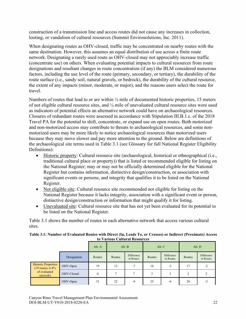
Canyon Rims Travel Management Plan Environmental Assessment DOI-BLM-UT-Y010-2018-0220-EA 22
construction of a transmission line and access routes did not cause any increases in collection,
looting, or vandalism of cultural resources (Summit Envirosolutions, Inc. 2011).
When designating routes as OHV-closed, traffic may be concentrated on nearby routes with the
same destination. However, this assumes an equal distribution of use across a finite route
network. Designating a rarely used route as OHV-closed may not appreciably increase traffic
(concentrate use) on others. When evaluating potential impacts to cultural resources from route
designations and resultant changes in route concentration (if any) the BLM considered numerous
factors, including the use level of the route (primary, secondary, or tertiary), the durability of the
route surface (i.e., sandy soil, natural gravels, or bedrock), the durability of the cultural resource,
the extent of any impacts (minor, moderate, or major), and the reasons users select the route for
travel.
Numbers of routes that lead to or are within ¼ mile of documented historic properties, 15 meters
of not eligible cultural resource sites, and ¼ mile of unevaluated cultural resource sites were used
as indicators of potential effects an alternative network could have on archaeological resources.
Closures of redundant routes were assessed in accordance with Stipulation III.B.1.c. of the 2018
Travel PA for the potential to shift, concentrate, or expand use on open routes. Both motorized
and non-motorized access may contribute to threats to archaeological resources, and some non-
motorized users may be more likely to notice archaeological resources than motorized users
because they may move slower and pay more attention to the ground. Below are definitions of
the archaeological site terms used in Table 3.1 (see Glossary for full National Register Eligibility
Definitions):
• Historic property: Cultural resource site (archaeological, historical or ethnographical (i.e.,
traditional cultural place or property)) that is listed or recommended eligible for listing on
the National Register; may or may not be officially determined eligible for the National
Register but contains information, distinctive design/construction, or association with
significant events or persons, and integrity that qualifies it to be listed on the National
Register.
• Not eligible site: Cultural resource site recommended not eligible for listing on the
National Register because it lacks integrity, association with a significant event or person,
distinctive design/construction or information that might qualify it for listing.
• Unevaluated site: Cultural resource site that has not yet been evaluated for its potential to
be listed on the National Register.
Table 3.1 shows the number of routes in each alternative network that access various cultural
sites.
Table 3.1: Number of Evaluated Routes with Direct (In, Leads To, or Crosses) or Indirect (Proximate) Access
to Various Cultural Resources
Alt. A Alt. B Alt. C Alt. D
Designation Routes Routes Difference
in Routes Routes
Difference
in Routes Routes
Difference
in Routes
Historic Properties (19 routes; 6.4%
of evaluated
network)
OHV-Open 19 12 -7 16 -3 17 -2
OHV-Closed 0 7 7 3 3 2 2
OHV-Open 31 22 -9 25 -6 28 -3
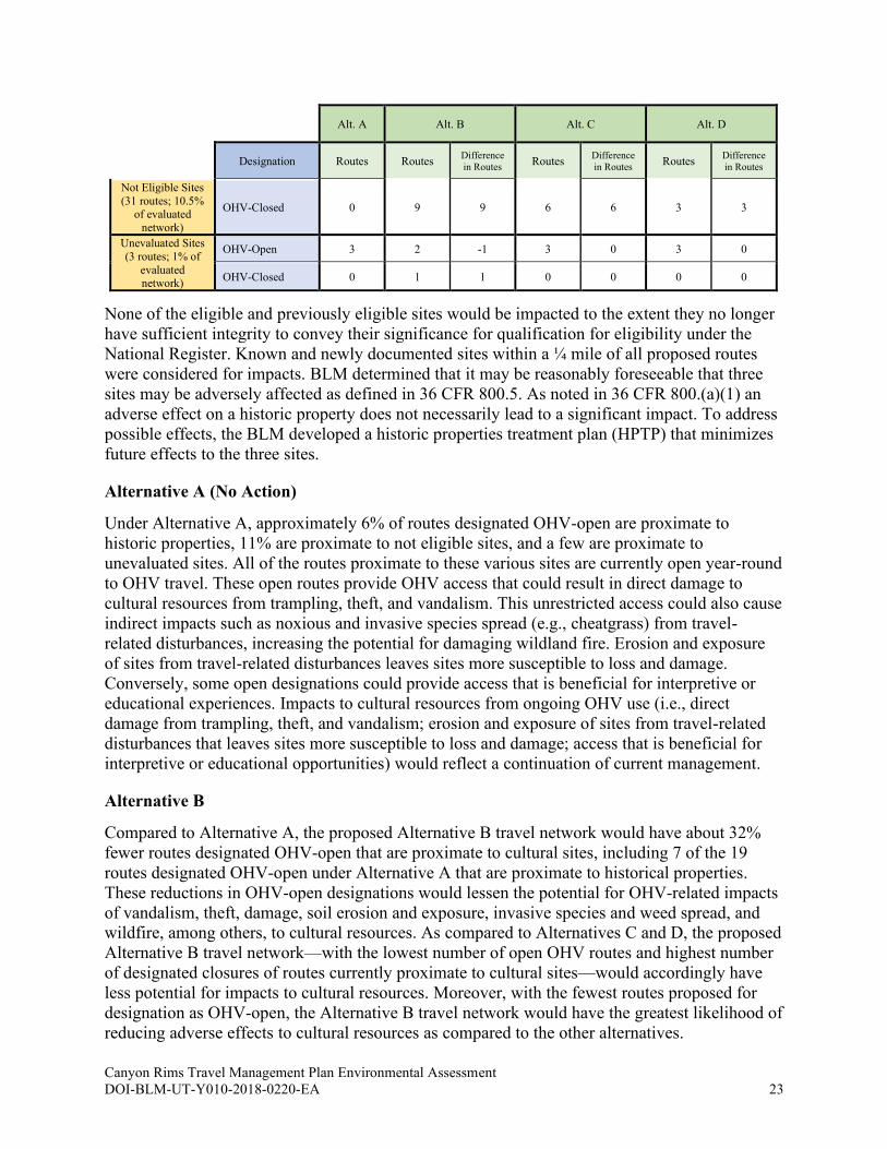
Canyon Rims Travel Management Plan Environmental Assessment DOI-BLM-UT-Y010-2018-0220-EA 23
Alt. A Alt. B Alt. C Alt. D
Designation Routes Routes Difference
in Routes Routes
Difference
in Routes Routes
Difference
in Routes
Not Eligible Sites
(31 routes; 10.5% of evaluated
network)
OHV-Closed 0 9 9 6 6 3 3
Unevaluated Sites
(3 routes; 1% of
evaluated network)
OHV-Open 3 2 -1 3 0 3 0
OHV-Closed 0 1 1 0 0 0 0
None of the eligible and previously eligible sites would be impacted to the extent they no longer
have sufficient integrity to convey their significance for qualification for eligibility under the
National Register. Known and newly documented sites within a ¼ mile of all proposed routes
were considered for impacts. BLM determined that it may be reasonably foreseeable that three
sites may be adversely affected as defined in 36 CFR 800.5. As noted in 36 CFR 800.(a)(1) an
adverse effect on a historic property does not necessarily lead to a significant impact. To address
possible effects, the BLM developed a historic properties treatment plan (HPTP) that minimizes
future effects to the three sites.
Alternative A (No Action)
Under Alternative A, approximately 6% of routes designated OHV-open are proximate to
historic properties, 11% are proximate to not eligible sites, and a few are proximate to
unevaluated sites. All of the routes proximate to these various sites are currently open year-round
to OHV travel. These open routes provide OHV access that could result in direct damage to
cultural resources from trampling, theft, and vandalism. This unrestricted access could also cause
indirect impacts such as noxious and invasive species spread (e.g., cheatgrass) from travel-
related disturbances, increasing the potential for damaging wildland fire. Erosion and exposure
of sites from travel-related disturbances leaves sites more susceptible to loss and damage.
Conversely, some open designations could provide access that is beneficial for interpretive or
educational experiences. Impacts to cultural resources from ongoing OHV use (i.e., direct
damage from trampling, theft, and vandalism; erosion and exposure of sites from travel-related
disturbances that leaves sites more susceptible to loss and damage; access that is beneficial for
interpretive or educational opportunities) would reflect a continuation of current management.
Alternative B
Compared to Alternative A, the proposed Alternative B travel network would have about 32%
fewer routes designated OHV-open that are proximate to cultural sites, including 7 of the 19
routes designated OHV-open under Alternative A that are proximate to historical properties.
These reductions in OHV-open designations would lessen the potential for OHV-related impacts
of vandalism, theft, damage, soil erosion and exposure, invasive species and weed spread, and
wildfire, among others, to cultural resources. As compared to Alternatives C and D, the proposed
Alternative B travel network—with the lowest number of open OHV routes and highest number
of designated closures of routes currently proximate to cultural sites—would accordingly have
less potential for impacts to cultural resources. Moreover, with the fewest routes proposed for
designation as OHV-open, the Alternative B travel network would have the greatest likelihood of
reducing adverse effects to cultural resources as compared to the other alternatives.
Canyon Rims Travel Management Plan Environmental Assessment DOI-BLM-UT-Y010-2018-0220-EA 24
Alternative C
The proposed Alternative C travel network would provide for a decrease in OHV-open routes
proximate to cultural resources of about 17% compared to Alternative A, including closure of 3
routes proximate to historic properties and 6 routes proximate to not eligible sites. There would
be no changes to the designations of the three routes that are currently proximate to unevaluated
sites. Compared to Alternative B, the Alternative C network would result in 20% more OHV-
open routes proximate to cultural sites. The Alternative C network is similar to the Alternative D
network, with only 4 fewer routes designated for OHV use proximate to cultural sites; because of
the similarity, the potential effects from Alternatives C and D on cultural resources would be
comparable, with Alternative C having slightly fewer potential impacts. Overall, the Alternative
C travel network would reduce the potential for adverse effects to cultural resources more than
Alternatives A and D but less than Alternative B.
Alternative D
Compared to Alternative A, the proposed Alternative D travel network would have 2 fewer
routes proximate to historic properties and 2 fewer routes proximate to not eligible sites that
would be open to OHV use. As a result, the Alternative D network, though very similar to
Alternative A, would have slightly fewer potential impacts to cultural resources. It would have
slightly more potential impacts than the Alternative C network. Overall, the Alternative D travel
network would reduce the potential for adverse effects to cultural resources more than
Alternative A but less than Alternatives B and C.
3.2.2 Lands with Wilderness Characteristics How would travel network route designations impact wilderness characteristics in inventoried
Lands with Wilderness Characteristics (LWC) areas?
3.2.2.1 Affected Environment
The 2017 Settlement Agreement stipulates that “For purposes of minimizing damage to public
lands with BLM-inventoried wilderness characteristics, the BLM will consider the potential
damage to any constituent element of wilderness characteristics, including naturalness,
outstanding opportunities for solitude, and outstanding opportunities for primitive and
unconfined recreation, for each alternative route network.” The TMA has 13 inventoried LWC
units that were found to possess wilderness characteristics (size, naturalness, solitude and/or
primitive recreation), and an area of at least 5,000 acres (or adjacent to other lands identified as
having wilderness characteristics)). None of the LWC units within the TMA are managed to
maintain wilderness characteristics and are instead managed for multiple uses. The TMA
contains 40,513.7 BLM acres (containing 36.3 miles of evaluated routes) inventoried as having
wilderness characteristics. Current LWC unit boundaries are based on LWC inventory completed
for the 2008 RMP and on several inventories preceding the 2016 Moab Master Leasing Plan. The
BLM’s inventory of the LWC units in the Canyon Rims TMA found these units to possess
wilderness characteristics even though the roads were designated and in place at the time of the
wilderness inventory. In other words, the presence of the roads did not disqualify these lands as
possessing wilderness characteristics.
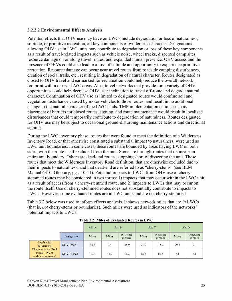
Canyon Rims Travel Management Plan Environmental Assessment DOI-BLM-UT-Y010-2018-0220-EA 25
3.2.2.2 Environmental Effects Analysis
Potential effects that OHV use may have on LWCs include degradation or loss of naturalness,
solitude, or primitive recreation, all key components of wilderness character. Designations
allowing OHV use in LWC units may contribute to degradation or loss of these key components
as a result of travel-related impacts such as vehicle noise, wheel tracks, dispersed camp sites,
resource damage on or along travel routes, and expanded human presence. OHV access and the
presence of OHVs could also lead to a loss of solitude and opportunity to experience primitive
recreation. Resource damage can occur near travel routes from roadside camping disturbances,
creation of social trails, etc., resulting in degradation of natural character. Routes designated as
closed to OHV travel and earmarked for reclamation could help reduce the overall network
footprint within or near LWC areas. Also, travel networks that provide for a variety of OHV
opportunities could help decrease OHV user inclination to travel off-route and degrade natural
character. Continuation of OHV use as limited to designated routes would confine soil and
vegetation disturbance caused by motor vehicles to those routes, and result in no additional
change to the natural character of the LWC lands. TMP implementation actions such as
placement of barriers for closed routes, signing, and route maintenance would result in localized
disturbances that could temporarily contribute to degradation of naturalness. Routes designated
for OHV use may be subject to occasional ground-disturbing maintenance actions and directional
signing.
During the LWC inventory phase, routes that were found to meet the definition of a Wilderness
Inventory Road, or that otherwise constituted a substantial impact to naturalness, were used as
LWC unit boundaries. In some cases, these routes are bounded by areas having LWC on both
sides, with the route itself excluded from the unit. Some are through-routes that delineate an
entire unit boundary. Others are dead-end routes, stopping short of dissecting the unit. These
routes that meet the Wilderness Inventory Road definition, that are otherwise excluded due to
their impacts to naturalness, and that dead-end are referred to as “cherry-stems” (see BLM
Manual 6310, Glossary, pgs. 10-11). Potential impacts to LWCs from OHV use of cherry-
stemmed routes may be considered in two forms: 1) impacts that may occur within the LWC unit
as a result of access from a cherry-stemmed route, and 2) impacts to LWCs that may occur on
the route itself. Use of cherry-stemmed routes does not substantially contribute to impacts to
LWCs. However, some evaluated routes are in LWC units and are not cherry-stemmed.
Table 3.2 below was used to inform effects analysis. It shows network miles that are in LWCs
(that is, not cherry-stems or boundaries). Such miles were used as indicators of the networks’
potential impacts to LWCs.
Table 3.2: Miles of Evaluated Routes in LWC
Alt. A Alt. B Alt. C Alt. D
Designation Miles Miles Difference
in Miles Miles
Difference
in Miles Miles
Difference
in Miles
Lands with Wilderness
Characteristics (36.3
miles; 13% of evaluated network)
OHV-Open 36.3 0.4 -35.9 21.0 -15.3 29.2 -7.1
OHV-Closed 0.0 35.9 35.9 15.3 15.3 7.1 7.1

Canyon Rims Travel Management Plan Environmental Assessment DOI-BLM-UT-Y010-2018-0220-EA 26
Alternative A (No Action)
Of the current designated route network, about 13% of the mileage designated OHV-open is
located in areas inventoried as having wilderness characteristics. Many of the routes making up
this mileage are completely within LWC units, and some cross into them from other areas. All
the mileage in the TMA’s LWCs is currently open to OHV use, which may result in dust, noise,
and user conflicts (i.e., OHV vs. primitive recreation users), potentially diminishing the LWCs’
characteristics of naturalness and potential for solitude and primitive recreation. Impacts to LWC
wilderness characteristics of naturalness and opportunities for solitude and primitive and
unconfined recreation would reflect a continuation of current management.
Alternative B
Alternative B proposes to designate as OHV-closed 35.9 miles of the routes (all but a 0.4-mile
route that leads to a SITLA parcel) within LWCs, resulting in a 99% decrease in miles open to
OHV use within LWCs compared to Alternative A. Approximately 3 miles that would be
designated OHV-closed would allow authorized use, and the rest would be earmarked for
reclamation. Therefore, Alternative B’s OHV route closures in LWC areas would reduce the
impacts of OHV travel on the fundamental components of wilderness characteristics. Alternative
B has the highest likelihood of any alternative for reducing route-related adverse effects on
BLM-inventoried wilderness characteristics within the TMA.
Alternative C
Alternative C proposes to designate as OHV-open 21.0 miles within LWCs, a 42% decrease
compared to Alternative A. Of the 15.3 miles that would be closed to OHV use, 2.9 miles would
allow authorized use only and the rest would be earmarked for reclamation. The decrease in
OHV use within LWCs would reduce impacts to wilderness characteristics such as non-primitive
use, noise, dust, and user conflicts, though not to the extent of Alternative B.
Alternative D
Compared to Alternative A, Alternative D proposes to decrease route miles designated for OHV
use within LWCs by 19% (7.1 mi). Of the 7.1 miles of OHV closures, 1.6 miles would be
reserved for authorized use, another 0.3 miles would be targeted for non-motorized use, and the
rest would be earmarked for reclamation. The decrease in miles designated for OHV use within
LWCs, though less than Alternatives B and C, would still reduce impacts to wilderness
characteristics compared to Alternative A.
3.2.3 Soils, Native Vegetation, and Weeds and Invasive Species How would travel network route designations impact native vegetation communities,
introduction and spread of invasive weeds, and soil stability?
The TMA’s native vegetation types exist in a variety of soil types and depths as discussed below
in Affected Environment for each vegetation type. Soil disturbance and erosion can create an
environment that is conducive to the introduction and spread of noxious weeds and invasive
species. Because of this interrelationship, these three resource topics are presented together in
this section.
Canyon Rims Travel Management Plan Environmental Assessment DOI-BLM-UT-Y010-2018-0220-EA 27
3.2.3.1 Affected Environment
Soil types in the Moab FO area are variable, reflecting the interactions between topography,
elevation, parent material, and time. Topography ranges from nearly level valley bottoms to
vertical cliffs. The area has a variety of soil types, including highly saline and erodible soils.
Biological soil crusts (also called cryptogamic or cryptobiotic soils) found throughout the Moab
FO area are composed primarily of cyanolichens and cyanobacteria. These crusts are important
soil stabilizers or “living mulches” that retain soil moisture and discourage the growth of
invasive weeds (BLM 2008b). Repeated disturbance or trampling of biological crusts can
permanently destroy the living filaments of the organisms, preventing the recovery of the crusts.
Blowing dust from disturbed soils can cover nearby crusts, depriving them of needed sunlight,
ultimately leading to the death of the living organisms that comprise the crusts. Without these
crusts, soil stability, fertility, and moisture retention capacity can be lost (BLM 2015); see 3.2.6
Water Resources: Rivers and Streams, Riparian Areas and Floodplains, and Water Quality.
The Colorado Plateau, with its variety of elevations and precipitation zones, provides a
substantial amount of biodiversity. The vegetation cover types of the area are predominantly
pinyon-juniper, sagebrush, blackbrush, salt desert shrub, perennial grassland, oak/mountain
shrub, and conifer. Hatch Wash and Kane Creek and some of their tributaries also have
vegetation associated with riparian areas, such as cottonwood, willow, riparian grasses, sedges,
and rushes—as well as invasive vegetation such as tamarisk (saltcedar) and Russian olive. Native
vegetation in the Moab FO area provides forage for livestock grazing as well as habitat for
wildlife, and serves a major role in the hydrologic cycle as an interface between the area’s soils
and the atmosphere. Some native vegetation communities such as blackbrush show a poor
history of revegetation, and some communities such as sagebrush have experienced high
percentages of conversion to cheatgrass. Analysis of alternative network designations on native
vegetation below will focus on the four predominant vegetation types within the TMA, which
combined cover 96% of BLM lands within the TMA:
• Pinyon-Juniper (47,236 acres on BLM lands in the TMA): Generally occurs at
elevations of 4,700-8,600 feet on landscapes of varied topography. Pinyon—which is a
valuable resource for firewood harvest and wildlife habitat—tends to dominate at higher
elevations, juniper at lower elevations. This vegetation community is typically associated
with sagebrush, Mormon tea, and blackbrush. (BLM 2013)
• Sagebrush (23,003 acres on BLM lands in the TMA): Generally occurs at elevations of
5.500-7,300 feet in areas of moderately deep soils. This vegetation community is
dominated by big sagebrush and may also include horsebrush, rabbitbrush, spiny
hopsage, saltbush, Mormon tea, and winterfat. It is associated with grasses such as sand
dropseed, western wheatgrass, Indian ricegrass, and galleta. Significant percentages of
this vegetation type have been converted to cheatgrass and Russian thistle because of
wildland fire, drought, and improper grazing management. (BLM 3013)
• Blackbrush (9,853 acres on BLM lands in the TMA): Generally occurs at elevations of
2,500-8,000 feet in well-drained soils. It occurs in pure stands and as part of several other
vegetation types. Blackbrush communities are generally bounded by big sagebrush and
juniper in this area, and they are associated with sagebrush, shadscale, winterfat,
greasewood, and rabbitbrush. This vegetation type has a poor history of revegetation.
(BLM 2013, USFS 2001)
Canyon Rims Travel Management Plan Environmental Assessment DOI-BLM-UT-Y010-2018-0220-EA 28
• Salt Desert Shrub (7,131 acres on BLM lands in the TMA): Generally occurs at
elevations of 4,000-5,400 feet in saline or alkaline soils with low moisture that are
susceptible to wind and water erosion from surface disturbances. Salt desert shrub
communities are associated with shrubs such as shadscale, greasewood, blackbrush, four-
wing saltbush, Nuttall’s saltbush, mat saltbush, Mormon tea, spiny hopsage, horsebrush,
and rabbitbrush. Associated forbs include snakeweed and buckwheat. And associated
grasses include wildrye, galleta, Indian ricegrass, and sand dropseed. (BLM 2013)
The presence of noxious weeds and invasive species can be used as indicators of healthy
ecosystems as their presence is often related to disturbances and loss of native species in those
systems. Noxious weed species that are found in many areas of the Moab FO include Russian
knapweed, halogeton, cheatgrass, tamarisk, and Russian olive. Encroachment of noxious and
invasive species presents a problem both along river corridors as well in large areas of uplands
and rangelands. Surface-disturbing activities have the potential to introduce or spread invasive
species and noxious weeds. Travel routes can serve as corridors where invasive species and
noxious weeds can be introduced or spread throughout connecting routes. For more information
on exotic and introduced plants as well as invasive and noxious weeds in the Moab FO’s
jurisdiction, see pages 3-173 through 3-174 of BLM 2008b. Noxious weeds are also problematic
in riparian areas. For more on travel-related effects for riparian resources, see 3.2.6 Water
Resources: Rivers and Streams, Riparian Areas and Floodplains, and Water Quality.
3.2.3.2 Environmental Effects Analysis
Travel network alternatives that designate more miles as OHV-closed would provide higher
levels of protection to soils from surface disturbances and, indirectly, to native vegetation and
riparian areas. Because virtually every route in the TMA crosses through areas of cryptobiotic
soils, travel network alternatives with fewer miles open to OHV use would better protect these
important soil crusts. Additionally, travel routes can serve as a conduit for saline-laden sediment
transport (indirect) into intermittent or perennial drainages and riparian areas during runoff
events. Surface disturbances from vehicle travel can also remove soil-stabilizing agents, such as
vegetative cover, soil crusts, and woody debris. Loss of one or more of these agents increases
potential erosion and sediment transport into water bodies and riparian areas.
Travel route-related direct effects on vegetation include trampling or crushing of soils and
vegetation as well as vegetation loss from access-related human activity. Effects also include
dusting, which can lead to plant mortality. Travel network alternatives that close more miles to
OHV travel when those miles cross through vegetated areas would provide higher levels of
protection to vegetation from OHVs and access-related activities. Route networks and their
designations can contribute to the introduction and spread of invasive plants and noxious weeds,
displacing native species and disrupting proper ecosystem functions because various travel-
related vectors (e.g., recreation, commercial, administrative, and fire suppression vehicles) can
carry invasive and noxious weed seeds on their undercarriages and tires. However, certain types
of travel route designations (e.g., closed or limited to authorized use), by limiting or eliminating
vehicle travel, can also limit or reduce the spread of invasive and noxious plants, thereby
benefitting native vegetation species. Travel routes also provide access for invasive species and
weed monitoring and treatment activities.
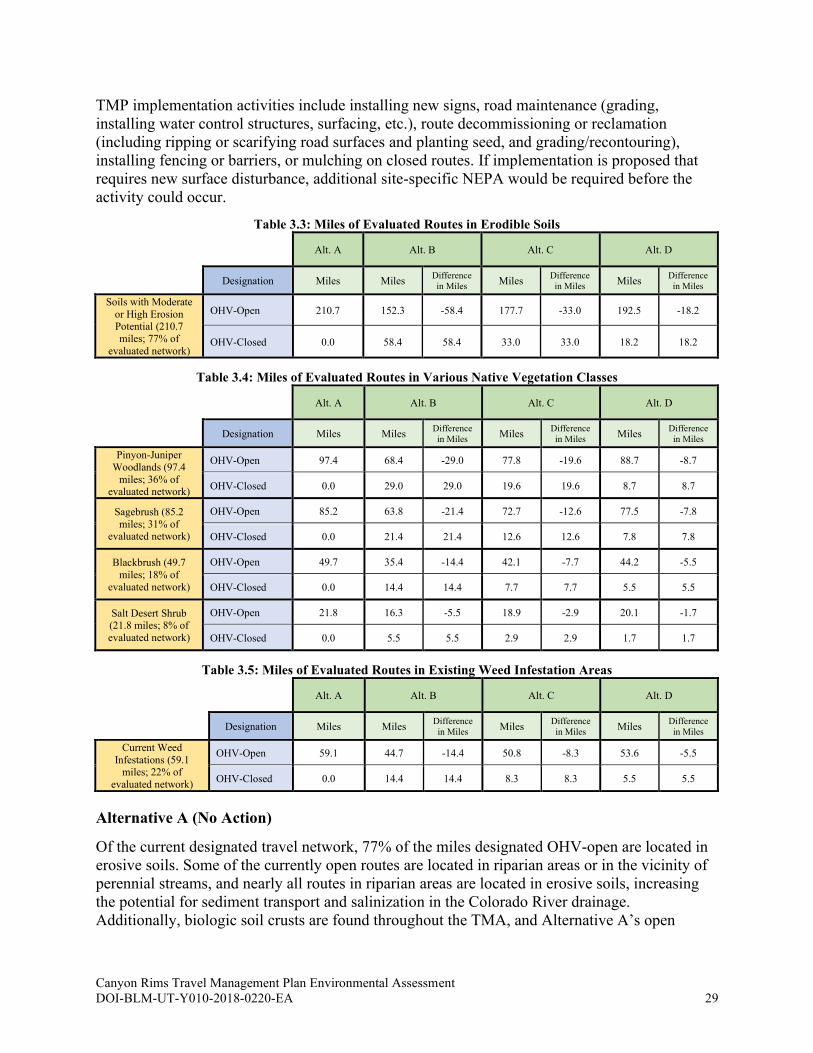
Canyon Rims Travel Management Plan Environmental Assessment DOI-BLM-UT-Y010-2018-0220-EA 29
TMP implementation activities include installing new signs, road maintenance (grading,
installing water control structures, surfacing, etc.), route decommissioning or reclamation
(including ripping or scarifying road surfaces and planting seed, and grading/recontouring),
installing fencing or barriers, or mulching on closed routes. If implementation is proposed that
requires new surface disturbance, additional site-specific NEPA would be required before the
activity could occur.
Table 3.3: Miles of Evaluated Routes in Erodible Soils
Alt. A Alt. B Alt. C Alt. D
Designation Miles Miles Difference
in Miles Miles
Difference
in Miles Miles
Difference
in Miles
Soils with Moderate
or High Erosion Potential (210.7
miles; 77% of
evaluated network)
OHV-Open 210.7 152.3 -58.4 177.7 -33.0 192.5 -18.2
OHV-Closed 0.0 58.4 58.4 33.0 33.0 18.2 18.2
Table 3.4: Miles of Evaluated Routes in Various Native Vegetation Classes
Alt. A Alt. B Alt. C Alt. D
Designation Miles Miles Difference
in Miles Miles
Difference
in Miles Miles
Difference
in Miles
Pinyon-Juniper
Woodlands (97.4
miles; 36% of evaluated network)
OHV-Open 97.4 68.4 -29.0 77.8 -19.6 88.7 -8.7
OHV-Closed 0.0 29.0 29.0 19.6 19.6 8.7 8.7
Sagebrush (85.2
miles; 31% of evaluated network)
OHV-Open 85.2 63.8 -21.4 72.7 -12.6 77.5 -7.8
OHV-Closed 0.0 21.4 21.4 12.6 12.6 7.8 7.8
Blackbrush (49.7
miles; 18% of
evaluated network)
OHV-Open 49.7 35.4 -14.4 42.1 -7.7 44.2 -5.5
OHV-Closed 0.0 14.4 14.4 7.7 7.7 5.5 5.5
Salt Desert Shrub (21.8 miles; 8% of
evaluated network)
OHV-Open 21.8 16.3 -5.5 18.9 -2.9 20.1 -1.7
OHV-Closed 0.0 5.5 5.5 2.9 2.9 1.7 1.7
Table 3.5: Miles of Evaluated Routes in Existing Weed Infestation Areas
Alt. A Alt. B Alt. C Alt. D
Designation Miles Miles Difference
in Miles Miles
Difference
in Miles Miles
Difference
in Miles
Current Weed
Infestations (59.1 miles; 22% of
evaluated network)
OHV-Open 59.1 44.7 -14.4 50.8 -8.3 53.6 -5.5
OHV-Closed 0.0 14.4 14.4 8.3 8.3 5.5 5.5
Alternative A (No Action)
Of the current designated travel network, 77% of the miles designated OHV-open are located in
erosive soils. Some of the currently open routes are located in riparian areas or in the vicinity of
perennial streams, and nearly all routes in riparian areas are located in erosive soils, increasing
the potential for sediment transport and salinization in the Colorado River drainage.
Additionally, biologic soil crusts are found throughout the TMA, and Alternative A’s open
Canyon Rims Travel Management Plan Environmental Assessment DOI-BLM-UT-Y010-2018-0220-EA 30
network leaves these soil crusts susceptible to access-related human impacts (i.e., damage or
crushing from camping, exploring, and un-authorized off-road travel).
With all evaluated routes designated as OHV-open, Alternative A would have the potential for
ongoing OHV use-related impacts such as crushing or trampling (driving on partially vegetated
roadways, roadside parking, camping, exploring, etc.) as well as general loss of plants and loss of
health and vigor from travel-related dusting and disturbance along routes. The Alternative A
network also has 59.1 miles of routes going through existing weed infestation areas designated
for OHV use, so this alternative does little to minimize the spread of invasive plants and noxious
weeds.
Impacts to soils and native vegetation from ongoing OHV use (i.e., increased soil compaction
and susceptibility to erosion, surface rutting from OHV use during wet periods, increased
sedimentation into waterways, increased dusting of vegetation, spread of invasive plants and
noxious weeds, etc.) would reflect continuation of current management.
Alternative B
The Alternative B travel network proposes OHV-open designations for 72% of the route miles
located in erosive soils, a decrease of 58.4 miles as compared to Alternative A. Alternative B
also proposes to designate as OHV-open the fewest overall miles of any of the alternative
networks (see section 2.2), and is thereby the least likely to impact the TMA’s biologic soil
crusts from OHV access-related damage.
The Alternative B network would decrease the route miles designated for OHV use in various
native vegetation classes between 25% (sagebrush) and 30% (pinyon-juniper). This network
would also decrease the route miles designated for OHV use going through existing weed
infestation areas by 24% (14.4 mi). Combined, because of this Alternative’s decreases in OHV-
open designations, it would have the least likelihood for OHV use-related impacts discussed
above such as crushing, disturbance, dusting, and invasive weed spread.
Compared to Alternative A and the other action alternatives, Alternative B proposes to designate
the fewest route miles as OHV-open in erosive soils, in each native vegetation class, and in areas
of weed infestation. Therefore, Alternative B is least likely to impact soils and vegetation from
adverse travel-related direct effects (e.g., soil disturbance and compaction, trampling, and
dusting) and from indirect effects (e.g., increased salinization in riparian areas and spread of
invasive plants and noxious weeds). Overall, Alternative B has the highest likelihood among the
alternatives for reducing adverse impacts to native vegetation and soils.
Alternative C
Alternative C proposes to designate 84% of the route miles in erosive soils for OHV use, a
decrease of 33.0 miles from Alternative A; this decrease is approximately half of that in
Alternative B. Fewer miles overall would be designated OHV-open in Alternative C than in
Alternative A, decreasing the potential for adverse impacts to biologic soil crusts.
Compared to Alternative A, Alternative C proposes to decrease the route miles designated for
OHV use in various native vegetation classes between 13% (salt desert shrub) and 20% (pinyon-
juniper). This network would also decrease the route miles designated for OHV use going
through existing weed infestation areas by 14% (8.3 mi). Combined, these decreases in OHV-
Canyon Rims Travel Management Plan Environmental Assessment DOI-BLM-UT-Y010-2018-0220-EA 31
open designations would help minimize use-related impacts of crushing, disturbance, dusting,
and invasive weed spread, though not to the extent of Alternative B.
Alternative D
Alternative D proposes to designate 91% of the route miles in erosive soils for OHV use, a
decrease of 18.2 miles from Alternative A. While this decrease would help protect soils from the
adverse route- and access-related impacts of disturbance, compaction, and crushing of biologic
crusts, the protections afforded by this network alternative would not be as substantial as those
under Alternatives B and C.
Compared to Alternative A, Alternative D would decrease the route miles designated for OHV
use in various native vegetation classes between 8% (salt desert shrub) and 11% (blackbrush). As
in Alternatives B and C, this would reduce the potential use-related impacts of crushing,
disturbance, and dusting compared to Alternative A, though not nearly to the extent of these
other action alternatives. This alternative would also decrease the route miles designated for
OHV use going through existing weed infestation areas by 9% (5.5 mi), minimally reducing the
area’s susceptibility to invasive weed spread.
3.2.4 Special Designation Areas How would travel network route designations impact the important and relevant values of the
Highway 279/Shafer Basin/Long Canyon ACEC and the Wild and Scenic River quality of the
Colorado River segment that flows through the TMA?
3.2.4.1 Affected Environment
ACEC designations highlight areas where special management attention is needed to protect
important and relevant values such as historical, cultural, and scenic values, or fish and wildlife
or other natural resources. The Federal Land Policy and Management Act directs the BLM to
give priority to the identification and potential designation of ACECs through the land-use
planning process. The types of activities allowed within an ACEC depend on the resource and
natural value the area is designated to protect (https://www.blm.gov/programs/planning-and-
nepa/planning-101/special-planning-designations/acec). The Highway 279/Shafer Basin/Long
Canyon ACEC (12,573 acres; contains 12.1 travel network miles) is the only ACEC in the TMA
and is managed for its significant scenic, wildlife, plant, and cultural resources. The ACEC is a
corridor along the scenic byway of Highway 279 providing extraordinary scenery and ancient
rock imagery. Shafer Basin, which is managed as Visual Resource Management (VRM) Class I,
provides the viewshed from Dead Horse Point State Park. The area also has significant value in
that it contains Jane’s globemallow, a BLM sensitive plant, and desert bighorn sheep habitat.
This ACEC’s particular habitat “enabled the dwindling desert bighorn herd to survive” (BLM
2013), and the Shafer Basin population has provided stock for restoring desert bighorns in other
environments. For more information on this ACEC, see pages 3-130 through 3-131 and 3-136
through 3-137 of the 2008 RMP.
The Wild and Scenic Rivers Act of 1968 established legislation for a National Wild and Scenic
Rivers System to protect and preserve designated rivers in their free-flowing condition and also
to protect and preserve their immediate environments. A 10.6-mile section of the Colorado River
(containing 3.1 travel network miles within its WSR corridor) that flows through the TMA was
Canyon Rims Travel Management Plan Environmental Assessment DOI-BLM-UT-Y010-2018-0220-EA 32
found suitable in the 2008 RMP as a Wild and Scenic River (WSR) for its scenic qualities, which
include rich, contrasting colors and textures with outstanding geologic and visual features. This
section of river and its immediate environment has a No Surface Occupancy (NSO) stipulation.
The outstandingly remarkable values (ORVs) of this Colorado River section include scenery,
recreation, wildlife, fish, cultural resources, and ecology. For more information on WSRs, see
pages 34-36 of the 2008 RMP.
3.2.4.2 Environmental Effects Analysis
The types of OHV-related effects that could diminish any of the ACEC relevant and important
values or WSR outstandingly remarkable values include:
• Degradation of the ACEC’s or WSR’s scenic quality.
• Degradation of the area’s ancient rock imagery.
• A decline in plant or animal species number and population viability, resulting in the
need to list species under the ESA or the inability to delist species, based on recovery.
• Habitat loss or adverse modification that contributes to the need to list species under the
ESA or the inability to delist species, based on recovery.
• Reduction in high-quality recreational experiences. Note: All alternative networks would
have no impact to recreational access for river-running activities on the Colorado River.
The 2008 RMP lists potential threats to the ACEC, including oil and gas development, increased
motorized recreation use, utility corridor development, and mineral development. Regarding
scenic values in the ACEC, travel route use can increase damage and disruption to the natural
appearance of landscapes by providing opportunities for route proliferation, illegal off-road
landscape damage, littering, and other harmful activities. Routes also impact visual resources by
creating contrasting lines where they do not follow natural landscape contours. Changes in color
and form from road cut backslopes and fill slopes create visible impacts. Potential effects on the
vegetation communities, crucial wildlife habitat, and cultural values of the ACEC include
trampling of vegetation from off-route motorized or non-motorized use; soil disturbance; route
proliferation; and exposure, loss, or damage of cultural resources. Other effects include soil
erosion, establishment and spread of noxious weeds from soil disturbance and native vegetation
loss, and enhanced risk of damaging wildfire. For mileage/designation breakdowns of routes in
the ACEC, see Table 3.6.
Wild and Scenic River qualities can be negatively impacted where travel routes serve as a
conduit for sediment transport (indirect) into intermittent or perennial drainages and riparian
areas during runoff events. Motorized travel in areas of highly erosive soils or in sensitive areas,
such as stream channels and riparian habitats, increases the potential for surface runoff (i.e., soil
displacement) and water quality impacts. In addition, travel routes and their use may result in
negative impacts to the outstanding scenic qualities of WSR segments. Route use may increase
damage and disruption to the natural appearance of landscapes by providing opportunities for
route proliferation, illegal off-road landscape damage, littering, and other harmful activities.
Establishment of a designated comprehensive travel route network is expected to minimize route
proliferation and decrease future degradation of visual resources. Travel routes can provide
beneficial access for interpretive and educational opportunities for cultural resources, though
their use can also lead to vandalism and other detrimental effects to cultural values along the
WSR. For mileage/designation breakdowns of routes in the WSR corridor, see Table 3.7.

Canyon Rims Travel Management Plan Environmental Assessment DOI-BLM-UT-Y010-2018-0220-EA 33
Table 3.6: Miles of Evaluated Routes in Areas of Critical Environmental Concern
Alt. A Alt. B Alt. C Alt. D
Designation Miles Miles Difference
in Miles Miles
Difference
in Miles Miles
Difference
in Miles
Areas of Critical Environmental
Concern (12.1 miles; 4% of
evaluated network)
OHV-Open 12.1 10.6 -1.5 10.8 -1.3 11.6 -0.4
OHV-Closed 0.0 1.5 1.5 1.3 1.3 0.4 0.4
Table 3.7: Miles of Evaluated Routes in Wild and Scenic River Corridor
Alt. A Alt. B Alt. C Alt. D
Designation Miles Miles Difference
in Miles Miles
Difference
in Miles Miles
Difference
in Miles
Wild and Scenic
River Corridor (3.1
miles; 1% of evaluated network)
OHV-Open 3.1 2.9 -0.2 3.1 0.0 3.1 0.0
OHV-Closed 0.0 0.2 0.2 0.0 0.0 0.0 0.0
Alternative A (No Action)
Within the Highway 279/Shafer Basin/Long Canyon ACEC, the current travel network
comprises 12.1 miles of routes, all of which are open to OHV travel. These open travel
designations leave the ACEC susceptible to some travel-related effects which could potentially
impact the ACEC’s extraordinary scenic qualities, increase the potential for damage to its ancient
rock art, and damage or destroy plant and wildlife habitat; however, it is important to note that
many of the routes previously causing adverse impacts in the ACEC were designated as closed
during earlier travel planning efforts for the 2008 RMP.
The WSR segment adjoining the TMA contains 3.1 miles of designated travel routes. Because all
of these route miles are open to public OHV use, the WSR’s outstandingly remarkable values
(scenery, recreation, wildlife, fish, cultural resources, and ecology) are susceptible to travel
route-related adverse effects of route proliferation, sediment transport and water quality
degradation, illegal off-road landscape damage and damage to cultural resources, littering, etc.
Alternatives B, C, and D
Compared to Alternative A, all the action alternatives provide for little change to travel route
designations in either the ACEC or WSR segment. In the ACEC, Alternative B proposes OHV-
closed designations for 1.5 miles of routes, Alternative C proposed OHV-closed designations for
1.3 miles, and Alternative D proposes OHV-closed designations for 0.4 miles. The only
difference between network alternatives in the WSR corridor would occur under Alternative B,
which would close 0.2 miles to OHV use. Under all alternatives, effects from any of these action
alternative networks and travel-related uses would be very similar to those discussed above
under Alternative A. As in Alternative A, because the route mileage in the special designation
areas is so low, any of these travel networks would have correspondingly minor potential for
adverse impacts to the ACEC and WSR segment.

Canyon Rims Travel Management Plan Environmental Assessment DOI-BLM-UT-Y010-2018-0220-EA 34
3.2.5 Visual Resource Management How would travel network route designations impact visual resources within the TMA?
3.2.5.1 Affected Environment
The visual resources of the Canyon Rims TMA include features such as canyons, cliffs, mesas,
and plains. The area has numerous outstanding scenic overlooks which afford views of the
Indian Creek corridor and the Sixshooter Peaks, Canyonlands National Park, and Dead Horse
Point State Park. Each of its four major overlooks gives the visitor a different view of the
surrounding area. The interplay of visuals between Canyonlands National Park and the Canyon
Rims TMA is particularly important: Canyonlands National Park was set aside in large part
because of its visual resources and, as the Canyon Rims Recreation Area Management Plan
points out, “It is important to remember that just as Canyonlands National Park is visible from
Canyon Rims, the cliffs of Canyon Rims are equally visible from Canyonlands National Park.”
Also, visitors to the TMA are afforded views into numerous canyon systems (Harts Draw, Hatch
Wash, and Kane Springs Canyon) “which truncate the landscape” (BLM 2002). Both the
Needles Overlook Road and Anticline Overlook Road were designated as Utah Scenic Backways
because of the area’s beauty.
Visual Resource Management (VRM) is a process the BLM uses to identify and manage scenic
values to reduce visual impacts of development or other surface-disturbing activities on public
lands. There are four VRM classes: I, II, III, and IV with the lower number representing higher
visual quality. All TMA BLM lands have been assigned to a VRM class, with 8,285 acres in
Class I, 45,536 acres in Class II, and 37,133 acres in Class III. The class objectives are:
• VRM Class I – Preserve the existing character of the landscape. This class provides for
the natural ecological changes; however, it does not preclude very limited management
activity. The level of change of the characteristic landscape should be very low and must
not attract attention.
• VRM Class II – Retain the existing character of the landscape. The level of change to the
characteristic landscape should be low. Management activities may be seen but should
not attract the attention of the casual observer. Changes must repeat the basic elements of
form, line, color, and texture found in the predominant natural features of the
characteristic landscape.
• VRM Class III – Partially retain the existing character of the landscape. The level of
change to the characteristic landscape should be moderate. Management activities may
attract attention but should not dominate the view of the casual observer. Changes should
repeat the basic elements found in the predominant natural features of the characteristic
landscape.
• VRM Class IV – Provide for management activities that require major modification of
the existing character of the landscape. The level of change to the characteristic landscape
can be high. These management activities may dominate the view and be the major focus
of viewer attention. However, every attempt should be made to minimize the impact of
these activities through careful location, minimal disturbance, and repeating the basic
elements.
Of the evaluated routes, approximately 12 miles of travel routes are in Class I, 147 miles are in
Class II, 113 miles are in Class III, and no miles are in Class IV.

Canyon Rims Travel Management Plan Environmental Assessment DOI-BLM-UT-Y010-2018-0220-EA 35
3.2.5.2 Environmental Effects Analysis
Existing travel routes and OHV use can contribute to damage and disruption to the natural
appearance of landscapes by providing opportunities for route proliferation (i.e., user-created
routes extending off existing routes). Other travel-related surface disturbances such as roadside
camping can lead to expansion of invasive species and noxious weeds and subsequently higher
potential for disruptive wildfire events. OHV use on dirt roads can increase dust levels in the air
(Kavouras et al. 2009), the extent of which depends on traffic characteristics and road quality
(Etyemezian et al. 2003). In turn, the presence of dust particles in the air can reduce viewsheds
(Duniway et al. 2019). Routes also impact visual resources by creating contrasting lines where
they do not follow natural landscape contours. User-created routes typically do not follow
ground contours and can extend up slopes, leading to rilling, erosion, and contrasting lines.
Changes in color and form from road cuts and fills create visible impacts. However, the formal
establishment of a route network that includes operation and management components (such as
those provided in the action alternatives) can minimize route proliferation and future degradation
of visual resources. Under all action alternatives, the application of specified operation and
management tools provided in the TMP Implementation Guide (Appendix L)—such as signs,
route markers, and human-made barriers—would help reduce or prevent impacts to the visual
elements of line, form, and color.
Regardless of the final route designation decision for each travel route, it is assumed there will
be follow-up action on the ground. For permanently closed routes, it can be assumed that actions
would include the placement of closure signs, reclamation, or installation of barricades. For
routes designated for OHV use, maintenance actions may include the use of heavy equipment for
grading and drainage maintenance or hand tools for directional signing. The effects of these
actions on visual resources are expected to be minor and short-term but are included in this
analysis. Overall, the route designations will result in some routes being closed, thereby
eventually reducing the overall footprint of the route network. More site-specific analysis of
maintenance or management actions may be needed if such actions could affect high-quality
visual landscapes.
See Table 3.8 for a breakdown of evaluated route miles/designations in VRM classes. The visual
resource analysis below is based on this table.
Table 3.8: Miles of Evaluated Routes in VRM classes
Alt. A Alt. B Alt. C Alt. D
Designation Miles Miles Difference
in Miles Miles
Difference
in Miles Miles
Difference
in Miles
VRM Class I (12
miles; 4% of evaluated
network)
OHV-Open 12.0 10.6 -1.5 10.8 -1.3 11.6 -0.4
OHV-Closed 0.0 1.5 1.5 1.3 1.3 0.4 0.4
VRM Class II (147.4 miles; 54% of
evaluated network)
OHV-Open 147.4 103.5 -43.9 121.1 -26.3 133.5 -13.9
OHV-Closed 0.0 43.9 43.9 26.3 26.3 13.9 13.9
VRM Class III (113.1
miles; 41% of evaluated network)
OHV-Open 113.1 83.5 -29.6 94.7 -18.4 101.0 -12.1
OHV-Closed 0.0 29.6 29.6 18.4 18.4 12.1 12.1
Canyon Rims Travel Management Plan Environmental Assessment DOI-BLM-UT-Y010-2018-0220-EA 36
Alternative A (No Action)
Approximately 4% of the current designated route network is located in VRM Class I areas, and
another 54% is in Class II. The remaining miles are in Class III. All route miles in this alternative
are currently open to OHV use. Impacts to the TMA’s visual resources (i.e., degradation of
visual quality, disruption of natural appearance, etc.) would reflect a continuation of current
management.
Alternative B
The Alternative B route network proposes a relatively small decrease (12%, 1.5 mi) in OHV-
open route miles in VRM Class I and a moderate decrease (30%, 43.9 mi) in Class II compared
to Alternative A. All 1.5 OHV-closed miles in Class I and 31.9 of the 43.9 OHV-closed miles in
Class II would be earmarked for reclamation. The 12 miles in Class II lands that would remain
available for authorized users would leave the visual resources at some risk of disruption in these
locations; however, closing these miles to public OHV use would reduce the probability for route
proliferation and OHV-related degradation. Overall, Alternative B would have the most
likelihood among alternatives for reducing adverse effects on visual resources.
Alternative C
Compared to Alternative A, Alternative C proposes a reduction of 11% (1.3 mi) in miles
designated for OHV use in VRM Class I and a reduction of 18% (26.3 mi) in Class II. All of the
route miles closed to OHV use in Class I and 19.2 of the 26.3 miles closed to OHV use in Class
II would be earmarked for reclamation.
Alternative D
The Alternative D route network proposes OHV-open designations for all but 0.4 miles in VRM
Class I lands. It also proposes OHV-open designations for 91% of the miles in Class II lands.
This alternative closes about one-third as many miles in Class I and II lands as Alternative B and
about half as many as Alternative C. Consequently, Alternative D would offer fewer protections
for visual resources compared to Alternatives B and C.
3.2.6 Water Resources: Rivers and Streams, Riparian Areas and Floodplains,
and Water Quality How would travel network route designations impact water resources within the TMA?
3.2.6.1 Affected Environment
Water resources—particularly important in this arid region—are managed to ensure that water
quality standards are not diminished as a result of BLM actions such as travel route designations.
The surface waters of the TMA consist of 10.6 miles of the Colorado River as well as numerous
perennial and intermittent streams. The area includes Hatch Wash and Kane Creek, two large
streams with perennial and intermittent sections, and also includes smaller streams occurring in
Dripping Spring, Trout Water, and Trough Springs Canyons, tributaries to Kane Creek.
Windwhistle Campground has a well and pump that supply the campground with drinking water.
Numerous stock ponds in the area provide water to cattle and wildlife.
Canyon Rims Travel Management Plan Environmental Assessment DOI-BLM-UT-Y010-2018-0220-EA 37
Riparian areas are a form of wetland transition between permanently saturated wetlands and
upland areas. In the arid Southwest, the riparian ecosystems depend on water availability,
defined by amount, timing, duration, and source, and characterized as perennial (yearlong),
intermittent (seasonal), or ephemeral (storm). They are defined as areas of land directly
influenced by permanent (surface or subsurface) water. They have visible vegetation or physical
characteristics reflective of permanent water influence. Lakeshores and streambanks with
perennial water flow are typical riparian areas. They include wetlands and those portions of
floodplains and valley bottoms that support riparian vegetation (Meehan 1991). Excluded are
such sites as ephemeral streams or washes that do not exhibit the presence of vegetation
dependent upon free water in the soil (BLM 1991). However, it is important to note that an
ephemeral stream is one that flows only in direct response to precipitation and whose channel is
at all times above the water table. Thus, intermittent or ephemeral streams which do not currently
exhibit riparian characteristics may in fact be connected to a water table and could potentially
develop riparian attributes with management changes.
Riparian areas comprise less than one percent of the approximately 22 million acres of public
lands administered by the BLM in Utah. However, these small but unique areas are among the
most important, productive, and diverse ecosystems in the state. Riparian areas provide many
benefits within the TMA, including filtering and purifying water, reducing sediment loads and
enhancing soil stability, contributing to groundwater recharge, dissipating high-energy flows
(floods), and supporting greater biodiversity. Riparian areas—occurring on streambanks and
floodplains, at springs, seeps, potholes, wet meadows, sloughs, marshes, swamps, and bogs—are
all important resources for aquatic organisms, wildlife, grazing, and recreation. Healthy and
productive riparian areas provide water, food, cover, and travel lanes for many aquatic and
terrestrial wildlife species, some of which are obligate to the riparian area and not found in dryer
upland areas. Native riparian plants and their root systems contribute to improved water quality
and quantity by holding soils in place while filtering sediments, increasing ground water
recharge, and protecting streambanks. The value of riparian areas to the general public has been
increasing by providing opportunities for a wide variety of recreation activities and aesthetic
attributes. However, riparian ecosystems are fragile resources that are among the first indicators
of impacts from disturbance.
The 2013 Analysis of the Management Situation for the 2016 Master Leasing Plan states that
“Some notable differences in riparian/wetland condition and priorities have occurred in areas
with popular OHV use (and associated dispersed camping), reoccurring livestock grazing, and
increased use of county access roads” (BLM 2013). Surface runoff and transport of saline soils
has been linked to increased salinity levels in the Colorado River. Surface-disturbing activities
from travel-related disturbances in or near areas of highly erosive soils or in sensitive areas, such
as stream channels and riparian habitats, increase the potential for surface runoff (i.e., soil
displacement), geomorphic change, sediment transport and water quality impacts in channels and
riparian areas. In general, travel route proximity to riparian areas or intermittent or perennial
drainages can have a bearing on water quality degradation.
3.2.6.2 Environmental Effects Analysis
The following assumptions and methodologies were applied in this analysis of potential effects
on water resources from the alternative travel route network designations:
Canyon Rims Travel Management Plan Environmental Assessment DOI-BLM-UT-Y010-2018-0220-EA 38
• In addition to routes that directly cross a riparian area or intermittent or perennial
drainage, routes or portions of routes that are located within 100 meters of riparian areas
are included in analysis.
• A well-planned travel route network would help conserve and protect the public land
water resources of the TMA by continuing to restrict OHV use to designated routes.
• Travel network alternatives that designate more miles OHV-closed in and near riparian
areas and/or streams would provide higher levels of protection from surface disturbances
and indirectly help reduce and minimize effects to water resources and water quality.
• Impacts to water resources would be reduced and minimized by applying best
management practices (BMPs) for operation and maintenance of all routes designated for
motorized use.
• Access to stock ponds/reservoirs would continue for permittees and other authorized
users.
Travel routes can serve as a conduit for sediment transport (indirect) into intermittent or
perennial drainages and riparian areas during runoff events. Surface disturbances from motorized
and non-motorized travel can also remove soil-stabilizing agents, such as vegetative cover, soil
crusts, and woody debris. Loss of one or more of these agents increases potential erosion and
sediment transport into water bodies and riparian areas, contributing to water quality
degradation. Poorly located roads and trails in highly erosive soil and steep slope areas (i.e.,
slopes greater than 20 percent) that are proximate to, leading to, or crossing drainages will result
in higher amounts of sediment travel and deposition in water bodies and riparian areas during
storms and runoff events. Indicators are rills and gullies leading to and from travel routes and
draining into existing perennial or intermittent streams or riparian areas and declining riparian
zone vegetation health, diversity, density, and vigor. Impacts to floodplains primarily consist of
loss of vegetation and geomorphic changes to bank angle, bank stability, increasing channel
width, increasing width/depth ratios, and in some cases creating artificial flow channels at or
near route/stream intersections. Floodplain connectivity may be impaired due to increased
erosion and channel downcutting resulting from accelerated flood velocities linked to loss of
vegetation or soil compaction.
TMP implementation activities that could result in compaction or increased sediment or
contaminant load include route maintenance (i.e., surface and ditch blading, drainage structure
installations, etc.), ripping and seeding of closed routes, and sign placement (digging post holes).
These effects are likely to be temporary because they occur infrequently and only last until the
soils stabilize. Some of the activities listed above could have a long-term beneficial effect on
water resources. For example, sign placement could encourage managed travel on stable
designated routes less disruptive to waterways; drainage structures installed at appropriate
intervals and locations (i.e., with adequate buffer areas at outlets) could help minimize route-
related erosion and sediment transport into waterways; and seeding and planting of closed routes
could help reestablish native vegetation communities, thereby improving soils’ resiliency to
water impairment-related erosion.

Canyon Rims Travel Management Plan Environmental Assessment DOI-BLM-UT-Y010-2018-0220-EA 39
Table 3.9: Number of Evaluated Routes In or Crossing Streams
Alt. A Alt. B Alt. C Alt. D
Designation Routes Routes Difference
in Routes Routes
Difference
in Routes Routes
Difference
in Routes
Perennial Streams (1
route; 0.3% of
evaluated network)
OHV-Open 1 1 0 1 0 1 0
OHV-Closed 0 0 0 0 0 0 0
Intermittent Streams (4
routes; 1% of evaluated network)
OHV-Open 4 4 0 4 0 4 0
OHV-Closed 0 0 0 0 0 0 0
Ephemeral Streams (50 routes; 17% of
evaluated network)
OHV-Open 50 31 -19 40 -10 45 -5
OHV-Closed 0 19 19 10 10 5 5
Table 3.10: Number of Evaluated Routes In, Crossing, or Proximate to Riparian Areas
Alt. A Alt. B Alt. C Alt. D
Designation Routes Routes Difference
in Routes Routes
Difference
in Routes Routes
Difference
in Routes
Within 100 m of Riparian Areas (21
routes; 7% of
evaluated network)
OHV-Open 21 11 -10 16 -5 20 -1
OHV-Closed 0 10 10 5 5 1 1
Alternative A (No Action)
Within the current travel network, approximately 18% of the routes cross streams. Of these
routes, only 1 crosses a perennial stream, 4 cross intermittent streams, and the rest cross
ephemeral streams. A total of 21 routes (7% of the network) are within 100 meters of riparian
areas. All of the Alternative A routes associated with streams and riparian areas are designated
for OHV use. This OHV and associated human use (i.e., camping, exploring, etc.) on routes in or
proximate to streams and riparian areas causes erosion, sedimentation, and loss of important
streamside and riparian vegetative cover. Subsequent sediment travel and deposition in streams
and riparian areas leads to water quality degradation. Impacts to water quality from ongoing
OHV use (i.e., erosion, sedimentation and salination, loss of important streamside and riparian
vegetative cover, etc.) would reflect continuation of current management.
Alternative B
Of the routes crossing perennial or intermittent streams, Alternative B would see no change from
Alternative A, as these routes would be designated OHV-open. However, Alternative B would
reduce the number of routes designated for OHV use that cross ephemeral streams by 38% (19
routes) and the number of routes in or proximate to riparian areas by 48% (10 routes). These
OHV closures would help protect the TMA’s water resources from travel-related erosion,
sedimentation, and riparian area and water quality degradation caused by OHV and access-
related human uses. Overall, the Alternative B travel network would result in the least amount of
potential impacts to water resources of any of the alternative travel networks within the TMA.
Canyon Rims Travel Management Plan Environmental Assessment DOI-BLM-UT-Y010-2018-0220-EA 40
Alternative C
As with the other alternatives, Alternative C would designate as OHV-open the 5 routes crossing
perennial or intermittent streams. Alternative C would decrease the number of routes designated
for OHV use that cross ephemeral streams by 20% (10 routes) and the number of routes that are
in or proximate to riparian areas by 24% (5 routes). These decreases would help reduce effects
from OHV and related uses in areas of water resources, though not nearly as much as Alternative
B. Given that most of the Alternative C network would remain open to OHV use, this network
has similar likelihood to Alternative A for reducing travel-related adverse impacts on the TMA’s
water resources.
Alternative D
As with the other alternatives, Alternative D would designate as OHV-open the 5 routes crossing
perennial or intermittent streams. Alternative D would decrease the number of routes designated
for OHV use that cross ephemeral streams by 10% (5 routes) and the number of routes that are in
or proximate to riparian areas by 1 route. Given that many of the routes currently open to public
OHV use would also be designated as open in Alternative D, this route network would result in
similar levels of erosion, sedimentation, and degradation to water resources as compared to
Alternative A.
3.2.7 Wildlife: Fish (T&E and BLM Sensitive Species) How would travel network route designations effect Threatened and Endangered and BLM
Sensitive fish species and habitat within the TMA?
3.2.7.1 Affected Environment
The TMA contains critical habitat for the federally listed endangered Colorado pikeminnow and
razorback sucker, connectivity with critical habitat for the federally listed endangered humpback
and bonytail chubs below the Colorado-Green River confluence, and important habitat for BLM
sensitive fish species (roundtail chub, flannelmouth sucker, and bluehead sucker). This aquatic
habitat comprises 10.6 miles of the Colorado River flowing through the northern portion of the
TMA. More information on the habitat requirements of these Threatened and Endangered and
BLM sensitive fish species can be found below. These special status species (SSS) fish have
declined due to streamflow regulation, competition with and predation by nonnative fish species,
and habitat modification resulting in habitat loss, degradation, and fragmentation caused by
watershed changes, including increased sedimentation and negative water quality changes (e.g.,
pollutants and pesticides).
• Bluehead sucker (Catostomus discobolus) – BLM Sensitive: Bluehead suckers are
widespread in rocky riffle habitats of small to large rivers in the Upper Colorado River
Basin. They now occupy about 50% of their historical range in the Upper Colorado River
Basin (Utah Department of Wildlife Resources (UDWR) 2006). Important habitat for this
species is found within the TMA.
• Bonytail chub (Gila elegans) – Endangered: According to NatureServe, “This fish
species is a warm-water species that appears to favor main-stem rivers, regardless of
turbidity, usually in or near deep swift water [and] in flowing pools and eddies just
outside the main current. It also has been found in reservoirs” (2019). It is found in
Canyon Rims Travel Management Plan Environmental Assessment DOI-BLM-UT-Y010-2018-0220-EA 41
streams below elevations of 4,000 feet (USFWS 2009). For more details on habitat,
threats, and trends, see USFWS 2009 and page viii of USFWS 2002a. Bonytail Chub
critical habitat occurs along the portion of the Colorado River that flows through the
northern part of the TMA.
• Colorado pikeminnow (Ptychocheilus lucius) – Endangered: The Colorado
pikeminnow is endemic to the Colorado River Basin of the southwestern United States.
The Colorado River Basin contains wild, reproducing populations. The USFWS notes,
“The Colorado pikeminnow is a long-distance migrator; moving hundreds of kilometers
to and from spawning areas” (USFWS 2002b). It requires high spring flows from runoff
that provide habitat diversity crucial habitat for spawning. For details on habitat, stresses,
and threats, see NSE 2019, USFWS 2002b, and USFWS 2011. Critical habitat for this
species spans the portion the Colorado River within the TMA.
• Flannelmouth sucker (Catostomus latipinnis) – BLM Sensitive: The flannelmouth
sucker is typically found in pools and deeper runs of medium to large rivers. They now
occupy about 50% of their historical range in the Upper Colorado River Basin (UDWR
2006). Important habitat for this species is found within the TMA.
• Humpback chub (Gila cypha) – Endangered: The humpback chub requires rocky
canyon river habitat. For details on habitat, stresses, and threats, see NSE 2019 and
USFWS 2018. Critical habitat for this species spans the portion of the Colorado River
within the TMA.
• Razorback sucker (Xyrauchen texanus) – Endangered: The razorback sucker is found
in backwaters, flooded bottomlands, pools, side channels and other slower moving waters
(USFWS 2002c). It is associated with bars of cobble, gravel, and sand substrates in areas
with sparse aquatic vegetation and moderate to warm temperatures (NSE 2019). The
USFWS notes, “Young require nursery environments with quiet, warm, shallow water
such as tributary mouths, backwaters, or inundated floodplain habitats in rivers, and
coves or shorelines in reservoirs” (2002c). For details on habitat, stresses, and threats, see
NSE 2019 and USFWS 2002c. Razorback sucker critical habitat occurs along the portion
of the Colorado River within TMA.
• Roundtail chub (Gila robusta) – BLM Sensitive: Habitat consists of rocky runs, rapids,
and pools of creeks, streams, and rivers. They now occupy about 45% of their historical
range in the Upper Colorado River Basin (UDWR 2006). Important habitat for this
species is found within the TMA.
3.2.7.2 Environmental Effects Analysis
Travel routes can have direct effects on water quality and fish habitat where routes intercept and
channel runoff, concentrating sediment and saline soils into aquatic reaches. They can also cause
mortality of eggs, young of year, or adults through direct contact with vehicle traffic. Travel
route drainage structures and crossings can limit or cut off fish breeding and spawning
connectivity. OHV use can also result in damage to vegetation and soil-stabilizing agents
through trampling and dusting and can accelerate soil displacement, erosion, and sediment
transport into aquatic habitat.

Canyon Rims Travel Management Plan Environmental Assessment DOI-BLM-UT-Y010-2018-0220-EA 42
Effects are analyzed collectively for the sensitive fish species in the TMA, as the habitat for each
species is the same: the portion of the Colorado River that flows through the area. The TMA has
7 routes proximate to the Colorado River habitat for the SSS fish species noted above.
Only special status fish species are analyzed in detail in this EA. For analysis of travel-related
effects on portions of lower Kane Creek and Hatch Wash, both of which are fish-bearing but are
not known to have SSS fish species, see section 3.2.6 Water Resources: Rivers and Streams,
Riparian Areas and Floodplains, and Water Quality.
Table 3.11: Number of Evaluated Routes In, Crossing, or Proximate to Streams with Special Status Fish
Species
Alt. A Alt. B Alt. C Alt. D
Designation Routes Routes Difference
in Routes Routes
Difference
in Routes Routes
Difference
in Routes
Fish-Bearing Streams (7 routes; 2% of
evaluated network)
OHV-Open 7 4 -3 5 -2 7 0
OHV-Closed 0 3 3 2 2 0 0
Alternative A (No Action)
Though the current designated network has only 7 routes (2% of the total route network) in the
vicinity of Colorado River SSS fish habitat, all are designated as open to OHV use. Impacts to
the TMA’s fish species (i.e., degradation of water quality and fish habitat due to erosion;
sedimentation; and loss of important streamside and riparian vegetative cover) from the routes
and ongoing related use would reflect a continuation of current management.
Alternative B
The Alternative B route network proposes to designate as OHV-open 4 of the 7 routes that are
proximate to the Colorado River in the TMA. By closing nearly half these routes, Alternative B
does the most of any network alternative in protecting SSS fish from the effects of soil
destabilization and related sedimentation and salinity issues.
Alternative C
The Alternative C network would designate as OHV-open 5 of the 7 routes that are proximate to
the Colorado River in the TMA. Though it closes only 2 of the routes, these closures would still
help reduce the travel-related effects of soil destabilization and related sedimentation and salinity
issues on SSS fish compared to Alternative A.
Alternative D
See effects analysis for Alternative A, above, as route designations for those routes proximate to
the Colorado River under the Alternative D network are identical to those of Alternative A.
Canyon Rims Travel Management Plan Environmental Assessment DOI-BLM-UT-Y010-2018-0220-EA 43
3.2.8 Wildlife: General Wildlife How would route network designations minimize impacts to general wildlife within the TMA?
3.2.8.1 Affected Environment
The TMA supports various big game and other general wildlife species. The Canyon Rims
Recreation Area Management Plan points out that “large, remote pieces of habitat are becoming
increasingly rare. The wildlife resources of the Canyon Rims Recreation Area cannot be
overstated” (BLM 2002). Not all TMA wildlife, wildlife habitat, and potential effects on these
resources from the alternative travel networks are discussed below; rather, only those that are
most likely to be affected and were identified as key issues in scoping. These include desert
bighorn sheep and pronghorn antelope.
Desert bighorn sheep (Ovis canadensis nelsoni) inhabit remote and rugged terrain—slickrock
canyons, rocky slopes, and canyonlands—and are one of the resources managed in the Highway
279/Shafer Basin/Long Canyon ACEC. Bighorns are native to Utah and were well known to the
prehistoric inhabitants of the state; they inhabited nearly every mountain range in the state prior
to European settlement. Because of the remote and inaccessible areas they inhabit, bighorn are
sometimes referred to as a “wilderness species” (UDWR 2018a). Populations have struggled to
survive human impacts. Today, desert bighorn generally occur in southern Utah and do not
migrate. The UDWR estimates the current population to be around 2,900 animals in the state
(2018a). Residing in the Highway 279/Shafer Basin/Long Canyon ACEC, the Potash herd is one
of the only remaining native populations of desert bighorn in Utah and the West and has served
as a source herd for re-introductions throughout the West. Individuals in this herd have exhibited
important genetic traits that have enabled them to withstand various diseases that can often
reduce herd viability. BLM-managed lands in the TMA include approximately 27,500 acres of
desert bighorn habitat, of which approximately 8,380 acres have been identified by the UDWR
and the Moab FO as crucial lambing habitats. Several GPS collar studies (2003-2010) and
modeling exercises have also determined that these bighorn not only utilize these areas for
lambing and rutting but consistently utilize these habitats year-round. Much of this lambing
habitat is within the Highway 279/Shafer Basin/Long Canyon ACEC (designated as an ACEC in
part for its desert bighorn habitat).
Pronghorn antelope (Antilocapra americana) historically ranged widely west of the
Mississippi. The late 1800s saw drastic declines in population due to fencing, habitat loss, and
unregulated hunting, but populations have since recovered; recent estimates place the North
American population around 800,000, including nearly 16,000 in Utah. Pronghorn primarily
inhabit grasslands and shrub steppe biomes with succulent forb vegetation and available water
(UDWR 2017b). The TMA contains 72,641 acres (63,778 acres of which are BLM lands) of
pronghorn habitat.
3.2.8.2 Environmental Effects Analysis
The nature and type of impacts on big game and general wildlife and their habitats from travel
route designations and route-related uses can include habitat avoidance and abandonment,
interference of daily movement, increased physical stress that can result in decreased health, and
increased vehicle collisions resulting in injury or mortality. These impacts can escalate
seasonally during sensitive birthing, rearing, and breeding seasons and during extreme weather

Canyon Rims Travel Management Plan Environmental Assessment DOI-BLM-UT-Y010-2018-0220-EA 44
regimes such as drought, extreme heat or cold, or heavy snowfall. Habitat loss and fragmentation
are indirect impacts resulting from travel-related surface disturbances from motorized and non-
motorized vehicle travel. Such use can result in:
• Increased soil erosion and direct loss of vegetative habitat
• Invasive plants and noxious weed establishment in disturbed areas which in turn
increases the potential and frequency for wildland fire
• Surface disturbances that promote growth and spread of invasive plants and noxious
weeds into native vegetative communities, reducing habitat quality, foraging availability,
and thermal cover
• Increased dusting of crucial native vegetative habitat resulting in plant mortality, and
subsequent reduction of habitat quality, foraging availability, and thermal cover
The potential for direct and indirect impacts on big game and general wildlife habitats from
OHV use can be estimated by comparing miles of routes and/or percentage of a given travel
network designated as Open, Limited, and Closed in areas of wildlife habitats. Conversely, travel
routes can also provide beneficial access for resource management activities such as vegetation
monitoring, wildlife monitoring, hunting and legal game retrieval, invasive species treatment,
and wildland fire suppression. Hunting and game retrieval access serves to support UDWR
management efforts where hunting is used as a management tool to control populations of big
game species.
TMP implementation activities that could affect general wildlife and their habitats include
installing new signs, route maintenance (grading, installing water control structures, surfacing,
etc.), route decommissioning or reclamation (including ripping the ground and planting seed,
grading/recontouring), or installing fencing or barriers. If implementation is proposed that
requires new surface disturbance, additional site-specific NEPA would be required before the
activity could occur. Seeding and planting on closed routes could accelerate reclamation and help
to reestablish habitat. Implementation activities in riparian areas are of particular concern for
general wildlife and migratory birds, though some implementation activities would have a
positive effect on riparian habitats; for example, sign placement could encourage managed travel
on routes less disruptive to riparian resources.
The wildlife analysis below focuses on desert bighorn sheep and antelope, but identified impacts
will have similar consequences to other wildlife species that inhabitant the area. Analysis for
bighorn will focus on travel-related effects on lambing habitats identified by the UDWR, as
bighorn are particularly sensitive to disturbance during the lambing season but typically reside in
these lambing habitats year-round.
Table 3.12: Miles of Evaluated Routes in Desert Bighorn Lambing Areas
Alt. A Alt. B Alt. C Alt. D
Designation Miles Miles Difference
in Miles Miles
Difference
in Miles Miles
Difference
in Miles
Year-Long Crucial Desert Bighorn
Lambing Habitat* (11.9
miles; 4% of evaluated network)
OHV-Open 11.9 10.4 -1.5 10.6 -1.3 11.4 -0.4
OHV-Closed 0.0 1.5 1.5 1.3 1.3 0.4 0.4
*UDWR Habitat Coverages access 2019 (https://dwrcdc.nr.utah.gov/ucdc/DownloadGIS/disclaim.htm)
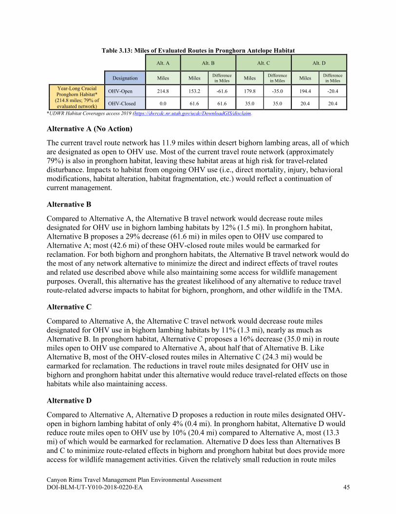
Canyon Rims Travel Management Plan Environmental Assessment DOI-BLM-UT-Y010-2018-0220-EA 45
Table 3.13: Miles of Evaluated Routes in Pronghorn Antelope Habitat
Alt. A Alt. B Alt. C Alt. D
Designation Miles Miles Difference
in Miles Miles
Difference
in Miles Miles
Difference
in Miles
Year-Long Crucial
Pronghorn Habitat*
(214.8 miles; 79% of evaluated network)
OHV-Open 214.8 153.2 -61.6 179.8 -35.0 194.4 -20.4
OHV-Closed 0.0 61.6 61.6 35.0 35.0 20.4 20.4
*UDWR Habitat Coverages access 2019 (https://dwrcdc.nr.utah.gov/ucdc/DownloadGIS/disclaim.
Alternative A (No Action)
The current travel route network has 11.9 miles within desert bighorn lambing areas, all of which
are designated as open to OHV use. Most of the current travel route network (approximately
79%) is also in pronghorn habitat, leaving these habitat areas at high risk for travel-related
disturbance. Impacts to habitat from ongoing OHV use (i.e., direct mortality, injury, behavioral
modifications, habitat alteration, habitat fragmentation, etc.) would reflect a continuation of
current management.
Alternative B
Compared to Alternative A, the Alternative B travel network would decrease route miles
designated for OHV use in bighorn lambing habitats by 12% (1.5 mi). In pronghorn habitat,
Alternative B proposes a 29% decrease (61.6 mi) in miles open to OHV use compared to
Alternative A; most (42.6 mi) of these OHV-closed route miles would be earmarked for
reclamation. For both bighorn and pronghorn habitats, the Alternative B travel network would do
the most of any network alternative to minimize the direct and indirect effects of travel routes
and related use described above while also maintaining some access for wildlife management
purposes. Overall, this alternative has the greatest likelihood of any alternative to reduce travel
route-related adverse impacts to habitat for bighorn, pronghorn, and other wildlife in the TMA.
Alternative C
Compared to Alternative A, the Alternative C travel network would decrease route miles
designated for OHV use in bighorn lambing habitats by 11% (1.3 mi), nearly as much as
Alternative B. In pronghorn habitat, Alternative C proposes a 16% decrease (35.0 mi) in route
miles open to OHV use compared to Alternative A, about half that of Alternative B. Like
Alternative B, most of the OHV-closed routes miles in Alternative C (24.3 mi) would be
earmarked for reclamation. The reductions in travel route miles designated for OHV use in
bighorn and pronghorn habitat under this alternative would reduce travel-related effects on those
habitats while also maintaining access.
Alternative D
Compared to Alternative A, Alternative D proposes a reduction in route miles designated OHV-
open in bighorn lambing habitat of only 4% (0.4 mi). In pronghorn habitat, Alternative D would
reduce route miles open to OHV use by 10% (20.4 mi) compared to Alternative A, most (13.3
mi) of which would be earmarked for reclamation. Alternative D does less than Alternatives B
and C to minimize route-related effects in bighorn and pronghorn habitat but does provide more
access for wildlife management activities. Given the relatively small reduction in route miles

Canyon Rims Travel Management Plan Environmental Assessment DOI-BLM-UT-Y010-2018-0220-EA 46
open to public motorized use, Alternative D would have greater travel route-related impacts to
bighorn, pronghorn, and other wildlife and their habitats than the other action network
alternatives but slightly less than those of Alternative A.
3.2.9 Wildlife: Migratory Birds, Including Raptors How would travel network route designations impact migratory birds within the TMA?
3.2.9.1 Affected Environment
Migratory birds, including nesting raptors, use the TMA for foraging, roosting, and nesting.
Many migratory birds depend on riparian areas (for more on riparian resources, see section 3.2.6
Water Resources: Rivers and Streams, Riparian Areas and Floodplains, and Water Quality), so
the riparian vegetation found in Hatch Wash is particularly valuable, both during migration and
for nesting (BLM 2002). Nesting habitat for migratory birds includes tree limbs, ground sites,
and rock outcrops. Raptors are widely accepted to be indicator species of environmental health
because of their position at the top of food chains. Romin and Muck state that “Each raptor nest,
its offspring, and supporting habitats are considered important to the long-term viability of raptor
populations and are vulnerable to disturbance by many human activities” (USFWS 2002d).
Raptors tend to nest on promontory points such as cliff faces and rock outcrops, but they may
also nest in pinyon, juniper, or deciduous trees (BLM 2013). There is limited potential for
occurrence of the ferruginous hawk, a Utah BLM sensitive species, in the TMA.
3.2.9.2 Environmental Effects Analysis
The nature and type of impacts on migratory birds and their habitat suitability from travel route
designations and route-related uses include disturbance, mortality or injury from collision, and
trampling or damage of brooding, nesting, foraging, and cover habitat. Travel route use can also
cause disturbance or interference with courtship, nesting, brood-rearing, or fledging activities.
Because of sensitivity and fidelity to nest territory, abandonment of nest sites due to nearby
human disturbances is of particular concern. Habitat-associated indirect risk factors of travel
routes and related use include damage, loss, or fragmentation through isolation of habitats,
establishment or spread of invasive weeds, and increased wildfire potential. Indirect effects also
include altering or influencing of prey species (e.g., rodents, lizards, and snakes) behavior as a
result of disturbance to cover vegetation (USFWS 2002d).
TMP implementation activities that could affect migratory birds and their habitats include
installing new signs, route maintenance (grading, installing water control structures, surfacing,
etc.), route decommissioning or reclamation (including ripping the ground and planting seed,
grading/recontouring), or installing fencing or barriers. If implementation is proposed that
requires new surface disturbance, additional site-specific NEPA would be required before the
activity could occur. Seeding and planting on closed routes could accelerate reclamation and help
to reestablish habitat. Implementation activities in riparian areas are of particular concern for
general wildlife and migratory birds, though some implementation activities would have a
positive effect on riparian habitats; for example, sign placement could encourage managed travel
on routes less disruptive to riparian resources.
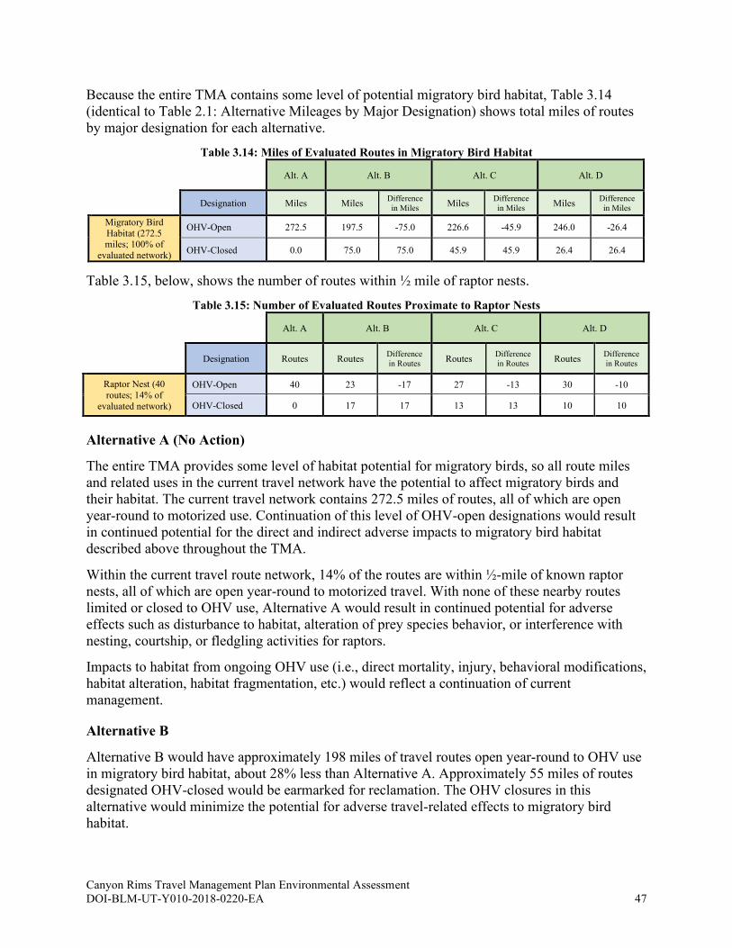
Canyon Rims Travel Management Plan Environmental Assessment DOI-BLM-UT-Y010-2018-0220-EA 47
Because the entire TMA contains some level of potential migratory bird habitat, Table 3.14
(identical to Table 2.1: Alternative Mileages by Major Designation) shows total miles of routes
by major designation for each alternative.
Table 3.14: Miles of Evaluated Routes in Migratory Bird Habitat
Alt. A Alt. B Alt. C Alt. D
Designation Miles Miles Difference
in Miles Miles
Difference
in Miles Miles
Difference
in Miles
Migratory Bird
Habitat (272.5 miles; 100% of
evaluated network)
OHV-Open 272.5 197.5 -75.0 226.6 -45.9 246.0 -26.4
OHV-Closed 0.0 75.0 75.0 45.9 45.9 26.4 26.4
Table 3.15, below, shows the number of routes within ½ mile of raptor nests.
Table 3.15: Number of Evaluated Routes Proximate to Raptor Nests
Alt. A Alt. B Alt. C Alt. D
Designation Routes Routes Difference
in Routes Routes
Difference
in Routes Routes
Difference
in Routes
Raptor Nest (40
routes; 14% of
evaluated network)
OHV-Open 40 23 -17 27 -13 30 -10
OHV-Closed 0 17 17 13 13 10 10
Alternative A (No Action)
The entire TMA provides some level of habitat potential for migratory birds, so all route miles
and related uses in the current travel network have the potential to affect migratory birds and
their habitat. The current travel network contains 272.5 miles of routes, all of which are open
year-round to motorized use. Continuation of this level of OHV-open designations would result
in continued potential for the direct and indirect adverse impacts to migratory bird habitat
described above throughout the TMA.
Within the current travel route network, 14% of the routes are within ½-mile of known raptor
nests, all of which are open year-round to motorized travel. With none of these nearby routes
limited or closed to OHV use, Alternative A would result in continued potential for adverse
effects such as disturbance to habitat, alteration of prey species behavior, or interference with
nesting, courtship, or fledgling activities for raptors.
Impacts to habitat from ongoing OHV use (i.e., direct mortality, injury, behavioral modifications,
habitat alteration, habitat fragmentation, etc.) would reflect a continuation of current
management.
Alternative B
Alternative B would have approximately 198 miles of travel routes open year-round to OHV use
in migratory bird habitat, about 28% less than Alternative A. Approximately 55 miles of routes
designated OHV-closed would be earmarked for reclamation. The OHV closures in this
alternative would minimize the potential for adverse travel-related effects to migratory bird
habitat.
Canyon Rims Travel Management Plan Environmental Assessment DOI-BLM-UT-Y010-2018-0220-EA 48
The Alternative B route network would also provide for a decrease of about 43% in routes
designated for OHV use within ½-mile of known raptor nests compared to Alternative A. Nearly
all of the closed routes would be earmarked for reclamation, resulting in fewer direct impacts
such as mortality from collision, habitat disturbance, and trampling as well as fewer indirect
effects such as alteration of prey species behavior from disturbance to cover vegetation. As
compared to Alternatives C and D, Alternative B proposes OHV-open designations for
approximately 15%-23% fewer routes in areas of raptor nests, resulting in correspondingly fewer
adverse impacts.
Overall, the Alternative B route network has the greatest likelihood of any network alternative
for reducing adverse impacts on migratory birds, including nesting raptors, in the TMA.
Alternative C
Alternative C proposes OHV-open designations for approximately 226.6 miles of travel routes in
migratory bird habitat, a 20% decrease compared to Alternative A. Most (75%) of the OHV-
closed miles would be earmarked for reclamation. The decrease in miles designated for OHV use
would help to reduce or minimize the potential for adverse travel-related effects to migratory
bird habitat.
Compared to Alternative A, the Alternative C route network proposes a 33% decrease in routes
designated OHV-open in areas of known raptor nests. This relatively large decrease in open
OHV routes would result in notably fewer route-related impacts to nesting raptors compared to
Alternative A. Alternative C would designate more routes for OHV use in areas of raptor nests
than Alternative B but fewer than Alternative D.
With fewer routes open year-round to OHV use in areas of known raptor nests compared to
Alternative A, Alternative C—like Alternative B—has the potential for reducing adverse impacts
to nesting raptors. However, the route miles in migratory bird habitat open year-round to OHV
use is only reduced by 20% compared to Alternative A. Overall, Alternative C would have
greater travel route-related impacts to migratory birds and raptors and their habitats than
Alternative B, but less than those of Alternative D and Alternative A.
Alternative D
The Alternative D route network proposes OHV-open designations for approximately 246 miles
of routes in migratory bird habitat, a reduction of approximately 10% compared to Alternative A.
While route use-related effects to migratory birds would be reduced, Alternative D would not
minimize effects nearly as much as Alternatives B or C.
In areas of raptor nests, Alternative D proposes more year-round OHV-open designations than
Alternatives B and C yet still provides for a drop of 25% compared to Alternative A, with nearly
all the closed routes being earmarked for reclamation.
Overall, given the relatively small decrease in miles of routes open to year-round OHV use in
migratory bird and raptor habitat, the Alternative D route network would have greater travel
route-related impacts to migratory birds and raptors and their habitats than the other action
network alternatives but slightly less than those of Alternative A.
Canyon Rims Travel Management Plan Environmental Assessment DOI-BLM-UT-Y010-2018-0220-EA 49
3.2.10 Wildlife: Special Status Species, excluding Fish (Federally Listed and
Utah BLM Sensitive Species) How would travel network route designations impact special status species wildlife within the
TMA?
3.2.10.1 Affected Environment
Several special status wildlife species have the potential to occur within the TMA:
• Burrowing owl (Athene cunicularia) – BLM Sensitive: Burrowing owl habitat consists
of “open, treeless areas with low, sparse vegetation, usually on gently sloping terrain,”
including grasslands, deserts, and steppe environments, and they are often associated with
high densities of burrowing mammals such as prairie dogs, ground squirrels, and tortoises
(CLO 2017). Stresses on the western burrowing owl include habitat loss and
fragmentation due to urban land conversion and declines in populations of colonial
burrowing mammals (USFWS 2003). The entire TMA has some level of potential for
burrowing owl use.
• California condor (Gymnogyps californianus) – Endangered: The California condor is
listed as a federally endangered species with non-essential, experimental status in the
TMA, meaning this species is treated as though it is proposed for federal listing rather
than as endangered. Though historically widespread in California, Arizona, Oregon, and
Mexico, it declined to extirpation in the wild in the mid-1980s; captive breeding and
reintroduction efforts are in progress, and the species is now found in California, Arizona,
and southern Utah. Nesting habitat tends to be steep, remote terrain—rock or cliff
escarpments—in mountains or canyons. Foraging areas are typically separate, in open
grasslands, oak savannas, and mountain plateaus (NSE 2019). Experimental habitat exists
across the TMA, though the only known occurrence within Utah is in the southwest
corner of the state.
• Gunnison’s prairie dog (Cynomys gunnisoni) – BLM Sensitive: Gunnison’s prairie
dog habitat includes grassland, semi-desert, and montane shrubland; they require deep,
well-drained soils for burrow construction (UDWR 2007). Due to poisoning and plague,
“GPD populations today are highly fragmented into complexes of small, isolated
colonies” (UDWR 2017a). The entire TMA has some level of potential for Gunnison’s
prairie dog use.
• Kit fox (Vulpes macrotis) – BLM Sensitive: Kit fox habitat within the TMA is
comprised of semi-desert and shrub-grass biomes that consist primarily of shadscale,
greasewood, and sagebrush (NSE 2019). Kit foxes “occupy habitats that provide
favorable combinations of low predator numbers, sufficient prey, and soils suitable for
denning” (UDWR 2017a). The entire TMA has some level of potential for kit fox use.
• Mexican spotted owl (Strix occidentalis lucida) – Endangered: The Mexican spotted
owl is found across a broad geographic area, but not uniformly. It is considered imperiled
in Utah (NSE 2019). Species habitat includes old-growth and mature forests as well as
canyon walls; these environments provide sites for protected nests and roosts. In Utah,
breeding owls primarily inhabit deep, steep-walled canyons and hanging canyons that
typically are surrounded by terrain that may provide foraging habitat (USFWS 2012).
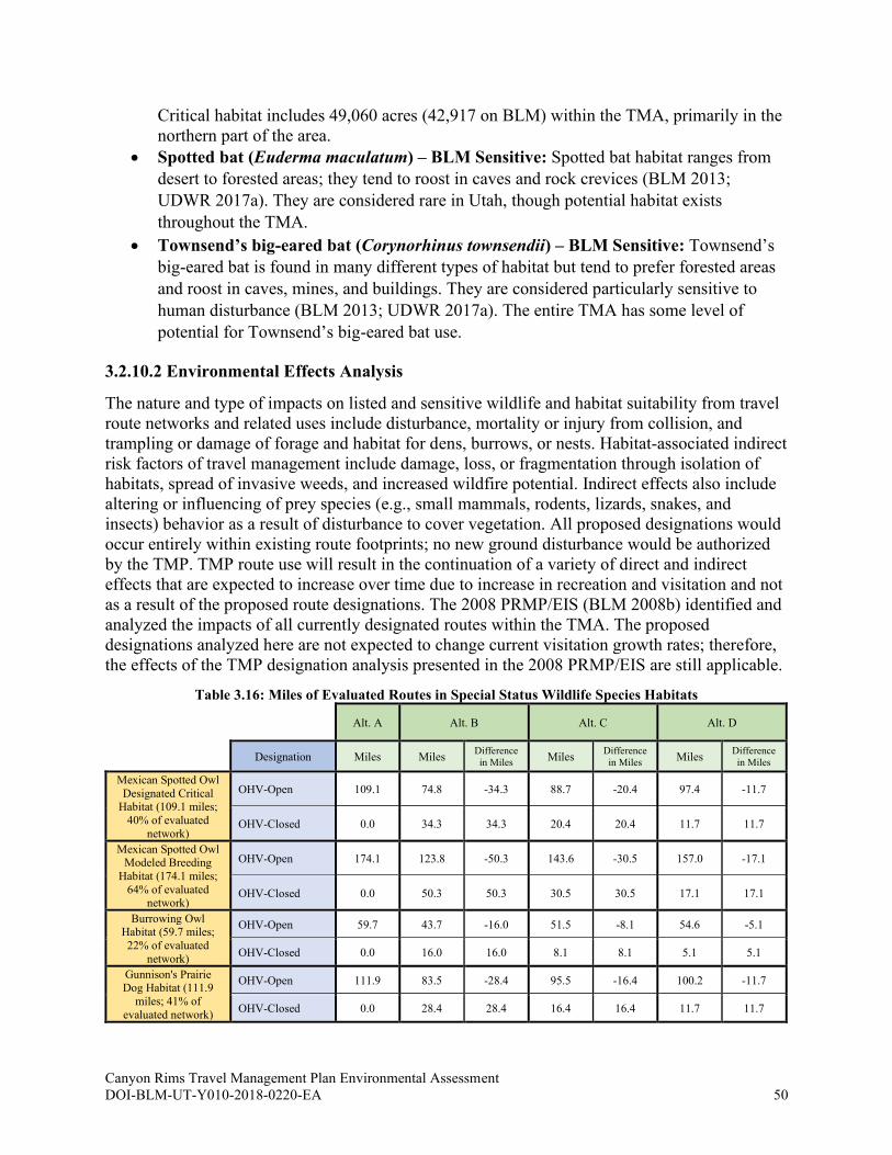
Canyon Rims Travel Management Plan Environmental Assessment DOI-BLM-UT-Y010-2018-0220-EA 50
Critical habitat includes 49,060 acres (42,917 on BLM) within the TMA, primarily in the
northern part of the area.
• Spotted bat (Euderma maculatum) – BLM Sensitive: Spotted bat habitat ranges from
desert to forested areas; they tend to roost in caves and rock crevices (BLM 2013;
UDWR 2017a). They are considered rare in Utah, though potential habitat exists
throughout the TMA.
• Townsend’s big-eared bat (Corynorhinus townsendii) – BLM Sensitive: Townsend’s
big-eared bat is found in many different types of habitat but tend to prefer forested areas
and roost in caves, mines, and buildings. They are considered particularly sensitive to
human disturbance (BLM 2013; UDWR 2017a). The entire TMA has some level of
potential for Townsend’s big-eared bat use.
3.2.10.2 Environmental Effects Analysis
The nature and type of impacts on listed and sensitive wildlife and habitat suitability from travel
route networks and related uses include disturbance, mortality or injury from collision, and
trampling or damage of forage and habitat for dens, burrows, or nests. Habitat-associated indirect
risk factors of travel management include damage, loss, or fragmentation through isolation of
habitats, spread of invasive weeds, and increased wildfire potential. Indirect effects also include
altering or influencing of prey species (e.g., small mammals, rodents, lizards, snakes, and
insects) behavior as a result of disturbance to cover vegetation. All proposed designations would
occur entirely within existing route footprints; no new ground disturbance would be authorized
by the TMP. TMP route use will result in the continuation of a variety of direct and indirect
effects that are expected to increase over time due to increase in recreation and visitation and not
as a result of the proposed route designations. The 2008 PRMP/EIS (BLM 2008b) identified and
analyzed the impacts of all currently designated routes within the TMA. The proposed
designations analyzed here are not expected to change current visitation growth rates; therefore,
the effects of the TMP designation analysis presented in the 2008 PRMP/EIS are still applicable.
Table 3.16: Miles of Evaluated Routes in Special Status Wildlife Species Habitats
Alt. A Alt. B Alt. C Alt. D
Designation Miles Miles Difference
in Miles Miles
Difference
in Miles Miles
Difference
in Miles
Mexican Spotted Owl
Designated Critical Habitat (109.1 miles;
40% of evaluated
network)
OHV-Open 109.1 74.8 -34.3 88.7 -20.4 97.4 -11.7
OHV-Closed 0.0 34.3 34.3 20.4 20.4 11.7 11.7
Mexican Spotted Owl Modeled Breeding
Habitat (174.1 miles;
64% of evaluated network)
OHV-Open 174.1 123.8 -50.3 143.6 -30.5 157.0 -17.1
OHV-Closed 0.0 50.3 50.3 30.5 30.5 17.1 17.1
Burrowing Owl Habitat (59.7 miles;
22% of evaluated
network)
OHV-Open 59.7 43.7 -16.0 51.5 -8.1 54.6 -5.1
OHV-Closed 0.0 16.0 16.0 8.1 8.1 5.1 5.1
Gunnison's Prairie Dog Habitat (111.9
miles; 41% of
evaluated network)
OHV-Open 111.9 83.5 -28.4 95.5 -16.4 100.2 -11.7
OHV-Closed 0.0 28.4 28.4 16.4 16.4 11.7 11.7
Canyon Rims Travel Management Plan Environmental Assessment DOI-BLM-UT-Y010-2018-0220-EA 51
Alternative A (No Action)
Some level of habitat potential for kit fox, Townsend’s big-eared bat, and spotted bat, as well as
California condor experimental habitat occurs across the entire TMA (see Table 2.1: Alternative
Mileages by Major Designation); the Alternative A travel network, with the most route miles
open to OHV use in SSS habitat, would have the most potential for adverse impacts (e.g.,
disturbance, displacement, mortality or injury, loss of foraging, loss of cover and breeding
habitat, avoidance, and fragmentation) to listed and sensitive species of any of the alternatives.
Of the Alternative A network, 40% of the route miles are in areas designated by the USFWS as
Mexican spotted owl designated critical habitat and 64% are in areas modeled as potential
breeding habitat, all of which are designated for year-round OHV use, creating substantial
potential for travel-related mortality, disruption of behavior, avoidance, and disturbance in
Mexican spotted owl habitat. Of the current route network, 22% is in burrowing owl habitat and
41% is in Gunnison’s prairie dog habitat. Impacts to special status animal habitat from ongoing
OHV use (i.e., direct mortality, injury, behavioral modifications, habitat alteration, habitat
fragmentation, etc.) would reflect a continuation of current management.
Alternative B
Alternative B proposes a decrease in total route miles designated for OHV use in SSS habitat of
nearly 30% compared to Alterative A; as a result, Alternative B would have notably less
potential for adverse effects on kit fox, Townsend’s big-eared bat, spotted bat, and California
condor experimental habitat. Alternative B also proposes 25-32% decreases in route miles open
to OHV use in Mexican spotted owl, burrowing owl, and Gunnison’s prairie dog habitats,
correspondingly decreasing the potential for mortality from vehicle collision, trampling of forage
or burrow and nest habitat, avoidance, and habitat fragmentation. An estimated 70-90% of the
OHV-closed miles would be earmarked for reclamation. Overall, the Alternative B network
would have greater likelihood than the other alternatives for reducing travel route-related adverse
impacts to special status species and their habitats.
Alternative C
Compared to Alternative A, Alternative C proposes a 20% decrease in route miles open to OHV
use; as a result, Alternative C would have somewhat less potential for adverse effects on kit fox,
Townsend’s big-eared bat, spotted bat, and California condor experimental habitats. In Mexican
spotted owl, burrowing owl, and Gunnison’s prairie dog habitats, Alternative B proposes 14-19%
decreases in route miles open to OHV use. Most of the OHV-closed miles would be earmarked
for reclamation. Overall, the Alternative C travel network would have greater likelihood for
reducing travel route-related adverse impacts to special status wildlife species and their habitats
than Alternative D and the No Action alternative, but less than Alternative B.
Alternative D
Compared to Alternative A, Alternative D proposes a 10% decrease in route miles open to OHV
use; as a result, the Alternative D network would have slightly less potential for adverse impacts
to kit fox, Townsend’s big-eared bat, spotted bat, and California condor experimental habitats as
compared to Alternative A, but more potential for adverse effects as compared to the other action
alternatives. In Mexican spotted owl, burrowing owl, and Gunnison’s prairie dog habitats,
Alternative D proposes 9-11% decreases in route miles open to OHV use compared to

Canyon Rims Travel Management Plan Environmental Assessment DOI-BLM-UT-Y010-2018-0220-EA 52
Alternative A. Most of the miles closed to OHV use would be earmarked for reclamation.
Though the OHV-open decreases are less than those in the other action alternatives, they would
still offer slightly more protections than Alternative A for these species and their habitats from
impacts such as collision mortality, trampling of forage or burrow and nest habitat, avoidance,
and habitat fragmentation.
3.2.11 Cumulative Effects for Key Issue 1
The cumulative impact analysis area (CIAA) used to analyze cumulative impacts for most of the
resource topics analyzed in Section 3.2 under Key Issue 1 consists of the entire TMA, with the
following exceptions:
• Lands with Wilderness Characteristics: The Moab FO area (most use of the Canyon Rims
TMA will originate from Moab, which functions as the most likely tourist base camp;
restriction on OHV travel in Canyon Rims could divert users to areas with fewer
restrictions, thereby impacting LWCs in those areas not included in the TMA)
• Wild and Scenic River: The WSR corridor that stretches approximately three miles
downstream of the TMA
• Visual Resource Management: The TMA and lands within its viewshed
• Water Resources: The Colorado River and its tributaries in the TMA downstream to its
confluence with the Green River in Canyonlands National Park
• General Wildlife: The predicted range for pronghorn and desert bighorn within the TMA
• Migratory Birds: The TMA and habitat adjacent to the TMA, particularly the riparian
corridors associated with the Colorado River watershed
Past, present, or reasonably foreseeable actions, plans, or projects impacting the resources or
resource uses analyzed under Key Issue 1 include the following:
• 1976 Hatch Point Habitat Management Plan
• 1996 California Condor Recovery Plan (Third Revision)
• 2002 Canyon Rims Recreation Area Management Plan
• 2002 Amendments to the Recovery Plans for the bonytail chub, Colorado pikeminnow,
and razorback sucker
• 2006 Range-wide Conservation Agreement and Strategy for Roundtail Chub (Gila
Robusta), Bluehead Sucker (Catostomus Discobolus), and Flannelmouth Sucker
(Catostomus Latipi); State, County, and private roadway developments; and energy and
mineral development
• 2008 RMP
• 2012 Mexican Spotted Owl Recovery Plan
• 2013 Moab Master Leasing Plan and its associated Reasonably Foreseeable Development
Scenarios for oil and gas and potash
• 2017 Utah Pronghorn Statewide Management Plan
• 2018 Utah Bighorn Sheep Statewide Management Plan
• In 2017, the UDWR started a wildlife migration initiative to “identify, preserve and
enhance essential movement corridors for terrestrial and aquatic wildlife species in the
state” that could “combine existing research and geographic information data sources into
comprehensive projects to improve critical habitat” (UDWR 2018b).

Canyon Rims Travel Management Plan Environmental Assessment DOI-BLM-UT-Y010-2018-0220-EA 53
• Ground-disturbing activities (e.g., mineral material site development, mining, road
construction, livestock grazing and range-related projects, reservoir construction, oil and
gas development, OHV and related recreational uses, etc.) on public and private lands
within the TMA
o Note: Within the ACEC a mining plan of operation is required for any proposed
mining activity that would create surface disturbance greater than casual use (43
CFR 3809 Regulations)
• Route maintenance and use associated with mineral activities as well as general road
maintenance
• Livestock and wildlife use
• Upland weed spraying along roadsides, in pastures, or in areas of high livestock or
recreational use to minimize weed dispersal
• Noxious weeds and invasive species proliferation
• Ongoing recreation-related activities such as OHV use and vehicle exploring, hunting,
horseback riding, hiking, camping, geocaching, and wildlife watching
• Paving of the Anticline Road and State, County, and private roadway developments
• Residential and commercial development
• Natural events, including drought and wildland fire
• Fire suppression
None of the travel network alternatives are proposing new surface-disturbing activities or access
points which would add to the past, present or foreseeable future actions noted above. BLM
determined that it may be reasonably foreseeable that three cultural sites may be adversely
affected as defined in 36 CFR 800.5. As noted in 36 CFR 800.(a)(1) an adverse effect on a
historic property does not necessarily lead to a significant impact. To address possible effects,
the BLM developed a historic properties treatment plan (HPTP) that minimizes future effects to
the three sites. Alternative B has the highest potential to reduce cumulative impacts to natural
and cultural resources in the CIAA through route closures and implementation measures.
Alternatives C and D would result in correspondingly lower potential to reduce cumulative
impacts than Alternative B, while Alternative A would not reduce cumulative impacts to these
resources within the CIAA.
3.3 Key Issue 2: Providing for recreation opportunities and
experiences
3.3.1 Recreation How would travel network route designations impact recreation opportunities in the TMA?
3.3.1.1 Affected Environment
The TMA offers significant opportunities for a variety of outdoor recreation activities,
particularly scenic viewing, jeeping/four-wheeling, camping, and hiking. The Moab area is
economically dependent upon recreation-based businesses, and the number of visitors continues
to grow annually—peaking each year during spring and fall months. The TMA is managed as a
Special Recreation Management Area and contains developed overlooks of the Colorado River,
Canyon Rims Travel Management Plan Environmental Assessment DOI-BLM-UT-Y010-2018-0220-EA 54
two scenic backways (Needles Overlook and Anticline roads), Windwhistle and Hatch Point
campgrounds, portions of the San Juan OHV Trail System, and hiking opportunities, including
the Hatch Wash Hiking and Backpacking Focus Area. The Moab FO receives approximately
1,894,393 visitor days per year and the BLM estimates that under any of the alternatives,
approximately 99.98% of these visitor days would be maintained (see Appendix F).
Visitation to the Canyon Rims portion of the Field Office differs in degree and intensity from
other areas within the Moab FO. Traffic counter data from 2017 through 2020 indicate that the
Canyon Rims TMA has actually seen a decrease in use. Traffic counters are located on the
Needles Overlook road, which provides the primary access to all the routes in the Canyon Rims
area. Using the April – October period for comparison, there were 90 vehicles/day in 2017, 74
vehicles/day in 2018, 82 vehicles/day in 2019 and 77 vehicles/day in 2020. This is a decrease in
use of about 15% from 2017 to 2020; to compare a non-pandemic year, there was a decrease in
use of 10% from 2017 to 2019. (Note: although BLM has no traffic counter data concerning the
Shafer Basin portion of the TMA, almost all travel in that area is on the maintained B road
travelling from Highway 279 to Canyonlands National Park).
BLM estimates (based on traffic counter and trail register data) that over 90% of the vehicles in
Canyon Rims are travelling only on the Needles Overlook Road, and about 10% of the total
vehicle count also travels on the Anticline Overlook Road (for example: in 2020, about 8
vehicles/day travelled on the Anticline Overlook Road). It is unknown exactly how many of
these vehicles explore the dirt roads that connect to these two main roads, but anecdotal evidence
indicates very few (many of the vehicles travelling on the two main routes are vehicles not
intended for travelling on unimproved roads. Thus, motorized vehicle use of the Canyon Rims
area appears to be decreasing.
3.3.1.2 Environmental Effects Analysis
Direct effects that travel networks and their use have on recreation include direct reductions or
gains in access for desired recreation opportunities and experiences and in encounters or
conflicts with other users seeking different experiences (e.g., equestrian users on open OHV
routes encountering dirt bike users). Indirect impacts or effects include the actual gain or loss of
recreation user opportunities and experiences afforded by the public lands for which a given
travel network serves to provide access.
Based on use trends within the Moab FO, it is highly likely that visitation and demand for
recreation opportunities will continue to increase, with visitors continuing to seek a diverse mix of
motorized and non-motorized opportunities. Users seeking non-motorized recreation experiences
(i.e., hiking, biking, and horseback riding) may in some cases benefit from a travel network that
closes more OHV routes, while users seeking OHV opportunities would benefit more from a
network with more open designations. Providing for a variety of motorized and non-motorized
opportunities would also enhance user safety by separating motorized users from non-motorized
users (e.g., reducing or eliminating encounters between motorcycle and equestrian or mountain
bike users).
TMP implementation activities that could affect recreation include route maintenance (surface
and ditch grading and drainage structure replacement or installation, etc.), and sign placement
(digging post holes). Maintenance can interrupt or temporarily block normal route use or access

Canyon Rims Travel Management Plan Environmental Assessment DOI-BLM-UT-Y010-2018-0220-EA 55
to recreation opportunities. However, maintenance actions would likely also enhance long-term
access and safety for recreation experiences. Sign installation would direct recreationists to their
destinations and educate recreationists on allowable uses for a particular route. If additional
implementation measures are proposed that require new surface disturbance, additional site-
specific NEPA consideration would be required before such activities could occur.
In analyzing the impacts of the various travel network alternatives on recreation, network miles
and percent of a given network are used to provide a quantitative comparison of increased or
decreased recreation user access for a variety of recreation activities and opportunities.
Table 3.17: Number of Evaluated Routes Providing Access for Various Recreation Activities
Table 3.18: Miles of Evaluated Routes by County Classification
Alt. A Alt. B Alt. C Alt. D
Designation Miles Miles Difference
in Miles Miles
Difference
in Miles Miles
Difference
in Miles
County B Routes
(58 miles; 21% of evaluated network)
OHV Open 58.0 58.0 0.0 58.0 0.0 58.0 0.0
OHV Closed 0.0 0.0 0.0 0.0 0.0 0.0 0.0
County D Routes (214.5 miles; 79%
of evaluated
network)
OHV Open 214.5 139.5 -75.0 168.6 -45.9 188.1 -26.4
OHV Closed 0.0 75.0 75.0 45.9 45.9 26.4 26.4
Table 3.19: Number of Evaluated Routes Currently Providing Access to Particular Types of Rec Destinations
Recreation Destination Number of Routes
Undeveloped Campsites 73
San Juan OHV Trail System 27
Undeveloped Parking Areas 13
Scenic Overlooks 6
Kiosks 5
Trailheads 5
Developed Campgrounds 4
Day-Use Areas 4
Interpretive Sites 4
0 50 100 150 200
Motorcycling (OHV)
Hiking
Photography
Other
Camping
Scenic Driving (OHV)
Jeeping/4-Wheeling (OHV)
Recreation Activities by Alternative
Alt A Alt B Alt C Alt D
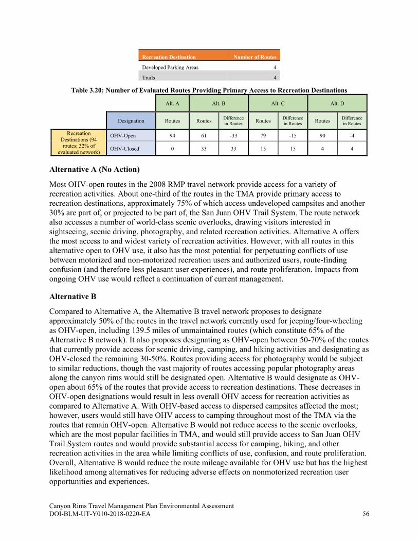
Canyon Rims Travel Management Plan Environmental Assessment DOI-BLM-UT-Y010-2018-0220-EA 56
Recreation Destination Number of Routes
Developed Parking Areas 4
Trails 4
Table 3.20: Number of Evaluated Routes Providing Primary Access to Recreation Destinations
Alt. A Alt. B Alt. C Alt. D
Designation Routes Routes Difference
in Routes Routes
Difference
in Routes Routes
Difference
in Routes
Recreation
Destinations (94 routes; 32% of
evaluated network)
OHV-Open 94 61 -33 79 -15 90 -4
OHV-Closed 0 33 33 15 15 4 4
Alternative A (No Action)
Most OHV-open routes in the 2008 RMP travel network provide access for a variety of
recreation activities. About one-third of the routes in the TMA provide primary access to
recreation destinations, approximately 75% of which access undeveloped campsites and another
30% are part of, or projected to be part of, the San Juan OHV Trail System. The route network
also accesses a number of world-class scenic overlooks, drawing visitors interested in
sightseeing, scenic driving, photography, and related recreation activities. Alternative A offers
the most access to and widest variety of recreation activities. However, with all routes in this
alternative open to OHV use, it also has the most potential for perpetuating conflicts of use
between motorized and non-motorized recreation users and authorized users, route-finding
confusion (and therefore less pleasant user experiences), and route proliferation. Impacts from
ongoing OHV use would reflect a continuation of current management.
Alternative B
Compared to Alternative A, the Alternative B travel network proposes to designate
approximately 50% of the routes in the travel network currently used for jeeping/four-wheeling
as OHV-open, including 139.5 miles of unmaintained routes (which constitute 65% of the
Alternative B network). It also proposes designating as OHV-open between 50-70% of the routes
that currently provide access for scenic driving, camping, and hiking activities and designating as
OHV-closed the remaining 30-50%. Routes providing access for photography would be subject
to similar reductions, though the vast majority of routes accessing popular photography areas
along the canyon rims would still be designated open. Alternative B would designate as OHV-
open about 65% of the routes that provide access to recreation destinations. These decreases in
OHV-open designations would result in less overall OHV access for recreation activities as
compared to Alternative A. With OHV-based access to dispersed campsites affected the most;
however, users would still have OHV access to camping throughout most of the TMA via the
routes that remain OHV-open. Alternative B would not reduce access to the scenic overlooks,
which are the most popular facilities in TMA, and would still provide access to San Juan OHV
Trail System routes and would provide substantial access for camping, hiking, and other
recreation activities in the area while limiting conflicts of use, confusion, and route proliferation.
Overall, Alternative B would reduce the route mileage available for OHV use but has the highest
likelihood among alternatives for reducing adverse effects on nonmotorized recreation user
opportunities and experiences.

Canyon Rims Travel Management Plan Environmental Assessment DOI-BLM-UT-Y010-2018-0220-EA 57
Alternative C
Alternative C would designate as OHV-open approximately 70% of the routes associated with
jeeping/four-wheeling, including 168.6 miles of unmaintained routes (which constitute 79% of
the Alternative C network). Alternative C also proposes to designate as OHV-open 70-85% of
the routes associated with scenic driving, camping, and other popular recreation activities.
Additionally, Alternative C would designate as OHV-open approximately 85% of the routes
currently providing access to various recreation destinations, the majority of which are dispersed
campsites.
Overall, the approximately 25 miles of routes proposed as OHV-closed in this alternative were
not found on the ground (though they were designated OHV-open in the 2008 RMP), indicating
they have not been receiving OHV use. The Alternative C network would result in fewer
conflicts between motorized and non-motorized users, less route-finding confusion, and less
route proliferation than in Alternative A while still providing OHV-based access to the most
popular recreation opportunities and facilities as well as the majority of known dispersed
campsites.
Alternative D
The Alternative D travel network is similar to Alternative A in the level of OHV-based access it
provides for recreation use. It would designate as OHV-open approximately 85% of the routes
associated with jeeping/four-wheeling, including 188.1 miles of unmaintained routes (which
constitute 88% of the Alternative D network) and 85-100% of the routes associated with other
popular recreation activities such as scenic driving, camping, and hiking. Of the routes in the
Alternative A travel network accessing recreation destinations, Alternative D proposes to
designate 4 of those routes as OHV-closed.
Overall, the approximately 25 miles of routes proposed as OHV-closed in this alternative were
not found on the ground (though they were designated OHV-open in the 2008 RMP), indicating
they have not been receiving OHV use. While Alternative D provides the most recreation access
of any of the action network alternatives, these proposed designations may create more potential
for user conflicts, route-finding confusion, and route proliferation.
3.3.2 Cumulative Effects for Key Issue 2
The geographic scope of cumulative effects analysis for Key Issue 2 includes the entire Moab
FO area. Past plans and actions within the TMA include the 2002 Canyon Rims Recreation Area
Management Plan and the 2008 RMP. Other past, present, and reasonably foreseeable actions
within the analysis area include the paving of the Anticline Road; State, County, and private
roadway development; expansion or re-routing of the San Juan OHV Trail System; livestock
grazing; oil and gas development; mineral material site development; mining; OHV travel; and
OHV-related human uses such as vehicle exploring, hunting, horseback riding, hiking, camping,
geocaching, and wildlife watching (see Table 3.17: Number of Evaluated Routes Providing
Access for Various Recreation Activities above). Direct and indirect effects to recreation include
conflicts between recreation users that can result in reduced quality of recreation opportunities or
experiences. Alternatives B-D would reduce user conflicts to various extents by closing some
routes and limiting some routes to administrative use only, providing for recreation experiences
Canyon Rims Travel Management Plan Environmental Assessment DOI-BLM-UT-Y010-2018-0220-EA 58
for nonmotorized users, in effect providing for some level of incremental reduction in recreation
user conflicts throughout the cumulative effects analysis area when added to the past, present,
and reasonably foreseeable actions, plans, and projects noted above. The Alternative A route
network would not address known recreation user conflicts, and navigational issues within the
TMA, potentially allowing other user conflicts within the cumulative effects analysis area to
perpetuate.

Canyon Rims Travel Management Plan Environmental Assessment DOI-BLM-UT-Y010-2018-0220-EA 59
4. CONSULTATION AND COORDINATION
4.1 List of Preparers
4.1.1 Bureau of Land Management
The following staff assisted with assembling this EA and the TMP Implementation Guide
(Appendix L) it supports. Additional staff contributed to the route evaluation that supports the
EA and Implementation Guide.
Name Title
Gabe Bissonette Ecologist, Moab Field Office
Jordan Davis Range Management Specialist, Moab Field Office
Nicollee Gaddis-Wyatt Field Manager, Moab Field Office
Lori Hunsaker Archaeologist, Moab Field Office
Ashley Losey Archaeologist, Moab Field Office
Todd Murdock Recreation Planner and Project Lead, Moab Field Office
Dave Pals Assistant Field Manager and Geologist, Moab Field Office
Pam Riddle Wildlife Biologist, Moab Field Office
Bill Stevens Recreation Planner/Economist, Moab Field Office
Katie Stevens Recreation Planner and Project Lead, Moab Field Office
Lisa Wilkolak Realty Specialist, Moab Field Office
David Williams Range Management Specialist, Moab Field Office
4.1.2 Interdisciplinary Team Involvement and Cooperators
BLM resource and resource use disciplines represented on the IDT during route evaluation
included: cultural resources, soils, water quality, riparian and wetlands, geology and minerals,
paleontology, GIS, hydrology, law enforcement, natural resources, outdoor recreation planning,
public health and safety, minerals, native vegetation and rangeland management, noxious weeds
and invasive species, lands and realty, and environmental planning and NEPA. Cooperating
Agencies involved with this project included San Juan County, the Utah School and Institutional
Trust Lands Administration (SITLA), and the State of Utah Public Lands Policy Coordinating
Office (PLPCO). After evaluation, these cooperators reviewed the preliminary alternative travel
route networks and provided feedback on the preliminary route designations and the draft
alternative route networks.
4.1.3 Advanced Resource Solutions, Inc. (ARS)
The following contractor staff also assisted with developing the TMP and EA
Name Title
Tom Folks Travel Management Planner
Cameron Gale Travel Management Planner/Writer
Dennis Gale Travel Management Planner/Writer
Canyon Rims Travel Management Plan Environmental Assessment DOI-BLM-UT-Y010-2018-0220-EA 60
Name Title
Derek Givens Travel Management Planner/GIS Specialist
Les Weeks Company Owner
4.2 Public Review
Public scoping occurred from August 5 – September 5, 2019, and was intended to solicit input
from the public on the issues, impacts, and potential alternatives that could be addressed in this
EA, and scoping comments were considered and used in its preparation (see section 1.6). See the
scoping report for a summary of public scoping. The draft alternative maps were posted online
on March 9, 2020, baseline LWC reports were posted on April 17, 2020, and the scoping report
was posted on May 1, 2020. A 30-day public comment period will be held from October 13,
2020 – November 13, 2020 in accordance with the 2017 Settlement Agreement. Route
evaluation reports were posted to the internet for public review in accordance with the 2017
Settlement Agreement on April 18, 2020.
4.3 Consultation
4.3.1 National Historic Preservation Act (NHPA) Section 106
The BLM conducted NHPA consultation in accordance with the 2018 Travel PA. These
consultation efforts included seeking input from Indian tribes and consulting parties regarding
BLM’s Class I Inventory, cultural resource potential models, the Area of Potential Effect, the
need to conduct additional cultural resource surveys, and BLM’s finding of effect. BLM’s
consultation efforts are documented in Appendix G.
Tribal Consultation
Tribal consultation was primarily initiated through the NHPA Section 106 consultation process,
described at 36 CFR 800 and directed by the Travel PA. That process typically concerns itself
with cultural resources; however, the BLM also encouraged tribes to share concerns they may
have regarding any resources and provided information as to how to find the BLM’s NEPA
documents through ePlanning so that tribes could access information for all resources within the
TMA.
On June 6, 2019, the BLM invited 61 leaders and representatives from 29 tribes that have
ancestral and historic ties to the TMA area to participate in consultation regarding the Canyon
Rims TMP. The tribes were the Colorado River Indian Tribes, the Confederated Tribes of the
Goshute, the Kaibab Band of Paiute Indians, the Navajo Nation, the Northwest Band of
Shoshone Nation, the Ohkay Owingeh, the Paiute Indian Tribe of Utah, the Pueblo of Acoma,
the Pueblo of Cochiti, the Pueblo of Isleta, the Pueblo of Jemez, the Pueblo of Kewa, the Pueblo
of Laguna, the Pueblo of Nambe, the Pueblo of Picuris, the Pueblo of Pojoaque, the Pueblo of
San Felipe, the Pueblo of San Ildefonso, the Pueblo of Sandia, the Pueblo of Santa Ana, the
Pueblo of Santa Clara, the Pueblo of Tesuque, the Pueblo of Zia, the Pueblo of Zuni, the
Southern Ute Tribe, the Southern Ute Tribe, the Hopi Tribe, the Uintah and Ouray Ute Tribe, and
the Ute Mountain Ute Tribe, including the White Mesa Community.
Canyon Rims Travel Management Plan Environmental Assessment DOI-BLM-UT-Y010-2018-0220-EA 61
The initial invitation included a description of the task at hand, background as to why BLM is
creating the TMP, an overview of the TMA, and maps. The invitation also directed recipients to
a number of online resources that provide further information on the TMA. Following the
BLM’s invitation, the Pueblo of Ysleta del Sur informed the BLM that they did not wish to
participate. The BLM included the remaining 28 tribes in all consultation correspondence
throughout the development of the Canyon Rims TMP.
The BLM next reached out to the 28 tribes on July 23, 2019 for input and information to help
define the NHPA Section 106 Area of Potential Effects. The letter again provided background on
the TMP and sought any information or concerns the tribes might have regarding impacts to
resources as a result of route designation in the TMA, particularly concerns regarding cultural
resources. The BLM received input from one tribe.
On August 5, 2020, BLM sent a letter to the 28 tribes outlining the identification efforts that
have been completed to identify effects to historic properties and requesting any additional
information that the tribes may wish to share. In addition, the BLM also sought comments
regarding proposed site eligibility determinations and a proposed finding of “no adverse effect”
as defined by 36 CFR 800.5, and the BLM received comments regarding identification efforts
and proposed finding of effect from six tribes.
On March 8, 2021, BLM sent a letter to the 28 tribes making a final finding of an adverse effect,
requesting comments on a draft HPTP, and a determination that no additional Class II survey
would be necessary for this undertaking. Five tribes concurred with BLM’s determinations and
requested to be informed if conditions changed.
Other Consulting Parties
The NHPA and the Travel PA directs the BLM to invite parties who may have a demonstrated
interest in the undertaking to participate in consultation. On June 6, 2019, the BLM invited nine
parties to participate in the Section 106 process as consulting parties. These parties were the Utah
Public Lands Policy Coordination Office, San Juan County, San Juan County Historical Society,
Utah School Institutional Trust Lands Administration, Southern Utah Wilderness Alliance,
United Four Wheel Drive Association, Utah Professional Archaeological Council, Utah Rock
Art Research Association, and Utah Statewide Archaeological Society. All nine indicated that
they wished to participate as consulting parities.
On July 23, 2019, the BLM sought input and information to help define the Section 106 Area of
Potential Effects. The letter again provided background on the TMP and sought any information
or concerns that the parties might have with defining the Area of Potential Effects in a manner
consistent with the direction defined by the Travel PA. The BLM received input from six parties.
The BLM next reached out to consulting parties on August 5, 2020 to request their input on
identification efforts, including proposed eligibility determinations, and a proposed finding of
effect. The BLM received input from 4 parties.
On March 8, 2021, BLM sent a letter to the nine consulting parties making a final finding of an
adverse effect, requesting comments on a draft HPTP, and a determination that no additional
Class II survey would be necessary for this undertaking. Two parties responded and concurred
with BLM’s determinations.

Canyon Rims Travel Management Plan Environmental Assessment DOI-BLM-UT-Y010-2018-0220-EA 62
The Utah State Historic Preservation Office
On December 19, 2018, the BLM initiated consultation with the Utah State Historic Preservation
Office (SHPO) and requested input with our plan to involve the public. The SHPO responded on
December 20, 2018 and concurred with BLM’s plan to involve the public.
On November 30, 2020, the BLM requesting comment on our identification efforts (including
determinations of eligibility for sites revisited and identified during the identification efforts) and
a finding of an adverse effect. The SHPO concurred with our eligibility determinations and our
finding of effect in a letter dated December 8, 2020.
On April 12, 2021, the BLM requested comment on the HPTP, and our determination that no
additional Class II survey would be necessary for this undertaking. On April 15, 2021, the Utah
SHPO concurred that implementation of the measures outlined in the HPTP would avoid
minimize and mitigate effects to sites 42SA16867, 28166, and 32489 and concurred that no
additional survey would be required for the Canyon Rims TMP.
4.3.2 Endangered Species Act Section 7
The BLM has had ongoing coordination and communication with the USFWS throughout the
development of this TMP. Formal consultation under ESA Section 7 with the USFWS
commenced in December 2020. The BLM determined that this TMP is likely to adversely affect
the Mexican spotted owl (Strix occidentalis lucida) and the Jones cycladenia (Cycladenia humilis
var. jonesii).
Additionally, the BLM determined that the TMP is not likely to adversely affect the Navajo
sedge (Carex specuicola), Colorado pikeminnow (Ptychochelius lucius), bonytail chub (Gila
elegans), humpback chub (Gila cypha), and razorback sucker (Xyrauchen texanus) (collectively
referred to as Colorado River fishes), will have no effect on the Southwestern willow flycatcher
(Empidonax traillii extimus) and the yellow-billed cuckoo (Coccyzus americanus occidentalis),
and is not likely to jeopardize the continued existence of the California condor.
Conservation Measures to minimize TMP effects on federally listed species and their habitats
within the TMA were developed during consultation with the Service and will be implemented
by the TMP.
The USFWS concurred with the BLM’s determination of not likely to adversely affect the
Navajo sedge and the Colorado River fishes and not likely to jeopardize the continued existence
of the California condor. The USFWS also acknowledged the BLM’s no effect determination for
the Southwestern willow flycatcher and the yellow-billed cuckoo.
The USFWS provided a Biological Opinion on May 3, 2021 that evaluated impacts to the
Mexican spotted owl and Jones cycladenia from TMP implementation. The USFWS concluded
that the TMP is not likely to jeopardize the continued existence of the Mexican spotted owl and
Jones cycladenia.
Canyon Rims Travel Management Plan Environmental Assessment DOI-BLM-UT-Y010-2018-0220-EA A-1
APPENDIX A. REFERENCES
Beck, R. Kelly, Mike Cannon, Ralph Burrillo, Stephanie Lechert, Paul Burnett, Mary Ann
Vicari, Lisa Krussow, Kiera Westwater and Lindsey Kester. 2016. A Class I Cultural
Resource Inventory of Lands Administered by the Bureau of Land Management, Moab
Field Office. Prepared by SWCA Environmental Consultants, Salt Lake City, Utah.
Prepared for and copies available from the Bureau of Land Management, Moab Field
Office, Moab, Utah.
BLM (Bureau of Land Management). 1991. Riparian-Wetland Initiative for the 1990’s.
BLM/WO/GI-91/001+4340. https://archive.org/details/riparianwetlandi00usbu.
_____. 2002. Canyon Rims Recreation Area Management Plan. Moab, UT.
_____. 2004a. Manual 8100 – The Foundations for Managing Cultural Resources (Public).
https://www.blm.gov/sites/blm.gov/files/uploads/mediacenter_blmpolicymanual8100.pdf
_____. 2004b. Manual 8110 – Identifying and Evaluating Cultural Resources (Public).
https://www.blm.gov/sites/blm.gov/files/uploads/mediacenter_blmpolicymanual8110_0.p
df.
_____. 2008a. BLM National Environmental Policy Act Handbook (H-1790-1). Washington,
D.C. https://www.ntc.blm.gov/krc/uploads/366/NEPAHandbook_H-1790_508.pdf.
_____. 2008b. Moab Field Office Proposed Resource Management Plan and Final
Environmental Impact Statement. Moab, UT. https://eplanning.blm.gov/epl-front-
office/projects/lup/66098/81227/94745/CompleteDocumentText.pdf.
_____. 2008c. Moab Field Office Record of Decision and Approved Resource Management
Plan. Moab, UT. https://eplanning.blm.gov/epl-front-
office/projects/lup/66098/80422/93491/Moab_Final_Plan.pdf.
_____. 2012. H-8342 Travel and Transportation Handbook (Public). N.p.
https://www.ntc.blm.gov/krc/uploads/750/8342%20-
%20TTM%20Planning%20Handbook.pdf.
_____. 2013. Analysis of the Management Situation for the Canyon Country District Office
Moab Master Leasing Plan and Associated Environmental Impact Statement. Moab, UT.
https://eplanning.blm.gov/epl-front-
office/projects/lup/68430/88313/105653/Moab_Final_AMS_web.pdf.
_____. 2015. Moab Field Office Approved Resource Management Plan Land Use Plan
Evaluation Report. https://eplanning.blm.gov/epl-front-
office/projects/lup/66098/80467/93538/Moab_RMP_Evaluation_September_2015.pdf.
_____. 2016a. Record of Decision and Moab Master Leasing Plan/Approved Resource
Management Plan Amendments for the Moab and Monticello Field Offices. December
2016. Canyon Country District Office, Moab, Utah. https://eplanning.blm.gov/eplanning-
ui/project/68430/510.

Canyon Rims Travel Management Plan Environmental Assessment DOI-BLM-UT-Y010-2018-0220-EA A-2
_____. 2016b. 1626 – Travel and Transportation Management Manual (Public) (MS 1626). N.p.
https://www.blm.gov/sites/blm.gov/files/uploads/mediacenter_blmpolicymanual1626.pdf
_____. 2019. Increasing Recreational Opportunities through the use of Electric Bikes.
https://www.doi.gov/sites/doi.gov/files/elips/documents/so_3376_-
_increasing_recreational_opportunities_through_the_use_of_electric_bikes_-508_0.pdf.
CLO (Cornell Lab of Ornithology). 2017. The Cornell Lab of Ornithology: All About Birds.
https://www.allaboutbirds.org/.
Colorado Division of Wildlife. 2006. Conservation agreement for Colorado River cutthroat trout
(Oncorhynchus clarkii pleuriticus) in the States of Colorado, Utah, and Wyoming. CRCT
Conservation Team.
https://cpw.state.co.us/Documents/Research/Aquatic/pdf/CRCT_Conservation_Agreeme
nt_Final_Dec06.pdf.
Duniway, Michael C., Alix A. Pfennigwerth, Stephen E. Fick, Travis W. Nauman, Jayne Belnap,
and Nichole N. Barger. 2019. Wind erosion and dust from US drylands: a review of
causes, consequences, and solutions in a changing world. Ecosphere, vol. 10, issue 3.
March 2019. https://doi.org/10.1002/ecs2.2650.
Etyemezian, V., H. Kuhns, J. Gillies, J. Chow, K. Hendrickson, M. McGown, and M. Pitchford.
2003. Vehicle-based road dust emission measurement (III): effect of speed, traffic
volume, location, and season of PM10 road dust emissions in the Treasure Valley, Idaho.
Atmospheric Environment, vol. 37, issue 32, 4583-4593, January 2003.
https://doi.org/10.1016/S1352-2310(03)00530-2.
GPO (U.S. Government Publishing Office). 2012. Code of Federal Regulations: Title 40, Part
1508 – Terminology and Index. https://www.gpo.gov/fdsys/pkg/CFR-2012-title40-
vol34/pdf/CFR-2012-title40-vol34-sec1508-7.pdf.
_____. 2016. Code of Federal Regulations: Title 43, Part 8340 – Off-Road Vehicles.
https://www.gpo.gov/fdsys/pkg/CFR-2016-title43-vol2/pdf/CFR-2016-title43-vol2-
part8340-subpart8340.pdf.
Itasca Denver, Inc. 2011. Nine Mile Canyon Dust Study. Submitted to Bill Barrett Corporation.
Kavouras, I. G., V. Etyemezian, D. W. DuBois, J. Xu, and M. Pitchford. 2009. Source
reconciliation of atmospheric dust causing visibility impairment in Class I areas of the
western United States. Journal of Geophysical Research: Atmospheres, vol. 114, issue
D2, January 2009. https://doi.org/10.1029/2008JD009923.
Meehan, W.R., editor. 1991. Influences of forest and rangeland management on salmonid fishes
and their habitats. American Fisheries Society Special Publication 19.
NSE (NatureServe Explorer). 2019. NatureServe Explorer: An Online Encyclopedia of Life [web
application]: Version 7.1. http://explorer.natureserve.org/.
Silver, Constance S. 2008. Development, Dust and Rock Art in Nine Mile Canyon, Utah: A
Report of the Impact of Dust Caused by Industrial Traffic on Dirt Roads in Nine Mile
Canyon. Preservar, Inc. Submitted to the Bureau of Land Management Utah State Office.
Copies available from Preservar, Inc. Brattleboro, Vermont.
Canyon Rims Travel Management Plan Environmental Assessment DOI-BLM-UT-Y010-2018-0220-EA A-3
Spangler, Jerry D. 2008. Dust Up: A Baseline Site Condition Assessment and Analysis of Dust
Accumulation and Vandalism of Cultural Resources in the Cottonwood Canyon Confluence
Area, Nine Mile Canyon, Carbon County, Utah. Colorado Plateau Archaeological Alliance.
Ogden, Utah.
Summit Envirosolutions, Inc. 2011. Results of a Five-Year Monitoring Program of Six
Archaeological Sites for the Sierra Pacific Falcon Project. BLM report numbers 6-2131-
14 and 8111-NV04-11-1309d.
USFS (U.S. Forest Service). 2001. Coleogyne ramosissima. By Michelle D. Anderson. Fire
Effects Information System, U.S. Department of Agriculture, Forest Service, Rocky
Mountain Research Station, Fire Sciences Laboratory (Producer).
https://www.fs.fed.us/database/feis/plants/shrub/colram/all.html.
USFWS (U.S. Fish and Wildlife Service). 1996. Recovery Plan for the California Condor: Third
Revision. Portland, OR. https://ecos.fws.gov/docs/recovery_plan/960425.pdf.
_____. 2002a. Bonytail (Gila elegans) Recovery Goals: Amendment and Supplement to the
Bonytail Chub Recovery Plan. Denver, Colorado.
https://ecos.fws.gov/docs/recovery_plan/060727a.pdf.
_____. 2002b. Colorado Pikeminnow (Ptychocheilus lucius) Recovery Goals: Amendment and
Supplement to the Colorado River Squawfish Recovery Plan. Denver, Colorado.
https://ecos.fws.gov/docs/recovery_plan/020828b.pdf.
_____. 2002c. Razorback sucker (Xyrauchen texanus) Recovery Goals: Amendment and
Supplement to the Razorback Sucker Recovery Plan. Mountain-Prairie Region (6),
Denver, Colorado. https://ecos.fws.gov/docs/recovery_plan/060727c.pdf.
_____. 2002d. Romin, Laura A. and James A. Muck. Utah Field Office Guidelines for Raptor
Protection from Human and Land Use Disturbances. Salt Lake City.
https://www.fws.gov/utahfieldoffice/Documents/MigBirds/Raptor%20Guidelines%20%2
8v%20March%2020,%202002%29.pdf.
_____. 2003. Status Assessment and Conservation Plan for the Western Burrowing Owl in the
United States. Klute, D.S., L.W. Ayers, M.T. Green, W.H. Howe, S.L. Jones, J.A.
Shaffer, S.R. Sheffield, and T.S. Zimmerman. U.S. Department of Interior, Fish and
Wildlife Service, Biological Technical Publication FWS/BTP-R6001-2003, Washington,
D.C. https://www.fws.gov/mountain-
prairie/migbirds/species/birds/wbo/Western%20Burrowing%20Owlrev73003a.pdf.
_____. 2008. Recovery Outline for the Jones Cycladenia.
https://ecos.fws.gov/docs/recovery_plan/Jones%20cycladenia_123008.pdf.
_____. 2009. Arizona Ecological Services USFWS Southwest Region Documents by Species:
General Species Information - Bonytail (Gila elegans).
https://www.fws.gov/southwest/es/arizona/Documents/Redbook/Bonytail%20RB.pdf.
_____. 2011. Colorado Pikeminnow (Ptychocheilus lucius) 5-Year Review: Summary and
Evaluation. Denver, Colorado. https://ecos.fws.gov/docs/five_year_review/doc3848.pdf.
Canyon Rims Travel Management Plan Environmental Assessment DOI-BLM-UT-Y010-2018-0220-EA A-4
_____. 2012. Mexican Spotted Owl Recovery Plan, First Revision (Strix occidentalis lucida).
Albuquerque, New Mexico.
https://ecos.fws.gov/docs/recovery_plan/MSO_Recovery_Plan_First_Revision_Dec2012.
pdf.
_____. 2014. Navajo sedge (Carex specuicola) 5-Year Review: Summary and Evaluation.
Phoenix, Arizona. https://ecos.fws.gov/docs/five_year_review/doc4442.pdf.
_____. 2018. Humpback Chub (Gila cypha) 5-Year Review: Summary and Evaluation.
Lakewood, Colorado. https://ecos.fws.gov/docs/five_year_review/doc5691.pdf.
UDWR (Utah Division of Wildlife Resources). 2006. Range-wide Conservation Agreement and
Strategy for Roundtail Chub (Gila Robusta), Bluehead Sucker (Catostomus Discobolus),
and Flannelmouth Sucker (Catostomus Latipi). Salt Lake City, Utah.
https://cpw.state.co.us/Documents/WildlifeSpecies/SpeciesOfConcern/RecoveryPlans/Ch
ubSuckerRangewideConservationAgreementandStrategy01-04-07.pdf.
_____. 2007. Lupis, S.G., K.D. Bunnell, T.A. Black, and T.A. Messmer. Utah Gunnison’s Prairie
Dog and White-Tailed Prairie Dog Conservation Plan. Salt Lake City, Utah.
https://utahcbcp.org/ou-files/UTGPDWTPDPlan_FinalDraft.pdf.
_____. 2017a. Utah Sensitive Species List. N.p.
https://dwrcdc.nr.utah.gov/ucdc/viewreports/SSL_Appendices.pdf.
_____. 2017b. Utah Pronghorn Statewide Management Plan. Salt Lake City, UT.
https://wildlife.utah.gov/pdf/bg/pronghorn_plan.pdf.
_____. 2018a. Utah Bighorn Sheep Statewide Management Plan. Salt Lake City, UT.
https://wildlife.utah.gov/hunting/biggame/pdf/bighorn-plan.pdf.
_____. 2018b. Utah’s Wildlife Migration Initiative. Salt Lake City, UT.
https://wildlife.utah.gov/43-migration-initiative.html.

Canyon Rims Travel Management Plan Environmental Assessment DOI-BLM-UT-Y010-2018-0220-EA B-1
APPENDIX B. ABBREVIATIONS AND ACRONYMS
ACEC Area of critical environmental concern
ATV All-terrain vehicle
BLM Bureau of Land Management
BMP Best management practice
CFR Code of Federal Regulations
CLO Cornell Lab of Ornithology
CX Categorical exclusion
DNA Determination of NEPA adequacy
DOI Department of the Interior
DR Decision record
DWR Utah Division of Wildlife Resources
ECOS Environmental Conservation Online System
EIS Environmental impact statement
FONSI Finding of no significant impact
GPO Government Publishing Office
IDT Interdisciplinary team
LWC Land with wilderness characteristics
MBTA Migratory Bird Treaty Act
Moab FO Moab Field Office
NEPA National Environmental Policy Act
NPS National Park Service
NRCS Natural Resources Conservation Service
NSE NatureServe Explorer
OHV Off-highway vehicle
ORV Outstandingly remarkable values
PLPCO State of Utah Public Lands Policy Coordinating Office
RMP Resource management plan
ROW Right-of-way
SITLA Utah School and Institutional Trust Lands Administration
SRMA Special recreation management area
SRP Special recreation permit
SSS Special status species
TCP Traditional cultural property
TMA Travel management area
TMP Travel Management Plan
UDWR Utah Division of Wildlife Resources
USFWS U.S. Fish and Wildlife Service
UTV Utility terrain vehicle
Canyon Rims Travel Management Plan Environmental Assessment DOI-BLM-UT-Y010-2018-0220-EA C-1
APPENDIX C. ADDITIONAL POLICIES, STATUTES, AND
GUIDANCE
In addition to the management plans and policies listed in section 1.5, this project also considers
the following:
• 43 CFR Part 8340: Off-Road Vehicles
• The BLM’s 2001 National Management Strategy for Motorized Off-Highway Vehicle
Use on Public Lands
• 43 CFR 8364.1: Closures and Restrictions
• BLM’s 2008 National Environmental Policy Act Handbook (H-1790-1).
• BLM’s 2012 Travel and Transportation Handbook (H-8342)
• Federal Land Policy and Management Act (FLPMA)
• 2017 Settlement Agreement
Though the BLM is not required to adhere to county plans, the IDT took into consideration the
San Juan County RMP and Travel Plan.

Canyon Rims Travel Management Plan Environmental Assessment DOI-BLM-UT-Y010-2018-0220-EA D-1
APPENDIX D. SCOPING DETAILS
Scoping Overview
Internal and external scoping were used to identify issues related to travel management in the
TMA. Internal scoping involved obtaining input from BLM staff. Some internal scoping
occurred via a BLM IDT of resource specialists analyzing potential consequences of a range of
travel management alternatives during the route evaluation process and during meetings held
throughout the development of this TMP EA. More detail on the route evaluation process can be
found in section 2.1. External scoping involved getting comments from the public and outside
agencies and groups. Details on public scoping can be found in the Canyon Rims Travel
Management Plan Scoping Report, available on this project’s ePlanning page.
Various scoping issues were identified, but only key issues receive analysis in the EA.
Scoping Issues Analyzed in EA
Route and travel-related issues that are analyzed in the EA fall under the underlined topic
headings listed below and are separated by semi-colons. In general, issues are tied to potential
impacts of individual route designations. These issues address the 43 CFR 8342.1 designation
criteria listed in Table 1.3 of this EA.
• Minimizing travel network adverse environmental effects on the TMA’s natural and
human environment while maintaining or enhancing access for resource management
activities:
o Cultural resources: Site protection; concentration/increased use on routes when
other routes are closed and potential effects based on such increased use; access
(related to research/inventory); public overuse; potential for illegal collection
and/or vandalism of artifacts/sites; maintenance of routes through sites; ability to
carry out Euro-historic events/uses (e.g., reenactments); tribal group access to
federal/tribal lands; public access to tribal areas; tribal groups not being restricted
access to federal lands and/or tribal lands; tribal groups concerned about public
access to significant tribal use areas
o Lands with Wilderness Characteristics: Motorized route designations’ effect on
presence, absence, and nature of wilderness characteristics; potential for illegal
motorized encroachment in special management areas; ability to access
wilderness characteristics areas in general; motorized use effects on natural
soundscapes; elimination of roads may have impact on LWC boundaries.
o Soils, Native Vegetation (Including T&E Species), and Weeds and Invasive
Species: Route network/travel related vectors’ (recreation, vehicle use, etc.)
contribution to introduction/spread of noxious weeds; native species
displacement; ecosystem function disruption; agency access needs for
monitoring/treatment activities; nuisance for recreation; range and wildlife habitat
viability impacts; impacts of travel route designations on native vegetation

Canyon Rims Travel Management Plan Environmental Assessment DOI-BLM-UT-Y010-2018-0220-EA D-2
communities, introduction and spread of invasive weeds, and fire regimes and
their management; route network-related illegal plant collection; direct impacts
from public motorized recreation (including illegal off-road travel); public access
for viewing/photographing; ecosystem integrity and value of native plants
(pollinators, etc.)
o Special Designation Areas: Maintain relevant and important values of the
Highway 279 Corridor/Shafer Basin/Long Canyon ACEC; maintain scenic quality
of Wild and Scenic River portion of Colorado River that runs through the TMA;
maintain integrity of the Old Spanish National Historic Trail
o Special Status Species Animals: see Wildlife
o Special Status Species Plants: see Soils, Native Vegetation, Weeds and Invasive
Species, and Soil Stability
o Visual Resource Management (VRM): Impact of travel routes on visual resources
o Water Resources: Rivers and Streams, Riparian Areas and Floodplains, and Water
Quality: Travel-related erosion’s impacts on water quality and waterway
appearance; salinity from natural sources, i.e., saline soils; OHV travel in washes
and small streams impacting stability and resulting in headcutting, particularly in
areas of fine soils; administrative access to monitoring sites; route-related adverse
impacts to soils via erosion/compaction (especially primitive routes) and
contributions to salinity; soil impacts caused by lack of route construction
standards; non-hardened routes crossing ephemeral and perennial channels
potentially contributing to stream sedimentation; difficulty of achieving
reclamation/maintenance objectives because of certain soil types; public desire for
route paving, more frequent maintenance; excessive, fugitive dust from traffic
o Wildlife: Fish (T&E and BLM Sensitive Species): Potential for route-related
habitat loss/fragmentation/degradation and disturbance of animals, particularly
Threatened and Endangered and BLM sensitive species; access to public lands for
consumptive and non-consumptive use of wildlife resources; access contributing
to species loss; public concern over potential loss of access for motorized game
retrieval; water quality’s benefits to habitats
o Wildlife: General Wildlife: Potential for loss, fragmentation, or degradation of
habitat; potential for disturbance of animals (mule deer, elk, desert bighorn sheep,
raptors, antelope, migratory birds, pollinators, prairie dogs, etc.) from routes and
traffic (O&G, recreation, administrative); concern about the availability of access
to public lands to enjoy the benefits of viewing/hunting big game, small game,
upland species, as well as trapping
o Wildlife: Migratory Birds, Including Raptors: Potential continued and new
impacts to bird & raptors
o Wildlife: Special Status Species Animals: Potential for route-related habitat loss,
fragmentation, and degradation; potential disturbance of animals, particularly
Threatened and Endangered and BLM sensitive species
• Providing for recreation opportunities and experiences:
Canyon Rims Travel Management Plan Environmental Assessment DOI-BLM-UT-Y010-2018-0220-EA D-3
o Recreation: Volume of use has exploded; route proliferation; greater potential for
activity conflicts caused by greater concentration of users on remaining routes
when limits/closures are applied to routes; ability of public to access lands for
recreation; non-motorized vs. motorized perspectives on experience opportunities;
BLM ability to provide variety of recreation experiences (including expansion of
opportunities) tied to varying route types, maintain SRP access, provide
opportunities for non-motorized activities without conflict with motorized use,
reduce conflicts among motorized users, and maintain existing recreation access
points; public ignoring sign system
Issues Identified but Eliminated from Detailed Analysis
Route/travel-related issues that were identified but eliminated from detailed analysis in the EA
fall under the topic headings listed below. Additional issues eliminated from detailed analysis are
found in Appendix E: Interdisciplinary Team Checklist and received either an NP (Not Present)
or NI (Not Impacted) determination.
• Revised Statute (RS) 2477: How will the BLM address Revised Statute (RS) 2477 claims
within the TMA?
o This EA and planning effort does not adjudicate, analyze, or otherwise determine
the validity of claimed rights-of-way. Resolution of RS 2477 assertions is a legal
issue beyond the scope of this EA and planning effort. Nothing in this document
has legal effect on or alters in any way the legal rights the state and counties have
to assert RS 2477 rights.
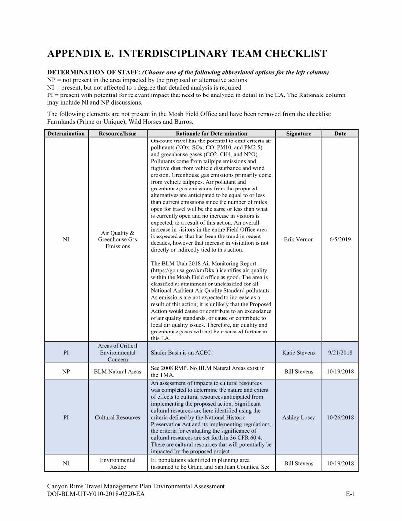
Canyon Rims Travel Management Plan Environmental Assessment DOI-BLM-UT-Y010-2018-0220-EA E-1
APPENDIX E. INTERDISCIPLINARY TEAM CHECKLIST
DETERMINATION OF STAFF: (Choose one of the following abbreviated options for the left column)
NP = not present in the area impacted by the proposed or alternative actions
NI = present, but not affected to a degree that detailed analysis is required
PI = present with potential for relevant impact that need to be analyzed in detail in the EA. The Rationale column
may include NI and NP discussions.
The following elements are not present in the Moab Field Office and have been removed from the checklist:
Farmlands (Prime or Unique), Wild Horses and Burros.
Determination Resource/Issue Rationale for Determination Signature Date
NI
Air Quality &
Greenhouse Gas
Emissions
On-route travel has the potential to emit criteria air
pollutants (NOx, SOx, CO, PM10, and PM2.5)
and greenhouse gases (CO2, CH4, and N2O).
Pollutants come from tailpipe emissions and
fugitive dust from vehicle disturbance and wind
erosion. Greenhouse gas emissions primarily come
from vehicle tailpipes. Air pollutant and
greenhouse gas emissions from the proposed
alternatives are anticipated to be equal to or less
than current emissions since the number of miles
open for travel will be the same or less than what
is currently open and no increase in visitors is
expected, as a result of this action. An overall
increase in visitors in the entire Field Office area
is expected as that has been the trend in recent
decades, however that increase in visitation is not
directly or indirectly tied to this action.
The BLM Utah 2018 Air Monitoring Report
(https://go.usa.gov/xmDkx ) identifies air quality
within the Moab Field office as good. The area is
classified as attainment or unclassified for all
National Ambient Air Quality Standard pollutants.
As emissions are not expected to increase as a
result of this action, it is unlikely that the Proposed
Action would cause or contribute to an exceedance
of air quality standards, or cause or contribute to
local air quality issues. Therefore, air quality and
greenhouse gases will not be discussed further in
this EA.
Erik Vernon 6/5/2019
PI
Areas of Critical
Environmental
Concern
Shafer Basin is an ACEC. Katie Stevens 9/21/2018
NP BLM Natural Areas See 2008 RMP. No BLM Natural Areas exist in
the TMA. Bill Stevens 10/19/2018
PI Cultural Resources
An assessment of impacts to cultural resources
was completed to determine the nature and extent
of effects to cultural resources anticipated from
implementing the proposed action. Significant
cultural resources are here identified using the
criteria defined by the National Historic
Preservation Act and its implementing regulations,
the criteria for evaluating the significance of
cultural resources are set forth in 36 CFR 60.4.
There are cultural resources that will potentially be
impacted by the proposed project.
Ashley Losey 10/26/2018
NI Environmental
Justice
EJ populations identified in planning area
(assumed to be Grand and San Juan Counties. See Bill Stevens 10/19/2018

Canyon Rims Travel Management Plan Environmental Assessment DOI-BLM-UT-Y010-2018-0220-EA E-2
Determination Resource/Issue Rationale for Determination Signature Date
2016 MLP. No reason to expect disproportionately
adverse impacts on EJ populations from plan
alternatives.
NI Fire/Fuels
Management No effect anticipated from travel management. Josh Relph 3/11/2019
PI Floodplains
Impacts to floodplains primarily consist of loss of
vegetation and geomorphic changes to bank angle,
bank stability, increasing channel width, and in
some cases creating artificial flow channels at or
near route/stream intersections. Floodplain
connectivity may be impaired due to increased
erosion and channel downcutting resulting from
accelerated flood velocities linked to loss of
vegetation or soil compaction.
Gabe Bissonette 3/25/2019
NI
Geology/Mineral
Resources/Energy
Production
Subject to valid existing rights. See 2008 RMP.
Access for mineral development activities would
be authorized under a separate process.
Dave Pals 6/26/2020
PI
Invasive
Species/Noxious
Weeds
Roadsides offer disturbance for invasive species to
establish. Would provide access to treat known
noxious weed infestations.
Jordan Davis,
Dave Williams 2/11/2019
NI Lands/Access
Subject to valid, existing rights. None of the
alternatives will result in the loss of reasonable
access to SITLA or other landowner parcels.
Lisa Wilkolak 6/26/2020
PI
Lands with
Wilderness
Characteristics
Large acreages in TMA identified as possessing
wilderness characteristics. Use of designated
routes into these areas (not boundaries) could
negatively impact outstanding opportunities for
solitude and/or primitive and unconfined
recreation. None managed in RMP to specifically
protect LWC.
Bill Stevens 10/19/2018
NI Livestock Grazing
It is expected that the limited or closed routes
would revegetate and produce more forage. It is
not known what the improvement to the forage
would be or if it would be enough to change an
authorization to allow for more use or not. It
would be improbable to analyze a figure that could
be meaningfully analyzed. The advent of the TMP
would still allow for use of the routes by the BLM
and the range user for management of the grazing
allotments. They would be limited or open to
range improvements which would still allow for
maintenance of range improvements. Because of
the potential improvements to forage not being
meaningfully analyzed and the range user still
being allowed access to range improvements it is
not expected to impact the livestock grazing on the
allotment.
Jordan Davis,
Dave Williams 2/11/2019
PI Migratory Birds
Potential continued and new impacts to bird &
raptors. Will provide potential species,
recommended spatial & seasonal buffers.
Pam Riddle 2/12/2019
NI Native American
Religious Concerns
Tribal consultation took place as part of BLM’s
National Historic Preservation Act, Section 106
process.
Lori Hunsaker 2/13/2020
NI Paleontology
A reasonable amount of invertabrate fossils and
plants may be collected in accordance with the
2008 Moab Resource Management Plan.
Vertebrate fossils should not be disturbed. If
paleontological resources are encountered during
surface disturbing activities, the activity should
stop at the site and Moab BLM notified.
Dave Pals 3/13/2019
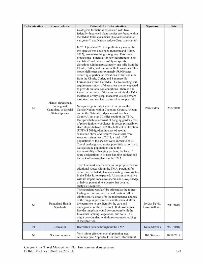
Canyon Rims Travel Management Plan Environmental Assessment DOI-BLM-UT-Y010-2018-0220-EA E-3
Determination Resource/Issue Rationale for Determination Signature Date
NI
Plants: Threatened,
Endangered,
Candidate, or Special
Status Species
Geological formations associated with two
federally threatened plant species are found within
the TMA: Jones cycladenia (Cycladenia humilis
var. jonesii) and Navajo sedge (Carex specuicola).
In 2011 (updated 2014) a preliminary model for
this species was developed (Sansom and Elliott.
2012); ground-truthing is ongoing. This model
predicts the “potential for new occurrences to be
identified” and is based solely on specific
elevations within approximately one mile from the
Chinle, Cutler, and Summerville Formations. This
model delineates approximately 58,000 acres
occurring at particular elevations within one mile
from the Chinle, Cutler, and Summerville
Formations within the TMA. Due to exacting soil
requirements much of these areas are not expected
to provide suitable soil conditions. There is one
known occurrence of this species within the TMA,
located on a very steep, inaccessible slope where
motorized and mechanized travel is not possible.
Navajo sedge is only known to occur on the
Navajo Nation, within Coconino County, Arizona
and in the Natural Bridges area of San Juan
County, Utah over 30 miles south of the TMA.
Occupied habitats consist of hanging garden areas
of piñon-juniper woodlands. It occurs primarily on
steep slopes between 4,200-7,600 feet in elevation
(USFWS 2014), often in areas of aeolian
sandstone cliffs, and requires moist soils from
seeps or springs. As of 2014, a total of 57
populations of the species were known to exist.
Travel on designated routes pose little to no risk to
Navajo sedge populations due to the
inaccessibility of hanging gardens, the lack of
route designations in or near hanging gardens and
the lack of known plants in the TMA.
Travel network alternatives do not propose new or
additional routes within the TMA; potential for
occurrence of listed plants on existing travel routes
in the TMA is not expected. All action alternative
will not impact Jones cycladenia and Navajo sedge
or habitat potential to a degree that detailed
analysis is required.
Pam Riddle 2/25/2020
NI Rangeland Health
Standards
The rangeland wouldn't be affected as the routes
leading to reservoirs etc. would continue allow
administrative access for the maintenance and use
of the range improvements and this would allow
the permittee to use them for the care and
management of thier livestock. It almost seems
like the rangeland could be connected with the
Livestock Grazing, vegetation, and soils. This
might be redundant with those resources looking
at the specifics.
Jordan Davis,
Dave Williams 2/11/2019
PI Recreation Recreation occurs throughout the TMA. Katie Stevens 9/21/2018
NI Socioeconomics Very minor effect on overall planning area
economy (see Appendix F for more information) Bill Stevens 10/19/2018
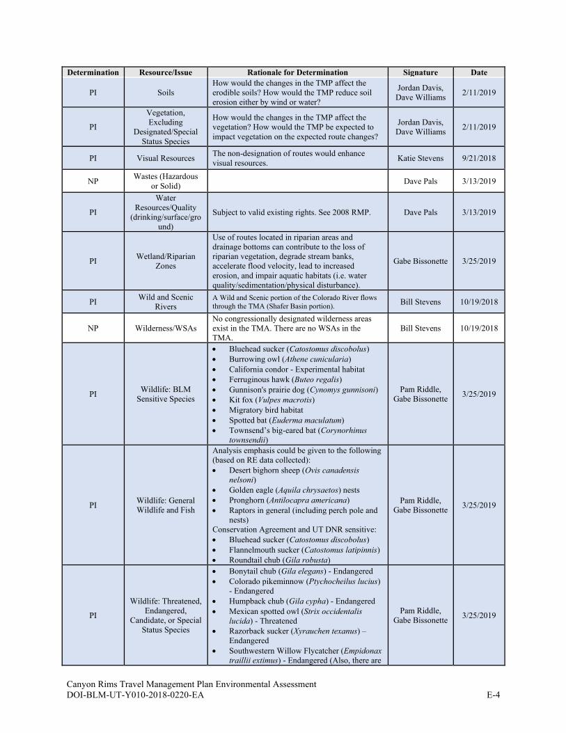
Canyon Rims Travel Management Plan Environmental Assessment DOI-BLM-UT-Y010-2018-0220-EA E-4
Determination Resource/Issue Rationale for Determination Signature Date
PI Soils
How would the changes in the TMP affect the
erodible soils? How would the TMP reduce soil
erosion either by wind or water?
Jordan Davis,
Dave Williams 2/11/2019
PI
Vegetation,
Excluding
Designated/Special
Status Species
How would the changes in the TMP affect the
vegetation? How would the TMP be expected to
impact vegetation on the expected route changes?
Jordan Davis,
Dave Williams 2/11/2019
PI Visual Resources The non-designation of routes would enhance
visual resources. Katie Stevens 9/21/2018
NP Wastes (Hazardous
or Solid) Dave Pals 3/13/2019
PI
Water
Resources/Quality
(drinking/surface/gro
und)
Subject to valid existing rights. See 2008 RMP. Dave Pals 3/13/2019
PI Wetland/Riparian
Zones
Use of routes located in riparian areas and
drainage bottoms can contribute to the loss of
riparian vegetation, degrade stream banks,
accelerate flood velocity, lead to increased
erosion, and impair aquatic habitats (i.e. water
quality/sedimentation/physical disturbance).
Gabe Bissonette 3/25/2019
PI Wild and Scenic
Rivers A Wild and Scenic portion of the Colorado River flows
through the TMA (Shafer Basin portion). Bill Stevens 10/19/2018
NP Wilderness/WSAs
No congressionally designated wilderness areas
exist in the TMA. There are no WSAs in the
TMA.
Bill Stevens 10/19/2018
PI Wildlife: BLM
Sensitive Species
• Bluehead sucker (Catostomus discobolus)
• Burrowing owl (Athene cunicularia)
• California condor - Experimental habitat
• Ferruginous hawk (Buteo regalis)
• Gunnison's prairie dog (Cynomys gunnisoni)
• Kit fox (Vulpes macrotis)
• Migratory bird habitat
• Spotted bat (Euderma maculatum)
• Townsend’s big-eared bat (Corynorhinus
townsendii)
Pam Riddle,
Gabe Bissonette 3/25/2019
PI Wildlife: General
Wildlife and Fish
Analysis emphasis could be given to the following
(based on RE data collected):
• Desert bighorn sheep (Ovis canadensis
nelsoni)
• Golden eagle (Aquila chrysaetos) nests
• Pronghorn (Antilocapra americana)
• Raptors in general (including perch pole and
nests)
Conservation Agreement and UT DNR sensitive:
• Bluehead sucker (Catostomus discobolus)
• Flannelmouth sucker (Catostomus latipinnis)
• Roundtail chub (Gila robusta)
Pam Riddle,
Gabe Bissonette 3/25/2019
PI
Wildlife: Threatened,
Endangered,
Candidate, or Special
Status Species
• Bonytail chub (Gila elegans) - Endangered
• Colorado pikeminnow (Ptychocheilus lucius)
- Endangered
• Humpback chub (Gila cypha) - Endangered
• Mexican spotted owl (Strix occidentalis
lucida) - Threatened
• Razorback sucker (Xyrauchen texanus) –
Endangered
• Southwestern Willow Flycatcher (Empidonax
traillii extimus) - Endangered (Also, there are
Pam Riddle,
Gabe Bissonette 3/25/2019
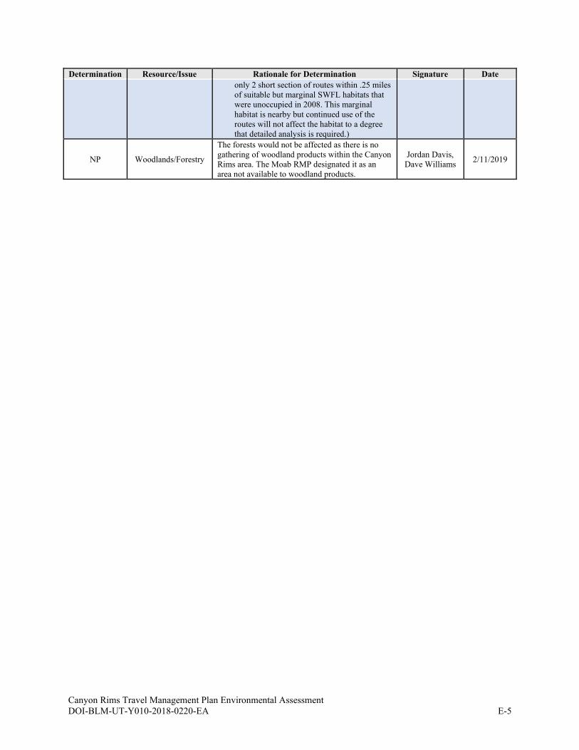
Canyon Rims Travel Management Plan Environmental Assessment DOI-BLM-UT-Y010-2018-0220-EA E-5
Determination Resource/Issue Rationale for Determination Signature Date
only 2 short section of routes within .25 miles
of suitable but marginal SWFL habitats that
were unoccupied in 2008. This marginal
habitat is nearby but continued use of the
routes will not affect the habitat to a degree
that detailed analysis is required.)
NP Woodlands/Forestry
The forests would not be affected as there is no
gathering of woodland products within the Canyon
Rims area. The Moab RMP designated it as an
area not available to woodland products.
Jordan Davis,
Dave Williams 2/11/2019
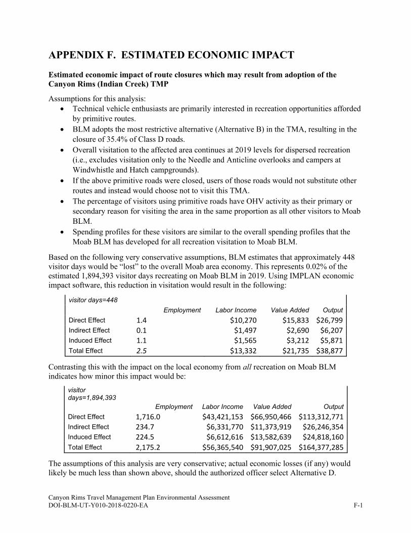
Canyon Rims Travel Management Plan Environmental Assessment DOI-BLM-UT-Y010-2018-0220-EA F-1
APPENDIX F. ESTIMATED ECONOMIC IMPACT
Estimated economic impact of route closures which may result from adoption of the
Canyon Rims (Indian Creek) TMP
Assumptions for this analysis:
• Technical vehicle enthusiasts are primarily interested in recreation opportunities afforded
by primitive routes.
• BLM adopts the most restrictive alternative (Alternative B) in the TMA, resulting in the
closure of 35.4% of Class D roads.
• Overall visitation to the affected area continues at 2019 levels for dispersed recreation
(i.e., excludes visitation only to the Needle and Anticline overlooks and campers at
Windwhistle and Hatch campgrounds).
• If the above primitive roads were closed, users of those roads would not substitute other
routes and instead would choose not to visit this TMA.
• The percentage of visitors using primitive roads have OHV activity as their primary or
secondary reason for visiting the area in the same proportion as all other visitors to Moab
BLM.
• Spending profiles for these visitors are similar to the overall spending profiles that the
Moab BLM has developed for all recreation visitation to Moab BLM.
Based on the following very conservative assumptions, BLM estimates that approximately 448
visitor days would be “lost” to the overall Moab area economy. This represents 0.02% of the
estimated 1,894,393 visitor days recreating on Moab BLM in 2019. Using IMPLAN economic
impact software, this reduction in visitation would result in the following:
visitor days=448
Employment Labor Income Value Added Output
Direct Effect 1.4 $10,270 $15,833 $26,799 Indirect Effect 0.1 $1,497 $2,690 $6,207 Induced Effect 1.1 $1,565 $3,212 $5,871 Total Effect 2.5 $13,332 $21,735 $38,877
Contrasting this with the impact on the local economy from all recreation on Moab BLM
indicates how minor this impact would be:
visitor days=1,894,393
Employment Labor Income Value Added Output
Direct Effect 1,716.0 $43,421,153 $66,950,466 $113,312,771 Indirect Effect 234.7 $6,331,770 $11,373,919 $26,246,354 Induced Effect 224.5 $6,612,616 $13,582,639 $24,818,160 Total Effect 2,175.2 $56,365,540 $91,907,025 $164,377,285
The assumptions of this analysis are very conservative; actual economic losses (if any) would
likely be much less than shown above, should the authorized officer select Alternative D.
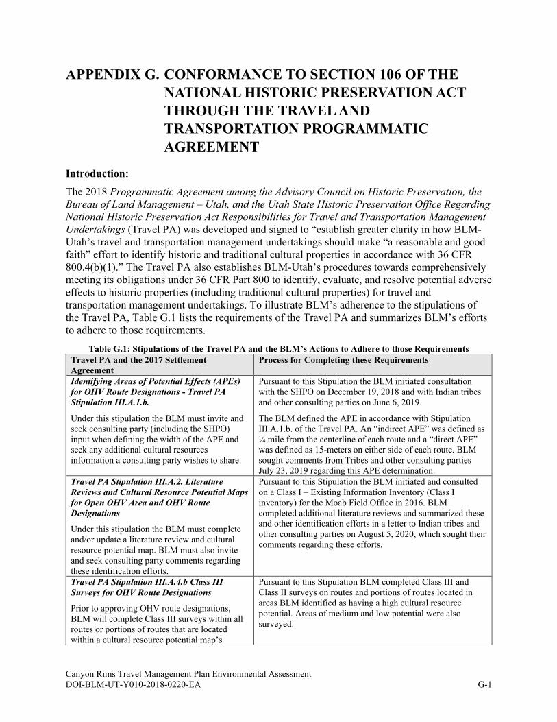
Canyon Rims Travel Management Plan Environmental Assessment
DOI-BLM-UT-Y010-2018-0220-EA G-1
APPENDIX G. CONFORMANCE TO SECTION 106 OF THE
NATIONAL HISTORIC PRESERVATION ACT
THROUGH THE TRAVEL AND
TRANSPORTATION PROGRAMMATIC
AGREEMENT
Introduction:
The 2018 Programmatic Agreement among the Advisory Council on Historic Preservation, the
Bureau of Land Management – Utah, and the Utah State Historic Preservation Office Regarding
National Historic Preservation Act Responsibilities for Travel and Transportation Management
Undertakings (Travel PA) was developed and signed to “establish greater clarity in how BLM-
Utah’s travel and transportation management undertakings should make “a reasonable and good
faith” effort to identify historic and traditional cultural properties in accordance with 36 CFR
800.4(b)(1).” The Travel PA also establishes BLM-Utah’s procedures towards comprehensively
meeting its obligations under 36 CFR Part 800 to identify, evaluate, and resolve potential adverse
effects to historic properties (including traditional cultural properties) for travel and
transportation management undertakings. To illustrate BLM’s adherence to the stipulations of
the Travel PA, Table G.1 lists the requirements of the Travel PA and summarizes BLM’s efforts
to adhere to those requirements.
Table G.1: Stipulations of the Travel PA and the BLM’s Actions to Adhere to those Requirements
Travel PA and the 2017 Settlement
Agreement
Process for Completing these Requirements
Identifying Areas of Potential Effects (APEs)
for OHV Route Designations - Travel PA
Stipulation III.A.1.b.
Under this stipulation the BLM must invite and
seek consulting party (including the SHPO)
input when defining the width of the APE and
seek any additional cultural resources
information a consulting party wishes to share.
Pursuant to this Stipulation the BLM initiated consultation
with the SHPO on December 19, 2018 and with Indian tribes
and other consulting parties on June 6, 2019.
The BLM defined the APE in accordance with Stipulation
III.A.1.b. of the Travel PA. An “indirect APE” was defined as
¼ mile from the centerline of each route and a “direct APE”
was defined as 15-meters on either side of each route. BLM
sought comments from Tribes and other consulting parties
July 23, 2019 regarding this APE determination.
Travel PA Stipulation III.A.2. Literature
Reviews and Cultural Resource Potential Maps
for Open OHV Area and OHV Route
Designations
Under this stipulation the BLM must complete
and/or update a literature review and cultural
resource potential map. BLM must also invite
and seek consulting party comments regarding
these identification efforts.
Pursuant to this Stipulation the BLM initiated and consulted
on a Class I – Existing Information Inventory (Class I
inventory) for the Moab Field Office in 2016. BLM
completed additional literature reviews and summarized these
and other identification efforts in a letter to Indian tribes and
other consulting parties on August 5, 2020, which sought their
comments regarding these efforts.
Travel PA Stipulation III.A.4.b Class III
Surveys for OHV Route Designations
Prior to approving OHV route designations,
BLM will complete Class III surveys within all
routes or portions of routes that are located
within a cultural resource potential map’s
Pursuant to this Stipulation BLM completed Class III and
Class II surveys on routes and portions of routes located in
areas BLM identified as having a high cultural resource
potential. Areas of medium and low potential were also
surveyed.
Canyon Rims Travel Management Plan Environmental Assessment
DOI-BLM-UT-Y010-2018-0220-EA G-2
Travel PA and the 2017 Settlement
Agreement
Process for Completing these Requirements
identification of a high potential cultural
resource area.
2017 Settlement Agreement Stipulations 24
(b)(ii) and (c), – Class III survey in certain
ACECs and Class III surveys in high
potential areas
Prior to approving a TMP within certain ACECs
the BLM must conduct Class III survey along
all routes or portions of routes that are
designated as open.
The 2017 Settlement Agreement also requires
Class III survey along all routes or portions of
routes that are located in areas of high cultural
resource potential that the BLM has identified in
a Class I cultural resource inventory.
Travel PA Stipulation IV.D. Stipulation
Adverse Effects (36 CFR 800.5)
Under this stipulation, the BLM must invite and
seek consulting party input regarding BLM-
Utah’s finding of adverse effect.
The results of the Class III survey and BLM’s proposed
finding of no adverse effect were shared with Indian tribes
and consulting parties through a letter dated August 5, 2020.
After consideration of tribal and consulting party comments,
BLM submitted the Class III survey report, site revisit reports
and literature review (with a finding of an adverse effect) to
SHPO on November 3, 2020.
SHPO concurred with BLM’s eligibility determinations and
finding of effect on December 8, 2020.
BLM consulted on the revised finding of effect with Indian
tribes and other consulting parties on March 8, 2021.
Travel PA Stipulation III.A. 3. Site Revisits for
Open OHV Areas and OHV Route
Designations
Site revisits serve as a component of BLM’s
efforts to identify historic properties for
undertakings that would designate OHV routes.
Pursuant to this Stipulation, BLM conducted site revisits
between 2017 and 2020. BLM sought comments on this
identification effort from Indian tribes and other consulting
parties on August 5, 2020.
Site revisit documentation was submitted to the SHPO on
November 30, 2020.
Travel PA Stipulation III.B.1 Determining the
Need for Phased Class II Surveys for Travel
Management Plans
This stipulation requires that the BLM invite
and seek consulting party input regarding the
need to conduct additional cultural resource
surveys after the TMP has been approved.
The BLM determined that no additional Class II survey would
be necessary prior to the approval of the Canyon Rims TMP.
BLM consulted with Indian tribes and other consulting parties
regarding this on March 8, 2021.
This determination was sent to the SHPO on April 12. 2021.
The SHPO concurred with this determination on April 15,
2021.
Travel PA Stipulation V. Resolution of Adverse
Effects Through Historic Property Treatment
Plans
BLM’s resolution of adverse effects from the
approval of the TMP are to be accomplished
through the development of Historic Properties
Treatment Plans (HPTP). BLM must provide an
opportunity for SHPO, Indian tribes and
consulting parties an opportunity to provide
input on the HPTP.
BLM sought comments on a draft HPTP from Indian tribes
and consulting parties on March 8, 2021.
BLM sought comments from the Utah SHPO on April 12,
2021 and on April 15, 2021 the Utah SHPO concurred that
implementation of the Plan would minimize and mitigate
possible effects to site 42SA16867, 28166, 32489.
Canyon Rims Travel Management Plan Environmental Assessment
DOI-BLM-UT-Y010-2018-0220-EA H-1
APPENDIX H. ROUTE REPORTS
Following completion of the travel route inventory and adjustments to existing BLM GIS data, a
BLM IDT met for several week-long planning sessions to systematically review and evaluate
each of the inventoried travel routes. During route evaluation, the BLM IDT used the ARS Route
Evaluation software and GIS to systematically review, discuss, and document each route’s
location, physical characteristics, current management, operation and maintenance, authorized
and permitted uses, public uses, associated biomes, all known natural and cultural resources,
proximity to resources of concern, specially designated areas, and resource issues. Each intensive
evaluation session included ongoing interactive IDT and Cooperator discussions of each route’s
resource and resource use concerns, as well as any route-specific public scoping information and
Cooperator input available at the time of the evaluation process.
For each route, the IDT also considered and addressed the 43 CFR 8342.1 Designation Criteria,
selecting applicable rationale demonstrating how the route would minimize impacts for each of
the route’s preliminary alternative designations. The process resulted in extremely thorough data
capture, produced a preliminary range of reasonable designation alternatives for each route based
on the alternative themes, and created a complete record of the process as documented in the
route reports. This initial route evaluation process occurred over two weeks.
The full collection of route reports is available on the BLM’s ePlanning site. Route reports
provide a record of the BLM Identification Team (IDT) evaluation of each route identified
during the route inventory. The header of each page of a route report displays the number that
was used to identify the route during evaluation (e.g., D3041). The number placed on published
maps and used on route signs may not be the same. Each route report includes three sections:
“General Background,” “Evaluation Information,” and “Designation Alternatives.”
General Background
The first part of the “General Background” section of a route report shows the route’s evaluation
session date (e.g., 8/30/2018), the name of the session’s contracted facilitator (in this case,
planners working for BLM’s contractor), and the BLM resource specialists (biologists,
archaeologists, recreation planners, etc.) responsible for evaluation of the route. The second part
of the “General Background” section provides physical information about the route such as
length, width, use, jurisdictions over which it passes, and origin (if known). Other information
may also be included along with citizen comments and proposals, as applicable. In the “Citizen
Comments and Proposals” subsection, “Author” refers to the citizen who made a proposal, and
“Designation” refers to what designation a citizen proposed. If there are no citizen comments or
proposals, “None” will be included in the subsection to apply to all headings in it.

Canyon Rims Travel Management Plan Environmental Assessment
DOI-BLM-UT-Y010-2018-0220-EA H-2
**SAMPLE** Route Report for D3041
Facilitator(s): Dennis Gale Initial Evaluation
Date:
8/30/2018
Cam Gale
Tom Folks
Modified Date: 2/18/2021
Modified Reason: Updates based on public comments.
Evaluators: Jared Lundell, Archeologist Pam Riddle, Wildlife Biologist
Lisa Wilkolak, Realty Specialist David Pals, Geologist
Misti Haines, Outdoor Recreation Planner Bill Stevens, ORP -
Wilderness/WSA/LWC
Todd Murdock, Outdoor Recreation
Planner (Permits)
Doug Rowles, NRS - Oil & Gas
Audrey Pefferman, Archaeology Intern/
GIS
Ashley Losey, Archaeologist
David Williams, Range Conservationist Katherina Diemer, NRS
Jordan Davis, Assistant Field Manager Katie Stevens, Outdoor Recreation Planner
TMA: Canyon Rims
Length: 0.27 miles Width: Dual Track Class: Primitive Roads Use Level: Low
Route Type(s): Spur
Surface: Not provided Maintained: Not Provided
Origin: Mining; Ranching Constructed: Not provided
Jurisdictions: BLM
Additional
Information
None.
Citizen Comments and
Proposals
Author Designation Comment or Proposal
Mr. Marsh; Colorado Offroad
Trail Defenders (COTD)
Open Paraphrased comment: This spur off a known 4x4 route (called
“Kamikaze’) is used and valued. One of the commenters
(Marsh) drove it recently and found it of value.

Canyon Rims Travel Management Plan Environmental Assessment
DOI-BLM-UT-Y010-2018-0220-EA H-3
General Evaluation Questions
Does this route: YES either wholly or in part, have a right-of-way grant or is it simply an officially-recognized route with a record of
management by another government agency?
provide commercial, private property, or administrative access, e.g., via permit, ingress/egress rights or
management responsibility?
provide a principal means of connectivity within a Travel Management Area or sub-region? exist as part of an officially recognized part of an Agency planning document and is subject to maintenance? provide an important linkage between Travel Management Areas or planning sub-regions?
Does this route contribute to recreational opportunities, route network connectivity, public safety, or other
public multi-use access opportunities enumerated in agency Organic laws?
YES
Might the continued use of this route potentially impact: YES State or Federal special status species or their habitat? cultural or any other specially-protected resources or objects identified by Agency planning documents, plan
amendments?
any special area designations, e.g., National Monuments? any other resources of concern?
Can the anticipated potential impacts to the identified resources be avoided, minimized, i.e., reduced to
acceptable levels, or be mitigated?
YES
Can the commercial, private property, recreation or public uses of this route be adequately met by another
route or routes that may minimize impacts to the resources identified as part of this evaluation or that may
minimize cumulative effects on various other resources?
NO
Evaluation Information
Introduction
Evaluation information in a route report is divided into three colored boxes that address the
topics of CAPE (yellow), public uses (blue), and special resource concerns (green).
CAPE
The first part of the “Evaluation Information” section focuses on CAPE issues. “CAPE” is an
acronym that represents the umbrella topic of commercial, administrative, and property owner
access—and economics. In the CAPE section, the general issue questions for CAPE are
answered, and a listing of facilities and access is provided. There are three types of access
identified:
• Primary = Main access
• Alternate = Secondary or backdoor access
• Link = Route necessary for use of the primary access

Canyon Rims Travel Management Plan Environmental Assessment
DOI-BLM-UT-Y010-2018-0220-EA H-4
Evaluation Information
Commercial, Administrative, Property and Economics
Route Management Objective(s) identify the purpose and need of the route:
This route provides important access to the following facilities and/or jurisdictions shown below for the purpose of carrying
out administrative and/or authorized operations or for property access where applicable.
Facilities & Access Specifically Primary Alternate Link Memo
Range Facilities Active allotment
Mineral Facilities High Mineral Potential
Mineral Facilities Oil/Gas Lease
('Primary access' is the main route into a jurisdiction or facility. 'Alternate access', while leading directly to a jurisdiction or facility, it is not the main access and
therefore may not be as important as a primary. 'Link access' does not lead directly to a jurisdiction or facility, but would be required to access a primary access.)
Public Uses
The second part of the “Evaluation Information” section focuses on public uses and provides a
list identifying the facilities, modes of transportation, and activities associated with the route. If a
facility, mode of transportation, or activity was not identified as associated with the route, it is
not listed. As in CAPE, facility access is listed using the categories of “Primary,” “Alternate,”
and “Link.” Mode of transportation and activity are indicated by:
• Primary = Main mode or activity on the route
• Secondary = Other common modes and activities
• Infreq = Infrequent (uncommon modes or activities)
Recreational Uses
Route Management Objective(s) identify the purpose and need of the route:
This route provides public access to the following facilities using the listed travel modes for the purposes of engaging in the
listed recreation activities.
Facilities Description Primary Alternate Link Memo
Recreation Facilities Scenic overlook
Travel Modes Description Primary Secondary Infreq
Modes of Transportation UTV/ATV
Modes of Transportation Modified 4 Wheel Drive
Activities
Public Use Activities Jeeping/4-Wheeling
Public Use Activities Hunting
Public Use Activities Scenic Driving
('Primary access' are the main uses on the route by the public. 'Secondary uses', while common, are not the main use on the route. Infrequent uses are uses
that are rare on this route, but have been observed.)
Special Resource Concerns
The third part of the “Evaluation Information” section focuses on special resource concerns.
General issue questions for special resource concerns are answered. Then resources and concerns
are identified. These are grouped into general categories such as:

Canyon Rims Travel Management Plan Environmental Assessment
DOI-BLM-UT-Y010-2018-0220-EA H-5
• Biome
• Special status animals
• Managed species
• Resource issues, etc.
In the “Special Resource Concerns” box, routes are characterized as:
• In = Route or a portion of the route is in the resource area or area of concern
• Leads To = Route provides access to the resource area or area of concern but is not in the
resource or area
• Crosses = Route crosses the resource (e.g., a route crossing a stream or a cultural site
directly on the route)
• Prox = Proximate to; the route is near the resource or area of concern as indicated by the:
• Dist = Proximate distance
Special Resource Concerns
Resources Evaluated:
This route is in, leads to, crosses or is proximate to the natural and/or cultural resources and resource concerns listed below.
Resource/Concern Specifically In LeadsTo Crosses Prox Dist Memo
Biome Sagebrush
Biome Pinyon-Juniper
Managed Species Pronghorn crucial range
Managed Species Peregrine falcon nest
Managed Species Desert bighorn sheep
lambing area
Special Status
Plants
Jones cycladenia habitat
Special Status
Plants
Navajo sedge habitat
VRM VRM Class II - Retain
existing character
Sp. Mgnt. Areas Habitat Management
Area
Sp. Mgnt. Areas SRMA - Special
Recreation Management
Area
Misc. Resources Cryptobiotic Soil 1/4 mile
Misc. Resources Lands with Wilderness
Chararacteristics
1/4 mile
Note: Specific sensitive resources, such as cultural or paleontological resources or Threaten or Endangered Species that may potentially be affected by this route
are not listed in this report for their protection. These resources will be analyzed in the NEPA process included in the planning process of route designation.
Designation Alternatives
The route report also contains the IDT’s evaluation of alternative designations for each route.
Alternative A (No Action/Current Management) simply states the current management of a route
and its area designation (no color). The action alternatives (Alternatives B, C, and D in this
example) are color-coded to “Open w/Management” or “Open” (green), “Limited
w/Management” or “Limited” (orange), and “Closed” (pink).
For Open and Limited designations, “w/ Management” indicates that there are types of
limitations, and that there would be adaptive management or other specific mitigation,
Canyon Rims Travel Management Plan Environmental Assessment
DOI-BLM-UT-Y010-2018-0220-EA H-6
maintenance, and/or monitoring that was identified during evaluation. The “w/ Management”
portion of Limited and Open designation labels are route specific; it is not used in designation
labels found earlier in this document. If there is management assigned to the selected designation
for the route, that management will be required as part of the TMP.
Limited alternatives include specific limitations regarding route use (e.g., limited by season,
vehicle width, etc.). For Closed alternatives, information is provided about how routes would be
closed/decommissioned. Also, if a route is redundant to another route, that is specified.
The Designation Alternatives also documents how the BLM IDT assessed the manner in which
each potential route designation within the TMA is consistent with 43 CFR 8342.1.
Potential Alternative Route Designations
Alternative A (Current Management, No Action Alternative)
Area Designation:
Limited to Designated Routes
Route Designation:
Open
Specific designations by user type:
Administrative/Official Users: All Federal, State and Local agencies may use this route by all motorized
modes, year-round.
Authorized/Permitted Users: Currently authorized users may use this route by all motorized modes, year-
round.
Additional users may be authorized by the BLM through future
authorizations.
Non-motorized Public: The public may use this route by all non-motorized modes, year-round.
OHV Public: Designation per 43 CFR § 8342.1: Open - The public may use this route
by all motorized modes, year-round.
Canyon Rims Travel Management Plan Environmental Assessment
DOI-BLM-UT-Y010-2018-0220-EA H-7
Alternative B
Comprehensive Designation:
CLOSED
This route will be decommissioned and not managed as a BLM transportation asset. Unless otherwise signed, cross-
country foot and animal use is allowed in the area.
OHV Public: Designation per 43 CFR § 8342.1: Closed
Specific Designation Criteria Addressed and Relevant to Route Issues:
• 43 CFR § 8342.1 (a) Areas and trails shall be located to minimize damage to soil, watershed, vegetation, air, or
other resources of the public lands, and to prevent impairment of wilderness suitability.
• 43 CFR § 8342.1 (b) Areas and trails shall be located to minimize harassment of wildlife or significant disruption of
wildlife habitats. Special attention will be given to protect endangered or threatened species and their habitats.
• 43 CFR § 8342.1 (c) Areas and trails shall be located to minimize conflicts between off-road vehicle use and other
existing or proposed recreational uses of the same or neighboring public lands, and to ensure the compatibility of
such uses with existing conditions in populated areas, taking into account noise and other factors.
How Designation Addresses Criteria Above: Closing the route would minimize the potential for conflicts between
off-road vehicle users and dispersed, non-motorized/non-mechanized forms of recreation. Closing this route, along
with natural reclamation, would reduce visual contrast created by the route. Closing this route would contribute to
retaining or restoring vegetation and soil cover, minimizing the potential for soil erosion. Closing this route would
reduce overall impact of vehicle use and route footprint in the area. Closing the route would reduce the potential for
impacts to endangered or threatened species and their habitats by eliminating motorized use and removing the route
footprint.
Designation Criteria Addressed but Not Relevant to Route Issues:
(no known conflicts among users or no known resource concerns to minimize for)
• 43 CFR § 8342.1 (d)
Closure Method: Sign closed
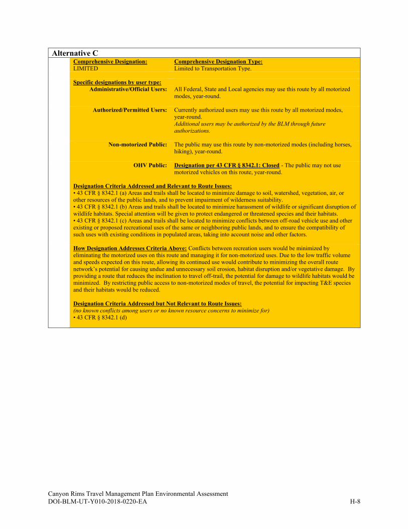
Canyon Rims Travel Management Plan Environmental Assessment
DOI-BLM-UT-Y010-2018-0220-EA H-8
Alternative C
Comprehensive Designation:
LIMITED
Comprehensive Designation Type:
Limited to Transportation Type.
Specific designations by user type:
Administrative/Official Users: All Federal, State and Local agencies may use this route by all motorized
modes, year-round.
Authorized/Permitted Users: Currently authorized users may use this route by all motorized modes,
year-round.
Additional users may be authorized by the BLM through future
authorizations.
Non-motorized Public: The public may use this route by non-motorized modes (including horses,
hiking), year-round.
OHV Public: Designation per 43 CFR § 8342.1: Closed - The public may not use
motorized vehicles on this route, year-round.
Designation Criteria Addressed and Relevant to Route Issues:
• 43 CFR § 8342.1 (a) Areas and trails shall be located to minimize damage to soil, watershed, vegetation, air, or
other resources of the public lands, and to prevent impairment of wilderness suitability.
• 43 CFR § 8342.1 (b) Areas and trails shall be located to minimize harassment of wildlife or significant disruption of
wildlife habitats. Special attention will be given to protect endangered or threatened species and their habitats.
• 43 CFR § 8342.1 (c) Areas and trails shall be located to minimize conflicts between off-road vehicle use and other
existing or proposed recreational uses of the same or neighboring public lands, and to ensure the compatibility of
such uses with existing conditions in populated areas, taking into account noise and other factors.
How Designation Addresses Criteria Above: Conflicts between recreation users would be minimized by
eliminating the motorized uses on this route and managing it for non-motorized uses. Due to the low traffic volume
and speeds expected on this route, allowing its continued use would contribute to minimizing the overall route
network’s potential for causing undue and unnecessary soil erosion, habitat disruption and/or vegetative damage. By
providing a route that reduces the inclination to travel off-trail, the potential for damage to wildlife habitats would be
minimized. By restricting public access to non-motorized modes of travel, the potential for impacting T&E species
and their habitats would be reduced.
Designation Criteria Addressed but Not Relevant to Route Issues:
(no known conflicts among users or no known resource concerns to minimize for)
• 43 CFR § 8342.1 (d)

Canyon Rims Travel Management Plan Environmental Assessment
DOI-BLM-UT-Y010-2018-0220-EA H-9
Alternative D
Comprehensive Designation:
OPEN W/ MANAGEMENT
Specific designations by user type:
Administrative/Official Users: All Federal, State and Local agencies may use this route by all motorized
modes, year-round.
Authorized/Permitted Users: Currently authorized users may use this route by all motorized modes, year-
round.
Additional users may be authorized by the BLM through future
authorizations.
Non-motorized Public: The public may use this route by all non-motorized modes, year-round.
OHV Public: Designation per 43 CFR § 8342.1: Open - The public may use this route by
all motorized modes, year-round.
Designation Criteria Addressed and Relevant to Route Issues:
• 43 CFR § 8342.1 (a) Areas and trails shall be located to minimize damage to soil, watershed, vegetation, air, or other
resources of the public lands, and to prevent impairment of wilderness suitability.
• 43 CFR § 8342.1 (b) Areas and trails shall be located to minimize harassment of wildlife or significant disruption of
wildlife habitats. Special attention will be given to protect endangered or threatened species and their habitats.
• 43 CFR § 8342.1 (c) Areas and trails shall be located to minimize conflicts between off-road vehicle use and other
existing or proposed recreational uses of the same or neighboring public lands, and to ensure the compatibility of such
uses with existing conditions in populated areas, taking into account noise and other factors.
How Designation Addresses Criteria Above: The low traffic volume and low speeds that characterize the overall use
of this route would reduce the potential for continued use of the route to impact documented resources. Allowing
continued use of this route would minimize potential impacts to documented resources by concentrating motorized use
(rather than dispersing it) on an alignment capable of accommodating the route’s anticipated traffic volume. Continued
use of this route with the added application of specific management prescriptions, would minimize potential impacts to
documented resources. Allowing continued use of this route would minimize the potential for impacts to documented
resources by providing targeted recreation activity and experience opportunities that reduce or eliminate the inclination
for users to travel off-route.
Designation Criteria Addressed but Not Relevant to Route Issues:
(no known conflicts among users or no known resource concerns to minimize for)
• 43 CFR § 8342.1 (d)
Potential Management Actions:
Maintenance: Signing - Directional
(Potential management actions may be incorporated with an overall monitoring strategy that would assess the status and/or integrity
of the potentially impacted sensitive resource or resource issues identified as they relate to various external factors, e.g., climate cycles, exotic species introduction, visitor use levels (type, intensity, and season of use), etc. Monitoring data that indicate a decline in
resource integrity or reveal methods of mitigation that proved to be unsuccessful would then trigger adaptive and appropriate
responses aimed at restoring integrity or successfully mitigating undesirable conditions.)
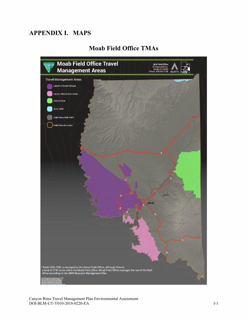
Canyon Rims Travel Management Plan Environmental Assessment
DOI-BLM-UT-Y010-2018-0220-EA I-1
APPENDIX I. MAPS
Moab Field Office TMAs
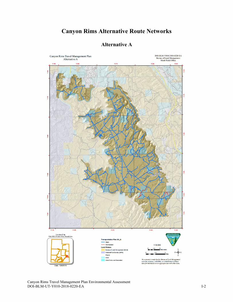
Canyon Rims Travel Management Plan Environmental Assessment
DOI-BLM-UT-Y010-2018-0220-EA I-2
Canyon Rims Alternative Route Networks
Alternative A

Canyon Rims Travel Management Plan Environmental Assessment
DOI-BLM-UT-Y010-2018-0220-EA I-3
Alternative B
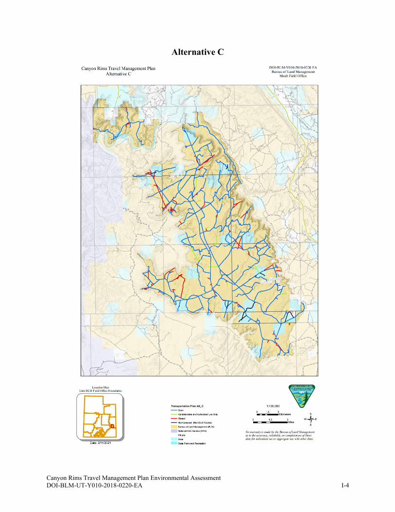
Canyon Rims Travel Management Plan Environmental Assessment
DOI-BLM-UT-Y010-2018-0220-EA I-4
Alternative C
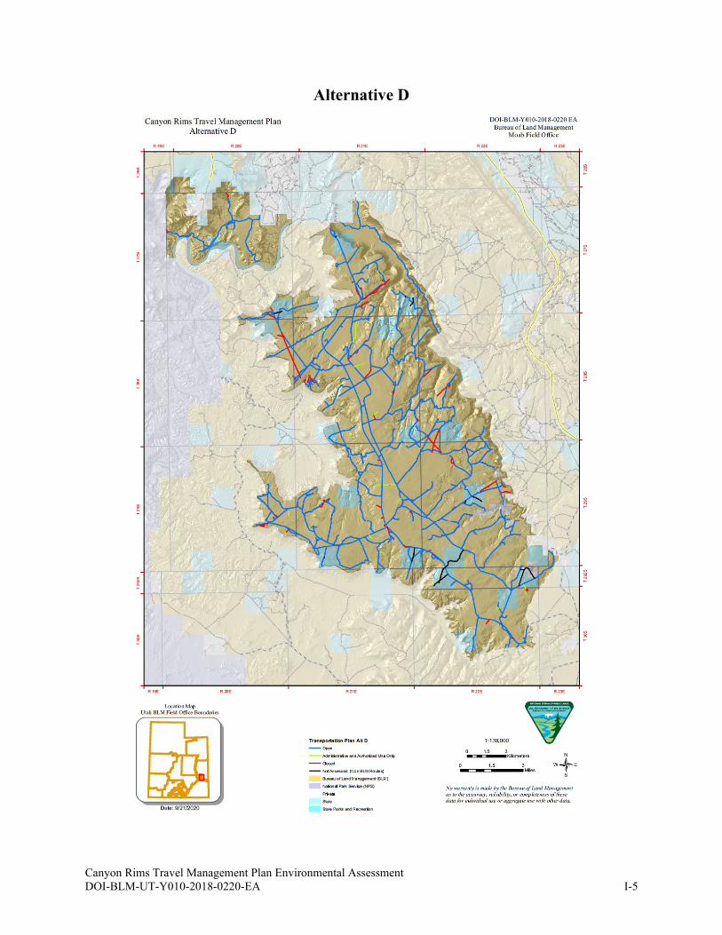
Canyon Rims Travel Management Plan Environmental Assessment
DOI-BLM-UT-Y010-2018-0220-EA I-5
Alternative D
Canyon Rims Travel Management Plan Environmental Assessment
DOI-BLM-UT-Y010-2018-0220-EA J-1
APPENDIX J. GLOSSARY
Access: The opportunity to approach, enter, and/or cross public lands.
Adaptive management: A type of natural resource management in which decisions are made as
part of an ongoing science-based process. Adaptive management involves testing, monitoring,
and evaluating applied strategies, and incorporating new knowledge into management
approaches that are based on scientific findings and the needs of society. Results are used to
modify management policy, strategies, and practices.
Administrative use: Travel-related access for official use by BLM employees and agency
representatives during the course of their duties using whatever means is necessary. Access is for
resource management and administrative purposes and may include fire suppression, cadastral
surveys, permit compliance, law enforcement, and resource monitoring or other access needed to
administer BLM-managed lands or uses.
All-terrain vehicle (ATV): A wheeled vehicle other than a snowmobile, which is defined as
having a wheelbase and chassis of 50 inches in width or less, handlebars for steering, generally a
dry weight of 800 pounds or less, three or more low-pressure tires, and a seat designed to be
straddled by the operator.
Alternatives: Other options to the proposed action by which the BLM can meet its purpose and
need. The BLM is directed by the NEPA to “study, develop, and describe appropriate
alternatives to recommended courses of action in any proposal which involves unresolved
conflicts concerning alternative uses of available resources.…”
Asset: A non-building facility and transportation construction, which include roads, primitive
roads, and trails that are included in FAMS. The BLM maintains assets through the annual and
deferred maintenance programs.
Authorized use: Travel-related access for users authorized by the BLM or otherwise officially
approved. Access may include motorized access for permittees, lessees or other authorized users,
along with approved access across BLM-administered public lands for other state and federal
agencies.
Class B road: Road that is constructed and maintained regularly by the County. As stated in
Utah Code, Class B roads:
(a) are situated outside of incorporated municipalities and not designated as state
highways;
(b) have been designated as county roads; or
(c) are located on property under the control of a federal agency and constructed or
maintained by the county under agreement with the appropriate federal agency. (Utah
Code 72-3-103)
Class D route: As stated in Utah Code, “any road, way, or other land surface route that has been
or is established by use or constructed and has been maintained to provide for usage by the
public for vehicles with four or more wheels that is not a class A, class B, or class C road” (Utah
Code 72-3-105). The San Juan County General Plan Update (2018) states that Class D routes are
“only maintained upon specific request.”
Canyon Rims Travel Management Plan Environmental Assessment
DOI-BLM-UT-Y010-2018-0220-EA J-2
Code of Federal Regulations (CFR): The codification of the general and permanent rules
published in the Federal Register by the departments and agencies of the Federal Government. It
is divided into 50 titles that represent broad areas subject to Federal regulation.
Cooperating agency: Assists the lead Federal agency in developing an environmental
assessment or environmental impact statement. These can be any agencies with jurisdiction by
law or special expertise for proposals covered by NEPA (40 CFR 1501.6). Any tribe or Federal,
State, or local government jurisdiction with such qualifications may become a cooperating
agency by agreement with the lead agency.
Crucial habitat: According to the UDWR: “[Crucial] habitat [is that] on which the local
population of a wildlife species depends for survival because there are no alternative ranges or
habitats available. Crucial value habitat is essential to the life history requirements of a wildlife
species. Degradation or unavailability of crucial habitat will lead to significant declines in
carrying capacity and/or numbers of wildlife species in question” (UDWR 2019).
Critical habitat: An area occupied by a threatened or endangered species on which are found
physical and biological features that are (1) essential to the conservation of the species, and (2)
may require special management considerations or protection.
Cultural resource: A definite location of human activity, occupation, or use identifiable through
field inventory (survey), historical documentation, or oral evidence. The term includes
archaeological, historic, or architectural sites, structures, or places with important public and
scientific uses, and may include definite locations (sites or places) of traditional cultural or
religious importance to specified social and/or cultural groups. Cultural resources are concrete,
material places and things that are located, classified, ranked, and managed through the system
of identifying, protecting, and utilizing for public benefit. They may be but are not necessarily
eligible for the National Register of Historic Places.
Cultural resource inventory classes:
1. Class I - existing information inventory: a study of published and unpublished
documents, records, files, registers, and other sources, resulting in analysis and synthesis
of all reasonably available data. Class I inventories encompass prehistoric, historic, and
ethnological/sociological elements, and are in large part chronicles of past land uses.
They may have major relevance to current land use decisions.
2. Class II - probabilistic field survey: a statistically based sample survey designed to
help characterize the probable density, diversity, and distribution of archaeological
properties in a large area by interpreting the results of surveying limited and
discontinuous portions of the target area.
3. Class III - intensive field survey: a continuous, intensive survey of an entire target area,
aimed at locating and recording all archaeological properties that have surface
indications, by walking close-interval parallel transects until the area has been thoroughly
examined. Class III methods vary geographically, conforming to the prevailing standards
for the region involved. In Utah, pedestrian transects are spaced at 15-meter intervals.
Decision record (DR): The BLM document associated with an EA that describes the action to
be taken when the analysis supports a finding of no significant impact.
Canyon Rims Travel Management Plan Environmental Assessment
DOI-BLM-UT-Y010-2018-0220-EA J-3
Designated routes: Specific roads and trails identified by the BLM where some type of use is
appropriate and allowed.
Disposal: Transfer of public land out of Federal ownership to another party through sale,
exchange, Recreation and Public Purposes Act, Desert Land Entry or other land law statutes.
Easement: A right afforded a person or agency to make limited use of another’s real property for
other purposes.
Effects
Adverse or detrimental: Contribute to degradation of a resource or resource use.
Adverse effect to historic properties: An adverse effect is found when an undertaking
may alter, directly or indirectly, any of the characteristics of a historic property that
qualify the property for inclusion in the National Register in a manner that would
diminish the integrity of the property's location, design, setting, materials, workmanship,
feeling, or association.
Beneficial: Contribute to enhancement or restoration of a resource or resource use.
Cumulative: According to the Code of Federal Regulations (40 CFR 1508.7), a
cumulative effect “is the impact on the environment which results from the incremental
impact of the action when added to other past, present, and reasonably foreseeable future
actions regardless of what agency (Federal or non-Federal) or person undertakes such
other actions. Cumulative effects can result from individually minor but collectively
significant actions taking place over a period of time” (GPO 2012). In other words, these
effects are the sum of the direct and indirect effects of an action and the direct and
indirect effects of other actions on the same affected resources/uses.
Direct: Caused by alternative (same time and place).
Indirect: Caused by alternative but later in time or further in distance but still reasonably
foreseeable.
Long-term: Generally considered to last 10 years or more.
Minor: The effect or impact is slight but detectable: there would be a small change to the
quality of the physical, biological, social, and economic values and resources.
Negligible: The effect or impact is at the lower level of detection; there would be no
measurable change to the quality of the physical, biological, social, and economic values
and resources.
Residual: Direct and indirect effects that remain after the application of all mitigation
measures.
Short-term: Generally considered to last from the point of occurrence to several weeks
or months but not expected to last beyond a year or two.
Endangered Species Act (ESA): The purpose of the ESA is to protect and recover imperiled
species and the ecosystems upon which they depend. It is administered by the U.S. Fish and
Wildlife Service (Service) and the Commerce Department's National Marine Fisheries Service
(NMFS). Under the ESA, species may be listed as either endangered or threatened.
“Endangered” means a species is in danger of extinction throughout all or a significant portion of
its range. “Threatened” means a species is likely to become endangered within the foreseeable
future. All species of plants and animals, except pest insects, are eligible for listing as
endangered or threatened. For the purposes of the ESA, Congress defined species to include
subspecies, varieties, and, for vertebrates, distinct population segments.
Canyon Rims Travel Management Plan Environmental Assessment
DOI-BLM-UT-Y010-2018-0220-EA J-4
Environmental assessment (EA): Public document for which a federal agency is responsible
that serves to: 1) Briefly provide sufficient evidence and analysis for determining whether to
prepare an environmental impact statement or a finding of no significant impact; 2) Aid an
agency’s compliance with the National Environmental Policy Act when no environmental impact
statement is necessary; 3) Facilitate preparation of an environmental impact statement when one
is necessary. Shall include brief discussions of the need for the proposal, of alternatives, of the
environmental impacts of the proposed action and Alternatives, and a listing of agencies and
persons consulted.
Environmental Impact Statement (EIS): Federal agencies prepare an Environmental Impact
Statement (EIS) if a proposed major federal action is determined to significantly affect the
quality of the human environment. The regulatory requirements for an EIS are more detailed and
rigorous than the requirements for an environmental assessment (EA).
Erosion: Detachment and movement of soil from the land by wind, water, or gravity.
Facility Asset Management System (FAMS): The BLM’s official database for the
management of transportation system assets and facilities.
Facility: All or any portion of a building, structure, site improvement, element, pedestrian route,
or vehicular way located on a site. An element is an architectural or mechanical component,
generally including toilets, picnic tables, grills, registration kiosks, etc. at a site (including a
staging site).
Finding of No Significant Impact (FONSI): A finding that explains that an action will not
have a significant effect on the environment and, therefore, an EIS will not be required.
Forage: All browse and herbaceous foods that are available to grazing animals.
Geographic Information System (GIS): “System designed to capture, store, manipulate,
analyze, manage, and present all types of geographical data. The key word to this technology is
Geography – this means that some portion of the data is spatial. In other words, data that is in
some way referenced to locations on the earth. Coupled with this data is usually tabular data
known as attribute data. Attribute data can be generally defined as additional information about
each of the spatial features. An example of this would be schools. The actual location of the
schools is the spatial data. Additional data such as the school name, level of education taught,
student capacity would make up the attribute data. It is the partnership of these two data types
that enables GIS to be such an effective problem-solving tool through spatial analysis. GIS is
more than just software. People and methods are combined with geospatial software and tools, to
enable spatial analysis, manage large datasets, and display information in a map/graphical form.”
(University of Wisconsin-Madison Libraries 2018)
Ground Transportation Linear Feature (GTLF): A geospatial database of all transportation
linear features (from motorized to foot use) as they exist on the ground, not just those in the
BLM transportation system (refer to the Ground Transportation Linear Features Data Standard
Report, October 22, 2014, version 2.0 or later, for detailed information on the GTLF data
standard).
Canyon Rims Travel Management Plan Environmental Assessment
DOI-BLM-UT-Y010-2018-0220-EA J-5
Habitat fragmentation: The degree to which an area of habitat is divided into smaller patches
of habitat as a result of human activities and developments (e.g. trails, roads, fencing) or as a
result of natural barriers (e.g. cliffs, rivers).
Historic property: Historic property means any prehistoric or historic district, site, building,
structure, or object included in, or eligible for inclusion in, the National Register of Historic
Places maintained by the Secretary of the Interior. This term includes artifacts, records, and
remains that are related to and located within such properties. The term includes properties of
traditional religious and cultural importance to an Indian tribe or Native Hawaiian organization
and that meet the National Register criteria.
Impassable: Roads intended for full-size vehicle passage that are otherwise impassable as a
result of road deterioration or vegetation overgrowth; project-level road maintenance is required
to make these roads passable. Road deterioration or vegetation overgrowth may be a result of
neglect, irregular maintenance, or management decisions.
Implementation decisions: Decisions that take action to implement land use planning; generally
appealable to Interior Board of Land Appeals under 43 CFR 4.410. These decisions are generally
more site-specific than land-use plan decisions.
Implementation plan: An area or site-specific plan written to implement decisions made in a
land use plan. Implementation plans include both activity plans and project plans. Examples of
implementation plans include interdisciplinary management plans, habitat management plans,
and allotment management plans.
Interdisciplinary Team: A group of individuals with different training, representing the
physical sciences, social sciences, and environmental design arts, assembles to solve a problem
or perform a task. The members of the team proceed to a solution with frequent interaction so
that each discipline may provide insights to any stage of the problem and disciplines may
combine to provide new solutions. The number and disciplines of the members preparing the
plan vary with circumstances. A member may represent one or more disciplines or BLM
program interests.
Land use plan: A set of decisions that establish management direction for land within an
administrative area, as prescribed under the planning provisions of FLPMA; an assimilation of
land-use-plan level decisions developed through the planning process outlined in 43 CFR 1600,
regardless of the scale at which the decisions were developed. The term includes both resource
management plans (RMPs) and management framework plans (MFPs).
Linear disturbance: A human-made linear travel or transportation related disturbance that is not
part of the BLM’s transportation system or travel network. Transportation linear disturbances
may include engineered (planned) but no longer needed features, as well as unplanned routes that
have been identified for decommissioning and reclamation either passively or actively. Linear
disturbances may also include permitted realty features (e.g., pipelines or power lines) that may
or may not have travel routes maintained in association with them.
Linear feature: A linear ground disturbance that results from travel across or immediately over
the surface of BLM-administered public lands. These features include engineered roads and
trails, as well as user-defined, non-engineered routes, created as a result of public or
Canyon Rims Travel Management Plan Environmental Assessment
DOI-BLM-UT-Y010-2018-0220-EA J-6
unauthorized use. Linear features may also include permitted realty features (e.g., pipelines or
power lines) that may or may not have travel routes maintained in association with them.
Mechanized travel: Moving by means of mechanical devices not powered by a motor, such as a
bicycle.
Minimize: Limit the degree or magnitude of.
Mitigation: in general, a combination of measures to lessen the impacts of a project or activity
on an element of the natural environment or various other cultural or historic values; more
specifically, as defined by the Council on Environmental Quality in its regulations for
implementing NEPA, mitigation includes: (a) avoiding the impact, (b) minimizing the impact,
(c) rectifying (i.e., repairing, rehabilitating, or restoring) the impact (d) reducing or eliminating
the impact through operations during the life of the project, or (e) compensating by replacing or
substituting resources (40 CFR Section 1508.20).
Monitoring: The process of tracking the implementation of land use plan decisions and
collecting and assessing data necessary to evaluate the effectiveness of land use planning
decisions.
Motorized vehicles: Vehicles propelled by motors or engines, such as cars, trucks, off-highway
vehicles, motorcycles, snowmobiles, and boats.
Multiple use: The management of the public lands and their various resource values so that they
are utilized in the combination that will best meet the present and future needs of the American
people; making the most judicious use of the land for some or all of these resources or related
services over areas large enough to provide sufficient latitude for periodic adjustments in use to
changing needs and conditions; the use of some land for less than all of the resources; a
combination of balanced and diverse resource uses that takes into account the long-term needs of
future generations for renewable and nonrenewable resources, including, but not limited to,
recreation, range, timber, minerals, watershed, wildlife and fish, and natural scenic, scientific and
historical values; and harmonious and coordinated management of the various resources without
permanent impairment of the productivity of the land and the quality of the environment with
consideration being given to the relative values of the resources and not necessarily to the
combination of uses that will give the greatest economic return or the greatest unit output
(FLPMA) (from M6840, Special Status Species Manual).
National Environmental Policy Act (NEPA): Requires federal agencies to assess and disclose
the environmental effects of proposed actions prior to making decisions. BLM travel
management must conform to NEPA requirements.
This legislation established a landmark national environmental policy which, among other
things, encourages environmental protection and informed decision-making. It provides the
means to carry out these goals by:
• mandating that every Federal agency prepare a detailed statement of the effects of “major
Federal actions significantly affecting the quality of the human environment.”
• establishing the need for agencies to consider alternatives to those actions.
• requiring the use of an interdisciplinary process in developing alternatives and
• analyzing environmental effects.
Canyon Rims Travel Management Plan Environmental Assessment
DOI-BLM-UT-Y010-2018-0220-EA J-7
• requiring that each agency consult with and obtain comments of any Federal agency
which has jurisdiction by law or special expertise with respect to any environmental
impact involved.
• requiring that detailed statements and the comments and views of the appropriate Federal,
State, tribal, and local agencies be made available to the public.
National Historic Preservation Act (NHPA): 1966 legislation establishing the National
Register of Historic Places and extending the national historic preservation programs to
properties of State and local significance.
National Register of Historic Places (National Register): Official inventory of districts, sites,
buildings, structures, and objects significant in American history, architecture, archeology,
engineering and culture.
National Register Eligibility Definitions:
Eligible: Cultural resources that are listed or recommended eligible for inclusion on the
National Register of Historic Places (National Register), are those resources that express
the quality of significance in American history, architecture, archeology, engineering, and
culture and are represented as districts, sites, buildings, structures, and objects that
possess integrity of location, design, setting, materials, workmanship, feeling, and
association. To be listed or recommended eligible the cultural resource must possess the
relevant aspects of integrity and meet at least one of the following National Register
Criteria:
A. Associated with events that have made a significant contribution to the broad
patterns of our history; or
B. Associated with the lives of significant persons in our past; or
C. Embody the distinctive characteristics of a type, period, or method of construction,
or that represent the work of a master, or that possess high artistic values, or that
represent a significant and distinguishable entity whose components may lack
individual distinction; or
D. Have yielded or may be likely to yield, information important in history or
prehistory. 36 CFR Part 800 defines National Register-eligible cultural resources as
“historic properties.”
Not eligible: Cultural resources that do not meet the National Register Criteria or
maintain the relevant aspects of integrity.
Native vegetation: Plant species that were in the TMA prior to European settlement, and
consequently are in balance with these ecosystems because they have well developed parasites,
predators, and pollinators.
Naturalness: Refers to an area that “generally appears to have been affected primarily by the
forces of nature, with the imprint of man’s work substantially unnoticeable” (Section 2[c] of the
Wilderness Act of 1964).
Non-mechanized travel: Moving by foot or by stock or pack animal.
Noxious weeds: A plant species designated by Federal or State law as generally possessing one
or more of the following characteristics: aggressive and difficult to manage; parasitic; a carrier or
host of serious insects or disease; or non-native, new, or not common to the US.

Canyon Rims Travel Management Plan Environmental Assessment
DOI-BLM-UT-Y010-2018-0220-EA J-8
Objective: A description of a desired condition for a resource. Objectives can be quantified and
measured and, where possible, have established time frames for achievement.
Off-highway vehicle (OHV): Any motorized vehicle capable of, or designed for, travel on or
immediately over land, water, or other natural terrain, excluding: 1) any non-amphibious
registered motorboat; 2) any military, fire, emergency, or law enforcement vehicle while being
used for emergency purposes; 3) any vehicle whose use is expressly authorized by the authorized
officer, or otherwise officially approved; 4) vehicles in official use; and 5) any combat or combat
support vehicle when used in times of national defense emergencies (as defined in 43 CFR
8340.0-5(a)).
Off-highway vehicle (OHV) area designation: A land use planning decision that permits,
establishes conditions for, or prohibits OHV activities on specific areas of public lands. The
BLM is required to designate all public lands as open, limited, or closed to OHVs. Below are
definitions of these designations as taken from the 2016 BLM Travel and Transportation
Management Manual (BLM 2016):
OHV Closed Areas: An area where OHV use is prohibited. Access by means other than
OHVs, such as by motorized vehicles that fall outside the definition of an OHV or by
mechanized or non-mechanized means, is permitted. The BLM designates areas as
closed, if necessary, to protect resources, promote visitor safety, or reduce user conflicts
(see 43 CFR 8340.0-5(h)).
OHV Limited Areas: An area where OHV use is restricted at certain times, in certain
areas, and/or to certain vehicular use. Examples of restrictions include numbers or types
of vehicles; time or season of use; permitted or licensed use only; use limited to existing,
designated roads and trails; or other restrictions necessary to meet resource management
objectives, including certain competitive or intensive use areas that have special
limitations (43 CFR 8340.0-5 (g)).
OHV Open Areas: A designated area where all types of OHV travel is permitted at all
times, anywhere in the area subject only to the operating restrictions set forth in subparts
8341 without restriction (43 CFR 8340.0-5(f)). Open area designations are made to
achieve a specific recreational goal, objective and setting and are only used in areas
managed for intensive OHV activity where there are no special restrictions or where there
are no compelling resource protection needs, user conflicts, or public safety issues to
warrant limiting cross-country travel.
Off-highway vehicle (OHV) route designations: Management designations applied to
individual routes (as opposed to OHV areas) during interdisciplinary route evaluation sessions. The BLM designates routes as open, limited, or closed, and the designation must be included in all
route-specific decisions and recorded in the national ground transportation linear feature dataset(s).
Definitions and the designation criteria used in this decision-making process stem from those
provided for OHV areas in 43 CFR 8340.0-5(f), (g), and (h).
• OHV Open: OHV travel is permitted where there are no special restrictions or no
compelling resource protection needs, user conflicts, or public safety issues to warrant
limiting the timing or season of use, the type of OHV, or the type of OHV user.
• OHV Limited: OHV travel on routes, roads, trails, or other vehicle ways is subject to
restrictions to meet specific resource management objectives. Examples of restrictions
Canyon Rims Travel Management Plan Environmental Assessment
DOI-BLM-UT-Y010-2018-0220-EA J-9
include numbers or types of vehicles; time or season of use; permitted or licensed use
only; or other restrictions necessary to meet resource management objectives, including
certain competitive or intensive uses that have special limitations.
• OHV Closed: OHV travel is prohibited on the route. Access by means other than OHVs,
such as by motorized vehicles that fall outside of the definition of an OHV or by
mechanized or non-mechanized means, is permitted. The BLM designates routes as
closed to OHVs if necessary to protect resources, promote visitor safety, reduce use
conflicts, or meet a specific resource goal or objective.
Perennial stream: Perennial streams carry flowing water continuously throughout the year,
regardless of weather conditions. It exhibits well-defined geomorphologic characteristics and in
the absence of pollution, thermal modifications, or other man-made disturbances has the ability
to support aquatic life.
Planning area: A geographic area for which land use and resource management plans are
developed and maintained.
Primitive road: A linear route managed for use by four-wheel drive or high-clearance vehicles.
Primitive roads do not normally meet any BLM road design standards. Unless specifically
prohibited, primitive roads can also include other uses such as hiking, biking, and horseback
riding.
Primitive route: Any transportation linear feature located within a WSA or lands with
wilderness characteristics designated for protection by a land use plan and not meeting the
wilderness inventory road definition.
Reclamation: Returning disturbed lands to a form and productivity that will be ecologically
balanced and in conformity with a predetermined plan.
Record of decision (ROD): Decision document associated with an EIS (equivalent to an EA’s
DR).
Recreation Management Information System (RMIS): The official BLM database for
recording and tracking visitor use and acres with OHV area designations on BLM-managed
lands; the BLM also uses it to track TMP completion and implementation; tool used by the BLM
to record number of visits, types of activities, permits, partnerships, and agreements.
Recreation management zone (RMZ): A subdivision of a recreation management area that
further delineates specific recreation opportunities and recreation setting characteristics.
Resource management plan (RMP): A land use plan as prescribed by the Federal Land Policy
and Management Act that establishes, for a given area of land, land use allocations, coordination
guidelines for multiple-use, objectives, and actions to be achieved.
Restoration: The process by which areas are brought back to a former, original or specific
desired condition or appearance. Could involve putting vegetation back in an area where
vegetation previously existed, which may or may not simulate natural conditions.
Right-of-way (ROW): An easement or permit that authorizes public land to be used for a
specified purpose that is in the public interest and that requires rights-of-way over, upon, under,
Canyon Rims Travel Management Plan Environmental Assessment
DOI-BLM-UT-Y010-2018-0220-EA J-10
or through such lands (e.g., roads, power lines, pipelines). A ROW holder is an authorized user
for their ROW.
Riparian area: A form of wetland transition between permanently saturated wetlands and
upland areas. Riparian areas exhibit vegetation or physical characteristics that reflect the
influence of permanent surface or subsurface water. Typical riparian areas include lands along,
adjacent to, or contiguous with perennially and intermittently flowing rivers and streams, glacial
potholes, and the shores of lakes and reservoirs with stable water levels. Excluded are ephemeral
streams or washes that lack vegetation and depend on free water in the soil.
Road: A linear route declared a road by the owner, managed for use by low-clearance vehicles
which have four or more wheels, and maintained for regular and continuous use. Often, many
types of uses are allowed on roads. BLM allowed uses on roads are often hierarchical such that if
motorized use is allowed on a road, various forms of non-motorized use are also allowed.
Rock Art: Petroglyphs (carvings) or pictographs (paintings) created on natural rock surfaces by
native people and depicting their history and culture.
Route Evaluation: The careful and systematic review of each route by a BLM interdisciplinary
team in conjunction with resource data collection and discussion of minimizing potential impacts
during preliminary alternative designations. It is the process through which a BLM
interdisciplinary team of resource specialists assess individual routes and documents potentially
affected resources and/or resource uses associated with each route. During route evaluation,
BLM staff will:
• Propose individual route designations for each route in a TMA based on individual
alternative themes.
• Address how each route will minimize impacts on resources per 40 CFR 8342.1.
• Document rationales for each alternative designation choice.
Route Inventory: Collection of route line data for maps (may also include collection of point
data and photos). Data may be collected in the field with GPS units or drawn on a computer
screen from aerial imagery.
Routes: Multiple roads, trails and primitive roads; a group or set of roads, trails, and primitive
roads that represents less than 100 percent of the BLM transportation system. Generically,
components of the transportation system are described as “routes.”
Scoping (Internal and External): Process by which the BLM solicits internal and external input
on the issues and effects that will be addressed, as well as the degree to which those issues and
effects will be analyzed, in the NEPA document. Scoping is one form of public involvement in
the NEPA process. Scoping occurs early in the NEPA process and generally extends through the
development of alternatives (the public comment periods for EIS review are not scoping).
Internal scoping is simply federal or cooperator review to decide what needs to be analyzed in a
NEPA document. External scoping, also known as formal scoping, involves notification and
opportunities for feedback from other agencies, organizations and the public.
Sensitive Species: Species designated as sensitive by the BLM State Director, including species
that are under status review, have small or declining populations, live in unique habitats, or
require special management. BLM Manual 6840 provides policy and guidance for managing
special status species.
Canyon Rims Travel Management Plan Environmental Assessment
DOI-BLM-UT-Y010-2018-0220-EA J-11
Solitude: The state of being alone or remote from habitations; isolation. A lonely or secluded
place. Factors contributing to opportunities for solitude may include size, natural screening,
topographic relief, vistas, physiographic variety, and the ability of the user to find a secluded
spot.
Special recreation management area (SRMA): An administrative unit where the existing or
proposed recreation opportunities and recreation setting characteristics are recognized for their
unique value, importance, or distinctiveness, especially compared to other areas used for
recreation.
Special recreation permits (SRPs): Permits issued to businesses, organizations, and individuals
to allow the use of specific public land and related waters for commercial, competitive, and
organized group use. Special Recreation Permits allow land stewards to coordinate and track
commercial and competitive use of public lands. They also provide resource protection measures
to ensure the future enjoyment of those resources by the public.
Special status species: Species that are proposed for listing, officially listed as threatened or
endangered, or are candidates for listing as threatened or endangered under the provisions of the
Endangered Species Act (ESA); those listed by a State in a category such as threatened or
endangered implying potential endangerment or extinction; and those designated by each State
BLM Director as sensitive.
State Historic Preservation Office (SHPO): Office in State or territorial government that
administers the preservation programs under the National Historic Preservation Act.
Substantial habitat: According to the UDWR: “[Substantial] habitat [is] that which is used by a
wildlife species but is not crucial for population survival. Degradation or unavailability of
substantial value habitat will not lead to significant declines in carrying capacity and/or numbers
of the wildlife species in question” (UDWR 2019).
Surface-disturbing activities: Human-caused disturbance resulting in direct and pronounced
alteration, damage, removal, displacement, or mortality of vegetation, soil, or substrates; usually
entail motorized or mechanized vehicles or tools; typically can also be described as disruptive
activities. Examples of typical surface disturbing activities include:
• Earth-moving and drilling
• Geophysical exploration
• Off-route motorized and mechanized travel
• Vegetation treatments including woodland thinning with chainsaws
• Pyrotechnics and explosives
• Construction of powerlines, pipelines, oil and gas wells, recreation sites, livestock
improvement facilities, wildlife waters, or new roads
Threatened species: Any plant or animal species defined under the Endangered Species Act as
likely to become endangered within the foreseeable future throughout all or a significant portion
of its range; listings are published in the Federal Register.
Traditional uses: Longstanding, socially conveyed, customary patterns of thought, cultural
expression, and behavior, such as religious beliefs and practices, social customs, and land or
resource uses. Traditions are shared generally within a social and/or cultural group and span

Canyon Rims Travel Management Plan Environmental Assessment
DOI-BLM-UT-Y010-2018-0220-EA J-12
generations. Usually traditional uses are reserved rights resulting from treaty and/or agreements
with Native American groups.
Trail: A linear route managed for human-powered, stock, or off-road vehicle forms of
transportation or for historical or heritage values. The BLM does not generally manage trails for
use by four-wheel-drive or high-clearance vehicles.
Travel management area (TMA): Portion of land (often represented with a polygon) where
areas have been classified as open, closed or limited; TMAs have an identified and/or designated
network of roads, trails, ways, and other routes that provide for public access and travel. All
designated travel routes within TMAs should have a clearly identified need and purpose as well
as clearly defined activity types, modes of travel, and seasons or time-frames for allowable
access or other limitations.
Travel management plan (TMP): A document that describes decisions related to the selection
and management of a travel network and transportation system.
Travel network: Routes occurring on public lands or within easements granted to the BLM that
are recognized, designated, decided upon, or otherwise authorized for use through the planning
process or other travel management decisions. These may or may not be part of the
transportation system and may or may not be administered by the BLM.
Unevaluated (to the Natural Register): A site that has not been evaluated to determine if it is
eligible to the National Register of Historic Places.
Utility Terrain Vehicle (UTV): Any recreational motor vehicle other than an ATV, motorbike
or over snow vehicle designed for and capable of travel over designated unpaved roads, traveling
on four (4) or more low-pressure tires, maximum width less than seventy-four (74) inches,
usually a maximum weight less than two thousand (2000) pounds, or having a wheelbase of
ninety-four (94) inches or less. Does not include vehicles specially designed to carry a person
with disabilities.
Visual Resource Inventory (VRI): An inventory taken to identify visual resource values and
quality.
Visual Resource Management (VRM): The system by which BLM classifies and manages
scenic values and visual quality of public lands. The system is based on research that has
produced ways of assessing aesthetic qualities of the landscape in objective terms. After
inventory and evaluation, lands are given relative visual ratings (management classes) that
determine the extent of modification allowed for the basic elements of the landscape.
Visual resources: The visible physical features on a landscape, (topography, water, vegetation,
animals, structures, and other features) that comprise the scenery of the area.
Wetland: Permanently wet or intermittently water-covered areas, such as swamps, marshes,
bogs, potholes, swales, and glades.
Wilderness characteristics: Wilderness characteristics include size, the appearance of
naturalness, outstanding opportunities for solitude or a primitive and unconfined type of
recreation. Indicators of an area’s naturalness include the extent of landscape modifications; the
presence of native vegetation communities; and the connectivity of habitats. Outstanding
Canyon Rims Travel Management Plan Environmental Assessment
DOI-BLM-UT-Y010-2018-0220-EA J-13
opportunities for solitude or primitive and unconfined types of recreation may be experienced
when the sights, sounds, and evidence of other people are rare or infrequent, in locations where
visitors can be isolated, alone or secluded from others, where the use of the area is through non-
motorized, non-mechanical means, and where no or minimal developed recreation facilities are
encountered.
REFERENCES
BLM (Bureau of Land Management). 2016. 1626 – Travel and Transportation Management
Manual (Public) (MS 1626). N.p.
https://www.blm.gov/sites/blm.gov/files/uploads/mediacenter_blmpolicymanual1626.pdf
GPO (U.S. Government Publishing Office). 2012. Code of Federal Regulations: Title 40, Part
1508 – Terminology and Index. https://www.govinfo.gov/app/details/CFR-2012-title40-
vol34/CFR-2012-title40-vol34-sec1508-7.
UDWR (Utah Division of Wildlife Resources). 2019. Utah Division of Wildlife Resources Index
of Available GIS Data. https://dwrcdc.nr.utah.gov/ucdc/downloadgis/disclaim.htm.
University of Wisconsin-Madison Libraries. N.d. Mapping and Geographic Information Systems
(GIS): What is GIS? https://researchguides.library.wisc.edu/GIS.
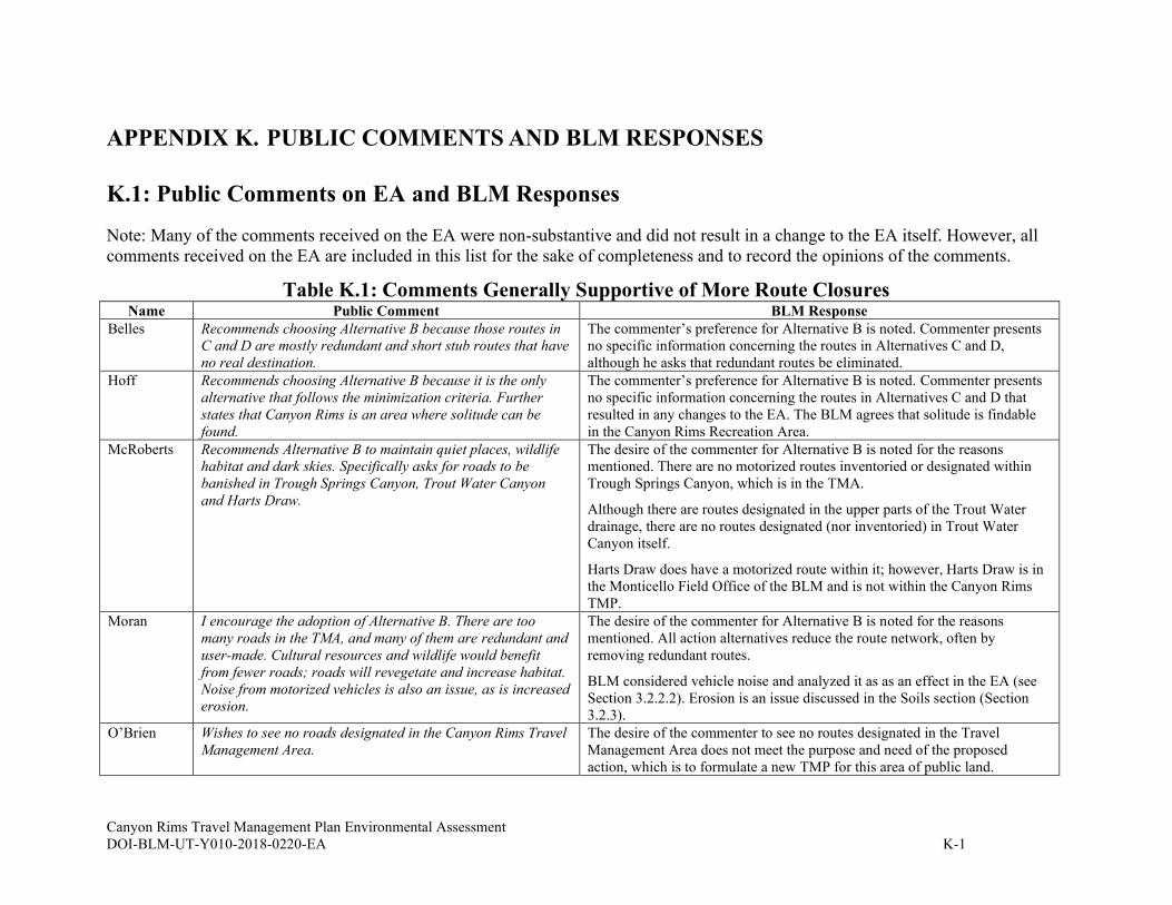
Canyon Rims Travel Management Plan Environmental Assessment
DOI-BLM-UT-Y010-2018-0220-EA K-1
APPENDIX K. PUBLIC COMMENTS AND BLM RESPONSES
K.1: Public Comments on EA and BLM Responses
Note: Many of the comments received on the EA were non-substantive and did not result in a change to the EA itself. However, all
comments received on the EA are included in this list for the sake of completeness and to record the opinions of the comments.
Table K.1: Comments Generally Supportive of More Route Closures Name Public Comment BLM Response
Belles Recommends choosing Alternative B because those routes in
C and D are mostly redundant and short stub routes that have
no real destination.
The commenter’s preference for Alternative B is noted. Commenter presents
no specific information concerning the routes in Alternatives C and D,
although he asks that redundant routes be eliminated.
Hoff Recommends choosing Alternative B because it is the only
alternative that follows the minimization criteria. Further
states that Canyon Rims is an area where solitude can be
found.
The commenter’s preference for Alternative B is noted. Commenter presents
no specific information concerning the routes in Alternatives C and D that
resulted in any changes to the EA. The BLM agrees that solitude is findable
in the Canyon Rims Recreation Area.
McRoberts Recommends Alternative B to maintain quiet places, wildlife
habitat and dark skies. Specifically asks for roads to be
banished in Trough Springs Canyon, Trout Water Canyon
and Harts Draw.
The desire of the commenter for Alternative B is noted for the reasons
mentioned. There are no motorized routes inventoried or designated within
Trough Springs Canyon, which is in the TMA.
Although there are routes designated in the upper parts of the Trout Water
drainage, there are no routes designated (nor inventoried) in Trout Water
Canyon itself.
Harts Draw does have a motorized route within it; however, Harts Draw is in
the Monticello Field Office of the BLM and is not within the Canyon Rims
TMP. Moran I encourage the adoption of Alternative B. There are too
many roads in the TMA, and many of them are redundant and
user-made. Cultural resources and wildlife would benefit
from fewer roads; roads will revegetate and increase habitat.
Noise from motorized vehicles is also an issue, as is increased
erosion.
The desire of the commenter for Alternative B is noted for the reasons
mentioned. All action alternatives reduce the route network, often by
removing redundant routes.
BLM considered vehicle noise and analyzed it as as an effect in the EA (see
Section 3.2.2.2). Erosion is an issue discussed in the Soils section (Section
3.2.3).
O’Brien Wishes to see no roads designated in the Canyon Rims Travel
Management Area.
The desire of the commenter to see no routes designated in the Travel
Management Area does not meet the purpose and need of the proposed
action, which is to formulate a new TMP for this area of public land.
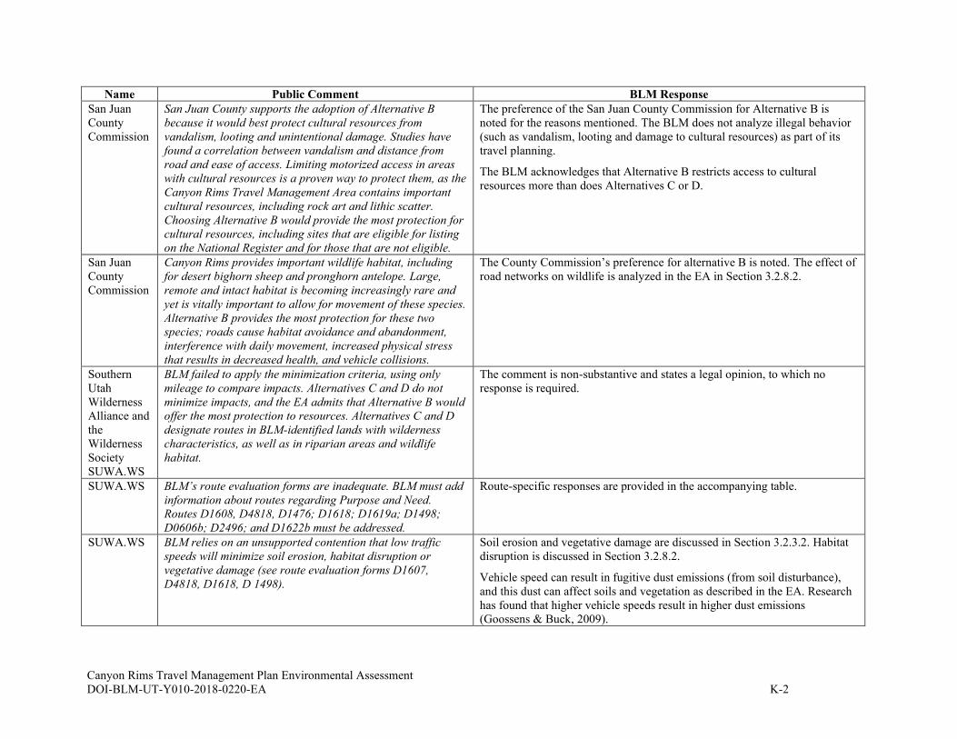
Canyon Rims Travel Management Plan Environmental Assessment
DOI-BLM-UT-Y010-2018-0220-EA K-2
Name Public Comment BLM Response
San Juan
County
Commission
San Juan County supports the adoption of Alternative B
because it would best protect cultural resources from
vandalism, looting and unintentional damage. Studies have
found a correlation between vandalism and distance from
road and ease of access. Limiting motorized access in areas
with cultural resources is a proven way to protect them, as the
Canyon Rims Travel Management Area contains important
cultural resources, including rock art and lithic scatter.
Choosing Alternative B would provide the most protection for
cultural resources, including sites that are eligible for listing
on the National Register and for those that are not eligible.
The preference of the San Juan County Commission for Alternative B is
noted for the reasons mentioned. The BLM does not analyze illegal behavior
(such as vandalism, looting and damage to cultural resources) as part of its
travel planning.
The BLM acknowledges that Alternative B restricts access to cultural
resources more than does Alternatives C or D.
San Juan
County
Commission
Canyon Rims provides important wildlife habitat, including
for desert bighorn sheep and pronghorn antelope. Large,
remote and intact habitat is becoming increasingly rare and
yet is vitally important to allow for movement of these species.
Alternative B provides the most protection for these two
species; roads cause habitat avoidance and abandonment,
interference with daily movement, increased physical stress
that results in decreased health, and vehicle collisions.
The County Commission’s preference for alternative B is noted. The effect of
road networks on wildlife is analyzed in the EA in Section 3.2.8.2.
Southern
Utah
Wilderness
Alliance and
the
Wilderness
Society
SUWA.WS
BLM failed to apply the minimization criteria, using only
mileage to compare impacts. Alternatives C and D do not
minimize impacts, and the EA admits that Alternative B would
offer the most protection to resources. Alternatives C and D
designate routes in BLM-identified lands with wilderness
characteristics, as well as in riparian areas and wildlife
habitat.
The comment is non-substantive and states a legal opinion, to which no
response is required.
SUWA.WS BLM’s route evaluation forms are inadequate. BLM must add
information about routes regarding Purpose and Need.
Routes D1608, D4818, D1476; D1618; D1619a; D1498;
D0606b; D2496; and D1622b must be addressed.
Route-specific responses are provided in the accompanying table.
SUWA.WS BLM relies on an unsupported contention that low traffic
speeds will minimize soil erosion, habitat disruption or
vegetative damage (see route evaluation forms D1607,
D4818, D1618, D 1498).
Soil erosion and vegetative damage are discussed in Section 3.2.3.2. Habitat
disruption is discussed in Section 3.2.8.2.
Vehicle speed can result in fugitive dust emissions (from soil disturbance),
and this dust can affect soils and vegetation as described in the EA. Research
has found that higher vehicle speeds result in higher dust emissions
(Goossens & Buck, 2009).

Canyon Rims Travel Management Plan Environmental Assessment
DOI-BLM-UT-Y010-2018-0220-EA K-3
Name Public Comment BLM Response
SUWA.WS Furthermore, the BLM sets up the spurious claim that
designated a given route would minimize impacts because
relocating the route would lead to greater impacts. There is
no requirement that BLM relocate any routes.
The BLM arrives at the Purpose and Need for a route by determining what
function it serves in the Travel network. Each route was examined by an
Interdisciplinary Team as well as representatives of San Juan County, PLPCO
and SITLA. The destination of the route, or its connectivity with other routes,
was discussed and evaluated. The Purpose and Need for each route is
recorded in the Route Evaluation Forms. In several route reports, the BLM
does acknowledge that relocating a route would lead to greater impacts. The
assumption is made that the route in question goes somewhere that people
wish to go – if the route were closed, there may remain a need to go to that
location, leading to greater damage from either illegal cross country travel or
route relocation.
SUWA.WS Leaving routes open in LWC impacts the constituent element
of wilderness characteristics. Settlement requires the BLM to
consider the potential damage to any constituent element of
wilderness characteristics, including naturalness, outstanding
opportunities for solitude and outstanding opportunities for
primitive and unconfined recreation.
The BLM has disclosed in the EA the potential damage to wilderness
characteristics and its constituent elements of naturalness, solitude and
primitive recreation in Section 3.2.2.2.
Information concerning the inventory of wilderness characteristics lands has
been added to Section 3.2.2.
An explanation of the BLM’s inventory process vis-a-vis wilderness
characteristics has been added to Section3.2.2.1. The impacts to LWC units
are described in Section 3.2.2.2.
SUWA.WS BLM rarely discussed how designating a route through
identified LWC would impact the constituent elements of
wilderness characteristics. BLM must revise its route
evaluation forms to account for potential damage to
constituent elements of wilderness characteristics.
The BLM has identified in each route report’s special resources concern table
the presence of wilderness characteristics. Then each alternative’s table
discloses how the proposed designation under that alternative (closed, limited,
or open) affects wilderness characteristics. For example, closed-route impact
text says: “By closing the route, the potential for future impacts to wilderness
character and impairment of wilderness suitability would be minimized while
wilderness characteristics of naturalness and opportunities for solitude would
be enhanced.” The open-route impact text says: “Continued use of this route
would minimize impacts to wilderness characteristics (LWC or Natural Area)
by providing reasonable access to these lands on a pre-existing route,
reducing the potential for new disturbances from cross-country use.” See
individual route reports.
Impacts to wilderness characteristics are outlined in Section 3.2.2.2.
SUWA.WS BLM refused to consider any other type of recreation in its
travel planning, as required by Manual 1626.
See sections 1.4 and 3.3.1.
SUWA.WS BLM failed to take a hard look. Specifically, BLM failed to
acknowledge existing potash leases or oil and gas leases in
the cumulative impacts section. These leases would increase
Section 3.2.11 lists the past, present or reasonably foreseeable actions and
includes the Moab Master Leasing Plan (which covers oil and gas and potash
leasing in the TMA) as well as the 2008 Resource Management Plan. These

Canyon Rims Travel Management Plan Environmental Assessment
DOI-BLM-UT-Y010-2018-0220-EA K-4
Name Public Comment BLM Response
traffic on roads as well as increase public use of newly
constructed minerals roads.
documents include reasonably foreseeable development scenarios which
address leasing actions. Although there are no potash leases within the TMA,
language has been added to the EA in Section 3.2.11 concerning maintenance
and use of routes by minerals companies as a reasonably foreseeable action.
SUWA.WS The BLM failed to analyze impacts to the yellow-billed
cuckoo or to the white-tailed prairie dog. The BLM must also
do a more thorough assessment of potential impacts to the
Mexican spotted owl.
There are no known populations of the yellow-billed cuckoo within the TMA;
this fact is listed in the Biological Assessment prepared by the MFO and sent
to U.S. Fish and Wildlife Service. Specifically, according to the Guidelines
for the identification of suitable habitat for WYBCU in Utah (2015) -
presented by the USFWS during training in Green River Utah, --there is no
suitable cuckoo habitat within 0.5 miles of any road within the TMA.
The white-tailed prairie dog is not found within the Canyon Rims TMA;
prairie dog habitat within the TMA is that of the Gunnison’s prairie dog.
Impacts upon that species are analyzed in the EA in Section 3.2.10.2.
The impacts of route designation on Mexican spotted owl are analyzed in
Section 3.2.10.2. In addition, consultation concerning the Mexican spotted
owl is part of the Biological Assessment prepared by the MFO for the
USFWS as part of the Section 7 consultation process.
SUWA.WS BLM failed to take a hard look at cumulative impacts to
wildlife.
Cumulative impacts to wildlife are analyzed in section 3.2.11.
SUWA.WS BLM failed to take a hard look at Air Quality, dismissing it as
“NI” in the checklist. An air quality analysis must be
completed. See papers by Dunway and Switalski
The BLM has considered dust as an effect on natural resources throughout
Chapter 3, as applicable. The BLM’s rationale for not analyzing impacts from
vehicle emissions is stated in Appendix E: Interdisciplinary Checklist.
SUWA.WS BLM failed to analyze greenhouse gas emissions associated
with OHV travel.
The BLM’s rationale for not analyzing impacts to climate change from
greenhouse gas emissions is stated in Appendix E: Interdisciplinary
Checklist.
In addition, none of the alternatives propose creating new routes that would
directly or indirectly promote new greenhouse gas emissions or climate
change impacts. Furthermore, any increase in use of designated routes will
occur because of reasons distinct from the designation of the route itself. As a
result, calculating a GHG emissions inventory will not help make a reasoned
choice between alternatives (BLM Handbook H1790-1 section 6.4.1) and will
not concentrate on the issues that are truly significant to the action in question
(40 CFR 1500.1(b).
SUWA.WS The BLM must comply with its National Historic Preservation
Act Section 106 responsibilities. SUWA is a consulting party
on the Canyon Rims TMP and submitted comments on BLM’s
compliance with Section 106.
This comment is not relevant to the content of this EA. The Section 106
process is summarized in Appendix G.

Canyon Rims Travel Management Plan Environmental Assessment
DOI-BLM-UT-Y010-2018-0220-EA K-5
Name Public Comment BLM Response
SUWA.WS To comply with the Settlement Agreement, Travel Plan PA
and HNPA, the BLM must determine which routes to survey
for cultural resources using individual site type maps.
See Appendix G.
SUWA.WS BLM must evaluate the potential effects of increased OHV use
on routes designated through this process rather than limiting
its analysis to current motorized use.
Projecting future use is speculative, although past use patterns can be used as
a proxy. The specific traffic counter data from the Canyon Rims Recreation
Area has been added to Section 3.3.1.1.
SUWA.WS The BLM does not provide sufficient information in its “Effect
Justification” for eligible sites. The BLM revisited 27 sites
within the APE that had previously been determined eligible
for listing on the National Register. BLM determined that 16
of them were no longer eligible. BLM must provide more
information to support its decision to remove its NRHP
eligibility determination.
This comment does not address the EA. However, neither the NHPA
implementing regulations or the Travel Management Programmatic
Agreement direct the BLM to provide this information to consulting parties
other than SHPO. This information was provided to SHPO, and they
concurred with BLM’s eligibility determination on 12/08/2020.
SUWA.WS BLM failed to take a hard look at the direct, indirect and
cumulative impacts to cultural resources. Repeated travel on
a route may have significant impacts (see Spangler’s work).
BLM failed to analyze reasonably foreseeable impacts to
cultural resources, including from increased use.
BLM analyzed impacts to cultural resources in the EA in Section 3.2.1.2. In
that section wording was changed from “a minor impact” to a “moderate
impact,” meaning that none of the eligible and previously eligible sites were
impacted to the extent they no longer had sufficient integrity to convey their
significance for qualification for eligibility under the NRHP. Known and
newly documented sites within a ¼ mile of all proposed routes were
considered for impacts. BLM determined that it may be reasonably
foreseeable that three sites may be adversely affected as defined in 36 CFR
800.5. As noted in 36 CFR 800.(a)(1) an adverse effect on a historic property
does not necessarily lead to a significant impact. To address possible effects,
the BLM developed a Historic Properties Treatment Plan that minimize future
effects to the three sites.
The study cited by SUWA is not relevant in the context of Canyon Rims. The
site types and deposition in Canyon Rims are different than those that occur
in Ten Mile Canyon, which was the subject of Spangler’s work. Ten Mile
Canyon is within the Labyrinth Rims/Gemini Bridges TMA, not the Canyon
Rims TMA.
Current data does not indicate that motorized use in the Canyon Rims is
increasing or will increase (use has actually decreased over the past several
years); see section 3.3.1.1. As noted above, reasonably foreseeable and
cumulative impacts were considered in BLM’s NRHP finding and will be
addressed.
SUWA.WS Sites need not be eligible to receive consideration under
NEPA.
The analysis found in Section 3.2.1.2 (pages 16 – 19) considers Historic
Properties (sites eligible for the National Register), sites determined to
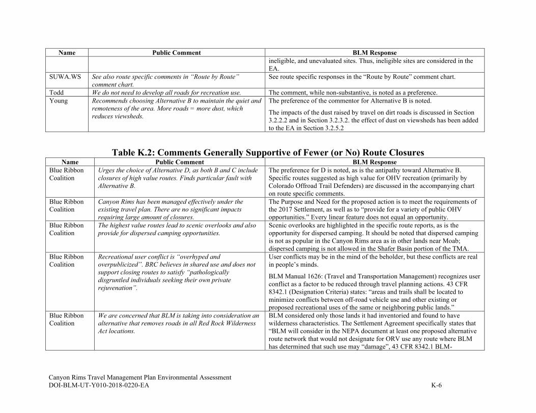
Canyon Rims Travel Management Plan Environmental Assessment
DOI-BLM-UT-Y010-2018-0220-EA K-6
Name Public Comment BLM Response
ineligible, and unevaluated sites. Thus, ineligible sites are considered in the
EA.
SUWA.WS See also route specific comments in “Route by Route”
comment chart.
See route specific responses in the “Route by Route” comment chart.
Todd We do not need to develop all roads for recreation use. The comment, while non-substantive, is noted as a preference.
Young Recommends choosing Alternative B to maintain the quiet and
remoteness of the area. More roads = more dust, which
reduces viewsheds.
The preference of the commentor for Alternative B is noted.
The impacts of the dust raised by travel on dirt roads is discussed in Section
3.2.2.2 and in Section 3.2.3.2. the effect of dust on viewsheds has been added
to the EA in Section 3.2.5.2
Table K.2: Comments Generally Supportive of Fewer (or No) Route Closures Name Public Comment BLM Response
Blue Ribbon
Coalition
Urges the choice of Alternative D, as both B and C include
closures of high value routes. Finds particular fault with
Alternative B.
The preference for D is noted, as is the antipathy toward Alternative B.
Specific routes suggested as high value for OHV recreation (primarily by
Colorado Offroad Trail Defenders) are discussed in the accompanying chart
on route specific comments.
Blue Ribbon
Coalition
Canyon Rims has been managed effectively under the
existing travel plan. There are no significant impacts
requiring large amount of closures.
The Purpose and Need for the proposed action is to meet the requirements of
the 2017 Settlement, as well as to “provide for a variety of public OHV
opportunities.” Every linear feature does not equal an opportunity.
Blue Ribbon
Coalition
The highest value routes lead to scenic overlooks and also
provide for dispersed camping opportunities.
Scenic overlooks are highlighted in the specific route reports, as is the
opportunity for dispersed camping. It should be noted that dispersed camping
is not as popular in the Canyon Rims area as in other lands near Moab;
dispersed camping is not allowed in the Shafer Basin portion of the TMA.
Blue Ribbon
Coalition
Recreational user conflict is “overhyped and
overpublicized”. BRC believes in shared use and does not
support closing routes to satisfy “pathologically
disgruntled individuals seeking their own private
rejuvenation”.
User conflicts may be in the mind of the beholder, but these conflicts are real
in people’s minds.
BLM Manual 1626: (Travel and Transportation Management) recognizes user
conflict as a factor to be reduced through travel planning actions. 43 CFR
8342.1 (Designation Criteria) states: “areas and trails shall be located to
minimize conflicts between off-road vehicle use and other existing or
proposed recreational uses of the same or neighboring public lands.”
Blue Ribbon
Coalition
We are concerned that BLM is taking into consideration an
alternative that removes roads in all Red Rock Wilderness
Act locations.
BLM considered only those lands it had inventoried and found to have
wilderness characteristics. The Settlement Agreement specifically states that
“BLM will consider in the NEPA document at least one proposed alternative
route network that would not designate for ORV use any route where BLM
has determined that such use may “damage”, 43 CFR 8342.1 BLM-
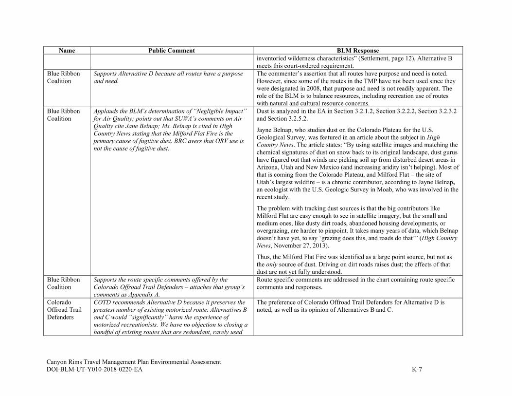
Canyon Rims Travel Management Plan Environmental Assessment
DOI-BLM-UT-Y010-2018-0220-EA K-7
Name Public Comment BLM Response
inventoried wilderness characteristics” (Settlement, page 12). Alternative B
meets this court-ordered requirement.
Blue Ribbon
Coalition
Supports Alternative D because all routes have a purpose
and need.
The commenter’s assertion that all routes have purpose and need is noted.
However, since some of the routes in the TMP have not been used since they
were designated in 2008, that purpose and need is not readily apparent. The
role of the BLM is to balance resources, including recreation use of routes
with natural and cultural resource concerns.
Blue Ribbon
Coalition
Applauds the BLM’s determination of “Negligible Impact”
for Air Quality; points out that SUWA’s comments on Air
Quality cite Jane Belnap; Ms. Belnap is cited in High
Country News stating that the Milford Flat Fire is the
primary cause of fugitive dust. BRC avers that ORV use is
not the cause of fugitive dust.
Dust is analyzed in the EA in Section 3.2.1.2, Section 3.2.2.2, Section 3.2.3.2
and Section 3.2.5.2.
Jayne Belnap, who studies dust on the Colorado Plateau for the U.S.
Geological Survey, was featured in an article about the subject in High
Country News. The article states: “By using satellite images and matching the
chemical signatures of dust on snow back to its original landscape, dust gurus
have figured out that winds are picking soil up from disturbed desert areas in
Arizona, Utah and New Mexico (and increasing aridity isn’t helping). Most of
that is coming from the Colorado Plateau, and Milford Flat – the site of
Utah’s largest wildfire – is a chronic contributor, according to Jayne Belnap,
an ecologist with the U.S. Geologic Survey in Moab, who was involved in the
recent study.
The problem with tracking dust sources is that the big contributors like
Milford Flat are easy enough to see in satellite imagery, but the small and
medium ones, like dusty dirt roads, abandoned housing developments, or
overgrazing, are harder to pinpoint. It takes many years of data, which Belnap
doesn’t have yet, to say ‘grazing does this, and roads do that’” (High Country
News, November 27, 2013).
Thus, the Milford Flat Fire was identified as a large point source, but not as
the only source of dust. Driving on dirt roads raises dust; the effects of that
dust are not yet fully understood.
Blue Ribbon
Coalition
Supports the route specific comments offered by the
Colorado Offroad Trail Defenders – attaches that group’s
comments as Appendix A.
Route specific comments are addressed in the chart containing route specific
comments and responses.
Colorado
Offroad Trail
Defenders
COTD recommends Alternative D because it preserves the
greatest number of existing motorized route. Alternatives B
and C would “significantly” harm the experience of
motorized recreationists. We have no objection to closing a
handful of existing routes that are redundant, rarely used
The preference of Colorado Offroad Trail Defenders for Alternative D is
noted, as well as its opinion of Alternatives B and C.
Canyon Rims Travel Management Plan Environmental Assessment
DOI-BLM-UT-Y010-2018-0220-EA K-8
Name Public Comment BLM Response
and naturally reclaiming. Only Alternative D does not
represent an unacceptable loss of motorized routes.
Colorado
Offroad Trail
Defenders
Highest value routes are to overlooks. We specifically ask
for BLM to keep open all routes to overlooks. We
specifically ask BLM to keep all routes in the Funtreks
Guide to Moab, UT Backroads and 4-Wheel Drive Trails.
Overlooks were considered in evaluating the purpose and need for routes. All
of the action alternatives have routes to overlooks among their designated
routes. Route specific comments concerning the routes described in the
Funtreks guidebook are contained in the route-by-route chart.
Colorado
Offroad Trail
Defenders
Looking Glass Road to Anticline Overlook (in book) –
please keep roads B133 and B132 (guidebook pages
attached).
Roads B132 and B133 are designated in all alternatives.
Colorado
Offroad Trail
Defenders
Kamikaze (in book) – consists of D1506 and D3041. All
action alternatives keep the main trail open, but
Alternatives B and C would close side spur D3041, which
leads to a good overlook.
Route D3041 is discussed in the route-by-route chart. Route 1506 is open in
all action alternatives.
Colorado
Offroad Trail
Defenders
Canyonlands Overlook (in book) – consists of D0605 and
D2740, as well as side spurs. Action alternatives close
several small side spurs, including D1407, D2401 and
D1849. I have not driven these, but Google Earth shows
that they are used. (Note: these spurs are not in the book)
The routes closed in some of the action alternatives are discussed in the route-
by-route chart. It should be noted that examination on Google Earth is not
always indicative of the on-the-ground state of a linear feature, nor of its
purpose and need.
Colorado
Offroad Trail
Defenders
Boxcar Butte (in book) – consists of roads B106, D0614,
D0615, D1515, D0621, D2742 and D0624. The route is
known for scenic views and challenging obstacles. All
alternatives keep the main route open, but several scenic
side spurs are closed, including D0616, D1516, D4825,
D0610, D1521, D1522 and D1523. Each of these side
routes offer unique experiences and great viewpoints and
should be kept open.
The referenced routes are discussed in the route-by-route examination of
comments.
The BLM contacted the author of Funtreks. He confirmed that the “side
spurs” are shown only for navigational purposes. He did not drive most of the
side spurs and his inclusion of them on the map does not imply any particular
use for the routes.
Colorado
Offroad Trail
Defenders
Missing Inventory: The end of D1830 (in Shafer Basin)
appears to be missing. The route does not end as shown on
the map, but continues to a scenic overlook. I have not
personally been to the end of this route, but my friends have
(photos attached). The route is lightly used and faint, but
clearly visible in Google Earth.
We ask that BLM designate the full length of D1830 and
also keep D1831 (in the wash below it) as open for
motorized travel (this route is closed in B and C but left
open in D).
The ‘end’ of D1830 was not designated in the 2008 Travel Plan
accompanying the RMP. The route was determined to be a linear feature
made during the building of a fence and then used for a horse stampede scene
in a movie. It was not designated as a route for public use. Only routes
designated in the 2008 Travel Plan (Alternative A) are under consideration in
the current effort. The ‘end’ of D1830 has been closed since 2008 and the
BLM has not received a request for its designation.
The disposition of Route D1831 is discussed in the route-by-route chart.
Canyon Rims Travel Management Plan Environmental Assessment
DOI-BLM-UT-Y010-2018-0220-EA K-9
Name Public Comment BLM Response
Colorado
Offroad Trail
Defenders
No routes should be closed to favor non-motorized
recreation in the name of “user conflict”. That phrase
refers to the subjective preference of non-motorized users
who are unwilling to share. BLM should ignore any claims
of “user conflict” alleged to exclude motorized users.
User conflicts may be subjective, but these conflicts are real in people’s
minds. User preferences for one type of recreation or another are equally
subjective, but nonetheless real factors.
BLM Manual 1626: (Travel and Transportation Management) recognizes user
conflict as a factor to be reduced through travel planning actions. 43 CFR
8342.1 (Designation Criteria) states: “areas and trails shall be located to
minimize conflicts between off-road vehicle use and other existing or
proposed recreational uses of the same or neighboring public lands”.
Marsh I would like routes D1516 and D3041 reconsidered. I
travelled them on November 14, 2020; they had been used
and there was no authorized off-road use off of them. These
two spurs are offshoots of the Boxcar and Kamikaze routes
which are widely publicized trails. Both provide
spectacular overlooks; D1516 in particularly has a
stunning view of Hatch Wash.
Most of the other routes we looked for that were slated for
closing could not be found – they had ceased to be used and
were overgrown to the point that driving them was
pointless. We did not have time to look for all of them.
I request that D1516 and D3041 be open in the chosen
alternative.
The two routes in question are discussed in the route-by-route chart.
The BLM appreciates the on-the-ground report on the value of the two routes
requested, as well as the report that many other routes designated in
Alternative A had ceased to be used and were overgrown at the time of the
commenter’s field trip.
McIntyre I request Alternative D (if we cannot keep Alternative A).
Alternative D allows maximum OHV use. Even people who
go there (Canyon Rims) for quiet will still need to drive
there. Do not continue to close lands.
The commenter’s desire to see Alternative D chosen is noted. If routes are not
designated, the lands surrounding those routes will not be closed to the
public. All action alternatives designate a network of routes.
Utah Public
Lands Policy
Coordinating
Office
(PLPCO)
The State commends the BLM on a well-thought out TMP.
The State supports Alternative D and encourage the BLM to
select it. Many of the State’s concerns are with Alternative
B, as it will result in unnecessary closures harmful to the
State’s and its citizens ability to use, access and benefit
from federal lands.
PLPCO’s endorsement of Alternative D, which designates 246 miles of route,
is noted.
Alternative C designates 226 miles of route and Alternative B designates 197
miles of route. The BLM acknowledges that Alternative B is the most
restrictive to OHV use.
PLPCO The range of alternatives is sound, logical and provide a
sustainable travel and transportation network.
Each of the alternatives is designed to provide a travel and transportation
network within the goals of that alternative (see Section 2.2 of the EA).
PLPCO Closing routes because adjacent areas are composed of
lands with wilderness characteristic (LWC) is
inappropriate and contrary to Congressional intent and
FLPMA
The Settlement Agreement specifically states that “BLM will consider in the
NEPA document at least one proposed alternative route network that would
not designate for ORV use any route where BLM has determined that such
use may “damage”, 43 CFR 8342.1 BLM-inventoried wilderness
Canyon Rims Travel Management Plan Environmental Assessment
DOI-BLM-UT-Y010-2018-0220-EA K-10
Name Public Comment BLM Response
characteristics.” (2017 Settlement Agreement, page 12) Alternative B meets
this court-ordered requirement.
PLPCO The state objects to analysis of “illegal motorized
encroachments”, especially into lands with wilderness
characteristics. Any concerns of encroachment into LWC
should not be identified in the EA; these concerns are an
enforcement issue and should not be a determining
consideration in travel management. The majority of users
follow rules and regulations; enforcement should be
addressed at the implementation phase.
“Illegal motorized encroachment” is listed as a scoping issue under Lands
with Wilderness Characteristics (Appendix D: Scoping Details).
The Environmental Effects Analysis (Section 3.2.2.2 of the EA) for Lands
with Wilderness Characteristics does not include analysis of illegal motorized
use off designated routes.
PLPCO The State notes that, in Alternative B, routes within 0.25
miles of cultural sites are removed in order to protect them.
The BLM should consider ways in which these routes could
remain open with mitigation that would reduce the risk to
cultural resources (fencing, signing etc.) These mitigation
efforts could increase awareness and understanding of
cultural resources.
Routes were not included in those designated in Alternative B for a variety of
reasons; cultural resources was but one of these reasons. As stated in Section
2.4, “Alternative B emphasizes protection of wildlife habitats, natural
resources, ecosystems, and landscapes. It also represents the alternative from
the 2017 Settlement Agreement that would most reduce adverse effects to
BLM-inventoried wilderness characteristics by closing routes in Lands with
Wilderness Characteristics (LWCs). OHV use is accordingly more
constrained under this alternative.”
PLPCO The state does not view routes as an impact to wildlife and
notes that the Hatch pronghorn herd has increased between
2007 and 2017. Routes in bighorn and pronghorn habitat
provide access for habitat and wildlife management, as well
as for hunting.
The state’s view is noted. Wildlife is discussed in sections 3.2.7, 3.2.8, 3.2.9,
and 3.2.10.
The Canyon Rims TMP is intended for public travel. As stated in Section
2.1.4, “as the need arises, and in accordance with applicable regulations, any
route (including those that are OHV-Closed) could be made available to
authorized or administrative uses.”
PLPCO Secondary access to private and/or SITLA landholdings are
closed in the action alternatives. These routes should be
kept open, even if only to authorized users.
The Canyon Rims TMP governs public OHV travel. The EA states in Section
3.1.3 that ROW considerations can be undertaken in the future. And, as stated
in Section 2.1.4, “as the need arises, and in accordance with applicable
regulations, any route (including those that are OHV-Closed) could be made
available to authorized or administrative uses.”
PLPCO The EA refers to “safe and diverse recreation
opportunities” but does not define this term. Evidence is not
provided as to why Alternative A is not safe and diverse.
The term “safe and diverse” is undefined in Appendix D, where scoping
issues are listed; it has been deleted.
PLPCO Access to range improvements is provided in Alternatives C
and D; however, the BLM should provide language that
provides “administrative access to range improvements
using any equipment necessary to continue to maintain and
improve range improvements.” Domestic livestock grazing
is a major use. The majority of roads in the planning area
The Travel Plan provides designations for the public OHV use (see Section
1.1). Administrative use is granted to authorized users, such as grazing
permittees. Throughout the development of this TMP, some routes not
designated for public OHV use “remain available for existing authorized or
administrative uses. Some of these routes provide access to authorized
facilities (i.e., stock tanks and ponds, corrals, communication sites, etc.)” see
Canyon Rims Travel Management Plan Environmental Assessment
DOI-BLM-UT-Y010-2018-0220-EA K-11
Name Public Comment BLM Response
are important to range operations. The TMP contains
“rugged wilderness study areas and lands with wilderness
characteristics that must continue to be open for livestock
production.”
(Section 2.1.4). The mileage of these routes varies by alternative and all
administrative use routes are shown on the alternative maps accompanying
the EA.
Thus, the designation of routes for public OHV use does not affect the ability
of grazing permittees to access or improve range facilities. Grazing permittees
work with BLM range staff to maintain and improve range improvements.
This process remains independent of the Travel Plan for the recreating public.
The Canyon Rims TMP does not contain Wilderness Study Areas.
Ride with
Respect.
Friends for
Wheelin’.
Trails
Preservation
Alliance (RwR
et al)
Only Alternatives A and D are acceptable options for
providing a modest quantity and quality of off-highway
vehicles recreation opportunities.
The commenters’ preference for Alternatives A and D are noted.
RwR et al. The BLM should consider all motorized travel routes, not
just those designated in the 2008 travel plan (Alternative
A). San Juan County did not “claim” all of the roads that it
recommended be available for motorized travel by the
public. There are many other roads in the area as shown on
aerial imagery. In addition, there are wash bottoms,
slickrock and narrower trails for ATV or motorcycle use
that were not included. Thus “hundreds of miles of route”
were not considered in the RMP and thus not in Alternative
A.
Alternative D excludes ‘ten times” the 26 miles of route that
are excluded in that alternative.
The 2008 Travel Plan (Alternative A in this effort) considered routes that
were found to have a purpose and need by San Juan County. A detailed
description of the process is contained in Appendix N of the 2008 RMP,
specifically on pages N-15 – N-17. The BLM was presented with
“supplemental” GIS data (apart from San Juan County’s) from Mr. Ber
Knight that covered the linear features (primarily old seismic lines) referred
to by the commenters. This data was shared with San Juan County; the county
was aware of this data, but chose not to add it to its inventory/travel plan.
BLM and San Juan County determined that no compelling evidence had been
brought forward that these linear features had purpose and need as travel
routes (and, in some cases, that the route even existed on -the-ground). A
recent (November 2020) telephone conversation with the San Juan County
Planner confirmed this understanding.
Wash bottoms and open slickrock are not travel routes in and of themselves;
no data was received on the “narrower trails” referred to by the commenter,
nor were any of these designated in the 2008 RMP Travel Plan which now
forms Alternative A. BLM personnel with on-the-ground experience in the
area are unaware of these “trails”.
Linear features present in aerial imagery are often not findable on-the-ground,
nor do they necessarily constitute a “road,” let alone demonstrate purpose and
Canyon Rims Travel Management Plan Environmental Assessment
DOI-BLM-UT-Y010-2018-0220-EA K-12
Name Public Comment BLM Response
need. In the Canyon Rims area, the majority of these linear features are
remnants of past seismic projects.
The Moab RMP outlined a process to add routes to the Travel Plan (TRV-3,
page 126, Moab RMP); an Instruction Memorandum issued by the District
Manager (Instruction Memorandum No. UTY000-2010-001) further
delineated the process. Since 2008, no individual or group has asked for a
route to be added to the Travel Plan in the Canyon Rims TMP. This is further
indication that the linear features referred to have no purpose and need.
The current travel planning effort starts with Alternative A, which constitutes
the routes vetted and designated in 2008. The linear features identified by the
commenters were considered during that process and not designated because
they lacked purpose and need.
RwR et al. There are 26 miles of route that were not found on the
ground by the BLM, but these routes may have received
recent use, may have no current value because they are
unmarked, may have future value and may not have been
used because their use would cause adverse impacts.
The routes not found on the ground by BLM were shown not to have received
use at that point in time. (For many of them, the presence of vegetation
indicated that the routes had not been used for some period of time). The
lower level of use that was seen indicates that the routes have a lower (if not
none) purpose and need in comparison with the resource values potentially
being impacted by designation of the road. The comment is speculative with
no specific details provided. Should a route be required at a future point, there
is a process for adding routes to the Travel Plan on a case-by-case basis
(TRV-3, Moab RMP).
RwR et al. Alternative C excludes routes to unique viewpoints, routes
that provide connectivity and routes that are part of the San
Juan OHV Trail System. These routes do not have negative
impacts such that they should not be designated. If these
routes are not designated, it could result in increased traffic
on the remaining routes.
Although the commenters do not delineate specific routes, route-by-route
comments and responses can be found in the accompanying chart.
Communication with the San Juan County Planner indicates that Alternative
C does not exclude routes that are part of the San Juan County OHV Trail
System.
RwR et al. Alternative A is already restrictive, but we would accept
Alternative D in the spirit of the 2017 settlement agreement.
The BLM notes the comment.
San Juan
Public Entry
and Access
Rights
(SPEAR)
Alternative A is of no concern to SPEAR; Alternative B is of
great concern, especially closures around the Box Car
Bridge route (shown on accompanying map). There is no
reason to close these side routes other than to take away
access by OHV riders to overlooks. Alternative C has a
closure to an overlook near the Anticline Overlook (shown
on accompanying map). Alternative D is the most
The BLM route designation process takes into account many resources.
Those that are particularly apropos to overlooks could include the presence of
raptor nests. The specific routes requested by SPEAR are addressed in the
route-by-route chart accompanying these comments.
Canyon Rims Travel Management Plan Environmental Assessment
DOI-BLM-UT-Y010-2018-0220-EA K-13
Name Public Comment BLM Response
acceptable of the action alternatives. See route specific
table for routes of concern.

Canyon Rims Travel Management Plan Environmental Assessment
DOI-BLM-UT-Y010-2018-0220-EA K-14
K.2: Public Comments Prompting Route Re-Evaluation
Table K.3: Route-Specific Comments and BLM Responses Route-Specific Comments and BLM Responses – Canyon Rims TMP
Comments Asking for Specific Routes to be Deleted (all comments from SUWA et al.)
Responses common to each of the routes are listed below:
1. All routes considered for designation provide an OHV recreation opportunity of some type.
2. The Purpose and Need for each of the routes was supported by the San Juan County and PLPCO representatives who worked as cooperators during
the route evaluation meetings.
3. Any designated route could potentially provide an entrée to illegal off road travel. The Travel Plan does not analyze illegal activity. The BLM
assumes that OHV users will stay on the designated routes. The Canyon Rims TMP area receives limited OHV use and has very little off-route
activity. It is not generally considered a primary OHV destination.
4. The commenter provides evidence of level of use via photographs. Photographic documentation in and of itself is not conclusive evidence of level of
use. Unless a route is completely invisible, factors such as topography, soil composition, vegetative regime, season of the year and recent weather
events can affect the perception of relative use on any given day. Overall OHV use in the entire Canyon Rims area is quite low; the Anticline Road
(the artery accessing many of the non-maintained roads) see an average of eight vehicles per day, only a few of which go off that artery to access the
D roads in question.
5. The routes in question are distributed across alternatives in the EA; each of the action alternatives provides for a different management emphasis.
Alternative B is the most protective of resources; under this alternative, all routes within lands determined by the BLM to possess wilderness
characteristics have been proposed as OHV-closed. Similarly, Alternative D emphasizes access, so routes that are only designated in Alternative D
are intended to provide maximum access.
Route #
Alternatives:
OHV-Open
in Draft EA
Public Comment (italics denote exact
quote from commenter) BLM Response
D0606b A,B,C,D BLM must add information about whether
a route is no longer being used, is
revegetating or is impassable to
motorized vehicles.
Based on this comment, the BLM reconsidered this 0.98 mile long route. The BLM
has concluded that its determination is accurate and has not changed the proposed
designation under the alternatives. Reevaluation of the route confirmed that the route
provides connectivity between D1629 and D2403, as well as the primary access to
several side routes (D1636, D1637 and D1638, which all provide views into
Lockhart Basin.) D0606b also terminates in a view over Lockhart Basin and that fact
has been added to the route report for D0606b.
D0609b A,B,C,D SUWA provides photos with no text. Based on this collection of submitted photos, the BLM reconsidered this 2.69 mile
long route. The BLM has concluded that its determination is accurate and has not
changed the proposed designation under the alternatives. Reevaluation of the route
confirmed that it provides access to the rim of Hatch Wash from the Eight Mile
Rock Road on the north side of Three Mile Wash. The route does provide access to

Canyon Rims Travel Management Plan Environmental Assessment
DOI-BLM-UT-Y010-2018-0220-EA K-15
the abovementioned rim of Hatch Wash, and this information has been added to the
route report for D0609b. The route also provides access to State Land.
D0616a A,B,C,D SUWA provides photos of this route with
no text.
Based on this collection of submitted photos, the BLM reconsidered this 3.41 mile
long route. The BLM has concluded that its determination is accurate and has not
changed the proposed designation under the alternatives. Reevaluation of the route
confirmed that the route does provide connectivity between D610 and D615 on the
east side of the Eight Mile Rock road. In addition, D0616a provides access to the
geological feature known as the Hanging Rincon (adjacent to Hatch Wash). This
information has been added to the route report for D0616a.
D0616b A, C, D SUWA provides photos of this route with
no text.
Based on this collection of submitted photos, the BLM reconsidered this 0.62 mile
long route. The BLM has concluded that its determination is accurate and has not
changed the proposed designation under the alternatives. Reevaluation of the route
found that the route provides the only view into the Hanging Rincon of Hatch Wash
(with D0616b, above). The information on this destination has been added to the
route report for D0609a. Reevaluation also confirmed that the route is part of the
San Juan County OHV system and is utilized for both dispersed camping and scenic
backcountry OHV viewing.
D0621 A,B,C,D Route D0621 should be closed to
motorized vehicle use beyond the old line
cabin. Beyond that point, it is a narrow
two-track that is not being used regularly.
It is redundant with other routes that lead
to canyon overlooks. It is in Mexican
spotted owl critical habitat and
pronghorn habitat. It also weaves in and
out of BLM-identified lands with
wilderness character. To preserve the
area's wilderness character and minimize
impacts to wildlife habitat, vegetation and
soil, BLM should remove this route from
its motorized travel plan.
Based on this comment, the BLM reconsidered 10.54 mile long route. The BLM has
concluded that its determination is accurate and has not changed the proposed
designation under the alternatives. Reevaluation of the route confirmed that D0621
provides access to SITLA lands as well as to several range developments. Further
examination of the route also confirmed that it is also used by the public on a semi-
regular basis for scenic touring and dispersed camping. Information added to the
route report for D0621 includes that the route provides views into Hatch Wash and
its confluence with Kane Creek Canyon and ends at an overlook of Trough Springs
Canyon. The route also provides the hiking access to Hatch Wash via Trout Water
Canyon; this information was added to the route report. The route is shown on the
Latitude 40 (recreation map) as a scenic drive and is given the name of the
“Benchlands Road.”
In addition, as shown on the route report, the route is part of the San Juan County
OHV system. The BLM acknowledges that the route is within pronghorn habitat,
although it is not within lands recognized by the BLM as possessing wilderness
characteristics. The route is within modeled MSO habitat.
D0624 A,B,C,D Route D0624 extends 5.37 miles from
Hatch Point Road toward the canyon
rims. After about 2.7 miles, the route
becomes difficult to pass and is not being
used regularly. BLM should close the
route to motorized vehicle use at about
Based on this comment, the BLM reconsidered this 5.37 mile long route. The BLM
has concluded that its determination is accurate and has not changed the proposed
designation under the alternatives. Reevaluation of the route confirmed that the route
provides the only access to one SITLA section and an alternative access to another
SITLA section. The route is part of the San Juan County OHV system. The route
leads to a viewpoint of Trough Springs Canyon, and this information has been added
Canyon Rims Travel Management Plan Environmental Assessment
DOI-BLM-UT-Y010-2018-0220-EA K-16
the 2.7 mile mark. It is a logical stopping
point just before climbing slickrock is
required to proceed along the route.
Beyond that point, the route is starting to
reclaim, with vegetation in the roadway.
The route also cuts through pronghorn
habitat. There are other, nearby routes
that provide canyon overlook views.
to the route report for D0624. No resource concerns were found that would dictate
the closure of this connecting route. It should be noted that the photos provided by
SUWA show regular and continuous use of D0624.
D1476 A, C, D
Removed
from C as a
result of
reexami-
nation
This route, extending from Rustlers Road
through BLM-identified lands with
wilderness character, is an old two track.
It is reclaiming with vegetation in the
roadway. In places it is barely visible on
the ground. It has no real purpose or
need. It is redundant with nearby routes
that lead to canyon overlooks.
Designating this route would impact
soils, vegetation and wilderness values.
BLM should remove this route from its
motorized travel plan.
Based on this comment, the BLM reconsidered this 1.58 mile long route. The BLM
has concluded that its determination was not accurate and has changed the proposed
designation under the alternatives after consultation with members of the IDT.
Reevaluation of the route led to the decision to remove it from Alternative C due to
its lack of purpose and need, its redundancy, and the fact that it is largely reclaiming,
as shown in past monitoring reports (available on the project’s ePlanning website).
The route report has been edited to reflect this reconsideration. Alternative D, with
its greater emphasis on access, retains the route as providing connectivity and
providing an OHV backcountry recreation opportunity.
D1484 A,B,C,D Route D1484 is a two-track that is rarely
used. The light use that is occurring on
the route is crushing vegetation and soil
crust that have formed in the roadway.
The route serves no purpose. BLM should
remove this route from its motorized
travel plan.
Based on this comment, the BLM reconsidered this 0.75 mile long route. BLM has
concluded that its determination is accurate and has not changed the proposed
designation under the alternatives. Reevaluation of the route confirmed that it
provides access to both State and private land. Its inclusion in all three action
alternatives reflects its access function.
D1497 A, D Route D1497 is two track extending
through BLM-identified lands with
wilderness character. It is reclaiming.
There is vegetation in much of the
roadway. Much of the route is difficult to
locate on the ground. It is redundant with
route D1495. To preserve the area's
wilderness values and minimize impacts
to vegetation and soil, BLM should
remove this route from its motorized
travel plan.
Based on this comment, the BLM reconsidered this 1.77 mile long route. The BLM
has concluded that its determination is accurate and has not changed the proposed
designation under the alternatives. Reevaluation of the route confirmed that D1497
provides connectivity between routes D1495 and D608. The route is included only
in the maximum access alternative (D) due to the presence of sensitive resources, as
shown in the route report.
D1498 A,B,C,D Route D1515 is a lightly-used two track
that is starting to reclaim in portions.
Based on this comment, the BLM reconsidered this 0.7 mile long route. The BLM
has concluded that its determination is accurate and has not changed the proposed
Canyon Rims Travel Management Plan Environmental Assessment
DOI-BLM-UT-Y010-2018-0220-EA K-17
There is some soil crust in the middle of
the roadway. The route is in Mexican
spotted owl critical habitat. There are
other, nearby routes that provide access
to canyon overlooks; this one is
unnecessary. To preserve the areas
wilderness character and minimize
impacts to soils, vegetation and wildlife
habitat. BLM should remove this route
from its motorized travel plan.
designation under the alternatives. Reevaluation of the route confirmed that D1498
provides the only access to the SITLA section along the rim of the Canyon Rims
SRMA. Information concerning the views the route affords into Lockhart Basin has
been added to the route report. The BLM acknowledges in its route report that use of
the route is low; however, it does receive some use as shown in BLM field visits.
D1515 A,B,C,D Route D1515 is a lightly-used two track
that is starting to reclaim in portions.
There is some soil crust in the middle of
the roadway. The route is in Mexican
spotted owl critical habitat. There are
other, nearby routes that provide access
to canyon overlooks; this one is
unnecessary. To preserve the areas
wilderness character and minimize
impacts to soils, vegetation and wildlife
habitat. BLM should remove this route
from its motorized travel plan.
Based on this comment, the BLM reconsidered this 4.62 mile long route. This
process found that the route constitutes the “Boxcar Bridge” bike or jeep trip. The
highlight of the trip is to view an arch called Boxcar Bridge. This is one of only two
routes in the TMA highlighted in the popular guidebook, Guide to Moab, UT
Backroads and 4-WheelDrive Trails by Charles Wells, as well as in at least one
bicycle guidebook, Above and Beyond Slickrock by Todd Campbell. The route is
also a featured recreation route on the Latitude 40 map series. The maps and
guidebooks demonstrate Purpose and Need for the route. This information about the
recreation value has been added to the route report for D1515. The BLM has
concluded that its determination is accurate and has not changed the proposed
designation under the alternatives.
The route is not within lands recognized by the BLM as possessing wilderness
characteristics. The route is the boundary of the area identified by BLM as
possessing wilderness characteristics.
D1516 A, C, D Route D1516 is a lightly-used two track
extending to the canyon rims. It is
reclaiming. There is vegetation in the
roadway. It cuts through desert bighorn
habitat as well as BLM-identified lands
with wilderness character. There are
numerous routes to canyon rims
overlooks. This one is not necessary. To
preserve the area's wilderness values and
minimize impacts to soils, vegetation and
wildlife habitat, BLM should remove this
route from its motorized travel plan.
Based on this comment, the BLM reconsidered this 2 mile long route The BLM has
concluded that its evaluation is accurate and has not changed the proposed
designation under the alternatives. Reevaluation showed that the route is a spur to an
overlook off the Boxcar Bridge route and, as such, is valued by some OHV users
and that it goes to the end of a prominent peninsula which looks into Hatch Wash.
This information has been added to the route report for D1516.
The BLM acknowledges that the route is within lands inventoried as possessing
wilderness characteristics. Alternative B removes the route from its travel network
to minimize impact to LWC and other resources. The route is not within critical
bighorn habitat. Alternatives C and D, which emphasize access to a greater degree,
maintain the route as part of the network.
D1523 A, C, D Route D1523 is a little-used two track. It
is in pronghorn habitat, chukar habitat
and Mexican spotted owl critical habitat.
Based on this comment, the BLM reconsidered this 0.88 mile long route. The BLM
has concluded that its determination is accurate and has not changed the proposed
designation under the alternatives. Reevaluation of the route confirmed that along
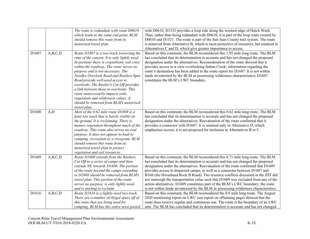
Canyon Rims Travel Management Plan Environmental Assessment
DOI-BLM-UT-Y010-2018-0220-EA K-18
The route is redundant with route D0610
which leads to the same end point. BLM
should remove this route from its
motorized travel plan.
with D0610, D1523 provides a loop ride along the western edge of Hatch Wash.
Thus, rather than being redundant with D0610, it is part of the loop route created by
D0610 and D1521. The route is part of the San Juan County trail system. The route
is removed from Alternative B, which is most protective of resources, but retained in
Alternatives C and D, which give greater importance to access.
D1607 A,B,C,D Route D1607 is a two-track traversing the
rims of the canyon. It is only lightly used.
In portions there is cryptobiotic soil crust
within the roadway. The route serves no
purpose and is not necessary. The
Needles Overlook Road and Rustlers Spur
Road provide well-used access to
overlooks. The Rustler's Cut Off provides
a link between those to overlooks. This
route unnecessarily impacts soils,
vegetation and wilderness values. It
should be removed from BLM's motorized
travel plan.
Based on this comment, the BLM reconsidered this 1.95 mile long route. The BLM
has concluded that its determination is accurate and has not changed the proposed
designation under the alternatives. Reconsideration of the route showed that it
provides access to a view overlooking Indian Creek; information regarding the
route’s destination has been added to the route report for D1607. It is not within
lands inventoried by the BLM as possessing wilderness characteristics; D1607
constitutes the BLM’s LWC boundary.
D1608 A,D Most of the 0.62 mile route D1608 is a
faint two track that is barely visible on
the ground. It is reclaiming. There is
mature vegetation throughout much of the
roadway. This route also serves no real
purpose. It does not appear to lead to
camping, recreation or a viewpoint. BLM
should remove this route from its
motorized travel plan to protect
vegetation and soil resources.
Based on this comment, the BLM reconsidered this 0.62 mile long route. The BLM
has concluded that its determination is accurate and has not changed the proposed
designation under the alternatives. Reevaluation of the route confirmed that it
provides a connector with D1607. It is retained only in Alternative D, which
emphasizes access; it is not proposed for inclusion in Alternatives B or C.
D1609 A,B,C,D Route D1609 extends from the Ruslters
Cut Off to a series of camps and then
extends NE towards D1608. The portion
of the route beyond the camps extending
to D1608 should be removed from BLM's
travel plan. This portion of the route
serves no purpose, is only lightly used
and is starting to reclaim
Based on this comment, the BLM reconsidered this 0.71 mile long route. The BLM
has concluded that its determination is accurate and has not changed the proposed
designation under the alternatives. Reevaluation of the route confirmed that D1609
provides access to dispersed camps, as well as a connector between D1607 and
B168 (the Horsehead Rock B Road). The resource conflicts discussed in the IDT did
not outweigh the transportation value such that D1609 was excluded from any of the
action alternatives. D1609 constitutes part of the BLM’s LWC boundary; the route
is not within lands inventoried by the BLM as possessing wilderness characteristics.
D1616 A,B,C,D Route D1616 is a lightly-used two track.
There are a number of illegal spurs off of
this route that are being used for
camping. BLM has this entire area posted
Based on this comment, the BLM reconsidered the 0.8 mile long route. The August
2020 monitoring report on LWC (see report on ePlanning page) showed that the
route does receive regular and continuous use. The route is the boundary of an LWC
unit. The BLM has concluded that its determination is accurate and has not changed

Canyon Rims Travel Management Plan Environmental Assessment
DOI-BLM-UT-Y010-2018-0220-EA K-19
as "No Camping". The route is
unnecessary. It simply parallels the
Needles Overlook Road and is only being
used to facilitate illegal camping. BLM
should remove this route from its
motorized travel plan.
the proposed designation under the alternatives. Reexamination of the route showed
that the route provides access to viewpoints into Harts Draw; this information has
been added to the route report for D1616. D1616 also provides the only access to
D2553 and D2554. The resource conflicts discussed in the IDT did not outweigh the
transportation value such that D1616 was excluded from any of the action
alternatives.
D1617 A,D Route D1617, extending off of Rustlers
Road, is a lightly-used two track through
BLM-identified lands with wilderness
character. There is vegetation and soil
crust in the route. The little use that has
occurred has led to illegal motorized
vehicle use along old seismic lines that
are not open for motorized vehicle use.
This route is unnecessary. It should be
closed to minimize impacts to the area's
wilderness values.
Based on this comment, the BLM reconsidered this 0.33 mile long route. The BLM
has concluded that its determination is accurate and has not changed the proposed
designation under the alternatives. Reevaluation of the route confirmed that it
connects to D1618. It also provides access to a campsite. Because of the potential
impact to LWC and other resources, the route is removed from all action alternatives
but Alternative D, which emphasizes access.
D1618 A,D Route D1618 is an old seismic line in
BLM-identified lands with wilderness
character. The western end of the route is
significantly reclaimed. It is barely visible
on the ground, with vegetation and soil
crust covering the route. While there has
been some use on the eastern end of the
route, it is not significant and there is
vegetation in the roadway. To the extent
that D1618 is being used, it is facilitating
illegal motorized use that appears to
continue around Horsehead Rock. BLM
should remove this route from its
motorized travel plan.
Based on this comment, the BLM reconsidered this 0.27 mile long route. The
August 2020 LWC monitoring report (see ePlanning entry for report) shows that the
route does receive some use. The BLM has concluded that its evaluation is accurate
and has not changed the proposed designation under the alternatives. Reevaluation
of the route confirmed that the Purpose and Need for the road is to access dispersed
campsites. Among the action alternatives, the route is designated only in Alternative
D, which most emphasizes access; it is not included in Alternatives B or C because
of its impact to resources including LWC.
D1619a A, D BLM must add information about whether
a route is no longer being used, is
revegetating or is impassable to
motorized vehicles. The specific route
report has no additional text.
Based on this comment, the BLM reconsidered this 0.82 mile long route. The BLM
has concluded that its determination is accurate and has not changed the proposed
designation under the alternatives. Reevaluation of the route confirmed that the route
provides an alternative link to B170. Among the action alternatives, the route is
designated only in Alternative D, which most emphasizes access.
D1619b A,C,D
Removed
from C as a
SUWA presents photos and a map with
no text.
Based on this comment, the BLM reconsidered this 0.62 mile long route. The BLM
has concluded that its determination was not accurate and has changed the proposed
designation under the alternatives after consultation with members of the IDT.
Reevaluation of the route led to the decision to remove it from Alternative C due to
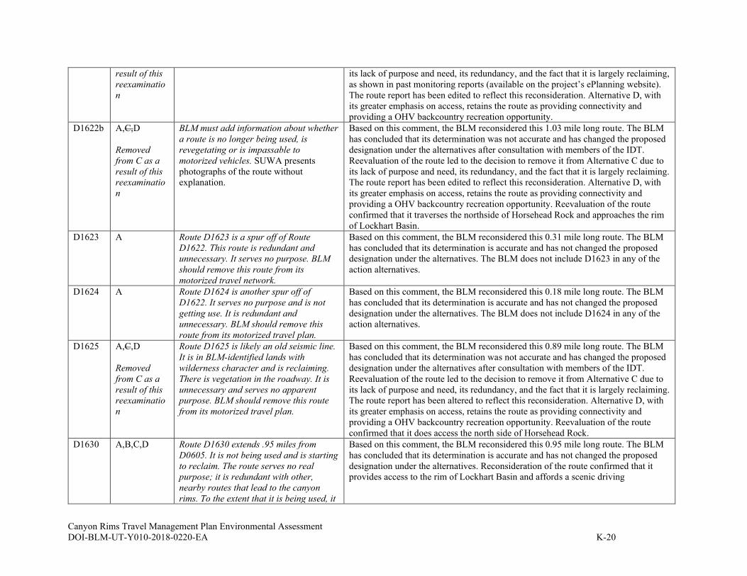
Canyon Rims Travel Management Plan Environmental Assessment
DOI-BLM-UT-Y010-2018-0220-EA K-20
result of this
reexaminatio
n
its lack of purpose and need, its redundancy, and the fact that it is largely reclaiming,
as shown in past monitoring reports (available on the project’s ePlanning website).
The route report has been edited to reflect this reconsideration. Alternative D, with
its greater emphasis on access, retains the route as providing connectivity and
providing a OHV backcountry recreation opportunity.
D1622b A,C,D
Removed
from C as a
result of this
reexaminatio
n
BLM must add information about whether
a route is no longer being used, is
revegetating or is impassable to
motorized vehicles. SUWA presents
photographs of the route without
explanation.
Based on this comment, the BLM reconsidered this 1.03 mile long route. The BLM
has concluded that its determination was not accurate and has changed the proposed
designation under the alternatives after consultation with members of the IDT.
Reevaluation of the route led to the decision to remove it from Alternative C due to
its lack of purpose and need, its redundancy, and the fact that it is largely reclaiming.
The route report has been edited to reflect this reconsideration. Alternative D, with
its greater emphasis on access, retains the route as providing connectivity and
providing a OHV backcountry recreation opportunity. Reevaluation of the route
confirmed that it traverses the northside of Horsehead Rock and approaches the rim
of Lockhart Basin.
D1623 A Route D1623 is a spur off of Route
D1622. This route is redundant and
unnecessary. It serves no purpose. BLM
should remove this route from its
motorized travel network.
Based on this comment, the BLM reconsidered this 0.31 mile long route. The BLM
has concluded that its determination is accurate and has not changed the proposed
designation under the alternatives. The BLM does not include D1623 in any of the
action alternatives.
D1624 A Route D1624 is another spur off of
D1622. It serves no purpose and is not
getting use. It is redundant and
unnecessary. BLM should remove this
route from its motorized travel plan.
Based on this comment, the BLM reconsidered this 0.18 mile long route. The BLM
has concluded that its determination is accurate and has not changed the proposed
designation under the alternatives. The BLM does not include D1624 in any of the
action alternatives.
D1625 A,C,D
Removed
from C as a
result of this
reexaminatio
n
Route D1625 is likely an old seismic line.
It is in BLM-identified lands with
wilderness character and is reclaiming.
There is vegetation in the roadway. It is
unnecessary and serves no apparent
purpose. BLM should remove this route
from its motorized travel plan.
Based on this comment, the BLM reconsidered this 0.89 mile long route. The BLM
has concluded that its determination was not accurate and has changed the proposed
designation under the alternatives after consultation with members of the IDT.
Reevaluation of the route led to the decision to remove it from Alternative C due to
its lack of purpose and need, its redundancy, and the fact that it is largely reclaiming.
The route report has been altered to reflect this reconsideration. Alternative D, with
its greater emphasis on access, retains the route as providing connectivity and
providing a OHV backcountry recreation opportunity. Reevaluation of the route
confirmed that it does access the north side of Horsehead Rock.
D1630 A,B,C,D Route D1630 extends .95 miles from
D0605. It is not being used and is starting
to reclaim. The route serves no real
purpose; it is redundant with other,
nearby routes that lead to the canyon
rims. To the extent that it is being used, it
Based on this comment, the BLM reconsidered this 0.95 mile long route. The BLM
has concluded that its determination is accurate and has not changed the proposed
designation under the alternatives. Reconsideration of the route confirmed that it
provides access to the rim of Lockhart Basin and affords a scenic driving
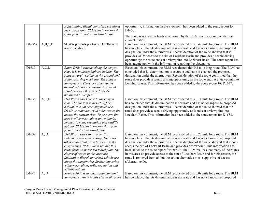
Canyon Rims Travel Management Plan Environmental Assessment
DOI-BLM-UT-Y010-2018-0220-EA K-21
is facilitating illegal motorized use along
the canyon rims. BLM should remove this
route from its motorized travel plan.
opportunity; information on the viewpoint has been added to the route report for
D1630.
The route is not within lands inventoried by the BLM has possessing wilderness
characteristics.
D1636a A,B,C,D SUWA presents photos of D1636a with
no explanation.
Based on this comment, the BLM reconsidered this 0.49 mile long route. The BLM
has concluded that its determination is accurate and has not changed the proposed
designation under the alternatives. Reconsideration of the route showed that it
provides OHV access to the rim of Lockhart Basin and provides a scenic driving
opportunity; the route ends at a viewpoint into Lockhart Basin. The route report has
been augmented with the information regarding the viewpoint.
D1637 A,C,D Route D1637 extends along the canyon
rims. It is in desert bighorn habitat. The
route is barely visible on the ground and
is not receiving much use. The route is
unnecessary. There are other routes
available to access canyon rims. BLM
should remove this route from its
motorized travel plan.
Based on this comment, the BLM reevaluated this 0.3 mile long route. The BLM has
concluded that its determination is accurate and has not changed the proposed
designation under the alternatives. Reconsideration of the route confirmed that the
route does provide a scenic driving opportunity as the route ends at a viewpoint into
Lockhart Basin. This information has been added to the route report for D1637.
D1638 A,C,D D1638 is a short route to the canyon
rims. The route is in desert bighorn
habitat. It is not receiving much use.
D1638 is redundant with other routes that
access the canyon rims. To preserve the
area's wilderness values and minimize
impacts to soils, vegetation and wildlife
habitat, BLM should remove this route
from its motorized travel plan.
Based on this comment, the BLM reconsidered this 0.11 mile long route. The BLM
has concluded that its determination is accurate and has not changed the proposed
designation under the alternatives. Reconsideration of the route showed that the
route does provide a scenic driving opportunity as it ends at a viewpoint into
Lockhart Basin. This information has been added to the route report for D1638.
D1639 A, D D1639 is a short spur route. It is
redundant and unnecessary. There are
other routes that provide access to the
canyon rims. BLM should remove this
route from its motorized travel plan. The
cluster of routes in this area are
facilitating illegal motorized vehicle use
along the canyon rims further impacting
wilderness values, soils, vegetation and
wildlife habitat.
Based on this comment, the BLM reconsidered this 0.23 mile long route. The BLM
has concluded that its determination is accurate and has not changed the proposed
designation under the alternatives. Reconsideration of the route showed that it does
access the rim of Lockhart Basin and provides a viewpoint. This information has
been added to the route report for D1639. The BLM realizes that many of the routes
in this area do provide access to the rim of Lockhart Basin and for this reason, the
route is removed from all but the action alternative most supportive of access
(Alternative D).
D1640 A, D Route D1640 is another redundant and
unnecessary route in this cluster of routes
Based on this comment, the BLM reconsidered this 0.09 mile long route. The BLM
has concluded that its determination is accurate and has not changed the proposed

Canyon Rims Travel Management Plan Environmental Assessment
DOI-BLM-UT-Y010-2018-0220-EA K-22
on the rims above Lockhart Basin. It is
not receiving much use and does not
appear to serve any purpose. It is in
desert bighorn habitat and Mexican
spotted owl critical habitat. To preserve
the area's wilderness values and minimize
impacts to vegetation, soils and wildlife
habitat, BLM should remove this route
from its motorized travel plan.
designation under the alternatives. Reexamination of the route showed that it
provides a viewpoint into Lockhart Basin, and that information has been added to
the route report for D1640. The BLM realizes that many routes in this area provide
access to the rim of Lockhart Basin and for this reason, the route is removed from all
but the action alternative most supportive of access.
The route is not within lands determined by the BLM to possess wilderness
characteristics.
D1641 A D1641 is among a cluster of old seismic
lines in this area. It is largely reclaimed
and not easily visible on the ground. It is
in desert bighorn habitat and Mexican
spotted owl critical habitat. It is
unnecessary and serves no apparent
purpose. There are other routes that
provide access to the canyon rims.
Retaining this route would facilitate
illegal motorized use along the canyon
rims. BLM should remove this route from
its motorized travel plan.
Based on this comment, the BLM reconsidered this 0.3 mile long route. The BLM
has concluded that its determination is accurate and has not changed the proposed
designation under the alternatives. The BLM does not include D1624 in any of the
action alternatives.
D1642 A Route D1642 is among the cluster of old
seismic lines in this area. It is largely
reclaimed and barely visible on the
ground. There is vegetation and soil crust
in the roadway. Like the other routes in
this cluster, it serves no real purpose and
is redundant with other routes that
provide access to the canyon rims. BLM
should remove this route from its
motorized travel plan.
Based on this comment, the BLM reconsidered this 0.35 mile long route. The BLM
has concluded that its determination is accurate and has not changed the proposed
designation under the alternatives. The BLM does not include D1642 in any of the
action alternatives.
D1643 A, D D1643 is among a cluster of old seismic
lines. There is vegetation in the roadway
and it is not getting used. It is in desert
bighorn habitat and Mexican spotted owl
critical habitat. It is redundant with other
routes that provide access to the canyon
rims. BLM should remove this route from
its motorized travel plan.
Based on this comment, the BLM reconsidered this 0.1 mile long route. The BLM
has concluded that its determination is accurate and has not changed the proposed
designation under the alternatives. Reexamination of the route showed that it does
access the rim of Lockhart Basin and this information has been added to the route
report for D1643. D1643 is included only in Action Alternative D, which most
emphasizes access.

Canyon Rims Travel Management Plan Environmental Assessment
DOI-BLM-UT-Y010-2018-0220-EA K-23
D1847 A, D Route D1847 is a reclaiming two-track. It
is barely visible on the ground as there is
significant vegetation in the roadway. It
serves no purpose and is redundant with
D1844. BLM should remove this route
from its motorized travel plan.
Based on this comment, the BLM reconsidered this 0.23 mile long route. The BLM
has concluded that its determination is accurate and has not changed the proposed
designation under the alternatives. Reexamination of the route confirmed that D1847
provides a connector from the Canyonlands Overlook route to the Kane Springs
Overlook route. It also provides secondary access to SITLA land, but is somewhat
redundant with D0605. For that reason, it is designated only in the action alternative
that most emphasizes access.
D1849 A, D Route D1849 is a .63 mile spur off of
route D2740, extending into BLM-
identified lands with wilderness
character. It is unneccessary and serves
no real purpose. It roughly parallels
route D2740. To minimize unnecessary
impacts to the area's wilderness values
and remove redundant motorized vehicle
routes, BLM should remove this route
from its motorized travel plan.
Based on this comment, the BLM reevaluated this 0.63 mile long route. The BLM
has concluded that its determination is accurate and has not changed the proposed
designation under the alternatives. Reexamination of the route showed that D1849
accesses the rim of Canyon Rims and overlooks the Colorado River, providing a
recreation opportunity for OHV users; this information has been added to the route
report for D1849. The route does traverse BLM inventoried LWC and is included
only in Action Alternative D, which emphasizes access over protection of resources.
D2401 A Route D2401 extends into BLM-identified
lands with wilderness character. It is
barely visible on the ground; there is
vegetation and soil crust in the roadway.
It is redundant with route D2740 and
serves no real purpose. It is also in
Mexican spotted owl critical habitat and
desert bighorn habitat. BLM should
remove this route from its motorized
travel plan.
Based on this comment, the BLM reconsidered this 0.32 mile long route. The BLM
has concluded that its determination is accurate and has not changed the proposed
designation under the alternatives. The BLM does not include D2401 in any of the
action alternatives.
D2403 A,B,C,D Route D2403 is among a cluster of old
seismic lines. It is a two track that is not
receiving much use. Like the other routes
in this cluster, it is unnecessary and
redundant. There are other nearby routes
that provide access to the rims of the
canyon. It is in desert bighorn habitat and
Mexican spotted owl critical habitat. It
ends abruptly without any defining
endpoint thereby potentially facilitating
illegal motorized use beyond the
designated route. BLM should remove
this route from its motorized travel plan.
Based on this comment, the BLM reconsidered this 0.38 mile long route. The BLM
has concluded that its determination is accurate and has not changed the proposed
designation under the alternatives. Reexamination of the route showed that it does
bring drivers closer to the rim of Lockhart Basin and provides a good viewpoint; this
information has been added to the route report for D2403.

Canyon Rims Travel Management Plan Environmental Assessment
DOI-BLM-UT-Y010-2018-0220-EA K-24
D2415 No information provided (only map of
Route D0621 is shown)
There is no route D2415. The entry is blank and this appears to have been submitted
in error.
D2416 A, D Route D2416 is a short spur off of D0621.
It is entirely within BLM-identified lands
with wilderness character. It serves no
purpose, it simply leads to another view
of the canyon. BLM should remove this
redundant route from its motorized travel
plan.
Based on this comment, the BLM reconsidered this 0.06 mile long route. The BLM
has concluded that its determination is accurate and has not changed the proposed
designation under the alternatives. Reexamination of the route confirmed that it does
provide another view of the canyon and this information has been added to the route
report for D2416. D2416 is included only in the action alternative that most supports
access (D). The route is within lands identified by the BLM as having wilderness
characteristics; it is excluded from Alternatives B and C.
D2495 A, C, D D2495 is a short spur route off of D1495.
It is not receiving much use and serves no
apparent purpose. It should be removed
from BLM's motorized travel plan.
Based on this comment, the BLM reconsidered this 0.13 mile long route. The BLM
has concluded that its determination is accurate and has not changed the proposed
designation under the alternatives. Reevaluation of the route confirmed that it
provides a connector between D1497 and D1495.
D2496 A, D Route D2496 is a short spur route. It is
reclaiming and nearly completely covered
with vegetation. The route is unnecessary
and has no purpose. It should be removed
from BLM's motorized travel plan.
Based on this comment, the BLM reconsidered this 0.26 mile long route. The BLM
has concluded that its determination is accurate and has not changed the proposed
designation under the alternatives. Reevaluation of the route confirmed that D2496
provides a connector between D1497 and D0608. It is the primary access to a range
facility. As such, the route is limited to administrative use in Alternatives B and C
and is open to the public only in Alternative D, which most emphasizes access.
D2545 A,B,C,D Route D2496 is a short spur route. It is
reclaiming and nearly completely covered
with vegetation. The route is unnecessary
and has no purpose. It should be removed
from BLM's motorized travel plan.
Based on this comment, the BLM reconsidered this 0.06 mile long route. The BLM
has concluded that its determination is accurate and has not changed the proposed
designation under the alternatives. Reevaluation of the route confirmed that D2545
is a very short “triangle” type connector between B0170 and D1707 near Lockhart
Overlook. Its purpose is that of a connector; use would continue on the route even if
it were to be closed, as people would seek to connect the two routes.
D2546 A, D Route D2546 is a short spur off of D1607.
It cuts into BLM identified lands with
wilderness character to lead to the
canyon rim. It is redundant with Route
D1609 which provides a similar, nearby
view of the canyon. BLM should remove
this route from its motorized travel plan.
Based on this comment, the BLM reconsidered this 0.08 mile long route. The BLM
has concluded that its determination is accurate and has not changed the proposed
designation under the alternatives. Reexamination of the route showed that D2546 is
a spur to the canyon rim. Route D2546 does cross BLM identified lands with
wilderness characteristics. It is included only in Action Alternative D, which
emphasizes access.
D2547 A Route D2547 is a short spur off of D1607.
It cuts into BLM identified lands with
wilderness character. It is redundant with
Route D1609 which provides a similar,
better view over the rims of the canyon.
BLM should remove this route from its
motorized travel plan.
Based on this comment, the BLM reconsidered this 0.03 mile long route. The BLM
has concluded that its determination is accurate and has not changed the proposed
designation under the alternatives. The BLM does not include D2547 in any of the
action alternatives.
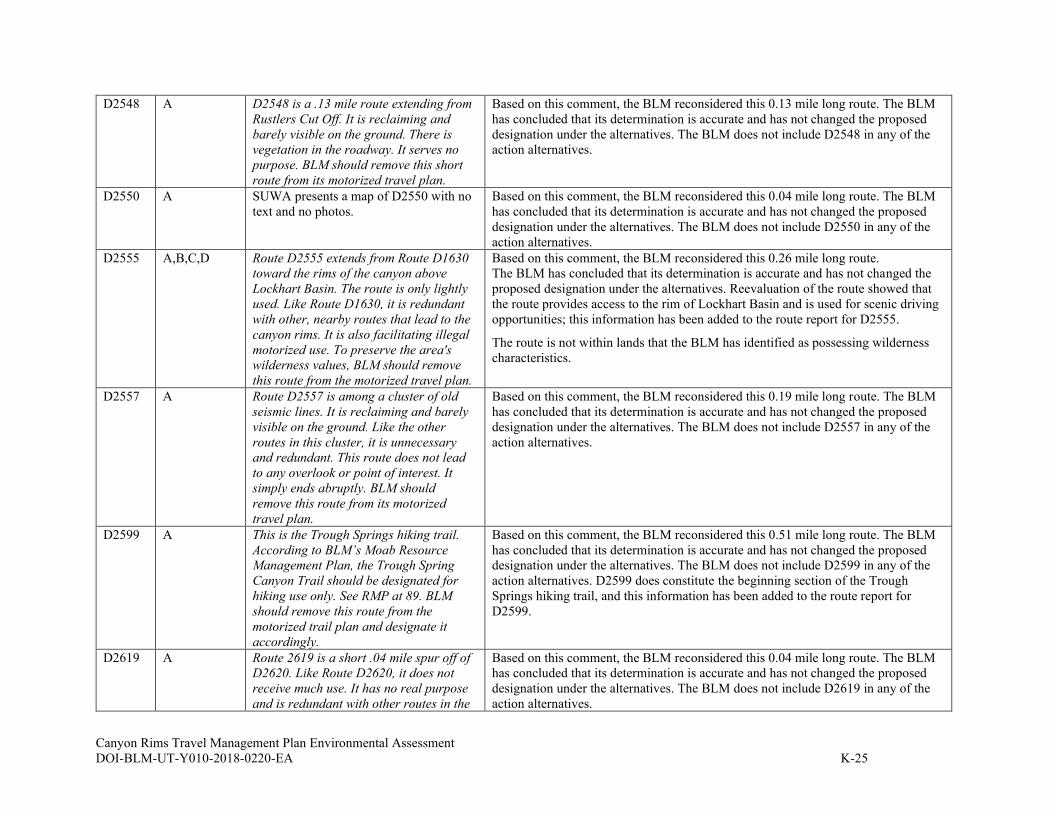
Canyon Rims Travel Management Plan Environmental Assessment
DOI-BLM-UT-Y010-2018-0220-EA K-25
D2548 A D2548 is a .13 mile route extending from
Rustlers Cut Off. It is reclaiming and
barely visible on the ground. There is
vegetation in the roadway. It serves no
purpose. BLM should remove this short
route from its motorized travel plan.
Based on this comment, the BLM reconsidered this 0.13 mile long route. The BLM
has concluded that its determination is accurate and has not changed the proposed
designation under the alternatives. The BLM does not include D2548 in any of the
action alternatives.
D2550 A SUWA presents a map of D2550 with no
text and no photos.
Based on this comment, the BLM reconsidered this 0.04 mile long route. The BLM
has concluded that its determination is accurate and has not changed the proposed
designation under the alternatives. The BLM does not include D2550 in any of the
action alternatives.
D2555 A,B,C,D Route D2555 extends from Route D1630
toward the rims of the canyon above
Lockhart Basin. The route is only lightly
used. Like Route D1630, it is redundant
with other, nearby routes that lead to the
canyon rims. It is also facilitating illegal
motorized use. To preserve the area's
wilderness values, BLM should remove
this route from the motorized travel plan.
Based on this comment, the BLM reconsidered this 0.26 mile long route.
The BLM has concluded that its determination is accurate and has not changed the
proposed designation under the alternatives. Reevaluation of the route showed that
the route provides access to the rim of Lockhart Basin and is used for scenic driving
opportunities; this information has been added to the route report for D2555.
The route is not within lands that the BLM has identified as possessing wilderness
characteristics.
D2557 A Route D2557 is among a cluster of old
seismic lines. It is reclaiming and barely
visible on the ground. Like the other
routes in this cluster, it is unnecessary
and redundant. This route does not lead
to any overlook or point of interest. It
simply ends abruptly. BLM should
remove this route from its motorized
travel plan.
Based on this comment, the BLM reconsidered this 0.19 mile long route. The BLM
has concluded that its determination is accurate and has not changed the proposed
designation under the alternatives. The BLM does not include D2557 in any of the
action alternatives.
D2599 A This is the Trough Springs hiking trail.
According to BLM’s Moab Resource
Management Plan, the Trough Spring
Canyon Trail should be designated for
hiking use only. See RMP at 89. BLM
should remove this route from the
motorized trail plan and designate it
accordingly.
Based on this comment, the BLM reconsidered this 0.51 mile long route. The BLM
has concluded that its determination is accurate and has not changed the proposed
designation under the alternatives. The BLM does not include D2599 in any of the
action alternatives. D2599 does constitute the beginning section of the Trough
Springs hiking trail, and this information has been added to the route report for
D2599.
D2619 A Route 2619 is a short .04 mile spur off of
D2620. Like Route D2620, it does not
receive much use. It has no real purpose
and is redundant with other routes in the
Based on this comment, the BLM reconsidered this 0.04 mile long route. The BLM
has concluded that its determination is accurate and has not changed the proposed
designation under the alternatives. The BLM does not include D2619 in any of the
action alternatives.
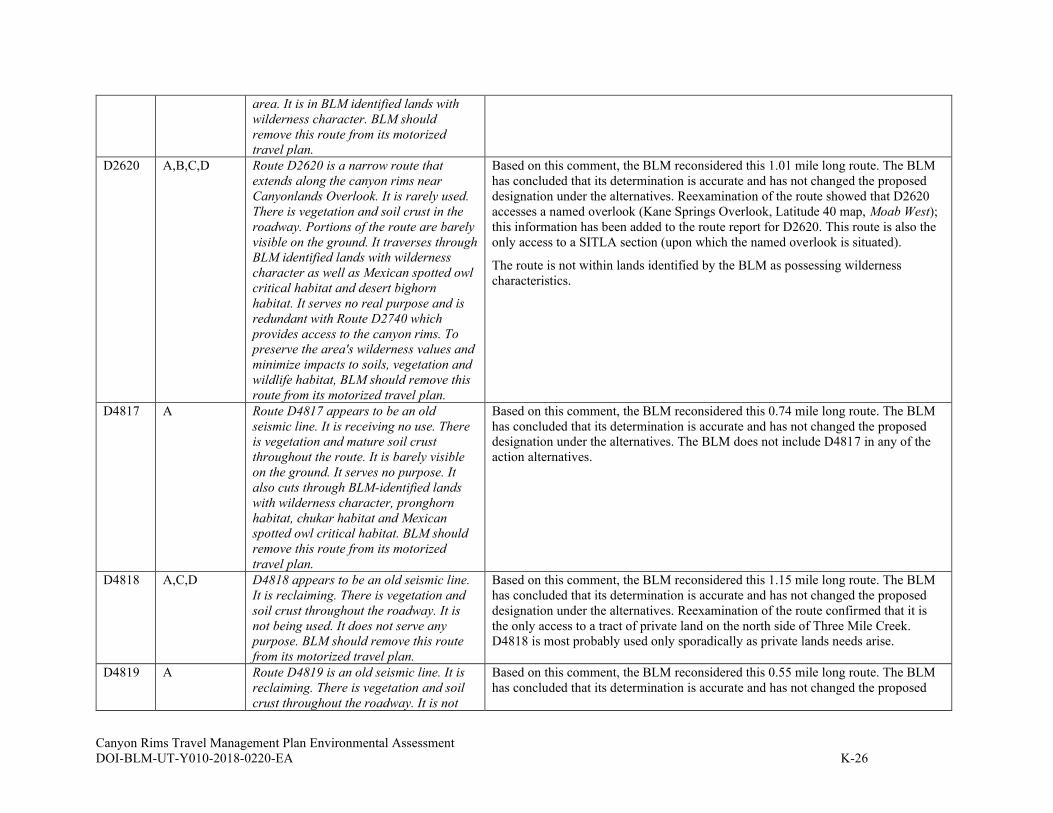
Canyon Rims Travel Management Plan Environmental Assessment
DOI-BLM-UT-Y010-2018-0220-EA K-26
area. It is in BLM identified lands with
wilderness character. BLM should
remove this route from its motorized
travel plan.
D2620 A,B,C,D Route D2620 is a narrow route that
extends along the canyon rims near
Canyonlands Overlook. It is rarely used.
There is vegetation and soil crust in the
roadway. Portions of the route are barely
visible on the ground. It traverses through
BLM identified lands with wilderness
character as well as Mexican spotted owl
critical habitat and desert bighorn
habitat. It serves no real purpose and is
redundant with Route D2740 which
provides access to the canyon rims. To
preserve the area's wilderness values and
minimize impacts to soils, vegetation and
wildlife habitat, BLM should remove this
route from its motorized travel plan.
Based on this comment, the BLM reconsidered this 1.01 mile long route. The BLM
has concluded that its determination is accurate and has not changed the proposed
designation under the alternatives. Reexamination of the route showed that D2620
accesses a named overlook (Kane Springs Overlook, Latitude 40 map, Moab West);
this information has been added to the route report for D2620. This route is also the
only access to a SITLA section (upon which the named overlook is situated).
The route is not within lands identified by the BLM as possessing wilderness
characteristics.
D4817 A Route D4817 appears to be an old
seismic line. It is receiving no use. There
is vegetation and mature soil crust
throughout the route. It is barely visible
on the ground. It serves no purpose. It
also cuts through BLM-identified lands
with wilderness character, pronghorn
habitat, chukar habitat and Mexican
spotted owl critical habitat. BLM should
remove this route from its motorized
travel plan.
Based on this comment, the BLM reconsidered this 0.74 mile long route. The BLM
has concluded that its determination is accurate and has not changed the proposed
designation under the alternatives. The BLM does not include D4817 in any of the
action alternatives.
D4818 A,C,D D4818 appears to be an old seismic line.
It is reclaiming. There is vegetation and
soil crust throughout the roadway. It is
not being used. It does not serve any
purpose. BLM should remove this route
from its motorized travel plan.
Based on this comment, the BLM reconsidered this 1.15 mile long route. The BLM
has concluded that its determination is accurate and has not changed the proposed
designation under the alternatives. Reexamination of the route confirmed that it is
the only access to a tract of private land on the north side of Three Mile Creek.
D4818 is most probably used only sporadically as private lands needs arise.
D4819 A Route D4819 is an old seismic line. It is
reclaiming. There is vegetation and soil
crust throughout the roadway. It is not
Based on this comment, the BLM reconsidered this 0.55 mile long route. The BLM
has concluded that its determination is accurate and has not changed the proposed

Canyon Rims Travel Management Plan Environmental Assessment
DOI-BLM-UT-Y010-2018-0220-EA K-27
being used and serves no purpose. There
are nearby routes that provide access to
the canyon rims. It cuts through BLM
identified lands with wilderness
character, pronghorn habitat, chukar
habitat and Mexican spotted owl habitat.
BLM should remove this route from its
motorized travel plan.
designation under the alternatives. The BLM does not include D4819in any of the
action alternatives.
D4821 A Route D4821 is another short spur off of
route D0609 that appears to be an old
seismic line. It is significantly reclaimed
to the extent that it is barely visible on the
ground. There is vegetation and soil crust
in the roadway. The route serves no
purpose. It is also in pronghorn habitat,
chukar habitat and Mexican spotted owl
critical habitat. BLM should remove this
route from its motorized travel plan.
Based on this comment, the BLM reconsidered this 0.18 mile long route. The BLM
has concluded that its determination is accurate and has not changed the proposed
designation under the alternatives. The BLM does not include D4821 in any of the
action alternatives.
D4822 A,C,D Route D4822 is a short spur off of route
D0609. It appears to be an old seismic
line. It is reclaiming and not being used.
There is vegetation and soil crust in the
roadway. The route is in BLM-identified
lands with wilderness character,
pronghorn habitat, chukar habitat and
Mexican spotted owl critical habitat. The
route also serves no purpose. There are
other, nearby routes that provide access
to the canyon rims. BLM should remove
this route from its motorized travel plan.
Based on this comment, the BLM reconsidered this 0.17 mile long route. The BLM
has concluded that its determination is accurate and has not changed the proposed
designation under the alternatives. Reexamination of the route showed that it does
provide opportunity for scenic driving as it accesses an overlook into Hatch Wash;
this information has been added to the route report for D4822.
The route is within lands determined by the BLM to possess wilderness
characteristics.
D4823 A D4823 is a short spur route off of D1516.
It is not seeing any use and is
significantly reclaimed. There is
vegetation and mature soil crust in the
purported roadway. It is in BLM
identified lands with wilderness character
as well as habitat for both the desert
bighorn and the chukar. BLM should
remove this spur route from its motorized
travel plan.
Based on this comment, the BLM reconsidered this 0.18 mile long route. The BLM
has concluded that its determination is accurate and has not changed the proposed
designation under the alternatives. The BLM does not include D4823 in any of the
action alternatives.
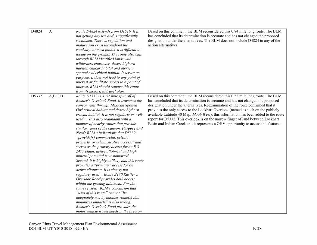
Canyon Rims Travel Management Plan Environmental Assessment
DOI-BLM-UT-Y010-2018-0220-EA K-28
D4824 A Route D4824 extends from D1516. It is
not getting any use and is significantly
reclaimed. There is vegetation and
mature soil crust throughout the
roadway. At most points, it is difficult to
locate on the ground. The route also cuts
through BLM identified lands with
wilderness character, desert bighorn
habitat, chukar habitat and Mexican
spotted owl critical habitat. It serves no
purpose. It does not lead to any point of
interest or facilitate access to a point of
interest. BLM should remove this route
from its motorized travel plan.
Based on this comment, the BLM reconsidered this 0.84 mile long route. The BLM
has concluded that its determination is accurate and has not changed the proposed
designation under the alternatives. The BLM does not include D4824 in any of the
action alternatives.
D5332 A,B,C,D Route D5332 is a .52 mile spur off of
Rustler’s Overlook Road. It traverses the
canyon rims through Mexican Spotted
Owl critical habitat and desert bighorn
crucial habitat. It is not regularly or well-
used … It is also redundant with a
number of nearby routes that provide
similar views of the canyon. Purpose and
Need: BLM’s indications that D5332
“provide[s] commercial, private
property, or administrative access,” and
serves as the primary access for an R.S.
2477 claim, active allotment and high
mineral potential is unsupported…
Second, it is highly unlikely that this route
provides a “primary” access for an
active allotment. It is clearly not
regularly used… Route B170 Rustler’s
Overlook Road provides both access
within the grazing allotment. For the
same reasons, BLM’s conclusion that
“uses of this route” cannot “be
adequately met by another route(s) that
minimizes impacts” is also wrong.
Rustler’s Overlook Road provides the
motor vehicle travel needs in the area on
Based on this comment, the BLM reconsidered this 0.52 mile long route. The BLM
has concluded that its determination is accurate and has not changed the proposed
designation under the alternatives. Reexamination of the route confirmed that it
provides the only access to the Lockhart Overlook (named as such on the publicly
available Latitude 40 Map, Moab West); this information has been added to the route
report for D5332. This overlook is on the narrow finger of land between Lockhart
Basin and Indian Creek and it represents a OHV opportunity to access this feature.
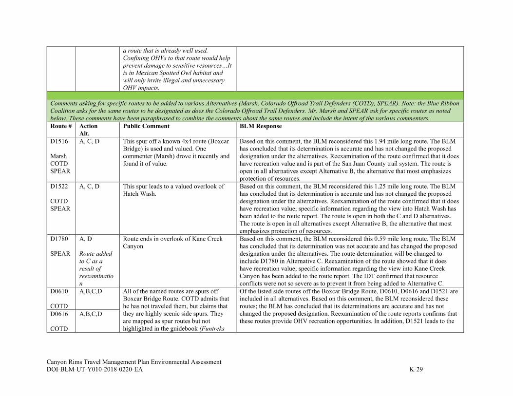
Canyon Rims Travel Management Plan Environmental Assessment
DOI-BLM-UT-Y010-2018-0220-EA K-29
a route that is already well used.
Confining OHVs to that route would help
prevent damage to sensitive resources…It
is in Mexican Spotted Owl habitat and
will only invite illegal and unnecessary
OHV impacts.
Comments asking for specific routes to be added to various Alternatives (Marsh, Colorado Offroad Trail Defenders (COTD), SPEAR). Note: the Blue Ribbon
Coalition asks for the same routes to be designated as does the Colorado Offroad Trail Defenders. Mr. Marsh and SPEAR ask for specific routes as noted
below. These comments have been paraphrased to combine the comments about the same routes and include the intent of the various commenters.
Route # Action
Alt.
Public Comment
BLM Response
D1516
Marsh
COTD
SPEAR
A, C, D This spur off a known 4x4 route (Boxcar
Bridge) is used and valued. One
commenter (Marsh) drove it recently and
found it of value.
Based on this comment, the BLM reconsidered this 1.94 mile long route. The BLM
has concluded that its determination is accurate and has not changed the proposed
designation under the alternatives. Reexamination of the route confirmed that it does
have recreation value and is part of the San Juan County trail system. The route is
open in all alternatives except Alternative B, the alternative that most emphasizes
protection of resources.
D1522
COTD
SPEAR
A, C, D This spur leads to a valued overlook of
Hatch Wash.
Based on this comment, the BLM reconsidered this 1.25 mile long route. The BLM
has concluded that its determination is accurate and has not changed the proposed
designation under the alternatives. Reexamination of the route confirmed that it does
have recreation value; specific information regarding the view into Hatch Wash has
been added to the route report. The route is open in both the C and D alternatives.
The route is open in all alternatives except Alternative B, the alternative that most
emphasizes protection of resources.
D1780
SPEAR
A, D
Route added
to C as a
result of
reexaminatio
n
Route ends in overlook of Kane Creek
Canyon
Based on this comment, the BLM reconsidered this 0.59 mile long route. The BLM
has concluded that its determination was not accurate and has changed the proposed
designation under the alternatives. The route determination will be changed to
include D1780 in Alternative C. Reexamination of the route showed that it does
have recreation value; specific information regarding the view into Kane Creek
Canyon has been added to the route report. The IDT confirmed that resource
conflicts were not so severe as to prevent it from being added to Alternative C.
D0610
COTD
A,B,C,D All of the named routes are spurs off
Boxcar Bridge Route. COTD admits that
he has not traveled them, but claims that
they are highly scenic side spurs. They
are mapped as spur routes but not
highlighted in the guidebook (Funtreks
Of the listed side routes off the Boxcar Bridge Route, D0610, D0616 and D1521 are
included in all alternatives. Based on this comment, the BLM reconsidered these
routes; the BLM has concluded that its determinations are accurate and has not
changed the proposed designation. Reexamination of the route reports confirms that
these routes provide OHV recreation opportunities. In addition, D1521 leads to the D0616
COTD
A,B,C,D
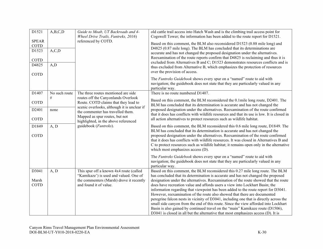
Canyon Rims Travel Management Plan Environmental Assessment
DOI-BLM-UT-Y010-2018-0220-EA K-30
D1521
SPEAR
COTD
A,B,C,D Guide to Moab, UT Backroads and 4-
Wheel Drive Trails, Funtreks, 2016)
referenced by COTD.
old cattle trail access into Hatch Wash and is the climbing trail access point for
Cogswell Tower; the information has been added to the route report for D1521.
Based on this comment, the BLM also reconsidered D1523 (0.88 mile long) and
D4825 (0.87 mile long). The BLM has concluded that its determinations are
accurate and has not changed the proposed designation under the alternatives.
Reexamination of the route reports confirm that D4825 is reclaiming and thus it is
excluded from Alternatives B and C; D1523 demonstrates resources conflicts and is
thus excluded from Alternative B, which emphasizes the protection of resources
over the provision of access.
The Funtreks Guidebook shows every spur on a “named” route to aid with
navigation; the guidebook does not state that they are particularly valued in any
particular way.
D1523
COTD
A,C,D
D4825
COTD
A,D
D1407
COTD
No such route
#
The three routes mentioned are side
routes off the Canyonlands Overlook
Route. COTD claims that they lead to
scenic overlooks, although it is unclear if
the commenter has travelled them.
Mapped as spur routes, but not
highlighted, in the above referenced
guidebook (Funtreks).
There is no route numbered D1407.
Based on this comment, the BLM reconsidered the 0.1mile long route, D2401. The
BLM has concluded that its determination is accurate and has not changed the
proposed designation under the alternatives. Reexamination of the route confirmed
that it does has conflicts with wildlife resources and that its use is low. It is closed in
all action alternatives to protect resources such as wildlife habitat.
Based on this comment, the BLM reconsidered this 0.6 mile long route, D1849. The
BLM has concluded that its determination is accurate and has not changed the
proposed designation under the alternatives. Reexamination of the route confirmed
that it does has conflicts with wildlife resources. It was closed in Alternatives B and
C to protect resources such as wildlife habitat; it remains open only in the alternative
which most emphasizes access (D).
The Funtreks Guidebook shows every spur on a “named” route to aid with
navigation; the guidebook does not state that they are particularly valued in any
particular way.
D2401
COTD
none
D1849
COTD
A, D
D3041
Marsh
COTD
A, D This spur off a known 4x4 route (called
“Kamikaze’) is used and valued. One of
the commenters (Marsh) drove it recently
and found it of value.
Based on this comment, the BLM reconsidered this 0.27 mile long route. The BLM
has concluded that its determination is accurate and has not changed the proposed
designation under the alternatives. Reexamination of the route showed that the route
does have recreation value and affords users a view into Lockhart Basin; the
information regarding that viewpoint has been added to the route report for D3041.
However, reexamination of the route also showed that there are documented
peregrine falcon nests in vicinity of D3041, including one that is directly across the
small side canyon from the end of this route. Since the view afforded into Lockhart
Basin is also gained by continued travel on the “main” Kamikaze route (D1506),
D3041 is closed in all but the alternative that most emphasizes access (D). It is
Canyon Rims Travel Management Plan Environmental Assessment
DOI-BLM-UT-Y010-2018-0220-EA K-31
closed in Alternatives B and C to protect resources, particularly the peregrine falcon
nesting in the vicinity.
“Contin
uation”
of
D1830
COTD
Not inven-
toried
Shafer Basin. Commenter has found this
route on Google Earth and states that it
leads to an overlook. This route should be
restored in all alternatives.
The inventoried portion of route D1830 was used to access a fence building project
in the Shafer Basin. After the fence construction, the route was used by a movie to
stampede a herd of horses, which continued up the hill to what COTD calls the
“end” of the route D1830. The “end” of route D1830 was purposely omitted from
2008 RMP as it was not built as a road, but rather used for a specific project and as a
horse run. This linear feature was thus not included in Alternative A, as it was not
designated in the 2008 Travel Plan. It remains closed to protect the natural resources
found in the Shafer Basin, which is a BLM Area of Critical Environmental Concern
(bighorn sheep habitat, sensitive plants and VRM Class I lands which constitute the
view from Dead Horse Point State Park).
D1831
COTD
A, D The commenter asks that this road in the
wash in Shafer Basin remain open.
Based on this comment, the BLM reconsidered this 0.6 mile long route. The BLM
has concluded that its determination is accurate and has not changed the proposed
designation under the alternatives. Reexamination of the route confirmed that it does
pose resource conflicts in an area of Critical Environment Concern. The route in
question is a dead end; it does not access an overlook or any other particularly
notable feature. Dispersed camping is prohibited in the Shafer Basin, so the route
does not provide a dispersed camping opportunity. The level of resource concerns on
the route are many and varied. The Shafer Basin is managed as an Area of Critical
Environmental Concern with VRM Class I management. Scenic values are
important factors in the Shafer Basin, as are sensitive plants and wildlife habitat,
particularly for desert bighorn sheep. D1831 was considered an unnecessary impact
upon visual resources by the ID Team. In addition, D1831 is in a wash, making it
difficult to keep the route intact and to keep vehicles on the route. D1831 also
impacts raptor nests, as well as being in critical habitat for Mexican spotted owl, a
threatened species. For these reasons, this route is proposed for closure in
Alternatives B and C. It is kept open only in the alternative which most emphasizes
access (D).
L-1
May 2021
APPENDIX L. IMPLEMENTATION GUIDE
for the Canyon Rims (Indian Creek) Travel Management Plan
DOI-BLM-UT-Y010-2018-0220-EA
Moab Field Office
82 East Dogwood
Moab, Utah 84532
Phone: 435-259-2100
FAX: 435-259-2106
L-2
LIST OF ACRONYMS
BLM Bureau of Land Management
BLM natural area Land managed for wilderness characteristics
BMP Best management practice
CFR Code of Federal Regulations
DOT Department of Transportation
EA Environmental assessment
ERMA Extensive recreation management area
ESA Endangered Species Act
FAMS Facility Asset Management System
FHWA Federal Highway Administration
FLAP Federal Lands Access Program
FLPMA Federal Land Policy and Management Act
FLTP Federal Lands Transportation Program
FO Field Office
GIS Geographic information system
GPO U.S. Government Publishing Office
GPS Global positioning system
GTLF Ground Transportation Linear Features
HPTP Historic Properties Treatment Plan
LAC Limit(s) of acceptable change
LUP Land use plan
LWC Lands with wilderness characteristics
MUTCD Manual on Uniform Traffic Control Devices
NCA National conservation area
NEPA National Environmental Policy Act
NGO Non-governmental organization
NHPA National Historic Preservation Act
NRHP National Register of Historic Places
OHV Off-highway vehicle
ORV Off-road vehicle
RMIS Recreation Management Information System
RMP Resource management plan
RMZ Recreation management zone
ROW Right-of-way
RSC Recreation setting characteristic
SHPO State historical preservation office
SRMA Special recreation management area
SRP Special recreation permit
TMA Travel management area
TMP Travel management plan
TTM Travel and transportation management
UTM Universal Transverse Mercator
VRM Visual resource management
L-3
TABLE OF CONTENTS L.1 INTRODUCTION.......................................................................................................... L-6
L.1.1 Document Overview ............................................................................................... L-6
L.1.2 Travel Management Area Overview ...................................................................... L-7 L.1.3 Background on BLM Travel and Transportation Management (TTM) ................. L-7
L.2 TRAVEL MANAGEMENT DECISIONS ............................................................................... L-8 L.2.1 2008 RMP Decisions and Current Management Settings ..................................... L-8 L.2.2 Route Designations .............................................................................................. L-10
L.2.3 Transportation Asset Types and the FAMS ......................................................... L-10 L.2.4 Non-Motorized Route Use.................................................................................... L-11 L.2.5 Cross-Country OHV Travel ................................................................................. L-11 L.2.6 Public Land Access .............................................................................................. L-12
L.3 IMPLEMENTATION ........................................................................................................ L-13
L.3.1 Introduction.......................................................................................................... L-13 L.3.2 Implementation Strategy and Priorities ............................................................... L-13
L.3.3 Education and Outreach ...................................................................................... L-15
L.3.4 Sign Plan .............................................................................................................. L-17 L.3.5 Maintenance and Engineering ............................................................................. L-17 L.3.6 Enforcement ......................................................................................................... L-24
L.3.7 Supplementary Rules ............................................................................................ L-25 L.4 LONG-TERM MONITORING PROTOCOL FOR OHV IMPACTS AND OTHER ITEMS ............ L-26
L.4.1 Overview .............................................................................................................. L-26 L.4.2 Types of Monitoring ............................................................................................. L-27 L.4.3 Adaptive Management ......................................................................................... L-31 L.4.4 Route Designation Changes ................................................................................. L-32
L.4.5 Tracking Plan Implementation Progress ............................................................. L-33
L.5 MITIGATION ................................................................................................................. L-33 L.5.1 Overview .............................................................................................................. L-33
L.5.2 Travel Management Mitigations in the 2008 RMP.............................................. L-33 L.5.3 Route Management Mitigation Actions for Conflict or Impact Scenarios .......... L-34
L.6 ROUTE CLOSURES ........................................................................................................ L-34
L.6.1 Introduction.......................................................................................................... L-34 L.6.2 Closures in General ............................................................................................. L-34
L.6.3 Emergency Closures ............................................................................................ L-35 L.6.4 Temporary Closures............................................................................................. L-35
L.7 ROUTE DECOMMISSIONING AND RECLAMATION .......................................................... L-35 L.7.1 Overview .............................................................................................................. L-35 L.7.2 Priorities .............................................................................................................. L-36
L.7.3 General Reclamation Strategy ............................................................................. L-36 L.7.4 Reclamation Standards ........................................................................................ L-37
L.8 CULTURAL RESOURCE CONSIDERATIONS ..................................................................... L-37 L.9 REVISED STATUTE 2477 ASSERTIONS .......................................................................... L-38 L.10 ROADSIDE CAMPING AND PULL-OFF CONSIDERATIONS ............................................... L-38 L.11 GAME RETRIEVAL ........................................................................................................ L-38 L.12 NEEDED AUTHORIZATIONS .......................................................................................... L-39 L.13 GROUND TRANSPORTATION LINEAR FEATURE (GTLF) GEOSPATIAL DATA ................ L-39
L-4
L.14 PRE- AND POST-TMP/EA MANAGEMENT ACTIONS IN GENERAL ................................. L-39 L.15 REFERENCES ................................................................................................................ L-40
APPENDIX L-A. TRAVEL MANAGEMENT-RELATED GOALS OBJECTIVES, AND MANAGEMENT
DECISIONS FROM 2008 RMPS ..................................................................................... L-44 APPENDIX L-B. MONITORING SUPPORT MATERIALS ............................................................ L-46
APPENDIX L-C. ROUTE RECLAMATION ................................................................................ L-53 APPENDIX L-D. TRAVEL MANAGEMENT AND ROUTE DESIGNATION GUIDANCE FOR KEY
PROTECTED AREAS ....................................................................................................... L-60 APPENDIX L-E. ROUTE-BY-ROUTE DETAILS ........................................................................ L-65 APPENDIX L-F. SIGN PLAN BMPS ........................................................................................ L-66
APPENDIX L-G. ROUTE MANAGEMENT MITIGATION ACTIONS FOR VARIOUS CONFLICT OR
IMPACT SCENARIOS ..................................................................................................... L-76 APPENDIX L-H. RELEVANT CONSERVATION MEASURES ...................................................... L-80

L-5
TABLES Table L.1: Miles of Routes and Percentages by Designation for the Selected Alternative ....... L-10
Table L.2: Miles of Routes by Asset Type and Designation ..................................................... L-11
Table L.3: 2008 RMP Public Land Access-Related Goals, Objectives, and Management
Decisions .................................................................................................................. L-12 Table L.4: TMP Implementation Action Tasks and Scheduling ............................................... L-14 Table L.5: Maintenance Intensities Under Chosen Alternative ................................................. L-22 Table L.6: 2008 RMP Travel Management-Related Monitoring Methodologies ..................... L-29
Table L.7: 2008 RMP Travel Management-Related Mitigation Guidance ............................... L-33 Table L.8: 2008 RMP Transportation Language ....................................................................... L-44 Table L.9: Route-by-Route Monitoring and Mitigation Details (Selected Alternative) ............ L-46 Table L.10: Reclamation Techniques Toolbox .......................................................................... L-55 Table L.11: Routes to be Reclaimed (Selected Alternative)...................................................... L-56
FIGURES Figure L.1: Adaptive Management Cycle .................................................................................. L-31 Figure L.2: Portal/entry sign example ....................................................................................... L-68 Figure L.3: Non-NCA BLM identification sign ........................................................................ L-68
Figure L.4: MUTCD-compliant BLM identification signs........................................................ L-68 Figure L.5: Directional guide sign with guidance to multiple destinations ............................... L-69
Figure L.6: Directional guide sign with guidance to one destination ........................................ L-69 Figure L.7: BLM information sign examples ............................................................................ L-69 Figure L.8: Route marker examples........................................................................................... L-70
Figure L.9: BLM route marker on the ground ........................................................................... L-71 Figure L.10: Route Designation, Restriction, and Closure Signs .............................................. L-72
Figure L.11: Additional Travel Management Signs .................................................................. L-73

L-6
L.1 INTRODUCTION
Creating a Travel Management Plan (TMP) route network and analyzing the potential resource
or resource use effects in an Environmental Assessment (EA) is the first of two key steps in the
travel management planning process. Implementing the travel network decisions and actively
managing the designated travel route system on the ground following the EA is the second key
step.
L.1.1 Document Overview
This document, the TMP Implementation Guide (Guide), is the implementation step of the
Canyon Rims Travel Management Plan (TMP), located on lands administered by the BLM’s
Moab Field Office (FO). This Guide provides operation and management guidance for the
Canyon Rims Travel Management Area (TMA) Off-highway Vehicle (OHV) route network as
analyzed in the Canyon Rims TMP EA and adopted and designated in the Decision Record.
This Guide is intended to serve as a standalone manual for operating and maintaining the TMA’s
designated travel route network in accordance with the DR. It helps fulfill the purpose and need
for the TMP as detailed in the EA in meeting current and future public access and resource
management needs, supports management decisions in the 2008 Moab Field Office Record of
Decision and Approved Resource Management Plan (2008 RMP), and complies with the
National Environmental Policy Act (NEPA) and other federal regulations.
As part of ongoing travel management associated with the adopted Canyon Rims TMP, new
route designations may be added or changed in the future to respond to growing public demand
for access, Title V Right-of-way (ROW) considerations, or concerns of damage to resources.
Any new or changed designations will be subject to site-specific review under the NEPA.
Primary operation and management actions discussed in this Guide include maintenance and
resource protection, public education and outreach, visitor services, working with partners and
volunteers, law enforcement, directional and regulatory signing, reclamation, monitoring, and
engineering and resource program interface.
Monitoring efforts are of key importance and will help the BLM determine the effectiveness of
operation and management, informing the BLM on issues that may need to be addressed through
adaptive management or additional management actions. The Canyon Rims TMP EA identified
several important resource issues at the heart of the BLM’s commitment to provide for multiple
land uses while protecting sensitive cultural and natural resources. They include:
• Impacts of OHV travel on known cultural resource sites
• Soil erosion, and its resulting impacts on vegetation
• OHV-related disturbances of sensitive species plants habitat
• OHV-related disturbances on sensitive species wildlife habitat
• Impacts from OHV travel on the defining characteristics of lands with wilderness
characteristics and other special management area designations
• User conflicts within the TMA
• Route proliferation within the TMA
L-7
In addition, the route evaluation process conducted as part of the TMP EA identified monitoring
activities specific to individual routes. General monitoring schedules are included in the
Appendix B “Strategies and Schedules” section of this guide.
Note: The BLM intends to fully implement the Canyon Rims TMP according to this Guide.
However, the operation and management actions discussed in this document are subject to
available staff and funding. For the EA it was assumed that staff and funding would be available
to implement the TMP-this assumption is carried through in this Guide. Grants, new
appropriations, partnerships, and volunteers may be used to supplement budgets and workforce
when possible.
Additionally, mileages, percentages, and other numbers used in this guide are approximate
projections for comparison and analytical purposes only. They do not reflect exact measurements
or precise calculations. Table mileages and percentages may not sum properly due to rounding.
L.1.2 Travel Management Area Overview
The 91,000-acre TMA is in San Juan County and falls under the jurisdiction of the BLM Moab
Field Office (FO). For more details, see the attached maps and Section 1.4 of the EA.
The TMA contains the following specially designated areas (i.e., areas formally designated by
Congress or through an RMP process):
• Highway 279/Shafer Basin/Long Canyon Area of Critical Environmental Concern
(ACEC)
• Suitable Wild and Scenic River (WSR) segment of the Colorado River
• Canyon Rims Special Recreation Management Area (SRMA)
• Colorado Riverway SRMA
There are also areas characterized as lands with wilderness characteristics (LWC) that are not
specially designated but are managed for undeveloped character and to provide opportunities for
primitive recreation as appropriate. See Appendix L-D. in this guide for details on BLM travel
management-related requirements for WSRs and LWCs. Motorized and mechanized travel is
limited to designated routes in the ACEC—as it is throughout the TMA—per the 2008 RMP.
Pages 85 to 86 and Appendix M of the 2008 RMP provide management guidance for the Canyon
Rims Special Recreation Management Area (BLM 2008b).
L.1.3 Background on BLM Travel and Transportation Management (TTM)
In the 1980s, in response to Presidential Executive Orders 11644 (Federal Center 1977) and
11989 (National Archives 1972), the BLM began to address public concerns regarding the
proliferation of unplanned roads and trails and their impact on public land resources and uses. by
designating all public lands as either “open,” “limited,” or “closed” to off-highway vehicle
(OHV) use in accordance with the designation criteria in the Code of Federal Regulations (CFR),
under 43 CFR 8342.1.
National BLM policy requires state and field offices to develop TTM plans using a
comprehensive, interdisciplinary approach. The BLM requires this approach to integrate TTM
with land use planning and resource management programs in a comprehensive process. Because
travel and transportation issues affect many of the BLM’s resource management programs, TTM

L-8
must be conducted using a comprehensive, interdisciplinary approach. Using a collaborative
approach can resolve or prevent resource conflicts and issues associated with travel on BLM
lands. The Canyon Rims TMP was developed using the TTM process. (This TMP addresses
OHV use of routes in the TMA. Non-motorized uses will be addressed in a separate planning
process.) See the BLM’s travel management handbook (BLM 2012a) and manual2 (BLM 2016c)
for more information on the TTM process.
The BLM’s TTM process ensures proactive management of public access and resources in
compliance with travel-related regulations and best management practices (BMPs). The process
moves from broad-scale land use plan (LUP) decisions achieved in RMPs or equivalent
documents to more site-specific project level decisions and actions (e.g., those included in the
EA and this document). TTM project-level decisions address specific implementation, operation,
and maintenance actions for routes and access and recreation-related needs. TTM goals are to:
• Provide and improve sustainable access for public needs and experiences.
• Protect natural resources and settings.
• Protect cultural resources in compliance with Section 106 of the NHPA.
• Promote the safety of public land users.
• Minimize conflicts among various public land users.
L.2 TRAVEL MANAGEMENT DECISIONS
L.2.1 2008 RMP Decisions and Current Management Settings
Previous Individual Route Designations and General Travel Management Guidance
The 2021 Canyon Rims TMP route network designations supersede the individual route and area
designations assigned in the TMA by the BLM’s 2008 RMP travel plan (for more details on that
designation effort, see pages 18-20 and 36-37 of the 2008 RMP. In some cases, individual route
designations developed in the 2021 Canyon Rims TMP modify route-specific designations
developed in 2008. In addition to assigning project-level route designations, the 2008 RMP also
provided overarching travel management-related considerations, goals, objectives, and
management decisions (see Appendix L-A. of this guide and pages 126-130 as well as Appendix
N of the 2008 RMP) to guide future travel management planning efforts such as this 2021
Canyon Rims TMP.
Area Designations
An area designation is a land use planning (i.e., RMP-level) decision that permits, establishes
conditions for, or prohibits OHV activities on specific areas of public lands. The BLM is
required to designate all public lands under their jurisdiction as open, limited, or closed to OHVs.
OHV area designations are different than individual route designations, which are more
comprehensive and specific. After OHV area designations are assigned in RMPs, individual
routes may be designated in areas designated as “open,” and individual routes must be
designated in areas designated as “limited.” Typically, individual preliminary route designations
of open, limited, or closed are identified during a systematic route evaluation process and
2 The BLM travel management manual was last updated in 2016 and should be used instead of the more outdated
handbook when manual topics overlap with handbook topics.
L-9
analyzed in an EA accompanying a proposed TMP. This was the case for the Canyon Rims
TMP/EA project.
The 2008 RMP designated all of the TMA as “Limited to Designated Routes.” For a depiction of
OHV area designations in the Project Area, see Map 30 in the 2008 RMP (BLM 2008b). Though
there are exceptions for emergencies and other instances, OHV and mechanized vehicle use is
limited to designated routes in the TMA. According to the BLM’s travel management manual,
“As an implementation-level decision, any limitation applied in an OHV limited area may
change through . . . subsequent implementation level decisions allowing management to adapt
based on resource concerns, changes in resource uses, and new information” (BLM 2016c). The
BLM’s travel management manual provides definitions for the OHV area designations that apply
in the TMA:
OHV Limited Areas
An OHV limited area is governed by one or more defined limitations. A limitation is a
restriction at certain times, in certain areas, and/or to certain vehicular uses or users.
These restrictions may be of any type but generally fall within the following categories or
combination of categories: numbers of vehicles, types of vehicles, time or season of
vehicle use, permitted or licensed use only, use on existing roads and trails, or use on
designated roads and trails. While the designation of an area to the OHV limited
allocation is a land use planning decision, the specific [individual travel route] limitations
applicable to the area are considered implementation-level decisions.
The standard limitation will be “limited to designated routes” (i.e., [travel] restricted by
implementation-level decisions to the use of specific roads, primitive roads, trails, and
other identified routes). If no route-specific decisions exist at the time the RMP decisions
are made, the designation of an “OHV Limited Area” will limit all OHV use to the same
manner and degree occurring at the time of the designation in the RMP. The “OHV
Limited Area” designation will prohibit any new surface disturbance, such as cross-
country travel, unless subsequently authorized through another implementation-level
decision. After the RMP decision has been issued, the field office will need to determine
the specific type of limitations that will apply to the areas with OHV ‘limited’ area
designations. This is done, in most cases, through the development of a travel
management plan (TMP) which results in an implementation-level decision for travel on
each travel route within a given planning area (see Chapter 4 [of the travel management
manual]). For additional information on the implementation of OHV limited area
limitations see section 4.2 [of the travel management manual].
OHV Closed Areas
OHV use is prohibited in a closed area. Areas should be designated closed when
limitations on OHV use will not suffice to protect resources, promote visitor safety, or
reduce use conflicts. Access in these areas by means other than OHVs, including those
motorized vehicles and users excluded from the definition of an OHV (43 CFR 8340.0
5(a)), mechanized vehicles, and non-mechanized use is still permitted. Closure to non
OHVs requires management outside of the 43 CFR 8340 regulation and may require
creation of supplementary rules (see 43 CFR 8365.1-6), establishment of closures or

L-10
restrictions (4 CFR 8364.1), or the addition of stipulations to new authorizations to
govern the authorized use of vehicles.
Except as otherwise provided by law or regulation, congressionally designated
Wilderness, certain other congressional designations, and some areas established by
Presidential proclamation are statutorily closed to motorized and mechanized use. Refer
to the appropriate law, regulation, proclamation, or policy for guidance on how to address
any exceptions to closures.
L.2.2 Route Designations
One of the purposes of the Canyon Rims TMP process was to assign specific designations for
each evaluated route in the TMA. For more details on route designation types and how they were
determined, see Section 2.1 of the EA. For details on each assigned route designation, see the
route reports discussed in Appendix H of the EA. Table L.4, below, shows the miles of routes for
the selected alternative that fall under the broad designation categories of OHV-Open, OHV-
Limited, and OHV-Closed. In some cases, more specific route designations may be called for
under these basic designation categories. For instance, if additional management is called for by
the IDT on an OHV-Open route to help mitigate a resource concern, the route would be
designated as “Open with Management” but still be grouped under the broad “OHV-Open”
category since it would remain available to OHV use (i.e., public motorized users). Conversely a
travel route may be as assigned a more specific designation of “Limited to Authorized Use”,
limiting route use to authorized users (e.g., grazing permittee) only. This specific designation
would be grouped under the broad OHV-Closed category since it would be closed to OHV users.
Table L.4: Miles of Routes and Percentages by Designation for the Selected Alternative
Designation Miles Percent of total evaluated
route miles
OHV-Open 226.6 83%
OHV-Limited 0 0%
OHV-Closed 45.9 17%
Totals 272.5 100%
L.2.3 Transportation Asset Types and the FAMS
“Transportation asset” is a term used to describe roads, primitive roads, and trails that comprise
the transportation system. It is the general term used to categorize all BLM-constructed
“transportation assets” contained within the Facility Asset Management System (FAMS). The
BLM travel management manual states, “The inclusion of a transportation linear feature in
FAMS is not a decision—inclusion in FAMS is a management tool to aid in the implementation
of route-related decisions such as administration, maintenance, emergency repair, etc.” (BLM
2016c). If the data are available, the BLM records FAMS numbers during evaluation for routes
that are already in the FAMS.
Closed routes, reclaiming routes, and routes in wilderness areas are not to be included in the
FAMS. Below are BLM travel management manual definitions for the three FAMS asset types:
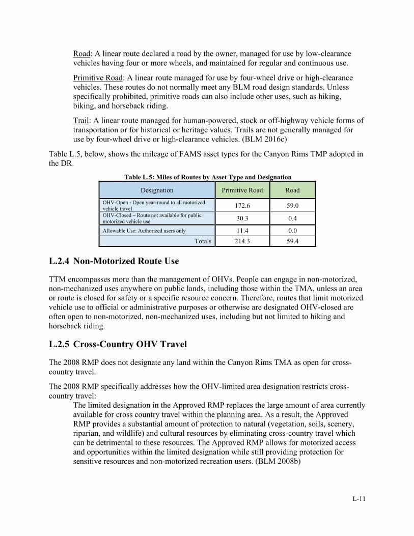
L-11
Road: A linear route declared a road by the owner, managed for use by low-clearance
vehicles having four or more wheels, and maintained for regular and continuous use.
Primitive Road: A linear route managed for use by four-wheel drive or high-clearance
vehicles. These routes do not normally meet any BLM road design standards. Unless
specifically prohibited, primitive roads can also include other uses, such as hiking,
biking, and horseback riding.
Trail: A linear route managed for human-powered, stock or off-highway vehicle forms of
transportation or for historical or heritage values. Trails are not generally managed for
use by four-wheel drive or high-clearance vehicles. (BLM 2016c)
Table L.5, below, shows the mileage of FAMS asset types for the Canyon Rims TMP adopted in
the DR.
Table L.5: Miles of Routes by Asset Type and Designation
Designation Primitive Road Road
OHV-Open - Open year-round to all motorized
vehicle travel 172.6 59.0
OHV-Closed – Route not available for public motorized vehicle use 30.3 0.4
Allowable Use: Authorized users only 11.4 0.0
Totals 214.3 59.4
L.2.4 Non-Motorized Route Use
TTM encompasses more than the management of OHVs. People can engage in non-motorized,
non-mechanized uses anywhere on public lands, including those within the TMA, unless an area
or route is closed for safety or a specific resource concern. Therefore, routes that limit motorized
vehicle use to official or administrative purposes or otherwise are designated OHV-closed are
often open to non-motorized, non-mechanized uses, including but not limited to hiking and
horseback riding.
L.2.5 Cross-Country OHV Travel
The 2008 RMP does not designate any land within the Canyon Rims TMA as open for cross-
country travel.
The 2008 RMP specifically addresses how the OHV-limited area designation restricts cross-
country travel:
The limited designation in the Approved RMP replaces the large amount of area currently
available for cross country travel within the planning area. As a result, the Approved
RMP provides a substantial amount of protection to natural (vegetation, soils, scenery,
riparian, and wildlife) and cultural resources by eliminating cross-country travel which
can be detrimental to these resources. The Approved RMP allows for motorized access
and opportunities within the limited designation while still providing protection for
sensitive resources and non-motorized recreation users. (BLM 2008b)
L-12
L.2.6 Public Land Access
Introduction
Access to and across BLM lands within the TMA is influenced by land tenure and various land-
use authorizations, such as rights-of-way (ROWs) for roads and utilities. Routes in the existing
transportation network which cross non-federal land or areas affected by special land-use
authorizations will continue to see use under current and foreseeable travel patterns, though their
public use is not legally ensured for the long-term. These routes constitute priorities for pursuing
legal access acquisition (or adjudicating existing access rights) across non-federal land to ensure
long-term access for the public and for the maintenance and operation of authorized uses. This
project's ePlanning page shows the TMP route network in relation to BLM surface ownership in
the TMA.
Access Routes and Lands from which Access Originates
Access to and within the TMA exists primarily from the Anticline and Needles Overlook roads,
which stem off U.S. Highway 191 on the TMA’s eastern border. The northern portions of the
TMA are accessed off the Looking Glass Rock road and Flat Iron Mesa road. The portion of the
TMA to the north of the Colorado River is primarily accessed from State Highway 279 (Potash
Road). In addition to these developed roads, many secondary routes provide access within the
TMA. Access to the TMA is primarily from BLM lands, though a few routes enter from private
and state lands. In areas where BLM-administered routes cross private lands, access into the
TMA from these routes is not ensured for the long-term, unless the BLM acquires legal
permission across these lands. TMP route designations do not apply to private lands and access
across private lands in the TMA is a concern for the public and for the BLM’s management of
adjacent public lands. The BLM may seek future easements from willing landowners to secure
long-term public access across these lands. To avoid new ground disturbance and impacts to
resources, the BLM typically prescribes use of existing roads in ROWs issued to access private
land.
Public Lands Access Guidance from the 2008 RMP
Table L.6, below, provide examples of some 2008 RMP goals, objectives, and management
decisions that are more directly related to public lands access than others. However, various 2008
RMP statements can relate to public access in some manner, and the lists in these tables are not
comprehensive. A complete list of lands and realty management statements can be found on
pages 115-122 of the 2008 RMP.
Table L.6: 2008 RMP Public Land Access-Related Goals, Objectives, and Management Decisions
Goals and Objectives
• Meet public needs for use authorizations such as rights-of-way (ROWs), alternative energy sources,
and permits while minimizing adverse impacts to resource values.
Management Decisions
LAR-3 Give land exchanges with the State of Utah priority consideration to resolve inholding issues.
LAR-4 Areas of Critical Environmental Concern (ACECs) will be avoidance areas for any new ROWs
(including communication sites and wind and solar sites).
LAR-8 As per the State of Utah v. Andrus, Oct. 1, 1979 (Cotter Decision), the BLM will grant the State of
Utah reasonable access to State lands for economic purposes, on a case-by-case basis.
L-13
L.3 IMPLEMENTATION
L.3.1 Introduction
This Guide’s primary purposes are to implement the designations in the adopted Canyon Rims
TMP and to create a management framework that allows for current and future needs of users
while ensuring the protection of resources and reducing or preventing user conflicts. The
implementation strategies in this section are designed to assist in achieving these purposes.
L.3.2 Implementation Strategy and Priorities
Priority of Implementation Actions
TMP implementation is staff- and funding-dependent and should be based on the strategies and
priorities discussed below. The implementation priorities are based on the BLM’s projected
ability to operate and maintain the designated travel network in a manner that may change TMA
conditions and influence visitor behavior to achieve desired conditions. Specific components of
TMP implementation are described in more detail elsewhere in this plan. This section provides
the reader with a sense of key implementation actions and when they could happen.
Monitoring, adaptive management, and budget limitations can affect the BLM’s implementation
priorities and timeline of completion. When selecting areas/routes for TMP implementation,
priorities will be assigned using the five factors listed below. The highest priority for
implementation will be given to areas/routes for which all five factors apply:
1. Would implementing the action maintain and enhance public safety?
2. Would the action be implemented in an area of high resource value (natural, cultural,
historic, biological, scientific, scenic, recreational, etc.)?
3. Does the area/route include habitat for special status species?
4. Does the area/route have above-average surface disturbance?
5. Does the action resolve significant community or administrative interface issues?
The primary implementation actions described below may be done concurrently, combined, or
conducted in the order in which they are funded. The BLM may attempt to complete
implementation in the order shown with heightened priority acknowledged for special emphasis
areas such as special designations, areas with sensitive resources, and areas of intensive use (see
Section L.1.2 for a listing of special emphasis areas in the TMA). The following list indicates the
BLM’s Canyon Rims TMP primary implementation actions and their general/current order of
priority:
1. Continue public education and outreach efforts. Develop and distribute public access
maps and informational brochures of the designated route network in print and electronic
(web-based) formats.
2. Sign the open route network to make open routes more apparent and attractive than
closed routes. Pursue funding for materials and staff needed to implement route and
transportation facility signing efforts.
3. Conduct an appropriate level of maintenance consistent with established maintenance
intensity levels on the designated transportation system.
L-14
4. Establish route closures and assess restoration needs based on inventory and monitoring.
Pursue funding for route closure and reclamation if necessary; then begin reclamation of
closed routes.
5. Establish or maintain partnerships with existing local groups and clubs and local, county,
State, and tribal government organizations. As needed and when possible, recruit and
train volunteers to establish monitoring patrols and place route markers to augment BLM
efforts.
6. Install informational kiosks and signs. Maintain and upgrade existing kiosk boards as
necessary.
7. Monitor compliance with the TMP route network designations, including the route
network markers.
8. Make changes to the route network and adjust management strategies as necessary.
Breaking down these primary implementation actions into a more refined schedule of individual
tasks serves to track implementation progress and achievement. Table L.7, below, provides a
refined task list with phased scheduling and task notes.
Table L.7: TMP Implementation Action Tasks and Scheduling
Phase Task Implementation Notes
Phase I
Assign a FAMS navigational identification
number to each route that is designated
open or limited.
Enter in FAMS. Update GIS database to
“crosswalk” with evaluation and
inventory numbers.
Phase I Develop and publish up-to-date, readily
available map of BLM travel route network.
This is the first step in the effort to
increase public knowledge of the travel
network and plans for its future. To be
cost-effective, maps may cover an area
larger than just TMA BLM lands.
Phase I Develop a signing plan and initiate an
outreach program. This can be done at the District level.
Phase I Pursue funding for outreach literature,
signs, and staff needed to implement the
route-marking effort.
Phase I
Establish databases and protocols for
collecting monitoring data. Identify initial
sites for resource monitoring.
Clear identification of the information
required would result in more effective
monitoring and data recording.
Phase I Prepare for initial signing of network.
As funding allows, this may include hiring
seasonal trail ranger(s) or contracting for
initial signing.
Phase I Sign the travel route network with route
markers and inventory maintenance and
restoration needs. Prioritize by area.
The principal goal is to make the open and
limited travel routes more attractive than
closed travel routes.
L-15
Phase Task Implementation Notes
Phase I
Set up partnerships with existing local
groups and clubs and local, county, State,
and tribal government organizations. As
needed/possible, recruit and train volunteers
to establish patrols and place route markers.
Greater public compliance with OHV
regulations may be achieved over time by
involving user groups for this task.
End of Phase I Monitor compliance with the TMP route
network. Publish an annual report online.
The report could include pictures of some
actions taken.
End of Phase I
Pursue funding for route reclamation.
Establish restoration priorities using data
from inventories and monitoring.
Phase II Take actions to reclaim “Closed and
Decommissioned” travel routes that
continue to receive vehicle traffic.
Timely reclamation of such routes would
reduce the potential for continued use of
those routes.
Phase II Update travel network maps and re-publish
as necessary.
All Phases of
Plan
Monitor and maintain the open route
network markers based on direction in this
guide’s sign plan.
Phase II or III Install bulletin boards/kiosks at primary
portals to public lands and where needed based
on monitoring.
Only install at non-portal sites if sites that
require additional visitor information have
been identified through monitoring.
Phase III Explore options for completing a visitor
survey for each TMA.
Funding Strategy
The BLM will seek adequate funding to manage and maintain the TMA’s route network.
Funding will be needed for labor and supplies to provide law enforcement, recreation and visitor
services, outreach programs, the restoration and decommissioning of closed routes, and
maintenance and operational costs (supplies, materials, tools, equipment, vehicles,
communications, etc.). Operational and monitoring funding for cultural resources protection,
wildlife surveys, transportation system maintenance, and related costs should be determined on
an ongoing project basis and planned annually.
L.3.3 Education and Outreach
Introduction
Public education and outreach are important priorities in implementing the TMP. Successful
implementation includes providing the public with information about route designations, laws
and regulations, land use ethics, safety notices, and resource values that may be affected by
travel and transportation on public lands. Interpretive media will be distributed through news
L-16
releases, traditional brochures and guides, travel maps, informational signage, social media sites,
electronic media from BLM websites, and other means. Educational efforts will be coordinated
with adjacent land managers to minimize user confusion and present a seamless message to the
public across different land jurisdictions and media outlets.
Objectives
The main education objectives for the Canyon Rims TMP include attaining voluntary
compliance with route designations and closures and reducing conflicts among public land users.
Ensuring compliance with route designations will promote the safety of public land users,
facilitate resource protection by discouraging the proliferation of unauthorized routes, and help
achieve other identified objectives.
The outreach initiative will promote respect for public, private, and state trust land by providing
information on access to public lands, encouraging users to obtain permission from landowners if
traveling across private or state trust lands, and by specifying where to get additional information
and maps. Target messages or themes for this educational effort include:
• Public lands provide diverse recreational opportunities enjoyed by various users.
• Restricting travel to designated travel routes protects resources and public access.
• Tread Lightly! (www.treadlightly.org)/Leave No Trace (www.lnt.org) outdoor ethics
• Share the trail (https://www.imba.com/ride/imba-rules-of-the-trail).
• Respect other users of public land and the rights of private landowners.
• Prevent wildfires.
• Practice OHV ethics and safety.
• Prevent the spread of invasive species.
Outreach Strategies
Effective communication with the public requires clear, concise messaging. This can be
accomplished through direct and indirect public contact and through physical and virtual means.
Though not exhaustive, the following list outlines potential targeted methods of communication:
• Kiosks and interpretive signage
• Visitor center displays
• In-person public presentations
• Paper and electronic format maps available to the public
o General visitor map of designated route network (must follow mapping standards
of the BLM’s Publication Standards Manual Handbook [H-1553]).
o Special area maps
• Website/electronic media
o Georeferenced PDF maps for viewing on portable electronic devices
o ArcGIS Online map server
o Google Earth KML/KMZ files
o Universal GPS files (GPX) for use with GPS units
o GPS-compatible route and basemap data loaded on memory cards for sale online
and/or at appropriate BLM offices and visitor centers
• Social Media
L-17
Signs are one of the most visible mediums used to convey information about the BLM and are
often the only formal contact the public has with the BLM. Appropriate, consistent signing that
conforms to national standards will help ensure a safe and enjoyable visit to public lands. For
more specifics on signing, see this guide’s sign plan (Section L.3.4).
Maps and other information relating to the travel and transportation network will be available to
the public at a future date in paper and electronic form at visitor centers, on BLM websites, and
displayed on informational kiosks throughout the TMA. The BLM will expand and improve
educational efforts to foster responsible land-use ethics among different user groups by
leveraging interpretive resources from recognized national organizations such as Tread Lightly!
Inc. and Leave No Trace, both of which have signed National Memoranda of Understanding with
the BLM. Educational materials will also include information on the impacts that inappropriate
visitor behavior has on TMA resources or other resource uses. The BLM will incorporate
information about public land values and user ethics into the terms and conditions of permits and
land-use authorizations to reach a wider audience.
Partnerships
To achieve travel management implementation objectives, the BLM will seek to develop and
maintain partnerships with a broad range of local, county, State, tribal, and federal agencies, as
well as service-oriented volunteers, schools, and non-governmental organizations.
Partnerships enhance opportunities for community involvement in travel management
implementation. Official partnerships may be established through agreements including
memoranda of understanding, cooperative agreements, assistance agreements, landowner
agreements, letters of agreement, and other types of documents for contributed goods and
services.
L.3.4 Sign Plan
Signing is a key element in implementing comprehensive travel and transportation plans on the
ground. The BLM will apply discretion and professional judgment to select the best signing
methods for each situation using the guidance set forth in the Sign Plan BMPs, Appendix L-F. ,
and may develop more detailed, area-specific plans as needed. The sign component of this guide
is intentionally broad in scope. Rather than addressing specific sign needs, requirements, or
locations, it establishes sign standards and guidelines for implementation and management of
TMP objectives. This is not a static implementation plan; it may be modified as new signing
needs are identified. Additional details for signs on BLM lands (installation, ordering, etc.) can
be found in the BLM’s 2016 National Sign Handbook (BLM 2016b) and the Federal Highway
Administration’s Manual on Uniform Traffic Control Devices, which is also known as the
MUTCD (FHWA 2019).
L.3.5 Maintenance and Engineering
Overview
This section covers maintenance and engineering considerations for the TMA route network. The
“Route-by-Route Details” list presented in Appendix L-E. shows the maintenance and
engineering-related details for routes in the network at the time the TMP is approved. These
L-18
routes will be added to the Ground Transportation Linear Feature (GTLF) dataset, which is the
most up-to-date dataset for Utah BLM, and updates in the route network in GTLF will serve as
updates to the TMP.
The routes will also be included in the Facility Asset Management System (FAMS). Each route
will have a FAMS route number, a primary route management objective, a functional
classification, a FAMS asset type, maintenance intensity, FAMS inclusion/nomination status,
and FLTP and FLAP eligibility status. More details on these implementation data types are
provided later in this section.
Route maintenance on BLM lands can include general grading and shaping of route surfaces,
maintenance and installation of water control structures, placement of gravel surfacing, washout
repairs or realignment, etc. The BLM will maintain roads on public lands in the TMA as
specified by maintenance intensities, and condition assessment developed and conducted in
accordance with the following BLM roads manual and handbooks policies:
• MS 9113 - Roads (BLM 2015a)
• H-9113-2 Roads Inventory and Condition Assessment Guidance & Instructions (2015b)
• H-9115-2 Primitive Roads Inventory and Condition Assessment Guidance &
Instructions (BLM 2012c)
The conditions and use levels of routes determine what maintenance intensities they receive.
Route conditions, design standards, and guidelines are based on average daily traffic, functional
classifications, and terrain. Changes to the transportation network (e.g., new routes, re-routes, or
closures) in the TMA are made through project-level planning with site-specific review as
appropriate under applicable laws.
Maintenance efforts will focus on sustaining navigability for designated routes in the travel
network without substantially changing the recreational experience that individual routes
provide. In addition to the BLM, authorized users (e.g., miners, grazing permittees, and utility
maintenance crews) have performed intermittent maintenance on roads in the past. Various
agreements exist between the BLM and these authorized users to allow them to perform
emergency spot maintenance on a case-by-case basis to restore access for authorized activities. A
current route maintenance MOU exists between the Moab FO and San Juan County and is
expected to remain in place in the future. No matter who performs the work, the top priorities for
route maintenance are public safety, protection and/or enhancement of resources, achieving route
standards, and ensuring consistency with route designation decisions.
Engineering Interface
This section describes the interface with the BLM Engineering program as an ongoing
component of travel management planning and implementation. The components described
below may only be fully attributed or documented as time and resources allow.
Routes in the Facility Asset Management System (FAMS)
The FAMS is the BLM’s official database for the management of transportation system assets
and facilities and plays a vital role in planning for the management and stewardship of BLM
assets. All appropriate designated roads, primitive roads, and trails within the travel network
addressed in this TMP are classified as transportation assets in the FAMS and will be tracked in
the FAMS as well as the Ground Transportation Linear Feature (GTLF) geospatial database.

L-19
Routes in the Federal Lands Transportation Program (FLTP)
The BLM project lead will coordinate with BLM engineering staff to determine which routes are
eligible for FLTP status. FLTP-eligible routes are:
• Owned and maintained by the federal government
• Important and highly valued by the BLM
• Located on, adjacent to, or provide access to federal lands
• Included in the national Federal Lands Transportation Facilities (FLTF) inventory
Routes in the FLTP provide access to high-use recreation locations and federal economic
generators. Documenting FLTP eligibility for FLTP funding is a requirement for travel
management plans (TMPs) in the 2016 BLM travel management manual (BLM 2016c).
Route Functional Classifications
The BLM uses three functional classifications (collector, local, and resource) to categorize its
roads.3 These classifications reflect the area served, type and volume of traffic, and maintenance
standards. These classifications are described in the subsections below, with text taken from the
BLM roads manual (BLM 2015a):
Collector Roads: “These BLM roads normally provide primary access to large blocks of
land and connect with or are extensions of a public road system. Collector roads
accommodate mixed traffic and serve many uses. They generally receive the highest
volume of traffic of all the roads in the Bureau system. User cost, safety, comfort, and
travel time are primary road management considerations. Collector roads usually require
application of the highest standards used by the Bureau. As a result, they have the
potential for creating substantial environmental impacts and often require complex
mitigation procedures.”
Local Roads: “These BLM roads normally serve a smaller area than collectors and
connect to collectors or public road systems. Local roads receive lower volumes, carry
fewer traffic types, and generally serve fewer uses. User cost, comfort, and travel time are
secondary to construction and maintenance cost considerations. Low volume local roads
in mountainous terrain, where operating speed is reduced by effect of terrain, may be
single lane roads with turnouts. Environmental impacts are reduced as steeper grades,
sharper curves, and lower design speeds than would be permissible on collector roads are
allowable.”
Resource Roads: “These BLM roads normally are spur roads that provide point access
and connect to local or collector roads. They carry very low volume and accommodate
only one or two types of use. Use restrictions are applied to prevent conflicts between
users needing the road and users attracted to the road. The location and design of these
roads are governed by environmental compatibility and minimizing Bureau [BLM] costs,
with minimal consideration for user cost, comfort, or travel time.”
Primary Route Management Objectives
3 Not all routes are considered “roads” in the context of BLM travel management. For example, a trail is a route but
not a road. Therefore, functional classifications only pertain to roads and primitive roads. Most of the BLM-
managed routes in the TMA function as resource roads.
L-20
The primary route management objective for each route influences the type of maintenance and
engineering to be applied to it. The BLM’s GTLF guidelines state that the primary route
management objective is “the BLM’s reason for the route. [It] summarizes multiple reasons into
a single presentable statement” (BLM 2014d). Primary route management objectives “should
reflect management area direction, including desired future conditions, uses, recreational
outcomes and settings, as well as TMP objectives” (BLM 2016c). The BLM’s GTLF guidelines
(BLM 2014d notes three possible individual route management objectives:
• Access - Access to specific location for specific task/project.
• Connectivity - Primary objective is travel between 2+ other routes.
• Experience - Primary objective is to provide for recreational experience.
Engineering and Maintenance Best Management Practices (BMPs) and Standard
Operating Procedures (SOPs)
The following engineering-specific BMPs and SOPs will be applied in the TMA:
Best Management Practices
• Road Drainage
o Provide adequate drainage from the surface of all roads by using out sloped or
crowned roads, drain dips, or in sloped roads with ditches and cross-drains or
relief culverts.
o Vary road grades to reduce concentrated flow in ditches and culverts and on fill
slopes and road surfaces.
o Size drainage structures appropriately to handle anticipated flow during normal
runoff or storms.
o Locate relief culverts or roadside ditches to prevent fill erosion or direct discharge
of sediment into streams.
o Prevent cross drains, culverts, water bars, dips, and other drainage structures from
discharging onto erodible soils or fill slopes without outfall protection.
o Plan natural road cross-drainage by in-sloping and using relief culverts or out-
sloping and by grade changes. Plan for effective and proper spacing for dips or
water bars based on road grades and soil erosion potential.
o Design roads for minimal disruption of drainage patterns.
• Road Maintenance
o Maintain erosion control features through periodic inspection and maintenance,
including cleaning drainage dips and cross-drains, repairing ditches, marking
culvert inlets to aid in location, and clearing debris from catch basins and culverts.
o Avoid using roads during wet periods if such use would damage the road surface
(i.e., cause rutting) and impact drainage features (i.e., breach drain dips).
o Grade road surfaces only as often as necessary to maintain a stable running
surface and effective surface drainage.
o Conduct spot maintenance on primitive roads to correct safety issues, conserve
resources, or to maintain desired recreation experiences. In most cases, grading
the full length of primitive roads is not required or desired.
o Route maintenance will occur within the route prism.
• Design features for Threatened and Endangered species and BLM Sensitive plant
habitat

L-21
o All efforts will be made to avoid disturbance in potential habitat areas.
o Maintenance activities will occur outside the flowering period.
o Dust will be suppressed using water.
o If disturbance outside the existing travel surface is required for maintenance
activities, then surveys will be conducted within suitable habitat. If plants are
located, then appropriate consultation with FWS will be initiated.
• General
o Ensure that road specifications and plans are consistent with good safety
practices.
o Design, construction, and maintenance of roads, primitive roads, and trails should
comply with guidelines identified in the BLM roads manual (BLM 2015a), the
BLM primitive roads manual (BLM 2012d), the U.S. Forest Service’s Trail
Construction and Maintenance Notebook (USFS 2007), Guidelines for a Quality
Trail Experience: Mountain Bike Trail Guidelines (BLM and IMBA 2017), and
the National Off-Highway Vehicle Conservation Council’s Great Trails resource
guide (NOHVCC 2015).
o Emphasize the use of existing roads (through continued use or reconstruction) to
minimize new road construction.
o Adapt plans to the soils and terrain to minimize disturbance and damage to soil
productivity, vegetation, water quality, and wildlife habitat.
o Implement mitigation techniques when designing and implementing the route
system.
Standard Operating Procedures
• Standards and guidelines shall be followed per BLM Manuals 9113 (BLM 2015a),
9114, and 9115 (BLM 2012d) for BLM road, trail and primitive road maintenance, new
construction, or reconstruction.
• The standards and guidelines for primitive roads shall be based on the functional
requirements of the various types of recreational motorized users.
• The BLM should not develop, endorse or publish road or trail ratings. The BLM will
describe the physical aspects of a road, primitive road, trail, or recreation site as
necessary to avoid visitor inconvenience and align visitor expectations with existing
conditions.
• Maintenance will be completed only to the identified maintenance intensity level in
support of resource protection, delivery of services to the public, and public safety.
• Maintenance standards for each designated route will be documented, and route
modifications will be identified and recommended if necessary.
• Maintenance of routes may be done to minimize soil erosion and other resource
degradation. This maintenance will be done on a case-by-case basis, depending upon
annual maintenance funding and available resources.
• Once the number and type of barriers is determined, maintenance procedures for
physical barriers will be developed and tracked manually or systematically by a system
such as the FAMS.
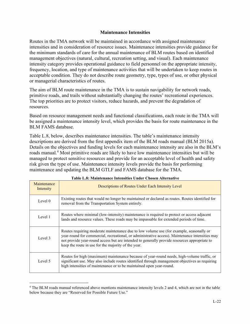
L-22
Maintenance Intensities
Routes in the TMA network will be maintained in accordance with assigned maintenance
intensities and in consideration of resource issues. Maintenance intensities provide guidance for
the minimum standards of care for the annual maintenance of BLM routes based on identified
management objectives (natural, cultural, recreation setting, and visual). Each maintenance
intensity category provides operational guidance to field personnel on the appropriate intensity,
frequency, location, and type of maintenance activities that will be undertaken to keep routes in
acceptable condition. They do not describe route geometry, type, types of use, or other physical
or managerial characteristics of routes.
The aim of BLM route maintenance in the TMA is to sustain navigability for network roads,
primitive roads, and trails without substantially changing the routes’ recreational experiences.
The top priorities are to protect visitors, reduce hazards, and prevent the degradation of
resources.
Based on resource management needs and functional classifications, each route in the TMA will
be assigned a maintenance intensity level, which provides the basis for route maintenance in the
BLM FAMS database.
Table L.8, below, describes maintenance intensities. The table’s maintenance intensity
descriptions are derived from the first appendix item of the BLM roads manual (BLM 2015a).
Details on the objectives and funding levels for each maintenance intensity are also in the BLM’s
roads manual.4 Most primitive roads are likely to have low maintenance intensities but will be
managed to protect sensitive resources and provide for an acceptable level of health and safety
risk given the type of use. Maintenance intensity levels provide the basis for performing
maintenance and updating the BLM GTLF and FAMS database for the TMA.
Table L.8: Maintenance Intensities Under Chosen Alternative
Maintenance
Intensity Descriptions of Routes Under Each Intensity Level
Level 0 Existing routes that would no longer be maintained or declared as routes. Routes identified for
removal from the Transportation System entirely.
Level 1 Routes where minimal (low-intensity) maintenance is required to protect or access adjacent
lands and resource values. These roads may be impassable for extended periods of time.
Level 3
Routes requiring moderate maintenance due to low volume use (for example, seasonally or
year-round for commercial, recreational, or administrative access). Maintenance intensities may
not provide year-round access but are intended to generally provide resources appropriate to
keep the route in use for the majority of the year.
Level 5
Routes for high (maximum) maintenance because of year-round needs, high-volume traffic, or
significant use. May also include routes identified through management objectives as requiring
high intensities of maintenance or to be maintained open year-round.
4 The BLM roads manual referenced above mentions maintenance intensity levels 2 and 4, which are not in the table
below because they are “Reserved for Possible Future Use.”
L-23
Upgrading a road’s surface, width, or permanently raising the maintenance intensity level on a
specific route may change the network, and therefore may trigger the need to determine if
additional environmental analysis is required.
Transportation Facilities
This TMP does not identify specific network-related facilities that may need improvement or
development. Such proposed improvements or development would be addressed in specific
activity-level or project-level proposals and be subject to site-specific analysis under the NEPA.
Examples of such proposed improvements or development include campsites, staging areas,
protective fencing, barriers, information kiosks, administrative gates, trailheads, and non-
motorized trails. Once completed, these improvements or developments would be incorporated
into this TMP and considered part of the travel network.
New Route Development
The addition of new routes is part of the operation and management of the overall travel
network. New route development may be appropriate, depending on the situation. For example,
resource protection or administrative concerns might necessitate the relocation of an existing
route. The BLM or members of the public might request new routes to improve or enhance
access or experiences (e.g., creating a travel loop). Engineering staff will be involved early in the
process of planning, locating, designing, constructing, and choosing and applying BMPs
associated with new routes. New routes and changes to the network will require an appropriate
level of NEPA review.
New routes may be proposed through site-specific project plans, permits, or ROW requests. The
route evaluation process and NEPA review (both of which may be done concurrently) must
occur prior to the implementation or construction of a new route. If authorized, new routes and
any associated ROWs would become part of the designated transportation system; closed routes
would be removed from the transportation system. The BLM’s travel management manual (BLM
2016c) provides broad guidelines on how to appropriately add new routes to a BLM travel
network.
All new roads, primitive roads, and trails shall meet the standards for design, construction, and
maintenance found in BLM manuals and handbooks (e.g., “Appendix 8: Trail Planning and
Standards” in the BLM Travel and Transportation Management Handbook (BLM 2012a)).
Among other guidance, all new TMA routes shall meet the standards for design, construction,
and maintenance found in the BLM’s Roads Design Handbook (BLM 2011) and Primitive Roads
Design Handbook (2012b). Such guidance provides details on specifics such as degree of
curvature, sight distance, alignment, etc.
Route Relocation and Realignment
Route widening, realignments, or travel surface upgrades can occur if:
• Appropriately addressed by a project-level TMP EA or other NEPA.
• Needed to achieve route standards or management objectives.
• Needed for public safety.
• Done in accordance with TMA route maintenance and construction standards.
L-24
Processing of Proposed Route Changes
The process of adding new routes (OHV) or adding administrative routes to the designated route
network and implementing other route changes require appropriate NEPA review. All proposed
route changes could be processed as follows:
• Route locations will, at a minimum, be mapped or located using accepted GPS devices
and presented to the BLM (if proposed by a third party) for consideration. Locations of
route proposals off designated OHV routes will be documented and mapped using non-
OHV methods. The proposed location will be staked and flagged or otherwise identified
for on-the-ground review by resource specialists. The BLM may require that a licensed
surveyor provide a cadastral survey (to be reviewed by a BLM cadastral surveyor) of a
route prior to issuance of a ROW authorization.
• Route proposals submitted to the BLM shall include a description of the route
(including its proposed width), its proposed use(s) (including expected traffic and
design vehicle), and rationale for its need.
• The route location shall be analyzed for potential conflicts, such as (but not limited to):
wildlife habitat and movement, adverse effects to NRHP-eligible cultural resources,
visual resources, other recreation uses, mining claims or leases, grazing facilities,
ROWs, public safety, and proximity to other jurisdictions (such as private land). A
structured process will be used to evaluate and document potential route conditions.
• The conflict assessment may lead to development of mitigation actions or alternative
locations or designs.
• NEPA review will be conducted to determine the environmental effects of the proposed
route, any reasonable alternatives, and recommended mitigation.
• A decision will be issued by the field manager based on 2008 RMP conformance,
resource objectives, and environmental impacts.
• If the decision is to approve the addition of the route, this TMP will be updated
accordingly.
L.3.6 Enforcement
Overview
Law enforcement coverage in the TMA is currently provided by BLM law enforcement and local
sheriff and/or police departments. The BLM maintains the authority to temporarily, permanently,
partially, or completely suspend any activity based on safety issues or unacceptable resource
impacts. Enforcement actions typically occur in response to complaints, and patrols are
conducted on a periodic basis, depending on other priorities. Typical law enforcement concerns
related to public use in the TMA include route proliferation, dumping, vandalism, theft of
government property, littering, interfering with livestock operations, medical emergencies,
search-and-rescue operations, illegal removal of natural resources, unauthorized cross-country
OHV use, firearms violations, and driving under the influence of alcohol or drugs. State vehicle
laws will be applied to OHV use where applicable. The following measures are key to effective
law enforcement in the TMA:
• Provide for a regular and systematic presence of BLM and partner agency law
enforcement.
• Expand and maintain interagency cooperation.
L-25
• Increase public education efforts to promote awareness of and voluntary compliance
with use restrictions and regulations through information posted on handouts, kiosks,
and websites, etc.
• Prioritize the use of limited law enforcement resources to the greatest effect:
o Concentrate law enforcement efforts during high-use periods such as weekends
and holidays.
o Focus targeted enforcement in the highest-use areas.
• Support volunteer efforts to educate the public on rules and proper land use etiquette,
such as NGOs leading Leave No Trace seminars.
Regulations to be Enforced
The public land regulations described in 43 CFR 8340 (GPO 2016), 43 CFR 8360 (GPO 2009a),
and 43 CFR 9268.3 (GPO 2001) will be enforced to implement travel management and route
designations within the TMA. These regulations will be enforced by BLM law enforcement
officers to protect public safety and resources. They may be supplemented as deemed necessary
by Supplementary Rules, which may be established pursuant 43 CFR 8360 under a separate
action to implement use restrictions identified in RMP decisions. State of Utah motor vehicle
laws and regulations, including OHV regulations, apply on BLM-administered lands in the TMA
and will continue to be enforced.
Patrols
In addition to responding to complaints, emergency situations, and where monitoring has found
user conflicts or resource concerns, BLM law enforcement officers and field staff will focus
patrols to detect and deter ongoing and potential future illegal activity, check compliance with
route designations, and educate visitors about BLM, state, and federal laws and regulations.
During regular patrols, law enforcement officers and field staff will document observed OHV
impacts to resources as appropriate or as a general component of monitoring. Routine, highly
visible patrols by BLM staff will also help to maintain an effective authoritative presence in the
field.
Personnel from partner agencies, such as the Utah Division of Wildlife Resources (UDWR), San
Juan County Sheriff’s Department, and the Utah Highway Patrol may also assist BLM staff with
law enforcement duties on BLM-administered lands in the TMA. Local police departments may
patrol in wildland-urban interface areas. Coordinated interagency efforts may be undertaken to
provide an official presence during times of peak use or to supplement ongoing resource
protection-related operations.
L.3.7 Supplementary Rules
Supplementary rules can be established where current regulations (including route designations)
do not provide adequate public safety or resource protection. See 43 CFR 8365.1-6 (GPO 2009b)
for the supplementary rulemaking process. Speed limits would be an example of supplementary
rules drafted and applied within the TMA.
L-26
L.4 LONG-TERM MONITORING PROTOCOL FOR OHV IMPACTS
AND OTHER ITEMS
L.4.1 Overview
Introduction and Purpose of Monitoring
Monitoring is an important component of successful TMP implementation. Monitoring efforts
will help determine the effectiveness of route management and inform the BLM on route use-
related issues that may need to be addressed. The EA identified a number of important resource
and use issues at the heart of the BLM’s commitment to provide for multiple land uses while
protecting sensitive cultural and natural resources. The following issues are of particular
importance to the TMA:
• Impacts of OHV travel on known cultural resource sites
• Soil erosion and its resulting impacts on vegetation
• OHV-related disturbances of special status species plant habitat
• OHV-related disturbances on special status species wildlife habitat
• Impacts from OHV travel on the defining characteristics of lands with wilderness
characteristics and other special management area designations
• User conflicts within the TMA
• Route proliferation within the TMA
As required in 43 CFR 8342.3 (“Designation changes”), “The authorized officer shall monitor
effects of the use of off-road vehicles. Based on information so obtained, and whenever the
authorized officer deems it necessary to carry out the objectives of this part, designations may be
amended, revised, revoked, or other actions taken pursuant to the regulations in this part” (GPO
2016). In the broadest sense, monitoring helps to determine if adequate progress is being made
toward management objectives. Among other things, this means that the monitoring program
will be used to determine:
• If resource protection and resource use objectives are being met.
• Visitor satisfaction.
• Use patterns and volumes.
• Condition of roads and trails, the condition of public use areas, and compliance with
route designations and use restrictions.
• Effectiveness of cross-jurisdictional enforcement.
Additional monitoring information and materials can be found in Appendix L-B. . Monitoring
Support Materials.
Where to Find Monitoring Guidance
Monitoring requirements can be found in the Biological Opinion, Historic Properties Treatment
Plan (HPTP), and specific route evaluation reports. Additional monitoring will occur as part of
ongoing monitoring and other resource monitoring (such as wilderness monitoring, lands with
wilderness character inventory, visual resource inventory, sensitive species monitoring, range
management monitoring, new project site consideration etc.). As noted in Section 0 the BLM
will compile specific monitoring requirements from the Biological Opinion, HPTP, and specific
L-27
route evaluation reports into a checklist so that those monitoring requirements can be tracked and
documented.
Who Conducts Monitoring
An effective monitoring program is dependent on establishing a cadre of monitoring personnel
who work with the BLM to report issues or concerns that they encounter while performing their
normal daily activities. Monitoring may be conducted by BLM staff, UDWR personnel,
commercial Special Recreation Permit (SRP) holders, grazing permittees, and other partners as
approved or authorized by the BLM.
Baseline Monitoring Data
In compliance with the 2017 Settlement Agreement, the Moab FO assembled the Canyon Rims
Travel Management Plan Baseline Monitoring Report (BLM 2019). This report can be found on
this project’s ePlanning page.
Assembling this report involved collecting information on visually apparent unauthorized surface
disturbances off routes as well as visually apparent damage to public lands resources caused by
OHV use within lands with BLM-inventoried wilderness characteristics. The baseline
monitoring data was used to help inform route decisions within the TMP. See Appendix L-B. for
more details on baseline monitoring report requirements associated with the 2017 Settlement
Agreement.
L.4.2 Types of Monitoring
Introduction
There are three basic types of monitoring detailed in this guide: implementation, effectiveness,
and resource monitoring. Implementation and effectiveness monitoring assess the effectiveness
of management actions. Resource monitoring documents how various indicators of resource
health change over time.
Implementation Monitoring
Implementation monitoring is the most basic type of monitoring, and simply determines whether
management actions in the TMP have been implemented in the manners prescribed by the
applicable planning documents. Implementation monitoring documents the BLM’s progress
toward full implementation of land use plan (i.e., 2008 RMP) decisions. There are no specific
thresholds or indicators required for this type of monitoring.
Effectiveness Monitoring
Effectiveness monitoring is used to determine if TMP implementation activities have achieved
2008 RMP goals and objectives. Effectiveness monitoring results are used to evaluate
implementation progress and the effectiveness of the TMP in achieving desired outcomes and
conditions. If adverse impacts are discovered, effectiveness monitoring results will also be used
to identify adaptive management measures. Effectiveness monitoring will evaluate route
conditions, public safety issues, and changes in visitor use patterns and preferences.
Effectiveness monitoring may also quantify OHV user compliance.
L-28
Effectiveness monitoring asks the following question: Was an activity successful in achieving its
objective? Effectiveness monitoring requires knowledge of the objectives established in the 2008
RMP as well as indicators that can be measured. To see the 2008 RMP’s travel management-
related goals, objectives, and management decisions, see Appendix L-A. of this guide.
Indicators are established by technical specialists to address specific questions and avoid
unnecessary data collection. Effectiveness is measured against the benchmark of achieving the
goals and objectives established by the 2008 RMP, which may include regulated standards for
resources. Effectiveness monitoring for the route network will be conducted by staff, volunteers,
users, and partners as time and funding permit; it may include the following elements:
• Visually document implementation or establishment of closure practices (signs, gates,
berms, rocks, etc.) or road decommissioning practices and monitor effectiveness of
closure. Establish photo-monitoring points to monitor long-term effectiveness of
closing/decommissioning routes.
• Determine the level of OHV use across the landscape using trail counters and aerial
photos over time. Traffic counters may be employed to determine levels of use on
selected routes.
• Identify route proliferation, unauthorized route creation, route conditions, recreation
conflicts, and resource damage compared to baseline monitoring. Measure illegal off-
trail and off-road travel as linear disturbances or as area impacts, depending on the level
and type of use that occurs.
• Monitor litter/trash.
• Monitor reclamation project success.
• Initiate and maintain collaborative partnerships among government agencies, local
governments, business communities, volunteers, user groups, stakeholders, educational
institutions, individuals, and the private sector to achieve recreation management
objectives through BLM-developed monitoring techniques.
• Quantify OHV user compliance and evaluate route conditions, public safety, and
changes in visitor preferences and use patterns. It may also help to identify adaptive
measures as adverse impacts are discovered.
• Administer a survey on recreation demand, preferences, uses, satisfaction, and
information needs in the TMA. This should be done as soon as possible, and maps
updated periodically. Work with partners such as universities and user groups to
conduct the surveys. Base specific schedule of surveys on TMA conditions and
available resources.
• Acquire visitor feedback to monitor whether TMA BLM lands have been clearly
mapped and signed for the public. This could be done as part of the survey efforts
described above.
• Consider information from recreational groups, records of field contacts, written trail
register comments, and public phone calls to the Moab FO as part of monitoring the
effectiveness of travel management in reducing conflict between different types of
users.
• Monitor signing effectiveness through field visits and consideration of amounts of
maintenance required.
• Assess primitive road and trail conditions.
L-29
• Assess indicators of potential recreation impact issues (e.g., number of new bare soil
areas attributable to visitor use, number of campfire pits, additional litter or trash along
primitive roads, etc.).
Resource Monitoring
Resource monitoring documents how implementation of the TMP influences natural resources
over time. Validating management actions’ effects on natural resources is more complex than
determining the result of compliance or effectiveness monitoring.
Resource monitoring will be adaptive- monitoring protocols or techniques may be adjusted as
new methods are developed or if it is discovered that current monitoring is not meeting
management information needs. Routes with “Open with Management” or “Limited with
Management” designations have monitoring specified for various resources, and those resource
monitoring protocols will be implemented (subject to funding and available resources) on or
along those specific routes. Resource monitoring may be accomplished through standard field
office protocols in accordance with the 2008 RMP (see below).
TMA-Specific Monitoring
Appendix E in the 2008 RMP includes specific monitoring guidelines applicable to various
resources/uses. Although various resources/uses could somehow be impacted by travel
management, these guidelines include specific methodologies for OHVs, travel and
transportation management, and recreation (see table below).
Table L.9: 2008 RMP Travel Management-Related Monitoring Methodologies
Resource Suggested Monitoring and Methodology
Travel
Management
Travel management and OHV use monitoring within the planning area will focus on compliance
with specific route and area designations and restrictions with primary emphasis on those routes
or areas causing the highest levels of user conflicts or adverse impacts to resources. Monitoring
will focus on the travel designation requirement that all motor vehicles remain on designated
routes.
Monitor the effect of the use of off-road vehicles. On the basis of information so obtained, and
whenever necessary, the designations may be amended, revised, revoked, or other action taken.
Modifications to the route system in the Approved RMP will not be considered until
implementation of the travel portion of the plan has been substantially completed which
includes mapping, signing, monitoring, and evaluation. The process for considering route
modifications will be detailed in the Implementation Plan developed for the RMP after
completion of the ROD.
BLM could impose limitations on types of vehicle allowed on specific designated routes if
monitoring indicates that a particular type of vehicle is causing disturbance to the soil, wildlife,
wildlife habitat, cultural or vegetative resources, especially by off-road travel in an area that is
limited to designated roads.
The RMP must include indicators to guide future plan maintenance, amendments, or revisions
related to OHV area designations or the approved road and trail system within "Limited" areas.
Indicators could include results of monitoring data, new information, or changed circumstances
(IM 04-005). Actual route designations within the "Limited" category can be modified without
completing a plan amendment, although NEPA compliance is still required.
Resource Suggested Monitoring and Methodology
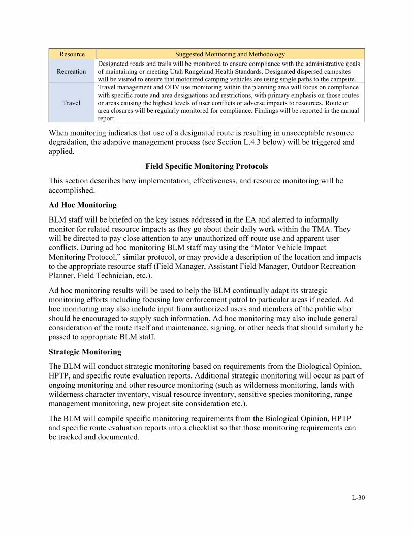
L-30
Resource Suggested Monitoring and Methodology
Recreation
Designated roads and trails will be monitored to ensure compliance with the administrative goals
of maintaining or meeting Utah Rangeland Health Standards. Designated dispersed campsites
will be visited to ensure that motorized camping vehicles are using single paths to the campsite.
Travel
Travel management and OHV use monitoring within the planning area will focus on compliance
with specific route and area designations and restrictions, with primary emphasis on those routes
or areas causing the highest levels of user conflicts or adverse impacts to resources. Route or
area closures will be regularly monitored for compliance. Findings will be reported in the annual
report.
When monitoring indicates that use of a designated route is resulting in unacceptable resource
degradation, the adaptive management process (see Section L.4.3 below) will be triggered and
applied.
Field Specific Monitoring Protocols
This section describes how implementation, effectiveness, and resource monitoring will be
accomplished.
Ad Hoc Monitoring
BLM staff will be briefed on the key issues addressed in the EA and alerted to informally
monitor for related resource impacts as they go about their daily work within the TMA. They
will be directed to pay close attention to any unauthorized off-route use and apparent user
conflicts. During ad hoc monitoring BLM staff may using the “Motor Vehicle Impact
Monitoring Protocol,” similar protocol, or may provide a description of the location and impacts
to the appropriate resource staff (Field Manager, Assistant Field Manager, Outdoor Recreation
Planner, Field Technician, etc.).
Ad hoc monitoring results will be used to help the BLM continually adapt its strategic
monitoring efforts including focusing law enforcement patrol to particular areas if needed. Ad
hoc monitoring may also include input from authorized users and members of the public who
should be encouraged to supply such information. Ad hoc monitoring may also include general
consideration of the route itself and maintenance, signing, or other needs that should similarly be
passed to appropriate BLM staff.
Strategic Monitoring
The BLM will conduct strategic monitoring based on requirements from the Biological Opinion,
HPTP, and specific route evaluation reports. Additional strategic monitoring will occur as part of
ongoing monitoring and other resource monitoring (such as wilderness monitoring, lands with
wilderness character inventory, visual resource inventory, sensitive species monitoring, range
management monitoring, new project site consideration etc.).
The BLM will compile specific monitoring requirements from the Biological Opinion, HPTP
and specific route evaluation reports into a checklist so that those monitoring requirements can
be tracked and documented.
L-31
L.4.3 Adaptive Management
Overview of Adaptive Management
Adaptive management is “a tool designed after the scientific research process. . . [It] requires a
measurable objective, monitoring to determine the effectiveness of the management practices in
achieving the objective, evaluation to determine if the objective is being reached, and adaptation
based on the results” (BLM 2014a). A similar definition is found in 43 CFR 46.30 (GPO 2011).
In adaptive management, problems are assessed, designs are formulated to address problems, and
then designs are implemented. During and after implementation, the BLM conducts monitoring,
gathers and evaluates data, and adjusts management based on new findings. However, new
problems could arise, or new approaches might be tried after management is adjusted, which
could start the cycle over again. Figure L.1, below, shows the cycle of adaptive management.
Figure L.1: Adaptive Management Cycle
Implementing Adaptive Management in the TMA
Some designated routes in the TMA are in or near resources of concern (e.g., special status
plants or wildlife, highly erosive soils, etc.) and mitigation is highlighted in route evaluation
forms. In addition, Appendix L-H. details management strategies for habitat evaluations and
monitoring within special status species habitat. The BLM should mitigate adverse effects
throughout the TMA on a case-by-case basis as directed in the 2008 RMP. For designated routes
identified for adaptive management, results from ongoing monitoring and assessment may be
used to adjust and improve management decisions over time. For TMA BLM-administered
lands, sufficient monitoring must be planned to determine whether adequate progress is being
made toward achieving priority tasks. If progress is insufficient to achieve tasks in a realistic
time period, management actions should be revised.
Adaptive management monitoring may be based on limits of acceptable change (LAC)
indicators. Below are some examples of LAC indicators/triggers which may require adjusting the
TMP:
• Desired recreation experiences are not being met as determined by surveys, visitor sign-
in logs, or other data-gathering processes conducted in the TMA
• Priority or special status species habitat conditions continue in a downward trend as a
result of recreation or travel impacts
L-32
• Riparian condition trend is not improving as a result of recreation or travel impacts
• Degradation of cultural sites and wilderness area boundaries
Adaptive management monitoring focuses on changing conditions that could affect route
designations. Through adaptive management, the BLM may modify the TMP to respond to a
variety of issues or concerns that could arise in the TMA throughout the life of the TMP. Some
more general examples of factors that might alter management are listed below:
• Need to create new roads to access private property, mining claims, public utilities, or
other needs
• User-created route proliferation
• Listing of additional special status plant and animal species
• Discovery of additional resources
• Availability of funding to manage and operate the travel management network
Applying adaptive management is an essential component of travel planning. Throughout the life
of the TMP, the BLM may use adaptive management and rely on monitoring data to improve this
plan. Modification actions based on adaptive management may require additional site-specific
analysis in accordance with the NEPA.
L.4.4 Route Designation Changes
The TMP will remain in effect until revised or replaced by a completely new TMP, RMP
revision, or amendment supported by an appropriate level of NEPA. The TMP may be updated
and maintained as monitoring and adaptive management indicate changes are needed to
individual route designations to protect resources or ensure user safety. In addition, any
individual, organization, or governmental body may propose that a current route designation be
changed. Requests to change route designations must be submitted in writing to the Moab FO
Field Manager and will be processed as follows:
• Upon receipt of a route change proposal, it will be reviewed by the Field Manager. The
Field Manager will determine whether the proposal has merit. If the request is rejected,
a letter will be sent to the requester indicating the reasons for rejection. If accepted, the
request will be forwarded to the appropriate BLM staff and reviewed for
recommendations as to the appropriateness of the proposal, and levels of required
NEPA review and analysis. When accepting a proposal, the Field Manager will consider
cost recovery.
• Modifications of the road network during implementation of the TMP may require new
site-specific review as appropriate under the NEPA.
• Modifications and minor realignments, including alignment changes made through
implementation actions shall be documented in the official record, kept on file in the
Moab FO, and considered as an update to the TMP.
The Moab Field Manager has the authority to make final decisions on route changes. A formal
decision to accept or reject a specific request for a route change will only be issued following an
appropriate level of NEPA review that includes evaluation of a proposal’s effect on the total
travel network.
L-33
L.4.5 Tracking Plan Implementation Progress
In accordance with the BLM travel management manual, “Field offices will track planning and
implementation progress using the travel management module in the Recreation Management
Information System (RMIS). States will track statewide progress through long-range
transportation plans (see section 6.8 (of the travel management manual)) using the BLM state’s
TTM planning schedule” (BLM 2016c).
L.5 MITIGATION
L.5.1 Overview
Travel management-related mitigation is prescribed and executed at multiple
levels: first, as described in the 2008 RMP; second, as a component of the
selection of a travel network alternative where routes are assigned an OHV
designation that considers impacts to resources, route purpose and need,
route redundancy, etc.; and third, as specific mitigation measures prescribed
by the BLM IDT during route evaluation and documented in route evaluation
reports. Many of the routes with “Open with Management” or “Limited with
Management” designations have specific mitigation measures prescribed (e.g.,
applying erosion control measures on a route segment that has ongoing
erosion issues). For route-specific mitigation details, see the route reports for
this project as well as Route-by-Route Monitoring and Mitigation
Table L.12Error! Reference source not found. in Appendix L-B. Error! Reference source
not found. of this Guide.
Additional mitigation will also occur as a result of resource monitoring via adaptive
management. Emerging issues (related to specific routes and management actions) may be
identified through adaptive management monitoring, and mitigation would be applied if
monitoring reveals that conditions require mitigation. Typical mitigation measures would be the
BMPs that respond to identified resource or resource use issues. Monitoring would continue to
be done during and after mitigation measure implementation.
L.5.2 Travel Management Mitigations in the 2008 RMP.
The 2008 RMP provides the following management statements closely tied to travel
management mitigation. The lists below are not exhaustive but are intended to capture the RMP
statements most clearly related to travel management-related mitigation.
Table L.37: 2008 RMP Travel Management-Related Mitigation Guidance
Management Decisions
TRV-5
BLM could impose limitations on types of vehicle allowed on specific designated routes if
monitoring indicates that a particular type of vehicle is causing disturbance to the soil, wildlife,
wildlife habitat, cultural or vegetative resources, especially by off-road travel in an area that is
limited to designated roads.
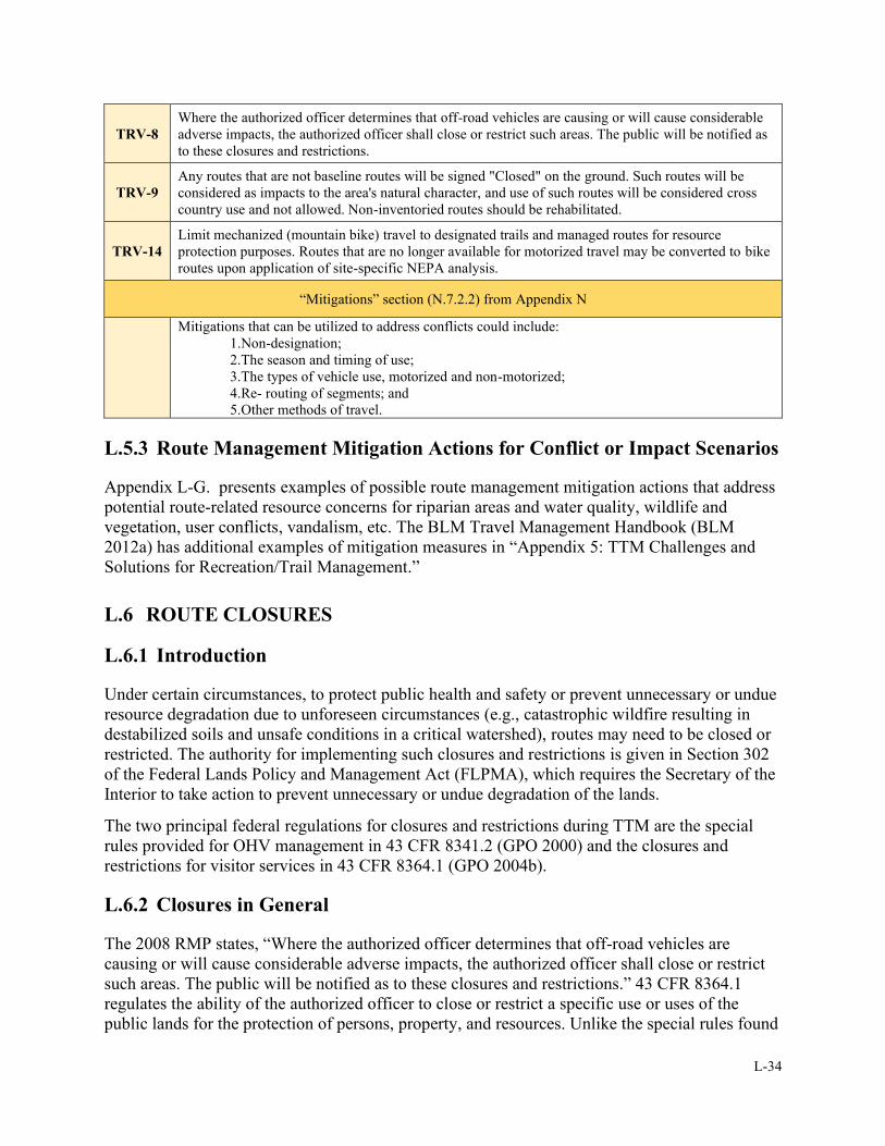
L-34
TRV-8
Where the authorized officer determines that off-road vehicles are causing or will cause considerable
adverse impacts, the authorized officer shall close or restrict such areas. The public will be notified as
to these closures and restrictions.
TRV-9
Any routes that are not baseline routes will be signed "Closed" on the ground. Such routes will be
considered as impacts to the area's natural character, and use of such routes will be considered cross
country use and not allowed. Non-inventoried routes should be rehabilitated.
TRV-14
Limit mechanized (mountain bike) travel to designated trails and managed routes for resource
protection purposes. Routes that are no longer available for motorized travel may be converted to bike
routes upon application of site-specific NEPA analysis.
“Mitigations” section (N.7.2.2) from Appendix N
Mitigations that can be utilized to address conflicts could include:
1.Non-designation;
2.The season and timing of use;
3.The types of vehicle use, motorized and non-motorized;
4.Re- routing of segments; and
5.Other methods of travel.
L.5.3 Route Management Mitigation Actions for Conflict or Impact Scenarios
Appendix L-G. presents examples of possible route management mitigation actions that address
potential route-related resource concerns for riparian areas and water quality, wildlife and
vegetation, user conflicts, vandalism, etc. The BLM Travel Management Handbook (BLM
2012a) has additional examples of mitigation measures in “Appendix 5: TTM Challenges and
Solutions for Recreation/Trail Management.”
L.6 ROUTE CLOSURES
L.6.1 Introduction
Under certain circumstances, to protect public health and safety or prevent unnecessary or undue
resource degradation due to unforeseen circumstances (e.g., catastrophic wildfire resulting in
destabilized soils and unsafe conditions in a critical watershed), routes may need to be closed or
restricted. The authority for implementing such closures and restrictions is given in Section 302
of the Federal Lands Policy and Management Act (FLPMA), which requires the Secretary of the
Interior to take action to prevent unnecessary or undue degradation of the lands.
The two principal federal regulations for closures and restrictions during TTM are the special
rules provided for OHV management in 43 CFR 8341.2 (GPO 2000) and the closures and
restrictions for visitor services in 43 CFR 8364.1 (GPO 2004b).
L.6.2 Closures in General
The 2008 RMP states, “Where the authorized officer determines that off-road vehicles are
causing or will cause considerable adverse impacts, the authorized officer shall close or restrict
such areas. The public will be notified as to these closures and restrictions.” 43 CFR 8364.1
regulates the ability of the authorized officer to close or restrict a specific use or uses of the
public lands for the protection of persons, property, and resources. Unlike the special rules found

L-35
in 43 CFR 8341.2, these closure and restriction orders can apply to any transportation mode or
activity but require a formal notification process, including Federal Register publication. The use
of this authority is limited to two years by policy, but extensions are approved on a case-by-case
basis. NEPA compliance is required for use of this authority.
L.6.3 Emergency Closures
Emergencies are unforeseen events of such severity that they require immediate action to avoid
dire consequences. In the event of an emergency, immediate actions (e.g., closures or public land
use restrictions) must be taken to prevent or reduce risks to public health or safety, property, or
important resources. Section 2.3 of the BLM NEPA Handbook (BLM 2008a) defines the
following actions as typical emergency situations:
• Cleanup of a hazardous material spill
• Fire suppression activities related to ongoing wildland fires
• Emergency stabilization actions following wildland fires or other disasters
L.6.4 Temporary Closures
Where OHV activities are causing considerable adverse effects to resources, temporary closures
can be implemented under the authority of 43 CFR 8341.2 and 8364.1. The purpose of a
temporary closure and restriction is to protect public health and safety or prevent undue or
unnecessary resource degradation due to unforeseen circumstances and should not be used in lieu
of permanent closures. The BLM’s Travel Management Manual states,
Where off-highway vehicles are causing or will cause considerable adverse effects upon
soil, vegetation, wildlife, wildlife and fisheries habitat, cultural resources, historical
resources, threatened or endangered species, wilderness suitability, other authorized uses,
or other resources, the affected areas will be immediately closed to the type(s) of vehicle
causing the adverse effect until the adverse effects are eliminated and measures are
implemented to prevent their recurrence (43 CFR 8341.2). (BLM 2016c)
If site, issue, or resource-specific evaluation is deemed adequate through the NEPA analysis
process associated with either the 2008 RMP or the EA for this TMP, temporary closures and
restrictions exercised under this process may not require further NEPA review. This may include
closure of routes or areas.
L.7 ROUTE DECOMMISSIONING AND RECLAMATION
L.7.1 Overview
When a closed route is successfully decommissioned and reclaimed, it should blend into the
surrounding area. Effective reclamation of closed routes is important for meeting a variety of
management objectives, including:
• Attainment and maintenance of physical and social settings that support prescribed
recreation opportunities and outcomes in SRMAs.
• Reduced visitor confusion resulting from unmarked non-system routes.
• Increased visitor safety through reclamation or rerouting of unsafe non-system routes.
L-36
• Reduced operation and maintenance costs associated with un-reclaimed routes slated for
reclamation.
• Restored natural appearance of the landscape.
• Restored natural habitat and reduced habitat fragmentation.
See Appendix L-C. for details on reclamation methods as well as the routes that are earmarked
for reclamation under the chosen alternative. Note that not all routes designated as OHV-closed
are scheduled for decommissioning, as they may remain available for authorized use or other
non-OHV uses.
L.7.2 Priorities
Certain routes earmarked for reclamation will have a higher implementation priority than others,
as determined by the BLM’s resource specialists. The BLM will prioritize reclamation in special
management areas (e.g., SRMAs), special designation areas (e.g., ACECs, LWCs, etc.), and
other sensitive areas. In general, initial reclamation efforts may focus on the following priority
types, in order of importance:
1. Routes that pose a public safety hazard
2. Routes leading into a designated wilderness area
3. Routes causing resource damage, or routes in areas with a high risk for potential impacts
to resources such as special status species or their habitat, or any other resources
requiring special management or protection
L.7.3 General Reclamation Strategy
The overall objective for routes earmarked for reclamation is to remove them from the landscape
using a variety of reclamation techniques. The most effective method of reclaiming these routes
and preventing further use is to disguise their location. This process favors a natural non-
disruptive form of recovery where possible and is the most cost-effective technique. If disruptive
reclamation techniques are to be used, sensitive timeframes or seasons for protected, sensitive, or
management priority species should be considered. To minimize route closure impacts,
whenever practicable, the BLM may implement the non-disruptive closure methods first.
Initially, most of the routes earmarked for reclamation may be allowed to naturally reclaim.
Alternatively, by applying low-impact manual reclamation techniques, surface disturbances may
be kept to the minimum necessary to close most routes and fulfill management objectives.
During the route evaluation process the most appropriate method of reclamation was identified
for each route based on factors such as geography, topography, soils, hydrology, and vegetation,
as well as management objectives, reclamation costs, modes and conditions of travel, recreation
settings, and other factors. The BLM will compile a prioritized list of routes scheduled for
reclamation including the reclamation method as prescribed by the TMPs route evaluation
reports.
Post-reclamation monitoring of routes is essential to maintaining successful closures. If
monitoring indicates the need for additional reclamation efforts after less intrusive closure
methods have not been successful, the BLM may consider other closure options through adaptive
management. Unless determined as necessary at the beginning of the implementation process,
surface-disturbing reclamation actions may only take place after less intrusive methods have
L-37
been tried. For example, continued vehicular use on a closed route may indicate that natural
reclamation has been ineffective on that route. If it is determined that surface-disturbing
reclamation techniques are necessary to effectively close a route, the Reclamation Techniques
Toolbox in Appendix L-C. will be used. It features a series of options designed to effectively
ensure that closed routes are reclaimed and revegetated. The minimum necessary or “least
impact” treatment analyzed in the Reclamation Techniques Toolbox may be applied to each
route slated for reclamation to achieve desired outcomes.
L.7.4 Reclamation Standards
If disruptive reclamation techniques will be used in route reclamation, the reclamation standards
listed below should be followed as applicable.
a. Routes slated for reclamation will not alter natural hydrologic function and condition of
the affected watershed (e.g., closed routes will not divert runoff from natural drainage
patterns).
b. Disturbed areas will be fully re-contoured and re-vegetated with BLM-approved seed
mixtures or plantings.
c. Seeding will be done where necessary to aid reclamation of closed routes. Appropriate
seed mixtures shall be selected for each site based on site conditions. Reclamation
techniques include ripping the surface with a tractor to break up compacted soil and
facilitate moisture retention. Broadcast seeding shall be done prior to winter. Some areas
should be fenced to prevent disturbance and allow for grazing rest during the first two
growing seasons. This technique is typically used near main roads where camping or
parking may occur.
d. The BLM will utilize native material such as rock and large woody debris to the greatest
extent practicable in combination with manufactured storm water structures (e.g., silt
fence, straw waddles, etc.), and mechanical erosion control techniques (e.g., ripping,
pocking, etc.) to minimize erosion and facilitate site stability.
e. Reclamation techniques for routes in designated wilderness and lands with wilderness
characteristics will attempt to return the area to its original condition in the shortest
amount of time.
f. Weed and vegetation treatment control measures will be implemented as needed to
promote re-vegetation with native plants, prevent any new weed establishment, and
control existing weed sources.
Consult Appendix C from the 2008 RMP for stipulations for surface-disturbing activities, which
may apply to some forms of intrusive route reclamation.
L.8 CULTURAL RESOURCE CONSIDERATIONS
Properly considering cultural resources is a critical component of effective travel management:
“The BLM must address cultural resources in consultation with state historic preservation
officers and under various state-specific protocol agreements, if applicable. The cultural
resource inventory strategy required to make TTM decisions should be commensurate to
the identified risk to resources. This risk should be based on the known presence of
historic properties or on the potential/likelihood for historic properties to occur in a given

L-38
area based on professional knowledge, judgment, and feedback received during the
planning and consultation processes.” (BLM 2016c)
Any and all cultural resource identification efforts, assessments, consultations, mitigations,
treatments, protection measures, and/or site treatments for the Canyon Rims TMP have been
addressed in separate NHPA Section 106 compliance documents and are therefore not addressed
in this document. Cultural resource compliance documents for this TMP undertaking consist of
(but are not limited to) a Class III Intensive Field Survey report (and any report amendments or
addendums that may take place in the future), government-to-government Tribal consultation
correspondences and documents, interagency consultation correspondences and documents
(including the State Historic Preservation Office), consulting party consultation correspondences
and documents, a HPTP developed through consultations under the Travel PA, and any HPTP
amendments or addendums that may take place in the future. Any and all future decisions and
actions regarding cultural resources for the Canyon Rims TMP undertaking will take place
through the HPTP and any continuing project consultation, as guided by the Travel PA.
L.9 REVISED STATUTE 2477 ASSERTIONS
A travel management plan is not intended to provide evidence, bearing on, or address the validity
of any Revised Statute 2477 (R.S. 2477) assertions. R.S. 2477 rights are determined through a
process that is entirely independent of the BLM's planning process. Consequently, this TMP
process does not take into consideration R.S. 2477 evidence. BLM bases travel management
planning on purpose and need related to resource uses and associated access to public lands and
waters given consideration to the relevant resources. At such time as a decision is made on R.S.
2477 assertions, the BLM will adjust its travel routes accordingly (BLM Manual 1626).
L.10 ROADSIDE CAMPING AND PULL-OFF CONSIDERATIONS
A management decision in the 2008 RMP allows dispersed camping “where not specifically
restricted” and that “all vehicle use associated with dispersed camping activities is required to
stay on designated routes.” Another decision states that “parking areas associated with dispersed
campsites will be marked during travel plan implementation.” These decisions will be adhered to
in implementing this TMP. Vehicle-based camping in the Highway 279/Shafer Basin/Long
Canyon ACEC is restricted to designated campgrounds.
Regarding other incidental pull-off considerations such as passing, users are expected to comply
with 43 CFR 8341.1 and not operate an OHV “in a manner causing, or likely to cause significant,
undue damage to or disturbance of the soil, wildlife, wildlife habitat, improvements, cultural, or
vegetative resources or other authorized uses of the public lands.”
L.11 GAME RETRIEVAL
The 2008 RMP does not allow OHV use off designated routes for big game retrieval.

L-39
L.12 NEEDED AUTHORIZATIONS
As part of implementing the TMP, the BLM may seek to acquire legal access to public land
where appropriate and necessary. The BLM may also identify needs and request funding for
access, exchanges, and acquisitions and incorporate them in the existing ranking system.
Easements, ROWs, and permissive access license agreements may include the acquisition of
road or trail easements or the issuance of ROWs on an existing or historic physical access. The
BLM may pursue such actions where they may contribute to natural resource protection or
recreation enhancement opportunities. Easements may be acquired through donation or purchase
following the procedures set forth in the BLM’s acquisition handbook (H-2100-1) (BLM 2002).
Table L.6 in Section L.2.6 in this guide lists 2008 RMP public land access-related goals,
objectives, and management decisions; some of these are related to needed authorizations. The
BLM’s Travel Management Manual provides guidance concerning authorized and permitted
motorized uses (BLM 2016c).
L.13 GROUND TRANSPORTATION LINEAR FEATURE (GTLF)
GEOSPATIAL DATA
The BLM’s Travel Management Manual provides the following guidance concerning the
maintenance of travel management geographic information systems (GIS) data in the GTLF
format (BLM 2016c).
For GTLF adherence guidance, consult the BLM’s GTLF data standard, data report, and data
implementation guidelines (BLM 2014b, 2014c, and 2014d). A GTLF database is a geospatial
database of motorized and non-motorized transportation linear features as they exist on the
ground. Features include all linear features, not just what is within the BLM Transportation
System.
The GTLF geodatabase exists to track route conditions and guide future management decisions.
Utilized as an adaptive management tool, the geodatabase should be updated regularly to
continually collect and update future changes in the transportation system, such as changing use
patterns, incorrectly inventoried routes, and route migration. Tracking such changes would
increase the effectiveness of implementation within the TMA by facilitating management
adjustments and informing future management actions.
L.14 PRE- AND POST-TMP/EA MANAGEMENT ACTIONS IN GENERAL
Creating a TMP route network and analyzing the potential resource or resource use effects in an
EA is a key component of travel management, but other important related actions take place
before and after the TMP and its EA are approved. Many of these actions (monitoring,
enforcement, etc.) are described in previous sections of this document. Active management of
the routes in the TMA requires consistent monitoring and maintenance. Statewide, OHV
recreation continues to increase, and the trend is expected to continue in this TMA as well. The
BLM’s Travel Management Manual provides a reminder on the importance of continuing TTM
beyond the development of an initial TMP:
L-40
[TTM] is a dynamic process. Upon completion of a TMP, the BLM should keep
information and data concerning the travel network and transportation systems up to date,
as staffing, budget and priorities allow. The BLM may modify the travel network and
transportation systems through monitoring and adaptive management protocols or by
specific BLM actions and authorizations. It is critical that the BLM continue TTM after
completion of the initial TMP as a routine part of land management. (2016c)
L.15 REFERENCES
BLM (Bureau of Land Management). 1997. Standards for Rangeland Health and Guidelines for
Grazing Management for BLM Lands in Utah. Denver, CO.
https://archive.org/details/standardsforrang00unit.
_____. 2002. H-2100-1 - Acquisition. N.p.
https://www.blm.gov/sites/blm.gov/files/uploads/Media_Library_BLM_Policy_h2100-
1.pdf.
_____. 2004. 9130 – Sign Manual. N.p.
https://www.blm.gov/sites/blm.gov/files/uploads/mediacenter_blmpolicymanual9130.pdf
_____. 2005. Interpreting Indicators of Rangeland Health: Version 4. Denver, CO. Technical
Reference 1734-6. BLM/WO/ST-00/001+1734/REV05.
https://www.blm.gov/documents/national-office/blm-library/technical-
reference/interpreting-indicators-rangeland-health.
_____. 2008a. BLM National Environmental Policy Act Handbook (H-1790-1). Washington,
D.C.
https://www.google.com/url?sa=t&rct=j&q=&esrc=s&source=web&cd=&ved=2ahUKE
wjMytXZn6rrAhUCbs0KHUGkBNoQFjACegQIARAB&url=https%3A%2F%2Fwww.b
lm.gov%2Fsites%2Fblm.gov%2Ffiles%2Fuploads%2FMedia_Library_BLM_Policy_Ha
ndbook_h1790-1.pdf&usg=AOvVaw3NUZLOh796repJ6iPfVBxz.
_____. 2008b. Moab Field Office Record of Decision and Approved Resource Management
Plan. Moab, UT. https://eplanning.blm.gov/epl-front-
office/projects/lup/66098/80422/93491/Moab_Final_Plan.pdf.
_____. 2011. 9113-1 – Roads Design Handbook. N.p.
https://www.blm.gov/sites/blm.gov/files/uploads/Media_Library_BLM_Policy_H-9113-
1.pdf.
_____. 2012a. H-8342 Travel and Transportation Handbook (Public). N.p.
https://www.ntc.blm.gov/krc/uploads/750/8342%20-
%20TTM%20Planning%20Handbook.pdf.
_____. 2012b. H-9115-1 – Primitive Roads Design Handbook. N.p.
https://www.blm.gov/sites/blm.gov/files/uploads/Media%20Center_BLM%20Policy_H-
9115-1.pdf.
_____. 2012c. H-9115-2 – Primitive Roads Inventory and Condition Assessment Guidance and
Instructions Handbook. N.p.
L-41
https://www.blm.gov/sites/blm.gov/files/uploads/Media%20Center_BLM%20Policy_911
5-2.pdf.
_____. 2012d. Primitive Roads Manual (MS-9115). N.p.
https://www.blm.gov/sites/blm.gov/files/uploads/mediacenter_blmpolicymanual9115.pdf
_____. 2012e. 6310—Conducting Wilderness Characteristics Inventory on BLM Lands (Public).
N.p. https://www.wilderness.net/NWPS/documents/BLM/6310.pdf.
_____. 2012f. 6320—Considering Lands with Wilderness Characteristics in the BLM Land Use
Planning Process (Public). N.p.
https://www.blm.gov/sites/blm.gov/files/uploads/mediacenter_blmpolicymanual6320.pdf
_____. 2012g. 6330 – Management of Wilderness Study Areas (Public). N.p.
https://www.blm.gov/sites/blm.gov/files/uploads/mediacenter_blmpolicymanual6330.pdf
_____. 2012h. 6340 – Management of Designated Wilderness Areas (Public). N.p.
https://www.blm.gov/sites/blm.gov/files/uploads/mediacenter_blmpolicymanual6340.pdf
_____. 2012i. 6400 – Wild and Scenic Rivers – Policy and Program Direction for Identification,
Evaluation, Planning, and Management (Public). N.p.
https://www.blm.gov/sites/blm.gov/files/uploads/mediacenter_blmpolicymanual6400.pdf
_____. 2014a. Adaptive Management: The scientific approach to flexible natural resource
management (un-dated PowerPoint PDF accessed in 2014). Huntsinger, R. and P.
Sorenson.
http://www.blm.gov/pgdata/etc/medialib/blm/wo/Planning_and_Renewable_Resources/p
resentations.Par.83536.File.pdf/Adaptive_Management_2.pdf.
_____. 2014b. Ground Transportation Linear Features: Data Standard Domains - October 22,
2014 - Version 2.0. Denver, CO.
https://www.blm.gov/sites/blm.gov/files/uploads/IM2015-061_att2.pdf.
_____. 2014c. Ground Transportation Linear Features: Data Standard Report - October 22, 2014
- Version 2.0. Denver, CO. https://www.blm.gov/sites/blm.gov/files/uploads/IM2015-
061_att1.pdf.
_____. 2014d. Ground Transportation Linear Features: Implementation Guidelines - October 23,
2014 - Version 2.0. Denver, CO.
https://www.blm.gov/sites/blm.gov/files/uploads/IM2015-061_att3.pdf.
_____. 2015a. MS 9113 – Roads. N.p.
https://www.blm.gov/sites/blm.gov/files/uploads/mediacenter_blmpolicymanual9113.pdf
_____. 2015b. H-9113-2 – Roads Inventory and Condition Assessment Guidance and
Instructions.
https://www.blm.gov/sites/blm.gov/files/uploads/Media%20Center_BLM%20Policy_H-
9113-2.pdf.
_____. 2016a. Moab Master Leasing Plan/Approved Resource Management Plan Amendments
for the Moab and Monticello Field Offices. December 2016. Moab, UT.
https://eplanning.blm.gov/eplanning-ui/project/68430/510.
L-42
_____. 2016b. National Sign Handbook. Denver, CO. https://www.blm.gov/documents/national-
office/handbook-public-room/handbook/national-sign-handbook.
_____. 2016c. 1626 – Travel and Transportation Management Manual (Public) (MS 1626). N.p.
https://www.blm.gov/download/file/fid/7257.
_____. 2019. Canyon Rims/Indian Creek Travel Management Area Baseline Monitoring Report
Summary. Moab, UT. August 2019. https://eplanning.blm.gov/eplanning-
ui/project/113775/570.
BLM and IMBA (Bureau of Land Management and International Mountain Bicycling
Association). 2017. Guidelines for a Quality Trail Experience: Mountain Bike Trail
Guidelines. N.p. https://www.blm.gov/sites/blm.gov/files/uploads/Travel-and-
Transportation_Guidelines-for-a-Quality-Trail-Experience-2017.pdf.
FedCenter. 1977. Executive Order 11989: Use of Off-Road Vehicles (ORVs) on The Public
Lands. https://www.fedcenter.gov/Bookmarks/index.cfm?id=584.
FHWA (Federal Highway Administration). 2019. Manual on Uniform Traffic Control Devices
(MUTCD). http://mutcd.fhwa.dot.gov/.
GPO (U.S. Government Publishing Office). 2000. Code of Federal Regulations: Title 43,
Subpart 8341 – Conditions of Use. https://www.govinfo.gov/app/details/CFR-2004-
title43-vol2/CFR-2004-title43-vol2-part8340-subpart8341.
_____. 2001. Code of Federal Regulations: Title 43, Subpart 9268 – Recreation Programs.
https://www.govinfo.gov/app/details/CFR-2011-title43-vol2/CFR-2011-title43-vol2-
part9260-subpart9268.
_____. 2004a. Code of Federal Regulations: Title 43, Subpart 4180 – Fundamentals of
Rangeland Health and Standards and Guidelines for Grazing Administration.
https://www.govinfo.gov/app/details/CFR-2011-title43-vol2/CFR-2011-title43-vol2-
part4100-subpart4180.
_____. 2004b. Code of Federal Regulations: Title 43, Subpart 8364 – Closures and Restrictions.
https://www.govinfo.gov/app/details/CFR-2004-title43-vol2/CFR-2004-title43-vol2-
part8360-subpart8364.
_____. 2009a. Code of Federal Regulations: Title 43, Part 8360 – Visitor Services Subpart 8360
– General. https://www.govinfo.gov/app/details/CFR-2009-title43-vol2/CFR-2009-
title43-vol2-part8360-subpart8360.
_____. 2009b. Code of Federal Regulations: Title 43, Subpart 8365 – Rules of Conduct.
https://www.ecfr.gov/cgi-
bin/retrieveECFR?gp=&SID=b9124f579be3eb84f702a8f20bcf328c&mc=true&n=sp43.2.
8360.8365&r=SUBPART&ty=HTML.
_____. 2011. Code of Federal Regulations: Title 43, Section 46.30 – Definitions.
https://www.govinfo.gov/app/details/CFR-2011-title43-vol1/CFR-2011-title43-vol1-
sec46-30.
https://www.govinfo.gov/app/details/CFR-2004-title43-vol2/CFR-2004-title43-vol2-part8340-subpart8341
https://www.govinfo.gov/app/details/CFR-2004-title43-vol2/CFR-2004-title43-vol2-part8340-subpart8341
https://www.govinfo.gov/app/details/CFR-2011-title43-vol2/CFR-2011-title43-vol2-part9260-subpart9268
https://www.govinfo.gov/app/details/CFR-2011-title43-vol2/CFR-2011-title43-vol2-part9260-subpart9268
https://www.govinfo.gov/app/details/CFR-2011-title43-vol2/CFR-2011-title43-vol2-part4100-subpart4180
https://www.govinfo.gov/app/details/CFR-2011-title43-vol2/CFR-2011-title43-vol2-part4100-subpart4180
https://www.govinfo.gov/app/details/CFR-2004-title43-vol2/CFR-2004-title43-vol2-part8360-subpart8364
https://www.govinfo.gov/app/details/CFR-2004-title43-vol2/CFR-2004-title43-vol2-part8360-subpart8364
https://www.govinfo.gov/app/details/CFR-2009-title43-vol2/CFR-2009-title43-vol2-part8360-subpart8360

L-43
_____. 2016. Code of Federal Regulations: Title 43, Part 8340 – Off-Road Vehicles.
https://www.govinfo.gov/app/details/CFR-2016-title43-vol2/CFR-2016-title43-vol2-
part8340-subpart8340.Library of Congress. 1866. An Act granting the Right of Way to
Ditch and Canal Owners over the Public Lands, and for other Purposes.
https://www.loc.gov/law/help/statutes-at-large/39th-congress/session-1/c39s1ch262.pdf.
National Archives. 1972. Executive Order 11644--Use of off-road vehicles on the public lands.
https://www.archives.gov/federal-register/codification/executive-order/11644.html.
NOHVCC (National Off-Highway Vehicle Conservation Council). 2015. Great Trails: Providing
Quality OHV Trails and Experiences. By Dick Duford. Great Falls, MT.
http://gt.nohvcc.org/About.aspx.
USDOT (U.S. Department of Transportation). 2012. The Federal Lands Transportation Program
& the Federal Lands Access Program: Moving Ahead for Progress in the 21st Century
(MAP-21). N.p. https://www.fhwa.dot.gov/map21/docs/23_25oct_fltp.pdf.
_____. 2016. Implementation Guidance for the Federal Lands Transportation Program.
https://flh.fhwa.dot.gov/programs/fltp/documents/FLTP%20Guidance%20-
%20CLEARED.pdf (accessed October 11, 2017).
USFWS (U.S. Fish and Wildlife Service). 2002. Utah Field Office Guidelines for Raptor
Protection from Human and Land Use Disturbances. Romin, Laura A. and James A.
Muck. U.S. Department of the Interior, U.S. Fish and Wildlife Service, Utah Field Office,
Salt Lake City, Utah.
USFS (U.S. Forest Service). 2007. Trail Construction and Maintenance Notebook: 2007 Edition.
Missoula, MT. https://www.fs.fed.us/t-
d/pubs/pdfpubs/pdf07232806/pdf07232806dpi72.pdf.
https://www.govinfo.gov/app/details/CFR-2016-title43-vol2/CFR-2016-title43-vol2-part8340-subpart8340

L-44
APPENDIX L-A. TRAVEL MANAGEMENT-RELATED GOALS
OBJECTIVES, AND MANAGEMENT DECISIONS
FROM 2008 RMPS
Table L.38: 2008 RMP Transportation Language
Transportation
TRV-2
BLM, in preparing its RMP designations and its implementation-level travel management plans, is
following policy and regulation authority found at: 43 CFR Part 8340; 43 CFR Subpart 8364; and 43
CFR Subpart 9268.
TRV-3
Provide opportunities for a range of motorized recreation experiences on public lands while protecting
sensitive resources and minimizing conflicts among various users. Identification of specific designated
routes will be initially established through the chosen Travel Plan accompanying this RMP (see
Appendix N) and may be modified through subsequent implementation planning and project planning
on a case-by-case basis. These identified routes will be available regardless of other management
actions. These adjustments will occur only in areas with limited route designations and will be
analyzed at the implementation planning level. These adjustments will be done through a collaborative
process with local government and will include public review of proposed route changes. Site-specific
NEPA documentation will be required for changes to the route designation system.
TRV-4
All areas are limited, open, or closed to motorized travel. Limit travel by motorized vehicle on all
lands administered by the MFO to designated routes, except for Managed Open Areas, and for areas
that are closed to motorized travel (see Map 30; see Appendix N for Travel Plan development).
TRV-5
BLM could impose limitations on types of vehicle allowed on specific designated routes if monitoring
indicates that a particular type of vehicle is causing disturbance to the soil, wildlife, wildlife habitat,
cultural or vegetative resources, especially by off-road travel in an area that is limited to designated
roads.
TRV-6
OHV access for game retrieval, antler collection and dispersed camping will only be allowed on
designated routes (designated routes/spurs and have been identified specifically for dispersed
camping; parking areas associated with dispersed campsites will be marked during travel plan
implementation). Adherence to the Travel Plan is required for all activities, except where otherwise
explicitly permitted.
TRV-7 Only designated roads and managed open areas are available for motorized commercial and organized
group use (see Maps 2 and 3 for route designations).
TRV-8
Where the authorized officer determines that off-road vehicles are causing or will cause considerable
adverse impacts, the authorized officer shall close or restrict such areas. The public will be notified as
to these closures and restrictions.
TRV-9
Any routes that are not baseline routes will be signed "Closed" on the ground. Such routes will be
considered as impacts to the area's natural character, and use of such routes will be considered cross
country use and not allowed. Non-inventoried routes should be rehabilitated.
TRV-10
OHV Designations:
• About 339,298 acres will be closed to OHV travel.
• About 1,481,334 acres will be limited to designated routes.
• Approximately 2,000 acres (White Wash Sand Dunes) will be open to cross country travel
(see Map 30).
TRV-11
Designated Routes – Motorized:
• Designate 3,693 miles of motorized routes.
• Designate 313 miles for motorcycles (163 miles on inventoried routes and 150 miles on
inventoried single-track).
• Designate a dirt bike route from Colorado State Line to Thompson (see Map 3), utilizing 9
miles of single-track designated above and 22 miles of inventoried Grand County roads.
These totals are reflected in the mileage under "designated routes."
Recreation and Off-Highway Vehicles
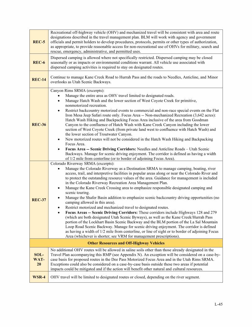
L-45
REC-5
Recreational off-highway vehicle (OHV) and mechanized travel will be consistent with area and route
designations described in the travel management plan. BLM will work with agency and government
officials and permit holders to develop procedures, protocols, permits or other types of authorization,
as appropriate, to provide reasonable access for non-recreational use of OHVs for military, search and
rescue, emergency, administrative, and permitted uses.
REC-6
Dispersed camping is allowed where not specifically restricted. Dispersed camping may be closed
seasonally or as impacts or environmental conditions warrant. All vehicle use associated with
dispersed camping activities is required to stay on designated routes.
REC-14 Continue to manage Kane Creek Road to Hurrah Pass and the roads to Needles, Anticline, and Minor
overlooks as Utah Scenic Backways.
REC-36
Canyon Rims SRMA (excerpts):
• Manage the entire area as OHV travel limited to designated roads.
• Manage Hatch Wash and the lower section of West Coyote Creek for primitive,
nonmotorized recreation.
• Restrict backcountry motorized events to commercial and non-race special events on the Flat
Iron Mesa Jeep Safari route only. Focus Area -- Non-mechanized Recreation (3,642 acres):
Hatch Wash Hiking and Backpacking Focus Area inclusive of the area from Goodman
Canyon to the confluence of Hatch Wash with Kane Creek Canyon including the lower
section of West Coyote Creek (from private land west to confluence with Hatch Wash) and
the lower section of Troutwater Canyon.
• New motorized routes will not be considered in the Hatch Wash Hiking and Backpacking
Focus Area.
• Focus Area -- Scenic Driving Corridors: Needles and Anticline Roads – Utah Scenic
Backways. Manage for scenic driving enjoyment. The corridor is defined as having a width
of 1/2 mile from centerline (or to border of adjoining Focus Area).
REC-37
Colorado Riverway SRMA (excerpts):
• Manage the Colorado Riverway as a Destination SRMA to manage camping, boating, river
access, trail, and interpretive facilities in popular areas along or near the Colorado River and
to protect the outstanding resource values of the area. Guidance for management is included
in the Colorado Riverway Recreation Area Management Plan.
• Manage the Kane Creek Crossing area to emphasize responsible designated camping and
scenic touring.
• Manage the Shafer Basin addition to emphasize scenic backcountry driving opportunities (no
camping allowed in this area).
• Restrict motorized and mechanized travel to designated routes.
• Focus Areas -- Scenic Driving Corridors: These corridors include Highways 128 and 279
(which are both designated Utah Scenic Byways), as well as the Kane Creek/Hurrah Pass
portion of the Lockhart Basin Scenic Backway and the BLM portion of the La Sal Mountain
Loop Road Scenic Backway. Manage for scenic driving enjoyment. The corridor is defined
as having a width of 1/2 mile from centerline, or line of sight or to border of adjoining Focus
Area (whichever is shorter; see VRM for management prescriptions).
Other Resources and Off-Highway Vehicles
SOL-
WAT-
20
No additional OHV routes will be allowed in saline soils other than those already designated in the
Travel Plan accompanying this RMP (see Appendix N). An exception will be considered on a case-by-
case basis for proposed routes in the Dee Pass Motorized Focus Area and in the Utah Rims SRMA.
Exceptions could also be considered on a case-by-case basis outside these two areas if potential
impacts could be mitigated and if the action will benefit other natural and cultural resources.
WSR-4 OHV travel will be limited to designated routes or closed, depending on the river segment.
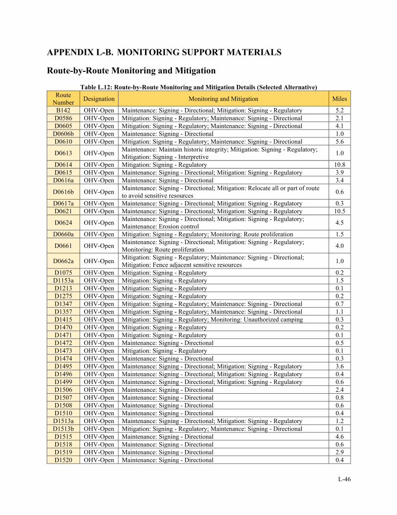
L-46
APPENDIX L-B. MONITORING SUPPORT MATERIALS
Route-by-Route Monitoring and Mitigation
Table L.12: Route-by-Route Monitoring and Mitigation Details (Selected Alternative)
Route
Number Designation Monitoring and Mitigation Miles
B142 OHV-Open Maintenance: Signing - Directional; Mitigation: Signing - Regulatory 5.2
D0586 OHV-Open Mitigation: Signing - Regulatory; Maintenance: Signing - Directional 2.1
D0605 OHV-Open Mitigation: Signing - Regulatory; Maintenance: Signing - Directional 4.1
D0606b OHV-Open Maintenance: Signing - Directional 1.0
D0610 OHV-Open Mitigation: Signing - Regulatory; Maintenance: Signing - Directional 5.6
D0613 OHV-Open Maintenance: Maintain historic integrity; Mitigation: Signing - Regulatory;
Mitigation: Signing - Interpretive 1.0
D0614 OHV-Open Mitigation: Signing - Regulatory 10.8
D0615 OHV-Open Maintenance: Signing - Directional; Mitigation: Signing - Regulatory 3.9
D0616a OHV-Open Maintenance: Signing - Directional 3.4
D0616b OHV-Open Maintenance: Signing - Directional; Mitigation: Relocate all or part of route
to avoid sensitive resources 0.6
D0617a OHV-Open Maintenance: Signing - Directional; Mitigation: Signing - Regulatory 0.3
D0621 OHV-Open Maintenance: Signing - Directional; Mitigation: Signing - Regulatory 10.5
D0624 OHV-Open Maintenance: Signing - Directional; Mitigation: Signing - Regulatory;
Maintenance: Erosion control 4.5
D0660a OHV-Open Mitigation: Signing - Regulatory; Monitoring: Route proliferation 1.5
D0661 OHV-Open Maintenance: Signing - Directional; Mitigation: Signing - Regulatory;
Monitoring: Route proliferation 4.0
D0662a OHV-Open Mitigation: Signing - Regulatory; Maintenance: Signing - Directional;
Mitigation: Fence adjacent sensitive resources 1.0
D1075 OHV-Open Mitigation: Signing - Regulatory 0.2
D1153a OHV-Open Mitigation: Signing - Regulatory 1.5
D1213 OHV-Open Mitigation: Signing - Regulatory 0.1
D1275 OHV-Open Mitigation: Signing - Regulatory 0.2
D1347 OHV-Open Mitigation: Signing - Regulatory; Maintenance: Signing - Directional 0.7
D1357 OHV-Open Mitigation: Signing - Regulatory; Maintenance: Signing - Directional 1.1
D1415 OHV-Open Mitigation: Signing - Regulatory; Monitoring: Unauthorized camping 0.3
D1470 OHV-Open Mitigation: Signing - Regulatory 0.2
D1471 OHV-Open Mitigation: Signing - Regulatory 0.1
D1472 OHV-Open Maintenance: Signing - Directional 0.5
D1473 OHV-Open Mitigation: Signing - Regulatory 0.1
D1474 OHV-Open Maintenance: Signing - Directional 0.3
D1495 OHV-Open Maintenance: Signing - Directional; Mitigation: Signing - Regulatory 3.6
D1496 OHV-Open Maintenance: Signing - Directional; Mitigation: Signing - Regulatory 0.4
D1499 OHV-Open Maintenance: Signing - Directional; Mitigation: Signing - Regulatory 0.6
D1506 OHV-Open Maintenance: Signing - Directional 2.4
D1507 OHV-Open Maintenance: Signing - Directional 0.8
D1508 OHV-Open Maintenance: Signing - Directional 0.6
D1510 OHV-Open Maintenance: Signing - Directional 0.4
D1513a OHV-Open Maintenance: Signing - Directional; Mitigation: Signing - Regulatory 1.2
D1513b OHV-Open Mitigation: Signing - Regulatory; Maintenance: Signing - Directional 0.1
D1515 OHV-Open Maintenance: Signing - Directional 4.6
D1518 OHV-Open Maintenance: Signing - Directional 0.6
D1519 OHV-Open Maintenance: Signing - Directional 2.9
D1520 OHV-Open Maintenance: Signing - Directional 0.4
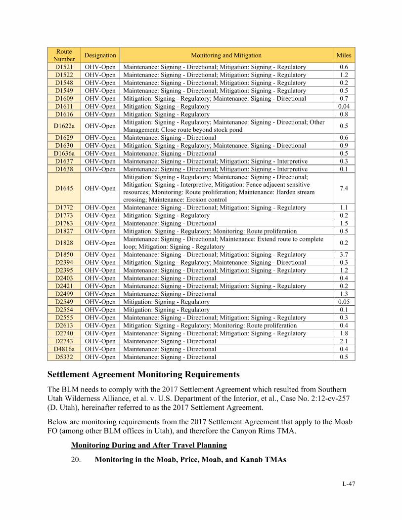
L-47
Route
Number Designation Monitoring and Mitigation Miles
D1521 OHV-Open Maintenance: Signing - Directional; Mitigation: Signing - Regulatory 0.6
D1522 OHV-Open Maintenance: Signing - Directional; Mitigation: Signing - Regulatory 1.2
D1548 OHV-Open Maintenance: Signing - Directional; Mitigation: Signing - Regulatory 0.2
D1549 OHV-Open Maintenance: Signing - Directional; Mitigation: Signing - Regulatory 0.5
D1609 OHV-Open Mitigation: Signing - Regulatory; Maintenance: Signing - Directional 0.7
D1611 OHV-Open Mitigation: Signing - Regulatory 0.04
D1616 OHV-Open Mitigation: Signing - Regulatory 0.8
D1622a OHV-Open Mitigation: Signing - Regulatory; Maintenance: Signing - Directional; Other
Management: Close route beyond stock pond 0.5
D1629 OHV-Open Maintenance: Signing - Directional 0.6
D1630 OHV-Open Mitigation: Signing - Regulatory; Maintenance: Signing - Directional 0.9
D1636a OHV-Open Maintenance: Signing - Directional 0.5
D1637 OHV-Open Maintenance: Signing - Directional; Mitigation: Signing - Interpretive 0.3
D1638 OHV-Open Maintenance: Signing - Directional; Mitigation: Signing - Interpretive 0.1
D1645 OHV-Open
Mitigation: Signing - Regulatory; Maintenance: Signing - Directional;
Mitigation: Signing - Interpretive; Mitigation: Fence adjacent sensitive
resources; Monitoring: Route proliferation; Maintenance: Harden stream
crossing; Maintenance: Erosion control
7.4
D1772 OHV-Open Maintenance: Signing - Directional; Mitigation: Signing - Regulatory 1.1
D1773 OHV-Open Mitigation: Signing - Regulatory 0.2
D1783 OHV-Open Maintenance: Signing - Directional 1.5
D1827 OHV-Open Mitigation: Signing - Regulatory; Monitoring: Route proliferation 0.5
D1828 OHV-Open Maintenance: Signing - Directional; Maintenance: Extend route to complete
loop; Mitigation: Signing - Regulatory 0.2
D1850 OHV-Open Maintenance: Signing - Directional; Mitigation: Signing - Regulatory 3.7
D2394 OHV-Open Mitigation: Signing - Regulatory; Maintenance: Signing - Directional 0.3
D2395 OHV-Open Maintenance: Signing - Directional; Mitigation: Signing - Regulatory 1.2
D2403 OHV-Open Maintenance: Signing - Directional 0.4
D2421 OHV-Open Maintenance: Signing - Directional; Mitigation: Signing - Regulatory 0.2
D2499 OHV-Open Maintenance: Signing - Directional 1.3
D2549 OHV-Open Mitigation: Signing - Regulatory 0.05
D2554 OHV-Open Mitigation: Signing - Regulatory 0.1
D2555 OHV-Open Maintenance: Signing - Directional; Mitigation: Signing - Regulatory 0.3
D2613 OHV-Open Mitigation: Signing - Regulatory; Monitoring: Route proliferation 0.4
D2740 OHV-Open Maintenance: Signing - Directional; Mitigation: Signing - Regulatory 1.8
D2743 OHV-Open Maintenance: Signing - Directional 2.1
D4816a OHV-Open Maintenance: Signing - Directional 0.4
D5332 OHV-Open Maintenance: Signing - Directional 0.5
Settlement Agreement Monitoring Requirements
The BLM needs to comply with the 2017 Settlement Agreement which resulted from Southern
Utah Wilderness Alliance, et al. v. U.S. Department of the Interior, et al., Case No. 2:12-cv-257
(D. Utah), hereinafter referred to as the 2017 Settlement Agreement.
Below are monitoring requirements from the 2017 Settlement Agreement that apply to the Moab
FO (among other BLM offices in Utah), and therefore the Canyon Rims TMA.
Monitoring During and After Travel Planning
20. Monitoring in the Moab, Price, Moab, and Kanab TMAs
L-48
a. Baseline Monitoring Report. Except for the Henry Mountains and Fremont
Gorge TMA, for each TMA identified in paragraph 13, BLM will complete a baseline
monitoring report that will document visually-apparent unauthorized surface disturbances off
routes as well as visually-apparent damage to public lands resources caused by OHV vehicle use
within WSAs, Natural Areas, and/or lands with BLM-inventoried wilderness characteristics. To
create the baseline monitoring report, BLM will physically inspect those portions of routes
within the TMA that are within or constitute a boundary to a WSA, Natural Area, and/or lands
with BLM-inventoried wilderness characteristics. For those portions of routes, BLM will
document by site photography and written narrative each disturbance and damage site. At a
minimum, BLM will document the following information: (1) the geospatial coordinate of the
site of disturbance or damage; (2) the route number or other identifier where the disturbance or
damage was observed, the date of the physical inspection, the TMA in which the inspection took
place, and the name of the inspector; (3) the observed usage intensity (i.e., none, light, medium,
or heavy); (4) the apparent geographic extent of the disturbance or damage; and (5), if possible,
(a) the apparent type of motorized vehicle(s) that caused the disturbance or damage, (b) the
apparent purpose of the disturbance (e.g., short spur, dispersed camping, play area, or inadvertent
travel), and (c) the type of public land resource damaged by motorized vehicle use. The baseline
monitoring report will include the information gathered and recorded during the physical
inspection, as well as maps showing the location and nature of any documented disturbance or
damage sites. BLM will make its baseline monitoring report available for public review at the
same time as the preliminary route evaluation documents identified in paragraph 16.d. BLM
need not complete the baseline monitoring report prior to that time, but may do so at its
discretion. Baseline monitoring reports described in this paragraph may be used to explain or
support any BLM final agency action, but do not themselves constitute final agency action.
b. Monitoring during planning. After BLM completes the baseline monitoring
report required by paragraph 20.a, BLM will, at least one time per year, inspect all sites where
BLM’s baseline monitoring report previously identified disturbance and damage. If BLM
receives credible information that any new visually-apparent unauthorized surface disturbances
off routes or visually-apparent damage to public lands resources caused by motorized vehicle use
(1) has occurred along those portions of routes within the TMA that are within or constitute a
boundary to a WSA, Natural Area, and/or lands with BLM-inventoried wilderness characteristics
and (2) is adversely affecting public land resources, then BLM will inspect the portion of that
route, subject to available personnel and passable route conditions. BLM will document its
inspection and monitoring of these sites during planning by site photography and written
narrative describing each disturbance and damage site. BLM’s documentation will include, at a
minimum, the following information: (1) the geospatial coordinate of the site of disturbance or
damage; (2) the route number or other identifier where the disturbance or damage was observed,
the date of physical inspection, the TMA in which the inspection took place, and the name of the
inspector; (3) the observed usage intensity (i.e., none, light, medium, or heavy); (4) the apparent
geographic extent of the disturbance or damage; and (5), if possible, (a) the apparent type of
motorized vehicle(s) that caused the disturbance or damage, (b) the apparent purpose of the
disturbance (e.g., short spur, dispersed camping, play area, or inadvertent travel), and (c) the type
of public land resource damaged by motorized vehicle use. BLM’s documentation and/or reports
described in this paragraph may be used to explain or support any BLM final agency action, but
do not themselves constitute final agency action. BLM will undertake monitoring more
frequently if it determines additional monitoring is warranted. BLM’s monitoring obligation

L-49
identified in this paragraph for the TMAs identified in paragraph 13 will terminate when BLM
issues the new TMP for that TMA, regardless of whether administrative or judicial review is
sought.
22. Consideration of Considerable Adverse Effects.
a. Any party to the agreement may provide BLM with evidence that (1) motorized
vehicle use is causing or will cause considerable adverse effects as set forth in 43 C.F.R. §
8341.2(a) or (2) that action is required to protect persons, property, and public lands and
resources pursuant to 43 C.F.R. § 8364.1. When BLM receives such information, it will
promptly make such information available to all parties to the Settlement Agreement. BLM will
provide a written response assessing whether action pursuant to § 8341.2(a) or §8364.1 is
necessary to the party submitting such information as well as all other parties to the agreement
within 90 days of receiving the information.
b. BLM will consider the information collected during monitoring identified in
paragraphs 20-21 of this Settlement Agreement and any other relevant information to determine
whether motorized vehicle use is causing or will cause considerable adverse effects as set forth
in 43 C.F.R. § 8364.1. If so, BLM will take appropriate management action.
c. The obligations outlined in this paragraph start on the effective date of this 2017
Settlement Agreement and end eight years after this Settlement Agreement becomes effective,
provided that nothing in this Settlement Agreement exempts or absolves BLM from compliance
with applicable regulations, including 43 C.F.R. subparts 8341 and 8364.
23. Monitoring after TMPs are issued. BLM will develop a long-term motorized
vehicle monitoring protocol as part of each new TMP prepared for the TMAs identified in
paragraph 13. BLM’s proposed long-term monitoring protocol will be outlined in the draft and
final NEPA document for each TMP, and the public, cooperating agencies, and other
stakeholders will have an opportunity to provide input on each TMP’s long-term monitoring
protocol during the relevant public comment period. Each TMP’s long-term monitoring protocol
will become effective as provided in the applicable TMP. Once each TMP is issued, the long-
term monitoring protocol specific to that TMP will apply and not the terms of this Settlement
Agreement.
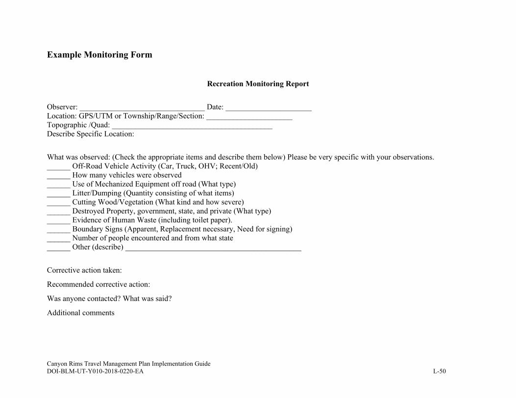
Canyon Rims Travel Management Plan Implementation Guide DOI-BLM-UT-Y010-2018-0220-EA L-50
Example Monitoring Form
Recreation Monitoring Report
Observer: ________________________________ Date: ______________________
Location: GPS/UTM or Township/Range/Section: ______________________
Topographic /Quad: _________________________________________
Describe Specific Location:
What was observed: (Check the appropriate items and describe them below) Please be very specific with your observations.
______ Off-Road Vehicle Activity (Car, Truck, OHV; Recent/Old)
______ How many vehicles were observed
______ Use of Mechanized Equipment off road (What type)
______ Litter/Dumping (Quantity consisting of what items)
______ Cutting Wood/Vegetation (What kind and how severe)
______ Destroyed Property, government, state, and private (What type)
______ Evidence of Human Waste (including toilet paper).
______ Boundary Signs (Apparent, Replacement necessary, Need for signing)
______ Number of people encountered and from what state
______ Other (describe) _____________________________________________
Corrective action taken:
Recommended corrective action:
Was anyone contacted? What was said?
Additional comments
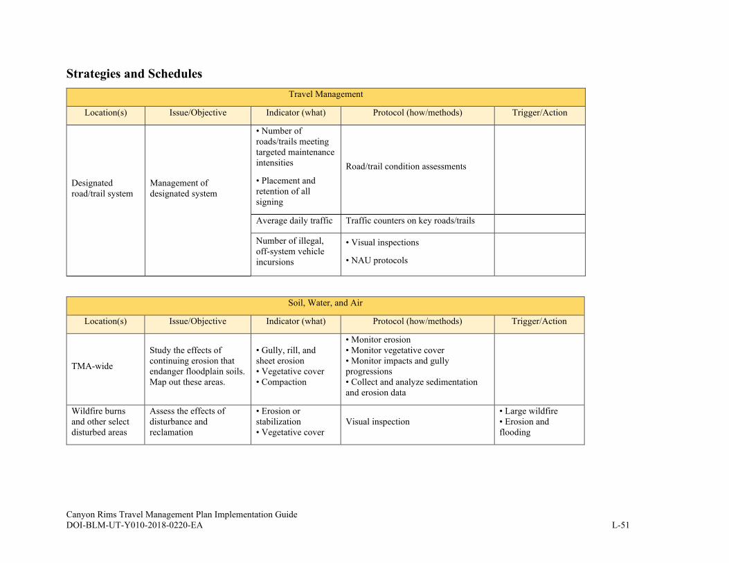
Canyon Rims Travel Management Plan Implementation Guide DOI-BLM-UT-Y010-2018-0220-EA L-51
Strategies and Schedules
Travel Management
Location(s) Issue/Objective Indicator (what) Protocol (how/methods) Trigger/Action
Designated
road/trail system
Management of
designated system
• Number of
roads/trails meeting
targeted maintenance
intensities
• Placement and
retention of all
signing
Road/trail condition assessments
Average daily traffic Traffic counters on key roads/trails
Number of illegal,
off-system vehicle
incursions
• Visual inspections
• NAU protocols
Soil, Water, and Air
Location(s) Issue/Objective Indicator (what) Protocol (how/methods) Trigger/Action
TMA-wide
Study the effects of
continuing erosion that
endanger floodplain soils.
Map out these areas.
• Gully, rill, and
sheet erosion
• Vegetative cover
• Compaction
• Monitor erosion
• Monitor vegetative cover
• Monitor impacts and gully
progressions
• Collect and analyze sedimentation
and erosion data
Wildfire burns
and other select
disturbed areas
Assess the effects of
disturbance and
reclamation
• Erosion or
stabilization
• Vegetative cover
Visual inspection
• Large wildfire
• Erosion and
flooding
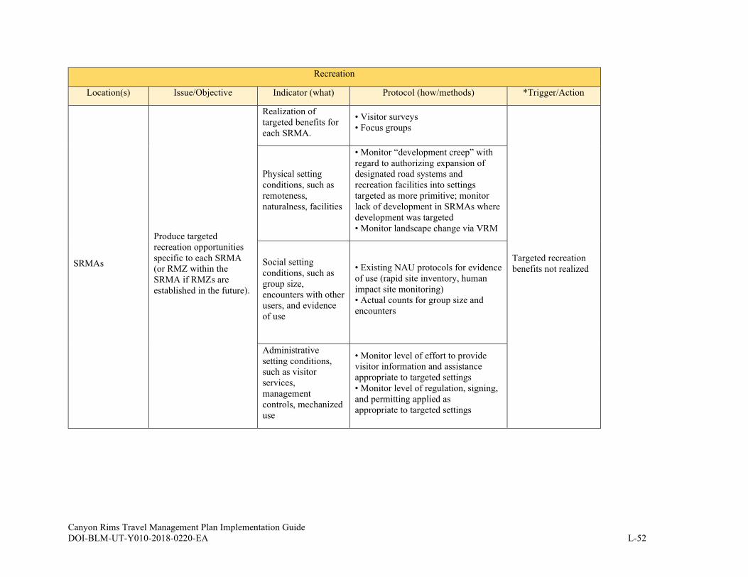
Canyon Rims Travel Management Plan Implementation Guide DOI-BLM-UT-Y010-2018-0220-EA L-52
Recreation
Location(s) Issue/Objective Indicator (what) Protocol (how/methods) *Trigger/Action
SRMAs
Produce targeted
recreation opportunities
specific to each SRMA
(or RMZ within the
SRMA if RMZs are
established in the future).
Realization of
targeted benefits for
each SRMA.
• Visitor surveys
• Focus groups
Targeted recreation
benefits not realized
Physical setting
conditions, such as
remoteness,
naturalness, facilities
• Monitor “development creep” with
regard to authorizing expansion of
designated road systems and
recreation facilities into settings
targeted as more primitive; monitor
lack of development in SRMAs where
development was targeted
• Monitor landscape change via VRM
Social setting
conditions, such as
group size,
encounters with other
users, and evidence
of use
• Existing NAU protocols for evidence
of use (rapid site inventory, human
impact site monitoring)
• Actual counts for group size and
encounters
Administrative
setting conditions,
such as visitor
services,
management
controls, mechanized
use
• Monitor level of effort to provide
visitor information and assistance
appropriate to targeted settings
• Monitor level of regulation, signing,
and permitting applied as
appropriate to targeted settings

Canyon Rims Travel Management Plan Implementation Guide DOI-BLM-UT-Y010-2018-0220-EA L-53
APPENDIX L-C. ROUTE RECLAMATION
Closed OHV Routes and Travel Maps
In general, OHV-closed routes should not appear on the travel map associated with the TMP.
However, the BLM may choose to include some OHV-closed routes on maps as helpful points of
reference or when needed or helpful for authorized users.
Disguising Routes with Natural Materials
This method, sometimes referred to as “vertical mulching,” is used to hide routes from view. If
routes are not on travel maps and are not evident to visitors, they will be unlikely to receive
additional use. Often, the first several hundred feet of illegal routes or routes slated for
reclamation may be disguised to look like surrounding areas by placing rocks, dead wood and
plants, and in some cases planting live vegetation in a natural-looking arrangement. Where
possible, materials used should be large enough and abundantly placed in order to deter people
familiar with route locations from easily removing them. In some cases, mechanical tools such as
shovels, rakes, and other hand tools may be employed to obliterate embankments, ruts, water
bars and ditches.
Ripping and Reseeding Routes
This process mechanically removes routes from the landscape and revegetates them. Native seed
mixes should be used. Mechanical removal may be accomplished by hand or, among other
methods, with the use of power equipment, excavators, bulldozers, or harrow or seed drills.
Herbicides may also be used for revegetation. Based on site-specific conditions, seeding and
planting treatments may include:
• Preparing a seedbed.
• Selecting an appropriate seed mix.
• Applying the seed.
• Covering the seed.
Due to the broad spectrum of situations encountered, all possible treatment options and
combinations of treatments may be utilized. This process ultimately results in closed routes
becoming undetectable.
Barrier Installation
In locations where it is impractical to employ any of the previous methods (e.g., extremely rocky
areas) and in areas where administrative use may occasionally be required on a route closed to
the public, it may be necessary to install natural or human-made barriers such as large boulders,
fences with gates, or other barriers to physically prevent unauthorized use. Where possible and
practical, these measures may be removed when routes are reclaimed or fully disguised.
Closing Routes with Informational Signs
This measure may be applied in cases where the previous measures have failed and ripping and
seeding or the use of physical barriers is impractical or ineffective. It may also be used on routes
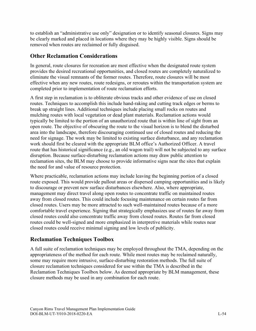
Canyon Rims Travel Management Plan Implementation Guide DOI-BLM-UT-Y010-2018-0220-EA L-54
to establish an “administrative use only” designation or to identify seasonal closures. Signs may
be clearly marked and placed in locations where they may be highly visible. Signs should be
removed when routes are reclaimed or fully disguised.
Other Reclamation Considerations
In general, route closures for recreation are most effective when the designated route system
provides the desired recreational opportunities, and closed routes are completely naturalized to
eliminate the visual remnants of the former routes. Therefore, route closures will be most
effective when any new routes, route redesigns, or reroutes within the transportation system are
completed prior to implementation of route reclamation efforts.
A first step in reclamation is to obliterate obvious tracks and other evidence of use on closed
routes. Techniques to accomplish this include hand-raking and cutting track edges or berms to
break up straight lines. Additional techniques include placing small rocks on routes and
mulching routes with local vegetation or dead plant materials. Reclamation actions would
typically be limited to the portion of an unauthorized route that is within line of sight from an
open route. The objective of obscuring the route to the visual horizon is to blend the disturbed
area into the landscape, therefore discouraging continued use of closed routes and reducing the
need for signage. The work may be limited to existing surface disturbance, and any reclamation
work should first be cleared with the appropriate BLM office’s Authorized Officer. A travel
route that has historical significance (e.g., an old wagon trail) will not be subjected to any surface
disruption. Because surface-disturbing reclamation actions may draw public attention to
reclamation sites, the BLM may choose to provide informative signs near the sites that explain
the need for and value of resource protection.
Where practicable, reclamation actions may include leaving the beginning portion of a closed
route exposed. This would provide pullout areas or dispersed camping opportunities and is likely
to discourage or prevent new surface disturbances elsewhere. Also, where appropriate,
management may direct travel along open routes to concentrate traffic on maintained routes
away from closed routes. This could include focusing maintenance on certain routes far from
closed routes. Users may be more attracted to such well-maintained routes because of a more
comfortable travel experience. Signing that strategically emphasizes use of routes far away from
closed routes could also concentrate traffic away from closed routes. Routes far from closed
routes could be well-signed and more emphasized in interpretive materials while routes near
closed routes could receive minimal signing and low levels of publicity.
Reclamation Techniques Toolbox
A full suite of reclamation techniques may be employed throughout the TMA, depending on the
appropriateness of the method for each route. While most routes may be reclaimed naturally,
some may require more intrusive, surface-disturbing restoration methods. The full suite of
closure reclamation techniques considered for use within the TMA is described in the
Reclamation Techniques Toolbox below. As deemed appropriate by BLM management, these
closure methods may be used in any combination for each route.

Canyon Rims Travel Management Plan Implementation Guide DOI-BLM-UT-Y010-2018-0220-EA L-55
Table L.40: Reclamation Techniques Toolbox
Manual Techniques
Passive/ natural
reclamation
Allow the route to naturally reclaim without any signing, surface disturbance, or replanting of
vegetation. This method is proposed in lightly used areas and on routes where restoration is
already occurring. The goal is to avoid attracting attention by not signing or fencing these
lightly used routes. This is the least obvious method of closure, least costly to the BLM, and
provides a high degree of naturalness when successfully implemented.
Fence and
sign/fence
only/gate
This method applies to upland routes, dry wash routes and routes limited to authorized users for
administrative use. This type of closure has little surface disturbance and is used in areas where
fence cutting would be expected to be minimal. Generally, the fence type would be T-post and
four strand smooth wire; however, the fence type could be increased to pipe rail/steel rail as
needed while still maintaining a small footprint at the beginning or end of a route. Fencing and
signs can later be removed to complete the reclamation process. A locked gate could be used to
control unauthorized use on routes limited to authorized users such as grazing permittees and
BLM staff.
Sign only
This method applies mainly to upland routes in lightly used areas and is proposed for routes in
lightly used areas and/or in areas where compliance with signage is expected to be good. The
signage can later be removed to complete the reclamation process.
Rake out tracks
only
This applies mainly to sandy washes where erasing the evidence of use in lightly used areas
may be enough to prevent attracting future use. This is very light on the land and provides a
high degree of naturalness when done. The goal is to avoid attracting attention to lightly used
routes. Monitoring and raking is required to ensure effectiveness and may be required for up to
one year.
Rake out tracks
and sign
This method applies mainly to sandy washes in lightly used areas. A sign reinforces the closure
by placing physical notice for visitors and to assist law enforcement. This method is low cost to
the BLM and provides a moderate degree of naturalness when complete. A downside to this
method is the potentially high number of closed signs that can accumulate in a given area and
the public perception that many routes are being closed, leading to vandalism. Monitoring is
required to ensure effectiveness. Signage can be removed to complete the reclamation.
Vertical mulch
with berm/ fence
and sign
This method works in upland areas where occasional use of routes in lightly used areas prevents
natural restoration. A sign provides physical notice and assistance to law enforcement. A T-post
and four strand smooth wire fence works best when the fence is placed in an area where
bypassing it is difficult. Combined with a sign and/or fencing, actively placing cuttings of
sagebrush, transplanted bushes, and scattering dead vegetation in the wheel tracks may be
enough to prevent use. Placement of plants in the closed route to the visible horizon minimizes
cost and surface disturbance. Seed mixtures may also be applied to enhance the effectiveness of
reclamation.
Barriers
Physical blockades constructed to prevent the passage of vehicles. Barriers may be earthen
mounds, wire fence, pipe rail fence, post and cable fence, concrete wall sections (also referred
to as Jersey or K-rail barriers), or free-standing steel structures commonly referred to as
Normandy barriers. To the greatest extent practicable, the BLM may utilize native, natural
materials, such as rocks, vegetative debris and wood to minimize further visual impacts to the
landscape. For example, wooden split rail fencing may be preferable to metal fencing.
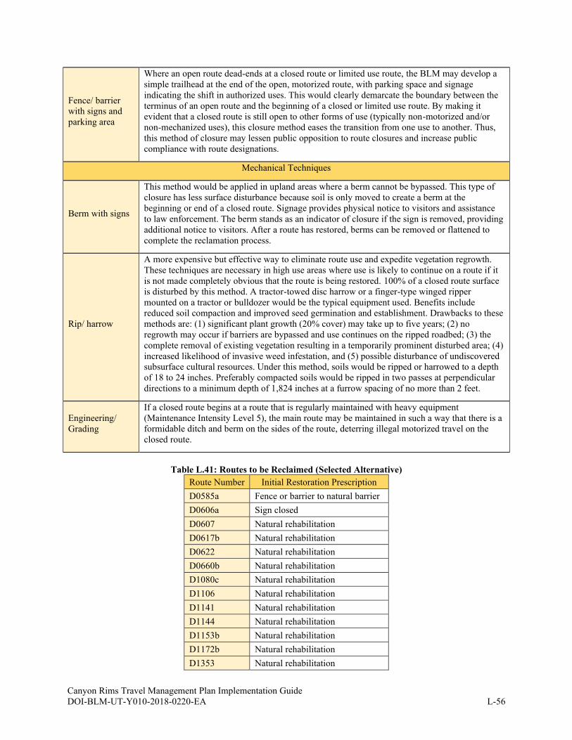
Canyon Rims Travel Management Plan Implementation Guide DOI-BLM-UT-Y010-2018-0220-EA L-56
Fence/ barrier
with signs and
parking area
Where an open route dead-ends at a closed route or limited use route, the BLM may develop a
simple trailhead at the end of the open, motorized route, with parking space and signage
indicating the shift in authorized uses. This would clearly demarcate the boundary between the
terminus of an open route and the beginning of a closed or limited use route. By making it
evident that a closed route is still open to other forms of use (typically non-motorized and/or
non-mechanized uses), this closure method eases the transition from one use to another. Thus,
this method of closure may lessen public opposition to route closures and increase public
compliance with route designations.
Mechanical Techniques
Berm with signs
This method would be applied in upland areas where a berm cannot be bypassed. This type of
closure has less surface disturbance because soil is only moved to create a berm at the
beginning or end of a closed route. Signage provides physical notice to visitors and assistance
to law enforcement. The berm stands as an indicator of closure if the sign is removed, providing
additional notice to visitors. After a route has restored, berms can be removed or flattened to
complete the reclamation process.
Rip/ harrow
A more expensive but effective way to eliminate route use and expedite vegetation regrowth.
These techniques are necessary in high use areas where use is likely to continue on a route if it
is not made completely obvious that the route is being restored. 100% of a closed route surface
is disturbed by this method. A tractor-towed disc harrow or a finger-type winged ripper
mounted on a tractor or bulldozer would be the typical equipment used. Benefits include
reduced soil compaction and improved seed germination and establishment. Drawbacks to these
methods are: (1) significant plant growth (20% cover) may take up to five years; (2) no
regrowth may occur if barriers are bypassed and use continues on the ripped roadbed; (3) the
complete removal of existing vegetation resulting in a temporarily prominent disturbed area; (4)
increased likelihood of invasive weed infestation, and (5) possible disturbance of undiscovered
subsurface cultural resources. Under this method, soils would be ripped or harrowed to a depth
of 18 to 24 inches. Preferably compacted soils would be ripped in two passes at perpendicular
directions to a minimum depth of 1,824 inches at a furrow spacing of no more than 2 feet.
Engineering/
Grading
If a closed route begins at a route that is regularly maintained with heavy equipment
(Maintenance Intensity Level 5), the main route may be maintained in such a way that there is a
formidable ditch and berm on the sides of the route, deterring illegal motorized travel on the
closed route.
Table L.41: Routes to be Reclaimed (Selected Alternative)
Route Number Initial Restoration Prescription
D0585a Fence or barrier to natural barrier
D0606a Sign closed
D0607 Natural rehabilitation
D0617b Natural rehabilitation
D0622 Natural rehabilitation
D0660b Natural rehabilitation
D1080c Natural rehabilitation
D1106 Natural rehabilitation
D1141 Natural rehabilitation
D1144 Natural rehabilitation
D1153b Natural rehabilitation
D1172b Natural rehabilitation
D1353 Natural rehabilitation
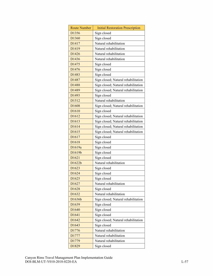
Canyon Rims Travel Management Plan Implementation Guide DOI-BLM-UT-Y010-2018-0220-EA L-57
Route Number Initial Restoration Prescription
D1356 Sign closed
D1360 Sign closed
D1417 Natural rehabilitation
D1419 Natural rehabilitation
D1426 Natural rehabilitation
D1436 Natural rehabilitation
D1475 Sign closed
D1476 Sign closed
D1483 Sign closed
D1487 Sign closed; Natural rehabilitation
D1488 Sign closed; Natural rehabilitation
D1489 Sign closed; Natural rehabilitation
D1493 Sign closed
D1512 Natural rehabilitation
D1608 Sign closed; Natural rehabilitation
D1610 Sign closed
D1612 Sign closed; Natural rehabilitation
D1613 Sign closed; Natural rehabilitation
D1614 Sign closed; Natural rehabilitation
D1615 Sign closed; Natural rehabilitation
D1617 Sign closed
D1618 Sign closed
D1619a Sign closed
D1619b Sign closed
D1621 Sign closed
D1622b Natural rehabilitation
D1623 Sign closed
D1624 Sign closed
D1625 Sign closed
D1627 Natural rehabilitation
D1628 Sign closed
D1632 Natural rehabilitation
D1636b Sign closed; Natural rehabilitation
D1639 Sign closed
D1640 Sign closed
D1641 Sign closed
D1642 Sign closed; Natural rehabilitation
D1643 Sign closed
D1776 Natural rehabilitation
D1777 Natural rehabilitation
D1779 Natural rehabilitation
D1829 Sign closed
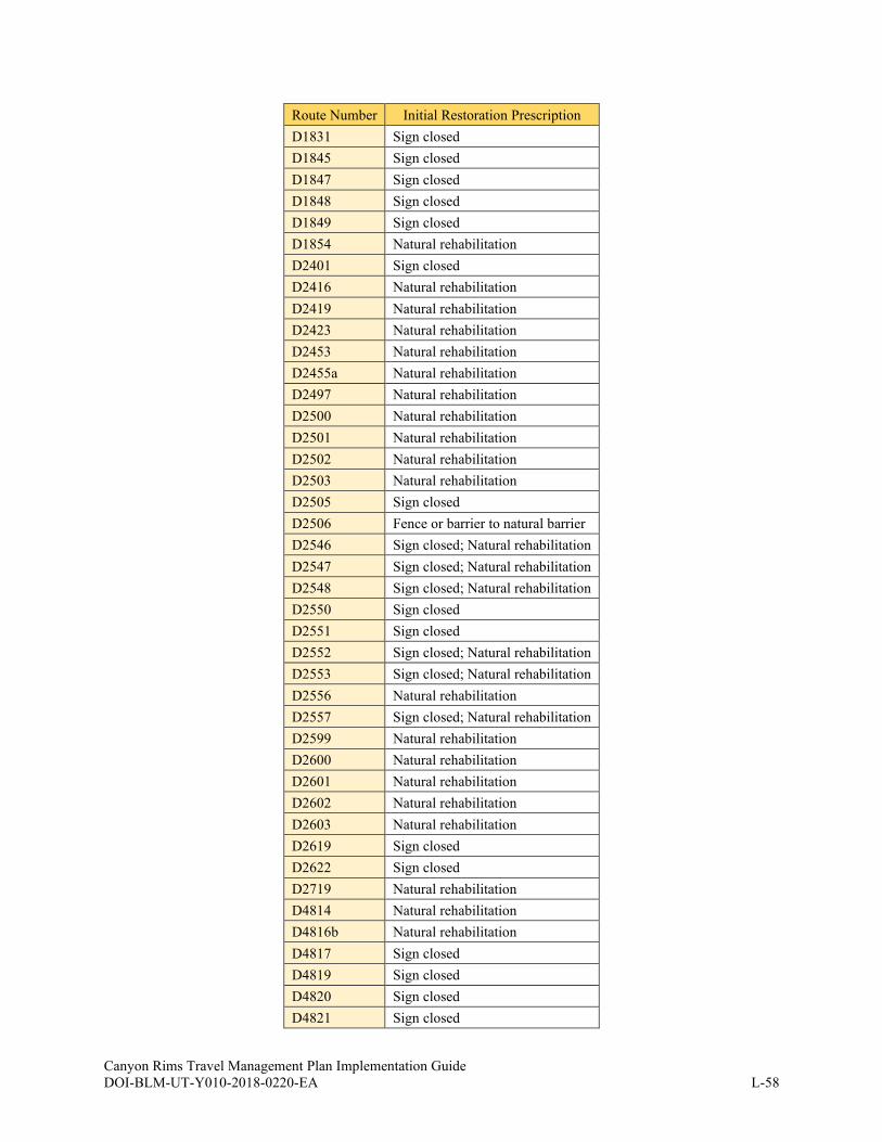
Canyon Rims Travel Management Plan Implementation Guide DOI-BLM-UT-Y010-2018-0220-EA L-58
Route Number Initial Restoration Prescription
D1831 Sign closed
D1845 Sign closed
D1847 Sign closed
D1848 Sign closed
D1849 Sign closed
D1854 Natural rehabilitation
D2401 Sign closed
D2416 Natural rehabilitation
D2419 Natural rehabilitation
D2423 Natural rehabilitation
D2453 Natural rehabilitation
D2455a Natural rehabilitation
D2497 Natural rehabilitation
D2500 Natural rehabilitation
D2501 Natural rehabilitation
D2502 Natural rehabilitation
D2503 Natural rehabilitation
D2505 Sign closed
D2506 Fence or barrier to natural barrier
D2546 Sign closed; Natural rehabilitation
D2547 Sign closed; Natural rehabilitation
D2548 Sign closed; Natural rehabilitation
D2550 Sign closed
D2551 Sign closed
D2552 Sign closed; Natural rehabilitation
D2553 Sign closed; Natural rehabilitation
D2556 Natural rehabilitation
D2557 Sign closed; Natural rehabilitation
D2599 Natural rehabilitation
D2600 Natural rehabilitation
D2601 Natural rehabilitation
D2602 Natural rehabilitation
D2603 Natural rehabilitation
D2619 Sign closed
D2622 Sign closed
D2719 Natural rehabilitation
D4814 Natural rehabilitation
D4816b Natural rehabilitation
D4817 Sign closed
D4819 Sign closed
D4820 Sign closed
D4821 Sign closed

Canyon Rims Travel Management Plan Implementation Guide DOI-BLM-UT-Y010-2018-0220-EA L-59
Route Number Initial Restoration Prescription
D4823 Natural rehabilitation
D4824 Natural rehabilitation
D4825 Natural rehabilitation
D4826 Natural rehabilitation

Canyon Rims Travel Management Plan Implementation Guide DOI-BLM-UT-Y010-2018-0220-EA L-60
APPENDIX L-D. TRAVEL MANAGEMENT AND ROUTE DESIGNATION
GUIDANCE FOR KEY PROTECTED AREAS
Overview
Some special designation rules apply to wilderness, Wild and Scenic Rivers (WSRs), Wilderness
Study Areas (WSAs), and inventoried LWCs. The TMA includes various LWC units. It does not
currently contain WSAs, though they could be established in the future. Also, no TMA LWC
units are currently managed for wilderness characteristics in the RMP, but that could change
with RMP revisions. Therefore, guidance for all special designations below is included in this
Guide.
Wilderness
The BLM’s wilderness management manual (BLM 2012h) contains guidance about routes and
vehicles in wilderness areas. It lists permanent roads, temporary roads, motor vehicles, and
mechanical transport as prohibited uses in wilderness areas. Pages 1-12 to 1-13 of the manual
provide more specifics. The BLM’s wilderness manual also provides details on exceptions to
these prohibitions on pages 1-15 to 1-17. Information on access authorizations in wilderness
areas is provided on pages 1-30 to 1-31. The manual provides guidance on trails and trail
systems (including new construction and access points) on pages 1-40 to 1-41.
Wild and Scenic Rivers
The BLM’s wild and scenic rivers manual (BLM 2012i) provides some travel management
guidance in the context of rivers officially designated as wild and scenic and rivers that are
eligible and suitable for such a designation but not designated. According to the manual, for both
designated and eligible/suitable wild and scenic rivers, “motorized and mechanized travel on
land or water may be permitted, prohibited, or restricted to protect the river values” (BLM
2012i). For designated wild and scenic rivers, the BLM manual provides the following guidance
under the heading of “Transportation System”:
1. Wild. New roads are not generally compatible with this classification. A few existing
roads leading to the boundary of the river corridor may be acceptable. New trail
construction should generally be designed for nonmotorized uses. However, limited
motorized uses that are compatible with identified values and unobtrusive trail bridges
may be allowed. In order to protect and enhance river values, the BLM should consider
restrictions or prohibitions of new airfields if such development is proposed.
2. Scenic. New roads and railroads are permitted to parallel the river for short segments or
bridge the river if such construction fully protects river values (including the river’s free-
flowing condition). Bridge crossings and river access are allowed. New trail construction
or airfields must be compatible with and fully protect identified values.
3. Recreational. New roads and railroads are permitted to parallel the river if such
construction fully protects river values (including the river’s free-flowing condition).
Bridge crossings and river access are allowed. New trail construction or airfields must be
compatible with and fully protect identified values.
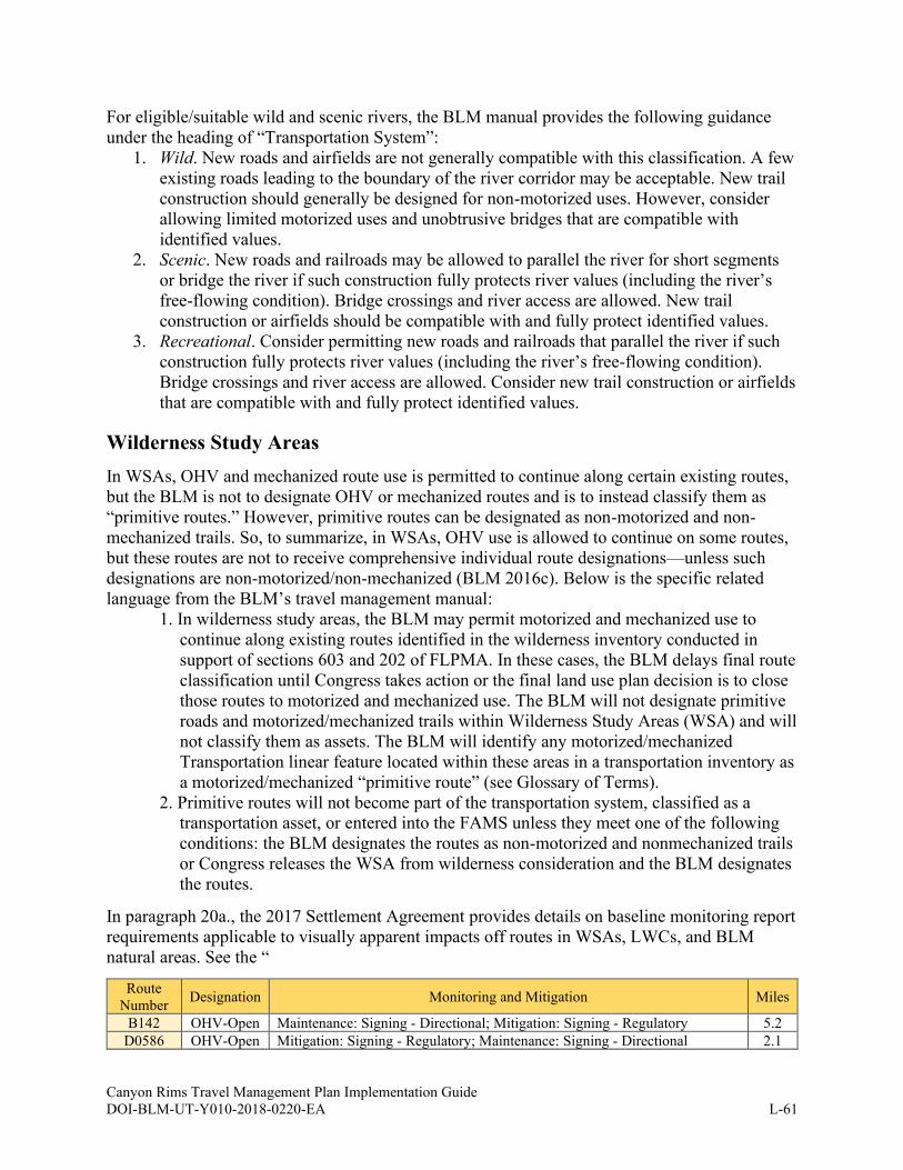
Canyon Rims Travel Management Plan Implementation Guide DOI-BLM-UT-Y010-2018-0220-EA L-61
For eligible/suitable wild and scenic rivers, the BLM manual provides the following guidance
under the heading of “Transportation System”:
1. Wild. New roads and airfields are not generally compatible with this classification. A few
existing roads leading to the boundary of the river corridor may be acceptable. New trail
construction should generally be designed for non-motorized uses. However, consider
allowing limited motorized uses and unobtrusive bridges that are compatible with
identified values.
2. Scenic. New roads and railroads may be allowed to parallel the river for short segments
or bridge the river if such construction fully protects river values (including the river’s
free-flowing condition). Bridge crossings and river access are allowed. New trail
construction or airfields should be compatible with and fully protect identified values.
3. Recreational. Consider permitting new roads and railroads that parallel the river if such
construction fully protects river values (including the river’s free-flowing condition).
Bridge crossings and river access are allowed. Consider new trail construction or airfields
that are compatible with and fully protect identified values.
Wilderness Study Areas
In WSAs, OHV and mechanized route use is permitted to continue along certain existing routes,
but the BLM is not to designate OHV or mechanized routes and is to instead classify them as
“primitive routes.” However, primitive routes can be designated as non-motorized and non-
mechanized trails. So, to summarize, in WSAs, OHV use is allowed to continue on some routes,
but these routes are not to receive comprehensive individual route designations—unless such
designations are non-motorized/non-mechanized (BLM 2016c). Below is the specific related
language from the BLM’s travel management manual:
1. In wilderness study areas, the BLM may permit motorized and mechanized use to
continue along existing routes identified in the wilderness inventory conducted in
support of sections 603 and 202 of FLPMA. In these cases, the BLM delays final route
classification until Congress takes action or the final land use plan decision is to close
those routes to motorized and mechanized use. The BLM will not designate primitive
roads and motorized/mechanized trails within Wilderness Study Areas (WSA) and will
not classify them as assets. The BLM will identify any motorized/mechanized
Transportation linear feature located within these areas in a transportation inventory as
a motorized/mechanized “primitive route” (see Glossary of Terms).
2. Primitive routes will not become part of the transportation system, classified as a
transportation asset, or entered into the FAMS unless they meet one of the following
conditions: the BLM designates the routes as non-motorized and nonmechanized trails
or Congress releases the WSA from wilderness consideration and the BLM designates
the routes.
In paragraph 20a., the 2017 Settlement Agreement provides details on baseline monitoring report
requirements applicable to visually apparent impacts off routes in WSAs, LWCs, and BLM
natural areas. See the “
Route
Number Designation Monitoring and Mitigation Miles
B142 OHV-Open Maintenance: Signing - Directional; Mitigation: Signing - Regulatory 5.2
D0586 OHV-Open Mitigation: Signing - Regulatory; Maintenance: Signing - Directional 2.1
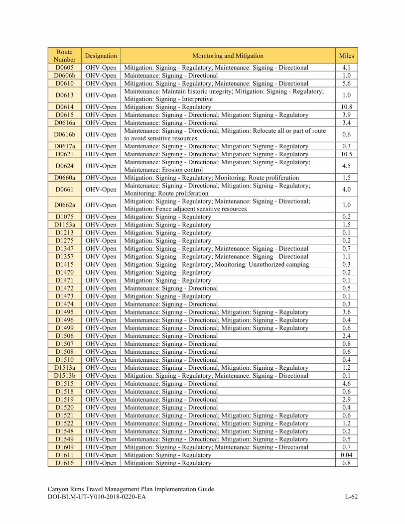
Canyon Rims Travel Management Plan Implementation Guide DOI-BLM-UT-Y010-2018-0220-EA L-62
Route
Number Designation Monitoring and Mitigation Miles
D0605 OHV-Open Mitigation: Signing - Regulatory; Maintenance: Signing - Directional 4.1
D0606b OHV-Open Maintenance: Signing - Directional 1.0
D0610 OHV-Open Mitigation: Signing - Regulatory; Maintenance: Signing - Directional 5.6
D0613 OHV-Open Maintenance: Maintain historic integrity; Mitigation: Signing - Regulatory;
Mitigation: Signing - Interpretive 1.0
D0614 OHV-Open Mitigation: Signing - Regulatory 10.8
D0615 OHV-Open Maintenance: Signing - Directional; Mitigation: Signing - Regulatory 3.9
D0616a OHV-Open Maintenance: Signing - Directional 3.4
D0616b OHV-Open Maintenance: Signing - Directional; Mitigation: Relocate all or part of route
to avoid sensitive resources 0.6
D0617a OHV-Open Maintenance: Signing - Directional; Mitigation: Signing - Regulatory 0.3
D0621 OHV-Open Maintenance: Signing - Directional; Mitigation: Signing - Regulatory 10.5
D0624 OHV-Open Maintenance: Signing - Directional; Mitigation: Signing - Regulatory;
Maintenance: Erosion control 4.5
D0660a OHV-Open Mitigation: Signing - Regulatory; Monitoring: Route proliferation 1.5
D0661 OHV-Open Maintenance: Signing - Directional; Mitigation: Signing - Regulatory;
Monitoring: Route proliferation 4.0
D0662a OHV-Open Mitigation: Signing - Regulatory; Maintenance: Signing - Directional;
Mitigation: Fence adjacent sensitive resources 1.0
D1075 OHV-Open Mitigation: Signing - Regulatory 0.2
D1153a OHV-Open Mitigation: Signing - Regulatory 1.5
D1213 OHV-Open Mitigation: Signing - Regulatory 0.1
D1275 OHV-Open Mitigation: Signing - Regulatory 0.2
D1347 OHV-Open Mitigation: Signing - Regulatory; Maintenance: Signing - Directional 0.7
D1357 OHV-Open Mitigation: Signing - Regulatory; Maintenance: Signing - Directional 1.1
D1415 OHV-Open Mitigation: Signing - Regulatory; Monitoring: Unauthorized camping 0.3
D1470 OHV-Open Mitigation: Signing - Regulatory 0.2
D1471 OHV-Open Mitigation: Signing - Regulatory 0.1
D1472 OHV-Open Maintenance: Signing - Directional 0.5
D1473 OHV-Open Mitigation: Signing - Regulatory 0.1
D1474 OHV-Open Maintenance: Signing - Directional 0.3
D1495 OHV-Open Maintenance: Signing - Directional; Mitigation: Signing - Regulatory 3.6
D1496 OHV-Open Maintenance: Signing - Directional; Mitigation: Signing - Regulatory 0.4
D1499 OHV-Open Maintenance: Signing - Directional; Mitigation: Signing - Regulatory 0.6
D1506 OHV-Open Maintenance: Signing - Directional 2.4
D1507 OHV-Open Maintenance: Signing - Directional 0.8
D1508 OHV-Open Maintenance: Signing - Directional 0.6
D1510 OHV-Open Maintenance: Signing - Directional 0.4
D1513a OHV-Open Maintenance: Signing - Directional; Mitigation: Signing - Regulatory 1.2
D1513b OHV-Open Mitigation: Signing - Regulatory; Maintenance: Signing - Directional 0.1
D1515 OHV-Open Maintenance: Signing - Directional 4.6
D1518 OHV-Open Maintenance: Signing - Directional 0.6
D1519 OHV-Open Maintenance: Signing - Directional 2.9
D1520 OHV-Open Maintenance: Signing - Directional 0.4
D1521 OHV-Open Maintenance: Signing - Directional; Mitigation: Signing - Regulatory 0.6
D1522 OHV-Open Maintenance: Signing - Directional; Mitigation: Signing - Regulatory 1.2
D1548 OHV-Open Maintenance: Signing - Directional; Mitigation: Signing - Regulatory 0.2
D1549 OHV-Open Maintenance: Signing - Directional; Mitigation: Signing - Regulatory 0.5
D1609 OHV-Open Mitigation: Signing - Regulatory; Maintenance: Signing - Directional 0.7
D1611 OHV-Open Mitigation: Signing - Regulatory 0.04
D1616 OHV-Open Mitigation: Signing - Regulatory 0.8
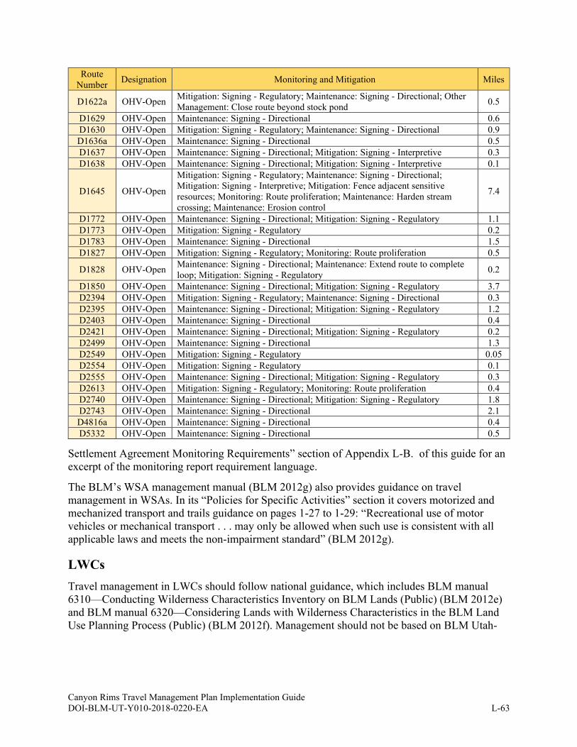
Canyon Rims Travel Management Plan Implementation Guide DOI-BLM-UT-Y010-2018-0220-EA L-63
Route
Number Designation Monitoring and Mitigation Miles
D1622a OHV-Open Mitigation: Signing - Regulatory; Maintenance: Signing - Directional; Other
Management: Close route beyond stock pond 0.5
D1629 OHV-Open Maintenance: Signing - Directional 0.6
D1630 OHV-Open Mitigation: Signing - Regulatory; Maintenance: Signing - Directional 0.9
D1636a OHV-Open Maintenance: Signing - Directional 0.5
D1637 OHV-Open Maintenance: Signing - Directional; Mitigation: Signing - Interpretive 0.3
D1638 OHV-Open Maintenance: Signing - Directional; Mitigation: Signing - Interpretive 0.1
D1645 OHV-Open
Mitigation: Signing - Regulatory; Maintenance: Signing - Directional;
Mitigation: Signing - Interpretive; Mitigation: Fence adjacent sensitive
resources; Monitoring: Route proliferation; Maintenance: Harden stream
crossing; Maintenance: Erosion control
7.4
D1772 OHV-Open Maintenance: Signing - Directional; Mitigation: Signing - Regulatory 1.1
D1773 OHV-Open Mitigation: Signing - Regulatory 0.2
D1783 OHV-Open Maintenance: Signing - Directional 1.5
D1827 OHV-Open Mitigation: Signing - Regulatory; Monitoring: Route proliferation 0.5
D1828 OHV-Open Maintenance: Signing - Directional; Maintenance: Extend route to complete
loop; Mitigation: Signing - Regulatory 0.2
D1850 OHV-Open Maintenance: Signing - Directional; Mitigation: Signing - Regulatory 3.7
D2394 OHV-Open Mitigation: Signing - Regulatory; Maintenance: Signing - Directional 0.3
D2395 OHV-Open Maintenance: Signing - Directional; Mitigation: Signing - Regulatory 1.2
D2403 OHV-Open Maintenance: Signing - Directional 0.4
D2421 OHV-Open Maintenance: Signing - Directional; Mitigation: Signing - Regulatory 0.2
D2499 OHV-Open Maintenance: Signing - Directional 1.3
D2549 OHV-Open Mitigation: Signing - Regulatory 0.05
D2554 OHV-Open Mitigation: Signing - Regulatory 0.1
D2555 OHV-Open Maintenance: Signing - Directional; Mitigation: Signing - Regulatory 0.3
D2613 OHV-Open Mitigation: Signing - Regulatory; Monitoring: Route proliferation 0.4
D2740 OHV-Open Maintenance: Signing - Directional; Mitigation: Signing - Regulatory 1.8
D2743 OHV-Open Maintenance: Signing - Directional 2.1
D4816a OHV-Open Maintenance: Signing - Directional 0.4
D5332 OHV-Open Maintenance: Signing - Directional 0.5
Settlement Agreement Monitoring Requirements” section of Appendix L-B. of this guide for an
excerpt of the monitoring report requirement language.
The BLM’s WSA management manual (BLM 2012g) also provides guidance on travel
management in WSAs. In its “Policies for Specific Activities” section it covers motorized and
mechanized transport and trails guidance on pages 1-27 to 1-29: “Recreational use of motor
vehicles or mechanical transport . . . may only be allowed when such use is consistent with all
applicable laws and meets the non-impairment standard” (BLM 2012g).
LWCs
Travel management in LWCs should follow national guidance, which includes BLM manual
6310—Conducting Wilderness Characteristics Inventory on BLM Lands (Public) (BLM 2012e)
and BLM manual 6320—Considering Lands with Wilderness Characteristics in the BLM Land
Use Planning Process (Public) (BLM 2012f). Management should not be based on BLM Utah-
Canyon Rims Travel Management Plan Implementation Guide DOI-BLM-UT-Y010-2018-0220-EA L-64
specific management LWC guidance tied to UT-IM-2016-0275 as such guidance was rescinded
in December 2018. The LWC inventory manual provides LWC context-based definitions for
primitive routes and roads on pages 11 to 12. It also provides route analysis guidance in its
Appendix C.
5 The following documents should not be followed: BLM-UT Additional Guidance for Manual 6310 – Conducting
Wilderness Inventory on BLM and BLM-UT Additional Guidance for Manual 6320 – Considering Lands with
Wilderness Characteristics in the BLM Land Use Planning Process.
Canyon Rims Travel Management Plan Implementation Guide DOI-BLM-UT-Y010-2018-0220-EA L-65
APPENDIX L-E. ROUTE-BY-ROUTE DETAILS
As timing and resources allow BLM will assign the following attributes for each route and track
that information in the Ground Transportation Linear Feature dataset:
• Evaluation Route #
• FAMS #
• Primary Route Management Objective
• Functional Classification
• FAMS Asset Type
• Maintenance Intensity
• Indicator of route’s inclusion in FAMS
• Indicator of route’s FLTP eligibility
• Indicator of route’s FLAP eligibility
Canyon Rims Travel Management Plan Implementation Guide DOI-BLM-UT-Y010-2018-0220-EA L-66
APPENDIX L-F. SIGN PLAN BMPS
This section identifies and describes BMPs for signing routes on BLM land. It focuses on
portal/entry signs and route marker signs for individual routes. Additional details for signs on
BLM lands (installation, ordering, etc.) can be found in the BLM’s 2016 National Sign
Handbook (BLM 2016b) and the Federal Highway Administration’s Manual on Uniform Traffic
Control Devices, which is also known as the MUTCD (FHWA 2019).
Signing Objectives
The main objectives of this sign plan are to identify designated routes on the ground in a clear
and consistent manner to eliminate or minimize off-network travel and other misuse of the TMA
while reducing user conflict and resource impacts. To accomplish this, the BLM may create and
distribute well-designed signs so that the public can understand the designated travel network
and comply with its terms and regulations. Signs in the TMA should adhere to a consistent theme
and will be consistent with all applicable laws, regulations, policies, and land use plans.
Specific objectives of this sign plan are to:
1. Address signing priorities and areas of special emphasis.
2. Provide an orientation to the types of signs, their design, and their uses in the TMA.
3. Address sign placement for current and proposed signs.
4. Outline basic protocols for the monitoring and maintenance of the sign system, including
future signing needs.
General objectives for the BLM’s use of signs in the TMA are to:
1. Identify public lands.
2. Promote the health and safety of visitors to the public lands.
3. Meet visitor needs for information and direction.
4. Ensure visitors are aware of route designations.
5. Use sign communication to:
a. Inform the visitor of the natural and management features of the public lands and
waters.
b. Enhance visitor experiences.
c. Reduce or mitigate user and management issues.
6. Uniformly promote public awareness of the BLM’s multiple use mandate and
stewardship responsibilities in managing the U.S. public lands and waters through
consistent messages and signage.
7. Provide uniformity in the shapes, materials, messages, and appearance of BLM signs.
The BLM’s 2016 National Sign Handbook (BLM 2016b) provides specific objectives pertaining
to sign design:
The BLM must use and place signs judiciously; use the established emblem or wordmark,
where appropriate; use approved international symbols and established standards of the
sign industry; comply with Uniform Federal Accessibility Standards (UFAS) guidelines;
meet specifications established in the Manual on Uniform Traffic Control Devices
(MUTCD) for vehicle and pedestrian traffic control signs; comply with federal, state, and
local laws, as appropriate; and complement other media, such as maps, brochures, and
webpages.
Canyon Rims Travel Management Plan Implementation Guide DOI-BLM-UT-Y010-2018-0220-EA L-67
Sign Types and Design
Sign Types Overview
Under the final TMP, various types of signs and markers will be installed according to the
current BLM policies and guidance for recreation and travel management signing. Signs
appropriate to travel settings (i.e., Backcountry, Frontcountry, etc.) may be installed along roads,
primitive roads, and trails. BLM travel management signs should use positive, clear, and simple
messaging (BLM 2012a).
Signs are intended to guide, inform, and protect visitors. This section groups and defines the
types of signs used on the BLM public lands and waters. Each of these categories has its own
requirements and functions. Ideally, to avoid sign clutter, messages should not be mixed on a
single sign or in a grouping of signs. The following categories of signs and may be installed in
the TMA and include categories listed in the BLM’s national sign handbook (BLM 2016b):
• Identification
• Guide (navigation)
• Informational
• Traffic control devices
• Regulatory/warning/safety
• Miscellaneous (temporary, special event, etc.)
Sign Design Overview
From large, informational portal signs to small, individual route markers, clear and accurate
signing is crucial to provide all users of the travel network with the information they need to
comply with route designations and meet TMP goals and objectives. New signage may
incorporate elements from the design standards outlined in the most current version of the
BLM’s sign handbook (BLM 2016b) in addition to design specifications from the BLM sign
shop. Any deviations from these standards must be approved by the BLM National Sign
Coordinator.
Portal/Entry Signs
Large portal identification signs (see Figure L.2 - Figure L.4 below) may be installed at the
beginning of popularly used areas, routes, or entrance points. Figure L.2 shows the current
format of portal identification signs on BLM lands that are outside National Conservation Areas
(NCAs). The BLM sign handbook (BLM 2016b) provides greater detail on formatting BLM
signs.
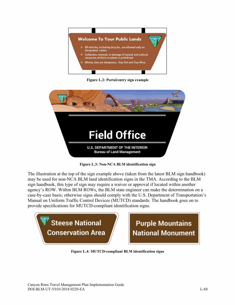
Canyon Rims Travel Management Plan Implementation Guide DOI-BLM-UT-Y010-2018-0220-EA L-68
Figure L.2: Portal/entry sign example
Figure L.3: Non-NCA BLM identification sign
The illustration at the top of the sign example above (taken from the latest BLM sign handbook)
may be used for non-NCA BLM land identification signs in the TMA. According to the BLM
sign handbook, this type of sign may require a waiver or approval if located within another
agency’s ROW. Within BLM ROWs, the BLM state engineer can make the determination on a
case-by-case basis; otherwise signs should comply with the U.S. Department of Transportation’s
Manual on Uniform Traffic Control Devices (MUTCD) standards. The handbook goes on to
provide specifications for MUTCD-compliant identification signs.
Figure L.4: MUTCD-compliant BLM identification signs
Moab
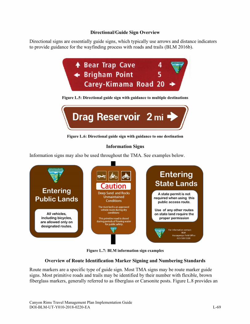
Canyon Rims Travel Management Plan Implementation Guide DOI-BLM-UT-Y010-2018-0220-EA L-69
Directional/Guide Sign Overview
Directional signs are essentially guide signs, which typically use arrows and distance indicators
to provide guidance for the wayfinding process with roads and trails (BLM 2016b).
Figure L.5: Directional guide sign with guidance to multiple destinations
Figure L.6: Directional guide sign with guidance to one destination
Information Signs
Information signs may also be used throughout the TMA. See examples below.
Figure L.7: BLM information sign examples
Overview of Route Identification Marker Signing and Numbering Standards
Route markers are a specific type of guide sign. Most TMA signs may be route marker guide
signs. Most primitive roads and trails may be identified by their number with flexible, brown
fiberglass markers, generally referred to as fiberglass or Carsonite posts. Figure L.8 provides an
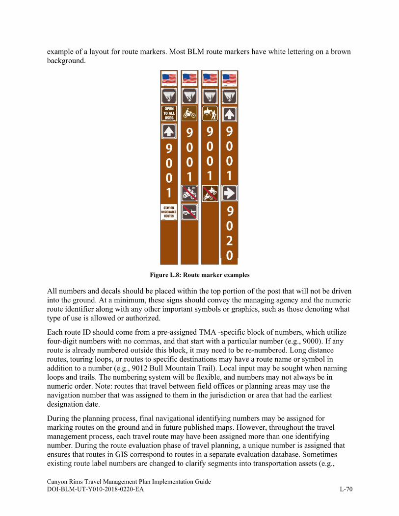
Canyon Rims Travel Management Plan Implementation Guide DOI-BLM-UT-Y010-2018-0220-EA L-70
example of a layout for route markers. Most BLM route markers have white lettering on a brown
background.
Figure L.8: Route marker examples
All numbers and decals should be placed within the top portion of the post that will not be driven
into the ground. At a minimum, these signs should convey the managing agency and the numeric
route identifier along with any other important symbols or graphics, such as those denoting what
type of use is allowed or authorized.
Each route ID should come from a pre-assigned TMA -specific block of numbers, which utilize
four-digit numbers with no commas, and that start with a particular number (e.g., 9000). If any
route is already numbered outside this block, it may need to be re-numbered. Long distance
routes, touring loops, or routes to specific destinations may have a route name or symbol in
addition to a number (e.g., 9012 Bull Mountain Trail). Local input may be sought when naming
loops and trails. The numbering system will be flexible, and numbers may not always be in
numeric order. Note: routes that travel between field offices or planning areas may use the
navigation number that was assigned to them in the jurisdiction or area that had the earliest
designation date.
During the planning process, final navigational identifying numbers may be assigned for
marking routes on the ground and in future published maps. However, throughout the travel
management process, each travel route may have been assigned more than one identifying
number. During the route evaluation phase of travel planning, a unique number is assigned that
ensures that routes in GIS correspond to routes in a separate evaluation database. Sometimes
existing route label numbers are changed to clarify segments into transportation assets (e.g.,

Canyon Rims Travel Management Plan Implementation Guide DOI-BLM-UT-Y010-2018-0220-EA L-71
roads, primitive roads, and trails). These evaluation numbers are used in route reports (described
in Appendix H of the EA). Finally, navigational identifying numbers are assigned as described
above, and they become the official FAMS asset numbers as well. All versions of the travel
network routes’ various identifying number schemes may be maintained in a GIS database.
To limit the number of markers at an intersection, two routes may be identified on one post using
arrow symbols and using both sides of the double-sided fiberglass posts. When adding a route
name or where more than two international symbols are needed to convey a restriction or
allowable use, the BLM may develop special decals which clearly state needed messages or trail
names. If a volunteer group adopts a route, they may be allowed to develop a decal to place on
the route’s markers. On sign marker posts, trail names or trail adopters may be identified and
labeled above route numbers. Not all route markers need to include a route name and numeric
route identifier.
Where there is potential for a route to be traveled by motorized vehicles past its designated
terminus, “Motorized Route Ends” signs or decals may be used. Routes that are open to
administrative use only may be marked prominently with standard “closed” route signs (usually
at the beginning of the route) and may be used in conjunction with route markers that display a
standard “administrative use only” message.
Figure L.9: BLM route marker on the ground
Where designated OHV routes intersect with closed routes, “closed” route markers may be
placed only where absolutely necessary for resource protection or public safety. When these
closed routes are completely reclaimed either through natural re-vegetation or reclamation
efforts, and the “closed” route markers are no longer necessary, the markers may be removed.
Implementation of signing should be completed in accordance with current BLM policy and
guidance per the most current BLM sign handbook (BLM 2016b). Specifics for sign design, use,

Canyon Rims Travel Management Plan Implementation Guide DOI-BLM-UT-Y010-2018-0220-EA L-72
and location are also determined by the BLM’s manuals for roads (BLM 2015a) and primitive
roads (BLM 2012d), the BLM’s sign manual (BLM 2004), and the BLM’s travel management
handbook (BLM 2012a).
Markers for Travel Routes That Are Open and Limited
Markers for travel routes that are open or limited to OHV travel may follow the basic layout
depicted in the signs in Figure L.9. Each marker post may contain the following elements:
• Arrow pointing in the direction of the route being marked
• Route identification number
• Symbols of allowed uses to which the route is open
• Symbols of prohibited uses to which the route is closed
• BLM logo
Markers may also have a decal with GPS coordinates marked at strategic locations.
Markers for Routes That Are Limited (Administrative) or Closed
Markers for travel routes where public motorized vehicle travel is allowed but limited (with
various restrictions) may use signs formatted like the first sign in Figure L.10, below. Markers
for travel routes that are decommissioned or closed to all forms of motorized vehicle travel may
use signs similar to that at the right in Figure L.10. Where motorized vehicle travel is limited to
administrative use, signs stating closure to OHVs may be used. Once a route has been
decommissioned, and the route footprint has revegetated and blends in with the adjacent
landscape, signs may be removed so as not to attract attention to the fact that a travel route once
existed.
Figure L.10: Route Designation, Restriction, and Closure Signs
Additional Sign Examples
In addition to portal/entry signs, directional signs, general guide signs, designated route marker
guide signs, and closure/limitation signs, the following signs may be used:
Canyon Rims Travel Management Plan Implementation Guide DOI-BLM-UT-Y010-2018-0220-EA L-73
Figure L.11: Additional Travel Management Signs
Sign Placement
Priorities for Placing Signs
Priorities for the placement of signing are listed below in order of importance:
1. Public health and safety
2. Entrances to and boundaries of areas of national significance (e.g., national monuments,
designated wilderness areas, etc.)
3. Special management areas (e.g., concentrated recreation sites, watchable wildlife sites,
trails, backcountry byways, etc.)
4. Travel corridors receiving intensive use
5. Enhancement of visitor experience and convenience
6. Concentrations of major thoroughfares crossing large blocks of BLM-managed public
lands
Priority should be given to the installation and maintenance of route markers (e.g., guide or
navigation signs). The intention is to make the network of open and limited routes more obvious
and attractive than the closed routes.
Sign Distribution
Signing should be kept to the minimum necessary for visitor management and assistance.
Signing may also be used as a tool for resource protection and regulatory and informational
purposes. Though signs may not be placed on every route in the travel network, most routes
Canyon Rims Travel Management Plan Implementation Guide DOI-BLM-UT-Y010-2018-0220-EA L-74
designated as OHV-open or OHV-limited to motorized/mechanized travel may be marked with
their navigation number or route identification number at their beginnings and at major
intersections. Route markers may be placed periodically to confirm the identity of the route
being traveled, serving as reassurance markers. Signing may also occur at other points where
following a primitive road or trail might be difficult or confusing to visitors. At the intersection
of two major connector routes, larger guide signs with destinations and mileages may be used.
Other signs, such as identification signs, kiosks, and regulatory signs may be placed within the
TMA as needed according to BLM management priorities.
Sign Monitoring and Maintenance
Monitoring/Maintenance Overview
Through monitoring and ongoing public input, strategies may be developed to constantly
improve signing effectiveness. Maintenance procedures and schedules may be developed for
signs and markers. Such procedures and schedules would include anticipated replacement needs.
A sign inventory and database (see below) may also be created to facilitate tracking of sign
locations and sign maintenance.
Signs may be removed or destroyed during the first few years following implementation. Sign
replacement could involve utilizing different techniques to more securely ensure a sign’s
physical placement (e.g., using concrete instead of a stake). The messages some removed or
destroyed signs conveyed may also be communicated through alternate means (e.g., public
notices, increased BLM interaction with visitors, etc.).
Public message signs may be routinely evaluated to ensure that they are adequately meeting user
needs and are consistent with BLM goals and policies. As kiosks typically require more
maintenance than other signs, they may be monitored more frequently for evidence of damage
and other problems.
The BLM may strive to monitor and maintain TMA signs. Signs may be updated, repaired, or
replaced as soon as possible; signs that are found to be unnecessary may be removed. General
sign maintenance should be conducted according to Chapter 8 of the BLM’s sign handbook
(BLM 2016b). Public land users will be encouraged to report missing or damaged signs, and
volunteer efforts may be developed to help monitor and replace signs. Costs may be identified
through the sign inventory database. For consistency, all future signing should conform to the
design standards set forth in the BLM’s sign handbook (BLM 2016b).
Sign Surveys and Inventories
A sign inventory (stored in a GIS database) should be developed and maintained. On a regular
basis, the BLM should evaluate signs and other communication products (brochures, maps, etc.)
for effectiveness (BLM 2016b).
A sign survey may be used to create a sign inventory. Current markers and signs may be
inventoried upon TMP implementation. The sign survey used to create a GIS database of sign
inventory details may include photos and information such as location, category, sign text, size
and color, substrate material, and condition. An electronic GPS data dictionary and fillable
electronic BLM sign survey form are available online. More details can be found on page 8 of
the BLM’s sign handbook (BLM 2016b).
Canyon Rims Travel Management Plan Implementation Guide DOI-BLM-UT-Y010-2018-0220-EA L-75
Sign Effectiveness Planning and Review
The review of existing and proposed signs is essential to assess the need for and usefulness of
each sign. Field staff involved with sign placement should have input during this review, helping
to determine which signs are worthwhile, which signs should be eliminated, and which signs
should be clarified. Field staff may also identify locations where signs are needed to resolve use
problems, to improve stewardship ethics, or to accommodate public health and safety issues.
Each sign should be planned and reviewed to fulfill the minimum review requirements of the
BLM’s sign handbook, including visibility, location, condition, etc. (BLM 2016b).

Canyon Rims Travel Management Plan Implementation Guide DOI-BLM-UT-Y010-2018-0220-EA L-76
APPENDIX L-G. ROUTE MANAGEMENT MITIGATION ACTIONS FOR
VARIOUS CONFLICT OR IMPACT SCENARIOS
Introduction
The following sections present examples of possible route management mitigation actions that
could be considered to address potential route-related resource concerns. These actions were
considered during the route evaluation and alternatives development process. Mitigating actions
are listed under resource-conflict scenario descriptions in order of possible implementation from
least restrictive to most restrictive. For additional examples of mitigation measures, consult
“Appendix 5: TTM Challenges and Solutions for Recreation/Trail Management” in the BLM
travel management handbook (BLM 2012a). It provides mitigation measures to address the
following topics:
• Route density
• Access management
• Circulation improvement
• Parking improvement
• User conflict resolution
• Quality and diversity of trail experiences
Cultural Resources
See the Historic Properties Treatment Plan (HPTP) developed for the Canyon Rims TMA.
Riparian and Water Quality
Route Location Degrades Riparian Conditions
1. Relocate the route to avoid riparian areas.
2. Raise the route above water level if route is necessary, and it cannot be relocated.
Remove compacted road fills and replace with permeable fills (such as corduroy) that
allow riparian vegetation root systems to continue to function. If riparian crossing is
unavoidable, choose nick points where crossing can occur with minimized impacts.
3. Close the route if no suitable mitigation is possible and perform reclamation.
Route-Associated Human Use Degrades Riparian Conditions
1. Place information and interpretive signs encouraging positive behavior (e.g., “Use only
when dry,” etc.).
2. Raise the route above water level or place barriers to keep vehicles and people on routes.
Remove compacted road fills and replace with permeable fills (such as corduroy) that
allow riparian vegetation root systems to continue to function. If riparian crossing is
unavoidable, choose nick points where crossing can occur with minimized impacts.
3. Relocate the route to allow riparian condition to improve.
4. Close the route if no suitable mitigation is possible and perform reclamation.
Canyon Rims Travel Management Plan Implementation Guide DOI-BLM-UT-Y010-2018-0220-EA L-77
Route-Associated Human Use Contributes to Water Quality Degradation and Excessive
Erosion
1. Review the situation to determine source of degradation; monitor to determine severity.
2. Place water control measures on the route, such as lead-off ditches and rolling dips to
drain the entire road surface.
3. Check and ensure adequate buffer strips are provided at drainage structures to avoid
direct drainage into water bodies.
4. Tighten spacing between drainage structures based on soil types and route grade.
5. Take reasonable measures to further harden/stabilize the route.
6. Relocate the route or raise the grade if the route is incised.
7. Close the route if no suitable mitigation is possible.
Wildlife and Vegetation
Route-Associated Human Use Degrades a Wildlife Habitat
1. Educate route users through interpretive signs and other information facilities.
2. Place use limitations on the route (time/season of use, type of use, number of users).
3. Review management plans for species (including recovery plans for Endangered Species
Act (ESA)-listed species) and follow recommendations.
4. Design mitigation plans to address:
o Temporary conditions
o Seasonal conditions
o Year-round conditions
5. Develop specific mitigation measures based on the site if species management plans are
insufficient.
6. Initiate consultation with the U.S. Fish and Wildlife Service (in the case of ESA-listed
species).
7. Replace/enhance habitat to offset problems caused by human use; methods could be to:
o Augment food/water sources.
o Place barriers along the route to protect specific habitat features.
o Relocate or expand reproduction sites to be away from the route.
8. Relocate the route.
9. Close route if no suitable mitigation is possible and perform appropriate reclamation.
Regarding intrusions into wildlife habitat, a management decision from the 2008 RMP
says, “Where the authorized officer determines that off-road vehicles are causing or will
cause considerable adverse impacts, the authorized officer shall close or restrict such
areas. The public will be notified as to these closures and restrictions” (BLM 2008b).
Route-Associated Human Use Degrades Plant Communities
1. Place interpretive signs to encourage vehicles and people to stay on routes.
2. Conduct public outreach and education regarding noxious weeds and conserving
vegetation.
3. Fence the area or place barriers to manage people.
4. Develop a program to improve desired plant communities.
5. Close the route and perform reclamation.
Canyon Rims Travel Management Plan Implementation Guide DOI-BLM-UT-Y010-2018-0220-EA L-78
Route Use Contributes to Invasive Plant and Noxious Weed Spread
1. Educate the public about the spread of invasive weeds to prevent new infestations.
2. Encourage thorough cleaning of vehicles entering the area and include cleaning
requirements for contractors or authorized users and permittees of the route.
3. Increase weed treatment along the route.
4. Require use of certified weed-free hay for horse users using the route.
5. Possibly limit the season of use on the route to prevent the spread of seeds if weeds are
more likely to be spread during a particular season.
6. Limit the route to administrative use.
User Conflicts
Different Travel Speeds Cause Conflict Between Route Users
1. Place signs and information kiosks to raise awareness of need for considerate use of the
area.
2. Monitor situation on the ground and request law enforcement support as necessary.
3. Conduct public outreach and education in an attempt change behavior.
4. Eliminate conflicts by separating uses or limit traffic by type or time of use.
Sound Levels Cause Conflict Between Recreationists and/or Local Residents
1. Place signs and information kiosks to raise awareness of sound issues.
2. Monitor situation on the ground and request law enforcement support as necessary.
3. Conduct public outreach and education in an attempt change behavior.
4. Implement “Quiet Time” use restrictions.
5. Reroute traffic to minimize conflict.
6. Place sound-reducing vegetative or constructed embankment barriers (if applicable).
7. Close route if no suitable mitigation is possible.
Administrative Use Attracts Unpermitted Use
1. Limit the amount or season of authorized use of the routes.
2. Add additional signing to the routes indicating they are limited to administrative vehicle
use and public non-motorized use.
3. Fence and gate the routes at their intersections with open routes.
Vandalism and Other Resource Impacts
Route Use-Related Resource Vandalism of Range, Wildlife, or Other Facilities
1. Sign and provide informational materials to the visiting public about the protection of
range and wildlife facilities.
2. Close the area around range and wildlife facilities to camping and recreational shooting.
3. Designate facility access routes as limited to administrative use.
Route Causes Unacceptable Recreation Settings Characteristic (RSC) Changes
1. Investigate the cause and implement signage and law enforcement as necessary.
2. Design mitigation plans to address:
Canyon Rims Travel Management Plan Implementation Guide DOI-BLM-UT-Y010-2018-0220-EA L-79
o Short-term conditions
▪ Implement new signing and public outreach to explain problem.
▪ Implement temporary use restrictions (e.g., no overnight camping).
▪ Issue emergency closure order and address conditions during closure.
o Long-term conditions
▪ Implement signing and mapping protocols for the area.
▪ If no suitable mitigation is possible, amend 2008 RMP to close the area.
▪ Issue emergency closure order and address conditions during closure.
3. Close areas near the route contributing to unacceptable changes.
Proposed Route Exceeds a Visual Resource Management (VRM) Objective
1. Take appropriate action to make the proposed route less noticeable (e.g., landscaping)
using the Visual Contrast Rating worksheet.
2. Realign or relocate the proposed route.
3. If no suitable mitigation is possible, construction of the proposed route should not be
allowed.
Canyon Rims Travel Management Plan Implementation Guide DOI-BLM-UT-Y010-2018-0220-EA L-80
APPENDIX L-H. RELEVANT CONSERVATION MEASURES
Surface-disturbing implementation activities will follow the BLM committed conservation
measures included in the 2008 RMP (BLM 2008b), the 2016 Moab Master Leasing Plan (BLM
2016a), and the project-specific measures listed below. The ones listed here are the most
applicable and appropriate measures for the implementation activities associated with this TMP.
Through consultation with the U.S. Fish and Wildlife Service, the following Conservation
Measures have been developed and are found in chapter two of the TMP EA:
• If occupancy of ESA-listed species is confirmed, BLM will monitor all routes,
including routes designated as closed, within occupied habitat to ensure compliance
with the designation in the TMP. If monitoring indicates that disturbance or use is
occurring outside the designated OHV open routes, BLM will implement appropriate
corrective actions as identified in the 2008 RMP or developed in consultation with the
U.S. Fish and Wildlife Service.
• Jones cycladenia and Navajo sedge potential suitable habitat: If surface-disturbing
activities occur within 300 ft of potential suitable habitat for Jones cycladenia and
Navajo sedge, the BLM will implement the committed conservation measures
identified in the Moab Master Leasing Plan.
• Mexican Spotted Owl Habitats: In un-surveyed areas or areas that have not had
protocol surveys since 2015, suitable and potentially suitable habitats will be
surveyed according to U. S. Fish and Wildlife Service protocol in 2021 and 2022.