Chaco Canyon - NPS History
464
3/D I D-9fc Culture and Ecology of Chaco Canyon ' · l'\ · Zc>6 and the San Juan Basin PLEASE RETURN TECHNICAL INFORMATION CENTER DENVER SERVICE CENTER rYITION/l.L PARK SERVICE
-
Upload
khangminh22 -
Category
Documents
-
view
0 -
download
0
Transcript of Chaco Canyon - NPS History

3/D I D-9fc
Culture and Ecology of
Chaco Canyon
' ~2- · l'\ · Zc>6 ~
and the San Juan Basin
PLEASE RETURN TO~
TECHNICAL INFORMATION CENTER DENVER SERVICE CENTER rYITION/l.L PARK SERVICE

Front Cover:
Overview of Chaco Canyon taken from the southwest. Pueblo def Arroyo is in the lower section and Pueblo Bonito is in the center. (Chaco Culture NHP Museum Archive, C-4580.)
Back Cover:
LANDSAT image of the San Juan Basin dated August 16, 1973. (On file, Archaeology Projects, National Park Service, lntermountain Region, Santa Fe.)
Culture and Ecology of
Chaco Canyon and the San Juan Basin
by Frances Joan Mathien
Publications in Archeology 18H Chaco Canyon Studies
National Park Service U.S. Department of the Interior
Santa Fe, New Mexico 2005

As the Nation's principal conservation agency, the Department of the Interior has responsibility for most of our nationally-owned public lands and natural and cultural resources. This includes fostering wise use of our land and water resources, protecting our fish and wildlife, preserving the environmental and cultural values of our national parks and historical places, and providing for the enjoyment of life through outdoor recreation. The Department assesses our energy and mineral resources and works to assure that their development is in the best interests of all our people. The Department also promotes the goals of the Take Pride in America campaign by encouraging stewardship and citizen responsibility for the public lands and promoting citizen participation in their care. The Department also has a major responsibility for American Indian reservation communities and for the people who live in Island Territories under U.S. Administration.
ii

Contents
LIST OF FIGURES . . . . . . . . . . . . . . . . . . . . . . . . . . . . . . . . . . . . . . . . . . . . . . . . . . . vii
LIST OF TABLES ..................................................... xi
PREF ACE ......................................................... xiii
ACKNOWLEDGMENTS .............................................. xvii
1. THE NATIONAL PARK SERVICE CHACO PROJECT ....................... 1
Background to the Chaco Project . . . . . . . . . . . . . . . . . . . . . . . . . . . . . . . . . . . . . . 4 The Chaco Prospectus . . . . . . . . . . . . . . . . . . . . . . . . . . . . . . . . . . . . . . . . . . . . . 7 Methods ...................................................... 8
Remote Sensing Techniques ..................................... 8 Survey Techniques . . . . . . . . . . . . . . . . . . . . . . . . . . . . . . . . . . . . . . . . . 12 Excavations . . . . . . . . . . . . . . . . . . . . . . . . . . . . . . . . . . . . . . . . . . . . . . 15 Analytical Techniques . . . . . . . . . . . . . . . . . . . . . . . . . . . . . . . . . . . . . . . 16 Summary ................................................ 18 Organization of This Volume . . . . . . . . . . . . . . . . . . . . . . . . . . . . . . . . . . . 19
2. THE ENVIRONMENT AND NATURAL RESOURCES OF THE CHACO AREA ..... 21
The Historic Setting . . . . . . . . . . . . . . . . . . . . . . . . . . . . . . . . . . . . . . . . . . . . . . 21 Geology ................................................ 22 Climate ................................................. 31 Hydrology . . . . . . . . . . . . . . . . . . . . . . . . . . . . . . . . . . . . . . . . . . . . . . . 34 Soils . . . . . . . . . . . . . . . . . . . . . . . . . . . . . . . . . . . . . . . . . . . . . . . . . . . 36 Flora .................................................. 37 Fauna .................................................. 43 Summary ................................................ 45
Paleoenvironmental Reconstructions . . . . . . . . . . . . . . . . . . . . . . . . . . . . . . . . . . . 45 Geomorphological Reconstruction . . . . . . . . . . . . . . . . . . . . . . . . . . . . . . . . 45 Palynological Reconstruction . . . . . . . . . . . . . . . . . . . . . . . . . . . . . . . . . . . 46 Evidence from Pack Rat Middens . . . . . . . . . . . . . . . . . . . . . . . . . . . . . . . . 48 Comparison of Pollen and Pack Rat Midden Results . . . . . . . . . . . . . . . . . . . . 51 Dendroclimatological Reconstruction . . . . . . . . . . . . . . . . . . . . . . . . . . . . . . 52 Chaco Project Interpretations . . . . . . . . . . . . . . . . . . . . . . . . . . . . . . . . . . . 53
Summary ..................................................... 57
iii

3. THE PRECERAMIC PERIOD IN CHACO CANYON ....................... 61
Models for the Preceramic Adaptation . . . . . . . . . . . . . . . . . . . . . . . . . . . . . . . . . . 61 Chaco Project Studies . . . . . . . . . . . . . . . . . . . . . . . . . . . . . . . . . . . . . . . . . . . . . 63
Survey Data . . . . . . . . . . . . . . . . . . . . . . . . . . . . . . . . . . . . . . . . . . . . . . 64 Excavations . . . . . . . . . . . . . . . . . . . . . . . . . . . . . . . . . . . . . . . . . . . . . . 69
Comparative Data . . . . . . . . . . . . . . . . . . . . . . . . . . . . . . . . . . . . . . . . . . . . . . . 88 The Chaco Canyon Area . . . . . . . . . . . . . . . . . . . . . . . . . . . . . . . . . . . . . . 88 The San Juan Basin . . . . . . . . . . . . . . . . . . . . . . . . . . . . . . . . . . . . . . . . . 90
Contributions of Chaco Project Preceramic Research . . . . . . . . . . . . . . . . . . . . . . . . . 94 Discussion . . . . . . . . . . . . . . . . . . . . . . . . . . . . . . . . . . . . . . . . . . . . . . . . . . . . 95
4. THE FOUNDATIONS OF CHACOAN SOCIETY: BASKETMAKER III TO PUEBLO I. 97
Chaco Project Studies . . . . . . . . . . . . . . . . . . . . . . . . . . . . . . . . . . . . . . . . . . . . . 99 Survey Data . . . . . . . . . . . . . . . . . . . . . . . . . . . . . . . . . . . . . . . . . . . . . . 99 Excavations . . . . . . . . . . . . . . . . . . . . . . . . . . . . . . . . . . . . . . . . . . . . . 101
Comparative Analyses . . . . . . . . . . . . . . . . . . . . . . . . . . . . . . . . . . . . . . . . . . . 106 Architectural Studies . . . . . . . . . . . . . . . . . . . . . . . . . . . . . . . . . . . . . . . 106 Evidence for Chacoan Lifestyles . . . . . . . . . . . . . . . . . . . . . . . . . . . . . . . . 113
Contributions of the Chaco Project . . . . . . . . . . . . . . . . . . . . . . . . . . . . . . . . . . . 118 Discussion . . . . . . . . . . . . . . . . . . . . . . . . . . . . . . . . . . . . . . . . . . . . . . . . . . . 119
5. THE FLORESCENCE OF THE CHACO PEOPLE: THE CLASSIC PERIOD (PUEBLO II TO EARLY PUEBLO III) . . . . . . . . . . . . . . . . . . . . . . . . . . . . . . . . 127
Survey Results . . . . . . . . . . . . . . . . . . . . . . . . . . . . . . . . . . . . . . . . . . . . . . . . 128 Excavations . . . . . . . . . . . . . . . . . . . . . . . . . . . . . . . . . . . . . . . . . . . . . . . . . . 131
29SJ1360 . . . . . . . . . . . . . . . . . . . . . . . . . . . . . . . . . . . . . . . . . . . . . . 131 29SJ627 . . . . . . . . . . . . . . . . . . . . . . . . . . . . . . . . . . . . . . . . . . . . . . . 134 29SJ629 (Spadefoot Toad Site) . . . . . . . . . . . . . . . . . . . . . . . . . . . . . . . . . 138 29SJ633 . . . . . . . . . . . . . . . . . . . . . . . . . . . . . . . . . . . . . . . . . . . . . . . 141 Other Small House Excavations . . . . . . . . . . . . . . . . . . . . . . . . . . . . . . . . 143 29SJ389 (Pueblo Alto) . . . . . . . . . . . . . . . . . . . . . . . . . . . . . . . . . . . . . . 143
Studies at Other Related Sites . . . . . . . . . . . . . . . . . . . . . . . . . . . . . . . . . . . . . . . 157 Other Great Houses . . . . . . . . . . . . . . . . . . . . . . . . . . . . . . . . . . . . . . . . 157 Shrines, Signaling Stations, and a Communications System . . . . . . . . . . . . . . 165 Stone Circles . . . . . . . . . . . . . . . . . . . . . . . . . . . . . . . . . . . . . . . . . . . . 169 Roads and Road-related Features . . . . . . . . . . . . . . . . . . . . . . . . . . . . . . . 169 Irrigation Systems and Agricultural Fields . . . . . . . . . . . . . . . . . . . . . . . . . 171
Summary . . . . . . . . . . . . . . . . . . . . . . . . . . . . . . . . . . . . . . . . . . . . . . . . . . . . 174
6. THE CLASSIC ADAPTATION WITHIN CHACO CANYON . . . . . . . . . . . . . . . . . 177
Environmental Parameters Affecting Agriculture . . . . . . . . . . . . . . . . . . . . . . . . . . 177 Land Available and Used for Agriculture . . . . . . . . . . . . . . . . . . . . . . . . . . 180 Estimated Population Supported by Available Agricultural Land . . . . . . . . . . . 183
iv

Estimates of Available Water . . . . . . . . . . . . . . . . . . . . . . . . . . . . . . . . . . 185 Summary . . . . . . . . . . . . . . . . . . . . . . . . . . . . . . . . . . . . . . . . . . . . . . . 185
The Chacoan People . . . . . . . . . . . . . . . . . . . . . . . . . . . . . . . . . . . . . . . . . . . . . 185 Population Estimates . . . . . . . . . . . . . . . . . . . . . . . . . . . . . . . . . . . . . . . 188 Diet and Health . . . . . . . . . . . . . . . . . . . . . . . . . . . . . . . . . . . . . . . . . . 192
Great House and Small House Differences . . . . . . . . . . . . . . . . . . . . . . . . . . . . . . 196 Architectural Studies . . . . . . . . . . . . . . . . . . . . . . . . . . . . . . . . . . . . . . . 196 Portable Items . . . . . . . . . . . . . . . . . . . . . . . . . . . . . . . . . . . . . . . . . . . 209
Evidence for Ritual, Ceremony, and Cosmology . . . . . . . . . . . . . . . . . . . . . . . . . . . 218 Construction and/or Closure Offerings . . . . . . . . . . . . . . . . . . . . . . . . . . . . 218 Possible Ritual Rooms and Practices . . . . . . . . . . . . . . . . . . . . . . . . . . . . . 219 Cosmology . . . . . . . . . . . . . . . . . . . . . . . . . . . . . . . . . . . . . . . . . . . . . 219
Summary . . . . . . . . . . . . . . . . . . . . . . . . . . . . . . . . . . . . . . . . . . . . . . . . . . . . 222
7. THE FINAL YEARS (A.D. 1140 TO 1300): ABANDONMENTS, FLUCTUATIONS, OR CONTINUITY? ............................... 225
Past History . . . . . . . . . . . . . . . . . . . . . . . . . . . . . . . . . . . . . . . . . . . . . . . . . . 225 Chaco Project Research . . . . . . . . . . . . . . . . . . . . . . . . . . . . . . . . . . . . . . . . . . . 231
Archival Research . . . . . . . . . . . . . . . . . . . . . . . . . . . . . . . . . . . . . . . . . 235 Survey ................................................ 235 Excavations . . . . . . . . . . . . . . . . . . . . . . . . . . . . . . . . . . . . . . . . . . . . . 236
Discussion . . . . . . . . . . . . . . . . . . . . . . . . . . . . . . . . . . . . . . . . . . . . . . . . . . . 241
8. RELATED COMMUNITIES IN THE SAN JUAN BASIN . . . . . . . . . . . . . . . . . . . . 245
Surveys of Outlying Communities . . . . . . . . . . . . . . . . . . . . . . . . . . . . . . . . . . . . 245 Research at Three Great House Communities . . . . . . . . . . . . . . . . . . . . . . . . . . . . . 255
Guadalupe Community . . . . . . . . . . . . . . . . . . . . . . . . . . . . . . . . . . . . . . 256 Bis sa'ani Community . . . . . . . . . . . . . . . . . . . . . . . . . . . . . . . . . . . . . . 257 Salmon Ruin . . . . . . . . . . . . . . . . . . . . . . . . . . . . . . . . . . . . . . . . . . . . 258
San Juan Basin Perspectives . . . . . . . . . . . . . . . . . . . . . . . . . . . . . . . . . . . . . . . . 261 Discussion . . . . . . . . . . . . . . . . . . . . . . . . . . . . . . . . . . . . . . . . . . . . . . . . . . . 263
9. EXPLAINING PUEBLO SOCIAL ORGANIZATION ....................... 267
External Influences . . . . . . . . . . . . . . . . . . . . . . . . . . . . . . . . . . . . . . . . . . . . . 267 Indigenous Development Models . . . . . . . . . . . . . . . . . . . . . . . . . . . . . . . . . . . . . 272
The Chaco Project Model . . . . . . . . . . . . . . . . . . . . . . . . . . . . . . . . . . . . 272 Agricultural Surplus as the Independent Variable . . . . . . . . . . . . . . . . . . . . . 277 Dual Social Organization . . . . . . . . . . . . . . . . . . . . . . . . . . . . . . . . . . . . 279
Discussion . . . . . . . . . . . . . . . . . . . . . . . . . . . . . . . . . . . . . . . . . . . . . . . . . . . 282
10. HISTORIC PERIOD STUDIES . . . . . . . . . . . . . . . . . . . . . . . . . . . . . . . . . . . . . 299
Chaco Project Results . . . . . . . . . . . . . . . . . . . . . . . . . . . . . . . . . . . . . . . . . . . . 303 Survey . . . . . . . . . . . . . . . . . . . . . . . . . . . . . . . . . . . . . . . . . . . . . . . . 303 Excavation . . . . . . . . . . . . . . . . . . . . . . . . . . . . . . . . . . . . . . . . . . . . . . 311
v

History of the Chaco Navajo . . . . . . . . . . . . . . . . . . . . . . . . . . . . . . . . . . 322 Related Research Projects . . . . . . . . . . . . . . . . . . . . . . . . . . . . . . . . . . . . . . . . . 325 Assessment of the Research . . . . . . . . . . . . . . . . . . . . . . . . . . . . . . . . . . . . . . . . 328
11. THE CHACO PROJECT FROM A BROADER PERSPECTIVE . . . . . . . . . . . . . . . . 331
Two Studies in Culture and Ecology . . . . . . . . . . . . . . . . . . . . . . . . . . . . . . . . . . 331 Binford's Hunter-Gatherer Studies . . . . . . . . . . . . . . . . . . . . . . . . . . . . . . 332 A. Johnson's Southwestern Horticulturalists . . . . . . . . . . . . . . . . . . . . . . . . 338
Implications for Chaco Canyon and Future Research . . . . . . . . . . . . . . . . . . . . . . . . 342
APPENDICES . . . . . . . . . . . . . . . . . . . . . . . . . . . . . . . . . . . . . . . . . . . . . . . . . . . . . 345
A. EXCAVATED SITES IN CHACO CANYON . . . . . . . . . . . . . . . . . . . . . . . . . . . . 345
B. CHRONOLOGY CHARTS . . . . . . . . . . . . . . . . . . . . . . . . . . . . . . . . . . . . . . . . 363
C. THE CHACO SYNTHESIS PROJECT . . . . . . . . . . . . . . . . . . . . . . . . . . . . . . . . 369
REFERENCES ..................................................... 381
INDEX .......................................................... 425
vi
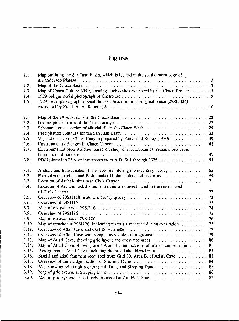
Figures
1.1. Map outlining the San Juan Basin, which is located at the southeastern edge of . the Colorado Plateau . . . . . . . . . . . . . . . . . . . . . . . . . . . . . . . . . . . . . . . . . . . . . . 2
1.2. Map of the Chaco Basin ............................................ 3 1.3. Map of Chaco Culture NHP, locating Pueblo sites excavated by the Chaco Project ....... 5 1.4. 1929 oblique aerial photograph of Chetro Ketl . . . . . . . . . . . . . . . . . . . . . . . . . . . . . . 9 1.5. 1929 aerial photograph of small house site and unfinished great house (29SJ2384)
excavated by Frank H. H. Roberts, Jr. . . . . . . . . . . . . . . . . . . . . . . . . . . . . . . . . . . 10
2.1. Map of the 19 sub-basins of the Chaco Basin . . . . . . . . . . . . . . . . . . . . . . . . . . . . . . 23 2.2. Geomorphic features of the Chaco arroyo . . . . . . . . . . . . . . . . . . . . . . . . . . . . . . . . 27 2.3. Schematic cross-section of alluvial fill in the Chaco Wash . . . . . . . . . . . . . . . . . . . . . 29 2.4. Precipitation contours for the San Juan Basin . . . . . . . . . . . . . . . . . . . . . . . . . . . . . . 33 2.5. Vegetation map of Chaco Canyon prepared by Potter and Kelley (1980) . . . . . . . . . . . . 39 2.6. Environmental changes in Chaco Canyon . . . . . . . . . . . . . . . . . . . . . . . . . . . . . . . . 48 2.7. Environmental reconstruction based on study of macrobotanical remains recovered
from pack rat middens . . . . . . . . . . . . . . . . . . . . . . . . . . . . . . . . . . . . . . . . . . . . 49 2.8. PDSI plotted in 25-year increments from A.D. 901 through 1325 . . . . . . . . . . . . . . . . . 54
3 .1. Archaic and Basketmaker II sites recorded during the inventory survey . . . . . . . . . . . . . 65 3.2. Examples of Archaic and Basketmaker III dart points and preforms . . . . . . . . . . . . . . . 69 3.3. Location of Archaic sites near Cly's Canyon . . . . . . . . . . . . . . . . . . . . . . . . . . . . . . 71 3.4. Location of Archaic rockshelters and dune sites investigated in the rincon west
of Cly's Canyon ................................................ 72 3.5. Overview of 29SJ1118, a stone masonry quarry . . . . . . . . . . . . . . . . . . . . . . . . . . . . 73 3.6. Overview of 29SJ116 ............................................. 73 3.7. Map of excavations at 29SJ116 ....................................... 74 3.8. Overview of 29SJ126 ............................................. 75 3.9. Map of excavations at 29SJ126 . . . . . . . . . . . . . . . . . . . . . . . . . . . . . . . . . . . . . . . 76 3 .10. Map of trenches at 29SJ126, indicating materials recorded during excavation . . . . . . . . . 77 3 .11. Overview of Atlatl Cave and Owl Roost Shelter . . . . . . . . . . . . . . . . . . . . . . . . . . . . 79 3 .12. Overview of Atlatl Cave with steep talus visible in foreground . . . . . . . . . . . . . . . . . . 79 3 .13. Map of Atlatl Cave, showing grid layout and excavated areas . . . . . . . . . . . . . . . . . . . 80 3.14. Map of Atlatl Cave, showing areas A and B, the locations of artifact concentrations . . . . . 81 3 .15. Pictographs in Atlatl Cave, including the broad-shouldered man . . . . . . . . . . . . . . . . . . 83 3 .16. Sandal and atlatl fragment recovered from Grid 30, Area B, of Atlatl Cave . . . . . . . . . . 83 3 .17. Overview of dune ridge location of Sleeping Dune . . . . . . . . . . . . . . . . . . . . . . . . . . 84 3.18. Map showing relationship of Ant Hill Dune and Sleeping Dune . . . . . . . . . . . . . . . . . . 85 3.19. Map of grid system at Sleeping Dune . . . . . . . . . . . . . . . . . . . . . . . . . . . . . . . . . . . 86 3.20. Map of grid system and artifacts recovered at Ant Hill Dune . . . . . . . . . . . . . . . . . . . . 87
vii

3.21. Overview of Sheep Camp Shelter, excavated by the University of Kansas as part of the Chaco Shelters Project . . . . . . . . . . . . . . . . . . . . . . . . . . . . . . . . . . . . . . . . . . . . 89
3.22. Judge's (1982b) hypothetical correlation of chronology, culture, and climate for the San Juan Basin . . . . . . . . . . . . . . . . . . . . . . . . . . . . . . . . . . . . . . . . . . . . . . . . . 92
4.1. Joseph Maloney excavating a slab-lined house near Casa Rinconada in 1936 . . . . . . . . . . 98 4.2. Identified Basketmaker III habitation sites in and around Chaco Culture NHP . . . . . . . . 102 4.3. Identified Pueblo I habitation sites in and around Chaco Culture NHP . . . . . . . . . . . . . 103 4.4. Map of Shabik'eshchee Village . . . . . . . . . . . . . . . . . . . . . . . . . . . . . . . . . . . . . . 104 4.5. Map of 29SJ423, indicating excavated structures and surrounding features . . . . . . . . . . 105 4.6. Map of 29SJ299, indicating the A.D. 500s to early 700s site use and the Pueblo I
component . . . . . . . . . . . . . . . . . . . . . . . . . . . . . . . . . . . . . . . . . . . . . . . . . . . 107 4.7. Map of 29SJ628 . . . . . . . . . . . . . . . . . . . . . . . . . . . . . . . . . . . . . . . . . . . . . . . 108 4.8. Map of 29SJ721, indicating A.D. 600s to late 700s use . . . . . . . . . . . . . . . . . . . . . . 109 4.9. Map of 29SJ724 . . . . . . . . . . . . . . . . . . . . . . . . . . . . . . . . . . . . . . . . . . . . . . . 110
5.1. Mapof29SJ1360 .............................................. 132 5.2. Construction phases at 29JS1360 . . . . . . . . . . . . . . . . . . . . . . . . . . . . . . . . . . . . . 133 5.3. Map of 29SJ627 . . . . . . . . . . . . . . . . . . . . . . . . . . . . . . . . . . . . . . . . . . . . . . . 135 5.4. Construction phases B, C, and D at 29SJ627 . . . . . . . . . . . . . . . . . . . . . . . . . . . . . 136 5.5. Map of 29SJ629 . . . . . . . . . . . . . . . . . . . . . . . . . . . . . . . . . . . . . . . . . . . . . . . 139 5.6. Construction phases I through IV at 29SJ629 . . . . . . . . . . . . . . . . . . . . . . . . . . . . . 140 5.7. Mapof29SJ633 ............................................... 142 5.8. Map of Pueblo Alto . . . . . . . . . . . . . . . . . . . . . . . . . . . . . . . . . . . . . . . . . . . . . 144 5.9. The Pueblo Alto community . . . . . . . . . . . . . . . . . . . . . . . . . . . . . . . . . . . . . . . . 145 5.10. Phase IA construction at Pueblo Alto, A.D. 1020 to 1040 . . . . . . . . . . . . . . . . . . . . 146 5.11. Phases IB and IC construction at Pueblo Alto, A.D. 1020 to 1040 . . . . . . . . . . . . . . . 147 5.12. Phase II construction at Pueblo Alto, A.D. 1020 to 1050 . . . . . . . . . . . . . . . . . . . . . 148 5.13. Phase III construction at Pueblo Alto, A.D. 1040 to 1060. . . . . . . . . . . . . . . . . . . . . 149 5.14. Phase IV construction at Pueblo Alto, A.D. 1080 to 1100 . . . . . . . . . . . . . . . . . . . . 150 5.15 Phase V Construction at Pueblo Alto, A.D. 1100 to 1140 . . . . . . . . . . . . . . . . . . . . . 151 5.16. Road network around the Pueblo Alto community . . . . . . . . . . . . . . . . . . . . . . . . . . 153 5.17. Road-related rooms and entry points at Pueblo Alto . . . . . . . . . . . . . . . . . . . . . . . . 155 5.18. Map of Chetro Ketl (29SJ1928) . . . . . . . . . . . . . . . . . . . . . . . . . . . . . . . . . . . . . 158 5.19. Early Type I masonry beneath Room 62 at Chetro Ket! . . . . . . . . . . . . . . . . . . . . . . 159 5.20. Map of Talus Unit No. 1 (29SJ1930) . . . . . . . . . . . . . . . . . . . . . . . . . . . . . . . . . . 161 5.21. Map of Una Vida (29SJ391) . . . . . . . . . . . . . . . . . . . . . . . . . . . . . . . . . . . . . . . . 162 5.22. Map of Kin Nahasbas (29SJ392) . . . . . . . . . . . . . . . . . . . . . . . . . . . . . . . . . . . . . 164 5.23. Shrine at 29SJ423: A) Overview of site. B) Plan of shrine . . . . . . . . . . . . . . . . . . . 166 5.24. Altar box at shrine at site 29SJ423 . . . . . . . . . . . . . . . . . . . . . . . . . . . . . . . . . . . 167 5.25. Shrines, stone circles, great kivas, and great houses in Chaco Canyon . . . . . . . . . . . . . 168 5.26. Map of Chaco roads system ........................................ 170 5.27. Map of the Poco site, 29SJ1010 . . . . . . . . . . . . . . . . . . . . . . . . . . . . . . . . . . . . . 172 5 .28. Map of three excavated circular masonry structures at the Poco site . . . . . . . . . . . . . . 172 5.29. Aerial photograph of the Chetro Ketl field, indicating placement of test trenches
excavated by Richard Loose . . . . . . . . . . . . . . . . . . . . . . . . . . . . . . . . . . . . . . . . 173
viii

6.1. Graph of the drought severity index measured in four-year increments for the Chaco area between A.D. 901 and 1201 . . . . . . . . . . . . . . . . . . . . . . . . . . . . . . . . 178
6.2. Composite of masonry types . . . . . . . . . . . . . . . . . . . . . . . . . . . . . . . . . . . . . . . 200 6.3. Construction labor at great houses by event . . . . . . . . . . . . . . . . . . . . . . . . . . . . . . 202 6.4. Mean labor requirements by five-year intervals . . . . . . . . . . . . . . . . . . . . . . . . . . . 203 6.5. Known areas of production of ceramic wares found in Chaco Canyon . . . . . . . . . . . . . 210 6.6. Sources of nonlocal lithic materials recovered in Chaco Canyon . . . . . . . . . . . . . . . . . 213
7 .1. Map of the Headquarters site . . . . . . . . . . . . . . . . . . . . . . . . . . . . . . . . . . . . . . . 227 7.2. Map of Be 236 ................................................ 228 7.3. Map of Be 288, the Gallo Cliff Dwelling ............................... 229 7.4. View of Be 288 nestled inside of a rock shelter . . . . . . . . . . . . . . . . . . . . . . . . . . . 230 7.5. Close view of masonry at Be 288 . . . . . . . . . . . . . . . . . . . . . . . . . . . . . . . . . . . . 230 7 .6. Map of Lizard House . . . . . . . . . . . . . . . . . . . . . . . . . . . . . . . . . . . . . . . . . . . . 232 7.7. Map of Be 362 ................................................ 233 7. 8. Map of Ley it Kin . . . . . . . . . . . . . . . . . . . . . . . . . . . . . . . . . . . . . . . . . . . . . . . 234 7.9. Map of 29SJ633 . . . . . . . . . . . . . . . . . . . . . . . . . . . . . . . . . . . . . . . . . . . . . . . 237
8.1. Correlation of chronological divisions used by researchers studying the San Juan Basin . 247 8.2. Early Pueblo II communities with Chacoan structures . . . . . . . . . . . . . . . . . . . . . . . 248 8.3. Late Pueblo II communities with Chacoan structures . . . . . . . . . . . . . . . . . . . . . . . . 249 8.4. Early Pueblo III communities with Chacoan structures . . . . . . . . . . . . . . . . . . . . . . . 250 8.5. Late Pueblo III communities with Chacoan structures . . . . . . . . . . . . . . . . . . . . . . . 251 8.6. The Chaco halo . . . . . . . . . . . . . . . . . . . . . . . . . . . . . . . . . . . . . . . . . . . . . . . . 259
9 .1. Access graphs for Pueblo Bonito during stages IIIA (first and second floors) and VIA (first floor) . . . . . . . . . . . . . . . . . . . . . . . . . . . . . . . . . . . . . . . . . . . . . . . 294
9.2. Access graphs for Kin Kletso, stages IA and IB . . . . . . . . . . . . . . . . . . . . . . . . . . . 295
10.1. Richard Wetherill and Navajo in camp behind the north wall of Pueblo Bonito in 1896 or 1897 . . . . . . . . . . . . . . . . . . . . . . . . . . . . . . . . . . . . . . . . . . . . . . . . . 300
10.2.
10.3.
10.4.
10.5. 10.6. 10.7. 10.8.
10.9.
10.10.
10.11.
General view of Pueblo Bonito and surrounding buildings taken in 1929 from the south side of Chaco Canyon. A number of historic structures are visible .......... . A 1929 view from the North Mesa looking across Pueblo Bonito to the Pueblo Bonito Lodge, the Chaco Trading Company, and Pueblo del Arroyo ................. . The School of American Research/University of New Mexico field-school station located on the south side of the Chaco Wash, west of Casa Rinconada ............ . Pueblito 3 at the Doll House site (29SJ1613). This is a two-room structure ........ . House 9 at the Doll House site (29SJ1613) ............................. . Inscriptions from rock-art files for site 29SJ206 .......................... . Map 1, locating Historic period site components attributable to the Pre-Pueblo Revolt period, or prior to 1692 (n= 1) ..................................... . Map 2, locating Historic period site components attributable to the Post-Pueblo Revolt period, 1692 to 1753 (n=4) ....................................... . Map 3, locating Historic period site components attributable to the Pre-Reservation period, 1753 to 1868 (n=33) ...................................... . Map 4, locating Historic period site components attributable to the Early Reservation period, 1868 to 1880 (n=4) ....................................... .
ix
304
305
306 307 307 308
312
313
314
315

10.12. Map 5, locating Historic period site components attributable to the Middle Reservation period, 1880 to 1920 (n=24) . . . . . . . . . . . . . . . . . . . . . . . . . . . . . . . . . . . . . . . 316
10 .13. Map 6, locating Historic period site components attributable to the Late Reservation period, 1920to 1945 (n=43) ....................................... 317
10.14. Map 7, locating Historic period site components attributable to the Recent period, post 1940(n=13) . . . . . . . . . . . . . . . . . . . . . . . . . . . . . . . . . . . . . . . . . . . . . . 318
10.15. Map 8, which combines Historic period site components from the Post-Pueblo Revolt through the Early Reservation periods, 1692 to 1868 (n=46) . . . . . . . . . . . . . . . . . . 319
10.16. Structures 1, 2, and 3 at the Doll House site (29SJ1613) as seen from Structure 5 . . . . . 320 10.17. Map of the Doll House site (29SJ1613) ................................ 321 10.18. Opportunities for wage labor included excavations at archaeological sites; e.g.,
Pueblo Bonito in 1924 during the National Geographic Society expedition . . . . . . . . . . 326
B.1. Correlation of Pecos classification with various assigned dates and phase terminology as applied to Chaco Canyon (1924-2001) . . . . . . . . . . . . . . . . . . . . . . . . . . . . . . . 368
x

Tables
1.1. Sets of aerial photographs of Chaco Canyon and selected outlying Chacoan sites . . . . . . . 11
2 .1. Five alluvial units identified by Hall . . . . . . . . . . . . . . . . . . . . . . . . . . . . . . . . . . . 30 2.2. Plants important for discriminating habitats . . . . . . . . . . . . . . . . . . . . . . . . . . . . . . . 42 2.3. PDSI values . . . . . . . . . . . . . . . . . . . . . . . . . . . . . . . . . . . . . . . . . . . . . . . . . . . 53
3.1. Evidence for Paleoindian use of the Chaco area . . . . . . . . . . . . . . . . . . . . . . . . . . . . 64 3.2. Breakdown of presedentary sites recorded during transect survey . . . . . . . . . . . . . . . . . 64 3.3. Archaic and unknown component types by survey area examined after additional lands
were added to the park . . . . . . . . . . . . . . . . . . . . . . . . . . . . . . . . . . . . . . . . . . . . 66 3.4. Lithic assemblages from Archaic sites in four areas added to the park . . . . . . . . . . . . . . 67 3.5. Projectile points assigned to the Archaic Period from four areas added to the park . . . . . . 68 3.6. Comparison of chipped stone materials recovered from Atlatl Cave and the two dune
sites located in the same rincon . . . . . . . . . . . . . . . . . . . . . . . . . . . . . . . . . . . . . . . 88
6.1. Estimates of land in Chaco Canyon available for crop production . . . . . . . . . . . . . . . . 182 6.2. Estimated acres of farm land needed per person . . . . . . . . . . . . . . . . . . . . . . . . . . . 183 6.3. Estimated population in Chaco Canyon that could be supported by agriculture . . . . . . . 184 6.4. Estimates of populations at excavated sites based on fauna! remains . . . . . . . . . . . . . . 184 6.5. Bonito phase population estimates . . . . . . . . . . . . . . . . . . . . . . . . . . . . . . . . . . . . 186 6.6. Pierson's population estimates for Chaco Canyon . . . . . . . . . . . . . . . . . . . . . . . . . . 188 6.7. Windes's small-house population estimates, based on adjusted inventory survey . . . . . . 189 6.8. Unusual architectural features found in great houses . . . . . . . . . . . . . . . . . . . . . . . . 206 6.9. Estimates of ceramic imports into Chaco Canyon by period . . . . . . . . . . . . . . . . . . . 211 6.10. Percentages of lithic imports into Chaco Canyon by period . . . . . . . . . . . . . . . . . . . . 212 6 .11. Projected ceramic consumption rates for four sites in Chaco Canyon . . . . . . . . . . . . . . 217
11.1. Major ecological zones and expected subsistence behavior defined by Binford (2001) . . . 334 11.2. Population thresholds identified by Binford (2001) . . . . . . . . . . . . . . . . . . . . . . . . . 337 11.3. Comparison of differences among Eastern and Western Pueblo groups . . . . . . . . . . . . 341
A.1. Sites excavated or examined by the Hyde Exploring expedition . . . . . . . . . . . . . . . . . 346 A.2. Sites excavated or examined by the National Geographic Society expedition . . . . . . . . . 348 A.3. Sites excavated or examined by the School of American Research/University of
New Mexico field schools . . . . . . . . . . . . . . . . . . . . . . . . . . . . . . . . . . . . . . . . . 351 A.4. Sites excavated or examined by the National Park Service between 1937 and 1969 . . . . . 355 A.5. Excavations and tests conducted by the Chaco Project . . . . . . . . . . . . . . . . . . . . . . . 358
xi

B.1. Ceramic typological time used in artifact analyses . . . . . . . . . . . . . . . . . . . . . . . . . . 363 B.2. Bonito phase ceramic assemblages . . . . . . . . . . . . . . . . . . . . . . . . . . . . . . . . . . . . 364 B.3. Dominant ceramic types by period used by Truell (1986) in analysis of architecture
of small sites . . . . . . . . . . . . . . . . . . . . . . . . . . . . . . . . . . . . . . . . . . . . . . . . . 365 B.4. Chaco chronology as updated by T. C. Windes . . . . . . . . . . . . . . . . . . . . . . . . . . . 366
C .1. The organization of production . . . . . . . . . . . . . . . . . . . . . . . . . . . . . . . . . . . . . . 3 71 C.2. Society and polity . . . . . . . . . . . . . . . . . . . . . . . . . . . . . . . . . . . . . . . . . . . . . . 372 C.3. The Chaco World . . . . . . . . . . . . . . . . . . . . . . . . . . . . . . . . . . . . . . . . . . . . . . 373 C.4. Economy and ecology . . . . . . . . . . . . . . . . . . . . . . . . . . . . . . . . . . . . . . . . . . . . 374 C.5. Chaco, Mesa Verde, and the confrontation of time . . . . . . . . . . . . . . . . . . . . . . . . . 375 C.6 Chacoan architecture . . . . . . . . . . . . . . . . . . . . . . . . . . . . . . . . . . . . . . . . . . . . 376 C.7. The capstone conference . . . . . . . . . . . . . . . . . . . . . . . . . . . . . . . . . . . . . . . . . . 377 C.8. In Search of Chaco: New Approaches to an Archaeological Enigma, edited by David
Grant Noble . . . . . . . . . . . . . . . . . . . . . . . . . . . . . . . . . . . . . . . . . . . . . . . . . . 379
xii
Preface
The National Park Service (NPS) Chaco Project was a cooperative and multidisciplinary endeavor that maintained several ties to earlier field schools conducted in Chaco Canyon by the University of New Mexico (UNM), School of American Research (SAR), and Museum of New Mexico (MNM) from 1929 to 1942, and in 1947. First, several archaeologists involved with the Chaco Project had been field-school students in Chaco Canyon (e.g., John M. Corbett, Robert H. Lister, Alden C. Hayes, and Thomas W. Mathews) and were later employed by the NPS for some period during their careers prior to the initiation of the Chaco Project. Second, during those early years, UNM held title to several sections of land that were within the boundaries of Chaco Canyon National Monument (Hewett 1936:207-213). A 1949 agreement ceded those parcels to the NPS, with the understanding that UNM would have the privilege of conducting research in future years. (Note that, for purposes of this volume, the original NPS administrative designation nchaco Canyon National Monument" and the current NPS administrative designation "Chaco Culture National Historical Park" will both be referred to as "the park.") Third, during the Chaco Project several NPS staff held faculty appointments in the department of anthropology and/or taught at least one course per academic year. Fourth, a number of UNM graduate and undergraduate students from various departments were able to participate in various natural and cultural resource studies. Fifth, and last, so as not to separate the two major collections and to make them more easily accessible for future study, the NPS Chaco Project collections remain on the UNM campus as part of a cooperative agreement between these two institutions. Although the following brief review of this unique multidisciplinary collaborative program is offered for its historical perspective, other institutions were also involved, and younger investigators continue to pursue answers to new questions.
In the 1960s, John M. Corbett was the NPS chief archaeologist. When the opportunity to begin another
xiii
major NPS research program arose, he realized that many questions about Chaco Canyon remained unanswered. Additionally, the NPS could gain recognition for its archaeological research program by initiating a project that utilized cutting-edge technology and employed a multidisciplinary approach to studies of adaptive change in a well-known and archaeologically rich area in northwestern New Mexico. To gain approval for his plan, Corbett needed a prospectus that included a research design, plans for facilities, number and types of personnel, and costs. He contacted Douglas W. Schwartz, Director of SAR, who prepared an initial bibliography on Chaco studies and sponsored an advanced seminar on Chaco Canyon. A number of scholars representing NPS, UNM, and Chaco research, as well as specialists from related fields, met on January 8-11, 1969. The seminar discussions (NPS Chaco Culture NHP Museum Archive, No. 1996) were formalized by Wilfred Logan and Zorro Bradley as the Chaco Prospectus (NPS 1969); it was soon approved by George B. Hartzog, then Director of the NPS (Maruca 1981:11-12).
To initiate the program, Thomas R. Lyons, an anthropologist and geologist who had worked in the San Juan Basin and who was testing remote sensing techniques at the Technical Applications Center at UNM, was appointed acting director of the Chaco Canyon Archeological Center on September 20, 1969. Studies were initiated by faculty and students in the departments of biology, geography, and geology, and the Office of Contract Archaeology. Lyons updated the natural and cultural resources bibliography and concentrated on the evaluation of remote sensing tools. Space on the UNM campus was provided for Lyons and his staff until a permanent research facility was completed on the second floor of the anthropology building in 1972.
Throughout the years, numerous NPS administrative changes ensued; these affected the name of the project and how it was managed over the years. In

List of participants in the School of American Research Advanced Seminar on Chaco Canyon, January 8-11, 1969.
Participant
Bradley, Zorro
Campbell, John
Corbett, John M.
Daugherty, Richard D.
Ellis, Florence H.
Ewing, George
Haag, William G.
Longacre, William A.
Potter, Loren D.
Reed, Erik K.
Schwartz, Douglas W.
Vivian, R. Gwinn
Affiliation
National Park Service, Washington, D.C.
Department of Anthropology, University of New Mexico
National Park Service, Washington, D.C.
Department of Anthropology, Washington State University
Department of Anthropology, University of New Mexico
Museum of New Mexico, Santa Fe, NM
Department of Anthropology, Louisiana State University
Department of Anthropology, University of Arizona
Department of Biology, University of New Mexico
National Park Service, Santa Fe, NM
School of American Research, Santa Fe, NM
Department of Anthropology, University of Arizona
Names under which the Chaco Project operated.
Date Name
Chaco Canyon Archeological Center
New Mexico Archeological Center
Chaco Center
1969 - Sept. 20
1971 - Aug. 10
1973 - July 18
1976 - Nov. 21 Division of Remote Sensing established under the Southwest Cultural Resource Center
Division of Chaco Research established under the Southwest Cultural Resource Center
1978 - Oct. 1
1980 - April 20
1985 - Mar. 31
Division of Cultural Research
Branch of Remote Sensing placed under the Division of Cultural Research
Branch of Cultural Research placed under the Division of Anthropology of the Southwest Cultural Resource Center
1995 - May 15
1997 - Jan.
Archaeology Program of the lnterrnountain Cultural Resource Center
Archaeology Program of the lntermountain Region, Santa Fe Office
List of Publications in Archeology, Chaco Canyon Studies.
Series Number
18A
18B
18C
Title and Author/Editor
Archeological Surveys of Chaco Canyon, New Mexico by Alden C. Hayes, David M. Brugge, and W. James Judge
Great Pueblo Architecture of Chaco Canyon, New Mexico by Stephen H. Lekson
Tsegai: An Archeological Ethnohistory of the Chaco Region by David M. Brugge
xiv
Date of Publication
1981
1984
1986

18D
18E
18F
18G
18H
Small Site Architecture of Chaco Canyon, New Mexico by Peter J. Mc Kenna and Marcia L. Truell
Environment and Subsistence of Chaco Canyon, New Mexico edited by Frances Joan Mathien
Investigations at the Pueblo Alto Complex, Chaco Canyon, New Mexico, I975-1979 Volumes I and II by Thomas C. Windes Volume III edited by Frances Joan Mathien and Thomas C. Windes
Ceramics, Lithics, and Ornaments of the Prehistoric People of Chaco Canyon edited by Frances Joan Mathien
Culture and Ecology of Chaco Canyon and the San Juan Basin by Frances Joan Mathien
List of Repons of the Chaco Center.
Series Number
1
2
3
4
5
6
7
8
9
10
11
12
13
14
Title and Author/Editor
Remote Sensing Experiments in Cultural Resource Studies: Non-destructive Methods of Archeological Exploration, Survey, and Analysis edited by Thomas R. Lyons
Aerial Remote Sensing Techniques in Archeology edited by Thomas R. Lyons and Robert K. Hitcocock
The Outlier Survey: A Regional View of Settlement in the San Juan Basin by Robert P. Powers, William B. Gillespie, and Stephen H. Lekson
A History of the Chaco Navajos by David M. Brugge
Stone Circles of Chaco Canyon, Northwestern New Mexico by Thomas C. Windes
The Architecture and Dendrochronology of Chetro Ket!, Chaco Canyon, New Mexico edited by Stephen H. Lekson
Architecture and Material Culture of 29SJ1360, Chaco Canyon, New Mexico. by Peter J. Mc Kenna
Recent Research on Chaco Prehistory edited by W. James Judge and John D. Schelberg
A Biocu/tural Approach to Human Burials from Chaco Canyon, New Mexico by Nancy J. Akins
Excavations at 29SJ 633: The Eleventh Hour Site, Chaco Canyon, New Mexico edited by Frances Joan Mathien
Excavations at 29SJ 627, Chaco Canyon, New Mexico, Volume I. The Architecture and Stratigraphy by Marcia L. Truell Excavations at 29SJ 627, Chaco Canyon, New Mexico. Volume II. Artifact Analyses edited by Frances Joan Mathien
The Spadefoot Toad Site: Investigations at 29SJ 629 in Marcia's Rincon and the Fajada Gap Pueblo II Community, Chaco Canyon, New Mexico 2 volumes by Thomas C. Windes
Early Puebloan Occupations in the Chaco Region: Excavations and Survey of Basketmaker Ill and Pueblo I Sites, Chaco Canyon, New Mexico 2 volumes by Thomas C. Windes
An Archaeological Survey of the Additions to Chaco Culture National Historical Park edited by Ruth M. VanDyke
xv
1986
1985
1987
1997
2005
Date of Publication
1976
1977
1983
1979
1978
1983
1984
1984
1986
1991
1992
1993
2006
2006

1971, Robert H. Lister, then at the University of Colorado, completed a major research project in Mesa Verde National Park. He soon transferred to UNM, where on February 8 he was appointed professor of anthropology; and in April he became permanent director of the Chaco Project. This allowed Lyons to concentrate on studies in remote sensing, which he pursued over the next decade not only in the canyon, but also in other environments. In 1976, the Remote Sensing Division was created as a separate entity because the investigations expanded beyond Chaco Canyon; this division would be reintegrated in 1980. Over time, a number of permanent staff were responsible for the archaeological research program. Lister directed Chaco Project studies from 1971 through 1978. Alden C. Hayes, who was completing NPS reports on Gran Quivira and Mesa Verde, joined the staff in June 1971 to direct field surveys and excavations. He also filled in behind Lister, who became Chief Archaeologist in Washington, D.C., after Corbett retired. As Hayes neared retirement in January 1976, W. James Judge, who had joined the NPS staff on July 1, 1974, assumed many of these responsibilities. In 1978, when Lister retired, Judge became director of the project, a position he held until 1985. Lyons, Lister, and Judge also taught courses at the undergraduate and graduate levels in the UNM department of anthropology; the last two held joint NPS/UNM faculty appointments.
Much of the field work was carried out under contract. Initially archaeologists were hired for survey or excavation through the Office of Contract Archeology at UNM. In 1978, when field work had been completed, most of them became NPS term employees for four years to complete analyses of materials recovered and prepare reports. When the term appointments expired in 1982, much work still remained. Although they found other employment, these dedicated archaeologists voluntarily completed this work. Only a few would receive contracts to assist them with their analyses and reports.
On October 26, 1984, the NPS established a task force to evaluate a proposal to consolidate what was then called the Division of Cultural Research with the Division of Anthropology in the NPS Southwest Cultural Resource Center. This transfer was finalized on March 31, 1985. In that year, Judge resigned, and
xvi
Larry V. Nordby took responsibility for the program as it was transferred from UNM to NPS offices in Santa Fe in 1986. The focus was on completion of reports and publication of results. Twenty-two titles were published in two government series. Additionally, numerous papers appeared in journals and edited volumes; many are listed as Contributions of the Chaco Center, which are maintained in the NPS anthropology program office in Santa Fe.
Because it was the intention of UNM and the NPS to retain their two m~jor Chaco collections in the same facility, data collected by the Chaco Project and the accompanying analytical records remain at UNM under a cooperative agreement. The responsibility for the NPS collections now resides with the superintendent of Chaco Culture National Historical Park. The two collections are accessible to researchers who visit the Chaco Culture NHP Museum Collections on the UNM campus in Albuquerque.
When it came time to produce a synthesis of the Chaco Project, NPS archaeologists were aware that much new research expanded our knowledge of the Pueblo use of Chaco Canyon and the Chaco World. As a result, Stephen H. Lekson was asked to direct a synthesis project that would bring our interpretations up-to-date. Two volumes were originally planned to be part of a companion set. This volume is the first of the two; it covers the work conducted by NPS from 1969 through 1985. Lekson's The Archaeology of Chaco Canyon: An Eleventh Century Pueblo Regional Center, published by the School of American Research, is volume II. It incorporates the most recent scholarly interpretations of the Chaco World.
In summary, John M. Corbett envisioned a major research program in Chaco Canyon that would evaluate the natural and cultural resources of a wellknown area and provide information to the public through reports and an interpretive program. As Wilshusen and Hamilton (2005) conclude, this was a major cultural resources management program that, because of its discoveries, resulted in enlarging the former Chaco Canyon National Monument into Chaco Culture National Historical Park in 1980 and its designation as a World Heritage Park in 1987. Corbett would have been pleased with these results, which, I think, went beyond his expectations.

Acknowledgments
The Chaco Project was a labor of love for all of those involved, not just the archaeologists and their professional colleagues who contributed to studies of natural resources and the environment. Many worked behind the scenes to run the organization and support the program, and there were numerous volunteers who gave generously of their time and energy. Some served only a short time, while others spent many years. Based on available records, I would like to recognize those listed on the following two pages; hopefully, no one has been missed.
I also want to thank Jim Judge, who, when he announced his resignation in 1985, called me into his office and indicated that I was to serve as general editor of the Chaco Project publications program. Additionally, he provided a tentative outline for a synthesis of the project, which I would eventually write. These were formidable tasks for someone who had not joined the Chaco Project until the field work was completed. At that time, I doubted if it would be possible to complete these assignments; but with a list of remaining publications and the help of my colleagues, we pressed ahead one volume at a time.
In my capacity as general editor, I worked with many people who made the completion of the publications program possible. First and foremost are the archaeologists and staff of the Chaco Project and counterparts in other fields who have given of their time to complete the numerous volumes, worked with peer reviewers' comments and editors' changes, and proofread final versions of manuscripts. Without their contributions, these publications would not have been possible. Without these publications, a synthesis of the project could not have been written. Additionally, typists and editorial assistants processed handwritten text and tables and formatted them into readable typed versions, and finally into camera-ready copy. Over the past two decades, the following have assisted in various aspects of this work: Rosemary Ames, Sarah L. Chavez, Dolores M. Guenzi, Rod
xvii
Hardy, Leah Hott, Sherry J. Ivey, J. P. Moore, Margaret Mosher, Heidi Reed, Lauren T. Rimbert, Carmen Silva, Judy Stem, and Gloria J. Vigil. Editors who polished the prose were invaluable; among them were Douglas L. Caldwell, Barbara E. Cohen, Carol J. Condie, M. Robyn Cote, Barbara L. Daniels, Jane N. Harvey, Kathy McCoy, Irene Mitchell, Bruce Panowski, June-el Piper, Paula Sabloff, Lynne Sebastian, John C. Thomas, and Laura Ware. Jerry L. Livingston, scientific illustrator, formatted the layout of many volumes, provided line drawings and photographs, and supervised the work of Ernesto Martinez, drafting technician. Additional illustrations were drawn by Gigi Bayliss, Nancy Lamm, Matthew Schmader, Cherie Rohn, and Vicki Spencer. Photographs were provided by Gary Lister and Bruce Moore. Barbara E. Cohen, Barbara L. Daniels, Jane N. Harvey, and Kathleen Havill indexed the volumes. To all of these people, I owe a debt of gratitude.
Besides NPS funds, support came from a number of people and institutions. Included are The Jonson Foundation, the Maxwell Museum of Anthropology of the University of New Mexico (which sponsored Chaco Tours), New Mexico State University Museum Docent Tours, and the Southwest Parks and Monuments Association (now Western National Parks Association). Other individuals donated fees from lectures or tours to the Chaco Publications Fund; such assistance was often the boost needed to complete a specific report.
I also want to acknowledge the role that Joyce Raab, Chaco archivist, has played in this production. We shared office space for over a decade, during which time she has been a professional colleague who knew where to find materials and photographs. Most of all, she listened as I faced challenges with different aspects of production of the volumes that make up this series-especially this one.

I
L
Personnel associated with the Chaco Project from 1969 to 1985 include:
Abbink, Emily Akins, Nancy J. Altschul, Jeffrey S. Ames, Rosemary Anastasio, Julian Aragon, Ann M. Arany, Lynn Archuleta, Rosarita 0. Atencio, John Atkins, Victoria Augustine, Ken Bandy, Phil Barde, David Beardsley, John Begay, Gene Begay, Tsosie Bennett, Connie Bertram, Jack Betancourt, Julio Beven, Bruce Beyale, Chee Beyale, George Beyale, James Blanchard, Scott P. Blea, Enrique Boyer, Kent Bradford, James Brancard, William Bratcher, L. Angelle Bretemitz, Cory D. Britt, Martin Brooks, Marita H. Bronitsky, Ronald Broster, John Brown, Galen Brugge, David M. Bums, Bruce Burt, Fred Cameron, Catherine M. Camilli, Eileen Cassidy, Dorothy Castiano, Wayne Castillo, Wallace Charles, James Chavez, Sarah Lee Chavez, Shirley Claffery, Mary Clary, Karen H. Clark, Jennie Clay, Amanda
Clay, Glendalee Cly, Susan Comber, Mary Jo Cooper, Kelly Creelman, Frank Creelman, Linda Crowder, June Cully, Anne Cully, Jack Curran, Antoinette Curtis, Bonnie Curtis, Curt Curtis, Greg Curtis, Kathy Curtis, Robert Curtis, Ty Davis, Cindy Davis, D. Dean, Glenna Dean, Jeffrey S. DeAngelis, James M. Dederich, Jo Devon Dennison, Alvin Dolphin, Lambert Donaldson, Marcia Drager, Andrew Drager, Dwight L. DuBois, R. Ebert, James I. Eggert, Kenneth G. Emslie, Steve Etavard, Dorothy Etavard, Paul Etcitty, Ben Etcitty, Gilbert Etcitty, Herman Fanalie, Rosalie Flynn, Leo Forman, Mac Fransted, Dennis Freund, Pan Fulgham, Tommy R. Garcia, Eddy Gillespie, William B. Gleickman, Carol Graham, Martha Greenlee, Robert Guenzi, Dolores Gutierrez, Alberto Hagarty, Barbara M.
xviii
Hall, Stephen Harrison, Dennis Harrison, Gerald Hasuse, Amos Hayes, Alden C. Henry, Wilbur Henry, Wilford Hitchcock, Robert H. Hodges, William Holley, Jay Hooten, Linda Jean Hopkins, Thomas S. Hott, Leah Huckins, Roger Hulett, Matt Ing bar, Eric Ireland, Arthur K. Ivey, Sherry J. Jacobson, LouAnn Joiner, Carol Jones, Kirtland Jorde, Lynn Judge, W. James Kee, James Kee, Victor King, Norman Kinney, Frances Klappert, H. E. Klausner, Stephanie Kloth, Raymond Knight, Georgia Knight, SuSu Lagasse, Peter F. Lanell, Charles Lekson, Stephen H. Levine, Daisy Levine, Richard Lewin, Harrilyn Lewis, David Linville, June Lister, Gary G. Lister, Robert H. Livingston, Jerry L. Loose, Richard W. Lopez, Daniel Lopez, Jimmy Lopez, Junior Lopez, Lewis Love, David W. Lyons, Thomas R.

Majewski-Bums, Donna Malde, Harold Marjon, Peter Martinez, Johnny Masterson, Kelly Mathews, Thomas W. Mathieu, Frances Joan McKenna, Peter J. McKibben, Ann McLeod, C. Milo Meleski, Richard Miles, Judith L. Miles-Neely, Beth Mills, Barbara J. Mitchell, Chee Moore, Bruce E. Moquin, Mike Morain, Stanley A. Morgan, Vernon Morrison, C. Randall Mosher, Margaret Neller, Earl H. Noonan, Terry Norberto, Ben Nordby, Larry V. Obenauf, Margaret S. Pablo, Jimmy Padilla, Louis Pattison, Natalie Peaker, L. Peterson, Delmar Powers, Robert P. Ralph, Elizabeth Ratti, Brett Reeves, Caroline Reinhard, Karl J. Rice, Phil Rimbert, Lauren T. Roll, Steve Rose, Martin Ross, Catherine Ross, Joseph Salazar, Sappington, Robert Schalk, Randall F. Schelberg, John D. Schieck, Cherie Sebastian, Lynne Shaffer, John Shipman, Thomas Shorty, Pav Shure, Stephen Siemers, Charles T.
Snow, Cordelia Sounart, Robert Sonnleitner, Stephanie Speth, John Stanford, Dennis Stein, John Stems, Judith Stiner, Mary Sullivan, Sharon Tainter, Joseph Tatum, Lise S. Thrift, John Toll, H. Wolcott Toll, Mollie Struever Truell, Marcia L. Trujillo, Jake Trujillo, Nelson Tso, Paul Van Devender, Thomas Vicklund, Lonyta Vigil, Carol Vigil, Gloria Wainwright, Bernard Walt, Henry W andsnider, LuAnn Warburton, Miranda Ware, John Warren, A. Helene Warren, Richard Wasson, Dan Wells, Stephen G. Welsh, Stanley Werito, Clifford Werito, Roger Werner, Oswald Wero, John Weymouth, John White, Adrian Whittlesey, Julian Williams, David Wills, Elizabeth 0. Wills, Wirt H. Windes, Connor L. Windes, Mary Jo Windes, Thomas C. Windes, Todd Windham, Michael Witter, Ann Witter, Dan Yazzi, Bruce Young, Lisa C. Young, Richard
xix

For this volume, I owe special thanks to Jeffrey S. Dean, who reviewed the chapters on environment and natural resources studies; to Earl Neller for his comments on the Preceramic; to R. Gwinn Vivian, who carefully read and commented on chapters devoted to the Pueblo adaptation; to David M. Brugge, who reviewed the Historic Period chapter; and to Thomas C. Windes and Arthur K. Ireland, who assisted with the list of personnel involved and the remote sensing studies. Ireland also reviewed a longer version of the remote sensing studies section.
Although Jerry L. Livingston retired a decade ago, he had prepared most of the line drawings that appear in this volume; John George located them in the Chaco Culture NHP Museum Archive. Those that were not yet finalized were recently drawn by Georgia Bayliss, who works in the same style as Livingston. Walter Wait assisted with the scanning of these figures.
Through the assistance of James Brooks and Catherine Cocks of the School of American Research,
xx
Barbara J. Mills and Stephen Plog graciously reviewed a much longer manuscript and offered many useful suggestions to improve the content and presentation of the data. The interpretations that follow in this synthesis, however, are mine alone.
Jane N. Harvey edited and proofread the chapters. Kathleen Havill prepared the index. To these colleagues, I offer my deep-felt gratitude.
Now, at the conclusion of the Chaco Project, I must admit that the opportunity to participate in this major research project has been a challenge. I am grateful to Jim Judge for taking this student under his wing and trusting her with the responsibility of presenting the work of so many colleagues in this volume.
Frances Joan Mathieu, NPS Archaeologist, and General Editor for Chaco Project Publications
May 2005

Chapter One
The National Park Service Chaco Project
AND WHEREAS, the extensive prehistoric communal or pueblo ruins in San Juan and McKinley Counties, Territory of New Mexico, principally embraced within the Chaco Canyon and generally known as the Chaco Canyon ruins, situated upon the public lands owned and controlled by the United States, are of extraordinary interest because of their number and their great size and because of the innumerable and valuable relics of a prehistoric people which they contain, and it appears that the public good would be promoted by reserving these prehistoric remains in a National Monument with as much land as may be necessary for the proper protection thereof.
NOW, THEREFORE, I, Theodore Roosevelt, President of the United States of America, by virtue of the power in me invested by section two of the aforesaid act of Congress, do hereby set aside as the Chaco Canyon National Monument, subject to any valid and existing rights, the prehistoric ruins and burial grounds situated in San Juan County, New Mexico . . . . (By the President of the United States of America, A Proclamation [No. 740-Mar. 11, 1907-35 Stat. 2119].)
Chaco Canyon is located in the northwestern comer of New Mexico in the approximate center of the San Juan Basin (Figure 1.1). As part of the southeastern section of the Colorado Plateau, the San Juan Basin encompasses an area of approximately 40,000 km2
, and is ringed by mountains-the San Juan and La Plata mountains on the north, the Carrizo and Chuska mountains on the west, the Zuni Mountains to the south, and the Nacimiento Mountains to the east. The San Juan Basin includes several smaller drainage systems; e.g., the Chaco, which flows into the San Juan River west of Farmington and near Shiprock. Within the approximately 11,500 km2 Chaco Basin, Chaco Canyon (Figure 1.2) was carved out of the lower section of the upper Chaco Wash just before it meets the Escavada Wash to form the Chaco River. Chaco Canyon is 32.5 km long, and from 500 to 1,000 m wide (D. Love 1983b: 187). Sandstones and shales form the cliffs that rise between plains that stretch north from the Escavada Wash and south from Chacra Mesa to enclose the canyon.
Today Chaco Canyon is a tourist and research destination, but this was not always so. We now
know that Archaic hunters and gatherers camped there over several millennia; ancestors of historic Pueblo people dependent on maize agriculture created the masonry structures for which Chaco Canyon National Monument was established. The canyon is now home to only a few National Park Service (NPS) employees, who live amidst Navajo sheep- and cattle-ranchers whose ancestors came to this area after the Pueblo peoples moved to other locations. Deciphering this history has been under way for more than 150 years (Brand 1937a; Frazier 2005; Lister and Lister 1981; Gwinn Vivian 1990; Gordon Vivian and Mathews 1965). The NPS Chaco Project (1969 to 1985) added much to our understanding of this history; it was a major research program that has inspired many scholars who continue the quest for explanation of events that occurred in this stark setting. This volume will document the Chaco Project's contributions from both historical and regional archaeological perspectives.
This chapter will outline the background in which the NPS Chaco Project took place; e.g., the scholarly milieu in which the research was conducted,

2 Chaco Project Synthesis
Figure 1.1.
S.n JHn Iulo
f
~ ..
Map outlining the San Juan Basin, which is located at the southeastern edge of the Colorado Plateau. (Taken from Drager and Lyons 1983.)

• • I I ...
I _,.. ..... ... .. . /·
:t
: l. 0 I\ ,...,,,cm1:1 N I \ H \ . 0: I \ .:C I ~I
I-·\ --. :
COLORADO -------=---.-. . .
The NPS Chaco Project 3
------r--_i
II TohG1+i
Mexican· t Springs 1-.....!!~-~ I 1 ·· ........ . • i
Q 20 SCALEl ... _~ __ _.I MILES N
i Continental Divide
• • • • • Chaco Drai:na&e Baain
___ State BoundaJ:y
___ Count;y Bounda.ry
::::>-- Major Stream&
Figure 1.2. Map of the Chaco Basin. (Taken from DeAngelis 1972:Figure 1.)

4 Chaco Project Synthesis
and the federal regulations that affected the research design. Once the prevalent interpretations of Chaco at the time of the project's inception are reviewed, the goals of the Chaco Prospectus (NPS 1969) will be presented. At that time, new research tools were becoming available; the methods in which they were employed, as well as some of the results and evaluations of these new techniques, will be presented prior to outlining how the research results are grouped into four major topics in the remaining chapters of this book.
Background to the Chaco Project
Discovery, documentation, and discussion of data obtained by examining several large ruins and a number of small houses related to the Pueblo use of the canyon (Figure 1.3) began in the late 1800s. A number of institutions conducted major multiyear projects now commonly referred to as the Hyde Exploring Expedition (1896 to 1901), the National Geographic Society Expedition (1921 to 1927), and the combined School of American Research (SAR)/ University of New Mexico (UNM)/Museum of New Mexico (MNM) field schools (1929 to 1942, 1947) (Lister and Lister 1981). In 1937, the NPS inaugurated a ruins stabilization program, and NPS archaeologists conducted surveys and excavations at several sites in order to prevent loss of knowledge about these resources due to erosion and other natural processes. By 1969, therefore, numerous surveys and excavations had been completed-but reports often remained buried among field notes kept by archaeologists or in repositories of sponsoring institutions. Appendix A provides a list of excavations carried out as part of each of these major periods and indicates where relevant information may be found.
Just prior to the Chaco Project, Gordon Vivian and Tom Mathews (1965) published their summary of archaeological research in the canyon area and outlined topics for future research. A few preceramic sites had been identified, but they were not included in survey records and no excavations of these sites had been conducted. Historic records and interaction with Navajo provided some information about their recent use of the canyon, but the exact date of Navajo entrance into the area was uncertain. A few sites outside the park boundaries had been excavated (Judd
1954; Gwinn Vivian 1960). Most research had focused on early Pueblo use of the canyon. Based on Kidder's (1927) Pecos Classification, change in use throughout that period was thought to progress from an incompletely described Basketmaker II period without pottery; to life in pithouses (some in small settlements); to use of above-ground structures with a few rooms by agriculturalists; to multifamily dwellings, the earliest of which are found in Chaco Canyon. Early Pueblo use of the canyon was recognized as occurring during the Basketmaker III period, for which Shabik'eshchee Village (Roberts 1929) was the type site. Shabik'eshchee Village was thought to represent occupation during the later part of this period (A.D. 700s), and to continue into Pueblo I (Bullard 1962); this latter period was also represented by Half House (R. N. Adams 1951) and one of Judd's (1924) pithouses. Most excavators had focused on four of the large Classic period sites, considered to be towns much like the historic pueblos with large numbers of permanent residents: Pueblo Bonito (Judd 1954, 1964; Pepper 1920); Chetro Ketl (Hawley 1934; Hewett 1936; Reiter 1933); Pueblo del Arroyo (Judd 1959); Una Vida (unreported); and Kin Kletso (Gordon Vivian and Mathews 1965).
During the 1930s, Hawley (1937b; Kluckhohn 1939a) recognized that sherds recovered from Chetro Ketl and several small houses indicated contemporaneity of occupation. Several possible explanations were offered, including two different mental outlooks (conservative and progressive), two different social organizations, or two different groups of people. Unfortunately, for the smaller and somewhat contemporary excavated sites, only a few reports were readily available (e.g., Brand et al. 1937; Dutton 1938; Kluckhohn and Reiter 1939). Based on excavations at Pueblo Bonito, where the greatest number of exotic items were recovered from rooms in the earliest section of the building, Judd (1954, 1964) had also proposed that two different groups of people were present.
By 1969, several sites recently excavated by NPS archaeologists included considerable amounts of McElmo Black-on-white pottery; there was some debate over the place of this ceramic type and the dimpled McElmo masonry style in the Chaco sequence. Pottery attributed to the McElmo period included a number of recognized types: the mineral-

kin Bl"~olc ll"i'
""•k l!ooodori
. ' Klnl<lizhffi
U I f MilH I I= -o l 2 l(i~mttws Z!:H1t,1B'\• (9'.Tk...,j
F6}11dll GllP
Figure 1.3. Map of Chaco Culture NHP, locating Pueblo sites excavated by the Chaco Project.
•roeoS~ t N
~ ~ (,/;
('") ::r
8 1-'d '"I
t9. a Vt

6 Chaco Project Synthesis
painted Escavada, Gallup, and Chaco black-on-whites, as well as carbon-painted McElmo Black-on-white. The presence of carbon-painted wares had been attributed to colonists from other areas (Hawley 1937b; Judd 1964), as well as to importation (Dutton 1938; Kluckhohn 1939a). Gordon Vivian and Mathews (1965:75) argued against a rapid succession of pottery styles that quickly supplanted one another; they proposed that the mineral- and carbon-painted wares coexisted in the area for a considerable period of time, and that the carbon-painted wares eventually were adopted over a wide area due to a shift in decorative materials and styles. The concept of shifts also accounted for the heavier design elements employed in the later Mesa Verde period decorative style (Vivian and Mathews 1965:83). The role of migration in Pueblo history and the meaning of the McElmo period (when carbon-painted ceramics and dimpled masonry are introduced) in Chaco Canyon were two issues that needed clarification (Vivian and Mathews 1965).
Because several large and small sites were contemporaneous, Gladwin's (1945) progression from the Hosta Butte phase through the Classic Bonito phase was incorrect. Z. Bradley (1971) partially supported Gladwin's (1945) proposition regarding a northward movement of population initially in Basketmaker III, then sequential development from the later Hosta Butte phase seen at the small houses to the Bonito phase of the large houses. Bradley's excavation at Be 236 revealed a 10-room pueblo with an enclosed kiva constructed of large, double-faced blocks that had been pecked and smoothed and remodeling of a kiva to accommodate a keyhole-like recess, as well as an infant burial accompanied by a Mesa Verde Black-onwhite bowl in a remodeled room. Using data from Pierson's (1949) survey of small houses on both sides of the Chaco Wash, Bradley concluded that the evidence from Be 236 indicated a peaceful transition of people from one type of living quarters to another during this later period. He proposed that the original Chaco population moved out of their Hosta Butte homes into great houses; and that incoming northerners then utilized the Hosta Butte houses, as well as building their own. In contrast, Voll (1964), who had excavated a Pueblo III house (Be 362) with 18 rooms, three kivas, and two plazas constructed around A.D. 1088 and remodeled around 1109, thought that Be 192 (excavated by Maxon 1963) and
Be 362 were less like typical Hosta Butte phase sites (Be 50 and Be 51) and probably belonged in the McElmo phase. The mingling of McElmo and Chaco black-on-white pottery did not suggest mass migrations. The proposition of an influx of people from the north or the San Juan River left many unanswered questions. How different were the people? Were their differences linguistic, ethnic, or what? How many groups actually lived side by side in the canyon? At what point in time can distinctions between/among groups be detected?
To explain the differences in masonry types found at small sites and the Classic Bonito- and McElmo-style great houses, Gordon Vivian and Mathews ( 1965: 107-115) proposed that there were three contemporaneous types of communities or phases in Chaco Canyon from the mid-A.D. 1000s to the early 1100s. Both the Hosta Butte and Bonito phases had evidence for long-term development within the canyon (see also Gordon Vivian 1965 :44-45). People living in Bonito-style houses had ties with the San Juan tradition to the north; those in the Hosta Butte sites possibly had ties with the Little Colorado tradition to the south. The McElmo phase, on the other hand, was thought to represent an intrusion of people from the north who had previously adopted, or then adopted, some of the styles used by the Bonito people.
Causes for abandonment of the canyon were unresolved. Because tree-ring dates from Kin Kletso indicated construction episodes in the late A.D. 1000s and early A.D. 1100s, aproposeddroughtwitharroyo entrenchment (Bryan 1954) was not considered a compelling reason for leaving the area at the end of the eleventh century. Gordon Vivian and Mathews (1965) noted that there were no tree-ring dates indicating construction after A.D. 1124; yet an A.D. 1178 + date on firewood at Kin Kletso indicated use for another half-century. Evidence for the small, later population at Be 236 and the Headquarters site, plus scattered sites in defensive positions on Chacra Mesa, suggested "either a continual movement of small groups of people or succeeding intrusions of small groups with varying trade relationships" (Vivian and Mathews 1965:113).
Proposed explanations for Pueblo development, growth, and demise were therefore based mainly on

two perspectives. Those who believed the Pueblo culture was a result of indigenous development relied heavily on ethnographic analogy and accounts of earlier migrations wherein historic Pueblo people, who are composed of independent tribes that speak several languages, moved across the landscape. Leadership is centered around religious ceremonies within what are (or were) thought to be egalitarian societies. Migration stories that documented origins and movements of groups across the Southwestern landscape in search of a permanent home provided explanations for changes in the archaeological record (e.g., Judd 1954, 1964; Gordon Vivian and Mathews 1965).
Other investigators thought that the construction of great kivas and large pueblos, especially around A.D. 1050 to 1100, was the result of Mesoamerican influence; e.g., from entrepreneurs often accompanied by priests and political leaders who sometimes remained in the area (DiPeso 1968a, 1968b, 1974; J. C. Kelley and E. A. Kelley 1975). In addition to teaching locals how to construct large pueblos, these foreigners were responsible for bringing exotic items such as copper bells and macaws from the south. The proponents of the Mesoamerican influence models suggested that differences between elite foreign leaders and local inhabitants would be visible.
In summary, by 1969 the indigenous development of Pueblo culture and its interaction with neighbors, both near and far, would be major foci for the Chaco Project. However, these models would be considered from a "New Archaeology" perspective, which placed little value on ethnographic analogy (Willey and Sabloff 1980). The level of social complexity and organization would be evaluated within a regional perspective that considered the ecological system a major factor in any explanation of cultural evolution in the Chaco region through time (Schelberg 1982a, 1982b).
The Chaco Prospectus
Some Federal projects are funded to answer questions pertinent to the management of lands under their care; thus, the Chaco Prospectus (NPS 1969) addressed issues that were important to both managers and researchers. The prospectus needed to take into account requirements of the National Historic
The NPS Chaco Project 7
Preservation Act of 1966; later projects would address those of the Archaeological Resources Protection Act of 1979. These new laws mandated the complete survey of all public lands and the evaluation of sites for significance. If determined significant, sites would be eligible for nomination to the National Register of Historic Places. This would affect costs of surveys, time involved, and details required. The survey methods discussed in the next section reflect these issues. Other management issues pertained to the landscape; they included the type of floral cover and wildlife species to be encouraged, water- and erosioncontrol practices to be implemented, and zoning for visitor use. Results of studies directed toward these goals would also contribute to the interpretation of human use of the area through time.
Because the interpretive program focused on the Pueblo adaptation for which the park was established, six major research topics were proposed: 1) the development of agriculture and its impact on a cultural system; 2) town life; 3) water-control systems in a marginal environment; 4) the cause of differential rates of change in culture systems; 5) the implications of interaction between continuous distinctive cultural systems; and 6) the cultural and ecological implications of population growth. Comparisons among cross-cultural databases would enhance the analysis and evaluation of the information obtained. That other people lived in the Chaco area prior to and after the Pueblos was recognized; thus, five culture periods for investigation were defined (Preceramic; Anasazi; Refugee; Navajo; and Recent Historic, or European). The last three would be collapsed into one. For each culture period, data were to be collected to expand and refine the chronology of the sequence. Within periods, interaction between humans and the environment would be evaluated through increased knowledge about: 1) the mineral resources available and their manner ofutilization; 2) the floral and faunal resources present and their utilization; 3) the hydrological resources (how they were utilized and how they affected the course of cultural development); 4) the way climatological factors (e.g., insolation, seasonal precipitation variation, air-current prevalence and direction) affected the cultural adaptation; 5) the character and distribution of arable soils in relation to settlement pattern; 6) which sectors of the natural environment were utilized by man and how these reflected man's view of the natural world; 7) how

8 Chaco Project Synthesis
utilization or exploitation of the natural environment affected the character of that environment with regard to resource availability, landscape, patterns of predation, etc.; and 8) how resources, or lack of them, affected the character of the cultural adaptation. A few years later, Judge (1975) outlined specific questions pertaining to population, resources, and social organization that would be addressed for each of the periods defined within the Pue~lo occupation.
Cutting-edge technology (e.g., computerization of data and standardization of maps, as well as testing of remote sensing technology) would be employed. These tools and techniques would be combined with survey, excavation, and ethnohistorical documentation in new ways to achieve the goals stated above.
Additionally, NPS managers were concerned with preservation and maintenance of physical structures, especially the excavated great houses for which the park had been established. Preservation and maintenance had been a function of the NPS Ruins Stabilization Unit since its inception. Thus, projects to develop, test, or apply equipment or materials for the grouting of masonry walls and foundations, the use of different mortars, and the investigation of ways to stop or arrest capillary water in standing walls were investigated or monitored by park personnel. They will not be covered in this volume.
Based on historical associations, a facility at UNM would be the administrative center for this 10-year program. Coordinated by the Chaco Center, numerous biological and geologic studies would be carried out by contractors with specialized skills and expertise. Other research would be directed by a small permanent staff, assisted by graduate students and archaeologists from UNM and other institutions. A central repository for Chaco-related materials would be created, and a publications program initiated.
In summary, the Chaco Prospectus outlined a program to improve the database for both natural and cultural resources, the testing of new research techniques, the curation of data, and the dissemination of results. This interdisciplinary study would examine the archaeology and environment of Chaco Canyon and the surrounding area to better understand, manage, and interpret the park through all periods of time. How these objectives were accomplished will be discussed below and in the remainder of this volume.
Methods
For the study of natural resources and environment, contracts and cooperative research programs included professionals from the University of New Mexico (departments of Biology and Geology and the Technical Information Center); the U.S. Geological Survey; the Soil Conservation Service (the Soil Conservation Service was abolished in 1994, and its function subsumed by the Natural Resources Conservation Service); the Laboratory of Tree-Ring Research at the University of Arizona; Simons, Li and Associates; and a number of individuals. Methods are documented in their reports. This section will focus on new techniques for the discovery, recording, and analysis of archaeological data, including applications of remote sensing technology.
Remote Sensing Techniques
Although a number of remote sensing techniques are part of an archaeologist's tool kit today, in the 1970s the most common remote sensing tool was the aerial photograph. Both Carlos Vierra and Charles Lindbergh had recorded major areas of Chaco Canyon on black-and-white photographs taken from smallengine planes during the summer of 1929 (Figures 1.4 and 1.5). By the late 1960s, Gordon Vivian and his son, Gwinn Vivian, had used aerial photographs to prepare maps and locate agricultural features and early Pueblo roads (Gwinn Vivian 1960, 1972). By the 1970s, however, a number of film types and platforms were available for testing. Different sensors were viewing the earth from satellites, and others could possibly identify features below ground.
Thomas R. Lyons designed a program that would evaluate these tools for archaeology and related studies. He initially defined remote sensing as "a technique for the acquisition of environmental data by means ofnon-contact instruments operating in various regions of the electromagnetic spectrum from air and space platforms" (Lyons and Hitchcock 1977a: 1). Photographic (optical, infrared, and microwave) and nonphotographic (radar, electric resistivity, magnetometer, radiometer, spectrometer, and scatter meter) sensors were to be examined to determine their scope of use in cultural resource studies pertaining to exploration and discovery, regional and intrasite analysis, quantitative data acquisition, and historical documentation (Lyons and Avery 1977).

The NPS Chaco Project 9
Figure 1.4. 1929 oblique aerial photograph of Chetro Ketl. (Photograph from the Carlos Vierra collection, Museum of New Mexico.)
Aerial Photography. Aerial photography is still the most useful and cost-effective type of remote sensing; variables such as the platform chosen, type of film used, and time of day affect its utility. The size of an area and the amount of detail desired condition the choice of platform. Experiments with a Bipod Camera Support System, which raises the camera 9.14 m (30 ft) above ground (Whittlesey 1966) proved useful in documenting and analyzing different strata in room excavation (Klausner 1980), but at this height preparation of a site map by combining photographs into a mosaic is not as satisfactory or efficient as use of plane table and alidade (Jacobson 1979). Intermediate platforms were tested. Kites and balloons are affected by wind gusts; a tethered balloon is unstable in gusts above 24 km per hour and its optimum elevation is around 400 to 600 m above ground (Camilli and Cordell 1983:76). More recent
experiments with a remote-controlled small airplane by Jim Walker of Brigham Young University and Art Ireland of the NPS overcame the disadvantages of kites and balloons and provided coverage of areas at some distance from the operators. Although these small planes cannot fly in air currents over 19.3 kmph (12 mph), coverage can easily be varied by adjusting the altitude (optimally between 30.4 to 304 m [100 to 1,000 ft]) to obtain overviews of an area or closeup views of specific features (Art Ireland, personal communication, 2004; J. Walker 1993). A full-sized aircraft, however, is the most common platform; altitude can be varied and controlled, and photographs cover large areas that can be analyzed for natural and cultural features. If ground control is set beforehand, the photographs can be combined into mosaics to obtain a regional perspective. They can also be used to produce maps of different types. Table 1.1 lists

10 Chaco Project Synthesis
Figure 1.5. 1929 aerial photograph of small house site and unfinished great house (29SJ2384) excavated by Frank H. H. Roberts, Jr. (Photograph from the Charles Lindbergh collection, Museum of New Mexico, no. 70.1/151.)

The NPS Chaco Project 11
Table 1.1. Sets of aerial photographs of Chaco Canyon and selected outlying Chacoan sites.
Source Date Scale Type
Soil Conservation Service 1930s 1:62,000 Black-and-white
Soil Conservation Service 1930s 1:32,000 Black-and-white
U.S. Geological Survey 1950s 1:32,000 Black-and-white
U.S. Geological Survey 1971 1:3,000 Black-and-white
Koogle and Pouls 1973 1:3,000 Black-and-white
Koogle and Pouls 1975 1:3,000 Black-and-white
Koogle and Pouls 1975 1:1,200 Black-and-white
Koogle and Pouls 1973 1:6,000 Color transparency
Remote Sensing Division 1974 35 mm oblique images Color infrared
then-available sets of aerial photographs for Chaco Canyon and selected outlying Chacoan sites by date, scale, and type.
Different types of film have distinct advantages. Black-and-white panchromatic is best suited for most purposes; it is low in cost, readily available, easy to use, and non-grainy, and has overall good contrast and resolution. Black-and-white infrared is more sensitive to vegetative differences and is less affected by haze. True color imagery is more expensive, but the subtle color changes make it easier to detect vegetation differences. False color infrared is most useful for plant detection (Lyons and Avery 1977). Potter and Kelley (1980) analyzed color transparencies at a scale of 1:6,000 to create an initial vegetative cover map of the canyon. Jacobson (1979; in Mathieu 1991a:348) found that color transparencies at 1: 1200 were more useful than black-and-white images when mapping a small site prior to excavation because color differences are more easily distinguished by the human eye than edges among shades of gray. Lyons and Hitchcock (1977b) used existing black-and-white photographs at 1:3,000 and 1:32,000 to discover a number of road alignments within Chaco Canyon and the local area; Obenauf (1980b, 1983b) expanded this analysis to communities in the San Juan Basin. Nials (1983:5-15 to 5-16) emphasized the importance of the timing of photographs when looking for linear features. The low-sun-angle black-and-white photographs used in
the Bureau of Land Management roads project revealed alignments that were not seen in photographs taken later in the day.
Aerial photographs serve many purposes. Because accuracy in site location is important, handheld 9x9 in prints are easy to carry and provide permanent records; data can be transferred to master maps in the laboratory. This proved useful during the Chaco roads survey and a survey of the lower Chaco River (Loose and Lyons 1976a, 1976b). An analysis of 1 :6,000 photographs of features in the Kin Bineola valley, particularly those relating to the prehispanic irrigation system (Lyons, Hitchcock and Pouls 1976), compared favorably with data obtained from the comprehensive survey of the area by Hayes (1981). If ground control is set up prior to photography, it is relatively simple, rapid, and economic to derive measurements for nonstandard contour intervals (Drager and Lyons 1985; Lyons and Avery 1977; Pouls et al. 1976). Orthophoto maps and photogrammetric maps can be digitized and the data used for various purposes (Drager and Lyons 1985). Slope determination, volumetric measurements, or population estimates can be obtained (Drager 1976b). At Pueblo Alto, photogrammetric maps before excavation, after wall stripping, and after the second season of excavation provided a permanent record of site condition. Detailed photogrammetric maps of large pueblos and digitization of their architectural

12 Chaco Project Synthesis
features allowed investigators to measure volumes and wall thicknesses, to add and subtract walls to create maps of different construction stages, and to print maps at any point during these manipulations (Drager and Lyons 1985; Pouls et al. 1976).
Are these methods cost-effective? Ireland (1980) reported that for small sites the traditional methods are useful and cost-effective, but when a site is large or more than one site is to be mapped, photogrammetric or photo-interpretive mapping should be considered.
Other Imagery and Sensors. Experiments with other imagery obtained above ground were carried out. Loose (1976a) found that airborne tape recording provided excellent color imagery, but that film resolution was not as good as that obtained from aerial photographs. Data from a Bendix M2S multiscanner flown approximately 457 m (1,500 ft) above ground over five pueblos in Chaco Canyon showed promise in detecting agricultural fields, structures, and linear alignments (Morain et al. 1981). Satellite imagery (ERTS and LANDSAT) provided repeated beam video and multispectral scans at several scales, including 1:250,000--the size of USGS topographic maps. Depending on the scans combined into a composite, false color infrared or black-and-white images could be obtained and computer enhanced (Drager 1983b). Schalk and Lyons (1976) stratified the San Juan Basin into gross ecological zones, and determined that a clear division between the northeastern and southwestern parts of the basin existed. Chaco Canyon is an erosional feature situated on the contact of two ecotones; the resources in each one suggested environmental determinants of settlement patterns that might be observed from such imagery. Vegetative cover type for the San Juan Basin (Camilli 1983; Drager 1983a) was plotted (Drager and Livingston 1983) and compared with geology and precipitation maps (Ireland 1983), and soils (Ireland and Drager 1983) at the same scales as aides in predicting archaeological site densities for unsurveyed areas within a study area (Drager 1983b; Drager and Ireland 1983).
One ethnographic study by Fanale (1982) used both LANDSAT and aerial photography to facilitate research on late-nineteenth- and early-twentiethcentury Navajo land use in the San Juan Basin. Acetate overlays of 31 areas were prepared using
LANDSAT imagery. Cover type, land formations, vegetative associations, soil types, and rainfall patterns were noted. This method quickly provided useful information about the environment of each of the study areas (Fanale 1982:75-79). Armed with maps depicting settlement features, legal land tenure information, and other information, as well as aerial photographs, Fanale was able to quickly locate household units and preplan routes to sites that were often difficult to find in open areas of the basin. During interviews, informants could mark places they had lived, zones used for herds, and mobility routes (Fanale 1982: 84-85).
Three sensors that detect anomalies under ground were evaluated. Refractive seismology was used to probe the surface beneath the canyon floor to determine depth to bedrock (Lewis and Shipman 1972; Ross 1978). However, transects across site 29SJ633 by Phil Bandy (1980) were disappointing. Jacobson (1979; in Mathieu 1991a:351) found that none of the patterns could be interpreted as features. Proton magnetometer measurements at 29SJ633 and Pueblo Alto did detect a number of features (Bennett and Weymouth 1981, 1987:MF-29; Jacobson 1979; in Mathieu 1991a:353). Tests with subsurface radar detected masonry walls but not adobe walls (Vickers and Dolphin 1975; Vickers et al. 1976). Since these experiments were conducted, many improvements have been made in equipment to provide better results.
In conclusion, as Giardino and Thomas (2002) indicate that "By the early 1980's, there were sufficient accomplishments in the application of remote sensing to anthropology and archaeology that a chapter on the subject was included in fundamental remote sensing references (Ebert and Lyons 1983)." Many of these techniques have been further refined and are now accepted practices in North America and Europe (Kvamme 2003). The remote sensing staff fulfilled the goals set forth in the Chaco Prospectus to test this new suite of sensors, as well as contributed to the cultural research program (contributions are included in the remaining chapters as appropriate).
Survey Techniques
Previous site surveys either focused on Pueblo sites along the bottom of the canyon (Pierson 1949) or were limited to a specific area that included land
- ___J

outside of the park (Gwinn Vivian 1960). A number of different recording procedures led to the identification of sites by either names or site numbers, or some combinations thereof (Hayes 1981:Table 1). During the Chaco Project, the Smithsonian Institution numbering system was employed during three separate survey projects that were designed for different purposes and recorded different information (Hayes 1981; Judge 1972; Van Dyke 2006a); the sites that are recorded in more than one of these surveys retain only one number. These site numbers were then correlated with the New Mexico system to provide LA numbers under which they are filed in the New Mexico Cultural Resource Information System (NMCRIS)-the official database for the State of New Mexico Historic Preservation Division in Santa Fe. Because of the variability in recording formats and correlations made to enter the Chaco data into the state system, it is recommended that use of the databases be limited to exploratory propositions; more detailed analyses of sites, their locations, features, dating, and other variables must be undertaken with these conditions in mind. The evolution of these surveys, however, reflects changes in methodology that were driven by government regulations mentioned above.
Once excavations were under way, improvements in artifact sampling technique during survey were proposed to better understand use of a site through time. Recording of pictographs and petroglyphs also informed on use of the canyon. Some survey data were computerized; others were not. This section will elaborate on what Chaco Project archaeologists learned through surveys, and how what they learned reflected changes in archaeological theory and method.
Sample Transect Survey. In 1970, developing methods for data-gathering and analysis of settlement locations included sample survey, which could be used to predict archaeological site locations and density (Judge 1972, 1981b), which is useful when estimating time, costs, and results for full inventory survey. Based on a systems theory approach in which culture is one variable integrated into the system, Judge's initial transect survey was designed to obtain as much information as possible about the range of archaeological site types and their environmental contexts. Included were data relevant to research initiated by the
The NPS Chaco Project 13
Southwest Archaeological Group (SARG), a consortium of investigators whose goals were to distinguish environmental criteria that would be useful when stratifying the survey area ecologically in anticipation of the next research stage (Judge 1971, 1972, 1981b: 109-110). Although a total of 636 sites from the Chaco Project are also recorded in the SARG database that is stored on tape at Arizona State University (Sylvia Gaines, personal communication, 1999), they were not included in analyses derived from that project. This study was one of the initial steps in the evaluation of predictive modeling in archaeology, especially for cultural resource managers. Models could be derived through either correlation of variables or deductive propositions based on theories from various fields (Judge and Sebastian 1988).
Inventory Survey. This survey was designed to obtain a complete inventory of sites within the boundaries of the park in order to provide managers with a tool to meet their protection and interpretation goals, to obtain information on the distribution of the populations and cultures that used the area through time, to determine why people located their sites where they did, and to pose questions for future research (Hayes 1981:2). A single form containing information pertinent to location, site type, probable dating, and other comments regarding materials at a site provided a standardized data-collection procedure; a sketch map could be drawn on the reverse side. Hayes transferred these data to library analysis cards, in which holes were punched according to a master plan. Using a long pick, cards with specific variables could be retrieved and numbers of sites counted. Later data from this survey were coded and entered into the San Juan Basin Regional Uranium Study (SJBRUS), a computerized database designed to assist in evaluation of the impact of uranium mining on cultural resources (Drager and Lyons 1983b; Wait 1982). A subset of these data was placed in PARKMAN, a database that could be manipulated and overlain with data on soils, roads, and other information (Judge 1983b; Mathien and Judge 1983; Mathien et al. 1982). Although the FORTRAN programs became obsolete, while operative, these early computerized databases did aid in analyses of specific projects (e.g., Gillespie and Powers 1983; Judge 1982).

14 Chaco Project Synthesis
Comparison of Sample Transect and Inventory Surveys. Judge (1981b) compared data from the 1971 transect survey with those from the 1972-1975 inventory survey to determine how accurately the transect survey estimated sample population parameters. Within an area selected for this analysis, a predicted total of 632 sites was far less than the 1,689 recorded. The reason for this discrepancy was determined to be an error of measurement, particularly with regard to site size, probably because the inventory crews spent more time evaluating and recording sites than the transect survey crew did. Although the results of this comparative study pointed to problems with the technique as employed, Judge concluded that future carefully prepared research designs would prove useful to both researchers and cultural resource managers once sufficient expertise was gained.
Judge continued to be involved in the evaluation of predictive models using site survey data. During the mid-1980s, the Bureau of Land Management funded a project to evaluate its use by cultural resource managers (Judge and Sebastian 1988). Jn their final appraisal of this technique, Judge and Martin (1988) concluded that, although useful, predictive models based on a sample of survey sites and an evaluation of their location against a number of environmental variables could not replace field surveys. Although there were numerous ways to define and analyze the components of the modelbuilding process, no clear-cut approach was recommended; few standards for archaeological and environmental data-collection were proposed. Complex human behavior within an ecosystem required integration of theories from anthropology and other social sciences into any model that could be proposed, based on both correlation and deductive reasoning. The focus on social aspects of human behavior in models began its return under the title of "Post Processual Archaeology."
Additional Lands Survey. With the addition of 5050.7 ha (12,480 acres) and a change in status from Chaco Canyon National Monument to Chaco Culture National Historical Park in 1980, surveys of sites in four previously undocumented areas were conducted in 1983 and 1984 under the direction ofR. Powers (Van Dyke 2006a). During the interim, site excavations (Appendix A: Table A.5) were underway,
and it became apparent that "grab" sherd samples collected during the inventory survey were not representative of the occupational spans at both large and small house sites (Windes 1982b). To correct this sampling deficiency, Windes initiated the practice of counting both sherds and lithics in transects laid across various features of the site. Transect surveys of ceramic and lithic materials were incorporated into the additional lands survey. Recent government regulations also required more extensive documentation; e.g., the recording of information on site condition and preservation that was desired by park managers. As a result, a more detailed analysis of survey data was possible (see chapters in Van Dyke 2006a). All data were coded and entered into a computerized database, which has been upgraded and is available at the NPS facility at UNM.
In summary, three site surveys recorded somewhat different information. Both the 1971 transect survey and the 1972-1975 inventory survey recorded 300 sites in two different formats. The additional lands survey of Chacra Mesa also covered some of the same area that was included in the inventory survey, but the amount of information is greater. As a result of these differences in survey technique and recording, comparisons of data and results among surveys in this synthesis are limited. The differences in purposes and methods reflect changes in governmental regulations, methodological improvements, and theoretical perspectives.
Rock-art Survey. The recording of petroglyphs, pictographs, and other images on rock as another tool for, or window into, deciphering cultural development came of age during the Chaco Project. Guided by the presence of pictographs or petroglyphs at sites recorded during the inventory survey, the Archaeological Society of New Mexico Rock Art Field School, under the direction of James G. Bain, spent seven years (1975 to 1981) recording data that represented Archaic, Basketmaker, Pueblo, Navajo, Spanish, and Anglo-American use of the canyon. The methods for recording were still being developed (Bain 1974; Crotty 2000; Kolber 2003). None of the data were computerized. Although no formal analysis of the project was undertaken, one graphic record appeared (Steed 1980), and several panels have been incorporated into broader regional discussions (Schaafsma 1980, 1984, 2000). Brugge(l976, 1977,

------------ ----- -- -----
1978a, 1981a) reported how several panels aided in deciphering the historic occupation. Since this work was completed, methods for recording and analysis have improved; management now recognizes the need to resurvey the area and reassess these features. Studies by Jane Kolber and Donna Yoder are under way (Kolber 2003).
Surveys Beyond Chaco Canyon. Once Gwinn Vivian (1972) identified a number of roads and linear features visible on aerial photographs and associated with the Pueblo occupation, remote sensing archaeologists re-examined extant photographs and ground-checked linear segments that suggested the presence of over 322 km (200 miles) of a road network that connected large pueblos in Chaco Canyon with similar sites in both the northern and southern San Juan Basin (Lyons 1973; Lyons and Hitchcock 1977b; Lyons, Ebert and Hitchcock 1976; Obenauf 1983a, 1983b). Because these roads extended well beyond NPS boundaries onto other public lands, the Bureau of Land Management (BLM) continued such studies (Kincaid 1983; Nials et al. 1987). Links to other Chaco-like structures influenced the initiation of two reconnaissance surveys. The outlier survey sponsored by the NPS recorded sites in three communities (Bis sa'ani, Peach Springs, and Pierre's) in some detail, and examined 33 additional great houses on the Chaco slope (R. Powers et al. 1983). A study of Anasazi communities sponsored by the Public Service Company of New Mexico focused on the southern periphery of the San Juan Basin (Marshall et al. 1979). Although models of a regional system had already been proposed (Altschul 1978; Grebinger 1973, 1979), the number of sites with Chaco-like masonry multiplied, and explanations for their existence proliferated (Ebert and Hitchcock 1980; Irwin-Williams 1980a, 1980b; Judge 1979, 1989, 1991; Gwinn Vivian 1990). Irwin-Williams (1972) coined "The Chaco Phenomenon" to describe this regional system, recognition of which led to the passage of P.L. 96-550. Under this legislation, the boundaries of the monument were enlarged; its status was changed to a park; and 33 of the large pueblos were protected for posterity.
Recognition of the extent of these Classic period sites, several of which were in locations where earlier communities of small sites existed, prompted Thomas C. Windes to survey several areas outside the
The NPS Chaco Project 15
park-e.g., the Chaco East community (Windes et al. 2000), a Pueblo I village south of the canyon, settlements around Pueblo Pintado, and the Casa del Rio area (Windes 2006a)-in order to better understand those earlier foundations. These and other surveys outside the park demonstrated that growth and change in Pueblo communities were neither identical nor correlated throughout the San Juan Basin and beyond. Movements of people were common in the Pueblo world (Herr 2001; Kantner and Mahoney 2000; Reed 2000; Wilshusen and Ortman 1999). Such mobility is slowly being outlined for the Mesa Verde phase of Pueblo culture (e.g., Cameron 1995; Lekson 1999b; Lekson and Cameron 1995; Roney 1996).
Excavations
Once Hayes (1981) completed the inventory survey and tallied site types through time, it was possible to select a sample for testing and excavation (Appendix A: Table A.5). Responsibilities for excavations was divided into three major periods; those in charge would integrate data from survey, excavation, and analysis. Preceramic period sites were excavated under the direction of Thomas W. Mathews and Thomas R. Lyons; Pueblo sites under Alden C. Hayes, W. James Judge, and Thomas C. Windes; and Navajo and Historic period occupations under David M. Brugge. Nothing was known about the Preceramic period; therefore, baseline data were sought. For the Pueblo occupation, tighter chronological control of the data was obtained and correlated with other variables-e.g., rainfall patterns-to help explain change. Judge (1976b, 1977a, 1979) would develop the Chaco Project model of a complex cultural ecosystem in the Chaco Basin that would be expanded and updated (Judge 1983a, 1989, 1991). Toward the end of the project, in addition to the sites selected under the Chaco Project, personnel assisted park managers with excavations at 29SJ597 (a Pueblo I site); 29SJ626 (a Pueblo I to Early Pueblo II site); Una Vida (a Pueblo II great house); and Kin Nahasbas (a Pueblo II great kiva located downslope from a great house). Data from these excavations were included in some of the analyses. Only investigators working with the Navajo Historic period would be able to utilize written records to help explain their data. Thus, those in charge of each major research period took a slightly different approach to research in the following chapters.
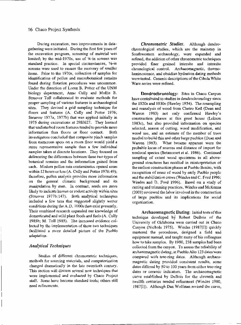
16 Chaco Project Synthesis
During excavation, two improvements in datagathering were initiated. During the first few years of the excavation program, screening of material was limited; by the mid-1970s, use of '.4-in screens was standard practice. In special circumstances, 1/a-in screens were used to ensure the recovery of smaller items. Prior to the 1970s, collection of samples for identification of pollen and macrobotanical remains found during flotation procedures was uncommon. Under the direction of Loren B. Potter of the UNM biology department, Anne Cully and Mollie B. Struever Toll collaborated to evaluate methods for proper sampling of various features in archaeological sites. They devised a grid sampling technique for floors and features (A. Cully and Potter 1976; Struever 1977a, 1977b) that was applied initially in 1975 during excavations at 29SJ627. They learned that undisturbed room features tended to provide more information than floors or floor contact. Both investigators concluded that composite pinch samples from numerous spots on a room floor would yield a more representative sample than a few individual samples taken at discrete locations. They focused on delineating the differences between these two types of botanical remains and the information gained from each. Modem pollen rain contaminates opened areas within 12 hours or less (A. Cully and Potter 1976:49); therefore, pollen analysis provides more information on the general climatic background and its manipulation by man. In contrast, seeds are more likely to indicate human or rodent activity within sites (Struever 1977b: 147). Both analytical techniques included a few taxa that suggested slightly wetter conditions during the A.D. 1000s than exist presently. Their combined research expanded our knowledge of domesticated and wild plant foods and fuels (A. Cully 1985b; M. Toll 1985). The increased evidence collected by the implementation of these two techniques facilitated a more detailed picture of the Pueblo adaptation.
Analytical Techniques
Studies of different chronometric techniques, methods for sourcing materials, and computerization changed dramatically in the late twentieth century. This section will discuss several new techniques that were implemented and evaluated by Chaco Project staff. Some have become standard tools; others still need refinements.
Chronometric Studies. Although dendrochronological studies, which are the mainstay in Southwestern archaeology, were expanded and refined, the addition of other chronometric techniques provided finer grained intersite and intrasite chronological control. Archaeomagnetic, thermoluminescence, and obsidian hydration dating methods were tested. Ceramic descriptions of the Cibola White Ware series were refined.
Dendrochronology: Sites in Chaco Canyon have contributed to studies in dendrochronology since the 1920s and 1930s (Hawley 1934). The resampling and reanalysis of wood from Chetro Ketl (Dean and Warren 1983) not only confirmed Hawley's construction phases at this great house (Lekson 1983c), but also provided information on species selected, season of cutting, wood modification, and wood use, and an estimate of the number of trees needed to build this and other large pueblos (Dean and Warren 1983). What became apparent were the probable locus of sources and distance of import for nonlocal species (Betancourt et al. 1986). Continued sampling of extant wood specimens in all aboveground structures has resulted in reinterpretation of the earliest construction phases at Pueblo Bonito, with recognition of reuse of wood by early Pueblo people and the stabilization crews (Windes and C. Ford 1996; Windes and D. Ford 1996). Based on a study of cutting and trimming practices, Windes and McKenna (2001) reviewed the labor involved in the construction of large pueblos and its implications for social organization.
Archaeomagnetic Dating: Initial tests of this technique developed by Robert DuBois of the University of Oklahoma were carried out in Chaco Canyon (Nichols 1975). Windes (1987[I]) quickly mastered the procedures, designed a field and equipment manual, and taught many of his colleagues how to take samples. By 1980, 238 samples had been collected from the canyon. To assess the reliability of archaeomagnetic dating, at Pueblo Alto 123 dates were compared with tree-ring dates. Although archaeomagnetic dating provided consistent results, some dates differed by 50 to 100 years from either tree-ring dates or ceramic indicators. The archaeomagnetic curve established by DuBois for the eleventh and twelfth centuries needed refinement (Windes 1980, 1987[1]). Although Dan Wolfman revised the curve,

some disagreement still remains (Windes 1993:297-304). Some discrepancies could be specific to Chaco Canyon (e.g., a local magnetic distortion or unusual soil chemistry), because samples from other sites around the San Juan Basin do not exhibit these deviations (Windes 1980).
Other New Chronometric Techniques. In his evaluation of dating techniques, Windes (1987[1]) found that radiocarbon dates may be affected by fluctuations in the atmosphere; some that should date around A.D. 1000 were recorded as A.D. 1500, while some that should be from A.D. 1250 registered around A.D. 400 and 900. A pilot study of eight sherds submitted for thermoluminescence dating provided results that suggested that this method had potential for future use. Before obsidian hydration provides good results, sources of obsidian must be determined.
Ceramic Chronology. Past studies of Chaco ceramics resulted in two different descriptive series (Hawley 1934, 1936, 1939; Roberts 1927), which were later merged by Gordon Vivian (1959, 1965). As noted above, several problems remained, especially the place of McElmo Black-on-white in the Chaco ceramic series. Windes (1985) recognized that some ceramic types in the Chaco series of Cibola White Wares were probably made in the canyon, but most ceramic types (including non-Cibolan types that were part of the assemblage) were produced elsewhere. He paid particular attention to Chaco-McElmo Black-onwhite ceramics, a type that has a short temporal span and reflects affinity with Black Mesa, Sosi, Toadlena, Nava, and McElmo black-on-white types. By using KYST, a multidimensional scaling software program, he was able to obtain finer temporal placement for the ceramic types at Pueblo Alto (Windes 1987[1):253-269) and 29SJ629 (Windes 1993:333). Based on initial studies of temper materials by A. Helene Warren (1976, 1977), and through the analyses of Windes, Peter J. McKenna, and H. Wolcott Toll, we now have a well-dated sequence of pottery types with more detailed descriptions for the Chaco series (H. Toll and McKenna 1997:Appendix A; Windes and McKenna 1989).
These chronometric studies allow colleagues working throughout the region to better understand their advantages and disadvantages. The results of these and the refined ceramic descriptions have been
- -- - ----~----
The NPS Chaco Project 17
used to compare data among other communities and evaluate links between communities and events in more recent models of social organization (e.g., Marshall et al. 1979; Powers et al. 1983). Tables in Appendix B correlate the various chronological schemes used by Chaco Project personnel.
Sourcing of Materials. Objects obtained from long distances indicate interaction between groups or sharing of resource areas. By the 1970s, sourcing of some artifact types involved cooperation with geologists, chemists, and other technicians who were developing methods, such as trace element studies. This section will discuss a number of such studies and indicate their potential value.
Geologists identified a number of source areas for lithic materials throughout New Mexico. Warren developed a standard four-digit code for materials she collected (Warren 1967, 1979). D. Love (1997a, 1997b) updated and expanded on this code for silicified materials in and around the Chaco area. Warren's analysis of ceramics, which included petrographic studies (Warren 1976, 1977, 1980), identified rock inclusions from a number of sources. Because Warren had worked on a number of projects for the Laboratory of Anthropology of the Museum of New Mexico and the Office of Contract Archeology at the University of New Mexico, the adoption of her coding system by a number of analysts made it possible to compare percentages of imports at various sites and during different periods to monitor changes in the transport of these materials across space and through time. During the Chaco Project, Warren's codes were used in the classification of material types during studies of ceramics (H. Toll and McKenna 1997); chipped stone (Cameron 1997b); and ornaments (Mathien 1997). It was possible to determine that interaction among Pueblo peoples was strongest to the south during the Early Bonito phase and was most heavily tied to the Chuska Mountains during the Classic Bonito phase, and that it shifted toward the northern San Juan region during the Late Bonito phase (Cameron 1997b; H. Toll and McKenna 1997).
Trace element studies carried out using a number of techniques became part of the analytical tool kit and added to the more rigorous scientific approach in archaeology at that time. X-ray fluorescence of 665

18 Chaco Project Synthesis
obsidian pieces from 20 excavated sites revealed that 12 distinct source areas in New Mexico, Colorado, Arizona, Utah, and northern Mexico provided chipped stone to the Chacoans (Cameron and Sappington 1984). A decade later, results were refined when Windes (1993:304-307) resubmitted some artifacts as part of a different analysis. Some specimens originally identified as coming from the Polvadera source in the Jemez Mountains were later identified as coming from the Grants Ridge source near Mount Taylor.
Attempts to source turquoise, however, have not been as satisfying. A small number of artifacts analyzed using arc emission spectrography (Sigleo 1970) suggested several possible sources in three different states. Neutron activation by Weigand et al. (1977) linked one artifact from Chetro Ketl to the Cerrillos Mining District south of Santa Fe, New Mexico, and additional studies of 150 artifacts reported a relative homogeneity with regard to consistent copper values, although the source was not identified (Bishop 1979:4-5; Mathieu 1981b). More recently, Harbottle and Weigand (1987, 1992; Weigand and Harbottle 1993) matched Chaco artifacts with artifacts from other sites in the Rio Grande Valley and the Southwest to propose two different trade networks extending southward. Their maps indicate that turquoise recovered in Chaco Canyon may have come from several sources besides Cerrillos; e.g., Colorado and Nevada. Hans Ruppert (1982, 1983) used an electron microprobe to analyze samples and artifacts from sites in both North and South America. Although successful in linking artifacts to sources in South America, his data for North America were difficult to interpret. Tables that included 462 source samples and 80 Chacoan artifacts did not fall into discrete clusters; e.g., 63 source samples from Cerrillos fell into 15 separate clusters. Artifacts from 29SJ629 and 29SJ423 in Chaco Canyon were grouped in clusters with source material from Cerrillos, New Mexico; Mineral Park, Arizona; the CourtlandGleeson area of Arizona; and the King Mine in Colorado. Thus, although it seems likely that turquoise was imported from several sources, additional research is needed to clarify present results.
In summary, the trace element studies of obsidian and turquoise provided clues as to areas of interaction among various Southwestern populations,
but they will benefit from improvements as methods are perfected and sample sizes increase.
Concurrent Studies. Dendroclimatic studies contributed much to the Chaco Project. Investigators began to evaluate the variability that was apparent in the specimens throughout the Southwest (Dean and Robinson 1977), which led to reconstruction of paleoenvironment (Dean 1988, 1992; Rose et al. 1982) and its effects on population dynamics (Dean 1996; Dean 1994, 1995). These contributions would aid in the development and testing of new models for growth and development of the Pueblo culture (see Chapter 2).
Summary
Prior to the 1970s, researchers relied on ethnographic analogy to interpret their data. The practitioners of "New Archaeology" (Willey and Sabloff 1980) wanted to use larger databases and new technology to examine propositions derived through deductive reasoning. In 1969, this would not be a straightforward path to success for the Chaco Project. For example, fewer than 400 sites had been recorded for Chaco Canyon in the UNM system (Be site numbers), and many excavations were either not reported or the existing documentation did not lend itself to detailed analysis. There was little understanding about selection of site locations or shifts in settlements through time. Gathering of data to address those problems would play an important role not just in the initial surveys but also throughout the Chaco Project.
I feel that the deductive approach simply cannot be implemented effectively in survey archeology, even in an area as wellknown archeologically as Chaco. An actual survey involves the expenditure of considerable time and effort and thus, I feel, must be inductively-oriented in order to maximize the information gained. This does not preclude the concept of specific problem formation to be tested with the survey data, but it does relegate such an orientation to a place second in importance to the maximization of the capabilities of inductive research. (Judge 1972:9)

A combination of deductive reasoning and use of data to inform on theory remained a practice throughout the project.
Organization of this Volume
This volume is organized around four topics: studies of natural resources and the environment, the Preceramic period, the Pueblo use, and the Historic period. Because our understanding of the Preceramic period is limited (Chapter 3), we can only assume continuity between those who relied on hunting and gathering with some horticulture and later Pueblo agriculturalists. If movement of people throughout a larger area occurred, there may have been periods when Chaco Canyon or at least some of its sites were not used. How societies marked or shared the landscape has not yet been deciphered. Thus, much more work on methods to discern continuity is needed, not just to link these two major periods, but also to link them within the Pueblo occupation. Chapters 4 through 9 discuss the Pueblo occupation. After some period of disuse, Navajo moved into the area. They remain there today, sharing the landscape with Euro-Americans. Chapter 10 presents their history, and evaluates how Euro-American cultures affected their herding adaptation. In Chapter 11, I
The NPS Chaco Project 19
focus on recent broad-based frames of reference that place this Southwestern case study within a worldwide frame of reference.
In summary, the Chaco Project is unique within NPS history and the history of archaeology. As Wilshusen and Hamilton (2005) note, it was one of the largest cultural resource management programs ever undertaken by the National Park Service. Its scope was immense, and a project of similar scope has not yet been implemented by this agency. It occurred during the period when "New Archaeology," with its more rigorous methods and deductive logic, was combined with systems theory and cultural ecology. Its staff included investigators trained in Southwestern archaeology during the 1930s, as well as a number of young students who availed themselves of many new tools to analyze previous models and propose new ones. As my colleague Marcia L. Truell (personal communication, 1982) remarked, "it is only at the end of a project that we begin to ask new questions." Scholars continue to pursue answers to newer questions (Mills 2002), but their database for Chaco Canyon still remains much the same-the data collected by the Chaco Project-for their evaluation of new theories, some of which will be included in the chapters that follow.


Chapter Two
The Environment and Natural Resources of the Chaco Area
Scrub cedars, very thinly scattered, were to be seen on the heights; and the artemisia characterized the flora. Some patches of good gramma [sic] grass could occasionally be seen along the Rio Chaco. The country, as usual, on account, doubtless, of constant drought presented one wide expanse of barren waste. Frequently, since we left the Puerco, the soil has given indications of containing all the earthy elements of fertility, but the refreshing shower has been wanting to make it productive. The Rio Chaco, near our camp, has a width of eight feet, and a depth of one and a half. Its waters, which are of a rich clay color, can only be relied upon with certainty during the wet season. (Simpson 1850:37)
Simpson was not alone in describing the Chaco area as bleak in appearance. Visitors and scholars alike often wonder how past populations coped with this semiarid setting, let alone created the many sites that provide testimony to a flourishing lifestyle during the eleventh century (Brand 1937c:45; Hewett 1905; Kidder 1924:54; Gordon Vivian and Mathews 1965: 1). Water remains the key variable. This chapter underscores the role that water played in the creation of the area, and describes the water resources themselves, and where those resources are located. The amount of water available to plants affects species diversity, the size of their range, and their density. In tum, these affect animal species that depend on plants for nourishment. Studies of the behavior of plants and animals in the current environment provide clues to what may have happened in the past if the climate was similar to that of today.
Some changes have occurred since the end of the Pleistocene, but for several thousand years the climate has been similar to that of today. Yet the amount of precipitation did vary slightly through time. These variations in amount or timing of precipitation events would have placed some restrictions on human populations who lived in this setting. Humans also would have brought changes to the local environment, especially once they settled into an agricultural adaptation or became pastoralists. This chapter
provides a backdrop for the cultural ecology and systems theory approach taken by the Chaco Project in the chapters that follow.
The Historic Setting
The eight-mile-long Chaco Canyon (Figure 1.3) is a unique feature in the approximate center of the semiarid San Juan Basin (Figure 1.1); surrounding it are mostly open spaces with only slight topographic variation until the mountain ranges that encircle the basin are reached (Gwinn Vivian 1990). Using LANDSAT imagery, Schalk and Lyons (1976:Figure 2) were able to delineate gross ecological zones in the San Juan Basin and reported that its sandstone mesas and canyons are not identical in the northeast and southwest sections. This erosional feature is located at the contact zone between northern terrestrial deposits and southern marine deposits; thus, soils and their water-retention properties differ in these two large areas. Sandy soils in the northeast should retain moisture for longer periods of time than the clayey soils of the southwest, which are characterized by more rapid runoff and poorer water retention. It is in the latter area, therefore, that Schalk and Lyons proposed that water control features would have been more useful to agriculturalists and would affect social organization when adopted.

- - --- -----------------
22 Chaco Project Synthesis
Geology
Studies of the bedrock geology and paleontology of the Upper Cretaceous (Siemers and King 1974) expand on Schalk and Lyons's description of Chaco Canyon as a contact zone. Upper Cretaceous marine sediments are found in the walls of the canyon, and also to the north, where are found the Allison Member (shales); the Mesaverde group (which contains Point Lookout Sandstone, the Menefee Formation, and Cliff House Sandstone); Lewis Shale; Pictured Cliff Sandstone; Fruitland Shales; and the Ojo Alamo and Puerco formations. Badlands, which have little vegetation, appear in shale deposits. Brand (1937c: 55-63) reported that barite, gypsum, aragonite, siderite, and petrified wood are associated with Kirtland Shale. Silicified wood, pebbles of red jaspery quartz, brown and gray chert, vein quartz, pink and white quartzite, rhyolite, andesite, felsite, porphyrite, granite, gneiss, schist, and obsidian were found in the Ojo Alamo Shales. This formation also contains limonitic and manganese concretions. Calcite crystals are present in the Puerco Formation, and the Torrejon Formation contains chert pebbles and quartz. There is a wealth of stone that could be used for construction and tool manufacture, as well as for fashioning ornaments and grinding pigments. Also within the Fruitland Formation, various Dinosauria, Chelonia, and Pices fossils occur (Brand 1937c:40-41).
In the canyon, Cliff House Sandstone is the predominant stratum that forms the north wall. Fossil remains in the walls include species belonging to the classes Gastropoda, Pelecypoda, and Cephalopoda, especially Inoceramus barabini and sharks' teeth (Brand 1937c:40-41; Vann 1931, 1942). On the north side of the canyon, the cliff wall rises approximately 20 to 30 m to a bench containing shale before rising again to full height of 85 to 95 m above the canyon bottom (Siemers and King 1974). Several re-entrants cut the cliff and funnel water into the canyon during infrequent rain storms. Water from the top of the North Mesa, however, flows toward the Escavada Wash. On the south side of the canyon, Chacra Mesa is from 91.5 to 152.4 m high, dips to the north, and is broken by several gaps (e.g., Vicente Wash, which enters the Chaco near Fajada Butte and South Gap). These shallow drainage systems move alluvium intermittently toward the Chaco Wash. This com-
bination of runoff from re-entrants from the northern cliff walls and the southern washes brings additional water to the canyon bottom that helps alleviate some constraints in an environment that is covered with sparse vegetation and receives minimal rainfall for agricultural production (Gillespie 1985; R. Powers et al. 1983; Schelberg 1982a; Gwinn Vivian 1990).
Four species of fossils recorded by Siemers and King (1974; see also Vann 1931, 1942) indicate minor regressions and transgressions of the Upper Cretaceous shoreline in Chaco Canyon. Some fossils are bivalves found today in depths of marine waters; others are found only in shallow marine environments; a few represent intertidal zones. The several freshwater and brackish-water gastropods suggest proximity to a major fresh-water influx and estuarine conditions. Siemers and King interpreted this to represent changes in the shoreline of an ancient lake. They concluded that the Cliff House Sandstone was probably a one-time barrier beach front during a shoreline standstill before it migrated farther south.
Siemers and King (1974:270) also examined the clay mineralogy of the Menefee Formation, Cliff House Sandstone, Lewis Shale, and Pictured Cliffs Sandstone. Clay from the Lewis Shale contains calcareous concretions; the minerals are predominantly a Na-montmorillonite, with some illite, a mixed layer of illite-montmorillonite, and a little kaolinite. Concretions in the Menefee Formation include siderite and calcite- and barite-bearing materials. D. Love (1977b:Table 11; 1980) would use these data to characterize soil composition that originates in the upper wash versus that from side washes draining into the canyon. Understanding the Chaco Basin, therefore, is relevant to understanding Chaco Canyon.
To initiate studies of the Chaco Basin, DeAngelis (1971, 1972) assessed the available literature and found that 18 studies were more pertinent for a regional overview than specific to the region. He divided the Chaco Basin into 19 subbasins (Figure 2.1) and examined the drainage pattern on a large scale. He found no true dendritic pattern as would be expected in a basin developed on nearly flatlying, sedimentary rocks. Instead, there is considerable evidence for structural control, and three anomalies become apparent:

Environment and Natural Resources 23
I COLORADO -1--------------------,--• .J I /
I r I I
• I • I • I
I 11 I
I 14
I I
I I I
I
0 20 SCALEI IMtLES N
i
., • I i 1 • I • I
Figure 2.1. Map of the 19 subbasins of the Chaco Basin. 1) Pajarito-Dead Man's Wash; 2) Coal Wash; 3) Cottonwood Arroyo; 4) Pinabete Arroyo; 5) Sanostee-Tocito Wash; 6) Theodore Wash; 7) Captain Tom-Tuntsa Wash; 8) Brimhall Wash; 9) Hunter Wash; 10) Sheep Spring Wash; 11) Coyote Wash; 12) Indian Wash; 13) De-na-zin Wash; 14) Kimenola Wash; 15) Escavada Wash; 16) Gallo Wash; 17) Fajada Wash; 18) Canada Alemita Wash; and 19) Canada Alamos-Corrales. (Taken from DeAngelis 1972:Figure 6.)

24 Chaco Project Synthesis
First, the Chaco Wash is not a true subsequent stream. Although it may have developed along the strike of a nonresistant bed, the present wash was most likely imposed upon more resistant formations.
Second, stream capture for several tributaries was unusual. Based on the extent of the subbasins and angular junctions of the Coyote (draining 2,281 km2
or 881 mi2), Escavada (draining 587 km2 or 227 mi2
),
and Fajada (draining 523 km2 or 202 mi2) washes,
they may represent three actual headwaters that were captured into a single wash through time. At each junction, the Chaco Wash makes a nearly 90-degree change in course, whereas the tributary wash appears to represent a natural headward extension of the main Chaco channel. D. Love (1977b: 12) also questioned whether the Escavada or the Chaco was the master stream for the Chaco River, and he recommended further study to determine the reasons for entrenchment of the Chaco-Escavada junction into bedrock. At the time, the implications of changes at this junction were not understood, but recent studies by Force et al. (2002) propose that breaching of a sand dune dam during the Pueblo adaptation would have affected ground water levels and water availability in the lower canyon.
Third, although the longitudinal profile of the Chaco Wash is typical of an ephemeral stream, a stream gradient anomaly occurs in Chaco Canyon between l,859 and 1,920 m (6,100 and 6,300 ft) contours. Within a distance of 22 km (13. 7 mi) between these contours (the main canyon, where many large Pueblo sites are located), the stream gradient averages 4.48mper1.6 km (14.7 ft per mi), which is consistent with gradients farther upstream and downstream. The gradient of the uncut alluvial floor in that distance, however, averages 5. 79 m per 1. 6 km (19 ft per mi). The 0.91 to 1.2 m per 1.6 km (3 to 4 ft per mi) difference in gradients was thought to reflect the effects of alluviation in the canyon between A.D. 1300 and 1860. The significance of this anomaly could be understood through review of processes of arroyo formation. Whether this anomaly holds true for earlier periods was not known. Knowing the causes of alluviation and the periods when such events occurred affects interpretations of human use of the canyon.
That the Chaco provided evidence for more than one series of erosional and depositional events was previously documented (Bryan 1941, 1954; Dodge 1920; Jackson 1878). Based on Bryan's more detailed studies of the strata that contained early Pueblo sherds, he suggested three periods of dissection and alluviation in the canyon, with the last deposition occurring in the twelfth century. He thought that these occurrences were not unique to this locality, but rather could be correlated with evidence from other stream localities in the northern Southwest. Bryan also postulated that the abandonment of the canyon by Pueblo ancestors may have been due to progressive upstream erosion of the wash due to climatic change; e.g., slightly decreased rainfall that led to arroyo formation. If erosional and depositional events were contemporaneous over the larger region, they would have affected the population throughout the San Juan Basin in a similar manner during each period. Each of these concepts was re-examined during the Chaco Project.
Bryan (1941, 1954) suggested that the oldest period of deposition was probably Pleistocene in age due to the presence of extinct faunal remains in the alluvial fill; it would have had no effect on human occupation. The first period of erosion was very long; Bryan thought it indicated climatic change, but it was difficult to date. Although there was very little evidence to suggest human occupation during this period, silt from one of the horizons was thought to correlate with the Archaic period or the Cochise culture. The second depositional period was not well dated. It might represent two episodes separated by an interval of erosion; and sherds present in the fill ranged from around A.D. 300 through 1250. The next erosional episode in Chaco Canyon was thought to occur after A.D. 1167 but prior to about A.D. 1250. Sherds in the fill of other streams indicate that deposition began before or shortly after A.D. 1400. The present erosional cycle was dated around A.D. 1860 to 1890, depending on the area. Although there was a lack of more exact dating in seven dispersed areas, Bryan concluded that these cutting and filling episodes were widespread rather than canyon-specific.
The restricted area where DeAngelis noted the 0.91 to 1.22 m per 1.60 km difference in gradients

that exists today contrasts with the lower area of the Chaco Wash, which is more open and more remote from sources of silt and clay. To understand variability among streams, DeAngelis assisted Hodges (1974), who studied 17 variables in 31 drainage basins to devise two models for arroyo and wash development in northwestern New Mexico and northeastern Arizona. The first model predicted the magnitude of channel development at a selected site. The second aided in classifying the form of channel development. Hodges found that the geomorphic process responsible for creating and maintaining a drainage is dependent on the interactions and changes that occur among several variables. Each basin is different and has a unique history; therefore, causes for drainage development may differ between neighboring basins. Thus, Bryan's correlation of erosional and depositional events across the region was not supported.
The 0.91to1.2 mper 1.6 km gradient difference between the Chaco Wash and the uncut valley floor would not be evident in the lower wash because coarse sands would not be able to maintain as great a slope. In the canyon between 1860 and 1925, when overgrazing, aridity, and the increasing gradient exceeded the threshold necessary for arroyo-cutting, the Chaco Wash became entrenched. Vertical erosion continued to deepen the arroyo until a stable gradient was achieved. Once entrenchment achieved a more stable condition, soil piping (water erosion in a layer of subsoil that results in the formation of tunnels and caving) created incipient tributaries. Since 1925, lateral erosion or widening of the arroyo has been more dominant over vertical erosion (DeAngelis 1972). After 1970, sedimentation is thought to be the cause of erosion (Brad Shattuck, personal communication, 2003).
Within the canyon, initial experiments with seismic refraction by Lewis and Shipman (1972) were not successful in determining the depth of the bedrock surface beneath the fill sediments, but Ross (1978) defined three seismic horizons that correlated fairly well with data obtained from two core test holes. An upper surface alluvium varied from 5.79 to 16.15 m (19 to 53 ft) with an average of 12.49 m (41 ft). Beneath this was a water-saturated alluvium, which also varied from 3.96 to 25.3 m (13 to 83 ft), with an average of slightly over 15 m (52 ft). Suballuvial
Environment and Natural Resources 25
bedrock (the Menefee Formation) varied from 17.06 to 35.36 m (56 to 116 ft), with an average of27 .86 m (91.4 ft). The water table sloped to the west from 1 to 5 degrees.
The canyon floor is relative flat in cross-section, with some downcutting on the north side (Ross 1978). Gravels, sand, silt, and clays characterize the complex alluvial fill. Two depositional environments (an alluvial fan and a meandering arroyo environment) were delineated. The presence of well-crystallized kaolinite suggests alluvial fill from the sandstone walls of the canyon; poorly crystallized illites and montmorillonites are probably derived from the headwaters of the Chaco drainage basin. In the meandering environment, Ross defined five facies: 1) backwater-tochannel margin, 2) mid-channel climbing ripple, 3) flat-bedded channel sand, 4) modified climbing ripple, and 5) channel lag deposits. These represent a range of water-flow regimes and load-carrying capacities. These facies also suggested more complex stratigraphy than the seismic data could discern.
Research on Quaternary deposits in the canyon undertaken by D. Love (1980) provided a more detailed analysis of events. Initially, Love (1974) reported a date of approximately 4,000 years B.P. on burned wood exposed in the bank of a collapsed wall in the wash just above its confluence with the Gallo Wash. Because the arroyo had filled 4.5 m above the lowest entrenchment level when the bum occurred and filled at least 2 m above it, this fill represented a previously unknown cycle of cut and fill. Because it had occurred prior to major human use of the canyon, Love thought this degradation and aggradation must be explained by climatic fluctuations rather than environmental degradation by canyon occupants. If so, later cycles were perhaps also climatically induced. Thus, he focused on the relationships between climate and geomorphic and sedimentologic conditions in the upper Chaco Basin (D. Love 1974, 1977a, 1977b, 1983a, 1983b).
After reviewing data on semiarid drainage basins and considering the deposits and processes that would have affected the upper Chaco Drainage Basin, D. Love (1977a, 1977b, 1980) indicated that the major variables that affect a geomorphic system include the physical geography, bedrock geology, soils, vegetation, and climate. He also found that all runoff from

26 Chaco Project Synthesis
the headwaters and/or side washes does not enter the Chaco at the same time. During a rainstorm, waters from the local side channels often run earlier than those of the headwaters, if the latter runs at all. Because the timing of the appearance of such waters differed, during a major storm there was often no real increase in discharge into the Chaco arroyo. Downcutting seemed to be associated with an increase in discharge and stream power on readily erodible material, and it seemed to end when the discharge was adequately handled by the newly developed hydraulic geometry of the new channel (Leopold and Miller 1956). Love confirmed Hodges's (1974) opinion that there are a number of complex geomorphic variables that affected the Chaco Wash.
Characteristics of sedimentary structures, color, grain size, grain mineralogy, clay mineralogy, and soluble cations were studied to differentiate local environments. By incorporating Siemers's data, D. Love (1980) was able to distinguish clays from the Menefee Formation, Cliff House Sandstone, Lewis Shale, and Pictured Cliffs Sandstone by examination of clay mineralogy. Unfortunately, after sediment is transported into the canyon, Love could not assign it to these specific types. He could, however, distinguish most local deposits from headwater deposits based on mineralogy and color (D. Love 1977b, 1980).
When he mapped and described the modem geomorphic features of the Chaco Wash, D. Love (1983a, 1983b) listed the following: 1) bench, slope, and cliff topography on either side of the canyon floor rising up to 180 m above the canyon; 2) short pediment talus fans at the base of the cliffs; 3) individual large rock falls; 4) side canyons cut into the cliffs on either side of the main canyon, which tend to parallel the regional jointing trend to the northeast, and which tend to be long on the southwest side and short on the northwest side of the canyon; 5) alluvial fans at the mouths of side canyons and re-entrants along the main canyon; 6) sand dunes on tops of cliffs and mesas and in some of the side canyons; 7) silt-clay dunes on the canyon floor; 8) flat canyon floor; 9) yazoo channels parallel to the main arroyo and side arroyos; and 10) the Chaco arroyo (Figure 2.2). Piping is also present.
-- --- ---------------
Because his work was carried out between 1973 and 1975, D. Love (1977a, 1977b, 1980) was able to provide an in-depth description of the Chaco arroyo prior to and after major floods. These observations, combined with his other studies, suggested an outline for three scales of geomorphic adjustments in the Chaco arroyo (D. Love 1979, 1983a). At each scale, changes in stream flow are involved.
First, minor changes in precipitation were correlated with small-scale changes. These include adjustments made within the past 140 years and are limited to the inner channel and inner floodplain. It was evident on aerial photographs that the channel had widened extensively between 1900 and 1934, possibly due to excess sediments or a sediment change. With the exception of a moist period from July 1940 through December 1941 during which Threatening Rock fell on Pueblo Bonito, a decrease in moisture occurred that lasted until the mid-1950s. Based on a longitudinal profile of the canyon floor, which was not broken by steep reaches, Love found no axial fans spread down the canyon floor. The arroyo meanders, with some loops pointing up canyon, indicating that the channel had been established on the floor prior to downcutting of the Chaco arroyo. This evidence did not support Bryan's (1954) model, in which he postulated that the arroyo formed by headward cutting of a previously unchanneled alluvial canyon floor. There were several possible reasons why the channel changed from a braided one to an inner channel and floodplain. The adjustments are due in part to changes in precipitation, land management, and the inherent fluvial system. D. Love (1983a: 199) preferred to explain channel development based on "changes in discharge, sediment load, and subsequent internal adjustments related to a period of less precipitation regionally." The timing of the initial channel cut, however, was not as clear. Review of written reports and interviews with local inhabitants suggested three possibilities: I) a pre-1849 date for the initial channel cut and partial fill; 2) an initial cut, partial fill, and reentrenchment between 1849 and 1877; and 3) an initial cut prior to 1877, with the presence of an alluvial terrace from 1877 through the late 1880s, and then re-entrenchment in the 1890s, with arroyowidening and removal of most of the alluvial terrace between 1905 and the 1930s. Love favored the last,

Environment and Natural Resources 27
CHACO CANYON
CANY N FUXlR
T£RRAC£ INNER f'L000Pt..AIN INNER CHANNEi.. INNER f'LOOOP\.AIN
Figure 2.2. Geomorphic features of the Chaco arroyo. (Taken from Love 1979:Figure 3.)
because it best fit the data. Thus, the smallest scale adjustments took place within this one channel within a century and a half.
Second, intermediate-scale fluvial adjustments were those that involved the aggradation of canyon fill and cycles of channel cut and fill in three stages: a flat floor, channel entrenchment, and channel fill until a flat floor was again present. When the floor is flat, alluvial fans from the canyon margin continue to aggrade and lenses of sand and clay spread across the floor. Also, headwaters could spread from margin to margin in narrow parts of the canyon during a flood that ran at a rate of 125 m2 per sec. To D. Love, the thinness of the deposits suggested that 1) either the canyon commonly had a channel that confined the
headwater sediments; 2) a somewhat steady state of transport of sediment through the canyon was achieved when no confining channel was present; or 3) large flood events were rare, particularly when there was no confining channel. Dating was least precise for the intermediate-scale changes, which encompass the period that includes the prehistoric use of Chaco Canyon, but several archaeomagnetic dates fell within this period (Nichols 1975). Three sets of archaeomagnetic samples from an upper laminated clay layer in the Chetro Ketl field suggested a date of A.D. 1250. Twelve samples from two test trenches in a meander scar provided eight possible dates. The uppermost sample, taken at 15.24 cm (6 in) below the surface, suggested deposition around A.D. 1850. Four samples taken at depths from 38.1 to 68.5 cm

28 Chaco Project Synthesis
(15 to 27 in) below the surface fell within the seventeenth century, but they were not sequenced from top to bottom. One taken at 38.1 cm (15 in) in test trench 1 (dating at A.D. 1600) was earlier than another taken at 48.3 cm (19 in) in test trench 2 (dating at A.D. 1625). Whether this indicates differential deposition in the two test trenches is not known. Two samples taken from the two test trenches at a depth of 38.1 cm (15 in) did vary; the one from test trench 2 dated ca. A.D. 1650 or 50 years later than the one from test trench 1. The lowest sample taken provided a date of ca. A.D. 1550. These dates suggest an approximate 400-year span within 78. 7 cm (31 in) from the modem surface.
Fill patterns for these channels were described. The modem channel contains approximately 12 m of alluvial fill; in the stratigraphy several other channels were noted at about the same depth, including Bryan's post-Bonito channel (Figure 2.3). Bryan (1954) thought the channel was not entrenched for most of the prehistoric occupation, that it had a high water table, and that crops were raised by floodwater farming. With the cutting of trees and ruining of vegetation by rapid runoff after a drought, stream forces would have initiated arroyo cutting that migrated upstream, destroying farm land and causing abandonment. D. Love's review of the limited evidence did not support this scenario. Because he could determine no major changes in climate or vegetation from a review of the aerial photographs, stratigraphic record, and tree-ring studies, Love ruled these out as causes for change in channel development during this intermediate scale or period. Instead, he thought the large channels were due to variable climatic conditions and responses to headwater channels.
Advantages of an entrenched channel include control of floods on the canyon floor, confinement of alkali-bearing clay to the channel itself, availability of water in lower parts of the channel, and prevention of flooding in subterranean structures (e.g., kivas) (0. Love 1980). Additionally, the sandy parts of the inner floodplain would have been available for agriculture. During the period when early Pueblo farmers were in the canyon, smaller cut and fill episodes probably changed the elevation of the bottom numerous times, but not always drastically. D. Love (1980) thought the inhabitants probably adjusted quite well to these changes in fluvial waters.
---------
Third, major climatic changes were the trigger for the large-scale sediment movements, a pattern that alternated between erosion and aggradation of the valley itself. Evidence for initial scouring of the valley floor and deposition of gravels greater than 30 cm in diameter were included in this category. In the Chaco Wash, five coarse-grained topographic levels were noted, some with cemented deposits. Their ages were not determined; one, red paleosol with caliche underneath was attributed by Hall (1977) to the Late Pleistocene; D. Love thought it might be older. The reasons for changes in the base level of the canyon and the high level of stream power had to be attributed to climatic control. Complex fluvial adjustments were involved. During semiarid episodes, the canyon would be partially filled. Because these events took place prior to human use of the canyon, land use would not have been a major cause of change.
Hall's (1977:Table 1) research included an analysis of 18 pollen samples that provided radiocarbon dates with which to date five alluvial units. In addition to the episodes of erosion and sedimentation recognized by Bryan (1954), Hall described two older alluvial units. The Gallo unit was firmly dated between 6,700 and 2,400 B.P., a period that was previously poorly known in the Southwest. The older Fajada unit and the Historic unit (which had only begun to form when Bryan worked in Chaco Canyon) were discussed in some detail. Hall's analysis resulted in definitions of the Fajada unit (late Pleistor:ene), the Gallo unit (7,000 to 2,400 B.P.), the Chaco unit (2,200 to 850 B.P .), the Post-Bonito unit (600 B.P. to A.D. 1860), and the Historic unit (1935 to present) (Table 2.1).
Hall recognized that the assumed relationships between climate and arroyo-cutting needed reevaluation. He suggested historic arroyo-cutting occurred when there were short climatic changes, with above-average rainfall and erosion due to abovenormal runoff. He did not believe that Holocene arroyo-cutting was due to reduced plant cover and increased runoff during periods of aridity. Hall proposed that either there was no period of aridity during the Holocene as proposed by Antevs (1948), or that alluviation can occur during arid periods. His Chaco data suggested that three intervals of erosion, indicated by increased pine pollen due to increased rainfall or decreased aridity. Hall (1975:13) thought

Environment and Natural Resources 29
SW NE
200 100 Om
Figure 2. 3. Schematic cross-section of alluvial fill in the Chaco Wash (levels 7-9). Remnants of earlier fill are located along the margins of the canyon and are partially buried by modern alluvium. Horizontal lines indicate widespread inundation of the canyon floor by sediments from the headwaters and are connected with filled-in entrenched channels, laminated swales, and yazoo channels. A) remnant gravel deposit of level 7 with blocks of alluvial fill; overlain by soils. B) sandy soil containing pottery. C) Gravel reworked into later channel. D) Broad swale filled by laminated clay derived from the headwaters, overlain by canyon floor deposits. E) Swale filled with laminated clay associated with 3,700-yearold fill in buried channel to right. G) Small water-control feature. H) Deeply buried laminated silty clay with soil developed on top of deposit. I) At least 38 m of fill above bedrock floor of canyon (level 9); water table at 12 m. J) Complex arroyo cut and fill about 3,700 years old. K) Pottery-bearing channel 3 to 4 m deep filled to present surface of canyon floor. L) Modern Chaco arroyo wall. M) Modern inner Chaco channel. N) Modern inner floodplain aggraded after 1934. 0) Indented terrace (former floodplain prior to 1896). P) Stone slabs associated with pithouse. Q) Canyon floor sediments derived predominantly from the headwaters. R) Buried channel(s) with pottery and rocks at base. S) Undated buried channel filled with sandy sediment with no backwater facies. T) Shallow channel. U) Thin wedge-shaped headwater-derived deposits pinch out against deposits from the canyon margin. V) Undated buried channel. W) Relict sediments of previous episode of canyon fill with well-developed reddish-brown soil, truncated at top by Holocene (6,000 yrs) sediments. X) Buried tributary channel containing pottery. Y) Sediments from canyon margins predominate. (Taken from Love 1983:Figure 4.)

30 Chaco Project Synthesis
Table 2.1. Five alluvial units identified by Hall.•
Alluvial Unit
Fajada Unit
Comment:
Comment:
Gallo Unit
Chaco Unit
Post-Bonito Unit
Historic Unit
Description
- Late Pleistocene. - Found in two main locations: a) gravel pit approximately 0.8 km southwest of visitor center and b) as a terrace along the base of the sandstone cliff 3 to 5 m above alluvial valley of Chaco Wash northeast of its junction with the Escavada Wash. - Composed mainly of cross-bedded sand and gravel, plus shale, quartz, quartzite, chert, jasper, agate petrified wood, and dark reddish-brown sandstone.
Red paleosol on top of Fajada gravels probably Early Holocene in age.
Early Holocene alluvial deposits not documented (Hall 1990:325). Gap in pollen sample record from 9,700 to 7,000 B.P.
- 7,000 to 2,400 P.B. (End date estimated) - Up to 4 m thick. Found in Gallo Wash above Fajada Unit and below Post-Bonito alluvium. Similar material identified in Mockingbird Canyon Arroyo, south of Chetro Ket!, also 500 m upstream from eastern boundary of park. - Composed ofunbedded, blocky, yellowish-brown silt; occasional clay beds and lenses of sandy gravel. Approximately 4 m thick. (Some material from small tributaries and reentrants are local alluvium. In axis of canyon gray-brown, silty, fine alluvium of upstream origin.) - Haynes (1968:612) noted an absence of radiocarbon-dated deposits between 5,800 to 7,100 B.P. in alluvium of the southwest. Hall's data fill in this gap.
- 2,200 (estimated) to 1,000 or 850 B. P. (A.D. 1100 or 860, respectively). Both beginning and end dates estimated. - Principal valley fill; in central part of valley extends to unknown depth. - Composed of pale brown clayey silt, largely without regular bedding; upstream origin. Pueblo pottery described by Bryan (1954:30-32, 37) found in two distinct zones represents late and early pottery types.
- 600 B.P. to A.D. 1860. Dating of the channel-cutting is uncertain. Last building construction at Pueblo Bonito dated ca. A.D. 1100-1130; therefore, erosion thought to have begun around A.D. I JOO. Filling of channel is less certain. - In channel cut in older sediments, ca I m thick in central part of canyon, especially near Pueblo de! Arroyo - Composed of clayey silt and sand. Abraded pottery fragments similar to types recovered at Pueblo Bonito. - Bryan (1941 :231, Table 1) correlated fill in this unit with similar fill found in northeastern Arizona and northcentral New Mexico prior to A.D. 1400. There is no good evidence with which to date the horizons in this unit.
- 1935 to present. - In Chaco Wash arroyo, about 2 m. - Clay, silt, and sand, probably resulting from planting of willow, tamarisk, wild plum and cottonwood for erosion control of Chaco Wash. Institution of checkdams, cable-willow-rock jetties during 1949 and 1950s.
•Taken from Hall (1977, 1988, 1990) and supplemented by (D. Love 1980).
that arroyo-cutting occurs with a transition from arid to less arid climate (or increased precipitation), that arroyo-cutting does not occur during a transition to a more arid environment, and that erosion is not continuous during a period of aridity.
In summary, the intermediate-scale adjustments also can encompass the small-scale changes to an inner channel that is affected by minor changes in precipitation. Understanding more recent changes in
stream development, however, is complicated by conservation projects initiated during the 1930s. Several investigators considered these issues. When DeAngelis (1972) rechecked Bryan's 1920s measurements of several sections of the arroyo, it was about the same depth. In 1924-1925, the flat-floor, braided gully existed; in 1972, the active channel was entrenched as much as 3 m (10 ft) below the arroyo floor. Using 1934 photographs, DeAngelis determined that the arroyo had widened considerably by

approximately 5.08 to 15.24 cm (2 to 6 in) per year between 1934 and 1972-a period when grazing within the park was eliminated and agriculture was not practiced. However, planting of vegetation during the 1930s may have trapped sediments eroding from the arroyo walls and could be interpreted as alluviation after the 1920s (DeAngelis 1972), but Dean (personal communication, 2000) indicates that in other areas where no vegetation was planted the same events occurred. The vegetation did slow the stream flows and encourage sediment deposition; it indirectly retarded vertical erosion, because water had less velocity to scour or undercut the vertical banks. Recently, Kirk Vincent from USGS (Brad Shattuck, personal communication, 2002) suggested that the arroyo was not deeper but rather went from a sand-bed channel with a vertical arroyo wall to a vegetative plain with an inner channel. The former sand channel became a new floodplain.
Other documentation of changes in the recent floodplain exists in photographs taken by Chauvenet (1935) and Malde in 1972; Malde (2001) continues to update this photographic record. Malde's 1970s investigation established transects selected to represent vegetational types defined in Loren Potter's (1974) studies, as well as provide data on soil erosion accumulation and bank-cutting studies. To accomplish the latter, scour chains and erosion pins were installed and monitored (Simons, Li & Associates 1982). Although relatively little net change occurred over a period of four years, there were differences between washes. For example, Fajada Wash showed the highest net aggradation (35 cm) while the Gallo Wash had an 8 cm net degradation over a five-year period. Rates of surface lowering ranged between 1 to 4 mm/yr. At the higher elevated canyon floor near Fajada Butte, the rate was 0.2 mm/yr; in contrast, the rate was 9 mm/yr where transect B3 crossed an area of active gullying and piping adjacent to Fajada Wash. When the Chaco erosion rates were compared to those from other semiarid and badland areas, the results were relatively similar (Simons, Li & Associates 1982:3.43-3.45).
In summary, human actions alone cannot be the major cause for changes described in the Chaco Wash. DeAngelis (1972) proposed that overgrazing and climatic fluctuations were complementary, rather than mutually exclusive, causes for arroyo formation. If
Environment and Natural Resources 31
arroyo-cutting occurs when the gradient of the alluvial fill of a restricted valley increases until it is no longer stable and channel trenching begins when the critical angle is reached, overgrazing, aridity, and climatic factors must interact to lower the critical angle necessary for arroyo-cutting. Even small-scale climatic changes would affect the level of fill within the Chaco Wash; intermediate-scale changes would alter the character of the canyon bottom such that there might be a flat floor or an entrenched arroyo. During any short period, Pueblo inhabitants would have encountered somewhat different conditions than their ancestors or descendants did. The construction of a masonry dam across the Chaco Wash at its confluence with the Escavada Wash, probably in the mid-eleventh century, would have raised the water table in the canyon (Force et al. 2002) and brought advantages to the agriculturalists. Archaeologists have not yet had time to evaluate this information, but future research on this topic will enhance our understanding of Pueblo use of the canyon. Until recently, researchers were dependent on climatic data to guide their interpretations of this cultural period.
Climate
The last major climatic change occurred at the end of the Pleistocene as a warming trend began. But within the Holocene, how much change and precisely when it occurred have been topics of research for numerous scholars. In early studies of the Pueblo adaptation in Chaco, rainfall was considered a key variable that affects the diminution of plant cover and erosion of soils (e.g., Bryan 1954; Fisher 1934; Hawley 1934; Hewett 1936; Judd 1954, 1964). Beginning in 1932, a weather station was set up at Pueblo Bonito, but data collected included only the amount of precipitation and maximum and minimum temperatures.
In an initial evaluation of climate, Fisher (1934) used data from these and other stations in the San Juan Basin to suggest that killing frosts ended the second week of May and began around the first week in October; he estimated a 150-day growing season. Fisher realized that data on fluctuations in rainfall in Chaco Canyon were unavailable, but that new treering studies would provide approximate precipitation values by year.
32 Chaco Project Synthesis
A few years later, Brand (1937c:43-45) accepted Fisher's estimated number of frost-free days and lengths of growing season. He also reported that the peak rainy season occurred in July, August, and September (46 percent of total annual rainfall). Variation in annual precipitation ranged from less than 15.24 cm (6 in) in the western areas of the canyon to more than 38.10 cm (15 in) in higher southern and eastern areas. Annual precipitation could vary as much as 50 percent from the mean. Temperature and winds shifted diurnally. Comparison of Chaco data with Koeppen's system indicated that Chaco was considered during normal years to be a cold desert bordering on steppe. With an average increase of only 2.54 cm (1 in) more rain per year, the canyon would be considered a steppe environment.
Gordon Vivian and Mathews (1965:8-11) had 32 years of temperature and precipitation figures to examine. The highest temperature recorded was 106 degrees F; the lowest was minus 38 degrees F. There were also large daily variations during the summer months, but the estimated frost-free period remained at 150 days. There was a wide fluctuation in precipitation from year to year (8.5 to 45.8 cm [3.35 to 18.02 in]), and there seemed to be a pattern of two to four or five years of below mean precipitation (22.1 cm [8. 71 in]) separated by a single year above the mean. They inferred that there would be several years with only 12.7 to 17.8 cm (5 to 7 in) of rainfall followed by a year with destructive rainfall. They recognized the effects of precipitation and frost-free periods on agricultural production. When they compared the available data from Chaco with Rack's (1942) observations on the Hopi, they recognized that recent precipitation in Chaco was slightly more than half of what was needed. Extensive water collection and conservation systems would thus have been a necessity during the height of the Pueblo agricultural adaptation. Although the weather station at Pueblo Bonito was in a cold desert, Chacra Mesa (at around 2, 113 m, or 7 ,000 ft) enjoyed a steppe climate where piii.on, juniper, and sagebrush provided ground cover.
Because the weather station was moved in 1960 (Gillespie 1985: 19), it was important to re-evaluate both the data available prior to the inception of the Chaco Project (e.g., Brand et al. 1937; Fisher 1934; Toulouse 1937; Gordon Vivian and Mathews 1965) and data gathered by scholars during the past few
decades to expand our understanding of the role of climate on the Chaco. Gillespie (1983, 1985) examined climatologic data for Chaco Canyon and the San Juan Basin, which are characterized by somewhat cool, semiarid environments. There is considerable fluctuation in both daily and yearly temperatures, and there is generally low and variable precipitation. The rainfall tends to be seasonal, falling in two peak periods separated by droughts in the months of June and November. The higher summer peak is from late July through September, and the lower peak is in the winter and early spring. Humidity tends to be low, and there are occasional strong winds. The San Juan Basin is in a sensitive transitional location where there are fluctuations between a relatively winter-dominant pattern of precipitation to the north and a summerdominant pattern to the south. Depending on latitude, elevation, and geographic location in relation to atmospheric circulation features and surrounding orographic barriers, precipitation values and seasonal distribution vary.
Precipitation comes into the area from various sources due to different circulation features. Winter precipitation comes from two sources. Moisture from the northern Pacific brings cyclonic storms that usually pass north of the Four Comers area but sometimes dip into the Southwest. Tropical Pacific low-pressure systems also occasionally enter the Southwest, but these are rare in the San Juan Basin. The summer precipitation peak is caused by the summer monsoonal circulation pattern, which brings the western edge of moisture from the Gulf of Mexico and tropical Pacific adjacent to Central America to the highlands of the Colorado Plateau by mid-July. Its northerly boundary seems to be a line across southeastern Utah and northwestern Colorado, and into the Great Plains. Because the San Juan Basin is on the northwestern edge of this monsoonal flow pattern, there is less moisture than in the central areas, and it arrives later and departs earlier in the season. There is a distinct gradient in the percentage of rainfall occurring in the summer, it is heavier in the southern part of the San Juan Basin (38 to 40 percent) than in the north (about 20 percent in the Mesa Verde). Rainfall is also heavier in the east than it is in the west. Because Chaco is on the leeward side of the Chuska Mountains, less precipitation is available in the canyon. It drops approximately 15 mm/100 m (0.18 in/10 ft) in the lower parts of the basin. Ireland

Chu aka Mis.
LaPl•ta Mta.
Zuni Mia.
Environment and Natural Resources 33
Mt. Teylor
Uft JU~R IASIN
PUCCPCTUION COftTOUKl
N
t
Mta.
40 kin
20mllM
Figure 2.4. Precipitation contours for the San Juan Basin. (Taken from Windes 1993:Figure 2.3.
(1983:Plate IV) mapped the precipitation contours for the San Juan Basin; these are presented here as Figure 2.4.
Data on temperature and precipitation in the San Juan Basin are generally limited to the past century. During this recent time, temperatures rose until the late 1960s and then declined (Gillespie 1985). There was a similar trend in increased rainfall during July and August, but the correlations between these two trends are weak. Both rising trends occurred when
global temperatures were cooling and there were generally weak westerly circulation patterns. These data do not fit the model presented by Bryson and Baerries (1968), who suggested reduced July rainfall when westerlies are slightly expanded. When evaluated against the models of Euler et al. (1979), and Rose et al. (1982), who proposed either summeror winter-dominant precipitation, the data show no negative correlation over the past 40 years between amounts of summer and winter precipitation, both of which peaked in the 1960s (Gillespie 1985).

34 Chaco Project Synthesis
Gillespie (1985) reported that during the 1960s and 1970s the average annual precipitation in Chaco was 220 mm (8.5 in), but there was considerable variation from year to year. The lowest amount was 8.5 cm (3.35 in); the highest 35.0 cm (13. 75 in). In slightly over half the years, the median was lower than the mean. Characteristically in Chaco Canyon, August is the wettest month with 35 mm (1.37 in) of rain. In July, September, and October, Chaco receives approximately 25 mm (1 in). The driest month, June, receives approximately 10 mm (0.38 in) of rain. Because precipitation in Chaco Canyon varies spatially, the key constraint is the location of rain gauges. Thomas Windes currently monitors rain gauges throughout the canyon.
Temperatures in the canyon vary diurnally, but the average temperature is 9. 9 degrees C ( 49. 8 degrees F). The highest average temperature occurs in July (22.9 degrees C [73.2 degrees F]) and the lowest occurs in January (minus 1. 7 degrees C [29.0 degrees F]). Since 1960, the frost-free period has spanned more than 100 days, with half of the years between then and now having fewer than 100 days. Other published figures are somewhat higher, but these are based on data collected prior to the changes in weather station location in 1960. The growing season can be measured in two ways: dates with freezing temperatures, and the number of frost-free days. Further evaluation is needed to determine which data set is more representative (see discussion in Windes 1993:36-43). There also has been a change in the regional climatic pattern, with recent years having shorter frost-free periods. Additionally, one must ask what is being evaluated. If a killing frost occurs at minus 1. 1 degrees C (30 degrees F) rather than 0 degrees C (32 degrees F), the growing season is 13 days longer. Gillespie (1985) asked how critical this difference is, especially if prehistoric peoples used a fast-maturing com; he suggested that we consider this a potential limitation on agriculture rather than a barrier to it.
Hydrology
The amount of water available at any one time, its flow rate, and its quality would have affected any people living in the canyon. Based on seven years of data, Fisher (1934) calculated that the Chaco River averaged 379,926 acre ft/year and 30,751 ha (75,985
acres) of land could be watered. He therefore suggested that about 10,000 people dependent on agriculture could exist in Chaco Canyon.
Recently, Kernodle (1996) provided general information on 12 hydrostratigraphic units that are part of the San Juan Basin water system. As measured in its lower reaches, the Chaco River has a water flow from 0.283 to 0.849 m3/s (10 to 30 ft3/s during nonstormflow periods. Springs were considered the probable major contributors to this flow. Until a deep well was drilled into the Gallup Sandstone in 1973, water from the Menefee Formation supplemented water from shallow alluvial deposits to provide water for domestic use and livestock for Chaco Culture National Historical Park and the surrounding area (Kernodle 1996:40). Kernodle reported that most wells have a low, but steady, flow because water rate is limited by leakage of water from shales and silt in the lenses of sandstone sitting above (i.e., the Cliff House Sandstone in Chaco Canyon). Stone et al. (1983:33) suggested a transmissivity of about 1858 cm2/day (2 ft2/day) in areas where sandstone is less than 60.96 m (200 ft) thick. Kirk Vincent (Brad Shattuck, personal communication, 2002) is currently reviewing data on ground water levels and the history of their drop.
Simons, Li & Associates (1982:Tables 4.15-4.20) documented the results of a computer simulation of storm events and their results for the Gallo Wash. Total water runoff ranged from 20. 9 a/ft for two-year storms to 578.1 a/ft for over-100-year events. The amount of runoff and the peak discharges were considered small for the type of storm and size of watershed, probably because a large percentage of the watershed is overlain by soils having high permeability that can rapidly infiltrate rainfall. If the area contained a higher percentage of less permeable soils, the magnitude and peak rate of the runoff would greatly increase. Also, the watershed is fairly large and the probability of a thunderstorm covering the entire area with intense rainfall is small (Simons, Li & Associates 1982:4.31). Suspended sediment concentrations were thought to be large, ranging from 9,600 ppm for a two-year event to 113, 000 ppm for an over-100-year event.
Extrapolating from these data for the entire upper Chaco Basin, Simons, Li & Associates (1982:

Figure 4.4) divided it into 11 subwatersheds. Volume of runoff, grouping of watersheds into connection units, and peak discharges for connection units were provided (Simons, Li & Associates 1982:Tables 4.22 through 4.24). Peak discharge rates at four points were then presented for 2-year, 5-year, 10-year, 25-year, 50-year, and 100-year storms (Simons, Li & Associates 1982:Table 4.28). The lowest rate was 910 a/ft for a 2-year storm; the highest was 23, 800 a/ft for a 100-year storm (e.g., covering the area from arroyo rim to rim).
To understand how these storms would affect agriculturalists with water control systems, this model was applied to two prehistoric systems (Lagasse et al. 1984). During a typical rainstorm at Rincon 4 in the Peiiasco Blanco canal and headgate system used during the Pueblo adaptation, peak flow was estimated at 0.09 cm/s. Discharge at the gate was 0.8 cm/s; therefore, it was capable of handling flow from a typical summer storm and smaller events. For longer storms, no peak higher than 0.08 cm/sis shown, with a peak time between 30 and 50 minutes (Lagasse et al. 1984: Figure 11). At a second location in Werito's Rincon, a large reservoir was studied. It could collect water and sediment from smaller storms without breaching, but larger storms would have brought too much sediment, and water would have breached the walls.
Would runoff from storms have been sufficient to water agricultural plots? Figures reported by H. Toil et al. (1985) and Lagasse et al. (1984) were used by Gwinn Vivian (1992:52) to determine whether Pueblo gridded gardens would have been sufficiently watered. His analysis suggested that current data on runoff are insufficient to do more than allow speculation on the amount of water impounded by Pueblo period water control systems. Their presence, however, testifies to a role within the subsistence system. Hopefully, Vivian will provide additional insights in his forthcoming evaluation of water control features in Chaco Canyon (in preparation, personal communication, 2003).
Other water resources are available. On the plateau south of Chaco Canyon, Brand (1937c) documented a number of ponds; a spring (a reliable one on top of Chacra Mesa), seeps (located where the Menefee and Cliff House sandstones meet and clay provides an impervious layer so that water flows
Environment and Natural Resources 35
laterally); tinajas (holes or small basins); and charcos (puddles). Scour holes, located primarily in side canyons, also provide water. Waterholes on the mesa benches on the north would have filled during seasonal rains. Springs fed by seepage through the sandstone would provide water on a more reliable basis. Historic white settlers found no permanent water table in the canyon away from the underflow in the riverbed. There are a number of artesian basins south of the canyon, but seeps above the Mancos Shale were probably the most likely source of water. Some wells produced water that is hard and often quite salty (Brand 1937c:39-49).
Windes (1987[1]:Table 2.3) summarized discharge-rate data collected during 1985 and 1987 at seeps near Pueblo Alto and the precipitation rates covering this period. These resources were probably available prehistorically. He concluded that there would have been a sufficient supply of water for an estimated population of about 100 to 200 people, but that the water in the Gambler's Spring site (29SJ1971) was high in mineral and salts (Windes 1987[1]:37-42). One spring on Chacra Mesa has a good flow; it was used historically by Navajo.
An early study of water quality is reported by Judd (1964:10-12), who tested the water in the well used by the National Geographic Society crew; floodwaters; Rafael's Well; and surface water near Kin Bineola. Results indicated that high percentages of sodium were found, which suggests that the waters would not easily penetrate the soils. The sample from Rafael's Well differed from the ones from the Chaco Wash in that it contained a higher proportion of calcium. The water from Kin Bineola also contained a high proportion of calcium and was considered hard water and usable for irrigation.
Recent studies in the area indicate that specific conductance, which measures water quality, commonly exceeds 2,000 µmhos (considered to be fresh water) but higher values (4,000 µmhos) are commonly found in the lower reaches. Stone et al. (1983:22) indicated that water with less than 1,000 µmhos normally has sodium and sulphate as major constituents. Dam (1995) sampled water twice from well no. 2 located in Chaco Canyon, somewhat near the visitor center. In 1986 and 1987, the dissolved solids were measured at 1,799 and 2,000 mg/L; these

36 Chaco Project Synthesis
measurements are within the range reported by Lyford (1979:Figure 9), who stated that the dissolved solids in Chaco were within the 1,000 to 4,000 mg/L range.
The National Park Service Water Resources Division (1997) compiled available data from six existing databases into a report that presents baseline water quality data on Chaco Canyon and its immediate surrounding area (4.8 km [3 m] downstream and 1.6 km [1 mi] upstream from the current park units: Chaco Culture National Historical Park, the Kin Bineola unit, the Pueblo Pintado unit, and the Kin Ya'a unit). Results of pH (measured 345 times at 38 monitoring stations; only 325 observations used in criteria analysis) indicated that 12 observations at seven stations were outside the pH range of 6.5 to 9.0 standard units, criteria for freshwater aquatic life. Eleven observations (10 from Kin-me-ni-oli Wash) were greater than or equal to 9.0. There are still insufficient data to make definitive statements on recent water quality. It is likely that human activities (e.g., those related to oil and gas exploration and development, uranium and coal mining, atmospheric deposition, livestock operations, recreational use) have impacted the study area. Although the criteria entered into the database may be flawed due to field, laboratory, or recording techniques, at present the water does not meet the Environmental Protection Agency's standards for drinking water for 13 of the 18 parameters or for protection of freshwater aquatic life for 10 of the 18 parameters as measured by instantaneous concentration values. The report stresses that these observations were based on recent samples.
Soils
The soils in Chaco Canyon are affected by the alluvial material brought in through both the main wash and its tributaries. The soil content, therefore, is not uniform across the canyon bottom. Brand (1937c:39-49) had characterized the soils in the canyon as desert gray soils derived from local sandstones and shales. Potash, phosphates, and nitrates are practically lacking, but iron, sulphur, gypsum (calcium carbonate), white alkalis (sodium chloride and sodium sulphate), and black alkali (sodium carbonate) are present in varying amounts. Data on soils in general can be obtained from maps published by Keetch (1980:Sheets 20 and 21), but these maps are
general in nature and provide little detail on specific areas of the park.
During the 1920s, Judd (1964:230-231) analyzed 11 soil samples taken from test pit 3, located south of Pueblo Bonito between the site and his field camp. This test pit was placed in the banks of one of the post-Bonito channels, and the samples did not come from cultivated fields; he indicated that they represent transported alluvium from upstream. The soils were impervious to water; they contained an excess of sodium and a scarcity of soluble calcium (based on a report by J. F. Breazeale of the Office of W estem Irrigation Agriculture) and were not conducive to agricultural practices. In another study, M. Bradfield (1971:58-59) collected one sample from the floor of Chaco Canyon and 15 samples from the Hopi villages. The one from Chaco Canyon is much more saline than the worst one from the Hopi fields. Recent soil survey data by the Natural Resources Conservation is imminent (Brad Shattuck, personal communication, 2003) and should provide additional information.
Based on the presence of montmorillonite in the soils that wash down the Chaco in headwaters during major flood episodes, Love (1980) was not surprised by the alkalinity reported for the soils on the canyon floor (Judd 1954, 1959, 1964). Because of the presence of high sodium and low soil permeability, Judd had suggested that farmers probably used side drainages for growing crops, where the alluvium that originated from the side canyons would have provided better soils for farming (D. Love 1980). Based on their experimental com plots, H. Toll et al. (1985) suggested that study of the south side of the canyon may indicate this area was more reliable for agriculture over longer periods. We also need to know more about the chemical tolerances of the various types of com and other crops that were grown (Gillespie 1985; D. Love 1977b:228). During the experiment involving com plots that were located in several types of soils, com did grow in the "black alkali" location near Chetro Ketl. Even in the two dry years, plants did well in relation to plants in other locations during the same season. H. Toll et al. (1985: 115) suggested that the fine-grained sediment may hold moisture better, so as to promote plant growth, but they also noted that the plants would have more difficulty extracting the moisture because of reduced permeability and increased ionic attraction.

R. Powers et al. (1983:8-9, 288-290) used data from the Soil Conservation Service and by Maker, Bullock, and Anderson (1974) to examine six land classes in the San Juan Basin. Although the areas covered by a single land class were often larger than the area probably farmed during the Pueblo adaptation, the land in Chaco Canyon fell into classes 3 and 4, which were thought to be moderately to severely limited for irrigation. Class 1 and class 2 lands existed around the perimeter; e.g., in the San Juan Valley, the Chuska Valley, and drainages around the north and south perimeters of Lobo Mesa. Powers et al. (1983:289) recognized that the land-class ratings defined only general differences and that variability in precipitation may have been more important than soil and hydrological factors in determining the location of the Chacoan structures in their study sample. The only Chacoan structures not located on class 1 or class 2 soils were in the canyon and Kin Bineola. Both of these locations have evidence for water control features (Lyons, Inglis, and Hitchcock 1972; Lyons, Hitchcock, and Pouls 1976; Gwinn Vivian 1974b, 1990).
Flora
Brand (1937c:46-47) characterized the canyon floor as a Great Basin microphyll desert. During the 1930s, sparse vegetation near site Be 50 consisted of "chico or black greasewood (Sarcobatus venniculatus), tumble weed or Russian thistle (Salsola pestifer), crownbeard or smelling sunflower (Verbesina enceliodes exauriculata), and scattered grasses. Herbaceous forms dominate; there is no tree growth; and the chico is the only shrub in the immediate area" (Brand 1937c:39). On the alluvial flats, sagebrush (Artemisia) was the dominant shrub; but greasewood (Sarcobatus vermiculatus), bunch grasses (Sporobolus), rubberweed (Hymenoxys), tumble weed (Salsola pestifer), salt bushes (Atriplex), rabbit brush (Chrysothamnus), blue grama (Bouteloua gracilus), galleta grass (Hilaria jamesii), feather grass (Stipa), poverty grass (Aristida), crownbeard (Verbesina), and others were present. Yuccas and cacti were found on talus slopes, rocky ledges, and other mesa and valley surfaces. On sandstone ridges and mesas were Juniperus (also known as cedars), piii.on (Pinus edulis), and sagebrush (Artemisia). Steppe grasses appeared in parklike openings in these settings. In vegetated areas between the mesa levels were
Environment and Natural Resources 37
sagebrush, rubberweed, blue grama grass, prickly pear, and cane cacti (Opuntia). Joint fir (Ephedra) and redtop grass (Agrostis) were found in very sandy soils; around ponds and lakes in the area are found carrizo (Phragmites phragmites), rushes (Juncus), bullrushes (Scripus), and sedges (Carex).
Brand (1937c:53-55) identified species that were used for food, medicine, dyes, fibers, matting, and baskets. Later, Elmore (1943) conducted ethnobotanical studies of the Navajo and began collections for a herbarium. By 1965, Gordon Vivian and Mathews (1965:23-24) were able to expand the description of available flora. Although there is no great abundance or wide diversification of plants, the vegetation was characterized as predominantly Upper Sonoran with some remnants of the Transitional in more sheltered coves, and re-entrants. They listed species by the general areas in which they were found (canyon floor, exposed soils at outwashes from from side entrants, and at junctures of the Chaco and Escavada, arroyo bottom, mesa tops, and other higher elevations). Vivian and Mathews (1965) recognized that the lists were incomplete, especially for higher and more remote areas on Chacra Mesa. It was their impression that erosion control measures taken during the 1930s resulted in an increase of black greasewood and larger shrubs on the canyon bottom. It was in the intermediate zone between the mesa tops and canyon floor, however, that they noted the greatest variation in vegetation and the largest number of species.
By 1969, the wash contained a few trees planted during an erosion control program; today, there is some natural recivitment. Species introduced by the Soil Conservation Service during a three-year period (1933 to 1936) include tamarisk (Tamarix); willow (Salix); broad leaf cottonwood (Populus wislizeni); narrow leaf cottonwood (P. angustifolia); wild plum (Prunus americana); Parosela shrubs; western wheat grass, or bluestem (Argopyron smithii); sacaton (Sporobolus); and sand bunchgrass (Oryzapsis hymenoides)(Brand 1937c:47 Footnote 12; Gordon Vivian and Mathews 1965:5). Relict stands of pine trees and a few Douglas-firs existed along Chacra Mesa. In the central canyon, relict individual Pinus ponderosa were cut down for firewood. In the 1990s, Windes (personal communication, 2003) noted a few individuals upcanyon near the Chaco East community. Healthy populations are found in higher elevations, toward

38 Chaco Project Synthesis
Lybrook, Cuba, and Pueblo Pintado. Healthy Pinus pii'i.on are found on Chacra Mesa and Southwest Mesa.
Understanding the vegetative cover and diversity was one goal of the Chaco Project. One of the first studies to sample by transects was that of Jones (1970), whose lines crossed six physiographic areas (plains, rock outcrop, cliff, alluvium, canyon floor, and arroyo); he also classified vegetation into four groups (forbs and grasses, half-shrubs, shrubs, and trees). Scientific and common names were provided for various species (seven grasses, 11 forbs, one tree, and 11 shrubs); three unidentified plants and many others were noted to be present in the area. Jones commented that for all plant associations, the plant diversity was lower than expected. The four-wing saltbush/greasewood association had the least species diversity and was more sensitive to manmade disturbances. "Based upon casual observations made during this project, it appears that all of the associations are ecologically frail. The minor amount of visitation from our investigations is quite evident at each sampling unit, and in a few cases minor erosion can be seen due to our activities" (Jones 1972:71). This observation was reiterated one year later, when Jones continued research on small rodents (Potter 1974: 115). The census of small animals in each unit is discussed below.
On a broader scale, aerial photography and ground-based studies were employed to prepare a vegetative map and description of vegetative types for the area encompassed within the former Chaco Canyon National Monument. Using color transparencies taken at 1:6000 in 1973 and black-and-white photographs taken at 1:3000 in 1974, plus information from Jones' s ( 1970) vegetational survey, a preliminary vegetative map was prepared by N. Edmund Kelley. Vegetative data were correlated with relief and other features within 1 m units. Due to the scale of the photography, it was not possible to recognize the species of grasses, but two types of grasslands were designated. It was also possible to detect areas where there had been watershed treatments or previously cultivated fields. The resulting map (Figure 2.5) and description of the vegetative types (E. Kelley and Potter 1974; Potter and Kelley 1980) illustrated the zones, coded for either the dominant plant species or combination of species, or physiographic area, as follows:
HB: Hilaria-Bouteloua grassland. This grassland type is found in the upland plateau where soils are thin and composed of silt and sand. Depending on the texture and depth of soils, the associations of plants vary. Galleta grass (Hilaria jamesii) is found in heavier soils. Blue grama grass (Bouteloua gracilis) is greater where soils are intermediate in texture; where soils tend to be sandier, sand dropseed (Sporobolus cryptadrus) and Indian ricegrass ( Orowpsis hymenoides) increase. Other common species include winterfat (Eurotia lanata), the exotic Russian thistle (Salsola kali), and a desert hiddenflower ( Cryptantha angustifolia). In areas where there had been sand dunes, there is an increase in Indian ricegrass and four-wing saltbush; this was subdivided as HB(A). HB(J) denotes scattered junipers located in this soil with fractured sandstone.
Sp-Si: Special grassland dominated by alkaline sacaton (Sporobolus airoides) and bottlebrush squirreltail grass (Sitanion hystrix). Only two small areas where there are low, level, clay soils with high alkalinity were placed in this category. During moist summers, tansy mustard (Descurainia) is expected; other species include grasses and weedy species indicative of disturbed soils.
AOS: Atriplex-Orywpsis-Sporobolus. When four-wing saltbush (Atriplex canescens) is co-dominant with Indian ricegrass ( Oryzopsis hymenoides) and sand dropseed (Sporobolus cryptandrus), the designation AOS was given. This zone is commonly associated with deep sandy soils that were once dunes; it is also found at the base of cliffs where outwash is relatively coarse. On the lower slopes, where brush increases, it blends with the upper limits of black greasewood (Sarcobatus vermiculatis). Also appearing are a variety of grasses, forbs, and shrubs.
AS: Atriplex-Sarcobatus. This code marks a zone of transition from upper to lower slopes, sandy to clayey soil, high to low alkalinity, and greater to lesser depth of the water table. Four-wing saltbush (Atriplex canescens) and greasewood (Sarcobatus vermiculatus) extend from the banks of the Chaco Wash to the intermediate and lower slopes of the central canyon, where they dominate the vegetative cover. Other species present include several grasses, shrubs, and forbs.

J !:•r/>' i(\:':,--'1.--' \.\ \ ')Rl;W.
_ _J
PRELIMINARY VEGETATIVE TYPE MAP OF CHACO CANYON
SC.tl£ l.ltOOO
Figure 2.5. Vegetation map of Chaco Canyon prepared by Potter and Kelley (1980).
Environment and Natural Resources 39
LEllENI)
Branllllld
~ H!!ona - 80\lftJ011Q (Alnplt~) ~ Hilarl11- E101Jtelo11a (J~11iparu1l lsporobo\u1·Sitll11\011
31tr111>-Gr1111
B Atr1plo-Ory1cp•iJ·Sporobol11t
0 Atriplo.·Stntob111t11t
l!!J Sartoboh•·Spcroboh.11
Wood~
mPinio11-Junipu
IRipo.nan,'<jooOy
OUl\U
lo1.1111,11c11n
llJ o~n•,vt~~toted Lond ~H
Cl l:.J Wl!ierahd treotment

40 Chaco Project Synthesis

I•
SS: Sarcobatus venniculatus-Sporobolus airoides. At the eastern end of the park, from where the Chaco and Gallo washes cross the boundary to the road that crosses the Chaco Wash from the south exit to the visitor center, are stands of black greasewood (Sarcobatus venniculatus). Here the soils are characteristically alkaline silt and clay. Also in this area are rubber rabbitbrush (Chrysothamnus nauseosus), several species of wheatgrasses (Agropyron), alkali sacaton (Sporobolus airoides), and spiny or shadscale saltbush (Atriplex confertifolia).
PJ: Pinon-juniper. This woodland zone, found only on Chacra Mesa at the southeastern edge of the park, is dominated by one-seed juniper (Juniperus monosperma), with piiion (Pinus edulis) below 2, 133 m (7,000 ft). Shrubs include true mountain mahogany (Cerocarpus montanus) and black sagebrush (Artemesia nova), plus a large variety of grasses and forbs that have no indicator value.
RW: Riparian woody vegetation. The entire stream of the Chaco Wash was characterized as riparian, and woody, to correspond with soil piping and erosional studies being conducted by Malde. Several species of rabbitbrush (Chrysothamnus spp.), greasewood (Sarcobatus sp.), coyote willow (Salix exigua), four-wing saltbush (Atriplex canescens), Fremont's cottonwood (Populus fremontii), and the exotic tamarisk (Tamarix pentandra) are present.
D: Dune area. Da: dune area-active. Dv: dune area-vegetated. Rubber rabbitbrush ( Chrysothamnus nauseosus) and sand sagebrush (Artemisiafilifolia) are the dominant species present. Also present are several herbs and grasses.
BR: Bare rock.
Wt: Watershed treatment. Manmade zone.
Of: Old field succession. Manmade zone.
Potter and Kelley (1980: 103) indicated that changes in vegetation could be linked to relatively minor changes in environmental conditions. Many species in the area, especially the annuals, fluctuate greatly in density and coverage due to changes in annual precipitation. There is also a close link to features of geology, physiography, and soils. In
Environment and Natural Resources 41
summary, a coarse vegetative classification map, with a detailed description of the different vegetative zones, was completed, and reasons for some changes in vegetation were noted. A. Cully (1985a:Appendix A) published a comprehensive plant list based on existing collections in the park and supplemented by those from Ron Bronitsky in 1972 and those that she and Mollie Struever Toll collected in association with pollen and flotation studies during the Chaco Project. After the monument became a park in 1980, the additional lands were surveyed by Floyd-Hanna and Hanna (1995) and Floyd-Hanna et al. (1993). The vegetative map by Kelley and Potter was digitized, and inventory transects provided data, indicating that 13 distinct vegetation types can be defined and aggregated into eight visually distinct vegetation communities. These include the riparian wash, Artemesia tridetata!Chrysothamnus nauseosus, Sarcobatus associations, pifion/juniper associations, Artemesianova-J. monosperma-C. visiijlorus, A. novaGutierrezia sarothrae-C. greenei, Sporobolus airoides associations, and Hilaria jamesii-Sarcobatus vermiculatus-Bouteloua gracilis-Orozopsis hymenoides, as well as the distinct formations of sandstone cliffs and active dunes.
Scott (1980) confirmed the variability in plant response to available moisture and supported observations and explanations proposed by Potter (1974) regarding the annual variability in plant species due to differences in rainfall. From 1975 through 1977, rainfall in Chaco was below normal (215 mm). In 1975, it was 68 percent of average; in 1976, 62 percent; and in 1977, 87 percent. When monthly observations on the phenology of plants in sampling areas were compared, seven of 11 observed species of perennial plants reproduced during 1976, while 10 of 11 reproduced in 1977. The flowering period (April to October) contained two peaks: May-June, and August-October. Norman and Duke (section 2 of "Phenology of the Perennial Plants") recorded differing flowering dates for various species, some of which flowered twice; e.g., galleta grass (Hilaria jamesii) and muhly (Muhlenbergia sp.). Scott (section 7 on "Perennial Plant Coverage") noted that some perennials partially or completely died (e.g., snakeweed [Gutierrezia sp.]), depending on available moisture, while others (e.g., Indian rice grass [ Oryzopsis hymenoides], ephedra [Ephedra torreyi]), blue grama grass [ Boutelous gracilis J, cactus [ Opuntia polya-

42 Chaco Project Synthesis
cant ha] and winterfat [ Ceratoides lanata]) were relatively unchanged by the drought. Differences in plant populations were noted in an area where there formerly had been a blacktailed prairie dog (Cynomys ludovicianus) town.
Transects placed across vegetative communities designated by Potter (E. Kelley and Potter 1974; Potter 1974; Potter and Kelley 1980) were used to study numbers of plant species in Chaco Canyon. The habitats included the bench, the pii'i.on-juniper woodland, two floodplain areas (Casa Chiquita and Pueblo Bonito), the wash, the shrub grassland at Pueblo Alto, and a similar vegetative community in Werito's Rincon. A. Cully and Cully (1985:Table 2) reported that 12 species of plants (Table 2.2) were important in discriminating among habitats. All but false terragon (Artemesia dracunculoides) were dominants within habitats. The wash, floodplain, bench, and mesa tops were distinct habitats that could be distinguished either by species unique to the habitat or by a greater dominance of a particular species. There were definite similarities between the study areas at Casa Chiquita and Pueblo Bonito, and the bench and pii'i.on-juniper woodlands were also similar. With regard to species diversity, the bench had the second highest richness, the highest diversity, and the lowest cover. The two floodplain sites, Casa Chiquita and Pueblo Bonito, had lower plant diversity than the bench; Casa Chiquita had similar cover, but at Pueblo Bonito the cover was slightly higher. Plant species and biomass varied by year; the plant species were higher during 1979, when several storms occurred to bring additional precipitation. Biomass differences were attributed to species composition and soil conditions, but water availability was most influential.
A. Cully and Cully's (1985) results differed slightly from those reported by Potter (1974) and Jones (1972), probably because the methods employed in each study were different and because there were actual changes in the abundance of perennial plants (also noted by Jones [1972] and documented by Scott [1980]). All three studies point to variability in annual plant production, which correlated with precipitation.
The major conclusion to be drawn from this study is that both annual and perennial plant species vary between habitats and
Table 2.2. Plants important for discriminating habitats.a
Common name Species
Broadscale Atriplex obovata
Fourwing saltbush Atriples canescens
Sagebrush Artemisia bigelovii
Bigelow rabbitbrush Chrysothamnus nauseosus
Grease wood Sarcobatus vermiculatus
Juniper Juniperus monosperma
Galleta grass Hilaria jamesii
Indian ricegrass Oryzopsis hymenoides
False terragon Artemisia dracunculoides
Coyote willow Salix exigua
Tamarisk Tamarix pentandra
Joint-fir Ephedra viridis
•Taken from A. Cully and Cully (1985:Table 2).
that resources may be available during different years in different habitats. The second conclusion is that those habitats with the highest alpha diversity may be the poorest in terms of food production, and that the variety of species present is accompanied by low biomass. (A. Cully and Cully 1985b:73)
Plants are also affected by human disturbances and may provide useful information for the archaeologist. Young and Potter (1974; Potter and Young 1983) selected three sites on mesas and in valleys from each of four periods (Basketmaker Ill, with two mesa sites; Pueblo I; Pueblo II; and Late Pueblo III). They also examined several sections of prehistoric roadways and three isolated great kivas. Based on specific water and soil requirements, most plant species provided clues to the type of structure, but they did not provide clues to help date the sites. Nine plant species were
•f

considered possible site indicators (Young and Potter 1975:Table 4); the best indicators WV}re Western tansy mustard (Descurainia pinnata), greasewood (Sarcobatus vermiculatus), winterfat (Eurotia lanata), alkali sacaton (Sporobolus airoides), and wolfberry (Lycium palladium).
In summary, in the contemporary environment of Chaco Canyon, the amount of rainfall and the timing of precipitation events are crucial to the growth and production of many plants. Even minor variations affect the successful maturation of com plants, and, by inference, other plants that would have supplemented an agricultural diet or have been important to huntergatherer populations.
Fauna
By combining evidence from archaeological and historical studies, Brand (1937c:47) concluded that there were few, if any, mammalian species present today that were not there prehistorically. The converse, however, was not true. Antelope had not been seen for at least 50 years. Mule deer and elk were missing for at least one generation. Brand postulated that these mostly herbivorous animals left due to hunting and the introduction of domesticated grazing animals (Historic period). He also proposed that the carnivores, or Felidae, that preyed upon these herbivores probably moved out at about the same time. As a result, smaller animals, especially rodents, moved into the empty niche. After the monument boundaries were fenced (beginning in the 1930s and completed in 1948 [Brugge 1980)), vegetation slowly recovered. Gordon Vivian and Mathews (1965: 16) indicated that within the next few decades mule deer populations had become more common. Wapiti or elk reappeared. Vivian and Mathews doubted, however, if bison, bear, and mountain sheep were ever part of the local scene. (Pronghorn were last sighted moving through the park in the late 1980s.) Over the years, park personnel compiled lists of other animal species. Scurlock (1969) realized that his list of birds was not comprehensive, and that baseline biological inventories were lacking. More detailed studies were needed to understand the movements of various animal species across the landscape.
Initial baseline studies began in 1968, when Kirtland L. Jones initiated the first structured study of
Environment and Natural Resources 43
herpetofauna of the area (Jones 1970). After establishing transects across six physiographic areas, he found differences in herpetofauna associations. For example, there were no reptiles or amphibians associated with rabbitbrush (Chrysothamnus nauseosus) in an area where water stands for long periods. Toads were recorded in riparian and four-wing saltbush/greasewood (Atriplex canescens-Sarcobatus vermiculatus) associations, but not in the mixed grassland, mixed shrub, or pifion-juniper associations. Jones concluded that herpetofauna were distributed according to physiographic areas in which there was a distinct complement of plants. Within the physiographic areas, the herpetofauna were segregated by niche requirements. For lizards, the niche distribution was by substrate; for snakes, there was no niche distribution, but species segregated, in part, by activity periods and feeding habits.
During his two-year study of small rodents, Jones recorded 163 species. Those areas that had a higher plant diversity also had higher numbers and greater diversity of small rodents (Potter 1974). With few exceptions, the number and species recovered during the second year were similar to those trapped during the first year. In one sampling unit (Pueblo Alto South), however, no grasshopper mice were present during the second year, although they comprised the majority of the species in the previous year. Instead, kangaroo rats and pocket mice, species not present a year earlier, were found. When Potter (1974: 114) reviewed data from both years, he suggested that the density of small rodents was approximately 1/92.9 m2 (1/1,000 ft2
), with the highest density (2/92.9 m2 [2/1,000 ft2]) associated with mixed grasslands and the lowest (0.2/92.9 m2
[0.2/1,000 ft2]) with rabbitbrush. There had been a decline in the number of Northern grasshopper mice and an increase in other small mice. These studies suggest how minor changes in vegetation affect smallmammal behavior; the differences between years also indicates the ease with which populations moved about in their environment.
Research reported in Scott (1980) evaluated the behavior of insectivorous bird populations, rodent populations, and seed-harvesting ant populations to understand their effects on perennial plant coverage. Rodents demonstrated differences in population during three years of study. The pocket mouse (Perognathus

44 Chaco Project Synthesis
flavescens) was most common, followed by the deer mouse (Peromyscus maniculatus), and then by the grasshopper mouse (Onychomys leucogaster), and another pocket mouse (Perognathusflavus). In 1976, populations peaked in June and August; in contrast, the numbers were highest in the fall months during 1975 and 1977. On sampling plots, rodent populations recovered from one month to the next. In an experiment with desert seeds that are part of the rodent's natural diet, the seeds proved not to be a good food for these animals; a more balanced diet was needed to sustain them. For the foraging ant populations, both species of Pogonomyrmex (P. rugosus and P. occidentalis), activity depended on temperature. The ants foraged between May and October; activity was highest in August and September. Plant parts utilized included seeds, leaves of Mormon tea (Ephedra torryeana), and twigs. P. occidentalis enjoyed the fruits of Chenopodium freemontii and Oryz,opsis hymenoides. P. raguosus also gathered these species, plus considerable numbers of Hilaria jamesii fruits. Several of these species of plants have been recovered in archaeological sites; no studies indicate the effect of competition between the human and animal species.
Jack Cully (1985a, 1985b) examined bird and rodent communities in five areas: the bench, the pifion-juniper woodland, two floodplain areas (Casa Chiquita and Puelo Bonito), and the wash. Data were compared to determine differences among the numbers of animals and species. He recognized that birds are highly mobile and that changes in their communities may reflect changes in larger areas; e.g., the entire park or areas outside of the park. Rodents, on the other hand, do not migrate, and therefore react to local conditions. Any changes in their populations probably relate to events within the park.
Results of the trapping of mammalian species indicated that there were three communities of manunals. The pifion-juniper woodland was composed predominantly of cricetines and sciurids. It consistently had the highest number and diversity of species. It also had several species not found in other habitats. The rock grasslands along the bench contained the fewest species and had the lowest populations. It acted as a sink for excess production in other areas. The wash complex, which included both floodplain areas, exhibited a mix of heteromyid,
------------ ---- -
cricetine, and sciurid rodents.
For birds, J. Cully (1985a) listed 132 species that either he identified or were recorded in park files. Descriptions included whether the birds were residents or migrants, and breeding species or not. The majority were migrants. Due to the presence of trees in the Chaco Wash, he thought that the wash functioned as an oasis for migrants crossing the San Juan Basin. The lower diversity of breeding birds along the Chaco Wash, when compared with either the San Juan River or the Gila River, was probably due to the limited amounts of water in the intermittent stream (see also J. Cully 1984a, 1984b). When he eliminated bird species that live only in deciduous riparian habitats, the results of his study were similar to those reported for similar habitats. They were also similar to results of the Chaco floodplain habitats in terms of diversity of species.
Within the vegetative habits he studied in the canyon, J. Cully (1985b:281) found that higher diversity occurred during breeding season. The two floodplain sites were similar in number of species (45). The piiion-juniper woodland had slightly fewer species (41). It also had the second highest diversity during the breeding season and was low during winter months. The bench, with 12 species observed, had the lowest diversity in both winter and summer and was unique when compared to the other habitation sites.
When evaluating the results of bird and mammal studies, J. Cully noted that bird populations and mammal populations could be both assigned to three habitat-related communities: wash-floodplain, pifion/ juniper woodland, and rock grassland of the bench. The diversity index that allowed him to distinguish among bird populations did not work well for mammals. For the latter, a major within-habitat population change followed tremendous plant production in 1979. The bird populations were lower than the mammals, and the mammals were more closely tied to place. The high variance in populations of mammals, however, was not easily monitored in the two-year study; long-term studies were needed to understand changes in the ecology of this diverse area.
The results of these studies suggest that species may have been available to earlier inhabitants of the canyon during different seasons and that variations in

rainfall that affected the vegetative production also affected the location and abundance of species available to hunters. Studies of the deer mouse (Peromyscus maniculatus), a generalist forager, provided data to examine the vegetative diversity model (that hunters and gatherers would utilize habitats where ecological diversity is greatest). J. Cully (1984b) reported that deer mice respond to between-habitat diversity and young disperse into a variety of habitats. Deer mice populations are least stable in habitats with high plant diversity and most stable where diversity is low but cover type is high. Although these correlations were not considered significant (J. Cully 1984b:216), Cully suggested that the deer mice better fit the strategy of living in an area that was near to a great variety of resources that would be available at different times (J. Cully 1984:221). This concept underlies the mini-max theory, but without the assumptions of the vegetative diversity model (used where ecological diversity is greatest). Based on this work, he predicted that in Chaco Canyon, Archaic huntergatherer camps would be located in the bench habitat between the floodplain and the shrub-grassland mesa top where a variety of resources would be available for harvesting during different seasons of the year.
Summary
The studies presented above indicate how climate affects major aspects of the natural setting, yet even small changes in precipitation (the single largest factor) can bring about changes in the fluvial system, as well as in the numbers and diversity of plant and animal species. As little precipitation as 2.54 cm (1 in) can bring discernible changes to the canyon landscape. Reconstruction of past environments to determine how much change and when would provide archaeologists with a framework within which to examine and interpret human adaptations during the Preceramic, Pueblo, and Historic periods. Gillespie (1983, 1985) indicated the transitional position between the northern and southern weather zones that affects Chaco Canyon and the San Juan Basin. The next section will explore several reconstructions of the past environment that were evaluated by Gillespie.
Paleoenvironmental Reconstructions
Several investigators examined data from their disciplines to retrodict earlier conditions and suggest
Environment and Natural Resources 45
reasons why human adaptations changed through time. Each field of study, however, imposes certain parameters on the inferences that can be made. Geologic studies usually discern changes in broad time scales, which can be hundreds, thousands, or millions of years. In contrast, dendroclimatic studies can discern differences in precipitation during different seasons of a year; the resolution span for pollen data is approximately 100 years. Pollen is carried in the air for long distances or can be washed downstream for many miles. Evidence from macrobotanical remains recovered during studies of pack rat middens tells us about what was growing only in a limited area, usually one that is less than one hectare (ha) from the midden itself (Betancourt 1990:260). As a result, conclusions drawn by investigators from these fields will be reviewed before presenting Gillespie's (1983, 1985; Gillespie and Powers 1983) climatic model, which was used by the Chaco Project to correlate environmental reconstruction with the early agricultural adaptation between ca. A.D. 500 and 1300.
Geomorphological Reconstruction
D. Love's (1980) studies of sedimentary geomorphology encompassed events at the largest scales discussed herein. His division of stream behavior into three categories, separated by thousands of years, indicated that only one period of fluvial geomorphic adjustments-the intermediate-is pertinent to Archaic and Pueblo adaptations in the Chaco area. An exact beginning date for this period was not specified. Love (1977b:232, 1979:294, 1983b) suggested, however, that there were no major changes in the climate or vegetation in Chaco Canyon for thousands of years. Several channels in the valley floor are up to 12 m deep; these formed during the long period in which channel cutting and filling resulted in several episodes that alternate between a flat valley floor and channel entrenchment (D. Love 1979:293-296). Kirk Vincent of the USGS is currently revisiting this research (Brad Shattuck, personal communication, 2002).
D. Love (1983b:192-193) faced several problems when trying to determine the dates of the various channel cuts (Figure 2.3). He found a positive correlation between his data on one channel and Hall's (1975, 1977) Gallo unit (dated ca. 6,000 to 7,000 B.P., see below). There was one major buried chan-

46 Chaco Project Synthesis
nel present at 3, 700 B.P. and one at 2,400 B.P. Love recognized that pit structures are present 2 to 4 m below the present surface and suggested that the channel was entrenched at the time of their construction and use. Judd (1964) documented several old channels south of Pueblo Bonito between A.D. 900 and 1127. Love (1977b:215) cited 29SJ550, a
· Pueblo II field house with cored masonry between Wijiji and Shabik'eshchee at a depth of 2 to 3 m, as possibly having been constructed on the banks of a buried channel. South of Pueblo del Arroyo is an old channel containing walls with late masonry styles that date post-A.D. 1050. These data suggest the possibility of more than one channel. Laminated gray clay layers, which Nichols (1975) dated at A.D. 1250, were found in the stratigraphy near Chetro Ketl. Similar layers were found in Senter's (1937) postA.D. 1050 strata. They suggest flooding of the canyon floor; there probably was no channel at that time. Thus, the record for the past 1,000 years suggests several cut and fill episodes, not all of which were 12 m deep, but they do indicate alternate periods of entrenchment and filling of the Chaco arroyo, probably to different heights during different times (Figure 2.3).
Although the presence of trees on the valley floor during the early Pueblo occupation has been debated, D. Love (1977b:232-234) found no indication of large trees. Each tree species has specific requirements. For example, Love (1977b) reported that ponderosa pine requires 355. 6 cm (14 in) of rain, but precipitation only averages about 222.5 cm in Chaco. Judd (1964:18) documented a small stand of pines at the head of Chaco Canyon and four dead pines in Werito's Rincon in the 1920s, plus the remains of one rotted pine in the West Court of Pueblo Bonito. Windes et al. (2000) recorded several individual ponderosas on Chacra Mesa near the Chaco East community. Judd (1954:10) cited Jackson (1878), who indicated that willows and cottonwoods were numerous in 1877; by the 1920s there were still several on the south side of the canyon. These species grow shallow roots, and a decrease in the water table could cause their disappearance. Shattuck (personal communication, 2003) indicates some seep populus remain even during the recent five-year drought period. The presence of a prehistoric forest is doubted; but the presence of some species during times when a high water table was present is likely.
Palynological Reconstructi.on
Hall (1975, 1977) accepted Bryan's (1954) geomorphological results, in which the latter indicated that two periods of erosion and sedimentation in the Chaco arroyo served as a baseline. Hall's initial analysis of 18 radiocarbon dates (Hall 1977:Table 1) and alluvial pollen samples from four locations in the Chaco Wash, two in the Gallo Wash, and seven surface pollen stations (Hall 1977:Figure 1) provided data that allowed him to describe five alluvial units and their relative dates, as well as shifts in the dominant arboreal vegetation over a period of 7 ,000 years (Hall 1975, 1977, 1983).
Hall assumed that the major source of pollen in surface material is upstream. "If the conclusion is accepted that pollen in alluvium comes from sheet erosion of surface materials and that the surface pollen is a mixture of many years of accumulation, then fluctuations in climate and in plant communities of less than many years duration will likely be undetected" (Hall 1975:39-40). Theperiodsmeasured would fall within 100 years, at best. D. Love (1980) realized that Hall did not recognize the different sources of alluvial fill (headwater and local) of the different facies within the fill at the time of his early publication. Because it is necessary to understand conditions that affect the formation of each unit (where the material came from and how long it took to form the unit), Love suggested that Hall's sequence was the result of alternating different kinds of deposits, and that it therefore may not be climatically accurate. Later work by Hall recognized this problem (Hall 1990:325).
Hall (1977:Figure 13) divided his data into three pollen zones and seven subzones. These subzones may be more specific to Chaco than they are to the region (Hall 1977:1609). The climatic history in the Chaco area fit the broad regional pattern of "cooler and more moist conditions during glacial times, a moderately warm and dry early postglacial period, a mid-postglacial interval of greater dryness and warmth, and a late postglacial reverse in climate to moderately warm and dry conditions" (Hall 1977: 1613). ThedetailsforChaco, however, differed; Hall noted an abrupt onset of arid conditions around 5,800 years ago. The period of greatest aridity fell between 5,600 to 2,400 B.P. rather than 7 ,500 to 4,000 years

ago as Antevs (1955) suggested. Instead of a gradual change from one climatic regime to another (e.g., the 1,000 years proposed by Antevs [1948]), the change was much more rapid, perhaps within 200 years. Differences in vegetation at both high and low elevations did not correspond with today's patterns; the rate of changes in vegetation between the two elevations were not identical-one could change more than another during the same period.
Hall (1988) later examined the pollen content of pack rat middens studied by Betancourt and Van Devender (1980) from Atlatl Cave and elsewhere in the canyon. He re-evaluated these data as an independent check of pollen and plant macro fossil data and expanded his interpretations of the vegetation and environment of Chaco Canyon and the San Juan Basin (Hall 1988; 1990). He concluded that the alluvial record presented earlier (Hall 1977) was correct. Figure 2.6 illustrates the stratigraphy and processes as they relate to the archaeology, climate, and vegetation of the area. A summary follows.
Throughout the Holocene (since 10,600 years ago), Chaco has been a shrub grassland. Although grasses dominate the alluvial floor, today's vegetation includes saltbush (Atriplex) and greasewood (Sarcobatus vermiculatum). In the uplands, sagebrush (Artemisia) and Mormon tea (Ephedra) are the predominant shrubs. Single junipers are present on the slopes. On Chacra Mesa, pifion is more prevalent on the eastern end and juniper on the western end. In the mountains that surround the San Juan Basin are pine forests (P. Ponderosa), oak (Quercus), Douglasfir (Pseudotsuga), spruce (Picae), and fir (Abies). Because the sediment samples were dominated by chenopods and pine in different amounts over the Quaternary period, Hall thought that the modem and prehistoric environments were much the same; they just varied in proportions at different times.
During the late Pleistocene, when the sediments exhibit a thick cross-bedded Fajada gravel, a ponderosa pine forest was probably present on Chacra Mesa; piiions probably grew in lower elevations of the Chaco drainage. Today, these areas contain only grasses and occasional shrubs. Hall (1988:589) suggested that temperatures during the Late Pleistocence-Early Holocene were slightly lower than today, and that
Environment and Natural Resources 4 7
precipitation was possibly slightly higher. The exact nature of the climate during the soil formation processes represented by the red paleosol is unknown. Prior to 6,700 B.P., erosion and re-entrenchment of the canyon floor had occurred.
Between approximately 5,800 and 2,400 B.P. (Hall's Middle Holocence period) was the period of greatest aridity. At the onset of this arid period, lakes began to dry up. Pinon woodlands and ponderosa forests rapidly retreated to higher elevations and were diminished in size. There was deep trenching of alluvial valleys. Hall (1988:589) admitted that the record for Chaco is incomplete and needs much more study.
Around 2,400 B.P., a period of erosion began; it ended by approximately 2,200 B.P. At this time sediments began to accumulate in the canyon and runoff spread over the flat valley floor. The climate was warmer and slightly drier than at present. Hall (1990:326) suggested that the Chaco Unit alluvium, deposited between 2,200 and 1,000 B.P., is almost entirely upstream in origin. About 1,000 years ago, there was a change to moister conditions, such as exist today. Not until ca. A.D. 1100 was there an increase in rainfall and runoff sufficient to erode the postBonito channel. Snail remains analyzed by Hall (1980) indicate that there were pools of shallow water that supported Stagnicola cockerelli in the main valley fill from Basketrnaker through Pueblo occupations. He proposed that this aquatic snail was eliminated when its habitat was destroyed-when the post-Bonito channel eroded. Hall (1980:61) suggested that between A.D. 600 and 1200, there was no deep arroyo channel like the one present today and that runoff from storms spread across the valley floor.
Sometime between A.D. 1300 and 1400, the post-Bonito channel began to fill. During this period the pifion woodlands again expanded, reaching their present abundance and range. Hall thought the climate was similar to that of today. He also thought the ponderosa forest in the mountains nearby may have reached its present abundance only within the past 100 years. The modem arroyo began to erode in 1860; erosion was halted after 1935 when measures were taken to stabilize the wash to protect the archaeological sites (Hall 1977:1617).

48 Chaco Project Synthesis
YllS a.I! EOUAH £01.JAll • 1,000 STRATIGRAPttY PROCESSES
o-EOUAll UlllT l.,. local -.. d#polltl,..
/ /
/ IOil 1- I I t1welofl11M1rf -2- ilob/llzollon
UO'Pf:R PALEOSOL
3-
t;Ol.lAll dt1n•
4- UNIT *PO•illon
2
5-
1- I
7-dun•
sto/li//zotlon
a-
so;/ ,_ .. .. d..,.,_, .. .. / ...
1:,0WER PAL£0SOL
10-1•1
o " rooioearoon do in
A a
Al.l.UVIAI. STRATIGRAPHY
l'OST•IOlllTO
citi.co
ULLO
..,,.,
!---------lewer
,,. .. .. , .. ,,. Ff~AOA PAL(OSOL
c
fl.UVIAI. PROC£$S£S
olluvi11111 of hndwol.,s tl'igin
C/Ulnn.i trmclllng
allwium of loco/ 111lgi•
ollwilllll of lt-4dwal.,., °'igin
ci•n.-gt1
soil dn•lopmHI
D
ARQIAEOl.OGY
ICAVA.IO
l'UllLO I, 11. Ill
MSKETMAKER
AllCHAIC
-7
-8
PALEQ•INOIAH -9
------~-10
E F G
Figure 2.6. Environmental changes in Chaco Canyon: A) stratigraphy of dunes and soils of Chaco Dune field; B) processes affecting dune field; C) stratigraphy of alluvium at Chaco Canyon; D) processes affecting Chaco Canyon alluvial record, channel trenching coincides with increased rainfall; E) archaeology of San Juan Basin; F) paleoclimate based on reconstruction of vegetation from pollen and plant macrofossil data; and G) vegetation reconstruction from pollen and plant macrofossil data for basin area below 2,000 m. (Taken from Hall 1990:Figure 7.)
Evidence from Pack Rat Middens
During the analysis of material excavated from Atlatl Cave, Earl Neller (1975) recognized the value of studying pack rat middens to aid in the reconstruction of the paleoenvironment. Thomas R. Van Devender and Julio L. Betancourt of the geo-
sciences department at the University of Arizona collected and analyzed macrofossils from 22 pack rat middens from four different locations on the north side of the canyon and one in Werito's Rincon on the south side. Radiocarbon dates were obtained (Betancourt and Van Devender 1980, 1981). The results of the macrobotanical analysis provided clues

Environment and Natural Resources 49
CULTURAL
SEQUENCE
~-~----· HIS TORICI NAVAJO
r I I t
1 PA.LEO- I
i r' lNDIAN I
t __ ,,_ 0 ' ..
Figure 2.7. Environmental reconstruction based on study of macrobotanical remains recovered from pack rat middens. (Taken from Betancourt and Van Devender 1981 :Figure 1.)
to changes in the environment during the past 11,000 years. Figure 2. 7 summarizes the data, which were interpreted as follows:
Late Pleistocene: The area probably was covered by a subalpine forest consisting mainly of limber pine (Pinus cf. flexilis), Douglas-fir (Pseudotsuga menziesii), and spruce (Picea sp.).
Early Holocene (or Paleoindian, 11, 000 to 9, 000 B.P. ): Mixed conifer communities were dominated by Douglas-fir, Rocky Mountain juniper (Juniperus scopulorum), and limber pine. There was only one example of spruce. It was inferred that the plant communities in Chaco Canyon were relicts of an extensive Late Pleistocene forest dominated by Douglas-fir, limber pine, and spruce. The weather

50 Chaco Project Synthesis
was probably cooler than it is today; precipitation fell mostly in winter and was probably twice as heavy (440 mm).
Between 9,460 and 5,550 B.P., there was a gap in the data due to inadequate sampling of the pack rat middens in the canyon.
Middle Holocene (or Early Archaic, 6,000 to 4,000 B.P.): This period was thought to represent a shift from a mixed conifer forest to a well-developed pifion-juniperwoodland around 8,000 B.P. Summers would have been slightly wetter than they are today. Although plant communities were dominated by piiion and juniper, small amounts of Douglas-fir and ponderosa pine in one sample suggest that there was a substantial decrease in effective moisture, probably starting at the beginning of the Middle Holocene. Also appearing for the first time were several herbs that respond to summer precipitation.
Betancourt and Van Devender (1980:52) noted that Hall (1977) suggested greater aridity during the period from 5,600 to 2,400 B.P., which resulted in maximum reduction of the piiion-juniper woodlands and ponderosa pine forests in northwestern New Mexico. However, they indicated that the piiionjuniper woodland persisted well into the Late Holocene on the xeric exposures where pill.on and juniper are most vulnerable to increased aridity.
Late Holocene (or Late Archaic, 3,940 to 1,230 B.P.): A persistent piiion-juniper woodland was inferred. In contrast with 87 percent found in contemporary middens that were examined, only 40 percent of the perennial species recovered from midden remains are found in the area today. Betancourt and Van Devender suggested that the understory was more like the modem desert scrub communities than the understory of the Chacra Mesa woodlands. There probably were limited stands of ponderosa pine in favorable sites on the south side of the canyon and on Chacra Mesa, but this possibility could not be inferred from the data. On the north side, a patchwork of desert scrub and grasslands with scattered junipers on exposed hillsides and piiionjuniper stands on cliff sides and sandy outcrops were described.
Anasazi (1,230 to 460 B.P.): There was a local reduction of piiion-juniper woodlands; Betancourt and Van Devender suggested that stands were slow to reproduce and that woodcutting by the prehistoric inhabitants eventually caused the disappearance of these species in the canyon.
Recent (after 460 B.P.): No piiion or juniper macrofossils were recovered. The material that was recovered closely resembles the modem flora.
Modern: Modem pack rat dens, located in close proximity to the middens, revealed small traces of juniper in middens only in areas where isolated trees are present. There was no piiion in any of the modem deposits. For the perennial species, 87 percent found in the midden occurred within 30 m of the site. Today there are still isolated examples of Douglas-fir found on Chacra Mesa, 20 to 25 km east of the main area of the canyon. Rocky Mountainjuniper are not found in the lowlands of the San Juan Basin; they only occur in areas where annual precipitation is from 381 to 631 mm annually. That range is above the 220 mm average that occurs in Chaco Canyon. Limber pine is found only in the San Juan Mountains, approximately 180 km to the northeast.
The reduction in pill.on-juniper after 1,230 B.P. was most difficult to understand. Because the regional climatic variability after 1,230 B.P. was probably within the range that occurred between 5 ,550 and 1,230 B.P., Betancourt and Van Devender could not attribute it to climatic change alone. Instead, they suggested that it resulted from an interaction between humans and their resources, particularly the use of fuel for fires, and the slow reproductive rate of the stands. To examine this proposal, Samuels and Betancourt ( 1982) used computer software designed to determine fuel-harvesting impacts on a pill.on-juniper woodland; they compared the model and data from Chaco Canyon. To obtain the most generous estimates possible, their figures overestimated the woodland parameters (13,000 ha) and were conservative regarding the amount of fuelwood/firewood procured by the early Pueblo people (14.8 cords/ha/yr). They initialized their model in A.D. 250 with a population of 48 individuals reproducing at a 0.6 percent growth rate. Within the-200-year period between A.D. 950

and 1150, the woodlands would have been completely depleted.
In 1982 Betancourt had the opportunity to participate in the study of Sheep Camp Shelter just to the east of the park (from which four pack rat middens were sampled) and Ashislepah Shelter located to the northwest of the monument. To fill in gaps in the initial sequence (9,460 to 5,550 B.P.) obtained from Chaco Canyon, Betancourt also collected material from 50 additional middens in the canyon, 35 of which were dated. His interpretations and conclusions (Betancourt 1984) did not change, but he was able to refine his paleoecological reconstruction. An uncalibrated sample from a midden in Atlatl Cave dated 8290 ± 150 B.P. contained abundant ponderosa, Douglas-fir, and pifion, with only a small amount of Rocky Mountain juniper imd one-se,ed juniper. One rose microfossil was present. None of the last three occurred in later specimens (post-5 ,550 B.P.) and only a few of the junipers occur today on Chacra Mesa. This supported his interpretation of the transition between the Late Pleistocene and Early Holocene environments. With regard to the existence of a hot, dry Altithermal period, the data were less clear. None of the assemblages dating prior to 5,000 B.P. were more xeric than those dating later. The presence of ponderosa pine and/or Douglas-fir with pifion-juniper would support a wetter period from 8,300 to 2,300 B.P. than post-2,300 B.P., but there were no data to control for site differences. Betancourt had not collected samples younger than 2,830 B.P., either. The only middens in which ponderosa were found are near Pueblo Pintado, where it grows today. Thus, there was no evidence to support a local origin for most ponderosa used to build the Chaco towns.
All middens that had no evidence for pifion were younger than 500 B.P.; the youngest was the one east of the Gallo Wash that dated to 1,230 B.P. These data supported the interpretation that the reduction in pifion woodlands took place during the Anasazi occupation. Betancourt (1984: 185) suggested "The late Holocene woodland in the Monument was likely restricted to cliffsides, further reducing the total cordage available as fuelwood." This was not the case for Chacra Mesa, and although the Anasazi probably harvested Chacra Mesa later in time and the impact was devastating, the vegetation was able to recover. It would have been used later by the Navajo.
Environment and Natural Resources 51
Comparison of Pollen and Pack Rat Midden Results
The paleoenvironmental reconstructions that resulted from analysis of pollen and pack rat midden macrobotanical remains differ. The packat midden material seems to indicate that both ponderosa and piiion were expanding their ranges during the Early Holocene (10,000 to 7,000 B.P.), while spruce and limber pine remained only as relict species from the Pleistocene (Betancourt 1984; Betancourt and Van Devender 1981). Hall (1977), on the other hand, indicated that pollen analysis from the same middens shows that presence of ponderosa and pifion pine was similar to that seen today. Fredlund (1984: 187) evaluated the assumption that comparisons can be made between the alluvial and pack rat midden pollen assemblages and recognized that there are strengths and weaknesses associated with these two complementary techniques. Differences in pollen frequencies can be due to to pollen production, transportation, preservation, recovery, and identification.
The occurrence of high pine pollen percentages in sediment samples taken from a very localized zone of woodland has important implications. Hall (1977, 1981, 1982) interprets variations in pine pollen in his alluvial record as indicating regional, rather than local, vegetation change. Evidence from packrat middens, on the other hand, has documented the decimation of local woodlands at Chaco Canyon during the height of the Anasazi occupation (Pueblo II and III) (Betancourt and Van Devender 1981: Samuels and Betancourt 1982; Betancourt, this volume).
This apparent discrepancy has been blamed on the lack of sensititity of alluvial pollen records to local vegetation change (Betancourt and Van Devender 1981; Betancourt, this volume). This may be correct, but for the wrong reasons. Alluvial pollen samples are overly sensitive to the local vegetation on the valley floor. Evidence for changes in scarp woodlands of the area could be obscured by the over-representation of floodplain pollen taxa (Solomon et al.

52 Chaco Project Synthesis
1981 [sic]). Change in local woodlands would be better seen in pollen records from the escarpments, which would have supported these woodlands. Such locally sensitive pollen records could be obtained from caves or rockshelters where aeolian sediments and scree have accumulated. (Fredlund 1984:191)
After reviewing the variation among the variables that could affect the palynological data and interpretations of them, plus his own analysis of material from Sheep Camp and Ashislepah shelters, Fredland (1984:205) concluded that palynological data provide good evidence for regional environmental reconstructions. Unfortunately, the records from the Late Holocene (after 1,200 B.P.) were obscure, and preclude useful additions to the interpretations available. For Late Pleistocene and Early Holocene vegetation, interpretations were constrained by two major problems: the identification of Pinus species, and the ability to distinguish local pollen sources from regional pollen rain, especially for samples taken from shelters along escarpments. As a result, reconstruction of Late Pleistocene vegetation from pollen data in Chaco Canyon is difficult. Fredland indicated that the Mid-Holocene (5,800 to 2,200 B.P.) was a period of sustained aridity, an explanation that is internally consistent with all data and conforms externally with published results by Hall (1977). He suggested that the ponderosa and pifion woodlands were significantly larger at the beginning of this period than they are today, but decreased thereafter. Relict stands of pifion and juniper remained until 2,200 B.P., at which time they began to recover. Fredlund (1984:209) acknowledged that the period of aridity proposed is too broad in scope, but that the lack of understanding of climatic records makes it difficult to appreciate pollen data with regard to specific environments, such as that in Chaco Canyon. There seem to be differences in events by area.
Dendroclimatological. Reconstruction
The NPS was a major sponsor of the Southwest Paleoclimate Project, which was funded by contracts from 1967 to 1971 and again from 1974 to 1976, to construct a network of climate-sensitive tree-ring chronologies based on archaeological materials and
samples from living trees. One result of this study was a series of maps that indicated the relative variation in tree-ring growth in space and time, as well as fluctuations in rainfall and temperatures (Dean and Robinson 1977). A second project, jointly sponsored by the Chaco Center (NPS), the Dolores Project (BLM), and the Puerco Project (ENMU), studied the dendrochronology of the Southwest Plateau in and around Chaco Canyon (Rose 1979; Rose et al. 1982). Building on earlier work, Rose et al. (1982; and Rose 1979) used tree-ring data to reconstruct the environment from A.D. 900 through 1970. See Rose et al. (1982:Table 1, Figure 1.2) for locations used to construct expanded tree-ring chronologies.
Rose et al. (1982) acknowledged that there were a number of methodological problems that could be addressed by using statistical tests to determine the representativeness of the tree-ring chronologies from seven different prehistoric and historic locations. They incorporated the assumptions that characterize all dendroclimatic work (e.g., no long-distance transport of wood used in archaeological sites, uniforrnitarianism in climatic factors, chronological accuracy, ability to incorporate different species of trees, and historic and prehistoric sample populations possess similar time and frequency domain characteristics). Using monthly temperature and precipitation data, they reconstructed regional precipitation and temperature values, as well as calculated the Palmer Drought Severity Index (PDSI). This is an index of meteorological drought-"an anomaly characterized by a prolonged abnormal moisture deficiency, with its severity depending on the duration and magnitude of the abnormality" (Rose et al. 1982: 109). This meteorological measure was used rather than agricultural drought or hydrological drought to avoid the problems that must be considered when other variables come into play; e.g., the economic factors in the local community and responses available to agriculturalists to overcome them, or the engineering problems that the disciplines of hydrology, geology, and geophysics address. Rose et al. (1982) selected the July PDSI because it was the period when most demands on water supply are high and when droughts tend to peak, thus having the greatest stress affects on tree growth. Table 2.3 indicates the values used to determine drought severity.

Table 2.3. PDSI values.a
PDSI Values Class
~ 4.00 Extreme drought
3.00 to 3.99 Very wet
2.00 to 2.99 Moderately wet
1.00 to 1.99 Slightly wet
.50 to .99 Incipient wet spell
.49 to -.49 Near normal
-.50 to -.99 Incipient drought
-1.00 to -1.99 Mild drought
-2.00 to -2.99 ~ .. foderate drought
-3.00 to -3.99 Severe drought
.::-.400 Extreme drought
•Taken from Rose ct al. (1982:Table 3.12).
Reconstructions at the seven locations were then tested. The highest ranking were those for the northern Rio Grande and southwestern Colorado, followed by northwestern New Mexico for precipitation. For temperature data, the northern Rio Grande proved best; no temperature values were reconstructed for the northwestern plateau. PDSI reconstructions were presented for all regions. For the Northwestern Plateau climatic region, two figures (Rose et al 1982:Figures 7.2 and 7.4) graphically display annual precipitation; one other (Rose et al. 1982:Figure 7 .6) illustrates the July PDSI. Numerical data for precipitation, temperature, and PDSI variables that were used for the Chaco, Puerco, and Dolores Project climatic reconstructions (Rose et al. 1982:Appendix 3) lacked statistical verification for "hwinter" (the period from October through March) and "hsummer" (the period from April through September) calibration equations.
Windes (1987[I]) graphed the July PDSI values in 25-year increments (Figure 2. 8) and interpreted the period between A.D. 900 and 1000 to be a century of above-average moisture, followed by favorable climatic regimes interspersed with very dry periods. Between A.D. 1006 and 1029, above-average years for 67 percent of the time were interspersed with six
Environment and Natural Resources 53
bad years. Between A.D. 1031and1050, there were mild drought conditions (Windes 1987[I]:34). Conditions in the A.D. 1060s and 1070s improved, but between A.D. 1081 and 1099 a period of mild drought returned. From A.D. 1100 to 1129, PDSI values exceeded the mean 60 percent of the time, and the years between A.D. 1101 and 1125 were the best for the over-400-year period that includes the Bonito and Mesa Verdean phase (A.D. 900 to 1300). Windes (1987[1]:34-37) compared the early A.D. 1100s with the early 1900s, when Navajo farming practices were documented; even though there were relatively moist conditions, the Navajo still faced difficult times during individual drought years. His results indicated that agriculture was never a simple process; even in the best of times, crops could fail.
Chaco Project Interpretations
Based on the above studies on climatological data, Gillespie (1983b, 1984b, 1985; Gillespie and Powers 1983) proposed the following reconstruction of the paleoenvironment, which was used by Chaco Project staff:
The Late Pleistocene-Early Holocene (ca. 16, 000 to 8,000 B.P.) was a period of global warming. Increases in mid-latitude monsoonal circulation and precipitation ca. 9,000 to 10,000 B.P. probably caused the dynamic local vegetational changes that occurred ca. 9,000 to 8,000 B.P. During this period, temperatures were probably similar to or exceeded those occurring in the present, and vegetation would have been similar to that seen today. Rainfall was less than at present.
Thin rocky sediments at Chaco apparently supported mixed conifer woodlands which persisted into the early Holocene. Surrounding mesa tops may have supported open desert scrub communities similar to the present northern Great Basin. Pinyon and ponderosa may have been absent until warmer temperatures and increased summer rainfall allowed expansion of their ranges. Increased effective moisture in the late Pleistocene-early Holocene was probably a result of both lowered temperatures, especially in summer, and increased winter precipitation. Summer

-1.2
- 2 Mode rote drought
901 to
925
950 to
975
1001 to
1025
1050 to
1075
1101 to
1125
1150 to
1175
YEARS-A.D.
1201 to
1225
1250 to
1275
1301 to
1325
1876 to
1900
1926 to
1950
Figure 2.8. PDSI plotted in 25-year increments from A.D. 901 through 1325. (Taken from Windes 1987[I]:Figure 2.2.)

rainfall was proportionally (and most likely absolutely) less than at present. While more mesic than now, the San Juan Basin was probably colder and more arid than areas further south and east where evidence of successful Paleoindian adaptations 1s more abundant. (Gillespie 1985:27)
The Middle Holocene (8,000 to 4,000/2,000 B.P.) probably had temperatures that were generally higher than any time before or since. The debate over specific characteristics-e.g., whether there was a hot, dry period as described by Antevs (1955) or a relatively mesic period with more summer rainfall as described by Paul Schultz Martin (1963)-was unresolved. Macrobotanical data indicated the development of piiion and juniper woodlands to replace earlier, more mesic conifers (Betancourt and Van Devender 1980, 1981; Betancourt 1984; Betancourt et al. 1983). Palynological evidence indicated reduced pine pollen between 5,500 and 2,999 B.P. and probably less regional woodland coverage (Hall 1981 and Fredlund 1984). Petersen (1981) and Pippin (1979) attributed lower pine pollen counts to more mesic conditions; Petersen saw increased piiion woodlands around 4,000 to 3,000 B.P. Fauna} remains from around 5 ,000 B.P. indicated a fauna similar that found today, but with several nonlocal small vertebrates that are found in better developed grasslands. Gillespie (1985:30) suggested that the grasslands respond to increased summer rainfall. Geological data (e.g., Wells et al. 1983) suggested that the period was more arid than at present. The climatic reason for the shift from more montane mixed conifers to piiion and juniper on these soils and from cold desert scrub to desert grassland in open habitats was thought to be a major shift in the seasonality of precipitation, with increased summer precipitation due to strong monsoonal circulation during the thermal maximum. Trees such as piiion and ponderosa that depend on adequate summer moisture were replaced by species that were better adapted to winter-dominant precipitation. By ca. 5,500 B.P., the change to more xeric conditions began and these lasted until about 2, 000 B. P. -a period that may have been the most arid time in the entire post-glacial period.
During the past 2,000 years, there has been an increase in pine pollen, which Hall ( 1977) interpreted as representing more mesic conditions. Gillespie
Environment and Natural Resources 55
(1985) indicated that studies of pollen for the Basketmaker III through Pueblo III period (Euler et al. 1979; Schoenwetter and Dittert 1968) suggest favorable climatic conditions. Samuels and Betancourt (1982) suggested that the need for fuel and construction materials caused the removal of local piiion-juniper growth. Even though Judd (1954) and others assumed that the few relict pines indicated the presence of forests in. the area, ponderosa and other montane conifers had always been rare in the canyon. Palynologists (Hall 1977; Euler et al. 1979; and Petersen 1981) differed in interpreting their data. Hall favored a period of more aridity until A.D. 1100, when there was an increase in pine pollen; Euler et al. (1979), and Petersen (1981) thought the period between A.D. 950 and 1150 was more mesic. The tree-ring data (Rose et al. 1982) provided the best information on small-scale climatic fluctuations; these pointed out the drought between A.D. 1130and1180. An extended period of cool arid summers then persisted from ca. A.D. 1300 until the 1800s. Geological evidence was equivocal; Bryan (1954) and Hall (1977) both thought the arroyo formed ca. A.D. 1100. Bryan attributed it to drought, while Hall thought it was due to increased precipitation that caused arroyo-cutting. D. Love (1983b) indicated there were numerous buried channels during this period.
Regional pollen sequences (Euler et al. 1979; Petersen 1981) suggest that from about A.D. 950 to mid-llOOs relatively warm temperatures with generally high summer precipitation characterized the southeastern Colorado Plateau. Anasazi culture development at Chaco Canyon flourished during this period, in part because of favorable conditions for agricultural production. The decline of Chaco Anasazi is well correlated with a period of low summer rainfall in the middle of the twelfth century. This period of drought may have been a major destabilizing factor in the apparent decline in the Chaco-based regional economic system. (Gillespie 1985:35)
That data from these different scales are difficult to correlate, especially when used to interpret past environments, is not surprising. Dean (1988) ex-

56 Chaco Project Synthesis
amined the dendroclimatological data for variables that could be compared to those derived from palynological and alluvial data to determine whether the proposed alluviation correlated with arid periods (Bryan 1954; Karlstrom 1983) or wet periods (Love 1980; and Hall 1977). He had more success with the fonner, but noted that much more research is needed before this problem can be solved.
Depending on the period under consideration, inhabitants of the Chaco area would have relied on different resources that would affect their subsistence strategies and social organization (Gillespie 1985). If the mixed conifer woodland and open steppe habitat dominated by sagebrush in the Chaco area was probably relatively unproductive during the Paleoindian period, it is expected that the earliest people would have used areas farther south and east where there was greater precipitation and milder temperatures that would favor more biodiversity than the San Juan Basin. The Four Comers area of the Southwest would have a smaller and more variable population of large game animals and a paucity of usable floral resources (Gillespie 1985:26). Gillespie thought that the archaeological evidence agreed well with this.
The Middle Holocene, with its initial moist summer conditions, was probably favorable for hunters and gatherers of the Early Archaic (Jay-Bajada periods). Plant and animal resources would have increased with enhanced summer rainfall, and pifion nuts would have been abundant for the first time. Bison may have peaked. Yet the more favorable areas to the southeast, where greater numbers of sites have been found, would have been preferred to the San Juan Basin. During the Late Archaic (San Jose and Annjio periods), cooler and less mesic conditions probably led to decreased resource availability. Because Archaic evidence from the Chaco area peaked around 3,000 B.P. and cultivars are present in the sites, Gillespie (1985:32) suggested that populations responded more to social, demographic, or other non-environmental conditions.
During the past 2,000 years, Gillespie (1985:35) suggested that the relatively warm temperatures and high summer precipitation from about A.D. 950 to the mid-llOOs would have allowed cultural development in Chaco Canyon to flourish. The agricultural
conditions would have been favorable. The onset of a period of low summer rainfall in the mid-twelfth century may have destabilized the economic system.
Gillespie and Powers (1983) examined settlement patterns throughout the entire San Juan Basin to determine whether changes were related to limitations imposed by climatic parameters; e.g., elevation range, temperature, precipitation, and length of frost-free season. For example, the high, cool-season precipitation in the north is more evenly distributed throughout the year. In the south, the summer peak is more evident, with an average of 35 percent falling between July and August in the Red Mesa Valley and Zuni. This is 10 percent more than that recorded for the northern San Juan Basin during this period. In general, precipitation correlates with elevation, as does the frost-free season.
Based on their knowledge about the arid San Juan Basin and its topography and variable rainfall patterns, and knowing that going in almost any direction from Chaco would improve conditions for agriculture, Gillespie and Powers made the following predictions:
It is suggested that the relative aridity of the basin greatly restricts the potential for dry farming. Instead, the mid-summer moisture peak and overall aridity suggest more reliance on cultivation in sediments watered by summer runoff. Anasazi farming techniques and field locations were undoubtedly highly varied, but given present hydrologic and geomorphologic conditions, it is believed the overall agricultural potential of the basin is directly related to summer rainfall. Extended periods of high summer precipitation in prehistoric times should correspond to use of a greater variety of agricultural techniques in a variety of topographic situations.
In reviewing modem temperature and precipitation parameters and their relation to accepted criteria for optimal farming, several inferences can be made. First, it is probable that in many areas of the San Juan Basin, there exists a potential risk of

occasional crop failure from unfavorable meteorological conditions-in particular, frost-free seasons and inadequate precipitation. At the same time, it would be easy to overemphasize the marginality of the situation. For example, by some standards (e.g., [E.] Adams 1979), the short, frostfree seasons at Chaco Canyon would indicate "prohibitive" risks. Yet, the rich archeological record from there suggests that prehistoric farming was successful over an extended period of time. On this basis, it would be difficult not to consider Chaco to be closer to the optimal end of an optimal-margin continuum or risks of yearto-year subsistence stress. Considering other environmental variables in addition to meteorological characteristics, it seems likely that Chaco was something of an "oasis" in the San Juan Basin, as suggested by [Gwinn] Vivian (1970a). This in tum brings into question the reliability of assessing marginality or suitability for farming on the basis of modem climatic data. In particular, the accuracy of such widely cited criteria as minimum growing season requirements needs to be better established before their implications of prehistoric adaptations can be well understood. (Gillespie and Powers 1983: 8)
These investigators used data from the San Juan Basin Regional Uranium Study (SJBRUS) database to evaluate a model that predicts use of changing relative frequencies of sites through time, depending on the geology, elevation, and retrodicted temperature and precipitation levels. With increased summer precipitation, expansion of settlements was expected. Between A.D. 900 and 1100, for example, there was increased site expansion at both high and low elevations in the San Juan Basin, which occurs with increased summer precipitation; during the mid A.D. 1100s, growth halted when a 50-year period of decreased moisture impacted the San Juan Basin. Although settlements continued in limited areas around the margins of the basin, the central area collapsed. In the northern river basins, floodwater farming would have been an option; in the southeast highlands, dry farming would have been possible.
Environment and Natural Resources 57
Summary
There is little support for major climatic change after the transition from the Late Pleistocene to Early Holocene. There were no major changes in the environment during the Holocene. However, there had been minor shifts in temperatures and precipitation. The change to a more arid environment during the Middle Holocene brought with it a change in the species of trees available; except for isolated stands, the ponderosa pine forest had disappeared from Chacra Mesa by 7 ,000 B.P. (Hall 1977). Dense pine forests were not present in the canyon, but some remnant forests did outcrop on the higher mesas, with a few trees appearing at higher elevations along the upper walls of the canyons.
Pine, fir, and spruce were not abundant in the canyon for construction purposes. During the Pueblo occupation, it was unlikely that the ponderosa pine logs used in the construction of the great house sites could have been obtained locally; rather, they were probably imported from some distance, where species grew at high elevations; e.g., Mount Taylor, Mount Powell, the Chuska Mountains, or the Cuba area (Hall 1975:57, 1977). The studies of Betancourt and Van Devender (1980) and Samuels and Betancourt (1982) indicate that fir and spruce would have been imported from long distances, but that ponderosa pine would have been available in scattered stands in favorable habitats. Dense ponderosa stands were more distant, probably 40 km from Chaco Canyon. Because most construction beams attributable to this species are 35 cm-plus in diameter, it is unlikely that tree harvesting would have destroyed these stands. The removal of the larger-sized, slow-growing specimens, however, would have forced the Pueblo people to travel farther to obtain logs of appropriate size for construction (Betancourt et al. 1986:373). Samuels and Betancourt (1982) modeled the effects of timber-cutting, which would have deforested the area by A.D. 900. Harvesting of piii.on and juniper in the canyon, however, probably caused their disappearance by that date.
Rather than simple lists of plant and animal species, we now have a record of which ones occur in specific zones. We know something about the densities of some species and how they respond to even small fluctuations in rainfall by season or

58 Chaco Project Synthesis
annually. Assuming that the environment was similar over the past 2,000 years, there would have been fluctuations in resource availability during the different periods when it was either more mesic or more xeric; and these changes would have had some effect on human adaptations. Gillespie (1985; Gillespie and Powers 1983) has outlined what some of .these responses would have been. Jones (1972:71) and Potter (1974: 115) indicate the frailty of the vegetation in several ecological zones. Simply trapping fauna led to disturbances in the sampling units. Human use of the canyon would have altered its vegetative pattern.
The Chaco arroyo provided evidence of a number of cut and fill episodes during the period of Pueblo occupation. Unfortunately, we cannot date all the sequences. How deep the various cuts were and whether the channel filled across the entire bottom at specific times still need further research. If the wash degrades in sections where the angle of the fill exceeds a certain measure, then we must re-evaluate some of the older models for prehistoric behavior, such as the cause of abandonment of Chaco being related to slow and progressive upstream downcutting of the water supply for both vegetation that holds down the soil and for a supply of irrigation water.
DeAngelis (1972) was the first to note the limited success of the 1930s conservation projects to retard channelization of the Chaco arroyo. The use of dikes was more successful than some other methods. He indicated the need to better understand the interrelationships among variables such as climate, soils, vegetation, structure and topography, drainage basin size, stream gradient, and grazing pressure, as well as qualitative and quantitative data, before we could fully realize the contributions of each to the process. According to Hodges (1974:116-118), the conservation efforts begun in the 1930s by the Soil Conservation Service were only partially successful. Planting trees in the wash and constructing dikes, checkdams, and other structures confined the water to a channel but there was further entrenching in the floor (see Simons, Li & Associates 1982 for further evaluation of the various erosion control mechanisms).
Humans would not have destroyed these forests, as Bryan (1954), Fisher (1934), Hawley (1934), Judd
(1964), and others have suggested. D. Love (1979: 298) also found no evidence that the inhabitants of Chaco caused arroyo formation. Although they used small canals and rock quarries, possibly had small agricultural plots on the margins of the canyon floor (Loose and Lyons 1976a), and used the arroyo as a refuse dump (Judd 1954, 1964), the data were considered inadequate to demonstrate which, if any, of these extrinsic causes contributed to degradation of the arroyo. There was also no evidence that the downcutting of arroyos caused the abandonment of the area. The condition of vegetation cover, although altered by humans, affects runoff only after basic elements in nature that are conductive to erosion have been established. Overgrazing during the past century would have been a trigger for events that were about to occur as a function of climate (DeAngelis 1972; Hodges 197 4). Deforestation and agricultural misuses of land may have been factors, but climatic factors determine the amount of rainfall and its availability as runoff.
The quality of the water today is poor. We cannot be sure what it was like in the past. Recently, park personnel have initiated a number of studies on water quality and hydrology that may shed light on this topic. For human consumption, the amount of water available in different areas of the park is unknown. Windes has initiated the placement of several water gauges throughout the park; results of his study will provide a better understanding of the varying amounts by season and location and the range of variability in the fluctuation that may have occurred over a period of years.
Conflicting thoughts about the productivity of the soils washed in from upstream (the gray lenses) indicate a need for additional studies on com and other plant species that were used by prehistoric farmers. Whether they were growing their own com has recently been questioned by Benson et al. (2003); they suggest that much was imported from the peripheries of the San Juan Basin.
Experiments in growing com in 1977, 1978, and 1979 provide some idea of what effects the variability in location and precipitation within Chaco Canyon mayhavehad. H. Toll et al. (1985:104)reportedthat although the germination rates in all three years were

similar, the survival rate and size of the cobs were much different. With watering, some improvement was noted, but adequate natural precipitation was needed. The regime or scheduling of this precipitation was also critical, especially during the months of March through August. Even in the plot located along an irrigation ditch, the water flowing through the ditch came too late in the season to be of use. These researchers concluded that Chaco definitely was a marginal environment for growing com; even in proven locations, farming was risky. The effects of even small changes in rainfall on plant and animal densities during recent times as recorded by Potter and Kelley (1980: 103), Scott (1980), and A. Cully and Cully (1985b), and discussed above, are similar to those reported by H. Toll et al. (1985).
Yet environmental factors alone cannot be considered sufficient to explain human behavior. Dean (1984, 1988, 1992; Dean et al. 1985, 1994) and his colleagues have been investigating the interrelationships of environmental, population, and behavioral variables in the archaeological record from a regional perspective. On the southern Colorado plateaus of Arizona, they studied low- and high-frequency environmental variability and attempted to evaluate human responses (mobility, shift in settlement, subsistence mix, exchange, ceremonialism, agricultural intensification, and territoriality).
Environment and Natural Resources 59
No longer can a single measure of environmental variability, such as rainfall be involved to "explain" behavioral change. It is essential that both high and low frequency processes be documented and that their interaction with one another be understood. In addition, the behavioral implications of temporal and spatial environmental variability must be accounted for in understanding adaptive processes. Finally, because so many environmental, behavioral, and demographic variables interact in different '\vays to produce different adaptive systems, each period under investigation is likely to be unique. Generalization, therefore, is difficult.
Clearly, retrodicting past environments in sufficient detail to understand the culturenature interaction is an extraordinarily difficult task. (Dean et al. 1985:550)
In conclusion, although we have learned much about the environment and natural resources, there is much work to be done before we can explicitly model human adaptations to the Chaco area. The following chapters incorporate data and models available during the Chaco Project and comment on new information available since that time.


Chapter Three
The Preceramic Period in Chaco Canyon
Tnere has been no investigation of non-ceramic sites in the general Chaco area. Such sites do exist. They are confined to high, sandy ridges on the Chacra Mesa and east of the Monument. They occur as hearth areas and slab hearths eroding out of the sand; the hearths are accompanied by abundant flint chips. The types of points or blades from which these were derived are unknown and the sites have received only passing attention from the senior author. They may or may not have any direct connection with the following long and imperfectly understood period. (Gordon Vivian and Mathews 1965:28)
Although several sites indicated a preceramic presence around the basin's peripheries (Agogino 1960; Agogino and Hester 1953, 1956; Alexander and Reiter 1935; Bryan and Toulouse 1943; Campbell and Ellis 1952; Mohr and Sample 1959; Reinhart 1967; and Renaud 1942), in 1969, very little was known about the Preceramic period, not just in Chaco Canyon but throughout the San Juan Basin. Dittert et al. (1961) recorded several sites in the Navajo Reservoir area and Cynthia Irwin-Williams was conducting the Anasazi Origins Project (1964 to 1969) along the Arroyo Cuervo in the Rio Puerco drainage specifically to learn more about the Archaic adaptation (IrwinWilliams 1994:571-572). TheChacoProspectus(NPS 1969:4) stated that "A survey specifically oriented toward recovery of preceramic information is mandatory. The establishment of typology and criteria for cultural subdivisions, if any, is necessary. This survey should include all physiographic situations. It is suggested that the survey be extended beyond the canyon environment, especially to the east in the Chacra Mesa area." The need to reconstruct the Preceramic ecosystem by determining the vegetation then present was emphasized.
Since that time, cultural resource management studies in this section of northwestern New Mexico have contributed a comparative wealth of information on surface sites, plus limited data from three rock shelters in the Chaco Canyon area. Much of this information has been summarized by others (e.g., Elliott 1986; Vierra 1994; Gwinn Vivian 1990). This
chapter will outline the models available for interpreting the Paleoindian and Archaic periods, present the results of Chaco Project survey and excavation, and suggest how these data fit within current knowledge of the Preceramic adaptation in the San Juan Basin.
Models for the Preceramic Adaptation
As the Chaco Project was under way, several models for a Paleoindian and Archaic adaptation in northern New Mexico provided a framework for analysis and for comparative studies. Environmental change was the major variable considered by IrwinWilliams (1973), Judge (1971, published in 1973), Reinhart (1968), and Lyons (1969), but cultural variables were not excluded.
Irwin-Williams outlined changes that occurred in the Southwest from Paleoindian through Archaic periods (Irwin-Williams 1967, 1968a, 1968b) and reported on excavation of the En Media rockshelter that was part of her Anasazi Origins Project (IrwinWilliams and Tompkins 1968). She proposed that the Paleoindians who utilized the San Juan Basin prior to 8 ,500 B. C. were part of a plains-based hunting culture characterized by specific fluted point types (e.g., Clovis around 9,300 B. C., and Folsom from 8,500 to 7,500 B.C.). With the last Paleoindian occupation identified as makers of Cody points about 6, 000 B. C., changes in the environment brought about an eastward shift in large fauna! species and a movement of hunters

62 Chaco Project Synthesis
to the Southern Plains. Southwestern and northern Mexican cultures that had mixed or locally specialized economies were then free to move into the San Juan Basin. By 3,000 B.C., Picosa (the Elementary Southwestern culture) covered southern California, all of Arizona, the western half of New Mexico, parts of southeastern Utah, and southwestern and south-central Colorado, as well as northern Mexico (Irwin-Williams 1967). This elementary Southwestern culture lasted until about A.D. l, and could be divided into three areas that often blurred at their edges. The PintoAmargosa complexes covered California, southern Nevada, and western Arizona. The Cochise included the Chiricahua and San Pedro phases of southeastern Arizona and southwestern New Mexico. Less well known materials from northwestern New Mexico, northeastern Arizona, southeastern Utah, and central and southwestern Colorado were given the name Oshara, and were considered to be ancestral to the Anasazi (Irwin Williams 1967). In a more detailed description of the Oshara tradition, Irwin-Williams placed her data from the Arroyo Cuervo region of New Mexico into six temporally ordered phases and provided illustrations of the lithic technology for each period (Irwin-Williams 1973:Figures 2 through 7).
Jay phase (5,500 to 4,800 B.C.). This phase represents a broadly mixed gathering and hunting economy. Sites are located on cliff tops in canyon heads, near ephemeral ponds or low mesas. Site size is less than 50 m2, but some represent repeated use of the same area. Tool kits include large, slightly shouldered projectile points, well-made lanceolate bifacial knives, and very well made side scrapers. No tools for breaking or pulverizing seeds or nuts are present. Data suggest a mixed spectrum of subsistence activities, and year-round exploitation of local resources whose maximum concentration was accessible from permanent water resources.
Bajadaphase(A.D. 4,800to3,200B.C.). This phase occurred during a period of decreased moisture, and was divided into early and late parts (IrwinWilliams and Haynes 1970). It is thought to represent an increasingly effective adaptation to a broadspectrum subsistence base. Sites are located at canyon heads, with special activities taking place on adjacent sloping mesas and along canyon rims. Site size remains small (less than 50 m2). The tool kit during the early part of this phase includes points with long
parallel-sided stems and basal indentation and thinning; those with shorter stems, well-defined shoulders, and decreased overall lengths are assigned to the later part of the phase. Bi facial knives are rare, and side-scrapers range from well made to poorly made. Overall the quality of the stone tool technology declines. There is an increase in ground stone; e.g. large chopping tools. Small cobble-filled hearths and earth ovens appear, suggesting changes in food processing. Continuity and change reflected in the artifacts probably represent an annual cycle that was not strongly seasonal but did have some scheduled activities.
San Jose phase (3,000 to 1,800 B.C.). During this phase, there was an increase in effective moisture, dune stabilization, and soil formation that resulted in an increased reliability of springs, and an improved quantity of reliable flora and fauna. The number of sites increased, and the average size of a camp also increased (100 to 150 m2
). The presence ofpostholes suggests the construction of temporary shelters; extensive refuse suggests repeated occupation. There is a decline in workmanship of chipped stone tools. Chipped and ground stone artifacts indicate shifts toward mixed foraging as the subsistence strategy. Cooking in large subsurface or surface ovens lined with cobbles was introduced. Irwin-Williams (1973: 9) thought that this phase represents localized adaptations that exploited regional microenvironments during a somewhat systematic annual cycle.
Armijo phase (1,800 to 800 B.C.). At this time the environment was slightly less moist; the major change is the addition of maize to the subsistence base. Even though maize was only a minor component, it provided a localized and temporary seasonal surplus. A new type of site, the rockshelter, is added to the settlements along cliff tops of canyon heads. Sites near ephemeral ponds are now rare. Tools in the Armijo rockshelter represent a wider range of classes, including some objects considered representative of ideological significance. Irwin-Williams (1973: 11) interpreted this period as one in which seasonal aggregation developed, possibly involving groups of 30 to 50 individuals. They would have had greater opportunities for social and ceremonial activities while living together than during the rest of the year when they splintered into smaller groups.

En Medio phase (800 B.C. to 400 A.D.). This phase represents continuity and change in the Basketmaker II adaptation of the Anasazi sequence. By 800 to 600 B.C., Irwin-Williams (1973: 12) suggested that there was an increase in regional population growth, which peaked in the early centuries of the Christian Era. Slab-lined storage pits are present, and there is an increasing emphasis on ground stone tools. Trough and flat metates and long manos also appear near the end of this period. In addition to the canyon-head cliff-base sites, settlements on dune ridges appear; these are thought to represent sites utilized during the seasonal round during which a number of wild plants could be gathered between April and September.
Trujillo phase (A.D. 400 to 600). This is thought to be a continuation of the En Media phase; it is distinguished by the introduction of the bow and arrow, as well as ceramics. It represents a Basketmaker III adaptation.
Concurrently, studies of the Paleoindian and Archaic adaptations east of the San Juan Basin were under way. Judge (1973) focused on the Paleoindian adaptation in the central Rio Grande Valley, where he evaluated four cultures (Clovis, Folsom, Belen, and Cody complex) that differed distinctly from Archaic cultures. Hafting of projectile points to the foreshaft of the atlatl dart during the Paleoindian period involved grinding the base of the projectile to fit into a bone foreshaft. In contrast, Archaic points were rigidly affixed to a wooden foreshaft with a sinew binding. Judge (1973:325) considered the former better suited for hunting large animals and the latter for smaller game. Differences in scraper types, lithic debitage, and lithic raw materials between these periods were noted (Judge 1973:56-57). Judge (1973: 301), however, saw a cultural continuum between Cody and the subsequent Early Archaic (Jay) periods.
The Archaic adaptation in the Rio Grande was addressed by Reinhart (1968), who surveyed and excavated eight sites (including one cave). He outlined culture changes from the previously defined Atrisco phase (pre-1000 B.C.) through his newly named Rio Rancho phase (1000 to 1 B.C.) and Alameda phase (1 B.C. to A.D. 500). Both Reinhart and Judge attributed changes in these cultures initially to environmental shifts; as moisture decreased, the
The Preceramic Period 63
types of fauna and flora changed and the local populations adjusted to these new subsistence resources. Cultural factors also played a role in the shifts from big game hunting to hunting and gathering and from hunting and gathering to horticulture.
Chaco Project Studies
Gillespie's (1985) analysis of the paleoenvironment suggested that the Chaco area was probably relatively unproductive for people living during the Paleoindian period. He predicted that the Four Comers area and land to the south and east would have had greater precipitation and milder temperatures than the central San Juan Basin. As a result, in those areas there would have more biodiversity to support large game animals and usable floral resources. One would expect, therefore, fewer Paleoindian sites in and around Chaco Canyon than in areas surrounding the central San Juan Basin.
During the Archaic, or Middle Holocene, which correlates with the Jay-Bajada periods, moist summers would have provided a greater abundance of plant and animal resources. Pinon nuts would have been available for the first time, and bison populations would have achieved their peak population sizes in the San Juan Basin (Gillespie 1985). These conditions, while much better suited for hunter-gatherer populations, would not be as good in and around Chaco Canyon as they would have been in the Arroyo Cuervo area to the south and east (Irwin-Williams 1973).
During the Late Archaic (Irwin-Williams's San Jose and Armijo phases), Gillespie (1985) suggested a change to less mesic, but cooler, conditions. As a result, exploitable resources would have been less abundant. It is during the Armijo phase (1800 to 800 B.C.) that Irwin-Williams noted the introduction of maize in the Arroyo Cuervo area, the use of rockshelters, and a probable seasonal aggregation of people into larger social units.
In summary, there should be differences in the density of populations (as represented by the number of types and sites) in Chaco Canyon versus the Arroyo Cuervo area. Gillespie (1985) suggested similarities in adaptive patterns in these two areas.
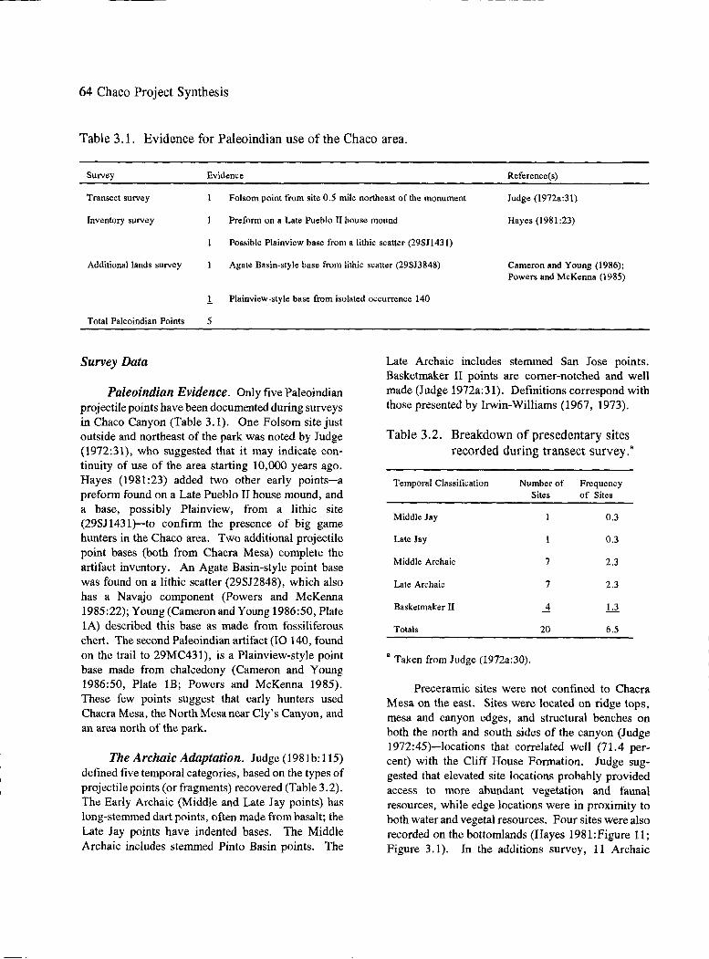
64 Chaco Project Synthesis
Table 3 .1. Evidence for Paleoindian use of the Chaco area.
Survey Evidence Reference(s)
Transect survey Folsom point from site 0.5 mile northeast of the monument Judge (l 972a :31)
Hayes (1981 :23) Inventory survey Preform on a Late Pueblo II house mound
Possible Plainview base from a lithic scatter (29SJ143 J)
Additional lands survey Agate Basin-style base from lithic scatter (29SJ3 848) Cameron and Young (1986); Powers and McKenna (1985)
1 Plainview-style base from isolated occurrence 140
Total Paleoindian Points 5
Survey Data
Paleoindian Evidence. Only five Paleoindian projectile points have been documented during surveys in Chaco Canyon (Table 3.1). One Folsom site just outside and northeast of the park was noted by Judge (1972:31), who suggested that it may indicate continuity of use of the area starting 10,000 years ago. Hayes (1981:23) added two other early points-a preform found on a Late Pueblo II house mound, and a base, possibly Plainview, from a lithic site (29SJ1431)-to confirm the presence of big game hunters in the Chaco area. Two additional projectile point bases (both from Chacra Mesa) complete the artifact inventory. An Agate Basin-style point base was found on a lithic scatter (29SJ2848), which also has a Navajo component (Powers and McKenna 1985:22); Young (Cameron and Young 1986:50, Plate lA) described this base as made from fossiliferous chert. The second Paleoindian artifact (IO 140, found on the trail to 29MC431), is a Plainview-style point base made from chalcedony (Cameron and Young 1986:50, Plate lB; Powers and McKenna 1985). These few points suggest that early hunters used Chacra Mesa, the North Mesa near Cly's Canyon, and an area north of the park.
The Archaic Adaptation. Judge (1981b:l15) defined five temporal categories, based on the types of projectile points (or fragments) recovered (Table 3.2). The Early Archaic (Middle and Late Jay points) has long-stemmed dart points, often made from basalt; the Late Jay points have indented bases. The Middle Archaic includes stemmed Pinto Basin points. The
Late Archaic includes stemmed San Jose points. Basketmaker II points are corner-notched and well made (Judge 1972a:31). Definitions correspond with those presented by Irwin-Williams (1967, 1973).
Table 3.2. Breakdown of presedentary sites recorded during transect survey.•
Temporal Classification Number of Frequency Sites of Sites
Middle Jay 0.3
Late Jay 0.3
Middle Archaic 7 2.3
Late Archaic 7 2.3
Basketmaker II ..1 Ll.
Totals 20 6.5
• Taken from Judge (1972a:30).
Preceramic sites were not confined to Chacra Mesa on the east. Sites were located on ridge tops, mesa and canyon edges, and structural benches on both the north and south sides of the canyon (Judge 1972:45)-locations that correlated well (71.4 percent) with the Cliff House Formation. Judge suggested that elevated site locations probably provided access to more abundant vegetation and fauna} resources, while edge locations were in proximity to both water and vegetal resources. Four sites were also recorded on the bottomlands (Hayes 1981:Figure 11; Figure 3 .1 ). In the additions survey, 11 Archaic

Park Boundory
Figure 3.1.
~c_.o
o I 2.Miles r ,---- -O I 2 Kilometers
Fojodo 6op Fojodo
/ Bulle
'.~· ~<>
-~~
i N
:;ft~~fi:; ... .:~ -:~~~ 3~- . ./~{!~''{ . ··:
-~
Archaic and Basketmaker II sites recorded during the inventory survey. (Based on Hayes 1981:Figure 11.)
;l Ct>
"'d ..... Ct> n ~
§. n "'d ~ a· p.
0\ Ul

66 Chaco Project Synthesis
Table 3.3. Archaic and unknown component types by survey area examined after additional lands were added to the park. a
Kin Kin Component Type Klizhin Bineola
Chacra Mesa
Soutli Addition
Hearth
Baking pit
Litliic scatter
Oilier
Totals
Unknown
Ledge room
Hearth
Baking pit
Water control
Cist/storage
Lithic scatter
Road/trail .
Rock art
Stair
Other
Unknown
Totals
2
4
...Q
7
0
4
0
2
0
0
0
0
IO
0
0
0
...Q
0
2
6
10
0
0
0
0
2
-1
25
0
2
_!
4
4
88
119
17
16
8
5
4
22
_.li
299
a Taken from Sebastian and Altschul (1986:Table SP.35). Shading covers components that probably are not Archaic.
components were recorded; none were in the Kin Bineola or South Addition sections (Sebastian and Altschul 1986:Table SP.35). Hall (1977) exposed nine charcoal deposits, two of which dated at around 5500 B.C. and A.D. 5, while studying alluvial stratigraphy of the Chaco Wash. Hall (1975:Table la) also dated a hearth (I-7091 6290 .± 115; 5300-5500 B.C.) and a baking pit (I-7248, 2110 .±. 85; 145 B.C.) in the canyon to confirm the long occupation of the area by Archaic people. Thus, Hayes (1981) was cogni?.ant of
0
0
0
0
3
2
0
0
2
0
0
.J.
10
Totals Comments
2
2
6
11
6 Probably not Archafo, ? Navajo
99 Possibly Anasazi, possibly Archaic
133 Possibly Anasazi, possibly Archaic
19 Probably not ? Navajo
20 Possibly Anasazi, possibly Archaic
8 Possibly Anasazi, possibly Archaic
5 Not characteristic of Archaic
7
25
344
the effects of erosion and alluviation on the archaeologist's ability to discern site locations. He was not certain that all Preceramic sites in the canyon had been recorded.
Archaic evidence from the additions survey (Table 3.3), as defined by the presence of diagnostic projectile points, ground stone (basin metates, onehand manos), and an absence of ceramics, suggested that 75 percent of the components represented camps

The Preceramic Period 67
Table 3.4. Lithic assemblages from Archaic sites in four areas added to the park.a
Hearth (Kin Klizhin)
No. of Components 2
Total Lithics 64
Debitage: No. 57 Percent 89.1
Cores: No. 2 Percent 3.1
Utilized Flakes: No. Percent
Projectile Points: No. Percent
Scrapers: No. 1 Percent 1.6
Bifaces: No. Percent
Drills: No. I Percent 1.6
Ground Stone: No. 3 Percent 4.7
Hammerstones: No. Percent
Other: No. Percent
Baking Pit (Kin Klizhin)
87
78 89.7
9 10.3
a Taken from Sebastian and Altschul (1986:Table SP.36).
or camp-like sites (Saebastian and Altschul 1986: Table SP.35). The lithic assemblages (Sebastian and Altschul 1986:Table SP. 36) included mostly debitage, five cores, 15 utilized flakes, 11 projectile points, one scraper, two bifaces, one drill, six grinding stones, six hammerstones, and two other objects (Table 3.4). Nine points or fragments, all from Chacra Mesa, fell
Lithic Scatter (Kin Klizhin)
Lithic Scatter (Chacra Mesa)
Other (Chacra Mesa)
4 2
206 219 0
193 199 93.7 90.9
1 0.5
0.5
4 1.9
3 1.5
2 1.0
2 1.0
2 0.9
5 2.3
7 3.2
2 0.9
4 1.8
within the Archaic-Basketmaker II period (Cameron and Young 1986). One possibly reworked basalt Jay point and two Bajada (or Early Archaic) points, made from an unknown nonlocal chert and from basalt, documented the Early Archaic presence. Three San Jose points (two obsidian and one fossiliferous chert) were attributed to the Middle Archaic. One indetermi-

68 Chaco Project Synthesis
Table 3.5. Projectile points assigned to the Archaic period from four areas added to the park.
Point classification Site type Material type
Clear identification:
Reworked Jay point IO 5, near 29SJ2430, Kin Klizhin Basalt
Bajada point 29Mc465, deflated dune area on Chacra Mesa Unknown nonlocal chert
Bajada point 29SJ2842, upper south bench of Chacra Mesa Basalt
San Jose point 29SJ2861, lithic scatter I, on Chacra Mesa Obsidian
San Jose point 29SJ2846, lithic scatter 2, on Chacra Mesa Fossiliferous chert (type 1010)
Problematic identification:
Middle Archaic, possibly San 29SJ2843, lithic concentration 2, on Chacra Mesa Obsidian Jose
Late Archaic 29SJ2890, refuse scatter I, on Chacra Mesa Light-colored splintery wood with quartz crystals
Indeterminate Archaic 29SJ2847, lithic scatter 1, on Chacra Mesa Chert
Late Archaic or Basketmakcr 29MC412, surface
Total 9 points
ant Archaic chert point and one obsidian Late Archaic or Basketmaker point were also found on Chacra Mesa, either along the ridge or near the ledge of the mesa. One other point made from a light-colored splintery wood with quartz crystals in Late Archaic style was recovered. Several were of problematical identification (Table 3.5; Cameron and Young 1986: Plates 2 and 3).
Unclassified lithic sites (Judge 1972; Sebastian and Altschul 1986:92-93) posed a problem. Although 344 unknown components were recorded during the additional lands survey, Sebastian and Altschul were not able to infer what percentage may have been Archaic, due to the nature of the data available. Based on the comments in the column of Table 3. 3 and the statements of Sebastian and Altschul, the shaded areas in that table indicate components that probably should not be considered because 1) no clearly determined Archaic components were located in the Kin Bineola and South Addition, and 2) several component types did not fit the Archaic pattern. Because Chacra Mesa contained 95 percent of the other/unknown lithics, as well as most Archaic sites, Young evaluated the lithics from identified Archaic, Anasazi, and Navajo sites in
Obsidian
order to properly assign the other/unknown site type materials. She determined that the Archaic assemblages were distinct: there were fewer utilized or retouched pieces and more projectile points. The other/unknown assemblages closely resembled the Anasazi pattern (Cameron and Young 1986:44-45). Although the number of projectile points of basalt and obsidian, as well as non-local chert, listed in Table 3 .5 suggest the importation of material types, Cameron and Young (1986:29) indicate that only about 3 percent of all the lithic raw materials were nonlocal. Similar figures for Navajo (8 percent) and Anasazi (5 percent) suggested heavy reliance on locally available material types, but reduction strategies among these cultural groups differed. Archaic sites had a higher percentage ofbiface thinning flakes (3 percent) versus the Anasazi (1 percent) and Navajo (1.2 percent). The formal-to-informal tool ratios were higher for the Archaic than for later sites (Cameron and Young 1986:36-38, 52). Simmons (1982) also was able to distinguish Archaic from later tool assemblages using data from the surveys in the Alemita Coal Lease area. More recently, Vierra (1994) was able to distinguish between lithic debris assigned to aceramic, Archaic, and ceramic period sites by evaluating material types,

tool production, and tool use. Vierra ( 1994) also used the types of materials and the locations of their sources to outline possible areas utilized during an annual round by groups using the central San Juan Basin.
In summary, Chaco Project surveys covered all physiographic situations within the park boundaries. A typology and criteria for cultural subdivisions of the Preceramic adaptation were established. The data confirmed Gordon Vivian's impression that Preceramic sites were present on Chacra Mesa, but the evidence included a few sites in the canyon bottom, as well as on ridges or mesa ledges in other areas of the park (Hayes 1981).
There is limited evidence for the use of the area around Chaco Canyon from Paleoindian through Late Archaic. The Paleoindian evidence cons1· <:t<>A ,...f on lv ..... -- '-"• ....... J
five diagnostic projectile points. The more robust Archaic evidence indicates that approximately 28 sites, plus two isolated points (Figure 3.2), are located within the current park boundaries. The greatest number of Preceramic sites were occupied during the Middle and Late Archaic; points from the additional lands survey peaked in Late Jay and Middle Archaic. Gillespie (1985) thought that the Late Jay and Bajada periods represented moist summers with an increase in plants and animals, the availability of pifion nuts, and probably the peak abundance of bison, followed by a less mesic but cooler period (San Jose-Armijo) during which there would have been less abundance of resources. Thus, the low numbers of sites/points (which may or may not be truly representative of the use of the area) indicate larger populations during these moister periods. Whether these sites represent seasonal use by mobile groups or use by a limited number of people living in the Chaco area was not ascertained. The documentation of nonlocal materials (obsidian and basalt) indicates either large territories for mobile groups or trade among Archaic people.
Excavations
Initially, Thomas W. Mathews was responsible for the preceramic site excavations. Sites with cultural horizons such as the Paleoindian, Archaic, and Basketrnaker II horizons, were considered "on the basis of single phase occupations where no earlier or later manifestations would be likely to complicate the
The Preceramic Period 69
,. Figure 3.2. Examples of Archaic and Basket
maker II dart points and preforms. (Taken from Cameron and Young 2005.)
excavations and confuse the picture" (Mathews 1979). One goal was to reassess the existence ofBasketmaker II sites; which were thought to resemble the Late Archaic sites, with the addition of cultigens. To obtain necessary data, rockshelters and cave loci, as well as open sites without ceramics, were considered. Further considerations were Archaic flaked stone forms, open site configuration and location, presence of "figure-eight" -shaped surface depressions surrounded by broken cobble or other stone paving, and location near or on dunes.
Five sites, considered to be Archaic, were selected for excavation. All were on the north side of the Chaco Wash, either around Cly's Canyon (29SJ126, 29SJ116, and 29SJ1118)(Figure 3.3) or the next canyon to the west (29SJ1156 and 29SJ1157) (Figure 3.4); none were on Chacra Mesa. Once excavations were under way, 29SJ1118, a lithic site with

70 Chaco Project Synthesis
shallow circular depressions (ringed by discarded waste stone that formed raised borders) was determined to be a sandstone quarry of unknown age (Figure 3.5). Site 29SJ116 (Figures 3.6 and 3.7), located approximately 15.24 m (50 ft) away from 29SJ1118, had evidence for three periods of use: Archaic, possibly Pueblo III, and Navajo. The relationship of at least two hearth areas (around which were scattered flaked stone tools, one-hand manos, and other items) to the Pueblo and Navajo use were not well determined, and this site was eliminated from the analysis of Archaic adaptations. Thus, only three sites that were extensively tested provide evidence for understanding the Archaic culture (Lister and Lister 1981 :xi).
2981126(Stanford's1 site). During survey, one impure green chert Jay point, one chalcedony Jay base, one petrified wood or chalcedony broken tip, one fine-grained red quartzite bifacial knife fragment, one dark-brown petrified wood bifacial implement, and one fire-shattered chalcedony biface fragment were recorded in a saltbush-grass environment on the east side of Cly's Canyon (Figure 3.3). The Jay point indicated an Early Archaic use of this ca. 61 x 61 m (200 x 200 ft) site (Figure 3.8). Corrugated and black-on-white pottery sherds suggested an Anasazi presence (probably Pueblo II).
Most artifacts recovered during excavations in two trenches (Figure 3.9) came from the surface; only a few were from the 0-10-cm level. A number of rocks, flakes, pottery sherds, scrapers, manos, hammerstones, and metate fragments were plotted by squares and used to make a distribution map (Figure 3 .10). The nine black-on-white sherds recovered from the surface of N 0-1 m, E 1-18 m were part of a restorable pot identified as the remains of a small McElmo Black-on-white bowl that would date to approximately A.D. 1100 to 1200 (Peter J. McKenna, personal communication, 1980) and were considered intrusive. A roasting hearth was exposed in test trench 1 (S 0-2 m; E 12-13 m was identified as a hearth area); N 0-1 m, E 14-16 m, was also listed as having bone beneath a hearth.
Flakes of chert, chalcedony, and petrified wood were most frequently recorded, but concretions, jasper, argillite, obsidian, and basalt were recovered from both the surface and the occupational level of the
site. The last two materials were the least common and the only materials that would have been imported from outside of the area. Other catalogued items include one piece of red ochre, one petrified wood scraper, one complete chalcedony Jay point from the surface, one possible point fragment of chert, and one midsection of a chalcedony point. One broken chalcedony projectile point (base to midsection, with basal thinning) was recorded as corning from below the hearth. Also present were one broken obsidian base that was reworked into a drill, one chalcedony broken tip, a sandstone mano, and a fine-grained quartzite hammerstone. In addition, one chalcedony scraper and one fist axe, or hamrnerstone, were identified. Some burned bone was recovered. A broken shell pendant was considered to be from a freshwater clam, possibly Anadonta (Mathien 1985), which lives in water that runs year round. Today the San Juan River is the nearest such stream, but the source of the shell is undetermined.
No analyses for this site have been carried out. One unpublished indicator-only date of 5680 + 1290 -1540 was obtained (from Dicarb Radioisotope Laboratory, DIC633) in November 11, 1976. A very small charcoal specimen (fragments) came from a hearth near the surface in the north-south trench in the 13-to-14 m grid. This uncalibrated date suggests possible use ca. 3730 B.C, which falls slightly later than the range for Jay material provided by Judge (1982:Table 1.2). Because of the presence of a hearth, Lister and Lister (198l:Appendix) considered 29SJ126 to be a habitation site. The lithic materials are predominantly local; only the obsidian and basalt would have been carried in from some distance. These, plus the freshwater shell, suggest a wide range for procurement by the people who camped along the east rim of Cly's Canyon over 5,000 years ago.
29SJ1156 (Atlatl Cave) and 29SJ1157 (Sleeping Dune and Ant Hill Dune). The 94 sites assigned to the Archaic-Basketmaker II period did not include those with petroglyphs, a feature that Neller (1976b) thought might have been related to hunting magic. The Late Archaic-Basketmaker II sites selected for excavation are located in a small rincon downstream and west of Cly's Canyon; here, two rockshelters and several dune sites had been recorded (Figure 3.4). The rockshelter, known as Atlatl Cave, or 29SJ1156, contains pictographs and is located on

N
/ (
~· .. _j
/
--29SJllS
"' ' I ' \. --~
The Preceramic Period 71
0 100 200 300 METERS
Figure 3.3. Location of Archaic sites near Cly's Canyon. Sites 29SJ116 and 29SJ1118 (located next to 29SJ 116) were excavated but found not to date exclusively to the Archaic period. (Taken from field notes on 29SJ126, Chaco Clulture NHP Museum Archive Collection, Accession no. 2.)

72 Chaco Project Synthesis
..... ~---N \ .- ... -/:·..____
·. ,.....,·:....-----... · . \/ /29SJll57 \. I /Steeping Dune • \ \ : I Site _.._ \ )J / __ ,,,.- , _ _. ·'I I/ \ I J :
\ I . : \.J \__, ... -~ ............ ~·· ..... .... . " \ . ,.. a. I
I I I' 29SJll57 · / T Ant Hill Dune Site
( \ \ ·. \ \) \ \ / .. ---( l 1' / ·.. ,_... (··./ ./' \ l .. --- ..
~ . ____.:.... ... _,... \ / ·--·· \( ... - ... ./ ... _,
. .,,,-- .. _ _...,,.... y""
I \
\
Figure 3.4. Location of Archaic rockshelters and dune sites investigated in the rincon west of Cly's Canyon. (Taken from Neller 1976b.)

The Preceramic Period 73
Figure 3.5. Overview of 29SJ1118, a stone masonry quarry. (Chaco Culture NHP Museum Archive, Slide no. C-0152. Alden C. Hayes, photographer.)
Figure 3.6. Overview of 29SJ116. (Chaco Culture NHP Museum Archive, Slide no. C-0008. Alden C. Hayes, photographer.)

74 Chaco Project Synthesis
-"\ / \
I \ I ' I 4.1' ...........
( Hearth Area 2? ~) \ 4 / ......... ----,
/ N
'-- /I/ I -/ ( / Hearth Area I
5 \ ~ \, ) ~ ,,,..- ...
' / l..§...1 ........ ___ /
/
Trench 3
_, // '
I 8 I I / I / \./
/ Limits of e~cavation
0 I 2 METERS
/""'\ I \
( I l 7 I I I I I J I I I \ I _,
(~ Rock concentration
Trench I, NE-SEextension
Figure 3. 7. Map of excavations at 29SJ 116. (Taken from field notes on 29JS 116, Chaco Culture NHP Museum Archive, Accession no. 14.)

The Preceramic Period 75
Figure 3.8. Overview of 29SJ126. (Courtesy of Chaco Culture NHP Museum Archive, Slide no. C-4446. Thomas R. Lyons, photographer.)

76 Chaco Project Synthesis
20
18
H 0 2 3 4
METERS .. N 16
G
14
L 0 F
K N 12
J M p E
10
D
[] 8
c 6
B
4
2
10 8 6 4 2 0
Figure 3.9. Map of excavations at 29SJ126. (Taken from field notes on 29SJ126, Chaco Culture NHP Museum Archive, Accession no. 2.)

;ye;; 0. 0 1 c :
I
The Preceramic Period 77
...,.,..._ __ N
0 J
~ETERS
I,
C • ~~'~-~~-=----"' -M -
I i 10!-_J I i I . I I
" 5<.'"0jlCI
• ¥0~ '1:i/) HQ.,.m111-1~
0 lole1001"1rQ.(jf"f'.el$f
I D 0
Figure 3 .10. Map of trenches at 29SJ 126, indicating materials recorded during excavation. (Taken from field notes on 29SJ126, Chaco Culture NHP Museum Archive, Accession no. 2.)

78 Chaco Project Synthesis
the first terrace above the canyon. Owl Roost Shelter, located 30 m south of Atlatl Cave, was also briefly examined (Elliott 1986:80), but it contained only one pictograph on the ceiling to indicate human visitation. Gillespie (1982) attributed a lack of use of shelters to formation processes; most of the shelters in the Chaco area form at the base of sandstone cliffs where ground water seeps out along the top of the underlying, less permeable shale or mudstone strata. Floors are usually damp, shaly, and often steeply sloping-traits not well-suited to human occupation or the preservation of material culture. Atlatl Cave was different, in that the floor was 2 to 3 m above the wne of ground water seepage and much drier than most shelters, such as neighboring Owl Roost Shelter (Figure 3.11). Just below the rockshelter were dunes on which 29SJ1157 was located.
as The current vegetation of the area was described
variable but generally sparse. Woody shrubs are abundant around the base of the cliff, particularly in the sheltered, more recessed areas such as Owl Roost Shelter where ground water seepage and less direct sunlight lead to greater effective soil moisture. New Mexico olive (Foresteria neomexicana) is dominant here with other characteristic wet alcove shrubs, such as Skunkbush (Rhus aromatica), also present. Atlatl Cave itself is nearly devoid of plant growth. The mesa top above the cliffs supports a mixed grassland and desert scrub community characterized by such grass taxa as Hilaria, Bouteloua and Oryzopsis as well as Ephedra (Mormon tea), Artemisia folifolia (Sand sage), and Atriplex confertifolia (Shadscale). Many of these same taxa occur on the sandier parts of the bench area between the shelter and the valley bottom. Immediately above the cliffs is a slickrock area dominated by Cowania mexicana (Cliffrose). The valley floor is dominated by Atriplex canescens (Four-winged Saltbush) and Sarcobatus vermiculatus (Greasewood) with Tamarix (now pervasive along the stream course). Neither juniper nor piny on is present in the immediate site vicinity though there are a few scattered junipers (Juniperus mono-
sperma) within a few hundred meters. The nearest pinyon (Pinus edulis) is more than 1 km away. (Gillespie 1982:4)
Excavations at Atlatl Cave and the dune sites were carried out during 1975 and 1976. Prior to his retirement, Mathews (1979) began a draft report but lacked sufficient information to complete it. Although Mathews and Neller (1979) issued a preliminary summary of the work and Neller (1975, 1976a, 1976b) began analyses of botanical remains and lithic artifacts prior to accepting employment elsewhere, it was several years before Gillespie (1982) analyzed the faunal remains and Elliott (1986) undertook an evaluation of the Late Archaic-Basketmaker II period. In the meantime, Judge (1982) had reviewed the Paleoindian and Basketmaker data from the San Juan Basin and noted a number of research problems that needed to be addressed to promote a better understand this period. Results of these evaluations are presented below.
Atlatl Cave: Atlatl Cave is approximately 25 m long, 4 to 5 m deep (but up to 9 m deep from the drip line), and 2 to 5 m high. Accumulating roof fall has elevated the floor a few meters above the surrounding terrain. A steep talus slope is located in front of the elevated area, but still under the drip line (Figure 3 .12). The loose sediments containing archaeological and vertebrate remains are located from 1 to 3 m along the back wall for the entire length of the elevated area (Gillespie 1982).
Pack rat middens were present in three areas-at the two ends of the shelter, and against the slightly elevated roof fall. Other unconsolidated debris from wood rat occupation is found throughout most of the shelter. It is mixed with loose sediments mainly in the upper 20 to 30 cm (Gillespie 1982). Figures 3.13 and 3.14 present a plan view of the layout and excavations in Atlatl Cave, as well as the distribution of pack rat middens and artifacts. During his initial analysis of one-half of the material collected from grid 29, Neller ( 1975) realized that because pack rats tended to have a limited foraging range (ca. 50 to 150 m), a study of the materials collected by these animals would provide clues to past environmental conditions (Betancourt and Van Devender 1980, 1981). Piiion and one-seed juniper, plus traces of Douglas-fir, hackberry, poison ivy, and wild rice, suggested slightly different conditions

The Preceramic Period 79
Figure 3 .11. Overview of Atlatl Cave and Owl Roost Shelter. (Chaco Culture NHP Museum Archive, Slide no. C-0470. W. James Judge, photographer.)
Figure 3.12. Overview of Atlatl Cave, with steep talus visible in foreground. (Chaco Culture NHP Museum Archive, Slide no. C-1255. Thomas Mathews, photographer.)

80 Chaco Project Synthesis
( \ IW
\ \ \ I /\
I ) I I
I I Roof fall I
I \ exposed
I \ at surface
I \..
I \ I Steep ' I I l fa/us
\ Site datum \ \
\.. \._" \.. \ \..
"' ) (
" I \.. I \
\ \ I I l
+-Drip line ) (approx.) I
I
0 IE 2E
·26 27 .28
29 30 31
32 33 34
3E
7N
SN
5N
4N
3N
2N
IN
0
IS
25
35
4S
55
SS
75
es
95
IOS
llS
\ N
(approx.)
• E~covoted 9rids
0 I 2 3 METERS
Figure 3.13. Map of Atlatl Cave, showing grid layout and excavated areas. (Taken from Gillespie 1982a.)

~ .... c1
~
~
-'
., A
' --~ -<
1 -\
'\
' j ~ -1 ~ 4
-' ::, j -
'-, /---.
( \
j \
\ \
' I I
I /
\ ."
\
I j
~ \ ! j
I I
I \ \
\
Roof fall exposed
at surface
"'- Steep '-- talus
\.
" " \ ~Drip line rpprox)
\ I I I j
.:)
1 j -<
The Preceramic Period 81
29SJ//56 At/at/ Cave
\ 2
METERS
·29008P (Crid 33)
:J ,opprr;x.:
Figure 3.14. Map of Atlatl Cave, showing areas A and B, the locations of artifact concentrations. (Taken from Gillespie 1982a.)
L_ _____ _

82 Chaco Project Synthesis
from the present. Burned materials and hearths suggested human use of the rockshelter.
When Neller (1976a) compared the site location and chipped stone artifacts from this and the dune sites with data from Judge (1973), he did not think the rockshelter or dune sites had functioned as base camps, processing camps, or armament sites. He considered the use of this rockshelter as a specialpurpose area; the triangular, broad-shouldered petroglyph of a man (Figure 3.15) is similar to other Basketmaker II art and might indicate a religious purpose. He also considered seasonal use and habitation among the alternatives.
Except for an anomalous cache of San Jose projectile points, almost all the chipped stone material came from the uppermost stratum of Atlatl Cave. Although some of the deposits were stratified, most of the chipped stone artifacts could not be separated stratigraphicall y; thus, Neller considered all to represent a single homogeneous cultural horizon (Basketmaker II). Approximately 85 percent of the material was classified as flakes, most of which were close together, which Neller interpreted to mean use of the cave for stone tool production. A few of these flakes had polish that might result from cutting yucca, and a knife had attrition that could result from cutting wood. Other types of stone included one graver, one spokeshave, two knives, a few scrapers, and utilized flakes. There were no drills, point fragments, or preforms. These, plus cut yucca leaves and some cut wood in the shelter, suggested that a few activities were carried out in the shelter.
Gillespie (1982) untangled the stratigraphy of the rockshelter. By then, there were two radiocarbon dates from upper and lower hearths in area A; they indicated considerable time differences (DIC 591 at 4240.±70 B.P. corrected to 4,855 B.P.; DIC 588 at 2330+85 B.P. corrected to 2,405 B.P.). He noted a lack of natural stratigraphic distinctions within this area and divided it into three units: unit l, an upper layer; unit 2, a mixed layer; and unit 3, material from a crevice. The five San Jose projectile points had been recovered from all three units, all within 30 m (Gillespie 1982:9). Two points were from unit Al (grids 2 and 48), two were from unit A2 (grid 49, mixed), and one was from unit A3 (grid 2). Because these units proved to have different radiocarbon dates,
he indicated that either the association of the points with dates is spurious because of mixing or misinterpretation of the spatial relationships, the dating is faulty, or the Irwin-Williams sequence and dates are not directly applicable (Gillespie 1982:9). The first explanation seemed most probable. Artifacts recovered (mostly from unit Al) were small wooden artifacts, basketry fragments, yucca ties, cordage, bone tools, chipped stone debris and tools, and evidence of corn.
Although there was much mixing due to pack rat activity, area B produced three radiocarbon dates (DIC 794 at 2220.±100 B.P. corrected to 2,275 B.P.; DIC 592 at 2700.±65 B.P. corrected to 2,860 B.P.; and DIC 590 at 2730.±65 B.P. corrected to 2,900 B.P.). This area contained poorly delimited hearths and burned rocks. Cultural materials included small wooden artifacts, a fragment of a wooden atlatl, a yucca sandal (Figure 3.16), basketry fragments, cordage, yucca ties, fragments from a rabbit-fur robe; and chipped stone debris. Evidence of corn was recovered.
Gillespie considered this record to represent a sporadic, short-term camp site. Use probably fell within the En Medio phase of the third millenium before the present. Because the corn kernels and cobs from both area A and area B were fragmentary, they did not add much to knowledge about early corn, but they could be assigned to the range of2,200 to 2,900 B.P. (ca. 950 to 450 B.C.).
Most of the fauna! remains were not attributable to human occupation of the shelter. Gillespie's analysis did, however, provide information that could assist with reconstruction of paleoenvironments. The presence of one species of bat (Lasionycteris noctivagans) suggested a woodland environment; and the prairie vole (Microtus ochrogaster) suggested greater effective moisture and better developed grasslands in the past (Gillespie 1982:94-96). The few fauna! remains that could be tied to cultural behavior were insufficient to reconstruct minimum numbers of individuals (MNI) or meat weight calculations. Burning on 13 percent of the bones from large mammal species, however, did indicate human use. These species included Odocoileus sp. (deer), Antilocapra americana (pronghorn), and Bison sp. (bison). Although smaller animal bones had less
- --- ---

The Preceramic Period 83
Figure 3 .15. Pictographs in Atlatl Cave, including the broad-shouldered man. (Chaco Culture NHP Museum Archive, Photo no. 10752. Victoria Atkins, photographer.)
Figure 3.16. Sandal and atlatl fragment recovered from grid 30, area B, of Atlatl Cave. (Chaco Culture NHP Museum Archive, Photo no. 10742. M. Moquin, photographer.)

84 Chaco Project Synthesis
Figure 3 .17. Overview of dune ridge location of Sleeping Dune. (Chaco Culture NHP Museum Archive, Slide no. C-1389. Thomas Mathews, photographer.)
burning, Cynomys (prairire dogs), Sylvilagus (cottontail rabbits), Neotoma (wood rats), and Ihomomys (pocket gophers) were utilized to a limited extent.
Sleeping Dune and Ant Hill Dune. The location of these two sites on a low, deflated dune ridge is not the typical setting for Archaic sites (Figures 3.17 and 3.18); such sites are usually found on sandy ridges overlooking the canyon floor. Neller (1976b, 1976c) described the Sleeping Dune site as a residual lithic concentration with chipped stone tools, cobble manos/hamerstones, and fire-burned sandstone. An arbitrary grid system was laid out in 1 m squares. Two test trenches indicated no natural stratigraphy. No features were found in the 146 m2 excavations that covered approximately 17 percent of the site (Figure 3.19). Ant Hill Dune was a smaller area with a few flakes, almost no stone tools, abundant fire-burned sandstone, a "biscuit" mano, a basin metate, and a midden of sand with fine particles of charcoal. Within the trench that contained 20 m2 grids, a hearth area and a portion of a midden, plus a fire-burned soil area beneath the surface manifestation of the hearth, were exposed (Figure 3.20).
Understanding Archaic Use of the Rincon. Neller (1976b) made the first attempt to understand these sites. His chipped stone study included both an analysis of early trade patterns and a determination of the types of activities associated with the pictographs. Data from Atlatl Cave (29SJ1156) were compared with those from surface collections at 29SJ1157 and 29SJ1159. Only 121 pieces of debitage were examined from Atlatl Cave, yet materials reflected 19 different sources, five of which accounted for 75 percent of the sample because many pieces came from the same core. One projectile point was made from Alibates chert (Texas). The remaining materials are currently found in the Anasazi region. Neller recognized the need for detailed survey of lithic sources and techniques to measure distinctions among them, possibly using trace elements. Comparison of chipped stone materials among the three sites indicated that the same sources were represented, but in different proportions (Table 3.6). Neller thought that the three lithic sites represented a similar culture at a similar time period (based on source material similarities), but that the two open sites showed more variability than the shelter. He believed that this supported his idea
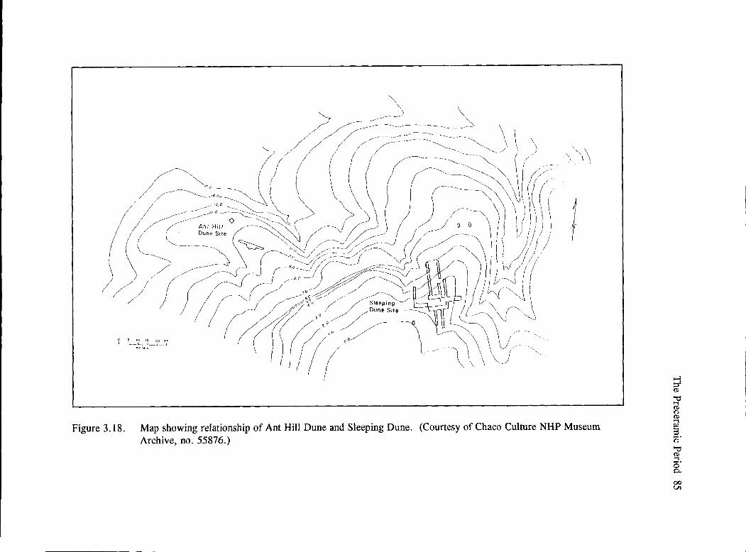
"" \ \ "' ----- "" 7 ---- ~ /- ~ ---~-.----~-------~ \
// /- ~,,--- -==~·=:~=-~---=-~----~,, \ \ \ '• , / / // / / -- '- / ' ' \\ "- / / , , --- '•, "- , ' ,/ " \ I , I ( ~~- ---~-- ~- \ I , - I i
,/~'>o __ I \ ( -~ -:~ I(/; /~- -=:''.:;-::~~ ( \ \ ( / \' \\ \ \\. ( , I -----/ ___ ,,o---;=~~ \ '> J ) / \ I) \ 1 I~
I / ./ Dune Site ,,---- -------~- _ // ~ ( ; / ( )L ----- ---- ~ ,_o ,./ -. -~2:/1~ -~ / /~0 I/! ~ -----._ / /.--- // "" ( / // I
......_ ---0
0 ~/ ,/,-/_ ~-- · f .....,,_ ,, _ ___-:- · / / I / ~ . --'---,// - ---____J ~ 'V ( / "'- ,-.f / . I \ ///-::;~ (1 c:.-!ff~ ~/7~~/~ ,- J J ----1 f 11
I /
( / /-----0;;- I :J~// ~ / JI --- \ / ) ) I ----. / ·'~o -:;;:- ,,- ,,-/ __.,,.----~ / , v·{ -"~ \ / ' / ,,.------"" ',
00 Sleeping l J v--, ,,, ' r /j / ,/ ~'""'';,· -- , (!,,\( , __
. , . ,,.,, ( r/;!t((;/f,: .. ,/----\. -~~\\\;:-L -o.:- - \ I ! I I I ( L \ \ \ \)
I
Figure 3 .18. Map showing relationship of Ant Hill Dune and Sleeping Dune. (Courtesy of Chaco Culture NHP Museum Archive, no. 55876.)
;l (ll
-0 ..-; (ll n ~ s 0· -0 ~ c;· 0..
00 Ul

--------
86 Chaco Project Synthesis
··--......
t 40N-
= ~ N
35N-
30N-
25N-Site stake
20N - /' I --0 I 2 3 ..
METERS /
15N - /
.· I
I I I I I I I I I I I I I I I I I I I I I I I I I I 1 I
IOE l~E 20E 25E 30E 35E
Figure 3.19. Map of grid system at Sleeping Dune. (Taken from Neller 1976c.)

The Preceramic Period 87
-...+- Light sand
D
P, '
Q) \i\)o ,,,_. -'\ / 0 ' I a \
00: \°'I --+Ant hill
'\) v I \ D I
~00$ ~"u //
0 2 METERS
(J Rock
9 Hearth
Dark, sandy midden
Figure 3.20. Map of grid system and artifacts recovered at Ant Hill Dune. (Taken from Neller 1976c.)

--------------
88 Chaco Project Synthesis
Table 3.6. Comparison of chipped stone materials recovered from Atlatl Cave and the two dune sites located in the same rincon. All numbers are percentages.•
Material Type Atlatl Cave
1052 Clear translucent chalcedony
1053 Chalcedony with black inclusions 10
1091 Chert, chaldeconic (Pedernal chert) 10
1112 Dark silicified wood (nonchalcedonic)
1113 Light-colored silicified wood
1120 Red-colored silicified wood 27
1140 Light-colored to white chalcedonic silicified wood
1142 Light-colored silicified wood, chalccdonic, undifferentiated 18
1151 Yellow-brown silicified (jasperized) wood 9
4000 Quartzite, undifferentiated 6
Other
Total percent 100
Sleeping Dune
6
14
31
8
5
16
20
100
Ant Hill Dune
6
14
26
6
8
19
14
_]_
100
•Taken from Neller (1976b:Tablc 4), with Warren's descriptions for lithic codes added.
that the shelter represented limited use. The surface collections at the open sites also were larger.
Neller (1976b) also compared the chipped stone from Atlatl Cave and Sleeping Dune with Judge's survey data from Folsom sites along the Rio Grande. He concluded that the Archaic-Basketmaker II sites were different from Folsom and that the Chaco sites did not represent base camps, processing sites, or armament sites. He also compared these three sites with Preceramic site-location data from Judge's transect survey; there was a negative correlation for dunes and rincons, thus indicating that these sites were not typical.
Comparative Data
The Chaco Canyon Area
Besides Atlatl Cave, two other rockshelters were excavated as part of the Chaco Shelters Project (Simmons 1984a) in order to increase knowledge of
the Archaic use of rockshelters and to evaluate Simmons's hypothesis that the Chaco area may have been the winter location of Archaic peoples who would be more protected in these rockshelters than in open areas. Simmons wanted to establish an absolute chronology for the San Juan Basin Archaic (which he considered a possible variant of the Oshara tradition [Irwin-Williams 1973, 1979; Simmons 1984d: 10)) and to improve the database available for use in reconstructing the paleoenvironment. This project contributed more toward the latter goal, but data from the excavations at Sheep Camp Shelter (29SJ178), and Ashislepah Shelter (CAP PB AH 15), and surveys in the surrounding areas also improved our understanding of the Archaic period in this area.
Gillespie (1984a) described Sheep Camp Shelter, which is located on the north side of Chaco Canyon just east of Chaco Culture National Historical Park and 1.5 km west of Sheep Camp Canyon. It is approximately 600 m north of the floodplain at the bottom of the canyon, 60 m above the canyon floor (at

The Preceramic Period 89
Figure 3.21. Overview of Sheep Camp Shelter, excavated by the University of Kansas as part of the Chaco Shelters Project. (Chaco Culture NHP Museum Archive, Photo no. 30775. William B. Gillespie, photographer.)
1,975 m [6,475 ft]), and on the southeast side of a shallow open side canyon (Figure 3 .21). Excavations in a test pit and four areas of this 20 m long and 7 to 8 m deep shelter covered approximately 26 m2 of the surface area. Two major strata were defined. In stratum A, the upper 15 to 65 cm were composed of dense organic material (mostly plants collected by pack rats) in decomposing sandstone and are assigned dates from approximately 3,000 years ago to the present. The lower stratum (stratum B) reflects Late Pleistocene or Early Holocene fauna; thick sandstone rubble has few archaeological or macrobotanical remains but abundant fauna! remains. Because material often slumped off from higher levels, the two strata were often difficult to separate. The evidence for Archaic period use is in the uppermost levels of the lower stratum (B) and the upper stratum (A). These deposits also have remains that indicate use of the rockshelter until approximately A.D. 900. Hearths (but not firepits) indicate non-intensive use of the shelter.
Several radiocarbon dates were obtained (Simmons 1984b:Table 50). Two from domestic squash seeds-2820 ± 220 B.P. (A-3388) and 2130 ±
280 (A-3159)-indicate early evidence (approximately 870 B.C.) of use. Two maize kernels were also dated to 2250±_80 B.P. (A-3395) and 2150_±170 B.P. (A-3396) (Gillespie 1984a:69, Table 8), or approximately 500 to 200 B. C. The major contribution of this excavation was pack rat midden and other faunal remains that provided new data for reconstruction of the paleoenvironment.
Survey around Sheep Camp Shelter documented 26 sites; of these, eight were classified as lithic scatters with presumed Archaic affiliation. Six are located on level areas along the ridge tops above Sheep Camp Shelter, and two were on the sloping area (talus?) between the upper and lower cliffs. Of these, four were in sand dunes; the others are in sand sheets. Located at several were concentrations of burned rock. No diagnostic lithics were found and no finer chronological placement of these sites was made (Weston and Simmons 1984: 121-122). Ten possible Archaic sites along Sheep Camp Canyon were identified during brief reconnaissance. A test at Sheep Camp no. 4 uncovered a fire-burned rock concentration that provided a radiocarbon date of ca. 160 B. C. (Weston and Simmons 1984:Table 26).

90 Chaco Project Synthesis
The second excavated rockshelter, Ashislepah Shelter, is located on a small, northwest-flowing tributary to Ashislepah Wash. This 70 m long and 8 m wide shelter has a fairly flat floor and the opening faces west. Grasslands and large dune sheets are located above the shelter. Although water can be obtained by digging into the alluvial wash, there are no nearby permanent water sources.
Excavations at Ashislepah Shelter (Simmons 1984c) revealed six stratum and four occupations in area A. Stratum A, a loose flow sand that was less than 5 cm deep, and stratum B, a variable level that did not exceed 10 cm of recent organic material (straw and grass) with Pueblo ceramics, as well as pack rat activity, were thought to represent both a Navajo corral and Pueblo use (late A.D. 1100s to early 1200s). In stratum C, which was disturbed by rodents, there was a mixing of materials (straw, grass, ceramics) that made it difficult to separate from it from stratum B. Feature 1, a 60 cm long by 10 cm deep hearth containing carbon and other organic material including com, provided a radiocarbon date of 1400 ±. 80 (A.D. 550, UGa-4605). Its use was attributed to early Anasazi or Late Basketmaker people. Beneath this, stratumD was approximately 30 cm of sterile sandy material that contained coarse gravel lenses that possibly represent roof fall. Stratum E was similar to stratum C in that feature 2, a welldefined hearth, contained charcoal and inorganic remains (com) in its 5 cm thick layer. A radiocarbon date of 2205 ±. 65 BP (255 B.C.; UGa-4606) was obtained. This was interpreted to represent Late Archaic use. The lowest level, stratum F, was 60 cm thick and similar to stratum D in its sandy matrix.
Areas B and C, located south of an inferred Navajo corral, contained some charcoal and recent bone, as well as Anasazi ceramics and nondiagnostic lithics that may be Late Archaic. Simmons (1984c: 102) concluded that the stratigraphic context of these two units was equivocal.
Survey in the immediate vicinity of Ashislepah Shelter documented the presence of two Archaic lithic scatters, one that dates to the Armijo phase (1800 to 800 B.C.), based on the presence of an Armijo point located directly above the shelter; and a second one that dates to the San Jose phase (3000 to 1800 B.C.), based on the presence of a San Jose point. Two
possible Archaic sites were also recorded. One is a lithic scatter whose age could not be determined; the other is a general debris scatter that included Anasazi ceramics along with burnt rock and lithics (Weston and Simmons 1984:116-117).
In summary, data from the Chaco Shelters Project suggest that more intensive use of this area began around 3,000 B.P. Cultigens from the three excavated rockshelters include both com and squash during the Late Archaic-Basketmaker II period. Because the stratigraphy in the excavated rockshelters was disturbed by pack rats, the recovered data were more useful for reconstructing past environments than for understanding cultural change through time.
The San Juan Basin
During the 1980s, investigators attempted to view data from a regional perspective. In a review of data from the San Juan Basin, Judge (1982) indicated that major baseline data (e.g., chronological placement of sites, site distribution within general ecological zones, and categorization by site type) were virtually absent in the then-existing database (SJBRUS-the computerized database created as part of the San Juan Basin Regional Uranium Study, Wait 1982). Recording of Preceramic sites was variable; they often were ignored. When recorded, they often were lumped into a single period and were not categorized by site type. Only 14 (0.2 percent) were attributable to the Paleoindian or transitional; 719 (8.6 percent) to the Archaic or transitional; and 102 (1.2 percent) to the Basketmaker or transitional periods. This was a total of 11.1 percent of all known prehistoric sites (Judge 1982:Table 1.1). Very few were archaeometrically dated; very few studies even attempted to place them within the Oshara tradition defined by Irwin-Williams (1973), and data that would document the Oshara model had not been fully published so that it was difficult to determine whether the model was truly applicable to an area broader than the Arroyo Cuervo region of the southeast San Juan Basin.
Plots of site distributions were presented with caution. The entire Archaic span could not be subdivided, but preferred locations were in upland dunes, on elevated ridges, and/or on mesas near water resources. The Basketmaker II period was not clearly defined, and Judge suspected it was underrepresented.

However, he thought the Basketmaker III period was probably representative; locations of these sites were quite different from those in earlier periods. Environmental reconstructions were incomplete and often conflicting, especially with regard to the extent and timing of the Altithermal period. As a result, Judge suggested a general scenario of climatic and cultural events for this period (Judge 1982:Figure 1. 7) as an initial step in furthering understanding of these poorly defined Preceramic periods (Figure 3.22).
Several archaeological procedures that would implement collection of the baseline data needed to verify the Preceramic chronological sequence in the San Juan Basin and to refine dates assigned to the different phases included detailed descriptions of qualitative and quantitative attributes, condition, and material type for all projectile points. With better data on the range of variability of each point, the projectile point typologies could be further refined. All artifacts associated with points should be described and analyzed. The environmental context (topographic and vegetative) should be recorded for all sites. Similar data should be collected for all lithic sites, not only those with projectile points (Judge 1982:51). Still needed were additional studies that would lead to a better understanding of the paleoclimate; e.g., alluvial geochronology and palynology of Late Pleistocene and Holocene deposits, macrobotanical and faunal analyses, and dendroclimatology of these earlier periods. By using proper sampling strategies, sufficient information could be obtained to provide a picture of the changes that took place from Paleoindian through Archaic and Anasazi. Only when sufficient baseline data were collected would it be possible to evaluate models of prehistoric behavior.
Elliott (1986) had two goals: to synthesize the survey and excavation data from Chaco Canyon, and to compare these data with those from other areas of the San Juan Basin. He defined the Late Archaic as extending from 3,000 to 1,500 B.P., a period that encompasses the beginnings of horticulture, the appearance of ceramics, increased population, seasonal sedentism, and the transition to use of pithouses as habitations. He reviewed the data relative to environmental reconstructions and past archaeological research, which included major cultural resources management surveys that were conducted during the
The Preceramic Period 91
1960s and 1970s and were among the 28,000 site files in SBJRUS.
When Elliott attempted to order sites chronologically, he, too, was hampered by the lack of absolute dates. Most radiocarbon dates available were from only a few sites. Relative dating using IrwinWilliam's phases was based on projectile point styles that still needed considerable refinement before they would be useful in assigning sites to more specific time frames. Like Judge, Elliott found few sites attributable to the Archaic. The low level of utilization for those sites that were recorded was attributed to small groups of people using them for short periods of time. He inferred that there were no large permanent populations.
Although a large database was available, it contained limited baseline data, and the suitability of the database for testing models was uncertain. The site distribution analysis had several drawbacks, including the problem of site visibility, methods used to specify site types, lack of stringent criteria for interpreting sites, and, without burials, lack of understanding of how mobility of people would have affected use and reuse of sites through time. The data from Chacoan sites and the increased information from recent surveys in the San Juan Basin were not as detailed as necessary to answer specific questions about changes in adaptations through this long period of prehistory.
Elliott did provide a model of what he believed represented Late Archaic period behavior. There was limited temporal and spatial diversity in sites, and site sizes were small prior to 3,000 B.P. He suggested limited sporadic use of the Chaco area, with none during cold weather. The macrofloral species recovered in sites suggested occupation during the late spring, summer, and early fall. No survey data were available from cold-weather use areas, which were postulated to be in the surrounding mountains. Because site densities in the San Juan Basin were low, Elliott discounted population pressure as a prime mover for this change. Instead, he proposed that Chaco' s water catchments were good for seasonal sedentism and limited maize horticulture. The introduction of cultigens that enabled horticulture came from the south around 1000 B.C. Only with the

92 Chaco Project Synthesis
Years B.P. Years B.C.
12,000 1
Mikt1
Winters, Cool Summers r-10,000 I Clovis 11,000 t- 9000
I Folsom Colder Winters
10,000 TPlano
t- 8000 I I Winter Dominant
9000 1
nCody
Precipitation t- 7000
8000 6000
IJ•y Summer Dominant Precipitation
7000 t- 5000 Bajoda Modern Climatic a
1 Vegetative Conditions
6000 I- 4000
5000 San Jose r-3000
Warm, Xeric Period
4000 ~ 2000
3000 l Armijo
1-1000
IBMll Cooler, Mesic
2000 Warmer, Xeric Interlude? I'-- B.C./A.D.
lBM .m:: Cooler, Mesic
1000 IOOOA.D.
Figure 3.22. Judge's (1982b) hypothetical correlation of chronology, culture, and climate for the San Juan Basin.

adoption of maize horticulture and the availability of storable surpluses was year-round occupation probable. This, in tum, provided a foundation for later agricultural adaptations (Elliott 1986).
Gwinn Vivian (1990) examined the San Juan Basin data to evaluate a correlation between climatic changes and cultural adaptations. He reviewed the evidence for Paleoindian, Archaic, and Basketmaker II use of the San Juan Basin to elucidate the basis for the origins of, and clarify the processes of the system trajectory of, the Chaco Anasazi. Because most investigators used Irwin-William's (1979) description of the Oshara tradition as a baseline for analysis of their data, they assumed that gradual cultural shifts correlated with changes in subsistence practices that were based on climatic fluctuations, particularly precipitation amounts and patterns (Gwinn Vivian 1990:79-109).
For the Paleoindian adaptation, Gwinn Vivian considered the availability of water one of the most important factors that would have influenced the presence of several species of animals, especially mammoth, the major animal found in relation to Clovis artifacts. There are several correlations between sites and probable climatic variations. Although data are few, Clovis points have been recovered in the peripheries and the northern part of the San Juan Basin where water would have been available in savannah-like areas around approximately 9500 B.C. Between 9000 B.C. and 8500 B.C., there was a drier period during which savannas and megafauna withdrew and mammoth disappeared, only to be replaced with bison after 8500 to 8000 B. C., when increased moisture again extended grasslands that provided hunting territories for those using a Folsom technology. Folsom evidence is generally limited to projectile points and appears in areas similar to those where Clovis points were found. From 8000 to 6500 B.C., effective moisture decreased, and evidence for the Cody complex appears circa 6500 B.C., when effective moisture that lasted until 6000 B.C. is noted. Vivian (1990:81) indicated that the Clovis, Folsom, and Cody complex remains are usually found on dunes and ridges above valley bottoms. His map of Paleoindian and Early Archaic site locales (Vivian 1990: Figure 4.1) shows six areas of the San Juan Basin that were considered primary locations (Arroyo Cuervo region, Chaco core,
The Preceramic Period 93
Gallegos Mesa, Upper Chuska Valley, Lower Chuska Valley, and Puerco Valley). Evidence for use of the drier interior of San Juan Basin is limited.
Gwinn Vivian (1990:83) contrasted the model proposed by Irwin-Williams, who suggested that the Paleoindian hunters abandoned the San Juan Basin after 6000 B.C. to follow large game animals eastward, with that of Judge (1982), who proposed that environmental variables affected the local adaptations and that changes in tool technology may simply represent adaptations to these climatic changes. During the Eariy Archaic (5500 to 3000 B.C., or the Jay and Bajada phases), Vivian acknowledged a relationship between greater aridity and changes in the lithic tool kits, specifically projectile points. The tool kits would reflect the greater adaptability to a semiarid environment that is somewhat similar to that seen today. "In either case, increasing dryness probably fostered greater concentration in localities with permanent water" (Gwinn Vivian 1990:84).
During the Late Archaic (3000 B.C. to A.D. 400; San Jose, Armijo, and En Medio phases), there were two different opinions about the climate. IrwinWilliams ( 1979) suggested that the climatic conditions provided increased effective moisture, while Judge (1982) differed. Gwinn Vivian (1990) suggested that the Late Archaic was not as dry as the Early Archaic, and that there was, therefore, increased plant growth. These conditions, however, did not provide sufficient game animals for a return to hunting as a primary subsistence strategy. Although there was an increase in human population growth, greater dependence on plants occurred. Data from the Chaco area were considered similar to those reported from the Arroyo Cuervo area, but there was a lack of evidence for seasonal aggregation. Simmons (1982, 1984d: 10-11), who worked just north of Chaco Canyon, thought that Chacra Mesa might have served as a winter camp where such larger populations aggregated. When Vivian compared data from a number of surveys conducted throughout the northern San Juan Basin, he noted that although lrwin-Williams's model for this period was essentially substantiated, there were some minor regional differences by the Late En Medio phase.
The degree of Archaic cultural variation in the Basin remains unclear, and the im-

94 Chaco Project Synthesis
pression that cultural complexity decreased from east to west, based on evidence for larger and more permanent seasonal habitation sites in the Arroyo Cuervo region, may be incorrect. The problem is compounded, as Judge (1982) and others have noted, by the lack of detailed empirical data from the Arroyo Cuervo region. Until Archaic sites are sought more diligently in Chaco Canyon, on the Chacra Mesa, and along the eastern flanks of the Chuska and Lukachukai ranges, the extent of regional variation cannot be firmly established. (Gwinn Vivian 1990: 90)
Gwinn Vivian (1990:90-91) acknowledged the problems that existed in defining a Basketmaker II occupation in the San Juan Basin. Yet he also evaluated the data from numerous sites that indicated reliance on wild plant foods, the presence of maize pollen, some procurement of small animals, and the long-distance procurement of some lithic materials. With caution, he was able to infer a regional difference between the En Medio and the Los Pinos variants around 100 B.C. to A.D. 400. In summary,
Though the processes of culture change operating in the San Juan Basin during the Archaic and Basketmaker II periods are only broadly defined, the available data and interpretations of that data provide several useful guides for analyzing the evolution of Chacoan culture after A.D. 400. First, the evidence for linking culture change to climatic shifts during the Archaic and Basketmaker II, though weak, strengthens the argument that similar processes probably characterized the Puebloan period. Second, though Berry's (1982) model for culture change may be extreme, it has refocused attention on the importance of considering social as well as environmental elements in explaining culture growth. Finally, cultural variability in the Puebloan period may have considerable antiquity if the contrasts between the Late En Media and Los Pinos variants do represent expressions of contemporaneous but basically different cultural systems. (Gwinn Vivian 1990: 109)
Contributions of Chaco Project Preceramic Research
Studies of pack rat midden debris (Betancourt and Van Devender 1980, 1981) and pollen (Hall 1975, 1977, 1990) contributed to environmental reconstruction for this early period. Fauna! analysis also indicated differences in the Archaic environment (Gillespie 1985), but research leading to more detailed environmental reconstruction is needed.
Survey and excavation carried out by the Chaco Project contributed to our knowledge about preceramic adaptations in the Chaco Canyon area. We have a comprehensive inventory of all sites located within the boundaries of Chaco Culture National Historical Park. We do know there was little use of the area during the Paleoindian period, that use increased during the Early and Middle Archaic, and that use was probably greatest during the Middle and Late Archaic. The criteria developed by Young (Cameron and Young 1986) to discern whether lithic scatters belonged to the Preceramic, Pueblo, or Navajo adaptations can be integrated with similar studies by others to improve the assignment of such site types to chronological or cultural periods. Although there are still numerous questions about the chronological placement of many sites, Chaco site data can be assigned to the chronology established by Irwin-Williams (1979) for the Arroyo Cuervo area to the southeast of the San Juan Basin.
Atlatl Cave (29SJ1156) and two dune sites, Sleeping Dune and Ant Hill Dune (29SJ1157), are similar to other Late Archaic-Basketmaker II settlements throughout the San Juan Basin. The presence of com and squash at Atlatl Cave and neighboring Sheep Camp Shelter and Ashlislepah Shelter correlates well with the known presence of cultigens in the basin. These sites probably represent regional springthrough-fall encampments, with possible winter encampments on Chacra Mesa. The timing of increased dependence on maize, however, may not correlate with events in other areas of the San Juan Basin; e.g., the Chuska valley. Gwinn Vivian (1990) thought that there were subregions within the larger Oshara tradition, and that differences can be attributed, in part, to environmental variables.

Judge's (1972) indication that obsidian and basalt were the only imported lithic materials recovered during the initial transect survey suggests that the people using the Chaco area may have had a large territory or trade contacts with groups nearer to these sources. Neller's (1976b) analysis of lithics from Atlatl Cave and local lithic scatters did not
. indicate what other materials might suggest trade or large regional mobility.
Discussion
Irwin-Williams (1994) indicated the need for multiple working hypotheses about the Preceramic period that can be tested when good control over time and space is available. Irwin-Williams believed that the plethora of models and research pursuits represent a healthy approach to understanding the iifeways of hunting and gathering populations; the role that cultigens play in subsistence changes over time; and problems in determining regional group differences, the size of regions, and the role that environmental variability plays in sustaining populations during all seasons. During the ensuing years, research on the Preceramic period has made several advances.
One problem exists with terminology. Vierra (1994) pointed out that two contexts are included in the term Archaic (a generalized subsistence adaptation, and a cultural/temporal unit). If we accept the Archaic as a hunting and gathering adaptation only, then difficulties arise when we try to evaluate change in the cultural continuum from Paleoindian to Archaic and from hunting and gathering to an agricultural adaptation in a temporal system. Vierra also reviewed the different models for social organization that have been proposed for Archaic settlement and subsistence systems.
Several contributions dealt specifically with the prehistory of the San Juan Basin. Within the Oshara tradition, Vierra (1987a, 1987b, 1994:383) was able to distinguish between the use of the west side of the San Juan Basin during the San Jose phase and the east side during the Armijo phas<7--the period from about 3,800 to 2,800 B.P. Hogan (1994) proposed movement between areas as a response to changes in climate and rainfall patterns during the Armijo phase. He therefore expected the introduction of cultigens to appear first on the eastern side of the San Juan Basin
The Preceramic Period 95
(including the Chaco Plateau) during the shift from cool-winter- to warm-summer-dominated rainfall patterns. After examining floral remains from aceramic sites representative of Archaic loci, M. Toll and Cully (1983, 1994) suggested seasonal movement of populations between lowland summer resources, especially grasses, to upland winter resources. Vierra (1994:380) suggested that late fall and winter sites would be located in ecotonal areas between lowland and upland resources areas; and that piiion nuts would be a focus of collecting. Data collected from the Transwestem Pipeline Survey indicated some clustering of sites. T'nirteen aceramic and Archaic sites were found in the dune-grassland settings between Gallegos Canyon and Den-Na-Zin Wash, an area where previous surveys also recorded a number of sites. Site density was attributed to the abundance and seasonal exploitation of grasses on sheet sand and dune deposits (Vierra 1994:381). Four other sites, all located in the pifion-juniper ecotonal area along the southern periphery of the Chuska Mountains, seemed to represent fall-winter habitation sites at elevations between 2,012 and 2,142 m.
A better estimate of the number of hunters and gatherers who were using this area, possibly seasonally, and a determination of whether the users were a local band or part of a larger regional group, is needed before we would be able to determine the carrying capacity for human populations.
Although maize pollen was present at a number of sites dated to Late Archaic-Basketmaker II, it was recovered only in small quantities (Vierra 1994:383). Because he expected more evidence to be present in sites that had either structures or storage features, Vierra believed the corn was initially a supplemental food rather than a main staple in the diet. He proposed that the shift to major reliance on com took place between the Basketmaker III and Pueblo I periods (Vierra 1996). He examined the issue of continuity versus replacement of populations relevant to the origins of agriculture. Using data from the Transwestem Pipeline Survey, Vierra concluded that com appeared in both the Basin-and-Range and the Colorado Plateau areas at approximately the same time. Although there is evidence for its use in rockshelters, open-air sites, and structural sites for over 1,000 years during the Archaic period, there is little evidence for dependence on the cultigens prior to the
-------- -- -------------
96 Chaco Project Synthesis
introduction of ceramics. Those sites with the earliest directly dated cultigens tend to be located in areas presumably near fields and occupied during the growing season, a pattern seen elsewhere in the Southwest. These sites are situated at midelevations on the eastern side of the San Juan Basin; the patterning of site locations by phase indicates repositioning of Archaic groups with numerous San Jose period sites, few Armijo sites, and an increased number of En Medio sites in the San Juan Basin. Following Hogan (1994), Vierra noted that this pattern probably reflects a movement of Archaic people to different areas at different times rather than movement of new people into the Basin.
With the discovery of irrigation features in the Zuni area (Damp et al. 2002), Vierra (2004) again revisited the issues relating to the adoption of maize horticulture across the Colorado Plateau. He compared the percentages of archaeobotanical remains from 53 Late Archaic habitation sites (those containing structures and extramural features) in three areas: the western San Juan Basin, the northern San Juan Basin, and the northern Rio Grande valley. He could not support the hypotheses that farmers moved into the area (e.g., Berry 1982) or that the San Juan Basin was segregated into foragers on the west and farmers on the east during the Late Archaic (Hogan 1994). Instead, he suggested that agriculture developed at different rates in different environmental locations
(earlier in the western San Juan Basin than in the northern San Juan Basin or Rio Grande valley). Maize cultivation appeared in both upland and lowland contexts. Vierra suggested that early agriculture would have occurred in well-watered microniche settings that had low diet-breadth return rates (e.g., succulents and wild seeds). These microniches would include floodplains, high-water-table areas, playas, ponds, seeps, springs, or areas where runoff water from mesa tops can be utilized. Those areas adjacent to piii.on-juniper woodlands and fall plant resources would have an advantage of fewer scheduling problems in any cost-benefit assessments. Vierra's (2004) analysis lends support to the proposition by Gwinn Vivian (1990) that environmental variables are important in these early periods.
In summary, models for the Archaic adaptation have been devised and are being evaluated. Because it has proven the most useful for the San Juan Basin, many investigators still rely on Irwin-Williams' (1973, 1979) incomplete description of the Oshara tradition to evaluate their data. The Chaco Project data do fit her model, but it is more likely that the Chaco area of the San Juan Basin would not have as dense a population as the peripheries or the Arroyo Cuervo region. Its unique setting, however, does provide advantages not available immediately surrounding this center of the San Juan Basin.
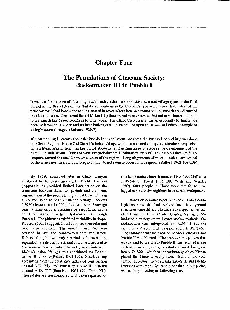
Chapter Four
The Foundations of Chacoan Society: Basketmaker III to Pueblo I
It was for the purpose of obtaining much-needed information on the house and village types of the final period in the Basket Maker era that the excavations in the Chaco Canyon were conducted. Most of the previous work had been done at sites located in caves where later occupants had to some degree disturbed the older remains. Occasional Basket Maker III pithouses had been excavated but not in sufficient numbers to warrant definite conclusions as to their types. The Chaco Canyon site was an especially fortunate one because it was in the open and no later buildings had been erected upon it. Ii was an isolated example of a ~ingle cultural stage. (Roberts 1929:7)
Almost nothing is known about the Pueblo I village layout-or about the Pueblo I period in general-in the Chaco Region. House Cat Shabik'eshchee Village with its associated contiguous circular storage cists with a living area in front has been cited above as representing an early stage in the development of the habitation-unit layout. Ruins of what are probably small habitation units of Late Pueblo I date are fairly frequent around the smaller water courses of the region. Long alignments of rooms, such as are typical of the larger northern San Juan Region units, do not seem to occur in this region. (Bullard 1962: 108-109)
By 1969, excavated sites in Chaco Canyon attributed to the Basketmaker III - Pueblo I period (Appendix A) provided limited information on the transition between these two periods and the social organization of the people living at that time. During 1926 and 1927 at Shabik'eshchee Village, Roberts (1929) cleared a total of 20 pithouses, over 48 storage bins, a large circular structure or great kiva, and a court; he suggested use from Basketmaker III through Pueblo I. The pithouses exhibited variability in shape; Roberts (1929) suggested evolution from circular and oval to rectangular. The antechambers also were reduced in size and transformed into ventilators. Roberts thought two major periods of occupation, separated by a distinct break that could be attributed to a reversion to a nomadic life style, were indicated. Shabik'eshchee Village was considered the Basketmaker III type site (Bullard 1962: 101). Nine tree-ring specimens from the great kiva indicated construction around A.D. 753, and four from House H clustered around A.D. 757 (Bannister 1965: 192, Table XL). These dates are late compared with those reported for
similar sites elsewhere (Bannister 1965: 199; McKenna 1986:54-58; Truell 1986: 139; Wills and Windes 1989); thus, people in Chaco were thought to have lagged behind their neighbors in cultural development.
Based on ceramic types recovered, Late Pueblo I pit structures that had evolved into above-ground structures were difficult to assign to a specific period. Data from the Three C site (Gordon Vivian 1965) included a variety of wall construction methods; the architecture was interpreted as Pueblo I but the ceramics as Pueblo II. This supported Bullard's (1962: 175) comment that the division between Pueblo I and Pueblo II was blurred. The architectural pattern that was carried forward into Pueblo II was retained in the earliest forms of great houses that appeared during the late A.D. 800s, which is approximately where Vivian placed the Three C occupation. Bullard had concluded, however, that the Basketmaker III and Pueblo I periods were more like each other than either period was to the preceding or following one.

98 Chaco Project Synthesis
Figure 4.1. Joseph Maloney excavating a slab-lined house near Casa Rinconada in 1936. (Courtesy of the Vivian family, Chaco Culture NHP Museum Archive, Photo no. 70860.)
The presence of a great kiva at Shabik'eshchee Village was rare; Bullard (1962: 102) found very few attributable to Basketmaker III. This, and available settlement data, prompted him to ask whether valley populations lived in a few large villages or a number of small villages and whether there may have been one large village with scattered subordinate settlements.
Several pit structures had been discovered as they eroded out of the wash (R. N. Adams 1951; Judd 1922; Roberts 1929:80-71). Others had been buried by later occupations (e.g., z. Bradley 1971; Judd 1964:21-22). Some were poorly reported (e.g., one beneathBc50; Glenn 1939:166-172; Hibben 1937:81-87; Senter 1939) or not reported at all (e.g., sites excavated just south of Casa Rinconada [Figure 4 .1] by Joseph Maloney as recorded in Brand 1937a:27). Gordon Vivian (Vivian and Mathews 1965:42-45) indicated that in addition to the pithouses located in the eastern section of the park (Shabik' eshchee Village and Half House), there were numerous Basketmaker sites in Werito's Rincon, on the mesa near Pefiasco Blanco, south of Tsin Kletzin, and just south of the canyon escarpment. He had seen very little evidence of Basketmaker III pithouses between Chaco Canyon and the San Juan River but had noted numerous ones to the south (Gordon Vivian and Mathews 1965:28-29).
Based on ceramics, limited architectural data, and a lack of archaeometric dates, it was difficult to place some sites within a tight chronological sequence or distinguish subtle changes in construction, settlement, or other cultural manifestations. Gordon Vivian (Vivian and Mathews 1965:28-29) did not fully agree with Gladwin (1945), who proposed that there had been an early migration into Chaco Canyon from the south and west; Vivian thought that populations had only shifted and become more consolidated through time. He acknowledged R. N. Adams's (1951:291) statement that Half House differed somewhat from Shabik'eshchee Village, and thought that these structures may be representative of different cultures in the canyon at an early date-a hypothesis he explored in more detail elsewhere (Gordon Vivian and Mathews 1965: 108-111). Bullard (1962:55) also had noted the differences between his northern and southern Anasazi areas in pottery types and ventilator construction.
Both traits cannot be attributed to the same center of origin. I have suggested that the ventilator originated in the southern part of the area, the habitation unit in the northern. The rapidity of the spread is indicative of the unity of Anasazi culture and of the close contacts maintained throughout the area. (Bullard 1962: 175)

In summary, at the start of the Chaco Project, there were several issues that deserved attention. Among them were the difficulty in estimating the number of pit structures buried under several feet of alluvium along the main Chaco Wash or under later site components, in assigning dates to components, in interpreting the variability in architectural features for contemporary sites, the settlement pattern, and the possibility that more than one group lived within the area. It would be difficult to understand the transitions from horticulture to agriculture and from pit structures to above-ground houses without better dated excavations.
This chapter will focus on information gathered during surveys and excavations in order to address these issues. The final report on Basketmaker IIIPueblo I excavations (windes 2006a) will provide greater detail. Here, I have relied heavily on McKenna's (1986) synopsis of small-site excavations and Truell's (1986) synthesis of small-site architecture, which provide careful analyses of changes in pit structures and above-ground structures through time. Their information is combined with artifact analyses and other studies to provide a picture of the foundations for later developments in Chaco Canyon and the San Juan Basin.
Chaco Project Studies
The Chaco Prospectus (NPS 1969) recommended that ceramic and architectural sequences be reevaluated and populations be estimated in order to better understand the shift ofBasketmaker sites typical of the southern half of the San Juan Basin into the Chaco area and the shift from mesa top locations to valley bottom locations. Changes in the environment that related to the discovery of pithouses beneath the present surface along the Chaco Wash needed clarification.
Survey Data
Judge's transect survey crew identified 43 Basketmaker III sites based on the presence of depressions, indicating pithouses, and a dominance of Lino Gray pottery. An absence of surface structures was a major factor in distinguishing these sites from later Pueblo I sites (Judge 1972:31-32). Although the Basketmaker III sites were found at similar mean site
Basketmaker III to Pueblo I 99
elevations as earlier Preceramic sites, their location on Menafee Shale 66 percent of the time and on sandstone 24 percent of the time was exactly opposite from the earlier site distributions with regard to geological substrate. The mesa and canyon edge locations of many of the open-air Preceramic sites would have been unsuitable for the construction of pithouses. Judge also attributed this difference to an association ofBasketmaker III sites with a low average distance to the nearest stream, especially when compared with sites assigned to different periods. Basketmaker III sites were generally found on hills, ridges, or active dunes in upland areas south of Chacra Mesa, as well as on the elevated Menafee Shale outcroppings found at mesa bases in close association with tributaries rather than major streams.
Hayes's (1981) inventory survey assigned dates for the Basketmaker III period from A.D. 400 or 500 to A.D. 725 or 750. Subcircular subterranean pithouses with antechambers or large ventilator shafts had oval or bean-shaped cists located behind them. Characteristic artifacts included two major ceramic types (Lino Gray and La Plata Black-on-white); imported ceramics from the Mogollon region (darkred with black smudged interiors); bows and arrows instead of atlatls; and deep trough metates. Using these criteria, the survey crews identified a total of 188 Basketmaker III sites located on mesas (n=60), on plains (n = 40), and in bottomlands (n = 88) (Hayes 1981:Figure 13).
Because 15 Basketmaker III sites were found in cutbanks of canyon bottom arroyos, Hayes (1981:24) was concerned about site visibility for these pit structures. Windblown sand quickly covers pit structures on mesa tops (e.g., Roberts's [1929] need to trench to uncover pithouses at Shabik'eshchee Village), and exposures in arroyo cuts indicated considerable aggradation of the Chaco Wash over time. Hayes estimated a rate of deposition of about 3.9 m (13 ft) in 500 years, and suspected that 150 sites may have been buried in the floodplain and not recorded. If Hayes's estimate is correct, approximately two-thirds of the Basketmaker III sites would have been located in the bottomlands, closer to intermittent streams.
Two great kivas were recorded, one at Shabik'eshchee Village and the other at 29SJ423 on

100 Chaco Project Synthesis
West Mesa near Peiiasco Blanco, suggesting two major Basketmaker III focal points. Hayes ( 1981: 14, Figure 13) identified clusters of Basketmaker III sites at the north end of West Mesa, on the southeast side of West Mesa near the head of South Gap, on the southwest side of West Mesa, in Rafael's Rincon, and in the Pueblo Bonito/Chetro Ketl vicinity. Because Shabik'eshchee Village is located near the park boundary and there was a lack of survey outside of that boundary, Hayes also thought there might be a cluster near this large site.
Hayes's suspicions were confirmed during the 1983 survey of the four additions to the park. The number of Shabik'eshchee Village pithouses skewed the samples recorded. The size of this site is much larger than any other pit structure site (with an average of 1.1 to 1.8 pithouses per site if Shabik'eshchee Village is not included) and confirmed Hayes's suggestion of this as a major locus for Basketmaker III habitation (Sebastian and Altschul 1986). Sebastian and Altschul also confirmed a shift in locations on Chacra Mesa; during the period from A.D. 550 to 750, most of the residential concentration was on the drainage where Shabik'eshchee Village is located (see also Wills and Windes 1989). Other sites were found along the east and south edges of mesas. In the Kin Bineola addition, between A.D. 550 and 750, habitation sites and scatters were found on mesa tops and valley slopes along both sides of the wash (Sebastian and Altschul 1986). In both the Kin Klizhin and South addition, sites were few in number, especially during the periods from A.D. 550 to 800 (Sebastian and Altschul 1986).
Initial identification of Pueblo I sites was not simple, nor was the characterization of the sites recorded. Judge (1972:32) considered the distinction between Basketmaker III and Pueblo I sites one of the hardest to make. Neck-banded pottery sherds were not always the best diagnostic ceramic type, especially in small-site surface collections. If a site had both La Plata Black-on-white (an early ware) and Red Mesa Black-on-white (a late ware), plus a pit structure and surface structures, it was assigned to the Pueblo I period. Early ceramics and a surface structure also merited a Pueblo I classification. Judge (1972:51) thought that the problem of identifying a Pueblo I adaptation in Chaco was hampered by the possible improper classification of sites (mixes of Basketrnaker
--------------- -- - -
III, Pueblo II, and Pueblo III in the sample) or the early existence of a dichotomy between the "Towns" and "Villages" suggested by Gordon Vivian (Vivian and Mathews 1965:29).
Like Basketmaker III sites, the 19 recorded Pueblo I sites tended to be found on Menafee Shales, but at a considerably lower elevation (Judge 1972). These sites also tended to be located in areas with relatively high frequencies of rice grass. Their topographic settings exhibited characteristics of both Basketmaker III and Pueblo II, yet none were associated with mesas, few with rincons, and many with hills.
Hayes (1981) assigned a total of 457 sites to Pueblo I (A.D. 750 to 900); of these, 373 were pueblos and 36 were classified as field houses. The transition from below-ground to above-ground structures occurred. Storage cists were joined together, and ramada-like structures appeared in front of them. The smaller and deeper pit structures lost their antechambers, and floor features dwindled. Above-ground construction consisted of jacal poles and adobe, upright slabs, adobe walls with stones, adobe turtlebacks, and rough-coursed masonry. Lino Gray and La Plata Black-on-white continued to be used, but pottery types evolved into neck-banded (Kana'a Gray) and White Mound or Kiatuthlanna Black-on-white (see also Truell 1986). Hayes (1981:26) was still concerned that some of the Pueblo I sites had been buried (e.g., the pithouses excavated by Judd [1924] and R. N. Adams [1951]).
Hayes (1981) posited a gradual but significant change in site location to the canyon bottom. There was a shift in the locations of large communities. Basketmaker III communities on the south side of West Mesa, in Rafael's Rincon, and near Peiiasco Blanco decreased in size or nearly disappeared, but the ones in South Gap, near Pueblo Bonito, and Fajada Gap increased in size. A new settlement appeared on Padilla Wash (Hayes 198l:Figure 15).
Sebastian and Altschul (1986) reported a decline in occupation on Chacra Mesa between A.D. 700 and 880; only one habitation site was located on the canyon floor east of Shabik' eshchee Village. Between A.D. 700 and to 880, there were three major clusters in the Kin Bineola section-one in the north, one

centrally located, and one in the south with a great kiva. The last small site (29Mc261) consists of two room blocks and a trash mound with ceramics dating to approximately A.D. 750 to 1000. Across the wash was another area of intensive occupation (29Mc291) dating from approximately A.D. 700 or 880 through A.D. 1130.
In summary, the three surveys identified a number of Basketmaker III and Pueblo I habitation sites (Figures 4.2 and 4.3). Due to alluviation of the floor of the Chaco Wash, however, it was doubted that all sites were identified. Although several clusters of pithouse sites dated to both periods, there is a shift in cluster locations between periods. The two largest Basketmaker III clusters, both with great kivas, appear on mesa tops (Wills and Windes 1989). Other pit structure clusters were also located on the southeast side of West Mesa, the southwest side of West Mesa, near Rafael's Rincon, and in the vicinity of Pueblo Bonito and Chetro Ketl. By Pueblo I, the two major clusters declined in size; three major clusters (Fajada, South Gap near Pueblo Bonito, and Padilla Well) were no longer on mesa tops but rather were in valley bottoms, as is the cluster in the Kin Bineola valley. Pueblo I great kivas were identified at 29SJ457 on a ridge southeast of Padilla Well and 29SJ352 (south of Padilla Well) (Truell 1986:238), as well as the Kin Bineola drainage. Recent surveys by Windes (Lekson et al. 2006; Windes 2006a) document the presence of a Pueblo I cluster (A.D. 775 to 850), which includes at least one great kiva, along the south fork ofFajada Wash. These data support Judge's observations of Pueblo I populations located near tributary washes that would provide a source of water for agriculture.
Excavations
Most of the excavated small house sites have components assigned to more than one period. Sites that provide information about the Basketmaker III and Pueblo I periods include 29SJ423 (Windes 1975); 29SJ299 (Loose 1979b; Windes 1976a); 29SJ628 (Truell 1976); 29SJ1659 (Shabik'eshchee Village) (Hayes 1975; Roberts 1929; Wills and Windes 1989); 29SJ721 (Windes 1976b); and 29SJ724 (Windes 1976c). Three others (29SJ629 [Windes 1993]; 29SJ1360 [McKenna 1984]; and 29SJ627 [Truell 1992]) have Pueblo I components, but major occupation was during the Pueblo II period. A summary of
Basketmaker III to Pueblo I 101
the architecture and stratigraphy for each site was prepared (Table A.5). A detailed analysis of the sites within the Chaco region is under way (Windes 2006a). Major contributions to the database for the periods include information from the following sites:
29SJ1659 (Shabi k'eshchee Village). At about the same time that Hayes (1975) was excavating Pithouse Y (which proved to be comparable to Pithouse Cat 29SJ628) and obtaining tree-ring dates in the A.D. 500s for this structure, Robinson et al. (1974:39) re-evaluated prior tree-ring dates from Shabik'eshchee Village to place them in the A.D. 500s. This site, then, was contemporary with other Basketmaker III settlements in the San Juan Basin. Although these new insights did not improve the information available from earlier excavations by Roberts (1929), Wills and Windes (1989) reviewed the new survey data (Figure 4.4), which added approximately 49 structures on the north side of a small depression (including two that Roberts had assigned to a separate site) to this largest Basketmaker III settlement in Chaco Canyon. Re-evaluation of the information from at least 163 Basketmaker III sites in the canyon led to an analysis of proposals for social organization for this period (Wills and Windes 1989; see discussion below). As noted above, recognition of two sites (both with great kivas) and numerous other Basketmaker III sites in their respective areas confirmed major settlements on the two mesas at the east and west ends of the canyon (Hayes 1981).
29SJ423. This is one of approximately 20 Basketmaker III sites located on West Mesa near the confluence of the Chaco and Escavada washes. It is just above 29SJ424 and 29SJ425, which are located on a lower leeward bench; McKenna (1986) suggested that these three site designations may represent one living area. The extensive number of pithouse sites on this mesa and the presence of a great kiva at 29SJ423 suggest that this large settlement may be comparable to Shabik'eshchee Village on Chacra Mesa (Wills and Windes 1989). Fieldwork under the direction of Windes (1975) included the excavation of three of probably seven pithouses; three of at least 40 cists; a great kiva that exhibited three construction episodes, each of which was destroyed by fire; and a Pueblo III shrine (Figure 4.5). Although data from the pithouses were minimal, the three great kiva construction phases all fell within the A.D. Soos (around A.D. 520 to

Figure 4.2. Identified Basketmaker III habitation sites in and around Chaco Culture NHP. (Data from the New Mexico Historic Preservation Office, NMCRIS database, overlaid on aerial photographs digitized by Richard Friedman.)
,_. s n ::r ~
8 :;i .2. ('!)
~ en '< g. ~ r;;·

Figure 4.3. Identified Pueblo I habitation sites in and around Chaco Culture NHP. (Data courtesy of the New Mexico Historic Preservation Office, NMCRIS database, overlaid on aerial photographs digitized by Richard Friedman.)
tt:l I}; :>';"
§ ~ ~ ...... ::::: 8 ~ g.. -0 ...... ...... 0 ~

~~.~~lJ . .,,~,,k/o.~b·l~4.1~,rJ.4 _.,,,,...... . ......
,,,,,,,,,,,.•""' '• """'"\~·""" ' ·~ . ~,,,- .. \ ...... ,~. .,,,.,... . •' . •'"' ' ;! "
-,#"' 0 ·~, \ };;; ~" ~ ··' . , ' ' .?' 0 I 0 -.. ~ .,.
"'f.;t
l I '·,,_,,
• I -. ~ 1 I ~ l
""4 .. ,, "''/''i4l.,J4 ,,it . .;, . "\,
( /
"~
4 A A ...
<!Lt~ A,
~ ~
0 oo 0
\ /. ~\
~. \
\
¥~~
\
-- ·~~ '·•t..n,.11r,fk.,1,
I c 0 ~.k./1r,t1Mk,1;.,1,,
~\
' 0 0
0 oo 0 00 oo
oo Qo
Proto"11;1vm 0
\ :5\6 0 -~ 0 ()
0
C6 o~~Q" ,.~ "' .,/' ·~ ,, ,. ,,
$
:J 1 "" 1'
fh-p,?7,, 0
o0 o o 0 0 yo o,
0 0 0
0 0
,~ .. e· Q, 0 o, .. 0 0
l\. . ""°' "'° n~ ,,..... 0 o~:·~·~ 0
cµ '-' ' ~ <3. .o. Q, o. 0, O'
/
; r\q 0. 0
. .vt>
. l'
"i''fr'I,
7~'t·1''!•"·•1•1·•1•'f'11111i~·1•1·1pr•r1·r)h ;-;; '1
J ,, ;§:~)>-, . , ,,., 1,~1·~1r·fpy.,1··1nnr,,,1%,, 'rl/1',/"l,~{lfe r ~nr1r
///
Figure 4.4. Map of Shabik'eshchee Village. (Composite compiled by Windes.)
" lil01'£• A~~ D~ see>~ •M do..!~~~ .._ <1p;rto•.11<•i-.
AdlLhinc:e"m'tll.jO,,,llhoo•lot ....... _.d
..... ~ g s:>o n 0
~ .3. (p
~ ~ '<
s. ~ c;;·

Figure 4.5.
0;. 0
()
Q-. ·' . ' I
(_ ('
.() (
c ()
·-· ;f_
O:J, r.;;s;-. \.:. CIST
,,_.
<:~
·@:~ ,,. ..... --,,
/, "\ ' ' ' ' ' ' \ / . / '.. ... __ ,.. __ ,
,,-----·.-:. ' '. I '~I ,,.., v~ .. -.;:..,. __ ...
_,
.... . -'\ I ' ......
)
0
( '"\ 0 ,l
Basketmaker III to Pueblo I 105
\ )
'
...... (__)
to 110 ll&"TPll
Map of 29SJ423, indicating excavated structures and surrounding features. (Taken from McKenna 1986:Figure 1.8.)

106 Chaco Project Synthesis
540, 540 to 550, and 557). Offerings of turquoise and shell were placed in the kiva during each of these construction phases, suggesting an early establishment of a practice that is well documented during the later Chaco florescence (Mathien 2001b).
29SJ299. This small house site, located on a long ridge on the canyon floor north ofFajada Butte, provided evidence for both Basketmaker III and Pueblo I developments (Figure 4.6). Two of three pithouses (Pithouse A and Pithouse D) excavated by Richard Loose (1979b) were D-shaped, with benches and antechambers, and were burned. Suggested dates are in the A.D. 600s. Pithouse E, with associated rooms 13 and 14 and rooms 12 and 15, was excavated by Windes (1976a). It represents a transitional development between Basketmaker III and Pueblo I; it was assigned dates around A.D. 710 to 740 by Windes, but McKenna (1986) compared it to structures at 29SJ724, which represent an A.D. 800 development. Windes interpreted it as representing one nuclear family.
29SJ628. Excavated by Marcia L. Truell (1976), the six pithouses and six cists at this site (Figure 4. 7) also represent a continuum from Basketmaker III to Pueblo I during the A.D. 700s. The short sequence of construction and abandonment were used by both McKenna (1986) and Truell (1986) to determine trends in architectural development.
29SJ721. A single family probably constructed two pithouses and six cists sometime in the A.D. 600s through late 700s (Figure 4.8). Windes (1976b) noted a lack of winter sunshine on the low ridge near Werito's Rincon and suggested sporadic rather than year-round settlement. A lack of neck-banded and slip-decorated sherds from pithouses C and A limited its use to just prior to Pueblo I, and a Pueblo I room was incomplete and featureless.
29SJ724. This single-component Pueblo I site (Figure 4.9) includes three room blocks, one of which was excavated by Windes (1976c). Ten rooms formed an arc that was two rooms deep behind Pithouse A. Analysis of two living rooms and eight storage rooms suggested occupation by two nuclear families. La Plata, Lino, Piedra, and White Mound black-on-white pottery types suggest a date around A.D. 725 to 750; an archaeomagnetic date of around A.D. 800 was also
obtained. This component could be compared with the transitional component at 29SJ299, which was thought to be occupied by a single family. The clear configuration of an arc of living and storage rooms behind a pit structure that is exhibited at these sites is carried forward into construction at the early great houses discussed in Chapter 5, and indicates continuity in pattern that was established by Pueblo I in the canyon.
Comparative Analyses
Data from both survey and excavation were analyzed by several archaeologists who had tighter control over chronology than their predecessors. By combining architectural information with artifact and ecofact analyses, new insights into social organization emerged. This section will offer some new observations about Chaco Canyon during these early periods. For a full and in-depth evaluation and discussion, the reader is referred to Windes's (2006a) two-volume report.
Architectural Studies
McKenna (1986) summarized the trends in architecture, wood use, and chronological placement of these sites; Truell (1986) analyzed the small-site architectural features from these and previously excavated sites in Chaco Canyon. Because McKenna and Truell classified sites using somewhat different dates for their chronological sequences, their contributions are presented separately below.
McKenna (1986:28-32) observed that prior to A.D. 575 (Early Basketmaker), pithouses resembled those attributed to the Basketmaker II period. They were small, shallow, and ringed with upright slabs. They often had plaster-lined firepits with low adobe ridges that extended to their southern comers. Post roof supports were present in the four quadrants of the structures. After A.D. 575, the Basketmaker III (or Late Basketmaker) pithouses were deeper. Benches with wall-forming leaner poles appeared. The main rooms and antechambers were D-shaped. Storage was possible in comer bins and wall niches. After A.D. 750, pithouses became rounder and deeper. The antechambers were reduced to ventilator shafts. Storage moved to surface rooms that were formalized in shape, placement, and arrangement. In front of the

PlfttOUIE 0
Figure 4.6.
I 0 / 4\'\Y • ~---~ <"~, ,·
j<;;:vv • •
( .. ·-··· ... . 12-, ,1 •
.,,,<" ,,
•
~\ ~.
%· (;;>
• B
~ .,.n ..
•• •
8
Hlg""
ftlO
<£) •
£": @G ~j)
H
(~
0
Map of 29SJ299, indicating the A.D. 500s to early 700s site use and the Pueblo I component. (Taken from McKenna 1986:Figure 1.9.)
IOVA 8
to ~ ;.;-"
~ 3
~ ""I ....... :::::: 0 ~ g. 0 ....... ........ s
108 Chaco Project Synthesis
0
0
0 0 0 Q<P
0
0 - -
CISTS
PITHOUSE F
5 - - -METERS
Qrp PITHOUSE E
PITHOUSE A
Figure 4.7. Map of 29SJ628. (Taken from McKenna 1986:Figure 1.11.)

CIST
//( __ .)6 -
Basketmaker III to Pueblo I 109
0 I t I MITtAS
~l.'•lfT.
Figure 4.8. Map of 29SJ721, indicating A.D. 600s to late 700s use. (Taken from McKenna 1986:Figure 1.14.)

Figure 4.9.
~ V;__·
Rv<f.f-· ©~ .
@<>°.DO
r. ....... .?.._ . ..,,. O/
~~ .. ,J 00
• 9.
Map of 29SJ724. (Taken from McKenna 1986:Figure 1.15.)
[ =i ~
'1\ASllllOIJllO
Cl I ~4 I
,.._ ,.._ 0 n ::r" ~ (') 0
"'Cl '-!
.3. CD ~ Cl)
'< g. ~-CA

storage rooms were ramadas with low walls often made of adobe turtlebacks or simple masonry in mortar. At this time, the pit structures were located closer to the room blocks; they also had fewer habitation features. These changes were similar at all sites, regardless of site size.
Basketmaker III firepits were multipurpose facilities that served a nuclear group (McKenna 1986:32-37). By Pueblo I, there was multifamily use of differentiated features and space (e.g., Pithouse A at 29SJ724 [McKenna 1986:37; Windes 1976c]). Although there was a trend toward standardizing pit structure size through time, the function of these structures was not always clear. McKenna suggested that a Pueblo I differentiation of sites into special components was possibly related to an amalgamation of populations, which may not have been due to indigenous growth.
Truell (1986) summarized pit structures and above-ground features in shorter time intervals as follows.
A.D. 450 to early A.D. 500s. Because Pithouse Bat 29SJ423 (Figure 4.5) was located beneath strata attributed to construction and use of the great kiva that was dated to the mid-A.D. 500s, this structure is the earliest of the excavated pithouses in Chaco Canyon (Windes 1975: 19). Windes (1975: 17-18) thought that it could have been an antechamber to a larger pithouse destroyed by erosion or quarried for material for later use. It therefore provided little information for analysis.
A.D. 500s to early A.D. 700s. Pithouses at Shabik'eshchee Village (29SJ1659) (Figure 4.4), 29SJ423 (Figure 4.5), 29SJ299 (Figure 4.6), and 29SJ 628 (Figure 4. 7) provided a small sample with good dates. Truell (1986:218-219) found several consistencies in construction: four floor postholes, winged walls, a south or southeast orientation, shallow structures, and antechambers for all but two. In contrast to McKenna, who related changes in architecture to change through time, Truell identified differences between the pithouses at several sites. At Shabik'eshchee Village, the main chambers of the pithouses tended to be circular to square in shape, with four floor postholes and slab-lined wall bases, but no benches. At other sites, the pithouses were
Basketmaker III to Pueblo I 111
associated with antechambers and had D-shapes and three-quarter benches. Truell suggested that two styles might have existed contemporaneously or that house styles were more consistent for those sites located in close proximity to one another. The A.D. 600s structures at 29SJ299 and 29SJ628 (1.6 km apart) were more like each other than they were to those at Shabik' eshchee Village ( 5. 5 and 7 .1 km distant).
There is a distinct difference between the pithouses and two excavated large pit structures labeled great kivas (at Shabik'eshchee Village and 29SJ423). The great kivas had at least 13 to 20 m2
more space and their shapes were circular instead of square or D-shaped. They also contained a central hearth and postholes for roof poles, but few other features (except possibly ladder rests at 29SJ423) (Truell 1986:235). Because the presence of great kivas at Shabik'eshchee Village and 29SJ423 was unusual but not a unique occurrence in the Anasazi region, Truell (1986:236) questioned whether these two sites should be classified as small sites or large sites. None of the other Basketmaker III sites in the Chaco area contained great kivas and none had as dense clusters of pithouses.
Other features at the small sites included small, square, slab-lined extramural hearths; roasting pits that were very similar in construction, but had an outward flare to slabs that exhibited intense burning; small subterranean storage bins or circular cists that in Chaco contained no food remains; and firepits that were located near structures or storage bins in what would later be called plaza areas. The pattern for later site units had been established.
Early A.D. 700s to early A.D. 800s. Information from Chaco Canyon sites reflects events noted elsewhere in the San Juan Basin, but the details available for analysis do not always correlate well (Truell 1986:250). Gladwin (1945) had separated the A.D. 700toearly A.D. 900sintothreephases: White Mound (A.D. 750 to 800); Kiatuthlanna (A.D. 800 to 870); and Red Mesa (A.D. 850 to 930). The predominance of the White Mound Black-on-white pottery type was not precisely dated. The end of the White Mound phase, sometime in the late A.D. 700s, was considered by Gladwin to be the transition from Basketmaker III to Pueblo I.

112 Chaco Project Synthesis
Truell (1986:219-220, 249-250) found very little evidence for an early A.D. 700s occupation, which she considered a transitional period when storage cists that had been separate entities were joined together. The predominant ceramic types (White Mound Blackon-white, La Plata Black-on-white, and Lino Gray) are present in Chaco but not closely associated with pit structures. Possibly Pithouse A at 29SJ724, Pithouse E at 29SJ299, and Feature 5 at Be 50 belong to this period. Truell observed both ceramics and architecture similar to Gladwin's White Mound phase descriptions for the southern San Juan Basin. During the ceramic analysis, however, very few sherds were classified as Kiatuthlanna Black-on-white.
Middle to Late A.D. 700s to Early to Middle A.D. 900s. Windes and McKenna (1989:7) recorded very few painted sherds present on or in Chaco Canyon sites dating between A.D. 800 and 900. As a result, most of the Chaco Project analyses combined information from the A.D. 700s through A.D. 900 into one period. Early Red Mesa Black-on-white pottery was identified as the major ceramic type for the period extending from the early to middle A.D. 800s into the early or middle A.D. 900s (Truell 1986:219-220, 250) (see also H. Toll and McKenna 1997:278). Excavated sites with well-documented structures included 29SJ299, 29SJ625, 29SJ627, 29SJ629,29SJ721,29SJ724,29SJ1360,and29SJ1659 (Shabik'eshchee Village); others with less information for this period include Be 50, Be SI, Be 236, Half House, and Judd's Pithouse No. 1. The typical site arrangement consists of adjoined storage bins forming a crescentic arc located to the west or north of a ramada or roofed area in front and a pithouse to the south.
There is some variability among architectural features during this period. Dirt-walled pit structures continue to exhibit a variety of forms (circular, rectangular, or D-shaped, the last being most common). They predominantly faced south, but some faced east or southeast. Benches were more common, and pit structure size decreased, with postholes toward the sides of the structures or incorporated into the bench. In the late A.D. 700s, the antechambers were transformed into ventilators. Although the pit structures were deeper, as a possible explanation Truell (1986:221) attributed this to their location on slopes or floodplains rather than bedrock.
The joined storage rooms (initially dug as separate units) that appear during this period also showed variability in construction (Truell 1986:251). Not only did their size increase, but also roofs probably were full-height. Instead of the generally circular shape of earlier storage facilities, these rooms were usually somewhat oval in shape at the floor level. Other than two rooms at 29SJ724, these units were lined with upright sandstone slabs set into the floor and covered with an adobe or gray-clay plaster. Unlike earlier pithouses, none had flagstone floors. Because these rooms were still located somewhat below the ground level, some had lateral benches (in 52 percent of the excavated rooms) or shelves that held either roof support posts or adobe turtleback walls to support the roof. Adobe turtleback walls often contained some small sandstone chinking embedded in the mortar and covered with plaster. Ingress and egress through doors that only connected to the plaza/work areas and not to other storage rooms was often facilitated by a sandstone slab door step.
Unlike Basketmaker III cists, these later interior storage rooms contained floor features that varied by structure. Subfloor cists were found most often at 29SJ627 and 29SJ724. A few firepits were also identified at 29SJ627, as were several heating pits that may have served to dry out rooms or warm people using the rooms as workrooms (Truell 1986:260).
Many of these structures were remodeled through time; Truell (1986:Table 2.30) estimated an average floor area of 2.93 m2 vs. 2.56 m2 for earlier Basketmaker III sites. At most Pueblo I sites, there were two storage structures for each ramada area; but at three sites (29SJ299, 29SJ724, and 29SJ625) one of the storage features was over 1 m2 larger than the others. There were only a few wall niches in these rooms during the A.D. 700s; Truell (1986:259) proposed that the increased space in the storage rooms compensated for the decreasing space in the pit structures.
Ramadas or work areas frequently fronted two storage structures and tended to be wider than the associated storage rooms. There is variability in the number of storage rooms fronted (from one to three), the presence or absence oflow-walled enclosures, and the number of associated features (Truell 1986:261-266). Some areas were identified only by the presence

and distribution of postholes that supported uprights for roofs in the open spaces (plaz.as) between the storage rooms and the pit structures. At 29SJ627, where adobe walls were not shared, the uncovered wall bases were narrow (10 to 17 cm wide). Except for two work areas at 29SJ724, the surfaces were at the level of the surrounding area. Floors were leveled, and possibly sloped to drain. Surface
·treatments varied from none to adobe to clay, probably depending on the source of material. Slabor plaster-lined hearths were the most common feature found within the ramadas, but sometimes none, or two, were present. The plai.a work areas became formalized during this period.
In summary, architectural analyses confirmed the changes in pit structures from shallow to deeper through time, the transformation of the antechamber into a ventiiator, and the linking of cists to form above-ground storage rooms separated from pit structures by a plaza work area. The presence of two larger villages with great kivas at different ends of the canyon introduces the possibility of population centers with integrative structures as early as Basketmaker III. Data from the excavation of very few early structures at 29SJ423 precludes comparisons of smaller structures between these two villages. Truell did suggest, however, that there may be two different house styles represented in different areas of the canyon (Shabik'eshchee Village vs. the area around Fajada Butte as exemplified by 29SJ299 and 29SJ628).
The concept of multifamiliy use of Pueblo I sites was reviewed by McKenna, who proposed that growth may be due to the accommodation of nonindigenous populations. How these possibly different populations were integrated and whether or not they were related to groups outside of Chaco Canyon had not yet been addressed. (See also Gwinn Vivian [1990:147-148, 154], who viewed the Pueblo I period as a time when migrants from the southern part of the San Juan Basin moved into the Chaco Basin and shared its resources with earlier inhabitants.
Evidence for Chacoan Lifestyles
The inhabitants of Chaco Canyon depended on both agriculture and hunting to sustain their society. Flotation samples with macrobotanical remains from six sites indicate heavy reliance on crop production
Basketmaker III to Pueblo I 113
and little reliance on economic annuals, which appear only in a patchy fashion and in very low numbers in these early sites (M. Toll 1993a). Com contributed 53 percent to economic remains during the Basketmaker III through Pueblo I periods; in later periods, that portion would decrease to 26 percent. Horticultural remains present in Toil's samples included common beans, squash, and 12-rowed corncobs (versus 10-rowed cobs during Pueblo II). Because row number is generally considered a genetic trait, Toll considered the possibility that these early farmers may have been growing a different genetic strain of com than the later iri_liabitants of the canyon. Yet undeveloped kernel rows, as well as reduction in size of the cob, can also be attributed to stress induced by low moisture, temperature, and mineral content of soil.
In her comparative analysis of cobs from Basketmaker III and Pueblo I sites in the San Juan Basin, M. Toll (1993a) found that the 12-rowed cobs dominate the collection from Chaco Canyon, and from LA 26749, a site located near Crownpoint. For the sample from small sites to the west and south, 45 percent are eight-rowed. When cob diameters were compared, however, there was little variation among sites. Those from Chaco are the largest (13.6 mm); by Pueblo II, cobs from sites in Chaco share small cob diameters with Bis sa'ani, sites excavated during the ENRON Project, and Navajo Mine sites. Also during this later period, predominantly 12-rowed com has been recovered from Salmon and sites in the La Plata valley, and their cob diameters are larger than the ones from Chaco. Although a larger sample size is needed, Toll's results could suggest differences between areas in the San Juan Basin, but how well these differences in row number and cob size reflect genetic and environmental stress, let alone social ties, needs much further investigation.
Data on squash and bean remains are fewer and less definitive. Most squash remains are difficult to identify as to species. M. Toll did identify C. Mi.xta seeds at 29SJ724, which contrasts with C. pepo seeds from Bis sa'ani and Pueblo Bonito, which were introduced early and are most widespread. Because unburned seeds at Be 288 indicate that there is some morphometric variation among varieties, dimensions of two bean seeds from 29SJ628 were found to resemble those from later proveniences at 29SJ629,

114 Chaco Project Synthesis
but smaller seeds from 29SJ626 possibly represent a different variety. Although at least seven varieties of common beans have been identified, the differences among sites are difficult to interpret.
Data from faunal remains suggest the types of animals that provided a protein source. Akins (1985: Figures 7.1and7 .2) indicated that small mammals are the major species present in the Basketmaker IIIPueblo I sites. Cottontail rabbits were predominant, with jackrabbits providing some meat, and prairie dogs present but contributing fewer calories. Both species of rabbits occur in reasonable numbers, reproduce rapidly, and increase dramatically around agricultural fields (Akins 1985:335-336). If the early Chacoans employed communal hunts in a manner similar to their Historic Period descendants, one might expect hunts in early summer and autumn or during the piiion-nut gathering season (October and November). Akins (1985:339) concluded that rabbithunting probably occurred year round, and that complete animals were brought back. Prairie dogs were probably field pests during the spring and summer and could be eliminated by trapping throughout the agricultural season; they hibernate from November through March, but their burrows could have been raided for meat. Akins's (1985:Figure 7 .1 and Figure 7 .2) graphs suggest that the prairie dog percentages were slightly lower during the Basketmaker III-Pueblo I period than during the later periods; if taking of this species is correlated with agriculture, then a greater dependence on agriculture would be taking place during Pueblo II and Pueblo III. (If, however, much larger areas were under cultivation or more diligence was needed by agriculturalists during later periods to prevent garden pests from destroying much-needed crops to support a larger population, an increase in prairie dog remains could be expected.)
Because of the relatively small size of these animals, little butchering or preparation prior to cooking was necessary. Evidence for burning was high for these small mammal species when compared to rodents, carnivores, artiodactyls, or birds (Akins 1985:339). They probably represent the major source of protein in the daily diet, especially during the growing season.
Several carnivore species (bobcats and coyotes, which are local species; wolf, mountain lion, and
bear, which are considered imports) were recovered. The limited numbers of bear, wolf, and mountain lion body parts suggested possible ceremonial use (Akins 1985:356). Ethnographically, bear skins are used in ceremonies and the hides often appear as robes, bedding, and rugs. During Chaco Project excavations, all bear remains (except one from Pueblo Alto) were found in the early sites (A.D. 500 through 800)(Akins 1985:Table 7.14), which may reflect early instances of their importance (Akins 1985:349). Body parts of grizzly bear included a tibia and possibly a rib, as well as a metapoidal recovered from 29SJ423. Bear claws and mountain lion claws were found in a later kiva at Pueblo Bonito, which suggests ceremonial use or perhaps the marking of architectural features used by a distinct group (see discussion in Chapter 9). Akins (1985:356) commented that the remains of carnivores at 29SJ423 and 29SJ628 are different from those at other sites in that the evidence for burning is higher and the amount of dog bone and gnawing is lower, which might reflect a different attitude toward these animals.
Artiodactyl populations include deer, pronghorn, mountain sheep, and elk. Only elk are nonlocal and hunted in the mountains surrounding the San Juan Basin. During Basketmaker III-Pueblo I, pronghorn are the most common of these large mammals (Akins 1985:Table 7.18, Figures 7 .3, 7 .4, and 7 .5) and probably were procured through communal hunting (Akins 1985:368). "Perhaps most of the deer in the immediate environment had already been harvested and the inter-community organization necessary for communal hunts was present from A.D. 600 on" (Akins 1985: 357).
Although a few turkey remains were recovered from Shabik'eshchee Village and 29SJ628, no pens were located. This, plus the poor environment for forage, suggested that these birds may have been kept for their feathers (Akins 1985:368-369). Fewer turkey remains were present in the Pueblo I components at 29SJ724 vs. a greater abundance at 29SJ299. Other wild bird species were also captured, probably for their feathers. More of these species are present at earlier sites (Akins 1985:384). It is reasonable, then, to infer that some of the larger animals and birds were not simply part of the daily diet, but rather that products made from them contributed to other aspects of this society. It may also be reasonable to infer that
people living in different sites specialized in the procurement and utilization of their products-ideas that were being fully explored during the 1980s, when most of the analyses were completed.
Were the horticultural and hunting strategies adequate to sustain the populations estimated to have lived in the canyon at this time? Schelberg (1982a: 115-118) reviewed population estimates compiled by several investigators. He used Gwinn Vivian's (1974b) estimates of the amount of irrigable land, Loose and Lyon's (1976a) estimates of the productivity of Chaco fields, and Jorde's (1973) estimate of the number of acres needed to support a person, plus models for fallow, to propose that a population of around 2,013 to 2,416 could have been supported within the canyon. Based on these estimates, both Hayes's (1981) Basketmaker III popuiation estimate of 1,053 and Pueblo I estimate of 1,674 people could have been supported by agriculture. There would have been no need to rely on outsiders to supplement agricultural production unless there was an unforeseen increase in population, a crop disaster, or some fluctuation in climatic factors that affected soils and/or the amount of available water. In contrast, Akins (1985: 404) suggested that the prehistoric populations probably needed to procure animal resources from outside of the canyon at all times. She estimated that only 702 persons could have been sustained by exploiting local rabbits and artiodactyls. Even during the Basketmaker III period, local inhabitants would have had to look outside the canyon for additional meat. Dried meat could have been brought into the canyon from the larger region, either through trade or more frequent hunting trips.
Interaction with people living in the larger region is evident. Artifacts for this period (ceramics [H. Toll and McKenna 1997], chipped stone [Cameron 1997b; Lekson 1997], bone tools [Miles 1989], faunal remains [Akins 1985], ground stone [Bretemitz 1997; Wills 1997], and ornaments and minerals (Mathien 1997]) were analyzed separately. Some artifact categories suggest limited interaction; others imply more frequent communication. Analyses of construction wood, household goods, and luxury items shed some light on the frequency and possible reasons for trade or long-distance procurement trips during the Basketmaker III-Pueblo I period.
Basketmaker III to Pueblo I 115
For house construction, M. Toll (1985, 1993a) found that 88 percent of the wood used was coniferous; it included a large pmon component. The conifers tend to be local species, probably obtained from side canyons and nearby mesa tops. A small number of riparian species were identified. Yet only a few of the tools used to cut these trees were recovered; Bretemitz (1997) assigned only two greenstone axes to this period. Greenstone is an imported material, found in the Brazos Uplift of north-central New Mexico, which indicates a conscious choice of an imported material for the axes.
Heating pits within structures contained mostly nonconiferous species (mostly shrubby types, especially saltbush and greasewood), which are locally available(M. Toll. 1985, 1993a). Coniferousremains (mostly juniper) rnade up less than half of the material recovered from these pits.
Food was prepared by grinding on locally available sandstone metates (Schelberg 1997), using both one- and two-hand manos (Cameron 1997a). All but five of the one-hand manos were sandstone pieces; the five quartzite manos indicate a choice of a different, but still local, material.
Pounding tools (e.g., mauls [Bretemitz 1997]) tend to be made of local sandstones. About onequarter of the hammerstones, however, were made from imported materials (Wills 1997). There was a gradual increase in the amount of local chert and dark wood (type 1112) among these artifacts until the transition between Basketmaker III and Pueblo I, after which they decrease in number. Wills thought that these changes might be related to technological change, population growth, diversity in material culture, and experimentation that was taking place at that time. The Basketmaker III-Pueblo I sites also had more quartzite hammerstones, which then decreased in frequency through time. In contrast, the relative use of petrified wood was lower in these early times, but increased through time.
Wills proposed a correlation between the use of these two types of materials. Quartzite is a tougher material and would be excellent for the initial flaking of cores to prepare other tools made of chert or chalcedony. Some petrified wood may have been used

116 Chaco Project Synthesis
in the later stages of chipped stone tool manufacture. There could have been a gradual decrease in flint knapping activities or an increase in the importation of blanks rather than cores of other materials into the canyon so that only finishing touches were needed to prepare the tools for use. Cameron's (1997c:652) analysis of cores indicated that importation from long distances was almost nonexistent from A.D. 500 through A.D. 920. This would suggest that imported lithic materials came as end products rather than raw materials from which to produce tools or flakes. For locally available core materials, however, the patterns are varied. The number of chert and splintery silicified wood cores does decrease from the A.D. SOOs through the A.D. 820 to 920 period. The cherty silicified wood cores, on the other hand, increase, while the relative percentages of chalcedonic silicified wood cores peak in the A.D. 600s (Cameron 1997b: Table 3C.12).
For chipped stone tool use, Cameron (1997b: Table 3. 8) indicated that nonlocal materials made up 5 percent during the A.D. 500s; 10 percent during the A.D. 600s; 3 percent during the A.D. 700 to 820 period; and 2 percent during the A.D. 820 to 920 period. These materials varied by type through time (Cameron 1997b:Table 3.9). Obsidian was always the most frequently imported material throughout the period. During the A.D. 500s and 600s, Red Hill obsidian (source in west-central New Mexico; Cameron 1993:Figure 3.2; Cameron and Sappington 1984) was the most frequent obsidian source (69.3 percent in the A.D. 500s, and 43.5 percent in the A. D. 600s [Cameron 1997b:Table 3.11]), followed by imports from Polvadero Peak (in north-central New Mexico), Jemez, and Modena (Utah) sources. By the A.D. 700 to 820 period, the predominant obsidian source was in the Jemez Mountains; and by the A.D. 820 to 920 period, it had shifted back to the Polvadero source. In the first three periods, there were also obsidian pieces from several other sources in Arizona, Utah, and Colorado.
More recent analyses of source areas for site 29SJ629 (see Windes 1993:304) indicate that there may have been fewer Red Hill specimens at this site than was suggested during the early studies, when the numbers of sources were not as well sampled and analyzed. Sources identified by Cameron and Sappington (1984) as Polvadera were later identified
as Grants Ridge; Windes (1993:304) assumed that a source near Grants Ridge was more common and that the Red Hill may have been rarely used. There were shifts in percentages obtained between two major areas (to the north and south), but Windes suggested that we may not be able to accurately estimate the amount of material coming from these sources during these periods.
Except for some unusual caches and a few grave goods, formal tools make up only a small percentage of the chipped stone items (Cameron 1997b; Lekson 1997). Formal tools were found more frequently in the early periods (A.D. SOOs and 600s); and miscellaneous points and blades were found most frequently in the A.D. SOOs. The relative proportions of materials for finished tools are different from the chipped stone material types. Cameron (1997b:564) noted that certain tools (e.g., arrow points) were made from imported materials. Obsidian is the most frequent material type recorded for the A.D. 600 through A.D. 820 period. Drills and scrapers, on the other hand, were made primarily from local chalcedonic silicified wood. Cameron identified a possible chipped stone tool workshop area at 29SJ423. Because the cores that would indicate importation from long distances are almost nonexistent from A.D. 500 through A.D. 920 (Cameron 1997b:652), it is likely that most imported lithic materials came as end products rather than raw materials from which to produce tools or flakes.
Evidence for local manufacture of pottery was present at three sites (29SJ299, 29MC448, and Shabik'eshchee Village) during the Basketmaker III period, and at two sites (Half House and Judd's Pithouse) during the Pueblo I period (H. Toll and McKenna 1997:Table 2.67). Evidence includes the presence of a number of different tools, raw or worked clays, possible kilns, and some uniformity of ceramics within specific sites.
Changes in ceramic wares, forms, and design styles documented by H. Toll and McKenna (1997) parallel those found throughout the Anasazi region during the Basketmaker III and Pueblo I periods. The use of reddish paint increases from 44 percent in the A.D. 500s to 70 percent during the A.D. 600s, but it decreases to 6.4 percent between A.D. 700 and 820, and to 2.2 percent between A.D. 820 and 920 (H. Toll

and McKenna 1997:Table 2. 7). Decorated wares are not common priorto A.D. 700. Slips are not common prior to AD. 850. White wares are few during the early years, but they increase through time, with the greatest number present after A.D. 820 to 1040.
Jars were the predominant form throughout the Basketmaker III and Pueblo I periods, and bowls were second in frequency. Yet, between A.D. 700 and 820, bowls increased in almost equal proportions to jars (H. Toll and McKenna 1997:Table 2.15).
A dramatic and widespread change in vessel form took place from early grayware (Lino Gray) jars with necks and tecomates (both with small orifices) to the widemouthed jars that followed (Table 2.15). This change has two components-change in the role of ceramics in food preparation involving more boiling, probably as part of a greater reliance on agricultural products (Blinman 1988), and the development of more task-specific whiteware forms (C. Wilson and Blinman 1995:79-77). Although the number of grayware forms is greater in the earlier periods than in later periods (partly because decoration covers smaller percentages of vessel surfaces in early "whitewares"), graywares are nearly always closed forms in all time periods. (H. Toll and McKenna 1997:70)
Other forms were present in low numbers during these two periods.
There was a change in design styles from "isolated to continuous lines bisecting or quartering the vessel, to designs pendant from rims" (H. Toll and McKenna 1997:43). Hachure was recorded on less than 5 percent of Pueblo I vessels. The treatment of gray ware jar surfaces went from smoothly scraped during the earliest period to texturing (wide neckbanding) on the upper one-third of the jar necks, probably around A.D. 850 to 925 (vs. the A.D. 800 to 950 dates cited by others). These trends are region wide.
Ceramic data indicate long-distance contacts with people living in different areas of the Anasazi and Mogollon regions. Although the percentages of
Basketmaker III to Pueblo I 117
imports are lower at earlier sites, all the major imported temper types found throughout time in Chaco Canyon ceramics are represented in the samples recovered at Basketmaker III and Pueblo I sites. H. Toll and McKenna (1997:Table 2.58) documented an overall total of imported ceramics at 16.6 percent prior to A.D. 800, and 18.1 percent between A.D. 800 and 920. Prior to the A.D. 800s, the highest portions of these imports included brown wares, red wares, and smudged wares of the Forestdale/Woodruff series; these types are attributed to the eastern Arizona and southern New Mexico or Mogollon regions. Some Lino Red ceramics may have be.en brought in from the San Juan Basin. Only 6 percent of the gray ware and 17 .1 percent of the white ware were imported from areas in the San Juan Basin. Between A.D. 800 and 920, approximately 55.1 percent of the gray ware and 38.9 percent of the white ware came from areas throughout the San Juan Basin. Trachyte (from the Chuska area) and chalcedonic sandstone were the dominant temper types.
Evidence of more distant imports is seen among ornaments and minerals (Mathien 1997). In contrast to the objects recovered from the Archaic-Basketmaker II period, when all materials could have been obtained from sources within the San Juan Basin, the Basketmaker III-Pueblo I peoples included materials from a larger area. The appearance of turquoise (unsourced to date, but from outside the San Juan Basin) and shells from the Gulf of California (Glycymeris gigantea and Olivella dama) indicate that either Chacoans traded with neighbors or traveled long distances. Increased numbers of minerals probably obtained from the peripheries of the San Juan Basin (azurite, quartz crystal, and talc/soapstone) were recovered.
At 29SJ628, a site that spans the transition between Basketmaker III and Pueblo I, one new shell species appears; however, Haliotus cracherodii was found earlier in other parts of the Anasazi region. Its presence indicates importation from the Pacific Coast. Use of materials prior to A.D. 900 is similar to that elsewhere in the Anasazi world, but this use is low compared to what occurs during the Pueblo II period (Mathien 1997:1151).
The presence of turquoise in two postholes and the appearance of turquoise and shell on top of the

118 Chaco Project Synthesis
lower bench of the great kiva at 29SJ423 suggests the beginning of a custom of placing these materials in buildings either during construction or remodeling (Mathien 200lb).
The technology for jewelry-making and the use of turquoise and shell were documented in northeastern Arizona during Basketmaker II. In the early Chacoan sites there is little evidence for the manufacturing of jewelry items. No workshops have been found; items that were used were probably being made on an as-needed basis (Mathien 1984). Tools used to make jewelry include active and passive lapidary abraders. These tools are rarely found in Basketmaker III or Pueblo I sites (Akins 1997:733, 773, 792, Tables 5.25, 5.81, 5.89). None of the abraders attributed to the Basketmaker III through Pueblo I periods suggested a jewelry workshop area.
Those abraders that are present are part of a tool kit that includes polishers and cobbles. Most abraders were made of sandstone; quartzite cobbles also were used in high numbers (Akins 1997:Table 5.153). During the Basketmaker III and Pueblo I periods, there were low percentages of active and passive abraders; high percentages of polishers; high percentages of burned abraders (except at 29SJ423); much variability in cobble materials; less reuse of other artifacts as abraders than in later times; fewer abraders that were extensively modified; and more abraders that were more often heavily used than in later sites, and secondary use, mostly as hammerstones (Akins 1997: 853). Akins reasoned that either the polishers were used for many activities that abraders later filled, or that they were perhaps used for maintaining clay surfaces that are found in pit structures and other subterranean structures until Pueblo II. During this period, the tool kit was more general than that of later periods. The incorporation of abraders into bench construction of the great kiva at 29SJ423 indicates that larger stones, even during Basketmaker III, were reused during construction.
At two Pueblo I sites, 29SJ721 and 29SJ724, anvils were found on floors from which almost everything else of value had been removed. The one from 29SJ724 was recovered in an area near two metate fragments and five bone tinklers and other bone artifacts. Akins (1997:927) considered this anvil to be part of a bone tool working area or possibly a
resonating chamber.
Analyses of these different artifacts indicate that the Basketmaker III and Pueblo I people in Chaco either traveled long distances, traded with neighboring tribes, or were joined by people from these areas who brought some local resources with them. The direction of social interaction during the Basketmaker III period indicates that the use of ceramics and lithics from eastern Arizona and southern New Mexico was more intense during this period and that contact with the north and east increased during Pueblo I.
Because human remains from all excavated sites in Chaco Canyon attributed to this period are meager, Akins (1986) analyzed all from the Basketmaker period through the early Red Mesa (pre-A.D. 925) period as one group. The largest number (n= 14) was recovered from Shabik'eshchee Village, where only three were accompanied by ceramics, and from the Three C site (n= 15), where six had Early Red Mesa pottery. When found, these grave goods were recovered with burials of children as well as adults. In general, a westerly orientation was reported (Akins 1986:82-85). Although the sample is small and the data from these previous excavations limited, it does provide a baseline with which to contrast later human burials and grave goods to infer changes in social organization.
Contributions of the Chaco Project
Investigations of the Basketmaker III-Pueblo I period indicates considerable change during the 400 years. Families lived in small houses. Initially there were two major clusters on mesa tops; several other smaller ones were also identified. The two major clusters contained large, round structures suggestive of great kivas at different ends of the canyon. Although many smaller sites were also located on mesas (relatively close to tributaries of main streams), others were found on the floodplains, some at a considerable depth below the current surface. There was a movement off the mesas during Pueblo I, and Hayes (1981) noted a shift in site cluster locations. Recently Windes (2001) identified a Pueblo I village with a great kiva on the south fork of Fajada Wash. During this period, antechambers were transformed into ventilator shafts, and living quarters were moved from pit structures to above-ground rooms.

Families subsisted on com, beans, and squash, supplemented by protein obtained by capturing garden pests, local rabbits, and some larger game animals from the area. IfHayes's (1981) population estimates are correct and Akins's (1985) estimate of the human population that could be fed by hunting local animals is reasonable, then Akins's conclusion that game must have been hunted outside of the canyon as early as Basketmak:er III suggests a need for continuous movement out of the canyon by at least a small portion of the local population to obtain meat. That contacts with groups outside the canyon existed during Basketmaker III and increased during Pueblo I is confirmed by the variety of sources of ceramics or their temper, lithic materials, and shell species present. Because there is evidence for local ceramic production, locally available sources of chipped stone and ground stone tools, and much material used for site construction, the presence of imported goods may reflect 1) material collected during hunting excursions, 2) ties to other related groups living outside the canyon who either shared hunting areas or information regarding resources and their availability, or 3) trade with nonrelated groups.
The presence of turquoise and shell offerings during the construction(s) of the great kiva at 29SJ423 suggest that some traditions recorded at later sites may have been established during the Basketmaker III period. Akins (1985) also suggested that the presence of the very few bear, wolf, and mountain lion parts among the faunal material may reflect early ceremonial items that retained meaning throughout the Puebloan occupation.
Discussion
Southwestern archaeologists recognize that life in a semiarid environment placed restrictions on the agricultural production needed to support a local population. Schelberg (1982a, 1982b) used an ecological approach to outline the limitations that such an environment placed on horticulturalists and agriculturalists in the San Juan Basin. In a stressed environment, inhabitants would react to even minor variations in climate. Seasonal storage would maintain the structure of the system and smooth out fluctuations in the subsistence base. The amount of energy available insulates and controls the system,
Basketmaker III to Pueblo I 119
which can change only when excess energy is available. Perturbations can occur in either the environmental parameters or population, leading to such change. In a semiarid environment, water availability is the major influence on energy flows that affect both plant and animal life across space and through time. Dendroclimatological reconstructions of past environments offered clues to changes in precipitation that might effect changes in the human adaptation.
Dendroclimatological reconstructions for the San Juan Basin were not well defined for the years prior to A.D. 900. Using paleoclimatic data from Dean et ai. (1985), and Euler et al. (1979), Gwinn Vivian (1990: 92-94) emphasized broad 50-year patterns that suggested variations in periods of drought on the Colorado Plateau. "The most significant climatic feature of this period was the decline in total annual moisture that began at about A.D. 725-750, reached minimal levels about 875, and then increased to essentially the 725 levels by A.D. 1050" (Vivian 1990:24). He (Vivian 1990:24) accepted a shift from winter-dominant to summer-dominant storm patterns around A.D. 750 to 775 (Schoenwetter and Eddy 1964). Summer monsoons were characterized as having greater intensity; shorter duration; and limited soil permeability, and thus increased runoff. Vivian considered two events in the period from A.D. 750 to 1000 as critical-the major drought from A.D. 850 to 900, and the shift in periodicity and variance of precipitation and storm dominance-but he recognized the period from A.D. 500 to 1200 as being relatively high in moisture values.
Judge et al. (1981) pointed out that the drought from A.D. 850 to 900 documented by Euler et al. (1979) for the broader region was not as visible in the data reported by Dean and Robinson (1977) for the San Juan Basin. Additionally, after A.D. 900, summer precipitation peaks seen in the dendrochronological data presented by Robinson and Rose (1979) do not always correlate with information on annual precipitation. A more detailed interpretation of rainfall patterns in the tree-ring data of Dean and Robinson (1977) during the Pueblo I period appeared in Windes and D. Ford (1996:306-308), who indicated that there were several long periods (A.D. 728 to 737, A.D. 850 to 864, 887 to 899, and A.D. 910 to 919) when precipitation levels were above normal.

120 Chaco Project Synthesis
The period between A.D. 850 and 864 was the longest and wettest period in the A.D. 800s; every year had precipitation values that were above average.
Based on these interpretations of the environmental data, changes during the Basketmaker III and Pueblo I periods should have been initiated after A.D. 725 to 750 when a decline in moisture began (Gwinn Vivian 1990). The above-normal rainfall between A.D. 728 and 737 (Windes and D. Ford 1996) may have alleviated some of the problems brought on by the onset of drier summers, or the drought may have started after this period. After A.D. 737, however, slowly declining summer moisture must have eroded the farmers' ability to produce successful crops without adjustments.
Possible adjustments include moving to better watered lands, increasing acreage under cultivation, or changing technology, or any combination thereof (Hayes 1981). The population estimates derived by Hayes indicate that there should have been sufficient available agricultural land to allow movement off the mesa tops, where dry farming would have been the only option. By locating along the larger tributaries to the Chaco Wash, where soils were deeper and probably better able to obtain and retain moisture that was being channeled into these areas, the population was able to survive. The gradual movement from mesa tops to the valley floor correlates with these dates. But the need to move back and forth to more distant hunting grounds to provide animal protein would remain.
The social organization needed to coordinate this adaptation remains under discussion. Wills and Windes (1989) recognized that most models of social organization during the Basketmaker III to Pueblo I period relied heavily on Roberts's (1929) report on Shabik'eshchee Village. They (Wills and Windes 1989:352) suggested that the band-to-clan progression for Chaco society that had been in vogue since Steward's (1937) analysis of Basketmaker III social organization may not be accurate. Instead, Wills and Windes (1989) proposed that the mesa top locations of the two large Basketmaker III sites (Shabik'eshchee Village and 29SJ423) were indicative of "group-level decision making that was situational and episodic" (Wills and Windes 1989:349).
Shabik'eshchee Village was located in an area where access to pinon-nut harvests would have been possible in the fall for approximately one out of every four years (Wills and Windes 1989:359). The proximity of this site to good agricultural lands in the valley bottom during wet springs may have lured members into longer periods of sedentism. The Basketmaker III occupation, therefore, is tied to sedentism, because it represents the period when the use of stored grains would tether the population to seasonal sites.
Two types of storage at Shabik'eshchee Village may represent two different storage tactics (Wills and Windes 1989). The antechambers attached to the pit structures may have held crops that were used daily; the small cists or bins located outside of the pit structures may represent sealed facilities that would prevent exposure to air and humidity (for cultigens that would be needed as seeds at some future date or for longterm preservation) or for caching of foodstuffs by highly mobile groups. Because these cists would have been easily visible to the group, easily monitored communal economies could have existed at this time. The population would have included a resident family (or families) that remained at the site year-round, and other members who were present at intervals. Three possible pithouse clusters in the southwestern part of the site excavated by Roberts (1929) may represent growth and change in social organization among families who recycled pit structures through time.
Wills and Windes (1989:359-361) proposed that there were two types of settlements in the canyon during Basketmaker III: 1) typical sites that represent one to three families who moved around throughout the seasonal cycle; and 2) large aggregations such as Shabik'eshchee Village and 29SJ423, both located near access to arable lands, large local watersheds, and probable pifion woodlands, which led to episodes of population concentration. The linear distribution of Basketmaker III sites in these two areas is not found elsewhere on the mesa tops. Although Wills and Windes (1989:364) agreed with Lightfoot and Feinman (1982) that there was a need for group-level decisionmaking in large sites such as Shabik'eshchee Village, they did not believe that the big-man model best fits the data. Storage cists could not be linked to pit structures; there was a lack of evidence of storage
by any specific group at the site. Instead, they proposed consensus agreements among household heads, possibly using a periodic corporate strategy.
In contrast, Schelberg (1982a) proposed that a low-level ranked society during Basketmaker III would monitor climatic changes that affected the availability of food products. The leaders would be in contact with similar groups throughout the San Juan Basin and beyond. He thought that the presence of great kivas and the importation of nonlocal materials did not differ qualitatively from the evidence for later periods that he thought represented a stratified society. Schelberg proposed that the Basketmaker III-Pueblo I period was the foundation for later developments.
Imported goods could easily have been transported from other areas as part of the hunting quest. Whether some lithic materials were actually obtained during hunting expeditions has not been established. There were, however, very few imports into the canyon during the Basketmaker III and Pueblo I periods (Bretemitz 1997; Cameron l997a, 1997b; Mathien 1997; H. Toll and McKenna 1997; M. Toll 1985, 1993a; Wills 1997). Cameron (1997c) suggests that very few cores were imported, and that most materials came as end products. Because the distance to marine shells is much farther, it not unlikely that the shells from the Gulf of California were obtained through a down-the-line trade network. The few numbers of imported lithics (including turquoise) and shell prior to around A.D. 920 do not signify a high degree of broad regional interaction outside of the San Juan Basin.
At Shabik'eshchee Village, the protokiva definitely shared Pueblo I features, as did House C with its raised bench and multiple posts, and the court with its tub-shaped rooms and paved patio. Wills and Windes (1989:353-354) suggested that the breaks in deposition in the refuse mounds that Roberts attributed to two different Basketmaker occupations may, instead, divide Basketmaker III and Pueblo I occupations.
A change in subsistence strategy is suggested by several lines of evidence. The change from living in pithouses and storing foods in cists to above-ground storage facilities fronted by ramadas, and eventually habitation rooms, may be related to increased concern
Basketmaker III to Pueblo I 121
over the protection of harvested crops, and reflect a change from communal sharing (by hunter-gatherers dependent on horticulture) to individual family stockpiles (by those dependent on agriculture) (McKenna 1986).
Based on firepit size, McKenna (1986: 14) suggested that a change from single-family dwellings to multifamily dwellings might indicate more cooperation between members of an extended family and possibly less reliance on the community at large. Access to storage rooms located behind ramadas was limited to the users of the ramada directly in front of these rooms; connections between ramadas were not visible (Truell 1986).
The wetter periods around A.D. 850 to 864 and A. D. 887 to 899 would have provided an opportunity to acquire surplus, which could lead to several possible changes; e.g., greater storage for nonsurvival uses and/or the ability to support an increased population within the same spatial configurations. Judge et al. (1981) postulated that those who had established a claim to the best lands at confluences of side tributaries of the Chaco Wash would have been able to support the growth that is seen ca. A.D. 850 and thereafter. Three early examples in the canyon are Peiiasco Blanco, Pueblo Bonito, and Una Vida; in these areas, cultivation could have been expanded as local populations increased. Such developments could have occurred anywhere in the San Juan Basin where similar conditions existed; the presence of Basketmaker III and Pueblo I communities has been documented in the San Juan Basin (e.g., Marshall et al. 1979; R. Powers et al. 1983). Some, but not all, have evidence of later construction of large Chacoan structures. If extended families retained use of these better watered areas starting during Early Pueblo I, then some type of social organization would be needed to maintain interaction among the various inhabitants of the canyon and its surrounding area. Judge et al. (1981) considered the three great houses and communities that developed in the tenth century (now known to have occurred in the ninth century) (Windes and D. Ford 1996) to have changed from a kin-based society that used reciprocity to even out subsistence shortfalls to one of redistribution by leaders who gained advantages due to the location of their farm lands in better watered locations (with labor-intensive strategies). This model provided some basis for

122 Chaco Project Synthesis
Sebastian's (1988, 1992) later discussion of change in leadership roles through time (see below).
Composition of the population living in the canyon and the San Juan Basin must also be considered. Truell's (1986:218-219) observation that there are two types of pit structures in the A .D. 500s through the early A.D. 700s and the differences between construction techniques for small houses in different localities suggest standards did vary. Akins's (1985) observations on differences among the uses of carnivores at sites 29SJ423 and 29SJ628 provoked a comment about different attitudes toward these animals. Different attitudes could reflect differences among people of the same background, or suggest the existence of different social groups. If different groups existed and a desire to identify with their social groups became more important, perhaps this brought about increased use of decoration on ceramic vessels after A.D. 700. There was an increase in the numbers of white ware vessels through time and improvements in technology; e.g., the use of slip after A.D. 850 (H. Toll and McKenna 1997). Based on craniometric analyses, Schillaci (2003) recently proposed a link between two distinct human population samples in southwestern Colorado and the two burial populations from the Classic period at Pueblo Bonito. Whether additional distinct populations co-existed in the canyon is unknown; the lack of human remains from Basketmaker III and Pueblo I sites precludes definitive research of this type.
Gwinn Vivian (1990) discussed the Chaco data within a larger regional framework of the San Juan Basin. Both architecture and ceramics were used to support the existence of four regional divisions during the Basketmaker III and Pueblo I periods. During the Basketmaker III period, he included Chaco Canyon sites in his La Plata variant (Gwinn Vivian 1990: Figure 5.1), which extends from the Mesa Verde on the north to the lower Chuska Valley on the south, and from the Arizona-New Mexico border on the west to the "Chaco core" on the east. His Lupton variant (located to the southwest) slowly expands and overlaps with the La Plata variant by Pueblo I; during this period they are called the Piedra and the White Mound-Kiatuthlana variants (Gwinn Vivian 1990: Figure 6.1). Vivian's data support Bullard's (1962) conclusion that both a southern and northern population were present in Chaco Canyon during this period.
Gwinn Vivian (1990: 133-134) suggested that the Chaco core area was initially a hunting and gathering area used by descendants of En Medio period peoples who probably retreated into the highland areas or became sedentary during Basketmaker III. He suggested that La Plata colonists also moved into the area and established homes, so that by A.D. 700 people who descended from both variants were firmly entrenched. For Pueblo I, he listed several distinctions that are seen in the architecture of the San Juan Basin sites: 1) the northern habitation surface rooms are twice as large as the southern ones; 2) the northern-related sites link room blocks and create plazas; 3) the northern sites exhibit a curvilinear plan, in contrast to short linear room blocks found in the south; 4) in southern-style sites, the ramada work areas are not as well defined or tied to storage rooms as those in the north; and 5) great kivas are found in the northern sites but not in the southern. Thus, Vivian (1990: 153-154) would support Bullard's (1962) observations, with expected forms in the Chaco Basin being transitional between the two areas. This differentiation and overlapping use of the canyon formed the basis for later developments; Vivian attributed the construction of sites that exhibited great houses to northern populations, who established water control systems and gridded gardens; the southern populations were considered inhabitants of small house sites who continued to use akchin farming methods.
If Gwinn Vivian's distinctions for the Basketmaker III-Pueblo I period are correct, the two Basketmaker III sites with great kivas (Shabik'eshchee Village and 29SJ423) reflect the presence of a northern population that relied on hunting and gathering and remained in place into Pueblo I times. The curvilinear plan at 29SJ724 (McKenna 1986: Figure 1.15) also reflects a northern characteristic. The Basketmaker III component at 29SJ299 (McKenna 1986:Figures 1.9 and 1.10) is linear, as is the Pueblo I component at 29SJ627 (McKenna 1986:Figure 1.18), reflecting southern styles. At 29SJ629, the Pueblo I component started out as a linear block that later curves at one end, perhaps reflecting a mixing of the two types. Whether this mixing indicates that people from the two areas lived at the same site (perhaps an intermarriage and adaptation by one spouse to the other's style) has not be examined.
Gwinn Vivian (1990, 1992) suggested that northern populations had already adapted to a dual system of organization with specific functions delegated to leaders who made decisions during their seasonal rotation. In the south he anticipated that decisionmaking rested more closely with the family or extended family, depending on the number of people aggregated together during a particular season. In both cases, he did not see a formal hierarchical system evolving during these early periods; however, two established forms of social organization were present by the end of Pueblo I.
Whatever social forms developed, we may need to consider that there may have been more than one set of institutions, and to consider how the integration of several groups may have occurred. Other evidence suggests that more than one group lived together or nearby in several places in the Anasazi World even earlier. Scheick (1983; Scheick and Ware 1983) indicated that the area around Gallup, New Mexico, has evidence for mixed cultural remains that span the entire time sequence from Archaic through Pueblo III. Chapters in the Kiva issue edited by Matson and Dohm (1994) document the distinctions seen in Basketmaker II in southeast Utah. Papers in Reed (2000) support a similar conclusion for the Basketmaker III along the Chuska Valley, as do Wilshusen and Ortman (1999) for the Pueblo I period in southwestern Colorado. I expect, therefore, that mechanisms in their social organization integrated different lineage groups, and possibly different ethnic or linguistic groups, quite early.
Sebastian (1988: 132-140; 1992b:99-104) preferred not to label the type of social organization; rather, she was concerned with how social organization would develop, and why it would change, and the processes involved. She acknowledged the shift in settlement patterns from Basketmaker III to Pueblo I. Although the reasons are not precisely ascertained, several possibilities could be considered; e.g., new strains of higher yielding cultigens, or the attainment of a critical density threshold for population. Sebastian preferred the latter because survey data (Judge et al. 1981) indicate that the better watered areas throughout the San Juan Basin were becoming densely settled. The movement of agriculturalists into former hunting and gathering locations would probably result in increased agricultural production and multiyear
Basketmaker III to Pueblo I 123
storage. The Pueblo I above-ground storage facilities support this consideration. She saw a pattern of incipient or low-level sociopolitical differentiation throughout the Anasazi region by A.D. 900.
Again, following Judge et al. ( 1981) and Cordell (1982a, 1982b), Sebastian proposed that two options were available to the Chacoans to increase their agricultural production: 1) a land-extensive strategy wherein numerous plots in different physiographic settings were planted in the hopes that some would survive and provide sufficient crops; and 2) a laborintensive strategy wherein facilities to capture and distribute runoff required a system to construct, maintain, monitor, and manipulate such facilities. Individual families or corporate groups would make their decisions based on the topography and hydrology of the land. Their decisions, however, would affect future production and organizational trajectories. An extensive land use strategy would never achieve an increase in the water available to crops, but it would require continued use of diverse topographic and hydrologic settings. This could lead to problems, especially if population increases brought about a decrease in the size of plots available to each group through time. Leadership would focus more on how to allocate land and how to regulate its use (e.g., marriage alliances and inheritance), as well as managing calendrical events related to the agricultural year. Those who chose a labor-intensive strategy would have increased the amount of water available to crops. They would be more concerned with the organization of labor to construct and manage their system. Sebastian suggested that decisionmaking by consensus would have been replaced by decisionmaking by those in positions of authority, which would result in greater differentiation in jobs and centralization of authority. The latter group would need additional labor; the former would need jobs for surplus populations. Because Sebastian assumed that both strategies would have been operational, kin ties and social obligations would bind them together.
Sebastian viewed Pueblo I as the period during which the two trajectories led to an imbalance and groups that selected for a labor-intensive strategy accumulated larger surpluses and could afford more frequent displays that would demonstrate their success (whether due to better influence with the supernatural or as a means to engender social obligations). When

124 Chaco Project Synthesis
obligations could not be paid through goods or services (e.g., ceremonial duties, labor, or assistance in warfare or defense), reciprocity and mutual aid that existed among kin groups would have been strained. A pattern ofleaders and followers emerged. Sebastian suggested that throughout the Anasazi region there is evidence of such differentiation. Although she did not see leaders achieving permanent roles, they could convert their success into ascribed status roles. The two distinct uses of pit structures (as domestic quarters and as ritual settings) may indicate that some individuals or groups began to build "a power base of ritual knowledge and access to the supernatural" (Sebastian 1992b: 104).
Although data from the Chaco Project did not directly tie the Archaic settlements to those of Basketmaker III, Stuart (2000) recently elaborated on how choices made during one period affect later outcomes. He suggested that a period of unstable precipitation from500 B.C. to A.D. 1 would have led to some experimentation with cultigens, which over time meant a larger investment in time to secure food. The presence oflarge com cobs and new com types in archaeological sites dated to this period, plus the existence of large and more permanent camps with some storage facilities, indicate that some people were shifting toward a slightly more sedentary life style dependent on a greater labor input.
With the rise in precipitation and water tables just prior to A.D. 1, the ground water in intermittent stream beds would have been sufficient to support small-scale agriculture. A dependable food source in one place would be advantageous to people living in a patchy environment. As a result, there would be some areas where farming became more intense. The few scattered pithouses and greater storage in such settings attest to such beginnings. Those families who chose this more labor-intensive food production strategy would be able to produce more children. In the long run, they would overcome the traditional hunters and gatherers.
Stuart characterized the Basketmaker period as one of experimentation. During the early Basketmaker period (A.D. 1 to 400), settlements with pithouses would be established in upland elevations overlooking lower ground near streams and intermittent washes that allowed better farming. Con-
temporary sites in dune areas would have ramadas but not pithouses; these would be hunter-gatherer seedprocessing sites. He interpreted these two sets of sites as 1) fall and winter settlements with pithouses; and 2) spring and summer foraging camps at lower elevations. A major revolution in cooking is indicated by the appearance of pottery around A.D. 300 to 400. Between A.D. 400 and 750, or Late Basketmak:er, pithouse settlements increased in size. Larger settlements are found in uplands, but as population increased by the A.D. 600s and 700s, hamlets appeared in lower and more open basins such as Chaco Canyon. An increase in population growth by the A.D. 800s locked the population into a pattern.
During the Pueblo I period, Stuart proposed a more conservative approach. The decrease in precipitation during the late A.D. 700s and its more erratic appearance made uplands more attractive. A shorter growing season would make agriculture more unpredictable and increase trade relationships between communities that would share risks. Experiments with new types of com and learning the advantages of farming in better watered areas would contrast with moving, foraging, and trading. Thus, there would be an enhancement of trade and social connections. As a result of what he terms "mixed signals," Stuart saw the period between A.D. 760 and 860 as one needing new solutions.
But at A. D. 800 most of the lowlands were simply not yet the place to be. Lowland Basketmaker sites similar to Shabik'eschee Village in Chaco Canyon were abandoned altogether, and no Pueblo I sites were built on top. Many of the lower-elevation Basketmaker sites are believed to have been used only intermittently or seasonally, when intervals of cooler, wetter climate favored temporary gardening there. Three notable exceptions lie in Chaco Canyon itself, where Pueblo Jstyle settlements built just after 800 are considered the oldest core units at the eventual "great-house" sites of Pueblo Bonito, Peiiasco Blanco, and Una Vida. Each had an unusual number of multistory rear storage rooms behind the residences and pithouses. Why should Chaco Canyon have been an exception? And why, apart

from the University of Arizona's R. Gwinn Vivian, do so few archaeologists make anything of it? (Stuart 2000:55)
Unknown to Stuart at the time, a dune dam across the Chaco Wash at its confluence with the Escavada Wash may have ensured a high water table in the canyon
. (Force et al. 2002).
Stuart accepted that from the A.D. 700s on there were two rainfall patterns in the San Juan Basin. To the west, a bimodal pattern provided water during both winter snowfalls and summer rainfaiis. To the east and southeast, mid-summer to late summer provided the rains. Stuart considered Chaco to be on the boundary between these two areas; he proposed that the Chacoans became brokers in trade between these areas and that pottery was the medium of exchange. Thus, during Pueblo I, the young families of farmers moving into new areas used trade networks to share resources. The period around A.D. 830 or 840 is when we see the presence of different settlement types that include the beginnings of great house settlements and communities (Stuart 2000:56).
Yet, as Schelberg (1982a) noted, importation of ceramics, lithics, and other nonlocal materials into Chaco Canyon was taking place as early as Basketmaker III. The ability to move from place to place during this period, whether to hunt and gather or to establish new agricultural fields, would have afforded kin groups the opportunity to provide their relatives and associates with objects obtained from long distances or to exchange goods and information with non-kin groups. At this time, we have not examined the data in an attempt to link different room suites and their outdoor areas within sites to different sources. We have not deciphered whether lithic artifacts from excavated sites indicate that different sources may have been used as the result of visiting different areas as part of the annual round or whether they represent changes in places where people traded. Judge's observations on obsidian and basalt imports at different times and Cameron's analysis of lithic materials suggest shifts in the intensity and type of use of resource areas by periods. We may begin to appreciate how decisions made in times past affected the options available later and how Puebloan traditions that exist today may have started early.
--------
Basketmaker III to Pueblo I 125
Recently Wilshusen and Ortman (1999), who are working north of the San Juan River, suggested that the minor changes in rainfall during the late A. D. 800s initiated a movement of peoples out of southwestern Colorado toward the south. If accurate, the late A.D. 800s in Chaco Canyon may also have accommodated increasing numbers of northern neighbors, many of whom could have been related . Mobility options may have been determined through kin groups and based on who had sufficient surplus to handle additional relatives. The effects of shifting populations and additional populations in some areas (e.g., Chaco Canyon) on social organiz:ation are just beginning to be discussed.
In summary, data from the Chaco Project helped to clarify and establish a chronology for architectural changes that took place from Basketmaker III to Pueblo I. What is evident is that there were aiready some large settlements in the canyon during Basketmaker III, but that these settlements shifted to lower latitudes by Pueblo I, probably because of increasing dependence on agriculture, which required establishment on better watered lands. By the midA.D. 800s, at least three major settlements along the confluences of smaller washes that drain into the Chaco had evidence for the establishment of largerthan-average structures that later grew into the great houses for which Chaco is so well known.
Models for subsistence and social organiz:ation by Chaco Project investigators and their colleagues vary, but all questioned the model put forth by Julian Steward (1937) that suggests a band-to-tribe organization. Instead, Schelberg (1982a) proposed that a ranked social order would have been necessary in order to monitor changes in production across the region. Wills and Windes (1989) did not believe that a ranked society existed during the Basketmaker III period; they proposed that there was still reliance on seasonal piiion harvests and that leadership would be situational. They did propose use of two different storage facilities (antechambers and cists) representing short-term and long-term facilities. They interpreted this to indicate less-than-full-time agricultural dependence. In contrast, the macrobot.anical analysis of M. Toll (1993a) suggested that the ubiquity of com during the Basketmaker III and Pueblo I periods was much higher than during Pueblo II. If dependence on

--------
126 Chaco Project Synthesis
com was higher than during Early Pueblo II, we need to re-examine the dependence on agriculture during these different periods. If dependence is higher than any of the other investigators assumed, then Schelberg' s proposal of a ranked society needs further investigation.
Support for populations composed of people from both the northern and southern parts of the basin was found in differences in pit structures and types of faunal remains found at several small sites. When combined with more recent data in Reed (2000), Wilshusen and Ortman (1999), and Gwinn Vivian (1990), it is likely that more than one group lived side by side in several areas in the San Juan Basin by Basketmaker III. Thus, any models of social organi-
zation must account for the integration of multiple groups, possibly moving between kin-linked locations. Whether hunting grounds were shared by numerous groups or limited to kin groups is unknown. Similar questions arise for sources of goods such as minerals and lithic resources.
In conclusion, Chaco Project investigations have shown that the early Pueblo culture is much more complicated than previously thought. To fully understand the foundations on which Classic Chacoan society was based, new models will need to consider such variables as kinship, mobility, mechanisms for social integration, and level of social organization in much more detail.

Chapter Five
The Florescence of the Chaco People: The Classic Period (Pueblo II to Early Pueblo III)
The climax of this development was Pueblo Bonito. From the treasures found within its ruined walls we can reconstruct the golden days of Pueblo history. Bonito housed somewhere around 1,000 people and there must have been 3,000 to 4,000 people in the canyon living in the other communal dwellings. To Chaco came the riches of the Pueblo world through an extensive trade system. Shells from the west coast and the Gulf of Mexico, pottery from the neighbors on all sides, parrots and copper bells from old Mexico, and various wineral pigments and semi-precious turquoise came from the four comers of their far-flung country. (Pierson 1956: 15)
Most of what was known about Chaco Canyon prior to 1969 was derived from excavations at several large pueblos and a number of smaller sites dating to the Classic period (Appendix A). Summaries of early research by Brand (1937a) and by Gordon Vivian and Mathews (1965) provided overviews of the natural setting, environment, and resources available, as well as the known changes in architecture and material culture. Based on available tree-ring samples, Bannister (1965) found considerable unity among dated sites ranging between A.D. 828 and 1178, a period he considered "Classic" and one that encompassed what are now defined as Late Pueblo I through Pueblo III sites (see Appendix B for a correlation of chronological schemes used during different studies). Cessation of the construction of large pueblos and a dwindling of the population were thought to have occurred by the mid-A.D. 1100s. Several possible reasons for this florescence and decline have been proposed.
Why this florescence and decline occurred in a semiarid environment needed explanation. Although Kidder (1924) painted a bleak picture of Chaco Canyon and its surrounding area, Gordon Vivian and Mathews (1965:1-5, 14) recognized its uniqueness within the central San Juan Basin, in that perennial green cover existed in side canyons where there were pockets of trees and other vegetation not found on the canyon floor or flat plains to the north and south.
Although the greatest variation in vegetation and largest number of species were found in these side canyons, they were not necessarily representative of the entire area. Based on the presence of a few local pine trees (Hawley 1934; Judd 1954) and estimates of between 75,000 and 100,000 trees used in construction of Chetro Ketl, Vivian and Mathews (1965: 110) suggested that a widespread pine belt probably receded as construction needs increased. Comparison of 32 years of precipitation records with historic Hopi agricultural needs (Hack 1942) indicated that the growing season, calculated at 150 days, was long enough, but the average annual precipitation of 22 cm (8. 71 in) in Chaco was about half of the 47 .5 cm (16 in) needed to produce Hopi com. Thus, unless additional water was captured, dry farming would be tenuous at best. Floodwater farming, enhanced by capturing runoff from north side mesas using water control features, however, would increase available water. Evidence for water control features had been recorded by a number of investigators (Brand 1937b: 113-114; Bryan 1954:38, 39; Hewett 1905, 1936: 123-125; Holsinger 1901; Judd 1954:55-57). Floodwater irrigation and akchin fields were therefore considered the most likely farming methods used. Based on physiographic features, locations of the former on the north side of the Chaco Wash and the latter on the south side were postulated. Gordon Vivian began a study of aerial photographs to determine where canals
------- --- ---------------

128 Chaco Project Synthesis
for irrigation systems were located (Gwinn Vivian 1983b). The presence of canals, mostly on the north side, and the long-term changes that their presence would imply, would be one clue to help explain differences between settlements in the canyon.
Differences in site size on the two sides of the canyon and initial acceptance of Kidder's ( 1924) Pecos Classification had led to the proposition that small sites were constructed and used earlier than large pueblos. Excavations at Be 50 and Be 51 (Hawley 1937b; Kluckhohn l939a) negated that concept; these small sites were contemporaneous, in part, with Chetro Ket!. Yet site size and evidence of material culture differed. The different architectural and pottery styles uncovered at Kin Kletso (Gordon Vivian and Mathews 1965) supported the possibility of three different groups; this McElmo style could represent a late migration.
The presence of copper bells, macaws, and other imports, plus similar architecture at several large sites in the San Juan Basin, were recognized as evidence for long-distance trade. Based on a comparison of architectural features, the question of Mesoamerican influence was raised again (Ferdon 1955). Researchers working in northern and western Mexico were pursuing these lines of investigation (DiPeso 1968a, 1968b, 1974; J. Kelley and Kelley 1975). Their models proposed that foreigners would have been responsible for teaching local populations about crafts and masonry techniques, and that the florescence of Chaco could be correlated with events farther south. Thus, a regional perspective would be needed to integrate data from sites resembling Chaco (e.g., Aztec [Morris 1928], Lowry [Paul Sidney Martin 1936], and the Village of the Great Kivas [Roberts 1932]), and to evaluate the concept of foreign influence.
If the Pueblo social organization evident in Chaco was indigenous and similar to that of historic people, possible reasons for abandonment included 1) accumulation of black alkali soils that became impermerable due to irrigation (Judd 1954:60); 2) progressive up-canyon arroyo-cutting (Bryan 1954); and 3) elimination of perennial cover through farming, which led to soil erosion and abandonment of fields. Because there were no tree-ring dates for the period from A.D. 1126 to 1300, Gordon Vivian and Mathews (1965) thought the Classic period was much
like today, but that between A.D. 1276 and 1299 conditions were twice as dry as at present.
In summary, the Classic period provided evidence for contemporaneous occupation of small and large sites, with two different architectural styles described for the latter. Egalitarian social organiz.ation, migration of people, and long-distance exchange were possible explanations for the differences between "towns" and "villages." Ethnographic analogy provided models to explain Chaco as part of a long-standing Puebloan system, or the result ofpochteca traders from Mexico. Either organization could have been responsible for the unusual developments recorded in Chaco Canyon.
With the wealth of new data resulting from the Chaco Project, it is now possible to divide Bannister's (1965) "Classic" period into finer segments: The Early, Classic, and Late Bonito phases (Appendix B: Table B.1). This chapter will focus on survey and excavation data that indicate evidence for change at both large and small sites during the period from A.D. 850 to 1150 and the propositions put forth to account for that change. How more specific chronological divisions evolved is seen in the survey and excavation data presented below.
Survey Results
Judge (1972) defined Pueblo II small sites as those with surface rooms, a kiva depression, and ceramics that were comprised predominantly of Red Mesa and Gallup black-on-white ceramic wares, with a high percentage of corrugated utility ware. How to assign small sites to Pueblo III was less clear. The contemporaneity of Be 50 with the great houses (Kluckhohn 1939a:l56-157) and Gordon Vivian's (Vivian and Mathews 1965:29) exclusion of cored masonry, internal kivas, and McElmo Black-on-white from Pueblo II prompted Judge to base distinctions on ceramic types. Mancos Black-on-white, McElmo Black-on-white, Tusayan Black-on-white, and Wingate Black-on-red were considered evidence for a Pueblo III assignment. As a result, 59 sites in the transect survey were classified as Pueblo II, and 58 as Pueblo III.
Pueblo II small sites lacked any general associations with environmental attributes (Judge 1972).
Although they were nearly evenly located on Menafee Shales or Cliff House Sandstone, there was no concentration in a particular topographic area. The most distinct environmental attribute of these sites was slope direction to the northeast, followed by a tendency to be located in canyon bottoms. Pueblo III small sites tended to be located on Menafee Shales, frequently in rincons, but on flat lowlands or erosional escarpments, in contrast to the ridges or dunes noted for the Basketmak:er III sites.
Pueblo II small sites had an average of 3. 8 rooms, a predominance of chaicedony and a iack of obsidian, and very few projectile points. In contrast, Pueblo III small sites had more rooms and kivas and a wide variety of ceramic types. In addition to chalcedony, lithic materials included chert, quartzite, and siiicified wood. Side-notched projectile points were reported frequently and ground stone implements also increased in numbers.
Hayes ( 1981) addressed the confusion in ceramic types as described by Hawley (1934b, 1936, 1939) and Roberts (1927) and correlated by Gordon Vivian (1959, 1965). Hayes's goal was to refine the dating and improve knowledge about the extent of the problems. Based primarily on ceramic types and architectural styles, Hayes (1981: 19-20) defined five periods:
Early Pueblo II (A.D. 900 to 975). Room blocks often were linear rather than curved, and Tohatchi Banded was the diagnostic ceramic type. At this time, Red Mesa Black-on-white, Escavada Blackon-white, and Coolidge Corrugated appeared.
Late Pueblo II (A.D. 975 to 1050). Walls were more substantial, especially those in kivas that are now lined with masonry. Although the Early Pueblo II pottery types continue, Gallup Black-on-white and Wingate Black-on-red appear. Early construction at great houses was not considered distinct enough to separate them from small house sites.
Early Pueblo Ill (A.D. 1050 to 1175). A dichotomy existed between contemporary great houses and small house sites. Large pueblos were assigned to the Bonito phase and small sites to the Hosta Butte phase. These small houses were very similar to earlier ones, but tended to be L-shaped in ground plan and slightly more compact. Chaco Black-on-white, a less
I. __
The Florescence 129
common ceramic type, appears. There was an increase in carbon-painted wares and a change in utility wares from Coolidge to Chaco corrugated wares. If sherds of these types were not present on a small house site, it was not considered to have lasted into the Pueblo III period, and many assigned to Late Pueblo II did not.
Late Pueblo Ill (A.D. 1175 to 1350). Large, shaped blocks of softer sandstone masonry and the presence of Mesa Verde Black-on-white ceramics characterize sites assigned to this period, which is the subject of Chapter 7.
Hayes was aware that room estimates were not always adequate to estimate population size. At 29SJ627, the survey crew documented three rooms and one kiva, but excavation revealed 25 rooms, seven pit structures, and a trash midden (Hayes 1981:28; Truell 1992:8). Hayes's estimates compensated for this problem and provided a combined Pueblo II population of estimate of 3,240 people and an Early Pueblo III estimate of 5,625 people. (For the latter period, the Hosta Butte phase or small site population was estimated at 2,889 people and the Bonito Phase as 2,763 people [Hayes 1981:50-51].)
Settlement locations changed considerably between Early and Late Pueblo II. The major Early Pueblo II site cluster was located in the central canyon around Pueblo Bonito and Chetro Ketl. There was a decrease in cluster size from earlier periods at South Gap and Fajada Butte, but the cluster near Padilla Well remained much the same. By Late Pueblo II, the cluster at Padilla Well had grown, and the mesa tops and plains north and south of the canyon were nearly abandoned. Rather than clusters at definable locations, there was now a string of small sites extending the length of the valley floor. During Early Pueblo III, this canyon-floor small-site pattern persisted, but there was a population concentration, including great houses, at the mouth of South Gap. Construction of new great houses or additions to existing ones had increased in scale and frequency. A number of other architectural features (water control, cairns, shrines, stone circles, quarries, and road-related features) were assigned to the combined Pueblo II-Pueblo III period. Thus, Early Pueblo III represented the peak for population and construction in the canyon (Hayes 1981). The many new features and the differences between

------ ----------
130 Chaco Project Synthesis
Hosta Butte and Bonito phase sites led Hayes (1981: 60-61) to suggest that these two phases of Early Pueblo III could reflect either two different social systems (one partly foreign and possibly Mexican in origin) or a stratified society ( c. f., Grebinger 1973). Both hypotheses would require further investigation through excavations.
Data on settlement and population changes along two tributaries of the Chaco Wash located west of the canyon were recorded by Sebastian and Altschul (1986). In both sections, there was decreased use of upland areas around A.D. 1025 or 1030. Initial construction of great houses in the Kin Bineola and Kin Klizhin communities, however, occurred during different periods: the late A.D. 800s at Kin Bineola, vs. the mid-A.D. 1000s at Kin Klizhin. Within the floodplains of the Kin Bineola survey area, there was an early small Chacoan site in the southern portion. Location of field houses and habitation sites moved slowly upstream through time, eventually clustering near Kin Bineola. A dam and water control features suggested floodwater farming at a communal level (Sebastian and Altschul 1986; Van Dyke and Powers 2006b). In the Kin Klizhin section, general upstream movement filled all arable land between A.D. 1030 and 1130. Here, however, habitation sites were regularly spaced, and interspersed with field houses. The presence of approximately four to five field houses per habitation site suggested a pattern of dispersed agricultural fields. Unlike the Kin Bineola section, the presence of the Chacoan structure here did not indicate a clustering of habitations nearby; instead, many moved away from this site. Key areas for agriculture had been settled early; when old fields were exhausted, movement to establish new fields ensued (Sebastian and Altschul 1986).
Sebastian and Altschul (1986) recognized some behavioral similarities for these two sections; e.g., a major change in A.D. 890, when the number and variety of site components began to increase. Prior to this time, components consisted mostly of habitation sites and scatters with hearths. Between A.D. 890 and 1025, components were dominated by field houses and nonstructural sites; habitations became the dominant type after A.D. 1030 to 1130. Sebastian and Altschul concluded that these movements were responses to microregional shifts in agricultural potential. There was probably a gradual expansion of the population
from their initial habitation space into new areas, possibly in more than one location. Activities that had taken place in nonhabitation components during the later periods had been performed in habitation components during earlier periods. An increase in the size of room blocks at habitation sites and an increased clustering of habitations into communities were considered additional evidence for a system in which sites had narrower or more specialized functions or ranges of activities through time. Yet the people living in these two sections probably were more concerned with their own well-being than they were with the needs of a larger social group. They did not see these two communities tightly integrated into Chacoan society, but Kin Klizhin was thought to have had closer ties to the canyon than Kin Bineola.
Population estimates for the two areas for the period from A.D. 1030 to 1130 were in the range from 878 to 937 for the Kin Bineola area and from 137 to 166 for the Kin Klizhin area. When Sebastian and Altschul (1986) reviewed the estimates of how many people might be supported on the "good" and "fair" agricultural lands defined by A. Cully and Toll (1986), there were more people than could have supported themselves as farmers. Their peak in population in A.D. 1030 to 1130 is slightly later than Hayes's (1981) peak, and may be attributable to their definition of the field house component. Hayes ( 1981) considered one-room structures to be field houses, with pueblos having two or more rooms. During the additional lands survey, field houses were defined as having two or fewer rooms, while habitation sites consisted of more than two rooms.
In summary, surveys not only documented the locations for various types of sites or components, but also indicated major changes through time. Movement from uplands to lowlands and the filling up of good agricultural lands were completed during the period from A.D. 1030 to 1130. There were clusters of sites, some located around great houses and some not, but the great houses (with a few exceptions that were in close proximity to Pueblo Bonito) were located near water sources that were tributaries of the Chaco Wash. Throughout the Pueblo II and Pueblo III periods, there was an increase in population. The definition and role of field houses, however, needs further clarification.

Excavations
Data from excavations not only expanded our understanding of the chronological developments in architecture, ceramics, and artifact types, but also raised several new topics for discussion. Site 29SJ1360, located on a ridge north of Fajada Butte,
·was originally thought to be representative of Pueblo I, but was an excellent example of Pueblo II use. Within the discrete geographic area known as Marcia's Rincon, three sites (29SJ627, 29SJ628, and 29SJ629) were excavated, and three others (29SJ626, 29SJ630, and 29SJ633) were tested to examine settlement change through time (see summary in Truell 1992:6-8). Because numerous roads entered the canyon near Pueblo Alto (29SJ389), this great house was chosen for excavation (Windes 1987[1]). Other excavated sites included a road-related feature (29JS 1010) (Drager and Lyons 1983a); the Chetro Ketl field (Loose and Lyons 1976a); a shrine at 29SJ423 (Hayes and Windes 1975); several stone circles (Windes 1978); and the fireboxes fronting Hillside ruin near Pueblo Bonito (Windes, field notes, 1978). This summary illustrates why the period from A.D. 850 to 1150 includes the florescence of Chaco culture and underscores new issues, not all of which have yet been fully resolved.
29SJ1360
This small house site, located just below and north of Fajada Butte, was occupied from approximately A.D. 850through1030 (Figures 5.1and5.2). Two house mounds associated with pit structures, a trash midden, several retaining walls, and other extramural features may represent part of a larger occupation that included an unexcavated site, 29SJ1278. McKenna's (1984) analysis of the architecture and material culture indicates initial construction around A.D. 850 to 950 of rooms 2, 4, and possibly 3, in House 1, Pit structure C, and the lowest floor (Floor 2) of Pithouse B. From about A.D. 950 to 1030, he found evidence for the addition of rooms 6, 9, and 11 in House 1, the ramada area, and Kiva A in front of House 2. An L-shaped wall complex (mealing area) and Room l, plus the retaining wall north of Pithouse B, were also attributed to this period. By abandonment (around A.D. 1020 to 1030), the inhabitants of Pithouse B were using House 1 plaza areas, Room 1, and the L-shaped complex; and rooms
The Florescence 131
7, 9, and 11 (two of which had unusually large firepits and may represent special use areas) in House 1. Contemporary trash was thrown into Kiva A.
Because Pithouse B was left intact after an unusual event, household furnishings provide a unique view of the material culture in use at the end of the pithouse's use. Human remains in Pithouse B indicate that two women, probably in their late 30s to early 40s, and three children, plus their dogs, died of ashyxiation during the cold season. One woman (Burial 2) and child in the main part of the pithouse were lying on mats, seemingiy asieep. A younger woman (Burial 1) was found in the raised area to the south behind the wing wall in a position that suggests that she was trying to save an infant by placing it in the ventilator shaft, but she fell backward into another young child who also died in this area. The unusual placement of the area behind the wing walls at 30 cm above the floor of the main chamber may have provided more oxygen, but the deflector could have prevented proper air circulation and caused a build-up of carbon dioxide and carbon monoxide. McKenna (1984) suggested that two projectile points and other traumatic evidence found with Burial 2 were probably the result of slightly earlier damage. Stuart (2000) argued against a violent ending for the woman because both dogs are in positions of repose, and they would have heard anyone above who intended to harm the women. Although some ceramics in Pithouse B (Red Mesa Black-on-white and narrow-neckbanded culinary ware) fall generally into the Early Bonito phase, the presence of early Gallup Black-on-white, Escavada Black-on-white, and Mancos Black-on-white placed this event and the terminal use of this structure at around A.D. 1020 to 1030.
In addition to the two women and children, McKenna (1984: 199) considered other evidence to suggest that this pit structure may have been used by two nuclear families. The pairing of open and closed ceramic forms (e.g., two early Gallup Black-on-white pitchers) on both sides of the firepit suggests use by an extended group, as did two possible clusters of bone tools on distinct sides of the bench (McKenna 1984: 35-345). He thought these could represent two disinct tool kits, a single tool kit duplicated in both areas, or one tool kit that was scattered along the bench. McKenna favored the last. Additionally, rooms 7 and 11, both located behind the storage areas in House 1,

t
Figure 5.1.
Ml (llllbllfJlt 9a11ti
rP 'ln·p1t HP HHtlftf PO
AT R•feltJ1h19 Wall
~T•~I "" ~Y••' y
'u~ ',, \Y
/• ~:. \l<IVAA . . ' ... ~ ,'
"' ... :: : .... ___ .. ',, ,· ' ... __ , 0 ....
...... ,,,
..
0 ....
' ' '
Map of29SJ1360. (Taken from McKenna 1986:Figure 1.17.)
'· ' ' ~--
STRIPPING BOUNDARY
TRASH
---
MOU HD
I' ,, /
\
QrHtTr•ftctl
..........
.... /
/
.... -·-
-w N () :::r ~ 0
~ ""I
..2. (I>
~ en '< §. (I> VJ r;;·

The Florescence 133
.,,..- .... IJ /' ' I \
I I \ I ' ./ .... _..-,, ..
Period I: AD 850-950
Period II: AD 950-1010, maximum extent of site
I I
Period IIa: ca. AD-1020-1030, areas in use at abandonment (?)
Figure 5.2. Construction phases at 29SJ1360. (Taken from McKenna 1984:Figure 2.77.)

------~ --- - ---
134 Chaco Project Synthesis
have unusually large firepits, possibly indicative of special preparation areas.
Some specialized tasks were carried out at this site. Lapidary tool kits and a number of turquoise pieces on the bench in Pithouse B and in Plaza Area 5 suggest jewelry-making (McKenna 1984:275, 306, Table 5; Mathien 1984). The bone tool kit(s) on the bench also suggest a variety of other tasks (McKenna 1984:335). Although a number of ceramic items that could have been part of a potter's tool kit were present in Pithouse B, the tools were multifunctional in nature and could not be considered representative of a fulltime specialist's tool kit. Because McKenna believed that 29SJ1360 was last used during the winter, and pottery-making was a warm-weather activity, he suspected that such a tool kit may not be easily seen. A large number of ceramics and the somewhat limited variability in certain production traits on black-onwhite items also add weight to the proposition of onsite ceramic production (McKenna 1984:203-204).
Several unusual finds led McKenna to entertain a relationship between the inhabitants of29SJ1360 and Pueblo Bonito. Bin 1, located north of Room 3/10 and east of Room 11 in House 1, resembled a pen for the confinement of birds. The recovery of five elements from an old macaw in the overburden or backdirt represent the only known macaw remains from Chaco Canyon not found in a great house site. Recovery of macaws from several locations and numerous complete macaw skeletons at Pueblo Bonito (Judd 1964; Pepper 1920) suggests they were kept for special purposes. Additionally, one cylinder jar sherd at 29SJ1360 (McKenna 1984:197-191) ties it to Pueblo Bonito, which has the greatest numbers of cylinder jars recovered to date (Pepper 1920; Judd 1954; H. Toll 1990).
Since McKenna (1984) prepared his report, Akins's (1986) craniometric study of a very limited sample of human remains from sites in Chaco Canyon provides another tantalizing clue. She discerned that the population buried in the northern or central area of Pueblo Bonito was more closely related to several individuals, including \he women found in Pithouse B at 29SJ1360, than they were to the population buried in the western area of Pueblo Bonito. Burial 2 at 29SJ1360 is also the only person recovered from any small site that had a long strand of 3, 889 disc beads as
a necklace. The implications of these data for social interaction have not been fully explored. If such a relationship existed, there would be no distinction among populations living in great houses and small house sites; some people may have lived in small houses and buried their dead in Pueblo Bonito.
29SJ627
This site (Figure 5.3), located on the south side of the Chaco Wash in Marcia's Rincon, is the largest of the small sites excavated by the Chaco Project. Construction and remodeling of a row of rooms along the western edge of the room block and its associated features (ramadas and pit structures) started in the middle A.O. 700s and continued into the middle A.O. 1000s (Figure 5.4), suggesting an occupation of more than 300 years. Changes in pit structure form and function (pithouse to kiva) were documented, as were changes in the use of some of the above-ground structures. Site use peaked around the middle A.O. 1000s, yet there is evidence of some use in the early A.D. 1100s (Truell 1992).
Wall construction at 29SJ627 includes plastered dirt walls, puddled adobe lining, turtlebacks with spalls, upright slab and turtleback foundations, and single horizontal masonry. With the exception of Kiva E, pit structure walls were cut into the ground and plastered; there was limited evidence of masonry. McKenna (1986:82) suggested that the simple masonry in Kiva E and in the southern wall and wing wall of Pithouse C may have functioned as a retaining wall for fill into which the structures had been built rather than adoption of a masonry style. Through time, the pit structures at 29SJ627 tend to decrease in size, become more rounded, and be placed deeper below the surface. Placement of floor features became more formalized; and the number of these features decreased through time. McKenna (1986:84) indicated that orientation of kivas in a north-south alignment stabilized by the mid-A.D. 1000s.
Truell (1992) divided the 25 rooms into four suites (A through 0). Suites A, B, and C were built first (possibly in the late A.O. 800s, based on the presence of Red Mesa ceramics). Pithouse C probably served all three suites. Suite 0 was constructed slightly later and is probably associated with Pit Structure F. Typical of the pattern recorded throughout the

Figure 5.3.
Q .... ,.g.
FP5
0 0
0
l<IVAtmD •• \ PIT STRUCTURE F
\ I}
~ ,·---~
C) Qc1sr3
QFPI~
Ctc1sr 11
PITHOUSE C
Frlf .~
0 I z·--:;~
MElEftS
Map of 29SJ627. (Taken from McKenna 1986:Figure 1.21.)
TT I I ---l;--
TT 2£
.TT I
;1 <t> "Tj
0 "'1 <t>
"' (')
~ (') <t>
...... w VI

Figure 5.4.
()/ -,_ - -
I '1 --"'::..---/ 11 Rt~ ;1"2 ;~
,' ,.} II I •• ~
,',---....._ : 0 ,, •
,'· ,, ., ~ , OR19 ,• /Rtoo Q,'1 Suite A : (} I I '[D ~ /I
_,L../1 D •11 I l;:j 1ip
•
f.j,-~ _ R14. ,~
! :R3 :@-~-~~ ,R24 (unexcavated)
\
I 1' V 7~V,..0'°'.'./' ~
I / o I/~ Suite B 1 ~ • ~· , ~
/ I
..... - -/ ... ' '\
\ Pithouse C 1
I /®R:: Q •,1 O
I :· IRS o ,1
I 0 I ... O 11 R23 o .et. I
Suite c 1 ' •• 0 · · 11
~ 1__ --·-ct..~,, ; ~---=...::....: -- • - '1 0 ~ :o 1, ~
R9 •'o • ~!-:";.-=..- -.fJ , \'.] o :ZI ··op -,, I.-- • • _,D ,,
I. I tr' '\\
- I ' RS 11
I ----- I I -- - - -· - • I R2 i•o ,_/1
Suite o -i.___ } RT • 11 /' - - ......... I ~~ti "" I I ~ ,, / \
I / 0.1' I \ ( R 1 1 R
6 o 1~1 l Ptthouse H 1
\ l • ~II I I 0 ti \ / ••o I ' / I I '-
: '°I R 11 I
\ , ? -
I I I I
' ......
I
,... -' I / ..
' , \ / .. __
I
I ..... _, I
I
0123456 I I I I l_J__J
meters
Construction phases B, C, and D at 29SJ627. (Taken from McKenna 1986:Figures 1.18, 1.19, and 1.20.)
-w
°' Q $:>) n 0 "d ...... .9. a t.l.l
'<! g. ~ :;;;·

Pit Structure F~ Co
Qi -~~ ·---~
Plthouse C ~ ..,:':'..,
R 11 D II 10-·.-80 ~ "::rr: g " t 0 ....
·i:::. 0 :::: ..... R i ,...,,-
0 -.,_m:_ - --D a::.,-----1 " I •R 8 ,1
-~---- <>p. ,, 'J :q , );() ~ '• R 23 I, ' ~'"'• i_I II II
114 '.1 1·-, .• , ~ " I \
Rli ef: -~ /
~ I~ 800 o o-!
(
/j 0--· .-. " 'l" 20?1 : ' i.: - - -
\~::::::::::::·,' 11 '2 qi ~ 1
J a .. , :,'
I II 7 I
ur::~-~· ---------'
Figure 5.4.
I 11 11 I \
(Cont'd.).
0 1 2 3 4 5 6
meters
r::A ~) ~r:·
' ' ' ' KIVA E } I I ' , 0
Oc11
~
1
0 C3
B Burial R Room C Clst
MB Mealing Bin :ra Sealed Doorway o Uprl9ht Slab WA Unexcavated
3 4 5
~~~-~_.L_j
melcrs
;i (!)
"'rj
0 .... (!) [I>
0 g 0 (!)
..... Vo) --l

13 8 Chaco Project Synthesis
Anasazi region at this time, the back two storage rooms were fronted by a larger living or work space, with a plaza area separating these ramada rooms from a pit structure. The ramadas were divided by low walls, and roofed; they contained a number of features such as firepits, heating pits, and other work areas.
Remodeling maintained the earlier pattern, yet reflected change and more variability in room use. Sometime during the late A.D. 900s through early A.D. 1000s, storage room walls were completely rebuilt; the ramada area walls were tom down; the area was resurfaced; and Room 19 (a storage room), which included a mealing catchment area, was built. By the mid-A.D. 1000s, above-ground rooms were fully walled and new floor surfaces were in use, as were two or three pit structures (kivas D, G, and E). Room 17/18 and Room 20 had a series of mealing bins; other mealing basins were located in the plaza on the east side of the pueblo. The presence of multiple bins in formal work areas suggests a division of the site into specific functions. Ceramic analysis by H. Toll and McKenna (1992) supports differential use of rooms. Mealing rooms 19 and 20 were associated with a high number of white wares, and might be part of the grinding complex. The presence of features and white wares in one of two rooms in the pairs of storage rooms (rooms 4/9 and 16/19), while the other room had no features and higher numbers of culinary wares, also suggests differences in types of storage, possibly long- and short-term (H. Toll and McKenna 1992:225).
An increase in the use of turquoise and shell after A.D. 900 is documented by the presence of a cache of 23 pieces of turquoise and two Olivella shell beads in the ventilator tunnel of Kiva G that Truell (1992:90-91) considered to be either a ritual offering at the time of construction or intentional fill. This is the earliest (A.D. 1000s) such offering in a small-site pit structure. Although most of the turquoise in this cache resembled bead blanks, unfinished pieces of turquoise were also found in two floor pits in storage Room 16 (Mathien 1992). Cameron (1992:262) recorded a cache of seven drills of silicified wood (similar to those from workshop debris at 29JS629) in Room 5. These data only hint at, but do not prove, the manufacture of jewelry took place at this site, which also exhibits an increase in number of shell
------------ ---- ---
species from approximately the A.D. 900s through 1000s (Mathien 1992).
29SJ629 (Spadefoot Toad Site)
This site (Figure 5.5) is also located in Marcia's Rincon. Nine rooms and three pit structures, a trash midden, and several extramural features testify to its use from around A.D. 900 to the middle 1000s, and again in the early A.D. 1100s (Figure 5 .6) (McKenna 1986:65-71; Windes 1993). Architectural and ceramic differences allowed Windes to subdivide the data into approximately 50-year periods and discern changes in site use through time.
Site 29SJ629 may have been occupied by two families or extended families and their descendants for approximately 150 years (Windes 1993). Initial construction of Pithouse 2, a ramada with a bell-shaped pit, and three to four tub-like storage rooms oriented toward the east, occurred sometime between A.D. 875 and 925. Some turquoise on Floor 2 of Pithouse 2 hints at jewelry-making, which is well documented for the next occupational phase. Between A.D. 925 and 975, the smaller secondary Pithouse 3 was constructed, as was Other Pit 6 in the plaza. Other Pit 6, a possible storage facility for the new pithouse, may have been used for ceremonial purposes during this period when change from pithouses to kivas occurred; or it could have functioned as additional space for those using Pithouse 2. From A.D. 975 to 1000, two sets of living and storage rooms were added to the north and south ends of the surface rooms, and Pithouse 2 was refloored and its ventilator was remodeled into the subfloor type. Domestic activities in rooms 3 and 9 (the new, but not fully enclosed, living rooms on each end of the surface structure), dual sets of mealing bins and catchments in Pithouse 2 and on the plaza work areas, and differences in ramada work areas suggested the presence of two families who may have used the surface living rooms during warmer weather. Windes (1993) questioned whether occupation was seasonal or permanent. He could not determine whether the families returned to Pithouse 2 or moved elsewhere during colder times. Windes (1993:400) proposed that the addition of the two sets of rooms on the north and south ends of the site may indicate the presence of permanent residents. The lack of Puerco Black-on-white, Escavada Black-

0
0:) ' '::,., ~'0 \l
_______ ~-----1--r-u=l. __ ···~. ~·-------------, ( ... _ ·-----------------
__ ,.;:;,,_ ___ t'---, ~·"r="'I .. ·'-... - ... -->i··· I
TRASH MOUND
PITHOUSE 2
0
I 0 • 4
METC•I
Figure 5.5. Map of29SJ629. (Taken from McKenna 1986:Figure 1.16.)
~ (1)
'Tj
0 "'1
~ n g n (1)
...... w \0

140 Chaco Project Synthesis
Phase I
AO 875-925
•
O 6m
"0-. 00~ ........ , (/ /• 0 ... . . I . : . I
Io 0000
~ocr o/.) B•· ~ ~Vl (0:·· 00~ --·
(J o • • 0
/a/:':0; o""•,. '/..-···, • • 0 'cl • o· .
l ~8 '-. __ ,; 0.-·~ • o D • • · I .. O:l ---
. oB • • • ~ .... 8'-·f ;¢.lo w·
Oo.J..._o • o 0
Phose Ill a> • .• :!o l:lD 975 - tOOO
I I
I ....... , . ·,- -.. : ' ... --'----'
Phase 11
AD 925- 975
Phose 1v
AD 1000 - 1030
' '
·")
0 0 0 .
~
Figure 5.6. Construction phases I through IV at 29SJ629. (Taken from Windes 1993:Figures 3.2 and 3.3.)
-- ---- -- ---------

on-white, and Gallup Black-on-white sherds suggests that the site was abandoned sometime between A.D. 1000 and 1030. Limited use occurred between A.D. 1100 and 1150, when a kiva (Pithouse 1) was built over Pithouse 2, Room 1 was added, and Plaza Firepit 5 and Bin 1 were in use, which Windes postulated may be related to events at nearby 29SJ630.
Recovery of predominantly Red Mesa Black-onwhite ceramics covers 150 years of use of 29SJ629. Both the transition from Kiatuthlanna Black-on-white to Red Mesa Black-on-white and from Red Mesa Black-on-white to Gaiiup Biack-on-white represent the continuum of black-on-white ceramic development in the area (H. Toll and McKenna 1993). There was some change in design elements between the early and late Red Mesa Black-on-white ceramic period.
Using temper to determine sources of ceramic vessels made outside of Chaco Canyon, H. Toll and McKenna (1993) deduced that at this site white-ware imports may have declined through time while grayware imports more than doubled. The decrease in white-ware imports is not straightforward, however, because there was an Anasazi-wide decrease in sandstone grain size in temper through time. Because finegrained sandstone is dominant in Chaco Canyon, but present in other areas as well, some ceramics with this temper type could have been imports as well. Along with these changes, H. Toll and McKenna documented increased standardization in ceramic production, which included a gradual sophistication in white-ware production and more formalized or specialized grayware vessels. Based on the recovery of several nonfired ceramic pieces, Windes (1993:396) suggested that special ceramic items were made on the site.
Debris from turquoise ornament manufacturing recovered in Pithouse 2, as well as in the Plaza Grid 9 floor and associated pits, indicates that much time was spent in the preparation of beads and pendants, probably representing part-time craft specialization (Mathien 1984, 1993b, 200lb; Windes 1993). Because most of the turquoise recovered represents unfinished pieces or workshop debris, the use of finished items probably occurred elsewhere.
Windes (1993) noted similarities in and differences between contemporary small sites. 29SJ629 is
The Florescence 141
much smaller than 29SJ627; yet the presence of multiple mealing bins and/or catchments suggests that considerable grinding activity took place at both sites. Windes proposed that the large number of grinding and food processing tools suggest heavy dependence on horticulture. This increase in mealing areas is also seen at 29SJ1360, which, like 29SJ629, has evidence for turquoise jewelry production and ceramic production. Although Windes (1993) considered 29SJ1360 to be part of the larger Fajada Gap community, he placed it within a different subgroup of sites from 29SJ629. Thus, there is some suggestion of differences among small sites within the larger Fajada Gap area, as well as within Marcia's Rincon.
29SJ633
The only excavated site in the Chaco Project sample representing the late A.D. 1000s to early 1100s is 29SJ633. Truell (1979, 1981, 1986; and Mathien 1991a) indicated that small sites assigned to this period demonstrate greater organizational differences than had been recognized previously. Her goals, therefore, were to compare data from this site with earlier sites in Marcia's Rincon to determine whether there was continuity or difference in construction techniques and to compare 29SJ633 with great houses to determine the degree of continuity between inhabitants of large and small house sites. Room 7 (a living room) and Room 8 (a storage facility), which are located in the central room block (Figure 5.7), were examined.
Architecture was attributed to the late A.D. 1000s to early 1100s, but most of the artifacts were assigned to later reuse. Gray clay foundations and associated heating pits, plus the offset placement of some walls from the foundations, indicate preplanning. Combined with unusually large room size, these traits suggest continuity in construction techniques between great house and small house sites. The wall masonry, however, is unlike the styles documented either by Hawley (1938) or Judd (1964). At 29SJ633, the masonry is heterogeneous; there was much reuse of ground stone artifacts and locally available soft, friable sandstone. These irregularities led Truell to suggest expedient wall construction over the preplanned foundations.

~
-- -cr;T5
O AT6 R4
I West Plaza
QAT9
-- . i ' 4 ., Q- ' MUHi
AT • Anomo ly Test
... - - ', ' ' \ .
Klvo? : :
\ / '...., -_ ___,,
Figure 5.7. Map of 29SJ633. (faken from McKenna 1986:Figure 1.22.)
I I \ ___ ,
- ---~----El~~-
East Room Block (unfinished)
ATIO CJ
-~ N n ::r
8 ~ '"1
..9. a Vl '< s. ~ c:;:;·

Other Small House Excavations
Other contemporary small sites, either tested or partially excavated, include 29SJ625 (the Three-C site, previously excavated by Gordon Vivian 1965) and 29SJ626 East. No formal reports have yet been prepared, but information from these sites has been
_incorporated into studies by McKenna (1986), Truell (1986), and Windes (1993d), and compared with data from excavations at 29SJ627 and 29SJ629.
When Windes re-examined 29SJ625, the ThreeC site, he located an earlier pithouse a..11d floors (see Truell 1986:Figure A.89) beneath the structures described by Gordon Vivian (1965). McKenna (1986: 11) indicated that plaza-facing rooms are similar in pattern to other mid- to late A.D. 900s to early 1000s small sites even though Vivian's maps and discussion do not make this clear (compare Truell 1986:Figures A.89 and A. 95 with Vivian 1965:Figure 2). Truell (1986:266, Table A.4) provided dimensions for above-ground rooms during this period. Windes (1993:207) suggested that the secondary pit structure location fits a pattern seen at 29SJ626 East and 29SJ627 and indicates the need for additional space in the A.D. 900s for specialized tasks.
At 29SJ626, the West House was tested in 1976, but no structures were excavated (Truell 1986:267; Windes 1993:7). Ceramics dated to the mid-A.D. 900s through mid-lOOOs (Truell 1986:267). During 1983 and 1984, when the park's road alignment was being changed, the East House was partially excavated (Windes 1993:7). Architecture was similar to other contemporary sites (Windes 1993:207, 278, Table 7. 2). Archaeomagnetic samples ranged in the late A.D. 900s and early 1000s. Although much of the material culture has not yet been analyzed, Windes (1993: 187) found evidence for the breaking of overall indented corrugated jars at the time of abandonment. He suggested that purposeful destruction of these Chuskan vessels, which are later than the other ceramics at 29SJ626, was possibly due to inability to cope with bad times between A.D. 990 and 1040 (Windes 1993:404).
29SJ389 (Pueblo Alto)
This one-story, D-shaped great house (Figure 5.8), located on the north mesa, has 133 rooms. Of
The Florescence 143
these, 13 rooms and two kivas were excavated in an attempt to better understand relationships between this great house and others within the canyon and the San Juan Basin, as well its relationship with contemporaneous small-house sites. Several other structures on the mesa top form the small community (Figure 5.9) that Windes (1987[1 and II] and Mathien and Windes 1987) documented in detail.
Windes (1987[1]) discerned an early settlement beneath the great house. Rooms 50 and 51, and an area with several features located beneath the later great house and plaza, contained a Red Mesa ceramic assemblage that dates in the early A.D. 1000s, and pinpoints the first use of this location.
Windes (1987[1]) envisioned five construction stages for the great house, beginning around A.D. 1020 to 1040 and ending about A.D. i 100 to 1140, which fall into three major categories: Primary site use (stages I through III); remodeling and construction (stage IV), which alters the form and function of the site; and late remodeling (stage V), which exhibits a definite contrast in patterns, layout, and use of space.
Stage I (A.D. 1020 to 1040), represented by the central room block (Figures 5.10 and 5.11), consists of five "big-room" suites and at least three "court" kivas. These features are similar to smaller sized features in small house sites. The large front rooms in the big-room suites contain heating pits, which suggest possible habitation use; but they lack the more permanent cooking facilities (e.g., firepits) that suggest full-time habitation. At this time, rooms 208 and 209, located just east of a road spur that leaves RS 33, a route from the canyon floor originating between Pueblo Bonito and Pueblo del Arroyo that passes the northwest corner of Pueblo Alto and continues toward the north-northeast, were constructed (Windes 1987[1]: 113, 160). These rooms were later integrated into the southern arc that enclosed Plaza 1.
Stage II, the West Wing, was built between A.D. 1020 and 1050 (Figure 5.12). This L-shaped room block contains big-room suites; here, however, the big rooms contain firepits rather than heating pits. This room block also includes other rooms that exhibit more variability in suite size. Windes interpreted this as a habitation area.

-,--' ' ' ' , ' , ' ' , ' ' , , , , ,
' ' , , ' , , ' , ' , /=~~~llO"O / ' '
PUEBLO ALTO
/ // ~~~:-··"~i-~ ::~-~~~ _;~~::rr7'· rL ... I.~,~---~,, t -1f:· rk J"j[ "'lb " If "c - -~·-~1--' Jo,;,;.·-J[_ ... :._r;.;]r-----~-- - --/ ,: "(,,t~l.~"-'-'.C:., -"JI ___ a~.-~:.- 1~ "' u .. ;n ;,'r ;:.-,er-_ -·~JJ;.;::JC::J(";;-.-- ,--=--/ .. ••I ml ... \ ,."' 1 .. ,- '" '" -:::· -, ",_,.J '" !'~• r~""' ":JL'" "C• -f"'"C"' / :.::/·'~1tc...A~~; .. 1tJ:~ ):t~J,~·J:::.:·1'.:~11~·· .. ·1~" .. J . '°itJ - --- -------------
/ 1.:. t.~.:~·~11~~J(~ (r ....... ) ·f=:.~-1-""''cc:"01G:i· .. 11c:-1F.~ / "JL'' ~- .. "J)\ ~ \ )I I OQ .. : ' _,gi~ IEJ· [~ ' " .. - .. "' Jl!J • - " O' '""" ii . " oL .,
r--.... O~~·~- ?O.,
/... r:.·~/JTt-:.::1 ni----j1"· . .,. ... " .o,. ..... ~J-- -\ o""d., ~~(·~[[: , l '"' f - ~"• _c ';' .. ,.. 1':-; ~F / ["' -~ ···;·· I{- -- '· / " ·~· ~-~" "'
, "' I "' ' ' - , , A -. - ,!J" . .. -- . . ' , -"l, ·J - · .. - "' - "' ' ! r .. , Ji( t " ) r _ j 01--'~ .... , p /'"'"" ,. [ ~""""' · ·• ... · ·;'"' ,_ 1r::li , /I
/ < ~-:"~ - ~:~-'fJl:"Jnr 1r:---J·~'•._ '/ 0
_,J \01=-~·~~ ::~~ / O A > '
1 "}"''~,,rr: . .,, . · , .. , ~ --=---. , ' .. :"""' -- .. .. . '·' "'- -' ' ~<':· .. ··~rJJ!l-' ·??- -·~· ~-~7T- \\ ~~ ' -\\!_ , ' " ;..---- /,/;,' ~" ;, ·i ... 0 ° \\\:: " "" jt/ ......... )r\f' ""·~· \la;\ " "" //'-" ..
.,,.."'''
, ,
, '
,
'
-0~·· ?"\~ -_::-.-- -~-~~~ •w"'"""Y ~ \\ "'1~~ ~ ~;_; <::_~~~- -- ,,,, _l -- '°' ~~'c?'-- ,:; \\ ..- l~·~"'~···-.. "')''"'"'c•<,.0'\J .... 9"~' ·• ~?" .. ,,/ ~,~,J~~ir-~~~-M,-fi!e~,0-J\l{J.;J:--- ." C • J ,lL!J _J "' ' , -' , ::?J' . / / ~o,·--;,,;{ A- - ~ ,, ,/ I -=-~--==-~~? "'.. \
,,'/ J'' \ , ' \ / . \
,/ /i. ""'" ... , , \ , /I P I / :/ • "z
,' 11 \
/ r1 " / /;' \
,/ """"""" 1/ \ , .,.,. .. ,.. 1 ' / ' \ ,,, :' " / d \ ' \
I
'
Figure 5.8. Map of Pueblo Alto. (faken from Lekson 1984a:Figure 4.55.)
...... ~ ~
("} ::r ::» 0 0
~ ~. (!)
~ Ul
'<!
s. ~. ""

I I I I
~·..,. 1'1$411
NULOALTI)
I : : I 1 I : l \I .... I l ""._,_. - ,_~~---
-Al.TO
B llUIQNG LOT M.llN
B3 ---~--- ~~ uuw
\ , .... I I
~
Figure 5.9.
.. ..,
' /
,/~~~< (~// .. -.. ~~) ~~/~
~ I . ~-'-\ ' Li I 1 . I . A
~ C> Q Q ~;\-· _; ~-0 oL:/'Y \\ ..
___ _,. [ \\
The Pueblo Alto community. (Taken from Windes 1987[I]:Figure 4.1.)
. .. ,
t N«h
~ '°""
L ; a> "Tj
0 .-; a>
"' n g n a>
.......
"""" UI

I I
I I
/
I I
I I
I I /
/ I
I
/ ,NOQCIUI
/ Atct.SS"°""
I I
I I I
I I
I I
i I
I I
I I
~'"
l
. .
: ltJVJ.I} I
PUEBLO ALTO IA
~
/,.----,, OP.Pl rP ~
~··""""'~""';h· ', / ' ... __ .. ""'
WJ..l~ COMl'\.U I
·.-.u/
i'-""' /j.SlffWI-
~~
_/
Figure 5.10.
,,"/,
I
,/ I
,,.,,.~,r
,, .. .,0 0
I I
I
/ /
I I
/
/ I
I
/ tJ / / //~-~~Iii·~~
/~ / ~
-~\
' 1 l l I \ I
,// I
/
,/ ! // ,. ........ . ,, II
/ I
\
\ L \ l l I I
\ ,/-"''"' 4 / ~ ~o.o II
.I
' I I f>JltH>SfOlllC\ sPl,J~ AO.O.(l \
•,
\ I
' \ 1 \ \ l \ I I •
A \ z \ \ I I \ I \ l I \ I \ I
\
Phase IA construction at Pueblo Alto, A.D. 1020 to 1040. (Taken from Windes 1987[I]:Figure 6.5.)
,__. .+:>.
°' n ::r f:l,:> (j
0
~ .2. (D (j -VJ '< ::l g. (D
"' c;;·

/ /
I I
I I
I I
I I
f I
I
/ (
/
IMOOCAll f ac(OSll(IAC
I I
I I
I f
I
! , I
/ f I f
I f
' f
I , I
f I
J , f I f
I
/ I
I I f
I I
I f I I
I I
' ( I I I
I I I
I
{ I
I I I
I I
I I
(
I I I
I ,'
~d-=4\--:..----{~
' ' '
,.,,''
///
,///
/ /
/ /
,..,/
I I
I
/ /
// /
/ /
/ //
/
/ ,///
/ ,/ l"Jtl.ll1•W•·"
,,./" $r1Jflf1;1),l(l
;:A'" t~~~ ' \
: """' 0 J
/
I /
I I
PUEBLO ALTO • 1c-----
~Q~rnu /,,,,...---....._, ofl;P;t FPl
lh'5E•$ 'TA(HQO ~:2 ~l~Al ~<
' /j' , __ I ~:,
•ALL«a"\.D)
~ w,M/
"'~"O 0
l"OvHl>'ol!Otl
""°~• ... ( if~1~'
~?..._-:::;
\ \ I I \ l I
\ I I \ I
\ I
' \ I l
•lll'U'CISUH.C l tf'Vl"#tl).y \
I I
\ \ \ I \ I
\ I I I \ I
A \ 1-\ l I
' I I I
' \ I
\ I \ \
,.,..-11UoJ~fl; •~tl I
t,~, ... -'
6S•1" .... •'"
Figure 5.11. Phases IB and IC construction at Pueblo Alto, A.O. 1020 to 1040. (Taken from Windes 1987[I]:Figure 6.6.)
~ Cl>
"T1 0 ..., ~ (')
g n Cl> -~
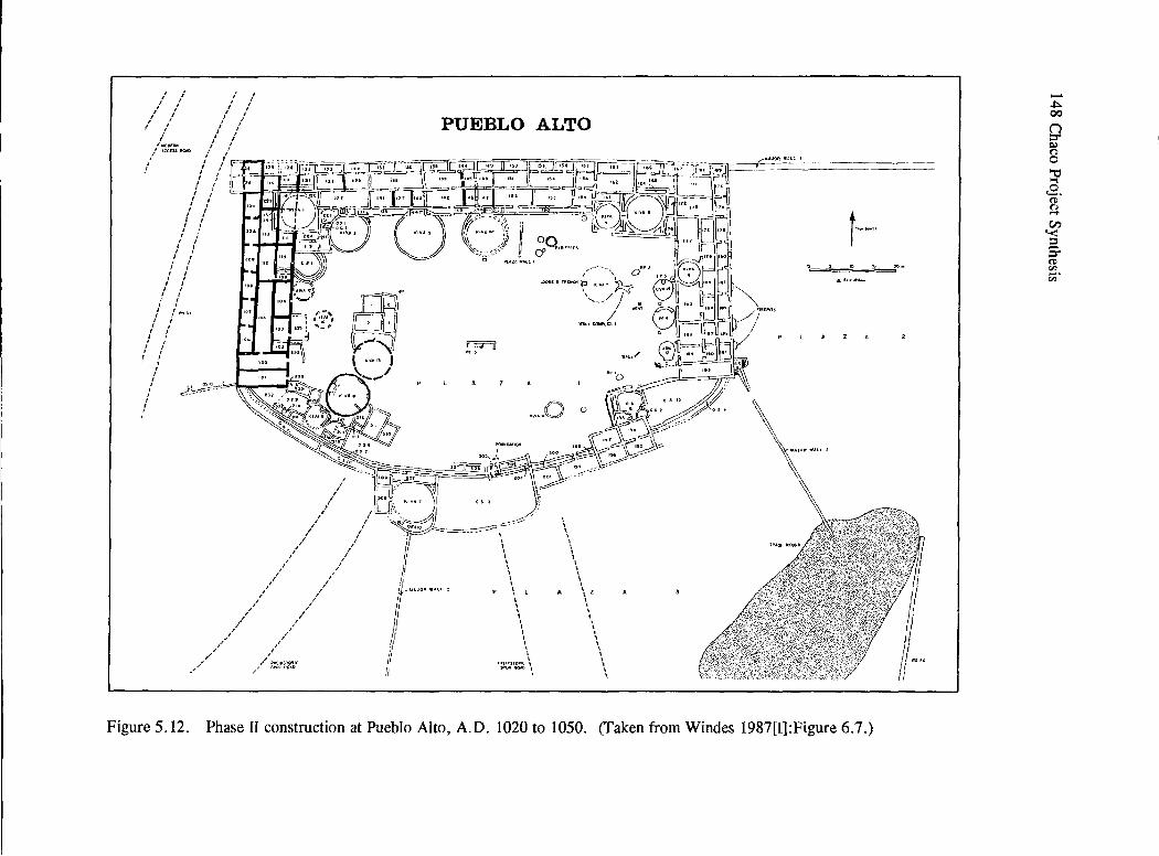
/ / ,
I I
I
; I
/ I
I
I I
I l
I I
I I
I )
I I /
I
/ /
I I
I
l
/ol()Of:J:ll
I/ •tc£SSll¢ilO
' !
/ I
' I I
' I
l I
I
! I
I I
I I
I
I
I
: I
I I
' I J
J
I I
I I I I
I I I
, , , I :
I I
I I
' I I
I I
I J
/ I
I
' / "'·" I
I I
I , I , /
I
J
/ I ,
I I
I
' '
PUEBLO ALTO
~" ~
I I
' ' vP~~
I ,,,.,, J "::-..--/
r {
'
~"'/ I
/,//
I
/ I
/ I
/ /./
l'OIP<CAl!l)M
2-0~, _(
~,;;"l,"'fil'irf\t
l~rl'"'~ r---. -, .:- I ,tJ,_ .. .,., J ' ''
I
/ I
-~~ ------ \
/ .,.~~;--A ;'~
:/ ·~ \
' 1 I
' I I /1 / // ' \ ,/ if.""" .. cc '
/ 11
1 I I I 1 I I I I
... "o o
I \
" \ I 1
' \ \ ' I
I
A \ l 1 \ \ I I I
'
///
/// // j
/ ] \ I I I I
' //f>tt'El!IST9"11C ti
./.I i\P\.~ !'i;AO //
/ _,/"' Fittl!'.Sfl)RIC \ --· \
\ \ I
' \ ' I
~~"
\\
\"' \
r--" .s.r • .soi-
Figure 5.12. Phase II construction at Pueblo Alto, A.D. 1020 to 1050. (Taken from Windes 1987(1]:Figure 6.7 .)
...... ~ 00
n ::r' ~
8 ~
..2. (!) n ..... en '< s. ~ c;;·
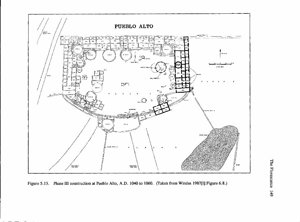
I I
// /
/ I
I I
I I
/ , I
I I
I I I
'
I I
/llfCOCll'-1 / "ccrs~ 11t1.D
I
I I
I {
I
F~"' -
' I ' r ~l'fJi I~
' ~~HI-:--~
/
,,'' ,,,''
,"'"''
,,// /
/ I I
I
/ ,l' ,
/
/
/ ,/'
/ /
/
/ /
/
./''
,//,,~":i'
/ I
/ /
///
/
~ t §
PUEBLO ALTO
~
OQll>{<>!H (f'
--- ..--Ul0$PI: fl<lt .. CI<
11" , ... \ ~I<~ 2
p ""'' ')c_ t '" \,_,yr-Nj• ~ ,,II
''" WALlCOMf'\.Ell1
""'"
.,,.,,0 0
\ 1 \ \ I I I I \ I I I I \ I 1 \ \ I I \ I 1 l
l'>R(Hl~TOfttC l $1'\1f!llCW) \
l I
.;;:·
I \ \
' I \ I
' \ l I \ I
\ z I I I I I \
\ I \ 1 I 1
' 1 I
t·-"""
Figure 5.13. Phase III construction at Pueblo Alto, A.D. 1040 to 1060. (Taken from Windes 1987[I]:Figure 6.8.)
~ .. ~ (I)
~ 0 ..., ~ n g n (I)
..,_ ~
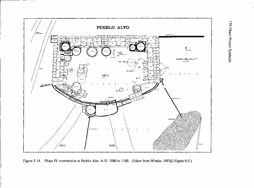
I ! I i ' / / I
I , / I I I I ' I I I I I
I I / / I I
' I I I I I I I
I / '"oot:~ .. / .ACCU5.llC4C / I I
' I
I I I I
' I I I I I I
I I I ,' I I I I I I I
I I
/ I , I I I I
I I I I
I I I I
I I I ) I I
I I I , I I
' , , ' , I
I I f /~SH I
I I
I I I
I I I
I I I I ,
! I I
I
' I I
I I
I I
I I
I
'
////
/
,/ /
~-&~ '
I '\']
: ~'\{J 13 I
' ~-
~~-.ZI! 'Kl~o\' - ~t•? ·~
/ /
I I
,'/ I
I I
I
/
i,l'
,/'//
/ ,,,,''
,/,/
,//~/ rf P~E:,.IHO~LC
r//r' SPV'I .. OAJ)
//
//
I
I I
I I
PUEBLO ALTO
~Q'"'""' -,
I ' LOO$C'5TR£JI'" h -·---~ !.:..
~
.,,. .. 0 0
I I I I I \
' I \ I I \ I I I I I I I I \ I I I
?'ICl<'Sl:lof.11( ~ 5"~~~ \
I I I
I I I I I I \ I I \ \ I I
A \ 2 I
' I I
' I \ I I
\ I
' ' I I '
.. "/
( .. •IP!t Wjl.t..l I
r,.~ .. ' . " -·
.-.s ..... -
Figure 5.14. Phase IV construction at Pueblo Alto, A.D. 1080 to 1100. (Taken from Windes 1987[I]:Figure 6.9.)
....... Vl 0 \.) C" ~ n 0 ""O ~
..2. (1) n ..... en '< = g.
" . (1)
~.
"'

' f I f
' I I I f I
I f
/ /
(
' I f MC OCR~
I At:e~SS 11(;;11~ f
' f
l 11 I/
PUEBLO ALTO
L
.. ~ .. O o
\ I \ \ \ I \ \ \ \ I \ l
\ l \ \ I \ I \ \ \ \ \ \ I \ \ \ \ I
f'··'""
Figure 5.15. Phase V construction at Pueblo Alto, A.D. 1100 to 1140. (Taken from Windes 1987[I]:Figure 6.10.)
~ (ll
'T1 0 ~ ('")
g ('") (ll
....... Vt .......

152 Chaco Project Synthesis
Stage III, the East Wing (Figure 5.13), built between A.D. 1050 and 1060, exhibits a change in masonry style from Judd's (1964) type II to Hawley's (1934) combined types III and IV (Windes 1987[1]: 148). This unit parallels the West Wing, but unlike the rooms in the latter unit, three toward the south have doorways that link Plaza 2 (on the east) with the Plaza 1. Four road-related rooms (194 through 197) appear along what is later the southeastern section of the room biock. They are located east of a road spur that enters Plaza 1; the main route runs north from Chetro Ketl, proceeds northward along the east side of Pueblo Alto, and becomes part of the Great North Road. The East ruin and the Parking Lot ruin, both adjacent to roads, were probably built at this time (Windes 1987[1]:94). During this period there is a ceramic shift from the dominance of Red Mesa Blackon-white ware to Gallup Black-on-white ware.
Events during stage IV, from A.D. 1080 to 1100, include the construction of the south arc. Rooms 225 and 226 are remodeled. Major walls extend in several directions to form boundaries for plaza areas outside of the pueblo and major walls that restrict access to areas around Pueblo Alto (Figures 5.8 and 5.14). Kivas were built in older rooms of the existing room blocks.
During stage V, from A.D. 1100 to 1140, there is evidence for a ceramic shift to what has been named the "Late Mix," in which several ceramic types are present but none are dominant (Appendix B, Table B.2). A number of irregular features and rooms appear in the plaza (Figure 5.15). Plaza Feature 1, a five-room structure, provided one tree-ring date at A.D. 1132 on firewood in Firepit 2 (CNM-562; 1031p-1132rBc). New Alto, Rabbit ruin, and 29SJ2401 were built; Windes (1987[1]:415-416) suggested that Rabbit ruin and New Alto replace the earlier Parking Lot ruin and the East ruin. New Alto may represent a large storage facility (Lekson 1984a); Rabbit ruin is a habitation site rather than a roadrelated site. At this time, while there is continuity for the overall system, there is a shift in the importance of roads to the west side of Pueblo Alto. An examination of Figure 5 .16 indicates that several of these western roads lead to seeps in Cly's Canyon during this period, which represents the greatest expanse of this community.
Several issues arose as a result of these excavations. First, the "big-room suites" identified in the central area are similar to suites found at Pueblo Bonito, Peiiasco Blanco, Kin Bineola, and Una Vida (Windes 1987[1]:355, Figure 10.2). All were built between A.D. 919 and 1050. (More recent dating places initial construction at several of these sites into the late A.D. 800s [Windes and D. Ford 1992, 1996].) Windes(unlikeJudgeetal. 1981, andLekson 1984a) does not consider these large room suites to be simply scaled-up habitation units. Differences were noted in big-room suites in the Central Wing and West Wing at Pueblo Alto, with the West Wing rooms exhibiting classic living room or habitation features while the north or central room blocks had fewer floor features, less diversity in pits, and heating pits rather than firepits, all of which suggested more storage functions. Yet big-room suites in the central section coexisted with the smaller habitation suites in the West Wing and are clearly associated with "court" kivas, which are intermediate in size compared to "clan" kivas and "great" kivas (Lekson 1984a:50-61).
Second, because so few living rooms were identified at Pueblo Alto, Windes (1987[1]:383,-406) questioned the size of the population living there, as well as year-round use. If there were cyclical groups entering the area for short periods of time for ceremonial or other reasons, the smaller population estimate of approximately 100 people at Pueblo Alto would be more in line with other data. To further examine this hypothesis, Windes re-examined several of the Pueblo II and Pueblo III sites located along the canyon bottom to suggest that there was not a continuous increase in population in the canyon; instead, he inferred that data for the period between A.D. 1050 and 1100 suggest a decrease, with a later increase during the early A.D. 1100s. To explain these changes, he cited a correlation with dendroclimatic patterns that indicate drought conditions during the late A.D. 1000s but an increase in moisture between A.D. 1100 and 1130.
Windes (1987[1]:49) concluded that the Pueblo Alto area had insufficient resources to support more than 100 individuals. There was little evidence for farming on the mesa top, but several terraces with masonry walls to retain soil and water were present along the southern slopes toward the canyon. Water

Y·.'..~· I
(~~:= ~····· .... RS4·3· . ~o~.f 'i ' l ·····... ~~ -------~. · .. C/
) ~~.~ \ { ~ ······ ... ~ .... "'s .. p?
/-.. · 1786~;
-{S \
o/ !'-flt i ·1
____/
I
-\ ~nKletso . ~ .-..._/
q_ ~~e ...,.e>o ·~
~~ \~ ~ \_ "1
~ ~.
Pueblo del Arroyo/~ .\______
i ·,( : S.~:
1792
~RS44
: 2401
.. ::-. · I .... ;.-·
1\~0~--=~ ..... 1930 .. :
1946
~
RS 43
) Pueblo Bonito
\../"."-
tNo,lh
Great N<»-th Road J
~ •·· ••. RS40E
(:RS 40W ··.
~ 200 400m
• Stoirs • · .. ·••• Road ser;ime~ts
---Masonry wall
RS 35 ,,,~··
13 ~:<·'.. ~ ...... <,.<-· R$Z8
J··&./ ' (terrace) ~. ·. l} ,. ... , .. ~ " [· .. · ~ T 5 .: •.. ··• ~. ,. .. : ... ····
TalusUn1i~o~ ~ o, .. :i ... ·~············ /f \l.:.Y 152!!·
Chetro Ket! ~.r
Figure 5.16. Road network around the Pueblo Alto community. (Taken from Windes 1987[I]:Figurn 5.2.)
;i (ll
"Tj
0 ""' (ll
"" n g n (ll
..... Vt w

154 Chaco Project Synthesis
was only available when it rained, or when obtained through seeps along Cly's Canyon and from the Escavada Wash to the north. Thus, the attraction to this area was probably related to other factors. Among the hypotheses presented was a road-related function in which Pueblo Alto was the control point for people entering "downtown" Chaco (Lekson 1984a:272) from the northern San Juan Basin during the Classic and Late Bonito phases.
Third, no great kivas were found in the Pueblo Alto community. The function of court kivas, which were defined as being between 5 and 10 m in diameter, vs. smaller clan kivas (less than 5 m in diameter) was evaluated. Windes (1987[1]) doubted that their functions were identical. Court kivas, associated with big-room suites, appear between A.D. 1050 and 1100 in the large-size units. Around A.D. 1080, courtkivas were incorporated with the rooms in the northeast and northwest areas, and smaller kivas were placed within living rooms in the West Wing.
After A.D. 1100, adjacent to Kiva 10 in the central room block (Figure 5.8), Room 147 was designated a possible clan or society room (Windes 1987[1]:310). The east and west walls were painted with designs (Windes 1987[II]:Figure 2.37), as was the north wall of Room 143 in front (Windes 1987[II]:Figures 2.30 and 2.31). Fir pollen was found in heating pits in both of these rooms.
Fourth, Windes (1987a[1]:95-140, Figure 5.2) documented three local uses for the Pueblo Alto road network (Figure 5.16) that functioned between A.D. 1050 and 1140: as 1) links to water procurement areas, 2) to terraced farming areas, and 3) for local interaction between Pueblo Alto and the great houses of Pueblo Bonito, Chetro Ketl, and Peiiasco Blanco, as well as a community along the Escavada Wash. The great north road (Gwinn Vivian 1972, 1983a) suggests ties to the northern San Juan Basin; thus, Windes included the transport of goods and people from other sites and areas as another function (cf., Lyons and Hitchcock 1977b).
Possibly related to the roads are several wall segments that divide the mesa top around Pueblo Alto into discrete areas (Windes 1987[11]:546-554, [I]: Figures 1.4 and 5.2). Major Wall 1, which leaves the northeast comer of Pueblo Alto and proceeds to the
East ruin, includes the gate documented by Ware and Gumerman (1977) and a blockhouse excavated by Loose (as documented in Camilli and Cordell 1983). Major Wall 2 runs from the southeast comer of Pueblo Alto toward the trash mound. A passage through this wall provides easy access between plaz.as 2 and 3. Major Wall 3 marks the western side of Plaz.a 3 and creates an unnamed space similar to the other plaz.as on the southwestern side of Pueblo Alto. Other Structure 13 (a major wall) juts off the southwestern comer of Pueblo Alto. Major Wall 6 proceeds from the northwest comer of Pueblo Alto and passes the Parking Lot ruin and New Alto.
The arc and the major walls that divide the outside space into discrete areas would have directed individuals using the road system from Talus Unit No. 1 and Chetro Ketl to enter Plaza 1 through Other Structure 5 and Room 205 (Figure 5.17). In Plaza 3, a prehistoric road spur links with stairways into the canyon at Talus Unit No. 1 and to the northeast of Chetro Ketl; it enters Pueblo Alto through either Other Structure 3 or Room 199. Just east of Room 199 is one of the sets of road-related rooms. The area between Major Wall 3 and Other Structure 13 receives traffic from a spur of RS 33. The main route of RS 33 passes west of Other Structure 13 and heads toward the northwest comer of Pueblo Alto, where another of the sets of road-related rooms has been identified. Windes (1987[1]:113-114) suspected that these walls may serve to move traffic between local and regional directions.
Four sets of paired room units at Pueblo Alto that Windes (1987[1]:96-129) identified were associated with road functions (Figure 5.17), as were similar sets at the Parking Lot ruin, the East ruin, and Peiiasco Blanco (where he also mapped existing road segments: Windes 1987[1]:Figure 5.1). Additional road-related storage features were postulated for exterior rows of rooms at Pueblo Bonito, Chetro Ketl, Kin Bineola, Peiiasco Blanco, and Pueblo Alto, all built between A.D. 1040 and 1085 (Windes 1987[I]:Figure 10.3).
Fifth, studies in the trash mound revealed numerous layers (Windes 1987[II]:Figure 8.2) that indicated there were three types of deposits that were dated from around A.D. 1050 to 1100 (Windes 1987[11]:561-667). The earliest layers, representing

, ' ' ' ' , ,'/
, ' ,
/
, IMCM~tl
/ ':'.b'-'"'"
/ I
/
PUEBLO ALTO
i1Jf~:~~f~'.!;5J:I~1~C:3~Er~.~~~1f,:~u:: f 'tl--.--~jl:L.,;, JI f J If .',,; i .>·.··,'-IL·:·--·{Jflw; l·•'i···1'
1(Jf ~~~:<:;i~>~) ,,:;···.:i .. L ·~~.=: ~c~~~} i~f<if~~ ..... ·I I ~ -0.., 1---~ , - ,, , fr . i: .1 / 1 '"/ -~---' "J,,_ ,. .. .
• ,,,,f ~t~f~J;>kJ C;T - "'• ""' ~ti::~t:• (_I
-~<.~·~~~~~~~
' ' , .//
/,,f /,/
)I
, ' , ·• ~/ .'1
, I I ;• ' ' I/ >I""
// ii
•=-:-cc:-"'~' \
\ I
\ ' I I I
\
/
\
\ ' ' \
\ I I I I \ I I
\ I \ I I
'·
':-
//:-
///,/ ·~·""' if
,//,/ ~,.,,., """"'~:'Q~..- I 50~~ """" \
\ / \ ' \
-. .,., ... 1\ ,,
\\ -,\
i"""'
rl Ji •I i r ~~ ""
r/ 1/
"<""·'·Ii
Figure 5.17. Road-related rooms and entry points at Pueblo Alto. (Taken from Windes 1987[I]:Figure 5.4.)
;a (ll
"l'j -0 '""l
~ (")
g (") (ll
...... Ut Ut

156 Chaco Project Synthesis
43 percent of the profile, consist of construction debris that included rotted juniper bark, building stones, hafted and unhafted hammers, hammerstones/abraders, and ceramics that represent a Red Mesa assemblage. Faunal remains of small and large mammals, gray ash, charcoal, and chipped stone in layers 11 and 16 were attributed to activities associated with construction. Green corn stalks and burned bone indicative of either spring or fall hunting in construction levels of Room 142 support the suggestion of fall construction.
The intermediate layers, representing 37.9 percent of the profile, indicate trash deposition, and were associated with the Gallup ceramic assemblage. Only Layer 35, which was the largest unit in this set and included a mixture of adobe chunks, grayish sands, bits of charcoal, and occasional spalls and larger stones, probably represents remodeling. Layers 70 to 72 were thought to represent a rise in construction debris around A.D. 1075. Other layers included less sandstone, but increased quantities of chipped stone, bones, ceramics, and corncobs. There was variability in changes among these layers; e.g., the density of ceramics and lithics correlated with one another but not with those of the fauna} remains and ash. Windes indicated that layers 45 and 57 had faunal densities greater than ceramics, which might represent feasting events; yet beginning in Layer 57 ceramic densities increased immediately and were marked by sudden breakage and discard.
When compared with data from small site trash deposition, Windes (1987[11]:615) thought that the long and wide Pueblo Alto trash mound layers were not representative of typical year-round habitation. At small sites, the deposits were mixed and the stratigraphy unclear (Windes 1987(II]:588-608). Yet Akins's (1984:234, 1987a:588) analysis of the fauna! remains from the Pueblo Alto trash mound indicated year-round use; she estimated the meat would have supported approximately 100 people, the number that Windes estimated lived in Pueblo Alto (see also Wills 2001, and discussion below).
At Pueblo Alto, the unusually high number of ceramics (H. Toll and McKenna 1987) and lithics (Cameron 1987), plus the discrete layers that were noted in the profiles, led to the proposal that this site was used intermittently or was the location of large
periodic gatherings during which many vessels were broken and many stone implements were discarded. Additional evidence to support this conclusion is the presence of six intentionally smashed Gallup Black-onwhite bowls found in Level 10 of Grid 183. Windes (1987[Il]:602) suggested that they were part of an initial trash deposit that occurred after the construction episodes. H. Toll and McKenna (1987: 178-181) cite a Zuni example in which rare vessels are intentionally smashed by religious leaders in a ceremony that takes place every four years during the winter months. The bowls were recovered from layers that Akins assigned to winter or fall. Another ethnographic possibility is that the bowls may have been used for ritual cleansing. A large Forestdale Smudged bowl from Grid 239 also occurs at the bottom of the mound. H. Toll and McKenna indicate that this pottery easily breaks into numerous fragments. They asked why there were so many fragments in the same place.
The unusually high number of ceramics present in the trash mound led H. Toll and McKenna (1987: 205-209, Table 1.51) to compare Pueblo Alto's remains with those at small sites and to estimate the number of vessels per household. Assuming that 10 percent of the trash mound had been excavated and that 20 families may have lived in the site during the Classic Bonito phase (Gallup ceramic assemblage, A.D. 1050 to 1100), they concluded that the permanent population at this site was inadequate to account for the ceramic deposits. They suggested that Pueblo Alto was the scene of very large gatherings.
Because Pueblo Alto was occupied for some time after deposition on the trash mound ceased and the trash was not disturbed, Windes (1987[11]:667) suggested a special meaning for this feature at this and other great house trash mounds, all dating to the same period, ca. A.D. 1050 to 1100. Later period trash was deposited in unused rooms, kivas, plazas, or over back walls after A.D. 1100. Windes, therefore, suggested that these features were part of periodic events that were part of the planned ritual landscape in and around great houses (Stein 1987) during this period. The concept that these large mounds associated with Pueblo Alto and other large sites were intentionally constructed ritual architecture became part of the model of Chaco as a ritual center (Lekson 1984a; Marshall 1997; Nials et al. 1987; Stein and Lekson 1992; Stein et al. 1997).

Recently Wills (2001) questioned the interpretation of the trash mounds at large Chacoan sites as evidence of intentionally constructed ritual or sacred architecture. He evaluated several propositions: the seasonal or cyclical deposition of materials on the trash mound; the calculation of the number of vessels deposited on the mound, based on the assumption that an unmatched rim sherd represented a whole pot; and the proposal that feasting events account for the large numbers of ceramics and lithics recovered. He argued that the fauna} remains recovered do not represent seasonal discard (Akins 1984), but instead suggest year-round use of Pueblo Alto. Based on the sample of sherds from a single trench through the trash mound, he questioned whether we can assume a 1: 1 relationship between a rim sherd and the number of vessels estimated for the entire mound. Based on a 10 vs. 2.2 percent sampie, even H. Toll and McKenna (1987:207) provided a lower estimate (33, 130) of the number of vessels than the 150,590 that has been commonly accepted. Wills suggested that large numbers of ceramics and Iithics most often recorded in the trash mound are found in layers that are associated with construction, thus indicating that they are associated with feeding of the labor force rather than ritual breakage and discard. Instead, he proposed that construction-related activity accounts for the formation and growth of the trash mound. He does agree that ritual played a major role in Chacoan life; the ritual activity was in the construction activities elsewhere at the site that contributed to the deposits on the trash mound and not the construction of the trash mound itself.
In conclusion, excavations at Pueblo Alto document two major periods of change: The first change from the use of a Red Mesa to a Gallup ceramic assemblage took place around A.D. 1040 to 1050, at which time a greater number of materials were imported from the Chuska Mountains to the west; e.g., Narbona (formerly Washington) Pass chert (Cameron 1987, 1997b); timber; many culinary vessels; and some white-ware vessels (H. Toll and McKenna 1987, 1997). Construction and use of prehistoric roads around Pueblo Alto took place while there was much construction and remodeling of great houses throughout the canyon (Lekson 1984a, 1984b). Despite these events that are the characteristics of the Classic Bonito phase, several features from earlier times continue to be seen; e.g., the use of large pits in the Early and
The Florescence 157
Classic Bonito phases (Windes 1987(1]:333). The second shift, around A.D. 1100 to approximately A.D. 1150, is characterized by a Late Mix ceramic assemblage. Although Pueblo Alto remained a community center and two new sites, including the McElmo-style structure at New Alto, were built, new construction in this great house no longer followed the symmetry of earlier times; trash was placed in empty rooms; and a special-use room was identified next to a kiva in the central room block. These shifts indicate continuity and major changes in social organization within approximately 60 years.
Studies at Other Related Sites
Other Great Houses
Lekson took on the respons1b1llty for the architectural studies, especially at Chetro Ketl, where the architecture and dendrochronology were examined in detail (Lekson 1983b). He also revisited Talus Unit No. 1 (Lekson 1985). Akins and Gillespie reexamined Una Vida prior to backfilling (Akins and Gillespie 1979; Gillespie 1980a, 1980b, 1984c). Windes and Mathien prepared a historic structure report on Kin Nahasbas (Mathien and Windes 1988, 1989). Windes also documented an early great house in the Chaco East community, up canyon from the park boundaries (Windes et al. 2000), and continued research at the Pueblo Pintado community (Windes 1999, 2001). Each activity expanded the available database on Chacoan great house construction and use, as well as community organization.
Chetro Ketl. This great house (Figure 5.18) was partially excavated in the 1920s and 1930s (Hewett 1936). Hawley (1934) correlated ceramic types, masonry styles, and tree-ring dates that suggested construction periods for the various room blocks and additions to this site. Sixty percent of all tree-ring dates from great houses in Chaco Canyon came from Chetro Ketl, yet no comprehensive report on this site had been prepared. Lekson searched for notes, reports, maps, and other extant data. He and McKenna re-examined each room to create detailed wall maps. Difficulties correlating published tree-ring dates with architectural information led to a restudy of the tree-rings by Dean and Warren (1983). Lekson's (1983b) report includes a history of previous research

I I
I I
I (
I I
J I
I I
,,~ ............. _ I , ,_
.... --...... ... ....... , ' I
I \ I I I I
\ ' ' , ...... _J,
I
I I
I I
I
' I
~//
I
0 0
I
I I I I I I I I
' ' I I I __________ .!
' ,, ' \ \ ' '' ' \~\ '
' ' ' ' ' ' ',, ',_
.. -
I IO> " I I I -+-..
.J __ _J ___ ,_ 1 I I I t.J i :;:sJ....c:;:' t' 11
n' f lh.l 1
1 \ 1 1 -
............. --
.. ~
" -a4 I H
., &2 I 10
t:S< v
------ ------- -- -!' ~
Figure 5.18. Map of Chetro Ketl (29SJ1928). (Taken from Lekson 1984a:Figure 4.39.)
I
' ,-I I I r-+--t :
' ''" I --4--
1
' t I
--1--
io 30m
-Vl 00
n :::r s:» n 0
"C .... 2. (!)
~ en '< s. ~ v;·

The Florescence 159
Figure 5 .19. Early type I masonry beneath Room 62 at Chetro Ketl. (Chaco Culture NHP Museum Archive, no. 101578. This photograph also appears in Gwinn Vivian et al. 1978:Figure E.6. Charles Voll, photographer.)
and the interpretations of Chetro Ketl that arose throughout the years; the results ofhis and McKenna's research; a comparison of his dating of the construction history of Chetro Ketl with a re-evaluation of the older tree-ring data reviewed by Julio Betancourt; additional collections and analysis of tree-ring data by Jeffrey S. Dean and Richard Warren; and a revised construction sequence for this site.
Overall, more than 200 additional tree-ring samples were collected. The three construction phases for Chetro Ketl proposed by Hawley (1934) (A.D. 945 to 1030, A.D. 1030 to 1090, and A.D. 1100 to 1116) were verified, with minor modifications. Although there is architectural evidence of an earlier building beneath the visible structure (Voll 1978) (Figure 5.18), there was no way to tie some early treering dates obtained by Hawley (A.D. 945 to 1030) to extant rooms. Dean and Warren (1983: 107) thought that some samples represented salvage and reuse of old wood or the presence of isolated rooms that were no longer visible. Lekson (1983b:241-271, and Figures VI: 1-12; 1984a: 152-192) discerned 15 construction stages for the visible structure, with the earliest dated
at A.D. 1010 to 1030. After initial construction of the north room block, there was considerable remodeling and numerous additions to the site, some of which overlapped other construction stages. Some features, including the court kiva, great kiva, and colonnade, could not be precisely dated.
Dean and Warren (1983) were able to discern major tree-cutting clusters and suggest stockpiling events. The need to assess problems that result from stockpiling of wood by the early Pueblo people, the reuse of timbers from one site or section of the site by early Pueblo people, and the impact of modem stabiliz.ation practices were all evident. In addition, between A.D. 1018 and 1077 there was evidence for annual activity; but in A.D. 1054, there was a decline in the cutting activity. Dean and Warren (1983:198-199) proposed that reuse of salvaged wood, poor preservation of upper story logs, or small numbers of samples from units post-dating the north room blocks B and C may have contributed to these observations. These issues were further elaborated upon during the Chaco Wood Project (Windes and C. Ford 1996; Windes and D. Ford 1992, 1996; Windes et al. 1994).
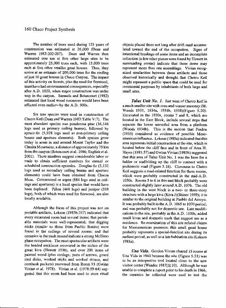
160 Chaco Project Synthesis
The number of trees used during 125 years of construction was estimated at 26,000 (Dean and Warren 1983:202-207). Dean and Warren then estimated tree use at five other large sites to be approximately 25,000 trees each, with 15,000 trees each at five other smaller great houses. Thus, they arrive at an estimate of 200,000 trees for the roofing of just 10 great houses in Chaco Canyon. The impact of this activity on forests, plus the need for firewood, must have had environmental consequences, especially after A.D. 1020, when major construction was under way in the canyon. Samuels and Betancourt (1982) estimated that local wood resources would have been affected even earlier-by the A.D. 900s.
Six tree species were used in construction of Chetro Ketl (Dean and Warren 1983:Table V:7). The most abundant species was ponderosa pine (16, 146 logs used as primary ceiling beams), followed by spruce-fir (5,928 logs used as non-primary ceiling beams and aperture elements). Both species grow today in areas in and around Mount Taylor and the Chuska Mountains, a distance of approximately 75 km from the canyon (Betancourt et al. 1986; English et al. 2001). These numbers suggest considerable labor or trade to obtain sufficient numbers for annual or scheduled construction episodes. Douglas-fir (2, 132 logs used as secondary ceiling beams and aperture elements) could have been obtained from Chacra Mesa. Cottonwood or aspen (884 logs used in ceilings and apertures) is a local species that would have been depleted. Pifion (468 logs) and juniper (338 logs), both of which were used for firewood, are also locally available.
Although the focus of this project was not on portable artifacts, Lekson (1983b:317) indicated that every excavated room had several items; that perishable materials were well-represented; that digging sticks (similar to those from Pueblo Bonito) were found in the ceilings of several rooms; and that ceramics in the trash mound indicate a strong McElmo phase occupation. The most spectacular artifacts were the beaded necklaces recovered in the niches of the great kiva (Hewett 1936), and over 200 items of painted wood (plus cordage, parts of arrows, gourd rind disks, worked sticks and worked stones, and cornhusk packets) recovered from Room 93 (Gwinn Vivian et al. 1978). Vivian et al. (1978:59-64) suggested that this room had been used to store ritual
objects placed there not long after drift sand accumulated toward the end of the occupation. Signs of intentional breakage of some items and an incomplete collection (a few other pieces were found by Hewett in surrounding rooms) indicate that these items may represent more than one assemblage. Vivian recognized similarities between these artifacts and those observed historically and thought that Chetro Ketl might represent a public space that could be used for ceremonial purposes by inhabitants of both large and small sites.
Ttilus Unit No. 1. Just west of Chetro Ketl is a much smaller site with core-and-veneer masonry (M. Woods 1933, 1934a, 1934b, 1938)(Figure 5.20). Excavated in the 1930s, rooms 7 and 8, which are located in the East Block, include several steps that separate the lower unroofed area from a platform (Woods 1934b). This is the section that Ferdon (1955) considered as evidence of possible Mesoamerican influence. Lekson (1985a) indicated that this area represents initial construction at the site, which is located below the cliff face and in front of Area H. Hayes (1981:57) and Gwinn Vivian (1983b) suggested that this area of Talus Unit No. 1 was the base for a ladder or scaffolding up the cliff to connect with a prehistoric road (Figure 5.16). Closeness to Chetro Ketl suggests a road-related function for these rooms, which were probably constructed in the mid-A.D. 1030s. Rooms 3 to 6 in this east block probably were constructed slightly later around A.D. 1076. The old building in the west block is a two- or three-story structure with a large kiva (Kiva J)(Shiner 1959); it is similar to the original building at Pueblo del Arroyo. It was probably built in the A.D. 1065 to 1070 period, and was probably not for domestic use. Late modifications to the site, probably in the A.D. 1100s, added small kivas and domestic trash that suggest use as a residence. Re-examination of this site refuted claims for Mesoamerican presence; this small great house probably represents a special-function site during its earliest period, as well as a late habitation site (Lekson 1985a).
Una Vida. Gordon Vivian cleared 15 rooms at Una Vida in 1960 because the site (Figure 5.21) was to be an interpretive tool located close to the new visitor center (Windes 1987[1]: 10). Although he was unable to complete a report prior to his death in 1966, the ceramics he collected were used to test the

" ' I
..
" " " ~ 39 •O •I 20 "
0
1~~;0::::::::::_,<R \,I ,'--=~
O' I
1 Cl :
,.. ~ii 20 \ ,' IJ . \. ,' \~ 14 ',, __ ,,,''I) "
,-/ ' I
\ . ' \,..,
0
.... ____ ..
Figure 5.20.
10
II
. ' \ \ . ,,, ' \' \,, ,' ~I f
\ '".,_ '.. J' ,'I I
','~~:~~ ~~~~~~~~;;>'
+ ~...-· : ti°
Mcuu
OPEN
DOOR 0 \/ENT A
BLOC KW
• ... 0 STABILIZEOt NOT
VISIBLE
Map of Talus Unit No. 1 (29SJ1930). (Taken from Lekson 1985b:Figure: 2.)
;i Cl>
'TJ 0 '"I
~ n g n Cl>
..... °' .....

--------
162 Chaco Project Synthesis
I 74 73
75
0
---------
I I I I I I I I I
10
I I I I I t I I
' I I I
' t I I I
L._
20 30 m '------""--~---'----~
I I
,----.., I / ' I
I \ I I I I I I I I \ I I I
._ / I I ','--' I I
'..... I I '-...( I
'./
Figure 5.21. Map of Una Vida (29SJ391). (Taken from Lekson 1984a:Figure 4.1.)

rough-sort method used during the Chaco Project. Based on this test, Windham (1976) was able to suggest three construction periods that are roughly similar to those defined later by Gillespie (1984c:79-94). Once Una Vida was scheduled to be backfilled in May 1979, Gillespie and Akins cleared floors, completed room excavations, and prepared detailed maps of the exposed rooms. They focused on a room block in the northern comer of the site, paying special attention to early features in nine of 15 rooms; collected pollen and flotation samples; took archaeomagnetic samples; and provided an accurate description of all floor features (Akins and Gillespie 1979).
Construction at Una Vida took place in several stages. Like Pueblo Bonito and Pefiasco Blanco, Una Vida has early tree-rings dates in the A.D. 800s (Bannister 1965). Gillespie (Akins and Gillespie 1979; Gillespie 1984c) indicated that the tenth-century layout and masonry (Judd's type I; thin slabs with copious mortar) was probably representative of two construction episodes, each with two stories. Stage I (Lekson 1984a:Figure 4.4a) is a small arc of rooms on the northeast side with two mid-A.D. 800s dates. The bulk of the western block or lower arc and three suites in the northeastern section (Lekson 1984a:Figure 4.4b) were constructed around A.D. 930 to 950 (stage II). Areas beneath rooms 23, 83, and 84 were identified as belonging to an early plaza that may have been associated with this early room block (Akins and Gillespie 1979). Stage III (A.D. 950 to 960) is represented by type I masonry additions to the existing structure (Lekson 1984a:Figure 4.4c). Stages IV and V occur nearly a century later (A.D. 1050 to 1055, and A.D. 1050 to 1095), when a front row of rooms and kivas was added to the plaza side of the western section and several rooms were added onto the original arc of rooms (Lekson 1984a:Figure 4.4d). Stage VI represents construction around A.D. 1070 to 1075, when the southeast block was added and some modifications were made to the existing structure. Stage VII construction enclosed the plaza sometime after A.D. 1095 (Lekson 1984a:Figure 4.4e and f).
A range of room functions was documented by Akins and Gillespie (1979), who classified two of the nine rooms (rooms 18 and 65 built during stage I) as storage rooms. Rooms 21 (stage I), 23 (stage III), and 60 (stage III) were originally built as habitation rooms; Room 60 was later modified into a special-use
The Florescence 163
room, possibly a kiva. Room 83 (stage V), although square, possibly functioned as a kiva. Rooms 63 (stage III), 64 (stage I), and 84 (stage V) also contained floor features indicative ofliving areas. As at Pueblo Alto and Pueblo Bonito, much evidence of reuse and change are visible at this site.
Kin Nahasbas. In 1935, as part of inquiries into the standard features of great kivas, Hewett entrusted the excavation at Kin Nahasbas to Dorothy Luhrs (1935). After clearing the great kiva to the first floor and excavating in two rooms in the house mound on the hill above, this site (Figure 5.22) was left open. Information on the great kiva was incorporated into the report by Gordon Vivian and Reiter (1960), but no other data were published. In 1983, Windes and Mathien prepared a historic structure report prior to backfilling (1fathien and \A/indes 1988). Documentation of the great kiva, the house above, and surrounding features was undertaken to understand its relationship to Una Vida and other structures in the area (Mathieu and Windes 1989).
Initial construction at Kin Nahasbas probably occurred during the A.D. 900s. A 44 m2 pit structure found beneath the earliest great kiva is similar in layout to other tenth-century pit structures (Truell 1986). Although much of the pit structure had been destroyed by later construction, it contained a firepit, heating pit, two postholes, and possibly sets ofladder rests that would indicate entry through a hatch in the roof.
Oriented southeast to northwest, this pit structure sits downslope of a set of rooms designated as Old House. The set of rooms is a 283 m2 irregular room block constructed of type I (Hawley 1934) masonry for which two styles were recorded: a large, crudely shaped, lenticular set of ashlars that spanned the width of the wall, and a set of smaller squarish stones. A small circular room ( 1. 8 min diameter) and a possible tower (4 m in diameter) may represent observation posts (Windes in Mathien and Windes 1988:73). Contemporary with the Old House is Great Kiva 1, also constructed of type I masonry. Today only the north wall and a narrow adobe band along the northwest side of the structure remain. The size of this great kiva is estimated to have been about 136 m2
•
Standard floor features (roof supports, vaults, firebox, and deflector) were present. Because of its location on

164 Chaco Project Synthesis
~ BOUlOERS
==:: ANASAZI WALLS (VERIFIED)
:::::: NAVAJO WALLS (VERIFIED)
' ' '
s 6
A'
GREAT
KIVAS ,'
HOGANS
li'ILI o,:
WALL
au•aLI? :
'"~ \)~
~ ... \,
0 10 ...
Figure 5.22. Map of Kin Nahasbas (29SJ392). (Taken from Mathien and Windes 1988:Figure 4.)
the hillside, a wall buttress extended downslope for approximately 8 m in a step-like manner; two instances of type I masonry facing were recorded as part of this feature.
Type III, or inferior type III, masonry characterizes the walls of New House, a 13- to 14-room structure with two kivas. Great Kiva 2, also constructed of type III or type IV masonry, was placed in the same location as the earlier great kiva, but enlarged to approximately 162 m2 as measured from
the floor or 187 m2 at bench top. The wall buttress was revamped. An antechamber of type II or type III masonry that appears on the north side may have served both great kivas.
Because of remodeling, dating of materials from two pits in the northern section of the great kivas is difficult. Other Pit 18 contained a cache that included "punches" and flakes; Other Pit 19 held a concretion in the fill. Both had been covered with stones and adobe.

Ceramics dating to the A. D. 11 OOs were found in several transects across the site, including the Old House. These late sherds, plus subdivisions of the vaults in Great Kiva 2 and crude masonry modifications to the firepit, indicate late use of this site.
Viewed within a community context, Kin Nahasbas is thought to have been part of an early cluster of sites near Una Vida (Windes 1993d). Both great houses were built using similar masonry styles that indicate construction by the A.D. 900s; both had similar ceramic types. Una Vida, however, tended to be approximately eight times larger during this early period (2,330 vs. 283 m2
). Four small sites found nearby (Mathien and Windes 1988:Figure 3) represent the entire span of occupation of the great houses. Within a 2-km radius, there are 65 contemporaneous Pueblo II and Puebio III smaii houses; these great houses are considered part of the Fajada Butte community (Windes 1993).
The function of two nearby and contemporaneous great houses merits discussion. Although factionalism and proximity to a water source or water and field system were considered, Windes (Mathien and Windes 1988:100-101) suggested visibility as the reason for the location of Kin Nahasbas. During the A.D. 900s, the earliest great houses in the canyon (Pueblo Bonito, Peiiasco Blanco, and Una Vida) were all visible from Kin Nahasbas. In contrast to Una Vida, during the A.D. 1000s this site also could been part of the signaling system and shrine network. The number of rooms in the Old House did not suggest a need for a great kiva at this site; if this great kiva were used by other inhabitants of the community, Kin Nahasbas may have served more than one special function within this community.
Chaco East Community. Another great house with early masonry that suggests construction during the A.D. 900s is located up canyon and outside of the park boundaries where a major drainage empties into the Chaco Wash (Windes et al. 2000). Although a straight line of visibility between this site and those in the main section of the canyon did not exist, Windes et al. (2000:39, Figure 4.1 and Figure 4.2) suggested that this community was linked with four others through a system of communication shrines described in Hayes and Windes (1975). No excavations have been conducted; survey at local small sites and
The Florescence 165
analysis of sherds and lithics indicate mobility among the inhabitants who abandoned the early community. Closer ties to the Pueblo Pintado community than the main canyon are suggested (Windes et al. 2000).
Shrines, Signaling Stations, and a Communication System
During excavation of the Basketmaker III pit structures and great kiva at 29SJ423, an unusual arcuate wall (Figure 5.23), 15 m long and 30 cm high (possibly rising to 52 cm), constructed of coursed compound masonry set in mortar, was discovered (Hayes and Windes 1975). The crudely scrabbled stones and irregular width, plus the presence of some metate fragments in its construction suggested a late date, but there were no sherds from the Pueblo II to III periods to further refine its chronological placement. Approximately 6.5 m south of the middle of the gentler arc was a pile of shallow mounded trash. In this pile was a pecked sandstone bowl with a flat bottom. It was surrounded by tabular dry-laid sandstone slabs rising as high as the rim, and it was covered by a rectangular sandstone slab that had a rectangular hole in its center (Figure 5.24). When the shaped cover for this hole was removed, 146 turquoise beads and three turquoise chips were found in a bowl. Also recovered in the area adjacent to the mound and wall were 184 turquoise beads, two black shale beads, one shell bead, 148 turquoise chips, and a small McElmo Black-on-white bowl that contained one turquoise bead. Because this arc arrangement is common in Historic Pueblo shrines, a ritual activity (possibly a sun-watcher's station or signaling station) was inferred.
Clear visibility from 29SJ423 extends 90 miles to the north, past Huerfano Butte to the La Plata Mountains, as well as to the Chuska Mountains in the west. Within Chaco Canyon, only three of the large pueblos or great houses could not be seen (Una Vida, Chetro Ketl, and Hungo Pavi). However, two features similar to the one at 29SJ423 (29SJ1207, located on top of South Mesa due south of Pueblo Bonito, and 29SJ706, at the east end of South Mesa) provide such a line of sight for all but Una Vida. As a result, Hayes and Windes (1975: 152) suspected that Kin Nahasbas was part of the larger Una Vida settlement or that the raised kiva in the west wing of Una Vida might have been a possible linking station. All of the

166 Chaco Project Synthesis
n?Poctfi38!Cfli9EJ~go ~vo~ ~l.Y
# 0
()
,0 Figure 5.23. Shrine at 29SJ423: A) overview of site (Chaco Culture NHP Museum Archive, Photo no.
5700. Thomas C. Windes, photographer); B) Plan of shrine (taken from Hayes and Windes 1975:Figure 22).

The Florescence 167
Figure 5.24. Altar box at shrine at site 29SJ423. (Composite from Chaco Culture NHP Museum Archive, photo nos. 5697, 5768, and 5696. Thomas C. Windes, photographer.)

-,, 'l! "
~p/
. 0
~
i C:OXTOIJa l•T••n'- ... •••T
Figure 5.25. Shrines, stone circles, great kivas, and great houses in Chaco Canyon. A Stone circle. [Shrines. 1) Pefiasco Blanco, 2) Casa Chiquita, 3) Kin Kletso, 4) New Alto, 5) Pueblo Alto, 6) Pueblo del Arroyo, 7) Pueblo Bonito, 8) Chetro Ketl, 9) Casa Rinconada, 10) Tsin Kletzin, 11) Hungo Pavi, 12) Kin Nahasbas, 13) Una Vida, 14) Wijiji, 15) Kin Bineola, 16) Kin Klizhin, 17) Great kiva 1253, and 18) Great kiva 1642. (Taken from Windes 1978:Figure 1.)
.......
°' 00
n ::r i:» (') 0 ""tj '"I
.3. g (/.)
'< s. ~ r;;·

Bonito phase structures in Chaco Canyon could also be tied into a single system (Figure 5.25) linked by line of site from the three elevated kivas at Tsin Kletsin to the raised kiva at Kin Klizhin and a tower-like structure (29SJ1578) above Kin Bineola. 29SJ706 also provided a visual link with the tower kiva at Kin Ya'a. If any one of these shrines had been located from 30 to 70 min any direction, such a system would not have worked. It was inferred, therefore, that some time and labor had been invested in determining the locations of the shrines/signaling stations.
Since the mid-1970s, Windes added 29Mci83 and 29Mc186 on Chacra Mesa (Drager 1976a: 12). Another U-shaped shrine (29Mc567) was found on top of the mesa just west of the Chaco East community, at the confluence of Wild Horse Canyon and the Chaco \Vash ('YVindes 1993:459 a..~d Figure F.1; Windes et al. 2000:43, Figure 4.2.). Site 29Mc187, on Chacra Mesa near the Chaco East community, ties Pueblo Pintado into the canyon system as well. The eleventhor twelfth-century masonry in the shrines suggests a widespread communication system within the Chaco core (Drager 1976a).
Stone Circles
Twenty stone circles differ from shrines (Hayes and Windes 1975). Windes (1978) described these features as oval or circular walls up to 1 m high that usually enclose circular or rectangular basins cut into the bedrock. Although basins are randomly distributed within the stone circles, the larger circles had more basins and are located closer to Bonito phase rums.
Recovered artifacts only hint at their date and function. Ceramics suggest a Pueblo II-Early Pueblo III use (80 percent of the sherds vs. 12.5 percent dating to the Basketmaker III-Pueblo I period, and 7. 5 percent to the Pueblo III period). The low numbers of sherds suggest nonceramic activities. Siliceous stone was rare; where present, there was a high percentage of imported materials (obsidian, Brushy Basin chert, and Narbona [Washington] Pass chert). The most abundant ground stone artifact recovered is the weathered abrader, which is consistently found in association with walls or wall rubble. All 229 abraders had similar wear patterns. Unlike those from habitation sites, they may have been used to smooth
The Florescence 169
the bedrock on which the stone circles were built. Of the abraders, 95.6 percent showed no modification other than wear patterns that could not be assigned to a specific task. Only a few other ground stone objects (manos, a shaft smoother, metate fragments, and a possible pot cover) were recovered. At 29SJ1974, three stone pendants, found in the rubble northwest of the stone circle, were crudely shaped and drilled from two sides.
All stone circles are located on cliff edges that overlook the canyon; most appear on the first bench, at an average of 693 m from a Bonito Phase site (Figure 5.25). Visibility to the nearest great house is rare, but great houses can be seen from nine of 13 sites. From all, a Pueblo II to III great kiva is visible. Because stone circles were placed in precise locations that allowed visibility between them and great kivas, their function was probably integrative. "Towns with only a single circle nearby might be indicative of occupation by a single social or religious group, or simply that other circles nearby escaped detection" (Windes 1978:65). Even though similar basins in other areas could be used for water catchment, the stone circles were not built for water control. They could represent areas where manufacturing of religious items occurred; they could have been hide-processing or wood-processing centers. Public dancing areas or staging areas for dancers were also postulated, but their exact role within the system remains uncertain. Windes (1978:65-69) concluded that stone circles appeared primarily between A.D. 1000 and 1150.
Roads and Road-related Features
Road segments in the San Juan Basin were documented by Holsinger (1901) and Judd (1964), among others, but it was not until the 1950s and 1960s that they received much attention. Gordon Vivian began to examine linear features, some of which he thought were canals (Obenauf 1980a; Gwinn Vivian 1983b). Continuing studies by Gwinn Vivian (1972; Vivian and Buettner 1973) identified six major routes that started in the canyon and extended outward, including the North Road (called the Great North Road by C. Randall Morrison; Vivian 1983a:A-12).
Chaco Project staff documented additional linear features on aerial photographs, both in the canyon and throughout the San Juan Basin (Ebert and Hitchcock

170 Chaco Project Synthesis
.LOWRY
,.,.-..... \ JDA JEAN
WALLACE
SleepiDI Ut.•.., ~ Mt. :-•yucCA HOO&•
HOUCK
' ,• ...... ,, ....
:'.iji-ALLANT-OWN
VILLAGE OF • THE Gli\J:AT KIVAS
IQUAW Bl'&INGlg
Figure 5.26. Map of Chaco road system.
1980; Ebert and Lyons 1976; Obenauf 1980a, 1980b, 1983a, 1983b, 1991). Over 200 miles of verified road segments were identified (Figure S.26). Because a number of these linear features led to great houses, they were considered part of a large cultural system. Road systems at Pueblo Alto and Peiiasco Blanco were mapped by Windes (1987[1]:95-139, Figures 5.1 and 5.2, 1991). A few Pueblo II associations (Ebert and
~ 9 5 1,0 lj$ 20 ml.
D Q 5 10 15 202.530 k,
Lyons 1976; Lyons and Hitchcock 1977b; Obenauf 1980a, 1980b) were made, but most roads were thought to have been used during Pueblo III (Windes 1987[1]). Functions attributed to the roads include transportation of people and goods; communication; and sociopolitical, economic, and religious integration.

Three road-related excavations were conducted. As part of initial field research on the road system, Ware and Gumerman (1977) placed several trenches across road segments leading into Pueblo Alto. Road beds were difficult to find; most trenches provided little evidence that the roads were intentionally prepared. Formal attributes of the roads included curbing (not always present) and peripheral sandstone rubble mounds (discontinuous and nonlinear). Approximately 40 m east of Pueblo Alto, a 1-m-wide gate in the north wall was exposed (Obenauf 1980a: Figure 10). It is here that three roads converged; but the trench that extended for 2 m north of the gate revealed no evidence of a prepared road surface. Only a hard-packed caliche surface sloped away from the gate.
In 1974, Richard Loose examinea tne biock house, a jog in Major Wall 1 that connects Pueblo Alto to the East ruin (Camilli and Cordell 1983:Figure 27; Obenauf 1980a: 145; Windes 1987[1]: 16, Figure 4.1). Although initially thought to represent a small room or ramp over the wall, the results of excavations were inconclusive.
The Poco site, 29SJ1010, was discovered in 1972 during field checking of road segments found on aerial photographs. Located along a spur of the "Sandspit Road" between Chetro Ketl and the Escavada Wash, this site consists of six circular features, linear features, and mounds along the east and west side of the site (Figure 5.27). Excavation was designed to determine whether features identified on the photographs would be similarly classified once excavated; the accuracy of orthophoto maps; the site construction date, and whether it preceded or succeeded the road construction, and therefore when the road was built; and the function of the site structures (Drager and Lyons 1983a). Initially the circular structures were designated as kivas; excavation of three of the circles that were linked to one another indicated that walls probably never exceeded 1 m in height and lacked evidence for roofs. Masonry walls in all three circles were very similar; tabular sandstone coursed walls with adobe mortar were approximately 1 m thick and less than 1 m high. Although two of the three had firepits on their plastered floors, other features typical ofkivas were lacking (Figure 5.28). Because the road surface butted the Circle B wall but did not go beneath it, there was no way to determine which feature had
The Florescence 171
been constructed first. One archaeomagnetic date from the firepit in Circle A suggested use around A.O. 1210 ± 11. Windes (in Drager and Lyons 1983a) thought this date was too late, based on experience at dating Pueblo Alto; he suggested that the ceramics indicated a Late Pueblo II-Pueblo III use, possibly as a signaling station, because it was on a high point of the mesa. Although road-related, the function of this site had not been satisfactorily determined (Obenauf 1980a: 146).
Continuing studies of roads and road-related features outside of Chaco Canyon conducted by the Bureau of Land Management (Kincaid 1983; Nials et al. 1987) identified the Poco site as an example of a "zambullida" (Kincaid 1983:9-11to9-14, C7 to C9). In addition to increasing our knowledge about the extent of the road network, excavations demonstrated the differences between historic and prehistoric roads; ceramics provided dates for the use of some of these features; and a number of road-associated masonry features were identified and named (Kincaid 1983; Nials et al. 1987). More recent evaluation of the roads led Roney (1992) to question their function; he proposed that the short segments documented around many of the Chacoan great houses and great kivas may represent ceremonial tracks.
Irrigation Systems and Agriculiura/, Fields
Identification of both Navajo and Anasazi agricultural features in and around Chaco Canyon has a long history (Gordon Vivian and Mathews 1965: 11-14). Holsinger's (1901: 11-12) descriptions of Navajo fields and the small ditches used to bring water to them contrasts with his description of five "artificial reservoirs," each associated with a system of irrigation ditches. Hewett (1905) relocated these "reservoirs" the following year, but by the 1920s, visibility of these features had decreased due to alluviation in some areas (Judd 1954:55-59). Gordon Vivian's examination of aerial photographs did not reveal the water control features described by Holsinger (1901) at Pueblo Pintado and Kin Ya' a, but those at Kin Klizhin and Kin Bineola were identified and studied. Additionally, a complex near Casa Rinconada was identified. Today the only visible fields in the canyon bottom attributed to the Pueblo people are those near Chetro Ketl and Casa Rinconada.

N
I ff{<f o~
~ ~ cD ._~"!Y' ~ t ( QUARRY AREA
+"/- (] ~ c,~/ . \ ~O .~ I I <·
/
O @C~l!~T~ -...aa!!~ .,... ~ - -.TRUCTURE
.,~ \., ... ~ 0
15 0 30 ~
SCALE: METERS
•f/ ~ct.Ii"''°" @·.;.•·. , ... ··· ..-:::Q1>0 ' .
/ __...",c " . ~'•"o
Figure 5.27. Map of the Poco site, 29SJ1010. (Taken from Kincaid 1983:Figure C-2.)
N
I
I
/
I
\
/
/
0 1 2 3 4 5
SCALE: METERS
CIRCLE B
OFIREPIT
CIRCLE C
' ' ....
Figure 5.28. Map of three excavated circular masonry structures at the Poco site. (Taken from Kincaid 1983:Figure 9-8.)
......
....J N n ::r I>' n 0
'"O '"I
..9. (I)
~ en '< s. ~ c;;·

The Florescence 173
Figure 5.29. Aerial photograph of the Cherto Ketl field, indicating placement of test trenches excavated by Richard Loose. (NPS office, Santa Fe.)
Pursuing his father's lead, Gwinn Vivian (1972: 8, 1974b: 104-105, in preparation) documented a 14.5-km (9-mi)-long system of canals that extends along the north side of the canyon from the Gallo Wash to the Escavada Wash. Earth and stone dikes channel runoff from side rincons to major gates that lead to smaller canals and gridded fields (Gwinn Vivian 1972:5, Figure 9.4). In Cly's Canyon, a large masonry diversion dam impounded greater volumes of water. Two reservoirs at Tsin Kletzin and some pond areas along the Gallo Canal near Una Vida were observed (Vivian 1972:4-5). Bromberg (1961) documented a diversion wall (Be 364, 29SJ1095) on the south side of Chaco Wash just upstream from Pefiasco Blanco. This feature would have diverted water into alluvial
flats. Based on masonry style, all are attributed to the Classic period.
In addition to grid gardens associated with the water control features on the north side of the canyon, terraced gardens were recorded between Pueblo Alto, Chetro Ket!, and Kin Kletso. At the base oflow cliffs east of Tsin Kletsin, several walled gardens were identified.
During their evaluation of aerial photographs used to prepare a vegetation map of the canyon, Potter and Kelley (1980:Figure 8) identified a number of old fields. The one southeast of Chetro Ketl was the largest and the easiest to distinguish (Figure 5.29).

174 Chaco Project Synthesis
Evaluation of seven trenches in this field (Loose and Lyons 1976a) suggested intentional flattening of the surface, earthen levees, and probably intermittent floods across the area. Two possible laminated strata, the lowest associated with Pueblo I sherds, were attributed to overbank flooding of the wash. Two gate systems suggest continued use. A single archaeometric date of A.D. 1250 from the upper layer by Nichols (1975:4-8) does not correlate well with the latest Bonito phase sherds recovered in the test trenches (Loose and Lyons 1976a).
Lagasse et al. ( 1984) do not believe that the large rainfall events flowing through the major watersheds could have been controlled by facilities such as those in Rincon 4 near Pefiasco Blanco (Gwinn Vivian 1972: Figure 5.4). Vivian (1992) suggested that the capture of all water, especially that from .small precipitation events, would have provided some moisture that may have been sufficient to soak some gridded garden plots within the system.
Summary
With the new data from survey and excavation, Chaco Project archaeologists were able to better define the chronological sequence for the Classic period. Pueblo II sites were divided into early and late segments, as were Pueblo III sites. The Classic florescence was described in three phases: The Early Bonito phase (Red Mesa ceramic assemblage); the Classic Bonito phase (Gallup ceramic assemblage); and the Late Bonito phase (Late Mix ceramic assemblage), which included Early Pueblo III sites. Although the calendrical dates assigned to these periods shifted slightly (Appendix B, Figure B.1), the architectural styles and artifacts assigned to them provided a basis for more detailed discussions of change through time, including the movement of major settlements in the canyon. The distinct differences among large and small sites in the adoption of wall masonry, wall foundations, ventilator shaft construction, and location of trash disposition, as well as formalization of features in great kivas and enclosure of plai.as, will be presented in the following chapter.
By approximately A.D. 850, communities around three great houses were established. Not only were additions to these three great houses built during the A.D. 900s, but several other great houses with
type I masonry were constructed during the tenth century; e.g., Chaco East. Una Vida and Kin Nahasbas were contemporaneous and close together. In the latter case, participation in a communications system and not location next to a major drainage seems a more likely explanation for placement on the slope of the north mesa. The burst of construction at great houses during the mid- to late-lOOOs and early 1100s, the diversity that appears in small site rooms in the early A.D. 1000s, and the changes in room sizes and function at Pueblo Alto suggested two major shifts in social organization around A.D. 1050 and 1100 that were marked by the beginning and end of the dominance of Gallup Black-on-white in the ceramic assemblage (H. Toll and McKenna 1997). These finer-grained chronological distinctions, which divided three phases of the Bonito period, would be correlated with climatic fluctuations and changes in material culture. Some results of those analytical studies only became available recently.
With new data come new questions. Once the great houses were found to have different types of rooms, not all of which were living quarters, the number of families using these structures year-round became an issue. The differences in big-room suites between those with firepits vs. heating pits and the presence of road-related rooms suggested multiple functions for the great houses during the Classic Bonito phase between A.D. 1050 and 1100. The function of trash mounds and roads, both associated with the great houses during this period, are also unclear. Are they ritual structures?
At great houses such as Pueblo Alto, Windes (1987[11]:605) described the trash mound as having distinct layers separated by a thick layer of aeolian fill, which led to the interpretation of deposition as being cyclical and different from that at small sites where no such definite divisions are apparent. Truell (1992:209-210) acknowledged that there are differences in exotics and bone frequencies at small house site trash middens, but she did see internal layering. She suggested that the mounds had different functions. The mounds at small sites represent a slow accretion of regularly accumulated debris; those at the large sites contained large quantities of construction debris and very little trash. Wills's (2001) recent reevaluation of the trash mound came to a similar conclusion about the function of trash mounds; their

construction could be the result of a ritual activity that is being carried out elsewhere, but the mounds are not intentional ritual structures. Under the direction of Wills, re-evaluation of earlier trenches at Pueblo Bonito is currently under way.
The function of roads is also unclear. Roney (1992) found that only a few major roads (e.g., the Great North Road) can be traced for long distances. Most other known segments are found around great houses in communities outside of Chaco Canyon. He suspects that they may have had ritual meaning.
Do small sites represent seasonal occupation (Windes 1987[1]:405)? Data from 29SJ627 (Truell 1992:240) do not provide a clear answer. Analyses of macrobotanical and pollen remains (M. Toll 1985a and A. Cully 1985b) indicate use from spring through autumn. Truell considered Akins's study of fauna! remains insufficient to shed light on this topic because either procurement practices or later disturbances by animals could have affected the data. Truell (1992: 241) stated: "One thing that seems apparent from the site use through time is that if the inhabitants of 29SJ627 were there intermittently or seasonally, there
The Florescence 175
was some consistency in the group who occupied the site. " They made similar use of space and construction methods through time. Without answers to these questions, models for social organiz.ation will remain difficult to evaluate.
The shift in population concentrations toward the central canyon after A.D. 1050 needs further clarification. The presence of A.D. 1100s features at some of the small sites in Marcia's Rincon and elsewhere may indicate a reuse of earlier areas or a problem with the sample of excavated sites. Windes (1993:404) indicates that five Pueblo II srr.all sites in the Fajada Gap community were occupied during the Classic Bonito phase, but that many others were abandoned. He suggests that some of the abandoned houses were formally closed with the smashing of the latest cooking jars in the primary pit structures. We do not know why some people moved away while others remained.
Some of these issues will be explored further in the following chapters; others remain for future investigation. But any models for social organiz.ation (Chapter 9) must consider these data and questions.


Chapter Six
The Classic Adaptation Within Chaco Canyon
What may have been the purposes of many of their marked peculiarities; what the numbers and characteristics of their buildeis; what the relationship, if a...11y, bet\veen their in.habit~'l.ts a..nd the other families of the great race of early community dwellers, are queries which may be answered in part when the investigator shall go back with pick and shovel to uncover the buried rooms, and lay bare that which has remained concealed since the death of departure of the ancients. (Bickford 1890:896-897)
The Chaco Project staff focused on an examination of data pertaining to the Classic period in Chaco Canyon, including the effects of environment on culture. Determining the parameters within which the people lived and worked was especially relevant to understanding this period with the largest population, the great houses and their communities, and the most spectacular artifacts. This chapter outlines the environmental parameters within which the Chacoans lived, evaluates the population and its health, and presents aspects of material culture and practices that provide clues to social organization. Other colleagues studied astronomy and cosmology to flesh out the models discussed in Chapter 9.
Environmental Parameters Affecting Agriculture
Based on research synthesized by Gillespie (1983, 1984b, 1985), the climate of Chaco Canyon during the Bonito period is assumed to be similar to that of today. Although average rainfall is approximately 22 cm (8 in), it varies considerably from year to year. Extended periods of above- or below-average rainfall would have affected crop production; but even during wetter periods, dry farming on mesa tops would have been limited. Vegetation would have been similar to that of today. Pinon and juniper were probably present within the area. Some ponderosa pine would have been imported from long distances; and spruce, Douglas-fir, and subalpine fir, which require cooler and wetter climates, would have been found only on the perimeters of the San Juan Basin.
Because of the low annual rainfall, water was considered the most limiting factor for the agriculturalists who farmed within Chaco Canyon and its immediate surroundings. Regional summer precipitation values reconstructed by Robinson and Rose (1979) provided the initial data against which comparisons of cultural events could be made. Based on the Palmer Drought Severity Index (PDSI) calculated by Rose et al. (1982), the dry interval between A.D. 1030 and 1060 and the protracted and severe drought between A.D. 1130 and 1180 are thought to have affected agricultural production (Dean 1992).
Windes (1987[I]:30-37, Figure 2.2) interpreted the July PDSI values as an indicator that overall the A. D. 900s represent a century of above-average moisture, followed by interspersed dry periods between A.D. 1006 and 1029. This period corresponds archaeologically with the predominance of Red Mesa Black-on-white pottery in the ceramic assemblage. Mild drought conditions from A.D. 1031 to 1050, thought to coincide with the beginning of the Gallup ceramic assemblage, were worst in the eleventh century. Increased moisture in the A.D. 1060s and 1070s was followed by a low from A.D. 1081 to 1099. The early twelfth century (A.D. 1100 to 1129, the Late Mix ceramic assemblage) was a wet period, followed by moderate drought conditions from A.D. 1130 to 1180-the most severe drought that occurred during the 250-year Bonito phase (Figure 6.1).
When Windes (1993:Figure 2.6) constructed a three-years-running mean for the San Juan Basin, there

3--------------------------------------------------------------------------------'.-i---------, Moderotely wet
1.8
~ 0.6 -.J §
<;; a: -0.6
-1.8
-3 901
-905
Figure 6.1.
Mean Chaco PDSI (July)
Moderate drought
921 941 961 981 1001 IO'll 1041 1061 1061 llOI 1121 1141 1161 1181 1901 1921 - --
925 945 965 985 1005 I025 1045 1065 I085 1105 1125 1145 1165 1185 1905 1925
4- YEAR PERIODS (YEARS A.OJ
Graph of the drought severity index measured in four-year increments for the Chaco area between A.D. 901 and 1201. (Taken from Windes 1987[I]:Figure 2.3.)
-......i 00
() ::r ::.> n 0
~ ..3.
(1) g. Cl')
~ s-(1)
~. o:I)

were above-normal PDSI values for fewer years than those below normal. Thus, farmers contended with incipient drought and mild drought more often than they had with either wet spells or moderate to severe droughts. Six severe droughts (A.D. 907 to 908, 924, 980 to 982, 992 to 994, 1035, and 1047) were followed by rebounds in precipitation. He concluded that a three-year storage capacity would have carried people through any crop failures.
That the storage would have been sufficient to over-come most environmental perturbations is supported by two other studies. Bums (i983) examined the effects of several variables on com and dry bean production. His simulation indicated that dry bean crop yields are more susceptible to variation in precipitation than com. He used three years of storage and 24 years of shortfalls to indicate fa!!line. Although several periods of famine were identified, none occurred during the Chaco florescence. However, Bums (1983:232-235) suggested that two periods (A.D. 995 to 1041, and 1146 to 1193) were times when agriculturalists would have faced severe agricultural and nutritional problems. Years of surplus crops also occurred at A.D. 730 to 737, 785 to 787, 797 to 808, 820 to 822, 832 to 839, 899 and 900, 987 to 989, 1050 to 1065 (the second largest surplus in the series), 1112 to 1118, and 1201to1213. In a later study, Sebastian (1992: 106-114) based her simulation on com units. Allowing for a five-year surplus, years of low production or little or no social surplus occurred from A.D. 937 to 942, from 1142 to 1154, from 1167 to 1178, and from 1190 to 1195. Crop surpluses would have occurred around A.D. 990, and from A.D. 1050 to 1130.
In summary, although prec1p1tation was a limiting factor, the Chacoans would have been able to farm and store crops successfully during incipient or mild drought. During three major periods of stress (identified by Burns [1983] as around A.D. 705 to 726, during the mid-A.D. 1100s, and again around A.D. 1276 to 1299) one expects major cultural disruptions. Other fluctuations in precipitation were probably overcome by changes in storage practices and other adjustments.
To better understand the constraints of precipitation on agricultural production, Chaco Project archaeologists planted crops in nine locations during
The Classic Adaptation 179
1977, 1978, and 1979 (H. Toll et al. 1985). Due to a lack of success with beans and gourds during the first year, only corn was planted during the following two. Com plots were located in several topographic locations. Some were not watered; some were watered once a week; and some were watered twice a week. Differences in results between plots were marked. Com did grow in the sodium-rich black alkali soils found on the main canyon floor. Dunes along the south side of the canyon produced com but seemed more prone to destruction by pests than plots on valley floor. There were greater high and low temperature extremes on the north side of the canyon. Preci= pitation events varied at three different stations. Even though watering helped, natural precipitation was required. Based on their experiences, H. Toll et al. (1985) concluded that Chaco is a marginal environment in which to grow corn. Even with irrigation systems, there is no guarantee of success because the timing of precipitation events is crucial. Farmers would have to have been very attentive to precipitation events in order to provide extra water when needed. The horticultural methods employed on the south side of the canyon may have been more reliable on a longterm basis.
Precipitation is not the only factor that would affect crop production. Gillespie (1985:18-19) considered temperature and a frost-free season crucial to agricultural success. He indicated that the frost-free period in Chaco Canyon is between 110 and 130 days, which is quite close to M. Bradfield's (1971) estimate of 115 to 130 days needed for historic Hopi com. Faster maturing strains of com may have been available to the Chacoans.
Although the species of com grown in Chaco Canyon have not been determined, general patterns of change have been described. For the Southwest, M. Toll (1985:260-263) indicated that a new type introduced by A.D. 500 probably increased yields. After A.D. 700, the number of cob rows also shifted. The "broad pattern of continuity in corn morphology from late Basketmaker through Pueblo II, followed by a change to a lower-rowed Pueblo III type" in the San Juan Basin did not accurately model what she observed in Chaco Canyon samples (M. Toll 1985:260). Sites in Chaco Canyon generally average 10-rowed cobs from Basketmaker III through Pueblo III. At Pueblo Alto, however, the Red Mesa ceramic assemblage had

180 Chaco Project Synthesis
predominantly eight-rowed cobs, while the Gallup and Late Mix ceramic periods had 10-rowed cobs. Larger cobs and more 12-rowed than 8-rowed cobs appear in one Basketmaker III site (29SJ628) and one Red Mesa site (29SJ1360).
During the Red Mesa ceramic period, there was . wide use of all categories of wild plants. Economic annuals (i.e., goosefoot, winged pigweed, pigweed, purslane, cocklebur stickweed tobacco, and possibly groundcherry, stickleaf, and beeweed that appeared in Basketmaker III and Pueblo I sites) were found in greater numbers and less patchy patterns (M. Toll 1985, 1993b). Com ubiquity is at its lowest level during the Early Bonito phase. Data from Pueblo Alto indicate a steady and perceptible increase in ubiquity of com through time; at the same time there is a diminution in the presence of some perennials. By the Late Mix ceramic period (Late Bonito phase, early A.D. 1100s), a robust type of com is found in three great houses: Pueblo Bonito, Pueblo del Arroyo, and Talus Unit No. 1. In contrast, com remains from Una Vida, Kin Nahasbas, and Pueblo Alto, plus cobs from the Bis sa'ani great house, are much smaller (M. Toll 1985, 1987).
Variability is also present in the San Juan Basin at Salmon ruin, where the Chacoan occupation was characterized by cobs with 12 rows versus the 10-rowed cobs among later remains. When Chaco Canyon data are compared with Salmon ruin specimens, however, the cobs and cupules from the Chacoan occupation at Salmon are even larger as the row number decreases. Toll attributed these morphological differences to variability in growing conditions and redistribution rather than racial variation. The larger cob sizes may reflect better growing conditions in an area that has a permanent water source.
There is no information on when and how agricultural pests or other perturbations affected crop production (Gillespie 1985). The severity of any problem would depend on how much land was available for multiple planting and overplanting, population density, improvements in technology, ability to increase reliance on hunting and gathering, or the ability to rely on inhabitants from other areas of the San Juan Basin through food exchange.
Land Available and Used for Agriculiure
Not all lands in Chaco were equally good for agriculture.
The tilt of the rock strata ... has resulted in the exposure of eroding shale at the foot of the southern cliffs, and deep alluviation on the north side where the floodplain in some places laps the foot of the rock.... Soil deposited around the walls of Bonito and Chetro Ketl and stratigraphy exposed in the channel demonstrated that from 2 to 5 feet of soil were added since those walls were erected.
... When the wash was still a shallow channel, occupants on the north side were more subject to the danger of occasional high water than the people across the valley, but the southern exposure made for shorter winters. (Hayes 1981:61)
Soils were not uniform on the canyon floor (D. Love 1977b, 1980). Those along side canyons and near side-canyon mouths were locally derived; they were sandier and contained well-crystallized kaolinite. In contrast, soils from the Chaco drainage had poorly crystallized illites and montmorillonites (Ross 1978). Soil samples taken from the "post-Bonito channel" and analyzed for Judd (1964:230-231) were impervious to water and contained an excess of sodium and a scarcity of soluble calcium. A. Cully and Toll (1986) assessed conditions as follows:
Geomorphic conditions during the Anasazi period provided an additional environmental aspect temporarily favorable to floodwater and dry farming. D. Love (1977a) suggests that shallow, anastomosed channels characterized most natural drainage basins in this period. Flow in these channels (concentrated from a wider area) was spread over 30-60 centimeters of windblown sands and silts trapped by vegetation, and kept within root depths of crops by underlying finer-grained alluvial deposits. Large-grained eolian deposits in

upland areas during this period also contributed to ready absorption of rainfall. Where such deposits overlaid fine-grained materials, the percolated moisture was again kept within a range useful to plants, while the sands acted as an evaporationretarding mulch and prevented soils buildup. (A. Cully and Toll 1986)
Studies of current conditions in the Kin Bineola and Kin Klizhin sections by A. Cully and Toll (1986) indicated that both areas have a mix of saltbrush species tolerant of alkaline and saline conditions on the floodplains. Although a similar mix of species is present on the slopes and in side drainages, these areas contain more ricegrass and sand dropseed than the uplands, which have more grasses and shrubs. The Kin Bineola lowlands are better for agricultuie tha..~ those along Kin Klizhin Wash because they are less alkaline or saline and have a higher water table. However, because soils can collect salts through agricultural use, retrodicting today's conditions into the past and making inferences about the potential for agriculture must proceed with caution.
Several investigators provide evidence for Pueblo use of three types of agriculture (dry farming, floodwater farming, and use of water control systems to direct water to gridded fields). Akchin gardens on the south side of the canyon and planting in dunes, on the talus, or alongside channels would have been dependent on natural precipitation (Gwinn Vivian 1992). Dry farming would have been a viable option during wetter periods that occurred between A. D. 900 and 1150. "The persistent location of small houses next to dry farming areas indicates that local agriculture continued to be attempted. Despite high site density, small houses rarely encroached on dune locations, possibly for reasons other than their potential for agriculture" (Truell 1986:319). Although few fields in Chaco Canyon are visible today, small site clusters occur at the mouths of side drainages and adjacent to dune deposits that may represent the best dry farming areas in the canyon.
Although Gillespie (1985) and Gwinn Vivian (1992) did not consider mesa tops a good location for farming, Windes (1987[1]:120-124, Plates 5.15 and 5 .16) documented four areas on terraces south of
The Classic Adaptation 181
Pueblo Alto where masonry walls, backed by alluvial sand, would have been well situated to enjoy morning sun, afternoon shade, and ground water seepage. One tchamahia and a predominance of jar forms suggest agricultural activities in these areas (Windes 1987[1]: Table 5.5). Ceramic types include a few from the A.D. 900s, but the sherds date predominantly to the early A.D. 1000s through the early A.D. 1100s.
Floodwater farming was proposed for the inhabitants ofBc 362, a small site located on the south side of the Chaco Wash and on the eastern edge of an aiiuviai fan that resuited from outwash from the arroyo in Cly's Canyon (Voll 1964). Voll suggested that sediments created a dam across the main Chaco Wash during a period of aggradation. The house was located on a small mound composed of sandy, silty, and clayey alluvium that was topped by 0.6 m (2 ft) of cultural material. Below this was a layer that exhibited fine charcoal in sandy soil. At about 1.5 to 2.1 m (5 to 7 ft) was a gray silty clay strata that Voll attributed to water deposition from the main channel. The initial occupation of five rooms and a kiva on top of the mound was tentatively dated around A.D. 1088 based on the presence of Chaco, Escavada, Gallup, and McElmo black-on-white sherds. Expansion and remodeling around A.D. 1100 resulted in a 20-room pueblo with two kivas. The latest tree-ring dates, around A.D. 1113, suggested short use and abandonment during the early A.D. 1100s.
Voll was unaware of the major diversion and collection system that Gwinn Vivian (1991) documented for the arroyo in Cly's Canyon, where a masonry dam crosses it. Masonry at 29SJ1731 (Vivian's B2, B4, BS, and BS) recorded by the Chaco Project survey crew was cruciform in shape and composed of unshaped sandstone rocks, probably representing a headgate. The masonry veneer was not McElmo style, but was more like Classic Chaco masonry. A long depression extended from the mouth of the rincon and included sites 29SJ1741 and 29SJ1750. Vivian (1991:51) identified this area as one of three examples of larger water control features in the canyon. During testing, Vivian (personal communication, 2002) recovered very few sherds; types could support either a mid- to late 1000s or a mid- to late 1100s use. Vivian is fairly certain that the system was built by at least A.D. 1080.

182 Chaco Project Synthesis
Table 6.1. Estimates of land in Chaco Canyon available for crop production.
Investigator Criterion Acres Hectares
Hayes (1981) Canyon floor alluvium 3,200 1,295
Loose and Lyons (1976a) Vegetative zones associated with old fields defined by Potter and 3,584 1,451 Kelley (1980)
Gwinn Vivian (1974b, Area covered by floodwater from side canyons 2,667 1,080 1991:66)
If lower moisture levels charted by Windes (1987[I]:Figures 2.2 and 2.3) prompted farmers to construct Be 362 around A.D. 1088 on an alluvial fan at the bottom of a major side drainage during a period of stress (ca. A.D. 1081 to 1099), later expansion of the site in the early A.D. 1100s would have allowed the inhabitants to take advantage of a longer and wetter period that followed. The demise of the site in the early A.D. 1100s may correlate with the onset of a long-term drought beginning around A.D. 1126. The late sherds obtained from the water control feature by Gwinn Vivian suggest that this system may have been reused by people living at another site in an attempt to alleviate effects of the A.D. 1130 to 1180 drought.
Dating of the water control system and associated gardens is difficult to establish. Of the systems located on the north side of the canyon in the 15-km stretch from Wijiji to the confluence of the Chaco and Escavada washes (Gwinn Vivian 1974b, 1984, 1990: 309-313, 1991, 1992), we know the most about the Chetro Ketl field (Loose and Lyons 1976a) that Vivian used to model the Rincon-4 system (Vivian 1974b, 1992:51). Near Chetro Ketl, one of the gates that funneled water through the gardens had been remodeled, reconstructed, or repaired at least once, probably due to a flood that washed out the structure. Vivian (personal communication, 2002) thinks that this repair occurred soon thereafter and is not representative of different periods of use. He reasoned that if the grid borders were being constructed in the early to midA. D. 1100s using earlier refuse, the occasional McElmo sherd might represent refuse washing down from the pueblo. Vivian indicated that sherds recovered from this system span the period from A.D. 1050 to 1200. The mid- to late-A.D. 1200s archaeo-
magnetic date obtained by Nichols (1975) and discussed by Loose and Lyons (1976a) might suggest even later use of the fields than the Wingate Black-onred sherds indicate. At Casa Rinconada there is similar evidence for one instance of change in the use of features. Here the latest canal orientation runs approximately at a 45-degree angle from an earlier, deeper canal (personal communication, 2002). Vivian is currently preparing an in-depth report on his research, which hopefully will help clarify the use of these features.
In summary, the Chacoans used several different farming techniques, mainly along the canyon bottom. Table 6.1 summarizes estimations of possible crop production areas on the canyon floor. Hayes (1981) calculated the area of the canyon floor covered by alluvium. Therangeofnumbers(from l,080to 1,451 ha [2,667 to 3,584 a]) probably encompass the actual area under cultivation, yet not all of this area was necessarily in use contemporaneously. Schelberg (1982a: 116-118) introduced fallowing ofland into the evaluation of Chacoan agricultural practices. He suggested decreasing the available acreage by either 40 or 50 percent to allow for renewal of soils. Is fallow necessary? Perhaps not; natural accumulation of new soils probably occurred during certain periods. Judd (1964:224-225), Jackson (1878), and Bryan (1954) all indicated accumulation of from 1.2 to 4.8 m (4 to 16 ft) of soil in the Chaco Wash between Pueblo I and Pueblo III. The deposit of several feet of soils above the lower clay level where Pueblo I sherds were recovered to the upper clay levels in the Chetro Ket! fields (Loose and Lyons 1976a) also indicated that fallow may not have been necessary. Any discussion of agricultural practices, however, should not dismiss this consideration.

Estimated Population Supported by Avallable Agricultural Land
Based on observations at historic Pueblos, Table 6.2 suggests a range of acres cultivated per person.
Table 6.2. Estimated acres of farm land needed per person.
Pueblo Acres Per Group Person Reference
Hopi 3 Stephen (1930)
Hopi 3 Hack (1942)
Hopi 2 W. Bradfield (1971:36)
Zia 1.09 White (1962:85)
Zuni 1.06 Tyler (1964:xvi)
Various 0.89 Jorde (1973)
As A. Cully and Toll (1986) pointed out, most of these studies include populations that consume many dietary supplements and may not accurately reflect past needs. Only the calculations made by Jorde (1973) included variables such as metabolic rates, age and sex structure of the population, stature, prehistoric cultigen production, and proportion of diet. By combining the available acreage estimated by different researchers, as well as estimates by Schelberg (1982a) for the Escavada Wash and by Cully and Toll (1986) for the additional lands and the Bis sa'ani community that is located along the Escavada Wash, with the various number of acres needed per person, Table 6.3 was constructed. Although there is a range in the number of people that could be supported by agriculture, the maximum number for the canyon bottom is approximately 4,000. With fallowing, this number would be reduced to 1,880 at 40 percent fallow, and to 1,567 at 50 percent fallow (Schelberg 1982a:Table 12). Depending on the density of settlement along the Escavada Wash, these numbers could be increased. However, the Bis sa'ani community was present during the A.D. 1100s; it might have supported greater numbers than either Kin Klizhin or Kin Bineola at this time.
The Classic Adaptation 183
These population estimates are considerably higher than those derived from estimates of the available mammalian remains (Akins 1985:403). Akins assumed that each person needs 200 calories of protein per day. Based on estimated rabbit and deer harvest rates for the Chacoan landscape, she calculated that only 702 people could have been supported using available fauna from within what is now the park boundary. By extending her range to include a 10-km radius, 2, 727 people could be supported (Akins 1985: 404). This latter estimate assumes that no one lived within the perimeters of this larger area so that resources would be available to those in the canyon. Even if this were true, the numbers fall below several estimates of the canyon population (see below).
Using the same assumptions for caloric need, base.cl on faunal ren1ains re..covered from excavated sites (Table6.4), Akins (1985:400-401) calculated the number of people that could have been supported. She found that none of the inhabitants of small house sites would have had sufficient protein in their diet. Even if the number of calories per day were cut in half (to 100 per day), there would have been too little protein to meet their needs. Although Akins recognized that there are a number of problems (such as exact length of site occupation and whether the site was used intermittently), the situation seems bleak. Only for Pueblo Alto did estimates come close to supporting the proposed population; here, the method for determining these estimates was based on data from the trash mound. When she based her calculations on other trash areas at this site, the estimated protein was lower.
There are several factors that could affect these results. Dried meat could have been imported. Although it would be easily storable and portable, it would not be visible in the archaeological record (Akins 1985). Such meat could be acquired directly by hunting or through trade. The presence of elk, bear, tassel-eared squirrel, snowshoe hare, and Eastern cottontail, all available at a distance of 60 to 70 km from Chaco Canyon, suggests that this occurred. Some deer and pronghorn could have been obtained from closer locations. Fresh meat would keep through the time involved in foot transport from areas between 16 and 32 km away, but meat would need to be concentrated if the source was at 80 km or more. Deer,

184 Chaco Project Synthesis
Table 6.3. Estimated population in Chaco Canyon that could be supported by agriculture.
Acres per Person
Reference Area Acreage 3 2 0.89
Hayes (1981) Main canyon alluvium 3,200 1.067 1,600 3596
Loose and Lyons (1976a) Main canyon, two vegetative 3,584 1,195 1,792 4,026 zones
Gwinn Vivian (1991) Main canyon; side drainages and 2,667 889 1,334 2,997 their alluvial fans
Schelberg (1982a) Main canyon 3,584 1,195 1,792 4,026
At 40% fallow 717 1,075 2,416
At 50% fallow 598 896 2,013
Escavada 1,000 ft 2,788 929 1,394 3,133
Escavada 500 ft 1,394 465 697 1,566
Escavada 250 ft 697 232 348 783
A. Cully and Toll (1986) Kin Klizhin 123.2 41 62 138
Kin Bineola 218.2 73 109 245
South Addition 155.9 52 78 175
Chacra Mesa 432.9 144 217 486
Bis sa'ani community 380-470 123 153 426-528
Table 6.4. Estimates of populations at excavated sites based on faunal remains. a
Estimated length of Estimated fauna! Estimated site time population could Estimated occupation
Site Number remains in man years population be supported of site
29SJ299 2 9 81 days 150 years
29SJ628 14.1 5 2.8 years 75 years
29SJ724 1 9 40.5 days 30 years
29SJ1360 7.9 20 145 days 50 years
29SJ627 50 10 5 years 150 years
Pueblo Alto Trash 6,360 100 63 years 70 years Mound
•Estimates taken from Akins (1985:400-401).

which are 7 4 percent water, would have been much easier to transport in a dried state (Akins 1985:409). After reviewing studies examining energy and the transport of food, Akins (1985:408) suggested that trade probably was involved in the acquisition of meat from distances in excess of 10 km.
Estimates of Available Water
No matter how much arable land was available, it would be useful only ifthere was sufficient water to cover domestic use and construction needs, as well as farming (Gwinn Vivian i992). Today, surface water collects in pools at the confluence of the Chaco and Escavada washes. Ground water collects in seeps, in rincons, and in side canyons. Seasonal runoff collects in potholes and tanks; it can be captured or diverted to fields.
Drinking water may have been sufficient. Windes (1987[1]:39) identified four seeps in Cly's Canyon. Samples from the Great Gambler's Spring (29SJ1791) had been analyzed by Judd (1954: 12), and by Windes. Both indicated that this water was exceptionally pure. Discharge rates calculated from samples collected by Windes in mid-October were 4 L per day. At nearby seep 29SJ1752, discharge rates were 59 L per day (in mid-May) and 69 L per day (in midOctober) during a wet year. Based on documented needs of soldiers in a dry environment and New Mexicans at rest, Windes thought that the four seeps in Cly's Canyon would support between 100 and 200 permanent residents. Other seep basins appear along the cliff bases where the Cliff House Formation is exposed on the north mesa bench. Shallow wells in the Escavada Wash would have provided considerable water. The Chaco Wash could have been used, but its high mineral and salt content would have made its water much less desirable to drink or use for irrigation (Windes 1987a[I]:37-42). Assuming a population of 5,566 people living in the canyon, Gwinn Vivian (1992) thought that domestic needs could be met by utilizing the numerous seeps, shallow wells, bedrock tanks, and manmade reservoirs. If rules of use were similar to historic Hopi, members of either great houses or small house sites could have managed their own local supply. Hopi women are known to stay up all night to capture every drop of water during periods of drought; they also manage water sources with limited flows. Larger springs are under the control of
The Classic Adaptation 185
individual clans who develop and clean the areas on a regular basis (Vivian 1992).
Because construction could be delayed, Gwinn Vivian (1992) thought the timing of construction was flexible. Using Lekson's (1984a) estimates for water needs during great house construction periods, Vivian proposed that small houses and class I great house construction (a fairly regular, ongoing event) needs could have been met by using the water sources listed for domestic use. Class II, class Ill, and class IV construction needs, however, would have required advance plan•1ing, scheduling of seasonal labor, a..-id storage of water in temporary ponds or reservoirs for short periods. Ownership of stored resources by a social group, such as a clan, for communal purposes, and a manager for great house labor units were proposed.
Summary
Chaco Project investigators (e.g., Judge 1989; Schelberg 1982a) considered the canyon a stressful environment in which to earn a living as an agriculturalist. Although storage of foods would probably buffer short-term shortfalls in crop production, there were periods when decreased rainfall probably induced at least minor changes in behavior to alleviate problems. Planting of crops in dune areas and locations where side drainages brought additional water to the land was practiced, but rainfall alone was probably insufficient to ensure crop production at all times. Construction of canals and gridded gardens may have begun early and continued throughout the entire period, but dating these features is difficult. No matter how the land was used, the total acreage considered suitable for agriculture probably would not have supported more than 4,000 people in the best of circumstances. People were able to make adjustments, either through increased mobility or trade, during periods of stress. The feasibility of these options depends very much on the number of people living in the canyon and the control they may have had over resources in the larger region.
The Chacoan People
How many people lived in Chaco Canyon, and how healthy they were are topics that have intrigued visitors and researchers since the great houses were

Table 6.5. Bonito phase population estimates.
Investigator
Cope (1875: 1093)
Loew (1875: 1096)
Jackson (1878:436)
Hewett (1921a:3)
Fisher (1934:21, and in Hewett 1936:159)
Judd (1921a:640, 1925b:227, 253 1928a:141, 1930b:70)
Pierson (1949)
Great Houses
1,500 to 3,000
2,500
10,000
Population Estimates
Specific Great House Site
400 Pueblo Pintado
200 Pueblo Pintado
800 Pueblo Pintado 600 Wijiji 700 Una Vida
1,200 Chetro Ketl 1,200 Pueblo Bonito
800 Pueblo del Arroyo 1,000 Pueblo Alto
800 Tsin Kletsin 100 Kin Kletso 100 Casa Chiquita
1,200 Peiiasco Blanco 800 Kin Bineola
1,100 and 1,200-1,500 Pueblo Bonito
475 Pueblo de! Arroyo
Small Sites Combined
10,000
10,000 to 15,000 25,000
10,000
4,400
Comments
Assumed each room was inhabited by a family of four.
Assumed each family of five occupied four rooms.
Combined estimate covers entire Chaco Basin.
Survey of211 small sites and great houses for A.D. 950 to 1075. For other periods from A.D. 700 to 1200, see Table 10.6. Assumed 1.9 people per room.
-00
°' g ~ (")
0 "'t:1 '"I
.9. (1)
~ Vl '< g. ~. VI

Table 6.5. (cont'd.)
Population Estimates
Investigator Specific Great House Site
Comments Great Houses Small Sites Combined
Drager (1976b) 2,889 498 Pueblo Bonito 2,947 5,836 Used Hayes's estimates for small sites. Great 438 Peiiasco Blanco houses outside~ of Chaco Culture NHP central 333 Una Vida canyon boundaries removed from great house 485 Chetro Ketl estimate. 300 Kin Bineola 274 Hungo Pavi 263 Pueblo del Arroyo
33 Casa Chiquita 92 Kin Kletso
181 Pueblo Pintado 48 Kin Klizhin 94 Kin Ya'a 78 Tsin Kletsin 94 Wijiji
317 Pueblo Alto 42 New Alto
Hayes (1981 :49-51) 2,889 800 Pueblo Bonito 2,748 5,652 Inventory survey of small sites and great 285 Pueblo del Arroyo houses used. 130 Pueblo Alto
Windes (1982, 2,000 100 Pueblo Bonito 2,889 Great house e:stimates based on documented 1984a:84, 1987[1]:383- 40-60 Pueblo de! Arroyo firepits (one per household of six persons). 405) 300 to 600 50-100 Pueblo Alto 1,000 1,600 Individual gr('.at house estimates from Windes ;i
50-100 Hungo Pavi (1984). (I)
(') -Lekson (1984a:270 4,100 Between 2,100 and 2,700 people estimated for ~ 1988a: 129) 300 to 425 1,600 2,025 "downtown" Chaco (Lekson 1984:272). '"" (1"
> 0..
~ ..... ~ 5· :;, -00 -...J

188 Chaco Project Synthesis
first discovered. This section will review data and problems associated with population estimates and health that need to be resolved.
Population Estimates
Population estimates for Chaco Canyon vary considerably (Table 6.5). The most common method counts the number of rooms and multiplies by a reasonable factor. The use of architecture, however, is fraught with pitfalls, even when based on the same data. For example, Loew (1875: 1096) assumed that a family of four inhabited each room at Pueblo Pintado. In contrast, Jackson (1878:436) thought a family of five would use four rooms. Thus, their estimates for Pueblo Pintado were 400 and 200 , respectively.
Prior to the 1970s, most population estimates considered only the occupation of great house sites (Table 6.5), and investigators assumed these were habitation sites used by the local agricultural population. In contrast, Fisher's (1934:21) estimate was based on the amount of irrigable land and available runoff for the entire Chaco Basin.
The first to examine population by period and to include small site data was Pierson (1949), who recorded 211 sites along the Chaco Wash. He estimated the number of rooms at each site and apportioned 1.9 people per room based on contemporary Pueblo room use. Although his small-house survey was incomplete, he concluded that 4,400 people lived in the canyon during its peak occupation between A.D. 950 and 1075 (Table 6.6).
Based on the Chaco Project inventory survey, Hayes (1981:50-51) calculated that a family of 4.5 individuals would use a three-room suite; thus, accurate numbers of rooms in a site were critical to his results. Hayes was aware of complicating factors that would affect his results (including sites buried under later deposits or occupations) and tried to compensate for such problems. During the period of maximum population, his Early Pueblo II period (A.D. 1050 to 1175), his total of 5,652 included 2,889 people in small sites and 2,748 in great houses.
Other Chaco Project investigators used different approaches. Drager (1976b) measured the areas of 12
Table 6.6. Pierson's population estimates for Chaco Canyon. a
Period Estimated (A.D.) Total Rooms Population
700 - 800 101 191
800 - 850 923 1754
850 - 950 1,837 3,490
950 - 1075 2,316 4,400
1075 - 1130 1,889 3,509
1200 - 1300 168 391
•Taken from Pierson (1949:Figure 4).
Bonito and McElmo great houses on photogrammetric maps. N aroll 's (1962) formula (which he compared to modem Pueblo use) depended on room area; it was applied to covered roof space to suggest a population of 2,947 for the central canyon great houses. This is an increase of 201 over Hayes's (1981) estimate, a number not unlikely given that two different methods and formulas had been used. Drager used Hayes's numbers for small sites to obtain a suggested total of 5,836 as a maximum population living in the canyon.
The assumption that great houses were habitation sites, however, came into question. Windes (1982a) recognized that Hayes's population figures differed considerably from the populations that could be supported by the economic estimates of local wood resources (Betancourt and Van Dev ender 19 81), arable land (Schelberg 1982a), and faunal remains (Akins 1982b). Based on his work at Pueblo Alto, Windes proposed that big-room suites that lacked true firepits might represent single-use or short-term use for limited functions. Other rooms probably were associated with road-related activities. As a result he questioned whether these great houses were used seasonally or year-round.
Estimates of populations at great houses must address several other considerations. Windes (1984a: 83) recognized that excavations at Pueblo Alto indicated that the small site pattern of plaza-facing

Table 6. 7. Windes 's small-house population estimates, based on adjusted inventory survey. a
Estimated Estimated No. of percent Predicted number of Percent pueblos unaccounted number of abandoned contem-
Period surveyed for pueblos pueblos Total rooms poraneous
Pueblo I 373 33 497 9 4,473 25 700- 900
Early Pueblo II 353 15 406 9 3,654 50 900 - 1050
Late Pueblo II 323 15 371 9 3,339 50 1050 - 1100
Early Pueblo III 270 7 289 10 2,890 67' 1100 - 1150
Late Pueblo III 172 7 186 10 80" 67 1200 - 1300
Combined Early and 415 7 480 9 4,316 50 Late Pueblo II
•Minus great houses (980 rooms).
-Total con tern-porary rooms
1,119
1,827
1,670
1,926
586
-2,158
Population estimate
1,679
2,736
2,505
2,889
879
3,237
; (!)
n i v.i n· > 0. ~ .... ~ s· = ..... 00 \0

190 Chaco Project Synthesis
residences held true for great houses. He acknowledged that if lower floor firepits were considered representative of permanent occupation, the presence of firepits in multistoried structures could be problematic. He also realized that Hopi populations moved seasonally from upper to lower stories to conserve energy (Mindeleff 1891:103). These variables influence the outcome of any estimates. Windes (1984:83) settled on the use of first-story firepits as indications of habitations used by a family of six to suggest that 2,000 people may have lived in great houses on a year-round basis. This represents a decrease of 700 to 900 fewer people than estimated by either Hayes (1981) or Drager (1976b). Reyman (1989:51-52), after reviewing Pepper's field notes from Pueblo Bonito, commented that some of Pepper's (1920) room descriptions were incomplete and did not include all floor features, so that Windes's estimates for this great house are probably too low. Bernardini (1999) recently provided another low population estimate for great houses.
In his initial reanalysis of small site populations, Windes (1982) used the 1972 site survey records, but separated Pueblo II and Pueblo III into early and late phases. His results (Table 6. 7) indicate a fluctuation in population during Late Pueblo II, when a slight decrease was noted. The drop from 2,736 to 2,505, and then an increase to 2,889, was correlated with changes in rainfall patterns. Thus, Windes thought that few small-site occupations dated to the Late Pueblo II period.
Windes (1982b, 1984) also realized that the ceramic samples collected during the inventory survey did not truly represent the occupation periods at a number of small sites. He attributed part of the difference to changing patterns of trash deposition through time. At sites with long occupations spanning Late Pueblo I and Early Pueblo II, a formal extramural trash midden appears, usually to the east or southeast of the habitation and work areas. As the site expands, this area may be covered by a plaza; later trash deposits often appear only on house mounds. At the large pueblos, trash in the mounds usually represents construction debris initially consisting of a Red Mesa ceramic assemblage but accrued predominantly during the Gallup ceramic assemblage (ca. A.D. 1050 to 1100). At large pueblos constructed
----------- -- --
after A.D. 1100, there is usually no midden; but trash was being deposited in unoccupied rooms in both small and large structures. As a result, the inventory survey samples did not always reflect later occupations.
Resurvey of sample transects on the canyon floor between Shabik'eshchee Village and Peiiasco Blanco in 1985 led Windes (1987[1]:383-405) to further reduce his small-site population estimates. Small sites dated to the Early Pueblo II (Red Mesa ceramic assemblage) period were found along the eastern half of the canyon floor, but were not visible along the western half, possibly because they may be buried under a later occupation. Sites with a Gallup ceramic assemblage (Late Pueblo II) also appear in the eastern half of the canyon. Windes proposed that the drop in population at small sites between A.D. 1050 and 1100 might signify a clustering of people in great houses in the central canyon. (Yet, as part of his analysis of great house populations, above, this is the period when they are least likely to have been strictly habitation sites.) Around A.D. 1100, however, there are more small sites, and they are now found predominantly on the western half of the canyon. Based on approximately two families per kiva and the inference that only about half of the kivas would have been contemporary, Windes (1987[1]:392) suggested a population of less than 1,000 in the small houses, with 300 to 600 people living in great houses for both the mid-lOOOs and early 1100s.
Mills (1986) noted that Windes's survey (Windes and Doleman 1985) was restricted to habitation sites of three to four, or more, rooms. In her analysis of the proveniences and artifacts documented during the additional lands survey, Mills (1986:Table 4.14) indicated that over 40 percent of both categories was attributed to the period between A.D. 1030 and 1130. The second highest period was A.D. 890 to 1025, but in both instances there was variability in numbers among the four survey areas. Sebastian and Altschul (1986:Table 2.32) achieved similar results based on analysis of habitation structure size.
Lekson (1984a 1988a, 1988b:l02-129, 1989) also questioned the use of population estimates based on room counts; he chose pithouses-kivas as an index of family counts. Acknowledging that early pit

structures are larger than later ones, he recognized that an average of four to five people per small-site pit structure may seem unrealistic until one remembers that many of the functions of pithouses (storage and mealing facilities) moved into the above-ground structures. With fewer functions, the smaller space would accommodate the same number of people. This transformation in pit structures, however, did not necessarily signify a shift from habitation to ceremonial functions, as most archaeologists believe. He suggested these structures retained their habitation functions through Pueblo III, when the ratio of rooms to pit structures increases dramaticaily.
Lekson also noted a correlation between the number of pithouses-kivas with the amount of trash present at a great house site.
Great Houses with many pit house-kivas (e.g., Pueblo Bonito, Chetro Ketl, Peiiasco Blanco, and Pueblo Alto) have huge trash mounds, while Great Houses with only one or two pit house-kivas (e.g., Hungo Pavi, Wijiji, KinKletso) lack mounds altogether. Indeed, at sites with fewer than three pit houses-kivas one almost looks in vain for sherds, flakes, and other artifacts. (Lekson 1988a: 120)
Pueblo del Arroyo, on the edge of Chaco Wash, was considered an exception; it is possible that the trash mound eroded into the wash. Gwinn Vivian (personal communication, 2003) expects that if there had been a trash mound at Kin Kletso, it would have eroded into the wash.
Using the pithouse-kiva as his basis, Lekson (1984a:270, 1988a: 125) proposed a total population of 4, 100 for the canyon during Early Pueblo III. The more dispersed settlement pattern of the east side of the canyon is more similar to that seen at outliers; Una Vida, therefore, was not included in the central Chaco estimate-the area extending from a gap between Una Vida and Hungo Pavi to the confluence of the Chaco and Escavada washes. He then recalculated smallhouse kivas and derived an estimated small-house population of 1,600 people, and a great house population from 300 to 425, to bring his overall estimate down to 1,900 to 2,025 people in this more limited area.
The Classic Adaptation 191
Windes (1987[1]:384; 1993:378-382, 400-402) addressed the question of year-round permanent residents at both large and small sites through examination of house orientation. When the long axis of a rectangular building runs from east to west and the living quarters face south, the inhabitants receive more solar winter heat in their living space, which is buffered from the cooler north side. Many of the houses located in the Fajada Gap community are so aligned, but many others are not. Windes's analysis of construction at 29SJ629 suggests that this house was not originally meant to be a year-round residence, but that around A.D. 900 two additional (unenclosed) living rooms were added at each end so they conformed to the east-west pattern, possibly representing a change to permanent residence. Similar analysis of site placement in the Chaco East community led Windes et al. (2000) to infer that this was a seasonally used community.
In summary, different methods for estimating population and the smaller numbers of people derived from firepit and pithouse-kiva estimates illustrate a major issue that engages archaeologists when interpreting the data. As Lekson (1988a:88-92), Sebastian (1992:52-53), and Windes (1987[1]:405) indicate, population estimates and determination of year-round occupation are critical factors for postulating Chacoan social organization and interrelationships. Because there are problems with the data and methods, we do not have an accurate estimation of population size, especially during the Classic Bonito phase. Sebastian (1992:52-53) listed questions that need to be addressed: How many people should be included in a Chacoan family? How do we identify a suite of rooms that correctly reflects habitation use for great houses? How do we determine the function of great houses? How do we determine seasonal occupation or semipermanent use? And for unexcavated structures, how do we calculate which rooms or areas were in use at the same time?
When current population estimates are compared with the range in numbers of people that could have been supported by agricultural production in Chaco Canyon (Table 6.3), we see that Schelberg's (1982a) estimate of 4,000 people would severely tax the land if fallowing were necessary. The lower estimates for permanent inhabitants by Windes and Lekson, and more recently Bernardini (1999), indicate that these

192 Chaco Project Synthesis
smaller numbers could have been supported by local agricultural production.
Diet and Hea/,th
Floral and fauna! remains provide evidence for foods included in the Chacoan subsistence base. Analyses of coprolites and human skeletal remains ·provide clues as to how well this diet nourished the population. Although samples are limited, some insights were gained.
M. Toll (1985:268) indicated that there are lowlevel shifts in wild plant use through time. As noted previously, when the ubiquity of com is at its lowest level at Pueblo Alto during the Red Mesa ceramic period, there is evidence to suggest widespread use of wild plants. There were more species from outside the canyon in botanical samples from Chacoan great houses, which might indicate different household and subsistence organi:zation (M. Toll 1985:249). At small sites, use of firepits vs. heating pits seemed to differ; the former contained more charred economic weeds and corncobs, while the latter indicated few food processing activities. In contrast, at Pueblo Alto these two features seem to have been used in a similar manner (M. Toll 1985:266). When samples from same proveniences were compared, data from pollen and flotation samples were often complementary in nature. Data from pollen analysis confirmed the use of similar domesticated and wild plant species at both large and small sites (A. Cully 1985b:218), yet the distributions of com pollen at each of the sites was unique. For example, at 29SJ629, the pattern could be interpreted as perhaps being seasonal in nature.
Based on her analysis of fauna! remains, Akins (1982d, 1984, 1985) indicated major dependence on small mammals (e.g., cottontail rabbit, jackrabbit, and prairie dog) and economic rodents (e.g., squirrel), plus three larger mammals (antelope, deer, and pronghorn), over an 800-year period. Yet several trends suggested change through time (Akins 1985: 389-403). Prairie dog use was always fairly low; prairie dogs tended to show low increased percentages from Red Mesa (A.D. 950 to 1020 or 1040) through Late Mix (A.D. 1100 to 1150 or 1200). Jackrabbits contributed more to the diet than cottontails during the Classic period. The largest number of cottontail remains were associated with the Red Mesa and
Gallup (A.D. 1040 to 1100) ceramic assemblages. The peak in jackrabbit remains correlated with the Gallup ceramic assemblage, and remained high thereafter. Around A.D. 920 to 950, there was a shift in artiodactyl remains that suggested less dependence on pronghorn and greater dependence on deer. Although the number of mountain sheep remains fluctuated, no clear pattern could be discerned. Carnivores were present in low numbers; their presence increased between A.D. 850 and 1000. Turkeys also appeared in low numbers until very late. The overall pattern at both small sites and great houses suggested that there was increased use of animals with larger body size beginning around A.D. 950 and continuing throughout the Classic period. Akins attempted to quantify the possible differences between remains found at the small sites vs. great houses, but the number of assumptions that would have had to be made was too great. These species that were recovered are typical of those found at other sites in the San Juan Basin and on the Colorado Plateau (Dean et al. 1985).
Two early studies of coprolites (Be 288, the Gallo Cliff Dwelling, by Callen 1977; Kin Kletso, by Conley 1977) suggested that all foods included in the Chaco diet may not appear in coprolites, yet some unintentional materials do accompany meat and vegetal selections. Ingestion of several plant and animal taxa was confirmed by more detailed studies of bone (Gillespie 1981), macrobotanical remains (M. Toll 1981), and pollen (Clary 1981, 1983a, 1983b, 1984) found in coprolites recovered from three sites excavated by the Chaco Project.
Based on pollen recovered in coprolites, Clary (1983a, 1983b, 1984) confirmed that the diet at the great houses (Pueblo Bonito, Pueblo Alto, and Kin Kletso) between about A.D. 1000 and 1150 was very similar. Among the taxa recovered were two cultivars (com [Zea mays] and squash [Curcubita sp.]). Beans (Phaseolus sp. ), which are difficult to recover because of poor preservation and limited pollen distribution, were absent in these samples even though they are reported from Be 288 (Callen 1977). Weedy economic species that probably were encouraged to grow were also present. Pollen samples included goosefoot and amaranth (Chenopodiacea and Amaranthus sp., including pigweed); mallow (Sphaeralcea sp.); wild sunflower (Helianthus sp.), and other members of the sunflower family (Compositae); beeweed (Cleome

sp.); buckwheat (Erigonum sp.); and purslane (Portulaca sp.). Among the macrobotanical remains were tansy mustard (Descurania sp.) and night shade (Solanium sp.). In addition to these encouraged food items, a number of wild edible plants were gathered and eaten. Grasses were found in pollen (Graminaea); macrobotanical remains indicated that ricegrass (Orywpsis sp.) and dropseed (Sporobolus sp.) were ingested. Pinon (Pinus edulis), Mormon tea (Ephedra sp.), yucca (Yucca sp.), hackberry (Celtis sp.), cactus (type A Cactaceae) and prickly pear (Opuntia sp.), lily (type B Liliacaea), gooseberry (Ribus sp.), and sedge (cf. Carex sp.) were aiso recovered as poiien.
As with the floral remains, fewer faunal species appear in coprolites when compared with the excavated materials. Clary (1983b:76) noted three species in coprolites vs. 22 in the collection from Room 110 at Pueblo Alto. Clary (1983b:36) and Gillespie (1981b) found both cooked and uncooked small mammals. Sylvilagus sp. (desert cottontail) was recovered most frequently (in nine of 47 specimens), followed by Cynomys (prairie dog in two of 47 specimens); Peromyscus (white-footed mouse in two of 47 specimens); small birds (in two of 47 specimens); and Lepus (black-tailed jackrabbit in one of 47 specimens). Only one large mammal bone (either deer or pronghorn) was recovered in a sample from Kin Kletso. These data reflect evidence from excavations where Akins (1985) indicated the greatest dependence on small mammals, primarily rabbits (cottontail and jackrabbit) and rodents (prairie dogs and mice), plus some large mammals (mule deer, pronghorn, and mountain sheep), as well as birds (hawk and golden eagle) and several other small species. As at Bis sa'ani Pueblo, whole rodents were consumed (Clary 1983b:20-38).
Because pollen can be ingested unintentionally during a meal, a number of noneconomic species were recovered (Clary 1983b). Remains suggested the presence of other species either in the local area or in areas where Chaco people had been during the past several days that it would have taken to digest their food. Species included ponderosa pine (Pinus ponderosa), oak (Quercus sp.), buckhorn (Rhamnus sp.), sage (Artemisia sp.), sumac (Rhus sp.), walnut (Juglans sp.), greasewood (Sarcobatus sp.), ash (Fraxinus sp.), juniper (Juniperus sp.), birch (Botula sp.), elm (Ulmus sp.), fir (Abies sp.), smartweed
The Classic Adaptation 193
(Polygonium sp.), beardtongue (Penstemon sp.), veronia (Veronia sp.), dock (Rumex sp.), primrose (Oenothera sp.), and plantain (Plantago sp.), as well as members of the bean family (Legumenosae), carrot family (Umbelliferae), and lily family (Liliaceae). Clary (1983b:60) concluded the Classic Bonito phase diet depended on cultivated plants, semicultivated plants, and useful field weeds. Cultivated species and weedy economic species (Cheno-ams and beeweed) were substantial contributors to the diet.
When compared with coprolite analyses from other sites in the area (e.g., Salmon ru.in and Bis sa'ani Pueblo) or from the Anasazi region (e.g., Hoy House and Antelope House), the major dietary components were similar (Clary 1983b). A few of the less important taxa varied. For example, Cattanach (1980:371) recovered juniper bark at sites in the Mesa Verde area; these, plus small pieces of maize cobs, were considered famine foods. In Chaco Canyon, com was more abundant than at Hoy House and AntelopeHouse(Clary 1983b:64), whilebeeweedwas recovered less often. These data suggest that although the diet was similar for all inhabitants of the Colorado Plateau, the percentages of different species varied in terms of both site and time period.
Analysis of human remains suggests how well this diet sustained the population. Although Hewett (1936) suggested that burials were scarce, Akins (1986) documented at least 700 individuals who had been removed from Chacoan sites. Burials in small sites were generally placed beneath house floors, in trash middens, or possibly along the cliff base and in the talus slopes. Many had been disturbed by local carnivore populations or early relic hunters (Akins 1986: 15). The condition of many of the remains was poor; e.g., Holsinger (1901) and Farabee (1901) both indicate how fragile bones in "burial mounds" on the flat lands farther away from the canyon were and how they often disintegrated once uncovered. Great houses generally lack burials. The majority of the human remains recovered from great houses come from Pueblo Bonito, where they were found in two sets of rooms that became burial repositories during the Classic Bonito phase (Akins 1986, 2001, 2003). There was a notable lack of human remains in the trash mound. At other large contemporary sites, where only a sample of the structures has been excavated, few remains were recovered. Kin Kletso,

194 Chaco Project Synthesis
a Late Bonito phase site that was completely excavated, provided only six complete skeletons and partial remains of at least five more individuals. The small numbers of burials from all but one great house may reflect our excavations or sampling strategy, or there may be differences in the use of great houses and small house sites.
The remains of 135 individuals from all sites through time were included in Akins's (1986:59-63) biological analysis. Dental pathologies (the presence of caries, abscesses, and tooth loss after age 30) suggest a diet high in carbohydrates and one that causes nutritional stress. A large number of individuals have hypoplasia lines in the teeth, indicative of "physiological stress caused by malnutrition and other disease processes" (Akins 1986:29). Because of the nature of the samples in Chaco and elsewhere, inferences regarding the effects of these health issues are limited.
Some evidence of malnutrition and disease is expected in a semiarid environment such as Chaco, when the population is sedentary; stress and signs of iron deficiency would not be unusual (Akins 1986: 59). In Judd's western room sample from Pueblo Bonito, where differences in burial goods would suggest more wealth and presumably a better diet than was available to the general small-site population, Palkovich (1984: 111) noted that evidence of porotic hyperostosis and cribra orbitalia is high among subadults. This indicates general dietary inadequacies, nutritional stress, and infectious disease. In the larger burial population, Akins (1986) recognized that half of the adult population was considered nutritionally stressed.
Akins (1986:62-63) acknowledged that life probably was not easy and living conditions were less than optimal; yet, in part, cultural practices may account for this evidence, as might local productivity of food items. Infants and young children are expected to die from infectious diseases between the age of one and 12 months. Only one out of 12 in the Chaco sample had evidence of death from this cause. When compared with other sites in the Southwest, the proportion of infant deaths in the Chaco population (16.3 percent) was considered low (Akins 1986:61). Except at Pindi, where infants only represented 9.8 percent of the deaths in the sample, the recorded range at other sites ran from 25 to 55 percent. Skeletal
evidence for anemia (the presence of cribra orbitalia and porotic hyperostosis) was seen in 83 percent of the children under 10 years of age (Akins 1986:61). Because no periostial reactions were found, Akins thought that infectious disease was an unlikely cause of death.
A study of 20 fecal specimens from Pueblo Bonito, Kin Kletso, and Pueblo Alto by Reinhard and Clary (1986) indicated the presence of Enterobius vermicularis (pinworms) in four instances, two freeliving nematodes, and one larvae, possibly a Strongyloides nematode, in specimens from Pueblo Bonito. The presence of E. vermucularis in 20 percent of the specimens is similar to that from Turkey Pen Cave (20 percent) and Antelope House (17 percent), all of which are higher than those from Salmon ruin and some Mesa Verde sites. Two of three nematode specimens were small and indicative of nonparasitic forms that enter the specimens after defecation. The third nematode was larger, possibly of the parasitic genus Strongyloides, which would suggest parasitic infection in the human. A concentrated population and a low level of personal hygiene are suggested by these results. Due to the small sample size, Reinhard and Clary (1986: 184) considered their results representative of only a minimal count of possible parasites present. To date, eight helminth species have been identified in other Southwestern site samples. Thus, the presence of helminths at Chaco is not unusual. If pinwonn was the only parasite present, its effect on the population would have been limited. If, however, Strongyloides parasites were also present, anemia would be a possible result.
Based on these studies, Chacoan agriculturalists lived in an age when the Pueblo diet was rich in carbohydrates and no one was spared from nutritional stress. Even though there are slight differences among the skeletal remains at several sites through time, malnutrition was a constant problem. Infectious disease was present; it is not unusual when people aggregate in larger sites. These data, however, are too few to make more specific inferences about the differences among disease manifestations in Pueblo populations.
There are other differences among populations within Chaco Canyon and the larger Anasazi region;

e.g., a difference in stature (Akins 1986:Table 6.2). On the average, both males and females from the northen section of Pueblo Bonito were 4.6 cm taller than contemporaries at small sites. Those from the western section fell between those from the northern rooms and the small-site populations. Akins (1986: 137) noted that in addition to stature, lower infant mortality and better overall general condition of the Pueblo Bonito populations suggest some dietary and health differences among these populations.
Palkovich (1984) compared human remains from Judd's western burial cluster (romns 320, 326, 329, and 330, n = 12) with a burial sample from other small sites in Chaco Canyon (Be 51, n=57; Be 53, n=20; and Be 59, n=73), as well as Kin Neole (in the Kin Bineola community, n=68). Based on modem life tables, Pueblo Bonito had ll..n underrepresentation of infants and children (Palkovich 1984: 107). Within the canyon, there were no significant differences in the age profile between Pueblo Bonito and the small sites (Palkovich 1984:Table 1). At Kin Neole, however, there was an abundance of infants and children. Females were recovered nearly twice as often as males at Pueblo Bonito, Be 59, and Kin Neole (Akins 1986). The presence of more infants and children in the Kin Neole population might indicate that more families lived year-round in outlying communities, with perhaps only scheduled trips to the center that may have been maintained by a small resident population.
Craniometric studies by Akins (1986) indicated there were two distinct genetic groups buried in Pueblo Bonito; her work has been confirmed recently by Schillaci (2003; Schillaci et al. 2001). The burial populations in the northern section (rooms 32, 33, 53, and 56) and the western section (rooms 320, 326, 329, and 330) contained both males and females in their clusters. Because the males and females in each cluster are most closely related to their burial group, they probably represent members of the same lineage. The presence of two groups suggests the possibility of long-term use of this site by more than one descent group, and might explain the architectural differences present in the earliest phase of construction (Lekson 1984a; Windes and D. Ford 1996).
Results of these studies hinted at possible relationships with people in other sites in Chaco
The Classic Adaptation 195
Canyon and the larger Anasazi area through time; but larger samples are needed to support the interpretations. In her initial small sample, Akins (1986:70-75) compared cranial measurements from skeletal remains from Pueblo Bonito with those from other canyon sites: two from Pueblo del Arroyo; six from two small sites in Fajada Gap area (four from 29SJ299, and two from 29SJ1360); and five from Be 59 (a small house site located across the Chaco Wash from Pueblo Bonito). Those from the western group at Pueblo Bonito were most closely linked to the burials from Be 59, while those from the northern group were most closely linked to the Fajada Gap sites. Thus, Pueblo Bonito may have functioned as a burial repository for two lineages living in small houses in different areas of the canyon. Given the location of the sites included in Akins's study, these ties were not necessarily between small sites and their closest great house. Schillaci (2003; Schillaci et al. 2001) linked the remains in Pueblo Bonito to later Pueblo III and Pueblo IV burial populations with sites in the Hopi-Zuni area and the Rio Grande, thus providing evidence for continuity in ties between historic and prehistoric Pueblo peoples.
In summary, the population living in Chaco Canyon during the Classic Bonito phase may have been much smaller than earlier estimates suggest. If the lower numbers are accurate, it is more likely that they could have grown sufficient crops to sustain themselves in all but major drought periods. However, their high-carbohydrate diet, which is similar to that of populations across the Colorado Plateau, was not necessarily healthful. Nutritional stress affected everyone, but those in Pueblo Bonito had some advantages over those in small sites, as well as those in several other sites within the larger region for which comparable data is available. Although the differences between the two burial populations in Pueblo Bonito have been attributed to differences in rank (Akins 1986; Akins and Schelberg 1984), we cannot rule out genetic differences to account for the 2 cm difference in stature between lineages in Pueblo Bonito and between Pueblo Bonito and the small house sites. If hints of relationships between populations in great houses and small house sites in Akins's (1986) craniometric analysis prove correct, we need to reevaluate the differences in stature that she thought might represent ranking among social groups.

196 Chaco Project Synthesis
Great House and Small House Differences
Prior to the Chaco Project, sites in Chaco Canyon were viewed as discrete entities rather than as part of a larger settlement. The more detailed architectural studies of Lekson (1984a) and Truell (1986) recognized that both the "towns" and "villages" of Gordon Vivian and Mathews (1965) belonged to a single architectural continuum, and that there was considerable complexity and variability within each category. By the late A.D. 1000s to early 1100s, what were labeled villages often had 30 to 35 rooms, making them comparable to some of the smaller towns; e.g., Talus Unit No. 1. Thus, the dichotomy in site size blurred, and investigators began to think more about community and interaction among inhabitants. Differences in architecture and material remains still exist between these two general categories, but the inappropriate earlier terms have been replaced by the terms "great house" (Lekson 1984a: 266-267) and "small house" site (Truell 1986:128-129). Both architectural and material culture analyses inform on the interactions among their inhabitants and suggest changing interactions through time within the larger region.
Architectural Studies
Early Red Mesa pottery appears in small house sites and great houses with the type I masonry style; recent tree-ring studies indicate that the earliest sections of Una Vida, Pueblo Bonito, and Peiiasco Blanco were built in the middle to late A.D. 800s (Windes and D. Ford 1996). At this time, great houses and small sites both exhibited a similar unit pattern, but the size of the rooms in great houses is greatly increased, and they are two stories high. This section reviews evidence for diverging developments at these two site types.
Small House Architecture. During the Early Bonito phase, there is some correlation between changes in pottery types and architecture, but these are not always clear cut. Among the small sites, Truell (1986:250) recognized the presence of Red Mesa Black-on-white pottery just prior to A.D. 900; it was found on these sites until the late A.D. 1000s. During this long continuum, subtle architectural differences were better matched when Truell separated the Early Red Mesa from Red Mesa around A.D. 950 (see H.
Toll and McKenna (1997:278-297] for detailed descriptions).
To briefly review, during the late A.D. 800s to middle 900s, typical small house units included two storage rooms fronted by a partially enclosed work space or ramada, a plaza area, and a pit structure; and placement of trash in formal exterior mounds becomes more common and extensive (Truell 1986:307). Storage rooms were walled and had floors that were recessed from 20 to 30 cm (Truell 1986:251). Other than large-volume cists set into the floor, storage rooms generally lacked floor features. Storage rooms were connected to a ramada or living room by doorways. The ramada or living room fronting these storage rooms was at the same level as the plaza surface in front, but it Jacked full walls. Ramadas were characterized as having light roofs; occasional boundary walls; centralized fixed features; and the appearance of a gray-clay plaster on the surfaces (Truell 1986:266). By A.D. 900, firepits that averaged ca. 20 cm deep and were either slab-lined or plastered were present. Because ramadas were not enclosed, they were thought to have been used seasonally. Pit structure orientation in this period shifted to a more southerly direction. The pit structures maintained floor features associated with living and working activities, and had some storage features and some evidence of ceremonial use.
From the mid-900s through the mid-lOOOs, the location of storage and living .rooms within room blocks is less predictable (Truell 1986:268-282, 307-308). The rear storage rooms become slightly longer than they are wide. Floor-feature position is also less consistent. A few of the rear-row rooms contain crude heating pits, as before; but at 29SJ627, Room 19 was converted into a mealing room. Although flat-laid masonry replaces adobe turtlebacks and storage rooms had more squared comers, the abundant plaster still gave them an oval appearance. Plaza-facing rooms or earlier ramada areas were fully enclosed. The front living rooms tend to be slightly longer and wider than the rear storage rooms. Living rooms also vary more in size than do storage rooms, which may be related to a wider range of activities taking place within them. Yet some of these plaza-facing rooms are featureless. Thus, Truell suggested that room size does not necessarily correlate with function, but rather with location. Masonry in the above-ground rooms is variable in
block size, amount of mortar, the presence of footings, and the presence of simple and compound masonry. Plazas with slab-lined firepits were occasionally protected by short masonry walls. Pit structures retained mud walls but the number of floor features decreased. There is more standardization in shape and size in the pit structures constructed during the early to mid-A.D. 1000s.
Although full masonry walls appear in aboveground rooms during this period, they do not appear in pit structures until the late A.D. 1000s. Masonry appearance or style differs from that in great houses, where it was present by the late A.D. 800s or early A.D. 900s (Truell 1986:274-276). At small house sites there is little evidence for stone preparation; and only a few examples of Judd's type I masonry style appear approximateiy 75 years after it was used in great house walls. Wall niches and benches are also absent in above-ground rooms.
Storage rooms with two to five mealing catchments and similar catchment areas in the plaza dating to the late A.D. 900s and early A.D. 1000s were found at 29SJ1360 and 29SJ627 (Truell 1986:281-282). Slab-lined boxes or bins are found in pit structures at great houses and small house sites during this period. (This changes by the late A.D. 1000s). Fixed mealing bins suggest possible communal grinding areas. Two rooms at 29SJ627 each have five mealing bins; one of these rooms is accessible only from the plaza and is twice the size of other living rooms at this site. This is also the only room with mealing bins that does not contain a heating pit or firepit.
In the late A.D. 900s and early A.D. 1000s, there is a difference between four storage rooms at 29SJ627 and those constructed during the A.D. 1020s to 1040s (Truell 1986:269-273). The later storage rooms were, on the average, 1 m2 larger. Comparable increases in living or work areas were noted. Truell (1986:273) asked whether the corresponding increase in orifice diameters for neck-banded gray ware at this time (H. Toll and McKenna 1993:Figure 1.12) represents larger families, more permanent site use, or new responsibilities.
The differences in small house sites dating to the Classic Bonito phase (A.D. 1050 to 1100) and the Late Bonito phase (A.D. 1100 to 1150) are not as
The Classic Adaptation 197
easily distinguishable. Although there are data from a number of small houses for the late A.D. 1000s, good architectural details from excavated sites are scarce and difficult to evaluate because many of the sites exhibit earlier occupations and much of the earlier excavation work was not fully reported. During the Chaco Project, only one and a half aboveground excavated rooms at 29SJ633 provide evidence for the Late Bonito phase; however, these rooms were reoccupied during the early A.D. 1200s, and represent some mixed use. In spite of these analytical handicaps, Truell (1986:284-301, 307-308) made several observations:
• There is greater variability in rear room size during this period. This variability is more obvious between sites than within one site.
• Former plaza-facing rooms and ramada areas often had two to three small rooms added in front. Some rooms may have been interstitial spaces around enclosed kivas, and many were often used in conjunction with pit structures. These small rooms frequently contained firepits or bins.
• Regardless of their positions in a room block, rooms with firepits tend to have larger floor areas, but they do not differ significantly from earlier floor areas. Some sites, however, were larger than others.
• Compound masonry walls exhibiting a variety of styles and range in the quality of craftsmanship are preserved. At two sites (Be 50 and Be 51), two stories were present. There were a number of sites containing adobe or stone footings that do not seem to align with earlier construction episodes. Masonry wall stones typically were not pecked or ground except at Be 236 (Voll 1964:3) and Leyit Kin (Dutton 1938), where additional labor was invested in construction. Some sites (e.g., 29SJ633) often have evidence of reuse of stone from other sites.
Truell (1986:291-295; Appendix B) listed 48 small sites constructed between the late A.D. 1000s and early A.D. 1100s using core-and-veneer masonry. Although located throughout the canyon, they tend to cluster along the canyon bottom, especially near

--------
198 Chaco Project Synthesis
Pueblo Bonito. Nine are found along the south side, in an area from South Gap to the first large rincon to the west (opposite Cly's Canyon). Relatively few appear farther west or down canyon. Approximately 14 are located in and around Fajada Butte, but they are spaced farther apart (Truell 1986:Figure 2.16). None of the sites had more than 30 to 35 rooms, but these ·larger sites are comparable in size to Lizard House and Talus Unit No. 1.
At this time, several unusual features appeared in small house sites (Truell 1986:195-297). These include doors exiting into nonplaza areas. Doors vary in shape, including T-shaped and corner doorways at Be 51. A colonnade was present at Be 51; five columns in Room 42 form the north wall. When originally built, they were not joined at the floor level like those at Chetro Ketl. But like those at Chetro Ketl, they were filled in at a later date.
For rooms with floor features, those with adobe and/or slab-lined firepits tend to have larger floor areas, and a number of these rooms do not face the plaza. Mealing bins are present, usually in plazafacing rooms. Trough metates are now set in rows of slab-lined bins; such bins are no longer associated with firepits or heating pits. Not all sites had mealing bins. Truell (1986:300) suggested the possibility of a change from multifunctional to unifunctional rooms.
There is more diversity in room suite arrangements (Truell 1986:300-301). Pitstructuresarecloser to their associated room suites; sometimes rooms surround the pit structure-a characteristic seen in great house construction as well. At Lizard House and Be 236, the ratio of rooms to pit structures is larger (ca. 9: 1 vs. 5 or 6: 1) and excavated floors had slab-lined firepits. This contrasts with evidence from other small and large sites. Be 57 and Lizard House exhibit larger rooms, while Be 51 has a less regular room pattern and is the only site with a pit structure located west of a room block. Be 51 seems like an anomaly; and Truell (1986:301) suggested that "typical" is a slightly elusive connotation for early A.D. 1100s site construction. What is apparent is the greater variability in small house form and features during this period.
Prior to the late A.D. 1000s, there is no evidence of painting, incised designs, or coats of
white gypsite plaster in small house sites (Truell 1986:188-189, 296). Building blocks with incised lines (straight lines or hachure patterns) were recorded at Kiva 3 at Be 50 (Brand et al. 1937:78-79); Be 57 (Kiva C); Be 59; Leyit Kin; and possibly Lizard House. Wall murals in the late A.D. 1000s to early A.D. 1100s appear when pit structures become masonry-lined and have fewer, and less varying floor features. Motifs range from a dado to intricate and variable drawings. Examples are found in Kiva B at Leyit Kin (Dutton 1938:49), and in Kiva 5 and Kiva 6 at Be 51 (Kluckhohn 1939b:38-39). White plaster was found in Kiva Eat 29SJ627 (Truell 1992:99), and in kivas 2 and 4 at Be 50 (Brand et al. 1937:75-77, 79; Truell 1986:188-189).
In summary, Truell's (1986:315) study of small site architecture indicates that prior to the rnid-A.D. 1 OOOs there was more conformity in small site layout and use. Deviations from the standard pattern become evident in the late A.D. 1000s and early 1100s, and there is more variability in the A.D. 1100s. The similarities between small houses and great houses are thought to represent a local shared culture rather than nonlocal (Mesoamerican) origins. Lizard House and Talus Unit No. 1 were considered intermediary in size, form, and construction.
Great House Architecture. Data on architectural form, masonry styles, ceramics, and available dendrochronology for 12 great houses were compiled in an attempt to answer several questions about the construction techniques and the functions of these large structures, and the people who built them and their social organization (Lekson 1984a). Like Truell, Lekson concluded that the smallest of the great houses-e.g., the Hillside ruin, as reported in Judd (1964: 146); the Headquarters site (Gordon Vivian and Mathews 1965:81); and Talus Unit No. 1 (Bannister 1965: 194 )-were no larger than the largest of the small houses (Lekson 1984a:55). Division into site size may be an artifact of earlier analyses rather than reflective of Pueblo practices, especially during the Late Bonito phase.
Procurement of materials for construction involved the collection of local stone, clay, and water (estimates of 1,440 kg of stone, 463 kg of sand, and 130 L of water for every m3 of wall), as well as the importation of more than 200,000 ponderosa, spruce,

and fir beams (Dean and Warren 1983). Initial inferences that wood beams came from long distances (the Chuska Mountains and the Mount Taylor area) have recently been confirmed (Durand et al. 1999; English et al. 2001). (Either members of the local population made trips to these areas on a regular basis to obtain the timbers, or the timbers were brought into the canyon by those living in the distant areas or their down-the-line neighbors. Lekson ( 1984a) assumed the former in his labor calculations-see below.)
Construction techniques are fairly easy to deduce. Analyzing the sequence on the basis of choice of site, area leveling or preparation, laying of foundations, constructions of walls (usually one story at a time, with roofs used as platforms for the upper story) was complicated mostly by the razing of older sections and rebuilding in the same aiea. Sometimes founda-tions were ignored when walls were laid (see Windes 1987[11] for examples of offset walls at Pueblo Alto). The change in use of single-width stones with thick mortar to cores with tightly compacted stone veneers (Figure 6.2) that would add strength sufficient to hold up several stories suggests improvement m construction techniques through time.
Tree-ring dates suggested several major construction periods for great houses (Lekson 1984a, 1984b). The earliest pattern (A.D. 900 to 940, with the initial construction now placed in the late A.D. 800s by Windes and D. Ford [1996]) is visible in Pueblo Bonito, Peiiasco Blanco, and Una Vida. It consists of a multistoried, arc-shaped building composed of suites containing a ramada/living room in front, with a large room and paired storage rooms behind. In front of every two to three suites is a pit structure. Firepits in front rooms suggest domestic functions. Although these buildings were similar in layout to that of contemporaneous small sites, the increased amount of space per unit, the higher ratio of rectangular rooms per round room, and the increased labor investment were interpreted as the appearance of local leaders or elite within a community comprised of a great house and surrounding small sites. Great houses provided increased storage area for goods needed to carry out the elite's functions within the community. The three initially identified settlements were located at the confluence of major side drainages that flowed into Chaco Canyon (Judge et al. 1981), possibly giving
The Classic Adaptation 199
these communities an advantage with regard to water available for agriculture.
During the 80 years between A.D. 940 and 1020, within the central canyon only Hungo Pavi was built at the mouth of Mockingbird Canyon, a smaller side drainage. Although there are a number of small sites near this great house, the cluster is not as concentrated as those around the initial three great houses. Hungo Pavi is similar in size but differs from its predecessors in that the back wall is straight rather than arcuate. This form, which is dated between A.D. 990 and 1010 at Hungo Pavi, becomes the standard for all later construction at new great houses; e.g., Pueblo Alto (a road-related building) and Chetro Ketl.
Between A.D. 1020 and 1050, construction began at Pueblo Alto and Chetro Ketl, and Pueblo Bonito gained an exterior row of storage rooms. Neither Pueblo Alto nor Chetro Ketl were located at confluences with side drainages; rather, they are not too distant from Pueblo Bonito in the area that Lekson proposed as becoming "downtown" Chaco. Lekson suggested that Chetro Ketl and Hungo Pavi might represent an association with sites outside the canyon. Although the individual units at great houses continue to resemble those at small sites from A.D. 900 to 1050 in form, and firepits continued to appear in front rooms, Lekson (1984a:264) noted that the ratio of round to rectangular rooms at small sites had increased through time (1:2.7 during the A.D. 800s; 1:3.6 during the middle A.D. 900s; and 1:6.0 during the early A.D. 1000s); and that at great houses it is still larger, at 1: 9. 3. If the rectangular rooms are devoted to storage, the great houses have much larger storage capacity than small house sites.
The only new great house constructed between A.D. 1050 and 1075 is Pueblo del Arroyo, but there were additions to several existing large pueblos; e.g., rear-row rooms, upper stories, and massive blocks of rooms that have little access from the exterior. For this period, Lekson (1984a:60) distinguished between tower kivas (kivas with more than one story), clan kivas (kivas built on the second story of a building that may have had domestic use), and great kivas that were located in the plazas. The elevated circular rooms had no clear associations with room suites. There was also a decrease in the size difference

Type 1 Type II Type Ill
Hawley Hawley SUggeste:i .Judd (1Q34) (1938) Date($)
I 4 900-950 !,?)
II II 5 1020-1060
m m 6 and 1 1050-1115
IV v 9 1050-1115
McEwo• IV 8 1114-1140 f?)
• Vivian and Me.thews rt 96 5l
"McElmo" Type IV
Figure 6.2. Composite of masonry types. (faken from Lekson 1984a:Figure 2.1. Table 2.1, and Hawley 1938.)
N
8 g s:.>
8 ~ .9.
(t>
~ Cl'l '< s. ~-"'

between front and rear rooms. The basic A.D. 900s ground plan disappears, and Lekson (1984a:60, 69-71) asked whether people were aggregating in the great houses at this time or whether the great houses assumed different functions. If these additions indicated living space, then population growth in Pueblo Bonito, for example, would be 2.25 percent-a number that is thought to be considerably higher than the 0.1 to 0.5 percent that Hassen (1981) suggests is normal, and the 0.3 percent that Hayes (1981) estimates overall for Chaco Canyon. Lekson thought that some people still lived in the larger houses and that there triay have been a deciease in sniall=site population at this time. Construction units were built to the same scale as during the previous period, but construction episodes occur more often and indicate greater labor needs.
The peak of construction occurred between A.D. 1075 and 1115, when six major events took place (work on the East Wing and West Wing at Pueblo Bonito; the addition of a third-story row of storage rooms at Pefiasco Blanco; the North Wing, and the South Wing at Pueblo del Arroyo; and the construction of Wijiji). Rooms in the massive blocks tend to be interconnected on both axes. The interior rooms look more like storage rooms (standard rectangular rooms without firepits) than domestic spaces. This form, plus the presence of large, round rooms (kivas) enclosed within the room block, suggest public architecture. Lekson (1984a) noted that John Stein thought that this ground plan is often associated with roadrelated structures in the San Juan Basin. After A.D. 1110, similar units in Chaco Canyon were often located near buildings with long construction histories, at termini of roads, or at strategic points of access to Chaco Canyon; e.g., the three earliest great houses, and Pueblo Alto. Lekson suggested that this period represents the formaliz.ation of a regional network. Although each construction event was three to four times larger than those in previous construction phases, these were sequential events occurring as one every seven to 10 years. The yearly labor input, therefore, was only twice that of the previous period. Lekson (1984a:63) asked whether this labor investment represented kin groups or regional corvee labor.
Based on Lekson's (1984a:261) estimates, the largest construction event-the East Wing of Pueblo Bonito(stage VIB)-wouldhaverequired 193,000man
The Classic Adaptation 201
hours. A crew of 30 could have accomplished this task if they worked a 10-hour day, 30 days per month for 20.8 months, over a 10-year period that included three years devoted only to construction. Although corvee labor would not have needed many skills to accomplish this feat, labor would have to have been well-organized to schedule the cutting and transport of timbers, quarrying of stone, and construction. Because these buildings had evidence for better built walls that would require less upkeep and many interior rooms with restricted access, Lekson (1984a:66) considered a change in function of these great houses from elite residence to storage with some elite residence. He proposed that a public function was added to these buildings. He concluded that the central canyon during this period was an urban, regional center, which represents significant complexity within the larger regional system (Lekson 1984a:71). (See Chapter 8 for a discussion of the region.)
During the early A.D. 1100s, the presence of trash in a number of rooms at Pueblo Alto, Pueblo Bonito, and Chetro Ketl was interpreted as indicative of habitation at these large sites; and there are a number of contemporary small sites in use. The appearance of additional storage facilities and specialized buildings (e.g., tri-walled structures, road ramps) suggest different functions for various facilities and an increase in the institutions present in this society. Lekson suggested that by this time the overall administration of the larger system was alienated from the local elite; and a higher level of administration became effective when Chaco Canyon became the center of a single, basin-wide entity that participated in long-distance trade that included the importation of macaws and copper bells. Based on his estimated population of 2, 100 to 2, 700 people in the central canyon, Lekson recognized that this number was larger than any documented historic pueblo and that the level of social complexity was probably more hierarchical than that of the historic pueblos. Unfortunately, the data from studies of architecture cannot provide more than these hints to answer questions about social complexity.
Around A.D. 1110, or 1115 to 1140, construction decreased to former levels. There was some building at existing sites, but most of the work resulted in new sites distinguished by McElmo-style masonry (e.g., New Alto, Kin Kletso, Casa Chiquita,

200...,
180...,
0 160~ 0 0 ... 140-><
~ 120 -:::> 0 l: 100~ ....... z 0 80-
"' a: w
960 1025 1080 1110 I I I I
~- - - - - - - - , - - - - - - - - - - - 1 9 2, 0 0 0 PH I • I t I Class IV I t
~-------,-- --------170,000 PH I
I
I I I
I I
- - - - - - - - - -: - - - - "i - - 1- - - - - - - - •• - -1 3 0, 0 0 0 PH I I
, • • Class Ill ,_ - - - - - - - ._: - - - - - - - ~ - - - - - - - - - - -1 1 7, 0 0 0 PH
I I I I
I I
- __ -.- - - - - - - - -:- - - - - - - - - - - - - - - -:- - - - - - - .- - - • - - , _ - - - - - -: - - - ;. - - - - - - 9 0, 0 0 0 PH
I I I
• : • : • Class II • I I • : ' • •
60-0.
• I I • • I I
- - - - - - - - - - - - - - - ~ - - - - - - - - - - - - - - - '- - - - - - -•-- _4l_ 'I! - -'- - - - - - - -•- - -o - - - -o- - - · 5 5 000 PH I I I I t
40-
20-
o...., 0 0 (J)
Figure 6.3.
• •
I IO N (J)
•
I 0 IO (J)
or
I 01
I
I IO l'-0>
• Large Roomblocks
• •McElmo"Roomblocka
o Other Conuructlon
I 0 0 0
I IO N 0
•
I Q t
I• I 0 8 I .o • I 8 I 0
• oeo
00 • 0
T 0 U)
0
• 0 l 0
0 00
0
-T
IO l'-0
6 ° 0 0
~ 8 0 0
'T 0 0
I 01
?o I
I 0
0 0
i
0
0 0 0
IO N
Construction labor at great houses by event. (faken from Lekson 1984a:Figure 5.1.)
Class I 0
., 0 It)
N 0 N
9 !:» n 0
~ .3. (t>
$4. en '< s. ~ in·

340
320
300
280
260
240
220
0 0 200 0 .,..
180 ><
r.n 160 a: ::> 140 0 :c
' 120 z 0 1ooj /1 r.n a:
I I
w I
BO ,- -
Q. I
60
40 I I I
20--I I I I I ,,
0--• y ~--·1
0 10 0 ~ 0 IO 0 0 N IO ~ 0 N IO m m m m o o o
,, II II , , I I
I I
t' I I ',r
I I I
I I 1 I I I , , 11 1• 11 II f I
\ '1 ,, I I
i \ .... ..---5 - Year Values I I I I I I
I I_ I
I
' I I I I,..
I/
I
' II II ii ,, I I I I I I
I
Moving
I l l IO
"'" 0
Ct Ct
IO N
0 IO
Figure 6.4. Mean labor requirements by five-year intervals. (Taken from Lekson 1984a:Figure 5.2.)
;i (J)
(J
[ r;/l ..... (")
> 0. .§ ~ 5· ::s N 0 w

204 Chaco Project Synthesis
Rabbit ruin west). Be 50, a small site across the Chaco Wash from Pueblo Bonito, also exhibited a similar ground pattern (Truell 1986:Figure A.103). Tower kivas, a tri-walled structure, and some roadrelated structures appear. The class II events represented by construction at Tsin Kletsin, New Alto, and Kin Kletso appear to be designed for storage. Lekson (1984a:269) suggested that this may represent a transfer of function from the earlier great houses, which would make many of their rooms available for other functions.
Somewhat concurrently, a shift in the location of trash disposal occurs (Lekson 1984a). Beginning in the late A.D. 1000s and continuing into the early A.D. 1100s, trash is placed in rooms rather than on trash mounds. This trash contains many decorated sherds and does not resemble the trash recovered from later rooms in Kin Kletso. Thus, the system exhibits some change in events that has not yet been fully explained.
To better understand the social implications of great house construction episodes, Lekson (1984a: Table 5.1 and Figure 5.1) calculated the scale of construction events and plotted them through time (Figure 6.3). There is a major difference between classes I and II when compared with classes III and IV. The latter two included only three sites each and occurred only after A.D. 1050. For all classes of events except class II, the peak of construction occurred between A.D. 1050 and 1100 (Figure 6.4).
Class I events were the smallest, but they represent the largest number of construction episodes (N=59, or 41.3 percent of the person-hours). In this category are room blocks represented by the initial construction at Una Vida, Pueblo Bonito, and Pefiasco Blanco; McElmo room blocks; and others (e.g., incidental rooms, plaza-enclosing arcs). Although none of these events occurred between A.D. 960 and 1030, a few were constructed prior to these dates, and many appeared later. Sometime after A.D. 1020, it seems as if these were part of a constant construction background, with one or two units being built every two to four years. The greatest number (20) of these units were built between A.D. 1080 and 1110.
Class II events numbered 14 or 35 .1 percent of the person-hours. Most events represent the building
of room blocks between A.D. 1030 and 1080, but four McElmo structures constructed after A.D. 1110 are included. During the gap in this class of events between A.D. 1080 and 1110, five of the six larger construction episodes (class III and IV) occurred.
Class III room blocks at Pueblo Bonito (II), Pefiasco Blanco (IIIA), and Pueblo de! Arroyo (IIB) were built between A.D. 1050 and 1100. Class IV room blocks represent additions to Pueblo del Arroyo (IIA) and Pueblo Bonito (VIB), and the construction of one new great house, Wijiji, between A.D. 1075 and 1110. Together, these two classes represent 25 percent of the person-hours in all great house construction within a span of 60 years. Lekson estimated that class III construction events took place approximately every nine years, and that class IV events took place every seven to 10 years.
Analysis of the labor needed to collect materials and build great houses indicated that a fairly small population could have been organized in such a manner as to not compete with other duties, yet still accomplish the task. When considering the longdistance acquisition of numerous primary beams (vigas), plus securing the secondary beams (latillas) and layers needed to complete the roof, even the largest construction episodes after A.D. 1075 could have been accomplished by a population of 5,211 individuals-a number remarkably close to Hayes's (1981) estimates of 5,600 for this period (Lekson 1984a:262), but considerably above Windes's (1987a[I], 1993d) recent estimates. If the large sites functioned as storage facilities or public architecture, then the number of inhabitants is greatly decreased. Depending on the amount of available time and the size of populations, there may have been difficulties during periods when the most massive construction events took place. Lekson (1988a: 129) estimated that only 425 individuals lived in great houses. He thought that this still represented a large number of leaders or elite living in the canyon settlement. A smaller population estimate would put more pressure on the small house population that probably constructed these buildings.
The large increase in labor estimates for the class III and class IV construction events, and (with the exception of Wijiji) the focused expansion of great houses predominant) y in the central area of the canyon

in and around Pueblo Bonito suggest the presence of an increasingly larger central settlement (Pueblo Bonito, Chetro Ketl, Pueblo del Arroyo, and surrounding sites). Lekson (1984a, 1988a) attributed this to a formalization of a regional network that included other communities located throughout the San Juan Basin. Thus, the system would have reached its peak in the early A.D. 1100s, and could have drawn on people living outside the canyon for seasonal labor.
The McElmo Style. The change in masonry style and type of sandstone, as well as floor plan, attributed to the McEimo styie needed further evaluation. Judd ( 1927b) did not include the McElmo style in his categories of masonry types, but Hawley (1938) did (her no. 8)(see Figure 6.2). Gordon Vivian and Mathews (1965) suggested the McElmo style bega..~ around i\.D. 1050 and lasted through A.D. 1124 or later, and was representative of an influx of northern people into the canyon. Lekson (1984a) dated Judd's types III and IV and Hawley's types 6, 7, and 9 to the period from A.D. 1050 to 1115. All are considered the products of skilled masons. Lekson (1984a:267-268) concluded that the masonry style and ground plan of the structures, plus the use of carbon-painted ceramics, correlate best with time, rather than the migration of northerners into the canyon. Not only are multistoried structures with round rooms enclosed within the room block early in Chaco Canyon, but the ground plan is not typical in the Mesa Verde area. When found in the north, it is often thought to come from the south. The use of different sandstones in construction is attributed to the availability of the resource in specific areas of the canyon. The McEimo masonry style found in the central canyon at Kin Kletso, Casa Chiquita, and New Alto probably represents the exhaustion of the darkbrown sandstone outcrops in this area, whereas the Bonito style at Wijiji farther east persists because this outcrop had not been exhausted by earlier great house construction in this area.
The function of the McElmo units was evaluated (Lekson 1984a). The size, shape, and placement of rooms in the Bonito and McElmo room blocks are more important than the differences in building material and masonry style. Suites and room blocks slowly evolve from a set of paired small rooms behind large rectangular rooms (similar to those at contemporary small house sites, but larger) to linear suites
The Classic Adaptation 205
surrounded by many almost-square small rooms of a similar size. Lekson and Judge (1978) proposed that these sites may have been used primarily for storage, with only a few people in residence as a caretaker population; yet even an unusually large crop of corn could have been stored in two back rooms at Chetro Ketl.
Overall, the form and function of rooms (determined by size and features) at great houses indicate both stability and change through time. Rectangular rear rooms tend to be featureless and average 12 m2 in size. They are thought to represent a storage function (Lekson 1984a:41-42) and are an example of stability through time. They are fronted by much larger rooms (Windes's [1987] big-room suites) during the A.D. 1000s. By A.D. 1060, the earlier paired room suites (two smaller rooms fronted by one or two larger rooms) begin to be replaced by a set of linear rooms, with room size decreasing from front to back (Lekson 1984a:62). Between A.D. 900 and 1100, the average size of front rooms decreased from 45 m2 to 10 m2
•
More recent investigators have used space syntax analysis to confirm a trend toward increased specialization in both small sites and great houses around A.D. 1050. Not only are there differences in the use of space within small sites, but by A.D. 1100 it is also apparent between small sites (Bustard 1996, 1999). Bustard (1995, 1999) and Cooper (1995, 1997) document similar changes in great houses; e.g., the lack of household patterning, and increased spatial segregation. Cooper (1995) also noted differences between Aztec West and Salmon (both in the north, or San Juan River, area) vs. Chaco Canyon great houses. However, neither could determine the exact function of the great houses.
Unusual Features. Unusual architectural features that occur, often at two or more great house sites but not in all, include masonry piers, buttressing, filled rooms, use of natural features, ramadas and portals, balconies, stairs, and room-wide platforms (Table 6.8). Some features may be time-related. The appearance of ramadas and portals is common in the early great house sites; e.g., at Pueblo Bonito (Room 3, Judd 1964:95; Pepper 1920:7). The use of masonry piers as roof supports in great kivas (e.g., Room 308 in Pueblo Bonito [Judd 1964:96], rooms 117 and

Table 6.8. Unusual architectural features found in great houses."
Feature
Masonry piers:
A) Colonnade
B) Roof supports (piers)
Buttressing:
Examples
Chetro Ketl
Be 51
Common in great kivas Aztec ruin, rooms 117 and 120 Pueblo Bonito, Room 308
A) Broad brace along exterior walls Pueblo de! Arroyo, south wall Kin Kletso, Area 60, south wall Casa Chiquita, south wall
8) Beams or masonry walls between rectangular walls of square rooms and cylindrical walls of elevated round rooms
Kin Bineola, west wall
Pueblo del Arroyo, Kiva C Chetro Ketl, Kiva G Pueblo Bonito Kin Kletso
Filled rooms: Lower floors filled with Kin Kletso earth, sand, or trash. Chetro Ketl
Use of natural features:
Pueblo Bonito and others
Pueblo Bonito Kin Kletso Una Vida
Reference(s)
Ferdon (1955)
Ferdon (1955)
Gordon Vivian and Reiter (1960:90) Morris (1928:333) Judd (1964:96)
Judd (1959:96) Gordon Vivian and Mathews (1965:44)
Gordon Vivian and Mathews (1965:Figure 15) Lekson (1983b) Reiter (1933:56) Judd (1964)
Comments
Used in special context; do not support upper story walls
Great house
Small house (one of the largest of the small house sites, see Truell 1986).
Rare as free-standing supports for vigas. Possible time-related, latedevelopment, perhaps due to scarce pine posts of proper size.
Buttress-only, one story high, even though walls are two or three stories high.
Possibly used as braces for scaffolding (Hewett 1936: 102) or as locations to bond buttresses (Lekson 1984a:35). Neither suggestion is compelling.
Earth often in interstitial spaces between square rooms and elevated round rooms. Lekson (1984a:35) gives two functional reasons: a) reinforcement of walls, b) insulation. Trash fill may signify change in room function.
Room blocks built over boulders or fragments of cliff; suggests inflexible location or orientation. Talus pueblos utilize cliff walls.
N
~ () ::r 8 "'C .... .9. (p
~ tll
l ~ ;;;·

Table 6.8. (cont'd.)
Feature
Ramadas and portals:
Balconies
Stairs: A) Into doorways
B) Into staircases
Room-wide platforms
•Taken from Lekson (1984a:34-38).
Examples
Casa Chiquita Una Vida
Pueblo Bonito, Room 3
Pueblo Bonito, in front of Room 224, 93
Chetro Ketl, 200 and 3rd stories Pueblo Bonito, rear wall
Pueblo del Arroyo, north wall
Hungo Pavi Pefiasco Blanco
Aztec Ruin Pueblo de! Arroyo, rooms 41
and 52 Pueblo Bonito
Pueblo de! Arroyo, Room 44 Pueblo Alto, Room 112
Pueblo Bonito Pueblo del Arroyo Chetro Ketl Pueblo Alto Pefiasco Blanco
Reference(s)
Judd (1964:95) Pepper (1920:7)
Lekson (1984a:131)
Lekson (1983b) Hewett (1936:33) Judd (1964:34)
Judd (1959:53)
Jackson (1878) Holsinger (1901)
Morris (1928)
Judd (1959) Judd (1964)
Judd (1959)
Comments
Over large knoll. Possibly height of room !block is important.
Common in earlier sites. Possibly present at great houses.
All on north-facing walls, even at Pueblo de! Arroyo. Increases usable space in shadow or shade (Lekson 1984a:37). Building platforms for upper stories, yet not at all multistoried sites.
Raised-sill doorways with rudimentary steps.
~ (!)
0 ~ <:ll <:ll ;::;· > c.
~ ~ 5· ::s IV s
208 Chaco Project Synthesis
120 in Aztec [Morris 1928:333]) are late developments, possible due to a scarcity of pine posts of the proper size (Lekson 1984a).
Other features may be related to construction problems. Filling of rooms may have reinforced walls or insulated rooms. Buttressing of round rooms may have served to relieve stress or reinforce walls. Lekson (1984a:34) suggested that the large protruding stones on the exterior walls may have be.en useful in erecting scaffolding or bonding buttresses. Other features relate to use of the buildings; e.g., balconies on the north side that may have provided shade (Lekson 1984a:37). Use of natural features suggests that the builders were inflexible in their choice of location and orientation. Although Lekson suggested that height may have been a concern, this may have been less important because height was achieved by multiple stories in several buildings.
Summary. Kluckhohn (1939a) had proposed that the differential adoption of architectural changes in great houses and small house sites might be due to time lags; if so, it could be attributed to small site residents who were more conservative than their great house neighbors (Kluckhohn's 1939a). Yet this differential adoption of architectural features (lined pit structures, enclosed ramadas, pithouse-to-kiva transition) that occurred around A.D. 900 in great houses, but around A.D. 1000s in the small sites, could be attributed to several factors (Truell 1986:316-317). If water was scarce and stone abundant, adobe would not have been the material of choice for constructing large edifices, even if it were as structurally strong. If small sites were used only seasonally, there would be little need to enclose the above-ground rooms; yet during the A.D. 900s there was much remodeling and new construction in these houses, which suggest more permanent occupation.
Truell (1986:391) noted a heavier use of small sites in the Fajada Butte area during the Red Mesa ceramic period, and Windes (1993:315) commented on the possible abandonment of Marcia's Rincon during the Gallup ceramic assemblage (A.D. 1040/50 to 1100) and increased concentrations of small houses in the early A.D. 1100s in the central canyon. Architectural evidence suggested closer ties to the south during earlier years, and closer ties to the west and north later. The core-and-veneer masonry in small
houses in the A.D. 1100s exhibited both a blocky pattern and types III and IV masonry, possibly indicating no time lag, a copying of the latter type, or a temporary resurgence in construction. Truell (1986: 319) concluded that the more intense use of small sites probably indicates differential use, "the nature of which is not yet clear."
In addition to the burst of construction at great houses, the construction of roads, shrines, signaling stations, and stone circles during the Classic Bonito phase (A.D. 1050 to 1100) provided Judge (1989) with data to propose that Chaco was a periodic population center within the San Juan Basin. Although there may have been a small year-round resident population, there could have been an influx of people to participate in ceremonies on a scheduled basis. As Lekson pointed out, this would explain the heavy investment of labor into permanent structures that required low maintenance. Yet, he asked, why would people who spent so much energy to construct large empty rooms not spend a little more effort to equip them with fireplaces that would make their stay more comfortable?
Hayes (1981) indicated that there were several site clusters present in the canyon as early as Basketmaker III and that these clusters shifted through time. Lekson (1984a:267) proposed that these clusters may represent communities during the initial growth of great houses, but that they probably have several antecedents. Schelberg (1982a, 1982b) proposed that a hierarchical social organization existed from Basketmaker II. By around A.D. 1050, construction in the central canyon (Pueblo Alto; Chetro Ketl; and, in the 1080s, Pueblo del Arroyo) led Lekson to define "downtown Chaco" as the central area. This definition would be expanded to include the area from Pueblo Alto on the north to Tsin Kletsin on the south, and from Kin Kletso on the west to Chetro Ketl and possibly Hungo Pavi on the east. Combined with the evidence from human burials and their associated grave goods, Akins (1986 and Akins and Schelberg 1984; Schelberg 1982a, 1982b) proposed that the Classic period represented a stratified social organization.
Lekson concluded that the local evolution of construction form and techniques suggests that no outside influence, especially during the later dates sug-

gested by Di Peso (1974) and others, was involved to create the large structures that characterize this spectacular expression in the central San Juan Basin at a time when other areas of the Southwest have much smaller site types. Documentation of numerous great houses outside of Chaco Canyon and their association with Chaco Canyon will be discussed in Chapter 8.
Porlable Items
There is no question that there are differences between great houses and small house sites in terms of the recovery of luxury items, most of which were imported(Mathien 1981a, 1986, 1993, 2003a; H. Toll 1991). Yet many everyday goods (e.g., ceramics and lithics) were also imported. Such imported items during the Classic period indicate a considerable increase in interaction over Basketmaker III-Pueblo I levels between inhabitants of Chaco Canyon and their neighbors in the San Juan Basin and beyond. This increase is reflected primarily in the ceramic data (H. Toll 1985; Toll and McKenna 1997), but lithic materials (Cameron 1997b), including turquoise and shell species (Mathien 1997), as well as wood used in construction (Dean and Warren 1983) and fuel (M. Toll 1985), reinforce observations of a widespread acquisition of goods. With the larger population in Chaco Canyon and the San Juan Basin during the Bonito period and this increased interaction, evidence for craft specialization would be likely. In this section, these databases will be reviewed to suggest the level of specialization that existed and its implications for social complexity.
Ceramic Data. Although there is some evidence for local production through time, the volume is considerably less than some investigators might expect. H. Toll and McKenna (1997: 156, Table 2.67) tabulated kaolin cakes, balls of clay, unfired clay sherds, paint, scrapers, polishers, and other tools to suggest that earlier sites (Basketmaker III-Pueblo I) had more convincing evidence for local production than later ones. When compared with data from the northern San Juan (C. Wilson and Blinman 1995:74), Chaco's evidence is limited. This, plus the lack of potters' tool kits among the grave goods (Akins 1986) led H. Toll and McKenna (1997:161) to suggest that ceramic manufacture in the canyon was uncommon during the Classic period. Lack of locally available fuel was suggested as one possible explanation for this
The Classic Adaptation 209
paucity in ceramic production (H. Toll and McKenna 1997:162-164).
Clay refiring studies shed light on where ceramic production took place, but also led to more questions than answers. Previous studies that involved the firing of clay source samples and the refiring of sherds suggested that Chaco specimens produced a buff color. H. Toll and McKenna (1997: 114-118, Appendix 2C) collected clay samples from 21 locations in Chaco Canyon, prepared and fired tiles for each area sampled, and recorded their characteristics (e.g., color, sh..-i.rJcage) for each site. What they learned is that "l) there is considerable variability in oxidation colors of clays from a single formation even within a small area, and 2) apparently usable clays from near central Chaco Canyon can contain considerable oxidation color" (H. Toll and McKenna 1997:117). Because these observations differed from conventional wisdom that suggested that Cibola white wares and gray wares tended to refire to a buff color, this study engendered new questions: Do the results indicate area of manufacture or selectivity for particular resources? Were ceramics being produced by a number of different potters using particular sources consistently? Or, is the oxidation color insignificantly related to properties that are more important in the production of pottery, which allowed acquisition of clay from a range of resources?
Based on tempering materials and wares (Figure 6.5), the level and direction of interaction among neighbors varied through time. Due to difficulties in identifying sources of some tempering materials, H. Toll and McKenna (1997:132-138) tabulated their results in two ways. A minimal or conservative estimate is based on known sources of tempering materials; maximum estimates assume that coarse sandstone temper signifies imports (H. Toll and McKenna 1997:Tables 2.58 and 2.59). Their results are summarized in Table 6.9. Using the conservative estimate, the overall 16.6 percent for the pre-A.D. 800 period increases to a peak of50.4 percent between A.D. 1100 and 1200, and then decreases to 45. 7 percent during the A.D. 1200 to 1300 period. In contrast, using the maximum estimates, imports are highest at 79.4 percent during the pre-A.D. 800s and 76. 7 percent after the end of the Bonito phase, with the lowest rate at 45.2 percent during the Red Mesa ceramic period from A.D. 940 to 1040. Both es-

210 Chaco Project Synthesis
N
1 >-.......
"' (coLORADO )
NEWMEXICO ? t) e;
\ ifJ --- 1a \ / ~----~'1 (
I -0 ~
1b \\ f ~)
~ 1c "'1
I r' \ \ I
Figure 6.5. Known areas of production of ceramic wares found in Chaco Canyon. 1) Cibola white and gray wares: la) Chaco; lb) Reserve; le) Socorro/Cibolleta; 2) Chuska white and gray wares; 3) White Mountain red ware; 4) San Juan white and gray wares; 5) San Juan red ware; 6) Tusayan white and gray wares, red ware, and Tsegi orange ware; 7) Little Colorado white ware; and 8) Polished Smudged ware. (Taken from H. Toll and McKenna 1997:Figure 2.10.)

Table 6.9. Estimates of ceramic imports into Chaco Canyon by period. a
Conservative Maximum Estimated Estimated
Period (A.D.) Percentages Percentages
Pre-800 16.6 79.4
800-920 28.1 67.9
920-1040 25.2 45.2
1040-1100 39.8 63.6
1100-1200 50.4 66.5
1200-1300 45.7 76.7
a Taken from H.Toll and McKenna (1997:Tables 2.58 and 2.59).
timates indicate a dip in the Early Bonito phase, which might signify decreased interaction between Chacoans and their neighbors at this time.
Within the entire Classic period, there are some interesting shifts in source areas. Based on the assumption that chalcedonic cement sandstone represents interaction and importation with southern groups, the overall percentage for this temper type peaks between A.D. 800 and 920. The percentages for trachyte, indicative of western ties, increase steadily through time and peak between A.D. 1040 and 1100. San Juan igneous temper was never high; it decreased after A.D. 920, reached a low of2.4 percent between A.D. 1040 and 1100, increased slowly thereafter, and peaked at 16.4 percent between AD. 1200 and 1300 (H. Toll and McKenna 1997:Table 2.58). Other imported temper types are low during the A.D. 800 to 920 period, slowly increase between A.D. 1040 and 1100, and show a greater increase thereafter. Based on these trends, ties always connected the Chacoans to people in many directions; these ties were never severed, but closer reliance on different areas shifted from the south to west, and later to the north.
Other studies helped define the areas of ceramic production and level of craft specialization, but there are many caveats that can be applied to different explanations for behavior that suggest craft special-
The Classic Adaptation 211
ization (H. Toll 1985; H. Toll and McKenna 1997: 164-211). The basic underlying assumption is that the more standardization in the size of several production variables, the more likely that craft specialization existed. Also, different wares probably had different functions; therefore, each ware was examined separately to tease out the significance of the variables analyzed. Because red wares and smudged wares were few in number, H. Toll and McKenna (1997) focused on gray wares (thought to have been used for storage and cooking) and white wares (thought to have been used for serving and special purposes).
Because broad-based ceramic shifts affect interpretations of specialization, H. Toll (1985:216-223; Toll and McKenna 1997:215) also took into account six shifts: 1) The change from mineral to carbon paint; 2) the change in vessel forms with small orifices (e.g., Lino jars with necks and tecomates) to wide-mouthed jars; 3) the appearance of the exterior manipulation of gray ware neck coil width, which took place around A.D. 900 in Chaco; 4) an abandonment of fugitive red treatment on vessel exteriors; 5) the adoption and rejection of vessel forms (e.g. gourd ladles, pitchers, kiva jars, and mugs); and 6) decorative changes such as those seen between Red Mesa to Gallup black-on-white designs. These nearly contemporaneous changes throughout the Anasazi region, especially those that occurred early, could be the result of several organizational or functional reasons. Functional reasons included a possible improvement in resistance to thermal shock by increasing the texturing of gray ware vessels or the conservation of fuel by using organic paint that could be fired at lower temperatures. Organizational considerations include the production by a limited number of potters across space who could quickly correlate improvements and changes, decisions by authorities, or the use of style to indicate group membership that would facilitate interaction among groups in an unpredictable environment (Gillespie 1985; Schelberg 1982a). Because of the extent of the changes and their timing, H. Toll suggested that social reasons were more likely.
The level of specialization was difficult to determine. H. Toll (1985; H. Toll and McKenna 1997:206-207) found no evidence for the production of specialized forms by producers attached to elite leaders; the technology used to produce special forms

---- -------
212 Chaco Project Synthesis
was shared and the technical attributes were seen on even the most abundant forms. Based on the tempers present, production took place at numerous locations. Probably not all households produced pottery, but at least some produced more than was needed. Whether production occurred on a seasonal basis or not could not be determined, nor could the amount of time spent at this task. The ethnographic record indicates that all Hopi children master the skills needed for all sexrelated activities encountered through life; yet some exhibit better skills at some tasks than others and tend to develop specialties. The same distinctions occur with groups; all of the pueblos are self-sufficient, yet some (e.g., Hopi) who are known for basketry produced specialized products. If specialization was at a low level during the Chacoan sequence, the greater regularity in Chuskan gray wares would suggest an increase in specialization. H. Toll thought that by A.D. 1100 it is possible that a combination of individuals, or perhaps community specialists, existed, but he could find no class of very distinct pottery. The quick rate of change, however, suggests more specialization than purely domestic production.
In summary, studies to assess the degree of stanardization and specialization in ceramic production led to the following conclusions (H. Toll and McKenna 1997:202-205):
• Similarities in temper groups cross-cut suspected production groups; these similarities were noted in size, rim measurements, and primary surface designs.
• Although there are some metric distinctions among groups, the distinctions are not strong. The trachyte-tempered gray wares consistently show less metric variability but more surface variability in narrow neck-banded through Pueblo II Corrugated.
•
•
The volume of imports from numerous areas is substantial. This is especially evident for the trachyte-tempered gray wares.
It is likely that there were multiple producers in the various areas who supplied ceramics to Chaco.
•
•
There is greater variability in narrow neckbanded and neck-corrugated ceramics between A.D. 900 and 1050, but there is considerable consistency in production before and after that time.
The least variability is visible in Pueblo 11-111 corrugated pottery; its production corresponds most closely with the fullest extent of the Chaco system when its relationship to the Chuska area was most pronounced (A.D. 1050 to 1100).
• Change across temper groups occurs consistently on a broad pan-Anasazi scale.
Lithic Data. Sources of nonlocal lithics (located more than 50 km from Chaco Canyon) are illustrated in Figure 6. 6. The percentages of imported lithics for all times were much lower than they were for ceramics (Cameron 1997b:Table 3.8) (Table 6.10). Prior to
Table 6.10.
Period (A.D.)
500s
600s
700-820
820-920
920-1020
1020-1120
1120-1220
1220-1320
Percentages of lithic imports into Chaco Canyon by period. a
Percentage
5
10
3
2
4
30
33
12
•Taken from Cameron (1997b:Table 3.8) .
A.D. 1020 to 1120 (now A.D. 1050 to 1100) and A.D. 1120 to 1220 (now A.D. 1100 to 1140), the highest number, 10 percent, occurred during the A.D . 600s. The most common import between A.D. 1020 and 1120 (now A.D. 1050 to 1100), when the total

" ,,.
~\ 1080
~6· . "I>-
,/ ~
/
/
··..__.
The Classic Adaptation 213
~ OJo Alamo Sardsto1e
~ Morrisor~ormator:
83 friass C Roc~s Und1V1oed
1430 )
Figure 6.6. Sources of nonlocal lithic materials recovered in Chaco Canyon. (Taken from Cameron 1997:Figure 3.1.)
imports reached 30 percent, was Narbona (Washington) Pass chert, which comprised 21.1 percent of the lithic assemblage. Yet its greater abundance at this time would have required very few trips to the source-1.2 trips per year for the 50 years (Cameron 1997b:601). By A.D. 1120 to 1220 (now A.D. 1100 to 1140), import of this material decreased to 18.9 percent, but overall imports increased to 33 percent because the other low-frequency materials (Morrison Formation materials, Zuni wood, Zuni chert) rose slightly (Cameron 1997b:Table 3.9). Obsidian exhibited an interesting temporal patterning; it arrived as finished tools, particularly projectile points, during the early periods, but during the A.D. 1120 to 1220 (now A.D. 1100 to 1140) period, it
appeared in unfinished form. The damage on obsidian bifacial artifacts prompted the suggestion by Bruce Bradley (1997:699) that perhaps some of the ones recovered from earlier sites had been curated and "used as components of medicine bundles and/or in rituals."
The majority of the approximately 34,000 chipped stone items examined represent expedient use of flakes. During the 800 years represented by the 16 sites included in Cameron's (1997b) analysis, there was no increase in the standardization of technology with regard to flake size or special treatment of cores in general. The only notable evidence for chipped stone manufacturing was recovered at Pueblo Alto,

214 Chaco Project Synthesis
where Room 110 had several cores of Narbona (Washington) Pass chert and evidence for flake distribution in pits that were on several floors of the room. Cameron (1997b) concluded there was no evidence for craft specialization in chipped stone items in the canyon.
Only 500 formal tools were recovered from sites excavated by the Chaco Project during this long period. Lekson (1997) reviewed other collections to add another 1,200 tools in his study of points, knives, and drills. Points were the most abundant, and Lekson (1997:Figures 4.1 and 4.3) was able to confirm that artifacts from Chaco Canyon reflect the Anasazi point series. There is great variety in material type and point size in this large collection. Of interest were the observed metric differences between complete points and blade fragments. Lekson (1997: 675) suggested that blade fragments may have been coming into the canyon, perhaps transported with meat from other areas (Akins 1982b, 1985), but he could not infer that there was a difference between complete points and blade fragments sufficient to suggest different areas of manufacture. Complete points had a 60:40 ratio of local:exotic materials; while the ratio for blade fragments was nearly 50:50.
There was one unique set of points found with Burial 10 in Room 330 at Pueblo Bonito (Judd 1954:254-255, 333; Plates 73A, 74, 98 [lower]). Lekson (1997:676) indicated that they are larger, and have deeper notches, unusual base forms, and other distinctions that set them aside from the rest of the collection. Most important is the variability in workmanship that B. Bradley (1980) assigned to at least five different knappers. This collection of unusual and well-made arrows found either in the quill or between the legs of a middle-aged male in the western burial repository led Akins (1986) to assign this burial to a second tier of an elite hierarchy based on her analysis of grave goods.
Two other distinct point types were found (Lekson 1997:676). In the trash at the south end of Room 251 in Pueblo Bonito was a group of Neff points, a type found in southeastern New Mexico in a site dated between A.D. 1000 and 1200 (Wiseman 1971). The second type was recovered in surface trash at Be 51. Made from probably-local white chert, the bases of these points were deeply concave; this
--------------
form is not uncommon at Pueblo III and Pueblo IV sites in other Southwestern areas. Similar quality of workmanship was recorded for the two large obsidian knives from Pueblo del Arroyo and two white chalcedony knives from a niche in the north wall of Room 45 at Be 51. Three large blades (two fossiliferous chert and one fine white quartzite) recovered from a sealed cache in the north wall of Kiva Q at Pueblo Bonito (Judd 1954:323-324) are also unusual; a stabilization crew also found a similar chert blade in a sealed niche in the south wall of Room 316 at Pueblo Bonito (Lekson 1997:687). These, and other distinct examples, do not prove the presence of craft specialists in the canyon, but they do indicate great skills by some knappers who produced points that made their way in the canyon sites. That many were found in caches or special proveniences suggests they were not part of everyday life.
In the collection, both globular and discoidal cores were present.
I observed one small core with a single platform and small parallel blade scars. Alone, this could easily have been unintentional, but the occurrence of this form (along with small blades in the Montezuma Valley of southwest Colorado) may indicate that there was a minor bladelet production technology, possibly for the production of small drills. (B. Bradley 1997:698)
Although Bradley did not indicate the material of this core or the site it was from, chalcedonic silicified wood cores tend to be small (Cameron 1997b:644). Whether or not Bradley's observations pertain to chalcedonic silicified wood, there is an association of drills of this material (described as fortuitous drills and not considered formal tools) with jewelry-making debris at 29SJ629 and Pueblo Alto (29SJ389) (Cameron 1997b:596), both of which date to the A.D. 920 to 1020 period, when the frequency of chalcedonic silicified wood cores is highest (Cameron 1997b:Table 3C.13).
The identification of jewelry workshops is based predominantly on the presence of turquoise in several states of manufacture (Mathien 1984, 1997); but studies of lapidary abraders (Akins 1997) and

chalcedonic silicified wood drills (Cameron 1997b; Lekson 1997) support that determination in several instances. Although turquoise was imported from outside the San Juan Basin as early as Basketmaker III, the largest number of pieces are recovered in Bonito phase proveniences, and particularly from Pueblo Bonito (Mathien 198la, 1997b). The evidence from workshops suggests that some individuals or families at a number of sites participated in the manufacture of jewelry items. Between A.D. 920 and 1020, workshop areas existed at 29SJ1360 (McKenna 1984); 29SJ629 (Windes 1993); Pueblo Alto (29SJ389; Windes 1987); Kin Nahasbas (Mathien and Windes 1988); and possibly at 29SJ626 (Windes 1993d). At this time, many new forms of jewelry were also introduced (e.g., buttons, rings, unusual shell pendants); and the amount of labor invested tended to be greater (Mathien 1997: 1162). Tne materiai recovered from a remodeled room in the house at 29SJ629 suggests that this may have been a tradition passed down through the family (Mathien 2001b). The presence of two women with children in the pit structure at 29SJ1360 suggests that perhaps an extended family participated in this occupation. Whether or not this was a full-time specializ.ation has not been determined. During the Classic Bonito phase (A.D. 1040 to 1100), more materials (e.g., selenite) were made into unusual shapes. During the Late Bonito phase (A.D. 1100 to 1140), indications of jewelry-making are present in Room 23 at Una Vida, Pueblo del Arroyo, Kin Kletso, Be 51, and Be 59. However, the lack of details for these prior excavations makes it difficult to determine who was doing the work and where.
Summary. During the entire Bonito phase, inhabitants of Chaco Canyon were importing high numbers of ceramics and lithics-overall more so than at previous or later times. Similarly, higher numbers are evident for timbers used as roof beams (Dean and Warren 1983; WindesandMcKenna2001), turquoise, and shell (Mathien 1997). Sometime around A.D. 1050, macaws (Hargrave 1970; Judd 1954) and copper bells (Judd 1954; Sprague 1964; Sprague and Signori 1963; Vargas 1995) appear, but they are many fewer in number and their appearance tends to be limited to great houses, especially Pueblo Bonito (Mathien 2003a).
The level of craft specializ.ation was probably low. H. Toll (1985; H. Toll and McKenna 1997)
The Classic Adaptation 215
acknowledged the probability that there were some ceramic specialists, some hunting specialists (Akins 1982a, 1982b), and some jewelry-making specialists (Mathien 1984a), and possibly a few administrative specialists, based on the analysis of grave goods (Akins 1986; Akins and Schelberg 1984), but he doubted that there was sufficient wealth to create a coercive power base, as proposed by Sebastian (1992b) and Wilcox (1993). Some probability of task differentiation, especially for food preparation, as evidenced by the presence of milling areas at 29SJ1360 (McKenna 1984:257), 29SJ627 (Truell 1992), 29SJ629 (Windes 1993), and Pueblo Alto (29SJ389; Windes 1987) is also proposed (Mathien 1997: 1227).
Although the large number of imports indicates increased interactions with neighbors in the San Juan Basin and beyond and does not necessariiy impiy fuiitime craft specializ.ation, the consumption patterns do suggest differences between the use of these materials at great houses and small house sites. The great wealth of objects recovered from Pueblo Bonito (Judd 1954; Pepper 1920), plus the unusual black-and-white necklaces in the great kiva at Chetro Ket! (Hewett 1936) and the painted wooden artifacts recovered from a rear room at this site (Gwinn Vivian et al. 1978) are definitely more spectacular that items recovered from Be sites located across the wash (Brand et al. 1937; Dutton 1938; Kluckhohn andReiter 1939) or the small sites excavated during the Chaco Project.
H. Toll and McKenna (1997:144-149) were aware that comparing the percentages of materials used at small houses and great houses is difficult because of the poor provenience dating for earlier excavations, and the fact that the one great house excavated by the Chaco Project, Pueblo Alto, is not exactly contemporaneous with the small house sites uncovered in this project. Although their comparisons of imported ceramics through time (H. Toll and McKenna 1997 :Table 2. 66) indicated a similar overall maximum import percentage, the variations in specific wares did suggest some differences. These may be due, in part, to the changes in types imported through time and the short intervals of overlap between Pueblo Alto and the small sites with which it was compared.
In contrast, the estimates for ceramic consumption at the excavated sites indicated that the volume consumed at Pueblo Alto was considerably

216 Chaco Project Synthesis
higher than that at small house sites (H. Toll 1984, 1985; H. Toll and McKenna 1987, 1992, 1997). The number of families was estimated for each site, as were the percentages of the sites that were excavated, ceramics recovered, projected totals, number of years of use, and calculated number of pots used per family per year (H. Toll 1984:Table 8). The numbers for the Pueblo Alto trash mound during the Gallup ceramic period were estimated to be at least five times higher than they are for its Red Mesa ceramic period or for materials recovered from small house sites. Toll's exceedingly higher number of ceramics per household in the Pueblo Alto trash mound formed the basis for inferences that the discarded pots may have resulted from periodic visits and feasting at this great house (H. Toll 1985; Windes 1984, 1987[11]).
Wills (2001) has challenged Toll's suggested interpretation of events that created the trash mound at Pueblo Alto (see Chapter 5), which has become the foundation for interpretations of Chaco as a pilgrimage ceremonial center with ritual landscapes (among others, Judge 1989; Lekson 1984a; Stein and Lekson 1992, 1994). Wills (2001:447) prefers to think of the trash mounds as developing in conjunction with great house construction intensity, site location, and occupational duration. In one set of calculations, which is fraught with assumptions, H. Toll (1985:177-201) assumed that 2.2 percent of the trash mound dating to this period had been excavated. But he (H. Toll 1984: 130, 1985) also indicated that an upper limit of 10 percent of the trash mound may be represented by these excavations. If so, then there would be 33,130 vessels represented instead of 150,590. H. Toll did not recalculate the use per household per annum on the lower figure. If he had, the result would have been 27.6 vessels per family per annum, much closer to the 28.4 calculated for 29SJ627 (Table 6.11). Instead, the 125.5 pots per annum per family were interpreted as possible evidence for either periodic gatherings of nonresidents in which, perhaps, the disposal of items occurred at the conclusion (Toll 1984: 130, 1985: 190-201).
For lithic materials, there were some periods during which there was probably differential access to imported materials. Between A.D. 920 and 1020, this was only slight; but from A.D. 1040 to 1100 there was an increase in Narbona (Washington) Pass chert. Much more of this chert was recovered from Pueblo
---- -- -------------
Alto than from 29SJ627 (Cameron 1997b:Table 3.15, 553), the small site with which it was compared. Yet Cameron was not certain the proveniences at the two sites are truly contemporaneous. Examination of surface material from other small sites dating to the Classic Bonito phase (Be 362 or 29SJ827, and 29SJ839) indicates higher percentages (23 and 15 percent, respectively) and suggests there may have been similar amounts present on both small sites and great houses (Cameron 1997b:602). This ambiguous evidence may indicate that Narbona Pass chert was more frequent during the Classic Bonito phase at all sites, and that our excavation sample is the source of the differences seen in the Chaco Project results.
Consumption of copper bells, macaws, turquoise, shell, and rare ceramic forms (e.g., cylinder jars, effigy forms), however, does suggest that the bulk of exotic material is found in great houses (Mathien 1981a; H. Toll 1991). Akins's (1986) evaluation of grave goods indicates overwhelmingly that the burials recovered in great houses have many times more goods than those in small sites. This dichotomy led to the inference that elite members of the society used the large structures (Akins 19 86; Akins and Sch el berg 19 84) and contrasts somewhat with the following interpretation:
There have been suggestions that the prehistoric pueblos were differentiated to the extent that there were big men (Lekson 1984a:265), ranked societies (Schelberg 1982[a]), self-serving elites (Sebastian 1992); oligarchies (Upham 1982:20,199), and military polities and a Chaco state (Wilcox 1993). Although Lynne Sebastian understands me differently, I acknowledge that some individuals must have had greater access to knowledge and control over distribution of resources. I also continue to think that the ethnographic record suggests and the archaeological record supports the idea that these "leaders" were meant to be heard but not seen. Wilcox discusses individualizing and group oriented chiefdoms. Group-oriented organizations include difficult-to-identify leaders, part-time specialists, periodic communal redistribution, impressive group monuments, and emphasis on group
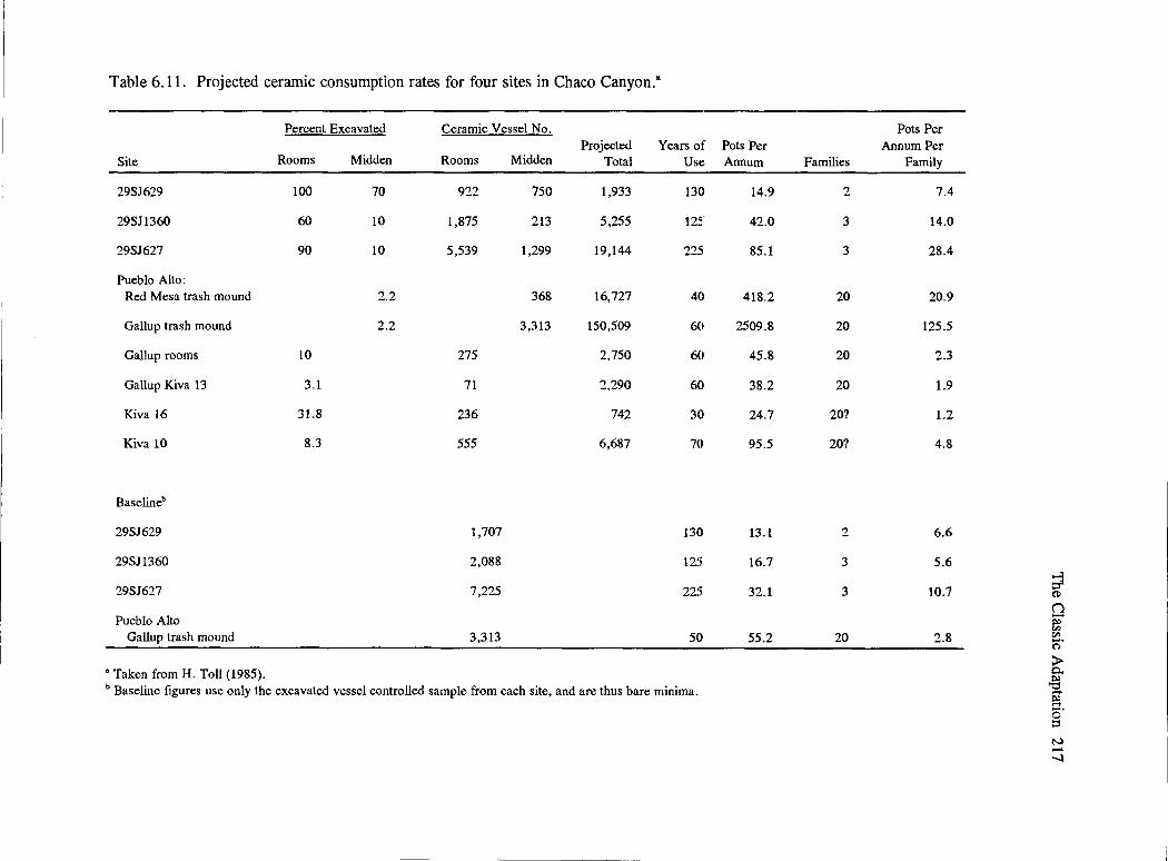
Table 6.11. Projected ceramic consumption rates for four sites in Chaco Canyon.a
Percent Excavated Ceramic Vessel No. Projected Years of
Site Rooms Midden Rooms Midden Total Use~
29SJ629 100 70 922 750 1,933 130
29SJ1360 60 10 1,875 213 5,255 125
29SJ627 90 10 5,539 1,299 19,144 225
Pueblo Alto: Red Mesa trash mound 2.2 368 16,727 40
Gallup trash mound 2.2 3,313 150,509 60
Gallup rooms 10 275 2,750 60
Gallup Kiva 13 3.1 71 2,290 60
Kiva 16 31.8 236 742 30
Kiva 10 8.3 555 6,687 70
Baselineb
29SJ629 1,707 130
29SJ1360 2,088 125
29SJ627 7,225 225
Pueblo Alto Gallup trash mound 3,313 50
•Taken from H. Toll (1985). b Baseline figures use only the excavated vessel controlled sample from each site, and are thus bare minima.
Pots Per Annum Families
14.9 2
42.0 3
85.1 3
418.2 20
2509.8 20
45.8 20
38.2 20
24.7 20?
95.5 20?
13.1 2
16.7 3
32.1 3
55.2 20
Pots Per Annum Per
Family
7.4
14.0
28.4
20.9
125.5
2.3
1.9
1.2
4.8
6.6
5.6
10.7
2.8
; (J)
n ~ r;:i n· > Q.
.§ i?l s· ::s N ...... --.l

218 Chaco Project Synthesis
activities (Saitta 1997; Wilcox 1993:Table 1). If these individuals were supposed to have low visibility to their contemporaries, what chance does an archaeologist have of identifying them? By their deeds perhaps we shall know them; it is less likely that we will know them by their houses (or their burials). (H. Toll in Toll and McKenna 1997:208-209; emphasis in original)
H. Toll concluded that the evidence from Chaco Canyon points to the presence of general specialists who participate in an exchange network rather than supply an elite group. They are integral to the household and local economy. The community specialization (e.g., Chuska gray ware producers) provides an integrative mechanism to maintain economic relationships. Chaco does show participation in this Anasazi-wide region that shares forms and symbols. H. Toll (1985; and H. Toll and McKenna 1997:211-213) suggested that costumbre, defined as a community's definition of what is done and how it is done, would be sufficient to account for the degree of standardization evident in the ceramic analyses, and would allow for the slight variations among communities that maintain contact on a periodic basis if they shared a common belief system. Although there would be some part-time specialists and some people with some differentiation in roles, there would be no need for an elite, use of force, or exploitation by leaders; pressures of public opinion would be sufficient to maintain traditions. Viewed from a larger regional perspective, Chaco was an obvious participant, but whether the center served the region or the region served the center remained unanswered.
Evidence for Ritual, Ceremony, and Cosmology
Several lines of evidence in the archaeological record point toward aspects of historic Pueblo ideology that may have been present earlier. Thus, when it proved unlikely that Chaco Canyon functioned as a economic redistribution center, Judge (1989) could propose that Chaco was a ritual center. The data indicate some time-depth to historic Pueblo practices, but we cannot make inferences about their earlier meanings or be sure that the meanings of these practices did not change through time.
Construction and/or Closure Offerings
Data relevant to ritual or ceremonial practices, either during initial construction or remodeling events, include goods cached within buildings. The earliest example of an offering is from the Basketmaker III great kiva at 29SJ423 (Mathieu 1997, 2001b; Windes 1975, 2006a). Senter (1939:26) indicates that two niches in Feature 5-an A.D. 770s pit structure at Be 50-also contained offerings (Truell 1986:Table 2.6). Truell (1992:90) found an offering in the Kiva G ventilator shaft at the small site of 29SJ627; but the turquoise debris and five Olivella dama shells are considerably later (A.D. 1000 to 1050; Mathieu 1992: 315). Truell was uncertain as to whether this offering was made during construction or was included with intentional fill. Similar offerings were uncovered at Pueblo Alto (Mathieu 1987; Windes 1987) and Kin Nahasbas (Mathieu and Windes 1988, 1989), among sites attributed to the Classic period. There were several turquoise caches in the great kiva at Chetro Ketl (J. Woods 1934a). Both Pepper (1920) and Judd (1954) had called attention to the placement of turquoise and other items in kiva pilasters at Pueblo Bonito and Pueblo del Arroyo. Judd (1964: 156) recorded three caches placed in walls of rooms 90, 178B, and 186, all falling within the fourth addition to Pueblo Bonito. Chaco Project excavations uncovered similar offerings, one of which occurred earlier and suggests that these practices may have had a long history. Historic Acoma, Hopi, and Zuni place similar offerings in some buildings (Parsons 1936: 300; Pepper 1920). Whether these practices carry the same meaning throughout this long period is unknowable, but they do suggest that construction deposits have considerable time-depth.
Akins (1985) suggested that some birds and mammals may have been acquired for ritual purposes (see also K. Durand 2003; Gordon Vivian and Mathews 1965); both Akins (1985) and Truell (1986) remarked on the intentional burial of dogs and turkeys when sites were abandoned. Most references to birds, including turkey, indicated they were kept for their feathers, which were attached to ceremonial objects (Akins 1985:322-330). Turkeys may also have been used for food, especially during later occupations in Chaco. Carnivores had multiple uses (Akins 1985: 349-356). Truell (1986:225-227) reviewed the literature to document that placement of animals in

structures during closure tended to be reported most commonly in the Mancos Canyon in southwestern Colorado (Emslie 1978; Gillespie 1976). She noted that at Be 50, Brand et al. (1937) found four kivas that included intentional turkey burials upon closure; and Senter (1939) suggested possible turkey and dog burials in Feature 5, an earlier pit structure at this site. These findings contrasted with the lack of similar practices at the neighboring site, Be 51 (Kluckhohn 1939b:34). Truell found only a few examples of this practice, which occurred in small sites dating ca. A.D. 700 or later. Similar practices had been recorded during a later period at Puebio dei Arroyo, where dog burials were recovered in kivas F and I. Voll (1978: 142) recorded the placement of the legs and skulls of four deer in the upper fill of an earlier lower story of Room 92 at Chetro Ketl. This type I masonry, room was intentionally closed prior to construction of the pueblo in the mid-A.D. 1000s. Windes (1993:404) suggests that culinary ceramics were intentionally destroyed and left in the firepits of primary pit structures at three small sites (29SJ626 East, 29SJ629, and 29SJ1360), probably in the early A.D. 1000s.
In addition to these special offerings, both during construction and closure of pit structures and kivas at small sites and great houses, Akins (1985: 343) surveyed the ethnographic literature to determine that bear remains often contribute to ceremonial practices. Several were recovered in the great kivas at Pueblo Bonito (Judd 1954) and Kin Nahasbas (Mathien and Windes 1988). Shell and turquoise offerings, however, were more abundant and possibly more important or represented different aspects of the ceremonial-ritual cosmology.
Possible Ritual Rooms and Practices
During his excavation of Pueblo Bonito, Pepper (1920: 193-195) recognized a number of artifacts that resembled ceremonial items used by historic Hopi and Zuni clans. For example, in Room 38 were the remains of macaws and a platform holding objects encrusted with turquoise and other tesserae. He thought that the macaws suggested the presence of a macaw totem similar to the Zuni Mula-kwe (People of the Sun). He compared human effigy vases from Room 38 and adjacent Room 46 with the He'he and He'he mana-modern Hopi katsinas. Some of the flagolets (flutes) collected from Room 33 are similar
The Classic Adaptation 219
to those used by Hopi flute priests. Thus, Pepper (1909:250) suggested the burials found above the floor of Room 33 may be representative of an early flute fraternity. He thought that the wealth of Pueblo Bonito, especially with burials 13 and 14 in Room 33, represented ceremonial paraphernalia of a priesthood or leaders who held important positions in Chaco society. He also considered Room 67, a kiva under the West Court, to have been a council house (Pepper 1899:2, 1920:251-254). Windes (1987[1]:373-377) suggested a predominantly ceremonial rather than multifunctional living purpose for several rooms with firepits constructed in the early A.D. i iOOs. Tne semisubterranean rooms tend to be located in front of big-room suites on the west side of Pueblo Bonito. Possibly earlier similar rooms include rooms 309, 315, and 316 at Pueblo Bonito; Room 21 at Una Vida; and Room 110 at Pueblo .AJto. Although we cam10t
make direct links with historic Pueblo social organization, these data suggest the institution of formal space for some type of clan or sodality practices during this period.
Cosmology
By the 1970s, the recording of pictographs and petroglyphs and studies of archaeoastronomy provided data to suggest that there may have been some time-depth to several Historic Pueblo practices. Reyman (1971) examined Southwestern archaeological sites to determine whether they were aligned with celestial bodies. In Chaco Canyon, he determined that the great kivas at Chetro Ketl and Pueblo Bonito did align with Ursa Major and that several other smaller kivas may have been aligned to stars during the Classic Bonito phase or later. These alignments were not unique to Chaco Canyon; they occurred at other sites in the Anasazi region. Reyman was not certain whether star alignments were relevant to these early Pueblo people, because historic Pueblo people do not seem as concerned with star alignments as they do with movements of the sun, in particular at the winter solstice.
Based on her extensive knowledge of Pueblo ethnology, Ellis (1975) proposed that sun-watching stations or observation sites could have been used to establish a yearly calendar and mark religious ceremonies early in time, and that these stations could be identified in the archaeological record. Several

220 Chaco Project Synthesis
investigators examined site locations and associated roads, pictographs, petroglyphs, and other features in Chaco Canyon to pinpoint such locations. Williamson et al. (1977) published observations that provided affirmation of her proposal. Two possible solstice observing sites (one east of Wijiji and one near Peiiasco Blanco) were identified. Both were at different ends of the canyon, both were associated with roads, both had clear sun symbols (two concentric circles with a dot in the center) painted on the canyon wall, and both were thought to be good places from which to observe the winter solstice.
Given the more central location of Fajada Butte and its prominence in the canyon, Williamson et al. (1977) were surprised that they did not discover similar evidence there. On June 29, 1977, Jay Crotty and Anna Sofaer, members of the Archaeological Society of New Mexico Rock Art Field School, climbed Fajada Butte and observed the interplay of light and shadow around three slabs and two concentric circles pecked on the wall face behind the slabs. Sofaer recognized the significance of the "Sun Dagger" shape during the summer solstice. She initiated a multiyear project that examined this site and two other petroglyph panels to the east and west at different times of the year (Sofaer and Sinclair 1987; Sofaer, Sinclair, and Doggett 1982; Sofaer, Marshall, and Sinclair 1989). The three-slab site marks the solstices and equinoxes, as well as the major and minor lunar standstills. The west side petroglyph site marks the spring equinox, and the east and west petroglyph sites mark solar noon. It is debatable whether the exterior corners of the three slabs on Fajada Butte are intentionally modified (Sofaer, Zinser, and Sinclair 1978, 1979), or whether the curvature is due to natural erosion (Carlson 1987; Newman et al. 1982).
Although Sofaer, Zinser, and Sinclair ( 1979) and Sofaer, Sinclair, and Doggett (1982a) indicate that the three-slab site on Fajada Butte had potential for anticipating both the solstices and equinoxes, Zeilik (1987) thought the 2 mm linear movement that occurred around the summer solstice would have been too small for detection by the human eye. He suggested that this site probably functioned as a sun shrine. Carlson (1987) questioned whether this site would have been used to mark lunar standstills, because the historic literature did not indicate these were relevant to Pueblo people. Carlson also con-
eluded that this site represents a sun shrine that marks the summer solstice and probably the winter solstice and equinoxes. He thought the sun-watchers who knew these events took advantage of the natural rock fall to mark the site with petroglyphs.
Dating these sites is difficult. Based on nearby features (e.g., closeness to roads), the pictographs at the sun-watching stations near Wijiji and Peiiasco Blanco have been associated with the Classic period or Bonito Phase (Williamson et al. 1977). Yet these two sites are also near the early Basketmaker III villages that included great kivas and were probably centers for local inhabitants. There is also Navajo reuse of the pictograph site near Wijiji. Sofaer, Zinser, and Sinclair (1979) attribute the Fajada Butte site to Chacoans living in the canyon between A.D. 950 and 1150; the nearby sites are Mesa Verde structures, which suggest A.D. 1220 to 1300 use, a period when it was customary to live on top of buttes or in rockshelters (Carlson 1987; Zeilik 1985a, 1985c). The Bonito phase associations may not represent an exclusive period of use.
At Casa Rinconada, Reyman (1971) noted solstice rising and setting points; but due to the location of the great kiva near mesas, he realized there would be a need for external points for observations regarding the sun's exact rising and setting points on the horizon that could be relayed back. He plotted such points, and on inspection found a series of burned areas to the WSW that rose in altitude, with the last or highest having a view of the horizon. One burned area to the ESE also marked a spot that would provide a view of the horizon. Thus, it was feasible that solstices were observed. Observations at Casa Rinconada by Williamson et al. ( 1977) confirmed that this structure may have provided a visual display of shadow and light patterns during the solstice and equinox periods. During these times, rays of light entering windows or niches in the great kiva cast their light on particular niches in the lower part of the wall. Reconstructed walls of this structure and the lack of knowledge about the original roofing conditions make it difficult to verify this suggestion. For example, was there an outer set of rooms at Casa Rinconada that would have blocked light rays coming through the northeast window (Williamson et al. 1977)? If not, would a post have obstructed the rays' path to Niche E (Zeilik 1984)? A similar situation exists at Pueblo

Bonito, where two of six corner doors (in rooms 228B and 225B) also capture light rays during the winter solstice sunrise (Reyman 1976, 1978a, 1978c, 1979). Were there exterior second-story rooms at Pueblo Bonito that would have blocked the light rays passing through the doorways (Williamson et al. 1977)? Or, as Cooper (1995) suggests, did they facilitate movement within a set of interconnected rooms?
Both Reyman (1987) and Zeilik (1985b, 1987) reviewed the ethnographic literature to determine some common Pueblo religious practices; Zeilik observed that the historic sun-watcher predicts the time of change in the sun's position. He noted the following points:
•
•
•
•
•
•
•
A religious office (usually the sun priest) is invested \Vith the responsibility of \Vatching the sun.
Observations take place at sunrise (usually) and sunset (less often) from within or close to the pueblo.
Observation sites with calendrical functions are most likely to be within or close to the pueblo; the place is rarely marked.
Horizon marks are most commonly used to establish the sun's seasonal position; observing light and shadow through windows is less frequently employed. Horizon markers can be rather small changes in relief; shrines may be located at the sun's key positions on the horizon.
The most important times in the ritual calendars are the solstices, especially in winter; the sun priest also keeps track of the basic planting calendar from April to June.
The sun priest must be able to announce the solstices ahead of time; he does so by anticipatory observations made about two weeks before the solstice when the sun is still moving a noticeable distance along the horizon each day.
The site and technique for the anticipatory observations are usually the same as those used for confirmatory observations.
The Classic Adaptation 221
The anticipation and prediction of events are important because people need time to prepare for ceremonies. At the solstice, the sun stands still for four days; therefore, the sun priest would have difficulty determining which day is the actual solstice. Learning how to make correct predictions would take a period of several years, during which the observation of horizon markers would be made and a count kept to determine the best time for the ceremony.
Zeilik (1987) applied these observations to sites in Chaco Canyon. Like Reyman ( 1971) and Wiiiiamson (i982; Williamson et al. 1975, 1977), at Casa Rinconada both anticipatory and confirmatory observations could be made. Yet the lack of knowledge about the original condition of this great kiva and the lack of historic use of great kivas as sunwatching stations cast doubt on this inference. At Pueblo Bonito, the two corner doorways could be used to confirm the winter solstice as well as anticipate it. If outer second-story walls were present, however, the views would have been blocked.
Architectural alignments also have been documented. Initial observations at Casa Rinconada and Great Kiva A at Pueblo Bonito indicated that they were constructed along the north-south axes of symmetry, as was the dividing wall in the plaza at Pueblo Bonito. The west side of the south wall that encloses the plaza has an east-west alignment. This documentation by Williamson et al. (1977) expanded the types of data that suggested astronomical knowledge by the Chacoans.
Using these observations as an initiative, Fritz (1978, 1987) attempted to discover what aspects of the ideational system could be detected in the spatial ordering of sites. He observed asymmetrical positions within sites (e.g., the east-west division of Pueblo Bonito into two plaza spaces), and among sites (e.g., the north-south axis that runs from Pueblo Alto to Casa Rinconada to shrine 29SJ1207 to Tsin Kletsin), and a north-south division of features in Casa Rinconada and through the canyon if one draws a line from Una Vida to Peiiasco Blanco. He interpreted these to represent social asymmetry, with those having the greatest power utilizing the great houses on the northern side of the canyon. Mediation between the sacred and everyday worlds was expressed through
222 Chaco Project Synthesis
architecture, which encoded both secular and religious ideas. Rotational symmetry in architecture also suggested balancing through the sequential rotational alteration of authority and responsibility. Although he could not determine whether the social system was composed of two distinct groups living in differentsize pueblos or whether there was sharing of power among two groups, Fritz (1978) demonstrated the ability to glimpse the ideological system through analysis of architectural evidence.
Continued investigations into the architectural expression of astronomical observations and markings were conducted by the Solstice Project headed by Sofaer (Marshall and Sofaer 1986, 1988). Solar and lunar orientations were found for the walls of great houses both within Chaco Canyon and the Chaco Core (Sofaer 1994, 1997; Sofaer, Marshall, and Sinclair 1989; Sofaer and Sinclair 1992; Sofaer, Sinclair, and Donehue 199la, 1991b). Stein and McKenna (1988) noted astronomical alignments among buildings in the Aztec complex. Malville (1999; Malville et al. 1991) recorded the lunar rise at a major standstill every 19 years between two stone pilars at Chimney Rock, 150 km to the northeast in southern Colorado. In addition to solar and lunar markings and expressions noted among great houses, Marshall (1997) suggested that Chacoan roads also may represent a cosmological expression. After an extensive review of the documented segments of Chacoan roads, Roney (1992) agreed. For an interesting summary of debate on Chacoan roads, see Gabriel (1991). Historic Pueblo people still schedule ceremonies in conjunction with the movement of the sun and moon, both of which are important to their ceremonial cycle.
In his keynote address at a symposium on early Pueblo astronomy, Judge (1987) emphasized that the most important issue is not that Chacoans were observant of astronomical events, but rather is how these observations were interwoven into their social organization. Williamson (1987) asked if we should be looking for purposeful astronomical alignments at all of these sites, or whether the functions of these sites were limited. Carlson (1987) thought that much of what we have observed may be due to fortuitous observations and does not apply to the Chaco culture. Jojola (1987), a native fromlsleta, shared that the sunwatcher, or Pueblo astronomer, functioned as an intermediary between the supernatural and the human
worlds; he uses three points of reference to crosscheck the cyclical progress of the year. These are the passing of the solstices, the phases of the moon, and the seasonal position of recognized constellations. It is the orderly passing of cyclical time and the ceremonies that take place that are important, not the study of the heavens for their knowledge of movements in and of themselves. Thus, Reyman's (1987) discussion of the role of the sun priest, whose major obligations are related to the yearly calendar and the scheduling of ceremonial events, provides a model for how a ritual ceremonial center in Chaco may have operated. Although he has power, he is not materially distinguishable from other members of society. Although the position of sun-watcher is passed down through clans, leaders can be replaced, and leadership can be transferred to other groups. This model might well fit within the parameters of the ritual ceremonial center that Judge (1993) proposed for the Chacoan system.
In summary, it is not possible to use ethnographic analogy for direct interpretation of Chacoan archaeology. Yet, there is long-term continuity for some practices in Pueblo society in which religious leaders are not clearly distinguished through material culture.
Summary
Research presented in this chapter indicates that Chacoan society during the Classic period probably consisted of fewer than 4,000 people living in the canyon. They supported themselves through reliance on agriculture, but utilized local economic plants, captured field pests, and participated in hunts or traded with neighbors in order to procure sufficient protein. Protein procurement, therefore, would bring them into contact with other groups, possibly widely disseminated across the larger region. The presence of imported ceramics, lithics, shell, and timber substantiate some form of interaction, which increased substantially from levels documented for the Basketmaker III-Pueblo I period.
Although the Chacoans were successful in coping with various periods of drought between ca. A.D. 850 and 1130, they still suffered nutritional stress due to a high-carbohydrate diet-typical of most early Pueblo people. When compared to other populations, the
--------

number of infant deaths was considered low, but evidence for anemia was present in 83 percent of the children under 10 years of age (Akins 1986). The underrepresentation of infants and children in the western burial rooms at Pueblo Bonito and high number of children at Kin Neole (Palkovich 1984) could be indicative of a small residential population in the canyon with other family members living elsewhere. Periodic visits into the canyon were proposed.
Akins's (1986) identification of two distinct burial populations in Pueblo Bonito indicates that social structure encompassed some form of sharing among the population at this site. When compared with each other, stature differences between the two groups were documented, but both groups tended to be taller than those utilizing the small house sites. Although her sample was small, Akins did find possible links between these two Pueblo Bonito populations and two distinct small house sites. If proven correct, this would indicate that relationships between these two types of sites were highly integrated and that many who used the great house may have been living in neighboring small sites.
Schillaci's (2003) confirmation of the distinct populations in Pueblo Bonito and their probable ties to earlier Basketmaker III populations in southwestern Colorado, and their later ties to both the Hopi-Zuni area and the Rio Grande, suggest that mobility of groups through time. Mobility among different genetic groups and increasing populations in the southern San Juan Basin by the end of the late ninth and early tenth centuries probably brought about a need for adaptations in social organization to smooth relationships among different groups, as well as ensure their survival. Two groups were able to establish formal burial repositories in the central and largest site in the canyon. Because there is evidence for more than one group living fairly close to another in some parts of the San Juan Basin during the Basketmaker IIIPueblo I period (Chapter 4), they would have built upon earlier foundations, possibly expanding the
The Classic Adaptation 223
levels at which decisions were made for different groups (e.g., continuation of use of turquoise and shell offerings during construction). Leaders may also have had a need to distinguish themselves from other group leaders, whether they were in either situational or ranked positions. How we interpret the closure of sites with different animal remains or ceramics has not yet been addressed, but the difference among these markers needs to be explored. Similarly, the variability in wall decorations around A.D. 1050 may be indicative of a need to mark rooms used by specific families/clans/sodalities,
The identification of several possible clan/ sodality rooms in great houses and Pepper's (1920) observations of resemblances of artifacts from Pueblo Bonito to historic Pueblo society indicate that mechanisms for integrating different groups may have been in place. That a cosmology existed that included knowledge of the movement of the sun and moon and probably a yearly calendar is likely. The documentation of two sun-watching stations, in addition to the solstice marker on Fajada Butte-all probably solstice observation sites-and other possible architectural features from which similar observations could be made suggest an early origin for some of this historic Pueblo cosmology.
If these lines of evidence are verified, any model of Chacoan social organization will have to be carefully evaluated to determine whether there were hereditary leaders or if the society operated under a more corporate mode. The Chaco Project, therefore, has raised many questions about early Pueblo society. Until we have better methods to estimate population and determine the seasonality of the use of large and small structures, as well as their functions through time, the amount and impact of mobility, and the chronological depth of Pueblo ritual/ceremonial practices, our explanations will remain only models to be tested by future archaeologists. (See Chapter 9 for an evaluation of models proposed for Chaco social organization.)


Chapter Seven
The Final Years (A.D. 1140 to 1300): Abandonments, Fluctuations, or Continuity?
From the beginning of Chacoan studies, students have recognized a late development in the Chaco Canyon sequence that had Mesa Verde-like qualities .... They mentioned a "Montezuma Phase" but generally regarded the post-Bonito occupation in Chaco Canyon as the result of immigration from the northern San Juan, i.e., an earlier "McElmo Phase," augmented by new arrivals from Mesa Verde and/or the northern San Juan. (McKenna 1991: 128)
The Mesa Verde Phase in Chaco Canyon ... has been a controversial and inconsistently recognized period of occupation. The turmoil surrounding the period, which can be generally assigned to the thirteenth century, stems from the lack of period-specific research in Chaco Canyon, poor definition leading to problems of recognition, and, in no small part, the name "Mesa Verde" applied to phenomena in Chaco Canyon. As in most phase definitions, ceramics played a large role in defining not only the event but the cultural and historical implications for the phase. (McKenna 1991:127)
Judd (1964) proposed an early, as well as a late, set of influences in Chaco Canyon from the San Juan area. The evolution of carbon-painted ceramic wares is the basis for discussion of the "Mesa Verde" influence in Chaco Canyon. Carbon-painted ceramics recovered from Be SO, Be 51, and Talus Unit No. 1 and identified as McElmo Black-on-white were thought to appear between A.D. 1050 and 1150, and possibly earlier in Chaco (Gordon Vivian and Mathews 1965:83). About the same time, McElmostyle masonry characterized the construction of Kin Kletso, the Tri-Wall structure at Pueblo del Arroyo, Casa Chiquita, New Alto, and other sites in the canyon where this pottery type was recovered. Thus, interaction between people living along the San Juan River and its tributaries and those in the central San Juan Basin was recognized. Explaining the interaction, however, remained a challenge. Although site components we now assign to the Late Bonito phase can be separated from those that belong to the McElmo and the later Mesa Verde phases (see Windes's revised chronological scheme in Appendix B: Figure B.1), this was not clear at the inception of the Chaco Project. Following a brief review of prior
------------
work, survey, and excavations at one site, as well as the ceramic analyses carried out by Chaco Project archaeologists, will be discussed within a broader framework of information available today on Pueblo use of Chaco Canyon and the San Juan Basin during the thirteenth century.
Past History
When Gordon Vivian and Mathews (1965:30) summarized knowledge about Chaco Canyon after A.D. 1130, there was limited data on which to base their interpretation. Kidder (1924:57) had documented Mesa Verde pottery in Pueblo Bonito, which suggested reuse of this site during the late A.D. 1200s. In conjunction with planned construction of a new park headquarters building, a small house unit and a four-room site were tested by Gordon Vivian in 1950. Both sites contained Mesa Verde Black-onwhite sherds. Another small pueblo (29SJS89, or Be 236) had Mesa Verde pottery in the upper levels (Z. Bradley 1971). Similar pottery was recovered by Gordon Vivian from Una Vida and in the upper levels at a number of other small sites, but data often were

226 Chaco Project Synthesis
not analyzed or the results of excavations were not widely disseminated (see sites classified as Pueblo III and Late Pueblo III in Truell 1986:Table 2.1). A brief review follows.
Headquarters site no. 1 (29SJ515) was constructed during the Classic period (Late Bonito phase) (Gordon Vivian and Mathews 1965:81). In plan view (Figure 7 .1) it was similar to Wijiji. Five of its rooms and one kiva had cored masonry constructed of soft sandstone blocks with dimpled surfaces, similar to that in early A.D. 1100s sites. No cultural materials were found on the floors, but 0.6 to 1.2 m (2 to 4 ft) of refuse above the floor contained one burial and Mesa Verde sherds similar to those found in a neighboring small site. This nearby four-room Headquarters site no. 2, located at the base of the talus slope, had masonry consisting of unshaped stones laid two stones wide. The rooms were small (1.2 x 2.1 m [4 x 7 ft]), and the floors were not compact but rather loose and sandy. Approximately 77 percent of the sherds were Mesa Verde Black-on-white; the remainder were McElmo Black-on-white (7 percent); Chaco Black-onwhite (5 percent); Escavada Black-on-white (3 percent); Gallup Black-on-white (1 percent); Querino Polychrome (3 percent); and St. Johns Polychrome (2 percent). These sherds were attributed to a Montezuma phase (Vivian and Mathews 1965:81).
Z. Bradley (1971) recognized that Be 236 (Figure 7. 2) had evidence for two periods ofuse. The original walls consisted of large blocks shaped by pecking and smoothing; the double-faced masonry had been laid on an underlying foundation. Floors were packed adobe and averaged 5.08 cm (2 in) in thickness. Floors for the secondary occupation were compacted fill; Bradley (1971:32) thought that rooms 8 and 9 may have been covered with a jacal structure. Eleven of 18 firepits from the site were located against walls. In Room 8, the earlier firepit was in the center of the floor; in the secondary occupation, it was placed against the wall, suggesting similar customs to those found in the Mesa Verde region. The original enclosed kiva walls were similar to Hawley's (1938) type 9 (i.e., rubble core with small slab facing); there were six pilasters. The lower levels of occupation contained a mix of Chaco and Mesa Verde sherds, while the upper levels were characterized by Mesa Verde pottery. The courtyard exhibited two periods of use: the earlier had a mix of Mesa Verde and
Chacoan sherds, while the later contained only Mesa Verde sherds. An infant burial, accompanied by a Mesa Verde Black-on-white bowl, was found on the floor of Room 2. A second human burial had been uncovered in a refuse area located ca. 7 .5 m (25 ft) southwest of the house; it had been eroding out from the surface and had been removed by Gordon Vivian in 1958. The presence of 51 turkey bones out of 57 total bird bones was similar to evidence that Dutton (1938) reported for the late occupation at Leyit Kin. At Be 236, 13 came from a deliberate burial of one turkey recovered from a deep firepit located along the west side of the house that was assigned to the secondary occupation. Bradley thought that this site was built around the early A.D. 1100s, abandoned between ca. A.D. 1150 and 1200, and reoccupied in the early A.D. 1200s.
The Gallo Cliff Dwelling (29SJ540, Be 288) (Abel 1974) is a small house block and kiva (Figure 7 .3) located on a talus slope under an overhang on the west side of Gallo Wash (Figure 7.4). The crude, unshaped sandstone blocks (Figure 7.5), similar to Hawley's (l 937a, 1938) type 10, were of varying sizes and were randomly laid, with occasional chinking stones between them (Abel 1974). Of the 762 sherds recovered, 74 percent were utility wares, half of which were classified as Chaco Corrugated. Of the decorated wares (26 percent of the collection), 12 percent of the total sherds were classified as McElmo Black-on-white and 6.3 percent as Wingate Black-onred. These were found predominantly in Room 5 and the kiva. Based on the ceramics recovered, specifically the McElmo Black-on-white, Abel placed this site's use between A.D. 1100 and 1200, and possibly later. Windes (personal communication, 2004) is uncomfortable with archaeomagnetic dates. ESQ 1466, formerly listed as A.D. 1370 .± 25, falls at A.D. 1330 on the 1990s revision of the curve, while ESQ 1475, formerly placed at A.D. 1250 .± 56, did not date. Based on Abel's ceramic analysis, Windes places the site at about A.D. 1200 or very late A.D. 1100s, with possible later use, but recommends reappraisal of the ceramics. Much material made from twine and over 2,000 turkey feathers were recovered; 50 to 85 percent of the fauna! remains represented turkeys.
Site 29SJ1912, also known as Lizard House (Maxon 1963), or Be 192 or Be 193 in Hayes's survey (1981), and site 29SJ827 (Voll's site Be 362; Voll

~·
II) ... o.iita111
Urtll 1~·
.... CQO' TO CLl,F J
[j ~ I
I I
0 ~ . " 0 0 z
" ... 0
z >-" 0
"
l 17'
I ~u
.--
\
I 1T•• Of WALL 4• ___.1 jl~ SUU~H)
I HO' TO QL!U )o
0 101
~-
Figure 7.1. Map of the Headquarters site. (Taken from Chaco Culture NHP Museum Archive, map C55320. Original map probably by Gordon Vivian.)
; (I)
'T1 a· e:.. ...:: (I) i;.l ..... (l:i
N N -..J
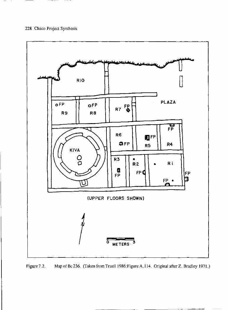
228 Chaco Project Synthesis
oFP
R9
oFP
RS
R6
OFP
R3
a FP
• RZ
FP
(UPPER FLOORS SHOWN)
O METERS 3
D
PLAZA
FP
IJFP
R5 R4
• RI
FP FP •
Figure 7.2. Map of Be 236. (Taken from Truell 1986:Figure A.114. Original after Z. Bradley 1971.)

Figure 7.3.
RI
R3 1"1 I I I I I I I I
R2
'""----~f"?' '
The Final Years 229
R4 ll I I i;------____ ___,_ - - - - -.7----~"'
0 I 2 3 METERS
Map of Be 288, the Gallo Cliff Dwelling. (Taken from Truell 1986:Figure A.117. Original in Chaco Culture NHP Museum Archive, No. 2149.)

230 Chaco Project Synthesis
Figure 7.4.
Figure 7.5.
View of Be 288 nestled inside of a rockshelter. (Chaco Culture NHP Museum Archive, Photo no. 31586. Thomas C. Windes, photographer.)
Close view of masonry at Be 288. (Chaco Culture NHP Museum Archive, Photo no. 3180. Milo McLeod, photographer.)

1964) included carbon-painted ceramics. Maxon suggested construction of Lizard House (Figure 7.6) shortly prior to A.D. 1100, when Chaco Black-onwhite was predominant and when carbon-painted wares were beginning to appear. Around A.D. 1130, when McElmo Black-on-white pottery was becoming predominant, the house was remodeled and used for 15 to 20 more years. Maxon suggested an orderly progression and not replacement of populations during this period. At Be 362 (Figure 7.7), Voll suggested construction around A.D. 1088 and remodeling around A.D. 1109. Agai11, the mingling of pottery types (McElmo and Chaco) did not suggest mass migrations, even though a Mesa Verde-style kiva and similar ceramic designs had been interpreted as an influx of people from the north by earlier investigators.
Carbon-painted ceramics had been documented at Leyit Kin (Figure 7.8) where, in Unit III, Kiva B construction incorporated the "Mesa Verde style" (keyhole type with four pilasters and a deep recess on the southern end). Reuse of a number of rooms, some of which had considerable fill above previously used floors (Dutton 1938), also suggested late occupation. Partitions in some rooms, new bins and fireplaces, a 40 percent use of carbon-painted pottery, and one extended burial under the floor of Room 16 (an infant with two Mesa Verde Black-on-white bowl sherds, pumpkin seeds, and a turkey carcass) indicated a different population from previous inhabitants at this site. No good dates were available.
The lack of tree-ring dates after ca. A.D. 1130 suggested that little new construction took place during the later periods. Gordon Vivian and Mathews (1965) thought that people either made do with existing structures or remodeled older ones by using salvaged beams. Based on masonry and pottery types, they presented the following chronological and use scheme for the canyon:
• Post-A.D. 1130 to early A.D. 1200s: There was a small remaining population that used crude masonry consisting of poorly shaped blocks to reline benches in the great kivas at Pueblo Bonito and Chetro Ketl. One date of A.D. 1178.± from burned firewood suggested that Kin Kletso was also in use in the late twelfth century. At Be 236, people using a carbon-
•
•
•
The Final Years 231
painted McElmo Black on-white pottery with a Mesa Verde design style provided the only evidence for new construction; remodeling of the kiva into a Mesa Verdean style suggested continuity during the late Chacoan period (Vivian and Mathews 1965: 112). This population, however, abandoned the canyon around A.D. 1200.
Between A.D. 1250 and 1275, there was reoccupation of parts of Pueblo Bonito, use of Una Vida, remodeling at Pueblo del Arroyo, and construction of a small site (the Headquarters site) and dumping of refuse in a nearby earlier pueblo. Be 236 also has evidence of reuse.
A.D. 1275 to 1300 saw use of mesa top locations to the east of the canyon; some on Chacra Mesa were considered defensive locations. The largest site was known as CM-100 (Vivian and Mathews 1965: 113).
From A.D. 1300 to 1350, there were a few Galisteo Black-on-white and Zuni glazewares at one site in the main canyon; thus, it was thought that perhaps some of these people may have remained in the area through the A.D. 1350s. Vivian and Mathews suggested that these people were part of a movement toward the Rio Grande population centers. The limited occupation in Chaco Canyon was thought to represent either continual movement of small groups or successive small group use.
At the inception of the Chaco Project, therefore, there was an outline, but only a tentative picture, of the twelfth- and thirteenth-century use of Chaco Canyon. Research issues included the composition of late populations, especially during the A.D. 1200s. Was there an influx of new people from the north into an abandoned area? How were these people related to earlier inhabitants of Chaco who used Mesa Verde-like pottery and architecture-especially keyhole kivas? What were the numbers of people involved? Why did they leave? Where did they go?
Chaco Project Research
Three types of research shed additional light on the late occupations in Chaco Canyon. A search for

232 Chaco Project Synthesis
Figure 7.6.
RS
' I
R6 Rl3
I ~.--~-'--~-1-~-1 I I 1,~~.J.,_-L.-~-.
I I
I R7A I I
I I I I
I I
L..-----1
RSA I I I
I '
Rl4A
- - - - - - --- - -' '--- - ____ __.
----------- -- ----------------.
0 I METERS
RI
2
Rl7
Map of Lizard House. (Taken from Truell 1986:Figure A.113. Original by Maxon 1963:Figure 1.9.)

Figure 7.7.
0 I 2 3 METERS
The Final Years 233
Map of Be 362. (Taken from Truell 1986:Figure A.115. Original by Gordon Vivian and Mathews 1965.)

234 Chaco Project Synthesis
I I
ii I I
I I I I I
I t
I I t I I I
Rl2 I I I I I I
___ _(] __ _
R13 Rl4 ••
~-- - ....
I
Figure 7 .8. Map of Leyit Kin. (faken from Truell 1986:Figure A.102. Original by Dutton 1938.)

archival material at other institutions brought forth some previously unavailable data from past excavations. Surveys carried out as part of the Chaco Project, and later by Windes, as well as limited excavations and analyses, provided information on this least understood period in and around Chaco Canyon.
Archival Research
Examination of Roberts's field notes (Smithsonian Institution National Anthropological Archives, No. 485; Chaco Culture NHP, Archive No. 2108) and written materials obtained from the Harvard Peabody Museum shed light on three additional sites with evidence for late occupation. Two small sites near Wijiji were excavated by Roberts in 1926 (Roberts 1927:246-247). One large pueblo was excavated by Tozzer and Farabee in 1901(Andrews1970; Mathieu 2002). Pertinent details follow.
Turkey House, or Roberts' s Small House, is now identified as 29SJ2385 (Truell 1986:Table 2.1). It is located at the foot of talus that flows out from the cliffs on the south side of the Chaco Wash, just east of Shabik' eshchee Village. Roberts excavated nine of possibly 10 rooms and the East Court in this Be-like structure. There are probably one to three kivas in this site (Truell 1986:Table 2.1). In Room 6, three floors were identified; a northeast comer fireplace was associated with the uppermost floor, which contrasts with a center fireplace described for the middle floor. Comer firepits were also recorded in rooms 4, 7, and 8. Remains of turkey were abundant throughout the rooms. Several burials were recovered from the rooms and the trash midden. Akins (1986:Table B. l) associated six burials from the trash midden with Gallup Black-on-white ceramics; burials recovered from the house (e.g., an adult male in the northeast corner of Room 7, and a young child covered by a stone slab in the East Court) were placed in an unidentified later period. Pottery types from the site include some early types; for rooms I through 5, Mesa Verde pottery and some red wares were present.
The second small site excavated by Roberts, located one mile east of Turkey House, has not been assigned a name or survey number. From the available notes, it is difficult to determine its plan. Roberts excavated at least three rooms (rooms 6, 7, and 9), where several children and adults, accom-
The Final Years 235
panied by Mesa Verde ceramics but little else (Akins 1986: 105), were found on the floors. Although most burials were represented by numerous skeletal parts; in Room 7, only the skulls of two children were recovered.
The Mesa Tierra great house (LA 17220) was described by Roney ( 1995, 1996) as one of a few large isolated sites dating to the Mesa Verde period. It is located on a mesa top just west of Chaco Canyon and was excavated in 1901. Farabee (1901) estimated that it contained approximately 40 rooms, but only 25 could be traced. Seven rooms and three kivas were excavated. Walls were badly eroded; a few photographs suggest use of irregularly shaped rocks for construction. One human skull was recovered in a hearth in the kiva (Room 8). Ground stone, bone, and ceraniic artifacts were predominant (Mathieu 2002:Table 2). Excavated ceramic types included Pinedale Polychrome, St. Johns Polychrome, and Mesa Verde-type sherds (Andrews 1970). Ceramics from a survey sample (Marshall et al. 1979:79) included Mesa Verde Black-on-white (most common), Wingate Polychrome, St. Johns Polychrome, and a Kwakina-style polychrome, which suggest an A.D. 1200s assemblage.
Data from these three sites reinforce the conclusion that there was reuse of earlier small sites, but whether this indicates decreased population or abandonment and reuse was not apparent. The location of the great house in a defensive position, the irregular masonry, and the late ceramic types indicate that new construction of a large site did take place to the west of the canyon.
Survey
Hayes (1981) acknowledged overlap in the use of small and large sites, with two types of large sitesBonito-style and McElmo-style architecture-from about A.D. 1075 to the mid-A.D. 1200s. Based on architectural traits (fine-banded, darker sandstone masonry, vs. large, shaped blocks of lighter soft sandstone) recorded during survey, Hayes (1981 :20, 29-34) subdivided the Pueblo III period into early (A.D. 1050 to 1275) and late (A.D. 1275 to 1350) phases, but noted that there was much confusion in ceramic types (the early presence of Mesa Verde Black-onwhite). For Early Pueblo III, he considered an early

236 Chaco Project Synthesis
McElmo expression, noted especially by the appearance of Wetherill Black-on-white and an early form of McElmo Black-on-white, as well as Chacomade copies, to date sometime after A.D. 1075. Hayes (1981:29-30) was not sure there was sufficient evidence to indicate that people, and not copied traits, moved from north to south. In Hayes's Late Pueblo III period, McElmo and Mesa Verde black-on-white were the predominant pottery types. This period included reductions in population, with only a few people remaining into the early A.D. 1300s. A similar long late period of occupation was discerned during the additional lands survey: A.D. 1130 to 1230 (date group 500, when there is very little evidence of use of the area) (Mills 1986). Mills included the late occupation at Kin Klizhin, as well as a Chacoan structure (CM-100) and great kiva on Chacra Mesa, among the sites falling within this period. She thought the system still operated and encompassed sites within the Chaco Halo (a 10-km area around the canyon) in some type of exchange.
Hayes (1981 :Figure 20) illustrated the distribution of Late Pueblo III sites in the canyon bottom. Although there were fewer sites, they tended to be distributed fairly evenly throughout the canyon. The earlier high number and tight cluster of sites in and around Pueblo Bonito at South Gap were no longer visible; only the hint of clustering remained. In later resurvey to update his population estimates, Windes (1987[1]:404) commented on the difficulty of identifying sites with Mesa Verde occupation along the south side of the canyon because houses from the earlier period were often reused. Because trash deposits were no longer placed on middens, but could be found during excavation (e.g., at 29SJ633) (Truell 1979), Windes thought that we may be underestimating the number of people living in the canyon during the A.D. 1200s. He also thought that sites on the canyon floor were fairly evenly distributed.
Windes's examination of the Chaco East community, located east of the park boundaries and about 3.2 km (2 mi) west of Pueblo Pintado, revealed the presence of a small population in the early A.D. 1100s and widespread use of the area in the late A.D. 1100s and 1200s (Windes 1993; Windes et al. 2000). Thirty-nine houses were assigned to the period from A.D. 1175 to 1300; some were located on the north side of the canyon on south-facing cliff ledges. A
number of storage areas were also constructed in cliff shelters. Based on ceramic types and the construction of new houses over older ones, Windes et al. (2000:50) thought there was a break between the early A.D. 1100s occupation and the late use of the Chaco East community area.
Excavations
Although there is very limited evidence of late use at Pueblo Alto (Windes 1987[1]:172-175), one excavation that included evidence for the Mesa Verde phase was carried out by Marcia Truell and LouAnn Jacobson at 29SJ633, a small house in Marcia's Rincon (Figure 7. 9) that had been constructed during the late A.D. 1000s to early A.D. 1100s (Mathien 199la). Data from one and one-half rooms indicated that the central room block had been modified during the late A.D. 1100s to early A.D. 1200s. Sometime after remodeling, four burials (one adult male and three infants) were placed in these rooms before the roofs were removed, the walls collapsed, and some burning of layers above the floors took place. The rooms were subsequently filled with trash, which must have been discarded by people living in the area. Differences among the early and late occupations include floor features. Truell (in Mathien 199la:116) found that the initial builders constructed heating pits, while the later occupants were satisfied with fires that left only floor bums. This suggests that repeated cooking was not carried out during the last occupation. It is not possible to determine whether living in these rooms during the later period was unplanned or the rooms were used only for a short occupation.
Based on her examination of small site architecture, Truell (1986:302, 308) asked if reuse of earlier sites, or especially sites in overhangs, indicates a Mesa Verde migration into the canyon or a continuum of earlier populations that had a San Juan affiliation at this late date. Sherds from the A.D. 900s were present on some talus locations that had late Pueblo III evidence.
Analysis of fauna from 29SJ633 also documented change. Gillespie (1991) indicated a strong reliance on small mammals and turkeys at 29SJ633 during the Mesa Verde phase. Lagomorphs predominated; the abundance of small, immature cottontails was unusual. Although there was definitive evidence for summer

- - ~ 2 - -1 I R 4 I I R6
RI
0 I 2 3 METERS
R3 R5
BG :9Rl3 1---,_
,, ,_ ._
(
, 1" ..... '
I \
\ K\VA 2 ~ ' I ' / ....... __ ,, r--
Figure 7.9. Map of 29SJ633. (Taken from Truell 1986:Figure A.116. Original by Truell 1979.)
(Not excavated)
;i CD
'T1 s· e:. ~
°' e; Cl>
N w -.J

238 Chaco Project Synthesis
and fall use of the site, winter use could not be ruled out. Dogs were notably absent, and artiodactyls were scarce. To Gillespie, these data suggested stressful living during this late occupation. The large number of turkey bones, and the appearance of charring on 3. 3 percent of them, suggested that this bird became a contributor to the diet.
Use of turkey, probably for feathers, started earlier, and increased progressively, possibly supporting Gillespie's conclusion. At Pueblo Alto, Akins (1985:Table 7 .25) lists three NISP during the Early Bonito phase; 68 NISP during the Classic Bonito phase; and 878 NISP during the Late Bonito phase. At 29SJ633 there was an increase from three NISP during the earliest site use to 681 NISP during the late period. At the Gallo Cliff Dwelling (Be 288), over 2,000 turkey feathers and 50 to 86 percent of the bone recovered were assigned to turkey. That so few people would need so many turkey feathers would suggest either a major change in how feathers were used (ceremonially or for blankets) or use of turkeys as food. It seems likely that the change in reliance on turkey for food may have started during the Late Bonito phase but increased considerably during the Mesa Verde phase, especially because there were few large game animals among the fauna! remains at 29SJ633.
The human remains recovered from excavated sites suggest a small population that buried their dead at home. Akins (1986) classified human remains from 29SJ633 with those from Be 236 (one burial), Leyit Kin (one burial), and Roberts's small house site (five burials). At 29SJ633, all three children were placed in burial pits excavated into the upper room floors. Two of three were placed in lined pits; two of three (but not the same two) had ashes placed over their abdomens, as did one child found in the upper levels of Room 290 at Pueblo Bonito. Two had cranial deformation. In the pit with Burial 2 was one piece of turquoise; this was the only ornament found with burials at 29SJ633. None of the adult burials assigned to this period had ornaments clearly associated with them, but there was a piece of worked selenite and a faceted barite crystal near the adult male at 29SJ633. Adults from this period were oriented north-south, while earlier ones were oriented east-west. The adult male from 29SJ633 was taller than the other male skeletons from small sites; his height was in the range
that Akins recorded for males from Room 33 at Pueblo Bonito. He suffered from hypoplasia (on canines) and trauma (on vertebrae). With so few burials in this sample population, Akins (1986) found it difficult to reach strong conclusions, but the similarity in height to burials from Pueblo Bonito offers food for thought and might support continuity in late use of 29SJ633 by descendants of the earlier population. The recovery of only skulls at Roberts's small site and Mesa Tierra is unusual, but not unprecedented. Akins (1986:Table B.1) lists a few others from earlier sites; whether or not this may indicate a rare continuity of practice needs further investigation.
An important contribution from this excavation was the ability to use the ceramic data to refine the definitions of pottery types with Mesa Verde characteristics. As noted above, the crux of the problem is understanding the shift from mineral- to carbon-painted ceramics. Careful study of sherds excavated by Judd (1959) at Pueblo del Arroyo led to a detailed description of Chaco McElmo Black-onwhite (Windes 1985). This first carbon-painted type differs from McElmo Black-on-white, a distinction not clear to earlier investigators. Chaco McElmo Blackon-white incorporates traits found in other Chaco, Cibolan, Mesa Verdean, and Tusayan traditions; whether or not this represents a blending of people or ideas needs further investigaton.
When H. Toll et al. (1980) examined clay, temper, retiring colors, and types for the late periods in Chaco, they found that Chaco McElmo Black-onwhite was not solely locally produced. It was considered a regional or Chaco system type, some of which was imported from the Chuska area to the west. By comparing its characteristics with McElmo and Mesa Verde black-on-white types, shifts in the diversity of tempers and paste colors indicated that the transition from Chaco McElmo to Mesa Verde ceramic types was gradual. The following summarizes the approximate time frame and some of the differences between the mineral-painted and carbon-painted pottery types as they are now defined for Chaco Canyon (H. Toll et al. 1980).
Chaco Black-on-white is a member of the mineral-paint Cibola white ware series and is dated between A.D. 1075 and 1150. Although associated

most often with great houses, it never exceeds 1 percent of the ceramic assemblages (H. Toll and McKenna 1997:334). The quality of its craftsmanship and its striking appearance may often lead to enhanced significance; for example, Neitzel and Bishop (1990: 69) suggested that it may represent an elite possession.
Chaco McElmo Black-on-white marks not only the shift to carbon paint, but also a change in designs and their execution. This introduction of carbonpainted pottery was considered by some investigators to be an indication of influences entering Chaco from the north (e.g., Gordon Vivian and Mathews [1965], who included sherds of this type in their McElmo Black-on-white category). It is considered similar to the McElmo Black-on-white of the Mesa Verde series, with which it can easily be confused. Dates of use span the period from A.D. 1100 to 1150.
McElmo Black-on-white sherds from the Chaco Project were often classified under the Pueblo IIPueblo III (PII-PIII) carbon-on-white category (H. Toll and McKenna 1997:377), which dates to approximately A.D. 1075 through 1300. Tighter dates for McElmo Black-on-white are A.D. 1125 to 1225 (H. Toll et al. 1980:Figure 2).
Mesa Verde Black-on-white is a distinct type in Chaco Canyon that dates from A.D. 1200 through 1300. It is not an import from Mesa Verde, however. Temper studies suggest that some vessels (26 percent) were made locally; some (7 percent) in the Chuska Mountains; and some (SO percent) along the San Juan River (H. Toll and McKenna 1997:392).
The detailed ceramic analysis from 29SJ633 led McKenna and Toll (1991) to reaffirm their placement of29SJ633 in a continuum within the regionally based ceramic attributes, even though there are some fundamental differences between the Mesa Verde Black-onwhite and the Pueblo II-III carbon-on-white ceramics from the earlier period. During the later period, decorating systems changed; motifs decreased in number; and placement of bands around the rims as parallel framers became prevalent. Temper analysis revealed that ceramics from 29SJ633 were similar to types at other sites in the canyon with regard to the primary presence of sandstone or quartz sand. Trachyte temper from the Chuska Mountains was also present, but in a smaller proportion of the sherds than the igneous
The Final Years 239
tempers from the San Juan area, which was the predominant nonlocal temper material found in the carbon-painted ceramics. Through time there was a marked change in rim form from tapered to flat to beveled. By the late A.D. 1100s and early A.D. 1200s, the presence of Socorro Black-on-white bowls, pitchers, and jars suggested that specific sets of forms were being obtained from the south. McKenna and Toll (1991) indicate that none of the ceramic assemblages were exclusively used or deposited as sets; a variety of vessel forms were imported from different areas. Although there was a continuum in the diversity of pottery types, sources 7 and forms, there was a decline in the variety of forms through time, which possibly indicates increased seasonal use of the site during the Mesa Verde phase. Bowls and personal-service items such as ladles, mugs, and cooking jars were the only forms found among the decorated sherds.
This analysis suggested a shift in the center of a regional system from Chaco Canyon to the San Juan area instead of a distinct migration of northern people into Chaco Canyon after an abandonment.
... we have shown that considerable amounts of pottery were still being moved into Chaco Canyon although it is not clear if this was the result of the nature of Chaco Canyon or the nature of pottery as a commodity per se.... The complementary nature of decorated and utility wares in the series that makes up the late assemblage suggests that ceramics were not acquired as random additions but were selected for specified functions. The level of imports, the continuity in sources with past assemblages, and the technological compensations undertaken with the decline in Chuskan grayware all suggest a regional system adjusting to changing conditions but enduring. Our view regarding some fusion of Chacoan and San Juan traditions for this assemblage still holds. The assemblage is sufficiently similar to earlier and contemporary complexes to suggest that human occupation encompassed a variety of ceramically related activities that continued for an indeterminate time. (McKenna and Toll 1991:205)
---------- -~--
240 Chaco Project Synthesis
Decreased population of Chaco Canyon in the mid- to late A.D. 1100s was not as well organized as that of the earlier Classic period, but people did obtain vessels from many of the same areas as previously. The Mesa Verde Black-on-white ceramics represent continuity of residency in the area by people who were more completely tied to populations and events in the north or San Juan area. McKenna and Toll (1991) suggested that the San Juan area had become the focus of an economic system that replaced the Chuska Valley supply area, and that the focus of the region shifted from Chaco Canyon to the Aztec community along the San Juan River. Thus, the hypothesis of a Mesa Verde migration into an empty Chaco Canyon was not upheld (McKenna and Toll 1991; Toll et al. 1980).
Other artifact analyses support some continuity and some change during the Mesa Verde phase. When Cameron (1991) compared the chipped stone from the two occupations at 29SJ633, she demonstrated that while there was continuity in lithic sources, there was much less use of nonlocal materials during both phases at this small site than there was for earlier phase material from Pueblo Alto. Included in the Mesa Verde phase were a few pieces of obsidian from Jemez Ridge and Red Hill, two sources from which material recovered on earlier sites had been obtained. Also present were 31 pieces ofNarbona (Washington) Pass chert (from the Chuska Mountains area), 10 pieces of yellow-brown spotted chert (from the Zuni area), and four Morrison Formation cherts. Technology of manufacture was expedient.
Analysis of ornaments and minerals indicated continuity in forms and materials as well; again, there were fewer imported materials during the Mesa Verde phase than had been seen during the Late Bonito phase. Mathien ( 1991 b) found that the imported shell species were few (Glycymeris gigantea, Haliotus cracherodii, and Olivella dama) and similar to species found during the Basketmaker and Pueblo I periods. As noted above for obsidian, this change suggests a return to earlier patterns that existed during the Basketmaker III and Pueblo I periods. Does it represent a change in trade networks or an elimination of more widespread or sophisticated exchange relationships for the Classic period?
In summary, Truell's excavation of29SJ633 (in
Mathieu 199la) raised several questions about continuity in the use of the Chaco Canyon area, movements of people within the region, and the meaning of the changes noted. Gwinn Vivian (who reviewed sections ofTruell's report) subdivided the Mesa Verde phase into two components: Late McElmo and Early Mesa Verde (A.D. 1170 to 1220), and Late Mesa Verde (A.D. 1220 to 1350). These divisions were based on survey ofChacra Mesa during the late 1950s, which revealed the presence of crescent-shaped sites and cliff dwellings that he considered contemporaneous and attributable to the period when McElmo and early Mesa Verde black-on-white types, plus St. Johns, Houck, and Querino ceramics, were being used. (McKenna [1991] now recognizes Houck and Querino ceramics as part of the Wingate Polychrome series dated ca. A.D. 1175 to 1210.) Fortified buttetop sites with later ceramics were fewer in number and found in different locations. Gwinn Vivian (1974a) thought that these sites dated to A.D. 1250 and possibly later. He attributed the change in locations to a shift in farming practices from those using floodwater irrigation to those using dry farming techniques; the higher altitude and cooler temperatures, and perhaps increased precipitation, would have allowed this change. Areas farther east of the canyon had been settled late-only after A.D. 1075 to 1100. The changes in rainfall patterns at A. D. 1080 were thought to initiate a slow decline in the Chaco dominance of the San Juan Basin; the later droughts of the twelfth and thirteenth centuries were more difficult and necessitated continuing changes that result in the Mesa Verde phase (Vivian 1990:383-389).
The slow eastward movement is now accepted by some investigators. "This intense late occupation is evident east of the East community, shifting to the top of Chacra Mesa east of Pueblo Pintado Canyon (Roney 1996). Overall, classic Mesa Verde Black-onwhite, marking occupation by 1250 or later, was rare" (Windes et al. 2000:43). Windes (1987, and in Cameron and Toll 200l:Table 1) now divides the Pueblo III period into two phases:
The McE/mo Phase. This phase falls between approximately A.D. 1140 and 1200. It is characterized by the presence of McElmo Black-on-white sherds and an indented corrugated pottery with rock, sherd, and sand temper. Dendroclimatological reconstruction indicates that this period included a

severe drought from approximately A.D. 1130 through 1180. The canyon area was considered mostly depopulated during this period.
The Mesa Verde Phase. This phase is dated between A.D. 1200 and 1300. Mesa Verde Black-onwhite and indented corrugated (with rock and sherd temper) characterize the period. Repopulation occurs; and Aztec East, a large Chacoan site on the Animas River, is constructed.
In summary, at the conclusion of the Chaco Project, researchers had better chronological control of the carbon-painted ceramic series in Chaco Canyon. The blending of traits visible in Chaco McElmo Blackon-white and the recognition that it was made in several subregions of the San Juan Basin suggest a need to discern whether this represents a mixing of people, ideas, or both, beginning around A.D. 1080. The evolution of the carbon-painted ceramic series indicates that this was a gradual transition and not major migration into the canyon from the north.
Due to the lack of ceramic evidence on the surface of some small sites that were reused in later times, there are still problems with the identification of Mesa Verde phase sites and settlement patterns, both in Chaco Canyon and throughout the San Juan Basin. What is needed is a detailed reassessment of the number of sites and their locations; of whether they represented single components or the reuse of previously inhabited areas, and of the settlement patterns (especially the identification of communities).
Based on his sample resurvey data, Windes (1987[1]:404) was able to correlate the decreased populations or possible abandonment between A.D. 1130 and 1180, and the final departure of the Pueblo people from the canyon in the late A.D. 1200s with two unusually long drought periods that Bums (1983) indicated would be disastrous for com production. Because so little time was devoted to this period, the social implications for the inhabitants of the canyon and the larger region were not pursued.
Discussion
A reaction to the stress of major droughts (A.D. 1130 to 1180, and A.D. 1276 to 1299) may have been the abandonment of the San Juan Basin and Four
The Final Years 241
Comers area of the Anasazi region. Yet some evidence for cultural continuity exists. Evidence for the Mesa Verde phase in the Chaco Basin includes sites located in the bottomlands of Chaco Canyon, as well as in the Chacra Mesa uplands, near Pueblo Pintado (Pintado Gap, and east of Pintado Gap). Sites are also documented as far south as Las V entanas and the Rio Puerco. Known communities include the Chaco East community (Windes et al. 2000); Mesa Tierra (Marshall et al. 1979; Mathien 2002); the CM 100 area, and one settlement to the north (Jacobson and Roney 1985); Pueblo Pintado; and possibly Raton Springs (Marshall et al. 1979; Wait 1983:181-184). No communities are documented for central Chaco Canyon; but firepits in some of the upper levels of filled rooms in great houses suggest that some activity took place at least a few times in these sites. They were not, however, the centers of activity they had been in earlier years.
Based on a review of data on known Mesa Verde phase site locations from the inventory survey of Chaco Canyon, the additional lands survey, and the Chacra Mesa sites documented by Jacobson and Roney (1985) (which included Gwinn Vivian's data from the late 1950s), Mc Kenna ( 1991) commented on the diversity of site types that were utilized during this late occupation. Some were classified as expedient constructions; among these were small talus-boulder shelters and granaries, open adobe rooms, masonry pueblitos on butte tops, jacal buildings and augmenting masonry rooms, and small boulder-backed pueblos. There was a reuse of existing buildings (e.g., at 29JS633, Be 236, Be 52, Leyit Kin, and Be 51), as well as construction of new units (Headquarters B, Unit III at Leyit Kin, and the area ofKiva 6 at Be 51). Some commonalities among sites include small, single-story, accretional construction and a blocked-in keyhole-style plastered kiva. Rooms had small firepits located near the walls, paired slab metates in bins, and subfloor burials. None of this data reflect the high labor input that was seen during the Classic period.
McKenna (1991) suggested that Mesa Verde ceramics included subregional types, but represented a broad regional continuum. If so, what was happening throughout the region? When Stein and McKenna (1988) conducted reconnaissance survey of great houses and other small sites in the Animas

242 Chaco Project Synthesis
Valley, a number of Chaco and Mesa Verde great houses extended along the San Juan River from Blanco to Shiprock, as well as on the Animas and La Plata rivers (Stein and McKenna 1988:Figure 13). Most of these sites are attributed to the late eleventh and twelfth centuries. They found a large community around Aztec Ruins National Monument, and perhaps a similar large community at the Kello Blancett site to the southwest.
Like Gwinn Vivian (1990), McKenna (1991) thought that changes in subsistence (i.e., more reliance on small mammals and turkeys and a shift from flint to flour com) were taking place; he therefore concluded that there were definite alterations in the subsistence strategies that had earlier beginnings. By the Mesa Verde phase, Chaco Canyon could have represented an alternative to the more densely populated riverine communities along the San Juan; it could have been an alternative planting area for a small population. McKenna considered the San Juan as the regional center, with Chaco as a location with reduced population and an altered community structure. He could not determine whether the Mesa Verde phase in the canyon represented reorganization or increased use by additional groups, or a combination of both. For McKenna, the Mesa Verde phase was not representative of a migration of people into the Chaco area. Rather, the Mesa Verde pottery that has been found was part of an ongoing development and use of a regionally distinct black-on-white horizon style. A major problem still exists because of the lack of dates for excavated sites and lack of association of Mesa Verde Black-on-white with construction.
Stein and Fowler (1996) supported the idea of continued use of the San Juan Basin until final abandonment in the middle A.D. 1300s. They proposed that the great house complexes (with great kivas and roads) do not represent normal living spaces for people who had been organized in communities from the seventh through fourteenth centuries. Instead, they represent integrative architecture for either a community or a region. In this scenario, the architectural manifestations have specific functional roles in the local community. The complex in Chaco Canyon would represent a set of regional integrative architecture that during the early A.D. 1100s clearly shifted away from Chaco Canyon and ended up soon
thereafter in the Totah region, north of the San Juan River. Using data from several subareas, they indicated the continued presence of big houses or compounds throughout the region, and cited several instances in which newly constructed big houses are tied to older compounds by road segments. They did not see a displaced Chacoan population, but rather a planned renewal of "ritual" facilities. This renewal was undertaken at a community and a regional scale. While older elements of the culture were important, new architectural styles (beginning with the McElmo style of construction by A.D. 1100 to 1140) denote the beginning of this shift. The continuity that McKenna argued for black-on-white ceramic types (with Mesa Verde Black-on-white being the last of this series) is also apparent in the architecture throughout the San Juan Basin and its periphery.
On the basis of stylistic ceramics, architecture, and settlement patterns, Roney (1995, 1996) documented changes from the A.D. 1100s through 1350 in the larger region of the San Juan Basin. Divergence from the Chacoan regional network began during the early A.D. 1100s, when northern sites adopt carbon paint (the McElmo and Mesa Verde black-on-whites), while the south retains mineral-painted ceramics (Tularosa Black-on-white) and demonstrates a gradual evolution of sites. Thus, the earlier system that evidenced more uniform use of Gallup and Escavada black-on-white types and the construction of public architecture (great houses, greatkivas, often connected by roads) slowly disintegrated.
During the drought from A.D. 1130 to 1180, the Red Mesa Valley, the Dutton Plateau, and the floor of the San Juan Basin are mostly abandoned. A number of communities that are defined by the presence of Mesa Verde ceramics are found along the Rio Puerco at this time. Three communities that had been established earlier (Chaco Canyon, and the Guadalupe and Salado communities) continued, albeit with greatly reduced populations. Roney (1996) considered the possibility that these were abandoned by A.D. 1150. Between A.D. 1150 and 1200, however, new settlements were begun (e.g., at Torreon and Jones Canyon, and possibly at Ojito and Coots Ridge). Separated from these communities by vast distances are others that survived on Chacra Mesa, along the San Juan River, and in the Chuska Valley, and a few to the east of the Rio Puerco Valley. Based on

ceramic types, by A.D. 1350 the southern San Juan Basin can be divided into three distinct subdivisions: the Western, or Acoma-Laguna, area (Tularosa tradition); the Eastern (Mesa Verde tradition); and the Lower Puerco (Socorro tradition). Along the middle Rio San Jose, there is some overlap of the Mesa Verde tradition with the western tradition, especially in the area around Acoma Pueblo. Sherds from the Socorro tradition are found in both the Tularosa and Mesa Verde tradition sites. In the north, this evolution comes to an end at about A.D. 1350, and the area is abandoned, while in the south, although there are changes in settlement pattern, there is continued occupation of major areas into the Historic period.
If continued ceramic traditions indicate participation in a long-established group, during the period from A.D. 1100 through 1350, a major division between those using carbon and mineral paints took place. Roney (1996) suggested that the fuzzy ceramic borders at the eastern San Juan Basin flow over into the Rio Grande area (the close relationship of McElmo/Mesa Verde and Santa Fe types), which would suggest ties between these peoples. However, migration, or a slow movement of people from the Mesa Verde and Chaco areas through the Rio Puerco Valley and into the Rio Grande, seems unlikely because both the Mesa Verde and Rio Puerco areas are abandoned at the same time (but see recent comments by Baker and Durand [2003:188-189], who propose movement downstream to Hummingbird and later possibly to Pottery Mound, thus indicating possible continuity through time). The presence of Mesa Verde peoples in both the eastern San Juan Basin and the Rio Grande areas in the late 1200s, however, is accepted.
Like Gwinn Vivian ( 1990) and McKenna (1991), Roney (1996) suggested a change in agricultural practices; the shift led to the abandonment of dry farming in lowland areas and a movement to lowland areas with slick rock that channeled water to farming areas or to upland settings that were better watered due to enhancement by orographic effects. Roney (1996) proposed that local communities retained their organization. The presence of "pre-eminent" sites (those that are larger than others in the community) suggests some formal organization; these are also the last within the community to be abandoned. These pre-eminent sites vary considerably in layout; some
The Final Years 243
have plazas, some are in defensive locations, and some are walled. The possibility of conflict cannot be overlooked.
The period beginning around A.D. 1100 was an unsettled time, when local communities can be easily assigned to distinct ceramic provinces that often do not interact with one another (Roney 1996). In the Acoma-Laguna area, the mixing of Mesa Verde and Tularosa traditions suggested continued interaction or a melding of peoples with different backgrounds and outlooks.
Roney's ideas are not very different from those of Lekson and Cameron (1995), who proposed an expansion of the Chacoan regional system between A.D. 1050 and 1150, with an early A.D. 1100s shift of the center from Chaco Canyon to the Totah region of the San Juan River. They suggested that around A.D. 1150 a balkanization or division of the region took place, but the Chaco pattern of community continued even though it was no longer the center. The great houses were still used, but their functions changed. Based on similarities between the painted wood recovered from Chetro Ketl (Gwinn Vivian et al. 1978) with that used on contemporary Pueblo ceremonies, Lekson and Cameron suggested that katsina dances (associated with the use of macaws), which they believe originated in the Mimbres area around A.D. 1050, were introduced. Lekson and Cameron (1995) reported ties through oral histories of the Hopi and Zuni peoples that point to Chaco, where both lived together and where their ceremonial cycles began; it is still considered their northernmost place (Ferguson and Hart 1985). Lekson and Cameron provided a link between Acoma and the Chaco and Mesa Verde areas, which are named in migration accounts. Lekson (1999) pursued this link further; for this discussion, the goal is only to provide a background for the historic pueblos and to link them to the prehistoric sites and possible practices we can reconstruct from Chacoan archaeology.
Most recent studies by Hill et al. (2004) plot the presence of sites with 50 rooms or more between A.D. 1200 and 1600 at SO-year intervals. Their graphic illustration confirms a slow movement out of the Four Corners area to the historic Pueblo villages of today. They caution, however, that there may have been smaller sites existing during some of these periods so
244 Chaco Project Synthesis
that the empty spaces on their maps may still have been home to a small number of people. They propose that the reason for the decreasing population throughout this long time span may be related to having too few people within the mating population to maintain population densities.
The social changes that would have accompanied slow reductions in population sizes have not yet been extensively addressed. The evidence for violence and a few instances of cannibalistic behavior that have been documented (e.g., Bustard 2000, White 1992, among others ) may have resulted if droughts made it impossible for late A.D. 1100 populations to either grow sufficient food staples or trade for them with
groups or neighbors throughout the region. Severe stress lasting for longer periods would have made people more dependent on their local groups; if the cooperative aspects of regionwide exchange that probably went on during the Classic period no longer proved reliable, the dissension and fissioning that seems to take place over the 400 years illustrated by Hill et al. (2004) is not unexpected. Stuart's (2000) proposal that the settlements of historic populations that cover riverine through high-mountain settings along the Rio Grande would not be unlikely. Such settlements would allow much more independence among the historic tribes. Possible explanations will be further explored in Chapter 9.

Chapter Eight
Related Communities in the San Juan Basin
The ancient culture centered in the Chaco Canyon of northwestern New Mexico, which reached a climax in the 11th century A.D., was unquestionably one of the most sophisticated and complex pre-Columbian cultures of native North America. . .. recent and earlier research indicates that in the late 11th century populations from the Chaco Canyon expanded into other areas and created colonial towns duplicating the "great houses" of the Chaco. (Irwin-Williams 1972:4)
Based on his examination of sociai compiexity in Chaco Canyon, Gwinn Vivian (1970a, 1970b, 1972) recognized that the large pueblos, roads, and agricultural features found in Chaco Canyon could not be explained until there was a better understanding of similarities between the canyon and other known large sites with Chaco-style architecture (e.g., Allantown [Roberts 1939]; Aztec [Morris 1928]; Chimney Rock Pueblo [Eddy 1977; Jean~on and Roberts 1924]; Lowry ruin [P. Sidney Martin 1936]; Kin Ya'a [Bannister 1965; Holsinger 1901]; Salmon [IrwinWilliams 1972]; and the Village of the Great Kivas [Roberts 1932]). These sites were located around the peripheries of the 40,000 km2 San Juan Basin; road segments radiated from Chaco Canyon toward the basin margins and were thought to lead to those outlying areas (Gwinn Vivian 1972, 1974b). Based on their examination of aerial photographs and mapping of additional suspected road segments, Ebert and Hitchcock (1973) advocated a regional approach for additional studies. Models suggesting how an integrated system might work were provided by Altschul (1978-Chaco as part of a regional interaction sphere) and Grebinger (1973-Chaco as a pristine ranked society). By the late 1970s, the issues that evolved around Chaco and outlying communities focused on whether there was a large, complex socioeconomic system or interaction sphere in which task specialization, resource redistribution, and social ranking existed. And if so, how well integrated was it? Was it the result of indigenous development, or foreign influence? What caused its development, change through time, and eventual demise? Several
investigators carrying out survey and excavation projects focusing on large sites in the San Juan Basin would evaluate these concepts and propose more refined models to explain the "Chaco Phenomenon" (Irwin-Williams 1972). This chapter will present their results in three parts: surveys of outlying communities; contemporaneous research at great house communities; and environmental conditions in the San Juan Basin that would have affected locations of communities. How these communities throughout the San Juan Basin and beyond are linked is still under discussion (Kantner and Mahoney 2000).
Surveys of Outlying Communities
Because little was known prior to the Chaco Project about large sites and communities outside Chaco Canyon, two early interrelated surveys identified a sample of large sites located throughout the San Juan Basin. Initially, Loose (1976b) prepared a map locating known Chaco-like structures; summarized geological data, ecological diversity, climate, and cultural aspects of the San Juan Basin; and recommended an approach for study. His updated precis was the basis for research supported by the Public Service Company of New Mexico (PNM) and the New Mexico State Historic Preservation Office (SHPO) (Marshall et al. 1979). In the 1970s, energy development in the San Juan Basin threatened cultural resources. Many Chaco-like structures were located on properties managed by different government agencies, and on private lands. To protect at least a representative sample of Chacoan outlier sites would

246 Chaco Project Synthesis
require a cooperative effort and a preservationoriented plan. The PNM/SHPO-sponsored study focused on 1) a workable predictive model for outlier site location that would be useful for management; and 2) nomination of outlying Chacoan sites to the federal and state lists of cultural properties (Loose 1979a: 356). The major goal of NPS archaeologists was to examine the relationship between the outliers and Chaco Canyon (Judge 1976a). Judge's research design specified the collection of data in order to evaluate time, space, environment, site morphology, and artifacts in an attempt to formulate and evaluate hypotheses to explain this phenomenon. He advocated the use of systems theory, an evolutionary approach, and a cultural ecology orientation (R. Powers et al. 1983:5-6). Participants in both surveys addressed protection and preservation goals that contributed to the passage of Public Law 96-550 in 1980, which set aside 33 of the large pueblos as protected sites.
Although there were several differences between the PNM/SHPO (Marshall et al. 1979) and Chaco Pr~ject (R. Powers et al. 1983) surveys, some data were combined for analysis. Both studies focused on large pueblos. Marshall et al. (1979) assigned affiliations (Chacoan, Chuskan, or Mesa Verdean) to sites. The differences between Chacoan and Mesa Verdean designations correlated with time; those between Chacoan and Chuskan denoted cultural differences. For Powers et al. (1983), the focus was on Chacorelated sites and surrounding structures; ceramic types were designated as Cibolan. Loose (1979a:358) listed several criteria to define an outlier: 1) multi-banded and cored masonry, large rooms, high ceilings, and a planned appearance to the Chacoan structure; 2) Cibola-series ceramics; 3) Chaco-style kivas; 4) more than 20 rooms, or an association with a prehistoric road; and 5) a strategic location on one of the known road systems; and perhaps 6) a later McElmo appearance, if the structure is associated with Bonito phase roads. Powers et al. (1983) stressed the Chaco community, which included 1) a Chacoan structure (great house or great kiva); 2) proximity to a Chacoan road; and 3) a number of small houses within the area. Dates assigned to ceramics by Marshall et al. (1979) differed slightly from those used by Powers et al. (1983:Figure 3), who followed Hayes's (1981) version based on the Pecos Classification (Figure 8.1). Powers et al. ( 1983) concentrated on the Chaco slope, while Marshall et al. (1979) focused on the southern
periphery of the San Juan Basin. Three areas (Bis sa'ani, Peach Springs, and Pierre's site) were more intensively surveyed by Powers et al. (1983), who established a 1-km radius from the Chacoan structure to define the area examined for the presence of Pueblo II and Pueblo III sites. For these areas, a full set of data was recorded; other sites were only identified and located. Thus, early Basketmaker III and Pueblo I communities were less well documented, but their presence suggested long-term use of some areas, much like the data collected by Marshall et al. (1979). Research sponsored by PNM and the SHPO included data on 34 Chacoan, Chuskan, and Mesa Verdean great houses and/or communities (Marshall et al. 1979). When reconnaissance and literature search revealed that there was a large number of outlying communities, Powers et al. (1983:6) recognized that it would be impossible to report on all of them, and the sample for analysis was narrowed to 33 that represented a Chacoan manifestation. These initial studies provided a sufficient sample to suggest when and how communities were organized through time. Recent studies (e.g., Gilpin 2003; Gilpin et al. 1996; Kantner 2003b; Van Dyke 1999) include sites not documented during these surveys; refinements in chronology and settlement patterns continue to be distinguished among the great houses and communities (Kantner and Kintigh 2005).
Based on these two early surveys, it was possible to outline the development of communities. Marshall et al. (1979) indicated that clusters of small houses, some with great kivas, had Basketmaker III and Pueblo I ceramics (A.D. 550 to 950). In these communities there were no multistoried structures, no formal irrigation features, and no well-defined roads. The great kivas or single large houses within the communities were identified as community centers. As a result of their analysis, Marshall et al. (1979: 338) proposed a new chronological sequence. Between A.D. 500 and 950, there were numerous settlements consisting of traditional Basketmaker III and Pueblo I sites. Although communities existed, there was as no central control of the San Juan Basin. Between A.D. 950 and 1150, the classic Chaco settlements appeared. Small habitation sites around multistoried buildings and great kivas were frequently connected by formal roads. Other public works (irrigation canals, dams, and reservoirs) were thought to support a system that incorporated extensive regional

Calandrical Oates A.O.
500
600
700
800
900
1000
1100
1200
-
-
-
-
-
-
Pecos Clcssifieotion Toll et al.
(Hayas 1981) ( 1980)
Bosketmaker 111
I (BM Ill)
Pueblo I (PI)
Early Pu1blo 11 CEP II)
Early Bonito Phase
Late Pueblo 11 (LP II)
Classic Bonito Phase
Early Pueblo Ill (EP 111)
Late BonHo Phase
Lare Pueblo 111 (LP 111 )
Marshall er al. (1979) *
- - -?- - -
Bcsketmaker 111
Pueblo I Early
Pueblo I Late
Pueblo 11 Early
Pueblo II Lara
Pueblo Ill Early
Pueblo Ill Middle
Pueblo Ill Late
Vivion and Mathews (1965)
I- - - -?- - - -
Basketmaker Iii
Related Communities 247
Gladwin (1945)
r-
r-
Calendrical Oates A.O.
500
600
1-- - -?- - -t- 700
Whlta Mound Phase
800 Pueblo I Klatuth lanna Phase
Red Mesa Phase t- 900
Pueblo 11 Wingate Phase
1000
i---~ Hosta Butte Bonito Ho
7~ -
Phase Butte McElmo Phase Phase I-
t- - - '- -? - - -1100
Bonito Phase
Late P Ill t- 1200
1300 ~- -?- -- .... 1300
* Marshall et al. (1979) follow Vivian and Mathew• in reC<>gnizlng cantomporory Bonito, Hosta Butte, and Mc Elmo architectural phases, but with beginning end ending dates for tho Bonito and Hoste Butte pha111 at ca. 950-1200.
Figure 8.1. Correlation of chronological divisions used by researchers studying the San Juan Basin. (Taken from R. Powers et al. 1983:Figure 3.)
trade during the Pueblo II and Pueblo III periods of the Pecos Classification. Because of a lack of new construction, utilization of communities between A.D. 1150 and 1200 was not easy to discern. By A.D. 1200 to 1250, a number of great houses were constructed, often in defensive locations. These communities are located only on productive agricultural soils. No explanation for the abandonment after this period was given.
R. Powers et al. (1983) plotted commumties through time. Like Marshall et al. (1979), they recorded 10 localities with limited Basketmaker III
settlements; and great kivas appeared in two of 14 outlying settlements or communities during Pueblo I. Pueblo I communities included Pueblo Pintado, Kin Bineola, Skunk Springs, El Rito, and Kin Ya'a.
The first Chacoan structures found outside Chaco Canyon appeared during Early Pueblo II (A.D. 900 to 975) in seven localities (Figure 8.2). Five had existing small settlements: Peach Springs, El Rito, Guadalupe, Wallace, and Sterling, and possibly Skunk Springs (R. Powers et al. 1979). A Chacoan structure also appeared in the Kin Bineola area (see Van Dyke 2006a for more details on this community). Based on

Figure 8.2.
•WAI.LAC£
SKUNK SPRINGS •
.PU.CH SPRINGS
,.,.f .. • EL AITO
l_,-1 ,-,
,- I -, J '-; I I l~I. - LL.!.JL
• • •
l Chacoan. stnv.:lw-ot {oec:l.fJafK>n dunng pe-nocl ur.cert*'!n)
Out~ Chacoan structurt.or mepr Cl'aco C~n s tr~h.ut-
Ou1~ C~0$11 st:ruct\.11'-tu.:i &.SSO<:i&td COl».m.uru.ty
Outl'!lnf'. cr~oan strucruroe an.i probtllole: aissociat'!ld c:ommurut:y
IOllOlllO_...
I 0 I IO aam•H•U ......
Early Pueblo II communities with Chacoan structures. (faken from R. Powers et al. 1983:Figure 142.)
N ~ 00
(1 ::r I'.» n 0
"'C ~
..3. ~ c;n '< s. ~ ::;:;·

Figure 8.3.
SKUNK SPRINGS Ill
e WALL.ACE
\ ~ ~
Ill STANDING ROCK !IJ PEACH SPRINGS
DAL.TON PASS • Ill MUDDY WATER
fll KIN VA'A
Ill CASAMERO
Ill EL RITO
\ PENASCO BLANCO
I-I-I I-·
I- I -, I l~__L_JMt - t..J_..LJK.
1 .. . • • •
~--Ci-...:OVJ. st:ru.cturt ~xcupa.hon durin.l:pittlOd uncertaa.n)
Oul~Chs.:oans1ructi.utor m$J:>:r C~o C~nstructure
Out\ymg Chaco$.n slruc:ti...u t :a.ncJ. ~socia.hd oom:111.wuty
Outl~ Cha.coan shu.:tuu >il'ld prd:.tblof: associatd CO»l.l:AW"».t:V
I 0 I K> ti 10 .. 11.,
I 0ItO1120HIO .. ll••et•rt
Late Pueblo II communities with Chacoan structures. (Taken from R. Powers et al. 1983:Figure 143.)
:;t; ~
[ n 0 !3 g ::!. .... (ii" 00
N ~ \0

250 Chaco Project Synthesis
Figure 8.4.
.-.. .. •1 .. ,laC 0&\
••
• 0
Ill -Q@
~Mt.. J.•YVCCI&. WCHJ•S ' ,.. ~~
. , ... .... DafNCMg
f9f10lllO•L
D QI tO 1980ZllOk.
Outlying Chacoan structure or major Chaco Canyon structure (treated in Powers et al. 1983)
Outlying Chacoan structure (not treated in Powers et al. 1983)
Outlying Chacoan structure and associated community (inner circle or dot keys treatment or non-treatment)
Other reconnaissance area
- Schematic interpretation of pm bable prehistoric mad
Early Pueblo III communities with Chacoan structures. (Taken from R. Powers et al. 1983:Figure 1.)

Figure 8.5.
SKUNK SPRINGS liJ
•ESCALANTE
elDA JEAN •WALLACE
II STANDING ROCK
IJ PEACH SPRINGS
,, ... • ,1 .. ' i
VILLAGE OF THE GREAT KIVAS
e TWIN ANGELS
• EL RITO
Late Pueblo III communities with Chacoan structures.
~ EBLO BONITO __ -, ,,.,. ~~£TRO KHL -,~,,.,.
I \. ~I UNA VIDA ,_ ·-I -PUlBLO oo: ~~ ·-n_ - 1
_I I i __ ~I I _ ... ., \1 I __ -I I O I~ ~ ~ ... -~ ..
• • •
~ .. Cl:acOQn $ huch.ue (er<:o:upahor. dunng potnotl uneotrtain)
OutlyjngCht&coan :;t:ructure or -.~r Cl"...:o C~n siructu.r.i:
Out~ Cha>:oan st:ructure Qlll. tisocw.ted community
OuU~ Checo$n stn.icture 9l\d prcbsblot assoc~t'ld communtty
L 0 • 10 II zo •llU
I 0 I 10 II to I& SOi.l l•MetM&
(Taken from R. Powers et al. 1983:Figure 144.)
:;d ~ ~ a n 0
~ e. -~-N U\ ......

252 Chaco Project Synthesis
available ceramic types and a few tree-ring dates, Powers et al. (1983) could not determine which came first-the great houses in Chaco Canyon or those in the outlying communities.
At least nine new Chacoan structures appeared by Late Pueblo II (A.D. 975 to 1050); seven were located in areas that had evidence of previous settlements or communities (Figure 8.3).
The largest number of new Chacoan structures (n= 19; Figure 8.4) were assigned to the Early Pueblo III period (A.D. 1050 to 1175). During this peak construction period, some were built in each decade between A.D. 1058 and 1130. This increase in construction paralleled developments in Chaco Canyon (Lekson 1984a; R. Powers et al. 1979). Distribution of pottery types indicated that Chaco McElmo Blackon-white was rare on sites in the southern half of the San Juan Basin, where Puerco Black-on-white and Wingate Black-on-white were the diagnostic types. In the Chuska Valley, the predominant types were Toadlena Black-on-white, Chuska Black-on-white, and Nava Black-on-white. To the north of the San Juan River, types in the Mesa Verde series were more common. The formal road network that led to the fringes of the Chaco Basin, where a number of resources lacking in Chaco Canyon would have been more abundant, probably came into existence during this period.
There was a considerable decrease in occupation at outlying communities during Late Pueblo III (A.D. 1175 to 1300) (Figure 8.5). During the first half of this period there was no new construction of Chacoan structures. A slight increase in occupation and some new construction occurred between approximately A.D. 1225 and 1300. However, late reoccupation north of the San Juan River and at Guadalupe ruin did not look Chacoan (R. Powers et al. 1979).
R. Powers et al. (1979) and Marshall et al. (1979:337) concluded that public architecture developed gradually throughout the entire San Juan Basin. After A.D. 950 and continuing to around A.D. 1200, Cibola-series ceramics were present in areas where a number of small masonry structures were found near "public" buildings (great houses and great kivas) (Marshall et al. 1979). Some communities had reservoirs, and a few had irrigation facilities. Near public
structures, road segments were often visible. Because some communities existed prior to the construction of a Chacoan building, the cause for the establishment of a community could not be attributed to events in Chaco Canyon (Powers et al. 1983). The appearance of public architecture during the Early Bonito phase was not the result of colonization by elite from Chaco Canyon; rather, Marshall et al. (1980:337) proposed that productive communities and alliances among people "on the fringes of the Chacoan interaction sphere made the impressive developments at Chaco Canyon possible." Because most people in communities lived in small house sites, construction of public architecture represents community efforts to build and maintain these buildings. In Chaco Canyon, the large public structures may represent public facilities used by several distant communities. The Bonito- and McElmo-style great houses were thought to represent storage facilities for two reasons: first, it is in these structures that large quantities of unusual goods are found; and second, the thick walls of these buildings would provide insulation against rapid temperature changes, and discourage pests. The lack of burials at great house sites versus their presence in small house sites also supports this hypothesis.
Marshall et al. (1979) examined the spacing between Chacoan communities and the types of soils on which they were located. Except for the Hogback community, all Chacoan sites with public architecture and small houses within a community were located near productive soils. Some large structures were isolated, in which case they were associated most often with roads. Some of the road-associated sites were located away from productive soils; and none of the road-related sites had an associated great kiva. Here, great houses were small, and sites that could be considered part of a local community were few. These smaller settlements were thought to have functioned as logistical road-related sites rather than distinct communities that supported a large social group. The average spacing between public structures on the north-south roads was approximately 14.5 km, or about a day's walk. In the southwestern part of the San Juan Basin, communities averaged about 9.7 km apart.
Agricultural areas in the Red Mesa Valley and Dutton Plateau were packed with farming communities; yet all the best lands were not fully utilized

(Marshall et al.1979). In contrast, in the central area in and around Chaco Canyon, the soils tended to be extremely alkaline and poorly drained; thus, agricultural potential was minimal. Based on this distinction, Marshall et al. (1979:339) concluded that the central Chaco area represents a regional exchange center. It could not support itself, and it therefore . relied on some form of organization to produce a regional symbiosis that led to the emergence of a stratified society in which there were peripheral leaders who controlled the production and distribution of goods.
R. Powers et al. (1983) focused on the nature and intensity of the Chaco system between A.D. 900 and 1175. They incorporated information from the PNM/SHPO study into their more extensively analyzed sample. Evaluation of precipitation patterns indicated that the entire San Juan Basin suffered from a scarcity of water, and that dry land production of maize would have been extremely difficult in all but a few areas (Powers et al. 1983:284-287). Farming settlements would require supplemental moisture (runoff that would concentrate water in a large drainage, and water specifically diverted to fields), or the planting of crops in sand dunes that had retained moisture. Sand dunes had been recorded only in a few areas of the San Juan Basin (near the Bis sa'ani, Grey Hill Springs, and Peach Springs communities). The San Juan River and its northern tributaries were a source of perennial water. Within the Chaco Basin today, however, there are a few small intermittent streams along the eastern Chuskan slopes, plus a few seeps and wells. Flowing springs were also found at the base of Lobo Mesa, at Mexican Springs, and at Skunk Springs, but their productivity was not known. In Chaco Canyon, other than rainfall, there are the intermittent Chaco Wash and a few small pools of water where there is contact with the sandstone layers that provide a water supply (Powers et al. 1983).
Sites located in areas with the highest ecological diversity were found along the San Juan River and its northern tributaries. Next highest diversity was located on the peripheries of the San Juan Basin and major valleys to the south and east of the Chaco Basin. Outliers located in areas with the fewest ecological zones were in the central Chaco Basin. Although Chaco Canyon had a larger number of zones nearby, most of these were small, so that the number of effec-
Related Communities 253
tive or useful zones was reduced to two: the plains grass/shrubland, and the plateau grass/shrubland (Powers et al. 1983:293). Thus, Powers et al. (1983: 301) concluded that Chaco Canyon and the central Chaco Basin were not as well suited to supporting a large agricultural population as were the peripheries of the San Juan Basin .
Analysis of location of outlying communities with regard to proximity to arable land (R. Powers et al. 1983) suggested that almost all but those communities in the area in and around Chaco Canyon and Kin Bineola were situated on class 1 and class 2 soils during the period from Early Pueblo II to Early Pueblo III. Lands with less agricultural potential were generally limited to the Chaco Canyon area, the central portions of the Chaco Basin, and the Moncusco Plateau (northeast of the Chaco Basin). Powers et al. (1983:289) recognized that variability in precipitation could negate the gains that good soil and hydrology provided in the San Juan Basin.
Chaco Canyon lacked a number of resources that were recovered from its sites. For example, wood resources, especially ponderosa pine and Douglas-fir needed for construction and species documented in Chacoan structure roofs, are found in reasonable quantities near Mount Taylor or in the Chuska Mountains 14 to 40 km away. White fir is found in the La Plata Mountains of Colorado, a distance of 140 km (R. Powers et al. 1983:292-293). Other resources from the periphery include ceramics tempered with materials from the Chuska Mountains (trachyte) and the San Juan River (andesite and diorite). A number of lithic materials indicated use of Narbona (Washington) Pass chert from the Chuska Mountains, Zuni (yellow-brown) chert from the Zuni Mountain area, Brushy Basin chert from north of the San Juan River, and obsidian from the Jemez Mountains or Grants Ridge areas (Jacobson 1984). When the presence of these materials at outlying Chaco structures was evaluated, it was apparent that the highest percentages of these materials in specific assemblages were most often found near their sources or along the road that led toward Chaco Canyon, but seldom, or in very small amounts, at outlying Chaco structures not so located. Some type of exchange network was thought to exist to bring these and other resources into Chaco Canyon.

254 Chaco Project Synthesis
Architectural data suggested the possibility of ranked social organization. An evaluation of site type, variability, and morphology for the Chacoan structures in Chaco Canyon and at the outlying communities during Pueblo II and Early Pueblo III indicated considerable variability (R. Powers et al. 1983:304-326, Table 41). Some of the Chacoan structures in outlying communities were small-sometimes no larger than the larger small sites in Chaco Canyon. This was reflected in the number of rooms in the structures, the room size, the ceiling heights, and the number of Chacoan kivas present. Within their communities, however, the Chacoan structures definitely were larger than the small houses that surrounded them. In the sample of Chacoan structures, there also was an absence of Hawley's masonry types II and III, which represented the finer craftsmanship found among the Chaco Canyon structures.
When the sizes of Chacoan structures (including all floors and enclosed plazas) were calculated and compared, a hierarchy of site size was obvious. Four sites fell into the largest category (range from 23,395 to 15,010 m2
): Chetro Ketl, Pueblo Bonito, and Pefiasco Blanco are in Chaco Canyon, but Aztec is in the northern San Juan area. The medium-size category (ranges from 8,990 to 5,935 m2
) included sites in Chaco Canyon or its surroundings (Pueblo del Arroyo, Una Vida, Pueblo Alto, Kin Bineola, Hungo Pavi, and Pueblo Pintado), plus Salmon ruin, also located along the San Juan River. The smallest of the Chacoan structures (range from 3,552 to 145 m2
) were scattered throughout the San Juan Basin. (For a similar breakdown into site hierarchy, see Schelberg 1984.) A few of these were considered road-related because they were isolated structures with no associated communities (Twin Angels and Halfway House, both located along the North Road) or were located along a major road (Bee Burrow, Muddy Water, and Pierre's). Those structures built with a McElmo site plan were considered variants; Lekson and Judge (1978) noted that one or two of these structures were adjacent to the first- and second-order Chacoan structures in Chaco Canyon and probably represent a storage function. R. Powers et al. (1983) noted similar structures at Pierre's (House A) and Escalante. One other Chacoan structure presented an anomaly; a kiva and a nearby small house with coreand-veneer masonry at Grey Hill Spring and a few small houses in the area did not qualify as a com-
munity, but if considered as part of the nearest settlement with a Chacoan structure (Whirlwind House, 5 km to the north), these structures may have functioned as part of that community.
In summary, it was possible to define a hierarchy within communities. By Early Pueblo II, when the first Chacoan structures appeared, R. Powers et al. (1983:262) posited the existence of a number of small communities that acted as local ceremonial, administrative, and economic centers. By Early Pueblo III, the variability in Chacoan structures and their communities throughout the San Juan Basin suggested distinct roles and functions, and perhaps a hierarchy in the regional organization. Those communities with smaller Chacoan structures were thought to represent local administrative centers. Those with medium and large Chacoan structures were considered administrative centers for the roadways. Powers et al. (1983: 326) suggested the possibility of elite managers at these centers, which, by Early Pueblo Ill, may have been directed by a regional center in Chaco Canyon (either Pueblo Bonito or Chetro Ketl), and shortly thereafter may have been joined and/or replaced by another regional center in the San Juan River area (Aztec and Salmon). At this time the Chaco structures functioned partially as residences for a small elite group, but the lack of burials and special artifacts suggested that these individuals were not greatly distinguished. Like Marshall et al. (1979), Powers et al. (1983:272-274) viewed Chaco Canyon as the central place in a hierarchy of regional dimensions. Although interaction through a number of intermediaries brought a limited number of goods from Mesoamerica, foreign influence was indirect and not a major impetus to the growth and development of the system (Powers et al. 1983:6).
To explain how and why these indigenous developments occurred, Judge (1979) had proposed an ecological model in which the lack of resources in the Chaco Basin and the unpredictability of precipitation seriously affected populations who were no longer able to move freely throughout the San Juan Basin once a substantial number that relied on agriculture were settled in most of the well-watered areas. Initially, reciprocity-but later, redistribution-was assumed to be a basic function of the hierarchical organization that moved spatially restricted items from one environmental zone to the other. A reserve of
foodstuffs kept in storage facilities and the means to redistribute goods could have brought relief to the uneven production of subsistence resources throughout the basin. R. Powers et al. (1983:341-342) were interested in addressing the issues of interdependence related to local specialization and whether redistribution was the principal mode of exchange. They thought that if the function of the Chacoan great house in the outlying communities was as a residence for local elite and a regional or subregional administrative or exchange center, then it is reasonable to assume that the appearance of Chacoan structures throughout the San Juan Basin by around A.D. 900 signals the formal participation of the individual communities in an extensive regional system and the emergence of a ranked society.
The mechanisms for exchange were not well understood; there are no, or few, durable goods represent from Chaco Canyon that could be exchanged for ceramics, lithics, or wood. Perhaps labor to build the Chacoan structures was involved. Roads did link Chaco Canyon to diverse ecosystems; yet few roads went beyond the edges of the Chaco Basin. Because most of the goods that were brought into Chaco Canyon did not seem to be redistributed to neighboring sites outside the canyon, the canyon did not appear to function as an effective redistribution center. Even among the Chacoan structures within Chaco Canyon there were discrepancies in expected distributions of imported materials if these centers were expected to control items from sources located at the ends of the specific roads they headed. R. Powers et al. (1983:343) realized that much more work would need to be done in order to clarify this point.
If a coordination of exchange, or other political and ceremonial interactions, did lead to the rise of a regional elite centered in the canyon, the elite probably did not appear until around A.D. 1075 to 1100, after there was an increase in construction of Chacoan structures in both the canyon and the San Juan Basin. The possibility of rival elite centers in the San Juan area (Aztec and Salmon ruins) at this time was proposed. There was evidence of major construction at Aztec East in the A.D. 1100s and early A.D. 1200s, but major construction episodes in the canyon ceased in the early A.D. 1100s. By A.D. 1130, and
Related Communities 255
continuing through 1180, a 50-year drought was indicated in the tree-ring record, possibly causing the demise of the system in Chaco Canyon, especially if the canyon's inhabitants were dependent on food crops from this northern area.
In summary, the two initial surveys of outlying Chacoan structures in the San Juan Basin provided a general outline for the initial construction of regionwide Chacoan structures, identified their locations in better watered areas of the basin, indicated a hierarchy of Chacoan structure size, and evaluated the hypothesis of Chaco as a redistribution center. Although redistribution was not substantiated, the centrality of Chaco Canyon was accepted, and the probability of a ranked society to coordinate its functions was suggested. However, the function of this center needed further investigation. At the same time, other investigators were conducting research at several of the outlying communities. Their work provides a closer look at life in these communities during several time periods.
Research at Three Great House Communities
Contemporaneous survey and excavation by other investigators at three communities provided more detailed information about local adaptations and interrelations with Chaco Canyon. The Guadalupe community in the middle Rio Puerco Valley to the southeast has evidence for an initial occupation in the late Basketmaker-Pueblo I period and for continued use through Pueblo III (Baker and Durand 2003; Irwin-Williams and Baker 1991). The Bis sa'ani community on the Escavada Wash northeast of Chaco Canyon was short lived. It was established around A.D. 1100 in an area not previously inhabited, and was abandoned in the mid- A.D. 1100s (Bretemitz et al. 1982). The Salmon community on the San Juan River was established in an area where there had been some earlier settlement. The great house was constructed in the late A.D. 1000s and was used through Pueblo III (Irwin-Williams and Shelley 1980). Based on their view of the San Juan Basin from the periphery looking toward Chaco Canyon, investigators at each of these communities suggested models as to how Chacoan culture was integrated within their subarea of the larger system and how the system operated.

256 Chaco Project Synthesis
Guadalupe Community
From 1970 through 1981, Cynthia IrwinWilliams directed the Middle Rio Puerco Project, which included a survey that recorded over 800 sites, and excavations at two of them. Washburn (1974) published results of a nearest-neighbor analysis of small sites; and Pippin (1979, 1987) reported on the excavations at Guadalupe ruin. Initially, a small Late Basketmaker-Pueblo I community was established near Guadalupe Mesa in upland areas above Tapia Wash, a tributary drainage in the middle Rio Puerco Valley, during the A.D. 800s. Prior to A.D. 828, 22 sites with pit structures were located on the south side of the mesa. Later masonry structures were constructed in the same area. This settlement resembles many others found throughout the Anasazi region during the Pueblo I period (Baker and Durand 2003).
Between A.D. 900 and 960, sites with structures were located farther down slope toward the main tributary stream; they were concentrated at the contact of the slope environment (shale bedrock remnants) with the valley floor (Baker and Durand 2003). Eleanor ruin, a small house with Chaco-like features, was constructed on the valley floor. Pippin (1987: 174) placed the earliest Chaco (type I) construction of the initial nine rooms and one kiva at Guadalupe ruin on the mesa top sometime between A. D. 919 and 971. Within the settlement, four kivas were documented. Two were found with small (five- and six-room) sites-one with Eleanor ruin, and one with a 32-room structure (ENM-848) that was not excavated (Baker and Durand 2003). After A.D. 970, there is evidence of initial settlement farther south in the Salado Wash area, where there is no evidence of a Chacoan structure (Roney 1996: 150).
Between A.D. 960 and 1130, 21 structures were part of the community (Durand and Durand 2000: Table 8.1). L. Baker (2003) placed several water control features in ceramic group 7, dated A.D. 969 to 990. Guadalupe ruin increased to 29 rooms with coreand-veneer masonry; some were large rooms that had T-shaped doorways. The Eleanor ruin also has Tshaped doorways. The number ofkivas increases after around AD. 970 (to 27 for the entire community), with the largest number existing from about A.D. 1056 to 1091. Five are associated with Guadalupe ruin and Eleanor ruin.
Around A.D. 1092 to 1126, sites are located on valley floors, as well as at the previously noted slope contact areas, but there is little evidence for use of either Guadalupe ruin or Eleanor ruin. After A.D. 1130, the size of the community is greatly reduced. Between A.D. 1220 and 1300, 16 structures were in existence and the mesa top was much used. Remodeling of both the Guadalupe great house and Eleanor ruin occurred, but populations moved downstream soon thereafter.
Based on his analysis of the data from Guadalupe ruin and its surrounding community, Pippin (1987: 193-194) considered the pattern of town-like structures among rural hamlets as having developed earlier in Chaco Canyon, but as being present at a number of outlying communities during the tenth century. Development at the Guadalupe community paralleled the canyon sequence; yet the material culture in the great house was more like that in surrounding dispersed small house sites. Although communication between this settlement and Chaco Canyon existed, there was no evidence of an intrusive population. Pippin (1987: 193) proposed that similar processes may have led to the establishment of the large structures in this community and Chaco Canyon. He considered the large structures to be public buildings, possibly used as warehouses or ritual/ceremonial locations. The increase in population growth may have been due to more mesic conditions, the adoption of the mais de ocho variety of corn, and the development of water control features, all of which led to increased social complexity.
Judge (1989:235-237) proposed that leaders in the Guadalupe community may have controlled turquoise trade from the Cerrillos Mining District to Chaco Canyon. However, the lack of mining tools and the limited number and types of turquoise objects recovered at Guadalupe ruin did not support this inference.
Durand and Durand (2000) admitted that there are definite links between these areas, but thought Chaco was part of a pan-Southwestern adaptation in which the height of Chacoan culture represents early experimentation with an agricultural adaptation and an attempt at aggregated village life based on food production and seasonal exploitation of wild resources (Roler 1999). Until there was an increase in corn-row

and cupule widths, plus increased reliance on turkey, the increasing populations that adjusted to cycles of sedimentation and depletion of nutrients in the soil were unable to maintain permanent aggregated communities. Chaco may have been a focal point for ceremonies for the larger community within that area, but not all communities needed to be linked to Chaco in an organized manner.
Bis sa 'ani Community
The Bis sa'ani Pueblo and surrounding sites comprise a short-iived Late Bonito phase community that dates from around A.D. 1100 to 1150 (Bretemitz et al. 1982; Doyel et al. 1984; R. Powers et al. 1983: 21-54; J.P. Wilson 1979). Bis sa'ani Pueblo is located on two sections of a ridge 20 m above the Escavada Wash. The eastern complex includes 20 rooms made from puddled, coursed adobe in the central section (Casa Quemada), surrounded on three sides by enclosed kiva complexes (Casa Horminga on the west, Rabbit House on the east, and South House), all of them constructed of masonry. At South H~use, the western face exhibited two decorative bands of white sandstone that resemble the banding on the west wall at Aztec West (Bretemitz et al. 1982:264). Just slightly east was a C-shaped structure that could have been a signaling station. The western complex includes a large kiva and 10 masonry rooms. Unique features of this great house are four stairways; adobe architecture; large and massive wall-foundation platforms; and narrow, subdivided platform rooms located north of each kiva.
The 35 sites that constitute the Bis sa'ani community include 10 small habitation pueblos; 10 isolated structures (including field houses and three isolated kivas); and 15 limited use sites, where activities related to agriculture, resource procurement, or processing took place. The 10 habitation sites were typical units found throughout the Colorado Plateau. At two of these sites, however, there were separate walk-in storage rooms that were entered via stairways from the plaza.
Based on the presence of five kivas in Bis sa'ani Pueblo and five in its surrounding community, Breternitz et al. (1982) and Doyel et al. (1984) postulated a relationship between small sites and the great house. Within the community, two kivas were
Related Communities 257
incorporated into small pueblos. One of these small pueblos was located to the north of the Escavada Wash and was the only site in this area. Similarly, one with puddled adobe (similar to Casa Quemada in Bis sa'ani Pueblo) was the only structure located on the floodplain. The remaining three kivas were isolated structures located in three "neighborhoods" composed of small sites, field houses, and limited use sites. Bretemitzet al. (1982) and Doyel etal. (1984) suggest that the Bis sa'ani community included a pueblo that was constructed as a public facility and maintained through cooperation by the residents of the small house sites. Both site types had evidence for a residence (e.g., Casa Quemada, a section of the great house) and milling facilities. Bis sa'ani Pueblo had the greatest number and largest variety of exotic goods (higher numbers of imported ceramics and lithics, a more diverse faunal assemblage, and an unusual sealed pit with 31 stone objects, as well as ornaments, stone palettes, a copper bell, shells from the Pacific coast, a jet ring, and turquoise). Mutual interdependence between the site types for subsistence, as well as for social and secular amenities, was proposed.
A. Cully et al. (1982) indicate that from 150 to 190 ha of land would have been available for agriculture in the Bis sa'ani community, and that this land could support between 123 and 153 people. Thus, the estimated population (based on site numbers and size) of70 to 127 inhabitants (100 average) could have been supported locally. If the population using Bis sa'ani Pueblo was not permanent and if additional fields at a greater distance were used in addition to hunting and gathering, then a 25 percent reduction in community population would be a self-sufficient group, yet they would not have had an appreciable surplus.
Three lines of evidence were suggested to connect the Bis sa'ani community with other Chacoan sites. Although there are no identifiable resources to trade from the Bis sa'ani community area, the production of a few local ceramic vessels and services (such as labor) could have been available for exchange in an integrated system. A C-shaped feature on the ridge east of Bis sa'ani Pueblo may have been a signaling station that linked the great house to Fajada Butte and other points in Chaco Canyon. A prehistoric road from Chaco Canyon to outlying areas may pass through the community. Marshall et al. (1979) proposed that the Bis sa'ani community

258 Chaco Project Synthesis
functioned neither as a transportation nor a production community (Marshall et al. 1979), but may have had a special cooperative function within the system.
Marshall and Do ye! ( 19 81 : 7 3-7 5) proposed the "Chaco halo" model to explain the interrelationships between Chaco Canyon and neighboring areas. The area included in the Chaco halo is oval-shaped, with the greatest distance east to west (Doyel et al. 1984: Figure 7). It includes the lower Escavada drainage on the north, where Greasy Hill, the Escavada complex, Kin Indian ruin, and Kimbeto Point sites are articulated to the northern road system. To the west along the lower Kin Klizhin drainage are three areas located along road systems: the Padilla Well complex; the earlier Casa de! Rio mound; and Kin Klizhin, with its tower kiva. To the south are Upper Kin Klizhin, Greenlee ruin, and the Chacra Face-Fajada Wash communities-all established along early road alignments. To the east, a road along the bottom of the canyon was postulated to link Wijiji and Pueblo Pintado to the canyon. Thus, the halo (Figure 8.6) would include sites with different functions, all of which would provide support for the canyon. It would include ancestral communities that had been established as early as Basketmaker III in areas with good agricultural lands. During the Late Bonito phase, a period with good precipitation levels, scion communities arose in areas with less agricultural potential; they were usually smaller and lacked typical features such as great kivas. Some of these communities may have been used by populations that dispersed throughout the area on a seasonal basis. They may have been tied to different centers within the canyon, and Chaco Canyon could have been a regional capital composed of the representative centers of outlying districts.
Other components of the regional system would include settlements from 1) the San Juan area, where aquatic and riverine associated resources would be available; 2) the Chuska slope, where there is a ready supply of construction timbers, lithic materials (e.g., Narbona Pass chert and trachyte temper), and clays; and 3) the southern Cibola district, where land suitable for agriculture and an upland pinon-juniper resource area were located. Because the resources were dispersed, there would be a need for redistribution of materials (Doyel 1981). This system, however, was fragile and depended on cooperation from all mem-
hers. Depending on the amount and type of environmental stress, centers could wax and wane. Chaco developed as the regional capital because it was at a crossroad within this system that included different ethnic, geographical, and environmental boundaries (Doyel 1981).
Stdmon Ruin
From 1972 through 1978, Cynthia IrwinWilliams (1972; Irwin-Williams and Shelley 1980) adopted a general systems model and used data from archaeology and ethnology to test several hypotheses about the Chacoan adaptation at the Salmon ruin located just west of Bloomfield, New Mexico. To identify other local communities and to understand the relationships between the building at Salmon ruin and its later occupants, a survey of 3,000 km2 (1,200 mi2) was initiated (Whaley and Yingst 1978). The initial working hypothesis was that there were distinct but culturally related populations in the Animas, San Juan, and La Plata valleys. Although very little information from the site survey was published, Irwin-Williams (1980b:part 12) indicated that 150 sites were recorded. Included were two large great houses (Aztec and Salmon), plus approximately 12 smaller Chacoan structures (Irwin-Williams 1980a:part I:6).
All known Chaco structures were located at or near the confluence of a medium-size tributary with the river valley, much like the earliest great houses in Chaco Canyon (Irwin-Williams 1980b: 146). Twin Angels Pueblo, a site that was definitely roadassociated, was the only exception. Some local small house sites were similarly located at tributary confluences, but some also appeared away from such locations. At the larger Chacoan outliers (Salmon ruin, Aztec ruin, Jacquez, and the Sterling site), the new buildings were thought to represent a considerable population increase in an already-inhabited environment.
Prior to A.D. 1050, there were a small number of Chacoan sites in the San Juan area. Bice (1983) documents architectural features at the Sterling ruin, located on the south side of the San Juan River near Farmington. It has an early Chaco masonry style (type I), as well as later construction and habitation by people with Chaco and Mesa Verde ceramic types.

( . ) ~1 PIERRE'S
g ~·__.-/ ~ I .•.. ) BIS SA1ANI ti: -11ti..S'r'-~•. • o or>- • ,./' '-!. •_;:.,..-' z KIN c,P..\11>' •.
LOS AGUAJES 1 INDIAN (..S7°
~ r-~- ---. . . ~
--- I ~) • "1 ~ e/." ~·__::.. "< ti.,SI Ro40 /" "\ e...-- :r--.-PUEBLO'-
PINTADO
CHACO/ ~ · 1 GREASY HILL • • .• -. \
HALO~ ./· .. -·~ (
· . • . e ~ e CHACRA I CJ:!~c_o WASH_ •• , ••• ~--~.,.~ • MESA G ~ LAKE"" I I{••• • ~- J - WE:sr ROA: ' VALLEY '-- • - -~ ••• --.f CHACO CANYON RA • •• • JADA WASH
- --· ~ CHAC e ;fl>. _-------.. CU RO '• - \ CE • ' o , • •" - .._ : PAYASOS ) CAS • f""o PADILLA o FA ••• - • 7 • " ~ , '- WELL __.- _.. J ·. ~ ---1 ---.. ) EL LUGAR ' HIN - /~ >-'--- -- - -'m DEL ESCALONES \ KIN KLIZ ROAD \ ) - -
-" BINEOLA KIN KLIZHIN . .
\ . I \ INDIAN
r'~JCREEK
Figure 8.6.
~~KIN BINEOLA
· .. \• \ \ .',. ~\
\
\ 0 ~ 0 0::
j: 5 . (/)
"" "::\UPPER \ •• / _ _./ KLIZHIN ~_!· KIN .
The Chaco halo. (Taken from Doyel et al. 1984:Figure 7.)
f -;'.'GREENLEE
~~-}
t N
• GREAT HOUSE • HABITATION SITE
- !:WAD SEGMENT ::i;; ~
[ n 0 8 § 8. ..... ~·
N VI
'°
260 Chaco Project Synthesis
After A.D. 1050, two distinct patterns appeared (Irwin-Williams 1980a). In the middle San Juan River Valley, numerous large Chacoan outliers had evidence oflarge quantities and a diversity of intrusive Chacoan ceramics. A number of small sites had a similar ceramic pattern. Irwin-Williams (1980b) thought they were incorporated into the Chacoan sphere and represented a specific region of Chacoan culture. In the La Plata River Valley there were only a few outliers, and these were isolated structures. The local sites did not have the San Juan and Chaco ceramic patterns; she concluded that this was a different region, in which Chaco culture was not integrated with the indigenous population.
Salmon ruin was constructed during the late eleventh century. This large structure has 140 to 150 ground-floor rooms and over 100 second-story rooms, and a great kiva and a tower kiva. It is one of two outlying pueblos that fall into the large- and mediumsize great house category with those of Chaco Canyon (R. Powers et al. 1983:Table 41). The primary (or Chaco-affiliated) construction was divided into four phases (Rex Adams 1980). In phases I through III, from A.D. 1088 to 1106, the great house reached its final shape, and it had an open, easy flowing traffic pattern. Around A.D. 1116, during phase IV, a number of internal functions were modified: ground-floor doorways, including front-to-back connections, were sealed; the gallery in front was subdivided; and kivalike features were added to some of the large, square front rooms thought to be the living rooms of front-toback suites. Prior to this, only two kivas were present: the tower kiva in the central room block, and the great kiva in the plaza. The former had evidence of a larger number of Cibolan ceramics and was interpreted as a special-function area; the latter had an average amount of all types of ceramics and was thought to be a place where functions that integrated the entire population took place. Sometime after A.D. 1130, a Chaco-type kiva was constructed in Room 96.
Irwin-Williams (1980a) thought that a population-environment disequilibrium in the Chaco Canyon area in the late ninth and tenth centuries may have stimulated adaptive responses (new and improved technology) and expansion into the broader San Juan Basin in search of new homes and extensive trade. Thus, a need for integrative and regulative mechanisms brought about the Chaco Phenomenon, which
was characterized by supra-kin group organization during this period rather than the aggregated communities seen during the later Mesa Verde phase. Relying on the ceramic studies of Franklin (1980) and lithic studies by Shelley (1980), she compared Chaco period data with the later Mesa Verde period. (The Intermediate period was found to have little evidence of use, possibly due to greatly decreased population size.) Room function and artifacts indicated differences in use of space, composition of diet and probable subsistence base, and social organization. Irwin-Williams (1980b) concluded that the Chaco period was centered around some type of authority that had access to Chacoan goods, and control over specialized economic activities and main ceremonial areas (the tower kiva and the great kiva). Yet the leaders lived in a sty le similar to that of the rest of the population.
During the Chacoan period, Irwin-Williams (1980b: 169-170) found evidence for two populations using Salmon ruin. Except for the great kiva, all of the special-activity areas (i.e., milling room, butchering area, food preparation area, and tower kiva area) are associated with Cibolan ceramics. Rooms around the tower kiva contained com mothers, ceremonial features, and Gallup and Chuskan pottery types. The great kiva was thought to be associated with neither this group of rooms nor others that contained locally available or locally made artifacts. Irwin-Williams could not determine whether the personnel were affiliated with imported items or whether the objects represent special activities-or both-but she suggested that social organization was dominated by priestly leaders who controlled economic and social functions. These priests came from dispersed egalitarian origins and received little personal gain. Of the three burials attributed to the Chacoan period, only one male burial was accompanied by goods (a bow, nine cane arrows, four bone awls, a paho, a robe, four bowls with unusual designs, and finely woven mats) that reminded Irwin-Williams of a bow priest. His burial was attributed to the beginning of the Intermediate period. Irwin-Williams (1980b: 175-176) suggested that the central authority led by religious personnel was affiliated with Chaco Canyon.
Around A.D. 1116 to 1130, there was a distinct break in the culture continuity of the Chaco period. An increase in local ceramic types suggested the

possibility of more local control. This weakening of links led Irwin-Williams (1980b:200) to question the effectiveness of outliers as buffers in a Chacoan system. She found no locations for local redistribution centers, and the ceramics along the Great North Road did not support trade items from Salmon being imported to Chaco Canyon; rather, data suggested that more Chacoan ceramics were moving from the canyon toward Salmon. The presence of White Mountain and Chuskan ceramics during the Chaco period linked Salmon to other areas as well. The continued use of White Mountain ceramics after the Chaco period led Jr,..1vin-Williarr'&S to suggest that there were well-defined regions incorporated into the Chaco system and that these regions had multiple links with one another.
The ceramic analysis by Franklin (1980) indicated that a much smaller population probably used the site during the Intermediate period from the midA.D. 1100s until around A.D. 1186. Recurring drought and population decline between A.D. 1130 and 1185 were thought to have led to the reversion of the nucleated Chaco system to an aggregated system seen during the Mesa Verde period. Overall, IrwinWilliams thought the stress-adaptive model was confirmed.
In summary, studies at these three communities did not support the redistribution model proposed by Judge (1979). The Guadalupe community was established early, so its trajectory paralleled to some extent that of Chaco Canyon. Yet, it did not have as many luxury items, and the timing and use of some fauna! remains seemed to follow a trend established earlier in the canyon (Roler 1999). The Bis sa'ani community was established late; it probably could have supported a local population but would not have had much in the way of food or goods to contribute to inhabitants in the canyon. Because the community existed during the wettest period in the Chacoan florescence, would agricultural products have been needed? Or is this community part of the cooperative Chaco subregion, as Marshall et al. (1979) propose? Salmon ruin had one great kiva and a tower kiva; the former was thought to represent an integrative structure for the community that exhibited two distinct artifact distributions-one Cibolan (found in the tower kiva and surrounding rooms), and one local. The burial of one man toward the end of Chacoan use of
Related Communities 261
the site suggested that he may have been a bow priest, so Irwin-Wiiliams (1980b) suggested the possibility of a Chacoan religious leadership that was similar to that of the Historic Pueblos in which the individual is not materially distinct from the local group.
San Juan Basin Perspectives
To understand the variation in settlement patterns and locations, Gillespie and Powers (1983) used data coded in the San Juan Basin Regional Uranium Study database to review sites in 18 subregional zones. They found several general trends L.11 both the numbers and the elevations of sites from Basketmaker III (A. D. 500-750) through Pueblo I (A.D. 750-900), Pueblo II (A.D. 900-1100), and Pueblo III (A.D. 1100-1300). Although there were a number of caveats regarding the database, these investigators thought that changes would reflect general adaptations to local conditions.
Assuming that the number of sites reflected change in demographics, by Basketmaker III, 80 percent of the sites were located in three major regions-the Chuska Valley, Chaco Canyon, and along the Rio Puerco of the east. Elevation zones for these three areas ranged from 1,646 to 1,829 m (5,400 to 6,000 ft), and from 1,928 to 2,012 m (6,000 to 6,600 ft). The climate during Basketmaker III and Pueblo I was thought to be variable and marked by wet and dry periods, with gradually warming temperatures and increased summer precipitation. By Pueblo I, the number of sites in eight of the subregions began to increase. In the Chuska Valley, the percentage of sites in the 1,646 to l, 829 m zone decreased, but the sites were coalescing into communities located primarily in middle drainage systems between the Chuska Mountains and the Chaco River, where ephemeral streams lost most of their runoff. Thus, moisture would have been concentrated in areas where the danger of freezing was minimal and the areas were optimal for floodwater farming. A similar situation existed along the northern edge of Lobo Mesa. In Chaco Canyon, at Tohatchi Flats, and on the Lobo Mesa flanks, where the elevations ranged from 1,829 to 2, 195 m (6,000 to 7 ,200 ft), a number of settlements would have the advantage of short distances to resources (e.g., the piiion-juniper woodlands and the grass-shrublands, as well as alluvial areas). Here, agricultural products and hunting and gathering resources would have been easily available. These locations included commu-

262 Chaco Project Synthesis
mtJes such as Shabik'eshchee Village and Peach Springs. Gillespie and Powers suggested that there may have been a change in subsistence that emphasized increased dependence on cultivated plants, especially at slightly lower locations. The beginning of San Juan Basin communities, such as those at Grey Ridge, Peach Springs, and Kin Ya'a, occurred during this period. In the Rio Puerco of the east, greater summer precipitation and runoff from the tributaries from Mount Taylor, Mesa Chivato, and the Nacimiento Mountains would have permitted increased use of a lower elevation zone, I , 646 to 1, 829 m.
During Pueblo II, the Rio San Jose became the fourth major subregion based on the number of sites present. Substantial regionwide population growth was noted. Existing communities increased in size and new ones, often with Chacoan structures, were established. Much of the growth took place in the 1, 829 to 2, 195 m zone, but settlement was noted in higher and lower elevation zones. Climatically, the period was thought to have had wetter conditions (A.D. 950 to the early A.D. 1100s), with increased summer rainfall and an expansion of summer monsoons. This would allow for expansion into new areas during periods with longer frost-free seasons. Gillespie and Powers noted general agreement between peaks in summer precipitation and building construction episodes (A.D. 910s, 945-953, 970s, and A.D. 1034 to 1080) at several of the Chaco Canyon great houses. They attributed this increase in part to demographic growth and pressure during this period, with favorable temperatures and moisture regimes that allowed use of higher and lower elevation zones. Social and economic changes would have accompanied these increases, especially after mobility became somewhat circumscribed; thus, regional exchange and irrigation systems would have been instituted.
During Pueblo III, there are two distinct periods: From A.D. 1100 to 1130, there was a continued building frenzy, especially in the San Juan-Animas river area (which became an important population center), the central basin, and Chaco Canyon. Yet by A.D. 1150 to 1175, many of the sites-and even entire communities-had been abandoned, probably in relation to the collapse of Chaco Canyon. The continued use of the San Juan-Animas area through the thirteenth century was attributed to the availability of water in the perennial streams that could have been used for
irrigation. During this period the greatest reduction in site numbers occurred in elevation zones above 2,195 or below 1,829 m. This change was attributed to a 50-year decrease in summer rainfall levels (Rose et al. 1982), with possibly cooler temperatures occurring in the twelfth and thirteenth centuries, which would have affected agriculture below the 1,829 m level. Although there was not a complete migration out of the San Juan Basin, there was a major migration to the margins of the basin, the northern river valleys, and the southeast highlands. (See also Stuart and Gauthier 1980, who discuss the widespread adaptation to highlands at this time.)
In summary, Gillespie and Powers deciphered a general correlation between climatic data-especially rainfall patterns; the use of different elevation zones for farming; and the growth and decline of the Chaco system. This initial correlation would be refined by several investigators; the most detailed such study is that of Gwinn Vivian (1990). He thought that Chaco Canyon had some advantages over the surrounding region due to its unique features within the Chaco Basin, where numerous and more closely spaced side drainage systems collect more concentrated rainfall that could have been used for crop production.
As noted in chapter 4, Gwinn Vivian (1990) indicated that two different architectural and settlement patterns were present in the Chaco core by Pueblo I. By A.D. 920, Vivian's Rosa variant to the northeast of the canyon was oriented toward a highland adaptation, and it shows little interaction with the Chaco core. On the southern periphery of the San Juan Basin, the White Mound-Kiatuthlanna variant expanded to encompass some of the Loma Alta on the east. In the La Plata-Piedra variant, representative of well-established farmers from the north, there was construction of larger sites similar to those that would become the great houses that mark the Bonito phase, while the White Mound-Kiatuthlanna variant lived in small sites similar to those found in the southern San Juan Basin. The overlapping boundaries of these variants in and around Chaco Canyon suggested some means of integration of these distinct groups (see below).
Gwinn Vivian (1990) discussed the Classic period in three segments, based on dates used by the Chaco Project. The Early Bonito phase, characterized

by the Red Mesa ceramic tradition, covered three areas: the Red Mesa Valley; the Early Bonito Chaco core and Chuska Valley; and the Ackmen or Mesa Verde area. Due to its unique typography and hydrology, those in Chaco Canyon were able to capture more runoff to improve crop production during a period of increased precipitation. Although there are some difficulties with chronometric dating, some initial Chacoan structures in the canyon seem to be larger than their counterparts in the San Juan Basin.
Gwinn Vivian questioned possible interpretations of the larger buildings, both in the Chaco core and throughout the area encompassed by the Red Mesa ceramic assemblage. Were these structures public buildings for the community? Do they represent an Ackmen settlement pattern and architecture overlain by a Chacoan regional system? Or was the Chaco system restricted to the core area as representative of a gradual cultural divergence from its northern Piedra roots? If there were local enclaves with diluted patterns, the reason for the Chacoan divergence needed explication.
By the Classic Bonito phase, when there are good chronometric dates, the community pattern of great houses in small house settlements throughout the San Juan Basin is confirmed. There is, however, variability in the components, size, and organization of these settlements. Because of the numerous later sites, it is difficult to discern communities within Chaco Canyon. The great house may be a scaled-up version of small sites with alterations until around A.D. 1050 when a shift to storage functions is perceived (e.g., Lekson 1984a). Gwinn Vivian (1990: 305) questioned whether developments in Chaco Canyon represent a number of individual sites or an entire community. He proposed a different interpretation-that there were two divergent residential patterns reflecting two social groups, one living in the great houses and the other in small house sites.
Although there are better moisture conditions, a rising or stable water table, and decreased rainfall variance during the Classic Bonito phase, there is longer rainfall periodicity; therefore, a need for surplus to cover some periods (e.g., the drier A.D. 1020 to 1045 period, the decreased moisture of A.D. 1080 to 1090, and the drought of A.D. 1090 to 1100) would have brought about a need for increased horti-
Related Communities 263
cultural production through both the use of water control features and movement into new areas. It is at this time that Gwinn Vivian proposed that three methods of farming were carried out in Chaco: the use of akchin techniques, which rely on runoff in alluvial fans; terraced gardens; and the use of water control systems with canals, headgates, dams, and ditches to capture runoff from the canyon rims. The last requires considerable organization of labor, appears predominantly on the north side of the Chaco Wash, and may reflect the differences in adaptation between the two culture groups living in great houses and small house sites. His model for how these two populations interacted is discussed in more detail in Chapter 9. Here, we note that the two different agricultural adaptations would lead to divergent paths, especially when droughts occurred (see also Judge 1977; Sebastian 1988; 1992).
Gwinn Vivian (1990:333-335) suggested that the early twelfth century was a time of a dispersal of energy after the complexity achieved between A.D. 1080 and 1090. Attempts to sustain the system in a modified form are reflected in the specialized buildings that were constructed and the changes in settlement pattern, as earlier forms were scaled down to more manageable levels. The improved climatic conditions of the early twelfth century may have temporarily altered the attempts to restructure the system, but the mid-century drought may have cut the process short. He proposed that three variants emerged: a contracted Late Bonito variant, and expanded Mesa Verde and Houck variants. By A.D. 1170, Chaco Canyon was considerably depopulated, but Vivian proposed that the basic cultural patterns were retained.
Discussion
Researchers during 1970s and early 1980s recognized that by the late A.D. 800s, Chaco-like structures appeared in several locations throughout the San Juan Basin. Other than in the central core (in and around Chaco Canyon), communities were located on good agricultural lands near a water source. Their development correlated with periods of increased rainfall; changes in climatic conditions, especially major drought periods, paralleled the rise and fall of population, with final abandonment of the larger region around.A.D. 1300.

264 Chaco Project Synthesis
Chaco Project personnel tended to view this early Pueblo world from the canyon looking out. They proposed that Chaco Canyon was a center, initially for the redistribution of goods (Judge 1979). When the redistribution model could not be supported, it was viewed as a ceremonial or ritual center (Judge 1983a, 1989). Analyses of Chacoan great houses (R. Powers et al. 1983; Schelberg 1984) indicated that there were at least three size groups throughout the San Juan Basin; thus, the hierarchical system suggested by burial data (Akins 1986; Akins and Schelberg 1984) inside the canyon was supported. An integrated system centered on ritual activities was considered the most likely manner in which it was organized.
Recently, the extent of the system has been questioned(Kantner2003b; Gwinn Vivian 1996). Do we include every big bump on the horizon-or were there discrete entities organized around a peer polity system, as suggested by Durand (1992), and later described by Wilcox (1996)? Numerous models have been proposed. Vivian (1996) reviewed the recent scenarios for Chaco: Chaco as eastern Anasazi (Breternitz et al. 1982; Lekson 1991; Marshall and Doyel 1981); Chaco as a redistribution/ceremonial center (Judge 1989; Neitzel 1989; Powers 1984b; Schelberg 1984); Chaco as Pueblo enterprise (IrwinWilliams and Shelley 1980; Sebastian 1991, 1992b; H. Toll 1985; H. Toll and McKenna 1997; Gwinn Vivian 1989, 1990); Chaco as a state (Wilcox 1993); and Chaco as a cosmography (Doxtater 1991; Fritz 1978; Marshall 1992; Marshall and Sofaer 1988; Sofaer, Marshall, and Sinclair 1989). Other research provokes additional questions: Was it a peaceful period (Le Blanc 1999; Stuart 2000), when Chaco functioned as a central place to even out the distribution of resources? Was there warfare-or even cannibalism as Turner and Turner (1999) suggest? Just what does Chaco represent within the broader framework of the American Southwest (Wilcox 1996)?
There is variability among great houses; e.g., differences in their masonry styles and community layout in subareas (Kantner 1996; Meyer 1999; Van Dyke 1999). Add to this variability the recognition that the roads are not a system as previously thought. Both Roney (1992) and Gwinn Vivian (1997a, 1997b) reviewed existing data and concluded that there are only three major roads leading from Chaco Canyon to
the edges of the basin. The Great North Road ends at Kutz Canyon; it has been assumed that travelers followed the canyon as far as Salmon ruin, and perhaps made their way north from Salmon to Aztec (Gabriel 1991). Marshall and Sofaer (1988) proposed that Kutz Canyon may have been the end point; the depth of the canyon may represent the nadir, or underworld, from which the Pueblo people emerged. The South Road heads toward Hosta Butte-possibly the zenith point-and is suggestive of a cosmological or ritual meaning for its construction. The Coyote Canyon Road heads west, but no specific cosmological tie has been offered. Yet Fowler and Stein (1992) document road segments leading from one great house to another in Manuelito Canyon. Because the great houses it links are not contemporary but rather seem to be spaced from north to south toward Zuni from about A.D. 1200, the implication is that they represent "roads through time." Ritual may have been one function of such roads; memory may have been another (Van Dyke 2003).
Were outlying communities linked together? Wilcox (1993, 1996, 1999) suggested that there were numerous territories, some independent and some interconnected. Assuming that a 22-rnile radius around a great house represents the distance a person would be able to travel during a day, he plotted the known great houses and drew circles around them to determine the possible overlaps or linkages among communities that would have been integrated into a single polity. The graphics do not support a wellintegrated regional system. More recently, Wilcox has been working with colleagues to map all sites with 50 or more rooms in the Southwest through time. These data are plotted by 50-year periods and illustrate slow movement out of the Four Comers area from A.D. 1200 through 1600. Settlement clusters by A.D. 1600 are those found by Spanish explorers (Hill et al. 2004). These data support Schillaci's (2003; Schillaci et al. 2001) craniometric studies that indicate relationships among Historic Pueblo people and sites in the San Juan Basin. The data also suggest that the movement of people through time was a common practice. These data beg for further investigation to provide explanations of how four contemporary linguistic groups were organized at a much earlier time, how they initially came together, what caused them to diverge from the organization represented in the archaeological record around A.D. 1050 to 1100,

when the divergence actually began, and what the causes were.
Recently, Mills (2002) prepared an excellent overview of Chacoan economy, ritual, and society. She recognized that the concensus is that Chaco was not a centralized political organization. Currently, most scholars acknowledge the role of ritual as a key link that tied these different groups together in a coherent fashion. The question that comes to fore is how that ritual developed, operated, and changed over time. What aspects of Historic Pueblo organization have considerable time-depth? How far back ca_11 we take different practices?
Related Communities 265
Whatever Chaco represents, the archaeologists associated directly and indirectly with the Chaco Project stimulated new thoughts and interpretations of the Puebloan past. Once the scope of the system, with its numerous great houses and communities, the roads and road-related sites, and considerations of built space and community facilities became apparent, the number of models for how Chaco Canyon fit within a broader Southwestern perspective mushroomed. How the numerous communities relate to Chaco is still under consideration (Kantner 2003a, 2003b; Kantner and Kintigh 2005; Mahoney 2000a). A discussion of models of Chacoan society follows in Chapter 9.


Chapter Nine
Explaining Pueblo Social Organization
Most other peoples ... have just set up for themselves, and later fallen under the domination of, rulers temporal or religious; aristocracies or theocracies have sprung up, and the gap between the masses and the classes has become wider and wider. But among the Pueblos no such tendency ever made headway; there were neither very rich nor very poor, every family lived in the same sort of quarters, and ate the same sort of food, as every other family. Pre-eminence in social or religious life was to be gained solely by individual ability and was the reward of services rendered to the community. (Kidder 1924: 130-131)
At the inception of the Chaco Project, proposed explanations for the development of Pueblo social organization in Chaco Canyon were based mainly on two perspectives-external influences and indigenous growth. Those who believed the Chaco culture was a result of indigenous Pueblo development relied heavily on ethnographic analogy. Historic Pueblo groups that spoke several different languages were thought to be egalitarian social units. Migration stories documented their emergence and movements across the Southwestern landscape; migration provided explanations for changes in the archaeological record (e.g., Judd 1954, 1964; Gordon Vivian and Mathews 1965). Others (e.g., Di Peso [1968a, 1968b, 1974]; Frisbie [1972]; Kelley and Kelley [1975]) considered what effect external contact with migrating entrepreneurs, priests, political leaders, or warriors might have had on the American Southwest. During archaeology's "Processual" period (Wiley and Sabloff 1980), Chaco Project investigators shied away from ethnographic analogy; they borrowed from other fields-e.g., systems theory, cultural ecology, and information theory-and utilized insights gained from cross-cultural comparisons. Some evidence-e. g., grave goods, differences among human remains (Akins 1986; Akins and Schelberg 1984), and analysis of great house size (R. Powers et al. 1983; Schelberg 1984)-suggested the possibility of ranked leadership during the Chaco florescence. With Chaco Canyon as the center, an organized system may have encom-
passed the San Juan Basin and beyond. Models were proffered and debated to explain how this system operated within the Chaco World. Models derived in the 1970s and 1980s can be, and have been, improved (see Lekson 2005; Mills 2002). This chapter will review these models, indicate some discrepancies, and consider the role of ritual in continuing research.
External Influences
For both DiPeso (1968a, 196Sb, 1974) and J. Kelley ( 1980; Kelley and Kelley 1975), Chaco Canyon was an important northernmost node in a long-distance network that would have controlled the turquoise mines located in the Cerrillos mining district, about 160 km (100 mi) east in the Rio Grande Valley. This blue-green stone was one of several in that color range that were considered valuable by Mesoamerican elite.
Kelley and Kelley (1975) proposed that initial traders exploring the region reached Chaco Canyon by A.D. 600 or 700, and established great kivas as their loci for operations. After a hiatus between A.D. 800 and 925, contact was renewed as populations in all areas continued to grow and expand. Between A.D. 1020 and 1300, southern leaders were thought to have exploited the Anasazi region through a west Mexico center. Construction of core-and-veneer architectural features would have been taught to the Chacoans as a result of intensive interaction with people who

268 Chaco Project Synthesis
migrated north, and lived and organized society in Chaco Canyon for their benefit. The Mesoamericans would have brought advanced skills in road-building, water control, and building construction. Interaction between the regions fell apart when the Anasazi settlement of the Four Comers area collapsed, due either to environmental deterioration that caused withdrawal or local rebellion or to the appearance of aggressive nomadic tribes that infiltrated the area. For DiPeso (1968a, 1968b, 1974), after A.D. 1030 the culture center from which Mesoamericans, originally from Tula, operated was Casas Grandes, Chihuahua. In his model, cessation of interaction was tied to the collapse of the Toltec empire in the A.D. 1100s.
Aztec traders, called pochteca, provided a model for how the Mesoamerican core expanded into distant lands. Members of the pochteca belonged to a guild, but sometimes they operated alone as they went long distances into new lands for rare resources. Once long-term trading relationships had been established, caravans were organized to go to places where facilities had been set up and agreements worked out. Entrepreneurial families lived in enclaves and managed the economic aspects of these interactions; they also brought their religion and their warriors to protect them. Pochteca were high-status members of the society and possessed luxury items that local people did not have. It was expected that the places where they lived and worked in foreign areas would differ from those of the local population, and that they would control the possession and use of the objects they brought with them for trade. Although the pochteca model was specific to the Aztec, similar types of trade guilds with trocadores (Kelley 1980) were posited for ancestral groups, including the Toltec, who were contemporary with Chacoan people.
Frisbie (1978, 1980) and Reyman (1978b) examined the possibility of Mesoamerican high-status burials in Chacoan sites. Such Mesoamerican burials are often accompanied by dogs, numerous grave goods, and ceremonial items. Taller individuals tend to have more grave goods than the average-size person. Thus, the burials in Pueblo Bonito could represent the Mesoamerican leaders in Chaco (Frisbie 1978). When Reyman (1978b) examined data from three sites in the Southwest, he concluded that the magician from Ridge ruin was a pochteca-like leader who died en route, and that Burials 13 and 14 in
Room 33 at Pueblo Bonito were either members of the pochteca or in their employ, but that the warrior in Aztec ruin may have been a high-status individual but he was not apochteca. More recently, Turner (1993; Turner and Turner 1995, 1999) considered tooth transfigurement on a burial from Room 330 in Pueblo Bonito, which is nearly identical to a practice common in Mesoamerica, to indicate the presence of a southern warrior in Chaco Canyon.
To date, no Mesoamerian skeletal remains have been identified among the human remains in Chaco Canyon (Akins 1986; Schillaci et al. 2001). The adult male maxilla from Room 330 that Turner and Turner (1999:128-129, 473-476) indicated had tooth transfigurement (no. 326095) has a fused right upper incisor and canine that may mark a congenital pattern, one that was also seen in another adult in Room 320A. Unfortunately, their report did not indicate such fusion in any burials attributed to Room 320A; the closest similar description they record is for Burial 327077, which exhibited an enlarged right lower second incisor and lack of canine. Akins (1986:Table B. l) includes Burial 327077 among those from Room 326. In her craniometric study, this individual fell within the population from the western rooms of Pueblo Bonito; Schillaci et al. (2001) clearly retained this burial within the Pueblo population. If the assumption of a congenital relationship between these two burials is accepted, the transfigurement on the tooth in Room 330 represents a Pueblo man and not a Mexican who moved north. This individual may have traveled south, possibly to Teacapan, a site in the Marismas Nacionales region on the border between Sinaloa and Nayarit, that Turner and Turner (1999) indicate is contemporary with the Chacoan culture and where the practice of tooth disfigurment is documented (Gill 1985:195). This Chacoan may have lived among the population, been adopted into a society, and learned new techniques before bringing his new knowledge, a number of shells, and possibly other material back to Chaco Canyon.
Almost all Mesoamerican artifacts present in the Southwest could have been brought by only a few individuals (Haury 1976: 34 7). Based on a comparison with seventeenth-century Spanish in New Mexico, however, Frisbie (1985) suggested that many artifacts may not be needed to represent the presence of a foreign group among the Pueblo people. Frisbie

(1980, 1983, 1985, 1998) thought that only a few items could indicate a Mesoamerican presence. He considered adapted forms made from local materials representative of a Mesoamerican presence; e.g., cylindrical jars with personalized markings (Pepper 1920: 121; Washburn 1980); incense burners identified as shallow ladles with handles; effigies with specific three-looped sandal ties (Washburn 1978); the dot-inthe-square motif used in the royal cloak of the Toltec and Aztec that appears on a human effigy (Judd 1954: Figure 60); and a textile from Room 32 (Pepper 1920: 138) indicative of similar practices. Frisbie associated one turquoise with matrix fashioned as a iabret or nose-plug from Pueblo Bonito (as illustrated by Judd 1954:95, Figure 17) and a ceramic head with a pierced nose (Judd 1954:225-226, Figure 62d) as further evidence of foreign items and practices at this site (see also Reyman 1995). Holien (1975) confirmed that a piece of pseudo-cloisonne recovered from Pueblo Bonito (Pepper 1920:Figure 13) was imported, possibly from the Hohokam area or from West Mexico. Frisbie (1985) proposed that because there were no beasts of burden, the foreigners would have brought with them only religious items and knowledge. Very few items that accompanied these foreigners to Chaco Canyon would remain in the archaeological record if the foreigners took their prized possessions with them when they left (Frisbie 1985).
During the Chaco Project, Lister (1978) would not deny that certain artifacts-e.g., copper bells, marine shell, and macaws-must have been imported. Other traits, however, such as architectural features, similarities in pottery designs and decorative techniques, use of certain types of wooden objects, turquoise, water control devices, communication systems, and astronomical observations, "do not necessarily reflect actual influences or contacts" (Lister 1978:240). Hayes (1981:62-68) acknowledged that the Chaco population was largely indigenous, but that a small number of foreigners may have been present. Although difficult to see, the presence of a few "administrator-trader-priests contributing engineering know-how, astronomical knowledge for the control of the solstice and the equinox, and an inside track to the ears of the gods in exchange for labor, could explain the new, alien forms adapted to indigenous patterns and executed with local materials" if they minimally disrupted the old ways, for example, by adapting kivas and great kivas for their own pur-
---------- --
Explaining Pueblo Social Organization 269
poses (Hayes 1981:62). Local potters could make new forms using their traditional pastes, slips, and painted designs; e.g., cylindrical vases and squatting human effigies similar to Mexican forms (Pepper 1906). The Bonito phase system of roads, irrigation systems, shrines, isolated great kivas, and clusters of independent family groups was accepted as a unified system, which, if the result of foreign interlopers, must be of Mexican origin.
Hayes (1981:63) was unsure whether trade or politics was the cause for northern expansion. Aithough a few imported elite items and a benevolent authority might be sufficient to satisfy the Chacoans, there were few items to take south. Turquoise was not easily obtained in the Toltec area of Mexico; the Southwestern U.S. had many more sources. Yet the nearest source to Chaco-the Cerrillos Hills south of Santa Fe-is over 160 km distant. Hayes (1981:63) found no evidence that turquoise was stored or worked locally in quantity and available for export. Maize was an even less likely export, because there would have been little surplus, if any, grown in Chaco; some outlying Chacoan sites might have been sources of imported foodstuffs for the canyon populations. Hayes thought that friction and stress over control of imported com may have led to the turmoil and warfare seen during Pueblo III in the Mesa Verde area, where cannibalism of a ritualistic nature may have been practiced by those influenced by Mesoamericans. If Pueblo Bonito was the central place where the Mesoamerican population resided, Hayes saw no evidence to support the presence of captives for sacrifice.
Several investigators addressed architectural similarities. In a preliminary comparison of Chacoan core-and-veneer architecture with that in West Mexico and Mesoamerica, Wills (1977) concluded that there is no good evidence for the Chacoan origins of this technique in Mesoamerica. What appears to be similar construction in Mesoamerica differs in at least two functions from its Chaco counterpart: first, its function as a retaining wall for a mass that has little loadbearing quality; and second, its use mostly in monumental or religious architecture. Wills assumed that large pueblos in Chaco were constructed as residences, and proposed that the wide cores were needed to support upper stories in multistoried houses. Lekson (1983a; 1984a) concluded that in both Mesoamerica and Chaco Canyon, the construction oflarge buildings

270 Chaco Project Synthesis
was not as dependent on technical expertise as it was on a labor pool and some form of leadership that was responsible for the construction of the edifices. Thus, because of its local development in place, core-andveneer architecture did not represent specialized knowledge brought in by foreigners, but rather the desire to build multiple stories for some unspecified purpose that provided a need for sturdier construction techniques.
Lekson (1983a) recognized the absence of some unique architectural forms that are present in Chaco but absent in Mesoamerica (e.g., tower kivas, tri-wall structures). The great kivas of Chaco, unlike the circular complexes of the Rio Bolanos area in west Mexico, are roofed. The platform mound in Talus Unit No. l, listed by Ferdon (1955), is actually the base of a masonry ramp for a roadway that proceeds from the top of the north mesa of Chaco Canyon to Pueblo Alto (Gwinn Vivian 1983a). Shrines identified by Reyman (1971) at Pueblo Bonito and Pueblo Alto most likely had different functions than the Meso~ american patio altars with which they were compared. The T-shaped doorways found in Chaco and Casas Grandes in northern Chihuahua are similar, but this trait is earlier in the north than it is in the south (Casas Grandes dates have been re-evaluated [Dean and Ravesloot 1993; M. Love 1975]). Lekson (1999) now considers the Casas Grandes region to be a later Pueblo center in the continued development of Pueblo culture. The colonnade, or gallery, concept (at Chetro Ket! and Be 51) was similar and may have had some relationship with the south, but it is a form out of context. Lekson, Windes, and Fournier (2006) recently concluded that the concept of this form was probably Mesoamerican in origin and was passed along via west Mexico, but that construction techniques represent local knowledge and practices. The two rectangular mounds with masonry facings in front of Pueblo Bonito are most similar to platform mounds of later Hohokam. Stein and Lekson (1992, 1994) proposed that the mounds at Pueblo Bonito, Pueblo Alto, Chetro Ket!, and Penasco Blanco are architectural features that are part of a built landscape that reflects ritual practices (but see Wills [2001] and Chapter 5 for discussions on why these may not be intentionally constructed features). In summary, Lekson (1983a) found only two forms (the colonnade and the rectangular mound) that were unusual in the Southwest and most likely to have Mesoamerican
parallels. When he examined Cahokia in Illinois, however, these resemblances paled; thus, Lekson suggested that any Mesoamerican influence was less in Chaco than it would have been in the Mississippian area.
Because turquoise was the only major product desired by the Mesoamerican societies that was not perishable or more easily available at a close distance, Mathien (1981a, 1983, 1986) focused on its procurement, production, and consumption. To date, the source of Chacoan turquoise has not been well identified (Chapter 2). Who, if anyone, controlled the Cerrillos turquoise mines also remains undetermined. Warren and Mathieu (1984) identified sherds found at the different sites in the southern Cerrillos Hills. Types such as Kiatuthlanna Black-on white, Gallup (Prewitt) Black-on-white, Chaco-McElmo Black-onwhite, and several gray wares, including corrugatedindented, are similar to those found in Chaco Canyon, but the presence of other contemporary types suggested use by peoples living farther south in the Rio Grande area. Wiseman and Darling (1986) reported that five small house sites close to the Cerrillos mines also have Red Mesa Black-on-white, Late Red Mesa Black-on-white, Escavada Black-on-white, Gallup Black-on-white, Socorro Black-on-white, Puerco Black-on-red, and Wingate Black-on-red on the surface. They were surprised that few contemporary Rio Grande Valley sherds were recovered. The presence of Socorro Black-on-white sherds at the sites suggests the possibility that more southerly trade interactions existed between Cerrillos and the central Rio Grande. Because the five sites had a lack of grinding implements but a number of mining tools, Wiseman and Darling thought that they may represent special use sites. If the miners were supported by people in the Mount Taylor region rather than the central Chaco Basin, then Chaco would have obtained the turquoise through an intermediary, who may have produced some of the turquoise beads and pendants. Mathien (1981a:221) inspected a private collection from the Andrews community that includes workshop debris representative of several stages of production. Judge observed similar surface debris at San Mateo. Some jewelry items, therefore, were probably produced in this area. The bulk of ceramics in the five small houses at Cerrillos suggests a tie to the greater Mount Taylor region (which is part of the Chaco World) and on to Chaco Canyon. But their tie to

Chaco was probably indirect rather than representative of Chacoan control over the resource.
Production of turquoise objects did take place in Chaco Canyon (Mathien 1984, 1997), but it is unlikely that jewelers were full-time craft specialists. It is probable that the wealth of turquoise items found in Chaco Canyon represent local use rather than procurement and production for trade. Many objects were either deposited with burials in great houses, especially Pueblo Bonito (Akins 1986, 2001, 2003; Akins and Schelberg 1984), or used as religious offerings during construction, especially during the Classic Bonito phase (A.D. 1050 to llOO)(Judd 1954; Mathien 198la, 1997, 2001b, 2003a).
Mathien (198la, 1983, 1986) examined the pochteca model from an e.cono111lc perspective; When the available data were evaluated against 12 propositions that were derived to evaluate the fit of Wallerstein's (1974) world-system model, she (like Gwinn Vivian 1970b) could not find support for a foreign elite in Chaco Canyon or even full-time craft specialists who could provide them with the desired exports. She concluded it was unlikely that Chaco was the farthest node in a highly developed trade network controlled by a Mesoamerican center. Instead, some form of down-the-line trade could have easily passed goods among Uta-Aztecan-speaking neighboring societies that bordered the Chaco World and extended to the heartland of Mesoamerica, which in Aztec times formed its core (Mathien 1981a, 1993a). Other scholars reached similar conclusions; McGuire (1980) interpreted the evidence to suggest a prestige trade network. Nelson (2005) discussed how independent centers stretching from central Mexico into the Southwest adopted some, but not all, symbols and practices through time. He suggested a correlation between religious sanctification and social power.
Reyman (1971) proposed that Southwestern ceremonialism was influenced by Mesoamerican practices. He used ethnohistoric and archaeological data to test 11 hypotheses relating to astronomical alignments of ceremonial architecture, religious and cosmological concepts expressed in architecture, and artifact complexes and their distribution, including color-direction symbolism, and ceremonial contexts. Although his study was not definitive, it did suggest
Explaining Pueblo Social Organization 271
support for the hypothesis. There seemed to be a correlation between changes in Southwestern culture and events in Mesoamerican cultures during three distinct periods: ca. A.D. 700 (the first significant contact, followed by flux in central Mesoamerican cultures); ca. A.D. 900to1200, which correlated with the existence of the Toltec empire; and during the late fourteenth century, in connection with the rise of the Tlaloc cult. Reyman (1971:326) recognized that his preliminary study needed much more work and continued research (Reyman 1975, 1976, 1978c, 1979, 1982) to confirm that knowledge of an astronon1ical natu.re was probably wielded by priests \I/ho controlled the ceremonial and other events within Chacoan society (Reyman 1987).
Frisbie (1983) and Schaafsma (1999) evaluated religious concepts from Mesoamerica that are present in Southwestern societies. Frisbie (1983) correlated the appearance of different symbols for members of the Mesoamerican pantheon, and suggested different timings for their appearances in the Southwest. Schaafsma (1999) concluded that the Tlaloc and katsina symbols appear in both areas and probably represent a shared deeper meaning, but they do not necessarily represent a Mesoamerican presence. Regional networks of communication of a political and religious nature would have been conduits for ideas; yet each region would have been independent, much like modem Christian states that share an overarching belief system. These studies support Kelley and Kelley's (1975) proposal that shared ideas and practices were enduring over a long period of time, but as Schaafsma (1999) points out, they may not represent direct contact by members of these distinct culture areas.
In conclusion, the direct Mesoamerican influence model is inadequate to explain the development of Chaco Canyon. Most imported items may reflect contacts during the middle A.D. 1000s, which suggests the ability of leaders (whether religious, economic, or political) to obtain objects of foreign origin to enhance their positions of leadership. These items most likely represent symbols of information and perhaps prestige-item exchange. This interpretation does not preclude the appearance of one or more people from Mesoamerica or north or west Mexico in the canyon or the Southwest, but to date all analyses of skeletal material suggest that the burials in Chaco

272 Chaco Project Synthesis
Canyon represent Pueblo ancestors. Intermediate UtoAztecan-speaking groups could have facilitated the passage of information about successful adaptations to similar problems, goods, or some people throughout the American Southwest and Mexico (Wilcox 1986). How ideas, information, and goods moved among these people has become clearer through time (Carpenter and Sanchez 1996), but our understanding of the cultures of northern and western Mexico will require much more research before this issue is completely resolved. Those who support models of indigenous development, however, must incorporate why, how, and when the concepts and objects from the south appear in the archaeological record.
Indigenous Development Models
During the 1970s, a number of models focused on an explanation of a Chaco "system" between A.D. 900 and 1200, when developments in the canyon were unique when compared with the rest of the Southwest. Grebinger (1973, 1978) introduced the concept of Chaco as an indigenous ranked society, and Altschul (1978) considered the development of a Chaco interaction sphere. Allan and Broster (1978) applied the Christaller model to then-recognized Chaco great houses and roads data to conclude that the spacing between major sites supported an interpretation of them as redistribution centers. These models stimulated questions that Judge (1976b [published in 1979], 1977a) recognized needed to be addressed. Among them were the extent of the system, how it was organized, whether it was stratified, population trends, interaction among site residents, seasonal use, regional dependence or independence, responses to changes in moisture, and cause of the system's collapse.
Because Judge ( 1977 a) relied heavily on concepts from cultural ecology and systems theory, humans were considered part of an ecosystem that conformed to principles of energy distribution, diversity, tropic levels, and succession stability. It was assumed that humans would react to any stimulus that threatened their security within a perceived stable system. Either short-term or sustained stimuli included social, demographic, or environmental elements; they could have both positive (impetus) or negative (stress) effects. With regard to social stimuli, Judge (1976b, 1979) preferred not to address outside influence,
especially from Mesoamerica, until he understood local conditions and their effects on cultural development.
Once analyses of survey and excavation data were completed and numerous Chaco structures and communities within the San Juan Basin had been identified, Judge's (1976a, 1977a, 1977b, 1979) early model was expanded to encompass the San Juan Basin (e.g., Judge 198la, 1983a [published in 1989], 1991; Judge et al. 1981). Data used fortheevaluationofhis model included that gathered by Chaco Project personnel, as well as by colleagues undertaking new survey and excavations in the San Juan Basin. These colleagues (e.g., Bretemitz et al. 1982; IrwinWilliams and Shelley 1980; Pippin 1979, 1989; Gwinn Vivian 1990), too, based much of their theoretical approaches on cultural ecology. Most agreed that some type of leadership was necessary to direct the construction of Chacoan great houses and roads and integrate the many Chacoan communities throughout the region, but whether or not this was a stratified society has not been resolved.
The Chaco Project Model
The initial Chaco Project model (Judge 1977a) outlined how aspects of moisture availability (relative abundance as measured by annual precipitation, seasonal dominance, and periodicity) would affect stability of the system; what cultural responses to environmental stress (mobility or investment in energy subsidies such as importation of foodstuffs or intensification of agriculture) might be expected; how perceptions of group security (e.g., the amount of food surplus on hand) would affect response time; and how the population growth rate would increase if the adopted responses continued to be successful. A demographic stimulus would occur when population growth (or immigration) exceeded carrying capacity. Using Hayes's (1981) data, Judge recognized that mobility options would probably have remained open beyond the Late Pueblo II period due to increasing rainfall and recognition that the San Juan Basin was not completely filled during Early Pueblo II (Marshall et al. 1979; Powers et al. 1983). The Bis sa'ani community is an example of a short-lived late community during the early A.D. 1100s in a period of higher precipitation (Bretemitz et al. 1982)

Of the environmental stimuli (erosion, decreased length of growing season, increased salinity, and water availability), water availability in a semiarid environment was considered the most likely stimulus for trophic change. Such stimuli could evoke a change to a higher niche initially in a local area (a positive effect) and cause collapse if it was an area-wide problem (a negative effect) (Judge 1976b, 1979). Tree-ring studies used to model precipitation patterns were under way (Dean and Robinson 1977; Robinson and Rose 1979; Rose 1979; Rose et al. 1982), and changes in culture were evaluated against fluctuations in rainfall patterns.
Based on a number of studies, including pollen counts, both Judge (1976b) and Gwinn Vivian (1990) recognized an environmental change, which caused trophic change, during the middle A.D. 800s. Variability in available moisture suggests that prominent below-normal rainfall periods occurred in the A.D. 920s through 940s; declining values in the A.D. 1080s and 1090s, with a minor positive peak in the late A.D. 1080s; above-average values in the early A.D. 1100s; a drought between A.D. 1130 and 1180; improved rainfall in the early A.D. 1200s; and low values in the last three decades of the A.D. 1200s (Gillespie and Powers 1983; Powers et al. 1983:279-283, Figures 145 and 146; Schelberg 1982a). Severe drought from A.D. 1130 to 1180 would have had a major effect on agriculturalists on the southern Colorado Plateau (Gillespie 1985).
During periods of negative rainfall, suggested investments in energy subsidies included 1) the importation of foodstuffs, which could be measured through increases in storage capacity, and 2) intensification of agriculture, which would be evident through improved crop species, increased production, and technological change (Judge 1979). The earliest great houses, with layouts similar to contemporary small site units but with much larger rooms, were thought to have provided increased storage area (Lekson 1984a; Lekson et al. 1988). Later McElmo-style great houses, with their unit pattern of one circular structure enclosed by numerous rectangular rooms, and similar unit additions to Bonito-style great houses, were thought to represent storage space (Lekson 1984a; Lekson et al. 1988).
Improvement in crop species is difficult to dis-
Explaining Pueblo Social Organization 273
cem. Although M. Toll (1985) documented changes in cob size, number of rows of com, and cupule size, good data from Chaco Canyon came from only one great house and two small sites. When compared with other sites in the San Juan Basin, she noted that some change may be due to differences in available water rather than species improvements.
Increasing food production could be achieved by increasing the total area under cultivation or the yield per acre. Increasing the total acreage under cultivation would be limited by slope, soil type, and available water. In Chaco Canyon, the canyon bottom was best suited for agriculture, and the areas with the greatest amount of available water are confluences of side drainage systems with the Chaco Wash. If only rainfall was available, terracing of other areas without water control would probably have been inadequate. Improved overall moisture after ca. A. D. 900 would decrease the risk of farming in marginal areas throughout the Chaco Basin and allow outward expansion (Judge et al. 1981). It was assumed that during Pueblo II, productive lands in the canyon were filled; thus, expansion would stop, and technological improvements would be needed (Judge 1977a).
The most evident technological improvement is construction of dams and canals taking water from mesa tops to gridded gardens (Gwinn Vivian 1972). Although Judge (1977a) considered the Chaco inhabitants capable of constructing a water control system, as described by Vivian (1970b, 1972, 1974b) by A.D. 850, the masonry style and most of the associated ceramics recovered from test trenches in several systems suggested the existence of a formalized system around the middle A.D. 1000s and early A.D. 1100s. The few Pueblo I sherds noted by Loose and Lyons (1976a) in the bottom layer of the Chetro Ketl field hinted at possible early use, but their provenience association was questionable.
Families that utilized better watered garden plots would develop suprafamily cooperation units to maintain the system as it evolved. Pooling and redistribution of resources within local communities would occur. Construction of the earliest great houses (Una Vida, Pueblo Bonito, and Penasco Blanco) occurred at the confluence of major side drainage systems (Fajada Wash, South Gap, and the Escavada Wash, respectively) with the Chaco Wash. Their much larger and

274 Chaco Project Synthesis
greater number of rooms would hold surpluses; they could also store some trade items along with foodstuffs. These great houses exhibited increased formalization in design of the units, the use of some imported beams, and lack of growth by accretion.
Judge's (1989) final model incorporated these concepts within several periods:
The Pre-System Period extended from about A.D. 500 to 900 (now A.D. 850). Judge assumed that Basketmaker III and Pueblo I populations throughout the Chaco Basin pursued a generalized subsistence strategy based on horticulture and gathering of wild plant foods. Although horticulture limited mobility, storage of domesticated foods, gathering and storage of wild plant foods, and a network of reciprocal exchanges among kinsmen would have been adequate to ensure stability of the system until a stimulus necessitated change. The Basketmaker III and Pueblo I populations were primary consumers whose stability was dependent on the environmental conditions, especially available moisture.
The period from around A.D. 850 or 900 to 1000 or 1020 was designated the Initialization Period. Although periodicity of rainfall would not be controlled, if the system sustained itself during the initial period of environmental stress in the mid-A.D. 800s, Chaco would attract people for whom mobility was the only option. Because the canyon lacks many natural resources, the increased population would tax the supply of local materials-e.g., lithics, edible flora, and fauna-and inhabitants of Chaco Canyon would have maintained earlier reciprocal relationships with residents throughout the Chaco Basin. Ties with other areas to obtain ceramics, timber, and other imports would lead to the establishment of local redistribution centers. Evidence to support such a relationship includes Red Mesa Black-on-white pottery found in the southern half of the San Juan Basin and probably imported into Chaco Canyon; during this period it is the dominant ceramic type in Chaco great house sites, as well as in contemporary small houses (H. Toll 1984; H. Toll and McKenna 1997).
Because Judge (1979; Judge et al. 1981) assumed that resource pooling and the redistribution of goods compensated for fluctuating local environments, he proposed that the earlier reciprocal exchanges of foods
and other items among kinsmen would have become increasingly complex and more formalized through time. Those who had improved yield per hectare would have more food to share in bad times, but their neighbors would become indebted if such times persisted. Thus, a labor pool would be available for the construction of great houses (e.g., stage I at Hungo Pavi in the mid- to late A.D. 900s; Lekson 1984a: 152) or other features, and for craft specialization (e.g., production of turquoise jewelry). These methods of repayment led to the evolution of a new niche for the few leaders who became secondary consumers and independent of environmental constrictions.
Similar developments would occur in wellwatered outlying areas, where Chacoan structures would function as places to pool and redistribute local subsistence resources (Judge 1989:235). Most early communities with great houses are located to the south or west (e.g., Skunk Springs, Kin Bineola, Peach Springs, and El Rito [R. Powers et al. 1983]). Other early Pueblo II outliers (Judge 1989:Figure 22) are Wallace, in southwestern Colorado; Sterling, along the San Juan River above its confluence with the Animas; and Guadalupe, to the southeast of Chaco along the Rio Puerco.
Although Chaco Canyon was not considered a central place at this time and the communities probably were independent with regard to subsistence, Judge proposed that Chaco was taking the lead in turquoise-processing. Guadalupe Ruin, a great house situated within a larger early community (see IrwinWilliams and Baker 1991) was suggested as a intermediate link between Chaco and the Cerrillos turquoise mines. Because of the large number of turquoise objects recovered from sites in the canyon and evidence for turquoise workshops appearing in the A.D. 900s (Mathien 1984a), turquoise production by early, and probably part-time, craft specialization was proposed as a means to both stimulate and regulate exchange. Because the canyon is poor in resources, jewelry production would have been an additional buffer against hard times. If people in Chaco had control over turquoise production, then management of the system would be in the hands of specialists (Judge 1989:237); yet, see discussion above regarding the amount of control Chaco may have had over the Cerrillos turquoise mines.

Within the independent subsistence-based communities, people pooled their resources and redistributed the exchanged goods among the individual community members. Full-time specialists would have been few in number; they would have managed a trade system, and they would have been able to improve the stability of primary production and the community (Judge 1976b, 1977a, 1989). Thus, the response in the early tenth century advanced a small segment of the population to the level of secondary consumers who organized seasonal redistribution that probably took place when perishable goods were available. Because they did not want to equate social status with evidence for formal exchange, Judge et al. (1981) were careful not to specify the social correlate that was evolving either in the canyon or the basin. They were aware that Historic Pueblo people are primarily egalitarian; and that, other than two individuals at Pueblo Bonito, there is little evidence for high status among the burials in Chaco Canyon. Thus, emphasis was on examining Chaco as a developing center.
The Formalization Period extended from A.D. 1020 to 1050, when social organization served as a buffer against vagaries in moisture availability and encompassed a larger set of communities in the southern Chaco Basin. Only one of eight new outlier communities, Hogback, was in the north, which suggested that Chaco Canyon was not located in the center of a system. Administration of the exchange networks was controlled by Chacoan residents; whether these were elite individuals or members of a dominant corporate unit was not possible to determine.
A period of above-average moisture with continued variability from around A.D. 1020 to 1080 was interrupted by a period of below-average rainfall from about A.D. 1025 to 1035 (Judge 1989). Adjustments within the cultural niche would be made through increased formalization and complexity. Between A.D. 1020 and 1050, Gallup Black-on-white pottery appears. Two new great houses, Chetro Ketl and Pueblo Alto, were constructed in the central section of Chaco Canyon (Lekson 1984a). There were no local communities near these new great houses and they were not located along confluences of side drainage systems. Judge (1989:238) suggested that Chetro Ketl may have provided a link with settlement along the
Explaining Pueblo Social Organization 275
Escavada Wash. Pueblo Alto lacked evidence for road construction between A.D. 1020 and 1050, but its location permitted visibility across the San Juan Basin (Windes 1987[1]). Roads would later lead from both of these great houses to the north-the Great North Road from Pueblo Alto to Kutz Canyon and two roads from Chetro Ketl to the Escavada Wash. The proximity of these two great houses to Pueblo Bonito suggests an increasing importance for the central canyon.
Because analyses of data from studies in the canyon and the region indicated that most goods flowing through the exchange system came from the larger region into resource-poor Chaco Canyon, where they were being consumed during activities in the great houses (Cameron 1997b; H. Toll and McKenna 1997), management of the e~ono111ic system through redistribution of goods was unlikely. Judge (1989: 238-239) proposed that Chaco's increasing importance in the larger region is attributable to the ritual use of turquoise, which was obtained by people in outlying communities, brought into the canyon, and made into finished products by local craftsmen. Turquoise objects were used during periodic visits under a ritual metaphor when other nonritual material was brought in and exchanged. The development and control of ritual to ensure agricultural success fostered social interaction and became the locus of power.
The Expansion Period from A.D. 1050 to 1115 included two long periods of favorable climate, from A.D. 1045 to 1080 and from A.D. 1100 to 1130, that were interrupted by moisture reduction in the early A.D. 1080s and a 10-year reduction from A.D. 1090 to 1100. The earlier and later periods of good moisture show different patterns in the occupation and use of great houses. Windes (1982a, 1984, 1987[1]; Windes and Doleman 1985) noted decreased population between A.D. 1050 and 1100; he suggested that habitation in small houses in Marcia's Rincon may have ceased around A.D. 1050 (Windes 1993). Because big-room suites in great houses between A.D. 1050 and 1100 have no true firepits and may not represent habitation space, Windes (1987[1]) suggested that their function changed. Lekson (1984a) found that front rooms in great houses decreased in size through time and tend to be more similar in size and shape to back rooms. Massive construction stages between A.D. 1075 and 1115, especially the McElmo

276 Chaco Project Synthesis
layout, were thought to represent storage. Thus, between A.D. 1050 and 1115 there was considerable change within the canyon.
Judge (1977s) suggested that technical improvements-e. g., the canal system, which would deliver more water to gardens only when it rained-would have had a considerable effect on production. During wet periods, increased surplus or energy subsidies would require storage. Similar increases in productivity and storage may have taken place in other locations favorable to irrigation; e.g., Kin Bineola, where a canal system had been documented (Holsinger 1901, Gwinn Vivian 1970b, 1972, 1974b; Gwinn Vivian and Palmer 2003).
Concurrent! y, great houses proliferated throughout the southern San Juan Basin (Marshall et al. 1979; Powers et al. 1983) and the formal road system (Kincaid 1983, Lyons and Hitchcock 1977b; Nials et al. 1987; Obenauf 1980b, 1983b, 1991) was thought to have been constructed to link these communities to Chaco Canyon (but see Roney 1992). By the late A.D. 1080s, new construction at Salmon, and soon after at Aztec, indicates that expansion increased in the northern San Juan Basin. Judge (1989:240) accepted Windes's (1984) lower population estimate for the canyon on a year-round basis during the late eleventh century; there would be more facilities to accommodate people who came into the canyon from throughout the San Juan Basin. The Great North Road was thought to integrate these communities into the system. The roads would have facilitated the transport of people and goods into the center during pilgrimages that were attended by increasing numbers of people. Chacoan leaders would control the scheduling and provisioning for the events, but the basin participants would bring goods, including subsistence items, especially from nearby communities. This would lead to increasingly complex ritual, and necessitate more complex leadership by those in Chaco Canyon.
The period of System Reorganization from A. D. 1115 to 1140 was considered a delayed response to events that occurred in the A.D. 1080s, and especially the A.D. 1090s; this delayed response was thought to explain the early A.D. 1100s evidence. In the canyon, the construction of McElmo phase structures or additions to existing structures indicate a return to an earlier, and lower, level of energy investment in
the construction stages (Lekson 1984a). Also recorded were a shift in location of trash deposition from formal middens to unused rooms or kivas (Windes 1982b); increased frequency of carbonpainted wares (H. Toll and McKenna 1997); increased use of small mammals and turkeys (Akins 1982b); increased construction at village sites (Windes 1987[!], 1993); and increased diversity in village site structure (Truell 1986). Chaco was thought to be more residential and less ritual (Judge 1989:246).
The brief but severe climatic fluctuations around A.D. 1090 to 1100 were considered responsible for a possible shift in centrality of the system from Chaco to the San Juan area. Noticeable from A.D. 1100 to 1115 were the growth of numerous great houses in the north around A.D. 1088 and later; the recovery of a smaller proportion of Gallup Black-on-white ceramics that were considered a symbol of Chaco Canyon leadership; and the introduction of carbon-painted ceramics that were prominent in the north. Although the new northern center at Aztec (Stein and McKenna 1988) shows considerable new construction that continued after A.D. 1125, involvement with the southern San Juan Basin communities was not clear.
Judge (1989) suggested that three mechanisms could have been employed during reorganization: 1) continued use of optimal loci in the basin; 2) migration of groups from the Chaco Basin to their places or origin; and 3) return to a more mobile subsistence pattern. Although pilgrimages to Chaco Canyon may have continued, the canyon was probably equal to either an outlying area or a second-order center with primarily domestic functions. Although activity in Chaco continued to increase, the focus was domestic, and ritual dominance had moved north. Judge (1989:247) admitted that not all archaeologists agree with him; both Stein and Lekson suggested that this period represents the peak of activity for the system that included the entire San Juan Basin. Until better chronological control of the data is worked out, it is difficult to resolve this issue.
Environmental deterioration was considered the cause of the Chacoan Collapse, which took place from A.D. 1140 to 1200. The last cutting dates in the canyon are assigned to the early twelfth century. The 50-year drought between A.D. 1130 and 1180 was thought to have been severe enough to cause major

change. Judge considered the later Mesa Verde occupation in the middle A.D. 1200s as one of reuse rather than of continued use by a small remnant population.
Although Judge (1989) purposefully avoided a detailed discussion ofleadership, his colleagues could support propositions for either an ascribed or an achieved society, depending on the database examined and their theoretical perspectives. Akins (1986, 2001, 2003; Akins and Schelberg 1984) interpreted the wealth found with individuals in the central burial repository at Pueblo Bonito as indicative of the presence of an eiite strata. Scheiberg (i982a) thought a ranked society would have existed as early as Basketmaker III to correlate relationships among the inhabitants of Chaco and the San Juan Basin. Lekson (1984a) thought that although his population estimates needed to construct the great houses are small, they represent endeavors well beyond what is present in historical Pueblo society. For him, the peak of sociopolitical complexity was reached in the early A.D. 1100s, when the largest construction modules (stages III and IV) were being erected, both in the canyon and at Aztec and Salmon along the San Juan River. He viewed the Aztec complex as a second center, and as one that becomes part of a series of central places in the early Pueblo World (Lekson 1999, 2005).
H. W. Toll (1985; H. Toll and McKenna 1997) proposed alternatives to an elite system. Because there is so little evidence that a few individuals benefited unequally, he favored community rather than elite involvement in the production and operation of the system. Like Marshall et al. (1979), Toll considered the large pueblos representative of public buildings, constructed and used by the larger community located throughout the San Juan Basin for periodic gatherings that represented commitments to participate in and maintain the system (H. Toll 1985:507). The ritually sanctioned gatherings in Chaco Canyon would provide opportunities to bring in ceramics, lithics, turquoise, and other materials for consumption, including large mammals. Periods of stress or drought resulted in the initial intensification of energy investment in interaction among various groups; their responses varied, depending upon the time period and areas concerned. In Toll 's model, the peak period of social integration was reached in A.D. 1085 to 1110, when Chaco Canyon represents the center of the system that involved the entire San Juan Basin.
Explaining Pueblo Social Organization 277
Other investigators would model how elite leaders could have evolved (Sebastian 1988, 1992b) or how an egalitarian society might have accomplished the construction of great houses (Gwinn Vivian 1990).
Agricultural. Surplus as the Independent Variable
Although Chaco Project investigators considered the San Juan Basin a stressful environment in which to beahorticulturalist (e.g., Schelberg 1982a), Sebastian (1988, 1992b) assumed that because Pueblo farmers did survive for hundreds of years, they were capable of adapting to the vagaries of precipitation patterns. Initially, she predicted that instead of responding to deficits in production, farmers continued to overproduce during periods of increased precipitation, leading to surplus capital that could be invested in public affairs leading to sociopolitical complexity. Leaders gaining power would want to maintain high production levels, and competition between emerging leaders would lead to greater increases in visible power; e.g., great houses. Therefore, the initial increases in complexity should correlate with improvements in the environment.
Using rainfall data generated by analysis oftreerings and inferred storage practices that would provide food during periods of shortfall, Sebastian (1988, 1992:Figure 15) charted when major downturns in production would have depleted food stores. When she correlated her results with the major construction periods for great houses defined by Lekson (1984a) and his labor estimates for unit size of building episodes, three resulting distinct patterns did not match her expectations. Pattern 1, from A.D. 900 through 1020, indicates that great houses were constructed during periods when major downturns in production would have depleted food stores and social surplus. Pattern 2, from A.D. 1020 or 1040 to 1100, was generally very good for crop production and there was probably an incomplete depletion of surplus; this is the period when there is most evidence for great house construction. Pattern 3, from A.D. 1100 to 1130, has high storage and surplus values, but there is a decline in construction. The drought of A.D. 1130 to 1160 depletes stores and there is no evidence of construction of public buildings then or thereafter, even during improved climatic conditions. These variations in pattern needed explanation. Power or

278 Chaco Project Synthesis
leadership may have been related to environmental factors; Sebastian wanted to explain how power evolved in more detail than Judge had presented.
Sebastian recognized four problems that must be overcome by leaders. They include suppression of segmentation; legimitization, or institutionalization; ~ompetition; and succession. Suppression of segmentation may have been less of a problem than the others due to the unique location of Chaco Canyon within the central San Juan Basin. The mesas and arroyos that collect available water for agriculture in Chaco Canyon contrast with the open plains that immediately surround the canyon. This physiographic setting would have constrained some people from moving away without good reason or to a destination that provided the necessities they sought.
For pattern l (A.D. 900 to 1020), Sebastian (1992: 114-120) accepted the Chaco Project model, wherein a labor-intensive strategy on the most productive lands at the confluence of major side drainage systems provided individuals within these corporate groups with surplus. During periods of low productivity, labor to assist in the construction of great houses would be rewarded with food. Through their generosity, productive corporate groups would have engendered obligations from unsuccessful relatives and neighbors. Continued success in favored locations might indicate that they had been favored by the supernatural. Pe.riods of major downturns, however, may not have been easily resolved; as a result, no one leader or group would be able to maintain power for the entire period. Because great house construction events never occurred simultaneously during this period, Sebastian proposed that different leaders in the three early great houses competed for labor. Although she prefers not to label this as a "Big-Man" society, she suggested that problems with leadership succession existed.
During pattern II (A.D. 1020 to 1100), overall precipitation improved. The downturns that occurred were not as severe as those earlier, and storage capabilities never did drop below a one-year supply. A different power base was needed to account for the multiple construction episodes and peaks in labor investment. Although Sebastian had no problem with Judge's (1983a, 1989) proposal that turquoise was associated with this power base, she questioned how
well the Chacoans controlled the turquoise trade. Even if production and use of turquoise would guarantee a central role for Chaco in the economic system that brought subsidies into the canyon, the problem of succession needed to be solved. She suggested that the overall continuing good rainfall pattern would reinforce the leadership roles of those living in the earliest great houses and retaining the use of the best land; and continued construction of public buildings would increase the belief that participation in the system led by these mediators was legitimate. If successful ritual events were sponsored, more followers would join, and access to desired resources would be forthcoming. Competitive displays by patrons in the canyon would draw populations from the larger area into alliances. Advantages of institutionalized leadership include the facilitation of information and material exchange, promotion of social ties through periodic gatherings, and a buffer against subsistence failure through out-migration. Sebastian (1992:120-132) posited that the long-standing perception of the Chacoans' successful relationships with the supernatural would have led to legitimization of their roles as intermediaries. At this point, followers would owe goods and labor to their leaders to ensure continued intervention with the dieties on their behalf. As long as there were no catastrophic events, leaders could train their chosen successors. Once the leadership role of the religious mediators was accepted, the problem of succession would be solved.
Why this occurred in Chaco Canyon and not elsewhere is attributed to two factors: the unique geographic location of the better watered canyon, where several groups settled and competed; and the circumscription of this better agricultural area by the surrounding plains, so that people were less apt to move out. Leaders in the Chuska and San Juan valleys lacked such circumscription.
The drier periods between A.D. 1080 and 1100 would have depleted social surplus or capital, and there would therefore have been more demands on the patrons of the system. Yet the massive class III and class IV building episodes (Lekson 1984a) indicate that leaders successfully supported large labor pools. Sebastian (1988, 1992) considered several possible scenarios to explain the data, including patron use of downturns to increase power by providing food and meeting obligations. In this scenario, Sebastian

(1992) proposed that the downturn in small-site population noted by Windes (1987[1], 1993) could represent movement from these sites to great houses where workers expended energy in construction, craft specialties, etc., in return for food. It is possible that leaders could have extracted surplus from the population under the guise of ritual metaphor; communal stores in McElmo structures would accumulate for redistribution. The decreased rainfall could have signaled decreased power, so that leaders may have worked harder to show devotion to the dieties. Or patrons could take advantage of ties with kin or alliance partners to move away from the canyon. The interpretation of the next pattern would depend on how evidence from the last two decades of the eleventh century was viewed. Sebastian (1992:131) stressed the role of competition during this period-in acquisition and display, and even in conspicuous consumption. She extended this to regional competition between Chaco Canyon and the new centers that were being established along the San Juan River and its tributaries to the north.
Although interpretations of pattern III (A.D. 1100 to 1130) vary, Sebastian ( 1992) observed that all agree that the period was an unusually good one for agriculture. In Judge's interpretation, this period represents a delayed reaction to earlier climatic downturns leading to the transference of leadership from Chaco to the San Juan Valley. For H. Toll (1985), the earlier downturn could have resulted in a shift, but it also could have decreased the need for intense reliance on other areas as a coping strategy. On the other hand, Lekson (1984a) saw the increased variability in architecture as evidence for more complex sociopolitical interaction-a time during which Chaco is the central place for the San Juan Basin. Its different buildings had different functions.
The northern San Juan Basin would have benefited from the changes in precipitation during the early twelfth century, and, following Irwin-Williams and Shelley (1980), Sebastian (1992: 134) thought that it may represent expansion of the system. Although there is still importation of ceramics, lithics, and other prestige items into Chaco Canyon, she suggested that a cessation of use of imported wood, lack of deposition on trash mounds, and a dependence on local small mammals indicate a cessation of population influxes. That no new great houses were built after
Explaining Pueblo Social Organization 279
A.D. 1115 could be interpreted in two ways: as a failure by the leaders, or the possibility that patrons could have used control of food as their new power base. If the former, there would be a contraction in the scope of power that did not return once conditions improved. The expansion in the northern San Juan Basin, and the Aztec complex as documented by Stein and McKenna (1988), suggest these leaders were able to successfully compete for leadership positions. On the other hand, if control of food during scarcity became the new power base within the canyon, then competition in construction and ritual events may have ended among groups in the canyon. Competition would exist among secondary regions, and Chaco would have transferred more information and less matter and energy. Because the downturns during the A.D. 1090s were severe enough to wipe out surpluses, Sebastian (1992: 138) preferred the first scenario, in which the leadership lost credibility with its followers. The evolution of power, therefore, remains unknown, but the collapse during the long dry period after A.D. 1130 was clear.
Dual Social Organization
The presence of two distinct groups living in Chaco Canyon had been proposed by several previous investigators; e.g., Judd (1964:41), within one great house, Pueblo Bonito, vs. Kluckhohn (1939a), who viewed differences between large and small sites as evidence for two different populations based on masonry styles. Based on McElmo-style architecture and pottery types, Gordon Vivian and Mathews (1965) suggested that three distinct Pueblo traditions may have been present from around A.D. 1050 to 1150. The dichotomy between site size, agricultural practices, and topography on the north and south sides of the canyon led Gwinn Vivian (1989, 1990) to revisit the proposal that two distinct cultural traditions were present in the canyon from ca. A.D. 800, and that these traditions are still visible in contemporary Pueblo societies.
Gwinn Vivian (1989, 1990:430-434) was familiar with G. Johnson's (1978, 1982) evaluation of organizational models. Johnson noted that decisionmaking units were usually composed of no more than 15 people and more often at around six. When higher numbers are reached, units either fission or form one of two types of hierarchies: In a simultaneous hier-

280 Chaco Project Synthesis
archy, the organization becomes more complex by adding either horizontal or vertical units; but decisionmaking is in the hands of the few, while it affects all levels at the same time. In a sequential hierarchy, Johnson proposed that basic units may operate independently for some periods but are integrated into larger units during periods when consensus at a higher level is required. Vivian (1990:432-435) recognized that historical Tewa social organization allowed two distinct periods of leadership. He proposed a model of rotating sequential hierarchy, which provides an opportunity for horizontal power-sharing, with minimal vertical control.
In his comprehensive review of the archaeological data from the San Juan Basin, Gwinn Vivian (1990) documented differences in architecture and settlement patterns beginning in the Late Archaic through Pueblo III, linked the data to environmental changes, and compared the different needs for social organization in these ecological niches. Like Judge (1979) and Irwin-Williams and Shelley (1980), among others, Vivian recognized the effects that differences in precipitation patterns would have on the subsistence strategies of peoples utilizing different ecological niches. He identified the early economic practices that would have evolved in various niches, and traced four initial patterns to suggest which ones evolved into later archaeological traditions. Two patterns, which accompanied the people who moved into the central basin and merged in the Chaco core, were considered visible through analysis of great houses and small house sites and their localities.
Gwinn Vivian proposed that a rotating sequential hierarchy pattern can be traced from the Archaic populations in the northern San Juan Basin through the Chaco florescence and into the present. All groups would have been hunters and gatherers during the Middle Archaic and maize would have been only one of the cultigens that were included in the subsistence strategy. Those living in the ecotone between plains and mountains in the northern San Juan region during the Late Archaic would have relied more heavily on horticulture during a precipitation downturn between 100 B.C. and A.D. 100 than those in either of the two distinct environments (Gwinn Vivian 1990:450). Seasonal sharing of decisionmaking pertinent to the two different subsistence strategies would enable a larger group to solve social problems and prevent
fission. A larger population provides the ability to organize larger labor groups, which in Chaco are represented by the construction of great houses and water control features leading to grid gardens along the north side of the canyon. Thus, the great house populations were attributed to a Chaco-San Juan tradition that incorporated two seasonal sets of leaders to organize decisionmaking. Vivian (1990:433-435) accepted the suggestion that Tewa (Ford et al. 1972), especially, and also Keres (Fox 1967, 1972), ancestors were present in Chaco Canyon; thus, he proposed continuity of this duality as a dominant factor in their historic Pueblo life. Decisions of the two moiety heads are mediated through other sodalities whose members belong to both moieties, thus preventing fissioning (Ortiz 1965, 1969). Vivian's model incorporates reasons for the origin of dual social organization, and how it would have operated in the Chaco-San Juan tradition and continued into the present.
Based on rainfall patterns and soil types, the fertile crescent in the southern and western San Juan Basin was considered to have been a good place for expanding agricultural populations during Basketmaker III and Pueblo I. Such developing small-site populations would be organized around clan and lineage leadership units that were flexible, depending on the situation. They could fuse or fission. They evolved into the Cibola tradition that Gwinn Vivian attributed to the small-site population in Chaco that were akchin farmers along the south side of the Chaco Wash. Today their traditions are seen among the western pueblos of Zuni and Hopi.
Gwinn Vivian's interpretation of the data from Chaco Canyon and the San Juan Basin differs from that of the Chaco Project in several ways. This is due, in part, to how each model integrates accepted earlier periods of cultural development into the Chaco and San Juan database. During the Chaco Project, it was not possible to tie data from Archaic sites directly to the Pueblo adaptation. Instead, the Basketmaker III and Pueblo I evidence was considered similar to that found throughout the region; and Judge et al. (1981) assumed that this was the baseline from which later social developments evolved. As a result, it was less difficult to assume that one unified system developed a ranked social structure with a center in Chaco Canyon. In contrast, Vivian (1990) distinguished four

distinct patterns in the late Archaic and followed these trajectories through time.
Although Lekson (1984a) and Windes (1987[1]) proposed that great houses contained suites of rooms that were devoted to special functions between A.D. 1050 and 1100, Gwinn Vivian (1990) considered great houses to be mainly habitation units, in which the cooking and heating facilities would have been on the upper stories, much like Historic Pueblo units. These great house habitation sites were used by a number of lineages belonging to the Chaco-San Juan tradition that shared leadership roles via dual social divisions. He cited the two wings in Pueblo Bonito as being representative of housing for two groups, with the central section as a place for mediation. Based on studies of Tewa social organization (Ortiz 1965, 1969), a group, or groups, with membership that cross-cuts the dual organization would be able to mediate affairs, maintain social cohesion, and avoid fission. If this system existed, it would not provide a permanent elite class.
The relationships between Chaco Canyon and San Juan Basin communities are also affected by different premises. Gwinn Vivian (1990) is hesitant to accept ceramic dates as evidence for the initiation of great house construction. Because excavated great houses in the San Juan Basin have tree-ring construction in the eleventh century, Vivian viewed Chaco Canyon as the central node in a local system around A.D. 800 that expanded outward only in the A.D. 1000s. The unusual physiographic location of Chaco Canyon led early on to a higher level of social complexity, with expansion into the surrounding areas only when out-migration was necessary to cope with changing rainfall patterns and population growth. This contrasts with the in-migration for exchange or ceremonial festivals proposed by Judge (1989) and H. Toll (1985; Toll and McKenna 1997).
Another contrast is the projection of two different traditions onto great houses and small house sites; one would expect them to differ in layout and materials recovered rather than simply in size. Yet architectural studies by Lekson (1984a) and McKenna and Truell (1986) documented similarities in room suite patterns prior to about A.D. 1050, which suggests differences in scale rather than tradition.
Explaining Pueblo Social Organization 281
Although the quantity of imports from excavated sites is proportionately larger at great houses, the analysis of ceramic (H. Toll and McKenna 1997) and lithic (Cameron 1997b) artifacts, as well as faunal remains (Akins 1985), indicates that inhabitants of small sites and great houses all obtained imported goods from several different areas of the San Juan Basin and beyond through time. The unusual numbers of grave goods that accompanied the burials in great houses can also be interpreted as being differences in scale or greater wealth for some members of a single society, rather than as two different societies who use the same nJaterials (Akins 1986). Although Akins's sample of human crania from the small house sites was very limited, she found a few that could be linked to those in Pueblo Bonito. It is difficult, therefore, to support the division of Gwinn Vivian's Chaco-San Juan population in the great houses with a Cibolan tradition in small sites. The rotating simultaneous hierarchy proposed by Vivian could represent dual responsibilities shared by two different genetic groups using the same great house. Vivian's reasoning for the beginnings of dual social organization during the Archaic provides a fruitful approach that needs further investigation.
In summary, the early Pueblo peoples are acknowledged as master farmers who were able to construct great houses, build roads, and import numerous items from long distances during a period of long-term favorable climatic conditions between A.D. 900 and 1150. Yet, short-term climatic fluctuations affected crop production, and may have facilitated changes in social organization, especially during the mid-twelfth and thirteenth centuries. Although the proposal that Chaco Canyon functioned as a redistribution center was not substantiated and a ritual or ceremonial center model was proposed (Judge 1989), there is a lack of agreement on the type of social organization that existed during the Classic period. Some scholars (Akins 1986; Akins and Schelberg 1984; Schelberg 1982a) thought the evidence from burials and differences in sizes of great houses indicated a ranked or hierarchical society. Sebastian (1988; 1992) provided a model for how leadership could arise and how it might have been institutionalized. In contrast, H. Toll (1985, H. Toll and McKenna 1997) and Gwinn Vivian (1990) favored a community-oriented society (see also Wills 2000).

282 Chaco Project Synthesis
Discussion
Investigations by colleagues continue to amass data from areas outside of Chaco Canyon and to refine models, as well as offer new perspectives on Pueblo cultural development. NPS archaeologists recognized the need to incorporate this new information into a synthesis to bring the Chaco Project into the present. Through a cooperative agreement with the University of Colorado at Boulder, Stephen H. Lekson organized a series of mini-conferences that addressed several relevant topics. Participants included NPS personnel, Chaco Project researchers, colleagues who were currently involved in research, and topical experts; they presented their viewpoints, discussed the issues, and synthesized the data and concepts resulting from each conference. Once the series of conferences ended, a capstone conference provided representatives from each mini-conference and additional non-Chacoan scholars with the opportunity to focus on results and interpretations (Lekson 2005; see also Appendix C).
Concurrently, my responsibility was to synthesize the Chaco Project. Although it would have been ideal for the results of the capstone conference and this volume to be published as companions, this was not to be. My goal in the remainder of this chapter is therefore to acknowledge questions that still remain, both with the database and our interpretations or models of social organization. The reader is encouraged to examine Appendix C for citations that provide in-depth discussions on specific topics.
As Sebastian (2005) concluded, we still do not have answers to many of our questions. In previous chapters, the lack of clarity about the function of architectural features (e.g., great houses, large trash middens) was evident. Our estimates for populations need refining, as do our estimates for the number of people that could be supported by farming in Chaco Canyon. Currently, Larry Benson (personal communication, 2005) is re-evaluating soil productivity and water quality in the canyon; and the number of people that could be supported turns out to be even fewer than the approximately 2,000 proposed by Windes (1987a[I]). Thus, any model of Chacoan society based on currently available estimates is subject to further evaluation. We do have more data, more models, and more knowledge of where our problems lie (Mills 2002; Sebastian 2005).
During the Chaco Project, the concept of Chaco, and things Chacoan, was greatly expanded. We now ask what Chaco represents (see articles in Kantner and Kintigh 2005; Kantner and Mahoney 2000). Once we recognized that masonry styles and some architectural features present in Chaco Canyon were found in considerable numbers across a larger landscape, the need arose for a definition of the territory encompassed. Tainter and Gillio (1980: 102) and Gwinn Vivian (1990, 1996) were among the first to question the extent of things Chacoan. Lekson (1991) included any settlement with a "big bump" as part of his Chaco World; it covered much of the eastern Anasazi region. Doyel and Lekson (1992) described the eleventh- and twelfth-century Chaco World as extending from Mesa Verde to the Puerco-Little Colorado, but did not include the upper Rio Grande or Kayenta areas. Yet LA 835 on the Pojoaque grant in the northern Rio Grande is a settlement composed of 15 small pueblos with associated pit structures and a great kiva that span the period from the middle A.D. 800s through the early A.D. 1100s (Wiseman 1995). It is contemporaneous with the Bonito phase developments in Chaco Canyon and the San Juan Basin. The presence of Red Mesa Black-on-white pottery suggests communication between the two regions. Because LA 835 lacks a great house, it is not included among the possible 224 sites in the Chaco World database (Kantner 2003a:Table 1). Our criteria for what is Chacoan needs greater consensus (Kantner 2003b).
"Communities" were thought to be composed of a Chacoan structure and surrounding smaller sites (R. Powers et al. 1983). Wilcox (1996) used a 35-km (22-m) radius around community centers to plot great house communities across the landscape and suggest which ones might be interrelated and/or linked to others. While some communities were spatially segregated, others were not. The size of a traditionally defined community in which face-to-face interaction could take place may not have included sufficient people to supply marriage partners (Mahoney 2000b). Further investigation by Gilpin (2003) indicated that Chaco-era community boundaries must at times have included multiple clusters of habitation sites, and that some boundaries must have been porous, which suggested subregional inter-relationships.
Chacoan structures in various physiographic regions were not identical in terms of masonry styles,

sizes of sites, layout, ceramic wares, or lithic materials, which suggests that the great house communities were not part of an interdependent or integrated network (Kantner 2003b; VanDyke 2003). Mahoney (2000a: 17) proposed that the "Chaco Experience" may be a better description of the participation of the diverse populations that may have had different roles for leaders and different motivations for constructing great houses. She asked why leaders would join this overarching experience. Did they recognize that mutual help could be best obtained through an ideological structure that legitimized their roles? Were there convergences of rituai traditions among multi-ethnic and multi-lingual groups that may have used great houses for exclusive ceremonies by specific lineages, clans, or sodalities, and great kivas as inclusive ritual facilities? Or were local great houses constructed to emulate Chacoan symbolism, in order to compete for resources in an increasingly populated world? Mahoney (2000a: 17) suggested that we evaluate three possible models for leadership:
• those using ritual to legitimize coercive power and/or control over resources,
• those who obtain economic privileges because of their status, and
• those whose power is situational.
The power base for Chaco and how it might have integrated diverse, and sometimes distant, Pueblo areas received attention. When Judge (1979, 1983) suggested that Chaco may have functioned as a ritual or ceremonial center that pilgrims visited on a scheduled basis, he envisioned resident priests who provided ritual service in exchange for economic goods (see Earle [2001], and Renfrew [2001], for more recent discussion). Recently, Yoffee (2001) defined "rituality" to include political activities carried out through ritual hierarchies, and applied this concept to Chaco.
. . . we can begin to cull elements of those investigations that do not assume that Chaco society is 'integrated' in any functional, systematic way. Rather, various groups and social identities seem to have coexisted in Chaco within the context of the relations that called them into being.
Explaining Pueblo Social Organization 283
Although these relations are, at least in part, irreducibly ceremonial, as it seems to many, my term 'rituality' is not intended to substitute a mode of cultural integration in place of what others have seen as a political integration. Whatever coherence the Chaco rituality might have had was the product of many local and regional decisions, and such stability as Chaco may have achieved covered over the multiple cleavage planes that made Chaco, and indeed much of the prehistoric Southwest, a classic example of organizational flexibility in a harsh and unstable environment. (Yoffee 2001:67)
Yoffee saw singularity in Chaco between A.D. 900 and 1125 through the con1.itnon architectural features and imports held together through an overarching ceremonial system. He saw plurality through differences in great house plans, communities, and the linguistic and ethnic variety that must have been present. He proposed that competition existed between those performing ritual and local social organizations; some competition may have been violent, especially during a period of climatic disaster. He accepted John Ware's (2001; Ware and Blinman 2000) admonition that whatever model we derive for Chaco must lead into the present Historic Pueblo people.
If Chaco was organized as a rituality, we need to demonstrate how a hierarchy came to exist; the type of hierarchy that existed; and how the hierarchy was transformed, both before and after A.D. 1050 and 1100. Cameron (1995), LeBlanc (2000), Lekson (1996), Lekson and Cameron (1995), and Stuart (2000) have begun to explore a trajectory for Pueblo peoples that leads from the past to present. Lekson (1999) provided a model for where Pueblo people went after leaving Chaco Canyon; his stance assumes elite political leadership, which is not necessarily the case .
As Schelberg (1992) proposed, some type of leadership existed by Basketmaker Ill. Sebastian's (1992) first attempt to evaluate how leadership arose and was instituted has been followed by Aldenderfer (1993), who examined the role and function of ritual in foraging societies (e.g., those in the process of

284 Chaco Project Synthesis
sedentization, recently sedentary groups, and complex forager societies that had not yet institutionalized their hierarchies). Because some form of hierarchy exists in all societies, the problem is determining if, and how, G. Johnson's (1982) sequential hierarchy might have been transformed into a simultaneous hierarchy. Aldenderfer assumed that the function of ritual was as a means of communicating and justifying the acceptance of existing social forms. An aspiring leader with moral authority, who could direct certain activities that are critical to the survival of a group that had to adapt quickly to high-risk circumstances, could expand his control over other aspects of society. Control would be maintained if either environmental or social circumscription makes it more worthwhile to accept the hierarchy rather than endanger the good of the group, which is necessary for survival. Expansion of the influence of groups over other segments of the society would follow a similar pattern. If followers accept expressions of authority from others that were assumed to be part of an overall package, control could be institutionalized in the position of the ritual leader under favorable circumstances.
Although there are several routes to this end, Aldenderefer (1993) thought that prestige is a necessary component. The three ways that ritual leaders can extend their range of prestige and social power by manipulating and redefining ritual beliefs are: 1) using ritual to extend and enhance prestige; 2) combining existing moral authority (defined by ritual power, prestige, and wealth) into a new social entity; and 3) creating coercive force and protecting it through changes in ritual. In small-scale societies, persuasion is the key to cooperation; groups of kinsmen who cooperate effectively may be in a better competitive position than others of similar size. "The organization of large populations into lineage or descent group form appears to be a necessary condition for the eventualization of inequality in egalitarian societies" (Aldenderfer 1993:31). In his model, collapse is also possible; it occurs when the directions chosen by the ritual leaders escalate and are maladaptive. Although this brief summary does not do justice to Aldenderfer's model, it reinforces the need to understand when, why, and how a power structure evolves within a society. The model allows for segments to cooperate in organizing labor, as well as in acquiring prestige items and surplus production. It integrates environmental factors with social variables (e.g.,
mobility, ritual, inequality, and hierarchy), and allows both the evolution and devolution of ritual or hierarchical power.
Aldenderfer's model was applied by Schachner (2001) to the Pueblo I period in the northern San Juan region, when environmental changes were thought to have influenced migration of various regional groups. Schachner accepted great kivas as ritual structures; in the northern region that comprised his database, they were often constructed away from the habitation sites between A.D. 790 and 840. Between A.D. 840 and 860, however, when most residents of the northern San Juan moved into the Dolores River valley, great kivas were no longer used; instead, oversized pit structures with formalized floor features, which included vaults and floor grooves and had evidence of feasting and ritual paraphernalia, were the integrative features for multiple-family residents living in Ushaped units. The partial enclosure around these structures allowed control by particular segments of the society who could monitor the movement of people and events. This change was associated with simultaneous change in land tenure; change in ritual was both an impetus and justification for such land tenure change. This was a short-term occupation, which may not have been acceptable to all segments of the society. After around A.D. 880, there was evidence for the burning of large pit structures as populations abandon~d the Dolores River valley. Those who then settled at Grass Mesa again constructed great kivas and smaller pit structures devoid of ritual features, possibly indicative of a return to earlier ritual practices just prior to local abandonment. Schachner interpreted his data as evidence for a multitiered system in which there was some household autonomy, as well as participation in large-scale community events. The ritual transformations that were controlled by particular segments of the society existed for only a brief time. Schachner emphasized social disruption through environmental factors and migration of populations as forces that would cause ritual transformations. He suggested how human agents take advantage of some changes in the northern San Juan, and how changes in that area may have relevance for the Chaco area as populations moved south.
Schachner's research is one attempt to find correlations among mobility, diversity in populations,

environmental fluctuations, and changes in ritual practices that co-occur in the northern San Juan area. Schachner (2001) credits colleagues who are beginning to look at discrete features within structures, fauna related to feasting, and ceremonial use of animals. Recently, others have begun to examine pictographs and petroglyphs to evaluate the role of ritual and elite leaders within society (Schaafsma 2000). In the remainder of this chapter, I would like to explore similar evidence in the Chaco database to suggest a trajectory that leads to the historic practices:
Pueblo ceremoniaiism is coordinated in terms of a calendrical cycle where the solstices and equinoxes are the orienting points. There is an implicit dualism between the summer agricultural part of the cycle and the winter portion, \I/hen v1arfare and hunting are stressed [Ortiz 1969: 106). Different portions of the year are emphasized by different Pueblo groups. For the Tewa, the most intensive ritual period is between the autumnal and vernal equinox, while for the Hopi it is between winter and summer solstices [Ortiz 1969: 105]. (Lamphere 1983:755-756)
Based on data in Parsons (1936), as well as on the reconstructions of the priest! y hierarchy described by Reyman (1987) and Zeilik (1987), thereare several questions that archaeologists might ask regarding ritual practices in Pueblo society. When would we expect the duality between winter/summer, turquoise/ squash, or agriculture/hunting and warfare to begin? When might lineage affiliations be most important? When do we have evidence for clans and/or sodalities? When would cross-cutting sodalities become most important? In a nonliterate society, how might knowledge be passed on? Would there be a need for an elite strata at any time, but especially between A.D. 1050 and 1100?
In the following discussion, I assume that ecological models and correlations with social responses provide a starting point for evaluation of a ritual model, that some degree of mobility was always an option, and that the Pueblo population included diverse groups with numerous ties that were flexible through time. Braun and Plog (1982) and Dean et al. (1985) observed that exchange was most common
Explaining Pueblo Social Organization 285
when interlocal environmental differences were greatest; it becomes more prevalent when mobility or group movement decreases. Dean et al. (1994) specified when spatial variability and other climatic factors that affected agricultural populations occurred, but were only able to correlate general population trends. Expected exchange and mobility patterns for these trends include:
• The general population grew steadily between A.D. 1 and 1000. Fluctuations between A.D. 1000 and 1200 suggest that populations may have reached carrying capacity-or that mobility was an option; e.g., Herr (2001) documented new settlements above the Mogollon Rim in east-central Arizona.
•
•
Beneficial floodplain conditions existed between A.D. 400 and 750. Those depending on horticulture would benefit. Minimal exchange may have been sufficient to maintain relationships with others in the region.
High temporal variability in precipitation occurred between A.D. 750 and 1000. An accumulation of food reserves would be expected.
• High spatial variability in precipitation occurred between A.D. 1000 and 1150; this would be a period when interlocal production and exchange is expected to be high.
In his recent re-examination of climatic data for Chaco Canyon and the San Juan Basin, Dean (1999) listed the following ecological hinge points:
•
•
•
•
change from erosion and low groundwater to deposition and high groundwater at A.D. 925 and 1180,
change from deposition and high groundwater to erosion and low groundwater at A.D. 1130 and 1250,
change from low to high temporal variability at A.D. 750,
change from high to low temporal variability at A.D. 1000,

286 Chaco Project Synthesis
• change from low to increasing spatial variability at A.D. 1000, and
• change from high to decreasing spatial variability at A.D. 810 and 1130.
In a semiarid environment where horticulture/ agriculture is often marginal, there is a need for flexibility in subsistence practices and leadership organization to encompass changes in environmental conditions and habitation location (Schelberg 1982a; Stuart 2000; Gwinn Vivian 1990). As Vivian (1990) proposed, the importance of summer/winter, agriculture/hunting-warfare, would have been recognized by Basketmaker III and probably earlier. Dual social organization accommodates the seasonality of agriculture, as well as the skills and physical attributes of men and women. Women would have been more likely to stay closer to home to gather or tend crops, vs. men, who are unencumbered by children and could hunt or take part in expeditions to obtain nonlocal resources or to trade (Hagstrom 2001; Peregrine 2001). A form of duality was probably recognized in most societies as soon as dependence on cultigens results in part-time sedentism (see discussion in Wills and Windes 1989). The size of the community, composed of habitation sites and public architecture, would extend well beyond the local settlement, especially if scheduled activities allowed those from outside the immediate area to meet and find mates during seasonal gatherings. Oral histories would retain information about the locations of resources away from agricultural lands and proper behavior during interactions with kinsmen and associates in different areas where game, minerals, and other necessary resources are found (Jojola 1987).
During the years with beneficial floodplain conditions between A.D. 400 and 750, families would establish ties to productive lands; yet neighbors need not necessarily be relatives. Gwinn Vivian (1990) suggested that at least four population segments lived in the San Juan Basin during Basketmaker III. See also data in Matson and Dohm (1994), Reed (2000), and Wilshusen and Ortman (1999), who indicate the presence of at least two different groups living side by side in the northern and western Anasazi sites during Basketmaker II through Pueblo I. The two styles of pithouses discerned by Truell (1986:218-219) during the A.D. 600s suggest that more than one population
segment was present in Chaco Canyon.
With a number of different families/lineages, or even linguistic segments, present in Chaco Canyon, sodalities and/or moieties would integrate members and maintain solidarity; these organizations would benefit from neutral public architecture. Early great kivas would provide public space (Adler 1989; Adler and Wilshusen 1990; Mahoney 2000b; Van Dyke 2002), where information could be exchanged and different population segments could perform specific rituals to ensure good crop production and successful hunts. Recovery of turquoise and shell placed during construction events in the great kiva at 29SJ423 by the A.D. SOOs suggests the beginnings of a ritual practice that continues into the present (Parsons 1936).
In summary, the period from approximately A.D. 400 to 750 would have provided an improved climate for those practicing horticulture in the San Juan Basin, where diverse and mobile populations ranged across a large area to obtain other resources. During periods of aggregation near farmable lands, integrating mechanisms would be needed to pass on information about regional resources, subsistence techniques, and other groups who share some territories where hunting and resource extraction took place. The existence of sodalities and moieties would have enhanced the integration of these diverse and mobile populations that used a central location intermittently. During some events, exchange of special items would signify solidarity. Although families who farmed a small local area probably made their own decisions about scheduling, larger groups would have cooperated for some tasks; e.g., to hunt or procure other resources at a distance. These groups would have been led by the most experienced or successful person, but a single leader throughout the year was not needed. More likely, multiple leaders or specialists whose knowledge about specific regions and resources would be called upon as necessary.
Overall high temporal variability in precipitation between A.D. 750 and 1000 would encourage increased storage to ensure sufficient crops during periods of poor return, suggesting a need for an increased labor investment. The Pueblo I shift from individual storage cists to connected above-ground storage rooms associated with pithouses has been welldocumented (Gillespie 1976; Truell 1986:249-250).

The construction of big-room suites and large kivas that are the beginning units in great houses during the middle A.D. 800s is thought to represent construction that functioned to increase storage capacity for multifamily, or cooperating, groups. (However, the McElmo-style construction that begins at the end of the A.D. 1000s and is more marked during the early A.D. 1100s falls into a different precipitation pattern and requires additional explanation.)
Within this period, spatial variability in precipitation is low, but there are some fluctuations that occur in approximately 50-year segments that would promote both fission and fusion (see correlation chart in Lekson 2005; and at http://www.srifoundation.org/Chaco/Chaco/html). During periods with higher spatial variability in precipitation, those who remained in place and continued to use areas with better soils and water availability would have advantages; establishing the rights of these founding segments would become important. Over time, this would strengthen the importance of founding families and lineages, and, eventually, clans.
The first period of increased spatial variability of precipitation in Chaco Canyon occurs between A.D. 775 and 825. Increased interlocal reliance and exchange are expected, but no one family or leader would have a lasting advantage.
Between A.D. 825 and 875, a slight decrease in spatial variability would encourage planting in several zones within the local area and/or the dispersion of small groups into new lands. The construction of early components at Pueblo Bonito and two other great houses in better watered areas of Chaco Canyon (Judge et al. 1981) probably occurred during the wetter interval between A.D. 850 and 864 (Windes andD. Ford 1996:309). Big-room suites, courtkivas, and larger storage capacity suggest suprafamily use by those possibly living and working at some distance from their central place. Based on the analysis of later rooms at Pueblo Alto (Windes 1987[1]), it is assumed that some suites were probably for habitation by members of the segments who constructed them. Additional space for kinsmen and associates during feasts would strengthen ties between those in the great house and those living at some distance, even if it were only at a small site located in Chaco Canyon, the Chaco halo, or elsewhere in the San Juan Basin.
Explaining Pueblo Social Organization 287
Increased spatial variability in rainfall between A.D. 875 to 900 would again foster increased interaction. At both 29SJ1360 (McKenna 1984) and 29SJ629 (Windes 1993), there is evidence for use of kivas by more than one family around this time. Architectural studies by Truell (1986) and Lekson (1984a) suggest continuity in form between small sites and great houses; great houses probably functioned as public space for members in the local community, as well as for those coming from more distant locations for short-term events. The great house settlements would have the space and the surplus to host larger numbers during scheduled events. The few settlements with great houses, and their size, during this period suggest that most interaction was still among families or households. A small number of settlements that include later great houses-e.g., the great house at Skunk Springs in the Chuska Valley (Windes and D. Ford 1992)-suggest similar responses throughout the region. This is also the period when people from the northern San Juan were moving south (Windes 2006a). Communities farther away from the canyon, especially those situated around the margins of the San Juan Basin, would take advantage of better soils, but rainfall patterns would affect them in the same way, and cooperation among segments at levels above the household would have been advantageous. Previously established relationships would affect where different people settled; sodalities and moieties would become increasingly important to ease the tensions among various groups who were now living closer together; e.g., at Pueblo Pintado (Windes 1999).
Between A.D. 900 or 950 and 1000, channelcutting in Chaco Canyon (Force et al. 2002) would lower water tables; the canyon may not have been as desirable a place to farm. M. Toll (2000) found an inverse relationship between perennials and com during the Red Mesa period; corn was at its lowest ratio in the macrobotanical samples she analyzed. One way to alleviate stress is to spread out across the land. Six construction episodes at great houses in the canyon were carried out during this period, including the first construction stage at Hungo Pavi (Lekson 1984a: 152, Figure 5 .1; Windes and D. Ford 1996:Figure 5). Early construction dates (A.D. 900s) are assigned to great houses at Pueblo Pintado, the Chaco East community, Padilla Well, Kin Bineola, and Casa del Rio (Windes and D. Ford 1992), all located in better

288 Chaco Project Synthesis
watered areas in the Chaco halo (Marshall and Doyel 1981:73-75).
Were all great house communities integrated into one system? Because there had been two great kivas east and west of the central canyon during Basketmaker III, it is possible that Peiiasco Blanco may represent an independent node on the west end of the canyon. Una Vida and Kin Nahasbas may represent a similar independent community east of Pueblo Bonito. The early large pit structure beneath the great kiva at Kin Nahasbas probably belongs to this period, but it is replaced by later great kivas (Mathien and Windes 1988). The proximity of this great house to Una Vida was attributed to the need for visibility in a communications system that linked different areas of the canyon. No great kiva has yet been identified at Hungo Pavi; this great house might have been part of Pueblo Bonito's expansion into an area that captured water flowing through Mockingbird Canyon.
Within the Chaco halo, great kivas are absent in settlements at Padilla Well, South Gap, Fajada Gap, Chaco East, and Pueblo Pintado in the late A.D. 800s or early 900s (Windes et al. 2000:39). This suggests that most of these communities were not independent. A great kiva in the Kin Bineola area, 29Mc261 (Van Dyke and R. Powers 2006b), may be early; this site is in an area that was previously inhabited and may have been independent throughout its history. Which of the communities in the Chaco halo were tied to those in Chaco Canyon is not known.
Assuming that all new settlements in the Chaco halo were not independent, there is some evidence to suggest that existing social organization underwent modification during the A.D. 900s, when several new minerals and species of shell appear in Chaco Canyon sites, as well as the first jewelry workshops (Mathien 1997; Windes 1993:387). Around A.D. 900 or 950 to 1000, Plog (1990, 2003) found that designs on black-on-white ceramics become more geographically restricted, which is expected if less overall spatial variability in rainfall decreased the need for regional interaction. Some people in Chaco Canyon, however, were becoming tied more closely to other areas; as they began to exhaust the wood resources in the canyon (Samuels and Betancourt 1982), they began to rely on southern and western associates to provide
timber for roof construction (English et al. 2001). The growing numbers of trachyte-tempered ceramics indicate that the Chuska Mountains provided such resources. Windes (2004) proposed that migrations from the northern San Juan followed the Chaco River through the Chuska Valley and into the Chaco halo. Those in Chaco would need to adjust their integration of different social segments to accommodate these changes. As Sebastian (1992) proposed, this might be a time when competition among independent communities existed, but no one was able to establish hegemony. Recognition of the importance of both horticulture and hunting through a moiety system would continue. The importance of other crosscutting sodalities would require enhancement when people migrated southward (Ware 2001; Ware and Blinman 2000).
In summary, during the period between A.D. 750 and 1000, there would have been several fluctuations in local rainfall episodes. The increased need for storage would have increased the need for labor investments in the production of sufficient crops. All leaders, of both families and larger segments, would have had to manage the distribution of stores during some periods. If distribution to families (extended families and households) came first, it is likely that remaining lineage members came second, and that nonlineage neighbors might have been left to their own devices. This would strengthen the importance of lineage and/or clan affiliation. In addition, in-migration from the northern San Juan in the late A. D. 800s would have led to the absorption of additional people, some probably into existing localities, with others becoming established in new localities. Those lineage segments on better watered lands would have had advantages over other segments. But the variability in rainfall, both spatially and temporally, would not have brought long-term success to all areas. Cooperation among different groups across space would have been emphasized. The appearance of additional shell and turquoise items, and especially jewelry workshops, suggests that there is an increased emphasis on nonsubsistence materials that may have been exchanged for food or services, or that they may have served as symbols of prestige that identified cooperation among larger segments of the society. The extensiveness of the Red Mesa Black-onwhite ceramic design in sites across the Pueblo region at this time suggests ease of communication and

interaction, even though more geographically restricted black-on-white styles were evolving.
The overall return to high spatial variability in rainfall in the San Juan Basin around A.D. 1000 would encourage interaction, and also probably some competition throughout the San Juan Basin, if, as Dean et al. (1985, 1994) suggest, this was a time when populations were beginning to reach carrying capacity in some environments. In Chaco Canyon this return occurred around A.D. 950, with low temporal variability returning around A.D. 1000. Thus, aithough there was iess variabiiity in the timing of rainfall through A.D. 1125, there was still considerable spatial difference, which would suggest opportunities for much regional interaction.
Because the Chaco halo is not as good for agriculture as the peripheries of the San Juan Basin (Powers et al. 1983), those living in the Chaco halo (Figure 8.6) may have been somewhat circumscribed, and thus have been forced to make local adjustments or move much longer distances, which would make management of the ceremonial schedule more difficult or necessitate increased formalization to the succession of leaders performing priestly duties. Within the canyon, there is evidence for local adjustments. Force et al. (2002) indicate that slow aggradation of the Chaco Wash began around A.D. 1025 to 1090; it was enhanced by construction of a dam, an act that would provide benefits to all those living in the canyon. Gwinn Vivian (1990) documented that water control features and gridded gardens existed around this time. Because these gardens extend for many kilometers, especially along the north side of the Chaco Wash, the benefits would accrue to the managerial organization, which may involve representatives from one or more great houses. Both of these changes would have improved the horticultural base; yet population estimates and the analysis of faunal resources suggest the increased importance of procuring protein through hunting (Akins 1985). Use of distant hunting grounds or procurement of imported meat through trading partners, as well as procurement of timbers for the roofs during great house construction, would place emphasis on those who managed these segments of the population. Rituals devoted to both sides of the subsistence duality would increase.
Explaining Pueblo Social Organization 289
That such ritual emphasizing duality may have increased is supported by the use of two sections of Pueblo Bonito as repositories for human remains representing two different genetic lineages. These two segments may have been the formally acknowledged organizers, who coordinated actions of the society, especially during the period from the early A.D. 1000s through the early A.D. 1100s. Yet Schillaci's (2003) craniometric analyses indicate that there were four genetic lineages in Chaco Canyon. There is data to suggest the presence of a third group in the eastern section of Pueblo Bonito that may have unsuccessfully challenged the other two on more than one occasion. In the eastern section, Pepper (1920:267) recovered 10 burials (nos. 6850 to 6860) from Room 80 that Turner and Turner (1999: 112) reported were discarded. Pepper indicated that these burials were scattered in the debris of the room and probably fell from an upper story. If so, they deviate from the practice of placing burials in lower story rooms. The bones had evidence of burning. Artifacts recovered from floor fill included a unique painted stone mortar, a number of stone implements, bone artifacts and animal fragments that included a deer antler and a porcupine jaw. If these two stories were used by the same lineage, then these artifacts contrast with those found in the two well-documented burial repositories, and suggest the third group, which was not successful in its competition for leadership.
Competition by inhabitants of the eastern section is supported through architectural changes. The early rooms in the eastern section of Pueblo Bonito were destroyed by later remodeling (stage IV, A.D. 1060 to 1075). The foundations for a large eastern extension that deviated from the more symmetrical and consistent layout of the previous building were put in place during construction of stage V (A.D. 1070 to 1075; Lekson 1984a:Figure 4.20d). The rooms were never completed, and by stage VI (A.D. 1075 to 1085; Lekson 1984a:Figure 4.20f), the symmetrical shape of the pueblo was restored. Additionally, court kivas are placed inside structures rather than in front of rooms after A.D. 1050, which indicates that suprafamily organizations may have needed more privacy or protection. This may correlate with the closing of exterior doorways (Lekson 1984a) and suggest more competition among those groups utilizing the great houses.

290 Chaco Project Synthesis
Even earlier evidence of conflict is provided by the head wounds recorded by Akins (1986) on the burials beneath the floor in Room 33 in Pueblo Bonito. Who was responsible for the wounds is not known. With numerous lineages living in the area for several hundred years, it is not unlikely that clans were becoming more important as kinship distance from original settlers grew. As division into greater numbers of layered segments occurred, competition among various medicine or clan leaders is likely.
Whatever the differences, they were resolved, possibly through fission, which might explain why some segments of the population may have migrated to the north to settle along the San Juan River in the A.D. 1080s-possibly during the drought period. Based on Pueblo religious practices (Parsons 1936, Reyman 1987; Zeilik 1987), if the fissioning segment of the population in Pueblo Bonito left with a full complement of medicine priests to settle in an area that had once been an ancestral home, the similarities in the layout and size of the Salmon and Aztec great houses might result. If the migrants maintained ties with suppliers of ceramics, lithics, or other materials that signify the integration with some segments in Chaco Canyon, similar artifact types would be expected in their sections of northern great houses.
If a third (or even more) competing segment(s) existed during the mid- to late A.D. 1000s, then the formalization of dual social organization through moieties may have occurred during this period in the canyon. Certainly the droughts of the 1080s and 1090s would reinforce the need for ritual leaders who could deal with agriculture, as well as with hunting, trade, and warfare. Perhaps we see a combination of segments into a higher level of segmental organization. Great houses in "downtown" Chaco might represent the highest level of segmental grouping; if so, duality within these buildings would be expected. Also, there would be differences among architectural features if different segments at this level interacted with different segments or groups throughout the region or beyond. Those in the highest segments obtain unusual items such as macaws and copper bells that signify links with leaders in similar roles.
If a founding group used turquoise for offerings, this might account for the increased use of turquoise and shell items as offerings (Mathien 1997). There
would be increased focus on community rituals and the appearance of part-time specialization to support these activities, at least in the central canyon, and possibly in other areas where segments of these groups had settled (possibly at the Andrews or San Mateo communities).
Turquoise is not the only important blue-green mineral that is recovered archaeologically. In her recent preliminary study of azurite and malachite, Lewis (2002) proposed that by the Bonito period, numerous people gathered these minerals and prepared them for use, but that only religious leaders used the pigments for painting or in ceremonies held in great houses. Painted wood containing blue-green colors has been recovered from Chetro Ketl, Pueblo Bonito, Be 50, Kin Kletso, and Una Vida (Brand et al. 1937; Judd 1954; Pepper 1920; Gwinn Vivian et al. 1978). The only other occurrence of painted wood that Lewis (2002: 105) documented was from Aztec ruin (Morris 1928). All these sites are assigned to the Classic or Late Bonito phases, when the dominant wares include Gallup Black-on-white and Chaco Black-on-white, with the Dogoszhi style as the dominant decorative treatment. If, as Sebastian ( 1992) proposed, leaders were able to weather the environmental problems, acknowledgment of their successful mediation with higher powers was probably reinforced. Similar problems would exist within other subregions, but their better soils and less constricted space may have lessened the pressures on their leaders.
Outside the Chaco halo, additional areas may have been more attractive due to lower temporal variability or overall increased precipitation, and fission was a likely solution to competition. That there was a rise in construction of great houses during the A.D. 1000s is not unexpected. By establishing use rights in different areas, segments would be able to spread the risk of crop failure. There would be a need to accommodate newly independent communities to manage interaction and dampen competition (the founding-father concept). Based on historic models of religious leadership (Reyman 1987; Zeilik 1987), we might assume that not all new communities had the full complement of medicine priests essential to establish independence; such areas would have been ceremonially tied to a sun-watcher at home, e.g., in the canyon or one of the other early great house communities. The lack of great kivas outside Chaco

Canyon in communities within the Chaco halo during this period suggests that fission may have occurred.
People who moved out of Chaco Canyon or any of the communities in the San Juan Basin were probably not members of founding lineages. When they moved into a different area, they may have brought only some of their priests and ritual practices. Based on ethnohistoric records, new groups could have been welcomed in an established community if they provided a service; e.g., the acceptance of Tewa at Hopi (Dozier 1954). Such change could also occur in the canyon. Depending on how extensive a network of trading partners existed during this period, one might also expect that an increased number of new items could be made available when leaders visited distant areas; thus, the introduction of copper bells and tnaca\vs, or the filed tooth of one rnan. in Pueblo Bonito, might signify such visiting by a few leaders. Competition among lineages to bring materials back to their clans in the canyon may have fostered some of the massive building episodes recorded by Lekson.
Evidence for an overarching organization throughout the Pueblo World is found in the rapid change to the use of overall indented corrugated and the Gallup-Dogoszhi style around A.D. 1030or1040. The latter design does not displace, but rather cooccurs with, more constricted design traditions (Plog 1990, 2003). If the Dogoszhi style in ceramics became an icon to the larger population and was representative of blue-green as Plog (2003) proposes, this may be representative of a unifying set of practices that were adopted regionwide. In addition to Plog's (2003) suggestion that this Dogoszhi style may be representative of blue-green, Neitzel and Bishop (1990) thought it was indicative of Chacoan economic, political, and ceremonial power. The Dogoszhi design appears on a number of cylinder jars, found mainly in the central area of Pueblo Bonito, which H. Toll (1990) suggested may represent storage for use on special occasions by participants in scheduled events. Crown and Wills (2003) reported that a few cylinder jars from Room 28 were repainted with these designs, which suggests changes that reflect the increased importance of a concept associated with these vessels. These data support expansion of the social organization at this time-Judge's (1989) period of expansion. Sebastian's (1992) model explains how the leading lineages may have institutionalized their
Explaining Pueblo Social Organization 291
roles. Based on Reyman's (1987) and Zeilik's (1987) analyses of Pueblo hierarchy, the sun-watcher from the founding lineage may have regulated the ceremonial calendar, assisted by other medicine chiefs.
Were the leaders institutionalized? If one assumes that different lineages are represented by different symbols, there is evidence to support the presence of multiple groups whose relationships changed through time. One line of evidence is represented by animal remains that mark closing ceremonies. Voll (1978: 137) recorded the placement of the articulated front legs and skulls of four deer on an intentional sand-fill layer in the lower story of Room 92 at Chetro Ketl, which had type I masonry walls (Figure 5.18). Akins (1985:353) and Truell (1986:225-227, Table 2.25) documented the placement of dog/coyote and turkey remains in different kivas and pit structures-a pattern that Truell (1986) indicates is found in southwestern Colorado. Akins (1985:356) noted a difference in percentages of dog remains in Basketmaker III/Pueblo I sites, which may indicate different attitudes toward these animals or their use by different lineages. When the total number of remains from all proveniences were reviewed, dogs are present in greatest numbers during Pueblo II, when numerous burials were recorded, but their presence decreased thereafter.
Other species are predominant among offerings recovered from great kivas. Bear claws, dogs, and mountain lion remains were among the items recovered with turquoise and shell offerings in Kiva Q at Pueblo Bonito (Judd 1954:323-325). Early bear elements were recovered among Basketmaker III materials from Shabik'eshchee Village and 29SJ423. Most bear elements, with the exception of those recovered from Pueblo Alto and Be 51, are found in sites with great kivas; to date most are from sites in "downtown" Chaco. A combination of bear claws and mountain lion claws has been retrieved from great kivas at Pueblo Bonito (Judd 1954:323-324) and Kin Nahasbas (Akins and Bertram 1988:286). Akins (1985:356; Akins and Bertram 1988:288) considered the possibility that bear, wolf, and mountain lion were used for ceremonial purposes. Judd (1954:324) indicated that bears are associated with war by Historic Pueblo Indians, and with the west, where the dead dwell. Bears are considered humans in animal form, so there is a taboo against killing them for food (Judd

292 Chaco Project Synthesis
1954:65). Parsons (1936) connected bears with curing societies, and Stevenson (1904) illustrates bear paws on altars of the sword swallower and little fire fraternities at Zuni. Possibly three former lineage markers are represented here to mark the earliest lineages that cooperatively used Kiva Q and eventually migrated to other areas.
Because the greatest number of wealth items have been recovered from Pueblo Bonito, "the Bonito Factor" (H. Toll 1991), it is considered the central place within Chaco Canyon. Although Akins (1986) attributed the differences among grave goods and stature to different levels of an elite hierarchy, it is possible that they represent offerings with leaders of different lineages who provided different, but equally necessary, ceremonial practices to the community or whose segments operated or contributed to different aspects of the society. Contrast the higher quantities of shell and turquoise found with the two males beneath the floor of Room 33 with the 28 projectile points associated with the male in Room 330--the latter a room that also had a few bear claws. These burials might represent leaders of lineages whose kin were also buried in these repositories over time.
Gwinn Vivian's (1990) suggestion that a commitment to certain farming techniques that included water control systems allowed less leeway in subsistence practices in Chaco Canyon may be one reason why recognized membership in a lineage or clan became increasingly important. By the late A.D. 1000s or early A.D. 1100s, it is possible that some groups were adopting symbols to mark clan property and facilities where knowledge was passed on to younger members.
Clans, sodalities, and moieties may have needed a full-time presence in public structures by around A.D. 1100. At Pueblo Alto, Windes (1987a[II]) identified a possible clan room (Room 143/236) just north of Kiva 10. Judd (1954, 1964) identified several ceremonial rooms at Pueblo Bonito. Pepper (1909, 1920) recovered a number of objects that are similar to those used by members of the historic macaw totem at Zuni from Room 38 of Pueblo Bonito. Similarly, he recognized the effigy vessels in this room and adjacent Room 46 as being similar to two Hopi katsinas. Flagelots (flutes) from Room 33 are similar to those used by Hopi flute priests.
That different clans and/or sodalities marked their space with wall decorations at this time is also possible. Truell (1986:186-189), and later Mathien (2003b), reviewed examples of wall decorations from large and small sites. The sample is small and includes incised figures, painted dados, and carved figures, in both rooms and kivas. The earliest examples of such decoration appears in the Four Comers region (including Chaco Canyon) during Late Pueblo II, and the practice moved east and south during Pueblo III. It reached its greatest extent during Pueblo IV, when military or competitive scenes appear (Brody 1991; Crotty 1995; Smith 1952). Throughout all periods, the designs exhibit considerable variability in style, technique, and subject matter-such, in fact, that Crotty (1995:374) concluded that the Pueblo IV wall murals indicate a "mix of people with varied cultural traditions" and that the presence of these murals seems to have occurred and "flourished where widespread contacts were maintained." A similar diversity in Chacoan wall decorations supports the presence of various traditions in Chaco Canyon (Mathien 2003b).
Other recent studies suggest that activities in great houses were probably varied, and may have changed to support different needs during several construction periods or to meet the different requirements of various lineages, clans, sodalities, or moieties using their allotted space. Recent studies using spatial syntax analyses by Bustard (1996) and Cooper (1995) confirm differential traffic patterns among room blocks at great houses, and between great house and small house sites, during the Early, Classic, and Late Bonito phases. Both investigators remark that although there is apparent symmetry in units constructed at approximately the same time at Pueblo Bonito and Kin Kletso, they were not organized in the same manner (compare Figure 9.1 with Figure 9.2). Although great houses were planned facilities, the room blocks were not standard in size, form, or spatial organization. Initially some domestic units were present, but looping interconnections among units such as the central section of Pueblo Bonito (IB) suggest an interconnectedness that is not present earlier. Classic and Late Bonito great house room blocks were probably not intended for residential use; they were inconvenient for storage and would not support a redistribution model. They may represent multipurpose sections, with a variety of ritual

practices among their functions (Bustard 1996), or they may be monuments to an elite (Cooper 1995). Cooper (1995) indicated that the overall pattern at Salmon and Aztec West was similar to the patterns at great houses in Chaco Canyon, but that the individual units exhibited considerable variability and were not identical to those in the canyon.
Bustard (1996:252-257) documented diversity in small sites, where she identified three growth patterns for small house sites between A.D. 1000 and 1150: an agglomerative pattern of irregular rooms that were characterized by complex access rings; a modular pattern with similar, redundant units that had no access rings but did have one mealing unit that would unite the disparate units; and a single unit or room block that was similar to those in great houses. The last had wall foundations and exhibited planning; they were probably constructed for one group, but they had no access rings. Thus, the diversity seen in great houses is present at small sites, but the populations within them are integrated through different mechanisms. At some small sites, the mealing room integrates segregated storage areas with the plaza or public space; at great houses, the domestic rooms integrate the public space in the plazas and the featureless rooms in the back. For great houses, the room block modules were larger and doorways connected newer construction with older units. Initial great houses were not simply small-site domestic units written larger.
If leading lineages maintained their power only as long as they remained in the villages they founded, it is likely that the evidence that has been interpreted as elite ranking in Pueblo Bonito fits well within the framework of historic Pueblo organization. In her review, Lamphere (1983) considered the ceremonies of contemporary Pueblo people to be shamanistic in world view, b.ut with priests of powerful societies rather than shamans as the real guardians of the ceremonies. Although the agricultural cycle is the central focus of the ritual activity, hunting and curing rituals are equally important.
Clues to the extent of power present in Chaco Canyon can be found in more detailed evaluations of pictographs and petroglyphs as symbols that indicate the degree of institutionalization of social position (Schaafsma 2000). In her study, Schaafsma compared
Explaining Pueblo Social Organization 293
the imagery in and around Chaco Canyon, and Casas Grandes in Mexico, in an attempt to determine whether icons of political power are present. Although she recognized that this initial study is not definitive, evidence from Chaco does not support the presence of an elite power structure within the canyon or its role as a central place within the San Juan Basin. Instead, Schaafsma suggested that Chaco shared a common ideological and cosmological system with others in the larger region. In contrast, the evidence from Casas Grandes supports a centralized sociopolitical organization. Based on this evidence, much more study is needed before we can understand the levels of priestly power achieved by the Chacoans, but the various lines of evidence suggest more competition among various leaders sharing a pan-Pueblo ideological system than an elite hierarchy, as H. Toll (1985) deduced. (See Feimnan [2000] and Feinman et al. [2000] for further discussion of differences in organizational strategies of the Pueblo people.)
The wetter period from A.D. 1100 to 1130 would have lessened the need for cooperation or dependence of families and lineage segments on one another. Data from the canyon indicate a heavier dependence on com agriculture (M. Toll 1985, 2000). Yet the continued high spatial distribution of precipitation would have maintained the need for trade and interaction among the different areas. The McElmo structures with one small round room surrounded by many square rooms probably represent large storage facilities that freed the earlier great houses for other functions. The small kivas that appear in Late Bonito phase great houses suggest that earlier suprafamily organizations were not present, but rather that smaller segments needed permanent representatives in public structures at all times, or that there was a change in function for the great houses. The diversity in McElmo ceramic manufacturing locations documented for Chaco (H. Toll and McKenna 1997) and lithics brought into the canyon (Cameron 1997b) support continued interaction. The decreased use of Gallup/Chaco pottery, however, suggests that Chacoan organization changed, possibly as a result of fission, suggested by establishment of new communities (e.g., Bis sa'ani), and the presence of two organization centers-one in Chaco and one in the north. If the founders of northern great houses were not of the same lineage group as those in Chaco Canyon, the material correlates would change, but there would not

294 Chaco Project Synthesis
Figure 9.1.
p
337
123 120 23
Access graphs for Pueblo Bonito during stages IIIA (first and second floors) and VIA (first floor). (Taken from Bustard 1996:Figure 6-2.)

O = Building Entry B = Second Floor R = Pit Structure Rooftop
= Assumed Access
43
24 '7
S2
528
----
Explaining Pueblo Social Organization 295
2S
0
Zl
26
33 K
25 0 '
258 0338
::::: -: ::. :..: ;. ...
Figure 9.2. Access graphs for Kin Kletso, stages IA and IB. (Taken from Bustard 1996:Figure 6-6.)
- ------------------------------

296 Chaco Project Synthesis
necessarily be a change in the underlying concepts regarding social organization that were in place at these population centers. If cooperating segments maintained decisionmaking power, and the ability to fission alleviated the need for the highest level of cooperating segments, then a return to earlier patterns is likely.
Assuming that mobility was always an option if one cared to move far enough, Schillaci's (2003) craniometric analysis suggests that the Chaco population consisted of at least four distinct groups, some of whom had ancestors from the north and who eventually migrated to either the Hopi-Zuni or Rio Grande areas. His results suggest movements of long distances over time from southwestern Utah to Chaco Canyon (Pueblo Bonito western group) to later ancestral Tiwa sites in the Taos area. The Durango area of southwestern Colorado may have been ancestral to those buried in the northern rooms at Pueblo Bonito, and their descendants may have moved toward the Zuni area. The more homogeneous position of Aztec in Schillaci's study suggests a mixed group that drew from many lineages. The "Pax Chaco" (LeBlanc 1999, 2000; Stuart 2000) that provided safe interaction and assistance across the region may represent the height of an integrating mechanism that developed early among the northern groups and resulted in the dual social organization pattern that continues today.
The droughts from A.D. 1130 to 1180 correlate with decreased use of the canyon. Whether a remnant population remained in the canyon or whether the Mesa Verde occupation represents people moving back into the area is yet to be determined, but McKenna's (1991) suggestion that Mesa Verde pottery is the culmination of a black-on-white tradition deserves additional consideration. Droughts in the late A.D. 1200s have been considered the cause for abandonment of the area. There is a lack of Pueblo use of the central San Juan Basin and the Four Corners area during and after a second major drought at approximately A.D. 1275; Dean et al. (1994) indicate that a period of degradation with low water tables and high temporal variability in moisture ensued until about A.D. 1500. These conditions would not make the central San Juan Basin an attractive area for agriculturalists. If violence and warfare among competing groups (LeBlanc 1999, 2000), or even cannibalism (Bustard 2000; Turner and Turner 1999), occurred as
the result of insufficient food during droughts or periods of poor crop returns, there may have been a social taboo against moving back into the ancestral area. Fowler et al. (1987), Lekson and Cameron (1995), Roney (1995, 1996), and Stuart (2000) document how different groups dispersed into peripheral areas, most in the highlands. Hill et al. (2004), and Wilcox (Wilcox et al. 2003, 2004, 2005) model the dispersion of sites with 50 or more rooms from A.D. 1200 to 1600. As people moved apart, they lost the long-term settlement and leadership within a central area. Without the large settlements with numerous priestly leaders, some other integrating social mechanisms may have been emphasized.
Katsinas add a new integrative feature to the social structure. The origin of katsinas is still debated. E. C. Adams (1991) proposed they began in the Little Colorado area. Schaafsma and Schaafsma (1974) thought they originated in Mogollon territory. Crotty (1995) sided with Adams, and Lekson and Cameron (1995) suggested they may have been present in Chaco. Katsinas are well defined by A.D. 1250, when people are moving out of the Four Comers area. The question should be: What role do they fill? Historically, they assist in teaching the general population how to behave while they added a new integrative feature to the social structure.
If dual social organization began during Basketmaker II in the northern San Juan and had a long history of integrating different genetic and possibly ethnolinguistic groups, then an emphasis on different aspects of long-established traditions at different times is not unexpected, given the hundreds of years that have elapsed since the dispersal of these groups from the Four Comers area through Chaco Canyon and into the distinct territories we recognize today for the Hopi, Zuni, Acoma-Laguna, and Rio Grande settlements. With more distance separating the settlements and possibly less frequent interaction, the variations seen among historic Pueblo groups would not be unexpected. Although some means of maintaining social intercourse would be necessary, their different trajectories, especially after eastern and western tribes interacted with Europeans, would provide different historical patterns.
When we admit the presence of at least two, but probably more, distinct populations living in Chaco

Canyon early and recognize that mobility was an option that could be employed at different times and different places, we can begin to evaluate the diversity in material culture from a new perspective. Because a dependence on hunting and collecting was probably always present, Gwinn Vivian's (1989, 1990) proposal of dual sequential hierarchy may weU have operated early, but it might not have been formalized until the
Explaining Pueblo Social Organization 297
mid-eleventh century. Determining the individual trajectories of different groups and modeling the social organization pose a challenge and provide many opportunities to study the Pueblo World. I hope that the next generation makes as many inroads into understanding this durable yet flexible history of the early Pueblo peoples as the Chaco Project scholars did.


Chapter Ten
Historic Period Studies
Excavations of the past season have uncovered typically Nava..lto cists, such as are today used by this people in parching com, and they appear at levels in the Chettro-Ketl ruins which certainly antedate considerably the entrance of the first Spaniards into New Mexico. (Bloom 1921:31)
Photographs of four excavated masonry hogans built in the prehistoric pueblo of Una Vida were included. These were circular, single houses similar to Malcolm's (1939: 10) type 1. Similar masonry hogans at Pueblo Bonito and Chetro Ketl were reported by Ellis (personal communication). (Gwinn Vivian 1960:29)
Prior to the Chaco Project, the historic use of Chaco Canyon had received much less attention than that of the Pueblo occupation. However, during each of the major research projects carried out in Chaco Canyon, some individuals studied the Navajo who lived in the area and were among the workers who excavated Chacoan sites (Figure 10.1). Judd (1954) recorded historic use by later cattlemen.
The Navajo moved into the San Juan Basin after the Pueblo peoples left their homes (Gwinn Vivian 1960); yet some stories suggest that both peoples shared some space. The Gambler's Story, recorded by Jackson (1878) and told by his Jemez Pueblo guide, Hosta, included an account of interactions between Pueblo people and a man from the south. Because the story was elicited after a visit to Pueblo Alto, at which time Hosta had not offered a name for the site, Jackson (1878:447) was unsure as to whether the story might have been recited to cover for a lack of knowledge about Pueblo Alto. Another version recorded by Matthews (1889) did not identify the Gambler's house, but it did suggest interaction between Navajo and Pueblo people. (See also Chapin 1940.) Judd (1954:343-354) reported on discussions with Old Wello, Joe Hosteen Yazi, Tomascito, Hosteen Beyal, and Padilla. Two of their stories included the Gambler's myth-one told by Hosteen Beyal, the other by Padilla. Judd concluded: "From these several versions of the Noquollpi tale, it is obvious that a good
deal of the narrator goes into each rendering. And it seems equally certain, after listening to various reminiscences of boyhood days in Chaco Canyon, that the average Navaho memory is no more reliable than memories elsewhere" (Judd 1954:354). Begay's (2004) recent discussion enhances our understanding of the role of this story in Navajo oral history. His account of Navajo stories indicates how some Navajo clans are related to Pueblo ancestors; it also points to the importance of several sites in the Chaco area to ancestral clans that recognize Pueblo intermarriage. One of the goals of the Historic period studies was to refine the chronometric data that suggest when the Navajo entered the canyon.
Research into Navajo lifeways began early. During the Hyde Exploring Expedition, several observations of Navajo life were recorded by Pepper (1900, 1902a, 1902b, 1903, 1905a)andTozzer(1902, 1908, 1909). Ale8 Hrdlicka studied Navajo physiology as part of a broader study of North American populations in the Southwest (Hrdlicka 1908:8). Additional glimpses into Navajo life and interaction during this period are reported by McNitt (1957, revised 1966).
Both Pepper (1920) and Judd (1954, 1964) recorded information from local Navajo on previous and contemporary use of the canyon. Judd (1954:53-58, Figures 4-6) documented garden plots and water

Figure 10.1. Richard Wetherill and Navajo in camp behind the north wall of Pueblo Bonito in 1896 or 1897. (Courtesy of the American Museum of Natural History; Chaco Culture NHP Museum Archive, no. 52561.)
VJ
8 n ::r p,o (") 0
'i:i >-!
..2. ('D (") ..... Cl:> '< s. ~ (;;"

control systems used by Rafael, Dan Cly, and Tom Chischilly-begay; he mapped their fields in relation to a drainage from which each captured water. Low earth ridges, check dams, and natural features guided storm waters from higher areas into the garden plots. Additionally, abandoned hogan sites and former garden plots gave testimony that there had previously been more Navajo families living in the area (Judd 1954:53).
Judd (1954:343) reported on other historic use of the canyon by two cattle companies-the Carlisle Cattle Company, and the LC. Their use areas were between Hosta Butte and the San Juan River in 1879. Before 1895, the stone buildings that were part of the LC Chaco headquarters near Pefiasco Blanco were being used by Old Wello, and details about these two companies had faded from memory. Judd (1954:58 and Plate 1) also indicated that the reservoir located just southeast of Pueblo Bonito and the canal dug on the north side of the Chaco Wash by Wetherill in 1902 were part of the requirements for the Wetherill homestead.
During the SAR/UNM/MNM research in Chaco Canyon, Bloom (1921) summarized historical documents on Chaco Canyon; Brand (1937a) added to this preliminary work. Hewett (1922: 119) noted that "there were numerous cysts, vaults and pits for which we have little precedent" as one of seven "surprises" he encountered during the 1921 field season, yet he said nothing about Navajo use of Chetro Ketl. In addition to archaeological investigations, the SAR/ UNM field schools studied language, culture, and architecture. In 1929, several students assisted John Harrington in a study of the Zuni language; Janet Tietjens (1929) collected place names that included Spanish, Navajo, and Zuni derivations for the larger pueblos and some of the more prominent landmarks in the area. From 1933 through 1942, several fieldschool professors (Clyde Kluckhohn, Malcolm Bissell, and Leland Wyman) lectured on Navajo culture or directed research by field-school students on specific topics (Brugge 1980). Archaeological studies of Navajo hogans in the area were carried out by Malcolm (1939), Corbett (1940), and Farmer (1942). Several types of construction were recorded (e.g., forked-stick, cribbed-log, circular-stone-wall), as well as camps, fortified sites, ramadas, sweat houses, leantos, caches, burials, dance grounds, ovens, trash
Historic Period Studies 301
dumps, and petroglyphs. Unfortunately, none of these researchers combined the archaeological and historical records in a comprehensive review.
Prior to 1969, the most extensive, but unpublished, study that combines historical accounts and archaeological data is that of Gwinn Vivian (1960). He conducted archaeological survey and excavations to expand knowledge of Navajo sites in the area. Vivian obtained tree-ring samples that provided 25 dendrochronological dates from five sites (Vivian 1960:154). He compared his historical data for Navajo, Pueblo, and Spanish with archaeological data. He concluded that although historical documents indicate brief encounters between Spanish and nomadic peoples in New Mexico, some of whom could be Navajo, between 1582and1609, there was no positive pioof of their presence in the archaeological record. Between 1609 and 1680, however, documents indicate Navajo raids on Pueblo settlements and reprisals resulting from these actions. There was some indication of agricultural practices. From 1680 to 1704, the period of the Pueblo Revolt and reconquest, a number of people from Jemez and Keres pueblos sought refuge with the Navajo, while inhabitants of Cochiti Pueblo actually received com from the Navajo during times of crisis. Thus, during the seventeenth century, it was likely that the Navajo were well settled into the San Juan River drainages. Several districts were probably united under local leaders, but there was no unification into a larger entity. The Gobemador area, which is known as a "Refugee" area, lacks archaeological evidence of Pueblo people until about 1700. A few sites contain Navajo Dinetah utility ware. In the Chacra and Big Bead Mesa areas, there are no defensive sites or defensive architecture.
From 1705 through 1716, Navajo raids on the Rio Grande increased; Ute and Comanche attacked the Navajo; and Spanish troops began to penetrate Navajo country, where they decimated crops and captured people in retribution. Peaceful coexistence between Spanish and Navajo existed between 1717 and 1750. There is documentation of Navajo moving into the Cebolleta area, only seven leagues from Laguna Pueblo. A number of Navajo became Christians as a result of missionary efforts in the area between Santa Ana and Santa Clara pueblos. By 1750, a number of missions had been established; those at Cebolleta failed. Spanish homesteaders also entered the area and
302 Chaco Project Synthesis
established themselves along the Rio Puerco of the east. Competition for land then became a problem. This more intensive interaction between Navajo and Pueblo peoples is reflected in the archaeological record. In the Gobemador area, masonry buildings and tower-like structures, as well as pueblitos, are found. There is evidence of settlement on Chacra Mesa and Big Bead Mesa; on the former are sites having an emphasis on defense. Spanish trade items are rare in the Gobemador area and absent farther south. Gwinn Vivian saw the process of change in the development of masonry architecture and the ceramic materials. Based on faunal remains from Chacra Mesa, he suggested that livestock were present but were probably used for food rather than for wool and other products.
After 1750, and until 1800, documentary evidence indicates that, except in the Cebolleta area, where Spanish settlers obtained land grants and encroached upon the Navajo, there was less contact between Navajo and Pueblo peoples. At this time; the Navajo moved from their homeland in the north to settlements farther south and west. Many more Navajo sites are assigned to this period, both on Chacra Mesa and Big Bead Mesa. In the new settlements, there is evidence for a decline in Pueblostyle architecture, but also some evidence of contact and trade. Very few Navajo sites are found in the Gobemador area.
Based on these observations, Gwinn Vivian concluded that there is good correlation between the archaeological and historical records. The former could explain certain changes in the latter. When he examined architecture and ceramics to test the idea that Navajo culture remained stable through time, he concluded that the Pueblo traits found in the Gobernador area were considerably reduced from what they were in their homeland. Traits that evolved in the Gobemador area were reduced and simplified in the Chacra Mesa archaeological database. The Pueblo people who moved into Navajo territory during the 1600s were easily absorbed, but their traits and traditions were not as easily integrated into the Navajo culture. When defense against the Ute became a major problem for the Navajo, there was a change in structures from forked-stick to masonry hogans, a move south and west into new territory, and the appearance of Pueblo trade pottery on Navajo sites on Chacra and
Big Bead mesas. Sites in the south were less defensive in nature than those in the north, indicating a shift back to more traditional Navajo ways when the enemy was not close by.
In summary, knowledge about the Navajo peoples in Chaco Canyon was still limited in 1969. Although there were a number of ethnological studies carried out during the SAR/UNM field schools, most of the data were incorporated into larger studies of Navajo culture. The stories of the Gambler were varied, and some investigators wondered how much to attribute to the individual storyteller. Documentation of the prior history of the Navajo in the Chaco area had begun. A comprehensive survey of Navajo sites within the then-monument had not been undertaken, and the few reports that had been published were limited in scope. It was not until Gwinn Vivian conducted the survey on Chacra Mesa, and was able to assign dates to a number of structures and relate events to the historical documents, that we had a basic understanding of early Navajo use of the area. Vivian's research was limited to the period from 1600 to 1800 and had not been published, although a summary of this work appeared in Bannister (1965:116-202). He was, however, the first in Chaco to address causal factors for changes in the archaeological record based on historic documentation. His studies provided basic information on historic adaptation in the Chaco area prior to Chaco Project research.
The key issues in 1969, therefore, included a complete survey of all historic sites in the canyon; ascertaining more exact dates for when Navajo moved into the area; enhancing Navajo history of use in the area; and explicating relationships between Navajo and other culture groups. The Chaco Prospectus (NPS 1969: 15-17) suggested survey, excavation, and examination of documentary evidence within an ecological framework for three periods of use: Refugee, Navajo, and Recent Historic. These studies would easily be combined.
After a discussion of major data-recovery projects carried out by the Chaco Project, and several contemporaneous studies in the area outside of park boundaries, this chapter will conclude with an evaluation of what has been learned, and suggestions for future research.

Chaco Project Results
Chaco Project studies that encompassed the Historic period consisted of surveys, excavation, and ethnohistoric research. After the inventory survey fieldwork was completed, David M. Brugge assumed major responsibility for the analysis of the survey data (Brugge 1981b); additional survey that covered areas outside of the then-monument boundaries (Brugge 1986); ethnohistorical research (Brugge 1980); and excavation (Brugge 1986). Additional reports include a history of the Chaco Navajo (Brugge 1984); an evaluation of the form and function of small sites (Brugge 1978b); and a description of rock-art figures commonly depicted in the canyon (Brugge 1976, 1977, 1978a, 1981a). In addition, Williamson (1983a, 1983b) examined the relationship between Navajo rock art and sky symbolism. Students of Dr. Oswald Werner of Northwestern University received contracts to study Navajo place names (Fransted 1979; Fransted and Werner 1974) and Navajo views of land (Levine and Werner 1976). In 1983 and 1984, survey of four additional areas added to the park in 1980 included numerous Historic period sites (Van Dyke 2006a). Three chapters of the resulting report summarize what is known from that database about Navajo, Spanish, Mexican, and Anglo-American use of the canyon; e.g., the settlement pattern (Gleichman 1987), artifacts (Warburton 1988), and ethnohistoric data (W. Powers 1989).
In 1985, the NPS contracted with Thomas Merlan and Frances Levine to assess the Wetherill Homestead (Figures 10.2 and 10.3). These researchers summarized the problems that Wetherill faced while trying to establish his homestead, and documented buildings that were part of the homestead at various times, as well as the archaeological potential of the land (Merlan and Levine 1986). Between 1953 and 1958, the homestead and the School of American Research/University of New Mexico research station (Figure 10.4) located south of the Chaco Wash and just west of Casa Rinconada, were removed by the NPS. (See Hewett 1936 for plans and the initial use of the research station.)
Survey
Hayes (1981:34) attributed 659 sites (53 with Spanish-style hornos) to the Historic period. He did
Historic Period Studies 303
not assign any components to Spanish, Mexican, or Anglo-American use. However, names of people who had passed through Chaco Canyon during the late 1800s and early 1900s were recorded. When Brugge (198lb:69) analyzed this historic material, he assigned 845 sites to the Historic period. Often these sites had more than one component. Because of the data-collection method employed, these components were not separated into discrete categories during the analysis of artifacts.
During 1973 and 1974, Brugge conducted his more extensive archaeoiogicai and ethnohistoricai survey in the area from Pueblo Pintado on the east to Kin Bineola on the west. He recorded 95 Navajo components, 13 with Spanish-American components, and 16 with Anglo-American components (Brugge 1986). Included are some reported by G\.vin.n Vivia...11 (1960) and the NPS inventory survey.
The additional land survey recorded 364 sites with Navajo or other historic components (Gleichman 1987). Many of these sites were multicomponent or multiethnic; some included Anasazi components.
In summary, although these three surveys covered the entire park, some sites were recorded more than once. Brugge's (1986) survey also included previous sites studied by Malcolm (1939), Corbett (1940), and Gwinn Vivian (1960). Because these data were not integrated into a single Chaco Project database, the following discussion does not combine results.
In his analysis of the inventory survey data, Brugge (1981b) redefined structural types associated with Navajo site components prior to categorizing data from all historic components. He then described the structural types and numbers of each type recorded by survey crews prior to evaluating the available material-culture remains.
The majority of the structural types were Navajo; predominant were hogans of several subtypes. Also recorded were pueblitos (Figure 10.5), houses (Figure 10.6), ramadas, windbreaks, corrals, sheep beds, lamb pens, sweat houses, ovens, pebble caches, and play houses. There was evidence for Spanish use of tents and salt licks. Anglo-Americans and Navajo built dams and mined coal. All three groups built

304 Chaco Project Synthesis
Figure 10.2. General view of Pueblo Bonito and surrounding buildings taken in 1929 from the south side of Chaco Canyon. A number of historic structures are visible. (Photograph from the George A. Grant Collection, Chaco Culture NHP Museum Archive, no. 77417.)

Historic Period Studies 305
Figure 10.3. A 1929 view from the North Mesa looking across Pueblo Bonito to the Pueblo Bonito Lodge, the Chaco Trading Company, and Pueblo del Arroyo. (Photograph from the George A. Grant Collection, Chaco Culture NHP Museum Archive, no. 77418.)

Figure 10.4. The School of American Research/University of New Mexico field-school station located on the south side of the Chaco Wash, west of Casa Rinconada. (Chaco Culture NHP Museum Archive, no. 81528.)
V.l
~ (1 ::r ~
8 'i:I '"'l
2. ('1l (') .-tr.I '< s. ~ ;;;:;·

Historic Period Studies 307
Figure 10.5. Pueblito 3 at the Doll House site (29SJ1613). This is a two-room structure. (Photograph from the David M. Brugge Collection, Chaco Culture NHP Museum Archive, no. 31529.)
Figure 10.6. House 9 at the Doll House site (29SJ1613). (Photograph from the David M. Brugge Collection, Chaco Culture NHP Museum Archive, no. 3859.)

------------------- - -----
308 Chaco Project Synthesis
Figure 10.7. Inscriptions from rock-art files for site 29SJ206. (Chaco Culture NHP Museum Archive, no. 33000. William B. Gillespie, photographer.)
roads and trails and piled stones into cairns. At 266 rock-art sites, Navajo rock art was pictorial. Spanish and Anglo-Americans inscribed their names (Figure 10. 7), dates, and sometimes associations with towns or military regiments. Dates associated with Spanish names suggested use of the area as winter grazing ranges.
The most abundant artifact type was pottery, and the dominant types were Navajo. Pueblo trade wares on Navajo sites indicate exchange with Keres and Tewa groups, Santa Ana, Acoma-Laguna, CochitiZia, Zuni, and Hopi. Other artifact types on Navajo sites included lithics, two cradleboards, weaving tools, a beater, one digging stick, gaming pieces, three religious objects, two baskets, an arrow, and reworked trade items. No items attributable to Spanish or Mexican culture were recovered. Anglo-American goods included items of trade: those used for dress and grooming, household items, storage, tools, and transportation (Brugge 1981b:95).
Due to limitations in dating techniques, Brugge was concerned about our inability to identify Navajo sites in the Chaco area prior to the early eighteenth century. In spite of difficulties dating sites, Brugge
(198lb:99-100) found differences between Navajo sites assigned to the period from 1750 to 1820 and those assigned to the period between 1880 and 1945. Not only were the earlier sites more clustered and generally located on the south side of the canyon, but they were also more common on the eastern end of the park. Later sites were more common toward the western end, more scattered in location, and seeming! y less concerned with concealment. Exposure to the sun, relationship to vegetation, and access to farm lands were noted.
Brugge's (1981b:100-101) summary reiterates and comments on points made by Gwinn Vivian (1960). The earliest Navajo sites date to the mideighteenth century. Prior to 1774, their only enemies were other Indian tribes. After that, occasional wars with the Spanish induced some defensive retreats, but many sites were close to agricultural lands. Farming, livestock-raising, handicrafts, and some trade with nearby Pueblo people existed; the last depended on the availability of Euro-American goods and freedom from Spanish regulation. After 1818, warfare was more intense. Increased trade over the Santa Fe Trail brought more firearms, especially after Mexican independence. Sites are almost invisible; if Navajo

lived in the canyon, there was far less trade for durable goods. Although Navajo returned to Chaco Canyon after their release from Fort Sumner in 1868, there are no well-dated sites prior to the 1890s.
Spaniards most certainly penetrated Chaco Canyon, but the earliest dated inscriptions are attributed to Anglo-American troops in 1858, nine years after the first Anglo expedition and 35 years after the first recorded Mexican entry. Evidence for Spanish-American sheep camps and settlers' cabins are sparse, but the inscriptions indicate their constantly increasing presence. By the end of the century, archaeological expeditions and trading posts had been established in the area. Although farming and herding were important, wage work became more important through time. Navajo presence is documented in the park untii it was fenced.
An integration of more detailed archeological data with a chronicle of recorded events within the Monument and the neighboring region will allow better understanding of the historical and cultural changes and processes. This initial survey suggests some of the problems that must be solved if we are to have a clearer understanding of the historic period, and particularly of Navajo history in the Chaco country. The course of Navajo cultural development must be outlined more fully, and the effects of climate, erosion, intercultural relations in trade, war and competition for resources, and acculturational and adaptive responses need to be determined. The great wealth of data available with regard to archeology, climatic history, geological and ecological changes, tradition, oral history, and documented history make this project one that can carry our knowledge far beyond the results of this beginning effort. (Brugge 198lb: 100-101)
To remedy some of the problems noted above, an extensive survey of historic sites in a larger area was carried out to obtain a sample of the range of site types (Brugge 1986). One major contribution was an increased number of tree-ring dates, which Brugge used to place different sites and site types into broad
Historic Period Studies 309
temporal groups. The earliest datable occupations occurred around the 1720s, when Pueblito-style architectural sites suggest that immigrants of mixed descent (Pueblo and Navajo) entered the area. Population increases and decreases and construction spurts correlated well with Ute and Comanche warfare in the 1740s and 1750s, a smallpox epidemic in 1781, and the construction of the railroad during the 1870s. Another contribution was the identification of specific structures with an individual or individuals who may have used them, not necessarily contemporaneously but often consecutively over time. Navajo, Spanish, and English cognates for personal names and place names were specified. Locations of winter camps were identified, as were summer agricultural fields and nearby settlements. The development of pottery and lithic trade and changes in trade contacts were presented.
For the additional lands survey analyses, site dating was critical. Of the 364 sites, 187 components could be dated through the analysis of tree-rings, ceramic cross-dating, artifacts, or rock art. Sites were assigned to three periods: the Pre-Bosque Redondo period, from 1700 to 1863 (50 components); the PostBosque Redondo period, from 1868 to 1930 (54 components); and the Modem period, from 1930 to 1980 (84 components) (Gleichman 1987:Table 6.1). Ethnohistoric information on 17 sites also helped place them in time C\V. Powers 1989). The majority of the 221 inscriptions at 68 sites included Spanish surnames (91 percent of the 103 names). The presence of Hawikuh Polychrome sherds at two campsites on Chacra Mesa (29MC476 and 29MC479) suggested an early Navajo presence, probably between 1600 and 1680, which Gleichman considered questionable. The earliest tree-ring dates, taken from six samples from three hogans at 29SJ2606 on Chacra Mesa, clustered between 1771 and 1793 and complemented data gathered by Brugge (1986) and Gwinn Vivian (1960). There were no sites in either the Kin Klizhin or Kin Bineola areas that predated the late nineteenth century; one site, 29SJ2782, from the South addition, was earlier. All remaining early sites were found on Chacra Mesa, confirming Brugge's observations of the earliest settlements on the eastern end of Chaco Canyon and slow movement toward the west. Based on two tree-ring dates and informant data, the latest use was a corral at 29MC391 on Chacra Mesa during the mid-1950s.

310 Chaco Project Synthesis
Historic sites were assigned to 21 functionally distinct types (two types of habitation sites, six types of temporary camps, and 13 other types) that were described in detail. To test her site typology, Gleichman then classified most of the sites into five major types: two types of habitation sites (multiplehabitation and single-habitation sites) and three temporary camp classifications (temporary shelters, stock-holding facilities, and isolated ovens and hearths). The number of unidentified structures, ceramic scatters, and Euro-American refuse sites, which would also be representative of temporary camps, were too few to be included. It was assumed that these site types would have been distinguished by length of stay. Using the number and variety of artifacts that made up assemblage size and variability, plus the presence of heavier objects and the number of features at a site, several tests were conducted to determine if these five site types were distinct. The tests generally supported the typology, and Gleichman was able to conclude that the sites were functionally, as well as morphologically, distinct. The greatest similarity was between single-habitation sites and temporary camps, rather than between singlehabitation and multiple-habitation sites; she attributed this to the similarities in length of stay, even though the single-habitation sites contained structures similar to those at multiple-habitation sites.
Gleichman 's analysis of settlement was less clear cut, in part because data from the arbitrarily defined four Chaco additions were too limited to include the full range of land use by any one Navajo family over time. The archaeological data suggested some seasonal use of all four areas in both winter and summer. Although the ethnohistorical data verified this interpretation, the issue of how to relate archaeological data to models remained unresolved.
To analyze economic change through time, Gleichman (1987) used the land stratification presented by A. Cully and Toll (1986) to evaluate whether locations of habitation sites in the four additions reflected changes in subsistence patterns during the 1700-1863, 1868-1930, and 1930-1980 periods. Only from 1868 to 1930 did the highest percentages of land with good grazing and water resources correlate with the number of sites with habitations, primarily on Chacra Mesa. From 1700 to 1863, when the Navajo were thought to have
depended most heavily on agricultural production, Chacra Mesa also had the largest number of habitation sites, even though the South addition would have had the greatest amount of land with high agricultural potential. Gleichman thought that either a boundary problem (the Chacra Mesa addition is very close to the Chaco Wash) or the variables considered were inadequate for the type of testing that was being carried out. In this instance, proximity to the Chaco Wash may have been more important. Based on her test of the effects of distance from habitation sites to key resources, the latter explanation is probably more relevant. She concluded that no single factor was most important. Changes in site locations on the Chacra Mesa addition suggest that the archaeological data support the ethnohistorical record.
Evaluation of demographic change is fraught with difficulties, especially when most sites are not well dated. Gleichman (1987) reviewed previous population reconstructions, discussed the problems inherent in using either carrying capacity of the land or the average family size per habitation structure, and provided some estimates of population size prior to the Pre-Bosque Redondo period (1700 to 1863). Her calculations suggest a slight drop in population on Chacra Mesa after 1800, but the data did not provide a clear indication of population changes after the late 1700s.
Gleichman's analysis supported the earlier work ofBrugge regarding historic Navajo economy and land use, as well as population trends. Dating of sites still remains a problem. Gleichman's analysis also benefited from research conducted outside of Chaco Culture National Historical Park by K. Kelley (1982) and by Bailey and Bailey (1986). In contrast to earlier studies, however, Gleichman's analysis indicated that the size of family herds remained the same both preand post-1930, when the livestock-reduction program took effect. She attributed this discrepancy to the preservation of corrals, the key variable in her analysis of number of livestock present at any one time. Her discussions of assumptions, methods, and explanations for the results obtained, especially when evaluating localities restricted by modem boundaries rather than use areas of the people who lived there, are apropos to not just this research but also to all survey areas where boundaries are arbitrarily imposed on the landscape without regard to use by the people under study.

Warburton (1988) examined artifacts in relation to features and structures to determine behavior in particular areas of sites. This approach differed from that of Brugge (198lb, 1986), who looked at categories of artifacts across sites. In Warburton's study, 7,700 artifacts from 281 sites were analyzed; 1,850 were non-European sherds and lithics, and 5, 850 were Euro-American in origin. Because 1,400, or 24 percent, of the Euro-American artifacts were from one site (29SJ2966), this material was discussed separately; but when the results of the analysis of material from this site were compared with results from other sites, trends observed in each were the same. Such results added weight to conclusions reached during the analysis of sites with fewer than 20 artifacts and sites with more than 20 artifacts.
Warburton's three major conclusions were: 1) site date is significant; 2) feature function is not significant, a conclusion that differed from K. Kelley's (1982); and 3) "site function does not determine artifact assemblage composition, but assemblage size and variability may correlate with site type." The goal of correlating particular artifact assemblages with specific ethnic groups was difficult to achieve because some of the artifacts were more time-specific than culture-specific. What Warburton did determine is that there was an increase in artifacts on sites through time. The change in the composition of artifact assemblages over time was not as clear as hoped. Overall, her study supported the work of Gleichman (1986), K. Kelley (1982), and Brugge (1986) regarding the historic settlement of the Chaco area.
In summary, survey data improved through time. The initial analysis by Brugge provided a framework for site types and periods that was expanded through his more intensive survey and the additional lands survey. Most of Brugge's conclusions were supported; e.g., those regarding historic Navajo economy and land use, as well as population trends. Additionally, the earliest Navajo settlements were on the eastern end of the canyon, and there was slow movement toward the west. Figures 10.8 through 10.15 represent a graphic view of this movement from the 1600s until recent times. Although these maps are based on chronological divisions in the NMCRIS system and do not reflect the divisions presented in any of the reports listed above, they provide a general picture of change in habitation sites and camps, and
Historic Period Studies 311
illustrate movements of people through time. Ethnohistoric data gathered by Brugge during the extended survey, by York (and reported by W. Powers 1989) during the additional lands survey, and by other investigators such as K. Kelley (1982) provide comprehensive information on changes in site use by several Navajo families through time. Navajo reactions to the use of land by Spanish-American herders, the Sargent Ranch, and federal regulations are reflected in the archaeological record.
Excavation
One historic site was excavated. This multicomponent Navajo site, located on a bluff on the south side of Chaco Canyon, was named the Doll House site (Brugge 1986). The assigned number, Bl, includes NPS inventory survey numbers 29SJi613, 29SJ1637, 29SJ1639, and 29SJ1644; George Buckingham's unpublished 1968 survey numbers Be 386, Be 387, and Be 388; Gwinn Vivian's (1960) CM 23; and probably one of the sites in Malcolm's (1940) survey (Brugge 1986:88-89). It is located in a sparse piiionjuniper woodland, but the surrounding area contains a diversity of plants in a varied environment (Figure 10.16). Water is available in three nearby springs, and crops could be grown near the mouth of the two side canyons that border the bluff. Local vegetation would provide food for grazing and browsing animals.
This multicomponent site was chosen for excavation because it would provide data on intrasite relationships and would permit an evaluation oflongterm occupational shifts to more transitory uses. Brugge was interested in four Navajo issues: 1) flexibility and adaptability to natural resources, technology, and other people; 2) levels of sociopolitical organization; 3) how challenges from the natural environment, such as disease, were met; and 4) the effects of inter-ethnic relations.
Based on archaeological data available prior to excavation, features at the Doll House site (Figure 10 .17) were thought to cluster into four periods: those about 50 years old (cluster IV); 150 years old (cluster III); 200 years old (cluster I); or 250 years old (cluster II). Brugge did not see a break in time between clusters; he thought each cluster might represent use by an extended family of different generations, probably related through the female line.

Figure 10.8. Map 1, locating Historic period site components attributable to the Pre-Pueblo-Revolt period or prior to 1692(n=1). (Data courtesy of the Office of Historic Preservation, New Mexico Cultural Resources Information System, overlaid on aerial photographs digitized by Richard Friedman for the Chaco Culture NHP database.)
w -N
("") ::is:» n 0 "'C ..... ~-ct> g, en '< g. ~ r;;·
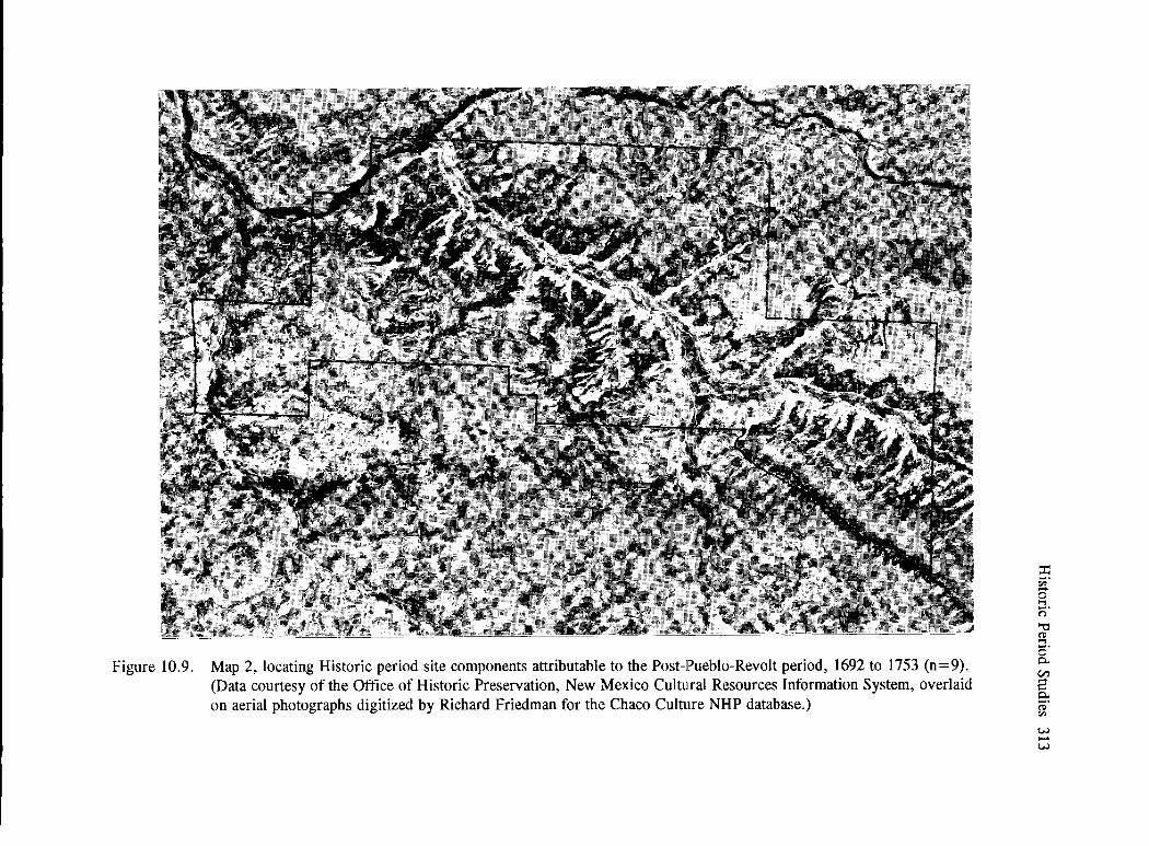
Figure 10.9. Map 2, locating Historic period site components attributable to the Post-Pueblo-Revolt period, 1692 to 1753 (n=9). (Data courtesy of the Office of Historic Preservation, New Mexico Cultural Resources Information System, overlaid on aerial photographs digitized by Richard Friedman for the Chaco Culture NHP database.)
~ "" 8 ""1 c:;· "'C ~ s· 0. en 2 0. a;· "" (.;.) ..... (.;.)

Figure 10.10. Map 3, locating Historic period site components attributable to the Pre-Reservation period, 1753 to 1868 (n=33). (Data courtesy of the Office of Historic Preservation, New Mexico Cultural Resources Information System, overlaid on aerial photographs digitized by Richard Friedman for the Chaco Culture NHP database.)
V.) -"""' (') ::r "' ('")
0 "'d '"1 '9. ~ en '< g. ('!)
"" r;;·
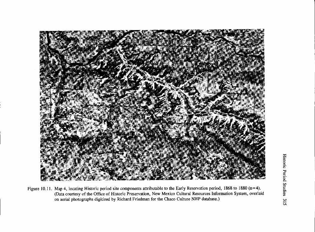
Figure 10.11. Map 4, locating Historic period site components attributable to the Early Reservation period, 1868 to 1880 (n=4). (Data courtesy of the Office of Historic Preservation, New Mexico Cultural Resources Information System, overlaid on aerial photographs digitized by Richard Friedman for the Chaco Culture NHP database.)
E9 1:1> g '"I c=;· '"C ~ 5· 0.. en 2 0.. ~·
(jl ...... VI

Figure 10.12. Map 5, locating Historic period site components attributable to the Middle Reservation period, 1880 to 1920 (n=24). (Data courtesy of the Office of Historic Preservation, New Mexico Cultural Resources Information System, overlaid on aerial photographs digitized by Richard Friedman for the Chaco Culture NHP database.)
w ..-°' n ::ii» n 0 "t:I '"1
.3. Ct> n ...... en '< ~ g. Ct>
"" ;;;;·

Figure 10.13. Map 6, locating Historic period site components attributable to the Late Reservation period, 1920 to 1945 (n=43). (Data courtesy of the Office of Historic Preservation, New Mexico Cultural Resources Information System, overlaid on aerial photographs digitized by Richard Friedman for the Chaco Culture NHP database.)
:::i:: ;;;· 8 '"'I 0· ""d ~ ...... 0 Q. (.I)
8 Q. ~· "" ~ ....... ........

Figure 10.14. Map 7, locating Historic period site components attributable to the Recent period, post-1940(n=13). (Data courtesy of the Office of Historic Preservation, New Mexico Cultural Resources Information System, overlaid on aerial photographs digitized by Richard Friedman for the Chaco Culture NHP database.)
UJ ...... 00
(') ::r ~ 0 ""C "'t
.3. ~ ('-!
'< s. DJ r;;·

Figure 10.15. Map 8, which combines Historic period site components from the Post-Pueblo-Revolt through the Early Reservation periods, 1692 to 1868 (n=46). (Data courtesy of the Office of Historic Preservation, New Mexico Cultural Resources Information System, overlaid on aerial photographs digitized by Richard Friedman for the Chaco Culture NHP database.)
a:; "' 0 ..., c:;· '"ti S!l -· 0 0. en 8" 0. ~-
w ...... \0

320 Chaco Project Synthesis
Figure 10.16. Structures 1, 2, and 3 at the Doll House site (29SJ1613) as seen from Structure 5. (Photograph from the David M. Brugge Collection, Chaco Culture NHP Museum Archive, no. 20513.)

• 29SJl604
APPROXIMATE r1 ""'"1 \ J
(
) •o~o~~~--'_,_co __ ,_ooLo_~o FEET
Cluster I
Historic Period Studies 321
\ I
/ l
~""""
929 82009
Figure 10.17. Map of the Doll House site (29SJ1613). (Taken from Brugge 1986:90.)
Depending on the period, dangers from enemy attack should be reflected in architecture and material culture remains. Subsistence and other economic materials should vary through time. Initially, mostly locally available materials would be found. Imported objects would increase through time, depending on whether or not friendly relationships existed between the Navajo and other Native American groups, and the
Navajo and whites (both Hispanic and AngloAmericans). Based on ethnographic data, several propositions were outlined about how buildings would be constructed and used and when and how artifacts would be discarded. Seasons of use would also be documented through the age of animal remains, pollen, etc. Priority during excavation was given to the two oldest clusters.

322 Chaco Project Synthesis
Detailed descriptions of excavated and unexcavated features were provided, as was an analysis of material remains. Most excavated structures in clusters I and II were estimated to have been used between 1740 and 1800. Pueblito 3 and houses 2 and 4 reflected the architectural tradition of the LargoGobemador area. House 7 and hogans 8 and 10 may represent use by the subsequent generation, probably seasonally, over a period of several years prior to abandonment. Hogan 1 and House 9 were located so as to have served as lookouts; the presence of loopholes and better preserved walls, like those in Pueblito 3 (Figure 10.5), suggest that these three structures may have served as places where hunters and war parties could gather sporadically. Hogans 14 and 15 were not excavated; evidence suggests late-eighteenthcentury use for Hogan 14 and nineteenth-century use (possibly as a campsite) for Hogan 15. Shelter 22 also suggested short-term visits to the area rather than permanent home sites.
Cluster III was interpreted as representing nineteenth-century use. Concealment and flight (light construction and sparse trash), rather than fortification, were inferred (Brugge 1986: 133). Short-term and intermittent use correlates with what would be expected during the period of warfare, when Spanish and American military expeditions traveled through the area.
Cluster IV definitely reflected twentieth-century use. Hogan 24 was part of Rafael Mescalito's summer camp, dating to approximately 1927. Mescalito farmed here until 1936, herded sheep in the area until the 1940s, and wintered on Chacra Mesa. Structure 28, a miniature cliff dwelling, was built by Charlie Atencio, the son-in-law of Katherine Mescalito.
The area in which the Doll House site is located was used as winter camp by Navajo George and his extended family after the return from Fort Sumner. Although a direct relationship to earlier occupants could not be established, family claims and ethnographic data suggested that there was a connection through Navajo George's wife, a member of the Tachii'ni clan, who may have had use rights to the area (Brugge 1986:137). Among those included in Navajo George's family who continued to use the land were his sister, Mrs. Rafael Mescalito, and his grandson, Willie George.
Based on ethnographic and archaeological data, Brugge (1986: 137) concluded that the clan system was already in place in the mid-1800s and that rights were passed down bilaterally. He thought that the early settlement on the bluff was probably by Navajo who had Pueblo ancestry. Pueblo traits, however, slowly decreased as a response to the social environment; e.g., defense from enemies, and perhaps the acceptance of the Blessingway teachings during the occupation of cluster III, and probably as early as the cluster I settlement, in which House 9 (Figure 10.10) exhibited considerable religious complexity, which indicated that the residents were definitely more Navajo than Pueblo. "The ceramic data provide strong indications that the traditional Navajo concepts of division of interior space were already being practiced by the 18"' century on Chacra Mesa, at least with regard to the cooking area" (Brugge 1986: 120). Similar inferences were obtained from the analysis of artifacts recovered from the exterior of the dwellings.
Changes in subsistence practices were found. Data from clusters I and II (sites that were approximately 200 or 250 years old) suggest reliance on agricultural products and storage. After 1868, storage facilities are rare (or possibly earlier ones were reused), and the presence of fauna! remains indicates an early importance for pastoralism, which continued throughout site use.
Trade relationships existed throughout site use, but it was not possible to determine whether early trade was with Pueblo relatives or friendly Pueblo peoples located away from the Spanish. Foreign artifacts-e.g., metal and glass beads-increased through time, but it was difficult to decide who crafted the metal objects.
Brugge was careful in his determination of which aspects of the foreign culture were adopted or rejected; he believed that adoptions should reflect decisions based on urgencies of the time and place. Sometimes, when circumstances change, accepted foreign practices will be rejected and a revitalization of culture results.
History of the Chaco Navajo
One ofBrugge's research goals was to provide a detailed history of the Chaco Navajo from their perspective. Brugge (1980) included a wealth of

information, beginning with that gleaned from records of early Spanish explorers of New Mexico through the first half of the twentieth century. He incorporated information on climate, range conditions, and crop yields for years when it was available.
Clues as to how the great houses may have acquired Spanish names (Simpson 1850) were found in Spanish documents dating from 1823; they indicate that Jose Antonio Vizcarra passed near Pueblo Pintado (also referred to as Pueblo del Raton), Cerrito Fajada, and El Peiiasco. Brugge (1980: 12-13) expected that other Spanish 1nilitary had been in the area and were well acquainted with the ruins in Chaco Canyon.
Continuing throughout this carefully researched volume, Brugge provides the names of people who entered Chaco Canvon. and when. and whv. Included --------- ------- _____ J ___ 7 ____ -- - 7 .;
are explorers and military troops; archaeologists; homesteaders; traders; Spanish and Anglo stockmen; Indian agents; land surveyors; and, most recently, those involved in extracting mineral resources from the surrounding land. As these outsiders began to use the land, their actions and reactions with regard to the Navajo were based on their cultural backgrounds, which had different social and political orientations from that of the local inhabitants. By the late nineteenth century, foreigners fully controlled the area; their rules and regulations brought a division of lands that could be obtained as homesteads or through allotments. The expansion of the railroad in the West claimed other territory in what is known as the "checkerboard" pattern. Discovery of mineral resources, such as coal, gas, and oil, which were found on Navajo lands in the San Juan Basin, provided the impetus for the organization of the Navajo tribal council, with its chapters and chapter houses, to aid with political organization of the tribal people dealing with these issues. All these variables brought changes to the former Navajo lifestyle. Brugge's history ends with the final fencing of Chaco Canyon National Monument in 1946-1948. In his closing statement, he noted that many white ranchers have recently sold their lands to the Navajo tribe so that the Navajo have now reclaimed much of the land around Chaco Canyon. Their way of life, however, has been greatly altered in the process. Brugge recognized that race, language, and culture are not always independent variables; he demonstrates how Pueblo, Spanish, and
Historic Period Studies 323
Anglo-Americans are intertwined in the processes of Navajo culture change.
Brugge's research added much to our knowledge about Navajo history, as well as the interactions between Spanish and Anglo herders and the Navajo during the past century and their effects on Navajo culture. He provided several hypotheses about the beginnings of certain practices; e.g., the introduction of the Blessingway and its acceptance by the Navajo. He suggested the existence of the clan system for over 150 years. He documented the earlier reliance on agriculture and an increase on pastoralism through time.
Although we still do not know exactly when Navajo settled in the Chaco drainage, their presence on Chacra Mesa in the early 1700s was confirmed. Early sites on Chacra Mesa did not manifest as many Pueblo features as those in the Gobernador area, and evidence for ritual is similarly less spectacular. Agriculture and pastoralism provided a way of life in this outpost of Navajo culture. It was not until approximately 1770, when the Spanish shifted alliance to the Ute, that data in the Chaco area indicate participation in warfare that drove out neighboring Spanish colonists. An extension of Navajo settlement farther west in Chaco Canyon seems to have taken place about this time. The smallpox epidemic of 1781 is reflected archaeologically in the number of hogans that appear to have been abandoned and the drop in tree-ring dates that indicate the construction of new homes. Ensuing wars throughout the next several decades probably brought Spanish troops through the area, and the lack of datable Navajo remains suggests considerable depopulation around Chaco. Brugge suspected frequent visits and use by a few Navajo for hunting.
Only after Anglo-American government took over and peace ensued after the Long Walk to Fort Sumner does an influx of Spanish and Anglo herders and traders appear in the area. Major changes wrought through the resulting intercultural interactions included increased trade, some wage labor, the need to establish claims to land, and eventually an increase in competition for land use areas. As lands were fenced, many traditional Navajo ways were circumscribed and cultural changes were necessitated. Lands used by three of the wealthiest Navajo stockmen-Navajo

324 Chaco Project Synthesis
George, Delgadito, and Bit'ahnii Ts'6sf-were slowly encompassed by Ed Sargent's holdings, and their descendants eventually abandoned some of their allotments. Stock reduction programs (to eliminate erosion), World War II, and mineral development on Navajo lands brought more pressure and change.
In summary, Brugge's data confirmed and expanded on Gwinn Vivian's (1960) earlier work. His research into the historic records and excavations at the Doll House site provided considerably more detail that indicated good correlation between the two databases. He also found that these data fit with the oral histories that were provided by current residents of the area. Yet Brugge ( 1986: 148-160) presented a number of ideas pertaining to demography, defense, economy, sociopolitical structure, religion, and climate that needed more testing. A detailed understanding of how many decisions made about Navajo culture in distant places, and sufficient knowledge about what the Navajo were doing during the early years were lacking. How Navajo arrived at decisions through time, especially at an individual or clan level, remained a puzzle.
Some of Brugge's questions were addressed during the Chaco additions survey (see above). Based on ethnohistoric data collected by Fred York, W. Powers (1989) outlined three major goals: 1) to evaluate and discuss Navajo and historic land ownership and use and the effect of various events, legislation, policy, etc., on those uses; 2) to analyze site usage and settlement patterns with regard to fencing, seasonal use, and subsistence practices that occurred; and 3) to identify site attributes that indicate seasonality and discriminatory factors in sites. Both York and W. Powers realized that data from the additional lands survey areas alone were insufficient to properly address these issues; throughout her presentation, Powers relied on work by Bailey and Bailey (1986), Brugge (198lb, 1986), and K. Kelley (1982) for data to expand knowledge about family use of the Chaco areas.
York's data on the use of sites generally dated between 1920 and 1950. He focused on the people who lived in the sites and the seasons of use. Powers was more concerned with competition over land, not just among different ethnic groups, but also among the Navajo themselves. What became evident were the
numerous interrelationships among families and clans who used most of the sites for which data was gathered. W. Powers, therefore, suggested that intermarriage may have been a mechanism that furthered cooperation among groups and provided them with a means to acquire resources.
W. Powers suggested seasonal use of sites. Although no reasons were given for selection of specific locations for sites, availability of water was the reason for winter use of the entire Chacra Mesa. Summer residences were predominantly in Chaco Canyon, south of Chacra Mesa prior to fencing, and later north in the Escavada drainage. In addition to winter residences for herding families, sites on Chacra Mesa included trails; play hogans; locations of squaw dances; and male and female sweat lodges associated with the largest Navajo family settlement-that of Navajo George and his descendants and relatives. Kin Bineola was used in the spring; and Kin Klizhin was used in both the spring and summer as an area where fields were planted and herds were kept, predominantly by 'Asdzaa Bilfilani and her descendants and relatives. Spanish herders later used Kin Klizhin in the winters.
Most information from informants dealt with sites on Chacra Mesa, and indicated that most families were related to each other, either by descent or by marriage. Although there were a number of hogans on some sites, not all of them were used continuously. People using portions of Chacra Mesa often rebuilt in the same location after a period of years. Thus, population may not be as high at any one time as archaeological data might suggest. Informants also recognized some circular structures as either chicken houses or dog houses; these had been recorded as storage rooms by the survey crews. Many hogans had been lamb pens that had been roofed to prevent attack by coyotes rather than habitations. The major difference between the structures is that lamb pens do not have east-facing entryways; size and location were also more variable. Who built trails and who used water sources were established, but rights over water use were not ascertained.
Data on which trading posts were used by several families was obtained. At some sites, the articles obtained from trading posts were present; informants could describe how other large objects such

as stoves were built from other materials.
Two events restricted Navajo mobility: the acquisition of large tracts of land, particularly by Ed Sargent beginning by 1910; and the fencing ofland by the National Park Service, which was initiated in 1934 and continued in 1947 and 1949. Some informants indicated that their families had used land south of Chacra Mesa and switched their summer quarters north to the Escavada.
Archaeological and ethnohistorical data supported land use patterns documented by Brugge (1986); Bailey and Bailey (1986); or K. Kelley (1982). On Chacra Mesa, the family of Navajo George-one of the richest of the Navajo herders at the turn of the century-responded to restrictions that came about as a result of the piesence of Spanish and other Euro-Americans after around 1880; the spread of the railroad; the fencing of land; the bad winter of 1931-1932; the Great Depression; and herd reductions. Inscriptions by Spanish herders were not present prior to about 1900; they represented 24 percent during the period from 1900 to 1928, and 76 percent from 1929 to 1947. These numbers reflect the increased use of this area by those employed on partido contracts through time or as Sargent's ranch hands. Because of the westward expansion of the railroad, the presence of archaeologists, Sargent, and the National Park Service, those Navajo living in the Chaco region had more opportunity than some Navajo in other regions to enter the wage labor market early (Figure 10.18). This allowed a shift to smaller and more permanent camps beginning in the 1930s; and by 1960, the shift toward permanent camps was nearly complete.
Data from the additional land survey complements those from other studies, and provides in-depth information on several areas, particularly that of the family of Navajo George on Chacra Mesa. It provides sufficient depth to show how ties among families were established and how they could have been used through time. Although W. Powers could not describe how competition between and among Navajo families occurred, her suggestion that intermarriage may have been a method to increase cooperation and provide a means to access necessary resources is an interesting one that needs further exploration.
Historic Period Studies 325
Related Research Projects
Brugge (1986: 160) regretted not being able to explore data relative to decisions made at some distance from Chaco and their effects on the historic populations of the area. Material from two contemporaneous studies (Bailey and Bailey 1986; K. Kelley 1982) that address some of these issues has already been referred to during the discussion of the additional lands survey. During the late 1970s, the development of gas, coal, uranium, and oil resources in the San Juan Basin brought about a series of environmental assessments and archaeoiogicai surveys of areas that were to be mined. One located to the east of the park-the Gallo Wash Mine-is a 26 km2 (67 mi2
) lease in T 18-25 N, R 5-13 W, that was formerly part of the Sargent Ranch. This land was surveyed in 1977 and 1978 by John Wilson (1979). K. Ke!!ey then conducted an ethnohistorical and ethnoarchaeological study of 78 Historic period site components. Her focus was "the history of Sargent's stock-raising outfit and related business interests ... against the backdrop of changes in the southwestern sheep-raising industry" (K. Kelley 1982:vi). She correlated changes in the livestock market and government regulations with changes in the use of land by both Anglo-American and Navajo land users. Repercussions from changes made by Sargent as he reorganized his large stockraising business also affected local Navajo land use patterns.
K. Kelley's ethnohistory focused on three families (those of Navajo George, Hastiin Ts'6si, and Dine Litsoi) and how they reacted to Sargent's responses to decisions made by the U.S. government and the railroad, both of which owned numerous unconnected sections of land in the area. Kelley indicated there was usually a two- to six-year lag time between the passage of new regulations in Washington, D.C., and evidence of change in the Chaco area. Use of sites by the three families and their descendants through time illustrated how families maintained their ties to a locality while shifting locations of land use among relatives over time. For example, between 1920 and 1929 there was no evidence of herders' camps attributed to either Sargent or the Navajo. These years encompassed a period of reduced water availability, so Sargent would have found the supply insufficient for his herds and grazed

Figure 10.18. Opportunities for wage labor included excavations at archaeological sites; e.g., Pueblo Bonito in 1924 during the National Geographic Society expedition. (Courtesy of the National Geographic Society; Chaco Culture NHP Museum Archive, no. 14, listed as being from the Maxwell Museum of Anthropology of the University of New Mexico, and described as mine cars pulled over narrow-gauge track.)
~ N
°' n ::r ~ 0
""d .., .9. (ll g en
'<!
e. &l; ;;;·

them elsewhere. Navajo herders who had fewer animals were unable to use the land because they would incur trespass violations and repercussions from breaking the law. Kelley also documented how a fall in livestock prices after 1940 and the forced purchase of railroad land by Sargent between 1940 and 1944 led to the downsizing of herds. Continued decreases in the profitability of livestock eventually led to the sale of the Sargent Ranch in 1958 to the Navajo Nation, which had earned income through the sale of mineral leases on their lands. The land once occupied by Navajo was thereby returned to Navajo use.
K. Kelley indicated how sites attributed to largescale Navajo stock owners, small-scale Navajo stock owners, shepherds who worked for Ed Sargent, and oil-drilling crews exhibited different manifestations in the archaeological record. These differences were evident in the number of sites recorded, complexes of features in each site type, artifact assemblages, and spatial distribution through time. Differences were tied to land-ownership policies; the distribution of water rights; fluctuations in the wool, livestock, and oil markets; differences in stock-raising practices; and the technology used in oil drilling and production. Kelley's contribution complements Brugge's research from the standpoint of detailed ethnohistories of local land users. Her evaluation of the broader economic factors affecting all users of the area adds the perspective that Brugge had hoped to attain.
A second study carried out by Rosalie Fanale (1982), a student at George Washington University who worked in the NPS Remote Sensing Division, evaluated Navajo rangeland management-its changes through time, and how these changes affected Navajo cultural practices. She was concerned with social pressures that affected the productivity of semiarid lands and with explaining processes of change in terms of the relationship of pastoral people to exogenous governments. Four basic questions were: 1) Did the Navajo have an indigenous land management system? 2) Were there changes in Navajo land use in the late nineteenth and twentieth centuries? 3) To what extent is environmental degradation a result of an exogenous constraint; e.g., government programs and laws? 4) To what extent are other explanations of environmental degradation appropriate?
Historic Period Studies 327
Maps prepared from LANDSAT images were useful before and during interviews with informants to determine which areas had been used prior to 1930s laws and other governmental restrictions. Interviews with older Navajo provided a late-1800s foundation for understanding range management practices.
The indigenous Navajo land management system was seen as an adaptation to seasonal, as well as yearly, fluctuations in the environment. Not only did the Navajo practice daily, seasonal, and yearly range rotation, but also the principles of visiting and inviting relatives to share an area during good environmental conditions that provided a buffer to the landscape in times of stress prescribed this behavior. Longdistance mobility was considered normal and allowed people to have close contacts. Proper behavior among kin and clan systems was important. The concept of harmony was expressed through love and friendship, which were the basis of the proper way of life. Fanale concluded that traditional Navajo land use was defined by regulating principles as follows:
• Land resources should be respected, and when they are plentiful, they should be shared among relatives living nearby or farther away.
• Rather than depleting a range, people should temporarily move away with their animals and visit relatives, thereby letting the land rest.
•
•
Rather than specific preferences for moves or a specific order of preference (e.g., nearer relatives preferred over more distant), there is a wide choice of destinations (as well as the timing and duration of each move) that encompasses the broad network of kin; the details of each move depend on situational and contextual factors, especially history of family contacts and environmental conditions.
Which way it goes-moving away or inviting others in-depends on environmental conditions, which are themselves highly variable from year to year and from place to place (Fanale 1982: 142-143).

328 Chaco Project Synthesis
Long-distance mobility through socially constituted patterns of land-sharing was a key issue that had not been previously explored.
Once Fanale determined that families ranged for long distances and that their culture was based on family (and clan) sharing of resources (depending on the current state of grazing areas), she reviewed government regulations and how they affected the ability of the Navajo families to cross boundaries to reach other pasturelands. Because different regulations and regulating agencies controlled land use off and on the reservation, she was able to demonstrate differences in behavior among Navajo in three areas of investigation: Crownpoint, southwest of Chaco Canyon; the Chaco Plateau; and Chaco Canyon East (mostly Chacra Mesa).
Fanale also traced the effects of exogenous rules and regulations on mobility of the Navajo; how the lack of mobility affected environmental conditions; how non-Navajo practices also affected the environment; why stock reduction and regulation did not improve range quality; and the changes taking place within the cultural system as a result of these effects. She suggested that many of the range management programs initiated by the federal government in the 1930s had an opposite effect, because they were implemented too hastily and without a thorough understanding of Navajo culture. The power of Anglo-American ranchers had more effect on government decisions than the few voices of field administrators. In the end, stock reduction, division of the land into administrative units, off-reservation competition with whites to obtain grazing permits, and recent grazing regulations all prohibited the Navajo from their traditional range management policies, and also affected their cultural concepts of land sharing.
As a result, Fanale recommended that government planners examine the histories and cultures of local people to determine what effects on an outside society rules and regulations will have. Even if changes are successful from the point of view of the dominant culture, there may be deleterious effects on indigenous groups who must conform even though the regulations destroy their basic cultural system.
Both K. Kelley (1982) and Fanale (1982) inform on historic use of the area and address broader issues
outlined in the Chaco Prospectus; i.e., the impact that human cultural events have upon the habitat, and how an adverse effect on the environment affects cultural development.
Assessment of the Research
Recommendations for research listed in the Chaco Prospectus for the Refugee, Navajo, and Historic periods were followed. The inventory survey (Hayes 1981) and the additional lands survey (Gleichman 1987) provided complete coverage of all NPS lands. Only a few sites reflect possible Pueblo traits. All Navajo and Recent Historic or EuroAmerican sites were recorded and data entered into the state system (NMCRIS).
Brugge (1980b, 1986) conducted an intensive search of the archival records pertaining to SpanishNavajo-Pueblo contacts. Although no excavations in the few earliest sites that reflected Pueblo traits were carried out, Brugge's thorough discussions and interpretations suggest that true Refugee period sites were not present; Gleichman's (1987) data (with two exceptions, which she questioned) support this conclusion. The dates obtained for the earliest sites and the intermingling of Navajo and Pueblo traits at these sites suggest that the people were probably more Navajo, possibly having some ancestral or social ties with Pueblo people, than Pueblo.
Excavation at the Doll House site indicated longterm, but not continuous, use of this area of Chacra Mesa (Brugge 1986). Oral histories confirmed use of the site by one family, that of Navajo George. It is possible that there were clan ties through his wife's family prior to 1863. Through oral histories gathered by Brugge (1986), York (in W. Powers 1989), and Kelley (1982), there is now a reasonable outline of the use of land in this area by a number of Navajo families.
Brugge's history of the Chaco Navajo included data on natural resources and their use, the effects of changes in climate, and other ecological data (see recent summary that incorporates current research in Brugge 2004). Although Navajo use of the Chaco area included agriculture, for the past century they depended more on raising livestock, and more recently on wage labor, to earn a living. This was not so much

the case during the 1700s and early 1800s; we have less knowledge about the Navajo adaptation at that time, and it is difficult to draw too many parallels or implications for prehistoric Pueblo adaptations from these data.
Although the writf:lrs of the Chaco Prospectus (NPS 1969:8) did not necessarily intend their section on the "Implications of Interaction Between Continuous Distinctive Cultural Systems" to be applied to the Historic period as defined in this chapter, the data from the Historic period can be used to examine this statement: "Present evidence indicates there were three distinct cultural systems exploiting the Chaco Canyon environment. What are the implications of the presence of several community types toward an understanding of the pace of cultural change in Chaco Canyon?" Ethnohistoric data on Navajo, Spanish, and Anglo-American use and interactions in the area since 1848 provide considerable insight into the reasons for culture change. The reports by K. Kelley (1982) and Fanale (1982) expanded on the work of the National Park Service to shed light on the interrelationships among different culture groups outlined in the prospectus. For example:
• What external culture contacts may be discerned as influencing cultural evolution?
• What demographic movements can be discussed in the record of cultural evolution?
• What insights into diversity and change in social organization and what implications for past or contemporary social problems can be ascertained from archaeological data?
The information on historic people clearly supple-
Historic Period Studies 329
ments and corrects some of the interpretations made based solely on the archaeological record.
Several issues remain. The Gambler stories told by the Navajo have some basis, probably during the Refugee period when Pueblo Indians moved into territory occupied by the Navajo (Begay 2004), but it is not clear what area the Gambler stories specifically record. It is possible that the intermingling of cultures illustrated in these stories occurred in the Chaco area, or possibly in another locale that was changed to suit the storyteller. There is little evidence of Pueblo use after A.D. 1300; and there is little evidence of Navajo use prior to the A.D. 1700s, when Pueblo traits appear in Navajo sites.
Pueblo and Navajo peoples did live together in other areas; e.g., the Jemez and Gobernadorhomeland of the Navajo. Some situations-e.g., the cooperation of Hosta (Jemez Pueblo) and Sandoval (Navajo) guides who accompanied Simpson through Chaco in 1849, suggest that Navajo and Pueblo people had numerous occasions to exchange stories. One can only speculate on conversations between Hosta and Sandoval as they participated in a number of Spanish and American expeditions in northern New Mexico, and how each would have adapted these stories for his own use as circumstances changed.
At the beginning of this chapter, two quotations indicated the lack of interest in Historic period sites at the tum of the century. The Navajo features at Chetro Ketl were not well documented, possibly because Hewett was so interested in the excavation of a Chacoan great house that he did not consider them important. The work carried out during the Chaco Project has remedied much of this deficit, but there still remains more to examine through both archaeology and oral history.


Chapter Eleven
The Chaco Project from a Broader Perspective
It will soon be forty years since I observed that our task was to "explicate and explain the total range of physical and cultural similarities and differences characteristic of the entire spatial-temporal span. of 1r.an's existence" (Binford 1962:218). I went on to say, so long ago, that by explanation I meant "the demonstration of a constant articulation of variables within a system and the measurement of the concomitant variability among the variables within the system." (Binford 2001:400)
Because the Chaco Project evolved during the period when theoretical perspectives changed from one of culture history to one of processual archaeology, models examined by the Chaco Project were based on systems theory and cultural ecology. Each period under study was examined as part of regional development that originally encompassed the Chaco Basin but was later extended to cover the San Juan Basin and its surrounding highlands. From a cultural resources management perspective, especially as it relates to interpretation of the resources of Chaco Canyon, this was a successful program that involved specialists from numerous fields. Much was learned about how people adapted to local conditions through time.
At the same time, Binford (2001), who was one of the major proponents of processual method and theory, focused on the interrelationships between culture and the environment by evaluating ecological variables and population as two semi-independent systems. By using several frames of reference in his comparisons, he demonstrated how environmental and cultural variables operated as part of a system and how changes in one affected the others. He recognized thresholds at which patterns in subsistence behavior that affect social organization would change. Using his methods, A. Johnson (1997) examined horticultural adaptations in the American Southwest. Some results are directly relevant to studies of Chaco Canyon and the San Juan Basin. This chapter will describe how the Chaco Project database fits within this even broader research framework. The following
discussion only highlights results pertinent to the Southwest; it illustrates the measuring devices developed and the thresholds that indicate when behavioral changes would occur among huntergatherers.
Two Studies in Culture and Ecology
Based on his analysis of data culled from studies in ecology and 339 documented ethnographic huntergatherer cases, Binford (2001) examined huntergatherer behavior from different environmental settings. He does not advocate environmental determinism; he emphasizes the need to understand the environmental conditions under which decisions are made and why they represent the most efficient responses to risk management in given situations. Once the environmental constraints on basic subsistence strategies (i.e., dependence on terrestrial plants, terrestrial animals, and aquatic resources) are understood, it is possible to model expected behavior that varies with the types and proportions of resources utilized. Labor investments for each subsistence strategy differ; social organization differs among groups focusing on specific types of resources, as well as with seasonal availability. With increased population densities, adjustments in labor investments are required and lead to changes in group organization. Among some more complex hunter-gatherer data sets, ranked leaders are present, even though their trajectories toward complexity differed. The research of both Binford and A. Johnson illustrates the

332 Chaco Project Synthesis
potential that studies in culture and ecology provide for explaining human behavior, and demonstrates how ethnographic case studies can be used, not in analogy, but rather in homology, to shed light on the archaeological record.
Binford's Hunter-Gatherer Studies
Binford (2001) constructed his ecological frame of reference by evaluating worldwide terrestrial habitats with regard to climate and available biomass. His goal was to anticipate variability in subsistence strategies that result only from differences in the effective environment, which affects relative dependence on plants and animals, and in some instances aquatic resources. Information on latitude, longitude, mean annual temperature, mean annual rainfall, mean coldest month, mean wannest month, mean rainfall during the wettest and driest months, and the number of months after the wannest month were used to calculate effective temperature (E.T.). E.T. became his scaled measuring device for delineating what subsistence practices, either alone or in combination, would be followed if humans were simply another species in the larger ecological system that harvested resources in proportion to availability.
For 339 hunter-gatherer cases, the data recorded included 1) estimates of dependence on hunting, gathering, and fishing; 2) the size of the area occupied; 3) the total population, its density per 100 km2
, and its group size during the most dispersed residential period (group size 1), the aggregated residential period (group size 2), and annual or periodic gatherings not necessarily focused on subsistence (group size 3); 4) the number of moves and their distances throughout the year, and whether moves were into and out from a central location or from camp to camp; 5) the vegetation type in which the group was located; and 6) general soil type found within the group's range. Seven types of system states were recognized: mounted hunters, agriculturalists, mutualists, egalitarian groups without leaders, egalitarian groups with leaders, ranked societies with wealth differences, and ranked societies with elitestatus groups.
When initial comparisons between environmental data and ethnographic cases were made, Binford (2001: 158) discovered that no hunter-gatherer cases
were located in true deserts and alpine tundra. Very few were found in semidesertic scrub areas, which are the world's most prevalent plant formation and the second-driest environment in terms of annual rainfall. In these heavily water-stressed and nonproductive habitats are found only pastoralists, agriculturalists who use some form of irrigation or other unearned water resource, or industrial states (Binford 2001: 137). As a result, he questioned prior reasoning that plant domestication took place in areas where plants occurred in natural abundance. He also found an inverse relationship between the presence of ungulates and hunter-gatherer populations. If domestication makes it possible for humans to utilize marginal areas that were previously unoccupied and domestication opens up new niches while increasing the productivity of older ones, he asked what factors led to changes in niche use and how they affected cultural systems.
The domestication of either plants or animals represents one form of intensification. Evaluation of intensification due to subsistence stress indicated that humans usually increase their dependence on terrestrial plants when the resource mix permits it (Binford 2001:212-213). Aquatic resources supplement a plant-based strategy or are adopted when plants were inadequate to support a primary subsistence strategy. Binford's research included discussions of different-size social units located within areas favorable to plant, animal, or mixed subsistence bases.
Large-scale Units. Analysis of data for western Europe indicated that the lower the population density, the later plant domesticates appeared. Except for those populations dependent on terrestrial animals, once domestication occurred, there were dramatic increases in ethnic group size among sedentary peoples relative to their mobile analogues. For these sedentary groups, there also was a dramatic decrease in the size of the area used. There are a few exceptions, in which the number of persons and the size of the area increase concomitantly. These exceptional groups maintain multiyear residential sites, and they are socially complex. They tend to rely on aquatic resources, or they may be mutualists or forest-product specialists, or people who recently adopted horticulture. Success in warfare or alliance-building among sedentists also led to increases in the area controlled as intensification increases (Binford 2001:223).

Among archaeological distributions in Europe, there was much diversity in hunter-gatherer populations that previously inhabited the area where the LBK culture is located. Binford suggested
that much of the cultural diversity extant among hunter-gatherers was replaced by relative homogeneity across the same range of environmental variability. It is reasonable to imagine that the appearance of a new niche, accompanied by an increase in system complexity, might well be signaled by the disappearance of some of the characteristics of the habitat that have been rendered irrelevant in the new effective environment. In short, a new niche may replace previous multiplicity and diversity with a larger but relatively more homogeneous cultural organization (compared with the prior system) that is associated with a considerable shift in effective environment. (Binford 2001 :203)
Evaluation of ethnographic cases led to the generalization that
There does not appear to be a 'selfdefining' constant structuring the number of persons included in hunter-gatherer regional units, dialect groups, or ethnic units. The data reveal that large-scale, collective human groups co-vary in size with environmental variables. Large-scale macro units are presumably selectively conditioned, and the extent to which they can be thought of as system state indicators is also variable. (Binford 2001:225, generalization 7 .18)
Micro-group Units. Binford recognized that depending on the system state condition, variables found in one setting may interact in different ways so as to produce either similar or different organizational properties among these cases. To better understand how these differences arose, Binford shifted analytical scales to see if he could identify a self-defining constant. In the ethnographic database, there is a considerable range in dispersed residential groups, or group 1, household size per 100 km2 for those
A Broader Perspective 333
practicing different subsistence strategies, as follows (Binford 2001:346):
mounted hunters
agriculturalists
mutualists
egalitarian groups, no institutionalized leaders
egalitarian groups, with institutionalized ieaders
ranked societies, no elite leaders
ranked societies, with elite leaders
3.69
29.60
23.97
13.15
14.80
46.74
51.08
Among plant-gatherers, group 1 size varies with aboveground productivity. People who depend totally on terrestrial plants tend to be foragers with residential mobility. They have small group 1 units in habitats with low primary productivity. For animalcollectors, foods were acquired at some distance from the residential camp and transported back. The residential groups tended to be large. They have larger group 1 sizes in low primary production settings. In a cool, temperate setting and all warmer settings, people who depend on terrestrial animal resources are organized in terms of forager strategies with residential mobility. Two thresholds would affect subsistence strategies (Table 11.1). Between the Arctic and Equatorial zones, where either hunting or gathering would be exclusive subsistence patterns, there is a mix in the dependence on either strategy. At an effective temperature (E.T.) value of 12.75 degrees, the growing season is such that plantdominant subsistence patterns end. Toward the upper end of the warm temperate zone, at an E.T. value of 15.25 degrees and 35 degrees latitude, the need for storage becomes part of the subsistence strategy, but storage is also found in the archaeological and ethnographic record where higher E.T. values are calculated. In these instances, storage is one of several strategies that can be adopted when groups need to intensify their food-production levels. This variable, therefore, is correlated both with environment and other variables that suggest intensification. Above the storage threshold, the dependence on stored foods was

334 Chaco Project Synthesis
-
ll ij a a 8
., ] .. 0
0
0
0
IO ""! "<t' -I ~ N -
l 'E c: :~ "O c: 8
!1 "' 0
<..!:: CJ)
;.§ ] 0 z
c: 0
~ ., CJ)
·~ 8 0
Q
> 0
.D ~ .. 0
0
00
-~ 0 ~ ::l O'
UJ
associated with a decreased length in the growing season. Larger group 1 sizes were found to increase from a median value of around 10 persons at E.T. 15 to around 19.5 at E.T. 11.53. At lower E.T. values, group 1 size decreased. For those groups where E.T. values were less than 15 .25 degrees, mobile residential work groups originating in sedentary settlements were larger than groups that were maximally dispersed components of residentially mobile people.
Binford assumed that dispersed residential group size should reflect the labor demands required for bulk procurement and processing, and that the most dispersed residential population sizes are either a response to the season with the least food abundance, in which group I size reflects minimal mobility and minimal food demands per areal unit, or a response to the number and spatial distribution of patches of concentrated resources, as well as temperature variability at such patches. To evaluate various combinations of environmental and population size variables, Binford devised the group size model for dispersed hunter-gatherer populations who would be expected to 1) use minimal technology in habitats that differed in subsistence resources, and 2) utilize these resources in proportion of their availability. He calculated habitat diversity, species stress, human size, and prey access to determine expected population density values for the areas where basic weather data were available. Calculations were standardized for I 00 km2 units. He specified relationships between basic food resources, the structure of the habitat, and the organization of labor relevant to forager and collector strategies. For the first condition, the size of the labor force needed to process food in bulk would increase depending on the length of time for which the group depended on stored foods and the number of different stored foods that needed to be processed at one time. He determined the number of moves and the distances moved, and the minimum number of producers and consumers (as well as dependency ratios) necessary for each subsistence strategy . Minimal size is favored to reduce mobility costs.
The division of labor varies with the quantity of resources that must be obtained over a short period of time. When men and women focus on the same species, men usually procure while women process. When more than one species need to be processed simultaneously, several work groups are organized.

Assuming that male and female terrestrial huntergatherers contribute 50 percent to the total food consumed by a group and that the division of labor is such that males and females focus on different species and organize independent work parties, it was possible to estimate the minimal group size for foragers at 18.98 persons, or at 9 .49 if the sexual division of labor was collapsed. When the male-female division of labor collapses, group sizes decrease to about half the minimal size of groups with a 50:50 division oflabor.
The greater the dependence of the group on terrestrial animals, the greater the proportion of the diet that is obtained by males. When the males assume greater responsibility for the procurement of terrestrial animals, the minimal group size increases linearly as does the percentage of their contribution to the total diet until thresholds are reached. For those dependent on plant resources, this threshold is reached at a 49 to 50 percent contribution, and there seems to be no bias toward collectors. For animal-dependent groups, the threshold occurs when 77 percent of the male contribution to all food is reached. After that, the male contribution may continue to increase, but the group 1 size decreases. When the group size model was compared to the ethnographic data, the model worked for cases that meet assumptions, but there was considerable variability among cases that violated one or more of the assumptions.
Once mobility is no longer an option due to increasing population, changes in labor organization would occur at the same time that mobility becomes increasingly ineffective. Mobile residential work groups that originate in sedentary settings are larger than the maximum dispersed components of residentially mobile people at similar locations. Yet there is a dramatic decrease in the area occupied by sedentary people relative to that occupied by mobile people. When stress occurs, one way to obtain more food is to increase the labor input. Within an ethnic group, intensification operates throughout the range of social segments; it operates best among larger groups when they are constrained in geographic expansion and the area available for use becomes smaller.
Binford(2001:318-332) foundthatG. Johnson's (1978, 1982) value of six decisionmakers per segment of population did seem to result from an organi:zational factor. The number of nuclear families in the
A Broader Perspective 335
smallest groups of hunter-gatherers at foraging camps closely matched this number during periods of collapsed division of labor. The average group consisted of 10.5 persons (multiply dependency ratio of 1.75 by six), which compared fairly well with the average of the smallest node in the bimodal distribution for cases dependent on terrestrial plants, and with 10.23, the number derived from the minimal mobility model. When doubled, so that six men and six women supported 21 persons, the results were not that different from 17.49, the average group size in the ethnographic data, and 20.47, the number derived from the minimal mobility model. Binford concluded that the minimal decision group and the minimal mobility group numbers fit the same pattern. The family was the basic organi:zational scale for group 1 units; the household is the basic unit only when it is larger than the group 1 size or the household equals the family. Examples of the latter are mounted hunters and net-hunting mutualists who have very large group 1 units. A third pattern in which the organizational number of six occurs was found among those hunters who reduce risk by pooling their consumable products (Winterhalder 1990).
Aggregated Residential Units. Group 2 units, or aggregated residential units, were not necessarily built on group 1 units. The social organization of hunter-gatherers in these residential units is based on segments that work together in cooperative units. Based on his terrestrial model, for groups obtaining most of their food from plants, group 2 size increases as subsistence diversity increases. The nonpacked groups are organized in terms of networks; the family is the unit that decides with whom to cooperate and where to locate themselves with regard to maximum subsistence security. The composition of these larger units varies throughout the year as segments participate in different tasks and reunite with others at a later date in risk-pooling cooperative associations. Within the larger group, these associations are not necessarily tied through kinship; rather, the task at hand and the abilities of the participants affect the choice of partners. Thus, the composition of the aggregated residential group changes as different segments move around the landscape. More than two work groups may be organized each day as the packing threshold (when maximum diversity in niche breadth is reached) is approached (Binford 2001:422).

336 Chaco Project Synthesis
Once the packing threshold is reached, subsistence diversity decreases and group 2 size decreases. The pattern of minimizing group size to reduce mobility is no longer important; the daily labor required increases as the group works within a smaller home range. Group size is further reduced as a function of decreases in subsistence diversity and the splintering of groups into new residential units that are situated adjacent to the resources upon which each group focuses. Splintering accompanies a concentration of labor upon those resources that respond best to increased labor with increased net returns. A segmented social organization may result among those for whom the adoption of horticulture progresses slowly. For those who change subsistence strategies at a rapid rate, organization became complex and exhibited internal social ranking. Inherited leadership also appears among some elite segments.
As a result of his detailed modeling and comparisons against frames of reference, Binford derived a set of packing thresholds that indicate the population densities at which system state organizations would change (Table 11.2). The first threshold (line 0, or minus 0.57 persons per 100 km2
) represents the minimum number of people that must be present in order to sustain themselves in a habitat.
The second threshold (line 1, or 1. 57 persons per 100 2km) represents the population density at which those who specialize in obtaining either aquatic resources or terrestrial animals in settings with relatively narrow niche breadth change their subsistence strategy. Aquatic specialists tend to expand their niche to include plant foods. Terrestrial hunters will either begin to utilize plants or they will extensify. Mounted hunters of the Great Plains are one example of an extensification strategy, which is considered one route to ranked social organization. The introduction of the horse allowed former semisedentary horticulturalists to utilize a new ecological niche-the bison. The sizes of their smallest residential groups and their seasonal aggregated groups increased dramatically while the population density decreased to 3.69 per 100 km2
• The response was reflected in a social scale in which larger dispersed and aggregated groups responded to the need for cooperative labor.
All remaining nonpacked hunter-gatherers are organized in terms of networks, for which the family
is the basic decisionmaking unit. Because there is seasonal segmentation and rejoining into larger groups and these larger groups are not necessarily made up of the same composition as previous ones, networks allow broad contacts within the ethnic unit, but the aggregated residential units have much fluidity.
The third threshold (line 2, or 9.098 persons per 100 km2
) is the packing threshold where there is maximum diversification in niche breadth. Mobility disappears and many new patterns emerge as populations continue to increase. Binford (2001:435-437) calls this the point of self-organized criticality, where there is a transition from a relatively stable generic hunter-gatherer pattern to one with greater instability that former subsistence tactics cannot arrest. Above this point, there are complex hunter-gatherers (ranked societies with elite, or ranked societies with wealth differentiation); mutualists (who rely on exchange of their specialized products with neighboring groups to obtain sufficient food); or those who domesticate either plants or animals.
Those who become specialists often develop ranked societies. Those who had been primarily dependent on terrestrial animals had responded to intensification by reducing dependence on larger terrestrial animals and shifting to terrestrial animals having smaller body size. In warmer temperate zones, they increased dependence on plants; in cool to cold environments, this shift was to aquatic resources, which was their only option (Binford 2001:368). Once the packing threshold is reached and populations are focused on the use of patches, institutionalization of leaders of groups who own the most productive patches occurs when those in less productive patches meet with insufficiencies and become indebted to those who have surplus to share in return for labor or craft items. The craft items eventually mount up, and leaders with wealth differentials emerge.
For those dependent on plants, when mobility is no longer an option and no aquatic resources are available, they can either expand their diet breadth to species that increase net return but that are less efficient to obtain, or they can increase their labor inputs for processing and storage. Major changes to their social organization can thus be delayed as they gain time and space utility through the use of residential patches. Thus, not all hunter-gatherer groups

Table 11.2. Population thresholds identified by Binford (2001). 0
Line No.
0
2
3
4
No. of Persons/ 100 km2
-0.57
1.57
9.098
52.677
304.99
Comments on thresholds estimated from group size model.
Minimal population density for occupation by hunter-gatherer populations based on terrestrial model. Hunter-gatherers tend to specialize and have relatively narrow niche breadth. They have very low achieved population densities and low rates of population increase. There is no balanced mutualism found below line 0.
Threshold for terrestrial hunters. They become mounted hunters; extensification allows specialists. For those dependent upon terrestrial plants, there is a general increase in subsistence diversity concurre>nt with growing population density. For those dependent on aquatic resources, specialization decreases.
Packed conditions reached. Terrestrial animal specialists rely on plant foods. Terrestrial plant specialists increase labor. Both often reduce space to concentrate on patches. Some horticulturalists and pastoralists share this space. Domestication might be adaptation, but not a linear result.
End of nonranked generic hunter-gatherer groups. End of nonranked groupi>. Modified hunter-gatherers share space.
Hunter-gatherer subsistence practices end.
•See Binford (2001 :Figure 11.16)
> td 8 ~ ~ '"d
~ 't:I
a =c:· (ll
w w -....)

----------------------
338 Chaco Project Synthesis
adopted status based on ranked hierarchies as they crossed this threshold. Those in areas with high subsistence diversity adopted age-graded secret societies and other social entities to provide needed services along their route to social complexity. These leaders arrange periodic feasts, organize funeral rites, and supply wives to more distant settlements.
At the packing threshold, reasonable responses are to shift to horticulture or pastoralism to increase the amount of food available. These choices are probably a response to biases in the habitat. Thus, domestication is a response to packing; it is not a direct response to population pressure alone, but also to different rates of growth that can be affected by conditions in neighboring regions, processes of fusion, or circumscription. It appears later in settlements that are less conducive to high rates of population growth (e.g., where pathogens affect food storage), and appears more rapidly in areas where there are constraints on population expansion.
Sedentism is not a prerequisite to agriculture; complete sedentism is not expected until almost all labor investments are devoted to a single venue for production of nonmobile food resources (Binford 2001:438). Some labor investment strategies for plant-dependent foragers include ways to render plants edible, storage, cultivation of the plants themselves, and selection of a limited number of domesticated plants for cultivation.
The fourth threshold (line 3, or 52.677 persons per 100 km2
) marks the end of non-ranked huntergatherer populations. Modified hunter-gatherers (complex leaders), mutualists, horticulturalists and pastoralists, and extensified or mounted huntergatherers share space on graphs derived from plotting the species diversity against the log10 population densities.
The last threshold (line 4, or 304.99 persons per 100 km2
) marks the space in which all hunter-gatherer subsistence practices disappear.
Binford concluded that complexity evolves in two ways. One path is through the integration of previously independent systems, such as forest-product specialists or mutualists. In these instances, ownership or wealth is bartered for food. The other path is
through intensification, which may result in complex social organization when resources occur in patches, or, if subsistence diversity is high, in egalitarian societies that maintain age- or sodality-related leaders.
One [path to complexity] is associated with scalar changes in group size as, for example, among hunter-gatherers who are primarily dependent upon terrestrial plants and have the highest values for population density. In these groups, increased complexity is represented by secret societies and social differentiation based on an individual's progress through a series of aggregated sodalities.
These societal structures are also embedded in a social fabric that features ownership or unchallenged association of persons with specific, highly productive locations for resource exploitation. Intensification is apparent in the increased labor inputs required at the time of harvest and preparation for storage, as well as during the food processing required for immediate consumption. This pathway to intensification is associated with decreased dependence upon terrestrial animals oflarge body size and a shift of male labor into roles previously assumed by female laborers, particularly the collection and processing of plant materials.
At the same time that group size increases, there is an institutionalization of regular regional interactions among the growing commumties. Round-robin hosting and mutual participation in mortuary rites and educational events are major expressions of the development of regional, institutionalized interaction, as are moieties, which perform complementary functions that crosscut at least some of the residential units. (Binford 2001:432-433)
There are, therefore, several paths that lead to the same outcome. The similarities between horticulturalists on the eastern seaboard of North America, the plant-dependent hunter-gatherers of California, and the Pueblo peoples of the American Southwest, all of

whom fall between the fourth threshold and the last threshold, suggested to Binford that similar kinds of density-dependent changes affected each of these different societies.
A. Johnson's Southwestern Horlicu/,tural.ists
Pueblo horticulturalists were studied by A. Johnson (1997), whose goal was to determine why the pace of the adoption of horticulture and the process of village formation vary across the Southwest. Because the environment has changed very little over the past 4,500 years, the Southwest offered an opportunity to examine the transition to food production. At this regional scale, Johnson examined 25 Pueblo and 15 non-Pueblo ethnographic cases. The initial conditions that formed the basis for explaining the pace and process of the development of food-producing strategies and village formation were subsistence, mobility, population density, and group size.
Based on permanent settlements, surface treatment on ceramics, and aspects of house forms, adaptive strategies for each of the cases were classified into three adaptive phases:
Phase I represents the span of time between evidence of the earliest maize and the initial appearance of early pottery and round houses. Huntinggathering is the primary subsistence strategy. In this phase, cultigens were considered seasonal supplements to the gathering of wild resources, which is different from the adoption of horticulture. Sites with the earliest maize are located in contexts of relatively stable hunter-gatherer groups. At the end of phase I, plain pottery, more permanent sites, and an increased reliance on cultigens occur.
Phase II covers the span of time from the appearance of plain pottery to the construction of sites with up to 100 rooms, integrative features, and textured and painted pottery. This period was indicative of a horticultural adaptation, which is a subsistence specialization around which other activities of the group are organized. This strategy appears in the least stable hunter-gatherer areas. Organization of the horticultural strategy will vary with aspects of the local environment.
A Broader Perspective 339
Phase III begins with the appearance of large (more than 100 rooms), aggregated sites with communal architecture represented by large integrative features and massive labor investment. Agriculture, or farming, as the chief subsistence pursuit, provided subsistence needs. The earliest population aggregations and evidence for a permanent, stable aggregated community are found in different environments. Aggregation responds to labor needs that are found in areas with the lowest subsistence diversity. Food production responds to mobility options in areas with higher subsistence diversity.
Throughout the Southwest, horticultural sites are located in environments where hunter-gatherer subsistence options would have been least diverse, and least stable. Under conditions of population packing, labor investment in horticulture would have been the only intensification option in the Southwest, where aquatic resources are negligible. In areas where hunter-gatherer subsistence diversity is expected to be low, any reduction in mobility options associated with population packing could lead to a critical reduction in subsistence options, forcing greater reliance on a much narrower range of resources. Investment in horticultural strategies could mitigate the risk of relying on such a narrow range of wild resources in a number of ways. First, it could increase the utility, from the standpoint of humans, of primary productivity-e.g., grasses with large seeds are more useful than shrubs or grasses with small seeds. Second, it could increase the predictability of both the timing and the amount of resources available. Finally, increased labor investment in fertilizing, watering, and weeding, could increase yields beyond the productivity of the natural vegetation. While the distinction between non-horticultural and horticultural site locations follows the niche breadth generalization throughout the study area, it is expected that the organization of horticultural strategies will vary depending on which aspects of local environments

340 Chaco Project Synthesis
contributed most to the destabilization of hunting and gathering economies. (A. Johnson 1997:47, emphasis in original)
Subsistence diversity was measured as a standard deviation of subsistence dependence. Higher standard deviations indicate lower subsistence diversity and .narrow niches; lower standard deviations indicate higher subsistence diversity and broader niches. Greater subsistence diversity correlates with a slower transition to dependence on horticulture (A. Johnson 1997:39). The southern area, represented by the Hohokam culture, had a shorter phase I and relatively longer phase III duration than did the Eastern and Western Anasazi pattern. Longer phase I and phase II durations occurred in areas where projected subsistence diversity is highest, but phase III was short. By deriving standard deviations for the projected subsistence diversity of horticulturalists, A. Johnson was able to confirm that measurements of niche breadth did operate in the same manner for horticulturalists as they did for hunter-gatherers. She also found that the environmental conditions supporting the least stable hunter-gatherers are the same as those that support the most stable horticulturalists. The earliest evidence for com was found on sites where hunter-gatherer niche breadth was greatest; the earliest horticultural sites are located where huntergatherer adaptations would have been the least stable (A. Johnson 1997:44). Thus, the context for the introduction of maize is different from that of its use in a horticultural subsistence strategy. She also found evidence for different environmental contexts for the earliest examples of population aggregations and those with permanent, stable population aggregations.
A. Johnson chose to examine the distribution of aggregated sites with 50 or more rooms in New Mexico. She then calculated the standard deviation of subsistence specialties. There were few aggregated sites in New Mexico prior to A.D. 1000(N=11); all are located in areas with moderate or low diversity projections for horticultural subsistence diversity (A. Johnson 1997:50). The San Juan Basin had very low horticultural subsistence diversity (A. Johnson 1997: Figure 3.5). Between A.D. 1000 to 1200 and 1300, the shift in the number of aggregated sites in settings with high subsistence diversity went from 17 percent to 80 percent.
To examine the effects of diverse subsistence strategies on the stability of human social organization, A. Johnson focused on the differences between Eastern and Western Pueblo social and ceremonial organizations. For the Historic Pueblo world, there were general patterns in social organization-e.g., clans, moieties, and medicine societies-but there were graded variations in social organization from east to west (Table 11. 3). Johnson concluded that differences in conditions for social organization (i.e., population density, group size, mobility, and subsistence system) led to distinct adult labor organization patterns. Values for the cooperative labor group size (i.e., number of households controlling access to productive resources) were related to the intensity of agricultural labor. When values of agricultural intensity were either high or low, individual households were the primary resource access group. When values were moderate, communal access is common (Adler 1994: 89).
When A. Johnson evaluated her sample of Pueblo agriculturalists, there was a distinct division between those who owned land individually versus those with communal ownership at 25.5 standard deviations (s.d.) from subsistence. The values of a cooperative labor group size increased when subsistence strategies were rated as less diverse. Below the standard value of 25.5, the primary access group size was characterized as cooperative labor among clans who are the social unit involved in land tenure and work parties. Above 25. 5, there were dramatically different group sizes and increasing divergences. This led to implications for variability in ceremonial organization. The number of secret societies increased with the need to maintain the integration of large social units that only occasionally cooperated in economic pursuits (Johnson 1997:68). Yet there was also a relationship between the number of integrative structures and the total population. Acoma, Oraibi, and Zuni had more secret societies, but also had the largest populations in clan-based societies (ca. 850 vs. less than 300 in others).
... the diversity of subsistence strategies conditions adult labor requirements and that the relationships between economically interdependent primary resource access groups and periodically cooperative labor

A Broader Perspective 341
Table 11.3. Comparison of differences among Eastern and Western Pueblo groups.a
Trait
Lineality
Organization
Medicine societies
Integrative structures
Social organization
Subsistence strategies
Western Pueblos (Hopi, Zuni, Acoma, and Laguna)
Matrilineal
Exogamous clans. Affect personal and public life through naming, marriage, land ownership, use of springs and reservoirs, eagle eeries and feathers, houses, kivas, and work parties. They maintain the ceremonial system.
Weak
Small kivas function as men's houses; ceremonies performed inside. Kivas vary from 2 to 13 per village. From 10.6 to 17.5 families per kiva at Hopi and 31. 8 at Zuni.
Clan
Dry farm
Small integrative structure
Lower subsistence diversity
Larger primary access group - clan
Less intensification
Diverse
More current demands on adult labor; need larger labor pool.
Clan-based
Smaller integrative structures; mens' houses; general-purpose structures.
More stable
•Taken from Johnson (1997).
Blurred (Eastern Keres)
Clans important. Mixed system.
Strong
No small structures. Two large structures.
Eastern Pueblos (Rio Grande Pueblos)
Patrilineal
Moiety system represents duality and directionality; e.g., east-west, and northsouth. A woman joins her husband's moiety at marriage.
Weak
Large kivas used specifically for moiety functions.
Moiety
Irrigation
Large integrative structure
Higher subsistence diversity
Smaller primary access group - individual household.
Greater intensification
Less diverse, more intense
Individual household
Large integrative structures for ceremonial purposes only. Combine moieties, dance groups, and cross-cutting secret societies. Other types of structures used for social houses, rehearsal halls, etc.
Less stable

342 Chaco Project Synthesis
groups, in tum, condition investment in and organization of ceremonial orgamzation. (A. Johnson 1997:70-71)
To link her results with archaeological evidence, A. Johnson evaluated integrative structures (i.e., men's houses, society houses, rehearsal halls, and structures reserved for ceremonial purposes) against the total population of historic pueblos (A. Johnson 1997:71). A relationship was found. She also linked the divergence in the scale of integrative architecture with that on the scale of labor organization. "Pueblos with a more-diverse, predominantly dry-farming horticultural adaptation with both land tenure and periodic work parties organized by relatively large economically cooperative units---<:ommon today among the Western Pueblos" differed from "those with a lessdiverse, more intensive irrigation-based horticultural adaptation with land tenure organized around individual households and period work parties organized by larger, socially-maintained cooperative units-common today among the Eastern Pueblos" (A. Johnson 1997: 76). Her conclusions mirror those of Dozier (1970).
In summary,
It has been shown that subsistence diversity is correlated with both primary resource access group size and divergence of scales of labor organization. Where subsistence strategies are more diverse, there are more concurrent demands on adult labor, thus a larger labor pool is required for daily activities. This same unit can be called upon for periodic cooperative efforts such as harvest or cleaning springs or ditches for irrigation. Among the Pueblos, clanbased social organization exists under these conditions. Where subsistence strategies are less diverse, but more intensive, individual households are the primary resource access group and larger cooperative units must be maintained for periodic efforts like harvest and ditch cleaning. Among the Pueblos, a combination of moieties, dance groups, and cross-cutting secret societies is the dominant aspect of social organization under these conditions. (A. Johnson 1997:78)
A. Johnson was able to develop a theory to predict when environmental conditions would destabilize the cultural system, but she recognized that accurate measures of population density, residential mobility, and degree of intensification are needed to correctly apply it to the archaeological record.
Implications for Chaco Canyon and Future Research
The work of Binford and Johnson offers many stimulating ideas about how culture and ecology are related. It remains for future archaeologists to further evaluate and apply these theories to explain behavior patterns through time and across space. Although this brief outline only touches on results specific to the American Southwest, the detailed methods of Binford and Johnson can be used by future researchers to answer numerous questions.
The Chaco Project database is one case that might benefit from an evaluation of the southeastern Colorado Plateau through time using Binford's approach to culture and ecology. The boundaries of the San Juan Basin (Figure 1.1) encompass 40,000 km2 (R. Powers et al. 1983: 1) that include the 35 degree N latitude line south of Grants, New Mexico (near the Village of the Great Kivas); the 36 degree N latitude line at the boundary of San Juan and McKinley counties (near Kin Bineola and just south of Chaco Culture NHP); the 37 degree N latitude (near the New Mexico/Colorado border); and the 38 degree N latitude line Gust north of Dolores, Colorado). Gillespie's (1985) environmental analysis of Chaco Canyon and the San Juan Basin is close to Binford's mid-latitude semidesert scrub and woodland class (DSD-24), which is located at an average latitude of 39. 7 .± 7. 32 degrees, and where rainfall averages just slightly less than 227 mm ± 61.65 mm (9 in) per year. The wettest months are either at the end of summer or in early autumn. This zone also has the shortest growing season (7 .53 months) (Binford 2001:Table 4.08).
New Mexico has the highest number of different mammal species, yet plant productivity is not particularly high (Binford 2001:366). Although the New Mexico desert has low productivity due to low rainfall, there is considerable between-habitat diversity
that is related to differences in altitude. For mammals, there are many small-body-size animals with small home ranges and reduced niche distributions. Based on the hunter-gatherer ethnographic cases in this type of environment, Binford (2001:Table 5.10) projected an average of 14.69 people per 100 km2
; an area of 217 .28 km2 per group; a 42. 76 percent dependence on terrestrial plants; a mean household size of 6.17 people; a mean size of largest annual social aggregation of 50.10 people; and an 8.36 average number of annual residential moves per year for foraging groups.
Based on available data (Gillespie's 1985: 18), the E.T. value for Chaco Canyon today would be 13.53, which places it in the cool temperate zone. It is within the storage threshold where one would expect generic hunters rutd gatherers to spend some periods of time in collecting and preparing foods (either plant or animal) for use during the nonproductive season; e.g., gathering of pifion nuts on Chacra Mesa (Wills and Windes 1989). However, there is considerable variability in topography within the larger region. Different E.T. values are expected in these microhabitats. Binford (2001) listed a number of E.T. values for more distant neighboring hunter-gatherer populations; they range from 13.59 for the Kaibab Southern Paiute in Arizona (where storage is expected) to 15.83 for the Lipan Apache in Texas (where storage would not be needed).
Based on current climatic conditions, which have been similar for the past 4,000 years (A. Johnson 1997), there would have been no aquatic animals or large game on which to rely. Prior to that, there was climatic change at the end of the Pleistocene. Using methods refined by Reid Bryson (Bryson and Bryson 1995) that depend on longitude, latitude, and elevation, high-resolution and site-specific models of climatic change could be reconstructed. By developing such reconstructions, it might be possible to address some questions. For example, did large game animals habitually use the San Juan Basin? What do the few Paleoindian points recovered in Chaco Canyon represent? The rate of change in environmental conditions could also be compared with the models developed by Betancourt and VanDevender ( 1980) and Hall (1977). If changes at the end of the Pleistocene made it less risky for those dependent on terrestrial mammals to switch to plant food, it should be possible
A Broader Perspective 343
to predict when the changes in technology (e.g., switch from atlatl to bow and arrow) would appear and compare the predicted results with the archaeological data.
Based on areas of 217. 28 km2 per group dependent on terrestrial plants, the number of people living in the San Juan Basin during the Preceramic period may not have been packed. There may have many separate groups that might have belonged to different segments, be they linguistic or cultural. How might these be correlated with Gwinn Vivian's (1990) delineation of four Archaic populations during Basketmaker II? When might the threshold of 52.677 persons per 100 km2 be reached and mobility no longer be an option for foragers dependent upon terrestrial plants? When might the threshold of 304.99 persons per iOO km2 be reached, at which nonranked hunters and gatherers no longer exist? Because the Historic Pueblo people fall within the zone where hunter-gatherer cases with the highest population density were charted, what might this imply for the level of social complexity in Chaco Canyon and the San Juan Basin during the Classic Bonito phase?
Due to the low productivity for the area and fluctuating rainfall patterns, how might periods of better rainfall alleviate population stress, which might allow Pueblo horticulturalists to maintain nonranked social organization during the Classic Bonito phase? Calculation of population density per 100 km2 could elucidate differences among communities, and perhaps indicate how the canyon differed from the rest of the San Juan Basin. Could nesting of segments in the canyon have reached a higher tier that brought together larger work groups during certain occasions? Was the movement out of the Four Comers area a response in part to the ability of Pueblo people to pursue subsistence in wider niche breadth locations elsewhere and not necessarily a response to drought alone?
After Pueblo people left the San Juan Basin, the region was open for use by different people. In Chapter 10, the issue of the earliest Navajo presence was not resolved. Because no other populations were living in the region after A.D. 1300, would huntergatherers have been easily visible? With Young's (in Cameron and Young 1986) ability to distinguish which lithic scatters are Archaic and which Navajo, would it be worthwhile to re-examine data from lithic

344 Chaco Project Synthesis
scatters to see ifthere is an earlier Navajo presence, as well as where the scatters are located? Once population packing was reached, horticulture would have been the likely option for the Navajo, but with the introduction oflarge mammals (i.e., cattle, sheep, and horses) after Spanish settlement in the American Southwest, there was an opportunity to use this desert scrub land in a new way. Given the options that Binford presented, the pastoralist adaptation of the Navajo people is an expected subsistence practice. The key is understanding how and when population packing is reached, not just in Chaco Canyon, but also
throughout the San Juan Basin.
Using Binford's results in this manner does not contribute to theory-building, but it would assist park managers and interpreters in further refining the culture history of this area. As an organization responsible for a major cultural park and a World Heritage Site, the NPS needs the most accurate information available for interpretive purposes. Many opportunities remain to study the Chaco Canyon database in ways that benefit both the public and the scientific community.

Appendix A
Excavated Sites in Chaco Canyon
Five major archaeological expeditions have excavated sites in Chaco Canyon. Tables A.1 through A.5 provide information on the sponsors of the investigations, the sites excavated (by name and site
numbers), the excavators, the dates and extent of excavation, and references relating to the work. When a site is listed on more than one table, there is a crossreference under extent of excavations.

Table A.l. Sites excavated or examined by the Hyde Exploring expedition. V-l ~
°' Site Name Site Number(s) Excavator( s) Date(s) Extent of Excavations Reference( s) n
::r ;.:> n
Sponsored by HEE 0
"d ,..., Pueblo Bonito 29SJ387 George H. Pepper 1896-1899 190 rooms over four years. Judd (1954, 1964) .3.
(t>
LA226 Richard Wetherill Trash mounds. In 1916 Nels Lekson (1984a:109-144) n ... Be 253 Nelson and Earl Morris Pepper(1899, 1905b, en
placed stratigraphic tests in 1906, 1909, 1920) '< ::i
the east and west trash Er (t>
mounds. Later excavations ~ r;;·
by Judd for National Geographic Society (Table A.2).
Peiiasco Blanco 29SJ410 "Waylo" and other Navajo? Several rooms. Trash mound Judd (1954:345) LA225 later trenched by Roberts Lekson (1984a::94-109) Bc250 (Table A.2). Pepper (1920:378)
Pepper's Mound 1 29SJ399 George H. Pepper 1896 Trash mound Pepper (1920) LA40399 Richard Wetherill Bc59
Pepper's Mound 2 29SJ383? George H. Pepper 1896 Trash mound Pepper (1920) LA40383 Richard Wetherill Be 117, 118
29SJ823 Richard Wetherill? 1896-1900 Mound Truell (1986:Table 2.1) LA40823 George Pepper? Bc263
29SJ1579 Richard Wetherill 1900? Mound Truell (1986:Table 2.1) LA41579
Picture Cliffs 29SJ426 Frederic Putnam 1901 Burial Andrews (1970) LA41426 Alfred M. Tozzer Mathien (200la)
Mound 1 William C. Farabee 1901 Midden Andrews (1970) Alfred M. Tozzer Mathien (2001a)
Mound 2 William C. Farabee 1901 Midden Andrews (1970) Alfred M. Tozzer Mathien (2001a)

Table A.1. (cont'd.)
Site Name Site Number(s) Excavator( s) Date(s) Extent of Excavations Reference(s)
Mound 3 William C. Farabee 1901 Midden Andrews (1970) Alfred M. Tozzer Mathien (2001a)
Mound 4 William C. Farabee 1901 Midden Andrews (1970) Alfred M. Tozzer Mathien (2001a)
House Site William C. Farabee 1901 8 rooms Andrews (1970) Alfred M. Tozzer Mathien (2001a)
Wetherill Mesa Pueblo Mesa Tierra William C. Farabee 1901 7 (of approximately 40) Andrews (1970) LA 17220 Alfred M. Tozzer rooms; Marshall et al. ( 1979)
3 kivas Mathien (200la, 2002)
Kin Neole (1/3 mile west ? Frederic Putnam 1899 100 graves Akins (1986:Table B.1) of Kin Bineola) Ale8 Hrdlicka
Related to Period or Project
"Cemetery" 1 mile east Warren K. Moorehead 1897 Unknown, probably a trash Akins (1986:118-119) of Pueblo Bonito midden Lekson (1984a:110)
Moorehead (1906)
Pueblo Bonito 29SJ387 Warren K. Moorehead 1897 Rooms 53 and 56 Akins (1986:118-119) LA226 Moorehead (1906) Be 253
Pueblo del Arroyo 29SJ1947 S. J. Holsinger 1901 Arc enclC1sing plaza. Site later Holsinger (1901:51) LA41947 excavated by Judd (Table Judd (1959) Be 254 A.2). Lekson (1984a:209-223)
Holsinger's site 2 miles S. J. Holsinger 1901 Mound Holsinger (1901) east of Kin Klizhin
Holsinger's site 1 mile S. J. Holsinger 1901 Mound Holsinger (1901) > "O
northwest of Kin Klizhin "O (!) ::s Q.. ~-
> w ~ -.i

Table A.2. Sites excavated or examined by the National Geographic Society expedition. (j.)
~ 00
Site Name Site Number(s) Excavator(s) Date(s) Extent of Excavations Reference( s) n ::r i;I:> n
Pueblo Bonito 29SJ387 Neil M. Judd 1921- 198 rooms and kivas. Trash Judd (1954, 1964) 0
LA226 Monroe Amsden 1927 mounds. Previous excavations Lekson (1984a:109-144) '"'d ..... Be 253 Frans Blom by Pepper (Table A.l). Pepper (1920) 2.
(p
H. B. Collins n ..... L. C. Hammond (l'.l
'< O.C. Havens :::i
g. George B. Martin (p
~
Frank H. H. Roberts, Jr. r;;· Henry B. Roberts Karl Ruppert
Frank H. H. Roberts, Jr. 1926 Trash mound trench Roberts (1927)
Pueblo del Arroyo 29SJ1947 Neil M. Judd 1923- 65 rooms. Tri-wall structure Holsinger (1901) LA 41947 Karl Ruppert 1926 and several associated rooms. Judd (1959) Bc254 Previous excavation by Lekson (1984a:209-223)
Holsinger (Table A. l); later Gordon Vivian (1959) excavations by Gordon Vivian (Table A.4).
Penasco Blanco 29SJ410 Frank H. H. Roberts, Jr. 1926 Trash mound trench. Previous Lekson (1984a:94-109) LA225 excavation by Navajo (Table Pepper (1920) Be 250 A.1). Roberts (1927)
Pueblo Alto 29SJ389 Frank H. H. Roberts, Jr. 1926 Trash mound trench. Later Roberts (1927) LA661 excavations by Chaco Project. Windes (1987a; in Be 251 Lekson 1984a:192-209)
Hillside Ruin 29SJ1175 Neil M. Judd 1921-1927 Pueblo III kiva Judd (1964:146-147) LA 41775 Stein et al. (2003) Bc95 Gordon Vivian and
Mathews (1965)
Judd's Pithouse No. 1 29SJ396 Neil M. Judd and Zuni crew 1920 Mud pit structure 17 ft in Judd (1921:640, (100 yards east of Casa LA 40396 diameter with fireplace, 3 bins I 923: 136, 1924:399-Rinconada, possibly Be 53 and 2 niches. 413, 1954:15, 1964:21) beneath Be 53)

Table A.2. (cont'd.)
Site Name Site Number(s) Excavator(s) Date(s) Extent of Exc;avations Reference(s)
Judd's Pithouse No. 2 29SJ1678 Neil M. Judd 1922 Pit structure 12 feet below valley Douglas (1935:44) (1.6 km/1.0 mile east of LA 41678 floor; dendro dated to ca. A.D. Judd (1923:136, Pueblo Bonito Be 194 720 and 777. 1954:15, 1964:21)
Pit structure beneath 29SJ387 Neil M. Judd 1925 Judd (1964:22) Pueblo Bonito West LA226 Court trench Be 253
Pit structure beneath 29SJ387 Neil M. Judd 1925 Judd (1964:22) Room 241 of Pueblo LA 226 Bonito Be 253
Ruin 3 (6 miles east of Monroe Amsden 1925 L-shaped puc~blo with 8 rooms, Amsden (1925) Crownpoint near Kin dating to Early Bonito phase. Bustard (1996:97-99, Ya'a) Figure 4-6)
Ruin 13 (in side LA 65441 Monroe Amsden 1925 L-shaped puc~blo with 7 + rooms Amsden (1925) tributary to Kin Bineola and a kiva dating to Classic Bustard (1996:124-125, Wash) Bonito phase:. Figure 4-23)
Pit structure 9 miles east Frank H. H. Roberts, Jr. 1926 Judd (1927a:168, of Pueblo Bonito, in 1964:21-22) gully in opposite bank from Arroyo House or Half House beneath Turkey House
Arroyo House or Half 29SJ1657 Frank H. H. Roberts, Jr. 1926 Partial pit structure R. N. Adams (1951) House LA41657 Judd (1927a: 168,
Be 244, 373 1964:21)
Shabik'eshchee Village: 29SJ1659 Frank H. H. Roberts, Jr. 1926-1927 2 pithouses and several storage Judd (1927a:165-166) a pithouse 9 miles east LA539 cists on western side of gully, Roberts (1928, 1929) > of Pueblo Bonito Be 256 18 pit structures, court, great "C
"C kiva, and 48 storage bins. (1)
::s Q.
~·
> Vl ~ \0

Table A.2. (cont'd.) VJ Ul 0
n Site Name Site Number(s) Excavator(s) Date(s) Extent of Excavations Reference( s) ::r
ti> n 0
Roberts' small house or 29SJ2385 Frank H. H. Roberts, Jr. 1926 9 rooms and East Court, several Amsden and Roberts '"'C Turkey House LA42385 burials in Pueblo II and Pueblo (n.d.) '""1
.2. Bc262 III house and mound. Bustard (1996:101-102) (1)
n Judd (1927a:165-166, .....
en 1964:21) '<
::i Roberts (1929:1) :;. CCNHP Archive 2108B
(1)
~. Cl>
Small house 29SJ2384 Frank H. H. Roberts, Jr. 1926-1927 Test trench across unfinished CCNHP Archive 2108B LA 42384 Pueblo III ruin eroding into
wash.
Small house 10 miles Frank H. H. Roberts, Jr. 1926-1927 Numerous burials from at least 3 CCNHP Archive 2108B east of Pueblo Bonito rooms of Late Pueblo III site. and 1 mile east of Turkey House
Small house, Smith's Frank H. H. Roberts, Jr. 1927 Amsden and Roberts Ranch ruin (n.d.)
Bustard (1996:99-101) CCNHP Archive 2108B
Talus House behind 29SJ1935 Frank H. H. Roberts, Jr. 1927 2 rooms and kiva of Late Pueblo Archive 2108B Pueblo Bonito LA 41935 III site.
Bc348

Table A.3. Sites excavated or examined by the School of American Research/University of New Mexico field schools.
Site Name Site Number(s) Excavator( s) Date(s) Extent of Excavations Reference(s)
Large Puebws:
Chetro Ketl 29SJ1928 Edgar L. Hewett 1920-1921 Approximately ll30 rooms, great Hawley (1934) LA 838 1929-1935 kiva, court kiva,, and about 8 Hewett (1936) Bc246 others. Later excavations of 2 Leinau (1934)
rooms by NPS (Table A.4). Miller (1937) Lekson (1983b, 1984a:152-192) P. Reiter (1933) Gwinn Vivian et al. (1978)
Casa Rinconada 29SJ386 Gordon Vivian 1930-1931 Great kiva Gordon Vivian and Reiter LA 841 (1960) Bc255
Kin Kletso 29SJ393 Edwin Ferdon 1934 9 rooms and 2 k:ivas. Later Lekson (1984a:238-246) LA 2464 excavations by Gordon Vivian Gordon Vivian and Bc248 and Mathews (Table A.4). Mathews (1965)
Kin Nahasbas 29SJ392 Dorothy Luhrs 1935 Great kiva and one room in Hewett (1936) LA 152 great house. Luhrs (1935) Bc249 Mathien and Windes (1988)
Gordon Vivian and Reiter (1960)
Talus Unit No. 1 29SJ1930 Paul Walters, Jr. 1933-1937 27 rooms and 6 kivas. Later Lekson (1985a) LA 2470 Margaret Woods NPS excavation of Kiva J (Table M. Woods (1933, 1934a Be 257 A.4). 1934b, 1935, 1937, 1938)
Small Sites:
Anna Shepard's site 29SJ200 Anna Shepard 1929 3 rooms and trench Dutton (1938:11) LA 40200 Truell (1986:Tab1e 2.1) > Be 114 't:l
"O (I>
Cacique's Sanctum 29SJ1924 Richard Vann 1930 2 rooms Vann (1930) ::I 0..
LA 41924 Phil Drucker ~·
Be 86 > (,;)
Vt .......

Table A.3. (cont'd.) (.;,) Ut N
n Site Name Site Number(s) Excavator( s) Date(s) Extent of Excavations Reference(s) ::r
I>' n 0
Kin Sabe 29SJ823 W. W. Postlethwaite 1931 Previous work by Wetherill and Judd (1954, 1959, 1964) .,, LA 40823 Alden C. Hayes 1937 Pepper (1896-1900) and by Judd Pierson (1956:43) '"'I
..2. Be 263 Mabel Harding (1925). Postlethwaite ( 1931) (l)
n Truell (1986:Table 2.1)
..... (J')
'< Talus unit 29SJ1927 Sally Pearce 1932 Partial excavation of 2 rooms Pierce (1932) =3 e-
LA41927 (ll <ll
Be 89 r;;·
Talus Rock Shelter 29SJ1936 1932 Shelter with firepit and storage Bannister (1965:193-1"94) LA 41936 cists. Exposed room walls. Hawley (1934b:63) Be 98-99 Floor cleaned. Truell (1986:Table 2.1)
Cliff cavities: 29SJ1944 Hurst Julian 1932 Series of cliff cavities between Julian (1933) PS 1, PS2, PS3 LA41944 Dorothy Keur 1933 Chetro Ketl and Pueblo Bonito Pierson (1956:34-35) Ul, U2 Be 130, 133 (U) (PS) and behind Kin Kletso (U).
Be 48? Paul Reiter 1932 Few burials Maher (1947) Gordon Vivian Truell (1986:Table 2.1) R. F. Maher 1947 Gordon Vivian notes in
CCNHP Archive No. 393)
Hutch's site 29SJ838 Charles Hutchinson 1934 6 rooms and 2 kivas of Brand (1937a:26) LA 40838 Albert Ely previously looted site. Pierson (1956) Be 126 J. Charles Kelley Truell (1986:Table 2.1)
CCNHP Archives Nos. 487, 570, 1031, 1193, 1194
Kin Chinde 29SJ799 Bertha P. Dutton 1934 4 or 5 rooms and trash midden. Brand (1937a:26) LA 40799 Marion Hollenbach Pierson (1956:41) Be 61 Truell (1986:Table 2.1)
Leyit Kin 29SJ750 Bertha P. Dutton 1934 14 rooms, 4 kivas, and trash Dutton (1938) LA 41750 1936 midden. Be 24, Mound 26

Table A.3. (cont'd.)
Site Name Site Number(s) Excavator(s) Date(s) Extent of Excavations Reference( s)
Pit houses near Casa Be 64A Joseph Maloney 1936 1 pit house and 5 cists Pierson (1956:42) Rinconada Gordon Vivian and Reiter
(1960:Figure 3)
Be 50; Tseh So 29SJ394 Donald Brand 1936 Most of site Brand et al. (1937) LA40394 Florence Hawley Kluckhohn and Reiter Be 50 Frank Hibben (1939)
Wesley Bliss Pierson (1956:39) Nan Glenn 1937 Numerous papers in Barbara Clark 1938 CCNHP Archives F. Seltzer 1939 Donovan Senter Gordon Vivian 1947 Raymond Rixey
Be 51 29SJ395 Clyde Kluckhohn 1937 Most of site Kluckhohn and Reiter LA 40395 Florence Hawley (1939) Be 51 William Mulloy Pierson (1956:40)
Wesley Bliss CCNHP archives A. R. Kelly 1938 Walter Taylor 1939 Gordon Vivian 1949-1950
Be 52, Casa 29SJ400 William Mulloy 1940 19 or 20 rooms and 3 kivas Mulloy (1941) Sombreada LA 40400 1941 Truell (1986:Table 2.1)
Be 52 CCNHP Archives
Be 53, Ignorance 29SJ396 Frank H. H. Roberts, Jr. 1940 20 rooms, 4 kivas, trash midden, Pierson (1956:40-41) Hollow LA 40396 Paul Reiter 1941 and earlier pit house excavated Truell (1986:Table 2.1)
Be 53 by Judd. CCNHP Archives
Be 54 29SJ1922 Ripley Bullen 1941 4 rooms, parts of others, and 3 Bullen (1941) LA 41922 William Mulloy kivas. Truell (1986:Table 2.1) > Bc54 Paul Reiter CCNHP Archives :g
Be 55 29SJ1921 Theodora Buggeln 1941 2 or 3 rooms Pierson (1956:41) g 0..
LA 41921 M. Chandler Truell (1986:Table 2.1) x· Be 55 >
w VI w

Table A.3. (cont'd.) w Ul ~
Site Name Site Number(s) Excavator(s) Date(s) Extent of Excavations Reference( s) (1 ::r ~
Bc56 29SJ753 Paul Reiter 1941 8 rooms, 2 kivas, and burials Pierson (1956:41) () 0
LA 40753 CCNHP Archives 234, '"d ""I
Be 56 (also Be 235, 250-256 ..s. (P
78-83) () ...... {/)
Be 57 29SJ397 Paul Reiter 1942 9 rooms, 4 kivas, earlier pit Pierson (1956:41) ~ ::I
LA 40397 structure beneath trash. Truell (1986:Table 2.1) s-(P
Be 57 ~
r;;·
Be 58 29SJ398 C. Burroughs 1947 10 or llrooms, 2 kivas Pierson (1956:41) LA 40398 Stanley Stubbs Truell (1986:Table 2.1) Be 58 CCNHP Archives
Tom Mathews's site 29SJ399 Thomas Mathews 1947 16 to 20 rooms, 3 kivas, trash Mathews (1947) LA 40399 Gordon Vivian midden. Stabilization led to Pierson (1956:42) Be 59 excavation of 3 additional Truell (1986:Table 2.1)
rooms. CCNHP Archives 2160g, 2059-2061
Half House/ Arroyo 29SJ1657 R. Adams 1947 Portion of pit house, previously R. N. Adams (1951) House LA 41657 L. Knudson excavated by Roberts. Judd (1964)
Be 373 M. Raphael Truell (1986:Table 2.1) Gordon Vivian and Mathews (1965)

Table A.4. Sites excavated or examined by the National Park Service between 1937 and 1969.
Site Name Site Number(s) Excavator(s) Date(s) Extent of Excavations Reference( s)
Large Pueblos:
Chetro Ket! 29SJ1928 Gordon Vivian 1947 Room 93 Lekson (1984a:152-LA838 Charles B. Voll 1964 Room 92. The SAR/UNM field 192) Gwinn Vivian et Bc246 Martin T. Mayer schools had previously excavated al. (1978)
much of the east side of this great Voll (1978) house (Table A.4).
Kin Kletso 29SJ393 Thomas Mathews 1950 Excavated remainder of this great Lekson (1984a:238-LA 2464 Gordon Vivian 1951 house. Ferdon previously 246) Bc248 1953 excavated 9 rooms and 2 kivas Gordon Vivian and
during SAR field season (Table Mathews (1965) A.3).
Pueblo del Arroyo 29SJ1947 Leland Abel 1950 Re-excavation and stabilization of Holsinger (1901) Tri-Wall Structure LA 41947 Gordon Vivian the tri-wall structure. Previously Judd (1959)
Be 254 tested by Holsinger and partially Lekson (1984a:209-excavated by Judd (Tables A.1 223) and A.2). Gordon Vivian (1959)
Una Vida Gordon Vivian 1956 Kiva C, trench across east wing Gillespie in Lekson 1957 from Room 6 to Room 56, and 5 (1984a:79-94)
Navajo hogans; 15 rooms in NE 1960 corner. In 1979 Akins and
Gillespie would reexamim: several rooms.
Talus Unit No. 1 29SJ1930 Joel Shiner 1959 Kiva J. !Previous excavations by Shiner (1961) LA 2470 SAR field school (Table A.3). Be 257
Small Sites:
Three-C site 29SJ625 Gordon Vivian and H.K. 1939 9 rooms Gordon Vivian (1965) > LA 41625 Boone
:g ~
Be 243 Gordon Vivian and R. 1949 2 kivas ::l 0.
Rixey Later re-examined by Chaco ><" Project >
w Ut Ut

Table A.4. (cont'd.) ~ VI
°' Site Name Site Number(s) Excavator(s) Date(s) Extent of Excavations Reference( s) n
::r s:»
29SJ1054 ? Gordon Vivian 1947? 2 rooms and 1 kiva Pierson (1956) (") 0
LA 41054 Truell (1986:Table 'i:I '"I
Be 363 2.1) ..2. (!) 0
Be 48 Be 48 (possibly Martin Maher 1947 Truell (1986:Table ..... en
Be 395?) 2.1) '< ::s ET
Be 50, Tseh So 29SJ394 Gordon Vivian 1947 Previously excavated by UNM Truell (1986:Table (!) (/l
LA 40394 Raymond Rixey field schools. 2.1) r;;·
Bc50
Be 51 29SJ395 Gordon Vivian 1949-1950 Previously excavated by UNM Truell (1986:Table LA40395 field schools. 2.1) Be 51
Headquarter's site 1 Gordon Vivian 1950 Trench Gordon Vivian and Mathews (1965:81)
Headquarter's site 2 29SJ515 Gordon Vivian 1950 4 rooms Gordon Vivian and LA 40515 Mathews (1965:81) Be 211
29SJ240 Gordon Vivian 1957 1 of2 rooms, 1 kiva Truell (1986:Table LA40240 2.1)
CCNHP Archive 2172F
29SJ589 Zorro Bradley 1958 10 rooms, 1 kiva, 1 oven, 1 cist, Bradley (1971) LA 40589 and a Pueblo I pithouse. Be 236
Lizard House 29SJ1912 James Maxon 1960 17 rooms and 3 kivas Maxon (1963) LA 41912 William Bromberg Be 192
Bromberg's ditch 29SJ1095 William Bromberg 1960 Partial excavation of water control Bromberg (1961) LA41095 James Maxon feature. Be 364

Table A.4. (cont'd.)
Site Name Site Number(s) Excavator(s)
Voll's site 29SJ827 Charles Voll LA 40827 Roland Richert Be 362 (and Be 250)
Gallo Cliff Dwelling 29SJ540 Donald Morris LA 40540 Leland Abel Be 288 Martin Mayer
George Buckingham
Date(s) Extent of Excavations
1962 18 rooms, 3 kivas, and 2 plazas
1966 1 kiva at west end 1967 4 rooms
Reference( s)
Voll (1964)
Abel (1974)
> :g 8. ><· > w Vi ..._J

Table A.5. Excavations and tests conducted by the Chaco Project. ~ Ul 00
n Site No. Site Name Excavator(s) Year Nature of Test or Excavation References ::r'
s:io n 0
Pre-ceramic ~ '""
29SJ116 Thomas Mathews 1973 Archaic: 20 m of surface stripped; hearth excavated. Mathews's field notes ..3. ~ n
LA40116 Peripheral tests. ...... en '<
29SJ126 Dennis Stanford 1972 Archaic: surface cleared; burned area cleared. Field notes ;::I ...... LA40126 Thomas R. Lyons ::r'
(I>
~.
"' 29SJ1156 Atlatl Cave Thomas Mathews 1975 Archaic: rock shelter tested and excavated. Elliott ( 1986) LA41156 John D. Schelberg 1976 Mathews (1979)
Mathews and Neller (1979) Neller (1975, 1976b)
29SJ1157 Sleeping Dune Earl Neller 1976 Archaic-Basketmaker II: tested dune areas, mapped Elliott (1986) LA41157 Ant Hill Dune Victoria Atkins artifact distribution. Neller (1976a)
29SJ1987 John D. Schelberg 1973 Basketmaker II: hearth examined. Field notes LA41987 Kelley Masterson
Puebloan
29SJ299 Rich's site Richard W. Loose 1973 Basketmaker Ill: excavated 3 pithouses, 10 storage Loose (1979b) LA40299 cists, 1 baking pit. McKenna (1986)
Pueblo II: excavated 1 kiva, trash. Truell (1986)
Thomas C.Windes 1974 Pueblo I: excavated 1h of pithouse, 4 storage rooms, Windes (1976a, 2006a) Kelley Masterson ramada.
29SJ423 Thomas C. Windes 1973 Basketmaker III: excavated 3 pithouses, 3 storage cists, Hayes and Windes (1974) LA40423 great kiva. McKenna (1986)
Pueblo III: excavated shrine. Truell (1986) Windes (1975, 2006a)
29SJ628 Marcia L. Truell 1973 Basketmaker III-Pueblo I: excavated 6 pit houses, 6 McKenna (1986) LA40628 storage cists, 2 exterior hearths. Truell (1976, 1986)
Windes (2006a)

Table A.5. (cont'd.)
Site No. Site Name Excavator(s) Year Nature of Test or Excavation References --29SJ721 Be 164 Thomas C. Windes 1973 Basketmaker III-Pueblo I and Early Pueblo III: McKenna (1986) LA40721 excavated 1 kiva, 2 pithouses, 6-7 cists or baking pits, Truell (1986)
and 1 room. Windes (1976b, 2006a)
29SJ1659 Shab ik 'eshchee Alden C. Hayes 1973 Basketmaker III-Pueblo I: previously-excavated site Hayes (1975) LA41659 Village John Thrift revisited. Roberts uncovered 18 pithouses, 48 storage Thrift (field notes)
bins, 1 great kiva, and 3 small trash middens. Wills and Windes (1989) Excavated 2 pit houses and storage cists. Windes (2006a)
29SJ724 House block 1 Thomas C. Windes 1974 Pueblo I: excavated 10 rooms, ramad.a, 1 pithouse. McKenna (1986) LA40724 House block 2 1976 Trash tested. 2 other tests. Truell (1986)
Windes (1976c, 2006a)
29MC184 Thomas C. Windes 1975 Pueblo I: shallow test trenches placed in trash mound. Windes (field notes; 2006a) LA40081
29SJ597 Thomas C. Windes 1979 Pueblo I: tested pit structure. Windes (field notes) LA40597
Bruce Anderson 1980 Pueblo I-Early Pueblo II: 4 tests, 1 firepit, 3 heating Bradford (field notes) James Bradford pits, 1 burial and trash midden. Windes (field notes) James Trott Thomas C. Windes
James Bradford 1981 Trash Bradford (field notes)
29SJ626 Thomas C. Windes 1975 Pueblo I-Early Pueblo II: 6 shallow tests in 3 rooms and Windes (field notes, 2006a) LA40626 trash midden.
James Bradford 1983 Bradford (field notes) Peter J. McKenna McKenna (field notes) Judy Miles Windes (field notes, 2006a) Thomas C. Windes
> 29SJ627 Marcia L. Truell Pueblo I-Early Pueblo II: excavated 25 rooms, 6 pit
"C 1974 McKenna (1986) "C
(1)
LA40627 1975 structures, trash midden. Truell (1986, 1992) ::s Q..
>("
> (.;.)
Ul \0

Table A.5. (cont'd.) w 0\ 0
Site No. Site Name Excavator(s) Year Nature of Test or Excavation References n ::i" !»
29SJ629 Spadefoot Toad Thomas C. Windes 1975 Pueblo I-Early Pueblo II: excavated 8 rooms, 1 McKenna (1986) (') 0
LA40629 site 1976 ramada area, 2 pithouses, 1 kiva, and trash midden. Truell (1986) '"d
'"' Windes (1993) ..9. (ti (') ......
29S11360 C. Randall Morrison 1974 Pueblo I-Early Pueblo II: excavated 14 rooms, 1 pit McKenna (1983 1984, 1986) Cll
LA41360 Peter J. McKenna 1979 house, 1 kiva, 1 ramada, and 3 trash pits. McKenna Truell (1986) '< :::i
reexamined portions of the site and took samples for g. (ti
archaeomagnetic dating. "" r;;·
29SJ630 Earl Neller 1975 Pueblo II-Early Pueblo Ill: tested 2 small areas of trash Powers (field notes) LA40630 Robert Powers mound.
29SJ633 The 1 l'h Hour LouAnn Jacobson 1978 Early Pueblo III-Late Pueblo III: excavated 1.5 rooms Mathien (1991a) LA40633 site Marcia L. Truell and placed test on top of kiva, two areas of plaza.
29SJ389 Pueblo Alto Thomas C. Windes 1975 Pueblo II great house: excavated 10 percent sample. Lekson (1984a) LA661 and crew to Wmdes (1987)
1979
29511928 Chetro Ket! Richard Loose 1974 7 trenches through agricultural fields. Loose and Lyons (1976a) LA838 fields
2951391 Una Vida Nancy J. Akins 1978 Pueblo II great house: previously-excavated rooms Akins and Gillespie (1979) LA143 William B. Gillespie cleared and mapped. Lekson (1984a)
2951392 Kin Nahasbas F. Joan Mathien 1983 Pueblo II great house: previously-excavated great kiva Luhrs (1935) LA152 Thomas C. Windes cleared and mapped. Room block mapped. Mathien and Windes (1988,
1989)
29511010 The Poco site Dwight L. Drager 1975 Pueblo III: excavated 3 low-walled circular structures. Drager and Lyons (1983a) LA41010 Curious site Thomas R. Lyons 1976
29511118 Stone quarry Roger Huckins 1973 Stone quarry Chaco Culture NHP LA41118 Thomas Mathews Archives
Milo McLeod John D. 5chelberg John Thrift

Table A.5. (cont'd.)
Site No. Site Name
29SJ692 N Stone circle LA40692
29SJ692 S LA40692
29SJ866 LA40866
29SJ919 LA40919
29S11326 LA41326
29SJ1419 LA41419
29S11474 LA41474
29SJ1505 E LA41505
29S11505 w LA41505
29511533 LA41533
29SJ1565 LA41565
29S11572 LA41572
29SJ1660 LA41660
Excavator(s) Year Nature of Test or Excavation
Thomas C. Windes 1974 Stone circle: 20 recorded, 2 cleared and mapped to 1978
References
Windes ( 1978)
> "O "O
(1) s. ;;<" > (.;.;)
O'I ......

Table A.5. (confd.) VJ
°' N
Site No. Site Name Excavator( s) Year Nature of Test or Excavation References n ::r I>' ()
29SJ1976 A .. .. .. .. .. 0
'"d LA41976 ""I .g_
(I)
29SJ1976 B .. " . .. .. () ...... LA41976 en
'< ::s 29SJ1976 C .. . .. .. .. g.
(I)
LA41976 ~-~
29S1976 D LA41976
29SJ1976 E LA41976
29SJ1976 F LA41976
29SJ2240 LA42240
Historic
29SJ1613 Doll House site David M. Brugge 1975 Brugge (1986) LA41613

Appendix B
Chronology Charts
Throughout the Chaco Project, a number of different chronologies were revised as refinements in dating method were available. The following tables
summarize the terminology and ceramic types used during different analyses; the chart provides a_n overview of how all of these are correlated.
Table B.l. Ceramic typological time used in artifact analyses.a
Ceramic Spans for Artifact Analysis
A.D. 1120-1220
A.O. 1020-1120
A.D. 1020-1040
A.D. 900-1020
Ceramic Spans Revised
A.D. 1100-1140
A.O. 1040/1050-1100
A.O. 900-1040/1050
•Taken from Windes (1987[III]:Table 1.2).
Phase/Ceramic Period
Late Bonito Phase (Late Mix)
Classic Bonito Phase (Gallup)
Early Bonito 900-975± Early Red Mesa 975+-1040/50 Red Mesa
Dominant Painted Ceramic Type(s)
Gallup Black-on-white Puerco Black-on-white Chaco McElmo Black-on-white McElmo Black-on-white (local varieties)
Gallup Black-on-white
Red Mesa Black-on-white and Gallup Black-on-white
Red Mesa Black-on-white

Table B.2. Bonito phase ceramic assemblages.a
Phase/Period
Late Bonito Phase A.O. 1100-1040 Late Mix
Classic Bonito Phase A.D. 1040/50-1100 Gallup
Early Bonito Phase A.O. 975±-1040/50 Red Mesa
Early Bonito Phase A.D. 900-975+ Early Red Mesa
Black-on-white
Chaco-McElmo Black-on-white Gallup Black-on-white Puerco Black-on-white McElmo Black-on-white Chuska Black-on-white Toadlena Black-on-white Black Mesa Black-on-white Mancos Black-on-white Sosi Black-on-white Socorro Black-on-white
Gallup Black-on-white Puerco Black-on-white Red Mesa Black-on-white Chuska Black-on-white Toadlena Black-on-white Black Mesa Black-on-white Mancos Black-on-white
Red Mesa Black-on-white Escavada Black-on-white Newcomb Black-on-white Burnham Black-on-white
Red Mesa Black-on-white Whitemound Black-on-white Tunicha Black-on-white Kana'a Black-on-white La Plata Black-on-white
Black-on-red
White Mountain red wares (types unidentified) Tsegi Orange wares (Black-on-red and polychromes) Puerco Black-on-red Wingate Black-on-red Wingate Polychrome
Tsegi Orange wares (types unidentified) San Juan Red wares Tusayan Black-on-red
San Juan Red wares (types unidentified) La Plata Black-on-red Deadman's Black-on-red
San Juan Red wares (types unidentified) Deadman's Black-on-red La Plata Black-on-red Bluff Black-on-orange Sanostee Black-on-red
•Taken from Windes (1987[I]:Table 8.15). Types are arranged in descending order of frequency.
Culinary
Chuskan corrugated (unidentified) Cibola corrugated (unidentified) indented corrugated (types unidentified) Coolidge Corrugated Blue Shale Corrugated Chaco Corrugated Hunter Corrugated Mancos ? Corrugated
Cibola corrugated (unidentified) Chuskan corrugated (unidentified) indented corrugated (types unidentified) Exuberant Corrugated Coolidge Corrugated Blue Shale Corrugated Tohatchi Corrugated
Cibola/Tusayan plain gray Cibola narrow neckbanded Cibola neck indented corrugated Chuskan neck indented corrugated Chuskan narrow neckbanded Tohatchi Banded
Cibola/Tusayan plain gray Cibola narrow neckbanded Tohatchi Banded Kana'a neckbanded Cibola neck indented corrugated Chuskan neck indented corrugated Lino Gray
V.)
~ n ::r ~ (") 0
"'O '"1
.2. (p
l4. Vl '< s. ~ r;;·

Appendix B 365
Table B.3. Dominant ceramic types by period used by Truell (1986) in analysis of architecture of small sites. a
Period Black-on-white
Late A.D. 1100s to Chaco-McElmo Black-on-white 1200s McElmo Black-on-white
Late A.D. 1000s to Middle 1100s
Middle-Late 900s to Early-Middle 1000s
Middle-Lale 700s to Early-Middle 900s
700s to Early 800s dominants
500s to Early 700s
Mesa Verde Black-on-white Chaco McE!mo Black-on-white Nava Black-on-white Crumbled House Black-on-white
Gallup Black-on-white Puerco Black-on-white Mancos Black-on-white Chaco McElmo Black-on-white Sosi Black-on-white Biack Mesa Black-on-white McElmo Black-on-white Brimhall Black-on-white Nava Black-on-white Toadlena Black-on-white Chuska Mesa Black-on-white
Red Mesa Black-on-white Newcomb Black-on-white Burnham Black-on-white Naschitti Black-on-white Cortez (Cortancos) Black-on-white Early Gallup (mid 1000s) Black-on-white Puerco-Escavada Black-on-white
Kiatuthlanna Black-on-white Red Mesa Black-on-white Whitemound Black-on-white Piedra Black-on-white Tunicha Black-on-white Pena Black-on-white Whitemound Black-on-white Piedra Black-on-white
La Plata Black-on-white White Mound Black-on-white Lino Black-on-gray Piedra Black-on-white
Black-on-red
Wingate Black-on-red St. Johns Polychrome Tusayan Polychrome
Tusayan Black-on-red Puerco Black-on-red Wingate Black-on-red
Deadman's Black-on-red
Deadman's Black-on-red Bluff Black-on-orange
Abajo Black-on-orange Bluff Black-on-red Sanostee Black-on-orange
•Taken from Truell (1986:Table 2.3). Types are arranged in descending order of frequency.
Culinary
Hunter Corrugated Mummy Lake Gray
Chaco Corrugated Mancos Corrugated Blue Shale Corrugated
narrow neckbanded neck corrugated:
Capt. Tom's Corrugated Newcomb Corrugated Coolidge Corrugated
Tohatchi Neckbanded
Kana'a wide neck banded "narrow" neck banded Lino Gray Grey Hills Gray Tohatchi Neckbanded
Lino Gray Lino Fugitive

Table B.4. Chaco chronology as updated by T. C. Windes.a w ~
Pecos Classification Chaco Project Dates (A.D.) Ceramic Assemblage (dominant Major Architectural Events Other Events n :r Phases types) r:»
(") 0
Late Pueblo III Mesa Verde 1200 to 1300 Mesa Verde Black-on-white Aztec East constructed. Major repopulation '"C ..., indented corrugated (rock and Reoccupation of great houses 0 ........
(I)
sherd temper) (") ...... en
Pueblo III McElmo 1140 to 1200 McElmo Black-on-white Little or no construction in Major depopulation; '< ::s ...... indented corrugated (rock, sherd, Chaco canyon severe drought :r
(I)
and sand temper) ""' r;;·
Early Pueblo III Late Bonito 109011100 to Chaco-McElmo Black-on-white "McElmo" sites in Chaco. Major population 1140 Gallup Black-on-white Major great house construction increase, then decrease
indented corrugated (sand temper) north of the San Juan River
Late Pueblo II Classic Bonito 1040 to 1100 Gallup Black-on-white Major great house construction Major depopulation. indented corrugated (sand and Varied climate with trachyte temper) drought, major surplus
Early Pueblo II Early Bonito 900 to 1040 Red Mesa Black-on-white Small-house aggregation and Major population narrow neckbanded (sand temper) increased frequency. Kivas increase. Rise of
appear. Numbers of great turquoise industry and houses in San Juan Basin crafts. Corn ubiquitous.
Water control systems appear
Late Pueblo I- Early Bonito 875 to 925 Kiatuthlanna Black-on-white Above-ground slab house of Shift from dry to wet Early Pueblo II Red Mesa Black-on-white small to moderate size? period
Lino Gray Kana'a Gray
Pueblo I White Mound 800 to 875 Whitemound Black-on-white Classic above-ground slab row Major increase in Lino Gray houses of small to moderate storage facilities
size. First great houses appear
Early Pueblo I White Mound 700 to 800 Whitemound Black-on-white Deep pithouses, dispersed Sparse storage facilities? Lino Gray settlement

Table B.4. (cont'd.)
Pecos Classification Chaco Project Phases
Late Basketmaker III La Plata
Basketmaker III La Plata
Late Basketmaker II Brown ware
Dates (A.D.)
600 to 700
500 to 600
400 to 500
Ceramic Assemblage (dominant types)
La Plata Black-on-white Lino Gray Obelisk Gray
La Plata Black-on-white Lino Gray Obelisk Gray
Obelish gray ware Brown ware
Major Architectural Events
Shallow pithouses, dispersed settlement
Shallow pithouses. Two aggregated communities with great kivas
Unknown
a Taken from http://www.colorado.edu/conferences/chaco/chronology.htm. Published in Cameron and Toll (2001:Tablc 1).
Other Events
Moderate storage facilities (surface cists)
Moderate storage facilities (surface cists)
Unknown
~ "'c:I
[ )<"
tti w ~

r--
0
«
1300
1200
1100
1000
900
800
~ 100
~
600
'!>00
400
300
200
100
0
-
c 0 ·-; ..,
"''€ 0:: ~ .2 ll.U
Pveblo Ill
Pueblo lI
Pueblo I
Bosketmoker m
Bos~etmoker lI
Figure B. l.
c: c -·j ()2 Q-g -: 't; ~ ....::.~ r---Vcn0yke(2005l----, "' u ~~ ~~
.,.,_o !:..
.:;~ ~ 0 co .. CIO'" ~~-=:.~ a. "' c "' .2 e .. c .;:;. 0 cu :~~R !~ i '° g. a; ¥l ;::- :;~
.,,_ al -~ .. .. -~ C) .. "'"' .., <q- .. 0 "ii CIO .g'~~; .. .,. .., co ] 8: '.:? "' ,.. > ,..., .., .,, CIO c
0 "' .2 "' 0 .. 0 .. 2 "' :>"' ~ " .E 01 ~~ a: .:; C);::. :r a: :r Q. f- ~ ~ ~ i9 .ll ., .:; a: ;i:;::. ;i:~
i ~ Lote Puebtom Meso Verde 0. ~ 0 Post -Syste..,., = ~ " 1200. 1220-1320 MHO Verde Late Putblolll. Meso Verde ._
Great Pueblu , ._
f Lotit 1100• <D 0
~ ~ u; Lot• Bonito DG ~00 "30-12W Pueblom Mc Elmo CoUopH McElmO 0 0 ~ 1120-1220 Bonito Phos.e :!: "'
(orl)" Puebo m: Middle ! 1001 ReorQOl'll lOI iOn Lole Bonito Eorl)'Pueb1om Lore Bon 1 to ._____ Lote IOOOt c1on1c 8ori-ito E•pon11on OG 400 10!()-lj~Q
Oos.51C Bomto LoteF\i8'b10n CtoH•C Bonito Hoslo Butte 1020-1120
Form~<1ot1on Phase LoU-Pueb1o.IT Eorly-Mid 1000•
~o•J'li§:>e Eorty 8ori1to Eori)' P.-ebloll ""id- Lole 9001 EorlJ 8011110 Early Bonito W1l'l9ote Phou 9?0-1020 ln1tioli1ot1C>n DG 300 (orly Puebloll 890-1025
01ve1t)pmento1 Red Mes.a PhoH Rtd MHoPhost Eor1,,-M1d goos ~t.Pl-EorlyPlt
Pueblo 820-920
Kia~u!tilonno Pt'i ?ueb\o I Pre - System DG200
Pueblo I
K1oh.1thlonn.aPh M1d·Lat1170CX While Mound Wh11e Mound
White Mo.md Ph. 700-820 ---- 700-900 E.arly Pueblo I WhileM011nd Ph
Early 70Ch ---600• 550-nO late
Modif•ed Boskttmoktr.JI DGlOO BosHlmoi..erm
SaslH:tmoker La Plato Pr.ose Lo Plato Pho"e Lo Ploto Lo Ploto
!!I-OD'., !)ODs 8DP.etrriokerm
Brow'l'lwore Late
Browrrware Boallt1moke~n
Bos.kelmo-.er
Archaic::
B-osk,,tmoke, JI
Archo1c I
Correlation of Pecos classification with various assigned dates and phase terminology as applied to Chaco Canyon (1924-2001).
llDO
1200
100
000
900
SOD
roo
GOO
~OD
400
300
200
00
0
w °' 00
n ::T' .., (".) 0
"t:I ..... ..s . (t> (".) ...... en
'-< g. f); r;;·

Appendix C
The Chaco Synthesis Project
As completion of the publications of the NPS Chaco Project drew to a close, the importance of reevaluating the results and interpretations of the data from the Pueblo adaptation, along with continuing research by younger scholars and experts from other areas, became evident. The Chaco Synthesis Project, under the direction of Stephen H. Lekson, \I/as designed to address specific topics during a series of small conferences, and to bring these discussions together in a capstone conference that would present the latest interpretations. It was important to disseminate information on these conferences as quickly as possible and to make the results available to the Native American community and the general public as well.
Throughout the project, there have been many opportunities for scholars and laymen to track progress. Interim reports were provided. Lekson and Burd prepared a brief review entitled "A New Synthesis of Chaco Canyon Archaeology," which was published in Anthropology News 41(9), 2000. Lekson and Burd (2001; foreword in Society and Polity-Table C.2) wrote a mid-project overview. Summaries of the mini-conferences also appeared in Archaeology Southwest 14(1), Winter 2000. Included in the latter were:
"Ancient Chaco's New History," by Stephen H. Lekson, pp. 1-4;
"Economy and Ecology," by R. Gwinn Vivian, pp. 5-7 · '
"Organization of Production," by Catherine M. Cameron and H. Wolcott Toll, pp. 8-9;
"Architecture," by Stephen H. Lekson, pp. 12-14;
"Chaco World," by Nancy Mahoney, pp. 15-17; and
"Society and Polity," by Linda S. Cordell and W. James Judge, pp. 18-19.
These summaries alerted interested researchers to the dire~tions in which the mini-conferences were heading and that they should expect more extensive reports of the results.
The professional publications, summarized in Tables C.1 through C. 7, indicate where these results appear, either as published papers or books, or in a website database.
Several popular volumes are also based, in part, on the Chaco Synthesis Project. Brian Fagan (Chaco Canyon. Archaeologists Explore the Lives of an Ancient Society, Oxford University Press, New York, 2005) graciously took on the job of presenting a personal view that incorporated lessons learned from his work in Africa. At the same time, David Grant Noble (2004) had been planning to update an earlier edited collection of papers; he was able to expand the coverage and obtain many additional viewpoints (Table C. 8). Additionally, Kendrick Frazier (2005) revised his volume entitled People of Chaco: A Canyon and Its Culture.
Two websites contain information about the synthesis project at its inception and its end (http:// www.colorado.edu/Conferences/Chaco.cdarc.org; and http://www. sri foundation. org/Chaco/Chaco.htrnl). John Kantner designed and maintains the Chaco World website at http://sipapu.gsu.edu/Chacoworld.htrnl, which he updates as new information becomes available.

370 Chaco Project Synthesis
In summary, the Chaco Synthesis Project provided an excellent assessment of the place of Chaco Canyon in the Pueblo World, and its history. It acknowledged the important groundwork that resulted from the Chaco Project. Although many new analyses
by numerous researchers since that time refine the concepts proposed at the close of the Chaco Project, some of the same questions remain for the next generation of scholars to address.

Table C.1. The organization of production.
When: Where: Organizers:
Outside Specialists:
Project Director: NPS Project:
Other Attendees;
Published Results:
March 21-23, 1999 University of Colorado, Boulder Catherine M. Cameron H. Wolcott Toll Timothy Earle Melissa Hagstrom Peter Peregrine Lord Colin Renfrew Stephen H. Lekson Peter J. McKenna Frances Joan Mathien Thomas C. Windes Karin Burd Michael Larkin
Cameron, Catherine M., and H. Wolcott Toll
Appendix C 371
1999 "The Chaco Organization of Production Conference." Society for American Archaeology 17(4):24, 29.
Articles in American Antiquity 66(1), January 2001, as follows:
Cameron, Catherine M., and H. Wolcott Toll "Deciphering the Organization of Production in Chaco Canyon," pp. 5-13.
Renfrew, Colin "Production and Consumption in a Sacred Economy: The Material Correlates of High Devotional Expression at Chaco Canyon," pp. 14-25.
Earle, Timothy "Economic Support of Chaco Canyon Society," pp. 26-35.
Peregrine, Peter N. "Matrilocality, Corporate Strategy, and the Organization of Production in the Chacoan World," pp. 36-46.
Hagstrom, Melissa "Household Production in Chaco Canyon Society," pp. 47-55.
Toll, H. Wolcott "Making and Breaking Pots in the Chaco World," pp. 56-78.
Cameron, Catherine M. "Pink Chert, Projectile Points, and the Chacoan Regional System," pp. 79-102.
Mathien, Frances Joan "The Organization of Turquoise Production and Consumption by the Prehistoric Chacoans," pp. 103-118.
Windes, Thomas C,, and Peter J. McKenna "Going Against the Grain: Wood Production in Chacoan Society," pp. 119-140.

372 Chaco Project Synthesis
Table C.2. Society and polity.
When: Where: Organizers:
Outside Specialists:
Project Director: NPS Project:
Other Attendees:
Published Results:
May 3-7, 1999 Fort Lewis College, Durango, CO. Linda S. Cordell W. James Judge Nancy Mahoney Mark Varien John Ware Henry T. Wright Norman Yoffee Stephen H. Lekson Frances Joan Mathien Thomas C. Windes Susan Bryan Karin Burd Michael Larkin
Cordell, Linda S. and W. James Judge 2000 "The Chaco Society and Polity Working Conference." Society for American Archaeology 18(2):7, 10.
Cordell, Linda S., W. James Judge, and June-el Piper 2001 Chaco Society and Polity: Papers from the 1999 Conference. New Mexico Archeological Council Special Publication No.
4. New Mexico Archeological Council, Albuquerque. Chapters included:
Lckson, Stephen H., and Karin Burd "Foreword," pp. vii-ix.
Cordell, Linda S., and W. James Judge "Perspectives on Chaco Society and Polity," pp. 1-12.
Mahoney, Nancy "Monumental Architecture as Conspicuous Display in Chaco Canyon," pp. 13-29.
Windes, Tom "House Location Patterns in the Chaco Canyon Area. A Short Description," pp. 31-45.
Varien, Mark D. "We Have Learned A Lot, But We Still Have More to Learn," pp. 47-61.
Yoffee, Norman "The Chaco 'Rituality' Revisited," pp. 63-78.
Ware, John A. "Chaco Social Organization: A Peripheral View," pp. 79-93.

Table C.3. The Chaco World.
When: Where: Organizers:
Outside Specialists:
Discussants:
Project Director: NPS Project:
NPS Park Personnel:
BLM: Other: Other Attendees:
Published Results:
September 25-27, 1999 Arizona State University Nancy Mahoney Keith Kintigh John Kantner Dennis Gilpin Sarah Herr Winston Hurst James Kendrick Kathy Roler Ruth Van Dyke David Anderson Roger Anyan Timothy Pauketat Stephen H. Lekson Frances Joan Mathien Robert P. Powers Thomas C. Windes Dabney Ford Charles Wilson Sarah Schlanger David Doyel Karin Burd Michael Larkin
Articles in Kiva 69(2) Winter 2003, as follows:
Kantner, John "The Chaco World," pp. 83-92.
Kintigh, Keith "Coming to Terms with the Chaco World," pp. 93-116.
Van Dyke, Ruth M.
Appendix C 373
"Bounding Chaco: Great House Architectural Variability Across Time and Space," pp. 117-139.
Durand, Kathy Roler "Function of Chaco-Era Great Houses," pp. 141-169.
Gilpin, Dennis 'Chaco-Era Site Clustering and the Concept of Communities," pp. 171-205.
Kantner, John "Rethinking Chaco as a System," pp. 207-227.
Database: http://sipapu.gsu.edu/Chacoworld.html Included are 224 possible great houses outside Chaco Canyon.

I
I~
374 Chaco Project Synthesis
Table C.4. Economy and ecology.
When: Where: Organizers:
Participants:
Discussants:
Project Director: NPS Project:
NPS Park Personnel:
Other Attendees:
Published Results:
Vivian, et al.
October 28-30, 1999 University of Arizona Desert Laboratory, Tucson, AZ. R. Gwinn Vivian Carla VanWcst Jeffrey S. Dean Julio Betancourt Nancy J. Akins Mollie S. Toll Brian Fagan Enrique Salmon William Doolittle Stephen H. Lekson Frances Joan Mathien Thomas C. Windes Dabney Ford Charles Wilson Karin Burd Michael Larkin
2005 Chapter entitled Economy and Ecology and Appendix to The Archaeology of Chaco Canyon: An Eleventh Century Pueblo Regional Center, edited by Stephen H. Lekson. School of American Research Press, Santa Fe.
Included is chart coordinating different economic and environmental data through time.

Table C.5. Chaco, Mesa Verde, and the confrontation with time.
When: Where: Organizers:
Participants:
NPS:
February 24-26, 2000 University of Colordo at Boulder Patricia Limerick Stephen H. Lekson Vine Deloria Jr. Leah Dilworth Ann Fabian Peter Goin Robert Greenlee Roger Kennedy Tessie Navanjo Simon Ortiz Enrique Salmon Reg Saner Charles Scoggin Russell Bodnar Frances Joan lvfathien
Appendix C 375

376 Chaco Project Synthesis
Table C.6. Chacoan architecture.
When: Where: Organizers:
Outside Specialists:
Other Specialists: NPS Project:
NPS Park Personnel:
Other Attendees:
Published Results:
September 28 - October 3, 2000 University of New Mexico and Chaco Culture National Historical Park Stephen H. Lekson Thomas C. Windes Wendy Ashmore Taft Blackhorse Patricia Fournier Richard Friedman Ben Nelson Anna Sofaer John Stein Phillip Tuwaleststiwa Jay Williams David Stuart Frances Joan Mathien John D. Schelberg Russ Bodnar G. B. Cornucopia Dabney Ford Charles Wilson Karin Burd Michael Larkin
Lekson, Stephen H. (editor) 2006 Architecture of Chaco Canyon, New Mexico. University of Utah Press, Salt Lake City, in press. Chapters include:
Lekson, Stephen H. "Foreword"
"Introduction to Chaco Architecture"
Windes, Thomas C. "Gearing Up and Piling On: Early Greathouses in the Chaco Basin"
Van Dyke, Ruth M. "Great Kivas in Time, Space, & Society"
Neitzel, Jill E. "Interpreting Pueblo Bonito's Architecture"
Lekson, Stephen H., Thomas C. Windes, and Patricia Fournier "The Changing Faces of Chetro Ket!"
Ashmore, Wendy "Building Social History at Pueblo Bonito"
Kievit, Karen "Seeing and Reading Chaco Architecture"
Stein, John, Rich Friedman, and Taft Blackhorsc "Revisiting Downtown Chaco"
Sofaer, Anna "The Primary Architecture of the Chacoan Culture"

Table C. 7. The capstone conference.
When: Where: Organizer: Participants:
Public volume:
NPS:
Published Results:
October 16 - 19, 2002 University of New Mexico Lynne Sebastian Catherine M. Cameron W. James Judge John Kantner Keith Kintigh Stephen H. Lekson William Lipe Ben Nelson H. Wolcott Toll Brian Fagan David Grant Noble Russell Bodnar Stephanie Dubois Dabney Ford Frances Joan Mathien Robert P. Powers Thomas C. Windes Carla Van West R. Gwinn Vivian
Lekson, Stephen H. (editor)
Appendix C 377
2005 The Archaeology of Chaco Carryon: An Eleventh Century Pueblo Regional Center. School of American Research Press, Santa Fe.
Lekson, Stephen H. "Chaco Matters: An Introduction"
Vivian, R. Gwinn, Carla VanWest, Jeffrey S. Dean, Nancy J. Akins, Mollie S. Toll, and Thomas C. Windes "Economy and Ecology"
Lekson, Stephen H., Thomas C. Windes, and Peter J. McKenna "Architecture"
Toll, H. Wolcott "Organization of Production"
Kantner, John, and Keith Kintigh "Chaco World"
Judge, W. James, and Linda S. Cordell "Society and Polity"
Wilshusen, Richard H., and Ruth M. VanDyke "Chaco 's Beginnings: The Collapse of Pueblo I Villages and the Origins of the Chaco System"
Lipe, William D. "Chaco: Notes from the North"

378 Chaco Project Synthesis
Duff, Andrew, and Stephen H. Lekson "Chaco: Notes from the South"
Nelson, Ben A. "Invoking Distant Ideals: Mesoamerican Content in Chaco Context"
Wilshusen, Richard H., and W. Derek Hamilton "Revitalizing American Archaeology: The Chaco Project in Historical Context"
Sebastian, Lynne "The Chaco Synthesis"
Appendix C 379
Table C.8. In Search of Chaco: New Approaches to an Archaeological Enigma, edited by David Grant Noble. School of American Research Press, Santa Fe. 2004
Judge, W. James "Chaco's Golden Century," pp. 1-6.
Vivian, R. Gwinn "Puebloan Farmers of the Chacoan World," pp. 7-13.
Windes, Thomas C. "The Rise of Early Chacoan Great Houses," pp. 15-21.
Lekson, Stephen H. "Architecture, The Central Matter of Chaco Canyon," pp. 23-31.
Toll, H. Wolcott "Artifacts in Chaco: Where They Came From and What They Mean," pp. 33-40.
Cordell, Linda S. "Chaco's Corn. Where Was It Grown?," p. 38.
Kuwanwisiwma, Leigh J. "Yupkoyvi. The Hopi Story of Chaco Canyon," pp. 41-47.
Swentzell, Rina "A Pueblo Woman's Perspective on Chaco Canyon," pp. 49-53.
Begay, Richard M. "Tse Blyah 'Anii'ahe. Chaco Canyon and Its Place in Navajo History," pp. 55-60.
Brugge, David M. "The Chaco Navajos," pp. 61-69.
Kantner, John "Great-House Communities and the Chaco World," pp. 71-77.
VanDyke, Ruth M. "Chaco's Sacred Geography," pp. 79-85.
Malville, J. McKim "Sacred Time in Chaco Canyon and Beyond," pp. 87-92.
Sebastian, Lynne "Understanding Chacoan Society," pp. 93-99.
Renfrew, Colin "Chaco Canyon, A View from the Outside," pp. 101-106.
Lipe, William D. "The Mesa Verde Region. Chaco's Northern Neighbor," pp. 107-115.
Lister, Florence C. "A Century of Archaeology in Chaco Canyon," pp. 117-122.
Mills, Barbara J. "Key Debates in Chacoan Archaeology," pp. 123-130.


References
Abel, Leland J. 1974 Be 288: A Late Pueblo Site in Chaco Canyon
National Monument, New Mexico. Archive 2149, Chaco CultureNHPMuseum Archive, University of New Mexico, Albuquerque.
Adams, E. Charles 1979 Cold Air Drainage and Length of Growing Season
on the Hopi Mesas Area. The Kiva 44:285-296. 1991 The Origin and Development of the Pueblo Katsina
Cult. University of Arizona Press, Tucson.
Adams, Rex 1980 Salmon Ruin: Site Chronology and Formation
Processes. In Investigations at Salmon Ruin: The Structure of Chacoan Society in the Northern Southwest, edited by Cynthia Irwin-Williams and Philip H. Shelley, Vol. 1, Pt. 4, pp. 199-294. Eastern New Mexico University, Portales.
Adams, Richard N. 1949 Half House: A Pit House in Chaco Canyon, New
Mexico. M.A. thesis, Yale University, New Haven. Published in 1951.
1951 Half House: A Pithouse in Chaco Canyon, New Mexico. Papers of Michigan Academy of Science, Art and Letters No. 35:273-295. Ann Arbor, Ml.
Adler, Michael A. 1989 Ritual Facilities and Social Integration in Nonranked
Societies. In The Architecture of Social Integration in Prehistoric Pueblos, edited by William D. Lipe and Michelle Hegmon, pp. 35-52. Occasional Papers of the Crow Canyon Archaeological Center, Cortez.
1994 Population Aggregation and the Anasazi Social Landscape: A View from the Four Corners. In The Ancient Southwestern Community. Models and Methods for the Study of Prehistoric Social Organization, edited by W.W. wills and Robert D. Leonard, pp. 85-101. University of New Mexico Press, Albuquerque.
Adler, Michael A., and Richard H. Wilshusen 1990 Large-scale Integrative Facilities in Tribal Societies:
Cross-Cultural and Southwestern U.S. Examples. World Archaeology 22:133-146.
Agogino, Grorge A. 1960 The San Jose Sites. A Cochise Like Manifestation
in the Middle Rio Grande. Southwestern Lore 26:43-48.
Agogino, Crt-orge A., and Jim J. Hester 1953 The Santa Ana Pre-ceramic Sites. El Palacio
60:131-140. 1956 A Reevaluation of the San Jose Non-ceramic
Cultures. El Palacio 63:6-21.
Akins, Nancy J. 1982a Analysis of Faunal Remains from Pueblo Alto,
Chaco Canyon. Ms. on file, NPS Chaco Culture NHP Museum Archive, University of New Mexico, Albuquerque. Revised and published in 1987.
1982b Perspectives on Fauna! Resource Utilization, Chaco Canyon. New Mexico Archeological Council Newsletter 4(5-6):23-29.
1984 Temporal Variation in Faunal Assemblages from Chaco Canyon. In Recent Research on Chaco Prehistory, edited by W. James Judge and John D. Schelberg, pp. 225-240. Reports of the Chaco Center No. 8. Division of Cultural Research, National Park Service, Albuquerque.
1985 Prehistoric Fauna! Utilization in Chaco Canyon Basketmaker III through Pueblo III. In Environment and Subsistence of Chaco Canyon, New Mexico, edited by Frances Joan Mathien, pp. 305-445. Publications in Archeology 18E, Chaco Canyon Studies. National Park Service, Albuquerque.
1986 A Biocultural Approach to Human Burials from Chaco Canyon, New Mexico. Reports of the Chaco Center, No. 9. Branch of Cultural Research, National Park Service, Santa Fe.
1987 Faunal Remains from Pueblo Alto. In Investigations at the Pueblo Alto Complex, Chaco Canyon, New Mexico 1975-1979. Volume lll: Artifactual and Biological Analyses, edited by Frances Joan Mathien and Thomas C. Windes, pp. 445-649. Publications in Archeology 18F, Chaco Canyon Studies. National Park Service, Santa Fe.
1997 The Abraders of Chaco Canyon: An Analysis of Their Form and Function. In Ceramics, Lithics, and Ornaments of Chaco Canyon. Analyses of Artifacts from the Chaco Project, 1971-1978, edited by Frances Joan Mathien, pp. 701-946. Publications in

382 Chaco Project Synthesis
Archeology 18G, Chaco Canyon Studies. National Park Service, Santa Fe.
2001 Chaco Canyon Mortuary Practices. Archeological Correlates of Complexity. In Ancient Burial Practices in the American Southwest: Archaeology, Physical Anthropology, and Native American Perspectives, edited by Douglas R. Mitchell and Judy L. Brunson-Hadley, pp. 167-190. University of New Mexico Press, Albuquerque.
2003 The Burials of Pueblo Bonito. In Pueblo Bonito: Center of the Chacoan World, edited by Jill E. Neitzel, pp. 94-106. Smithsonian Institution Press, Washington, D.C.
Akins, Nancy J., and Jack B. Bertram 1988 The Kin Nahasbas Fauna! Remains. In Historic
Structure Report, Kin Nahasbas, Chaco Culture National Historical Park, by Frances Joan Mathien and Thomas C. Windes, pp. 275-288. Branch of Cultural Research, National Park Service, Santa Fe.
Akins, Nancy J., and William B. Gillespie 1979 Summary Report of Archaeological Investigations at
Una Vida, Chaco Canyon, New Mexico. Ms. on tile, Chaco Culture NHP Museum Archive, University of New Mexico, Albuquerque.
Akins, Nancy J., and John D. Schelberg 1984 Evidence of Organizational Complexity as Seen
from the Mortuary Practices in Chaco Canyon. In Recent Research on Chaco Prehistory, edited by W. James Judge and John D. Schelberg, pp. 89-102. Reports of the Chaco Center No. 8. Division of Cultural Research, National Park Service, Albuquerque.
Aldenderfer, Mark 1993 Ritual, Hierarchy, and Change in Foraging
Societies. Journal of Anthropological Archaeology 12:1-40.
Alexander, Hubert G., and Paul Reiter 1935 Report on the Excavation of Jemez Cave, New
Mexico. School of American Research Monograph 4. University of New Mexico Press, Albuquerque, and School of American Research, Santa Fe.
Allan, William C., and John B. Broster 1978 An Archeological Application of the Christal/er
Model. Paper presented at the 54th Annual Meeting of the Southwestern and Rocky Mountain Division of the American Association for the Advancement of Science. Ms. on file, Chaco Culture NHP Museum Archive, University of New Mexico, Albuquerque.
Altschul, Jeffrey H. 1978 The Development of the Chacoan Interaction
Sphere. Journal of Anthropological Research 34(1):109-146.
Amsden, Monroe 1925 Small Sites of the Chaco. Ms. on file, Archive No.
4853(1), National Anthropological Archive, Smithsonian Institution, Washington, D.C., and Archive No. 2097, Chaco Culture NHP Museum Archive, University of New Mexico, Albuquerque.
Amsden, Monroe, and Frank H. II. Roberts, Jr. n.d. Untitled manuscript. Miscellaneous Collections No.
4853(2), National Anthropological Archives, Smithsonian Institution, Washington, D.C.
Andrews, Anthony 1970 The Chaco Canyon Project: The Tozzer-Farabee
Expedition, 1901. Archive 21281, Chaco Culture NHP Museum Archive, University of New Mexico, Albuquerque.
Antevs, E. 1948 Climatic Changes and Pre-White Man. In The Great
Basin, with Emphasis on Glacial and Postglacial Times. University of Utah Bulletin 38(20):168-191.
1955 Geologic-Climatic Dating in the West. American Antiquity 20:317-335.
Bailey, Garrick, and Roberta Glenn Bailey 1986 A History of the Navajos. The Reservation Years.
School of American Research Press, Santa Fe.
Bain, James G. 1974 Techniques and Procedures for Rock Art Recording.
COAS Monograph No. 3. Las Cruces.
Baker, Larry L. 2003 Anasazi Settlement Distribution and the Relationship
to Environment. In Prehistory of the Middle Rio Puerco Valley, Sandoval County, New Mexico, edited by Larry L. Baker and Stephen R. Durand, pp. 155-177. Archaeological Society of New Mexico Special Publication No. 3. Albuquerque.
Baker, Larry L., and Stephen R. Durand (editors) 2003 Prehistory of the Middle Rio Puerco Valley,
Sandoval County, New Mexico. Archaeological Society of New Mexico Special Publication No. 3. Albuquerque.
Bandy, Philip A. 1980 Draft Report on Archaeological Remote Sensing
Research with Refractive Seismology. Ms. on file,

Chaco Culture NHP Museum Archive, University of New Mexico, Albuquerque.
Bannister, Bryant 1964 Tree-Ring Dating of the Archeological Sites in the
Chaco Canyon Region, New Mexico. Southwestern Monuments Association Technical Series 6(2): 117-206, Globe, AZ.
Begay, Richard N. 2004 Tse Biyah 'Anii'ahi: Chaco Canyon and Its Place in
Navajo History. In In Search of Chaco. New Approaches to an Archaeological Enigma, edited by David Grant Noble, pp. 55-60. School of American Research Press, Santa Fe.
Bennett, Connie, and John Weymouth 1981 Analysis of Two Magnetic Surveys in Chaco
Canyon National Monument: Pueblo Alto and 29Sj633. Coniraci PS-6ii5-8-0197 to the Nebraska Center for Archaeophysical Research, Department of Physics and Astronomy, University of Nebraska, Lincoln through the Midwest Archeological Center, National Park Service, Lincoln. Ms. on file, Chaco Culture NHP Museum Archive, University of New Mexico, Albuquerque.
1987 Analysis of Two Magnetic Surveys in Chaco Canyon National Monument: Pueblo Alto and 29SJ 633. In Investigations at the Pueblo A/Jo Complex, Chaco Canyon, New Mexico, 1975-1979. Volume IV. Micro.fiche, edited by Thomas C. Windes and Frances Joan Mathien, pp. MF-21-MF-27. Publications in Archeology 18F, Chaco Canyon Studies. National Park Service, Santa Fe.
Benson, Larry, Linda Cordell, Kirk Vincent, Howard Taylor, John Stein, G. Lang Farmer, and Kiyoto Futa 2003 Ancient Maize from Chacoan Great Houses: Where
Was It Grown? Proceedings of the National Academy of Science 100(22):13111-13115.
Bernardini, Wesley 1999 Reassessing the Scale of Social Action at Pueblo
Bonito, Chaco Canyon, New Mexico. Kiva 64(4): 447-470.
Berry, Michael S. 1982 Time, Space and Transition of Anasazi Prehistory.
University of Utah Press, Salt Lake City.
Betancourt, Julio L. 1984 Fossil Packrat Middens from Sheep Camp Shelter
(29SJ 178). In Archaic Prehistory and Paleoenvironments in the San Juan Basin of New Mexico: The Chaco Shelters Project, edited by Alan H.
References 383
Simmons, pp. 167-185. Museum of Anthropology Project Report Series No. 53. University of Kansas.
1990 Late Quaternary Biogeography of the Colorado Plateau. In Packrat Middens: The Last 40,()()() Years of Biotic Changes, edited by Julio L. Betancourt, Thomas R. Van Devender, and Paul S. Martin, pp. 259-292. University of Arizona, Tucson.
Betancourt, Julio L., Jeffrey S. Dean, and Herbert M. Hull 1986 Prehistoric Long-Distance Transport of Construction
Beams, Chaco Canyon, New Mexico. American Antiquity 51(2):370-375.
Betancourt, Julio L., Paul S. Martin, and Thomas R. Van Devender 1983 Fossil Packrat Middens from Chaco Canyon, New
Mexico: Cultural and Ecological Significance. In Chaco Canyon Country .. A Field Guide to the Geo-morphology, Quarternary Geology, Paleoecology, and Environmental Geology of Northwestern New Mexico, edited by Stephen G. Wells, David W. Love, and Thomas W. Gardner, pp. 207-217. American Geomorphological Field Group, 1983 Field Trip Guidebook. Adobe Press, Albuquerque.
Betancourt, Julio L., and Thomas R. Van Devender 1980 Holocene Environments in Chaco Canyon, New
Mexico: The Packrat Midden Record. Contract PX 7486-9-0098 to the Department of Geosciences, University of Arizona, and the Arizona-Sonora Desert Museum, Tucson. Ms. on file, Chaco Culture NHP Museum Archive, University of New Mexico, Albuquerque.
1981 Holocene Vegetation in Chaco Canyon, New Mexico. Science 214(4521):656-658.
Betancourt, Julio L., Thomas R. Van Devender, and Paul S. Martin (editors) 1990 Packrat Middens. The Last 40,()()() Years of Biotic
Change. The University of Arizona Press, Tucson.
Bice, Richard A. 1983 The Sterling Site: An Initial Report. ln Collected
Papers in Honor of Charlie R. Steen, Jr. edited by Nancy L. Fox, pp. 49-86. Papers of the Archaeological Society of New Mexico Papers: 8. Albuquerque Archaeological Society Press, Albuquerque.
Bickford, F. T. 1890 Prehistoric Cave Dwellings. Century Magazine
40:896-911.

384 Chaco Project Synthesis
Binford, Lewis R. 1962 Archaeology as Anthropology. American Antiquity
28(2):217-225. 2001 Constructing Frames of Reference. An Analytical
Method for Archaeological Theory Building Using Hunter-Gatherer and Environmental Data Sets. University of California Press, Berkeley.
Bishop, Ronald L. 1979 Neutron Activation Analysis ofChacoan Turquoises:
An Informal Report to the Division of Chaco Research. Report from the Department of Chemistry, Brookhaven National Laboratory, Upton, NY. Ms. on file, Chaco Culture NHP Museum Archive, University of New Mexico, Albuquerque.
Blinman, Eric 1988 The Interpretation of Ceramic Variability: A Case
Study from the Dolores Anasazi. Unpublished Ph.D. dissertation, Department of Anthropology, Washington State University, Pullman.
Bloom, Lansing B. 1921 The Emergence of Chaco Canyon in History. Art
and Archaeology 11(1-2):29-35.
Bradfield, Maitland 1971 The Changing Pattern of Hopi Agriculture. Royal
Anthropological Institute, Occasional Paper No. 30. London.
Bradley, Bruce 1980 General Observations on Chacoan Lithic Tech
nology. Ms. on file, Chaco Culture NHP Museum Archive, University of New Mexico, Albuquerque.
1997 General Observations on Flaked Stone Technology. In Ceramics, Lithics, and Ornaments of Chaco Canyon, New Mexico. Analyses of Artifacts from the Chaco Project, 1971-1978, edited by Frances Joan Mathien, pp. 698-99. Publications in Archeology 180, Chaco Canyon Studies. National Park Service, Santa Fe.
Bradley, Z<>rro A. 1971 Site Be 236, Chaco Canyon National Monument,
New Mexico. Division of Archeology, Office of Archeological and Historic Preservation, National Park Service, Washington, D.C.
Brand, Donald D. 1937a Introduction. In Tseh So, A Small House Ruin,
Chaco Canyon, New Mexico. Preliminary Report, by Donald D. Brand, Florence M. Hawley, and
Frank C. Hibben, et al., pp. 17-37. University of New Mexico Bulletin No. 308, Anthropological Series 2(2). University of New Mexico, Albuquerque.
1937b Subsistence. In Tseh So, A Small House Ruin, Chaco Canyon, New Mexico. Preliminary Report, by Donald D. Brand, Florence M. Hawley, and Frank C. Hibben, et al., pp. 112-114. University of New Mexico Bulletin No. 308, Anthropological Series 2(2). University of New Mexico, Albuquerque.
1937c The Report, Part I. The Natural Landscape. In Tseh So, A Small House Ruin, Chaco Canyon, New Mexico. Preliminary Report, by Donald D. Brand, Florence M. Hawley, and Frank C. Hibben, et al., pp. 39-65. University of New Mexico Bulletin No. 308, Anthropological Series 2(2). University of New Mexico, Albuquerque.
Brand, Donald D., Florence M. Hawley, and Frank C. Hibben, et al. 1937 Tseh So, A Small House Ruin, Chaco Canyon, New
Mexico. Preliminary Report. University of New Mexico Bulletin No. 308, Anthropological Series 2(2). University of New Mexico, Albuquerque.
Braun, David P., and Stephen Plog 1982 Evolution of "Tribal" Social Networks. American
Antiquity 47:504-525.
Breternitz, Cory Dale 1997 An Analysis of Axes and Mauls from Chaco
Canyon, New Mexico. In Ceramics, Lithics, and Ornaments of Chaco Canyon. Analyses of Artifacts from the Chaco Project, 1971-1978, edited by Frances Joan Mathicn, pp. 977-996. Publications in Archeology 180, Chaco Canyon Series. National Park Service, Santa Fe.
Breternitz, Cory Dale, David E. Doyel, and Michael P. Marshall (editors) 1982 Bis sa'ani: A Late Bonito Phase Community on
Escavada Wash, Northwest New Mexico. Navajo Nation Papers in Anthropology No. 14. (3 vol.). Window Rock, AZ.
Brody, J. J. 1991 Anasazi and Pueblo Painting. University of New
Mexico Press, Albuquerque.
Bromberg, William 1961 Site Be 364, Chaco Canyon, A Prehistoric Farm
System. Ms. on file, Chaco Culture NHP Museum Archive, University of New Mexico, Albuquerque.

Brugge, David M. 1976 The Horse in Navajo Rock Art at Chaco Canyon.
AWANYU 4(4):34-46. Archaeological Society of New Mexico, Las Cruces.
1977 The Ye'i or Holy People in Navajo Rock Art. AWANYU5(3):8-16. Archaeological Society ofNew Mexico, Las Cruces.
1978a Motivation and Function in Navajo Rock Art. In American Indian Rock Art, edited by Ernest Snyder, A. J. Bock, and Frank Bock, pp. 141-147. Volume IV of the papers presented at the Fourth Annual ARARASymposium. American Rock Art Research Association, El Toro, CA.
i978b Stnall Navajo Sites. A Prelfrninary Report on Historic Archaeology in the Chaco Region. In Small Sites Conference: Limited Activity and Occupation Sites, edited by Albert H. Ward, pp. 41-49. Contributions to Anthropological Studies No. 1. Center for Anthropological Studies, Albuquerque.
1980 A History of the Chaco Navajos. Reports of the Chaco Center No. 4. Division of Chaco Research, National Park Service, Albuquerque.
1981a Horses and Horsemen in Early Native American Art. In Collected Papers in Honor of Erik Kellerman Reed, edited by Albert H. Schroeder, pp. 236-250. Papers of the Archaeological Society of New Mexico: 6. Albuquerque.
1981b The Historical Archeology of Chaco Canyon. In Archeological Surveys of Chaco Canyon, New Mexico, by Alden C. Hayes, David M. Brugge, and W. James Judge, pp. 69-106. Publications in Archeology 18A, Chaco Canyon Studies. National Park Service, Washington, D.C.
1984 The Chaco Navajos. In New Light on Chaco Canyon, edited by David Grant Noble, pp. 73-90. School of American Research, Santa Fe.
1986 Tsegai: An Archeological Ethnohistory of the Chaco Region. National Park Service, Washington, D.C.
2004 The Chaco Navajos. In In Search of Chaco. New Approaches to an Archaeological Enigma, edited by David Grant Noble, pp. 61-69. School of American Research Press, Santa Fe.
Bryan, Kirk 1941 Pre-Columbian Agriculture in the Southwest as
Conditioned by Periods of Alluviation. Annals of the Association of American Geographers 31(4):219-242.
1954 The Geology of Chaco Canyon, New Mexico, in Relation to the Life and Remains of the Prehistoric People of Pueblo Bonito. Smithsonian Miscellaneous Collections, Vol. 122(7):1-65. Smithsonian Institution Publication 4140, Washington, D.C.
References 385
Bryan, Kirk, and Joseph H. Toulouse 1943 The San Jose Non-Ceramic Culture and Its Relation
to Puebloan Culture in New Mexico. American Antiquity 8(3):269-280.
Bryson, R. S., and W. M. Baerreis 1968 Climatic Change and the Mill Creek Culture of
Iowa. Journal of the Iowa Archaeological Society 15-26: 1-358.
Bryson, Reid A., and R. Bryson 1995 AnArchaeoclimatology Workbook: High-Resolution
Site-Specific Climate Modeling for Field Sciemists. Center for Climatic Research, Madison.
Bullard, William R., Jr. 1962 The Cerro Colorado Site and Pithouse Architecture
in the Southwestern United States Prior to A.D. 900. Papers of the Peabody Museum of American Archaeology and Ethnology 44(2). Harvard University, Cambridge, MA.
Bullen, Ripley P. 1941 Preliminary Report. Be 54, Chaco Canyon, New
Mexico. Archives 2086, Chaco Culture NHP Museum Archive, University of New Mexico, Albuquerque.
Burns, Barney Tillman 1983 Simulated Anasazi Storage Behavior Using Crop
Yields Reconstructed from Tree Rings, A.D. 652-1978. Ph.D. dissertation, University of Arizona, Tucson. University Microfilms International, Ann Arbor, 1986.
Bustard, Wendy 1996 Space as Place: Small and Great House Spatial
Organization in Chaco Canyon, New Mexico, A.D. 1000-1150. Ph.D. dissertation, Department of Anthropology, University of New Mexico, Albuquerque.
2000 Chaco at the New Millenium: Nasty and Brutish. Paper presented at the 65'h Annual Meeting of the Society for American Archaeology, Philadelphia.
Callen, Eric 0. 1977 Coprolites from Be 288. Archive 2149, Chaco
Culture NHP Museum Archive, University of New Mexico, Albuquerque.
Cameron, Catherine M. 1987 Chipped Stone from Pueblo Alto. In Investigations
at the Pueblo Alto Complex, Chaco Canyon, New

386 Chaco Project Synthesis
Mexico, 1975-1979. Volume lll: Artifactual and Biological Analyses, edited by Frances Joan Mathien and Thomas C. Windes, pp. 231-278. Publications in Archeology 18F, Chaco Canyon Studies. National Park Service, Santa Fe.
1991 Chipped Stone from Site 29SJ633. In Excavations at 29SJ633: The Eleventh Hour Site, Chaco Canyon, New Mexico, edited by Frances Joan Mathien, pp. 207-219. Reports of the Chaco Center No. 10. Branch of Cultural Research, National Park Service, Santa Fe.
1992 A Brief Summary of Chipped Stone Use at Site 29SJ627. In Excavations at 29SJ627, Chaco Canyon, New Mexico. Volume II: The Artifact Analyses, edited by Frances Joan Mathien, pp. 249-264. Reports of the Chaco Center No. 11. Branch of Cultural Research, National Park Service, Santa Fe.
1993 Chipped Stone from 29SJ629. In The Spadefoot Toad Site. Investigations at 29SJ629, Chaco Canyon, New Mexico: Artifactual and Biological Analyses. Volume II, edited by Thomas C. Windes, pp. 135-184. Reports of the Chaco Center No. 12. Branch of Cultural Research, National Park Service, Santa Fe.
1995 Migration and the Movement of Southwestern Peoples. Journal of Anthropological Archaeology 14(2):104-124.
1997a An Analysis of Manos from Chaco Canyon, New Mexico. In Ceramics, Lithics, and Ornaments of Chaco Canyon. Analyses of Artifacts from the Chaco Project, 1971-1978, edited by Frances Joan Mathien, pp. 997-1012. Publications in Archeology 18G, Chaco Canyon Studies. National Park Service, Santa Fe.
1997b The Chipped Stone of Chaco Canyon, New Mexico. In Ceramics, Lithics, and Ornaments of Chaco Canyon. Analyses of Artifacts from the Chaco Project, 1971-1978, edited by Frances Joan Mathien, pp, 531-609. Publications in Archeology 18G, Chaco Canyon Studies. National Park Service, Santa Fe.
1997c Cores. In Ceramics, Lithics, and Ornaments of Chaco Canyon. Analyses of Artifacts from the Chaco Project, 1971-1978, edited by Frances Joan Mathien, pp, 643-658. Publications in Archeology 18G, Chaco Canyon Studies. National Park Service, Santa Fe.
Cameron, Catherine M., and Robert Lee Sappington 1984 Obsidian Procurement at Chaco Canyon, A.D. 500-
1200. In Recent Research on Chaco Prehistory, edited by W. James Judge and John D. Schelberg, pp. 153-171. Reports of the Chaco Center No. 8.
Division of Cultural Research, National Park Service, Albuquerque.
Cameron, Catherine M., and H. Wolcott Toll 2001 Deciphering the Organization of Production m
Chaco Canyon. American Antiquity 66(1):5-13.
Cameron, Catherine M., and Lisa C. Young 1986 Lithic Procurement and Technology in the Chaco
Canyon Area. Submitted in fulfillment of Contract PX7029-5-C031. Ms. on file, Chaco Culture NHP Museum Archive, University of New Mexico, Albuquerque.
Camilli, Eileen 1983 An Ecological Cover-Type Map of the San Juan
Basin, Northwestern New Mexico. In Remote Sensing in Cultural Resource Management: The San Juan Basin Project, edited by Dwight L. Drager and Thomas R. Lyons, pp. 39-56. Cultural Resources Management Division, National Park Service, Washington, D.C.
Camilli, Eileen L., and Linda S. Cordell 1983 Remote Sensing: Applications to Cultural Resources
in Southwestern North America. Supplement No. 8 to Remote Sensing: A Handbook for Archeologists and Cultural Resource Managers, by Thomas R. Lyons and Thomas Eugene Avery. Cultural Resources Management Division, National Park Service, Washington, D.C.
Campbell, Jack M., and Florence H. Ellis 1952 The Atrisco Site: Cochise Manifestations in the
Middle Rio Grande Valley. American Antiquity 17:211-221.
Carlson, John B. 1987 Romancing the Stone, or Moonshine on the Sun
Dagger. In Astronomy and Ceremony in the Prehistoric Southwest, edited by John B. Carlson and W. James Judge, pp. 71-88. Papers of the Maxwell Museum of Anthropology No. 2. University of New Mexico, Albuquerque.
Carpenter, John, and Guadalupe Sanchez (editors) 1996 Prehistory of the Borderlands: Recent Research in
the Archaeology of Northern Mexico and the Southern Southwest. University of Arizona Press, Tucson.
Cattanach, George S., Jr. 1980 Long House, Mesa Verde National Park, Colorado.

Publications in Archeology 7H, Wetherill Mesa Studies. National Park Service, Washington, D.C.
Chapin, Gretchen 1940 A Navajo Myth from Chaco Canyon. New Mexico
Anthropologist 4(4):63-67.
Chauvenet, William 1935 Erosion Control in Chaco Canyon, New Mexico.for
the Preservation of Archaeological Sites. M. A. thesis, Department of Anthropology, University of New Mexico, Albuquerque.
Clary, Karen Hus um 1981 Pollen Analysis of Coprolites from Chaco Canyon,
New Mexico. Castetter Laboratory for Ethnobotanical Studies, Technical Series Report No. 52. University of New Mexico, Albuquerque.
1983a Prehistoric Coprolite Remains from Chaco Canyon, New Mexico: Inferences for Anasazi Diet and Subsistence. Submitted in fulfillment of Contracts PX 7486-7-0125 and PX 7029-1-1106. Ms. on file, Chaco Culture NHP Museum Archive, University of New Mexico, Albuquerque.
1983b Prehistoric Coprolite Remains.from Chaco Canyon, New Mexico: Inferences for Anasazi Diet and Subsistence. Unpublished M.S. thesis, Department of Anthropology, University of New Mexico, Albuquerque.
1984 Anasazi Diet and Subsistence as Revealed by Coprolites from Chaco Canyon. In Recent Research on Chaco Prehistory, edited by W. James Judge and John D. Schelberg, pp. 265-279. Reports of the Chaco Center No. 8. Division of Cultural Research, National Park Service, Albuquerque.
Conley, Gary J. 1977 Preliminary Report on the Analysis of Coprolites
from Kin Kletso. Ms. on file, Chaco Culture NHP Museum Archive, University of New Mexico, Albuquerque.
Cooper, Laurel Martine 1995 Space Syntax Analysis of Chacoan Great Houses.
Ph.D. dissertation, Department of Anthropology, University of Arizona, Tucson. University Microfilms, Ann Arbor.
1997 Comparative Analysis of Chacoan Great Houses. In Proceedings of the First International Space Syntax Symposium 2:22.1-22.11. University College, London.
Cope, E. D. 1875 Report on the Remains of Population Observed on
and near the Eocene Plateau of Northwestern New
References 387
Mexico. In Appendix J. Ethnology, Philology, and Ruins, pp. 1086-1093. In Annual Report of the Chief of Engineers of the Secretary of War for the Year I895. Part II. 44th Congress, 1" Session, Ex. Doc. 1, Pt. 2, Vol. II. Government Printing Office, Washington, D.C.
Corbett, John Maxwell 1940 Navajo House Types. El Palacio 47(5):97-107.
Cordell, Linda S. 1982a An Overview of Prehistory in the McKinley Mine
Area. In Archaeology, edited by Christina G. Allen and Ben A. Nelson, pp. 75-120. Anasazi and Navajo Land Use in the McKinley Mine Area near Gallup, New Mexico, Volume 1. Office of Contract Archeology, University of New Mexico, Albuquerque.
1982b The Pueblo Period in the San Juan Basin: An Overview and Some Research Probiems. In The San Juan Basin Tomorrow: Planning for the Conservation of Cultural Resources in the San Juan Basin, edited by Fred Plog and Walter Wait, pp. 59-83. National Park Service and School of American Research, Santa Fe.
Cordell, Linda S., W. James Judge, and June-el Piper (editors) 2001 Chaco Society and Polity: Papers from the I999
Conference. New Mexico Archeological Council Special Publication No. 4. Albuquerque.
Crotty, Helen K. 1995 Anasazi Mural Art of the Pueblo IV Period, A.D.
1300-I600: Influences, Selective Adaptation, and Cultural Diversity in the Prehistoric Southwest. Ph.D. dissertation, Art History, University of California at Los Angeles. University Microfilms, Ann Arbor.
2000 The Rock Art Recording Field School of the Archaeological Society of New Mexico. In The First 100 Years: Papers in Honor of the State and Local Archaeological Societies of New Mexico, edited by Frances Joan Mathien, David T. Kirkpatrick, and Meliha S. Duran, pp. 107-132. Archaeological Society of New Mexico: 26. Albuquerque.
Crown, Patricia L., and W. H. Wills 2003 Modifying Pottery and Kivas at Chaco: Pentimento,
Restoration or Renewal? American Antiquity 68(3): 511-532.
Cully, Anne C. 1985a Checklist of Plants, Chaco Canyon National

388 Chaco Project Synthesis
Monument Appendix A in Environment and Subsistence of Chaco Canyon, New Mexico, edited by Frances Joan Mathien, pp. 447-457. Publications in Archeology 18E, Chaco Canyon Studies. National Park Service, Albuquerque.
1985b Pollen Evidence of Past Subsistence and Environment at Chaco Canyon, New Mexico. In Environment and Subsistence of Chaco Canyon, New Mexico, edited by Frances Joan Mathien, pp. 135-245. Publications in Archeology 18E, Chaco Canyon Studies. National Park Service, Albuquerque.
Cully, Anne C., and Jack F. Cully, Jr. 1985 Vegetative Cover Diversity and Annual Plant
Productivity, Chaco Canyon, New Mexico. In Environment and Subsistence of Chaco Canyon, New Mexico, edited by Frances Joan Mathien, pp. 47-78. Publications in Archeology 18E, Chaco Canyon Studies. National Park Service, Albuquerque.
Cully, Anne C., Marcia L. Donaldson, Mollie S. Toll, and Klara B. Kelley 1982 Agriculture in the Bis sa'ani Community. In Bis
sa 'ani: A Late Bonito Phase Community on Escavada Wash, Northwest New Mexico, edited by Cory D. Breternitz, David E. Doyel, and Michael P. Marshall, pp. 115-166. Navajo Nation Papers in Anthropology No. 14. Navajo Nation Cultural Resources Management Program, Window Rock, AZ.
Cully, Anne C., and Loren D. Potter 1976 Relation of Pollen and Flotation Analyses to
Archcological Excavations, Chaco Canyon. Final Report (Pollen Component). Submitted m fulfillment of Contract PX 7000-5-0802. Ms. on file, Department of Biology, University of New Mexico, Albuquerque.
Cully, Anne C., and Mollie S. Toll 1986 Evaluation of Agricultural Potential on Four Park
Additions to Chaco Culture National Historical Park. Southwest Ecological Associates, Albuquerque.
Cully, Jack F. 1984a A Multivariate Analysis of Niche Relationships
within a Nocturnal Rodent Community in Northwestern New Mexico. Unpublished Ph.D. dissertation, Department of Biology, University of New Mexico, Albuquerque.
1984b Diversity, Stability, and the Deermouse: Implications for the Vegetative Diversity Model. In
Recent Research on Chaco Prehistory, edited by W. James Judge and John D. Schelberg, pp. 213-224. Reports of the Chaco Center No. 8. Division of Cultural Research, National Park Service, Albuquerque.
1985a An Annotated List of the Birds of Chaco Canyon National Monument. In Environment and Subsistence of Chaco Canyon, New Mexico, edited by Frances Joan Mathien, pp. 459-4 75. Publications in Archeology 18E, Chaco Canyon Studies. National Park Service, Albuquerque.
1985b Baseline Biology of Birds and Mammals at Chaco Canyon National Monument, New Mexico. In Environment and Subsistence of Chaco Canyon, New Mexico, edited by Frances Joan Mathien, pp. 279-304. Publications in Archeology 18E, Chaco Canyon Studies. National Park Service, Albuquerque.
Dam, William L. 1995 Geochemistry of Ground Water in the Gallup,
Dakota, and Morrison Aquifers, San Juan Basin, New Mexico. U.S.G.S. Water Resources Investigations Report 94-4253. Denver.
Damp, Jonathan E., Stephen A. Hall, and Susan J. Smith 2002 Early Irrigation on the Colorado Plateau near Zuni
Pueblo, New Mexico. American Antiquity 67(4): 665-676.
Dean, Jeffrey S. 1984 Environmental Aspects of Modeling Human
Activity-Locating Behavior. In Theory and Model Building: Refining Survey Strategies for Locating Prehistoric Heritage Resources: Trial Formulations for Southwestern Forests, edited by Linda S. Cordell and Dee F. Green, pp. 8-20. Cultural Resources Management Report No. 5. U.S.D.A. Forest Service, Southwestern Region, Albuquerque.
1988 Dendrochronology and Paleoenvironmental Reconstruction on the Colorado Plateaus. In The Anasazi in a Changing Environment, edited by George J. Gumerman, pp. 119-167. Cambridge University Press, Cambridge.
1992 Environmental Factors in the Evolution of the Chacoan Political System. In Anasazi Regional Organization and the Chaco System, edited by David E. Doyel, pp. 35-43. Anthropological Papers No. 5. Maxwell Museum of Anthropology, University of New Mexico, Albuquerque.
1996 Demography, Environment and Subsistence Stress. In Evolving Complexity and Environmental Risk in the Prehistoric Southwest, edited by Joseph A. Tainter and Bonnie Bagley Tainter, pp. 25-56.

Santa Fe Institute Studies in the Sciences of Complexity, Proceedings 21. Addison-Wesley, Reading.
1999 Paleoenvironmental Reconstructions. Summary. Presented at the Economy and Ecology Conference, Tucson.
Dean, Jeffrey S., William H. Doelle, and Janet D. Orcutt .1994 Adaptive Stress, Environment, and Demography. In
Themes in Southwest Prehistory, edited by George J. Gumcrman, pp. 53-86. School of American Research; Santa Fe.
Dean, jeffrey S., Robert E. Euler, George J. Gumerman, Fred Plog, Richard H. Hevly, and Thor N. V. Karlstrom 1985 Human Behavior, Demography, and Paleo
environment on the Colorado Plateaus. American Antiquity 50(3):537-554.
Dean, Jeffrey S., and John C. Ravesloot 1993 The Chronology of Cultural Interaction in the Gran
Chichimeca. In Culture and Contact. Charles DiPeso 's Gran Chichimec, edited . by Anne I. Woosley and John C. Ravesloot, pp. 83-1-3. The Amerind Foundation, Dragoon, and University of New Mexico Press, Albuquerque.
Dean, Jeffrey S., and William J. Robinson 1977 Dendroclimatic Variability in the American
Southwest, A.D. 680 to 1970. Laboratory of TreeRing Research, University of Arizona, Tucson. Submitted in fulfillment of Contract CX 1595-5-0241 on Southwest Paleoclimate. Ms. on file, Chaco Culture NHP Museum Archive, University of New Mexico, Albuquerque.
Dean, Jeffrey S., and Richard L. Warren 1983 Dendrochronology. Chapter Vin The Architecture
and Dendrochronology of Chetro Ket!, Chaco Canyon, New Mexico, edited by Stephen H. Lekson, pp. 105-240. Reports of the Chaco Center No. 6. Division of Cultural Research, National Park Service, Albuquerque.
DeAngelis, James M. 1971 A Summary of Referenced Materials Concerning the
Physical Geography of the Chaco Canyon Area. Ms. on file, Chaco Culture NHP Museum Archive, University of New Mexico Albuquerque.
1972 Physical Geography of the Chaco Canyon Country. Ms. on file, Chaco Culture NHP Museum Archive, University of New Mexico, Albuquerque.
References 389
DiPeso, Charles C. 1968a Casas Grandes and the Gran Chichimeca. El
Palacio 75:47-61. 1968b Casas Grand es, a Fallen Trading Center of the Gran
Chichimeca. The Masterkey 42:20-37. 1974 Casas Grandes: A Fallen Trading Center of the
Gran Chichimeca. 8 volumes. The Amerind Foundation and Northland Press, Dragoon and Flagstaff.
Dittert, Alfred E., Jr., Jim J. Hester, and Frank W. Eddy 1961 An Archaeological Survey of the Navajo Reservoir
District, l'lorth"'W·estern l"/ei,.v i.~fexico. School of American Research Monograph No. 23, Navajo Project Studies No. 2. School of American Research and Museum of New Mexico, Santa Fe.
Dodge, R. E. 1920 Report of Ficid Studies. In Pueblo Boniio by
George Pepper, pp. 23-25. American Museum of Natural History Anthropological Papers. Vol. 27.
Douglass, Andrew E. 1935 Dating Pueblo Bonito and Other Ruins of the
Southwest. National Geographic Society, Contributed Technical Papers, Pueblo Bonito Series, No. 1, pp. 45-47. Washington, D.C.
Doxtater, Dennis 1991 Reflections of the Anasazi Cosmos. In Social
Space. Human Spatial Behavior in Dwellings and Settlements. Proceedings of an Interdisciplinary Conference, edited by Ole Grnn, Erika Engelstad and Inge Lindblom, pp. 155-184. Odense University Press, Odense.
Doyel, David E. (editor) 1981 The Evolution of Regional Diversity in the
Prehistoric Southwest: Anasazi Pueblo and the Hohokam. Paper presented at the Anasazi Conference, Mesa Verde National Park.
Doyel, David E., Cory D. Breternitz, and Michael P. Marshall 1984 Chacoan Community Structure: Bis sa'ani Pueblo
and the Chaco Halo. In Recent Research on Chaco Prehistory, edited by W. James Judge and John D. Schelberg, pp. 37-54. Reports of the Chaco Center No. 8. Division of Cultural Research, National Park Service, Albuquerque.

390 Chaco Project Synthesis
Doyel, David E., and Stephen II. Lekson 1992 Regional Organization in the American Southwest.
In Anasazi Regional Organization and the Chaco System, edited by David E. Doyel, pp. 15-21. Maxwell Museum of Anthropology, Anthropological Papers No. 5. University of New Mexico, Albuquerque.
Dozier, Edward P. 1954 The Hopi-Tewa of Arizona. University of California
Publications in American Archaeology and Ethnology 44(3):259-376. Berkeley.
1970 The Pueblo Indians of North America. Holt, Reinhart and Winston, New York.
Drager, Dwight L. 1976a An Analysis of a Possible Communication System in
the San Juan Basin of New Mexico. Paper for Anthropology 511, University of New Mexico. Ms. on file, Chaco Culture NHP Museum Archive, University of New Mexico, Albuquerque.
1976b Anasazi Population Estimates with the Aid of Data Derived from Photogrammetric Maps. In Remote Sensing Experiments in Cu/Jura/ Resource Studies. Non-destructive Methods of Archaeological Exploration, Survey, and Analysis, assembled by Thomas R. Lyons, pp. 157-171. Reports of the Chaco Center No. 1. National Park Service and University of New Mexico, Albuquerque.
1983a Introduction. In Remote Sensing in Cu/Jura! Resource Management: The San Juan Basin Project, edited by Dwight L. Drager and Thomas R. Lyons, pp. 1-3. Cultural Resources Management Division, National Park Service, Washington, D.C.
1983b Projecting Archeological Site Concentrations in the San Juan Basin, New Mexico. In Remote Sensing in Cultural Resource Management: The San Juan Basin Project, edited by Dwight L. Drager and Thomas R. Lyons, pp. 123-127. Cultural Resources Management Division, National Park Service, Washington, D.C.
Drager, Dwight L., and Jerry L. Livingston 1983 Large-Area Base Maps for Cultural Resource
Studies. In Remote Sensing in Cultural Resources Management: The San Juan Basin Project, edited by Dwight L. Drager and Thomas R. Lyons, pp. 27-31. Cultural Resources Management Division, National Park Service, Washington, D.C.
Drager, Dwight L., and Thomas R. Lyons 1983a A Field Test of Remote Sensing in Archeology. Ms.
in site files, Accession 57, Chaco Culture NHP Museum Archive, University of New Mexico, Albuquerque.
1983b (eds.) Remote Sensing in Cultural Resource Management: The San Juan Basin Project. Cultural Resources Management Division, National Park Service, Washington, D.C.
1985 Remote Sensing: Photogrammetry in Archeology: The Chaco Mapping Project. Supplement No. 10 to Remote Sensing: A Handbook for Archeologists and Cu/Jural Resource Managers by Thomas R. Lyons and Thomas Eugene Avery. Division of Cultural Resource Management, National Park Service, Washington, D.C.
Durand, Kathy Roler 2003 Function of Chaco-Era Great Houses. Kiva
69(2): 141-169.
Durand, Stephen R. 1992 Architectural Change and Chaco Prehistory.
Unpublished Ph.D. dissertation, Department of Anthropology, University of Washington, Seattle.
Durand, Stephen R., and Kathy Roler Durand 2000 Notes from the Edge: Settlement Pattern Changes at
the Guadalupe Great House Community. In Great House Communities Across the Chacoan Landscape, edited by John Kantner and Nancy M. Mahoney, pp. 101-109. University of Arizona Anthropological Papers No. 64. University of Arizona Press, Tucson.
Durand, Stephen H., Phillip H. Shelley, Ronald C. Antweiler, and Howard E. Taylor 1999 Trees, Chemistry, and Prehistory in the American
Southwest. Journal of Archaeological Science 26: 185-203.
Dutton, Bertha P. 1938 Leyit Kin, a Small House Ruin, Chaco Canyon, New
Mexico. Monographs of the University of New Mexico and School of American Research No. 7. University of New Mexico Bulletin No. 333, Monograph Series 1(5). University of New Mexico, Albuquerque.
Earle, Timothy 2001 Economic Support of Chaco Canyon Society.
American Antiquity 66(1):26-35.
Ebert, James I., and Robert K. Hitchcock 1973 Spatial Inference and the Archeology of Complex
Societies. Paper presented at the Mathematics in Social Sciences Board Conference on Formal Methods for the Analysis of Regional Social Structure, Santa Fe.
1980 Locational Modeling in the Analysis of the

Prehistoric Roadway System at and around Chaco Canyon, New Mexico. In Cultural Resources Remote Sensing, edited by Thomas R. Lyons and Frances Joan Mathien, pp. 169-207. Cultural Resources Management Division, National Park Service, Washington, D.C.
Ebert, James I., and Thomas R. Lyons 1976 The Role of Remote Sensing in a Regional
Archeological Research Design: A Case Study. In Remote Sensing Experiments in Cultural Resources Studies: Non-destructive Methods of Archeological Exploration, Survey, and Analysis, assembled by Thomas R. Lyons, pp. 5-9. Reports of the Chaco Center No. 1. National Park Service and University of New Mexico, Albuquerque.
1983 Archaeology, Anthropology and Cultural Resources Management. In Manual of Remote Sensing, second edition, edited by Robert N. Cowell. Vol. 11:1233-1304. American Society of Photogrammetry, Falls Church, VA.
Eddy, Frank W. 1977 Archaeological Investigations at Chimney Rock
Mesa: 1970-1972. Memoirs of the Colorado Archaeological Society, No. 1. Boulder.
Elliott, Michael Lee 1986 Atlatl Cave and the Late Archaic Period in Chaco
Canyon, New Mexico. Unpublished M.A. Thesis, Department of Anthropology, University of New Mexico, Albuquerque.
Ellis, Florence H. 1975 A Thousand Years of the Pueblo Sun-Moon-Star
Calendar. In Archaeoastronomy in Pre-Columbian America, edited by Anthony F. Aveni, pp. 59-87. University of Texas, Austin.
Elmore, Francis H. 1943 Ethnobotany of the Navajo. University of New
Mexico Bulletin Monograph Series 1(7), Albuquerque, and Monograph No. 8, School of American Research, Santa Fe. University of New Mexico Press, Albuquerque.
Emslie, Stephen 1978 Dog Burials from Mancos Canyon, Colorado. The
Kiva 43(3-4):167-182.
English, Nathan B., Julio L. Betancourt, Jeffrey S. Dean, and Jay Quade 2001 Strontium Isotopes Reveal Distant Sources of
Architectural Timber in Chaco Canyon, New
References 391
Mexico. Proceedings of the National Academy of Science 98(21):11891-11896.
Euler, Robert C., George J. Gumerman, T. N. V. Karlstrom, Jeffrey S. Dean, and Richard H. Hevly 1979 The Colorado Plateaus: Cultural Dynamics and
Paleoenvironment. Science 205:1089-1101.
Fagan, Brian 2005 Chaco Canyon. Archaeologists Explore the Lives of
an Ancient Society. Oxford University Press, New York.
Fanaie, Rosaiie 1982 Navajo Land and Land Management: A Century of
Change. Unpublished Ph.D. dissertation, Department of Anthropology, The Catholic University of America, Washington, D.C.
Farabee, William C. 1901 Peabody Museum Exploration to Chaco Canyon,
New Mexico, August-September 1901. Field Notes. Accession file 01-32, Peabody Museum Collections Department, Harvard University, Cambridge.
Farmer, Malcolm F. 1942 Navaho Archaeology of Upper Blanco and Largo
Canyons, Northern New Mexico. American Antiquity 8:65-79.
Feinman, Gary M. 2000 Dual-processual Theory and Social Formations in
the Southwest. In Alternative Leadership Strategies in the Prehispanic Southwest edited by Barbara J. Mills, pp. 207-224. University of Arizona Press, Tucson.
Feinman, Gary M., Kent G. Lightfoot, and Steadman Upham 2000 Political Hierarchies and Organizational Strategies in
the Puebloan Southwest. American Antiquity 65(3): 449-470.
Ferdon, Edwin N. 1955 A Trial Survey of Mexican-Southwestern Archi
tectural Parallels. Monograph No. 21. School of American Research, Santa Fe.
Ferguson, T. J., and E. Richard Hart 1985 A Zuni Atlas. University of Oklahoma Press,
Norman.
Fisher, Reginald G. 1934 Some Geographic Factors that Influenced the
Ancient Population of Chaco Canyon, New Mexico.

392 Chaco Project Synthesis
University of New Mexico Bulletin 244, Archaeology Series 3(1). University of New Mexico, Albuquerque.
Floyd-Hanna, Lisa, and David Hanna 1995 Vegetation Studies at Chaco Culture National
Historical Park. Ms. Final report to SPMA and Environmental Studies Program, Prescott College.
Floyd-Hanna, Lisa, David D. Hanna, Frank Hays, and Ken Heil 1993 Vegetation Inventory of Chaco Culture National
Historic Park. Final Report. Ms. on file, Chaco Culture NHP Museum Archive, University of New Mexico, Albuquerque.
Force, Eric R., R. Gwinn Vivian, Thomas C. Windes, and Jeffrey S. Dean 2002 Relation of "Bonito" Paleo-channels and Base-level
Variations to Anasazi Occupation, Chaco Canyon, New Mexico. Arizona State Museum Archaeological Series No. 194. The University of Arizona, Tucson.
Ford, Richard I., Albert H. Schroeder, and Stewart L. Peckham 1972 Three Perspectives on Puebloan Prehistory. In New
Perspectives on the Pueblos, edited by Alfonso Ortiz, pp. 19-39. School of American Research Advanced Seminar Series. University of New Mexico Press, Albuquerque.
Fowler, Andrew P., and John R. Stein 1992 The Anasazi Great House in Space, Time, and
Paradigm. In Anasazi Regional Organization and the Chaco System, edited by David E. Doyel, pp. 102-122. Maxwell Museum of Anthropology, Anthropological Papers No. 5. University of New Mexico, Albuquerque.
Fowler, Andrew P., John R. Stein, and Roger Anyon 1987 An Archaeological Reconnaissance of West-Central
New Mexico: The Anasazi Monuments Program. Ms. presented to the Office of Contract Archeology, University of New Mexico, and the Historic Preservation Department, Santa Fe.
Fox, J. Robin 1967 The Keresan Bridge: A Problem in Pueblo
Ethnology. London School of Economics, Monographs on Social Anthropology No. 35. Athlone Press, London.
1972 Some Unresolved Problems of Pueblo Social Organization. In New Perspectives on the Pueblos, edited by Alfonso Ortiz, pp. 71-85. School of
American Research, Advanced Seminar Series. University of New Mexico Press, Albuquerque.
Franklin, Hayward H. 1980 Salmon Ruin Ceramics Laboratory Report. In
Investigations at the Sabnon Site: The Structure of Chacoan Society in the Northern Southwest. Final report to funding agencies, edited by Cynthia IrwinWilliams and Philip H. Shelley. Eastern New Mexico University, Portales.
Fransted, Dennis 1979 An Introduction to the Navajo Oral History of
Anasazi Sites in the San Juan Basin. Submitted in fulfillment of Contract PX 7486-8-0224. Ms. on file, Chaco Culture NHP Museum Archive, University of New Mexico, Albuquerque.
Fransted, Dennis, and Oscar Werner 1974 The Ethnogeography of the Chaco Canyon Area
Navajo. Ms. on file, Department of Anthropology, Northwestern University, and Archive No. 1986C, Chaco Culture NHP Museum, University of New Mexico, Albuquerque.
Frazier, Kendrick 1986 People of Chaco: A Canyon and Its Culture. W.
W. Norton, New York. 1999 People of Chaco: A Canyon and Its Culture, 200
edition. W. W. Norton, New York. 2005 People of Chaco: A Canyonand Its Culture, 3rd
edition. WW. Norton, New York.
Fredlund, Glen 1984 Palynological Analysis of Sediments from Sheep
Camp and Ashislepah Shelters. In Archaic Prehistory and Paleoenvironments in the San Juan Basin, New Mexico: The Chaco Shelters Project, edited by Alan H. Simmons, pp. 186-209. University of Kansas Museum of Anthropology, Project Report Series No. 53. Lawrence.
Frisbie, Theodore R. 1972 The Chacoan Interaction Sphere: A Verification of
the Pochteca Concept within the Southwestern United States. Paper presented at the 37'h Annual Meeting of the Society for American Archaeology, Miami Beach.
1978 High Status Burials in the Greater Southwest: An Interpretive Synthesis. In Across the Chichimec Sea. Papers in Honor of J. Charles Kelley, edited by Carroll L. Riley and Basil C. Hedrick, pp. 202-227. Southern Illinois University, Carbondale.
1980 Social Ranking in Chaco Canyon, New Mexico: A Mesoamerican Reconstruction. Transactions of the

Illinois State Academy of Science 12( 4) :60-69. 1983 Anasazi-Mesoamerican Relationships: From the
Bowels of the Earth and Beyond. In Proceedings of the Anasazi Symposium 1981, edited by Jack E. Smith, pp. 215-227. Mesa Verde Museum Association, Mesa Verde, CO.
1985 The Chaco Phenomenon and Spanish Colonial Missions: Commonality through Paucity. In Prehistory and History in the Southwest. Collected Papers in Honor of Alden C. Hayes, edited by Nancy L. Fox, pp. 73-90. Papers of the Archaeological Society of New Mexico: 11. Ancient City Press, Santa Fe.
1998 New Light on Pochteca Concept and the Chaco Phenomenon. In Dine Btkeyak: Papers in Honor of David M. Brugge, edited by Meliha S. Duran and David T. Kirkpatrick, pp. 87-97. Papers of the Archaeological Society of New Mexico: 24. Albuquerque.
Fritz, John M. 1978 Paleopsychology Today: ldeational Systems and
Human Adaptation in Prehistory. In Social Archaeology, Beyond Subsistence and Dating, edited by Charles L. Redman, Mary Jane Berman, Edward V. Curtain, William T. Langhorn, Nina M. Versaggi, and Jeffrey C. Wanser, pp. 37-59. Academic Press, New York.
1987 Chaco Canyon and Vijayanagra: Proposing Spatial Meaning in Two Societies. In Mirror and Metaphor: Material and Social Constructions of Reality, edited by D. W. Ingersoll and G. Bronitsky, pp. 313-348. University Press of America, Lanham.
Gabriel, Kathryn 1991 Roads to Center Place: A Cultural Atlas of Chaco
Canyon and the Anasazi. Johnson Books, Boulder.
Giardino, Marco J., and Michael R. Thomas 2002 NASA Remote Sensing Research as Applied to
Archaeology. The SAA Archaeological Record 2(3):15-19. Society for American Archaeology, Washington, D.C.
Gill, George W. 1985 Culturallmplications of Artificially Modified Human
Remains from Northwestern Mexico. In The Archaeology of West and Northwest Mesoamerica, edited by Michael S. Foster and P. C. Weigand, pp. 193-215. Westview Press, Boulder.
Gillespie, William B. 1976 Cultural Change at the Ute Canyon Site: A Study in
Pithouse-Kiva Transition in the Mesa Verde Region. Unpublished M.A. thesis, Department of Anthro-
References 393
pology, University of Colorado at Boulder. 1980a Architectural Development at Una Vida, Chaco
Canyon, N .M. Ms. on file, Chaco Culture NHP Museum Archive, University of New Mexico, Albuquerque.
1980b Architectural Development at Una Vida: A Lexonian Account. Paper presented at the 1980 Pecos Conference, Mesa Verde. Ms. on file, Chaco Culture NHP Museum Archive, University of New Mexico, Albuquerque.
1981 Summary of Osteological Remains from Chaco Coprolites. Ms. on file, Chaco Culture NHP Museum Archive, University of New Mexico, Albuquerque.
1982 Vertebrate Remains from Atlatl Cave, Chaco Canyon, New Mexico. Preliminary Draft. Ms. on file, Chaco Culture NHP Museum Archive, University of New Mexico, Albuquerque.
1983 Precipitation Trends: 900-1300. In The Outlier Survey, A Regional Viel·V of Settlement in the San Juan Basin, by Robert P. Powers, William B. Gillespie and Stephen H. Lekson, pp. 279-283. Reports of the Chaco Center No. 3. National Park Service, Albuquerque.
1984a Excavations at Sheep Camp Shelter (29SJ178). In Archaic Prehistory and Paleoenvironments in the San Juan Basin, New Mexico: The Chaco Shelters Project, edited by A. H. Simmons, pp. 39-94. Museum of Anthropology Project Report Series No. 53. University of Kansas, Lawrence.
1984b The Environment of the Chaco Anasazis. In New Light on Chaco Canyon, edited by David Grant Noble, pp. 37-44. School of American Research, Santa Fe.
1984c Una Vida. In Great Pueblo Architecture of Chaco Canyon, New Mexico, edited by Stephen H. Lekson, pp. 79-94. Publications in Archeology 19B, Chaco Canyon Studies. National Park Service, Washington, D.C.
1985 Holocene Climate and Environment of Chaco Canyon. In Environment and Subsistence of Chaco Canyon, New Mexico, edited by Frances Joan Mathien, pp. 13-45. Publications in Archeology 18E, Chaco Canyon Studies. National Park Service, Albuquerque.
1991 Fauna! Remains from 29SJ633. In Excavations at 29SJ633: The Eleventh Hour Site, Chaco Canyon, New Mexico, edited by Frances Joan Mathien, pp. 243-315. Reports of the Chaco Center No. 10. Branch of Cultural Research, National Park Service, Santa Fe.
Gillespie, William B., and Robert P. Powers 1983 Regional Settlement Changes and Past Environment
in the San Juan Basin, Northwestern New Mexico.

394 Chaco Project Synthesis
Paper presented at the Second Anasazi Symposium, Salmon Ruin, Bloomfield, NM.
Gilpin, Dennis 2003 Chaco-Era Site Clustering and the Concept of
Communities. Kiva 69(2): 171-205.
Gilpin, Dennis, Douglas D. Dykeman, and Paul F. Reed 1996 Anasazi Community Architecture in the Chuska
Valley. New Mexico Archeological Council, Albuquerque.
Gladwin, Harold Sterling 1945 The Chaco Branch: Excavations at White Mound
and in the Red Mesa Valley. Medallion Papers No. 33. Gila Pueblo, Globe, AZ.
Gleickman, Carol Legard 1987 Navajo and Historic Sites and Settlement of the
Chaco Additions Inventory Survey. Prepared by Native Culture Resources Services, Boulder, CO, for NPS Contract PX7029-5-C045. Ms. on file, Chaco Culture NHP Museum Archive, University of New Mexico, Albuquerque.
Glenn, Nan 1939 Be 50 Substructures. In Preliminary Report on the
Excavations, Be 50-Bc 51, Chaco Canyon, New Mexico, edited by Clyde Kluckhohn and Paul Reiter, pp. 166-174. University of New Mexico Press, Albuquerque.
Grebinger, Paul 1973 Prehistoric Social Organization in Chaco Canyon,
New Mexico: An Alternative Reconstruction. The Kiva 39(1):3-23. Tucson.
1978 Prehistoric Social Organization in Chaco Canyon, New Mexico: An Evolutionary Perspective. In Discovering Past Behavior, Experiments in the Archaeology of the American So11thwes1 XI, edited by Paul Grebinger, pp. 73-100. Gordon and Breach Science Publishers, New York and London.
Hack, J. T. 1942 The Changing Physical Environment of the Hopi
Indians of Arizona. Papers of the Peabody Museum, Harvard University, Vol. 25(1). Cambridge.
Hagstrom, Melissa 2001 Household Production in Chaco Canyon Society.
American Antiquity 66(1):47-55.
Hall, Stephen A. 1975 Stratigraphy and Palynology of Quarternary
Alluvium at Chaco Canyon, New Mexico. Ph.D. dissertation, University of Michigan, Ann Arbor. University Microfilms, Ann Arbor.
1977 Late Quarternary Sedimentation and Paleoecologic History of Chaco Canyon, New Mexico. Geological Society of America Bulletin 88(11): 1593-1618. Washington.
1980 Snails from Quaternary Valley Fill at Chaco Canyon, New Mexico. The Nautilus 94(2):60-63.
1981 Holocene Vegetation at Chaco Canyon: Pollen Evidence from Alluviation and Packrat Middens. Paper presented at the 46th Annual Meeting of the Society for American Archaeology, San Diego.
1982 Reconstruction of Local and Regional Holocene Vegetation in the Arid Southwestern United States Based on Combined Pollen Analytical Results from Neotome Middens and Allivium. (Abstract) INQUA Abstracts l(XI INQUA Congress).
1983 Holocene Stratigraphy and Paleoecology of Chaco Canyon. In Chaco Canyon Country. A Field Guide to the Geomorphology, Quaternary Geology, Pa/eoecology, and Environmental Geology of Northwestern New Mexico, edited by Stephen G. Wells, David W. Love and Thomas W. Gardner, pp. 219-226. American Geomorphological Field Guide 1983 Field Trip Guidebook. Adobe Press, Albuquerque ..
1988 Prehistoric Vegetation and Environment at Chaco Canyon. American Antiquity 53(3):582-592.
1990 Holocene Landscapes of the San Juan Basin, New Mexico: Geomorphic, Climatic, and Cultural Dynamics. In Archaeological Geology of North America, Centennial Special Volume No. 4. edited by N. P. Lasca and J. Donahue, pp. 323-334. Geological Society of America, Boulder.
Harbottle, Garman, and Phil C. Weigand 1987 Reports on Neutron Activation Analysis of
Turquoise Artifacts and Numerical Taxonomy Based on the Chemical Analytical Profiles. In The Archaeology of the San Xavier Bridge Sile (Z BB:13:14), Tucson Basin, Southern Ariwna, edited by John C. Ravesloot, pp. 437-442. Cultural Resources Management Division, Archaeological Series No. 171. University of Arizona, Tucson.
1992 Turquoise in Pre-Columbian America. Scientific American 266(2):78-85.
Hargrave, Lyndon L. 1970 Mexican Macaws, Comparative Osteology and
Survey of Remains from the Southwest. Anthropological Papers of the University of Arizona No. 20. University of Arizona Press Tucson.

Hassen, Fekri A. 1981 Demographic Archaeowgy. Academic Press, New
York.
Haury, Emil W. 1976 The Hohokam: Desert Farmers and Craftsmen.
Excavations at Snaketown, 1964-65. University of Arizona Press, Tucson.
Hawley, Florence M. 1934 The Significance of the Dated Prehistory of Chetro
Kett. University of New Mexico Bulletin 246, Monograph Series 1(1). University of New Mexico and School of An1erican Reseaich, Santa Fe. University of New Mexico Press, Albuquerque.
1936 Field Manual of Prehistoric Southwestern Pottery Types. University of New Mexico Bulletin No. 291, Anthropological Series 1(4). University of New Mexico, Albuquerque.
1937a Succession of Chaco Canyon Masonry Styies. In Tseh So, a Small House Ruin, Chaco Canyon, New Mexico. Preliminary Report, by Donald Brand, Florence M. Hawley, and Frank C. Hibben et al., pp. 88-89. University of New Mexico Bulletin No. 308, Anthropological Series 2(2). University of New Mexico, Albuquerque.
1937b The Place ofTseh So in Chaco Culture Pattern. In Tseh So, a Small House Ruin in Chaco Canyon, New Mexico. Preliminary Report, by Donald D. Brand, Florence M. Hawley, and Frank C. Hibben et al., pp. 115-119. University of New Mexico Bulletin No. 308, Anthropological Series 2(2). University of New Mexico, Albuquerque.
1938 The Family Tree of Chaco Canyon Masonry. American Antiquity 3(3):247-255.
1939 Additions to Descriptions of Chaco Pottery Types. In Preliminary Report on the 1937 Excavations, Be 50--51, Chaco Canyon, New Mexico, edited by Clyde Kluckhohn and Paul Reiter, pp. 49-53. University of New Mexico Bulletin No. 345, Anthropological Series 3(2). University of New Mexico, Albuquerque.
Hayes, Alden C. 1975b Pithouse Y at Shabikeschee (29 SJ1659). Ms. on
file, Chaco Culture NHP Museum Archive, University of New Mexico, Albuquerque.
1981 A Survey of Chaco Canyon Archeology. In Archeological Surveys of Chaco Canyon, by Alden C. Hayes, David M. Brugge, and W. James Judge, pp. 1-68. Publications in Archeology 18A, Chaco Canyon Studies. National Park Service, Washington, D.C.
References 395
Hayes, Alden C., and Thomas C. Windes 1975 An Anasazi Shrine in Chaco Canyon. In Collected
Papers in Honor of Fwrence Hawley Ellis, edited by Theodore R. Frisbie, pp. 143-156. Papers of the Archaeological Society of New Mexico: 2. Hooper Press, Norman, OK.
Herr, Sarah A. 2001 Beyond Chaco: Great Kiva Communities on the
Mogollon Rim Frontier. Anthropological Papers of the University of Arizona, No. 66. University of Arizona Press, Tucson.
Hewett, Edgar L. 1905 Prehistoric Irrigation in the Navajo Desert. Records
of the Past 4:323-329. 1921 The Chaco Canyon and Its Monuments. Art and
Archaeology 11(91-2):3-28. 1922 The Chaco Canyon in 1921. Art and Archaeology
14(3): 115-13 i. 1936 The Chaco Canyon and Its Monuments. Handbooks
of Archaeological History. University of New Mexico and School of American Research, Albuquerque.
Hibben, Frank C. 1937 The Site and Excavations. In Tseh So, a Small
House Ruin, Chaco Canyon, New Mexico. Preliminary Report, by Donald D. Brand, Florence M. Hawley, and Frank C. Hibben et al., pp. 67-84. University of New Mexico Bulletin No. 308, Anthropological Series 2(2). University of New Mexico, Albuquerque.
Hill, J. Brett, Jeffrey J. Clark, William H. Doelle, and Patrick D. Lyons 2004 Prehistoric Demography in the Southwest:
Migration, Coalescence, and Hohokam Population Decline. American Antiquity 69(4):689-716.
Hodges, William K. 1974 Arroyo and Wash Development in the Chaco
Canyon Country and Contiguous Areas of Northwestern New Mexico and Northeastern Arizona. Project Report to the National Park Service for Contract CX-7000-3-0101. Ms. on file, Chaco Culture NHP Museum Archive, University of New Mexico, Albuquerque.
Hogan, Patrick 1994 Foragers to Farmers II: A Second Look at the
Adoption of Agriculture in the Northern Southwest. In Archaic Hunter Gatherer Archeowgy in the

396 Chaco Project Synthesis
American Southwest, edited by Bradley J. Vierra, pp. 155-174. Eastern New Mexico University Contributions in Anthropology 13(1). Portales.
Holien, Thomas 1975 Pseudo-Cloisonne in the Southwest and
Mesoamerica. In Collected Papers in Honor of Fwrence Hawley Ellis, edited by Theodore R. Frisbie, pp. 157-177. Papers of the Archaeological Society of New Mexico: 2. Hooper Publishing Co., Norman, OK.
Holsinger, S. J. 1901 Report on Prehistoric Ruins of Chaco Canyon, New
Mexico. Ordered by General Land Office Letter "P," December 18, 1900. General Land Office. Ms. on file, National Anthropological Archive, Washington, D.C.
Hrdlicka, Ale§ 1908 Physiowgical and Medical Observations among the
Indians of Southwestern United States and Northern Mexico. Bureau of American Ethnology Bulletin 30. Smithsonian Institution, Washington, D.C.
Ireland, Arthur K. 1980 Cost-Effective Mapping. In Cultural Resources
Remote Sensing, edited by Thomas R. Lyons and Frances Joan Mathien, pp. 371-387. Cultural Resources Management Division, National Park Service, Washington, D.C.
1983 The Surface Geology and Precipitation Contours of the San Juan Basin. In Remote Sensing in Cultural Resource Management: The San Juan Basin Project, edited by Dwight L. Drager and Thomas R. Lyons, pp. 33-37. Cultural Resources Management Division, National Park Service, Washington, D.C.
Ireland, Arthur K., and Dwight L. Drager 1983 Remote Sensing Assessment of the Environmental
Setting of the Navajo Indian Irrigation Project. In Remote Sensing in Cultural Resource Management: The San Juan Basin Project, edited by Dwight L. Drager and Thomas R. Lyons, pp, 77-101. Cultural Resources Management Division, National Park Service, Washington, D.C.
Irwin-Williams, Cynthia 1967 Picosa: The Elementary Southwestern Culture.
American Antiquity 32(4):441-457. 1968a Archaic Culture History in the Southwestern United
States. In Early Man in Western North America. Eastern New Mexico University Contributions in Anthropology 1(4):48-54. Portales.
1968b Configurations of Preceramic Development in the Southwestern United States. VJI INQUA Congress. Eastern New Mexico University Contributions in Anthropology 1(1): 1-23.
1968c The Reconstruction of Archaic Culture History in the Southwestern United States. In Archaic Prehistory in the Western United States. Eastern New Mexico Contributions in Anthropology 1(3):19-23. Portales.
1972 (editor). The Structure of Chacoan Society in the Northern Southwest: Investigations at the Sabnon Site-1972. Eastern New Mexico University Contributions in Anthropology 4(3). Portales.
1973 The Oshara Tradition: Origins of Anasazi Culture. Eastern New Mexico University Contributions in Anthropology 5(1). Portales
1979 Post-Pleistocene Archaeology, 7000-2000 B.C. In Southwest, edited by Alfonso A. Ortiz, pp. 31-47. Handbook of North American Indians, Volume 9. Smithsonian Institution, Washington, D.C.
1980a The San Juan Valley Archaeological Program Investigations at Salmon Ruin. In Investigations at Salmon Ruin: The Structure of Chacoan Society in the Northern Southwest. Volume I, Part 1, edited by Cynthia Irwin-Williams and Phillip H. Shelley, pp. 3-104. Eastern New Mexico University Printing Services, Portales.
1980b San Juan Valley Archaeological Project: Synthesis 1980. In Investigations at Sabnon Ruin: The Structure of Chacoan Society in the Northern Southwest. Volume IV, Part 12, pp. 134-208. Eastern New Mexico University Printing Services, Portales.
1994 The Archaic of the Southwestern United States: Changing Goals and Research Strategies in the Last Twenty-Five Years, 1964-1989. In Archaic HunterGatherer Archaeology in the American Southwest, edited by Bradley J. Vierra, pp. 566-670. Eastern New Mexico University Contributions in Anthropology, 13(1). Portales.
Irwin-Williams, Cynthia, and Larry L. Baker (editors) 1991 Anasazi Puebloan Adaptation in Response to
Climatic Stress: Prehistory of the Middle Rio Pucrco Valley. Ms. on file, Bureau of Land Management, Albuquerque.
Irwin-Williams, Cynthia, and C. Vance Haynes 1970 Climatic Change and Early Population Dynamics in
the Southwestern United States. Quaternary Research 1(1):59-71.
Irwin-Williams, Cynthia, and Phillip H. Shelley (editors) 1980 Investigations at Salmon Ruin: The Structure of

Chacoan Society in the Northern Southwest. Volumes I-IV. Eastern New Mexico University Printing Services, Portales.
Irwin-Williams, Cynthia C., and S. Tompkins 1968 Excavations at En Media Rock Shelter, New Mexico.
Ea~tern New Mexico University Contributions in Anthropology 1(2). Portales.
Jackson, William H. 1878 Report on the Ancient Ruins Examined in 1875 and
1877. In Tenth Annual Report of the United States Geological and Geographical Survey of the Territories Embracing Colorado ar.d Parts of Adjacent Territories, Being a Report on the Progress of the Exploration/or the Year 1876, by F. V. Hayden, Part III, pp. 411-450. U.S. Government Printing Office, Washington, D.C.
Jacobson, LouAnn 1979 A Remote Sensing Evaluation of29SJ633. Ms. on
file, Chaco Culture NHP Museum Archive, University of New Mexico, Albuquerque.
1984 Chipped Stone in the San Juan Basin: A Distributional Analysis. Unpublished M.A. thesis, Department of Anthropology, University of New Mexico, Albuquerque.
Jacobson, LouAnn, and John Roney 1985 Chacra Mesa Site Inventory: National Register
Nomination by BLM. Ms. on file, Bureau of Land Management, Albuquerque, and Chaco Culture NHP Museum Archive, University of New Mexico, Albuquerque.
Jean\'.on, Jean A., and Frank H. H. Roberts, Jr. 1924 Further Archaeological Research in the Northeastern
San Juan Basin of Colorado, During the Summer of 1922. The Colorado Magazine 1(5-6):213-224, 260-276.
Johnson, Amber Lynn 1997 Explaining Variability in the Pace and Pattern of
Cu/Jural Evolution in the North American Southwest: An Exercise in Theory Building. Unpublished Ph.D. dissertation, Department of Anthropology, Southern Methodist University, Dallas.
Johnson, Gregory A. 1978 Information Levels and the Development of
Decision-Making Organization. In Social Archaeology: Beyond Subsistence and Dating, edited by Charles L. Redman and Mary Jane Berman, pp. 87-112. Academic Press, New York.
1982 Organizational Structure and Scalar Stress. In
References 397
Theory and Explanation in Archaeology. The Southampton Conference, edited by Colin Renfrew et al., pp. 389-421. Academic Press, New York.
Jojola, Theodore S. 1987 The Sun Personified: Some Preliminary Obser
vations Regarding Celestial Cosmology and the Ordering of Pueblo Indian Society. In Astronomy and Ceremony in the Prehistoric Southwest, edited by John B. Carlson and W. James Judge, pp. 89-97. Papers of the Maxwell Museum of Anthropology No. 2. University of New Mexico, Albuquerque.
Jones; Kirtland 1970 An Ecological Survey of the Reptiles and
Amphibians of Chaco Canyon National Monument, San Juan County, New Mexico. Unpublished M.S. thesis, Department of Biology, University of New Mexico, Albuquerque.
1972 The Ecology of Chaco Canyon. Preliminary Survey. Submitted in fulfillment of Contract 14-10-7:931-47. Ms. on file, Chaco Culture NHP Museum Archive, University of New Mexico, Albuquerque.
Jorde, Lynn B. 1973 A Quantitative Evaluation of Prehistoric Pueblo
Maize Agriculture. Ms. on file, Department of Anthropology, University of New Mexico, Albuquerque.
Judd, Neil Merton 1921 A New National Geographic Society Expedition,
Ruins of Chaco Canyon, New Mexico, Nature-Made Treasure-Chest of Aboriginal American History to be Excavated and Studied; Work Begins this Month. National Geographic Magazine 39(6):637-643.
1922 Archeological Investigations at Pueblo Bonito, New Mexico. In Explorations and Fieldwork of the Smithsonian Institution in 1921. Smithsonian Miscellaneous Collections 72(15):106-117. Washington, D.C.
1923 Archaeologicallnvestigations at Pueblo Bonito, New Mexico. In Explorations and Field Work of the Smithsonian Institution in 1922. Smithsonian Miscellaneous Collections 74(5): 134-143. Washington, D.C.
1924 Two Chaco Canyon Pithouses. In Annual Report for 1922, Smithsonian Institution, pp. 399-413. Smithsonian Institution, Washington, D.C.
1925 Everyday Life in Pueblo Bonito. National Geographic Magazine 48(3):227-262.
1927a Archeological Investigations in Chaco Canyon, New Mexico. In Explorations and Fieldwork of the Smithsonian Institution in 1926. Smithsonian

398 Chaco Project Synthesis
Miscellaneous Collections 78(7): 158-168. Washington, D.C.
1927b The Architectural Evolution of Pueblo Bonito. In Proceedings of the National Academy of Science 13(7):561-563.
1928 Prehistoric Pueblo Bonito, New Mexico. In Explorations and Fieldwork of the Smithsonian Institution in I927, pp. 141-148. Smithsonian Institution Publication 2957. Washington, D.C.
1930 Pueblo Bonito and Its Architectural Development. Proceedings of the 23rd International Congress of Americanists, September 1928, pp. 70-73. New York.
1954 The Material Culture of Pueblo Bonito. Smithsonian Miscellaneous Collections 124. Washington, D.C.
1959a Pueblo del Arroyo, Chaco Canyon, New Mexico. Smithsonian Miscellaneous Collections 138(1). Washington, D.C.
1964 The Architecture of Pueblo Bonito. Smithsonian Miscellaneous Collections 147(1). Washington, D.C.
Judge, W. James 1971 An Interpretive Framework for Understanding Site
Locations. In The Distribution of Prehistoric Population Aggregates, edited by George J. Gumerman, pp. 38-44. Anthropological Report No. 1. Prescott College Press, Prescott.
1972 An Archaeological Survey of the Chaco Canyon Arca, San Juan County, New Mexico. Final report to the National Park Service for Contract No. 14-10-7:931-51. Ms. on file, Chaco Culture NHP Museum Archive, University of New Mexico, Albuquerque.
1973 Paleoindian Occupation of the Central Rio Grande Valley in New Mexico. University of New Mexico Press, Albuquerque.
1975 Chaco Center; Research Design, Working Draft, January 1975. Ms. on file, Chaco Culture NHP Museum Archive, University of New Mexico, Albuquerque.
1976a Chacoan Outlier Study: Research Prospectus. Ms. on file, Chaco Culture NHP Museum Archive, University of New Mexico, Albuquerque.
1976b The Development of a Complex Cultural Ecosystem in the Chaco Basin, New Mexico. Paper presented at the First Conference on Scientific Research in the National Parks, New Orleans, Nov. 9-13. Published in 1979.
1977a The Emergence of Complexity in Chaco Canyon, New Mexico. Paper presented at the 76th Annual Meeting of the American Anthropological Association, Houston.
1977b The Research Program of the Chaco Project: A Brief Summary. Paper presented at the 50th Pecos
Conference, Pecos. 1979 The Development of a Complex Cultural Ecosystem
in the Chaco Basin, New Mexico. In Proceedings of the First Conference on Scientific Research in the National Parks, Volume II, edited by Robert M. Linn, pp. 901-906. National Park Service Transactions and Proceedings Series No. 5. Washington, D.C.
1981a Chacoan Prehistory: Implications of a Regional Perspective. Summary and Final Comments. Paper presented at the 46th Annual Meeting of the Society for American Archaeology, San Diego.
198lb Transect Sampling in Chaco Canyon-Evaluation of a Survey Technique. Part Three in Archeological Surveys of Chaco Canyon, New Mexico, by Alden C.Hayes, David M. Bruggc, and W. James Judge, pp. 107-137. Publications in Archeology 18A, Chaco Canyon Studies. National Park Service, Washington, D.C.
1982 The Paleo-Indian and Basketmaker Periods: An Overview and Some Research Problems. In The San Juan Tomorrow, edited by Fred Plog and Walter Wait, pp. 5-57. National Park Service Southwest Regional Office in cooperation with the School of American Research, Santa Fe.
1983a Chaco Canyon-San Juan Basin. Paper presented at the School of American Research Seminar entitled "Dynamics of Southwestern Prehistory." School of American Research, Santa Fe. Published in 1989.
1983b PARKMAN: A Computer Graphics Program for Cultural Resource Management. CRM Bulletin 7(1): 14-16.
1987 Archaeology and Astronomy: A View from the Southwest. In Astronomy and Ceremony in the Prehistoric Southwest, edited by John 8. Carlson and W. James Judge, pp. 1-8. Papers of the Maxwell Museum of Anthropology No. 2. University of New Mexico, Albuquerque.
1989 Chaco Canyon-San Juan Basin. In Dynamics of Southwest Prehistory, edited by Linda S. Cordell and George J. Gumerman, pp. 209-261. Smithsonian Institution Press, Washington, D.C.
1991 Chaco: Current Views of Prehistory and the Regional System. In Chaco and Hohokam: Prehistoric Regional Systems in the American Southwest, edited by Patricia L. Crown and W. James Judge, pp. 11-30. School of American Research Press, Santa Fe.
1993 Resource Distribution and the Chaco Phenomenon. In The Chimney Rock Archaeological Symposium, October 20-21, 1990, Durango, Colorado, edited by J. McKim Malville and Gary Matlock, pp. 35-36. U.S.D.A. Forest Service General Technical Report RM-227. Rocky Mountain Forest and Range Experimental Station, Fort Collins.

Judge, W. James, William B. Gillespie, Stephen H. Lekson, and H. Wolcott Toll 1981 Tenth Century Developments in Chaco Canyon. In
Collected Papers in Honor of Erik Kellerman Reed, edited by Albert H. Schroeder, pp. 65-98. Papers of the Archaeological Society of New Mexico: 6. Albuquerque Archaeological Society Press.
Judge, W. James, and Daniel W. Martin 1988 An Appraisal. In Quanti.fYing the Present and
Predicting the Past: Theory, Method, and Applications of Archaeological Predictive Modeling, edited by W. James Judge and Lynne Sebastian, pp. 571-580. Bureau of Land Management, Denver.
Judge, W. James, and Lynne Sebastian 1988 QuantiJYing the Present and Predicting the Past:
Theory, Method, and Applications of Archaeological Predictive Modeling. Bureau of Land Management, Denver.
Julian, Hurst R. 1933 Annual Report on the Investigations of the Cliff
Cavities of the Chaco Canyon, New Mexico, 1933. Archive No. 2192, Chaco Culture NHP Museum Archive, University of New Mexico, Albuquerque.
Kantner, John 1996 Political Competition among the Chaco Anasazi of
the American Southwest. Journal of Anthropological Archaeology 15:41-105.
2003a Preface. The Chaco World. The Kiva 69(2):83-92. 2003b Rethinking Chaco as a System. The Kiva 69(2):207-
227. 2005 The Chaco World. In The Archaeology of Chaco
Canyon: An Eleventh Century Pueblo Regional Center, edited by Stephen H. Lekson. School of American Research Press, Santa Fe.
Kantner, John, and Keith Kintigh 2005 Chaco World. In The Archaeology of Chaco
Canyon: An Eleventh Century Pueblo Regional Center, edited by Stephen H. Lekson. School of American Research Press, Santa Fe.
Kantner, John, and Nancy M. Mahoney (editors) 2000 Great House Communities Across the Chacoan
Landscape. University of Arizona Anthropological Paper No. 64. University of Arizona Press, Tucson.
Karlstrom, Thor N. V. 1983 Holocene Chronostratigraphy and
Chronology of the Black Mesa Holocene Hydroclimate History. U.S.G.S., Flagstaff.
the Alluvial Region, and Ms. on file,
References 399
Keetch, C. Wesley 1980 Soil Survey of San Juan County, New Mexico:
Eastern Part. U.S. Department of Agriculture, Soil Conservation Service, Washington, D.C.
Kelley, Edmund, and Loren D. Potter 1974 Preliminary Vegetation Type Map of Chaco
Canyon. Ms. on file, Chaco Culture NHP Museum Archive, University of New Mexico, Albuquerque.
Kelley, J. Charles 1980 Discussion of Papers by Plog, Doyel, and Riley. In
Current Issues on Hohokam Prehistory, edited by David E. Doyel and Fred Plog. Arizona State University Research Papers No. 23. Tempe.
Kelley, J. Charles, and Ellen Abbott Kelley 1975 An Alternative Hypothesis for the Explanation of
Anasazi Culture History. In Collected Papers in Honor of Florence Ha1-vley Ellis, edited by The.adore R. Frisbie, pp. 178-223. Papers of the Archaeological Society of New Mexico: 2. Hooper Publishing Co., Norman, OK.
Kelley, Klara B. 1982 The Chaco Canyon
Ethnoarchaeology. Anthropology No. 8.
Kernodle, John Michael
Ranch: Ethnohistory and Navajo Nation Papers in Window Rock, AZ.
1996 Hydrology and Steady-State Simulation of GroundWater Flow in the San Juan Basin, New Mexico, Colorado, Arizana, and Utah. U.S.G.S. Water Resources Investigation Report 95-4187, Albuquerque.
Kidder, Alfred V. 1924 Ruin, Pottery, and Culture of Chaco Canyon] In An
Introduction to the Study of Southwestern Archaeology, pp. 49-57. Papers of the Southwest Expedition No. 1, Phillips Academy, Department of Archaeology. Yale University Press, New Haven.
1927 Southwestern Archaeological Conference. Science 66(1716):489-491.
1930 Colonel and Mrs. Lindbergh Aid Archaeologists. The Masterkey 3(6):January, pp. 5-17.
Kincaid, Chris (editor) 1983 Chaco Roads Project Phase 1. A Reappraisal of
Prehistoric Roads in the San Juan Basin. Bureau of Land Management, New Mexico State Office, Albuquerque District Office, Albuquerque and Santa Fe.

400 Chaco Project Synthesis
Klausner, Stephanie 1980 Bipod Photography: Procedures for Photographic
Mapping of Archeological Sites. In Cultural Resources Remote Sensing, edited by Thomas R. Lyons and Frances Joan Mathien, pp. 293-325. Cultural Resources Management Division, National Park Service, Washington, D.C.
Kluckhohn, Clyde 1939a Discussion. In Preliminary Report on the 1937
Excavations, Be 50-51, Chaco Canyon, New Mexico, edited by Clyde Kluckhohn and Paul Reiter, pp. 151-162. University of New Mexico Bulletin No. 345, Anthropological Series 3(2). University of New Mexico, Albuquerque.
1939b The Excavation of Be 51 Rooms and Kivas. In Preliminary Report on the 1937 Excavations, Be 50-5I, Chaco Canyon, New Mexico, edited by Clyde Kluckhohn and Paul Reiter, pp. 30-53. University of New Mexico Bulletin 345, Anthropological Series 3(2). University of New Mexico, Albuquerque.
Kluckhohn, Clyde, and Paul Reiter (editors) 1939 Preliminary Report on the 1937 Excavations, Be 50-
51, Chaco Canyon, New Mexico. University of New Mexico Bulletin 345, Anthropological Series 3(2). University of New Mexico, Albuquerque.
Kolber, Jane 2003 A Quarter Century Later in Chaco Canyon: A
Reassessment Recording Project. In Climbing the Rocks. Papers in Honor of Helen and Jay Crotty, edited by Regge N. Wiseman, Thomas C. O'Laughlin, and Cordelia T. Snow, pp. 99-109. Papers of the Archaeological Society of New Mexico: 29. Albuquerque.
Kvamme, Kenneth L. 2003 Geophysical Surveys as Landscape Archaeology.
American Antiquity 68(3):435-457.
Lagasse, Peter F., William B. Gillespie, and Kenneth G. Eggert 1984 Hydraulic Engineering Analysis of Prehistoric Water
Controlled Systems at Chaco Canyon, New Mexico. In Recent Research on Chaco Prehistory, edited by W. James Judge and John D. Schelbcrg, pp. 187-211. Reports of the Chaco Center No. 8. Division of Cultural Research, National Park Service, Albuquerque.
Lamphere, Louise 1983 Southwestern Ceremonialism. In Southwest, edited
by Alfonson A. Ortiz, pp. 743-763. Volume 10 of the Handbook of North American Indians, William
C. Sturtevant, general editor. Institution, Washington, D.C.
LeBlanc, Steven A.
Smithsonian
1999 Prehistoric Warfare in the American Southwest. University of Utah Press, Salt Lake City.
2000 Regional Interaction and Warfare in the Late Prehistoric Southwest. In The Archaeology of Regional Interaction: Religion, Warfare, and Exchange Across the American Southwest, edited by Michelle Hegmon, pp. 41-70. University Press of Colorado, Boulder.
Leinau, Alice 1934 Sanctuaries in the Ancient Pueblo of Chetro Ket!.
Unpublished M.A. thesis, Department of Archeology, University of New Mexico, Albuquerque.
Lekson, Stephen H. 1983a Chaco Architecture in a Continental Context. In
Proceedings of the Anasazi Symposium 1981, compiled and edited by Jack E. Smith, pp. 183-194. Mesa Verde Museum Association, Inc., Mesa Verde National Park.
1983b (editor) The Architecture and Dendrochronology of Chetro Ket!, Chaco Canyon, New Mexico. Reports of the Chaco Center No. 6. Division of Cultural Research, National Park Service, Albuquerque.
1984a Great Pueblo Architecture of Chaco Canyon. Publications in Archeology 18B, Chaco Canyon Studies. National Park Service, Albuquerque.
1984b Standing Architecture at Chaco Canyon and the Interpretation of Local and Regional Organization. In Recent Research on Chaco Prehistory, edited by W. James Judge and John D. Schelberg, pp. 55-73. Reports of the Chaco Center No. 8. Division of Cultural Research, National Park Service, Albuquerque.
1985a The Architecture of Talus Unit, Chaco Canyon, New Mexico. In Prehistory and History in the Southwest. Collected Papers in Honor of Alden C. Hayes, edited by Nancy Fox. pp. 43-59. Papers of the Archaeological Society of New Mexico: 11. Ancient City Press, Inc., Santa Fe.
1985b The Dating of Casas Grandes. The Kiva 50(1):55-60.
1988a Sociopolitical Complexity at Chaco Canyon, New Mexico. Unpublished Ph.D. dissertation, Department of Anthropology, University of New Mexico, Albuquerque.
1988b The Idea of the Kiva in Anasazi Archaeology. The Kiva 53(3):213-234.
1989 Kivas? In The Architecture of Social Integration in Prehistoric Pueblos, edited by William D. Lipe and

Michelle Hegemon, pp. 161-167. Crow Canyon Archaeological Center, Cortez.
1991 Settlement Pattern and the Chaco Region. In Chaco and Hohokam: Prehistoric Regional Systems in the American Southwest, edited by Patricia L. Crown and W. James Judge, pp. 31-55. School of American Research, Santa Fe.
1996 The Pueblo Southwest After 1150. In Interpreting Southwestern Diversity: Underlying Principles and Overarching Patterns, edited by Paul R. Fish and J. Jefferson Reid, pp. 41-44. Arizona State University Anthropological Research Papers No. 48. Arizona State University, Tempe.
1997 Points; Knives and Drills of Chaco Canyon. In Ceramics, Lithics, and Ornaments of Chaco Canyon. Analyses of Artifacts from the Chaco Project, 1971-1978, edited by Frances Joan Mathien, pp. 659-697. Publications in Archeology 18G, Chaco Canyon Studies. National Park Service) Santa Fe.
1999 The Chaco Meridian. Centers of Political Power in the Ancient Southwest. Altamira Press, Walnut Creek, CA.
2005 (editor) The Archaeology of Chaco Canyon: An Eleventh Century Pueblo Regional Center. School of American Research Press, Santa Fe.
2006 (editor) The Architecture of Chaco Canyon, New Mexico. University of Utah Press, Salt Lake City. (In press).
Lekson, Stephen H., and Catherine M. Cameron 1995 The Abandonment of Chaco Canyon, The Mesa
Verde Migrations, and the Reorganization of the Pueblo World. Journal of Anthropological Archaeology 14:184-202.
Lekson, Stephen H., and W. James Judge 1978 Architecture of the Bonito Phase of Chaco Canyon,
New Mexico. Paper presented at the 77th Annual Meeting of the American Anthropological Association, Los Angeles.
Lekson, Stephen H., Thomas C. Windes, and Patricia Fournier 2006 The Changing Faces of Chetro Ket!. In The Archi
tecture of Chaco Canyon, New Mexico. University of Utah Press, Salt Lake City. (In press).
Lekson, Stephen H., Thomas C. Windes, and Peter J. McKenna 2006 Architecture. In The Architecture of Chaco Canyon,
New Mexico. University of Utah Press, Salt Lake City. (In press).
References 401
Lekson, Stephen H., Thomas C. Windes, John R. Stein, and W. James Judge 1988 The Chaco Canyon Community. Scientific
American 256(7): 100-109.
Leopold, Luna B., and John P. Miller 1956 Ephemeral Streams: Hydraulic Factors and Their
Relation to the Drainage Net. U.S.G.S. Professional Paper 282-A. U.S. Government Printing Office, Washington, D.C.
Levine, Richard, and Oswald Werner 1976 An Ethnoscience Ethnography of Navajo Land Use
in the Chaco Canyon Area. Ms. on file, Chaco Culture NHP Museum Archive, University of New Mexico, Albuquerque.
Lewis, Candace K. 2002 Knowledge is Power: Pigments, Painted Artifacts,
and Chacoan Ritual Leaders. Unpublished M.A. thesis, Department of Anthropology, Northern Arizona University, Flagstaff.
Lewis, David, and Thomas Shipman 1972 Summary of Preliminary Seismic Work at Chaco
Canyon. Ms. on file, Chaco Culture NHP Museum Archive, University of New Mexico, Albuquerque.
Lightfoot, Kent G., and Gary M. Feinman 1982 Social Differentiation and Leadership in Early
Pithouse Villages in the Mogollon Region of the American Southwest. American Antiquity 47:64-86.
Lister, Robert H. 1978 Mesoamerican Influence on Chaco Canyon, New
Mexico. In Across the Chichimec Sea. Papers in Honor of J. Charles Kelley, edited by Carroll L. Riley and Basil C. Hedrick, pp. 233-241. Southern Illinois University Press, Carbondale.
Lister, Robert H., and Florence C. Lister 1981 Chaco Canyon: Archaeology and Archaeologists.
University of New Mexico Press, Albuquerque.
Loew, Oscar von 1875 J2. Report on the Ruins of New Mexico. In
Appendix J. Ethnology, Philology, and Ruins, pp. 1094-1098. In Annual Report of the Chief of Engineers to the Secretary of War for the Year 1875. Part II. 44'h Congress, 1" Session, Ex. Doc. 1, Part 2, Vol. II. Government Printing Office, Washington, D.C.
402 Chaco Project Synthesis
Loose, Richard W. 1976a Air-Borne TV as an Archeological Remote Sensing
Tool. In Remote Sensing Experiments in Cultural Resource Studies. Non-destructive Methods of Archeological Exploration, Survey, and Analysis, assembled by Thomas R. Lyons, pp. 77-80. Reports of the Chaco Center No. l. National Park Service and University of New Mexico, Albuquerque.
1976b Patterns of Chacoan Site Distribution: An Environmental View. Ms. on file, National Park Service, Santa Fe.
1979a Research Design. In Anasazi Communities of the San Juan Basin, by Michael Marshall, John R. Stein, Richard W. Loose, and Judith E. Novotny, pp. 355-363. Historic Preservation Bureau, Santa Fe.
1979b Site 29SJ299. Ms. on file, Chaco Culture NHP Museum Archive, University of New Mexico, Albuquerque.
Loose, Richard W., and Thomas R. Lyons 1976a The Chetro Ket! Field: A Planned Water Control
System in Chaco Canyon. In Remote Sensing Experiments in Cultural Resources Studies. Nondestructive Methods of Archeological E.xploration, Survey, and Analysis, assembled by Thomas R. Lyons, pp. 133-156. Reports of the Chaco Center No. l. National Park Service and University of New Mexico, Albuquerque.
1976b Use of Aerial Photos in Archeological Survey along the Lower Chaco River Drainage. In Remote Sensing Experiments in Cultural Resources Studies. Non-destructive Methods of Archeological Exploration, Survey, and Analysis, assembled by Thomas R. Lyons, pp. 69-71. Reports of the Chaco Center No. 1. National Park Service and University of New Mexico, Albuquerque.
Love, David W. 1974 Final Report to the Student Allocations Committee:
A 3700-Year Old Radiocarbon Date on a Bum in Chaco Canyon, New Mexico. Ms. on file, Chaco Culture NHP Museum Archive, University of New Mexico, Albuquerque.
1977a Dynamics of Sedimentation and Geomorphic History of Chaco Canyon National Monument, New Mexico. Guidebook of the San Juan Basin III, Northwestern New Mexico, edited by J.E. Fassett, pp. 291-300. New Mexico Geologic Society Guidebook, 28th Field Conference.
1977b Geology of Quaternary Deposits of Chaco Canyon, New Mexico. Ms. on file, Chaco Culture NHP . Museum Archive, University of New Mexico, Albuquerque. Revised 1980.
1979 Quaternary Fluvial Geomorphic Adjustments in Chaco Canyon, New Mexico. In Adjustments of the Fluvial System, edited by Dallas D. Rhodes and Garnett P. Williams, pp. 277-308. Kendall and Hunt, Dubuque, IL.
1980 Quaternary Geology of Chaco Canyon, Northwestern New Mexico. Unpublished Ph.D. dissertation, Geology Department, University of New Mexico, Albuquerque.
1983a Quaternary Facies in Chaco Canyon and Their Implications for Geomorphic-Sedimentological Models. In Chaco Canyon Country. A Field Guide to the Geomorphology, Quaternary Geology, Paleoecology, and Environmental Geology of Northwestern New Mexico, edited by S. G. Wells, D. W. Love, and T. W. Gardner, pp. 195-206. American Geomorphological Field Group, Field Trip Guidebook 1983 Conference. Adobe Press, Albuquerque.
1983b Summary of the Late Cenozoic Geomorphic and Depositional History of Chaco Canyon. In Chaco Canyon Country. A Field Guide to the Geomorphology, Quaternary Geology, Pa/eoecology, and Environmental Geo/.ogy of Northwestern New Mexico, edited by S. G. Wells, D. W. Love, and T. W. Gardner, pp. 187-194. American Geomorphological Field Group, Field Trip Guidebook 1983 Conference. Adobe Press, Albuquerque.
1997a Description of Chaco Project's Lithic Types Collected by A. Helene Warren. In Ceramics, Lithics, and Ornaments of Chaco Canyon. Analyses of Artifacts from the Chaco Project, 1971-1978, edited by Frances Joan Mathien, pp. 634-642. Publications in Archeology 18G, Chaco Canyon Studies. National Park Service, Santa Fe.
1997b Petrographic Description and Sources of Chipped Stone Artifacts in Chaco Canyon. In Ceramics, Lithics, and Ornaments of Chaco Canyon. Analyses of Artifacts from the Chaco Project 1971-1978, edited by Frances Joan Mathien, pp. 610-633. Publications in Archeology 18G, Chaco Canyon Studies. National Park Service, Santa Fe.
Love, Marion F. 1975 A Survey of the Distribution ofT-shaped Doorways
in the Greater Southwest. In Collected Papers in Honor of Florence Hawley Ellis, edited by Theodore R. Frisbie, pp. 296-311. Papers of the Archaeological Society of New Mexico: 2. Hooper Publishing Co., Norman, OK.
Luhrs, Dorothy L. 1935 The Excavation of Kin Nahazbas, Chaco Canyon,
New Mexico, Summer Session 1935. Archive

1010, Chaco Culture NHP Museum Archive, University of New Mexico, Albuquerque.
Lyford, Forest P. 1979 Ground Water in the San Juan Basin, New Mexico
and Colorado. Water-Resources Investigations 79-73. U.S.G.S., Albuquerque.
Lyons, Thomas R. 1969 A Study of the Paleo-Indian and Desert Cu/Jure
Complexes of the Estancia Valley Area, New Mexico. Unpublished Ph.D. dissertation, Department of Anthropology, University of New Mexico, Albuquerque.
1973 Archaeological Research Strategies: The Chaco Canyon Road Survey. Summer 1973. Ms. on file, National Park Service, Santa Fe.
Lyons, Thomas R., and Thomas Eugene Avery 1977 Remoie Sensing: A Handbook for Archeological
Cultural Resource Managers. National Park Service, Washington, D.C.
Lyons, Thomas R., James I. Ebert, and Robert K. Hitchcock 1976 Archaeological Analysis of Imagery of Chaco
Canyon Region, New Mexico. In ERTS-1: A New Window on our Planet, edited by Richard S. William, Jr. and William D. Carter, pp. 304-306. U.S. Geological Survey Professional Papers 929. Government Printing Office, Washington, D.C.
Lyons, Thomas R., and Robert K. Hitchcock 1977a (editors). Aerial Remote Sensing Techniques in
Archeology. Reports of the Chaco Center No. 2. National Park Service and University of New Mexico, Albuquerque
1977b Remote Sensing Interpretation in an Anasazi Land Route System. In Aerial Remote Sensing Techniques in Archeology, edited by Thomas R. Lyons and Robert K. Hitchcock, pp. 111-134. Reports of the Chaco Center No. 2. National Park Service and University of New Mexico, Albuquerque.
Lyons, Thomas R., Robert K. Hitchcock, and Basil G. Pou ls 1976 The Kin Bineola Irrigation Study. An Experiment in
the Use of Aerial Remote Sensing Techniques in Archeology. In Remote Sensing Experiments in Cu/Jura/Resource Studies. Non-destructive Methods of Archeological Exploration, Survey, and Analysis, assembled by Thomas R. Lyons, pp. 115-131. Reports of the Chaco Center No. 1. National Park Service and University of New Mexico, Albuquerque.
References 403
Lyons, Thomas R., Michael Inglis, and Robert K. Hitchcock 1972 The Application of Space Imagery to Anthropology.
Proceedings: Third Annual Conference on Remote Sensing in Arid Lands, pp. 244-264. Office of Arid Lands Studies, College of Earth Sciences, University of Arizona, Tucson.
Maher, Robert F. 1947 A Report on Excavations in Search of a Burial
Ground at Be 48. Archive 393, Chaco Culture NHP Museum Archive, University of New Mexico, Albuquerque.
Mahoney, Nancy 2000a Chaco World. Archaeology Southwest 14(1):15-17. 2000b Redefining the Scale of Chacoan Communities. In
Great House Communities Across the Chacoan Landscape, edited by John Kantner and Nancy M. rvfahoney, pp. 19-27. Anthropological Papers of the University of Arizona No. 64. University of Arizona Press, Tucson.
Maker, H.J., H. E. Bullock, Jr., and J. U. Anderson 1974 Soil Associations and Land Classification for
Irrigation, McKinley County. Las Cruces Agricultural Experimental Station, Research Report 267. Las Cruces, NM.
Malcolm, Roy L. 1939 Archeological Remains, Supposedly Navaho, from
Chaco Canyon, New Mexico. American Antiquity 5(1):4-20.
Malde, Harold E. 2001 Repeat Photography at Chaco Canyon Based on
Photographs Made During the 1896-1899 Hyde Expedition and in the 1970s. Report to the Wright Paleohydrological Institute.
Malville, J. McKim 1999 The Calendars of Chimney Rock and the Origins of
Chacoan Astronomy. Southwestern Lore 65:4-18.
Malville, J. McKim, Frank W. Eddy, and Carol Armbruster 1991 Moonrise at Chimney Rock. Archaeoastronomy
(Supplement to the Journal for the History of Astronomy) 1:34-50.
Marshall, Michael P. 1992 The Chacoan Roads-A Cosmological Interpretation.
In Proceedings: The Mesa Verde Symposium on Anasazi Architecture and American Design, edited and coordinated by Baker H. Morrow and V. B.

404 Chaco Project Synthesis
Price, pp. 123-137. Morrow and Co. Ltd., Albuquerque.
1997 The Chaco an Roads-A Cosmological Interpretation. In Anasazi Architecture and American Design, edited by Baker H. Morrow and V. B. Price, pp. 62-74. University of New Mexico Press, Albuquerque.
Marshall, Michael P., and David E. Doyel 1981 An Interim Report on Bis sa'ani Pueblo with Notes
on the Chacoan Regional System. Ms. on file, Chaco Culture NHP Museum Archive, University of New Mexico, Albuquerque.
Marshall, Michael P., and Anna Sofaer 1986 Solstice Project Investigations in the Chaco District
1984 and 1985-The Technical Report. Ms. on file with authors.
1988 Solstice Project Archaeological Investigations in the Chacoan Province, New Mexico. Ms. on file, Museum of New Mexico, Laboratory of Anthropology, Santa Fe.
Marshall, Michael P., John R. Stein, Richard W. Loose, and Judith E. Novotny 1979 Anasazi Communities of the San Juan Basin. Public
Service Company, Albuquerque, and New Mexico State Historic Preservation Bureau, Santa Fe. Printed by Albuquerque Photo Lab. Inc.
Martin, Paul Schultz 1963 The Last 10,000 Years: A Fossil Pollen Record of
the American Southwest. University of Arizona Press, Tucson.
Martin, Paul Sidney 1936 Lowry Ruin in Southwestern Colorado. Field
Museum of Natural History, Anthropological Series 23(1). Chicago.
Maruca, Mary 1982 An Administrative History of the Chaco Project.
Anthropology Division, National Park Service, Washington, D.C.
Mathews, Tom W. 1947 Extraction from Student Notes ofBc 59 Excavations.
Chaco Archive 2060, Chaco Culture NHP Museum Archive, University of New Mexico, Albuquerque.
1979 Atlatl Cave: Archaic-Basketmaker II Investigations in Chaco Canyon National Monument (Introduction and Site Background). Ms. on file, Chaco Culture NHP Museum Archive, University of New Mexico, Albuquerque.
Mathews, Thomas W., and Earl Neller 1979 Atlatl Cave: Archaic-Basketmaker II Investigations
in Chaco Canyon National Monument. In Proceedings of the First Conference on Scientific Research in the National Parks. Volume II, edited by R. M. Linn, p. 873. National Park Service Transactions and Proceedings Series No. 5. Washington, D.C.
Mathieu, Frances Joan 1981a Economic Exchange Systems in the San Juan Basin.
Unpublished Ph.D. dissertation, Department of Anthropology, University of New Mexico, Albuquerque.
198lb Neutron Activation of Turquoise Artifacts from Chaco Canyon, New Mexico. CA Research Conclusions. Current Anthropology 22(3):293-294.
1983 The Mobile Trader and the Chaco Anasazi. In Proceedings of the Anasazi Symposium 1981, compiled and edited by J. E. Smith, pp. 197-206. Mesa Verde Museum Association, Inc., Mesa Verde National Park.
1984 Social and Economic Implications of Jewelry Items of the Chaco Anasazi. In Recent Research on Chaco Prehistory, edited by W. James Judge and John D. Schelberg, pp. 173-186. Reports of the Chaco Center No. 8. Division of Cultural Research, National Park Service, Albuquerque.
1985 Ornaments and Minerals from Chaco Canyon, National Park Service Project, 1971-1978. Ms. on file, Chaco Culture NHP Museum Archive, University of New Mexico, Albuquerque.
1986 External Contacts and the Chaco Anasazi. In Ripples in the Chichimec Sea. New Considerations of Southwestern-Mesoamerican Interaction, edited by Frances Joan Mathien and Randall H. McGuire, pp. 220-240. Southern Illinois University, Carbondale.
1987 Ornaments and Minerals from Pueblo Alto. In Investigations at the Pueblo Alto Complex, Chaco Canyon, New Mexico, 1975-1979. Volume Ill. Artifactual and Biological Analyses, edited by Frances Joan Mathien and Thomas C. Windes, pp. 381-428. Publications in Archeology 18F, Chaco Canyon Studies. National Park Service, Santa Fe.
1991a (editor) Excavations at 29SJ633: The Eleventh Hour Site, Chaco Canyon, New Mexico. Reports of the Chaco Center, No. 10. Branch of Cultural Research, National Park Service, Santa Fe.
1991b Ornaments and Minerals from 29SJ633. In Excavations at 29SJ633: The Eleventh Hour Site, Chaco Canyon, New Mexico, edited by Frances Joan Mathien, pp. 221-241. Reports of the Chaco Center

No. 10. BranchofCulturalResearch,NationalPark Service, Santa Fe.
1992 Ornaments and Minerals from Site 29SJ627. In Excavations at 29SJ 627, Chaco Carryon, New Mexico. Volume JI. lhe Artifact Analyses, edited by Frances Joan Mathieu, pp. 265-318. Reports of the Chaco Center No. 11. Branch of Cultural Research, National Park Service, Santa Fe.
1993a Exchange Systems and Social Stratification among the Chaco Anasazi. In The American Southwest and Mesoamerica: Systems of Prehistoric Exchange, edited by Jonathon E. Ericson and Timothy G. Baugh, pp. 27-63. Plenum Press, New York and London.
1993b Ornaments and Minerals from 29SJ629. In The Spadefoot Toad Site: Investigations at 29SJ629, Chaco Canyon, New Mexico: Artifactual and Biowgical Analyses. Volume II, edited by Thomas C. Windes, pp. 269-316. Reports of the Chaco Center i..Jo. 12. Branch of Cultural Research, National Park Service, Santa Fe.
1997 Ornaments of the Chaco Anasazi. In Ceramics, Lithics, and Ornaments of Chaco Canyon. Analyses of Artifacts from the Chaco Project, 1971-1978, edited by Frances Joan Mathieu, pp. 1119-1220. Publications in Archeology 18G, Chaco Canyon Studies. National Park Service, Santa Fe.
2001a Anthropology and Archaeology in Chaco Canyon. The Hyde Exploring Expedition. In Folwwing Through: Papers in Honor of Phyllis S. Davis, edited by Regge N. Wiseman, Thomas C. O'Laughlin, and Cordelia T. Snow, pp. 103-114. Papers of the Archaeological Society of New Mexico: 27. Albuquerque.
2001b The Organization of Turquoise Production and Consumption by the Prehistoric Chacoans. American Antiquity 66:103-118.
2002 Mesa Tierra and the Hyde Exploring Expedition. In Forward Into The Past. Papers in Honor of Teddy Lou and Francis Stickney, edited by Regge N. Wiseman, Thomas C. O'Loughlin, and Cordelia T. Snow, pp. 47-57. Archaeological Society of New Mexico: 28. Albuquerque.
2003a Artifacts from Pueblo Bonito: 100 Years of Interpretation. In Puebw Bonito: Center of the Chacoan World, edited by Jill E. Neitzel. Smithsonian Institution Press, Washington, D.C.
2003b Pueblo Wall Decorations: Examples from Chaco Canyon. In Climbing the Rocks. Papers in Honor of Helen and Jay Crotty, edited by Regge N. Wiseman, Thomas C. O'Laughlin, and Cordelia T. Snow, pp. 111-126. Papers of the Archaeological Society of New Mexico: 29. Albuquerque.
References 405
Mathien, Frances Joan, and W. James Judge 1983 A Data Base Management System for Cultural
Resource Managers. The George Wright FORUM 3(3):2-17. Summer. Hancock, MI.
Mathien, Frances Joan, W. James Judge, and Andrew Drager 1982 Development of a Data Base Management System
for Archeological Resource Conservation. New Mexico Archeowgical Council Newsletter 4(5-6):29-33.
Mathien, Frances Joan, and Thomas C. Windes 1987 (editors) Investigations at the Puebw Alto Complex,
Chaco Carryon, New Mexico 1975-1979. Volume lll. Artifactual and Biowgical analyses. Publications in Archeology 18F, Chaco Canyon Studies. National Park Service, Santa Fe.
1988 Historic Structure Report, Kin Nahasbas Ruin, Chaco Culture l'../·ational Historical Park, 1~/ew
Mexico. Branch of Cultural Research, National Park Service, Santa Fe.
1989 Greathouse Revisited: Kin Nahasbas, Chaco Culture National Historical Park. In From Chaco to Chaco: Papers in Honor of Robert H. and Fwrence C. Lister, edited by Meliha S. Duran and David T. Kirkpatrick, pp. 11-34. Papers of the Archaeological Society of New Mexico: 15. Albuquerque.
Matson, R. G., and Karen M. Dohm (editors) 1994 Anasazi Origins: Recent Research on the
Basketmaker II. Kiva 60(2): 159-343.
Matthews, Washington 1889 Naqoilpi, the Gambler: A Navajo Myth. Journal of
American Folk Lore 2:89-94.
Maxon, James C. 1963 Lizard House, a Report of a Salvage Excavation at
Chaco Canyon National Monument, New Mexico in 1960. Ms. on file, Chaco Culture NHP Museum Archive, University of New Mexico, Albuquerque.
McGuire, Randall H. 1980 The Mesomerican Connection m the Southwest.
lhe Kiva 46(1-2):3-38.
McKenna, Peter J. 1983 A Case Study of an Early Bonito Phase Small Site,
29SJ1360, in Chaco Canyon New Mexico. Unpublished M.A. thesis, Eastern New Mexico University, Portales.

406 Chaco Project Synthesis
1984 The Architecture and Material Culture of 29SJ 1360, Chaco Canyon, New Mexico. Reports of the Chaco Center No. 7. Division of Cultural Research, National Park Service, Albuquerque.
1986 A Summary of the Chaco Center's Small Site Excavations: 1973-1978. Part I in Small Site Architecture of Chaco Canyon, New Mexico, by Peter J. McKenna and Marcia L. Truell, pp. 5-114. Publications in Archeology 18D, Chaco Canyon Studies. National Park Service, Santa Fe.
1991 Chaco Canyon's Mesa Verde Phase. In Excavations at 29SJ633: Ihe Eleventh Hour Site, Chaco Canyon, New Mexico, edited by Frances Joan Mathien, pp. 127-137. Reports of the Chaco Center No. 10. Branch of Cultural Research, National Park Service, Santa Fe.
McKenna, Peter J., and H. Wolcott Toll 1991 Ceramics from 29SJ633, The Eleventh Hour Site.
In Excavations at 2981633: Ihe Eleventh Hour Site, Chaco Canyon, New Mexico, edited by Frances Joan Mathien, pp. 139-205. Reports of the Chaco Center No. 10. Branch of Cultural Research, National Park Service, Santa Fe.
McKenna, Peter J., and L. Truell 1986 Small Site Architeccture of Chaco Canyon, New
Mexico. Publications in Archeology 18D, Chaco Canyon Studies. National Park Service, Santa Fe.
McNitt, Frank 1957 Richard Wetherill: Anasazi. Pioneer Explorer of
Southwestern Ruins. University of New Mexico, Albuquerque.
1966 Richard Wetherill: Anasazi. Pioneer Explorer of Southwestern Ruins, revised edition. University of New Mexico, Albuquerque.
Merlin, Thomas W., And Frances Levine 1986 A Homestead in Ruins: Richard Wetherill's
Homestead in Chaco Canyon. Ms. on file, Chaco Culture NHP Museum Archive, University of New Mexico, Albuquerque.
Meyer, D. 1999 Masonry and Social Variability in the Chaco System.
Ph.D. dissertation, Department of Archaeology, University of Calgary, Calgary.
Miles, Judith 1989 Overview of Bone Artifacts Excavated from Chaco
Culture National Historical Park Between 1973 and 1978. Ms. on file, Chaco Culture NHP Museum Archive, University of New Mexico, Albuquerque.
MiIJer, James Marshall 1937 The G Kivas of Chetro Ket!. Unpublished M.A.
thesis, University of Southern California, Los Angeles.
Mills, Barbara J. 1986 Regional Patterns of Ceramic Variability in the San
Juan Basin: Ceramics of the Chaco Additions Inventory Survey. Final Report Contract PX 7029-5-C034. Branch of Cultural Research, National Park Service, Santa Fe.
2002 Recent Research on Chaco: Changing Views on Economy, Ritual, and Society. Journal of Archaeological Research 10(1):65-117.
Mindeleff, Victor 1891 A Study of Pueblo Architecture: Tusayan and
Cibola. In Eighth Annual Report of the Bureau of American Ethnology for the Years 1886-1887, pp. 3-228. Government Printing Office, Washington, D.C.
Mohr, A., and L. L. Sample 1959 San Jose Sites in Southeastern Utah. El Palacio
66:109-119.
Moorehead, Warren K. 1906 A Narrative of Explorations in New Mexico,
Arizona, etc. Department of Archaeology, Bulletin No. 3. Phillips Academy, Andover, MA.
Morain, Stanley A., Thomas K. Budge, and Amelia Komarek 1981 An Airborne Spectral Analysis of Settlement Sites in
Chaco Canyon. In Remote Sensing: Multispectral Analysis of Cultural Resources: Chaco Canyon and Bandelier National Monument. Supplement No. 5 to Remote Sensing: A Handbook for Archeologists and Cultural Resource Managers by Thomas R. Lyons and Thomas Eugene Avery, pp. 1-37. Division of Cultural Resource Management, National Park Service, Washington, D.C.
Morris, Earl H. 1928 The Aztec Ruin. Anthropological Papers No. 26.
American Museum of Natural History, New York.
Mulloy, William 1941 Casa Sombreada: Excavation at Be 52. Pre-
liminary Report. Chaco Archive 21011, Chaco Culture NHP Museum Archive, University of New Mexico, Albuquerque.

Naron, Raoul 1962 Floor Area and Settlement Population. American
Antiquity 27(4):587-589.
National Park Service 1969 Prospectus. Chaco Canyon Studies. National Park
Service, Washington, D.C. 1997 Baseline Water Quality Data, Inventory and
Analysis, Chaco Culture National Historical Park. Technical Report Water Resources Division, National Park Service, Fort Collins, CO.
Neitzel, Jill E. 1989 The Chacoan Regional System: interpreting the
Evidence for Sociopolitical Complexity. In The Sociopolitical Structure of Prehistoric Southwestern Societies, edited by Steadman Upham, Kent Lightfoot, and Roberta Jewett, pp. 509-556. Westview Press, Boulder.
Neitzel, Jill E., and Ronald L. Bishop 1990 Neutron Activation of Dogoszhi Style Ceramics:
Production and Exchange in the Chacoan Regional System. Kiva 56(1):67-85.
Neller, Earl 1975 Botanical Analysis in Atlatl Cave, Preliminary
Report. Ms. on file, Chaco Culture NHP Museum Archive, University of New Mexico, Albuquerque.
1976a An Introduction to Archaeological Research at Pueblo Alto. Ms. on file, Chaco Culture NHP Museum Archive, University of New Mexico, Albuquerque.
1976b Chipped Stone Analyses in Atlatl Cave, Chaco Canyon, New Mexico. Ms. on file, Chaco Culture NHP Museum Archive, University of New Mexico, Albuquerque.
1976c Sleeping Dune. Ms. on file, Chaco Culture NHP Museum Archive, University of New Mexico, Albuquerque.
Nelson, Ben A. 2005 Invoking Distant Ideals: Mesoamerican Content in
Chaco Canyon Contexts. In The Archaeology of Chaco Canyon: An Eleventh Century Pueblo Regional Center, edited by Stephen H. Lekson. School of American Research Press, Santa Fe. (In press).
Newman, Evelyn B., Robert K. Mark, and R. Gwinn Vivian 1982 Anasazi Solar Marker: The Use of A Natural Rock
fall. Science 217(4564):1036-1038.
References 407
Nials, Fred L. 1983 Physical Characteristics of Chacoan Roads. In
Chaco Roads Project, Phase I. A Reappraisal of Prehistoric Roads in the San Juan Basin, 1983, edited by Chris Kincaid, pp. 6-1 to 6-51. Bureau of Land Management, Albuquerque and Santa Fe.
Nials, Fred, John Stein, and John Roney 1987 Chacoan Roads in the Southern Periphery: Resulls
of Phase II of the BLM Chaco Roads Project. Cultural Resources Series No. 1. Bureau of Land Management, New Mexico State Office, Santa Fe.
Nichois, Ronaid Frankiin 1975 Archaeomagnetic Study of Anasazi-Related
Sediments of Chaco Canyon, New Mexico. Unpublished M.S. thesis, School of Geology and Geosciences, University of Norman, Oklahoma.
Noble, David Grant (editor) 1984 New Light on Chaco Canyon. School of American
Research Press, Santa Fe. 2004 (editor) Jn Search of Chaco: New Approaches to an
Enduring Enigma. School of American Research Press, Santa Fe.
Obenauf, Margaret Senter 1980a A History of Research on the Chacoan Roadway
System. In Cultural Resources Remote Sensing, edited by Thomas R. Lyons and Frances Joan Mathien, pp. 123-167. Cultural Resources Management Division, National Park Service, Washington, D.C.
1980b The Chacoan Roadway System. Unpublished M.A. thesis, Department of Anthropology, University of New Mexico, Albuquerque.
1983a Evaluation of Aerial Photography. In Chaco Roads Project, Phase I: A Reappraisal of Prehistoric Roads in the San Juan Basin, 1983, edited by Chris Kincaid, pp. 4-1to4-21. Bureau of Land Management, New Mexico State Office, Albuquerque and Santa Fe.
1983b The Prehistoric Roadway Network in the San Juan Basin. In Remote Sensing in Cultural Resource Management. The San Juan Basin Project, edited by Dwight L. Drager and Thomas R. Lyons, pp. 117-122. Cultural Resources Management Division, National Park Service, Washington, D.C.
1991 Photo Interpretation of Chaeoan Roads. In Ancient Road Networks and Settlement Hierarchies in the New World, edited by Charles D. Trombold, pp. 34-41. Cambridge University Press, Cambridge.

408 Chaco Project Synthesis
Ortiz, Alfonso A. 1965 Dual Organization as an Operational Concept in the
Pueblo Southwest. Ethnology 4(4):389-396. 1969 The Tewa World: Space, Time, Being, and
Becoming in a Pueblo Society. University of Chicago Press, Chicago.
Palkovich, Ann M. 1984 Disease and Mortality Patterns in the Burial Rooms
of Pueblo Bonito: Preliminary Considerations. In Recent Research on Chaco Prehistory, edited by W. James Judge and John D. Schelberg, pp. 103-113. Reports of the Chaco Center No. 8. Division of Cultural Research, National Park Service, Albuquerque.
Parsons, Elsie Clews 1936 Pueblo Indian Religions. Two volumes. University
of Nebraska Press, Lincoln.
Pepper, George II. 1899 Ceremonial Deposits Found in an Ancient Pueblo
Estufa in Northern New Mexico. Monumental Records 1(1):1-6.
1900 The Navajo Indians. An Ethnological Study. Southern Workman, November.
1902a The Making of a Navajo Blanket. Everybody's Magazine, pp. 33-43. January.
1902b The Navajo Indians. An Ethnological Study. The Papoose 1 ( 1): 3-9. Hyde Exploring Expedition, N cw York.
1903 Native Navajo Dyes. Reprint from The Papoose, February, pp. 3-12.
1905a An Unusual Navajo Medicine Ceremony. The Hampton Institute Press, Hampton, VA. Reprinted from The Southern Workman.
1905b Ceremonial Objects and Ornaments from Pueblo Bonito, New Mexico. American Anthropologist 7(2):183-197.
1906 Human Effigy Vases from Chaco Canyon, New Mexico. In Boas Anniversary Volume: Anthropological Papers Written in Honor of Franz Boas, pp. 320-334. G. E. Stechert & Co., New York.
1909 The Exploration of a Burial Room in Pueblo Bonito, New Mexico. In Putnam Anniversary Volume: Anthropological Essays, presented to Frederic Ward Putnam in Honor of his Seventieth Birthday, April 16, 1909, by his Friends and Associates, pp. 196-252. G. E. Steckhert & Co., New York.
1920 Pueblo Bonito, Anthropological Papers of the American Museum of Natural History Vol. 27. New York.
Peregrine, Peter N. 2001 Matrilocality, Corporate Strategy, and the
Organization of Production in the Chacoan World. American Antiquity 66:36-46.
Petersen, Kenneth L. 1981 10,000 Years of Climatic Change Reconstructed
from Fossil Pollen, La Plata Mountains, Southwestern Colorado. Unpublished Ph.D. dissertation, Washington State University, Pullman.
Pierce, Sarah Louise 1932 Report on Excavation of a Talus Ruin North of
Chetro Ket!. Ms. on file, Archive 2125J, Chaco Culture NHP Museum Archive, University of N cw Mexico, Albuquerque.
Pierson, Lloyd M. 1949 The Prehistoric Population of Chaco Canyon, New
Mexico: A Study in Methods and Techniques of Prehistoric Population Estimation. Unpublished M.A. thesis, University of New Mexico, Albuquerque.
1956 A History of Chaco Canyon National Monument. Ms. on file, Chaco Archive No. 726, Chaco Culture NHP Museum Archive, University of New Mexico, Albuquerque.
Pippin, Lonnie C. 1979 The Prehistory and Paleoecology of Guadalupe
Ruin, Sandoval County, New Mexico. Ph.D. dissertation, Washington State University, Pullman.
1987 Prehistory and Paleoecology of Guadalupe Ruin, New Mexico. University of Utah Anthropological Papers No. 112. University of Utah Press, Salt Lake City.
Plog, Stephen 1990 Sociopolitical Implications of Stylistic Variation in
the American Southwest. In Uses of Style in Archaeology, edited by Margaret Wright Conkey and Christine Ann Hasdorf, pp. 61-72. Cambridge University Press, Cambridge.
2003 Exploring the Ubiquitous through the Unusual: Color Symbolism in Pueblo Bonito on Black-onwhite Pottery. American Antiquity 68(4):665-695.
Postlethwaite, W. W. 1931 Further Excavation of a Small Ruin Southeast of
Pueblo del Arroyo, June 19-20, 1931. Vivian Archive No. 1879, Reiter Papers 3:220-221. Chaco Culture NHP Museum Archive, University of New Mexico, Albuquerque.
Potter, Loren D. 1974 Ecological Survey of Chaco Canyon. Final Report
NPS Contract 14-10-3-390-222. Ms. on file,
Department of Biology and Chaco Culture NHP Museum Archive, University of New Mexico, Albuquerque.
Potter, Loren D., and N. E. Kelley 1980 Aerial Photointerpretation of Vegetation of Chaco
Canyon National Monument. In Cuhural Resources Remote Sensing, edited by Thomas R. Lyons and Frances Joan Mathien, pp. 87-104. Cultural Resources Management Division, National Park Service, Washington, D.C.
Potter, Loren D., and R. Young 1983 Indicator Plants and Archeological Sites, Chaco
Canyon National Monument, New Mexico. Archaeology and History 8:19-37. COAS, Las Cruces.
PouJs, Basil G., Thomas R. Lyons, and James I. Ebert 1976 Photogrammetric Mapping and Digitization of
Prehistoric Architecture: Techniques and Applications in Chaco Canyon National Monument, New Mexico. In Remote Sensing Experiments in Cu/;ural Resource Studies. Non-destructive Methods of Archeological Exploration, Survey, and Analysis, assembled by Thomas R. Lyons, pp. 103-114. Reports of the Chaco Center No. 1. National Park Service and University of New Mexico, Albuquerque.
Powers, Robert P. 1984 Regional Interaction in the San Juan Basin: The
Chacoan Outlier System. In Recent Research on Chaco Prehistory, edited by W. James Judge and John D. Schelberg, pp. 23-36. Reports of the Chaco Center No. 8. Division of Cultural Research, National Park Service, Albuquerque.
Powers, Robert P., William B. Gillespie, and Stephen H. Lekson 1983 The Outlier Survey: A Regional View of Settlement
in the San Juan Basin. Reports of the Chaco Center No. 3. Division of Cultural Research, National Park Service, Albuquerque.
Powers, Robert P., and Peter J. McKenna 1985 Preliminary Report on Inventory Survey at Chaco
Culture National Historical Park, Summer, 1984. Ms. on file, Chaco Culture NHP Museum Archive, University of New Mexico, Albuquerque.
Powers, Willow Roberts 1989 An Ethnohistoric Study of Chaco Navajo Sites. Ms.
on file, Chaco Culture NHP Museum Archive, University of New Mexico, Albuquerque.
References 409
Reed, Paul F. (editor) 2000 Foundations of Anasazi Cuhure: The Basketmaker
Pueblo Transition. University of Utah Press, Salt Lake City.
Reinhard, Karl J., and Karen H. Clary 1986 Parasite Analysis of Prehistoric Coprolites from
Chaco Canyon. In A Biocultural Approach to Human Burials from Chaco Canyon, New Mexico, by Nancy J. Akins, pp. 177-186. Reports of the Chaco Center No. 9. Branch of Cultural Research, National Park Service, Santa Fe.
Reinhart, Theodore R. 1967 The Rio Rancho Phase: A Preliminary Report on
Early Basketmaker Culture in the Middle Rio Grande Valley, New Mexico. American Antiquity 32:458-470.
1968 Late Archaic Cu/Jures of the Middle Rio Grande VaUey, New Mexico: A Study of the Process of Cuhure Change. Unpublished Ph.D. dissertation, Department of Anthropology, University of New Mexico, Albuquerque.
Reiter, Paul D. 1933 The Ancient Pueblo of Chetro Ket/. Unpublished
M.A. thesis, Department of Anthropology, University of New Mexico, Albuquerque.
Renaud, E. B. 1942 Reconnaissance Work in the Upper Rio Grande
Valley, Colorado and New Mexico. University of Denver, Department of Anthropology, Archaeological Series No. 3. Denver.
Renfrew, Colin 2001 Production and Consumption in a Sacred Economy:
The Material Correlates of High Devotional Expression at Chaco Canyon. American Antiquity 66(1):14-25.
Reyman, Jonathan E. 1971 Mexican Influence on Southwestern Ceremonialism.
Ph.D. dissertation, Department of Anthropology, Southern Illinois University, Carbondale. University Microfilms, Ann Arbor.
1975 Architecture and Adaptation. Two Possible Solstitial Alignments at Pueblo Bonito, Chaco Canyon, New Mexico. Ms. on file, NPS Chaco Culture NHP Museum Archive, University of New Mexico, Albuquerque.
1976 Astronomy, Architecture, and Adaptation at Pueblo Bonito. Science 193(4257):957-962.
1978a Evidence for Annual and Circadian Rhythms in Southwestern Pueblo Ceremonial Behavior. In

410 Chaco Project Synthesis
Psychological Perspectives on Dances, edited by Ruth E. Priddle. San Francisco Conference-Based Series II, Fall Congress on Research in Dance. New York.
1978b Pochteca Burials at Anasazi Sites? In Across the Chichimec Sea. Papers in Honor of J. Charles Kelley, edited by Carroll L. Riley and Basil C. Hedrick, pp. 242-259. Southern Illinois University, Carbondale and Edwardsville.
1978c The Winter Solstice at Pueblo Bonito. Part 1. Griffith Observer 42(12):16-19. December.
1979 The Winter Solstice at Pueblo Bonito. Part 2. Griffith Observer 43(10):2-9. January.
1982 A Deposit from Pueblo Bonito Having Astronomical Significance. Archaeoastronomy (Supplement to the Journal of the History of Astronomy) 5:14-19.
1987 Priests, Power and Politics: Some Implications of Socioceremonial Control. In Astronomy and Ceremony in the Prehistoric Southwest, edited by John B. Carlson and W. James Judge, pp. 121-147. Papers of the Maxwell Museum of Anthropology No. 2. University of New Mexico, Albuquerque.
1989 The History of Archaeology and the Archaeological History of Chaco Canyon, New Mexico. In Tracing Archaeology's Past, The Historiography of Archaeology, edited by Andrew L. Christenson, pp. 41-51. Southern Illinois University, Carbondale and Edwardsville.
1995 Value in Mesoamerican-Southwestern Trade. In The Gran Chichimeca: Essays on the Archaeology and Ethnohistory of Northern Mesoamerica, edited by Jonathan E. Reyman, pp. 271-280. AveburyAshgate Worldwide Archaeology Series No. 12. Alldershat and Brookfield, VT.
Roberts, Frank H. H., Jr. 1927 The Ceramic Sequence in the Chaco Canyon, New
Mexico, and Its Relation to the Cultures of the San Juan Basin. Unpublished Ph.D. dissertation, Harvard University, Cambridge, MA.
1928 A Late Basketmaker Village of the Southwest. In Smithsonian Institution Explorations and Fieldwork for 1927, pp. 165-172. Washington, D.C.
1929 Shabik'eshchee Village, a Late Basket Maker Site in Chaco Canyon, New Mexico. Bureau of American Ethnology Bulletin 92. Smithsonian Institution, Washington, D.C.
1932 Village of the Great Kivas on the Zuni Reservation, New Mexico. Bureau of American Ethnology Bulletin 111. Smithsonian Institution, Washington, D.C.
1935 A Survey of Southwestern Archaeology. American Anthropologist 37(2): 1-33.
1939 Archeological Remains in the Whitewater District, Eastern Ariwna, Part I. House Types. Bureau of
American Ethnology, Bulletin 121. Washington, D.C.
Robinson, William J., Bruce G. Harrell, and Richard L. Warren 1974 Tree-Ring Dates from New Mexico B: Chaco
Gobernador Area. The Laboratory of Tree-Ring Research, University of Arizona, Tucson.
Robinson, William J., and Martin Rose 1979 Preliminary Annual and Seasonal Dendroclimatic
Reconstruction for the Northwest Plateau, Southwest Colorado, Southwest Mountains and Northern Mountains, Climatic Regions, A.D. 900-1969. Ms. on file, Chaco Culture NHP Museum Archive, University of New Mexico, Albuquerque.
Roler, Kathy L. 1999 The Chaco Phenomenon: A Fauna[ Perspective from
the Peripheries. Unpublished Ph.D. dissertation, Department of Anthropology, Arizona State University, Tempe.
Roney, John R. 1992 Prehistoric Roads and Regional Interaction in the
Chacoan System. In Anasazi Regional Organization and the Chaco System, edited by David E. Doyel, pp. 123-131. Anthropological Papers No. 5. Maxwell Museum of Anthropology, University of New Mexico, Albuquerque.
1995 Mesa Verdean Manifestations South of the San Juan River. Journal of Anthropological Archaeology 14(2):170-183.
1996 The Pueblo III Period in the Eastern San Juan Basin and Acoma-Laguna Areas. In The Prehistoric Pueblo World, A.D. 1150-1350, edited by Michael A. Adler, pp. 145-169. University of Arizona Press, Tucson.
Rose, Martin 1979 Preliminary Annual and Seasonal Dendroclimatic
Reconstructions for Four Climatic Regions Including and Surrounding Chaco Canyon Canyon. Laboratory of Tree-Ring Research, University of Arizona, Tucson. Ms. on file, Chaco Culture NHP Museum Archive, University of New Mexico, Albuquerque.
Rose, Martin R., William J. Robinson, and Jeffrey S. Dean 1982 Dendroclimatic Reconstruction for the Southeastern
Colorado Plateau. Submitted in fulfillment of Contract PX 7486-7-0121 by the Laboratory of Tree-Ring Research, University of Arizona, Tucson.
Ross, Joseph R. 1978 A Three-Dimensional Facies Analysis of the Canyon
Alluvial Fill Sequence, Chaco Canyon, New Mexico. Unpublished M.S. thesis, Geology Department, University of New Mexico, Albuquerque.
Ruppert, Hans 1982 Zur Verbreitung und Herkunft von Tiirkis und
Sodalith in Priikolumbischen Kulturen der Kordilleren. Baessler-Archiv 30:69-124. Berlin.
1983 Geochmische Untersuchungen an Tiirkis und Sodalith aus Lagerstiitten und priikolumbischen Kulturn der Kordilleren. Berliner Beitrtlge zur Archao;netrie 8:101-210. Berlin.
Saitta, Dean J. 1997 Power, Labor, and the Dynamics of Change in
Chacoan Political Economy. American Antiquity 62(1):7-26.
Samuels, Michael L., and Julio L. Betancourt 1982 Modeling the Long-Tenn Effects of Fuelwood
Demands on Pinyon-Juniper Woodlands. Environmental Management 6(6):505-515.
Schaafsma, Polly 1980 Indian Rock Art of the Southwest. School of
American Research Press Santa Fe. 1984 Rock Art in Chaco Canyon. In New Light on Chaco
Canyon, edited by David Grant Noble, pp. 59-64. School of American Research, Santa Fe.
1999 Tlalocs, Katchinas, Sacred Bundles, and Related Symbolism in the Southwest and Mesoamerica. In The Casas Grandes World, edited by Curtis F. Schaafsma and Carroll L. Riley. University of Utah Press, Salt Lake City.
2000 Emblems of Power: Social Identity and the Role of Visual Symbols in the Cases of Casas Grande and Chaco Canyon. Paper presented at the 65'h Annual Meeting of the Society for American Archaeology, Philadelphia.
Schaafsma, Polly, and Curtis F. Schaafsma 1974 Evidence for the Origins of the Pueblo Kachina Cult
as Suggested by Southwestern Rock Art. American Antiquity 39:535-545.
Schachner, Gregson 2001 Ritual, Control and Transformation in Middle Range
Societies: An Example from the American Southwest. Journal of Anthropological Archaeology 20:164-194.
Schalk, Randall F., and Thomas R. Lyons 1976 Ecological Applications of Landsat Imagery in
References 411
Archeology: An Example from the San Juan Basin, New Mexico. In Remote Sensing Experiments in Cullural Resources Studies. Non-destructive Methods in Archeological Exploration, Survey, and Analysis, assembled by Thomas R. Lyons, pp. 173-186. Reports of the Chaco Center No. 1. National Park Service and University of New Mexico, Albuquerque.
Schelberg, John D. 1982a Economic and Social Development as an Adaptation
to a Marginal Environment in Chaco Canyon, New Mexico. Ph.D. dissertation, Department of Anthropology, ~.lorthwestern Univeisity, Evanston.
1982b The Development of Social Complexity in Chaco Canyon. New Mexico Archeological Council Newsletter 4(5-6): 15-20.
1984 Analogy, Complexity, and Regionally-Based Perspectives. In Recent Research on Chaco Prehistory, edited by W. James Judge and John D. Schelberg, pp. 5-21. Reports of the Chaco Center No. 8. Division of Cultural Research, National Park Service, Albuquerque.
1997 The Metates of Chaco Canyon, New Mexico. In Ceramics, Lithics, and Ornaments of Chaco Canyon. Analyses of Artifacts from the Chaco Project, 1971-1978, edited by Frances Joan Mathien, pp. 1013-1118. Publications in Archeology 18G, Chaco Canyon Studies. National Park Service, Santa Fe.
Scheick, Cherie 1983 Conclusions. In The Gamerco Project: Flexibility as
an Adaptive Strategy, compiled by Cherie Scheick and Laura Ware, pp. 606-645. Archeological Division, Project Report No. 071. School of American Research, Santa Fe.
Scheick, Cherie (compiler) and Laura Ware (editor) 1983 The Gamerco Project: Flexibility as an Adaptive
Strategy. Archeological Division, Project Report No. 071. School of American Research, Santa Fe.
Schillaci, Michael A. 2003 The Development of Population Diversity at Chaco
Canyon. Kiva 68(3):221-245.
Schillaci, Michael A., E. G. Ozolins, and Thomas C. Windes 2001 Multivariate Assessment of Biological Relationships
among Prehistoric Southwest Amerindian Populations. In Following Through: Papers in Honor of Phyllis S. Davis, edited by Regge N. Wiseman, Thomas C. O'Laughlin, and Cordelia T. Snow, pp. 133-149. Papers of the Archaeological Society of New Mexico: 27. Albuquerque.

412 Chaco Project Synthesis
Schoenwetter, James, and Alfred E. Dittert 1968 An Ecological Interpretation of Anasazi Settlement
Patterns. In Anthropological Archaeology in the Americas, edited by Betty J. Meggars, pp. 41-66. Anthropological Society of Washington, Washington, D.C.
Schoenwetter, James, and Frank W. Eddy 1964 Alluvial and Palynological Reconstruction of En
vironments, Navajo Reservoir District. Museum of New Mexico Papers in Anthropology No. 13. Santa Fe.
Scott, Norman J. 1980 The Ecology of Seeds and their Predators on Three
Arid Sites in Arizona and New Mexico. Ms. on file, Chaco Culture NHP Museum Archive, University of New Mexico, Albuquerque.
Scurlock, Dan 1969 A Checklist of the Birds of Chaco Canyon National
Monument. Ms. on file, Natural Resources Office, National Park Service, Denver.
Sebastian, Lynne 1988 Leadership, Power, and Productive Potential: A
Political Model of the Chaco System. Unpublished Ph.D. dissertation, Department of Anthropology, University of New Mexico, Albuquerque.
1991 Sociopolitical Complexity and the Chaco System. In Chaco and Hohokam. Prehistoric Regional Systems in the American Southwest, edited by Patricia L. Crown, and W. James Judge, pp. 109-134. School of American Research, Santa Fe.
1992 The Chaco Anasazi. Sociopolitical Evolution in the Prehistoric Southwest. Cambridge University Press, Cambridge.
2005 The Chaco Synthesis. In The Archaeology of Chaco Canyon: An Eleventh Century Pueblo Regional Center, edited by Stephen H. Lekson. School of American Research Press, Santa Fe.
Sebastian, Lynne, and Jeffrey H. Altschul 1986 Settlement Pattern, Site Typology, and the Demo
graphic Analysis: The Anasazi, Archaic and Unknown Sites. Contract PX 7029-5-C04 l. Ms. on file, Chaco Culture NHP Museum Archive, University of New Mexico, Albuquerque.
Senter, Donovan 1937 Floor Deposition and Erosion in Chaco Canyon. In
Tseh So, A Small House Ruin, Chaco Canyon, New Mexico, edited by Donald D. Brand, Florence M. Hawley, and Frank C. Hibben, et al., pp. 134-139. University of New Mexico Bulletin 308,
Anthropological Series 2(2). University of New Mexico, Albuquerque.
1939 Excavation Report, Chaco Canyon, Be 50, Season 1939. Vivian Archive No. 020, Chaco Culture NHP Museum Archive, University of New Mexico, Albuquerque.
Shelley, Phillip H. 1980 Salmon Ruin Lithics Laboratory Report. In
Investigations at the Sabnon Site: The Structure of Chacoan Society in the Northern Southwest, edited by Cynthia Irwin-Williams and Phillip H. Shelley, Vol. 3. Pt. 6:1-159. Eastern New Mexico University, Portales.
Shiner, Joel L. 1959 The Stabilization of Talus Unit, Chaco Canyon
National Monument, 1959. Report on file, Chaco Culture NHP Museum Archive, University of New Mexico, Albuquerque, and Chaco Culture National Historical Park.
1961 Excavation of a Chaco-type Kiva, Chaco Canyon, New Mexico. Chaco Archive No. 2769, Chaco Archives, University of New Mexico, Albuquerque.
Siemers, Charles T., and Norman R. King 1974 Macroinvertebrate Paleoecology of a Transgressive
Marine Sandstone, Cliff House Sandstone (Upper Cretaceous), Chaco Canyon, Northwestern New Mexico. New Mexico Geological Society Guidebook, 25th Field Conference, Ghost Ranch (CentralNorthern New Mexico) 1974, edited by Charles T. Siemers, pp. 267-279. New Mexico Geological Society, Albuquerque.
Sigleo, Anne C. 1970 Trace-Element Geochemistry of Southwestern
Turquoise. Unpublished M.S. thesis, Geology Department, University of New Mexico, Albuquerque.
Simmons, Alan H. 1982 (assembler) Prehistoric Adaptive Strategies in the
Chaco Canyon Region, Northwestern New Mexico. Navajo Nation Papers in Anthropology No. 9. Window Rock, AZ.
1984a (editor) Archaic Prehistory and Paleoenvironments in the San Juan Basin, New Mexico: The Chaco Shelters Project. Museum of Anthropology Project Report Series No. 53. University of Kansas, Lawrence.
1984b Chronological Implications. In Archaic Prehistory and Paleoenvironments in the San Juan Basin, New Mexico: The Chaco Shelters Project, edited by Alan H. Simmons, pp. 210-216. Museum of Anthro-

po logy Project Report Series No. 53. University of Kansas, Lawrence.
1984c Test Excavations at Ashishlepah Shelter (CRP PB AH 15). In Archaic Prehistory and Paleoenvironments in the San Juan Basin, New Mexico: The Chaco Shelters Project, edited by Alan H. Simmons, pp. 95-115. Museum of Anthropology Project Report Series No. 53. University ofKansas, Lawrence.
1984d The San Juan Basin Archaic-Archaeological and Environmental Context. In Archaic Prehistory and Paleoenvironments in the San Juan Basin, New Mexico: The Chaco Shelters Project, edited by Alan H. Simmons, pp. 5-23. Museum of Anthropology Project Report Series No. 53. University of Kansas, Lawrence.
Simons, Li & Associates, Inc. 1982 Erosion Study at Chaco Culture National Historical
Park, i'1ew tvtexico. tvfs. on file, Chaco Culture NHP Museum Archive, University of New Mexico, Albuquerque.
Simpson, James Hervey 1850 Journal of a Military Reconnaissance from Santa Fe,
New Mexico, to the Navajo Country. In Report of the Secretary of War to the 31st Congress, 1st Session, Senate Executive Document, No. 65 , pp. 55-168. Union Office, Washington, D.C.
Smith, Watson 1952 Kiva Mural Decorations at Awatovi and Kawaika-a,
with a Survey of Other Wall Mural Paintings in the Pueblo Southwest. Papers of the Peabody Museum of American Archaeology and Ethnology, Harvard University, Volume 37. Cambridge.
Sofaer, Anna 1994 Chacoan Architecture: A Solar-Lunar Geometry.
In Time and Astronomy at the Meeting of Two Worlds, edited by Stanislaw Iwaniszewski, pp. 265-278. Warsaw U.
1997 The Primary Architecture of the Chacoan Culture. A Cosmological Expression. In Anasazi Architecture and American Design, edited by Baker H. Morrow and V. B. Price, pp. 88-130. University of New Mexico Press, Albuquerque.
Sofaer, Anna, Michael Marshall, and Rolf Sinclair 1989 The Great North Road: A Cosmographic
Expression of Chaco Culture of New Mexico. In World Archaeoastronomy. Selected Papers from the 2nd Oxford International Conference on Archaeoastronomy, edited by A. I. Aveni, pp. 365-376. Cambridge University Press, Cambridge.
References 413
Sofaer, Anna, and Rolf Sinclair 1987 Astronomical Markings at Three Sites on Fajada
Butte. In Astronomy and Ceremony in the Prehistoric Southwest, edited by John B. Carlson and W. James Judge, pp. 43-70. Papers of the Maxwell Museum of Anthropology No. 2. University of New Mexico, Albuquerque.
1992 Cosmographic Expressions in the Constructions of the Chaco Culture of New Mexico: A Synthesis of the Research of the Solstice Project (1977-1991). Summary of paper presented. In Proceedings: The Mesa Verde Symposium on Anasazi Architecture and American Design, edited and coordinated by Baker H. Morrow and V. B. Price, pp. 153-154. Morrow and Co. Ltd., Albuquerque.
Sofaer, A., K. M. Sinclair, and L. E. Doggett 1982 Lunar Markings on Fajada Butte, Chaco Canyon,
New Mexico. In Archaeoastronomy in the New World, Proceedings of an International Conference Held at Oxford University, September 1981, edited by Anthony F. Aveni, pp. 169-181. Cambridge University Press, Cambridge.
Sofaer, Anna, Rolf M. Sinclair, and Joey B. Donehue 199la An Astronomical Regional Pattern Among the Major
Buildings of the Chaco Culture of New Mexico. In Proceedings of the Third International Conference on Archaeoastronomy (1990). University of St. Andrews, Scotland.
1991b Solar and Lunar Orientations of the Major Architecture of the Chaco Culture of New Mexico. In Colloquio Internazionale Archeologia e Astronomia, edited by Giorgio Bretschneider, Rome.
Sofaer, A., V. Zinser, and R. M. Sinclair 1978 A Unique Solar Marking Construct of the Ancient
Pueblo Indians. American Indian Rock Art Volume 5, edited by F. G. Bock, K. Hedges, G. Lee, and H. Michaelis, pp. 115-125. American Rock Art Research Association, El Toro, CA.
1979 A Unique Solar Marking Construct. Science 206(4416):283-291.
Solomon, Allen M., T. J. Blasing, and J. A. Solomon 1982 Interpretation of Floodplain Pollen in Alluvial
Sediments from an Arid Region. Quaternary Research 18:52-71.
Sprague, Roderick 1964 Inventory of Prehistoric Southwestern Bells:
Additions and Corrections I. The Kiva 30(1):18-24.
414 Chaco Project Synthesis
Sprague, Roderick, and Aldo Signori 1963 Inventory of Prehistoric Southwestern Bells. The
Kiva 28(4):1-20.
Steed, Paul P., Jr. 1980 Rock Art in Chaco Canyon. The Artifact 18(3):1-
146. El Paso Archaeological Society, Inc.
Stein, John R. 1987 Architecture and Landscape. In Archaeological
Reconnaissance of West-Central New Mexico. The Anasazi Monuments Project, by Andrew P. Fowler, John R. Stein, and Roger Anyon, pp. 71-103. Submitted to the Historic Preservation Division, Office of Cultural Affairs, State of New Mexico, Santa Fe.
Stein, John R., Dabney Ford, and Richard Friedman 2003 Reconstructing Pueblo Bonito. In Pueblo Bonito:
Center of the Chacoan World, edited by Jill E. Neitzel, pp. 33-60. Smithsonian Institution Press, Washington, D.C.
Stein, John R., and Andrew P. Fowler 1996 Looking Beyond Chaco in the San Juan Basin and Its
Peripheries. In The Prehistoric Pueblo World, A.D. 1150-1350, edited by Michael A. Adler, pp. 114-130. University of Arizona, Tucson.
Stein, John R., and Stephen H. Lekson 1992 Anasazi Ritual Landscapes. In Anasazi Regional
Organization and the Chaco System, edited by David E. Doyel, pp. 87-100. Anthropological Papers No. 5. Maxwell Museum of Anthropology, University of New Mexico, Albuquerque.
1994 Anasazi Ritual Landscapes. In Chaco Canyon. A Center and Its World, photography by Mary Peck, essays by Stephen H. Lekson, John R. Stein and Simon, J. Ortiz, pp. 45-64. Museum of New Mexico, Santa Fe.
Stein, John R., and Peter J. McKenna 1988 An Archeological Reconnaissance of a Late Bonito
Phase Occupation near Aztec Ruins National Monument, New Mexico. Division of Anthropology, Southwest Cultural Resources Center National Park Service, Santa Fe.
Stein, John R., Judith E. Suiter, and Dabney Ford 1997 High Noon at Pueblo Bonito. Sun, Shadow and the
Geometry of the Chaco Complex. In Anasazi Architecture and American Design, edited and coordinated by Baker H. Morrow and V. B. Price, pp. 205-231. Morrow and Co., Ltd., Albuquerque.
Stephen, Alexander M. 1930 Hopi Journal of Alexander M. Stephen, edited by
Elsie Clews Parson. Columbia University Contributions to Anthropology, Vol. 23. New York.
Stevenson, Matilda Coxe 1904 The Zuni Indians: Their Mythology, Esoteric
Fraternities, and Ceremonies. Bureau of American Ethnology Annual Report 23: 3-634. Smithsonian Institution, Washington D.C.
Steward, Julian H. 1937 Ecological Aspects of Southwestern Society.
Anthropos 32:87-104.
Stone, William G., Forest P. Lyford, Peter F. Frenzel, Nancy H. Mizell, and Elizabeth T. Padgett 1983 Hydrogeology and Water Resources of San Juan
Basin, New Mexico. Hydrologic Report No. 6. New Mexico Bureau of Mines and Mineral Resources, Socorro.
Struever, Mollie 1977a Relation of Pollen and Flotation Analysis to
Archeological Sites, Chaco Canyon, New Mexico. Final Report (Flotation Component). Ms. on file, Chaco Culture NHP Museum Archive, University of New Mexico, Albuquerque.
1977b Relation of Pollen and Flotation Analyses to Archeological Excavations, Chaco Canyon, New Mexico (Flotation Component). Unpublished M.A. thesis, Department of Biology, University of New Mexico, Albuquerque.
Stuart, David E. 2000 Anasazi America: Seventeen Centuries on the Road
From Center Place. University of New Mexico Press, Albuquerque.
Stuart, David E., and Rory P. Gauthier 1980 Prehistoric New Mexico. Background for Survey.
Office of Contract Archeology, University of New Mexico, Albuquerque, and New Mexico State Historic Preservation Office, Santa Fe.
Tainter, Joseph A., and David "A" Gillio 1980 Cultural Resources Overview. Mt. Taylor Area,
New Mexico. U.S.D.A. Forest Service, Southwestern Region, Albuquerque, and Bureau of Land Management, New Mexico State Office, Santa Fe.
Tietjens, Janet 1929 Chaco Canyon Place Names. Archive 1858, 1892,
1921, Chaco Culture NHP Museum Archive, University of New Mexico, Albuquerque.
Toll, H. Wolcott, III 1984 Trends in Ceramic Import and Distribution in Chaco
Canyon. In Recent Research on Chaco Prehistory, edited by W. James Judge and John D. Schelberg, pp. 115-135. Reports of the Chaco Center No. 8. Division of Cultural Research, National Park Service, Albuquerque.
1985 Pottery, Production, Public Architecture, and the Chaco Anasazi System. Unpublished Ph.D. dissertation, Department of Anthropology, University of Colorado, Boulder. University Microfilms, Ann Arbor.
1990 A Reappraisal of Chaco Cylinder Jars. In Clues to the Past. Papers in Honor of William M. Sundt, edited by Meliha S. Duran and David T. Kirkpatrick, pp. 273-306. Papers of the Archaeological Society of New Mexico: 16.
1991 Material Distributions and Exchange in the Chaco System. In Chaco and Hohokam Prehistoric Regional Systems in the American Southwest, edited by Patricia L. Crown and W. James Judge, pp. 77-107. School of American Research, Santa Fe.
Toll, H. Wolcott, and Peter J. McKenna 1987 The Ceramography of Pueblo Alto. In Investi
gations at the Pueblo Alto Complex, Chaco Canyon, New Mexico, I975-1979. Volume III. Artifactual and Biological Analyses, edited by Frances Joan Mathien and Thomas C. Windes, pp. 19-230. Publications in Archeology 18F, Chaco Canyon Studies. National Park Service, Santa Fe.
1991 Material Distributions and Exchange in the Chaco System. In Chaco and Hohokam. Prehistoric Regional Systems in the American Southwest, edited by Patricia L. Crown and W. James Judge, pp. 77-107. School of American Research, Santa Fe.
1992 The Rhetoric and the Ceramics: Discussion of Types, Function, Distribution, and Sources of the Ceramics of 29SJ627. In Excavations at 29SJ627, Chaco Canyon, New Mexico. Volume II. The Artifact Analyses, edited by Frances Joan Mathien, pp. 37-248. Reports of the Chaco Center No. 11. Branch of Cultural Research, National Park Service, Santa Fe.
1993 The Testimony of the Spadefoot Toad Ceramics. In The Spadefoot Toad Site: Investigations at 29SJ 629, Chaco Canyon, New Mexico: Artifactual and Biological Analyses, Volume II, edited by Thomas C. Windes, pp. 15-134. Reports of the Chaco Center No. 12. Branch of Cultural Research, National Park Service, Santa Fe.
1997 Chaco Ceramics. In Ceramics, Lithics, and Ornaments of Chaco Canyon. Analyses of Artifacts from the Chaco Project, 1971-1978, edited by Frances Joan Mathien, pp. 17-530. Publications in
References 415
Archeology 18G, Chaco Canyon Studies. National Park Service, Santa Fe.
Toll. H. Wolcott III, Mollie S. Toll, Marcia L. Newren, and William B. Gillespie 1985 Experimental Corn Plots in Chaco Canyon. The
Life and Hard Times of Zea Mays L. In Environment and Subsistence of Chaco Canyon, New Mexico, edited by Frances Joan Mathien, pp. 79-133. Publications in Archeology 18E, Chaco Canyon Studies. National Park Service, Albuquerque.
Toll, H. Wolcott, Thomas C. Windes, and Peter J. Mc Kenna 1980 Late Ceramic Patterns in Chaco Canyon: The
Pragmatics of Modeling Ceramic Exchange. In Models and Methods in Regional Exchange, edited by Robert S. Fry, pp. 95-117. SAA Papers No. 1. Society for American Archaeology, Washington, D.C.
Toll, Mollie S. 1981 Macro-botanical Remains Recovered from Chaco
Canyon Coprolites. Castetter Laboratory for Ethnobotanical Studies, Department of Biology Technical Series No. 38. Ms. on file, Chaco Culture NHP Museum Archive, University of New Mexico, Albuquerque.
1985 An Overview of Chaco Canyon Macrobotanical Materials and Analyses to Date. In Environment and Subsistence of Chaco Canyon, New Mexico, edited by Frances Joan Mathien, pp. 247-277. Publications in Archeology 18E, Chaco Canyon Studies. National Park Service, Albuquerque.
1987 Plant Utilization at Pueblo Alto: Flotation and Macrobotanical Analyses. In Investigations at the Pueblo Alto Complex, Chaco Canyon, New Mexico, 1975-1979. Volume Ill. Artifactual and Biological Analyses, edited by Frances Joan Mathien and Thomas C. Windes, pp. 691-784. Publications in Archeology 18F, Chaco Canyon Studies. National Park Service, Santa Fe.
1993a Botanical Indicators of Early Life in Chaco Canyon: Flotation Samples and Other Plant Materials from Basketmaker and Early Pueblo Occupations. Final Report. Ms. on file, Chaco Culture NHP Museum Archive, University of New Mexico, Albuquerque.
1993b Flotation and Macrobotanical Analyses at 29SJ629. In The Spadefoot Toad Site: Investigations at 29SJ629, Chaco Canyon, New Mexico: Artifactual and Biological Analyses, Volume II, edited by Thomas C. Windes, pp. 413-497. Reports of the Chaco CenterNo.12. Branch of Cultural Research, National Park Service, Santa Fe.

416 Chaco Project Synthesis
2000 Macrobotanical Remains: Summary and Directions for Discussion. Ms. from Economy and Ecology Conference, Tucson.
Toll, Mollie S., and Anne C. Cully 1983 Archaic Subsistence and Seasonal Round. In
Economy and Interaction along the Lower Chaco River, edited by Patrick F. Hogan and Joseph C. Winter, pp. 385-392. Office of Contract Archeology, University of New Mexico, Albuquerque.
1994 Archaic Subsistence and Seasonal Population Flow in Northwest New Mexico. In Archaic HunterGatherer Archeology in the American Southwest, edited by Bradley J. Vierra, pp. 103-120. Eastern New Mexico University Contributions in Anthropology 13. Portales.
Toulouse, Joseph Harrison III 1937 An Analysis of the Meteorological Stations of New
Mexico by the Thornthwaite System and the Construction from This of a Climatic Map of the Chaco Basin, New Mexico. School of American Research and Museum of New Mexico Fellowship. Ms. on file, Chaco Culture NHP Museum Archive, University of New Mexico, Albuquerque.
Tozzer, Alfred M. 1902 A Navajo Sand Picture of the Rain Gods and Its
Attendant Ceremony. International Congress of Americanists XIII. New York.
1908 A Note on Star-Lore among the Navajos. Journal of American Folklore 21(70). Boston and New York.
1909 Notes on Religious Ceremonials of the Navaho. In Putnam Anniversary Volume. Anthropological Essays Presented to Frederic Ward Putnam in Honor of his Seventieth Birthday, April 16, 1909, by His Friends and Associates, pp. 299-343. G. E. Stechert & Co., Publishers, New York.
Truell, Marcia L. 1976 Site 628 Summary. Ms. on file, Chaco Culture
NHP Museum Archive, University of New Mexico, Albuquerque.
1979 Excavations at 29SJ633, the 11th Hour Site, Chaco Canyon, New Mexico. Ms. on file, Chaco Culture NHP Museum Archive, University of New Mexico, Albuquerque.
1981 An Examination of Small Site Diversity in Chaco Canyon in the Late A.D. 1000s and Early to Middle A.D. 1100s. Paper presented at the 46th Annual Meeting of the Society for American Archaeology, San Diego.
1986 A Summary of Small Site Architecture in Chaco Canyon, New Mexico. Part II in Small Site
Architecture of Chaco Canyon, New Mexico, by Peter J. McKenna and Marcia L. Truell, pp. 115-502. Publications in Archeology 18D, Chaco Canyon Studies. National Park Service, Santa Fe.
1992 Excavations at 29SJ 627, Chaco Canyon, New Mexico. Volume I. The Architecture and Stratigraphy. Reports of the Chaco Center No. 11. Branch of Cultural Research, National Park Service, Santa Fe.
Turner, Christy G., II 1993 Cannibalism in Chaco Canyon: The Charnel Pit
Excavated in 1926 at Small House Ruin by Frank H. H. Roberts, Jr. American Journal of Physical Anthropology 91:421-439.
Turner, Christy G. II, and Jacqueline A. Turner 1995 Cannibalism in the Prehistoric American Southwest:
Occurrence Taphonomy, Explanation, and Suggestions for Standardized World Definition. Anthropological Science 103(1):1-22.
1999 Man Corn: Cannibalism and Violence in the Prehistoric American Southwest. University of Utah Press, Salt Lake City.
Tyler, H. A. 1964 Pueblo Gods and Myths. University of Oklahoma
Press, Norman.
Upham, Steadman 1982 Polities and Power: An Economic and Political
History of the Western Pueblos. Academic Press, New York.
Van Dyke, Ruth M. 1999 The Chaco Connection: Evaluating Bonito Style
Architecture in Outlier Communities. Journal of Anthropological Archaeology 18:471-506.
2003 Memory and the Construction of Chacoan Society. lnArchaeologiesofMemory, edited by Ruth M. Van Dyke and Susan E. Alcock. Blackwell, Malden, MA.
2006a (editor) An Archaeological Survey of the Additions to Chaco Culture National Historical Park. Reports of the Chaco Center No. 14. National Park Service, Santa Fe. (In press.)
2006b Great Kivas in Space, Time, and Society. In The Architecture of Chaco Canyon, New Mexico, edited by Stephen H. Lekson. University of Utah Press, Salt Lake City. (In press).
Van Dyke, Ruth M., and Robert P. Powers 2006a The Chaco Additions Survey. In An Archaeological
Survey of the Additions to Chaco Culture National Historical Park, edited by Ruth M. Van Dyke.

Reports of the Chaco Center No. 14. National Park Service, Santa Fe. (In press.)
2006b Summary and Conclusions. In An Archaeological Survey of the Additions to Chaco Cuhure National Historical Park, edited by Ruth M. Van Dyke. Reports of the Chaco Center No. 14. National Park Service, Santa Fe.
Vann, Richard P. 1930 A Cacique's Sanctum. Archive 1884, Chaco
Culture NHP Museum Archive, University of New Mexico, Albuquerque.
1931 Paleontology of the Upper Cretaceous of Chaco Canyon, New Mexico. M.S. thesis, Department of Geology University of New Mexico, Albuquerque.
1942 Paleontology of the Upper Cretaceous of Chaco Canyon, New Mexico. University of New Mexico Press, Albuquerque.
Vargas, Victoria D. 1995 Copper Bell Trade Patterns in the Prehispanic U.S.
Southwest and Northwest Mexico. Arizona State Museum Archaeological Series, No. 187. The University of Arizona Press, Tucson.
Vickers, R. S., and Lambert T. Dolphin 1975 A Communication on an Archaeological Radar
Experiment at Chaco Canyon, New Mexico. In Museum of Applied Science Center for Archeology Newsletter 11(1). University of Pennsylvania, Philadelphia.
Vickers, Roger, Lambert Dolphin, and David Johnson 1976 Archeologicallnvestigations at Chaco Canyon Using
a Subsurface Radar. In Remote Sensing Experiments in Cuhural Resource Studies. Non-destructive Methods of Archeological Exploration, Survey, and Analysis, assembled by Thomas R. Lyons, pp. 81-101. Reports of the Chaco Center No. 1. National Park Service and University of New Mexico, Albuquerque.
Vierra, Bradley J. 1987a Archaic Hunter-Gatherer Mobility Strategies in
Northwestern New Mexico. In Archaic HunterGatherer Archaeology in the American Southwest, edited by Bradley J. Vierra, pp. 121-154. Eastern New Mexico University Contributions in Anthropology Series, No. 13. Portales.
1987b Regional Archaic Mobility Patterns. Paper presented in Symposium on the Archaic of the Northern Rio Grande. 60'h Pecos Conference, Pecos, NM.
1994 Aceramic and Archaic Research. In Across the Colorado Plateau: Anthropological Studies for the
References 417
Transwestern Pipeline Expansion Project. Volume XV. Excavation and Interpretation of Aceramic and Archaic Sites, complied by Tim W. Burchett, Bradley J. Vierra, and Kenneth L. Brown, pp. 375-424. Office of Contract Archeology and Maxwell Museum of Anthropology, University of New Mexico, Albuquerque.
1996 Late Archaic Settlement, Subsistence, and Technology: An Evaluation of Continuity vs. Replacement Arguments for the Origins of Agriculture in the Northern Southwest. Paper presented at the Conference on Archaic Prehistory of the North American Southwest, University of New Mexico, Albuquerque.
2004 Early Agriculture on the Southeastern Periphery of the Colorado Plateau: A Case of Diversity in Tactics. In Archaeology Without Borders: Contact, Commerce, and Changes in the U.S. Southwest and Northwestern Mexico, edited by M. BcBrinn and L. Webster. University of Colorado Press, Boulder. (In preparation).
Vivian, R. Gordon 1959 The Hubbard Site and Other Tri-wall Structures in
New Mexico and Colorado. National Park Service Archaeological Research Series No. 5. Washington, D.C.
1965 The Three-C Site, an Early Pueblo II Ruin in Chaco Canyon, New Mexico. University of New Mexico Publications in Anthropology No. 13. University of New Mexico, Albuquerque.
Vivian, R. Gordon, and Tom W. Mathews 1965 Kin Kletso: A Pueblo Ill Community in Chaco
Canyon, New Mexico. Technical Series 6(1):1-115. Southwest Parks and Monuments Association, Globe, AZ.
Vivian, R. Gordon, and Paul Reiter 1960 The Great Kivas of Chaco Canyon and Their
Relationships. School of American Research and the Museum of New Mexico Monographs No. 22. Santa Fe.
Vivian, R. Gwinn 1960 The Navajo Archaeology of the Chacra Mesa, New
Mexico. Unpublished M.A. thesis, Department of Anthropology, University of New Mexico, Albuquerque.
1970a An Inquiry into Prehistoric Social Organization in Chaco Canyon, New Mexico. In Reconstructing Prehistoric Pueblo Societies, edited by William A. Longacre, pp. 59-83. School of American Research Advanced Seminar Series. University of New Mexico, Albuquerque.
418 Chaco Project Synthesis
1970b Aspects of Prehistoric Society in Chaco Canyon, New Mexico. Unpublished Ph.D. dissertation, Department of Anthropology, University of Arizona, Tucson.
1972 Prehistoric Water Conservation in Chaco Canyon. Final Technical Report to the National Science Foundation, Grant No. GS-3100, Washington, D.C.
1974a Chacra Mesa Site Index. Ms. on file, Chaco Culture NHP Museum Archive, University of New Mexico, Albuquerque.
1974b Conservation and Diversion. Water-Control Systems in the Anasazi Southwest. In Irrigation's Impact on Society, edited by Theodore E. Downing and McGuire Gibson, pp. 95-112. Anthropological Papers No. 25. University of Arizona, Tucson.
1983a Discovery and Description: Chacoan Road Field Studies 1963-1980. In Chaco Roads Project Phase I, edited by Chris Kincaid, pp. A-1 to A-34. Bureau of Land Management, Albuquerque.
1983b Identifying and Interpreting Chacoan Roads: An Historical Perspective. In Chaco Roads Project Phase I, edited by Chris Kincaid, pp. 3-1 to 3-32. Bureau of Land Management, Albuquerque.
1984 Agricultural and Social Adjustments to Changing Environment in the Chaco Basin. In Prehistoric Agricultural Strategies in the Southwest, edited by Suzanne K. Fish and Paul R. Fish, pp. 242-257. Anthropological Research Papers No. 33. Arizona State University, Tempe.
1989 Kluckhohn Reappraised: The Chacoan System as an Egalitarian Enterprise. Journal of Anthropological Research 45(1):101-113.
1990 The Chacoan Prehistory of the San Juan Basin. Academic Press, San Diego.
1991 Chacoan Subsistence. In Chaco and Hohokam. Prehistoric Regional Systems in the American Southwest, edited by Patricia L. Crown and W. James Judge, pp. 57-75. School of American Research, Santa Fe.
1992 Chacoan Water Use and Managerial Decision Making. In Anasazi Regional Organization and the Chaco System, edited by David E. Doyel, pp. 45-57. Anthropological Papers No. 5. Maxwell Museum of Anthropology, University of New Mexico, Albuquerque.
1996 "Chaco" As a Regional System. In Interpreting Southwestern Diversity: Underlying Principles and Overarching Patterns, edited by Paul R. Fish and J. Jefferson Rid, pp. 45-53. Arizona State University Anthropological Research Paper No. 48. Tempe.
1997a Chaco Roads: Morphology. Kiva 63(1):7-34. 1997b Chaco Roads: Function. Kiva 63(1):35-67.
Vivian, R. Gwinn, and R. C. Buettner 1973 Pre-Columbian Roadways in the Chaco Canyon
Region, New Mexico. Paper presented at the 38th Annual Meeting of the Society for American Archaeology, San Francisco.
Vivian, R. Gwinn, Dulce N. Dodgen, and Gayle H. Hartmann 1978 Wooden Ritual Artifacts from Chaco Canyon, New
Mexico. The Chetro Ket/ Collection. Anthropological Papers Series No. 32. University of Arizona, Tucson.
Vivian, R. Gwinn, and Douglas Palmer 2003 A Reevaluation of the Kin Bineola Water Control
Systems. Ms. on file, Chaco Culture NHP.
Voll, Charles B. 1964 Be 362: A Small Late 11th and Early 12th Century
Farming Village in Chaco Canyon, New Mexico. Archive 505, Chaco Culture NHP Museum Archive, University of New Mexico, Albuquerque.
1978 The Excavation of Room 92, Chetro Ket! Ruin. In Wooden Ritual Artifacts from Chaco Canyon, New Mexico. The Chetro Ket/ Collection, by R. Gwinn Vivian, Dulce N. Dodgen, and Gayle H. Hartmann, pp. 137-148. Anthropological Papers No. 32. University of Arizona, Tucson.
Wait, Walter K. 1982 The Development and Application of a Com
puterized Data Base for the San Juan Basin, New Mexico. In The San Juan Basin Tomorrow: Planning for the Conservation of Cultural Resources in the San Juan Basin, edited by Fred Plog and Walter Wait, pp. 171-208. National Park Service, Southwest Region, and School of American Research, Santa Fe.
1983 The Survey of Ceramic Sites. In The Star Lake Archaeological Project. Anthropology of a Headwaters Area of Chaco Wash, New Mexico, edited by Walter Wait and Ben A. Nelson, pp. 181-184. Publications in Archaeology. Southern Illinois University, Carbondale.
Walker, James W. 1993 Low Altitude Large Scale Reconnaissance: A Method
of Obtaining High Resolution Vertical Photographs for Small Areas. Interagency Archeological Services, Division of National Preservation Programs, Rocky Mountain Regional Office, National Park Service, Denver.
Wallerstein, Imanuel 1974 The Modern World System. Studies in Political
Discontinuity. Academic Press, New York.

Warburton, Miranda 1988 Historic Artifacts of the Chaco Additions Inventory
Survey. Ms. on file, Chaco Culture NHP Museum Archive, University of New Mexico, Albuquerque.
Ware, John A. 2001 Chaco Social Organization: A Peripheral View. In
Chaco Society and Polity: Papers from the 1999 Conference, edited by Linda S. Cordell, W. James Judge, and June-el Piper, pp. 79-93. NMAC Special Publication No. 4. New Mexico Archeological Council, Albuquerque.
Ware, John A., and Eric Blinman 2000 Culture Collapse and Reorganization. The Origin
and Spread of Pueblo Ritual Sodalities. In The Archaeology of Regional Interaction. Religion, Warfare, and Exchange across the American Southwest and Beyond, edited by Michele Hegmon, pp. 381-409. University Press of Colorado, Boulder.
Ware, John A., and George J. Gumerman 1977 Remote Sensing Methodology and the Chaco
Canyon Prehistoric Road System. In Aerial Remote Sensing Techniques in Archeology, edited by Thomas R. Lyons and Robert K. Hitchcock, pp. 135-167. Reports of the Chaco Center No. 2. National Park Service and University of New Mexico, Albuquerque.
Warren, A. Helene 1967 Lithic Code 2 Used in Chaco Project. Ms. on file,
Chaco Culture NHP Museum Archive, University of New Mexico, Albuquerque.
1976 Technological Studies of the Pottery of Chaco Canyon. Ms. on file, Chaco Culture NHP Museum Archive, University of New Mexico, Albuquerque.
1977 Source Area Studies of Pueblo I-III Pottery of Chaco Canyon 1976-1977. Ms. on file, Chaco Culture NHP Museum Archive, University of New Mexico, Albuquerque.
1979 Lithics Identification and Quarry Source Workshop. Presented at the New Mexico State University, Cultural Resources Management Division Workshop, Las Cruses. Ms. on file, Chaco Culture NHP Museum Archive, University of New Mexico, Albuquerque.
1980 Production and Distribution of Pottery in Chaco Canyon and Northwestern New Mexico. Ms. on file, Chaco Culture NHP Museum Archive, University of New Mexico, Albuquerque.
Warren, A. Helene, and Frances Joan Mathien 1984 Prehistoric and Historic Turquoise Mining in the
References 419
Cerrillos District. In Collected Papers in Honor of Albert H. Schroeder, edited by Charles Lange, pp. 93-127. Papers of the Archaeological Society of New Mexico: 10.
Washburn, Dorothy K. 1974 Nearest Neighbor Analysis of Pueblo I-III Settlement
Patterns along the Rio Puerco of the East, New Mexico. American Antiquity 39(2):315-335.
1978 A Reanalysis of Grave Goods from Pueblo Bonito. Sandals with Some Mexican Similarities. Paper presented at the 43rd Annual Meeting of the Society for American Archaeology, Tucson.
1980 The Mexican Connection: Cylinder Jars from the Valley of Oaxaca. In New Frontiers in the Archaeology and Ethnohistory of the Greater Southwest, edited by Carroll L. Riley and Basil C. Hedrick. Transactions of the lllinois Academy of Science 72(4):70-85.
Weigand, Phil C., and Garman Harbottle 1993 The Role of Turquoise in the Ancient Mesoamerican
Trade Structure. In The American Southwest and Mesoamerica. Systems of Prehistoric Exchange, edited by Jonathan E. Ericson and Timothy G. Baugh, pp. 159-177. Plenum Press, New York.
Weigand, Phil C., Garman Harbottle, and Edward V. Sayre 1977 Turquoise Sources and Source Analysis: Meso
america and the Southwestern U.S.A. In Exchange Systems in Prehistory, edited by Timothy Earle and Jonathan Ericson, pp. 15-34. Academic Press, New York.
Wells, Stephen G., Thomas F. Bullard, L. N. Smith, and Thomas W. Gardner 1983 Chronology, Rates, and Magnitudes of Late
Quaternary Landscape Changes in the Southeastern Colorado Plateau. In Chaco Canyon Country. A Field Guide to the Geomorphology, Quaternary Geology, Paleoecology, and Environmental Geology of Northwestern New Mexico, edited by S. G. Wells, D. W. Love and T. W. Gardner, pp. 177-185. American Geomorphological Field Group 1983 Field Trip Guidebook. Adobe Press, Albuquerque.
Weston, Timothy, and Alan H. Simmons 1984 Archaeological Survey. In Archaic Prehistory and
Paleoenvironments in the San Juan Basin, New Mexico: The Chaco Shelters Project, edited by Alan H. Simmons, pp. 116-130. Museum of Anthropology Project Report Series No. 53. University of Kansas, Lawrence.

420 Chaco Project Synthesis
Whaley, L., and J. Yingst 1978 S.J.V.A.P. Survey and Testing Program: General
Description. Ms. on file, Chaco Culture NHP Museum Archive, University of New Mexico, Albuquerque.
White, Leslie 1962 The Pueblo of Sia, New Mexico. Bureau of
American Ethnology Bulletin 194. Smithsonian Institution, Washington, D.C.
White, Timothy D. 1992 Prehistoric Cannibalism at Mancos SMTUMR-2346.
Princeton University Press, Princeton.
Whittlesey, Julian H. 1966 Bipod Camera Support. Photogrammetric En
gineering 32(6):1005-1010.
Wilcox, David R. 1986 The Tepiman Connection. In Ripples in the
Chichimec Sea: New Considerations of Southwestern-Mesoamerican Interactions, edited by Frances Joan Mathien and Randall H. McGuire, pp. 135-154. Southern Illinois University Press, Carbondale.
1993 The Evolution of the Chacoan Polity. In The Chimney Rock Archaeological Symposium, October 20-21, Durango, Colorado, edited by J. McKim Malville and Gary Matlock, pp. 76-90. U.S.D.A. Forest Service General Technical Report RM-227. Rocky Mountain Forest and Range Experiment Station, U .S.D.A. Fort Collins, CO.
1996 Pueblo III People and Polity in a Relational Context. In The Prehistoric Pueblo World, A.D. 1150-1350, edited by Michael A. Adler, pp. 241-254. University of Arizona Press, Tucson.
1999 A Peregrine View of Macroregional Systems in the North American Southwest, A.D. 750-1250. In Great Towns and Regional Polities in the American Southwest and Southeast, edited by Jill E. Neitzel, pp. 115-141. University of New Mexico Press, Albuquerque.
Wilcox, David R., David A. Gregory, and J. Brett Hill 2004 Zuni in the Puebloan and Southwestern Worlds. In
Zuni Origins, Anthropological Approaches on Multiple Americanist and Southwestern Scales, edited by David A. Gregory and David R. Wilcox. University of Arizona Press, Tucson. (In press).
Wilcox, David R., Dennis Gilpin, David A. Gregory, and J. Brett Hill 2005 Chacoan Settlement Patterns through Time. Paper
presented at the 70'h Annual Meeting of the Society for American Archaeology, Salt Lake City.
Wilcox, David R., David A. Gregory, J. Brett Hill, and Gary Funkhouser 2003 The Changing Contexts for Warfare in the North
American Southwest, A.D. 1200-1700. Paper presented at the Annual Meeting of the American Anthropological Association, Chicago.
Willey, Gordon R., and Jeremy A. Sabloff 1980 A History of American Archaeology. W. H.
Freeman, San Francisco.
Williamson, Ray A. 1982 Casa Rinconada, a Twelfth Century Anasazi Kiva.
In Archaeoastronomy in the New World, American Primitive Astronomy, Proceedings of an International Conference Held at Oxford University, September 1981, edited by Anthony F. Aveni, pp. 205-219. Cambridge University Press, Cambridge, England.
1983a A Navajo Astronomical Site in Chaco Canyon National Park, New Mexico. Paper presented at the 161st Meeting of the American Astronomical Society, Boston.
1983b Sky Symbolism in a Navajo Rock Art Site, Chaco Canyon. Archaeoastronomy VI(l-4):59-65.
1987 Light and Shadow, Ritual, and Astronomy in Anasazi Structure. In Astronomy and Ceremony in the Prehistoric Southwest, edited by John B. Carlson and W. James Judge, pp. 99-119. Papers of the Maxwell Museum of Anthropology No. 2. University of New Mexico, Albuquerque.
Williamson, Ray A., Howard J. Fisher, and Donnel O'Flynn 1977 Anasazi Solar Observatories. In Native American
Astronomy, edited by Anthony F. Aveni, pp. 203-217. University of Texas, Austin.
Williamson, R. A., II. J. Fisher, A. F. Williamson, and C. Cochrane 1975 The Astronomical Record in Chaco Canyon, New
Mexico. In Archaeoastronomy in Pre-Columbian America, edited by Anthony F. Aveni, pp. 33-43. University of Texas Press, Austin.
Wills, Wirt II. 1977b An Alternative Perspective on Core-Veneer
Masonry in Chaco Canyon, New Mexico. Ms. on file, Chaco Culture NHP Museum Archive, University of New Mexico, Albuquerque.
1997 A Preliminary Analysis of Hammerstoncs from

Chaco Canyon, New Mexico. In Ceramics, Lithics, and Ornaments of Chaco Canyon. Analyses of Artifacts from the Chaco Project, 1971-1978, edited by Frances Joan Mathien, pp. 947-976. Publications in Archeology 18G, Chaco Canyon Studies. National Park Service, Santa Fe.
2000 Political Leadership in Chaco Canyon, New Mexico, A.D. 1020-1140. In Alternative Leadership Strategies in the Prehispanic Southwest, edited by Barbara J. Mills, pp. 19-44. University of Arizona Press, Tucson.
2001 Ritual and Mound Formation During the Bonito Phase in Chaco Canyon. American Antiquity 66(3):433-451.
Wills, Wirt H., and Thomas C. Windes 1989 Evidence for Population Aggregation and Dispersal
during the Basketmaker III Period in Chaco Canyon, New Mexico. American Antiquity 54(2):347-369.
Wilshusoen, Richard H., and W. Derek Hamilton 2005 Revitalizing American Archaeology: The Chaco
Project in Historical Context. In The Archaeology of Chaco Canyon: An Eleventh Century Pueblo Regional Center, edited by Stephen H. Lekson. School of American Research, Santa Fe.
Wilshusen, Richard H., and Scott G. Ortman 1999 Rethinking the Pueblo I Period in the San Juan
Drainage: Aggregation, Migration, and Cultural Diversity. Kiva 64(3):369-399.
Wilson, C. Dean, and Eric Blinman 1995 Changing Specialization ofWhite Ware Manufacture
in the Northern San Juan Region. In Ceramic Production in the American Southwest, edited by Barbara J. Mills and Patricia L. Crown, pp. 63-87. University of Arizona Press, Tucson.
Wilson, J.P. 1979 Cultural Resources of the Alamito Coal Lease Area,
Northwestern New Mexico. Alamito Coal Co., Tucson.
Windes, Thomas C. 1975 Excavation of 29SJ423, an Early Basketmaker III
Site in Chaco Canyon. Preliminary Report on the Architecture and Stratigraphy. Ms. on file, Chaco Culture NHP Museum Archive, University of New Mexico, Albuquerque.
1976a Excavation of 29SJ299 (P-I Component). Preliminary Report of the Architecture and Stratigraphy. Ms. on file, Chaco Culture NHP Museum Archive, University of New Mexico, Albuquerque.
References 421
1976b Excavation of 29SJ721, an Early Pueblo I Site in Chaco Canyon. Preliminary Report of the Architecture and Stratigraphy. Ms. on file, Chaco Culture NHP Museum Archive, University of New Mexico, Albuquerque.
1976c Excavation of 29SJ724. Preliminary Report of the Architecture and Stratigraphy. Ms. on file, Chaco Culture NHP Museum Archive, University of New Mexico, Albuquerque.
1978 Stone Circles of Chaco Canyon, Northwestern New Mexico. Reports of the Chaco Center No. 5. Division of Chaco Research, National Park Service, Albuquerque.
1980 A;cheomagnetic Dating: Lessons jTom Chaco Canyon, New Mexico. Paper presented at the 45th Annual Meeting of the Society for American Archaeology, Philadelphia.
1982a A Second Look at Population in Chaco Canyon. Paper presented at the 47th Annual Meeting of the Society for American Archaeology, Minneapolis.
1982b Lessons from the Chacoan Survey. The Patterns of Trash Disposal. New Mexico Archeological Council Newsletter 4(5-6):5-14
1984 A New Look at Population in Chaco Canyon. In Recent Research on Chaco Prehistory, edited by W. James Judge and John D. Schelberg, pp. 75-87. Reports of the Chaco Center No. 8. Division of Cultural Research, National Park Service, Albuquerque.
1985 Chaco-McElmo Black-on-White from Chaco Canyon with an Emphasis on the Pueblo del Arroyo Collection. In Prehistory and History in the Southwest. Collected Papers in Honor of Alden C. Hayes, edited by Nancy Fox, pp. 19-42. Papers of the Archaeological Society of New Mexico: 11. Ancient City Press, Inc., Santa Fe.
1987 Investigations at the Pueblo Alto Complex, Chaco Canyon, New Mexico, 1975-1979. Volumes I and 11. Publications in Archeology 18F, Chaco Canyon Studies. National Park Service, Santa Fe.
1991 The Prehistoric Road Network at Pueblo Alto, Chaco Canyon, New Mexico. In Ancient Road Networks and Settlement Hierarchies in the New World, edited by Charles D. Trombold, pp. 111-131. Cambridge University Press, Cambridge.
1993 The Spadefoot Toad Site: Investigations at 29SJ629, Chaco Canyon, New Mexico. Reports of the Chaco Center No. 12. Branch of Cultural Research, National Park Service, Santa Fe.
1999 A Chacoan Community at Pueblo Pintado. Paper presented at the 72nd Pecos Conference, Pinedale, AZ.
2001 Pueblo II-III House Location Patterns in the Chaco Canyon Area: A Short Description. In Chaco Society and Polity: Papers from the 1999
--------------------------------------
422 Chaco Project Synthesis
Conference, edited by Linda S. Cordell, W. James Judge, and June-el Piper, pp. 31-45. NMAC Special Publication No. 4. New Mexico Archeological Council, Albuquerque.
2004 The Rise of Early Chacoan Great Houses. In In Search of Chaco: New Approaches to an Archaeological Enigma, edited by David Grant Noble, pp. 14-21. School of American Research Press, Santa Fe.
2006a Early Puebloan Occupations in the Chaco Region: Excavations and Survey of Basketmaker Ill and Pueblo I Sites, Chaco Canyon, New Mexico. Reports of the Chaco Center No. 13. National Park Service, Santa Fe.
2006b Gearing Up and Piling On: Early Greathouses in the Chaco Basin. In T11eArchitectureofChaco Canyon, New Mexico, edited by Stephen H. Lekson. University of Utah Press, Salt Lake City. (In press).
Windes, Thomas C., Rachel Anderson, Brian K. Johnson, and Cheryl A. Ford 2000 Sunrise, Sunset: Sedentism and Mobility in the
Chaco East Community. In Great House Communities Across the Chacoan Landscape, edited by John Kantner and Nancy M. Mahoney, pp. 39-59. Anthropological Papers of the University of Arizona No. 64. University of Arizona Press, Tucson.
Windes, Thomas C., and William Doleman 1985 Small House Population Dynamics during the Bonito
Phase in Chaco Canyon. Paper presented at the 50th Annual Meeting of the Society for American Archaeology, Denver.
Windes, Thomas C., and Cheryl A. Ford 1996 The Dating Game at Pueblo Bonito: Chronology and
Wood Use at Chacoan Great House. Paper presented at the 61st Annual Meeting of the Society for American Archaeology, New Orleans.
Windes, Thomas C., Cheryl A. Ford, and Dabney Ford 1994 The Chaco Wood Project: Reanalysis of Pueblo del
Arroyo. Report submitted to Southwest Parks and Monuments Association, Tucson.
Windes, Thomas C., and Dabney Ford 1992 The Nature of the Early Bonito Phase. In Anasazi
Regional Organization and the Chaco System, edited by David E. Doyel, pp. 75-85. Anthropological Papers No. 5. Maxwell Museum of Anthropology, University of New Mexico, Albuquerque.
1996 The Chaco Wood Project: The Chronometric Reappraisal of Pueblo Bonito. American Antiquity 61(2):295-310.
Windes, Thomas C., and Peter J. McKenna 1989 Cibola Whiteware and Cibola Grayware: The
Chaco Series. Presented at the Northwest New Mexico Ceramics Workshop, of the New Mexico Archeological Council, Red Rock State Park, Gallup.
2001 Going Against the Grain. Wood Production in Chacoan Society. American Antiquity 66(1):119-140.
Windham, Michael D. 1976 A Preliminary Analysis of the Ceramics ofUna Vida
Ruin, Chaco Canyon, New Mexico. Ms. on file, Chaco Culture NHP Museum Archive, University of New Mexico, Albuquerque.
Winterhalder, Bruce P. 1990 Open Field, Common Pot: Harvest Variability and
Risk Avoidance in Agricultural and Foraging Societies. In Risk and Uncertainty in Tribal and Peasant Economies, edited by Elizabeth Cashdan, pp. 67-87. Westview Press, Boulder.
Wiseman, Regge N. 1971 The Neff Site, a Ceramic Period Lithic Manu
facturing Site on the Rio Felix, Southeastern New Mexico. The Artifact 9(1):1-30. El Paso Archaeological Society.
1995 Reassessment of the Dating of the Pajoaque Grant Site (LA 835), a Key Site of the Rio Grande Developmental Period. In Of Pots and Rocks: Papers in Honor of A. Helene Warren, edited by Meliha S. Duran and David T. Kirkpatrick, pp. 237-248. Papers of the Archaeological Society of New Mexico: 21. Albuquerque.
Wiseman, Regge N., and J. Andrew Darling 1986 The Bronze Trail Site Group: More Evidence for a
Cerrillos-Chaco Turquoise Connection. In Collected Papers in Honor of James G. Bain, edited by Anne V. Poore, pp. 115-193. Papers of the Archaeological Society of New Mexico: 12. Albuquerque.
Woods, Janet Mc. 1934 Excavation of the Court Kiva, Chetro Ketl.
Archives 1919, 1941, and 2125, Chaco Culture NHP Museum Archive, University of New Mexico, Albuquerque.
Woods, MargaretS. 1933 Report on Excavation Work at Talus Unit No. 1 of
Chetro Ket! Ruin, Chaco Canyon, San Juan County, New Mexico, in Summer of 1933. Archive 1828, Chaco Culture NHP Museum Archive, University of New Mexico, Albuquerque.

1934a Burial No. 4., Talus Unit No. 1, Chetro Ketl. Southwestern Monuments, pp. 61-62. August.
1934b Report on Excavations in 1934 of Talus Unit No. 1, Chetro Ketl, Chaco Canyon. Ms. on file, School of American Research, Santa Fe, and Archive 1825, Chaco Culture NHP Museum Archive, University of New Mexico, Albuquerque.
1935 Talus Unit No. 1, Chetro Ketl. Southwestern Monuments Monthly Report Supplement 1 :44-46. August supplement, pp. 321-323.
1937 Talus Unit No. 1 at Chaco. Southwestern Monuments Monthly Report/or October, pp. 321-323.
1938 Preliminary Report of the 1937 Excavations of Talus Unit #1. Ms. on file, Chaco Culture NHP Museum Archive, University of New Mexico, Albuquerque.
Yoffee, Norman 2001 The Chaco "Rituality" Revisited. In Chaco Society
and Polity: Papers from the 1999 Conference, edited by Linda S. Cordell, W. James Judge, and June-el Piper, pp. 63-78. NMAC Special Publication No. 4. New Mexico Archeological Council, Albuquerque.
Young, Richard, and Loren Potter 1975 Correlation of Indicator Plants and Archeological
References 423
Sites, Chaco Canyon National Monument. Ms. on file, Chaco Culture NHP Museum Archive, University of New Mexico, Albuquerque.
Zeilik, Michael 1984 Summer Solstice at Casa Rinconada: Calender,
Hierophany, or Nothing? Archaeoastronomy 7(1-4):76-81.
1985a A Reassessment of the Fajada Butte Solar Marker. Archaeoastronomy (Supplement to the Journal of the History of Astronomy) 9:69-85.
1985b The Ethnoastronomy of the Historic Pueblos I. Calendrical Sun Watching. Archaeoastronomy (Supplement io the Journai for the History of Astronomy) 8:1-26.
1985c The Fajada Butte Solar Marker: A Reevaluation. Science 228:1311-1313.
1987 Anticipation in Ceremony: The Readiness is All. In Astronomy and Ceremony in the Prehistoric Southwest, edited by John B. Carlson and W. James Judge, pp. 25-41. Papers of the Maxwell Museum of Anthropology No. 2. University of New Mexico, Albuquerque.

Index
abandonment, and dispersion, 296, 333; closure activities, 143, 218-219, 291; Chaco collapse, 231, 241, 262, and earlier, 242, and final, 263; Marcia's Rincon, 208; reasons for, 6, 24, 58, 128
Abel, Leland J., 226 Acoma-Laguna area, 243; Rio San Jose subregion,
262 activities, specialized, community-wide ceramic, 218;
labor pool for, 274; mealing/milling facilities, 138, 141, 196-198, 215, 257, 26Q, as space integration, 293; workshops for c~ramic -and lithic, 118, 134, 138, 141, 211-216, 270-271. See also kivas
Adams, E. Charles, 296 Adams, Richard N., 98 agriculture: acres per person, 183, and land available
for, 28, 37, 115, 120, 180-185, 188, 252-253, 257, 273; environmental parameters, 177; fields, 115, 171, 173-174, and test plots, 36, 58-59, 179; garden types, 122, 173, 181-182, 263, and fallowing, 115, 182, 183; growing season, 31-34, 127, 179, 333, 334, 342; historic, 179, 340-342; household size for, 333; microregional shifts, 130, and other shifts, 243; options for increasing, 123; surplus, 179, and surplus variable, 277-279. See also horticulture; subsistence strategies; water, availability of; water control features
Akins, Nancy J., on burial populations, 208, 214, 216, 223, 23S, 277, 290, and craniometric studies, 134, 268, 281; on abraders, 118; on fauna, 114, 115, 119, 1S6, 17S, 238, and attitude toward fauna, 122, and ritual, 218, 219, 291-292; on population estimates, 183-184, and human health, 192-195
Akins, Nancy J., and William B. Gillespie, 157, 163 Aldenderfer, Mark, 283-284 Alemita Coal Lease, 68 Allan, William C., and John B. Broster, 272 alluviation, 24-31, and burial of sites, 46, 98, 99,
100, in cross-section, 29; and channel cutting events, 6, S8, 128, 287; facies for, 2S; rate for Chaco Wash, 99; reconstructions of paleo-
environments based on, 4S-47, Sl, and soil formation, 36-37, 182
Altschul, Jeffrey H., 24S, 272 American Southwest, 264 Anasazi, North and South, 98; Eastern, 264 A.11asazi Origins Project, 61 Anasazi period. See divisions separately Anasazi World, 123 Anglo-American components, 303, 308, 309 Anglo-American encounters, 322, 323, 329 Animas River Valley, 241-242, 2S8, 274 Ant Hill Dune, 70, 84-88, 3S8 Antevs, E., 28, 47, SS Apache comparison, 343 Archaeological Society of New Mexico Rock Art
Field School, 14, 220 archaeology, records for, 269, 329, 343; field
schools, 14 Archaic period: alluviation during, 24, 4S, and
environment, S6, 93; Oshara phases, 62-63, Rio Grande phases, 63, and discussion, 64-88; shelters and sites, 90, 93, and use of com, 95-96; burned bone, 70, 82; distinct populations, 280-281, 343; problems with the term, 9S, and Late Archaic, 91
Archaic-Basketmaker II period, 67, 70, 88; Late Archaic-Basketmaker II period, 78, 94-95. See also Basketmaker II period
architecture: alignments, 221-222; Chaco style, 24S; continuity, 106, 141; expedient, 241; functions, 1S4, 201, 242-243, 27S; great/small house comparison, 196-20S, 208, 293; orientation, 191; interconnected rooms, 293; interior decoration, 154, 198, 223, 292; McElmo style, 6, 128, 1S7, 204, 20S, 225-23S, 273, 287; Navajo, 301-303, 308, 322, 324; public, 201, 2S2, 2S7, 286, 287, 292, 293; reviewed, 106-113; ritual, 1S6-1S7, 219; ritual landscape and, 270; room ratios, 199; room relationships, 191, 20S, 293; suites, 134, 143, 1S2, 198, 199, 20S; surface structures appear, 100; unit patterns, 111, 196, 199; unusual features, 204-208, 257, 270. See also construction; masonry; and see features separately

426 Chaco Project Synthesis
Arizona, 25, 59, 62, 116, 118, 122, 285 Arizona State University, 13 Armijo phase Oshara, 62, 63, 90, 95, 96 Armijo rockshelter, 62 Arroyo Cuervo, 61-63, 93-94 arroyo entrenchment (channel cutting), 6, 24-31, 4 7,
58, 128, 287 artifacts: archaic, 64, 66-68, 82, 91; basketmaker, 99,
115-118; cached, 218-219; great/small house compared, 209-218; historic, 308, 310, 311, 322; imported and exotic, 121, 157, 209, 215, 216, 257, 268-269, 275, 281, 288, 291; painted, 290; paleoindian, 61, 64; puebloan or late period, 129, 134, 160, 164, 235, 240, and reused, 141; stone circle, 169; wealth, 281. See also ceramics; lithics; pottery; tools
'Asdzaa Bilfflani, 324 Ashislepah Shelter, 51, 88, 90 astronomy, 219-220, 222 Atencio, Charlie, 322 Atlatl Cave, 47, 48, 51, 70, 78-84, 358; comparison, 84 Aztec ruin and community: architecture, 208, 222,
254, 290; artifacts, 290; burial, 268; population, 296, and new Chaco focus, 240, 276, 279; Aztec East, 241, 255; Aztec West, 205, 257, 293
Aztec Ruins National Monument, 242
Bailey, Garrick, and Roberta Glenn Bailey, 310, 324 Bain, James G., 14 Bajada phase Oshara, 62, 69 Baker, Larry L., 256 Baker, Larry L., and Stephen R. Durand, 243 baking pit, archaic, 66 Bandy, Philip A., 12 Bannister, Bryant, 127, 128, 302 Basketmaker II period: as En Medio Oshara, 63; in
the San Juan Basin, 90, with variants, 94; reassessed, 69, and evaluated, 78; jewelry making, 118; petroglyph, 82; projectile points, 64; social organization, 208, and distinct populations, 286, and mixed populations, 123; structures, 106. See also Archaic-Basketmaker II
Basketmaker III period: as Trujillo Oshara, 63, and evaluation, 91; artifacts, 218, and ceremony, 220; outlier, 246-247; populations, 6, 115, 261, as distinct, 286, and mixed, 123; structures, 98; sites, 99-101, and type site, 97
Basketmaker III - Pueblo I period: as transitional, 97-115, 274, and regional, 115-118, 121-122, with outliers, 255-256; social models, 120-124; structures, sites, and artifacts, 106, 111-114, 121, 169. See also Basketmaker III period; Pueblo I period
Be 50 listed, 353, 356: as transitional, 112, 128; artifacts, 218, 219, 225; interior decoration, 198, 204; vegetation, 37
Be 51 listed, 353, 356: as transitional, 112, 128; artifacts, 214, 215, 225; structure, 198
Be 57 listed, 354: architecture, 198 Be 59 (Pepper's Mound 1) listed, 346: architecture,
198; workshop, 215; population, 195 Be 192 (Lizard House) listed, 356: excavation, 6. See
also Lizard House Be 236 listed, 356: excavation, 6; architecture, 197,
198, 226; burial, 238; dating, 112 Be 288 (Gallo Cliff Dwelling) listed, 357: architecture
and artifacts, 226; fauna and flora, 113, 192, 238
Be 362 (Vail's site) listed, 357: excavation, 6; farming, 181-182; structure, 231
bears, 114, 219, 291-292 Begay, Richard N., 299 Benson, Larry, 282; et. al., 58 Bernardini, Wesley, 190, 191 Berry, Michael S., 94 Betancourt, Julio L., 51, 159 Betancourt, Julio L., and Thomas R. Van Devender,
47, 48,57, 343 Bice, Richard A., 258 Big Bead Mesa, 302 Binford, Lewis R., 331-339, 342, 343 Bis sa'ani community: agriculture, 113, 183; history,
255, 257-258, 261, and compared, 272 blockhouse at Pueblo Alto, 154, 171 Bloom, Lansing B., 301 Bonito Factor, 292 Bonito phase of Anasazi period (Early-Classic-Late):
artifacts, 131, 157, 196, 209, 211, 215-216, 290; burials, 194; ceremony, 220; environment, 53, 128, 177-179, and fauna, 238, and flora, 180, 193; outliers, 252, 257, 258, 262, 263; populations, 129; structures, 157, 196, 197, 208, 252; visibility among sites, 169; period divisions, 6, 128, 225, and geographic areas, 262-263. See also Classic Bonito phase; Classic period
boundaries, 310, 323-324, 328

bow and arrow, 63, 99 Bradfield, Maitland, 36, 179 Bradley, Bruce, 213, 214 Bradley, Zorro A., 6, 226 Brand, Donald D., 22, 32, 35-37, 43, 127, 301 Braun, David P., and Stephen Plog, 285 Bretemitz, Cory Dale, on axes, 115; with others, on
great and small house relationships, 257 Brigham Young University, 9 Bromberg, William, 173 Brugge, David M., on analysis of data, 303, 308-311,
322-325, 328; on rock art, 14, 15 Biyan, Kirk, on alluviation, 24, 26, 28, 30, 46, 55;
on forests, 58; on soil accumulation, 182 Bryson, R. S., and W. M. Baerreis, 33 Bryson, Reid A., and R. Bryson, 343 Buckingham, George, 311 Bullard, William R., Jr., 97, 98, 122 Bureau of Land Management, 11, 14, 15, 171 burials: early period, 118, and later, 226, 231, 235,
236; Mesoamerican, 268; population health, 193-195; Pueblo Bonito, 214, 260, 289, 290, 292; small house, 238, 281, compared with great house, 252, 264, 281; of animals not human, 218, 219, 226, 291; unusual deaths, 131
Bums, Barney Tillman, 179, 241 Bustard, Wendy, 205, 292, 293
calendar, 219-222, 285, 291 Cameron, Catherine M., on lithics, 116, 121, 138,
213-214, 216, 240, and with Lisa Young, 68; on social trajectory, 283
camps, early, 66-67, 82, 93; historic, 310, 322, 325 Carlson, John B., 220, 222 carrying capacity (populations in habitats), 289,
336-339 Casa Chiquita, 42, 205, 225 Casa del Rio, 15, 258, 287 Casa Rinconada, 98, 171, 182, 220, 221, 351 Casas Grandes (Mexico), 268, 270, 293 Cattanach, George S., Jr., 193 cattle companies, 301, 323-324 ceramics: as indicators, 281, 293; at archaic sites, 70,
90; at turquoise mine, 270; basketmaker era, 99, 116-117, 122; carbon-painted, 6, 129, 225, 231, 238-240, 276; Chaco series, 14, 17, 238; cylinder jars, 134, 138; defining outliers, 246, 253, 260; designs on, 288, and repainting, 291; early and late regional, 242-243; estimating numbers of, 156, 157; great/small house
Index 427
compared, 215-217; imported, 6, 141, 209, 211-212, 239; Mesa Verde series, 239; Navajo, 301; puebloan era, 100, 106, 128, 129, 152, 177; purposeful destruction of, 143, 156, and ritual, 219; sources, 17, and production, 141, 209-212; surface treatment and social phases, 339-342. See also pottery and see also separately by type name
ceremony, 216, 218, 271, 285, 296, 340, 342, and rituality, 275, 283; shrines, 101, 165, 270
Cerrillos (Hills) Mining District, 18, 267, 269, 270, 274
Cerrito Fajada, 323 Chaco Basin, 22-25; Navajo use of, 35, 37, 51, 53 Chaco Black-on-white pottery, 6, 17, 129, 226, 231,
238-239; Chaco-McElmo variety, 6, 17, 238, 239, 252
Chaco Canyon: core or downtown, 122, 124, 154, 156, 199, 208, 263; demography, 12-13, 61, 101, 196, 262, and duality or multiplicity, 98, 288; outside influence, 225; physiography, 1, 12, 21-31, 46, 199; ranking of site sizes, 254
Chaco Canyon National Monument, 14, 323, and Chaco Culture National Historical Park, 14, 34, 94
Chaco East community: era for, 15; populations, 191, 236; relict pines, 37, 46; structures, 157, 165, 169, 236, 287, 288
Chaco Experience, 283 Chaco Halo, 236, 258, 287-288 Chaco Phenomenon, 15, 245, 260 Chaco Project, 1, 15, 53-59, 272, 358-362 Chaco Prospectus, 7-8, 61, 99, 302, 328-329 Chaco River, 1, 11, 24, 34, 288 Chaco Shelters Project, 88, 90 Chaco Wash: aggradation, 99, 289, and alluviation,
22, 24-31; archaic sites along, 69, and other sites, 6, 188; charcoal deposits, 66; dam across, 24, 31, 125, 181, 289; flora, 41; location, 1
Chaco Wood Project, 159 Chaco World, 282 Chacoan Collapse, 276. See also abandonment Chacra Face-Fajada Wash communities, 258 Chacra Mesa: archaic, 61, 64, 67-69, 93; flora,
37-38, 41, 46, 47, 50, 51, 160; location, 1, 22, and climate, 32, and water, 35; population, 100-101; sites, 6, 14, 169, 231, 236, 240, and historic use, 302, 309, 310, 322, 324-325
Chauvenet, William, 31 Chetro Ket! listed, 351, 355: artifacts and ritual, 218,

428 Chaco Project Synthesis
219, 291; fields, 27, 173, 360, and datable clay, 46; great house, 16, 157-160, 275, and structures, 127, 198, 199, and relation to small sites, 128; road-related features, 152, 154, 275; trash, 201; water control, 182
Chimney Rock (Colorado), 222 Christaller model, 272 Christian comparison, 271 chronology, 366-367; techniques for:
archaeomagnetic, 16-17, 27-28, 106, 143, 171, 174, 182, 226, ceramic, 17, 24, 106, 143, 181, 363-366, dendrochronologic (tree-ring dating), 6, 16, 52-53, 55, 97, 101, 119, 152, 157, 159, 163, 181, 199, 273, 276, 301, 309, radiocarbon, 17, 28, 46, 48, 82, 89, 90; Pecos Classification, 4, 128, 246, 368; sequence for outliers, 246. See also periods and phases separately by name
Chuska-Chaco cultural comparison, 246 Chuska Mountains: imports from, 157; ceramic
sources, 239, 253, 288, and wood sources, 57, 160; location, 1, 32, and visibility, 165; preceramic sites, 95
Chuska Valley: as regional, 122-123, 261, 263; ceramics, 252; great house (Skunk Springs), 247, 253, 287; soils, 37
Cibola ceramic series (Cibola White Ware), 17, 238-239, 246, 252, 260
Clary, Karen Husum, 192, 193 Classic Bonito phase, 128, 157, 193, 197, 208,
215-216, 263 Classic period: dates, 127-128, 174, and divisions,
128, 129, 262-263; ceramics, 209-212; diet, 192; models, 281; sites 226. See also Bonito phase of Anasazi
clay, 22, 25, 26, 35, 46; refiring, 209 Cliff House Sandstone (Formation), 22, 64, 129, 185 climatological factors. See environment Clovis points, 93 Cly's Canyon: preceramic, 64, 69, 70; roads, 152;
water, 154, 173, 181, 185 Cochise culture, 24, 62 Cody complex, 61, 63, 93 Colorado (comparisons), 62, 116, 123, 125, 291, 296 Colorado Plateau: as a region, 342; climate, 32, 55,
119-120, and com growing, 95-96; diet, 193; location, 1
Comanche encounters, 309 communication, 165-171, 257, 286. See also road
segments
community, defining Chacoan, 282-283; formation, 130, and development, 246-252, 254, 338, 340, and renewal, 242; shift in location of larger, 100. See also settlement
construction: above-ground, 100, 138; adobe, 12, 257; basketmaker, 112, 121; core-and-veneer, 269; great house, 185, 198-205, 208; labor for, 16, 157, 185, 201, 204-205, 270, 274; linear/curvilinear, 122, 129, 199; Mesoamerican, 269, 270; offerings, 138, 218-219; outlier, 245, 246, 254, 256, 257, 260; preplanned, 141, 156-157; puebloan, 112, 121, 122, 129, and remodeled, 112; rain patterns and, 277-279; resources for, 22, 185; small house, 196-198, 208; variability of, 134; wood for, 50-51, 57, 115, 116, 127, 157, 159, 160, 215, 253, 288, and reuse of wood, 16, 159. See also architecture; masonry
Coolidge Corrugated pottery, 129 Cooper, Laurel Martine, 205, 221, 292-293 coprolites, 192-193, 194 Corbett, John Maxwell, 301, 303 Cordell, Linda S. , 123 cosmology, 264. See also astronomy; ideology costumbre, 218 council house, 219 craft specialization. See activities, specialized Crotty, Helen K., 292, 296 Crotty, Jay, 220 Crown, Patricia L., and W. H. Wills, 291 Crownpoint, New Mexico, 113 Cully, Anne C., plant list by, 41; on sampling, 16;
and with others, on land availability, 257 Cully, Anne C., and Jack F. Cully, Jr., 42, 59 Cully, Anne C., and Mollie S. Toll, 130, 180-181,
183, 310 Cully, Jack F., 44, 45 cultural ecology, 272. See also settlement; social
organization cultural interaction. See populations cultural periods. See separately cultural change. See subsistence strategies
Dam, William L., 35 Dean, Jeffrey S., on paleoclimate, 55-56; and with
others, on climate, 59, 119, 285, 289, 296 Dean, Jeffrey S., and Richard L. Warren, on wood
use, 157, 159-160 DeAngelis, James M., 22, 24, 30, 31, 58 decision making. See leadership

demography: community, marriage, and boundaries, 282, 324; craniometric studies, 264, 268; gender in society, 286, 322, 334-335, 338; historic, 310. See also populations
diet and health: agriculture and, 180-185; cooking, 62, 124, 193; corn as supplemental, 95; discussion, 192-193; early diet, 113-115, and later, 238, 289; wild plants, 42, 63
DiPeso, Charles C., 209, 267-268 Dittert, Alfred E., Jr., et. al., 61 Dogoszhi style of pottery decoration, 290, 291 Doll House site, 307, 311, 320-322, 328 Dolores Project, 52 Dolores River Valley, 284 Doyel, David E., and Stephen H. Lekson, 282 Doyel, David E., et. al., on great/small sites, 257 Dozier, Edward P., 342 Drager, Dwight L., 188, 190 drought: an index for measuring, 52-53, and patterns
of 119-120, 177-179; paleoenvironmental drying, 46-47, 51-52, 55, and early aridity, 93; eleventh century, 152, 179, 182, 263; twelfth century, 6, 182, 241, 242, 244, 255, 261, 273, 276, 296, and later, 241, 296
DuBois, Robert, 16 Durand, Stephen R., 264 Durand, Stephen R., and Kathy Roler Durand, 256 Durango, Colorado, 296 Dutton, Bertha P., 226 Dutton Plateau, 252
Ebert, James I., and Robert K. Hitchcock, 245 ecology, 331, and the human place in, 332; regional
models, 254-255, 272-79, and hinge points, 285-286; subsistence zones, 333. See also environment
egalitarians: household size, 333; social organization, 338
Eleanor ruin, 256 Elliott, Michael Lee, 79, 91 Ellis, Florence H., 219. See also Hawley, Florence Elmore, Francis H., 37 El Peiiasco, 323 El Rito outlier, 247 En Media phase Oshara, 63, 82, 93-95, 122 En Medio rockshelter, 61 environment, 8; carrying capacity, 289, 336-339;
climate change, 31-34, and reconstructing, 45-59, 61, 119-125; geographic constraints, 278, 284, 289, 335, 336, 338, expansion, 332,
Index 429
and contraction, 335; effective temperature measuring, 332, and threshold change, 333; mapping, 12-14; microhabitat, 343; outlier, 252-253, 261-262; populations in habitats, 261-262, 336-339; resource ownership, 338; semidesert scrub, 332, 342-343; steppe, 32. See also alluviation; ecology; fauna; flora; precipitation; water
Escalante ruin, 254 Escavada Black-on-white pottery, 129, 131, 226 Escavada Wash: location and drainage, 1, 22, 24, 31,
258; sites along or near, 101, 255, 257, 275, and agriculture, 183, and water control, 125, 173; historic use, 324, 325; water resources, 154, 185
ethnographic analogy, 7, 156, 267. See also Historic period
ethnography, and ceremony, 221-222; and society, 322; of horticulturalists, 339-342. See also Historic period
ethnohistory, 309, 311, 324, 327. See also Historic period
Euler, Robert C., et. al., 33, 55, 119 European comparison, 332 Euro-American use of Chaco Canyon, 311. See also
Anglo-American components; Spanish components
excavation, 4, 14-16, and mapping, 11-12 exchange threshold, 338
Fagan, Brian, 369 Fajada Butte, canyon floor at, 31; observatory on,
220; visibility of, 257 Fajada Butte community, 106, 129, 131, 165, 198,
208. See also Fajada Gap community FajadaGapcommunity, 100, 191, 195, 288. See also
Fajada Butte community Fajada Wash: aggradation, 31; south fork site, 101,
118 Fanale, Rosalie, 12, 327-328 Farabee, William C., 193, 235 Farmer, Malcolm F., 301 fauna: basketmaker and puebloan use, 114-115, 157,
183-184, 192, 226, 235, 236, 289, and shift, 276; burned bone, 70, 82, 114; eastward shift of fauna, 61; exotic, 134; extinct, 24, and paleofauna, 78, 82, 89, 93, 94; freshwater aquatic, 36, 47, 70; gatherers' relationships, 333-335, 336, 343; overview, 43-45, and pack rat middens, 48-52; ritual use, 218-219, 285, 291

430 Chaco Project Synthesis
Ferdon, Edwin N., 160, 270 field houses, 46, 100, 130 fireboxes, 131 firepits: basketmaker, 106, 111, 121; comer style,
235; great house, 143, 199; Mesa Verde style, 226; slab-lined, 198; small house, 134, 196, 197, 198; small site, 192; use of rooms and, 188, 190. See also hearths; heating pits
firewood,6, 50, 152, 160 Fisher, Reginald G., 31, 34, 58, 188 flora, overview of, 37-43, and faunal connections,
43-45; people and, 332-339, for pueblo era, 100, and at rockshelters, 78; receding pine belt, 127; reconstructing environments, 16, 46-52; site indication by, 42-43; use of wild plants, 42, 63, 180, 192, 339; vegetative maps, 11, 12, 31, 38-41. See also horticulture
Floyd-Hanna, Lisa, and others, 41 Folsom site, 64, 88, 93 Force, Eric R., et. al., 24, 289 Forestdale Smudged pottery, 156 Fort Sumner, 322, 323 fossils, 22, 48 Four Comers area: environment, 56, 63, and
weather, 32; interior decoration, 292; populations, 243, 264, 268
Fowler, Andrew P., and John R. Stein, on roads, 264 Fowler, Andrew P., with others, on population, 296 Franklin, Hayward H., 260, 261 Frazier, Kendrick, 369 Fredland, Glen, 51, 52 Frisbie, Theodore R., 268, 269, 271 Fritz, John M., 221-222
Gabriel, Kathryn, 222 Galisteo Black-on-white pottery, 231 Gallo Cliff Dwelling (Be 288), 113, 192, 226, 238,
357 Gallo Wash: discharge, 31, 34; environment, 51;
paleoenvironment, 25; site along, 226; water control along, 173
Gallo Wash Mine, 325 Gallup, New Mexico, 123 Gallup Black-on-white pottery: appearance, 275; as
symbolic, 276; dating with, 131, 156; defining Pueblo II with, 128, 129; in a ceramic continuum, 141, 152; small site use, 226, 235
Gambler's Spring, 35 Gambler, the, 299, 329 George, Navajo, 322, 324, 325
George, Willie, 322 George Washington University, 327 Giardino, Marco J., and Michael R. Thomas, 12 Gillespie, William B., at rockshelters, 78, 82, 88; at
Una Vida, 163; environmental analysis by, 32, 45, 63, 342, and models, 53, 55-56, 69, 177, 179, 181; on diet, 193; on rainfall, 34
Gillespie, William B., and Robert P. Powers, 56, 261-262
Gilpin, Dennis, 282 Gladwin, Harold Sterling, 6, 98, 111-112 Gleickman, Carol Legard, 309, 310, 328 Gobemador area, 301, 302, 322 Grass Mesa, 284 Greasy Hill complex, 258 great houses: alignment, 222; burials, 193-194;
ceramics, 239, 274, 281; comparisons, 196-218; construction, 160, 185, and dates, 199, and events, 201, 204, 205, 280-281; diet, 192; excavation, 130, 143-165; functions, 235, 242, 252, 273, 275, at outliers, 257, and as representative of dual society, 288; populations, 188, 190; spacing among, 264, and site clustering, 208; specialization, 201, 204; unusual features, 205-208; variability, 264, 288, 292
great kivas: alignment, 219; architecture, 205, as public, 286; basketmaker, 97, 98, 99, 101, 106, 111; caches and ceremonial deposits, 106, 117-118, 160, 218, 286, 291; contrast with Mesa Verde, 270; puebloan, 101, 163, 164, 252, 260, and outlier, 260; regional network, 267, and north of the San Juan River, 284; Rio Grande Valley, 282; road relationship, 252; stone circles, 169
Great North Road, 152, 154, 169, 261, 264, 276 Great Plains comparison, 336 Grebinger, Paul, 245, 272 Greenlee ruin, 258 Grey Hill Spring, 254 Grey Ridge community, 262 Guadalupe community: basketmaker-puebloan eras,
247, 252, 255; discussion, 256-257, 261; great house, 274
Guadalupe Ruin, 274 Gulf of California, 121
habitation sites: archaic, 70, 96; historic, 310, 324; puebloan, 130, 190. See also great houses; small houses

Hack, J. T., 32 Half House, 98, 112, 349, 354 Hall, Stephen A., on charcoal, 66; on environmental
modeling, 28, 45, 46, 50-52, 55, 343 Harbottle, Garman, and Phil C. Weigand, 18 Harvard Peabody Museum, 235 Hassen, Fekri A., 201 Hawikuh Polychrome pottery, 309 Hawley, Florence M., at Chetro Ketl, 4, 16, 58, 157,
159; on ceramics, 129; on masonry, 141, 152, 205, 226. See also Ellis, Florence H.
Hayes, Alden C., on alluviation, 66, 182; on architecture, 101, 130, 160, 188, 208; on ceramics, 129, 246; on historic sites, 303; on populations, 115, 118-119, 190, 201, 204, 235-236, 269, 272; on preceramic era, 64; on survey, 11, 13, 15, 99-100, 276
Hayes, Alden C., and Thomas C. Windes, 165 Headquarters sites, 198, 226, 356 health, 194. See also diet and health hearths, dated, 90; early small site, 111, 113;
preceramic, 66, 70, 82, 84, 89. See also firepits; heating pits
heating pits, 115. See also firepits Herr, Sarah A., 285 Hewett, Edgar L., 163, 171, 193, 301 Hill, J. Brett, et. al., 243, 244, 296 Hillside ruin, 131, 198, 348 Historic period: divisions, 309, and site typology,
310; excavations, 15; hunting comparison, 114; ideology and rituality, 165, 218, 222, 264, 285, 286, and society, 290-293; settlements, 243, and society, 261, 280, 281, 296, 340-341; rock art, 15; site numbering, 303
Historic Pueblo period, 283; East/West compared, 341
Hodges, William K., 25-26, 58 Hogan, Patrick, 95, 96 hogans, 301, 302, 324 Hogback community, 252, 275 Hohokam comparisons, 270, 340 Holien, Thomas, 269 Holsinger, S. J., 169, 171, 193 Hopi comparisons, agricultural, 127, 179, 185, 280;
residential, 190; ritual, 219, and ideological, 243, 285, 291, 292; social, 212, 243, 280
horticulture: beans, 113-114, 179; com, 63, 82, 89, 90, 95, 113, 125-126, 179-180, 256, 273, 287, 340; early general, 91-93, 95-96, and later, 141, 274, 280, 285; growing season, 31-34, 127,
Index 431
179, 333, 334, 342; imported crops, 58; plant domestication, 332, 339, and threshold for domestication, 336, 340. See also agriculture; flora; storage; water
Hosta Butte, 264 Hosta Butte phase, 6, 129-130 Houck ceramics, 240 Houck variant, 263 household, 333, 335, 340 Hrdlie\ka, Al~, 299 Hungo Pavi, 199, 287, 288 hunter-gatherers, 332-339; population sizes for, 335 Hyde Exploring Expedition, 4, 299, 346-347 hydrological resources. See precipitation; water
ideology: artifacts, 62, 218-222; leadership, 283; Mesoamerican, 271; regional, 293; road segments, 264
inscriptions, 309, 325 Intermediate period (Salmon ruin), 260, 261 Ireland, Arthur K., 9, 12, 32-33 irrigation. See water control features Irwin-Williams, Cynthia, at Guadalupe, 256; at
Salmon Ruin, 258; on a regional system, 15; outlining the preceramic era, 61-64, 90-96; on social organization, 260-261
Irwin-Williams, Cynthia, and Phillip H. Shelley, 279, 280
Jackson, William H., 46, 182, 188, 299 Jacobson, LouAnn, 11, 12, 236 Jacobson, LouAnn, and John Roney, 241 Jay phase Oshara, 62, 63, 64, 69, 70 Jemez Pueblo, 299 Johnson, Amber Lynn, 331, 339-342 Johnson, Gregory A., 279-280, 284, 335 Jojola, Theodore S., 222 Jones, Kirtland, 38, 42, 43, 58 Jorde, Lynn B., 115, 183 Judd, Neil Merton, on architecture, 141, 152, 205,
292, and artifact caches, 218; on ceramics, 238; on environmental factors, 35, 36, 46, 55, 58, 180, 182, 185; on Hillside ruin, 198; on ideology, 291; on Navajo use at Chaco Canyon, 299-301; on outside influences, 225; on pithouses, 4; on populations, 194, 195, 279; on road segments, 169
Judd's Pithouse No. 1 listed, 348; mentioned, 112 Judge, W. James, defining Pueblo II, 128; excavation
by, 15; on Chaco as central, 208, 218, 261; on

432 Chaco Project Synthesis
outliers, 246, 254, 256; on preceramic data, 61-64, 70, 78, 82, 88, 90-93; on questions and survey, 8, 13, 14, 95, 99-101, and final model, 272-283
Judge, W. James, and others, on agriculture, 121, 123; on environment, 119; on the final model, 275, 280
Judge, W. James, and Daniel W. Martin, 14
Kantner, John, 369 katsinas, 271, 296 Keetch, C. Wesley, 36 Kelley, Edmund, and Loren D. Potter, 41 Kelley, J. Charles, 267 Kelley, J. Charles, and Ellen Abbott Kelley, 267, 271 Kelley, Klara B., 310, 311, 324, 325, 327, 328 Kelley, N. Edmund, 38 Kello Blancett site, 242 Keresan comparison, 280 Kernoble, John Michael, 34 Kiatuthlanna Black-on-white pottery, 141 Kiatuthlanna phase, 111 Kidder, Alfred V., 4, 127, 128, 225 Kimbeto Point, 258 Kin Bineola: dates and situation, 130, 247, 253, 287;
great kiva, 288; Navajo use, 324; road segmant, 154; sites near, 100, as clustered, 100-101; visibility, 169; water, 11, 35, 37, 171, 276
Kin Indian, 258 Kin Kletso listed, 351, 355: dates, 6; architecture,
128, 204, 205, 225, 292; workshop, 215 Kin Klizhin: dates, 130, 236; early sites near, 100;
Navajo and Spanish at, 324; visibility, 169; water control, 171; Upper Kin Klizhin, 258
Kin Nahasbas listed, 351, 360: cache, 218; discussed, 163-165; excavation, 15; fauna, 219; great house, 288; structures, 157; workshop, 215
Kin Neole, 195, 347 Kin Ya'a, 169, 247, 262 kivas: built in old rooms, 152; caches in, 218;
external influence on, 269; fauna! remains, 114, 163, 219; fixed orientation, 134; functions, 154; great house, 199, 201, 205, 293; late styles, 226, and Mesa Verde style, 231; masonry, 129, 205, 208; multifamily, 287; outlier, 256, 257, 260; population and, 190, 191; small house, 197, 198
Klausner, Stephanie, 9 Kluckhohn, Clyde, 208, 279
Kolber, Jane, 15 Kutz Canyon, 264 Kwakina-style polychrome pottery, 235
LA 835 comparison, 282 LA 26749 comparison, 113 Laboratory of Tree-Ring Research, 8 Lagasse, Peter F., et. al., 35, 17 4 Lamphere, Louise, 293 land ownership, historic, 324, 325, and site
manifestations, 327; Navajo land management, 327-328
LANDSAT, 12, 21, 327 La Plata Black-on-white pottery, 99, 100 La Plata Mountains, 1, 165, 253 La Plata-Piedra variant, 262 La Plata River Valley, 260 La Plata variant, 122 Late Basketmaker period, 90, 124. See also
Basketmaker III and Basketmaker III - Pueblo I leadership: ceramic symbol for, 276; mobility and
decision making, 335; religious, 261; subsistence threshold for, 336, 338; various models, 120-125, 216, 278-280, 283, 331-338
LeBlanc, Steven A., 283 Lekson, Stephen H., on architecture, 157, 185, 196,
198-208 passim, 269-270, 275, 277, 279, 287; on artifacts, 160, 214; on Chaco peak, 276; on populations, 190-191, and with others on dispersion of population, 243, 283, 296
Lekson, Stephen H., and W. James Judge, 205, 254 Lewis, Candace K., 290 Lewis, David, and Thomas Shipman, 25 Leyit Kin listed, 353: architecture, 197, 198; burial,
238; ceramics, 231; fauna, 226; late occupation, 226
Lightfoot, Kent G., and Gary M. Feinman, 120 Lindbergh, Charles, 8 linguistics, 264, 301 Lino Grey pottery on Basketmaker sites, 99 Lister, Robert H., 269 Lister, Robert H., and Florence C. Lister, 70 lithic scatters, 94, 343-344 lithics: Alibates chert, 84; Anasazi pattern, 68;
basketmaker, 115-116; imported, 212-214; outlier, 253, 260; preceramic, 62, 63, 67, 68, 70, 84, 88, 95; puebloan, 129, 156, 157, 169, 216, and Mesa Verdean, 240; sampling, 14, 216; sources, 17-18, 22, 69, 253. See also projectile points; tools

Little Colorado (River) area, 6, 296 livestock, 302, 310, 323-324, 325, 327; and
rangeland management, 327-328 Lizard House, 198, 226, 231, 356 Lobo Mesa, 37, 253, 261 Loew, Oscar von, 188 Loma Alta variant, 262 Loose, Richard W., at Pueblo Alto, 154, 171; on
airborn taping, 12; on outliers, 245-246; on pithouse, 106
Loose, Richard W., and Thomas R. Lyons, 115, 182, 273
Los Pinos phase, 94 Love, David W., on channel cutting, 45-46, 55, 58,
180; on geology, 22-28, 36; on a lithic code, 17 Luhrs, Dorothy L., 163 Lupton variant, 122 Lyford, Forest P., 36 Lyons, Thomas R., 8, 15, 61 Lyons, Thomas R., and Robert K. Hitchcock, 11
Mahoney, Nancy, 283 Maker, H. J., et. al., 37 Malcolm, Roy L., 301, 303, 311 Malde, Harold E., 31, 41 Maloney, Joseph, 98 Mal ville, J. McKim, 222 Mancos Black-on-white pottery, 128, 131 Mancos Canyon, Colorado, 219 Manuelito Canyon, 264 Marcia's Rincon, 134, 138, 141, 208, 236, 275 Marshall, Michael P., on alignment and roads, 222,
with Anna Sofaer, 222, 264 Marshall, Michael P., and David E. Doyel, 258 Marshall, Michael P., et. al., on regional affiliations,
246-247, 252-254, 257, 261, 277 Martin, Paul Schultz, 55 masonry: contemporary types, 6, 163-164; core
and-veneer, 197-198; expedient, 141; influences on, 267; McElmo style, 201, 205, 226; stone preparation, 197, and reuse, 118, 141, 197; Type I, 196, 197; water control feature with masonry, 181
Mathews, Tom W., 15, 69, 78 Mathews, Thomas W., and Earl Neller, 78 Mathien, Frances Joan, 240, 270-271, 292 Mathien, Frances Joan, and Thomas C. Windes, 157,
163, 165 Matson, R. G., and Karen M. Dohm, 123, 286 Matthews, Washington, 299
Index 433
Maxon, James C., 231 McElmo Black-on-white pottery, 70, 128, 165, 225,
226, 231, 236, 239, 240; Chaco copies, 236; Chaco-McElmo variety, 6, 17, 238, 239, 252
McElmo phase, 128, 160, 240-241; early interpretations, 6
McElmo style architecture, 128, 157, 204, 225-235, 254, 273, 287, 293; and McElmo masonry, 201, 205, 226
McGuire, Randall H., 271 McKenna, Peter J., on ceramics, 17, 296; on small
sites, 99, 101, 106, 131-134, 143, 241, and fireplace size, 111, 121; on subsistence changes, 242, 243
McKenna, Peter J., and H. Wolcott Toll, 239-240 McKenna, Peter J., and L. Truell, 281 McNitt, Frank, 299 mealing areas and milling facilities: early catchments,
138, and bins, 141; small house rooms, 196-198; outlier, 257, 260; space integrated by milling room access, 293
Menafee Shale (formation), 22, 25, 99, 100, 129 Merlin, Thomas W., and Frances Levine, 303 Mesa Tierra site, 235, 347 Mesa Verde, Colorado, 122 Mesa Verde Black-on-white pottery, 129, 225, 226,
235, 236, 239, 240, 241, 296 Mesa Verde comparisons, 15, 53, 193, 194, 205,
220, 225, 226, 235-243 passim, 246, 258, 260, 263
Mesa Verde phase, 241-242; divisions, 240, 263 Mescalito, Katherine, 322 Mescalito, Rafael, 322 Mesoamerican cultural fluctuations, 271 Mesoamerican influence, 7, 128, 160, 254, 267-272 Mexican use of Chaco Canyon, 309 Mexico, 62, 128 Middle Archaic period, 64, 67 Middle Rio Puerco Project, 256 migrations, as explanations, 267; from the north, 231,
236, 287, 288; from the south, 98, 113; out of Chaco basin, 262, 281; out of Four Comers area, 343; regional movements, 6-7, 240; to San Juan River, 239, 290
Mills, Barbara J., 190, 236, 265 mineral resources. See clay; lithics; obsidian;
turquoise mobility routes. See migrations and population,
mobility Mogollon area, 296
434 Chaco Project Synthesis
Mogollon ceramics, 99, 117 Mogollon Rim, 285 Moncusco Plateau, 253 Montezuma phase, 226 Mount Powell, 57 Mount Taylor, 57, 160, 253, 270 Museum of New Mexico (MNM), 4, 17
Nacimiento Mountains, 1 Naroll, Raoul, 188 National Geographic Society (Expedition), 4, 35,
348-350 National Park Service (NPS), l, 19, 52, 325,
355-357; Water Resources Division, 36 Navajo comparisons, 68, 171, 220 Navajo components, 64, 70, 90, 301, 303, 308, 311,
324, 343-344; the Doll House site, 322 Navajo George's camp, 322, 324, 325 Navajo land use, 12, and economics, 323, 325,
327-328 Navajo period. See Historic period Navajo relationship to Puebloans, 299, 301-302, 308,
322, 328, 329 Navajo Reservoir, 61 Neitzel, Jill E., and Ronald L. Bishop, 239, 291 Neller, Earl, 48, 70, 78, 82, 84, 88, 95 Nelson, Ben A., 271 New Alto, 152, 154, 157, 204, 205, 225 New Archaeology, 7 New House at Kin Nahasbas, 164 NMCRIS (New Mexico Cultural Resource
Information System), 13, 311 New Mexico State Historic Preservation Office
(SHPO), 245-246, 253 Nials, Fred L., 11 Nichols, Ronald Franklin, 46, 174, 182 Noble, David Grant, 369 North Mesa, 22, 64, 174 Northwestern University, 303
Obenauf, Margaret Senter, 11 obsidian, 18, 116, 213, 214, 240 Old House at Kin Nahasbas, 163, 165 Old Wello, 299, 301 organizational models, 279-280 Oshara tradition, 62-63, 88, 90, 93, 94, 95 outliers, 15, 245, 246, 254, 263 Owl Roost Shelter, 78
Pacific Coast, 117
pack rat middens, 47, 48-52, 78, 82, 89, 90, 94 Padilla Wash, 100 Padilla Well settlement, 129, (complex) 258, 287, 288 Paiute comparison, 343 Paleoenvironment, 18, 45-59, 63, 82, 88, 93, 96 Paleoindian period, 55-56, 63, 64, 93, 343 Palkovich, Ann M., 194, 195 Palmer Drought Severity Index (PDSI), 52-53, 177 pan-Southwestern adaptation, 256, 293 Parking Lot Ruin, 152, 154 Parsons, Elsie, Clews, 285, 292 pastoralism, 338, 344 Pax Chaco, 296 Peach Springs, 247, 262 Pecos Classification, 4, 128, 246 peer polity system, 264 Peii.asco Blanco listed, 346, 348: architecture, 196,
199, 204, and additions, 204; as part of system, 288; early sites near, 98, 100, 121, and shifts, 100; pictographs, 220; road related feature, 154; water control feature, 35, 173, 17 4
Pepper, George H., on burials, 289; on caches and ritual, 218, 219, 223, 292; on Navajo lore, 299; on Pueblo Bonito, 190
Petersen, Kenneth L., 55 petroglyphs, 14, 70, 82, 220, 285, 293 Picosa culture, 62 pictographs, 14, 70, 78, 84, 220, 285, 293 Piedra variant, 122 Pierre's House, 254 Pierson, Lloyd M., 6, 188 Pindi Pueblo, 194 Pinedale Polychrome pottery, 235 Pippin, Lonnie C., 55, 256 pit houses and pit structures: alluvial burial, 46, 98,
99, in cross-section, 29; antechamberto-ventilator, 112; beginning use, 91; comparisons through time, 100, 106, 111-112, 124, 131, 134, 196-199, 284, 286; populations and, 124, 190-191, 286. See also kivas; great kivas
plazas, 111, 112, 113, 138, 152, 154, 197, 199, 221, 257
Plog, Stephen, 288, 291 pochteca, 268, 271 Poco site, 171, 172, 360 Pojoaque grant ruin, 282 pollen: alluviation dated by, 28; counts for, 273;
dietary evidence, 192-193; great kiva, 154; paleoenvironmental reconstruction, 46-52, 55, 94

population as a system, 331, and early interpretations, 4, 6-7; behavioral questions, 191. See also demography
populations: aggregating, 63, 201, 256-257, 261, 286, 335-339, 340, and group reductions, 336; amalgamation, 111; compos1t10ns, 115, 122-126, 129, 130, 152-154, 156, 231, 236, 238, and distinct segments, 260, 286, 296; densities 95, 123, 334, 343, and packing threshold, 336-339; detecting foreigners, 269; mobility, 95-96, 119, 125, 223, 272, 274, 284, 285, 296, 333-334, 343, and mobility thresholds, 335, 336; regional interactions, 115, 117, 119, 194-195; violence, 244, 269, 296. See also abandonment; migration; population as a system
Post-Bosque Redondo period, 309, 322, 323 Post Processual Archaeology, 14 Potter, Loren D., 16, 31, 41, 42, 43, 58 Potter, Loren D., and N. E. Kelley, 11, 41, 59, 173 pottery, appearance of, 124; early painted, 112;
historic, 308; McElmo interpretations, 4, 6, and Mesa Verde style, 6, 239. See also ceramics; clay; and see pottery types separately by name
Powers, Robert P., 14, and others on synthesis, 37, 246, 247-255
Powers, Willow Roberts, 311, 324, 325 Pre-Bosque Redondo period, 309, 310 Preceramic period, 15. See also Archaic period;
Basketmaker II period; Paleoindian period precipitation: and agriculture, 177-179; drainage
patterns, 22, 26; flora and, 41; seasonality, 55, 119-120, 124, 125. See also water, available
predictive modeling, 13, 14 preservation and maintenance, 8 prestige, 284 projectile points: Archaic, 64, 66-68, 91; Pale
oindian, 61, 64; Puebloan, 129, 214; thehafting of, 63
Public Service Company of New Mexico (PNM), 15, 245-246, 253
pueblitos, 303, 309, 322, Pueblo Alto listed, 348, 360: cache, 218-219;
ceramics, 17, 181, 215-216, 219; dates, 16, and phases, 143-152; detecting features, 12; generally, 199, 143-157, 275, 292; lithics, 213-214; historic visit, 299; road related features, 275; trash, 154-156, 201; water near, 35; East Ruin, 152, 154; East Wing, 152; New Alto, 152, 154, 157, 204, 205, 225; Parking
Index 435
Lot Ruin, 152, 154; Rabbit Ruin, 152; West Wing, 143, 154
Pueblo Bonito listed, 346, 347, 348: as central, 275, 292; artifacts, 214, 218-219, 269; burials, 238, 268; construction, 121, 196, 199, 201, 204, 205, 221; fauna, 114; flora, 42, 113; populations, 195, 223, 279, 281, 289, and competition, 289-290; road related, 154; small sites near, 197-198, and relationship to small sites, 134; trash, 175, 201, 270; water channel, 46
Pueblo Bonito-Chetro Ketl vicinity, 100, 129 Pueblo del Arroyo listed, 347, 348: construction,
199, and additions, 204; lithics, 214, and workshop, 215; ritual and caches, 218-219; Talus Unit comparison, 160; Triwall structure, 225, 355; water channel, 46
Pueblo Pintado: construction, 287, 288; as an outlier, 15, 157, 165, 169, 247; pine near, 38, 51; population, 188; road related, 258; Spanish visit, 323
Pueblo Revolt, 301, and refugee era, 328, 329 Pueblo I period: demographics, 261, and
populations, 113, 115, 123, 123-124, 284; distinct architecture, 99, 100, 122, and sites, 101, 106, 121, and variants, 262; outliers, 246-247, 256; storage, 286; tools, 118
Pueblo II period: blurred with Pueblo I, 97; ceramics, 128; demographics, 262; dogs, 291; ecosystem model, 272; interior decoration, 292; outliers, 254, 274; road features, 170; sites, 46, 101, 128-129; separationintophases, 190; Early Pueblo II mentions, 129, 188, 247, 253, 254; Late Pueblo II mentions, 129, 252
Pueblo II - Pueblo III carbon-on-white pottery, 239 Pueblo II - Pueblo III era: ceramics, 212, 239;
outliers, 246-247, 254; stone circles, 160 Pueblo III period: burials, 195; ceramics, 128;
customs, 292; demographics, 262; excavations, 6; outliers, 255; shrines, 101; small sites, 128-129; stone circles, 169; separation into phases, 235, 240-241; Early Pueblo III, 129, 191, 235-236, 252-254; Late Pueblo III, 129, 236, 252
Pueblo IV period, 195, 292 Pueblo World, 277, 291 pueblos, 100 Puerco Black-on-white pottery, 252 Puerco Project, 52, 256
436 Chaco Project Synthesis
quarry, sandstone, 70, 360 Querino Polychrome pottery, 226, 240
Rabbit Ruin, 152 Rafael's Rincon, 100 railroad, 323, 327 ramadas, 100, 111, 112, 121, 138, 196, 199, 205 Red Mesa Black-on-white pottery, 100, 128, 129,
141, 152, 177, 274, 282, 288; separated into Early/Late, 196; Early mentions, 112, 118, 196
Red Mesa phase, 111, 287 Red Mesa Valley, 56, 242, 252, 263 Reed, Paul F., 123, 126, 286 Refugee period, 328, 329 Reinhard, Karl J., and Karen H. Clary, 194 Reinhart, Theodore R., 61, 63 remote sensing, 8-12; underground, 12; re
examination, 15 resonating chamber, 118 Reyman, Jonathan E., on alignment, 219-222; on
burials, 268; on ceremonialism, 270, 271, 285, 291; reviewing Pepper, 190
Ridge ruin, 268 Rio Grande (Valley): artifacts, 18; great kiva, 282;
Navajo presence, 301; populations, 231, 243; preceramic era, 63, 88, 96; turquoise, 267
Rio Puerco (Valley), 61, 242, 255, 256, 262, 274 Rio San Jose, 262 rituality, 275, 283, and ceremony, 216, 218, 271,
285, 296, 340, 342; shrines, 101, 165, 270 road segments, detecting, 11, 15; functions for, 264;
Pueblo II era, 170; related to architecture, 143, 152, 154, 160, 171, 201, 242, 270, 275; related to cosmology, 220, 222; related to outliers, 246, 252, 254; trade network and, 245, 255, 258, 261, 276
roasting pits, 111 Roberts, Frank H. H., Jr., 97, 101, 120, 121, 129;
field notes of, 235 Roberts's Small House, 235, 238 Robinson, William J., and Martin Rose, 119, 177 Robinson, William J., et. al., 101 rock art, 14, 82, 303, 308; petroglyphs and
pictographs, 70, 78, 84, 220, 285, 293 rockshelters, 61-63, 82, 88-90; formation of, 78 Roney, John R., on populations, 242-243, 296; on
roads, 171, 175, 222, 264; on later site, 235 Rosa variant, 262 Rose, Martin R., et. al., 33, 52, 177 Ross, Joseph R., 25
Ruppert, Hans, 18
St. Johns Polychrome pottery, 226, 235, 340 Salado Wash, 256 Salmon community: architecture, 205, 255, 290, 293,
discussed, 258, 260-261, and ranking size, 254; com at, 180
Samuels, Michael L., and Julio L. Betancourt, 50, 57, 160
San Jose phase Oshara, 62, 90, 95, 96 San Jose projectile points, 64, 82 San Juan Basin: boundaries and location, 1, 21, 342;
climate, 32, 56-57, and land, 37, 253, and water, 34; ecological zones, 12, and Navajo use, 12; horticultural diversity/variability, 113, 180, 340; peripheral studies, 61, 95; populations, 101, 121, 242-243, 245-246, and distinctions, 122-123; preceramic perspective, 90-94, 96; visibility in, 275
San Juan Basin Regional Uranium Study (SJBRUS), 13, 57, 90, 91, 261
San Juan Mountains, l, 50 San Juan River (Valley), as a regional focus, 239,
240, 242; Chacoan outlier along, 255, 258, 260; people north of, 6, 70, 284, and influence, 225; soils, 37
Sargent, Ed, 324, 325, 327 Schaafsma, Polly, 271, 293 Schaafsma, Polly, and Curtis F. Schaafsma, 296 Schachner, Gregson, 284-285 Schalk, Randall F., and Thomas R. Lyons, 12, 21 Schelberg, John D., on agriculture and populations,
115, 119, 182, 183, 191, and mobility, 125; on social organization, 121, 208, 277, 283
Scheick, Cherie, 123 Schillaci, Michael A., 122, 195, 223, 264, 289, 296 Schillaci, Michael A., et. al., 268 School of American Research (SAR) 4, 301, 303,
351-354 Scott, Norman J., 41, 43, 59 Scurlock, Dan, 43 Sebastian, Lynne, on agriculture and populations,
179, 191, 277-279, 282; on leadership, 122, 123-124, 215, 216, 281, 283, 288, 290, 291
Sebastian, Lynne, and Jeffrey H. Altschul, 68, 100, 130, 190
sedentism, 338 Senter, Donovan, 46, 218, 219 settlement: climate for, 56-57; clustered, 95, 101,
208, 264; distance (space) between great houses,

264, and nearest-neighbor analysis, 256, and nearness and style, 111; distance between road-related features, 252; distance to resources, 310; distinct centers, 113, 120, 122, 128, 262-263, 279; historic site typology, 310, and ratio of population, 324; identification by flora, 43; mapping, 12-14; outliers, 246, 254; permanency, 339-342; planned, 156; regional models, 240, 258, 261-263, 272; reoccupation/reuse of, 226, 231, 236, 241, 252, 256, 277; seasonality, 63, 88, 91, 93, 124, 175, 280, 324, or periodic use, 156; situations, 90, 129, 242-243, 308, and shifts, 99, 100, 118, 120, 123; spatial ordering of sites, 221; town-and-village dichotomy, 100, 196; unit configurations, 111, 196. See also environment, geographical constraints
Shabik'eshchee Village, 97, 98, 100, 101, 111, 112, 118, 120, 121, 262, 349, 359
Sheep Camp Shelter, 51, 88-89 shell, 70, 117, 138, 240 Shelley, Phillip H., 260 shrines, 101, 165, 270 Siemers, Charles T., and Norman R. King, 22 Simmons, Alan H., 68, 88, 90, 93 Simons, Li & Associates, 8, 31, 34 Simpson, James Hervey, 21, 329 sites, the naming and numbering of, 13. See
separately by name or number Skunk Springs, 247, 253, 287 Sleeping Dune and Ant Hill Dune, 70, 84-88, 358 small houses: artifacts, 218, 274; compared to great
houses, 196-218, 281; situations of, 6, 106, 131, 197, 226, 235, 236, 257, 270, and growth patterns, 293; unusual features, 198
small sites, 99, 101, 106, Ill, 131-143, 197; burial at, 193; mapping, 11; populations at, 188, 189, 190-191; seasonality, 175; unit configuration, 111, 112, 128-129
smallpox, 323 Smithsonian Institution, 13, 235 social organii.ation: ascribed or achieved, 277; as
enterprise, 264; band-to-tribe, 125; basketmaker-pueblo model, 120-125; contemporary multiplicity, 123; debt and repayment, 274-275, 278-279, 336; dispersed residency, 334; duality, 279-286, 289, 296-297; ecosystem model, 272-277, and energy subsidies, 273, 276; exchange and status, 275; hierarchical, 284, or stratified, 208, 253, and a
Index 437
rotating sequential hierarchy, 280-286, 297; kinship and lineage, 260, 284, 288, 291-293, of Navajo clans, 322; impetus for Navajo politics, 323; labor size threshold, 334-335; ownership and work, 340, 342; point of self-organized criticality, 336; population reduction, 244; ranked, 125,245,254-255,267,272,277,333, 336, and alternatives, 277, 338; reciprocity to redistribution, 121, 274-275; risk pooling, 335; ritualistic power, 275-276; special activities, 201, 215-216, 221-222; state model, 264; variability-to-homogeneity, 333, and paths to complexity, 338-339. See also leadership
Socorro Black-on-white pottery, 239 Sofaer, Anna, 220, 222 Soil Conservation Service, 8, 37, 58 soils, 180-181, and vegetation, 38-41; alkaline, 128;
identifying, 22, 25, 26; the red paleosol, 28, 47. See also alluviation
Solstice Project, 222 South Gap community, 100, 129, 288 South House at Bis sa'ani, 257 Southwest, American: horticultural adaptation, 331;
regional perspective, 128, 264 Southwest Archaeological Group (SARG), 13 Southwest Paleoclimate Project, 52 space (spatial) syntax analysis, 205, 292-293 Spadefoot Toad Site listed, 360: artifacts, 17, 18,
116; construction, 122, and discussion, 138-141; era, 112, and seasonality, 191-192; kivas, 287; special activities, 214-215
Spanish comparison, 268 Spanish components, 303, 308, 309 Spanish contact/encounters, 264, 301-302, 322, 323,
325 stairways, 257 Stanford's J site, 70 Stein, John R., and others, on public architecture,
201, 242, 270; and others, on San Juan River focus, 222, 241, 276, 279
Sterling site, 247, 258, 274 Stevenson, Matilda Coxe, 292 Steward, Julian H., 120, 125 Stone, William G., et. al., 34, 35 stone circles, 169, 361-362 stone paving, 69, 70 storage: threshold for initiating, 333-334, 343 storage facilities: basketmaker, 106, 111, 112, 120,
121; cliffshelter, 236; comparison of great/small house, 196, 197, 199, 201, 204, 205, 273;

438 Chaco Project Synthesis
heated rooms, 112; historic, 322; joined cists, 112; McElmo structures, 279, 293; necessary capacity, 179; outlier, 257; public, 252, 254; puebloan, 100, 138, 163, 286-287; road-related, 154; slab-lined, 63; threshold for initiating, 333-334, 343
Struever, Mollie, 16. See also Toll, Mollie S. Stuart, David E., 124-125, 131, 244, 283, 296 subsistence strategies: adaptive phases, 339-342;
available resources, 334, 335, and decreasing diversity, 336; broad spectrum, 62, 70, and constraints, 331; changes, 121, 124, 242, and threshold for storage, 333-334, 343, threshold for horticulture, 336, and factors for domestication, 332, 336, 340; context for com, 340; duality, 289; ecological zones, 333; historic patterns, 310, 322; household sizes, 333, 335; hunter-gatherer, 62, 64, 93, 114, 122, 280, 332; intensification factors, 332; labor threshold, 334-335, 336; land-sharing, 327-328; mixed foraging, 62; mobility threshold, 335, 336; pastoralism, 338, 344; population packing 335-339; pooling consumables, 335; a scaled measuring device for, 332; seasonal, 62, 63, seasonal sedentism, 120, sedentism, 338; system states, 332. See also agriculture; horticulture
Tainter, Joseph A., and David "A" Gillio, 282 Talus Unit, 154, 157, 160-161, 198, 225, 270, 351,
355 Teacapan site, 268 Tewa comparisons, 280, 281, 285 Threatening Rock, 26 Three C Site, 97, 112, 118, 143, 355 Tietjens, Janet, 301 Tohatchi Banded pottery, 129 Tohatchi Flats, 261 Toll, H. Wolcott, III, on ceramics, 17, 211, 212,
215-218, 291, and with others on ceramics, 116-117, 138, 141, 156, 157, 209-211, 215, 238; on social systems, 277, 279, 281, 291, 293
Toll, H. Wolcott, III, et. al., on agriculture, 35, 36, 58, 179
Toll,MollieS.,oncom, 113, 125, 179-180,273,on pollen counts, 16, 41, 113, 192, 287; on wood species, 115
Toll, Mollie S., and Anne C. Cully, 95 Toltec empire, 268, 271 tools: abraders, 118, 169; archaic, 68, 82, 84, 93;
basketmaker,99, 115-116, 118;bonetools, 118,
131; cached, 138; formal tools, 116; greenstone axe, 115; groundstone, 62, 63, 66-67, 115, 118, 129, 141; hafting, 63; hammerstones, I15; preceramic, 62-63, 66; puebloan, 118, 129, 134. See also projectile points
tooth transfigurement, 268 Totah region, 242, 243 town life. See great houses and settlement Tozzer, Alfred M., 235, 299 trade: archaic, 69, 84, 95; basketmaker, 117, 121,
124-125; Chaco as center, 201, 264, and items from Chaco, 269; exchange events, 285; formal exchange, 275; meat, 185; Mesa Verde phase, 240; outlier network, 253-255, 257, 261; pochteca, 268, 271; threshold for exchange, 338; trocadores, 268
trade guilds, 268 trading posts, 324-325 Transwestern Pipeline Survey, 95 trash deposit: great/small house compared, 154-157,
174-175, 201, 204, 216; population estimates and, 190, 191; shifts in places for trash, 276
tree-ring data, for architectural events, 6, 16, 97, 101, 152, 157, 159, 163, 181, 199, 276, on Navajo sites, 301, 309; for environmental reconstruction, 52-53, 55, 119, 273
trocadores, 268 Truell, Marcia L., excavations by, 106, 141, 236,
240; on structures, 99, 111-112, 122, 134, 141, 143, 174, 175, 196, 197-198, 208, 286, 287, and fauna,. 291, and interior decoration, 292, and offerings, 138, 218
Trujillo phase Oshara, 63 T-shaped doorways, 198, 256, 270 Tsin Kletzin, 98, 169, 173, 204 Turkey House (Roberts's Small House), 235, 238,
350 turkeys, 114, 226, 235, 238 Turner, Christy G., II, 268 Turner, Christy G., II, and Jacqueline A. Turner,
264, 268, 289 turquoise, cached, 138, 165; ceramic design for, 291,
and importance of, 290; sources for, 18; trade network and products of, 134, 214-215, 267-278 passim
Tusayan Black-on-white pottery, 128 29Mc183 placement, 169 29Mcl86 placement, 169 29Mcl87 placement, 169 29Mc26 I kiva, 288

29Mc391 structure, 309 29SJ116 listed, 358; mention, 70 29SJ126 listed, 358; excavation, 70 29SJ178 shelter, 51, 88-89 29SJ299 listed, 358; discussed, 106, 111, 112, 114,
122 29SJ352 great kiva, 101 29SJ389. See Pueblo Alto 29SJ423 listed, 358: artifacts, 18, 114, 116, 117,
118; excavation, 101, 106, 111; great kiva, 99, 117, 118, 218; shrine, 165
29SJ424 location, 101 29SJ425 iocation, 101 29SJ457 great kiva, 101 29SJ515 (Headquarters No.2), 226, 356 29SJ550 situation, 46 29SJ597 listed, 359; excavation, 15 29SJ625 (Three C Site), 97, 112, 118, 143, 355 29SJ626 listed, 359; discussed, 15, 114, 215 29SJ626 East, 143 29SJ626 West, 143 29SJ627 listed, 359: cache, 218; ceramics, 216;
excavation, 16, 112, 129, 134-138; shape, 122; special rooms, 196, 197, 198, 215; use, 175
29SJ628 listed, 358; discussed, 106, 111, 114, 117 29SJ629. See Spadefoot Toad Site 29SJ633 listed, 360: architecture, 141-143, 197, 236,
and detecting features, 12; burials, 238; ceramics, 239; chipped stone, 240; fauna, 236, 238
29SJ706 placement, 169 29SJ721 listed, 359; discussed, 106, 112, 118 29SJ724 listed, 359: compared, 106, 114, 122, and
discussed, 106, 112, 113, 118 29SJ1010 (Poco Site), 171, 172, 360 29SJ1118 listed, 360; excavation, 69-70 29SJ1156 (Atlatl Cave), 70, 78, 84-88, 358 29SJ1157 (Dune sites), 70, 78, 84-88, 358 29SJ1159 mention, 84 29SJ1278 mention, 131 29SJ1360pithouse, 112, 131-134, 141, 197, 215, 287 29SJ1578 placement, 169 29SJ1659. See Shabik'eshchee Village 29SJ 1731 masonry, 181 29SJ1741 location, 181 29SJ1750 location, 181 29SJ1752 discharge rate, 185 29SJ1912 (Lizard House), 198, 226, 231, 356 29SJ1971 (Gambler's Spring), 35 29SJ1974 artifact, 169
Index 439
29SJ2384 listed, 350; photographed, 10 29SJ2385 (Turkey House), 235, 238, 350 29SJ2404 construction, 152 29SJ2606 dates, 309 29SJ2782 dates, 309 Twin Angels Pueblo, 258
Una Vida listed, 355, 360: as early, 121; excavation, 15, 157, 160-163, 196, 199, 204; ceremonial room, 219; great house, 288; workshop, 215; ceramics, 225; visibility, 165; water control feature, 173
U. S. Geological Survey, 8, 31 University of Arizona, 8, 48 University of Colorado, 282 University of New Mexico, 4, 8, 14, 17, 18, 303 University of Oklahoma, 16 Upper Kin Kliz.1lin, 258 uranium mining, 13; SJBRUS, 13, 57, 90, 91, 261 Utah, 62, 116, 123, 296 Ute encounters, 302, 309, 323
Vierra, Bradley J., 68, 95-96 Vierra, Carlos, 8 Vincent, Kirk, 31, 34 Vivian, R. Gordon, 8, 17, 69, 97, 129, 143, 169,
171; and with Paul Reiter, 163 Vivian, R. Gordon, and Tom W. Mathews, on early
sites, 98; on environments, 32, 128, fauna, 43, flora, 37; on a duality of distinct people, 6, 279, and site types, 100, 196, and McElmo style, 205; summary of Chaco, 4, 127, 225, and a chronology for Chaco, 231
Vivian, R. Gwinn, on agriculture, 8, 35, 57, and water control, 173-174, 181-182, 273, 289, 292, and water needs, 185; on artifacts, 160; on dividing eras, 240, 262-264; on environment/cultural variations, 93-94, 96, and regional divisions, 122-123, and distinct contemporary peoples, 126, 262, 279-281, 286, 297, 343; on a regional system, 282; on roads, 15, 245, 264; on subsistence shifts, 242, 243; on the Navajo and historic use of Chaco Canyon, 301-302, 303, 308, 309, 311, 324, 343
Vizcarra, Jose Antonio, 323 Voll, Charles B., 6, 181, 219, 231, 291
Walker, James W., 9 Wallace site, 247, 274 Wallerstein, Imanuel, 271

440 Chaco Project Synthesis
Warburton, Miranda, 311 Ware, John A., 283 Ware, John A., and George J. Gumerman, 154, 171 Warren, A. Helene, 17 Warren, A. Helene, and Frances Joan Mathien, 270 Washburn, Dorothy K., 256 water, availability of: 22, 28, 31-36, 56, 119-120,
127, 152, 154, and paleofauna, 93, and tree growth, 46; drainage history, 24-31; precipitation (rainfall) patterns, 55, 273-279, 285-289; sites and water, 99, 101, 185, 188, 253, 262, 324, 325; and subsistence stress, 332
water control features: in the canyon, 35, 37, 96, 123, 127, 130, 152, 171, 173-174, 181, 273, 276, 280, 289; homestead use, 301; locating, 11, 21, 38, and dating, 182; Navajo use, 299, 301; related sites' use, 252, 256, 263; Zuni area, 96
wealth, 336 weather stations, 31, 32, 34 websites for Chaco, 287, 369 Weigand, Phil C., et. al., 18 Werito's Rincon, 35, 46, 48, 98, 106 Werner, Oswald, 303 West Mesa, 100, 101 West Wing at Pueblo Alto, 143, 152 Wetherill Black-on-white pottery, 236 Wetherill homestead, 301, 303 White Mound ceramics, 261 White Mound-Kiatuthlanna variant, 122, 262 WhiteMoundphase, 111-112 Wijiji, 182, 204, 205, 220, 226, 235, 258 Wilcox, David R., on society and community, 215,
216, 264, 282, and with others on site dispersion, 296
Williamson, Ray A., 222, 303 Williamson, Ray A., et. al., 220 Wills, Wirt H., 115, 157, 174, 216, 269
Wills, Wirt H., and Thomas C. Windes, 101, 120, 121, 125
Wilshusen, Richard H., and W. Derek Hamilton, 19 Wilshusen, Richard H., and Scott G. Ortman, 123,
125, 126, 286 Wilson, J.P., 325 Windes, Thomas C., at Pueblo Alto, 143-156, 174,
181-182, 292; at small sites, 15, 101, 106, 118, 138-141; on ceramics, 14, 219; on dating sites, 17, 226; on obsidian, 18, 116; on population estimates, 188-191, 204, 208, 241, 275, 276, 288; on rainfall, 34, 53, 58, 177, and seepage, 35, 185; on great houses, 281, later sites, 236, roads, 170, stone circles, 169
Windes, Thomas C., and William Doleman, 190 Windes, Thomas C., and Dabney Ford, 119, 199 Windes, Thomas C., and Peter J. McKenna, 16, 112 Windes, Thomas C., et. al., 46, 165, 236 Windham, Michael D., 163 Wingate Black-on-red pottery, 128, 129, 182, 226 Wingate Black-on-white pottery, 252 Wingate Polychrome pottery, 235, 240 Wiseman, Regge N., and J. Andrew Darling, 270 Wolfman, Dan, 16 world-system model, 271
Yoder, Donna, 15 Yoffee, Norman, 283 York, Fred, 311, 324 Young, Lisa C., 64, 68, 94, 343 Young, Richard, and Loren Potter, 42
zambullida, 171 Zeilik, Michael, 220, 221, 285, 291 Zuni comparisons, 56, 96, 219, 243, 280, 292, 301 Zuni glazeware pottery, 231 Zuni Mountains, 1, 253
G:;()" U.S. GOVERNMENT PRINTING OFFICE: 2005-775-086