Maybe Canyon Mine
12
Maybe Canyon Mine (North Maybe Canyon, South Maybe Canyon) The Maybe Canyon Mines (North and South) are located in T. 7 and 8 S., R. 44 E., on the east side of Dry Valley, about 17 miles northeast of Soda Springs, in Caribou County, Idaho (Figure 97). The mines together are over 3½ miles in length and are located on Federal Lease I-04. Although phosphate ore has been known in this area since the latter part of the nineteenth century, it wasn’t until 1910 that the ore deposits were investigated in any detail. In that year, the USGS conducted field investigations of the phosphate, and in 1911, the USGS field party made an opening consisting of three pits in the SW¼SE¼ of Section 14, T. 8 S., R. 44 E., near the southern end of the future South Maybe Canyon Mine (Mansfield, 1927, p. 258). The three pits were offset from one another in order to cover as much of the phosphate section as possible. The next reported investigation of the phosphate ore in the vicinity of Maybe Canyon occurred in August and September, 1948 when the USGS excavated a bulldozer trench (Lot #1210) in the NW¼NE¼ of Section 10, T. 8 S., R. 44 E., in Maybe Canyon proper. The rocks exposed in this trench were extensively sampled and analyzed for phosphate content (McKelvey, Davidson, O’Malley, and Smith, 1953, page 14). The USGS field party also opened a bulldozer trench (Lot #1258) in Section 28, T. 7 S., R. 44 E., about a quarter of a mile north of the northernmost extension of the future mine. The rocks of this trench were also extensively sampled and analyzed (O’Malley and others, 1953, p. 20). The trenching activities of the USGS during 1948 apparently attracted commercial interest. On September 7, 1948, the J. R. Simplot Company applied to the Federal government for a lease of the phosphate ore in the Maybe Canyon area. Later, on March 14, 1949, the Simplot Company withdrew their application from consideration. The BLM continued to look at this area for leasing and on May 25, 1949, the BLM held a competitive lease sale for the phosphate resources of the Maybe Canyon area. There were three bidders at the sale with the Western Fertilizer Association (WFA) of Salt Lake City, Utah being the successful high bidder for this Federal lease, I-04. The two other bidders were the J. R. Simplot Company of Pocatello, Idaho, and the Washington Cooperative Farmers Association of Seattle, Washington. The WFA was issued Lease I-04 on October 1, 1950. The WFA was incorporated under the laws of the State of Utah and was an association consisting of the following organizations: Washington Cooperative Farmers Assoc. Pacific Supply Cooperative Northwest Wholesale, Inc. Grange Cooperative Wholesale Idaho Egg Producers Idaho Potato Growers, Inc. Idaho Farm Bureau Federation, Inc. Utah Poultry and Farmers Cooperative Utah State Farm Bureau Federation Utah Cooperative Association. 116
-
Upload
khangminh22 -
Category
Documents
-
view
3 -
download
0
Transcript of Maybe Canyon Mine

Maybe Canyon Mine (North Maybe Canyon, South Maybe Canyon)
The Maybe Canyon Mines (North and South) are located in T. 7 and 8 S., R. 44 E., on the east side of Dry Valley, about 17 miles northeast of Soda Springs, in Caribou County, Idaho (Figure 97). Themines together are over 3½ miles in length and are located on Federal Lease I-04.
Although phosphate ore has been known in this area since the latter part of the nineteenth century, it wasn’t until 1910 that the ore deposits were investigated in any detail. In that year, the USGS conducted field investigations of the phosphate, and in 1911, the USGS field party made an opening consisting of three pits in the SW¼SE¼ of Section 14, T. 8 S., R. 44 E., near the southern end of the future South Maybe Canyon Mine (Mansfield, 1927, p. 258). The three pits were offset from one another in order to cover as much of the phosphate section as possible.
The next reported investigation of the phosphate ore in the vicinity of Maybe Canyon occurred in August and September, 1948 when the USGS excavated a bulldozer trench (Lot #1210) in the NW¼NE¼ of Section 10, T. 8 S., R. 44 E., in Maybe Canyon proper. The rocks exposed in this trench were extensively sampled and analyzed for phosphate content (McKelvey, Davidson, O’Malley, and Smith, 1953, page 14). The USGS field party also opened a bulldozer trench (Lot #1258) in Section 28, T. 7 S., R. 44 E., about a quarter of a mile north of the northernmost extension of the future mine. The rocks of this trench were also extensively sampled and analyzed (O’Malley and others, 1953, p. 20).
The trenching activities of the USGS during 1948 apparently attracted commercial interest. On September 7, 1948, the J. R. Simplot Company applied to the Federal government for a lease of the phosphate ore in the Maybe Canyon area. Later, on March 14, 1949, the Simplot Company withdrew their application from consideration. The BLM continued to look at this area for leasing and on May 25, 1949, the BLM held a competitive lease sale for the phosphate resources of the Maybe Canyon area. There were three bidders at the sale with the Western Fertilizer Association (WFA) of Salt Lake City, Utah being the successful high bidder for this Federal lease, I-04. The two other bidders were the J. R. Simplot Company of Pocatello, Idaho, and the Washington Cooperative Farmers Association of Seattle, Washington. The WFA was issued Lease I-04 on October 1, 1950.
The WFA was incorporated under the laws of the State of Utah and was an association consisting of the following organizations:
Washington Cooperative Farmers Assoc. Pacific Supply Cooperative Northwest Wholesale, Inc. Grange Cooperative Wholesale Idaho Egg Producers Idaho Potato Growers, Inc. Idaho Farm Bureau Federation, Inc. Utah Poultry and Farmers Cooperative Utah State Farm Bureau Federation Utah Cooperative Association.
116

Figure 97. Map showing the location of the North and South Maybe Canyon Mines, Caribou County, Idaho.
117

Immediately after the issuance of the Lease I-04, WFA established a field camp (Figures 97 and 98)and started construction of roads to the Maybe Canyon area and throughout the lease in preparation for mining. Underground mining was initially contemplated for Lease I-04. The WFA initiated mining on Lease I-04 in July, 1951 at a site in Maybe Canyon near the creek-level by excavating an area about 250 feet long by 50 feet wide and siting the portal area on an exposed 8-foot thick phosphate ore bed (Figures 99 and 100). Equipment used to excavate the tunnel was a 500-horsepower Gardner-Denver compressor and a one-quarter yard EIMCO mucking machine (Figures 101 and102). The tunnel was driven 191 feet north and by the cession of excavation reported production was approximately 1,048 tons of 28% phosphate rock, all mined for bulk sample analyses, phosphate content, and processing characteristics (Krall, and others, 1985). Nothing further was done at the tunnel site and in August, 1961, the adit was sealed with 4-inch planks and all buildings and equipment were removed from the site. The final costs of the underground exploration was $23,196.33 for equipment and $15,320.03 for payroll, benefits, supplies and insurance for a grand total of $38,516.36. As of the writing of this report, the adit is completely caved to the portal with only a few timbers visible (Figure 103).
Figure 98. Area of the Western Fertilizer Association camp of 1950 in Maybe Canyon, June 8, 1998. Photo by the author.
Also during this period of time, WFA excavated two exploration trenches near the south end of the lease, each about 300 feet long and 8 to 10 feet deep (Figure 104). The exploration trenching program
118

Figure 99. Portal area, Western Fertlizer Association prospect tunnel, July, 1951. Stewart Williams, geologist, WFA. BLM file photo.
continued into 1951 and eventually the WFA excavated nine trenches on the lease, including reopening the 1948 USGS trench #1210. The trenching program cost WFA approximately $12,500. Other exploration on the lease during 1950-1951 consisted of topographic and geologic mapping, sampling, and sample analyses (Service, 1966).
119

Figure 100. Western Fertilizer Association prospect tunnel in Maybe Canyon, October 10, 1951. Right - C. Donald Emigh, Production Superintendent, Monsanto Chemical Company; left - H. I. Smith, Mining Branch, USGS. BLM file photo.
The BLM held a lease sale for lands adjacent to Lease I-04 on August 29, 1953. There were two bidders with the WFA being the successful high bidder. The J. R. Simplot Company was the second bidder. Because the WFA was the successful high bidder, the lands covered by this lease sale were then incorporated into the Lease I-04.
120

Figure 101. 500-hp Gardner-Denver compressor, Maybe Canyon underground mine. BLM file photo.
Figure 102. Western Fertilizer Association EIMCO mucking machine and face at Maybe Canyon underground mine, view northeast. BLM file photo.
121

Figure 103. Caved adit of the Maybe Canyon underground mine, June 8, 1998. Photo by the author.
Based on the exploration conducted on the lease during 1950-1951, WFA applied for a lease modification to add 200 acres to Lease I-04 and on September 30, 1953, the lease was so modified. In the period from late 1951 to early 1959, WFA conducted low level mining activities that consisted of the removal of overburden along the ridge immediately south of Maybe Canyon in preparation for mining (Cressman and Gulbrandsen, 1955), and scattered exploration activities throughout the leasehold.
Apparently, the Western Fertilizer Association was unable to develop a viable phosphate mine on the lease, because, on June 1, 1959, the Lease I-04 was assigned to the Central Farmers Fertilizer Company (CFFC). This company was a large association of farm cooperatives organized in the State of Illinois. The CFFC filed to do business in Idaho on June 11, 1948. The company consisted of the following organizations:
Central Cooperatives, Inc.Farm Bureau Cooperative Assoc.Farm Bureau Services, Inc.Farmers Union Central ExchangeIllinois Farm Supply CompanyIowa Farm Supply CompanyMinnesota Farm Bureau Service Co.
Consumers Cooperative AssociationFarm Bureau Service Co. of MissouriFarmers Chemical CompanyFarmers Union State ExchangeIndiana Farm Bureau Cooperative Assoc.Midland Cooperatives, Inc.Missouri Farmers Association
122

Nebraska Non-Stock Cooperative Assoc. Ohio Farmers Grain and Supply Assoc.Pacific Supply Cooperative Utah Cooperative AssociationUtah Poultry and Farmers Cooperative Washington Cooperative Farmers Assoc.Wisconsin Farmco Service Cooperative
The CFFC was a large phosphate operator in the Georgetown Canyon area south of the Maybe Canyon property. There the company had developed a phosphate mine on private land and had erected a processing facility for the phosphate ore. Apparently the company wanted the Maybe Canyon property as an ore reserve for when their other property was exhausted.
Figure 104. Western Fertilizer Association trench, South Maybe Canyon area, July, 1951. George G. Bywater, Regional Mining Supervisor, USGS. BLM file photo.
123
Central Farmers Fertilizer Company did nothing on the Lease I-04 for the next five years. In 1964,CFFC initiated efforts to sell the lease and encouraged other companies to look at the property. InJuly, 1964 the El Paso Natural Gas Products Company purchased all of CFFC’s interests in theGeorgetown Canyon area. The CFFC then went out of business and withdrew their authorization todo business in Idaho on July 22, 1969. El Paso moved most of the Georgetown Canyon phosphateprocessing facility to a new plant being built at Conda, Idaho (Service, 1967). This facility consisted ofa sulphuric acid plant, fluosolids reactor, crushing and grinding equipment and facilities formanufacturing phosphoric acid and phosphate fertilizer (Service, 1967). This new phosphateprocessing facility at Conda was called the Charles F. White phosphate plant.
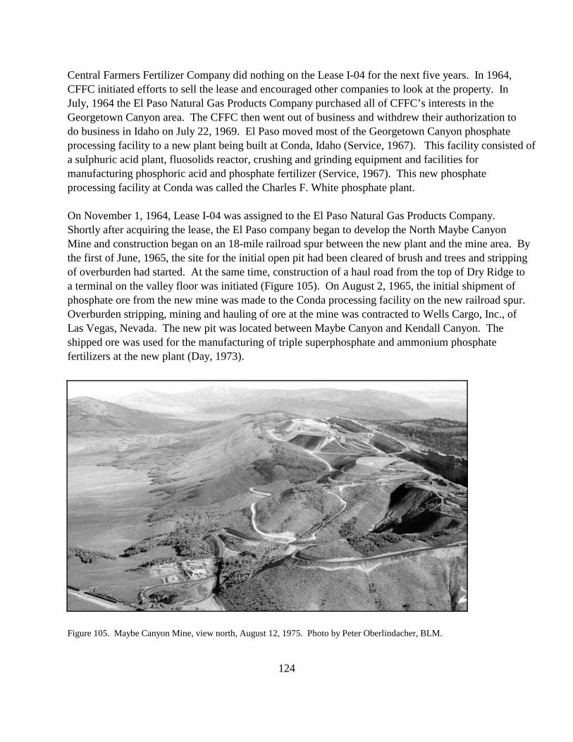
On November 1, 1964, Lease I-04 was assigned to the El Paso Natural Gas Products Company.Shortly after acquiring the lease, the El Paso company began to develop the North Maybe CanyonMine and construction began on an 18-mile railroad spur between the new plant and the mine area. Bythe first of June, 1965, the site for the initial open pit had been cleared of brush and trees and strippingof overburden had started. At the same time, construction of a haul road from the top of Dry Ridge toa terminal on the valley floor was initiated (Figure 105). On August 2, 1965, the initial shipment ofphosphate ore from the new mine was made to the Conda processing facility on the new railroad spur. Overburden stripping, mining and hauling of ore at the mine was contracted to Wells Cargo, Inc., ofLas Vegas, Nevada. The new pit was located between Maybe Canyon and Kendall Canyon. Theshipped ore was used for the manufacturing of triple superphosphate and ammonium phosphatefertilizers at the new plant (Day, 1973).
Figure 105. Maybe Canyon Mine, view north, August 12, 1975. Photo by Peter Oberlindacher, BLM.
124
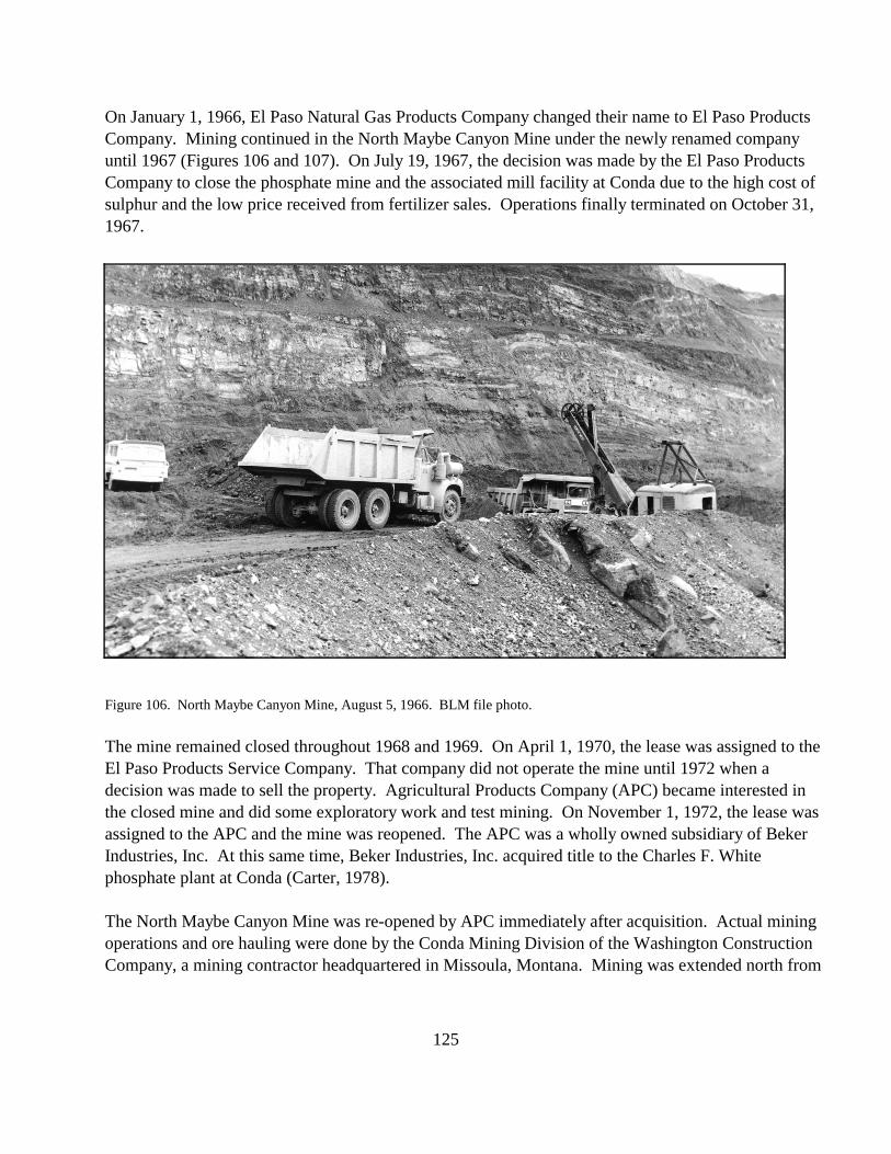
On January 1, 1966, El Paso Natural Gas Products Company changed their name to El Paso Products Company. Mining continued in the North Maybe Canyon Mine under the newly renamed company until 1967 (Figures 106 and 107). On July 19, 1967, the decision was made by the El Paso Products Company to close the phosphate mine and the associated mill facility at Conda due to the high cost of sulphur and the low price received from fertilizer sales. Operations finally terminated on October 31, 1967.
Figure 106. North Maybe Canyon Mine, August 5, 1966. BLM file photo.
The mine remained closed throughout 1968 and 1969. On April 1, 1970, the lease was assigned to the El Paso Products Service Company. That company did not operate the mine until 1972 when a decision was made to sell the property. Agricultural Products Company (APC) became interested in the closed mine and did some exploratory work and test mining. On November 1, 1972, the lease was assigned to the APC and the mine was reopened. The APC was a wholly owned subsidiary of Beker Industries, Inc. At this same time, Beker Industries, Inc. acquired title to the Charles F. White phosphate plant at Conda (Carter, 1978).
The North Maybe Canyon Mine was re-opened by APC immediately after acquisition. Actual mining operations and ore hauling were done by the Conda Mining Division of the Washington Construction Company, a mining contractor headquartered in Missoula, Montana. Mining was extended north from
125

Figure 107. North Maybe Canyon Mine, August 5, 1966. BLM file photo.
the old El Paso pit. Equipment used in mining included 15-inch bore hole drills, 85- and 120-ton haulage trucks, bulldozers, scrapers, and 16- and 24-yard electric shovels (Figure 108).
The mine underwent a major expansion during the 1974 phosphate boom (Carter, 1978). The company roughed out the alignment for the South Maybe Canyon Mine haul road with the plan to open a pit on the southern portion of the lease. On January 1, 1975, the Agricultural Products Corporation was merged into its parent company, Beker Industries, Inc. and ceased to exist as a separate corporation. This merger wasn’t officially recognized until April 21, 1975, however this business activity had no effect on the mining status of the Maybe Canyon Mines. Production was slowed down to about half during the latter part of 1975 and into 1976 due to a major phosphate price drop-off (Carter, 1978).
By December, 1976, Beker had started mining in the northernmost section of the South Maybe Canyon Mine in Section 10, T. 8 S., R. 44 E. Reclamation of the southern end of the North Maybe Canyon Mine pit also had started by late 1976. Mining activities ceased in the North Maybe Canyon Mine and by 1977, all mining occurred in the South Maybe Canyon Mine. This portion of the mine was plagued with slope stability problems in the waste dump areas. Because of these stability problems, french drains were constructed under the new dumps to drain surface water.
126
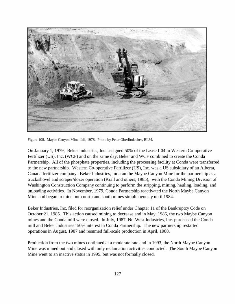
Figure 108. Maybe Canyon Mine, fall, 1978. Photo by Peter Oberlindacher, BLM.
On January 1, 1979, Beker Industries, Inc. assigned 50% of the Lease I-04 to Western Co-operative Fertilizer (US), Inc. (WCF) and on the same day, Beker and WCF combined to create the Conda Partnership. All of the phosphate properties, including the processing facility at Conda were transferred to the new partnership. Western Co-operative Fertilizer (US), Inc. was a US subsidiary of an Alberta, Canada fertilizer company. Beker Industries, Inc. ran the Maybe Canyon Mine for the partnership as a truck/shovel and scraper/dozer operation (Krall and others, 1985), with the Conda Mining Division of Washington Construction Company continuing to perform the stripping, mining, hauling, loading, and unloading activities. In November, 1979, Conda Partnership reactivated the North Maybe Canyon Mine and began to mine both north and south mines simultaneously until 1984.
Beker Industries, Inc. filed for reorganization relief under Chapter 11 of the Bankruptcy Code on October 21, 1985. This action caused mining to decrease and in May, 1986, the two Maybe Canyon mines and the Conda mill were closed. In July, 1987, Nu-West Industries, Inc. purchased the Conda mill and Beker Industries’ 50% interest in Conda Partnership. The new partnership restarted operations in August, 1987 and resumed full-scale production in April, 1988.
Production from the two mines continued at a moderate rate and in 1993, the North Maybe Canyon Mine was mined out and closed with only reclamation activities conducted. The South Maybe Canyon Mine went to an inactive status in 1995, but was not formally closed.
127