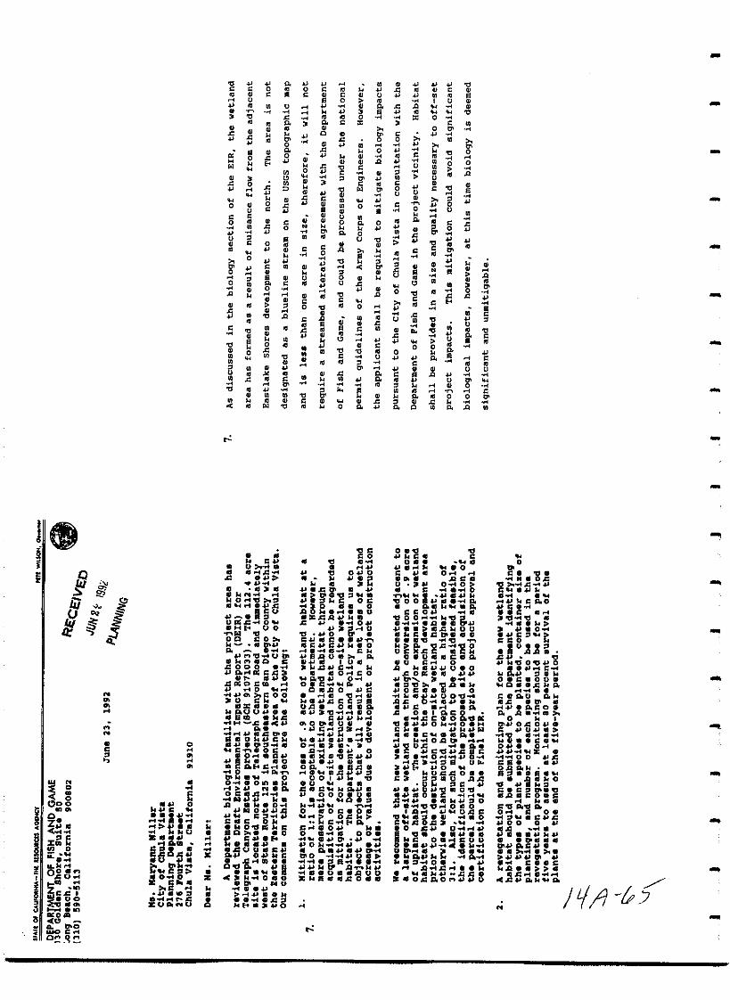
Telegraph Canyon Estates Subdivision - City of Chula Vista
432
I I I I I I I I I I I I I I I I I I I FINAL ENVIRONMENTAL IMPACT REPORT FOR THE TELEGRAPH CANYON ESTATES SUBDIVISION EIR 91 05 SCH 91071033 Prepared For The City of Chula Vista Environmental Review Coordinator 276 Fourth Avenue Chula Vista California 92010 Prepared By Affinis Shadow Valley Center 847 Jamacha Road El Cajon California 92019 July 1992 I ll p i R 1 7 7
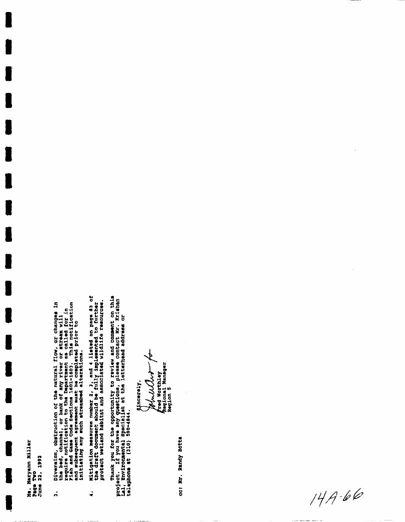
-
Upload
khangminh22 -
Category
Documents
-
view
3 -
download
0
Transcript of Telegraph Canyon Estates Subdivision - City of Chula Vista

I
I
I
I
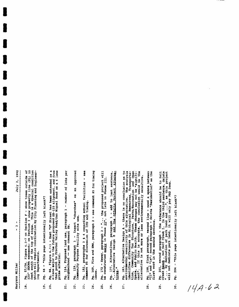
I
I
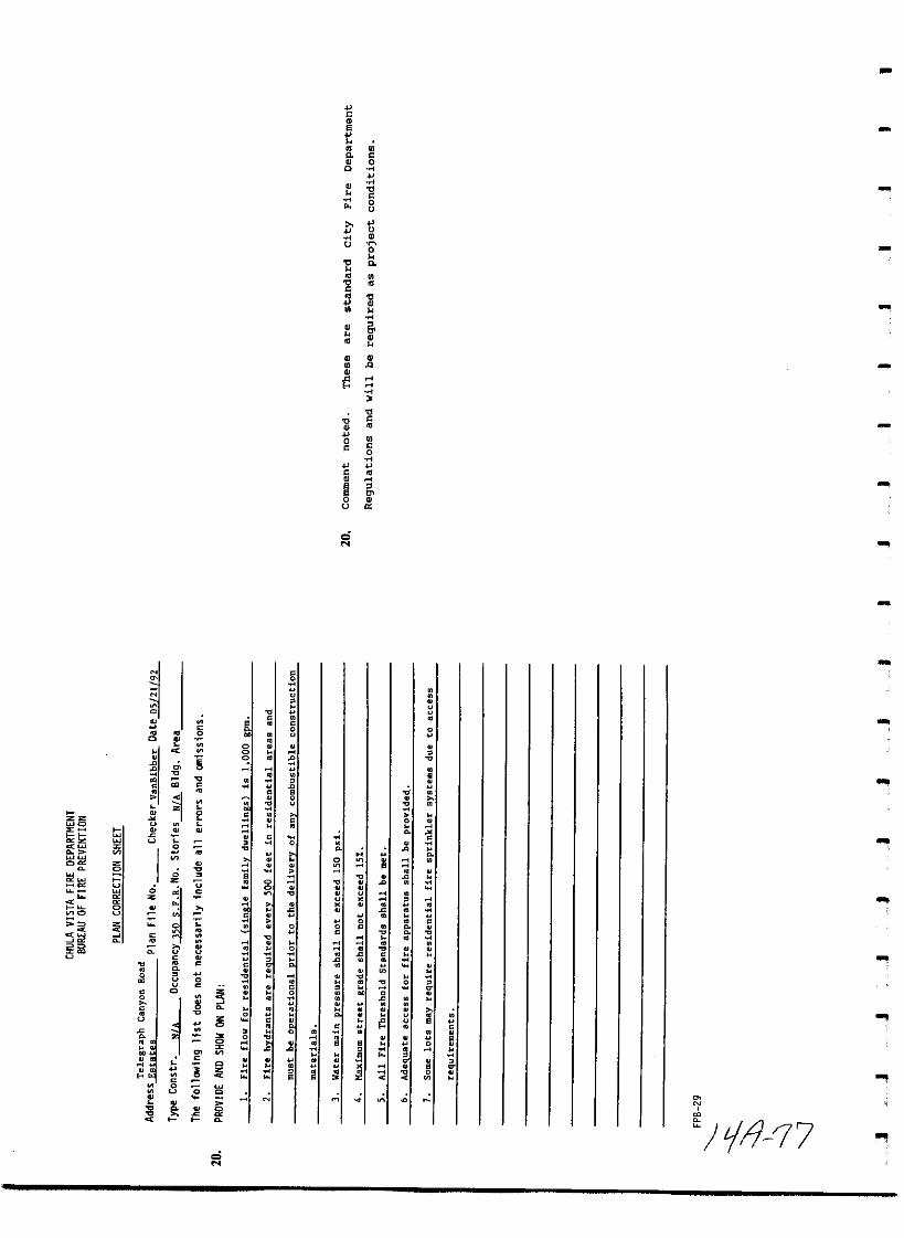
I
I
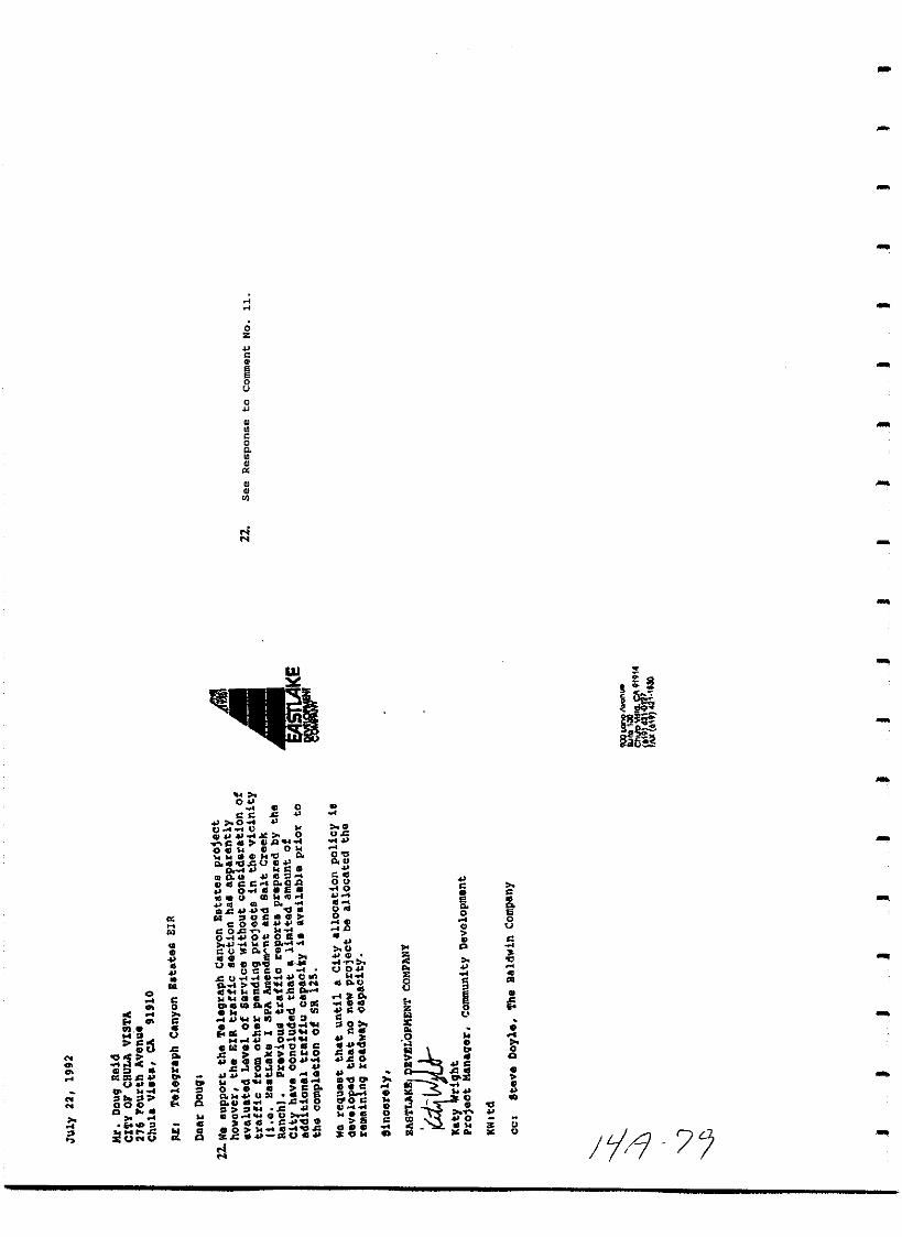
I
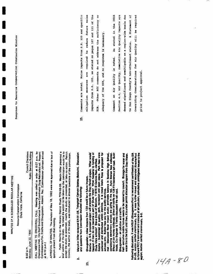
I
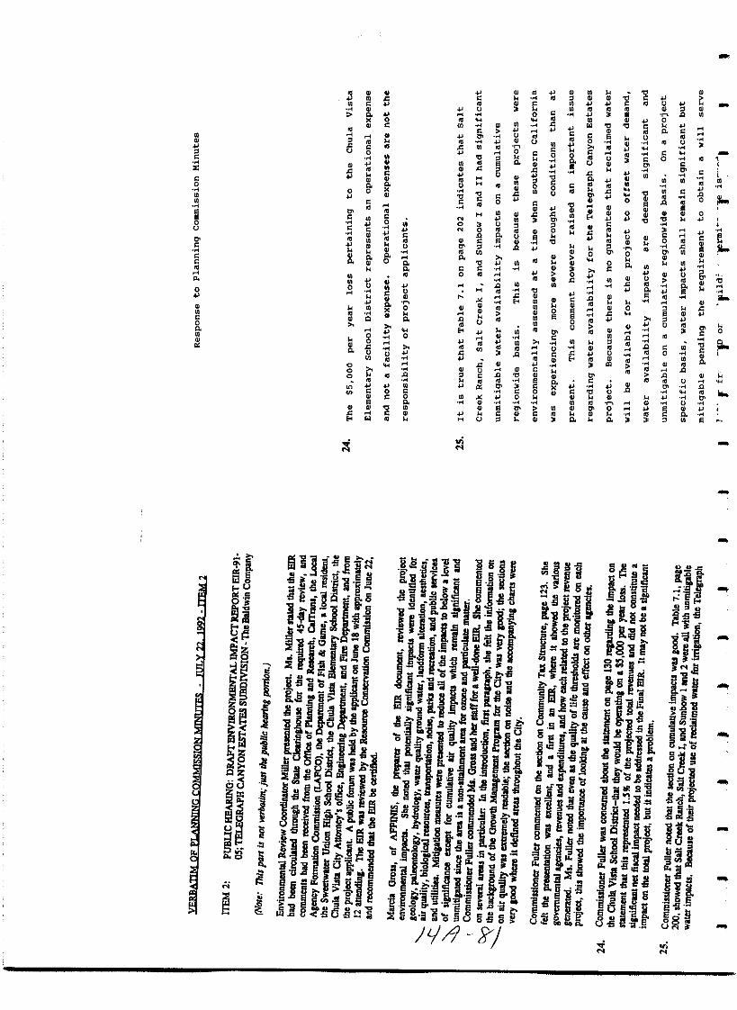
I
I
I
I
II
I
II
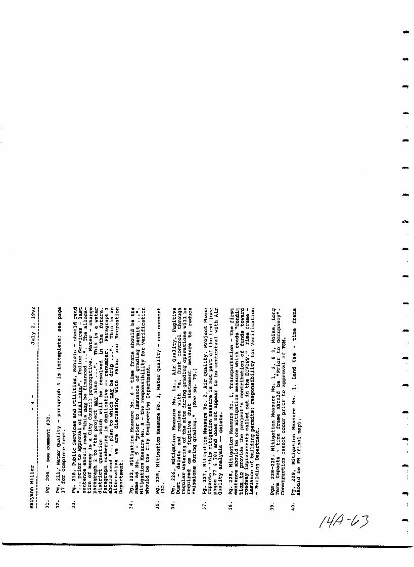
FINAL ENVIRONMENTAL IMPACT REPORTFOR THE TELEGRAPH CANYON ESTATES SUBDIVISION
EIR 9105SCH 91071033
Prepared For
The City of Chula VistaEnvironmental Review Coordinator
276 Fourth AvenueChula Vista California 92010
Prepared By
AffinisShadow Valley Center
847 Jamacha RoadEl Cajon California 92019
July 1992
Ill p iR 1 7 7

I
I
I
I
I
II
I
I
II
I
I
I
I
I
I
II
RESPONSES TO COMMENTS
LJ 5
Ic
I 0
0
0 0
6
I 00Co
c
I 00
UlUl
0
i
I Ul00 c
0
0
13 0
IUl
1jUl c
0
I0
0 000
0 0
I U
I
III
iI
I z
IICOJ
IIQZCllzZzc
III
o
i1 f
iiifn
I
I
tl
o
o
iil Ctilfld
H00
J JntJ
l CI
3
J e B0
IH gOI lk 2k CI c 0
INDO oGlfI C
tell 0 II
OOJ01
c0 CIICB Cc C
4JO OC t
ft 8 D
e tC D04ltol 4J c CI 0
All 0 O S2 0 1
4II Q C
g i1iL aI
4J I iOQOfltlOltQO
t1 IlIUE gIllftlO C
s cOU
OtJ lDQlJu lJ Gl Oc s
C llolJ 0Cleoco
OJ 0 00114 D1ZH C It
c Il GI C tIllI
0 lI cU1 ID
000 0 0c CO fIU 1Il
CI 0 0 0 bIC CI fi
ceoe101 0
0 coeta ca ClII c
fI AtI 1 tJl
ul fi fir4 tJI
ClP411 eAiIII Iip 0 u O
alca c a 0CoOlie
II S t c
5 eEkftD3 U PO
I I Ii fi a 0
5f4 111 U U o
OM
B3fa2ill Z
ioil
Iu
g
I
00
s tiI o
eOleJc
c00
cC4JD
o
c OCll
0t III il
OootgC g
k
0 PoHO
U
lIAOOO
a
tJIkeel
USlliIo v
co a
0u
cocDI1111 1
0
Q Viiik
cc J CI0
DoCCI
uc
1lU0
aJ olQ 31
u
o
u
c
oo
o
oo
u
c
oc
o
8
o
toiltfli
c
2 SCIJ tIO
oClIIa
0U 0
1II0lUU 0
Oc
1 10
tifi
0 c
ttlJ0 0
IIICtO
E0
OlH CD0
Gloot0 0o
aDca
0 III
c Jj
D4uu
c WI
0 titaJ1C ISc e
E1 O
0Ul
U OtiCk loI
t 1oIcoco
u
D
lJiggDD
co
c
CoaJalO
C 04oc4J
Q oeIii 1o Ct UD
110111
c IIItH 0
I 00 cc
00 aEco
a III 0
c kc
IIlEie
O WMt
0 0001 0
DOl I Cat In
OIlO 1C s
3 0u t
10
U01
IUke
1Ic100c I GI
011r CC
fo4i SRaOl
IOo DoE
Uo
o
D
c
fjl
II
Il
o
o
o
I
Lj4

00 fi 0 0 0
N0
N 0 00 0
0 0 c
0
fi 0fin
0 0 0 00 N
6 0 0 6c 0
0 n
0 0 N0 0
i M cc0 M 00 0 0
M N 0 0 llJ0
0 0 0
fi 00 c0 0
00 0
0M 0
0 00 iN
0m0 tj0
M0
0 0 c0 00c
n C0 0 0 0
00 0
N0 0
N c 00 0 00
1l 0 c0 0
0 0 c 8 c 0 J0 0 0n 0 00 0
0 0
0 00 0 0 0 M 0 0
an 0 00 0 0 0 0 0
i 00 0 N
B0 00 Ii ll 0
0 n 0
N vi
0
1iif 1 0
Clll0 5a W
gjffir ae0 Ec
1ClI Oa c s ll
U i i5rn ec cSl 8
s E j 00Us EC J I 1 gjco 8 500 D
j 0 0
Ili o
88 0 c iiI
09E aD 1D oS5t a
e2 S GIW c
aJlf0 5i U em5 g1J 9 s c
JIi iE 0 E2 2j 0
Ec
E 6 s tf oc
ftJ N 0
6 l Eii cre 0 A Z3 ao 1iQ 9we
oiu c aD D
OU 0 iis ceCIl3 CGi a 0 0 J
Woo WOa
e CDa c
oJ 5 i1
u 0c a
c Cl ec s g EC1 IL l is02S C1 liC5
co clDILa CD
Z at S i5ECD u sl cCDaI c0 a so Qea
KIi In 5 t3is oWe E0 5 Ie 16 2 gi5a cC
i J0
IX lU 0 i
ioCij oo0 oS ioE co 2 c iQ LL Q I gtScccIJ ie GC e jiiu oec CDcgCGCzeO
Ece c c ESjW 2J e
c 00 02 5 CII O
fla
o Ciwts C CDWCD 8 20 S 8 811 2 0
0 0a Ie CG O c
agI II 5 ii c
i j ec o 0 00 0
tO O iz E l t g e
9 e a tWi 5i c
E z uaa fiDO c 0 S g 8w co
2 tc E co cJ 2 00 eo
0 c G Ou oClac emwlic ii 18
1 CII aou
O evi o
0 D Co 2s N
7C
E Y4i
I
I
II
I
I
I
II
I
I
I
I
It ff
JII liI I 1I
I
I
I
I
Nc
CluJ
WJUJ0
ille
8
S
at
C
c
0
C
0
0
C
C 00
Q
c
CC
c
C0
0
c
c0
Il
0 0 Ot IIlOc c c Ql Ca 4J l c cc D DU 0 III oc III III
0 c oIJ C u q a 1 ql El1lI f Clllc lU
o C e Q ijJ HJeoIJ 0 Q t 0 6 t gH0 c r Ql artl ool Ql a t Ilo C
NC C Ill CoEO 0 NOCO H 1Il ItI
tl J Ji dGlo4J U4Jl cI5iQjIlo Q III
Ill Uc Q
4J Illlll4Jt I ickl t 0 0 tJlOflllllllllJ IllC
N tUr O tIllll QlUlllljjocIl
0 D4J f III U Ill 0tl I n 0
1ll 1Il 0 QIc Cc
ol c0 c0
00
t B0
10 QlllSC 1 00 ooGl s0
u ClIlC
UU oc oo 0Ql t 0 Ql 0 I
Ql r U CIll tl Cj t Uti 0 C
co lte Ill uIll l t c s0 t 4J a c Ql 0 Q 1lIl
CO 4J maQl gqB c Po I C0 lUo
Itlc 0 III C 0 Ilis
8fr t 8 JQlllE 41l lIlGl UJ aQ CtJl c e B U IOJ0 00 lll
0 t 0 c e o c geM 0 0
IllQlIllIIIc llIlla C IIlGlCM coc a III l1J J Cl t U III Coc
C o
01 0 Glj oCOftlCtj OIOc Gl u 0 1114JiJ U
1l 0o 2l tJI fiQ tl LII C llS50 IIl S C gs
1I tllS U1 C c 1illlo0 00 p l
a
3 p llSllSrIu CrI tJ 0 00 c
0 88CII 0 11 rIrI C 0
N 0III c
Ou 6 a g llS t Eu 0 dc 00 001
0c
rI af r u CC11c
Co c i II C11I1JIIB QQo u c let t c tft
ilJ tIl5Q8Quu oc s
lJl
u c CII a2N C c N It InllSU5 QUIIllfol lrIB
fa c 0 thR ol 6gGlOll C Q 2 IlffaQXCI lIl 3tCl lOOlOCQltCls dillS C 0 rI d 11 Qllrl JCCf
u Il 0 Il Il Il f g fi51l BN cooo 00llSlI ro llf o
t rI u IIlQifoIlDf0 llSCHtd 2l co allI
E tJNU WUQ1lf N M
Ilt4 P 0

N0
I0o 0 0 00 0 i ou 0QlIrIOl 0 g 8 0 00 Ml ItJU n 0Oc GIU 0
e 0 0o c0N c lllQlol 0 tJ 0
i IT0 OWe0 Ql 1II
atlP
0OO 0 0 0 00 OCU 0
c 1tI0jJ
lIl0 1IIJ a 000
O N 0 8 u0ltI j B 00
N tl II l o00 0 III0
gol
00 a0 0 0 0 oiloo o 0 00
IM o
cr 01 0 o 00 0 0 0 0Ql2 Oc Ql 0 a 0
og ltl 13 a0 u JcEN g o1101
fit0 0llll C III
a 00
5 cc0o
0o ci t l M0 0
u ft iJ 0
11g 5
0 OO1QI
0C 1tI oI
ONllll a QlCP S 0 Illlllo N
c 4N
l lGllu ol r 3 llIo oM
cJ0
000
000 0
OQlUlO 0 m0 0 fra 1IlI tIIllU 00 LO CjJ
i0
if I Gloe00 QllUIIlo g Gllll IIl 0 o 8 u
M UQlM o o l0 om N
Gl e 017o fr 81 0CP Ol 0
0 0Ho
0OjJ 0l 0 CIl j cIa 8t s
0 0Cll0 0 0 u z en
O50 GlHgM D 0 ll1J l0
0 QlU 00 g IllUci0 cllll4J 0r oO 0 0
50 o Ql l 1 c jJ 00o or Ulllt 00 0
ifg
o0 m 13 0 l5 0 g E tlom 6 t000
c 0 t
Itl
U 000 N lQ Gl0
0 00 0
t0 00 0 tz 0 lc co
0 g J to MItI9l0 0 00 e III 4 N t o GlOlll 0 0 N llIQlOllSm N tI 0 M M a0
oc 0rO OIGl
C Gl C c j 1Il Ulll 00 O g fOr G g 00 g g g 00 fGJllllG tJlOGJc o g 00 f f rr0 0 0ot c P za 0
iM
JJ IF0 m
I
II
II
I
II
I
I
I N Oc OllllelQl c0 0 OC C oIJ ftlGll c U
UC ID Q l0 C 1fI JlO tIlH C ftl 8 CIl 0Qolj
Olj11
IN III Co C 0 u c c c mtl Q
4J 0OC o III cc ItlQlOtl C 0 n 1 ICIftl till QlGllIIlllO
l tI CO lAm Ie u Q
u0
llI1ftlr tlU
0 lt3E cG1lIII Ccc 4 oQ 1IJ ljGlfJQQl 041ll 0 c I Ifwou
c u g UJ
tt 8 9 jj c o Ql 0 l rl0
0 C
gtolllI 0 UGlUQlCol8 U1C 0
a0
o O m0
Ill CC 0 COOllle OC 0 CfJOQl ICIn g o
0C GJ 0IJl D II1 0 c
cu
1lJ 1I1X Glc0 cN u u n lIIg fJ C1 1Il Ql
l Qloo 11 0c 0 0 GlfJ guJl
Ir c
fJ O c c2 c c Glc
cc u lIllllftl l
JftlCI 1lIIUuo cGlc 4 UJ
C C IO 0
BeN
aJ 0 Gl
tlI 8 Hog0 01112 1t50ic 00 c 1c Q1 IDCc cn
51c o
moIJ 0 II 0 Cfl Co 0 C 0 JQQlQJ u 0
ItIl J 0 0 c N
c lQtElc
I tiu 0CQllllftl c
c cc ll e cGllC c0 c c 0 oC g 0
0 g f o ftII
oa 1tI lfJ cr cotj 0 e QI l tnfJ U QI c eUlWc0 c 0 n
n
c o
illll 0n 0 0 cu u U tJq
o
ffi0 0 0 0
i g Q1mB c CO c
IfJfJU co
0Gl 5 CIl Ql cU iIllGlfc
fJ UGl
III trl 0 g
rp8 0
li 5 S III g ctI
QlaJt cc c
d 0 IllfJ
g 00 I 0 eUl fJamo I fr CCUIlJe 5 e J 0
0 l Ia JI c ou
co tllc JI E8 ll tlf
IW lwjgo4
o u
I fi tI JQI 00
I e c cS lllgtll l IW E rIlls t c t QlQIoS I10 I 4111 o Ill 0
Vlglt So Ill 0 N N c 0
12 s c c co 01 s o c 0co c 0 ol wJ QlI w N NU 0 U l s U J Gl m
0 Qlor0 Ill l m
i1lQI 0 Ill S J
IC iN G1c s f f c f f8 fa f f i jg ftl f il1I fc ollW I
0 LA 20 N nN N N N N N N N N N n
I
N
N
cc
i
o
M
c
ou
o
I
oN
K
M
0
o
4J I II Il M CIllUlllltTolllQl ItlO
IlIIllUClJ ld 4Il r 0 III III l 0 m 4J
c3lJ1tl 1ll0 0 lll III
InIV Illl Olin J4
g Ql CIlI fl g
d Uc J4 GlIll P1Il E4Ql deI 11
QlJ d C le C
ml lC Ill Itl
611 Ql
o UQl 09 PII
c Qll Dou6 ctIll3o B iJ Glllp
C g ll tf
00
Gl I 1Ild
jiel
Itl aIII Ql
GIQ a
Qj l Dfl Illd Cu
iilu u
tl II C fl In
c u3llCmIII 1110 Q 31B
lW flU II dg 0 UI
05 00 U 041
ul
oll II tl
4Ill i l C
tU
Ql tJlQl
QlOmltldcc oll
tI 11 J0
III0
IllU tl l J III
l Olld3r 0 II 041 II 9Jg N cO III
lOgc cDJDll4JGl
CIOIIU fdUl ItlJlC iO tlj t
S IlIJftl lGllC 0 IIlG Il 0 0
fl O 8t g
cc I 0
u
tI fl
er0
0o
0s
f2II
QlDI
C
fl Q sjIO t
QlCIllUOo0 C Do
00O tJI
zlllQlC
Il
flc
oGl
laJ I QJo C
IllIlCO
0 gc tz
w
0 GlIl l
ll I0
UlIllQl
IeOcZOo
o 0NON lU III 0N
SaJ 0tJllIJf4d
l1 ml1ll
M
c
u
o
GlJ GlCllDQ u
lOl tlq Q1
fi 11
0c
000
jQls 1ll11
Ol fI OGl 10
0
OIaJO
3c n
IIII
I GII aJ lJl
lJllcc
aJ I GI0 Ql
2 IgII f
o tJ
1 f fic I
0 gC0
IlJl DC C
GII
aJGlIOf
EiaJIl1 tJ
o
c1 2
N 14 10
gK ilee
10 GI
Q
aJfiu
no
0
0
c0
lO0
0
go0
GlIII0
0 0Z
aifcCaJ
1lI0111IaJotJ
c tJ10clUlII
I Ei
lJlIII 1llUl 0elo
xaJt 3CI
1 1111
NNO
g lJl l
1101lg 0I
M
c0
111I 1IIaJ
Ol lu
GI
aJ tJI l II
cll0
e 0aJ 0 0
0aJe c Q
Oo
g aJ IlIJ fll
mbfiIII 5 c 8
COIO
1IIaJ0Z Ill 0
GI oonaJ
GI
f 1il eIII ftlGI g ogE 8 III DC caJco 0laJ c IIIc t
g sgtfc
c 0E III Q 0 go
JNI IIIC lN I I
Of fC III m lQ
r e I
M
c
noc
0
Uo u
zoUl
0M
0
14
N
00
oc ltI0
fg 0
III
Gloco B
u
0
0cC
E I
IllCN O
NU
ell fj u
IIe
aie0
Co
M
o
c
l
o
0
C0
c
fo
0
90
Ki
o
4
0
oUc
M
0
o
0
ooU
NO
K
NM
MM
M
oz
e
co
onNN
N
K
onM M

I
I
I
I
I
I
I
II
I
I
II
I
I
II
I
I
M
M
I
I
o
C
l
c
oo
8
co
u
o
l
MO
0
0c
g
Ilo
c0
oo
0
o
0
c0
u
10
0
o
0o
j
I
M oN
c0
Z iu
fit
M
C5o
00
o
6co
o
0
cou
00
0
0
c cpoc
c
0
U
o
8Cc
flOg
M
p B
00
o
1ii
c
p
uil0u
5
i 5
00u
go
l
icO
M0
Iloll
MC0
c 0
N
ci
ss
o0
0
i0
MU
0
f
CO
C
o
co
0
i0U
0
c
co0
co
s5Sou
00
cGlfJ
gN
U
5jGU
1Il l
EU
UC
sJ8 oc
c c
15
j il II
CP u
EU
ii
o
c
0
1
u
iJ 1
ttIJi
I
Clc
j o
c
e I eaIt
iL
LoN
f og5 aJ
zo
v010
a17D
c wo Co
fJiiiJ0
v 1fe
o
lot
t1
6 tto J0 000
s
1tii 5
c0 0 0 0 c 0 c
c c c uu 0 I U
u C 0 0n
0 0 0 0c c C 0 C
00 C C
0 8 0 0 0
C 0 0 00 C
0 0a 0 0
0 C U0 a
U0 C C
0 0 CU U
0 C0 0 0 0 C 0
UC 0 U
C C j U
0 C 0 c 0 cC 00 0 g 0
c 0 0UC 0 1lC C
000
gC00
aU 00 c c U 0
00a a 0 0
C C 0C
0 00
0a c a0 U
C 0 C
0 c cU0 C 0 0
0 0 0 c0 U c C
0U UU 0 C C a
0 C c U0
n Cc 0 0
0 0 00 c c c c a
000
a trr
III IJClNt It
lot 0 sa c
1t 8
DC COOkDo t
M UtJIIlJlMIIQ s
fi sto 0
5 sQO eoaz
AU UIlfSUIi I U
H cc
1l t eZelJl f 1lI
CnIlOCII 0 c
c 20 aTIo
r tn 2NIlg
5154 04
t lo1gC IlIt Ok
s Od kCJilat eo
1 J5ug3e
1 J1c Jot 0 III 0
01 0II
JJotEt Jao
000
ell
E OJ 0
If CI Etro
01 0c DC
g e 1l8ca J4
c 0
t g ll 4J C T
c c oe CJI
E1QQIl O Do
tII IS 0 C 0
Po 04o c Ito4Po
C 1lItI 0 C01tJ
C C C II
fi I 8cJJ I
00 1Jlo l 0 II tJJ e tOl a
Q 0c OS
C
ft B5VOIl4 0
eu
5cc QoO 3
o COCIIO
tc tCf4 O
o II IIS 000 c
OJl ta 1tJIt
GoO tt 01l
gu aou
lENJlC J O
0 tI tI
t 51 0Cl O
Q C IIIU 010
s 4 I 0I k
S0011 W 8s 01 t III
i s ia 1 gg
coo 0
t Itc gc g eO U CIo
ClU 1 0Q JI C U 0
c0P1ll It
l 0 0 Q IIl4OCIll CU 0
U 0Qc O C1
C II Pic OIl Crc O
1Il c C 0 c OPIiiO O t4
cJla 1liICI 110
I kt OQ 01
E ofi c 1 It1 O t 04
a
gf3ura
14UJc oC 6e g
Q
ti g r W
cc 11000 10 0
IAoo4 IIWUcl0 1 0
coc aeo 1 1 0 1
014C OIllCUU
c
talJI t lI lIt
4 cc IIa Os O Olt u
o
s 8Ol c4aJ
M 0c
Illl11 III
tJ 04
1l fil teO I
lJ QQ 110k 0 0
fJ cPo l 14
O C OOIIo c lotrI
ceGoo ra kec tJlI II ra s o
ra Q t tillo
0 0C 0
pt14 10 044J J
00 c
s lJ4st
tJ i o
S CJGaISCO C
t aroa Da D01 II O11 IS CoIJ00 0
JtIS I
1IIJI
r CJ4G
t tcs AoIotra
jLIJ
M
o
I
I
I
I
I
I
I
II
I
I0
oi
I0
t l Ou 00 0
C 0 03t
OUJil ell r
I00 0s
0a
Ut
104 1 ls 00 III c
I0
ll1eM1 0
kft DWI U 0
llIrf 0 0c c a OQ 0
I o
5 N 00 12 II
5 t Ii0 oo i04011
ga4J I 00
I 8 01oO
0 0 A Q OC Io kO
e 8ii 0
UlaeAOI
ou UlunCt 0
i8I
g i c0 0
tiUilol 0
0 10c c ec 0 So D 4 g Ii1E HO IiQ
I g5 co
lio 0 c
l J c c il5 lI Jl q0a II ft UIloU
all 0
I ILjl fP
I
Ifii
MD
2Q d
8Q
li uoJ s
3g8Uo on
0
CJ
N
u
co
u
o
N
co
eu
Cc lC
u
osac c
EONU
o
c c c 0 c 0 c c cc 0 c c c
uc
g0 cc
0 0 0c il 0 00 c
u cc c c c
c0 0
c c0 c
u 0 0 Q 0
u cc
0 0 C 00
0c 0
U c cu c 0c uc 0 0 U
l 00 c
0 0 c cc 00 C C
00 0
0 c Q0 0 Q
c 0Q 0 0
0 il c 0 c0
Q0
0c
u 0c
0 0 cc 0 c Q
8c c cU 0 0
c cQ
Q c on0 0 u
0
c 0 c 80 c c 0 c 0 Cc 0 0 u c0
c c QU
c uc 0 0 c0
0on c
c 0 c c c uc 0 0 0 c
0 0 c 0
c 00 0
0 00
cC 0c C 0 0
0 c 0U 0 0 0
co
0 Glo 0 C t1 III Gl I
al lIlc GlCJIooQ a4O co m c uo I 0 M II 0
e uoc IIIC I II I c celli Lo 1II
100 fJ III Oil 0 0 III c c 00 s caeOUCLCIO 0 001 0 U C 1110 GlIII COc cSc 0 Dille C1a1CJ c o DoD 00100
0 0 U 31 0 IlSC C UCl 10 00 CI s o cell II octoac II
a1U cO Il Ill IIDC 8 f J cuca II tL31 um IIIC OKO cmc
1111 Sill OIlIU GO ccu IlIllOGtI eu
oco ol UO IIIa CIl ao USU
o u D 00 Ii r uc 311Cl oe
w ClC U cu I cu OIlIllUOU sccca CODC c a 10 e 0 0
co 00 0 0Cl c 0 1lIC1 0 III
Cl 1 CdG Q G UdG Qo GG O rl O e G rl U
e O e u cue G G IIl 1 l cI Q Q 0 Q Q oc c Do III IlCI
QUU o OBcIGUG illS M GO dllS C ou O s Q Ocl V rl G
eo e o c OO O Url U CU
Q 3 OC Og dllll IlI CEI cI OIlc CII O tc l Il OE 1I OuuOO
110C c II C III u Q II c Q 110 c VII ICOO ecO OIllV V rl G Il
OIlO 0 cIt u c c Ol cIII U E 11 0 uQ O cU II n
Q l VO OOrl c O O EiIl 3 lMU lU CI1l IIC OTlU l 0 0 D I lV II I
CG cI C III u lcclCrl OIll l c11100 lOCO OVCU v IIlOoa U OU CU UCIooll O Q
lII u II oc otc lo lC c 1I 0Es lIc G U E I G C O GotO O CClOtI C
1 oeo OC rlOcO 3Gegrl aosaoQO cueuuu oo cuc ccI 00 00 l
U I cL cc0 0Q U U U 1IDe e II 0 111 r4o ca OOM c1lCl U G lo O U o uUOE UU Vu o ooc m c
O o uc UU C l U rl UUe 000 C GU I YM
fIl OCGIIIil l Mu t11C v tIl co cu o ve ouGrl C 1I01l W
c u x WCI IIG aIlC Ori O d II ktllW M o c 1IIem U u o o U
c II C II U a cu I 0 C aeo 101 QI OlC O c cahol Ql O t5iLI GlU Vl clIlI IoOOE
C U Ilt cI fIl dG c ao N O
UGlS t1 IlI 10 I El UaU ClIClIu ODoS II
o o rlUO IO OCO c u G G u
OccuO GyeElEl O uc C IIcOCaIlO3CloC0r4 c ucc ac rluu Q tlO C
z CIlUE Glu dcu eu ccL 0
II Orl l u o c II a0 a C U t G c C Il II ClI C rl 0 0 II C
G111D O 1II03 OEo CGOII t l CCO c lc IO cp3 CO Q cg U C G OOUrlll euu
c 0 0 t O uc u u Ollu ceo weu IUgC 1 I
11 OS lG IN c GelOO ouo c C1G1c 0ul Gcue Gcc c 00
ug d o GlQU lo a IIu cIoua O ClI
N
c
c c
O
ocI co 0
1IlII 0 l
0OOIlCla
0OO cI I
0
c
Oo
c00O
o
c 0O
000
u
00
0CO
ooc
0
iJ t7
Ic0 0 c
I0 0 c0 0 0 0
0 0C Q C 0c 0 J0 0 0 Q
0
0 0 00 8 c Q
I0 J
J
00c c 0 c c0 0
1 00 0 c 0
0 g
I 5 Qc 0 0
c
f e n 0N 0 0 0Q 5 c 0
0 c
i0C Q 0 000 J
I0 C 0 00C 0 Q C
0 0 2l c0
C0 00 C
0 0C 0
0C C C
0 0 0
i0 ti Q 0 Q C C0
I e c gn 0 0 0Q 0 C
0J 0
5 00
0C C
C Q 0 C C0 0
C0 t
I0 C 0 C 0ll 0 0C C 00 0 0
5 C 0 JC
0 0 0 00 0 0 0
I0 C Q 0 0 c0 0 0N C
C C ll 00 0 2l
0 0 00 0 J c
I
II c
v o c11 B40 U v V
11 0 00 o
u M 0C v
II II 0 0 0 0 o u0 o U 0
III ouo u co 0
u o ofI C O 0ll Gl ou
oc u
u l c
Ic
0 0 0 Ol J ClO I Vg c 11 00to 4 11 GC
Vu e u
Gcac 00 u u
C 01 u
Ioco 100I c El V
U u 0 00C II III
0 I oa 0I II G o O 10
O jI J1I BUGCloIC1 c 41 I
V o O Il C O
Iu OV 01
e0 00 1 0ca 0 ecCl otl u
0 0 till Ql II
0 0 0a O 1lt
V 0 M 0oc II c
III U ON G 0 u 0
U IOClCI0 113 II 0
I 1WI co u 0 u
oa c u Cll00 0 0
0 0G l1li11 C Gl tCO t 0 DoC U I
I0 N
o GCa cc lo CIJOC o uU 0 CIO U 0 a CI
0 ca II c 0U 0 PII A uca 0
0 V
u o 0 M GIIO SIl c I II s 8
I0 0 ou u0 U aGa a II oa
00 11 1
0 O II IIsl rt 0Oc 00 0
L 7 IfcloP a GM U 0
I

o
3
8
e
a
5se
5
foJ0
Ii
c
5
i8ijjCu
f2e
i
9
c
i0
o
S0
lio
U
tIII
iilJe s
EQ uO
e ali5l il 1J
OCl1
llllI lO
iltl J
9e0
iilc
eou
301c
Uc
00u
i
i
0
c 0 c0 0 C
0C
0 0
C 0C c c
0 0
cC 0 U
C0 C MU
1lC
0 00g
U
c0N
c uc
0U 0
Q
cu
cu
u c0 u
00
0
C
tl c c c
o
8C U t
e c 3Gi5611 C
Cl GU 0
to lIS jl 0 l
Citi gtlgG S
uod 10Qo
tgtPl a8 z 0
c Co oa
o MdesoaO S 0 3
o ffil P c5g c u G
ou S o5
tD ii allu IC ICl t
jslSilg
llu tt Die
aOo ss ouu
guc
88eii 5F3Ut dE3g s 2t
o c 3 5r
aUjSiil Oll5 U
F Soe2oS a eolllllh o g
i ijH h
eCl c 0 iii2iilg st
c e u Ii d II 5s oS 5tg
ii e01 0 0
U u g g flO8 tg 8jBj 5f j 1l r iS
2gsugs
s t9S Eiid E uSUGQ Oi gust 5 8 u oS
sR Etltl g ua saCII U U
I n a9gCl
U c g qijo Ell g e c
Uu O
CooS en F a lc
IIGUaoogo 8 i s
u o elli 2ii9
llHllHEiilial
lllle a llh
L8 fhli u a hU hi
iI af0 j lli 1 in5 a Ji S5 SZ 81
g1
l
u
a
au
u
ilofo
I
t3
2ic
N
1o il i
1 i eHa 2S 8r
iPUlli h1ili
HUll
i8i Hlat HiIi O I I2a ilc OlI
a
lll
i f01
l 1a
tj1 c
I
I
I
I
I
I
II
I
I
I
10E
1rn
i5oo
IQ
182
Iliiill
131
8
z o
c
4 OOi
Oi
ii
c
Iei1
LJW
Wuwu
2ecOc
ic
2
c
J
swe1
a1 c
o
ss 20oitcl5
Ec
cNO
i
ii
ig
10i
5
Us
CI C
S s5 a g
f 50 Ee 0 lQ5
III0
1 8 sj 3iiclQ u t
ll u 2
t s 3stt5CI
tlu
u c
EoI Ce
es
sSojSl1 fJc
cEo c
0 u
di
fe a
0
SS er S
oSic c III 0
oJ l t itCI
cn J
o
I gbDIo I I Q
Q5 il 41 e
w t 05 55c uoSloc
sfoo C C oS
CI sgl tlSco
o c
o c 1EjoI llS
e E ail is E
fCIE Ss S gg H
e lZOij c l II
co U
Jilr
i 5 telq
oS oSi Ol E
5ll1iSei
s1o ils8III w
o l5
Doo cg
f w tt 1
8 5cS t o
II Ifc M02 5 a
M B00
c cu
c 0
lJ go
1lc
M
5M
u 0
iln
0 0E
M0
c
c c0
ti tic
00
go
c t
cU 0
gc Q
0
c 0 0 lJ
U 0
M0 U
C
0M
uc
0
S sl Il
2 5 t6
c s 0 0
giSo tOl istI 4
l
i r55jQ flgczrr aE c
cl31il1l 0 iss Ea Cl
q g8 6 5i
l3 crr
e 3e
0 l 3
eto f IS
s sfo gIll g t
c 0 III a
I 55 0
cl
n Sc 2S b
fl c
ofic 2l 0
c
t l1 Ec
s
5 Q 5CllsI jJe c UQ JIl cr
5 f
8 Cle g e ti c
I l gill58 s
oSo
8
IJ
0
c
ef
E 0
EB
I
oS0
oC
ee00
e e
o
lJesl
S C
s1
8
12
N jl g iUi l
8jji3s
iZ
1 ec
uscli
2
s
H
pill 7
uw
iiiuwa
N
N
co
a
Co
I
C
o
C
CC
i
t
o
C
o
I
C
o
o
g0
cu
0
t
o
o
co
c
I
Co
0
Il
coccDoIJ tJ 004
11 0 ut1Il
QI4J l1a OQI 0 B IJElJilllll
l
1IQ11d1
06Il 01
0 1
Ul 1ll
H Q DoroI
lIS
WOIdOu
Cc 0
QJCcn j
5 III
0
c u
o6m Oo t
GIGII
o
o c po QlIlll IIra
l
u 0
o cIEI
fit W Ql
tlllJJ cJGlcui m
Gluo
0
Glfal OIltlX
aCe Gl
cg IiIOJSCGlJQl
o tllt O cO GIJ
c u0
0 00 0 0
0 0 0 0 C cc c c 0 0
0 c 0 uM I 0 c
00 c 0 0 u
0 0 0 0c 0
c 0 C00 0 0 0
0c c 00 0 on 0
0 0 Nc 0 0
0 0c
0 0 cc 0 c 0 0 0 0
0 0c 0
0 0 c 00
0 0 on 00 c 0 0 NC 0 2 g
c0c 0 c 0 c0 0 I 0 c e 0
0 0c c 0 0 0 0
0 0 go0 c
0 0 0c
0 0 0 0 0 0 c 0c 0 0
M 0 0I 0 0 0 0
0 c 00 C c 0 c c 0 0I c 0 0
c 00 c c I c c 0
c 0 0 c
0 M C 0 c0 0 0 0 0 0 C
c 0 C 000 0 0 e 0
00 c
0 c 0 0 0 g 00 e0 0 c c c 0 0
0 0 0 0 c0 c 0 0u 0 5 c 0 0
0 0 0 I
Ql OlNcr ClllUfJ 0 III c
0
cr 11ilo Ill UIIII X r
uIII
II GO
lll ttlo11 III
C QI
g 0 Gl E QC slll
1Gl IZ
COIOUQlIllOC4 uIolUOlIS Iii O
0 1llS Qlj Oll l C
t1 Ql liirIdDoIlt iflQllllfll dP lQ
o lii QlfJll ao Jo Gl
tO Ql
GlO11 cJlGllllldld
E o lIJ
t11itlPoral
II El
ri 3 Iii III
Jl e Gl
III CIIII 110 Do lEIc 00 r
CllS
Gl CIIGlg omll i
cug Ql
lIlQlClii s04 I c
gQl
BvdEt4 IIl
roI 0 c0
II gi g rlJ3 E
QI Il cJ CJ
OUCQtJCQlII IGIQI
1411 CoIG I1oP
0co
c0
c
c
Oc
O
25
c
cO C
c0
C0
00
00
0 0
0
dJ00
GlJlpooI0
00c
c00
C
5c
Gl C QII OJ O GlUOQ 4clllC Oc
1011 5 J
II IOQl 011C oo44 IO
QI0
QI lllcg100 ulQi QIO
Coo c 5tI C 10 1111 cI 4 QI
c Ul C4III U 2 00410
U GI I 4UI coB Ul
QI UlUUl 01
c C c Gl 10 u
4JtJlO QI Ul
U 0 1010I tI 0 c
IIUO lCQUlQiplOQllCUlQlUI
IQlO
IelQi t QICo 0 QI 5fi
1II1 1J J10 Co4
CQ Ul
tIlJc JJ01 101 2 11
ICOCQIIIlQiQlllr
c 0III ttEl
u oOtJc 11I11I 101 11I11I 0
1lle
Q1 pJleECQ fi8 e
a
c 14 III III 0 01
gO
IIJ l ULS11I11I 2l 11I11I i t
a fiJI fi eUl 0 c 0 DocI Illc u 07
I0 III IIIZ
tIlJQI CII r
1tIt 004 IQ 11I rc 0
Qlt Ill J1g COo QltI1G110 Ii g gl 5
01 El1tI1 004OJC C4Ql QI oo4 11 IGc oo4
O CQJIoI IGli tIlZ
mCII 111I QI QI 0 tJlO fiXJlpUl
IijjQlEl 0 QI
f t S Ec III
Oc 004QI III COItlI1oc mru Ql
J110 10 I 0
CU QlQlz
I iCtJl1ll ir Ii r
ct tI e10 t C k 0 J B
J QI r t kC11
m r I III Cd 1i 004
3tI 1tJl
0040 r Z IG
st 5 tJl r OOJ
J DoO S jr
lII 100 1llJc fiJ tCdQl
c a004
o cJI 0 k
JDo J
QlQBS klQ IrIQ 01 1Qi IG0
0 004Uc
e00 Ql Ql J III
III
JC Ql C
ge te Pl 1l g C Illjo
L QllQitIcU IoIfiP 0
Ql 8QlQm
E QlODotJl lQlIol 1tl
iCe OlQilllc UIll004 c Iti CO5 t
JQl
C oo4 vq QlU
t QIG110 0
e e tJl r1IJI C 0 III
MO Omc omuOI clol Utt r
W oo4Do
C IG
El c 0 5l IitJl1ll tJlJ i Ul
u idlllc CQl11o
st 8c0 1011 IG CQ Doc
OJIG tJ JIGIGlCo
oco
0I
0
oc
e
ii5C
c
c0
0
c
c
c
0
I 0
00
0
0
cC
co
Ii 7

I
I
I
II
I
II
I
I
I
I
I
I
I
I
I N
E0
IEN
EEo
I
G111 qJItIIlIaJG1 0 C aHtJal GI C4J Ql
fi GllllC UQ 1ll cc Oc c cc 00 lG 00 4JCII 11 011
1l aJ lDtI N 0 UJ Ql J Eloa lG R4 lGoIJll aJ IllQlIW
4J IIlU 1 a GlIGl 01 U 0 0mal 0 N C S coc IG
1tIt gl e 5 QlaJ Il 1ll
c iIll j g Ct laJ 0 lol aJ IIlIllS 0
III U Jill oGlIll CII Ul
Q CCeIll c c all 0stl 0 0 b 0Ic fi
0 0111U 0Ql U l QI
oJi lIlcIl 4J 0 CUl
U 1lJ NItI 4J u j Ilo 0
c g Illfi lG In Ill UclG Do cell 00 IlllCC CU
U lSlJ U MV1 004
lIl
mOltlftlJ tl1G
Ill III tl S E fi4 III s c A uc lllldra Dl 1tI
51 rc1 t 0 C u c 0
aJJ cJtllQ a J III ul mC
0 g c c c 0 co ElaJ 0 C
c Ill ItJ IIIII
0 J III 0 lGc00 Gl StS Qtl ts1I s lPi 11 t
1l1ll 1ll IIIJ 0I DID c CII 0 Il l
Dot JaJ cJIt llilDa 104 In 0C
C 041
egll lPg Il I cBcBIl Il0 tIl m QlQl 1II01t 1II 1 10 Cc cGllllC c0Ql
6 u0cSr 1ll ai VJ g C U C
Ql U Ql
ct CII Qljco
fUil 0
Gl cllllQc m Ql 00
J Jc fi Q l fi Q CJ Gl fi 00
JIGuJ JGl Gl tI CQ g 5o
UlUIG o c oc O ZJGlu
Gl o Qt1 Gl
OJUl COJ
c 1J g cclIS C 0 Gl GlJClI OJ Ul o lIS NO 00 CJc O 0CDc
0 lIS lIS lIS Ill
c 5 GluJO c c OCc I8 U tJI
fool o t g Glfi S u
MiIII C fi C m II J
c g O 1 5 t i Oc
t PiGl ON 000fi lIS
C QlQ Gl O Ill 11 StJI1Gl c IllGl ClI c U tJlU cc lIS
I PiOII U Gl U CGGl II o fi C g1ll0c C Cc tI S lISc C G c
PiU lU j4J fi JI U I
Ii 7
000 e 0 ce 0
0
Z eZ 0 0 ece c
c0 c ee
j 00e
0
00e0c e
M
it0 e0 0 e
c 0 cc N
ee0 0
0 0 0
0 e 0 e0 0e
ec 00
00e 0
l0 e e0 0
ll e0 0
e
iic Nc e 0
00
eZ
00 0
l 0c e
e c g oe 0
00
c0
e cM 0c e 0 e0 M
0 e 00 0
00
0 c0 00 0 0
00 0 00 0 0 0 0 0
0 0 00 0
00 0
e e M00
0c 0 c e 0 0 00 c
N
01 0fl
1o 100GlO alGlI JHQ c 00
c ca co Ql
0 ZIq1ol0
leUN M0 lUUE UO 1olQ O ll
Ill0 oC E0 uo u DU ol
m Ills Q lln0 04 e III III GllOQ
C00 CD IlIl
G1COC0
0u
oNZ Ull 1ll
iuQc OQ l0
1 d l eu 1
CIlclJoCfl
0 0
Q tGI t Cl UlaGI M oGI mlDC 0
u0
QI gf I GI IIIC 1 1 0 0tjl1u M 01 Qtl 0o o u 5g Qo CII 1lI0 00 c
ftl tlO O QlGl0 0
5lilu tlZlO tl o g III u Ic1cJ JtW u 0 III l c go
m dc1lI o cPo0
W uo 0 o c I 1lI tl c
ii 50 0 III uc IfZ 0EU 0 0 0 o
CIlG1Q Ic 1G1d E w
0cW to 0
0 IO d1ll 5 GI 8 gu 0 e u 0 ea M 00o o GIlliESe 0 c 0 lti to 0 U
u 00 u CDi 11e 101
t Ill Co UI CtllllCDM CO
N dGlleO l00 oN A C Cflo sQ 0
M IOlllM 0 0 I Ilu
0 1oIIcCo
oEo
l coI 00X 0 O M01 60 0 0
IG 1M 0 G l 1OG 0I Q oIro 0 Co WG o cP 0lol o 0 r cP
Q o0 l l 0 lloll lM 10 m cP c c o IG
ggO llll 100 III 01 010 g sX u c 001 lP lepDlIoll0 l os O IG 010 oec o c G l CDQ Q SCDcPQ 1oII o lll l 0c0 Q u oI ls cPU Eotllll l Q cP loI QOQ Q
0M
0 N M
N i
JLIIJ 7
IH
I 0HH
0 0
Iu c
H
g 0 H
0 00
0
Ic
0
0 000
0 0
I 0U
00 0
00
I0 m
0 00
UU
H0 0
Iu
00 n
0 0M 0 0
0 00
0
I0
tl 00 H 0
vi
I
I
I N 0 0 0 lQ l 0
J0
H c cP4I J 0 c CllOOP c0 OcP cP
cP U j 4C1 N cO
H 0 0 cP IcPra IO 11
g OlDtU 0 ltollOuue
c 0 mCMo 0 o t
IN
0U1cPcGl 0 e 0 w tJ ep tJl c
0 0Q
0 0 10 c r tJlc c Q c
0 0 CDcQlGlEUI u 0 D1 m e Jlo00
0
rJQze u 0 oJ c
0 c 11 c t cIO gg
0I tol H CfI t c 1Oc ts
O to c10 Ol c
IO GlOtJIS C CD
u 000
0 rl UI
IGlIO S
o 0 cOog CtII H 0
cPolO I C
ng OO 000 J D10l
0 0 1011 11 E sj a01 00 l0 cPO t 0
0 t 8 H cP DIU c aQl 4l t 0
u z
I0 e clcIGEe
O g c 0 III I III
H0 III O 1ll Gl i Q
Cw 0 0
Ic S g s
c o OllC cu
CDtI
O 10H
gc Pt 0GI C
uciiiu 00 c 3 GI
Q C c CI lIS iI
JUlOe J 0 OlIO 10H
c Ic U1cP0 0
N CllQ IOH 0 c 8 0 u
10 e Oot J
OoDlJ UI0 cc
o olIllI U
go OIIOtlt gi0 s IIJ 0 0 c
c0 1O ftl
IH 0 H
j0
ggilc 0 QlIllCDoOl H l iz
o lIIc C e 0
Z g S Oc H 0
0 cu cPo 00 0J 4
0 O J go 1lI III E 1lI00ocrlE Gl
Z E J J1 0 0 H 0 0 c Ultl
g IlIJ CIl c 0 u Gl CrlO 0 cGl Gl
u u 00 0 c C C IlIno
Illc0 CIlGl 0 OOlPJ
I0 c III Gl III w 0 cH 011 c 41
uOI tl
tlH 0 s rlO
O QCc1I l
o0 rllllCOo
41 100
c n I c c ctlrl DIN c HO eM
00 Glc0 10 0 Gl 11 0 0 00 Gl go 0 IO c g Z OSO c c 0 H
0 c c 0O Hc tlrl 4IC0 J 0 0 0c 0 rl OU U oio
c lGwC t lGgs 00
0U 0 0 U o
Iu u c 41 01 0 co GlCO 0 H O g
PJ CI E C 10 112 0
0 Ill G 0 UH H UO 8 Gl
0 oc EI 4ICOOk c 0 k llI1 o c t O goaH tJl 1Q u oDI cOlnlll o O E 00
Gl 00k 0 0k Gl GIrl CIl
X 0 o O04QC IJIlI 0 0 0 0 Gl k
w 00 oc 00 0
I00 lOCC Gl0 0 Gl c c O O klD c O
oe Q Po 0 0 u co EllIctl u c U 0 0 0E
x
I Ii 1vi
NC
11
tJIQO
C
O
UPolui1
Ow
eIUOGJ10110Co
0
llOOeu
gt11
cgtokCIllu
fj cIII 11101 III I
IllollllcU lQ G
c1111 01
O Qe C Co
1nl1O lu
2 cS JCwI llS 10t1 E
CGlGl1111 U
IlIcCDcP
Itl C Co
cc
c
ju
uCoCo0
u
0
Q
NQ
o
Noo
o IIlIIIl
N
Co
a
uu
flJ 7
I
I
I
I
I
I
I
I
I
I
I
IirJl
I8
I
J
t
u
c
c
s 0
a5
00
lu
0
0
ss
u 0
iu
Nmm
m
00
o
ou
IfQ
co
o
o
mroIIJ
Gl IfJQlCJlIw
1 ccl OleE ltll
IllCIJ I lIS
ccc colJItlGlUJ1fJ
El 11IlCI oIltllOOOE Il r ca
J DlIII c r J
ErolUNU
0
4 3 o to0
g 8
IBcHHS0 as
c
o
5oon
m
0
00
vno
to
c0
c
uon
oc0
m
cco
cc
ou
cco
gOo
c
c0
c0
0
8
cc
o000onOM
onN
cc
0000
0
c
cO
c 0
c0 0c
0
0
1lcu u
c 0c
00
U
c
0c u
n
0 c
s0
0 0 00
0c tl 0
0 0
C C0
cu
0 u c
c00
0 0
c0 c
c
0
c
ll 0c c
S
t c
CkWIfJ QlQ lIfJ IoI IJQltll IoII lQlCI lOO ItllC QlCOCEl eMooeN Itlltl l 110 tll il j l Ql ri t 1Il
t Jmg g Jc
OIJQ lQlwwwO kltll tllGl Ql l IfJJ
ii f 1Il tt B 0 8 IJ 0 5 e I J eg alll l 0 1 Ill CD U 0 Q lll
tll QlI olIolU C 0101 c J tllCQ1oI1llI 0 lUQl IfJC WJCtll3 Illl
CEl IfJ 5J Il Ql IfJQlIllGlOI l Il e JQlIll III W O
JJ OOD JIIl 04C Q lG CQlCGlJ 101 11 c I QltllO CGltllO
W lfJQlc 0 kll oiCtlllfJ 1ll101 Ql tll O Ql mol 01
Olllmcc c J IllCO C l 10Jc J J OIfJIoi JIlllOQ lcao
III U Ql J U E ouue coJOI c Jsu ctl LU c o I
Jfi eJeuab g C
J e LUJ g o ccu OJC
0 CJ u OJ LU c MJJO OCJ 0 J J
ou c ueu N J ElJceJC ce CE 1ll C J
Ill LU e Jcc JCl lleeCJ
OOl J OO co o eJ EllllccJ Ol J c e l110 e
0J 0 J M Ill 1IlJ SJ UI u e COle
UI s Ol e Jt U e11e 0
g CJ S roge J BoUlS a
e euu o Je e UI LULUeJ CIllOlOl ou Ole 0
o c c Q Cuc 01e 00 eet o o cu
UI0 cJ g C aa
J JO JeJt Q IIlC C e C
u uue C JUCC O OI 0 IllOl IllOl C e Ol Illltl co
t g gE a 8e Ela lllltlo O UIllOCUO 0 eu u Ccc LU J QlOl OJ J
e J UIll uUI J ec lollll l J UI e
lole e 1ll e CIllJ ce
ac 2 UIJ aeoo OoOlC k IE lUUl o
OI1 ll klOl CO e lQ ee
e e8 eg g UI
eE LU CkOEl OOOlQl ek OJLU
tl oJ o u UE lllcoo o oJ J
s
o
coo
0
o
1 1f 0
0
i 0 0
ico
uo
c01 Ill
co
C
c
o
0
III Cc
LUI
csc
00oo
00
tJ 7k
c
0 C0
Q
c0u
u
n0
E 0
l
Q
dE
C
0C
C0
C
0
uu
0c
c
c c
ezz 0wo u
wcz w u
w
I0 A
N
0z
w Aw zu u
w uzz0
0 u
00
w c
tI uu c
c
u 0eu c
c 0
50
u
au z t u0
0 0
c0
j il 03 Xc
00 w
u c
il
1 17

I
I
I
I
I
I
II
I
I
I
I
II
II
I
I
I
0
N
e
co
co
0
ko
eOuC
Co
o
C
o
o
Co
Co
H
o
c
C 1111I1e
I Stte ruo 120
U
If tb1ee
0U cU
00o
Z U otIlu1
IS0
c t c ui
c1i ca cu ci CL
g ge
I u 00 Azt So DIoftew
en as 0Uo
w
iulQ zw
e 0oo
i t uc
u
UCI o
g fzg0c0ClC
OUi cif fiIJ
D
e
UVco oe
eoo
cI
0e
oo
fUc u
w0
MU U 0
oo
uc
I t 21
0
i au
0 So ooo
z uc UllCe
oo
uu
0
oo
e s Mc
c0
c oo
fif01
goou0
c t ecfo
ll l C11a
CL
ff 10
uuz
Gu
u
oo
DOc C jililt
0 a
e 0
11 0 oo
03
0e c UQ
2c zi 3 5
0 10 eu ue
u
a
E E
O oc ou 0
1 0C
N
OJc
at 0 u0 O au
7
c uL
EUoc 0
a
Ii
Oi uo tc c ut iil 0 u o
0
li0
0u
S Io
80OOJ
Utj
ci
e
0u
0
e0o
NN
w
0M
o
u
c
00
c c c 41
o 4J
O u kaJ aJ O 0
R t
OCD CD Olol14 CD 101 0
dco0 50c c
at OdD 1S3
gIO Q Gl5olfll
iJofll CD Po
1IDc od 0M 10 41
COQlIl4JcI
c os wot lOIJOI01 4s Q 4t
Co 0 Qo CD
etJ Cl 000
u c eo 0 t
cUI gllll
tgl tWlWClIl e
OIGtO DoC lot uG14 a n
W WJ IIo lal
folia 1 041 0
tlW c O cs 1 0
S Oc OlolIolO
I 100k0 r a
g 4 Ss J s 0
mo OUJ G C II
8 t lii
uc
00o U
eou
0
uoOo
0
u 0
o
0
COe
0e
cO
e
oe
E
ou
5o
lg
6
Q
Q
io
0
o
t jc
fSE
5 5 g tSo Eolo Ir IG 0
5
0eou
t
oQ
1
I
I
I c
c
o
ot
Co
cot
U
6
o
co
I
I
I
I
I
I
I
I
I
I z
tiw
s
w
ow
owJUU
o
Uw
z
1
I
II
I
I
I
co
w
E8 sUO
gaO U
U5
SU3
0aU
o
0
u 50
E
uo
u
gOUO
c
ias
Eo0 C
0
oSc00 0
g a00
oao E
sou
BSo c
ijD3l
oc
cUi3llc
c
iiii ic
uE6coCJ
0
ii niw
0101aoen
o t
I u
CJgg IQiru1515w Iii a
lIJ ooEHi EUi
c c ouuu
N
c
E0
0oSU
0u
II
o
l50o
IIc
Ouc
i eII S 0
ca jjjaE
CL
1 E
g15
05c
s E CD 0
E8
115ai
lD
9 i 6
g i
u Iii2
a2 il aaY U 8
1
lIJoJ 5
5gg 3l
oEf og
lDIE li1lD15Da Q 0
C II III
J lD III 0
s SI JJ
tiClem
I ca
5 Ciu 0
fifu
o
o
55 IiE 5
ciiwo
1E
0
l5
u
U
0
g
N
oc
u
U
o
o
a
oc
c
ot
co
a
co
c
o
c
c
c
Q
IC0
c0
Q
a
Ju
c
c
c
u
C0
o
uc
u
c
oc
o
c
U
tt
c
o
u
c
ou
c
co
o
c
c
0
Co
oc
co
c
o
t
N
c
o
6u
co
u
e j I
il l i1 oeji 1 1100 53
i 2E i iull HSsili 2s fli
lii 2
li1iH Hi Hoej EOo l ri ci e a b
O 3U ll Ii l
IimollJ SOD
liiEl iji 1i iRc
ie ljI t R fii
HnUU il illU Ii al e 11 0
i ll5Ioili tl
m u stCl z
eUI J
sD
as a IIt 1 s iia b
o 5ti15 ogDCca15 li IOI i
5v crD it 1 Coa a isea
fIiitii g
l5
Q s ii u uc b I1 2i
000 ga
UDO JVE C E
ell o
ciJiK Ia
o c3 iiua SC ii e
5fil Diou JtsD tio g
II0Q 0 UU J
is DSljll i
c1
lel
il
l5Ji
tl0
wo
1Ii1
weii
u
U
5Eelc II1llIi
o
ca
Q
o
c
c
ICoC
c
ot
o0
o
c
o
co
cot
0C
o
o
u
o
o
o
0wlliiIa
J
iLllu
rlluiIfi iIEI
lllillZlI g
i Iic9cqlDfilD
u
a c
liDlUa
InODD
EE E
Cl il iE
li H3 3
h fi6 6lE E
1 i59l sa
IiA gO
0 CU
CCc
Q
CU
Cn00
00
5 CUl
0C
CC C UU
0 U
tnC
C CC
0 C 0 0U C 0
0
0 C
c i
c
UC
0jC C0 U 0 0
Cg
C
0U
11oo
0
0 0
C C 0QC 0 CC
0 0N
C
Ce c0 0 u
gN 0
6 c
cc
lr Uj C Q Uc
nQU
0 0Ul
I
C
0 008 0
0
C0 0
C Cu 6
c0 C
U0
0j
Q0H
0
0 U
C UC Q
0
0ln
0 e0
U0 Q
u0
c
c
0
c Q
00 0
j Q Cc
0
00 0
Ulc
00
Q0
0 0Ul
Q0
c
Q0
Qu
0Q C
0 C
QcQ0
C 0 c 0c 0 C0
0
hC 0
n00
0C C0
C
0
vi
IIt
ihI jt tOl
ilfi i
H fp eii l
jHJllla
iJ llB li9u iini BifjJEMIli
1 il
Iaj 6Ijifjl EDIIId u Jls U 0 m
n li il
h li8iB mjO lL l
sIn 51il
fJ H EIi ii 2 8
i E6fn a eC
8e
CIOOe oN8Ulc 5US
U il i J Ii ihi 51 EJIi iu lIu l8E
u5 5 a 5
IIl gs Il 51lf il UiGli FfijUjijjd i
J Hila 5
mi iiu f ilj e r S liJl
l B8l J hilh8U lal ijii ji1ell d 5e
r dI H J eiIB iJl tl IIftll U l
tiJfJltH 5 illD ii
iJf0 iJ 1 ll ol
E0t Cd eoi a iO 38 as 5
J 1 6
ill U II J i a
llti l l
H1l ll ii 11 llij8 arIfJ f ll ij ii gi 1I11 Ir i f 1 iId il iNJldi illE i jm
1l liill hiElii B illuB5i lilli j hIj 1l If il il il
iJ iid i HIi ili r i II hni i hiui dji ll iiShll UigUi g t l
ij1 1l 31dJ l ii2 hu hah lS Hlil tl S li t5 J i JJ8 P 85 I J 5 8
viN
I
I
I
I
I
I
I
I
I
II
17I
o
r
IIII III
llM E
M
M
82Jl
6
ll b3
b
H mH118lld
d ls 0
1 1 lii ll
it J11
11
iHfi
Ii c
U
1i 5 8Qa ljlt C
BlsoSIm fi
ii l5 B
j id tR Hi
i i1 iI H
g IllfJjll2 Ii1 U iiJ tll tilU
5
1 g Hhlj
8l lllllb i8
lit g
i lna u 1
R f8 jo a
0
o
0C C
l
C0
X0
0 0
iI Ii
cc
l e11 0 I
1 g00
0 0o tl
0 0
r l IV l
l IIItl
lll 0 fa 0o 0 0
J l Ql I
0 l J 0
tl 5Ql lG tl Cc l C Ql
Eo 0 l tl
U jEJs1i
1Il1hs l
r 1
g8
s5 5l1l
II fi oll
8 slli1 B t 1il
l all illl iis
li1lg p
11 111la l
I lfill
Hi llHh
1UEl J
HIlifID
M5
IHI
hllo l5
gM6illll
c JlM
iJlllllhItl i
liujllll
j 1l li
lu
pjtnln
titli lul
lJlllfi i11 5 gtlillh
t P ll so1li 11
H rtd iIll ll
ili jIIid i
i11ifiihflSlli1 1
hlsiS5ileuIIE JII lle II t8 5
o
tl I
0 0
c
0
c
si
tltl
0o
r ti0
o
0
c
gu
oU
0
0
lc
0c
2 1 1lI
m
1J
tl
0
1Il t ltl 0c
tl
l l 1lI
o 1lI
tl 0 0
2l e
tl
oo u
0
0
1 oj lo
C 0
jJ I J
3 4
1 M
1 l lIii J D 0 0
IllIiI
J IJI III 8
u 1
l il
rtlil
lil l
Jllit
Iit sa
it j I
lil i
fllli1 hI
elid@o 8C1 I
tll liS
c
1i
0
00
o
tl
o0
C
o
o
o
tlC
o
tlC
o
C
tl
o0
8c
c
00
tQj
g0
o e
tl
ii Ii il iiiiis aSi d
fll a gjid lil4llj I G
In itilijU 1 h1iJ l
ili JHl B dd 1lB 56
8 hll4 lHg
a s a
ril on sii
I i h
il fi
I Ilili iillllg lils t
s1L 1
0 00 0
0 0 0
0 00 0 0
U0 0
U0 0
U 0
i0 0
0 00 0 0 0
0 00 U0 0 U 0 0
0 0 0 00 0 00 0 i1 00 0 0 00 0 o
0 00 0 U
0 0 0 0 0
U U 0 U 0U 00 000 0
0 0 00 0 0 00 U 0
c 0 00 0 0 0 0000 0 00 0 0U
0 0 0 0U 00 0 0 U
0 0 0 U 00 0 0 0 U0
0 00 0
U 0 00 0 0
0U 0
0 U0
U0 U 0
00
0 0 i00 00 00 0 0 0
0 000
00 0
0 0 00 00
00 0 0 0 0 000 0 0 0
0 0 00 0 0 0 0 0
0 0 0 0 0000 0 n
0 00 0 0 0
0 0 0 0 0 0 0 0 0 00 0 0 0 0
0 0 0 0 0 00 U 0
0 0 0 0 0 0 U 0 00 0
Q
GSl an ifi l m Ull g gP n i
i iii l jjt j i 1 J iil ii llili li i Iii lis l
i l f j i it i ii J1 iH H t i
t1
f j lii 1 fi t1i1i IJ il ll i Ij i ie fitSlt iiJ jJ 5 lij
h i 1 1 Js IHfl i i I I iiJ j JjJ I I I
fi I i li l i ii i ii ls U8i i 11 El I l
Iii 11 ll l t lllj 1 lj Ji 8 1e ltliJlJ R
IJul ll 8 Ii il 1 8lil1 h i H 1id h a i I i 1 i il l
t 8 fi I J iU j ii ilii ij i Jl ifflli I 1 II t l ili i
d 8 5 8 lJ h h H cS sf cSt InLj1J t5
Q
UII 0
151SEOJ g
t 0 al I e ilJ i
itj asI rl liil
tlljSg ll
U Jill IId iH I ll
I i jil j iddllil lllpllJjjSJs Sce
m 9 d iIi li
8 g
IU iSS5
liJlJl
loa ll1Ii 8 jlJjl cgc
I
II
I
I
I
I
I
I
I
I
I
I
I
II
I
I
I
5 JIJpn hi ife1l JgJ l
crl Ii l llll ii 8
1tf5 If R sa a
Ulll glsh2 0
ft lil l tall155
5 8l 55 Il
i53 i1 il1iU 9n8
1l 1 li 0e g Sti s8 a Is 0 E l
II g
i pHHl H ffBtJ H
alg 85
I llII tio 5
II 1I1I il ll1 t E
ft
od IJg8iilll htJillI
adle tiUllIIf H fUIS gc 0e il II 8
c 56
6 ftuOlo lij
o 00
c 0
0
o
oc
0
oc
c
No
6
t0
oc 1l 0g z
lIIl
o Iijl
0
o 0
0
111 g 8
H
0o c
0o
E0
o
0
o
to
5c
0
o c
g
c
o
o Hrzl
c 111 50 S1l lIl m
o 0 1C
00
c co 0
g go 0
i
Iil
lli tit
ll l l8llll C l
8 0 o ll l 0 ft g
1 I 1 j o
J ij 159 I U i l Il11 li
S 0 i 5 a
f t J e ei S
li 5 j 8SI El 5 i dll
I itt i ij j iI gO 1jj b 8 M il j
i ij 8 I ti as
ll gfi g 3
d II l iiRSl
I i j iBllgi J Ii iil jBiII J o 5 1 0Ill llmi r i B D B ii llli lllH i pi UJ lii
i ij ili i J i Ili 1pJ J J Ilis B ljn IJ Uf Jf ll
ig 11 lf ii I i Is J J Slll I I 1 St 11 i
ItjA 27i
o
C
H
o
o
c
o
o
ooc CI 4
C
6c 0
c
o
c
o c
rs ivi
U ll
lUlE IiE E
l lei
tfiIOcl1ol P 1s5qa UgC
fn
as lidaJeHl Ulj H
If g
s ja
Bit 0
llo
J w 1r1jJllh l
iidllvi
M
u
U
0
U
O
og
0
0
OC
ou
BC 4J
aJ 0 CIlJ 0 0 0 aJo 0 Itl
IC 1lI III rl III
Jl tIJ
C CJ
lIl0
0o IU 0 J C Co
0
o
u
0
s t11O
g0 U
Qo
o
CJ
o
o0
0
Il u ue U
g Ujj a J rt fa li 5
jll p II iCoO s JIil at l sZ ll lus iri fijfhrH
5 j ll s hl00 1 gj
1 U II lU Sl 1ii pn s t
O 8lO c 881 13c
nlf2 I r8 hHg 5iilg8 hr
Jlkgs ooii 51
5 Ii il 51E 8 Iii 2
Co51i
h
11 Jal as 11 fi fU11 iSIlU j sl il edE 0
i P d Jl5l ii I g
i11 ll U tile 51
51I II l le s ail ij A h 5E llH i till i J SlllS li5
lHti ll J1 f ll i BHi ui ie i Jl f irtB i g
s i 10 58 ill l0
Ilo Zll hjiiia i
5 lS j dEi51111 li sg EzJ 1 1Ssij S lJ
fl i81
p 1 Jlltl ill jHl j
i 5 Jll Ss0
pH 6 l j ls t u
M r J J hi l na iJ s t i II ija 5 I ll ti lll Ii diI
n t 1R
ii I fjU iFg Uiif i t s g
stil
8 ed I i hiH jr itl59 5R
BIi au is u
L 1 2

I
I
I
I
II
II
I
I
I 11 J i t j I BJ il Ii
Ilii f e fH 1 f I I
j istil jIt 2 II l 1t h s lI E
Jll lS lf li 9
E R i1 J j ti81 fii f ul I j iE s I I oll j
I J 5 I I jli i JIlj f lt il ii I l J IB
I 11 8 aa
aSi ji i li t
J Gs jil fjifi lis J l ii ili igs il551l s iOllti B j I 1lJll JailI I J j 6 l I 5l i I 11ll g
I3 g o
8 ll lt If a ll ll Jil l
II i ij r l J @ 8nl
IIi il
3 Ii Jlil8 str J 11 J 13S
Ii1 Blil ieGsl ai il6 g ies o
EPl Sl5 i I B Jill J If
I ll li l B ISoll l lili m l Mfi JI il fi lilf l g 8
J jJ ol
ft fifS j
I t iilii f itil l if I ii i fl iliJ IIiIif f i i all i i 11 jfil l Jf Ij
I J il jYb
c
0
co0
o
0
o
0
c
0ou
0
oc
c00
c
o 0u
l BAl S s S II i S Ii0B c i i illl EF GIift Sj E ll G sel g II s
i lCil il
i6 a Z it
E 3 1ili n 9
fi tlllfiflgfJ rl
iifJSl9 I2J if1eg ge ell El1I 9
8llllh glO e ill e ll S 6
t aU l ih11 itii J Pil fn gg h hl g8 l gh
8 Silli Jli g lijll f l al 1 5fillil ll slijl g lli d j0 1 IIII 11 S l
ojI ii i1inG If i I J Illlii fg of l joiIi 6 i i1 9p t 1 8 5lliiii S Stio
JJggIl
l8
j9
e
1is
if3is
iuiOlj8u
t if
I
II
I
I
I
I
II
I
I
I
I
I
II
I
I
I
TABLE OF CONTENTS
Executive Summary
1 0 INTRODUCTION SUMMARY
1 1 Purpose1 2 Background Threshold Standards Policy
2 0 PROJECT DESCRIPTION
2 1 Location2 2 Background2 3 Project Characteristics
3 0 ENVIRONMENTAL SETTING
4 0 IMPACT ANALYSIS
4 1
4 2
4 3
4 4
4 5
4 6
4 7
4 8
4 9
4 10
4 114 12
4 13
4 14
Geology Soils
Hydrology Water Quality GroundwaterLandform Alteration AestheticsAir QualityBiological Resources
Cultural Resources
TransportationNoiseLand Use General Plan ZoningCommunity Social Factors
Community Tax Structure
Parks Recreation Open SpacePublic Services and utilitiesPublic Health
5 0 COMPLIANCE WITH THRESHOLD STANDARDS POLICY
6 0 ALTERNATIVES
6 1 No Project Alternative6 2 Alternative Design A6 3 Alternative Design B
6 4 Off site Alternatives6 4 1 Otay Ranch Alternative site6 4 2 otay Mesa Alternative site6 4 3 Eastlake vistas and Woods
7 0 CUMULATIVE IMPACTS
8 0 THE RELATIONSHIP BETWEEN LOCAL SHORT TERM USES OF MAN S
ENVIRONMENT AND THE MAINTENANCE AND ENHANCEMENT OF LONG
TERM PRODUCTIVITY
i
YA yt
S l
1
1
2
3
3
3
7
17
21
21
29
39
65
77
83
85
101
113121
123139
145
163
167
175
175
176
181
182
182
188
194
199
205
9 0 IRREVERSIBLE ENVIRONMENTAL CHANGES THAT WILL RESULT FROMTHE PROPOSED PROJECT 207
10 0 THE GROWTH INDUCING IMPACT OF THE PROPOSED ACTION
11 0 INVENTORY OF MITIGATION MEASURES MONITORING PROGRAM
12 0 REFERENCES
13 0 AGENCIES AND INDIVIDUALS CONTACTED
14 0 CONSULTANT IDENTIFICATION
LIST OF FIGURES
1 Regional Location in San Diego County2 Project Location on USGS Topographic Map3 Relationship of site to Otay Ranch and Eastlake Project
Area
4 General Development Plan
5 Proposed SPA site utilization Plan
6 Proposed Tentative Subdivision Map7 Existing Conditions
4 1 1 Geology of the Project Area
4 1 2 Regional Fault Map4 2 1 Area Watersheds
4 2 2 Sub basins4 2 3 Existing Drainage4 2 4 Storm Drain Plan4 3 1 Views of Project Area4 3 2 Views of Project Area4 3 3 Topography and Viewsheds4 3 4 Landscape Concept Plan
4 3 5 Project Entry Features4 3 6 Cross Sections A E4 3 7 Cross Sections F J4 3 8 Conceptual Grading Plan4 3 9 Grading Cross Sections4 5 1 Biological Resources Telegraph Canyon Project4 7 1 Existing Street Network4 7 2 Circulation Plan4 7 3 Project Traffic Distribution4 8 1 Typical Outdoor CNEL Noise Levels4 8 2 Land Use Compatibility Matrix4 8 3 Roadway 65 CNEL Noise Contour4 8 4 Preliminary Noise Barrier Locations4 8 5 Noise Attenuation Wall Design4 9 1 Eastlake 1 Amended General Development Plan
ii
J L 1 fS
209
211
235
239
241
4
5
6
9
11
15
19
22
24
30
31
33
37
41
43
45
49
51
53
55
57
59
79
86
91
93102
103
108
109
110115

I
II
I
I
I
I
I
I
I
I
I
I
I
I
II
I
I
4 9 2
4 12 14 13 1
4 13 2
4 13 3
4 13 4
4 14 16 1
6 2
6 3
6 47 1
4 1 1
4 4 1
4 4 2
4 4 3
4 4 4
4 4 5
4 7 1
4 7 24 7 3
4 7 4
4 8 1
4 8 2
4 11 1
4 11 2
4 11 3
4 11 4
4 11 5
4 11 6
4 11 7
4 11 8
Eastlake 1 Amended Land Use DistrictsParks Trails and Open Space PlanExisting Reclaimed Water FacilitiesWater Facilities Plan
Sewer Facilities Plan
Proposed Reclaimed Water FacilitiesLocation of Powerlines Relative to Project Area
Conceptual Design Alternative A
Regional Map Alternative sitesAlternative Sites otay Ranch and Eastlake vistasand Woods
Alternative Site Otay Mesa
Projects Considered in Cumulative Analysis
LIST OF TABLES
Seismicity for Major Faults within 60 Miles of
siteAmbient Air Quality StandardsNumber of Days State Emission Standards Exceeded
Chula vista Monitoring StationNumber of Days Federal Emission StandardsExceeded
Projected Emissions from Diesel Powered EquipmentDuring Project Constructionproject Emissions from Mobile Sources
Existing LOS on Area RoadwaysProject Traffic GenerationExisting Plus Approved Project Traffic RoadwaySegmentsExisting Plus Approved Project Traffic RoadwayIntersections
Existing Noise LevelsFuture Buildout Noise Levelscity of Chula vista 1990 91 Revenue Generation
City of Chula vista 1990 91 ExpendituresOtay Water District 1991 Revenues and Expenditures
Chula Vista Elementary School District 1991
Revenues and ExpendituresSweetwater Union High School District 1991 Revenuesand ExpendituresTelegraph Canyon Estates City of Chula vistaRevenue ImpactTelegraph Canyon Estates City of Chula vista
Expenditure ImpactTelegraph Canyon Estates Net Fiscal Impact to Cityof Chula Vista
Hi
1 91
117
141
148
149
155
160
164
177183
185191
200
2566
67
68
72
74
88
89
96
97
105
106
124
125
127
128
129
131
132
133

4 11 9
4 11 10
4 11 11
4 12 1
4 13 1
4 13 2
4 13 3
7 1
11 1
Telegraph canyon Estates Net Impact to otay Water
District 134
Telegraph Canyon Estates Net Impact to Chula vistaElementary School District 135
Telegraph Canyon Estates Net Impact to the
Sweetwater Union High School District 136
Proposed Project Park and Recreational Facilities 143Potable Water Demand 152
Telegraph Canyon Reclaimed Water Demand 153Potential Water Conservation Plan For TelegraphCanyon 159Cumulative Impacts of Area Projects 202Draft Mitigation Monitoring and ReportingProgram 223
APPENDICESUnder Separate Cover
A Notice of Preparation
B Geotechnical Report
C Hydrology Report
D Air Quality Study
E Biology Report Update Letter
F Cultural Resources Letter Report
G Traffic Report
H Noise Report
I Fiscal Impact Analysis
J Water and Sewer Master Plans
iv
Jifj
I
I
I
I
II
I
I
I
I
I
I
I
I
I
II
I
I
EXECUTIVE SUMMARY
I PROJECT DESCRIPTION
The 112 4 acre Telegraph Canyon Estates project site is in theEastern Territories Planning Area of the City of Chula vista It
is north of Telegraph Canyon Road Otay Lakes Road immediatelywest of the proposed future extension of state Route 125 S R
125 The site is not presently a part of the City of Chula Vistabut it is within the Special study area of the City s GeneralPlan meaning that it will require action by the Local AgencyFormation Commission LAFCO to be included into the Chula vistaSphere of Influence and annexed into the City
fl 1gle family dwelling units du J two private park E as and
W community purpose facility ji on approximately aa acres
o f the 112 4 acre site yielding ii wnet density of 4 du ac
Approximately 30 2 acres of the property will be in open space
The Telegraph canyon Estates project area was originally includedas a part of the Otay Ranch area and has been included in previousstudies conducted for that larger project Because the projectarea is physically separated from the rest of the Otay Ranch
property by Telegraph Canyon Road and because the site is adjacentto the Eastlake Community it is now being proposed as a
development separate from Otay Ranch If approved it will be
developed in a manner similar to and compatible with the EastlakePlanned comm mity and will be processed as an m rl g ni ii1 iiinie y
P dG r Iilili P
I f lK ffi Dn n9
II ENVIRONMENTAL IMPACTS AND MITIGATION
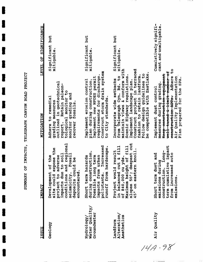
1 Geo1oav Soils Development of the site could expose the
project to geologic hazards associated with compressive and
expansive soils found on site and to hazards from regional seismicactivity Impacts can be fully mitigated by adhering to the
remedial grading measures set forth in the geotechnical reportprepared for the project and by monitoring during project gradingAll grading and drainage plans will be reviewed and approved by the
City S Engineering Division prior to issuance of a grading permitA Testing and Observation Report will be prepared and submitted to
S l
iJ 9J
the City s Engineering Division to verify that all requirementshave been met
Paleontoloaical Sensitivity The Oligocene Otay and Sweetwater
Formations which occur on site have a high potential for containingsignificant fossils Project grading may expose or destroysubsurface fossil bearing strata providing new and importantpaleontological data Adverse impacts to paleontological resourcescould occur A paleontological monitor will be on site at alltimes during original cutting of previously undisturbed sediments
mapped within the Sweetwater and Otay Formations Projectconstruction will be temporarily halted if necessary to allow
recovery of fossil resources
2 HYdroloav Water Ouality Groundwater Short term erosionimpacts could occur during project grading and constructionExisting erosion problems associated with agricultural uses will beeliminated after site development but the amount of runoff willincrease with added hardscape The project could potentiallydegrade water quality in Telegraph Canyon Creek from urban
pollutants Mitigation will require implementation of an erosioncontrol plan during construction construction of the storm drainplan proposed in the SPA and adherence to National Pollutant
Discharge Elimination System NPDES requirements for urban runoffand stormwater discharge All plans shall be designed andconstructed to meet City Engineering Standards
3 Landform Alteration Aesthetics The project will require abalanced cut and fill of 8 40 000 cubic yards The grading planhas been developed to follow the dominant site landforms and the
project is proposed to be constructed in a terraced fashion Themaximum manufactured slopes will be 50 feet in height and the
deepest cut will be 45 feet on the eastern knoll Because the
project area is adjacent to Telegraph canyon Road which isdesignated a Scenic Highway by the City of Chula Vista the SPA hasbeen developed to conform with the Telegraph Canyon Scenic Highwaycriteria The project will provide setbacks from the canyon floor
preserve and enhance the natural stream corridor and trail systemensure that the project s architectural design height and sitingof structures and landscaping and signs are considered in the
development and provide landscaping to beautify the adjacentportion of the scenic route both inside and outside the projectarea The project s design concept is based on design elements ofthe Eastlake Design Manual Guidelines in order to assure
compatibility with the adjacent Eastlake Shores community
4 Air Ouality The project will create short term impacts fromdust and emissions during project construction It willincrementally add to cumulative impacts to the San Diego Air Basinby adding pollutants from increased traffic and householdemissions Mitigation for short term effects will requireimplementation of dust control measures during project grading
S 2
i1 3
I
I
I
I
I
I
I
I
II
I
I
I
I
I
II
I
I
Construction equipment will be required to be well tuned and thenumber of construction related ADTs will be limited Long term
impacts will be reduced by adherence to the Air QualityImplementation Plan prepared for the SPA
s Bioloaical Resources The majority of the project site ischaracterized by disturbed and weedy vegetation associated with
past agricultural uses The project will eliminate thisvegetation along with 0 9 acres of wetland habitat Although thewetland habitat s rgmente tw lt9J iiw ity its loss is still
i ii 1 dbe
a
mic t
h fft aedf f of a
of wetland hab tat off s te otay Ranch to be preserved inconjunction with adjacent wetland habitat and compliance withCalifornia Department of Fish and Game Army Corps of Engineersand U S Fish and wildlife service requirements
6 Cultural Resources A site specific survey and records searchfor the project area did not reveal any significant cultural
resources on or adjacent to the property Thus no impacts willoccur to cultural resources with implementation of the project
7 TransDortation The project will generate a maximum 3500
average daily trips ADT The level of service LOS will be
lowered from C to D on Telegraph Canyon Road between otay LakesRoad and Eastlake Parkway from B to C between Crest Drive andfrom A to B between Paseo del Rey and Paseo Ladera butintersections will operate at acceptable levels and no significantdirect impacts will occur The applicant will pay its fair shareof area improvements to reduce cumulative impacts These mayinclude roadway widening restriping or installation of other
signals this will be determined by the City EngineeringDepartment during its annual review of cumulative impacts of all
projects in the Eastern Chula Vista Transportation Phasing Plan
ECVTPP
8 Noise Construction of the project will expose existingresidents to short term noise impacts The project will notincrease ambient noise levels significantly but portions of the
property will be subject to long term adverse noise impacts fromtraffic on S R 125 Mitigation will require construction of a
noise wall along the eastern portion of the site and possibly the
use of noise reducing construction materials and techniques Allnoise walls will be constructed in conformance with the designguidelines set forth in the SPA which follow the Eastlake I DesignGuidelines Materials will consist of stucco or stone walls withplexiglass panels to provide noise reduction while maintainingviews from residences All noise mitigation measures shall be made
conditions of the TSM Prior to issuance of building permits the
City of Chula vista s Noise Abatement Division shall review final
grading plans to determine whether additional noise materials are
S 3
18 9t

required for second stories of homes which may be impacted by noisefrom S R 125
9 Land Use General Plan Zonina The project area will requireannexation to the city of Chula vista which will require approvalby the Local Agency Formation Commission LAFCO The proposeddensity is consistent with the city s General Plan designation for
5rCommun1ty Purpose Fac1l1ty CPF s1te@ Wh1Ch meets the net acreagerequirement of the city The relJliireEi 10 percent affordable
housin rigftIDiimili will be rovided by dedication of a parcel off
efi i 1i1liif E s e
1ieu fees or a combination of
10 Community Social Factors The project will provide a maximumof 350 single family homes and generate approximately 1 134 newresidents No significant impacts will occur and no mitigation isrequired
11 Communi tv Tax Structure The applicant has prepared a PublicFacilities Financing Plan PFFP as required by the City of ChulaVista to ensure that adequate funding will be available forincreased demands for public services Therefore no significant
gim acts w1ll occur and no m1t1 at10n 1S re 1red m ltt lfI l
111111111 i III ljl IIFJ lli n f IIJlIllgill llw fi ll lill12 Parks Recreation ODen SDace The project will increasepar recre t gv N e mand by bringin approximately 1 134 newres1dents ntiot lilllJfC Under the prov1s10nal standards for parksset forth by the cTty of Chula Vista the Telegraph Canyon projectis required to set aside a total of 3 4 acres as dedicated parkland
The SPA proposes to dedicate 30 2 acres 27 of the total 112 4
project acreage to parks recreational areas and open spaceThese will include private neighborhood parks and mini parks A
portion of the central natural swale and the entire drainagechannel adjacent to Telegraph Canyon Road will be preserved as openspace as will the eastern property boundary abutting the proposedS R 125 freeway These open space easements will constituteapproximately 20 acres A San Diego County Water Authorityeasement in the center of the site will be developed as a privaterecreation and landscaped open space area A public trail is alsoproposed to connect the project to the Eastlake Community and tothe proposed community recreation center this area will coverapproximately 3 1 acres Two private recreational areas totalling0 6 acres are proposed One will consist of a recreational centerwith a changing cabana pool and spa and the other will provide a
S 4
Jil J
I
I
I
I
I
I
I
I
I
I
I
I
I
I
II
I
I
I
multi purpose court area fte aeaiea ia af ftese apeR spaee a a
parle laJd areas will aaeiBfy 58 ICrecflt af the prejcet16
rctfiirc H6 PlS fer parle land aceliest isl To provide fliH mitigationfor impacts to park facilities the applicant shall pay inlieu park fees in conformance with Section 17 10 of the Chula Vista
ii A t ie This will be done prior to or as a condition of the
MJ I d
13 Public Services and utilities The project will introduce102 new elementary school students and 102 secondary students intothe area Because the Chula vista school District elementary tinSii IitIB schools are all operating above permlnent capaciti s tileadd t on of these students w ll create s gn f cant adverse mpactsle IIIThe project will introduce approximately 1 134 new residents intothe area and thus will require an increase of approximately 1 4
police personnel based on the Police Department standards
A new fire station located at the corner of Lane Avenue and otay
k g J zl gr ph Canyon Road fs slate to e operatio al in
tig IAOO1 g gJ r l af 1992 and w ll prov de f re protect on to
theWprorecf mw
No significant impacts will occur with respect to
fire or emergency services
Mhii W i t d i in bt h m t
ArM d h T W tdf Wh i tWH f hP MJ i
fi lillli UI118nli IiIIIDith respect to sewer
The Sweetwater Union High School District has established CFD 5 for
developments of 50 or more units west of I 80S in the South Bayarea However this CFD is inappropriate for the Telegraph Canyondevelopment and a new CFD ei fter 6 ar III 7 will be cr l Eli t9accommodate the project As a condition of the lIlilnalllfmiHStililIcfttat irc lap and prier te iss1laftec ef B1ildiftlJ pinrI tB tElieapplicant shall be required to join CFD 6eP 7 and submit those
S 5
fees to the District The GBtila iata Oeheel Di6 riet haa alBeindicated E1at a ncw CFB till 136 er6a 6Ei fer the at a Rafteh
pre cet Aa the prepssea pre cet ill prceeae the GEay Raneh
preject the Di5tri t ha5 iflEiieat a tha it will go feruarEi with
illl iiiil ll i III n x ll lfil k
wfrr fTi Itrga e lmpacts 6 he drstrict Proof of payiiieiit offees and annexation into the CFDs shall be provided to the CityPlanning Department prior to approval of the liDII@MifiTD1It iB the reBpe1aihilit f af the Poliee Bepar meftt 51isjc et te
f1iflEiiR BY the City Counail te c n51irc the leymcftt af addit ienalIl li lleFBe el llrier ee issua e TU
ey r i g jiliIiIII Jl lilll fi s P fIIIIassessed for the project F Rdi ill be Ilrevided
14 Public Health The data available at the present time are notsufficient to warrant a determination of health and safety hazardsto future residents from proximity to the existing 8DG Etransmission lines However the following mitigation measures
i aFe recommended to reduce the potential to EMF exposure The
project applicant shall comply with any future policy adopted bythe City of Chula vista prior to consideration of the Final Map
8 6
Jill 9
I
I
I
I
I
I
I
III
I
I
I
I
I
II
I
I
EoUil
p
o
3p
zo
U
zp
ilIilEo
UlEoU
sIEH
ro
IUl
ilU
HrHz
HUl
ro
Iil
iJlQ
iJIIII Ol
UIQIll01
1O1iJ
Ul
zoH
HEoHIE
IIII I
UI0
I Ol 0I IiJ tl
I UIll IIII Olo 1ll
UI iJ 0tl Ol 0 IiJ 01 UIOl Ol IIl 01 III 1
OlUl iJO tlUlIllIOl IllUl
Ol p 0o I 01iJ tl III
01 Ol UOl IIiJ 0 Ol
O1iJOltl lO 0 0I III iJ 01 IUtl lOlOOOl
010 iJ
EoU
sIEH
IIII
Ol II 0iJ 1 1
Ol Ol 01l OlUlOOlUlOliJUI UI UIQ
OOl 00 Otl rtl
o tl iJ I IOl III III l
iJ Ol 0 tll tlOlUl UOl
Oll iJ tlliJl 0 UI Ol
o OiJUI UiJ iJOUUiJ iJ I
I OlU UIlOlOl r IlltlUlOOiJ 0 0 1 o U
Ol 0 Ol Ol Io UI 0 U UI tl Ol
il
UlUlH
01oIoOl
iJlQ
iJIIII Ol
UIQIll01
1O1iJ
Ul
OliJOl iJ
I 01 UIOlO IllUl
iJ OllIiJ 0 U Io U UIU l Ul III
iltlIiJO tlUl
OUlp tlIz 0
UlO IllOU Otl
OlUliJ1Ol 011iJ UI IIII I iJ
iJ iJ Ol iJ UII I U
OllOlOl ltl iJ
Ol Ol iJIIIl UlU
o lllo tI lI OlOO
H oH U iJ
tlOl OlUI 0
I III IIIUlOIOlU
tl III UIiJ OlQ Utl
IllUiJ INl lHIll
III 01 IIiJ I
UI 0 01 I UlO0 iJ
OlUOl 1iJ IUlIll
O1Q iJ iJiJ 1 U l
UI Illl 0o UI 0 1 IIl 0 Ol
Ultlp o
iJ
1 OlIlliJ
O1l1ll00lI tlO I
OlltliJOIll
Z
iJlQ
iJIIllOl
UIQIll01
1O1iJ
UlI tliJ Ol
O 0 QO UI Ill iJolo
UI iJ 1 IIIolo OI OUllU IllOl OliJ
llltlO iJ IiJ tlIUIQ p III 0 1 IIIiJ 1 1 I Illl ilOl 0lOl IOl
UlIU01o tllOl III iJ 1 iJ
OlU U U ltl UlOlIl101
1 UI tl riJo 1ll1 0OlIOlIII Ol III 011
Ol IIo QiJ 01 01 0 UIIII Ol iJ iJ iJ OliJI Iz IU tl III
OOl Olll 0o Eo IllU OiJ OliJ OO
0 I1 1 UIII UU 0 Ol 0 1 UII1 IllU OIllOOl
H UlHUrQ
iJI IlI IU
iJ II iJ I
l UI 0UI UI OlI
Ol tl 0 o oloiJ Oll iJ Ol I
tlUlltlI U 01 Olltl iJOOlOOl UI
UOlOIll1 0 IOOl
t O UlIOlIll OlO
rQ CO 0o 0
1 Illl1Op OIE UI
I UIOU
o III OlItlGliJ
IiJ UIIII I Gl1
IGl1Q
sUIiJ
I
ltl
iJIIII IIIIliJ
a
01II
0tl
iJ1llI001U
01iJIUIl
tlltliJI UIGlGl
GllIUI0 III
GlH
oiJ
Gl IO
Gl pIiJUltlllliJGl1 1
GliJ
Gl100
HtlGl
iJ1ll0
IGlIlllo01IIll1p
iJU
I III010 0I iJ0 l
011 IIIiJI GlUI tll Gltl lliJ UI
tl01ll1llEl 1 Gl
UIiJ l UIGlI UElUI
iJ0 ll1 0U
iJUI iJ UIUlUlElUI
0 I 0I OGl
UlGlUiJ Ol
tlIIII
iJ
IIIIl01
zl r
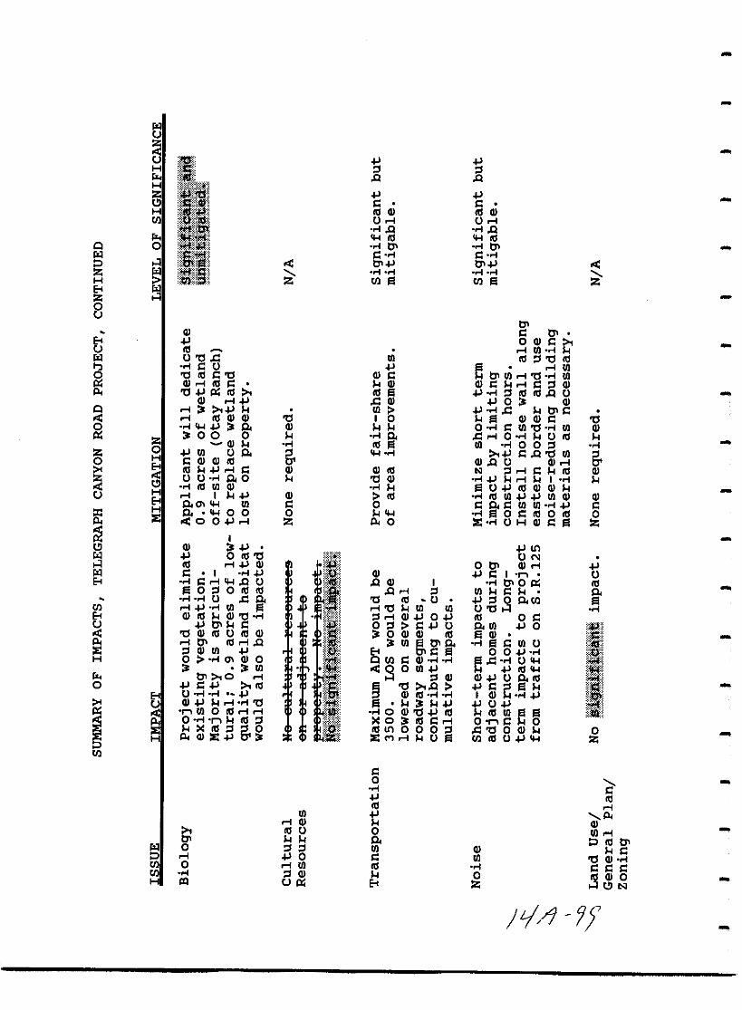
IlC
iiC l1tjH I l lr Q QH lpii lzu 141 s sH III G III Gen
Iu ol U olf Q fQ
r III IIIQ 0 f tlI f tlIIl s f s f
l tlI tlIIl f f f f
H en a en aEt fjz0C
tlIG s tlI
Et 0 G SC III ol rJl fIl U tl ll rJl III l tl III
f s u C ol rJltl III s tl G s tlI rJl ol tl f rJlG ol III s G G s ol s l Gtl ll III III f l III III Q U
G ol ll 0 GQ ol rJl fll tlI s
ol 1IlG G tl I a G G s tlf C G o f s rJl tl f rJl G
Z0 0 0 f C llol o f U III
G f III a rJl f 0 0 g fz 0 rJl U c 6 f s Q rJl 60 H s G G III G Q u G olEt III ol s G G III lol s III G
u u f c 0 tl G f ol I ff III rJl G f a u III G GH ol I G III f III rJl rJl G GEt c Cl rJl s s c s rJl rJl f s
ifH c 0 0 0 f a 0 s III 0 III 0IE 0 0 ol Z p 0 IE f u H G s a z
i IU G It1Il 0 III tl
Ii u Nl III ol G 0 tlI G lIl s I f
IG s I U
Et f s ol Q U Q G I f tlIO ll IIIa 0 l 0 III III y Q ol l rJl s cf f U ll 8 tl III U l 0 c en a
en ol f rJl ol tl rJl rJl U tl l fEt G III G tl f z lol G 0 III 0 sC tlI s ii 0 l s u C rJl 0 ill
s tl G III U III G 0 G G III a G 111Iiol tlI III ol Q rJl tlI f a s rJl UIE l G rJl t S s 0 0 fH 0 f Cl G 0
Ien s G f f C ll f u
rJl 9 0 rJl III 111r tlI 0 ol l G G U C 1Il0 s 1Il tl Q s a ORf
Et u f f G 1Il f f I G f 11IC G ol f tl u
s rJl 0 III ol ol f0 G III III rJl Co f III l 0 III s ol 0 sIE III l 6 0 II III It1 0 0 0 ll tl 0 G 0H p G IE IE M ol U en III u Z
en
s0f
IIIIII ol
rJl pol G GIII u 0 rJl oltlI C P III tlIIl 0 l l rJl G s
p ol 0 s rJl tl G fen 0 ol rJl III f s s sen f l G 0 G 0H III C ll Et Z U N
tj f
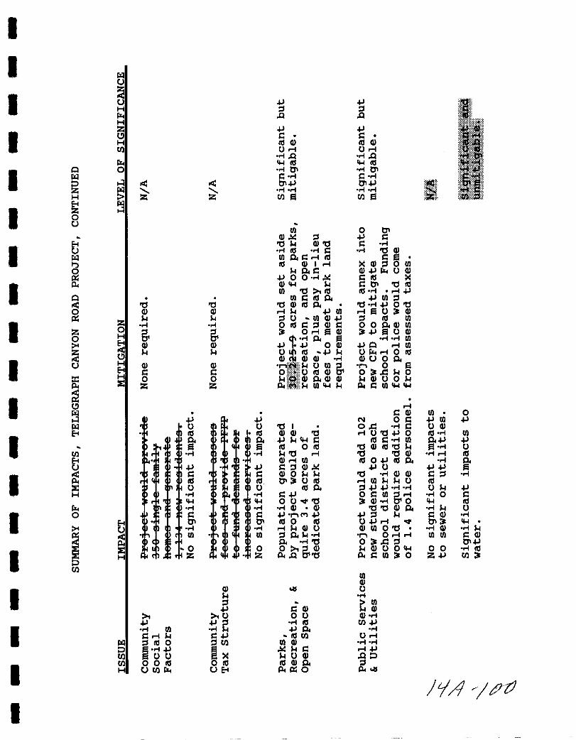
I
I IOlU
I J J
IH l lQ Q
H
IZ J J
ILlu s s
f i 1H III Q III QIII Ui Ui 11IQ IQ
CIl III CIl III
I11 0 1 0 1 0IOl S I S I 1I4fl OJ OJ I llllIOl 1 1 1 1H III Iil III IilEo
IZ0U
III 0 0Q l J s
IEo 011 Q O s 1
U 1 III 1 s 1 0 QIOl III s1 S i III s
III Q I i Q l III11 s1 S Q J U Q
J 0 0 1 s III
Ip Q CIl 11 s 0 0 III
III 0 Ill Ill I iJ11 III s 1lls1 J III l
0 0 0 Q III s1 0 1J 00Q Q i 11 Jill i Iil U3 Q
Z11 11 l U Ill Q J l III III
I1 I o III S l Q s 0 0 s1 Q 1Il
Z 06 6 3 0i1ilQ 3 J Iil U Q
0 H I s1 Iil 1 1 IIIt Q Q J J 0 Q JII i III
i 11 11 U III J 11 U i 0 IIIQ Q Q 1 Q U 0 s1
1ilI U H Q Q nW lllU III 6 0Eo s s o i 0 ftS CD 0 3 d 110
I H 0 0 lliO Q s1 Q Q 11 Q U 011p IE Z Z pllill III CIl 11 p s IIlCllCl l
I U is Q III 0
J J N 0 s J III JIOl U U 0 I od 1 s U Q
IEo III III Q Q 0 lUO J 0 Ill I III
It It J IICI l s III S I III s1J JIII 0 III 0 Q III 0 11 Iil I U
III 1 1 11 0 l 0 0 Q Ii IIIEo Q i III III OJ III s1 1 s1U J J S l Q J U JJ Iil
I s s s Q 0 11 11 0 1 Q Q s l 1III III 0 3 U III i III 11 11 U III
IE U U III s1 lJ J I I U 11 JH 1 1 S J 0 s III 6i I 0 s
CIl CIl oUoQ O 3 Q I 0 CIl III1 1 1 Q Q OOQ s1 1 11 U
I0 s s J J Jl 11 s Q 1
Eo 0 0 III 0 III UJ i oQ 0 3 CIl
t U I I i IIQ U Q III 00 1 Q 1 11
i sIII III l s1 1II Oi l III III s Q
s1 10 0 3 d l O J
IIE 0 0 0 6 Q 11 Q UOCll 0 0 1 IIIH Z Z p Q 0 p s III 3 0 ZJ III 3
IIIIIIQ
IQ U11l IIIJ s Q Qu 0 U Q I
J J 1 III 1IlJ
I1 III 1 J s1S i 11 S J III III Ui
IOl l III 0 llll III Q 1 1
P IJ 11 s iJIII UU 11 U Q
IIII 0 0 III o III 1llQ s1H UIIl UEo p ll O
tjA ptJ
I
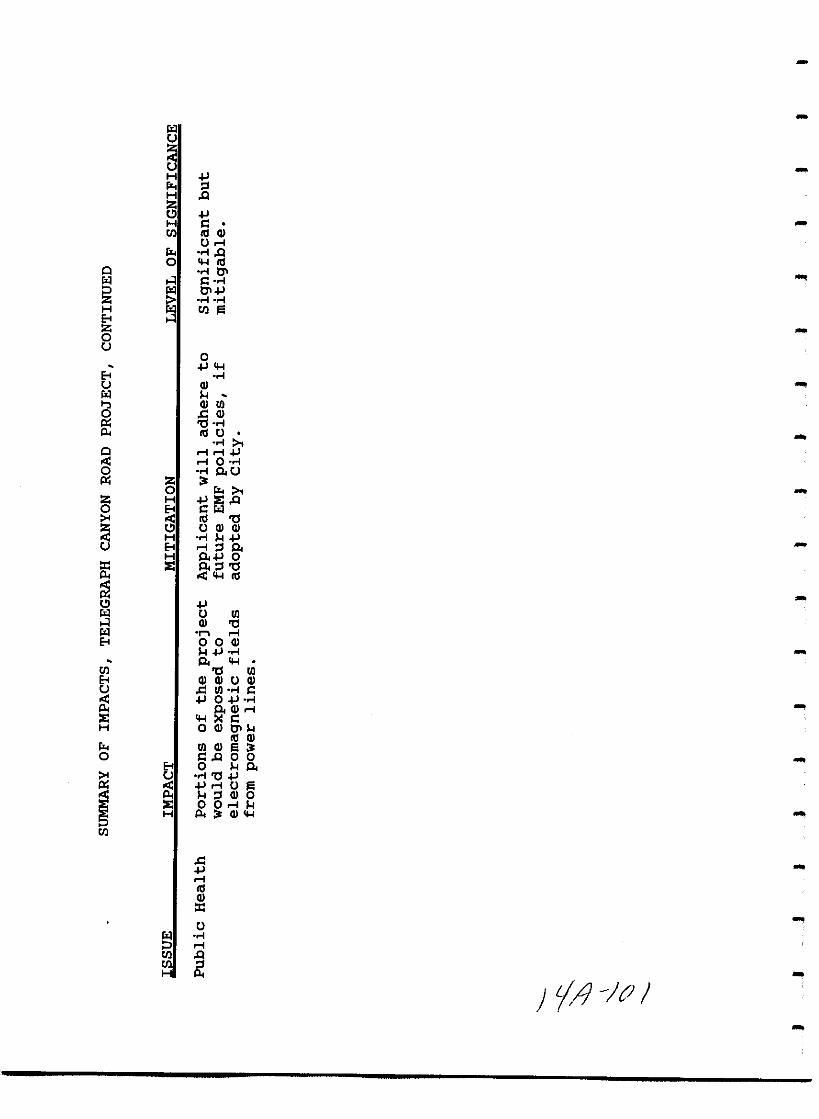
11t
Hrz lH Q
ijH ItIl III Ol
UIrz Q0 Ill
0 0111 i 1
11 Cl
H fjtIl
EtZ0t
0
Ett Ol11 l
OllI0 cOl
8 CIII U
0 II10
0 QtZ0 rz
z H IE Q0 Et 1 11
III 0U Ol Ol
H lEt IlQH Q 0
re IE Q lCIll
Cl11 U lIi Ol 011 n IEt OOOl
lQ
tIl 0 lIEt Ol Ol U Olt c lI I
0OlI
IE IH OOlCll
III Olrz lIOl0 IQ 0 0
Et 0 l Qt 0
iIU
l lOlOIE 001 lH A Ol
tIl
c
IIIIOlt
U11
ItIl QtIlH
fA J
I
I
I
III
I
II
I
I
I
I
II
II
I
I
1 0 INTRODUCTION SUMMARY
11 Purpose
The California Environmental Quality Act CEQA requires anenvironmental assessment of all governmental discretionary actionsdefined as projects Actions which could result in significantphysical impacts to the environment require the preparation of anenvironmental impact report
An application for the Telegraph Canyon Estates Subdivision hasbeen filed with the City of Chula vista to develop a maximum 350lot single family residential subdivision Discretionary actionsassociated with the project are a sphere of influence amendment an
Annexation a General Development Plan GDP a Sectional PlanningArea SPA and a Tentative Subdivision Map TSM Because the siteis adj acent to the Eastlake Community the pro is r tt e t e
i i iiiii ii giitri th
en il efgE iMft S aplanned Community District Regulations by the addition of the siteto the Eastlake Planned Community mapping area
An Initial Study conducted by the City of Chula vista determinedthat the project could impact certain environmental resources TheInitial Study Notice of Preparation NOP and responses to theNOP determined the scope of analysis for this EIR CEQA GuidelinesSection 15082 These documents are contained in Appendix A to theEIR
This EIR focuses on the issues identified as having potentiallysignificant environmental impacts resulting from approval of the
proposed project These include geology soils paleontologyhydrology water quality groundwater landform alterationaesthetics air quality noise biological resources land use
community social factors community tax structure parksrecreation open space utility service transportation culturalresources public facilities and services and public healthEffects determined not to be significant during the initial studyhave not been discussed in detail but are listed in the initialstudy in Appendix A per CEQA Guidelines Section 15128
The purpose of this EIR is to provide a document which delineatesand explains the environmental impacts of the proposed projectMitigation measures and alternatives designed to eliminate or
reduce environmental impacts to below a level of significance are
delineated CEQA Guidelines Section 15126 c d In accordance
with recent California legislation AB 3180 the EIR also containsa Mitigation Monitoring and Reporting Program MMRP for those
issues where significant impacts have been identified
1
Itjl tJA
The Draft EIR shall be distributed to interested parties for a
period of 45 days for their review and comment Agency and publiccomments regarding the Draft EIR will be included in the Final EIRwith appropriate responses This report has been prepared inaccordance with the requirements of the California EnvironmentalQuality Act California Public Resources Code section 21000 et
seq and California Administrative Code 15000 et seq and theEnvironmental Review Procedures of the City of Chula vista
12 Background Threshold Standards Policy
In 1987 the City Council of Chula vista established a Threshold
Policy and Growth Management Oversight Committee GMOC The goalof the Threshold Standards Policy is to assure maintenance of a
high quality environment and adequate public services It involves
implementing standards or thresholds determined by the cityCouncil for eleven issues fire emergency medical servicepolice traffic parks recreation drainage libraries airquality economics schools sewer and water Project by projectreview is required during the environmental review phase for sevenof the issues fire emergency medical services pOlice trafficparks and recreation drainage sewer and water to determine the
relationship between the project s impacts and threshold standardsIn compliance with the Threshold Standards Policy programpertinent issue analyses in this document will incorporate an
evaluation of the proposed project for conformance with the
applicable Threshold Standards Policy
Additionally The GMOC is responsible for an annual review of andreport on compliance with the standards A yearly status reportis prepared for the City Council If any standards are beingexceeded the GMOC must inform the Council who in turn is requiredto hold a public hearing Funding and enforcement of suggestedrecommendations are the responsibility of the city Council
2
I tJ

I
II
II
I
I
I
I
I
I
I
II
I
I
I
I
I
2 0 PROJECT DESCRIPTION
2 1 Location
The 112 4 acre Telegraph Canyon Estates project site is insoutheastern San Diego County Figure 1 in the Eastern TerritoriesPlanning Area of the City of Chula Vista It is north of TelegraphCanyon Road Otay Lakes Road immediately west of the proposedfuture extension of State Route 125 S R 125 It is withinsection 34 Township 15S Range 1W on the Jamul Mountains USGS7 5 Quadrangle Figure 2 It can be identified as a portion ofAssessor Parcel Number 595 070 22
The site is not presently a part of the City of Chula Vista but itis within the Special Study area of the City s General Plan
meaning that it will require action by the Local Agency FormationCommission LAFCO to be included in the Chula vista Sphere ofInfluence and annexed into the city
The project site is currently vacant Adjacent land uses includethe Southwestern College Estates neighborhood and Otay Lakes LodgeMobile Home Parks to the west and the Eastlake Shores neighborhoodto the north The area to the east where the extension of S R125 will be constructed is presently vacant as is land to thesouth across Telegraph Canyon Road The area to the south ispresently being environmentally assessed in connection with the
proposed 23 OOO acre Otay Ranch Planned Community
Present access to the site isCrestview Drive in EastlakeSouthwestern College Estates
from Telegraph Canyon Road fromShores and from Gotham Road in
22 Background
The Telegraph Canyon Estates project area was originally includedas a part of the Otay Ranch area and has been included in previousstudies conducted for that larger project Background documents onthe Otay Ranch are on file with the City of Chula Vista s PlanningDepartment and an EIR is currently being prepared to incorporateinformation from those documents and other technical studies
Because the project area is physically separated from the rest ofthe otay Ranch property by Telegraph Canyon Road and because thesite is adjacent to the Eastlake Community Figure 3 it is now
being proposed as a development separate from otay Ranch If
approved it will be developed in a manner similar to and
compatible with the Ea tlake Planned Community and will be
processed as aft amendment to the Eastlake Peliey PlaH General
3
JiJ oi
40cJ
10
W
C
len
0
cJ0J
Jl
0or
wc
a
oce GI
GI tl 0
Q u Mi C 0
acl Os en
Jo
Z nic UIt c u
l E c
1 J5 c 0outlen U0cVl co LJJ
4
I 1I v
ft
NN
I
tLgldl ft
ft c
@II
II
oQ
z
i
NZ
c
J
l
e
I
01z
z
g 0
Juft
Ie
a0
e
wIi
H
3
r10
1 c
U II
0
z
102lUl
cC00C oo J
ai
UU
zU
Ci0
U
o
z
uo
cz
c
o
wc
u

I
II
I
I
I
I
I
I
I
I
II
I
I
I
I
IAffinis
IPROJECT LOCATIONShadow Valley Center
809 Jomacha RoadEI Cajon CA 92019
1 in 2000 11
FIGURE 2
F A 6

SAN MlGUaIMOUNTAINJ
III
EASTLAKE
PROJECT SITE
SAsr H
LErBase Map From FORMA 1991 No Scale
AffinisRELATIONSHIP OF SITE
TO OTAY RANCHAND EASTLAKE PROJECT AREAS
FIGURE 3
JiJ tJ7
Shadow Valley Center847 Jamacha RoadEI Cajon CA 92019
6
I
I
II
I
I
I
I
I
I
I
I
I
I
I
I
I
I
I
Development Plan llIgnM Iioomi llm and Planned Community llmlRegulations
23 Project Characteristics
General DeveloDment Plan GDPI The Telegraph Canyon Estates
project is planned to provide a high quality private singlefamily residential community The GDP characterizes the proposedcommunity as French Countryside and proposes to develop the sitein conformance with the Eastlake Design Manual Guidelines forFrench Country The GDP also notes however that alternative
styles which have similar design features and character such as
English Country Colonial or Early American may be selected
A maximum of 350 single family dwelling units du s two privatepark areas and @lgafie community purpose facilities are proposed on
approximately sj acres of the 112 4 acre site yielding a net
density of 4 3 du ac It is estimated that development at thisdensity will add approximately 1 134 new residents to the area
The General Development Plan is shown in Figure 4
As shown in Figure 4 the GDP calls for approximately 30 acres of
open space 11111i1ii about 9 4 acres in the eastern portion of thesite will be Tii an easement for the future extension of S R 125
Roughly 20 af the remaifiiR leJ acres will consist of privateparks and permanent open space This open space will preserve a
portion of a natural swale bisecting the site the area adjacent to
Telegraph Canyon Road and the area which will be adjacent to S R125
Two recreational areas a private recreation complex justthe central swale and private multi purpose courtsnortheastern corner will also be provided
north of
in the
The GDP reserves IR1II lil fI9 I il ili litlilitlqlilafl 1 S aerc pareel
in the extreme north Il lt ea5 eiR coiner f the Pr 9JE y forfuture development as Comm n1ty Fg2 g111ty CPF Iw I he
GDP notes that uses could 1nclude etiYMeffIW day care and commun1tyh X f
meeting facilities and calls for the CPF des1gnat1on to be rev1ewed
after five years at City Council discretion Residential
development may then be permitted according to Planned CommunityDistrict Regulations RS 7 zoning provided the total number of 350units is not exceeded
The project will be separated from existing residential developmentto the north and west by modifications to the existing landform and
by project landscaping Along the site s northern boundary an
existing 20 foot tallmanufactured slope will separate the Eastlake
Shores community and preserve views from that community beyond the
7
i4 ltJg

Telegraph Canyon Estates homes at the base of the slope Along thenorthwest property line of the community the existing Southwestern
College Estates lots will be separated from the project by a 5 to40 foot wide landscape buffer and by existing and proposed slopesof 15 to 18 feet on both sides of the property line Mobilehomeson the southwestern property boundary will be separated by a
20 foot wide water easement and by slopes from 10 to 27 feet inheight The landscape buffer in this area will range from 20 to 50feet in width The new lots along the western border will be 20 to50 feet away from and 10 to 27 feet above existing uses
Development along the southern edge of the site near TelegraphCanyon Road will be required to conform to the City s General PlanScenic Highway criteria Proposed setbacks average over 200 feetwith a minimum of 175 feet to a maximum of 770 feet at the centralswale The adjacent drainage corridor will be enhanced and atrail walkway system will be provided to connect with the existingwalkway along Telegraph Canyon Road
Sectional Plan Area SPA The SPA is required for the project bythe original Eastlake I Planned Community District Regulations andGeneral Development Plan This site specific SPA adheres toguidelines set forth in the Eastlake Design Manual to maintainconsistency with the existing Eastlake Community The SPA providesdesign and construction regulations based on the developmentconcept of the GDP All discretionary actions including theTentative Subdivision Map TSM will be required to be consistentwith the SPA in order to be approved
The proposed SPA site utilization Plan Figure 5 designates threeneighborhoods within the project area In Neighborhood 1 in thesouthwestern portion of the site OOi 44 lots are proposedNeighborhood 2 in h southeastern portIon of the site will consistof lots and m 446 lots will be provided in Neighborhood 3 inthe northern porti6nof the site A total of 32 5 gross acres aredesignated for non residential use open space proposed S R 125easement and the CPF site
The SPA has been prepared to provide guidelines for the proposedland uses Included within the SPA Plan are
A community design concept providing the overall communitycharacter landscape and maintenance guidel ines architecturalstandards wall and fencing design details and a scenichighways element
Grading guidelines including grading design to conform withGeneral Plan and Scenic Highway criteria
A signage program to follow the general guidelines establishedfor the Eastlake Planned Community
8
tJ 0
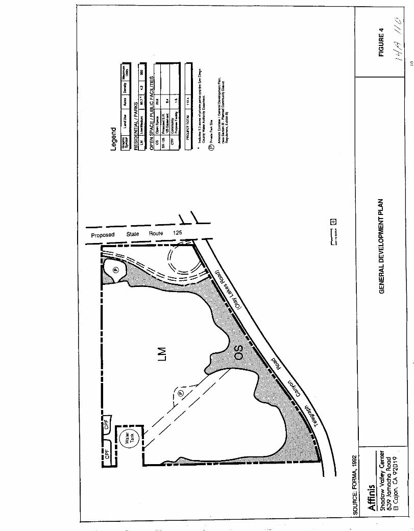
WII
Clu
J II lffl
f Jqii3
j hh
i g Hia
i i HI w i J H I
Z II JIIJ
c w OIlCl n
01Il Kl LJffi B H
a0 0
J a 0 @
LLProposed
II
III
III
I
Slale Roule 125
J
@
r W@VI
iiiiiii
B3
n
z
sllIZW
ll
9w
wc
otIIWZWCl
Iii
lJcDOo
UODN
i 00II 65l 111 gow 2
Ec
uoQ Q
II 00 0
J oU
0 cojjen

if
Ii 2
t
i t1 1tliin Jd j
@Il
u
if
Ifd l1 Ii Ii l
8 t
J J0
QOJ
f1111 LI
I
iI g lli t
u
uc
c
Io
s 83
2O s
I0 Gr w
w
c
g g
u
h
u
0w
tJ
E
w
m
S1
a
l2w
c
fit
4
It
WII
Clii
CK
zo
i
iii
IJl
lilIJloaoIIa
c
c
ot
ll
EUE r
o ftl 20 U
VltlOLIi
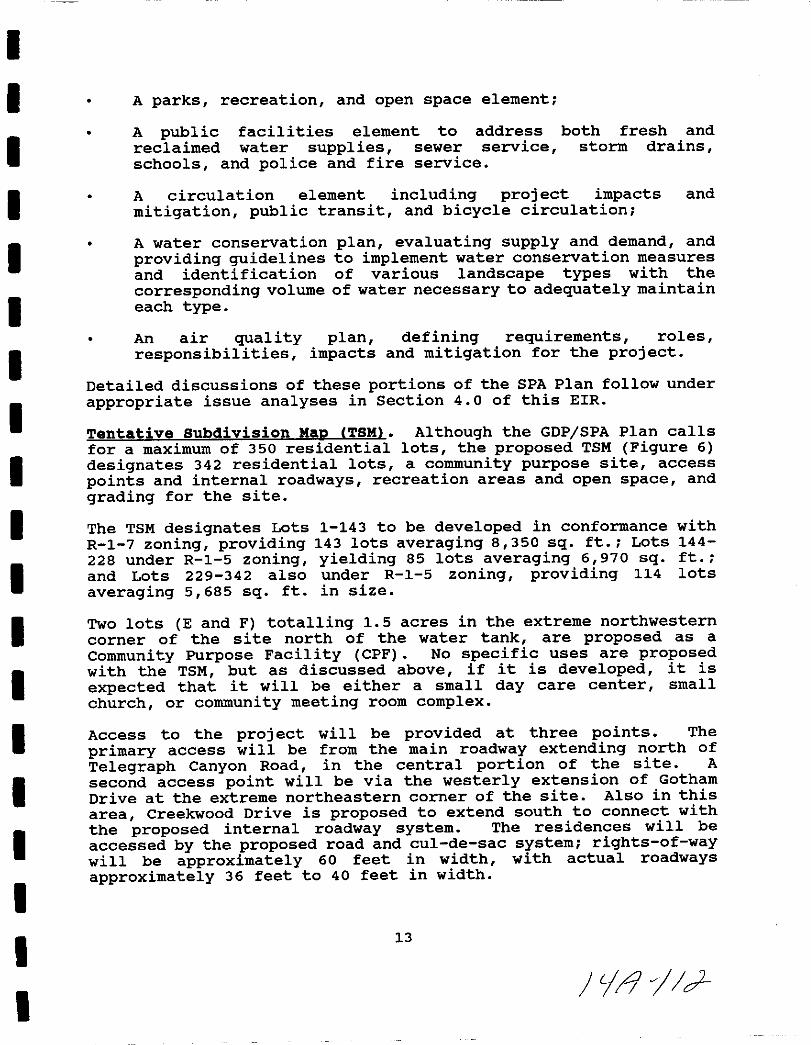
I
I
I
I
I
I
II
I
I
I
II
I
II
I
I
I
A parks recreation and open space element
A public facilities element to address
reclaimed water supplies sewer service
schools and police and fire service
both fresh and
storm drains
A circulation element including project impactsmitigation public transit and bicycle circulation
and
A water conservation plan evaluating supply and demand and
providing guidelines to implement water conservation measures
and identification of various landscape types with the
corresponding volume of water necessary to adequately maintaineach type
An air quality plan defining requirements roles
responsibilities impacts and mitigation for the project
Detailed discussions of these portions of the SPA Plan follow under
appropriate issue analyses in section 4 0 of this EIR
Tentative Subdivision MaD ITSM Although the GDPjSPA Plan calls
for a maximum of 350 residential lots the proposed TSM Figure 6
designates 342 residential lots a community purpose site access
points and internal roadways recreation areas and open space and
grading for the site
The TSM designates Lots 1 143 to be developed in conformance with
R 1 7 zoning providing 143 lots averaging 8 350 sq ft Lots 144
228 under R 1 5 zoning yielding 85 lots averaging 6 970 sq ft
and Lots 229 342 also under R 1 5 zoning providing 114 lots
averaging 5 685 sq ft in size
Two lots E and F totalling 1 5 acres in the extreme northwestern
corner of the site north of the water tank are proposed as a
Community Purpose Facility CPF No specific uses are proposedwith the TSM but as discussed above if it is developed it is
expected that it will be either a small day care center small
church or community meeting room complex
Access to the project will be provided at three points The
primary access will be from the main roadway extending north of
Telegraph Canyon Road in the central portion of the site A
second access point will be via the westerly extension of Gotham
Drive at the extreme northeastern corner of the site Also in this
area Creekwood Drive is proposed to extend south to connect with
the proposed internal roadway system The residences will be
accessed by the proposed road and cul de sac system rights of waywill be approximately 60 feet in width with actual roadwaysapproximately 36 feet to 40 feet in width
13
tfl 1cJ
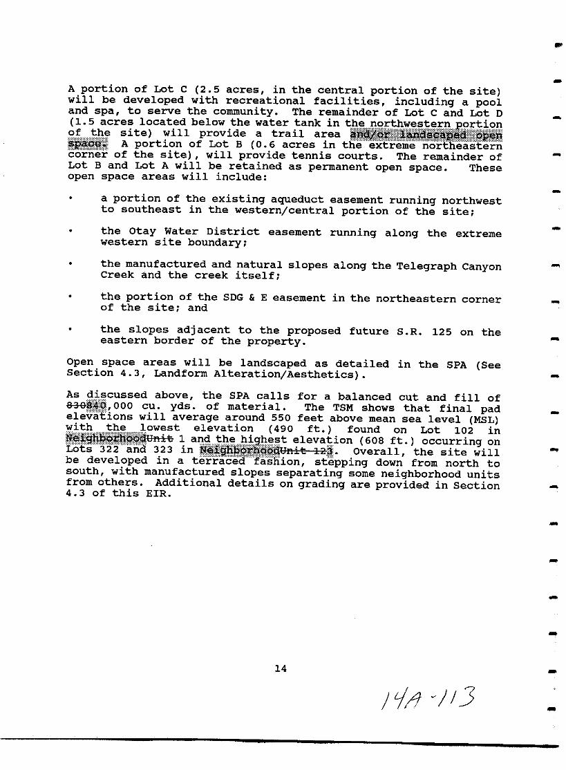
A portion of Lot C 2 5 acres in the central portion of the sitewill be developed with recreational facilities including a pooland spa to serve the community The remainder of Lot C and Lot D15 acres located below the water tank in tB wp8Eth t F t E9Et 9Af h site will provide a trail area lt BItl m itg ll iLq fiBa A portion of Lot B 0 6 acres in the extreme northeastern
corner of the site will provide tennis courts The remainder ofLot B and Lot A will be retained as permanent open space These
open space areas will include
a portion of the existing aqueduct easement running northwestto southeast in the western central portion of the site
the Otay Water District easement running along the extremewestern site boundary
the manufactured and natural slopes along the Telegraph CanyonCreek and the creek itself
the portion of the SDG E easement in the northeastern cornerof the site and
the slopes adjacent to the proposed future S R 125 on theeastern border of the property
Open space areas will be landscaped as detailed in the SPA SeeSection 4 3 Landform Alteration Aesthetics
As q cussed above the SPA calls for a balanced cut and fill of838 OOO cu yds of material The TSM shows that final padelevaEions will average around 550 feet above mean sea level MSLwith the lowest elevation 490 ft found on Lot 102 in
fi u ina iJ18ii a H
e i on
O lf tc
f n
ibe developed in a
terrceaRlaShion stepping dow from north tosouth with manufactured slopes separating some neighborhood unitsfrom others Additional details on grading are provided in Section4 3 of this EIR
14
JiJv 3
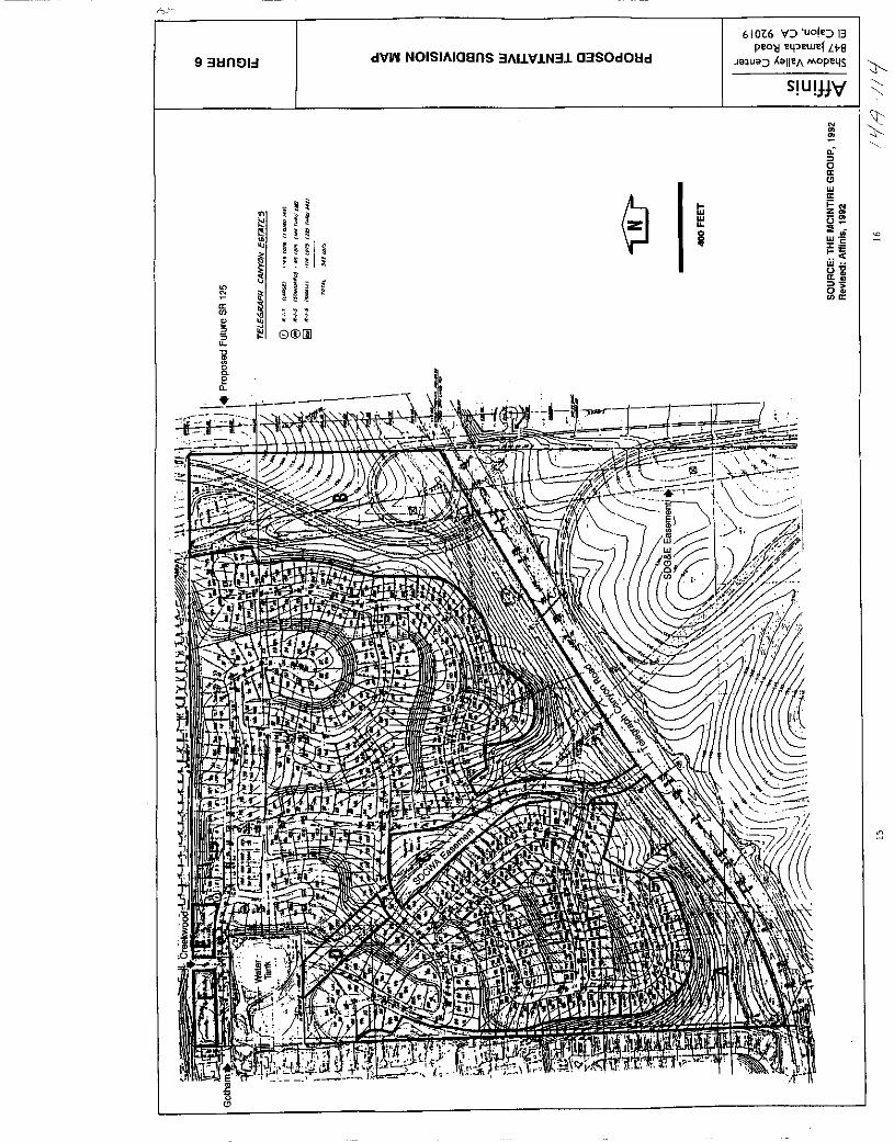
N
u
Q@j
Ii1 i
1
i I II
6106 V uo l 13
pilOtj e41 ewef LveJa1uaalleA MOPe4S
S U jN
Nm
0
0a
wa
Iii i NZm
C3
iaw
uia
5ta
9311n lI dlfW NOISIAloans 3AILIf LN3L 03S0dOlld
ILla
5
o
e
Pf
Or Or Or

I
I
II
I
I
I
I
I
I
I
I
I
I
I
I
I
II
3 0 ENVIRONMENTAL SETIING
The 112 4 acre Telegraph Canyon Estates project site is within theEastern Territories Planning Area of the City of Chula Vista Itis north of Telegraph Canyon Road Otay Lakes Road immediatelywest of the proposed future extension of state Route 125 S R125 At this time the site is in the County of San Diego s
jurisdiction and a sphere of influence amendment and annexation are
required prior to project implementation The site is in a LAFCOdesignated special study area
The main features of the project area are shown in Figure 7 Asdiscussed above the site is adjacent to residential development on
the north and west The northern border of the site is a 2 1manufactured slope which separates the project from the EastlakeShores neighborhood The Otay Ranch area is south of the property
Dominant landforms on site are two knolls on the east and westsides of the property These are separated by a drainage swalewhich roughly bisects the site Elevations range from
approximately 615 feet at the northwest corner of the site to 460feet on the southwestern corner
The property is presently vacant It has been farmed in the pastand used for cattle grazing as part of Otay Ranch Vegetation on
site is dominated by non native grassland with some wetland
species such as cattails and willows occurring in the drainageswale in the central portion of the site Soil types occurring on
site are predominantly Diablo Clay with smaller areas of LinneClay loam and Salinas Clay loam USDA 1973 There are no rock
outcrops on the site
Telegraph Canyon Creek runs immediately south of the site s
southern border In this area the creek is an improved grasslined graded earthen channel with drop structures Some of the
slopes adjacent to the creek are manufactured having been cut forthe construction of Telegraph Canyon Road and for improvements tothe creek
The property is traversed by several easements An 80 foot wideSan Diego County Water Authority Easement crosses the central
portion of the site from northwest to southeast the County Water
Authority is proposing to add another 40 feet to this easement sothat the ultimate width will be 120 feet A San Diego GasElectric SOG E easement also 120 feet in width runs north tosouth on the property s eastern side A 230 KV circuit is presenton the double circuit transmission towers in the easement On theextreme western border is a 20 foot wide Otay Water DistrictEasement Both of the water easements allow access to the 8million gallon reservoir adjacent to the site s northwest corner
17
Ii If
THIS PAGE INTENTIONALLY LEFT BLANK
18
iq
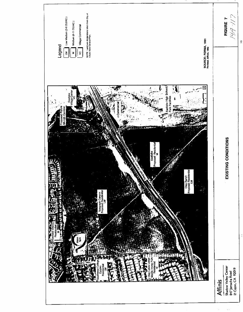
0 0
5 W0 IX
l0
ClE 0
E E0
iie 0 1E0
IJ0
tJ
J G0o
0w o
02zu
i0o
8u
tIDEllg
tI B3r
UlZoiiszoJClz
iUl
f3
VI
c
E
iiUOo
ClI
CiifiUE 5
g i1u
w

III
I
I
I
I
I
I
I
I
I
I
I
I
II
I
I
I
4 0 IMPACT ANALYSIS
4 1 Geology Soils
A geotechnical investigation of the project area was completed byICG Incorporated April 17 1991 This study included a reviewof previous geologic soils engineering and seismologic reportspertaining to the project site The technical report included inAppendix B to this EIR provides the background for the followinganalysis
Existing Conditions
The topography of the project site consists of gently to moderatelysloping hillsides separated by two north south trending canyonsThe property drains toward Telegraph Canyon on the southElevations range from 615 feet MSL at the northwestern corner ofthe property to 460 feet MSL at the southwestern corner The area
has been previously cultivated and used for cattle grazing but itis presently vacant with vegetation composed of low growinggrasses and occasional taller shrubs
site Geo1oav The project site lies within the coastal plainssection of the Peninsular Ranges geomorphic province and isunderlain by the Sweetwater and otay Formations The sedimentarybedrock appears to be tilted gently a few degrees to the southwestand the otay Formation dips in varying directions on the order of5 degrees or less Surface deposits of alluvium occur in the
drainages and topsoil and colluvium are found on the slopes Themain geologic features of the site are presented in Figure 4 1 1
The Sweetwater Formation lying below approximately 500 to 565 feetMSL on site consists of interbedded light brown to olive denseto very dense silty fine grained sandstone fine to coarse grainedsandstone with gravel and sandy claystone It is overlain by and
intermingled with the otay Formation which consists of white to
light gray or grayish pink dense to very dense silty fine tomedium grained sandstone with layered clayey sandstone bedsCaliche hardpan accumulations are common where the formation hasweathered Claystone beds are known to occur in this formationadjacent to the project area
Surface deposits of alluvium are found in the two main drainagesand the smaller swales The alluvium is composed of silty to
clayey sand and minor gravel is typically loose to medium dense
slightly porous damp to wet and contains some plant debris The
21
Ii 5

4 1 r 7
Iir 1
I 1 7 f0 t1 I
11
t i r JsRl x I
n7
7fl i lJV ltO
y iIlit
fjq C i r Ai 110
II i1YI L
iil r Ii i l v
iI 7 r8
c tL j Y I
io Ji Ht t 11
IV I
TVIO
119 I
t I l IIIII M I 00 J
IKX f Y II I
fd f jc J l
1
11tfh Jsw J V S IlkrA J Cv illlf r
t Ulllllrd2i i 1
2
FILL
Gal
To
EXPLANA TION
Tsw SWEETWAlBI FORMAnoNFILL
ALLUVIUM APPROXIMATE LOCAnONOF GEOLOGIC SITE
OTAY FORMATIONo APPROXIMATE LOCAnON
OF TEST PIT
SOURCE ICG INC 1991
AffinisShadow Valley Center
847 Jamacha Road
EI Cajon CA 92019
GEOLOGY OF THE PROJECT AREA FIGURE 4 1 1
122
1
L
L
L
L
I
I
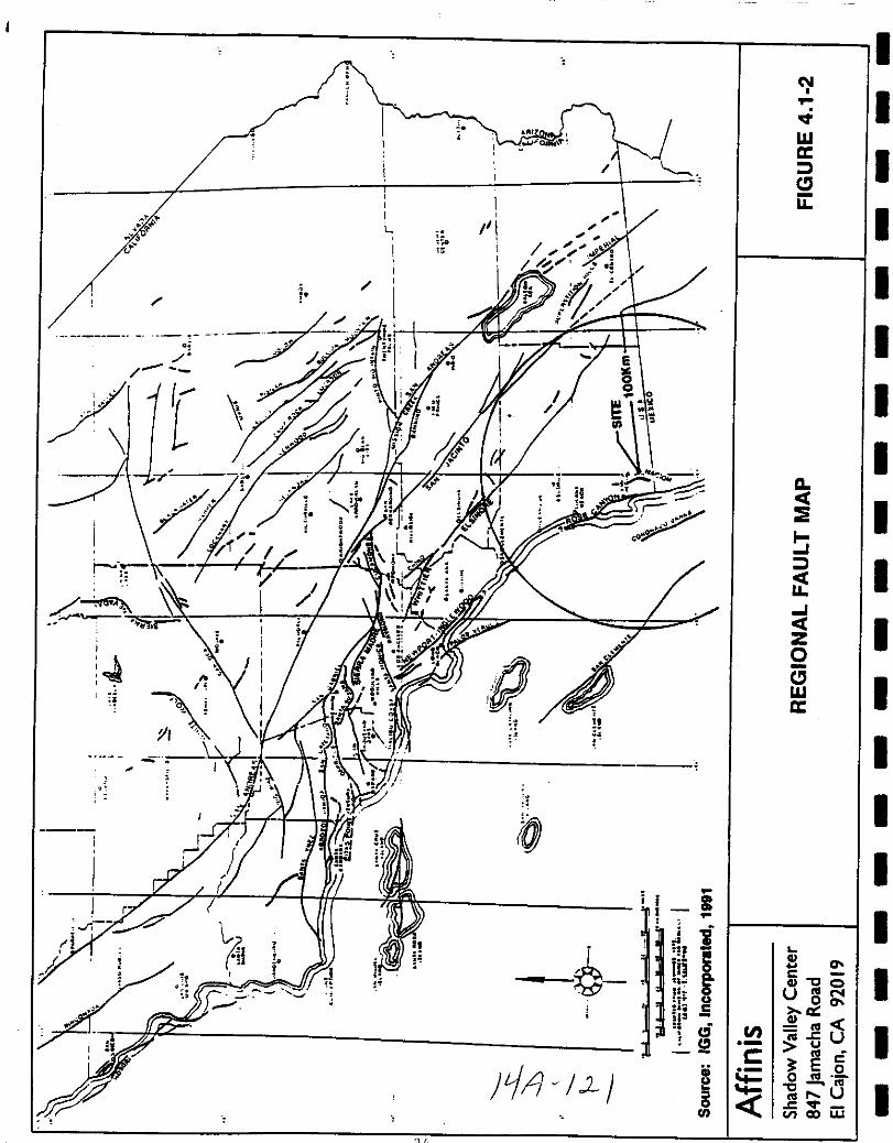
L
1
go oIoqe
fjr L
re
o
en
Jo
Ir
115
I
i
lOI
i
bi iill
Gu0
i C
W ci52ii
oII
en
c
JLI1 L1
N
I
I
I
I
I
I
II
I
II
I
I
I
II
I
II
It
Wa
CJu
a
E
i
tfI
ZoCJwa
S acGI OUIllN
a
GIIIIIllcU
E l5o III
Ill
lll Ucen to w
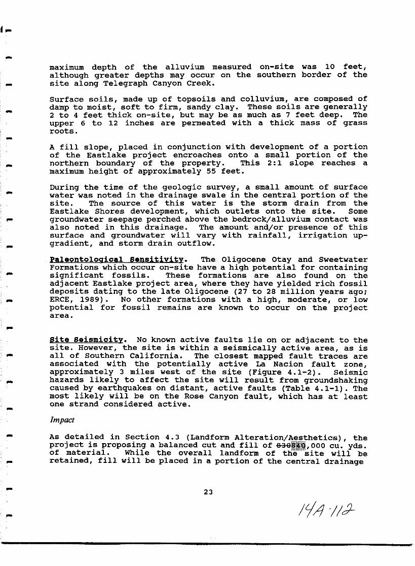
maximum depth of the alluvium measured on site was 10 feet
although greater depths may occur on the southern border of thesite along Telegraph Canyon Creek
Surface soils made up of topsoils and colluvium are composed of
damp to moist soft to firm sandy clay These soils are generally2 to 4 feet thick on site but may be as much as 7 feet deep The
upper 6 to 12 inches are permeated with a thick mass of grassroots
A fill slope placed in conjunction with development of a portionof the Eastlake proj ect encroaches onto a small portion of the
northern boundary of the property This 2 1 slope reaches a
maximum height of approximately 55 feet
During the time of the geologic survey a small amount of surface
water was noted in the drainage swale in the central portion of the
site The source of this water is the storm drain from the
Eastlake Shores development which outlets onto the site Some
groundwater seepage perched above the bedrock alluvium contact was
also noted in this drainage The amount and or presence of thissurface and groundwater will vary with rainfall irrigation up
gradient and storm drain outflow
Pa1eonto1oaica1 Sensitivity The Oligocene Otay and Sweetwater
Formations which occur on site have a high potential for containingsignificant fossils These formations are also found on the
adjacent Eastlake project area where they have yielded rich fossildeposits dating to the late Oligocene 27 to 28 million years agoERCE 1989 No other formations with a high moderate or lowpotential for fossil remains are known to occur on the projectarea
site Seismicity No known active faults lie on or adjacent to thesite However the site is within a seismically active area as isall of Southern California The closest mapped fault traces are
associated with the potentially active La Nacion fault zone
approximately 3 miles west of the site Figure 4 1 2 Seismichazards likely to affect the site will result from groundshakingcaused by earthquakes on distant active faults Table 4 1 1 Themost likely will be on the Rose Canyon fault which has at leastone strand considered active
Impact
As detailed in section 4 3 Landform Alteration Aesthetics the
project is proposing a balanced cut and fill of b ooo cu ydsof material While the overall landform of thelsite will beretained fill will be placed in a portion of the central drainage
23
Ii Id

f
QIQ
C CQI 0 0
c11 11 10 0ItOOc oltlr C
Ni OotO 0U QI QI I
0 000000 QIQIU U Ol C
rl QI QI U U QIC01
QI
C 0
0C QI QI0 c
C
OllnOOMOltl UE ro OJCIl E Ot IOt Of U QIE QlC 0en UJ
QI
0 QI 0 OlIII Coc QI C
Co QIQI
E 0QlO Cl
0 cQl QICD C C
QI 0 CC QI C
c 111 100 C UOotlt lorf 0Mrlr ltlt lO III
c U QI O CoQl EIII0 000000 c Q
III QI au QIU
3 rl QI QI U a QIQI III EI QI I I 0I c C
C IIlEQI QI C0 I QIC C C
iQ QI c QI Q
E Ii IIIU 0 III
OltltntnCXlLO C EE QI 00 E rfo CrIOr cE 00 H
3IIlQl C
u 001 a Q C
eE QI
QI CQI
III C QI Iijj 0 QIC rl 0 C III
OlZ Z rl cCO QI0 QI
rl III tn Ul tIJ en tIJ Co CI U IV CU QJ Q Q IV 0
z rt Ptit1t QlQI
It ES tl l 0 CaEEEaE QI I C
C c ICIl H to rlr lMOI C3 C E 0 QIc c flMNlt Illtl 0 E
C CQI III 0
U 0 Uo c 0 0
III a cC U QI C QI
2C QI EQI QI
C 0 t rn c0 C Ql3
QI C C III OlcQloao t E Co QI QI C
ftS C IVI 0 C a QI QCJOltSl4UftS QI QI QI 0 l5CCCJIOcc 0
UQ i 0 Z Ii QI rErn en c C
Oll 0 ItS ItS nI
al rlU l
52
LIu
J d l01Il
I
swale and manufactured slopes will be created throughout the site
Development of the site could result in exposure of the project to
the following geologic hazards
site improvements could sustain damage due to the compressivenature of alluvial soils and topsoil on site The clays and
topsoil on site also have a high expansion potential whichcould also damage roads and structures
The surface deposits of alluvial soils at the site may
experience settling due to regional seismic activity
Some areas
bentoniticFormation
of
claycut slope instability may occurseams within the sandstone of
due to
the otay
possible adverse impacts may occur associated with perchedgroundwater Some settling and shifting of structures builton top of these pockets of groundwater may occur
Project grading may expose or destroy subsurface fossil bearingstrata providing new and important paleontological data Adverse
impacts to paleontological resources could occur
MitigationjMonitoring
In order to reduce the adverse impacts associated with geologicalhazards the following mitigation measures will be required thesewill be made conditions of the TSM and will be ensured through theMMRP
1 Subsurface exploration shall be performed in the form of
geologic logging of large diameter borings in the vicinity ofcut slopes once grading plans are specifically defined todetermine if bentonitic clay seams exist and to determine ifactual subsurface conditions reflect those anticipated in thetechnical report
In areas of proposed fill or structures all vegetation or
other abandoned structures or utilities shall be strippedand or removed from the site Topsoil colluvium andalluvium shall be removed to bedrock and replaced by denselycompacted fill The geotechnical report concluded thatmaterials derived from the Sweetwater and otay Formations on
site will be suitable for use as compacted fill provided thatany cemented sandstone fragments found in the otay Formationare removed
2
3 Unsuitable fill materials will be removed during grading andclean fill free of debris and rocks will be brought in
26
Ji
I
I
I
II
I
I
I
I
I
I
I
I
II
I
I
I
I
wetted down and densely recompacted Fills constructed on
natural slopes steeper than 5 1 horizontal vertical shall be
keyed and benched into bedrock
4 Selective grading for building pads and streets shall be doneto avoid expansive soils or clayey alluvial materials
5 Rock disposal is recommended to be in a non structural areawith larger rocks incorporated into lower parts of compactedfills if performed under the observation and testing by ageotechnical consultant and may require special rock handlingequipment
6 Buildings shall not straddle a cut fill transition due topotential differential settlements of bedrock and fillmaterials within building pads Undercuts and grading are tobe done in accordance with recommendations of the geotechnicalreport Appendix B
7 To avoid surface slope failures appropriate plant materialselections and irrigation components and design shall bereviewed and approved by the City s Landscape Architects
8 Surface runoff to natural and graded areas shall be minimizedPad drainage shall be directed to suitable disposal areas viapaved swales and storm drains Subdrains shall be placed underall fills located in drainage courses
9 Soil expansion potential shall be evaluated on a lot by lotbasis upon completion of project grading If it is determinedthat conditions are not acceptable for standard foundationdesign additional measures such as lime treatment removalof soils or post tensioned slab foundations shall be
implemented
10 The City of Chula vista will also require detailed grading and
drainage plans to be prepared in conformance with The Chulavista Municipal Code the Subdivision Manual and all
applicable ordinance policies and standards
11 Final grading and foundation plans will include design andconstruction recommendations found in Appendix B All planswill be reviewed and approved by the City s EngineeringDivision prior to issuance of a grading permit
12 A qualified geotechnical consultant will monitor proj ect
grading to determine that the grading is in generalaccordance with the recommendations of the geotechnicalengineer s report If soil conditions are different fromthose anticipated modifications will be made to the initialrecommendations for geologic mitigation
27
JiJ4 1
13 Prior to issuance of a building permit the geotechnicalconsultant will be required to submit a Testing and
Observation Report to the City s Engineering Division to
verify that all requirements have been met during projectgrading
Potential impacts to paleontological resources will be mitigatedthrough the implementation of the following measures these will bemade a condition of the TSM and ensured through the MMRP
1 Prior to issuance of a grading permit the applicant shall
provide a letter to the City of Chula vista verifying that a
qualified paleontologist has been retained to implement a
mitigation program A qualified paleontologist is defined as
an individual with a MS or PhD in paleontology or geology who
is familiar with paleontological procedures and techniques
2 The paleontologist shall attend a pre grading meeting to
consult with the grading and excavation contractors
3 A paleontological monitor will be on site at all times duringoriginal cutting of previously undisturbed sediments mappedwithin the Sweetwater and Otay Formations
4 If fossils are encountered the paleontologist or
paleontological monitor shall recover them If recovery
requires an extended salvage time the paleontologist or
paleontological monitor will be allowed to temporarily directdivert or halt grading to allow recovery in a timely manner
5 The paleontologist or paleontological monitor will be allowed
to set up a screen washing operation on site if necessary to
recover small fossil remains e g mammal teeth etc
6 All fossil remains collected during the monitoring and salvageprogram shall be cleaned sorted cataloged and deposited ina scientific institution with paleontological collections such
as the San Diego Natural History Museum
Analysis of Significance
The aforementioned geologic impacts are considered significantHowever by adhering to the standard grading practices outlined inthe Geotechnical Report Appendix B and implementing the
mitigation measures discussed above these impacts will be reducedto below a level of significance Potential impacts to
paleontological resources are also considered to be significantbut will be reduced to below a level of significance throughmitigation measures set forth above which will be ensured throughthe MMRP
J
I
I
I
I
I
I
I
I
I
II
I
I
I
I
I
I
II
4 2 Hydrology Water Quality Groundwater
A hydrological analysis of the proposed project was done by TheMcIntire Group Inc June 21 1990 and is included in Appendix Cto this EIR The following EIR section is based on informationdeveloped in that analysis
Existing Conditions
Telegraph Canyon is oriented generally east to west ar1s1ngsouthwest of Mother Miguel Mountain and opening directly to SanDiego Bay Figure 4 2 1 The Telegraph Canyon drainage isapproximately nine miles long and varies generally from one halfto two thirds of a mile in width Hydrological analyses have beendone of the overall Telegraph Canyon watershed Rick Engineering
1987 summarized these and prepared a report to establish designdischarges for the channel design of Telegraph Canyon Creek whichwere done as a part of the roadway improvements of Telegraph CanyonRoad and Otay Lakes Road The project area drains to this improvedchannel it is the northern portion of sub basin 1A of the RickEngineering Report Figure 4 2 2
The site consists of gently rolling hills with moderate slopes20 gradient with a central swale bisecting the site A smaller
drainage runs parallel to this central swale in the eastern portionof the site
Elevations range from 615 feet MSL to 460 feet MSL The site isvacant but was previously used as agricultural grazing land Seesection 4 5
On site soil types mapped by the Soil Conservation Service are
Diablo Clay 2 9 9 15 slight erodibility and 15 30 slopesmoderate erodibility Linne Clay loam 9 30 slopes and Salinas
Clay loam 2 9 slopes both moderate erodibility The
predominate soil type is Diablo Clay 15 30 slopes moderate
erodibility Bowman 1973
The project area s two distinct parallel drainages run north tosouth Figure 4 2 3 into the improved channel of Telegraph CanyonCreek A lesser drainage serves the southwestern corner of thearea The easterly drainage encompasses approximately 54 acresThe drainage is projected to deliver 77 8 cubic feet persecond cfs during a storm of the frequency of 50 years TheMcIntire Group 1990
The central drainage covers approximately 52 acres on siteAdditional runoff is directed to this drainage via an existing 36inch storm drain pipe and open concrete channel at the base of theartificial fill slope at the northern boundary of the property
29
Ii olb
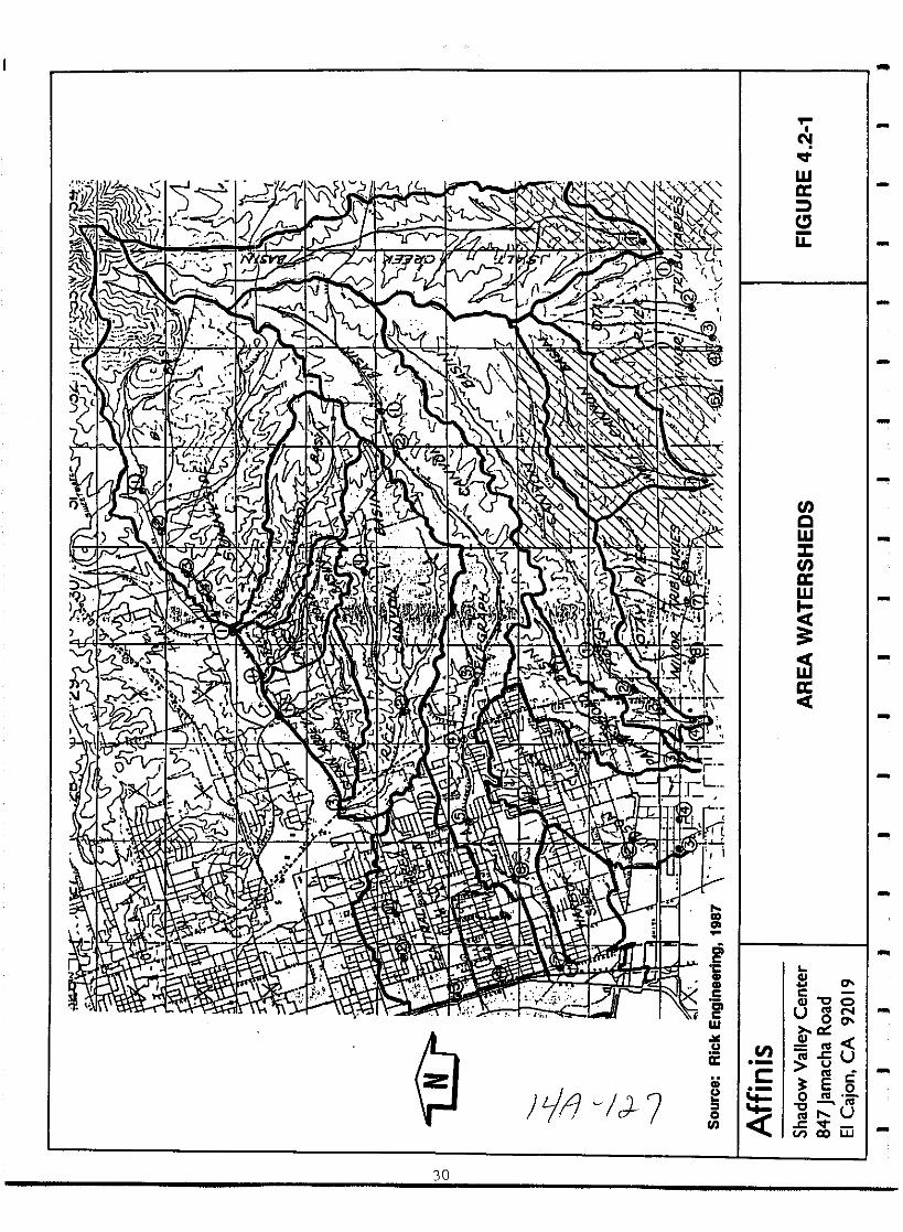
l 2 T t
llL k Ifr J
ir
J I v 4 c lM
1 K rl r9r Y3 rrb 5I ll x
Vl 1 r t
a t IL J
Il 10 iiw I lA n A
I i 1fm
f
J 0 1 2I
I I t i
f r tt 1
vLrt 2
lc iWJ trJv f
r
k2 1121 0 t lI l Y
J J 7LL lol1l
fJ Z fJC tllk c N 4n 1 0 p I sit vl 1r 1 r
r w
1L
ai Ir tK
oJ
n hr 2 1
r rli J d k
8 Ji 1 t S J ii t Xi Slt
f1J j A i lil Jji i 4
II n Jj
r5
JI J f z 71 J
J J
of
Y I sItr r lo r I l
I I
1 W oqQ v r l Jiirh
1
0J1f i iI S di l r 11
ir
tl lv 0 C0 L i
r io 7
gtl7t 1 H nOV Vi j y ry X L l f
l l L rfX I i I yi1 A Ir
fbl f lH rl l J JIJ 1 J1 lJrt 1i J II J
z
hJ Jkit
l
I4lri
Y U l v Uill
rIti I z Iirl
I L1 j
ICf 1 4 J
c1 r
cl7
30
I
C
wa
u
tCWJtaw
i
a
w
ii
Cll0
CCllOOU00a
enCll
cu
r E 51
oc u
ctVI co UJ
CDl0oUl
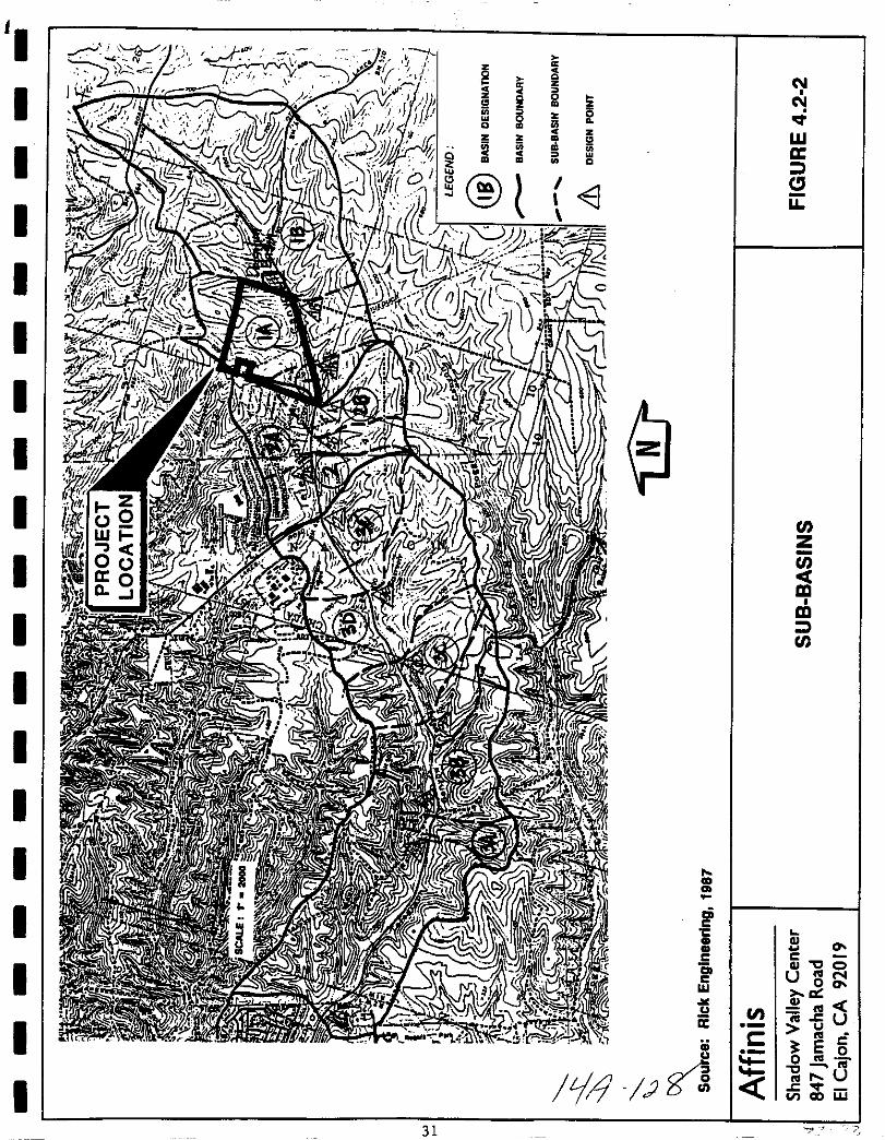
z ac
0 Qi z
0
CCO Ol Z0 2 litQ
ZZ
Wco0 0
acOl
Q
CJu
enz
enCm
m
U
CD
cicC L
II GlII 0C c
c Gl QU Nc 00w a
u enii c Uu
cii E 5u o ru 0
i4 Ju
crV CIO w
31 j
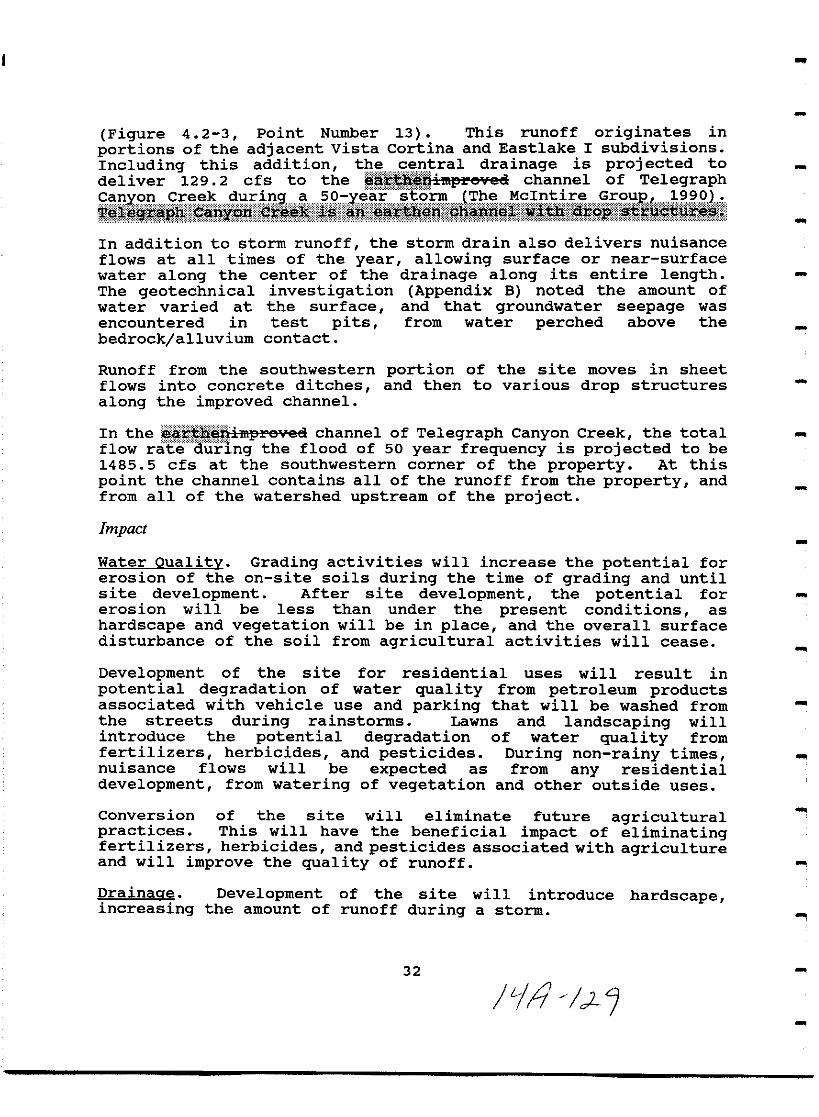
Figure 4 2 3 Point Number 13 This runoff originates in
portions of the adjacent vista cortina and Eastlake I subdivisions
Including this addition the central drainage is projected to
deliver 129 2 cfs to the Ulfiilllll e ee1 channel of Telegraph
liiiiifi iig lil i li i iti aii @iL igi giiiii iiiiiIn addition to storm runoff the storm drain also delivers nuisanceflows at all times of the year allowing surface or near surface
water along the center of the drainage along its entire lengthThe geotechnical investigation Appendix B noted the amount of
water varied at the surface and that groundwater seepage was
encountered in test pits from water perched above the
bedrock alluvium contact
Runoff from the southwestern portion of the site moves in sheet
flows into concrete ditches and then to various drop structures
along the improved channel
In the aE 3nimprevce1 channel of Telegraph Canyon Creek the total
flow ratedUFlng the flood of 50 year frequency is projected to be
1485 5 cfs at the southwestern corner of the property At this
point the channel contains all of the runoff from the property and
from all of the watershed upstream of the project
Impact
Water Oualitv Grading activities will increase the potential for
erosion of the on site soils during the time of grading and untilsite development After site development the potential forerosion will be less than under the present conditions as
hardscape and vegetation will be in place and the overall surface
disturbance of the soil from agricultural activities will cease
Development of the site for residential uses will result inpotential degradation of water quality from petroleum productsassociated with vehicle use and parking that will be washed fromthe streets during rainstorms Lawns and landscaping willintroduce the potential degradation of water quality fromfertilizers herbicides and pesticides During non rainy timesnuisance flows will be expected as from any residentialdevelopment from watering of vegetation and other outside uses
Conversion of the site will eliminate future agriculturalpractices This will have the beneficial impact of eliminatingfertilizers herbicides and pesticides associated with agricultureand will improve the quality of runoff
Drainaae Development of the site will introduce hardscapeincreasing the amount of runoff during a storm
32
17
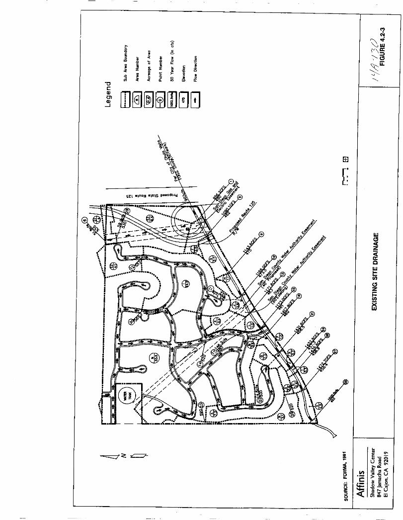
lN
j0
g I rrc
CliiE E 0
i c
z z5
ic
010
0cOJ
DJ I0GJOlOJ
8l
0
0
1 A T
iitr
iI
I
t
wCloCtZ
rrc
w
inClz
ti
j
L
tzIIC
uoi 0
lia 20 1 uu
Cw
E 0o ra
U tua
6 w

I
I
II
I
I
I
I
I
I
I
I
I
I
I
I
I
I
I
A storm drain system has been developed for the proposed projectFigure 4 2 4 The system proposes to maintain the overall north
to south drainage of the site to Telegraph Canyon Creek
Projections for the developed site condition indicate a total
flowrate of 1508 0 cfs in the imprevea ehaftftel ef Telegraph
i esce okrn P 1 W P l I reaatset
flowrate of 22 5 cfs from the 1485 5 cfs projected with existingsite conditions during a flood of 50 year frequency The McIntireGroup 1991
Mitigation Monitoring
Water Oualitv Potentially significant impacts to water quality inthe Telegraph Canyon Creek channel will be reduced to below a levelof significance through adherence to existing regulations and
procedures as well as compliance with the following mitigationmeasures which will be conditions of project approval and ensured
by the MMRP
1 Development of the Telegraph Canyon Estates Subdivision
project must comply with all applicable regulationsestablished by the united States Environmental Protection
Agency EPA as set forth in the National Pollutant DischargeElimination System NPDES permit requirements for urban
runoff and stormwater discharge and any regulations adopted bythe city of Chula vista thereto
2 The applicant shall submit an erosion control plan inaccordance with city of Chula Vista design standards The
plan shall be approved prior to issuance of a Grading PermitAt a minimum the Plan shall evaluate the need for and if
applicable include the placement of sandbags temporarysediment basin s and similar measures The Plan shall
include an evaluation of the need for an erosion control
maintenance program if such a program is needed the Plan
shall include one
3 The developer shall be required to obtain an NPDES
construction permit for the subject property from the State
Water Resources Control Board and to submit pOllutant controland monitoring plans to the Regional Water Quality Control
Board prior to the issuance of grading permits If the Btate
aces Rat rCEfUirc dc c lapmcnta like the prepeaeei prejcet te
comply with esftstrHet isR permit precess If the state does
not require developments like the proposed project to complywith the construction permit prior to completion of gradingthis condition becomes ineffective City of Chula Vista
Engineering Department personal communication 1992
35
LA J
l 0
Drainaae The Thresholds Standards of the City of Chula vista for
Drainage state Storm water flows and volumes shall not exceed cityEngineering Standards
2
3
1 The applicant shall submit a storm drain plan in accordancewith city of Chula vista design standards The plan shall be
approved prior to issuance of a Grading Permit Review of
plans by the City of Chula vista Engineering Department willensure the storm drain system is built to standard
specifications which will allow the water to drain to
Telegraph Canyon Creek
Standard engineering practices and adherence to the City ofChula vista Department of Engineering s grading guidelineswill eliminate potentially significant erosional impacts to
drainage facilities Monitoring will occur with review of the
Grading Plan and with field checks of the grading
To eliminate the possibility of silt and sediment entering the
adjacent drainage along Telegraph Canyon Road a barrier mustbe placed between the property and the adjacent drainagewayuntil 90 landscape coverage is achieved
Iilill liilllli Eli I i lll iIi FlII Mif li ii B ililiDiJiimifiltulli
Significance of Impact
An increase in flowrate of 22 5 cfs from 1485 5 cfs under existingconditions to 1508 0 cfs with the proposed project will not beprojected as a significant impact The critical drainage pointassociated with this project is in the improved channel ofTelegraph Canyon Creek at the southwestern corner of the site ata double box culvert If the culvert were to flow full it has thecapacity to handle a flowrate of approximately 3 500 cfs TheMcIntire Group 1990 well in excess of projected flowrates withor without the proposed project
Significant site erosion during grading or following grading butbefore site development and the ensuing sediment input to theoverall watershed drainage system could be a significant impactRunoff from the urbanized area could degrade the water quality inthe receiving drainage reduction of water quality is considered a
significant impact Compliance with the mitigation measures listedabove will reduce drainage and water quality impacts to below alevel of significance
36
1 3

1e
m0E
t
z z i2
tj
0
tJc
W
Q
rn I00
a
Ol
L
7
z
5Q
Z
C
aoIm
N
floco
Ui
0
00 III
Rl
U CijU
W lE g
tlo Rl
0 4c
J
U
06i1 jjj
CJ

I
II
I
I
I
II
I
I
I
I
I
I
II
I
I
I
4 3 Landform Alteration Aesthetics
Existing Conditions
The Telegraph Canyon Estates project area which has been farmedand grazed for a number of years is crossed by several easementsmarked by graded dirt access roads The property appears to havebeen disked on a regular basis as part of the past agricultural useand last year as afire prevention measure A 230 KV highvoltage transmission line with metal towers crosses the easternportion of the site in a 120 foot wide SDG E easement A waterreservoir dominates the northwestern corner of the parcel althoughit is outside the project area itself Views of the project sitefrom the south and southeast include the residential developmentimmediately to the north and west of the property Thus asillustrated in Figures 4 3 1 and 4 3 2 while the property iscurrently vacant views to and from the site are not of undisturbedland
The site is on the north side of Telegraph Canyon and TelegraphCanyon Creek a short distance east of Long Canyon and north ofPoggi Canyon Figure 2 The dominant landforms on site are twonorth south trending knolls on the east and west sides of theproperty These are separated by a drainage swale which roughlybisects the site In addition the extreme eastern end of theproperty is characterized by a portion of another north southknoll separated from the main project area by a drainage swalesmaller than the central swale
site topography is shown in Figure 2 Elevations range fromapproximately 615 feet at the northwest corner of the site to 460feet in the southwestern corner along the creek Figures 2 and 6The two main knoll tops are relatively flat with an elevation ofabout 580 feet Figure 2 The vicinity of the project site wasonce characterized by numerous ridges and knolls overlookingcanyons To the north and west of the property these ridges now
support residential development development is proposed for the
remaining surrounding areas which are currently vacant
The property is presently vacant It has been farmed in the pastand used for cattle grazing as part of otay Ranch Vegetation onsite is dominated by non native grassland Some wetland speciessuch as cattails and willows occur in the drainage swale in thecentral portion of the site which receives storm drain outfallfrom the adjacent Eastlake Shores development Disturbed non
native vegetation is found in the eastern drainage swale seesection 4 5 Biological Resources The project area isillustrated in Figures 4 3 1 and 4 3 2
39
Ji1 31
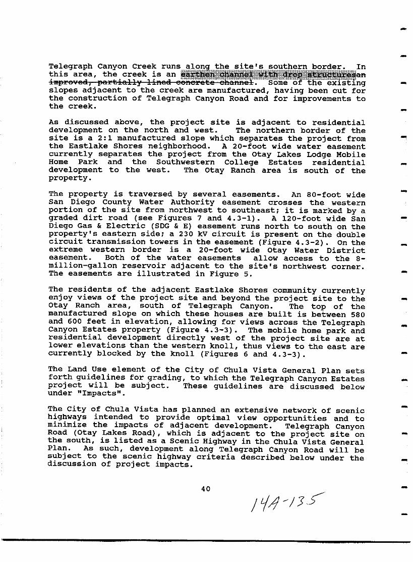
1 t iil lliii i ii tit i iiilislopes adjacent to the creek are manufactured having been cut forthe construction of Telegraph Canyon Road and for improvements tothe creek
As discussed above the project site is adjacent to residentialdevelopment on the north and west The northern border of thesite is a 2 1 manufactured slope which separates the project fromthe Eastlake Shores neighborhood A 20 foot wide water easement
currently separates the project from the Otay Lakes Lodge MobileHome Park and the Southwestern College Estates residentialdevelopment to the west The Otay Ranch area is south of the
property
The property is traversed by several easements An 80 foot wideSan Diego County Water Authority easement crosses the western
portion of the site from northwest to southeast it is marked by a
graded dirt road see Figures 7 and 4 3 1 A 120 foot wide San
Diego Gas Electric SDG E easement runs north to south on the
property s eastern side a 230 kV circuit is present on the doublecircuit transmission towers in the easement Figure 4 3 2 On theextreme western border is a 20 foot wide Otay Water Districteasement Both of the water easements allow access to the 8million gallon reservoir adjacent to the site s northwest cornerThe easements are illustrated in Figure 5
The residents of the adjacent Eastlake Shores community currentlyenjoy views of the project site and beyond the project site to the
Otay Ranch area south of Telegraph Canyon The top of themanufactured slope on which these houses are built is between 580and 600 feet in elevation allowing for views across the TelegraphCanyon Estates property Figure 4 3 3 The mobile home park andresidential development directly west of the project site are atlower elevations than the western knoll thus views to the east are
currently blocked by the knoll Figures 6 and 4 3 3
The Land Use element of the city of Chu1a Vista General Plan setsforth guidelines for grading to which the Telegraph Canyon Estates
project will be subject These guidelines are discussed belowunder Impacts
The City of Chula vista has planned an extensive network of scenichighways intended to provide optimal view opportunities and tominimize the impacts of adjacent development Telegraph CanyonRoad Otay Lakes Road which is adjacent to the project site onthe south is listed as a Scenic Highway in the Chula vista GeneralPlan As such development along Telegraph Canyon Road will besubject to the scenic highway criteria described below under thediscussion of project impacts
40
i JS

t 31nm l
IZw
w
J
uo
M0l3R z 3Ntd H1IM Sclrlll a O
wl0
8W
wO
51100
0gll
0
c
Ijl2e
f31V L03rOld 10 SM31
6 016 V uofo 13pootJ 04 OWOr 6 Q
J3lUa AallOA Mopo4S
S UIUV
IZW
W
Siiuo
j1 t
Ii
L
c
5cEc
gc
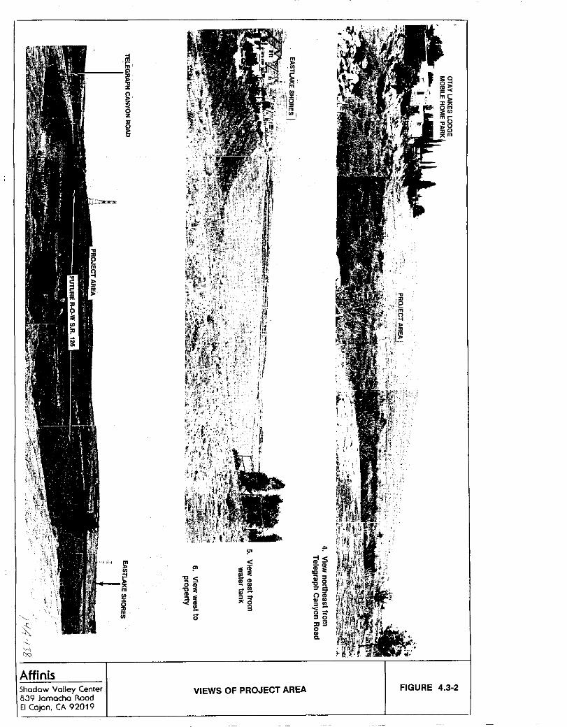
x
AffinisShadow Valley Center839 Jamacha RoadEI Cajon CA 92019
j1In
iIn
az
II
go
U
m
UIoIImU
lD
iii lD
gS iDlDI0
OlD ClCl rr
OlDI0lD I
l 3S
OI 0
030
0
VIEWS OF PROJECT AREA FIGURE 4 3 2
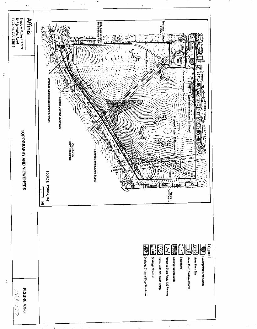
m
o
03nr
00
15
daoGl
aI
c
lJlImclJl
T1
i5clIm
lJ
1Ien
13c
orry
JE8
o
Om
g
rlJ iC C
aIa aZ339
i1r
jij iii
c i 1go il
Qft
gaD
I 1
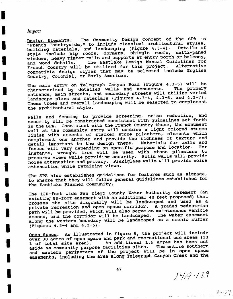
I
I
I
II
I
II
I
I
I
I
I
II
I
I
I
I
Impact
Desian Elements The Community Design Concept of the SPA is
French countryside to include classical architectural stylesbuilding materials and landscaping Figure 4 3 4 Details of
style include hip roofs dormers shingle roofs multi panedwindows heavy timber rails and supports at entry porch or balconyand wood details The Eastlake Design Manual Guidelines for
French country will be utilized for this project Alternative
compatible design styles that may be selected include EnglishCountry Colonial or Early American
The main entry on Telegraph Canyon Road Figure 4 3 5 will be
characterized by detailed walls and monuments The primaryentrance main streets and secondary streets will utilize varied
landscape plans and materials Figures 4 3 4 4 3 6 and 4 3 7
Theme trees and overall landscaping will be selected to complementthe architectural style
Walls and fencing to provide screening noise reduction and
security will be constructed consistent with guidelines set forth
in the SPA Consistent with the French Country theme the monument
wall at the community entry will combine a light colored stucco
finish with accents of stacked stone pilasters elements which
complement one another and provide the richness of texture and
detail important to the design theme Materials for walls and
fences will vary depending on specific purpose and location For
instance wrought iron will be used with stone pilasters to
preserve views while providing security Solid walls will providenoise attenuation and privacy Plexiglass walls will provide noise
attenuation while retaining views
The SPA also establishes guidelines for features such as signageto ensure that they will follow general guidelines established for
the Eastlake Planned Community
The 120 foot wide San Diego County Water Authority easement an
existing 80 foot easement with an additional 40 feet proposed that
crosses the site diagonally will be landscaped and used as a
private recreation and open space corridor A graded pedestrianpath will be provided which will also serve as maintenance vehicle
access and the corridor will be landscaped The water easement
along the western boundary will be landscaped as a scenic buffer
Figures 4 3 4 and 4 3 6
Ooen Soace As illustrated in Figure 5 the project will include
over 30 acres of open space and park and recreational use areas 33
of total site area An additional 15 acres has been set
aside as community purpose facilities sites The entire southern
and eastern perimeters of the project will be in open space
easements including the area along Telegraph Canyon Creek and the
47
Ll j31
53 1 l
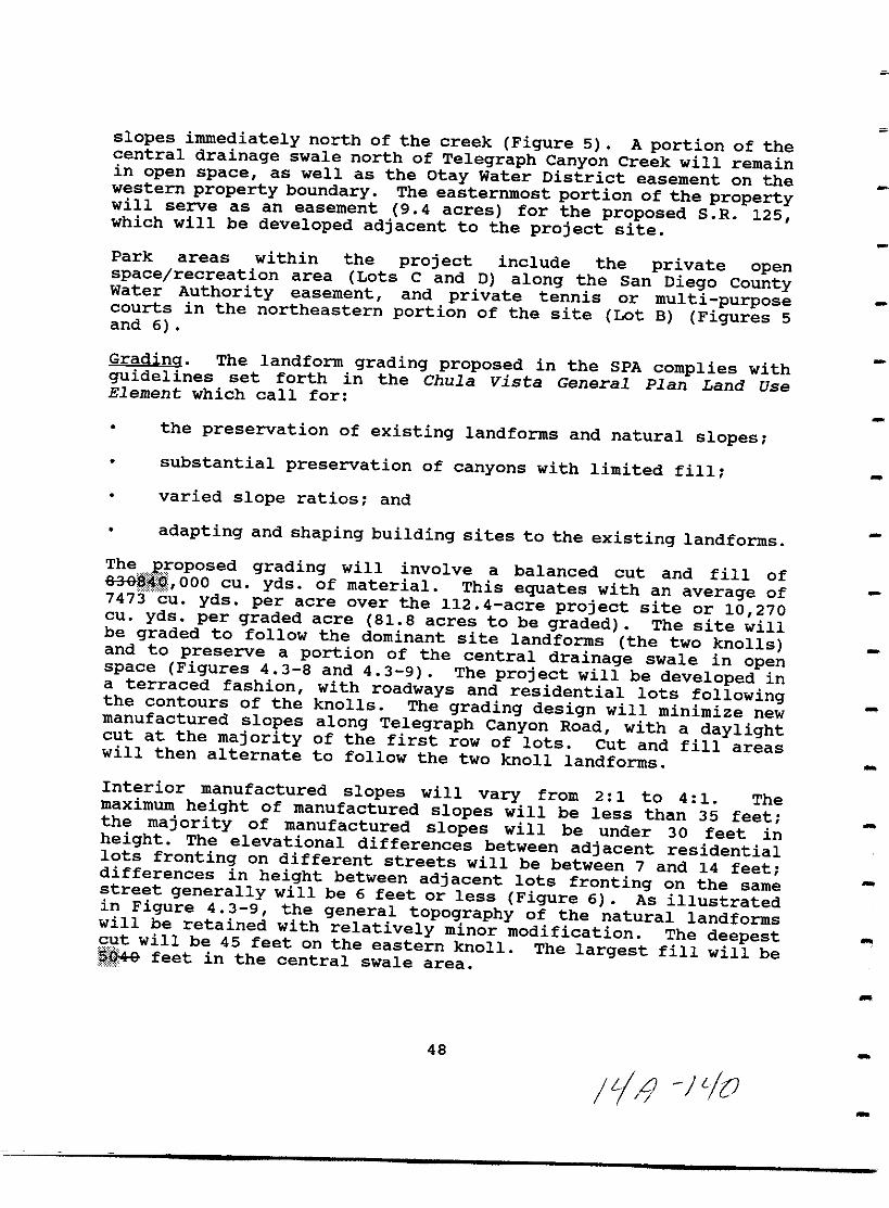
slopes immediately north of the creek Figure 5 A portion of thecentral drainage swale north of Telegraph Canyon Creek will remainin open space as well as the otay Water District easement on thewestern property boundary The easternmost portion of the propertywill serve as an easement 9 4 acres for the proposed S R 125which will be developed adjacent to the project site
Park areas within the project include the private openspace recreation area Lots C and D along the San Diego CountyWater Authority easement and private tennis or multi purposecourts in the northeastern portion of the site Lot B Figures 5and 6
Gradina The landform grading proposed in the SPA complies withguidelines set forth in the Chula Vista General Plan Land UseElement which call for
the preservation of existing landforms and natural slopessubstantial preservation of canyons with limited fill
varied slope ratios and
adapting and shaping building sites to the existing landforms
TheJ roposed grading will involve a balanced cut and fill ofm ooo cu yds of material This equates with an average of747j cu yds per acre over the 112 4 acre project site or 10 270cu yds per graded acre 81 8 acres to be graded The site willbe graded to follow the dominant site landforms the two knollsand to preserve a portion of the central drainage swale in openspace Figures 4 3 8 and 4 3 9 The project will be developed ina terraced fashion with roadways and residential lots followingthe contours of the knolls The grading design will minimize newmanufactured slopes along Telegraph Canyon Road with a daylightcut at the majority of the first row of lots Cut and fill areaswill then alternate to follow the two knoll landforms
Interior manufactured slopes will vary from 2 1 to 4 1 Themaximum height of manufactured slopes will be less than 35 feetthe majority of manufactured slopes will be under 30 feet inheight The elevational differences between adjacent residentiallots fronting on different streets will be between 7 and 14 feetdifferences in height between adjacent lots fronting on the samestreet generally will be 6 feet or less Figure 6 As illustratedin Figure 4 3 9 the general topography of the natural landformswill be retained with relatively minor modification The deepestg twill b 45 feet on the eastern knoll The largest fill will beQ9 feet n the central swale area
48
IL 1 JLIO
C
nUo0ae 0
003
nOg g
ocJIgro
oaJ
iil
5iii
oc
of11
CJ
is
m
3
rZ
5c
0
l c
I ijtIm
00 gZ0
0
gm
J0
l 0
tIm
rli a
rn 0 0 3
Z 00
30
gm m
5 Nc 3
o
T1
i5cDm
CDal
00iiiD
g
PropoSed tate Reule 1254
o
o
e
zo
Cm
0
0enCenm
en en
m
0Zzen
1 8 ig iEcn5 nlo
a
5 0 0 CD0 S a
CD c l II J J ill
l g ffi I r Q iii l
G r 3 lXI Ql to m
al OJ e 0 1l
a II C c 0 ll
g

rnVI I 25 Of
lL l r
en
moogJl
n no
lY 0
g 3 10
n9 1lI in Jl1lI
iS2n00
tlJ
m rm
0
D
l 113
G
C
o 3
n
0n
m
0g m
o
00
0
m af it
3m
me
m
G
Z
5
g0
a
5
JmIII
Iim
a
Ej
ti
N
thI il c111
i5cJ
o
im
lI j S
Z fl j
c
s
In
mac
nII
cl 0
nnl I
iiia
l
l PII
U
ttS2noc m
0
w
otlo1Il1Il
1Ilmol
oZ1Il
l
m
w
ll
15to c
tlm
Go
go
fi
0
10
I
lI e o
lit i
s
tiiu
j il
I
11
1I
D I
ITif
lI
go
rn
Iiroo
e
i
go I
i
Fj i jo
n
fl

cnfil a
n9JU iii
02c
0
lin
00c
11um
303i
l
0D01Il
I1Il
1Il
6isz
i1Il
c
I
ccZ i
m
Z
j
reh
1
II
rf
1 0
g
1
io
j
I
I
j
fL
a ajo
g
lij
f0
r
IIJ
iI
I
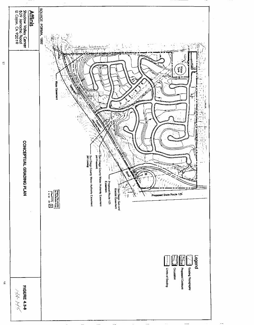
fT1 V
OilnJQ nQo 0 9 J3 Iii
9oDtJ6 n
acQa J
ID
8zn
r
Gl
gZGlC
jZ
00
i5cIIm
rJ CD
gJCD
1
2lD
i
JI
1Hifi
milm
o
i
L
OJ ElmO lDIto
c Qa iii2 1l
f
1l

l iS0 a0 0
3Oc3E III
r g goorJ6
naCIDQa ia
ft
o
Gl
C
ZGl
goenenen
6en
TI0
t i5S c
tlm
lcO
oC0o
2l0
s
cD0
I
VlfTI
loZ
lIJ
i0
re
I
I I 1xenOJlZJllJ
G1
110
II tIll 1l j L
f
c
o
o0
o
Zo
f
ifz
Q
Zo0
0xou
10
z
Q
Zo0
39o
0
fl80
o0
VlfTI
loz
f
ii t I0l 00
En n n a
IIII I1 m
i IIO
f E
lij UlU
zi51
10i rH
iiJ6ZO0
0
0
0
m
s
U
ifz
0
CiZo
0
9
Ez
0
0
z
0
80
80
o
0
fl80
c
o0
o0

j
I
II
I
I
I
I
II
II
I
I
I
The residents of Eastlake Shores to the north of the projectcurrently have views across the site toward the south Retentionof these views to the extent feasible is considered in the proposedgrading concept as illustrated in Figures 6 and 4 3 8 Tiemajority of development pads are 20 feet below the existingresidences to the north increasing to 30 feet on the eastern edgeand decreasing to 6 feet along the connecting road Figure 6
Landscaping along this slope is designed to preserve existing viewsfrom Eastlake Shores while screening views to the houses below
Figure 4 3 7
While the project attempts to preserve the views from Eastlake
Shores as much as feasible these views will no longer be of vacant
land However the nature of the views will change regardless of
the development of the Telegraph Canyon Estates project if
development of otay Ranch is approved for the property south of
Telegraph Canyon Road and if S R 125 is constructed immediatelyeast of the project site as proposed
The existing communities on the western border of the site will be
separated from the project by the 20 foot water easement and
landscaped slopes varying in height from 10 to 27 feet The
combined setback averages 40 feet on the western edge of the
project Figure 4 3 6
Scenic Hiqhwav Criteria Because the project area is adjacent to
Telegraph Canyon Road which is designated a Scenic Highway on the
Chula vista General Plan the SPA has been developed to conform
with the Telegraph Canyon Scenic Highway Criteria The projectwill
provide setbacks from the canyon floor
preserve and enhance the natural stream corridor and trail
system
ensure that the project I s architectural design height and
siting of structures and landscaping and signs are consideredin the development and
provide landscaping to beautify the adjacent portion of the
scenic route both inside and outside the project area
The grading plan has been designed to minimize new manufactured
slopes along Telegraph Canyon Road The existing Telegraph CanyonCreek drainage channel will remain unchanged Existing 3 1 and 4 1
graded slopes and 3 1 and 6 1 natural slopes will be preserved inthe open space easement along Telegraph Canyon Road Interior
manufactured slopes will vary from 2 1 to 4 1 as illustrated in
Figures 4 3 4 and 4 3 6
61
PiA It
3
4
The landscape concept plan is designed to comply with the ScenicHighway Criteria An expanded landscape setback area averaging 200feet in width minimum 175 feet maximum 700 feet will be providedalong Telegraph Canyon Road and will include the existing creekchannel The landscaped setback area will include varied contourgrading minimizing new manufactured slopes and varied planting toenhance the view from this scenic highway and screen the edge ofthe development The existing road right of way and channellandscaping will also be enhanced
MitigationjMonitoring
1 Grading for the Telegraph Canyon Estates project shall adhereto the guidelines of the Chula vista General Plan Land UseElement as outlined above
2 Development of the project shall comply with the ScenicHighway Criteria outlined above Adherence to the City s landuse and grading policies as well as the open space easementsand landscape and design elements discussed above willmitigate landform alteration aesthetic impacts to below a
level of significance
The mitigation monitoring program shall entail review ofgrading plans and the Tentative Subdivision Map by the CityEngineering Department to ensure compliance with the City s
grading and design standards
The landscape plan shall be reviewed and approved by thecity s Landscape Architects Landscaping for each phase shallbe installed prior to occupancy of the first building withinthat phase and 100 coverage shall be achieved for
groundcover within nine months of planting
Analysis of Significance
The City of Chula vista s Threshold Standards policy does notinclude threshold criteria for grading and landform alterationquality impacts The grading associated with development of the
Telegraph Canyon Estates project will not result in significantimpacts to landform alteration as the general topography of thenatural landforms will be retained and grading would comply withguidelines set forth in the Land Use Element of the Chula vistaGeneral Plan
The development will adhere to the City s Scenic Highway criteriathereby avoiding significant visual impacts to Telegraph CanyonRoad
The development concept of the Telegraph Canyon Estates SPA isFrench Country which is also used in the Hills portion of the
62
Ji4 ltf
I
I
II
II
I
I
I
I
I
II
I
II
I
I
I
Eastlake development The project s design concept is based on
design elements of the Eastlake Design Manual Guidelines in orderto assure compatibility with the adjacent Eastlake Shorescommunity Therefore development of the Telegraph Canyon Estatesproject will not create significant impacts to landform and visualquality with adherence to the mitigation measures outlined aboveand the MMRP
63
IrAll
THIS PAGE INTENTIONALLY LEFT BLANK
64
y 50
I
I
I
I
I
I
I
I
I
I
I
I
I
I
I
II
I
I
4 4 Air Quality
An Air Quality Improvement Plan AQIP was prepared for theTelegraph Canyon Estates SPA by Giroux and Associates August 61991 This document consisting of an analysis of potential airquality impacts and a mitigation and monitoring plan is includedin Appendix D to this EIR and provides data for the following airquality impact analysis
Existing Conditions
Ambient Air Qua1itv The City of Chula vista s climate is typicalof coastal areas of Southern California Chiefly influenced by asemi permanent high pressure system over the Pacific Ocean it istypified by early morning cloudiness hazy afternoon sunshinedaytime onshore breezes and little annual temperature changesRainfall occurs in small amounts chiefly during the winter monthswith annual amounts totalling around 10 inches
These conditions limit the atmosphere s ability to dispersepollutants Onshore winds diminish near the foothills in theCounty and sinking air within the offshore high pressure systemcreates a temperature inversion which traps pollutants near theground When the horizontal and vertical air stagnation arecombined with sufficient sunshine conditions are right for theformation of photOChemical smog
Coastal areas are less susceptible than are inland areas tounhealthful levels of smog because they are better ventilated bydaytime breezes When high levels of pollutants occur incommunities such as Chula Vista they may form during periods oflocalized stagnation in the summer but most frequently occur whenpollutants from the Los Angeles air basin drift south into SanDiego County Ambient air quality is recorded at several airmonitoring stations within the Air Basin The closest airmonitoring station to the project site is the Chula vista stationTable 4 4 1 shows Federal and State ambient air quality standardsThe number of days that Federal and State emission standards wereexceeded at the Chula Vista air monitoring station are shown on
Tables 4 4 2 and 4 4 3
The County of San Diego is considered a non attainment area forozone and respirable particulate matter air quality standards bythe Environmental Protection Agency Additionally the westernportion of the County is considered a non attainment area forState nitrogen dioxide and carbon monoxide standards While levelsof ozone have decreased over the last 10 years in San Diego Countyit is still the pollutant of primary concern In 1989 the Federalstandard for ozone was exceeded on 55 days and the State standardwas exceeded on 158 days Pollution transported from Los Angeles
65
IIA 5
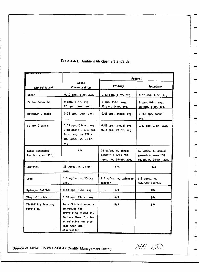
Table 441 Ambient Air Quality Standards
Federal
State
Air pollutant Concentration PrlMry Sealndary
Ozane 0 10 ppm I hr avg 0 12 ppm I hr Ivg 0 12 ppm I hr Ivg
Carbon Monoxide 9 ppm 8 hr Ivg g ppm 8 hr Ivg 9 ppm S hr Ivg
20 ppm I hr Ivg 35 ppm I hr Ivg 35 ppm I hr Ivg
Nitrogen DIoxide 0 25 ppm I hr Ivg 0 05 ppm annual Ivg 0 053 ppm annual
8vg
Sulfur Dioxide 0 05 ppm 24 nr avg 0 03 ppm annual avg 0 53 ppm 3 hr avg
with ozone 0 10 ppm 0 14 ppm 24 hr avg
I hr avg or TSP
100 ug cu m 24 hr
avg
Total Suspended N A 75 ug cu m annual 60 ug cu m annual
Partlculltes TSP geometric mean 260 geometri c mean ISO
ug cu m 24 hr aVe ug cu m 24 hr avg
Sulfates 25 ug cu m 24 hr N A N A
aVe
Lead 1 5 ug cu m 30 dlY 1 5 ug cu m calendar 1 5 ug cu m
avg quarter calendar quarter
Hydrogen Sulfide 0 03 ppm I hr avg N A N A
Vinyl Chloride 0 10 ppm 24 hr avg N A N A
VisibilIty Reducing In sufficient amounts N A N A
Particles to reduce the
prevailing visibility
to less than 10 miles
It rellthe humidIty
less thin 70 I
observation
Source of Table South Coast Air Quality Management District Fill J2
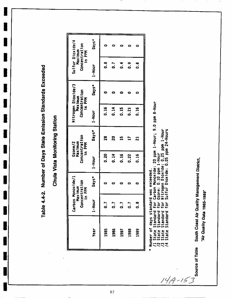
I
I
I
IC
IGICGIGIUoc
I w
III
EIII
ICCIII
en
Ic c0jjj 0
III III
sI
enw ClGI C
CS 0
I enC
III 0III
Ic III
7ii0
GIIIIg
I E 3l c
Z J
I N
IGI
c
III
II
eC C C C C
C 0
eE
C
o lGQELaCI J
eeeI GI
CD CDIE Ue
8I C C C C C0I c
C0 C C C C C
eQ
0i1i EECI CL
C icGIsU N
e
e 0 IC C Q C C
0c
z
e CD Q0Q N N N
Nj E
iefac
o
OJCCc8 C N
e N N
0 I0 C C Q C Cc
eC 0 C C C C C
ME XC
g Q
20
C
CsU0 e I CDJ 0 0
c C C C C C
CDCD CD CD CD CD
67
I0c
CD
EQQ
C
I
01Z O
I z0c
ENQQ E
E QQ L QQ IN
0 Ii0100N c
0
CU EC CC0 CII41 Q C
Ce 0 CQl00GlC C10 e
U2llC oeoCIl
c OILO O C
auc c Lt ofQ N S CD
auoz
J1ULL LL iijlI 0000c I CD
0JC CCCcnLL L L
tUIGIDIIIC CICC
liiQ
ccccdJlOta
C 0InvunU iij
IOCUCUGlGl c 0L 101U1G I
III 0tc Hun VI III
NMz
Gic
o
u
IoIII
JLl Y

tJQtJQQu
W
III
EcatJCca
encoiiilJ
sW
QtJQLl
III
caC
co
ca
en
OJcCo
co
ca
1ii
ca
ic
q c0
eVI
e1D f
sen
JlICC2Uz U
e0
0 U
6aEE
JC fo0OxecJZ U
e0
JU
VI
eoNe
z
ifaco
ONCe
e
oU
e0
ME2g a
j c
cE u
o e0 0
U
U
VI
a
a a a
VI
Jo
N
en 0en 0
o 0
eno
o 0
en CD
o 0
NN
o 0
o 0
CD
o 0
CD enCD CDen en
68
VI
J0
Jo
NCD
E EQQ
Jon J
aeen e
JA0
Joc us
N
EE a Suta a UCla s
011 1
JOA U
u E 000 a u us
GI a CIOCIOM CQ
ON M
ucOaa
UO VIJC2 0cs aII VI e
cutaUII a
Ga C fa
a 0 I
s0OOuovt u
as s s s oo00000
ce
aCI OOUQs E
DGfDftlQOO OOe
tCCCCGOIGGftJC
0VI H
0 e0 tV
CllIDftlllOss 1oo UJ
GlUUUGJDaO OOE
euuuUiosuu LL IL ZA
zN II
z
C
Qo
Qc
EsZ
co
Q
is
a
000
C
EOlcoCco
IIIE CO
Jiii IIII CO
i
Jo
CD
o 0 0
C
iiiI
oCJc
S
VI
o
N N
J
o
oN
JLjI7 i
s
o
eIoIII
o 0 0
VI
a
000
Jo
o 0 0
IICD CD CDen en en
I
II
I
I
I
II
I
II
I
I
I
I
II
II
was the primary source state nitrogen dioxide and carbon monoxidestandards were not violated in Chula vista in the last six yearsTable 4 4 2 and have exceeded standards on a basinwide scale
only infrequently
Air Oualitv Reaulation Both the state of California and theFederal government have established standards for air pollutionlevels Overall the state standards are more stringent than theFederal standards Table 4 4 1
Four agencies are involved in the air quality planning processThese include the Environmental Protection Agency EPAresponsible for administering the Federal Clean Air Act the stateAir Resources Board ARB responsible for implementing theCalifornia Clean Air Act CCAA of 1988 also known as AB 2595the San Diego County Air Pollution Control District APCDresponsible for developing the Air Quality Plan mandated by theCCAA and regulating regional emissions and the San Diego CountyAssociation of Governments SANDAG responsible for preparingtransportation control measures in the Air Quality Plan
The State Implementation Plan SIP currently serves as theregional Air Quality Plan Based on Series V and VI GrowthForecasts it was originally developed in 1982 by SANDAG and theAPCD incorporating tactics identified in the 1982 Regional AirQuality Strategy RAQS Update Mross personal communicationThe RAQS Update is presently being revised using series VII GrowthForecasts but the original SIP will continue to serve as theregional air quality plan until the new one is adopted
Because some pollutants in the San Diego air basin exceed State andFederal standards the CCAA requires that revisions are made to theSIP Regional air quality attainment plans are currently beingprepared by SANDAG and the APCD Specific guidelines and standardsare not available but the plans will focus on reducing singleoccupant automobile trips
The APCD Board adopted criteria for developing a transportationcontrol measures TCM plan which is being prepared by SANDAG TheTCM criteria focus on six main objectives including
transportation demand management reduction in the number ofvehicle trips and heavy duty vehicle restrictions
expansion of alternative transportation modes includingpublic transit park and ride facilities high occupancyvehicles and biCYCles pedestrians
transportation system management traffic signals and incidentmanagement
69
4 7I
land use balanced jobs and housing mixed use and focused
development
market based incentives fees and taxes and
driving restrictions
It is envisioned that regulations to meet these criteria willinclude ride sharing and van pool programs employer subsidizedtransit ticket passes flexible work schedules telecommutingparking incentives to support ride sharing trip managementeducation limitations on heavy truck traffic and measures to
reduce trips to large facilities These regulations combined withother transportation system measures will be included in the new
Air Quality Plan to reduce motor vehicle trips and emissions
While the City of Chula vista does not have a formal role in the
development of the Air Quality Plan it can contribute to regionalair quality improvements After studying the potential impacts of
future development on public facilities and services the Cityadopted the Threshold Ordinance see Chapter 12 updated itsGeneral Plan and prepared a Growth Management Plan GMP for the
city to establish an orderly process for development The projectarea is within the primary area of focus of the GMP east of I
805 The city Council is currently implementing the GMP which
requires that Air Quality Improvement Plans AQIP are prepared for
major development projects 50 residential units or
commercial industrial projects which generate more than 500 tripsper day Giroux and Associates 1991 This project developed an
air quality plan concurrent with the sectional Planning Area SPA
submittal pursuant to City requirements see Appendix 0
The city of Chula vista is also presently involved in a regionaleffort to implement a transportation demand management TOM
ordinance The immediate focus of the TOM ordinance will be on
employment travel college and university travel and the movement
of goods The objectives of reducing the number of trips are
detailed in Appendix 0 on page 12 Implementation of the TOM
ordinance will largely be the responsibility of regional employers
Impact
Short term project construction will generate dust and dieselemissions creating short term construction phase emissionsimpacts While individual homes do not directly affect airquality a residential development is considered to be an indirectsource of air pollution because it generates motor vehicle tripsGiroux and Associates 1991 Over the long term the Telegraph
Canyon Estates project if built at a maximum of 350 units willgenerate approximately 3500 daily automobile trips see Chapter4 8 Transportation Additional vehicle trips from the proposed
70
JfJ 56

I
I
I
I
I
I
I
I
II
I
I
I
I
II
I
I
I
project will cause further degradation of air quality within theSan Diego Air Basin
Construction Phase rmDacts Soil disturbance associated withproject construction is expected to generate fugitive dustGiven prevailing westerly winds dust plumes will generally blow tothe east except during Santa Ana conditions when winds will changeand blow dust west toward existing residential development Basedon standards set by the ARB it is projected that withoutapplication of dust control procedures the project could generateup to 630 tons of dust emissions
Combustion emissions will also be released from heavy equipmentduring project construction While these emissions are difficultto quantify because of day to day variation in activities a
projection of emissions which will result over the buildoutlifetime of the project is presented in Table 4 4 4
Construction phase air quality impacts are deemed tolevel of significance with implementation of themeasures identified below
be below a
mitigation
Pro ect Phase rmDacts The project will result in an increase inair emissions from automobiles The project is consistent withSANDAG Series VII growth projections and will be reviewed forconformance with the updated SIP when it is approved and adopted asthe regional Air Quality Plan AQP As noted in Appendix D theproject is residential and specific requirements for residentialprojects are expected to be minimal in the new AQP Because theAQP will focus on transportation measures beyond the control of asingle project developer it is anticipated that the project willbe reviewed for consistency with the AQP Giroux and Associates1991
The project will however contribute incrementally to basin wideair pollution As shown in Table 4 4 5 the project is expected tocontribute 0 009 of the basin wide reactive organic gases 0 025of carbon monoxide and 0 013 of nitrogen dioxide
The project is not expected to result in localized air qualityimpacts e g carbon monoxide hotspots due to idling trafficWhere the future level of service LOS on area roadways isexpected to decrease the project will provide mitigation tomaintain adequate traffic flow see Chapter 4 8 TransportationAdditionally at the present time the intensity of developmentnear the project site and non local background pollution levels are
low Therefore the local airshed is considered to have adequatecapacity limiting the potential for localized air pollution hot
spots from project implementation Giroux and Associates 1991
Because the proposed project is within a non attainment area airquality impacts are deemed to be significant and unmitigated on
71
11 57
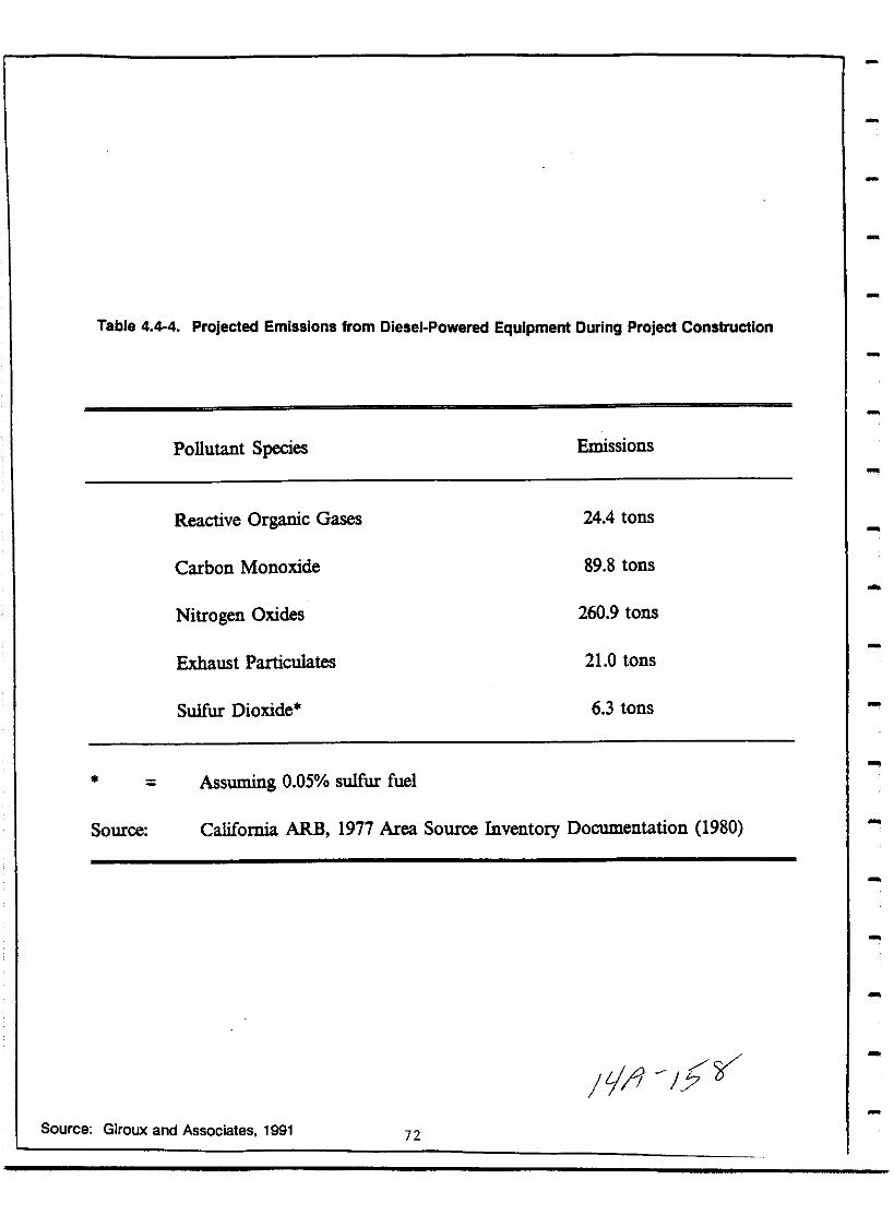
Table 4 44 Projected Emissions from Diesel Powered Equipment During Project Construction
Pollutant Species Emissions
Reactive Organic Gases 244 tons
Carbon Monoxide 89 8 tons
Nitrogen Oxides 260 9 tons
Exhaust Particulates 210 tons
Sulfur Dioxide 6 3 tons
Assuming 0 05 sulfur fuel
California ARB 1977 Area Source Inventory Documentation 1980Source
t1 5vSource Giroux and Associates 1991 72
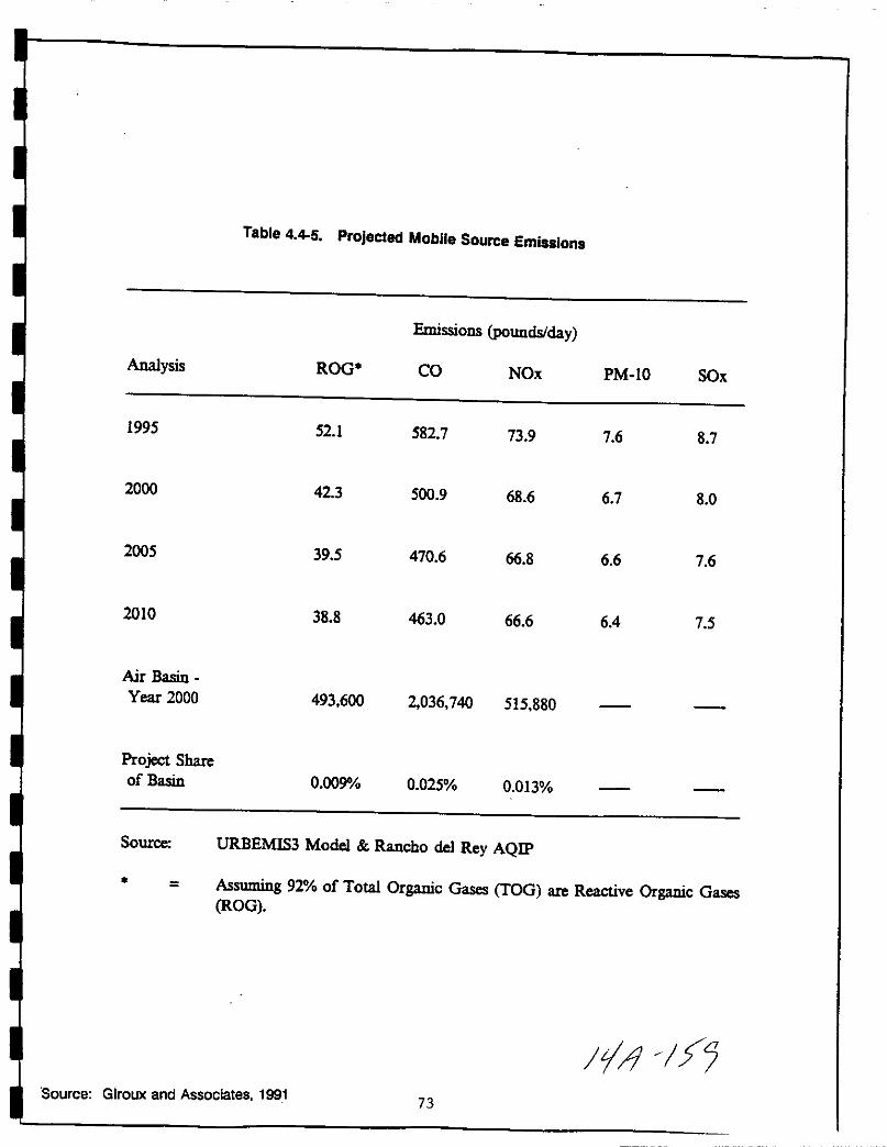
Table 4 45 Projected Mobile Source Emissions
Emissions POundsday
Analysis ROO CO NOx PM 10 SOx
1995 52 1 582 7 73 9 7 6 8 7
2000 423 500 9 68 6 6 7 8 0
2005 39 5 470 6 66 8 6 6 7 6
2010 38 8 463 0 66 6 64 75
Air Basin
Year 2000 493 600 2036 740 515 880
Project Shareof Basin 0 009 0 025 0 013
Source URBEMIS3 Model Rancho del Rey AQIP
Assuming 92 of Total Organic Oases TOO are Reactive Organic OasesROO
II IfSource Giroux and Associates 1991
73
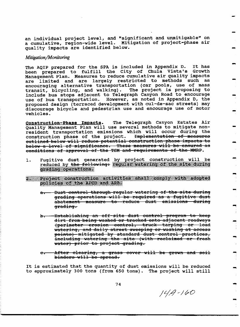
an individual project level and significant and unmitigable on
a cumulative region wide level Mitigation of project phase air
quality impacts are identified below
MitigationjMonitoring
The AQIP prepared for the SPA is included in Appendix o It has
been prepared to fulfill the City of Chula vista s Growth
Management Plan Measures to reduce cumulative air quality impactsare limited and are largely restricted to methods such as
encouraging alternative transportation car pools use of mass
transit bicycling and walking The project is proposing to
include bus stops adjacent to Telegraph Canyon Road to encourage
use of bus transportation However as noted in Appendix 0 the
proposed design terraced development with cul de sac streets may
discourage bicycle and pedestrian use and encourage use of motor
vehicles
Construction Phase Impacts The Telegraph Canyon Estates Air
Quality Management Plan will use several methods to mitigate non
resident transportation emissions which will occur during the
construction phase of the project IlIIplelllefttatisft sf llIeaS1lres
6Htlinca 5cle ill rcauec petcntial esnstraetisn phaac impacts te
bclew a le cl af ai ftifieaRec These measares ill 2 ensured as
eeflEiitieflB af appre al af the Ten ana rcquiremcflta af the lHmr
1 Fugitive dust gener ted pYPill
Pl
JFrp ri oftf 1mfje ff itlQt1J
fpt itFii iii lisi iiitfnft
1 1 1 111111111111 IIIIIIIIIII1 iil iililti 1 g Q M 1 jl 19DEi1
a Daat esntrel threa h rc tilar atcrift af the site atirinraEiiR epcrat ieftB ill Be required as a fti it i7C dust
aBatement measure te redact dust emissions duriR
graEiiflEj
s Esta131iahifitj aft eff aite daat central preEjram te kee
dirt fram lsc inEj uaahed er trae ted ante adj acent raae aya
perimster ereaisn eaRtral truc t tarpinEj ar laad
uaterinEj ana daily atreet B JecpinEj aE war3liinEj at aCCC30
paintB mitiEjate a lsy Btandard aaBt eentrel praetiec6iPlel11di1 Ej watcri1Ej the site ith reclaimed or frcElh
water prior to project Ejraai1Ej
e After elearinEj a Ejra66 eorer will be Ejrow1alia Bailbinders will Be spread
It is estimated that the quantity of dust emissions will be reduced
to approximately 300 tons from 650 tons The project will still
74
Lj41 O
I
I
I
I
I
I
I
I
I
I
I
I
I
I
I
I
I
II
contribute to cumulative fugitive dust generated by other areaconstruction projects but no additional construction phasemitigation will be required
2 11 II II ljli f mll allaGI Ifm ijS ltPff s e raff e 8 erfcrc8ee trem eeRa rHe 1eRperasllJcI te 136 reallse a ei previai1riaeslisre inselltiveareatriet iftEj laRe elestirea te eff pealc trMel Icrieaa andaeaeatlliftEj trtle c aeeeaa SHeft that 80 peresftt af daily reeeiltaf eSlistltiet isn materials Till B6 limitea te 19ct eCft 9 88 a Illalui J sa p m
3 Oenstrtlstisn aeti7itiea ill he passed ana aehceillle ei te a eieihiEJft BeeRedays
proieot Phase ImDacts Because the project will not createlocalized air quality impacts no mitigation measures are requiredAs discussed above the methods for reducing the project scontribution to cumulative air pollution are limited because theproject is residential Residents can be advised of car poolfacilities or mass transit routes but there is no method to ensurethat these options would be exercised The AQMP requires that the
IEPject is c mstructed using energy co servation materials whichMexceed T tle 24 energy budget requ rements by 10 percent ofestImated use and that homes are pre plumbed to encourage and
facilitate use of passive solar thermal collectors for spa or homewater heating requirements
As detailed in the AQIP in Appendix D three primary groups areinvolved to ensure implementation of the plan These include thedeveloper builder property owners residents and governmentagencies
Developer Builder The applicant is providing the basic planningdesign and management of the program and will be responsible forimplementing community level transportation facilities Efter yplannillEj ana manaEjcmcnt will Be the reapsnsi13ility af the Bl1ileie raesnstruet iBEj the aemea
Homeowners Residents The project s residents will be responsiblefor choosing their mode of transportation driving habits andlifestyles Mode choice will be primarily influenced by tripdestination rather than trip origin
Government and Service Aaencies All project plans will bereviewed by City Staff to ensure compliance with the updated AirQuality Plan Prior to approval of the tentative map projectplans will be reviewed by city Staff to insure that the requiredmeasures can be accommodated by the project s design
75
jfJ 1 I
Transportation control measures TCMs and development and
transportation improvement phasing are controlled by the City s
Growth Management Plan The potential impacts associated with
traffic congestion on roadways affected by the project will be
assessed Any mitigation measures delineated in the TransportationPhasing Plan shall be implemented prior to issuance of occupancypermits per the Public Facilities Financing Plan PFFP
The APCD is responsible for updating the regional Air Quality Plan
Because the APCD is prohibited by state law from intruding on the
land use authority of the City of Chula Vista it will be the
City s responsibility to implement the plan s guidelines when it is
approved
Analysis of Significance
Construction Phase Significant localized impacts to air qualityduring project construction will be reduced to below a level of
significance by standard dust control practices listed above
Pro ect Phase The project s contribution to the basin wideairshed is small 0 009 of reactive organic gases 0 025 of
carbon monoxide and 0 13 of nitrogen dioxide Given the San
Diego Air Basin s non attainment status however the incrementaladdition of pollutants from any individual project is considered a
significant unmitigable impact on a cumulative basis
As previously discussed SANDAG s regional growth forecasts are
based on land uses established in area general plans While the
project exceeds the Series V and VI Growth Forecast used in the
1982 SIP it will be reviewed for consistency with the Series VIIGrowth Forecast being used to update the SIP the new regional Air
Quality Plan Until consistency with that plan can be determinedhowever project phase air quality impacts are deemed to be
significant and unmitigated
76
LA J
I
I
I
I
I
I
I
I
I
I
I
I
I
I
I
I
I
I
I
4 5 Biological Resources
A biology field survey was done by Recon in 1989 on theapproximately 23 OOO acre Otay Ranch Property Recon 1991 TheRecon report is on file with the City of Chula Vista PlanningDepartment and may be reviewed at that location The TelegraphCanyon Estates site is a small portion of the Recon study area Anupdated biology survey to acquire more detail and to include aspring survey of the Telegraph Canyon Estates site was done in 1991by Affinis This section is based on that updated biology reportincluded in Appendix E to this EIR
Existing Conditions
The site consists of gently rolling hills with moderate slopes20 gradient with a central swale bisecting the site A smallerdrainage runs parallel in the eastern portion of the siteElevations range from 615 feet above Mean Sea Level to 455 feetThe site is largely agricultural land Figures 7 4 3 1 and 4 3 2
On site soil types mapped by the Soil Conservation Service areDiablo Clay 2 9 9 15 and 15 30 slopes Linne Clay loam 930 slopes and Salinas Clay loam 2 9 slopes The predominatesoil type is Diablo Clay 15 30 slopes There are no rockoutcrops on the site The site s northern border is a fill slopewhich was constructed for the Eastlake developmentThe majority of the site of 112 acres consists of 101 8 acres ofAgricultural land which had been recently mowed and tilled
Approximately 2 0 acres were mapped as Disturbed Ruderal Theseare in a swale and under the transmission lines in the easternportion of the site Figure 4 5 1 Plants observed were tocalotesow thistle Bromus species jimson weed and bindweed wild oatsfennel russian thistle and mustard were the dominant speciesAn area of 1 8 acres was mapped as Disturbed Ornamental This isin the northwestern portion of the site north of the waterreservoir The area is partially disturbed by tilling and otheractivity and partially planted and invaded by ornamental speciesAn area of 1 5 acres is covered by the artificial steep fill ofthe adjacent housing project On this artificial fill slope in thenorthwest corner buckwheat grasses encelia and saltbush wereidentified These appear to be the result of revegetation effortson the slope
The central drainage contains two areas of freshwater marsh an
upper area of approximately O 6 acres and a lower portion of
approximately 0 3 acres this lower portion is itself divided in
77
il tJ

half by the easement and road for the aqueduct and reservoir
Figure 4 5 1 In the upper portion just below the fill slopecattails dominated In the lower marsh portion cattails were
present north of the easement road south of the easement road were
willows tree tobacco fan palm watercress distichlis and
rabbitfoot grass The channel by Telegraph Canyon Road in the
southeastern section also contains a stand of giant reed
The area mapped as Drainage is the non vegetated portion of the
drainage between the two areas of marsh This occupiesapproximately 1 1 acres The site has been farmed for some time
Brushing and plowing have regularly occurred through this area as
a result no perennial vegetation is established Some watercress
was present
Mammals observed included three cottontail rabbits and one groundsquirrel Also observed were pocket gopher mounds Birds observed
were Brewer s and Red winged Blackbird Meadowlark Cliff Swallow
Killdeer House Finch and California Towhee feeding in the fennelin the second drainage the disturbed ruderal area One
invertebrate the escargot snail was observed in the northwest
corner by the water reservoir associated with the ornamental
plants Lists of species observed are presented in Appendix E
Impact
The proposed project with parks and the community PurposeFacilities will occupy 82 2 acres of the site The proposedproject includes 30 2 acres of open space 9 4 of this may be used
as easement by the future State Route 125 Figure 5 The
remaining 20 8 acres are proposed for revegetation landscaping as
discussed in section 4 3 above
Most of the disturbed ruderal area of the eastern swale will beretained by this project as open space in time the area will
likely be used by the State Route 125 project with this
exception the balance of the project will remove all of the
vegetation present as revegetation and landscaping are planned for
any areas not being built upon Figure 4 3 4
The proposed project will eliminate the upper freshwater marsharea of approximately 0 6 acres and the two portions of the lower
marsh area of approximately 0 3 acres together
Revegetation and landscaping will create some habitat particularlyvertical habitat with the introduction of trees and ground cover
on areas that are presently Agricultural or Disturbed
78
FIJ j
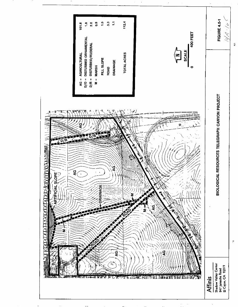
C ll 1 oj0
IiiWLL
0
J
0Z JW
0W
CJZ C
WJ
0 l
0OW
Wl C C 0
0
W W
9 JJ lD lDl 0 0 t CJ
C z
2j j CJJ 00 J 0 0 Iii 0 QQ C
011
C C
l
wa
Clii
oaa
z
z
c
aClwIWl
VWoa
oVwaI
oa9oiii
0c
ll
liigu0
Mll
1l u
6icow
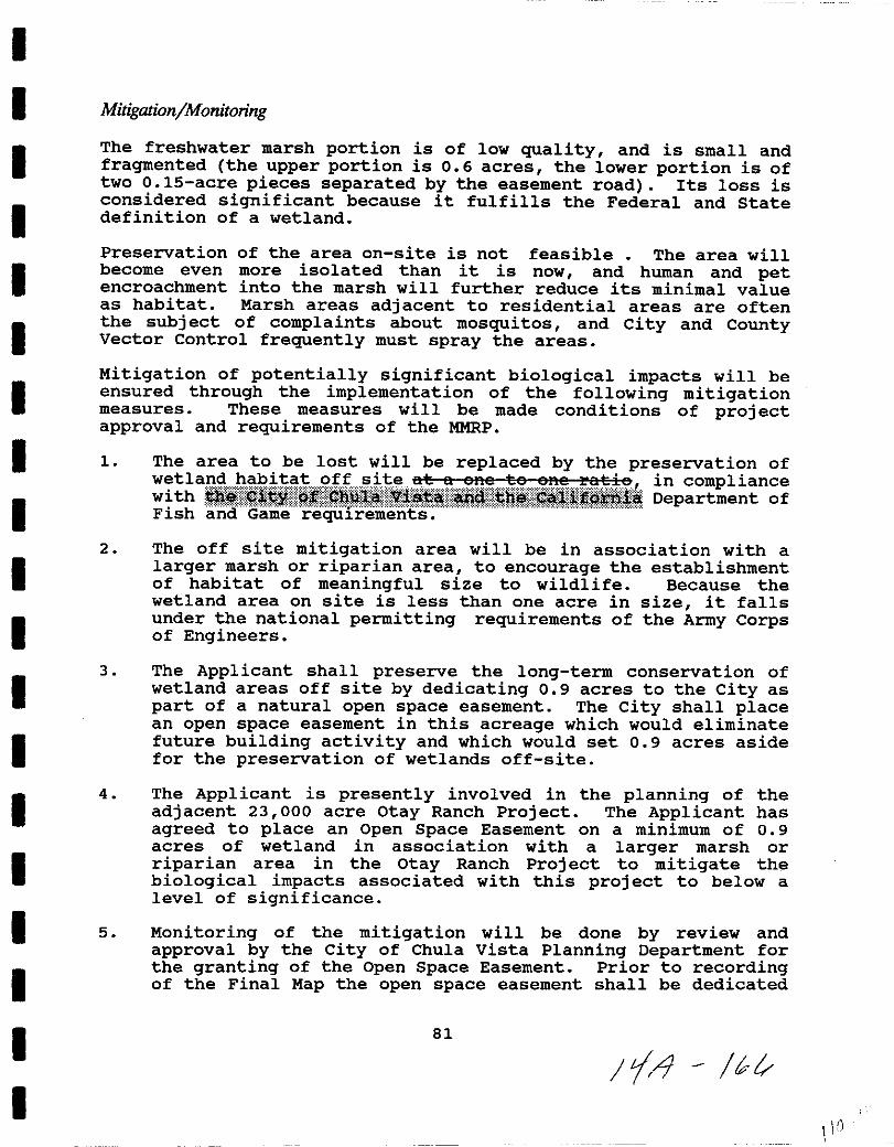
I
I
I
I
II
I
I
I
I
I
I
I
II
I
I
I
I
MitigationjMonitoring
The freshwater marsh portion is of low quality and is small and
fragmented the upper portion is 0 6 acres the lower portion is oftwo 0 15 acre pieces separated by the easement road Its loss isconsidered significant because it fulfills the Federal and statedefinition of a wetland
Preservation of the area on site is not feasible The area willbecome even more isolated than it is now and human and petencroachment into the marsh will further reduce its minimal valueas habitat Marsh areas adjacent to residential areas are oftenthe subject of complaints about mosquitos and City and CountyVector Control frequently must spray the areas
Mitigation of potentially significant biological impacts will beensured through the implementation of the following mitigationmeasures These measures will be made conditions of projectapproval and requirements of the MMRP
1 The area to be lost will be replaced by the preservation ofa ruiiiiiil I 1iiii iiiiliiiiliitIiiiii i p
n
Fish and Game requ1rements
2 The off site mitigation area will be in association with a
larger marsh or riparian area to encourage the establishmentof habitat of meaningful size to wildlife Because thewetland area on site is less than one acre in size it fallsunder the national permitting requirements of the Army Corpsof Engineers
3 The Applicant shall preserve the long term conservation ofwetland areas off site by dedicating 0 9 acres to the City as
part of a natural open space easement The City shall placean open space easement in this acreage which would eliminatefuture building activity and which would set 0 9 acres asidefor the preservation of wetlands off site
4 The Applicant is presently involved in the planning of the
adjacent 23 000 acre Otay Ranch Project The Applicant has
agreed to place an Open Space Easement on a minimum of 0 9acres of wetland in association with a larger marsh or
riparian area in the otay Ranch Project to mitigate thoabiological impacts associated with this project to below a
level of significance
5 Monitoring of the mitigation will be done by review and
approval by the City of Chula vista Planning Department forthe granting of the Open Space Easement Prior to recordingof the Final Map the open space easement shall be dedicated
81
Ii br
O
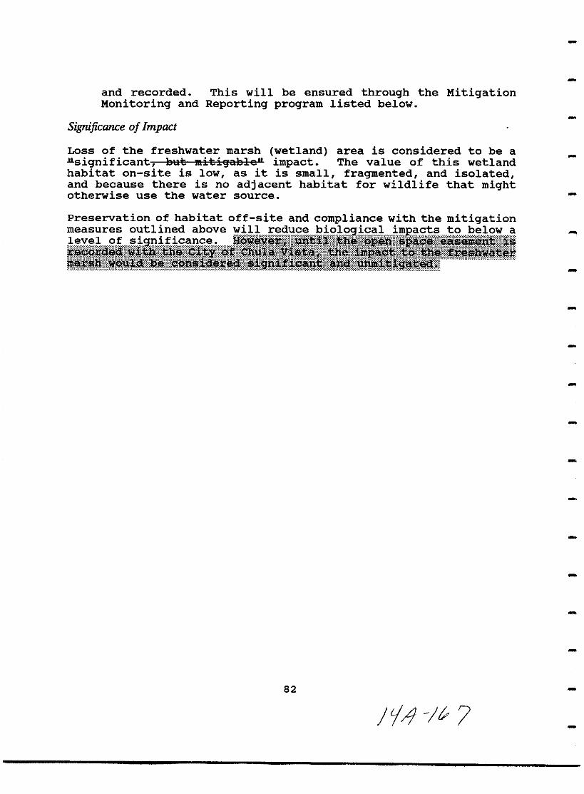
and recorded This will be ensured through the MitigationMonitoring and Reporting program listed below
Significance of Impact
Loss of the freshwater marsh wetland area is considered to be a
Jlsignificant Bllt lIIitiljJaBle impact The value of this wetlandhabitat on site is low as it is small fragmented and isolatedand because there is no adjacent habitat for wildlife that mightotherwise use the water source
Preservation of habitat off site and compliance with the mitigation
82
JiJ I

I
II
I
I
I
I
II
I
I
I
I
I
II
I
II
4 6 Cultural Resources
The Telegraph Canyon Estates project site was previously surveyedby Recon in 1989 as part of the survey for the proposed otay Ranch
project That survey report will be a part of technicaldocumentation accompanying the EIR for the otay Ranch projectwhich is currently being prepared
A focused survey of the project area was conducted by Affinispersonnel on July 2 1991 The Affinis survey report is includedas Appendix F to this EIR and serves as the background for the
following analysis
Existing Conditions
As previously discussed the project area consists of 112 4 acres
of land encompassing two gently sloping knolls trending north tosouth divided by a central swale Elevations on the property siterange from 460 feet MSL to 615 feet MSL
Previous agricultural use including grazing disking and plantinghas heavily impacted the property with the exception of theeasternmost portion of the property the area had been recentlymowed and tilled at the time of the Affinis survey At the presenttime the site supports a sparse cover of primarily non native
weedy plant species and animals typical of urban environments Seesection 4 5 of this EIR
Record searches performed for the project by the South Coastal
Information Center SCIC and the San Diego Museum of Mandetermined that no archaeological sites have been recorded on the
property However sites situated within one mile of the projectarea were reported These consist primarily of small lithicscatters or temporary camps
During the survey two isolated artifacts were identified These
artifacts a felsite flake and a fragment of purple glass were
mapped and collected Both isolates were judged insignificantbecause of their lack of potential research value
Impact
The two isolated artifacts a glass fragment and a felsite flakewere mapped and collected Thus development of the project sitewill not impact these artifacts As none of the sites recorded
within one mile of the property is immediately adjacent to the
project area no off site cultural resource impacts are expected to
occur
83
tfAt
MitigationjMonitoring
No significant impacts to cultural resources are expectedtherefore no mitigation measures or monitoring plan is required
Significance of Impact
No significant impacts to cultural resources are expected to occur
84
I1 ff
I
II
I
I
I
I
II
I
I
I
I
I
I
I
I
I
I
4 7 Transportation
A traffic study was prepared by Urban Systems Associates IncMarch 27 1992 for the proposed project and is included in
Appendix G to this EIR This EIR section is based on the analysisof that report
Existing Conditions
The project area is located in the Eastern Territories PlanningArea of the City of Chula vista It is north of Telegraph CanyonRoad also called otay Lakes Road and west of Eastlake ParkwayThe future alignment for S R 125 is immediately east of the sitePrincipal access to the project area will be from Telegraph CanyonRoad with secondary access from Rutgers Avenue and Gotham Street
Existing roadways are shown in Figure 4 7 1 The major roadwaysserving the project area are East H Street Telegraph Canyon Road
otay Lakes Road and Rutgers Avenue
East H Street is primarily an east west route which consists of a
six lane primary arterial between I 80S and otay Lakes Road and a
4 lane major roadway between otay Lakes Road and the future S R125 It is planned to be expanded to an 8 lane prime arterial fromI 80S to Hidden vista Drive Itwill remain a 4 lane major streetfrom otay Lakes Road to the future S R 125 Telegraph CanyonRoad also running predominantly east west connects I 80S withotay Lakes Road It currently terminates at its intersection withotay Lakes Road where otay Lakes Road becomes the east west
roadway but this portion will be renamed Telegraph Canyon Road inthe future It currently consists of 6 lanes between I 80S andPaseo Del Rey but loses one westbound lane between Medical Center
Drive and Paseo Ladera It becomes a six lane roadway again until
Apache Drive where it drops down to two lanes between Apache Driveand Rutgers Avenue It is currently under construction to 6 lane
prime arterial standards
otay Lakes Road runs mainly north south until it intersects
Telegraph Canyon Road It is presently a 4 lane major roadwaywithout raised medians between Bonita Road and Telegraph CanyonRoad and narrows to a two lane roadway just north of TelegraphCanyon Road otay Lakes Road is designated as a six lane primearterial on the Chula Vista General Plan The east west portionwill eventually become an extension of Telegraph Canyon Road a 6lane prime arterial and will continue south through otay Ranch inthe future
Rutgers Avenue also runs north to south and becomes Corral CanyonRoad north of East H Street Currently a two lane collector
Corral Canyon Road is planned to become a Class II collector street
85
4 7tl

PROCTOR VALlEY ROAD
I
QI
g II
oj I
l R1JGE IE
is II
a I
S
IC
Il
gfI
r r ie tlZ
z
ga l
i
u
l
i
i
Q
i 7
it
8lll131
1
PKWYB
l
Jo
I
LJ
iG
jtoe
II
IIIIII
IsYiiQ7
OJ 8JqIz
IEI
0
V3J 1YJI03f
Q Em
11I o
tii
iji
JAV ll3aJlvno
I
L J
qC
N
uiEwI
UlZClCDII
IiiuII
oUl
I
c
r
r
UJa
u
xao
Z
IUJUJaIen
zien
UJ
L
flc
0
UGJC 0ION
0
GJ e5UE C
o 2C U
In CX W
I
I
I
II
I
I
I
I
I
I
I
I
I
I
II
I
I
from East H street to Country Vistas Lane and a Class Icollector from Country Vistas Lane to Central Avenue
Level of Service LOS describes the speed and ease with whichtraffic moves on a given roadway segment It is rated on a scale
ranging from A best to F worst Existing and predicted LOSwere determined for roadway segments and critical intersections as
identified in the city of Chula Vista s Transportation PhasingPlan The existing LOS and capacities of key roadways in the
project area are shown in Table 4 7 1 As shown in the Tabletraffic is currently most congested on East H Street between I 80Sand Hidden vista Drive and on Bonita Road between I 80S and otayLakes Road
Additionally some of the land development proposed in the EasternTerritories is considered in the Eastern Chula vista TransportationPhasing Plan ECVTPP The circulation system cannot accommodateall of the traffic not identified in the ECVTPP e g Salt CreekRanch and it is not known at this time which projects willreceive capacity allocation The traffic volumes used in thetraffic report reflect maximum numbers based on approvals of largeprojects in the area e g Rancho del Rey SPA I II and III and
represent the worst case scenario
Impact
Pro ect Traffic If the Telegraph Canyon Estates project were
developed at the maximum density allowed on the site 350 unitsit will generate a total of 3 500 average daily trips ADT The
projected peak hour AM and PM rush hourn traffic is presented inTable 4 7 2
The SPA is proposing the circulation element shown in Figure 4 7 2Traffic will enter the project via a new Class III collector streetoff Telegraph Canyon Road or via extensions of Gotham Drive andCreekwood Way residential streets in the northwestern corner ofthe site Traffic is expected to be distributed as shown in Figure4 7 3 based on freeway access and location of services such as
shopping centers schools and community attractions
Approximately 80 of the trips 2800 ADT are assigned to TelegraphCanyon Road via the main access A total of 10 of the ADT 350
trips are expected to go to Rutgers Avenue via Gotham Street and
another 10 will go to Lakeshore Drive via Creekwood Way
Existinq Plus Approved Pro ects and Pro ect Traffic To evaluatethe potential traffic impacts of a given project the cumulativeimpacts of the project must also be considered In the vicinity ofthe proposed project there are a number of other projects whichhave been approved e g projects which have approved final or
87
JtA J

Table 4 7 1 Existing LOS on Area Roadways
STREET EXISTING
SEGMENT TRAFFIC CAPACITY LOS
1ELEGRAPH CANYON ROAD
I 80S TO CREST DR 46 600 50 000 C
CREST DR TO PASEO DEL REY 35 000 50 000 A
PASEO DEL REY TO PASEO LADERA 26 000 40 000 APASEOLADERA TO OTAY LAKES RD 21 000 40 000 AOTAY LAKES RD TO EASTLAKE PKWY 10 000 12000 B
ElO EAS11AKE PKWY 6 000 12 000 A
EAST H STREET
1805 TO HIDDEN VISTA DR 52000 50 000 0
HIDDEN VISTA DR TO
PASEO DEL REY 33 000 50 000 APASEO DEL REY TO OTAY LAKES RD 35 000 50 000 AOTAY LAKES RD TO
CORRAL CANYON RD 18 000 30 000 A
ElO CARROL CANYON RD 11500 30 000 A
OTAYLAKES ROAD
BONITA RD TO EASTH STREET 20 000 30 000 AEAST H STREETTO
1ELEGRAPH CMYON RD 16 000 30 000 ABONITA ROAD
1805 TO OTAYLAKES RD 33 000 30 000 0
OTAYLAKES RD TO
CENTRALAVE 27 000 30000 C
CORRAL CANYON RD
CENTRALAVE TO EAST H STREET 8 000 12 000 A
RUTGERS AVENUE
EAST H STREETTO GOTHAM ST 4 000 12000 AGOTHAM ST TO 1ELEGRAPH 2400 12 000 A
CANYON RD
SOURCE
SAIDAG OR CITY OF CHULAVISTA
CITY OF CHULA VISTA GE ERAL PLAN LOS C
tfll 73SOURCE URBAN SYSTEMS ASSOCIATES 1992

I
I
I
I
I
I
IJ0J
IV
I CIc
c0
I IV
CIcCI
IIV
I I
0CI
0
I c
I tGIcIV
I l
I
I
I
I
I
0
on onl5 li N
R R0
l5 on
5N
ll
Q
z
z
0
J
It g
89
Cl
uil wit jg C3
0uUlIE Ul
0
gQ
Ul00 z
wI0UlIii t
uUlI
Zb 0
EDa
Iii
JiJr 7iCa
0Ul
THIS PAGE INTENTIONALLY LEFT BLANK
90
FfJ 75
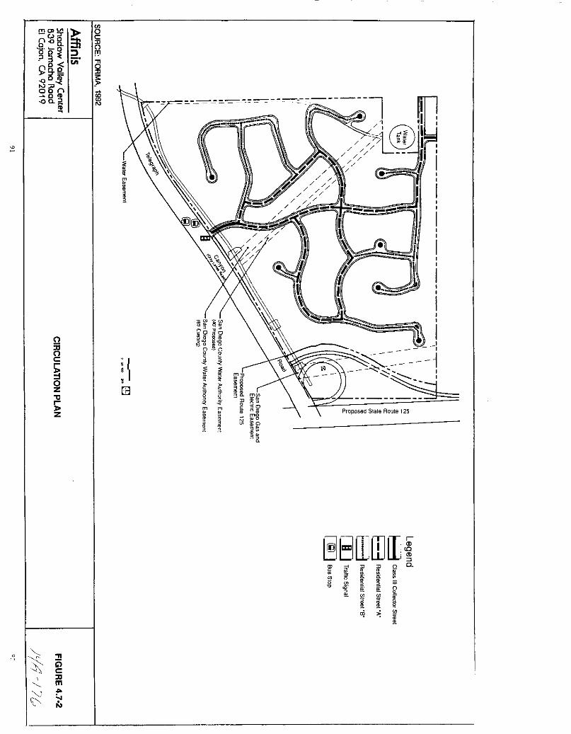
rTlCDVI0
nUT00 coO
D
003 2 f1
9 f Cl000
00 n
8cO
o
c
oZtl
Z
m
m3
o
J3
iIfmJ J
9 O
Jg
g go
it
Q
m
3
t
Q
m
3
m
0
rnl
5 lf
N0
3
o
8rnOJiF
5ff
g cJ 52
0
i Q
r
oj
i5cDm
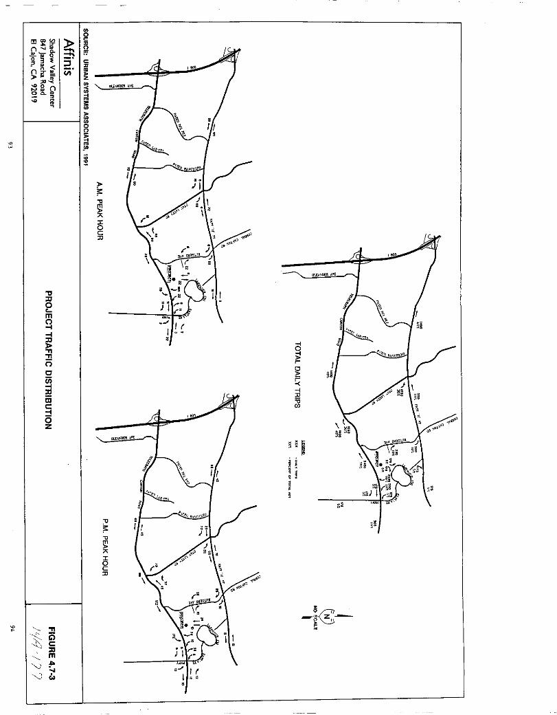
ma V
sQ
III 0
g 3
nn
if06 noQ m
n
m
w
IIJJo
m
ll
o
c
iiicl
isz
iVi
oc
ill
cD
z
l
m
illo
ll
III
iscJJ
niljiI
d
if
iliif
gi5
zO
c
z
JJm
J 0
ll
ll
III
5cJJ
alL DEH vt
PlR C
O
I
I
I
I
I
I
I
I
I
I
I
II
II
I
I
I
I
tentative subdivision maps which will also generate traffic thatwill impact area roadways
The traffic report compared LOS on area roadways based on streetimprovements which are being required as part of the approvedprojects and Rancho Del Rey SPAs I II and III Forecast As shownin Table 4 7 3 future traffic is projected to drop to unacceptablelevels on several roadway segments
Direct impacts of the proposed project will occur on segments of
Telegraph Canyon Road The LOS would go from B to C between CrestDrive and Paseo Del Rey and from A to B between Paseo Del Rey andPaseo Ladera While the project s traffic will lower the LOS onthe roadway segment between otay Lakes Road and Eastlake Parkwayfrom C to D the intersection at Telegraph Canyon Road and Eastlake
Parkway will still operate at a LOS C during the PM peak hourwhich is within the acceptable range set by the City of Chulavista s Threshold Standards The future LOS on Telegraph CanyonRoad between I 80S and Crest Drive is projected to drop to LOS Ewith or without the proposed project
The LOS on portions of East H Street will also be lowered by futuretraffic with or without the proposed project the future LOS onthese roadway segments will still range between D and F Theproject will contribute 1400 ADT to segments of East H Streetbetween I 80S and Hidden vista Drive Hidden Vista Drive to PaseoDel Rey Paseo del Rey and Paseo Ranchero and Paseo Ranchero andBuena vista Way
The LOS on Otay Lakes Road between East H Street and TelegraphCanyon Road is expected to drop to E in the future and a LOS F isprojected for Bonita Road between I 80S and otay Lakes RoadHowever as shown in Table 4 7 3 the project will not contributeany trips to these roadway segments The proj ect will not addtraffic to Corral Canyon Road between Central Avenue and East HStreet or to Rutgers Avenue between Gotham Street and TelegraphCanyon Road The project is expected to contribute 350 ADT to that
segment of Rutgers Avenue between East H and Gotham Street but theLOS is expected to remain at A
The traffic study conducted for the project also analyzed variousintersections using the Highway Capacity Method HCM and baseconditions from the November 18 1991 City of Chula Vista TrafficImpact Study for Salt Creek Ranch The intersections were analyzedwith traffic projected from approved projects detailed in AppendixC and D of the traffic report and also with traffic projectedfrom the proposed project The City of Chula Vista s Growth Plan
requires that the LOS at intersections must be maintained at LOS Cor better except that LOS D may occur at signalized intersectionsfor a period not to exceed a total of two hours a day As shownin Table 4 7 4 the project s traffic is predicted to lower the LOS
from B to C during the a m peak at the intersection of East H
95
JyJ 7g
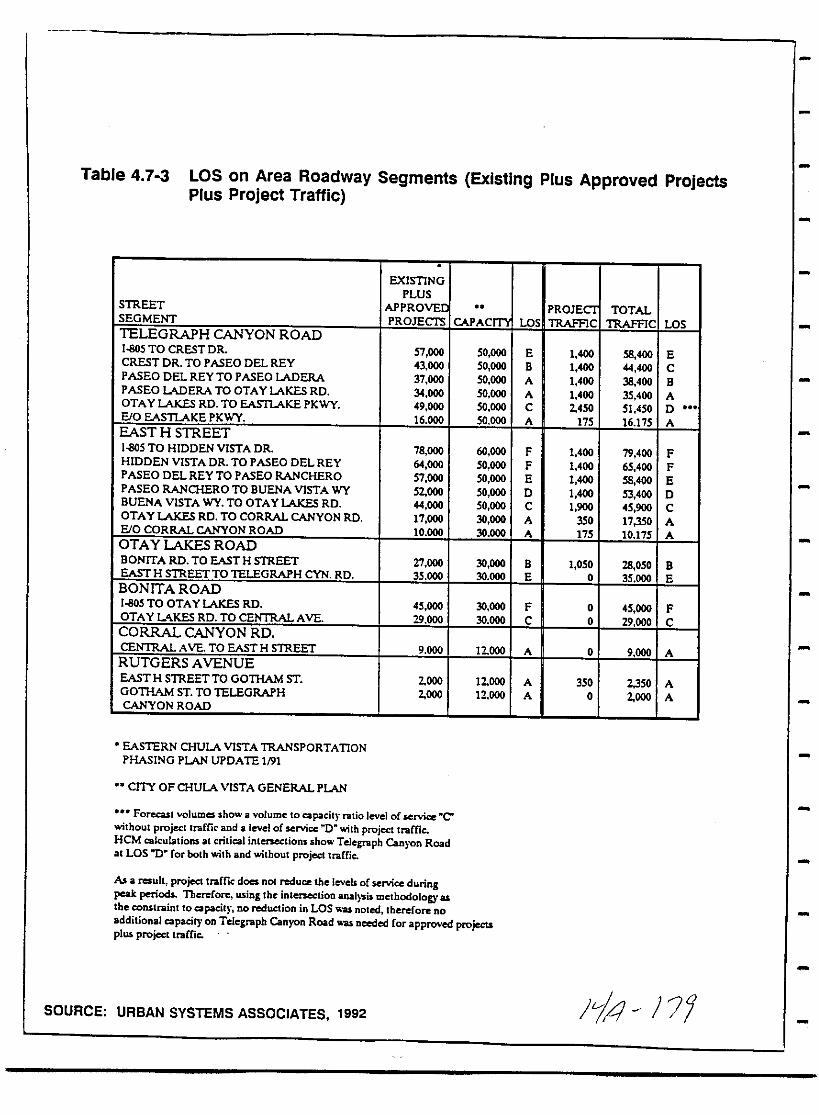
Table 4 7 3 LOS on Area Roadway Segments Existing Plus Approved ProjectsPlus Project Traffic
EXISTINGPLUS
STREET APPROVEI PROJECI TOTALSEGMENT PROJEClS CAPACm OS TRAFFIC TRAFFIC LOSTELEGRAPH CANYON ROAD1llO5 TO CREST DR 57 000 50 000 E 1 400 58 400 E
CREST DR TO PASEODEL REY 43 000 50 000 B 1 400 44 400 CP ASEO DEL REY TO PASEO ADERA 37 000 50 000 A 1 400 38 400 BPASEO ADERA TO OTAY LAKES RD 34 000 50 000 A 1 400 35 400 AOTAYLAKES RD TO EASTLAKE PKwY 49 000 50 000 C 2450 51 450 DEiO EASTLAKE PKwY 16 000 50 000 A 175 16 175 AEAST H STREET1llO5 TO HIDDEN VISTA DR 78 000 60 000 F 1 400 79 400 F
HIDDEN VISTA DR TO PASEO DEL REY 64 000 50 000 F 1 400 65 400 FPASEO DEL REY TO PASEO RANCHERO 57 000 50 000 E 1 400 58 400 EPASEO RANCHERO TO BUENA VISTA wY 52000 50 000 D 1 400 53 400 DBUENA VISTA wY TO OTAYLAKES RD 44 000 50 000 C 1 900 45 900 COTAYLAKES RD TO CORRAL CANYONRD 17 000 30 000 A 350 17350 AEiO CORRAL CANYON ROAD 10 000 30 000 A 175 10 175 AOTAY LAKES ROADBONITA RD TO EASTH STREET 27 000 30 000 B 1 050 28 050 BEASTH STREETTO TELEGRAPH CYN RD 35 000 30 000 E 0 35 000 EBONITA ROAD1llO5 TO OTAYLAKES RD 45 000 30 000 F 0 45 000 F
OTAYLlKES RD TO CENTRAL AVE 29 000 30 000 C 0 29 000 CCORRAL CANYON RDCENTRAL AVE TO EASTH STREET 9 000 12000 A 0 9 000 A
RUTGERS AVENUEEAST H STREETTO GOTHAM ST 2000 12000 A 350 2350 AGOTHAM ST TO TELEGRAPH 2000 12 000 A 0 2000 ACANYON ROAD
EASTERN CHULA VISTA TRANSPORTATIONPHASING PLAN UPDATE 1191
CITY OF CHULA VISTA GENERALPLAN
Forecast yolumes show avolume to capacit ntio level of service Cwithout projectlrame and a level of service 1t0 with project trafficHeMcalculations at critical intenections shoTelegnaph Canyon RoadalLOS 0 for both ith and without project tnaCfie
As a result project trafficdoes nol reduce the Jevels of service duringpeak periods Therefore using the intenectioD anal 5iJ methodology as
the constraint to capacity no reduction inLOS as nOled therefore no
additional capaat on Telegraph Canyon Road as needed for approved projectsplus project traCCic
SOURCE URBAN SYSTEMS ASSOCIATES 1992 i4 7
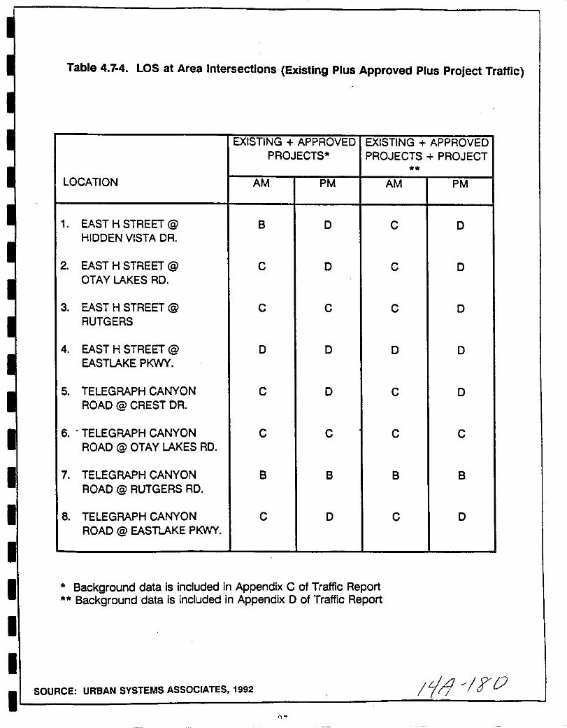
I
I
I
I
I
I
I
Table 4 7 4 LOS at Area Intersections Existing Plus Approved Plus Project Traffic
EXISTING APPROVED EXISTING APPROVEDPROJECTS PROJECTS PROJECT
LOCATION AM PM AM PM
1 EAST H STREET @ B D C D
HIDDEN VISTA DR
2 EAST H STREET @ C D C DOTAY LAKES RD
3 EAST H STREET @ C C C DRUTGERS
4 EAST H STREET @ D D D D
EASTLAKE PtNY
5 TELEGRAPH CANYON C D C D
ROAD @ CREST DR
6 TELEGRAPH CANYON C C C CROAD @ OTAY LAKES RD
7 TELEGRAPH CANYON B B B B
ROAD @ RUTGERS RD
8 TELEGRAPH CANYON C D C D
ROAD @ EASTLAKE PtWY
Background data is included in Appendix C of Traffic ReportBackground data is included in Appendix D of Traffic Report
SOURCE URBAN SYSTEMS ASSOCIATES 1992 tjl TO
0
street and Hidden vista Way and to lower the LOS from C to D
during the p m peak at the intersection of East H Street and
Rutgers Street The project s traffic is not expected to reducethe LOS at any of the other intersections analyzed
In addition to the major intersections shown in Table 4 7 4 the
project could potentially affect other intersections in the
adjacent residential areas The project is proposing to extendGotham Street and Creekwood Way to provide access in thenortheastern portion of the site This roadway connection willallow the possibility of through trips for non project trafficwhich is projected to be fewer than 100 ADT The intersection ofGotham Street and Rutgers Road is currently controlled by a four
way stop The future traffic volume on Rutgers Road is forecast at2000 ADT the minimum ADT needed to warrant a traffic signal is9000 trips The project is expected to increase the ADT here by350 trips 35 ADT during the PM peak hour Therefore the projectis not expected to adversely impact these roadways or thisintersection
The traffic study analyzed the need for a traffic signal on
Telegraph Canyon Road at the proposed project entry Projectedtraffic volumes are not sufficient to warrant a signal at thislocation see Appendix E of the traffic study
The project can function adequately from a traffic operationperspective without a traffic signal at the otay Lakes Road projectentry Under this scenario the intersection would only allowright turns into and out of the main project entry and exit Thustraffic desiring to turn left in and out of the roadway would beforced to travel out of direction to the nearest adjacentsignalized intersection on otay Lakes Road where a U turn could beperformed with the benefit of a left turnjU turn provision
However the amount of project traffic during the peak hourforecasted to utilize this access point is very close to meetingthe Caltrans warrants for signalization Also it is uncertain atthis time whether future developments to the south willnecessitate access to otay Lakes Road at the subject intersectionFor this reason the City traffic engineer has no objections to theinclusion of a traffic signal at the subject intersection It isexpected that the entire cost of the signal will be incurred by the
developer
While it is not required by the City the SPA shows a signal on
Telegraph Canyon Road at the project entry approximately 1350feet west of the future S R 125 southbound off ramp andapproximately 0 5 miles west of Rutgers Road
Scenario 4 of the City of Chula vista s future buildout conditionsincludes the completion of S R 125 The completion of thisroadway will alter the traffic flow on area streets and will
98
Ji4

I
I
I
I
I
I
I
I
I
I
I
I
I
I
I
I
I
I
I
substantially change the distribution and assignment of trafficgenerated by the proposed project The majority of project related
trips forecast at 3800 ADT will use the adjacent freeway accessrather than traveling west on Telegraph Canyon Road Total trafficon Telegraph Canyon Road is forecast to range between 16 000 and47 700 ADT below its LOS C capacity of 50 000 ADT Therefore no
adverse impacts are expected to occur under this buildout scenario
MitigationjMonitoring
1 Cumulative impacts to area roadways will be mitigated by the
project s contribution of funds toward roadway improvementscalled out in the ECVTPP The specific improvements requiredfor the proposed project such as possible roadway wideningrestriping or installation of signals will be determined bythe city of Chula vista s Engineering Department upon reviewof the cumulative impacts of the projects in the area
2 All improvements will be funded on a fair share basis amongprojects The project I s fair share contribution toward
mitigating direct and cumulative impacts will be made acondition of the TSM
Analysis of Significance
The proj ect will affect the LOS at the intersection of East HStreet and Hidden vista Drive where the LOS will go from B to C
during the a m peak hour and the intersection of East H Streetand Rutgers Avenue where the LOS will drop from C to D during thep m peak hour These are not considered significant impactshowever as the peak hour LOS at affected intersections isacceptable under the City S Threshold Criteria While the project
99
liA FL
will lower the LOS on three other segments of Telegraph Canyon Roadbetween otay Lakes Road and Eastlake Paokway Crest Drive and
Pas eo Del Rey and between Paseo Del Rey and Paseo Ladera and atthe intersection of East H Street and Hidden vista Drive the e
impacts will not be significant The project will incrementallycontribute to regional traffic congestion but by contributing toarea improvements called for in the ECVTPP the project will fullymitigate these cumulative effects
Compliance with the mitigation measures outlined above will be madeconditions of approval and ensured through the MMRP This willreduce traffic impacts to below a level of significance
100
L J g3

I
I
I
I
II
II
II
I
I
I
I
II
I
II
4 8 Noise
An acoustical analysis of the Telegraph Canyon Estates PlannedCommunity was prepared by Maestre Greve Associates June 28 1991A peer review conducted by Illingworth ROdkin AcousticalEngineers supports the conclusions of the initial report Thesedocuments included in Appendix H serve as the basis for thefollowing analysis
Existing Conditions
Noise Criteria Community noise levels are measured in terms ofthe A weighted decibel abbreviated dBA A weighting is a
frequency correction that correlates overall sound pressure levelswith the frequency response of the human ear Exhibit 2 AppendixH
The equivalent noise level or Leq is the average noise level on
an energy basis for any specified time period The Leq for onehour is the energy average noise level during the hour It can be
thought of as the level of a continuous noise which has the same
energy content as the fluctuating noise level The equivalentnoise level has the same units of dBA therefore a sound measuredfor one hour may be expressed as a one hour Leq of 57 dBA
Several rating scales have been developed to measure communitynoise The predominant rating scale now in use in California forland use compatibility assessment is the Community Noise EquivalentLevel CNEL CNEL is the average equivalent A weighted soundlevel over a 24 hour period CNEL is calculated by adding 5decibels dBA to evening 7 PM to 10 PM sound level and 10 dBAto night 10 PM to 7 AM levels Typical outdoor CNEL noise levelsare shown in Figure 4 8 1
The criteria used to assess the acceptability of community noiselevels varies with the municipality At the time of this reportthe Telegraph Canyon Estates Project is within the jurisdiction ofthe County of San Diego but it is proposed to be annexed to theCity of Chula vista The city of Chula Vista uses 65 CNEL as thecritical criterion for assessing the compatibility of residentialland uses with noise sources Figure 4 8 2 it requires theexterior living areas yards and patios of new residences notexceed this level The City of Chula vista s indoor noisestandards are consistent with the state standards which requirenoise levels for both single and mUlti family residentialdevelopments not exceed 45 CNEL
101
14 y
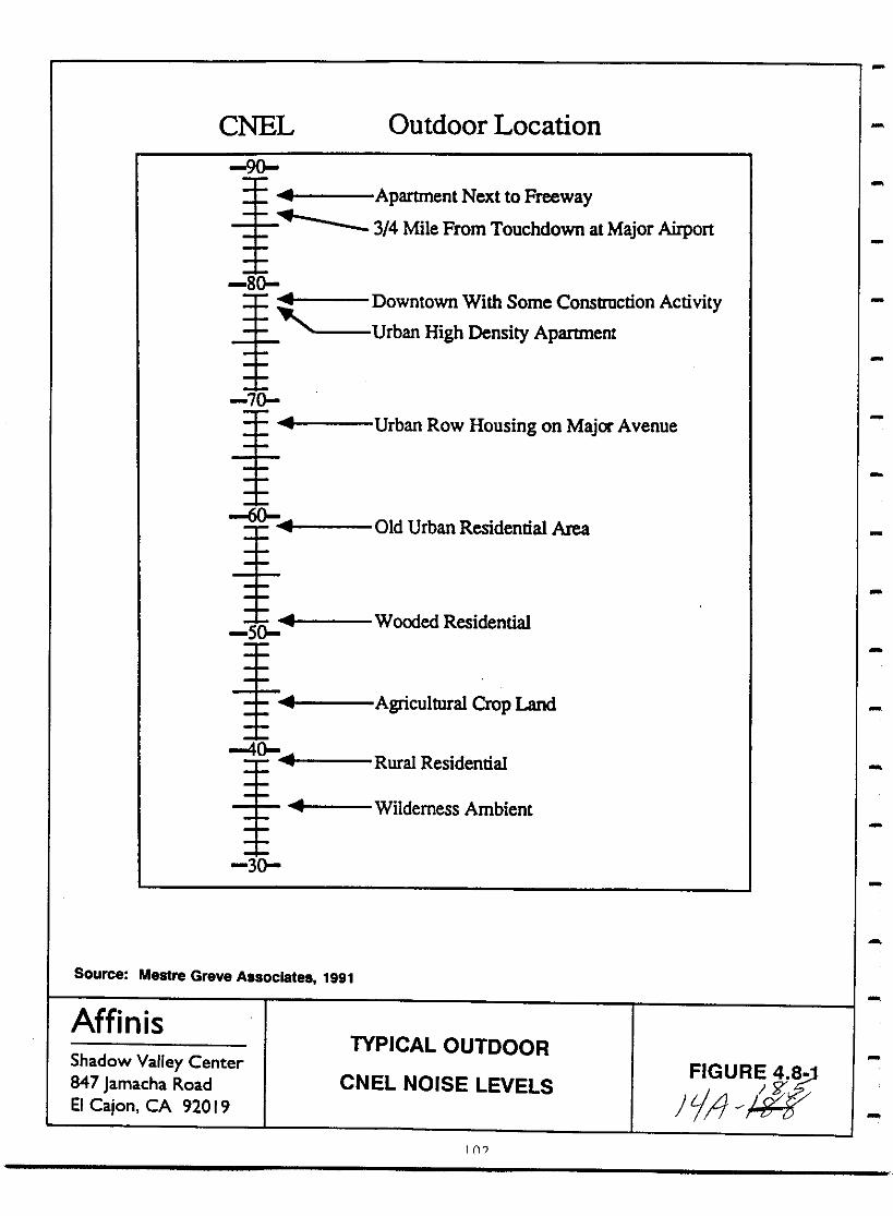
CNEL Outdoor Location
90
Apartment Next to Freeway3 4 Mile From Touchdown at Major Airport
80Downtown With Some Construction ActivityUrban High Density Apartment
70
Urban Row Housing on Major Avenue
60Old Urban Residential Area
soWooded Residential
Agricultural Crop Land
40Rural Residential
Wilderness Ambient
30
Source Mestre Greve Associates 1991
AffinisShadow Valley Center847 Jamacha RoadEI Cajon CA 92019
TYPICAL OUTDOOR
CNEL NOISE LEVELS FIGURJY4S
fj I iTFJ
1

I
I
I
I
I
I
II
I
II
I
I
II
I
I
II
8c
c
i 8l 1gH II B II
c g l i1a
ll i i 8 ll a lll tI Sll II gO C 11
H i 1 l5ill U t ia c ii5 Ii a bac RUti
lb 1 c 8 g c5 s ioJ c8 5 C II 0 S C li ij
u 1l8 8 I
alI8 9 p gl f11acii
ll failtg 5
wCD cl u I
t1Jl i
IeIII
u
lll
g32E
g su
c
li3l1 p
j eti 5
t l i1
tll8cac llg s l a l
C lia c
g S
llJiIll i89 8 j8 iI a
u
l C cS E3dI
a
itill8c
li
g SII
Ii
88
l
t 18 a
1U
dl01
f1
53 0
I ijOilc
iii
il
or
llSO
5
01If
z
jut3
rI
IIu
C9c
1
rnwlif
illm
t
mIiiill
jle 8
i
IJ R
isg
IIt3
l
tl1 IiiCDlt
l
g1l 5
CD l
8u
ISo u l1
IfA igh
rii
80
lCI
l
E
aeoIII
CIII
co
Wa
u
a
E
im
Eo
wen
cz
S
fI
c
r
s C7oc
lllCOUOSlOC7o
0III
ososoJ U
E go osC
OSos u
oJVl ex W
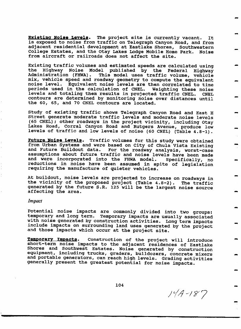
Existina Noise Levels The project site is currently vacant Itis exposed to noise from traffic on Telegraph Canyon Road and from
adjacent residential development at Eastlake Shores SouthwesternCollege Estates and the otay Lakes Lodge Mobile Home Park Noisefrom aircraft or railroads does not affect the site
Existing traffic volumes and estimated speeds are calculated usingthe Highway Noise Model published by the Federal HighwayAdministration FHWA This model uses traffic volume vehiclemix vehicle speed and roadway geometry to compute the equivalentnoise level Equivalent noise levels are then correlated to timeperiods used in the calculation of CNEL Weighting these noiselevels and totaling them results in projected traffic CNEL CNELcontours are determined by monitoring noise over distances untilthe 60 65 and 70 CNEL contours are located
Study of existing traffic shows Telegraph Canyon Road and East HStreet generate moderate traffic levels and moderate noise levels
65 CNEL other roadways in the project vicinity including otayLakes Road Corral Canyon Road and Rutgers Avenue produce lowlevels of traffic and low levels of noise 60 CNEL Table 4 8 1
Future Noise Levels Traffic volumes for this study were obtainedfrom Urban Systems and were based on city of Chula vista Existingand Future Buildout data For the roadway analysis worst case
assumptions about future traffic and noise levels have been madeand were incorporated into the FHWA model Specifically noreductions in noise have been assumed in spite of legislationrequiring the manufacture of quieter vehicles
At buildout noise levels are projected to increase on roadways inthe vicinity of the proposed project Table 4 8 2 The trafficgenerated by the future S R 125 will be the largest noise source
affecting the area
Impact
Potential noise impacts are commonly divided into two groupstemporary and long term Temporary impacts are usually associatedwith noise generated by construction activities Long term impactsinclude impacts on surrounding land uses generated by the projectand those impacts which occur at the project site
TemDorarv ImDacts Construction of the project will introduceshort term noise impacts to the adjacent residences of EastlakeShores and Southwest Estates Noise generated by constructionequipment including trucks graders bulldozers concrete mixersand portable generators can reach high levels Grading activitiesgenerally present the greatest potential for noise impacts
104
if Y7
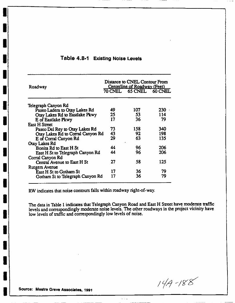
I
II
I
II
I
I
I
I
I
I
I
I
I
I
I
I
I
Table 4 8 1 Existing Noise Levels
Distance to CNEL Contour FromRoadway Centerline ofRoadwlY Feet
70 CNEL 65 CNEL 60 CNEL
Telegraph Canyon RdPasco Ladera toOtay Lakes Rd 49 107 230
Otay Lakes Rd toEasdake Pkwy 25 53 114
E of Easdake Pkwy 17 36 79East H Street
Pasco Del Rey to Otay Lakes Rd 73 158 340Otay Lakes Rd to Corral Canyon Rd 43 92 198E of Corral Canyon Rd 29 63 135
Otay Lakes Rd
Bonita Rd to East H St 44 96 206East H St toTelegraph Canyon Rd 44 96 206
Corral Canyon Rd27Central Avenue to East H St 58 125
Rutgers AvenueEast H St toGotham St 17 36 79Gotham St to Telegraph Canyon Rd 17 36 79
RW indicates that noise contours falls within roadway rightof way
The data in Table 1 indicates that Telegraph Canyon Road and East H Street have moderate traffic
levels and correspondingly moderate noise levels The other roadways in the project vicinity havelow levels of traffic and correspondingly low levels of noise
Source Mestre Greve Associates 1991
1 1 f5Z
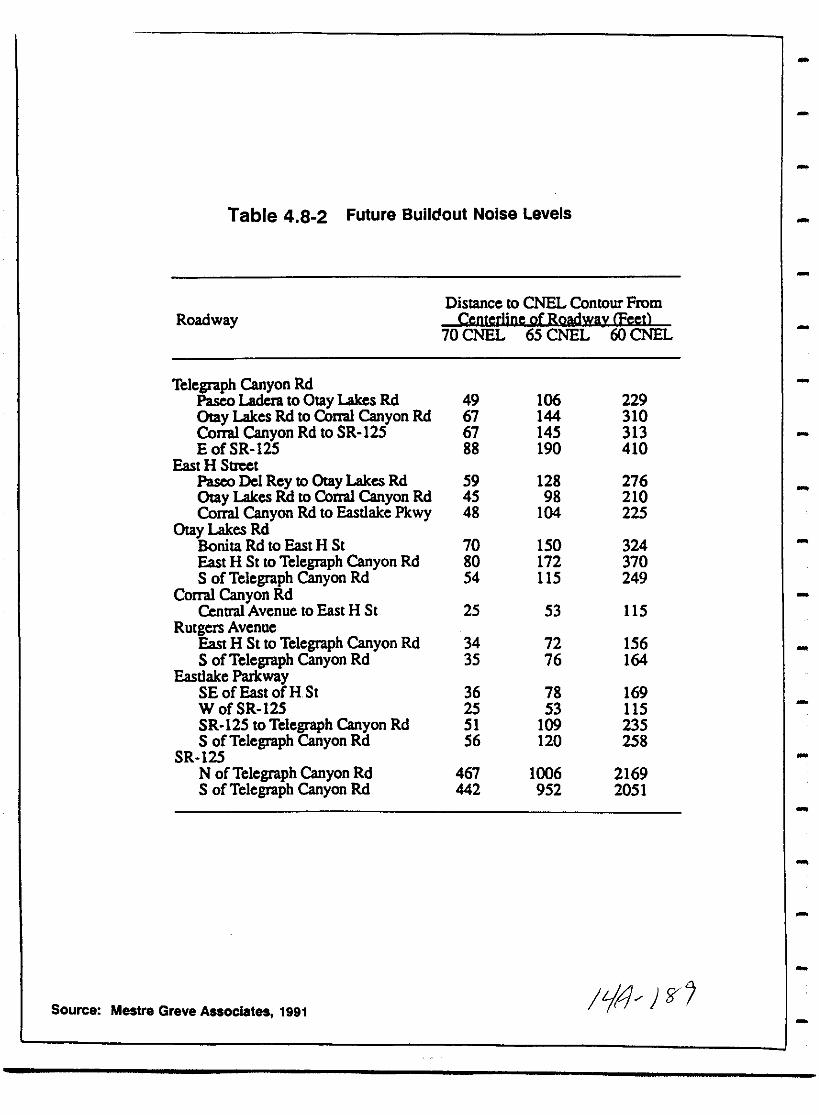
Table 4 8 2 Future Buildout Noise Levels
Distance to CNEL Contour From
Roadway Centerline ofRoadway Feet
70CNEL 65 CNEL 60 CNEL
Telegraph Canyon RdPasco Laden to Otay Lakes Rd 49 106 229Oray Lakes Rd to Com Canyon Rd 67 144 310Com Canyon Rd toSR I25 67 145 313E of SR I25 88 190 410
East HStreetPasco Del Rey to Olay Lakes Rd 59 128 276Oray Lakes Rd to Com Canyon Rd 45 98 210Com Canyon Rd to Eastlake Pkwy 48 104 225
Olay Lakes RdBonita Rd to East H St 70 150 324East H St to Telegraph Canyon Rd 80 172 3705 of Telegraph Canyon Rd 54 115 249
CoIT1ll Canyon RdCentral Avenue to East H 5t 25 53 115
Rutgers AvenueEast H St to Telegraph Canyon Rd 34 72 156S ofTelegraph Canyon Rd 35 76 164
EastlakeParkway5E ofEast ofRSt 36 78 169W ofSR 125 25 53 1155R 125 toTelegraph Canyon Rd 51 109 2355 of Telegraph Canyon Rd 56 120 258
SR 125N of Telegraph Canyon Rd 467 1006 2169S of Telegraph Canyon Rd 442 952 2051
Source Mestre Greve Associates 1991 III if

I
II
I
I
I
II
I
II
I
II
I
I
I
II
Lonq Term Imnaets The Telegraph Canyon Estates project will notbe subject to adverse noise levels from existing sources As shownin Table 4 8 1 noise levels from existing roadways are consideredwithin the low to moderate range and do not exceed the 65 CNELresidential standard applied by the City of Chula vista
The project is not expected to create adverse noise levels whichwill affect existing residential development While the projectwill generate additional traffic 3500 ADT see Chapter 4 7
projections of future surface street traffic noise indicate an
increase in noise levels of a maximum of 1 dBA which will notraise noise levels significantly
No development is proposed on the portion of the site which lieswithin the 65 dBA contour for Telegraph Canyon Road Upon itscompletion S R 125 will generate noise levels greater than 65CNEL for those residences proposed on the eastern border of thesite Lots 128 to 151 Figure 4 8 3
MitigationjMonitoring
Temnorarv Imnaets Because noise levels associated withconstruction of the project are considered a temporary nuisancerather than an impact no mitigation and monitoring is requiredConstruction will be limited to the hours of 7 a m to 10 p m on
Monday through Friday 7 a m to 8 p m Saturdays and Sundays and
prohibited on Federal holidays Chula vista Municipal Code section17 25 050 k to minimize these temporary effects
Lonq Term Imnaets No significant noise impacts to surroundingareas are anticipated with implementation of the Telegraph CanyonEstates project therefore no mitigation and monitoring isrequired
1 Noise levels generated by traffic on future S R 125 will bereduced by constructing noise barriers along the rear propertylines of those lots proposed within the 65 dBA contour Figure4 8 4 Construction of 5 6 foot high gap free slumpstone or
masonry sound walls or barriers will reduce exterior noiselevels between 4 and 6 dBA in the rear yards of these homesbelow the 65 dBA threshold
All noise walls will be constructed in conformance with the
design guidelines set forth in the SPA which follow theEastlake I Design Guidelines Figure 4 8 5 As detailed inChapter 4 3 Aesthetics materials will consist of stucco or
stone walls with plexiglass panels to provide noise reductionwhile maintaining views from residences
107
IV 70

I J l
IO J I rVT tY1ptph
N
A I i i r
II r i
I1 rj I 1Jr VI
II
MI HI
11r 5n
7JJf i 1 Jl1
I G 1
t
I11 R
tjx
Mt
j It
l ItL I y 16 l
Ir
ril Ii N r
Y I IYA
1 H I 1 l
c k t
IJ rt
f 1 Id A t
1 3 1c I f
Z d J
i 10 iUI1
1 II EJI t u
t lII
I u
1 I lI
rJ
I LJtflY VI
1 I nI I t
C I xil
xj r Ii I 9lfl t Nj l 1
It
Ie It J f 1J
f C Il
tr f 52 m S II
6A rV t
il III7f 5
ZI
IIiC
y
A 11
SOURCE MESTRE GREVE ASSOCIATES 1991
AffinisShadow Valley Center809 Jamacha RoadEl Cajon CA 92019
ROADWAY 65 CNELNOISE CONTOUR FIGURE 4 8 3
17 1108
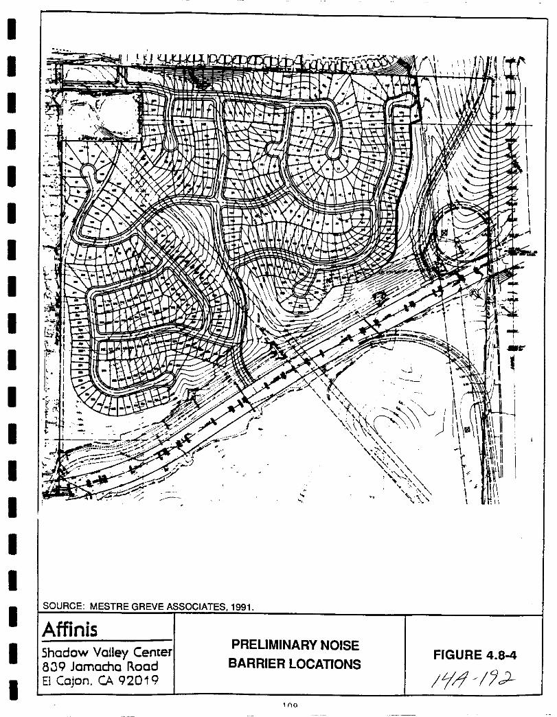
I
I
I
I
I
I
I
I
I
II
II
I
I
II
I
I
rI
i lj i r fI V idiii IIru LJ 1 I 1f J 11 rr
i IrJ j
I7 i f1 f iJI li l
7J
T lc n
1 ulliun ifIQIl Wit l IJR l 0 0
r j Ii
i 1
1t YJ I y
IV
J
I I f fi
mI
I I A 1Y
1111 I
jl lV lrJ lU jI
y
it 91I yo
lotI 1
11 YIf
I
W 3 0r r
ijf 1 r
rI
11t1 IL
c
iF7
J 1i
u 3iKil
I
I ft Vor
1i
II 1i ii tfs i r II
JFi df Jv0 11 iJ
1 11 iI
rLsi
ttII0
JI7 J
7
IA
I
II
A
SOURCE MESTRE GREVE ASSOCIATES 1991
AffinisShadow Valley Center
819 Jamacha RoadEl Cajon CA 92019
PRELIMINARY NOISE
BARRIER LOCATIONSFIGURE 4 84
11no
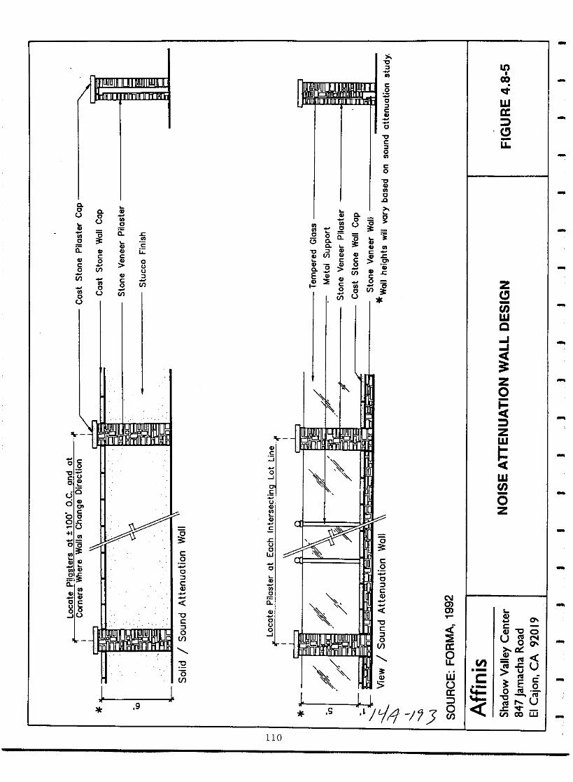
CooU
2ii
CooU
co
c
co
Cl
co
ol
C
o
CClo
co
NmmT
CI
c
r
ItI
CO
or
Wa
u
2ii
co
c
ouU
l
C
ol
Coo gU
t g
3C l
CL Ul Q CD
i 0 5 l5Q ViEtlI E c
o0u
j
c
ijc
z
tJWQ
Zo
Zw
5wtJ
oz
oU
c
u
c
S 0
Cll 0
ug
u
E go
uv
wen CX
oU
OSC
c uo e0
ud
c00
0u
ca
giQ
o c
86Ju
c2cl
cCll
0clofJ
c
oJ
uow
o
2ii
ouoJ
0
f2wU0
i n3J
ofJ
19 J
if S
110
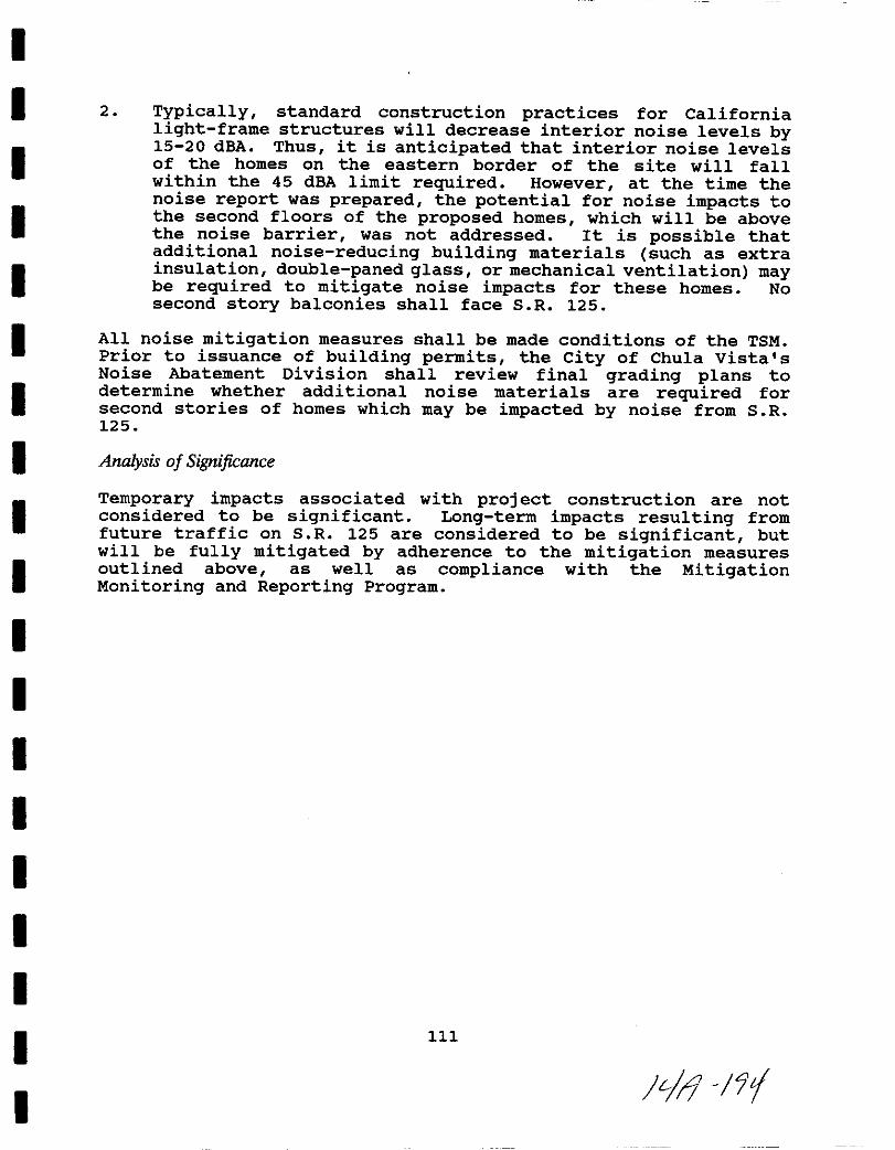
I
I
I
I
I
I
I
I
I
I
I
I
I
II
I
I
I
I
2 Typically standard construction practices for Californialight frame structures will decrease interior noise levels by15 20 dBA Thus it is anticipated that interior noise levelsof the homes on the eastern border of the site will fallwithin the 45 dBA limit required However at the time thenoise report was prepared the potential for noise impacts tothe second floors of the proposed homes which will be abovethe noise barrier was not addressed It is possible thatadditional noise reducing building materials such as extrainsulation double paned glass or mechanical ventilation maybe required to mitigate noise impacts for these homes Nosecond story balconies shall face S R 125
All noise mitigation measures shall be made conditions of the TSMPrior to issuance of building permits the city of Chula vista sNoise Abatement Division shall review final grading plans todetermine whether additional noise materials are required forsecond stories of homes which may be impacted by noise from S R125
Analysis of Significance
Temporary impacts associated with project construction are notconsidered to be significant Long term impacts resulting fromfuture traffic on S R 125 are considered to be significant butwill be fully mitigated by adherence to the mitigation measuresoutlined above as well as compliance with the MitigationMonitoring and Reporting Program
111
Jtl i

THIS PAGE INTENTIONALLY LEFT BLANK
112
i4 J
I
I
I
I
I
I
I
I
I
I
I
I
I
I
I
I
I
I
I
4 9 Land Use General Plan Zoning
Existing Conditions
The Telegraph Canyon Estates project site is in the EasternTerritories Planning Area of the City of Chula Vista and the otaySubregional Planning Area of the County of San Diego It isdesignated as low medium residential 3 6 dwelling units per acrein the Chula vista General Plan Because the site is adjacent tothe Eastlake Community it is also subject to the Eastlake PolicyPlan which was prepared to supplement the City s General Plan
At this time however the site is within the jurisdiction of the
County of San Diego and will require a sphere of influenceamendment and annexation to the City of Chula Vista prior to
project implementation The County zoning for the site isAgricultural and it is designated as a Special Study Area S 87by the County s Regional Land Use Element 1979 The S 87designator places limited controls on the use of the parcel pendingspecific studies to allow rezoning or reclassification inconformance with adopted community or subregional plans Permitteduses are single family residential with a minimum 2 5 acre lotsize agricultural and permit uses subject to limitation suchas veterinary clinics
The site is mapped as Farmlands of Local Importance by the Stateof California Department of Conservation 1984 designating it as
land of importance to the local economy as determined by theBoard of Supervisors The site is not designated as an
Agricultural Preserve and there is no Williamson Act CaliforniaLand Conservation Act contract on the property
The property is currently vacant but it has been used for
agriculture and grazing in the past It is adjacent to residentialdevelopment on the north and west The northern border of thesite is a 2 1 manufactured slope separating the project from theEastlake Shores neighborhood This area is designated as medium
density residential 6 11 dwelling units per acre and is
developed with single family homes at a density of 7 dwelling unitsper acre The Southwestern College Estates neighborhood to thewest is also zoned single family residential and is designated lowmedium it is developed at a density of 5 to 6 dwelling units peracre The otay Lakes Lodge Mobile Home Park designated mediumdensity is southwest of the site and supports 6 6 dwelling unitsper acre An easement for the future extension of S R 125 iseast of the property and the otay Ranch area is to the south
otay Ranch comprises roughly 23 000 acres and is presentlyundergoing environmental review in association with a developmentproposal The portions of otay Ranch closest to the project are
proposed as medium density and low medium density residential
113
liJ c b
The project area is within a Local Agency Formation CommissionLAFCO designated special study area LAFCO was created to deal
with annexations to existing cities or other boundary changes The
Commission determines annexation based on a number of pertinentfactors including sphere of influence compatibility In October
1991 the applicant submitted an annexation application to LAFCO
along with the required supporting documents including a statement
explaining the history of the proposed annexation area
justification for annexation all necessary GDP SPA documents a
development and annexation time schedule and a statement of
provision of public services and access to the project area In
January 1992 LAFCO ruled the project s application acceptable for
processing and a final annexation determination will be made
pending environmental review Michael ott personal communication
Impact
General Plan and Zonina As previously discussed the TelegraphCanyon Estates project area was originally included as a part ofthe Otay Ranch area and has been included in previous studiesconducted for that larger project However because the projectarea is physically separated from the rest of the Otay Ranch
property by Telegraph Canyon Road and because the site is adjacentto the Eastlake Community it is now being proposed as a
development separate from Otay Ranch
The project will be developed in a manner similar to and compatiblewith the Eastlake Planned Community and will be processed as anamendment to the Eastlake Policy Plan General Development Planand Planned Community Regulations The GDP will amend the Eastlake1 GDP to include the Telegraph Canyon Estates site Figure 4 9 1The Telegraph Canyon Estates Planned Community will be implementedthrough the use of Planned Community zoning as part of Eastlake 1
Figure 4 9 2
ProDosed Land Use The proposed SPA Site Utilization Plan Figure5 designates three neighborhoods within the project area In
Neighborhood 1 in the southwestern portion of the site ml9 lotsj
are proposed Ne1ghborhood 2 1n the southeastern port1on of thesite will consist of lots and wi lots will be provided inNe1ghborhood 3 1n the northern port1on of the s1te
A total of 32 5 gross acres are designated for non residential use
open space proposed S R 125 easement and the CPF site Openspace buffers along Telegraph Canyon Road and along S R 125 willbe created as will a central open space consisting of a privaterecreation area and landscaped open space Two separate privaterecreational areas one with a swimming pool cabana spa complexand the other consisting of a multi purpose court area are alsoproposed
114
tj 1F7 7

ma
1III 0
g 3
1III iiJ0 1lIoI
111
c
l ilIn f1I
ClJ
mCD
Q
olOr
3030I10
1 1
aE8
lrSJ
i3
3
l
m
mz
m
e jij lllm
I
e1 ml1
Clo m
m 0
z0
m 33
rI
e
m
5tI
Hmzl
ElltI
Z
j jg nC
l ill iJD i li gg 01 al iI E IiI f i F
Hh iW l Plni i
If PUrl I I
I
c eH @ H Il 0 i
Ja i JJ
I Biii Ii
15crJm
@w
0 rCD
g Ii ml lQ
l lN 0 iJ CDm
I
glI
rni l 1 2 0
oI II n f t
ii i
s r z
I mC iih
Z
N i1
iD
r
i1 m
f j
m III
110n cir g t
g 3 J ll ron9 VIaoo1lJD
dia92n 3oa
Jl
GGco
lIco
Ir
l
lP 0a
llmllo
I IiIIll
aI oen I
lD
lr 1WIw
hJ
0c 1
1oO
cCc
li rI
mil ll Vm
Id
PIrJv Jm
z I I Y
II fc i c
c PImJ 1 hi d illm
c
IUrn
Illz
lIfila N N Nc
1 mJIC
Comll iom
0c I 3l i0
3cD
nI
Bll
E8
llllz
qI hl
qdl
nqj J mqoii 0
00
riln
fnnfffff
m
r
mn
t m
nII
o
qi 0 Ii0
C
mo
l l P
C5cDm
co
UN
Jl gg ill filf 6
rrrrrrrrI a i i i I Ii
qffHijj f f m
Icc
1u a
a all
oonm
n
bl9
JH1
C
ms0
11 rnm m CD111 tl r co
am CDGl J
i it 0r
ho
JlCZffl
9 0
JFn
I
I
I
I
I
I
I
I
I
II
I
I
II
I
I
I
I
The proposed GDP SPA and TSM comply with the City s Land UseElement requirements for density open space and park land Theyare also in conformance with the Eastlake Policy Plan General
Development Plan and Planned Community Regulations The designelements of the project detailed in Section 4 3 of this EIR havebeen developed in accordance with the Eastlake Design Manual
guidelines The proposed gross density of 3 1 dwelling units pergross acre is consistent with the Eastlake Policy Plan whichproposes an overall gross density of 3 7 dwelling units per acre
The net density of 4 3 dwelling units per acre is within theGeneral Plan s 3 6 dwelling unit per acre range for low mediumresidential It is also compatible with and below the density of
adjacent existing development at Eastlake Shores Southwestern
College Estates and the Otay Lakes Lodge Mobile Home Park The
development concept includes landform preservation which adheres tothe grading policies set forth in the General Plan see section4 3 Landform Alteration and Aesthetics
The project is required to be in conformance with the City s
Affordable Housing Policy which requires that projects exceeding 50
dwelling units provide a minimum of 10 percent of the units to lowand moderate income housing The SPA provides for the constructionof these units off site or payment of in lieu fees
Section 19 04 055 of the City s Zoning Ordinance requires that CPFsites consist of 1 39 acres of net usable land including setbacks
per 1 000 population The proj ect is estimated to generateapproximately 1 134 residents see section 4 10 the SPA and TSMhave reserved two parcels totalling 15 acres in the extremenorthwestern portion of the site for future development as a
Community Purpose Facility CPF Precise uses for this facilityhave not been defined but it is envisioned that it may house it
fii ii day care facility and general meeting rooms as allowed byEhs GDP The 15 acre CPF site proposed meets the acreagerequired by the ordinance
Mitigation Monitoring
In order to meet the requirements of the City s Affordable HousingPolicy the applicant will implement one of the following measures
1 Dedicate a parcel off site for the construction of low tomoderate income housing to meet the 10 requirement
2 Pay in lieu fees to the City for the construction of low tomoderate income housing to meet the 10 requirement
3 Provide a parcel which partially meets the 10 requirement and
pay in lieu fees to meet the rest
119
L1 fl tltJ
Proof of provision of low to moderate income housing shall be
submitted to the Planning Department prior to approval of the GDP
SPA and TSM
Analysis of Significance
The project is not proposing to change Prime agricultural land to
residential uses therefore no significant impacts will occur with
respect to conversion of agricultural lands Impacts associatedwith the project s noncompliance with the City s Affordable HousingPolicy will be reduced to below a level of significance byimplementation of the mitigation measures discussed above with
implementation of these mitigation measures potential land use
impacts will be reduced to below a level of significanceMitigation measures will be ensured through the conditions of
project approval as well as the MMRP
120
iJ tJ
I
I
I
I
I
I
II
I
I
I
I
I
I
II
I
I
I
4 10 Community Social Factors
Existing Conditions
PODu1ation As of January 1991 the city of Chula vista had atotal population of 138 755 Batchelder personal communicationThis reflects an increase of 16 over the 1986 population total of116 430 SANDAG S Series VI Regional Growth Forecast 1989projects an annual average numeric increase of 1 737 people throughthe year 2010 1 3 at which time the estimated population ofChula vista is expected to be 158 112 an increase of 35 8 The
City of Chula vista will account for about 5 of San Diego regionalgrowth by the year 2010
Housina As of 1991 the City of Chula vista had a total of 51 570occupied housing units SANDAG expects occupied housing units inthe City of Chula vista to total approximately 60 950 units anincrease of 9380 units by the year 2010 Based on SANDAG s
Regional Growth projections 1988 single family units account forabout 54 of the total multiple family units contribute about 38and mobile homes comprise about 8
EmD1ovment Chula vista s 1991 labor force is comprised of
approximately 41 500 workers In 1988 Chula Vista s civilianlabor force numbered 47 233 SANDAG projections call for 58 775workers by 2010
The largest percentage of the Chula vista labor force is employedin the retail trades and services sector followed by durable
goods manufacturing and educational services
Impact
PODu1ation The proposed Telegraph Canyon Estates project willintroduce approximately 1134 residents based on a generationfactor of 3 24 occupants per dwelling unit and the proposed maximumof 350 units within the project
The population of Chula vista is expected to reach 158 112 personsby the year 2010 The Telegraph Canyon Estates population of 1134will represent about 6 of the population growth anticipated bySANDAG by 2010 As the population increase proposed by the
Telegraph Canyon Estates Project is within General Plan growthexpectations no adverse population impacts are expected from
implementation of the project
Housina The Telegraph Canyon Estates project will construct 350
single family units on 112 4 acres This represents approximately3 5 of the total new occupied housing units and approximately 7of the single family units projected by SANDAG for 2010 The
121
tJ Cd
project is consistent with the Chula vista General Plan guidelinesfor new housing and development of this project is not anticipatedto cause any adverse housing impacts
EmDlovment The Telegraph Canyon Estates project will not create
any new employment opportunities However because of regional andlocal employment availability including retail commercial andindustrial opportunities within the adjacent Eastlake developmentadverse employment impacts are not expected Further
implementation of the project will introduce additional workersinto the Chula vista labor force which is anticipated by SANDAG
growth projections
Mitigation Monitoring
No significant social impacts are associated with this projecttherefore no mitigation measures are required
Analysis of Significance
No significant adverse community social impacts are anticipated bythe implementation of this project
122
Jf4 d tJ3

I
I
II
I
I
II
I
I
I
I
I
I
I
I
I
I
I
4 11 Community Tax Structure
Information for this section was obtained from Willdan Associateswho prepared the Public Facilities Financing Plan PFFP April1992 for the Telegraph Canyon Estates Project Preliminaryinformation from this plan is included as Appendix I to this EIR
Existing Conditions
The Telegraph Canyon Estates PFFP projects the fiscal impacts tothe operation and maintenance budgets of the various publicentities and utilities that will serve the project These includethe City of Chula vista the Otay Water District the Chula vistaElementary School District and the Sweetwater Union High SchoolDistrict
Analysis is provided for a period of 15 years including 4
developmental phase years and 11 completed project years Revenueand expenditure assumptions for the Telegraph Canyon Estates
project are based on data generated for the Salt Creek Ranch
project located northeast of the Telegraph Canyon Estates
property
city of Chu1a vista Revenue is produced for the City of Chulavista through property and other taxes licenses and permitsfines penalties and forfeitures use of money revenue from other
agencies and other charges for services Chula Vista 1990 91revenues totaled over 39 million dollars Table 4 11 1
Expenditures for the City of Chula vista include general governmentand public works overhead line operating costs for police and fireprotection agencies public works libraries parks and recreationand other projects and entities Chula vista expenditures totaledabout 46 5 million dollars in 1990 91 Table 4 11 2
otav Water District OWDl Revenue sources for the OWD watersales and meter fees provided almost 15 million dollars in 1991
Table 4 11 3 Expenditures primarily related to administrativeoverhead and water purchases totaled about 14 8 million dollarsTable 4 11 3
Chula vista Elementarv School District Revenue is provided fromlocal state and Federal funding sources Revenue for 1990 91totaled over 61 million dollars Table 4 11 4 Expenditureslargely employee salaries and benefits books and supplies
totaled about 60 2 million dollars Table 4 11 4
Sweetwater Union Biah School District Revenue is generated fromthe same types of funding sources as the Elementary School Districtand totaled about 121 3 million dollars in 1990 91 Table 4 11 5
123
1J o1

i
Table 4 11 1 City of Chula Vista 1990 91 Revenue Generation
City ofChula Vista
AClUal 90 91 Revenues
Amount Percent Telegraph Canyon Road Generation
L
LProperty Taxes
Current Secured
Current Unsecured
Delinquent
Other Taxes
Sales Use Taxes I
Franchise Fees
Transient LodgingProperty Transfer
Utility Taxes
Licenses and Permits
Business Licenses
Anima1 Licenses
Bicycle Licenses
Fines Penalities and ForeilUresOrdinance Violations
Library Fines
Use ofMoney
Revenues from Other AgenciesSlale HOPTR
Motor Vehicle Licenses
Cigarette Tax
Gas Tax 2
Other
Charges for Current Services
Swimming Pools
Recreation ProgramsPark Reservation Fees
Other Park Recreation Fees
Misc Service Charges
Other Revenues
TOlal Recurring Fund Revenue
7 669 922 70
432 372 08
271 190 92
Based on 13 85 ofl ofTAV
Not ApplicableNot Applicable
119 67
111
0 70
111 808 279 30
1 664 91149
1 185 488 67
251 49247
2 628 419 54
30 28
4 27
3 04
0 64
6 74
4243 per CapitaBased on Gross Revenue per Unit and Tax Rates
Not ApplicableBased on Tumover Driven Simulation
Based on Consumption Revenues and Tax Rates
1
1652 738 67
51 840 50
16 106 05
167
0 13
0 04
Not Applicable0 373 per Capita0 116 per Capita
1
1
1
1
1
154 09941 0 40 0 720 per Capita 1991 92@ 100 000
93 343 73 0 24 0 671 per Capita
684 880 00 176 Based on 7 percent ofthe previous yearnet fiscal impact for Telegraph Canyon ifpositive
194 890 38 0 50 1401 per Capita4 718 623 64 12 10 33 91 per Capita
222 994 05 0 57 0 880 per Capita 1991 92 @ 122 000
10 71 per Capita259 660 00 0 67 Not Applicable
1
1107 30840 0 28 0 771 per Capita
18 009 72 0 05 0 129 per Capita19 465 00 0 05 0 140 per Capita8 212 62 0 02 0 059 per Capita6 72109 0 02 0 048 per Capita
5 880 509 00 15 08 Not Applicable
39 001 479 43 100 00
lSources City ofChula Vista Statement ofRevenue 1991
Economic Strategies Group 1991
10 Jan 92
1 Based on 50 percent of total collections
2 Based on the 70 percent of 15 30 per capita Gas Tax revenue allocated to the General Fund
IJ LC5SOURCE WILLDAN 1991
124
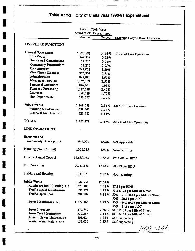

Table 4 11 2 City of Chula Vista 1990 91 Expenditures continued
City ofChula Vista
Actual 90 91 ExpendituresAmount Percent Telegraph Canyon Road Allocation
Parks and Recreation 3 905 704 8 39
Administration Parks 319 246 0 69 1 005 82 per Park Acre
Administration Open Space 148 687 0 32 Provided by Lighting and Landscaping District
Maintenance 1 724 422 3 71
General 1 556 063 3 34 4 902 53 per Park Acre
Marina Park Maintenance 168 360 0 36 Not ApplicableRecreation 1 713 348 3 68 12 35 per Capita
Athletics 126 768 0 27 0 91 per CapitaAquatics 478 701 03 345 per CapitaSenior Citizens 258 056 0 55 186 per CapitaGeneral 530 577 114 3 82 per CapitaAdministration Recreation 319 246 0 69 2 30 per Capita
Library 2 678 184 5 76 19 31 per Capita
Otay Ranch Project 200 611 0 43 Not Applicable
TOTAL 38 543 591 82 83
TOTAL EXPENDITURES 46 533 164 100 00
Sources City ofChula Vista Statement of Expenditures 1991
Economic Strategies Group 1991
08 Jan 92
I EDU allocation base includes only Public Works OperationsAdministration 370 819 and Communications 172 045
2 Street Maintenance expenditures would not be incurred until year 7 of the project
SOURCE WILLDAN 1991126 Y4 0
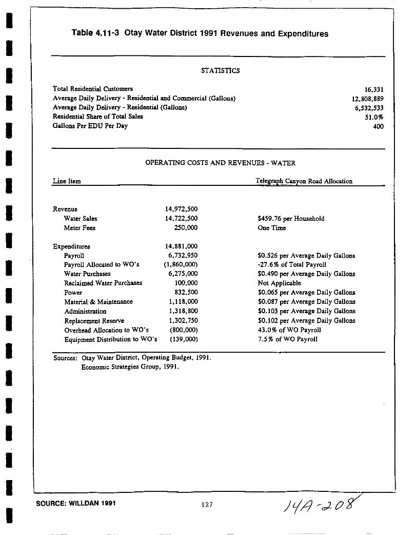
I
I
I
I
I
I
I
I
I
I
I
I
I
II
II
I
I
Table 4 11 3 Otay Water District 1991 Revenues and Expenditures
STATISTICS
Total Residential Customers
Average Daily Delivery Residential and Commercial Gallons
Average Daily Delivery Residential Galloos
Residential Share ofTotal Sales
Galloos Per EDU Per Day
16 331
12 808 889
6 532 533
510
400
Line Item
OPERATING COSTS AND REVENUES WATER
Ielegph Canyon Road Allocation
Revenue
Water Sales
Meter Fees
ExpendituresPayrollPayroll Allocated to WO s
Water Purchases
Reclaimed Water Purchases
Power
Material Maintenance
Administration
Replacement Reserve
Overhead Allocation to WO s
Equipment Distribution to WO s
14 972 500
14 722 500
250 000
459 76 per Household
One Time
14 88000
6 732 950
1 860 000
6 275 000
100 000
832 500
1 118 000
1 318 800
1 302 750
800 000
139 000
0 526 per Average Daily Gallons
27 6 ofTotal Payroll0 490 per Average Daily Galloos
Not Applicable0 065 per Average Daily Galloos
0 087 per Average Daily Galloos
0 103 per Average Daily Galloos
0 102 per Average Daily Gallons
43 0 ofWO Payroll7 5 ofWO Payroll
Sources Otay Water District Operating Budget 1991
Economic Strategies Group 1991
SOURCE WILLDAN 1991 127 Jtl dCJg
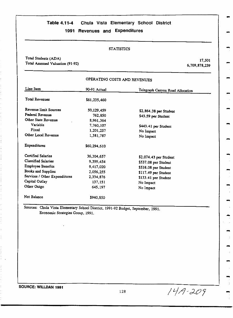
Table 4 11 4 Chula Vista Elementary School District
1991 Revenues and Expenditures
STATISTICS
Total Students ADA
Total Assessed Valuation 91 9217 501
6 709 878 239
OPERATING COSTS AND REVENUES
Line Item 90 91 Actual Telegraph Canyon Road Allocation
Total Revenues 61 235 460
Revenue limit Sources 50 129 459 2 864 38 per StudentFederal Revenue 762 850 43 59 per StudentOther State Revenue 8 961 364
Vanable 7 760 107 443 41 per StudentFixed 1 201 257 No Impact
Other Local Revenue 1 381 787 No Impact
Expenditures 60 294 610
Certified Salaries 36 304 657 2 074 43 per StudentClassified Salaries 9 399 454 537 08 per Student
Employee Benefits 9 417 020 538 08 per StudentBooks and Supplies 2 056 255 11749 per StudentServices I Other Expenditures 2 334 876 133 41 per StudentCapital Outlay 137 151 No ImpactOther Outgo 645 197 No Impact
Net Balance 940 850
Sources Cbula Vista Elementary School District 1991 92 Budget September 1991Economic Strategies Group 1991
SOURCE WILlDAN 1991128 I if dOl

I
I
I
I
I
I
I
I
I
I
I
I
I
III
I
I
I
Table 4 11 5
1991
Sweetwater Union High School District
Revenues and Expenditures
Total Students ADA
STATISTICS
27 894
OPERATING COSTS AND REVENUES
Line Item
Total Revenues
Revenue limit Sources
Federal Revenue
Other State Revenue
Variable
Fixed
Other Local Revenue
Transfers In
Expenditures
Certified Salaries
Classified Salaries
Employee Benefits
Books and SuppliesServices I Other ExpendituresCapital OutlayOther Outgo
Net Balance
90 91 Actual Telegraph Canyon Road Allocation
121 351 465
93 893 006
4 551 068
18 973 488
16 506 935
2 466 553
2 868 869
1 065 034
3 366 06 per Student
163 16 per Student
59177 per Student
No ImpactNo ImpactNo Impact
117 341 051
65 946 392
18 441 613
17 795 983
5 161 342
6 779 929
1 362 493
1 853 299
2 364 18 per Student
661 13 per Student
637 99 per Student
185 03 per Student
243 06 per Student
No ImpactNo Impact
4 010 414
Sources Sweetwater Union High School District 1991 92 BudgetEconomic Strategies Group 1991
SOURCE WILLDAN 1991 129 c q c2
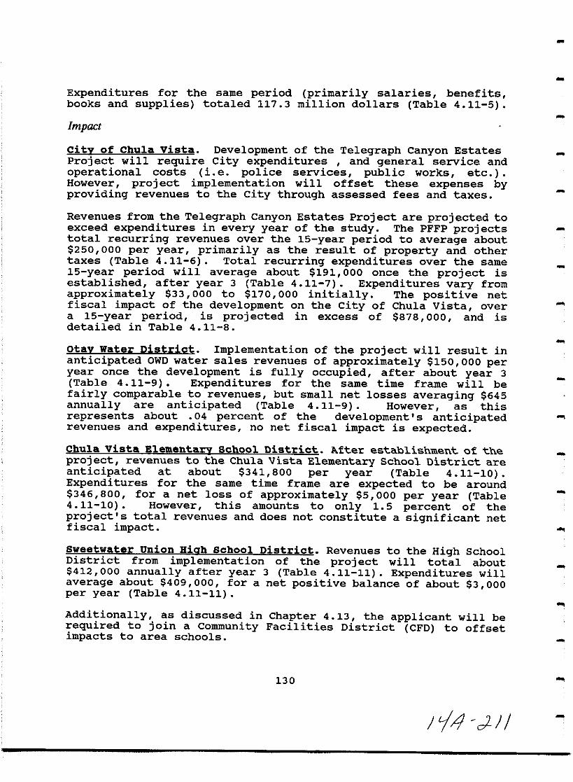
Expenditures for the same period primarily salaries benefitsbooks and supplies totaled 117 3 million dollars Table 4 11 5
Impact
city of Chu1a vista Development of the Telegraph Canyon Estates
Project will require City expenditures and general service and
operational costs ie police services public works etcHowever project implementation will offset these expenses byproviding revenues to the City through assessed fees and taxes
Revenues from the Telegraph Canyon Estates Project are projected toexceed expenditures in every year of the study The PFFP projectstotal recurring revenues over the 15 year period to average about250 000 per year primarily as the result of property and other
taxes Table 4 11 6 Total recurring expenditures over the same15 year period will average about 191 000 once the project isestablished after year 3 Table 4 11 7 Expenditures vary from
approximately 33 000 to 170 000 initially The positive netfiscal impact of the development on the City of Chula Vista overa 15 year period is projected in excess of 878 000 and isdetailed in Table 4 11 8
otay Water District Implementation of the project will result inanticipated OWD water sales revenues of approximately 150 000 peryear once the development is fully occupied after about year 3
Table 4 11 9 Expenditures for the same time frame will be
fairly comparable to revenues but small net losses averaging 645annually are anticipated Table 4 11 9 However as thisrepresents about 04 percent of the development s anticipatedrevenues and expenditures no net fiscal impact is expected
Chu1a vista Elementary School District After establishment of the
project revenues to the Chula Vista Elementary School District are
anticipated at about 341 800 per year Table 4 11 10Expendi tures for the same time frame are expected to be around
346 800 for a net loss of approximately 5 000 per year Table4 11 10 However this amounts to only 15 percent of the
project s total revenues and does not constitute a significant netfiscal impact
Sweetwater union Hiqh School District Revenues to the High SchoolDistrict from implementation of the project will total about
412 000 annually after year 3 Table 4 11 11 Expenditures willaverage about 409 000 for a net positive balance of about 3 000per year Table 4 11 11
Additionally as discussed in Chapter 4 13 the applicant will berequired to join a Community Facilities District CFD to offsetimpacts to area schools
130
jl 4 eJ J
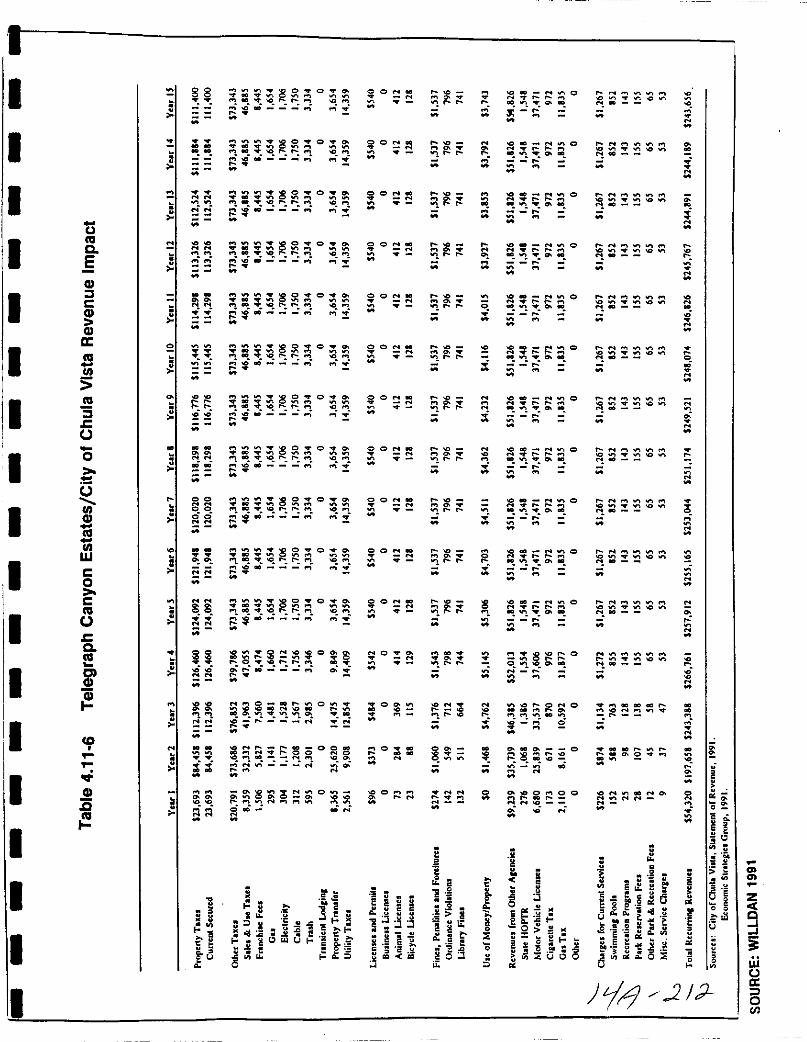
I
I
I
I
ItiCo
5CDJCCD
CDa
III
3co
I
I
III
o
oIIICD
Uiw
co
c
ocCo
ClCD
I
I
I
II lD
CDc2
II
I
II
l
2
N
88 8S O
IO 00 r to t0
8 O
Mt rll ICOO
N N
titi8 O
001
i
N N
ff8 O
Or r ll
c j
N N
it8S O
r r10
8s O
Ol r f0
ii8s 0
o r
N N85 O
oC r rO f01
00
ss00NN
8S O
1CI Q r lI
iN
85 0
or 10 r
c
N N
ISIS8S O
fl1O O r
nc
0 0101 00lICI r o
r O OOO
Orofollll fOl
it
ti
N 0 0010 101 0110
110 01 l Oro
oO N
IONr r oo O110 10010all N
N ri
ii8
to N
0N
cii
u
X oJl 11
K g at
J
11oa
S3
1iil
eU I
sllo5
o
DiN
it
00
tiO
i
0 101 0
it
o s
o
s
CON
3
i
OON
it
OONlION
it
CIONN
it
OONlION
it
OONlIO
8
eii
NO CJt
t
O
ONO
0N
0
N
00N
it Kc c
a
J t
11
i jfl iJ
NN
1tr
N
1r r
1r r
1r t
1r r
1 r
1
1
1r
1
1r
1r
N
r
0
8
N N
3itc
i 2
2iit
If t
5XO
ii
0 1IO
1I01fI CJt
i
N 0 N11
l 1 CJt
O IfIO11
1 CJt to
No NIfIO
11
lilt 1 CJt to
c0to NIfI 011 1
1 CJt 1Ilt
2 00 N IfI11 foo foo
1 CJt
N
N
10 1111 foo r
1fI 0
r
N 10 GO 1111 foo foo
1I01fI CJt
I
1011011 foo foo
IfI CJt
0 NN foo foo
1Ilt1 CJt
IOlID Nr r
l 1 o
8OIfl oOCJt
N r
N
e l 1fI
182N
o
e200 0 N
t8ll
eEg 0
s
III E
2
iu
e
Ool
N
N
N
N
l
N
o
N
N
N
N
2
N
l
N
N
N
2
2
2
ee
a
e
ollU
z
9I
iw
aloen
O N
1IOIO
0
gt
11e1l
e
I N IfI
O
fooN01fI OWlN
r N lI0Wl
foo N Wl
0
O 11 lI lIOWl IfI OWl
ItllD
JiJ 2
O N lI
O
O N WlW lOWl
O N01fI
O N
N0IfI
O N
lO
NO 00 00 lID
o lID rCJt 2 lI
o
N
Itc
f e gIf e
E e c jg eo u
a aa E t
s r K See e
el i 1III a oi
U

tftIC
EIIICII
ccCIIccw
ftI
III
ftI
5c
o
3IIICIIftI
IIIW
Co
CftI
ccftI
ClCII
tCII
a
0
0
0
0
0
0
0
0
N
0
iiSe
8l
il
eoU
N
0000000
iN
N V
00 lNO VI
ori
rot
5 S0
N1
MOoN
V
S0
N N
2 tQ st c
M
N N0
0
N
N VIo S
QriM
N0
NOori
N0
NO
M
N
S0
N N
e qSori
M
N 0
VI
0M
g gN ri
N
00000
IIONCI D
N rNM
r
iM
io
DOo
aE
e
J 00
e1 E
1 11 d d
o
ii
s
g
M
M
M
M
N
M
M
N
M
N
NM
M
M
M
a
M
M
N
M
co
l
M
M
M
M
N
M
N
M
N
NM
o
go
8l
i
M
i
i
i
i
i
i
i
N
N
i
Ii0
of
of
o
N
g
gM
N
M
N
N
N
N
M
N
M
M
N
oJoo
00c
a00
0cii
oE
o 8o
vol
N
N
M
a1
ItEo
NM
0000000
NM
1J c2 J
NM
0000000
tiNM
J
ClCl
I
NM
ooooooo
N N
zctQ
liswCJa
oIII
1
NM
0000000
riri
I
N
0000000
riN
N
0000000
iN
NM
0000000
riri
N
0000000
riri
NM
ooooooo
rifi
N
0000000
rifiM
N
jOOOOOOO
rifi
N
1001000000000
rifiM
N880000000tIO
M
OiOOOOOOO
E 5
S1ie
ii
fg
c
j igaee
lol e lit 5l iii8
c u u uc s
eEEEuuuue e e e e e eI I iijiijiijiii
132

I
I
I
I
I
II
I
II
I
I
I
I
I
I
I
II
Table 4 118 Telegraph Canyon Estates Net Fiscallmpact to the City of Chula Vista
Revenue
Net Expenditure AccumulatedYear Revenues Expenditures Balance Ratio Balance
1 54 320 33 345 20 976 162 9 20 9762 197 658 129 634 68 024 152 5 89 000
3 243 388 169 895 73 494 143 3 162 4934 266 761 190 962 75 800 139 7 238 293
5 257 912 190 724 67 188 135 2 305 480
6 255 165 190 724 64 441 133 8 369 9217 253 044 190 724 62 320 132 7 432 241
8 251 174 190 724 60 450 1317 492 692
9 249 521 190 724 58 797 130 8 551 489
10 248 074 190 724 57 35I 130 1 608 840
11 246 826 190 724 56 102 1294 664 941
12 245 767 190 724 55 043 128 9 719 985
13 244 891 190 724 54 167 128 4 774 151
14 244 189 190 724 53 465 128 0 827 617
15 243 656 190 724 52 932 127 8 880 549
Total 3 502 346 2 621 797 880 549
Source Economic Strategies Group 1991
Jrr7 L
SOURCE WILLDAN 1991 11 1

Table 4 11 9 Telegraph Canyon Estates Net Impact to the Otay Water District
YearsYear 1 Year 2 Year 3 Year 4 5 15
Revenue 27 126 104 931 136 135 152 599 152 075Waler Sales 27 126 104 931 136 135 152 599 152 075
Expeoditures 27 246 105 398 136 740 153 277 152 751
Payroll 12 414 48 020 62 299 69 834 69 594
Payroll Allocated to WO s 3 426 13 253 17 195 19 274 19 208Water Purchases 11 564 44 733 58 036 65 054 64 831Reclaimed Water Purchases 0 0 0 0 0Power 1 534 5 934 7 699 8 630 8 600Material Mainleoance 2 053 7 942 10 304 11 550 11 511Administratioo 2 431 9 403 12 199 13 675 13 628
Replacemeot Reserve 2 407 9 3J2 12 081 13 542 13 495Overhead Al1ocatioo to WO s 1 473 5 699 7 394 8 288 8 259
Equipmeot Distributioo to WO s 257 994 1 290 1 446 1 441
Net Balance 121 467 605 678 676
Sources Ecooomic Strategies Group 1991I
I
II
1l J5SOURCE WILLDAN 1991
134
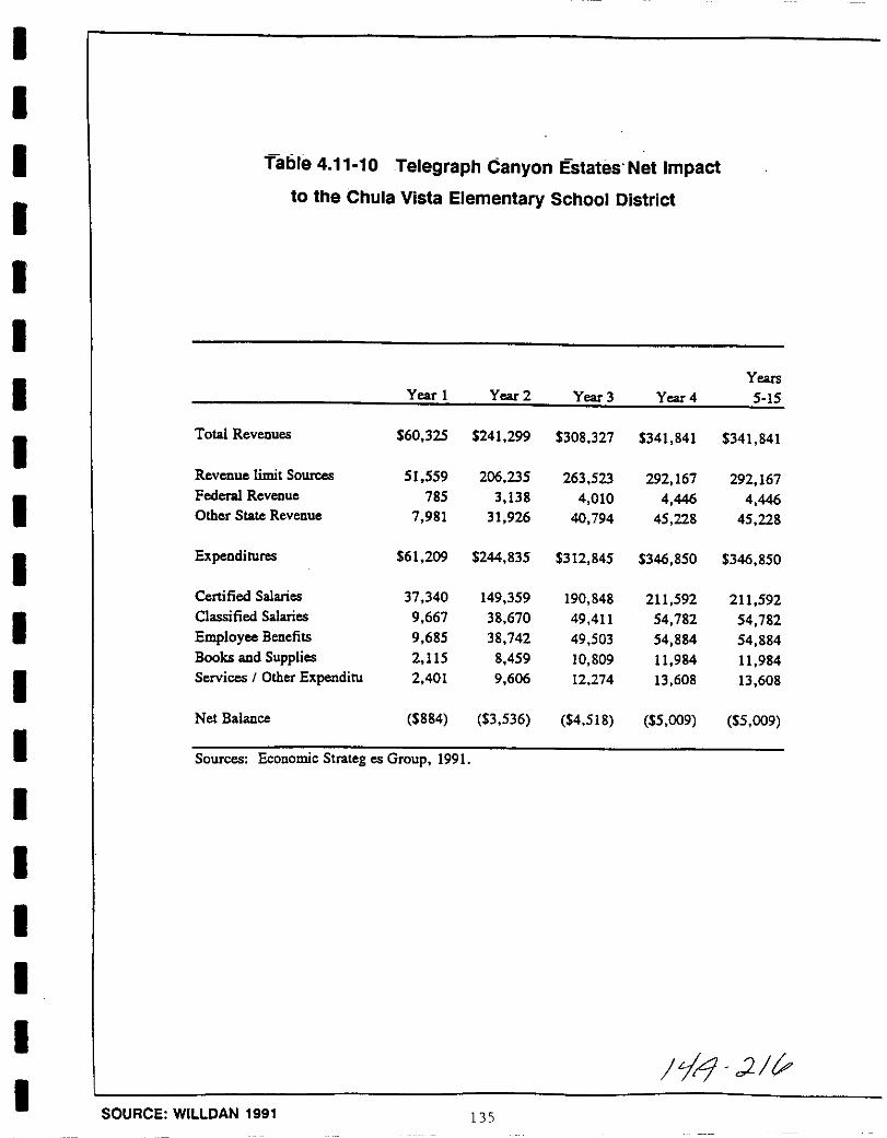
I
I
I
I
I
I
I
I
I
I
I
I
I
I
I
I
I
I
I
Table 4 11 10 Telegraph Canyon Estates Net Impactto the Chula Vista Elementary School District
Years
Year 1 Year 2 Year 3 Year 4 5 15
Total Revenues 60 325 241 299 308 327 341 841 341 841
Revenue limit Sources 51 559 206 235 263 523 292 167 292 167Federal Revenue 785 3 138 4 010 4 446 4 446Other Slate Revenue 7 981 31 926 40 794 45 228 45 228
Expenditures 61 209 244 835 312 845 346 850 346 850
Certified Salaries 37 340 149 359 190 848 211 592 211 592Classified Salaries 9 667 38 670 49 411 54 782 54 782
Employee Benefits 9 685 38 742 49 503 54 884 54 884Books and Supplies 2 115 8 459 10 809 11 984 11 984Services I Other Expenditu 2 401 9 606 12 274 13 608 13 608
Net Balance 884 3 536 4 518 5 009 5 009
Sources Economic Strateg es Group 1991
Ii2 v
SOURCE WILLDAN 1991 135
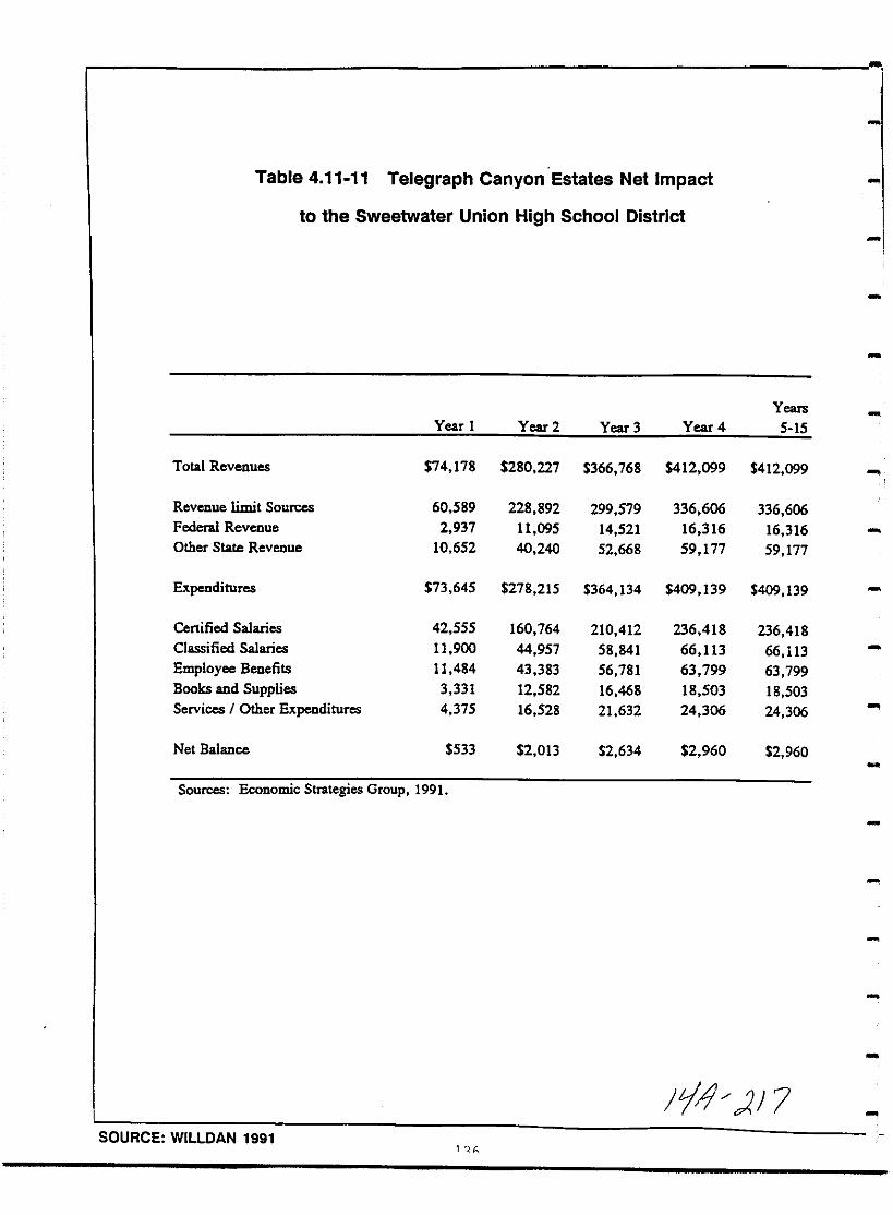
Table 4 11 11 Telegraph Canyon Estates Net Impact
to the Sweetwater Union High School District
Years
Year 1 Year 2 Year 3 Year 4 5 15
Total Revenues 74 178 280 227 366 768 412 099 412 099
Revenue limit Sources 60 589 228 892 299 579 336 606 336 606Federal Revenue 2 937 11 095 14 521 16 316 16 316Other State Revenue 10 652 40 240 52 668 59 177 59 177
Expenditures 73 645 278 215 364 134 409 139 409 139
Certified Salaries 42 555 160 764 210 412 236 418 236 418
Classified Salaries 11 900 44 957 58 841 66 113 66 113
Employee Benefits 11 484 43 383 56 781 63 799 63 799
Books and Supplies 3 331 12 582 16 468 18 503 18 503
Services Other Expenditures 4 375 16 528 21 632 24 306 24 306
Net Balance 533 2 013 2 634 2 960 2 960
Sources Economic Strategies Group 1991
pI 7SOURCE WILLDAN 1991
I
I
II
I
I
I
I
I
I
I
II
I
I
I
I
I
I
Mitigation Monitoring
No significant net fiscal impacts are associated with the
implementation of this project therefore no mitigation measuresare required
Analysis of Significance
No significant fiscal impactsimplementation of this project
are associated with the
137
yJ g

THIS PAGE INTENTIONALLY LEFT BLANK
138
JL nr2
I
I
I
I
I
I
I
I
I
I
I
I
I
I
I
I
I
I
I
4 12 Parks Recreation Open Space
Existing Conditions
The city of Chula Vista currently has 245 acres of park land
including 4 community parks 19 neighborhood parks and 6 mJnJparks These parks are located primarily in the western portion ofthe City but recently open space recreational facilities andpark areas have been provided within the Eastlake Community in theeastern portion of the city As previously discussed a portionof the Eastlake Community is contiguous to the project area
The City of Chula vista has an established standard of three acresof park land per 1 000 population for neighborhood and communityparks a mixture of neighborhood and community parks can be
provided depending on the need of the specific community All new
development in Chula vista is subject to the City s Park LandDedication Ordinance Required park land dedication anddevelopment requirements are based on section 17 10 of the Chulavista Municipal Code In lieu of land dedication fees may be paidfor each dwelling unit or a combination of land dedication and
improvement fees may be applied As of March 12 1992 in lieuPark Acquisition and Park Development fees total 4 375 00 persingle family dwelling unit Patty smith personal communication
Impact
The Telegraph Canyon Estates project will increase park recreationuse demand by bringing approximately 1 134 new residents based on
a generation rate of 3 24 people per dwelling unit into the areaUnder the provisional standards for parks set forth by the City ofChula Vista the Telegraph Canyon Estates project is required toset aside a total of 3 4 acres as dedicated park land
The Telegraph Canyon Estates SPA proposes to dedicate 30 2 acres27 of the total 112 4 project acreage to private parks private
recreational areas and open space As shown in Figure 4 12 1 andTable 4 12 1 a portion of the central natural swale and the entiredrainage channel adjacent to Telegraph Canyon Road will be
preserved as open space as will the eastern property boundaryabutting the proposed S R 125 freeway These open space easementswill constitute approximately 20 acres A San Diego County Water
Authority easement in the center of the site will be developed asa private recreation and landscaped open space area The projectproposes a public trail connecting the project to the Eastlake
Community and to the private community recreation center Two
private recreational areas tetallift 9 6 acres are proposed Onewill consist of a recreational center with a changing cabana pool
i giiil li9 1 fQiiiii ii llfiliiii iiiiliii 111iiiiiii139
rA 2dQ

THIS PAGE INTENTIONALLY LEFT BLANK
140
tjJ 2c2 J

e83B
2E
flas
c
8ii ii
Ugc 2c
0
O DJ rDg I WlJUlJ
no 1E ISpesodoJdSo
mae
w
I
Il13
Ii
I
I
I
I@ 2lI 1
1
i L
IL
U
IL
U
o2
Ea
l
N
wa
ClN
z
3IIWt
iffl
z
ocZC
CaI
if
a
Ii
a
oen
ijcOoo
uoaa N
6100600
lIS E0 6C0 0it go v
GJ0

Table 4J 1 P Private Park IUId Open Space Facilities
P rk Groll Propol d F ellltl 1
Aer l
Cb o lo CabPrlnC R ereaCloo C Cer f 07 Pool
SpaLaodleaplo
2 T CourCIPrince Mulll Purpol CourU u 1 5 Balkecball Hoopl od
SCrlploL dleapl
B uc1raJ1m e w 0 15hldl1S lDrf
1 Wlmlflllt
Unear Garden lfr US 1eo durtPro 1hr 3 1 Laodle pl
Tel rapb Ca o See Ie Corridor 2020 8 Laodleapl
Secbaek
TOTAL ACRES 9 1
Excludl 9 er lre w I C
Parks Recreational and Open Space areas total 5 3 acres
il 2

2 Prior to or as a condition of the TSM Chula Vista City staffwill need to ensure that the conditions for the proposed parkshave been implemented and all fees have been paid
rI
r
MitigationjMonitoring
1 In order to provide full mitigation for impacts to parkfacilities the applicant shall pay in lieu park fees inconformance with Section 17 10 of the Chula Vista MunicipalCode
Analysis of Significance
Compliance with Chula vista provisional standards for parks andthe Chula Vista Municipal Code will reduce the project s impactsbelow a level of significance and no further mitigation will benecessary
r
I
1
r
1
e
I
I
144
14 2J1 I
I
I
I
I
I
I
I
II
I
I
I
I
II
I
I
II
4 13 Public Services and Utilities
Existing Conditions
Schools The project area is in the Chula Vista School Districtwhich serves grades K through six and the Sweetwater Union HighSchool District which serves grades seven through twelve All
elementary schools in the Telegraph Canyon area are operating at orabove capacity Eastlake Elementary located nearest to the
project area opened in Fall 1991 with a capacity enrollment of 600students Two additional elementary schools are planned for the
area Rancho Del Rey expected to open at capacity in 1993 andEastlake Greens slated for 1994 Rancho Del Rey will operate on a
year round basis to accommodate student load Shurson personalcommunication
Existing secondary schools in the Sweetwater Union High School
District pertinent to the project area are Bonita Vista Junior Highand Bonita vista High School Current enrollment at Bonita vistaJunior High School in 1991 92 is 1 772 students approximately 116over capacity student enrollment at Bonita Vista High School is1 992 and the school is operating at approximately 103 over
capacity Silva personal communication
The Sweetwater Union High School District as a whole is operatingover capacity Its total capacity temporary and permanent is26 818 and its enrollment as of October 1990 was 27 894 studentsThe District is projecting completion of Phase I of Eastlake HighSchool for Fall 1992 This school will have a total capacity of
2 400 students Phase I will accommodate 900 Silva Personal
communication
Police Services The majority of the project area is currentlywithin the jurisdiction of the Chula vista Police Department a
small portion is within the jurisdiction of the County Sheriff s
Department Should police protection be required anywhere on the
property service would be provided by the Chula vista Police
Department Sisco personal communication The project area iscurrently under LAFCO consideration for annexation to the City of
Chula vista At such time as annexation occurs the property willfall totally within the jurisdiction of the City of Chula vistaPolice Department City threshold standards require a response timeof within 7 minutes for 84 of all emergency calls and within 7
minutes for 62 of all urgent calls Current planning provides for
increased police service for the entire Eastern Territories and
includes a police staff room in the Eastlake development to
complement existing facilities
Fire Protection The Telegraph Canyon Estates project area falls
within the jurisdiction of the City of Chula Vista Fire Department
145
L 1 5
The closest fire station to the project is station Four located at861 Otay Lakes Road south of East H street
A new fire station is planned for the Salt Creek Developmentnortheast of the project and will be required when standard serviceof response of 5 7 minute travel time from an existing or plannedfire station for 85 of all residential units cannot be met
Water San Diego is a semi arid region with limited surface and
ground water resources Over 90 of the area s water must be
imported and is supplied to the Metropolitan Water District MWDfrom the Feather River California Water project and from theColorado River The MWD distributes the water to other agenciesand water companies including the San Diego County Water Authority
CWA which in turn provides water to the Otay Water DistrictOWD the local member agency of the CWA that will store and
distribute water to the proposed project area
The MWD s current Colorado River allotment is about 1 2 millionacre feet but this is expected to decrease to 450 000 acre feetwhen the Central Arizona Project reaches completion MWD hopes to
purchase excess water from the Imperial Irrigation District and isnegotiating to do so Water is also available from the State Water
Project located in Northern California but this water cannot be
brought to San Diego County in sufficient quantity without a newcanal
In response to water shortage the MWA and CWA are in the processof constructing new water storage facilities including the
Domenigoni Reservoir in Riverside County which will store anadditional 800 000 acre feet of water upon completion in 1999 TheCWA is installing a new pipeline Pipeline 4 which will increasewater delivery capacity to the South Bay On the Federal level abill has recently been signed which will make 100 000 acre feet ofwater available from the Federal Central Valley Project to urbanareas
Also in response to the general lack of water availabilityespecially during peak demand periods the OWD has approved anallocation plan providing service to future development conditionedon the construction of terminal reservoirs Additionally a maximumof 1 900 Equivalent Dwelling Units EDUs per year can receivewater service
The City of Chula vista s water service Threshold Standards Policyensures adequate supplies of quality water are available projectapplicants are responsible for providing a service availabilityletter from the Water District for the City In turn the Cityrequires adequate water supply be available at the project sitebefore construction activities begin
146
Jfq
I
I
I
I
I
I
II
I
I
I
I
I
I
II
I
I
I
The project area is within the state Regional Water Quality ControlBoard s SRWQCB Subunit 9 10 which allows the use of reclaimedwater in the Telegraph Canyon Basin As shown in Figure 4 13 1the otay Water District OWD has nine reclaimed water storageponds on its reclamation property which are filled by secondaryeffluent pumped from the District s Jamacha Wastewater Treatment
Facility This facility is being upgraded to provide tertiarytreatment by mid 1992 In conjunction with the Eastlake Projecta 20 inch diameter reclaimed water line was constructed along LaneAvenue ending at Otay Lakes Road to provide irrigation water fora planned golf course A 16 inch diameter line is also planned forconstruction in East H Street through Salt Creek Ranch
Sewer Service Sewer service to the Telegraph Canyon Estates
project will be provided by the City of Chula vista The propertyis located entirely within the Telegraph Canyon Drainage BasinThe existing Telegraph Canyon Trunk Sewer is located in Otay LakesRoad Figure 4 13 2
utilities Gas and electricity for the Telegraph Canyon Estates
project area is supplied by San Diego Gas and Electric Rose
personal communication
Impact
Schools Based on the Chula vista School District generation rateof 0 3 students per single family and multi family dwelling unitthe 350 unit Telegraph Canyon Estates project will introduce 105
new elementary school students into the area Applying theSweetwater Union High School District generation rate of 0 29students per single multi family dwelling unit approximately 105
68 5 junior and 36 5 senior high students will be introduced bythe proposed project
Because the Chula vista School District elementary schools are all
operating above permanent capacities the addition of 105 primarygrade students will create significant adverse impacts to those
facilities Both Bonita Vista Junior and Senior High Schools are
over capacity as well so the addition of any number of students to
those facilities is also considered a significant adverse impact
Police Services The Telegraph Canyon Estates project willintroduce approximately 1134 new residents into the area The Chula
vista Police Department maintains a 1 3 officer per 1 000
population ratio Based on this ratio the Telegraph Canyon Estates
project will require an increase of approximately 1 4 policepersonnel
Fire Protection A new fire station located at the corner of
Lane Avenue and otay Lakes Road Telegraph Canyon Road is slated
to be operational in April of 1992 and will provide fire
147
t4 7
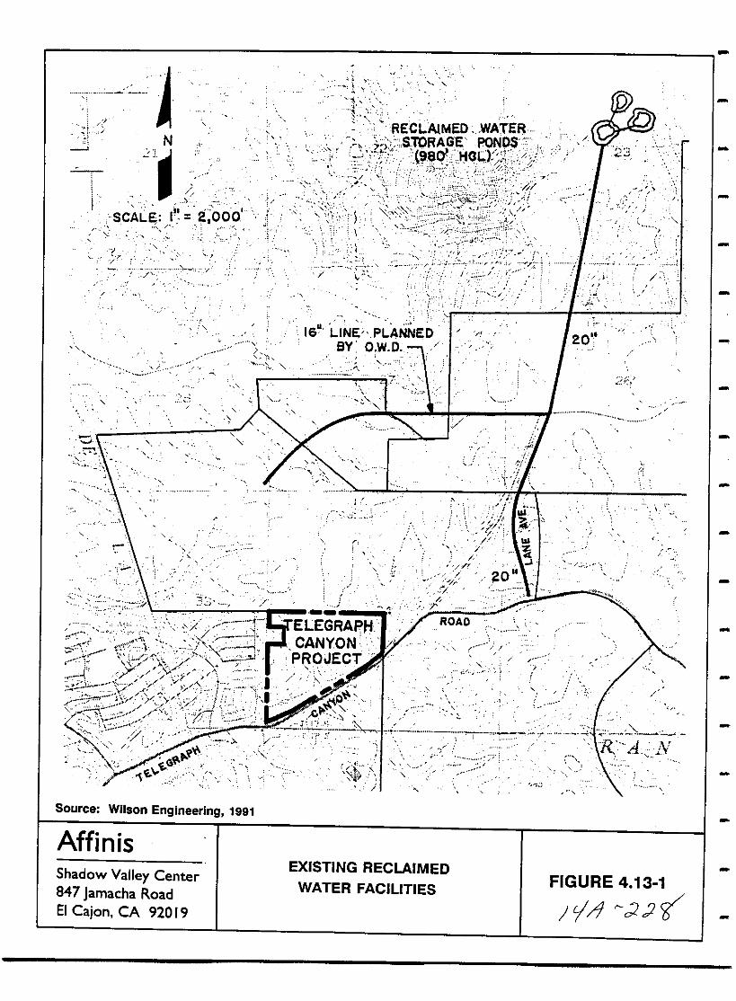
AH
1REeLAlMED wATE
STORAGE PONDh Z i96o t HOL r tj l
g Fft 0
r T
0
N21
ISCAL I 2 009
16 LINiPLANNEDBY O W D
1
20
7
n
AY
y0
n
T
Jtv1
yf 0I
I1
f f
i
t i tL I
y
V iG
1E
ELEGRAPHCANYONPROJECT
1J j
ROAD
f
j
ofer
J
iC
Source Wilson Engineering 1991
AffinisShadow Valley Center847 Jamacha RoadEI Cajon CA 92019
EXISTING RECLAIMEDWATER FACILITIES FIGURE 4 13 1
JY 22y

M
WII
clii i
05 5 llD QI i
Ci5
S l5 II gN N 5 0 go 0 N N c
g 0 0 lD
I i io
IdJrndJdJ
E EZ
N
S 81n01l 81l 1 pesodOJd 5w w D
f3B35 5 i
I
Gi
I 3Ii if0 E
I0 0 II
ru u
tlw
I 00 soI
N
a
m tOOa
0
vao
aOc 66f2 a
sVI
EcW 2w
aatl
Eo 0
c Do vJ
c ang cOGi
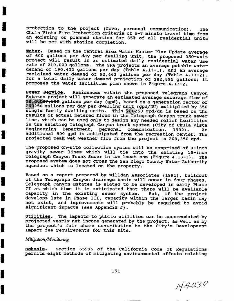
I
I
I
I
I
II
I
II
I
I
I
I
I
I
I
I
I
protection to the project Gove personal communication TheChula vista Fire Protection criteria of 5 7 minute travel time froman existing or planned station for 85 of all residential unitswill be met with station completion
Water Based on the Central Area Water Master Plan Update averageof 600 gallons per day per dwelling unit the proposed 350 unitproject will result in an estimated daily residential water userate of 210 000 gallons The SPA projects an average potable waterdemand of 190 432 gallons per day Table 4 13 1 and an averagereclaimed water demand of 92 463 gallons per day Table 4 13 2for a total daily water demand projection of 282 895 gallons itproposes the water facilities plan shown in Figure 4 13 2
Sewer Servioe Residences within the proposed Telegraph Canyons t s project will generate an estimated average sewerage flow of1 1 87 S88 gallons per day gpd based on a generation factor of
iSnisa gallons per day per dwelling unit gpd DU multiplied by 350sIngle family dwelling units This il9258 gpd du is based on theresults of actual metered flows in the Telegraph Canyon trunk sewerline which can be used only to design any needed relief facilitiesin the existing Telegraph Canyon trunk system City of Chula VistaEngineering Department personal communication 1992 Anadditional 500 gpd is anticipated from the recreation center The
projected peak wet weather flow from the project is 208 350 gpd
The proposed on site collection system will be comprised of 8 inchgravity sewer lines which will tie into the existing 15 inchTelegraph Canyon Trunk Sewer in two locations Figure 4 13 3 The
proposed system does not cross the San Diego County Water Authorityaqueduct which is located on the property
Based on a report prepared by Willdan Associates 1991 buildoutof the Telegraph Canyon drainage basin will occur in four phasesTelegraph Canyon Estates is slated to be developed in early PhaseII at which time it is anticipated that there will be availablecapacity in the existing sewer system But if the projectdevelops late in Phase III capacity within the larger basin maynot exist and improvements will probably be required to avoidsignificant impacts see Appendix J
utilities The impacts to public utilities can be accommodated byprojected yearly net income generated by the project as well as bythe project s fair share contribution to the City s DevelopmentImpact fee requirements for this site
Mitigation Monitoring
Sohools section 65996 of the California Code of Regulationspermits eight methods of mitigating environmental effects relating
151
11 X 0
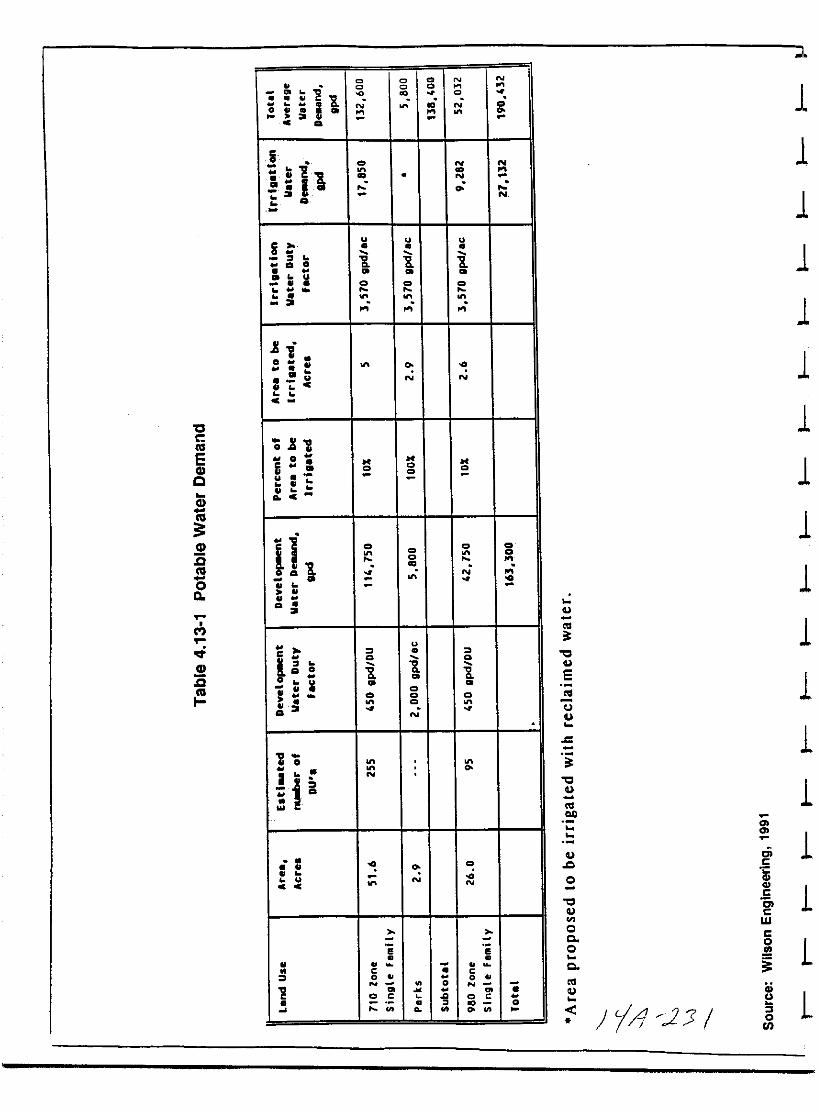
CcIll
EGlQ
Gl
Ill
3GlcIll
oQ
M
GlcIII
C C C N N
u
IiC C C
Cu
N coN to0 U ia
c
Iii1
co N Nto
U to N
I N
u u u
i0 Q
uu co co co
a
x 10
u
U N N
u c
c
xl0
0
6 co coco
uu
uc
i co co co
Illco co
toN
uu
u
a
u
l l
i 0
0 uu co
u co coco
u aco N
1 0
JN
i
couu
u NN
C C
s su u
Cl 0 0
N 0 N
2 co c g co c0
WI Qo WI
1
1
1
1
1
1
1
1
1
1
1it
0
E
1J
1c
i0
1OIl
en
en
1r c
0
1c0 6
cen W0
cCl 0
L0
Cl
a
LCJ
Jil JJ1s0en
I
I
II
II
I
I
I
I
I
I
I
I
I
I
I
I
I
Table 4 13 2
TELEGRAPH CANYON AVERAGE RECLAIMED WATER DEMAND
Land Use Landscape Area Irrig Water Total Reclaimed
Acres Duty Factor Water Demand
Approximate gpdl acre gpd
SDCWA Aqueduct 5 5 3 570 19 635Easement View
Park Private
Recreation Areas
Open Space 20 4 3 570 72 828Scenic Buffer
Areaj
TOTAL 25 9 92 463
Source Wilson Engineering 1991 rl7 2 3J
1

THIS PAGE INTENTIONALLY LEFT BLANK
154
L1 1
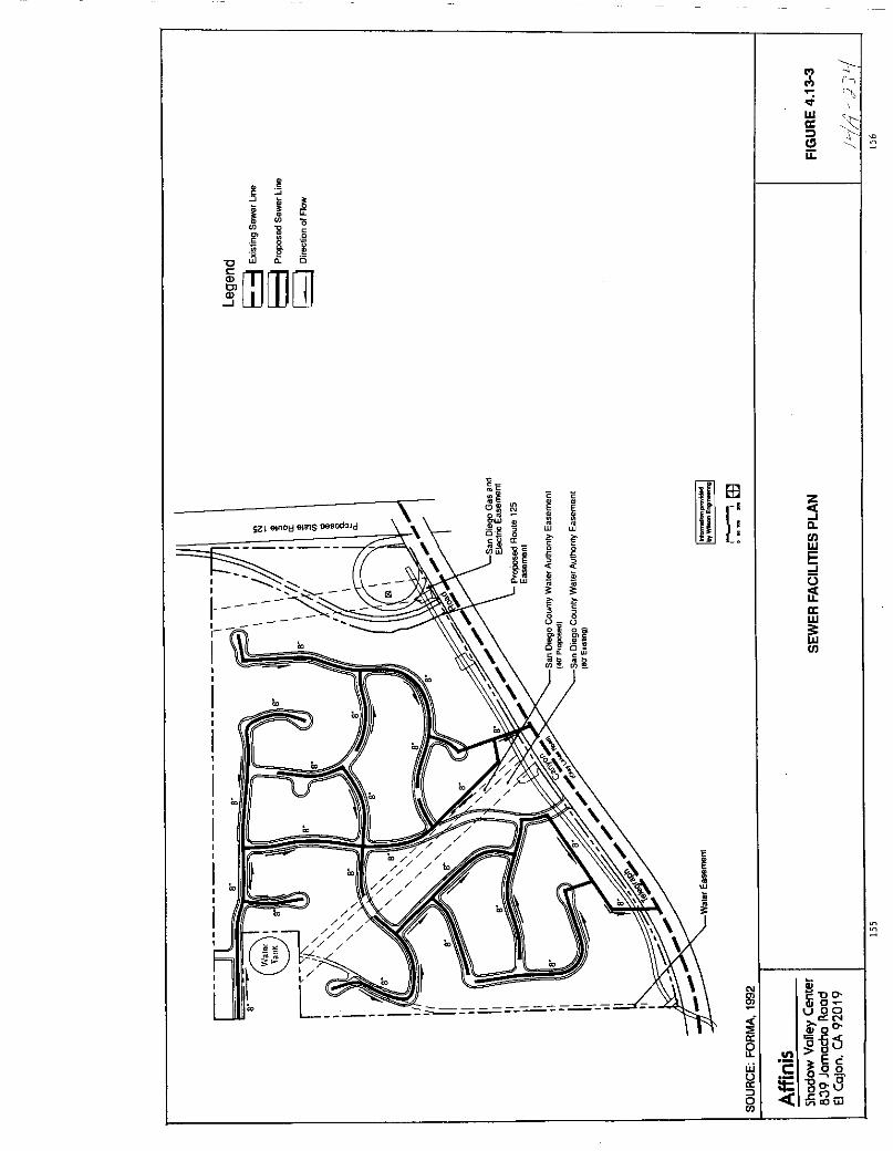
ell h
Ula t
i 1l
Clii
oSQ
8x Q
IdJdJ
s 91n01l erelS po odod
I
I
I I
II
I
III
II
I
II
II
I
II
I
I
o
o
o
@nI
Io L
o
68 s
lijg aw iC
1a
o
C E
5lUl
E5
3 5
IhD 0
JJi tIl l
HrII
E
o
sCOOUl
5jifaUl
1500
wucOJ
g
liiCUD
c
goobiHi
Inou
2 3E cOQ 0
l5 g 0 8JVllOw
I
II
II
I
I
I
I
I
I
I
II
I
II
I
I
to the adequacy of school facilities These may include payment ofstandard developer fees or participation in a community facilitiesdistrict large scale development projects may be required todedicate school sites or build school facilities
es is not considered adequate miti ationa 1ve 1m acts to overcrowde schools y he Chula Vista
School 1S r1C and Sweetwater n10n 19 c 00 District Eitherdeaicat10n of a scnool site or part1c1pat10n in a CommunityFacilItieS pE trict 1ffiT idflr ld Lu be adequate mitigation
AccordiISL Oth sch n i t i T Tho ale of the proposedvelopment is n T lar 9 onouah to warrant dedication of a school
s1te
The Sweetwater Union High School District has established CFD 5 for
developments of 50 or more units west of I 80S in the South Bayarea However this CFD is inappropriate for the Telegraph CanyonEstates development and a new CFD either e er illIlli 7 will becreated to accommodate the project Silva personal communicationAs a ee uiit isft 5h w e f J P i1 J te iSB11afte C of
llliillhlllJ plnllitB iS1ti b t ltiEiJtg HnMMmfgjjlE fA t6 1lQ the appl1cantshall be required to 01n CFD e er 7 and subm1t those fees to theDistrict
The Ch la iata Oeheel Diatriet haa alae iftdieatcd that a Re CPDill be ercatcd fer the otay RaRea Irej est A5 the preposca
fJrejcat ill prcecde the stay RaBea pre est the Diatriet haaiJsieatea that it will EJ8 fenard tith the CPD te allel th
d1str1ct Shurson personal commun1cat10n Proof of payment offees and annexation into the CFDs shall be proyidedto the CityPlanning Department prior to approval of the k nlltll
w w w w
Police Services The hiring of 1 4 additional police personnelwill mitigate the potential impact of insufficient policeprotection below a level of significance This will be financed
through the projected yearly net income from the project
Fire Protection Impacts incrementally created by this projectsuch as the need to construct additional fire stations and the
purchase of additional equipment will be mitigated by the projectedyearly net income and the project s contribution to the City S
Development Impact fee
Water A new pump station is under construction to expandcapacity This in conjunction with the proposed facilitiesconnections will provide the means to deliver water to the
project
157
pIA 2 3S
The OWD has provided a letter addressing water availabilityAppendix J Prior to the recordation of Final Maps the applicant
shall obtain will serve letters verifying that water facilitiesproposed shall adequately service the project via approval by theOWD of all plans and specifications The project will also be
1 required to pay Central Area Reservoir Fees
lVverification of adequacy of water supplies and payment of fees
A reduces water supply impacts to below a level of significanceThis service letter detailing reservoir main and hydrantconstruction schedules is also necessary for compliance with theThreshold Policy The City of Chula vista must in turn complywith the Threshold Standards Policy by providing annual developmentforecasts to the water district
In response to regional water shortage the Telegraph CanyonEstates project proposes additional conservation measures forindividual households including use of ultra low flow indoorfixtures and appliances low flush toilets showers and faucetspressure reducing valves Table 4 13 3
hLandscaping will feature drought resistant plants which will be
tdriP irrigated and principles of xeriscaping will be applied Byadhering tO these measures it is projected that 117 gallons perousehold per day will be saved
It is ated that approximately 92 463 gallons of otable waterper day could be save wa er s used to rr gate
mmoI1areas paffS ana open space within the project Asd scussea buv he OWfis upgrlldluy itsflfCilities to providereclaimed wateJu 1Q qation in the future I While reclaimedwater s not currently available for use within the proposedproject the project is providing a system to use reclaimed waterirrigation when it becomes available As this project scontribution the applicant shall either install the line acrossproject frontage or pay a proportional share of the line asdetermined by the Otay Water District The size of the line willbe determined by the City of Chula vista and the OWD based on thedemand for reclaimed water in the project s vicinityTwo four inch diameter water lines are proposed for the projectFigure 4 13 4 to provide permanent irrigation for the proposed
park areas and the SDCWA water easement area The scenic bufferalong Telegraph Canyon Road will be irrigated for a 2 year periodor until vegetation becomes established and will be served by
irrigation meters off the main line in Otay Lakes Road
There is no method to insure that reclaimed water will be availablefrom the Otay Water District at the time the proposed project is
158
14 2J
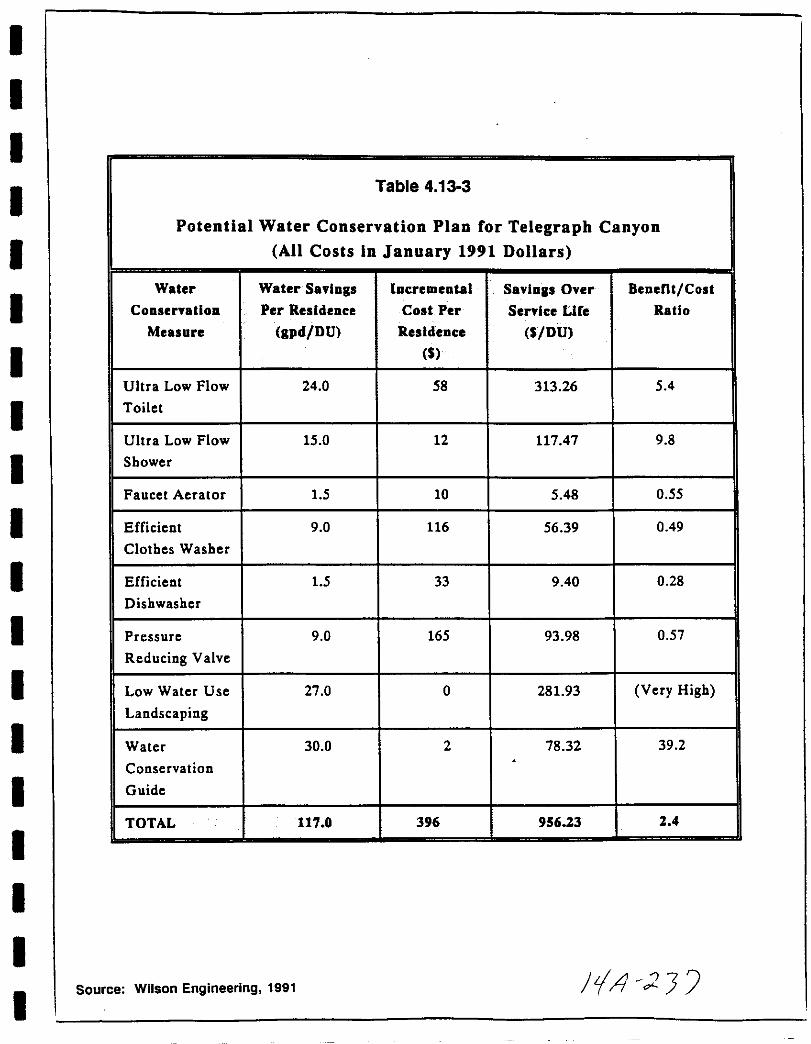
I
II
II
I
I
I
I
I
I
I
I
I
I
II
I
I
Table 4 13 3
Potential Water Conservation Plan for Telegraph CanyonAll Costs in January 1991 Dollars
Water Water Savings Incremental Savings Over Benent Cost
Conservation r Per Residence Cost Per Service Lire Ratio
Measure gpd DU Residence DU
Ultra Low Flow 24 0 58 313 26 5 4
Toilet
Ultra Low Flow 15 0 12 11747 9 8
Shower
Faucet Aerator 15 10 5 48 0 55
Efficient 9 0 116 56 39 0 49
Clothes Washer
Efficient 15 33 9 40 0 28
Dishwasher
Pressure 9 0 165 93 98 057
Reducing Valve
Low Water Use 27 0 0 28193 Very High
Landscaping
Water 30 0 2 78 32 39 2
Conservation
Guide
TOTAL 117 0 396 956 23 2 4
Source Wilson Engineering 1991 JtA 2
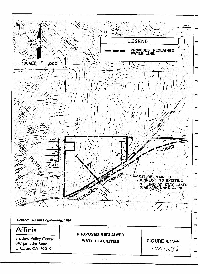
u
Source Wilson Engineering 1991
AffinisPROPOSED RECLAIMED
WATER FACILITIES FIGURE 4 134
JJ 2Jr
Shadow Valley Center847 Jamacha RoadEI Cajon CA 92019
I
I
I
I
I
II
I
I
I
I
I
I
I
I
I
I
I
I
constructed If potable water will be required until reclaimedwater becomes available projected in mid 1992 all water linesshall be planned to avoid future cross connections All water lineconnections have been detailed on the TSM and will be inspected andmonitored during project construction by the City s Engineeringdepartment
Sewer Service As reeSllllfl6fUica sy the WillaaB Rel sre mefti1erin afhe Irajee 8e elepmcBt ill aetermine whcther eE Bet miti atieft is
re irca If the Tcle ralh Canysft Estates prejcet is acvclel cawhile there is ailasle exiatiJ sewer eapaeity theZ c will be BeaaVCE a6 impae a aHa Be mitiga ieft eE farther mefti eriR isrc irca IIewc cr if m6fliteriJEj aet ermi1ca iraaeqt1 aee sewer
capacity ithiJ the larger draifta e saaia then mitigat isft will be
rcqtiirea af Irejeeta eataide af the TelcEJraph Caftyen baaift and willeeftsiat af i lemefttiftEJ the ftcesasaZ sHpplemcfttal capacity
iIBIlFSElIIIElIl1 s The developer shall be required to construct
project specific sewage system improvements The developer shallalso be required to contribute toward the costs of any monitoringand to construct or contribute towards the costs of constructingany required trunk sewer improvements in proportion to the
development s flow with respect to the cumulative waste water flows
generated by new development within the Telegraph Canyon basin
utilities Mitigation of utilities impacts will be ensured throughthe MMRP by requiring the project s contribution in the City S
Development fee
Analysis of Significance
Schools payment of fees through annexation to CFD s for the Chula
vista and Sweetwater Union High School Districts will reducedirect and cumulative impacts to area schools to below a level of
significance No further mitigation measures will be required
Police Services The addition of 14 police personnel providedthrough the projected yearly net income generated by the projectwill mitigate the potential impacts associated with insufficientpolice protection below a level of significance
Fire Protection Projected yearly net income and the project s
contribution to the City S Development Impact Fee mitigate the
incremental impacts to fire protection services
Water While increased water consumption is a major regionalissue the project is capable of providing water to residents TheCentral Area Water Master Plan has specified an infrastructure thatwill allow a sufficient amount of water to serve the project and
barring general regional unavailability water can be supplied to
161
jrfll cJ 3

By implementing water conservation measures and providing for thefuture use of reclaimed water the project will contribute toward
reducing cumulative impacts to area water supplies Hn liill
pre ce la ae a e Belew a level af ai fiifieaftee
Sewer Servioe Provided the Telegraph Canyon Estates project isimplemented early in Phase III of the buildout of Telegraph Canyonthe proposed sewer system including linkage to existing capacitieswithin the larger basin area will be adequate and no adverseimpacts are expected If project implementation occurs lateradditional sewer improvements may be required to reduce impacts tobelow a level of significance
utilities Implementation of this project will create nosignificant impacts on utilities Cumulative impacts to publicutilities will be mitigated to below a level of significance byrequiring the project to contribute its fair share to the City S
Development Impact fee program for public utilities
162
iJ 2 tjO
I
I
I
I
I
I
I
I
I
I
I
I
II
I
I
I
I
I
4 14 Public Health
Existing Conditions
The easternmost portion of the project area is crossed by a San
Diego Gas Electric Co SDG E transmission line corridortrending in a northwesterly southeasterly direction Thetransmission lines are contained midway within a 120 foot easementas shown in Figure 6 in Chapter 2 3 and in Figure 14 14 l
Currently there is one 230 kV circuit on the double circuit towerswithin the easement at a future date a 69 kV circuit will beadded and the potential for further circuit additions exists
Rose personal communication
The electric and magnetic fields produced by an overhead
transmission line are functions of the line s voltage current and
physical characteristics e g conductor size spacingconfiguration and clearance above the ground The amount ofradiation is governed by the relative balance between positive and
negative charges along the system The Ilesitive and 1leljative
eharljes aleRlj the system The greatest EMF emitters are
substations and transformers where the power is stepped down as
well as the system s distribution lines where varying demands forcurrent can yield imbalances APA 1992 In contrast thetransmission lines which run between generating plants andsubstations will have a constant and dependable field strengthbecause the substations use a constant volume of power
Based on the rough formulation of peak electric field given byKavet and Banks 1986 Nair and others 1990 and SDG E 1991the 60 Hz electric field directly below the 230 kV line is 3 9kV m and the field below the 69 kV line is approximately 0 9 kV m
The magnetic fields beneath transmission lines rarely exceedseveral tenths of a gauss several hundred milligauss Kavet and
Banks 1986 Both electric and magnetic fields drop off sharply ata distance of approximately 100 horizontal feet 30 m from the
centerline near midspan Kavet and Banks 1986
Electric and magnetic fields are found throughout nature and are inall living things These fields help hold matter together and are
a necessary part of the operation of the human nervous systemSubstantial data suggests that the higher range of field strengthscommonly encountered pose no greater risks than weaker fields In
some cases the electric and magnetic fields generated byappliances and electrical distribution systems in the home are
stronger than those produced by overhead transmission lines For
instance the magnetic field in front of a black and white computermonitor measures 2500 milligauss Miller 1989 whereas the
163
pf d II

View North
View South
AffinisShadow Valley Center839 Jamacha RoadEI Cajon CA 9201 9
LOCATION OF POWER LINESRELATIVE TO PROJECT SITE FIGURE 4 14 1
It c2L 2164

I
I
I
I
I
I
I
I
I
I
I
I
I
I
I
I
I
I
I
magnetic field directly under a 500 kV line averages 70 milligaussdoubling during periods of highest current flow APA 1992
Recent environmental health literature has addressed the biologicaleffects of extremely low frequency ELF electric and magneticfields cf Kavet and Banks 1986 Miller 1989 Bennett et al1990 Areas of concern in these studies include increased risk ofcancer changes in hormone levels neurophysiological changesmiscarriage and fetal development In recent years both the USDepartment of Energy and the Electric Power Research Institute haveconducted extensive research on the biological and health effectsassociated with exposure to 60 Hz electromagnetic fields Theresearch emphasis has been on electric fields rather than magneticprimarily because under transmission lines the induced bodycurrents generally result from the electric field Kavet and Banks1986 Nair et al 1990 However recent research has focused on
the effects associated with magnetic fields Slesin et al 1991
Although laboratory studies addressing effects of electric and
magnetic fields at the cellular level have suggested a disruptionof normal cell activity studies of whole animals exposedchronically to 60 Hz electric fields have failed to produce changesin indices of overall health or evidence of induced pathology withfew exceptions However effects from chronic exposure have beenobserved in a few areas behavior endocrinology neurophysiologyand possibly fetal development Kavet and Banks 1986 Miller 1989Nair et al 1990
Different studies have arrived at varying often conflictingconclusions Several epidemiological studies have suggested a linkbetween chronic exposure to electromagnetic fields and increasedrisk of leukemia and other cancers However most of these reportsfail to include measurements of the magnitude and duration of
exposure and many do not investigate alternative explanations for
changes in the state of health As these studies are inconclusivethis subject requires much more investigation Kavet and Banks
1986 Nair et al 1990 Larson 1991
Impact
As shown in Figure 6 in Chapter 2 3 two lots 150 and 151 and
the western edge of the tennis courts will immediately abut the
SDG E easement two other lots 149 and 152 lie within 100 feetof the transmission lines The effects of both electrical and
magnetic fields are strongest within 100 horizontal feet from thesource and then drop off sharply Kavet and Banks 1986Residences abutting or in close proximity to the transmission lineswill be subject to more intense electrical and magnetic field
exposure and as suggested by some studies occupants might be
possibly at greater risk for leukemia or other cancer related
disorders Since some studies conclude highest risk is associated
165
JtA 2 tJ

with prolonged and enduring contact use of the recreational courts
abutting the corridor might not result in the same type of
exposure However as discussed above various studies have arrivedat differing conclusions At the present time there are no
definitive data available to assess potential impacts to residents
living in proximity to transmission lines
Mitigation Monitoring
The issue of human health impacts from EMF exposure is too
speculative to reach a conclusion regarding the significance of
impacts Under CEQA the discussion of speculative matters
Guidelines section 15145 is permitted However if afterthorough investigation a particular impact is found to be too
speculative for evaluation the conclusions shall be noted and thediscussion terminated CEQA 1986 As no significant impacts havebeen identified no mitigation measures will be requiredHowever the following mitigation measure is recommended to reducethe potential to EMF exposure
1 The project applicant shall comply with any future policyadopted by the City of Chula vista prior to consideration ofthe Final Map
Analysis of Significance
Although there is no scientific consensus concerning the
possibility of adverse health effects from exposure to transmissionand or distribution lines certain studies have shown positivecorrelations between exposure to electromagnetic fields andincreased health disorders Current research does not provide aconsistent basis on which to conclude that exposure to transmissionlines causes health disorders but certain available evidence does
suggest an association between exposure and adverse health effectsIt is this association demonstrated in several studies whichprovide a basis for reducing exposure when possible
There are important qualifications however that are stated
throughout the literature on this issue
1 Transmission lines are not the only source of EMF fieldsHowever they may compound exposure by adding to existingfields within the home
2 EMF fields may create health disorders by acting together withother environmental stresses This possibility is not wellunderstood
3 The scientific research has not reached consensus on whetherchronic or intermittent exposure has greater health effectsBoth qualifications suggest that uncertainty remains onwhether there may by an increased risk with compoundexposures
J I JtJj
I
I
I
I
I
I
I
I
I
I
I
I
I
I
I
I
I
I
I
5 0 COMPLIANCE WITH THRESHOLD STANDARDS POLICY
As discussed in section 1 2 of this EIR the City Council of Chula
vista established a Threshold Standards Policy and Growth
Management oversight Committee GMOC in 1987 to assure
maintenance of a high quality environment and adequate publicservices The program involves implementation of standards or
thresholds as determined by the City Council In conformance withthe policy this EIR has examined seven issues police fire and
emergency medical service parks and recreation water sewer
drainage and traffic for project level compliance Additionallythe EIR has evaluated the potential effects of the project on airquality economics and schools which will be assessed by the
GMOC The following discussion provides a summary of the EIR
analysis of these threshold issues
1 Fire and EMS The Threshold Standards Policy for fire
protection is to ensure that fire EMS staff are properly equippedtrained and funded to provide the desired level of service
throughout the City to maintain and improve the current level of
service The standard response time is set at seven minutes in 85of annual cases The GMOC determined that the threshold was
maintained on both a cumulative and project basis in 1990 City ofChula Vista 1991
As discussed in section 4 13 of the EIR the project area is withinthe jurisdiction of the City of Chula vista Fire Department The
closest existing fire station to the project area is station 4located at 861 Otay Lakes Road south of East H Street However
a new station located at the corner of Lane Avenue and otay Lakes
139 t grap Canyon Road i slated to e operatioIal in l1nUbl r11 of 1992 and w111 prov1de f1re protect1on to the
proJect7m The city s threshold standard will be met
2 Police The goal of the Threshold standards Policy for policeprotection seeks to maintain or improve the current level of policeservice by ensuring that police staff equipment and traininglevels are adequate to provide police service at the desired level
throughout the City The Threshold Standards Policy requires that
police units must respond to 84 of Priority 1 calls within seven
minutes or less and maintain an average response time to all
Priority 1 calls of 4 5 minutes or less Police units must respondto 62 10 of Priority 2 calls within seven minutes or less and
maintain an average response time to all Priority 2 calls of seven
minutes or less
As discussed in section 4 13 of the EIR the project will requirethe addition of 14 personnel to the city s police force to
maintain the Threshold Standards Policy of 1 3 officer s per 1 000
population ratio Funding for additional personnel will be
167
ItA 2

provided by assessed taxes and fees on the project as detailed inSection 4 13
3 Traffic The goal of the Traffic Threshold Standard is toprovide and maintain a safe and efficient street system within theCity Objectives defined to meet this goal included the timelyprovision of adequate local circulation system capacity in responseto planned growth maintaining acceptable levels of service LOSand to plan new roadway segments and signalized intersections tomaintain acceptable standards at buildout of the General PlanThree Standards have been set
City wide To maintain LOS C or better at all intersectionswith the exception that LOS 0 may occur at signalizedintersections for a period not to exceed a total of two hoursper day
West of I 805 intersections not meeting this standard maycontinue to operate at the 1987 LOS but shall not worsen
City wide No intersection shall operate at LOS F as measuredfor the average weekday peak hour
The GMOC determined that the threshold was maintained on both acumulative and project basis in 1990 City of Chula Vista 1991
As discussed in Section 2 8 of this EIR the LOS on severalroadways in the project s vicinity is forecast to drop tounacceptable levels in the future with or without the proposedproject The project s traffic will not result in significantdirect impacts to area roadways or intersections However theproject will contribute on a fair share basis to trafficimprovements delineated in the East Chula Vista TransportationPhasing Plan to mitigate its cumulative impacts Thus future LOSand roadway capacities will be within the threshold levels set bythe city
4 Parks and Recreation The goal of the Threshold StandardsPolicy is to provide a diverse and flexible park system which meetsboth the active and passive recreational needs of the citizens ofChula Vista The objectives are to provide park and recreationalopportunities in a timely manner and to implement a five yearmaster plan which describes the location facility improvementsand funding program for proposed neighborhood and community parksThe Standard sets a ratio of three acres of neighborhood andcommunity parkland with appropriate facilities per 1000 residentseast of I 805 The GMOC determined that the threshold wasmaintained on both a cumulative and project basis in 1990 City ofChula Vista 1991
As detailed in Section 4 13 of the EIR the proj ect will berequired to pay in lieu fees As allowed under Section 17 10 of the
168
I J I
I
I
I
I
I
I
I
I
I
I
I
I
I
I
I
I
I
I
I
Chula vista Municipal Code the applicant will also pay in lieu
park fees to satisfy the requirement established by the ThresholdStandard
s Drainaae The goal of the drainage standard in the
Threshold Standards POlicy is to provide a safe and efficient storm
drainage system to protect residents and property in the City of
Chula vista The Threshold Standards Policy mandates that
individual projects will provide necessary improvements consistentwith the Drainage Master Planes and city Engineering StandardsStorm water flows and volumes are required to be within CityEngineering Standards Additionally the GMOC annually reviews the
performance of the City s storm drain system to determine itsability to meet the goals and objectives The GMOC determined that
the threshold was maintained on both a cumulative and project basisin 1990 City of Chula Vista 1991
As discussed in section 4 2 of the EIR implementation of the
proposed project will not significantly alter the project area s
drainage and it will meet the City s Engineering Standards and
requirements set forth in the Drainage Master Plan The stormdrain plan proposed in the SPA will keep storm water flows and
volumes within City Engineering limits Thus the project willmeet the Threshold Standards Policy for drainage
6 Water The goal of the Threshold Standards POlicy for water
service is to ensure that adequate supplies of quality water are
available to the City The objectives include ensuring that
adequate storage treatment and transmission facilities are
constructed concurrently with planned growth and that water
quality standards are not jeopardized during growth and
construction The OWD has provided a letter addressing water
service availability see Appendix J In order to comply with the
City s Threshold Standard for water service the project applicantwill obtain a service availability letter from the Otay Water
District prior to approval of the TSM
The City of Chula vista must also provide development forecasts to
the SDCWA the Sweetwater Authority and the Otay water districtson an annual basis The annual reports are required to address
water availability to the city and Planning Area considering both
short and long term perspectives amount of current capacityincluding storage capacity now used or committed ability of
affected facilities to absorb forecast growth evaluation of
funding and site availability for projected new facilities and
other relevant information to the District s desire to communicateto the city and GMOC Both the growth forecast and water district
response letters are required to be submitted to the GMOC for
review The GMOC determined that the threshold was maintained on
both a cumulative and project basis in 1990 city of Chula Vista1991
169
J 1 2 L 7
7 Sewer The Threshold Standards Policy requires thatindividual projects provide necessary improvements consistent withSewer Master Plans and City Engineering Standards to meet the goalof providing a healthful and sanitary sewer collection and disposalsystem for City residents The Threshold mandates that sewageflows and volumes not exceed City Engineering Standards
Additionally the City is required to provide an annual report tothe San Diego Metropolitan Sewer Authority which evaluates proposeddevelopment and sewage capacity The report must includeinformation on the amount of current capacity now used orcommitted ability of affected facilities to absorb forecastgrowth evaluation of funding and site availability for projectednew facilities and other relevant information Both the growthforecast and Authority response letters are required for submittalto the GMOC for its review The GMOC determined that the thresholdwas maintained on both a cumulative and project basis in 1990 Cityof Chula Vista 1991
As detailed in Section 4 13 the Sewer Master Plan prepared for theproject noted that the buildout of Telegraph Canyon Estates isprojected to occur in four phases and that the proposed projectwill be constructed @ ifjlla c in Phase ltIm At that timeadequate sewer capacity Tsiexpected to be present and no adverseimpacts are expected If project implementation is later howeveradditional sewer improvements may be required This will beassured by monitoring during the phasing of construction of theproposed project as well as other projects within the TelegraphCanyon area
8 Air Oua1itv The goal of the Threshold Standards Policy is tomaintain and improve the ambient air quality enjoyed by thecitizens of Chula Vista The objective acknowledges that airquality is a regional issue which cannot be effectively controlledby the City and seeks to implement the tactics established by the
currently adopted Regional Air Quality Maintenance Plan AQMPThe City is required to provide a yearly report to the APCD whichpresents a 12 to 15 month development forecast to allow the APCDto evaluate impacts on current and future air quality managementplans The growth forecast and APCD responses are given to theGMOC for review The GMOC determined that the threshold wasmaintained on both a cumulative and project basis in 1990 City ofChula Vista 1991
As discussed in Section 4 4 of the EIR the project will createboth short term and long term air quality impacts Short termimpacts are construction related and will be reduced to below alevel of significance by standard dust control practicesThe incremental addition of pollutants from any individual projectmay be considered a significant impact SANDAG s regional growthforecasts are based on land uses established in area general plansThe project exceeds the Series V Growth Forecast used in the 1982
170
14 l1
I
I
II
I
I
I
I
I
I
I
I
II
I
I
I
I
I
SIP which serves as the current AQMP However it will be
reviewed for consistency with the Series VII Growth Forecast beingused to update the SIP which will be adopted as the new AQMP The
project will be required to comply with the updated air qualityplan This will be reviewed by the GMOC during its annual update
9 Economics The goal of the Threshold Standards Policy is to
provide land uses and activities that respond to the economic needsof the residents and the City of Chula vista Fiscal ImpactReports FIRs and Public Facility Financing Plans PFFPs are
required to evaluate and plan for healthy economic attributes inbalance with environmental social and public policy criteriacity of Chula Vista 1987 The GMOC is provided with an annual
report prepared by staff which addresses the economic condition ofthe City and its residents and includes a 12 to 15 month
development forecast and an evaluation of its economic effectsIncluded in the report are statistics and data relevant to
residents economic well being income level average home priceetc vitality of local business number of business licensescommercial vacancy and lease rates etc and significant fiscal
changes over the previous year The GMOC determined that the
threshold was maintained on both a cumulative and project basis in1990 City of Chula Vista 1991
As discussed in Sections 4 10 and 4 11 of the EIR the proposedTelegraph Canyon Estates project will introduce approximately 1134
residents A PFFP has been prepared for the project and is on filewith the City of Chula Vista The project is consistent with the
General Plan guidelines for new housing and development of this
project is not anticipated to cause any adverse housing impacts
The project will not create any new employment opportunitiesHowever because of regional and local employment availabilityincluding retail commercial and industrial opportunities withinthe adjacent Eastlake development adverse employment impacts are
not expected Further implementation of the project will
introduce additional workers into the Chula vista labor force
which is anticipated by SANDAG growth projections
Development of the project will incur expenditures to the City of
Chula vista but these expenses will be offset by revenues providedto the city through assessed fees and taxes A positive net fiscal
impact of the development on the city of Chula Vista over a 15
year period is projected in excess of 878 000
No significant net fiscal impacts are expected to affect the OtayWater District or the Chula vista Elementary or Sweetwater Union
High School District
10 Schools The goal of the Threshold Standards Policy is to
ensure that the Chula vista City School District and the Sweetwater
Union High School District have the necessary school sites and
171
tf4 r21i

funds to meet the needs of students in new development areas in a
timely manner The objective of the standard is to providedistrict personnel with current development forecast to allow themto plan and implement school building and or allocation programs ina timely manner The City is required to provide the districtswith a 12 to 15 month development forecast and request anevaluation of the districts abilities to accommodate the forecastand continuing growth The districts replies are required toaddress the following issues
1 Amount of current capacity now used or committed
2 Ability to absorb forecast growth in affected facilities
3 Evaluation of funding and site availability for projected newfacil ities
other relevant information the District s
communicate to the City and GMOC
The growth forecast and school district response letters are
provided to the GMOC for review The GMOC determined that thethreshold was maintained on both a cumulative and project basis in1990 City of Chula Vista 1991
4 desire to
As discussed in section 4 13 of this EIR the 350 unit TelegraphCanyon Estates project will introduce 105 new elementary schoolstudents and approximately 105 68 5 junior and 36 5 senior highstudents Payment of fees through annexation to CFD s for theChula vista and Sweetwater Union High School Districts will reducedirect and cumulative impacts to area schools to below a level ofsignificance No further mitigation measures will be required
11 Libraries The goal of the library Threshold Standards Policyis to provide a high quality contemporary library system to meetcommunity needs The objective of the standard is to supplementthe central library facility by providing branch facilities in theMontgomery Otay area and east of 1 805 The City s library ratiois set at 500 gross square feet of library adequately equipped andstaffed per 1 000 population
In 1990 the GMOC determined that the City had a deficit of
approximately 10 000 square feet of library space The Citysubsequently applied for and received approval of CaliforniaLibrary Construction and Renovation Bond Act funds A new 35 000sq ft library is to be constructed in the Montgomery Otayplanning area and a 24 000 sq ft library is planned in theSweetwater Bonita planning area A 4 000 sq ft library is to beincluded in the Eastlake Village Center that project has been onhold pending finalization of construction plans for the commercialcomplex City of Chula Vista 1991
172
iA J
I
I
II
I
I
II
I
I
I
I
II
II
I
I
I
The GMOC determined that with the approval of the state libraryfund grant the City achieved conformance with the librarythreshold in 1990 City of Chula Vista 1991 It is anticipatedthat upon completion of the new facilities the Threshold standardsPolicy will not be exceeded by the Telegraph Canyon Estates
project
173
J J5
THIS PAGE INTENTIONALLY LEFT BLANK
174
ill cJ

II
I
I
I
I
II
I
I
I
I
I
I
I
I
I
I
I
6 0 ALTERNATIVES
The California Environmental Quality Act Guidelines Section15126d require the discussion of a no project alternative and of
reasonable alternatives to the project which could feasiblyobtain the basic objectives of the project and the discussion of
alternatives shall focus on alternatives capable of eliminating anysignificant adverse environmental effects or reducing them to a
level of insignificance even if these alternatives will impede to
some degree the attainment of project objectives or will be more
costly The range of alternatives required in an EIR is governedby rule of reason that requires the EIR to set forth only those
alternatives necessary to permit a reasoned choice The key issue
is whether the selection and discussion of alternatives fosters
informed decision making and informed public participation A
range of alternatives was considered for the proposed projectincluding the No project Alternative No Development AlternativeAlternative Design A and Alternative Design B and the Off site
Project Alternatives
6 1 No Project Alternative
Under the No Project alternative two scenarios are possible no
project and no development
No Pro ect This alternative will consist of no annexation GDP
SPA or TSM for the project The site will remain under countyjurisdiction and will remain under limited control under the S 87
Special Study Area land use designation until studies were
completed to enable reclassification of the property At this
point it would be speculative to determine what type of
development will be allowed but it is anticipated that it will be
required to provide either a transitional land use from adjacentundeveloped land to more densely developed land such as that
present at Eastlake Shores or be developed consistent with the
type of residential uses existing on adjacent parcels within the
city of Chula vista It is probable that an overall developmentplan such as a specific plan will be required by the county to
avoid piecemeal development on a lot by lot basis
If the property were developed under the existing land use
designation and zoning the 2 5 acre minimum lot size would allow
a gross maximum of 44 single family dwelling units on the l12 acre
parcel This number will likely be lower in reality given the
constraints on developable land easements for SDG E and the
SDCWA wetland area and setbacks for scenic highways and S R
125 All grading will be subject to the County s Resource
Protection Ordinance Impacts to landform alteration aesthetics
air quality biological resources traffic air quality and
hydrology will probably be reduced Impacts to geology soils
175
i9 d53
noise and public health will be similar to the proposed project simpacts under this alternative Impacts regarding social factorscommunity tax structure and demands on public services will likelybe greater Given the site s proximity to the City of Chula Vistathese impacts will directly affect the city schools parkssewers water supply emergency services etc andThreshold Standards Policy would probably be exceeded Thus thisis not considered to be an environmentally preferable alternative
No DeveloDment Under this alternative the project area willremain vacant and land use will remain unchanged No impacts to
geology hydrology landform alteration air quality biologicalresources traffic noise public facilities parks or publichealth will occur This alternative would not be consistent withthe City of Chula vista s or County of San Diego s land usedesignations for residential development and it would result inloss of tax revenue for the city It would not achieve the basicobjectives of the proposed project However because it wouldavoid the significant impacts which would result from the proposedproject it is considered to be the environmentally superioralternative
6 2 Alternative Design A
This alternative shown conceptually in Figure 6 1 will be areduced project developed at a low medium residential density R 17 A total of 280 single family homes would be constructed onapproximately 70 acres resulting in a density of 4 0 dwelling unitsper acre Open space would increase to 316 acres and wouldencompass a larger portion of the central swale on site TheCommunity Purpose Facility would remain the same as in the proposedproject
No circulation plan has been designed for this alternative butaccess points would be the same as those in the proposed projectand the overall street and cul de sac system would be similar Ifthis alternative is adopted the following impacts are expected tooccur
Geoloav soils This alternative would be anticipated to havesimilar impacts to those of the proposed proj ect Constraints fromthese factors would not expected to be more or less difficult underthis alternative or the proposed project
Hvdroloav Water Oualitv Groundwater In terms of project drainageeffects on water quality the discharge into the Telegraph CanyonCreek Channel is regulated by the National Pollutant DischargeElimination System NPDES permit requirements as such neitherthe proposed project nor this alternative or any alternative canhave a discharge that significantly degrades as defined by the EPA
176
Jt 2yl
fs
lIi
lto
6
iEll
e
II I it@
j
CcQClQid
u 83State Route 125
II
III
III
II
J
i iJ iiilii
cDwa
u
11J
Clw
iz
ffiiCl
z
ffic
Il1W
z
8
i
a III
cfE
5l
isgu 0
1ut
l Qgi
w
I
I
I
I
I
I
I
I
I
I
I
II
I
II
I
I
I
in the NPDES requirements the water quality in the receivingchannel Fewer houses would probably translate to fewer vehiclesusing and parking on the streets resulting in less material to be
carried off during rainstorms While this could allow easierattainment of the NPDES requirements the reduction in material isnot likely of sufficient magnitude to affect the way the systemwould be designed to meet NPDES requirements
This alternative may result in less runoff as there would likelybe less hardscape and more permeable surface yards open spaceEven with the same design the reduction would not be proportionalto the drop in units as the road system could not be reduced
proportionally Calculations on storm drainage capacity in
Telegraph Canyon Creek channel showed that the proposed project s
input is less than significant and that the channel would still bewell under capacity This alternative may result in less runoffbut the amount of runoff was not found to have a significant impactwith the proposed project
with the inclusion of much of the central swale in open space there
would likely be somewhat more input of fertilizers pesticides and
herbicides into the drainage than under the proposed project as
there would likely be private yards adjacent to the swale Privateuse of these chemicals is difficult if not impossible to control
Landform Al teration Aesthetios Landform alteration would be
similar under the proposed project and this alternative The
overall landform would be retained and the street system must be
created regardless of the 60 unit difference
Aesthetics is a subjective environmental issue People who objectto the placement of a 340 unit residential project on this sitewould likely object to the placement of a 280 unit projectconversely even with having to maintain the street system a
reduction in units may allow the designers to create a more
aesthetically pleasing project Given that a street system is
necessary it is likely that the proposed project and a designunder this alternative would be considered aesthetically similar bymost passers by
within the project the retention of the marsh area would likelyhave mixed reactions from the residents Small areas of marsh do
not have the wildlife that people find attractive The marsh would
quickly become a solid band of cattails if left alone This is not
considered aesthetically pleasing by most people The odors of the
decomposing vegetation in the summer and the presence of mosquitoand biting flies would be objectionable to residents living near
the marsh From an aesthetics perspective the landscaping of the
proposed project and the elimination of the biting insects would
likely be considered preferable by the majority of residents
179
1 r 25t
Air Oualitv From a project perspective the reduction in unitsassociated with this alternative would result in lesser air qualityimpacts as fewer vehicles would be present and fewer fireplacesand furnaces would be used From a regional perspective impactsdepend on whether it is assumed that the 60 unit differencedisappears or if it is fulfilled elsewhere The main source ofair pOllution in the county is from vehicles If the 60 units willbe supplied elsewhere and if that compositely creates more travelfor the inhabitants to work and shop then greater air qualityeffects will occur than with the proposed project If the 60 unitdifference disappears or if the displaced inhabitants selecthousing that will result in less travel then lesser air qualityeffects will occur than with the proposed project
Bioloaical Resources As noted in the Biological Resourcestechnical report and in the EIR section the marsh area is not ofhigh value While preservation on site of resources is usually thepreferable choice given the size and isolated nature of the marsharea to be retained preservation of higher quality habitat offsite as in the proposed project would result in greaterecological value
cultural Resources There is no impact on cultural resources witheither the proposed project or this alternative
TransDortation The number of projected ADTs for the proposedproject is 3500 with this alternative that number would be reducedto 2800 Less traffic would be considered a beneficial impactNo signal would be warranted under this alternative
Noise The noise generator for this project is largely the futurestate Route 125 and Telegraph Canyon Road These noise sources areindependent of the project density Under this alternative moreredesign may be possible as a part of the noise mitigationLand Use General Plan Zonina Both the proposed project andalternative are in general compliance with these issuesissue of affordable housing and community purpose facilitiesbe met with the proposed project and this alternative
Community Social Factors Neither the proposed project nor thisalternative would have impacts to community social factors
thisThe
will
Communitv Tax Structure This alternative would generate lesserfees as it results in lesser density Fewer units would be builtresul ting in lower property tax assessments Fees paid toschools parks the water district and other pUblic facilitieswould be less
Parks Recreation ODen SDace More open space would be created withthis alternative than with the proposed project The tennis courtsassociated with the proposed project are eliminated in this
180
il1 c257
I
I
II
I
I
I
I
I
I
I
I
I
I
I
I
I
I
I
alternative The decreased number of units would result in fewer
funds for park land and no private recreational facilities would be
provided
Public Services and utilities Lesser demands would be placed on
public services and utilities with this alternative The number of
students projected would reduced from 105 to 84
Public Health The lesser density of this alternative may allow
designers to incorporate greater distance from the transmissionlines At this time it is not possible to determine significanceof the lines to public health
Incorporation of a part of the mar h jJ QATJir nQ g w J9f t db t fl a
m
vwMvLivvv L
d
iliill lY i i U illf I f l pMleesHrrea B ae therft an Dic e Cetiftty
6 3 Alternative Design B
This alternative would be identical to the proposed project exceptthe proposed street system would be public rather than privateAll impacts associated with this project would be the same as withthe proposed project except those related to Community Tax
structure
As currently proposed the project contains approximately 2 5 milesof private local streets As such the City of Chula vista would
not incur any maintenance costs Such costs would be borne by the
property owners through a homeowners association If the streets
were dedicated to the City of Chula vista as public streets
however the City would be required to maintain them within its
regular street maintenance program in its Operations and
Maintenance Budget
As discussed in Section 4 11 the proposed project would have a net
positive fiscal balance for the City of Chula Vista with assessed
fees and taxes exceeding costs with the City assuming the streets
and the ensuing maintenance that fiscal balance would remain
positive although it would be reduced Under the proposed projectprivate streets the net positive fiscal balance in year fifteen
would be projected at 827 043 Willdan 1992 Under thisalternative public streets the projected net positive fiscalbalance would be 454 718 This is a reduction of 372 325
181
fA
64 Off Site Alternatives
In response to recent court decisions Citizens of Goleta Valleyvs Board of Supervisors of the County of Santa Barbara 243 CalRptr 339 1988 and 214 Cal App 3d176 Cal Rptr 1989 EIRshave been required to evaluate off site alternatives for projectsin addition to project alternatives on the same site
In recent years on going development in the Eastern Territoriesarea of the City of Chula Vista has necessitated the analysis ofalternative sites for a number of projects sites have beenidentified based on the needs of various projects and have beendivided into feasible and infeasible sites based on constraintssuch as steep topography and sensitive resources This EIR willevaluate the feasibility of relocating the Telegraph Canyon Estatesproject to three alternative sites Figure 6 2 which wereidentified in the Final Supplemental EIR for the Rancho Del Rey SPAIII Plan P D Technologies Inc 1990 Portions of thefollowing site descriptions are herein incorporated by reference
64 1 Otay Ranch Alternative Site
This site consists of approximately 500 acres within the otay Ranchproperty and is located southwest of the Telegraph Canyon Estatessite Like the Telegraph Canyon Estates property this site iswithin the unincorporated area of San Diego County
As shown in Figure 6 3 this site encompasses a portion of PoggiCanyon Elevations range between 350 feet MSL to 495 feet MSL butoverall the topography is relatively flat with most slopes under25 percent The site is within the County of San Diego S otaySubregional Plan and is subject to land use and zoning regulationsdefined in that document The General Plan s land useclassification for the property is Residential low medium density3 6 du per acre and the site is zoned A 70 Limited Agricultureallowing 1 du per 4 or 8 acres The proposed otay Ranch planwould provide low to medium density 3 6 dujacre residentialdevelopment on this parcel Development of the proposed project onthis alternative site is expected to result in the followingimpacts
Geoloav soils This site is expected to be susceptible to the sameregional seismic hazards as those affecting the proposed projectarea Strong groundshaking could trigger landslides in PoggiCanyon and if the alluvium present becomes saturated liquefactioncould occur Expansive clay soils in the otay and SweetwaterFormations would pose hazards similar to those in Telegraph CanyonErosion could be a problem particularly along Poggi Canyon Asite specific geotechnical study would be required but it isexpected that significant geology and soils impacts could be fullymitigated on this site
182
iA d 7
I
II
I
II
I
II
II
I
I
I
II
I
II
SAN MIGUELMOUNTAlN
EASTLAKE
PROJECT SITE
JAIoIULMOUNTAlNS
CHULA VISTAtJ OTAY XlRANCH il
SITE S
@o
II
OTAY PR0siDiMESA
SITE LINlERliAJ 1ONAl BQIlER
OT TO ac I ES
wEEASTLAKE VISTASAND WOODS SITE
TAY
OTAY MESA
MEXICO
BASE MAP FROM FORMA 1991
AffinisREGIONAL MAP
Shadow Valley Center
847 Jamacha RoadEI Cajon CA 92019
ALTERNATIVE SITES
FIGURE 6 2
Jill IPO

THIS PAGE INTENTIONALLY LEFT BLANK
184
Ji I
C 93llmll lsaOOM aNIf SfISI 31YlJ Sf3 HONlfll lfJO
S3J IS 3 1J IfNll3J If
61 OZ6 V uo 13
pto j e4JEWef LvBJ91U9A911lA MOP24S
S U Hv
516
h50 p
2
1u
Mli2jzlDol
swaw
tio
m
0
IV InDv 1 1 II
1 I irll IIdD
7 hj Zi
jv
F 1
lfk f YOvi
1I Vvj 2
II
I
I
I
II
I
I
I
I
I
I
I
I
I
I
I
I
I
I
I
HYdroloav Water OualitY Groundwater Increased impervious surfacesassociated with development of this site would result in similarimpacts to drainage and hydrology Any storm water discharge intoPoggi Canyon would be subject to NPDES requirements Noinformation is available on the presence of groundwater at thissite but if it were identified during the geotechnical studiesadverse impacts could be avoided A storm drain system would be
required to mitigate runoff impacts to Poggi Canyon
Landform Alteration Aesthetics The relatively level topography ofthis site would require less landform alteration than would the
Telegraph Canyon Estates site Because this site is also adjacentto Telegraph Canyon Road the project design would need to complywith Scenic Highway criteria The proposed architectural stylewould be compatible with the Eastlake Community if the project were
developed here but perhaps less compatible with the balance of
otay Ranch depending upon the architectural styles that would beused in that project
Air Ouality Because this site is in the immediate vicinity of theTelegraph Canyon Estates site air quality impacts are expected tobe the same as those resulting from the proposed project
Bioloaical Resources Previous biological surveys of this sitehave identified native vegetation including maritime succulentscrub Diegan coastal sage scrub and native grassland Recon1989 These habitats support a number of sensitive plant andanimal species which could be adversely impacted by sitedevelopment The proposed project is smaller 112 overall acresthan this alternative site 500 acres so it is possible that thesite could incorporate sufficient open space to offset impacts tothese resources However other factors such as brush managementwould also need to be considered A site specific survey would be
required to determine what resources the TSM might impact on thisproperty
cultural Resources No cultural resources are known to occur onthis site P D Technologies 1990 therefore no impacts are
expected to occur if the project were developed here A sitespecific survey would be required to verify this and to determinethat the project would not result in off site impacts to adjacentresources if any are present
TransDortation Primary access to the project if developed onthis site would probably be via Telegraph Canyon Road however
secondary access would not be provided at this time Trafficvolumes would not be changed Therefore traffic impacts would
probably be significant but mitigable as with the proposedproject
Noise If the project were developed on the Otay Ranch site itwould not be subject to impacts from future noise associated with
187
11 t3
S R 125 The size of this parcel would allow adequate setbacks to
avoid impacts from vehicular traffic on Telegraph Canyon Road
Thus if the project were developed on this site it is not
expected to be subject to adverse noise impacts
Land Use General Plan Zonina The proposed density for the project4 6 dwelling units would be consistent with the General Plan s
land use classification for the property although the number of
units would need to be increased on the SOD acre parcel to maintainthis ratio Like the proposed project this parcel would requireannexation to the city of Chula Vista and LAFCO requirements would
be similar Because this parcel is not geographically separatedfrom Otay Ranch it is less suitable for development designed for
compatibility with the Eastlake Community
Community social Factors and Communi tv Tax structure Developmentof the proposed 350 unit project on this parcel would generatefewer people than proposed for this portion of Otay Ranch reducinghousing and employment requirements but also reducing tax revenue
to the city of Chula vista
Parks Recreation ODen SDace Open space would be significantlyincreased if the project were implemented on this parcel The sitecould potentially provide park land for other adjacent developmentThe feasibility of this would depend in part however on the
biological constraints of the site and areas which would requirepreservation as natural open space
Public services and utilities Impacts associated with prov s on
of public services and utilities to this site are expected to bethe same as those associated with the proposed project
Public Health No impacts to public health are anticipated tooccur with implementation of the project on this site
In summary if the Otay Ranch alternative site is chosen impactsto geology soils hydrology water quality groundwater air qualitycultural resources traffic public services and pUblic healthare expected to be similar to those which would occur withimplementation of the project as proposed Fewer impacts relatedto landform alteration and noise are expected However
impacts to biological resources could potentially increase and theeffect on community tax structure would be greater Particularlyin terms of biological resources this alternative is notconsidered to be environmentally preferable
64 2 Otay Mesa Alternative Site
This site also consists of approximately 500 acres of vacant landIt is within the juriSdiction of the City of San Diego and isabout 0 5 miles east of I 80S north of Otay Mesa Road Figure
188
Ll GJj
I
I
I
II
I
I
I
I
I
I
I
I
I
I
I
I
I
I
6 4 The topography is characterized by rolling hills ridgesand small canyons over about two thirds of the site Elevationsrange from 340 feet MSL to 520 feet MSL with the majority of
slopes under 25 percent
The site is presently vacant and is surrounded by vacant land Itis within the City of San Diego s Otay Mesa Community Planning areaand is designated for mixed land uses very low to low mediumdensity residential neighborhood commercial parks and schools
The property includes portions of the proposed California Terraceand Hidden Trails projects Brown Field is approximately one mileeast of the site Development of the proposed project on thisalternative site is expected to result in the following impacts
Geoloav Soils This site like the proposed project site and the
otay Ranch site is expected to be susceptible to regional seismichazards and adverse soil conditions associated with bentoniticclays Additionally however this site possesses a northeast tosouthwest trending fault related to the La Nacion fault system andshall be considered potentially active P D Technologies 1990A site specific geotechnical study would be required to determinewhether significant geology and soils impacts could be fullymitigated on this site
Hydroloav Water Quality Groundwater Impacts similar to those
projected for the proposed project site and the otay Ranch site are
expected to occur on the Otay Mesa property NPDES regulationswould also be applicable on this parcel as it has several unnamedintermittent streams which could be affected Minor groundwaterhas been encountered in canyon bottoms during previous studies
Geocon 1984 Additional site specific hydrologic studies wouldbe required to determine how significant impacts could be avoidedor reduced if the project were developed on this site
Landform Alteration Aesthetics As noted by P D Technologies1990 only one third of this site is relatively level with the
topography dominated by ridges and canyons Landform alterationon site even if confined to the smaller area required by the
proposed project would likely be significant other constraintssuch as the location of sensitive biological and cultural
resources could further restrict development on flatter terrainon site Therefore landform alteration impacts could be
significant and unmitigable if the project were developed on thisparcel
Air Oua1ity The project would not be expected to generatesignificant direct air quality impacts if developed on the OtayMesa parcel As with other sites in the regional airshedcumulative impacts could occur As this project would involve
development of fewer residential units than assumed under the
189
G l 2bJ
THIS PAGE INTENTIONALLY LEFT BLANK
190
Jtf J t
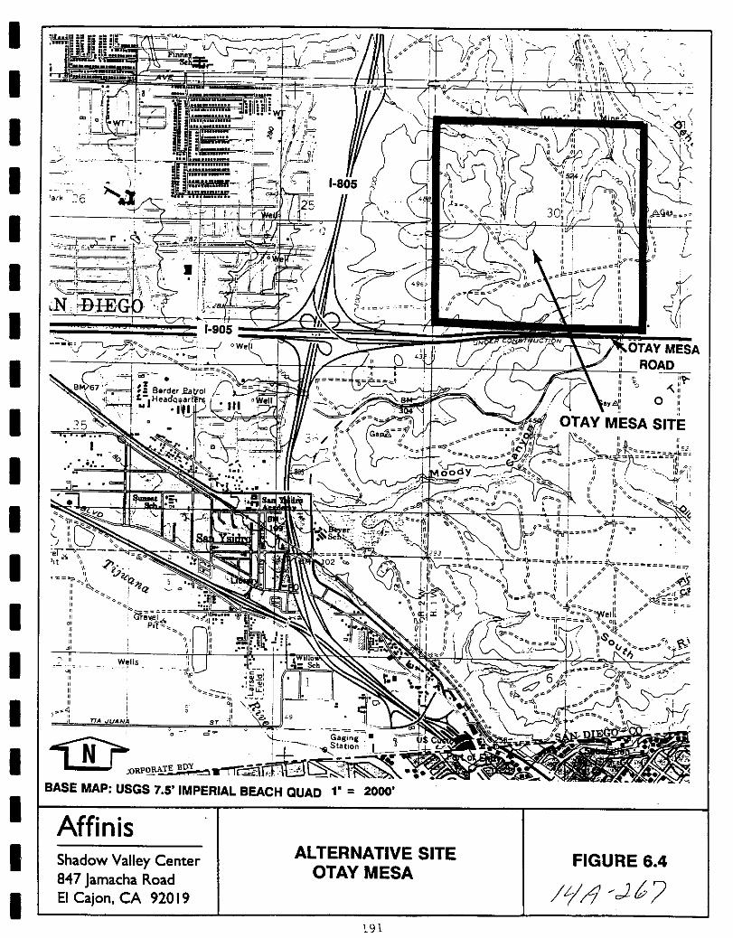
I
I
oU v
i 1Fi Ii JnneI C o
I
4
i1
Vl ir
t19
I fnIii r
iCli wri L
I Vv
w
1trJI
1 111
II 1
X
ffi
Lj
7J
I
Iark 6
I
I
I I i 905
r W Ie
jo t
k
0A
o
I
III II
J l5i
c I1 II It I FIII 1111 iI
I II III II
IIII
IJ
I l
I
I
I 7 II IIS Sch0
II
I
TA JUANA
d
I l teeLlJ oRPORATE B Y nFi
BASE MAP USGS 7 5 IMPERIAL BEACH QUAD l 2000
I Affinis
I Shadow Valley Center847 Jamacha RoadEI Cajon CA 92019
ALTERNATIVE SITEOTAY MESA
FIGURE 6 4
Il c1bI
191
192
1l Ui

I
I
I
I
I
I
I
I
I
I
I
I
I
I
I
I
I
I
I
City s General Plan and Otay Mesa Community Plan cumulativeimpacts would probably not be significant
Bioloaical Resources Biological surveys of this area have beenconducted for the California Terraces project While much of thisparcel has been heavily disturbed by agricultural and off roadvehicle activity it still supports valuable wildlife habitat anda number of sensitive species Coastal mixed chaparral coastalsage scrub and vernal pools have been mapped on this parcel anda number of sensitive plant species are known from this parcel Of
particular interest is the little leaf rose Rosa minutifolia R ED Code 3 3 1 present in California only at this site Sensitivebird species known to use the site include the Californiagnatcatcher cactus wren and Cassin s finch and the San Diegohorned lizard has been found here Thus development of the
project on this site would likely result in significant and
possibly unmitigable impacts to biological resources
Cultural Resources Cultural resource surveys and site testing onthis parcel have been conducted Several significantarchaeological sites are known to occur on the flatter portions ofthe property some of these have been undergoing mitigation inassociation with the California Terraces project At a minimumthese previous survey and testing reports would require reviewprior to evaluating the extent of impacts to cultural resourcesfrom project implementation on this site
TransDortation Primary access to the project if developed onthis site would probably be via Otay Mesa Road The project would
generate fewer ADTs than that assumed under the existing GeneralPlan and Community Plan designations but a site specific studywould be required to determine the significance of any trafficrelated impacts
Noise The Otay Mesa site is subject to noise from vehiculartraffic on 1 805 and Otay Lakes Road Additionally the site isaffected by air traffic from Brown Field located approximately 0 3miles east of the site Previous studies of noise impacts for theCalifornia Terraces project have identified significant impacts Asair traffic increases at Brown Field and the possibility of a
regional airport facility at this location continues to bediscussed future noise levels may increase dramatically If the
project were constructed on this site further study would be
required to determine whether site specific mitigation measures canbe developed to reduce these impacts to below a level of
significance
Land Use General Plan Zonina The proposed density for the project4 6 dwelling units would be consistent with the San Diego General
Plan s and Otay Mesa Community Plan s land use classifications forthe property Like the proposed proj ect this parcel would requireannexation to the City of Chula Vista and LAFCO approval would be
193
JtJ 2
required The ramifications of annexing this parcel to the City of
Chula vista and deleting it from the City of San Diego have the
potential for more significant impacts than those associated with
annexing a parcel from the unincorporated area however
communitv social Factors and Communi tv Tax structure Impactsassociated with development of the proposed 350 unit project on
this parcel are expected to be similar to developing the project as
proposed and no significant impacts would occur
Parks Recreation ODen SDace As with the Otay Ranch alternativeopen space would be increased substantially if the project were
implemented on this parcel and this site could also potentiallyprovide park land for other adjacent development However it isanticipated that steep slopes and biological constraints would
require the preservation of much of the natural portions of the
site
Public Services and utilities Impacts associated with prov1s1onof public services and utilities to this site are expected to bethe same as those associated with the proposed project
Public Health As with the proposed project this site is subjectto impacts associated with electromagnetic fields due to thelocation of overhead transmission lines although it is not
possible to determine the significance of these impacts Howeverthe issue of airport safety would need to be addressed if the
project were constructed on this parcel
In summary if the Otay Mesa alternative site is chosen impacts totraffic community social factors and tax structure and publicservices are expected to be similar to those which would occur withimplementation of the project as proposed Fewer impacts wouldoccur with respect to parks recreation and open space Howeverit is anticipated that impacts would be greater to geology soilshydrology water quality groundwater landform alteration andaesthetics biological and cultural resources land use generalplan elements and public health Thus this alternative is notconsidered to be environmentally preferable
64 3 Eastlake Vistas and Woods
This 500 acre site is composed of two parcels north and south of
otay Lakes Road and west of the Lower Otay Reservoir It is in theCity of Chula vista s Eastern Territories and is the easternmostproperty within the Eastlake Planned Community The property isproposed to be developed as the Eastlake Vistas and Woodsresidential neighborhoods
194
1 2
I
I
I
I
I
I
I
I
I
I
I
II
I
II
I
I
I
The site is currently vacant with development existing to the eastand approved to the west The future extension of S R 125 is justover one mile west of the site
site topography is characterized by rolling hills which have beenshaped by past plowing and disking associated with historical dryfarming Elevations range between 600 and 700 feet MSL on thenorthern portion and from a low of 484 feet MSL to a maximum 623feet MSL in the extreme southern portion Salt Creek an importantbiological and aesthetic resource is located on site
Geoloav soils This site like the proposed project site and otheralternative sites is expected to be susceptible to regionalseismic hazards Several ancient landslides and possible landslidefeatures have been found on this parcel and there is the potentialfor liquefaction in localized areas of alluvium A site specificgeotechnical study would be required to determine whether
significant geology and soils impacts could be fully mitigated
HYdroloav Water OualitY Groundwater Impacts similar to those
projected for the proposed project site and the other alternativesites are expected to occur on the Eastlake vistas and Woods
property Additionally Salt Creek flows south on this parcel theenforcement of NPDES and State Water Resources Control Board
regulations would be required to prevent additional urban
pollutants from entering Lower otay Reservoir and San Diego BayIt is possible that mitigation could require alteration of the
drainage pattern requiring at least State and possibly Federal
permits the feasibility of this would be evaluated in sitespecific hydrologic studies
Landform Alteration Aesthetics Like the proposed project sitethe topography of this site is characterized by rolling hills and
significant landform alteration impacts would be anticipated If
implemented on this parcel the project would be required to meet
guidelines for Scenic Highways due to the Scenic Roadwayclassification of Telegraph Canyon Road otay Lakes Road and EastH Street Proctor Valley Road
Air Ouality Because this site is near the Telegraph CanyonEstates site air quality impacts are expected to be the same asthose resulting from the proposed project
Bioloaical Resources Like the proposed project site this sitehas been heavily impacted by agricultural uses and thus impactswould not be as significant as those on the otay Ranch and otayMesa site However if hydrologic impacts on Salt Creek are
significant biological impacts could also occur
CUltural Resources Environmental review of this site for the
Eastlake vista and Woods project determined that cultural resources
were present It is not known at this time if these sites have
195
fJ 271
been tested for significance or if mitigation is requiredAdditional study of impacts of the proposed project on knowncultural resources would be required to determine if significantimpacts could be fully mitigated
TransDortation Primary access to the project if developed onthis site would probably be via Otay Lakes Road The proposedproject would probably generate fewer ADTs than that assumed forthe Eastlake Vistas and Woods project thus significant impacts maynot occur If this site is selected supplemental traffic studieswould be required to assess the compatibility of the proposedproject with the other uses proposed for this site to determine ifsignificant effects would occur and what type of mitigation isrequired
Noise The project if developed on this site would be exposed tonoise from otay Lakes Road and East H street Proctor Valley RoadIt would probably not be affected by noise from S R 125 Thusnoise impacts would be reduced if this alternative site isselected
Land Use General Plan Zonina The proposed density for the project4 3 dwelling units would be consistent with the land use
designations for the property Because the project has beendesigned to be compatible with the existing development atEastlake its implementation on the Eastlake vistas and Woods siteis not expected to create significant land use impacts
communitv social Factors and Communi tv Tax Structure Impactsassociated with development of the proposed 350 unit project onthis parcel are expected to be similar to developing the project asproposed and no significant impacts would occur
Parks Recreation ODen SDace As with the otay Ranch alternativeopen space would be significantly increased if the project wereimplemented on this parcel and this site could also potentiallyprovide park land for other adjacent development Fewer steepslopes and biological constraints would allow the development oflarger areas of park land on this alternative site
PUblic services and Utilities Impacts associated with provisionof public services and utilities to this site are expected to bethe same as those associated with the proposed projectPublic Health No significant impacts to pUblic health areexpected to occur if this alternative site is chosen
In summary if the Eastlake Vistas and Woods alternative site ischosen impacts are expected to be approximately the same as on theproposed project site for landform alteration aesthetics airquality traffic land use community social factors and taxstructure utilities and public health Impacts related to noise
196
t4 c172
I
I
I
I
I
I
I
I
I
I
I
I
I
I
II
I
I
I
and parks recreation open space would likely be reduced Howeverthere is the potential for increased impacts to geology soilshydrology and biological and cultural resources although thesecannot be quantified without additional site specific studyTherefore at this time this site cannot be designated as an
environmentally preferable alternative
197
il 7
THIS PAGE INTENTIONALLY LEFT BLANK
198
Jrl 2 71

I
II
I
II
I
I
I
I
I
I
I
I
II
I
II
7 0 CUMULATIVE IMPACfS
Section 15130 of the CEQA Guidelines requires that significantcumulative impacts be discussed in EIRs but the discussion neednot provide as great detail as is provided of the effectsattributable to the project alone The foregoing issue analysesinclude discussions of cumulative impacts where appropriatetraffic air quality this separate discussion is intended to
provide the reader with a regional context for evaluatingcumulative effects
CEQA Guidelines provide options for cumulative analyses These caninclude a list of past present and reasonably anticipated future
proj ects producing cumulative impacts or a summary of
projections contained in an adopted general plan or relatedplanning document This analysis includes residential projectswhich have been proposed and approved in the vicinity of the
Telegraph Canyon Estates project Figure 7 1 and include
1 Salt Creek Ranch
residential projecthas been certifiedTSM is pending
a 1200 acre single and mUlti familyThe GDP has been approved and the EIR
Approval of the SPA is complete and the
2 Salt Creek I a 124 acre project single family portion isunder construction and the mUlti family residentialdevelopment is pending construction The condominium portionof the project is still pending approval
3 Rancho Del Rey I a SOS acre single and mUlti familyresidential with industrial park and commercial facilitiesThe residential portion is SO complete and the commercialarea is already graded and partially developed
4 Rancho Del Rey II a 192 acre single family residentialdevelopment currently being graded for construction
5 Rancho Del Rey III a 206 acre single family residentialproject Grading is pending per completion of mitigationmeasures currently being implemented
6 Eastlake III Eastlake Woods and Vistas a 1000 acre
residential and commercial project also including the OlympicTraining Center OTC The GDP has been approved and mass
iiiiihii iiiilii I
a athfee TJ d1 truction I
7 Terra Nova Woodcrest a 26 acre single family residentialdevelopment is under construction
199
iJ 7J
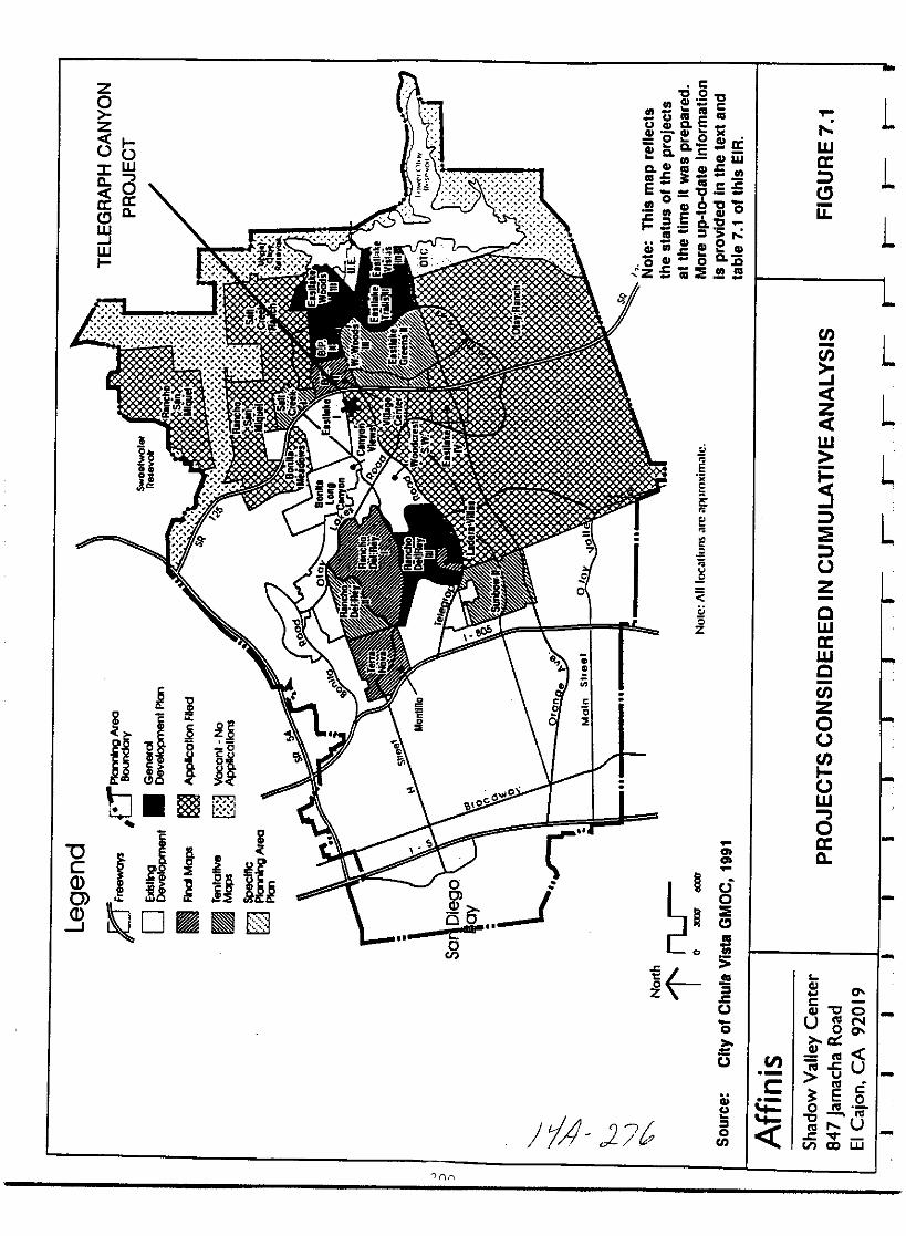
zo
z
tSt3cWc 3
aa cCWJW
0cQ0QJ
c i
J B
nbiUtJ B
2
fiifbUQD 8
ro
l ioL
oCI
0
74 J7tlnn
CS C
fII caCnU eca
Qo Oa
liiiQc 9cuw
a CGCDcfllca caE a5
06fIICD QlO
a 9 2CD
10 c c 0
c0 CD 0 Qcz 5 ii E S
1E
E
e
I u
S2
6Z
Cl
o
Cl
a
2oUl
en
s
wa
u
1
1
1
en
en
rzrw
E
oz
cwawc
enzooen
ow
oac
L
L
L
L
L
2l l7CGJ OU N
exl7
GJIIIIllcU
E 5o III
Ill
lll UrIn CI UJ
I
I
I
I
I
I
I
II
II
I
I
I
I
I
I
I
I
8 Sunbow I single and multi family is already completed SunbowII is a 602 acre single and mUlti family development withcommercial facilities The TM has been approved and
mitigation is currently being implemented
9 Eastlake Greens a 1228 acre single and mUlti familydevelopment with commercial facilities is already approvedResidential portions of the residential project are
constructed and the commercial portion is being reviewed
10 Woodcrest Southwest a 19 acre single family residentialproject is currently under construction
11 Rancho San Miguel a 2590 acre single family development withcommercial facilities The GDP approval is pending
Environmental documents have been prepared for each of these
projects allowing quantification of some data for comparativepurposes Table 7 1 Other large scale projects such as otayRanch will also add to cumulative impacts in the area if approvedHowever these projects are not included in this analysis becausethe environmental documents have not yet been completed and dataare not available
As shown in Table 7 1 the combined traffic from all these projectsis projected to be 286 373 ADT The proposed Telegraph CanyonEstates project will add an additional 3500 ADT representing 1 2of the total trips All of the projects including the Telegraphcanyon Estates project have been included in the Eastern ChulaVista Transportation Phasing Plan ECVTPP and the environmentalanalyses have concluded that traffic impacts can be mitigated and
acceptable levels of service will be maintained
The projects shown in Table 7 1 will generate an estimated 5 259
elementary school students and 5 729 secondary school studentsThe Telegraph Canyon Estates project will generate 105 students toeach district representing about 2 0 of the total elementaryschool and 1 8 of the total number of secondary school students
The larger projects including Salt Creek Rancho Del Rey Eastlake
III Sunbow Eastlake Greens and Trails and Rancho San Miguelhave included school and park sites in the developments The
remaining projects including the Telegraph Canyon Estates Projectare required to annex into a Community Facilities District CFD to
fully mitigate impacts to the school system
Air quality data are not available for all of the projects in thearea and therefore it is not possible to quantify the cumulativeimpacts The air quality analysis for the Telegraph Canyon Estates
project has concluded that the project is expected to contribute0 009 of the basin wide reactive organic gases 0 025 of carbon
201
4 277
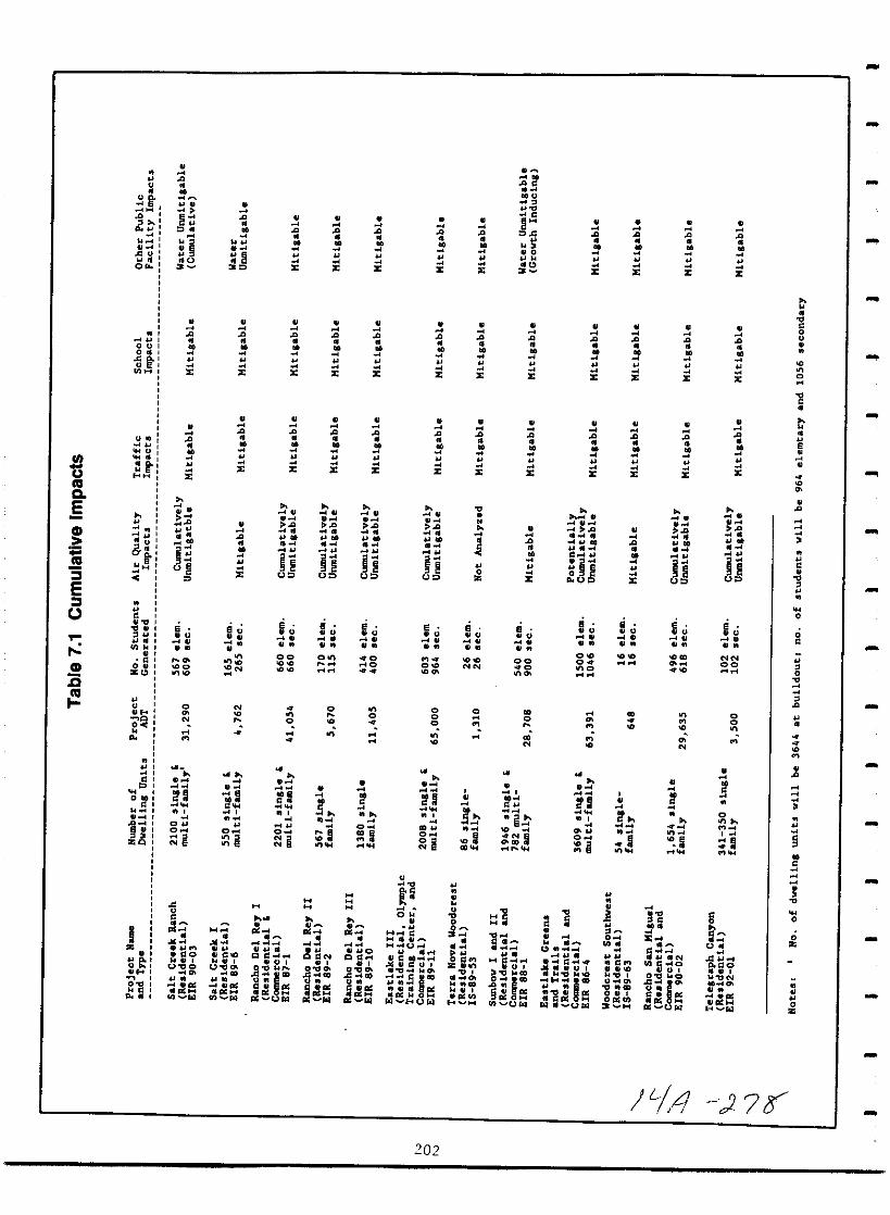
IIIQ
5Gl
III3ECJ
Gl
co
05
o
3
Ie
0
01
oo
a
u
C G
III I
Ill
6u
iu
z
z
01
u
B u
2
II
O
la
a
z
z
z
cl 04
00
iu
z
z
z
Hu
e
00
o
H
O
la
I
0
z
z
z
nu
e
0
o
I
rai
o
8S5 e
1
nu
e
00
I
O
I
z
z
z
o
C
u
C170 0
ifI cC
l UW
IS
O
a
z
z
z
U
e
0
ooo
oO
o
iI
z
ll
0
z
z
z
o
cUUI
110
i0 u D
r3 eu
lBu
II
O
a
z
z
z
iu0
o0
AO
00
iu
I1
z
z
z
z
I
I
nz
g C NCIl jQ
00 0
ig llC0
D Ull
z
z
z
nu
nu
z
e e
00
z
8o
e
0
II
OO
o a
0
u o
0
z
z
N
o
e u
000
oo
o
z
8
e
io
1
o
u
0
00
o
ijlIta
I
c
tl I
goICIOIHl
CIl Ufol
o
o
o
o
o
o
J 4 J 7Y
202
I
I
I
I
II
II
I
I
I
I
I
I
I
II
I
I
monoxide and 0 013 of nitrogen dioxide The environmentalanalyses for the other projects listed in Table 7 1 concluded thatcumulative impacts were unmitigable for Rancho del Rey III andRancho San Miguel and potentially cumulatively unmitigable forEastlake Greens and Trails
The analyses of public facilities for the 11 other projectsdetermined that the projects provided adequate public facilities tooffset increased demands for services The Salt Creek iAUijproject includes 31 acres of park land and a fire stationandneighborhood and community parks are included in the Rancho Del
Rey Eastlake and Rancho San Miguel projects As discussed inSection 4 12 of this EIR the Telegraph Canyon Estates project willmeet its parkland requirements Ily aeaieatia1l af park la1la a1la bypayment of in lieu fees Funding for increased police protectionwill come from assessed property taxes
The environmental analyses of two of the projects included in thecumulative analysis Salt Creek I and Sunbow concluded that
unmitigable impacts will occur with regard to regional water
availability from increased demand and drought conditions at thetime The proposed project includes a system to use reclaimedwater for irrigation and has received a water service availabilityletter from the OWD therefore it will not contribute tocumulative impacts
203
t1 J 7

THIS PAGE INTENTIONALLY LEFT BLANK
204
F 4 0
I
I
I
I
I
I
I
I
I
II
I
I
II
I
I
I
I
8 0 THE RELATIONSHIP BElWEEN LOCAL SHORT TERM USES OF MAN SENVIRONMENT ANDTHE MAINTENANCE AND ENHANCEMENT OF LONGTERM PRODUCTIVITY
section 15126 e of the State CEQA Guidelines requires anassessment of how a proposed project will affect short term use ofthe environment at the expense of maintenance of long term
productivity as part of the discussion of environmental impacts
The proposed proj ect would convert the vacant parcel to a lowmedium density residential development The proposed placement ofsome areas of the parcel in open space would afford a protectionnot presently in place Conversion of the land to low mediumresidential uses would likely preclude its use for any other
purpose in the foreseeable future The project area is likely toremain residential once converted
The project has been proposed by the applicant at this time becausemarket analyses indicate it would help satisfy a type ofresidential market demand that currently exists and that willcontinue to exist in the future
205
J j 2
THIS PAGE INTENTIONALLY LEFT BLANK
206
01 JJ 2
I
I
I
I
I
I
I
I
I
I
I
I
I
I
I
I
I
I
I
9 0 IRREVERSIBLE ENVIRONMENTAL CHANGES THAT WILL RESULT FROMTHE PROPOSED PROJECT
sections 15126 f and 15127 of State CEQA Guidelines require thatEIRs address the significant irreversible changes which wouldresult from implementing a proposed project if the project would
require the adoption amendment or enactment of a planpolicy or ordinance of the public agency
require adoption by a Local Agency Formation CommissionLAFCO of a resolution making determinations or
preparation of an Environmental Impact Statement pursuantto the National Environmental Policy Act of 1969
This section is required for the Telegraph Canyon Estates EIRbecause the project requires an annexation and LAFCO approval
The development would eliminate 0 9 acres of wetland habitat butit would preserve a wetland area off site It would cumulativelycontribute to regional air pollution and traffic although these
impacts may be reversible in the future if mass transit facilitiesbecome available to area residents
The existing landform would be altered for the proj ect Land
previously used for agriculture would be converted to residentialuses While it is possible that the land could return to
agricultural uses in the future it is more probable that it wouldremain a low medium residential development in the future
207
J A 2lf

THIS PAGE INTENTIONALLY LEFT BLANK
208
LI J i
I
II
I
I
I
I
I
I
I
I
I
I
I
I
I
I
I
I
10 0 THE GROWTH INDUCING IMPACT OF THE PROPOSED ACTION
Section 15126 g of State CEQA Guidelines defines growthinducement as ways in which the proposed project could fostereconomic or population growth or the construction of additionalhousing either directly or indirectly in the surroundingenvironment It is considered in two areas onsite on the
proposed project proper and off site in adjacent or neighboringareas Discussions of growth inducing impacts of projects areimportant particularly during the early stages of projectconsideration and approval i e annexations GDPs and SPAsCEQA Guidelines further state that It must not be assumed thatgrowth in any area is necessarily beneficial detrimental or oflittle significance to the environment
Two documents herein incorporated by reference provide guidelinesand goals against which a project s growth inducing effects can memeasured First the County of San Diego s Regional Land UseElement and Land Use Map August 1984 provides goals to manageurban growth so communities may be planned in balance withnecessary facilities Second the City of Chula vista s Growth
Management Program continues the City s efforts to create a
comprehensive system to manage future growth The programimplements the General Plan s Growth Management Element andprovides a foundation for coordinating future growth with the
timely provision of public facilities and services
Onsite the proposed project would place up to 350 residences onland that presently has no residential use As such the proposedproject is growth inducing in that it allows the additionalresidences The number of residences is within the General Plan
designations therefore the proposed project does not encourage orinduce onsite growth beyond that assumed under the General PlanThe project incorporates mitigation measures to ensure that it willprovide its share of costs associated with increased demands for
public services and facilities
Off site the project would not be expected to result in growthinducement This is based on the proposed project s geographicallocation the proposal is an in fill project and is adjacent tothe Otay Ranch
As an in fill project the proposed project is bordered on thenorth and west by residential development Its eastern border isthe proposed State Route 125 with existing development to theeast As such implementation of the proposed project would notrequire the extension or enlargement of Telegraph Canyon Road orof the storm water channel of Telegraph Canyon Creek It would not
require the extension of water or sewer lines It would not
require the extension of transmission lines or gas pipelinesExtension of such facilities can be growth inducing when the
209
ItA 277
proposed project is beyond existing facilities and implementationbrings the supporting facilities to or closer to undevelopedareas As an in fill project the proposed project would not haveto extend such facilities and would not be expected to be growthinducing
The only undeveloped land adjacent to the proposed project is the
otay Ranch to the south The otay Ranch covers several thousandacres A development is currently in planning with the City ofChula vista The magnitude of an otay Ranch Project is such thatit will define and develop its own links to needed supportingstructure including that needed for its water sewer electricitygas and transportation requirements Development of the proposedTelegraph Canyon Estates project would not be expected to have
growth inducement effects either positive or negative on the otayRanch Project
210
14 2
I
I
I
I
I
I
I
I
I
I
II
I
I
I
I
I
I
I
11 0 INVENTORY OF MITIGATION MEASURESMONITORING PROGRAM
111 Geology Soils
1 Subsurface exploration shall be performed in the form ofgeologic logging of large diameter borings in the vicinity ofcut slopes once grading plans are specifically defined todetermine if bentonitic clay seams exist and to determine ifactual subsurface conditions reflect those anticipated in thetechnical report
2 In areas of proposed fill or structures all vegetation or
other abandoned structures or utilities shall be strippedand or removed from the site Topsoil colluvium andalluvium shall be removed to bedrock and replaced by denselycompacted fill The geotechnical report concluded thatmaterials derived from the Sweetwater and otay Formations on
site will be suitable for use as compacted fill provided that
any cemented sandstone fragments found in the otay Formationare removed
3 Unsuitable fill materials will be removed during grading andclean fill free of debris and rocks will be brought inwetted down and densely recompacted Fills constructed onnatural slopes steeper than 5 1 horizontal vertical shall be
keyed and benched into bedrock
4 Selective grading for building pads and streets shall be doneto avoid expansive soils or clayey alluvial materials
5 Rock disposal is recommended to be in a non structural areawith larger rocks incorporated into lower parts of compactedfills if performed under the observation and testing by a
geotechnical consultant and may require special rock handlingequipment
6 Buildings shall not straddle a cut fill transition due to
potential differential settlements of bedrock and fillmaterials within building pads Undercuts and grading are tobe done in accordance with recommendations of the geotechnicalreport Appendix B
7 To avoid surface slope failures appropriate plant materialselections and irrigation components and design shall bereviewed and approved by the City s Landscape Architects
8 Surface runoff to natural and graded areas shall be minimizedPad drainage shall be directed to suitable disposal areas viapaved swales and storm drains Subdrains shall be placed underall fills located in drainage courses
211
1 42
4
9 Soil expansion potential shall be evaluated on a lot by lotbasis upon completion of project grading If it is determinedthat conditions are not acceptable for standard foundationdesign additional measures such as lime treatment removal
of soils or post tensioned slab foundations shall be
implemented
10 The city of Chula vista will also require detailed grading and
drainage plans to be prepared in conformance with The Chulavista Municipal Code the Subdivision Manual and all
applicable ordinance policies and standards
11 Final grading and foundation plans will include design andconstruction recommendations found in Appendix B All planswill be reviewed and approved by the city s EngineeringDivision prior to issuance of a grading permit
12 A qualified geotechnical consultant will monitor projectgrading to determine that the grading is in generalaccordance with the recommendations of the geotechnicalengineer s report If soil conditions are different fromthose anticipated modifications will be made to the initialrecommendations for geologic mitigation
13 Prior to issuance of a building permit the geotechnicalconsultant will be required to submit a Testing andObservation Report to the City s Engineering Division to
verify that all requirements have been met during projectgrading
Potential impacts to paleontological resources will be mitigatedthrough the implementation of the following measures
1 Prior to issuance of a grading permit the applicant shallprovide a letter to the City of Chula Vista verifying that a
qualified paleontologist has been retained to implement a
mitigation program A qualified paleontologist is defined asan individual with a MS or PhD in paleontology or geology whois familiar with paleontological procedures and techniques
The paleontologist shall attend a pre grading meeting toconsult with the grading and excavation contractors
2
3 A paleontological monitor will be on site at all times duringoriginal cutting of previously undisturbed sediments mappedwithin the Sweetwater and Otay Formations
If fossils are encountered the paleontologist orpaleontological monitor shall recover them If recoveryrequires an extended salvage time the paleontologist or
paleontological monitor will be allowed to temporarily directdivert or halt grading to allow recovery in a timely manner
212
Ji11 2 gg
I
I
I
I
I
I
I
I
I
I
I
II
I
I
II
II
5 The paleontologist or paleontological monitor will be allowedto set up a screen washing operation on site if necessary torecover small fossil remains e g mammal teeth etc
6 All fossil remains collected during the monitoring and salvageprogram shall be cleaned sorted cataloged and deposited ina scientific institution with paleontological collections suchas the San Diego Natural History Museum
11 2 Hydrology Water Quality Groundwater
Water Oualitv The project will be required to implement the
following measures
1 Development of the Telegraph Canyon Estates Subdivisionproject must comply with lJlapplicable regulationsestablished by the United States Environmental ProtectionAgency EPA as set forth in the National Pollutant DischargeElimination System NPDES permit requirements for urbanrunoff and stormwater discharge and any regulations adopted bythe City of Chula vista thereto
2 The applicant shall submit an erosion control plan inaccordance with city of Chula vista design standards The
plan shall be approved prior to issuance of a Grading PermitAt a minimum the Plan shall evaluate the need for and ifapplicable include the placement of sandbags temporarysediment basin s and similar measures The Plan shallinclude an evaluation of the need for an erosion controlmaintenance program if such a program is needed the Planshall include one
3 The developer shall be required to obtain an NPDESconstruction permit for the subject property from the StateWater Resources Control Board and to submit pollutant controland monitoring pla s to the Regiolal Wat r Qua X S9l nEq
Drainaae The Thresholds Standards of the City of Chula vista for
Drainage state Storm water flows and volumes shall not exceed CityEngineering Standards
1 The applicant shall submit a storm drain plan in accordancewith city of Chula vista design standards The plan shall be
approved prior to issuance of a Grading Permit Review of
plans by the City of Chula vista Engineering Department willensure the storm drain system is built to standard
213
14 2gC
4
2
specifications which will allow the water to drain to
Telegraph Canyon Creek
Standard engineering practices and adherence to the City ofChula vista Department of Engineering s grading guidelineswill eliminate potentially significant erosional impactsMonitoring will occur with review of the Grading Plan andwith field checks of the grading
3 To eliminate the possibility of silt and sediment entering the
adjacent drainage along Telegraph Canyon Road a barrier mustbe placed between the property and the adjacent drainagewayuntil 90 landscape coverage is achieved
4 The applicant is required to pay the Telegraph Canyon Drainage fee
11 3 Landform Alteration Aesthetics
The SPA establishes guidelines for architectural style and
landscaping for the project In addition
1 Grading for the Telegraph Canyon Estates project shall adhereto the guidelines of the Chula Vista General Plan Land UseElement
2 Development of the project shall comply with the ScenicHighway criteria outlined above Adherence to the City s landuse and grading policies as well as the open space easementsand landscape and design elements discussed above willmitigate landform alteration aesthetic impacts to below alevel of significance
3 The mitigation monitoring program shall entail review ofgrading plans and the Tentative Subdivision Map by the CityEngineering Department to ensure compliance with the City s
grading and design standards
The landscape plan shall be reviewed and approved by the CityPlanning Department Landscaping for each phase shall beinstalled prior to occupancy of the first building within thatphase and 100 coverage shall be achieved for groundcoverwithin nine months of planting
11 4 Air Quality
An Air Quality Implementation Plan was prepared for the SPA tofulfill the City of Chula Vista s Growth Management Plan Measures
214
FIIl 210
I
I
I
I
I
I
I
II
I
I
I
I
I
II
I
I
I
to reduce cumulative air quality impacts are limited and are
largely restricted to methods such as encouraging alternativetransportation car pools use of mass transit bicycling andwalking The project is proposing to include bus stops adjacentto Telegraph Canyon Road to encourage use of bus transportationIn addition the following measures will be required
Construction Phase ImDacts The Telegraph Canyon Estates AirQuality Management Plan will use several methods to mitigate nonresident transportation emissions
1 Fugitive dust generated by project construction will bereduced by the following
a Scheduling grading during the early spring when naturalsoil moisture is high or by importing non potable waterfor watering during grading
b Establishing an off site dust control program to keepdirt from being washed or tracked onto adjacent roadwaysperimeter erosion control truck tarping or load
watering and daily street sweeping or washing at access
points mitigated by standard dust control practicesincluding watering the site with reclaimed or freshwater prior to project grading It is estimated thatthe quantity of dust emissions will be reduced to
approximately 300 tons from 650 tons The project willstill contribute to cumulative fugitive dust generated byother area construction projects but no additionalconstruction phase mitigation will be required
c After clearing a grass cover will be grown and soilbinders will be spread
2 Off site traffic interference from construction personnel tobe reduced by providing rideshare incentives restricting laneclosures to off peak travel periods and scheduling truckaccess such that 80 percent of daily receipt of constructionmaterials will be limited to between 9 00 a m and 3 00 p m
3 Construction activities will be phased and scheduled to avoidhigh ozone days
Pro ect Phase ImDacts Because the project will not createlocalized air quality impacts no mitigation measures are requiredAs discussed above the methods for reducing the project s
contribution to cumulative air pollution are limited because the
project is residential Residents can be advised of car poolfacilities or mass transit routes but there is no method to ensurethat these options would be exercised The AQMP requires that the
project is constructed using energy conservation materials whichexceed Title 24 energy budget requirements by 10 percent of
215
14 J9
estimated use 1 and that homes are pre plumbed to encourage and
facilitate use of passive solar thermal collectors for spa or homewater heating requirements
As detailed in the AQIP in Appendix D three
involved to ensure implementation of the plandeveloper builder property owners residents
agencies
primary groups are
These include the
and government
Develooer Builder The applicant is providing the basic planningdesign and management of the program and will be responsible for
implementing community level transportation facilities Energyplanning and management will be the responsibility of the buildersconstructing the homes
Homeowners Residents The project s residents will be responsiblefor choosing their mode of transportation driving habits and
lifestyles Mode choice will be primarily influenced by tripdestination rather than trip origin
Government and Service Aqencies All project plans will bereviewed by City Staff to ensure compliance with the updated AirQuality Plan Prior to approval of the tentative map projectplans will be reviewed by City Staff to insure that the requiredmeasures can be accommodated by the project s design
Transportation control measures TCMs and development andtransportation improvement phasing are controlled by the City s
Growth Management Plan The potential impacts associated withtraffic congestion on roadways affected by the project will beassessed Any mitigation measures delineated in the TransportationPhasing Plan shall be implemented prior to issuance of occupancypermits per the Public Facilities Financing Plan PFFP
The APCD is responsible for updating the regional Air QualityPlan Because the APCD is prohibited by state law from intrudingon the land use authority of the City of Chula Vista it will bethe City s responsibility to implement the plan s guidelines whenit is approved
11 5 Biological Resources
Preservation of the area of freshwater marsh on site is notfeasible Therefore the following mitigation measures arerequired
1 The area to be lost will be replaced by the preservation ofwetland habitat off site at a one to one ratio in compliancewith Department of Fish and Game requirements
216
It 2 92
I
I
I
I
I
I
I
II
I
I
I
I
I
I
I
I
I
I
2 The off site mitigation area will be in association with alarger marsh or riparian area to encourage the establishmentof habitat of meaningful size to wildlife Because thewetland area on site is less than one acre in size it fallsunder the national permitting requirements of the Army Corpsof Engineers
3 The Applicant shall preserve the long term conservation ofwetland areas off site by dedicating 0 9 acres to the City aspart of a natural open space easement The City shall placean open space easement in this acreage which would eliminatefuture building activity and which would set 0 9 acres asidefor the preservation of wetlands off site
4 The Applicant is presently involved in the planning of theadjacent 23 000 acre Otay Ranch Project The Applicant hasagreed to place an Open Space Easement on a minimum of 0 9acres of wetland in association with a larger marsh or
riparian area in the Otay Ranch Project to mitigate thebiological impacts associated with this project to below alevel of significance
5 Monitoring of the mitigation will be done by review andapproval by the City of Chula Vista Planning Department forthe granting of the Open Space Easement Prior to recordingof the Final Map the open space easement shall be dedicatedand recorded This will be ensured through the MitigationMonitoring and Reporting program listed below
11 6 Cultural Resources
No significant impacts to cultural resources are expectedtherefore no mitigation measures or monitoring plan is required
11 7 Transportation
No significant direct traffic impacts would result fromimplementation of the project as proposed However as the projectwould contribute to cumulative traffic the following mitigationmeasures are required
1 Cumulative impacts to area roadways will be mitigated by the
project s contribution of funds toward roadway improvementscalled out in the ECVTPP The specific improvements requiredfor the proposed project such as possible roadway wideningrestriping or installation of signals will be determined bythe City of Chula vista s Engineering Department upon reviewof the cumulative impacts of the projects in the area
2 All improvements will be funded on a fair share basis amongproj ects The proj ect s fair share contribution toward
217
Icl r21
mitigating direct and cumulative impacts will be made a
condition of the TSM
11 8 Noise
Temcorarv Imcacts Because noise levels associated withconstruction of the project are considered a temporary nuisancerather than an impact no mitigation and monitoring is requiredConstruction will be limited to the hours of 7 a m to 10 p m on
Monday through Friday 7 a m to 8 p m Saturdays and Sundays and
prohibited on Federal holidays to minimize these temporary effects
Lonq Term Imcacts No significant noise impacts to surroundingareas are anticipated with implementation of the Telegraph CanyonEstates project therefore no mitigation and monitoring isrequired
The following measures have been incorporated into the projectdesign to mitigate noise impacts to the project
1 Noise levels generated by traffic on future S R 125 will bereduced by constructing noise barriers along the rear propertylines of those lots proposed within the 65 dBA contourConstruction of 5 5 foot high gap free slumpstone or masonrysound walls or barriers will reduce exterior noise levelsbetween 4 and 6 dBA in the rear yards of these homes belowthe 65 dBA threshold
All noise walls will be constructed in conformance with thedesign guidelines set forth in the SPA which follow theEastlake I Design Guidelines Materials will consist ofstucco or stone walls with plexiglass panels to provide noisereduction while maintaining views from residences
2 Typically standard construction practices for Californialight frame structures will decrease interior noise levels by15 20 dBA Thus it is anticipated that interior noise levelsof the homes on the eastern border of the site will fallwithin the 45 dBA limit required However at the time thenoise report was prepared the potential for noise impacts tothe second floors of the proposed homes which will be abovethe noise barrier was not evaluated Inclusion of noisereducing building materials such as extra insulation doublepaned glass or mechanical ventilation may be required tomitigate noise impacts for these homes No second storybalconies shall face S R 125
All noise mitigation measures shall be made conditions of the TSMPrior to issuance of building permits the City of Chula Vista s
218
JllJ JCjtj
I
I
I
I
I
I
I
I
I
I
I
I
I
I
I
I
I
I
I
Noise Abatement Division shall review final grading plans todetermine whether additional noise materials are required forsecond stories of homes which may be impacted by noise from S R125
11 9 Land Use General Plan Zoning
In order to meet the requirements of the City s Affordable HousingPolicy the applicant will implement one of the following measures
1 Dedicate a parcel off site for the construction of low tomoderate income housing to meet the 10 requirement
2 pay in lieu fees to the City for the construction of low tomoderate income housing to meet the 10 requirement
3 or provide a parcel which partially meets the 10 requirementand pay in lieu fees to meet the rest
Proof of provision of low to moderate income housing shall besubmitted to the Planning Department prior to approval of the GDPSPA and TSM
1110 Co unity Social Factors
No significant social impacts are associated with this projecttherefore no mitigation measures are required
1111 Co unity Tax Structure
No significant net fiscal impacts are associated with the
implementation of this project therefore no mitigation measures
are required
11 12 Parks Recreation Open Space
1 In order to provide full mitigation for impacts to parkfacilities the applicant shall pay in lieu park fees inconformance with section 17 10 of the Chula vista MunicipalCode
2 Prior to or as a condition of the TSM Chula vista City staffwill need to ensure that the conditions for the proposed parkshave been implemented and all fees have been paid
219
i I r 97
Schools The Chula vista School District has indicated that a new
CFD will be created for the Otay Ranch project As the proposedproject will precede the otay Ranch project the District hasindicated that it will go forward with the CFD to allow thisproject to join first and then otay Ranch could followAnnexation into the CFD will fully mitigate impacts to the districtProof of payment of fees and annexation into the CFDs shall be
provided to the City Planning Department prior to approval of the
11111111111 nJl
Police Services The hiring of 1 4 additional pOlice personnelwill mitigate the potential impact of i e ficient policeprotection below a level of significance This gjdll be financedthrough the projected yearly net income from tniproject
Fire Protection Impacts incrementally created by this projectsuch as the need to construct additional fire stations and thepurchase of additional equipment will be mitigated by the projectedyearly net income and the project s contribution to the city s
Development Impact fee
Water
1
2
l
iJ3
4
11 13 Public Services and Utilities
Prior to the recordation of Final Maps the applicant shallobtain will serve letters verifying that water facilitiesproposed shall adequately service the project via approval bythe OWD of all plans and specifications
The project iI fbill also be required to pay Central AreaReservoir Fees
In response to regional water shortage the Telegraph CanyonEstates project proposes additional conservation measures forindividual households including use of ultra low flow indoorfixtures and appliances low flush toilets showers andfaucets and pressure reducing valves
Landscaping will feature drought resistant plants which willbe drip irrigated and principles of xeriscaping mi beapplied
While reclaimed water is not currently available for usewithin the proposed project the project is providing a systemto use reclaimed water irrigation when it becomes available Inorder to connect to the 20 inch reclaimed water line built forthe Eastlake project the applicant shall either install theline across project frontage or pay a proportional share ofthe line as determined by the Otay Water District The size
220
JiJ J 9
I
I
I
I
I
I
I
I
I
I
I
I
I
I
I
II
I
I
of the line will be determined by the City of Chula vista andthe OWD
is If potable water will be required until reclaimed waterbecomes available projected in mid 1992 all water linesshall be planned to avoid future cross connections All waterline connections have been detailed on the TSM and will beinspected and monitored during project construction by the
City s Engineering department
Sewer Service Monitoring of the project development willdetermine whether or not mitigation is required If the TelegraphCanyon Estates project is developed while there is available
existing sewer capacity there will be no adverse impacts and no
mitigation or further monitoring is required
However if monitoring determines inadequate sewer capacity withinthe larger drainage basin then mitigation will be required andwill consist of
1 The developer shall be required to construct project specificsewage system improvements
2 The developer shall also be required to contribute toward thecosts of any monitoring and to construct or contributetowards the costs of constructing any required trunk sewer
improvements in proportion to the development s flow with
respect to the cumulative waste water flows generated by new
development within the Telegraph Canyon basin
utilities Mitigation of utilities impacts will be ensured
through the MMRP by requiring the project s contribution in the
City s Development fee
1114 Public Health
No significant impacts have been identified thus no mitigationmeasures will be required However the following mitigationmeasure is recommended to reduce the potential to EMF exposure
1 The project applicant shall comply with any future policyadopted by the City of Chula vista prior to consideration ofthe Final Map
221
ifl 27
THIS PAGE INTENTIONALLY LEFT BLANK
222
iJ 1
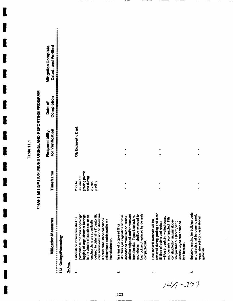
I
I
I
I
I
I E
II
IcJ0IIIl
cJ
IziII0IlW
IIIQ
c5
I II Zis it
gI
z0E
Z
I0
cJE
IE
tII
IQ
I
II
I
I
IIIIIIIIIIIIIIIIII
D II
lElICo
Eouoac
c
0
iag
iQ
co
OiQ IIE II
Q 0U
5au
e011CoOJ110
11
II
EIII
Ei
OJ
JOJ
IIEco
ig
i
II
io
m10
w
o
Q1iio
81l0
o CCel
a cncac 6
gena u
Q g o ErnC6 SGiC5100
0O OCl wE c
ct QiQ Iiio CCc 0
1G g t 0 ciEEU Q
lP 8IDO Cl ECQ i32
IiiHo OJ ll liiaQ Em jC w @
J io Q iii
5 E g iI as gIIo za c
I g Egi 8 l i i 2en Q s IC C 1lt
i
ili iESs I Cl Cll
o g ilo 5 C
o 0oo lIlo
5 i0
fl D ij
il 5i5 ij oj E
oi iiLi lii
iufig 1iSZiiiE E
s gliio8
cO
223
JQ U
c ou llc C Q Gl
i2 c
CleQ uUO
ij 5 1li lj ilGiec a Ioc
IC Ill cSa E gE c
C
Eilc o igo lii lje15 Q s
Q0
gio uJl i
F sili1li10 og0P D
Cl lIicaoc c oasorn0
J2a mc 05s ca
scO
0c
acc
l 0
OJii5
1liil il
Jj h
JLJ 2

0saI
a C
E a
0uo
c c
0
ili01 a
1j0
C0
05a c1jE0 0
uij
U Et
i il lc t 02 0
en 0enil1j en
cg C 11 ii j gliC C 0 Ei50 a c
S enCo wIII W wlXla 0 0 0 ga 0 0
a en en en
E g5 i at EE 50 Q C o en l 0c
cQ a E C Q C I C Q CcC 08enI g g g J U sgS6U i aME Cd 0 Q cuc Q csOJ O OJ fC l K
01i if l if C iQ ifa C ca c lc
0a
c
coU
I
IIIIIII
a
co
i01
e
ij8 I Es g 09ilslL g
cc Q c C
iij Eg liiEe o O
ElBsim5 iOacc c
i giililC crlc Etj l 158
ll20i2ih U
gSSejg580g il og
a E 25
ori
1i8
lj1ftcaSii Eggfl
Q tJO al Sicti 5o
jgijilcnoe8 J50 cj CLI
CC
Sci5 QallDo sgiicJg cmEen i E
siEe 1i E t0
00 0SC i f glXl II ent
ci
ecQ C
l QCd fi
0U
l CQ QJ2 C1
ilSaieQ 16 ca ec cn et
oID
o CnlI ii i11
j8j c
c 15 i IloQ IIs f
ii 8 l gc i8S
224
en
l E lis 0
e CE I0 22 0 0 I
olfCt c ei Jsi lii8u1 iil illl
ca E Ci I0 m Oc
o lSEiln c
iie
iii5 co cniB5 iiEP l
ril ril
00
8 c
Q Jt ggg CDa2 Q Ja a1i fd g Ci I 0cci5cnS
E g Joc0 D tJ 0 J
nl5i IIl 2G c gEO G
oc 5e8Sil mijc 0C
cca o i2co SEic1i00C i gE2Eiiillj c
r i5 hJHcaEQjU0G 0CG
cllii8 lllJigais
LA r 3CJ

I
I
I
I
I
I
II
II
I
I
I
II
0
I c
0
Ic
I
I
0
ale
o0
C C
o
iu01
10
IE
co
Iiia
o g
gi
auiiC10
a
0a
e
iej
IEco
i01
eIE
io
W
o
0o
Sos cn
g 8 jD asoa
III
IIIIIIIII
iDcilt Qlvil E
0 EI t o8 QC
iIccoa 5c 0 cas u as aI en
0
l E oiiC
cnt CE Cfil IO IiiC as lD
EiOJ 05 c
Oi oSC
0u
I 6 Iii0 00 tIII
J C CIl aIT St 01C 0
IIIII
o
150lil0
1lg
WID
o Iii
00
0
sC CDJa Q
aiij
EJi 0
SS IDo g lS
02 ii1i o
82
gigIl
o
Xle a8Bi
u 1 E
ja
06
n5 ilW ilOod
geo
l0
o 00
0a s CD
1 6 E lC 20C1l Xl
oga llue
1J oo oE iic 0
is Q QJ
il6l 1lEC E E
2 1G ogCJ oEEllE gaf
dl5 l Egct 8c 8
oJ
O0
0
asag sl1 22 c
l
8 iigi g
CII s
c cW r
s CI E l2II Q
Ib ca CJ
o lIS Q 1ii e5
gst1ccn5 Eil S lil S 1ft
2la 1lc c 2CD I Q 22
i1it Cs
225
2o
1l5W
o
od
6o
ol
0000ic0o
en l 0
if 22 C5
iJI
Iil
o
ii i
8G E
ECI
cu
Psg0
152saJ2a
G 1ijOllS
ll0CD
Q crlas
0E8 ii
oiiitE
f 1200
uC lii Eil38iilQ8is
llo x
oiElItJ
il E Iii8g g
oJ
Iii0
0
00E
1JIi2aS
fieBi
ge0
s
l0
0ell a i
ll Ifl
0 E 0o
tJlCI U
ell sEJl
agooii g
e i5eii3
e 1tJll9tJ OJ
sm eIll ECI J2 g
iii C
liia j
tA OA
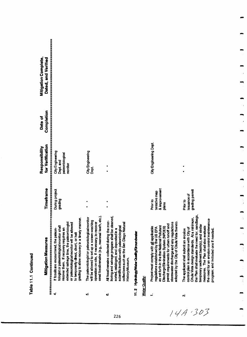
0CD
CD
aE
00UcISi
CD
QE
co
SiCDii
8U
ISi
c uIi II
C C IIo CD IIClVICD 0
tt
0CD
C0CoU
CD15
0
ij 0
5 O
iE IsW 2e
B
CD
EII
iiEi
tl
200
O cCC C
I00
0C
C
5C
w
0
5 ti0 l
S E mE j 6i0
o l
g sI0 Ql iEE IIIg1ij 0o dl
II
2 wt en
g a jQi 1iis c1
000 cCIl aI 0 0i3Q0
06o EOct
ifell
1 3Ql
CIICIf 4c E
og ilS il5 en
II
i5CEojlcil t 8 8
e1JEQ C
o Q ca c enucntioCG
alQ EgEgiil1i I VI
0 CU3J
Ii 0 aEcnc n
e e m igiR8r
226
III Il
o0C
c
5cw
o iU
s E1
0 c
C ii IIQ ocs c
0CCl
Ji c cCi igca w J5 I
BW2o o
OlLlJ8 o 2
1ij C
iil 15 6
J i Jc
D Gi iOi CD l DOcco P
Q E iilcc Q o
85 0ft r E ili
0
lIE aoO I illliil LaJCf uEl op Ill sCIL as C c II ca
E0
0
000ccls i5
IQ cn
0
11 1lEC c
Cas Ql
o E lllE iiE o EtIll
ent 0 ttI as
OO i Em 2fio eccl u as CI t
CD i E IIUa E CIIt BalQ i oc
E5g in O
gas fIl 2i8
en al c en 0
1i u i if fi5 co or ii Q II S
stD CJIllCccCa c
s ctiE III
1ie cll lligl iilcotDCEQ lBG o80 E c
VICD
IVI
CDEco
i0
i
iiiU C
C
tD ic2 E
00
G llJ1 ii ii8j 2x
C I a
s 1c is
l 2
tf8 B giil
C
8 E iECI en 0 Io icosu 16C2c OJ
g H0 SC ot
G O Cl
N
LA JIJ
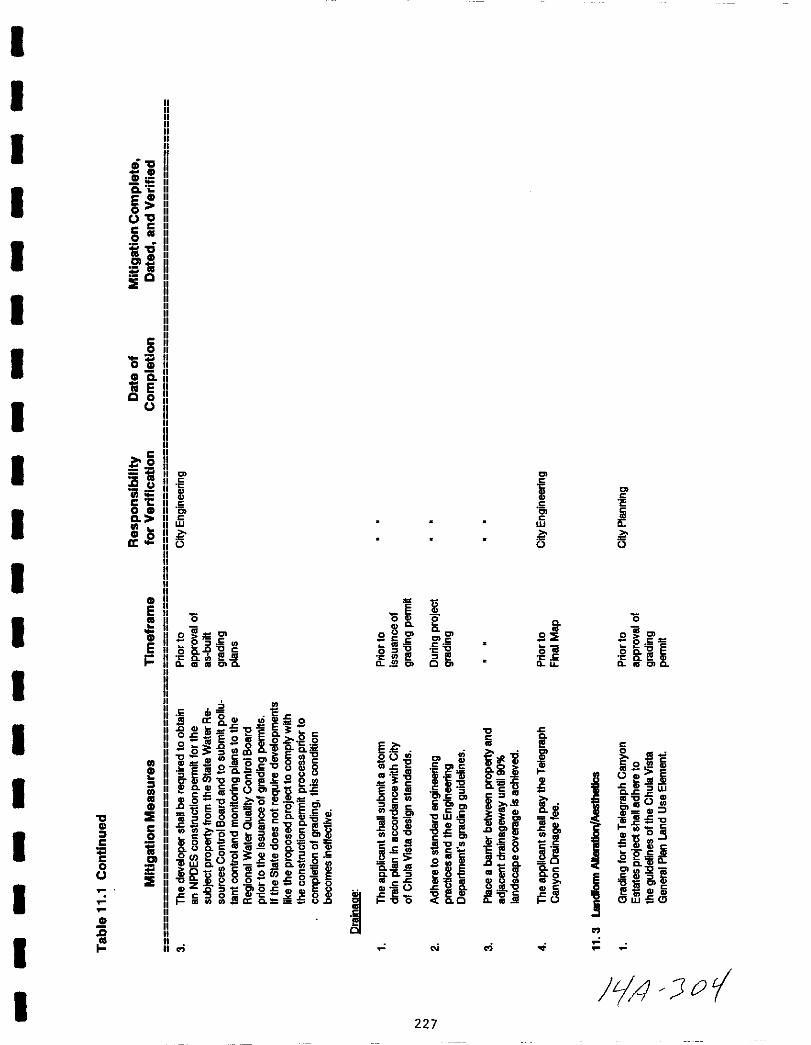
I
I IIIIIIII
IIIIIIIII
aIIIIII
1S
Ia i
E0
0
C C
I0
ioCl 1Il
1ilQ
IE
Ic
I0
OtIII a
Ig
Ic
IIg II1il II
JlU
11ii5 IIc I e 1
Io III 5 IiiCo
W W
III 0a
I III
III IIIIE II
oII
0
III II e c
0II ii 01 o8 c 101II S S SII eoE en ol
E II l a C li eiQ qC I l C0 0
i II Q wl lI 1 CI l I if c 1II III III C1Q a 2 01 0 c
IIIIIIIIIII
cbII 5Jl
II S a GI uii i oII
Ic CD m 5c E C
o eoiQ 010 III 8 0 I 0
E0 g CI m Q 1 Q evi i l I g SC CI ii CI C o
iiSQ gEc818 1ii E S553III l ilI CClIC O
c
Il j
I g e8 ii K 36 iE1l
c u s QI W
0 il lC CD
III Q Eg 5 en iB ii5 JIl
a IE 2i p g Kf j J CD
iioiCw ii C
CC
0 l
I0 i CO i 8C l 1 cno3
c llg gliillo3 l2i S ll 8 E sll0 i Q Q I 2CQ uO i5
SC0 e8ip 0 2 5 en 1 r B I
c Cl 1 0 1 0 ii 0 e K0 iiW c 1iJ C 1l isl l c g cn2
Itl 80
o E c c c o
IIE Cz oQ CD5UQ g hi cCDe
ICD cl srOl CDCDE e
gl CDi
1 IOs 1 I OCD0 iliIII cn cn a Q C c Co w5e
III elS I 0
III
NII
I f4 O
227
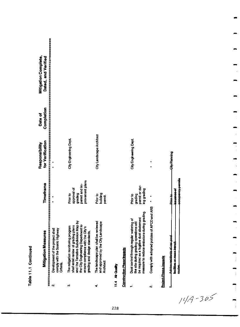
a
Soc I
E0
uac
c
0
ioCllll
1iiQ
E
c0
Oil1Il a1ii EQ 0
U I
U
g 0 0
ig u 0
11co 1Il 5c 3w w
1Il 0a u u u
1Il
E Eo
0
s
i caC liii2 1 o IC oC5 C ct 1
E ls 8 ie gi gsllQlCDQ Q llc 0 lL CJ Q E
m
0
s
o Iii I 0c i OJ E u
E en Co g en
c 3 Q C ll
asrn1iied ij Cc J 0g0
III1Il 2CJ5EOi 113o a ci1 CII lls ox cna i o65I j of e2 U ii 0
1Il 0 Iii o cnc CienS ij ia E S oQjC 3c fl g 11 1io P S1Il C E i III 0 e llIll 0s 0 c
C 0S SE a 0 en
i U cIii Ii
CJ EC g5 5 jc Cl e i ligli 211
i0
8 bcG S 0 cC eU i 11 Iii I 0
fo Q t
I a 0 Iii 0 0 s ca ue liiljljEE l1 gQ fI
l cc II Q Q Ii 008u l ca s Ii en c5 oE u
1Il
is
oi oi
1 1 J Y
228
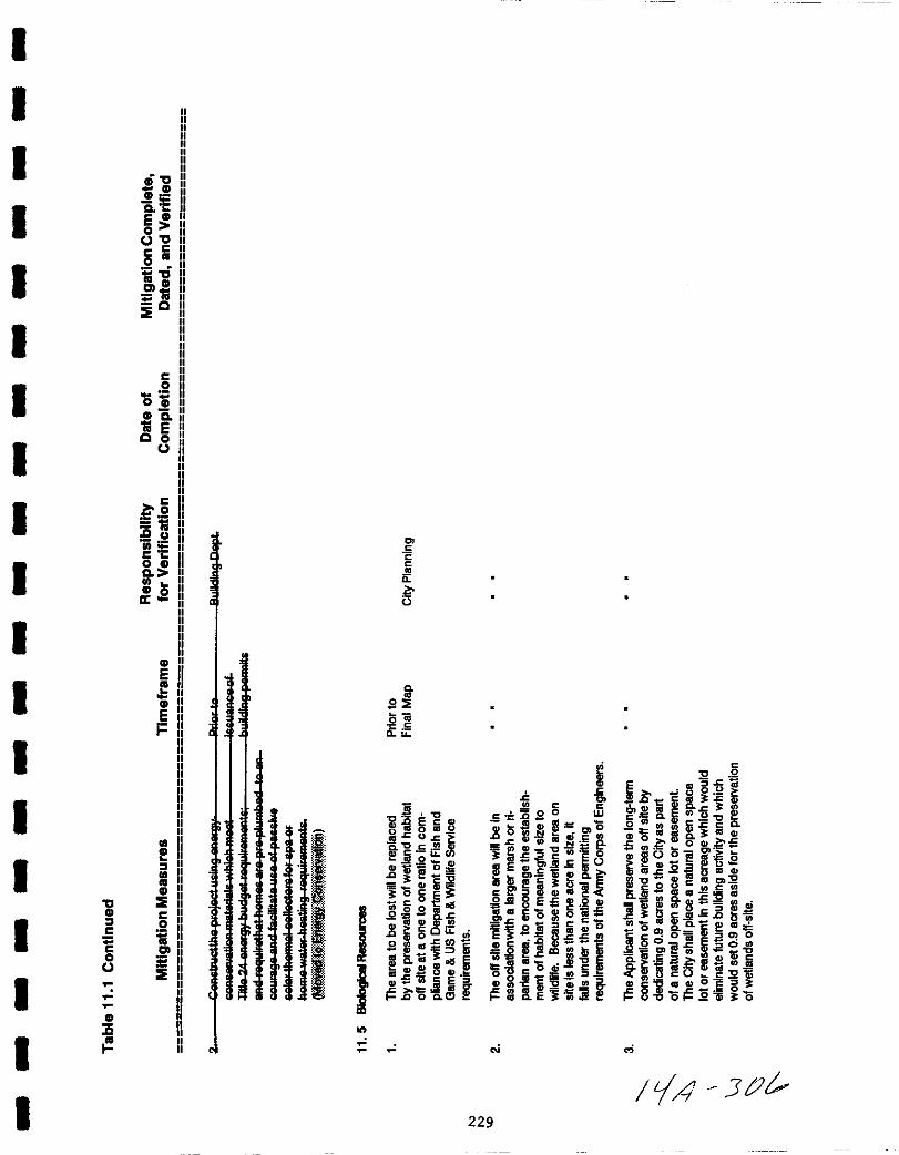
I
I
I 0CD
eg
Eo n
JOIIcello n
allca II II
t0
E
I
II
Ico
isCD at E II00
J II
Ic
2t
JI
Eo CDg
CD 0a
I
I
ICD
E
CD
Ei
I
I IIIIII
CD
I
CD
0 ECD CI 0c
ic Cll0J
E
CD II
a IIIIIIII
I
II
I
I
I1 1
IIl 0
I II
c
C
lijIi
Q
090
iil
011 e0
Gl J CGl
J 8 CO 2l c
ttg siilOtl
o1gii
oC e1 a 1
20alG l en
6Ciui
sSias ilBa il 11
Q enas
E
j liacll
on
1c c
sc 5SoQ I SGlm cnoo I IIlS3 Efl
i Ov
jEiO
h H Q
c tIGisgE5 g8CD
lGaJcoGlOa l5QcQ 0 c
a o iiCl O
Eoas lUJ lD iioc c
oo5 lCJQG CI C CD 5jl8 i6i e
N
229
c
0 2E G 5c tiS
j 1 illQ c lc a i0sz C1o 0Cf fflm s c 0
Q alIQ SQ5 en
0 5lB Oe i5
a 6iiClSc s lijotllGl
c C 8 c CO CD2Q
cCO as JQEQ cOmen Q SJ aj
DcjE st51iioCG8 c CG
5c OiiQ a o
Q cni ii iao5liJ il h
Cft cO c32m4lCiCGCI OESj 8Ooj S ii o
liA JIi

0CD
CD
aeE CD
0uO
c c0
ell CD
1iQ
IE
c0
05CD Q1i EQ 0
U
c
S 21ig u eO
OIl IHe c 5 iso CD 01
0wa
CD 0 ga 0
CD
E oII Q
oUCD
E 51 01 II
0 2 0I
lI ui 1II s gi 0 IlJ 2 Q
iQ c C 0
Q o UiOI 0 al i i0 a alof CPep c
Q F llJ2 iCD gc6itS5 OE
I ao 85 8 E 0
I CD o EII u i 5 ooCD I cp
0 IE 00 cn oC gCD c l w 8 jig en 1sJ5 Q
I 0 OC CD wen c 1 osl
C c II 1IlE
fi8gai Q lIIS cc
tEigo 0 1Il S
UCc Il SE0ciSt CIle tJo0
Q WOep c CW e GIS ce UU iii CC 1 c CD IfI o ojle sojg Q c
u c
0 oi 5cecn 0 sfnepOc U
Rto 5 Q i5 0J i5COI
CD Z
a CD
N
230
Cl
i0
1lg0
i wa
5 ga o
oQ Qc
08OCJlfClE1J E i5oC cC
g sI Iii e I0 en c Cl Q 2c
8 is c
11 009cE c
Q
c tfoc E
i caC Ee s lj E
5 c 0e
S c8icil1 0o aI C cc
Q
ti
P5hc 5a u
00lI c 150 1 0
ioQ
cp2 coa mas tC
S oS 6 I
15 2gs c
1 l52c
80ycgCI g2 ClO ttahoc
0ari CD
UQ o62e 1i1 c c Cc 2 c E
8 8 0
o
Jt J7

I
I
I
I
II
I
I
I
II
I
I
II
0CD
I c
c0
ICD
jS
I l
I
0CD
E11
E CD
00
cc
0
aIII CD
1itQ
co
05CDQ1iEQ 0
b CIII
Jl COii
c Co CD11
CD 0a
CDE
CDEi
CD
CD
c2 It1iIll II
i
c
cc
o
1c
0ii E
oagI V Ia Lc
S6i0 t
ucJ Ol
5 icnG I IIc 1o Q c S 0SOJD ooQ rn c il
cc G tn0Qje j 1 1S3 Q co oc
en 0 u
liij t
tEoils itc CI Cd S
08 uW lD III
CD Gl 1ii sE
c
c
i5lD
IIIc0
tlIl Ec c 0
cii2C 1ic 0
3cb CI gQ S2 0
g g ggug QJft
J ii 0
Il 5 ll Z odc e N
s E IlllJ 0 Eo g oa
EIlcI e Q 80
0 Eiifo6 t
3 CIlOllI cnc t
c
cc
o
i
o c
if iil
Ocgl
o
o is a
if i
E E E 0
81 0ijc 50Iii 28
c
11c
iID l c o
i 10 g 8
IIg c ijo
c Uiiic
is If c I 800 cOi lU
c
I ijg8I 1 iiiSi ac
I f0 8 0 1 0c E E oE0 0
il S 0 31 cl OJ
c
H 5 l c0 o i5O
010
l Ill Fcs il fQ lG
i c g 8 o E I 0c0
01 i N
e
IrA JtJ231
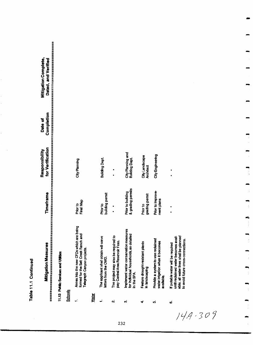
IIIIIIIIIIIII
0GlGllia
E00cc
o
iOalGlIii
0E
co
IiiGliiIii E00
c
Iiiau
iiioC Co Gla
Gl 0a
Gl
E
Ei
0Gl
5co
IIIIIII
Gl IIIIIIIIII
Gl II
Eco
ial0
i
c
c
eo
0
sC5ii
if
IIIIIIIIIIIIIII
j1
j
c
0cl c
t t
Uc
ic cn
IU
ou
00c
cc7J gIii
550S 61
0Ell
c
5 l2
g3c
jc
lo
tc
BEoag
il
ilf
II
1io
c
gSlD
0
0C
0Co c
s
l sng Ilija
H2 ii00
t
t o
N
c
c 1icOc
Ji
j 5OlD
C1
ccSi5
g C
o od
l
11dc
0CIS
0ct0
l 51Ot30Jcii o
aQ 5eJ2s
232
E
0
it
gE
l
IIu E
0
Buc
t
01f
c
c
0cw
o
Hc
Cal i 5
G 0G Cti
5 E Q i
g8 2ii 8t
f en
cnlnCIS Q 0
l 3Oli l
1Uim301 10
30
j Ol o
8 isiJs
Glis JI
0
0c
6if
cbe0E c
sa
ii
illIE
c
iit
i 30c
2
8aloE GilD cl
PlOOld i
on
14 0
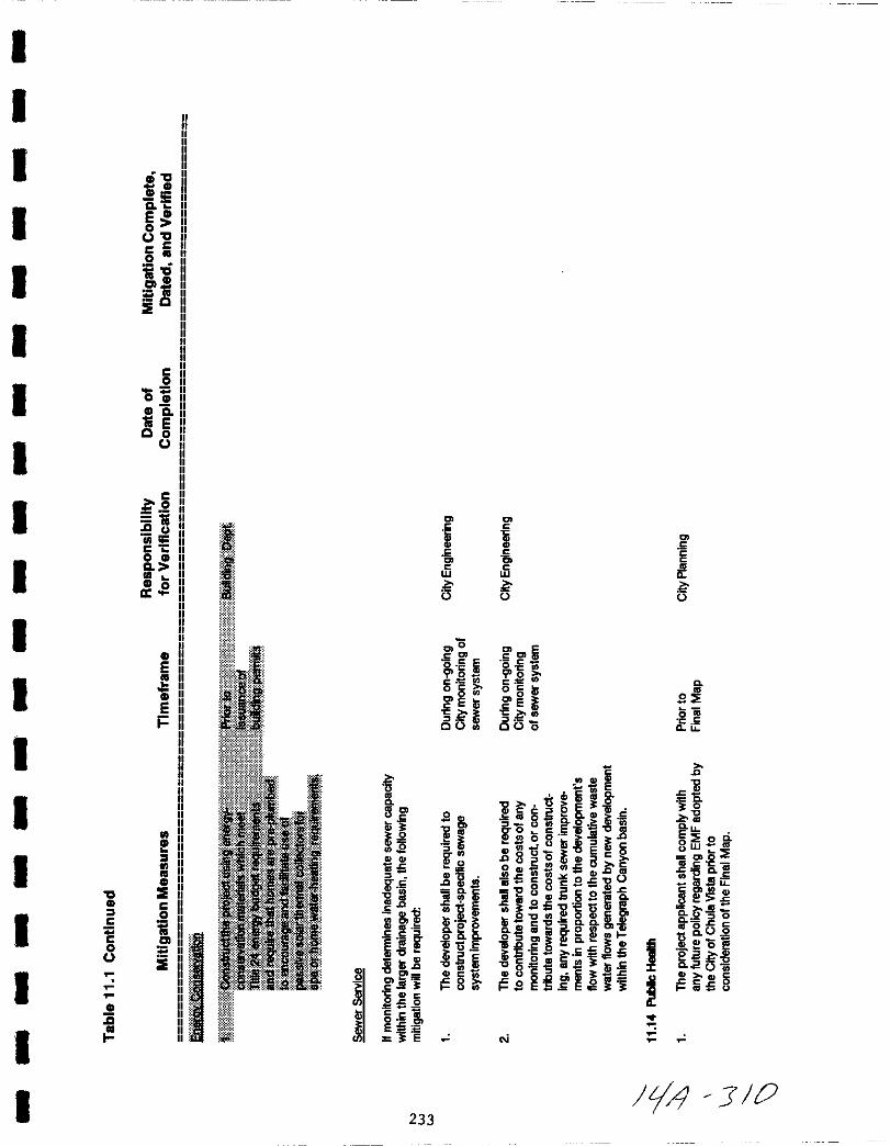
I
I
I 0CDCD1i5
aE
o0
c c
0
iacnCD
ti0
IE
I
I
I
Ico
0CDeti E00
I
Ic
2ti0 ll
ijj rc Co CDa
CD 00I
ICD
E
iEi
I
I
ICD
I
CD
0 IECD CI 0c
ic g0
IE
CD
ii
I
I
I
I
I
IIII
I
IIrm
B
III
c c
M M cc c c
cc cW W
0 0 0
0Iiic 10
eC
1ii oO C
i o ico o c l
l 01 sec E
I s ifco co 0
f CLIi 0
u 1 E cJl8 llcbi g 0
l g i l 3 0
s ill i li g o c UjD o LL
I g E oliI Zl 8 om Ii I c 8 w I2 8UolEcg C oEu
o 50cncD 1C a c C iit CUcn1i lDQd ce c c
g O 0 cc o oci
2SUm ouc
1iei uQ Sf5Sil IiD c
U s ieM a s
Jiisgcn 8 c iCLI 0 J 0lo al 6c cCLIo o CLlcaE OcnD1
l0 02c c 00 0 0
llIS Q ctJ
g UllEo 3
Il OU l e J wiH gcil i inS B
l D0 8 c
i 3 c
en 8 lU Q C
f e Ee8 CcO
lc l 3 UC CD c
Oc 0
l 6OEEE
3 E N
tJ 3 0233
THIS PAGE INTENTIONALLY LEFT BLANK
234
F 1 Jlj

I
II
I
I
I
I
I
I
I
I
I
I
II
I
I
I
I
12 0 REFERENCES
American Planning Association
1992 Land Use and Electromagnetic Fields
JanuaryZoning News
Bennett M D William Ira et al
1991 Electromagnetic Waves How Real a HazardMedical School Health Letter
Harvard
Bowman Roy H Ralph E Bishop Roy W Griffin
1973 Soil Survey of the San Diego Area U S Department of
Agriculture
California Department of Conservation
1984 Advisory Guidelines
Monitoring Programfor the Farmland Mapping
Publication FM 84 01
and
City of Chula vista
1991 Growth Management Oversight Commission 1990 ReportJune
ERCE
1989 Eastlake Greens Specific Plan Area Plan and EastlakeTrails Prezone and Annexation Final Supplemental EIR
EIR No 86 4 June
Geocon
1984 Preliminary Soil InvestigationReconnaissance for Otay Mesa Property
and
MayGeologic
Giroux and Associates
1991 Air Quality Improvement Plan Telegraph Canyon SPA
235
11 7
ICG Inc
1991 Geotechnical Investigation for Planning TelegraphCanyon Site Otay Lakes Road Chula Vista California
Kavet Robert I and Robert S Banks
1986
Larson Lyle
1991
Emerging Issues in Extremely Low Frequency Electric andMagnetic Field Health Research in EnvironmentalResearch 39 386 404
PURPA EMF and the Not In My Backyard SyndromeGeorgetown University Law Center
The McIntire Group Inc
1990 Preliminary Hydrological Analysis for Telegraph CanyonEstates
Mestre Greve Associates
1991 Noise Assessment for the Telegraph Canyon EIR City ofChula Vista
Miller Barrett C
1989 Biological Effects of Exposure to ElectromagneticFields in Professional Safety 8 21 23
Nair Indira M Granger Morgan and H Keith Florig1990 The Biological Effects of Power Frequency Electric and
Magnetic Fields Background Paper Congress of theUnited States Office of Technology Assessment
Rick Engineering
1987 TelegraphReportCompany
Canyon Creek HEC 1 Model Analysis HydrologyReport prepared for Eastlake DevelopmentApril 4 1987
236
F J 3
I
I
I
IIII
I
I
II
I
I
I
III
I
I
Recon
1989
1991
otay Ranch Archaeological Survey San Ysidro MountainsParcel Proctor Valley Parcel otay River Parcel
Biological Resources Inventory Report for the otayRanch Property
San Diego County of
1979 San Diego County General Plan Part II Regional Land
Use Element Adopted January 3 1979 GPA 78 03Amended December 14 1988 GPA 88 03
San Diego Gas and Electric Company
1991 Electric and Magnetic Fields Questions and Answers
Slesin Louis Matthew Connelly and David Bergman
1991 MagneticPlanningChicago
Fields and Land Use Controls
Association Planning AdvisoryII Report No 435 December
AmericanService
willdan Associates
1991 Fiscal Impacts Report
wilson Engineering Consulting Engineers
1991
1991
1991
1991
Master Plan of Reclaimed Water for the Telegraph CanyonProject
Master Plan of Sewer for Telegraph Canyon
Master Plan of Water for Telegraph Canyon Project
Water Conservation Plan for Telegraph Canyon Project
237
fH JIt i1

THIS PAGE INTENTIONALLY LEFT BLANK
238
ill JLr
I
I
I
I
I
I
I
I
I
II
I
I
I
I
II
I
I
13 0 AGENCIES AND INDIVIDUALS CONTACfED
Air Pollution Control District
Robert Mross Analyst
Chula vista Elementarv school District
George Bjornson Principal Eastlake Elementary School
Kate Shurson Director of Planning
Chula vista Fire Deoartment
Carol Gove Planner
city of Chula vista
Maryann Miller Planning DepartmentSteve Griffin Planning DepartmentDoug Reid Planning DepartmentPatty Smith Planning DepartmentDiana Lilly Planning DepartmentElizabeth Chopp Engineering DepartmentHal Rosenberg Engineering Department
San Dieao County Sheriff s Deoartment
Gail Sisco Imperial Beach Sheriff s station
Sweetwater union Hiah School District
Thomas Silva Director of Planning
Local Aaencv Formation Commission
Michael ott member LAFCO
Otav Water District
Bill Miller Field Operations EngineerCarol Barnes Engineering Planning
San Dieao Gas Electric Comoanv
Don Rose Senior Land Planner
Sue Scott project Manager
Willdan Associates
Tom Bandy Division Manager
239
LI 3
THIS PAGE INTENTIONALLY LEFT BLANK
240
Fl1 7
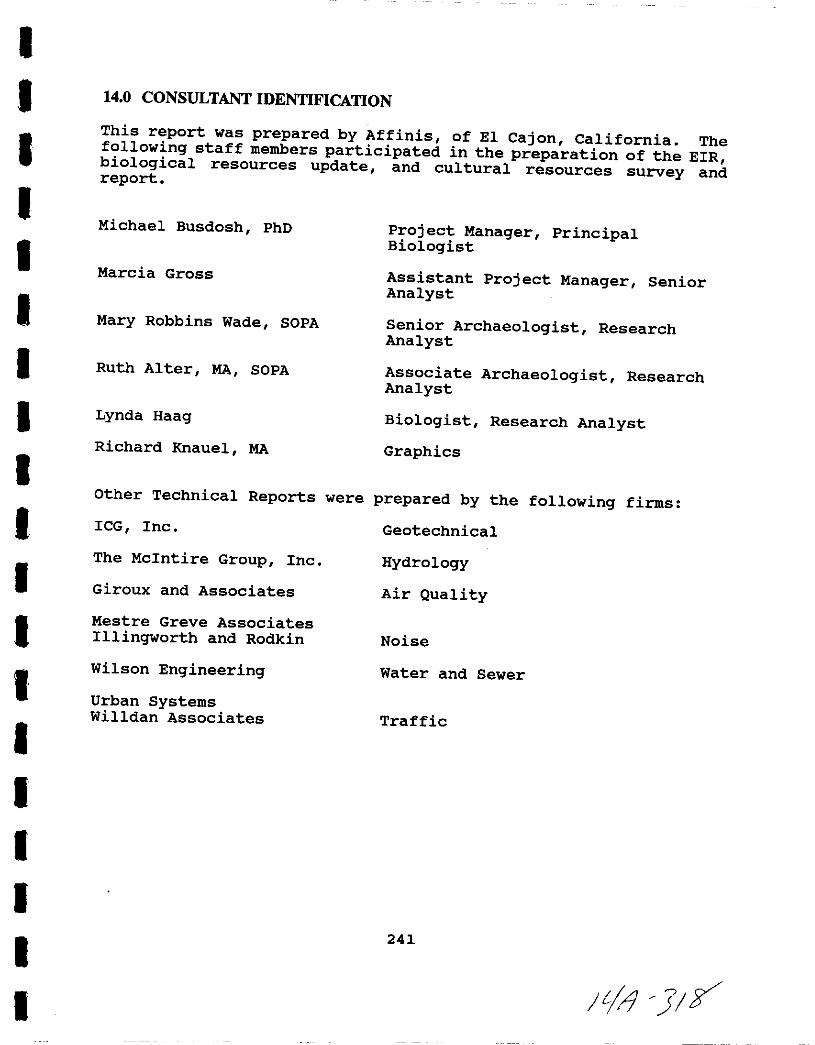
IIIII
II
II
II
IIII
I
I
I
I
14 0 CONSULTANT IDENTIFICATION
This report was prepared by Affinis of El Cajon California Thefollowing staff members participated in the preparation of the EIRbiological resources update and cultural resources survey andreport
Michael Busdosh PhD Project Manager PrincipalBiologist
Marcia Gross Assistant Project Manager SeniorAnalyst
Mary Robbins Wade SOPA Senior Archaeologist ResearchAnalyst
Ruth Alter MA SOPA Associate Archaeologist ResearchAnalyst
Lynda Haag Biologist Research Analyst
GraphicsRichard Knauel MA
Other Technical Reports were prepared by the following firms
ICG Inc
The McIntire Group Inc
Geotechnical
Hydrology
Air QualityGiroux and Associates
Mestre Greve AssociatesIllingworth and Rodkin Noise
Wilson Engineering Water and Sewer
Urban SystemsWilldan Associates Traffic
241
It J Y
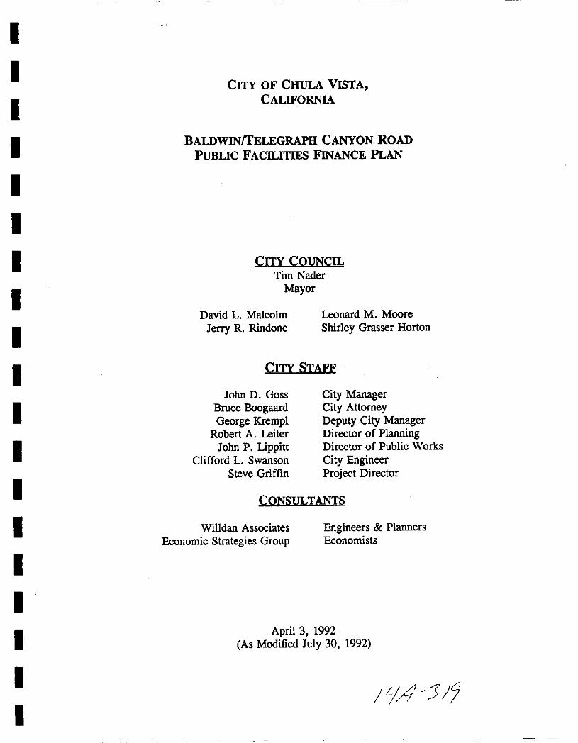
I
II
I
I
I
I
I
I
I
I
II
I
I
I
I
II
CITY OF CHULA VISTACALIFORNIA
BALDWINITELEGRAPH CANYON ROADPuBLIC FACILITIES FINANCE PLAN
CITY COUNCILTim Nader
Mayor
David L Malcolm
Jerry R Rindone
Leonard M Moore
Shirley Grasser Horton
CITY STAFF
John D Goss
Bruce BoogaardGeorge Krempl
Robert A Leiter
John P LippittClifford L Swanson
Steve Griffin
City ManagerCity AttorneyDeputy City ManagerDirector ofPlanningDirector of Public Works
City EngineerProject Director
CONSULTANTS
Willdan AssociatesEconomic Strategies Group
Engineers Planners
Economists
April 3 1992
As Modified July 30 1992
ILIA 5 7
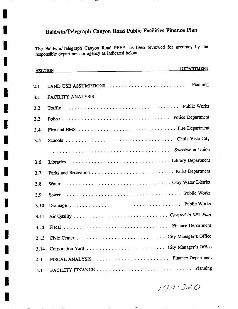
I
I
I
I
I
I
II
I
I
II
I
I
I
I
I
I
I
BaldwinTelegraph Canyon Road Public Facilities Finance Plan
The BaldwinTelegraph Canyon Road PFFP has been reviewed for accuracy by the
responsible department or agency as indicated below
SECTION DEPARTMENT
2 1 LAND USE ASSUMPTIONS 0 0 0 00 0
o Planning
3 1 FACILITY ANALYSIS
3 2 Traffic 0 0 0Public Works
303 Police 0 0 0 00 0 Police Department
34 Fire and EMS 0 0 0 0 0 0 0 0 0Fire Department
35 Schools 0 00 0 0
0 0 0 0 0 0Chula Vista City
o 00 0 0
0 0 0 0Sweetwater Union
3 6 Libraries 0 0 0 0 0 0 0 Library Department
3 7 Parks and Recreation 0 0 0 Parks Department
3 8 Water 00 0
0 0 00 Otay Water District
3 9 Sewer Public Works
3 10 Drainage 0 0 0 0 0 0 0 0 0 0 Public Works
3011 Air Quality 0 0 0 0 0 0 0 0 0 0 0 0 Covered in SPA Plan
3 12 Fiscal 0 0 00
0 0 0 0
Finance Department
3 13 Civic Center 0 0 0 0 0 0 0 City Manager s Office
3 14 Corporation Yard 0 0 0 0 0 0 0 City Manager s Office
4 1 FISCAL ANALYSIS 0 0 0 0 0 0 Finance Department
Sol FACILITY FINANCE 0 0 0 0 0 0 0 0 0 Planning
JiA J20
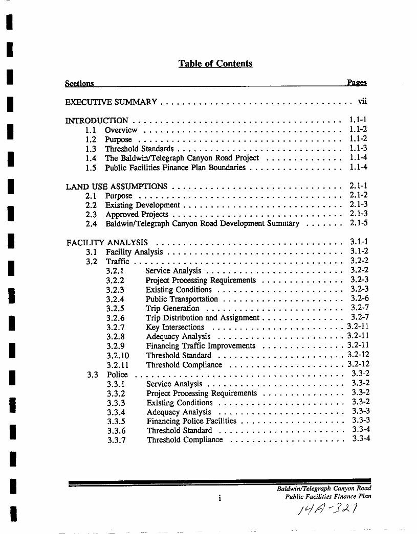
I
I
I
I
I
I
I
I
I
I
I
I
I
I
I
I
I
II
Table of Contents
Sections Pales
EXECUTIVE SUMMARY vii
INTRODUCTION 1 1 1
1 1 Overview 1 1 2
1 2 Purpose 1 1 2
13 Threshold Standards 11 314 The BaldwinlTelegraph Canyon Road Project 11 4
15 Public Facilities Finance Plan Boundaries 1 1 4
LAND USE ASSUMPTIONS 2 1 1
2 1 Purpose 2 1 2
2 2 Existing Development 2 1 3
2 3 Approved Projects 2 1 324 BaldwinTelegraph Canyon Road Development Summary 2 1 5
FACILITY ANALYSIS 3 1 1
3 1 Facility Analysis 3 1 2
3 2 Traffic 3 2 2
3 2 1 Service Analysis 3 2 2
3 2 2 Project Processing Requirements 3 2 3
3 2 3 Existing Conditions 3 2 3
3 24 Public Transportation 3 2 63 2 5 Trip Generation 3 2 7
3 2 6 Trip Distribution and Assignment 3 2 7
3 2 7 Key Intersections 3 2 11
3 2 8 Adequacy Analysis 3 2 11
3 2 9 Financing Traffic Improvements 3 2 11
3 2 10 Threshold Standard 3 2 12
3 2 11 Threshold Compliance 3 2 12
33 Police 3 3 2
3 3 1 Service Analysis 3 3 2
3 3 2 Project Processing Requirements 3 3 2
3 3 3 Existing Conditions 3 3 2
3 34 Adequacy Analysis 3 3 3
3 3 5 Financing Police Facilities 3 3 3
3 3 6 Threshold Standard 3 3 4
3 3 7 Threshold Compliance 3 3 4
iBaldwinTelegraph Canyon Road
Public Facilities Finance Plan
JLjJ j I
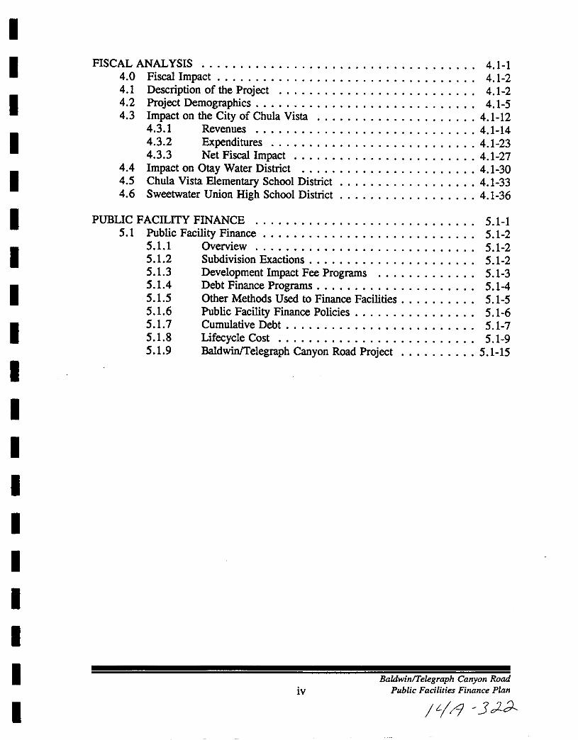
I
I
I
I
I
I
I
I
I
II
I
I
I
I
I
I
I
I
FISCAL ANALYSIS 4 1 14 0 Fiscal Impact 4 1 24 1 Description of the Project 4 1 24 2 Project Demographics 4 1 54 3 Impact on the City ofChula Vista 4 1 12
4 3 1 Revenues 4 1 144 3 2 Expenditures 4 1 2343 3 Net Fiscal Impact 4 1 27
44 Impact on Otay Water District 4 1 304 5 Chula Vista Elementary SChool District 4 1 334 6 Sweetwater Union High School District 4 1 36
PUBUC FACILITY FINANCE 5 1 15 1 Public Facility Finance 5 1 2
5 1 1 Overview 5 1 25 12 Subdivision Exactions 5 1 25 13 Development Impact Fee Programs 5 1 35 14 Debt Finance Programs 5 145 15 Other Methods Used to Finance Facilities 5 1 55 16 Public Facility Finance Policies 5 1 65 17 Cumulative Debt 5 1 75 18 LifecycleCost 5 1 95 19 BaldwinlTelegraph Canyon Road Project 5 1 15
ivBaldwinTelegraph Canyon Road
Public Facilities Finance Plan
L l 3 LA

I
I
ITitle
1
I23
4
I4A
4B
4C
I5
6
I7
89
I1011
12
I1314
15
I1617
18
I 19
I
I
I
I
I
I
I
I
Fi ures
Pale
Regional Location Map 11 5SPA Boundaries Map 11 6Development Phasing Forecast 5 to 7 Years Summary 2 1 4
Existing Lane Configuration 3 2 5
Trip Distribution 3 2 8AM Peak 3 2 9PM Peak 3 2 10Chula Vista Elementary School District Projected Enrollments Permanent and
Temporary Capacities 3 5 4Sweetwater Union High School District 3 5 6Chula Vista Existing Parks 3 7 3Chula Vista Future Parks 3 7 4Parkland Dedication Standards 3 7 5
BaldwinlTelegraph Canyon Road Population 3 7 5
Existing Water Facilities 3 8 7Recommended Water Facilities 3 8 10Potential Reclaimed Water Use Areas 3 8 11
Existing Reclaimed Water Facilities 3 8 12Recommended Reclaimed Water Facilities 3 8 14
Existing Sewer Facilities 3 9 6Proposed Sewer Facilities 3 9 7Sewer Facilities Cost Estimate 3 9 8
Summary of Facility Costs 5 1 16
v
BaldwinlTelegraph Canyon Rood
Public Facilities Finance Plan
JtI43 3
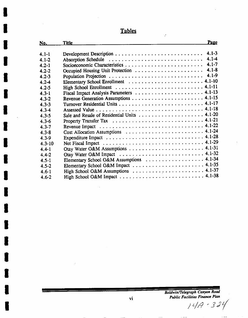
I
I
I
I
I
II
I
I
I
I
I
I
I
I
II
I
I
No
4 1 1
4 1 2
4 2 1
4 2 2
4 2 3
4 24
4 2 5
4 3 1
4 3 2
4 3 34 3 4
4 3 5
4 3 64 3 7
4 3 84 3 94 3 10
4 4 1
44 2
4 5 1
4 5 2
4 61
4 6 2
Tpbles
Title Pale
Development Description 4 1 3
Absorption Schedule 4 14
Socioeconomic Characteristics 4 1 7
Occupied Housing Unit Protection 4 1 8
Population Projection 4 1 9
Elementary School Enrollment 4 1 10
High School Enrollment 4 1 11
Fiscal Impact Analysis Parameters 4 1 13
Revenue Generation Assumptions 4 1 15
Turnover Residential Units 4 1 17
Assessed Value 4 1 18
Sale and Resale of Residential Units 4 1 20
PropertyTransferTax 4 1 21
Revenue Impact 4 1 22
Cost Allocation Assumptions 4 1 24
Expenditure Impact 4 1 28
Net Fiscal Impact 4 1 29
Otay Water O M Assumptions 4 1 31
Otay Water O M Impact 4 1 32
Elementary School O M Assumptions 4 1 34
Elementary School O MImpact 4 1 35
HighSchoolO MAssumptions 4 1 37
High School O M Impact 4 1 38
vi
BaldwinTe egraph Canyon Road
Public Facilities Finance Plan
L l 3cJ
I
I
I
I
I
I
I
I
I
I
I
I
I
I
II
I
II
EXECUTIVE SUMMARY
viiBaldwinlTelegraph CaffYOn Road
Public Facilities Finance Plan
Il 12S
I
I
I
I
I
I
I
I
I
I
I
II
I
I
I
I
I
I
Executive Summarv
OVERVIEW
This Public Facilities Finance Plan PFFP has been prthe Ci of Chula Vista s Grow ana em tion o
e prepara on 0 the PFFP is required in conjunction with the preparation of theSectional Planning Area Plan SPA to ensure that the phased development of the projectis consistent with th lvp l1 gn l iplOnf thl rty General Plan Growth
Management Program and to ensure that the development of the project will not adverselyimpact the Quality of Life Standards
The PFPP is based upon the requested developer phasing as presented in the SPA The
BaldwinlTelegraph Canyon Road project is proposed to be developed in one phase ThePFFP begins by analyzing the existing demand for facilities based upon the demand from
existing development and those projects with approved final and tentative maps Projectswhich currently have a final or tentative map are deemed to have committed facilitycapacity and are the approved projects Then the PFFP uses the proposed developerphasing of the BaldwinTelegraph Canyon Road project as shown in the Sectional PlanningArea Plan SPA to determine the impacts associated with each phase of the project
Phasing of the future development of this project is done to predict when additional or
upgraded facilities will be needed to meet or maintain compliance with the City s QualityofLife Standards When specific thresholds are projected tobe reached or exceeded based
upon the analysis of the phased development of the Baldwin Telegraph Canyon Road
project the PFFP provides recommended mitigation necessary for the continued compliancewith the Growth Management Program and Quality ofLife Standards
Since the plan is a regulatory document each facility section contains recommendedconditions to ensure that compliance will be maintained with the City s overall GrowthManagement Program This Executive Summary includes a list of recommended Generaland Special Conditions for the Baldwin Telegraph Canyon Road project
viiiBaldwin Telegraph Canyon Road
Public
Facilitiej Jr j2
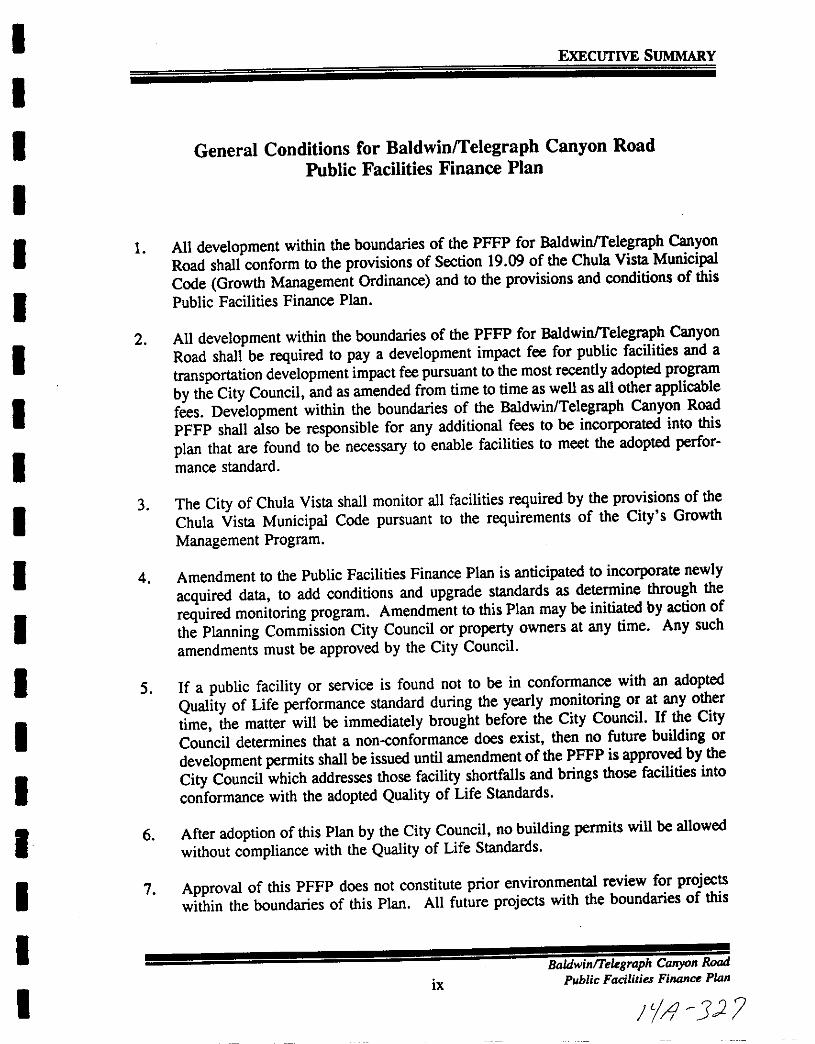
I
I
I
I
I
I
I
I
I
I
I
I
I
I
I
I
I
I
I
ExECUTIVE SUMMARY
General Conditions for BaldwinlTelegraph Canyon Road
Public Facilities Finance Plan
1 All development within the boundaries of the PFFP for BaldwinlTelegraph CanyonRoad shall conform to the provisions of Section 19 09 of the Chula Vista MunicipalCode Growth Management Ordinance and to the provisions and conditions of this
Public Facilities Finance Plan
2 All development within the boundaries of the PFFP for BaldwinlTelegraph CanyonRoad shall be required to pay a development impact fee for public facilities and a
transportation development impact fee pursuant to the most recently adopted program
by the City Council and as amended from time to time as well as all other applicablefees Development within the boundaries of the Baldwin Telegraph Canyon Road
PFFP shall also be responsible for any additional fees to be incorporated into this
plan that are found to be necessary to enable facilities to meet the adopted performance standard
3 The City of Chula Vista shall monitor all facilities required by the provisions of the
Chula Vista Municipal Code pursuant to the requirements of the City s Growth
Management Program
4 Amendment to the Public Facilities Finance Plan is anticipated to incorporate newly
acquired data to add conditions and upgrade standards as determine through the
required monitoring program Amendment to this Plan may be initiated by action of
the Planning Commission City Councilor property owners at any time Any such
amendments must be approved by the City Council
5 If a public facility or service is found not to be in conformance with an adopted
Quality of Life performance standard during the yearly monitoring or at any other
time the matter will be immediately brought before the City Council If the City
Council determines that a non conformance does exist then no future building or
development permits shall be issued until amendment of the PFFP is approved by the
City Council which addresses those facility shortfalls and brings those facilities into
conformance with the adopted Quality of Life Standards
6 After adoption of this Plan by the City Council no building permits will be allowed
without compliance with the Quality of Life Standards
7 Approval of this PFFP does not constitute prior environmental review for projectswithin the boundaries of this Plan All future projects with the boundaries of this
ix
BaldwinTelegraph Canyon Road
Public Facilities Finance Plan
1l J

I
I
I
I
I
I
I
I
I
I
I
I
I
I
I
I
I
I
I
EXECUTIVE SUMMARY
PFFP shall undergo environmental review as determined appropriate by the City of
Chula Vista
9 Approval of this PFFP does not constitute prior discretionary review for projectswithin the boundaries of the Plan All future projects within the boundaries of the
Baldwin Telegraph Canyon Road PFFP shall undergo review as detailed in the Chula
Vista Municipal Code This PFFP analyzes the maximum allowable developmentpotential for planning purposes only The approval of this plan does not guaranteespecific development densities
x
BaldwinlTeegraph Canyon Rood
Public Facilities
7ip n
JJZ
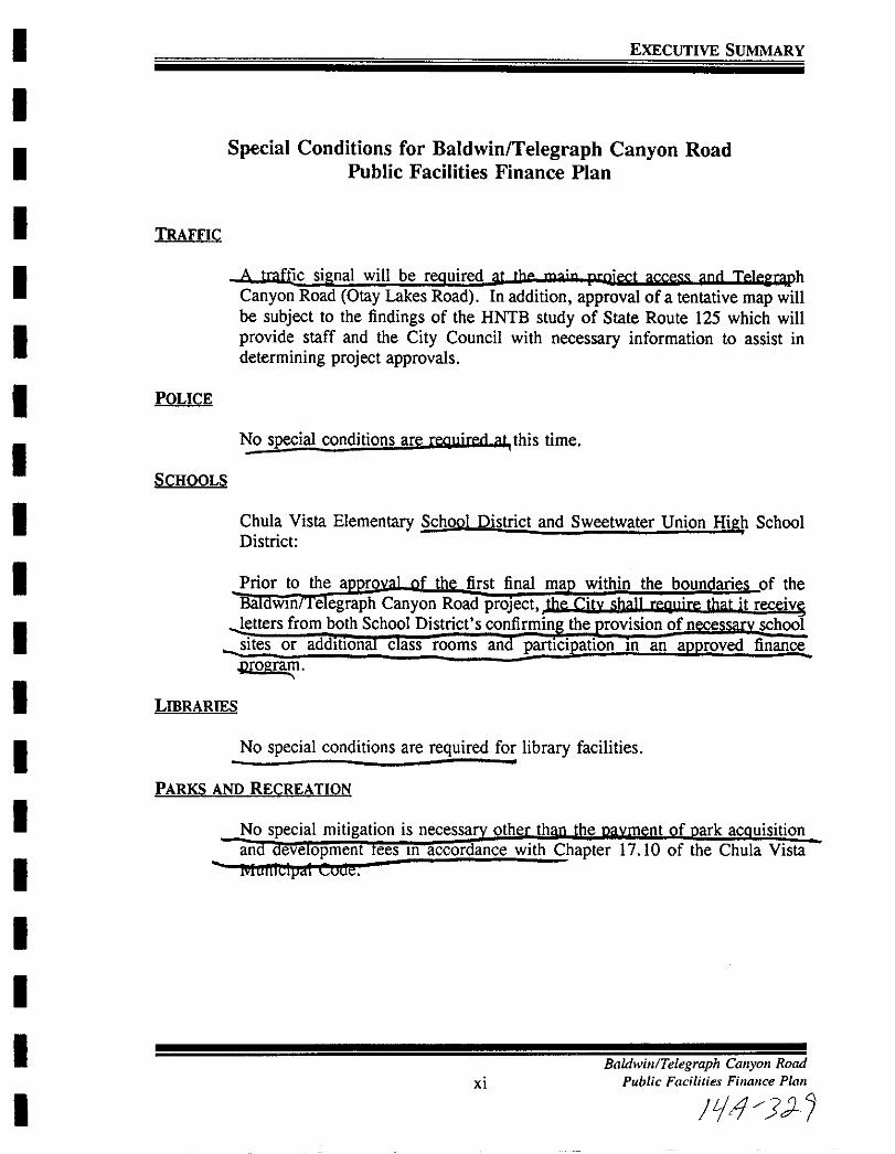
I
I
I
I
I
I
II
I
I
I
I
I
I
I
I
I
I
I
EXECUTIVE SUMMARY
Special Conditions for Baldwin Telegraph Canyon RoadPublic Facilities Finance Plan
TRAFFIC
A traffic signal will be reQuired It thp mn p niect acce mcl Tp leE phCanyon Road Otay Lakes Road In addition approval of a tentative map willbe subject to the findings of the HNTB study of State Route 125 which will
provide staff and the City Council with necessary information to assist in
determining project approvals
POLICE
No special conditions are relluirerl t this time
SCHOOLS
Chula Vista Elementary School District and Sweetwater Union High SchoolDistrict
Prior to the a th first final ma within the boundaries of the
B Win e egraph Canyon Road proJect the citv sh l1 reo r that it receivlSletters from both School District s confirmin the rovision of n e schoolsites or addltlona c ass rooms an partIcipation In an approved finance
Drol1 ram
LffiRARIES
No special conditions are required for library facilities
PARKS AND RECREATION
Xl
Baldwill Telegraph Callyoll Road
Public Facilities Finance Plan
F r1 JJ

I
I
I
I
I
I
I
I
I
I
I
I
I
I
I
I
I
I
I
EXECUTIVE SUMMARY
OPEN SPACE AND TRAILS
The maintenance of trails and open space which lie within public easements or
on which the City holds title in fee will be considered for fundin throu h the
use of an Ii s ce Maintenance District formed ursuant to the rovisionsof the Landscape and Lighting District Act of 197 or 0 er appropnate land
secured public financing mechanism
WATER
Facilities to provide for water and reclaimed water distribution have been
loentified
Water services allocated to major developments of a master planned communitywill be determined for a future quarter as a part ofan agreement with the OtayWater District forconstruction of required terminal reservoir storage and other
major water facilities As such the facilities i
required of the develo the ment of fi
SEWER
Facilities to accommodate sewer flows have been identified The City will not
allow the design capacity of trunk sewers to be exceeded If flows largeenough to surpass the design capacity of receiving sewers are anticipated as the
result of new development the City could require the construction of relieflines The construction of new sewer trunk lines must be phased with the
construction of streets As such the facilities identified in this plan shall be
required of the developer either as constructed facilities through the paymentof fees
DRAINAGE
Baldwin Telegraph Canyon Road project shall be responsible for the convey
ance of storm water flows in accordance with the City Engineering standards
AIR OUALITY
The City continues to provide a development forecast to the APCD in
conformance with the threshold standard A separate AirQuality ImprovementPlan is provided as part of the SPA document
xiiBaldwinlTelegraph Cmryon Rood
Public Facilities Finance Plan
LjJ 33f

I
I
I
I
I
I
I
I
I
I
I
I
I
I
I
I
I
I
I
EXECUTIVE SUMMARY
FISCAL
Section 4 0 of this Public Facilities Financing Plan contains an analysis of the
fiscal impacts the development of BaldwinTelegraph Canyon Road will haveon the operation and maintenance budgets of the City of Chula Vista the OtayWater District the Chula Vista City School District and the Sweetwater Union
High School District
The results of the analysis are contained in Section 4 0 and will be included in
the next annual fiscal and economic report prepared for the City s Growth
Management Oversight Commission
CIVIC CENTER
Civic Center facilities will be funded through the collection of the PublicFacilities Fees at the rate in effect at the time building permits are issued
CORPORAnON YARD
Corporation yard facilities will be funded through the collection of Public
Facility Fees at the rate in effect at the time building permits are issued
FISCAL ANALYSIS
This analysis demonstrates the fiscal impact that development in BaldwinTele
graph Canyon Road will have on the operation and maintenance budgets of the
City of Chula Vista the Otay Water District the Chula Vista ElementarySchool District and the Sweetwater Union High School District The analysiscovers a period of fifteen years four of which depict the development phase of
the project and eleven years which depict the impact of the completed project
The net fiscal impact of BaldwinTelegraph Canyon Road on the City of Chula
Vista during its first fifteen years indicates that revenues areprojected toexceed
expenditures in every year of the impact The annual net balances range from
71 918 in year four to a low of 20 345 in year one The total accumulated
net fiscal balance of the fifteen year period covered by the analysis is 827 043
Order of magnitude operation and maintenance fiscal impacts of BaldwinTele
graph Canyon Road on the Otay Water District results in a net fiscal loss of
about 676 annually at the buildout stage of the project However since this
represents only about 04 percent of the revenues and cost resulting from the
development it is reasonable to expect that virtually no net impact will be
experienced This is also consistent with comments made by Otay Water
xiii
BaldwinTelegraph Canyon Road
Public Facilities Finance Plan
f1 73

I
I
I
I
I
I
I
I
I
I
I
I
I
I
I
I
I
I
I
EXECUTIVE SUMMARY
District staff who insisted that rates would be adjusted as needed to balancerevenues and operation and maintenance expenditures
Also required by Growth Management Ordinance No 2448 operation andmaintenance impacts on the Chula Vista Elementary School District were
projected based on the number of students generated by development ofBaldwinlTelegraph Canyon Road The rate for revenues and expenditures perstudent multiplied by the number of elementary school children in BaldwinTelegraph Canyon Road at buildout results in an annual net fiscal loss of about
5 000 However this amount corresponds to only 15 percent of totalrevenues of 341 841 The district has commented that while any loss is causefor concern the assumptions and parameters used in the analysis are such thata minor change in anyone assumption could change the net fiscal loss into afiscal gain
The impacts of BaldwinlTelegraph Canyon Road on the operation andmaintenance budget of the Sweetwater Union High School District were alsoproject based on the projected number of high school students The rate forrevenues and expenditures per student multiplied by the number of high schoolstudents in BaldwinlTelegraph Canyon Road at buildout results in an annual netfiscal gain of about 2 960 However this amount corresponds to only 0 72
percent of total revenues of 412 099
xivBaldwinlTelegraph Canyon Road
Public Facilities Finance Plan
179 3A
I
I
I
I
I
I
I
I
I
I
I
I
I
I
I
I
I
I
I
1 0 INTRODUCTION
Baldwin Telegraph Canyon Road
1 1 1 Public Facilities Finance Plan
p 1 p
I
I
I
I
I
I
I
I
I
I
I
I
I
I
I
I
I
I
I
INTRODUCTION
10 INTRODUCTION
11 Overview
The City of Chula Vista has looked comprehensively at issues dealing with
development and the additional impacts it places on public facilities and
services The approval of the Threshold Ordinance and the General Plan
update were the first steps in the overall process of addressing growth relatedissues The second step in this process was the development and adoption of
a specific Growth Management Element which set the stage for the creation of
the City s Growth Management Program
The adoption of Growth Management Program and Implementing OrdinanceNo 2448 formalized on May 28 1991 a comprehensive system to manage
future growth These documents execute the Growth Management Element of
the General Plan and establish a foundation for carrying out the developmentpolicies of the City by directing and coordinating future growth in order to
guarantee the timely provision of public facilities and services
The Growth Management Ordinance requires a Public Facilities Finance Plan
PFFP to be prepared concurrently with a Sectional Planning Area SPA Plan
The contents of the PFFP are governed by Section 19 09 060 of the Growth
Management Ordinance which requires that the plan show how and when the
public facilities and services as identified in the Growth Management Programwill be installed or financed
12 Purpose
The purpose of the Public Facilities Finance Plan is to implement the City s
Growth Management Program and to meet the General Plan goals and objectives as well as the Growth Management Element goals and objectives The
Chula Vista Growth Management Program implements the City s General Plan
and Zoning Ordinance by ensuring that development occurs only when
necessary public facilities and services exist or are provided concurrent with the
demands of new development
Central to the Growth Management Program is the requirement that a Public
Facilities Finance Plan PFFP be prepared for future development projectsrequiring either a Sectional Planning Area Plan SPA or a tentative map
11 2
BaldwinTelegraph Canyon Road
Public Facilities FinanPlan
Ii J 5 1
I
I
I
I
I
II
I
I
I
I
I
I
I
II
I
I
I
INTRODUCTION
13 Threshold Standards
City Council Resolution No 13346 approved eleven public facilities and
services with related threshold standards and implementation measures which
were listed in a policy statement dated November 17 1987 and have subse
quently been refined based on recommendations from the Growth ManagementOversight Commission GMOC
The eleven are
TrafficPolice
Fire EMS
SchoolsLibrariesParks and Recreation
Water
Sewer
DrainageAir QualityFiscal
During the development of the Growth Management Program twonew facilities
were added to the list of facilities to be analyzed
Civic Facilities
Corporation Yard
Threshold standards are used to identify when new or upgraded public facilities
are needed to mitigate the impacts of new development Developmentapprovals will not be made unless compliance with these standards can be met
These threshold standards have been prepared to guarantee that public facilities
or infrastructure improvements will keep pace with the demands of growth
11 3
BaldwinlTeegraph Canyon Road
Public Facilities Finance Plan
lill S

I
I
I
I
I
I
I
I
I
I
I
I
I
II
I
I
I
I
INTRODUCTION
14 The Baldwin Telegraph Canyon Road Project
The Baldwin Telegraph Canyon Road is approximately 1124 acres and is
proposed to be developed in one phase In total 342 residential dwelling unitsare proposed to be constructed along with 24 acres of private recreationalfacilities
15 Public Facilities Finance Plan Boundaries
Section 19 12 070 of the Growth Management Implementation Ordinance
requires that the boundaries of the PFFP shall be established by the City at thetime a SPA Plan or Tentative Map is submitted by the applicant The
boundaries shall be based upon the impact created by the Project on existingand future need for facilities The project boundaries will correlate the
proposed development project with existing and future development proposedfor the area of impact to provide for the economically efficient and timelyinstallation of both onsite and offsite facilities and improvements required bythe development In establishing the boundaries for the PFFP the City shallbe guided by the following considerations
1 Service areas drainage sewer basins and pressure zones which serve the
Project
2 Extent to which facilities or improvements are in place or available
3 Ownership of property
4 Project impact on public facilities relationships especially the impact on
the City s planned major circulation network
5 Special district service territories
6 Approved fire drainage sewer or other facilities or improvementmaster plans
The boundaries of the PFFP for the Baldwin Telegraph Canyon Road projectare congruent with the Sectional Planning Area SPA Plan boundaries
11 4
Baldwin Telegraph Canyon Road
Public Facilities Finance Plan
F 4 3Jb
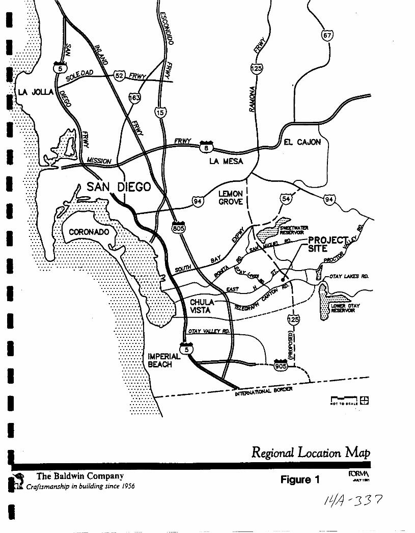
I
I
I
1
11
I
1
1
I
I
I
I
I1
ri
o6o
@
15
LA MESA
5IMPERIALBEACH
r 1mOf TO CIl rn
Regional Location MapThe Baldwin Company
P Craftsmanship in building since 1956
I
Figure 1IOM
MoT
IIA J3 7
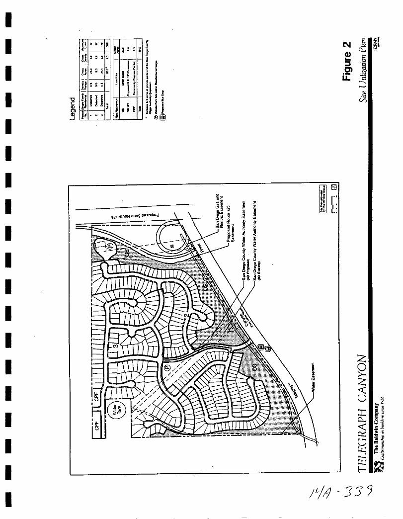
I
I
I
I
I
I
I
I
I
I
I
I
I
I
I
I
I
I
I
IIII
11 a
s
H 2
Un
UlllCl I
III H jqjII h J
i fJI
r I
1I J
Iii I@IOO
N
1J0u
l
g
Vi
sz l lno 81elS pesodoJd
IG
H 1lj a
cnw iE
iQ
i e
g
E E8
l iII
IiCUIl
B3
Ii fb
z
Uis
0 aC slct 5
s Cl
o 1tI 1
L 1
I
I
I
I
I
I
I
I
I
I
I
I
I
I
I
I
I
I
I
2 0 LAND USE ASSUMPfIONS
BaldwinTelegraph Canyon Road
2 1 1 Public Facilities Finance Plan
119 30

I
I
I
I
I
II
I
I
I
I
I
I
I
II
I
I
I
LAND USE ASSUMPTIONS
2 0 LAND USE ASSUMPTIONS
2 1 PURPOSE
The purpose of this section of the PFFP is to quantify how the BaldwinlTelegraph
Canyon Road project will be analyzed in relationship with all other projects which
are at some stage in the City s overall development process The Growth Manage
ment Program addressed the issue of development phasing in relationship to location
timing and fiscal economic considerations
Based upon the overall elements to be considered when projecting the phasing of
development and policies contained in the Growth Management Program the Citywas able to forecast where and when development will take place and produced a 5
to 7 year Development Phasing Forecast Since the approval of the Growth
Management Program the development phasing forecast has been updated and will
be updated annually as facility improvements are made and the capacity for new
development becomes available
The specific factors which effect the development phasing forecast include the Otay
Municipal Water District Allocation Program the future construction of State Route
125 the status of development approvals and binding development agreementsThese components were reviewed as part of this PFFP in conjunction with the
requirement to provide facilities and services concurrent with the demand created byBaldwin Telegraph Canyon Road project to maintain compliance with the threshold
standards
The management of future growth includes increased coordination of activities of the
various City departments as well as with both School and Water Districtswhich serve
the City of Chula Vista The development phasing forecast enables the City to
prioritize and maximize limited staff resources in order to focus efforts on the highest
priority projects in the forecast The development phasing forecast 5 to 7 years is
a method which will be used to effectively and efficiently manage future develop
ment
As indicated in the Growth Management Program accuracy of the forecast is
dependent upon numerous outside influences which affect the overall demand for new
development The first 12 to 18 months of the forecast will be more accurate and
subsequent years less accurate due to lower levels of development approval and
corresponding agreements to provide public facilities These later years are subject
to change and will become more accurate as development entitlements are solidified
and public facilities are guaranteed
2 1 2
BaldwinTe1egraph Carryon RoadPublic Facililies Finance Plan
fIl JI
I
I
I
I
I
I
I
I
I
I
II
I
I
II
I
I
I
LAND USE ASSUMPIIONS
The PFFP for Baldwin Telegraph Canyon Road will begin analyzing the existingdemand for facilities based upon the demand from existing development and those
projects with approved final and tentative maps Projects which currently have a
final or tentative map have committed facility capacity and are the approvedprojects Then the PFFP will use the proposed phasing of the BaldwinTelegraph
Canyon Road project as shown in the Sectional Planning Area Plan SPA to
determine the impacts associated with each phase of the project
2 2 Existing Development
As a starting point the PFFP will consider all existing development up to June 301991 as the base condition This information is based upon City of Chula Vista
Planning Department Annual Residential Development Forecast This reportquantified the population of the City as of June 30 1991 to be 139 150 The
population west of Interstate 805 was identified to be 100 042 and east of Interstate
805 to be 39 108
For the purposes of projecting future facility demands per dwelling unit the State
Department of Finance April 1990 population coefficient of 2 693 persons per
equivalent dwelling unit will be used throughout this Public Facilities Finance Plan
to calculate facility demands from approved projects This coefficient has been
confirmed for use in the PFFP by the Planning Department
For the purposes of calculating the specific Baldwin Telegraph Canyon Road projectfacility demands the following April 1990 State Department population coefficients
will be used
1 Single Family Detached 3 24 personsldu
2 3 Approved Projects
The total number of Approved Projects on June 30 1991 was 8 723 dwellingunits Additionally there are 280 6 acres of industrial and 69 5 acres of commercial
land in the Approved Projects category The approved projects are considered to
have committed facility capacity
2 1 3Badwin Teegraph Canyon Rood
Public Facilities FilQ1lal Plan
14 2
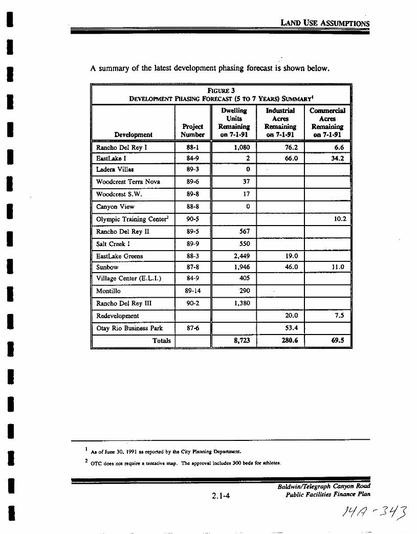
I
I
I
I
II
I
I
I
I
I
I
I
I
II
I
LAND USE ASSUMPrIONS
A summary of the latest development phasing forecast is shown below
FIGURE 3
DEVEWPMENT PHASING FORECAST 5 TO 7 YEARS SUMMARY
Dwelling IndustriaI CoounenialUnits Acres Acres
Project Remaining Remaining RemainingDevelopment Nwnber on 7 1 91 on 7 1 91 on 7 1 91
Rancho Del Rey I 88 1 1 080 76 2 6 6
EastLake I 84 9 2 66 0 34 2
Ladera Villas 89 3 0
Woodcrest Terra Nova 896 37
Woodcrest S W 89 8 17
Canyon View 88 8 0
Olympic Training Center 90 5 10 2
Rancho Del Rey II 89 5 567
Salt Creek I 89 9 550
EastLake Greens 88 3 2 449 19 0
Sunbow 87 8 1 946 46 0 11 0
Village Center E L1 84 9 405
Montillo 89 14 290
Rancho Del Rey III 902 1 380
Redevelopment 20 0 7 5
Olay Rio Business Park 876 53 4
Totals 8 723 280 6 69 5
1A of June 30 1991 as reported by the City Planning Dcpartmcnl
2OTC does not require a tentalive map The approval includes 300 bed for athlete
I
I2 14
BaldwinTelegraph Canyon Road
Public Facilities Finance Plan
Ii r 3
I
I
I
I
I
I
I
I
I
I
I
II
I
I
I
I
I
I
LAND USE ASSUMPTIONS
24 BaldwinTelegraph Canyon Road Development Summary
This project is proposed to include a total of 342 residential dwelling units The SPA
plan proposes to build this project in one phase
2 1 5Baldwin Telegraph Canyon Road
Public Facilities Finance Plan
0 11 3 tu
I
I
I
I
I
I
I
I
I
I
I
I
I
I
I
I
I
I
I
3 0 FACILITY ANALYSIS
BaldwinlTeegraph Canyon Road
3 1 1 Public Facilities Finance Plan
Ie f 325
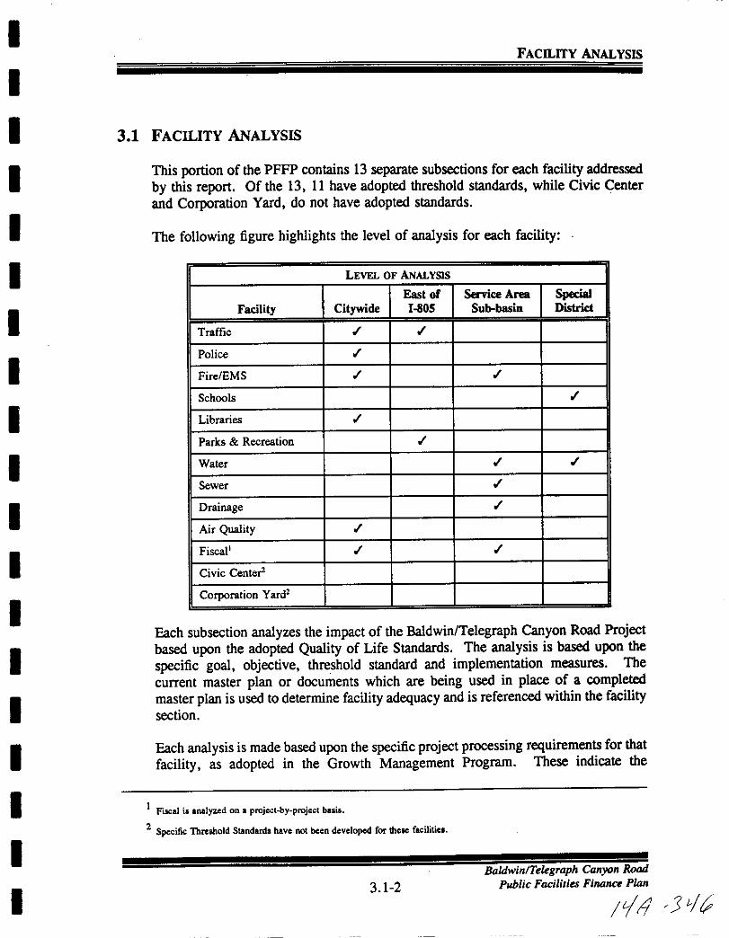
I
I
I
I
I
I
I
I
I
I
I
I
I
I
I
I
I
I
I
FACllITY ANALYSIS
3 1 FACILITY ANALYSIS
This portion of the PFFP contains 13 separate subsections for each facility addressed
by this report Of the 13 11 have adopted threshold standards while Civic Center
and Corporation Yard do not have adopted standards
The following figure highlights the level of analysis for each facility
LEVEL OF ANALYSIS
East of Service Area SpecialFacility Citywide 1805 Subbasin District
Traffic
Police
Fire EMS
Schools
Libraries
Parks Recreation
Water
Sewer
Drainage
Air Quality
Fiscal
Civic Center
Corporation Yard
Each subsection analyzes the impact of the Baldwin Telegraph Canyon Road Projectbased upon the adopted Quality ofLife Standards The analysis is based upon the
specific goal objective threshold standard and implementation measures The
current master plan or documents which are being used in place of a completedmaster plan is used to determine facility adequacy and is referenced within the facilitysection
Each analysis is made based upon the specific project processing requirements for that
facility as adopted in the Growth Management Program These indicate the
1Fiscal i analyzed on aprojecl by projecl basis
2 Specific Threshold Standards have not been developed for these facilitic
3 1 2
BaldwinlTeegraph Canyon Road
Public Facilities Finance Plan
lill J

I
I
I
I
I
I
I
II
I
I
I
I
I
I
I
I
I
I
FACILITY ANALYSIS
requirements for evaluating the project consistency with the threshold ordinance at
various stages General Development Plan Sectional Planning Area PlanPublic
Facilities Finance Plan Tentative Map Final Map and Building Permit in the
development review process
A service analysis section is included which identifies the service provided by each
facility An existing facilities inventory is included along with those future improvements which are guaranteed through the conditioning ofan Approved project or are
scheduled to be made in the City s adopted Capital Improvement Budget
The existing plus approved demands for the specific facility are identified in the
subsection based upon the adopted threshold standard
Each facility subsection contains an adequacy analysis followed by a detailed
discussion indicating how the facility is to be financed The adequacy analysisprovides a determination of whether or not the threshold standard is being met and
the finance section provides a determination if funds are available to guarantee the
improvement If the threshold standard is not being met mitigation is recommended
in the Threshold Compliance subsection which proposes the appropriate conditions
or mitigation to bring the facility into conformance with the threshold standard
3 1 3
BaldwinTelLgraph Canyon Road
Public Facilities Fi Plan
Jilll j1

I
I
I
I
I
I
II
I
I
II
I
I
I
I
I
I
I
3 2 TRAFFIC
BaldwinTekgraph Canyon Road
3 2 1 Public Facilities Finance Plan
Ie IJ J1zr
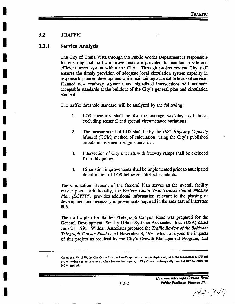
I
I
I
I
I
I
I
I
I
I
I
I
I
I
I
I
I
I
I
TRAFFIC
3 2 TRAFFIC
3 2 1 Service Analysis
The City of Chula Vista through the Public Works Department is responsiblefor ensuring that traffic improvements are provided to maintain a safe and
efficient street system within the City Through project review City staffensures the timely provision of adequate local circulation system capacity in
response to planned development while maintaining acceptable levels ofservicePlanned new roadway segments and signalized intersections will maintain
acceptable standards at the buildout of the City s general plan and circulationelement
The traffic threshold standard will be analyzed by the following
1 LOS measures shall be for the average weekday peak hour
excluding seasonal and special circumstance variations
2 The measurement of LOS shall be by the 1985 Highway CapacityManual HCM method of calculation using the City s publishedcirculation element design standards1
3 Intersection of City arterials with freeway ramps shall be excluded
from this policy
4 Circulation improvements shall be implemented prior to anticipateddeterioration of LOS below established standards
The Circulation Element of the General Plan serves as the overall facilitymaster plan Additionally the Eastern Chula Vista Transportation PhasingPlan ECVJPP provides additional information relevant to the phasing of
development and necessary improvements required in the area east of Interstate
805
The traffic plan for BaldwinTelegraph Canyon Road was prepared for the
General Development Plan by Urban Systems Associates Inc USA dated
June 24 1991 Willdan Associates prepared the Traffic Review of the Baldwin
Telegraph Canyon Road dated November 8 1991 which analyzed the impactsof this project as required by the City s Growth Management Program and
On August 30 1990 theCity Council directed statflOprovidc amore indepth analysis of the two method leu and
HeM which canbe used to calculale intersection capacity City CouncillUbaequcntly difCted Ilaff to utilize the
HeM method
3 2 2BaldwinlTelegraph Canyon Road
Public Facilities Fi1UJllCe Plan
JIA 3t1

I
I
I
II
I
I
I
I
I
II
I
I
I
I
I
II
TRAFFIC
identified the necessary mitigation to comply with the traffic threshold standardThe City Traffic Engineer subsequently modified the Willdan review and theUSA report was revised March 27 1992 and the resulting analysis andrecommended mitigation is described in detail in the following sections
3 2 2 Project Processing Requirements
Sectional Planninl Area Plan Public Facilities Finance Plans
I Identify phased traffic demand and demonstrate compliance with theEastern Chula Vista Transportation Phasing Plan
2 Identify on site and off site impacts and improvements by phase of
development
3 Provide cost estimates for all improvements
3 2 3 Existing Conditions
The following paragraphs provide a description of the roadways in the vicinityof the proposed project and the latest traffic count data Figure 4 illustrates the
study area and includes the existing number of travel lanes at the keyintersections in the vicinity of the project The following paragraphs providea description of the roadways in the vicinity of the proposed project
Interstate 805 is a north south eight lane divided freeway branching offInterstate 5 just north of the Mexican border and reconnecting to Interstate 5in Sorrento Valley Currently Interstate 805 carries 148 000 and 131 000
Average Daily Trips ADT north and south respectively of its interchangewith H Street North of the Bonita Road interchanges this freeway carries160 000 ADT
State Route 54 is an east west freeway connecting Interstate 5 and Interstate805 then transitioning to a four lane conventional roadway east of Interstate805 It should be noted that the portion between Interstate 5 and 805 was
recently opened and traffic count data is not available for this section however
east of Interstate 805 this roadway carries 51 000 ADT
East H Street is designated a six lane primary arterial 6 lanes divided andis currently constructed to ultimate standards east of Interstate 805 to OtayLakes Road East H Street is currently carrying 32 400 and 50 400 ADTeast and west of Hidden Vista Drive respectively West of Otay Lakes Road
East H Street currently carries 29 800 ADT
3 2 3Baldwin Telegraph Canyon Road
Public Facilities Finance Plan
1 150

I
I
I
I
I
II
I
I
I
I
I
I
I
II
I
I
I
TRAme
East of Otay Lakes Road East H Street is designated as a four lane majorroad and is currently constructed to ultimate standards across the EastLake Hills
and Shores development According to the City ofChula Vista s traffic
counts East H Street carries approximately 16 100 ADT just east of OtayLakes Road and approximately 18 100 ADT west ofCorral Canyon Road and
11 500 ADT east of Corral Canyon Road
Telegraph Canyon Road is an east west facility connecting Interstate 805 with
Otay Lakes Road Telegraph Canyon Road terminates at its intersection with
Otay Lakes Road where Otay Lakes Road turns and changes general direction
to become an east west facility In the future the eastwest portion of OtayLakes Road east of the terminus of Telegraph Canyon Road will be renamed
Telegraph Canyon Road Currently this facility is constructed with six travel
lanes divided between Interstate 805 and Paseo del Rey five travel lanes
three lanes eastbound and two lanes westbound between Paseo del Rey andMedical Center Drive four travel lanes divided between Medical Center
Drive and Paseo Ladera transitioning to six travel lanes from Paseo Ladera to
Apache Drive Just east of Otay Lakes Road the EastLake DevelopmentCompany is constructing this facility toa six lane primary arterial through their
property The existing two lane segment between Apache Drive and OtayLakes Road is being reconstructed to ultimate prime arterial standards
According to the City of Chula Vista s most recent traffic count data
Telegraph Canyon Road is carrying 46 600 ADT just east of Interstate 805
decreasing to 36 900 ADT west of Crest Drive To the east volumes decrease
from 25 800 to 15 900 just west of Otay Lakes Road
Otay Lakes Road is a north south facility constructed to four lane majorstandards between Bonita Road to just north of Telegraph Canyon Road
Ultimate plans designate Otay Lakes Road as a six lane major road between
Bonita Road and Telegraph Canyon Road The most recent traffic count data
indicates that Otay Lakes Road is carrying between 16 200 and 19 600 ADT
between East H Street and Bonita Road South of East H Street current
daily traffic volumes range between 12 100 and 16 500 ADT East of
Telegraph Canyon Road Otay Lakes Road carries 9 600 ADT west of
EastLake Parkway Between EastLake Parkway and Lane A venue this facilitycurrently carries 5 600 ADT
3 2 4
BaldwinlTeegraph Canyon Road
Public Facilities Finance Plan
JyJ 5
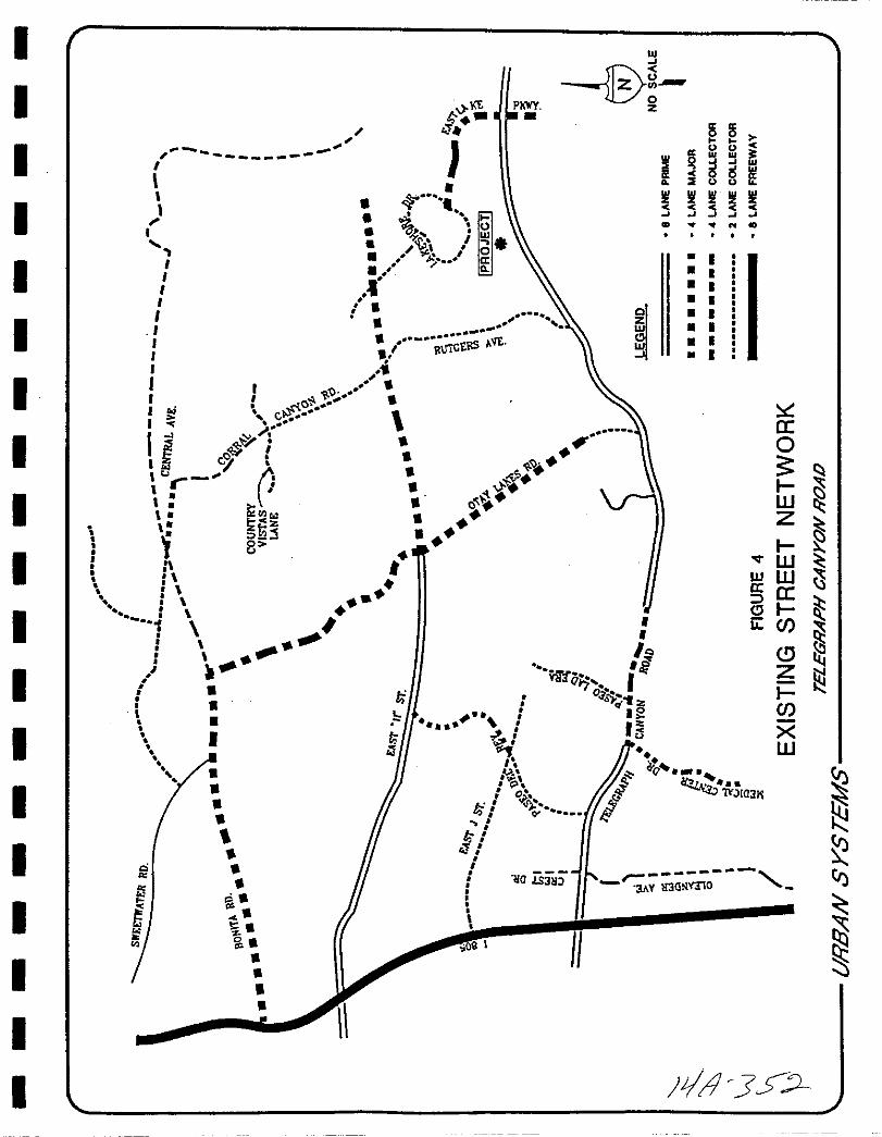
I III
zI15 l5
II LU i
g gII II II II5 5 5
N CD
iJ
JI I
11 ll 0
I 1 a
IQ
II
JI Q
rj NO
I IIC
Is d115 CrIr I
Ie c cnt1
J jJ 8n
t
I
00
1IJJtoJ IYJIOJiI
w
a
I
II
II
II
0 I
ZI
UJCl IUJ IJ I
II ItlllliGtllS
I
IoI
I
IIf
VifCl03 1q
I
I t
P0
Qo
triJl
I
I
I f
I
s
i s
g ss
s
09 I
I Q
ao
IWZ
Il WwWa aalLi j
JZIjXW
10iS3i r3A Y lI3GNvnO
I
II
I
I
s
I l3SJ
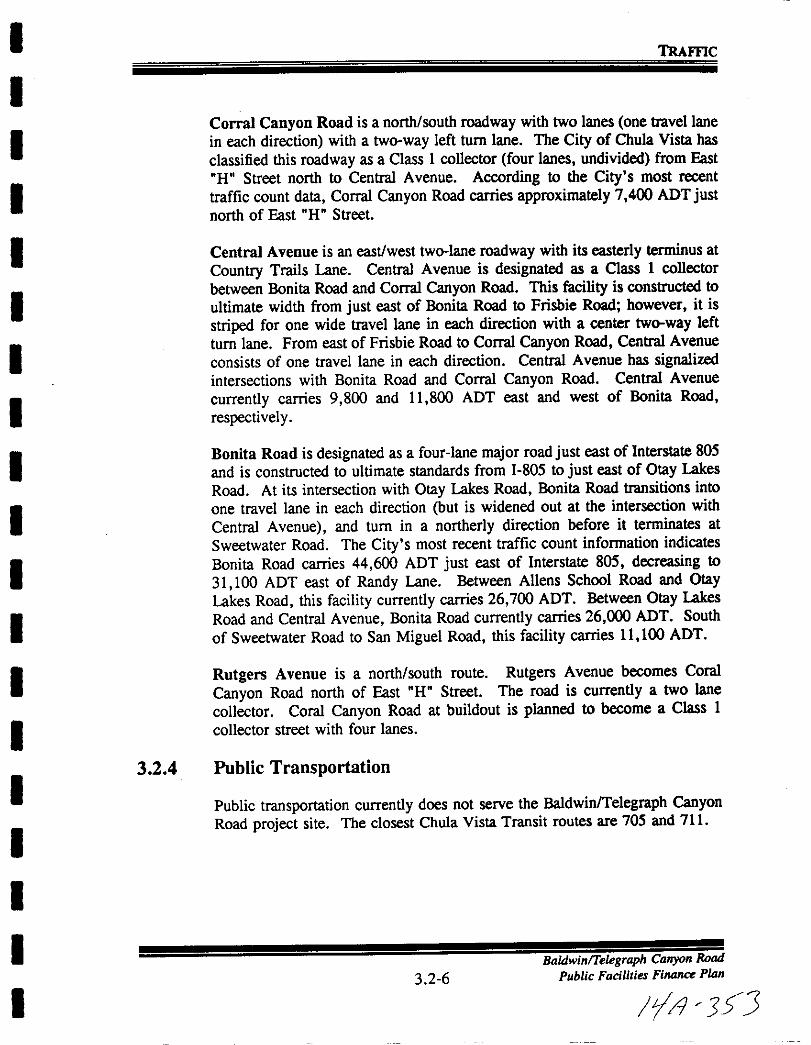
I
I
I
I
I
I
I
I
I
I
I
I
I
I
II
I
II
TRAme
Corral Canyon Road is a north south roadway with two lanes one travel lane
in each direction with a twoway left turn lane The City of Chula Vista has
classified this roadway as a Class I collector four lanes undivided from East
H Street north to Central Avenue According to the City s most recent
traffic count data Corral Canyon Road carries approximately 7 400 ADT justnorth of East H Street
Central Avenue is an east west twolane roadway with its easterly terminus at
Country Trails Lane Central Avenue is designated as a Class I collector
between Bonita Road and Corral Canyon Road This facility is constructed to
ultimate width from just east of Bonita Road to Frisbie Road however it is
striped for one wide travel lane in each direction with a center twoway left
turn lane From east of Frisbie Road to Corral Canyon Road Central Avenue
consists of one travel lane in each direction Central Avenue has signalizedintersections with Bonita Road and Corral Canyon Road Central Avenue
currently carries 9 800 and 11 800 ADT east and west of Bonita Road
respectively
Bonita Road is designated as a four lane major road just east of Interstate 805
and is constructed to ultimate standards from 1 805 to just east of Otay Lakes
Road At its intersection with Otay Lakes Road Bonita Road transitions into
one travel lane in each direction but is widened out at the intersection with
Central Avenue and turn in a northerly direction before it terminates at
Sweetwater Road The City s most recent traffic count information indicates
Bonita Road carries 44 600 ADT just east of Interstate 805 decreasing to
31 100 ADT east of Randy Lane Between Aliens School Road and OtayLakes Road this facility currently carries 26 700 ADT Between Otay Lakes
Road and Central Avenue Bonita Road currently carries 26 000 ADT South
of Sweetwater Road to San Miguel Road this facility carries 11 100 ADT
Rutgers Avenue is a north south route Rutgers Avenue becomes Coral
Canyon Road north of East H Street The road is currently a two lane
collector Coral Canyon Road at buildout is planned to become a Class 1
collector street with four lanes
3 2 4 Public Transportation
Public transportation currently does not serve the BaldwinTelegraph CanyonRoad project site The closest Chula Vista Transit routes are 705 and 711
3 2 6
BaldwinTe egraph Canyon Road
Public Facilities Finance Plan
r 3 J
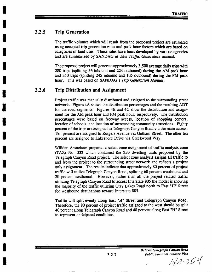
I
I
I
I
I
I
I
I
I
I
I
I
I
I
II
I
I
I
TRAme
3 2 5 Trip Generation
The traffic volumes which will result from the proposed project are estimated
using accepted trip generation rates and peak hour factors which are based on
categories of land uses These rates have been developed by various agenciesand are summarized by SANDAG in their Traffic Generators manual
Theproposed project will generate approximately 3 500 average daily trips with
280 trips splitting 56 inbound and 224 outbound during the AM peak hour
and 350 trips splitting 245 inbound and 105 outbound during the PM peakhour This was based on SANDAG s Trip Generation Manual
3 2 6 Trip Distribution and Assignment
Project traffic was manually distributed and assigned to the surrounding street
network Figure 4A shows the distribution percentages and the resulting ADT
for the road segments Figures 4B and 4C show the distribution and assignment for the AM peak hour and PM peak hour respectively The distribution
percentages were based on freeway access location of shopping centers
location of schools and location of surrounding community attractions Eightypercent of the trips are assigned to Telegraph Canyon Road via the main access
Ten percent are assigned to Rutgers Avenue via Gotham Street The other ten
percent are assigned to Lakeshore Drive via Creekwood Way
Willdan Associates prepared a select zone assignment of traffic analysis zone
TAZ No 332 which contained the 350 dwelling units proposed by the
Telegraph Canyon Road project The select zone analysis assigns all traffic to
and from the project to the surrounding street network and reflects a projectonly assignment The results indicate that approximately 80 percent of projecttraffic will utilize Telegraph Canyon Road splitting 60 percent westbound and
20 percent eastbound However rather than all the project related traffic
utilizing Telegraph Canyon Road to access Interstate 805 the model is showingthe majority of the traffic utilizing Otay Lakes Road north to East W Street
for westbound destinations toward Interstate 805
Traffic will split evenly along East W Street and Telegraph Canyon Road
Therefore the 80 percent of project traffic assigned to the west should be split40 percent along Telegraph Canyon Road and 40 percent along East H Street
to represent anticipated conditions
3 2 7BaldwinlTelegraph Canyon Road
Public Facilities Finance Plan
IIJ J i
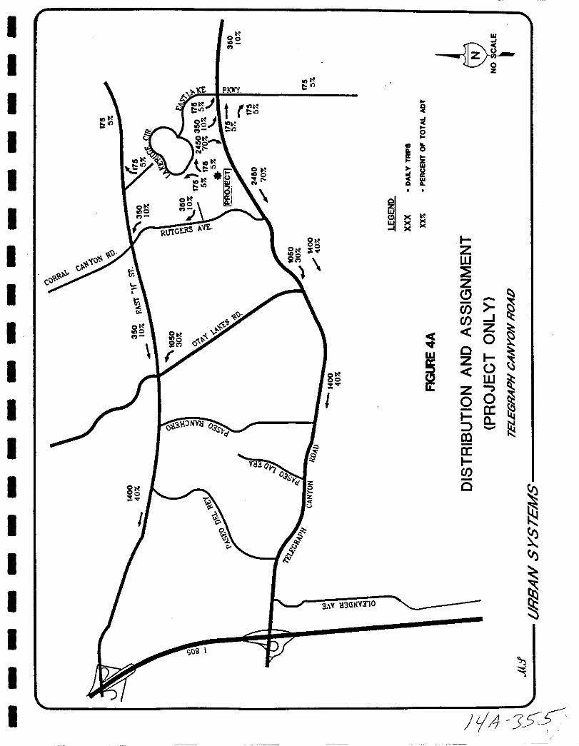
I
I
I
II
II
I
I
I
I
I
II
I
I
I
I
I
t00
tll PKWY
t1
t
t
to
to tlit
0to
0 IC l
toot
0
li
ot0
8
I
3 y 113GNY310
i
e0
ffiC1i
I s
oz
i
tZW
ZJ Ij
r
j J
oZ t
0 IS
Zo 0t
a
il
aI
o
s
LA 5s
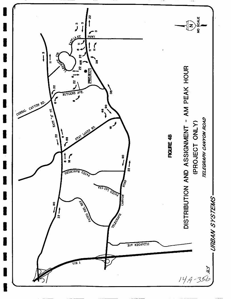
I
I
I
I
I
II
I
I
I
I
I
I
I
II
I
II
I
Ollc
COiii
N
N
oCO
NN w
it
l rjt PJWY
tNN
oCO
I tO liYH O
o r
NN
j
3hY 113alY310
Jzjl 35h
I
I
I
I
I
I
I
I
I
I
I
I
I
I
I
I
I
I
I
l t
OllC
COIr
ta
51
N
I t
lN tI r
ICE p K1IY
t rN
lN
t
au
@2
I t
c
0J
wa
a
IZ
J
W Z
i 0Z I
052 CI wu
CIC 0
a fa0 a Rlz I
Z0I
lDcICI
t0
O JNVll OJco
co
0
gOg
3hY 1I3aNY310
11 557
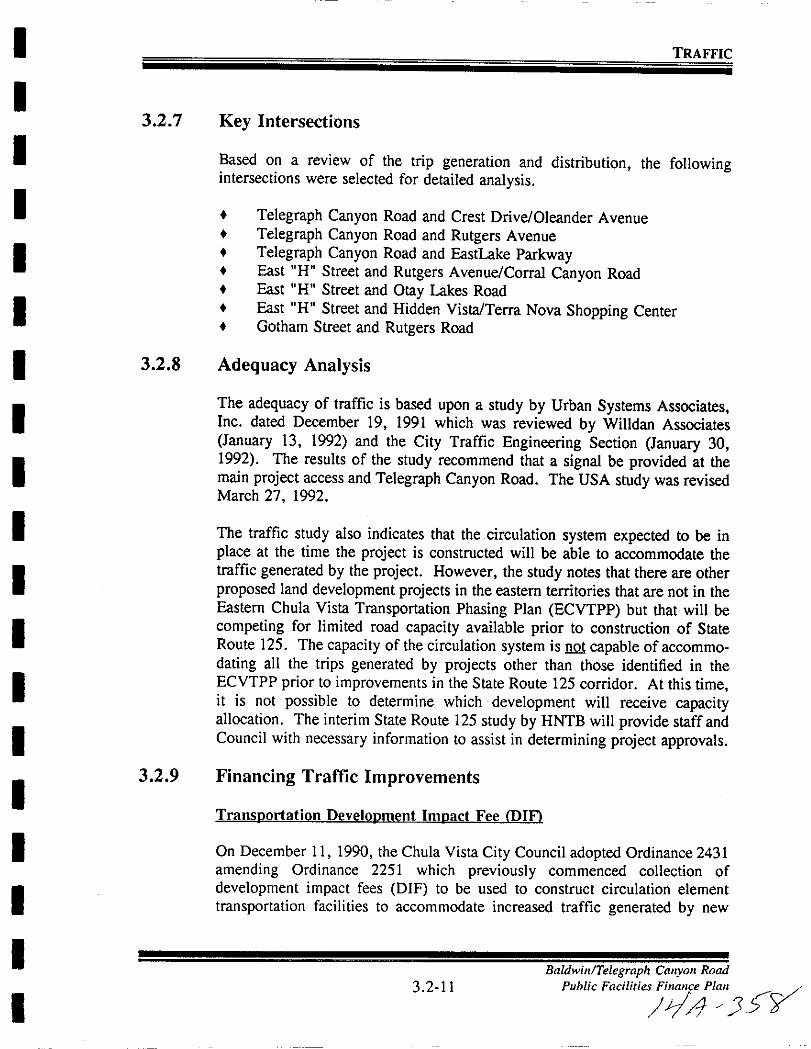
I
I
I
II
I
I
I
I
I
I
I
I
I
I
I
I
II
TRAFFIC
3 2 7 Key Intersections
Based on a review of the trip generation and distribution the followingintersections were selected for detailed analysis
Telegraph Canyon Road and Crest Drive Oleander Avenue
Telegraph Canyon Road and Rutgers Avenue
Telegraph Canyon Road and Eastlake ParkwayEast H Street and Rutgers AvenueCorral Canyon RoadEast H Street and Otay Lakes RoadEast H Street and Hidden VistaTerra Nova Shopping CenterGotham Street and Rutgers Road
3 2 8 Adequacy Analysis
The adequacy of traffic is based upon a study by Urban Systems AssociatesInc dated December 19 1991 which was reviewed by Willdan AssociatesJanuary 13 1992 and the City Traffic Engineering Section January 301992 The results of the study recommend that a signal be provided at themain project access and Telegraph Canyon Road The USA study was revisedMarch 27 1992
The traffic study also indicates that the circulation system expected to be in
place at the time the project is constructed will be able to accommodate thetraffic generated by the project However the study notes that there are other
proposed land development projects in the eastern territories that are not in theEastern Chula Vista Transportation Phasing Plan ECVTPP but that will be
competing for limited road capacity available prior to construction of StateRoute 125 The capacity of the circulation system is not capable of accommo
dating all the trips generated by projects other than those identified in theECVTPP prior to improvements in the State Route 125 corridor At this timeit is not possible to determine which development will receive capacityallocation The interim State Route 125 study by HNTB will provide staff andCouncil with necessary information to assist in determining project approvals
3 2 9 Financing Traffic Improvements
Transoortation Develooment Imoact Fee DIY
On December 11 1990 the Chula Vista City Council adopted Ordinance 2431
amending Ordinance 2251 which previously commenced collection of
development impact fees DIF to be used to construct circulation element
transportation facilities to accommodate increased traffic generated by new
3 2 11Baldwill Telegraph CallyolI Road
Public
FacilitiCjJt 57
I
I
I
II
I
I
I
I
I
I
I
I
I
I
I
I
I
I
TRAFFIC
development within the City s eastern territories The current fee of 3 060 perequivalent dwelling unit is to fund approximately 88 million in improvements
The Baldwin Telegraph Canyon Road project is within the boundaries of the
Transportation DIF program and as such the project will be subject to the
payment of the fee at the rate in effect at the time building permits are issuedHowever the improvements as identified in Section 3 2 8 of the PFFP will be
required to be constructed at the time of need In this case the DIF ordinanceallows for the issuance of credit in lieu of fees when an eligible facility isconstructed by the project If the total eligible construction cost amounts to
more than the total required DIF fees the owner developer will be paid theexcess amount when funds are available as determined by City Ordinance
Non DIF Streets
The Baldwin Telegraph Canyon Road project contains private streets that are
not eligible for DIF credit These streets and their associated improvementswill be funded by the development as a subdivision exaction
3 2 10 Threshold Standard
1 City wide Maintain LOS C or better as measured by observed
averagetravel speed on all signalized arterial segments except that duringpeak hours an LOS of D can occur for no more than any two hours ofthe day
2 West of Interstate 805 Those signalized intersections which do not meet
the standard above may continue to operate at their current year 1991LOS but shall not worsen
3 2 11 Threshold Compliance
Threshold compliance will continue to be monitored through the annualintersection monitoring program and the Eastern Chula Vista TransportationPhasing Plan updates
Based upon the traffic analysis prepared for the Baldwin Telegraph CanyonRoad project threshold compliance is projected to be maintained with
implementation of the improvements identified in the Traffic Impact Studydated December 19 1991 and revised March 27 1992
3 2 12Baldwin Telegraph Canyon Road
Public Facilities Finance Plan
1A

I
I
I
I
I
I
I
I
I
I
I
I
I
I
I
I
I
I
I
3 3 POLICE
BaldwinTe egraph CalfOn Road
3 3 1 Public Facilities Finance Plan
114 r3 tbO

I
I
I
I
I
I
I
I
I
I
I
I
I
I
I
I
I
I
I
POLICE
3 3
3 3 1
3 3 2
3 3 3
POLICE
Service Analysis
Police services are provided by the City of Chula Vista Police DepartmentThe purpose of the Threshold Standard is to maintain or improve the current
level of police services throughout the City by ensuring that adequate levels ofstaff equipment and training are provided
Police Facilities are addressed in A Master Plan for the Chula Vista Civic
Center Solving City Space Needs Through Year 2010 dated May 8 1989
Project Processing Requirements
Sectional PlanniDl Area Plan Public Facilities Finance Plans
1 Services reviewed consistent with proposed phasing of the project2 Demonstrate conformance with A Master Planfor the Chula Vista Civic
Center May 8 1989
Existing Conditions
The Chula Vista Police Department currently provides police service for the
project area It is expected that the Baldwin Telegraph Canyon Road
development will increase the demand for police service in the project area
Police Facilitv Inventory
ExistiDl Facilitv
Police HeadquartersExistinl Location
276 4th Avenue
Future Facilities
Remodel Existing Facility 276 4th Avenue
33 2
BaldwinlTeegraph Canyon Road
Public Facilities Finance Plan
pi
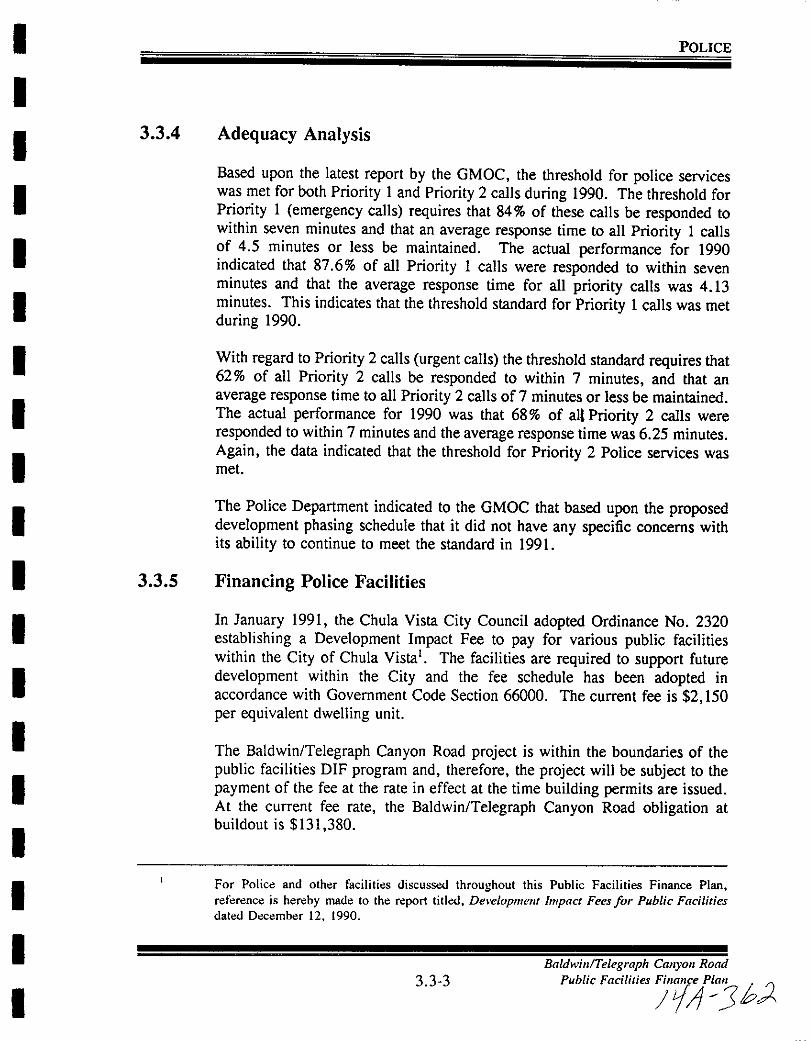
I
I
I
I
I
I
I
I
I
I
I
I
I
I
I
I
I
I
I
POLICE
3 3 4 Adequacy Analysis
Based upon the latest report by the GMOC the threshold for police serviceswas met for both Priority 1 and Priority 2 calls during 1990 The threshold for
Priority 1 emergency calls requires that 84 of these calls be responded towithin seven minutes and that an average response time to all Priority 1 caBsof 4 5 minutes or less be maintained The actual performance for 1990indicated that 87 6 of all Priority 1 calls were responded to within seven
minutes and that the average response time for all priority calls was 4 13minutes This indicates that the threshold standard for Priority 1 calls was met
during 1990
With regard to Priority 2 calls urgent calls the threshold standard requires that62 of all Priority 2 calls be responded to within 7 minutes and that an
average response time to all Priority 2 calls of 7 minutes or less be maintainedThe actual performance for 1990 was that 68 of aU Priority 2 calls were
responded to within 7 minutes and the average response time was 6 25 minutes
Again the data indicated that the threshold for Priority 2 Police services was
met
The Police Department indicated to the GMOC that based upon the proposeddevelopment phasing schedule that it did not have any specific concerns withits ability to continue to meet the standard in 1991
3 3 5 Financing Police Facilities
In January 1991 the Chula Vista City Council adopted Ordinance No 2320
establishing a Development Impact Fee to pay for various public facilitieswithin the City of Chula Vista The facilities are required to support futuredevelopment within the City and the fee schedule has been adopted inaccordance with Government Code Section 66000 The current fee is 2 150
per equivalent dwelling unit
The Baldwin Telegraph Canyon Road project is within the boundaries of the
public facilities DIF program and therefore the project will be subject to the
payment of the fee at the rate in effect at the time building permits are issued
At the current fee rate the Baldwin Telegraph Canyon Road obligation at
buildout is 131 380
For Polic and oth r faciliti s discussoo throughout this Public Facilities Finance Plan
reference is hereby made to the report titled Developmefll Impact Fees for Public Facilities
datoo D ember 12 1990
3 3 3Baldwin Telegraph Canyon Road
Public Facilities
JJi 36
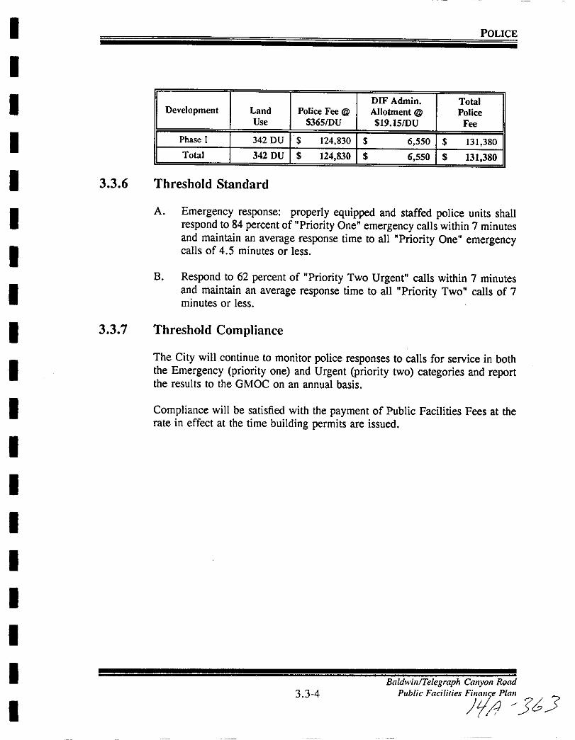
I
I
I
I
I
I
I
I
II
I
I
I
I
I
I
I
I
I
POLICE
DIF Admin TotalDevelopment Land Police Fee @ Allotment @ Police
Use 365DU 19 15DU Fee
Phase I 342 DU 124 830 6 550 131 380
Total 342 DU 124 830 6 550 131 380
3 3 6 Threshold Standard
A Emergency response properly equipped and staffed police units shall
respond to 84 percent of Priority One emergency calls within 7 minutesand maintain an average response time to all Priority One emergencycalls of 4 5 minutes or less
B Respond to 62 percent of Priority Two Urgent calls within 7 minutesand maintain an average response time to all Priority Two calls of 7minutes or less
3 3 7 Threshold Compliance
The City will continue to monitor police responses to calls for service in boththe Emergency priority one and Urgent priority two categories and reportthe results to the GMOC on an annual basis
Compliance will be satisfied with the payment of Public Facilities Fees at therate in effect at the time building permits are issued
3 3 4
Baldwill Telegraph CallyolI Road
Public Facilities
fra 33

I
I
I
I
I
II
I
I
I
I
I
I
I
I
II
I
I
3 4 FIRE AND EMERGENCY MEDICAL SERVICES
BaldwinTelegraph Canyon Road
34 1 Public Facilities FinanCt Plan
L17 1
I
I
I
I
I
II
I
I
I
I
I
I
I
II
I
I
I
FIRE AND EMERGENCY MEDICAL SERVICE
3 4 FIRE AND EMERGENCY MEDICAL SERVICE
3 4 1 Service Analysis
Fire and Emergency Medical Services are provided by the City ofChula Vista
Fire Department The City also has county wide mutual aid agreements with
surrounding agencies should the need arise for their assistance The purposeof the Threshold Standard and the monitoring of response times is to maintain
and improve the current level of fire protection and emergency medical servicesEMS in the City FireEMS facilities are provided for in the Fire StationMaster Plan dated March 23 1989 The Fire Station Master Plan indicates
that response time is primarily determined by the number and location of fire
stations The Fire Station Master Plan evaluates the planning area s fire
coverage needs and recommends an eight station network at buildout to
maintain compliance with the threshold standard
3 4 2 Project Processing Requirements
Developments shall be in accordance with the project guidelines outlined in the
Fire Station Master Plan and detailed below
In accordance with the Fire Station Master Plan the City at its sole discretion
shall determine when a new fire station is required in order to achieve threshold
service levels meet specific project guidelines or maintain general operationalneeds of the Fire Department The requirement to pay for fire station
construction and related equipment shall be the sole responsibility of the
developer or developers and the City may require said developer or developersto provide a guarantee mechanism to assure the availability of such funding
Sectional Planninl Area Plan Public Facilities Finance Plans
I Specific siting of the facility takes place which conforms with the Fire
Station Master Plan March 23 19892 Site reserved
3 Equipment needs identified
4 Methods of financing discussed5 Timing of construction is consistent with threshold service levels specific
project guidelines and or general operational needs of the Fire Department
6 Demonstrate the ability to provide adequate facilities to access requiredfire stations in conjunction with the construction of sewer and water
facilities
34 2BaldwinTe egraph Canyon Road
Public Facilities Finance Plan
LrJ JIPJ IdJA 7
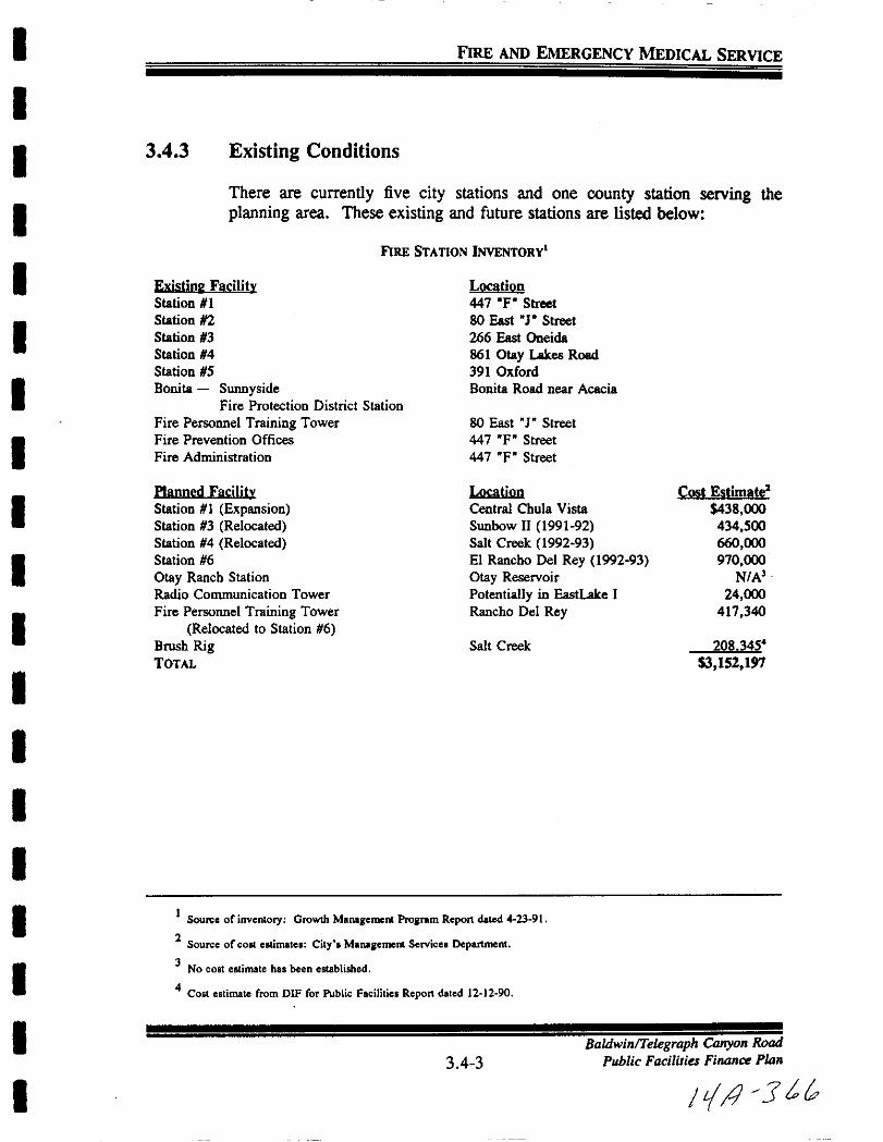
I FIRE AND EMERGENCY MEDICAL SERVICE
II 3 4 3 Existing Conditions
IThere are currently five city stations and one county station serving the
planning area These existing and future stations are listed below
FIRE STATION INvENTORY
I ExistinFacilitv
Station I
Station 2
Station 3
Station 4
Station 5Bonita Sunnyside
Fire Protection District Station
Fire Personnel Training Tower
Fire Prevention Offices
Fire Administration
I
I
I
IPlanned Facilitv
Station 1 ExpansionStation 3 Relocated
Station 4 Relocated
Station 6
Otay Ranch Station
Radio Communication Tower
Fire Personnel Training Tower
Relocated to Station 6
Brush RigTOTAL
I
I
I
I
I
II
Location
447 Fo Street
80 East0
Street
266 East Oneida861 Otay Lakes Road
391 OxfordBonita Road near Acacia
80 East Street
447 OF Street
447 OF Street
Location
Central Chula Vista
Sunbow II 1991 92
Salt Creek 1992 93
EI Rancho Del Rey 1992 93
Otay Reservoir
Potentially in EastLake I
Rancho Del Rey
Cost Estimate438 000434 500
660 000
970 000N A
24 000
417 340
Salt Creek 208 345
3 152 197
1Sou eof inventory Growth Management Projram Report dated 423 91
2Source of colt estimates City MaRlgement Services Department
3No COlt estimate has been established
4Cost estimate from DIF for Public Facilities Report dated 12 12 90I
I34 3
BaldwinTe egraph Canyon Road
Public Facilities Finance Plan
I Il Jtt
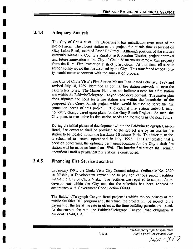
I
I
I
I
I
II
I
I
I
I
I
I
I
I
I
I
II
FIRE AND EMERGENCY MEDICAL SERVICE
3 4 4 Adequacy Analysis
The City of Chula Vista Fire Department has jurisdiction over most of theproject area The closest station to the project site at this time is located on
Otay Lakes Road south of East H Street Although portions of the site are
currently within the County s Rural Fire Protection District project approvaland future annexation to the City of Chula Vista would remove this propertyfrom the Rural Fire Protection District jurisdiction At that time all serviceresponsibility would then be assumed by the City This transfer of responsibility would occur concurrent with the annexation process
The City ofChula Vista s Fire Station Master Plan dated February 1989 andrevised July 10 1989 identified an optimal fire station network to serve theeastern territories The Master Plan does not indicate a need for a fire stationsite within the Baldwin Telegraph Canyon Road development The master plandoes stipulate the need for a fire station site within the boundaries of theproposed Salt Creek Ranch project which would be used to serve the fire
protection needs of this project The optimal fire station network mayhowever change based upon plans for the Otay Ranch Project As such the
City plans to reexamine its fire station needs and locations in the near future
During the initial phases of development within the Baldwin Telegraph CanyonRoad fire coverage shall be provided to the project site by an interim firestation to be located within the EastLake I Business Park This interim stationis scheduled to become operational in July 1992 It is anticipated that a
decision concerning the optimal permanent location for the City s sixth firestation will be made no later than 1996 The interim fire station shall remainoperational until a permanent fire station is constructed
34 5 Financing Fire Service Facilities
In January 1991 the Chula Vista City Council adopted Ordinance No 2320
establishing a Development Impact Fee to pay for various public facilitieswithin the City of Chula Vista The facilities are required to support future
development within the City and the fee schedule has been adopted inaccordance with Government Code Section 66000
The Baldwin Telegraph Canyon Road project is within the boundaries of the
public facilities DIF program and therefore the project will be subject to the
payment of the fee at the rate in effect at the time building permits are issuedAt the current fee rate the Baldwin Telegraph Canyon Road obligation at
buildout is 40 319
34 4Baldwin Telegraph Canyon Road
Public Facilities Finance Plan
14 3b
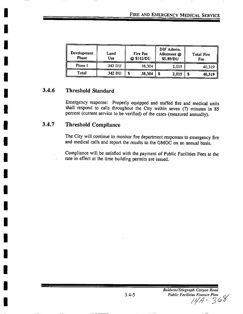
I
I
I
I
I
I
I
II
I
I
I
I
I
I
I
I
I
I
FIRE AND EMERGENCY MEDICAL SERVICE
DIF AdminDevelopment Land Fire Fee Allobnent @ Total Fire
Phase Use @ SIl2DU SS 89DU Fee
I Phase I
I 342 DU I 38 304 I 2 015 i 40 319 ITotal 342 DU I S 38 304 I S 2 01S i S 40 319 I
3 4 6 Threshold Standard
Emergency response Properly equipped and staffed fire and medical unitsshall respond to calls throughout the City within seven 7 minutes in 85percent current service to be verified of the cases measured annually
34 7 Threshold Compliance
The City will continue to monitor fire department responses to emergency fireand medical calls and report the results to the GMOC on an annual basis
Compliance will be satisfied with the payment ofPublic Facilities Fees at therate in effect at the time building permits are issued
34 5Baldwin Telegraph Canyon Road
Public
Facilitij ri
I
I
II
I
II
I
I
I
I
I
I
I
II
I
I
I
3 5 SCHOOLS
BaldwinTelegraph Cmryon Road
3 5 1 Public Fadlities Finance Plan
Ii Jb7
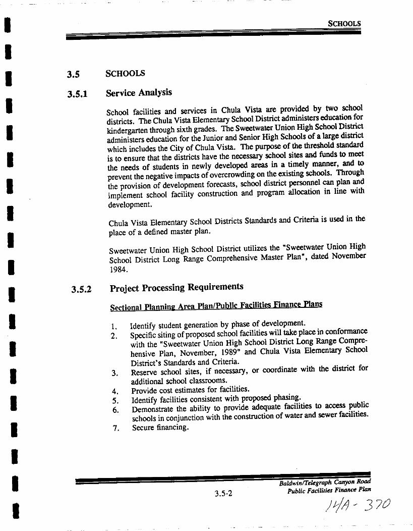
I
I
I
I
I
II
I
I
I
II
I
I
II
I
II
SCHOOLS
3 5 SCHOOLS
3 5 1 Service Analysis
School facilities and services in Chula Vista are provided by two school
districts The Chula Vista Elementary School District administers education for
kindergarten through sixth grades The Sweetwater Union High School District
administers education for the Junior and Senior High Schools of a large district
which includes the City of Chula Vista The purpose of the threshold standard
is to ensure that the districts have the necessary school sites and funds to meet
the needs of students in newly developed areas in a timely manner and to
prevent the negative impacts of overcrowding on the existing schools Through
the provision of development forecasts school district personnel can plan and
implement school facility construction and program allocation in line with
development
Chula Vista Elementary School Districts Standards and Criteria is used in the
place of a defined master plan
Sweetwater Union High School District utilizes the Sweetwater Union High
School District Long Range Comprehensive Master Plan dated November
1984
3 5 2 Project Processing Requirements
Sectional Planninl Area Plan Public Facilities Finance Plans
1 Identify student generation by phase of development2 Specific siting ofproposed school facilities will take place in conformance
with the Sweetwater Union High School District Long Range Compre
hensive Plan November 1989 and Chula Vista Elementary School
District s Standards and Criteria
3 Reserve school sites if necessary or coordinate with the district for
additional school classrooms
4 Provide cost estimates for facilities
5 Identify facilities consistent with proposed phasing6 Demonstrate the ability to provide adequate facilities to access public
schools in conjunction with the construction of water and sewer facilities
7 Secure financing
35 2
BaldwinlTelegraph Canyon Road
Public Facilities Finance Plan
J7 370
I
I
I
I
I
II
I
I
I
I
I
I
I
I
I
I
I
I
SCHOOLS
3 5 3 Existing Conditions
School Facilities Inventorv Chula Vista Elementarv School District
The Chula Vista Elementary School District s inventory consists of32 existingelementary schools Figure 5 lists existing schools with the projected number
of students Permanent and temporary capacity totals 18 987 which exceeds the
1991 92 projected enrollment by 446 students
New elementary schools will be needed to meet the educational needs ofstudents generated from the projected development and resultant populationincrease The elementary schools planned for Rancho del Rey and EastLakeGreens have been initiated but the School Board has taken no action on either
the development schedule or phasing schedule for future schools resulting frombuiIdout of the City
3 5 3Baldwin Telegraph Canyon Road
Public Facilities Finan PlJJn
111 37
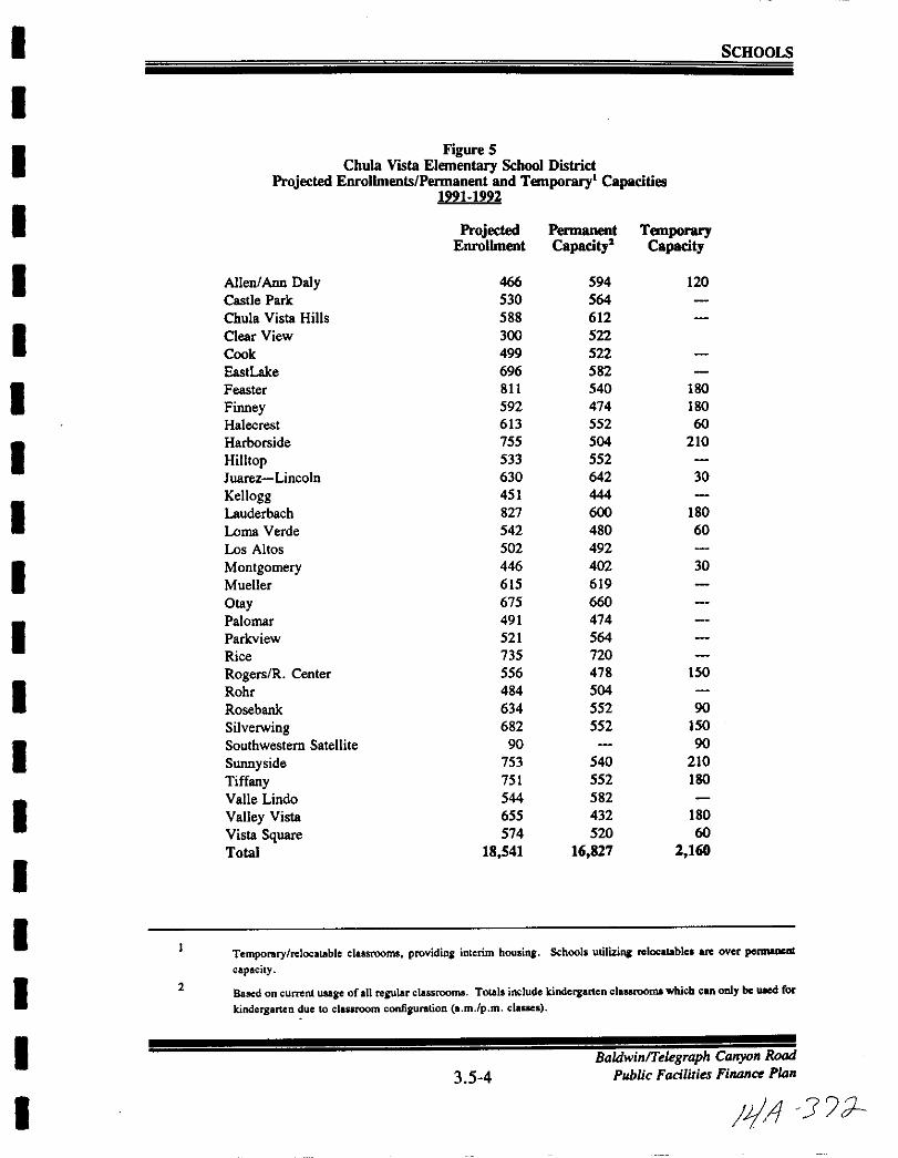
I SCHOOLS
I
I
Figure 5ChuIa Vista Elementary School District
Projected Enrolbnenls Pennanent and Temporary Capacities1991 1992
Projected Pennanent TemporaryEnrolbnent Capacity Capacity
AlieniAnn Daly 466 594 120
Castle Park 530 S64
Chula Vista Hills 588 612
Clear View 300 522
Cook 499 522
EastLake 696 582
Feaster 811 540 180
Fioney 592 474 180
Halecrest 613 552 60
Harborside 755 504 210
Hilltop 533 552
Juarez Lincoln 630 642 30
Kellogg 451 444
Lauderbach 827 600 180
Loma Verde 542 480 60
Los Altos 502 492
Montgomery 446 402 30
Mueller 615 619
Otay 675 660
Palomar 491 474
Parkview 521 564
Rice 735 720
Rogers R Center 556 478 150
Rohr 484 504
Rosebank 634 552 90
Silverwing 682 552 150
Southwestern Satellite 90 90
Suonyside 753 540 210
Tiffany 751 552 ISO
Valle Lindo 544 582
Valley Vista 655 432 ISO
Vista Square 574 520 60
Total 18 541 16 827 2 160
I
I
I
I
I
I
I
I
I
I
I
I
I
ITemporary rclocatable classrooms providina interim housing School utilizina rclocatablc are oyer pennaocrat
capacity
Based on current usage of all reJUlar classrooms Totals include kindergarten clal8rooma which can only be uIlCd for
kindergarten duc to classroom configuration a mlp m clanes
2
I3 5 4
BaldwinTelegraph Canyon Road
Public Facilities Finance Plan
I pIA J L
I
I
I
II
II
I
II
II
I
I
II
I
I
I
SCHOOLS
School Facilities Inventorv Sweetwater Union Hilh School District
The Sweetwater Union High School District currently administers four juniorand four senior high schools and one continuation high school in Chula VistaAs the population grows the District is predicting a need for 4 to 6 juniorhighs and 3 to 6 high schools Currently the District owns three school siteseast ofInterstate 805
The first site which is the most westerly has been determined by the State
Department of Education to be unbuildable due to seismic constraints Thesecond site located in the Sunnyside community has been determined by theSweetwater District to be unbuildable because of the proposed State RouteCaltrans least intrusive alignment plan for State Route 125 cuts through the
property and leaves 5 acres of buildable land for school constructionConstruction plans fora new high school on the third site in the Eastlake greensCommunity are underway with the anticipated completion date of the 1992school year
3 5 5
BaldwinTelegraph Canyon Road
Public Facilities Finance Plan
L 1 7
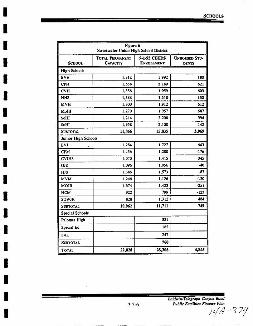
I
I
I
I
I
I
I
I
I
I
I
I
I
I
I
I
I
I
I
SCHOOLS
Figure 6
Sweetwater Union High School District
TOTAL PERMANENT 9 1 92 CBEDS UNHOUSED STUSCHOOL CAPACITY ENROLLMENT DENTS
High Schools
BYH 1 812 1 992 180
CPH 1 568 2 189 621
CYH 1 356 1 959 603
HHS 1 388 1 518 130
MYH 1 300 1 912 612
MoHI 1 270 1 957 687
SoHI 1 214 2 208 994
SuHI 1 958 2 100 142
SUBTOTAL 11 866 15 835 3 9
Junior High Schools
BY 1 284 1 727 443
CPM 1 456 1 280 176
CYJHS 1 070 1415 345
GJS 1 096 1 056 40
HJS 1 386 1 573 187
MVM 1 246 1 126 120
MOJR 1 674 1 423 251
NCM 922 799 123
SOWJR 828 1 312 484
SUBTOTAL 10 962 11 711 749
Special Schools
Palomar High 331
Special Ed 182
SAC 247
SUBTOTAL 760
TOTAL 22 828 28306 4 845
3 5 6BaldwinTelegraph Canyon Road
Public Facilities Finance Plan
F J 77

I
I
I
I
I
I
I
I
I
I
I
I
I
I
I
I
I
I
I
SCHOOLS
Sweetwater Union High School District
EsTIMATED
FuTURE SCHOOLS CAPACITY OPENING DATE
EastLake High School 2 400 Sept 1992
Rancho del Rey Junior High School 1 2001 500 Sept 1997
JuniorlMiddle School in EastLake Trails 1 200 1 500 Contingent on
schedule ofbuild
out
Otay Ranch
24 Junior Highs 1 200 1 500 each unknown
2 5 High Schools 2 400 each unknown
3 5 4 Adequacy Analysis
The Baldwin Telegraph Canyon Road is proposed to consist of 341 dwellingunits at buildout At completion the proposed BaldwinlTelegraph CanyonRoad project could generate approximately 201 students At the student
generation factors shown below this would translate into approximately 102
elementary students 65 junior high students and 34 high school students at
buildout
Student Generation Factors
Elementary k 6
Junior High 7 9
High School 10 12
30
19
10
students dwelling unitstudents
students
School Size
ElementaryJunior HighHigh School
650 students
1 800 students
2 500 students
Based on maximum elementary school capacity levels it is anticipated that the
projected 102 elementary students will create a demand of approximately 16
percent of an entire elementary school facility
3 5 7
BaldwinTelegraph Canyon Road
Public Faciliries Finance Plan
Ii J 75f

I
II
I
I
I
I
I
II
I
I
II
I
I
I
I
I
SCHOOLS
By phase and school category Baldwin Telegraph Canyon Road is expected to
generate the following students
Phase Dwelling Elementary Jr High High School TotalUnits 3 per DU 19 per DU 1 per DU
I 342 102 65 34 201
Total 342 102 65 34 201
There are no existing elementary school facilities to serve the projected 102students The Baldwin Company and school representatives are attempting to
resolve this situation
EastLake High School scheduled for opening in the fall of 1992 will accept all
high school students from the Baldwin Telegraph Canyon Road project
The Sweetwater School District maintains a 29 1 studentteacher ratio for most
classes Therefore the project will require approximately 3 4 new classroomsto fully house the new students
The Bonita Vista Junior High School is currently over capacity by approximately 200 students according to the 1990 report of the Growth ManagementOversight Commission To alleviate this overcrowding the Sweetwater Union
High School District is considering making boundary adjustments in theattendance areas for the school By the fall of 1997 the Rancho del Rey Junior
High is scheduled for completion and at a later date contingent on development absorption the Junior Middle School in EastLake Trails will open
3 5 5 Financing School Facilities
In comments to the City regarding this project the Chula Vista ElementarySchool District staff has stated the problems associated with serving this
project given its location in a newly developing area near two schools
EastLake Elementary and future school in EastLake Greens the first of which
is currently at capacity and the second which is expected to be at or near
capacity by the time it is built In planning for this area it was not envisioned
that an additional 102 children adjacent to the EastLake Community would have
to be housed separate from those children expected from the Otay Ranch
Annexation to the Elementary District s generic community Facilities District
CFD no 5 does not appear to be appropriate for this project as CFD No5 was designed for smaller projects where the impact would be far less on a
particular school This project is not large enough to make formation of a new
3 5 8Baldwin Telegraph Canyon Road
Public Facilities Finance Plan
IV J b

I
I
I
I
I
I
II
I
I
I
I
I
I
I
I
I
I
I
SCHOOLS
CFD feasible There will be an immediate impact on elementary facilities and
funds to provide necessary facilities must be available far earlier than would be
the case through conventional CFD financing Area schools are full One
option would be to obtain full reimbursement up front and utilize the funds
to purchase relocatable classrooms to house these students at a nearby school
Another would be to form a new CFD for the Otay Ranch However
development of Otay Ranch is some time away and the same problem with
having funds to provide facilities at the time of need would exist with this
option as with the first
The Elementary District has met and is continuing to meet with representativesfrom the Baldwin Company and the District s financial consultant toattempt to
resolve these issues The applicant has indicated willingness to pursue either
of the above options The unanticipated development of the Telegraph Canyonproject separate from the Otay Ranch and the lack of facilities to serve this
project require consideration offull reimbursement financing mechanisms which
would allow the District to obtain funds up front so that elementary facilities
are available at the time of need
California Government Code section 65995 and Education Code Section 53080
both authorize districts with the means to impose facility mitigation exactions
on new development as a way to address increasing enrollment caused by that
development Presently there are no statutes which allow the District to
recover increased operations costs resulting from new development Althoughthe collection of school fees is one method available to defray the cost of new
development it is not an acceptable solution to the district inasmuch as the
District s 56 percent of the maximum amount which could be collected by law
represents less than one fourth the cost to construct schools When a projectsuch as the Baldwin Telegraph Canyon Road Proposed Project requireslegislative action the District has the authority to require mitigation above and
beyond the 158 per square foot authorized in state law providing that the
financing mechanism bears a reasonable relationship to the needs caused by the
development
For this reason it has been the District s policy to fully mitigate the facilityimpacts caused by a master planned community via the creation of a Mello
Roos District prior to the approval and recordation of a final map for the
project
3 5 6 Threshold Standard
The City shall annually provide the two local school districts with a 12 to 18
month development forecast and request an evaluation of their ability to
3 5 9
BaldwinTelegraph Canyon Road
Public Facilities Fi1ltlllPlan
p I r 377
I
I
II
I
I
I
I
I
I
I
I
I
I
II
I
I
I
SCHOOLS
accommodate the forecast and continuing growth The District s replies shouldaddress the following
1 Amount of current capacity now used or committed
2 Ability to absorb forecast growth in affected facilities
3 Evaluation of funding and site availability for projected new facilities
4 Other relevant information the District s desire s to communicate to the
City and GMOC
3 5 7 Threshold Compliance
As future development applications are processed in the eastern territories the
City shall coordinate with the School District to ensure that developmentapprovals do not take place until the provision for and financing of schoolfacilities are provided consistent with the threshold standard
The approval of a final map within the Baldwin Telegraph Canyon Roadboundaries will not be made unless the City receives a letter from the Districtconfirming that the provision of school and or the implementation ofacceptablefinancing techniques are in place
3 5 10Baldwill Telegraph CallyolI Road
Public Facilities
4P j 7J
I
I
I
I
I
I
I
I
I
I
I
I
I
I
I
I
I
I
I
3 6 LffiRARIES
BaldwinlTelegraph Canyon Road
3 6 1 Public Facilities Finance Plan
JijA 7

I
II
I
I
I
II
I
I
I
I
I
I
I
I
I
I
I
LmRARIES
3 6
3 6 1
3 6 2
3 6 3
LmRARIES
Service Analysis
Library facilities are provided by the City ofChula Vista Library DepartmentThe City Council approved Master Plan for Libraries includes a range of 500
to 700 square feet of library per 1 000 population Using the design criteria
set forth in the April 30 1987 Chula Vista Public Library Master Plan the
libraries are being designed to an average of 600 square feet per 1 000
population The standard is 500 square feet per 1 000 population
Library facilities are provided in the Chula Vista Public Library Master Plan
Facility Planning to the Year 2010 dated April 30 1987
Project Processing Requirements
Sectional Planninl Area Plan Public Facilities Finance Plans
I Identify phased demands in conjunction with the construction of streets
water and sewer facilities
2 Specifically identify facility site in conformance with the Chula Vista
Library Master Plan April 30 1987
Existing Conditions
Inventorv
The City provides library services through the Chula Vista Public Library at
Fourth and F Street and two small branch libraries in the Montgomery Otayplanning area
The existing and future libraries are listed below
Existing Facilities
Existing Libraries Square Footage
Chula Vista permanent 55 000
Castle Park temporary 1 720
Woodlawn Park temporary 608
Total Existing Square Feet 57 328
BaldwinTe egraph Canyon Road
Public Facilities Finance Plan3 6 2
tA 315
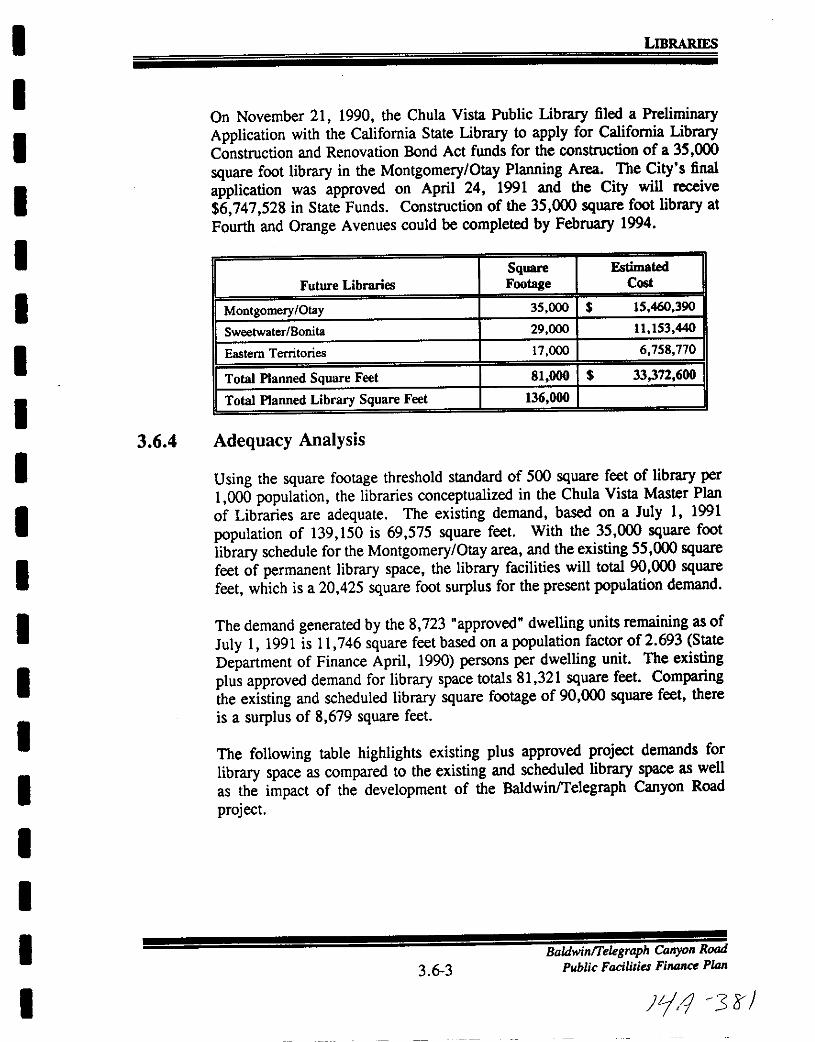
I
I
II
I
II
I
I
I
I
I
I
I
II
I
I
I
LmRARIES
On November 21 1990 the Chula Vista Public Library filed a PreliminaryApplication with the California State Library to apply for California LibraryConstruction and Renovation Bond Act funds for the construction of a 35 000
square foot library in the Montgomery Otay Planning Area The City s final
application was approved on April 24 1991 and the City will receive
6 747 528 in State Funds Construction of the 35 000 square foot library at
Fourth and Orange Avenues could be completed by February 1994
Square Estimated
Future Libraries Footage Cost
Montgomery Otay 35 000 15 460 390
Sweetwater Bonita 29 000 11 153 440
Eastern Territories 17 000 6 758 770
Total Planned Square Feet 81 000 33372 600
Total Planned Library Square Feet 136 000
3 6 4 Adequacy Analysis
Using the square footage threshold standard of 500 square feet of library per
1 000 population the libraries conceptualized in the Chula Vista Master Plan
of Libraries are adequate The existing demand based on a July I 1991
population of 139 150 is 69 575 square feet With the 35 000 square foot
library schedule for the Montgomery Otay area and the existing 55 000 squarefeet of permanent library space the library facilities will total 90 000 squarefeet which is a 20425 square foot surplus for the present population demand
The demand generated by the 8 723 approved dwelling units remaining as of
July I 1991 is 11 746 square feet based on a population factor of 2 693 State
Department of Finance April 1990 persons per dwelling unit The existingplus approved demand for library space totals 81 321 square feet Comparingthe existing and scheduled library square footage of 90 000 square feet there
is a surplus of 8 679 square feet
The following table highlights existing plus approved project demands for
library space as compared to the existing and scheduled library space as well
as the impact of the development of the BaldwinTelegraph Canyon Road
project
3 6 3BaldwinlTelegraph Canyon Road
Public Facilities Finance Plan
ll1 3 rr
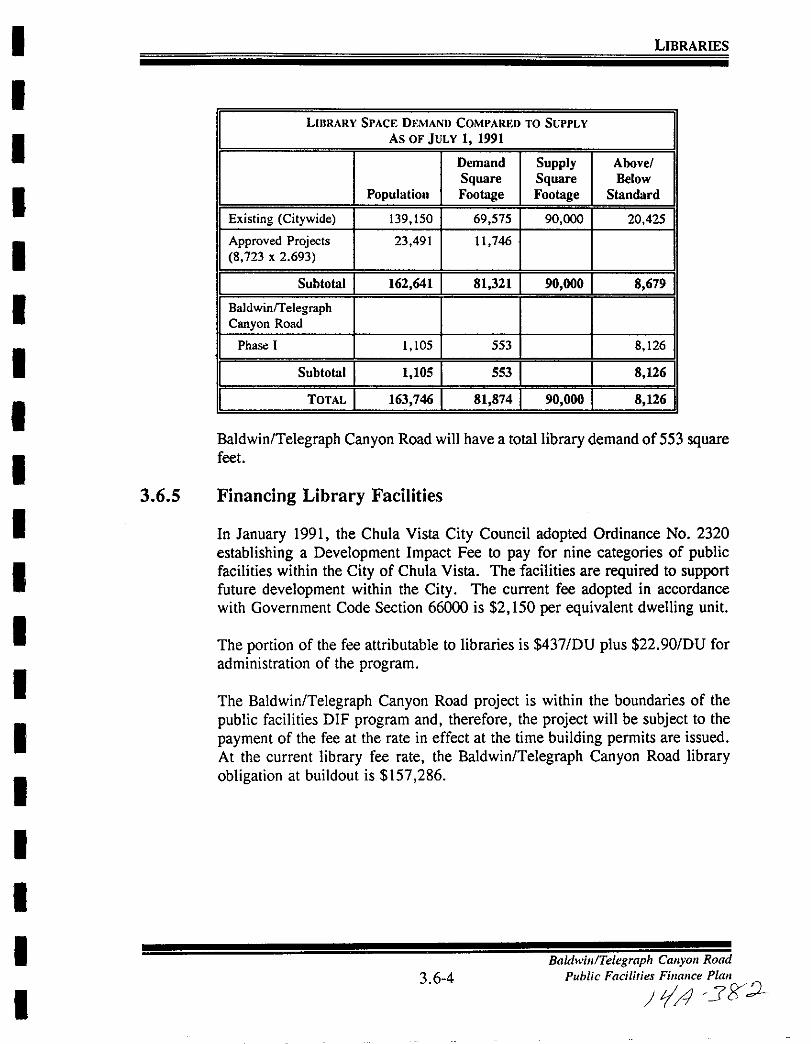
I
I
I
I
I
I
I
I
I
I
I
I
I
II
I
I
I
I
LIBRARIES
LIIlRARY SPACE DEMAND COMPARED TO SUPPLY
AS OF JULY 1 1991
Demand Supply Above
Square Square Below
Population Footage Footage Standard
Existing Citywide 139 150 69 575 90 000 20 425
Approved Projects 23491 11 746
8 723 x 2 693
Subtotal 162 641 81 321 90 000 8 679
BaldwinrrelegraphCanyon Road
Phase I 1 105 553 8 126
Suhtotal 1 105 553 8 1
1TOTAL 163 746 81 874 90 000 8 12
Baldwin Telegraph Canyon Road will have a total library demand of 553 squarefeet
3 6 5 Financing Library Facilities
In January 1991 the Chula Vista City Council adopted Ordinance No 2320
establishing a Development Impact Fee to pay for nine categories of publicfacilities within the City of Chula Vista The facilities are required to supportfuture development within the City The current fee adopted in accordance
with Government Code Section 66000 is 2 150 per equivalent dwelling unit
The portion of the fee attributable to libraries is 437 DU plus 22 90 DU for
administration of the program
The Baldwin Telegraph Canyon Road project is within the boundaries of the
public facilities DIF program and therefore the project will be subject to the
payment of the fee at the rate in effect at the time building permits are issued
At the current library fee rate the Baldwin Telegraph Canyon Road libraryobligation at buildout is 157 286
3 6 4
Baldwin Telegraph Canyon Road
Public Facilities Finance Pla
tA Jgl
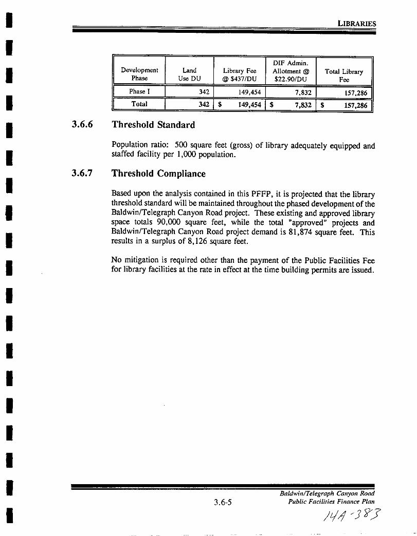
I
I
I
I
I
I
II
I
I
I
I
I
I
I
I
I
II
LIBRARIES
DlF Admin
Development Land Library Fee Allotment @ Total LibraryPhase Use DU @ 437 DU 22 90IDU Fee
I Phase I 1 3421 149454 1 7 832 I 157 286 II Total I 342 I 149 454 I 7 832 I 157 286 1
3 6 6 Threshold Standard
Population ratio 500 square feet gross of library adequately equipped andstaffed facility per 1 000 population
3 6 7 Threshold Compliance
Based upon the analysis contained in this PFFP it is projected that the librarythreshold standard will be maintained throughout the phased development of theBaldwin Telegraph Canyon Road project These existing and approved libraryspace totals 90 000 square feet while the total approved projects andBaldwin Telegraph Canyon Road project demand is 81 874 square feet Thisresults in a surplus of 8 126 square feet
No mitigation is required other than the payment of the Public Facilities Feefor library facilities at the rate in effect at the time building permits are issued
3 6 5
Baldwin Telegraph Canyon Road
Public Facilities Finance Pla
L1 JJ
I
II
I
I
I
I
II
I
I
II
I
II
I
I
3 7 PARKS AND RECREATION
3 7 1
BaldwinTe egraph Canyon Road
Public Facilities Finance PIDn
LIJ 1
II
I
I
I
I
I
I
I
I
I
I
I
I
I
II
I
I
PARKS AND RECREATION
3 7 PARKS AND RECREATION
3 7 1 Service Analysis
The City of Chula Vista provides public park and recreational opportunitiesthrough the Parks and Recreation Department which is responsible for the
acquisition and development of parkland All park development plans are
reviewed by City staff and presented to the Parks and Recreation Commission
for review A recommendation is made by the Parks Commission to the
deciding body the City Council
The Parks Element of the General Plan dated July 1990 serves as the master
plan for park facilities There is currently no existing citywide detailed parksmaster plan
3 7 2 Project Processing Requirements
Sectional Planninl Area Plan Public Facilities Finance Plans
1 Identify phased demands in conformance with street improvements and
in coordination with the construction of water and sewer facilities
2 Specific siting of the facility will take place in conformance with the
Chula Vista General Plan Park and Recreation Element
3 Site reserved
3 7 3 Existing Conditions
The existing and future parks as depicted in the Park and Recreation Element
of the General Plan are listed in Figures 7 and 8
3 7 2
BaldwinTe egraph Canyon Road
Public Facilities Finance Plan
111 J7S
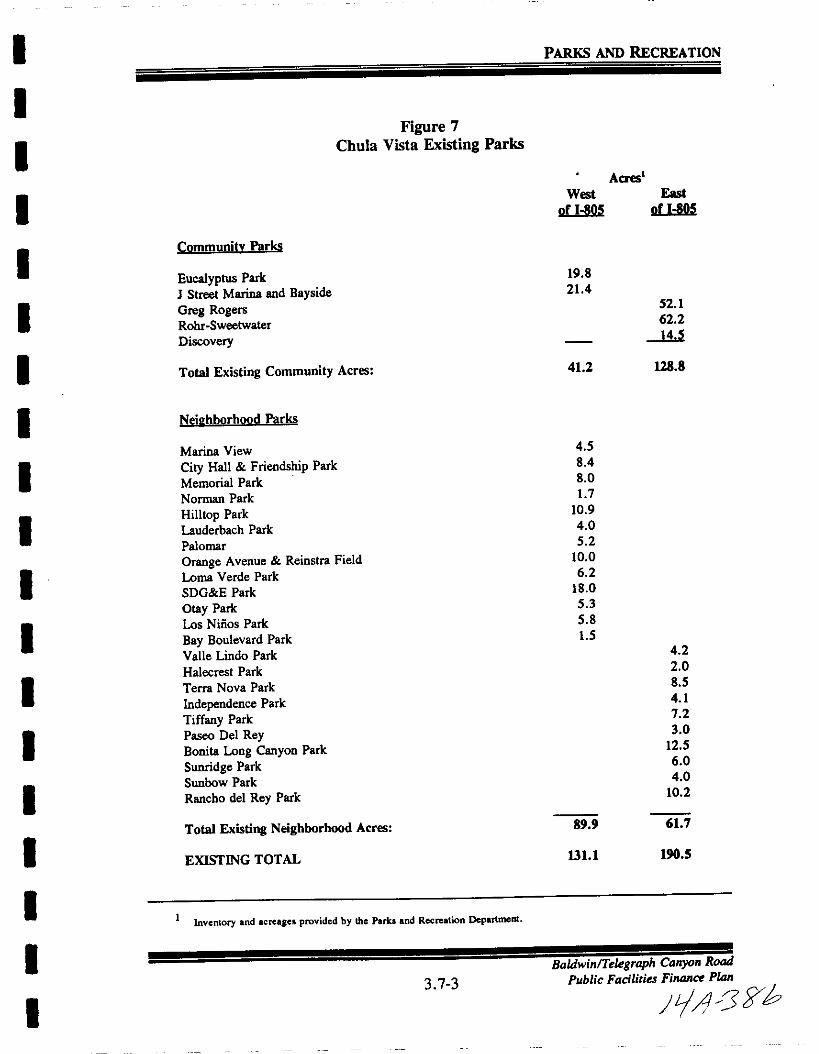
I
II
I
I
I
I
I
I
I
I
I
I
I
III
I
I
PARKS AND RECREATION
Figure 7
Chula Vista Existing Parks
Acres
West
or 1805
East
or 1805
Community Parks
Total Existing Community Acres
19 8
21452 1
62 2
412 128 8
Eucalyptus Park
J Street Marina and BaysideGreg RogersRohr Sweetwater
Discovery
Nei2hborhood Parks
4 5
84
8 017
10 9
405 2
10 0
6 2
18 0
5 35 8
lS4 2
2 0
8 5
4 17 2
3 0
12 5
6 0
4 0
10 2
89 9 61 7
1311 190 5
Marina View
City Hall Friendship Park
Memorial Park
Norman Park
Hilllop Park
Lauderbach Park
Palomar
Orange Avenue Reinstra Field
Loma Verde Park
SDG E Park
Otay Park
Los Nmos Park
Bay Boulevard Park
Valle Lindo Park
Halecrest Park
Terra Nova Park
Independence Park
Tiffany Park
Paseo Del ReyBonita Long Canyon Park
Sunridge Park
Sunbow Park
Rancho del Rey Park
Total Existing Neighborhood Acres
EXISTING TOTAL
1Inventory and acreagel provided by lhc Parka and Recreation Department
3 7 3
BaldwinTelegraph Canyon Road
Public Facilities Finance Plan
J A ffb

I PARKS AND RECREATION
I
IFigure 8
Chula Vista Future ParksAcres
IWest
of 1805
East
of 1805
Future Community Parks
I
Rancho San MiguelSalt Creek CommunityRutgersTelegraph South
MontgomeryOlay ValleyUniversity West
University East
EastLake Woods
Sunbow CommunityEastLake Community
2S20
2S
2SI
I
I
24 0
2S
2S2S
22 5
10 5
12 5
Total Future Community Acres 24 0 215 5
IFuture Neilhborhood Parks
I
Marisol Park
F Street Woodlawn
4th OrangeExplorer Park
Olay Valley Road BrandywinePaseo Ranchero Wolf CanyonRancho Drive Park
EastLake Trails
Salt Creek NeighborhoodEastLake Greens
Unnamed Park
Unnamed Park
6 0
I12 5
12 5
I
5 012 5
12 5
12 512 5
7 0
12 5125
12 5
I Total Future Neighborhood Acres lli
IFUTURE TOTAL 615 308 5
I
INote The general plan minimum part sizes arc 15 acrea for community and 7 acre for nei bborbood Since 1bc cIeIiftd aDd
anticipaled size i 2030 acrea for community and 1015 acres for neiahborbood it it recommended that the poem plan
clement be amended to reflect the desired size For the purpoaea of this park listina aD annp i UNCI 2S acre or
community parks and 12 5 for neighborhood parks
IInventory and acreages provided by the Parks and Recreation Department
I3 7 4
BaldwinTelegraph Canyan Road
Public Faciliries Finance Plan
I 1L 33
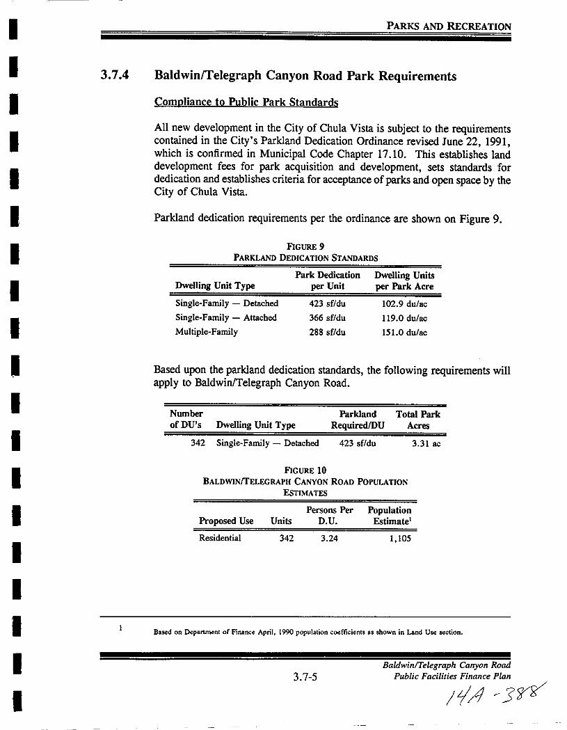
I
I
I
II
I
I
I
I
II
I
I
I
I
I
I
I
I
PARKS AND RECREATION
3 7 4 Baldwinrrelegraph Canyon Road Park Requirements
Compliance to Public Park Standards
All new development in the City of Chula Vista is subject to the requirementscontained in the City s Parkland Dedication Ordinance revised June 22 1991which is confirmed in Municipal Code Chapter 17 10 This establishes land
development fees for park acquisition and development sets standards fordedication and establishes criteria for acceptance ofparks and open space by the
City of Chula Vista
Parkland dedication requirements per the ordinance are shown on Figure 9
FIGURE 9
PARKLAND DEDICATION STANDARDS
Dwelling Unit Type
Single Family Detached
Single Family Attached
Multiple Family
Park Dedication
per Unit
423 sf du
366 sf du
288 sf du
Dwelling Units
per Park Acre
102 9 du ac
119 0 du ac
1510 du ac
Based upon the parkland dedication standards the following requirements will
apply to Baldwin Telegraph Canyon Road
Number
ofDU s Dwelling Unit Type
342 Single Family Detached
Parkland
RequiredlDU
423 sf du
Total Park
Acres
3 31 ac
FIGURE 10
BALDWINTELEGRAPH CANYON ROAD POPULATION
ESTIMATES
Proposed Use
Residential
Persons Per
Units D U
342 3 24
PopulationEstimate
1 105
Based on Department of Finance April 1990 population coefticients as shown in Land Use section
3 7 5Baldwin Telegraph Canyon Road
Public Facilities Finance Plan
IrA 3
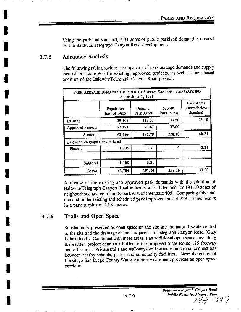
II
I
I
II
II
I
I
I
I
I
I
II
I
I
I
PARKS AND RECREATION
Using the parkland standard 3 31 acres of public parkland demand is created
by the Baldwin Telegraph Canyon Road development
3 7 5 Adequacy Analysis
The following table provides a comparison of park acreage demands and supplyeast of Interstate 805 for existing approved projects as well as the phasedaddition of the Baldwin Telegraph Canyon Road project
PARK ACREAGE DEMAND COMPARED TO SUPPLY EAST OF INTERSTATE 805
AS OF JULY 1 1991
Park Acres
Population Demand Supply Above Below
East of I 80S Park Acres Park Acres Standard
Existing 39 108 117 32 190 50 73 18
Approved Projects 23 491 7047 37 60
I SubtoIB I 62 599 I 187 791 228 10 I 40 31 IBaldwinrrelegraph Canyon Road
Phase I 1 105 3 31 0 3 31
I SubtoIBI I 1 1051 3 31 I II TOTAL I 63 704 I 191 10 I 228 10 I 37 00 IA review of the existing and approved park demands with the addition of
Baldwin Telegraph Canyon Road indicates a total demand for 191 10 acres of
neighborhood and community park east of Interstate 805 Comparing this total
demand to the existing and scheduled park improvements of 228 1 acres results
in a park surplus of 40 31 acres
3 7 6 Trails and Open Space
Substantially preserved as open space on the site are the natural swale central
to the site and the drainage channel adjacent to Telegraph Canyon Road GtayLakes Road Combined with these areas is an additional open space area alongthe eastern project edge as a buffer to the proposed State Route 125 freewayand off ramps Private trails and walkways will provide functional connections
between nearby schools parks and community facilities Near the center of
the site a San Diego County Water Authority easement provides an open space
corridor
3 7 6
Baldwin Telegraph Canyon Road
Public Facilities Finance Plan
tJ 1fS
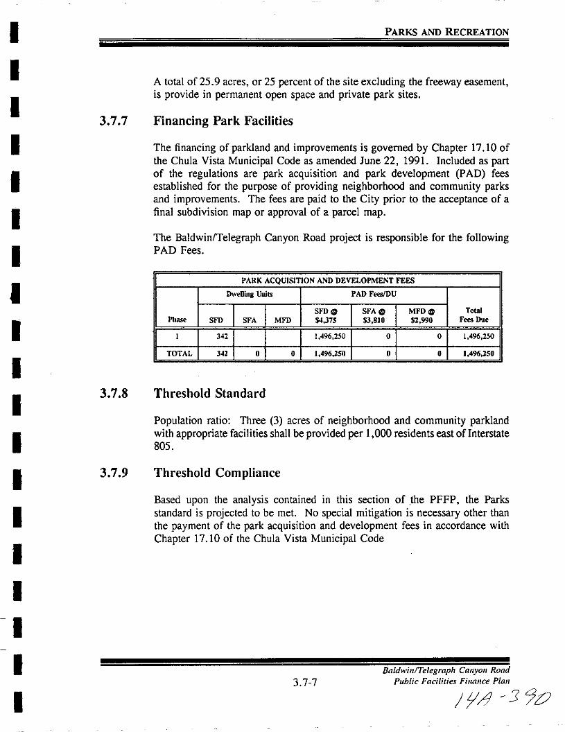
I
I
I
I
I
I
I
I
I
I
I
I
I
I
I
I
I
I
PARKS AND RECREATION
3 7 7
3 7 8
3 7 9
A total of25 9 acres or 25 percent of the site excluding the freeway easement
is provide in permanent open space and private park sites
Financing Park Facilities
The financing of parkland and improvements is governed by Chapter 17 10 of
the Chula Vista Municipal Code as amended June 22 1991 Included as partof the regulations are park acquisition and park development PAD fees
established for the purpose of providing neighborhood and community parksand improvements The fees are paid to the City prior to the acceptance of a
final subdivision map or approval of a parcel map
The Baldwin Telegraph Canyon Road project is responsible for the followingPAD Fees
PARK ACQUISITION AND DEVELOPMENT FEES
Dwelling Uuits PAD FeesJDU
SFDC SFAC MFDC TotalPbase SFD SFA MFD 4375 3 810 2 990 Fees Due
1 342 1 496 250 0 0 1 496 250
TOTAL 342 0 0 1 496 250 0 0 1 496250
Threshold Standard
Population ratio Three 3 acres of neighborhood and community parklandwith appropriate facilities shall be provided per 1 000 residents east ofInterstate
805
Threshold Compliance
Based upon the analysis contained in this section of the PFFP the Parks
standard is projected to be met No special mitigation is necessary other than
the payment of the park acquisition and development fees in accordance with
Chapter 17 10 of the Chula Vista Municipal Code
3 7 7
Baldwin Telegraph Canyon Road
Public Facilities Finance Plan
fA 1 90

I
I
I
I
I
I
I
I
I
I
I
I
I
I
I
I
I
I
I
3 8 WATER
BaldwinTe graph Canyon Road
3 8 1 Public Facilities Finance Plan
01r3J
I
II
I
I
I
I
I
I
I
I
I
I
I
I
I
I
I
I
WATER
3 8 WATER
3 8 1 Service Analysis
Water is provided to the City of Chula Vista through the San Diego CountyWater Authority Sweetwater Authority and the Otay Municipal Water DistrictThe City ofChula Vista is working with each of these special districts toensure
that new growth will not reduce the availability of adequate water supplies or
jeopardize the water quality standards within the City Each of these districts
is responsible for providing capital facilities necessary to accommodate future
growth as well as providing services to existing development within the Cityof Chula Vista The existing and proposed facilities to serve the communitythrough the water districts are listed on Figures 11 and 12
The Sweetwater Authority utilizes Sweetwater Authority Water Master Plan
dated December 1989
Black Veatch has prepared a draft master plan for the Otay Municipal Water
District which the City is currently reviewing
A Master Plan of Water for Baldwin Telegraph Canyon Road dated October
1991 has been prepared by Wilson Engineering
Reclaimed water is addressed in the July 1989 Water Reclamation and Reuse
Conceptual Master Plan Prepared for the Clean Water Program for Greater San
Diego by James M Montgomery Consulting Engineers Inc
3 8 2 Project Processing Requirements
Sectional PlanniDl Area Plan Public Facilities Finance Plans
I Identify phased demands in conformance with street improvements and
in coordination with the construction of sewer facilities2 Identify location of facilities for on site and off site improvements in
conformance with the master plan of the water district serving the
proposed project and in compliance with the Otay Water District s
Allocation Plan
3 Provide cost estimates and proposed financing responsibilities4 Identify financing methods5 A Water Conservation Plan shall be required for all major development
projects 50 dwelling units or greater or commercial and industria1
projects with 50 EDU s of water demand or greater
3 8 2BaldwinlTelegraph Canyon Road
Public Facilities Finance Plan
jif JJA
I
I
I
I
I
I
I
I
I
I
I
I
I
I
I
I
I
I
I
WATER
3 8 3 Existing Conditions
Facilitv Inventorv
San Diego County Water Authority
ExistinFacilitv Canacitv
Pipeline 3 east ofCorral Canyon Rd
66 single to delivertreated water
Pronosed Facilitv Canacitv Fstimated Cost
Pipeline 4 ExtensionParallel line east of
Corral Canyon Rd
96 single to deliverraw water
Chula Vista s
portion of the cost
is unknown but the
total estimated cost
is 4060 million
Otav Municipal Water District Allocation Proram
The Otay Municipal Water District has been experiencing a water storageproblem for some time As a result the district developed and is implementinga water allocation system The Dtay Water District Report on Allocation ofWater Requests Based on Water Availability was adopted by the Board of
Directors on April 19 1989 as Resolution No 2742 Because of the limited
water supply and storage for unlimited amounts ofconstruction the allocation
system allots 1 900 Equivalent Dwelling Units EDUs of water service per
year for the service area In the City of Chula Vista this limit equates to
approximately 700 to 1 000 units per year This system will remain in effect
until supply and terminal storage conditions improve at which time the yearlyallotment of connections will be raised or the allocation program will be
eliminated These improvements are anticipated to be completed in 1993
The Otay Water District water allocation program addresses actions taken bythe District and land developers to allow issuance of water service connections
within the District until the County Water Authority CWA completesconstruction of the new Pipeline No 4 The issuance of water services is
subject to the District s present limited water storage and water supply These
actions include the approval of guidelines which 1 categorize various water
requests and 2 determine if a water service request qualifies for immediate
connection or future connection by a land development being allocated water
service to a proportion of the anticipated Equivalent Dwelling Units EDUs
3 8 3
BaldwinTe1egraph Cturyon Rood
Public F aciities Finance Plan

I
I
I
I
I
I
I
I
I
I
I
I
I
I
I
I
I
I
I
WATER
requests The following categories are used in determining the association of
water service in the District
Category I Water service requests that qualify for immediate water
connection with issuance of an approved building permit
Cateeory II Water service requests that qualify for water service connection
contingent upon completion of conditions of an agreement with the District
entered into prior to adoption of the allocation program
Catelory III Land development water service requests that are allocated
water service dependent on contribution to construction ofmajor water facilities
including but not limited to terminal water reservoirs major water transmis
sion mains pump stations etc that directly or indirectly support water
service
Based on anticipated terminal reservoir construction development will onlyreceive a proportionate share of water service requests as determined by the
Allocation Formula applied to the total requests that qualify in a given yearwithin the annual limit of 1 900 EDUs The proportionate share will be
determined from an allocation process in which a specific request is considered
in a quarterly allocation of total requests
Water services allocated to major developments of a master planned communitywill be determined for a future quarter as a part of an agreement with the
District for construction of required terminal reservoir storage and other majorwater facilities
Otav Triad Alreement
This agreement is between the Otay Water District EastLake DevelopmentCompany Rancho Del Rey Partnership and Rancho Del Sur Partnership In
essence the Otay Triad Agreement allows EastLake Rancho Del Rey and
Rancho Del Sur to request more EDUs per quarter per development for singlefamily connections than would otherwise be possible Without the Otay Triad
Agreement these developers would not be able to request more than 200 EDUs
per quarter per development for single family connections In exchange the
developers have approved bond financing of terminal storage faculties in lieu
of paying Otay a Reservoir Storage Fee This enables Otay to construct the
necessary terminal storage reservoirs at an earlier date than would have been
possible by simply collecting fees
3 8 4
Baldwin Telegraph Canyon Road
Public Facilities FilltUlCt Plan
JIA 3 72

I
I
I
I
I
I
I
I
I
I
I
I
I
I
I
I
I
I
I
WATER
3 8 4 Adequacy Analysis
The atay Municipal Water District s allocation program will impact or limit
development in the City of Chula Vista to between 700 and 1 000 units per
year until additional storage facilities are provided It is projected these
facilities will not be available until 1993
Water Conservation Plan
A Water Conservation Plan is required for all major development projects 50
dwelling units or greater or commercial and industrial projects with 50 EDU s
of water demand or greater This plan is required at the Sectional PlanningArea SPA Plan level or equivalent for projects which are not processedthrough a Planned Community Zone
The water conservation plan shall provide an analysis of water usage requirements of the proposed project as well as a detailed plan of proposed measures
for water conservation use of reclaimed water and other means of reducingper capita water consumption from the proposed project as well as defining a
program to monitor compliance This plan shall be reviewed by the Resource
Conservation Commission and Planning Commission prior to final review and
adoption by the City Council The Water Conservation Plan will not be
prepared as part of the Public Facilities Financing Plan
Baldwin Teletraoh Canvon Road Water Demand
The Baldwin Telegraph Canyon Road project is located within the atay Water
District and therefore water service for the project will be provided by the
atay Water District Because of the range of elevation throughout the projectthe Baldwin Telegraph Canyon Road development will be served by two water
service zones Approximately 255 single family residences and the park will
be served by the 710 Zone Approximately 95 residential units are above the
upper service boundary of the 710 Zone and will require service from the 980
Zone
The estimated average demand in the 710 Zone is 138 400 gpd and the
estimated average demand for the 980 Zone is 52 032 gpd The total average
demand projected for Baldwin Telegraph Canyon Road is 190 432 gpd This
amount excludes demands that will be satisfied by reclaimed water
Current district policy also requires ten average days of total storage capacitybe provided for emergency storage to meet aqueduct shutdown conditions The
total volume required for Baldwin Telegraph Canyon Road is approximately 2 0
3 8 5
BaldwinTelegraph Canyon Road
Public Facilities Finance Plan
11 J9
I
I
I
I
I
II
I
I
I
I
I
I
I
II
I
I
I
WATER
million gallons At 40 per gallon the 2 0 million gallons would equate to
a fee of 800 000 This formula is currently under study by OWD
Baldwin Telegraph Canyon Road will also be required to annex into an
improvement district within Otay Water District These improvement districts
are set up for the purpose of collecting fees for the expansion operation andmaintenance of water facilities
Otav Water District Master Plan
The Otay Water District s new water and reclaimed water master plan includeswater demands for this project as part of the overall demands in the area based
upon land use data
3 8 5 Existing Facilities
The existing water supply to the project and surrounding area is supplied viaa connection to the San Diego County Water Authority Aqueduct The San
Diego County Water Authority Aqueduct connection supplies the 12 4 million
gallon 624 Zone Patzig Reservoir The Central Area Pump Station drawswater from the Patzig Reservoir and discharges to the 710 Zone The 710Zone water is then further boosted to the 980 Zone
Figure 11 presents a map which identifies the existing potable water facilitiesin the vicinity of the project Although water service will be provided from the
710 Zone and 980 Zone existing 624 Zone facilities are shown as they are
located through the property The following discussion of existing facilities is
divided between the 710 Zone and the 980 Zone
Existinl 710 Zone Facilities
The source for the 710 Zone is the Central Area Pump Station located near the
624 Zone Patzig Reservoir As shown on Figure 11 there is an existing 710Zone 16 inch line located in the Telegraph Canyon Road along the southern
boundary of the project In addition there is a 980710 Zone pressure
reducing station and 710 Zone 12 inch line located in the northwest corner of
the project Storage for the 710 Zone is provided in the 3 million gallonreservoir located south of Telegraph Canyon Road in the EastLake Development
3 8 6
BaldwinTe egraph Canyon Road
Public Facilities Finance PIDn
IiAI 1
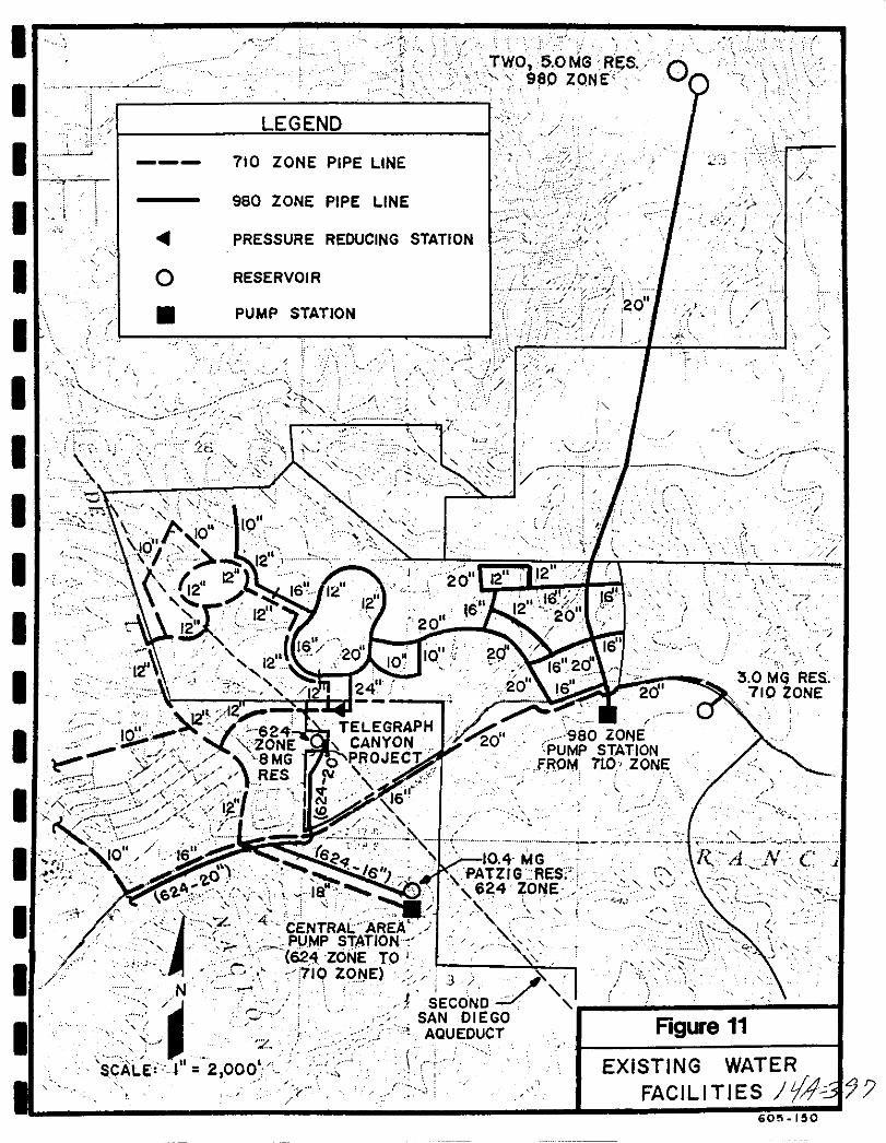
I
I
I
I I
I
I
I
I
I
I
I
I
I
I
II
I
I
12 1d
10 624ZONESlOGm
0
c V RES
2 Jtl
T
o
LEGEND
710 ZONE PIPE LINE
980 ZONE PIPE LINE
PRESSURE REDUCING STATION
RESERVOIR
PUMP STATION
J
t
j SECONOJSAN DIEGOAQUEDUCT
o
J
20
r
0
M
j
3 0 MG RES710 ZONE
1 j
f j
Figure 11
EXISTING WATER
FACILITIES tjJ 77
2
2 000
605 150
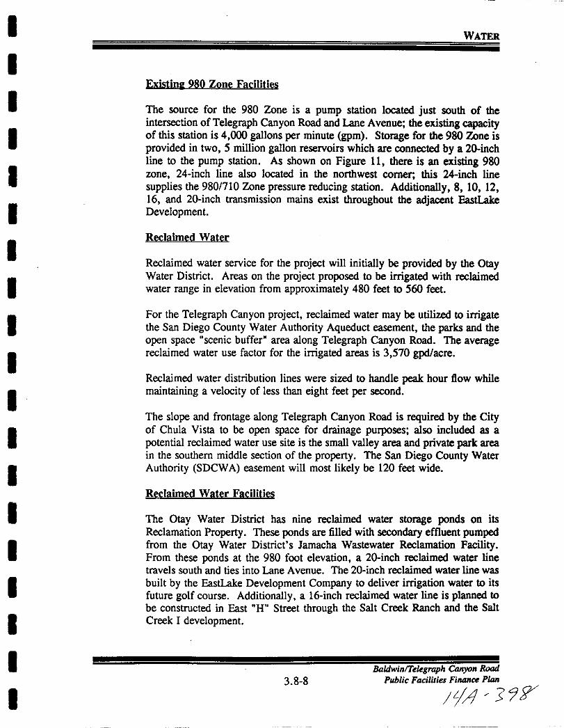
I
I
I
I
I
I
I
I
I
I
I
I
I
I
II
I
I
I
WATER
Existim 980 Zone Facilities
The source for the 980 Zone is a pump station located just south of theintersection ofTelegraph Canyon Road and Lane Avenue the existing capacityof this station is 4 000 gallons per minute gpm Storage for the 980 Zone is
provided in two 5 million gallon reservoirs which are connected by a 20inchline to the pump station As shown on Figure II there is an existing 980zone 24 inch line also located in the northwest comer this 24 inch line
supplies the 980710 Zone pressure reducing station Additionally 8 10 1216 and 20inch transmission mains exist throughout the adjacent EastLake
Development
Reclaimed Water
Reclaimed water service for the project will initially be provided by the OtayWater District Areas on the project proposed to be irrigated with reclaimed
water range in elevation from approximately 480 feet to 560 feet
For the Telegraph Canyon project reclaimed water may be utilized to irrigatethe San Diego County Water Authority Aqueduct easement the parks and the
open space scenic buffer area along Telegraph Canyon Road The averagereclaimed water use factor for the irrigated areas is 3 570 gpdacre
Reclaimed water distribution lines were sized to handle peak hour flow while
maintaining a velocity of less than eight feet per second
The slope and frontage along Telegraph Canyon Road is required by the Cityof Chula Vista to be open space for drainage purposes also included as a
potential reclaimed water use site is the small valley area and private park area
in the southern middle section of the property The San Diego County Water
Authority SDCWA easement will most likely be 120 feet wide
Reclaimed Water Facilities
The Otay Water District has nine reclaimed water storage ponds on itsReclamation Property These ponds are filled with secondary effluent pumpedfrom the Otay Water District s Jamacha Wastewater Reclamation FacilityFrom these ponds at the 980 foot elevation a 20 inch reclaimed water linetravels south and ties into Lane Avenue The 20inch reclaimed water line was
built by the EastLake Development Company to deliver irrigation water to its
future golf course Additionally a l6 inch reclaimed water line is planned to
be constructed in East R Street through the Salt Creek Ranch and the Salt
Creek I development
3 8 8BaldwinTe egraph Canyon Rood
Public Facilities Finance Plan
ItA Jc

I
I
I
I
I
II
I
I
I
I
II
I
I
I
I
I
I
WATER
The Jarnacha plant has an existing capacity of 12 million gallons per dayMGD An expansion capability study was prepared which states that the plant
could be expanded to 2 6 MOD As development continues in EastLake SaltCreek I and Salt Creek Ranch the demand for reclaimed water will exceed the
available supply from the atay Water District s facility
3 8 6 Proposed Facilities
This section discusses the recommended potable water facilities needed toserve
the Telegraph Canyon project Figure 12 presents the proposed water facilities
for both water pressure zones the boundary line separating the 980 Zone and710 Zone service areas is also indicated
As discussed previously water service from the atay Water District s 710 Zone
and the 980 Zone will be required to serve the Telegraph Canyon projectEach service zone has its own requirements for water facilities which will be
discussed separately
710 Zone
The 710 Zone services pad elevations up to 560 feet As indicated on Figure12 the majority of the project approximately 75 percent will be providedwater service from the 710 Zone Based on the proposed site plan for the
project approximately 255 units and the parks will be located in the 710 Zone
service area The required fire flow for this area is 1 500 gpm
The proposed 710 Zone water distribution facilities consist of 8 and lO inch
pipelines necessary to provide adequate domestic services and fire protectionto the Telegraph Canyon project
The proposed system will require a lO inch connection to the existing 710
Zone 16inch line in Telegraph Canyon Road A second 8 inch connection isrecommended to connect to the existing 12 inch line in the northwest comer to
provide a secondary source As shown an 8 inch loop of unknown configuration will be necessary throughout the 710 Zone service area
As an alternative to the lO inch connection to the 16inch line in atay LakesRoad two 8 inch connections would also provide adequate service
3 8 9BaldwinTelegraph CturyOn Rood
Public Facilities Finance Plan
Jfl J 1
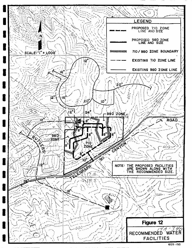
I
I nsL t oo lU l
ZU
I
j iK 16
II no
j 7F Ji
l o j
c fbto1lf j
c fjS80 ONE
i5 t Id k2 I
4f j ROAOr
l r Y
l yq
J J7
II 08 rtJ
tf98 el
8 8II i
v j fIJi 1 fJ
v ZQlIlJ r
J 8f rJ 7 C 5
e jf ZOE j
j 1 irr
0
0
i7 f r 1 F fi i
j j rYI LX NOTE THE PROPOSED FACILITIES
0
1i bS ARE SHOWN ALONG WITHnW
0iff THE RECOMMENDED SIZEl 3 M
I
Jt
y
f ct1 18 1
t N r J i 1l i 1
0
olli t I
fJi iiJ fsj
Cors J 1T RECOMMEND WJE
FACILITIES
1I LEGEND1
I PROPOSED 710 ZONELINE AND SIZE
IPROPOSED 980 ZONE
LINE AND SIZE
710 I 980 ZONE BOUNDARY
I EXISTING 710 ZONE LINE I
IEXISTING 980 ZONE LINE
II
I
I
I
I
I
I
II
I
I
I605 150

Itlx
r A j iN f
I I ffJ
SCALC i QOOI l
JJ
rf r if
r j7 t
i
Q isS i H F if ftix e h c 1oE
IE q S I Ii l
X t F 1l t 4
RE CElEAnONAL
illX E 3 aop IL
2 X
11j ROAO
J 1 f
t F tl Si rr5 e E 1 BUFFER t I
2
y i 1 SLOPE i V
r i f j j l i PH
1i
S J 0
f Jr I
i 1
j i rl
1fr J V iIrlf
rC1 1 1WATER USE AREAS
I
I
I
I
I
I
I
I
I
I
I
I
I
II
I
I
I605 52
RECLAI MED wATERSTORAGE PONDS
980 HOC
i i
A
I
If
IN
elloo
7
I SCALE 2 OOO
I
I IS
I l E
I
I
I
I
I
I
ELEG
Z z j t JH
y
r YA I
iQ
r G
XI
1
pL
m
NJ I c
r
I
II
J
zr
v
I 3
j
I Z
I
Y
f
V
j
20
ROAD
t
i
20
i
ti
i
7
j
C J
1
Figure 14
EXISTINGWATER
RECLAIMEDFACILITIES
l LL 605 152
I
I
I
I
I
II
I
I
I
I
I
I
I
I
I
I
I
I
WATER
710 Zone Purnn Station and Storale
There is a new 710 Zone Pump station currently under construction at the
Patzig Reservoir to expand the existing Central Area Pump Station to 12 000
gpm The estimated operational and fire flow storage required for the 710
Zone on the Telegraph Canyon project is 430 000 gallons There is not
sufficient elevation for a 710 Zone reservoir onsite therefore offsite storage
will be required in an existing or new 710 Zone reservoir
980 Zone
The 980 Zone services elevations from 560 feet up to840 feet Approximately25 percent of the developable land will be provided water service from the 980
Zone Based on the proposed site plan 95 units will be located in the 980
Zone service area The required fire flow for these units is 1 000 gpm
The recommended 980 Zone water distribution facilities consist of 8 inch
pipelines necessary to provide adequate domestic service and fire protection to
the two 980 Zone service areas on the Telegraph Canyon project
The proposed system consists of one 8 inch connection to the existing 980
Zone 24 inch line located in the northwest corner of the project From this
8 inch connection the project will most likely require two 8 inch lines to serve
both the northern and western 980 Zone service areas
980 Zone Purnn Station and Storale
The existing 980 Zone pump station has an existing capacity of4 000 gpm and
can be expanded to 8 000 gpm with the addition of one pump if needed to
serve the Telegraph Canyon project The estimated operational and fire flow
storage required for the Telegraph project is 350 000 gallons The Water
Resources Master Plan states that an additional 16 2 million gallons is needed
to meet the ultimate operational storage need in the 980 Zone
3 8 13
BaldwinTe egraph Canyon Road
Public Facilities Finance Plan
JrA ij
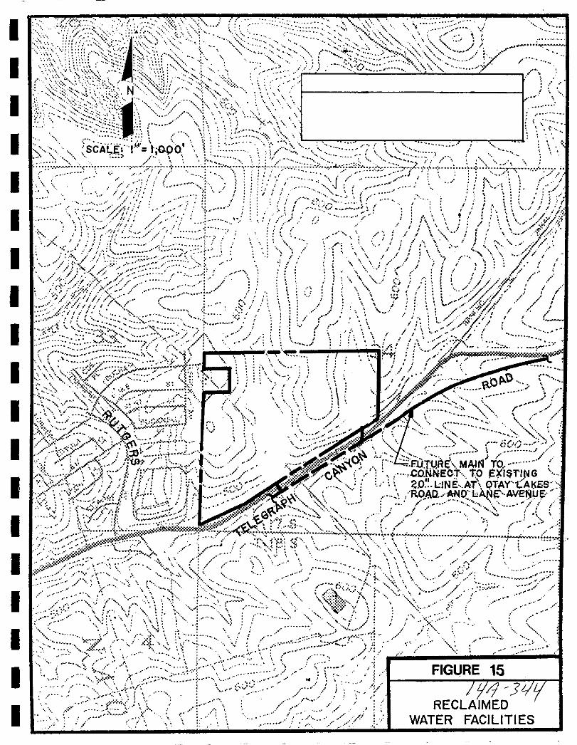
I
I
I vi i
5 y
SCALf I t OPO I
t s t r ttj f j f Tflit 7 il I
I I AI I i i J I1 I h
1 t j ft I l 1
j lI 7 I1 I t1
1 1 S1 r j l N 1
I 11 II
I
II 1
01f
ii
4y
7 1f 010 Os1 F
0 Ft o
JJ I
t Te 7 IA 0 y Iu
Osi
ltt
I 1
frw II l v FDT U E MAH TOI r l T r I
ic cO NNECT TO I 1NGv t
11f iOlINE AT QTAYtAlfS
I j ROAD 4A o hII ut 0v
IOn V I
j1v or jJo d I1 I i
1C I Iv
uo oo x o iI
tj i
i
j i
t ir l cOV
I
I
I
I
I
I
I
I
I
I
I
I
I
I
I
I
I
I
FIGURE 15
9 JRECLAIMED
WATER FACILITIES
I
I
I
I
II
I
I
I
I
I
I
I
II
I
I
I
I
WATER
Emer2encv Stora2e
Emergency storage for the 710 Zone the 980 Zone and other pressure zones
served from the San Diego County Water Authority aqueduct connection and
the Central Area Pump Station is part of a District wide project Presentlythere are plans for a large storage reservoir on the order of 50 to 100 million
gallons near the Central Area pump station and the aqueduct connection The
exact size and location of this reservoir has not yet been determined
The intent of the Otay Water District is to provide emergency storageequivalent to ten average days demand For the Telegraph Canyon project the
required volume of 10 day emergency storage is approximately 2 0 million
gallons The Telegraph Canyon project could comply with the emergency
storage requirement by paying the Central Area Service Zone Terminal
Reservoir Construction Fee For a project the size of Telegraph Canyonproject payment of fees would be more appropriate than a building a small
amount of emergency storage The Otay Water District would prefer to build
terminal reservoir storage in large volume increments
Offsite Reclaimed Water Facilities
The nearest existing reclaimed water line is approximately one mile to the east
To deliver reclaimed water to the project an offsite reclaimed water transmission main will need to be constructed from the 20 inch line at Lane AvenueThe most likely alignment would be in Otay Lakes Road the size of this future
line in Otay Lakes Road will depend on the projected demand for reclaimedwater in the vicinity of the project
Onsite Reclaimed Water Facilities
Only two reclaimed water lines are proposed for the Telegraph Canyon projectThe minimum recommended size for a reclaimed water distribution main is four
inches
The scenic buffer area should be able to be served directly from irrigationmeters off the future line in Otay Lakes Road Two four inch connections and
lines are proposed to serve the SDCWA easement and parks
The SDCWA easement view parks and private recreation areas will requirepermanent irrigation from reclaimed water facilities if reclaimed water is
available According to the City of Chula Vista however the open spacescenic buffer area along Telegraph Canyon Road will only be temporarily
irrigated for two years
3 8 15
Baldwin Telegraph Canyon Road
Public Facilities Finance Plan
1 J 1

I
I
I
I
I
I
I
I
I
I
I
I
I
I
I
I
I
I
I
WATER
It should be pointed out that it is possible that reclaimed water may not be
available to be used on the Telegraph Canyon Project at the time of development If this is the case potable water will be utilized until reclaimed water
becomes available If the potable system is used initially to irrigate the open
space areas consideration must be given to the potable water connections to
ensure that cross connections are avoided when reclaimed water becomesavailable
Finally if prior to the actual construction of State Route 125 there is any
grading within the State Route 125 easement irrigation with either potable or
reclaimed water will be necessary until development of the freeway inter
change
The Otay Water District Jamacha Plant is to be expanded to 2 6 MGD and
ultimately 45 MGD The Jamacha Plant is being upgraded to provide tertiarytreatment by May 1992 The Otay Valley Reclamation plant is planned to
have an ultimate capacity of 14 0 MGD with an initial 6 0 MGD phaseexpected to be completed by 1997 It is anticipated that ultimate reclaimed
water service to the project will be supplied from the future Otay Valley Water
Reclamation plant Initially however it is not known whether or not the OtayWater District facility will be able to supply the initial reclaimed water demand
to Baldwin Telegraph Canyon Road
3 8 7 Financing Water Facilities
The following table identifies the costs associated with the water facilities
required to serve the project
Current OWD policy requires ten average days of total capacity be provided for
emergency storage The total required for the Baldwin Telegraph Canyon Road
project is 2 0 million gallons At 40 per gallon the 2 0 million gallonswould equate to a fee of 800 000 Terminal storage fees are collected at thetime water meters are purchased
I Proposed Water Facilities I Unit Cost I Cost I710 Zone
350 feet of lO inch 35 ft 12 250
9 700 feet of 8 inch 30 ft 291 000
980 Zone
5 200 feet of 8 inch 30 ft 156 000
Subtotal 459 250
3 8 16Baldwill Telegraph CallyolI Road
Public Facilities Finance Plan
Jyq llb

I
I
I
I
I
I
I
I
I
I
I
I
I
I
I
I
I
I
I
WATER
Relocation of Existing Water Facilities Unit Cost Cost
Pressure Reducing Station Lump Sum 40 000
500 feet of 12 inch 40 ft 20 000
400 feet of 20 inch 65 ft 26 000
150 feet of 24 inch 75 ft 11 250
150 feet of 30 inch 90 ft 13 500
Subtotal 110 750
TOTAL 570 000
3 8 8 Threshold Standard
1 Developer will request and deliver to the City a service availability letterfrom the Water District for each project
2 The City shall annually provide the San Diego County Water Authoritythe Sweetwater Authority and the Otay Municipal Water District with a
12 to 18 month development forecast and request and evaluation of their
ability to accommodate the forecast and continuing growth TheDistrict s replies should address the following
a Water availability to the City and Planning Area considering bothshort and long term perspectives
b Amount of current capacity including storage capacity now usedor committed
c Ability of affected facilities to absorb forecast growth
d Evaluation of funding and site availability for projected new
facilities
e Other relevant information the District s desire s to communicateto the City and GMOC
The growth forecast and water district response letters shall be provided to theGMOC for inclusion in its review
3 8 17Baldwill Telegraph CallyolI Road
Public Facilities
ja
3L
I
I
I
I
I
I
I
I
I
I
I
I
I
I
I
II
I
I
WATER
3 8 9 Threshold Compliance
Water services allocated to major developments ofa master planned communitywill be determined for a future quarter as a part of an agreement with the OtayWater District for construction of required terminal reservoir storage and other
major water facilities As such the facilities identified in this plan shall be
required of the developer either as constructed facilities or through the paymentof fees as indicated
3 8 18BaldwinTe egraph Canyon Road
Public Facilities Finance Plan
Jtf4r 3tY
I
I
I
I
I
I
I
I
I
I
I
I
I
I
I
I
I
I
I
3 9 SEWER
3 9 1
Baldwinneegraph Canyon Road
Public Fadlities Finance Plan
id 315

I
I
I
I
I
I
I
I
I
I
I
I
I
I
I
I
I
I
I
SEWER
3 9
3 9 1
3 9 2
3 9 3
SEWER
Service Analysis
The City of Chula Vista currently purchases capacity for wastewater treatment
through the City of San Diego Chula Vista oversees the construction mainte
nance and the operation of the sewer trunk line system The City Engineer isresponsible for reviewing proposed developments and ensuring that the
necessary sewer facilities are provided with each development project
The Sewer Threshold Standard was developed to maintain healthful sanitarysewer collection and disposal systems for the City of Chula Vista Individualprojects are required to provide necessary improvements consistent with the
City of Chula Vista Wastewater Master Plan dated July 1989 and shall complywith all City Engineering standards
Sewer facilities are planned for in the City of Chula Vista Wastewater MasterPlan dated July 19 1989
A master plan for sewerage has been prepared for Baldwin Telegraph CanyonRoad by Wilson Engineering dated October 1991
Project Processing Requirements
Sectional Plannine Area Plan Public Facilities Finance Plans
1 Identify phased demands for all sewer trunk lines in conformance with
the street improvements and in coordination with the construction ofwater facilities
2 Identify location of facilities for on site and off site improvementsincluding reclaimed water facilities in conformance with the City of
Chula Vista Waste Water Master Plan July 9 19893 Provide cost estimates for all facilities and proposed financing responsi
bilities
4 Identify financing methods
Existing Conditions
The Baldwin Telegraph Canyon Road project is located entirely within the
Telegraph Canyon Drainage Basin The Telegraph Canyon project will be
proVided sewer service by the City of Chula Vista Sewer lines from the
Telegraph Canyon project will tie into the existing Telegraph Canyon Trunk
Sewer in Telegraph Canyon Road
3 9 2BaldwinlTelegraph Canyon Road
Public Facilities Finance Plan
tjIJ 3 O

I
I
I
I
I
I
I
I
I
I
I
I
I
I
I
I
I
I
I
SEWER
3 9 4 Adequacy Analysis
The wastewater master plan evaluates sewer facilities from two aspects Thecurrent and future adequacy of trunk sewers and the future wastewater
treatment facilities
Wastewater Treatment
Since approximately 13 0 million gallons per day mgd of wastewater are
treated by the City of San Diego and the capacity is 19 2 mgd there is a
capacity surplus of 6 2 mgd Listed below are land uses for Chula Vista andthe established output of wastewater per day as shown in the WastewaterMaster Plan
1 Residential
2 Commercial
3 Industrial
4 Institutional
216 gallons per Dwelling Unit per dayl1 500 gallons per acre per day2 000 gallons per acre per day1 200 gallons per acre per day
The sewage generation factors shown above from the Wastewater Master Plan
have not been accepted by the City as a design standard For design purposesa factor of 280 gpd from the City s Subdivision Manual is used As a compromise between the measured flows in the Telegraph Canyon Basin and theMaster Plan Standard a factor of 250 gpd was used in the Telegraph CanyonSewer Basin Fee Study For estimating purposes the 250 gpd factor is usedbelow
1 Residential SFD
2 Residential MF
3 Commercial
4 Industrial
5 Institutional
250 gallons per dwelling187 gallons per dwelling2 500 gallons per dwelling acre
2 500 gallons per dwelling acre
2 500 gallons per dwelling acre
The Development Phasing Forecast Summary as shown on Figure 3 lists 8 723residential dwelling units 280 6 acres of industrial and 69 5 acres ofcommercial in the Tentative and Final Map approval categories Using the per
day wastewater figures for each land use equates a total of 3 056 000 gallonsper day of wastewater generation to Final and Tentative Maps reducing the
capacity surplus from 6 2 to 3 144 mgd This surplus capacity as a comparison can accommodate approximately 12 600 DU s
The 216 gallons per D U is based on usage by population average of II the densitie in the relidcntialland UIC
categories
3 9 3
BaldwinTelegraph Canyon Road
Public Facilities Finance Plan
J d 15
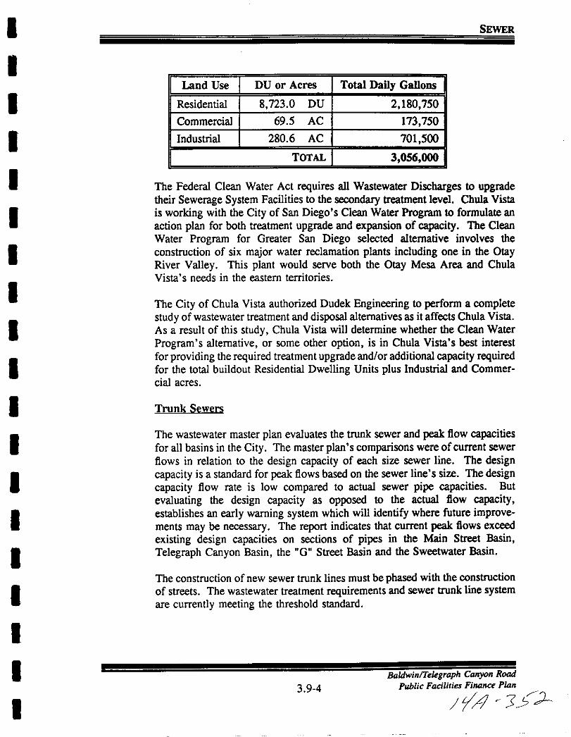
I
I
I
II
I
I
I
I
I
I
I
I
I
I
I
I
I
I
SEWER
Land Use DU or Acres Total Daily Gallons
Residential 8 723 0 DU 2 180 750
Commercial 695 AC 173 750
Industrial 280 6 AC 701 500
TOTAL 3 056 000
The Federal Clean Water Act requires all Wastewater Discharges to upgradetheir Sewerage System Facilities to the secondary treatment level Chula Vista
is working with the City of San Diego s Clean Water Program to formulate an
action plan for both treatment upgrade and expansion of capacity The CleanWater Program for Greater San Diego selected alternative involves the
construction of six major water reclamation plants including one in the OtayRiver Valley This plant would serve both the Otay Mesa Area and ChulaVista s needs in the eastern territories
The City of Chula Vista authorized Dudek Engineering to perform a completestudy ofwastewater treatment and disposal alternatives as it affects Chula Vista
As a result of this study Chula Vista will determine whether the Clean Water
Program s alternative or some other option is in Chula Vista s best interestfor providing the required treatmentupgrade and or additional capacity requiredfor the total buildout Residential Dwelling Units plus Industrial and Commer
cial acres
Trunk Sewers
The wastewater master plan evaluates the trunk sewer and peak flow capacitiesfor all basins in the City The master plan s comparisons were of current sewer
flows in relation to the design capacity of each size sewer line The designcapacity is a standard for peak flows based on the sewer line s size The designcapacity flow rate is low compared to actual sewer pipe capacities But
evaluating the design capacity as opposed to the actual flow capacityestablishes an early warning system which will identify where future improvements may be necessary The report indicates that current peak flows exceed
existing design capacities on sections of pipes in the Main Street Basin
Telegraph Canyon Basin the G Street Basin and the Sweetwater Basin
The construction of new sewer trunk lines must be phased with the construction
of streets The wastewater treatment requirements and sewer trunk line systemare currently meeting the threshold standard
3 9 4
BaldwinlTelegraph Canyon Road
Public Facilities Finance P14n
It r J J
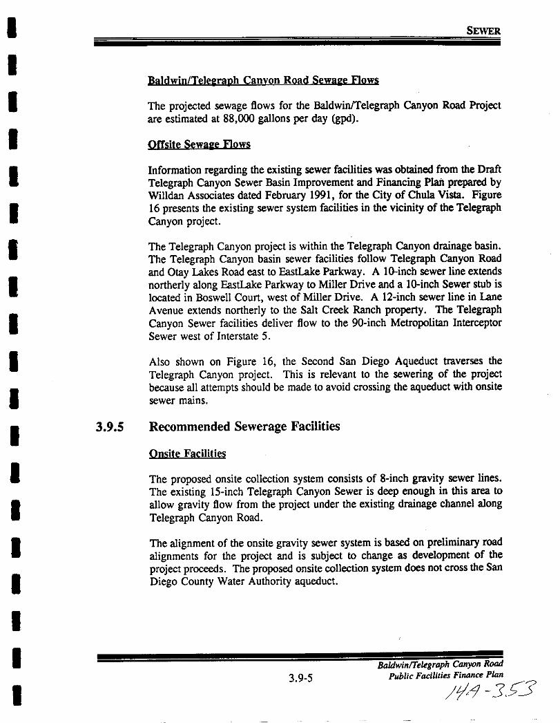
I
I
I
I
I
I
I
I
I
I
I
I
I
I
I
I
I
I
I
SEWER
Baldwin TelelraDh Canvon Road Sewale Flows
The projected sewage flows for the Baldwin Telegraph Canyon Road Projectare estimated at 88 000 gallons per day gpd
Offsite Sewale Flows
Information regarding the existing sewer facilities was obtained from the Draft
Telegraph Canyon Sewer Basin Improvement and Financing PIaiI prepared byWilIdan Associates dated February 1991 for the City of Chula Vista Figure16 presents the existing sewer system facilities in the vicinity of the TelegraphCanyon project
The Telegraph Canyon project is within the Telegraph Canyon drainage basinThe Telegraph Canyon basin sewer facilities follow Telegraph Canyon Road
and Otay Lakes Road east to EastLake Parkway A lO inch sewer line extends
northerly along EastLake Parkway to Miller Drive and a lO inch Sewer stub is
located in Boswell Court west of Miller Drive A l2 inch sewer line in Lane
Avenue extends northerly to the Salt Creek Ranch property The TelegraphCanyon Sewer facilities deliver flow to the 90 inch Metropolitan InterceptorSewer west of Interstate 5
Also shown on Figure 16 the Second San Diego Aqueduct traverses the
Telegraph Canyon project This is relevant to the sewering of the projectbecause all attempts should be made to avoid crossing the aqueduct with onsite
sewer mains
3 9 5 Recommended Sewerage Facilities
Onsite Facilities
The proposed onsite collection system consists of 8 inch gravity sewer linesThe existing l5 inch Telegraph Canyon Sewer is deep enough in this area to
allow gravity flow from the project under the existing drainage channel alongTelegraph Canyon Road
The alignment of the onsite gravity sewer system is based on preliminary road
alignments for the project and is subject to change as development of the
project proceeds The proposed onsite collection system does not cross the San
Diego County Water Authority aqueduct
3 9 5
BaldwinTe graph Canyon Road
Public Facilities Finance Pkm
09 5S3
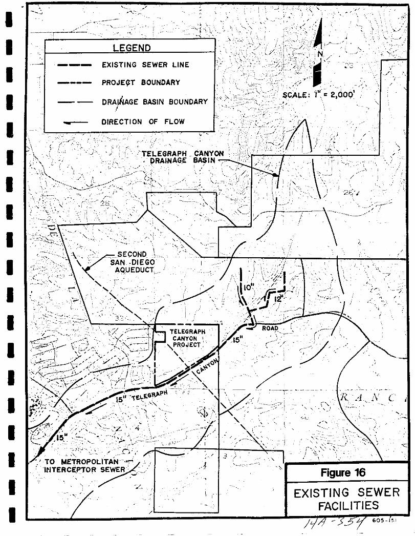
IJ
Jj
jT I
N
CALE I 2 000
Figure 16
EXISTING SEWERFACILITIES
3 605 1
Ip
LEGEND
EXISTING SEWER
PROJE TI
I
I nITELEGRAPH
PRAINAGEI o
v
P
tIl
126
Ii
I
r NE g GOAqUEDUCT
2
I
I
It
t
j i TELEGRAPHCANYON
It
I
I C
1
I c 7 tK t
gE CE OoP L7I A
R SEWER
z
I J
1
I
I
i
7
t
1
R A C i
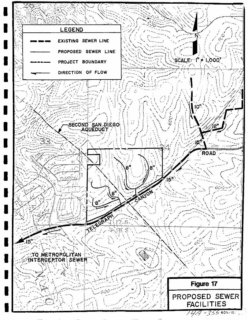
I
1 I
rgI Y I
i jlI
I
I
i
1 lA1r ROAb
i jiJ
00
aJ US iO0 A K
0
cr1 S
lif 4KC 2 io v
i J f j
ifII y5
r c k i
TO E TRQPOLITAN11
NT6 E JtOR SEWEff1
si
t PR 0P0 SED SEWERIAC I LIT I ESr
X
F x f 8ECONCf SAN DLEGOAQUEOUT
ff J 0 r l7 y l
IN i t
I LEGEND
IEXISTING SEWER LINE
PROPOSED SEWER LINE
I PROJECT BOUNDARY
DIRECTION OF FLOW
I
I
I
I
I
I
I
I
II
I
I
I
I
I
r iY
S J Ji N I
J JI
SCALEr f1 i l 000 j
31J j f
I
ji
o
60 15J

I
I
I
I
II
I
I
I
I
I
I
I
I
I
I
I
I
I
SEWER
Offsite Facilities
The existing Telegraph Canyon basin sewer facilities were analyzed byreviewing the February 1991 Willdan Associates report Based on this reportultimate buildout of the Telegraph Canyon drainage basin is to occur in fourphases with the Telegraph Canyon project expected to be developed in thefourth phase According to the Willdan Associates report the existingTelegraph Canyon sewer system has sufficient capacity for the first three phasesof development within the basin During development of Phase IV there are
several reaches of pipe which are expected to exceed their capacity TheWilldan report recommends monitoring at the end of Phase ill and throughoutPhase IV
The Baldwin Telegraph Canyon Road project is most likely to develop aheadof the Willdan schedule in Phase II rather than Phase IV The other projectsin Phase III consist of Rancho del Rey III EastLake Business Park II and theBaldwin Company s Salt Creek Ranch
Therefore the available capacity in the existing Telegraph Canyon Sewer will
depend on where the Telegraph Canyon projects falls within Phase II Development If the project develops early in Phase II there is likely to be available
capacity however if it develops late in Phase III then improvements would
be dependent on the results of the monitoring program The Master Plan
recommends that the Willdan Associates report be reviewed as progress in the
basin occurs to track the actual development and associated improvementsrequired of the Telegraph Canyon project
3 9 6 Financing Sewerage Facilities
The following table identifies the costs associated with the sewer facilities
required to serve the project
FIGURE 18
SEWER FACILITIES COST EsrIMATE
Length Feet I Required Size I Unit Cost foot I Total Cost
Gravity Sewers
12 500 I 8 I 40 ft I 500 000
Total 500 000
3 9 8
BaldwinTelegraph Canyon Road
Public Facil e n
S
I
I
I
I
I
I
I
I
I
I
I
I
I
I
I
I
I
I
I
SEWER
3 9 7 Threshold Standard
1 Sewage flows and volumes shall not exceed City Engineering Standards
2 The City shall annually provide the San Diego Metropolitan SewerAuthority with a 12 18 month development forecast and request confirmation that the projection is within the City s purchased capacity rights andan evaluation oftheir ability toaccommodate the forecast and continuinggrowth or the City Engineering Department staff shall gather the
necessary data The information provided to the GMOC shall include the
following
a Amount of current capacity now used or committedb Ability of affected facilities to absorb forecast growthc Evaluation of funding and site availability for projected new facili
tiesd Other relevant information
3 9 8 Threshold Compliance
Facilities to accommodate sewer flows have been identified The City will not
allow the design capacity of trunk sewers to be exceeded If flows largeenough to surpass the design capacity of receiving sewers are anticipated as theresult of new development the City could require the construction of relieflines The construction of new sewer trunk lines must be phased with theconstruction of streets As such the facilities identified in this plan shall be
required of the developer either as constructed facilities or through the paymentof fees
3 9 9
BaldwinlTeegraph Canyon Road
Public Facilities Finance Plan
f7 35

I
I
I
I
I
I
I
I
I
I
I
I
I
I
I
I
I
I
I
3 10 DRAINAGE
BaldwinTelegraph Canyon Road
Public Facilities Finance Plan
3 10 1 JfAr 5Ir
I
I
I
I
I
II
II
I
II
I
I
II
I
I
I
DRAINAGE
3 10
3 10 1
3 10 2
3 10 3
DRAINAGE
Service Analysis
The City of Chula Vista through its Public Works Department is responsiblefor ensuring that safe and efficient stonn water drainage systems are providedconcurrent with development in order to protect the residents and propertywithin the city City staff shall review individual projects to ensure that
improvements are provided which are consistent with the drainage master
plan s and that the project complies with all City engineering drainagestandards
Drainage facilities are planned for in the City of Chula Vista Public FacilitiesPlan Flood Control Summary Report dated March 1989 phase II
A report titled Preliminary Hydrological Analysisfor Telegraph Canyon tatesdated June 21 1990 was prepared by the McIntyre Group Inc
Project Processing Requirements
Sectional Plannim Area Plan Public Facilities Finance Plans
1 Identify phased demands
2 Identify locations of facilities for on site and off site improvements3 Provide cost estimates4 Identify financing methods
Existing Conditions
The City of Chula Vista Public Facilities Plan Flood Control Summary ReportMarch 1989 shows fifteen major drainage basins in Chula Vista These
drainage basin boundaries were determined by existing topography drainageconditions and land uses Four of these are essentially developed and not
expected to have significant changes in runoff Eleven drainage basins are east
of Interstate 805 with one of the basins Long Canyon mostly developed to the
predicted densities in Scenario 4 of the general plan Only the remaining ten
basins will experience major development and the subsequent changes in
drainage conditions
The City s Drainage Master Plan analyzed current and future requirements for
drainage facilities The report details three alternative solutions for drainagein each basin Because drainage facilities are directly related to the type and
3 10 2
BaldwinTe egraph Canyon Road
Public Facilities Finance P14n
t
7415
I
I
I
I
I
II
I
I
I
I
I
I
I
II
I
I
I
DRAINAGE
location of future development it is not possible to determine which specificimprovements will be required until the development project is presented andreviewed by staff
3 10 4 Proposed Facilities
The study area consists of gently rolling hills with moderate slopes 20gradient The site is dominated by two north south trending ridges forminga defined valley through the central portion of the project A furthernorth south trending ridge lies offsite to the east forming a second drainagebasin onsite within the existing San Diego Gas Electric easement bothbasins drain from north to south This portion of the Telegraph Canyondrainage basin lies within the upper reaches of the lower foothills of MotherMiguel Mountain as such the term canyon is not applicable to this portionof the drainage basin It would be best defined as a valley
Otay Lakes Telegraph Canyon Road lies within and defines this valley at the
project location Immediately to the north and parallel to the road within the
project site is a developed earthen drainage channel conveying runoff westerlyover a series of rock drop structures
Elevations within the study area range from 640 feet in the north to 450 feetin the sou thwest corner
A study of the existing condition for the study area encompassing TelegraphCanyon Estates determines a 50 year flow rate of 1399 6 cfs leaving the site atthe southwest corner Development of this site will generate an increase inflow rate of 23 0 cfs for a total of 1422 6 cfs
By examining the hydrologic assumptions used in the design of the channel
adjacent to Otay Lakes Telegraph Canyon Road it is apparent that a veryconservative approach was used This assumption considered that all basins
draining into this channel would be developed Using this criteria and the COvalues obtained from the Fogg Study the channel was designed for maximumrunoff potential
For Telegraph Canyon Estates the critical drainage point ofthe open drainagechannel is at the double 6 x 10 box culvert in the southwest corner of the siteThis culvert is 330 feet long with a slope of approximately two percent If thisculvert were to flow full with a water depth of 5 to 6 it has the capability tohandle a flow rate of approximately 3 500 cfs
BaldwinTelegraph Canyon Road
Public Fadlities Finance Plan
3 10 3
ItJ J O
I
I
I
I
I
I
I
I
I
I
I
I
I
I
II
I
I
I
DRAINAGE
According to the McIntyre Group Study ofJune 1990 a flow rate increase of
23 0 cfs attributable to this development for a developed flow total of 1422 6
cfs will have no significant impact upon the existing drainage facilities
3 10 5 Financing Drainage Facilities
On Site Facilities
City policy requires that all master planned developments provide for the
conveyance of storm waters throughout the project to City engineeringstandards As such Baldwinrrelegraph Canyon Road will be required to
construct those facilities identified in Section 3 10 through the subdivision
exaction process
Off Site Facilities
The Baldwin Telegraph Canyon Road project drains into the Telegraph CanyonBasin The McIntyre Report calculates this drainage area to be 112 4 acres
In accordance with Chula Vista Ordinance 2384 approved August 7 1990
Baldwin Telegraph Canyon Road is required to pay the Telegraph CanyonDrainage Fee of 3 922 per gross benefit acre For the 1124 acres this fee
equals 440 832 The fee is payable as defined by Ordinance 2384
3 10 6 Threshold Standard
1 Storm water flows and volumes shall not exceed City EngineeringStandards
2 The GMOC shall annually review the performance of the City s storm
drain system to determine its ability to meet the City s goals and
objectives
3 10 7 Threshold Compliance
Baldwin Telegraph Canyon Road shall be responsible for the conveyance of
storm water flows in accordance with City Engineering standards The City
Engineering Division shall review all plans to ensure compliance with City
Engineering Standards
BaldwinTelegraph Canyon Road
Public Facilities Finance Plan
3 10 4 Jf r J6 I
I
I
I
I
I
I
I
I
I
I
I
I
I
I
II
I
I
I
3 11 AIR QUALITY
BaldwinTelegraph Canyon Road
Public Facilities Finance P14n
3 11 1J if rPL
I
I
I
I
I
I
I
I
I
I
I
I
I
I
II
I
I
I
AIR QUALITY
3 11
3 11 1
3 11 2
3 11 3
AIR QUALITY
Service Analysis
Air Qualitv ImDrovement Plan
An Air Quality Improvement Plan is required for all major developmentprojects 50 dwelling units or greater or commercial and industriaI projectswith 50 EDU s of water demand or greater This plan is required at the
Sectional Planning Area SPA Plan level or equivalent for projects which are
not processed through a Planned Community Zone
The Air Pollution Control District is updating the Air Quality Maintenance
Program to comply with the California Clean Air Act There is no localMaster Plan for Air Quality
The Air Quality Improvement Plan will not be prepared as part of the Public
Facilities Financing Plan This plan is being prepared as part of the Baldwinl
Telegraph Canyon Road SPA
Threshold Standard
The City shall annually provide the San Diego Air Pollution Control DistrictAPCD with a 12 18 month development forecast and request an evaluation
of its impact on current and future air quality management programs alongwith recent air quality data The growth forecast and APCD response letters
shall be provided to the GMOC for inclusion in its annual review
Threshold Compliance
The City continues to provide a development forecast to the APCD in
conformance with the threshold standard A separate Air Quality ImprovementPlan is provided as part of the SPA document
BaldwinTe egraph Canyon Road
Public Facilities Finance PIDn
3 11 2
JiJ5

I
I
I
I
I
I
I
I
I
I
I
I
I
I
II
I
I
I
3 12 FISCAL
Baldwinrrelegraph Canyon lWad
3 12 1
pubjCFaci jl
i 3t zJ
I
I
I
I
I
I
I
I
I
I
I
I
I
I
I
II
I
I
FIsCAL
3 12
3 12 1
3 12 2
3 12 3
3 12 4
FISCAL
Facility Master Plan
There is no existing Master Plan for fiscal issues However an economic base
study and a long range fiscal impact study was prepared by P D Technologiesas part of the Chula Vista General Plan
Project Processing Requirements
Sectional PlanninArea Plan Public Facilities Finance Plans
1 Prepare a phased fiscal economic report dealing with revenue vexpendi
tures including maintenance and operations
Threshold Standard
1 The GMOC shall be rovided with an annual fiscal im ct
proVIdes an evaluati n n it iner 0 operations and capital imnrovements This report shouldvdlu u actUal growth over the previous 12 month period as well as
projected growth over the next 12 18 month period and 3 5 year period
2 The GMOC shall be provided with an annual economic monitoringreport which provides an analysis ofeconomic development activity andindicators over the next previous 12 month period as well as projectedgrowth over the next 12 18 month period and 3 5 year period
Threshold Compliance
Section 4 0 of this Public Facilities Financing Plan contains an analysis of thefiscal impacts the development of BaldwinlTelegraph Canyon Road will haveon the operation and maintenance budgets of the City of Chula Vista the OtayWater District the Chula Vista City School District and the Sweetwater Union
High School District
The results of the analysis are contained in Section 4 0 and will be included in
the next annual fiscal and economic report prepared for the City s Growth
Management Oversight Commission
BaldwinlTelegraph Canyon Road
Public Fadlities Finance Pliln
3 12 2
ifA 3b
I
I
II
I
II
I
I
I
I
I
I
I
I
I
I
I
I
3 13 CIVIC CENTER
BaldwinTelegraph Canyon Road
Public Facilities Finance Plan
3 13 1
JtA Ykb
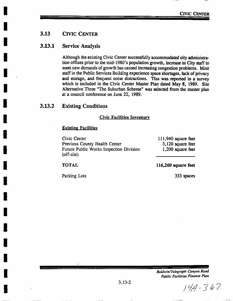
I
I
I
I
I
I
I
I
I
I
I
I
I
I
I
I
I
I
I
Crne CENTER
3 13
3 13 1
3 13 2
Crnc CENTER
Service Analysis
Although the existing Civic Center successfully accommodated city administration offices prior to the mid 1980 s population growth increase in City staff to
meet new demands ofgrowth has caused increasing congestion problems Moststaff in the Public Services Building experience space shortages lack ofprivacyand storage and frequent noise distractions This was reported in a surveywhich is included in the Civic Center Master Plan dated May 8 1989 Site
Alternative Three The Suburban Scheme was selected from the master planat a council conference on June 22 1989
Existing Conditions
Civic Facilities Inventorv
Existinl Facilities
Civic CenterPrevious County Health Center
Future Public Works Inspection Division
off site
111 940 square feet3 120 square feet1 200 square feet
TOTAL 116 260 square feet
Parking Lots 333 spaces
BadwinlTelegraph Canyon Road
Public Facilities Finance Plan
3 13 2
LJ J h 7

I
I
I
I
I
I
I
I
I
I
I
I
I
I
I
I
I
I
I
Crne CENTER
cFre i cJ1 City Hall2 Public Services Facility3 New City Hall Annex4 Legislative Offices5 Subterranean Parking6 Parking Structure
7 Demolition8 Surface Parking9 Misc Site Improvements10 Landscaping11 Land Acquisition 459 F Street12 Master Plan
m Estimated
25 765 Sfl40 615 sfl28 925 sfl
6 000 sfl126 spaces359 spaces
5 920 sf45 425 sf15 000 sf55 000 sf
2 203 3003 023 5003 023 6001 330 0001 008 0002 872 000
83 600227 100180 000
698 500
TOTAL
65 250
CiS 4S93OO3 13 3 Adequacy Analysis
The Master Plan for the Chula Vista Civic Center shows 126 990 square feet
of Civic Center facilities are needed to serve the population in 1988 Thisidentifies an existing space deficiency of 15 050 square feet Since the writingof the Master Plan the City has acquired the 3 120 square foot County Health
building and a 1 200 square foot Public Works office They are both listedunder Existing Facilities Because of this increase in square footage the
deficiency is reduced to 10 730 square feet
The need for the Civic Center can not be easily related topopulation fieures or
ales or commercial and industrial land which will be developed in the futureThe facilities according to the master plan are currently inadequate becauseof the lack of space This inadequacy will worsen as employee numbers andtheir workloads increase in response to demands for services which are
generated by new development
Currently FY 1990 91 the City is moving ahead to implement Phase 1 of theCivic Center Master Plan by acquiring additional land to the west of the
existing Civic Center for the proposed parking garage
Some of the size figures represent combination of remodeled exi81in lqUre footage and newly Con8lrlcted Quare
footage The completed civic facilities will 0181149 120 aquare feel with 625 parkifllPacc
BaldwinlTelegraph Canyon Road
Public Facilities Finance Plan
3 13 3
i 3 g
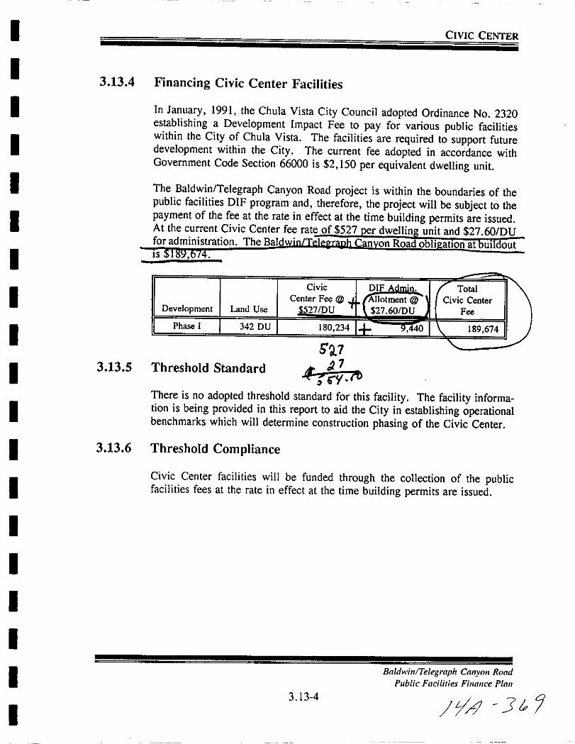
I
I
I
I
I
I
I
I
I
I
I
I
I
I
I
I
I
I
I
CIVIC CENTER
3 13 4 Financing Civic Center Facilities
In January 1991 the Chula Vista City Council adopted Ordinance No 2320establishing a Development Impact Fee to pay for various public facilitieswithin the City of Chula Vista The facilities are required to support futuredevelopment within the City The current fee adopted in accordance withGovernment Code Section 66000 is 2 150 per equivalent dwelling unit
The Baldwin Telegraph Canyon Road project is within the boundaries of thepublic facilities DIF program and therefore the project will be subject to thepayment of the fee at the rate in effect at the time building permits are issuedAt the current Civic Center fee rate of 527 er dweIlin unit and 27 60DUforadministration The Bald n on Road obli atlOn at UI outIS
Development Land Use
Phase I 342 DU
Total
Civic Center
Fee
189 674
3 13 5
J1
Threshold Standard t rtThere is no adopted threshold standard for this facility The facility information is being provided in this report to aid the City in establishing operationalbenchmarks which will determine construction phasing of the Civic Center
3 13 6 Threshold Compliance
Civic Center facilities will be funded through the collection of the publicfacilities fees at the rate in effect at the time building permits are issued
Baldwil Telegraph Calyol Road
Public Facilities Finance Plan
3 13 4
y41 3t
I
I
I
I
I
I
I
I
I
I
I
I
II
I
I
I
I
I
3 14 CQRPORATION YARD
Badwin Telegraph Canyon Road
Public Facilities Finance P1i2n
3 14 1 t J 70

I
I
I
I
I
I
I
I
I
I
I
I
I
I
I
I
I
I
I
CORPORATION YARD
3 14
3 14 1
3 14 2
3 14 3
CORPORATION YARD
SERVICE ANALYSIS
The corporation yard is currently operating beyond capacity New development with its resultant increase in required maintenance services creates a
need for a larger corporation yard The new yard may be located east ofInterstate 805 because of the availability of centrally located large parcels A
City staff memo dated November 11 1987 states that 15 acres are needed toaccommodate 85 010 square feet of office and storage and 228 000 square feetofparking
EXISTING CONDITIONS
Existinl Facilities Location
Corporation Yard 707 F Street
Future Facilities Cost Estimate
1 Buildings2 Outside Storage3 Parking4 Site preparation and grading5 Site development utilities and landscaping6 Site acquisition
4 699 4911 031 362
543 5984 000 0001 181 260
1995 000
TOTAL 13 450 711
Adequacy Analysis
The growth in population increase in street miles and the expansion of
developed areas in Chula Vista requires more equipment for maintenance as
well as more space for storage and the administration of increased numbers of
employees The need for a larger Corporation Yard can be specifically related
to new development and its effect on all of these subjects
The existing corporation yard located at F Street and Woodlawn no longeraccommodates present demands The City Council approved an agreement on
May 22 1990 between the City and Rancho Del Sur Sunbow The agreementgrants the City an option to acquire 15 net usable acres within the 46 acre
BaldwinlTelegraph Canyon Road
Public Facilities Finance Plan
3 14 2
J 1 J71
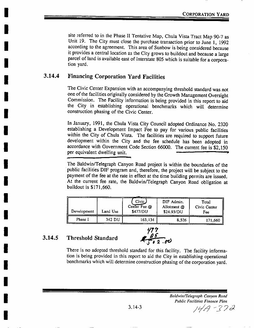
I
I
I
I
I
I
I
I
I
I
I
I
I
I
I
I
I
I
I
CORPORATION YARD
site referred to in the Phase II Tentative Map Chula Vista Tract Map 90 7 asUnit 19 The City must close the purchase transaction prior to June I 1992according to the agreement This area of Sun bow is being considered becauseit provides a central location as the City grows to buildout and because a largeparcel of land is available east of Interstate 805 which is suitable for a corporation yard
3 14 4 Financing Corporation Yard Facilities
The Civic Center Expansion with an accompanying threshold standard was notone of the facilities originally considered by the Growth Management OversightCommission The Facility information is being provided in this report to aidthe City in establishing operational benchmarks which will determineconstruction phasing of the Civic Center
In January 1991 the Chula Vista City Council adopted Ordinance No 2320establishing a Development Impact Fee to pay for various public facilitieswithin the City of Chula Vista The facilities are required to support futuredevelopment within the City and the fee schedule has been adopted inaccordance with Government Code Section 66000 The current fee is 2 150
per equivalent dwelling unit
The Baldwin Telegraph Canyon Road project is within the boundaries of the
public facilities DIF program and therefore the project will be subject to the
payment of the fee at the rate in effect at the time building permits are issuedAt the current fee rate the Baldwin Telegraph Canyon Road obligation at
buildout is 171 660
Civij DIF Admin TotalCenter Fee @ Allotment @ Civic Center
Development Land Use 4771DU 24 93DU Fee
I Phase I I 342 DU I 163 134 I 8 526 I 171 660 I
3 14 5r
Threshold Standardr a dc
There is no adopted threshold standard for this facility The facility information is being provided in this report to aid the City in establishing operationalbenchmarks which will determine construction phasing of the corporation yard
Baldwin Telegraph Canyon Road
Public Facilities Finance Plan
3 14 3 Jlrl J C2

I
I
I
I
I
I
I
I
I
I
I
I
I
I
I
I
I
I
I
CORPORATION YARD
3 14 6 Threshold Compliance
Compliance will be satisfied with the payment ofpublic facility fees at the ratein effect at the time building permits are issued
3 144
BaldwinTelegraph Canyon Road
Public Facilities Finance Plan
It 1 3
I
I
I
I
I
I
I
I
I
I
I
I
I
I
I
I
I
I
I
4 0 FISCAL ANALYSIS
BaldwinlTe1egraph Canyon Road
Public Facilities Finance Plan
4 1 1 tfJ 7 1
I
I
I
I
I
II
I
I
I
I
I
I
I
II
I
I
I
FISCAL ANALYSIS
4 0 FISCAL IMPACT
The information and observations contained in this report are based on our
present knowledge of the components of development and of the current
socioeconomic and fiscal conditions of the affected jurisdictions Projectionsmade in this report are based on hypothetical assumptions and current publicfinance policies As such there are usually differences between the projectionsand the actual results
4 1 DESCRIPTION OF THE PROJECT
The proposed Telegraph Canyon Road development includes 79 6 acres of new
residential development in Otay Ranch The development will contain a totalof 341 single family housing units Table 4 1 1 details the project componentsshowing the size and average market price of each product type in the
development
The phasing of the project is detailed in the absorption schedule developed byThe Baldwin Company as a conservative estimate shown in Table 4 1 2 This
schedule shows the expected annual absorption of each project componentduring the 4 year development period Annual absorption is expected to peakin the second year of the project with absorption of about 171 units For the
purpose of this analysis absorption represents new units being sold or rented
and occupied
Baldwin Telegraph Canyon Road
Public Facilities Finance Plan
4 1 2 JIf J 75
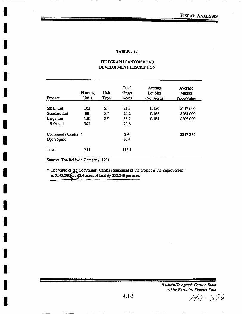
I
I
I
I
I
II
I
I
I
I
I
I
I
II
I
I
I
FISCAL ANALYSIS
TABLE 4 1 1
1ELEGRAPH CANYON ROAD
DEVELOPMENT DESCRlPTION
Total Average AverageHousing Unit Gross Lot Size Market
Product Units Type Acres Net Acres PriceNalue
Small Lot 103 SF 213 0 150 212 000
Standard Lot 88 SF 20 2 0166 264 000
Large Lot 150 SF 38 1 0184 305 000
Subtotal 341 79 6
Community Center 24 317 376
Open Space 304
Total 341 112 4
Source The Baldwin Company 1991
The value of the Community Center component of the project is the improvementat 240 Ius 24 acres of land @ 32 240per acre
BadwinlTelegraph Canyon Road
Public Facilities Finance Plan
4 1 3 jfj J
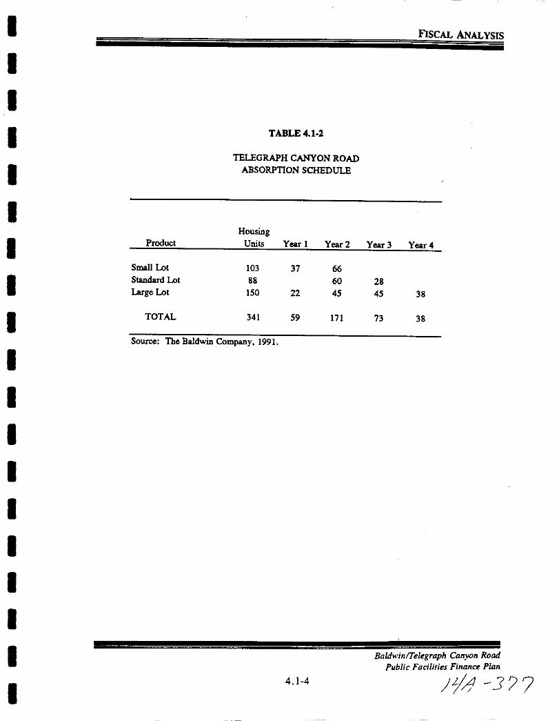
I
I
I
I
I
I
I
I
I
I
I
I
I
I
II
I
I
I
FISCAL ANALYSIS
TABLE 4 1 2
TELEGRAPH CANYON ROAD
ABSORPTION SCHEDULE
HousingProduct Units Year 1 Year 2 Year 3 Year 4
Small Lot 103 37 66
Standard Lot 88 60 28
Large Lot 150 22 45 45 38
TOTAL 341 59 171 73 38
Source The Baldwin Company 1991
4 1 4
Baldwin Telegraph Canyon Road
Public Facilities Finance Plan
Lj J 7
I
I
I
I
I
III
I
I
I
I
I
I
II
I
I
I
FISCAL ANALYSIS
4 2 PROJECT DEMOGRAPHICS
Since many of the impacts of the project are based on the population residingin the Telegraph Canyon Road project it was necessary to project populationlevels resulting from the absorption of new units This includes total
population as well as enrollment so that the impacts on school districts could
be assessed
Table 4 2 1 shows the household size factors and student generation rates
applied to the absorption of new units to calculate the population and
enrollment projections for Telegraph Canyon Road Population per dwellingunit assumptions were obtain from the City of Chula Vista Planning Department The population per dwelling unit for single family detached homes of
3 24 is based on total housing inventory
Student generation rates also shown in Table 4 2 1 were obtained in
interviews with the Chula Vista Elementary School District and the Sweetwater
Union High School District Student generation rates estimate the number of
elementary and high school students that would be expected to result from the
addition of one new housing unit Elementary junior high and high school
student generation rates used in this analysis were 0 30 0 10 and 0 19 students
per housing unit respectively Since the junior high and high school student
attend a single district these rates were aggregated to 0 29 for this analysis
Since some revenue line items are best estimated using the number of occupiedhousing units it was also necessary to make assumptions about the long term
occupancy rates in the Telegraph Canyon Road project Single familyoccupancy rates were assumed to be 97 percent These assumptions were based
on data from the 1990 Census and our experience with Southern California
real estate markets
These occupancy rates are shown applied to projected housing absorption in
Table 4 2 2 Note that all units are assumed to be occupied in the year in
which they are first sold This results in the total number of occupied units
peaking in the fourth year of the development at 332 units and subsidingslightly to 331 units during subsequent years
Application of household size assumptions to the number of new unitsproducedthe population projections for Telegraph Canyon Road shown in Table 4 2 3
The project is expected to house 197 people by the end of its first year and
increase to a total of 1 105 people by year 5 Projections for elementary school
BaldwilllTelegraph Callyoll Road
Public Facilities Fillallce Plall
4 1 5 f4 J7T

I
I
I
I
I
II
I
I
I
I
I
I
I
II
I
I
I
FlSCAL ANALYSIS
and high school students are performed in the same manner and are shown in
Table 4 2 4 and 4 2 5 respectively Elementary school enrollment is expectedto be approximately 102 students by year 4 while the number of high school
students should reach about 100
Baldwin Telegraph Canyon Road
Public Facilities Finance Plan
4 1 6
IfJ 37
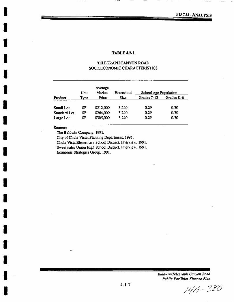
I
I
I
I
I
I
I
I
I
I
I
I
I
I
II
I
I
I
FISCAL ANALYSIS
TABLE 421
1ELEGRAPH CANYON ROAD
SOCIOECONOMIC CHARACTERISTICS
AverageUnit Market Household School aJte POJlulation
Product TYJe Price Size Grades 7 12 Grades K 6
Small Lot SF 212 000 3 240 0 29 0 30
Standard Lot SF 264 000 3 240 0 29 0 30
Large Lot SF 305 000 3240 0 29 030
Sources
The Baldwin Company 1991
City ofChuIa Vista Planning Department 1991
Chula Vista Elementary School District Interview 1991
Sweetwater Union High School District Interview 1991
Economic Strategies Group 1991
Baldwin Telegraph Canyon Road
Public Facilities Finance Plan
4 1 7
i 360
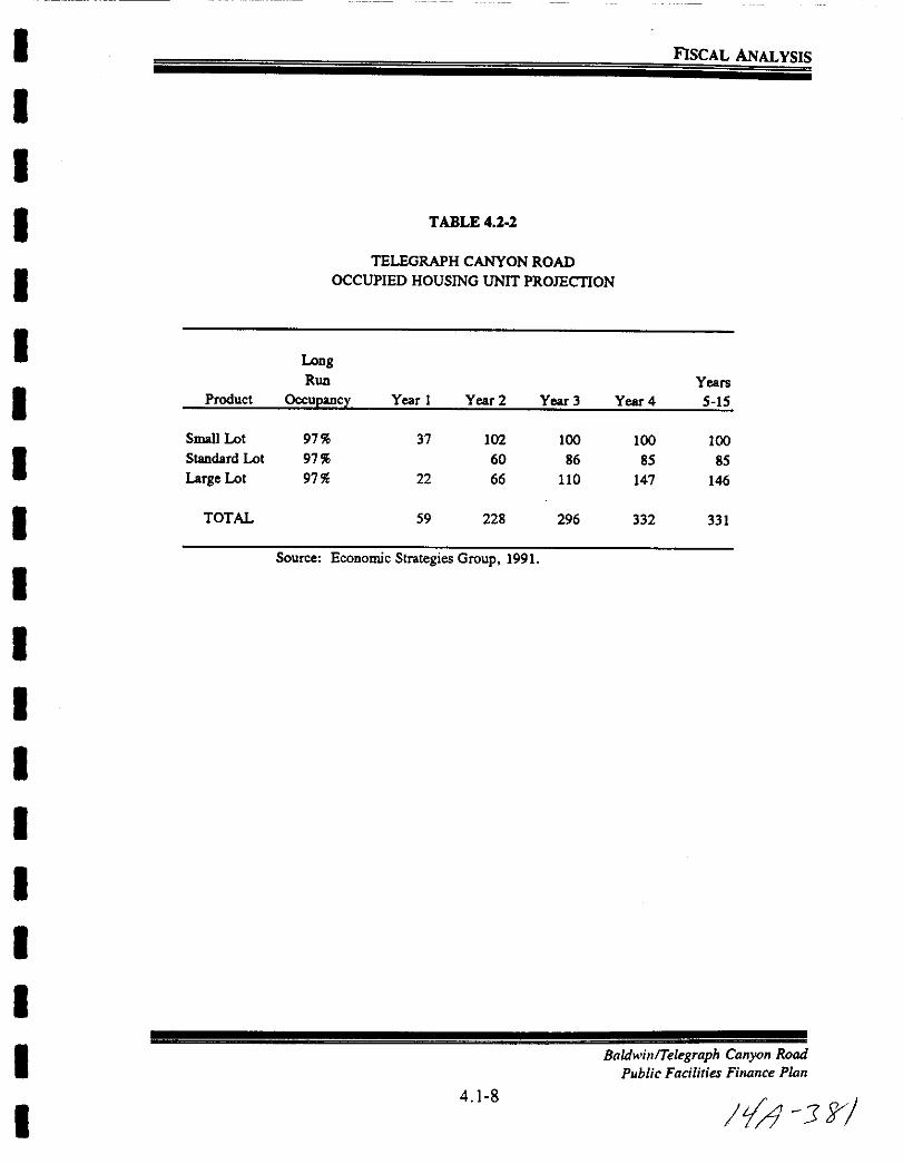
I
I
I
I
I
II
I
I
I
I
I
I
I
I
I
I
I
I
FISCAL ANALYSIS
TABLE 422
TELEGRAPH CANYON ROAD
OCCUPIED HOUSING UNIT PROJECTION
LoogRun Years
Product Occupancy Year 1 Year 2 Year 3 Year 4 S lS
Small Lot 97 37 102 100 100 100Standard Lot 97 60 86 8S 8S
Large Lot 97 22 66 110 147 146
TOTAL S9 228 296 332 331
Source Economic Strategies Group 1991
Baldwin Telegraph Canyon Road
Public Faciliries Finance Plan
4 8
111 rJ

I
I
I
I
I
I
I
I
I
I
I
I
I
I
I
I
I
I
I
FISCAL ANALYSIS
FIGURE 4 23
TELEGRAPH CANYON ROAD
POPULATION PROJECTION
Population
eJper OccupiedProduct Unit Year 1 Year 2 Year 3
Small Lot 3 34 124 340 334 334 334Standard Lot 3 34 0 200 288 285 285
Large Lot 3 34 73 222 367 490 486
TOTAL 197 762 989 eJSource Economic Strategies Group 1991
Baldwin Telegraph Canyon Road
Public Facilities Finance Plan
4 1 9
tA J7J
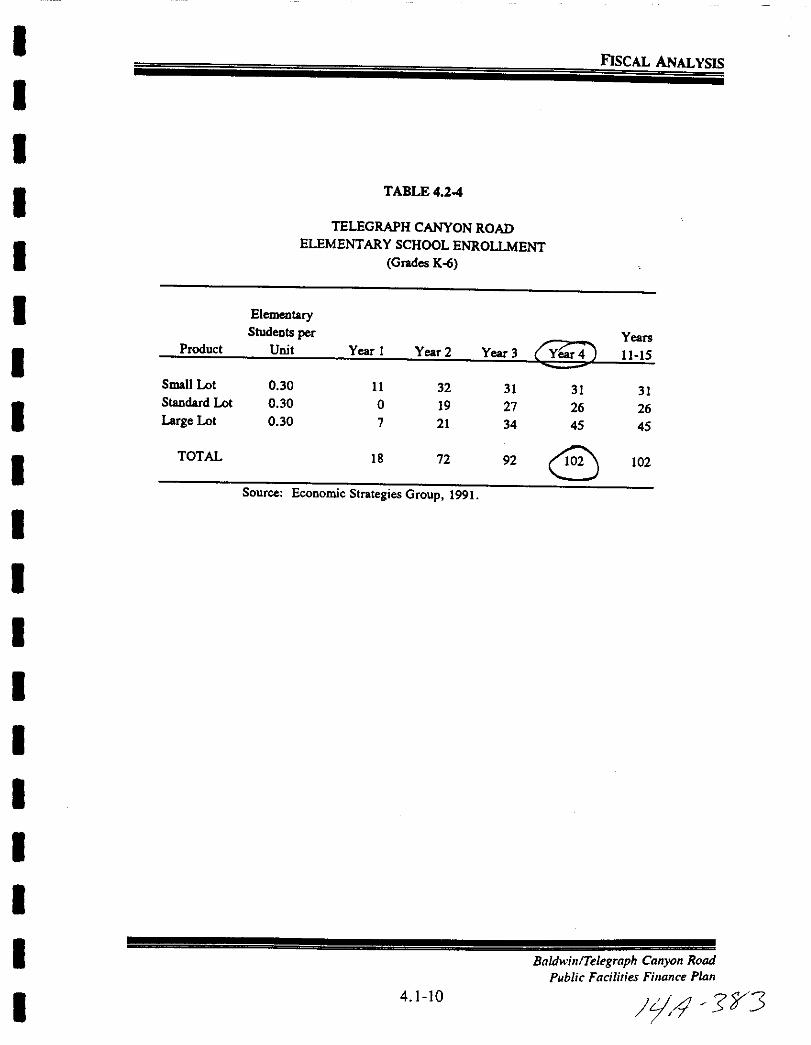
I
II
I
I
I
I
I
I
I
I
I
I
I
I
II
I
I
FISCAL ANALYSIS
TABLE 4 24
TELEGRAPH CANYON ROAD
ELEMENTARY SCHOOL ENROLLMENTGrades Ko
ElementaryStudents per
@DYears
Product Unit Year 1 Year 2 Year 3 11 15
Small Lot 0 30 11 32 31 31 31Standard Lot 0 30 0 19 27 26 26Large Lot 0 30 7 21 34 45 45
TOTAL 18 72 92 C0 102
Source Economic Strategies Group 1991
4 10
BadwinlTelegraph Canyon Road
Public Facilities Finance Plan
yi J1J3
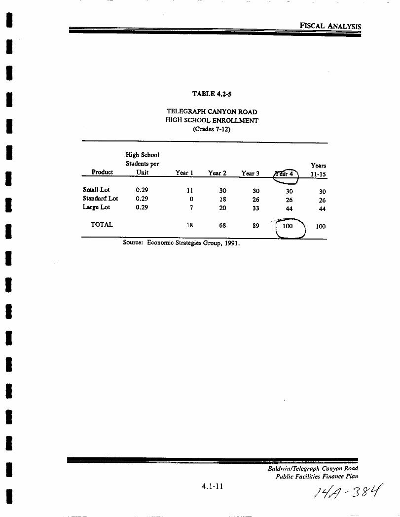
I
I
I
I
I
I
I
I
I
I
II
I
I
III
I
I
FISCAL ANALYSIS
TABLE 42 5
TELEGRAPH CANYON ROAD
HIGH SCHOOL ENROLLMENTGrades 1 12
High School
Students per YearsProduct Unit Year 1 Year 2 Year 3 1115
Small Lot 0 29 11 30 30 30 30Standard Lot 0 29 0 18 26 26 26
Large Lot 0 29 1 20 33 44 44
TOTAL 18 68 89 CIOO J 100
Source Economic Strategies Group 1991
Baldwin Telegraph Canyon Road
Public Facilities Finance Plan
4 1 11
J ftL
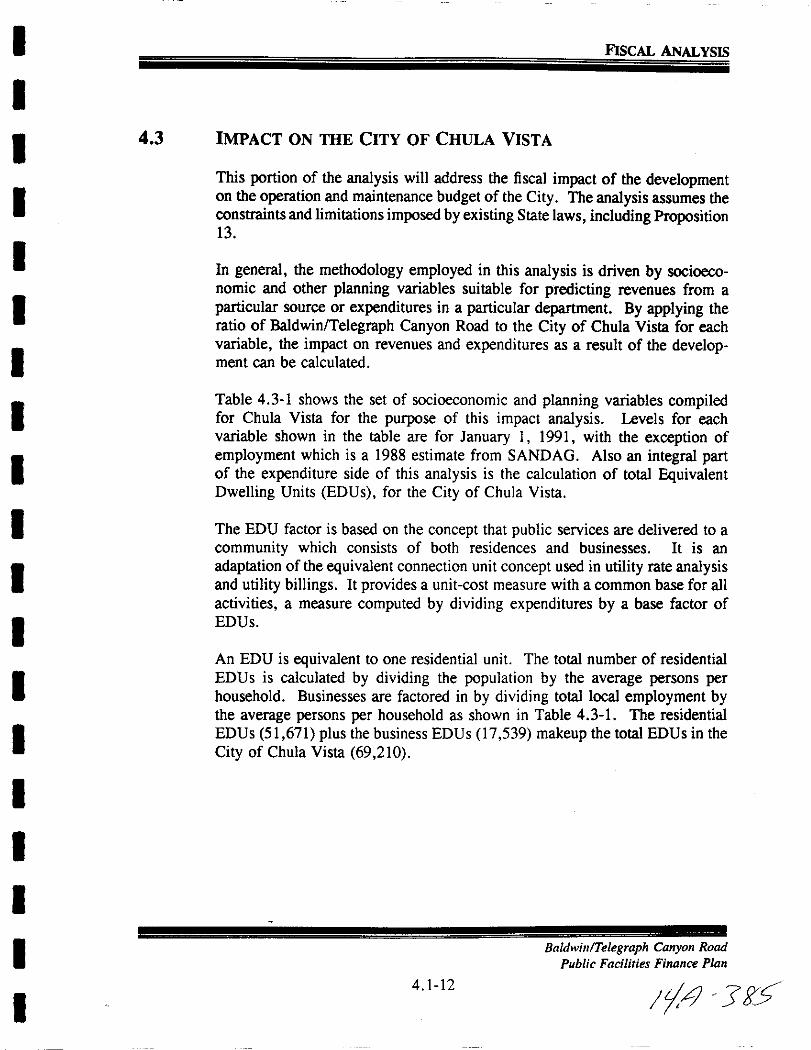
I
I
I
I
I
I
I
I
I
I
I
I
I
I
I
II
I
I
FISCAL ANALYSIS
4 3 IMPACT ON THE CITY OF CHULA VISTA
This portion of the analysis will address the fiscal impact of the developmenton the operation and maintenance budget of the City Theanalysis assumes theconstraints and limitations imposed by existing State laws including Proposition13
In general the methodology employed in this analysis is driven by socioeconomic and other planning variables suitable for predicting revenues from a
particular source or expenditures in a particular department By applying theratio of Baldwin Telegraph Canyon Road to the City ofChula Vista for eachvariable the impact on revenues and expenditures as a result of the development can be calculated
Table 4 3 1 shows the set of socioeconomic and planning variables compiledfor Chula Vista for the purpose of this impact analysis Levels for eachvariable shown in the table are for January I 1991 with the exception of
employment which is a 1988 estimate from SANDAG Also an integral partof the expenditure side of this analysis is the calculation of total EquivalentDwelling Units EDUs for the City of Chula Vista
The EDU factor is based on the concept that public services are delivered to a
community which consists of both residences and businesses It is an
adaptation of the equivalent connection unit concept used in utility rate analysisand utility billings It provides a unit cost measure with a common base for all
activities a measure computed by dividing expenditures by a base factor of
EDUs
An EDU is equivalent to one residential unit The total number of residential
EDUs is calculated by dividing the population by the average persons perhousehold Businesses are factored in by dividing total local employment bythe average persons per household as shown in Table 4 3 1 The residential
EDUs 51 671 plus the business EDUs 17 539 makeup the total EDUs in the
City of Chula Vista 69 210
BaldwillTelegraph Canyon Road
Public Facilities Finance Plan
4 1 12
It jg5

I
I
I
I
I
I
I
I
I
I
I
I
I
I
I
I
I
I
I
FISCAL ANALYSIS
TABLE 4 3 1 Su
TELEGRAPH CANYON ROAD FISCAL IMPACT
CITY OF CHULA VISTA
ANALYSIS PARAMETERS
GENERAL
Chula Vista
Population 139 150IIOccupied Housing Units 51 570
Employment 1988 47 233Street Miles 2815Total AtTs 1 148 035Park Acres 317 4
Open Space Acres 700 0
Telegraph Canyon Road
Park Acres 3 32Public Street Miles 0 00
Open Space Acres 3040
EQUIVALENT DWELLING UNIT CALCULATION
Residential EDUs ofResidents 139 150 51 671Persons per Dwelling Unit 2 693
Nonresidential EDUs of Locally Employed 47 233 17 539
Persons per Dwelling Unit 2 693
Total EDUs 69 210
Sources
California Department ofFinance 1991
SANDAG Series 7 Projections 1989
City ofChula Vista Planning Department 1991
City ofChula Vista Transportation Department 1991
Government Finance Review The Equivalency Factor 1990
Economic Strategi Group 1991
4 1 13
Baldwin Telegraph Canyon Road
Public Facilities Finance Plan
Jr1 3

I
I
I
I
I
I
I
I
I
I
I
I
II
I
I
I
I
I
FlSCAL ANALYSIS
4 3 1 Revenues
With two exceptions revenue information for the City of Chula Vista includedin this analysis is based on actual fiscal year 1990 91 data obtained from theSchedule of Revenues Revenues from the Ordinance Violations and CigaretteTax were based on 1991 92 revenue estimates of 100 000 and 122 000respectively as recommended by the City of Chula Vista Department ofFinance However results of the impact analysis are expressed on constant
1991 dollars Although the analysis is based on constant dollars the generalrate of infiation and property value appreciation rates will have an effect on theresults of the analysis relative to Proposition 13 For this analysis both rates
are assumed to be 4 5 percent per annum
Table 4 3 2 displays the current General Fund revenue information for the Cityof Chula Vista by source Also shown in this table are the assumptions madeto estimate the flow of revenues resulting from the Baldwin Telegraph CanyonRoad development Four sources of revenue are explicitly calculated based on
current tax regulations property tax property transfer tax franchise taxes and
utility taxes Calculation of these revenues is detailed below Six sources of
revenues were identified as not being directly impacted by development in
Baldwin Telegraph Canyon Road including current unsecured property taxes
delinquent property taxes transient lodging business licenses other revenue
from other agencies and other revenues Most of these revenues are either
from sources which would be unaffected by any specific development or theyare excluded because of the purely residential composition of Baldwin Tele
graph Canyon Road The remaining revenue sources including sales tax are
estimated on a per capita basis
Prooertv Tax
Property tax is a function of the property tax rate and the total assessed value
TAV of the development The property tax rate limit of I percent of total
assessed value is shared out to jurisdictions according to Annual Tax Increment
ratios This analysis utilizes a rate of 13 85 percent the average ratio ofTAV
for Baldwin Telegraph Canyon Road
Baldwin Telegraph Canyon Road
Public Facilities Finance Plan
4 1 14 zjll JY7

I
IFISCAL ANALYSIS
TABLE 4 3 1
ITELEGRAPH CANYON ROAD FISCAL IMPACT
REVENUE GENERATION ASSUMPTIONS
I
I
City of Cbolo VistaActual 9091 Revu
Amount Puceot Telegraph Cauyoa Rood G eration
PropertyTCumat Securod 7 669 912 70 19 67 Based on 13 85 of 1 ofTAVComat U red 432 372 08 1 11 Not Applicable
DeliDqt 271 190 92 0 70 Not Applicable
OtherT
Sol Use T I 11 808 279 30 30 28 842 43 per CapitaFrallchise F 1 664 911 49 4 27 Based on Gross ReverJue per Unit and Tax RatesTronsient Lodging 1 185 488 67 3 04 Not ApplicableProperty Transfer 251 492 47 0 64 Based 011 TUID ver Driven Simulation
Utility T 2 628419 54 6 74 Based OD ConsumptionIReveoues and Tu Rates
Uceosos d Permits
Business Licenses 652 738 67 1 67 Not ApplicableAnimal Uceosos 51 840 50 0 13 SO 373 per CapitaBicycle Uceosos 16 106 05 0 04 SO 116 per Capita
Fin PeoaIitiaDd Foreitures
OrdinanceViot tions 154 09941 0 40 SO 720 per Capita 1991 92@Sloo ooo
Ubrary Fin 93 343 73 0 24 SO 671 per Capita
Use of MODey 684 880 00 1 76 Based on 7 of th previous yearDel fiscal impaclfor TeI araph CauYOD if positive
Revenufrom Other AgenciesState HOPTR 194 890 38 0 50 SI 401 per CapitaMotorVehicl Uceoses 4 718 623 64 12 10 S33 91 per CapitaCigarette T 222 994 05 0 5a SO 880 per Capita 1991 92@ 122 000Gas T 2 SI0 7I per CapitaOther 259 660 00 0 67 Not Applicabl
Charges for Curreot Services
Swimmina Pools 107 308 40 0 28 SO 771 per CapitaRecreation Proaram5 18 009 72 0 05 SO 129 per CapitaPark ReservatioD F 19 465 00 0 05 SO 140 per CapitaOther Park RecreatioD F 8 212 62 0 02 SO 059 per CapitaMisc Service Charges 6 72109 0 02 SO 048 per Capita
Other Revenues 5 880 509 00 15 08 Not Applicabl
Total Recurrina Fund Revenue 39 001 479 43 100 00
I
I
I
I
I
I
I
I
I
I
I Sources Cily of Chul Vista SLalement of Revenue 1991Economic Strategies Group 1991
l7 l 92
I I Based OD 50 percent of total collectioDS
2 Based OD the 70 percent of S15 30 per upita Gas Tax r venues allocated to the G r1I Fund
I Baldwin Telegraph Carryon Road
Public Facilities Finance Pian
I4 1 15
1 JYg

I
I
I
I
I
I
I
I
I
I
I
I
I
I
I
I
I
I
I
FISCAL ANALYSIS
Due toProposition 13 assessed value can only increase at the rate of 2 percentper year unless the property is sold Therefore the calculation of projectedassessed value must take into consideration not only original sales price and therate of inflation but also the rate a which housing units are re sold If we
assume that the rate of housing appreciation is equal to the rate of inflationthen as time goes on the total assessed value of any property will declineunless the rate of inflation is less than 2 percent or all properties sell each yearIn order to simulate this process it is necessary to determine the rate ofturnover for each component of development Turnover rates from AngusMcDonald Associates used in the Macroanalysis for Otay Ranch were usedin this analysis for Baldwin Telegraph Canyon Road Table 4 3 3 shows the
application of these rates in terms of the number of re saIes in Baldwin Tele
graph Canyon Road
When a unit is re sold its increase in assessed value is the difference betweenI the selling price and 2 its previous selling price inflated at 2 percent peryear Therefore it is necessary to determine the period of time since a unit
was last sold The reciprocal of the turnover rate yields the average time since
a unit was last sold a seven percent turnover rate implying resale every 14 3
years However this rate cannot be used in the early years of a developmentsince none of the units will be old enough to have been sold 14 years ago Asa result no re sale of units occurs in the first year of development and the
average age at resale increases with the age of the development until the later
years of the analysis The total number of sales re sales stabilizes in the postdevelopment period at 24 units annually or about 7 0 percent of the projectinventory
Total assessed value becomes the sum of the value of each unit at the originaltime of sale plus the increase in assessed value at the time of resale usingprices inflated at the rate of 4 5 percent per year Therefore the projections of
total assessed value must be deflated at the rate of inflation to keep the analysisin constant 1991 dollars This method represents a conservative approach to
property value appreciation which could tend to understate resulting propertytax revenues
Baldwin Telegraph Canyon Road
Public Facilities Finance Plan
4 1 16
tA J

I FISCAL ANALYSIS
I
I
I lt C
I
I0
Ir
I OZJOJ
z II
I oltl0
rl u3Jc
I orlS II
I IIi
I
I 0
II
I000 0 ci
eIIIII
IEoe
e 000rrr Vi
I
s
I0c
g 3 J 0
Jj52 5 l3t3
l
I
I Baldwin Telegraph Canyon Road
Public Facilities Finance Plan
4 1 17
I ItA 3 70
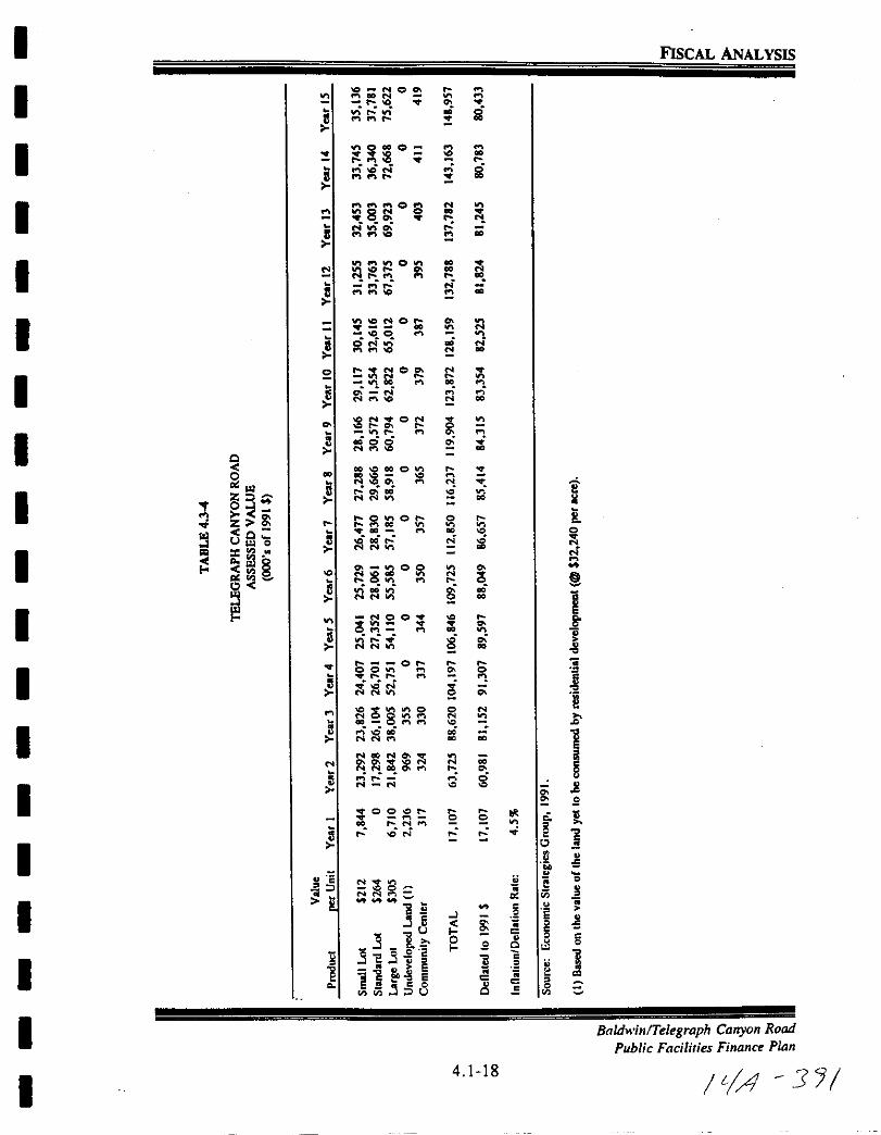
I FISCAL ANALYSIS
IIO NOofI 00 N
r g
I0
t g 2g
IPlP I O
l 8 ic 0l
IVl1 lVlOV l gOr 0
r Nl
IVl ONO q00
ICO fI
gNn N
2 t C
I c
8N ON
IlIIt fI
gg iQ
00 N i
Iro oC 2 n
2 NNO
I OlnOr0 82 8 toof lOC Vl ael
0 0
U O oo r N liN N
I gj 00 ql8
0 oOv g jN
I NO O 85 1r
0
or i
IOOVl fl
iir r flt f 0 0
8 lil N
ClCI fIl l
I 1NOON
q 0N 0 0 0
NNOOa 8r 0
IN N
0 8S
0 00 Co J2eri
I0
oSc
g e 0
ViNNfI
I li 0
sl 2 0 oS
gc
L l0 iss Q J
1l jp 1l 1I a 8 E Ol
558c
c 55Q
I BaldwilllTelegraph Canyon Rood
Public Facilities Finance Plan
I4 1 18
ItA 3J
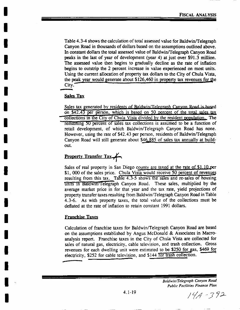
I
I
I
I
I
I
I
I
I
I
I
I
I
I
I
I
I
II
FISCAL ANALYSIS
Table 4 3 4 shows the calculation of total assessed value for Baldwin TelegraphCanyon Road in thousands of dollars based on the assumptions outlined above
In constant dollars the total assessed value of BaldwinlTelegraph Canyon Road
peaks in the last of year of development year 4 at just over 913 million
The assessed value then begins to gradually decline as the rate of inflation
begins to outstrip the 2 percent increase in value experienced on most units
Using the current allocation of property tax dollars to the City of Chula Vista
the peak year would generate about 126 460 in property tax revenues for e
City
Sales Tax
Pronertv Transfer Tax
Sales of real property in San Diego countv are taxed at the rate of 1 10 per1 000 of the sales price Chula Vista would receive 50 rcent of revenue
resulting from this tax Ta e 4 3 5 shows t e sa es and re sales of housingunits 10 HaJdwmnelegraph Canyon Road These sales multiplied by the
average market price in for that year and the tax rate yield projections of
property transfer taxes resulting from Baldwin Telegraph Canyon Road in Table
4 3 6 As with property taxes the total value of the collections must be
deflated at the rate of inflation to retain constant 1991 dollars
Franchise Taxes
Calculation of franchise taxes for Baldwin Telegraph Canyon Road are based
on the assumptions established by Angus McDonald Associates in Macro
analysis report Franchise taxes in the City of Chula Vista are collected for
sales of natural gas electricity cable television and trash collection Gross
revenues for each dwelling unit were estimated to be 250 for as 469 for
electricity 252 for cable television and 144 tor trash collection
Baldwin Telegraph Canyon Road
Public Facilities Fillance Plall
4 1 19i1 J 2

I FISCAL ANALYSIS
Il
0
I
I l1 0
I I C
I
Iz
I i01
jo zz
I08
Ul
rl UI 0
I1I
o
I 8
I
Ul
I8
0 III
I 0
IQ
8 et
r
Io le 000
0 rI y
s0
I s1 l0
0 jj32 3
0g I
E 0
Ij 0
I BaldwinTelegraph Canyon Road
Public Facilities Finance Plan
4 1 20
ILl JJI
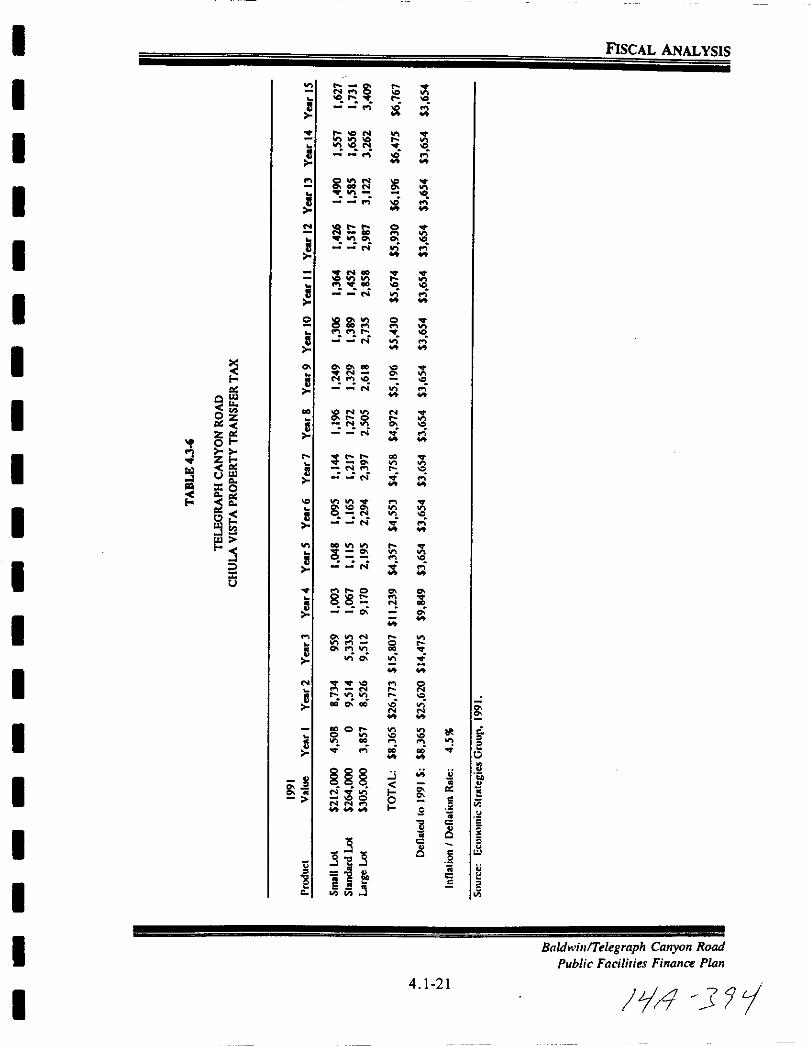
I FISCAL ANALYSIS
I
I g
l i g
I l
ll 0
gl0l
I1 g
I 5 8 0
fi
I 2C
c
I llt0 z 0 gz tioI
I Ztu ri0
Iis
ii N
s cg
I u0
l1 t0
I 116vi
I 1oi oO i
I0
o0
15
0
I8 w
b e0 2 ViI 2 u
c11 cw i
Ic
35c
u
230
tc
I1 i f 5Vij
I BaldwinlTelegrnph Canyon Road
Public Facilities Finance Pian
4 1 21
14 31iI
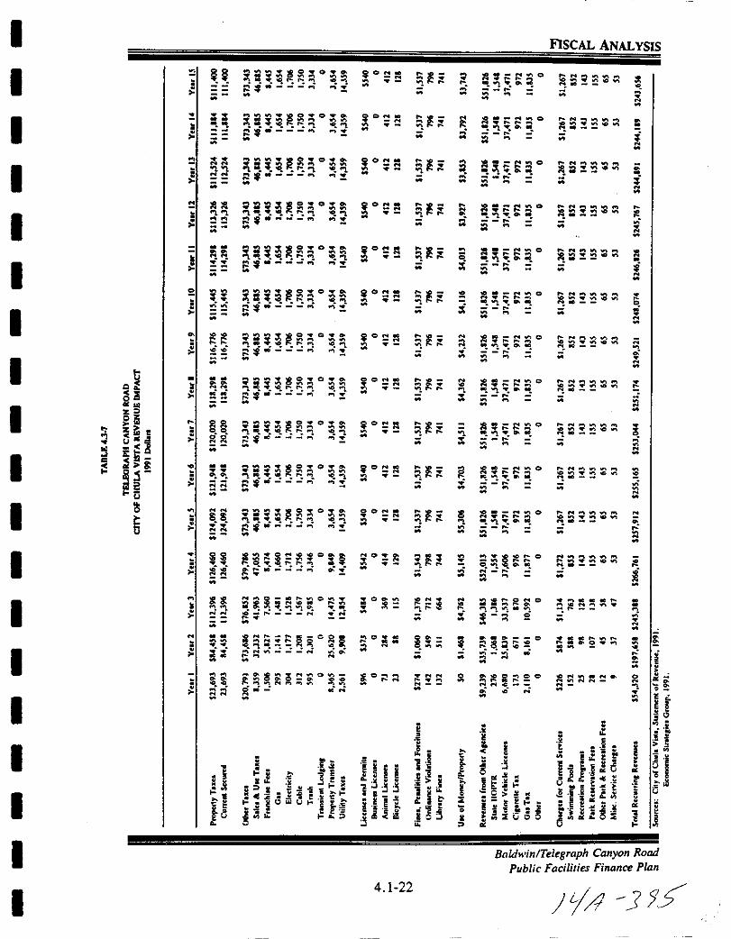
I
I
I
I
I
II
I
I
I
I
I
I
I
II
I
I
I
FISCAL ANALYSIS
Q
iOCz
i5z
ocou
hoc
ru
5
QO O O
qM
iCM
iCM
CON
M
iCl
OON
l
iCM
OON
M
CON
M
M
tl O
M
C
0
tc tIIO
a ill
M
tM
iM
e
M
l
M
sM
M
iiM
M
NM
N
M
iM
M
1Ic2
c
I111
u
JlO OWIji
1Il 1Ct l l litfI
M
iCl
iCM
CON
M
itt
o SM
jCrt
i
oa ClIol
l l
M
orI loo
1l
M
i
rE
o
t l jt
M
00
M
ilC
i
lM
JO
W
M
Nt Wl
C iNIC
ll a
M
C
itl O O
1Ilt t tM
iiM
0
fi
M
C
ii
120 00
J lCrit itM
fl i O
fii jM
22cc
1 0 0
l irJi i
M
00
NN
C1 00l011
0 c
riiM
lI Cl Cl o
i jI ql qe
M
nM
i C
Cl
M
ai i iClo
M
M
e
Itl Sl
Oi0II
1M
i0
N
M
ClieN
I t
fa
I
iI
lII lI iIi C
C
i
r iM
5i 1e 1
too l r
I5
U0
N
C
l
rClrM
s i i Iii
1 JJii
1
4 1 22
1l
p
2
i aM
11
i u
d I t0
i OJit
si
l0
iI
lI Cl
l tM
M
l
M
IM
0
M
Il
M
Cl
l t
M
M
Cl
l 0
M
e Cl
00 2
M
8M
0 0
M
M
C
M
eM
t
M
M
82NM
Cl
eig cM
CC
E
oS i
ec lII
iisII
t i ll C
Cl
C
0
c
BaldwinlTelegraph Canyon Road
Public Facilities Finance Pian
C
Mo011 011N
c oII
lC
tC
01lr c
ttM
C
0
01lr
C
2ON
M
2 tM
M
o
oJ
Jat l
g i r 6d c Erg t
I of JIe e
t 1 l
dlSi
J J15
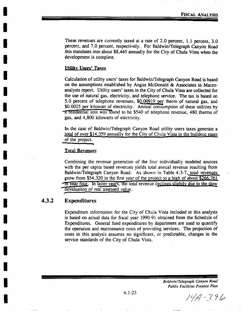
I
I
I
I
I
II
I
I
II
II
I
I
II
I
I
FISCAL ANALYSIS
These revenues are currently taxed at a rate of 2 0 percent 1 1 percent 3 0
percent and 7 0 percent respectively For Baldwin Telegraph Canyon Roadthis translates into about 8 445 annually for the City of Chula Vista when the
development is complete
Utilitv Users Taxes
Calculation of utility users taxes for Baldwin Telegraph Canyon Road is basedon the assumptions established by Angus McDonald Associates in Macro
analysis report Utility users taxes in the City ofChula Vista are collected forthe use of natural gas electricity and telephone service The tax is based on
5 0 percent of telephone revenues 0 00919 per therm of natural gas and0 0025 per kilowatt of electricity Annual consumption of these utilities by
a reSloentJal unit was round to be 540 of telephone revenue 480 therms of
gas and 4 800 kilowatts of electricity
In the case of Baldwin Telegraph Canyon Road utility users taxes generate a
total ofover 14 359 annually for the City of Chula Vista in the buildout sta e
of the project
Total Revenues
Combining the revenue generation of the four individually modeled sources
with the per capita based revenues yields total annual revenue resulting from
Baldwin Telegraph Canyon Road As shown in Table 4 3 7 total revenues
grow from 54 320 in the first year of the ro ect to a hi h of about 2 7 I
year our n atter years e total revenue dsclines slirhtlv due to the slodevaluation of real assessed value
4 3 2 Expenditures
Expenditure information for the City of Chula Vista included in this analysisis based on actual data for fiscal year 1990 91 obtained from the Schedule of
Expenditures General fund expenditures by department are used to quantifythe operation and maintenance costs of providing services The projection of
costs in this analysis assumes no significant or predictable changes in the
service standards of the City of Chula Vista
Baldwin Telegraph Canyon Road
Public Facilities Finance Plan
4 1 23
JYJ 7P
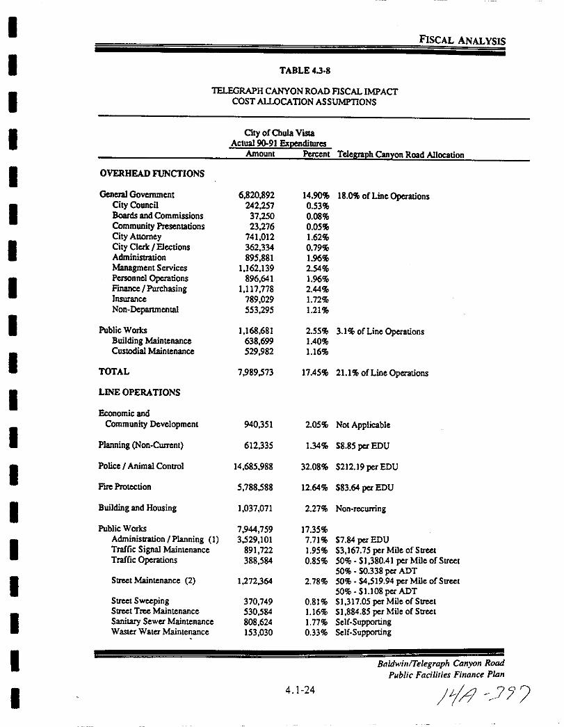
IFISCAL ANALYSIS
I TABLE 43 8
IIELEGRAPH CANYON ROAD FISCAL IMPACT
COST ALLOCATION ASSUMPTIONS
I Oty ofChula VislaActual 9091 pendilllres
Amount Percent TeleR18ph Canyon Road Allocation
I OVERHEAD FUNCTIONS
General Government 6 820892 14 90 18 0 ofLine Operations
ICity Council 242 257 0 53Boards andCommissions 37 250 0 08
Community Presentations 23 276 0 05
City Anomey 741 012 162
I City Cleric I Elections 362 334 0 79Administration 895 881 196
Managment Services 1 162 139 2 54
IPersonnel Operations 896 641 196FinanceI Purchasing 1 117 778 2 44
Insurance 789 029 172Non Deparunental 553 295 121
I Public Works 1 168 681 2 55 3 1 of Line OperationsBuilding Maintenance 638 699 140
ICuslOdial Maintenance 529 982 116
TOTAL 7 989573 1745 211 of Line Operations
ILINE OPERATIONS
Economic and
Community Development 940 35 I 2 05 Not Applicable
I Planning Non Current 612 335 134 58 85 per EDU
IPolice IAnimal ContrOl 14 685 988 32 08 521219 per EDU
Fue Protection 5 788588 12 64 583 64 per EDU
I Building and Housing 1 037 071 2 27 Non recuning
Public Works 7944 759 17 35
IAdministration IPlanning I 3529 101 7 71 57 84 per EDUTraffic Signal Maintenance 891 722 195 53 167 75 per Mile ofStreetTraffic Operations 388 584 0 85 50 51 38041 per Mile ofStree
50 0338per ADT
I Street Maintenance 2 1272 364 2 78 50 54 519 94 per Mile of Street50 S1108 per ADT
Street Sweeping 370 749 0 81 S1 317 05 per Mileof Street
IStreet Tree Maintenance 530 584 116 SI 884 85 per Mile of StreetSanitary Sewer Maintenance 808 624 177 Self SupportingWaster Water Maintenance 153 030 0 33 Self Supporting
I Baldwill Telegraph Canyoll Road
Public Facilities Fillallce PIaIl
I4 1 24
f4 7 7

I
I
I
II
I
I
I
I
I
I
I
I
I
II
I
I
I
FISCAL ANALYSIS
TABLE 438Continued
lELEGRAPH CANYON ROAD FISCAL IMPACfCOST ALLOCATION ASSUMPTlONS
City of Chula Vista
Actual 90 91 ExpendituresAmount Perccnt TelcJUllph Canyon Road Allocation
ParIes and Recreation 3 905 704 853Administration Parks 319 246 0 70 SI 005 82 per Park AcreAdministration Open Space 148 687 032 Provided by Lighting and Landscaping DistrictMaintenance 1 724 422 3 77
Gcneral 1556 063 340 4 902 53 per Park AcreMarina Park Maintenance 168 360 037 Not Applicable
Recreation 1 713 348 3 74 S12 313 per CapitaAthletics 126 768 028 0911 per CapitaAquatics 478 701 105 S3 440 per CapitaSenior Citizens 258 056 056 S 1855 per CapitaGeneral 530 577 116 S3 813 per CapitaAdministration Recreation 319 246 0 70 S2 294 per Capita
Library 2 678 184 5 85 S19 25 per Capita
Otay Ranch Project 200 611 0 44 Not Applicable
TOTAL 37 793 591 8255
TOTAL EXPENDITURES 45 783 164 100 00
Sources City ofChula Vista Statementof Expenditures 1991 19 Feb 92
Economic Strategies Group 1992
I EDUallocation base includes only Public Works OperationsAdministration S370 819 and Communications SI72 045
2 Street Maintenance expenditures would not be incurred until year 7 of theproject
Baldwin Telegraph Canyon Road
Public Facilities Finance Plan
4 1 25
tl 3 r
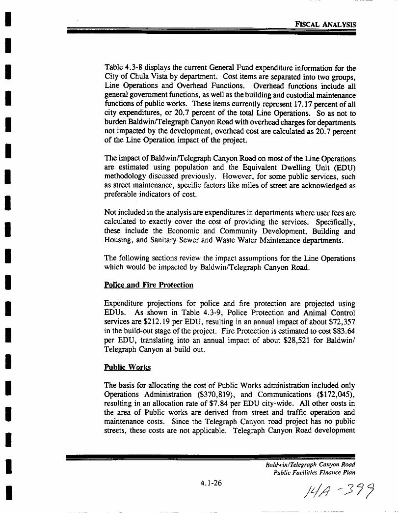
I
I
I
I
II
I
I
II
I
I
I
I
I
I
I
I
I
FlSCAL ANALYSIS
Table 4 3 8 displays the current General Fund expenditure information for the
City of Chula Vista by department Cost items are separated into two groupsLine Operations and Overhead Functions Overhead functions include all
general government functions as well as the building and custodial maintenancefunctions of public works These items currently represent 17 17 percent of all
city expenditures or 20 7 percent of the total Line Operations So as not to
burden Baldwin Telegraph Canyon Road with overhead charges fordepartmentsnot impacted by the development overhead cost are calculated as 20 7 percentof the Line Operation impact of the project
The impact of Baldwin Telegraph Canyon Road on most ofthe Line Operationsare estimated using population and the Equivalent Dwelling Unit EDU
methodology discussed previously However for some public services suchas street maintenance specific factors like miles of street are acknowledged as
preferable indicators of cost
Not included in the analysis are expenditures in departments where user fees are
calculated to exactly cover the cost of providing the services Specificallythese include the Economic and Community Development Building and
Housing and Sanitary Sewer and Waste Water Maintenance departments
The following sections review the impact assumptions for the Line Operationswhich would be impacted by Baldwin Telegraph Canyon Road
Police and Fire Protection
Expenditure projections for police and fire protection are projected usingEDUs As shown in Table 4 3 9 Police Protection and Animal Control
services are 212 19 per EDU resulting in an annual impact of about 72 357in the build out stage of the project Fire Protection is estimated to cost 83 64
per EDU translating into an annual impact of about 28 521 for Baldwin
Telegraph Canyon at build out
Public Works
The basis for allocating the cost of Public Works administration included onlyOperations Administration 370 819 and Communications 172 045
resulting in an allocation rate of 7 84 per EDU city wide All other costs in
the area of Public works are derived from street and traffic operation andmaintenance costs Since the Telegraph Canyon road project has no publicstreets these costs are not applicable Telegraph Canyon Road development
Baldwill Telegraph CallYOIl Road
Public Facilities Fillallce Plall
4 1 26
iA 3
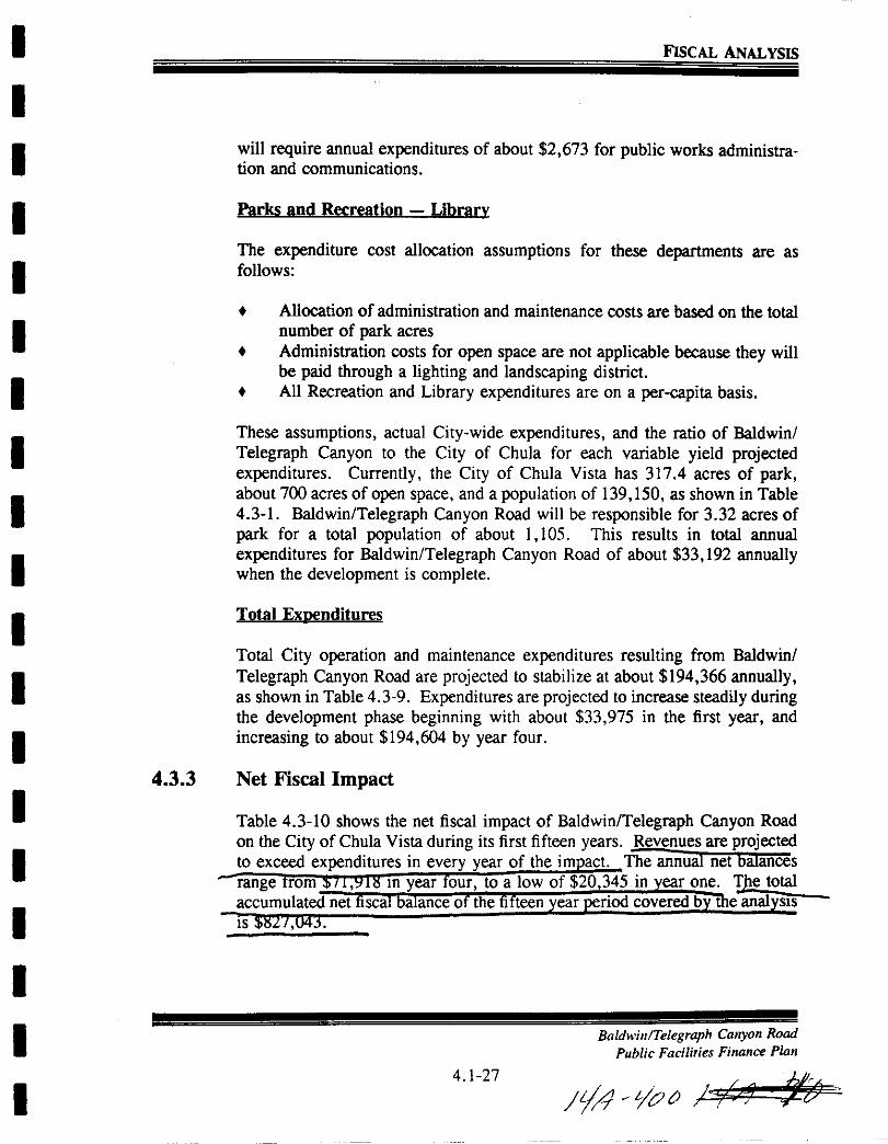
I
I
I
I
I
I
I
I
I
I
I
I
I
I
I
I
I
I
I
FISCAL ANALYSIS
will require annual expenditures of about 2 673 for public works administration and communications
Parks and Recreation Library
The expenditure cost allocation assumptions for these departments are as
follows
Allocation ofadministration and maintenance costs are based on the totalnumber of park acres
Administration costs for open space are not applicable because they willbe paid through a lighting and landscaping districtAll Recreation and Library expenditures are on a per capita basis
These assumptions actual City wide expenditures and the ratio of Baldwin
Telegraph Canyon to the City of Chula for each variable yield projectedexpenditures Currently the City of Chula Vista has 3174 acres of parkabout 700 acres of open space and a population of 139 150 as shown in Table
4 3 1 Baldwin Telegraph Canyon Road will be responsible for 3 32 acres of
park for a total population of about 1 105 This results in total annual
expenditures for Baldwin Telegraph Canyon Road of about 33 192 annuallywhen the development is complete
Total Exuenditures
Total City operation and maintenance expenditures resulting from Baldwin
Telegraph Canyon Road are projected to stabilize at about 194 366 annuallyas shown in Table 4 3 9 Expenditures are projected to increase steadily duringthe development phase beginning with about 33 975 in the first year and
increasing to about 194 604 by year four
4 3 3 Net Fiscal Impact
Table 4 3 10 shows the net fiscal impact of Baldwin Telegraph Canyon Road
on the City of Chula Vista during its first fifteen years Revenues are projectedto exceed expenditures in every year of the im act The annual net balances
range rom m year our to a low of 20 345 in year one Ie total
accumulated net fiscal balance of the fifteen ear riod covered b The anal SIS
IS
Baldwin Telegraph Canyon Road
Public Facilities Finance Plan
4 1 27
Yl 70tJ f tM
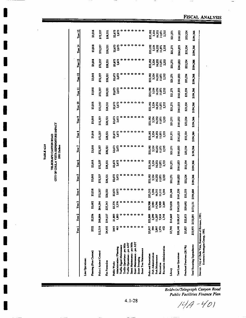
I
I
I
I
I
I
I
I
I
I
I
I
I
I
I
I
I
I
I
a
t
oJ
isi5ii t8ilS
15
6
l
5
i
N
1
OJ
0t
0
0
0
0
0
0
0
0
0
0
N
N
N
II
To
t1
I
tN
N
t
toJ
toJ
oJ
qN
q
oJ
oJt
qN
t
toJt
i
2
N
j
8
e
N
N
0000010
N N
N
N
OOCCOOQ
N
N
etOOOOOO
stl
N
N
0000000
N N
tN
ooooooo
N N
N
N
oocoooo
5
tN
0000000
ss
tl
0000000
rqN N
N
N
ooaoooo
N
tl
OOOOQOO
SS
N 0000000
N
N
ocooooo
cI tN N
NN N
000000
iiO OClOOOO
OOClOOo O
II
fHiH 6
Hilr1 S ep c ni EE III
s HlIilljt t
4 1 28
N
t sPI o N
N WI
1Cof
II lN
N Vl
tqaN
1 Sc N
N N fOI
qaO N
S L0 N
N M
tJ s qO N
N Vl
tqa qN
N tI
qsO N
XN v
qSN
ND
Pi V0 N
1 loN
gF1 il
NN rN
too N
oN
1
q iJ q1 ij1
i i t tt
l ll
1N
1ii
5N
1N
N
ii
1N
N
1N
1ii
1N
N
a
8
N
to
il
0
a
a0
a0
a0
0
a0
a0
0
0
0
0
l
N
1
FIsCAL ANALYSIS
ll
II
a
t a
II
a
N
il13
i
t
Ui j B1
1 Jilll dOls
08
j
N
ll
i
1ls
BaldwillTelegraph Canyon Rood
Public Facilities Finance Plan
It 10
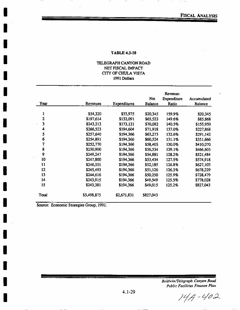
I
II
I
I
I
I
I
I
I
I
I
I
I
I
I
I
I
I
FIsCAL ANALYSIS
TABLE 4 3 10
lELEGRAPHCANYON ROAD
NET FISCAL IMPACf
CITY OF CHULA VISTA
1991 Dollars
Revenue
Net Expenditure Accumulated
Year Revenues Expenditures Balance Ratio Balance
1 54 320 33 975 20 345 159 9 20 345
2 197 614 132 091 65 523 149 6 85 868
3 243 213 173 131 70082 140 5 155 950
4 266 523 194 604 71 918 137 0 227 868
5 257 640 194 366 63 273 132 6 291 142
6 254 891 194 366 60524 1311 351 666
7 252 770 194 366 58 403 130 0 410 070
8 250 900 194 366 56534 129 1 466 603
9 249 247 194 366 54 881 128 2 521 484
10 247 800 194 366 53 434 1275 574 918
11 246 551 194 366 52 185 126 8 627 103
12 245 493 194 366 51 126 126 3 678 229
13 244 616 194 366 50 250 125 9 728 479
14 243 915 194 366 49 549 125 5 778 028
15 243 381 194 366 49015 125 2 827 043
Total 3498 875 2 671 831 827 043
Source Economic Strategies Group 1992
Baldwin Telegraph Canyon Road
Public Facilities Finance Plan
4 1 29
lid VCJ2

I
I
I
I
I
I
I
I
I
I
I
I
I
I
I
I
I
I
I
FISCAL ANALYSIS
4 4 IMPACT ON OTAY WATER DISTRICT
Order of magnitude operation and maintenance fiscal impacts ofBaldwin Tele
graph Canyon Road on the atay Water District were also projected as part ofthis analysis Table 44 1 shows the basic characteristics of the District as
well as its operating revenues and expenditures based on water operations onlySewer services in the Baldwin Telegraph Canyon Road area will be providedby the City of Chula Vista All cost and revenue allocation projections are
based on the fact that 51 percent of water consumption in the District is byresidences
Allocation of revenues accruing to the atay Water District from developmentin Baldwin Telegraph Canyon Road are based on current average sales r
household of 459 76 annually Cost allocation factors tor most expendltu e
classes are based on residential consumption expressed in terms of dollars peraverage daily gallons consumed However the share of expenses attributableto paid services billed through work orders are calculated as follows payrollallocated to work orders is assumed to be 27 6 percent of total payroll as per1990 91 actual performance Reimbursed overhead and equipment expendituresare projected to be 43 0 percent and 7 5 percent of work order related payrollalso based on actual 1990 91 performance
Application of these revenue and cost allocation factors to development inBaldwin Telegraph Canyon Road result in a net fiscal loss of about 676
annually at the buildout stage of the project see Table 44 2 However sincethis represents only about 04 percent of the revenues and costs resulting from
the development it is reasonable to expect that virtually no net impact will be
experienced This is also consistent with comments made by atay WaterDistrict staff who insisted that rates would be adjusted as needed to balance
revenues and operation and maintenance expenditures
BaldwinlTelegraph Canyon Road
Public Facilities Finance Plan
4 1 30
Ii t3
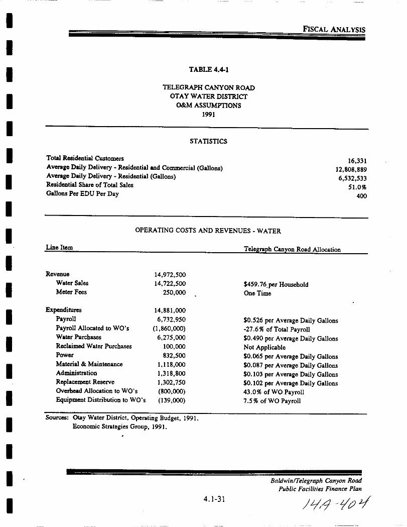
I
I
I
I
I
I
I
I
I
I
I
I
I
I
I
I
I
I
I
FISCAL ANALYSIS
TABLE 4 41
TELEGRAPH CANYON ROAD
OTAY WATER DISTRICT
OM ASSUMPTIONS
1991
STATISTICS
Total Residential Customers
Averale Daily Delivery Residential and Commercial Gallons
Averale Daily Delivery Residential Gallons
Residential Share ofTotal Sales
Gallons Per EDU Per Day
16 331
12 808 889
6 532 533
510
400
Line Item
Revenue
Water Sales
Meter Fees
ExpendituresPayrollPayroll Allocated to WO s
Water Purchases
Reclaimed Water Purchases
Power
Material Maintenance
Administration
Replacement Reserve
Overhead Allocation to WO s
Equipment Distribution to WO s
OPERATING COSTS AND REVENUES WATER
Telegraph Canyon Road Allocation
14 972 500
14 722 500
250 000
459 76 per Household
One Time
14 881 000
6 732 950
1 860 000
6 275 000
100 000
832 500
1 118 000
1 318 800
1 302 750
800 000
139 000
0 526 per Average Daily Gallons
27 6 of Total Payroll0 490 per Average Daily Gallons
Not Applicable0 065 per Average Daily Gallons
0 087 per Average Daily Gallons
0 103 per Average Daily Gallons
0 102 per Average Daily Gallons
43 0 ofWO Payroll7 5 ofWO Payroll
Sources Otay Water District Operating Budget 1991
Economic Strategies Group 1991
BaldwilllTelegraph Canyon Road
Public Facilities Finance Plan
4 1 31
19 Yt1j

I
I
I
I
I
II
I
I
I
I
I
I
I
II
I
I
I
FISCAL ANALYSIS
TABLE 442
TELEGRAPH CANYON ROAD
OTAY WATER DISTRICTOMIMPACT
1991 Dollars
YearsYear 1 Year 2 Year 3 Year 4 5 15
Revenue 27 126 104 931 136 135 152 599 152 075Water Sales 27 126 104 931 136 135 152 599 152 075
Expenditures 27 246 105 398 136 740 153 277 152 751Payroll 12 414 48 020 62 299 69 834 69 594Payroll Allocated to WO s 3 426 13 253 17 195 19 274 19 208Water Purchases 11 564 44 733 58 036 65 054 64 831Reclaimed Water Purchases 0 0 0 0 0Power 1 534 5 934 7 699 8 630 8 600Material Maintenance 2 053 7 942 10 304 11 550 11 511Administration 2431 9 403 12 199 13 675 13 628
Replacement Reserve 2407 9 312 12 081 13 542 13 495Overhead Allocation to WO s 1473 5 699 7 394 8 288 8 259Equipment Distribution to WO s 257 994 1 290 1 446 1 441
Net Balance 121 467 605 678 676
Sources Economic Strategies Group 1991
4 1 32
Baldwin Telegraph Canyon Road
Public Facilities Finance Plan
Id 1V

I
I
I
I
I
I
I
I
I
I
I
I
I
I
I
I
I
I
I
FISCAL ANALYSIS
4 5 CHULA VISTA ELEMENTARY SCHOOL DISTRICT
Operation and maintenance impacts on the Chula Vista Elementary SchoolDistrict were projected based on the number of students generated by development of Baldwin Telegraph Canyon Road The methodology used to projectschool enrollment was described in Section 4 2 Revenues and expenditures perstudent for the District were calculated using 199091 average daily attendanceof 17 501 and actual revenues and expenditures for 1990 91 as shown in the1991 92 Budget Further Chula Vista Elementary School District staff wereconsulted to discuss which if any revenue or expenditure items would not besensitive to the number of students from Baldwin Telegraph Canyon Road
Projections of revenues accrued due to BaldwinTelegraph Canyon Road arebased on per student rates for revenue limit sources Federal revenue and a
portions of other State revenues totalling 3 351 per annum as shown in Table45 1 Revenue limit sources are not directly affected by assessed value in the
District since revenues in this category are limited by the State Certainrevenue sources were excluded from the projections because they would not beimpacted by an increase in the student population
Allocation ofexpenditures to development in BaldwinTelegraph Canyon Roadwas also based on per student rates with the exception of capital outlay andother outgo These items were identified by staff as not being impacted by thenumber ofchildren resulting from BaldwinlTelegraph Canyon Road especiallyin light of the capital improvement funding that is being established Total perstudent expenditures were estimated to be 3 400 annually as shown in Table45 1
The rate for revenues and expenditures per student multiplied by the numberof elementary school children in Baldwin Telegraph Canyon Road at buildoutresults in annual net fiscal loss of about 5 009 However as shown in Table4 5 2 this amount corresponds to about 15 percent of total revenues of
341 841 Therefore it is reasonable to assume that no significant net impactsmay be experienced The district has commented that while any loss is causefor concern the assumptions and parameters used in the analysis are such thata minor change in anyone assumption could change the net fiscal loss into a
fiscal gain
Baldwin Telegraph Canyon Road
Public Facilities Finance Plan
4 1 33
YA tjV0

I
I
I
I
I
I
I
I
I
I
I
I
I
I
II
I
I
I
FISCAL ANALYSIS
TABLE 45 1
TELEGRAPH CANYON ROAD
CHULA VISTA ELEMENTARY SCHOOL DISTRICT
OM ASSUMmONS
1991
Total Studeuts ADA
Total As essed Valuation 91 92
STATISTICS
17 501
6 709 878 239
Line Item
Total Reveuues
Revenue limit Sources
Federal Revenue
Other State Revenue
Variable
Fixed
Other Local Revenue
Expenditures
Certified Salaries
Classified Salaries
Employee Benefits
Books aDd SuppliesServices I Other ExpendituresCapital OutlayOther Outgo
Net BalaDce
OPERATING COSTS AND REVENUES
90 91 Actual Telegraph Canyon Road Allocation
61 235 460
50 129 459
762 850
8 961 364
7 760 107
1 201 257
1 381 787
2 864 38 per Student
43 59 per Student
443 41 per Student
No ImpactNo Impact
60 294 610
36 304 657
9 399 454
9 417 020
2 056 255
2 334 876
137 151
645 197
2 07443 per Student
537 08 per Student
538 08 per Student
117 49 per Student
133 41 per Student
No ImpactNo Impact
940 850
Sources Chula Vista Elementary School District 1991 92 Budget September 1991
Economic Strategies Group 1991
Baldwill Telegraph Canyon Road
Public Fadlities Finance Plan
4 1 34
JiJ LjO
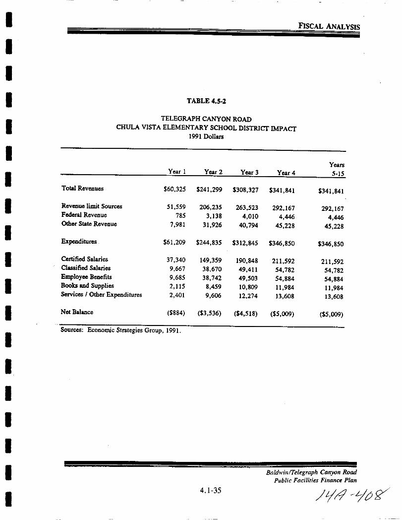
I
II
I
I
I
I
I
II
I
I
I
I
II
I
I
I
FISCAL ANALYSIS
TABLE 4 5 2
TELEGRAPH CANYON ROAD
CHULA VISTA ELEMENTARY SCHOOL DISTRICT IMPACT1991 Dollars
YearsYear I Year 2 Year 3 Year 4 5 15
Total Revenues 60 325 241 299 308 327 341 841 341 841
Revenue limit Sources 51 559 206 235 263 523 292 167 292 167Federal Revenue 785 3 138 4 010 4 446 4 446Other State Revenue 7 981 31 926 40 794 45 228 45 228
Expenditures 61 209 244 835 312 845 346 850 346 850
Certified Salaries 37 340 149 359 190 848 211 592 211 592Classified Salaries 9 667 38 670 49411 54 782 54 782Employee Benefits 9 685 38 742 49 503 54 884 54 884Boolcs and Supplies 2 115 8 459 10 809 11 984 ll 984Services I Other Expenditures 2 401 9 606 12 274 13 608 13 608
Net Balance 884 3 536 4 518 5 009 5 009
Sources Economic Strategies Group 1991
BaldwilllTelegraph Canyon Road
Public Facilities Finance Plan
4 1 35
LJ O
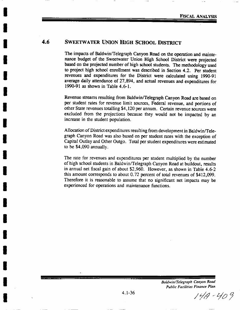
I
I
I
I
I
II
I
I
I
I
I
I
I
II
I
I
I
FISCAL ANALYSIS
4 6 SWEETWATER UNION HIGH SCHOOL DISTRICT
The impacts of Baldwin Telegraph Canyon Road on the operation and maintenance budget of the Sweetwater Union High School District were projectedbased on the projected number of high school students The methodology usedto project high school enrollment was described in Section 4 2 Per studentrevenues and expenditures for the District were calculated using 199091
average daily attendance of 27 894 and actual revenues and expenditures for1990 91 as shown in Table 4 6 1
Revenue streams resulting from BaldwinITe1egraph Canyon Road are based on
per student rates for revenue limit sources Federal revenue and portions ofother State revenues totalling 4 120 per annum Certain revenue sources were
excluded from the projections because they would not be impacted by an
increase in the student population
Allocation ofDistrict expenditures resulting from development in Baldwin Tele
graph Canyon Road was also based on per student rates with the exception of
Capital Outlay and Other Outgo Total per student expenditures were estimatedto be 4 090 annually
The rate for revenues and expenditures per student multiplied by the numberofhigh school students in Baldwin Telegraph Canyon Road at buildout resultsin annual net fiscal gain of about 2 960 However as shown in Table 4 6 2this amount corresponds to about 0 72 percent of total revenues of 412 099Therefore it is reasonable to assume that no significant net impacts may be
experienced for operations and maintenance functions
Baldwin Telegraph Canyon Road
Public Facilities Finance Plan
4 1 36
Jy9 Ijo J

I
I
I
I
I
II
I
I
I
I
I
I
I
I
I
I
I
I
FISCAL ANALYSIS
TABLE 4 6 1
TELEGRAPH CANYON ROAD
SWEETWATER UNION mGH SCHOOL DISTRICT
O M ASSUMPTIONS
1991
STATISTICS
Total Students ADA 27 894
OPERATING COSTS AND REVENUES
Line Item 90 91 Actual Telegraph Canyon Road Allocation
Total Revenues 121 351 465
Revenue limit Sources
Federal Revenue
Other State Revenue
Variable
Fixed
Other Loca1 Revenue
Transfen 10
3 366 06 per Student
163 16 per Student
93 893 006
4 551 068
18 973488
16 506 935
2 466 553
2 868 869
1 065 034
59177 per Student
No ImpactNo ImpactNo Impact
Expenditures 117 341 051
Certified Salaries
Classified Salaries
Employee Benefits
Books and SuppliesServices IOther ExpendituresCapital OutlayOther Outgo
2 364 18 per Student
661 13 per Student
637 99 per Student
185 03 per Student
243 06 per Student
No ImpactNo Impact
65 946 392
18 441 613
17 795 983
5 161 342
6 779 929
1 362493
1 853 299
Net Balance 4 010 414
Sources Sweetwater Union High School District 1991 92 BudgetEconomic Strategies Group 1991
BaldinlTelegraph Canyon Road
Public Facilities Finance Pllln
4 1 37
LI1 WO
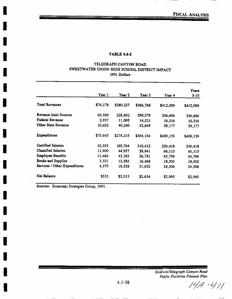
I
I
I
I
I
II
I
I
I
I
I
II
II
I
I
I
FISCAL ANALYSIS
TABLE 4 62
TELEGRAPH CANYON ROAD
SWEETWATER UNION HIGH SCHOOLDISTRlCT IMPACT1991 Dollars
YearsVear 1 Vear 2 Vear 3 Vear 4 5 15
Total Revenues 74 178 280 227 366 768 412 099 412 099
Revenue limit Sources 60 589 228 892 299 579 336 606 336 606Federal Revenue 2 937 11 095 14 521 16 316 16 316Other Stale Revenue 10 652 40 240 52 668 59 177 59 177
Expenditures 73 645 278 215 364 134 409 139 409 139
Certified Salaries 42 555 160 764 210 412 236 418 236 418Classified Salaries 11 900 44 957 58 841 66 113 66 113
Employee Benefits 11 484 43 383 56 781 63 799 63 799Books and Supplies 3 331 12 582 16 468 18 503 18 503Services I Other Expenditures 4 375 16 528 21 632 24 306 24 306
Net Balance 533 2 013 2 634 2 960 2 960
Sources Economic Strategies Group 1991
Baldwin Telegraph Canyon Rood
Public Facilities Finance Plan
4 1 38 JL4 1J
I
II
II
I
I
I
II
I
I
I
I
I
I
I
I
I
5 0 PUBLIC FACILITY FINANCE
BaldwinTelegraph Canyon Road
Public Facilities Finance Plan
5 1 11 Y2
I
I
I
I
I
I
I
I
I
I
I
I
I
I
I
I
I
I
I
PuBLIC FACllITY FINANCE
5 1 PuBLIC FACllITY FINANCE
5 1 1 Overview
The City will ensure the appropriate public facilities financing mechanisms are
utilized to fund the acquisition construction and maintenance ofpublic facilitiesrequired to support the planned development of the BaldwinlTelegraph CanyonRoad project in compliance with the City s Growth Management Program
Public facilities are generally provided or financed in one ofthe following threeways
1 Subdivision Exaction Developer constructed and financed as a
condition of project approval
2 Development Impact Fee Funded through the collection ofan impactfee Constructed by the public agency or
developer constructed with a reimbursement
or credit against specific fees
3 Debt Financing Funded using one of several debt financemechanisms Constructed by the publicagency or developer
It is anticipated that all three methods will be utilized for the BaldwinlTelegraph Canyon Road project to construct and finance public facilities
5 12 Subdivision Exactions
Neighborhood level public improvements will bedeveloped simultaneously withrelated residential and non residential subdivisions Through the use of theSubdivision Map Act it is the responsibility of the developer to provide for alllocal street utility and recreation improvements The use of subdivisionconditions and exactions where appropriate will insure that the construction
of neighborhood facilities is timed with actual development
The imposition of subdivision conditions and exactions does not preclude the
use of other public facilities financing mechanisms to finance the publicimprovement when appropriate
BaldwinTelegraph Canyon Road
Public Facilities Finance Plan
5 1 2
If L 5
I
I
I
I
I
I
I
I
I
I
I
I
I
I
I
I
I
I
I
PuBLIC FACILITY FINANCE
5 13 Development Impact Fee Programs
Development Impact Fees are imposed by various governmental agenciesconsist with State law to contribute to the financing of capital facilitiesimprovements within the City of Chula Vista The distinguishing factorbetween a fee and a subdivision exaction is that exactions are requested of a
specific developer for a specific project whereas fees are levied on all
development projects throughout the City or benefit area pursuant to an
established formula and in compliance with State law
Baldwin Telegraph Canyon Road through policy decisions ofthe City ofChula
Vista and other governing agencies is subject to fees established to help defraycosts of facilities which will benefit Baldwin Telegraph Canyon Road and areas
beyond this specific project These fees include but may not be limited to
1 Eastern Chula Vista TransDonation Impact Fee Street DIFestablished10 provide financing for circulation element road projects of regionalsignificance in the area east of Interstate 805
2 Public Facilities Development Imlact Fee Public Facilities DIP
establishes to collect funds for CiVIC Center Facilities Police FacilityRemodeling Corporation Yard Relocation Libraries Fire SuppressionSystem Geographical Information System Mainframe ComputerTelephone System Upgrade and a Records Management System
3 Park Acquisition and DeveloDment Fees PAD Fee established to payfor the acquisition and development of park facilities
4 Traffic Silinal Fees to pay for traffic signals associated with circulationelement streets
5 Telegraph can on Drainage Basin Fee to pay for constructingdrainage channe Improvements
6 Telegraph Canyon Sewer Basin Fee the City is contemplating the
dupoon 01 oils lee In early 1992 toPaY for sewer basin improvementsnecessitated by future development in the basin
7 State Mandated School 1m ac ees payable to the Chula Vista CityCOOlS nc an Sweetwater Union High School District It should be
noted that both school districts generally require development projects to
BaldwinTelegraph Canyon Road
Public Facilities Finance Plan
5 1 3
YJ 1 1
I
I
I
I
I
I
I
I
I
I
I
I
I
I
II
I
II
PuBLIC FACnrrV FINANCE
annex into existing Mello Roos Community Facilities Districts in lieu of
paying State mandated school fees
8 Olay Water District Fees It should be noted that the Water District
may require the formation ofor annexation to an existing improvementdistrict or creation of some other finance mechanism which may result in
specific fees being waived
5 1 4 Debt Finance Programs
The City of Chula Vista has used assessment districts to finance a number ofstreet improvements as well as sewer and drainage facilities Both school
districts have implemented Mello Roos Community Facilities Districts to
finance school facilities
Assessment Districts
Special assessment districts may be proposed for the purpose of acquiringconstructing maintaining certain public improvements under the MunicipalImprovement Act of 1913 the Improvement Bond Act of 1915 and the
Lighting and Landscape Act of 1972 The general administration of the specialassessment district is the responsibility of the public agency
Special assessment financing may be appropriate when the value or benefit of
the public facility can be assigned to a specific property Assessments are levied
in specific amounts against each individual property on the basis of relative
benefit Special assessments may be used forboth publicly dedicated on site and
off site improvements
MelloRoos Community Facilities Act of 1982
The Mello Roos Community Facilities Act of 1982 authorizes formation of
community facilities districts which impose special taxes to provide the
financing of certain public facilities or services Facilities which can be
provided under the Mello Roos Act include the purchase construction
expansion or rehabilitation of the following
1 Local park recreation or parkway facilities
2 Elementary and secondary school sites and structures
3 Libraries
BaldwinfTelegraph Canyon Road
Public Facilities Finance Plan
5 1 4
1f i3

I
I
I
I
I
I
I
I
I
I
I
I
I
I
I
I
I
I
I
PuBLIC FACllITY FINANCE
4 Any other governmental facilities that legislative bodies are authorized to construct own or operate
5 15 Other Methods Used to Finance Facilities
General Fund
The City of Chula Vista s general fund serves to pay for many public services
throughout the City Those facilities and services identified as being funded bygeneral fund sources represent those that will benefit not only the residents ofthe proposed project but also Chula Vista residents throughout the City Inmost cases other financing mechanisms are available to initially construct or
provide the facility or service then general fund monies would only be
expected to fund the maintenance costs once the facility is accepted by the City
State and Federal Fundinl
Although rarely available to fund an entire project Federal and State financialand technical assistance programs have been available to public agencies inparticular the public school districts
The City was recently awarded a 6 million State Grant to construct the
Montgomery Otay Library
Dedications
Dedication of sites by developers for public capital facilities is a common
financing tool used by many cities In the case of BaldwinlTelegraph CanyonRoad the following public sites are proposed to be dedicated
I Roads if public2 Park sites
3 Open space and public trail systems
Homeowners Associations
Community Homeowner Associations will be formed to manage operate and
maintain private facilities within Baldwin Telegraph Canyon Road
BaldwinTelegraph Canyon Road
Public Facilities Finance Plnn
5 1 5
14 lilt
I
I
I
I
I
I
I
I
I
I
I
I
I
I
I
I
I
I
I
PuBLIC FACllITY FINANCE
Develooer Reimbursement Alreements
Certain facilities that are off site of BaldwinlTelegraph Canyon Road andor
provide regional benefits may be constructed in conjunction with the development of BaldwinlTelegraph Canyon Road In such instances developerreimbursement agreements will be executed to provide for a future payback tothe developer for the additional costofthese facilities Future developments are
required to pay back their fair share of the costs for the shared facility when
development occurs
Soecial Alreementsffievelooment Alreement
This category includes special development programs for financing constructionof Telegraph Canyon Road and State Route 125 It also includes any other
special arrangements between the City and the developer such as credits againstfees waiver of fees or charges for the construction of specific facilities
A development agreement can play an essential role in the implementation ofthe Public Facilities Financing Plan The Public Facilities Financing Planclearly details all public facility responsibilities and assures that the constructionof all necessary public improvements will be appropriately phased with actual
development while the development agreement identifies the obligations and
requirements of both parties
5 16 Public Facility Finance Policies
The following finance policies were included and approved with the Growth
Management Program to maintain a financial management system that will be
implemented consistently when considering future development applicationsThese policies will enable the City to effectively manage its fiscal resources in
response to the demands placed on the City by future growth
1 Prior to receiving final approval developers shall demonstrate and
guarantee that compliance is maintained with the City s adopted threshold
standards
2 The Capital Improvement Program Budget will be consistent with the
goals and objectives of the Growth Management Program The CapitalImprovement Program Budget establishes the timing for funding ofall fee
related public improvements
Baldwinrrelegraph Canyon Road
Public Facilities Finance Plan
5 1 6
IiA 1
I
II
I
I
I
I
I
I
I
I
I
I
I
I
I
I
I
I
PuBLIC FACILITY FINANCE
3 The priority and timing of public facility improvements identified in thevarious City fee programs shall be made at the sole discretion of the CityCouncil
4 Priority for funding from the City s various fee programs sha11 be givento those projects which facilitate the logical extension or provision of
public facilities as defined in the Growth Management Program
5 Fee credits reimbursement agreements developer agreements or publicfinancing mechanisms shall be considered only when it is in the publicinterest to use them or these financing methods are needed to rectify an
existing facility threshold deficiency Such action shall not inducegrowthby prematurely extending or upgrading public facilities
6 All fee credit arrangements or reimbursement agreements will be made
based upon the City s plans for the timing and funding ofpublic facilitiescontained in the Capital Improvement Program Budget
7 Public facility improvements made ahead of the City s plans toconstruct
the facilities will result in the need for additional operating and mainte
nance funds Therefore all such costs associated with the facilityconstruction shall become the responsibility of the developer until such
time as the City had previously planned the facility improvement to be
made
5 17 C CumulativeDebtThe City of Chula Vista has an established policy limiting the maximum debt
to be placed on a residential dwelling unit 10 an aOOIUOnal one percent above
the nronertv tax This policy was restated in the adopted Growth Mana2ementProgram
Like many other cities Chula Vista has Ion under
agenc which can utilize public finance mechanismswa s ee at e to e t will remain
nt e 1 y n s to coordinate its debt finance programs with the other
special istricts which provide service to the residents of Chula Vista to ensure
that the cumulative debt does not become excessive Coordination is also
necessary toguarantee all public facilities needed to s port a development can
be financed and constructed as needed
5 1 7
Badwin Teegraph Canyon Rood
Public Facilities Finance Plan
iJ l b
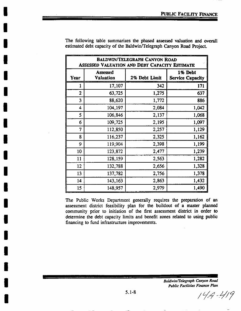
I
II
I
I
I
I
I
I
I
I
I
I
I
II
I
I
I
PuBLIC FACILITY FINANCE
The following table summarizes the phased assessed valuation and overall
estimated debt capacity of the BaldwinlTelegraph Canyon Road Project
BALDWIN TELEGRAPH CANYON ROADASSESSED VALUATION AND DEBT CAPACITY EsrIMATE
Assessed 1 DebtYear Valuation 2 Debt Limit Service Capacity
1 17 107 342 171
2 63 725 1 275 637
3 88 620 1 772 886
4 104 197 2 084 1 042
5 106 846 2 137 1 068
6 109 725 2 195 1 097
7 112 850 2 257 1 129
8 116 237 2 325 1 162
9 119 904 2 398 1 199
10 123 872 2 477 1 239
11 128 159 2 563 1 282
12 132 788 2 656 1 328
13 137 782 2 756 1 378
14 143 163 2 863 1 432
15 148 957 2 979 1 490
The Public Works Department generally requires the preparation of an
assessment district feasibility plan for the buildout of a master plannedcommunity prior to initiation of the first assessment district in order to
determine the debt capacity limits and benefit zones related to using publicfinancing to fund infrastructure improvements
BaldwinTe egraph Canyon Road
Public Facilities Finance Plan
5 1 8
74 0t

I
I
I
I
I
II
I
I
I
I
I
I
I
I
I
I
I
I
PuBLIC FACnrrV FINANCE
5 18 Lifecycle Cost
Section 19 09 060 Analysis subsection F 2 of the Growth ManagementOrdinance requires the following
The inventory shall include LifeCycle Cost LCC projectionsfor each element in 19 09 060E as they pertain to City fiscal
responsibility The LCC projections shall be for estimated life
cycle for each element analyzed The model used shall be able to
identify and estimate initial and recurring life cycle costs for
the elements
Backlround
The following material presents information on the general aspects of life cyclecost analysis as well as its specific application to the City of Chula Vista
operations The discussion regarding the general benefits and process of LCC
is meant to provide a common base of understanding upon which further
analysis can take place
Life cycle costing LCC is a method of calculating the total cost of asset
ownershio over the life span of the asset Initial costs and all subsequentexpected costs of significance are included in the life cycle cost analysis as well
as disposal value and any other quantifiable benefits to be derived as a result
of owning the asset Operating and maintenance costs over the life of an asset
often times far exceed initial costs and must be factored into the decision
process
Life cycle cost analysis should not be used in each and every purchase of an
asset The process itself carries a cost and therefore can add to the cost of theasset Life Cycle Cost analysis can be justified only in those cases in which the
cost of the analysis can be more than offset by the savings derived through the
purchase of the asset
Four major factors which may intluence the economic feasibility of applyingLCC analysis are
1 Energy Intensiveness LCC should be considered when the anticipatedenergy costs of the purchase are expected to be large throughout its life
BaldwinTelegraph Canyon Road
Public Facilities Finance Plan
5 1 9 1A Jc20

I
I
II
I
I
II
I
I
I
I
I
I
II
I
I
I
PuBLIC FACJLITV FINANCE
2 Life Expectancy For assets with long lives Le greater than five
years costs other than purchase price take on added importance For
assets with short lives the initial costs become a more important factor
3 Efficiency The efficiency of operation and maintenance can have
significant impact on overall costs LCC is beneficial when savings can
be achieved through reduction of maintenance costs
4 Investment Cost As a general rule the larger the investment the more
important LCC analysis becomes
The four major factors listed above are not however necessary ingredients for
life cycle cost analysis A quick test to determine whether life cycle costingwould apply to a purchase is to ask whether there are any post purchase costs
associated with it Life cycle costs are a combination of initial and postpurchase costs
The term capital budgeting is defined as the process ofanalyzing expenditureson assets expected to provide returns beyond a year to determine if theyshould be included in the capital budget The outlays may be for facilities
which are either revenue producing or nonrevenue producing
Lifecycle costing is not something different from capital budgeting but rather
is generally understood to be the application of capital budgeting tononrevenue
producing projects Capital budgeting is a term more familiar to industry while
life cycle costing is more familiar to government The principles are the same
however regardless of the terminology since the objective is to maximize
benefits and minimize costs For nonrevenue producing projects such questionsseB
VWill it pay for itse1fIf so in what period of timeWhich of several alternatives will cost the least or save the most
Should it be leased or boughtShould it be replaced
These are questions which can be answered by the application of life cyclecosting methods
Capital has a cost regardless of whether it comes from an investor volun lyor from a taxpayer involun ly A business derives its capital from retained
BaldwinTekgraph Canyon Rood
Public Facilities Finance Plan
5 1 10 4 Jc2
I
II
I
I
I
I
I
I
I
I
I
I
I
II
I
I
I
PuBLIC FACnrrV FINANCE
profits borrowed funds and sale of shares in the business The overall cost
of its financing is referred to as the cost of capital Government obtainsfunds primarily from taxation sale of bonds and through the process of
development exactions and although the cost of capital definition is not
exactly parallel the application to capital analysis is similar
As long as capital can be employed in other projects and earn a return it is not
free it has an opportunity cost Opportunity cost refers to the cost
sacrificed by not investing in an alternative project This applies even wherethe capital takes the form ofassets other than cash as long as a cashequivalentcan be established for the assets To say that capital has an opportunity cost
is another way of saying that money has a time value The present worth ofmoney due in the future is calculated by a process known as discounting The
discounting process facilitates the translation of future values topresent valuesIf the total cost ofowning an asset is its initial cost and all subsequent costs
the latter must be discounted to present value before they are combined withinitial cost to obtain the life cycle cost
All life cycle cost analysis must be performed in terms of compatible dollars
that is dollars dated as of a point in time or a period of time The tools oflife
cycle cost analysis by which dollar values are shifted in time are based upon sixbasic interest formulas The symbols used in these formulas are
i interest rate per periodn number of interest periodsP present worth or present value
F future worth or future value
A uniform sum of money in each time period
Using these tools of life cycle cost analysis and the concept of the time valueof money two methods of life cycle costing are generally available They are
the present worth method and the uniform annual cost method When the
present worth method is used all expenditures regardless of when theyoccur are compared during a common year that is baseline year Future
expenditures are properly discounted to reflect their time value using the six
basic formulas Once these future expenditures are discounted they may be
compared properly to expenditures incurred todayor during the baseline
year Once this discounting is accomplished all expenditures are weighed on
a common basis and may be added together to obtain a total present worth
value
BaldwinTe egraph Canyon Road
Public Facilities Finance Plan
5 1 11 1 1 22
I
I
I
I
I
I
I
I
I
I
I
I
I
I
II
I
I
I
PuBLIC FACILITY FINANCE
The other method uniform annual cost method reduces each alternative cost
to the equivalent base of a uniform annual cost By using this method both
present dollars and future dollars are converted to a uniform annual cost while
taking into account the time value of money at a particular interest rate All
present costs are broken down into equivalent yearly payments throughout thelife cycle All future costs spent at any time during the life cycle are alsobroken down into equivalent yearly payments throughout the life cycle All the
equivalent yearly costs are then added together to establish the total uniform
annual cost
When comparing alternatives the same result will be achieved whether the
present worth method or uniform annual cost method is used The same
relative cost advantage will result from either method of calculation
An important step in life cycle cost analysis is the development of an allinclusive listing of all costs and dollar benefits associated with a given facilityThis listing must include all dollar flows from the first outlay to disposal of the
facility and must be categorized by stage of ownership to facilitate the LCC
analysis as follows
I Initial Cost Period Conceptual studies design planning acquisitioninstallation testing training financing of preoperational phaseExpenditures made prior to the LCC analysis called sunk costs arenot
included
2 Use Period
a Operating costs staffing energy insurance security increasesin working capital personnel training
b Maintenance Costs parts used repair cleaning painting all
corrective and preventive maintenance
c Replacement costs
3 Disposal Period Costs of removal and restoration salvage value and
release of working capital are benefits ie negative costs
Shouldn t the wear depreciation on a piece of equipment be included as a
cost The answer is no since there is no cash outlay for depreciation The
cash was paid initially for the purchase and to include depreciation as a cost
Badwin Telegraph Canyon Road
Public Facilities Finance Plan
5 1 12
JLA L 2Y
I
I
I
I
I
II
II
I
I
I
I
I
I
I
I
I
I
PuBLIC FACILITY FINANCE
would be counting it twice Purchasers in the private sector who are subjectto federal income tax may deduct depreciation as an expense provided an
approved method of accounting for the depreciation is used
One of the objections to the use of life cycle costing is that the estimation offuture costs is too difficult Aren t the estimates merely guesses And whyshould decisions be based on guesses If life cycle costing is based on dubious
estimates how useful can it be
In response to these questions it can be argued that there is no alternative to
life cycle costing Buying on initial cost is not an alternative to buying on life
cycle cost All purchases are made for a life cycle and the only differencebetween initial cost and life cycle cost purchasing is in the judgement about the
treatment of future costs Lifecycle costing if done correctly recognizes that
post purchase costs matter that they do have value and that a consideredestimate of those costs is likely to be closer to true value than the zero value
presumption In either case ajudgement about future costs cannot be avoided
The only real issue is what the judgement will be
Undeniably there is some guesswork in predicting costs but often information
can be obtained which will reduce the uncertainty of the estimates It may be
that an estimate can be narrowed down to a range but even that informationis useful
The following is a step by step description for completing the Life Cycle Cost
Analysis in short form
1 Initial Costs
a Base Cost Enter basic initial cost of equipmentasset
b Interface and Auxiliary Costs Enter cost of such items as
I Additional ConstructionII Additional PlumbingIII Additional ElectricalIV Fuel Storage Tanks
V Any other costs associated with the item under con
struction
c Total Initial Cost Total of la and 1b
BaldwinTelegraph Canyon Road
Public Facilities Finance Plan
5 1 13
fA 12 L
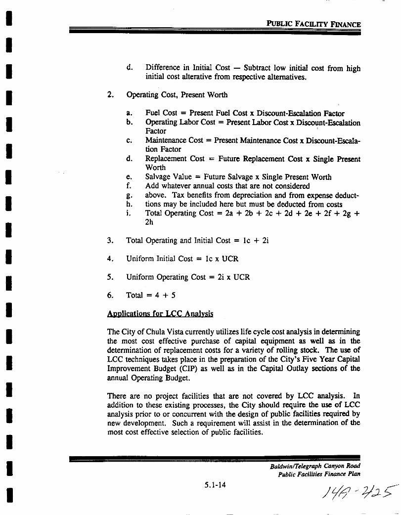
I
I
I
I
I
I
I
I
I
I
I
I
I
I
I
I
I
I
I
PuBLIC FACILITY FINANCE
d Difference in Initial Cost Subtract low initial cost from highinitial cost alterative from respective alternatives
2 Operating Cost Present Worth
a Fuel Cost Present Fuel Cost x Discount Escalation Factorb Operating Labor Cost Present Labor Cost x Discount Escalation
Factor
c Maintenance Cost Present Maintenance Cost x Discount Escalation Factor
d Replacement Cost Future Replacement Cost x Single PresentWorth
e Salvage Value Future Salvage x Single Present Worthf Add whatever annual costs that are not considered
g above Tax benefits from depreciation and from expense deducth tions may be included here but must be deducted from costs
i Total Operating Cost 2a 2b 2c 2d 2e 2f 2g2h
3 Total Operating and Initial Cost lc 2i
4 Uniform Initial Cost lc x UCR
5 Uniform Operating Cost 2i x UCR
6 Total 4 5
Anplications for LCC Analvsis
The City ofChula Vista currently utilizes life cycle cost analysis in determiningthe most cost effective purchase of capital equipment as well as in the
determination of replacement costs for a variety of rolling stock The use of
LCC techniques takes place in the preparation of the City s Five Year CapitalImprovement Budget CIP as well as in the Capital Outlay sections of the
annual Operating Budget
There are no project facilities that are not covered by LCC analysis In
addition to these existing processes the City should require the use of LCC
analysis prior to or concurrent with the design of public facilities required bynew development Such a requirement will assist in the determination of the
most cost effective selection of public facilities
Baldwin Telegraph Canyon Road
Public Facilities Finance Plan
5 1 14
Jytf 2JLs
I
I
I
I
I
I
I
I
I
I
I
I
I
I
I
I
I
I
I
PuBLIC FACILITY FINANCE
5 19 Baldwinffelegraph Canyon Road Project
The following tables identify and summarize the various facility costs associated
with development of the Baldwinrrelegraph Canyon Road project The
facilities and their cost are identified in detail in Section 3 of this Public
Facilities Financing Plan The tables indicate a recommended financingalternative based upon current City practices and policies However where
another financing mechanism may be shown at a later date tobe moreeffective
the City may implement such other mechanisms in accordance with Citypolicies This will allow the City maximum flexibility in determining the best
use ofpublic financing to fund public infrastructure improvements
BaldwinlTelegraph Canyon Road
Public Facilities Finance Plan
5 1 15
tfd oi2b
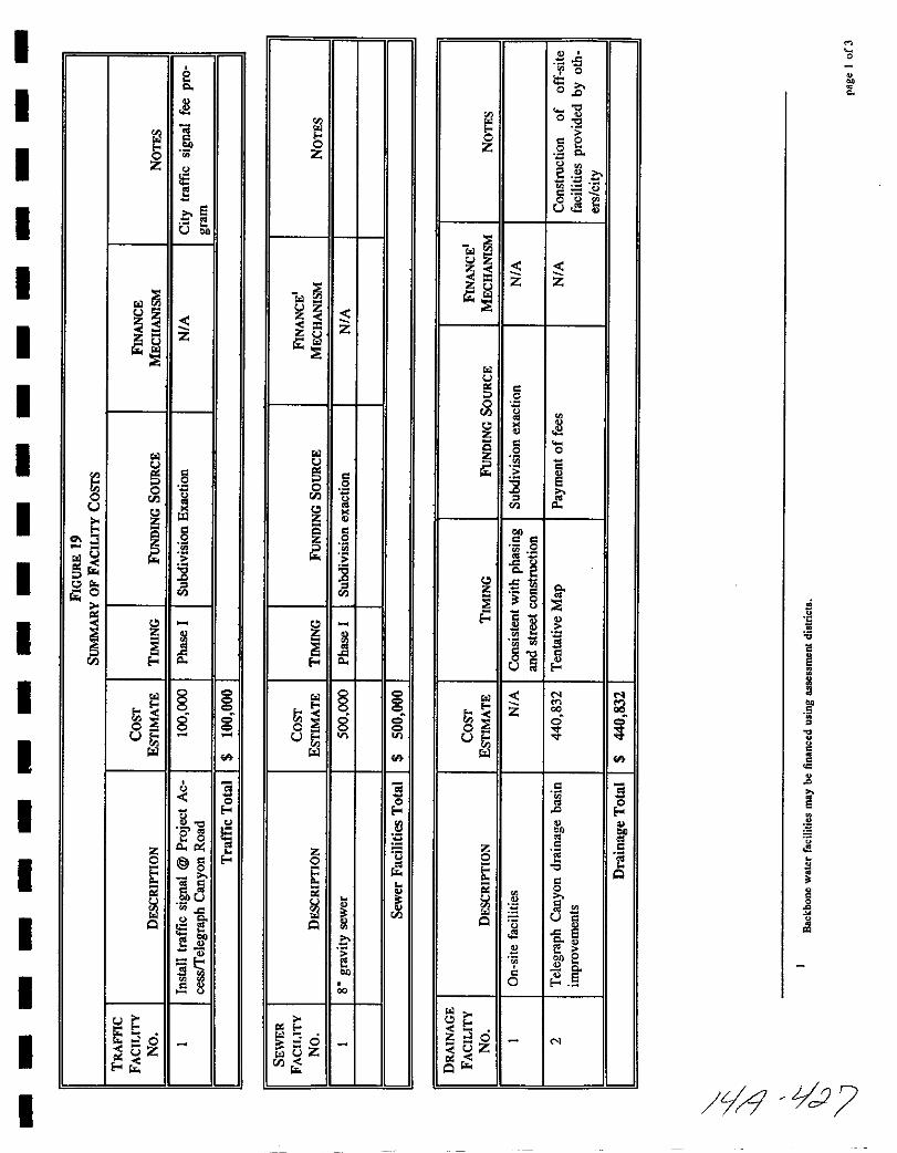
oz
21r0
E30
e8 c
2 200c
oJ Q
M
0
0
uz3 z
u
0
tlV
55 0
52 eI ig
0
ti2jg as
51 8e 58
OJ11
az1 0
ogUI
III
111100
c EE
t00
12 oe0
t Qriii 0
j 1iiQ 0 5l 5
eooe
6e0 E
Z oz
Q
oi1
X
o
0
0
Jl
o
llell
cjrl d

I
I
I
I
I
I
I
I
I
I
I
I
I
I
I
I
I
I
I
Gi
slol1
Z Z
l
Jti
l
l
IIl Il
J J1l
IS
u
JE
l 0 @ 0 @I M 0 0 88 0
00 lI1l
3Q
Il
Z0
t
e0
enOl
OJ8
0 0000
0 NZ
Giuz
1slol
Z
1
u
I p
Z 8gf fa
OJ
os
p
000
lI 0
u
I1l
3Q
0
pZ0 0
t S
Q Ol
8os
p
u0zOU
pr
0z
1
1slol
z
1
0Vi
I0
p
1Z 8gf
s3r
OJ
p
0
I 0oguI1l
CilCi Q
pe
0 liZ0 S
t OJ
9Ol
Q E
er
os
p
gjloOZr
vi
iil
1
zlolS1
U
0
Z
as
i2J
ilroS
0u z z
I1l
3Q
Zgc
0 rJit0
u
Q
e
8JouZlr
M
o
0
c
1
1o
0
e
0oI
J3
LrJ L02Y

I
I
I
I
I
I
I
I
I
I
I
I
I
I
I
I
I
I
I
z zIil
Sl0
ll
11co
Si
IiN
ono
U
s0
0
It rlC
z 0 E00 JJ
t s
OJQie
ll
0z
Jr
0 rn
1lj10 5
e
co Q
jtCs
U
z zIi
u
jV
IQ
ll
gC0
8ill
OJ go
B
0
tll 0
0 Con
N
D tU
s
z
j0
t0
ll
0 0
ll
z
90
uZll r
u
z zIi ll
0V
0
isll
Z
0
8
f 3iJ
00 00o
U
S0
00
s
9z ii0 U
tl0 UU
Q
U0
ll ll
ugJrl
zo c
Z ll
Uu
0Z
u
zIil
0V
I0
ll
IS
cz 8
co
f c
sliJ
0
g
oU
0
9 sz OJ E0
lt0
c Us
Q I0
u 0
ll ll
Q0f8 Z
M
o
M
d vJV